Pastoral mobility in a variable environment
204
The copyright of this thesis vests in the author. No quotation from it or information derived from it is to be published without full acknowledgement of the source. The thesis is to be used for private study or non- commercial research purposes only. Published by the University of Cape Town (UCT) in terms of the non-exclusive license granted to UCT by the author. University of Cape Town
-
Upload
khangminh22 -
Category
Documents
-
view
3 -
download
0
Transcript of Pastoral mobility in a variable environment
The copyright of this thesis vests in the author. No quotation from it or information derived from it is to be published without full acknowledgement of the source. The thesis is to be used for private study or non-commercial research purposes only.
Published by the University of Cape Town (UCT) in terms of the non-exclusive license granted to UCT by the author.
Unive
rsity
of C
ape
Town

Unive
rsity
of C
ape
Town
Pastoral mobility in a variable and spatially constrained
South African environment
Mogamat Igshaan Samuels
Thesis Presented for the Degree of
DOCTOR OF PHILOSOPHY
in the Plant Conservation Unit, Department of Biological Sciences, Faculty of
Science, University of Cape Town
May 2013
Unive
rsity
of C
ape
Town
ii
Declaration
I, the undersigned, hereby declare that the work contained in this thesis is my own
original work and that it has not been previously in its entirety or in part submitted at any
university for a degree.
Signature Date
Unive
rsity
of C
ape
Town
iii
Abstract
Pastoral mobility is viewed as ecologically rational and necessary to ensure livestock
survival in environments which are characterised by variability and uncertainty. Around
the world, mobile pastoral systems are becoming smaller and spatially constrained and
there is a limited understanding of how pastoral mobility is adapted to rangelands of
limited extent. This thesis sets out to establish how extensive pastoral systems have
changed and investigated the role of the key legislative and policy influences on these
changes. It examined the current key drivers of pastoral mobility and analysed the
different movement patterns and their spatial extent within a spatially constrained
environment. This thesis also investigated the role of vegetation type and condition in the
distribution of grazing pressure and further discussed the implications of using variable
stocking rates in a spatially constrained pastoral system.
The study was carried out in the 192 000 ha Leliefontein communal area located in the
semi-arid region of Namaqualand in South Africa. The Leliefontein communal area is
divided into ten unfenced village commons and is surrounded by private and land reform
farms.
An analysis of the impacts of key legislation during five periods of political rule in South
Africa on pastoral mobility showed that during the colonial era legislation resulted in
pastoralists losing most of their grazing lands and they became unable to move over long
distances into other agro-ecological zones. During Apartheid, legislation that promoted
economic units to improve livestock production was not ecologically and economically
viable due to the limited size of grazing camps and the restriction of herd mobility to
access variable resources. Since democracy land reform was implemented to provide
pastoralists with additional grazing lands but this opportunity has been taken up largely
by the relatively more wealthy members of the communal areas.
An investigation into the key drivers of pastoral mobility from 1997 to 2006 in the study
area showed that cold temperatures, livestock impacts on the rangeland, water

Unive
rsity
of C
ape
Town
iv
availability, rangeland condition and toxic plants are key environmental factors
pastoralists consider before moving their herds. As opposed to larger pastoral systems,
this study found that drought was not a key driver of mobility. Pastoral mobility was also
strongly influenced by the need to protect growing crops from livestock damage as this
prevents conflict with croppers and provides herds with important forage sites after the
harvesting season. Decisions on herd movements were also affected by the need to be
closer to the village due to personal reasons or when labour was required during the
lambing and sowing seasons. Overcrowding conditions emerged as a key driver of
mobility since it forced some pastoralists to move around to prevent herds from mixing.
Herd mixing could have severe implications for reproduction and lambing percentages.
To assess the spatial scales of mobility between 1997 and 2006, I used a GIS analysis to
examine the distances and patterns of stockpost movements in relation to resources and
human settlements. Movement distances ranged from 0.1 km to 12.1 km within and 0.9
km to 31.8 km across village boundaries. By moving over these short distances,
pastoralists could still move seasonally to avoid cold temperatures, access seasonal forage
resources, protect growing crops and rest some pastures. Opportunistic movements were
mainly employed to track resources while outmigration was used by some pastoralists
when good quality forage was scarce in the communal area. Sedentarisation of herds is
likely to increase due to a lack of competent herders and a reduction in water availability
and the preference for village life as opposed to staying alone at a stockpost.
A GIS analysis on the effect of pastoral decision-making on the distribution of grazing
pressures within the different vegetation types showed that during the winter months,
Succulent Karoo as oppose to Fynbos vegetation was preferred by herds. Fynbos
vegetation was, however, preferred by some pastoralists during the dry summer months.
The benefits to pastoralists of using flexible and opportunistic stocking rates within
different vegetation types include the ability to access key resource areas, to make
optimal use of increased primary production during the wet periods and to rebuild their
herds at faster rates after drought periods. Ecological implications however, include
overgrazing of some vegetation types during their recruitment period.
Unive
rsity
of C
ape
Town
v
The knowledge and understanding of short-range movements developed through this
study could be regarded as a case study of how mobile pastoral systems that are
becoming increasing smaller and spatially constrained can be managed in the future. The
Leliefontein mobile pastoral system remains functional because it is built on strong social
cohesion and the sophisticated ecological knowledge and management skills of
pastoralists that have been developed over centuries. These attributes and the qualities of
pastoralists themselves are crucial to ensure the continued existence of mobile livelihoods
in a changing pastoral landscape.
Unive
rsity
of C
ape
Town
vi
Acknowledgements
Firstly, I would like to thank God for giving me the strength and will to complete this
thesis.
Thank you to my supervisor Dr Nicky Allsopp for allowing me to work on this project,
your continual support, encouragement and making me believe in myself and for
mentoring me throughout the years. To my other supervisor Prof. Timm Hoffman, thank
you for giving me the opportunity to study under your guidance. Thank you for your
advice, support and your commitment towards my studies.
A sincere thanks to the local field guides, Barney Links, Simon Waldeck, Jacob Cloete,
Barend Cloete, Sors Cloete, Petrus Stewe, Piet Gall, Nicolaas Makatees, Andries Beukes
for introducing me to the pastoralists and showing me the locations of the stockposts and
watering points.
Thank you to Marieta van der Rijst from the ARC-Biometry Services for helping me with
the statistics and my colleagues Clement Cupido and Melvin Swarts for your continual
assistance throughout the project.
My sincere gratitude to:
Plant Conservation Unit at the University of Cape Town for allowing me to be
part of their wonderful team
Agricultural Research Council, my employer for giving me time off to complete
my thesis
Biodiversity and Conservation Biology Department at the University of the
Western Cape for office space and allowing me to use their resources
South African Weather Service for supplying the rainfall data
Agri-Kameelkrans Farmers Union for always being available to answer my
questions
Kamiesberg Local Municipality for allowing me to do research in the area and
providing me with livestock numbers of farmers in the communal area
Mike Peel, Harry May, Nazeem Samuels and Tony Palmer for commenting on
my earlier drafts
This project was funded by the Critical Ecosystems Partnership Fund (CEPF) through the
Succulent Karoo Ecosystem Programme (SKEP) and partially by the Norwegian Ministry
of Foreign Affairs through the Ephemeral River Basins-SADC (ERB) Project. The data
collected in Paulshoek village forms part of the BIOTA Southern Africa project which is
sponsored by the German Federal Ministry of Education and Research under promotion
number 01 LC 0024A. Without these funds, the project would not have been possible.
Thanks you to my family, friends and colleagues for your continual support and
encouragements throughout the project. Thank you Yurisha Maharaj for your love and
support during the writing of this thesis.
Unive
rsity
of C
ape
Town
vii
Lists of Boxes
Chapter One Page
Box 1: Exploiting seasonal variation in forage by Wodabee pastoralists 3
Box 2: Pastoral mobility amongst the Turkana in East Africa 5
Box 3: Pastoral mobility as a survival strategy during drought 5
Box 4: Pastoral mobility and cultivation 6
Box 5: Management of decision-making amongst Raikas pastoralists 7
Box 6: Pastoral mobility and the challenges facing biodiversity
conservation 9
Lists of Figures and Tables
Chapter One
Figure 1.1: Typologies of herding strategies identified during normal rainfall
years and a drought period in the Leliefontein communal area 14
Chapter Two
Figure 2.1: The location of the Leliefontein communal area in
Namaqualand, Northern Cape Province of South Africa 19
Figure 2.2: A pastoralist filling the trough with water from a hand dug well for
his animals 20
Figure 2.3: The mean annual rainfall recorded between 1997 and 2006 in
and around the Leliefontein communal area 22
Figure 2.4: Interpolated mean annual rainfall for the study period
(1997-2006) in and around the Leliefontein communal area 21
Table 2.1: The nine vegetation types found in Leliefontein and their
proportion relative to the total size of the study area 24
Figure 2.5: Renosterveld landscape in the uplands showing that livestock is
grazing in a patch of ephemeral wetlands around the water point 24
Figure 2.6: The locations of the six communal areas in Namaqualand,
Northern Cape Province of South Africa 28
Figure 2.7: The number of small stock (goats & sheep) and cattle recorded
between 1832 and 2007 in the Leliefontein communal area 29
Figure 2.8: Cattle grazing in ephemeral wetlands in the uplands during the
dry season 29
Unive
rsity
of C
ape
Town
viii
Figure 2.9: Livestock grazing on stubble after the crops have been harvested 30
Figure 2.10: The number of households recorded in 2010 for each of the 10
villages found in the Leliefontein communal area 32
Figure 2.11: Two Nama pastoralists outside their traditional cooking shelter
(kookskerm) 32
Figure 2.12: Goats are milked in the morning and the milk is shared amongst
pastoral families 35
Chapter Three
Table 3.1: Formal legislation assessed to study the impacts of legislation
on the geography of pastoral herding in the Leliefontein
communal area 42
Figure 3.1: The boundaries of the Leliefontein Mission Institution in 1856
and the 1994 boundary of the Leliefontein communal area 51
Figure 3.2: Number of small stock belonging to white farmers and farmers
from other commonages in Namaqualand that were declined,
illegal or permitted in Leliefontein between 1956 and 1966 53
Figure 3.3: Seasonal grazing areas for each of the 10 villages in the
Leliefontein communal area before the implementation of
economic units in 1984 54
Figure 3.4: Remnants of structures used as seasonal grazing boundaries in
the Leliefontein communal area before the implementation of
economic units in 1984 54
Figure 3.5: The distribution of the economic units that was introduced by
the Apartheid government from 1984 to 1988 the Leliefontein
communal area 56
Figure 3.6: Livestock densities in private and communal camps during the
system of economic units in 1985 in Leliefontein 58
Figure 3.7: Locations of communal areas in Namaqualand before and after
the implementation of South Africa’s Land Reform Policy 63
Figure 3.8: The locations of the land reform farms acquired by the
Department of Land Affairs through the Land Reform
Programme for the people of Leliefontein 64
Figure 3.9: Spatial distribution of grazing densities during 2003 and 2007
on Tweefontein Farm which was acquired for the people of
Leliefontein through the Land Reform Programme 65

Unive
rsity
of C
ape
Town
ix
Figure 3.10: Proportions of the Tweefontein Farm grazed at different
grazing densities during 2003 and 2007 66
Figure 3.11: The evolution of mobile practices in a variable and spatially
constrained pastoral system in South Africa 67
Chapter Four
Figure 4.1: The total number of herds and unique stockposts used by herds
from 1997 to 2006 in the Leliefontein communal area 82
Table 4.1: The locations of stockpost movements from 1997 to 2006 in
the Leliefontein communal area 83
Figure 4.2: The number of stockpost movements by herds from all 10
villages between 1997-2006 in the Leliefontein communal area 85
Figure 4.3: The mean stationary time for herds at any stockpost from 1997
to 2006 for the 10 villages located in the Leliefontein
communal area 85
Figure 4.4: Number of stockpost movements per year of herds from 1997
to 2006 in the Leliefontein communal area 86
Figure 4.5: Average number of stockpost movements per month in the
Leliefontein communal area from 1997 to 2006 86
Table 4.2: Reasons provided for of stockpost movements within the
Leliefontein communal area during the period 1997 and 2006 88
Table 4.3: Reasons given by pastoralists for remaining stationary during
the study period 89
Chapter Five
Figure 5.1: Digital elevation model and the distribution of various land
uses in relation to altitude within the Leliefontein communal area 105
Table 5.1: Number of different stockposts used by a herd in each village
between January 1997 and December 2006 in the Leliefontein
communal area 106
Table 5.2: Single and total distances of stockpost movements per herd
within village boundaries during the ten year study period 107
Table 5.3: The average distance moved between stockposts within the
different movement patterns during the study period in the
Leliefontein communal area 111
Figure 5.2: Different types of stockpost movement patterns that occurred
during the study period in the Leliefontein communal area 112
Unive
rsity
of C
ape
Town
x
Figure 5.3: The distribution of distances moved between stockposts within
the different movements patterns identified during the study
period from 1997 to 2006 in the Leliefontein communal area 113
Table 5.4: The types and number of different livestock watering points
used by herds during the study period in the Leliefontein
communal area 115
Figure 5.4: The distribution of the number of watering points within
2.5 km from stockposts between 1997 and 2006 in the
Leliefontein communal area 116
Figure 5.5: Number of stockposts located within 1 km of a cropland in
April and September in the Leliefontein communal area 117
Figure 5.6: The distribution of stockpost distances from human settlements
between the different villages from 1997 to 2006 in the
Leliefontein communal area 119
Figure 5.7: Principal component analysis of the distribution of stockposts
in relation to variables that affect stockpost locations in the four
villages where cropping did not play a major role in the grazing
patterns of herds during the study period in Leliefontein 120
Table 5.10: Pearson correlation matrix of variables that affected stockpost
locations in four villages where cropping did not play a major
role in the grazing patterns of herds the study period in the
Leliefontein communal area 121
Table 5.11: Pearson correlation matrix of variables that affect stockpost
locations during the non-cropping season in six villages where
cropping occurred during the study period in Leliefontein 122
Figure 5.8: Principal component analysis of the distribution of stockposts
in relation to variables during the non-cropping season in six
villages where cropping occurred during the study period
in the Leliefontein communal area 122
Figure 5.9: Principal component analysis of the distribution of stockposts
in relation to variables during the cropping season in six
villages where cropping occurred during the study period in the
Leliefontein communal area 123
Table 5.12: Pearson correlation matrix of variables that affect stockpost
locations during the cropping season in six villages where
cropping occurred during the study period in Leliefontein 123
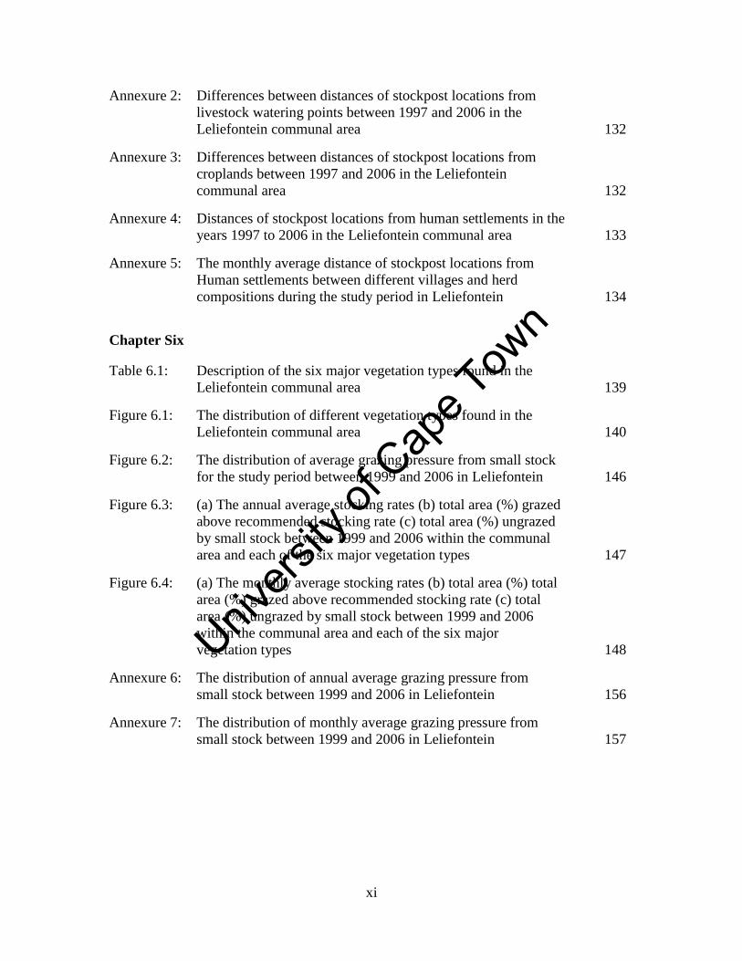
Annexure 1: The monthly average distances of stockposts from livestock
watering points for different villages and herd compositions
during the study period in the Leliefontein communal area 131
Unive
rsity
of C
ape
Town
xi
Annexure 2: Differences between distances of stockpost locations from
livestock watering points between 1997 and 2006 in the
Leliefontein communal area 132
Annexure 3: Differences between distances of stockpost locations from
croplands between 1997 and 2006 in the Leliefontein
communal area 132
Annexure 4: Distances of stockpost locations from human settlements in the
years 1997 to 2006 in the Leliefontein communal area 133
Annexure 5: The monthly average distance of stockpost locations from
Human settlements between different villages and herd
compositions during the study period in Leliefontein 134
Chapter Six
Table 6.1: Description of the six major vegetation types found in the
Leliefontein communal area 139
Figure 6.1: The distribution of different vegetation types found in the
Leliefontein communal area 140
Figure 6.2: The distribution of average grazing pressure from small stock
for the study period between 1999 and 2006 in Leliefontein 146
Figure 6.3: (a) The annual average stocking rates (b) total area (%) grazed
above recommended stocking rate (c) total area (%) ungrazed
by small stock between 1999 and 2006 within the communal
area and each of the six major vegetation types 147
Figure 6.4: (a) The monthly average stocking rates (b) total area (%) total
area (%) grazed above recommended stocking rate (c) total
area (%) ungrazed by small stock between 1999 and 2006
within the communal area and each of the six major
vegetation types 148
Annexure 6: The distribution of annual average grazing pressure from
small stock between 1999 and 2006 in Leliefontein 156
Annexure 7: The distribution of monthly average grazing pressure from
small stock between 1999 and 2006 in Leliefontein 157
Unive
rsity
of C
ape
Town
xii
Table of Contents
Page no.
Declaration ii
Abstract iii
Acknowledgments vi
List of figures and tables vii
Chapter One: Introduction 1
1.1 Problem statement 1
1.2 Background and Context 3
1.2.1 Understanding pastoral mobility in dryland ecosystems 3
1.2.2 Understanding the factors that spatially constrain mobile
pastoralists 9
1.2.3 Pastoral mobility in Namaqualand 13
1.3 Objectives of this study 15
1.4 General Approach, Research Design and Thesis Structure 16
Chapter Two: Study Area 18
2.1 Introduction 18
2.2 Geographical Location 18
2.3 Landscape 18
2.4 Soils 20
2.5 Climate 21
2.6 Biodiversity 23
2.6.1 Fauna 23
2.6.2 Flora 23
2.7 Land use 25
2.8 The people of Leliefontein 31
2.9 Why do people in Leliefontein keep livestock? 34
Chapter Three: The impact of legislation from five periods of political
rule on the geography of pastoralism in a semi-arid
region of South Africa 36
3.1 Introduction 36
3.2 Livestock management in pre-colonial Namaqualand 39
3.3 Approach 41
3.3.1 Legislative documentation 41
3.3.2 Reconstruction of historical communal area boundaries 41
3.3.3 Land use practices on the new land reform farms 41
3.4 Results 42
3.4.1 Dutch Colonial Era (1652 – 1805) 42
Unive
rsity
of C
ape
Town
xiii
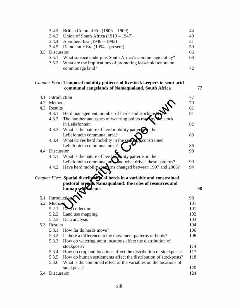
3.4.2 British Colonial Era (1806 – 1909) 44
3.4.3 Union of South Africa (1910 – 1947) 49
3.4.4 Apartheid Era (1948 – 1993) 51
3.4.5 Democratic Era (1994 – present) 59
3.5 Discussion 66
3.5.1 What science underpins South Africa’s commonage policy? 68
3.5.2 What are the implications of promoting leasehold tenure on
commonage land? 72
Chapter Four: Temporal mobility patterns of livestock keepers in semi-arid
communal rangelands of Namaqualand, South Africa 77
4.1 Introduction 77
4.2 Methods 79
4.3 Results 81
4.3.1 Herd management, number of herds and stockposts used 81
4.3.2 The number and types of watering points used by livestock
in Leliefontein 82
4.3.3 What is the nature of herd mobility patterns in the
Leliefontein communal area? 83
4.3.4 What drives herd mobility in the spatially constrained
Leliefontein communal area? 86
4.4 Discussion 90
4.4.1 What is the nature of herd mobility patterns in the
Leliefontein communal area and what drives these patterns? 90
4.4.2 Have herd mobility patterns changed between 1997 and 2006? 94
Chapter Five: Spatial distribution of herds in a variable and constrained
pastoral area in Namaqualand: the roles of resources and
human settlements 98
5.1 Introduction 98
5.2 Methods 101
5.2.1 Data collection 101
5.2.2 Land use mapping 102
5.2.3 Data analysis 103
5.3 Results 104
5.3.1 How far do herds move? 106
5.3.2 Is there a difference in the movement patterns of herds? 108
5.3.3 How do watering point locations affect the distribution of
stockposts? 114
5.3.4 How do cropland locations affect the distribution of stockposts? 117
5.3.5 How do human settlements affect the distribution of stockposts? 118
5.3.6 What is the combined effect of the variables on the locations of
stockposts? 120
5.4 Discussion 124
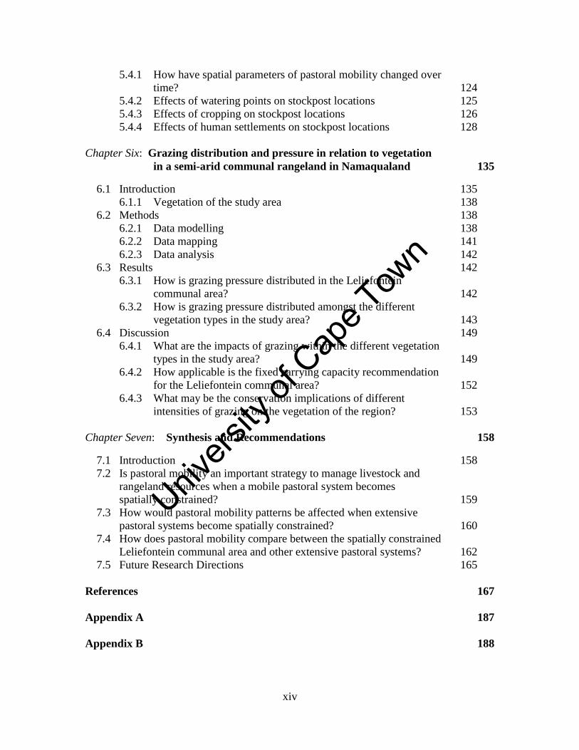
Unive
rsity
of C
ape
Town
xiv
5.4.1 How have spatial parameters of pastoral mobility changed over
time? 124
5.4.2 Effects of watering points on stockpost locations 125
5.4.3 Effects of cropping on stockpost locations 126
5.4.4 Effects of human settlements on stockpost locations 128
Chapter Six: Grazing distribution and pressure in relation to vegetation
in a semi-arid communal rangeland in Namaqualand 135
6.1 Introduction 135
6.1.1 Vegetation of the study area 138
6.2 Methods 138
6.2.1 Data modelling 138
6.2.2 Data mapping 141
6.2.3 Data analysis 142
6.3 Results 142
6.3.1 How is grazing pressure distributed in the Leliefontein
communal area? 142
6.3.2 How is grazing pressure distributed amongst the different
vegetation types in the study area? 143
6.4 Discussion 149
6.4.1 What are the impacts of grazing within the different vegetation
types in the study area? 149
6.4.2 How applicable is the fixed carrying capacity recommendation
for the Leliefontein communal area? 152
6.4.3 What may be the conservation implications of different
intensities of grazing on the vegetation of the region? 153
Chapter Seven: Synthesis and Recommendations 158
7.1 Introduction 158
7.2 Is pastoral mobility an important strategy to manage livestock and
rangeland resources when a mobile pastoral system becomes
spatially constrained? 159
7.3 How would pastoral mobility patterns be affected when extensive
pastoral systems become spatially constrained? 160
7.4 How does pastoral mobility compare between the spatially constrained
Leliefontein communal area and other extensive pastoral systems? 162
7.5 Future Research Directions 165
References 167
Appendix A 187
Appendix B 188
Unive
rsity
of C
ape
Town
1
Chapter One Introduction
1.1 Problem statement
Mobile pastoralism is a livestock production system that has been practiced for millennia
in numerous ecosystems across the world. In arid and semi-arid environments mobility is
a response to temporal and spatial variability in resources since it allows herds to
optimally use vegetation, which varies in quality and quantity (McCabe, 1994; Schareika,
2001). Mobility also enables pastoralists to access water sources (Bassett, 1986; Penn,
1986; Behnke, 1999) and other key resource areas that are important for the survival of
livestock during the dry season (Illius and O’ Connor, 1999) and helps them to evade
disease stricken areas (Touré, 1990; Homewood, 2008; Behnke et al., 2011). Socio-
economic benefits of pastoral mobility include access to local and international markets
(Touré, 1990; Adriansen, 2003; 2008; de Jode, 2010), evasion of conflict (de Weijer,
2007) and maintaining social ties with other pastoralists where ecological knowledge and
livestock products are shared (Waller and Sobania, 1994; Samuels, 2006; Butt, 2010).
Throughout history, mobile pastoral systems have changed in order to adapt to dynamic
social-ecological environments. As discussed later in this chapter, the factors that
influence pastoral systems are complex, occur across several scales, and include
environmental, socio-economic and political components (Dong et al., 2011; Flintan,
2011). A general trend has been for mobile pastoral systems to become increasingly
spatially constrained and in many parts of the world pastoralists no longer have the option
to move over long distances. For example, in pre-colonial Botswana, communal
rangelands were managed by traditional institutions which allowed for inter-territorial
grazing between unfixed tribal boundaries so that animals could access forage and water
(Makepe, 2006). During colonisation, the British established administrative boundaries
that restricted pastoral mobility and thus livestock’s access to resources that vary in space
and time. After independence, policies such as the Tribal Lands Grazing Policy of 1975
led to the privatisation of some communal lands. As a result, communal rangelands
Unive
rsity
of C
ape
Town
2
continued to shrink, pastoral mobility became constrained and increased pressure was
exerted on the limited resource which led to overgrazing (Makepe, 2006).
The Leliefontein communal area in South Africa, which forms the focus of this study, has
undergone several changes over the last 300 years. Before the Namaqualand region,
which Leliefontein is part of, was colonised by European settlers, indigenous Nama
pastoralists utilised millions of hectares of grazing lands which extended into southern
Namibia (Blench, 2001). They were able to move over distances of up to hundreds of
kilometers to the Orange River in the north or southwards to the Olifants River when
environmental conditions were unfavourable for their livestock (Rohde and Hoffman,
2008).
In the late 1600’s in the Cape, indigenous tribes allowed the Dutch access to their grazing
lands based on a system of usufruct rights (Marinus, 1997) but the colonists viewed
access to grazing as permanent. During the early 1700s there was an encroachment of
colonists into Namaqualand and from 1750 to 1772, white farmers gained sole tenure of
the land they occupied from the state (Penn, 1995; Webley, 1982). Leliefontein was
established in 1816 as a mission station to protect the indigenous people from land
hungry colonists and secure them access to some of their traditional grazing lands (Kotze
et al., 1987). In 1854, Leliefontein was proclaimed a reserve (Melvill, 1890). The reserve
was incompletely surveyed and white farmers encroached further onto reserve land.
Between the early and mid-1900s, private farms were fenced off from the communal area
and mobile pastoralists1 in Leliefontein became spatially constrained.
Presently, Leliefontein is approximately 192 000 ha in size and informally divided into
10 unfenced village commons ranging from 12 000 to 25 000 ha in size. Despite being
confined to relatively small areas within the broader Namaqualand region, Leliefontein
pastoralists have managed to sustain large livestock populations for several decades
(Todd and Hoffman, 2000).
1 A pastoralist in this thesis defined as anyone who owns at least one animal or identifies himself as a
pastoralist even though he obtains most of his income from non-agricultural sources.
Unive
rsity
of C
ape
Town
3
There is a lack of understanding how mobile pastoralism has changed and adapted to the
constraints imposed on it. This thesis aims to improve our understanding of herd mobility
and the drivers of change in a spatially constrained pastoral system where resources
availability still varies in space and time. Understanding the drivers of change in
Leliefontein and how mobility has adapted, provides insights into how other mobile
pastoral systems that are continually shrinking will be managed in the future. However,
in order to do this, an understanding of pastoral mobility and the challenges pastoralists
encounter is needed.
1.2 Background and Context
1.2.1 Understanding pastoral mobility in dryland ecosystems
The perspectives on the use of pastoral mobility to counter the variability in natural
resources differ between role players (Adriansen, 2008). Scientists view the use of
mobility in drylands as ecologically rational whereas pastoralists say they use it to keep
their animals in good condition (Adriansen, 2008). When countering environmental
variability in pastoral systems, pastoralists have to move in response to certain factors
within their grazing area. In some instances, one factor will be more prominent but
usually a combination of factors is considered before a herd moves. To illustrate this, an
example of Wodabee herd movements in West Africa is summarised in Box 1.
Box 1: Exploiting seasonal variation in forage by Wodabee pastoralists
A primary aim of the Wodabee herders in West Africa is to optimise herd production to
maximise their income from market sales. To achieve this, they have to provide animals
with the best nutritive fodder available during the different seasons including drought
periods when forage is scarce and of poor quality. Before moving the herd, herders
consider livestock condition, use their ecological knowledge of the grazing areas,
negotiate access agreements with other pastoralists and croppers, and consider market
locations and armed rebels. The Wodabee use long and middle distance transhumant2
patterns to exploit seasonal forage abundance between ecological zones. When the
2Transhumance is the regular seasonal movement of livestock (Niamir-Fuller, 1999b) and herding families
(Beinart, 2007) between well-defined agro-ecological zones.
Unive
rsity
of C
ape
Town
4
survival of their animals becomes of increased concerned, they access sandy areas as
opposed to clayey areas because of faster resprout after light rains even though toxic
plants are first to emerge. These sandy areas are the only hope for survival since all
animals are in poor condition. Wodabee also engage in short-range camp transfers when
forage is depleted around the camps. - Schareika, 2001
Pastoral mobility is ideal for the Wodabee since it allows them to exploit rangeland
resources which vary in space and time. When extensive mobile pastoral systems become
smaller and spatially constrained, we might expect that livestock would not be able to
optimise their quality and quantity of forage intake. This is because there would be
reduced access to forage that might be outside the boundaries of the constrained area.
Transhumance is also practiced between altitudinal zones where herds are moved to
lower altitudes to avoid cold temperatures as in the case of Lesotho (Turner, 2003) and
Afghanistan (de Weijer, 2007). In Peru, transhumance is used to exchange goods not
produced at certain altitudes with other communities (Sendón, 2009). Grazing reserves
also play an integral part in transhumance systems such as in Kenya (Grandin et al.,
1989; Oba, 2001; Letai and Lind, 2012) and Mongolia (Fernandez-Gimenez and Swift,
2003) where they serve as fall back areas in times of drought when pastoralists need
access to dry forage.
In contrast to transhumance, nomadic movements are opportunistic and irregular at
different times of the year (Fernandez-Gimenez and Swift, 2003). Opportunistic
movements occur as a result of both push factors that force a herd out of an area and pull
factors that attract a herd to an area. An example how push and pull factors determine the
location and direction of herd movements of a Turkana herd in East Africa is summarised
in Box 2.
Unive
rsity
of C
ape
Town
5
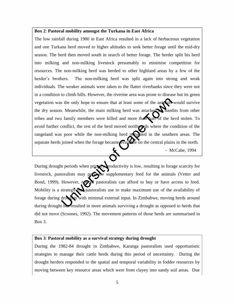
Box 2: Pastoral mobility amongst the Turkana in East Africa
The low rainfall during 1980 in East Africa resulted in a lack of herbaceous vegetation
and one Turkana herd moved to higher altitudes to seek better forage until the mid-dry
season. The herd then moved south in search of better forage. The herder split his herd
into milking and non-milking livestock presumably to minimise competition for
resources. The non-milking herd was herded to other highland areas by a few of the
herder’s brothers. The non-milking herd was split again into strong and weak
individuals. The weaker animals were taken to the flatter riverbanks since they were not
in a condition to climb hills. However, the riverine area was prone to disease but its green
vegetation was the only hope to ensure that at least some of the animals would survive
the dry season. Meanwhile, the main milking herd was attacked by bandits from other
tribes and two family members were killed and more than half of the herd stolen. To
avoid further conflict, the rest of the herd moved northwards where the condition of the
rangeland was poor while the non-milking herd remained in the southern areas. The
separate herds joined when the forage became available on the central plains in the north.
- McCabe, 1994
During drought periods when primary productivity is low, resulting in forage scarcity for
livestock, pastoralists may purchase supplementary feed for the animals (Vetter and
Bond, 1999). However, not all pastoralists can afford to buy or have access to feed.
Mobility is a strategy that pastoralists use to make maximum use of the availability of
forage during droughts with minimal external input. In Zimbabwe, moving herds around
during drought has resulted in more animals surviving a drought as opposed to herds that
did not move (Scoones, 1992). The movement patterns of those herds are summarised in
Box 3.
Box 3: Pastoral mobility as a survival strategy during drought
During the 1982-84 drought in Zimbabwe, Karanga pastoralists used opportunistic
strategies to manage their cattle herds during this period of uncertainty. During the
drought herders responded to the spatial and temporal variability in fodder resources by
moving between key resource areas which were from clayey into sandy soil areas. Due
Unive
rsity
of C
ape
Town
6
to the influx of herds into the key resource areas, the available fodder became insufficient
and cattle herds move out of the area. Firstly, they moved to the outskirts of a residential
area and then some herds moved south to abandoned farms that had sufficient forage
available. Other herds moved to the northern parts of the communal area and then
illegally onto commercial ranches. Few herders hired grazing land from private land
owners whereas other land owners allowed pastoral herds access to their land for free.
- Scoones, 1992
The study described above demonstrates the importance of mobility for livestock survival
in Zimbabwe. The fact that these pastoralists have large grazing areas and options to
move over long distances, allow them to evade drought conditions. In a spatially
constrained environment, there might be insufficient space to move to areas where
pastoralists could evade drought conditions and access key resource areas.
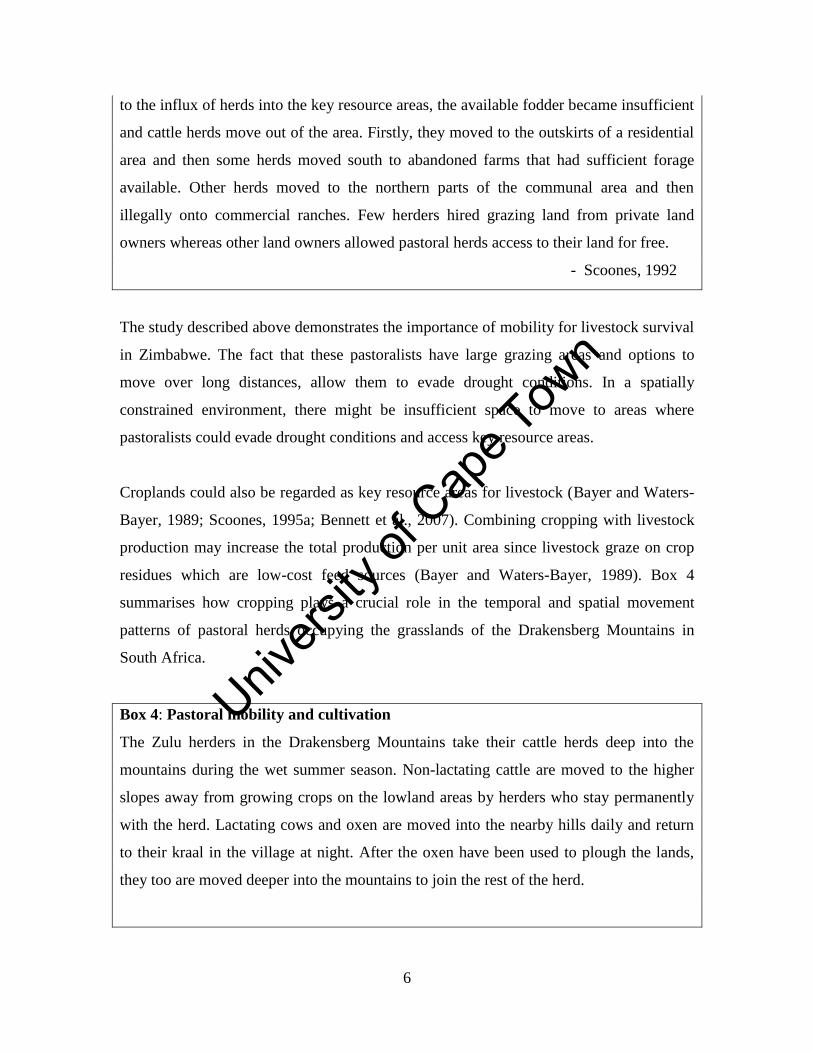
Croplands could also be regarded as key resource areas for livestock (Bayer and Waters-
Bayer, 1989; Scoones, 1995a; Bennett et al., 2007). Combining cropping with livestock
production may increase the total production per unit area since livestock graze on crop
residues which are low-cost feed sources (Bayer and Waters-Bayer, 1989). Box 4
summarises how cropping plays a crucial role in the temporal and spatial movement
patterns of pastoral herds occupying the grasslands of the Drakensberg Mountains in
South Africa.
Box 4: Pastoral mobility and cultivation
The Zulu herders in the Drakensberg Mountains take their cattle herds deep into the
mountains during the wet summer season. Non-lactating cattle are moved to the higher
slopes away from growing crops on the lowland areas by herders who stay permanently
with the herd. Lactating cows and oxen are moved into the nearby hills daily and return
to their kraal in the village at night. After the oxen have been used to plough the lands,
they too are moved deeper into the mountains to join the rest of the herd.
Unive
rsity
of C
ape
Town
7
Time of movement into the mountains is made by a tribal leader but penalties are only
imposed on owners whose animals damage crops and not for herds remaining on the
lowlands. Oxen will return to the lowlands to transport harvested crops and then the rest
of the herd move down the mountain during winter to graze on crop residues. Recently,
there has been an increased concern about stock theft and most owners prefer to graze
their animals close to the village to watch them. Then again, owners do not want to pay
penalties for crop damages. - Chonco, 2009
Mobile pastoralists do not make their decisions in isolation. They still work within a
community that has formal and informal institutions to regulate life. Box 5 summarises
how a pastoral group, The Raikas, manages the decision-making process.
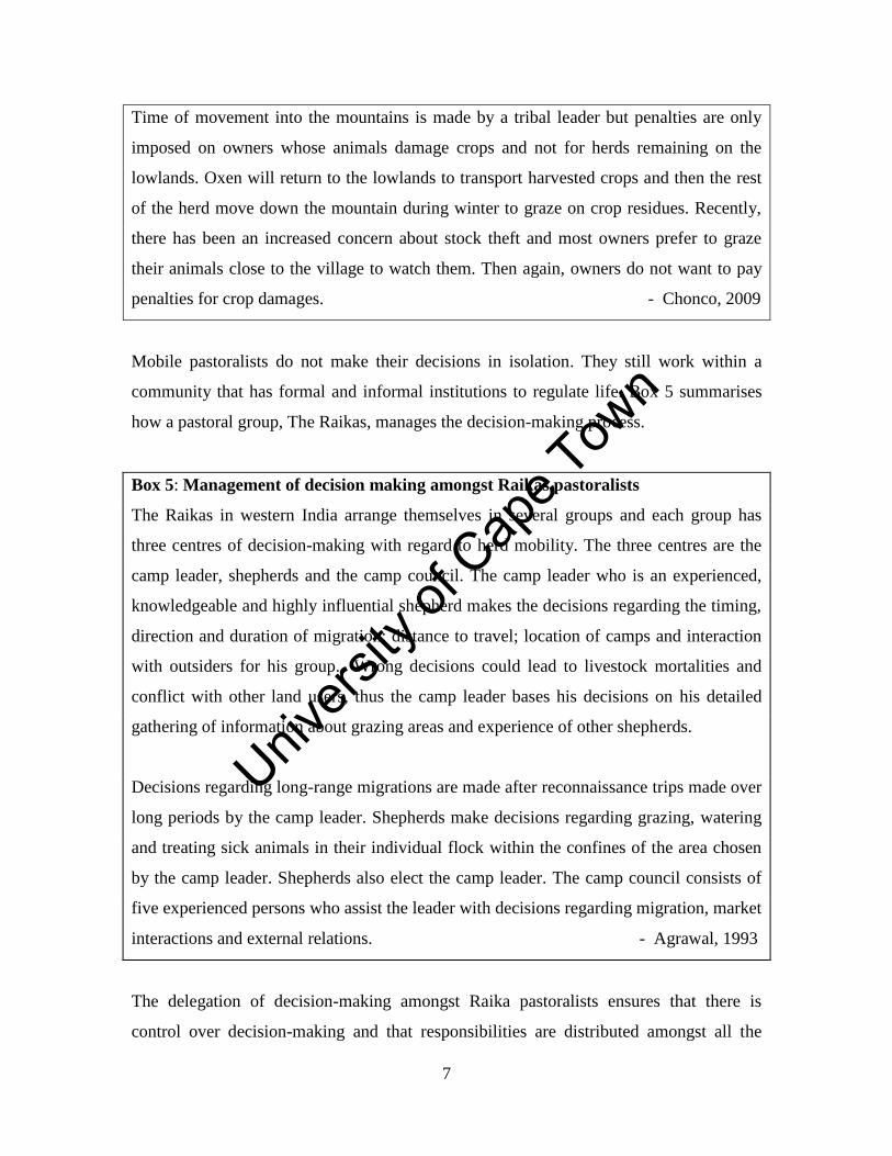
Box 5: Management of decision making amongst Raikas pastoralists
The Raikas in western India arrange themselves in several groups and each group has
three centres of decision-making with regard to herd mobility. The three centres are the
camp leader, shepherds and the camp council. The camp leader who is an experienced,
knowledgeable and highly influential shepherd makes the decisions regarding the timing,
direction and duration of migration; distance to travel; location of camps and interaction
with outsiders for his group. Wrong decisions could lead to livestock mortalities and
conflict with other land users, thus the camp leader bases his decisions on his detailed
gathering of information about grazing areas and experience of other shepherds.
Decisions regarding long-range migrations are made after reconnaissance trips made over
long periods by the camp leader. Shepherds make decisions regarding grazing, watering
and treating sick animals in their individual flock within the confines of the area chosen
by the camp leader. Shepherds also elect the camp leader. The camp council consists of
five experienced persons who assist the leader with decisions regarding migration, market
interactions and external relations. - Agrawal, 1993
The delegation of decision-making amongst Raika pastoralists ensures that there is
control over decision-making and that responsibilities are distributed amongst all the

Unive
rsity
of C
ape
Town
8
interest groups within their herding camp. This informal institutional arrangement also
ensures effective utilisation of available information, that economies of scale are
promoted and that no person or group abuses their power and personally benefits from
the decisions (Agrawal, 1993).
In other pastoral systems such as in Namaqualand in South Africa (Debeaudoin, 2001;
Baker and Hoffman, 2006) decisions regarding the location of stockposts3 are made by
individual herd owners. This is because herds are kraaled separately and graze alone
during the day (Samuels, 2006). The locations of stockposts are often in areas used
historically by the owner or his family and are usually thus not contested by other herd
owners. The selection of daily grazing routes of herds is made by the herder who bases
his decision on a set of criteria (Allsopp et al., 2007). The selection of a daily grazing
route might be contested by croppers if livestock graze on their growing crops. The local
municipality does not actively enforce the grazing rules and usually leaves it up to land
users themselves to resolve their disputes.
Nama pastoralists also benefit from economies of scale when they share costs of
medicines and feed (Marinus, 1997). Other pastoral groups such as the Turkana of
Kenya arrange themselves in groups during the wet season and separate into individual
herds during the dry season when resources are scarce (McCabe, 1994). Separation into
individual herds results in reduced competition for forage and water amongst the animals.
Herding in smaller herds based on species, breed, animal condition or age of the herd
allows for more efficient utilisation of resources and reduces stock losses through
disease, predation and raiding (McCabe, 1994; Fernandez-Gimenez and Swift, 2003).
Decision-making and institutional arrangements amongst mobile pastoral groups are
variable and the strategy used depends on the local conditions and circumstances of
pastoralists and their animals. Despite these variations, they gain similar benefits through
their informal arrangements.
3 A stockpost is the living quarters for small stock herds and herders who stay with their animals at night.
A stockpost consists of a corral (kraal) for confining animals at night, a sleeping shelter (khaya) for the
herder and a cooking shelter (kookskerm).
Unive
rsity
of C
ape
Town
9
1.2.2 Understanding the factors that spatially constrain mobile pastoralists
Mobile pastoralists are affected by changes in the environment, socio-economic pressures
and political marginalisation that hinder their access to resources and services (Turner,
1999a; Nori and Davies, 2007). One area that has received considerable recent attention
has been the conflict between protected area establishment and the effect this has had on
the ability of pastoralists to move across traditional grazing areas (Ngoitiko et al., 2010).
Mobile pastoralism has been particularly negatively affected by conservation initiatives
when grazing space has been limited (Galaty, 2012). For example, the formation of a
national park in Niger resulted in the park being at the centre of conflict because animals
were herded through the conservation area to access resources on the other side (Turner,
1999a). In Kenya parks host important resources including water and salt licks that the
Maasai depend on for the survival of their animals (Kipuri and Naikuni, 2008).
Elsewhere in East Africa, mobile pastoralists near the Ngorongoro conservation area are
restricted in accessing traditional grazing resources (Galaty, 2012). This is because
conservation policies are based on the segregation of people and wildlife and thus human
activities are restricted in game controlled areas (Ngoitiko et al., 2010).
In South Africa, a few contractual parks have been formed to ensure that conservation
and other land uses can co-exist (Grossman and Holden, undated). However, this system
of conservation is complex and poses several challenges to park management. Box 6
summarises challenges posed by mobile pastoralists within the Richtersveld National
Park in semi-arid South Africa.
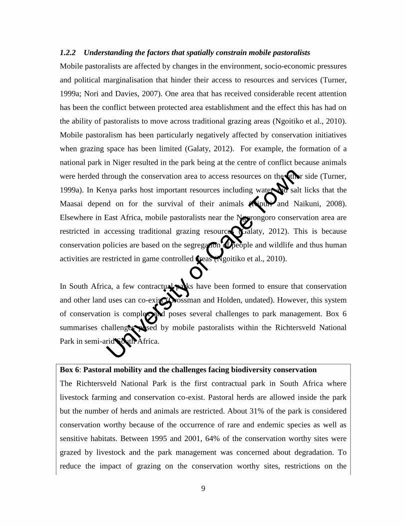
Box 6: Pastoral mobility and the challenges facing biodiversity conservation
The Richtersveld National Park is the first contractual park in South Africa where
livestock farming and conservation co-exist. Pastoral herds are allowed inside the park
but the number of herds and animals are restricted. About 31% of the park is considered
conservation worthy because of the occurrence of rare and endemic species as well as
sensitive habitats. Between 1995 and 2001, 64% of the conservation worthy sites were
grazed by livestock and the park management was concerned about degradation. To
reduce the impact of grazing on the conservation worthy sites, restrictions on the
Unive
rsity
of C
ape
Town
10
movement of herds and establishment of new stockposts are now regarded as the only
viable options to the park management. Destocking is unpopular amongst the herders and
was not an option when agreements were made between the park and the herders. Fences
are also not suitable because of the visibility to tourists. - Hendricks, 2004
Changes in climates that lead to diseases expanding the risk of transmission over larger
spatial scales might result in animals not being able to graze in certain areas. This was the
case in Zimbabwe where herd mobility was restricted between disease zones during an
outbreak of Foot and Mouth Disease which reduced long-range movements (Scoones,
1992). Similarly, African horse sickness periodically expands its range from sub-Saharan
Africa (Mellor et al., 2000). This might restrict pastoral mobility into these regions since
pastoralists often use equines to transport their possessions during migrations. As a result,
herds might become spatially constrained since some parts of their rangeland will no
longer be available for grazing.
There are between 100 and 200 million mobile pastoralists around the world (FAO, 2003
cited in Davies and Hatfield, 2007) and these pastoral communities could be expected to
by grow in the future. The growing pastoral community may struggle to find enough land
for grazing if all households in the community continue to practice livestock keeping. As
the human populations around pastoral communities also continue to grow, governments
see this as a growing market for meat and other animal products. In Africa, pastoral herds
produce between 50 to 75% of the continent’s milk and meat (de Haan et al., 1997 cited
in Galvin et al., 2008) and the demand for animal products is expected to increase
significantly by 2025. Governments therefore want mobile pastoralists to settle down and
become commercialised in order to satisfy this increase in demand.
In agro-pastoral systems, it is the more productive pastures that are used for cropping and
these are usually key grazing sites for pastoralists (Niamir-Fuller and Turner, 1999;
Bassett and Turner, 2007). The use of land as migration routes by pastoralists to access
seasonal resources are contested by non-pastoralists or foreign investors who want to use
the land for other purposes such as cultivation (Lengoiboni, 2011; Galaty, 2012). In
Unive
rsity
of C
ape
Town
11
Sudan, migration routes are increasingly becoming narrower and shorter due to the
encroachment of cultivated fields (Babiker, 2012). In Lesotho, mobility has declined
partly due to crop expansion onto historical grazing lands (Turner, 2003). It has been
widely reported that conflict sometimes arises between herders and croppers over crop
damages (Bassett, 1986; Fratkin, 1997; Shazali and Ahmed, 1999; Touré, 2004). An
increase in rainfall in certain areas could result in further encroachment of cultivation into
pastoral lands (Kirkbride and Grahn, 2008). In contrast, a decrease in rainfall and an
increase in rainfall variability could lead to an area becoming more marginal which could
result in the abandonment of cropping because it will be too risky (Hoffman and Vogel,
2008). For example, Jones and Thornton (2003) used simulation models to assess the
possible impacts of climate change on maize yields and show that overall crop yields
could decrease by 10% by 2055 in Africa and Latin America. The implications of a
decrease crop yields would be that people’s livelihoods might become more dependent on
livestock products and that cultivated lands might be used again as rangelands for
pastoral herds in these areas.
The Pashtunistan conflict during the 1960s resulted in the borders between Pakistan and
Afghanistan being closed and Afghan nomads were prevented from accessing their
traditional winter grazing areas. This resulted in a permanent change in grazing patterns
of Afghan nomads who had to seek alternative winter forage inside their own borders (de
Weijer, 2007). Stock theft is a major concern for pastoralists near the South Africa-
Lesotho border (Salomon et al., 2013) and elsewhere in Lesotho where it resulted in a
decrease in transhumance and underused areas as herders are afraid to graze some areas
(Turner, 2003). In Uganda, Jie pastoralists started to vacate remote areas in the 1990s
where they obtained good quality wet season forage and settled in areas with high human
densities as a defense strategy against conflict and raiding (Niamir-Fuller, 1999a).
Colonial and post-colonial governments have also used discriminatory policies to grab
land from indigenous pastoralists (Galaty, 2011). For example, in Sudan state policies
continue to advocate privatisation of grazing land. Due to privatisation, traditional
Unive
rsity
of C
ape
Town
12
grazing patterns and coping strategies of pastoralists have been disrupted resulting in
them being more vulnerable to the impact of droughts (Babiker, 2012).
Mobile pastoral systems are continually shrinking and short-range migrations are being
more used as a strategy to manage herds as long–range movements are no longer
possible. Studies that have described certain aspects of short-range movements in pastoral
systems are mainly from a few individual herds under drought conditions (e.g. Grandin et
al., 1989; McCabe, 1994) whereas other studies (e.g. Turner, 1999a; de Weijer, 2007;
Behnke et al., 2011; Akasbi et al., 2012; Dongmo et al., 2012) described short-range
movements where it is practiced in conjunction with longer-range movements. In Niger,
pastoralists use short range movements of 5-20 km to move away from growing crops
and to permanent water sources during the late dry seasons (Dupire 1972 cited in Tuner,
1999). They also move over longer distance of up to 50 km to access better forage after
the early rains. In Afghanistan, short-range movements account for 33% of migratory
patterns and are used during times of war when pastoralists do not want to be far away
from home. Short-range movements are also used when herds are small and livestock do
not have to move far due to less competition for food within the herd (de Weijer, 2007).
Long range movements, which account for 52% of migratory patterns in Afghanistan,
occur across provincial and national boundaries and are used to access seasonal grazing
resources (de Weijer, 2007). About 15% of herds do not migrate as some pastoralists
have obtained ownership of the land. Other pastoralists have not moved since they
consider the risk of losing animals during migrations too high.
Historically, in Sudano-Sahelian West Africa, long-range latitudinal movements of up to
500 km occurred to access nutritional grasses in the north during the rainy season and
during the dry season herds moved to the south to be closer to water (Behnke et al.,
2011). Movements between 15 to100 km occur towards floodplains during the dry season
due to the abundance of water and better forage and away from the floodplains during the
wet season to avoid deep water and diseases. Short-range movements between 3 to15 km
occur around human settlements and water points (Behnke et al., 2011).
Unive
rsity
of C
ape
Town
13
Long and short-range movements are very crucial in dryland ecosystems in order for
mobile pastoralists to meet specific objectives. However, when mobile pastoral systems
in drylands become smaller and spatially constrained and long-range movements are no
longer possible, we need to determine whether short-range movements will still be
effective in managing livestock and rangeland resources. Our understanding for short-
range movements within mobile pastoral systems is limited. This thesis aims to improve
our understanding of short-range movements by studying the movement patterns of
pastoral herds in the spatially constrained Leliefontein communal area.
1.2.3 Pastoral mobility in Namaqualand
Allsopp et al. (2007) examined the management of selected herds in four villages in the
Leliefontein communal area and developed a daily grazing route model around
stockposts to understand the grazing patterns of individual herds. Their study
demonstrated the variability and complexity in decision-making by pastoralists on when
and where to graze their animals. Allsopp et al. (2007) also developed a typology of daily
herding practices in normal rainfall years. Samuels (2006) extended the typology to
include herd management during drought periods in Paulshoek, one of the villages that
forms part of the Leliefontein communal area (Fig. 1.1). These typologies were based on
several factors that included: whether the herder or the animals select the daily grazing
route; how long the herder stays with the herd during the grazing period; whether animals
are actively directed by the herder or whether the herder only follows the herd to look out
for predators; and how the herd returns to the stockpost in the late afternoon.
Samuels et al. (2007) investigated micro-mobility that entailed examining daily grazing
routes of herds during a drought period in Paulshoek village. They determined the size of
the daily grazing area, how often herds rotate their daily grazing routes and how often
herds graze the same patch within their grazing area around stockposts. The study
identified mountains as key resource areas for herds during the drought period. It was
also found that a trade-offs exists since not all the animals are in good physical condition
to climb steep mountains daily in search of better forage. However, some animals might
have to be sacrificed so that the rest of the herd could survive the drought.
Unive
rsity
of C
ape
Town
14
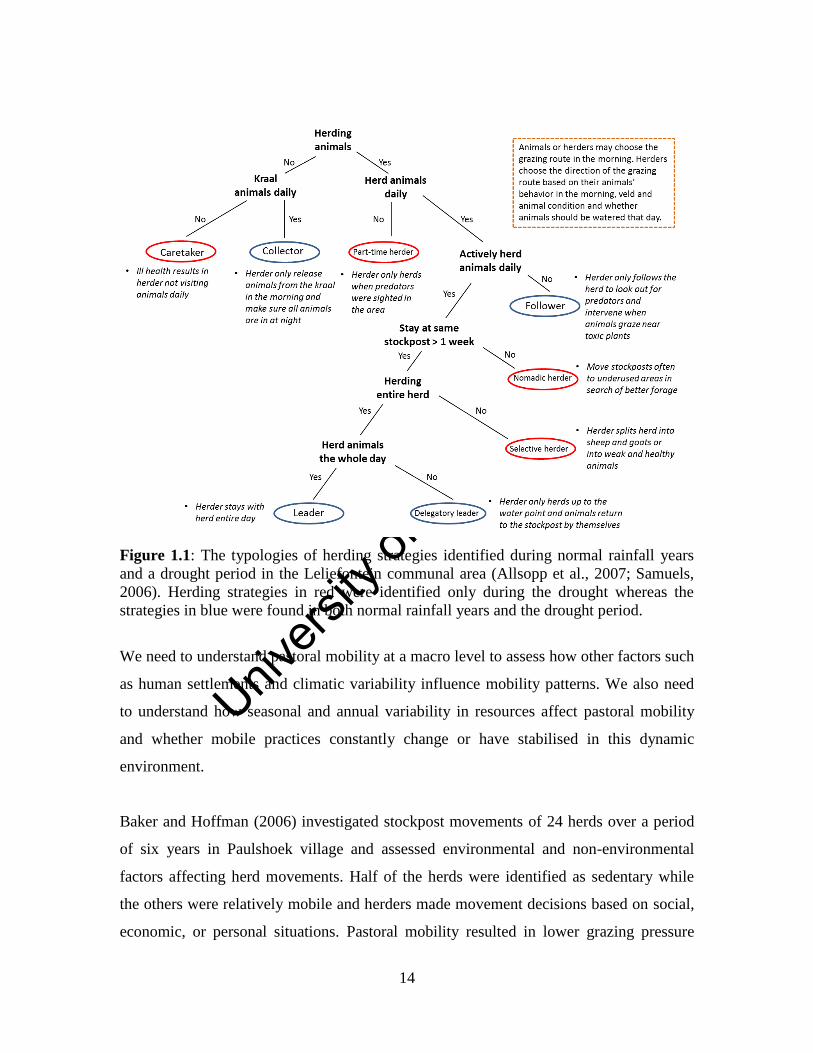
Figure 1.1: The typologies of herding strategies identified during normal rainfall years
and a drought period in the Leliefontein communal area (Allsopp et al., 2007; Samuels,
2006). Herding strategies in red were identified only during the drought whereas the
strategies in blue were found in both normal rainfall years and the drought period.
We need to understand pastoral mobility at a macro level to assess how other factors such
as human settlements and climatic variability influence mobility patterns. We also need
to understand how seasonal and annual variability in resources affect pastoral mobility
and whether mobile practices constantly change or have stabilised in this dynamic
environment.
Baker and Hoffman (2006) investigated stockpost movements of 24 herds over a period
of six years in Paulshoek village and assessed environmental and non-environmental
factors affecting herd movements. Half of the herds were identified as sedentary while
the others were relatively mobile and herders made movement decisions based on social,
economic, or personal situations. Pastoral mobility resulted in lower grazing pressure
Unive
rsity
of C
ape
Town
15
around stockposts than sedentary herds. However, this village is not isolated as it is one
of ten village commons in Leliefontein and thus this study could not capture the effect of
inter-village herding dynamics. Baker and Hoffman (2006) also did not investigate
pastoral mobility in relation to heterogeneity in vegetation.
In the Richtersveld National Park in Namaqualand, pastoral mobility is dictated by
conservation objectives rather than herder’s choice of grazing sites (Hendricks, 2004).
Factors that would affect pastoral mobility patterns are those that would threaten the
conservation status of an area and thus grazing would be prohibited in that area.
Moreover, the fact that livestock compete directly with indigenous herbivores for space,
food and water means that the number of herds inside the park are limited to 26 or an
equivalent of 6 000 small stock units (SSU). Conservation concerns are not significant
factors regarding decision-making in Leliefontein and thus mobility is likely to be
influenced by factors other than conservation.
Mobile pastoral systems are complex and dynamic and to understand them it is crucial to
consider all the factors that affect pastoral mobility. Also, we need to understand how
different levels of management within a pastoral system interact. This study will analyse
pastoral mobility at a herd, village commons and communal rangeland level.
1.3 Objectives of this study
The overall objectives of this study were to determine and discuss the extent to which
pastoral mobility still occurs in the variable environment of the Leliefontein communal
area, how mobility has changed over time and space and what are the key drivers for
these changes. This thesis analysed the roles of socio-economic and agricultural factors
as well as rangeland resources, including the unique vegetation of this semi-arid
biodiversity hotspot, in pastoral mobility. This study also identified and discusses which
aspects of mobile pastoralism are lost, changed or maintained when environments
become spatially constrained. In addition this study analysed which new strategies
(including those that do not depend on mobility) emerge under a spatially constrained
environment.
Unive
rsity
of C
ape
Town
16
To achieve these overall objectives, specific objectives, related to each of the four main
data chapters, included the following:
1. To examine how the mobile pastoral system in the Leliefontein communal area
has changed over time and space;
2. To understand the key drivers of changes in pastoral mobility in this variable and
spatially constrained environment;
3. To analyse the spatial scales of pastoral mobility in relation to resources and
human settlements in a constrained pastoral system;
4. To assess and discuss the effect of different vegetation types in the study area on
pastoral mobility and how grazing affects the conservation of the flora of the
region.
1.4 General Approach, Research Design and Thesis Structure
Chapter One contextualises the study and sets out the study objectives. It also provides a
justification for the study. Chapter Two describes the physical environment of
Leliefontein and the lifestyles of the people inhabiting this environment. Chapters Three
to Six are in the format where research questions are asked, the methods and statistical
treatment outlined, results interpreted and discussed to answer those questions.
Chapter Three documents and discusses the historical changes in the Leliefontein
pastoral system as a result of past and present legislation. I identified the key bits
of legislation that were promulgated during five periods of political rule in South
Africa and analysed its impacts on the geography of pastoral mobility in
Leliefontein. I also examined the literature and archival records such as
government reports and private correspondence kept in state libraries which refer
to specific legislation and the time period of its implementation. Furthermore, I
examined this material to see if any impacts of legislation on the mobility of herds
were recorded.
Chapter Four analyses and discusses the decisions that were made in relation to
temporal changes in rangeland resources, climatic conditions and socio-economic
conditions to affect pastoral mobility from 1997 to 2006 in Leliefontein. It also
outlines when and why pastoralists moved their herds. I conducted interviews
with pastoralists at stockposts or in the field while livestock was being herded in
Unive
rsity
of C
ape
Town
17
order to get a better understanding of the herd’s environment and herder’s reasons
for using certain management strategies.
Chapter Five examines and discusses herd movements in this spatially constrained
semi-arid environment and whether these patterns changed between 1997 and
2006. I conducted interviews with pastoralists and used GIS to analyse temporal
and spatial patterns of herd movements in relation to resources and human
settlements.
Chapter Six examines and discusses the distribution of grazing pressure within the
major vegetation types found in the study area. I calculated grazing densities at
each stockpost using livestock censuses from a range of sources. A grazing
density map was produced using GIS and was overlaid onto the vegetation map of
southern Africa (Mucina and Rutherford, 2006). The vegetation map of southern
Africa identifies 440 vegetation types. This fine scale map with its detailed
descriptions defines a vegetation type based on the dominant and rare plant
species in the landscape and how these species are associated with the physical
environment (Mucina and Rutherford, 2006). In the Leliefontein communal area,
nine vegetation types have been identified and their distribution boundaries have
been refined by Helme and Desmet (2006).
The thesis concludes with Chapter Seven which provides a synthesis of the knowledge
gained in this study and makes recommendations regarding future research that would
further improve our understanding of pastoral mobility in other variable and spatially
constrained environments.
Unive
rsity
of C
ape
Town
18
Chapter Two
Study Area
2.1 Introduction
Pastoralists and agro-pastoralists need to know their environment very well in order to
make informed management decisions. This chapter first describes the biophysical
environment of Leliefontein. Secondly, it describes the people who occupy these
environments and their diverse land use activities.
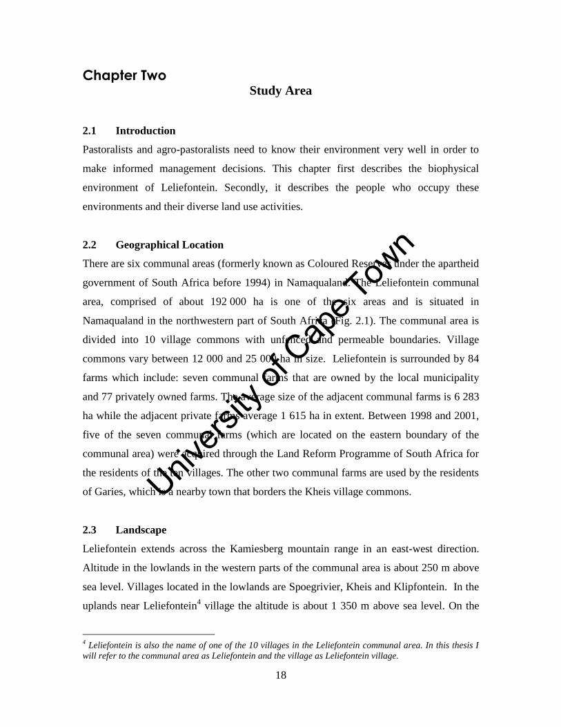
2.2 Geographical Location
There are six communal areas (formerly known as Coloured Reserves under the apartheid
government of South Africa before 1994) in Namaqualand. The Leliefontein communal
area, comprised of about 192 000 ha is one of the six areas and is situated in
Namaqualand in the northwestern part of South Africa (Fig. 2.1). The communal area is
divided into 10 village commons with unfenced and permeable boundaries. Village
commons vary between 12 000 and 25 000 ha in size. Leliefontein is surrounded by 84
farms which include: seven communal farms that are owned by the local municipality
and 77 privately owned farms. The average size of the adjacent communal farms is 6 283
ha while the adjacent private farms average 1 615 ha in extent. Between 1998 and 2001,
five of the seven communal farms (which are located on the eastern boundary of the
communal area) were acquired through the Land Reform Programme of South Africa for
the residents of the ten villages. The other two communal farms are used by the residents
of Garies, which is a nearby town that borders the Kheis village commons.
2.3 Landscape
Leliefontein extends across the Kamiesberg mountain range in an east-west direction.
Altitude in the lowlands in the western parts of the communal area is about 250 m above
sea level. Villages located in the lowlands are Spoegrivier, Kheis and Klipfontein. In the
uplands near Leliefontein4 village the altitude is about 1 350 m above sea level. On the
4 Leliefontein is also the name of one of the 10 villages in the Leliefontein communal area. In this thesis I
will refer to the communal area as Leliefontein and the village as Leliefontein village.
Unive
rsity
of C
ape
Town
19
plateau in the east around Rooifontein and Kamassies villages the height is about 800 m
above sea level. The villages of Kharkams, Tweerivier, and the western parts of
Nourivier and Paulshoek villages are located on the Kamiesberg escarpment.
Figure 2.1: The location of the Leliefontein communal area in Namaqualand, Northern
Cape Province of South Africa.
The uplands and escarpment are characterised by large granite gneiss boulders, inselbergs
and steep mountains. The topography in the lowlands in the west and the plateau in the
east is flatter and sandy due to fewer gneiss intrusions.
All the rivers within the communal area are ephemeral and flow only for short periods
during the winter months and after occasional heavy summer rainfall events.
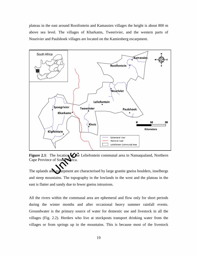
Groundwater is the primary source of water for domestic use and livestock in all the
villages (Fig. 2.2). Herders who live at stockposts transport drinking water from the
villages or from springs up in the mountains. This is because most of the livestock
Unive
rsity
of C
ape
Town
20
boreholes deliver water with a high concentration of salts and other minerals which
render the water unfit for humans (Titus et al., 2002). In Paulshoek village, water from
boreholes for domestic use is usually mixed with rainwater, if available, before it is piped
to the homes.
Figure 2.2: A pastoralist filling the trough with water from a hand dug well for his
animals.
2.4 Soils
Soils on the western side of the study area near Spoegrivier village consist mainly of deep
red, yellow and grey sands. Soils of upland areas and the escarpment are shallow, red
soils on dorbank especially in the flatlands between the mountain ridges. On the eastern
boundary of the study area, shallow red sandy soils are underlain by calcrete and dorbank
on the plains (Ellis, 1998 cited in Francis et al., 2007).
The physical and chemical properties of soils affect biodiversity distribution (Petersen et
al., 2004) as well as ecosystem function in Namaqualand (Francis et al., 2007). However,
nitrogen distribution patterns are also influenced by organic matter accumulation in the
soils around shrubs. Soil moisture levels in the landscape are also patchy since perennial
Unive
rsity
of C
ape
Town
21
shrubs take up water after rainfall events and thus deplete soil moisture faster than open
areas which do not have perennial shrubs (Allsopp, 1999). Cultivation of soils on the
flatlands results in the loss of soil nutrients (Allsopp, 1999).
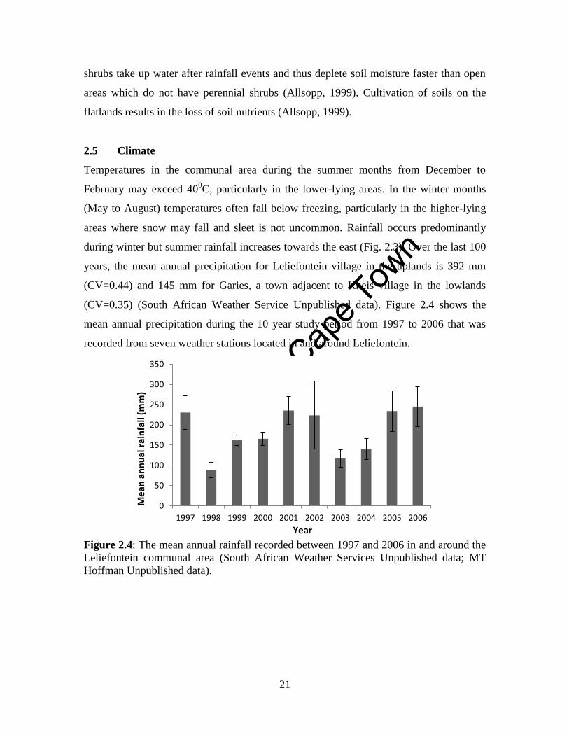
2.5 Climate
Temperatures in the communal area during the summer months from December to
February may exceed 400C, particularly in the lower-lying areas. In the winter months
(May to August) temperatures often fall below freezing, particularly in the higher-lying
areas where snow may fall and sleet is not uncommon. Rainfall occurs predominantly
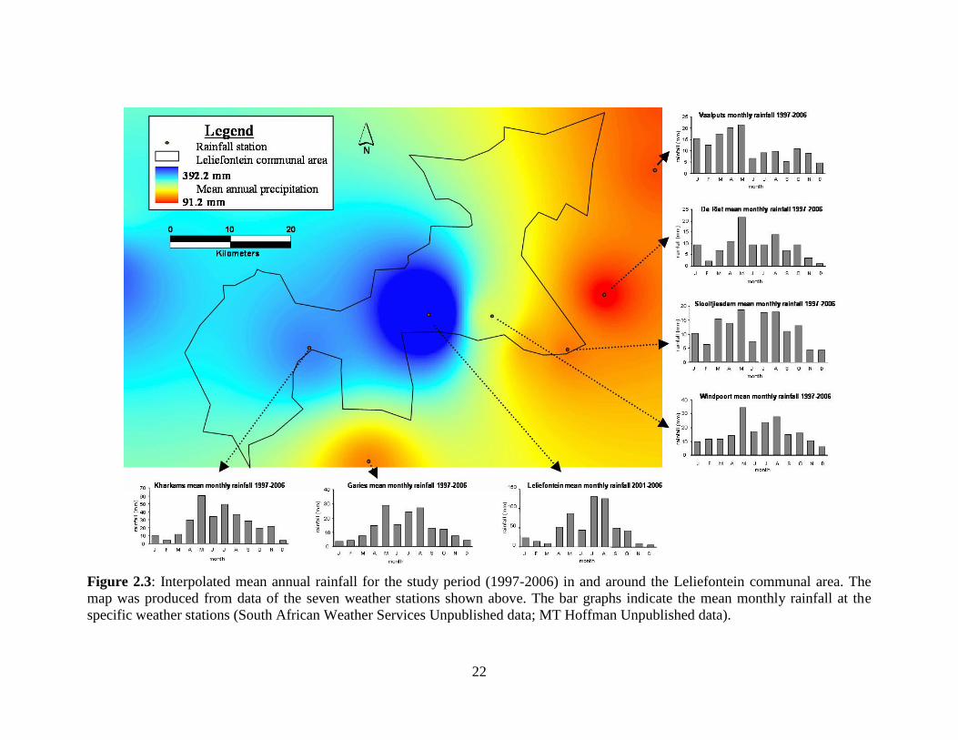
during winter but summer rainfall increases towards the east (Fig. 2.3). Over the last 100
years, the mean annual precipitation for Leliefontein village in the uplands is 392 mm
(CV=0.44) and 145 mm for Garies, a town adjacent to Kheis village in the lowlands
(CV=0.35) (South African Weather Service Unpublished data). Figure 2.4 shows the
mean annual precipitation during the 10 year study period from 1997 to 2006 that was
recorded from seven weather stations located in and around Leliefontein.
Figure 2.4: The mean annual rainfall recorded between 1997 and 2006 in and around the
Leliefontein communal area (South African Weather Services Unpublished data; MT
Hoffman Unpublished data).
0
50
100
150
200
250
300
350
1997 1998 1999 2000 2001 2002 2003 2004 2005 2006
Mea
n a
nn
ual
rai
nfa
ll (m
m)
Year
Unive
rsity
of C
ape
Town
22
Figure 2.3: Interpolated mean annual rainfall for the study period (1997-2006) in and around the Leliefontein communal area. The
map was produced from data of the seven weather stations shown above. The bar graphs indicate the mean monthly rainfall at the
specific weather stations (South African Weather Services Unpublished data; MT Hoffman Unpublished data).
Unive
rsity
of C
ape
Town
23
2.6 Biodiversity
2.6.1 Fauna
Historically, Namaqualand supported a wide variety of indigenous mammals which are
now extinct in the region. These included Equus zebra hartmannae (Hartmann’s mountain
zebra), Antidorcas marsupialis (springbok), Oryx gazelle (gemsbok), Alcelaphus
buselaphus (Red hartebees) and Pelea capreolus (Grey rhebok) (Skead 1980 cited in
Landman et al., 2006). If some of these species were to be re-introduced then livestock
populations will have to be reduced because these animals compete for the same
resources (Landman et al., 2006).
Presently, the study area still contains a wide variety of indigenous invertebrate, reptile,
bird and other mammal species. 164 insect species have been recorded in the uplands
area alone of which 80% are endemic to the biome (Colville, 2006). Mammal species that
occur in the study area include herbivores such as Lepus capensis (Cape hare), Procavia
capensis (Cape hyrax), Raphicerus campestris (steenbok) and Oreotragus oreotragus
(klipspringer) and carnivores such as Canis mesomelas (Black-backed jackal) and Felis
caracal (rooikat). Both of these carnivores prey on livestock and are thus viewed as pests
to livestock keepers.
2.6.2 Flora
The study area forms part of the Succulent Karoo biome, a biodiversity hotspot of global
significance that supports the world’s richest succulent vegetation (Cowling et al., 1999).
The Succulent Karoo has been identified as the biome most threatened from climate
change in South Africa (Rutherford et al., 2000). This biome contains 4 750 plant species
(Cowling and Hilton-Taylor, 1994) and Namaqualand contains 75% of the hotspot’s plant
species (Cowling and Pierce, 1999). Nine vegetation types occur in the study area (Table
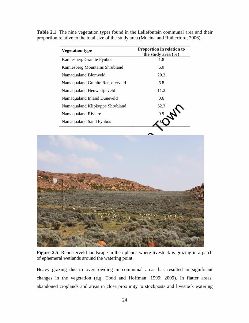
2.1) (Mucina and Rutherford, 2006) including Renosterveld (Fig. 2.5), which is one of
the most threatened vegetation types in South Africa (Winter et al., 2005). The vegetation
of the Leliefontein communal area will be discussed in greater detail in Chapter Six.
Unive
rsity
of C
ape
Town
24
Table 2.1: The nine vegetation types found in the Leliefontein communal area and their
proportion relative to the total size of the study area (Mucina and Rutherford, 2006).
Vegetation type Proportion in relation to
the study area (%) Kamiesberg Granite Fynbos 1.8
Kamiesberg Mountains Shrubland 6.0
Namaqualand Blomveld 20.3
Namaqualand Granite Renosterveld 6.8
Namaqualand Heuweltjieveld 11.2
Namaqualand Inland Duneveld 0.6
Namaqualand Klipkoppe Shrubland 52.3
Namaqualand Riviere 0.9
Namaqualand Sand Fynbos 0.1
Figure 2.5: Renosterveld landscape in the uplands where livestock is grazing in a patch
of ephemeral wetlands around the watering point.
Heavy grazing due to overcrowding in communal areas has resulted in significant
changes in the vegetation (e.g. Todd and Hoffman, 1999; 2009). In flatter areas,
abandoned croplands and areas in close proximity to stockposts and livestock watering
Unive
rsity
of C
ape
Town
25
points, perennial palatable shrubs have generally been replaced by shrubs unpalatable to
livestock (Todd and Hoffman, 2000; Riginos and Hoffman 2003; Anderson and
Hoffman, 2007). The dominant unpalatable woody shrubs that establish on these
disturbed areas are Elytropappus rhinocerotis (renosterbos) in the uplands, Hermannia
amoena (jeukbos) on the plateau and Galenia africana (kraalbos) in other parts of the
communal area. Annual plants have also increased in abundance and cover in areas with
the greatest grazing densities (Todd and Hoffman, 1999).
2.7 Land use
In Namaqualand, extensive livestock farming on communal areas and private farms is the
main land use. Irrigated commercial agriculture mainly occurs along the Orange and
Olifants Rivers. Diamond mining occurs on 397 000 ha (7.54%) of the land along the
Namaqualand coast. Several copper mines are still operational in towns around
Springbok, the main town in Namaqualand. Formal conservation occurs in the Namaqua
National Park (141 000 ha) and Goegab Nature reserve (15 004 ha) where no other land
use is allowed. In the Richtersveld National Park, however, which borders on Namibia,
communal livestock herds are allowed to move in and out the park. This protected area is
managed as a contractual national park where livestock numbers are regulated.
Conservation stewardship agreements are also currently being developed by the NGO,
Conservation South Africa in association with land users on communal and private lands.
There are 420 private farms in Namaqualand which occupy about 52% of the area while
communal lands occupy 30% of the area (May and Lahiff, 2007). Livestock farming on
private farms is mostly profit driven and animals are managed through a rotational
grazing system with the use of multiple paddocks which are referred to locally as
‘camps’. These practices were promoted by subsidies and legislation from the 1950s
onwards for white farmers. Most private farm owners have more than one farm which in
some cases are located in a different agro-ecological regions (Van Zyl, 1957; Rohde and
Hoffman, 2008) providing these land owners with the opportunity to move their livestock
seasonally between farms. Moving between agro-ecological zones in response to drought
and variation in resources mimics the transhumance patterns adopted by Nama-
Unive
rsity
of C
ape
Town
26
pastoralists before Namaqualand was colonised (Webley, 1986; Rohde and Hoffman,
2008). Commercial farming is a profit driven enterprise where meat is produced for
national and international agricultural markets.
There are two main types of communal tenure in the Northern Cape Province. Municipal
commonages are owned by local municipalities and include land acquired by the
Department of Land Affairs after 1994 through South Africa’s Land Reform programme.
In addition, six historic communal areas in the Northern Cape are held in trust by the
Minister of Land Affairs for the people of the region and services are provided by local
municipalities.
Municipal commonage holdings include 367 817 ha which are owned by municipalities
in the Northern Cape alone, excluding the large Namaqualand and Mier areas (Benseler,
2003). These sizes should increase dramatically as the Land Reform programme of South
Africa aspires to transfer a total of 30% of agricultural land of the country to previously
disadvantaged people by 2014. Municipal commonages are managed on a camp system5
whereby a fenced paddock (camp) is rented out to an individual or a group of farmers.
Stocking rates are fixed according to regulations set out by the Department of
Agriculture. There are instances where more than one camp is rented out to the same
person or group of people, usually the wealthier farmers (Lebert and Rohde, 2007). Since
all the camps are rented out at the same time, farmers cannot practice rotational grazing.
With the camp system, as opposed to an open grazing system without the use of fences,
there is no means for people to move to better grazing areas when environmental
conditions are unfavourable. However, the municipality insists that the land is best
managed by using camps. Prior to 1994, grazing rights on municipal commonages were
awarded to individual white and coloured6 farmers at a nominal fee. These farmers either
5A camp system refers to a grazing system whereby livestock is rotated between three or more fenced
paddocks seasonally or at temporal intervals depending on factors that include rangeland condition, water
availability and grazing pressure.
6 Under the apartheid government in South Africa, the population was classified into three racial groups
and these groups were treated differently as a consequence of legislation. The three groups are the natives
(blacks of Bantu descent), whites (European descent) and coloureds (people that are neither white nor of
Bantu descent).The people of Namaqualand were classified as coloureds.
Unive
rsity
of C
ape
Town
27
had access to other grazing lands or were awarded access to the entire municipal
commonage.
The six communal areas (Fig. 2.6) are approximately 1 010 703 ha in total size and have
been stocked at 1.6 times the recommended stocking rate between 1974 and 1997
(Northern Cape Veterinary Services Unpublished data). This excludes the cattle
population of between 500 and 1200 individuals during this period for four of the areas
combined and the equine population (horses and donkeys) which could be several
thousand animals in the six communal areas. As in other communal areas of
Namaqualand (Hendricks, 2004), small stock herds which include sheep and goats are
aggregated at stockposts scattered around the rangeland. Various breeds of sheep (Ovis
aries) are kept in Leliefontein which include Dorper, Damara, Karakul, Persian and
indigenous Afrikaner breeds. However, rarely do we find pure breeds in the study area
since pastoralists usually crossbreed their livestock to ensure that their animals are
adapted to the variable climatic conditions and to ensure good quality mutton sheep.
Pastoralists only keep boer goats (Capra hircus) but there are a few people who keep one
or two Swiss breeds at their stockposts for milk which they use for home consumption or
when a ewe dies or abandons her lambs. Small stock herds on the communal area are
managed by herders who have developed several herding strategies as a response to
environmental and social drivers (Samuels, 2006; Allsopp et al., 2007).
In Namaqualand, as in other pastoral systems in East Africa (Fratkin, 1986), different
livestock species are kept for different reasons. Livestock numbers in the communal area
have also varied significantly over the years (Fig. 2.7) and are closely related to
fluctuations in annual rainfall (Todd and Hoffman, 2000). There has also been a
significant change in the type of livestock species using the rangelands in the region. For
example, in 1853, about 2 170 cattle were recorded in the Leliefontein communal area
(Mellvill, 1890) but in 2002 this number had declined to only 354 animals (Fig. 2.7). The
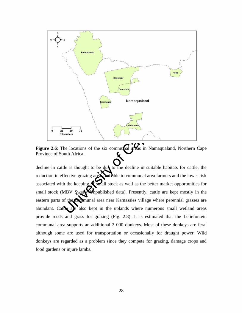
Unive
rsity
of C
ape
Town
28
Figure 2.6: The locations of the six communal areas in Namaqualand, Northern Cape
Province of South Africa.
decline in cattle is thought to be due to the decline in suitable habitats for cattle, the
reduction in effective grazing area available to communal area farmers and the lower risk
associated with the keeping of small stock as well as the better market opportunities for
small stock (MBV Swarts Unpublished data). Presently, cattle are kept mostly in the
eastern parts of the communal area near Kamassies village where perennial grasses are
abundant. Cattle are also kept in the uplands where numerous small wetland areas
provide reeds and grass for grazing (Fig. 2.8). It is estimated that the Leliefontein
communal area supports an additional 2 000 donkeys. Most of these donkeys are feral
although some are used for transportation or occasionally for draught power. Wild
donkeys are regarded as a problem since they compete for grazing, damage crops and
food gardens or injure lambs.
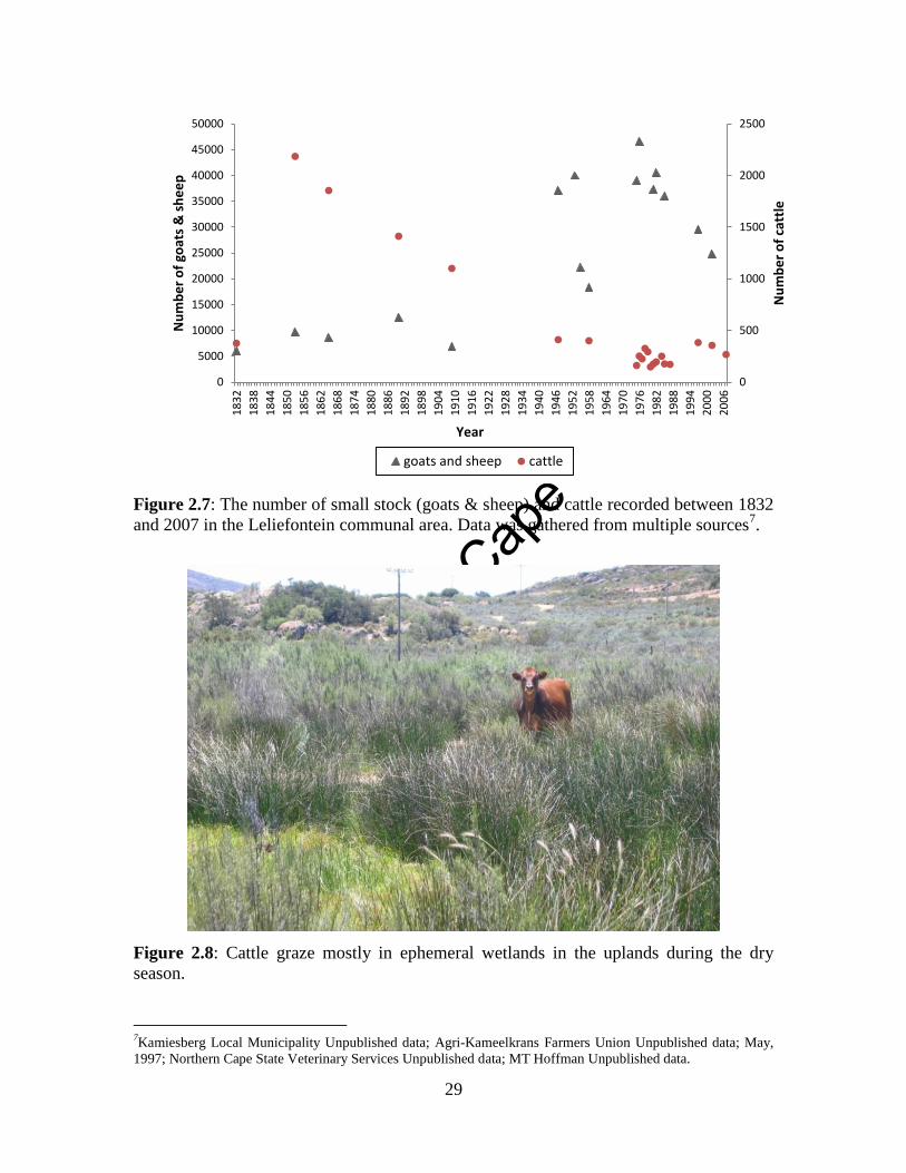
Unive
rsity
of C
ape
Town
29
Figure 2.7: The number of small stock (goats & sheep) and cattle recorded between 1832
and 2007 in the Leliefontein communal area. Data was gathered from multiple sources7.
Figure 2.8: Cattle graze mostly in ephemeral wetlands in the uplands during the dry
season.
7Kamiesberg Local Municipality Unpublished data; Agri-Kameelkrans Farmers Union Unpublished data; May,
1997; Northern Cape State Veterinary Services Unpublished data; MT Hoffman Unpublished data.
0
500
1000
1500
2000
2500
0
5000
10000
15000
20000
25000
30000
35000
40000
45000
50000
18
32
18
38
18
44
18
50
18
56
18
62
18
68
18
74
18
80
18
86
18
92
18
98
19
04
19
10
19
16
19
22
19
28
19
34
19
40
19
46
19
52
19
58
19
64
19
70
19
76
19
82
19
88
19
94
20
00
20
06
Nu
mb
er
of
catt
le
Nu
mb
er
of
goat
s &
sh
ee
p
Year
goats and sheep cattle
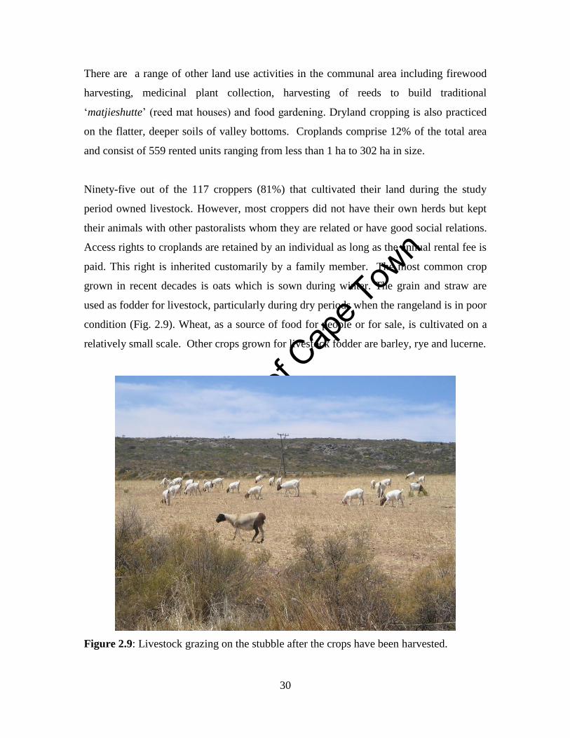
Unive
rsity
of C
ape
Town
30
There are a range of other land use activities in the communal area including firewood
harvesting, medicinal plant collection, harvesting of reeds to build traditional
‘matjieshutte’ (reed mat houses) and food gardening. Dryland cropping is also practiced
on the flatter, deeper soils of valley bottoms. Croplands comprise 12% of the total area
and consist of 559 rented units ranging from less than 1 ha to 302 ha in size.
Ninety-five out of the 117 croppers (81%) that cultivated their land during the study
period owned livestock. However, most croppers did not have their own herds but kept
their animals with other pastoralists whom they are related or have good social relations.
Access rights to croplands are retained by an individual as long as the annual rental fee is
paid. This right is inherited customarily by a family member. The most common crop
grown in recent decades is oats which is sown during winter. The grain and straw are
used as fodder for livestock, particularly during dry periods when the rangeland is in poor
condition (Fig. 2.9). Wheat, as a source of food for people or for sale, is cultivated on a
relatively small scale. Other crops grown for livestock fodder are barley, rye and lucerne.
Figure 2.9: Livestock grazing on the stubble after the crops have been harvested.
Unive
rsity
of C
ape
Town
31
The relatively low rainfall is the main environmental constraint to crop farming in the
area. Crop farmers will usually only sow and plough if there are good rains before mid-
August. Harvesting takes place towards the end of November or early December.
Croplands are traditionally regarded as open grazing lands after the crops are harvested
but individuals seek to retain rights to graze their stubble.
2.8 The people of Leliefontein
The latest complete population census in 2001 for the Leliefontein communal area
indicated that there were 7 571 people within 1 399 households in the region (Atkinson
and Ravenscroft, 2002). This is about three times more than the 2 467 residents reported
in Leliefontein in 1936 (Van Zyl, 1957).The largest village in terms of the number of
households is Kharkams and the smallest is Tweerivier (Fig. 2.10). As a result of the
growth of 307% of the human population in the last century more households in the study
area own livestock (OO Ogidan Unpublished data). This means that more households are
now dependent on livestock products. However, livestock numbers have remained
constant suggesting that the rangeland cannot accommodate more animals. Since there
has been a decrease in livestock owned per capita in the study area, pastoralists in
Leliefontein have diversified their income which includes non-agricultural income
sources (Rohde et al., 2003). This strategy has also been observed in other mobile
pastoral systems (Reid et al., 2008).
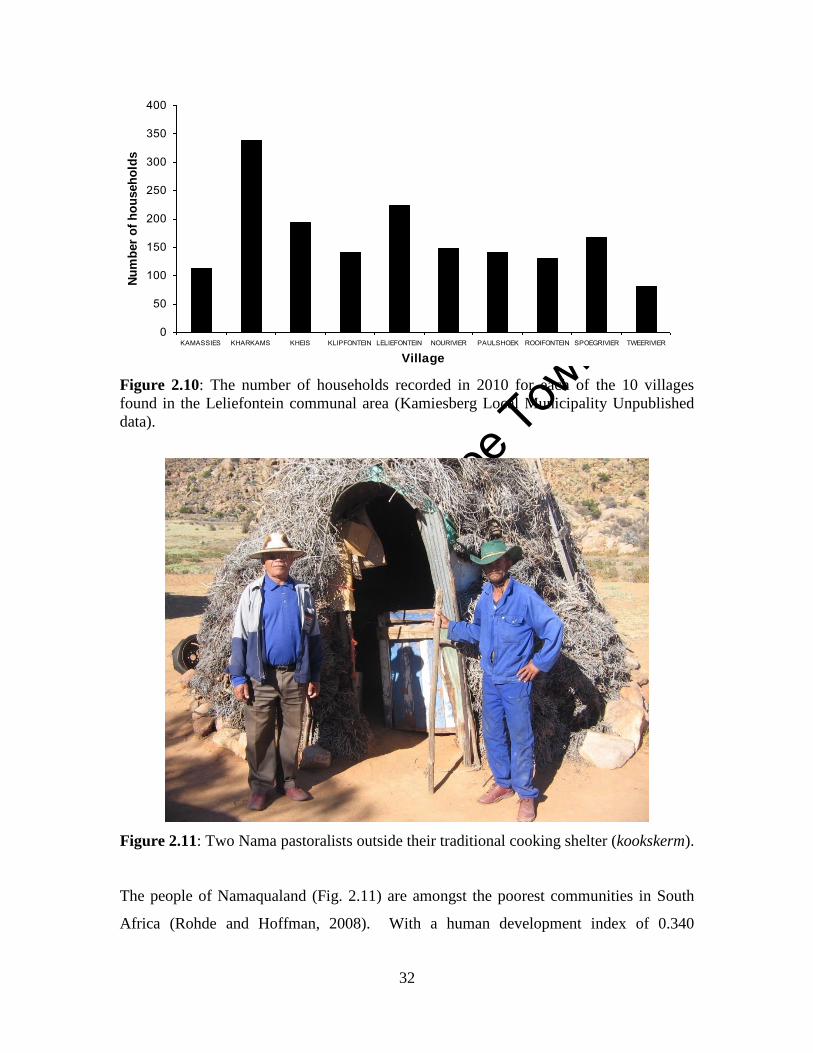
Unive
rsity
of C
ape
Town
32
Figure 2.10: The number of households recorded in 2010 for each of the 10 villages
found in the Leliefontein communal area (Kamiesberg Local Municipality Unpublished
data).
Figure 2.11: Two Nama pastoralists outside their traditional cooking shelter (kookskerm).
The people of Namaqualand (Fig. 2.11) are amongst the poorest communities in South
Africa (Rohde and Hoffman, 2008). With a human development index of 0.340
0
50
100
150
200
250
300
350
400
KAMASSIES KHARKAMS KHEIS KLIPFONTEIN LELIEFONTEIN NOURIVIER PAULSHOEK ROOIFONTEIN SPOEGRIVIER TWEERIVIER
Village
Nu
mb
er
of
ho
useh
old
s
Unive
rsity
of C
ape
Town
33
Namaqualand has a substantially lower value than the national and provincial indices
(Rohde et al., 2003). However, there is a significant wealth differentiation gap between
households in the study area.
Anseeuw et al. (2001) identified seven different household typologies in the Leliefontein
communal area which was based on their income streams. The highest earning
households receive an income of R43 800 per year and have motorised transport, which
allow them to move their animals to the land reform farms (Lebert and Rohde, 2007).
They have salaried herders and own an average of 300 small stock animals. The poorest
households earn R615 or 1.4% of the richest household’s income per annum. They do not
have motorised transport and own on average 33 small stock animals. The middle income
groups own between 69 and 84 small stock animals. They obtain an income from
temporary jobs that are often unreliable or from social grants or remittances sent by
migrants working outside the communal area. Most of the middle income groups do not
have motorised transport (Anseeuw et al., 2001). Therefore, the fact that the land reform
farms are located far away from some villages in the study area means that poorer and
most of the middle income groups cannot access the new lands made available for
pastoralists in Leliefontein.
In analysing the typologies of households in Paulshoek village, which is one of the ten
villages in the study area, Rohde et al. (2003) identified five household types based on
sources and amount of income and household characteristics such as education,
household size and age. The average income per household in 1995 for the poorest
households is 9.6% that of richest households. Within the richest households in the
village, most household heads have permanent jobs or are self-employed and have
multiple sources of income. The poorest households live below the poverty line and rely
on assistance from others in the village to survive. In 1999, the poorest households
earned 25.3% of richest households (Rohde et al., 2003). This increase could be
attributed to an increase in the amount of social grants obtained in the village over the
years.
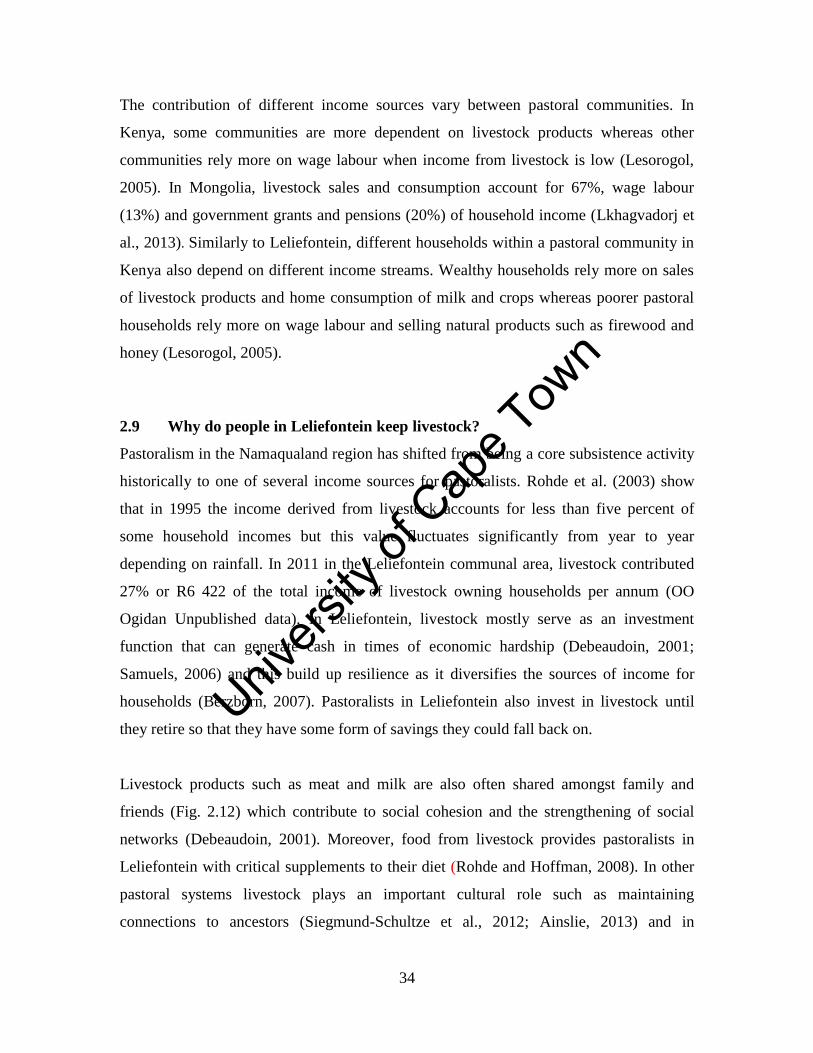
Unive
rsity
of C
ape
Town
34
The contribution of different income sources vary between pastoral communities. In
Kenya, some communities are more dependent on livestock products whereas other
communities rely more on wage labour when income from livestock is low (Lesorogol,
2005). In Mongolia, livestock sales and consumption account for 67%, wage labour
(13%) and government grants and pensions (20%) of household income (Lkhagvadorj et
al., 2013). Similarly to Leliefontein, different households within a pastoral community in
Kenya also depend on different income streams. Wealthy households rely more on sales
of livestock products and home consumption of milk and crops whereas poorer pastoral
households rely more on wage labour and selling natural products such as firewood and
honey (Lesorogol, 2005).
2.9 Why do people in Leliefontein keep livestock?
Pastoralism in the Namaqualand region has shifted from being a core subsistence activity
historically to one of several income sources for pastoralists. Rohde et al. (2003) show
that in 1995 the income derived from livestock accounts for less than five percent of
some household incomes but this value fluctuates significantly from year to year
depending on rainfall. In 2011 in the Leliefontein communal area, livestock contributed
27% or R6 422 of the total income of livestock owning households per annum (OO
Ogidan Unpublished data). In Leliefontein, livestock mostly serve as an investment
function that can generate cash in times of economic hardship (Debeaudoin, 2001;
Samuels, 2006) and this build up resilience as it diversifies the sources of income for
households (Berzborn, 2007). Pastoralists in Leliefontein also invest in livestock until
they retire so that they have some form of savings they could fall back on.
Livestock products such as meat and milk are also often shared amongst family and
friends (Fig. 2.12) which contribute to social cohesion and the strengthening of social
networks (Debeaudoin, 2001). Moreover, food from livestock provides pastoralists in
Leliefontein with critical supplements to their diet (Rohde and Hoffman, 2008). In other
pastoral systems livestock plays an important cultural role such as maintaining
connections to ancestors (Siegmund-Schultze et al., 2012; Ainslie, 2013) and in
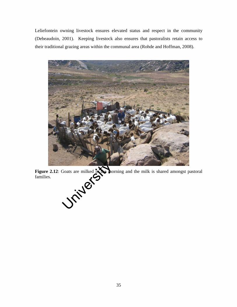
Unive
rsity
of C
ape
Town
35
Leliefontein owning livestock ensures elevated status and respect in the community
(Debeaudoin, 2001). Keeping livestock also ensures that pastoralists retain access to
their traditional grazing areas within the communal area (Rohde and Hoffman, 2008).
Figure 2.12: Goats are milked in the morning and the milk is shared amongst pastoral
families.
Unive
rsity
of C
ape
Town
36
Chapter Three
The impact of legislation from five periods of political rule on the
geography of pastoralism in a semi-arid region of South Africa
Abstract
Legislation is one of the key tools used by governments to change a pastoral landscape.
This study assessed the historical changes in the geography of pastoral mobility in the
Leliefontein communal area by analysing different sets of legislation introduced by
different political rulers since 1652 in South Africa. During Dutch rule from 1652 to
1805, policies were implemented to seize land from indigenous people, which resulted in
them losing access to traditional grazing resources. British rule from 1806 to 1909
promoted leasehold tenure or private ownership and focused on bettering livestock
productivity. During the Union of South Africa from 1910 to 1947, legislation was
passed to promote segregation. Privately owned white farms were fenced off, which
resulted in mobile pastoralists in Leliefontein becoming spatially constrained. During the
Apartheid era from 1948 to 1993, legislation promoted privatisation as a means to
develop the communal area and to prevent overgrazing and soil erosion. Privatisation did
not lead to development but to increased stocking densities and restriction of herd
mobility. Since democracy in 1994, land reform was implemented to rectify the injustices
of the past and alleviate poverty amongst rural people. New legislation was developed
using developmental discourses that are not supported by scientific evidence. As a result,
land reform legislation failed to address the problems in communal areas and in some
cases achieved the opposite effect of its initial objectives.
3.1 Introduction
All pastoral areas around the world have undergone changes in their environment and
management systems through time. This is often driven by factors such as changes in
climate, political systems and human population densities. Previous studies on
pastoralism have attempted to understand these factors that cause change and have
analysed their impacts on pastoral management. Kelso (2010) reconstructed the climate
Unive
rsity
of C
ape
Town
37
of Namaqualand using archival records and examined how changes in the climate
affected the livelihoods of pastoral people. Her study in Leliefontein shows that the
ability of people to cope with the intensity and frequency of droughts declined during the
19th century. This decline was due to factors that included encroachment of settlers onto
traditional lands, increased reliance on cultivation and the decline in grazing lands
available to practice transhumance. The encroachment of colonial farmers onto
traditional grazing lands resulted in less land available to support Nama herds. This is
particularly important during droughts, for example when approximately 60% of
livestock died during the 2002-2003 drought period (MT Hoffman Unpublished data).
Areas which herders had historically used to access variable resources outside their
traditional grazing areas when conditions became harsh were no longer available (Kelso,
2010). Furthermore, with the increased reliance on wheat cultivation, droughts reduced
crops on which people had become reliant for food.
Political marginalisation is one of the key challenges facing mobile pastoralists (Nori and
Davies, 2007; Oseni and Bebe, 2011). Political discrimination and exclusion have been
used by colonial governments to take land from indigenous pastoralists (Galaty, 2011)
and to pressure them into wage labour (Bundy, 1988; Kreis, 2001). For example, during
the 18th
and19th
centuries in England, landlords used their influence within government to
pass laws to seize public land which they could then acquire cheaply. More than 900
pieces of legislation were passed between 1800 and 1810 alone that allowed for the
enclosure of communal pastures which resulted in the impoverishment of landless rural
communities (Kreis, 2001). This led to a surplus of landless people who were forced to
leave rural areas to work as poorly-paid labourers in factories during the Industrial
Revolution. Consequently, the land of England became increasingly concentrated in the
hands of a few elite.
Sendón (2009) focused on the impacts of historic republican policies and the Peruvian
Agrarian Reform Law of 1969 on people’s livelihoods in Peru. The Agrarian Reform
Law made provision for the state to expropriate land from the richer Creole landowners
and to transfer it to peasant communities. However, this law did not recognise and
Unive
rsity
of C
ape
Town
38
understand livestock mobility since communities were given lands that were not used by
herders for grazing and as a result their grazing area became disconnected. Fernandez-
Gimenez (1999) also investigated how historical formal and informal institutions from
the Qing Dynasty in 1691 until 1990 affected land use patterns of Mongolian pastoralists.
She shows how changes in administrative boundaries, tenure and regulatory institutions
have transformed and constricted the grazing patterns of herds. In spite of these changes
in livestock management, adequate institutions were developed to facilitate flexibility in
mobility patterns. However, many government policies around the world still do not
promote pastoral mobility since traditional farming practices have been viewed as
backward and unproductive, leading to overgrazing and environmental degradation
(Lamprey, 1983; Sinclair and Fryxell, 1985).
Policies implemented during colonial times in the developing world were based on the
commercial ranching model developed in the early part of the 20th
century in the United
States using carrying capacities, fencing and destocking to manage grazing lands (Sayre
and Fernandez-Gimenez, 2003). These management strategies were based on the
assumptions that grazing systems are in equilibrium, pastoral systems are degrading and
that the ‘Tragedy of the Commons’ narrative (Harding, 1968) reflects a socio-economic
reality (Rohde et al., 2006). Rohde et al. (2006) show that even in the current era, post-
colonial grazing policies in southern Africa that were implemented to rectify past policies
are still based on these underlying assumptions.
The ranching model of grazing management has failed because policy makers often do
not understand indigenous rangeland management (Rohde et al., 2006), nor do they
appreciate that equilibrium systems seldom occur in arid and semi-arid regions (Behnke
et al., 1993). In African drylands where equilibrial systems operate, heavy grazing has
been found to be interrelated to soil erosion and woody shrub encroachment when grasses
are over consumed (Coppock, 1993). However, this is just one of a few examples of
equilibrial systems in African rangelands, which are governed more by non-equilibrium
conditions (Oba et al., 2000; Vetter, 2004). Mobile pastoralism is a key strategy to access
variable grazing resources in non-equilibrium environments (Behnke et al., 1993; Niamir-
Unive
rsity
of C
ape
Town
39
Fuller and Turner, 1999). Recently, African governments which include Mali, Burkina
Faso, Mauritania and Guinea have adopted mobile pastoralism in state policies (Hesse
and Thébaud, 2006; de Jode, 2010) whereas other governments still persist with policies
that have proven ineffective in drylands.
Investigating the historical changes in the pastoral landscape is important to understand
how the political environment has influenced land use practices. The objectives of this
study are:
To assess and discuss the impacts of legislation from five different political eras
in South African history on the geography of pastoral mobility in the Leliefontein
communal area. These are the Dutch colonial era (1652-1805); British colonial
era (1806-1909); Union of South Africa (1910-1947); Apartheid era (1948-1993);
and the democratic era (1994-present)
To examine and discuss the scientific and other foundations on which various
legislation was based
To assess and discuss the positive and negative implications of legislation for
mobile pastoralism in the region
Before addressing these objectives, I will use the published literature to describe the pre-
historic practices of the indigenous Khoekhoe pastoralists before the permanent arrival of
the colonists in 1652.
3.2 Livestock management in pre-colonial Namaqualand
The San (Bushmen) who were hunter-gatherers were the original inhabitants of South
Africa (Catling, 2008). Khoekhoe pastoralists are assumed to have arrived in southern
Africa about 2000 BP with domestic livestock (Smith, 1992). From 2000 years ago,
Khoekhoe herded sheep in small numbers in Namaqualand (Webley, 2007) and sufficient
archeological evidence exists from 1800 BP to show that they were highly mobile
pastoralists (Sadr, 2008).
Unive
rsity
of C
ape
Town
40
In historical records, Africa is portrayed as a dark, barbarous and degraded continent by
Europeans (Kelso, 2010). The Khoisan8 peoples were also regarded as savages by
seafarers who passed the Cape en route to the East before the 17th
century. Nevertheless,
the Portuguese and Dutch were comfortable to trade for cattle and sheep owned by the
indigenous peoples. During the colonial times from 1652 onwards, these people were still
regarded as uncivilised and violent beastlike men and heathens (Byrnes, 1996; Frere,
2010). However, these views of Khoisan societies were culturally biased since Europeans
found it difficult to accept indigenous peoples as equals (Abrahams, 1994). Derogative
and racist descriptors toward the indigenous peoples were also used by Europeans to
assert their superiority over local people, justify land grab and influence colonial policy
makers (Kelso, 2010). These distinct European views of the life of the Khoisan are also
indicative of the relationship of indigenous groups to power and authorities. During the
colonial periods, Europeans argued that only they knew what is best for South Africa and
thus controlled almost every aspect of the lives of the Khoisan peoples (Kelso, 2010).
The Nama speaking groups within the Khoekhoe in the Kamiesberg Mountains farmed
with cattle, sheep and goats and sometimes hunted wild animals. Their farming practices
entailed following seasonal transhumant patterns between upland areas in summer and
lower altitudes near the coast or the Bushmanland grasslands in winter (Webley, 1986).
The grazing system of pre-colonial Nama-pastoralists was enforced by a clan council
consisting of the elders in the clan (Webley, 1986). Fines were imposed if farmers did not
follow the grazing system. The chief (traditional leader) would consider the number of
herds already in the area and whether the area had sufficient time to rest from the
previous grazing cycle before herds were allowed to graze those lands (Webley, 1984).
The extent of land belonging to clans was not defined by clear boundaries but to land
around key resource areas (Boonzaier et al., 1996). Historical evidence suggests that one
clan allowed others to use their land in times of need, through the payment of a small
symbolic tribute (Penn, 1986).
8Khoisan is the collective name that refers to the San and Khoekhoe ethnic groups in South Africa.
Unive
rsity
of C
ape
Town
41
3.3 Approach
3.3.1 Legislative documentation
In this study I analysed and discuss only legislation that affected pastoral mobility in
Leliefontein since numerous other legislation and amendments were passed but did not
affect their herding patterns. Relevant legislation from the 19th
to 21st centuries (Table
3.1) included national acts that are specific to rural reserves, racial or indigenous groups,
rangeland management and accessibility, land tenure, access rights, centralisation and
decentralisation of power.
Copies of the legislation that were not available online were obtained from the Parliament
of the Republic South Africa in Cape Town. For additional information on land use in the
study area, I searched archival records that included government reports, travel journals,
diaries and private correspondence kept in the South African National Library in Cape
Town. I also used official minutes of monthly meetings from 1956 to 1966 of the
Leliefontein management board and Cape Supreme Court documents (Case No. 87/9050)
pertaining to land struggles in Leliefontein.
3.3.2 Reconstruction of historical communal area boundaries
An elderly member in one of the communities who used to farm with livestock pointed
out the boundaries of historic grazing areas that were used prior to the erection of
boundary fences in the Leliefontein communal area in the 1950s. I mapped these
boundaries with a hand-held Garmin etrex (Garmin Ltd, Kansas, USA) GPS receiver.
Maps of the grazing areas were produced using ArcView 3.2.
3.3.3 Land use practices on the new land reform farms
As part of the Land Reform Programme of South Africa, five farms were acquired after
1994 for the residents of the Leliefontein communal area. Data on the sizes of camps,
tenants of camps on these farms and number of animals they owned were obtained from
the farmers themselves, Kamiesberg Local Municipality and unpublished data from MT
Hoffman at the University of Cape Town. Stocking rates for camps were calculated by
dividing the size of the camp by the number of small and large stock that grazed inside

Unive
rsity
of C
ape
Town
42
the camp. According to agricultural regulations for the region, one large stock unit (LSU)
is equivalent to six small stock units (SSU).
Table 3.1: Formal legislation assessed to study the impacts of legislation on the
geography of pastoral herding in the Leliefontein communal area.
Proclamations and Ordinances Year
Caledon Code 1809
Ordinance 50 1828
Name of Act Act No. and Year of
promulgation
Village Management Act Act of 1881
Act 10 of 1870 Act 10 of 1870
Mission Stations and Communal Reserves Act Act No. 29 of 1909
Fencing Act Act No. 17 of 1912
Natives Land Act Act No. 27 of 1913
Natives Trust and Land Act Act No. 18 of 1936
Population Registration Act Act No. 30 of 1950
Group Areas Act Act No. 41 of 1950
Coloured Rural Areas Act Act No. 24 of 1963
Rural Coloured Areas Act Act No. 1 of 1979
Rural Areas Act Act No. 9 of 1987
Conservation of Agricultural Resources Act Act No. 43 of 1983
Provision of Certain Land for Settlement Act Act No. 126 of 1993
Local Government Transition Act Act No. 209 of 1993
Common Property Associations Act Act No. 28 of 1996
Transformation of Certain Rural Areas Act Act No. 94 of 1998
Municipal Structures Act Act No. 117 of 1998
Municipal Systems Act Act No. 32 of 2000
Northern Cape Provincial Gazettes Notice No. and Year of
promulgation
Kamiesberg Local Municipality Grazing Regulations Notice 18 of 2002
Kamiesberg Local Municipality Cropping Regulations Notice 34 of 2003
Kamiesberg Local Municipality Impounding Regulations Notice 68 of 2003
3.4 Results
3.4.1 Dutch Colonial Era (1652-1805)
Before the permanent arrival of the Europeans in South Africa, ships passing by the Cape
only stopped in order to trade with indigenous Khoekhoe tribes for livestock products and
to take on fresh water. In 1652, the Dutch East Indian Company (VOC) under the
command of Jan van Riebeeck arrived in the Cape and established a permanent colony to
Unive
rsity
of C
ape
Town
43
supply passing ships with fresh water and produce (Boonzaier et al., 1996). In 1657, the
VOC granted cropping rights to some of its employees, also called free burghers, to
produce fresh vegetables to be sold to the company at predetermined prices (Guelke,
1979). On the basis of the system of usufruct rights, which included a payment to the
chief, colonists were also allowed by the Khoekhoe tribes to use their traditional grazing
lands (Marinus, 1997), which as a result reduced their dependency on meat from
indigenous peoples. However, these chiefs did not foresee that grazing rights would
become permanent and exclusive to settlers. The Khoekhoe did not view the payment in
the same light as Europeans since the Khoekhoe viewed the payment as a customary
tribute while the settlers viewed it as a purchase for the land (Archer and Meer,
1995).This misconception, together with the wars between the Dutch and Khoekhoe as
well as the small pox epidemics in the early 18th
century, which decimated almost 90% of
the Khoekhoe population (Byrnes, 1996), meant that the traditional system of land use
and governance practices employed by the Khoekhoe in the Cape was destroyed
(Marinus, 1997).
However, free burghers became unhappy with the autocratic administration and
corruption of the local VOC which owned most of the prime land in the Cape (Byrnes,
1996). As a result, rich free burghers and poorer members of the white community
embarked on a trek during the early 1700s beyond the boundaries of the Cape. In 1720,
the trekboers expanded their range to the Breede River in the east and the Swartland in
the north (Guelke and Shell, 1992). Beyond the boundaries of the colony trekboers had
large grazing lands available to them and adopted the livestock management strategies of
the Khoekhoe by moving between agro-ecological zones (Van Zyl, 1957; Penn, 1986;
Beinart, 2007; Catling, 2008). This transhumant system of management is still used by
some white farmers to manage their livestock in the region (Penn, 1986; Rohde et al.,
2001; O’Farrell et al., 2007) albeit between different privately owned pieces of land.
Unive
rsity
of C
ape
Town
44
In 1750 the first European farmer registered a loan farm9 in Namaqualand but it is
assumed that these areas were occupied by Europeans well before registration (Penn,
1995). Later there was a surge in registration of loan farms in the Kamiesberg area, and in
1761, Leliefontein was registered to a trekboer, H. Beukes (Webley, 1982). Traditional
grazing movements, which were reported to be over 100 km in distance (Webley, 1986),
became restricted when the first colonists were given grazing concessions in the
Kamiesberg. By 1770, the Dutch encroachment onto pastoral lands affected the
transhumant patterns of Nama pastoralists to an extent that herds had to move almost
daily during dry periods due to forage limitation and the hunger of their big herds
(Webley, 1984). In 1772 Leliefontein had been granted to Hermanus Engelbrecht but
later that year the Dutch Governor Van Plettenberg revoked the land after he realised that
the previous Governor had awarded the land to the Nama10
chief Jantjie Wildschutt. This
was one of the few examples where the colonists recognised the aboriginal land rights of
the Nama (Penn, 1995). The governor gave back the land to the Nama in an attempt to
stabilise and preserve order on the northern frontier where there was an increase in raids
between the Khoekhoe and the expanding trekboer communities (Marinus, 1997).
3.4.2 British Colonial Era (1806-1909)
In the Cape Colony, Dutch rule officially ended in 1806 as a result of the defeat of France
by the British during the Napoleonic Wars. Holland had been an ally to France and the
region was taken over by the British. Lack of tenure security was a major weakness in
the Dutch system of rule and the British passed the Caledon Code of 1809. The Code
required every Baster11
or Khoekhoe person to have a registered place of residence and to
obtain permission from the colonial government to move.
When colonial frontiers to the north marked by the Buffels River and in the east marked
by the Kat River (Boonzaier et al., 1996) became unstable and volatile due to frontier
9Farmland of approximately 2570 hectares in size that were rented out to settler farmers by the Dutch
Government provided that they pay an annual fee. 10
The Nama is the Khoekhoe tribe who occupied Namaqualand. 11
Basters are people of mixed descent having white and indigenous Khoekhoe or slave parents. Slaves were
imported into South Africa from Asia and other parts of Africa by former Dutch and British rulers.
Unive
rsity
of C
ape
Town
45
wars, the British Cape government encouraged the establishment of mission stations for
the Khoekhoe in order to stabilise these frontiers. The missionaries that arrived in
Namaqualand were from German, British and Dutch missionary societies who were sent
to Africa to preach the gospel and bring spiritual assistance to the poor communities
(Catling, 2008). Missionaries had to regularly report to their missionary societies in
Europe on their progress and current circumstances. Missionaries also assisted with
education, health care and skills development for Khoekhoe who worked on white-owned
private farms (Catling, 2008).
The Nama welcomed the missionaries and sought refuge at mission stations (Sharp and
West, 1984) to have some form of land security from the trekboers who had begun to
occupy their land (Boonzaier, 1984). The missionaries in Namaqualand were given the
right to farm with livestock and introduced the cultivation of vegetables and wheat to
supplement pastoralism. The missionaries extended this practice to the indigenous
people in an attempt to settle them closer to the mission stations (Boonzaier et al., 1996)
as opposed to their nomadic lifestyles.
In 1816 the Leliefontein missionary station was founded and the government recognised
the Nama chief (traditional leader) as the manager of the station. Within the station,
Nama pastoralists were guaranteed access to some of their ancestral land for which they
did not have to pay taxes (Kotze et al., 1987). Due to their migratory lifestyle regular
church services could only be held in Leliefontein village from mid-December to the end
of March because pastoralists trekked to outstations within the missionary station to
evade cold temperatures and prevent livestock from damaging crops (CCP 1/2/1/74). The
fact that families moved with their herd also resulted in low school attendances when
herds moved to outstations (CCP 1/2/1/74). The lifestyles of the Nama were thus
perceived to be an administrative and development problem for the missionaries who
wanted to Christianise and control the indigenous people. In January 1825, Barnabas
Shaw, the first missionary at Leliefontein, was given the power to manage the station by
the government of the Cape Colony at the missionary’s request citing ignorance and
Unive
rsity
of C
ape
Town
46
incompetence of the Nama chief (Carstens, 1966). Grazing rights through communal
land tenure were now given to residents by the missionary (Sharp and West, 1984).
The Caledon Code was overturned in 1828 by Ordinance 50 that gave indigenous people
the right to own property and move freely within the colony. However, by this time most
of the land had been occupied or privatised by settlers (Kingston, 2001). Since the
Khoekhoe were ‘free’ some Khoekhoe immediately applied for land but were refused by
the governor, because they applied for land for their entire population in the Cape while
tenure was based on individual ownership (Boonzaier et al., 1996). The government did
make land available to a Khoekhoe and baster community in Kat River along the eastern
frontier. However, this settlement was established to buffer white farmers from attacks by
Xhosa tribes who were expelled from their land by the colonists (Boonzaier et al., 1996).
The boundary of the Cape Colony shifted several times as the colonists moved
northwards. On 17 December 1847 the territory north of the Buffels River was annexed
and the entire Little Namaqualand region was declared as crown land (Carstens, 1966). In
1854, Leliefontein which was 188 009 ha in size at this date (Melvill, 1890) was declared
a reserve by the British for the Little Nama (Rohde et al., 1999). On 22 May1854,
“Tickets of Occupation”, an institutionalised form of racial classification (Marinus,
1997), were issued to Leliefontein inhabitants. The boundaries of the reserve were
incompletely surveyed and white farmers slowly encroached on the mission land, which
further constrained herd movements in Leliefontein.
In 1856, two unsurveyed loan farms, Tweerivieren (2 802 ha) and Hoorngaat (2 674 ha)
which were bought by the missionaries, were added as part of the Leliefontein reserve
(Fig. 3.1) (ACLT 4206/2). These farms were cultivated and some of the produce was sold
to supplement the salary of the missionary. On the other parts of the reserve, croplands
were cultivated by reserve residents for animal fodder and to provide flour.
Act 10 of 1870 formally recognised the authority of the missionaries and church council
that consisted of four members, which included the traditional leader, two community
Unive
rsity
of C
ape
Town
47
members and the resident missionary as the chairman (Marinus, 1997). During this
period, the council formally established a seasonal cycle of grazing and defined the
grazing boundaries each year based on land available for grazing in the Leliefontein
reserve (Price, 1976). This meant that all the herds had to move away from cultivated
lands in winter and in the uplands herds had to move to lower altitudes to escape freezing
conditions. Missionaries also moved with pastoralists to the outstations (Fig. 3.1) to
continue with their provision of education and health services and preaching the gospel to
the community (Price, 1976).
The Village Management Act of 1881, which applied to all areas that were not part of a
municipality, replaced the missionary Rev. Henry Tindall (1881-1887) by a white
magistrate as chairperson on the church council. By doing so, the colonial government
became directly involved in local matters in the reserve (Marinus, 1997). The magistrate,
as opposed to the resident missionary, was now responsible for overseeing the list of
registered occupiers and for punishing those who violated the laws of the British
authority at the Cape (Marinus, 1997). In an attempt to decentralise the control of reserve,
it was proposed to Parliament on 21 May 1890 by a Mr. P.B. van Rhyn, a member of the
legislative council, that the reserve be subdivided into 75 farms. However, the resident
missionary of Leliefontein at that time, Rev. George Robson (1887-1892) wrote a letter
dated 13 June 1890 to the Ministerial Department of Crown Lands and Public Works that
such a subdivision would decrease the control over land, and would further exclude
people from valuable grazing and arable lands (Melvill, 1890).
The perception of increased alcohol abuse by the people in Leliefontein led the
government to believe that the council was losing administrative control over the people.
In an attempt to exert better control over the people, it was also proposed in a report dated
24 July 1890 to the Commissioner of Crown Lands and Public Works by Mr Samuel
Melvill that the extent of land in Leliefontein was too large to administer and proposed to
subdivide the land into three sections around the present day villages of Kharkams,
Rooifontein and Leliefontein (Melvill, 1890). Mr Melvill, the Second Assistant Surveyor-
General was instructed by the Commissioner to investigate the administration and
Unive
rsity
of C
ape
Town
48
conditions of the reserves in Namaqualand and make recommendations to Parliament. At
the time, the eastern side of the reserve around Rooifontein village was demarcated for
the use by Basters who had no rights to grazing lands outside of Leliefontein. It was
proposed that the lowlands in the western part near Kharkams village be administered
separately. The resident missionary who was asked by Mr Melvill to comment on his
proposal on the subdivision of land before he wrote to the Commissioner, raised the
concern that subdivision would lead to exclusion of people in the uplands from their
croplands in the lowlands and those in the lowlands would be denied access to water for
livestock in the uplands during summer. The missionary also argued for the need for
livestock to move seasonally between the upland and lowland grazing sites to evade
unfavourable climatic conditions, protect growing crops, and to make use of the temporal
and spatially variability of forage. He further mentioned that limited arable lands in the
reserve, frequent droughts where forage availability declines and the drying up of
ephemeral water sources all indicated that the area was not large enough for the people of
Leliefontein. The missionary based his opinions on his understanding of the land use
management system of the Nama people since he had been residing in the Leliefontein
mission station for more than three years (Kelso, 2010). Government officials who
supported the proposal spent less time in Namaqualand and did not understand the
variability in resources in the region and the need for livestock to track this variability in
order to survive. The fact that the missionary opposed the proposal was also because he
was sympathetic to the indigenous people and the difficulty to survive in this variable
ecosystem (Kelso, 2010). It was thus concluded that the reserve would not be subdivided.
The Mission Stations and Communal Reserves Act, 1909 (Act No. 29 of 1909) was
passed to improve management, control the resources and delineate boundaries (Carstens,
1966). This Act also made provision for crown lands to be transferred to the Department
of Native Affairs and for them to be managed by management boards. The Leliefontein
board consisted of six community-elected councilors known as korporale (corporals)
who, when elected held office for life; and three officials elected by the Governor of
whom one was a representative from the missionary society. The board was under the
chairmanship of the resident magistrate. Previously, the traditional leader of the
Unive
rsity
of C
ape
Town
49
community was a senior member of the church council but the establishment of a new
board took the powers away from the traditional leaders and the Church. The main
functions of the board were to enforce all the laws, control land and grazing and collect
taxes.
3.4.3 Union of South Africa (1910-1947)
In 1910 the Union of South Africa, which united the two British and two Boer12
colonies,
was established. One of the first Acts passed by the Union was the Natives Land Act,
1913 (Act No. 27 of 1913). This Act was adopted to curtail the existence of African
peasantry, prevented their accumulation of capital and deprived those who were not
regarded as of 100% European descent from buying or hiring land from white farmers.
Pressure on African peasantry also emerged from the commercialisation of white
agriculture and as a consequence eliminated the competition from black peasants (Bundy,
1988). Fencing and irrigation led to a decrease in the need for African squatter peasants
to provide labour. White farmers also realised that they could get more out of their land if
they had cheap labour rather than having quasi-feudal relationships with peasants
(Bundy, 1988). Eviction of sharecroppers and lessees on white farms was initiated by
levying high license fees which led to the transformation of peasants into wage labourers.
As a result of these interventions vast numbers of peasants lost their economic
independence and their ability to meet their subsistence requirements across large areas
of South Africa.
In Namaqualand pastoralists were prevented from using white-owned land when
privately white-owned farms were fenced off and a camp system was introduced under
the Fencing Act, 1912 (Act No. 17 of 1912). Fencing also began to replace herding as a
livestock management option in the Karoo at this time (Dean et al., 1995). Fencing of
private farms adjacent to Leliefontein continued until the 1960s since several private
farmers did not want to proceed with erecting fences until the Leliefontein management
board paid half of the fencing costs (Leliefontein Management Board Unpublished
12
Boers are Afrikaans speaking settlers of Dutch, German and French Huguenot descent.
Unive
rsity
of C
ape
Town
50
minutes). Fencing was perceived to increase the carrying capacity of the veld and
improved rangeland condition (Archer, 2002).
The Natives Trust and Land Act, 1936 (Act No. 18 of 1936) restricted ‘non-whites’ to
13% of agricultural land in South Africa. Reserves for the ‘non-whites’ were too small
for the livestock populations and insufficient grazing lands forced many people to seek
employment outside the reserves. Consequently, people staying in the reserves, including
Leliefontein, became dependent on remittances sent by those relatives working outside
the reserves (Thompson, 1990).
Boundary disputes became the order of the day when farmers started to fence off their
land. For example, in 1947 there was a boundary dispute over Pedroskloof farm (ACLT
/218/3073). Apparently, the owner wanted to put up the fence in convenient areas
because the terrain is rugged. However, the management board did not allow this since it
would have resulted in his farm becoming larger and the communal area smaller
(Leliefontein Management Board Unpublished minutes). Presently, Pedroskloof farm is
fenced and is located between two sections of the communal area (Fig. 3.1). However,
the present owner denies pastoralists to cross his land to access some remote areas of the
communal area. Pastoralists now have to move over steep mountains on foot together
with their livestock to access their land on the other side. There are examples where
disputes that were unresolved resulted in the communal land becoming smaller. In
October 1887, a boundary dispute between the council and the farm owner of
Karagiesfontein occurred. The farmer deliberately moved the boundary beacons on his
farm which increased the size of his farm. After an investigation, the farmer was
requested by the council to move his beacons to their original positions but refused to do
so. The matter was left unresolved and the communal area became smaller as a result
(Price, 1976).
During my interviews with pastoralists it was mentioned that land was also lost through
various illegal land acquisitions with allegations that some members of the management
board sold land to private farmers. I was told about one example what pastoralists call
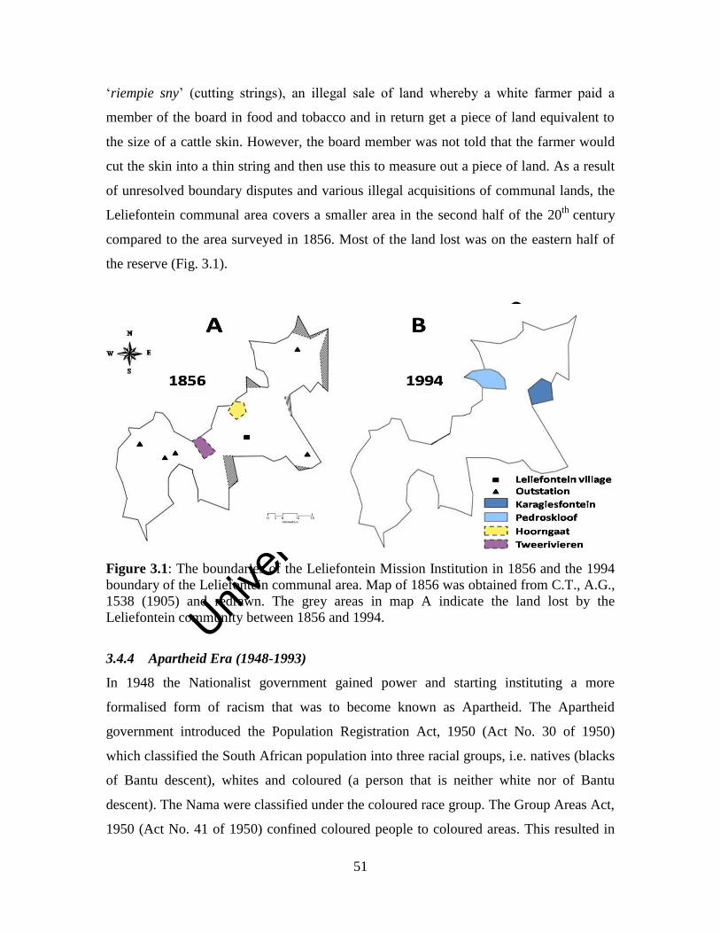
Unive
rsity
of C
ape
Town
51
‘riempie sny’ (cutting strings), an illegal sale of land whereby a white farmer paid a
member of the board in food and tobacco and in return get a piece of land equivalent to
the size of a cattle skin. However, the board member was not told that the farmer would
cut the skin into a thin string and then use this to measure out a piece of land. As a result
of unresolved boundary disputes and various illegal acquisitions of communal lands, the
Leliefontein communal area covers a smaller area in the second half of the 20th
century
compared to the area surveyed in 1856. Most of the land lost was on the eastern half of
the reserve (Fig. 3.1).
Figure 3.1: The boundaries of the Leliefontein Mission Institution in 1856 and the 1994
boundary of the Leliefontein communal area. Map of 1856 was obtained from C.T., A.G.,
1538 (1905) and redrawn. The grey areas in map A indicate the land lost by the
Leliefontein community between 1856 and 1994.
3.4.4 Apartheid Era (1948-1993)
In 1948 the Nationalist government gained power and starting instituting a more
formalised form of racism that was to become known as Apartheid. The Apartheid
government introduced the Population Registration Act, 1950 (Act No. 30 of 1950)
which classified the South African population into three racial groups, i.e. natives (blacks
of Bantu descent), whites and coloured (a person that is neither white nor of Bantu
descent). The Nama were classified under the coloured race group. The Group Areas Act,
1950 (Act No. 41 of 1950) confined coloured people to coloured areas. This resulted in
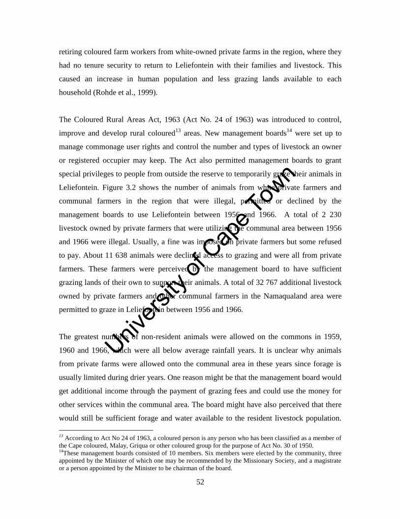
Unive
rsity
of C
ape
Town
52
retiring coloured farm workers from white-owned private farms in the region, where they
had no tenure security to return to Leliefontein with their families and livestock. This
caused an increase in human population and less grazing lands available to each
household (Rohde et al., 1999).
The Coloured Rural Areas Act, 1963 (Act No. 24 of 1963) was introduced to control,
improve and develop rural coloured13
areas. New management boards14
were set up to
manage commonage user rights and control the number and types of livestock an owner
or registered occupier may keep. The Act also permitted management boards to grant
special privileges to people from outside the reserve to temporarily graze their animals in
Leliefontein. Figure 3.2 shows the number of animals from white private farmers and
communal farmers in the region that were illegal, permitted or declined by the
management boards to use Leliefontein between 1956 and 1966. A total of 2 230
livestock owned by private farmers that were utilizing the communal area between 1956
and 1966 were illegal. Usually, a fine was imposed on private farmers but some refused
to pay. About 11 638 animals were declined access to grazing and were all from private
farmers. These farmers were perceived by the management board to have sufficient
grazing lands of their own to support their animals. A total of 32 767 additional livestock
owned by private farmers and other communal farmers in the Namaqualand area were
permitted to graze in Leliefontein between 1956 and 1966.
The greatest numbers of non-resident animals were allowed on the commons in 1959,
1960 and 1966, which were all below average rainfall years. It is unclear why animals
from private farms were allowed onto the communal area in these years since forage is
usually limited during drier years. One reason might be that the management board would
get additional income through the payment of grazing fees and could use the money for
other services within the communal area. The board might have also perceived that there
would still be sufficient forage and water available to the resident livestock population.
13
According to Act No 24 of 1963, a coloured person is any person who has been classified as a member of
the Cape coloured, Malay, Griqua or other coloured group for the purpose of Act No. 30 of 1950. 14
These management boards consisted of 10 members. Six members were elected by the community, three
appointed by the Minister of which one may be recommended by the Missionary Society, and a magistrate
or a person appointed by the Minister to be chairman of the board.
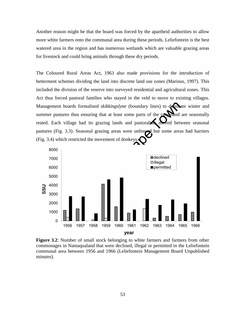
Unive
rsity
of C
ape
Town
53
Another reason might be that the board was forced by the apartheid authorities to allow
more white farmers onto the communal area during these periods. Leliefontein is the best
watered area in the region and has numerous wetlands which are valuable grazing areas
for livestock and could bring animals through these dry periods.
The Coloured Rural Areas Act, 1963 also made provisions for the introduction of
betterment schemes dividing the land into discrete land use zones (Marinus, 1997). This
included the division of the reserve into surveyed residential and agricultural zones. This
Act thus forced pastoral families who stayed in the veld to move to existing villages.
Management boards formalised skikkingslyne (boundary lines) to delineate winter and
summer pastures thus ensuring that at least some parts of the rangeland are seasonally
rested. Each village had its grazing lands and pastoralists moved between seasonal
pastures (Fig. 3.3). Seasonal grazing areas were unfenced but some areas had barriers
(Fig. 3.4) which restricted the movement of donkeys.
Figure 3.2: Number of small stock belonging to white farmers and farmers from other
commonages in Namaqualand that were declined, illegal or permitted in the Leliefontein
communal area between 1956 and 1966 (Leliefontein Management Board Unpublished
minutes).
0
1000
2000
3000
4000
5000
6000
7000
8000
1956 1957 1958 1959 1960 1961 1962 1963 1964 1965 1966
SS
U
year
declined
illegal
permitted
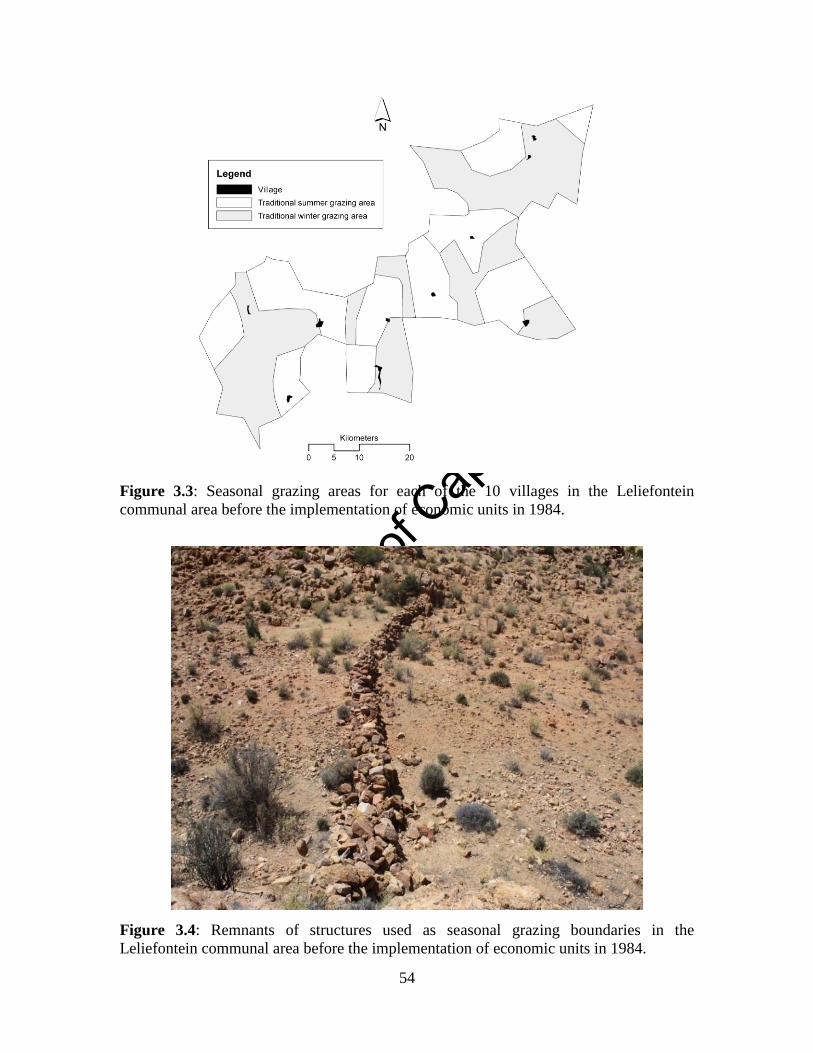
Unive
rsity
of C
ape
Town
54
Figure 3.3: Seasonal grazing areas for each of the 10 villages in the Leliefontein
communal area before the implementation of economic units in 1984.
Figure 3.4: Remnants of structures used as seasonal grazing boundaries in the
Leliefontein communal area before the implementation of economic units in 1984.
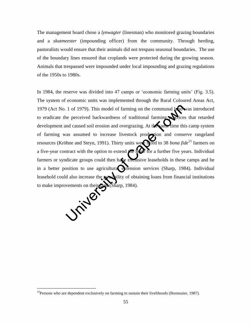
Unive
rsity
of C
ape
Town
55
The management board chose a lynwagter (linesman) who monitored grazing boundaries
and a skutmeester (impounding officer) from the community. Through herding,
pastoralists would ensure that their animals did not trespass seasonal boundaries. The use
of the boundary lines ensured that croplands were protected during the growing season.
Animals that trespassed were impounded under local impounding and grazing regulations
of the 1950s to 1980s.
In 1984, the reserve was divided into 47 camps or ‘economic farming units’ (Fig. 3.5).
The system of economic units was implemented through the Rural Coloured Areas Act,
1979 (Act No. 1 of 1979). This model of farming on the communal land was introduced
to eradicate the perceived backwardness of traditional farming practices that retarded
development and caused soil erosion and overgrazing. At the same time this camp system
of farming was assumed to increase livestock production and conserve rangeland
resources (Kröhne and Steyn, 1991). Thirty units were hired to 38 bona fide15
farmers on
a five-year contract with the option to extend the lease for a further five years. Individual
farmers or syndicate groups could then have exclusive leaseholds in these camps and be
in a better position to use agricultural extension services (Sharp, 1984). Individual
leasehold could also increase the possibility of obtaining loans from financial institutions
to make improvements on their land (Sharp, 1984).
15
Persons who are dependent exclusively on farming to sustain their livelihoods (Boonzaier, 1987).
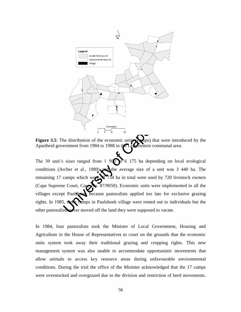
Unive
rsity
of C
ape
Town
56
Figure 3.5: The distribution of the economic units (camps) that were introduced by the
Apartheid government from 1984 to 1988 in the Leliefontein communal area.
The 30 unit’s sizes ranged from 1 500 to 6 175 ha depending on local ecological
conditions (Archer et al., 1989) and the average size of a unit was 3 440 ha. The
remaining 17 camps which were 57 734 ha in total were used by 720 livestock owners
(Cape Supreme Court, Case No. 87/9050). Economic units were implemented in all the
villages except Paulshoek because pastoralists applied too late for exclusive grazing
rights. In 1985, three camps in Paulshoek village were rented out to individuals but the
other pastoralists never moved off the land they were supposed to vacate.
In 1984, four pastoralists took the Minister of Local Government, Housing and
Agriculture in the House of Representatives to court on the grounds that the economic
units system took away their traditional grazing and cropping rights. This new
management system was also unable to accommodate opportunistic movements that
allow animals to access key resource areas during unfavourable environmental
conditions. During the trial the office of the Minister acknowledged that the 17 camps
were overstocked and overgrazed due to the division and restriction of herd movements.
Unive
rsity
of C
ape
Town
57
He also mentioned that the condition will deteriorate if the high numbers of livestock
continue to graze these camps. On 22 April 1988, the court ruled in favour of the
applicants to have the economic units system abolished but not for the above mentioned
reasons but because of a few technicalities when the economic units system was
introduced. Technicalities being that 18 of the 38 farmers who were granted private
camps were not bona fide farmers since they had other permanent sources of income.
Also, when the entire Leliefontein area was subdivided into 47 units, no provision was
made for a residential area, croplands and town commonage for the purposes of a
graveyard and future expansion of the residential area.
The economic unit system introduced in 1984 by the Apartheid state was not ecologically
rational since most of the camps were heavily stocked (Fig. 3.6). The average stocking
rate for the 30 private camps was 1.63 SSU/10 ha (range: 0.22 to 7.05 SSU/10 ha) and
communal camps averaged 4.46 SSU/10 ha (range: 1.02 to 7.15 SSU/10 ha). It was
argued that to be economically viable camps needed to be between 4 808 and 2 070 ha on
veld that was in moderate and good condition respectively (Archer et al., 1989). Since the
condition of the range in Leliefontein was assumed to be degraded, a larger unit was
needed. Moreover, it would be desirable that the farm be spread over different ecological
zones to provide heterogeneity in the grazing resource (Archer et al., 1989). Water and
forage resources were scattered which means that livestock still had to move between
camps (Boonzaier, 1987). The above requirements were not met and as a result economic
development objectives were not met (Archer et al., 1989). Since pastoralists who used
communal camps could not move beyond the fences, some lost most of their animals
mainly due to a lack of forage and water for their animals (Levy and Ndlakuhlolo, 1985).
For example, a pastoralist in Nourivier village who had to use the communal camp had
260 small stock before the economic unit system was implemented and had only 92
animals two years later. Similarly, another pastoralist in the village lost 255 out of his
300 small stock mainly due to a lack of forage in the communal camps (Levy and
Ndlakuhlolo, 1985).
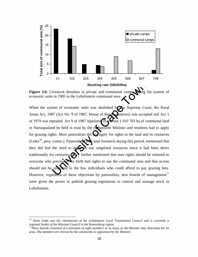
Unive
rsity
of C
ape
Town
58
Figure 3.6: Livestock densities in private and communal camps during the system of
economic units in 1985 in the Leliefontein communal area.
When the system of economic units was abolished by the Supreme Court, the Rural
Areas Act, 1987 (Act No. 9 of 1987, House of Representatives) was accepted and Act 1
of 1979 was repealed. Act 9 of 1987 stipulated that about 1 010 703 ha of communal land
in Namaqualand be held in trust by the responsible Minister and residents had to apply
for grazing rights. Most pastoralists did not apply for rights to the land and its resources
(Links16
, pers. comm.). Pastoralists, who kept livestock during this period, mentioned that
they did feel the need to apply to use rangeland resources since it had been theirs
traditionally for centuries. They further mentioned that user rights should be restored to
everyone who previously by birth had rights to use the communal area and that access
should not be restricted to the few individuals who could afford to pay grazing fees.
However, regardless of these objections by pastoralists, new boards of management17
were given the power to publish grazing regulations to control and manage stock in
Leliefontein.
16
Neels Links was the chairperson of the Leliefontein Local Transitional Council and is currently a
regional leader of the Khoisan Council in the Kamiesberg region. 17
These boards consisted of a minimum of eight members or as many as the Minister may determine for an
area. The members are elected by the community or appointed by the Minister.
0
5
10
15
20
25
≤1 1≥2 2≥3 3≥4 4≥5 5≥6 6≥7 7≥8
Stocking rate (SSU/10ha)
To
tal siz
e o
f co
mm
un
al are
a (
%)
private camps
communal camps
Unive
rsity
of C
ape
Town
59
3.4.5 Democratic Era (1994 - present)
In 1994, the first democratic elected government came into power which marked the
beginning of the abolition of colonial and segregationist policies. In terms of the Local
Government Transition Act, 1993 (Act No. 209 of 1993), management boards were
replaced by local transitional councils to control and administer the communal land in
Namaqualand. The Leliefontein Local Transitional Council consisted of nine members
representing civil society and administered Leliefontein from 1995 until 2000 when the
Kamiesberg Local Municipality were formed. To address historic inequalities and limited
access to land, Act No. 9 of 1987 was abolished and land reform through the Provision
of Certain Land for Settlement Act, 1993 (Act No.126 of 1993) was implemented. Land
reform in South Africa includes the redistribution of land, restitution for those who lost
their land after 19 June 1913 and tenure reform of communal land.
The Transformation of Certain Rural Areas Act (TRANCRAA), 1998 (Act No. 94 of
1998) was the first comprehensive legislation to reform communal land tenure in South
Africa (Wisborg and Rohde, 2004). TRANCRAA aims to transfer land ownership of 23
‘coloured rural areas’ that were administered through the Rural Areas Act, 1987.
TRANCRAA was implemented in six rural areas of Namaqualand (Fig. 2.4) from
January 2001 to January 2003. In November 2002 to January 2003, referenda over land
ownership were held and people voted on three ownership alternatives which include a
Common Property Associations (CPA) in terms of the CPA Act, 1996 (Act No. 28 of
1996), a municipality or a choice that may include trust ownership and individual title
(Wisborg and Rohde, 2004). Four communities voted for a CPA and another community
did not want to take part in the referendum. The Leliefontein community is the only
community who voted for the land to be transferred to a municipality. In 2008, the
Kamiesberg municipal council requested from the Minister of Land Affairs that the
transfer of land should be accompanied by a grant to repair and maintain the
infrastructure on the communal area. A decision on the grant has yet to be agreed upon
by the Minister and thus land has not been transferred.
Unive
rsity
of C
ape
Town
60
Regulations in terms of the Municipal Structures Act, 1998 (Act No.117 of 1998) and the
Municipal Systems Act, 2000 (Act No. 32 of 2000) made provision for communal
grazing land to be controlled by the Kamiesberg Local Municipality. Through these two
Acts, the municipality promulgated grazing regulations in 2002 (Notice 18 of 2002),
cropping regulations in 2003 (Notice 34 of 2003) and skutregulasies (impounding
regulations) in 2003 (Notice 68 of 2003). Grazing regulations take into account
community rules and sets of regulations that had been in use since the application of Act
No 29 of 1909. Regulations make provision for control of grazing access, for stock
numbers on the communal areas to be limited according to the Department of
Agriculture’s stocking rates for the region and resting certain grazing areas perceived to
be overgrazed. According to Conservation of Agricultural Resources (CARA) Act, 1983
(Act No. 43 of 1983) the Department of Agriculture exercises control over South Africa’s
natural agricultural resources. However, there is very little cooperation between the
Department of Agriculture and the local municipality with regard to the management of
natural resources and infrastructure in Leliefontein. The Department of Agriculture also
lacks the capacity to visit Leliefontein regularly and give agricultural advice to
pastoralists. As a result, not all CARA regulations are implemented.
Cropping regulations lay the legal foundation for the allocation and management of
croplands in Leliefontein. There were 559 croplands and food gardens surveyed in 2002
by the Department of Land Affairs. This amalgamated to a total size of 23 049.8 ha or
12% of the Leliefontein communal area. From 1996 to 2009, 66 croplands were used on
average annually. Traditionally, croplands were regarded as open grazing areas after the
crops were harvested but recently, some croppers have fenced off their cropping units for
exclusive use. This resulted in less forage available to other herds during the dry season,
fragmentation of the grazing lands which restrict herd movements and the fact that
herders do not have to move their stockposts seasonally to avoid crop damage (Chapter
Four).
Impounding regulations allowed for any animal to be impounded if unattended in public
or residential areas or found causing damage to croplands and vegetable gardens. The
Unive
rsity
of C
ape
Town
61
impounding regulations were suspended in 2003 by the Kamiesberg Local Municipality
due to a lack of capacity to enforce the regulations and legal complications arising from
the actions of some pastoralists. Legal complications arose from the failure of the
municipal to appoint impounding officers when pastoralists started to impound each
other’s animals and animals died while being impounded. This resulted in legal battles
between livestock owners and those who impounded the animals. Since the suspension,
more crop farmers have fenced off their croplands which include natural rangeland that
falls within the boundary of their allotment. The suspension of the impounding
regulations is one of the main reasons why cropping has declined over the years (Chapter
Four) as croppers are not compensated for the damages they suffer.
Other reasons mentioned by croppers why cropping has decreased in the area include
their perceptions that rainfall has decreased and that rainfall patterns have changed over
the years. Croppers mentioned that they observed a change in rainfall patterns over the
years and the main rainfall events sometimes fall outside the growing period of crops.
Croppers are thus reluctant to sow seeds because there might not be sufficient follow-up
rains which are crucial for crops to grow. Furthermore, famers raised the concern that
there is a lack of skilled people in the communal area who could assist with cropping.
Cropping in Leliefontein has also decreased due to the absence of markets to sell their
wheat and that people can buy flour at prices cheaper than growing it. Other croppers
mentioned that they would cultivate their lands if they could get access to mechanised
farming implements and seeds.
Land redistribution18
in rural areas is addressed through the Municipal Commonage
Programme. Currently, the inhabitants of the six former Coloured Rural Areas in
Namaqualand have access to an additional 245 550 ha of municipal commonage which
was land purchased through the Land Redistribution Program and 372 888 ha of state
land (Fig. 3.7) that has been allocated for usage by people living in the coloured rural
areas (May and Lahiff, 2007).
18
This component of the land reform process enables poor and previously disadvantaged people to access
land purchased by the National Department of Land Affairs on the open market (May and Lahiff, 2007).
Unive
rsity
of C
ape
Town
62
Between 1998 and 2000, five farms totaling 32 627 ha in size were acquired for the
people in Leliefontein through the Land Redistribution Programme are part of the
Kamiesberg Local Municipality’s commonage land. Expansion of municipal
commonages is as an attempt by the democratic government to supplement the income
and enhance household food security of poor communities by giving people access to
more land (DLA, 1997). However, the revised commonage policy of 2002 (DLA, 2002)
outlined that land reform farms should also be used as stepping stones for aspiring
pastoralists to become commercial farmers. These farms would then provide pastoralists
with the opportunity to expand their herds and acquire sufficient skills and capital to
acquire their own land which will be subsided by a state grant. State grants were provided
through the Land Reform and Agricultural Development (LRAD) sub-programmme of
the Land Redistribution Programme that was introduced from 2000 to 2006. This sub-
programme aimed to provide people access to land to reduce poverty, promote economic
development and promote the emergence of black commercial farmers.
Due to the slow pace of land reform through the ‘willing buyer willing seller’ approach,
LRAD was replaced in 2006 by the Proactive Land Acquisition Strategy (PLAS) where
the state (as opposed to the beneficiaries) took the leading role in targeting land for
acquisition. Under PLAS newly acquired farms are leased to beneficiaries for a 3-5 year
trial period with the option to purchase provided that the beneficiaries have established a
satisfactory farming enterprise according to government standards. Until 2012, no land in
the Kamiesberg region was acquired through PLAS and thus pastoralists in Leliefontein
have yet to benefit from this new strategy.
Many pastoralists especially wealthier individuals (Lebert and Rohde, 2007) grabbed the
opportunity and moved onto the land reform farms on the eastern side of the Leliefontein
communal area (Fig 3.8). Most of the poorer pastoralists were excluded because they
could not pay the high grazing fees in addition to paying their herder. Some poorer
pastoralists also returned with their animals to the old commons due to transport
constraints which prevented them from visiting their livestock regularly. Drought and the
lack of infrastructure on the land reform farms also influenced their decisions to return to
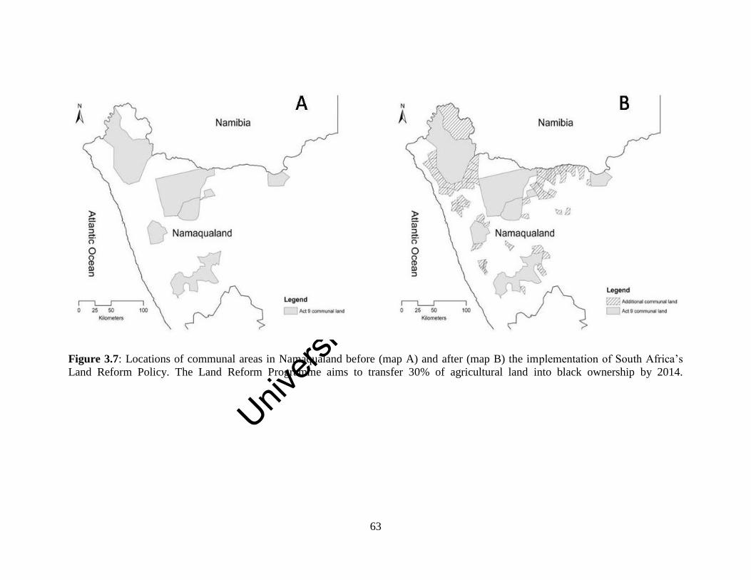
Unive
rsity
of C
ape
Town
63
Figure 3.7: Locations of communal areas in Namaqualand before (map A) and after (map B) the implementation of South Africa’s
Land Reform Policy. The Land Reform Programme aims to transfer 30% of agricultural land into black ownership by 2014.
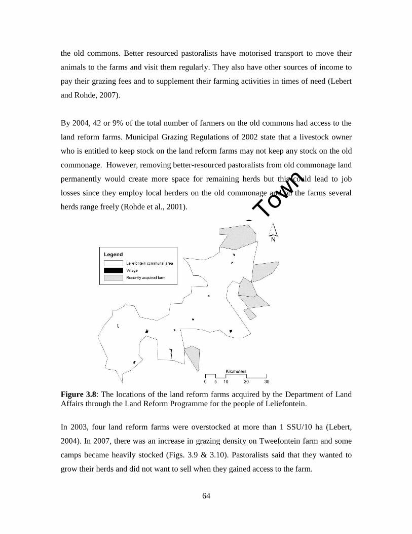
Unive
rsity
of C
ape
Town
64
the old commons. Better resourced pastoralists have motorised transport to move their
animals to the farms and visit them regularly. They also have other sources of income to
pay their grazing fees and to supplement their farming activities in times of need (Lebert
and Rohde, 2007).
By 2004, 42 or 9% of the total number of farmers on the old commons had access to the
land reform farms. Municipal Grazing Regulations of 2002 state that a livestock owner
who is entitled to keep stock on the land reform farms may not keep any stock on the old
commonage. However, removing better-resourced pastoralists from old commonage land
permanently would create more space for remaining herds but this could lead to job
losses since they employ local herders on the old commonage and on the farms several
herds range freely (Rohde et al., 2001).
Figure 3.8: The locations of the land reform farms acquired by the Department of Land
Affairs through the Land Reform Programme for the people of Leliefontein.
In 2003, four land reform farms were overstocked at more than 1 SSU/10 ha (Lebert,
2004). In 2007, there was an increase in grazing density on Tweefontein farm and some
camps became heavily stocked (Figs. 3.9 & 3.10). Pastoralists said that they wanted to
grow their herds and did not want to sell when they gained access to the farm.
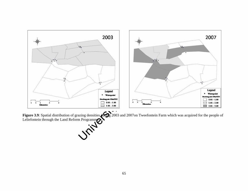
Unive
rsity
of C
ape
Town
65
Figure 3.9: Spatial distribution of grazing densities during 2003 and 2007on Tweefontein Farm which was acquired for the people of
Leliefontein through the Land Reform Programme.
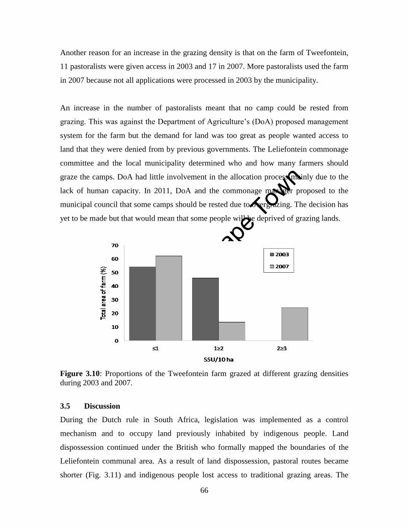
Unive
rsity
of C
ape
Town
66
Another reason for an increase in the grazing density is that on the farm of Tweefontein,
11 pastoralists were given access in 2003 and 17 in 2007. More pastoralists used the farm
in 2007 because not all applications were processed in 2003 by the municipality.
An increase in the number of pastoralists meant that no camp could be rested from
grazing. This was against the Department of Agriculture’s (DoA) proposed management
system for the farm but the demand for land was too great as people wanted access to
land that they were denied from by previous governments. The Leliefontein commonage
committee and the local municipality determined who and how many farmers should
graze the camps. DoA had little involvement in the allocation process mainly due to the
lack of human capacity. In 2011, DoA and the commonage manager proposed to the
municipal council that some camps should be rested due to overgrazing. The decision has
yet to be made but that would mean that some people will be deprived of grazing lands.
Figure 3.10: Proportions of the Tweefontein farm grazed at different grazing densities
during 2003 and 2007.
3.5 Discussion
During the Dutch rule in South Africa, legislation was implemented as a control
mechanism and to occupy land previously inhabited by indigenous people. Land
dispossession continued under the British who formally mapped the boundaries of the
Leliefontein communal area. As a result of land dispossession, pastoral routes became
shorter (Fig. 3.11) and indigenous people lost access to traditional grazing areas. The
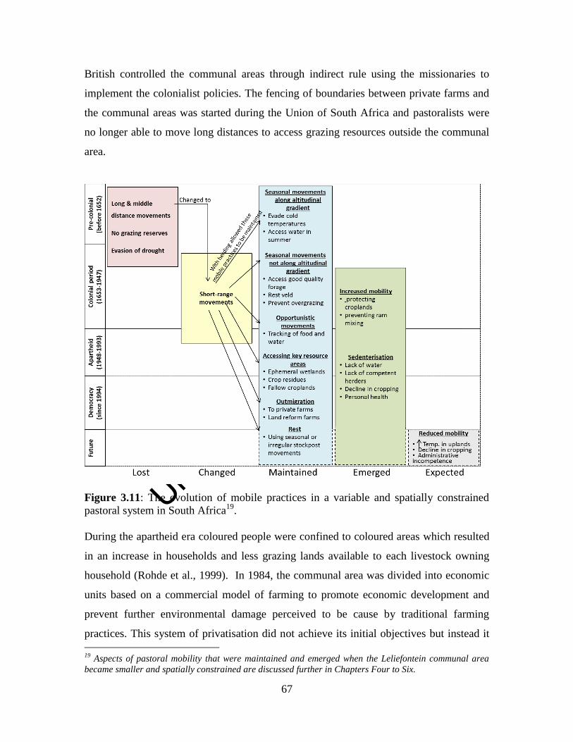
Unive
rsity
of C
ape
Town
67
British controlled the communal areas through indirect rule using the missionaries to
implement the colonialist policies. The fencing of boundaries between private farms and
the communal areas was started during the Union of South Africa and pastoralists were
no longer able to move long distances to access grazing resources outside the communal
area.
Figure 3.11: The evolution of mobile practices in a variable and spatially constrained
pastoral system in South Africa19
.
During the apartheid era coloured people were confined to coloured areas which resulted
in an increase in households and less grazing lands available to each livestock owning
household (Rohde et al., 1999). In 1984, the communal area was divided into economic
units based on a commercial model of farming to promote economic development and
prevent further environmental damage perceived to be cause by traditional farming
practices. This system of privatisation did not achieve its initial objectives but instead it
19
Aspects of pastoral mobility that were maintained and emerged when the Leliefontein communal area
became smaller and spatially constrained are discussed further in Chapters Four to Six.
Unive
rsity
of C
ape
Town
68
increased stocking densities and restriction of herd mobility. The economic unit system
was poorly designed and was based on faulty scientific theories (Rohde et al., 2006).
These theories still form the basis of the current South African commonage policy.
3.5.1 What science underpins South Africa’s commonage policy?
The practices promoted by the democratic government in the commonage policy of South
Africa are a continuation of previous legislation and is also similar to land policies in
other post-independence countries in Africa. In these countries developmental discourses,
which were not often based on scientific evidence were used to formulate policies (Abel
and Blaikie, 1989; Homewood, 2008). In South Africa, Botswana, Lesotho and
Zimbabwe, policies which favour privatisation of communal or tribal land are based on
the equilibrium theory that is applied to vegetation dynamics, the perception that pastoral
systems are degraded and the ‘Tragedy of the Commons’ narrative (Abel and Blaikie,
1989; Rohde et al., 2006).
The equilibrium theory as it is applied to rangeland dynamics is informed by Frederick
Clements’ linear plant succession model (Sayre and Fernandez-Gimenez, 2003). This
theory assumes that a rangeland has a carrying capacity based on rainfall and biophysical
characteristics that determine its primary production (Vetter, 2005). It further assumes
that vegetation succession and grazing pressure are in equilibrium with each other
(Westoby et al., 1989). Heavy grazing will push vegetation to an early successional or
pioneer stage whereas light or no grazing will allow the vegetation to move towards to a
climax community (Wilson & Macleoid 1991; Vetter, 2005). Managing rangelands based
on the equilibrium theory promotes the use of conservative stocking rates as determined
by fixed carrying capacities for the land to prevent overgrazing. Destocking schemes, an
orientation towards market production and improved breeding have also been introduced
to modernise communal areas (Sayre and Fernandez-Gimenez, 2003). Many
interventions to modernise pastoral practices in arid and semi-arid areas have failed (Oba
et al., 2000; Behnke, 2008) often because the ranching model used was designed for use
in wetter or less variable environments (Kirkbride and Grahn, 2008).

Unive
rsity
of C
ape
Town
69
In arid and semi-arid regions where the coefficient of variation (CV) in rainfall is more
than 30% non-equilibrial factors tend to operate (Ellis et al., 1993). In non-equilibrium
systems, density independent factors such as rainfall as opposed to density-dependent,
grazing pressure are the most important drivers of vegetation dynamics (see Vetter,
2005). Rainfall in semi-arid areas is spatially and temporally variable causing variability
in primary production (Vetter, 2005). Livestock numbers are regulated by environmental
fluctuations and seldom reached densities that are high enough to affect vegetation
dynamics (Ellis and Swift, 1988). Policies which encourage the use of conservative
stocking rates may not result in overgrazing during dry periods but will result in
undergrazing during good rainfall years and could result in a loss of potential income for
pastoralists (Ellis and Swift, 1988; Campbell et al., 2006). Opportunistic stocking rates20
are thus recommended in variable environments (Campbell et al., 2006). Moreover, in
semi-arid environments pastoral mobility, as opposed to paddocking which restricts
livestock movements, is considered ecologically rational when resources are variable
(Niamir-Fuller and Turner, 1999).
Most researchers agree that land degradation is a reality (Ward et al., 1998; Abel and
Blaikie, 1989; Vetter, 2005) but there is no consensus on what constitutes degradation
and what its causes are. Some argue that changes in vegetation composition and structure,
loss of plant cover or bush encroachment constitute degradation (Hoffman, 2003) while
others argue that these are shifts into alternative vegetation states as described by the state
and transition model of rangeland dynamics (Westoby et al., 1989). Other researchers
hold the position that only a change in vegetation which is irreversible that is, it has
moved beyond it bounds of resilience, should be classified as degradation (Abel and
Blaikie, 1989). Natural scientists also regard soil erosion and nutrient depletion as
indicators of land degradation (Hoffman, 2003; Scholes, 2009) whereas others consider
degradation as a decrease in secondary production over time (Behnke and Scoones,
1993).
20
Opportunistic stocking rates occur when animal numbers are regulated by livestock keepers usually in
response to environmental conditions. During unfavourable conditions such as drought when there is a
lack of food and water, farmers may sell their animals although the low selling cost often discourages
sales. During good rainfall periods when forage is abundant, livestock keepers are inclined to buy in
animals to boost production.
Unive
rsity
of C
ape
Town
70
Warren (2002) says that a single measure of degradation is too simplistic since
biophysical change can have different consequences at different context. For example,
land users assess degradation at local scale and might only classify an area as degraded if
it affects their livelihood but at larger scales the effects might be masked by the success
of an agricultural system (Warren, 2002). Scholes, (2009) argues that for an area to be
regarded as degraded, we should look at whether there has been a decrease in the amount
of ecosystem services provided, which results in a loss of natural capital. Rangelands
provide various ecosystem services such as natural products and medicinal plants to
pastoralists as well as fodder and water to their livestock (Shackleton et al., 2008).
However, these ecosystem services might become degraded from poor management
practices such as overgrazing and poor livestock policies. For example, in Namaqualand
overgrazing resulted in a significant reduction in the cover of palatable perennial plants
and an increase in annual and unpalatable plant cover (Todd and Hoffman, 1999, 2009;
Anderson and Hoffman, 2007). Consequently, these changes in the ecosystem could lead
to a loss in ecosystem services in the future.
Traditional pastoral practices which are often associated with heavy grazing have been
assumed to cause land degradation (Lamprey, 1983; Sinclair and Fryxell, 1985; Miller,
2000). In these systems destocking is proposed to improve rangeland condition and
improve livestock productivity (Abel and Blaikie, 1989). However, it is argued that there
is no link between herbivory and land degradation (Scoones, 1995b). This is corroborated
by research in Namibia where no difference was found in livestock impacts on soil and
vegetation between communal and private farms in Namibia even at higher human and
livestock densities in the communal areas (Ward et al., 1998). These authors argue that in
variable environments rainfall masks the impacts of grazing and that rainfall is the main
driver that recharges the systems after suffering from heavy grazing pressure.
The ‘Tragedy of the Commons’ narrative (Hardin, 1968) assumes that access to
communal resources is open and unregulated; farmers keep livestock for economic
reasons and they would rationally want to maximise their personal gains from these
resources. Since all users act in this rational manner, the common resource is overused
Unive
rsity
of C
ape
Town
71
and this might lead to the destruction of the environment. Policies for communal or tribal
land thus promote the allocation of grazing areas to specific groups of people so that the
owners bear all the costs of environmental degradation (Abel and Blaikie, 1989).
The ‘Tragedy of the Commons’ narrative has been challenged as a useful way to view
land use practices in many pastoral systems around the world (McCabe, 1990; Peters,
1994; Ward et al., 1998). In Leliefontein it was found that the communal rangeland is not
open for all and pastoralists usually graze in certain areas and do not graze in areas that
have been traditionally used by others even though they have a right to do so (Marinus,
1996; Debeaudoin, 2001, Allsopp et al., 2007). Livestock numbers in Leliefontein are
regulated to ensure that more animals are able to survive drought periods (Debeaudoin,
2001). Moreover, livestock keeping in Leliefontein (Debeaudoin, 2001) as in other
pastoral systems (Hassan et al., 1998; Homewood, 2008; Siegmund-Schultze et al.,
2012; Ainslie, 2005; 2013) is not profit driven but is used mostly for subsistence reasons
as well as traditional and cultural practices.
Pastoralists do not always want to maximise their personal gains from communal
resources since they regularly help each other by sharing their farming knowledge
(Samuels, 2006), which are important to maintain social networks (Marinus, 1996). In
Paulshoek village, there are seven identifiable networks amongst 26 pastoralists that are
based on kinship ties and co-operatives (Marinus, 1996). Social networks are important to
help pastoralists to cope with changes in the pastoral system, promote economies of
scale, prevent conflict and in times of need when they need access to good quality forage
(Turner, 1999b; Mwangi 2003 cited in Galvin, 2009; Galvin, 2009). In Niger, social
networks are also important for resident pastoralists to access additional labour to assist
with herding duties during the wet season (Turner, 1999b). In Leliefontein, social
networks are important to access to information on the condition of the rangeland from
other herders (Debeaudoin, 2001) and extended kinships and provide pastoralists’
families with employment opportunities in urban areas, which would provide pastoralists
with additional sources of income through remittances (Rohde et al., 2003).
Unive
rsity
of C
ape
Town
72
The basis for promoting commercially-oriented rangeland practices in communal areas
within the municipal commonage policy is thus not supported by scientific evidence but
on theories which have been refuted in many parts of the world.
3.5.2 What are the implications of promoting leasehold tenure on commonage land?
The commonage policy of 2002 (DLA, 2002) emphasises the additional role of land
reform farms as ‘stepping stones’ for emergent21
black farmers to become commercial
farmers. However, the system of promoting emerging black farmers to become
commercial farmers has not been successful in South Africa. Emerging farmers encounter
practical constraints such as lack of access to markets which prevent them from entering
main stream commercial agriculture (Senyolo et al., 2009). They also have constraints
regarding access to land, infrastructure and financial support since they do not have title
deeds to the land and thus cannot use it as collateral (Senyolo et al., 2009). Moreover, the
land that they occupy is mostly not economically viable due to its limited size (Martens,
2009).
In Namaqualand, the commonage policy has failed to assist the poor (Rohde et al., 2006)
because pastoralists seldom have sufficient capital and farm assets to become commercial
farmers (Anseeuw and Laurent, 2007). Moreover, farming credit is only granted to full-
time farmers with long-term farming experience. This is not feasible since rarely do we
find full-time farmers even in the commercial farming sector in South Africa.
Commercial farmers in Namaqualand engage in non-farm income activities such as
having other professions or additional activities to supplement their income from
farming. It was found that pluriactivity is also necessary on land reform farms in order for
the stepping stones system to be successful since it would ensure sufficient income to the
household and development of the farming unit (Anseeuw and Laurent, 2007).
21
Emerging farmers in South Africa are regarded as smallholder farmers, who were previously excluded
from the mainstream agricultural economy and include beneficiaries of land reform programmes (Senyolo,
2009).

Unive
rsity
of C
ape
Town
73
The Tribal Grazing Land Policy of 1975 in Botswana which allowed for the creation of
leasehold ranches for larger cattle herds on former tribal lands had similar implications as
South Arica’s commonage policy. In Botswana, the policy resulted in conflicts over
former communal lands, widened the gap between rich and poor farmers (Rohde et al.,
2006) and showed negative rates of return (Malope and Batisani, 2008). During the 1960s
to 1980s, traditional Maasai lands were divided into group ranches to modernise and
improve livestock production and protect the environment (Kimani and Pickard, 1998;
Kipuri and Naikuni, 2008). Ranching led to inequitable access for pastoralists to grazing
land and water and the subdivision of ranches reduced the ability of livestock to access
vegetation heterogeneity due to restrictions of herd movement (BurnSilver and Boone,
2003).
The LRAD grant in South Africa was too small to purchase large and economically
viable livestock farms (Martens, 2009). This resulted in groups rather than individuals
purchasing the land which created a communal farming system where often the poorest
members are marginalised in the decision-making processes (Lahiff, 2007). In the
political arena in South Africa, Benjaminsen et al. (2006) argue that the reason why the
system of ‘stepping stones’ on the land reform farms remains unchallenged even though
it is unsuccessful is because it serves political interest. These interests include the
emergence of black commercial farmers and reversing the racial land ownership profile
created by apartheid and previous legislation. However, deracialising commercial
agriculture is not sufficient to change the status quo of South Africa’s agricultural
landscape (Cousins, 2007).
In order for land reform beneficiaries to be successful commercial farmers, more focus
should be placed on agrarian reform. Cousins (2007) argues that agrarian reform could be
achieved if the state played a central role in land and agrarian reform, devoted sufficient
resources to land reform and acknowledged the contributions of smallholder production
to the rural economy (Cousins, 2007). There should also be an active participation of
beneficiaries of agrarian reform in processes of policy making, planning and
implementation (Cousins, 2007). Achieving agrarian reform might then improve
Unive
rsity
of C
ape
Town
74
pastoralists’ access to markets, finances, good infrastructure and information, which are
the aspects needed to become successful commercial farmers (Senyolo et al., 2009).
Since colonisation, legislation introduced in communal areas has not promoted and
supported mobile pastoralism. It is no surprise that since Namaqualand was governed by
the Dutch, there has been little compliance with the legislation by Leliefontein
pastoralists. Firstly, legislation passed before democracy in 1994, discriminated against
the indigenous people and they might have viewed those laws as forms of oppression.
After 1994, non-compliance continued and arguably even increased because people had
high expectations of equality and greater access to resources during the new South
Africa. Pastoralists mentioned that there is a deliberate withholding of information
regarding the TRANCRAA process so people are confused about their rights to the land
and their land use options.
Presently, municipal grazing, cropping and impounding regulations are poorly
implemented. There is a lack of capital in the local municipality to employ people to
enforce these regulations. Furthermore, there is a lack of capacity in municipal officials
who do not understand how these regulations should be implemented and how to respond
to the breaching of rules. An example exists whereby a local farmer was ordered by the
municipal council to vacate a community ram camp which he occupied. Seven years
later, the farmer still uses the ram camp to graze his herd. Moreover, the fact that few
people pay rent for croplands or grazing fees has resulted in the municipality giving less
attention to land use in the communal area. The possibilities of lawsuits especially against
those who wrongfully impound livestock are also why the impounding regulations are not
enforced. However, pastoralists in Leliefontein do not contest the political legitimacy of
these regulations and understand that they are based on traditional practices and norms of
the community. Therefore, the only concern is the lack of enforcement by the
municipality.
Legislation on the new farms cannot be implemented due to a shortage of human
resources and limited operational budgets as well as the lack of cooperation between
Unive
rsity
of C
ape
Town
75
community structures, DoA and the local municipality. The commonage committee,
which consists of elected officials from the ten villages, the municipality and DoA was
established to co-manage the land reform farms and to move away from the top-down
approach of communal land management. However, most of the elected officials who are
part of the decision-making processes are there for their self-interest (Lebert and Rohde,
2007). In addition to the lack of capacity and resources, the commonage committee is
also unwilling to enforce rules because it is not in their best economic benefit. As a result,
stocking rates are not adhered to and the elite members of the community gain the
greatest benefit from the municipal commonage programme (Lebert and Rohde, 2007).
Some governments have started to embrace mobile pastoralism in state policies (de Jode,
2010). In Mongolia, policies implemented during 2003 and 2006 aimed to restore
customary institutions and common property management of natural resources.
Traditional range management strategies such as increased transhumance, improved
access to pastures and greater control over key resources were implemented which
resulted in improved range condition (WISP, 2008). A decrease in poverty amongst
pastoral households was also observed due to tourism initiatives and greater access to
markets (WISP, 2008). In Tanzania, the Wildlife Policy of 1998 acknowledged the roles
mobile pastoralists play in conserving biodiversity by protecting wildlife and their
habitats (WISP, 2008). However, from 1999 onwards, the government reconsolidated
their central control over tourism and conservation. The activities of pastoralists and
wildlife became segregated and pastoralists are now restricted in their access to
traditional grazing resources (Ngoitiko et al., 2010).
In other countries such as in Kenya, the subdivision of communal lands into group
ranches by government to promote privatization in an attempt to improve production and
conserve the environment can be seen as a policy in contrast to those that promote
mobility. The further subdivision of group ranches resulted in pastoral mobility being
constrained which in turn increased overstocking. However, in order to improve herd
mobility, pastoral households have engaged in collective actions which include pasture
sharing agreements and strengthening traditional norms so that herds can move between
Unive
rsity
of C
ape
Town
76
grazing areas which have become fragmented through land tenure changes (BurnSilver
and Mwangi, 2007). This re-aggregation suggests that in variable environments such as
Kenya, pastoralists need to be mobile and appropriate policies should be in place to
promote mobility. In South Africa, current policies also need to be aligned to support
mobile pastoralists (Vetter, 2013). These policies should be informed by scientific
understandings of pastoral systems that have been rigorously tested and reviewed as well
as the management practices of pastoralists. Such policies might then assist pastoralists in
overcoming their constraints and help them to meet their farming objectives.
Unive
rsity
of C
ape
Town
77
Chapter Four22
Temporal mobility patterns of livestock keepers in semi-arid
communal rangelands of Namaqualand, South Africa
Abstract
In arid and semi-arid environments, pastoralists use herd mobility to manage resource
variability. When grazing areas become modified, however, herd mobility needs to
change and adapt to the new environment. In this study, I investigated what drives herd
mobility and how the temporal mobility patterns of pastoral herds changed between 1997
and 2006 in the spatially constrained Leliefontein communal area in Namaqualand. I
conducted semi-structured interviews with about 300 pastoralists and agro-pastoralists
from 10 villages in the communal area. Herd size and the frequency of herd movements
varied significantly amongst the herds in the different villages. Although several herds
moved out of the commons onto recently acquired land reform farms to increase their
flexibility of herd movements, about 80% of herd movements still occurred within village
boundaries. Pastoral mobility in Leliefontein is complex and is influenced by
environmental, agricultural, social and personal factors that operate at both herd and
village levels within the pastoral system.
4.1 Introduction
Arid and semi-arid ecosystems are characterised by unpredictability in rainfall and
variability in grazing resources. Such environments pose great risks and uncertainty for
animal husbandry (Behnke and Scoones, 1993), and people and their livestock have to
adapt to these conditions. One way of adapting is to coordinate their activities with the
spatial and temporal availability of resources. Pastoralists around the world have
managed to sustain livestock in variable environments for millennia by adopting these
approaches (Fernandez-Gimenez and Swift, 2003).
22
A large component of the data presented in this chapter has been published in Samuels et al. (2008).
Unive
rsity
of C
ape
Town
78
In drylands where non-equilibrium factors mostly drive vegetation dynamics (Vetter,
2004), pastoralists use herd mobility to manage resource variability (Bovin, 1990;
Agrawal, 1993; Coppolillo, 2000; Fernandez-Gimenez, 2000; Hendricks et al., 2005).
Mobility is seen as an ecologically rational means to ensure maximum use of limited
resources (Niamir-Fuller, 1999b; Adriansen, 2003), a risk avoidance strategy (Swallow,
1994) and a strategy that maximises digestible nutrient intake during growing seasons
(Western, 1982). Mobility is usually in the form of nomadic movements in search of
better forage and water (Sieff, 1997) or seasonal transhumant patterns between dry and
wet season pastures (Adriansen, 2003), geomorphological zones (Schareika, 2001), from
higher to lower elevation during the cold seasons (de Weijer, 2007) or between different
latitudinal areas (Dwyer and Istomin, 2006).
Even though mobile pastoralism contributes significantly to the Gross Domestic Product
(GDP) of numerous developing countries around the world (Davies and Hatfield, 2007),
its sustainability is not promoted in government policies (Niamir-Fuller, 2008). Mobile
practices are also under pressure from long droughts, encroachment of other land uses,
especially cropping, due to increases in human population (de Weijer, 2007), and disease
control policies (Niamir-Fuller and Turner, 1999). An inadequate supply of
infrastructure, the breakdown of customary hierarchies, famine and wars have also led to
a decrease in mobility (Niamir-Fuller and Turner, 1999).
This chapter investigates changes in the mobility patterns of pastoralists in the
Leliefontein communal area between 1997 and 2006. Pastoralists in this area are spatially
constrained and represent the situation of many pastoralists in Africa and the rest of the
world in modern times where herd mobility has become increasingly restricted. The study
also investigates the key drivers of change in the pastoral system from a social and
environmental perspective. Understanding the socio-economic drivers of pastoral
mobility is crucial to better manage livestock and prevent environmental degradation
(Baker and Hoffman, 2006).
Unive
rsity
of C
ape
Town
79
In this chapter I asked the following key questions:
1. What is the nature of herd mobility patterns in the Leliefontein communal area?
2. What drives herd mobility in the spatially constrained Leliefontein communal area?
3. How have herd mobility patterns changed between 1997 and 2006 and what are the
drivers of this change?
Mobile pastoral systems are often described in general terms. This study analyses
individual herd mobility from all the herds in ten villages in the Leliefontein communal
rangeland. McCabe (1994) points out the lack of detailed information on mobility
patterns for specific pastoral communities in contrast to generalised descriptions of land
use. This lack of information might have directly contributed to the failure of
development projects (Horowitz 1981 cited in McCabe, 1994). This study can also
contribute to the development of grazing management policy that takes into account
current mobile pastoral systems. An example would be in the development of the
Municipal Integrated Development Plans (IDPs) in South Africa which are presently
responsible for management approaches within the communal lands.
4.2 Methods
Data on stockpost and watering point locations from 1997 to 2006 were collected using a
Garmin etrex (Garmin Ltd, Kansas, USA) handheld GPS receiver. A local informant in
each village, except in Paulshoek where data already existed, was relied on to show the
locations of the stockposts and watering points used by pastoralists during the study
period. The informants were selected for their in-depth knowledge of the local farming
system. The history of stockpost and watering point usage, reasons for stockpost
movements and their stock numbers were obtained through semi-structured interviews
with about 300 pastoralists and agro-pastoralists from the 10 villages (Appendix A).
Interviews were conducted in the local language, Afrikaans, but notes were taken in
English. Stock numbers were also obtained from sources listed in Appendix B.
Fieldwork and interviews were conducted from September 2006 to March 2007. The total
number of herds through time presented in this study includes herds that started or went
Unive
rsity
of C
ape
Town
80
extinct during the study period. The locations and occupation of stockposts and stock
numbers for the village of Paulshoek were extracted from a long term livestock database
on the Paulshoek farming system maintained by the Plant Conservation Unit at the
University of Cape Town. Rainfall data was obtained from the South African Weather
Services.
ANOVA was used to test for significant differences in maximum herd size between
different herd compositions. When the Kolmogorov-Smirnov normality test failed, the
Kruskal-Wallis One Way Analysis of Variance on Ranks test was run using Dunn’s
method of multiple comparisons (Dunn, 1961). I used maximum individual herd size to
determine the number of animals a herder could manage in this variable environment. In
Leliefontein, herds with no herders are usually comprised entirely of goats (Samuels,
2006). These goat herds are usually kept close to the village and pastoralists seldom
move their stockpost locations. I used t-tests to determine whether the number of
stockpost movements of exclusively goat herds was significantly different to herds of
other compositions. To test whether larger herds move more often than smaller herds, a
regression analysis was used to assess the type and strength of this relationship.
A t-test was used to test for differences in the number of stockpost movements between
villages and between years and to test whether there is a difference in the time a herd
occupies a single stockpost. When the normality test failed, the Mann-Whitney Rank
Sum Test was used. A t-test was also used to test whether there were significant
differences in minimum temperatures and the number of frost days during the coldest
months (June to August) between stockposts at high and low elevations around the
Leliefontein village. Data on minimum temperatures and the number of frost days were
extracted from the South Africa Atlas of Agrohydrology and Climatology (Schulze,
1997).
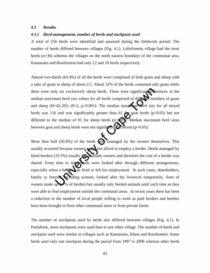
Unive
rsity
of C
ape
Town
81
4.3 Results
4.3.1 Herd management, number of herds and stockposts used
A total of 256 herds were identified and assessed during the fieldwork period. The
number of herds differed between villages (Fig. 4.1). Leliefontein village had the most
herds (n=36) whereas the villages on the north eastern boundary of the communal area,
Kamassies and Rooifontein had only 12 and 18 herds respectively.
Almost two-thirds (65.4%) of all the herds were comprised of both goats and sheep with
a ratio of goats to sheep of about 2:1. About 32% of the herds contained only goats while
there were only six exclusively sheep herds. There were significant differences in the
median maximum herd size values for all herds comprised of different numbers of goats
and sheep (H=42.293; df=2, p<0.001). The median maximum herd size for all mixed
herds was 116 and was significantly greater than 61 for goat herds (p<0.05) but not
different to the median of 91 for sheep herds (p>0.05). Median maximum herd sizes
between goat and sheep herds were not significantly different (p>0.05).
More than half (56.8%) of the herds were managed by the owners themselves. This
usually occurred because owners could not afford to employ a herder. Herds managed by
hired herders (33.5%) usually had multiple owners and therefore the cost of a herder was
shared. From time to time herds were looked after through different arrangements,
especially when a herder was fired or left his employment. In such cases, shareholders,
family or friends, including women, looked after the livestock temporarily. Sons of
owners made up 9.7% of herders but usually only herded animals until such time as they
were able to find employment outside the communal areas. In recent years there has been
a reduction in the number of local people willing to work as paid herders and herders
have been brought in from other communal areas or from private farms.
The number of stockposts used by herds also differed between villages (Fig. 4.1). In
Paulshoek, more stockposts were used than in any other village. The number of herds and
stockpost used were similar in villages such as Kamassies, Kheis and Rooifontein. Some
herds used only one stockpost during the period from 1997 to 2006 whereas other herds
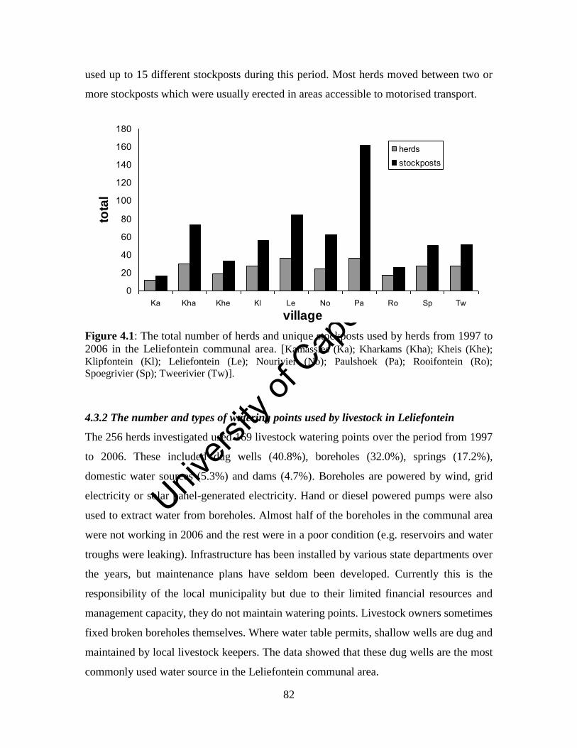
Unive
rsity
of C
ape
Town
82
used up to 15 different stockposts during this period. Most herds moved between two or
more stockposts which were usually erected in areas accessible to motorised transport.
Figure 4.1: The total number of herds and unique stockposts used by herds from 1997 to
2006 in the Leliefontein communal area. [Kamassies (Ka); Kharkams (Kha); Kheis (Khe);
Klipfontein (Kl); Leliefontein (Le); Nourivier (No); Paulshoek (Pa); Rooifontein (Ro);
Spoegrivier (Sp); Tweerivier (Tw)].
4.3.2 The number and types of watering points used by livestock in Leliefontein
The 256 herds investigated used 169 livestock watering points over the period from 1997
to 2006. These included dug wells (40.8%), boreholes (32.0%), springs (17.2%),
domestic water sources (5.3%) and dams (4.7%). Boreholes are powered by wind, grid
electricity or solar panel-generated electricity. Hand or diesel powered pumps were also
used to extract water from boreholes. Almost half of the boreholes in the communal area
were not working in 2006 and the rest were in a poor condition (e.g. reservoirs and water
troughs were leaking). Infrastructure has been installed by various state departments over
the years, but maintenance plans have seldom been developed. Currently this is the
responsibility of the local municipality but due to their limited financial resources and
management capacity, they do not maintain watering points. Livestock owners sometimes
fixed broken boreholes themselves. Where water table permits, shallow wells are dug and
maintained by local livestock keepers. The data showed that these dug wells are the most
commonly used water source in the Leliefontein communal area.
0
20
40
60
80
100
120
140
160
180
Ka Kha Khe Kl Le No Pa Ro Sp Tw
village
tota
l
herds
stockposts
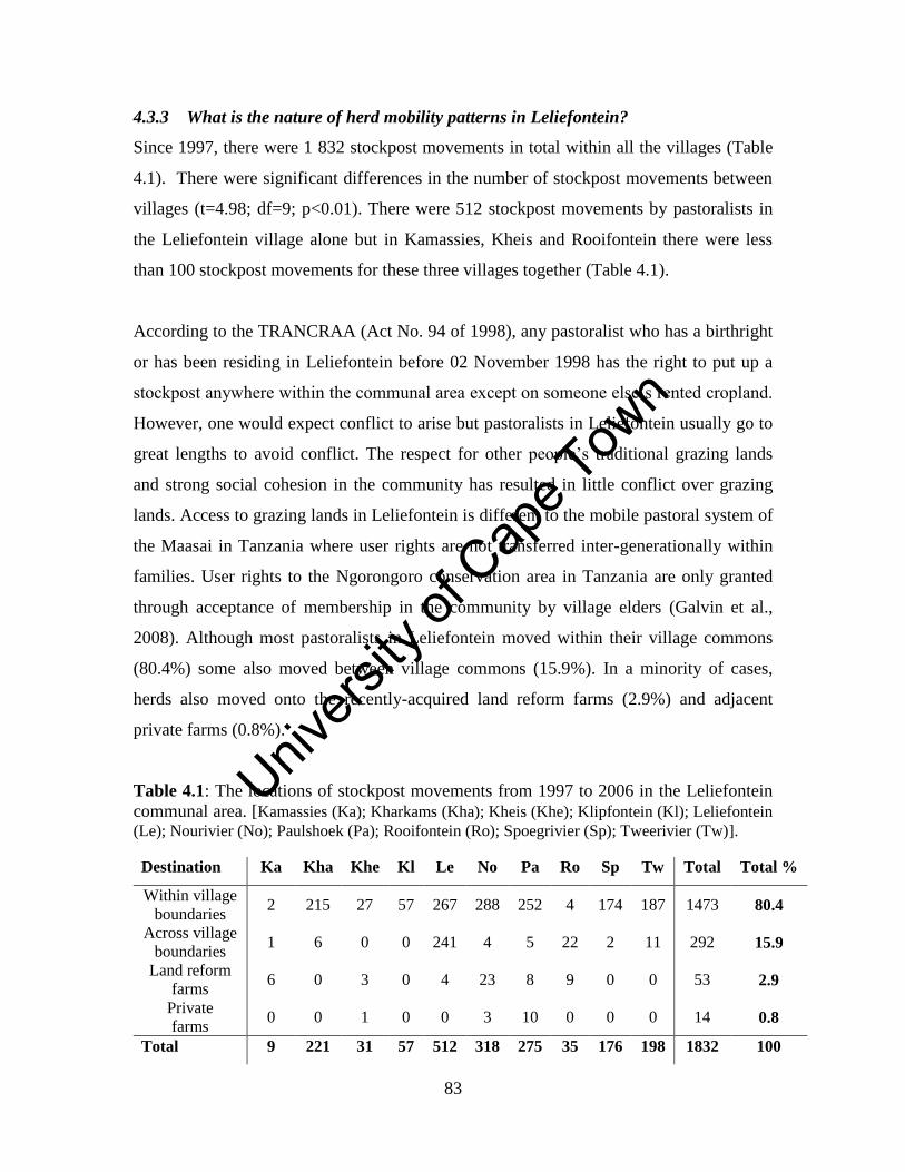
Unive
rsity
of C
ape
Town
83
4.3.3 What is the nature of herd mobility patterns in Leliefontein?
Since 1997, there were 1 832 stockpost movements in total within all the villages (Table
4.1). There were significant differences in the number of stockpost movements between
villages (t=4.98; df=9; p<0.01). There were 512 stockpost movements by pastoralists in
the Leliefontein village alone but in Kamassies, Kheis and Rooifontein there were less
than 100 stockpost movements for these three villages together (Table 4.1).
According to the TRANCRAA (Act No. 94 of 1998), any pastoralist who has a birthright
or has been residing in Leliefontein before 02 November 1998 has the right to put up a
stockpost anywhere within the communal area except on someone else’s rented cropland.
However, one would expect conflict to arise but pastoralists in Leliefontein usually go to
great lengths to avoid conflict. The respect for other people’s traditional grazing lands
and strong social cohesion in the community has resulted in little conflict over grazing
lands. Access to grazing lands in Leliefontein is different to the mobile pastoral system of
the Maasai in Tanzania where user rights are not transferred inter-generationally within
families. User rights to the Ngorongoro conservation area in Tanzania are only granted
through acceptance of membership in the community by village elders (Galvin et al.,
2008). Although most pastoralists in Leliefontein moved within their village commons
(80.4%) some also moved between village commons (15.9%). In a minority of cases,
herds also moved onto the recently-acquired land reform farms (2.9%) and adjacent
private farms (0.8%).
Table 4.1: The locations of stockpost movements from 1997 to 2006 in the Leliefontein
communal area. [Kamassies (Ka); Kharkams (Kha); Kheis (Khe); Klipfontein (Kl); Leliefontein
(Le); Nourivier (No); Paulshoek (Pa); Rooifontein (Ro); Spoegrivier (Sp); Tweerivier (Tw)].
Destination Ka Kha Khe Kl Le No Pa Ro Sp Tw Total Total %
Within village
boundaries 2 215 27 57 267 288 252 4 174 187 1473 80.4
Across village
boundaries 1 6 0 0 241 4 5 22 2 11 292 15.9
Land reform
farms 6 0 3 0 4 23 8 9 0 0 53 2.9
Private
farms 0 0 1 0 0 3 10 0 0 0 14 0.8
Total 9 221 31 57 512 318 275 35 176 198 1832 100
Unive
rsity
of C
ape
Town
84
Between 1998 and 2000, five land reform farms were acquired for the communities of
Leliefontein through the Land Reform Programme of South Africa. These farms were
acquired as a direct consequence of the government policy to redress the unequal
distribution of land in South Africa with the majority being in the hands of white farmers.
The Land Reform Programme aims to transfer 30% of agricultural land in South Africa to
previously disadvantaged people by 2014. The land reform farms are divided into
paddocks (locally referred to as camps) and a single paddock could be given to more than
one herd. Paddock sizes on these farms range between 126 and 2 199 hectares.
Pastoralists in Leliefontein are only allowed to move onto private farms if they reach
agreements with commercial farmers. The terms of the agreements entail repaying the
commercial farmer through labour (labour tenancy) or transferring 50% of the
pastoralist’s newborn lambs to the farmer. Through the 50:50 agreement the commercial
farmer often gives pastoralists access to his veterinary services and good quality rams to
service pastoralists’ stock.
Between 1997 and 2006, 187 out of the total of 256 herds moved their stockposts at least
once whereas 69 herds did not move at all (Fig. 4.2). The owners of a herd and not the
herders make the decisions on where and when to move a stockpost. Eighty seven herds
moved less than five times between 1997 and 2006. Fifty four herds moved between 16
to 20 times and only 14 herds moved more than 20 times during this period. Due to
differences in the stockpost movements between herds, the average time period that a
single herd occupied a stockpost varied significantly (t=4.58; df =0; p<0.001). On
average, pastoralists in Kamassies village occupied a single stockpost for approximately
five years (Fig. 4.3). Pastoralists in Rooifontein and Klipfontein villages occupied a
single stockpost for almost 40 months. Pastoralists in the upland villages of Leliefontein,
Nourivier, Paulshoek and Tweerivier occupied a single stockpost for less than a year.
The average stationary time for herds in Kheis was similar to Kharkams which had more
movements (Table 4.1) because four of the nine herds that moved in Kheis were only
constituted in August 1998.
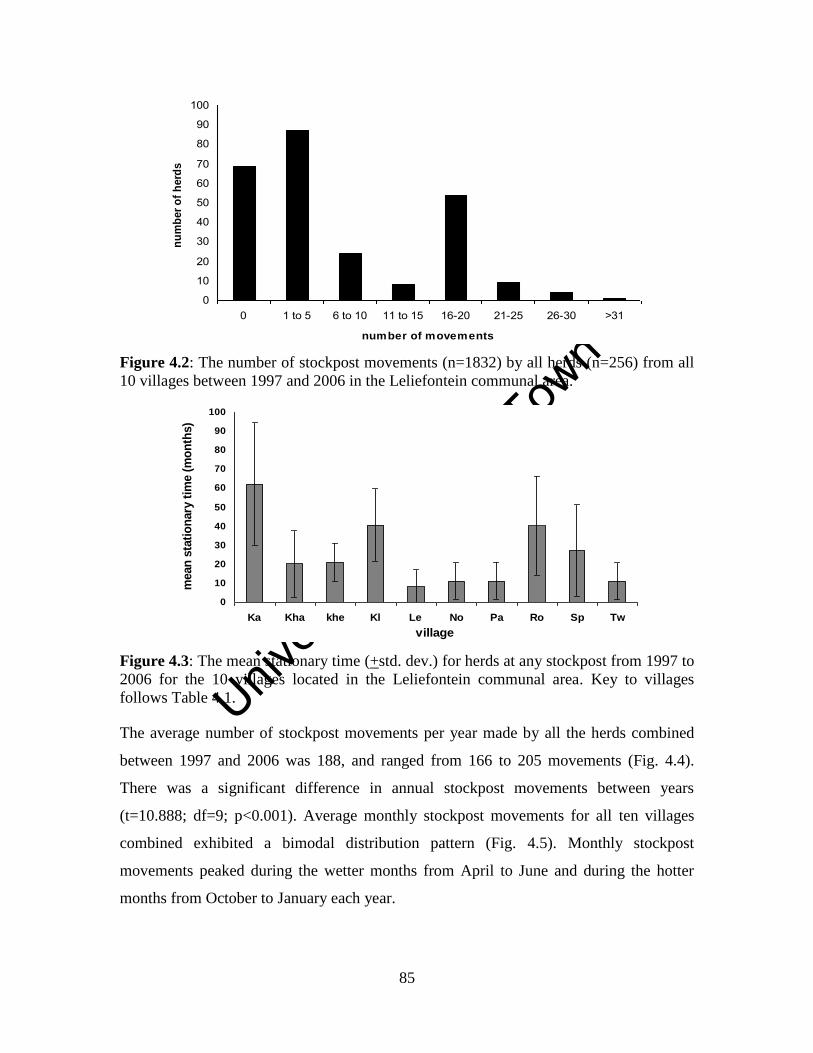
Unive
rsity
of C
ape
Town
85
Figure 4.2: The number of stockpost movements (n=1832) by all herds (n=256) from all
10 villages between 1997 and 2006 in the Leliefontein communal area.
Figure 4.3: The mean stationary time (+std. dev.) for herds at any stockpost from 1997 to
2006 for the 10 villages located in the Leliefontein communal area. Key to villages
follows Table 4.1.
The average number of stockpost movements per year made by all the herds combined
between 1997 and 2006 was 188, and ranged from 166 to 205 movements (Fig. 4.4).
There was a significant difference in annual stockpost movements between years
(t=10.888; df=9; p<0.001). Average monthly stockpost movements for all ten villages
combined exhibited a bimodal distribution pattern (Fig. 4.5). Monthly stockpost
movements peaked during the wetter months from April to June and during the hotter
months from October to January each year.
0
10
20
30
40
50
60
70
80
90
100
0 1 to 5 6 to 10 11 to 15 16-20 21-25 26-30 >31
number of movements
nu
mb
er
of
herd
s
0
10
20
30
40
50
60
70
80
90
100
Ka Kha khe Kl Le No Pa Ro Sp Tw
village
mean
sta
tio
nary
tim
e (
mo
nth
s)
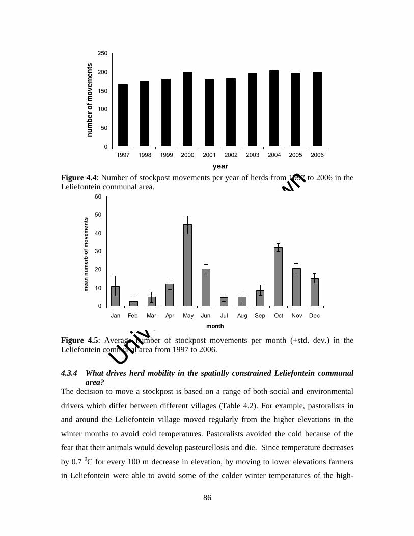
Unive
rsity
of C
ape
Town
86
Figure 4.4: Number of stockpost movements per year of herds from 1997 to 2006 in the
Leliefontein communal area.
Figure 4.5: Average number of stockpost movements per month (+std. dev.) in the
Leliefontein communal area from 1997 to 2006.
4.3.4 What drives herd mobility in the spatially constrained Leliefontein communal
area?
The decision to move a stockpost is based on a range of both social and environmental
drivers which differ between different villages (Table 4.2). For example, pastoralists in
and around the Leliefontein village moved regularly from the higher elevations in the
winter months to avoid cold temperatures. Pastoralists avoided the cold because of the
fear that their animals would develop pasteurellosis and die. Since temperature decreases
by 0.7 0C for every 100 m decrease in elevation, by moving to lower elevations farmers
in Leliefontein were able to avoid some of the colder winter temperatures of the high-
0
50
100
150
200
250
1997 1998 1999 2000 2001 2002 2003 2004 2005 2006
year
nu
mb
er
of
mo
ve
me
nts
0
10
20
30
40
50
60
Jan Feb Mar Apr May Jun Jul Aug Sep Oct Nov Dec
month
mean
nu
merb
of
mo
vem
en
ts
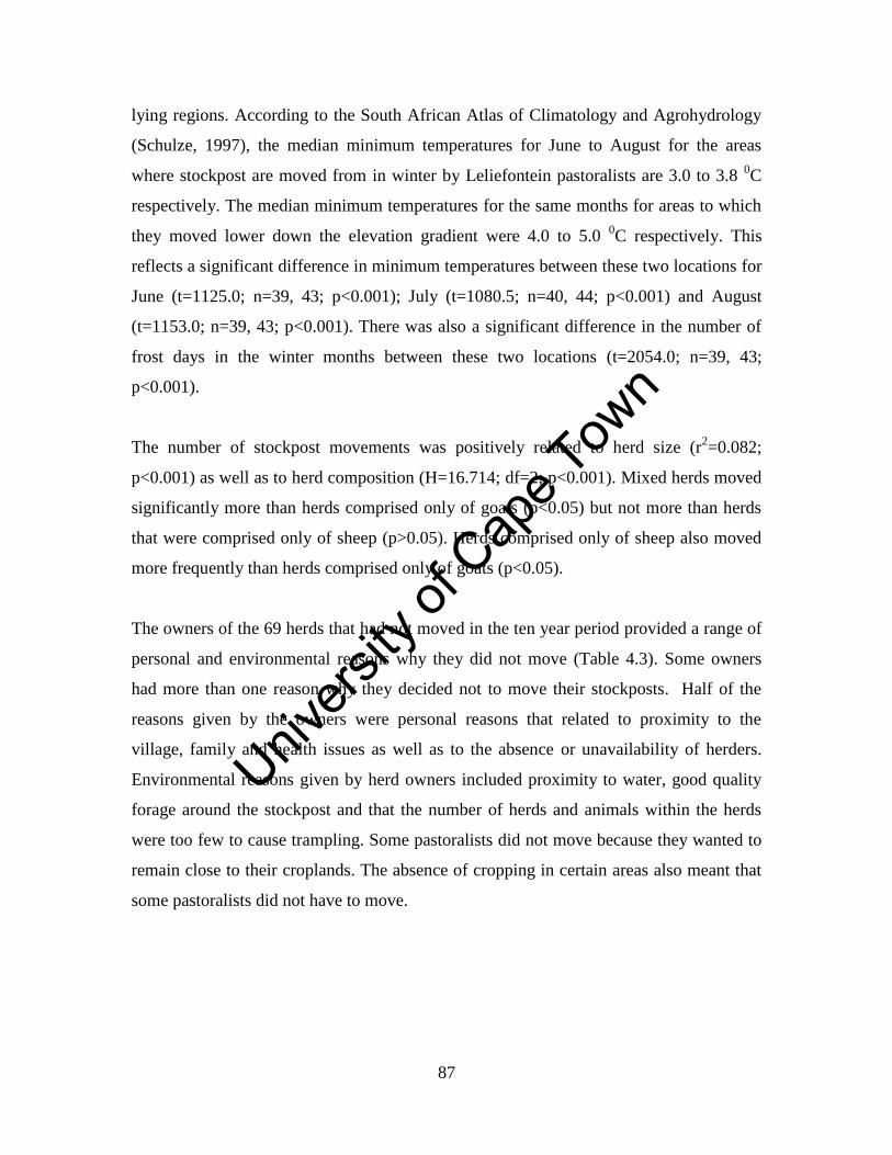
Unive
rsity
of C
ape
Town
87
lying regions. According to the South African Atlas of Climatology and Agrohydrology
(Schulze, 1997), the median minimum temperatures for June to August for the areas
where stockpost are moved from in winter by Leliefontein pastoralists are 3.0 to 3.8 0C
respectively. The median minimum temperatures for the same months for areas to which
they moved lower down the elevation gradient were 4.0 to 5.0 0C respectively. This
reflects a significant difference in minimum temperatures between these two locations for
June (t=1125.0; n=39, 43; p<0.001); July (t=1080.5; n=40, 44; p<0.001) and August
(t=1153.0; n=39, 43; p<0.001). There was also a significant difference in the number of
frost days in the winter months between these two locations (t=2054.0; n=39, 43;
p<0.001).
The number of stockpost movements was positively related to herd size (r2=0.082;
p<0.001) as well as to herd composition (H=16.714; df=2; p<0.001). Mixed herds moved
significantly more than herds comprised only of goats (p<0.05) but not more than herds
that were comprised only of sheep (p>0.05). Herds comprised only of sheep also moved
more frequently than herds comprised only of goats (p<0.05).
The owners of the 69 herds that had not moved in the ten year period provided a range of
personal and environmental reasons why they did not move (Table 4.3). Some owners
had more than one reason why they decided not to move their stockposts. Half of the
reasons given by the owners were personal reasons that related to proximity to the
village, family and health issues as well as to the absence or unavailability of herders.
Environmental reasons given by herd owners included proximity to water, good quality
forage around the stockpost and that the number of herds and animals within the herds
were too few to cause trampling. Some pastoralists did not move because they wanted to
remain close to their croplands. The absence of cropping in certain areas also meant that
some pastoralists did not have to move.
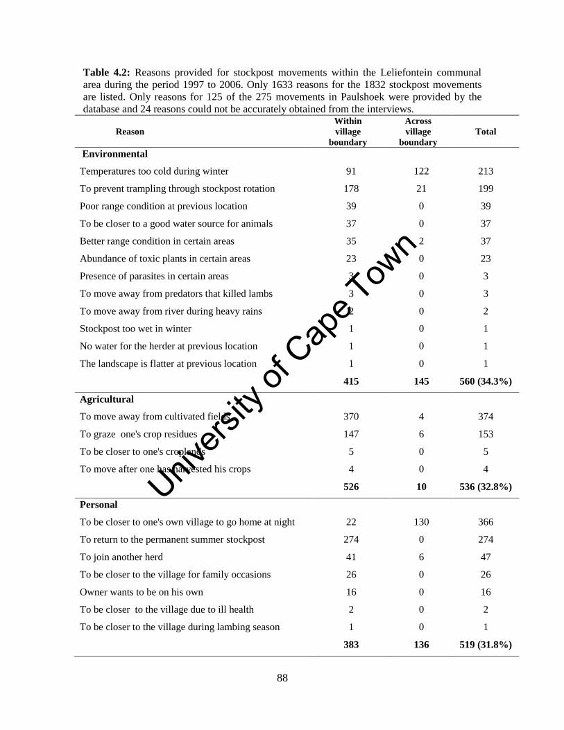
Unive
rsity
of C
ape
Town
88
Table 4.2: Reasons provided for stockpost movements within the Leliefontein communal
area during the period 1997 to 2006. Only 1633 reasons for the 1832 stockpost movements
are listed. Only reasons for 125 of the 275 movements in Paulshoek were provided by the
database and 24 reasons could not be accurately obtained from the interviews.
Reason
Within
village
boundary
Across
village
boundary
Total
Environmental
Temperatures too cold during winter 91 122 213
To prevent trampling through stockpost rotation 178 21 199
Poor range condition at previous location 39 0 39
To be closer to a good water source for animals 37 0 37
Better range condition in certain areas 35 2 37
Abundance of toxic plants in certain areas 23 0 23
Presence of parasites in certain areas 3 0 3
To move away from predators that killed lambs 3 0 3
To move away from river during heavy rains 2 0 2
Stockpost too wet in winter 1 0 1
No water for the herder at previous location 1 0 1
The landscape is flatter at previous location 1 0 1
415 145 560 (34.3%)
Agricultural
To move away from cultivated fields 370 4 374
To graze one's crop residues 147 6 153
To be closer to one's croplands 5 0 5
To move after one has harvested his crops 4 0 4
526 10 536 (32.8%)
Personal
To be closer to one's own village to go home at night 22 130 366
To return to the permanent summer stockpost 274 0 274
To join another herd 41 6 47
To be closer to the village for family occasions 26 0 26
Owner wants to be on his own 16 0 16
To be closer to the village due to ill health 2 0 2
To be closer to the village during lambing season 1 0 1
383 136 519 (31.8%)
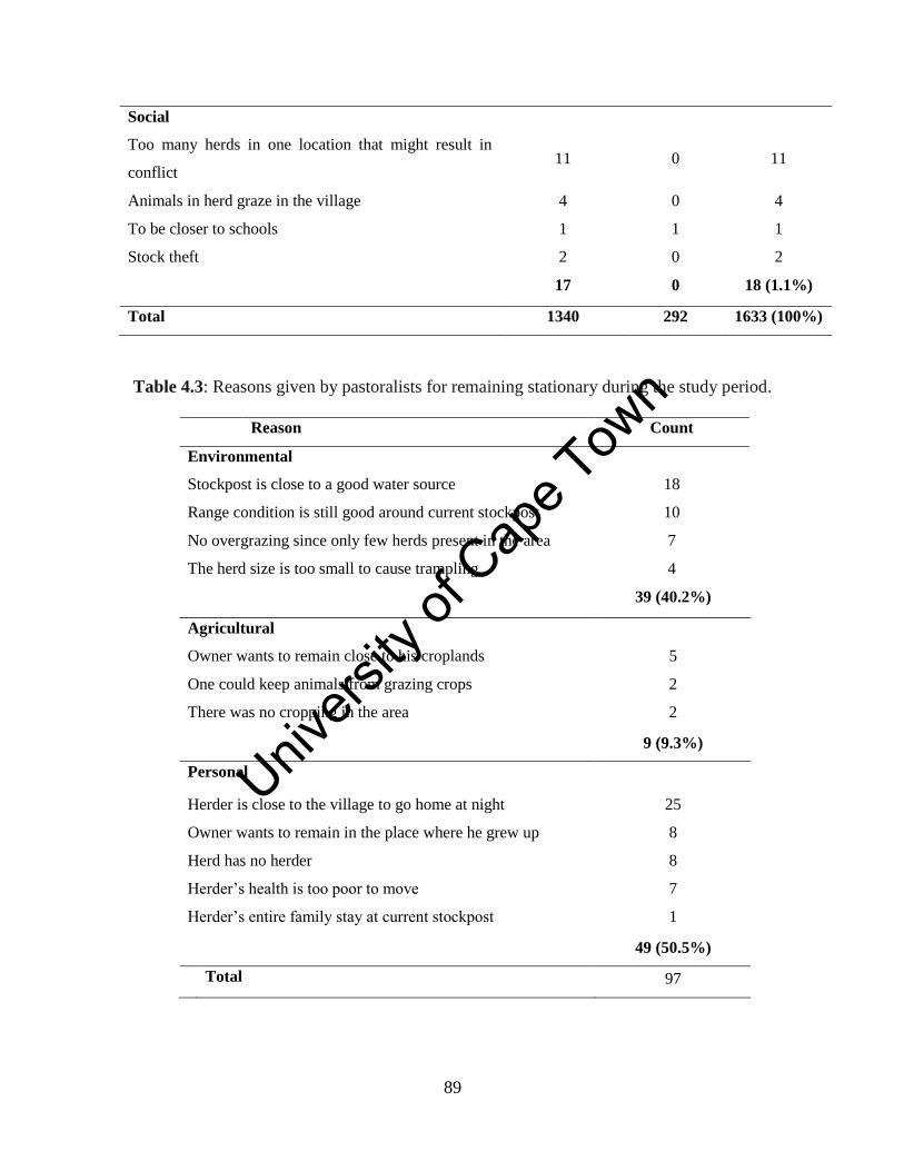
Unive
rsity
of C
ape
Town
89
Social
Too many herds in one location that might result in
conflict 11 0 11
Animals in herd graze in the village 4 0 4
To be closer to schools 1 1 1
Stock theft 2 0 2
17 0 18 (1.1%)
Total 1340 292 1633 (100%)
Table 4.3: Reasons given by pastoralists for remaining stationary during the study period.
Reason Count
Environmental
Stockpost is close to a good water source 18
Range condition is still good around current stockpost 10
No overgrazing since only few herds present in the area 7
The herd size is too small to cause trampling 4
39 (40.2%)
Agricultural
Owner wants to remain close to his croplands 5
One could keep animals from grazing crops 2
There was no cropping in the area 2
9 (9.3%)
Personal
Herder is close to the village to go home at night 25
Owner wants to remain in the place where he grew up 8
Herd has no herder 8
Herder’s health is too poor to move 7
Herder’s entire family stay at current stockpost 1
49 (50.5%)
Total 97
Unive
rsity
of C
ape
Town
90
4.4 Discussion
This study identified several different herd mobility patterns across different temporal
scales during the study period from 1997 to 2006 in the Leliefontein communal area. This
suggests that there is heterogeneity in livestock management amongst pastoralists in the
spatially constrained communal area and that they face different sets of constraints as
livestock keepers. It has previously been shown that different pastoralists in Leliefontein
have different perceptions about the environment based on their personal and very local
ecological knowledge (Samuels, 2006) and thus they might also manage their herd
differently based on their specific sets of criteria for assessing rangeland condition.
4.4.1 What is the nature of herd mobility patterns in Leliefontein and what drives
these patterns?
In the Leliefontein communal area, seasonal movements were along altitudinal gradients
as well as horizontally across the landscape. Seasonal movements are used by pastoralists
all over the world to move livestock between seasonal grazing areas (McCabe, 1983;
Niamir-Fuller, 1999b; Touré, 2004; Adriansen, 2008). As in other pastoral systems
(Dyson-Hudson and Dyson-Hudson, 1980; Hudson, 1980; Niamir-Fuller, 1999b; Turner,
2003; Kerven et al., 2004), vertical movements in Leliefontein are also used to evade
unfavourable climatic conditions. In the study area, pastoralists from Leliefontein village
moved mostly just before the start and immediately after the onset of the cold season. In
this village, pastoralists move to lower altitudes onto the Tweerivier village commons to
escape low temperatures during winter in the uplands. The pastoralists in the Tweerivier
in turn move to the southern parts of their commons to accommodate pastoralists from
Leliefontein village who settle in the northern parts of the Tweerivier commons.
There is no formal institution regulating inter-village movements between Leliefontein
and Tweerivier pastoralists. Movement patterns up and down the altitudinal gradients of
the Kamiesberg in response to winter and summer temperatures were evident before the
colonists occupied Namaqualand (Webley, 2007). Pastoralists say that they maintain
these traditional movement patterns to ensure that their livestock survive the cold winter
temperatures. This mobile system is maintained due to good social cohesion in the two
Unive
rsity
of C
ape
Town
91
communities. In 2011, concerns were raised about stockpost locations of pastoralists
from Leliefontein village that graze the croplands of Tweerivier farmers. This issue was
resolved when the two communities met and agreed that Leliefontein pastoralists should
not grazed on other people’s croplands even if no crops are grown during the winter
season.
Seasonal movements also occurred when herds moved away from growing crops but
these movements were not always along an altitudinal gradient. Dryland cropping was
the reason for 32.8% of the movements within the Leliefontein communal area. Dryland
cropping occurs mostly in the Leliefontein, Nourivier, Kharkams, Tweerivier,
Spoegrivier and Paulshoek villages and is the main reasons why stockposts in these
villages are moved. This study and the findings of Baker and Hoffman (2006) show that
livestock keepers in Leliefontein move their stockposts away from growing crops to
prevent crop damage. We know from studies in other areas (Bayer and Waters- Bayer,
1989; Homewood, 2008; Chonco, 2009) that this practice is typical of many mobile
pastoral societies. After harvesting in November and December in Leliefontein, herds
move closer to croplands to graze on crop residues which may have much higher
nutritional value than natural vegetation at the same time of year. Arable lands are
considered key resource areas for livestock during dry seasons in other pastoral systems
in South Africa (Bennett et al., 2007; Chonco, 2009) and elsewhere when natural
vegetation becomes scarce (Scoones, 1995a; Baba and Magadi, 1998; Kerven et al.,
2004; Homewood, 2008) and when livestock need to be kept in good physical condition.
Pastoralists in Leliefontein and elsewhere (Schareika, 2001) keep their animals in good
physical condition to improve breeding success and to enable them to survive the dry
season.
It is assumed that overgrazing is the main cause of degradation in the communal areas
(Lamprey, 1983; Fryxell and Sinclair, 1985). Several studies in the Kamiesberg have
shown that cover of palatable perennial shrubs and succulents has declined as a result of
high grazing pressure, particularly on the lowlands and around watering points and
villages (Todd and Hoffman, 1999, 2009; Anderson and Hoffman, 2007). These impacts
Unive
rsity
of C
ape
Town
92
of overgrazing in the Kamiesberg can result in rangeland degradation if the changes are
irreversible after several decades. However, overgrazing should not only be attributed to
poor livestock management practices but also to overcrowding on the commons.
Overcrowding occurs when many herds use the same grazing area such as when herds
congregate around limited water sources during the dry season when the survival of herds
depends on access to water. This is different to poor livestock management when an area
is continuously grazed although pastoralists have an option to move.
Pastoralists in Leliefontein and other mobile pastoralists (Western, 1982; Behnke, 1999)
usually attempt to prevent trampling and overgrazing by resting certain parts of the
rangeland and moving away from overutilised areas when water is freely available. In the
study area, about 12% of the movement of stockposts were undertaken to prevent the
impact of trampling around stockposts. This was mentioned more frequently by
pastoralists in Kharkams, Leliefontein and Tweerivier villages where stockpost density
was highest. There is no government regulation for herd movements in the communal
area and pastoralists decide to move on their own. This is because pastoralists in general
are well aware of erosion and vegetation degradation problems that could emerge if they
remain stationary for long periods (Behnke, 1999).
Opportunistic movements, which are characteristic of other mobile pastoral systems
(Sieff, 1997; Solomon et al., 2006; de Weijer, 2007), occur in all of the Leliefontein
villages, especially when range condition is poor around the stockpost being used at the
time. During drought, when the availability and quality of forage generally decreases,
many pastoralists in Leliefontein temporarily move their stockposts to areas that are
largely undergrazed and have good dry forage (Samuels et al., 2007). Movements at
irregular intervals in Leliefontein also occur as a result of overcrowding and predators
that force herds to move to other areas. Other studies have demonstrated that disease
outbreaks and banditry (McCabe, 1994) and conflict (de Weijer, 2007) are additional
factors that determine both short and long term animal movements.
Unive
rsity
of C
ape
Town
93
In most mobile pastoral systems, grazing reserves are often accessed to make use of the
abundance of dry forage especially during droughts (McCabe, 1994; Behnke, 1999; Oba,
2001; Fernandez-Gimenez and Swift, 2003). However, there is no land available in the
Leliefontein communal area to be set aside as grazing reserves due to the limited size of
the communal area. Chapter Six shows that some areas, particularly mountainous areas
are not grazed at all because these areas are largely not accessible to livestock. Therefore,
herds might have to rely on these undergrazed areas to provide their animals with good
quality dry season forage.
The introduction of various government policies in the 1960s and 1970s and the shift
away from subsistence to a cash economy (Rohde and Hoffman, 2008) forced many
families to settle in the villages where previously they were scattered throughout the
rangeland at various stockposts. People became accustomed to village life and presently
only a few families stay with herders at stockposts. However, several herders frequently
move closer to their villages so that they are able to visit their families in the village. It
was found that herds in the study area also move closer to the village for family occasions
during the Christmas and Easter holidays, or for weddings and burials that could occur at
any time of the year (Baker and Hoffman, 2006).
During dry periods, when forage and water are generally more limited on the commons,
some pastoralists migrated in and out of the commons to increase their mobile range and
have access to better grazing resources. In Leliefontein, seven pastoralists reached verbal
agreements with neighbouring commercial farmers to temporarily use their private land
and then to return to the commons when conditions become favourable. Pastoralists in
Leliefontein that entered into the 50:50 agreements with adjacent commercial farmers say
that it is better to sacrifice half of your lambs than to have no lambs at all which can
occur when they remain on the commons during drought periods. Pastoralists may also
risk losing more of their breeding stock when they do not move out of the commons
during drought. This was observed during the drought period in 2003 in Paulshoek
village when some pastoralists lost more than 50% of their breeding stock (Baker and
Hoffman, 2006).
Unive
rsity
of C
ape
Town
94
Temporary access agreements are also used by herders in Namibia and Ethiopia where
they negotiate with neighbouring pastoralists or agro-pastoralists to use their lands for
grazing during drought periods (Behnke, 1999; Bogale and Korf, 2009). When water is a
limiting factor in Mali, Fulani pastoralists enter into arrangements with neighbouring
agro-pastoralists to camp near their fields to be closer to water (Ramisch, 1999). In
return, agro-pastoralists get milk and manure from the livestock which they use to
improve their crop yields. When the extent of drought occurs at a regional level, some
mobile pastoralists in Africa use long distance migrations into neighbouring countries to
evade drought conditions (Oba and Lusigi, 1987). These cross-border movements are
facilitated in policies from regional blocks such as the Economic Community of West
African States (ECOWAS) which consists of 15 member states (de Jode, 2010).
In northern Kenya migrating pastoralists also make agreements with non-pastoralists to
allow pastoral herds to graze on their private land (Lengoiboni et al., 2011; Letai and
Lind, 2012). These agreements are usually during the dry seasons when animals have to
move around to search for dry forage. Pastoralists enter into written agreements with
private ranchers in which they set the duration of grazing on the farm and the amount of
grazing fees to be paid to the rancher. Private ranchers may negotiate access onto their
land through grazing committees who will manage the duration of grazing access, collect
grazing fees and solve any disputes. If these rules in the agreement are broken eviction,
denial of future access, confiscation or fines are the penalties (Lengoiboni et al., 2011).
4.4.2 How have herd mobility patterns changed between 1997 and 2006 and what are
the drivers of this change?
Between 1997 and 2006 the most important changes to the traditional herd mobility
patterns that could be identified in the Leliefontein communal area occurred when the
land reform farms were opened to pastoralists in 1998. Although pastoralists moved onto
the farms primarily to improve their production, an important outcome of the process was
an additional option of migration out of the commons. Mostly, pastoralists who were
located closer to the land reform farms on the eastern side of the Leliefontein communal
area moved onto these farms. During 2003, several pastoralists from villages further
Unive
rsity
of C
ape
Town
95
away from the land reform farms also moved to the farms to evade drought conditions on
the old commons. However, most of the pastoralists returned to the old commons due to
water and transport constraints, infrastructural problems and overcrowding on the new
land reform farms. Pastoralists who remained on the farms have motorised transport and
could afford to travel regularly to their home in the village when they run out of food and
other supplies (Lebert and Rohde, 2007).
Another aspect of pastoral mobility that is evolving in Leliefontein is the practice of
keeping a ‘safe’ distance from other herds. Due to overcrowding on the commons, some
pastoralists frequently move their stockposts to prevent their neighbours’ rams from
mixing and breeding with their ewes (see Fig. 3.11). Results from the study period do not
show significant effects of this strategy on pastoral mobility but through my interviews I
observed that pastoralists are becoming more aware of the potential consequences of
mixing rams with ewes during the non-breeding season. Pastoralists in Leliefontein want
their lambs to be born in winter when sufficient grazing resources are available. In some
herds the rams remain with the herd the entire year and ewes are therefore often
impregnated during the winter period and give birth during the dry season when
resources are scarce. A pastoralist may also want his own ram to impregnate his livestock
to improve the overall quality and hardiness of his next generation of breeding stock.
Dangers of ram mixing were not evident during the eras before apartheid since all the
rams were looked after by a ramwagter (‘ram herder’) or kept separately from the main
herd in a ram camp. However, none of the villages now has a ramwagter and only five
villages have ram camps which are not always used for the purpose intended. Frequently
ram camps are occupied by individuals because of the generally better quality of forage
and the lack of grazing management control. In other African pastoral systems this
strategy of keeping a ‘safe’ distance from other herds is used over larger spatial scales to
prevent the spread of diseases and pests (Niamir-Fuller, 2000). In Mongolia, herders have
watering schedules to prevent herds from mixing (Fernandez-Gimenez, 2002). Similarly,
reindeer nomads have a grazing timetable and move their herds quickly through narrow
migratory passages so that they do not mix with other herds (Dwyer and Istomin, 2006;
Behnke et al., 2011).
Unive
rsity
of C
ape
Town
96
During the study period, about 27% of herds did not move at all. This occurred most
commonly when there was no cropping in the area where their stockpost was located.
Pastoralists in other areas such as the Rendille and Ariaal in northern Kenya also prefer to
remain stationary in order to be close to socio-economic and health services (Fratkin et
al., 1999). Similarly, in Senegal, some Fulani herders do not want to move and prefer to
remain close to their homes since herding is too labour intensive (Adriansen, 2008).
Other reasons for not moving a stockpost include affordability, ill health or for other
personal reasons. Single owners also preferred not to move when their stockposts were
situated close to the village and they were able to go home at night. Many pastoralists
also kept small goat herds at permanent stockposts near the village because goats are able
to graze unattended. Goats are also preferred because of their resilience to drought and
their ability to cope with the rugged terrain which characterises much of the Leliefontein
communal area (Samuels, 2006).
When pastoral mobility is reduced due to land fragmentation or herds become stationary,
pastoralists risk having a reduction in animal productivity (Wilson and Clarke, 1976;
Boone and Hobbs, 2004; Boone, 2007; de Jode, 2010). For example, in western Sudan,
calving rates in mobile herds was 25% more and calving mortality was 29% less than that
of sedentary herds (Wilson and Clarke, 1976). In Zimbabwe, mobile herds had a greater
survival rate than that of sedentary herds during drought periods (Scoones, 1992).
However, Baker and Hoffman (2006) found that mobility did not result in an increase in
livestock production or a decrease in mortality between sedentary and mobile herds in
Paulshoek village in Namaqualand. The fact that pastoralists do not obtain higher animal
production rates and that moving a stockpost is costly since one requires labour and
transport, might be why sedentarisation of herds is likely to increase in the future.
This study shows that even in a spatially constrained pastoral system where multiple land
uses occurs, a range of traditional mobility patterns could still be maintained by
pastoralists to manage their livestock. In Leliefontein, pastoralists have adapted their
traditional mobility patterns to their spatially constrained environment. They have also
developed new patterns of mobility (see Fig. 3.11) which are determined by several
Unive
rsity
of C
ape
Town
97
environmental, agricultural, personal and social factors that operate at herd and village
levels within the pastoral system. Movements due to a range of social factors not only
allow pastoralists to benefit by avoiding other herds, but also to maintain some level of
social cohesion within the pastoral system. Maintaining social networks in Leliefontein
allows pastoralists access to resources and information in times of need and prevents
conflict over limited resources in the spatially constrained pastoral system. Even though
pastoralists experienced high variability in climatic conditions during the study period,
their mobility practices remained relatively stable since only a few herds could
temporarily move in and out of the commons.
Unive
rsity
of C
ape
Town
98
Chapter Five
Spatial distribution of herds in a variable and constrained pastoral area
in Namaqualand: the roles of resources and human settlements
Abstract
In this study I assessed the spatial distribution of herds and their mobility patterns from
1997 to 2006 in the variable and spatially constrained Leliefontein communal area. In
addition, I investigated the role of water, croplands and human settlements on the
movement patterns of herds in Leliefontein. There was variability in the spatial mobility
patterns of herds across the landscape. Some movement patterns mimic the historical
movement patterns of Nama pastoralists before the region was colonised but on a
considerably smaller spatial scale. Movement distances between stockposts were up to
12.1 km within and 31.8 km across village boundaries. Movement distances were
significantly different between villages but were not affected by herd composition. There
were significant differences in monthly stockpost locations in relation to water location
and availability between all herd groups. During the wet winter months when the
vegetation is full of water and growing, herds move away from formal water sources to
areas that are seldom grazed in summer. Herds that are located closer to croplands move
away in winter to protect growing crops. In some villages herds were located close to
human settlements mostly due to personal reasons and labour requirements for preparing
croplands.
5.1 Introduction
Livestock farming is the major land use practice in most arid and semi-arid environments.
Within these ecosystems, rainfall is unpredictable and variable in space and time. In some
years, droughts of varying durations may occur whereas in other years an area might
become flooded. Rainfall variability results in patchiness of food and water availability
for people and animals occupying these areas (Behnke et al., 2011). In drylands,
pastoralists make use of herd mobility to access patchy rangeland resources ((Niamir-
Fuller and Turner, 1999) and attempt to optimise the use of available resources within the
limitations of water supply in the dry season (Western and Dunne, 1979). Animals derive
Unive
rsity
of C
ape
Town
99
benefit through mobility because they can obtain optimal physical condition if their
energy intake is greater than the energy they spend during grazing. Optimal physical
condition is important for breeding success and for survival during the dry season
(Schareika, 2001).
Pastoral systems are continually becoming smaller and spatially constrained due to
environmental, socio-economic and political factors (Makepe, 2006; de Jode, 2010;
Flintan, 2011) and many pastoralist groups can no longer move their animals over long
distances into other grazing areas. This is evident in Niger (Turner, 1999a) and Kenya
(Kipuri and Naikuni, 2008) where the formation of conservation areas amongst other
factors restricts pastoralists from gaining access to traditional grazing resources.
Transhumance has decreased in Afghanistan as pastoralists avoid areas of conflict (de
Weijer, 2007). In African countries as different as Lesotho and Sudan, mobility patterns
of pastoral herds are also affected by the encroachment of crop expansion onto grazing
lands (Turner, 2003; Babiker, 2012).
There is a lack of understanding of herd movements within smaller and spatially
constrained pastoral systems which characterise much of South Africa (Hoffman and
Ashwell, 2001). As traditional pastoral lands are changing, it is important to assess the
spatial extent of herd movements to understand how grazing patterns might change over
time. As discussed in Chapter Three, the Leliefontein communal area has become smaller
in size and pastoralists are restricted in their movements between agro-ecological zones
in order to evade unfavourable environmental conditions and to access grazing resources.
This chapter will assess how pastoralists in Leliefontein move their herds over spatial
scales in their spatially constrained rangeland.
Pastoralists move their herds to an area due to a range of environmental and socio-
economic factors (Western and Dunne, 1979; Fernandez- Gimenez, 1999; Baker and
Hoffman, 2006; see also Chapter Four). The selection of grazing sites in Niger, for
example, was based on the quality and quantity of fodder (Schareika, 2001). Water
availability is also critically important for herders in Africa (Bassett, 1986; Coughenour,
Unive
rsity
of C
ape
Town
100
1991; Coppolillo, 2000) and Asia (Fernandez- Gimenez, 1999; Kerven et al., 2004) when
they relocate their herds during the dry season. Also, the Rendille of Kenya settle small
stock camps closer to human settlements for water and to trade with local stores (Fratkin,
1986). In other parts of Asia, the decision of where to establish camps is based on the
decision of experienced herders who have in-depth knowledge of the local environment.
Decisions are also partially based on the relationship with crop farmers in the area
(Agrawal, 1993). In the Paulshoek rangeland in Namaqualand, labour sharing is a major
factor since herders locate their stockposts close to each other to provide reciprocal
assistance during the lambing season (Baker and Hoffman, 2006).
Previous studies that have assessed movement patterns between grazing sites have mostly
focused on pastoral systems where long-range movements occur in combination with
short-range movements (Fernandez-Gimenez and Allen-Diaz, 1999; de Weijer, 2007;
Behnke et al., 2011). In West Africa long-range transhumant patterns of up to 500 km
occur to access better forage and water (Behnke et al., 2011). Behnke et al (2011)
described middle distance movements between 15 to100 km to access better resources, to
avoid disease areas and for animal safety as well as short-range movements between 3-15
km around villages and watering points. In Afghanistan long-range movements across
provincial and state boundaries occur when herds move between seasonal grazing areas
(de Weijer, 2007). Short-range movements also occur when herd sizes are small and the
demand for forage is less (de Weijer, 2007).
In this study, I investigate the spatial parameters of pastoral mobility from 1997 to 2006
in the variable and spatially constrained Leliefontein communal area. Over the last two
decades the area has been administrated by three different institutions and their different
land use policies for the communal area might have affected pastoral mobility over this
period. A management council, which was established by the apartheid government,
managed the land until 1995. After apartheid, the Leliefontein Local Transitional
Council, which consisted of representatives of civil society, took over the administration
until 2000 when the Kamiesberg Local Municipality was formed.
Unive
rsity
of C
ape
Town
101
Firstly, I assess and discuss the spatial parameters of herd movements between stockposts
and identify a typology of movement patterns. Secondly, I investigate the role of water in
the spatial management of pastoral herds. In semi-arid areas, the provision of water for
animals is important during the dry season when animals might not get sufficient
moisture from the vegetation (Bassett, 1986; Fernandez- Gimenez, 1999) or when current
boreholes are not functioning (Adriansen, 2008). Thirdly, I assess and discuss the role of
croplands in grazing management. Croplands are used as key resource areas for pastoral
herds during dry and drought periods (Bassett, 1986; Baba and Magadi, 1998; Bennett et
al., 2007). Lastly, I investigate the role that human settlements play in the location of
stockposts.
To achieve these objectives, I asked the following questions:
1. How far do herds move between different stockposts?
2. Are there differences in the movement patterns of herds?
3. Have the spatial parameters of pastoral mobility in the study area changed over
time?
4. How do water, croplands and human settlements affect the location of stockposts?
5.2 Methods
This study was carried out in the Leliefontein communal area. For a detailed description
of the study area, see Chapter Two.
5.2.1 Data collection
I collected data on the spatial distribution and movement between stockposts of all the
herds in Leliefontein from January 1997 to December 2006. Semi-structured interviews
were conducted with pastoralists to determine when and where they move their
stockposts (Appendix A). I also asked their reasons for moving or not moving their
stockposts. During the fieldwork period, I used a Garmin eTrex (Garmin Ltd, Kansas,
USA) handheld GPS receiver to record the locations of stockposts and livestock watering
points used by the herds during the study period. A local guide from each village except
Paulshoek village was employed to show the locations of stockposts and watering points.
Unive
rsity
of C
ape
Town
102
The locations of stockposts in Paulshoek were obtained from an existing database on
livestock farming which is maintained by the Plant Conservation Unit at the University of
Cape Town. The locations of the watering points in Paulshoek were obtained from
Samuels (2006) who conducted a study on daily grazing routes of herds during a drought
period in the village. GPS data on human settlements and ram camps23
were obtained by
walking around the perimeter. Data was collected from September 2006 to July 2007.
5.2.2 Land use mapping
All those who rent croplands in Leliefontein were interviewed between September 2006
and July 2009. During the interviews I recorded all the years that the crop farmer used a
specific cropland and what the reasons were for not cropping in some years. Croplands
were formally mapped in 2003 by a consultant employed by the local municipality.
However, during the fieldwork period only a printed copy of the allotment map was
available as the original data have been lost. This map was digitised using ArcView 3.2.
The cropping season in the communal area usually occurs from May to November each
year. In the uplands around the Leliefontein village, however, ploughing may start as late
as July depending on the particular seasonal rainfall conditions (too little or too much).
Unusually cold temperatures also delay ploughing in some years. Since the cropping
season differs between years, I used monthly distances of stockpost locations from
croplands from April to represent the non-cropping season and September as the cropping
season to analyse the differences in distances between the seasons.
I used ArcGIS 9.3 to map the locations of stockposts, watering points and human
settlements. This software was also used to determine how far stockposts are located
from watering points, croplands and human settlements as well as the distance that
livestock keepers have moved their stockposts.
The average herd size for each stockpost used was determined by adding the number of
animals that used a stockpost every month and dividing the total by the number of
months the stockpost was occupied. Livestock numbers were obtained from a number of
23
A fenced-off area where only rams are kept during the non-mating season from March to October
Unive
rsity
of C
ape
Town
103
different sources (see Appendix B). Monthly livestock numbers for stockposts that were
not obtained from these sources were estimated using the percentage change in monthly
stock totals for herds from Paulshoek and applied to the other nine villages. The change
in monthly livestock numbers in Paulshoek is affected by environmental variables that
influence birth and deaths rates, as well as socio-economic variables such as local and
market sales (Baker and Hoffman, 2006). These factors also play important roles in
regulating animal numbers in all other villages and therefore it is the best available
information to use to estimate monthly livestock numbers for the entire Leliefontein
communal area.
5.2.3 Data analysis
Univariate analysis of variance was performed using the General Linear Models (GLM)
procedure of SAS statistical software version 9.2 to compare the distances moved
between stockposts. The Shapiro-Wilk test was used to test for normality (Shapiro and
Wilk, 1965). Since distances were not normally distributed, square root or log
transformations were therefore used to normalise the data.
Univariate analysis of variance was also performed on stockpost distances from all
independent variables assessed using the GLM procedure. The independent variables
consisted of the locations of watering points, human settlements and croplands. When
normality failed, the sum of squares totals were used to compare the total and average
stockpost distances from the independent variables between villages and herd
compositions. The student’s t-test significant difference was calculated at the 95%
confidence level to compare the mean stockpost distances from watering points, human
settlements and croplands. A Principle Component Analysis (PCA) was conducted to
determine the combined influence of all independent variables and herd size on stockpost
locations. A Pearson correlation matrix was used to measure the strength of the linear
dependence between the variables that determine stockpost locations. A probability level
of p<0.05 was considered significant for all statistical tests.
Unive
rsity
of C
ape
Town
104
5.3 Results
A total of 595 stockposts were used by 256 herds from January 1997 to December 2006.
Stockposts and watering points were scattered throughout the communal area but several
stockposts were congregated around human settlements and watering points that are
mostly located in north-south valleys (Fig. 5.1). There were also areas where there were
no watering points and where stockposts were absent. These areas are the mountainous
areas which are difficult to access via road. There were 559 demarcated croplands on the
commons (Fig. 5.1). Croplands accounted for 23 049.8 ha or 12% of the communal area
and their sizes ranged from 0.6 to 302.0 hectares. Croplands occurred mostly in the
uplands and midlands since these areas receive more rainfall than the eastern plateau and
western lowlands near the coast. In total, 128 different croplands were cultivated between
1997 and 2006 with an average of 66 used per year. On average 3741.7 ha of land
demarcated as croplands was used per annum for cropping purposes during the ten year
study period.
There were 78 herds or 30% of the total herds that used only one stockpost during the
study period (Table 5.1). Of these, 69 herds never moved their stockposts and nine herds
moved out of the commons either onto the land reform farms acquired for these
pastoralists by the government or onto adjacent private farms. Another 24 herds also
moved onto the land reform or adjacent private farms but these herds used more than one
stockpost in the communal area during the ten year study period. Of the herds that moved
between two or more stockposts, most were found in Kharkams, Klipfontein, Leliefontein
village, Nourivier, Paulshoek, Spoegrivier and Tweerivier and rotated mostly between
summer and winter stockposts. In Paulshoek, 17 herds used more than three stockposts
during the study period and some of these herds seldom moved back to the same
stockpost.
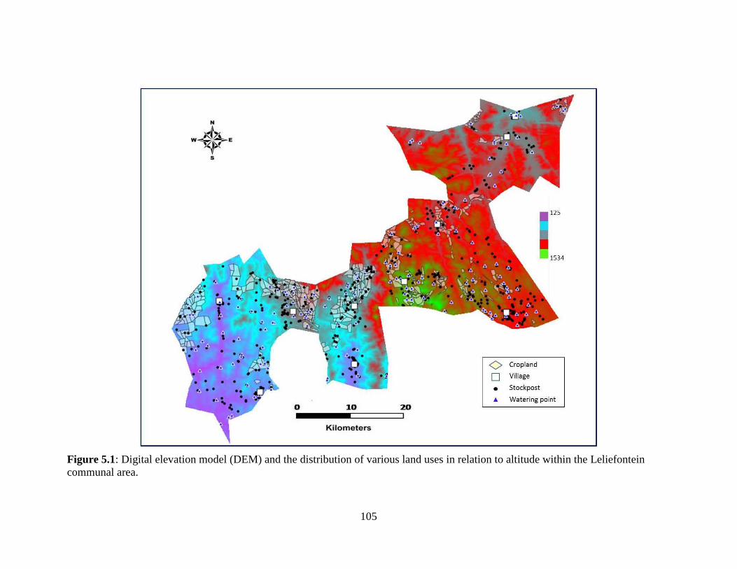
Unive
rsity
of C
ape
Town
105
Figure 5.1: Digital elevation model (DEM) and the distribution of various land uses in relation to altitude within the Leliefontein
communal area.
N
W~}E S
125
1534
<> Cropland
D Village
• Stockpost
.. Watering point
iO ......... 1~O========:J20 Kilometers
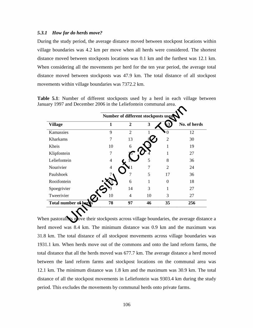
Unive
rsity
of C
ape
Town
106
5.3.1 How far do herds move?
During the study period, the average distance moved between stockpost locations within
village boundaries was 4.2 km per move when all herds were considered. The shortest
distance moved between stockposts locations was 0.1 km and the furthest was 12.1 km.
When considering all the movements per herd for the ten year period, the average total
distance moved between stockposts was 47.9 km. The total distance of all stockpost
movements within village boundaries was 7372.2 km.
Table 5.1: Number of different stockposts used by a herd in each village between
January 1997 and December 2006 in the Leliefontein communal area.
Number of different stockposts used
No. of herds Village 1 2 3 >3
Kamassies 9 2 1 0 12
Kharkams 7 13 8 2 30
Kheis 10 6 2 1 19
Klipfontein 7 15 4 1 27
Leliefontein 4 19 5 8 36
Nourivier 4 11 7 2 24
Paulshoek 7 7 5 17 36
Rooifontein 11 6 1 0 18
Spoegrivier 9 14 3 1 27
Tweerivier 10 4 10 3 27
Total number of herds 78 97 46 35 256
When pastoralists move their stockposts across village boundaries, the average distance a
herd moved was 8.4 km. The minimum distance was 0.9 km and the maximum was
31.8 km. The total distance of all stockpost movements across village boundaries was
1931.1 km. When herds move out of the commons and onto the land reform farms, the
total distance that all the herds moved was 677.7 km. The average distance a herd moved
between the land reform farms and stockpost locations on the communal area was
12.1 km. The minimum distance was 1.8 km and the maximum was 30.9 km. The total
distance of all the stockpost movements in Leliefontein was 9303.4 km during the study
period. This excludes the movements by communal herds onto private farms.
Unive
rsity
of C
ape
Town
107
There were 14 stockpost movements by seven pastoralists onto seven different private
farms during the study period. Four of these movements were during a drought because
of the lack of forage on the commons. The abundance and quality of forage during
drought on the private farms were perceived by pastoralists to be better than that of the
communal area. Other pastoralists moved onto private farms temporarily due to the lack
of competent herders to look after their animals. On private farms, pastoralists can take
advantage of fenced camps to leave the animals on their own.
Six of these private farms are adjacent to the communal area and one farm is about
100 km away near the town of Springbok. The sizes of the herds that temporarily moved
onto private farms ranged from 25 to 255 SSU (Avg. 93 SSU). Five pastoralists returned
to the commons during the study period while the remaining two were still on the private
farms when the study was conducted. The time spent on the private farms ranged from 3
to 22 months.
ANOVA tests indicate that there were significant differences in the average single
(F=3.00, df=9; p=0.003) and total (F=4.89, df=9; p<0.001) stockpost distances moved by
herds from the different villages. The average total distances moved between stockposts
by a single herd were the shortest in Kamassies and Kheis (Table 5.2). These two villages
had the least number of watering points and herds did not want to move far away from
water particularly during the dry season. The average single and total distances that herds
from Nourivier moved between stockposts were the furthest when compared to the other
villages. In Nourivier, several croppers cultivated their lands during the study period and
herds move away from the cultivated fields to prevent crop damages. When herds in
Nourivier move away from the croplands most pastoralists establish their stockpost
further away on the periphery of the Rooifontein and Paulshoek village commons. The
average single (F=0.96, df=2; p>0.05) and total (F=0.90, df=2; p>0.05) stockpost
distances moved by herds comprised of different proportions of sheep and goats were not
significantly different.
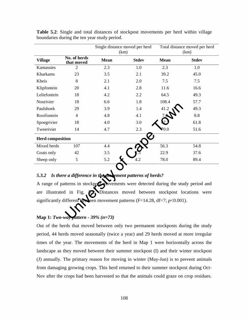
Unive
rsity
of C
ape
Town
108
Table 5.2: Single and total distances of stockpost movements per herd within village
boundaries during the ten year study period.
Single distance moved per herd
(km) Total distance moved per herd
(km)
Village No. of herds that moved
Mean Stdev Mean Stdev
Kamassies 2 2.3 1.0 2.3 1.0
Kharkams 23 3.5 2.1 39.2 45.0
Kheis 8 2.1 2.0 7.5 7.5
Klipfontein 20 4.1 2.8 11.6 16.6
Leliefontein 18 4.2 2.2 64.5 49.3
Nourivier 18 6.6 1.8 108.4 57.7
Paulshoek 29 3.9 1.4 41.2 49.3
Rooifontein 4 4.8 4.1 7.8 8.8
Spoegrivier 18 4.0 3.0 47.7 61.8
Tweerivier 14 4.7 2.3 70.0 51.6
Herd composition
Mixed herds 107 4.4 2.3 56.3 54.8
Goats only 42 3.5 2.3 22.9 37.6
Sheep only 5 5.2 4.2 78.0 89.4
5.3.2 Is there a difference in the movement patterns of herds?
A range of patterns in stockpost movements were detected during the study period and
are illustrated in Fig. 5.2. Distances moved between stockpost locations were
significantly different between movement patterns (F=14.28, df=7; p<0.001).
Map 1: Two-way pattern - 39% (n=73)
Out of the herds that moved between only two permanent stockposts during the study
period, 44 herds moved seasonally (twice a year) and 29 herds moved at more irregular
times of the year. The movements of the herd in Map 1 were horizontally across the
landscape as they moved between their summer stockpost (I) and their winter stockpost
(J) annually. The primary reason for moving in winter (May-Jun) is to prevent animals
from damaging growing crops. This herd returned to their summer stockpost during Oct-
Nov after the crops had been harvested so that the animals could graze on crop residues.
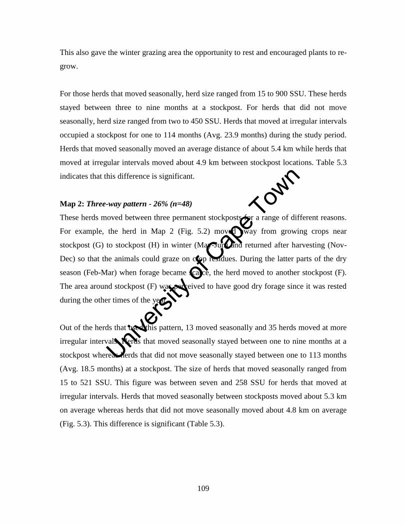
Unive
rsity
of C
ape
Town
109
This also gave the winter grazing area the opportunity to rest and encouraged plants to re-
grow.
For those herds that moved seasonally, herd size ranged from 15 to 900 SSU. These herds
stayed between three to nine months at a stockpost. For herds that did not move
seasonally, herd size ranged from two to 450 SSU. Herds that moved at irregular intervals
occupied a stockpost for one to 114 months (Avg. 23.9 months) during the study period.
Herds that moved seasonally moved an average distance of about 5.4 km while herds that
moved at irregular intervals moved about 4.9 km between stockpost locations. Table 5.3
indicates that this difference is significant.
Map 2: Three-way pattern - 26% (n=48)
These herds moved between three permanent stockposts for a range of different reasons.
For example, the herd in Map 2 (Fig. 5.2) moved away from growing crops near
stockpost (G) to stockpost (H) in winter (May-Jun) and returned after harvesting (Nov-
Dec) so that the animals could graze on crop residues. During the latter parts of the dry
season (Feb-Mar) when forage became scarce, the herd moved to another stockpost (F).
The area around stockpost (F) was perceived to have good dry forage since it was rested
during the other times of the year.
Out of the herds that used this pattern, 13 moved seasonally and 35 herds moved at more
irregular intervals. Herds that moved seasonally stayed between one to nine months at a
stockpost whereas herds that did not move seasonally stayed between one to 113 months
(Avg. 18.5 months) at a stockpost. The size of herds that moved seasonally ranged from
15 to 521 SSU. This figure was between seven and 258 SSU for herds that moved at
irregular intervals. Herds that moved seasonally between stockposts moved about 5.3 km
on average whereas herds that did not move seasonally moved about 4.8 km on average
(Fig. 5.3). This difference is significant (Table 5.3).
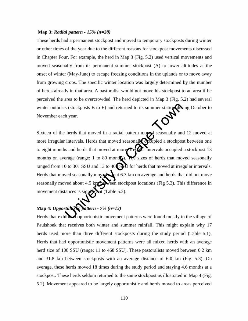
Unive
rsity
of C
ape
Town
110
Map 3: Radial pattern - 15% (n=28)
These herds had a permanent stockpost and moved to temporary stockposts during winter
or other times of the year due to the different reasons for stockpost movements discussed
in Chapter Four. For example, the herd in Map 3 (Fig. 5.2) used vertical movements and
moved seasonally from its permanent summer stockpost (A) to lower altitudes at the
onset of winter (May-June) to escape freezing conditions in the uplands or to move away
from growing crops. The specific winter location was largely determined by the number
of herds already in that area. A pastoralist would not move his stockpost to an area if he
perceived the area to be overcrowded. The herd depicted in Map 3 (Fig. 5.2) had several
winter outposts (stockposts B to E) and returned to its summer station during October to
November each year.
Sixteen of the herds that moved in a radial pattern moved seasonally and 12 moved at
more irregular intervals. Herds that moved seasonally occupied a stockpost between one
to eight months and herds that moved at more irregular intervals occupied a stockpost 13
months on average (range: 1 to 80 months). The sizes of herds that moved seasonally
ranged from 10 to 301 SSU and 13 to 400 SSU for herds that moved at irregular intervals.
Herds that moved seasonally moved about 6.3 km on average and herds that did not move
seasonally moved about 4.5 km between stockpost locations (Fig 5.3). This difference in
movement distances is significant (Table 5.3).
Map 4: Opportunistic pattern - 7% (n=13)
Herds that exhibited opportunistic movement patterns were found mostly in the village of
Paulshoek that receives both winter and summer rainfall. This might explain why 17
herds used more than three different stockposts during the study period (Table 5.1).
Herds that had opportunistic movement patterns were all mixed herds with an average
herd size of 108 SSU (range: 11 to 468 SSU). These pastoralists moved between 0.2 km
and 31.8 km between stockposts with an average distance of 6.0 km (Fig. 5.3). On
average, these herds moved 18 times during the study period and staying 4.6 months at a
stockpost. These herds seldom returned to the same stockpost as illustrated in Map 4 (Fig.
5.2). Movement appeared to be largely opportunistic and herds moved to areas perceived
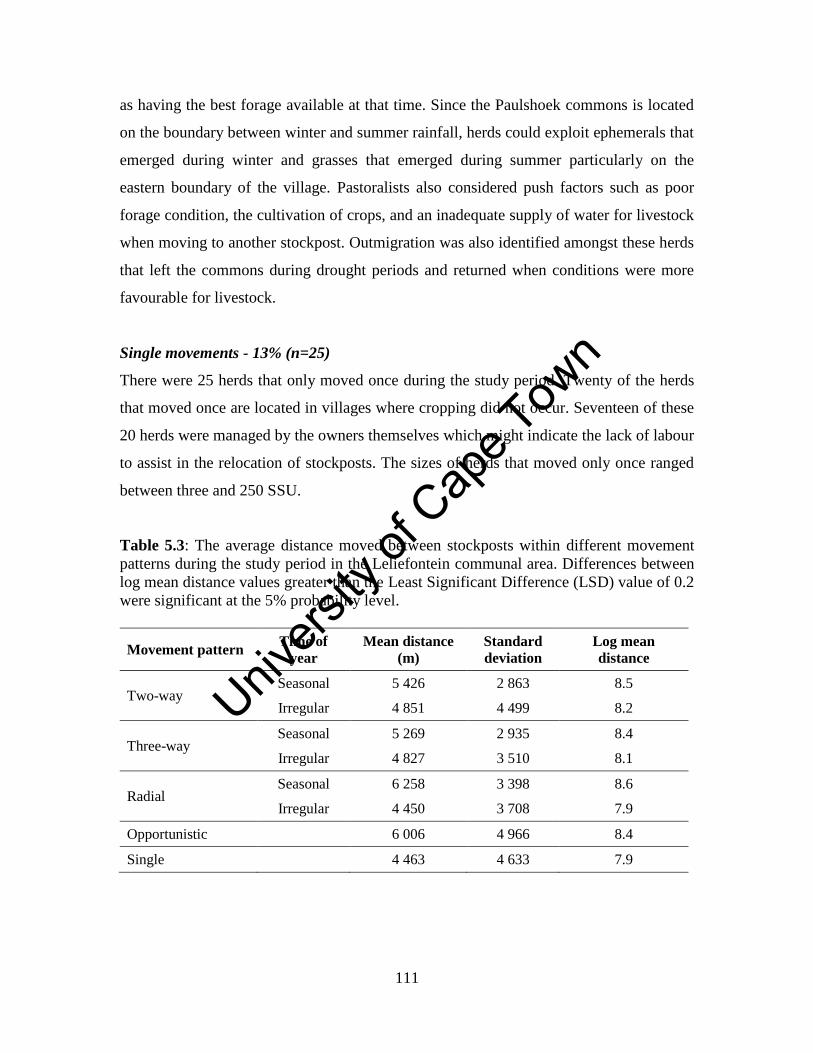
Unive
rsity
of C
ape
Town
111
as having the best forage available at that time. Since the Paulshoek commons is located
on the boundary between winter and summer rainfall, herds could exploit ephemerals that
emerged during winter and grasses that emerged during summer particularly on the
eastern boundary of the village. Pastoralists also considered push factors such as poor
forage condition, the cultivation of crops, and an inadequate supply of water for livestock
when moving to another stockpost. Outmigration was also identified amongst these herds
that left the commons during drought periods and returned when conditions were more
favourable for livestock.
Single movements - 13% (n=25)
There were 25 herds that only moved once during the study period. Twenty of the herds
that moved once are located in villages where cropping did not occur. Seventeen of these
20 herds were managed by the owners themselves which might indicate the lack of labour
to assist in the relocation of stockposts. The sizes of herds that moved only once ranged
between three and 250 SSU.
Table 5.3: The average distance moved between stockposts within different movement
patterns during the study period in the Leliefontein communal area. Differences between
log mean distance values greater than the Least Significant Difference (LSD) value of 0.2
were significant at the 5% probability level.
Movement pattern Time of
year
Mean distance
(m)
Standard
deviation
Log mean
distance
Two-way Seasonal 5 426 2 863 8.5
Irregular 4 851 4 499 8.2
Three-way Seasonal 5 269 2 935 8.4
Irregular 4 827 3 510 8.1
Radial Seasonal 6 258 3 398 8.6
Irregular 4 450 3 708 7.9
Opportunistic 6 006 4 966 8.4
Single 4 463 4 633 7.9
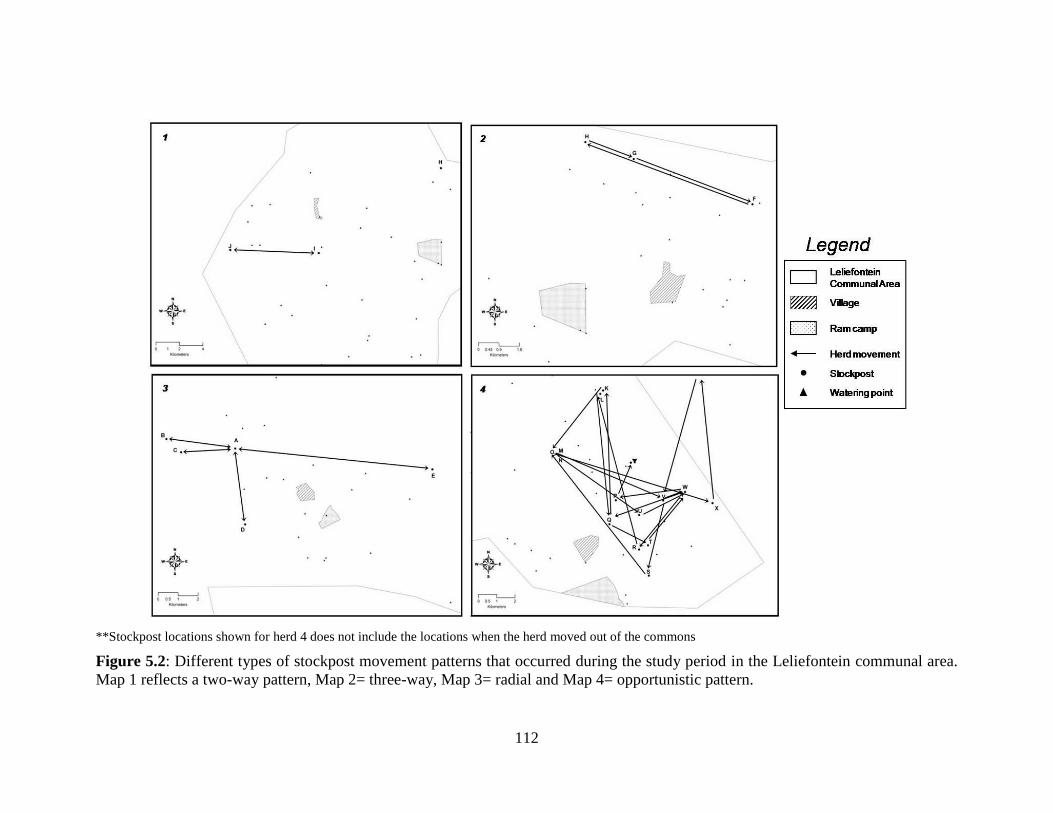
Unive
rsity
of C
ape
Town
112
**Stockpost locations shown for herd 4 does not include the locations when the herd moved out of the commons
Figure 5.2: Different types of stockpost movement patterns that occurred during the study period in the Leliefontein communal area.
Map 1 reflects a two-way pattern, Map 2= three-way, Map 3= radial and Map 4= opportunistic pattern.
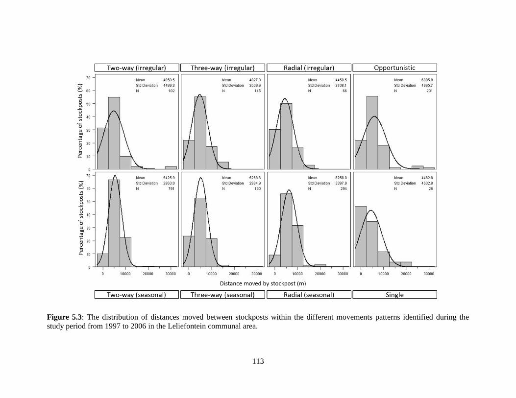
Unive
rsity
of C
ape
Town
113
Figure 5.3: The distribution of distances moved between stockposts within the different movements patterns identified during the
study period from 1997 to 2006 in the Leliefontein communal area.
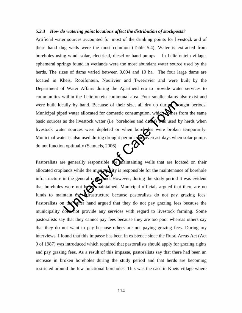
Unive
rsity
of C
ape
Town
114
5.3.3 How do watering point locations affect the distribution of stockposts?
Artificial water sources accounted for most of the drinking points for livestock and of
these hand dug wells were the most common (Table 5.4). Water is extracted from
boreholes using wind, solar, electrical, diesel or hand pumps. In Leliefontein village,
ephemeral springs found in wetlands were the most abundant water source used by the
herds. The sizes of dams varied between 0.004 and 10 ha. The four large dams are
located in Kheis, Rooifontein, Nourivier and Tweerivier and were built by the
Department of Water Affairs during the Apartheid era to provide water services to
communities within the Leliefontein communal area. Four smaller dams also exist and
were built locally by hand. Because of their size, all dry up during drought periods.
Municipal piped water allocated for domestic consumption, which comes from the same
basic sources as the livestock water (i.e. boreholes and dams) was used by herds when
livestock water sources were depleted or when boreholes were broken temporarily.
Municipal water is also used during drought periods and overcast days when solar pumps
do not function optimally (Samuels, 2006).
Pastoralists are generally responsible for maintaining wells that are located on their
allocated croplands while the municipality is responsible for the maintenance of borehole
infrastructure in the general rangeland. However, during the study period it was evident
that boreholes were not being maintained. Municipal officials argued that there are no
funds to maintain the infrastructure because pastoralists do not pay grazing fees.
Pastoralists on the other hand argued that they do not pay grazing fees because the
municipality does not provide any services with regard to livestock farming. Some
pastoralists say that they cannot pay fees because they are too poor whereas others say
that they do not want to pay because others are not paying grazing fees. During my
interviews, I found that this impasse has been in existence since the Rural Areas Act (Act
9 of 1987) was introduced which required that pastoralists should apply for grazing rights
and pay grazing fees. As a result of this impasse, pastoralists say that there had been an
increase in broken boreholes during the study period and that herds are becoming
restricted around the few functional boreholes. This was the case in Kheis village where
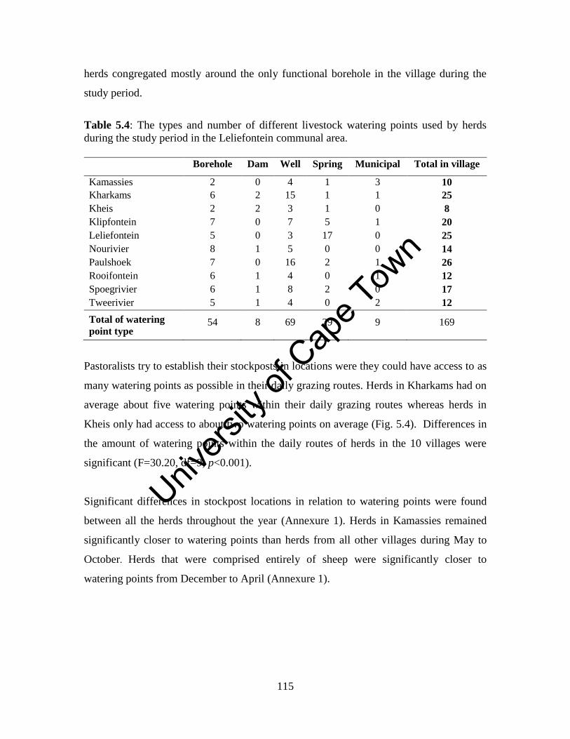
Unive
rsity
of C
ape
Town
115
herds congregated mostly around the only functional borehole in the village during the
study period.
Table 5.4: The types and number of different livestock watering points used by herds
during the study period in the Leliefontein communal area.
Borehole Dam Well Spring Municipal Total in village
Kamassies 2 0 4 1 3 10
Kharkams 6 2 15 1 1 25
Kheis 2 2 3 1 0 8
Klipfontein 7 0 7 5 1 20
Leliefontein 5 0 3 17 0 25
Nourivier 8 1 5 0 0 14
Paulshoek 7 0 16 2 1 26
Rooifontein 6 1 4 0 1 12
Spoegrivier 6 1 8 2 0 17
Tweerivier 5 1 4 0 2 12
Total of watering
point type 54 8 69 29 9 169
Pastoralists try to establish their stockposts in locations were they could have access to as
many watering points as possible in their daily grazing routes. Herds in Kharkams had on
average about five watering points within their daily grazing routes whereas herds in
Kheis only had access to about two watering points on average (Fig. 5.4). Differences in
the amount of watering points within the daily routes of herds in the 10 villages were
significant (F=30.20, df=9; p<0.001).
Significant differences in stockpost locations in relation to watering points were found
between all the herds throughout the year (Annexure 1). Herds in Kamassies remained
significantly closer to watering points than herds from all other villages during May to
October. Herds that were comprised entirely of sheep were significantly closer to
watering points from December to April (Annexure 1).
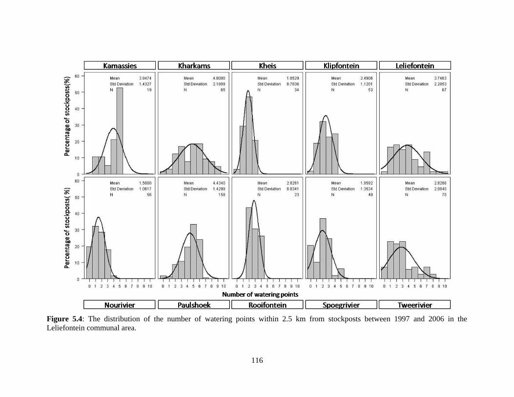
Unive
rsity
of C
ape
Town
116
Figure 5.4: The distribution of the number of watering points within 2.5 km from stockposts between 1997 and 2006 in the
Leliefontein communal area.
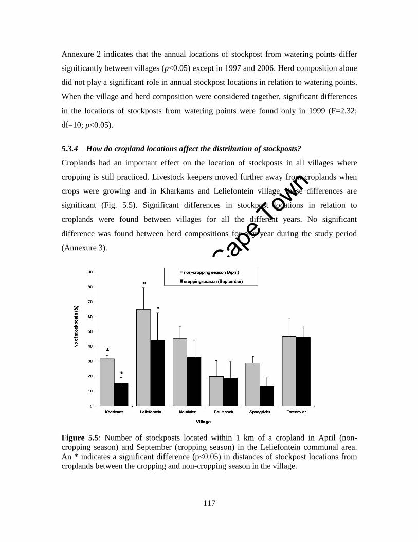
Unive
rsity
of C
ape
Town
117
Annexure 2 indicates that the annual locations of stockpost from watering points differ
significantly between villages (p<0.05) except in 1997 and 2006. Herd composition alone
did not play a significant role in annual stockpost locations in relation to watering points.
When the village and herd composition were considered together, significant differences
in the locations of stockposts from watering points were found only in 1999 (F=2.32;
df=10; p<0.05).
5.3.4 How do cropland locations affect the distribution of stockposts?
Croplands had an important effect on the location of stockposts in all villages where
cropping is still practiced. Livestock keepers moved further away from croplands when
crops were growing and in Kharkams and Leliefontein village, these differences are
significant (Fig. 5.5). Significant differences in stockpost locations in relation to
croplands were found between villages for all the different years. No significant
difference was found between herd compositions for any year during the study period
(Annexure 3).
Figure 5.5: Number of stockposts located within 1 km of a cropland in April (non-
cropping season) and September (cropping season) in the Leliefontein communal area.
An * indicates a significant difference (p<0.05) in distances of stockpost locations from
croplands between the cropping and non-cropping season in the village.

Unive
rsity
of C
ape
Town
118
5.3.5 How do human settlements affect the distribution of stockposts?
There was variability in the distance stockposts were located from settlements. In villages
such as Kharkams almost half of the herds were located within 2.0 km from the
settlement whereas in Tweerivier, almost 40% of the herds were located 6.0 km from the
village (Fig. 5.6). In Kheis, Klipfontein and Kamassies bimodal patterns of distribution of
stockposts distances from human settlements could be observed. For example, in
Kamassies 42% of stockposts were located within a 2.0 km and 47% were located farther
than 6.0 km from the village.
Village and herd composition significantly affected the locations of stockposts in relation
to human settlements (Annexure 4). When these factors were considered together
significant differences could only be found in selected years. Herds in Kheis were
significantly closer to settlements than herds from other villages from March to
September. Herds from Nourivier were significantly further from settlements than herds
from Kamassies throughout the year except December (Annexure 5). Herds that were
comprised entirely of sheep were established significantly closer to settlements than
mixed or goat only herds from December to April. Between July and September, mixed
herds were significantly further from settlements than herds comprised only of goats
(Annexure 5).
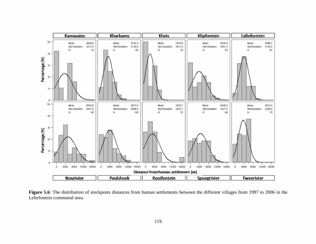
Unive
rsity
of C
ape
Town
119
Figure 5.6: The distribution of stockposts distances from human settlements between the different villages from 1997 to 2006 in the
Leliefontein communal area.
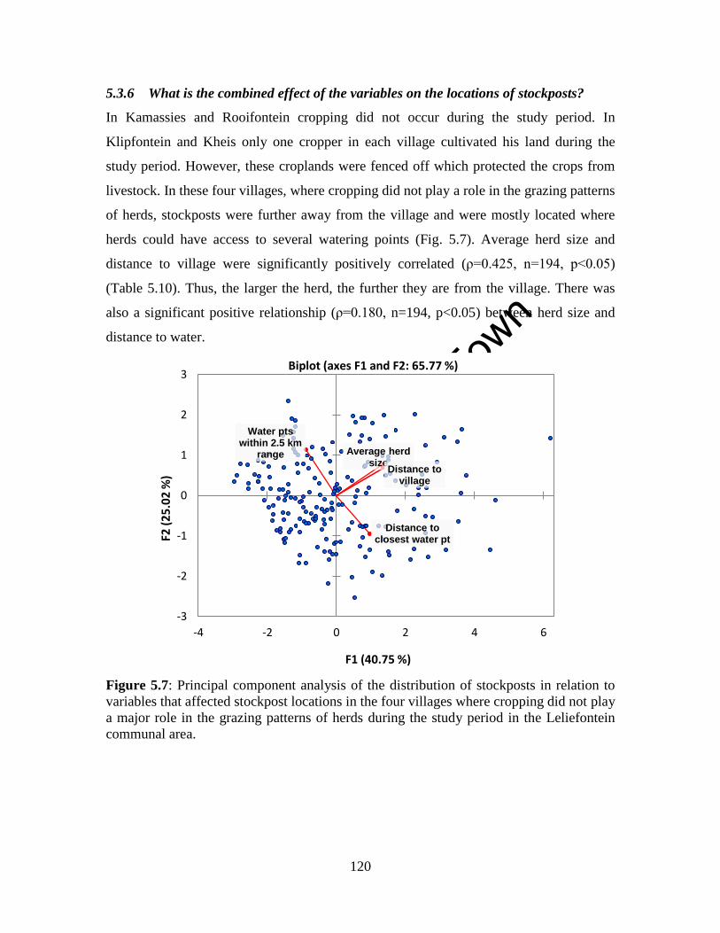
Unive
rsity
of C
ape
Town
120
5.3.6 What is the combined effect of the variables on the locations of stockposts?
In Kamassies and Rooifontein cropping did not occur during the study period. In
Klipfontein and Kheis only one cropper in each village cultivated his land during the
study period. However, these croplands were fenced off which protected the crops from
livestock. In these four villages, where cropping did not play a role in the grazing patterns
of herds, stockposts were further away from the village and were mostly located where
herds could have access to several watering points (Fig. 5.7). Average herd size and
distance to village were significantly positively correlated (ρ=0.425, n=194, p<0.05)
(Table 5.10). Thus, the larger the herd, the further they are from the village. There was
also a significant positive relationship (ρ=0.180, n=194, p<0.05) between herd size and
distance to water.
Figure 5.7: Principal component analysis of the distribution of stockposts in relation to
variables that affected stockpost locations in the four villages where cropping did not play
a major role in the grazing patterns of herds during the study period in the Leliefontein
communal area.
Average herd size
Distance to closest water pt
Distance to village
Water pts within 2.5 km
range
-3
-2
-1
0
1
2
3
-4 -2 0 2 4 6
F2 (
25
.02
%)
F1 (40.75 %)
Biplot (axes F1 and F2: 65.77 %)
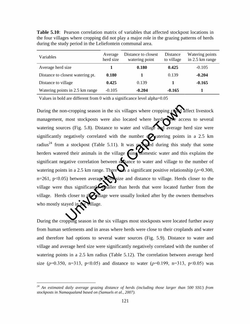
Unive
rsity
of C
ape
Town
121
Table 5.10: Pearson correlation matrix of variables that affected stockpost locations in
the four villages where cropping did not play a major role in the grazing patterns of herds
during the study period in the Leliefontein communal area.
Variables Average
herd size Distance to closest
watering point Distance
to village Watering points
in 2.5 km range
Average herd size 1 0.180 0.425 -0.105
Distance to closest watering pt. 0.180 1 0.139 -0.204
Distance to village 0.425 0.139 1 -0.165
Watering points in 2.5 km range -0.105 -0.204 -0.165 1
Values in bold are different from 0 with a significance level alpha=0.05
During the non-cropping season in the six villages where cropping could affect livestock
management, most stockposts were also located where herds have access to several
watering sources (Fig. 5.8). Distance to water and village and average herd size were
significantly negatively correlated with the number of watering points in a 2.5 km
radius24
from a stockpost (Table 5.11). It was recorded during this study that some
herders watered their animals in the village using domestic water and this explains the
significant negative correlation between distance to water and village to the number of
watering points in a 2.5 km range. There was a significant positive relationship (ρ=0.300,
n=261, p<0.05) between average herd size and distance to village. Herds closer to the
village were thus significantly smaller than herds that were located further from the
village. Herds closer to the village were usually looked after by the owners themselves
who mostly stayed in the village.
During the cropping season in the six villages most stockposts were located further away
from human settlements and in areas where herds were close to their croplands and water
and therefore had options to several water sources (Fig. 5.9). Distance to water and
village and average herd size were significantly negatively correlated with the number of
watering points in a 2.5 km radius (Table 5.12). The correlation between average herd
size (ρ=0.350, n=313, p<0.05) and distance to water (ρ=0.199, n=313, p<0.05) was
24
An estimated daily average grazing distance of herds (including those larger than 500 SSU) from
stockposts in Namaqualand based on (Samuels et al., 2007).
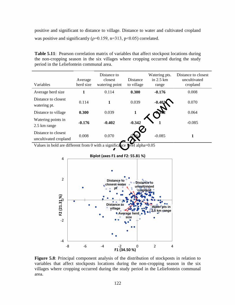
Unive
rsity
of C
ape
Town
122
positive and significant to distance to village. Distance to water and cultivated cropland
was positive and significantly (ρ=0.159, n=313, p<0.05) correlated.
Table 5.11: Pearson correlation matrix of variables that affect stockpost locations during
the non-cropping season in the six villages where cropping occurred during the study
period in the Leliefontein communal area.
Variables Average
herd size
Distance to
closest
watering point Distance
to village
Watering pts.
in 2.5 km
range
Distance to closest
uncultivated
cropland
Average herd size 1 0.114 0.300 -0.176 0.008
Distance to closest
watering pt. 0.114 1 0.039 -0.402 0.070
Distance to village 0.300 0.039 1 -0.342 0.064
Watering points in
2.5 km range -0.176 -0.402 -0.342 1 -0.085
Distance to closest
uncultivated cropland 0.008 0.070 0.064 -0.085 1
Values in bold are different from 0 with a significance level alpha=0.05
Figure 5.8: Principal component analysis of the distribution of stockposts in relation to
variables that affect stockposts locations during the non-cropping season in the six
villages where cropping occurred during the study period in the Leliefontein communal
area.
Average herd size
Distance to closest water
pt
Distance to village
Water pts in 2.5 km range
-4
-2
0
2
4
-8 -6 -4 -2 0 2 4
F2 (
21
.31
%)
F1 (34.50 %)
Biplot (axes F1 and F2: 55.81 %)
Distance to uncultivated
cropland
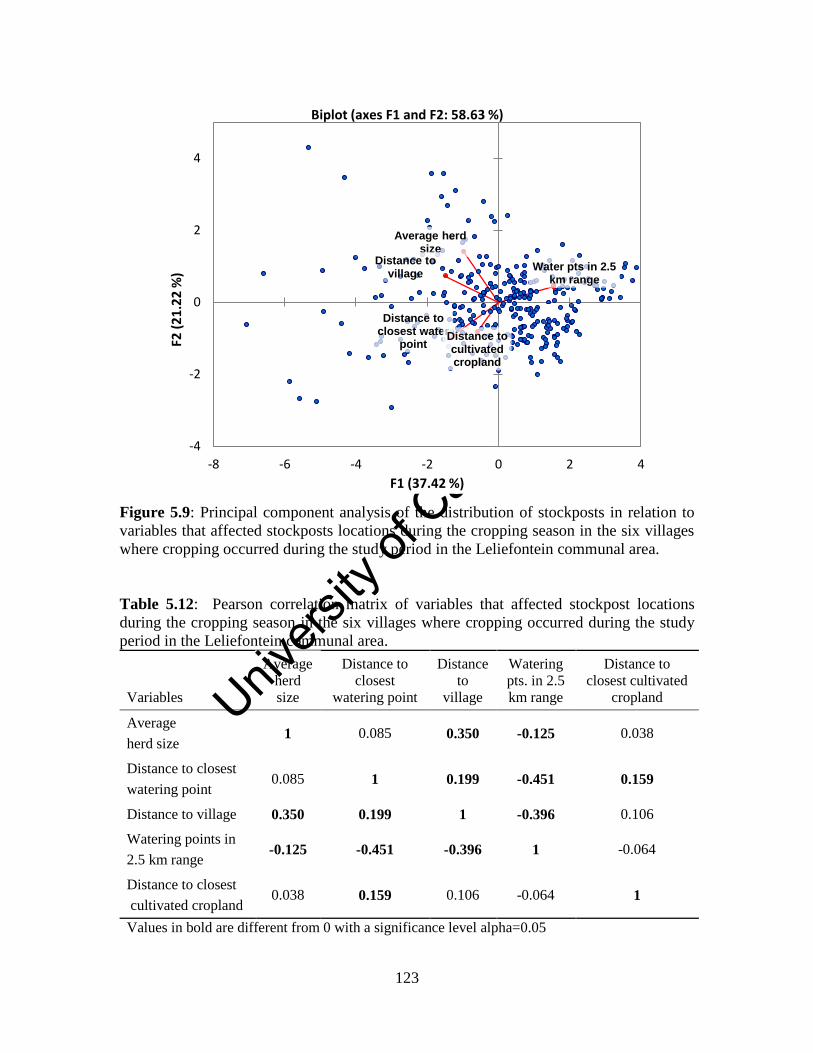
Unive
rsity
of C
ape
Town
123
Figure 5.9: Principal component analysis of the distribution of stockposts in relation to
variables that affected stockposts locations during the cropping season in the six villages
where cropping occurred during the study period in the Leliefontein communal area.
Table 5.12: Pearson correlation matrix of variables that affected stockpost locations
during the cropping season in the six villages where cropping occurred during the study
period in the Leliefontein communal area.
Variables
Average
herd
size
Distance to
closest
watering point
Distance
to
village
Watering
pts. in 2.5
km range
Distance to
closest cultivated
cropland
Average
herd size 1 0.085 0.350 -0.125 0.038
Distance to closest
watering point 0.085 1 0.199 -0.451 0.159
Distance to village 0.350 0.199 1 -0.396 0.106
Watering points in
2.5 km range -0.125 -0.451 -0.396 1 -0.064
Distance to closest
cultivated cropland 0.038 0.159 0.106 -0.064 1
Values in bold are different from 0 with a significance level alpha=0.05
Average herd size
Distance to closest water
point
Distance to village
Water pts in 2.5 km range
Distance to cultivated cropland
-4
-2
0
2
4
-8 -6 -4 -2 0 2 4
F2 (
21
.22
%)
F1 (37.42 %)
Biplot (axes F1 and F2: 58.63 %)
Unive
rsity
of C
ape
Town
124
5.4 Discussion
5.4.1 How have spatial parameters of pastoral mobility changed over time?
The current size of the grazing areas for pastoralists in Leliefontein is much smaller than
in the pre-colonial era and pastoralists have had to adapt their mobility patterns by
moving over shorter distances between stockposts. During the pre-colonial era, the
grazing areas of Nama pastoralists were large enough for transhumance over long and
middle distances into other agro-ecological zones (Penn, 1986; Rohde and Hoffman,
2008). People could have moved more than100 km to the Sandveld near the coast in the
west in winter to avoid cold conditions in the Kamiesberg uplands and also to make use
of available marine resources to augment their diet (Webley, 1986). They could also have
moved in the opposite direction to the fringes of Bushmanland in the east in times of
drought in the west (Webley, 1982) or during the summer months when rain usually falls
in this region. There is also evidence that Nama pastoralists moved long distances north
to the Orange River or south to the Olifants River when forage became scarce in the
Kamiesberg region (Rohde and Hoffman, 2008). Presently, long distances movements
within the communal area are no longer possible but shorter movements still allow the
herds to engage in some form of seasonal and opportunistic movements as well as
outmigration during drought periods (Chapter Four). Since the distance between
stockposts is short, pastoralists move their animals on foot and take one day or less to
move between stockposts.
In a spatially constrained pastoral area, such as in Namaqualand, it is less labour intensive
and less costly to relocate herds than in larger mobile pastoral systems and thus deciding
to move in Leliefontein might not be such a difficult option. However, it is sometimes
difficult to access labour to assist as those who could help; especially the youth expect to
be paid. Pastoralists do not always have the means to pay those who assist them with
relocating their stockposts. Elsewhere in semi-arid Africa, it has been reported that
moving livestock is labour intensive since some herders are known to walk for up to 600
km to reach desired markets (Little et al., 2001). Other pastoral groups such as the Raikas
in India embark on migratory routes for up to 1 500 km which last for about seven
months (Agrawal, 1993). Pastoralists in several European countries today use motorised
Unive
rsity
of C
ape
Town
125
transport to move livestock over long distances to overcome some of the challenges in
moving their herds (Baena and Casas, 2010; Thevenin, 2011). However, these costs are
sometimes covered by the state since transhumance practices provide tourism
opportunities for local municipalities (Pardini and Nori, 2011).
The majority of pastoralists in Leliefontein moved between the same stockposts. This
practice informally defines their rights to certain grazing areas. Preferential access to
these grazing areas is often based on the historical locations of families within the shared
commons in the 19th
and early 20th
centuries before they were relocated and aggregated in
villages (Marinus, 1996). Stockposts in the study area were located relatively close to
each other and this resulted in an overlapping of grazing areas between herds.
Overlapping grazing routes, however, rarely led to conflict over resources. Samuels
(2006) found that pastoralists respected each other’s grazing area and did not guide their
animals in a specific direction if another herd was already grazing in that area. In other
mobile pastoral systems, social relationships are also maintained to reduce conflict over
limited resources and to access inter-territorial grazing lands (Waller and Sobania, 1994;
Behnke, 1999; Ramisch, 1999; Galvin, 2009). Maintaining social ties might be another
reason why there was no conflict over resources in this spatially constrained pastoral
system. Pastoralists in Leliefontein often congregate and meet at watering points where
they share knowledge and food which maintain these social ties (Samuels, 2006).
5.4.2 Effects of watering points on stockpost locations
The introduction of boreholes for agricultural purposes in Namaqualand in 1845 (Walton,
1998) and elsewhere (Western, 1982; Bassett 1986; Sonneveld et al., 2009) influenced
the settlement patterns of herds. During this study herds were located close to water
during the dry season and moved further away when water was more abundant during the
wet winter season. Livestock congregation around permanent and reliable watering
sources during the dry season is found within many other arid mobile pastoral systems
(Bassett, 1986; Smith and Metelerkamp, 1995; Behnke, 1999; Shazali and Ahmed, 1999).
Since the area is small, herds in Leliefontein do not have to travel far distances daily to
Unive
rsity
of C
ape
Town
126
reach water and can use their energy to search for better forage. In larger pastoral
systems, as in West Africa, the physical constraints of accessing water that is located far
from livestock encampments are sometimes overcome by transporting water to livestock.
As a result, animals are able to conserve their energy and use it to access better pastures
(Adriansen, 2008).
The high number of watering points (including those that are seasonal) in some villages
of the Leliefontein communal area, resulted in pastoralists locating stockposts in areas
where they had access to several watering sources within their daily grazing orbit around
stockposts. This allowed herds to have several grazing routes where they could visit
different vegetation types and still be able to water their animals on a daily basis
(Samuels, 2006). Such access to several watering sources daily even during the dry
season is not as prevalent in most other pastoral systems where large herds often have to
walk far and over a long time period to reach a water source when water cannot be
transported to them (Behnke, 1999; Adriansen, 2008).
Herds in Nourivier, Spoegrivier, Kharkams and Leliefontein village were furthest away
from watering points during the winter period. During winter the vegetation, and
particularly the succulent component is full of water and provides enough moisture for
animals. This enables pastoralists to move their herds to areas where there is no
permanent watering source. By moving to these winter grazing areas, pastoralists allow
the vegetation around the areas closer to permanent watering sources to rest. This practice
is similar to other pastoral systems where herds move further away from permanent
watering sources during the wet season to distant areas that are usually undergrazed
during the dry season (Western, 1982).
5.4.3 Effects of cropping on the locations of stockposts
Results from this study show that cropping in the smaller and spatially constrained
Leliefontein communal area could be regarded as a promoter of pastoral mobility in
several villages since herds have to move away from growing crops in winter. In other
transhumant systems, cropping has also been an important influence on herd movement
Unive
rsity
of C
ape
Town
127
in order to protect maturing crops (Homewood, 2008). In contrast, in several other
mobile pastoral systems, rain fed and irrigated agriculture has led to a reduction in
pastoral mobility by narrowing and blocking migratory routes and preventing access to
grazing resources (Shazali and Ahmed, 1999; Turner, 2003; Babiker, 2012; Dongmo et
al., 2012).
After the harvesting of crops in the Leliefontein communal area, herds usually returned to
their summer locations to graze on crop residues. This is similar to mobile pastoral
systems elsewhere in South Africa (Bennett et al., 2007) and Africa (Bassett, 1986;
Scoones, 1995a; Baba and Magadi, 1998; Homewood, 2008) where croplands provide
livestock with high quality forage during the dry season. However, in Leliefontein, fallow
croplands have an additional benefit as they act as key grazing sites for livestock during
winter. Pastoralists prefer guiding their herds to fallow croplands due to the abundance of
ephemerals that emerge after good rains. Pastoralists regard ephemerals as good quality
forage and allow their animals to graze the flowers which they perceive to stimulate milk
production in lactating ewes (Samuels, 2006). Additional benefits of croplands have also
been reported in West Africa, where fallow croplands are preferred grazing sites for
livestock when savanna grasses become lignified (Bassett, 1986).
As a result of the small size of the grazing area available to herds in Leliefontein,
livestock will graze the crops if left unattended (Baker and Hoffman, 2006). The fact that
most herds investigated in this study are located farther away or moved away from
croplands during the growing season indicates that pastoralists still adhere to traditional
norms that regulate land use. Moving away from growing crops is a traditional practice
and can be regarded as an effective way of protecting unfenced croplands. When herds
move away from croplands there is no need for croppers to fence off their land to protect
their crops from livestock. However, during the study period, not all the herds moved
away from growing crops in winter. Consequently, some croppers suffered crop damages
from unmanaged herds which are not looked after by herders during grazing periods
(Samuels, 2006). During farmer interviews it was often mentioned that there is lack of
competent herders in Leliefontein to look after livestock during the grazing period to
Unive
rsity
of C
ape
Town
128
protect growing crops. Therefore, some croppers have fenced off their land since they are
often not compensated for the damages they suffer. The fencing off of croplands by some
croppers, however, has led to the exclusion of pastoralists from grazing sites.
Traditionally, all croplands have been regarded as open to livestock when crops are not
growing.
Due to the usually poor returns from cropping there has been a steady loss of skills and
fewer people are expected to cultivate their allocated croplands in Leliefontein in years to
come. When an area is not cultivated, herds no longer have to move away from croplands
during the growing season. This contraction of cropping area is fundamentally different
to the circumstances in many other parts in Africa where cropping is expanding into the
rangelands and the need for more labour to practice cropping has resulted in less labour
available to look after livestock (Turner et al., 2005). A balance thus needs to be
maintained between the amounts of cropping that could occur in pastoral systems without
compromising the mobile existence of pastoralists. In a spatially constrained grazing area,
too much cropping will take away valuable grazing lands and cramp livestock herds on
the remaining parts of the rangelands. An absence or a decline in cropping, on the other
hand, may result in pastoralists opting not to move away from croplands and lead to a
decline in seasonal mobility. This could lead to overgrazing of some areas which might
result in a depletion of palatable plants and in an increase in unpalatable plants in the
study area (Anderson, 2008). Overgrazing also removes vegetation cover which exposes
the soil to erosion.
5.4.4 Effects of human settlements on stockpost locations
During this study it was found that the location of stockposts close to human settlements
in the Leliefontein communal area often occurred as a result of social and personal
circumstances. The perceived lack of competent herders to look after livestock also
resulted in several herds being looked after by the owners themselves. In some villages
investigated in this study, herds were located close to human settlements so that herd
owners could be at home with their families at night. Before people settled in villages
from the 1940s onwards, the entire family usually stayed with the herder at the stockpost
Unive
rsity
of C
ape
Town
129
and would then move with the herder to other stockpost locations (Rohde and Hoffman,
2008). The current circumstances of herders in Leliefontein are similar to those in other
pastoral systems where some owners prefer paying younger herders to look after
livestock and not go on transhumance themselves so that they could remain at home and
look after their shops and other business interests (Adriansen, 2008).
In Leliefontein some herds also established themselves closer to the village in winter so
that family members could assist with milking and ‘stutwerk’ (placing kids with their
mothers to drink milk) in the morning before the adult herd leaves the stockpost. In other
mobile pastoral systems, herds are located closer villages in winter because labour is
needed for other activities such as weeding of crops (Sanford, 1983a). Thus the need for
labour is an important driver of herd mobility in pastoral systems especially during the
winter season.
Some pastoralists settle their herds close to their homes in the village due to personal
health constraints (Baker and Hoffman, 2006). This might be because in Namaqualand,
the average age of herders is about 55 years old with the oldest herders over 70 years old
(Hendricks, 2004; Samuels, 2006). In Namaqualand, being a herder is not attractive to the
younger generation since it is labour-intensive and the financial reward is far less than
what it is for other occupations. Young people in Leliefontein say that they do not want to
suffer (financially) like their parents (Swarts and Aliber, 2013). In Italy for example, the
ageing pastoral population is addressed by using migrants from Africa and other parts of
Europe to look after animals (Pardini and Nori, 2011). During my interviews, I found that
few herders were from other regions in Namaqualand but usually young people find the
modern city life more attractive than being a pastoralist (Swarts and Aliber, 2013).
The spatial extent of pastoral mobility in the study area has changed since the pre-
colonial era because pastoralists can no longer move over long distances into other agro-
ecological regions. The fact that that they are spatially constrained only allows them to
move 4.2 km on average when they move within their village commons and 8.4 km when
the move across village boundaries. Pastoral mobility in Leliefontein remains an
Unive
rsity
of C
ape
Town
130
important way for pastoralists to access resources and is influenced by a number of other
socio-economic drivers as well. Decisions to move a stockpost in Leliefontein are
complex and are based on the need for farmers and pastoralists to protect their crops
during the growing season, to gain access to permanent and reliable watering sources
especially during dry periods, to be in close proximity to the village when labour for
activities other than herding are needed and to accommodate the varied and often
complex personal circumstances of pastoralists. This has resulted in different herd
mobility patterns which include outmigration opportunistic and seasonal movement
patterns that resemble historic spatial movements of Nama pastoralists in the region.
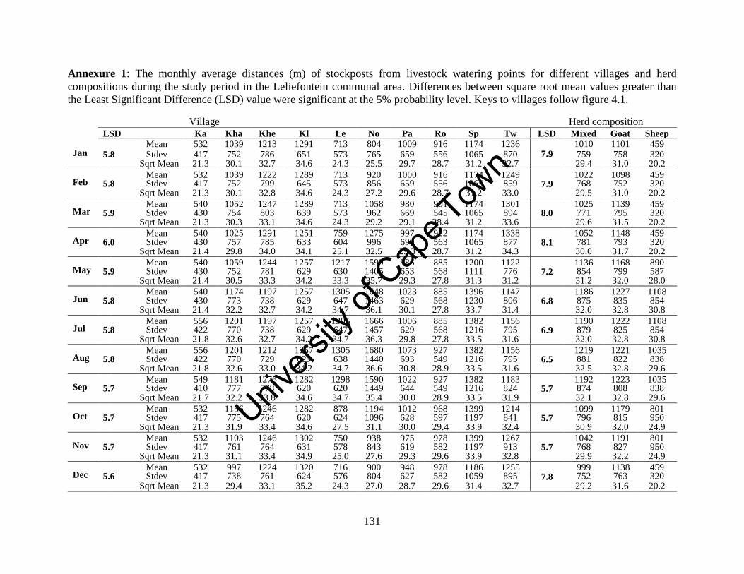
Unive
rsity
of C
ape
Town
131
Annexure 1: The monthly average distances (m) of stockposts from livestock watering points for different villages and herd
compositions during the study period in the Leliefontein communal area. Differences between square root mean values greater than
the Least Significant Difference (LSD) value were significant at the 5% probability level. Keys to villages follow figure 4.1.
Village Herd composition
LSD
Ka Kha Khe Kl Le No Pa Ro Sp Tw LSD Mixed Goat
s
Sheep
Jan Mean 532 1039 1213 1291 713 804 1009 916 1174 1236
7.9 1010 1101 459
5.8 Stdev 417 752 786 651 573 765 659 556 1065 870 759 758 320 Sqrt Mean 21.3 30.1 32.7 34.6 24.3 25.5 29.7 28.7 31.2 32.7 29.4 31.0 20.2
Feb Mean 532 1039 1222 1289 713 920 1000 916 1174 1249
7.9 1022 1098 459
5.8 Stdev 417 752 799 645 573 856 659 556 1065 859 768 752 320 Sqrt Mean 21.3 30.1 32.8 34.6 24.3 27.2 29.6 28.7 31.2 33.0 29.5 31.0 20.2
Mar Mean 540 1052 1247 1289 713 1058 980 901 1174 1301
8.0 1025 1139 459
5.9 Stdev 430 754 803 639 573 962 669 545 1065 894 771 795 320 Sqrt Mean 21.3 30.3 33.1 34.6 24.3 29.2 29.1 28.4 31.2 33.6 29.6 31.5 20.2
Apr Mean 540 1025 1291 1251 759 1275 997 922 1174 1338
8.1 1052 1148 459
6.0 Stdev 430 757 785 633 604 996 690 563 1065 877 781 793 320 Sqrt Mean 21.4 29.8 34.0 34.1 25.1 32.5 29.3 28.7 31.2 34.3 30.0 31.7 20.2
May Mean 540 1059 1244 1257 1217 1599 986 885 1200 1122
7.2 1136 1168 890
5.9 Stdev 430 752 781 629 630 1405 653 568 1111 776 854 799 587 Sqrt Mean 21.4 30.5 33.3 34.2 33.3 35.7 29.3 27.8 31.3 31.2 31.2 32.0 28.0
Jun Mean 540 1174 1197 1257 1305 1648 1023 885 1396 1147
6.8 1186 1227 1108
5.8 Stdev 430 773 738 629 647 1463 629 568 1230 806 875 835 854 Sqrt Mean 21.4 32.2 32.7 34.2 34.7 36.1 30.1 27.8 33.7 31.4 32.0 32.8 30.8
Jul Mean 556 1201 1197 1257 1305 1666 1006 885 1382 1156
6.9 1190 1222 1108
5.8 Stdev 422 770 738 629 647 1457 629 568 1216 795 879 825 854 Sqrt Mean 21.8 32.6 32.7 34.2 34.7 36.3 29.8 27.8 33.5 31.6 32.0 32.8 30.8
Aug Mean 556 1201 1212 1257 1305 1680 1073 927 1382 1156
6.5 1219 1221 1035
5.8 Stdev 422 770 729 629 638 1440 693 549 1216 795 881 822 838 Sqrt Mean 21.8 32.6 33.0 34.2 34.7 36.6 30.8 28.9 33.5 31.6 32.5 32.8 29.6
Sep Mean 549 1181 1276 1282 1298 1590 1022 927 1382 1183
5.7 1192 1223 1035
5.7 Stdev 410 777 778 620 620 1449 644 549 1216 824 874 808 838 Sqrt Mean
MeanMeanAvg
21.7 32.2 33.8 34.6 34.7 35.4 30.0 28.9 33.5 31.9 32.1 32.8 29.6
Oct Mean 532 1156 1246 1282 878 1194 1012 968 1399 1214
5.7 1099 1179 801
5.7 Stdev 417 775 764 620 624 1096 628 597 1197 841 796 815 950 Sqrt Mean 21.3 31.9 33.4 34.6 27.5 31.1 30.0 29.4 33.9 32.4 30.9 32.0 24.9
Nov Mean 532 1103 1246 1302 750 938 975 978 1399 1267
5.7 1042 1191 801
5.7 Stdev 417 761 764 631 578 843 619 582 1197 913 768 827 950 Sqrt Mean 21.3 31.1 33.4 34.9 25.0 27.6 29.3 29.6 33.9 32.8 29.9 32.2 24.9
Dec Mean 532 997 1224 1320 716 900 948 978 1186 1255
7.8 999 1138 459
5.6 Stdev 417 738 761 624 576 804 627 582 1059 895 752 763 320 Sqrt Mean 21.3 29.4 33.1 35.2 24.3 27.0 28.7 29.6 31.4 32.7 29.2 31.6 20.2
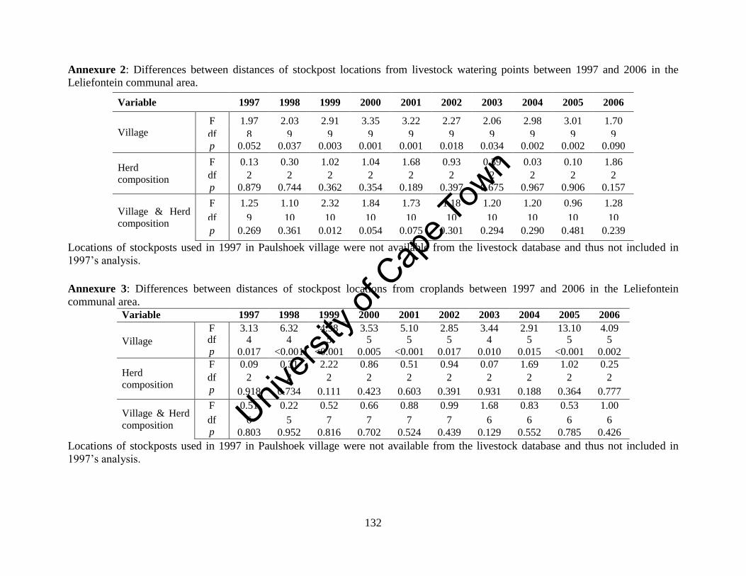
Unive
rsity
of C
ape
Town
132
Annexure 2: Differences between distances of stockpost locations from livestock watering points between 1997 and 2006 in the
Leliefontein communal area.
Variable 1997 1998 1999 2000 2001 2002 2003 2004 2005 2006
Village
F 1.97 2.03 2.91 3.35 3.22 2.27 2.06 2.98 3.01 1.70
df 8 9 9 9 9 9 9 9 9 9 p 0.052 0.037 0.003 0.001 0.001 0.018 0.034 0.002 0.002 0.090
Herd
composition
F 0.13 0.30 1.02 1.04 1.68 0.93 0.39 0.03 0.10 1.86
df 2 2 2 2 2 2 2 2 2 2 p 0.879 0.744 0.362 0.354 0.189 0.397 0.675 0.967 0.906 0.157
Village & Herd
composition
F 1.25 1.10 2.32 1.84 1.73 1.18 1.20 1.20 0.96 1.28
df 9 10 10 10 10 10 10 10 10 10
p 0.269 0.361 0.012 0.054 0.075 0.301 0.294 0.290 0.481 0.239
Locations of stockposts used in 1997 in Paulshoek village were not available from the livestock database and thus not included in
1997’s analysis.
Annexure 3: Differences between distances of stockpost locations from croplands between 1997 and 2006 in the Leliefontein
communal area.
Variable 1997 1998 1999 2000 2001 2002 2003 2004 2005 2006
Village
F 3.13 6.32 4.98 3.53 5.10 2.85 3.44 2.91 13.10 4.09 df 4 4 5 5 5 5 4 5 5 5 p 0.017 <0.001 <0.001 0.005 <0.001 0.017 0.010 0.015 <0.001 0.002
Herd
composition
F 0.09 0.31 2.22 0.86 0.51 0.94 0.07 1.69 1.02 0.25
df 2 2 2 2 2 2 2 2 2 2 p 0.918 0.734 0.111 0.423 0.603 0.391 0.931 0.188 0.364 0.777
Village & Herd
composition
F 0.51 0.22 0.52 0.66 0.88 0.99 1.68 0.83 0.53 1.00
df 6 5 7 7 7 7 6 6 6 6 p 0.803 0.952 0.816 0.702 0.524 0.439 0.129 0.552 0.785 0.426
Locations of stockposts used in 1997 in Paulshoek village were not available from the livestock database and thus not included in
1997’s analysis.
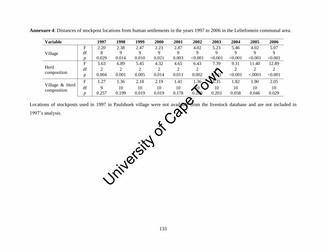
Unive
rsity
of C
ape
Town
133
Annexure 4: Distances of stockpost locations from human settlements in the years 1997 to 2006 in the Leliefontein communal area.
Variable 1997 1998 1999 2000 2001 2002 2003 2004 2005 2006
Village
F 2.20 2.38 2.47 2.23 2.87 4.02 5.23 5.46 4.02 5.07 df 8 9 9 9 9 9 9 9 9 9
p 0.029 0.014 0.010 0.021 0.003 <0.001 <0.001 <0.001 <0.001 <0.001
Herd
composition
F 5.63 6.89 5.45 4.32 4.65 6.43 7.39 9.31 11.40 12.89
df 2 2 2 2 2 2 2 2 2 2
p 0.004 0.001 0.005 0.014 0.011 0.002 0.001 <0.001 <.0001 <0.001
Village & Herd
composition
F 1.27 1.36 2.18 2.19 1.41 1.36 1.35 1.82 1.90 2.05
df 9 10 10 10 10 10 10 10 10 10
p 0.257 0.199 0.019 0.019 0.178 0.200 0.203 0.058 0.046 0.029
Locations of stockposts used in 1997 in Paulshoek village were not available from the livestock database and are not included in
1997’s analysis.
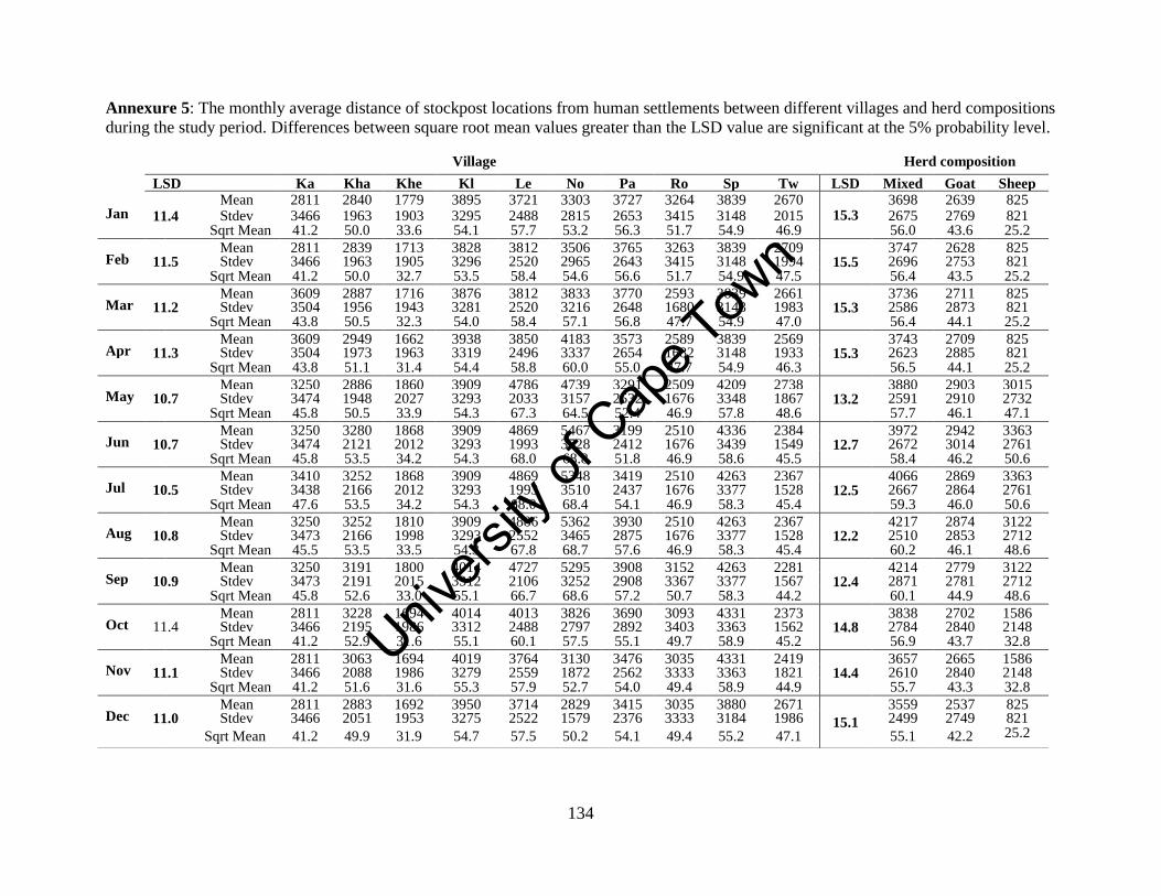
Unive
rsity
of C
ape
Town
134
Annexure 5: The monthly average distance of stockpost locations from human settlements between different villages and herd compositions
during the study period. Differences between square root mean values greater than the LSD value are significant at the 5% probability level.
Village Herd composition
LSD
Ka Kha Khe Kl Le No Pa Ro Sp Tw LSD Mixed Goat
s
Sheep
Jan Mean 2811 2840 1779 3895 3721 3303 3727 3264 3839 2670
15.3 3698 2639 825
11.4 Stdev 3466 1963 1903 3295 2488 2815 2653 3415 3148 2015 2675 2769 821 Sqrt Mean 41.2 50.0 33.6 54.1 57.7 53.2 56.3 51.7 54.9 46.9 56.0 43.6 25.2
Feb Mean 2811 2839 1713 3828 3812 3506 3765 3263 3839 2709
15.5 3747 2628 825
11.5 Stdev 3466 1963 1905 3296 2520 2965 2643 3415 3148 1994 2696 2753 821 Sqrt Mean 41.2 50.0 32.7 53.5 58.4 54.6 56.6 51.7 54.9 47.5 56.4 43.5 25.2
Mar Mean 3609 2887 1716 3876 3812 3833 3770 2593 3839 2661
15.3 3736 2711 825
11.2 Stdev 3504 1956 1943 3281 2520 3216 2648 1680 3148 1983 2586 2873 821 Sqrt Mean 43.8 50.5 32.3 54.0 58.4 57.1 56.8 47.7 54.9 47.0 56.4 44.1 25.2
Apr Mean 3609 2949 1662 3938 3850 4183 3573 2589 3839 2569
15.3 3743 2709 825
11.3 Stdev 3504 1973 1963 3319 2496 3337 2654 1682 3148 1933 2623 2885 821 Sqrt Mean 43.8 51.1 31.4 54.4 58.8 60.0 55.0 47.7 54.9 46.3 56.5 44.1 25.2
May Mean 3250 2886 1860 3909 4786 4739 3291 2509 4209 2738
13.2 3880 2903 3015
10.7 Stdev 3474 1948 2027 3293 2033 3157 2532 1676 3348 1867 2591 2910 2732 Sqrt Mean 45.8 50.5 33.9 54.3 67.3 64.5 52.4 46.9 57.8 48.6 57.7 46.1 47.1
Jun Mean 3250 3280 1868 3909 4869 5467 3199 2510 4336 2384
12.7 3972 2942 3363
10.7 Stdev 3474 2121 2012 3293 1993 3728 2412 1676 3439 1549 2672 3014 2761 Sqrt Mean 45.8 53.5 34.2 54.3 68.0 68.8 51.8 46.9 58.6 45.5 58.4 46.2 50.6
Jul Mean 3410 3252 1868 3909 4869 5348 3419 2510 4263 2367
12.5 4066 2869 3363
10.5 Stdev 3438 2166 2012 3293 1993 3510 2437 1676 3377 1528 2667 2864 2761 Sqrt Mean 47.6 53.5 34.2 54.3 68.0 68.4 54.1 46.9 58.3 45.4 59.3 46.0 50.6
Aug Mean 3250 3252 1810 3909 4886 5362 3930 2510 4263 2367
12.2 4217 2874 3122
10.8 Stdev 3473 2166 1998 3293 2552 3465 2875 1676 3377 1528 2510 2853 2712 Sqrt Mean 45.5 53.5 33.5 54.3 67.8 68.7 57.6 46.9 58.3 45.4 60.2 46.1 48.6
Sep Mean 3250 3191 1800 4014 4727 5295 3908 3152 4263 2281
12.4 4214 2779 3122
10.9 Stdev 3473 2191 2015 3312 2106 3252 2908 3367 3377 1567 2871 2781 2712 Sqrt Mean
MeanMeanAvg
45.8 52.6 33.0 55.1 66.7 68.6 57.2 50.7 58.3 44.2 60.1 44.9 48.6
Oct Mean 2811 3228 1694 4014 4013 3826 3690 3093 4331 2373
14.8 3838 2702 1586
11.4 Stdev 3466 2195 1986 3312 2488 2797 2892 3403 3363 1562 2784 2840 2148 Sqrt Mean 41.2 52.9 31.6 55.1 60.1 57.5 55.1 49.7 58.9 45.2 56.9 43.7 32.8
Nov Mean 2811 3063 1694 4019 3764 3130 3476 3035 4331 2419
14.4 3657 2665 1586
11.1 Stdev 3466 2088 1986 3279 2559 1872 2562 3333 3363 1821 2610 2840 2148 Sqrt Mean 41.2 51.6 31.6 55.3 57.9 52.7 54.0 49.4 58.9 44.9 55.7 43.3 32.8
Dec Mean 2811 2883 1692 3950 3714 2829 3415 3035 3880 2671
15.1
3559 2537 825 11.0 Stdev 3466 2051 1953 3275 2522 1579 2376 3333 3184 1986 2499 2749 821
Sqrt Mean 41.2 49.9 31.9 54.7 57.5 50.2 54.1 49.4 55.2 47.1 55.1 42.2 25.2
Unive
rsity
of C
ape
Town
135
Chapter Six
Grazing distribution and pressure in relation to vegetation in a semi-
arid communal rangeland in Namaqualand
Abstract
The spatial heterogeneity of vegetation in rangelands provides pastoralists with a range of
grazing sites to select for their livestock. When herds are spatially constrained there is
reduced access to ecological heterogeneity and this may impact negatively on the
condition of the grazing resource. In this study, I investigated both the effects of
vegetation on the herding strategies used by pastoralists and the impacts of grazing within
the six major vegetation types found in the Leliefontein communal area. Results show
that in this unfenced pastoral system, the diversity of vegetation types and the variability
in forage availability and quality between vegetation types resulted in herds being able to
move short distances to reach desired grazing sites. Pastoralists used their indigenous
technical knowledge of the life cycles and palatability of the vegetation to move their
livestock to areas with highest grazing value for their animals. Pastoralists move their
herds to Succulent Karoo vegetation which they perceive to have better forage value than
Fynbos affinities during the winter months. During the dry season, pastoralists moved
their herds to ephemeral wetlands to access quality forage and water. This study also
discussed the applicability of fixed stocking rates in a variable and spatially constrained
pastoral system and found that stocking rates varied during the study period which would
have allowed livestock to exploit the abundance of forage during the wet season. Due to
the movement of herds back to the uplands in summer, overstocking occurred during the
recruitment period of most plants within Kamiesberg Granite Fynbos and Namaqualand
Granite Renosterveld vegetation. I discuss the long term implications of these movements
on the conservation of flora in the study area.
6.1 Introduction
African rangelands are characterised by a mosaic of vegetation types (Niamir, 1991).
Spatial heterogeneity of vegetation in Africa is affected by gradients in climate (O' Brien,
1993; Scholes et al., 2009), soils (Anderson and Talbot, 1965) and landscapes (McCabe,
Unive
rsity
of C
ape
Town
136
1994). Land use (Esler et al., 2006) including grazing (Adler et al., 2001) also affects the
spatial heterogeneity of vegetation at a range of scales. Grazing gradients around
watering points, livestock camps and human settlements results in vegetation gradients
where the most palatable plants occur further away from livestock focal points (Adler et
al., 2001; Riginos and Hoffman, 2003; Todd, 2006). Vegetation in areas in Namaqualand
where long-term grazing pressure is high has lower perennial cover (Riginos and
Hoffman, 2003), an increase in unpalatable and toxic plants and an increase in annuals
and grasses (Todd and Hoffman, 1999; 2009). The heterogeneity and patchiness of
vegetation creates different grazing sites for livestock in the rangeland. When vegetation
is heterogeneous and patchy, grazing distribution will be uneven (Valentine, 2000).
On private farms, various strategies are used to manipulate the distribution of grazing by
livestock in the rangeland. These strategies include the use of fences, water point
location, location of salt licks and other nutritional supplementation, and shade
(Valentine, 2000). Fences are used to separate different vegetation types into paddocks to
create homogenous vegetation landscapes. Ranchers usually try to rotate their herds
between paddocks in a time frame that prevents selective grazing since livestock are
forced to graze on a wider range of plants including less-palatable species (Beukes and
Cowling, 2000). Although short duration grazing and non-selective grazing systems are
perceived to decrease selectivity these perceptions have not been verified consistently by
scientific evidence (McCabe, 1987; Kreuter and Tainton, 1988).
In extensive, unfenced rangeland commons, pastoralists herd their livestock to areas most
desired for their livestock species or breeds. These movements of livestock between
different habitats have been the focus of many studies (Bailey et al., 2004; Coppock et
al., 1986; Low et al., 1981; Scoones, 1995a) and is now regarded as a sophisticated
strategy to make optimal use of variable grazing resources (Niamir-Fuller and Turner,
1999; Schareika, 2001), to distribute grazing pressure (Behnke and Scoones, 1993) and to
prevent overgrazing and under grazing (Bassett, 1986). To achieve these objectives,
pastoralists have to consider that forage quality fluctuates with season and have to move
in accordance with this variation. In order to move pastoralists thus need to know their
Unive
rsity
of C
ape
Town
137
local environment and monitor resources to make informed herd management decisions
(Schareika, 2001). For example, herders in Niger have a nutritional programme for their
cattle where they move their animals to specific areas in the rangeland based on the
availability and quality of forage during specific times of the year (Schareika, 2001). In
another example, the Turkana move their animals to higher elevations over long distances
to access available herbaceous vegetation during the dry season (McCabe, 1994).
In spatially constrained environments, there is reduced access to ecological heterogeneity
(Niamir-Fuller, 1999a; BurnSilver and Boone, 2003) since pastoralists might not be able
to access the full spatial variability of vegetation in the landscape. Pastoralists could also
lose access to key resources (Scoones, 1991) that are important for the survival of
livestock during the dry season (Illius and O’ Connor, 1999). In pastoral systems where
there is a low input of external food sources herders have to make maximum use of
available natural resources to feed their animals.
Chapter Four shows that herders frequently move their stockposts to areas where they
perceive forage to be of better quality and where they perceive enough forage is
available. In this study, I investigated how vegetation types affected the grazing strategies
used by pastoralists during the study period. This study also assessed and discussed the
impacts of grazing within the six major vegetation types in the Leliefontein communal
area. I asked the following questions:
1. How does the selection of grazing sites by pastoralists affect stocking rates within
different vegetation types throughout the year?
2. If the observed stocking rates are indicative of longer term stocking rates, how
applicable is the fixed carrying capacity recommendation for the Leliefontein
communal area?
3. What may be the conservation implications of different intensities of grazing on
the vegetation of the region?
Unive
rsity
of C
ape
Town
138
6.1.1 Vegetation of the study area
Six main vegetation types have been identified by Mucina and Rutherford (2006) in the
Leliefontein communal area namely; Namaqualand Heuweltjieveld, Kamiesberg Granite
Fynbos, Namaqualand Klipkoppe Shrubland, Kamiesberg Mountains Shrubland,
Namaqualand Blomveld and Namaqualand Granite Renosterveld (Table 6.1). Using the
refined boundaries of these vegetation types (Helme and Desmet, 2006), I examined
grazing distribution and pressure within them. Three smaller vegetation types cover less
than 2% of the study area (Fig. 6.1) and are not discussed further.
6.2 Methods
6.2.1 Data modelling
Monthly livestock numbers for herds in Paulshoek village were obtained from an existing
database on animal production that is managed by the University of Cape Town (MT
Hoffman Unpublished data). I collected annual livestock numbers from 1997 to 2006
from eight different sources for herds in the other nine villages in the Leliefontein
communal area (Appendix B). Monthly stock totals for herds for the other nine villages
were modelled as described in Chapter Five.
I calculated the monthly average stocking rate at a specific stockpost by dividing the
daily grazing area with the monthly average number of livestock in a herd. The average
grazing distance that herds in Paulshoek village graze from their stockpost is
approximately 2.2 km (Samuels, 2006) but I used a radius of 2.5 km to accommodate the
herds larger than 500 SSU in size found in Nourivier, Kharkams and Rooifontein
villages. A buffer of 2.5 km around each stockpost was created which produced an area
of 1 964 ha as the daily grazing area of a herd. I excluded daily grazing areas which fell
outside the Leliefontein communal area. In total about 15% of the daily grazing areas fell
outside the boundary of Leliefontein communal area.
Unive
rsity
of C
ape
Town
139
Table 6.1: Description of the six major vegetation types found in the Leliefontein communal area.
Vegetation type
Biome
Total size of vegetation
type (Helme and
Desmet, 2006)
Proportion
of study
area
Vegetation features
(Mucina and Rutherford, 2006)
Namaqualand
Klipkoppe
Shrubland
Succulent
Karoo 274 356 ha 52.3%
Outcrops support an open shrubland dominated
by dwarf to medium shrubs (up to 1m tall),
flatlands support dwarf or prostrate succulents,
areas where runoff collects support tall (1-3m)
non-succulent shrubs
Namaqualand
Blomveld
Succulent
Karoo 130 580 ha 20.3%
Shrubland dominated by sparse dwarf succulent
and ericoid leaf shrubs, geophytes, herbs and low
leaf succulents also abundant
Namaqualand
Heuweltjieveld
Succulent
Karoo 246 717 ha 11.1%
Low leaf-succulent shrubland with heuweltjies
(termite mounds)
Namaqualand
Granite
Renosterveld
Fynbos 17 147 ha 6.8%
Dense 1-1.5m shrubland dominated by
Elytropappus rhinocerotis and asteraceous shrubs,
diversity of geophytes
Kamiesberg
Mountains
Shrublands
Succulent
Karoo 35 872 ha 6%
Tall shrubland dominated by non-succulent and
succulent shrubs
Kamiesberg
Granite Fynbos Fynbos 6 432 ha 1.8%
Sparse medium-tall (1-2 m) shrubland dominated
by malacophyllous shrubs
Unive
rsity
of C
ape
Town
140
Figure 6.1: The distribution of the different vegetation types found in the Leliefontein communal area (Mucina and Rutherford, 2006
as modified by Helme and Desmet, 2006).
Legend
c=J leliefontein Communal Area
.. Kamiesberg Granite Fynbos
.. Kamiesberg Mountains Shrubland
Namaqualand Blomveld
Namaqualand Heuweltjieveld
.. Namaqualand Inland Duneveld
.. Namaqualand Klipkoppe Shrubland
.. Namaqualand Riviere
.. Namaqualand Sand Fynbos
D N
~ o 5 10 20
Kilometers
Unive
rsity
of C
ape
Town
141
Annual stocking rates were calculated as follow:
X = Annual stocking rate at a stockpost
y = size of daily grazing area (ca. 1964 ha)
a = total number of livestock for the months a stockpost was occupied
b = number of months a stockpost was occupied
c = total number of months for the study period (101 months)
(
) (
)
The Paulshoek database started in August 1998 and thus monthly stock numbers for other
villages were only modeled from that month. Livestock numbers from the last five
months in 1998 (August to December) were included in the determination of monthly
grazing densities and not in the annual grazing densities since data were not available for
that entire year. Thus, annual grazing densities were only determined for eight years
from 1999 to 2006.
6.2.2 Data mapping
A total of 595 stockposts were used during the study period from August 1998 to
December 2006 and their close proximity to each other resulted in overlapping grazing
areas. I created 71 separate group shapefiles of non-overlapping grazing areas and
projected them as WGS 184 UTM ZONE 34S in ArcGIS 9.3. Group shapefiles were
imported into IDRISI as vector files. The output data type of the vectors files were
selected as ‘real’; the reference systems as ‘latlong’ and the reference units as degrees.
For each of the 71 group vector tables separate vector files with the same spatial
parameters were created for the study period as a whole and for each of the eight years
and 12 months thus providing 21 time periods in total. The grazing densities for the same
months during the study period were grouped and monthly averages were used to
construct grazing density maps. The vector files were converted into raster files with
1200 columns and 800 rows. This created a pixel size of 69.63 m X 102.5 m or 0.7137
ha.
Unive
rsity
of C
ape
Town
142
The raster files of a particular time period were overlaid on top of each other using the
additions option. The final image contained the union of all the information of the 71
group files. This was repeated for all of the 21 time periods of the study. The final raster
images were overlaid with a raster image outlining the study area using the
multiplications option. The study area image was selected as the Boolean image and the
final raster images as the second images. This resulted in a grazing density map with the
same boundary lines as the study area map.
Each of the 21 raster images of grazing density was overlaid on top of each of the six of
the vegetation types. This created raster images containing the density of livestock for all
of the 21 time periods in each of the six vegetation types.
6.2.3 Data analysis
I extracted the grazing density information in IDRISI and created density categories of
0.2 SSU/10ha. The data was imported into MS Excel for analysis. All the pixels with zero
grazing density were regarded as ungrazed areas during the study period. Pixels with
grazing densities greater than 1 SSU/10 ha were regarded as areas grazed above the
recommended stocking rate set by the Department of Agriculture for the region. Pixels
with less than 1 SSU/10 ha but greater than zero were regarded as areas grazed below the
recommended stocking rate. The average stocking rate per vegetation type was calculated
as the sum of all the grazing densities of the pixels divided by the number of pixels in
each vegetation type.
6.3 Results
6.3.1 How is grazing pressure distributed in the Leliefontein communal area?
Grazing pressure was unevenly distributed during the study period (Fig. 6.2). Grazing
density was above the recommended stocking rate of 1 SSU/10 ha in areas mainly around
human settlements which indicates that proximity to the village is an important factor in
the distribution of pastoral herds in Leliefontein. Other areas were under grazed and some
areas were not grazed at all by livestock during the study period. Ungrazed areas were
further away from human settlements and included mountainous areas that were
Unive
rsity
of C
ape
Town
143
inaccessible to livestock. It is also evident that grazing pressure was more even around
Paulshoek village where the most stockposts were used during the study period and with
many widely-distributed water sources. In villages such as Kamassies and Rooifontein
where there are fewer stockposts and watering points, grazing was concentrated mainly
around the villages and large parts of the rangeland were not visited by livestock at all.
Annual grazing pressure was also unevenly distributed during the entire study period
(Annexure 6). Over the course of the study period, the same areas were consistently
overgrazed or grazed under the recommended stocking rate. Large parts in the north of
the study area were unutilised by livestock between 1999 and 2006. The distribution of
grazing pressure also remained relatively uneven throughout the year. Grazing
distribution was more clumped during the dry summer months probably because animals
are dependent on artificial water sources (Annexure 7). During the dry season most of the
ephemeral springs and wells dug in rivers dry up in the study area. This indicates that
animals are dependent on fewer watering points during the dry season. During the winter
months, grazing densities were higher because of the additional animals born into the
herds during this time of the year. Even though the grazing densities were higher during
winter, grazing pressure was more dispersed than in summer since animals might get
sufficient moisture from the vegetation and are less dependent on formal water sources.
Moreover, herds make use of ephemeral natural pools of water during winter in areas
away from artificial watering points and human settlements.
6.3.2 How is grazing pressure distributed amongst the different vegetation types in
the study area?
Stocking rates varied between vegetation types and the changes in annual stocking rate
followed the same patterns of variation between the vegetation types. Kamiesberg
Mountains Shrubland and Namaqualand Klipkoppe Shrubland were grazed on average
under the recommended stocking rate throughout the study period. Kamiesberg Granite
Fynbos and Namaqualand Granite Renosterveld had the highest grazing pressure of the
six vegetation types (Fig. 6.3a). In 2004, the year following the 2002/2003 drought
period, all vegetation types and the study area as a whole were grazed at or below the
Unive
rsity
of C
ape
Town
144
recommended stocking rate. This is because of the high livestock mortality rates recorded
during the 2002/2003 drought and the cold and wet period immediately after the drought.
Kamiesberg Granite Fynbos and Namaqualand Granite Renosterveld vegetation had more
than half of the areas grazed above the recommended stocking rate for most part of the
study period (Fig. 6.3b). These two vegetation types together with Namaqualand
Heuweltjieveld had the least amount of area ungrazed by livestock. The area which was
ungrazed by livestock was relatively constant over time for all vegetation types. Areas
that were ungrazed lack water and are inaccessible to pastoralists via road. This result
also suggests that there is not a natural aversion to one or other vegetation type that keeps
them ungrazed.
Figure 6.4a shows that between April and October most livestock leave the areas where
Kamiesberg Granite Fynbos and Namaqualand Granite Renosterveld vegetation occur.
However, when these animals leave these two vegetation types, there does not seem to be
another area which gains these animals because there is no sharp rise in stocking rates in
the other vegetation types. These two vegetation types are the smallest in terms of size in
the study area and there are very few animals on these two vegetation types relative to the
other vegetation. Thus, the large change in stocking rates in these two vegetation types is
not reflected as a sharp change in the other four vegetation types. Another reason is that
the other four vegetation types, which all have Succulent Karoo affinities, are closely
associated with each other spatially and it is difficult to differentiate when one or the
other may actually be the target grazing area in a particular season.
Kamiesberg Granite Fynbos and Namaqualand Granite Renosterveld vegetation were
heavily utilised by small stock from September to mid-April which coincides with the
flowering and recruitment periods for most of those plants in these vegetation types
(Mucina and Rutherford, 2006). About 55% of the total area covered by Kamiesberg
Granite Fynbos and 31% of Namaqualand Granite Renosterveld are found in the
Leliefontein communal area. About 21% of the Renosterveld vegetation in the study area
has already been transformed by cropping and about 60% of the endemic or near endemic

Unive
rsity
of C
ape
Town
145
flora is rare or threatened. Therefore, additional heavy impacts from grazing could result
in a loss of Renosterveld species in the region. Kamiesberg Granite Fynbos has been
identified as a key element in the conservation strategy for the area since it supports at
least 29 endemic or near endemic plant species (Helme and Desmet, 2006).
The average herd size during the study period was 84±86 (mean ± std. dev.). By using the
size of a grazing orbit of 2.5 km around a stockpost and the recommended stocking rate
of 1 SSU/10 ha unit, about 196 SSU could be kept at a stockpost throughout the year.
This includes the areas within piospheres around stockposts. Sacrifice zones within
piospheres around stockposts, which are characterised by bare ground, have on average a
radius of about 50 meters (ca 0.79 ha) in the study area (MI Samuels Unpublished data).
During winter, other zones within piospheres are covered with ephemerals which provide
valuable forage to animals. Therefore, the small area of sacrifice around stockposts
(0.04% of a herd’s grazing area) and the fact that valuable forage could still be obtained
in winter in other zones resulted in these areas around stockpost not being excluded from
the analysis.
Keeping more than 196 SSU at a stockpost without relocating your stockpost during the
year, means that the area will be grazed above the recommended stocking rate. Out of
256 herds investigated, 90 of them had a herd size greater than 196 SSU at some time
during the study period. This suggests that stockposts need to be relocated at least once a
year to prevent heavy grazing. During the study period, there were 1 473 stockpost
movements within the boundaries of the communal area.

Unive
rsity
of C
ape
Town
146
Figure 6.2: The distribution of average grazing pressure from small stock for the study period between 1999 and 2006 in the
Leliefontein communal area. The white areas represent areas that were not grazed by livestock at all during the study period.
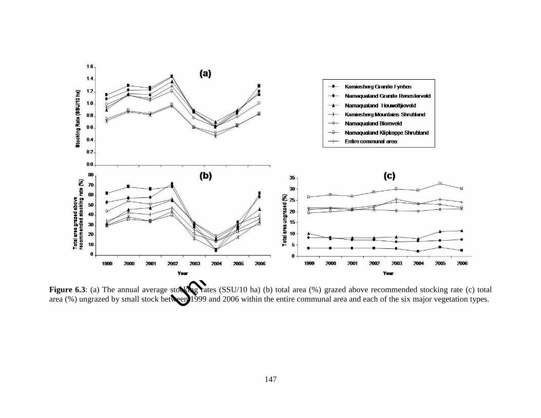
Unive
rsity
of C
ape
Town
147
Figure 6.3: (a) The annual average stocking rates (SSU/10 ha) (b) total area (%) grazed above recommended stocking rate (c) total
area (%) ungrazed by small stock between 1999 and 2006 within the entire communal area and each of the six major vegetation types.

Unive
rsity
of C
ape
Town
148
Figure 6.4: (a) The monthly average stocking rates (SSU/10 ha) (b) total area (%) grazed above recommended stocking rate (c) total
area (%) ungrazed by small stock between 1999 and 2006 within the entire communal area and each of the six major vegetation types.
Unive
rsity
of C
ape
Town
149
Discussion
Pastoralists in Leliefontein divide their grazing area into different landscape features
which include mountainous areas, lowlands, cultivated croplands, fallow croplands,
riverine and wetland areas (Samuels, 2006). Most vegetation types in the study area
contain all these different landscape features and the locations of stockposts are usually
closer to features that pastoralists prefer during a specific time of the year. Preference for
specific landscape features by pastoralists is based mostly on their perceived quality of
forage and abundance of preferred forage species and water (Samuels, 2006; Allsopp et
al., 2007). However, this study could not assess stocking rates within particular landscape
features. This drawback results from the basic pixel size of the analysis and the
assumption of a fixed circular grazing orbit of 2.5 km around a stockpost. The complex
topography in the study area and the close association of vegetation types (Helme and
Desmet, 2006) also made it difficult to separate landscape features in a Geographical
Information System. Therefore, the discussion is only focused on stocking rates within
vegetation types.
6.4.1 What are the impacts of grazing within the different vegetation types in the
study area?
Pastoralists move their herds to lower altitudes in winter due to the cold conditions in the
uplands. As a result, they have to move along an altitudinal gradient from Kamiesberg
Granite Fynbos and Namaqualand Granite Renosterveld vegetation to Succulent Karoo
vegetation types. Although the main reasons for moving are cold temperatures and frost
periods in the uplands during winter (discussed in Chapter Four), pastoralists also regard
the two Fynbos affinities as sourveld and the Succulent Karoo vegetation types as
sweetveld. In winter, vegetation classified as sourveld loses its nutritive value (Meissner,
2000) and pastoralists are aware of this change in forage quality. This change in forage
value is one of the reasons why pastoralists move their animals to sweetveld which has
higher grazing value during winter (Meissner, 2000). However, several pastoralists are
reluctant to move unless their animals would adapt to a new area and are less concerned
as to whether they would obtain good quality forage for their animals. The survival of
animals is the most critical factor in the decision-making of pastoralists but they do
Unive
rsity
of C
ape
Town
150
acknowledge that accessing good quality forage would keep their ewes in good physical
condition for the winter lambing season. As a result of the movements of most
pastoralists to sweetveld, lower grazing pressure was recorded for the two Fynbos
vegetation types in winter.
The specific grazing area to which pastoralists in Leliefontein move in winter might also
depend on whether plants are in flower and if there is a low occurrence of toxic plants
(Chapter Four). Pastoralists prefer grazing in areas where there is an abundance of plants
in flower. Such areas often include fallow croplands where flowering ephemerals
dominate the landscape during late winter and early spring. Pastoralists perceive that the
consumption of flowers stimulates milk production in lactating ewes (Chapter Five). This
is important to ensure that their newborn lambs and kids are in good physical condition.
Areas where there is low occurrence of toxic plants are often preferred by pastoralists as
several plant species in the region, if consumed, are known to be fatal to livestock
(Samuels, 2006). Livestock mortalities as a result of toxic plants are often higher amongst
lambs and kids and, therefore, it is one of the key duties of a herder not to access these
areas and to train animals not to graze toxic plants (Debeaudoin, 2001; Samuels, 2006;
Salomon et al., 2013). In other mobile pastoral systems, the movement of herds to other
grazing areas is also not made unless one or several criteria are fulfilled. Elsewhere in
Africa, for example, Fulani pastoralists first move to an area on a temporary basis and
will only stay if the forage quality is good and there is a presence of key forage species
(Ba, 1982 cited in Niamir, 1991). Similarly, in India, scouts are sent out to evaluate
rangeland condition before a pastoral herd is moved to a particular location (Agrawal,
1993).
In Leliefontein, the diversity of vegetation types within the relatively small area creates a
mosaic landscape and herds only move on average 4.2 km between stockposts within and
8.4 km across village boundaries (Chapter Five) where they could access forage of higher
nutritional value. In other mobile pastoral systems, herds often have to travel up to
hundreds (Behnke et al., 2011) even thousands of kilometers as in the case of the Saharan

Unive
rsity
of C
ape
Town
151
Tuareg (Homewood, 2008) to reach vegetation types that might be of higher grazing
value.
Herds in Leliefontein village are able to graze in several ephemeral wetlands when they
move back to the upland areas in summer. Pastoralists say that wetlands provide good
quality forage for their animals during summer and hold water longer into the dry season
for livestock to drink. Wetlands in the Kamiesberg have been found to contain several
indigenous wetland species that are palatable to livestock (Kotze et al., 2010). In other
mobile pastoral systems, wetlands have been described as key resource areas that are
important for herd survival during the dry season in variable environments (Scoones,
1991). In the Richtersveld National Park, patches of Cynodon dactylon grass on the
Orange riverbanks provide pastoralists with good quality summer forage (Hendricks et
al., 2004). Elsewhere in Africa, Sahelian floodplains provide pastoral livestock with
important forage resources during the dry season (Scholte and Brouwer, 2008).
The four vegetation types with Succulent Karoo affinities are grazed at constant stocking
rates throughout the year. Since stockpost movements do occur where these vegetation
types are distributed, movements are often within the same vegetation type as was found
in other parts of Namaqualand (Mussgnug, 1995). Grazing a single vegetation type
during the same season indicates that pastoralists do not want to or cannot switch the diet
of their animals. Pastoralists say that switching their animals’ diet could result in
livestock mortalities since the animals are not used to eating those specific plants. In
addition, a particular vegetation type might have more grazing areas of nutritional forage
(e.g. riverine areas and wetlands) when compared to other vegetation types during that
specific season. Other reasons for moving within the same vegetation might be the lack
of water, an increase in the abundance of toxic plants in other vegetation types during that
specific season or pastoralists might want to rest other vegetation types.
Unive
rsity
of C
ape
Town
152
6.4.2 If the observed stocking rates are indicative of longer term grazing pressure,
how applicable is the fixed carrying capacity recommendation for Leliefontein?
During this study, grazing pressure varied over space and time. Most vegetation types
were grazed above the stocking rate recommended by Department of Agriculture but
during and the period immediately following the 2002-2003 drought, all vegetation types
were grazed below the recommended stocking rate.
Within variable environments, high livestock mortalities during drought usually keep
animal numbers below the carrying capacity of the veld (Ellis and Swift, 1988; Sullivan
and Rohde, 2002; Vetter, 2005).The effect of high livestock mortalities during drought,
which is a characteristic of non-equilibrial systems (Vetter, 2005), was evident in 2003-
2004 in Leliefontein when no vegetation type was grazed above the recommended
stocking rate. However, the livestock population recovered to pre-drought levels after
two years and large parts of the Leliefontein communal area continued to be grazed at
levels above the recommended stocking rate. This recovery in stock numbers after
drought is faster than the four-year recovery period of the Turkana livestock population
following the 1979-80 drought and which occupy a larger area (Ellis and Swift, 1988). In
Leliefontein, the good rainfall periods following the 2002-2003 drought resulted in the
rapid recovery of the livestock population. This recovery was facilitated by the small size
of the study area as well as by the pastoralists’ long-term strategy of selecting for
livestock that produce multiple offspring.
The greater variability in the total size of the livestock population in the Leliefontein
communal area over time suggests that livestock are vulnerable to climatic perturbations
in variable and spatially constrained areas. Greater vulnerability might also result from
the fact that the vegetation in some parts of Leliefontein has over the years shifted from a
perennial to an annual dominated plant community (Anderson, 2008; Todd and Hoffman,
1999). Thus during periods of low rainfall, forage production would be less than what is
required by the livestock population in Leliefontein and this results in high livestock
mortalities.
Unive
rsity
of C
ape
Town
153
Thus, could a livestock management strategy with a fixed carrying capacity as proposed
by agricultural policies be applicable if forage availability varies in space and time across
the landscape? Campbell et al. (2006) show that the “one size fits all” stocking regime
does not fit all farming systems. Carrying capacities depend on vegetation type, rainfall
and on the specific farming objectives (Fritz and Duncan, 1994). By using flexible and
opportunistic stocking rates in variable environments such as Leliefontein, pastoralists
would be able to take advantage of increased primary production in wetter years, which
they cannot do if they use fixed and conservative stocking rates. Pastoralists do suffer
high livestock mortalities during drought but they might overcome this by reducing their
herd sizes (Sanford, 1983b) which would also reduce grazing pressure (Campbell et al.,
2006). However, the ability to reduce herd sizes depends on whether pastoralists have
access to markets and in Leliefontein pastoralists do not have access to permanent
markets. Pastoralists in Leliefontein sell their animals mostly to speculators during
October and November when the lambs and kids are about six months old. When they
sell their livestock at speculators’ rates, they often get much lower prices for their
animals than the market price. This is the reason why some pastoralists prefer not to sell
their animals during some years.
6.4.3 What may be the conservation implications of different intensities of grazing on
the vegetation of the region?
Within the Leliefontein communal area, Namaqualand Klipkoppe Shrubland had about
30% of its area ungrazed annually whereas Kamiesberg Mountains Shrubland and
Namaqualand Blomveld were about 20% ungrazed annually. Kamiesberg Granite
Fynbos, Namaqualand Granite Renosterveld and Namaqualand Heuweltjieveld had less
than 10% of their areas ungrazed annually. The fact that less than 10% of some
vegetation types are ungrazed, indicates that grazing pressure might be more evenly
distributed than in vegetation types that had 20-30% of their areas ungrazed. If the
absence of grazing in a particular vegetation type is due to insufficient water, then there is
the potential to improve grazing distribution through water point development. If the
absence of grazing in certain parts of the study area is mainly due to inaccessibility, then
roads may need to be built or repaired to access this resource. However, the effect of
Unive
rsity
of C
ape
Town
154
greater access on these ungrazed areas or refugia also needs to be assessed. Refugia could
be considered important for the maintenance of populations of several important plant
species in the area but excluding some vegetation types from grazing may also be
detrimental to the maintenance of diverse communities than allowing disturbance from
grazing.
Overstocking has also been reported to have negative implications for plant diversity in
the Namaqualand region (Todd and Hoffman, 1999; Riginos and Hoffman, 2003). It
could therefore be assumed that overstocking of Kamiesberg Granite Fynbos and
Namaqualand Granite Renosterveld vegetation types during the flowering season of most
plants could have severe negative consequences for the vegetation. Todd and Hoffman
(1999, 2009) suggest that grazing during the flowering season might explain the lower
seed production and recruitment of palatable plants in the communal area. However, it is
argued that vegetation types found in the study area might be resilient to the current
levels of grazing pressure. It was found even though plant cover was significantly lower
in the Leliefontein communal area than in adjacent private farms where conservative
stocking rates are used, plant diversity was similar between the communal area and
private farms (Anderson, 2008). Then again, high plant diversity does not necessarily
indicate a higher conservation value. An area can have higher conservation value if there
are more red data species present even though plant diversity is low.
Grazing could be beneficial to the vegetation of the region since it has been shown that
intermediate levels of disturbance may be good for maintaining species diversity in
Namaqualand (van Rooyen, 2002). The diversity of ephemeral species in these vegetation
types is a product of past heavy grazing by antelope and are probably dependent on heavy
grazing events to survive (van Rooyen, 2002). The presence of grazing as opposed to
cropping may also help conserve an area. Cropping has been shown to remove plant
species from an area when the land is ploughed (Carrick, 2003).
During this study, I observed that there is spatial variability in preferred forage species in
the communal area and this provided pastoralists with various options of grazing sites.
Unive
rsity
of C
ape
Town
155
These options that are available to pastoralists might be due to the resilience of the
vegetation because even at grazing pressure at twice the recommended stocking rates for
several decades, the vegetation types in the Leliefontein communal area have not become
homogenised (Anderson, 2008). Therefore, pastoralists could continue to use shorter
range movements to access different grazing sites.
In this study, it is evident that there is no land set aside as grazing reserves, to provide
livestock with critical forage during drought, such as in mobile pastoral systems in other
parts of the world (McCabe, 1994; Oba, 2001; Fernandez-Gimenez and Swift, 2003).
This could be mainly due to the fact that most of the Leliefontein communal area is
grazed annually to satisfy the nutritional requirements of all of the 256 herds. As
mentioned earlier, the areas that are not used by livestock either do not have water during
summer or are inaccessible via road. Even though mountainous areas provide pastoralists
with critical forage during drought (Samuels et al., 2007), Samuels et al. (2013) outline
other possible scenarios to incorporate formal grazing reserves into the Leliefontein
mobile pastoral system. Areas in the region that could be used as grazing reserves include
the adjacent land reform farms, national parks or land purchased specifically for this
reason. However, to establish formal grazing reserves would require capital to develop
infrastructure and to build robust institutions to manage access to these reserves (Samuels
et al., 2013).
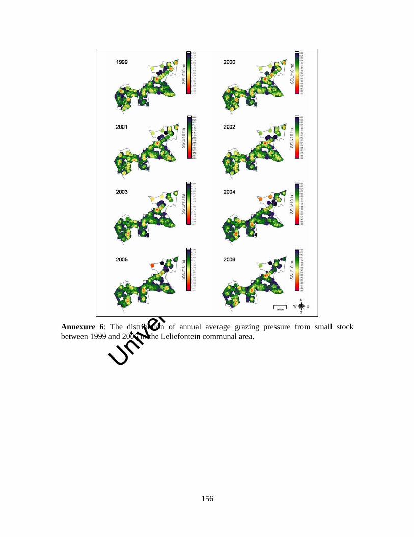
Unive
rsity
of C
ape
Town
156
Annexure 6: The distribution of annual average grazing pressure from small stock
between 1999 and 2006 in the Leliefontein communal area.
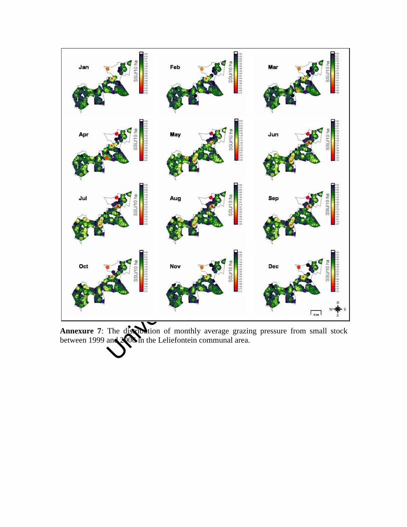
Unive
rsity
of C
ape
Town
Annexure 7: The distribution of monthly average grazing pressure from small stock
between 1999 and 2006 in the Leliefontein communal area.
Unive
rsity
of C
ape
Town
158
Chapter Seven
Synthesis and recommendations
7.1 Introduction
Studies on pastoral mobility have highlighted its importance in adapting to the dynamic
ecological and socio-economic conditions that characterise pastoral systems in variable
environments. Pastoral mobility in variable environments is used for a wide range of
purposes including to access water (Bassett, 1986; Behnke, 1999) and high quality forage
(Illius and O’ Connor, 1999; Behnke et al., 2011), to prevent crop damage (Homewood,
2008), to escape conflict (de Weijer, 2007), to move away from disease stricken areas
(Homewood, 2008; Behnke et al., 2011) as well as to access local and international
markets (Touré, 1990; Adriansen, 2003; 2008).
Most studies on pastoral mobility have described its use in a combination of long and
short-range distances (e.g. Turner, 1999a; de Weijer, 2007; Behnke et al., 2011).
However, mobile pastoral systems around the world are shrinking and long–range
movements are no longer possible to manage livestock. As a result short-range
movements are being more used by pastoralists as a strategy to manage herds. When
mobile pastoral systems in variable climates become smaller and spatially constrained,
we need to determine whether short-range movements will be effective in managing
livestock and rangeland resources. This study assesses whether mobility remains an
important strategy to access resources and to manage livestock when a semi-arid pastoral
system becomes spatially constrained. Specifically, this thesis assesses how a mobile
pastoral system has changed and further examines the current key drivers of mobility and
the spatial extent of herd movements in relation to rangeland resources in the communal
area.
The objective of this chapter is to answer the following questions by using the knowledge
gained through this study and interpret them in the context of existing knowledge on
pastoral mobility.
Unive
rsity
of C
ape
Town
159
1. Is pastoral mobility an important strategy to manage livestock and rangeland
resources when a mobile pastoral system becomes spatially constrained?
2. How would pastoral mobility patterns be affected when extensive pastoral
systems become spatially constrained?
3. How does pastoral mobility compare between the spatially constrained
Leliefontein communal area and other extensive pastoral systems?
7.2 Is pastoral mobility an important strategy to manage livestock and rangeland
resources when a mobile pastoral system becomes spatially constrained?
Pastoral mobility remains an important strategy to raise livestock and manage rangeland
resources in a variable and spatially constrained pastoral system. In Leliefontein, pastoral
mobility is used to achieve ecological and socio-economic objectives. These objectives
are important to pastoralists to ensure that their animals are in good condition and survive
unfavourable environmental conditions and to reduce livestock impacts on the
environment. In the study area, short-range movements allowed pastoralists to continue
to have opportunistic and seasonal movements and migrate out of the commons which
they considered important to manage livestock in variable environments (Chapters Four
and Five).
The high compositional turnover of vegetation and the temporal variability and
patchiness in resources in the study area permitted herds to move over short distances
where they could access different rangeland resources. The movement distances of herds
between grazing areas shortened from more than 100 km historically (Penn, 1986;
Webley, 1986; Rohde and Hoffman, 2008) to distances of 4.2 km (range: 0.7 to 12.1 km)
within and 8.4 km (range: 7.6 km to 9.0 km) between village commons. When
pastoralists moved onto the adjacent land reform farms to access resources outside the
Leliefontein communal area, the average distance a herd moved was 12.1 km (range:1.8
km to 30.9 km).
There appears to be no suitable alternative to pastoral mobility to manage livestock and
rangeland resources in the Leliefontein communal area. During the 1980s, fencing was
Unive
rsity
of C
ape
Town
160
implemented as a tool to manage livestock when the study area was divided into
economic units. Fencing and the subsequent subdivision of land has been shown to be
effective in wetter and less variable climates (Tainton, 1999). However, it has been
argued to be ineffective in variable environments (BurnSilver and Boone, 2003)
including the Leliefontein communal area (Chapter Three). This study showed that the
introduction of fencing, particularly in the 1980s led to inequitable access to resources
and increased stocking rates and conflict in this spatially constrained pastoral system.
Moreover, fencing is too expensive for pastoralists to purchase and maintain on their
own. Pastoral groups are often poor and in Namaqualand, they are largely dependent on
remittances and social grants to supplement their income from livestock (Rohde et al.,
2003).
Another alternative to pastoral mobility would be to buy supplementary feed when there
is insufficient food for the animals in the rangeland. However, pastoralists in Leliefontein
cannot afford to constantly buy feed for their animals. Moving herds to areas where they
could find sufficient food to eat thus appears to be the only affordable and ecologically
rational management option.
7.3 How would pastoral mobility patterns be affected when extensive pastoral
systems become spatially constrained?
When the Namaqualand region became colonised, pastoralists lost their ability to move
over longer distances into other agro-ecological zones and this could be expected when
larger pastoral systems become smaller. In pre-colonial Namaqualand, pastoralists in the
Kamiesberg occasionally moved their livestock over long distances to the Orange or
Olifants Rivers when resource became scarce (Rohde and Hoffman, 2008). They also
moved more regularly over middle distances between summer grazing areas in the
uplands, winter grazing in the lowlands or in Bushmanland in the east when droughts
only affected the Namaqualand region (Webley, 1982; 1986). These mobile patterns
started to break down when Dutch farmers competed for grazing as they moved from the
overcrowding of the Western Cape area into the Namaqualand region. Later colonial
policies formally made provision to take grazing lands away from the Nama and reduced
Unive
rsity
of C
ape
Town
161
their traditional control over the remaining pieces of land that they still occupied. In
1913, legislation promoted segregation and later, in the 1950s, privately owned white
farms became fenced off from the Leliefontein communal area. Fencing took away
pastoralists’ option to move over long and middle distances into other agro-ecological
zones to find good quality forage for their livestock.
Another aspect that was lost when Leliefontein became smaller and spatially constrained
was the role of drought as a driver of pastoral mobility. In many mobile pastoral systems
drought has often lead to a significant increase in the frequency and distance of herd
movements. Under such circumstances pastoralists attempt to evade unfavourable
environmental conditions and access better forage and water (Oba and Lusigi, 1987;
Touré, 1990; Scoones, 1992; McCabe, 1994; Niamir-Fuller, 1999a; Behnke et al., 2011)
which might be located outside their core territory (Scoones, 1999; Solomon et al., 2006).
Drought was not found to be a key driver of pastoral mobility during this study in the
Leliefontein communal area since it did not lead to a significant increase in the frequency
of stockpost movement or to an increase in the distance moved between stockposts. Most
pastoralists in Leliefontein cannot evade drought conditions to search for better forage
and water since the area is small. However, several pastoralists do attempt to access
better forage on their daily grazing routes (Samuels et al., 2007) and also possess a range
of different herding strategies what they use during drought periods (Samuels, 2006).
Some aspects of traditional mobile pastoralism were maintained by pastoralists in
Leliefontein (Fig. 3.11). For example, pastoralists in Leliefontein used seasonal
movements to access different vegetation types during winter and spring. Pastoralists
know the palatability of the vegetation and move their livestock to areas they perceive as
having the highest grazing value at that specific time of the year. Seasonal movements
along an altitudinal gradient were also maintained by herds in Leliefontein village to
evade unfavourable environmental conditions at high altitudes during winter. These
altitudinal movements were also made by Nama pastoralists before the colonists occupied
Namaqualand (Hoffman and Rohde, 2007; Webley, 2007). This study shows that
Unive
rsity
of C
ape
Town
162
pastoralists currently evade median minimum temperature differences between 0.2 and
2.0 0C when they move to lower altitudes in winter.
The tracking of water and forage during unfavourable environmental conditions, which is
a common strategy in larger mobile pastoral systems (Niamir-Fuller and Turner, 1999;
Solomon et al., 2006), is still evident (albeit only occasionally) in Leliefontein.
Pastoralists did not have to travel farther than two kilometres on average to reach water
during the dry summer season. This could mostly be attributed to the high number of
watering points available within the daily grazing routes of most herds. However, the
absence of water in some areas during the dry season has led to some areas not being
grazed during summer. This resulted in undergrazing in areas where watering points are
broken and overgrazing around functional watering points. During winter, the vegetation
almost always has sufficient moisture for the animals to not having to drink water daily,
so pastoralists moved to areas that are not grazed in summer due to water limitations.
During the study, about 27 % of herds did not move at all and it could be expected that
more herds will become sedentary in Leliefontein over time. This could be ascribed to the
dynamic socio-ecological conditions of pastoralists. General Circulation Models project
that Namaqualand will become hotter and drier (MacKellar et al., 2007) and an increase
in 1-2 0C in the uplands might allow pastoralists not to move to lower altitudes to escape
the current cold temperatures during winter. Moreover, a decrease in rainfall or shift in
rainfall patterns in Namaqualand as projected by these models and as experienced by
pastoralists (Samuels, 2006) may result in more agro-pastoralists abandoning cropping as
a component of their livelihood strategy. A decrease in cropping, therefore, might
influence pastoralists to not move away from growing crops since there would be fewer
croplands to protect during winter.
7.4 How does pastoral mobility compare between the spatially constrained
Leliefontein communal area and other extensive pastoral systems?
Pastoralists in Leliefontein used mobility to evade low temperatures and frost periods in
the uplands by moving to lower altitudes during winter. Moving over short distances to
Unive
rsity
of C
ape
Town
163
lower altitudes in winter remains a necessity to ensure livestock survival. This strategy
appears to be common amongst many mobile pastoral groups occupying more extensive
rangelands (Dyson-Hudson and Dyson-Hudson, 1980; Niamir-Fuller, 1999b; de Weijer,
2007).
In Leliefontein pastoralists use mobility to exploit different areas in the rangeland.
Pastoralists established their stockposts in the uplands during summer to access
ephemeral wetlands, which have good quality forage and carry water for livestock long
into the dry season. In other extensive pastoral systems ephemeral wetlands and other
wetter habitats are also preferred by livestock during the dry season and could be
regarded as key resource areas (Scoones, 1991; Hendricks, 2004; Hempson, 2010).
In a spatially constrained area cropping is a key driver of pastoral mobility since
pastoralists move their herds away from croplands to prevent livestock from damaging
growing crops. In some extensive pastoral systems, cropping also increased mobility
(Homewood, 2008) but in other pastoral areas cropping resulted in pastoralists becoming
less mobile since croplands block transhumant routes which deny herds access to water
and forage especially during the dry season (Shazali and Ahmed, 1999; Niamir-Fuller,
2000; Solomon et al., 2006). However, cropping in the Leliefontein communal area is
declining and some croppers have fenced off their arable lands. As a result some
pastoralists have decided not to move their stockposts in winter as there was no danger of
livestock damaging crops in the area during the growing season.
In this study, croplands were accessed mostly after harvesting during November and
December when herds moved closer to the arable lands to graze on crop residues. Arable
lands have been identified as key resource areas in other pastoral systems (Scoones,
1995a; Ramisch, 1999; Shazali and Ahmed, 1999; Bennett et al., 2007) since they may
offer more nutritious forage than natural veld during a particular time of the year (Bayer
and Waters-Bayer, 1989). Fallow croplands are also preferred by pastoralists in
Leliefontein in winter due to the abundance of ephemerals which they consider good
quality forage (Samuels, 2006).
Unive
rsity
of C
ape
Town
164
Pastoralists in Leliefontein considered their environment when making herd management
decisions. More than 12% of the movements between 1997 and 2006 were to prevent
trampling around stockposts. Conservation farming methods are also evident in other
pastoral system such as in Namibia, where Himba pastoralists prefer grazing further from
water during rainy season to rest pastures and make use of underutilised areas (Behnke,
1999). Thus, even though resources are limited in the small and spatially constrained
areas, pastoralists in Leliefontein conserve resources for future use. Preventing the
overuse of resources through pastoral mobility is a strategy contrary to that recommended
by agricultural officials who emphasise that pastoralists should destock to reduce their
impact on the environment. Destocking could result in an increase in the levels of poverty
in the area since there would be fewer animals to sell or to trade for other essential
products. There would be fewer livestock products to share amongst the community
which is important in maintaining social capital in the study area. Culturally it would
erode their status in the community as livestock are seen as a symbol of wealth.
In extensive mobile pastoral systems that are not spatially constrained, migrating to other
areas where better forage and reliable water could be accessed is important so that
livestock could survive unfavourable environmental conditions (Oba and Lusigi, 1987;
Behnke, 1999; Ramisch, 1999; Behnke et al., 2011). In the spatially constrained
Leliefontein communal area, these opportunities are limited and strong social cohesion is
important so that pastoralists could benefit from shared resources in times of need.
During this study, some pastoralists were provided the opportunity by the municipality to
move onto the adjacent land reform farms to ensure better survival of livestock when
forage was scarce during the 2002-2003 drought. However, the lack of water and
infrastructure on the farms forced them to return to the Leliefontein communal area.
Seven pastoralists also reached agreements with private farmers to use their grazing lands
when the rangeland condition was poor. However, in Leliefontein moving beyond
communal land onto private land comes at a cost since pastoralists have to give the
farmer 50% of new born lambs while the herd is on the private farm.
Unive
rsity
of C
ape
Town
165
Pastoralists move from overcrowded areas since they did not want their and their
neighbours’ rams from mixing with the ewes. Since not all the rams are camped during
the non-breeding season in Leliefontein, it could result in lambs being born during the
dry season when forage is scarce. Moreover, a pastoralist wants his own ram to
impregnate his livestock to improve the overall quality and hardiness of his breeding
stock. The strategy of a ‘safe’ distance is also used in other African pastoral systems but
over larger spatial scales to prevent the spread of diseases and pests (Niamir-Fuller,
2000).
7.5 Future research directions
While this study has shown that pastoralists move their herds between grazing sites, it did
not determine how efficient, in terms of quality of diet, it is to move between the grazing
sites at different times of the year. A future study on diet selection amongst livestock
species during different times of the year could answer this question. We could then
determine how the use of mobility translates into livestock production indicators such as
lambing percentages and mortality rates.
A possibility also exists for combining smaller herds into larger management units which
rotate between different village commons taking advantage of variability at a larger
spatial scale and leaving a larger area to rest in-between grazing events. We could
determine whether this is a potential strategy to use mobility at a different scale to foster
vegetation recovery and forage availability within low-lying areas and the rocky uplands
and between different vegetation types.
This study provided detailed information about mobile practices of pastoralists in the
Leliefontein communal area. These movements could also be modelled to assess how
herds would adapt to the projected climatic changes described by MacKellar et al. (2007).
Moritz et al. (2010) modelled grazing pressure in Cameroon and Macopiyo (2005) used a
spatially explicit, herd foraging and movement model to simulate pastoral mobility in
East Africa to assess how future changes in climate might affect rangeland use.
Simulation models could be used to predict grazing distribution in the Leliefontein
Unive
rsity
of C
ape
Town
166
communal area in relation to the future options for livestock management in
Namaqualand as described in Samuels et al. (2013).
This is particularly of interest since pastoralists in Leliefontein village will not have to
move to evade cold conditions in the uplands when the temperatures increase by 1-2 0C.
If pastoralists in the uplands do not move to lower altitudes in winter, we also need to
determine the impacts of increased sedentarisation on the environment. Since rainfall
patterns are projected to be more variable in Namaqualand (MacKellar et al., 2007), it
would also be important to assess the impacts of these changes on cropping and pastoral
mobility.
Pastoralists in Leliefontein often referred to the feral donkeys that they say compete with
their livestock for the limited resources. We could investigate whether donkeys compete
directly with livestock for forage or whether they occupy a niche outside of the traditional
grazing routes used by mobile herders. If they occupy the same niche, would solving the
‘donkey problem’, exert less pressure on rangeland resources and would herd mobility
patterns change in response to this?
Unive
rsity
of C
ape
Town
167
References
Abel, N.O.J., Blaikie, P.M., 1989. Land degradation, stocking rates and conservation
policies in the communal rangelands of Botswana and Zimbabwe. Land Degradation
and Rehabilitation 1, 101-123.
Abrahams, Y., 1994. Resistance, pacification and consciousness: A discussion of the
historiography of the Khoisan resistance from 1972 to 1993 and Khoisan resistance
from 1652 and 1853. MA. Queen’s University, Canada.
Adler, P.B., Raff, D.A., Lauenroth, W.K., 2001. The effect of grazing on the spatial
heterogeneity of vegetation. Oecologia 128, 465–479.
Adriansen, H.K., 2003. The use and perception of mobility among Senegalese Fulani:
New approaches to pastoral mobility. ISS/Gl. Kongevej Working Paper.
Adriansen, H.K., 2008. Understanding pastoral mobility: the case of Senegalese Fulani.
The Geographical Journal 174, 207-222.
Agrawal, A., 1993. Mobility and cooperation among nomadic shepherds: the case of the
Raikas, Human Ecology 21, 261-279.
Ainslie, A., 2005. Farming Cattle, Cultivating Relationships: Cattle Ownership and
Cultural Politics in Peddie District, Eastern Cape. Social Dynamics 31, 129-156.
Ainslie, A. 2013. The sociocultural contexts and meanings associated with livestock
keeping in rural South Africa. African Journal of Range and Forage Science 30.
DOI:10.2989/10220119.2013.770066
Akasbi, Z., Oldeland, J., Dengler, J., Finckh, M., 2012. Social and ecological constraints
on decision making by transhumant pastoralists: A case study from the Moroccan
Atlas Mountains, Journal of Mountain Science 9, 307-321.
Allsopp, N., 1999. Effects of grazing and cultivation on soil patterns and processes in the
Paulshoek area of Namaqualand. Plant Ecology 142,179-187.
Allsopp, N., Laurent, C., Debeaudoin, L.M.C., Samuels, M.I., 2007. Environmental
perceptions and practices of livestock keepers on the Namaqualand Commons
challenge conventional rangeland management. Journal of Arid Environments 70,
740-754.
Anderson, G.D., Talbot, L.M., 1965. Soil factors affecting the distribution of the
grassland types and their utilisation by wild animals on the Serengeti Plains,
Tanganyika. Journal of Ecology 53, 33-56.
Anderson, P. M. L., 2008. The impact of grazing along an environmental gradient in the
Kamiesberg, South Africa. PhD. University of Cape Town, Cape Town.
Anderson, P. M. L., Hoffman, M. T., 2007. The impacts of sustained heavy grazing on
plant diversity and composition in lowland and upland habitats across the Kamiesberg
mountain range in the Succulent Karoo. Journal of Arid Environments 70, 686–700.
Unive
rsity
of C
ape
Town
168
Anseeuw, W., Laurent, C., Modiselle, S., Carstens, J., van der Poll, S. 2001. Diversity of
the rural farming households and policy issues: An analysis based on a case study in
the Northern Cape Province, South Africa. Communication to the conference ʺSouth
Africa since 1994ʺ, 17 pp.
Anseeuw, W., Laurent, C., 2007. Occupational paths towards commercial agriculture:
The key roles of farm pluriactivity and the commons. Journal of Arid Environments
70, 659–671.
Archer, F., Danckwerts, J.E., Hoffman, M.T., 1989. How economic are the farming units
in Leliefontein, Namaqualand? Journal of the Grassland Society of South Africa 6,
211-215.
Archer, F., Meer, S., 1995. A woman’s work is only recognised when it is not done—
Women, land tenure and land reform in Namaqualand’s Coloured Rural Areas. Future
of Namaqualand Research Project report. Surplus People Project, Athlone.
Archer, S., 2000. Technology and ecology in the Karoo: a century of windmills, wire and
changing farming practice. Journal of Southern African Studies 26, 675-696.
Atkinson, D., Ravenscroft, P., 2002. Alternative service delivery options for
municipalities in the rural areas: Kamiesberg Local Municipality case study. Water
Research Commissions Report No. 137/02, Pretoria.
Baba, K.M., Magadi, M.D., 1998. Fadama crop residue production and utilisation in
north-western Nigeria. In: Hoffmann, I., (Ed.), Prospects of Pastoralism in West
Africa. Tropeninstitut Giessen, 247-261.
Babiker, M. 2012. Mobile pastoralism and land grabbing in Sudan. In: Catley, A., Lind,
J., Scoones, I. (Eds.), Pastoralism and Development in Africa. Dynamic change at the
margins. Routledge, Abington, Oxon, UK, 177-185.
Baena, P.M., Casas, R., 2010. Past, present and future ofTrashumancia in Spain:
nomadism ina developed country. Pastoralism: Research, Policy and Practice 1, 72-90.
Bailey, D.W., Keil, M.R., Rittenhouse, L.R., 2004. Research observation: Daily
movement patterns of hill climbing and bottom dwelling cows. Journal of Range
Management 57, 20-28.
Baker, L.E., Hoffman, M.T., 2006. Managing variability: herding strategies in communal
rangelands of semi-arid Namaqualand, South Africa, Human Ecology 34, 765–784.
Bassett, T.J., 1986. Fulani herd movements. Geographical Review 76, 233-248.
Bassett, T.J., Turner, M.D. 2007. Sudden Shift or Migratory Drift? FulBe Herd
Movements to the Sudano-Guinean Region of West Africa. Human Ecology 35, 33-
49.
Unive
rsity
of C
ape
Town
169
Bayer, W., Walters-Bayer, A., 1989. Crop-livestock interactions for sustainable
agriculture. Gatekeeper Series No. 13. International Institute for Environment and
Development.
Behnke, R.H., 1999. Stock-movement and range management in a Himba community in
north-western Namibia. In: Niamir-Fuller, M., (Ed.), Managing Mobility in African
Rangelands: The Legitimization of Transhumance. Intermediate Technology
Publications, London, 184-216.
Behnke, R.H. 2008. The drivers of fragmentation in arid and semi-arid landscapes. In:
Galvin, K.A., Reid, R.S., Behnke, R.H., Hobbs, N.T. (Eds.), Fragmentation in semi-
arid and arid landscapes: Consequences for Human and Natural Systems. Springer,
Dordrecht, 305-340.
Behnke, R.H., Fernandez-Gimenez, M., Turner, M., Stammler, F., 2011. Pastoral
migration: Mobile systems of animal husbandry. In: Milner-Gulland, E.J., Fryxell,
J.M., Sinclair, A.R.E., (Eds.), Animal Migration: A synthesis. Oxford University
Press, USA, 145-160.
Behnke, R.H., Scoones, I., 1993. Rethinking range ecology: implications for rangeland
management in Africa. In: Behnke, R.H., Scoones, I., Kerven, C., (Eds.), Range
ecology at disequilibrium: new models of natural variability and pastoral adaptation in
African savannas. Overseas Development Institute, London, 1-30.
Behnke, R.H., Scoones, I., Kerven, C., 1993. Range ecology at disequilibrium: new
models of natural variability and pastoral adaptation in African savannas. Overseas
Development Institute, London.
Beinart, W., 2007. Transhumance, animal diseases and environment in the
Cape, South Africa. South African Historical Journal 58, 17–41.
Benjaminsen T.A., Rohde, R., Sjaastad, E., Wisborg, P., and Lebert, T., 2006. Land
reform, range ecology, and carrying capacities in Namaqualand, South Africa. Annals
of the Association of American Geographers 96, 524–540.
Bennett, J., Lent, P.C., Harris, P.J.C., 2007. Dry season forage preferences of cattle and
sheep in a communal area of South Africa. African Journal of Range and Forage
Science 24, 109-121.
Benseler, A. 2003. Municipal commonage administration in the Northern Cape: Can
municipalities promote emergent farming? Human Sciences Research Council Report.
Berzborn, S. 2007. The household economy of pastoralists and wage-labourers in the
Richtersveld, South Africa. Journal of Arid Environments 70, 672–685.
Beukes, P.C., Cowling, R.M., 2000. Impacts of non-selective grazing on cover,
composition and productivity of Nama-karoo grassy shrubland. African Journal of
Range and Forage Science 17, 27-35.
Unive
rsity
of C
ape
Town
170
Blench, R., 2001. 'You can't go home again': Pastoralism in the New Millennium.
Overseas Development Institute, London, 106 pp.
Bogale, A., Korf, B. 2009. Resource Entitlement and Mobility of Pastoralists in the Yerer
and Daketa Valleys, Eastern Ethiopia. Human Ecology 37, 453–462.
Boone, R.B. 2007. Effects of fragmentation on cattle in African savannas under variable
precipitation. Landscape Ecology 22, 1355–1369.
Boone, R.B., Hobbs, N.T. 2004. Lines around fragments: effects of fencing on large
herbivores. African Journal of Range and Forage Science 21, 147-158.
Boonzaier, E., 1984. Economic differentiation and racism in Namaqualand: A case study.
Carnegie Conference Paper No 68, 13-19 April 1984, Cape Town.
Boonzaier, E.A., 1987. From communal grazing to 'economic' units: changing access to
land in the Namaqualand reserve. Development Southern Africa 4, 419-426.
Boonzaier, E.A., Malherbe, C., Berens, P., Smith, A.B., 1996. The Cape herders: A
history of the Khoikhoi of southern Africa. David Phillip, Cape Town.
Bovin, M., 1990. Nomads of the drought: FulBe and WoDaaBe nomads between power
and marginalization in the Sahel of Burkina Faso and Niger Republic. In: Bovin, M.,
Manger, L., (Eds.), Adaptive strategies in African arid lands, Nordiska
Afrikainstitutet, Uppsala, 29-58.
Bundy, D., 1988. The Rise and Fall of South African Peasantry. 2nd
Edition, David Philip
and James Currey, Cape Town.
BurnSilver, S.B., Boone, R.B., 2003. Current land use and potential impacts of ongoing
fragmentation of a pastoral landscape: An example from four Maasai group ranches,
Kajiado District, Kenya. In: Allsopp, N., Palmer, A.R., Milton, S.J., Kirkman, K.P.,
Kerley, G.I.H., Hurt, C.R., Brown, C.J. (Eds.), VIIth International Rangelands
Congress. Durban, South Africa, 604-606.
Butt, B. 2010. Seasonal space-time dynamics of cattle behavior and mobility among
Maasai pastoralists in semi-arid Kenya. Journal of Arid Environments 74, 403–413.
Byrnes, R.M., (ed.), 1996. South Africa: A Country Study. The Division, 532 pp.
Campbell, B.M., Gordon, I.J., Luckert, M.K., Petheram, L., Vetter, S., 2006. In search of
optimal stocking regimes in semi-arid grazing lands: One size does not fit all.
Ecological Economics 60, 75-85.
Carrick, P.J., 2003. Different land use options produce a gradient of plant richness at a
single location in Namaqualand: the pattern and the processes. In: Allsopp, N., Palmer,
A.R., Milton, S.J., Kirkman, K.P., Kerley, G.I.H., Hurt, C.R., Brown, C.J. (Eds.),
VIIth International Rangelands Congress. Durban, South Africa, 177-186.
Carstens, P., 1966. The Social Structure of a Cape Coloured Reserve: a study of racial
integration and segregation in South Africa, Oxford University Press, Cape Town.
Unive
rsity
of C
ape
Town
171
Catling D., 2008. An Elusive Harvest. Working with Smallholder Farmers in South
Africa. Fanele, Auckland Park.
Chonco, J.M., 2009. Factors influencing choices of grazing lands made by livestock
keepers in Enhlannokhombe in Ukhahlamba (Drakensberg), KwaZulu-Natal. MSc.
University of KwaZulu-Natal, Pietermaritzburg.
Colville, J.F., 2006. A profile of the insects of the Kamiesberg uplands, Namaqualand,
South Africa. Conservation South Africa, Cape Town.
Coppock, D.L. 1993. Vegetation and pastoral dynamics in the southern Ethiopian
rangelands: implications for theory and management In: Behnke, R.H., Scoones, I.,
Kerven, C., (Eds.), Range ecology at disequilibrium: new models of natural variability
and pastoral adaptation in African savannas. Overseas Development Institute, London,
42-61.
Coppock, D.L., Ellis, J.E., Swift, D.M., 1986. Livestock feeding ecology and resource
utilization in a nomadic pastoral ecosystem. Journal of Applied Ecology 23, 573-583.
Coppolillo, P.B., 2000. The landscape ecology of pastoral herding: Spatial analysis of
land use and livestock production in East Africa. Human Ecology 28, 527-560.
Coughenour, M.B., 1991. Spatial components of plant-herbivore interactions in pastoral,
ranching, and native ungulate ecosystems. Journal of Range Management 44, 530-542.
Cousins, B., 2007. Agrarian reform and the two economies: transforming
South Africa’s countryside. In: Ntsebeza, L., Hall, R. (Eds.), The Land Question in
South Africa: the Challenge of Transformation and Redistribution. Human Sciences
Research Council Press, Pretoria, 220-245.
Cowling, R. M., Esler, K. J., Rundel, P.W., 1999. Namaqualand, South Africa – an
overview of a unique winter-rainfall desert ecosystem. Plant Ecology 142, 3–21.
Cowling, R.M., Hilton-Taylor,C., 1994. Patterns of plant diversity and endemism in
southern Africa: An overview, Strelitzia 1, 31-54.
Cowling, R.M., Pierce, S.M., 1999. Namaqualand: A Succulent Desert. Fernwood Press,
Cape Town.
Davies, J., Hatfield, R., 2007. The economics of mobile pastoralism: A global
perspective. Nomadic Peoples 11, 91-116.
Dean, W.R.J., Hoffman, M.T., Meadows, M.E., Milton, S.J., 1995. Desertification in the
semi-arid Karoo, South Africa: review and reassessment. Journal of Arid
Environments 30, 247-264.
Debeaudoin, L.M.C., 2001. Livestock farming practices in a communal rangeland,
Leliefontein, Namaqualand. MSc. University of the Western Cape, Cape Town.

Unive
rsity
of C
ape
Town
172
de Jode, H., (Ed.). 2010. Modern and mobile. The future of livestock production in
Africa’s drylands. International Institute for Environment & Development and SOS
Sahel International, UK.
de Weijer, F., 2007. Afghanistan’s Kuchi pastoralists: Change and adaptation. Nomadic
Peoples 11, 9-37.
DLA., 1997. Municipal Commonage: Policy and Procedures. Department of Land
Affairs, Pretoria, South Africa.
DLA., 2002. The Commonage Programme: Policy, Legislative Framework and Delivery
Mechanism. Department of Land Affairs, Pretoria, South Africa.
Dong, S., Wen, L., Liu, S., Zhang, X., Lassoie, J.P., Yi, S., Li, X., Li, J., Li, Y., 2011.
Vulnerability of worldwide pastoralism to global changes and interdisciplinary
strategies for sustainable pastoralism. Ecology and Society 16, 10 [online].
Dongmo, A., Vall, E., Diallo, M.A., Dugue, P., Njoya, A., Lossouarn, J. 2012. Herding
territories in Northern Cameroon and Western Burkina Faso: spatial arrangements and
herd management. Pastoralism: Research, Policy and Practice 2, 26 pp.
Dunn, O.J., 1961. Multiple comparisons among means. Journal of the American
Statistical Association 56, 54-65.
Dwyer, M.J., Istomin, K.V., 2006. Mobility and technology: understanding the
vulnerability of two groups of nomadic pastoralists to reindeer losses. Nomadic
Peoples 10, 142-164.
Dyson-Hudson, R. Dyson-Hudson, N., 1980. Nomadic pastoralism. Annual Review of
Anthropology 9, 15-61.
Ellis, J.E., Coughenour, M.B., Swift, D.M., 1993. Climate variability, ecosystem stability
and the implications for range and livestock development. In: Behnke, R.H., Scoones,
I., Kerven, C., (Eds.), Range ecology at disequilibrium: new models of natural
variability and pastoral adaptation in African savannas. Overseas Development
Institute, London, 31-41.
Ellis, J.E., Swift, D.M., 1988. Stability of African pastoral ecosystems: Alternate
paradigms and implications for development. Journal of Range Management 41, 450-
459.
Environmental Systems Research Institute, 1996. ArcView 3.2, Redlands, California.
Esler, K.J.E., Milton, S.J., Dean, W.R.J., (Eds.). 2006. Karoo veld: Ecology and
management. Briza Press, Pretoria.
Fernandez-Gimenez, M.E., 1999. Sustaining the Steppes: A geographical history of
pastoral land use in Mongolia. The Geographical Review 89, 315-342.
Fernandez-Gimenez, M.E., 2000. The role of nomadic Mongolian pastoralists’ ecological
knowledge in rangeland management. Ecological Applications 10, 1318-1326.
Unive
rsity
of C
ape
Town
173
Fernandez-Gimenez, M.E., 2002. Spatial and social boundaries and the paradox of
pastoral land tenure: a case study from postsocialist Mongolia. Human Ecology 30,
49-78.
Fernandez-Gimenez, M.E., Allen-Diaz, B., 1999. Testing a non-equilibrium model of
rangeland vegetation dynamics in Mongolia. Journal of Applied Ecology 36, 871-885.
Fernandez-Gimenez, M.E., Swift, D.M., 2003. Strategies for sustainable grazing
management in the developing world. In: Allsopp, N., Palmer, A.R., Milton, S.J.,
Kirkman, K.P., Kerley, G.I.H., Hurt, C.R., Brown, C.J. (Eds.), VIIth International
Rangelands Congress. Durban, South Africa, 821-831.
Flintan, F., 2011. Broken lands: Broken lives? Causes, processes and impacts of land
fragmentation in the rangelands of Ethiopia, Kenya and Uganda. A Report to Regional
Learning and Advocacy Programme, Nairobi, Kenya.
Francis, M.L., Fey, M.V., Prinsloo, H.P., Ellis, F., Mills, A.J., Medinski, T.V., 2007.
Soils of Namaqualand: compensations for aridity. Journal of Arid Environments 70,
588-603.
Fratkin, E., 1986. Stability and resilience of East African pastoralism: The Rendille and
the Ariaal of Northern Keya. Human Ecology 14, 269-286.
Fratkin, E., 1997. Pastoralism: governance and development issues. Annual Review
Anthropology 26, 235-261.
Fratkin, E., Roth, E., Nathan, M., 1999. When nomads settle: the effects of
commoditization, nutritional change and formal education on Ariaal and Rendile
pastoralists. Current Anthropology 40, 729-735.
Frere, B., 2010. Historical Sketch of South Africa. Transactions of the Royal Historical
Society 4, 221-284.
Fritz, H., Duncan, P., (1994) On the Carrying Capacity for Large Ungulates of African
Savanna Ecosystems. Biological Sciences, 256, 77-82.
Galaty, J.G., 2011. The modern motility of pastoral land rights: Tenure transitions and
land-grabbing in East Africa. International Conference on the Future of Pastoralism in
Africa. 21-23 March 2011, Addis Ababa.
Galaty, J.G. 2012. Land grabbing in the Eastern African rangelands. In: Catley, A., Lind,
J., Scoones, I. (Eds.), Pastoralism and Development in Africa. Dynamic change at the
margins. Routledge, Abington, Oxon, UK, 143-153.
Galvin, K.A. 2008. Responses of pastoralists to land fragmentation: social capital,
connectivity, and resilience. In: Galvin, K.A., Reid, R.S., Behnke, R.H., Hobbs, N.T.
(Eds.), Fragmentation in semi-arid and arid landscapes: Consequences for Human and
Natural Systems. Springer, Dordrecht, 369-389.
Unive
rsity
of C
ape
Town
174
Galvin, K.A., 2009. Transitions: pastoralists living with change. Annual review of
Anthropology 38, 185-198.
Galvin, K.A., Thornton, P.A., Boone, R.B., Knapp, L.M. 2008. Ngorongoro conservation
area, Tanzania: fragmentation of a unique region of the greater Serengeti ecosystem.
In: Galvin, K.A., Reid, R.S., Behnke, R.H., Hobbs, N.T. (Eds.), Fragmentation in
semi-arid and arid landscapes: Consequences for Human and Natural Systems.
Springer, Dordrecht, 255-279.
Gammon, D.M., Twiddy, D.R., 1990. Patterns of defoliation in four- and eight-paddock
grazing systems. Journal of the Grassland Society of Southern Africa 7, 2935.
Grandin, B.E., De Leeuw, P.N., Lembuya, P., 1989. Drought, resource distribution and
mobility in two Maasai group ranches, South-Eastern Kajiado District. In: Downing,
T.E., Gitu, K.W., Kamau, C.M., (Eds.), Coping with Drought in Kenya: National and
local strategies. Boulder, Colorado.
Grossman, D., Holden, P., undated. Contract Parks in South Africa. IUCN Commission
on Environmental, Economic and Social Policy Publications. Date accessed: 6 Aug
2012. http://www.conservation-
development.net/Projekte/Nachhaltigkeit/CD1/Suedafrika/Literatur/PDF/Grossmann
Guelke, L., 1979. The white settlers, 1652 - 1780. In: Elphick, R., Giliomee, H., (Eds),
The shaping of South African Society, 1652-1820. Maskew Miller Longman, Cape
Town.
Guelke, L., Shell, R., 1992. Landscape of Conquest: Frontier Water Alienation and
Khoikhoi Strategies of Survival, 652 -1 780. Journal of Southern African Studies18,
803-824.
Hardin, G., 1968. The tragedy of the commons. Science 162, 1243-1248.
Hassan, W.A., Hoffmann, I., Steinbach, J., 1998. Sheep and goat keeping under arable
farming in the Zamfara Reserve. In: Hoffmann, I., (Ed.), Prospects of Pastoralism in
West Africa. Tropeninstitut Giessen, 196-202.
Helme, N., Desmet, P., 2006. A description of the endemic flora and vegetation of the
Kamiesberg uplands, Namaqualand, South Africa. CEPF/SKEP, Cape Town.
Hempson, G., 2010. Herbivore dynamics in an arid environment. PhD. University of
Edinburgh, Edinburgh.
Hendricks, H.H., 2004. Semi-nomadic pastoralism and the conservation of biodiversity in
the Richtersveld National Park, South Africa. PhD. University of Cape Town, Cape
Town.
Hendricks, H.H., Clark, B., Bond, W.J., Midgley, J.J., Novellie, P.A., 2005. Movement
response patterns of livestock to rainfall variability in the Richtersveld National Park.
African Journal of Range and Forage Science 22, 117-125.
Unive
rsity
of C
ape
Town
175
Hendricks, H.H., Midgley, J.J., Bond, W.J., Novellie, P.A., 2004.Why communal
pastoralists do what they do in the Richtersveld National Park. African Journal of
Range and Forage Science 21, 29-36.
Hesse, C., Thébaud, B., 2006. Will pastoral legislation disempower pastoralists in the
Sahel? Indigenous Affairs 1/06, IWGIA.
Hobbs, N.T., Galvin, K.A., Stokes, C.J., Lackett, J.M., Ash, A.J., Boone, R.B., Reid,
R.S., Thornton, P.K. 2008. Fragmentation of rangelands: Implications for humans,
animals, and landscapes. Global Environmental Change 18, 776–785.
Hoffman, M.T., 2003. Poverty as a cause of land degradation in South Africa. In:
Allsopp, N., Palmer, A.R., Milton, S.J., Kirkman, K.P., Kerley, G.I.H., Hurt, C.R.,
Brown, C.J. (Eds.), VIIth International Rangelands Congress. Durban, South Africa,
445-451.
Hoffman, M.T., Ashwell, A., 2001. Nature divided: Land degradation in South Africa.
UCT Press, Cape Town.
Hoffman, M.T., Rohde, R.F., 2007. The historical impact of changing land use practices
in Namaqualand. Journal of Arid Environments 70, 641-658.
Hoffman, M.T., Vogel, C., 2008. Climate change impacts on African rangelands.
Rangelands 30, 12-17.
Homewood, K., 2008. Ecology of African Pastoralists. James Currey, Ohio University Press
& Unisa Press.
Illius, A.W., O'Connor, T.G., 1999. On the relevance of nonequilibrium concepts to arid
and semiarid grazing systems. Ecological Applications 9, 798-813.
Jones, P.G., Thornton, P.K. 2003. The potential impacts of climate change on maize
production in Africa and Latin America in 2055. Global Environmental Change 13,
51–59.
Kelso, C.J., 2010. On the edge of the desert – A Namaqualand story: 1800-1909:
Climatic and socio-economic drivers of decline, PhD. University of the
Witwatersrand, Johannesburg.
Kerven, C., Alimaev, I., Behnke, R., Davidson, D., Franchois, L., Malmakov, N.,
Mathihs, E., Smailov, A., Temirbekov, S., Wright, I. 2004. Retraction and expansion
of flock mobility in Central Asia: costs and consequences. African Journal of Range
and Forage Science 21, 149-170.
Kimani, K., Pickard, J., 1998. Recent trends and implications of group ranch sub-division
and fragmentation in Kajiado District, Kenya. The Geographical Journal 184, 202-
213.
Kingston, E., 2001. A study of Communal Land Management: Steinkopf Communal area,
Namaqualand, South Africa. MSc. University College Cork, Ireland.
Unive
rsity
of C
ape
Town
176
Kipuri, N., Naikuni L.O., 2008. Indigenous people’s rights to lands, territories and
resources related to discrimination in employment and occupation: Case study on
practices of pastoralism and hunting-gathering in Kenya. International Labour
Organization.
Kirkbride, M., Grahn, R., 2008. Survival of the fittest: Pastoralism and climate change in
East Africa. Oxfam Briefing Paper No. 116. Oxfam International.
Kotze, D., Malan, H., Ellery, W., Samuels, I., Saul, L., 2010. Assessment of the
Environmental Condition, Ecosystem Service Provision and Sustainability of Use of
Two Wetlands in the Kamiesberg Uplands. Report No. TT439-09 Water Research
Commission, Pretoria, 189 pp.
Kotze, D.A., La Grange, L.F., Pienaar, B.J., Carstens, E.H.W., 1987. Verslag van die
komittee van ondersoek rakende die Leliefontein landelike gebied. House of
Representatives, Cape Town.
Kreis, S., 2001. Lectures on Modern European Intellectual History. The origins of the
Industrial Revolution in England, Lecture 17. Date accessed: 08 September 2011.
http://www.historyguide.org/intellect/lecture17a.html
Kreuter, U. P., Tainton, N.M., 1988. The effects of continuous and rotational grazing of
sourveld on the selection of plant fractions by simmentaler heifers. Journal of the
Grassland Society of Southern Africa 5, 68- 71.
Kröhne, H., Steyn, L., 1991. Land use in Namaqualand—towards a community-based
management strategy for agricultural land use in the Namaqualand reserves;
Leliefontein, Steinkopf and the Richtersveld. Surplus People Project, Cape Town.
Lahiff, E., 2007. State, Market or the Worst of Both? Experimenting with Market-Based
Land Reform in South Africa. Programme for Land and Agrarian Studies, University
of the Western Cape, Cape Town.
Lamprey, H.F., 1983. Pastoralism yesterday and today: the overgrazing controversy. In:
Bourlie` re, F. (Ed.), Tropical Savannas. Ecosystems of the World, vol. 13. Elsevier,
Amsterdam, 730pp.
Landman, M., Shrader, A.M., Kerley, G.I.H., 2006. A habitat suitability assessment for
the introduction of black rhinoceros and mountain zebra to the Namaqua National
Park and upland priority region in the Succulent Karoo Biome. Conservation
International Foundation - South Africa, Cape Town.
Lebert, T., 2004. Municipal commonage as a form of land redistribution: A case study of
the new farms of Leliefontein, a communal reserve in Namaqualand, South Africa.
PLAAS Research Report No.18. PLAAS, University of the Western Cape, Bellville.
Unive
rsity
of C
ape
Town
177
Lebert, T., Rohde, R., 2007. Land reform and the new elite: Exclusion of the poor from
communal land in Namaqualand, South Africa. Journal of Arid Environments 70, 818-
833.
Lengoiboni, M. 2011. Pastoralists seasonal land rights in land administration: a case
study of northern Kenya. PhD Thesis, Wageningen University, Netherlands, 170 pp.
Lengoiboni, M., van der Molen, P., Bregt, A.K. 2011. Pastoralism within the cadastral
system: Seasonal interactions and access agreements between pastoralists and non-
pastoralists in Northern Kenya. Journal of Arid Environments 75, 477-486.
Lesorogol, C.K. 2005. Privatizing Pastoral Lands: Economic and Normative Outcomes in
Kenya. World Development 33, 1959–1978. Letai, J., Lind, J. 2012. Squeezed from all sides. In: Catley, A., Lind, J., Scoones, I.
(Eds.), Pastoralism and Development in Africa. Dynamic change at the margins.
Routledge, Abington, Oxon, UK, 164-176.
Levy, M., Ndlakuhlolo, M., 1985. The land must be for everyone. South Newspaper. 18-
23 June 1985.
Little, P. D, Teka, T., Azeze, A., 2001. Cross-border livestock trade and food security in
the Horn of Africa. BASIS-CRSP and OSSREA, 29 pp.
Lkhagvadorj, D., Hauck, M., Dulamsuren, C., Tsogtbaatar, J. 2013. Pastoral nomadism in
the forest-steppe of the Mongolian Altai under a changing economy and a warming
climate. Journal of Arid Environments 88, 82-89.
Low, W.M., Dudzinski, M.L., Muller, W.J., 1981. The influence of forage and climatic
conditions on range community preference of shorthorn cattle in central Australia.
Journal of Applied Ecology 18, 11-26.
MacKellar, N.C., Hewitson, B.C., Tandross, M.A., 2007. Namaqualand’s climate: Recent
historical changes and future scenarios. Journal of Arid Environments 70, 604-614.
Macopiyo, L.A. 2005. Spatially explicit, individual-based modelling of pastoralists’
mobility in the rangelands of east Africa. PhD Thesis, Texas A&M University, USA,
140 pp.
Makepe, P.M., 2006. The evolution of institutions and rules governing communal grazing
lands in Botswana. Eastern Africa Social Science Review 22, 39-61.
Malope, P., Batisani, N., 2008. Land reforms that exclude the poor: the case of Botswana.
Development Southern Africa 25, 383-397.
Marinus, T.W., 1997. Understanding local institutions and organisations relating to
natural resource use and management in the Leliefontein reserve (Namaqualand).
MSc. University of the Western Cape, Cape Town.
Marinus, T.W., 1996. Local level politics and agrarian reform in the Leliefontein Reserve
(Namaqualand). Paper presented at the conference, ‘Rural livelihoods and natural
Unive
rsity
of C
ape
Town
178
resource management in the communal areas of Namaqualand’, 16-17 February 1996,
Kirstenbosch, Cape Town.
Martens, C., 2009. The governance and management of commonages in three small
towns in the Eastern Cape, South Africa. MA, Rhodes University, Grahamstown.
May, H., 1997. Report on the current situation concerning livestock farming in
reservations, municipal areas (including communal areas) and areas with communal
grazing in Namaqualand. Surplus People Project, Springbok.
May, H., Lahiff, E., 2007. Land reform in Namaqualand, 1994–2005: A review. Journal
of Arid Environments 70, 782-798.
McCabe, J. T., 1983. Land use among the pastoral Turkana. Rural Africana 15-16, 109-
126.
McCabe, J. T., 1990. Turkana Pastoralism: A case against the Tragedy of the Commons.
Human Ecology 18, 81-103.
McCabe, J.T., 1994. Mobility and land use among African pastoralists: Old conceptual
problems and new interpretations. In: Fratkin, E., Galvin, K.A., Roth. E.A., (Eds.),
African Pastoralist Systems. An integrated approach. Lynne Rienner, London 69-90.
McCabe, K., 1987. Veld Management in the Karoo. The Naturalist 31, 8-15.
Mellvill, S., 1890. Report on the lands in Namaqualand set apart for the occupation of
natives and others. Ministerial Department of Crown Lands and Public Works. Cape
of Good Hope.
Mellor, P.S., Boorman, J., Baylis, M., 2000. Culicoides biting midges: their role as
Arbovirus vectors. Annual Review of Entomology 45, 307–340.
Meissner, H.H., 2000. Nutrient supplementation of the grazing animal. In: Tainton, N.M.,
(Ed.), 2000. Pasture Management in South Africa. University of Natal Press,
Pietermaritzburg, 355 pp.
Miller, D.J., 2000. Tough times for Tibetan nomads in western China: snowstorms,
settling down, fences and the demise of traditional nomadic pastoralism. Nomadic
Peoples 4, 83-111.
Moritz, M., Soma, E., Scholte, P., Xiao, N., Taylor, L., Juran, T., Kari, S., 2010. An
Integrated Approach to Modeling Grazing Pressure in Pastoral Systems: The Case of
the Logone Floodplain (Cameroon). Human Ecology 38, 775–789.
Mucina, L., Rutherford, M.C., 2006. The vegetation of South Africa, Lesotho and
Swaziland. South African National Biodiversity Institute, Pretoria.
Mussgnug, U., 1995. An ethno-archaeological study of pastoralism along the Orange
River at the Richtersveld. In: Smith, A.B., (Ed.), Einiqualand. Studies of the Orange
River Frontier. UCT Press, Cape Town, 165-208.
Unive
rsity
of C
ape
Town
179
Ngoitiko, M., Sinandei, M., Meitaya, P., Nelson, F. 2010. Pastoral activists: negotiating
power imbalances in the Tanzanian Serengeti. In: Nelson, F.(ed.), Community Rights,
Conservation and Contested Land: the politics of natural resource governance in
Africa. Earthscan, London , 269-289.
Niamir, M., 1991. Traditional African range management techniques: Implications for
range development. Paper 31d, Pastoral Development Network, Overseas
Development Institute.
Niamir-Fuller, M., 1999a. Conflict management and mobility among pastoralists in
Karamoja, Uganda. In: Niamir-Fuller, M., (Ed.), Managing Mobility in African
Rangelands: The Legitimization of Transhumance. Intermediate Technology
Publications, London, 149–183.
Niamir-Fuller, M., (Ed.). 1999b. Managing mobility in African rangelands: The
legitimization of transhumance. Intermediate Technology Publications, London, 1-9.
Niamir-Fuller, M., 2008. Policy drivers for rangelands in developing countries. In:
Multifunctional grasslands in a changing world. XXI International Grassland and VII
International Rangeland Congress. Guangdong People’s Publishing, Hohhot, 887-892.
Niamir-Fuller, M., and M. D. Turner 1999. ‘A review of recent literature on pastoralism
and transhumance in Africa. In: Niamir-Fuller, M., (Ed.), Managing Mobility in
African Rangelands: The Legitimization of Transhumance. Intermediate Technology
Publications, London, 18–46.
Nori, M., Davies, J., 2007. Change of wind or wind of change: climate change, adaptation
and pastoralism. IUCN, Nairobi.
Oba, G., 2001. The importance of pastoralists’ indigenous coping strategies for planning
drought management in the arid zone of Kenya. Nomadic Peoples 5, 89-119.
Oba, G., Lusigi, W.J., 1987. An overview of drought strategies and land use in African
pastoral systems. ODI Pastoral Network Paper 23a. Overseas Development Institute,
London.
Oba, G., Stenseth, N.C., Lusigi, W., 2000. New perspectives on sustainable grazing
management in arid zones of sub-Saharan Africa. BioScience 50, 35–51.
O' Brien, E.M., 1993. Climatic gradients in woody plant species richness: towards an
explanation based on an analysis of southern Africa's woody flora. Journal of
Biogeography 20, 181-198.
O’Farrell, P.J., Donaldson, J.S., Hoffman, M.T., 2007. The influence of ecosystem goods
and services on livestock management practices on the Bokkeveld plateau, South
Africa. Agriculture, Ecosystems and Environment 122, 312–324.
Oseni, S., Bebe, B., 2011. Adapting pastoralism to a changing climate. Joto Afrika 7, 2.
Unive
rsity
of C
ape
Town
180
Pardini, A., Nori, M., 2011. Agro-silvo-pastoral systems in Italy: integration and
diversification. Pastoralism: Research, Policy and Practice 1, 10pp.
Penn, N.G., 1986. Pastoralists and pastoralism in the Northern Cape frontier zone during
the eighteen century. South African Archaeological Society Goodwin Series 5, 62-68.
Penn., N., 1995. The Orange River frontier zone, c. 1700-1805. In: Smith, A.B., (Ed.),
Einiqualand: Studies of the Orange River frontier. UCT Press, Cape Town, 21-109.
Peters, P.E., 1994. Dividing the Commons: Politics, Policy and Culture in Botswana.
Charlottesville VA: University Press, 277 pp.
Petersen, A., 2004. The vegetation of Paulshoek, Namaqualand: Phytosociology and
landscape impacts, M.Sc. thesis, University of Cape Town, Cape Town.
Petersen, A., Young, E.M., Hoffman, M.T., Musil, C.F., 2004. The impact of livestock
grazing on landscape biophysical attributes in privately and communally managed
rangelands in Namaqualand. South African Journal of Botany 70, 777–783.
Price, L., 1976. Leliefontein: Structure and decline of a coloured mission community
1870-1913. Honours thesis, University of Cape Town, Cape Town.
Ramisch, J., 1999. The long dry season: Crop-livestock linkages in Southern Mali.
International Institute for Environment and Development, Issue paper No. 88, 24pp.
Rapp, A., 1976. Sudan. In: Rapp, A., Le Houerou, H.N., Lundholm, B., (Eds.), Can
Desert Encroachment be Stopped? A Study with Emphasis on Africa. Ecological
Bulletins 24, Swedish National Research Council, Stockholm, 155-164.
Reid, R.S., Galvin, K.A., Kruska, R.S. 2008. Global significance of extensive grazing
lands and pastoral societies: an introduction. In: Galvin, K.A., Reid, R.S., Behnke,
R.H., Hobbs, N.T. (Eds.), Fragmentation in semi-arid and arid landscapes:
Consequences for Human and Natural Systems. Springer, Dordrecht, 1-24.
Richardson, F.D., Hahn, B.D., Hoffman, M.T., 2005. On the dynamics of grazing
systems in the semi-arid succulent Karoo: The relevance of equilibrium and non-
equilibrium concepts to the sustainability of semi-arid pastoral systems. Ecological
Modelling 187, 491-512.
Richardson, F.D., Hoffman, M.T., Gilson, L., 2010. Modelling the complex dynamics of
vegetation, livestock and rainfall in a semi-arid rangeland in South Africa. African
Journal of Range and Forage Science 27, 125-142.
Riginos, C., Hoffman, M.T., 2003. Changes in population biology of two succulent
shrubs along a grazing gradient. Journal of Applied Ecology 40, 615–625.
Rohde, R.F., Benjamin, T.A., Hoffman, M. T., 2001. Land Reform in Namaqualand:
Poverty alleviation, stepping stones and ‘economic units’. An Occasional Paper
Series. PLAAS, University of the Western Cape, Bellville.
Unive
rsity
of C
ape
Town
181
Rohde, R.F., Hoffman, M.T., 2008. One hundred years of separation: the historical
ecology of a South African ‘Coloured Reserve’. Africa 78, 189-222.
Rohde, R.F., Hoffman, M.T., Allsopp, N., 2003. Hanging on a wire – A historical and
socio-economic study of Paulshoek village in the Leliefontein communal area of
Namaqualand. PLAAS Research Report No. 4, PLAAS, University of the Western
Cape, Bellville.
Rohde, R. F., Hoffman, M. T., Cousins, B., 1999. Experimenting with the commons. An
Occasional Paper Series No 12, PLAAS, University of the Western Cape, Bellville.
Rohde, R.F., Moleele, N.M., Mphale, M., Allsopp, N., Chanda, R., Hoffman, M.T.,
Magole, L., Young, E., 2006. Dynamics of grazing policy and practice: environmental
and social impacts in three communal areas of southern Africa. Environmental
Science & Policy 9, 302-316.
Rutherford, M.C., Midgley, G.F., Bond, W.J., Powrie, L.W., Roberts, R., Allsopp, J.,
2000. South African country study on climate change. Plant biodiversity: vulnerability
and adaptation assessment. Department Environmental Affairs and Tourism, Pretoria.
Sadr, K., 2008. Invisible herders? The archaeology of Khoekhoe pastoralists. Southern
African Humanities 20, 179-203.
Salomon, M., Cupido, C.F., Samuels, M.I. 2013. The good shepherd: remedying the
fencing syndrome. African Journal of Range and Forage Science 30.
DOI:10.2989/10220119.2013.781064
Samuels, M.I., 2006. Patterns of resources use by livestock during and after drought in a
communal rangeland in Namaqualand in South Africa. MSc. University of the
Western Cape, Cape Town.
Samuels, M.I., Allsopp, N., Hoffman, M.T., 2008. Mobility patterns of livestock keepers
in semi-arid communal rangelands of Namaqualand, South Africa. Nomadic Peoples
12, 123-148.
Samuels, M.I., Allsopp, N., Hoffman, M.T. 2013. How could herd mobility be used to
manage resources and livestock grazing in semi-arid rangeland commons? African
Journal of Range and Forage Science 30. DOI:10.2989/10220119.2013.781063
Samuels, M.I., Allsopp, N., Knight, R.S., 2007. Patterns of resource use by livestock
during and after drought in a communal rangeland in Namaqualand, South Africa.
Journal of Arid Environments 70, 728-739.
Sanford, S., 1983a. Organization and management of water supplies in tropical Africa.
ILCA Research Report No. 8, International Livestock Centre for Africa.
Sanford, S., 1983b. Management of pastoral development in the third world. John Wiley
and Sons, New York.
Unive
rsity
of C
ape
Town
182
SAS, 2000. SAS/STAT Users Guide, Version 8, 1stEdition, Vol. 2. SAS Institute Inc.,
Cary, USA.
Sayre, N.F., Fernandez-Gimenez, M., 2003. The genesis of range science, with
implications for current development policies. In: Allsopp, N., Palmer, A.R., Milton,
S.J., Kirkman, K.P., Kerley, G.I.H., Hurt, C.R., Brown, C.J. (Eds.), VIIth
International Rangelands Congress. Durban, South Africa, 1976- 1985.
Schareika, N., 2001. Environmental knowledge and pastoral migration among the
Wodaabe of South-Eastern Niger. Nomadic Peoples 5, 61-88.
Scholes, R. J., 2009. Syndromes of dryland degradation in southern Africa. African
Journal of Range & Forage Science, 26, 113-125.
Scholes, R.J., Dowty, P.R., Caylor, K., Parsons, D.A.B., Frost, P.G.H., Shugart, H.H.,
2009. Trends in savanna structure and composition along an aridity gradient in the
Kalahari. Journal of Vegetation Science 13, 419-428.
Scholte, P., Brouwer, J., 2008. Relevance of key resource areas for large-scale
movements of livestock. In: Prins, H.H.T., van Langevelde, F. (Eds.), Resource
Ecology: Spatial and Temporal Dynamics of Foraging. Springer, The Netherlands,
211-232.
Schulze, R.E., 1997. South African atlas of agrohydrology and climatology. Water
Research Commission, Pretoria.
Scoones, I.E., 1991. Wetlands in drylands: Key resources for agricultural and pastoral
production in Africa. Ambio 20, 366-371.
Scoones, I., 1992. Coping with drought: responses of herders and livestock in contrasting
savanna environments in southern Zimbabwe. Human Ecology 20, 293-314.
Scoones, I., 1995a. Exploiting heterogeneity: habitat use by cattle in dryland Zimbabwe.
Journal of Arid Environments 29, 221-237.
Scoones, I., (eds.) 1995b. Living with uncertainty: new directions in pastoral
development in Africa. Intermediate Technology Publications, London.
Sendón, P.F., 2009. Mountain pastoralism and spatial mobility in the South-Peruvian
Andes in the age of state formation (1880-1969 and beyond). Nomadic Peoples 13, 51-
64.
Senyolo, G.M., Chaminuka, P., Makhura, M.N., Belete, A., 2009. Patterns of access and
utilization of output markets by emerging farmers in South Africa: Factor analysis
approach. African Journal of Agricultural Research 4, 208-214.
Shackleton, S.E., Campbell, B., Lotz-Sisitka, H. & Shackleton, C.M. 2008. Links
between the local trade in natural products, livelihoods and poverty alleviation in a
semi-arid region of South Africa. World Development, 36, 505-526.

Unive
rsity
of C
ape
Town
183
Shapiro, S.S., Wilk, M.B., 1965. An analysis of variance test for normality (complete
samples). Biometrika 52, 591-611.
Sharp, J.S., 1984. Rural development schemes and the struggle against impoverishment
in the Namaqualand reserves. Carnegie Conference Report 69, Cape Town.
Sharp, J., West, M., 1984. Controls and constraints: Land, labour and mobility in
Namaqualand. Carnegie Conference Paper 71. 13-19 April 1984, Cape Town.
Shazali, A., Ahmed, A.M., 1999. Pastoral land tenure and agricultural expansion: Sudan
and the Horn of Africa. International Institute for Environment and Development,
Issue Paper 85, 18pp.
Sieff, D.F., 1997. Herding strategies of the Datoga pastoralists of Tanzania: Is household
labor a limiting factor? Human Ecology 25, 519-544.
Siegmund-Schultze, M., Lange, F., Schneiderat, U., Steinbach, J. 2012. Performance,
management and objectives of cattle farming on communal ranges in Namibia. Journal
of Arid Environments 80, 65-73.
Sinclair, A.R.E., Fryxell, J.M., 1985. The Sahel of Africa: Ecology of a Disaster.
Canadian Journal of Zoology 63, 987-94.
Smith, A.B., 1992. Origins and spread of pastoralism in Africa. Annual Review
Anthropology 21, 125-141.
Smith, A.B., Meterlerkamp, W., 1995. Ecology and resources of the middle and lower
Orange River and hinterland. In: Smith, A.B., (Ed.), Einiqualand: Studies of the
Orange River Frontier. UCT Press, Cape Town, 21-109.
Solomon, T.B., Snyman, H.A., Smit, G.N., 2006. Cattle-rangeland management practices
and perceptions of pastoralists towards rangeland degradation in Barona zone of
southern Ethiopia. Journal of Environmental Management 82, 481–494.
Sonneveld, B.G.J.S., Keyzer, M.A., Georgis, K., Pande, S., Seid Ali, A., Takele, A.,
2009. Following the Afar: using remote tracking systems to analyze pastoralists’
trekking routes. Journal of Arid Environments 73, 1046–1050.
Sullivan, S., Rohde, R., 2002. On non-equilibrium in arid and semi-arid grazing systems.
Journal of Biogeography 29, 1595–1618.
Swallow, B.M., 1994. The role of mobility within the risk management strategies of
pastoralists and agro-pastoralists. IIED Gatekeeper Series No. 47, International
Institute for Environment and Development, London.
Swarts, M.B.V., Aliber, M. 2013. The ‘youth and agriculture’ problem: implications for
rangeland development. African Journal of Range and Forage Science 30.
DOI:10.2989/10220119.2013.778902
Tainton, N.M., (ed.) 1999. Veld management in South Africa. University of Natal Press,
Durban.
Unive
rsity
of C
ape
Town
184
Thevenin, M., 2011. Kurdish Transhumance: Pastoral practices in South-east Turkey.
Pastoralism: Research, Policy and Practice 1, 24 pp.
Thompson, L., 1990. A history of South Africa. Radix, Sandton.
Titus, R., Pietersen, K., Williams, M., Adams, S., Xu, Y., Saayman, I., Calvin, C., 2002.
Groundwater assessment and strategy for sustainable resource supply in arid zones:
The Namaqualand case study. Water Research Commissions, Pretoria.
Todd, S.W., 2006. Gradients in vegetation cover, structure and species richness of Nama-
Karoo shrublands in relation to distance from livestock watering points. Journal of
Applied Ecology 43, 293-304.
Todd, S.W., Hoffman, M.T., 1999. A fence-line contrast reveals effect of heavy grazing
on plant diversity and community composition in Namaqualand, South Africa. Plant
Ecology 142, 169-17.
Todd, S.W., Hoffman, M.T., 2000. Correlates of stocking rate and overgrazing in the
Leliefontein communal reserve, central Namaqualand. African Journal of Range and
Forage Science 17, 36-45.
Todd, S.W., Hoffman, M.T., 2009. A fence line in time demonstrates grazing-induced
vegetation shifts and dynamics in the semiarid Succulent Karoo. Ecological
Applications 19, 1897–1908.
Touré, O., 1990. Where herders don’t herd anymore: Experience from the Ferlo, northern
Senegal. Dryland Network Programme Issue Paper no. 22, International Institute for
Environment and Development.
Touré, O., 2004. The impact of pastoral legislation on equitable and sustainable natural
resource management in Guinea. International Institute for Environment and
Development, Issue Paper No., 126, 51pp.
Turner, M.D., 1999a. No space for participation: pastoralist narratives and the etiology of
park-herder conflict in southeastern Niger. Land Degradation and Development 10,
345-363.
Turner, M.D. 1999b. The role of social networks, indefinite boundaries and political
bargaining in maintaining the ecological and economic resilience of the transhumance
systems of Sudano-Sahelian West Africa. In: Niamir-Fuller, M., (Ed.), Managing
Mobility in African Rangelands: The Legitimization of Transhumance. Intermediate
Technology Publications, London, 97-123.
Turner, M.D., Hiernaux, P., Schlecht, E., 2005. The distribution of grazing pressure in
relation to vegetation resources in semi-arid West Africa: the role of herding.
Ecosystems 8, 668-681.
Turner, S., 2003. Rangelands in Lesotho: Can common property resources succeed in the
21st Century? In: Allsopp, N., Palmer, A.R., Milton, S.J., Kirkman, K.P., Kerley,
Unive
rsity
of C
ape
Town
185
G.I.H., Hurt, C.R., Brown, C.J. (Eds.), VIIth International Rangelands Congress.
Durban, South Africa, 1558-1566.
Valentine, J.F., 2000. Grazing Management. 2nd edition, Academic Press, San Diego,
USA.
Van Rooyen, M.W., 2002. Management of the old field vegetation in the Namaqua
National Park, South Africa: conflicting demands of conservation and tourism.
The Geographical Journal 168, 211-223.
Van Zyl, J.A., 1957. Die Kamiesberg en aansluitended Kliprand. M.A. thesis. University
of Stellenbosch, Stellenbosch.
Vetter, S., (Ed.). 2004. Rangelands at equilibrium and non-equilibrium. Recent
developments in the debate around rangeland ecology and management. PLAAS,
Bellville.
Vetter, S., 2005. Rangelands at equilibrium and non-equilibrium: recent developments in
the debate around rangeland ecology and management. Journal of Arid Environments
62, 321–341.
Vetter, S. 2013. Development and sustainable management of rangeland commons –
aligning policy with the realities of a changing rural landscape in South Africa.
African Journal of Range and Forage Science 30.
DOI:10.2989/10220119.2012.750628
Vetter, S., Bond, W.J., 1999. What are the costs of environmental degradation to
communal livestock farmers? In: Eldridge, D., Freudenberger, D. (Eds.), People and
Rangelands Building the Future. Proceedings of the VIth
International Rangelands
Congress, vol. 1, 537–538.
Waller, R., Sobania, N.W., 1994. Pastoralism in historical perspective. In: Fratkin, E.,
Galvin, K.A., Roth, E.A., (Eds). African pastoral systems: An integrated approach.
Lynne Rienner, London, 45-68.
Walton, J., 1998. Windpumps in South Africa. Human & Rousseau, Cape Town.
Ward, D., Ngairorue, B.T. , Kathena,J., Samuels, R., Ofran, Y., 1998. Land degradation
is not a necessary outcome of communal pastoralism in arid Namibia. Journal of Arid
Environments, 40, 357-371.
Warren, A., 2002. Land degradation is contextual. Land Degradation and Development
13, 449-459.
Webley, L., 1982. Settlement studies amongst descendents of Nama herders: an ethno-
archaeological approach. Khoisis 3, 1-26.
Webley, L., 1984. Archaeology and ethnoarchaeology in the Leliefontein Reserve and
surrounds, Namaqualand. MA. University of Stellenbosch, Stellenbosch.

Unive
rsity
of C
ape
Town
186
Webley, L., 1986. Pastoralist ethnoarchaeology in Namaqualand. South African
Archaeological Society Goodwin Series 5, 57-61.
Webley, L., 2007. Archaeological evidence for pastoralist land use and settlement in
Namaqualand over the last 2000 years. Journal of Arid Environments 70, 629-640.
Western, D., 1982. The environment and ecology of pastoralists in arid savannas.
Development and Change 13, 183-211.
Western, D., Dunne, T., 1979. Environmental aspects of settlement site decisions among
pastoral Maasai. Human Ecology 7, 75-98.
Westoby, M, Walker, B., Noy-Meir, I., 1989. Opportunistic management for rangelands
not at equilibrium. Journal of Range Management 42, 266-274.
Wilson, A.D., Macleoid, N.D., 1991. Overgrazing: Present or absent? Journal of
Range Management 44, 475-482.
Wilson, R.T., Clarke, S.E., 1976. Studies of the livestock of southern Darfur, Sudan II.
Production traits in cattle. Tropical Animal Health and Production 8, 47-51.
Winter, S.J., Esler, K.J., Kidd, M., 2005. An index to measure the conservation attitudes
of landowners towards Overberg Coastal Renosterveld, a critically endangered
‘vegetation type in the Cape Floral Kingdom, South Africa. Biodiversity Conservation
126, 383-394.
Wisborg, P., Rohde, R.F., 2004. Contested tenure reform in South Africa- experiences
from Namaqualand. Development South Africa 22, 207-225.
World Initiative for Sustainable Pastoralism (WISP).2008. Policies that work for pastoral
environments. A six-country review of positive policy impacts on pastoral
environments. WISP, Nairobi.

Unive
rsity
of C
ape
Town
187
Appendix A: Questionnaire for pastoralists or agro-pastoralists
Livestock farming
1. Name of owner/herder
2. Age of owner/herder
3. How long have you been farming with livestock?
4. Why do you farm with livestock?
5. How did you acquire your livestock?
6. How many livestock do you have? Does the number of livestock change
annually?
7. What is the reason for the specific size of your herd?
8. Why do you keep sheep and/or goats in your herd?
9. Do you keep cattle? Why or why not?
10. Who looks after your livestock?
11. How many people own livestock in your herd? Why do you combine your
livestock in one herd?
12. How many times did you move your stockposts from 1997-2006?
13. When and to where did you move to?
14. How long did you stay at each stockpost?
15. Why did you move your stockpost?
16. Did you ever move out of the communal area? When and why?
17. What was the arrangement for you to move out of the communal area?
18. Would you prefer your livestock grazing in a paddock or be herded? Why?
19. Where in the rangeland is the best forage available during summer and winter?
Why would you regard these areas as the best?
20. Do you interact with other herders? When and why? What do you do when you
meet?
21. What are the main challenges you experience as a livestock farmer?
22. How can conditions for livestock farmers be improved in Leliefontein?
Crop farming
1. Do you rent a cropland?
2. Did you plough your land in the last ten years?
3. When did you crop in the last ten years?
4. Why did you crop?
5. Where did you crop?
6. Where did you get your seed from?
7. Who assisted you when you cropped the land? How did you compensate them?
8. What are you main challenges as a crop farmer?
If a new topic arose during the interviews that were important to the research, then we
discussed those particulars in greater detail.
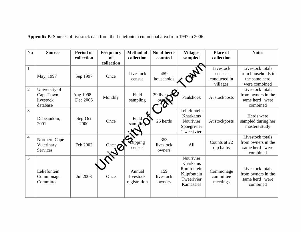
Unive
rsity
of C
ape
Town
Appendix B: Sources of livestock data from the Leliefontein communal area from 1997 to 2006.
No Source Period of
collection
Frequency
of
collection
Method of
collection
No of herds
counted
Villages
sampled
Place of
collection
Notes
1
May, 1997 Sep 1997 Once Livestock
census
459
households All
Livestock
census
conducted in
villages
Livestock totals
from households in
the same herd
were combined
2 University of
Cape Town
livestock
database
Aug 1998 –
Dec 2006 Monthly
Field
sampling
39 livestock
owners Paulshoek At stockposts
Livestock totals
from owners in the
same herd were
combined
3
Debeaudoin,
2001
Sep-Oct
2000 Once
Field
sampling 26 herds
Leliefontein
Kharkams
Nourivier
Spoegrivier
Tweerivier
At stockposts
Herds were
sampled during her
masters study
4 Northern Cape
Veterinary
Services
Feb 2002 Once Dipping
census
353
livestock
owners
All Counts at 22
dip baths
Livestock totals
from owners in the
same herd were
combined
5
Leliefontein
Commonage
Committee
Jul 2003 Once
Annual
livestock
registration
159
livestock
owners
Nourivier
Kharkams
Rooifontein
Klipfontein
Tweerivier
Kamassies
Commonage
committee
meetings
Livestock totals
from owners in the
same herd were
combined
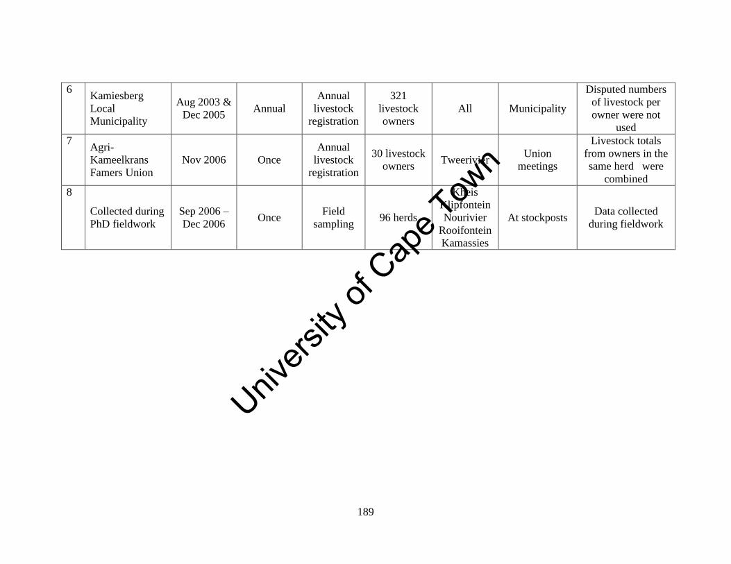
Unive
rsity
of C
ape
Town
189
6 Kamiesberg
Local
Municipality
Aug 2003 &
Dec 2005 Annual
Annual
livestock
registration
321
livestock
owners
All Municipality
Disputed numbers
of livestock per
owner were not
used
7 Agri-
Kameelkrans
Famers Union
Nov 2006 Once
Annual
livestock
registration
30 livestock
owners Tweerivier
Union
meetings
Livestock totals
from owners in the
same herd were
combined
8
Collected during
PhD fieldwork
Sep 2006 –
Dec 2006 Once
Field
sampling 96 herds
Kheis
Klipfontein
Nourivier
Rooifontein
Kamassies
At stockposts Data collected
during fieldwork