
Microscale Adaptive Response of Charophytes of the Negev Desert, Israel: Species Divergences by AFLP
Geomorphology xxx (2014) xxx–xxx
GEOMOR-04607; No of Pages 15
Contents lists available at ScienceDirect
Geomorphology
j ourna l homepage: www.e lsev ie r .com/ locate /geomorph
The Nahal Oz Reservoir dam-break flood: Geomorphic impact on a small ephemeralloess-channel in the semi-arid Negev Desert, Israel
Nathaniel Bergman a,⁎, Ofer Sholker b, Joel Roskin c,d, Noam Greenbaum e,f
a Department of Geography, University of Western Ontario, London, Ontario N6A 5C2, Canadab Shikma-Besor Drainage Authority, Omer 84965, Israelc Department of Geography and Environmental Development, Ben-Gurion University of the Negev, Beer-Sheva 84105, Israeld Department of Maritime Civilizations, School of Marine Studies and the Leon Recanati Institute for Maritime Studies (RIMS), University of Haifa, Mt. Carmel Haifa, 31905 Israele Department of Geography and Environmental Studies, University of Haifa, Mount Carmel, Haifa 31905, Israelf Department of Natural Resources & Environmental Management, University of Haifa, Mount Carmel, Haifa 31905, Israel
⁎ Corresponding author. Tel.: +1 519 719 4831; fax: +E-mail address: [email protected] (N. Bergm
0169-555X/$ – see front matter © 2013 Elsevier B.V. All rhttp://dx.doi.org/10.1016/j.geomorph.2013.12.024
Please cite this article as: Bergman, N., et al., Tthe semi-arid Negev Desert, Israel, Geomorp
a b s t r a c t
a r t i c l e i n f oArticle history:Received 30 September 2011Received in revised form 16 December 2013Accepted 17 December 2013Available online xxxx
Keywords:Catastrophic dam-break floodLoess channel erosionGeomorphic impact and sedimentarypreservationTransmission lossesVegetation recoveryConceptual landscape evolution model
TheNahal OzReservoir— in the coastal, semi-arid southwestern Israelwas designed to enhance local irrigation ofcrops using reclaimed sewagewater during the dry summermonths. OnMarch 2001, part of the western dike ofthe reservoir was breached and generated a flow release of 3.5 ∗ 106 m3 of secondary irrigation water that waschanneled down the 1st order ephemeral loess stream (Nahal Yare'akh). The consequent 12-hour flood surge,with an estimated peak discharge of 1000 m3s−1, inflicted severe loess erosion, agricultural, property and infra-structural damage downstream ($6 million).Post-floodmapping documented the geomorphic response to thefloodwhich included channel scour andwideningalong the initial 2 km downstream of the reservoir where a spillway channel was formed. The increase in the cross-sectional area was about 60% and had an estimated 170,000 m3 of sediment bed, bank and floodplain erosion. Cal-culatedmaximum shear stress and stream power along this section are estimated at 300 Nm−2 and 900wm−2, re-spectively. The peak discharge at the end of this segment was estimated at 800 m3s−1 indicating only minorattenuation along this segment. Two km downstream of the breach, a wide braided fan indicated deposition ofthe eroded sediments. At the end of this segment the floodwater diverged into several watercourses and inundatedtilled agricultural fields and neighborhoods. Downstream, 9 km from the reservoir, the discharge attenuated to100 m3s−1, slightly above bankfull. Further downstream and upon reaching the large Shikma stream the flowwas already very low. This reduction in discharge is attributed to the anthropogenic infrastructure— roads, neigh-borhoods and agricultural fields and the large transmission losses typical of sandy ephemeral streams.The study shows that channels within erodible materials respond to high peak discharges very locally. Erosionalthresholds that severely incised the channel are only maintained for 2 km below the breached reservoir and asdistance from the source area increases, available energy is substantially reduced due to high transmission losses,gentler valley gradients, very wide shallow flow and the ability of the drainage network to accommodate largedischarges. Consequently, the geomorphic impact was limited to the first 2.6 km with only minor erosional ordepositional evidence downstream. The current natural flow regime has onlyminor impact on the newly formedchannel geometry below the breached dam. Accordingly, the channel geometrymay be preserved for a relativelylong time. However, channel recovery in this segment was rapid and within a few years all bare loess surfacesexposed during the flood have been covered by dense vegetation. The analysis also shows that Nahal OzReservoir's dam-break flood transmission losses and flood attenuation rates were extreme in comparison toother case studies. This artificialflood event in a desert environment offers a rare opportunity to quantify channeland bank erosion evolution processes during an extremely high-magnitude floodwithin highly erodiblefine sed-iment as well as to detect the recovery processes a few years later.
© 2013 Elsevier B.V. All rights reserved.
1. Introduction
Dam-break catastrophicfloodsdue todam failures occur both in nat-ural and in constructed dams (Cenderelli, 2000). Natural dam failures
1 519 661 3750.an).
ights reserved.
he Nahal Oz Reservoir dam-bhology (2014), http://dx.doi.o
are usually linked to terrestrial freshwater bodies such as glaciatedlakes, ice caps, morainal dams, volcanic flow dams, volcanic craterlakes and landslide dams (Baker, 1973; Gallino and Pierson, 1985;Costa, 1988; Rathburn, 1993; Walder and Costa, 1996; O'Connor et al.,2001; O'Connor et al., 2002; Hancox et al., 2005). The geomorphic con-sequences of the outbursts from reservoirs and natural dam-breakfloods are linked to water volumes, peak discharges, flow durations,
reak flood: Geomorphic impact on a small ephemeral loess-channel inrg/10.1016/j.geomorph.2013.12.024
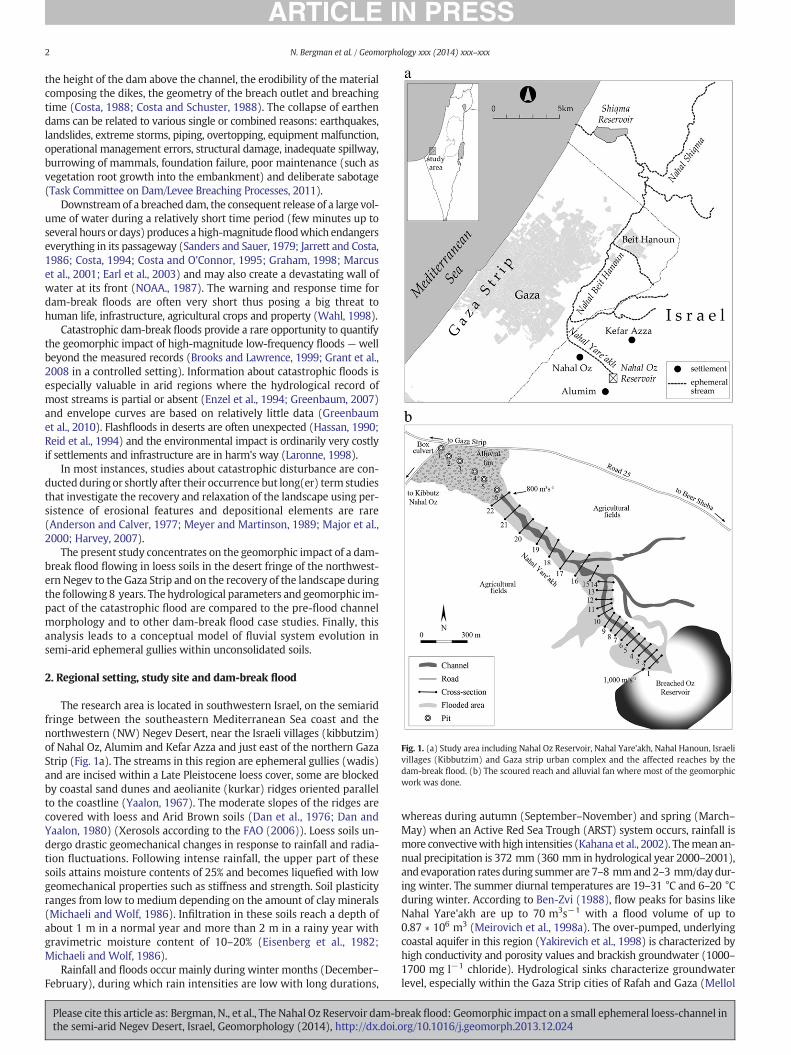
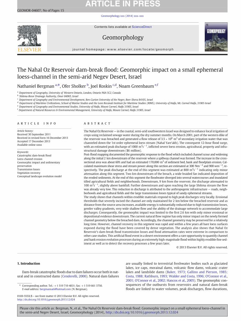
Fig. 1. (a) Study area including Nahal Oz Reservoir, Nahal Yare'akh, Nahal Hanoun, Israelivillages (Kibbutzim) and Gaza strip urban complex and the affected reaches by thedam-break flood. (b) The scoured reach and alluvial fan where most of the geomorphicwork was done.
2 N. Bergman et al. / Geomorphology xxx (2014) xxx–xxx
the height of the dam above the channel, the erodibility of the materialcomposing the dikes, the geometry of the breach outlet and breachingtime (Costa, 1988; Costa and Schuster, 1988). The collapse of earthendams can be related to various single or combined reasons: earthquakes,landslides, extreme storms, piping, overtopping, equipment malfunction,operational management errors, structural damage, inadequate spillway,burrowing of mammals, foundation failure, poor maintenance (such asvegetation root growth into the embankment) and deliberate sabotage(Task Committee on Dam/Levee Breaching Processes, 2011).
Downstreamof a breached dam, the consequent release of a large vol-ume of water during a relatively short time period (few minutes up toseveral hours or days) produces a high-magnitudefloodwhich endangerseverything in its passageway (Sanders and Sauer, 1979; Jarrett and Costa,1986; Costa, 1994; Costa and O'Connor, 1995; Graham, 1998; Marcuset al., 2001; Earl et al., 2003) and may also create a devastating wall ofwater at its front (NOAA., 1987). The warning and response time fordam-break floods are often very short thus posing a big threat tohuman life, infrastructure, agricultural crops and property (Wahl, 1998).
Catastrophic dam-break floods provide a rare opportunity to quantifythe geomorphic impact of high-magnitude low-frequency floods —wellbeyond the measured records (Brooks and Lawrence, 1999; Grant et al.,2008 in a controlled setting). Information about catastrophic floods isespecially valuable in arid regions where the hydrological record ofmost streams is partial or absent (Enzel et al., 1994; Greenbaum, 2007)and envelope curves are based on relatively little data (Greenbaumet al., 2010). Flashfloods in deserts are often unexpected (Hassan, 1990;Reid et al., 1994) and the environmental impact is ordinarily very costlyif settlements and infrastructure are in harm's way (Laronne, 1998).
In most instances, studies about catastrophic disturbance are con-ductedduring or shortly after their occurrence but long(er) term studiesthat investigate the recovery and relaxation of the landscape using per-sistence of erosional features and depositional elements are rare(Anderson and Calver, 1977; Meyer and Martinson, 1989; Major et al.,2000; Harvey, 2007).
The present study concentrates on the geomorphic impact of a dam-break flood flowing in loess soils in the desert fringe of the northwest-ern Negev to the Gaza Strip and on the recovery of the landscape duringthe following 8 years. The hydrological parameters and geomorphic im-pact of the catastrophic flood are compared to the pre-flood channelmorphology and to other dam-break flood case studies. Finally, thisanalysis leads to a conceptual model of fluvial system evolution insemi-arid ephemeral gullies within unconsolidated soils.
2. Regional setting, study site and dam-break flood
The research area is located in southwestern Israel, on the semiaridfringe between the southeastern Mediterranean Sea coast and thenorthwestern (NW) Negev Desert, near the Israeli villages (kibbutzim)of Nahal Oz, Alumim and Kefar Azza and just east of the northern GazaStrip (Fig. 1a). The streams in this region are ephemeral gullies (wadis)and are incised within a Late Pleistocene loess cover, some are blockedby coastal sand dunes and aeolianite (kurkar) ridges oriented parallelto the coastline (Yaalon, 1967). The moderate slopes of the ridges arecovered with loess and Arid Brown soils (Dan et al., 1976; Dan andYaalon, 1980) (Xerosols according to the FAO (2006)). Loess soils un-dergo drastic geomechanical changes in response to rainfall and radia-tion fluctuations. Following intense rainfall, the upper part of thesesoils attains moisture contents of 25% and becomes liquefied with lowgeomechanical properties such as stiffness and strength. Soil plasticityranges from low to medium depending on the amount of clay minerals(Michaeli and Wolf, 1986). Infiltration in these soils reach a depth ofabout 1 m in a normal year and more than 2 m in a rainy year withgravimetric moisture content of 10–20% (Eisenberg et al., 1982;Michaeli and Wolf, 1986).
Rainfall and floods occur mainly during winter months (December–February), during which rain intensities are low with long durations,
Please cite this article as: Bergman, N., et al., The Nahal Oz Reservoir dam-bthe semi-arid Negev Desert, Israel, Geomorphology (2014), http://dx.doi.o
whereas during autumn (September–November) and spring (March–May) when an Active Red Sea Trough (ARST) system occurs, rainfall ismore convectivewith high intensities (Kahana et al., 2002). Themean an-nual precipitation is 372 mm (360 mm in hydrological year 2000–2001),and evaporation rates during summer are 7–8 mmand2–3 mm/daydur-ing winter. The summer diurnal temperatures are 19–31 °C and 6–20 °Cduring winter. According to Ben-Zvi (1988), flow peaks for basins likeNahal Yare'akh are up to 70 m3s−1 with a flood volume of up to0.87 ∗ 106 m3 (Meirovich et al., 1998a). The over-pumped, underlyingcoastal aquifer in this region (Yakirevich et al., 1998) is characterized byhigh conductivity and porosity values and brackish groundwater (1000–1700 mg l−1 chloride). Hydrological sinks characterize groundwaterlevel, especially within the Gaza Strip cities of Rafah and Gaza (Mellol
reak flood: Geomorphic impact on a small ephemeral loess-channel inrg/10.1016/j.geomorph.2013.12.024

Fig. 2. The breach of Nahal Oz Reservoir and the consequent flood surge into the 1st orderchannel of Nahal Yare'akh.
3N. Bergman et al. / Geomorphology xxx (2014) xxx–xxx
and Collin, 1994) and therefore, the high transmission losses duringfloods which recharge the aquifer are of high importance.
The Nahal Oz Reservoir, located over the crest and western slopes ofan aeolianite ridge, virtually dissects the natural headwaters of theNahal (stream in Hebrew) Yare'akh catchment from the downstreamchannel. Nahal Yare'akh is a first order catchment with an area of10 km2. Its natural headwaters at an elevation of 102 m a.s.l. whichflows to the northwest into the larger Nahal Hanoun within the GazaStrip and from there into the much larger Nahal Shikma (744 km2),which drains the southern JudeaMountains and the plains of the north-western Negev into the Mediterranean Sea. The soils in the NahalYare'akh drainage basin include brown to reddish silty–sandy Hamrasoil at the upper parts of the basin and up to 10 m thick light brownloessial arid soils covering the lower parts and filling the valleys (Danet al., 1976).
The Nahal Oz reservoir was completed in the year 2000 (cost of$5 million by the Jewish National Fund, JNF) and it is one of 7 terminalreservoir systems carrying the reclaimed water of heavily populatedcentral Israel (the Shafdan Center — The Dan Region Association ofTowns for Sewage and Environment) which were designed to enhancethe irrigation of cultivated lands during the summer (Nevo, 2001).
The reservoir foundation being located in a natural depression in-volved excavating the eastern side and artificial filling of natural gullieson the western side. A trapezoid, 22 m high (130 m wide at base 8 mwide at top) dike dams the natural headwaters of Nahal Yare'akh. Thereservoir (0.4 km2) has an elongated semi-trapezoidal shape; the max-imumwater capacity is 4 ∗ 106 m3, maximumwater depth is 20 m, thewater surface area is 0.284 km2, while the reservoir's floor is 0.166 km2.The dikes were constructed out of compacted local loess (G.Y.A.Soil andFoundation Engineering Ltd, 1995). The water source of the reservoir isan internal 32″ pipe with a maximal discharge of 4000 m3h−1. There isno contribution of natural runoff from the surrounding catchment.The earthen dikes and base of the reservoir are isolated from the naturalterrain with welded black 1.5 mm thick HDPE (high density polyethyl-ene) plastic sheets lining in order to avoid seepage (G.Y.A. Soil andFoundation Engineering Ltd, 1995). The reservoir's continuous fillingstarted on January 15, 2001. The water level within the reservoir was5 m below the head of the western dike during the breach inception.
2.1. The dam-break flood
OnMarch 26, 2001, part of thewestern dike of theNahal Oz Reservoircollapsed and generated a flow release of 3.5 ∗ 106 m3 of secondaryirrigation water (Nevo, 2001; Rudge, 2001) (Fig. 2). The breach had atrapezoidal shape, 180 m2 in area, top width of 5.5 m, a maximumwidth of 33 m at the toe of the dike and an average width of 20 m. Thevolume of sediment derived from the collapse of the dike itself wasabout 3640 m3. It is noted that the final breach shape is wider than theactual shape during the flood due to mass wasting related to soil dryinggiving the breach a cirque-like shape.Most of the floodwater drained di-rectly into the Nahal Yare'akh gully. Some of the escaping waters weredeflected northward into a gully tributary of Nahal Yare'akh andreturned to the main stem several hundred meters downstream(Fig. 1b).
The weather was sunny and therefore was not a factor in the damfailure. The flood was unexpected and this magnitude could not havebeen generated from a natural precipitation event. Three main con-struction flaws caused the collapse of the dike according to the officialinvestigation committee (Zaslavsky et al., 2002):
(a) Lack of adequate soil compaction, heterogeneous layers and defi-cient moisture of the dike leading to internal seepage and even-tually piping. When compaction is performed without sufficientmoisture the material tends to be friable and prone to erosion.Piping occurs when water percolates into the soil, graduallyremoves soil particles and eventually creates a cavity connecting
Please cite this article as: Bergman, N., et al., The Nahal Oz Reservoir dam-bthe semi-arid Negev Desert, Israel, Geomorphology (2014), http://dx.doi.o
the upstream and downstream side of the dike. Piping processesare a major threat to dikes and dams (Von Thun, 1996; Wan andFell, 2002).
(b) The location of the dike over the partially infilled gully (NahalYare'akh) channel. The designer of the reservoir did not takeinto account that during saturation (full reservoir) seepagethrough possible cracks in the dikewill lead to differential settle-ment. As the reservoir water level receded, the reservoir's west-ern foundations base close to the outlet to Nahal Yare'akh sunkmore than 1 m, creating heterogeneous depressions or sink-holes. These were caused by large underground burrows typicalto loess material and tree regrowth within the exposed breachsection (GEOTECH Consulting Engineers, 2001; Zaslavsky et al.,2002). Similar post-failure sinkholes were also reported in theBaldwin Hills Reservoir failure although in that case they wereassociated with active faults and cracks (Jansen, 1987).
(c) Tears in the HDPE lining were found after the reservoir's draw-down suggesting that the welding process of the plastic sheetswas flawed. Once welding is complete, the cover is supposed toprovide complete insulation between the reservoir's water andthe underneath foundation compacted soil (Zaslavsky et al.,2002).
Another possible cause for the failure was tree roots that were notfully removed during construction as a eucalypt tree grew in the centerof the breach a few years later (authors' personal observations).
Below the breached reservoir, a 2 km segment of the Nahal Yare'akhchannel underwent substantial erosion. Downstream of the upper seg-ment, mass deposition occurred in the form of 0.6 km long triangular al-luvial and braided fan blocked by two paved roads (Fig. 1b). Downstreamof the fan, vast shallow inundation occurred in open agricultural fields ofIsrael and along the outskirts of the city of Gaza and Beit Hanoun. Theagricultural infrastructure regulated the flood, as identified from aerialphotographs and discussions with agriculture authorities. Therefore, thegeomorphic impact in this areawas smaller as thesewere restored almostimmediately after the flood.
3. Methodology
3.1. Field methods
The fieldwork concentrated on the newly-formed scoured segmentand alluvial fan of Nahal Yare'akh, a total distance of 2.6 km down-stream of the Nahal Oz Reservoir. Fieldwork began just one week afterthe flood. Additional surveys to document the channel recovery pro-cesses were conducted in the springs of 2003, 2007, 2008 and the sum-mer of 2009. Field work suffered from restrictions due to the region
reak flood: Geomorphic impact on a small ephemeral loess-channel inrg/10.1016/j.geomorph.2013.12.024
4 N. Bergman et al. / Geomorphology xxx (2014) xxx–xxx
being an active conflict zone and due to intense agricultural infrastruc-ture and activities and did not enable digging trenches or making large-scale spatialmeasurements andmeasurements downstreamof the allu-vial fan. Unfortunately, access into the Gaza Strip was not permissible(Fig. 1a). End pointmeasurements weremade with a global positioningsystem (GPS). Peak discharge was determined using the slope-areamethod (Dalrymple and Benson, 1967) and step-backwater methods;water surface slope was reconstructed based on the high water marksin the form of a driftwood line. These features are considered of bestquality (Jarrett and England, 2002; Webb and Jarrett, 2002) for largeungauged floods.
The amount of sediment removed from the scoured segment wascalculated from 22 pre and post-flood cross-sections (Fig. 1b). Thecross-sections are at 50–200 m intervals apart. Post-flood cross-sectional elevation data was extracted from 1/2500 scale map preparedafter the flood (Zaslavsky et al., 2002) with 1 m contour intervals and asimilar scale map that was prepared during the design of the reservoir.The eroded sediment volume was calculated by subtracting the area ofeach of the two matching x-sections (pre-flood x-sectional area minusx-sectional post-flood area) to acquire local net erosion change, averag-ing this value with the next paired x-sectional area downstream andmultiplying it by the distance between them. The volume between allx-sections was summed up to give a total erosion volume of the entirescoured reach. The longitudinal profile of the new channel thalwegwas surveyed for both the scoured segment and the alluvial fan andcompared to elevation data extracted from the pre-flood map.
Rectified aerial photographs at a scale of 1:5000 aided in locatingspecific areas that experienced significant morphologic change (e.g.considerable scour and deposition) that were of special interest and indelineating the flooded areas (Fig. 1b). Eye-witness reports of local res-idents and professional engineering personnel completed the real-timevisual scenario whichwas later verified in the field by ground surveyingand additional photography.
Fig. 3. Typical cross-sections (a) just downstream of the breached dike toe and (b) 50 m downswater level. Bed and bank erosion from the dam-break flood increased the cross-sections by 6
Please cite this article as: Bergman, N., et al., The Nahal Oz Reservoir dam-bthe semi-arid Negev Desert, Israel, Geomorphology (2014), http://dx.doi.o
Six stratigraphical pits were handdug in 2007 in 70–130 m intervalsalong the center axis between the channel inflow and the outflow con-crete box culvert of the alluvial fan (Fig. 1b) in siteswhere the estimatedthickness of the flood deposits wasmaximum. Each pit reached the dis-tinct pre-flood surface indicated by dark loess underlying the flood de-posits. To estimate the sedimentary volume we followed a methodproposed by Greenbaum and Bergman (2006). The fan was subdividedinto six cross-sections each containing a pit to account for the localdeposit thickness. Each of the two proximate cross-sectional areas wasaveraged and multiplied by the distance between them. Once this pro-cedure covered the entire fan, all the local sediment volume valueswere summed into a total volume approximation. While the fan mor-phology isn't uniform, our assumption is that an average depth fromthe six pits multiplied by a precise x-sectional area provides a reason-able estimate for the overall sedimentary volume when trenches arenot possible.
3.2. Laboratory methods
Representative samples (about 5 kg each)were taken from the alluvi-al fan sediments, the pre-flood loess soil from the 6 pits and from the ver-tical bank at the scoured reach (5 locations) and the present channel bed(5 locations). All sediments from each feature were combined into onebulk sample. Our assumption was that the different channel features orlocations will be composed of different grain size distributions and byaggregating them together it will represent the entire spectrum ofdeposited/eroded/non-disturbed sediments during the dam-break flood.
In the laboratory, the samples were oven-dried at 105 °C, mechani-cally disaggregated and sieved using sieveswithmeshes of 0.063, 0.106,0.145, 0.250, 0.354, 0.5, 0.6, 1.0, 2.0, 4.75 and 8.0 mm for the bank loess,present channel bed and pre-flood soil. For the alluvial fan deposit thesieves used were 0.063, 0.075, 0.180, 0.425, 0.850, 2.0, 4.75 and 8 mm.For all samples grain size distributions (GSDs) were produced using
tream of the dam showing the pre-flood and post flood channel morphology and the peak0% on average.
reak flood: Geomorphic impact on a small ephemeral loess-channel inrg/10.1016/j.geomorph.2013.12.024
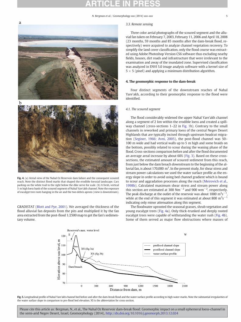
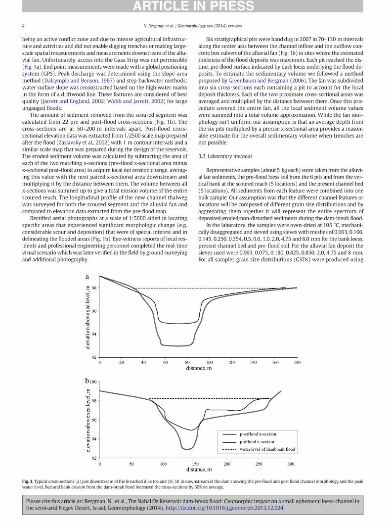
Fig. 4. (a) Aerial view of the Nahal Oz Reservoir dam failure and the consequent scouredreach. Note the distinct flood marks that shaped the erodible loessial landscape. Carsparking on the white trail to the right below the dike serve for scale. (b) A fresh, vertical5 m high loess bank of the scoured segment of Nahal Yare'akh channel. Note the exposureof eucalypt tree roots hanging in the air and the two debris aprons (view is downstream).
5N. Bergman et al. / Geomorphology xxx (2014) xxx–xxx
GRADISTAT (Blott and Pye, 2001). We averaged the thickness of theflood alluvial fan deposits from the pits and multiplied it by the fanarea extracted from the post-flood 1/2500map to get the fan's sedimen-tary volume.
Fig. 5. Longitudinal profile of Nahal Yare'akh channel bed before and after the dam-breakflood andthe water surface slope in comparison to pre-flood bed elevation. XS is the abbreviation for cross
Please cite this article as: Bergman, N., et al., The Nahal Oz Reservoir dam-bthe semi-arid Negev Desert, Israel, Geomorphology (2014), http://dx.doi.o
3.3. Remote sensing
Three color aerial photographs of the scoured segment and the allu-vial fan taken on February 7, 2003, February 11, 2006 and April 18, 2008(23 months, 59 months and 85 months after the dam-break flood, re-spectively) were acquired to analyze channel vegetation recovery. Tosimplify the land cover classification, only the flood course was extract-ed using Adobe Photoshop Version CS6 software thus excluding nearbyfields, houses, dirt roads and infrastructure that were irrelevant to theexamination and away of the inundated zone. Supervised classificationwas analyzed in ENVI 5.0 image analysis software with a kernel size of5 × 5 (pixel) and applying a minimum distribution algorithm.
4. The geomorphic response to the dam-break
Four distinct segments of the downstream reaches of NahalYare'akh, according to their geomorphic response to the flood wereidentified.
4.1. The scoured segment
The flood considerably widened the upper Nahal Yare'akh channelalong a segment of 2 km within the erodible loess and created a spill-way channel (cross-sections 1–22 in Fig. 1b). Contrary to the smallchannels in reworked and primary loess of the central Negev DesertHighlands that are typically incised through upstream headcut migra-tion (Seginer, 1966; Avni, 2005), the post-flood channel was 50–100 m wide and had vertical walls up to 5 m high and some braids onthe bottom, possibly related to scour during the waning phase of theflood. Cross-sections comparison before and after the flood documentedan average areal increase by about 60% (Fig. 3). Based on these cross-sections, the estimated amount of scoured sediment from this reach,from just below the dambreach downstream to the beginning of the al-luvial fan, is about 170,000 m3. In the present study, for shear stress andstream power calculations we used the water surface profile as the en-ergy slope in order to avoid using bed channel gradient which is boundto scour and aggradation processes along the reach (Meirovich et al.,1998b). Calculated maximum shear stress and stream power alongthis section are estimated at 300 Nm−2 and 900 wm−2, respectively.The peak discharge at the outlet of the reservoir was about 1000 m3s−1,while at the end of this segment it was estimated at about 800 m3s−1
indicating only minor attenuation along this segment.The floodwater uprooted the seasonal grasses, shrub vegetation and
young eucalypt trees (Fig. 4a). Only thick-trunked and deeply rootedeucalypt trees were capable of withstanding the water rush (Fig. 4b).Some of them served as major flow obstructions where masses of
thewater surface profile according to highwatermarks. Note the substantial irregularities of-section.
reak flood: Geomorphic impact on a small ephemeral loess-channel inrg/10.1016/j.geomorph.2013.12.024
6 N. Bergman et al. / Geomorphology xxx (2014) xxx–xxx
organic debris piled against their trunks and branches while others hadtheir roots completely exposed by themassive bed and bank scour prac-tically leaving them hanging in the air (Fig. 4b). This response is typicalto high energy floods of ephemeral channels where eucalypt or acaciatrees grow (Graeme and Dunkerley, 1993; Greenbaum and Bergman,2006; Dunkerley, 2008).
The bed slope is of importance as it determines the hydrostaticpressure during the collapse of the dam as well as the development ofthe propagating flow downstream (Nsom et al., 2000). The pre-floodchannel bed of the first 2 km had an average bed gradient of 0.01 witha planar shape without any significant knickpoints. The post-flood bedgradient of 0.02 was significantly steeper also without breaks in slope(Fig. 5). In contrast to natural tributaries in the central and northernNegev (Seginer, 1966; Avni, 2005), this segment lacks substantialknickpoints or vertical headcuts.
4.2. The alluvial fan
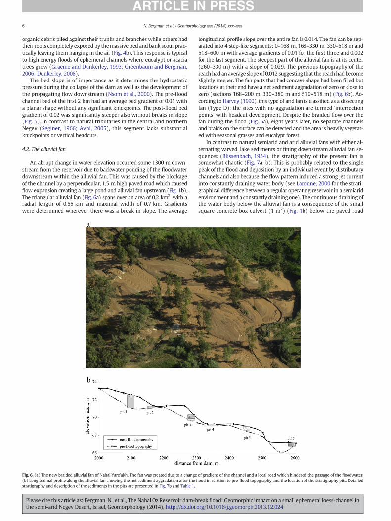
An abrupt change in water elevation occurred some 1300 m down-stream from the reservoir due to backwater ponding of the floodwaterdownstream within the alluvial fan. This was caused by the blockageof the channel by a perpendicular, 1.5 m high paved road which causedflow expansion creating a large pond and alluvial fan upstream (Fig. 1b).The triangular alluvial fan (Fig. 6a) spans over an area of 0.2 km2, with aradial length of 0.55 km and maximal width of 0.7 km. Gradientswere determined wherever there was a break in slope. The average
Fig. 6. (a) The new braided alluvial fan of Nahal Yare'akh. The fan was created due to a change(b) Longitudinal profile along the alluvial fan showing the net sediment aggradation after the fl
stratigraphy and description of the sediments in the pits are presented in Fig. 7b and Table 1.
Please cite this article as: Bergman, N., et al., The Nahal Oz Reservoir dam-bthe semi-arid Negev Desert, Israel, Geomorphology (2014), http://dx.doi.o
longitudinal profile slope over the entire fan is 0.014. The fan can be sep-arated into 4 step-like segments: 0–168 m, 168–330 m, 330–518 m and518–600 m with average gradients of 0.01 for the first three and 0.002for the last segment. The steepest part of the alluvial fan is at its center(260–330 m) with a slope of 0.029. The previous topography of thereachhad an average slope of 0.012 suggesting that the reachhadbecomeslightly steeper. The fan parts that had concave shape had been filled butlocations at their end have a net sediment aggradation of zero or close tozero (sections 168–200 m, 330–380 m and 510–518 m) (Fig. 6b). Ac-cording to Harvey (1990), this type of arid fan is classified as a dissectingfan (Type D); the sites with no aggradation are termed ‘intersectionpoints’ with headcut development. Despite the braided flow over thefan during the flood (Fig. 6a), eight years later, no separate channelsand braids on the surface can be detected and the area is heavily vegetat-ed with seasonal grasses and eucalypt forest.
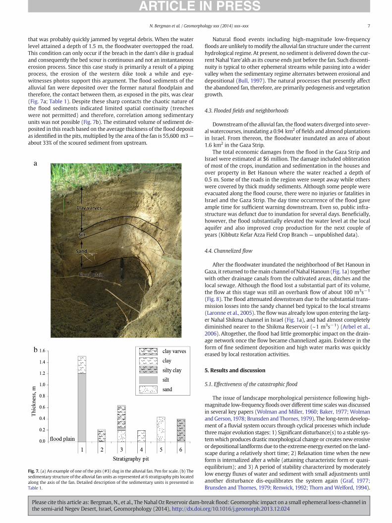
In contrast to natural semiarid and arid alluvial fans with either al-ternating varved, lake sediments or fining downstream alluvial fan se-quences (Blissenbach, 1954), the stratigraphy of the present fan issomewhat chaotic (Fig. 7a, b). This is probably related to the singlepeak of the flood and deposition by an individual event by distributarychannels and also because the flow pattern induced a strong jet currentinto constantly draining water body (see Laronne, 2000 for the strati-graphical difference between a regular operating reservoir in a semiaridenvironment and a constantly draining one). The continuous draining ofthe water body below the alluvial fan is a consequence of the smallsquare concrete box culvert (1 m2) (Fig. 1b) below the paved road
of gradient of the channel and a local road which hindered the passage of the floodwater.ood in relation to pre-flood topography and the location of the stratigraphy pits. Detailed
reak flood: Geomorphic impact on a small ephemeral loess-channel inrg/10.1016/j.geomorph.2013.12.024
7N. Bergman et al. / Geomorphology xxx (2014) xxx–xxx
that was probably quickly jammed by vegetal debris. When the waterlevel attained a depth of 1.5 m, the floodwater overtopped the road.This condition can only occur if the breach in the dam's dike is gradualand consequently the bed scour is continuous and not an instantaneouserosion process. Since this case study is primarily a result of a pipingprocess, the erosion of the western dike took a while and eye-witnesses photos support this argument. The flood sediments of thealluvial fan were deposited over the former natural floodplain andtherefore, the contact between them, as exposed in the pits, was clear(Fig. 7a; Table 1). Despite these sharp contacts the chaotic nature ofthe flood sediments indicated limited spatial continuity (trencheswere not permitted) and therefore, correlation among sedimentaryunits was not possible (Fig. 7b). The estimated volume of sediment de-posited in this reach based on the average thickness of the flood depositas identified in the pits, multiplied by the area of the fan is 55,600 m3—
about 33% of the scoured sediment from upstream.
Fig. 7. (a) An example of one of the pits (#3) dug in the alluvial fan. Pen for scale. (b) Thesedimentary structure of the alluvial fan units as represented at 6 stratigraphy pits locatedalong the axis of the fan. Detailed description of the sedimentary units is presented inTable 1.
Please cite this article as: Bergman, N., et al., The Nahal Oz Reservoir dam-bthe semi-arid Negev Desert, Israel, Geomorphology (2014), http://dx.doi.o
Natural flood events including high-magnitude low-frequencyfloods are unlikely tomodify the alluvial fan structure under the currenthydrological regime. At present, no sediment is delivered down the cur-rent Nahal Yare'akh as its course ends just before the fan. Such disconti-nuity is typical to other ephemeral streams while passing into a widervalley when the sedimentary regime alternates between erosional anddepositional (Bull, 1997). The natural processes that presently affectthe abandoned fan, therefore, are primarily pedogenesis and vegetationgrowth.
4.3. Flooded fields and neighborhoods
Downstreamof the alluvial fan, the floodwaters diverged into sever-alwatercourses, inundating a 0.94 km2 of fields and almond plantationsin Israel. From thereon, the floodwater inundated an area of about1.6 km2 in the Gaza Strip.
The total economic damages from the flood in the Gaza Strip andIsrael were estimated at $6 million. The damage included obliterationof most of the crops, inundation and sedimentation in the houses andover property in Bet Hanoun where the water reached a depth of0.5 m. Some of the roads in the region were swept away while otherswere covered by thick muddy sediments. Although some people wereevacuated along the flood course, there were no injuries or fatalities inIsrael and the Gaza Strip. The day time occurrence of the flood gaveample time for sufficient warning downstream. Even so, public infra-structure was defunct due to inundation for several days. Beneficially,however, the flood substantially elevated the water level at the localaquifer and also improved crop production for the next couple ofyears (Kibbutz Kefar Azza Field Crop Branch— unpublished data).
4.4. Channelized flow
After the floodwater inundated the neighborhood of Bet Hanoun inGaza, it returned to themain channel ofNahal Hanoun (Fig. 1a) togetherwith other drainage canals from the cultivated areas, ditches and thelocal sewage. Although the flood lost a substantial part of its volume,the flow at this stage was still an overbank flow of about 100 m3s−1
(Fig. 8). The flood attenuated downstream due to the substantial trans-mission losses into the sandy channel bed typical to the local streams(Laronne et al., 2005). The flowwas already low upon entering the larg-er Nahal Shikma channel in Israel (Fig. 1a), and had almost completelydiminished nearer to the Shikma Reservoir (~1 m3s−1) (Arbel et al.,2006). Altogether, the flood had little geomorphic impact on the drain-age network once the flow became channelized again. Evidence in theform of fine sediment deposition and high water marks was quicklyerased by local restoration activities.
5. Results and discussion
5.1. Effectiveness of the catastrophic flood
The issue of landscape morphological persistence following high-magnitude low-frequency floods over different time scaleswas discussedin several key papers (Wolman and Miller, 1960; Baker, 1977; Wolmanand Gerson, 1978; Brunsden and Thornes, 1979). The long-term develop-ment of a fluvial system occurs through cyclical processes which includethreemajor evolution stages: 1) Significant disturbance(s) to a stable sys-temwhich produces drasticmorphological change or creates new erosiveor depositional landforms due to the extreme energy exerted on the land-scape during a relatively short time; 2) Relaxation time when the newform is internalized after a while (attaining characteristic form or quasi-equilibrium); and 3) A period of stability characterized by moderatelylow energy fluxes of water and sediment with small adjustments untilanother disturbance dis-equilibrates the system again (Graf, 1977;Brunsden and Thornes, 1979; Renwick, 1992; Thorn andWelford, 1994).
reak flood: Geomorphic impact on a small ephemeral loess-channel inrg/10.1016/j.geomorph.2013.12.024
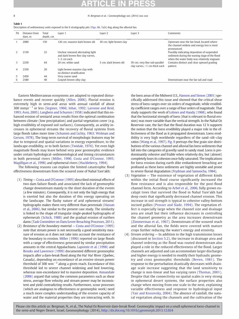
Table 1Description of sedimentary units exposed in the 6 stratigraphy pits (Figs. 6b, 7a,b) dug along the alluvial fan.
Pit Distance fromdam, m
Totaldepth, cm
Layer 1 Layer 2 Layer 3 Comments
1 2080 150 120 cm; massive dark brown silt 30 cm; light brown clay Upstream near the fan head, located wherethe channel widens and energy loss is mostpronounced.
2 2150 22 Unclear smeared alternating lightand dark brown fine clay varves,1–3 cm each
Possibly indicating deposition of suspendedsediment during the waning stage of the floodwhen the water body was relatively stagnant.
3 2250 64 20 cm; white sand 5 cm; dark brown silt 39 cm; very fine sub-parallelclay varves, b1 cm thick each
Contains distinct and clear upward gradingpattern
4 2350 20 Light brown massive clay withno distinct stratification
5 2450 44 Very coarse sand6 2580 40 Grayish brown silty-clay Downstream near the fan tail and road
8 N. Bergman et al. / Geomorphology xxx (2014) xxx–xxx
Eastern Mediterranean ecosystems are adapted to repeated distur-bance events and recover quickly (Allen, 2006). Fluvial erosion isextremely high in semi-arid areas with annual rainfall of about300 mmyr−1 or less (Seginer, 1966; Inbar, 1992; Laronne and Reid,1993; Avni, 2005). Langbein and Schumm(1958) indicated that this en-hanced erosion of semiarid areas results from the optimal combinationbetween climate (low precipitation) and partial vegetation cover (e.g.high erodibility of exposed soil surfaces). Consequently, as aridity in-creases in ephemeral streams the recovery of fluvial systems fromlarge floods takes more time (Schumm and Lichty, 1963; Wolman andGerson, 1978). The long-term survival of morphologic features may bedue to temporal and spatial variations in energy expenditure, to thelandscape erodibility, or to both factors (Twidale, 1976). Yet even highmagnitude floods may leave behind very poor geomorphic evidenceunder certain hydrological–sedimentological and timing circumstancesin both perennial rivers (Miller, 1990; Costa and O'Connor, 1995;Magilligan et al., 1998) and ephemeral rivers (Huckleberry, 1994).
The following reasons can explain the limited catastrophic floodeffectiveness downstream from the scoured zone of Nahal Yare'akh:
(1) Timing—Costa andO'Connor (1995) describedminimal effects oftwo dam failure floods and associated the lack of geomorphicchange downstream mainly to the short duration of the events(a few minutes). Consequently, it is not only the high energy thatis exerted but also the duration of this energy operating onthe landscape. The flashy nature of arid ephemeral streams'hydrographs makes them very different than perennials (Hassanet al., 2006), but similar to the present case study. The similarityis linked to the shape of triangular single-peaked hydrographs ofephemerals (Schick, 1988) and the gradual erosion of earthendams (Task Committee on Dam/Levee Breaching Processes, 2011).
(2) Resistance of the boundary material — Costa and O'Connor (1995)note that stream power is not necessarily a good sensitivity mea-sure of erosion as it does not take into account the resistance ofthe boundary to erosion. Miller (1990) reported on large floodswith a range of effectiveness generated by similar precipitationamounts in the central Appalachians. Lapointe et al. (1998) andBrooks and Lawrence (1999) documented different geomorphicimpacts after a dam-break flood along the Ha! Ha! River (Quebec,Canada), depending on exceedance of an erosive stream powerthreshold of 300 wm−2 along a given reach. Exceedance of thisthreshold led to severe channel widening and bed lowering,whereas non-exceedance led to massive deposition. Annandale(2006) argued that using the common parameters such as shearstress, average flow velocity and stream power may be inconsis-tent and yield contradicting results. Furthermore, scour processes(which are analogous to effectiveness or geomorphic work) needa much more complex understanding of the erosive capacity ofwater and the material properties they are interacting with. In
Please cite this article as: Bergman, N., et al., The Nahal Oz Reservoir dam-bthe semi-arid Negev Desert, Israel, Geomorphology (2014), http://dx.doi.o
the loess areas of theMidwest U.S., Hanson and Simon (2001) spe-cifically addressed this issue and showed that the critical shearstress of loess ranges over six orders of magnitude, while erodibil-ity coefficient ranges over a rangeof four orders ofmagnitude. Thatstudy supports the work of Lohnes and Handy (1968), who foundthat the horizontal strength of loess (that is relevant to fluvial ero-sion)wasmore variable than the vertical strength. In the Nahal OzReservoir case, the fact that the flood duration was 12 h supportsthe notion that the loess erodibility played a major role in the ef-fectiveness of the flood as it propagated downstream. Loess erod-ibility is very high worldwide regardless of the sand–silt–clayratios (Wang et al., 1997). Fig. 9 portrays the fine grain size distri-butions of the various channel and alluvial fan loess sediments thatfall into the categories of gravelly sand to sandymud. Loess is pre-dominantly cohesive and friable when relatively dry, but (almost)completely loses its cohesion once fully saturated. The implicationsfor loess erosion during earth dike embankment breaching areprofound as these loess sediments are highly unstable and proneto severe fluvial degradation (Frydman and Samoocha, 1984).
(3) Vegetation — The existence of vegetation of different kindswithin the initial flood course significantly increased theflow resistance and is also responsible for the post-floodchannel form. According to Arbel et al., 2006, fully grown eu-calypt trees that survived the flood in Nahal Yare'akh haddeep roots that significantly decreased channel erosion. Thisincrease in soil strength is typical to cohesive valley-bottomincised gullies (Prosser and Slade, 1994). The vegetation ef-fect is especially large when the channel size and drainagearea are small but their influence decreases in controllingthe channel geometry as the area increases downstream(Zimmerman et al., 1967). Downstream of the scoured reachand the alluvial fan, the fields were covered with maturecrops further reducing the water's energy and erosivity.
(4) Stream ordering — In addition to the high transmission losses(discussed in Section 5.2), the increase in drainage area andchannel ordering as the flood was routed downstream alsoplayed a role in the reduced effectiveness of the flood. Largerchannels are adjusted and can accommodate larger dischargesand higher energy is needed to modify their hydraulic geome-try and cross geomorphic thresholds (Beven, 1981). Theresponse to the perturbation drastically decreases with drain-age scale increase suggesting that the land sensitivity tochange is non-linear and has varying rates (Thomas, 2001).Despite that the connectivity on spatial scales is very strongin ephemeral desert systems, the surface properties alsochange when moving from one scale to the next, explainingvariable effectiveness and response to hydrological input(Yair and Kossovsky, 2004). The absence of rainfall, the natu-ral vegetation along the channels and the cultivation of the
reak flood: Geomorphic impact on a small ephemeral loess-channel inrg/10.1016/j.geomorph.2013.12.024

Fig. 8. An aerial view of the flood within Nahal Hanoun, 9 km downstream of the dambreach. Although theflood at that locationwas still above bankfull discharge it had alreadylost about 90% of its peak discharge.
9N. Bergman et al. / Geomorphology xxx (2014) xxx–xxx
nearby fields (already with mature crops on March when theflood occurred) maintained the high infiltration rates withinthe channel rather than vast flooding.
Fig. 10. The recovered state of the scoured reach, 8 years after the dam-break flood.(a) The active “inner channel” flows within a 50–100 m wide valley which is the actualchannel geometry of the dam-break flood. The vertical loess wall on the left bank marksthe border of the peak discharge. (b) A close-up view of the new, straight, slightly incised,sandy channel adjusted to the natural flow regime.
5.2. Persistence of flood features
Two small post dam-break flood flows in Nahal Yare'akh (b1 m3s−1)caused a localizedminor incision (1–2 mwide, up to 0.5 mdeep) into the50–100 m wide scoured reach (Fig. 10a), which now serves as its actualdisconnected valley or abandoned floodplain. The vertical loess banks(up to 5 m high) are currently stable except for minor dry mass wastingprocesses (falls and slides) of the loose material producing conic apronsthat are not evacuated by the present channel flows (Fig. 4b). This“inner channel” phenomenon is very typical of ephemeral desert rivers,which accommodate rapid changes in discharges and consequently un-dergo radical morphological adjustment (Graf, 1988). Nanson (1986)suggested a model in which high energy floods instantaneously destroyfloodplains that were slowly built by vertical accretion over decades orcenturies. These floodplains are so infrequently flooded that they maybe mistaken for abandoned terraces under a different flow regime. If thecurrent channel ofNahal Yare'akh inciseswithoutmigratingduring futurefloods as observed for adjacent loess gullies, the wide catastrophic chan-nel will transform into a disconnected terrace-floodplain bordered withvertical walls.
The variable fluvio-sedimentary response casts doubt on the abilityto recognize catastrophic floods in the stratigraphic fluvial record of
Fig. 9. Grain size distributions (GSDs) of the various channel components of Nahal Yare'akh
Please cite this article as: Bergman, N., et al., The Nahal Oz Reservoir dam-bthe semi-arid Negev Desert, Israel, Geomorphology (2014), http://dx.doi.o
this semiarid environment. Jerolmack and Paola (2010) modeled thedampening of the geomorphic signal as ‘morphodynamic turbulence’when two different time-dependent regimes converge and one smearsthe other. Furthermore, VanDeWiel andCoulthard (2010) assert froma
. These fine-textured, friable sediments pose only a minor resistance to fluvial erosion.
reak flood: Geomorphic impact on a small ephemeral loess-channel inrg/10.1016/j.geomorph.2013.12.024
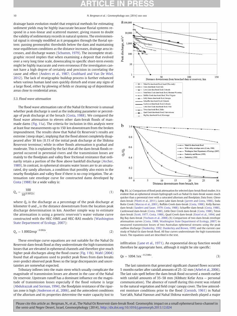
Fig. 11. (a) Comparison offlood peak attenuation for selecteddam-breakflood studies. It isevident that an ephemeral stream hydrograph such as Nahal Oz dam-break wanes muchquicker than a perennial river with a saturated alluvium and floodplain. Data from: Glenodam-break (Pilotti et al., 2011), Lawn Lake dam-break (Jarrett and Costa, 1986), SodaButte Creek (Marcus et al., 2001), Buffalo Creek dam-break (Costa, 1988); Kelly Barnesdam-break (Sanders and Sauer, 1979; Costa, 1988); Schaeffer dam-break (Costa, 1988),Castlewood dam-break (Costa, 1988), Little Deer Creek dam-break (Costa, 1988), Tetondam-break (Scott, 1977; Costa, 1988), Quail Creek dam-break (Enzel et al., 1994) andBig Bay dam-break (Yochum et al., 2008).(b) Comparison of two dam-break envelopeattenuation curves (Costa, 1988; Washington State Department of Ecology, 2007) tomeasured transmission losses of two Australian ephemeral streams using the peakoutflow discharge (Dunkerley, 1992; Dunkerley and Brown, 1999) and the current casestudy of Nahal Oz dam-break flood. All four curves underestimate the high transmissionlosses. The equations used are described in the text.
10 N. Bergman et al. / Geomorphology xxx (2014) xxx–xxx
drainage basin evolution model that empirical methods for estimatingsediment yields may be highly inaccurate because fluvial systems re-spond in a non-linear and scattered manner, giving reason to doubtthe validity of sedimentary records in natural systems. The environmen-tal signal is strongly modified as it propagates through the fluvial sys-tem: passing geomorphic thresholds below the dam and maintainingnear-equilibrium conditions as the distance increases, drainage area in-creases, and discharge wanes (Schumm, 1979). The incomplete strati-graphic record implies that when examining a deposit that evolvedover a very long time scale, downscaling to specific short-term eventsmight be highly inaccurate and even erroneous if the investigators can-not have a high degree of certainty and precision in correlating thecause and effect (Anders et al., 1987; Coulthard and Van De Wiel,2012). The lack of stratigraphic buildup process is further enhancedwhen various human land uses quickly disturb and erase any signs ofa large flood, either by plowing of fields or cleaning up of depositionalareas close to residential areas.
5.3. Flood wave attenuation
The floodwave attenuation rate of theNahal Oz Reservoir is unusualwhether peak discharge is used as the indicating parameter or percent-age of peak discharge at the breach (Costa, 1988). We compared theflood wave attenuation to eleven other dam-break floods of man-made dams (Fig. 11a). The criteria for inclusion in this analysis wereat least four measurements up to 150 km downstream from the brokenimpoundment. The results show that Nahal Oz Reservoir's results areextreme (steep slope), implying that theflood almost completely disap-peared after 30 km (0.1% of the initial peak discharge at the ShikmaReservoir terminus) while in other floods attenuation is gradual andmoderate. This is explained by the fact that all the dam-break floods re-ported occurred in perennial rivers and the transmission losses aremainly to the floodplain and valley floor frictional resistance that ordi-narily retain a portion of the flow above bankfull discharge (Archer,1989). In contrast, in ephemeral streams water losses are to an unsatu-rated, dry sandy alluvium, a condition that possibly also exists in thenearby floodplain and valley floor if there is no crop irrigation. The at-tenuation rate envelope curve for constructed dams developed byCosta (1988) for a wide valley is:
Qx ¼100
10 0:0052xð Þ ð1Þ
where Qx is the discharge as a percentage of the peak discharge atkilometer 0 and x is the distance downstream from the location peakdischarge determination in km. Another simple way to estimatethe attenuation is using a generic reservoir's water volume curveconstructed with the HEC-HMS and HEC-RAS models (WashingtonState Department of Ecology, 2007):
Qx ¼ 1:0002exp−0:002x: ð2Þ
These envelope curve equations are not suitable for the Nahal OzReservoir dam-breakflood as they underestimate the high transmissionlosses that are elevated in ephemeral channels and therefore give muchhigher peak discharges along the flood course (Fig. 11b). Wahl (2004)found that all equations used to predict peak flows from dam breaksover-predict observed peak flows so the large discrepancies and uncer-tainties are somewhat expected.
Tributary inflows into the main stem which usually complicate themagnitude of transmission losses are absent in the case of the NahalOz reservoir. Upstream runoff has a dominant influence on the magni-tude of transmission losses especially if the flood volume is large(Abdulrazzak and Sorman, 1994), the floodplain resistance of the ripar-ian zone is high (Anderson et al., 2006), and the antecedent conditionsof the alluvium and its properties determine the water capacity lost to
Please cite this article as: Bergman, N., et al., The Nahal Oz Reservoir dam-bthe semi-arid Negev Desert, Israel, Geomorphology (2014), http://dx.doi.o
infiltration (Lane et al., 1971). An exponential decay function wouldtherefore be appropriate here, although it might be site specific:
Qx ¼ 1094:1ex−0:2348x: ð3Þ
The last rainstorm that generated significant channel flows occurred5 months earlier after rainfall amounts of 25–32 mm (Arbel et al., 2006).The last rain spell before the dam-break flood occurred a month earlierwith rainfall amounts of 35–58 mm (Kibbutz Kefar Azza — personalcommunication). The absence of runoff during this event was relatedto the natural vegetation and field crops' canopy cover. The low anteced-ent moisture conditions prior to the flood (Cornish, 1961) in NahalYare'akh, Nahal Hanoun and Nahal Shikma watersheds played a major
reak flood: Geomorphic impact on a small ephemeral loess-channel inrg/10.1016/j.geomorph.2013.12.024
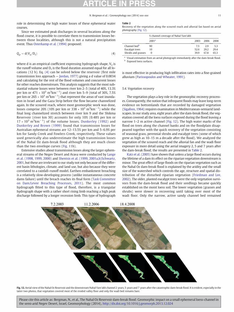
Table 2Recovery of the vegetation along the scoured reach and alluvial fan based on aerialphotography (Fig. 12).
% channel coverage of Nahal Yare'akh
2001a 2003 2006 2008
Channel bedb 90 7.5 2.9 5.3Eucalypt trees 10 52.6 29.2 29.4Shrubs and grasses 0 39.9 67.8 65.3
a Visual estimation from an aerial photograph immediately after the dam-break flood.b Exposed loess surfaces.
11N. Bergman et al. / Geomorphology xxx (2014) xxx–xxx
role in determining the high water losses of these ephemeral watercourses.
Since we estimated peak discharges in several locations along theflood course, it is possible to correlate them to transmission losses be-tween those localities, although this is not a natural precipitationevent. Thus Osterkamp et al. (1994) proposed:
Qp ¼ d Va=Dsð Þ ð4Þ
where d is an empirical coefficient expressing hydrograph shape, Va isthe runoff volume and Ds is the flood duration assumed equal for all lo-cations (12 h). Eq. (4) can be solved below the reservoir (first miletransmission loss approach — Jordan, 1977) giving a d value of 0.0034and calculating for the rest of the flood volumes and concurrent lossesfor other reaches downstream. This analysis suggests that themost sub-stantial volume losses were between river km 2–5 (total of 40%, 13.3%per km or 471 ∗ 103 m3km−1) and river km 5–9 (total of 30%, 7.5%per km or 265 ∗ 103 m3km−1) that represent the areas of vast inunda-tion in Israel and the Gaza Strip before the flow became channelizedagain. In the scoured reach, where most geomorphic work was done,losses comprise 20% (10% per km or 338 ∗ 103 m3km−1) while thefinal long channelized stretch between river km 9 and the ShikmaReservoir (river km 30) accounts for only 10% (0.48% per km or17 ∗ 103 m3km−1) of the volume losses. Dunkerley (1992) andDunkerley and Brown (1999) found that transmission losses forAustralian ephemeral streams are 12–13.5% per km and 5–6.9% perkm for Sandy Creek and Fowlers Creek, respectively. These valuesused generically also underestimate the high transmission lossesof the Nahal Oz dam-break flood although they are much closerthan the two envelope curves (Fig. 11b).
Extensive studies about transmission losses along the larger ephem-eral streams of the Negev Desert and Arava were conducted by Langeet al. (1998, 1999, 2000) and Shentsis et al. (1999, 2001a,b)Schwartz,2001, but these are irrelevant to our studynot only because of the differ-ent basin lithologies, climate, and land use, but also because they werecorrelated to a rainfall–runoff model. Earthen embankment breachingis a relatively slow-developing process (unlike instantaneous concretedams failure) until the breach reaches its final form (Task Committeeon Dam/Levee Breaching Processes, 2011). The most commonhydrograph fitted to this type of flood, therefore, is a triangularhydrograph shape with a rather short rising limb reaching a high peakdischarge followed by a longer recession limb. This type of hydrograph
Fig. 12.Aerial viewof theNahalOz Reservoir and thedownstreamNahal Yare'akh channel 2 yealatter two photos, that vegetation covered most of the eroded valley floor and only the wadi b
Please cite this article as: Bergman, N., et al., The Nahal Oz Reservoir dam-bthe semi-arid Negev Desert, Israel, Geomorphology (2014), http://dx.doi.o
is most effective in producing high infiltration rates into a fine-grainedalluvium (Parissopoulos and Wheater, 1991).
5.4. Vegetation recovery
The vegetation plays a key role in the geomorphic recovery process-es. Consequently, the notion that infrequentfloodsmay leave long-termevidence on bottomlands that are recorded by damaged vegetation(Sigafoos, 1964) requires examination inMediterranean-semiarid land-scapes. In our study area, eight years after the dam-break flood, the veg-etation covered all the loess surfaces exposed during the flood leaving anarrow 1–2 m active channel (Fig. 12). The high water marks of theflood on trees along the channel banks and on the floodplain disap-peared together with the quick recovery of the vegetation consistingof seasonal grass, perennial shrubs and eucalypt trees (some of whichgrew as high as 10–15 m a decade after the flood). We analyzed thevegetation of the scoured reach and the alluvial fan and the wadi floorexposure in more detail using the aerial imagery 2, 5 and 7 years afterthe dam-break flood; the results are presented in Table 2.
Katz et al. (2005) have shown that unless a large flood occurs duringthe lifetime of a dam its effect on the riparian vegetation downstream isminor. The great effect of large floods on the riparian vegetation such asthe Nahal Oz dam-break flood is explained by the aridity and the smallsize of the watershed which controls the age, structure and spatial dis-tribution of the disturbed riparian vegetation (Friedman and Lee,2002). The older, planted eucalypt trees were the only vegetation survi-vors from the dam-break flood and their seedlings became quicklyestablished on the moist loess soil. The lower vegetation (grasses andshrubs) were slower in recovering until taking over most of thewadi floor. Only the narrow, active sandy channel bed remained
rs, 5 years and7 years after the catastrophic dam-breakflood. It is evident, especially in theed remains bare.
reak flood: Geomorphic impact on a small ephemeral loess-channel inrg/10.1016/j.geomorph.2013.12.024
12 N. Bergman et al. / Geomorphology xxx (2014) xxx–xxx
Please cite this article as: Bergman, N., et al., The Nahal Oz Reservoir dam-bthe semi-arid Negev Desert, Israel, Geomorphology (2014), http://dx.doi.o
un-vegetated with fluctuations depending on the vegetation state(Figs. 10b, 12).
The presence of a given species on a particular landform can serve asa hydrogeomorphic indicator which represents the tolerance to thechannel disturbance regime (Hupp and Rinaldi, 2007). The recovery ofa fluvial system from a disturbance such as extreme flood returning tothe regular flow regime will be reflected in the composition and struc-ture of the vegetation community: species that took advantage of thecatastrophic flood will prevail, whereas for species that are more sensi-tive their ability to recuperate is limited (Ross and Hupp, in revision).The opposite is also true for a channel which does not experience fre-quent high magnitude floods disturbance for long periods of time. Thiscan happen naturally in ephemeral streams following a period with de-creased discharges (Hereford, 1984; Graf et al., 1991),whereas commonanthropogenic-related cases appear following reservoir constructionwhen the riparian vegetation below the dam establishes over the flood-plain and encroaches into the active channel over time, consequentlynarrowing it (Pizzuto, 1994; Friedman et al., 1996).
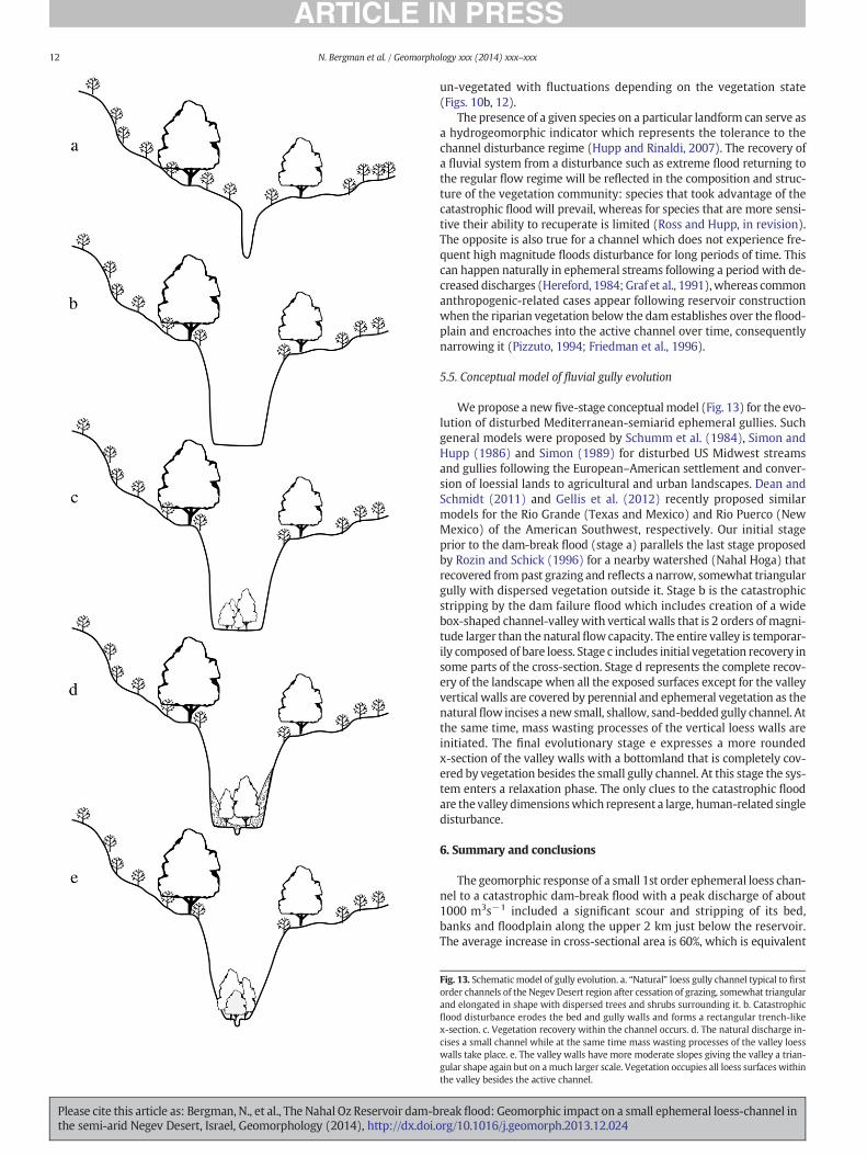
5.5. Conceptual model of fluvial gully evolution
Wepropose a new five-stage conceptualmodel (Fig. 13) for the evo-lution of disturbed Mediterranean-semiarid ephemeral gullies. Suchgeneral models were proposed by Schumm et al. (1984), Simon andHupp (1986) and Simon (1989) for disturbed US Midwest streamsand gullies following the European–American settlement and conver-sion of loessial lands to agricultural and urban landscapes. Dean andSchmidt (2011) and Gellis et al. (2012) recently proposed similarmodels for the Rio Grande (Texas and Mexico) and Rio Puerco (NewMexico) of the American Southwest, respectively. Our initial stageprior to the dam-break flood (stage a) parallels the last stage proposedby Rozin and Schick (1996) for a nearby watershed (Nahal Hoga) thatrecovered frompast grazing and reflects a narrow, somewhat triangulargully with dispersed vegetation outside it. Stage b is the catastrophicstripping by the dam failure flood which includes creation of a widebox-shaped channel-valleywith vertical walls that is 2 orders of magni-tude larger than the natural flow capacity. The entire valley is temporar-ily composed of bare loess. Stage c includes initial vegetation recovery insome parts of the cross-section. Stage d represents the complete recov-ery of the landscape when all the exposed surfaces except for the valleyvertical walls are covered by perennial and ephemeral vegetation as thenatural flow incises a new small, shallow, sand-bedded gully channel. Atthe same time, mass wasting processes of the vertical loess walls areinitiated. The final evolutionary stage e expresses a more roundedx-section of the valley walls with a bottomland that is completely cov-ered by vegetation besides the small gully channel. At this stage the sys-tem enters a relaxation phase. The only clues to the catastrophic floodare the valley dimensionswhich represent a large, human-related singledisturbance.
6. Summary and conclusions
The geomorphic response of a small 1st order ephemeral loess chan-nel to a catastrophic dam-break flood with a peak discharge of about1000 m3s−1 included a significant scour and stripping of its bed,banks and floodplain along the upper 2 km just below the reservoir.The average increase in cross-sectional area is 60%, which is equivalent
Fig. 13. Schematicmodel of gully evolution. a. “Natural” loess gully channel typical to firstorder channels of the Negev Desert region after cessation of grazing, somewhat triangularand elongated in shape with dispersed trees and shrubs surrounding it. b. Catastrophicflood disturbance erodes the bed and gully walls and forms a rectangular trench-likex-section. c. Vegetation recovery within the channel occurs. d. The natural discharge in-cises a small channel while at the same time mass wasting processes of the valley loesswalls take place. e. The valley walls have more moderate slopes giving the valley a trian-gular shape again but on amuch larger scale. Vegetation occupies all loess surfaces withinthe valley besides the active channel.
reak flood: Geomorphic impact on a small ephemeral loess-channel inrg/10.1016/j.geomorph.2013.12.024

13N. Bergman et al. / Geomorphology xxx (2014) xxx–xxx
to an estimated 170,000 m3 of sediment eroded and transported down-stream. Peak flood attenuation along this reach was relatively minor —20% (800 m3s−1). Downstream, the flow expanded into awide, braidedalluvial fan due to a change in the natural topographic slope, twoblocking roads, and deposition of a third (55,600 m3) of the sedimentseroded from the upper segment.
Farther downstream, the floodwater diverged into several water-courses and dispersed over tilled agricultural fields and neighborhoods.In the lowermost segment — Nahal Hanoun stream, peak discharge(100 m3s−1) was about bankfull and is approximately 90% lower thanat the dam breach. This reduction was attributed to the anthropogenicinfrastructure — channels, roads, neighborhoods and agricultural fieldsthat acted as a sponge in addition to the large transmission lossesalong the sandy channel bed and floodplain. The analysis also showsthat Nahal Oz Reservoir's dam-break flood transmission losses andflood attenuation rates were extreme in comparison to other dam-break flood case studies that are much more gradual and moderate.
Eight years after the catastrophic flood, the natural flow regime af-fects only a minor portion of the new channel geometry (2–4%), andhas formed a narrow sandy gully typical to a catchment of this size(1–2 m wide, up to 0.5 m deep). This suggests that the new floodplain(i.e. the channel of the dam-break flood) morphology may preservefor a relatively long time because it is no longer active. The recovery ofthe landscape is expressed by rapid vegetation growth consisting of sea-sonal grasses, shrubs and perennial eucalypt trees which cover the ex-posed loess surfaces that were stripped during the flood. The rarity ofthe dam-break flood relative to the natural flow regime is beyond anymeasured record, especially for such a small catchment.
One of the most striking geomorphic outcomes from this unusualflood is the variable erodibility of the loess material to a volume ofwater that is two orders of magnitude above the natural flows. The en-ergy dissipation occurs very close to the dam breach first with massiveerosion (incised 2 km segment) and then deposition (0.6 km long allu-vial fan).Within a short distance of 2.6 km from the reservoir the down-stream hydraulic geometry does not record the flood due to vastshallow flooding, large transmission losses and anthropogenic actionsand land use. Consequently, there is no stratigraphic, sedimentary orgeomorphicfingerprint for theflood occurrence beyond the two vicinityreaches below the breached reservoir.
This artificial flood event offers a rare opportunity to visualize andquantify large-scale landscape evolution processes such as channel inci-sion, bank erosion and consequent depositional patterns during an ex-tremely high-magnitude flow and the resulting short-term landscaperecovery. Dam-break floods may serve as essential time-compressedtools for predicting channel evolution patterns during large scale floodevents, disturbances that are usually well beyond the lifespan of mod-ern hydrologic records. Their stratigraphic interpretation in long-termrecords, however, requires caution as depositional strath may onlyexist locally or be completely absent from the existing erosional or de-positional environment.
Acknowledgments
Jacob Kimelman of the Israel Ministry of the Environmental Protec-tion assisted us with collecting background data. Elhanan Weinbergerprovided worthy photographs which allowed a better understandingof the flood occurrence. Benzion Porat provided real time informationon the flood route and damage. Cliff Hupp, Waite Osterkamp andJonathan Friedman of the U.S. Geological Survey and David Dunkerelyof Monash University advised us on the riparian vegetation recoveryissue and have improved the discussion considerably. Marina Hetzof Ben Gurion University and Yannick Rouseau of the University ofWestern Ontario assisted with aerial image analysis of the vegetation.Sergei Meizlin of the Building and Infrastructure Testing Lab conductedthe sieving of the loess samples. Dan Zaslavsky provided the abstract ofthe official investigation committee. Jonathan Laronne of Ben Gurion
Please cite this article as: Bergman, N., et al., The Nahal Oz Reservoir dam-bthe semi-arid Negev Desert, Israel, Geomorphology (2014), http://dx.doi.o
University of the Negev provided the vehicle and field surveying equip-ment. Noga Yoselevich of the Cartography Laboratory of the Depart-ment of Geography of the University of Haifa drew the figures. KarenVan Kerkoerle also assisted with the figures. Bob Jarrett of the U.S. Geo-logical Survey Denver encouraged the first author to look further intothis unusual case study and is greatly appreciated. Rick Sadler ofWestern University edited the final text. We thank the editor RichardMarston, Victor Baker and an anonymous reviewer for the constructivecriticism that substantially improved an earlier manuscript.
References
Abdulrazzak, M.J., Sorman, A.U., 1994. Transmission losses from ephemeral stream in aridregion. J. Irrig. Drain. Eng. ASCE 120, 669–675.
Allen, H.D., 2006. Vegetation and ecosystem dynamics. In: Woodward, J.C. (Ed.), ThePhysical Geography of the Mediterranean. Oxford University Press, Oxford,pp. 203–227.
Anders, M.H., Krueger, S.W., Sadler, P.M., 1987. A new look at sedimentation rates and thecompleteness of the stratigraphic record. J. Geol. 95, 1–14.
Anderson, M.G., Calver, A., 1977. On the persistence of landscape features formed by alarge flood. Trans. Inst. Br. Geogr. 2, 243–254.
Anderson, B.G., Rutherford, I.D., Western, A.W., 2006. An analysis of the influence of ripar-ian vegetation on the propagation of flood waves. Environ. Model. Software 21,1290–1296.
Annandale, G.W., 2006. Scour Technology. Mechanics and Engineering Practice, McGraw-Hill Civil Engineering Series (430 pp.).
Arbel, S., Getker, M., Arazi, I., 2006. Unusual rain and flood events data — summary of hy-drological year 2000–2001. Soil Erosion Research Station, Special Report M-77 (35pp. (in Hebrew)).
Archer, D.R., 1989. Flood wave attenuation due to channel and floodplain storage and ef-fects on flood frequency. In: Beven, K., Carling, P. (Eds.), Floods: Hydrological, Sedi-mentological and Geomorphological Implications. John Wiley & Sons Ltd, pp. 37–46.
Avni, Y., 2005. Gully incision as a key factor in desertification in an arid environment, theNegev highlands, Israel. Catena 63, 185–220.
Baker, V.R., 1973. Paleohydrology and sedimentology of Lake Missoula flooding in easternWashington. Geol. Soc. Am. Spec. Pap. 144, 79.
Baker, V.R., 1977. Stream channel response to floods with examples from central Texas.Geol. Soc. Am. Bull. 88, 1057–1071.
Ben-Zvi, A., 1988. Maximal discharges observed in Israel. Environ. Geol. Water Sci. 11,15–19.
Beven, K., 1981. The effect of ordering on the geomorphic effectiveness of hydrologicevents. Erosion and Sediment Transport in Pacific Rim Steeplands. IAHS Publ. 132,510–523.
Blissenbach, E., 1954. Geology of alluvial fans in semiarid regions. Geol. Soc. Am. Bull. 65,175–190.
Blott, S.J., Pye, K., 2001. GRADISTAT: a grain size distribution and statistics package for theanalysis of unconsolidated sediments. Earth Surf. Proc. Land. 26, 1237–1248.
Brooks, G.R., Lawrence, D.E., 1999. The drainage of the Lake Ha! Ha! reservoir and down-stream geomorphic impacts along Ha! Ha! River, Saguenay area, Quebec, Canada.Geomorphology 28, 141–168.
Brunsden, D., Thornes, J.B., 1979. Landscape sensitivity and change. Trans. Inst. Br. Geogr.4, 463–484.
Bull, W.B., 1997. Discontinuous ephemeral streams. Geomorphology 19, 227–276.Cenderelli, D.A., 2000. Floods from natural and artificial dam failures. In: Wohl, E.E. (Ed.),
Inland Flood Hazards: Human. Riparian and Aquatic Communities. Cambridge Uni-versity Press, Cambridge, pp. 73–103.
Cornish, J.H., 1961. Flow losses in dry sand channels. J. Geophys. Res. 66, 1845–1853.Costa, J.E., 1988. Floods from dam failures. In: Baker, V.R., Kochel, R.C., Patton, P.C. (Eds.),
Flood Geomorphology. John Wiley and Sons Inc., pp. 439–463.Costa, J.E., 1994. Multiple flow processes accompanying a dam-break flood in a small
upland watershed, Centralia, Washington. U.S. Geological Survey. Water-ResourcesInvestigations Report. 94–4026.
Costa, J.E., O'Connor, J.E., 1995. Geomorphologically effective floods. In: Costa, J.E., Miller,A.J., Potter, K.W., Wilcock, P.R. (Eds.), Natural and Anthropogenic Influences in FluvialGeomorphology. Geophysical Monograph, 89, pp. 45–56.
Costa, J.E., Schuster, R.L., 1988. The formation and failure of natural dams. Geol. Soc. Am.Bull. 100, 1054–1068.
Coulthard, T.J., Van De Wiel, M.J., 2012. Can we link cause and effect in landscape evolu-tion? In: Church, M., Biron, P., Roy, A. (Eds.), Gravel Bed Rivers VII: Processes, Tools,Environments. Wiley, Chichester, UK, pp. 512–521.
Dalrymple, T., Benson, M.A., 1967. Measurement of Peak Discharge by the Slope-AreaMethod. U.S. Geological Survey Techniques of Water Resources Investigations(Book 3, Chapter A2, 12 pp.).
Dan, J., Yaalon, D.H., 1980. Origin and distribution of soils and landscapes in the northernNegev. Stud. Geogr. Israel 11, 31–56.
Dan, J., Raz, Z., Koyumdjiski, H., 1976. The Soil Associations of Israel. Volcani Institute, BetDagan, Israel.
Dean, D.J., Schmidt, J.C., 2011. The role of feedback mechanisms in historic channelchanges of the lower Rio Grande in the Big Bend region. Geomorphology 126,333–349.
Dunkerley, D., 1992. Channel geometry, bed material, and inferred flow conditions inephemeral stream systems, Barrier, Range, western N.S.W. Australia. Hydrol. Process.6, 417–433.
reak flood: Geomorphic impact on a small ephemeral loess-channel inrg/10.1016/j.geomorph.2013.12.024

14 N. Bergman et al. / Geomorphology xxx (2014) xxx–xxx
Dunkerley, D., 2008. Flow chutes in Fowlers Creek, arid western New South Wales,Australia: evidence for diversity in the influence of trees on ephemeral channelform and process. Geomorphology 102, 232–241.
Dunkerley, D.L., Brown, K.J., 1999. Flow behaviour, suspended sediment transport andtransmission losses in a small (sub-bank-full) flow event in an Australian desertstream. Hydrol. Process. 13, 1577–1588.
Earl, R.A., Benke, R.D., Knaup, K., 2003. Analysis of the July 2002 Flood at the Canyon DamSpillway, Guadalupe River, South-Central Texas. Proc. Pap. Appl. Geogr. Conf. 26,371–379.
Eisenberg, J., Dan, J., Koyumdjisky, H., 1982. Relationships between moisture penetrationand salinity in soils of the northern Negev, Israel. Geoderma 28, 313–344.
Enzel, Y., Ely, L.L., Martinez-Goytre, J., Vivian, R.G., 1994. Paleofloods and dam-failure floodon the Virgin River, Utah and Arizona. J. Hydrol. 153, 291–315.
FAO, 2006. Guidelines for Soil Descriptions. Food and Agriculture Organization of theUnited Nations, Rome (97 pp.).
Friedman, J.M., Lee, V.J., 2002. Extreme floods, channel change, and riparian forests alongephemeral streams. Ecol. Monogr. 72, 409–425.
Friedman, J.M., Osterkamp, W.R., Lewis, W.M., 1996. The role of vegetation and bed-levelfluctuations in the process of channel narrowing. Geomorphology 14, 341–351.
Frydman, S., Samoocha, Y., 1984. Laboratory studies on Israeli clays for reservoir embank-ment design. Proceedings 5th International Conference on Expansive Soils, pp. 94–98.
G.Y.A. Soil and Foundation Engineering Ltd, 1995. Nahal Oz Reservoir — soil report andembankment stability analysis (May).
Gallino, G.L., Pierson, T.C., 1985. Polallie Creek debris flow and subsequent dam-breakflood of 1980, East Fork Hood River Basin, Oregon. U.S. Geological Survey Water-Supply Paper 2273 (22 pp.).
Gellis, A.C., Pavich, M.J., Ellwein, A.L., Aby, S., Clark, I., Wieczorek, M.E., Viger, R., 2012. Ero-sion, storage, and transport of sediment in two subbasins of the Rio Puerco, NewMexico. Geol. Soc. Am. Bull. 124, 817–841.
GEOTECH Consulting Engineers, 2001. Failure of Nahal Oz Reservoir (Expert Opinion (inHebrew with English abstract)).
Graeme, D., Dunkerley, D.L., 1993. Hydraulic resistance by the river red gum, Eucalyptuscamaldulensis, in ephemeral desert streams. Aust. Geogr. Stud. 31, 141–154.
Graf, W.L., 1977. The rate law in fluvial geomorphology. Am. J. Sci. 277, 178–191.Graf, W.L., 1988. Definition of flood plains along arid-region rivers. In: Baker, V.R., Kochel,
R.C., Patton, P.C. (Eds.), Flood Geomorphology. John Wiley & Sons, New York,pp. 231–242.
Graf, J.B., Webb, R.H., Hereford, R., 1991. Relation of sediment load and flood-plain forma-tion to climatic variability, Paria River drainage basin, Utah and Arizona. Geol. Soc.Am. Bull. 103, 1405–1415.
Graham, W., 1998. The Worst Dam Failures — Why? Proc. Munich Meeting of theEuropean Concerted Action on Dam-Break Modelling, Munich, pp. 1–17.
Grant, G.E., Marr, J.D.G., Hill, C., Johnson, S., Campbell, K., Mohseni, O., Wallick, J.R., Lewis, S.L.,O'Connor, J.E., Major, J.J., Burkholder, B.K., 2008. Experimental and field observations ofbreach dynamics accompanying erosion of Marmot cofferdam, Sandy River, Oregon. In:Babcock, R.W., Walton, R. (Eds.), ASCE Proceedings of the 2008World Environmental &Water Resources Congress, Honolulu, Hawaii, May 12–16, 2008 (10 pp.).
Greenbaum, N., 2007. Assessment of dam-failure flood and a natural, high-magnitudeflood in a hyperarid region using paleoflood hydrology, Nahal Ashalim catchment,Dead Sea, Israel. Water Resour. Res. 43. http://dx.doi.org/10.1029/2006WR004956(W02401).
Greenbaum, N., Bergman, N., 2006. Formation and evacuation of a large gravel-bar depos-ited during a major flood in a Mediterranean ephemeral stream, Nahal Me'arot, NWIsrael. Geomorphology 77, 169–186.
Greenbaum, N., Schwartz, U., Bergman, N., 2010. Extreme floods and short-termhydroclimatological fluctuations in the hyper-arid Dead Sea region, Israel. GlobalPlanet. Change 70, 125–137.
Hancox, G.T., McSaveney, M.J., Manville, V.R., Davies, T.R., 2005. The October 1999 MtAdams rock avalanche and subsequent landslide dam-break flood and effects inPoerua River, Westland, New Zealand. N. Z. J. Geol. Geophys. 48, 683–705.
Hanson, G.J., Simon, A., 2001. Erodibility of cohesive streambeds in the loess area of theMidwestern USA. Hydrol. Process. 15, 23–38.
Harvey, A.M., 1990. Factors influencing Quaternary alluvial fan development in southeastSpain. In: Rachocki, A.H., Church, M. (Eds.), Alluvial Fans: A Field Approach. Chapter,13, pp. 247–269.
Harvey, A.M., 2007. Differential recovery from the effects of a 100-year storm: signifi-cance of long-term hillslope-channel coupling; Howgill Fells, northwest England.Geomorphology 84, 192–208.
Hassan, M.A., 1990. Observations of desert flood bores. Earth Surf. Proc. Land. 15,481–485.
Hassan, M.A., Egozi, R., Parker, G., 2006. Experiments on the effect of hydrograph charac-teristics on vertical grain sorting in gravel bed rivers. Water Resour. Res. 42. http://dx.doi.org/10.1029/2005WR004707 (W09408).
Hereford, R., 1984. Climate and ephemeral-stream processes: Twentieth Century geomor-phology and alluvial stratigraphy of the Little Colorado River, Arizona. Geol. Soc. Am.Bull. 95, 654–668.
Huckleberry, G., 1994. Contrasting channel response to floods on the middle Gila River,Arizona. Geology 22, 1083–1086.
Hupp, C.R., Rinaldi, M., 2007. Riparian vegetation patterns in relation to fluvial landformsand channel evolution along selected rivers of Tuscany (Central Italy). Ann. Assoc.Am. Geogr. 97, 12–30.
Inbar, M., 1992. Rates of fluvial erosion in basins with Mediterranean type climate. Catena19, 393–409.
Jansen, R.B., 1987. A review of the Baldwin Hills Reservoir failure. Eng. Geol. 24, 7–81.Jarrett, R.D., Costa, J.E., 1986. Hydrology, geomorphology, and dam-break modeling of the
July 15, 1982 Lawn Lake Dam and Cascade Lake Dam Failures, Larimer County,
Please cite this article as: Bergman, N., et al., The Nahal Oz Reservoir dam-bthe semi-arid Negev Desert, Israel, Geomorphology (2014), http://dx.doi.o
Colorado. Geological Survey Professional Paper 1369. United States GovernmentPrinting Office, Washington (78 pp.).
Jarrett, R.D., England, J.F., 2002. Reliability of paleostage indicators for paleoflood studies.In: House, P.K., Webb, R.H., Baker, V.R., Levish, D.R. (Eds.), Ancient Floods, ModernHazards: Principles and Applications of Paleoflood Hydrology. AGU Water Sciencesand Applications 5, Washington D.C., pp. 91–109.
Jerolmack, D.J., Paola, C., 2010. Shredding environmental signals by sediment transport.Geophys. Res. Lett. 37 (L19401).
Jordan, P.R., 1977. Streamflow transmission losses in Western Kansas. J. Hydraul. Div.ASCE 105, 905–919.
Kahana, R., Ziv, B., Enzel, E., Dayan, U., 2002. Synoptic climatology of major floods in theNegev Desert, Israel. Int. J. Climatol. 22, 867–882.
Katz, G.L., Friedman, J.M., Beatty, S.W., 2005. Delayed effects of flood control on a flood-dependent riparian forest. Ecol. Appl. 15, 1019–1035.
Lane, L.J., Diskin, M.H., Renard, K.G., 1971. Input–output relationship for an ephemeralstream channel system. J. Hydrol. 13, 22–40.
Langbein, W.B., Schumm, S.A., 1958. Yield of sediment in relation to mean annual precip-itation. Am. Geophys. Union Trans. 39, 1076–1084.
Lange, J., Leibundgut, C., Greenbaum, N., Schick, A.P., 1998. Modelling high-magnitude events in large arid catchments — a field based approach in NahalZin, Israel. In: Hydrology, Water Resources and Ecology in Headwaters. IAHSPubl. 248, 561–567.
Lange, J., Leibundgut, C., Greenbaum, N., Schick, A.P., 1999. A non-calibrated rainfall-runoff model for large arid catchments. Water Resour. Res. 35, 2161–2172.
Lange, J., Schick, A.P., Leibundgut, C., 2000. The importance of single events in arid zonerainfall-runoff modelling. Phys. Chem. Earth B 25, 673–677.
Lapointe, M.F., Secretan, Y., Driscoll, S.N., Bergeron, N., Leclerc, M., 1998. Response of theHa! Ha! River to the Flood of July 1996 in the Saguenay Region of Quebec: largescale avulsion in a glaciated valley. Water Resour. Res. 34, 2383–2392.
Laronne, J.B., 1998. Sediment transport and surface water use in arid regions — newdevelopments and future perspective. A Paper Presented at the IV InternationalCongress of Project Engineering, Cordoba — Spain, October 7–9.
Laronne, J.B., 2000. Event-based deposition in the ever-emptying Yatir Reservoir. Israel.Int. Assoc. Hydrol. Sci. Publ. 261, 285–302.
Laronne, J.B., Reid, I., 1993. Very high rates of bedload sediment transport by ephemeraldesert rivers. Nature 366, 148–150.
Laronne, J.B., Taig, M., Shaulker, O., 2005. Solutions to sand aggradation within selectedchannels in the Ashkelon area. Final Report Submitted to the Shikma Besor DrainageAuthority. (30 pp. (In Hebrew)).
Lohnes, R.A., Handy, R.L., 1968. Slope angles in friable loess. J. Geol. 76, 247–258.Magilligan, F.J., Phillips, J.D., James, A.L., Gomez, B., 1998. Geomorphic and sedi-
mentological controls on the effectiveness of an extreme flood. J. Geol. 106,87–95.
Major, J.J., Pierson, T.C., Dinehart, R.L., Costa, J.E., 2000. Sediment yield following severevolcanic disturbance — a two-decade perspective from Mount St. Helens. Geology28, 819–822.
Marcus, W.A., Meyer, G.A., Nimmo, D.R., 2001. Geomorphic control of persistent mineimpacts in a Yellowstone Park stream and implications for the recovery of fluvialsystems. Geology 29, 355–358.
Meirovich, L., Ben-Zvi, A., Shentsis, I., Yanovich, E., 1998a. Frequency and magnitude ofrunoff events in the arid Negev of Israel. J. Hydrol. 207, 204–219.
Meirovich, L., Laronne, J.B., Reid, I., 1998b. The variation of water surface slope and its sig-nificance for bedload transport during floods in gravel bed streams. J. Hydraul. Res.36, 147–157.
Mellol, A.J., Collin, M., 1994. The hydrological malaise of the Gaza Strip. Israel J. Earth Sci.43, 105–116.
Meyer, D.F., Martinson, H.A., 1989. Rates and processes of channel development and re-covery following the 1980 eruption of Mount St. Helens, Washington. J. Hydrol. Sci.34, 115–127.
Michaeli, L., Wolf, M., 1986. The influence of hydrochemical conditions in loess onthe stability of slopes. Geol. Surv. Israel GSI/50/86 73 p. (in Hebrew).
Miller, A.J., 1990. Flood hydrology and geomorphic effectiveness in the Central Appala-chians. Earth Surf. Proc. Land. 15, 119–134.
Nanson, G.C., 1986. Episodes of vertical accretion and catastrophic stripping: a model ofdisequilibrium flood-plain development. Geol. Soc. Am. Bull. 97, 1467–1475.
Nevo, N., 2001. Dambreak of the Oz Reservoir. Water Eng. (Handasat Maim) 47, 6(in Hebrew).
NOAA., 1987. Walls of Water— Deadly Fences. Western Region Technical Attachment, No87-48, December 1, 1987, 5 p. (In: www.weather.gov/im/pub/wrta8748.pdf, lastaccessed December 2009).
Nsom, B., Debiane, K., Piau, J.M., 2000. Bed slope effect on the dam break problem.J. Hydraul. Res. 38, 459–464.
O'Connor, J.E., Haridson, J.H., Costa, J.E., 2001. Debris Flows from Failures of Neoglacial-Age Moraine Dams in the Three Sisters and Mount Jefferson Wilderness Areas,Oregon. U.S. Geological Survey Professional Paper 1606 (93 pp.).
O'Connor, J.E., Grant, G.E., Costa, J.E., 2002. The geology and geography of floods. In:House, P.K., Webb, R.H., Baker, V.R., Levish, D.R. (Eds.), Ancient Floods, ModernHazards: Principles and Applications of Paleoflood Hydrology. American GeophysicalUnion, pp. 359–385.
Osterkamp, W.R., Lane, L.J., Savard, C.S., 1994. Recharge estimates using geomorphic/distributed-parameter simulation approach, Amargosa River basin. Water Resour.Bull. 30, 493–507.
Parissopoulos, G.A., Wheater, H.S., 1991. Effects of wadi flood hydrograph characteristicson infiltration. J. Hydrol. 126, 247–263.
Pilotti, M., Maranzoni, A., Tomirotti, M., Valerio, G., 2011. 1923 Gleno dam break: casestudy and numerical modeling. J. Hydraul. Eng. ASCE 137, 480–492.
reak flood: Geomorphic impact on a small ephemeral loess-channel inrg/10.1016/j.geomorph.2013.12.024

15N. Bergman et al. / Geomorphology xxx (2014) xxx–xxx
Pizzuto, J.E., 1994. Channel adjustment to changing discharges, Powder River, Montana.Geol. Soc. Am. Bull. 78, 1494–1501.
Prosser, I.P., Slade, C.J., 1994. Gully formation and the role of valley-floor vegetation,south-eastern Australia. Geology 22, 1127–1130.
Rathburn, S., 1993. Pleistocene cataclysmic flooding along the Big Lost River, east centralIdaho. Geomorphology 8, 305–319.
Reid, I., Laronne, J.B., Powell, D.M., Garcia, C., 1994. Flash flood in desert rivers: studyingthe unexpected. EOS Trans. Am. Geophys. Union 75, 452.
Renwick, W.H., 1992. Equilibrium, disequilibrium, and nonequilibrium landforms in thelandscape. Geomorphology 5, 265–276.
Ross, K.M., Hupp, C.R., in revision. Riparian vegetation response along a flood gradient,Rapidan River, Virginia. Personal written communication.
Rozin, U., Schick, A.P., 1996. Land use change, conservation measures and stream channelresponse in theMediterranean/semiarid transition zone: Nahal Hoga, southern coast-al plain, Israel. Erosion and Sediment Yield: Global and Regional Perspectives. IAHSPubl. 236, 427–444.
Rudge, D., 2001. Nahal Oz Reservoir bursts. Jerusalem Post, Tuesday, March 27, 2001,15:35, 3 Nisan 5761. (In: http://www.jpost.com, last accessed December 2009).
Sanders, C.L., Sauer, V.B., 1979. Kelly Barnes Dam flood of November 6, 1977, near Toccoa,Georgia. U.S. Geological Survey Hydrologic Investigations Atlas HA-613. (In: http://pubs.usgs.gov/ha/ha613/, last accessed December 2009.).
Schick, A.P., 1988. Hydrologic aspects of floods in extreme arid environments. In: Baker, V.R.,Kochel, R.C., Patton, P.C. (Eds.), Flood Geomorphology. John Wiley & Sons, pp. 189–203.
Schumm, S.A., 1979. Geomorphic thresholds: the concept and its applications. Trans. Inst.Br. Geogr. 4, 485–515 (New Series).
Schumm, S.A., Lichty, R.W., 1963. Channel Widening and Flood-Plain Construction alongCimarron River in Southwestern Kansas: U.S. Geol. Survey Prof. Paper 352-D. 71–88.
Schumm, S.A., Harvey, M.D., Watson, C.C., 1984. Incised Channels, Morphology, Dynamicsand Control. Water Resources Publications, Littleton, Colorado (200 pp.).
Schwartz, U., 2001. Surface and Near Surface Responses to Floods in a Large Channel(Nahal Zin) in the Context of an Alluvial Aquifer in a Hyper-Arid Environment.Unpublished PhD dissertation, Department of Geography, The Hebrew University,Jerusalem, 135 pp. (in Hebrew with English abstract).
Scott, W.E., 1977. Geologic Effects of Flooding from Teton Dam Failure, SoutheasternIdaho. U.S. Geological Survey, Open-File Report 77–507 (11 pp.).
Seginer, I., 1966. Gully development and sediment yield. J. Hydrol. 4, 236–253.Shentsis, I., Meirovich, L., Ben-Zvi, A., Rosenthal, E., 1999. Assessment of transmission
losses and groundwater recharge from runoff events in a wadi under shortage ofdata on lateral inflow, Negev, Israel. Hydrol. Process. 13, 1649–1663.
Shentsis, I., Meirovich, L., Ben-Zvi, A., Rosenthal, E., 2001a. Assessment of transmissionlosses and groundwater recharge from runoff events in watercourses of the Neqarotwatershed, Israel. Israel J. Earth Sci. 50, 201–215.
Shentsis, I., Meirovich, L., Ben-Zvi, A., Rosenthal, E., 2001b. Assessment of transmissionlosses and groundwater recharge from runoff events in a reach of Nahal Paran,Israel. Israel J. Earth Sci. 50, 187–199.
Sigafoos, R.S., 1964. Botanical evidence of floods and flood-plain deposition. GeologicalSurvey Professional Paper 485-A. (Washington, 35 pp.).
Simon, A., 1989. A model of channel response in disturbed alluvial channels. Earth Surf.Proc. Land. 14, 11–26.
Simon, A., Hupp, C.R., 1986. Chanel Evolution in Modified Tennessee channels. Proceed-ings, IV Federal Interagency Sedimentation Conference, Las Vegas, Nevada, March24–27, volume 2, 5-71-5-82.
Task Committee on Dam/Levee Breaching Processes, 2011. Earthen embankmentbreaching. J. Hydraul. Eng. ASCE 137, 1549–1564.
Please cite this article as: Bergman, N., et al., The Nahal Oz Reservoir dam-bthe semi-arid Negev Desert, Israel, Geomorphology (2014), http://dx.doi.o
Thomas, M.F., 2001. Landscape sensitivity in time and space— an introduction. Catena 42,83–98.
Thorn, C.E., Welford, M.R., 1994. The equilibrium concept in geomorphology. Ann. Assoc.Am. Geogr. 84, 666–696.
Twidale, C.R., 1976. On the survival of paleoforms. Am. J. Sci. 276, 77–95.Van DeWiel, M.J., Coulthard, T.J., 2010. Self-organized criticality in river basins: challeng-
ing sedimentary records of environmental change. Geology 38, 87–90.Von Thun, J.L., 1996. Understanding Seepage and Piping Failures — The No. 1 Dam Safety
Problem in theWest. ASDSOWestern Regional Conference, Lake Tahoe Nevada, Asso-ciation of State Dam Safety Officials, Kentucky.
Wahl, T.L., 1998. Prediction of embankment dam breach parameters: a literature reviewand needs assessment. Dam Safety Research Rep. DSO-98-004.US Bureau of Reclama-tion (60 pp.).
Wahl, T.L., 2004. Uncertainty of predictions of embankment dam breach parameters.J. Hydraul. Eng. 130, 389–397.
Walder, J.S., Costa, J.E., 1996. Outburst floods from glacier dammed lakes: the effect ofmode of lake drainage on flood magnitude. Earth Surf. Proc. Land. 21, 701–723.
Wan, C.F., Fell, R., 2002. Investigation of internal erosion and piping of soils in embank-ment dams by the slot erosion test and the hole erosion test. UNICIV Report NoR-412. The University of New South Wales, Sydney (ISSN 0077 880X).
Wang, S.Y., Langendoen, E., Shields Jr., F.D., 1997. Management of landscapes disturbed bychannel incision, stabilization, rehabilitation and restoration. University of Mississip-pi, Mississippi (1134 pp.).
Washington State Department of Ecology, 2007. Dam Safety Guidelines— Technical Note1: Dam Break Inundation Analysis and Downstream Hazard Classification. MGS Engi-neering Consultants, Inc., Water Resources Program Dam Safety Office, Olympia,Washington (Publication 92-55E. Available in: http://www.ecy.wa.gov/biblio/9255e.html. Last accessed July 9, 2013.).
Webb, R.H., Jarrett, R.D., 2002. One-dimensional estimation techniques for discharges ofpaleofloods and historical floods. In: House, P.K., Webb, R.H., Baker, V.R., Levish,D.R. (Eds.), Ancient Floods, Modern Hazards: Principles and Applications ofPaleoflood Hydrology. AGU Water Sciences and Applications 5, Washington D.C.,pp. 111–126.
Wolman, M.G., Gerson, R., 1978. Relative scales of time and effectiveness of climate inwa-tershed geomorphology. Earth Surf. Proc. Land. 3, 189–208.
Wolman, M.G., Miller, J.P., 1960. Magnitude and frequency of forces in geomorphic pro-cesses. J. Geol. 68, 54–74.
Yaalon, D., 1967. Factors affecting the lithification of eolianite and interpretation of itsenvironmental significance in the coastal plain of Israel. J. Sediment. Petrol. 37,1189–1199.
Yair, A., Kossovsky, A., 2004. Climate and surface properties: hydrological response ofsmall arid and semi-arid watersheds. Geomorphology 42, 43–57.
Yakirevich, A., Melloul, A., Sorek, S., Shaath, S., Borisov, V., 1998. Simulation of seawaterintrusion into the Khan Yunis area of the Gaza Strip coastal aquifer. Hydrogeol. J. 6,549–559.
Yochum, S.E., Goertz, L.A., Jones, P.H., 2008. Case study of the Big Bay Dam failure:accuracy and comparison of breach predictions. J. Hydraul. Eng. ASCE 134,1285–1293.
Zaslavsky, D., Ravhon, Z., Cohen, M., Zaslavsky, S., Ran, R., Nehama, M., Zamkov, S., 2002.Water outburst in the Nahal Oz Reservoir 26.3.2001. Final Report Submitted by theInvestigation Committee Appointed by the Minister of National Infrastructures Mr.Avigdor Liberman on the Date of 26.3.01. (Tel Aviv, 25.2.2002 (in Hebrew)).
Zimmerman, R.C., Goodlett, J.C., Comer, G.H., 1967. The influence of vegetation on channelform of small streams. IAHS Publ. 75, 225–275.
reak flood: Geomorphic impact on a small ephemeral loess-channel inrg/10.1016/j.geomorph.2013.12.024
Copyright © 2022 FDOKUMEN