Palynological Investigations at the Middle Paleolithic Site of Nahal Mahanayeem Outlet, Israel
18
Palynological investigations at the Middle Palaeolithic site of Nahal Mahanayeem Outlet, Israel Sophia Aharonovich a , Gonen Sharon b , Mina Weinstein-Evron a, * a Laboratory of Palynology, Zinman Institute of Archaeology, University of Haifa, Haifa, Israel b Prehistory Laboratory, Tel Hai College, Upper Galilee, Israel article info Article history: Available online xxx abstract A detailed palynological sequence of the late Middle Palaeolithic (MP) open-air site Nahal Mahanayeem Outlet (NMO), northern Jordan Rift Valley, Israel, dated to ca. 65e51 ka, constitutes a rare case of a south Levantine archaeo-palynological study for this period. The sequence is characterized by relatively high Arboreal Pollen (AP) ratios, comparable to humid fluctuations in the near-by Hula cores. The pollen spectra represent a Mediterranean maquis with Quercus calliprinos (Palestine oak), Quercus ithaburensis (Mt. Tabor oak), Pistacia sp. (pistachio), Pinus halepensis (Aleppo pine), and Olea europaea (wild olive) as the main tree taxa. Among the Non Arboreal Pollen (NAP) the dominant families are Poaceae (true grasses family), Chenopodiaceae (goosefoot family), Apiaceae (parsley family) and Liliaceae (lily family), and the genera Artemisia (sagebrush) and Centaurea (centaury). Two humid fluctuations with higher AP ratios, separated by a somewhat drier one, seem to emerge. The earlier humid fluctuation represents a cooler climate as indicated by the occurrence of Cedrus libani (Lebanon cedar), Abies (fir), and Alnus (alder) pollen. Altogether, the palynological data suggest wet habitats near the site in a rather humid period, when a Mediterranean maquis was widespread on the mountains surrounding the valley, with some minor fluctuations in humidity and temperature. Results of the current study fit those of a previous study of the Hula Basin for roughly the same time period. They further provide valuable details and a unique palaeoenvironmental reconstruction specifically related to the occupation period of NMO. Given the postulated short-term nature of its human occupation, the palynological sequence may represent a longer period of accumulation, extending before, during and after human presence at the site, with short human habitation spell/s incorporated within the sequence. The unique preservation of rich and diverse micro-botanical (pollen) and macro-botanical (wood, bark, seeds and fruits) assemblages at the site further contributes to the comprehensive reconstruction of a variety of biotopes exploited by the in- habitants of the site, both in the vicinity and further afield. Ó 2013 Elsevier Ltd and INQUA. All rights reserved. 1. Introduction The Middle Palaeolithic (MP) is a period of significant cultural change in the Levant, encompassing technological, social, subsis- tence and symbolic developments among its human populations (e.g., Bar-Yosef, 2000; Shea, 2003; Speth, 2012). Moreover, it in- volves the yet enigmatic issue of the possible relationships between the Neanderthals and early modern humans, the two carriers of the culture of the period, the Mousterian. Data on climate change during the culture’s time frame between 250 ka and 50 ka are critical to understanding factors which may have influenced these important cultural transformations and human population dy- namics and evolution during this period (see also Tchernov, 1998; Weissbrod and Zaidner, 2013). Various palaeoenvironmental reconstructions of the Late Pleis- tocene Levant have been based on long and continuous regional records derived from lakes in the Jordan Rift Valley (Niklewski and van Zeist, 1970; Horowitz, 1979; Weinstein-Evron, 1983; Bartov et al., 2002), the Mediterranean Sea (Langgut et al., 2011) and from cave speleothems (Bar-Matthews et al., 1997, 2003; Vaks et al., 2003). However, direct evidence from the archaeological sites themselves, which are critical for correlating accurately between cultural and palaeoenvironmental dynamics, are scarce. The avail- able sequences obtained from MP archaeological sites are rarely continuous, and often reflect the impact of various biasing factors * Corresponding author. E-mail addresses: [email protected] (S. Aharonovich), gonen. [email protected] (G. Sharon), [email protected] (M. Weinstein-Evron). Contents lists available at ScienceDirect Quaternary International journal homepage: www.elsevier.com/locate/quaint 1040-6182/$ e see front matter Ó 2013 Elsevier Ltd and INQUA. All rights reserved. http://dx.doi.org/10.1016/j.quaint.2013.10.043 Quaternary International xxx (2013) 1e18 Please cite this article in press as: Aharonovich, S., et al., Palynological investigations at the Middle Palaeolithic site of Nahal Mahanayeem Outlet, Israel, Quaternary International (2013), http://dx.doi.org/10.1016/j.quaint.2013.10.043
Transcript of Palynological Investigations at the Middle Paleolithic Site of Nahal Mahanayeem Outlet, Israel

lable at ScienceDirect
Quaternary International xxx (2013) 1e18
Contents lists avai
Quaternary International
journal homepage: www.elsevier .com/locate/quaint
Palynological investigations at the Middle Palaeolithic site of NahalMahanayeem Outlet, Israel
Sophia Aharonovich a, Gonen Sharon b, Mina Weinstein-Evron a,*
a Laboratory of Palynology, Zinman Institute of Archaeology, University of Haifa, Haifa, Israelb Prehistory Laboratory, Tel Hai College, Upper Galilee, Israel
a r t i c l e i n f o
Article history:Available online xxx
* Corresponding author.E-mail addresses: [email protected]
[email protected] (G. Sharon), [email protected]
1040-6182/$ e see front matter � 2013 Elsevier Ltd ahttp://dx.doi.org/10.1016/j.quaint.2013.10.043
Please cite this article in press as: AharonoOutlet, Israel, Quaternary International (201
a b s t r a c t
A detailed palynological sequence of the late Middle Palaeolithic (MP) open-air site Nahal MahanayeemOutlet (NMO), northern Jordan Rift Valley, Israel, dated to ca. 65e51 ka, constitutes a rare case of a southLevantine archaeo-palynological study for this period. The sequence is characterized by relatively highArboreal Pollen (AP) ratios, comparable to humid fluctuations in the near-by Hula cores. The pollenspectra represent a Mediterranean maquis with Quercus calliprinos (Palestine oak), Quercus ithaburensis(Mt. Tabor oak), Pistacia sp. (pistachio), Pinus halepensis (Aleppo pine), and Olea europaea (wild olive) asthe main tree taxa. Among the Non Arboreal Pollen (NAP) the dominant families are Poaceae (truegrasses family), Chenopodiaceae (goosefoot family), Apiaceae (parsley family) and Liliaceae (lily family),and the genera Artemisia (sagebrush) and Centaurea (centaury). Two humid fluctuations with higher APratios, separated by a somewhat drier one, seem to emerge. The earlier humid fluctuation represents acooler climate as indicated by the occurrence of Cedrus libani (Lebanon cedar), Abies (fir), and Alnus(alder) pollen. Altogether, the palynological data suggest wet habitats near the site in a rather humidperiod, when a Mediterranean maquis was widespread on the mountains surrounding the valley, withsome minor fluctuations in humidity and temperature. Results of the current study fit those of a previousstudy of the Hula Basin for roughly the same time period. They further provide valuable details and aunique palaeoenvironmental reconstruction specifically related to the occupation period of NMO. Giventhe postulated short-term nature of its human occupation, the palynological sequence may represent alonger period of accumulation, extending before, during and after human presence at the site, with shorthuman habitation spell/s incorporated within the sequence. The unique preservation of rich and diversemicro-botanical (pollen) and macro-botanical (wood, bark, seeds and fruits) assemblages at the sitefurther contributes to the comprehensive reconstruction of a variety of biotopes exploited by the in-habitants of the site, both in the vicinity and further afield.
� 2013 Elsevier Ltd and INQUA. All rights reserved.
1. Introduction
The Middle Palaeolithic (MP) is a period of significant culturalchange in the Levant, encompassing technological, social, subsis-tence and symbolic developments among its human populations(e.g., Bar-Yosef, 2000; Shea, 2003; Speth, 2012). Moreover, it in-volves the yet enigmatic issue of the possible relationships betweenthe Neanderthals and early modern humans, the two carriers of theculture of the period, the Mousterian. Data on climate changeduring the culture’s time frame between 250 ka and 50 ka are
(S. Aharonovich), gonen.ifa.ac.il (M. Weinstein-Evron).
nd INQUA. All rights reserved.
vich, S., et al., Palynological3), http://dx.doi.org/10.1016/
critical to understanding factors which may have influenced theseimportant cultural transformations and human population dy-namics and evolution during this period (see also Tchernov, 1998;Weissbrod and Zaidner, 2013).
Various palaeoenvironmental reconstructions of the Late Pleis-tocene Levant have been based on long and continuous regionalrecords derived from lakes in the Jordan Rift Valley (Niklewski andvan Zeist, 1970; Horowitz, 1979; Weinstein-Evron, 1983; Bartovet al., 2002), the Mediterranean Sea (Langgut et al., 2011) and fromcave speleothems (Bar-Matthews et al., 1997, 2003; Vaks et al.,2003). However, direct evidence from the archaeological sitesthemselves, which are critical for correlating accurately betweencultural and palaeoenvironmental dynamics, are scarce. The avail-able sequences obtained from MP archaeological sites are rarelycontinuous, and often reflect the impact of various biasing factors
investigations at the Middle Palaeolithic site of Nahal Mahanayeemj.quaint.2013.10.043

S. Aharonovich et al. / Quaternary International xxx (2013) 1e182
related to their mode of accumulation or to site formation processessuch as selective hunting or differential preservation, for palyno-logical and faunal data, respectively (Weinstein-Evron, 1994; Spethand Tchernov, 2001). Palynological sequences from MP sites areespecially rare, and thus far are available only for the lower part ofthe MP, in Layers D and C of Tabun Cave (Jelinek et al., 1973).
The current study is based on the detailed palynological analysisof a continuously sampled sequence at theMousterian open-air siteof Nahal Mahanayeem Outlet (NMO) (Fig. 1). The site is dated byOSL to 65 kae51 ka (Kalbe et al., 2013). The primary goal of thestudy is to reconstruct the vegetation and climate during the lateMP in the northern part of the Jordan Rift Valley and in the vicinityof the palaeo-Lake Hula where the site is located. The palynologicaldata, in conjunction with detailed geological, archaeological, andfaunal studies at the site will provide a comprehensive overviewconcerning potential influencing factors on human behavior, sub-sistence and the environmental background of the area during thelate MP period.
Continuous sequences pertaining to our researchwere primarilyobtained by detailed palynological analyses (e.g., Horowitz, 1979;Weinstein-Evron, 1983), speleothem isotopic data (e.g., Bar-Matthews et al., 1997, 1999; Vaks et al., 2003, 2006), or sedimen-tological studies and lake level reconstructions (e.g., Bartov et al.,2002; Develle et al., 2011). Other data, representing shorter pe-riods, were mainly derived from prehistoric sites (e.g., Rosen inHenry et al., 1996; Albert et al., 1999; Madella et al., 2002).
Palynological studies performed by Horowitz (1979, 1989, 2001)in the Hula basin suggest a warm and dry interpluvial climate (witha low tree cover and high presence of Poaceae (true grasses family)during the Riss-Würm Interpluvial stage (ca. 130e110 ka) (MIS 5e),followed by a cool and humid Würm pluvial. The Würm (ca. 110e11.5 ka) (Petit et al., 1999) was further divided by Horowitz intothree cool and humid stadial, separated by two warmer, humidinter-stadials phases (Horowitz, 1971, 1979).
A detailed study of the last interglacial-glacial sequence (MIS 5-3) of the Hula basin was carried out by Weinstein-Evron (1983,1990). Sixteen palynological zones were suggested for a sequence
Fig. 1. Location map of the NMO site and other sites mentioned in the text.
Please cite this article in press as: Aharonovich, S., et al., PalynologicalOutlet, Israel, Quaternary International (2013), http://dx.doi.org/10.1016/
encompassing the period between about 130 and 41/40 ka (Fig. 2).A relatively dry climate was suggested for the lower part of thesequence (Pollen Zones 1-5; MIS 5) as indicated by low ArborealPollen (AP) levels with relatively high Poaceae, Chenopodiaceae(goosefoot family) and Artemisia (sagebrush) ratios. The first phaseof the last glacial (Pollen Zone 6; beginning of MIS 4) was wet andcold. The composition of the pollen spectra suggests that thisperiod was the most humid (with some minor fluctuations in hu-midity), based on the high levels of Quercus and AP and low pro-portions of Chenopodiaceae and Artemisia (Weinstein-Evron,1983).The composition of the pollen spectra suggests that oak forestswere extensive in the area, while the Irano-Turanian vegetation beltshifted eastward away from the Hula Valley (Fig. 3). After a milddesiccation (Zone 7), a renewed increase in humidity was detectedin Pollen Zones 8 and 9. However, humidity was not as pronouncedas before and, based upon an abundance of Cedrus (cedar) pollen,this period is noted for its coldness, which was more marked thanin any other zone. The high ratios of cedars are also consistent withcontinental conditions. The pollen spectra of this zone probablyrepresent spreading of Quercus and Cedrus forests in the area,including the Lebanon and Hermon regions, during a period morehumid and considerably colder than previously. During Pollen Zone10, dry conditions prevailed again as indicated by low AP levels andhigh Chenopodiaceae. Humidity increased again during PollenZones 11e13 (early part of MIS 3), with gradually decreasing tem-peratures. During Pollen Zone 11 oak forest spread over themountains, and probably into the valley itself. This period wasfollowed by a minor dry period (Pollen Zone 12), with some in-crease in temperature as indicated by higher Olea and Pinus ratios.Pollen Zone 13 suggested another spreading of the oak forest overthe mountains during the cool and humid climatic conditionswhich prevailed in the area, and high Cedrus ratios indicated itsprobable spreading in the Lebanon and Hermon. A short dry period(Zone 14) was followed by a relatively cold, humid short phase(Zone 15). After a short, dry phase at a depth of 54m, a renewed risein humidity is indicated by the higher AP levels of Zone 16, espe-cially in its upper part. The relatively lower AP, high Artemisia, lowCedrus and high Olea indicate that the prevailing climate was lesshumid and probably slightly warmer than during Zone 6 times(Fig. 2; Weinstein-Evron, 1983, 1988).
Cold and dry conditions were suggested for the Last GlacialMaximum (LGM) with low AP levels and high ratios of Artemisiaand Chenopodiaceae, with a rather humid Late Glacial (Tsukada,cited in Bottema and van Zeist, 1981; Bottema and van Zeist, 1981;Weinstein-Evron, 1983, 1990; Baruch and Bottema, 1991). Palyno-logical data from Birket Ram, located in the northernmost part ofthe Golan Heights, also suggest a humid climate throughout the lastglacial, with a cooling and drying trend (Weinstein,1976). However,sparse sampling and poor dating prevent further correlations.
Based on similar fluctuations in the pollen curves and peaks ofthe coniferous Pinus and Cedrus Weinstein-Evron (1990) suggestedthat similar trends in climate and vegetation changes are registeredin the pollen curves from the Hula Valley and the Ghab Valley,located about 300 km north of the Hula (Niklewski and van Zeist,1970). Both exhibit a relatively high tree cover in the area overmost of the last glacial, with a dry LGM period (Niklewski and vanZeist, 1970; Weinstein-Evron, 1990).
Palynological and palaeoenvironmental reconstructions basedon a northern Levantine core from Lake Yammoûneh in Lebanon(Develle et al., 2011) suggest rather opposite trends to the pictureemerging from the Hula, with a wet MIS 5 and a cool and dry LastGlacial. Similar trends were observed in a recently studied corefrom the south-eastern Mediterranean (Langgut et al., 2011). Thefactors underlying this discrepancy are unclear. While in the case ofthe Hula sequence this may have resulted from insufficient age
investigations at the Middle Palaeolithic site of Nahal Mahanayeemj.quaint.2013.10.043

Fig. 2. Schematic palaeoclimatological reconstruction based on the Hula L07 core. a.AP curve. b. reconstructed climate. c. Suggested chronology (after Weinstein-Evron,1988; Fig. 4).
Fig. 3. A schematic cyclic representation of the onset of climatic fluctuations in theLevantine Rift Valley. High AP levels (mainly Quercus) represent a humid period with adense maquis or forest and a shift of the Mediterranean vegetation belt eastwards. Indry periods the situation is reversed and the expansion of the Irano-Turanian steppevegetation westward is indicated by high Chenopodiaceae and Artemisia levels. In-termediate periods show more mixed AP (with Olea and Pistacia) and NAP (with manyPoaceae) spectra. Note that Cedrus peaks always follow those of the AP and Quercus(after Weinstein-Evron, 1990; Fig. 8).
S. Aharonovich et al. / Quaternary International xxx (2013) 1e18 3
control (e.g., Weinstein-Evron et al., 2001; Meadows, 2005; vanZeist et al., 2009), this cannot explain the better conforming ofthe Hula datawith those of the Jerusalem area (Frumkin et al., 2011)and the Dead Sea basin, for example (see below). A palynologicalstudy in the eastern Mediterranean area (Langgut et al., 2011)suggested less humid climate with aridification between ca. 75.5kae56.3 ka followed by a moderate increase in humidity to 43.5 ka.These results supported the environmental reconstructionsreceived in previous studies of Mediterranean Sea sediments(Cheddadi et al., 1991; Rossignol-Strick, 1995, 1999). Significantly,while the general trends of the Mediterranean and Lebanese curvesand those of the Hula may seem contradictory, the time-spanrelevant to the late MP NMO palynological reconstructions, i.e.,the period between ca. 65 � 5 and 51 � 4 ka, is relatively humid inboth the northern Rift sequences and the south-eastern Mediter-ranean cores (Niklewski and van Zeist, 1970; Weinstein-Evron,1983, 1990; Develle et al., 2011).
Although it is a much earlier site, the palynological analysis ofthe nearby Acheulean occupation of Gesher Benot Ya’aqov (GBY)dated to about 800e700 ka (Goren-Inbar et al., 2000) may proverelevant in highlighting various aspects of our interpretation andthe resulting palaeoenvironmental reconstructions. GBY is locatedat the southern end of the ancient Hula Valley, some 7 km south of
Please cite this article in press as: Aharonovich, S., et al., PalynologicalOutlet, Israel, Quaternary International (2013), http://dx.doi.org/10.1016/
the NMO site. A pollen diagram, representing 65e70 ky, suggestedthe presence of Quercus ithaburensisePistacia atlantica (Mt. Taboroakemastic tree) woodland (open forest) in the Hula Valley and thelower slopes of the surrounding mountains at the time of thedeposition of the sequence (van Zeist and Bottema, 2009). Quercuscalliprinos (Palestine oak), together with Olea europaea (wild olive)must have been important components of the maquis, especially athigher elevations. The moderately wet sequence was interruptedby at least two drier phases, when either Chenopodiaceae alone, orboth Chenopodiaceae and Artemisia values peaked, the latterindicating the driest climate in the sequence (van Zeist andBottema, 2009). Based on the relatively high percentages of Ced-rus pollen in the upper part of the diagram, a cooler and morehumid climate was suggested, but the authors do not negate thepossibility of prevailing continental conditions (cf. Weinstein-Evron, 1983; van Zeist and Bottema, 2009). These reconstructions,supported by the wood remains retrieved from the site (Goren-Inbar et al., 2002a; Werker in Goren-Inbar et al., 2002b) suggestthat the arboreal vegetation in the surroundings of the site wascomparable with the inferred present-day natural tree cover(Werker in Goren-Inbar et al., 2002b; van Zeist and Bottema, 2009).
The only continuous sedimentological sequence containingpollen grains from anMP site was studied in Tabun Cave, located onthe western escarpment of Mount Carmel (Jelinek et al., 1973;Horowitz, 1979). The sequence covered the upper part of theRiss-Würm (MIS 5) interpluvial (Layer E) and the Early Würmpluvial periods (Layers D-C) (MIS 4-3). While the dating of theTabun sequence has changed dramatically since (Grün, 1991;Mercier and Valladas, 2003; Rink et al., 2003), the palaeo-environmental reconstructions suggesting a humid early MP
investigations at the Middle Palaeolithic site of Nahal Mahanayeemj.quaint.2013.10.043

S. Aharonovich et al. / Quaternary International xxx (2013) 1e184
(Tabun D), and a somewhat less humid late MP (Tabun C) still hold.No evidence is available for Tabun Layer B, which, in accordancewith the OSL dates, is contemporaneous with NMO. In addition, afew isolated samples, taken from sites in Jordan (Emery-Barbier,1995) and in the Negev desert (Horowitz, 1977, 1979), suggest ahumid MP. However, these samples do not provide continuoussequences, and their dating is poor.
Similar to the lacustrine palynological evidence, speleothemisotopic analyses also provide continuous palaeoenvironmentalreconstructions, based on the study of stable oxygen (d18O) andcarbon (d13C) profiles of their calcite. Several studies pertaining tothe MP time span were conducted in southern Levantine speleo-them caves (Fig. 1), mainly the Soreq Cave (Bar-Matthews et al.,1997, 1999; Almogi-Labin et al., 2009), Peqiin Cave (Bar-Matthewset al., 2003), Tsavoa Cave and the Ma’ale Efraim Cave (Vaks et al.,2003, 2006; Affek et al., 2008).
The isotopic data suggest several cycles of climatic changes,oscillating between warmer and wetter and cooler and drier pe-riods, during the late MP. These studies suggested high precipita-tion for the period between ca. 130 to 120 ka (Bar-Matthews et al.,1999, 2003), with other humid spells from ca. 110 to 100 ka andfrom ca. 90 to 70 ka (Bar-Matthews et al., 1999, 2003; Vaks et al.,2003), and are in accordance with eastern Mediterranean marineisotopic records (Almogi-Labin et al., 2009). The period about 73 to55 ka was suggested to be more humid than the entire MIS 5 (Bar-Matthews et al., 1999, 2003; Vaks et al., 2003). A cool and dryperiod was identified about 56e54 ka, followed by a wetter periodwith some dry fluctuations (about 54 ka and 36 ka) (Bar-Matthewset al., 1999; Ayalon et al., 2002).
Reconstructed lake levels of the Lisan, the late Pleistocene pre-cursor of the Dead Sea which occupied the tectonic depressionalong the Dead Sea basin and the Jordan Valley from about 70 to 15ka, also serve as palaeoclimatic indicators. A number of sedimen-tological and geomorphological studies were performed in the area(e.g., Schramm et al., 2000; Bartov et al., 2002 and referencestherein), and sequences of climatic reconstructions were proposedbased on the reconstructed fluctuations in lake levels (Bartov et al.,2002). The generally high Lake Lisan levels between about 55 kaand 30 ka were interpreted as indicating high humidity in the area.This was punctuated by a dry spell between 48 and 43 ka (Steinet al., 1999; Bartov et al., 2002). Significantly, a long period oflake-level stabilization and hence high humidity, was suggested forthe period encompassing the late MP at NMO, between 55 and 48ka. Geomorphological and sedimentological studies in YammoûnehLake, located on the eastern flank of Mount Lebanon, suggestedsimilar water-level fluctuations during the MP period (Develleet al., 2011).
The palynological data, mostly derived from lacustrine sedi-ments, can be complemented by other archaeobotanical data(mainly phytoliths, charcoals, seeds, and grains). While rarelypreserved in archaeological sediments, such botanical remainswere occasionally derived from late Levantine MP sites, allowing amore comprehensive picture of the vegetation in the area. Theseinclude Tabun Layer C (Albert et al., 1999), Amud (Madella et al.,2002), Kebara (Albert et al., 2000, 2010; Lev et al., 2005) and TorFaraj (Henry et al., 1996; Henry, 2003; Rosen, 2003), bearing lithicindustries that were assigned to different stages of the lateLevantine Mousterian.
Although the accumulation of phytoliths as well as other macro-botanical remains in archaeological sites is strongly biased byanthropological influence (Rosen, 2003; Lev et al., 2005; Albertet al., 2010), the collected plant materials likely originated fromthe local vegetation, not far from the various sites. They suggest arelatively humid climate in the southern Levant during the late MP,but probably less humid than during the earlier MP. These climate
Please cite this article in press as: Aharonovich, S., et al., PalynologicalOutlet, Israel, Quaternary International (2013), http://dx.doi.org/10.1016/
reconstructions support the conclusions provided by the contin-uous studies in the area (Weinstein-Evron, 1983; Frumkin et al.,2011; Langgut et al., 2011). Data retrieved from archaeologicalsites are fragmentary, and cannot present a continuous vegetationpicture during different chronological periods.
A rather humid MP is generally suggested by the faunal data,mostly derived from short-sequenced prehistoric sites. Particularlyfor the case of macro-faunal remains, the data are probably alsobiased by human interference (e.g., Bate, 1937; Garrard, 1982;Weinstein-Evron, 1993, 1994; Speth and Tchernov, 2001; Yes-hurun et al., 2007; Speth, 2012).
Similar to the archaeobotanical data, there seems to have been adrying trend along the MP, as apparent from the decreasing ratiosofDamamesopotamica (fallow deer) from the earlyMP (e.g., MisliyaCave; Yeshurun et al., 2007) to the laterMP period (e.g., Amud Cave:Rabinovich and Hovers, 2004). However, the natural accumulationat Rantis Cave (Fig. 1) points to a somewhat different scenario(Marder et al., 2011).
The composition of the rich and diverse archaeozoological as-semblages from the late MP site of Quneitra (Golan Heights), datedto about 70e50 ka, may constitute an example of this trend(Rabinovich, 1990). The large mammal assemblage included Bosprimigenius, Equus caballus, Equus mauritanicus, Gazella gazella,Dama mesopotamica and others (Davis et al., 1988). This couldsuggest a lowoakwoodland cover in the late MP period, as opposedto its earlier stage (see also Speth and Tchernov, 2001; Rabinovichand Hovers, 2004; Stiner, 2005; Yeshurun et al., 2007). A similarpicture was suggested for the late MP habitation of Dederiyeh Cave(90e50 ka), located in the north-westernmountainous area of Syria(Akazawa et al., 1993; Griggo, 2004). Study of the micro-mammalremains from Amud Cave (Fig. 1), the closest MP assemblage toNMO both geographically and chronologically, also provided strongevidence for relatively wet Mediterranean habitats in the areaduring the MP habitation of the site (Belmaker and Hovers, 2011).
2. Study area
The Hula Valley is situated at the northern end of the Jordan RiftValley (Fig. 1), at an elevation of about 70 m above sea level. Theshallow basin is narrow and elongated, and is flanked by the UpperGalilee’s Naphtali carbonate mountains on the west and thebasaltic Golan plateau on the east, rising to about 800e1000 m(Fig. 4). To the north-east, the Hermon range rises tow2800m, andto the south the basin is bordered by the small basaltic Korasimplateau (Fig. 4).
Three types of sediments characterize the fill of the Hula basin:conglomerates of various types, depending on their provenance,frame the valley; peats and lignites were formed in the marshes;and clays and marls form a transitional facies between the swampand lacustrine facies. The upper lacustrine formations were definedby Horowitz (1979) as Mallaha, Ashmura, Hulata and Benot Ya’aqovFormations, respectively, and assigned ages of MIS 18 to Recent. Thegeological layers in the NMO area are assigned to the AshmuraFormation (Horowitz, 1979, 2001; Sharon et al., 2010). This for-mation was defined as comprising primarily lacustrine clay layersthat were suggested to have been formed by Lake Hula during theLate Pleistocene and Holocene. The soils are of three main types,largely dependent on the nature of the underlying rocks or sedi-mentological fill: alluvial soils and peat in the Hula Valley; terrarossa, derived from the carbonate rocks of the Galilee and Hermon,sometimes replaced by rendzina; and basaltic soils, mainly in theGolan Heights.
Climatic conditions in the Hula basin today are semi-arid. Themean annual rainfall is about 400e500 mm. Rain falls duringwinters only, and summers are hot and dry. The climate of the
investigations at the Middle Palaeolithic site of Nahal Mahanayeemj.quaint.2013.10.043

Fig. 5. Lake Hula and marshes, with location of palynological cores and the NMO site(after Dimentman et al., 1992; Fig. 4).
Fig. 4. General geological map of the studied area (after Geological map of Israel,2003).
S. Aharonovich et al. / Quaternary International xxx (2013) 1e18 5
mountainous zones in the area is Mediterranean, with winter rainsof 600e1300 mm, depending on elevation. The mean annualtemperature in the basin is about 20 �C, with a day-time mean ofabout 12 �C in January and 27 �C in August (Katsenelson, 1966;Meteorological Survey of Israel, 1990).
Generally, the prevailing winds in the region are westerlies. Inthe valley itself, northern and southern winds prevail, changingtheir direction during the day. The strong winds, however, areessentially western and north-western with some eastern winds,especially during the winter. From the analysis of wind directionand intensity (Manes et al., 1979), it was concluded that pollengrains are transported into the valley by the various westernwinds,together with some contribution from the east during winters.They are then dispersed throughout the valley by the most com-mon local winds (Weinstein-Evron, 1983).
The lower, southern part of the Hula basin was occupied by theshallow Lake Hula until 1955, when it was artificially drained. Its
Please cite this article in press as: Aharonovich, S., et al., PalynologicalOutlet, Israel, Quaternary International (2013), http://dx.doi.org/10.1016/
original depth did not exceed 3e4m. The basinwas roughly dividedinto three parts (Fig. 5): the southern area, which was occupied bythe lake; the central area, with extensive marshes; and the north-ern area, somewhat higher than the other two, covered by alluvialsoils (Karmon, 1956; Dimentman et al., 1992). The Hula basin wassubjected to strong subsidence, with consequent deep accumula-tion of sediments at least since Neogene times (Horowitz, 1979).
The largest river in the area is the Jordan (Fig. 5). Its three maintributaries, the Senir, Dan and Hermon, drain the larger part of thecatchment area to the north-north-east of Lake Hula, andcontribute about 52% of the lake’s water. Wadis flowing from the
investigations at the Middle Palaeolithic site of Nahal Mahanayeemj.quaint.2013.10.043

S. Aharonovich et al. / Quaternary International xxx (2013) 1e186
Golan and Galilee contribute about 35% of the water (Inbar, 1977). Anumber of springs, mainly in the western part of the valley, flowinto the valley (Fig. 5), but their contribution is relatively small(Karmon, 1956; Michaeli, 1979; Dimentman et al., 1992). Based onthe relative contribution of the various regions, it can be concludedthat pollen deposited by rivers originates primarily from the north,with some contribution from the Golan and Galilee.
Phytogeographically the northern Jordan Valley, together withthe surrounding mountains, belongs to the Mediterranean vege-tation belt (Fig. 6). The mountain vegetation of the studied regioncan be divided into three main areas: the Upper Galilee, the GolanHeights and Mount Hermon (Fig. 7).
In the Hermon area, three main vegetation belts were defined(Fig. 8): evergreen Mediterranean maquis (300e1200 m a.s.l.),
Fig. 6. Phytogeographic regions of the southern Levant (after Zohary, 1962; Fig. 3).
Please cite this article in press as: Aharonovich, S., et al., PalynologicalOutlet, Israel, Quaternary International (2013), http://dx.doi.org/10.1016/
Xero-Montane open forest (1300e1900 m a.s.l.) and the sub-alpineTragacanthic belt (1900e2800 m a.s.l.) (Auerbach and Shmida,1993). The evergreen Mediterranean maquis consists primarily ofevergreen sclerophyllous shrubs. At lower altitudes, the dominantassociation is Quercus calliprinosePistacia palaestina (pistachioterebinth). Above 900 m, both Quercus calliprinos and Quercusboissieri (Aleppo oak) are dominant. On the northern and westernslopes of the Hermon and Lebanonmountains relics of Cedrus libani(Lebanon cedar) forest together with some deciduous oaks, espe-cially Quercus libani (Lebanon oak), still exist (Shmida, 1977;Shmida and Lev-Ari, 1982). The Xero-Montane open forest ischaracterized by a sparse low-lying steppe-forest with many de-ciduous species, including several Rosaceae (Amygdalus korschinskii(almond), Crataegus aronia (hawthorn), C. hermonis, Pyrus syriaca(Syrian pear), Eriolobus trilobata, Prunus ursina) and oaks(Q. boissieri, Q. libani, Q. cerris). Other species include Acer hermo-neum, Styrax officialis, and Lonicera nummulariifolia. Between theshrubs, perennial herbaceous vegetation, composed of manygrasses and spiny plants, is dominant. The main species of theSubalpine Tragacanthic belt are Onobrychis sp. and Acantholimonsp. and spiny species of Astragalus that resist low temperatures(Shmida, 1977; Auerbach and Shmida, 1993).
Two main vegetation units can be recognized in the GolanHeights: the Upper Golan vegetation and the central/southernGolan vegetation. The colder and more humid Upper Golan ischaracterized by Quercus calliprinos and Q. boissierimaquis (Zohary,1973; Waisel et al., 1978). This maquis which in the past hadprobably covered the northern and north-eastern part of the GolanHeights, from 600 m a.s.l. and higher, now appears in several iso-lated areas (Fig. 7), usually between 900 and 1100 m a.s.l. (Zohary,1973; Danin, 2004). The main trees of this maquis are Quercuscalliprinos and Q. boissieri, together with Crataegus aronia, P. ursina,Pyrus syriaca, Styrax officinalis, and Pistacia atlantica. Other speciesinclude Crataegus monogyna, Spartium junceum, Lonicera etrusca,Rubia olivieri, Smilax aspera, Asparagus stipularis, Rosa canina, andR. tomentosa (Zohary, 1973; Danin, 2004).
In the central and southern parts of the Golan Heights, above300m a.s.l., relics ofQuercus ithaburensis and Pistacia atlantica, withZiziphus lotus (lotus tree) and Z. spina-christi (Christ’s thorn jujube)characterize the park forest (Danin, 1968; Seligman, 1973; Waiselet al., 1978). These two Ziziphus species are nowadays widespreadon the western slopes of the Golan, where they have presumablyreplaced the Quercus ithaburensis forests (Danin, 1968; Zohary,1982). The most common herbaceous vegetation includes Hor-deum bulbosum, Dactylis glomerata, Lolium perenne, Echinops vis-cosus, Bituminosa psoralea, and Convolvulus dorycnium (Seligman,1973).
The vegetation of the eastern Upper Galilee (Fig. 7) is dominatedby a Quercus calliprinoseP. palaestina association (Zohary, 1962,1973). The maquis is characterized by a high diversity of species,including several unique to the Upper Galilee or the Galilee ingeneral. These include Acer obtusifolium, Rubus canescens, Dry-opteris villarii, Verbascum galilaeum, and Hedera helix (Zohary, 1959,1973). At higher elevations, in the Mount Meron area a Quercusboissieri and Arbutus andrachne (Greek strawberry tree) maquisassociation grows, accompanied predominantly by various Rosa-ceae, mainly Pyrus syriaca and Crataegus aronia. Pinus halepensis(Aleppo pine) is generally rare in the Galilee area: on Mount Meronit occurs together with Juniperus oxycedrus (cade juniper) (Zohary,1959, 1973). Stands of the Irano-Turanian Pistacia atlanticaeA.korschinskii can be found on the eastern slopes of the mountainfacing the Hula basin.
The maquis of the Golan Heights which grows on basaltic soilsdiffers from that growing on limestone in the Galilee. Several plantstypical of the latter are here rare or missing altogether (e.g., Laurus
investigations at the Middle Palaeolithic site of Nahal Mahanayeemj.quaint.2013.10.043

Fig. 7. Vegetation map of the northern Jordan Valley and adjacent mountains (after Zohary, 1962; Fig. 5 and Zohary, 1980, Fig. 14).
S. Aharonovich et al. / Quaternary International xxx (2013) 1e18 7
nobilis, Phillyrea media, Pistacia lentiscus, Viburnum tinus, A.andrachne, and Rhamnus (buckthorn)). Sarcopoterium spinosum(thorny burnet) is also rare in the area, while Cistaceae (rockrosefamily) are absent. A similar maquis composition also characterizesbasaltic soils of the Upper Galilee. Deciduous trees are abundant inthe Golan maquis, probably as a result of the colder winters andmore continental climate of the region (Waisel et al., 1978).
Please cite this article in press as: Aharonovich, S., et al., PalynologicalOutlet, Israel, Quaternary International (2013), http://dx.doi.org/10.1016/
Similar to the surrounding mountains, in the Hula Valley thenatural arboreal vegetation was significantly disturbed by humanimpact and here it is replaced by ruderal vegetation. Relics of theformer include mainly Quercus ithaburensis, together with Pistaciaatlantica, and other mostly Irano-Turanian shrubs (Ziziphus lotus,Z. spina-christi, Carlina involucrata, Notobasis syriaca, Eryngiumcreticum, and others) (Waisel et al., 1978).
investigations at the Middle Palaeolithic site of Nahal Mahanayeemj.quaint.2013.10.043

Fig. 8. Schematic vegetation section of the Upper Galilee, Golan and Hermon (Weinstein-Evron, 1983; Fig. 4). 1. Terra rossa; 2. Basaltic soils; 3. Rendzina; 4. Alluvial soils.
S. Aharonovich et al. / Quaternary International xxx (2013) 1e188
The hydrophilous biotopes are represented by a rich variety ofplant associations (Jones, 1940; Zohary and Orshansky, 1947). Theriparian trees, mainly of the River Jordan and its tributaries, includePopulus euphratica, Tamarix jordanis, Salix acmophylla, Platanusorientalis, Nerium oleander, and Fraxinus syriaca. The swamp vege-tation, very well-developed in the Hula basin, primarily north ofthe lake (Fig. 5), consists mainly of Cyperus papyrus, Scirpus hol-oschoenus, Phragmites australis (common reed), Sparganiumneglectum, Polygonum acuminatum, Rubus sanctus, Lythrum sali-caria, and Mentha longifolia. The floating plants of the deep waterareas of Lake Hula are represented by Myriophyllum spicatum andPotamogeton lucens, Nuphar luteum and Ceratophyllum demersumcan be found in shallow water, while Potamogeton pectinatus, P.nodosus and Ranunculus aquaticus typify the swamp or lake shore(Zohary and Orshansky, 1947; Waisel et al., 1978).
3. Nahal Mahanayeem Outlet (NMO) site
The Nahal Mahanayeem Outlet (NMO) Mousterian open-air siteis located in the southern part of the Hula basin, at the outlet of theMahanayeem stream to River Jordan (Figs. 1 and 5), some 15 kmnorth of the Sea of Galilee. Following detailed geological survey, alarge area was chosen for excavation in 2008, based on previousfindings of MP archaeological remains in the surrounding expo-sures (Sharon et al., 2010; Kalbe et al., 2013; Sharon and Oron,2013). This is Area D, which constitutes the main excavation areaof the site (Fig. 9).
Thearchaeological stratigraphyof thesite isdetailed inKalbeetal.(2013) and Sharon and Oron (2013). It can be summarized as follows(from top to bottom; Fig. 9a): Layer 1 is comprised of sand andpebbles deposited by the present-day River Jordan during recentyears. Layer 2 is a series of easily identified channels of ancientstreams (possibly the Palaeo-JordanRiver), that laid sandmixedwith
Please cite this article in press as: Aharonovich, S., et al., PalynologicalOutlet, Israel, Quaternary International (2013), http://dx.doi.org/10.1016/
molluscs, flints, basalt and limestone pebbles and archeological im-plements ranging in time from the Neolithic to the Byzantine pe-riods. These channels cut into the clays and silts of the underlyinglayer. Layer 3 consists of clays and silts, probably accumulated in thePalaeo-Hula Lake or in its marginal swamps. No clear archaeologicalhorizon was identified within this sequence. The primary archaeo-logical horizon of the site is Layer 4. This is a layer of fine, silty, darkmud that is covering the basalt boulders and cobbles of the under-lying Layer5, the ‘bed-rock’of thearchaeological sequenceof the site.Layer 4 yielded themajority of the site’s lithic artifacts, many animalbones in excellent state of preservation, and a wealth of botanicalremains including wood, seeds, and fruits. During the excavation ofArea D the face of the basalt floor of Layer 5 was exposed (Fig. 9b). Itslanted from south to north, and tilted strongly to the east (seedetailed discussion in Kalbe et al., 2013; Sharon and Oron, 2013).
The lithic assemblage retrieved from Layer 4 of Area D isdescribed in Sharon and Oron (2013). It is a small assemblage,particularly when compared to the very rich MP cave sites of theLevant, holding less than 1000 artifacts of good archaeologicalcontext. The assemblage has a very high tool to waste ratio andcomprises an exceptionally high percentage of pointed elementsand cutting tools. It was interpreted as representing a short-term,task-specific human occupation in which the carcasses of largegame, primarily Aurochs, were processed.
Wood and bark remains found at the site included oak (Quercusboissieri), Syrian ash-tree (Fraxinus syriaca), willow (Salix) andalmond (Amygdalus). The main identified seeds and fruits wereCeratophyllum demersum, Chenopodium (goosefoots)/Suaeda(seepweeds), Cladium mariscus (saw-sedge), Cyperus sp., Lycopuseuropaeus (gypsywort), Ranunculus subgen, Batrachium (watercrowfoots), Rupia sp., Scirpus sp. (bulrush) and Silybum marianum(milk thistle) (Sharon et al., 2011). The distribution of the seeds andfruits (mainly Chenopodium sp., Scirpus lacustris (reedmace), Alisma
investigations at the Middle Palaeolithic site of Nahal Mahanayeemj.quaint.2013.10.043

Fig. 9. Stratigraphy, dating and sampling of Area D, NMO. a. General stratigraphy of the NMO site, Area D (Sharon et al., 2011; Fig. 4). b. NMO Area D during the 2012 excavationseason, with location of OSL dates and pollen samples (view from the east). c. Map of NMO pollen samples collected during the 2010 excavation season. d. Area D and stratigraphiclocation of dated samples (after Sharon et al., 2011; Fig. 5).
S. Aharonovich et al. / Quaternary International xxx (2013) 1e18 9
sp. (mad-dog weed), Cyperus sp., Ranunculus sp. (water crowfoots)and Potamogeton sp. (pondweed) suggests the occurrence of a va-riety of herbaceous, and especially hydrophilous biotopes in thevicinity of the site (Melamed in Sharon et al., 2011).
Dating of the NMO layers was performed by the opticallystimulated luminescence (OSL) method. A detailed discussion ofthe OSL methodology and results is given in Kalbe et al. (2013).Three dates were obtained for the sediments of Layer 4, fromwhichthe pollen samples discussed herewere collected: 65� 5 ka, 56� 3ka and 51 � 4 ka (Fig. 9d), with the error range of the latter twolargely overlapping. The middle part of Layer 3 yielded an age of43� 4 ka, but the disconformity between layers 3 and 4 renders thedate irrelevant for defining the chronological framework of Layer 4,beyond the indicated minimum age. The available dates suggestthat the studied palynological sequence can be roughly dated tobetween 65 � 5 and 51 � 4 ka and is certainly older than 43 � 4 ka.
4. Materials and methods
4.1. Sampling
Pollen samples were collected during the course of the 2010excavation season at NMO from Layer 4, the primary archaeological
Please cite this article in press as: Aharonovich, S., et al., PalynologicalOutlet, Israel, Quaternary International (2013), http://dx.doi.org/10.1016/
horizon of the site. To provide as continuous a sequence as possible,short sedimentological columns were retrieved from the variousexcavation squares at different depths. These short columns, about20 cm long and 540 cm3 in volume (Fig. 9b, c, samples: 1, 6, 7, 11, 13,22, 23) were sub-divided into 2-4 sub-samples depending on theretrieved lengths. To achieve stratigraphic continuity of thesampled sequence, additional isolated samples were collected fromthe exposed surfaces of the various excavated squares (Fig. 9c,samples: 2-5, 8-10,12,14-17, and 24e25). The spatial location of thesamples was recorded using a total station device to ensure reliablecorrelations with other excavation data. Altogether, the depth ofthe sampled sequence is about 1 m.
In addition to the archaeological samples, two recent surfacesamples (R1 and R2) were taken w5 m north and south of Area D,respectively, for a better understanding of the relationship betweenthe pollen data and the modern vegetation in the region (Mooreet al., 1991; Fæegri and Iversen, 1992) and the various biasing fac-tors at play (e.g., Bottema,1975;Weinstein-Evron,1994;Weinstein-Evron and Lev-Yadun, 2000).
Thirty five fossil pollen samples and sub-samples, together withtwo surface samples, were processed using standard palynologicaltechniques (Fæegri and Iversen, 1992). Between 13 and 35 g ofsediment were taken from each sample, depending on the original
investigations at the Middle Palaeolithic site of Nahal Mahanayeemj.quaint.2013.10.043

S. Aharonovich et al. / Quaternary International xxx (2013) 1e1810
sample size (sample or sub-sample) and the amount of small stonespresent. A tablet of Lycopodium (w10,679 spore grains in eachtablet) was added to each sample for pollen concentration calcu-lations (Stockmar, 1971).
4.2. Pollen identification and counting
Between 300 and 400 pollen grains were counted in eachsample (excluding hydrophilous plants). The comparative referencecollection of the Palynological Laboratory of the Zinman Institute ofArchaeology, University of Haifa, and relevant atlases and reports(van Zeist and Bottema, 1977; Reille, 1995, 1998, 1999) were used toidentify the pollen to the highest possible systematic level. Resultsof the pollen analysis are presented in the pollen curve (Fig. 10),constructed using the POLPAL 2004 program (Walanus andNalepka, 1997, 1999). The left column presents the Arboreal Pol-len (AP) and Non Arboreal Pollen (NAP) ratios. Curves of the variouspollen types are arranged in two groups: AP and NAP followed bythe curves of the hydrophilous taxa ratios based on the total pollencounted.
5. Results
5.1. Recent pollen
While massive human impact on the vegetation in the areaduring the Late Holocene (Baruch, 1986; Davies and Falls, 2001)may undermine direct inferences regarding ancient times, recentpollen studies in the area (e.g., van Zeist andWoldring,1978; Daviesand Falls, 2001) and the Hula basin itself (Horowitz, 1979; Baruchand Bottema, 1999) indicate that the major vegetation zones can
Fig. 10. Pollen diagram of
Please cite this article in press as: Aharonovich, S., et al., PalynologicalOutlet, Israel, Quaternary International (2013), http://dx.doi.org/10.1016/
be identified by the dominant pollen types, and their relative extentin the area is reliably represented.
Recent pollen spectra analyzed from two surface samplescollected w5 m north and south of the NMO site, show low APratios (14.1% and 24.1%, respectively), consisting mainly of Quercuscalliprinos (2.6% and 7.0%), Q. ithaburensis (3.3% and 4.4%) and Pis-tacia sp. (3.0% and 4.4%). These figures are well in accordance withthe present Mediterranean tree cover of the area. Other types (Oleaeuropaea, Ziziphus, Acacia (acacia) and Prunus (plums)) occur insmall percentages and provide additional details to the vegetationpicture. Ulmus (elm) (0.6%) and Salix (1% and 0.3%) probably indi-cate riparian trees that usually can be found on the river banks inthis area. In addition, low percentages of Eucalyptus pollen (a treethat exists in Israel flora only since the late 19th century) (0.7% and1.3%) were identified.
The NAP is also represented in the recent samples by families,types and species typical of the present-day vegetation in the area(Zohary, 1973). The high concentration of Poaceae (58.2% and44.8%), comprised of undetermined Poaceae (37.8% and 27.0%), andcereals (20.4% and 17.8%), indicates the influence of domesticatedcrops growing around the site today. Relatively low concentrationsof Artemisia (2.0% and 1.9%) and Chenopodiaceae (1.6% and 1.3% forChenopodium type; 6.6% and 5.7% for Atriplex (saltbush) type) pol-len agree with the dominant Mediterranean vegetation in the area,and especially on the surrounding mountains. Other types includeAsteraceae Asteroideae (Helianthus type (sunflower type)), Aster-aceae Cichorioideae, Apiaceae (parsley family) (Bunium (cumin)type), Brassicaceae (mustards), Liliaceae (lily family) and Allium(garlic) type, Lamiaceae (mints), Malvaceae (mallows) (Althaea(marshmallow) type), Cistaceae, and Rubiaceae (coffee family), aswell as Euphorbia (spurges), Papaver (poppy), Scabiosa (scabious),
the NMO late MP site.
investigations at the Middle Palaeolithic site of Nahal Mahanayeemj.quaint.2013.10.043

S. Aharonovich et al. / Quaternary International xxx (2013) 1e18 11
Ephedra (Mormon tea), Asphodelus (onion weed), Rumex (sorrel)and Anemone (windflower).
The location of the NMO site on the left bank of River Jordanexplains the occurrence of a variety of hydrophilous pollen, mainlyderived from riparian vegetation. This is primarily represented byCyperaceae (sedges) (Carex (true sedge) and Scirpus), Typha (com-mon cattail) andMentha (mint) pollen types. The small amounts ofidentified pollen of the water plants Lemna (duckweed) and Myr-iophyllum (watermilfoil) could be carried by the modern RiverJordan. In sum, the recent pollen spectra seem to portray the extantvegetation in the area reliably, with rather deteriorated oakmaquis,abundant herbaceous vegetation formation, and some hydro-philous environments near the site.
5.2. Palynological sequence
Results of the fossil pollen analysis are presented in Fig. 10.Pollen concentrations vary among samples (between 2500 and40,000 grains per gram sediment), with no distinct pattern orcorrelation with the subdivisions of the palynological sequence. Itspreservation is good, and a large variety of pollen types could beidentified. The pollen curve shows no major changes in its
Fig. 10. (con
Please cite this article in press as: Aharonovich, S., et al., PalynologicalOutlet, Israel, Quaternary International (2013), http://dx.doi.org/10.1016/
composition throughout the sequence. AP levels are relatively high(26.0e40.9%). The main AP types are Quercus calliprinos, Q. itha-burensis-type, Pinus (apart from the very bottom of the sequence,where it is rare) and Pistacia. Cedrus and especially Olea europaeaappear in most samples in relatively low ratios, or do not appear atall, as does Salix. Other AP occurs more sporadically.
The main NAP types are Poaceae, Cerealia-type, Apiaceae(mainly Bunium type), Chenopodiaceae (mainly Atriplex type),Artemisia and Asteraceae Asteroideae (mainly Helianthus type).Other taxa, including Pimpinella (anise) type, Chenopodium type,Plantago lanceolata (English plantain), Sarcopoterium spinosum,Centaurea (centaury), Ephedra, Scabiosa, Helianthemum (sun rose),Brassicaceae, Rubiaceae, Cistaceae and Fabaceae (legume family)appear almost continuously along the sequence, while othersappear more sporadically. The remaining taxa appear in rare oc-casions only.
Typha is the most prominent of the hydrophilous, riparianvegetation, with other bank-vegetation (Carex, Scirpus, Sparganium(bur-reed) and Mentha) and water plants (Lemna,Myriophyllum andPotamogeton) pollen types relatively rare. Among the spores,Dryopteris villarii (wood fern) is the most abundant along thesequence, with some occurrences of Polypodium (polypody),
tinued).
investigations at the Middle Palaeolithic site of Nahal Mahanayeemj.quaint.2013.10.043
S. Aharonovich et al. / Quaternary International xxx (2013) 1e1812
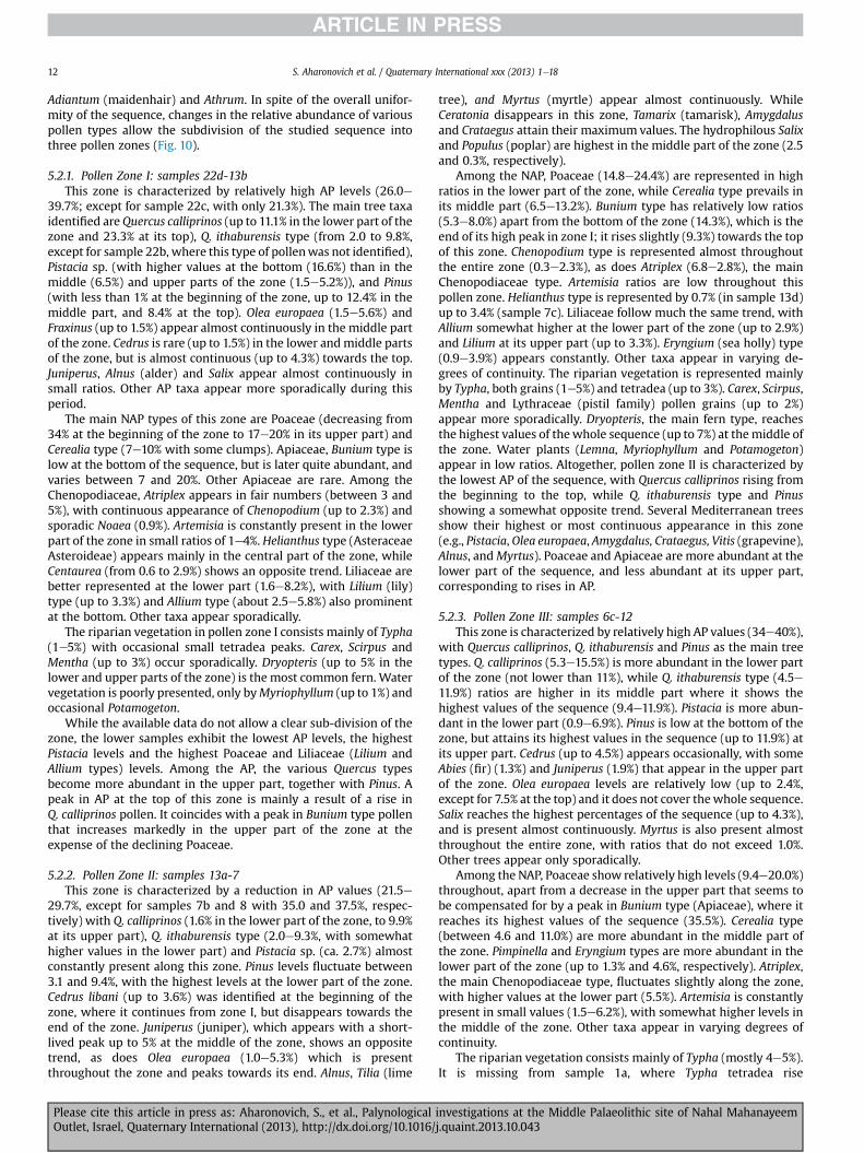
Adiantum (maidenhair) and Athrum. In spite of the overall unifor-mity of the sequence, changes in the relative abundance of variouspollen types allow the subdivision of the studied sequence intothree pollen zones (Fig. 10).
5.2.1. Pollen Zone I: samples 22d-13bThis zone is characterized by relatively high AP levels (26.0e
39.7%; except for sample 22c, with only 21.3%). The main tree taxaidentified are Quercus calliprinos (up to 11.1% in the lower part of thezone and 23.3% at its top), Q. ithaburensis type (from 2.0 to 9.8%,except for sample 22b, where this type of pollenwas not identified),Pistacia sp. (with higher values at the bottom (16.6%) than in themiddle (6.5%) and upper parts of the zone (1.5e5.2%)), and Pinus(with less than 1% at the beginning of the zone, up to 12.4% in themiddle part, and 8.4% at the top). Olea europaea (1.5e5.6%) andFraxinus (up to 1.5%) appear almost continuously in the middle partof the zone. Cedrus is rare (up to 1.5%) in the lower andmiddle partsof the zone, but is almost continuous (up to 4.3%) towards the top.Juniperus, Alnus (alder) and Salix appear almost continuously insmall ratios. Other AP taxa appear more sporadically during thisperiod.
The main NAP types of this zone are Poaceae (decreasing from34% at the beginning of the zone to 17e20% in its upper part) andCerealia type (7e10% with some clumps). Apiaceae, Bunium type islow at the bottom of the sequence, but is later quite abundant, andvaries between 7 and 20%. Other Apiaceae are rare. Among theChenopodiaceae, Atriplex appears in fair numbers (between 3 and5%), with continuous appearance of Chenopodium (up to 2.3%) andsporadic Noaea (0.9%). Artemisia is constantly present in the lowerpart of the zone in small ratios of 1e4%. Helianthus type (AsteraceaeAsteroideae) appears mainly in the central part of the zone, whileCentaurea (from 0.6 to 2.9%) shows an opposite trend. Liliaceae arebetter represented at the lower part (1.6e8.2%), with Lilium (lily)type (up to 3.3%) and Allium type (about 2.5e5.8%) also prominentat the bottom. Other taxa appear sporadically.
The riparian vegetation in pollen zone I consists mainly of Typha(1e5%) with occasional small tetradea peaks. Carex, Scirpus andMentha (up to 3%) occur sporadically. Dryopteris (up to 5% in thelower and upper parts of the zone) is the most common fern. Watervegetation is poorly presented, only byMyriophyllum (up to 1%) andoccasional Potamogeton.
While the available data do not allow a clear sub-division of thezone, the lower samples exhibit the lowest AP levels, the highestPistacia levels and the highest Poaceae and Liliaceae (Lilium andAllium types) levels. Among the AP, the various Quercus typesbecome more abundant in the upper part, together with Pinus. Apeak in AP at the top of this zone is mainly a result of a rise inQ. calliprinos pollen. It coincides with a peak in Bunium type pollenthat increases markedly in the upper part of the zone at theexpense of the declining Poaceae.
5.2.2. Pollen Zone II: samples 13a-7This zone is characterized by a reduction in AP values (21.5e
29.7%, except for samples 7b and 8 with 35.0 and 37.5%, respec-tively) with Q. calliprinos (1.6% in the lower part of the zone, to 9.9%at its upper part), Q. ithaburensis type (2.0e9.3%, with somewhathigher values in the lower part) and Pistacia sp. (ca. 2.7%) almostconstantly present along this zone. Pinus levels fluctuate between3.1 and 9.4%, with the highest levels at the lower part of the zone.Cedrus libani (up to 3.6%) was identified at the beginning of thezone, where it continues from zone I, but disappears towards theend of the zone. Juniperus (juniper), which appears with a short-lived peak up to 5% at the middle of the zone, shows an oppositetrend, as does Olea europaea (1.0e5.3%) which is presentthroughout the zone and peaks towards its end. Alnus, Tilia (lime
Please cite this article in press as: Aharonovich, S., et al., PalynologicalOutlet, Israel, Quaternary International (2013), http://dx.doi.org/10.1016/
tree), and Myrtus (myrtle) appear almost continuously. WhileCeratonia disappears in this zone, Tamarix (tamarisk), Amygdalusand Crataegus attain their maximum values. The hydrophilous Salixand Populus (poplar) are highest in the middle part of the zone (2.5and 0.3%, respectively).
Among the NAP, Poaceae (14.8e24.4%) are represented in highratios in the lower part of the zone, while Cerealia type prevails inits middle part (6.5e13.2%). Bunium type has relatively low ratios(5.3e8.0%) apart from the bottom of the zone (14.3%), which is theend of its high peak in zone I; it rises slightly (9.3%) towards the topof this zone. Chenopodium type is represented almost throughoutthe entire zone (0.3e2.3%), as does Atriplex (6.8e2.8%), the mainChenopodiaceae type. Artemisia ratios are low throughout thispollen zone. Helianthus type is represented by 0.7% (in sample 13d)up to 3.4% (sample 7c). Liliaceae follow much the same trend, withAllium somewhat higher at the lower part of the zone (up to 2.9%)and Lilium at its upper part (up to 3.3%). Eryngium (sea holly) type(0.9e3.9%) appears constantly. Other taxa appear in varying de-grees of continuity. The riparian vegetation is represented mainlyby Typha, both grains (1e5%) and tetradea (up to 3%). Carex, Scirpus,Mentha and Lythraceae (pistil family) pollen grains (up to 2%)appear more sporadically. Dryopteris, the main fern type, reachesthe highest values of thewhole sequence (up to 7%) at themiddle ofthe zone. Water plants (Lemna, Myriophyllum and Potamogeton)appear in low ratios. Altogether, pollen zone II is characterized bythe lowest AP of the sequence, with Quercus calliprinos rising fromthe beginning to the top, while Q. ithaburensis type and Pinusshowing a somewhat opposite trend. Several Mediterranean treesshow their highest or most continuous appearance in this zone(e.g., Pistacia,Olea europaea, Amygdalus, Crataegus, Vitis (grapevine),Alnus, andMyrtus). Poaceae and Apiaceae are more abundant at thelower part of the sequence, and less abundant at its upper part,corresponding to rises in AP.
5.2.3. Pollen Zone III: samples 6c-12This zone is characterized by relatively high AP values (34e40%),
with Quercus calliprinos, Q. ithaburensis and Pinus as the main treetypes. Q. calliprinos (5.3e15.5%) is more abundant in the lower partof the zone (not lower than 11%), while Q. ithaburensis type (4.5e11.9%) ratios are higher in its middle part where it shows thehighest values of the sequence (9.4e11.9%). Pistacia is more abun-dant in the lower part (0.9e6.9%). Pinus is low at the bottom of thezone, but attains its highest values in the sequence (up to 11.9%) atits upper part. Cedrus (up to 4.5%) appears occasionally, with someAbies (fir) (1.3%) and Juniperus (1.9%) that appear in the upper partof the zone. Olea europaea levels are relatively low (up to 2.4%,except for 7.5% at the top) and it does not cover thewhole sequence.Salix reaches the highest percentages of the sequence (up to 4.3%),and is present almost continuously. Myrtus is also present almostthroughout the entire zone, with ratios that do not exceed 1.0%.Other trees appear only sporadically.
Among the NAP, Poaceae show relatively high levels (9.4e20.0%)throughout, apart from a decrease in the upper part that seems tobe compensated for by a peak in Bunium type (Apiaceae), where itreaches its highest values of the sequence (35.5%). Cerealia type(between 4.6 and 11.0%) are more abundant in the middle part ofthe zone. Pimpinella and Eryngium types are more abundant in thelower part of the zone (up to 1.3% and 4.6%, respectively). Atriplex,the main Chenopodiaceae type, fluctuates slightly along the zone,with higher values at the lower part (5.5%). Artemisia is constantlypresent in small values (1.5e6.2%), with somewhat higher levels inthe middle of the zone. Other taxa appear in varying degrees ofcontinuity.
The riparian vegetation consists mainly of Typha (mostly 4e5%).It is missing from sample 1a, where Typha tetradea rise
investigations at the Middle Palaeolithic site of Nahal Mahanayeemj.quaint.2013.10.043

S. Aharonovich et al. / Quaternary International xxx (2013) 1e18 13
considerably (12%). Scirpus appears almost continuously (up to2.0%), while Carex and Sparganium are more sporadic. Water plants(Lemna, Myriophyllum, and Potamogeton) are rather scarce. Withinthe ferns, Dryopteris villarii prevails (up to 5% at the beginning andend of the zone), while Polypodium and Adiantum occur onlysporadically (up to 3% in the middle part of the zone).
In sum, pollen zone III shows high AP levels throughout. Theircomposition changes along this zone, with Quercus calliprinosmoreabundant at the bottom and top, and Q. ithaburensis type and Pis-tacia in the middle part. Pinus shows high values along most of thezone, apart from the basal samples. Its high levels coincide with theappearance of Cedrus. Olea europaea appears at roughly the samesections, but its peaks alternate with those of the Cedrus. WhileAbies, Juniperus, Tilia, Acer and Acacia are present in the upper partonly, Amygdalus, Pyrus (pear) and Populus appear only at the bottomof the zone, as a continuation from zone II. Salix, with its highestvalues in the sequence, appears almost continuously. Poaceae, themain NAP group, are higher in the lower part of the zone, with highpeaks corresponding to AP declines. Pimpinella, Ferula (fennel),Ranunculus, Dipsacaceae (teasel), Polygonum and AsteraceaeCichorioideae are almost absent from the lower part, but present inits upper part, where Bunium type clearly prevails.
5.3. Interpretation of the palynological data
The interpretation of the pollen diagram, and the main chara-cteristics and trends identified in the behavior of the differentpollen curves, is largely based on previous palynological work inthe Hula basin (Horowitz, 1979; Weinstein-Evron, 1983; van Zeistand Bottema, 2009). An accepted indicator of climatic changes isthe AP curve. A peak in this curve points to humid conditions,whereas a decrease suggests drier conditions. Further details can beobtained from the composition of the AP and NAP groups, therelative proportions of their components, and the fluctuations ofindividual curves (Weinstein-Evron, 1983; van Zeist and Bottema,2009).
The main tree taxa are the Quercus calliprinos and Q. ithaburensistypes. These trees played a prominent role in the vegetation aroundthe Hula Valley. Rises in the Q. calliprinos curve, the most importantcomponent of the AP, indicate periods of increased humidity(Horowitz, 1979; Weinstein-Evron, 1983), as do rises in deciduousoaks. However, as it is impossible to differentiate the various de-ciduous oaks palynogically, it cannot be determined whether in-creases in Q. ithaburensis-type pollen can be attributed toQ. boissieri (hence colder/wetter climate), or to Q. ithaburensis-type(hence a less-humid, warmer climate) (Weinstein-Evron, 1983; vanZeist and Bottema, 2009).
Cedrus levels are low in the NMO sequence, and as previouslyargued for the Hula basin (Weinstein-Evron, 1983) its peaks seemto follow periods of high humidity (Fig. 3). This suggests that risesin Cedrus may be determined more by a significant decrease intemperature that may be accompanied by continental conditions,than by an increase in humidity. Such conditions could have led tocedar dispersion on the Lebanon and Hermon mountains, and aprobable lowering of the elevation of the Cedrus vegetation belt(Weinstein, 1976; Weinstein-Evron, 1983). Colder conditions arealso indicated by northern vegetation elements, such as Abies, Tilia,and Betulaceae (birch family). Unfortunately, they are not suffi-ciently represented in the pollen spectra to allow meaningfulecological interpretation.
Pinus is relatively well represented in the pollen record. How-ever, as a result of aerodynamic features of pine pollen grains, thetypically high ratios of its pollen in the pollen rain suggest that it isusually over-represented in palynological counts (Fæegri andIversen, 1992; Weinstein-Evron and Lev-Yadun, 2000). High pine-
Please cite this article in press as: Aharonovich, S., et al., PalynologicalOutlet, Israel, Quaternary International (2013), http://dx.doi.org/10.1016/
pollen values in the diagram are thus attributed to long-distancetransport (see also van Zeist and Bottema, 2009). Pinus pollen inthe samples probably represents Pinus halepensis, at present theonly native species of Israel and Jordan (Zohary, 1973, p. 341). Pinepollen may have been blown in from north-western Israel, where P.halepensis could have formed forest stands on marly and chalkyrendzina soils, and where natural pine stands are still found, oroccasionally carried with south-easterly winds from Jordan(Weinstein-Evron and Lev-Yadun, 2000). Some pine pollen mayhave originated from Lebanon where at present P. brutia (Turkishpine) is the predominant conifer (Zohary, 1973; pp. 342e343; vanZeist and Bottema, 2009).
Based on the distribution of present-day plant formations,before large-scale human interference (Zohary, 1982), Pistaciapollen could have most probably derived from either Pistaciaatlantica or P. palaestina. The former would represent P. atlanticawoodland, occupying mainly the Hula basin itself, while the lattercould have been derived from the Q. calliprinoseP. palaestinamaquis/forest of the Upper Galilee. Interpretation of the pollendiagram should further consider the fact that Pistacia speciesgrowing in the Levant are not distinguishable from each otherpalynologically. Also of significance is the conspicuous under-representation of Pistacia pollen (Horowitz, 1979; Weinstein,1981), and especially P. atlantica (van Zeist and Bottema, 1977,2009) in the pollen records.
Olea europaea is not abundant in the NMO sequence and ap-pears in an alternating manner with Cedrus, hence its possibleattribution as an indicator of warmer periods. It does not grow inareas where temperatures fall below 3 �C (Zohary, 1973). It can alsobe an indicator of a mixed maquis in the area, in somewhat drierphases.
Juniperus pollen, the most likely candidate for Cupressaceaepollen (cypress family) (see also van Zeist and Bottema, 2009),usually appears in low ratios, and may represent either J. oxycedrusthat nowgrows onMountMeron (Danin, 1988) andMount Hermon(Shmida,1977;Waisel et al., 1978), or J. excels (Greek juniper) that isrestricted to Mount Hermon (Shmida, 1977; Waisel et al., 1978;Shmida and Lev-Ari, 1982; Auerbach and Shmida, 1993).
Other species that appear sporadically in the pollen spectra areArbutus and Rhamnus. Given their present-day distribution, whentheir percentages are higher, they may serve as geographical in-dicators of the Galilee, as does Amygdalus pollen, for example.
Jasminum (jasmine), Ceratonia siliqua (carob tree), Platanus(plane tree), Pyrus, Crataegus, Myrtus, Ulmus, Populus, Hedera (ivy),Ziziphus, Tamarix, Acer, Acacia and Alnus appear in too low per-centages and too sporadically to enable any meaningfulinterpretation.
Fraxinus and Salix are the main riparian trees in the spectra.Fraxinus (probably Fraxinus syriaca) is a wind-pollinated specieswith a moderately high production and dispersal of pollen. Salix, inspite of its being an insect-pollinated tree, also disperses a fairamount of pollen through wind action (van Zeist and Bottema,2009), hence its relative continuous appearance in the pollenspectra. Vitis may constitute an additional component of riparianvegetation.
The main NAP identified is Poaceae, Apiaceae, Asteraceae(sunflower family) and Chenopodiaceae. Grasses (Poaceae) played aprominent role in the herbaceous vegetation of the Hula area. Theyoccur in a wide variety of ecological niches, including open fields,sparse maquis, maquis or woodland (e.g., of Q. ithaburensis) un-dergrowth and pastures, together with the humid wadis and lakesurroundings. Some of the grasses were identified in the Hulaswamp area (e.g., Phragmites australis, Arundo donax (giant cane))(Zohary, 1982). As it is impossible to establish the relative propor-tion of the pollen originating from the marshland on one hand, and
investigations at the Middle Palaeolithic site of Nahal Mahanayeemj.quaint.2013.10.043

S. Aharonovich et al. / Quaternary International xxx (2013) 1e1814
upland vegetation on the other, the fluctuations in the Poaceaecurve are difficult to interpret. However, based on trends observedin the Hula L07 core, it was suggested that Poaceae levels wereeither high during dry periods, compensating for the low AP levels,or low when Chenopodiaceae, sometimes accompanied by Arte-misia, increased considerably (Fig. 3; Weinstein-Evron, 1983). HighPoaceae levels seem to characterize relatively slight desiccation,which may have caused Poaceae to spread into the relatively bareand exposed areas in the vicinity of the thinning maquis.
High levels of Artemisia, possibly the Irano-Turanian speciesArtemisia herba-alba (wormwood) (Zohary, 1973), indicate dry pe-riods with a possible shift of the steppe vegetation westward, to-wards the Hula basin. However, smaller increases may havecoincided with cold and continental periods, as suggested by par-allel increases in Cedrus.
Chenopodiaceae appear continuously in relatively high ratios.Three Chenopodiaceae types were identified, but genera or speciescannot be distinguished. Most of the Near Eastern Chenopodiaceaeare halophytic species, characteristic of more or less saline soils(Weinstein, 1982; van Zeist and Bottema, 2009). They showconsistent increases during dry conditions. In markedly dry pe-riods, Artemisia and Chenopodiaceae curves both increase(Weinstein-Evron, 1983).
Unlike many of the types discussed above, Apiaceae are insect-pollinated plants, and would thus be expected to be under-represented in the spectra. However, they are well-represented inthe NMO sequence, suggesting that they probably derived fromnearby locations. The different types of Apiaceae pollen cannot beattributed to any precise genera or species. The many differentApiaceae pollen types possibly point to a considerable diversity ofspecies (van Zeist and Bottema, 2009). Other NAP groups alsoinclude species inhabiting a variety of biotopes which are palyno-logically inseparable. Their low ratios and many small fluctuationsdo not allow any ecological insights to be made.
Various degrees of desiccation were suggested for the Hula L07core, based mainly on the interplay between Artemisia, Chenopo-diaceae and Poaceae levels (Weinstein-Evron, 1983), with rises inboth Artemisia and Chenopodiaceae characterizing general intensedrying (Weinstein-Evron, 1990). Such attributions are not appli-cable to the current study, where less-pronounced dry fluctuationsare indicated by rises in Artemisia, Poaceae, Apiaceae and other NAPcurves.
Hydrophilous pollen appears in relatively small numbers alongthe sequence. Curves of the various plants may help designateslight changes in the extent of the various biotypes, mainly riparianvegetation (Typha, Carex, Scirpus, Sparganium and Mentha). Theswamp (Carex) and deep-water (Potamogeton, Lemna and Myr-iophyllum) vegetation is less represented in the spectra.
6. Discussion
The NMO palynological curve is the only one reconstructed for alateMP site in the Levant to date. It exhibits nomajor changes in AP.However, the observed changes, together with those apparent inthe various, individual taxa curves, enabled the definition of threepollen zones (Fig. 10). These serve as the basis for the reconstruc-tion of several fluctuations in vegetation and climate.
Zone I is characterized by relatively high AP ratios, mainly of thevarious oak types, suggesting a rather widespread forest or maquisin the area, in a humid period. This is also supported by the rela-tively low Chenopodiaceae and Artemisia values. The relativecontribution of the Quercus calliprinoseP. palaestina maquis(possibly on the higher slopes of the Golan and Galilee) and theopen park forest of Quercus ithaburensiseP. atlantica of the HulaValley itself and the lower slopes of the surrounding mountains is
Please cite this article in press as: Aharonovich, S., et al., PalynologicalOutlet, Israel, Quaternary International (2013), http://dx.doi.org/10.1016/
hard to evaluate, as neither the deciduous oaks nor the pistachiospecies can be separated palynologically. However, the low Quercuslevels at the bottom part, together with the high Pistacia levels (thehighest in the sequence) and the high Poaceae levels (highest of thecurve) may indicate a sparse tree cover in the area, with possibleQuercus ithaburensiseP. atlantica park forest in a relatively dryclimate. When more humid conditions prevailed, tree cover in thearea became denser, culminating in the peak of Quercus calliprinospollen, probably representing widespread Mediterranean maquison the mountains surrounding the Hula Valley. Relatively high Oleaeuropaea levels suggest a rather mild climate in spite of the spo-radic appearance of Tilia, Betulaceae or Abies, for example, withsome cooling at the end of this zone, as suggested by the high levelsof Cedrus (the highest in the spectra) and its continuous appear-ance. Apart from indicating slight fluctuations in the composition ofthe vegetation, changes in other AP or NAP types (e.g., Juniperus,Acer, Ulmus, Apiaceae, Fabaceae, Liliaceae and Dipsacaceae) cannotbe interpreted as additional indicators for any significant changesin vegetation or climate throughout this zone.
The decrease in AP in pollen zone II suggests some thinning ofthe tree-cover in the area during a somewhat drier period. Thedriest conditions probably prevailed at the base of this zone, assuggested by the low AP and Quercus calliprinos levels (the lowestof the sequence), with humidity increasing towards the upper partof the zone.
Although in the lower samples Cedrus pollen continues to behigh, probably an indication of a somewhat cooler climate, Oleaeuropaea becomes more widespread later, probably indicatingsome warming. The composition of the tree cover suggests a moreopen landscape than during the deposition of pollen zone I, withrelatively high ratios of Quercus ithaburensis type pollen, and theappearance of Amygdalus, Crataegus and Arbutus (strawberry tree)pollen, probably derived from the rather mixed maquis of the Up-per Galilee and from its eastern slopes. A peak in Chenopodiaceaeroughly coinciding with the lowest AP levels suggests a dry period.However, the low Artemisia values along this zone indicate that thepostulated drying climate was not very pronounced. Apiaceaevalues are very pronounced at the lower part, while Poaceae andCerealia-type pollen dominate most of this zone, supporting theoccurrence of open park-forests in the area. They are accompaniedby the continuous appearance of Apiaceae, Liliaceae, Cistaceae,Dipsacaceae and Helianthus-type pollen.
A rise in the AP curve and the various oak types points to arenewed spreading of the forests in the studied area in a somewhatwetter period during pollen zone III. Both Cedrus and Olea europaeaappear sporadically along the sequence (in a somewhat alternatingmanner), so the climate was probably not very cold, in spite of theoccurrence of Alnus and Abies pollen. Poaceae pollen, especiallyCerealia-type, is somewhat scarcer in this zone, where a ratheropen landscape can be suggested by the almost continuousappearance of Sarcopoterium spinosum (the highest values of thesequence). It is impossible to differentiate the deciduous oaksspecies palynologically, but an open Quercus ithaburensis park for-est, possibly with Pistacia atlantica accords well with some thinningof the Quercus calliprinos maquis cover, over the Galilee and Golan,accompanied by a rise in Poaceae, Chenopodiaceae and Sarcopo-terium spinosum. This may also explain the relatively high Pinuslevels that are derived from long distances, but can be better rep-resented when the ratios of the nearby arboreal formationsdecrease. The pronounced rise in Apiaceae near the end of thiszone, mostly at the expense of various Poaceae, cannot be inter-preted. Similar to the dry climate between Zones I and II, whereApiaceae levels are high, it may precede a later drying stage.
Hydrophilous pollen is low along the sequence, with mainlyriparian vegetation, as represented by Typha (both tetradea and
investigations at the Middle Palaeolithic site of Nahal Mahanayeemj.quaint.2013.10.043

S. Aharonovich et al. / Quaternary International xxx (2013) 1e18 15
single grains), with some Populus and Salix that occur sporadically,especially in zone I. The almost continuous appearance of Salixpollen along zone II, and especially zone III, may indicate someriparian-vegetation stabilization in the area during this period. Therelatively higher ratios of Typha tetradea may support this.
Marsh vegetation is nearly absent throughout the NMOsequence. This indicates that marshes did not form in the vicinity ofthe site. Marshes were abundant in the northern parts of the Hulabasin before the drainage of the lake (Fig. 5), and their vegetationshares in the pollen spectra of the cores taken from the central andnorthern parts of the lake were accordingly high (Horowitz, 1979;Weinstein-Evron, 1983; van Zeist and Bottema, 2009). A limitedmarsh existed south of the Hula Lake (Fig. 5), and such marshescould also have existed in the area during MP times. Pollen of waterplants is also quite scarce in the spectra. It cannot be ascertainedwhether the Ranunculus and Myriophyllum pollen represent somelake-shore environment, or whether theymay have been carried bythe nearby river from the Palaeo-Lake Hula in the north(Weinstein-Evron, 1983).
In sum, the NMO pollen sequence represents a humid periodwith two minor humid fluctuations (pollen zones I and III), sepa-rated by a somewhat drier one (pollen zone II). A somewhat coolerclimate may have prevailed occasionally in pollen zones I and II, asindicated by the high ratios of cedar pollen and other northerntrees (such as Tilia and Abies). The sequence may have beendelimited by two dry periods at the bottom and top of thesequence, for which the available data are scarce. The coarsechronological determination does not allow any reliable correlationto be securely made between any of the fluctuations observed inthe pollen curve and the phases of human habitation at the site, assuggested by the archaeological data. Likewise, the drier periodsthat seem to precede and follow the NMO pollen sequence cannotbe used to explain either the beginning or the end of humanhabitation at the site. The available dates for the studied portion ofLayer 4 at NMO suggest that these sediments were depositedsomewhere between 65 � 5 ka and 51 � 4 ka, and before 43 � 4 ka(Kalbe et al. 2013). Given the error range, the fact that the top ofLayer 4 is not dated, and the impossibility to determine the exactlength of the erosional gap between layers 4 and 3, neither thewhole sequence nor any of the archaeological horizons can bemorenarrowly constrained. Significantly, the archaeological and sedi-mentological data suggest a short time interval for the period ofhuman occupation of the site (Kalbe et al., 2013; Sharon and Oron,2013). However, the palynological sequencemay represent a longerperiod of accumulation, extending before, during and after humanpresence at the site, with short human habitation spell/s beingincorporated within the sequence.
Humid conditions were suggested for the period under discus-sion by previous palynological works in the Hula basin (Weinstein-Evron, 1983), when pollen zones 11-13 of the L07 core curve weredeposited roughly between 65 ka and 55 ka (Fig. 2). The dating ofthe Hula sequence is problematic (Weinstein-Evron et al., 2001).However, palynologically, the NMO curve does fit this part of theHula curve, rather than any of the preceding pollen zones, in its APlevels (that are lower than in zone 6, the most humid fluctuation ofthe L07 core) and modest Cedrus levels (that are significantly lowerthan in the otherwise low-AP zones 8 and 9 of the L07 core). Basedon the composition of the pollen spectra in the Hula L07 core zones11-13 and the NMO sequence, it can be further postulated that theNMO curve best fits all or part of pollen zone 12 of the Hula L07sequence. This is based on the relatively low Quercus ratios, thesimilar ratios of Cedrus and Olea pollen, and the relatively highpercentages of Poaceae and Chenopodiaceae in both sequences.The two zones discussed also exhibit relatively low ratios ofhydrophilous plants. These correlations may somewhat reinforce
Please cite this article in press as: Aharonovich, S., et al., PalynologicalOutlet, Israel, Quaternary International (2013), http://dx.doi.org/10.1016/
the suggested Hula L07 chronological framework, in spite of thedating uncertainty and the different locations and settings of thesequences (northern part of the Hula lake vs. lake-shore or bank atthe southern part of the basin). Altogether, the palynological datasuggest wet habitats near the site in a rather humid period, when aMediterranean maquis was widespread on the mountains sur-rounding the valley, with some minor fluctuations in humidity andtemperature. In spite of the inherent dating problems, where theexact chronological framework of the samples cannot be securelydefined (except for their general attribution to Layer 4), this pictureaccords well with previous palynological studies in the area. It isalso supported by the relatively high Dead Seawater levels at aboutthe same period (Schramm et al, 2000; Torfstein et al., 2009), aswell as by isotopic data derived from several speleothem studies(e.g., Bar-Matthews et al., 1997, 1999; Vaks et al., 2003), and Med-iterranean cores (Bar-Matthews et al., 2003; Almogi-Labin et al.,2009; Langgut et al., 2011), suggesting a rather cool and humidclimate in the time period represented in the NMO pollen curve. Arecently studied speleothem record from a karst cave on MountHermon (Ayalon et al., 2013) also indicates a rather cool climate,with high precipitation (snow), for the period covered by the NMOsequence with two short warm spells at its end (56 and 52 ka),when speleothem growthwas facilitated.Whilewe cannot possiblycorrelate our specific pollen zones or fluctuations to any of theseepisodes, this reconstruction suggests that the NMO sequencerepresents the period before 56 ka.
Other palaeobotanical data retrieved from the site were woodand bark remains that include oak (Quercus boissieri), Syrian ash(Fraxinus syriaca), willow (Salix sp.), and almond (Amygdalus)(Werker in Sharon et al., 2010). All these taxawere also identified inthe palynological spectra. However, the lack of precise quantitativedata for the identified archaeobotanical remains, and the inherentdifference in the way pollen and wood were transported into thesediments (wind vs. flooding and/or human import), preventfurther environmental comparisons.
Preliminary results of fruit and seed studies at NMO provideadditional important information regarding plant species in thearea and their specific habitats. Over 3000 fruits and seeds wereidentified. Most of the plants identified can be associated withwater and riparian vegetation. Among the water plants, the mostabundant are Ranunculus subgen., Potamogeton spp. and Cerato-phyllum demersum. Various species of the riparian and shallowwater vegetation, mainly Cyperus sp., Polygonum sp., Scipus spp. andTypha sp., were identified. The riparian vegetation is representedmainly byMentha sp. and Ranunculus spp. (flooded soil vegetation).Only a few plants from drier habitats, such as Chenopodium sp.,Brassicaceae, Apiaceae, Silybum mariamum and cf. Hypericum, wereidentified in fair amounts (Melamed in Sharon et al., 2010, 2011).
Although the palynological data provide a more general view ofthe vegetation in the area, the macro-botanical data are probablyindicative of the closer, more local habitat. However, given the lowratios of hydrophilous pollen in the spectra, the macro-botanicalremains provide an important insight into the composition of thisvegetation, and suggest rich and varied hydrophilous formations inthe area of the site. Significantly, it is only based on these data thatspecies identification can be made. Therefore, the combination ofpalynological and macro-botanical data provides a more coherentpicture of the vegetation around the site.
Both pollen and macro-botanical remains indicate the occur-rence of some riparian/shallow-water/marsh vegetation (e.g.,Fraxinus, Salix, Typha and Scirpus), as well as floating and sub-merged water plants (e.g., Myriophyllum, Ranunculus and Potamo-geton). However, clear vegetation belts (cf. Zohary and Orshansky,1947) cannot be deduced. While the distribution of the variousformations is hard to decipher, the combined archaeobotanical data
investigations at the Middle Palaeolithic site of Nahal Mahanayeemj.quaint.2013.10.043

S. Aharonovich et al. / Quaternary International xxx (2013) 1e1816
seem to indicate rather dense riparian vegetation near the site, witha fair abundance of water plants, many of which (e.g., Myr-iophyllum) could have also thrived in the nearby River Jordan(Zohary, 1973; Feinbrun-Dothan and Danin, 1998).
7. Conclusions
The Late MP, NMO pollen sequence represents a generally hu-mid and cool period punctuated with a somewhat drier spell. Thesequence succeeded a dry period and was in turn followed byanother dry phase, for which the available data are, however scarce.Altogether, the palynological data suggest wet habitats near the sitein a rather humid period, when a Mediterranean maquis waswidespread on the mountains surrounding the valley, with someminor fluctuations in humidity and temperature.
The results of the current study fit those of a previous study ofthe Hula Basin for roughly the same time period (Weinstein-Evron,1983). They further provide valuable detailing and a uniquepalaeoenvironmental reconstruction specifically related to theoccupation period of NMO, still a rare phenomenon for lateMP sitesin the Levant. Given the postulated short-term nature of its humanoccupation, the palynological sequence may represent a longerperiod of accumulation, extending before, during and after humanpresence at the site, with short human habitation spell/s incorpo-rated within the sequence.
Acknowledgements
The research is based on an MA thesis (by S.A.) conducted at theDepartment of Archaeology, The University of Haifa. The NMOpalynological study is supported by the Irene Levi-Sala CareArchaeological Foundation. The NMO excavation project is sup-portedprimarily by the Israel Science Foundation (GrantNo. 645/09,titled: Behavior, Subsistence Strategies and Paleo-environmentalBackground of Middle Paleolithic Hominids in the Northern DeadSea Rift). In addition, the project is supported by the followinggranting agencies: The Leakey Foundation, The Wenner-GrenFoundation, National Geographic and the Irene Levi-Sala CAREArchaeological Foundation. We wish to thank Ms. Silvia Chaim forher valuable help in the identification of the pollen grains and herconstant support, Dr. YoelMelamed, Bar IlanUniversity, for shearinginformation regarding the NMO fruits, seeds and additional floralremains, and Prof. EllaWerker, The HebrewUniversity of Jerusalem,for wood identification. Thanks are due to Prof. Daniel Kaufman forhis useful remarks. Thanks are also due to the reviewers for theiruseful remarks.
References
Affek, H.P., Bar-Matthews, M., Ayalon, A., Matthews, A., Eiler, J.M., 2008. Glacial/interglacial temperature variations in Soreq cave speleothems as recorded by‘clumped isotope’ thermometry. Geochimica et Cosmochimica Acta 72, 5351e5360.
Akazawa, T., Dodo, Y., Muhesen, S., Abdul-Salam, A., Abe, Y., Kondo, O., Mizoguchi, Y.,1993. The Neanderthal remains from Dederiyeh cave, Syria: interim report.Anthropological Sciences 101 (4), 361e387.
Albert, R.M., Lavi, O., Estroff, L., Weiner, S., Tsatskin, A., Ronen, A., Lev-Yadun, S.,1999. Mode of occupation of Tabun cave, Mt Carmel, Israel, During the Mous-terian Period: A Study of the Sediments and Phytoliths. Journal of Archaeo-logical Science 26, 1249e1260.
Albert, R.M., Weiner, S., Bar-Yosef, O., Meigen, L., 2000. Phytoliths in the middlePalaeolithic deposits of Kebara cave, Mt. Carmel, Israel: study of the PlantMaterials Used for Fuel and Other Purposes. Journal of Archaeological Science27, 931e947.
Albert, R.M., Berna, F., Goldberg, P., 2010. Insights of Neanderthal fire use at Kebaracave (Israel) through High Resolution Study of Prehistoric Combustion Features:evidence from Phytolith and Thin Sections. Quaternary International, 1e16.
Almogi-Labin, A., Bar-Matthews, M., Shriki, D., Kolosovsky, E., Paterne, M.,Schilman, B., Ayalon, A., Aizenshtat, Z., Matthews, A., 2009. Climatic variabilityduring the last w90 ka of the southern and northern Levantine Basin as
Please cite this article in press as: Aharonovich, S., et al., PalynologicalOutlet, Israel, Quaternary International (2013), http://dx.doi.org/10.1016/
evident from marine records and speleothems. Quaternary Science Reviews28, 2882e2896.
Auerbach, M., Shmida, A., 1993. Vegetation change along an altitudinal gradient onMt Hermon, Israel e no evidence for discrete communities. Journal of Ecology81 (1), 25e33.
Ayalon, A., Bar-Matthews, M., Kaufman, A., 2002. Climatic conditions during marineisotopic stage 6 in the Eastern Mediterranean region as evident from the iso-topic composition of speleothems Soreq Cave, Israel. Geology 30, 303e306.
Ayalon, A., Bar-Matthews, M., Frumkin, A., Matthews, A., 2013. Last Glacial warmevents on Mount Hermon: the southern extension of the Alpine karst range ofthe east Mediterranean. Quaternary Science Reviews 59, 43e56.
Bar-Matthews, M., Ayalon, A., Kaufman, A., 1997. Late Quaternary palaeo-climate inthe eastern Mediterranean region from stable isotope analysis of speleothemsat Soreq cave, Israel. Quaternary Research 47, 155e168.
Bar-Matthews, M., Ayalon, A., Kaufman, A., Wasserburg, G.J., 1999. The easternMediterranean Palaeoclimate as a reflection of regional events: Soreq cave,Israel. Earth and Planetary Science Letters 166, 85e95.
Bar-Matthews, M., Ayalon, A., Gilmour, M., Matthews, A., Hawkesworth, C.J., 2003.Seaeland oxygen isotopic relationships from planktonic foraminifera and spe-leothems in the Eastern Mediterranean region and their implication forpalaeorainfall during interglacial intervals. Geochimica et Cosmochimica Acta67 (17), 3181e3199.
Bar-Yosef, O., 2000. The middle and early upper Paleolithic in southwest Asia andneighboring regions. In: Bar-Yosef, O., Pilbeam, D. (Eds.), The Geography ofNeandertals and Modern Humans in Europe and the Greater Mediterranean.Peabody Museum of Archaeology and Ethnography, Cambridge/MA, pp. 107e156.
Bartov, Y., Stein, M., Enzel, Y., Agnon, A., Reches, Z., 2002. Lake levels and sequencestratigraphy of Lake Lisan, the late Pleistocene precursor of the Dead Sea.Quaternary Research 57, 9e21.
Baruch, U., 1986. The late Holocene vegetation history of lake Kinneret (Sea ofGalilee), Israel. Palaéorient 12 (2), 37e48.
Baruch, U., Bottema, S., 1991. Palynological evidence for climatic changes in theLevant ca. 17,000 e 9,000 BP. In: Bar-Yosef, O., Valla, F. (Eds.), The NatufianCulture in the Levant. International Monographs in Prehistory, Ann Arbor,pp. 11e21.
Baruch, U., Bottema, S., 1999. A new pollen diagram from Lake Hula, climate andanthropogenic implications in the ancient lake. In: Kawanabe, H., Coulter, G.W.,Roosevelt, A.C. (Eds.), Ancient Lakes: Their Cultural and Biological Diversity.Kenobi Productions, Belgium, pp. 75e86.
Bate, D.M.A., 1937. New Pleistocene mammals from Palestine. Annals and Magazineof Natural History 20, 397e400.
Belmaker, M., Hovers, A., 2011. Ecological change and the extinction of the Levan-tine Neanderthals: implications from a diachronic study of micromammalsfrom Amud Cave, Israel. Quaternary Science Revolution 30, 3196e3209.
Bottema, S., 1975. The interpretation of pollen spectra from prehistoric settlements(with special attention to Liguliflorae). Paléorient 7, 23e31.
Bottema, S., van Zeist, W., 1981. Palynological evidence for the climatic history of theNear East, 50,000e6,000 BP. In: Cauvin, J., Sanlaville, P. (Eds.), Préhistoire duLevant. CNRS, Paris, pp. 111e132.
Cheddadi, R., Rossignol-Strick, M., Fontugne, M., 1991. Eastern Mediterraneanpalaeoclimates from 26 to 5 ka B.P. documented by pollen and isotopic analysisof a core in the anoxic Bannock Basin. Marine Geology 100, 53e66.
Danin, A., 1968. Golan vegetation (primary survey). Teva Ve-Aretz 10, 162e167 (inHebrew).
Danin, A., 1988. Flora and vegetation of Israel and adjacent areas. In: Yom-Tov, Y.,Tchernov, E. (Eds.), The Zoogeography of Israel. W. Junk, Dordrecht, pp. 29e58.
Danin, A., 2004. Distribution Atlas of Plants in the Flora Palaestina Area. IsraelAcademy of Sciences and Humanities, Jerusalem.
Davies, C.P., Falls, P.L., 2001. Modern pollen precipitation from an elevation transectin central Jordan and its relationship to vegetation. Journal of Biogeography 28(10), 1195e1210.
Davis, S.J.M., Rabinovich, R., Goren-Inbar, N., 1988. Quaternary extinctions andpopulation increase in Western Asia: the animal remains from Biq’at Quneitra.Paléorient 14, 95e105.
Develle, A.L., Gasse, F., Vidal, L., Williamson, D., Demory, F., Van Campo, E.,Ghaleb, B., Thouveny, N., 2011. A 250 ka sedimentary record from a small karsticlake in the Northern Levant (Yammoûneh, Lebanon), Palaeoclimatic implica-tions. Palaeogeography, Palaeoclimatology, Palaeoecology 305, 10e27.
Dimentman, C., Bromley, H.J., Por, F.D., 1992. Lake Hula: Reconstruction of the Faunaand Hydrobiology of a Lost Lake. The Israel Academy of Sciences and Human-ities, Jerusalem.
Emery-Barbier, A., 1995. Pollen analysis: environmental and climatic implications.In: Henry, D.O. (Ed.), Prehistoric Cultural Ecology and Evolution: Insights fromSouthern Jordan. Plenum Press, New York, pp. 375e384.
Fæegri, K., Iversen, J., 1992. Textbook of Pollen Analysis, second edition. Heffner,New York.
Feinbrun-Dothan, N., Danin, A., 1998. Analytical Flora of Eretz-israel, second ed.Cana Publishing Ltd, Jerusalem, Israel. (in Hebrew).
Frumkin, A., Bar-Yosef, O., Schwarcz, P., 2011. Possible paleohydrologic and paleo-climatic effects on hominin migration and occupation of the Levantine MiddlePaleolithic. Journal of Human Evolution 60, 437e451.
Garrard, A.N., 1982. The environmental implications of the re-analysis of the largemammal fauna from the Wadi el-Mughara Caves, Palestine. In: Bintliff, J.L., VanZeist, W. (Eds.), Paleoclimates, Paleoenviroments and Human Communities in
investigations at the Middle Palaeolithic site of Nahal Mahanayeemj.quaint.2013.10.043
S. Aharonovich et al. / Quaternary International xxx (2013) 1e18 17
the Eastern Mediterranean Region in Later Prehistory. British ArchaeologicalReports International Series, Oxford, pp. 165e198.
Goren-Inbar, N., Feibel, C.S., Verosub, K.L., Melamed, Y., Kislev, M.E., Tchernov, E.,Saragusti, I., 2000. Pleistocene milestones on the out-of-Africa corridor atGesher Benot Ya’aqov, Israel. Science 289, 944e947.
Goren-Inbar, N., Sharon, G., Melamed, Y., Kislev, M., 2002a. Nuts, nut cracking, andpitted stones at Gesher Benot Ya’aqov, Israel. Proceedings, National Academy ofScience 99 (4), 2455e2460.
Goren-Inbar, N., Werker, E., Feibel, C.S., 2002b. The Acheulean Site Gesher BenotYa’aqov, Israel. The Wood Assemblage. Oxbow Books, Oxford, p. 120.
Griggo, C., 2004. Mousterian fauna from Dederiyeh Cave and comparisons withfauna from Umm El Tlel and Douara Cave. Paléorient 30, 149e162.
Grün, R., 1991. Potential and problems of ESR dating. Nuclear Tracks and RadiationMeasurements 18, 143e153.
Henry, D.O., 2003. Neanderthals in the Levant: Behavioral Organization and theBeginnings of Human Modernity. Continuum, London.
Henry, D.O., Hall, S., Hietala, H., Demidenko, Y., Usik, V., Rosen, A., Thomas, P., 1996.Middle Paleolithic behavioral organization: 1993 excavation of Tor Faraj,southern Jordan. Journal of Field Archaeology 23, 31e53.
Horowitz, A., 1971. Climatic and vegetational developments in North-eastern Israelduring Upper Pleistocene-Holocene times. Pollen et Spores XIII (2), 255e278.
Horowitz, A., 1977. The climate and the settlement in the Negev mountain duringthe last Quaternary. In: Sohar, E. (Ed.), The Desert: Past, Present, Future.Reshafin Publishing, Tel-Aviv, pp. 52e59 (in Hebrew).
Horowitz, A., 1979. The Quaternary of Israel. Academic Press, Inc., New York.Horowitz, A., 1989. Continuous pollen diagrams for the last 3.5 m.y. from Israel:
vegetation, climate and correlation with the oxygen isotope record. Paleoge-ography Paleoclimatology Paleoecology 72, 63e78.
Horowitz, A., 2001. The Jordan Rift Valley. A. A. Balkema, Rotterdam.Inbar, M., 1977. Silt and Morphological Movements of Disperse Horizontals of the
Upper Jordan. PhD thesis. Hebrew University, Jerusalem (in Hebrew).Jelinek, A.J., Farrand, W.R., Hass, G., Horowitz, A., Goldberg, P., 1973. New excava-
tions at the Tabun cave, Mount Carmel, Israel: a preliminary report. Palaéorient1, 151e183.
Jones, R.F., 1940. Report of the Percy Sladen expedition to Lake Huleh: a contribu-tion to the study of the fresh waters of Palestine. Journal of Ecology 28, 357e376.
Kalbe, J., Sharon, G., Porat, N., Zhang, C., Mischke, S., 2013. Geological setting of themiddle Paleolithic site of NMO (Upper Jordan Valley, Israel). Quaternary Inter-national in press.
Karmon, Y., 1956. North Hula Valley, History of the Eretz Israel Landscape. Magnes,Jerusalem (in Hebrew).
Katsenelson, Y., 1966. Climate in Eretz Israel and its Areas. Agriculture Encyclopedia1, 27e62. Masada, Ramat Gan (in Hebrew).
Langgut, D., Almogi-Labin, A., Bar-Matthews, M., Weinstein-Evron, M., 2011. Vege-tation and climate changes in the South Eastern Mediterranean during the LastGlacial-Interglacial cycle (86 ka): newmarine pollen record. Quaternary ScienceReviews 30, 3960e3972.
Lev, E., Kislev, M.E., Bar-Yosef, O., 2005. Mousterian vegetal food in Kebara cave, Mt.Carmel. Journal of Archaeological Science 32, 475e484.
Madella, M., Jones, M.K., Goldberg, P., Goren, Y., Hovers, E., 2002. The exploitation ofplant resources by Neanderthals in Amud cave (Israel): the Evidence fromPhytolith Studies. Journal of Archaeological Science 29, 703e719.
Manes, A., Rondesderger, M., Seter, A., Cohen, Y., 1979. Hula, the lignite project.Environmental impact Statement. First report, Meteorological Reports. Meteo-rological Survey, Beit-dagan 39 (5) (in Hebrew).
Marder, O., Yeshurun, R., Lupu, R., Bar-Oz, G., Belmaker, M., Porat, N., Ron, H.,Frumkin, A., 2011. Mammal remains at Rantis cave, Israel, and MiddleeLatePleistocene human subsistence and ecology in the Southern Levant. Journal ofQuaternary Science 26, 769e780.
Meadows, J., 2005. The Younger Dryas episode and the radiocarbon chronologies ofthe Lake Huleh and Ghab Valley pollen diagrams, Israel and Syria. Holocene 15,631e636.
Mercier, N., Valladas, H., 2003. Reassessment of TL age estimates of burnt flint fromthePaleolithic siteof TabunCave, Israel. Journal ofHumanEvolution45, 401e409.
Meteorological Survey of Israel, 1990. Meteorological Survey, Beit-dagan.Michaeli, A., 1979. Hula Lignite Project Drainage Studies. Report 04/79/71. Tahal, Tel
Aviv.Moore, P.D., Webb, J.A., Collinson, M.E., 1991. Pollen Analysis, second ed. Blackwell
Scientific Publications, Oxford.Niklewski, J., van Zeist, W., 1970. A late Quaternary pollen diagram from northwest
Syria. Acta Botanica Neerlandica 19, 737e754.Petit, J.R., Jouzel, J., Raynaud, D., Barkov, N.I., Barnola, J.-M., Basile, I., Bender, M.,
Chappellaz, J., Davis, M., Delaygue, G., Delmotte, M., Kotlyakov, V.M.,Legrand, M., Lipenkov, V.Y., Lorius, C., Pépin, L., Ritz, C., Saltzman, E.,Stievenard, M., 1999. Climate and atmospheric history of the past 420,000 yearsfrom the Vostok ice core, Antarctica. Nature 399, 429e436.
Rabinovich, R., 1990. In: Stern, A.E., Tsafrir, Y. (Eds.), Taphonomic Research on theFaunal Assemblages from the Quneitra Site. Qedem: Monographs of the Insti-tute of Archaeology, pp. 189e219.
Rabinovich, R., Hovers, E., 2004. Faunal analysis from Amud Cave: preliminaryresults and interpretations. International Journal of Osteoarchaeology 14,287e306.
Reille, M., 1995. Pollen et Spores d’Europe et d’Afrique du Nord, supplément 1.Laboratoire de Botanique Historique et Palynologie, Marseilles.
Please cite this article in press as: Aharonovich, S., et al., PalynologicalOutlet, Israel, Quaternary International (2013), http://dx.doi.org/10.1016/
Reille, M., 1998. Pollen et Spores d’Europe et d’Afrique du Nord, supplément 2.Laboratoire de Botanique Historique et Palynologie, Marseilles.
Reille, M., 1999. Pollen et Spores d’Europe et d’Afrique du Nord, Seconde édition.Laboratoire de Botanique Historique et Palynologie, Marseilles.
Rink, W.J., Bartoll, J., Goldberg, P., Ronen, A., 2003. ESR dating of archaeologicallyrelevant antigenic terrestrial apatite veins from Tabun Cave, Israel. Journal ofArchaeological Science 30, 1127e1138.
Rosen, A.M., 2003. In: Henry, D.O. (Ed.), Neanderthals in the Levant: BehavioralOrganization and the Beginnings of Human Modernity. Continuum, London.
Rossignol-Strick, M., 1995. Sea-land correlation of pollen records in the EasternMediterranean for the Glacial-Interglacial transition: biostratigraphy versusradiometric time-scale. Quaternary Science Reviews 14, 893e915.
Rossignol-Strick, M., Paterne, M., 1999. A synthetic pollen record of the EasternMediterranean sapropels of the last 1 Ma: implications for the time-scale andformation of sapropels. Marine Geology 153, 221e237.
Schramm, A., Stein, M., Goldstein, S.L., 2000. Calibration of the 14C time scale to >40ka by 234Ue230Th dating of Lake Lisan sediments (last glacial Dead Sea). Earthand Planetary Science Letters 175, 27e40.
Seligman, N.G., 1973. A Quantitative Geobotanical Analysis of the Vegetation of theGolan. PhD thesis. Hebrew University, Jerusalem (in Hebrew with Englishabstract).
Sharon, G., Grosman, L., Fluck, H., Melamed, Y., Rak, Y., Rabinovich, R., Oron, M.,2010. The first two excavation seasons at NMO: a Mousterian site at the bank ofthe Jordan River. Eurasian Prehistory 7 (1), 135e157.
Sharon, G., Oron, M., 2013. The lithic tool Arsenal of a Mousterian Hunter. Quater-nary International in press.
Sharon, G., Porat, N., Mischke, S., Zhang, C., Oron, M., Melamed, Y., Werker, E.,Rabinovich, R., Biton, R., Zohar, I., Simons, T., Bratenkov, S., 2011. Behavior,Subsistence Strategies and Paleoenvironmental Background of Middle Paleo-lithic Hominids in the Northern Dead Sea Rift. Scientific Progress InterimReport. Israel Science Foundation.
Shea, J.J., 2003. The middle Paleolithic of the east Mediterranean Levant. Journal ofWorld Prehistory 17, 313e394.
Shmida, A., 1977. The Traganthic Vegetation of Mt. Hermon. PhD thesis. HebrewUniversity, Jerusalem (in Hebrew).
Shmida, A., Lev-Ari, Y., 1982. The vegetation and the forests of southern Lebanon.Rotem 5, 3e98 (in Hebrew).
Speth, J.D., 2012. Middle Palaeolithic subsistence in the Near East: zooarchaeo-logical perspectives e past, present and future. Before Farming 2, 1e45.
Speth, J.D., Tchernov, E., 2001. Neandertal hunting and meat processing in the NearEast: evidence from Kebara Cave (Israel). In: Stanford, C.B., Bunn, H.T. (Eds.),Meat-eating and Human Evolution. Oxford University Press, Oxford, pp. 52e72.
Stein, M., Bartov, Y., Enzel, Y., Goldstein, S.L., Machlus, M., Ken-Tor, R., Marco, S.,1999. High-resolution chronology of Lake Lisan levels. Eos, TransactionsAmerican Geophysical Union 80 (46), Fall Meeting Supplement.
Stiner, M.C., 2005. The Faunas of Hayonim Cave (Israel): a 200,000-Year Record ofPaleolithic Diet, Demography and Society. Peabody Museum of Archaeology andEthnology, Cambridge.
Stockmar, J., 1971. Tablets with spores used in absolute pollen analysis. Pollen etSpores 13, 615e621.
Tchernov, E., 1998. The faunal sequence of the southwest Asian Middle Paleolithic inrelation to hominid dispersal events. In: Akazawa, T., Aoki, K., Bar-Yosef, O.(Eds.), Neandertals and Modern Humans in Western Asia. Plenum Press, NewYork, pp. 77e90.
Torfstein, A., Haase-Schramm, A., Waldmann, N., Kolodny, Y., Stein, M., 2009. U-series and oxygen isotope chronology of the mid-Pleistocene Lake Amora (DeadSea basin). Geochimica et Cosmochimica Acta 73, 2603e2630.
Vaks, A., Bar-Matthews, M., Ayalon, A., Schilman, B., Gilmour, M., Hawkesworth, C.J.,Frumkin, A., Kaufman, A., Matthews, A., 2003. Paleoclimate reconstructionbased on the timing of speleothem growth and oxygen and carbon isotopecomposition in a cave located in the rain shadow in Israel. Quaternary Research59, 182e193.
Vaks, A., Bar-Matthews, M., Ayalon, A., Matthews, A., Frumkin, A., Dayan, U.,Halicz, L., Almogi-Labin, A., Schilman, B., 2006. Paleoclimate and location of theborder between Mediterranean climate region and the SaharoeArabian Desertas revealed by speleothems from the northern Negev Desert, Israel. Earth andPlanetary Science Letters 249, 384e399.
Waisel, Y., Polak, G., Cohen, Y., 1978. Vegetation Ecology in Israel. Tel Aviv University,Tel Aviv (in Hebrew).
Walanus, A., Nalepka, D., 1997. Palynological diagram drawing in Polish POLPALfor windows. INQUA Working Group on Data-Handling Methods. Newsletter16, 8e10.
Walanus, A., Nalepka, D., 1999. POLPAL. Program for counting pollen grains, dia-grams plotting and numerical analysis. Acta Palaeobotanica Suppl. 2, 659e661.
Weinstein, M., 1976. The Late Quaternary vegetation and climate of the NorthernGolan. Pollen et Spores XVIII 4, 553e562.
Weinstein, M., 1981. The influence of the slope on the pollen spectra. Pollen etSpores 23 (34), 381e387.
Weinstein, M., 1982. The Palaeoecology of the Early Würm in the Hula Basin. Thesissubmitted for the degree Doctor of Philosophy. Tel Aviv University (in Hebrew).
Weinstein-Evron, M., 1983. The Palaeoecology of the early Würm in the Hula basin,Israel. Paléorient 9, 5e19.
Weinstein-Evron, M., 1988. A middle Palaeolithic sequence from the Hula valley,Israel. In: Otte, M. (Ed.), L’Homme du Néandertal, L’Environnement. Eraul 29,Liège, vol. 2, pp. 207e222.
investigations at the Middle Palaeolithic site of Nahal Mahanayeemj.quaint.2013.10.043

S. Aharonovich et al. / Quaternary International xxx (2013) 1e1818
Weinstein-Evron, M., 1990. Palynological history of the last Pleniglacial in theLevant. In: Kozlowski, J.K. (Ed.), Feuilles de pierre: les industries à pointesfoliacées du paléolithique supèrieur Européen. Liege, Eraul 42, pp. 9e25.
Weinstein-Evron, M., 1993. Paleoecological reconstructions of the Upper Paleolithic inthe Levant. In: Proceedings of the XIIth UISPP Congress, Bratislava, pp. 259e269.
Weinstein-Evron, M., 1994. Biases in archaeological pollen assemblages: casestudies from Israel. AASP Contributions Series 29, 193e205.
Weinstein-Evron, M., Lev-Yadun, S., 2000. Palaeoecology of Pinus halepensis in Israelin the light of palaeoecological and archaeobotanical data. In: Ne’eman, G.,Trabaud, L. (Eds.), Ecology, Biogeography, and Management of Pinus halepensisand P. brutia Forest Ecosystems in the Mediterranean Basin. Backhuys Pub-lishers, Leiden, pp. 119e130.
Weinstein-Evron, M., Vogel, J.C., Kronfeld, J., 2001. Further attempts at dating thepalynological sequence of the Hula L07 core, Upper Jordan valley, Israel. In:Carmi, I., Boaretto, E. (Eds.), Proceedings of the 17th International 14C Confer-ence. Arizona board of regents, pp. 561e570.
Weissbrod, L., Zaidner, Y., 2013. Taphonomy and paleoecological implications offossorial microvertebrates at the Middle Paleolithic open-air site of NesherRamla, Israel. Quaternary International in this volume.
Yeshurun, R., Bar-Oz, G., Weinstein-Evron, M., 2007. Modern hunting behavior inthe early middle Paleolithic: faunal remains from Misliya cave, Mount Carmel,Israel. Journal of Human Evolution 53, 656e677.
Please cite this article in press as: Aharonovich, S., et al., PalynologicalOutlet, Israel, Quaternary International (2013), http://dx.doi.org/10.1016/
van Zeist, W., Bottema, S., 1977. Palynological investigations in western Iran.Palaeohistoria 19, 19e83.
van Zeist, W., Bottema, S., 2009. A palynological study of the Acheulian site ofGesher Benot Ya’aqov, Israel. Vegetation History and Archaeobotany 18,105e121.
van Zeist, W., Woldring, H., 1978. A postglacial pollen diagram from Lake Van in EastAnatolia. Review of Palaeobotanical Palynology 26, 249e276.
van Zeist, W., Baruch, U., Bottema, S., 2009. Holocene Palaeoecology of the Hulaarea. Northeastern Israel. In: Kaptijn, E., Petit, P. (Eds.), A Timeless Vale:Archaeology and Related Studies of the Jordan Valley. Leiden University Press,pp. 29e66.
Zohary, M., 1959. Geobotanics. Sifriat Poalim, Kibbutz Artzi, second ed. haShomerhaTzair Publishers, Mirhaviya. (in Hebrew).
Zohary, M., 1962. Plant Life of Palestine: Israel and Jordan. Ronald, New York.Zohary, M., 1973. Geobotanical Foundations of the Middle East, vol. 2. Gustav
Fischer Verlag, Stuttgart.Zohary, M., 1982. Vegetation of Israel and Adjacent Areas. Beihefte zum Tübinger
Atlas des Vorderen Orientalis, Reihe A (Naturwissenschaften) 7.Zohary, M., Orshansky, G., 1947. The vegetation of the Huleh Plain. Palestine Journal
of Botany 4, 90e105.
investigations at the Middle Palaeolithic site of Nahal Mahanayeemj.quaint.2013.10.043


![Palynological survey in honeys of Bahia (Brazil) [Original title: Prospecção palinológica em méis da Bahia]](https://static.fdokumen.com/doc/165x107/6341f6b0e8d6d6284d07e1db/palynological-survey-in-honeys-of-bahia-brazil-original-title-prospeccao-palinologica.jpg)