Palm Springs Resort - PalauGov.pw
549
May 2018 Palm Springs Resort An Environmental Assessment on a proposed first class, five- star resort at Ngerur Island, Koror, Palau NECO Group of Companies P.O. Box 129 Koror, Palau 96940 Palau Palm Springs Investment Development Limited P.O. Box 114 Koror, Palau 96940 Proponent
-
Upload
khangminh22 -
Category
Documents
-
view
0 -
download
0
Transcript of Palm Springs Resort - PalauGov.pw

May2018
PalmSpringsResort
AnEnvironmentalAssessmentonaproposedfirstclass,five-starresortatNgerurIsland,Koror,Palau
NECOGroupofCompaniesP.O.Box129Koror,Palau96940
PalauPalmSpringsInvestmentDevelopmentLimitedP.O.Box114
Koror,Palau96940
Proponent

TC-1
TABLE OF CONTENTS EXECUTIVE SUMMARY 1.0 INTRODUCTION 1.1 The Project Proponent 1-2
1.2 The Project Contractor 1-2
1.3 The Project EA Preparer 1-3
1.4 Legislative Framework 1-4
1.5 EA Process Documentation 1-5
1.6 EA Methodology 1-6
1.6.1 Preliminary Assessment 1-6
1.6.2 Marine Survey 1-7
1.6.3 Terrestrial Survey 1-7
1.6.4 Bird Survey 1-7
2.0 PROJECT DESCRIPTION 2.1 Project Objectives 2-1
2.2 Project Setting 2-1
2.3 Project Location 2-3
2.4 Project Site Description 2-5
2.5 Site Development Plan 2-6
2.6 Project Features 2-6
2.6.1 Architectural Considerations 2-9
2.6.2 Infrastructure Considerations 2-9
2.6.2.1 Water Supply System 2-10
2.6.2.2 Wastewater System 2-14
2.6.2.3 Drainage and Irrigation System 2-18
2.6.2.4 Solid Waste Collection and Disposal System 2-19

TC-2
2.6.2.5 Transportation and Road Network System 2-20
2.6.2.6 Electrical and Communication System 2-21
2.6.2.7 Fire Protection System 2-22
2.6.3 Marine Facilities and Improvements 2-23
2.6.3.1 Harbor and Dock Facility 2-23
2.6.3.2 Dive Grotto 2-27
2.6.3.3 Beach Improvements 2-29
2.7 Construction Features 2-31
2.7.1 Cut and Fill Volume 2-31
2.7.2 Environmental Protection Plan 2-31
2.7.3 Erosion and Sedimentation Control Plan 2-32
2.7.4 Government Permits and Clearances 2-33
2.7.4.1 Building and Zoning Permit from Koror State Planning
Commission 2-33
2.7.4.2 Water Reclassification 2-33
2.7.4.3 Historical Clearance from Bureau of Arts and Culture 2-33
2.8 Project Implementation Schedule 2-34
2.9 Project Cost 2-34
3.0 PROJECT ALTERNATIVES 3.1 No Action Alternative 3-1
3.2 The Proposed Development 3-2
3.3 Maximum Density Resort Development 3-2
3.4 Alternative Designs 3-3
3.4.1 Alternative Potable Water System 3-3
3.4.2 Alternative Wastewater Systems 3-4
3.4.2.1 Wastewater Collection via a Vacuum System 3-4
3.4.2.2 Off-site Wastewater Treatment and Disposal 3-5
3.4.2.3 Onsite Wastewater Treatment and Off-site Disposal 3-6
3.4.2.4 Onsite Wastewater Treatment and Disposal 3-6

TC-3
3.4.3 Alternative Fire Protection System 3-8
3.4.3.1 Seawater Fire Protection System 3-8
3.4.3.2 Catchment Fire Protection System 3-8
3.4.4 Alternative Electrical Power Systems
3.4.4.1 Palau Public Utilities Corporation (PPUC) Power Supply 3-8
3.4.4.2 Off-site Power Plant Facility 3-9
4.0 EXISTING ENVIRONMENTAL CONDITIONS 4.1 The Land Environment 4-1
4.1.1 Geography 4-1
4.1.2 Topography 4-1
4.1.3 Soil Type 4-1
4.2 Marine Biological Assessment
4.2.1 Preliminary Assessment 4-5
4.2.2 Water Quality 4-5
4.2.3 Marine Biological Survey 4-7
4.2.4 Terrestrial Survey 4-14
4.2.5 Bird Survey 4-20
5.0 IMPACT ASSESSMENT & MITIGATIONS 5.1 Impacts During Design and Construction of the Project 5-1
5.1.1 Potential Failure/Collapse of the Building If not Properly
Designed & Constructed 5-1
5.1.2 Loss of Land Use Options 5-2
5.1.3 Vegetation Clearing 5-3
5.1.4 Erosion and Sedimentation 5-4
5.1.5 Impacts to Coastal and Marine Resources 5-4
5.1.6 Impacts to Historical and Archaeological Resources 5-6
5.1.7 Construction Waste Disposal 5-7
5.1.8 Wastewater and Litter Management 5-8
5.1.9 Air Pollution 5-8

TC-4
5.1.10 Noise 5-9
5.1.11 Vibration 5-10
5.1.12 Earth Material Sourcing 5-10
5.1.13 Material Transportation 5-11
5.1.14 Material Stockpiling/Storage 5-12
5.1.15 Modification of Surface Water Drainage 5-13
5.1.16 Employment/Income Generation 5-13
5.2 Impacts During Operation of the Project 5-14
5.2.1 Impacts from Infrastructure Facilities 5-14
5.2.1.1 Water Supply System 5-14
5.2.1.2 Wastewater Treatment and Disposal System 5-15
5.2.1.3 Drainage System 5-17
5.2.1.4 Solid Waste Disposal System 5-18
5.2.1.5 Power Supply System 5-18
5.2.1.6 Refrigeration/Air Conditioning Systems 5-19
5.2.2 Housing Demand 5-19
5.2.3 Misuse of Coral Reef Resources 5-20
5.2.4 Circulation and Traffic 5-20
5.2.5 Employment Generation 5-21
5.2.6 Income from the Project 5-22
5.3 Checklist of Environmental Impacts & Mitigation 5-22
6.0 CONCLUSION & RECOMMENDATIONS 6.1 Conclusion 6-1
6.2 Recommendations 6-2
6.2.1 Revisit the Earthmoving Permit PEA-085-2001 6-2
6.2.2 Implement Proper Erosion Control Measures 6-2
6.2.3 Consultation with the EQPB on the Proposed Water and
Sewage Treatment System 6-2
6.2.4 Consultation with the EQPB on the Proposed

TC-5
Air-conditioning System 6-2
6.2.5 Develop and Implement Water Quality Monitoring Plan 6-3
REFERENCES 7-1
LIST OF APPENDICES Appendix 1 PEA 085-2001 Earthmoving Permit issued to Morita Hotel
Corporation, Inc, for Quest Resort in Ngerur Island
Appendix 2 Minutes of Scoping Meeting for Palm Springs Resort
Appendix 3 Foreign Investment Board (FIB) Certificate
Appendix 4 Lease Agreement and Certificate of Title
Appendix 5 Digital Copy of Final EIS for Quest Resort
Appendix 6 KSG Rezoning Permit
Appendix 7 Signed Amendment and Water Reclassification
Appendix 8 Historical Clearance

TC-6
LIST OF FIGURES
Figure 2-1 Project Setting, Palm Springs Resort 2-2
Figure 2-2 Project Location Map 2-3
Figure 2-3 Aerial View of the Project Site (Ngerur Island) 2-4
Figure 2-4 Ngerur Island 2-5
Figure 2-5 Site Development Plan 2-7
Figure 2-6 Hotel Perspective 2-8
Figure 2-7 Typical Guest Bungalow 2-8
Figure 2-8 Proposed Seawater Intake 2-11
Figure 2-9 Proposed Seawater Intake Structure & Brine Disposal Location2-12
Figure 2-10 Proposed (Jokaso) Wastewater Treatment System 2-15
Figure 2-11 Oil-Water Separator 2-16
Figure 2-12 Proposed Marine Outfall Location 2-17
Figure 2-13 Outfall Profile and Effluent Plume 2-18
Figure 2-14 Proposed Road Network 2-21
Figure 2-15 Power Generator Room 2-22
Figure 2-16 Rock/Sediment Bench Location 2-24
Figure 2-17 Proposed Layout, Harbor & Dock Facility 2-25
Figure 2-18 Typical Section, Revetted Mole & Breakwater 2-26
Figure 2-19 Layout of the Proposed Dive Grotto 2-28
Figure 2-20 Typical Section, Dive Grotto Breakwater 2-28
Figure 2-21 Typical Section, Beach Breakwater 2-29
Figure 2-22 Layout of the Proposed Beach Improvement 2-30
Figure 4-1 Soil Map of the Project Site 4-2
Figure 4-2 Water Quality Sampling Station Location 4-5
Figure 4-3 Water Quality Sampling Results 4-6
Figure 4-4(a) Transect Points for Marine Survey Conducted by Pentec, 1999 4-8
Figure 4-4(b) Transect Points for Marine Survey Conducted by Neco, 2018 4-8
Figure 4-5 Benthic Cover Result- Transect 1A 4-9

TC-7
Figure 4-6 Benthic Cover Result – Transect 1B 4-10
Figure 4-7 Benthic Cover Result – Transect 1C 4-11
Figure 4-8 Benthic Cover Result – Transect 2A 4-11
Figure 4-9 Benthic Cover Result – Transect 2B 4-12
Figure 4-10 Benthic Cover Result – Transect 2C 4-13
Figure 4-11 Benthic Cover Result – Transect 3 4-13
Figure 4-12 Benthic Cover Result – Transect 4 4-14
Figure 4-13 Terrestrial Transect Points, Ngerur Island 4-15
Figure 4-14 Bird Survey Results 4-21

TC-8
LIST OF TABLES Table 1-1 Project Applicant Information 1-2
Table 1-2 EA Process Documentation 1-5
Table 2-1 Project Area Summary 2-9
Table 2-2 Estimated Water Demand, Palm Springs Resort 2-10
Table 2-3 Estimated Waste Water Generation, Palm Springs Resort 2-14
Table 2-4 Estimated Solid Waste Generation, Palm Springs Resort 2-20
Table 2-5 Assumptions for Harbor Planning 2-23
Table 2-6 Primary Elements of the Dock Facility 2-26
Table 2-7 Estimated Dredged Volumes and Usage Requirements 2-31
Table 3-1 Comparison of the Daily Visitor Load 3-2
Table 3-2 Comparison of Annual Visitor Load 3-3
Table 4-1 Soil Characteristics of the Project Site, Palm Springs Resort 4-3 Table 4-2 Marine Survey Results – Transect 1A 4-9
Table 4-3 Marine Survey Results – Transect 1B 4-10
Table 4-4 Marine Survey Results – Transect 1C 4-10
Table 4-5 Marine Survey Results – Transect 2A 4-11
Table 4-6 Marine Survey Results – Transect 2B 4-12
Table 4-7 Marine Survey Results – Transect 2C 4-12
Table 4-8 Marine Survey Results – Transect 3 4-13
Table 4-9 Marine Survey Results – Transect 4 4-14
Table 4-10 Terrestrial Transect Survey Results – Transect 1 4-16
Table 4-11 Terrestrial Transect Survey Results – Transect 2 4-16
Table 4-12 Terrestrial Transect Survey Results – Transect 3 4-17
Table 4-13 Terrestrial Transect Survey Results – Transect 4 4-18
Table 4-14 Ocular Survey Results, Ngerur Island 4-19
Table 5-1 Water Quality Parameters After Initial Dilution 5-15
Table 5-2 Matrix of Environmental Impacts & Mitigating Measures 5-23

Palm Springs Resort Environmental Assessment
NECO Group of Companies P.O. Box 129 Koror, Palau 96940
EXECUTIVESUMMARY 1
EXECUTIVE SUMMARY
On April 30, 2001, the Environmental Quality Protection Board (EQPB) issued an Earthmoving Permit (PEA 085-2001) to Morita Hotel Corporation, Incorporated for the proposed development and operation of a hotel resort project, known as the “Quest Resort” located within Ngerur Island – approximately 750m northwest of Arakebesang Island in Koror State, Republic of Palau. Quest Resort was approved by the EQPB after submission of Environmental Impact Statement (EIS) in November 2000 and series of consultations and public hearing conducted for the Project. A copy of PEA 085-2001 is shown in Appendix 1.
Due to financial problems, Morita Hotel Corporation was unable to implement the Quest Resort Project. As a result, no earthmoving activities had taken place within Ngerur Island. Earthmoving Permit PEA 085-2001 expired on March 31, 2005.
In December 2017, a new proponent, Palau Palm Springs Investment Development, Ltd, signifies its intention to develop the proposed project in accordance with the original plan and scope of work as indicated in the EQPB Permit PEA 085-2001. The project is now identified as “Palm Springs Resort.”
The main objective of the project is to provide a first class, five-star resort on Ngerur Island. PPSIDL proposes to develop an exclusive, low density, high-end resort that will encompass the entirety of the existing, uninhabited, privately-owned island of Ngerur (Ngurur) in Koror State, Republic of Palau.1
Design of physical facilities and service levels provided to the resort guests will illustrate elegant sophistication within the framework of reasonable development and responsible consideration and stewardship of the environment2. The project is aimed at developing an independently operated resort without significantly increasing the demand for public utilities in Koror and Palau whilst meeting the needs of the tourism sector and bringing additional benefits to Palau’s economy.
In summary, the project aims to:
§ Run a professional, profitable and ethical company, building relationships with customers, suppliers, local government of Koror State and the national government of Palau;
§ Operate a resort island, furnished and equipped to the top of standards;
1 Final Environmental Impact Statement for Quest Resort Palau, November 2000 2 Final Environmental Impact Statement for Quest Resort Palau, November 2000

2 EXECUTIVESUMMARY
§ Provide complete satisfaction to clientele in terms of facilities and service standards, food and beverage and related products, at a fair price;
§ Manage the resort by human resource policies which encourage and reward individual and unified effort and achievement, provide training and personal development opportunities and create a working environment in which staff can feel a real sense of job involve; and,
§ Seek to comply with all statutory legislation and other external relevant authorities, define and keep under review Company policy, allowing flexibility for local requirements.
The proposed Palm Springs Resort project development encompasses the entirety of the island of Ngerur. Ngerur Island is a small island of approximately 5.2 hectares situated within Palau Lagoon. The Island extends about 350m in a north-south direction and approximately 250m in an east-west direction. A shallow fringing reef varying in width from 15 to 76m surrounds this uninhabited island3.
The Ngerur Island is owned by Ngerur Island Corporation under Certificate of Title LC 355-98 particularly described as Cadastral Lot No. 029 A 01. The proponent, Palau Palm Springs Investment Development Limited, was issued with a Certificate of Approval No. 644-2018 by the Foreign Investment Board (FIB) of the Republic of Palau to construct and operate a five star resort facility at Ngerur Island. A copy of the FIB Certificate is attached in Appendix 3.
A Lease Agreement between Ngerur Island Corporation, represented by Shallum Etpison and the project proponent represented by Dong Li and Gang Zeng, was executed on January 26, 2018 for the use of Cadastral Lot 029 A 01 (Ngerur Island) as an exclusive, low-density high-end resort. Copies of the Lease Agreement and Certificate of Title are presented in Appendix 4.
The proposed Palm Springs Resort is intended for a growing number of affluent, international travelers to Palau. As envisioned, the Palm Springs Resort will be a small scale, high-end resort of 60 deluxe visitor accommodations on Ngerur Island. In its existing state, Ngerur Island is a privately owned and accessible only by boat. These conditions will remain unchanged as a result of resort development. Visitors will venture to the island resort to experience privileged seclusion in exotic tropical surroundings4.
The design and master plan of the Palm Springs Resort will take full advantage of the spectacular views and existing natural environment that contribute to the remote island character of Ngerur. A proposed dive grotto on the southwest corner of the island and 3 Final Environmental Impact Statement for Quest Resort Palau, November 2000 4 Final Environmental Impact Statement for Quest Resort Palau, November 2000

Palm Springs Resort Environmental Assessment
NECO Group of Companies P.O. Box 129 Koror, Palau 96940
EXECUTIVESUMMARY 3
beach improvements along the western coast are additional luxuries intended to promote Ngerur Island as an exceptional destination for recreation and retreat5.
The Palm Springs Resort will encompass 60 visitor accommodations with an overall density of approximately 12 units per hectare. The general organization of the proposed development is as follows: 58 deluxe bungalows and two (2) VIP bungalows will be situated in the northern two-thirds of the island. Forty four (44) deluxe bungalows are proposed to be accommodated in 11 two-storey buildings whereas 14 deluxe bungalows will be accommodated in seven (7) single-storey duplex buildings. Forty (40) guest bungalows will be arranged along the elevated coastline of the island and 20 bungalows will be aligned within the interior of the island.
The southern third of the island will contain the public areas used for guest arrival/departure, lobby functions, restaurants, conference room, swimming pool with outdoor bar and a fitness area including a gym, Jacuzzi pools, massage/treatment and aerobics room. Spaces for the management, housekeeping and engineering functions will also be situated in this part of the island. A harbor area including a guest dock and recreational equipment storage area will be located along the southeastern shoreline of Ngerur Island.
The total square footage of the proposed Palm Springs Resort is estimated at approximately 10,220 to 11,037 square meters (m2). Deluxe guest bungalows will comprise approximately 72 m2. Lanai, garden and deck areas associated with each bungalow will be roughly 43 m2.
The proposed Palm Springs Resort will create an estimated daily water demand of 45,000 gallons per day (gpd) according to the supporting calculations. The daily flow would be approximately 20 gpm with peak flow at 60 to 80 gpm. Potable water storage for the resort including the required fire protection storage plus the peak day demand is estimated at approximately 150,000 gallons. As the Final EIS for Quest Resort Palau has been approved by the EQPB in 2001, the daily water demand calculated in the EIS was used in this EA.
Ngerur Island does not appear to have an aquifer that can sustain the average daily water demand for the proposed resort. An on-site potable water supply system will therefore include the treatment of seawater via a process of reverse osmosis (RO).
The RO system will extract the salt from the seawater through fine membranes. Concentrated waste (called brine) will be generated as a by-product of the RO system and discharge into the dredged harbor. The harbor is not intended for recreational uses (i.e., swimming, kayaking, snorkeling, etc.). 5 Final Environmental Impact Statement for Quest Resort Palau, November 2000

4 EXECUTIVESUMMARY
The wastewater generation rate for the proposed Palm Springs Resort is estimated at approximately 30,000 gpd of domestic wastewater. The wastewater generation is estimated to be 80% of the total water demand of the resort project. The wastewater generation rate from the “Final EIS for Quest Resort Palau” is used in this EA. The calculation is presented in the following table.
The on-site wastewater collection system will include 6-inch gravity sewers that convey effluent to the treatment plant located in the infrastructure building. One small sewage pump station located adjacent to the infrastructure building will serve only the kayak hut bathroom. Pumps (around 1 horsepower) and alarms indicating pump failure, high water levels, etc.) will be provided. The wet well will be slightly oversized to provide additional storage thereby allowing corrective actions to be taken prior to a spill event.
The treatment system will consist of a Jokaso wastewater treatment system. In Japan, "Jokaso" literally means "purification tank onsite wastewater treatment system" in Japanese.6
The Jokaso wastewater treatment system is currently manufactured in Japan and supplied by Fuji Clean Co., Ltd. The resort owner will order a Jokaso system to accommodate the projected design sewage flow of 30,000 gallons per day (115 m3/day). Depending on the capacity of each Jokaso unit, several units can be combined for optimal efficiency.
The effluent quality of a Jokaso wastewater treatment system is <15 mg/L of BOD and <20 mg/L of suspended solids (SS). The Jokaso effluent quality is accredited by the Building Center of Japan.
Oil/water separator will be installed to separate oils from wastewater discharge from the kitchen restaurant of the resort. The effluent from oil/water separator is discharged to the Jokaso sewage treatment plant to undergo further treatment.
Treated wastewater will be conveyed via a 6-inch HDPE pipe to a location northeast of the island and discharged approximately 100 feet (30.5 meters) below the ocean surface. Analysis using the PLUME model that was developed by the U.S. Environmental Protection Agency (EPA) indicates that "the receiving water would rapidly dilute the small volume of treated wastewater effluent generated from the Quest Resort"7 and "the dilution would be so rapid that all Class AA water quality criteria would be easily met within a zone of mixing 130 feet in radius around the discharge point" (Sea Engineering, Inc., 1999).8 The studies by Sea Engineering, Inc. indicate that the
6 fujiclean.co.jp, 2018 7 Final Environmental Impact Statement for Quest Resort Palau, 2000 8 Final Environmental Impact Statement for Quest Resort Palau, 2000

Palm Springs Resort Environmental Assessment
NECO Group of Companies P.O. Box 129 Koror, Palau 96940
EXECUTIVESUMMARY 5
discharge plume will not reach the lagoon surface because at 49 feet below sea level the plume becomes virtually indistinguishable from the receiving water with an average initial dilution ratio of over 1,000 to 1.
Runoff will be collected by an island-wide system of storm drains associated with infiltration trenches.
Solid waste generated at the Palm Springs Resort will primarily be domestic in nature (paper, plastics, packaging, waste food, etc.). Refuse collection and solid waste disposal will be contracted to a service provider and coordinated with the Bureau of Public Works (BPW) to ensure proper disposal to an operational landfill
Solid waste will be compacted to reduce the volume of disposed waste from the island. Approximately up to 345 kg per day (760 lbs/day) of solid waste will be generated. Solid waste generation calculation in the Final EIS Report for Quest Resort Palau is adapted in this EA.
Solid waste will be transported by boat. The intent of the resort operator is to install a trash compactor within the island thereby reducing the volume of refuse. Although the weight of the waste remains the same, a reduced volume will extend the life of the landfill.The resort will institute waste separation and recycling procedures in order to take advantage of existing, and hopefully expanding, recycling facilities in Palau.
Electrical carts will be made available for the transport of all guests to their bungalows.
The proposed project is well equipped to accommodate persons with physical disabilities. Disabled guests arriving in Palau will be transported, with any assistance they need, from the airport to the Palm Springs Resort. Transport boats will include the ability to handle wheel chairs and potential other needs.
The Palm Springs Resort does not intend to tap electrical power from the Palau Public Utility Corporation (PPUC) and implement the original plan in the “Final EIS for Quest Resort Palau” to install submarine cable from a location near the Palau Pacific Resort to the island. This will therefore eliminate potential impacts to the bottom of the ocean and marine environment.
Instead, three (3) diesel generators with 1,800 kW each will be used as main power supplies for the Palm Springs Resort. Two (2) generators will be used alternately while the other generator will be used as stand-by/back up purpose.It is proposed that one variable power distribution substation and a dry-type transformer are set up within the first floor of the building. Equipment with low noise generation is selected.

6 EXECUTIVESUMMARY
Generator sets will be provided with enclosure to significantly reduce the noise generation. “Room inside the room” design concept is adopted for control. With these controls in place, the noise generation should be no more than 50 dBA.
Potable water will be used for the fire protection system consisting of fire pumps and water storage facilities. The fire storage volume of 60,000 gallons along with an emergency water storage volume of 90,000 gallons means the potable water reservoir (including the fire storage allotment) should contain, at a minimum, 150,000 gallons. This volume meets the intent of emergency and fire storage requirements. The fire pumps are proposed to be located in the basement of the main structure on Ngerur Island and be plumbed into the potable water distribution system. Two fire pumps will be installed for duty/standby operation. Each pump will have a 50 horsepower motor and be rated for 500 gpm at 100 psi.
A small harbor is proposed at the southeast corner of the island. The harbor would support the docking of vessels that carry resort guests and their luggage from Koror to Ngerur Island, vessels that would be used for water recreation activities (e.g., scuba diving, sightseeing, fishing, kayaking, etc.), and vessels that transport employees and supplies to the island.
Vessels that will dock at the proposed resort are generally expected to be powerboats ranging in size from about 7.6m (25 ft) to 15m (50 ft) in length. The proposed harbor is located in an area where a wide (30 to 61m) shallow, rock, cobble and sediment bench extends in front of the shore, as shown in Figure 2-16. The 3m (10 ft) depth is up to 122m (400 ft) offshore. This location is partially sheltered from prevailing trade winds and direct wave approaches. The sediment bench is almost daily exposed when the water level is at -0.6m (-2 ft) MSL.
Dredging for the entry channel and turning basin for the harbor is proposed to create a depth of -3.65m (-12 feet) MSL, which means that the lagoon floor will be excavated to an average of 3m (10 ft) below its existing depth. Approximately 50 percent of the area proposed to be dredged for the harbor development including the entry channel and turning basins is located on the sediment bench, thereby keeping the coral areas to be disturbed by dredging activities to a minimum.
Dock construction involves the creation of interior land. A central area of approximately 0.2 hectares between the two dock facilities will be created with dredged material and protected by a vertical cemented rock wall. The area will serve as water access for kayaks as well as provide building space for kayak storage, scuba equipment, and maintenance, etc. The calculated elevation of this area will be +1.8m (+6 ft) minimum and vary upwards depending upon the distance from the edge of the water.

Palm Springs Resort Environmental Assessment
NECO Group of Companies P.O. Box 129 Koror, Palau 96940
EXECUTIVESUMMARY 7
It is estimated that approximately 20,000 cubic yards (CY) of bottom material will have to be removed to bring the harbor area to approximately 12 feet (3.6 meters) below sea level. Approximately 50 percent of the area proposed to be dredged for an entry channel and turning basin would occur within the area defined by the sediment bench, Approximately 65 percent of this sediment bench area will be dredged to -12 feet (3,6 meters) MSL; the remaining 35 percent will be filled to +6 feet (1,8 meters). The damage to vibrant coral areas would therefore be kept to a minimum. The dredged material is expected to be characterized as primarily volcanic breccia with pockets of sand and coral fragments. It is proposed that this material be used for construction on the island.
A small natural embayment on the southwest corner of the island will be developed into a protected saltwater pool. Creation of a rock grotto to be used primarily for SCUBA diving training will require excavation into the existing rocky nearshore area.
Wave protection will be provided by two offshore breakwaters of similar design to the rock groins used for beach stabilization. Both breakwaters will be approximately 60 feet (18.2 meters) long. These will protect the dredged pool that is 120 feet (36.4 meters) in diameter and approximately 6 to 8 feet (1.8 to 2.4 meters) deep.
Dredging in the nearshore grotto area to create adequate depths for swimming and diving is expected to remove approximately 3,500 CY of bottom material. The dredged material is expected to be characterized as primarily volcanic breccia with pockets of sand and coral fragments. It is proposed that this material be also used for construction on the island.
The proposed site for beach improvements is located along the western coast at the beginning of the northern third of the island.
Proposed stabilization structures will be rock groins constructed perpendicular to the shore at both ends of the beach. The groins will be constructed using 1,000 to 2,500 pound armor stone similar in characteristics to that occurring naturally around the island, placed over a core of 5 to 250 pound stone. The stone will be placed to form an irregular surface, and the crest elevation shall vary from +5 feet (+1.5 meters) to +7.5 feet (+2.3 meters), in order to create a more natural appearance. Cavities in the crest will be created for landscaping with salt tolerant vegetation.
The beach crest will be about 150 feet (45.6 meters) long and approximately 50 feet (15.2 meters) wide. Including the beach slope, this will result in a dry beach width of about 50 to 70 feet (15.2 to 21.2 meters) at high tide and over 100 feet (30.4 meters) at low tide. The sand fill will be stabilized by a north and south groin, each approximately 120 feet (36.4 meters) long. The relatively shallow near shore water depth at this

8 EXECUTIVESUMMARY
location necessitates constructing the beach toe at an approximate depth of minus 4 feet (1.2 meters).
The total cut volume on the island is estimated at approximately 14,200 cubic meter (m3) (18,500 cubic yard (CY)) with approximately 7,000 m3 (9,000 CY) or roughly 50 percent of the total cut volume attributed to the main structure of the resort. The total fill volume is projected at 2,100 m3 (2,800 CY). Excess cut volume (12,000 m3 or 15,700 CY) will be exported off-island and be available for sale as fill material to private customers, to the government, or to quarries for further processing.
The projected dredged volume generated by project actions is estimated at approximately 18,000 m3 (23,500 CY). Roughly 20 percent of this material will be used as fill material for the marine facilities and improvements. The remaining dredged material will be exported off-island for sale as fill material.
The 6th Koror State Legislature passed on September 21, 1999, Bill No. 6-42 LDI, identified as “Rezoning of Ngerur Island”. The official Koror Zoning Map was amended to re-zone the area known as Ngerur Island from CD (Conservation) to RV (Resort Center Zone). A copy of the Rezoning Permit is presented in Appendix 6.
An amendment to the Republic of Palau Marine and Freshwater Quality Regulations, Chapter 2401-11-42 on September 19, 2000 included the “Waters extending 200m from the shoreline of Ngerur Island” as a Class B Surface Water. A copy of the signed Amendment is attached as Appendix 7.
A Memorandum of Agreement between Ngerur Corporation and the Historical Preservation Office – Bureau of Arts and Culture (HPO-BAC) was signed by both parties on April 23, 2018 and May 7, 2018 respectively. Appendix 8 provides a copy of the Historical Clearance.
The applicant proposes to commence the construction of the Palm Springs Resort by August 2018 upon securing all the required government permits and licenses including the Earthmoving Permit. It is envisaged that construction activities for the project will be undertaken within 18 months. Commissioning of the Palm Springs Resort is expected by February 2020.
The proposed Palm Springs Resort is estimated to cost approximately Sixty -Six Million US Dollars ($66,000,000.00).
Several alternatives were considered for the proposed Palm Springs Resort Project. The “No Action” Alternative is always considered an option to the proponent even before the project was conceptualized.

Palm Springs Resort Environmental Assessment
NECO Group of Companies P.O. Box 129 Koror, Palau 96940
EXECUTIVESUMMARY 9
The alternatives considered with respect to the proposed Palm Springs Resort Project include water, wastewater, fire protection and electrical system options. An alternative maximum density resort development was also considered. Consequently, the alternatives discussed Section 3 include various infrastructure options that were considered and eliminated in favor of the proposed infrastructure systems discussed in this EA.
Baseline marine environmental survey was conducted by Pentec Environmental, Inc. on April, 1999 and results were accordingly presented in the submitted EIS for Quest Resort in November, 2000. The baseline information presented thereof will serve as reference for the assessment of NECO team of the existing conditions of the island to date.
On January 22, 2018, water samples for water quality analysis were collected using grab method at four (4) strategic point locations around the island where developments will be made based on the available conceptual plan.
Water samples were analyzed by Metiek Ngirchechol of Palau EQPB for presence of Enterococci using the IDEXXEnterolert Method with incubator set at 41OC. Turbidity was measured following the EPA 180.1 method using Turbidity Meter (Hach 2100P).
Result of the analysis for coliform count and water turbidity from 4 different stations shows that the water in the vicinity is free from any traces of coliform bacteria and is not considered turbid.
Effective October 6, 2000, an amendment to the Marine and Freshwater Quality Regulations, Chapter 2401-11-42 was approved specifically to classify waters extending 200 meters from the shoreline of Ngerur Island to Class B. Copy of the approved amendment is attached as Appendix 7.
On the basis of a past baseline marine environmental survey presented on the EIS for Ngerur Island, an updated baseline marine survey was conducted by Neco ECS team last January 20, 2018.
Previous baseline environmental survey from Pentec, Inc. last 1999 gathered data from areas designed to have improvements based on the conceptual plans. To monitor changes on the environmental setting, a similar transect survey was conducted on these areas with some modification.
Purpose of the marine survey was to revisit the four study areas that were selected and surveyed during the initial marine baseline survey conducted by Pentec back in 1999. The initial survey done by this company was very comprehensive and therefore should be referenced for in depth information about the site.

10 EXECUTIVESUMMARY
This present survey was more focused on the current condition of the reef in terms of coral cover. Observations during this survey show that the general condition of the area is still very much pristine. Coral community around the whole island seemed to be in good condition. There is no sign of any recently bleach coral or any sign of major physiographical change over the last two decades. Algal growth was minimal and mostly concentrated on coastal waterline. Thin layer of filamentous algae is coating basalt substrate along the whole stretch of southern side of the island making it slippery. Small patches of two species of soft coral Sarcophyton sp. and Sinularia sp. were observed on eastern side of island.
Massive corals mostly in the family of Poritidae are the dominant species around the island. Branching corals in the same family are second most common. There are other branching corals in the family of Acroporidae which was also observed outside the perimeter of study site T3 and T4 (see map). This distinct zone of branching Acropora corals runs along the east/southeast of the island but in a much deeper area which is out of reach of transect.
The survey team focused only on three biological indicators such as Fish, Invertebrate and Benthic cover. For fish species, the survey team decided to focus only on food fish, however, there were other non-food fish observed in each transect such as cardinal fish, butterfly fish, wrasses, damsels. For Invertebrate species, the team decided to include everything since there was not much in the area. For benthic survey, Line Intercept Transect (LIT) method was used to calculate the percent cover of each transect.
Two men survey team conducted the survey. Transect tape of 50 meter in length was placed along the substrate at each study site indicated by initial baseline survey team on a map. Each transect was laid as close as possible to the coast and extend perpendicular toward deeper water. Surveyors geared up with snorkeling equipment swam the length of transect enumerating fish and invertebrate within one and half meter (2.5m) on both sides of transect tape. Therefore, each transect covers an area of two hundred fifty square meter (5x50 = 250).
On February 26, 1999, a botanical survey was conducted by Dr. Derral Herbst for Ngerur Island. Results of which was gathered for the EIS prepared for then proposed Quest Resort in Ngerur.
On January 20, 2018, NECO ECS team conducted a terrestrial survey to update baseline information of the terrestrial cover of the island. An ocular survey was conducted by boat circling entirely around the island. Overlooking trees and plants were identified and noted. Four transect points were conducted at 75 – 100 meters to represent the north, east, west and south section of the island. At 5 meters interval, all

Palm Springs Resort Environmental Assessment
NECO Group of Companies P.O. Box 129 Koror, Palau 96940
EXECUTIVESUMMARY 11
trees within 1 meter from each transect point were identified and measured. Trees on this survey mean trees measuring more than 2 meters in height.
A total of fifteen (15) species of trees were identified and noted on the four transects that were made. Of this, eleven (11) species are native to Palau, three (3) are introduced species and one (1) as endemic species.9
The most prevalent species of tree that was noted is Pandanus tectorius or commonly known as Ongor or Ongor ra ked. The flowers and fruits of this tree is used during traditional first childbirth ceremonies in the country. The wood can also be used as posts for building summer houses. Another prevalent tree within the transect is Calophyllum inophyllum or locally known as Btaches. The wood of this tree is considered high value as this can be used for boat building, canoes, cabinet work and handicrafts.10
An ocular survey was also done on Jan. 20 , 2018 covering the entire island. This was done by encircling the island by boat and identifying plant species that can be observed from the shoreline. Below table identifies the different plant species in every directional section of the island.
The bird survey conducted followed the National Bird Monitoring Protocol developed by the Belau National Museum. The protocol requires a 15-minute count for species diversity at a central location on the site where you can simultaneously observe forest and sky.
A bird count was carried out by Ms. Heather Ketebengang of Palau Conservation Society on Jan. 20, 2018 at the proposed development site. The count was conducted in the middle of the island. This particular counting station allows a partial view of the sky, partial view of the ocean, the savannah forest and the other big tree forest.
There were a total of seven (7) birds recorded during the survey. Most of the birds that were counted, were seen or heard from the center of the proposed development site or the surrounding areas. Before the actual count, a White-tailed tropicbird was observed as well as a Palau Fruit Bat.
The negative impacts of the proposed first class high-end resort development will include soil disturbance/erosion and sedimentation, sea disturbance, damage to corals and other marine resources, dust emission, vibration and noise from heavy equipment. These impacts are typical of any type of development and can be mitigated through
9 Kitalong,et.al. 2008. Native Trees of Palau A Field Guide. 10 Kitalong,et.al. 2008. Native Trees of Palau A Field Guide.

12 EXECUTIVESUMMARY
proper erosion control measures and construction management. No substantial degradation to environmental quality is foreseen.
The negative impacts identified after completion of the project construction is the possible increased volume of storm water due to removal of ground cover and paving decreasing the capacity of the area to percolate. This is expected for all development projects. Hence, it is important to properly design the project and incorporate all mitigating measures, e.g., sediment retention/catch basins, rockfill outlets, energy dissipater, etc., in the project final design.
When the resort project becomes operational, the negative impacts identified include sea disposal of brine waste from the desalination process and treated effluent from the Jokaso wastewater treatment system, solid waste and stormwater management. The project will not impact the water and sewerage infrastructures in Koror. Sewage generated by the project will be treated independently onsite and discharge to ocean in compliance with the EQPB water quality standards.
In the long-term, the Palm Springs Resort will be an income-generating activity for the property owner that results in tax benefits to the local and national government. Proposed resort development will result in the productive use of the property, the generation of revenue, the creation of employment opportunities and the provision of recreational resources and accommodations for affluent visitors to Palau. These factors are all viewed as benefits of the Palm Springs Resort project.
An Environmental Impact Statement (EIS) has been prepared for the same scope of the project in 2000. After a series of consultations and public hearing in 2000 ~ 2001, the project was approved and granted an Earthmoving Permit (PEA 085-2001, copy attached in Appendix A). No unresolved issues were identified. The project was not implemented, however, due to financial problem of the former project proponent. PEA 085-2001 expired in 2005.
This EA is prepared and submitted to support the new Earthmoving Permit application by the new project proponent, Palau Palm Springs Investment Development, Limited, to implement the same project with a new project name. The only modification is the elimination of the then approved submarine cable installation for the power supply system. All other infrastructure components of the project remain the same.
The results of this assessment are that the negative impacts that have been identified in this document shall be adequately minimized by the suggested mitigation measures. Therefore, the proposed action should not result in significant impacts on the environment.

Palm Springs Resort Environmental Assessment
NECO Group of Companies P.O. Box 129 Koror, Palau 96940
1-1
1 INTRODUCTION
On April 30, 2001, the Environmental Quality Protection Board (EQPB) issued an Earthmoving Permit (PEA 085-2001) to Morita Hotel Corporation, Incorporated for the proposed development and operation of a hotel resort project, known as the “Quest Resort” located within Ngerur Island – approximately 750m northwest of Arakebesang Island in Koror State, Republic of Palau. Quest Resort was approved by the EQPB after submission of Environmental Impact Statement (EIS) in November 2000 and series of consultations and public hearing conducted for the Project. A copy of PEA 085-2001 is shown in Appendix 1.
Due to financial problems, Morita Hotel Corporation was unable to implement the Quest Resort Project. As a result, no earthmoving activities had taken place within Ngerur Island. Earthmoving Permit PEA 085-2001 expired on March 31, 2005.
In December 2017, a new proponent, Palau Palm Springs Investment Development, Ltd, signifies its intention to develop the proposed project in accordance with the original plan and scope of work as indicated in the EQPB Permit PEA 085-2001. The project is now identified as “Palm Springs Resort.”
This Environmental Assessment (EA) is prepared for the proposed Palm Springs Resort Project. This document provides the information (i.e., project description, existing environmental conditions, impact assessment and mitigation and supporting documentation) necessary to support the new Earthmoving Permit Application and obtain a new Earthmoving Permit /Approval from the EQPB.
The EA for the Palm Springs Resort is prepared in compliance with the EQPB Regulation 2401-61-03, which requires preparation of EA for any and all actions which propose (f) any proposed action which the Board determines may have a significant impact on the environment. As per agreement between the proponent’s representative and the EQPB staff during the Scoping Meeting held on December 1, 2017 at the EQPB Conference Room, an EA will be prepared as supplemental document to the 2001 EIS to support the EQPB Permit Application. The original EIS document is submitted to the EQPB separately.
The EA for this project covers updated baseline information of the environmental values to be impacted by the project construction, potential impacts to the environmental values and proposed mitigating measures. It is expected that all mitigation identified in this EA and recommended by the EA Preparer and the regulatory agency (EQPB), will be incorporated in the final detailed design of the Project.
The earthmoving permit applied for this project shall cover the earthmoving activities for the construction of
• 60 guest bungalows • Restaurants • Public recreation areas, including swimming pool, spa and other amenities

Palm Springs Resort Environmental Assessment
NECO Group of Companies P.O. Box 129 Koror, Palau 96940
1-2
• Administrative office space • Mechanical, storage, service and other support infrastructure, including a public
water supply system and wastewater collection and treatment system • Harbor and dock facility (dredging and filling for breakwater) • Beach (filling) • Dive grotto (dredging and filling for breakwater) • Manager’s cottage and back up electric power generator.
The EQPB is advised that description of the above structures in section 2 of this EA and the Palm Springs Resort were mostly taken from the “Final Environmental Impact Statement (EIS) for Quest Resort Palau” Report. After all, the new project proponent intends to implement the project in accordance with the original plan and scope of work as indicated in the EQPB Permit PEA 085-2001 (Appendix 1).
1.1 The Project Proponent
The Applicant/Project Proponent is Palau Palm Springs Investment Development, Ltd., represented by Dong Li and Gang Zeng. The proponent is engaged in hotel developments in other countries like Four Seasons Hotel in Hong Kong and also in Shenzhen, China. A copy of the FIB Certificate is attached in Appendix 3.
Table 1-1 provides information about the project owner, address and contact information of the Applicant:
TABLE 1-1, PROJECT APPLICANT INFORMATION
Name of Project: Palm Springs Resort Applicant: Palau Palm Springs Investment
Development, Limited Address: P. O. Box 114, Koror
Republic of Palau 96940
1.2 The Project Contractor
The proposed Palm Springs Resort will be constructed by NECO Construction Company. NECO Construction is a subsidiary arm of NECO Group of Companies.
NECO Construction emerged as the leading construction company in Palau due to its good reputation, excellent performance and integration of environmental mitigations during project implementation. Its willingness to incorporate the recommended mitigating measures at a reasonable extent during project construction/ implementation makes NECO Construction Company an environment-friendly builder in the country.
Among its projects include the Etpison Museum, NECO Plaza Building, NECO Marine/Yamaha Facilities, Airport VIP Lounge Renovation, 60 units renovation of the PPR Garden View Room, Palau Community College Three Story Library, Renovation of the Japan Embassy Building, Palau Tourism and Hospitality School of Excellence, Malakal Marine Resource Project Phase II, Palau High School 24-room Dormitory Project and New Pier Project of Palau Pacific Resort.

Palm Springs Resort Environmental Assessment
NECO Group of Companies P.O. Box 129 Koror, Palau 96940
1-3
1.3 The Project EA Preparer
The Project Proponent has chosen and contracted NECO Environmental Consultancy Services (NECO ECS) to act as its EA Preparer and Environmental Consultant for this project.
NECO ECS is a subsidiary arm of NECO Group of Companies that aims to help investors and entrepreneurs alike in pursuing economic development in Palau as well as maintaining and protecting the pristine environment of the country.
Through its competent and efficient team, NECO ECS has been approved by the Environmental Quality Protection Board (EQPB) as a qualified EA Preparer. Since its accreditation in 2009, NECO ECS became one of the leading environmental consultants in the Republic of Palau. NECO ECS approach to assisting its clients during project planning, identifying potential impacts of the proposed development and close coordination with the EQPB during the EA process make NECO ECS a highly sought after environmental consultant in Palau. NECO ECS ensures that its environmental services to client does not end at obtaining the EQPB earthmoving permit but continuous even during the construction phase and up to completion of the project.
NECO ECS has prepared and submitted the EAs and successfully secured the EQPB Earthmoving Permits for similar projects that include:
• Palau Chief Garden Hotel located in Ngerkebesang Hamlet, Koror State, owned by Asia International Tourism Real Estate Development Group Co., Inc.
• Maryland Motel Project located in Meketii, Koror State, owned by Mr Robert Tkel;
• Six80 Apartment Project located in Malakal, Koror State owned by Mr. Bedochel Evron Sadang;
• Palau Reef Pemphis Hotel (The Presidential Hotel) located in Ngermid Hamlet, owned by Etpison Corporation;
• PPR Mountain Villas located within the Palau Pacific Resort in Ngerkebesang, Koror State, owned and operated by the Pacific Islands Development Corporation (PIDC);
• PPR Water Villas located within the Palau Pacific Resort in Ngerkebesang, Koror State, owned and operated by the Pacific Islands Development Corporation (PIDC);
• Wild Orchid Hotel Project located in Malakal Island, Koror State, owned and operated by Wild Orchid Group of Companies.
In addition to the above, NECO ECS has also assisted both government and private clienteles in preparing the required EAs and successfully secured the Earthmoving Permits for their respective projects. All the below projects were constructed in accordance with the EQPB regulations and permit conditions and are now operational:

Palm Springs Resort Environmental Assessment
NECO Group of Companies
P.O. Box 129 Koror, Palau 96940
1-4
• The Project for Enhancing Coast Guard Capabilities in the Republic of Palau
implemented by Japan Agency for Marine Safety (JAMS), Division of Marine Law
Enforcement;
• WCTC Minimart & Service Station Project in Ngeburch Hamlet, Melekeok State,
owned and operated by Western Caroline Trading Company or WCTC;
• Ngiwal Subdivision Project located in Tangelbad, Ngermechau Village, Ngiwal
State, developed by the Ngiwal State Government, the Ngiwal State Public
Lands Authority (NSPLA) and the Kiuluul Economic Development Authority;
• Koksai~Ngchesar Compact Connecting Road Project in Ngatpang and Ngchesar
States administered by the Bureau of Public Works – Capital Improvement
Program – Design and Engineering Office (BPW-CIP-DEO), constructed by
Shine Engineering Co and FR Construction Company;
• National Emergency Management Office –Emergency Operation Center (NEMO-
EOC) Project in Ngerusar, Airai State, administered by the Bureau of Public
Works – Capital Improvement Program (BPW-CIP), funded by the European
Union (EU) and constructed by Coffel Aire Industries, Incorporated;
• FIDC (Airai) Fish Farm Project in Airai State owned and operated by Fortune
Investment & Development Corporation (FIDC);
• Ivan Rudimch Boat Channel in Ngetkib Hamlet, Airai State.
1.4 Legislative Framework
The Environmental Assessment (EA) for the Palm Springs Resort is prepared in
compliance with the Environmental Quality Protection Board (EQPB) Regulation 2401-
61-03, which requires preparation of EIA for any and all actions which propose (f) any
proposed action which the Board determines may have a significant impact on the
environment.
In most instances, an action shall be determined to have a significant effect on the
environment if it:
§ Involves an irrevocable commitment to loss or destruction of any natural or cultural
resource;
§ Curtails the range of beneficial use of the environment;
§ Conflicts with the Republic of Palau's long-term environmental policies or goals and
guidelines as expressed in the Environmental Quality Protection Act and any
revisions thereof and amendments thereto, any regulations promulgated thereunder
and relevant court decisions;
§ Substantially affects the economic or social welfare of the community;
§ Substantially affects public health;

Palm Springs Resort Environmental Assessment
NECO Group of Companies P.O. Box 129 Koror, Palau 96940
1-5
§ Involves a substantial secondary impacts, such as population changes or effects on
public facilities or infrastructure;
§ Involves a substantial degradation of environmental quality;
§ Substantially affects a rare, threatened or endangered species, or its habitat;
§ Detrimentally affects air or water quality or ambient noise levels; or
§ Affects an environmentally sensitive area such as flood plain, erosion-prone area, geologically hazardous land, estuary, lagoon, reef area, mangrove swamp, fresh water, or coastal waters.
1.5 EA Process Documentation
The EA Process is dependent on the extent and consequence of the project involved. On this project, the EA Process Documentation was done in accordance with existing outline for environmental assessment preparation. Regular gathering and surveys were done to bring together the necessary data for the completion of the EA. With the maximum support and cooperation of the applicant, consultant and the contractor, the documentation process was made simple yet complete and accurate.
The EA Preparer noted all meetings with the Owner/Applicant, consultation with the government agencies, site visits and surveys related to the proposed hotel project. Presented in Table 1-2 are the activities performed by the EA Preparer prior to finalization and submission of EA Report to EQPB.
The scoping meeting with the EQPB resulted to identification of the main concern and issues that need to be addressed in the EA for this project.
TABLE 1-2, EA PROCESS DOCUMENTATION
Date & Time Activity Agenda Parties Involved Nov. 29, 2017 10:00 AM
Initial meeting with the Applicant
Project Review / Site Visit
Applicant EA Preparer – NECO ECS
Dec. 1, 2017 9:00 AM
Scoping meeting Presentation of project to EQPB; Identify the main concern/issues that need to be addressed in the EA.
EQPB Applicant – NECO Architect EA Preparer – NECO ECS
Jan. 20, 2018 Terrestrial, Marine and Bird Survey
Ocular and Transect survey EA Preparer – NECO ECS Mr. Foober Skebong – Senior Advisor, Protected Areas Network (MNRET) Mr. Collin Joseph – Manager, Coastal Management Division (Department of Conservation and Law Enforcement, Koror State Government)

Palm Springs Resort Environmental Assessment
NECO Group of Companies P.O. Box 129 Koror, Palau 96940
1-6
Ms. Heather Ketebengang – PCS Mr. Asap Bukuruu, PICRC
In accordance with the EQPB Earthmoving Regulations 2401-1-06, the project developer and contractor are required to participate in a mandatory project concept meeting (otherwise referred to as “scoping meeting”) with the EQPB prior to undertaking any significant earthmoving activities that require the investment of over one hundred thousand dollars ($100,000.00) and/or require the submission of an Environmental Assessment. The purpose of the scoping meeting is to properly assess the potential impact of the project on the Republic of Palau’s environment, to ensure the applicant understand all EQPB rules and regulations, and to raise any other environmental issues relevant to the permit application.
On December 1, 2017, NECO ECS representatives met with the EQPB staff for the scoping meeting. The scoping meeting with the EQPB resulted to identification of the main concern and issues that need to be addressed in the EA for this project. Minutes of scoping meeting is attached as Appendix 2.
1.6 Methodology
In order to collect information for use in the environmental assessment, a thorough process was made to assure accuracy on the gathered data.
Terrestrial survey was undertaken to identify the plants/trees that will be removed from the site. Ocular site inspection by the team was conducted together with the quantitative survey to assess plants, birds and other wildlife in the area.
Analysis and evaluation on the design, plans and survey results generated a comprehensive mitigation measures that would complement in the protection of the underlying environment.
1.6.1 Preliminary Assessment
On November 29, 2017, the NECO ECS team went to Ngerur Island to assess the existing environmental condition. The areas for possible impacts were identified based on the project layout. Areas for biological and water quality investigation were identified based on areas on the island where developments will be constructed.
1.6.2 Marine Survey
On January 22, 2018, water samples for water quality analysis were collected using grab method at four (4) strategic point locations around the island where developments will be made based on the available conceptual plan. Water samples were analyzed by Metiek Ngirchechol of Palau EQPB for presence of Enterococci using the

Palm Springs Resort Environmental Assessment
NECO Group of Companies P.O. Box 129 Koror, Palau 96940
1-7
IDEXXEnterolert Method with incubator set at 41OC. Turbidity was measured following the EPA 180.1 method using Turbidity Meter (Hach 2100P).
1.6.3 Terrestrial Survey
On January 20, 2018, NECO ECS team conducted a terrestrial survey to update baseline information of the terrestrial cover of the island. An ocular survey was conducted by boat circling entirely around the island. Overlooking trees and plants were identified and noted. Four transect points were conducted at 75 – 100 meters to represent the north, east, west and south section of the island. At 5 meters interval, all trees within 1 meter from each transect point were identified and measured. Trees on this survey mean trees measuring more than 2 meters in height. At 4.5 feet from the ground, tree’s circumference was measured known as circumference at breast height (CBH).
1.6.4 Bird Survey
The bird survey conducted followed the National Bird Monitoring Protocol developed by the Belau National Museum. The protocol requires a 15-minute count for species diversity at a central location on the site where you can simultaneously observe forest and sky.
A bird count was carried out by Ms. Heather Ketebengang of Palau Conservation Society on Jan. 20, 2018 at the proposed development site. The count was conducted in the middle of the island. This particular counting station allows a partial view of the sky, partial view of the ocean, the savannah forest and the other big tree forest.

Palm Springs Resort Environmental Assessment
NECO Group of Companies P.O. Box 129 Koror, Palau 96940
2-1
2 PROJECT DESCRIPTION
2.1 Project Objectives
The Applicant “Palau Palm Springs Investment Development Limited (PPSIDL)” proposes to develop a small private island 750m northwest of Arakebesang Island in Koror State. PPSIDL identified the proposed project as “Palm Springs Resort”. The main objective of the project is to provide a first class, five-star resort on Ngerur Island. PPSIDL proposes to develop an exclusive, low density, high-end resort that will encompass the entirety of the existing, uninhabited, privately-owned island of Ngerur (Ngurur) in Koror State, Republic of Palau.1
Design of physical facilities and service levels provided to the resort guests will illustrate elegant sophistication within the framework of reasonable development and responsible consideration and stewardship of the environment2. The project is aimed at developing an independently operated resort without significantly increasing the demand for public utilities in Koror and Palau whilst meeting the needs of the tourism sector and bringing additional benefits to Palau’s economy.
In summary, the project aims to:
§ Run a professional, profitable and ethical company, building relationships with customers, suppliers, local government of Koror State and the national government of Palau;
§ Operate a resort island, furnished and equipped to the top of standards;
§ Provide complete satisfaction to clientele in terms of facilities and service standards, food and beverage and related products, at a fair price;
§ Manage the resort by human resource policies which encourage and reward individual and unified effort and achievement, provide training and personal development opportunities and create a working environment in which staff can feel a real sense of job involve; and,
§ Seek to comply with all statutory legislation and other external relevant authorities, define and keep under review Company policy, allowing flexibility for local requirements.
2.2 Project Setting
The project is located in the Republic of Palau, which comprises some 340 high and low islands in the southwestern Pacific approximately 805 kilometers (km) north of the equator at latitude 7°20'N and longitude 134°28'E. The Palau archipelago is part of 1 Final Environmental Impact Statement for Quest Resort Palau, November 2000 2 Final Environmental Impact Statement for Quest Resort Palau, November 2000
Palm Springs Resort Environmental Assessment
NECO Group of Companies
P.O. Box 129 Koror, Palau 96940
2-2
Micronesia and represents the most Western group of the Caroline Islands. The nearest
neighboring island groups of Papua New Guinea, the Philippines and Guam extend in a
circular pattern around Palau at an approximate distance of 800km to the south, west and
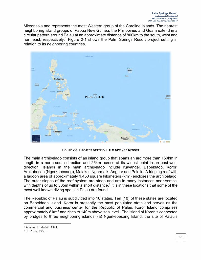
northeast, respectively.3 Figure 2-1 shows the Palm Springs Resort project setting in
relation to its neighboring countries.
FIGURE 2-1, PROJECT SETTING, PALM SPRINGS RESORT
The main archipelago consists of an island group that spans an arc more than 160km in
length in a north-south direction and 26km across at its widest point in an east-west
direction. Islands in the main archipelago include Kayangel, Babeldaob, Koror,
Arakabesan (Ngerkebesang), Malakal, Ngermalk, Anguar and Peleliu. A fringing reef with
a lagoon area of approximately 1,450 square kilometers (km2) encloses the archipelago.
The outer slopes of the reef system are steep and are in many instances near-vertical
with depths of up to 305m within a short distance.4 It is in these locations that some of the
most well known diving spots in Palau are found.
The Republic of Palau is subdivided into 16 states. Ten (10) of these states are located
on Babeldaob Island. Koror is presently the most populated state and serves as the
commercial and business center for the Republic of Palau. Koror Island comprises
approximately 8 km2 and rises to 140m above sea level. The island of Koror is connected
by bridges to three neighboring islands: (a) Ngerkebesang Island, the site of Palau’s
3 Sem and Underhill, 1994. 4 US Army, 1956.
PROJECT SITE

Palm Springs Resort Environmental Assessment
NECO Group of Companies
P.O. Box 129 Koror, Palau 96940
2-3
second largest hamlet, Meyuns, in the eastern part of the island; (2) Malakal Island, the
site of Koror’s port; and, Babeldaob Island, where Palau International Airport is located.
Koror Island is connected to the Ngerkebesang and Malakal Islands via causeways while
the Babeldaob Island by the Koror – Babeldaob Bridge, otherwise known as Japan-Palau
Friendship Bridge.
The greater Koror area is best used as a base for trips to Babeldaob Island, Rock Islands,
Peleliu, Angaur and other islands of Palau. It is a destination for visitors who want to
enjoy shopping at the markets of its downtown, or to experience some of Palau’s aquatic
life. Koror is home to Dolphins Pacific, the largest dolphin research facility in the world.
Also in Koror is the Palau International Coral Reef Center, which is an aquarium that
features local sea creatures.
2.3 Project Location
The proposed Palm Springs Resort project development encompasses the entirety of the
island of Ngerur. Ngerur Island is the smallest and northernmost element of the Koror
conurbation that comprises three main inhabited islands (Koror, Arakebesang and
Malakal) and three uninhabited islands (Ngerur, Ngerchaol and Ngermalk). Ngerur Island
is approximately 750 meters northwest of the westernmost point of Arakebesang Island.
Ngerur Island is approximately 6 kilometers from the Central Business District (CBD) of
Koror State. Figure 2-2 provides the location map while Figure 2-3 shows the aerial
photograph of the proposed Palm Springs Resort.
FIGURE 2-2, PROJECT LOCATION MAP
Source:

Palm Springs Resort Environmental Assessment
NECO Group of Companies P.O. Box 129 Koror, Palau 96940
2-4
FIGURE 2-3, AERIAL VIEW OF THE PROJECT SITE (NGERUR ISLAND)

Palm Springs Resort Environmental Assessment
NECO Group of Companies P.O. Box 129 Koror, Palau 96940
2-5
2.4 Project Site Description
Ngerur Island is a small island of approximately 5.2 hectares situated within Palau Lagoon. The Island extends about 350m in a north-south direction and approximately 250m in an east-west direction as indicated in Figure 2-4. A shallow fringing reef varying in width from 15 to 76m surrounds this uninhabited island5.
FIGURE 2-4, NGERUR ISLAND
The Ngerur Island is owned by Ngerur Island Corporation under Certificate of Title LC 355-98 particularly described as Cadastral Lot No. 029 A 01. The proponent, Palau Palm Springs Investment Development Limited, was issued with a Certificate of Approval No. 644-2018 by the Foreign Investment Board (FIB) of the Republic of Palau to construct and operate a five star resort facility at Ngerur Island. A copy of the FIB Certificate is attached in Appendix 3.
A Lease Agreement between Ngerur Island Corporation, represented by Shallum Etpison and the project proponent represented by Dong Li and Gang Zeng, was executed on January 26, 2018 for the use of Cadastral Lot 029 A 01 (Ngerur Island) as an exclusive,
5 Final Environmental Impact Statement for Quest Resort Palau, November 2000
~350m
~250m

Palm Springs Resort Environmental Assessment
NECO Group of Companies P.O. Box 129 Koror, Palau 96940
2-6
low-density high-end resort. Copies of the Lease Agreement and Certificate of Title are presented in Appendix 4.
2.5 Site Development Plan
The proposed Palm Springs Resort is intended for a growing number of affluent, international travelers to Palau. As envisioned, the Palm Springs Resort will be a small scale, high-end resort of 60 deluxe visitor accommodations on Ngerur Island. In its existing state, Ngerur Island is a privately owned and accessible only by boat. These conditions will remain unchanged as a result of resort development. Visitors will venture to the island resort to experience privileged seclusion in exotic tropical surroundings6.
The design and master plan of the Palm Springs Resort will take full advantage of the spectacular views and existing natural environment that contribute to the remote island character of Ngerur. A proposed dive grotto on the southwest corner of the island and beach improvements along the western coast are additional luxuries intended to promote Ngerur Island as an exceptional destination for recreation and retreat7. Figure 2-5 provides the Site Development Plan for the proposed Palm Springs Resort.
2.6 Project Features
The Palm Springs Resort will have several project features as reflected in Figures 2-6 and 2-7:
§ The architecture of the Palm Springs Resort will reflect a Pacific tropical style with gracious accommodations in the very traditional and informal manner of Palau;
§ Native stonewalls, earth tone materials, broad overhangs, lanais, pools, etc., are indicated in building forms and materials used throughout the site;
§ Thin slate style tile in natural green color will be used for roofs;
§ Walls will have rich colored plaster finish used in conjunction with local natural black rock at columns, piers and base walls;
§ Natural stained hardwood such as teak or mahogany will enrich the buildings;
§ Louvers will be used extensively to provide natural shading and ventilations;
§ Random cut stone will be used throughout the buildings and lanais;
§ Building structures will be primarily precast or cast in place concrete. Concrete masonry units (blocks) are also being considered.
6 Final Environmental Impact Statement for Quest Resort Palau, November 2000 7 Final Environmental Impact Statement for Quest Resort Palau, November 2000

Palm Springs Resort Environmental Assessment
NECO Group of Companies P.O. Box 129 Koror, Palau 96940
2-7
FIGURE 2-5, SITE DEVELOPMENT PLAN

Palm Springs Resort Environmental Assessment
NECO Group of Companies P.O. Box 129 Koror, Palau 96940
2-8
FIGURE 2-6, HOTEL PERSPECTIVE
FIGURE 2-7, TYPICAL GUEST BUNGALOW
(Note: Floor Plans & Elevations/Details of Building Structures are Provided in Appendix 5 (Digital Copy Only))

Palm Springs Resort Environmental Assessment
NECO Group of Companies P.O. Box 129 Koror, Palau 96940
2-9
2.6.1 Architectural Considerations
The Palm Springs Resort will encompass 60 visitor accommodations with an overall density of approximately 12 units per hectare. The general organization of the proposed development is as follows: 58 deluxe bungalows and two (2) VIP bungalows will be situated in the northern two-thirds of the island. Forty four (44) deluxe bungalows are proposed to be accommodated in 11 two-storey buildings whereas 14 deluxe bungalows will be accommodated in seven (7) single-storey duplex buildings. Forty (40) guest bungalows will be arranged along the elevated coastline of the island and 20 bungalows will be aligned within the interior of the island.
The southern third of the island will contain the public areas used for guest arrival/departure, lobby functions, restaurants, conference room, swimming pool with outdoor bar and a fitness area including a gym, Jacuzzi pools, massage/treatment and aerobics room. Spaces for the management, housekeeping and engineering functions will also be situated in this part of the island. A harbor area including a guest dock and recreational equipment storage area will be located along the southeastern shoreline of Ngerur Island.
The total square footage of the proposed Palm Springs Resort is estimated at approximately 10,220 to 11,037 square meters (m2). Deluxe guest bungalows will comprise approximately 72 m2. Lanai, garden and deck areas associated with each bungalow will be roughly 43 m2. A general breakdown of the area estimates for the various spaces or functions is presented in the following table.
TABLE 2-1, PROJECT AREA SUMMARY
Space/Function Approximate Area m2 ft2
Guest bungalows 5,946 ~ 7,181 64,000 ~ 77,300 Public areas 771 ~ 1,068 8,300 ~ 11,500 Administration 186 2,000 Food and beverage 613 6,600 Housekeeping 186 ~ 279 2,000 ~ 3,000 Spa/Wellness 297 ~ 650 3,200 ~ 7,000 Mechanical, storage, service 873 ~ 1,059 9,400 ~ 11,400
Appendix 5 (digital copy only) provides the complete set of architectural plans and sections of the proposed Palm Springs Resort.
2.6.2 Infrastructure Considerations
The proposed Palm Springs Resort will generally operate using new infrastructures to be built within the island. The required infrastructure for the resort must accommodate up to 120 guests and 110 support staff in three shifts. Equipment and facilities for water storage, reverse osmosis desalination, water treatment, wastewater treatment and pumping will be located in a dedicated building situated partially underground in the southeastern portion of the island in close proximity to the service doc area.
Infrastructure considerations are summarized as follows:

Palm Springs Resort Environmental Assessment
NECO Group of Companies P.O. Box 129 Koror, Palau 96940
2-10
2.6.2.1 WATER SUPPLY SYSTEM
The proposed Palm Springs Resort will create an estimated daily water demand of 45,000 gallons per day (gpd) according to the supporting calculations (refer to Table 2-2). The daily flow would be approximately 20 gpm with peak flow at 60 to 80 gpm. Potable water storage for the resort including the required fire protection storage plus the peak day demand is estimated at approximately 150,000 gallons. As the Final EIS for Quest Resort Palau has been approved by the EQPB in 2001, the daily water demand calculated in the EIS was used in this EA.
TABLE 2-2, ESTIMATED WATER DEMAND, PALM SPRINGS RESORT Use No. Unit of
Measure Unit Rate (gpd/unit)
Water Demand (gpd)
Guest Bungalows 60 Bungalow 315 18,900 Manager’s Cottage 1 Apartment 200 200 Main Structure
Lobby Lounge Level Lobby Reception 7 Seats 2 14 Women’s Restroom 150 Flushes 1.5 225 Men’s Restroom 150 Flushes 1.5 225 Women’s Locker Room 50 Showers 20 1,000 Men’s Locker Room 50 Showers 20 1,000 Staff Dining/Kitchen 150 Employees 10 1,500
Restaurant Level Men’s Restroom 100 Flushes 1.5 150 Women’s Restroom 100 Flushes 1.5 150 Main Dining 60 Seats 30 1,800 Wine Dining 40 Seats 30 1,200 Outside Dining 40 Seats 30 1,200 Bar Dining 50 Seats 20 1,000
Executive Offices 8 Employees 11 88 Spa/Recreation Facilities
Salon 20 Uses 10 200 Multi-purpose Room 2 Units 75 150 Hydrotherapy 2 Units
Vichey Shower 2 (estimate)1 960 1,920 Hydrotherapy Pool 2 Gal refill/day 77 154
Spa Suite 15 Uses 50 750 Swim up Pool Bar 18 Seats 2 36 Pool Bar 10 Seats 2 20 Pool 150 Persons 10 1,500
Changing Rooms Toilets 100 Flushes 1.5 150 Lavatories 100 Uses 1.5 150 Cold Plunge 2 Gal refill/day 50 100 Jacuzzi 2 Gal refill/day 100 200 Washer 2 Units 75 150 Dryer 2 Units 75 150 Showers 4 (estimate) 500 2,000 Sauna 2 Gal/day 100 200 Steam 2 Gal/day 100 200
Staff Housekeeping 40 Uses 20 800 Water Features
System 1 2,240 Sq. Footage 0.312 698 Systems 2, 3, and 4 6,680 Sq. Footage 0.312 2,082 System 6 2,080 Sq. Footage 0.234 486 System 7 5,365 Sq. Footage 0.234 1,254 Plunge Pools 36 Gal refill/day 50 1,800
Total 43,802 Total (Rounded) 45,000
Average GPD/unit 750 1 4 per day at 12 gpm times 20 minutes 2 20 per day at 5 gpm times 5 minutes

Palm Springs Resort Environmental Assessment
NECO Group of Companies P.O. Box 129 Koror, Palau 96940
2-11
Ngerur Island does not appear to have an aquifer that can sustain the average daily water demand for the proposed resort. An on-site potable water supply system will therefore include the treatment of seawater via a process of reverse osmosis (RO).
The RO system will extract the salt from the seawater through fine membranes. Concentrated waste (called brine) will be generated as a by-product of the RO system and discharge into the dredged harbor. The harbor is not intended for recreational uses (i.e., swimming, kayaking, snorkeling, etc.).
The RO system will operate as follows:
§ A submerged water intake structure will supply approximately 130,000 gallons of seawater with a total suspended solids (TSS) characteristic of 30,000 to 33,000 ppm to the system. The intake structure will be made of concrete with stainless steel bar screens on all four sides (see Figure 2-8). The bar screens will have a 2-inch by 2-inch mesh to prevent fish from entering the intake structure. The suction velocity will be less than 0.1 mph or near the equivalent of the ambient water velocity. The intake structure will be covered to prevent material from falling into it. The intake structure will take in seawater via the 12-inch diameter high density polyethelene (HDPE) pipeline (see Figure 2-9). An access hatch will be provided for the maintenance of corrosion resistant fiberglass reinforced plastic (FRP) components. The structure will be partially filled with concrete to prevent it from floating.
FIGURE 2-8, PROPOSED SEAWATER INTAKE

Palm Springs Resort Environmental Assessment
NECO Group of Companies P.O. Box 129 Koror, Palau 96940
2-12
FIGURE 2-9, PROPOSED SEAWATER INTAKE STRUCTURE & BRINE DISPOSAL LOCATION
§ Antiscalant (at a dosage rate of 12 ppm) will be added to the collected seawater to inhibit fouling of piping/membranes.�
§ Pretreatment will occur via a 5 micron cartridge system that removes particles.
§ Pressure will be increased to 1,000 pounds per square inch (psi) and the pretreated seawater will be passed through the RO membranes. The RO units (one duty with one standby) will have a recovery rate of approximately 35 to 40 percent. Each RO unit will be rated for 45,000 gpd. The two separate RO units will operate in DUTY/STANDBY mode and be alternated from on-line to off-line on a scheduled basis (per the manufacturer's recommendations).
, ..'f'
Infrastructure building
'-
Ngerur Island Utility Plan Quest Resort Palau Koror Slate a 80 160 Feet Republic of Palau Environmental Impact Statement WCP, Inc.
158

Palm Springs Resort Environmental Assessment
NECO Group of Companies
P.O. Box 129 Koror, Palau 96940
2-13
§ Pretreated seawater will be recovered as purified water and treated for hardness and
taste with calcium carbonate and zinc orthophosphate (at dosage rates of 10 and 12
ppm, respectively).
§ The purified water will be disinfected using sodium hypochlorite (at a dosage rate of
approximately 10 ppm). The RO system will be sized to achieve the projected water
demand of 45,000 gpd with TSS of 500 ppm.
§ Treated purified water will be stored in a 150,000-gallon watertight reservoir located
in the infrastructure building. From the storage tank, on-island water distribution will
occur via below ground piping, fire posts, distribution pumps, and a hydropneumatic
tank (refer to Figure 10). The piping will be sized to accommodate the average daily
flows and peak flows. For this particular project, however, a fire flow of 500 gpm with
a 20 psi residual dictates that the pipeline size should be 6 inches in diameter. The
pipelines will be installed beneath or near the circuitous pathways around the island
at an average depth between 2.5 and 3 feet. The distribution piping will be looped to
provide reliable service with minimal pressure drop. Isolation valves will be
strategically located to enhance maintenance.
§ Distribution pumps located in the infrastructure building adjacent to the storage tanks
will be part of the skid mounted packaged system that includes a hydropneumatic
tank. The system will operate in LEAD/LAG/STANDBY mode. The hydropneumatic
tank will provide pressurized storage to minimize pump starts and stops during low
demand conditions.
§ Brine (with pH of 8.3, temperature of 78°F with no chlorine residue) will be returned to
the harbor for dilution into surrounding waters. Approximately 85,000 gpd of brine with
TSS of 50,000 to 60,000 will be discharged as a result of the RO system. The brine
will be diluted to less than 35,000 ppm prior to its discharge through a perforated
pipe(s) installed at the base of the harbor rip- rap embankments (refer to Figure 10).
§ Dilution of the brine will be accomplished for compliance with point-source discharge
allowances applicable to all water classes, including Class B. To achieve the dilution,
approximately 600 to 700 gpm of fresh seawater will be mixed with the brine. An intake
pump station will draw the seawater from outside the harbor area. The intake will be
located adjacent to the outer (or seaward) portion of the harbor breakwater whereas
the perforated discharge pipe will be located near the base of the interior portion of
the harbor breakwater. Dilution pumps (between 15 to 20 horsepower) will run
continuously to match the continuous generation of brine by the RO units.
§ Water in the harbor is well circulated as a result of its open configuration.
Approximately one-third of the harbor waters are flushed or exchanged with every tide
cycle; therefore, the discharged brine is expected to be sufficiently circulated and
diluted prior to its contact with any coral or marine life beyond the harbor.
The RO system has a self-cleaning system that can be automated or manually activated.
The system will be backwashed using stored treated water.

Palm Springs Resort Environmental Assessment
NECO Group of Companies P.O. Box 129 Koror, Palau 96940
2-14
Maintenance of the RO system will be accomplished per the manufacturer's recommendations. The pretreatment cartridge filters can be individually isolated for cleaning/replacement and multiple cartridges can be out of service without affecting the on-line treatment capacity. RO membranes will be cleaned using the integral self- cleaning system.
Water quality can be monitored in the storage reservoirs using chlorine residual analyzers and samples taken on a scheduled basis for laboratory analysis. Compliance with local regulatory agency guidelines will be achieved.
2.6.2.2 WASTEWATER SYSTEM
The wastewater generation rate for the proposed Palm Springs Resort is estimated at approximately 30,000 gpd of domestic wastewater. The wastewater generation is estimated to be 80% of the total water demand of the resort project (refer to Table 2-3). The wastewater generation rate from the “Final EIS for Quest Resort Palau” is used in this EA. The calculation is presented in the following table.
TABLE 2-3, ESTIMATED WASTE WATER GENERATION, PALM SPRINGS RESORT
Use No. Unit of Measure
Unit Rate (gpd/unit)
Water Demand (gpd)
Estimated Waste Water Generation*
(gpd) Guest Bungalows 60 Bungalow 315 18,900 15,120 Manager’s Cottage 1 Apartment 200 200 160 Main Structure
Lobby Lounge Level Lobby Reception 7 Seats 2 14 11 Women’s Restroom 150 Flushes 1.5 225 180 Men’s Restroom 150 Flushes 1.5 225 180 Women’s Locker Room 50 Showers 20 1,000 800 Men’s Locker Room 50 Showers 20 1,000 800 Staff Dining/Kitchen 150 Employees 10 1,500 1,200
Restaurant Level Men’s Restroom 100 Flushes 1.5 150 120 Women’s Restroom 100 Flushes 1.5 150 120 Main Dining 60 Seats 30 1,800 1,440 Wine Dining 40 Seats 30 1,200 960 Outside Dining 40 Seats 30 1,200 960 Bar Dining 50 Seats 20 1,000 800
Executive Offices 8 Employees 11 88 70 Spa/Recreation Facilities
Salon 20 Uses 10 200 160 Multi-purpose Room 2 Units 75 150 120 Hydrotherapy 2 Units
Vichey Shower 2 (estimate)1 960 1,920 1,536 Hydrotherapy Pool 2 Gal refill/day 77 154 123
Spa Suite 15 Uses 50 750 600 Swim up Pool Bar 18 Seats 2 36 29 Pool Bar 10 Seats 2 20 16 Pool 150 Persons 10 1,500 1,200
Changing Rooms Toilets 100 Flushes 1.5 150 120 Lavatories 100 Uses 1.5 150 120 Cold Plunge 2 Gal refill/day 50 100 80 Jacuzzi 2 Gal refill/day 100 200 160 Washer 2 Units 75 150 120 Dryer 2 Units 75 150 120 Showers 4 (estimate) 500 2,000 1,600

Palm Springs Resort Environmental Assessment
NECO Group of Companies P.O. Box 129 Koror, Palau 96940
2-15
Sauna 2 Gal/day 100 200 160 Steam 2 Gal/day 100 200 160
Staff Housekeeping 40 Uses 20 800 640 Water Features
System 1 2,240 Sq. Footage 0.312 698 Systems 2, 3, and 4 6,680 Sq. Footage 0.312 2,082 System 6 2,080 Sq. Footage 0.234 486 System 7 5,365 Sq. Footage 0.234 1,254 Plunge Pools 36 Gal refill/day 50 1,800
Total 43,802 29,986 Total (Rounded) 45,000 30,000
Average GPD/unit 750 500 * Wastewater quantities equal to approximately 80% of potable water values
The on-site wastewater collection system will include 6-inch gravity sewers that convey effluent to the treatment plant located in the infrastructure building. One small sewage pump station located adjacent to the infrastructure building will serve only the kayak hut bathroom. Pumps (around 1 horsepower) and alarms indicating pump failure, high water levels, etc.) will be provided. The wet well will be slightly oversized to provide additional storage thereby allowing corrective actions to be taken prior to a spill event.
The treatment system will consist of a Jokaso wastewater treatment system. In Japan, "Jokaso" literally means "purification tank onsite wastewater treatment system" in Japanese.8
A Jokaso is usually installed underground as a single compact tank. There are five functional chambers (sedimentation, anaerobic, aeration, storage and disinfection) in a tank. Although anaerobic and aerobic combined biological treatment process has been commonly employed as an onsite wastewater treatment method for over 30 years in Japan, the Jokaso technology is now greatly improved with treatment performance equivalent to that of a centralized public sewage plant. Various types and sizes are available from small residential units to large commercial units. Figure 2-10 provides the Jokaso treatment process diagram and a typical Jokaso wastewater treatment system
8 fujiclean.co.jp, 2018

Palm Springs Resort Environmental Assessment
NECO Group of Companies P.O. Box 129 Koror, Palau 96940
2-16
FIGURE 2-10, PROPOSED (JOKASO) WASTEWATER TREATMENT SYSTEM
The Jokaso wastewater treatment system is currently manufactured in Japan and supplied by Fuji Clean Co., Ltd. The resort owner will order a Jokaso system to accommodate the projected design sewage flow of 30,000 gallons per day (115 m3/day). Depending on the capacity of each Jokaso unit, several units can be combined for optimal efficiency.
The effluent quality of a Jokaso wastewater treatment system is <15 mg/L of BOD and <20 mg/L of suspended solids (SS). The Jokaso effluent quality is accredited by the Building Center of Japan.
§ OIL WATER SEPARATOR
Oil/water separator will be installed to separate oils from wastewater discharge from the kitchen restaurant of the resort. The effluent from oil/water separator is discharged to the Jokaso sewage treatment plant to undergo further treatment. The plan and section for a proposed oil water separator is presented in Figure 2-11.
FIGURE 2-11, OIL-WATER SEPARATOR
§ EFFLUENT DISPOSAL
Treated wastewater will be conveyed via a 6-inch HDPE pipe to a location northeast of the island (refer to Figure 2-12) and discharged approximately 100 feet (30.5 meters) below the ocean surface (see Figure 2-12). Analysis using the PLUME model that was developed by the U.S. Environmental Protection Agency (EPA) indicates that "the receiving water would rapidly dilute the small volume of treated wastewater effluent

Palm Springs Resort Environmental Assessment
NECO Group of Companies P.O. Box 129 Koror, Palau 96940
2-17
generated from the Quest Resort"9 and "the dilution would be so rapid that all Class AA water quality criteria would be easily met within a zone of mixing 130 feet in radius around the discharge point" (Sea Engineering, Inc., 1999).10 The studies by Sea Engineering, Inc. (refer to Appendix 5) indicate that the discharge plume will not reach the lagoon surface because at 49 feet below sea level the plume becomes virtually indistinguishable from the receiving water (see Figure 12) with an average initial dilution ratio of over 1,000 to 1.
FIGURE 2-12, PROPOSED MARINE OUTFALL LOCATION
9 Final Environmental Impact Statement for Quest Resort Palau, 2000 10 Final Environmental Impact Statement for Quest Resort Palau, 2000
NGERUR ISLAND
Marine Ou!fall ent (Detail)Route Ahgnm ! Resort PalauQues
o 100 Feet Kacoc State ! men! Republic of Palau t I Impact Sta eEnvironmen a WCP, Inc.
17A

Palm Springs Resort Environmental Assessment
NECO Group of Companies P.O. Box 129 Koror, Palau 96940
2-18
Note: The illustrated plume outfall for the discharge of approximately 30,000 gpd of effluent reflects the most conservative assumptions: 100 percent concentration levels and 10 percent currents. with a plume diameter of 260 feel and a trapping depth of -49 feet MSL. A more realistic assumption would be 75 percent concentration levels and average currents whIch results in a plume diameter of 165 feel and a trapping depth at -55 feet MSL.
FIGURE 2-13, OUTFALL PROFILE AND EFFLUENT PLUME
HDPE is recommended for the outfall pipe. This material combines cost effectiveness, ease of construction, and long life.
One of the primary construction concerns for the Ngerur outfall will be to minimize any damage to corals. During the reconnaissance diving, it was observed that many coral outcrops could be avoided by using the flexibility of the HPDE pipe.
The section of HDPE pipeline that must cross the first 100 feet from the island shoreline is proposed to be trenched into the bottom because the area supports vigorous coral growth over almost 100 percent of the bottom surface. A narrow trench will not only protect the pipeline well but would also allow the coral to recolonize the covered trench, thereby allowing the coral ecology to regenerate while locally removing the pipeline from the ecosystem.
2.6.2.3 DRAINAGE AND IRRIGATION SYSTEM
Runoff will be collected by an island-wide system of storm drains associated with infiltration trenches. The following elements will direct drainage:
§ There is one major hardscape pavement area of porous pavement. It is located near the service building and service dock. The runoff from this area will be collected and discharged into the enclosed harbor area.
MSL -- - --------- -------- - --,,",,--- - ---10 6" HPDE Outfall Pipe - 20 Zone or. Mixi':"9 - 30 I'
Q) -ill -40 (L
c -50 c 0 - 60 :;:; Trapping Depth > -70'" - 49 Feet MSLill iii -80
-90 Diffuser Location -100 " -105 Feet MSLVertical Exageration 2 to 1 -110 -120
0 50 100 150 200 250 300 350 400 450 500 550 600
Offshore Distance in Feet
Note: The illustrated plume outfall for the discharge of approximately 30,000 gpd of effluent reflects the most conservative assumptions: 100 percent concentration levels and 10 percent currents. with a plume diameter of 260 feel and a trapping depth of -49 feet MSL. A more realistic assumption would be 75 percent concentration levels and average currents whIch results in a plume diameter of 165 feel and a trapping depth at -55 feet MSL.
Outfall Profile & Effluent Plume Quest Resort Palau Karot State Republic of Palau Environmental Impact Statement WCP, Inc.
17B

Palm Springs Resort Environmental Assessment
NECO Group of Companies P.O. Box 129 Koror, Palau 96940
2-19
• Matting materials (i.e., filter strips) will be placed on top of all construction berms dispersed around the perimeter of the island. These berms provide a barrier to surface discharge over the island edge and contain runoff for a more controlled discharge using perforated pipe and discharge feature.
• The landward side will have a filter fabric/silt curtain with a small impoundment area drained by a buried perforated pipe, wrapped in filter fabric and installed in a gravel trench with discharge to a waterfall feature.
• Infiltration trenches will run primarily along cart service paths. Precipitation will flow on the surface of the paths and infiltrate into the grave trenches paralleling the cart paths. Perforated pipes located in these trenches will be wrapped in a filter fabric in order to minimize sediment transport. They will convey the collected surface runoff to a controlled discharge point.
• Stormwater quality inlets will be used. Filter fabric wraps will be used for entrance points into the conveyance piping. This should minimize transport of sediment through the system which eventually discharges into the surrounding ocean.
• The permanent storm drainage system will catch both surface runoff and roof downspouts. Each building will be surrounded by underground piping which includes connections to both the downspouts and surface inlets. These features will convey the water underground to a controlled discharge point.
• Existing vegetation to be removed during construction will be turned into mulch and spread on the ground in disturbed areas as a temporary ground cover in order to dissipate rain energy.
• The project does not include any retention/detention basins on the island.
Drainage and grading elements of the Palm Springs Resort are illustrated in Appendix 5.
2.6.2.4 SOLID WASTE COLLECTION AND DISPOSAL SYSTEM
Solid waste generated at the Palm Springs Resort will primarily be domestic in nature (paper, plastics, packaging, waste food, etc.). Refuse collection and solid waste disposal will be contracted to a service provider and coordinated with the Bureau of Public Works (BPW) to ensure proper disposal to an operational landfill
Solid waste will be compacted to reduce the volume of disposed waste from the island. Approximately up to 345 kg per day (760 lbs/day) of solid waste will be generated according to the supporting calculation in Table 2-4. Solid waste generation calculation in the Final EIS Report for Quest Resort Palau is adapted in this EA.

Palm Springs Resort Environmental Assessment
NECO Group of Companies P.O. Box 129 Koror, Palau 96940
2-20
TABLE 2-4, ESTIMATED SOLID WASTE GENERATION, PALM SPRINGS RESORT
Use No. Unit of Measure
Unit Rate (lbs/unit)
Solid Waste Generation (lbs/day) (kg/day)
Guest Bungalows 60 Bungalow 3.3 198.0 90.0 Manager’s Cottage 1 Apartment 3.3 3.3 1.5 Main Structure
Lobby Lounge Level Lobby Reception 7 Seats 0.1 0.7 0.3 Women’s Restroom 150 Uses 0.1 15.0 6.8 Men’s Restroom 150 Uses 0.1 15.0 6.8 Women’s Locker Room 50 Uses 0.1 5.0 2.3 Men’s Locker Room 50 Uses 0.1 5.0 2.3 Staff Dining/Kitchen 150 Employees 0.5 75.0 34.1
Restaurant Level Men’s Restroom 100 Uses 0.1 10.0 4.5 Women’s Restroom 100 Uses 0.1 10.0 4.5 Main Dining 60 Seats 1.6 96.0 43.6 Wine Dining 40 Seats 1.6 64.0 29.1 Outside Dining 40 Seats 1.6 64.0 29.1 Bar Dining 50 Seats 1.6 80.0 36.4
Executive Offices 8 Employees 3.7 29.6 13.4 Spa/Recreation Facilities
Salon 20 Uses 0.1 2.0 0.9 Multi-purpose Room 2 Units 0.1 0.2 0.1 Hydrotherapy 2 Units
Vichey Shower 2 Units 0.1 0.2 0.1 Hydrotherapy Pool 2 Units 0.1 0.2 0.1
Spa Suite 15 Uses 0.1 1.5 0.7 Swim up Pool Bar 18 Seats 1.6 28.8 13.1 Pool Bar 10 Seats 1.6 16.0 7.3 Pool 150 Persons 0.1 15.0 6.8
Changing Rooms Toilets 100 Uses 0.1 10.0 4.5 Lavatories 100 Uses 0.1 10.0 4.5 Cold Plunge 2 Units 0.1 0.2 0.1 Jacuzzi 2 Units 0.1 0.2 0.1 Washer 2 Units 0.1 0.2 0.1 Dryer 2 Units 0.1 0.2 0.1 Showers 4 Units 0.1 0.4 0.2 Sauna 2 Units 0.1 0.2 0.1 Steam 2 Units 0.1 0.2 0.1
Staff Housekeeping 40 Uses 0.1 4.0 1.8 Total 760.1 345.5
Solid waste will be transported by boat. The intent of the resort operator is to install a trash compactor within the island thereby reducing the volume of refuse. Although the weight of the waste remains the same, a reduced volume will extend the life of the landfill.
The resort will institute waste separation and recycling procedures in order to take advantage of existing, and hopefully expanding, recycling facilities in Palau.
2.6.2.5 TRANSPORTATION & ROAD NETWORK SYSTEM
The proposed road network system for the Palm Springs Resort is shown in Figure 2-14. All guest bungalows and resort facilities are accessible via this road network. Electrical carts will be made available for the transport of all guests to their bungalows.

Palm Springs Resort Environmental Assessment
NECO Group of Companies P.O. Box 129 Koror, Palau 96940
2-21
The proposed project is well equipped to accommodate persons with physical disabilities. Disabled guests arriving in Palau will be transported, with any assistance they need, from the airport to the Palm Springs Resort. Transport boats will include the ability to handle wheel chairs and potential other needs.
Upon arrival at the resort, wheelchair access from the dock to the main area of the resort will include a ramp and an elevator. At least one such cart will be designated to accommodate the needs of a disabled guest.
The resort will offer, under current plans, special disabled facilities in two ground floor bungalows. Additionally, certain types of disabled guests can be accommodated in the regular ground floor bungalows.
FIGURE 2-14, PROPOSED ROAD NETWORK
2.6.2.6 ELECTRICAL AND COMMUNICATION SYSTEM
The Palm Springs Resort does not intend to tap electrical power from the Palau Public Utility Corporation (PPUC) and implement the original plan in the “Final EIS for Quest Resort Palau” to install submarine cable from a location near the Palau Pacific Resort to
Ngerur Island Building Layout Quest Resort Palau Koror Slale Republic of Palau Environmental Impact Statement wep, Inc.
0:...__:80: ';;;60 Feel 126

Palm Springs Resort Environmental Assessment
NECO Group of Companies P.O. Box 129 Koror, Palau 96940
2-22
the island. This will therefore eliminate potential impacts to the bottom of the ocean and marine environment.
Instead, three (3) diesel generators with 1,800 kW each will be used as main power supplies for the Palm Springs Resort. Two (2) generators will be used alternately while the other generator will be used as stand-by/back up purpose.
It is proposed that one variable power distribution substation and a dry-type transformer are set up within the first floor of the building. Equipment with low noise generation is selected.
Generator sets will be provided with enclosure to significantly reduce the noise generation. “Room inside the room” design concept is adopted for control. With these controls in place, the noise generation should be no more than 50 dBA. Figure 2-15 provides the section of the proposed generator house.
FIGURE 2-15, POWER GENERATOR ROOM
2.6.2.7 FIRE PROTECTION SYSTEM
Potable water will be used for the fire protection system consisting of fire pumps and water storage facilities. The fire storage volume of 60,000 gallons along with an emergency water storage volume of 90,000 gallons means the potable water reservoir (including the fire storage allotment) should contain, at a minimum, 150,000 gallons. This volume meets the intent of emergency and fire storage requirements. The fire pumps are proposed to be located in the basement of the main structure on Ngerur Island and be plumbed into the potable water distribution system. Two fire pumps will be installed for duty/standby operation. Each pump will have a 50 horsepower motor and be rated for 500 gpm at 100 psi.

Palm Springs Resort Environmental Assessment
NECO Group of Companies
P.O. Box 129 Koror, Palau 96940
2-23
2.6.3 Marine Facilities and Improvements
2.6.3.1 HARBOR AND DOCK FACILITY
A small harbor is proposed at the southeast corner of the island. The harbor would
support the docking of vessels that carry resort guests and their luggage from Koror to
Ngerur Island, vessels that would be used for water recreation activities (e.g., scuba
diving, sightseeing, fishing, kayaking, etc.), and vessels that transport employees and
supplies to the island.
The docking facility must be protected from wave approach to be fully functional during
all reasonable wind, wave and weather conditions. The harbor must be designed to
account for oceanographic conditions at the site, user vessel characteristics and use
requirements. Oceanographic parameters include wind and wave conditions, nearshore
bottom profiles and water depths and water level fluctuations. Vessel characteristics
include length, width, draft and maneuverability. Dock usage refers to parameters such
as passenger loading, cargo type and handling, and special berthing requirements.
Vessels that will dock at the proposed resort are generally expected to be powerboats
ranging in size from about 7.6m (25 ft) to 15m (50 ft) in length. The proposed harbor is
located in an area where a wide (30 to 61m) shallow, rock, cobble and sediment bench
extends in front of the shore, as shown in Figure 2-16. The 3m (10 ft) depth is up to 122m
(400 ft) offshore. This location is partially sheltered from prevailing trade winds and direct
wave approaches. The sediment bench is almost daily exposed when the water level is
at -0.6m (-2 ft) MSL.
Dredging for the entry channel and turning basin for the harbor is proposed to create a
depth of -3.65m (-12 feet) MSL, which means that the lagoon floor will be excavated to
an average of 3m (10 ft) below its existing depth. Approximately 50 percent of the area
proposed to be dredged for the harbor development including the entry channel and
turning basins is located on the sediment bench, thereby keeping the coral areas to be
disturbed by dredging activities to a minimum.
TABLE 2-5, ASSUMPTIONS FOR HARBOR PLANNING
Description Dimension Feet (ft) Meter (m)
Design/Typical Vessel
Length 50 15.2
Width 18 5.5
Draft 4 1.2
Channel & Basin Depth
Vessel draft 4 1.2
Low tide 4 1.2
Vessel motion 2 0.6
Bottom clearance 2 0.6
Total 12 3.65
Entrance Channel width (minimum three vessel width)
3 x 18ft = 54 ft but use larger value 60 18.2
Turning Basin Diameter (minimum 1.5 x vessel length)
1.5 x 50 ft = 75 ft but use 100 ft 100 30.4

Palm Springs Resort Environmental Assessment
NECO Group of Companies P.O. Box 129 Koror, Palau 96940
2-24
FIGURE 2-16, ROCK/SEDIMENT BENCH LOCATION
The conceptual dock, channel and basin, and protective structure layouts are illustrated in Figures 2-17 to 2-18. Appropriate dock design will enable comfortable loading and unloading of passengers and their luggage. The resort developer desires the docking facility to be attractive, as befits the entrance to a first-class resort.
•••••• N 497 200
Limit of harbor deveiopment Edge of Rock Outcrops
Existing rock/sediment bench within harbor development
N 497 000
NGERUR ISLAND
-=1'74:ifP7L;/-;rW'-h''-k-----\,--\\I:-----,..------------
m m g; g:
tI__._. m g8 SOUTH REVETTED MOLE rn AND BREAKWATER rn g
Harbor Design Rock/Sediment Bench Location Quest Resort Project Koror Slate Republic of Palau
o 100 200 FEEl Environmental Impact Statement WCP, Inc. Page 21A

Palm Springs Resort Environmental Assessment
NECO Group of Companies P.O. Box 129 Koror, Palau 96940
2-25
Boats and the docking facility provide the only access to and from the resort. The docking facility must therefore be fully functional during all reasonable wind, wave and weather conditions. With the given layout, the dock would be protected from wave approach. Primary elements of the dock facility layout are summarized in Table 2-6.
FIGURE 2-17, PROPOSED LAYOUT, HARBOR & DOCK FACILITY
"
Ngerur ;Island
a 50 100 Feet
}
.,r-.
South Revetted Mole and Breakwater
Harbor and Dock Facility Proposed Layout Quest Resort Palau Koror State Republic of Palau Environmental Impact Statement WCP, Inc.
22A

Palm Springs Resort Environmental Assessment
NECO Group of Companies P.O. Box 129 Koror, Palau 96940
2-26
FIGURE 2-18, TYPICAL SECTION, REVETTED MOLE & BREAKWATER
TABLE 2-6 PRIMARY ELEMENTS OF THE DOCK FACILITY
Description Approximate Size/ Dimension Meter Feet Guest Docks (concrete floating docks with guide piles and access ramps)
Main landing (covered) 4.8 x 18.2 16 x 60 Tour/recreation dock, 2 sides, with an effective length of 36.5m (120ft) 2.4 x 18.2 8 x 60 Access ramps, 2 ea. 1.2/1.8 4/6
Service Docks (floating docks) Solid fill wharf (concrete capped sheet pile bulkhead) 15.2 50 Floating dock, accessed by a 6 ft ramp 5.4 x 18.2 18 x 60
Entrance channel 18.2 60 Turning basins (2 areas between entrance channel and berths) - diameter 30.4 100 Protective Structures (rock rubblemound breakwaters, with crest elevation of +8 ft, 2 ea.)
North breakwater, length 125 413 South breakwater, length 124.6 409
Dock construction involves the creation of interior land. A central area of approximately 0.2 hectares between the two dock facilities will be created with dredged material and protected by a vertical cemented rock wall. The area will serve as water access for kayaks as well as provide building space for kayak storage, scuba equipment, and maintenance, etc. The calculated elevation of this area will be +1.8m (+6 ft) minimum and vary upwards depending upon the distance from the edge of the water.
It is estimated that approximately 20,000 cubic yards (CY) of bottom material will have to be removed to bring the harbor area to approximately 12 feet (3.6 meters) below sea level. Approximately 50 percent of the area proposed to be dredged for an entry channel and turning basin would occur within the area defined by the sediment bench,
HARBOR SIDE OCEAN SIDE
1,500 TO 2,500 LB ARMOR STONE, t 7.0' TWO STONES THICK, RANDOM PLACEMENT
CREST EL. + 8' 100 TO 250 LB UNDERLAYER STONE --- - - - .-------'.-
DEDGED MATERIAL VMSL
3,000 LB (MIN) TOE STONE
EXISTING BonOM (VARIES)
Harbor and Dock Facility Typical Revetted Mole Section Quest Resort Palau Koror Slale Republic 01 Palau
o 5 10 Feet Environmental Impact Statement WGP,lnc. 22B

Palm Springs Resort Environmental Assessment
NECO Group of Companies P.O. Box 129 Koror, Palau 96940
2-27
Approximately 65 percent of this sediment bench area will be dredged to -12 feet (3,6 meters) MSL; the remaining 35 percent will be filled to +6 feet (1,8 meters). The damage to vibrant coral areas would therefore be kept to a minimum. The dredged material is expected to be characterized as primarily volcanic breccia with pockets of sand and coral fragments. It is proposed that this material be used for construction on the island.
2.6.3.2 DIVE GROTTO
A small natural embayment on the southwest corner of the island will be developed into a protected saltwater pool (see Figure 2-19). Creation of a rock grotto to be used primarily for SCUBA diving training will require excavation into the existing rocky nearshore area. This shallow, roughly circular rock formation is located immediately seaward of the embayment, which is exposed at low tide and barely submerged at high tide. The rock formation provides some wave protection, particularly at low tide. Additional protective structures will still be required to provide a sheltered area for swimming and SCUBA lessons. The nearshore area is shallow and requires dredging to create adequate water depth for swimming and diving.
Wave protection will be provided by two offshore breakwaters of similar design to the rock groins used for beach stabilization (refer to Figure 2-20). A breakwater crest elevation of +5 feet (1.5 meters) is calculated to provide wave protection for the grotto users during times of prevailing and moderate westerly wind conditions. The breakwaters are expected to overtop during severe storm conditions.
Both breakwaters will be approximately 60 feet (18.2 meters) long. These will protect the dredged pool that is 120 feet (36.4 meters) in diameter and approximately 6 to 8 feet (1.8 to 2.4 meters) deep. The breakwaters will be detached from land. There will be a 10-foot (3.0-meter) wide and 8-foot (2.4-meter) deep circulation channel to facilitate water exchange and provide access to deeper water for SCUBA divers.
Dredging in the nearshore grotto area to create adequate depths for swimming and diving is expected to remove approximately 3,500 CY of bottom material. The dredged material is expected to be characterized as primarily volcanic breccia with pockets of sand and coral fragments. It is proposed that this material be also used for construction on the island.

Palm Springs Resort Environmental Assessment
NECO Group of Companies P.O. Box 129 Koror, Palau 96940
2-28
FIGURE 2-19, LAYOUT OF THE PROPOSED DIVE GROTTO
FIGURE 2-20, TYPICAL SECTION, DIVE GROTTO BREAKWATER
'I·'
···Ngerur
Dive Grotto Proposed Layout Quest Resort Palau Koror Slale
o 20 40 Feet Republic of Palau Environmental Impact Statement WCP,lnc.
23C
HARBORSIDE OCEANSIDE
1 70'1- 1,500 TO 2,500 LB ARMOR STONE, TWO STONES THICK, RANDOM PLACEMENT
CREST EL. + 8' 100 TO 250 LB UNDERLAYER STONE
1.5 GEOTEXTILE FILTER FABRIC 1.01./
V MSL --- - ---..;::;;-'" ." S7 MSL ,..': DREDGED 2.0'" " MATERIAL' • 3,000 LB (MIN) TOE STONE
..,-,,"- . . . .' OR '. . /
/ . . . QUARRY RUN STONE
GROnOSIDE OCEAN SIDE
2,000 TO 3,000 LB ARMOR STONE, ONE STONE THICK, UNIFORM KEYED AND FIT PLACEMENT
CRESTEL. +5
100 TO 250 LB UNDERLAYER STONE
,,- ..... 2.5'
S7 MSL MSL
SPALLSTO 5LBSTONE 3,000 LB (MIN) TOE STONE
Breakwaters Typical Section Quest Resort Palau
o 5 Koror Stale Republic of Palau Environmental Impact Statement WCP, Inc.
22C

Palm Springs Resort Environmental Assessment
NECO Group of Companies P.O. Box 129 Koror, Palau 96940
2-29
2.6.3.3 BEACH IMPROVEMENTS
The proposed site for beach improvements is located along the western coast at the beginning of the northern third of the island. A small natural embayment is the chosen location for the development of beach improvements (see Figure 2-22). The shape and shallow depth of the embayment provides a reasonable opportunity for beach construction. The relatively exposed nature of the shoreline, however, with little or no natural protection from storm waves, necessitates the use of beach stabilization structures. These structures will help control the beach configuration, reduce maintenance requirements and insure that the sand is not moved offshore where it could impact the marine environment.
Proposed stabilization structures will be rock groins constructed perpendicular to the shore at both ends of the beach (see Figure 2-21). The groins will be constructed using 1,000 to 2,500 pound armor stone similar in characteristics to that occurring naturally around the island, placed over a core of 5 to 250 pound stone. The stone will be placed to form an irregular surface, and the crest elevation shall vary from +5 feet (+1.5 meters) to +7.5 feet (+2.3 meters), in order to create a more natural appearance. Cavities in the crest will be created for landscaping with salt tolerant vegetation.
The beach crest will be about 150 feet (45.6 meters) long and approximately 50 feet (15.2 meters) wide. Including the beach slope, this will result in a dry beach width of about 50 to 70 feet (15.2 to 21.2 meters) at high tide and over 100 feet (30.4 meters) at low tide. The sand fill will be stabilized by a north and south groin, each approximately 120 feet (36.4 meters) long. The relatively shallow near shore water depth at this location necessitates constructing the beach toe at an approximate depth of minus 4 feet (1.2 meters).
FIGURE 2-21, TYPICAL SECTION, BEACH BREAKWATER
1,000 TO 2,500 LB ARMOR STONECREST WIDTH TWO LAYERS FORMING AN5 FT (MIN) IRREGULAR SURFACE { BUT VARYING {
CREST El. VARYING +5 TO +7.5 FT ---------.-.- - - -- 100 TO 250 LB UNDERLAYER STONE
,-2.5'
V MSl S7 MSl
SPALlSTO 3,000 lB (MIN) TOE STONE 5 laSTONE
NOTE: GROINS HAVE PLANTING CAVITIES FOR lANDSCAPING WITH TYPICAL SHORELINE VEGETATION THAT IS INDIGENOUS TO THE AREA
Beach Improvements Typical Groin Section Quest Resort Palau
o 5 10 Feet Koror State Republic of Palau Environmental Impact Statement WCP, Inc.
236

Palm Springs Resort Environmental Assessment
NECO Group of Companies P.O. Box 129 Koror, Palau 96940
2-30
FIGURE 2-22, LAYOUT OF THE PROPOSED BEACH IMPROVEMENT
NGERUR ISLAND \.
STATION 0+00 N497422 E15S838
.,"
., r'/. A
. ".'
../i I , J
,
Beach Improvements Proposed Layout Quest Resort Palau Koror State Republic of Palau Environmental Impact Statement we?, Inc. o 20 40 Fect
23A-

Palm Springs Resort Environmental Assessment
NECO Group of Companies P.O. Box 129 Koror, Palau 96940
2-31
2.7 Construction Features
2.7.1 Cut and Fill Volume
The total cut volume on the island is estimated at approximately 14,200 cubic meter (m3) (18,500 cubic yard (CY)) with approximately 7,000 m3 (9,000 CY) or roughly 50 percent of the total cut volume attributed to the main structure of the resort. The total fill volume is projected at 2,100 m3 (2,800 CY). Excess cut volume (12,000 m3 or 15,700 CY) will be exported off-island and be available for sale as fill material to private customers, to the government, or to quarries for further processing.
The projected dredged volume generated by project actions is estimated at approximately 18,000 m3 (23,500 CY). Roughly 20 percent of this material will be used as fill material for the marine facilities and improvements. The remaining dredged material will be exported off-island for sale as fill material.
Estimated quantities generated and required for proposed marine facilities and improvements are depicted in the following table.
TABLE 2-7, ESTIMATED DREDGED VOLUMES AND USAGE REQUIREMENTS Description Estimated Volume
Dredged m3 (CY)
Required m3 (CY)
Harbor Construction 15,291 (20,000) Breakwater armor stone 5,400 (7,000) Breakwater underlying stone 2,500(3,250) Breakwater center fill (can be dredged material) 3,500 (4,500)
Grotto Improvements 2,700 (3,500) Breakwater armor stone 400 (500) Breakwater underlying stone 300 (400) Breakwater center fill (can be dredged material) 150 (200)
Beach Improvements Sand fill 2,700 (3,500) Groin armor stone 760 (1,000) Groin underlying stone 600 (800) Groin center fill (can be dredged material) 300 (400)
2.7.2 Environmental Protection Plan
Construction activities will be accomplished in an environmentally responsible manner. The environmental protection plan (EPP) includes the following elements:
a) The project contractor will provide standard 20-foot containers with proper markings as storage area for hazardous materials. This storage area will be provided for all fuel tanks, oil drums and other hazardous materials. A liner and a berm will surround the containment area.
b) All hazardous and toxic materials transported by truck or boat will be equipped with spill kits, sufficient to contain and absorb the amount of material being transported.

Palm Springs Resort Environmental Assessment
NECO Group of Companies
P.O. Box 129 Koror, Palau 96940
2-32
c) Personnel involved in handling of hazardous materials will be provided with adequate
training in dealing with spill incidents.
d) If dry conditions develop creating fugitive dust emissions, sprayer or sprinklers
sufficient to reduce dust, without creating runoff or erosion will be implemented.
e) All equipment operating in construction areas will be properly muffled. Work hours
will be limited to between 0700 and 1800 hours on Monday through Saturday.
2.7.3 Erosion and Sedimentation Control Plan
A site specific erosion and sedimentation control plan (ESCP) will be submitted to the
EQPB in fulfillment of EQPB earthmoving permit requirements as stipulated in the EQPB
Earthmoving Regulations Section 2401-1-11. At a minimum, the ESCP must have the
following goals:
§ Minimize earth movement;
§ Implement staging of earthmoving activities to best utilize site conditions;
§ Avoid earthworks during heavy rains, to the extent possible.
In order to achieve the erosion and sedimentation control objectives, the contractor will
strive to increase awareness among all job-site personnel with respect to the handling
and disposal of materials. The contractor will hold weekly meetings to train and direct
personnel. Materials will be handled appropriately to minimize spills and erosion impact
to surrounding waters.
A number of proven techniques to minimize erosion impacts to the surrounding waters
will be implemented. The following list of techniques will be employed at various stages
of construction. The specific locations and time of implementation will be affected by
factors such as the local weather, availability of material, local geological conditions and
the construction schedule.
a) Site clearing will be limited to the area that will be disturbed by the construction of the
hotel, swimming pool and restaurant.
b) As much vegetation as practicable will be retained since it acts as an excellent erosion
control device. When vegetation is removed, mulch will be spread over the ground as
much as practicable to prevent mud tracking by heavy equipment.
c) A silt fence will be installed around the site perimeter prior to commencement of any
earthwork operations, e.g., grading. Silt fence will also be installed around temporary
stockpiled materials (i.e., fill or excavated materials).
d) Sandbags will be installed around storm drain inlets to prevent sediments from
entering permanent or temporary storm drain pipes. Sandbags may also be used as
sediment barriers around swales or other drainage devices.

Palm Springs Resort Environmental Assessment
NECO Group of Companies P.O. Box 129 Koror, Palau 96940
2-33
e) All unsuitable excavated materials, excess materials and site waste will be properly removed to an approved landfill site.
f) Fiber rolls, when available, will be installed at appropriate places to control or reduce the silts escaping the project site.
g) The contractor will monitor and maintain temporary erosion and sedimentation control devices during construction. Devices will be sequenced according to the various phases associated with site preparation, earthwork/site grading and general construction.
2.7.4 Government Permits and Clearances
An earthmoving permit application will be submitted to the EQPB. The earthmoving application will be supported by this EA document. In addition to the earthmoving permit, the following permits and clearances are required prior to construction of the proposed project:
2.7.4.1 Building and Zoning Permit from Koror State Planning Commission
The 6th Koror State Legislature passed on September 21, 1999, Bill No. 6-42 LDI, identified as “Rezoning of Ngerur Island”. The official Koror Zoning Map was amended to re-zone the area known as Ngerur Island from CD (Conservation) to RV (Resort Center Zone). A copy of the Rezoning Permit is presented in Appendix 6.
Building permit from the Koror State Government will be obtained upon re-issuance of the Earhthmoving Permit.
2.7.4.2 Water Reclassification
An amendment to the Republic of Palau Marine and Freshwater Quality Regulations, Chapter 2401-11-42 on September 19, 2000 included the “Waters extending 200m from the shoreline of Ngerur Island” as a Class B Surface Water. A copy of the signed Amendment is attached as Appendix 7.
2.7.4.3 Historical Clearance from the Bureau of Arts and Culture
A Memorandum of Agreement between Ngerur Corporation and the Historical Preservation Office – Bureau of Arts and Culture (HPO-BAC) was signed by both parties on April 23, 2018 and May 7, 2018 respectively. Appendix 8 provides a copy of the Historical Clearance.
In addition to the above permits and clearances, the following clearance and permit will also need to be obtained for the Palm Springs Resort:
• Utilities Clearance from the Public Works Authority; • Wastewater Discharge Permit from the EQPB.

Palm Springs Resort Environmental Assessment
NECO Group of Companies P.O. Box 129 Koror, Palau 96940
2-34
2.8 Project Implementation Schedule
The applicant proposes to commence the construction of the Palm Springs Resort by August 2018 upon securing all the required government permits and licenses including the Earthmoving Permit. It is envisaged that construction activities for the project will be undertaken within 18 months. Commissioning of the Palm Springs Resort is expected by February 2020.
2.9 Project Cost
The proposed Palm Springs Resort is estimated to cost approximately Sixty -Six Million US Dollars ($66,000,000.00).

Palm Springs Resort Environmental Assessment
NECO Group of Companies P.O. Box 129 Koror, Palau 96940
3-1
3 PROJECT ALTERNATIVES
Several alternatives were considered for the proposed Palm Springs Resort Project. The “No Action” Alternative is always considered an option to the proponent even before the project was conceptualized.
The alternatives considered with respect to the proposed Palm Springs Resort Project include water, wastewater, fire protection and electrical system options. An alternative maximum density resort development was also considered. Consequently, the alternatives discussed in this section include various infrastructure options that were considered and eliminated in favor of the proposed infrastructure systems discussed in this EA.
3.1 No Action Alternative
The selection of the “No Action” alternative would mean the discontinuation of project and result in the island being retained in its existing form. There are physical and socio- economic implications of this alternative.
As a result of the no action alternative, the island of Ngerur would remain in an undeveloped state. Short- and long-term environmental impacts, both beneficial and adverse, that are associated with the construction and operation of a resort facility would not occur. The potential impacts would be avoided as a result of no action.
Physically, the island is unlikely to undergo any major changes from its present condition. The vegetation currently present on site is unlikely to be severely affected, other than the potential for uncontrolled growth of weeds, bushes and trees introduced by avifauna, wind or other means.
The “No Action” Alternative is likely to have the greatest implications on the socio-economic environment of the area and surrounding communities. This option will consequently result in the possible loss of revenue for the applicant and the Koror State Government.
Selection of the no action alternative would result in no income generation to the property owner from resort activity on Ngerur Island. No capital resources would be expended as a result of the no action alternative despite the apparent interest of the investor to create a first- class resort project on the uninhabited island of Ngerur. The Palau Government would receive no benefits in terms of tax revenues or employment opportunities for local Palauans as a result of this alternative. The opportunity to stimulate the tourist environment in Palau would also be missed with no action. Based on the above considerations, the no action alternative has been eliminated from further consideration in this EA.
In addition, a development of this caliber will add to the Palau’s ability to market itself to visitors from markets previously under represented through previous marketing

Palm Springs Resort Environmental Assessment
NECO Group of Companies P.O. Box 129 Koror, Palau 96940
3-2
activities. It will also fuel the growth and development of Palau’s tourism industry.
If this alternative were adopted, the investor would need to find an alternative site for the development or decide to develop the project outside of Palau.
3.2 The Proposed Development
This alternative would see the construction of the development as proposed by the investor, PPSIDL, and as outlined in Section 2 of this EA document. This option has good support (based on results of socio- economic survey) by the stakeholders who would be most affected by its implementation, i.e., residents of the Koror State. Series of consultations and public hearing were undertaken in 2000~2001, during the EIS Process.
This alternative will provide positive benefits to the community and Palau’s tourism product. This includes benefits such as employment opportunities, government tax earnings, increased property values and benefits to ancillary supporters/dependents of the tourism industry. If approved, construction and operation of the project will provide employment for both Palauan and non-Palauan citizens. Significant number of people are expected to be employed during the operational phase. Additionally, the multiplier effects to the construction and operation of the resort project are likely to affect a much larger number of persons.
The proposed development is being designed and built to meet or exceed local and international standards and regulations. A key benefit also is the installation of a tertiary level sewage treatment facility that will produce an effluent suitable for final release into the ocean while meeting coastal water quality standards.
3.3 Maximum Density Resort Development
This alternative represents resort development on a substantially larger scale as allowed by the existing Koror State zoning designation for Ngerur Island (refer to Section 5.12 for a more detailed discussion of land use considerations). Tables comparing the estimates of the daily and annual visitor load are provided below.
TABLE 3-1, COMPARISON OF THE DAILY VISITOR LOAD
Maximum Density
Resort Development
Proposed Density
Resort Development
Resort bungalows per acre 20.0 bungalows 4.8 bungalows
Total acreage X 12.5 X 12.5
Total Number of resort bungalows 250 bungalows 60 bungalows
Assumed occupancy rate (75%) 188 bungalows 45 bungalows
Daily visitor load (based on 1.8 persons per room) 338 persons 81 persons

Palm Springs Resort Environmental Assessment
NECO Group of Companies P.O. Box 129 Koror, Palau 96940
3-3
TABLE 3-2, COMPARISON OF ANNUAL VISITOR LOAD
Maximum Density
Resort Development
Proposed Density
Resort Development
Daily visitor load (based on 1.8 persons per room) 338 persons 81 persons
Assumed turn over rate
(365 days per year/4-day length of stay)
X 91 X 91
Annual visitor load 30,758 persons 7,371 persons
A large-scale resort project based on the maximum allowable density for Ngerur Island would generate substantially greater environmental impacts as compared to the proposed action due to the substantially higher (more than four times greater) annual visitor load supported by maximum density development. Infrastructure considerations would therefore encompass larger systems that can accommodate the higher potable water demand and the disposal of greater volumes of effluent and solid waste.
The alternative of a large-scale resort project on Ngerur Island would presumably function as a major revenue-source and employment center; however, the number of visitors accommodated by a maximum density resort project would also generate a substantially larger load on the natural environment whereby deleterious effects could occur. Degradation of the environment could in turn lead to a deterioration of the image of Palau as a diving paradise, thereby contributing to a reduction in the annual flow of visitors. The potential for serious long- term environmental degradation as a result of maximum density resort development led to the elimination of this alternative from further consideration.
3.4 Alternative Designs
Alternative designs presented under this sub-sections were taken from the “Final EIS Report for Quest Resort Palau.”
3.4.1 Alternative Potable Water System
Implementation of an off-site water supply system would include several components including the expansion of the existing Koror-Airai water treatment plant, installation of an underwater transmission pipeline from Arakabesan Island to Ngerur Island, and potable water purchase from the local water service provider.
The alternative of connecting to an off-site water supply system has inherent advantages since the operation and maintenance of the system would be the responsibility of the service provider. The infrastructure requirement for this option

Palm Springs Resort Environmental Assessment
NECO Group of Companies P.O. Box 129 Koror, Palau 96940
3-4
would be primarily associated with the transbay connection to an existing system on the island of Arakabesan. The following characteristics of this option are noted:
§ Multiple service providers are available on the main islands; � § Less land on Ngerur Island may be required for facilities and infrastructure; � § Less power would be required on Ngerur Island for the water supply system; � § Less manpower would be required for operation and maintenance; � § Capital expenditure may be reduced if the transbay pipeline is used for power and
communications; and � § No waste products from the water treatment process would be generated or
disposed with this option (as compared to the proposed action that involves seawater intake and brine disposal). �
This alternative has several disadvantages related to the absence of control over the system and the dependence on the transbay pipeline for water conveyance.
§ The Ngerur Island water supply would be dependent on the off-island supply; � § The Ngerur Island water supply would be dependent on the transbay pipeline; � § There would be less control over water quality and extended pipeline residence time �may further deteriorate potable water quality; and �
§ A back-up water production system may be warranted to increase reliability.
As indicated in the above discussion, the alternative of an off-site potable water supply system implies damage to coral and marine resources along the transbay pipeline corridor. Considerable environmental analysis of off-site systems, the transbay pipeline corridor and mitigation for the irrevocable loss of marine resources would be required for the option to connect to an off-island water supply system such that it was eliminated from further consideration in favor of the proposed potable water system (with on-site supply and reverse osmosis treatment) that is more typical within the framework of an island environment.
3.4.2 Alternative Wastewater Systems 3.4.2.1 Wastewater Collection via a Vacuum System
The alternative of utilizing a vacuum system for wastewater collection implies smaller diameter collection pipes that can be installed at a shallower average depth. This option eliminates the need for pump stations since the system operates under a vacuum created by vacuum pumps located at a central collection location and through a number of pockets, valves, and clean-outs dispersed along the collection pipeline route. Collection pipelines would be 3-inches in diameter with an average depth of 3 to 5 feet. There is a limit to the amount of vacuum the system can sustain (typically not more than 15 to 25 inches of mercury (in Hg). The lower elevations in the main structure may not be serviceable by a vacuum system such that this alternative was deemed unfeasible and subsequently dismissed in favor of the proposed wastewater collection system utilizing conventional gravity collection pipelines and pump stations.

Palm Springs Resort Environmental Assessment
NECO Group of Companies P.O. Box 129 Koror, Palau 96940
3-5
3.4.2.2 Off-site Wastewater Treatment and Disposal
The alternative of off-site treatment and disposal involves an underwater pipeline between Ngerur Island and Arakabesan Island and conveyance of the effluent to the Malakal WWTP. The underwater pipeline would be a 8,000-foot HDPE submarine force main of 3 to 4 inches in diameter. The pipe would be of a continuous length such that it can be pulled out, sunk and hand placed between any corals encountered along the pipeline corridor. The underwater pipeline would be connected to the wet well at the public pump station on Arakabesan island and discharged into the public sewer system for conveyance to the Malakal WWTP.
Notable disadvantages of this system are as follows:
§ Waste storage facilities would be required on Ngerur Island because the Malakal WWTP is at near capacity and is characterized by an inadequate conveyance system (pipelines and pump stations);
§ With this option, the Quest Resort Palau would be reliant on the Malakal wastewater collection and treatment system that is prone to failure when the system is not well maintained;
§ Considerable environmental concerns are associated with the underwater piping of raw wastewater and the consequences of potential failure of the system; �
§ This option implies dependency on an off-site service provider and associated annual costs for treatment and disposal; �
§ There is an increased potential for odors on Ngerur Island due to the storage of raw wastewater on the island; and �
§ This option implies substantial construction costs associated with the pipeline and wastewater storage facilities. �
Pumping wastewater to the Arakabesan-Malakal collection system would require an in-depth analysis of the available capacity and reliability of the existing collection, treatment, and outfall facilities. Based upon data obtained from the Malakal Wastewater Master Plan (1994) and discussions with Public Works personnel, the existing collection system is approaching maximum capacity and many of the pump stations are in poor to fair condition. Untreated sewage spills are not uncommon at various locations in the collection system. Although there are plans for expansion of the Malakal WWTP, the treatment plant is operating above its rated capacity and frequently discharges wastewater into the ocean without proper secondary treatment according to applicable standards. In addition, the ocean outfall discharge for the treatment plant is only about 50 feet deep and located very close to the shore such that the effluent frequently surfaces and migrates to the shoreline. Without significant improvements to the existing Malakal system, proper conveyance, treatment, and disposal of wastewater cannot be guaranteed. �
The addition of new flows to the already overburdened municipal collection and conveyance system would require substantial infrastructure improvements requiring planning studies and substantial new/rehabilitation construction. Costs are expected to be exorbitant. For example, the underwater force main alone would cost in excess of

Palm Springs Resort Environmental Assessment
NECO Group of Companies P.O. Box 129 Koror, Palau 96940
3-6
$500,000. The cost for other required improvements is unknown but can be conservatively estimated at over $1,000,000. �
In light of the above considerations, the alternative of off-site wastewater treatment and disposal has been eliminated from further consideration.
3.4.2.3 On-site Wastewater Treatment and Off-site Disposal
With this alternative, the effluent would first be treated on Ngerur before its conveyance through a submarine pipeline to Arakabesan. As with the previously evaluated alternative, the effluent would be discharged to the public collection system for ultimate treatment and disposal via the Malakal WWTP. This alternative allows for the effluent to be treated twice; however, the Quest Resort Palau would then be dependent on the public collection/conveyance and treatment system. With this option, the Quest Resort Palau would be contributing liquid inputs to a system that is characterized as unreliable because it may be already at or near capacity. �
Cost for on-site wastewater treatment and off-site disposal would include the costs attributed to off-site treatment and disposal (refer to Section 3.3.2.2) in addition to the cost of constructing on-site treatment facilities. On-site treatment with off-site disposal is therefore one of the costlier options addressed in this EIS.
On-site treatment with off-site disposal is considered to be an expensive option that contributes new flows to an already overburdened municipal collection and conveyance system. For all these reasons, this option has been dismissed from further consideration.
3.4.2.4 On-site Wastewater Treatment and Disposal
Tertiary treatment (treatment beyond secondary level standards) was considered but dismissed in favor of proposed secondary treatment with UV.
§ Tertiary treatment is typically utilized when the wastewater is intended for use as recycled water. Recycled water is employed in areas where water is scarce/expensive for irrigation purposes. This is not the case in Palau where the average rainfall is around 150 inches per year. Therefore, tertiary treatment for reuse is impractical and/or unnecessary. �
§ The tertiary treatment process involves substantial use of chemicals to coagulate suspended particles and requires filtering with disinfection for subsequent reuse in a separate distribution system. Substantially more physical space would be needed for the additional chemical storage and equipment/structures to employ their use. Space is already at a premium on Ngerur Island. The size of the structure where all treatment facilities are contained would have to increase by 100 percent to include the additional treatment components. Tertiary treatment would �also entail greater cost for the treatment facilities and require the transport, storage, and use of numerous chemicals and/or fuel. Furthermore, tertiary treatment exponentially increases the complexity of the treatment process. All in all, the additional cost

Palm Springs Resort Environmental Assessment
NECO Group of Companies P.O. Box 129 Koror, Palau 96940
3-7
(approximately $250,000 to $500,000) to treat the effluent to a tertiary level is not practical or cost effective, hence, the dismissal of this option in lieu of secondary treatment with UV (a compact, cost-effective option estimated at $25,000 that requires no chemicals) and ocean disposal via a deep outfall. �The utilization of mounds/leach-fields or overland treatment was also considered and dismissed (in favor of the proposed on-site packaged WWTP).
The overland treatment was discounted due to the amount of land required, its potential for odors, and a perceived negative response of guests to a wastewater treatment process co-mingled within the public areas. �
§ A septic tank system employing a series of mounds and/or leach-fields was investigated but determined to be unfeasible because Ngerur Island is characterized by a thin layer of top soil underlain by a basaltic conglomerate material of unknown depth. The percolation capacity of this type of material is not favorable for a septic tank system utilizing a series of mounds and/or leach-fields. When these existing conditions are evaluated in conjunction with typical precipitation rates and the land requirement for even favorable percolation soils, the viability of such a system does not appear to be favorable �
The utilization of injection wells was also considered and dismissed (in favor of proposed disposal via ocean outfall).
§ Injection wells are a common means of effluent disposal in-lieu of ocean outfalls. Due to diurnal fluctuations in the wastewater flow, the injection wells would draw from an effluent forebay to allow for more constant discharge rates. The injection wells would be drilled to a depth much greater than any extraction wells (400 to 500 feet) if such wells were used by the potable water system, in order to eliminate the potential for migration into the seawater supplying the RO system. �
§ Injection wells do require an additional treatment process over that required for an ocean outfall. In order to prevent fouling/clogging of the injection wells, the wastewater effluent must be filtered to reduce the number and size of particulates in the liquid being injected through the well screens. �
§ Advantages associated with injection wells are that facilities are small and can be contained in the WWTP area, no off-shore construction is required, and there are minimal environmental impacts with this option. The disadvantages of this system are that it requires a high power demand, requires a redundant system for reliability, and implies operational and maintenance activities on-island. The primary environmental concerns related to this option are the increased potential for noise from continuous pump activity. �
§ Geotechnical analysis for Ngerur Island indicated that permeability was inadequate for injection wells since at +200 feet into the subsurface the material is so compressed that no water can travel through it (refer to Appendix B-1). As a result of the analysis, the option to utilize injection wells was determined to be impracticable and was therefore dismissed from further consideration. �

Palm Springs Resort Environmental Assessment
NECO Group of Companies P.O. Box 129 Koror, Palau 96940
3-8
3.4.3 Alternative Fire Protection Systems 3.4.3.1 Seawater Fire Protection System
Implementing a seawater fire protection system would require construction of a fire pump house on the docks and a separate looped piping system. To satisfy the 500 gpm flow requirement, a 6-inch diameter piping system would be required. � The advantage of the seawater system is that no fire storage is required since the ocean is the system forebay. Saltwater, however, is very aggressive on system materials. This aggressive attack translates into frequent and extensive maintenance that can result in decreased reliability. In addition, the need for a separate piping system counters the advantage of no storage requirements. Furthermore, using saltwater for the main structure sprinkler system is impractical. Lastly, in the event of a fire, saltwater would have a detrimental effect on vegetation in and around the fire. � Given the above considerations, the use of seawater for fire protection was eliminated from consideration in favor of using the potable water system for fire protection.
3.4.3.2 Catchment Fire Protection System�
A catchment system would likely utilize water features of the project for storage with the fire pumps drawing from those impounds. A piping system separate from the potable water system would be required since the catchment water would not be filtered or disinfected.
An advantage of using catchment water is the reduced potable water storage requirements; however, the need for a separate piping system around the island negates the potential storage reduction advantage. Moreover, if the main structure were provided with a sprinkler system, the entire structure would have to be plumbed with separate catchment piping for the sprinkler system.
The option of an independent catchment fire protection system was therefore eliminated from further consideration in favor of using the proposed potable water system for fire protection.
3.4.4 Alternative Electrical Power Systems 3.4.4.1 Palau Public Utilities Corporation (PPUC) Power Supply
This alternative will require electrical power for the Palm Springs Resort to be supplied by the Palau Public Utility Corporation (PPUC). Power will be transmitted from Arakabesan Island via a steel armored submarine cable from a location near the Palau Pacific Resort. The submarine cable will be installed in a "cut and cover" trench until deeper water is reached, where it will be laid on the ocean bottom over hard rock or coral. Anchors will be used only to the extent necessary to stabilize the submarine cable within the alignment corridor. No anchoring is required along the sandy areas that comprise approximately 75 percent of the entire alignment.
This alternative was eliminated due to the cost involved and the impacts it may cause

Palm Springs Resort Environmental Assessment
NECO Group of Companies P.O. Box 129 Koror, Palau 96940
3-9
on the seabed and marine life during the installation of the submarine cable.
3.4.4.2 Off-site Power Plant Facility
Obtaining power from an off-site power plant located on Arakabesan Island would require construction of a power plant on Arakabesan and installation of a transmission line such as a steel-armored submarine cable to Ngerur Island. The conduit would house power and telecommunications cables. It would have to be installed in a "cut and cover" trench until deeper water is reached where it would be laid on the lagoon bottom. Anchors would be used only to the extent necessary to stabilize the cable within the alignment corridor. No anchoring would be required along the sandy lagoon bottom areas that comprise 75 percent of the entire proposed alignment.
This alternative would require two generators each sized to handle the entire island demand. Generators would operate in a DUTY/STANDBY mode with scheduled alternation to allow for maintenance and proper exercising of the equipment. Diesel fuel would be used.
The advantages of this option are independence from the PUC power supply, less congestion on the island from equipment, no fuel transportation to and storage on the island, and reduced air and noise emissions on the island. Fewer on-island staff would be required, however, operational and maintenance staff would instead be required on Arakabesan.
The disadvantages of this alternative include the dependency on the integrity of the submarine cable, the potential line losses, and the potential need for a back-up system to increase reliability.
The alternative of an off-site facility was dismissed in favor of sourcing power supply from generators. The preferred alternative will nevertheless cause less impacts in comparison with the submarine cable installation.

4-1
Palm Springs Resort Environmental Assessment
NECO Environmental Consultancy Services P.O. Box 129 Koror, Palau 96940
4 EXISTING ENVIRONMENTAL CONDITIONS 4.1 The Land Environment 4.1.1 Geography The stunning islands of Palau lay 1,000km (600 miles) east of the Philippines in the middle of the Pacific Ocean. Strung out like emeralds in a necklace, the archipelago stretches over 650km (400 miles) from the atoll of Kayangel in the north to the islet of Tobi in the south. The eight main islands which are inhabited make up the bulk of Palau, but the archipelago includes more than 200 islands, and is part of the larger Caroline Islands chain which also include the Federated States of Micronesia.
All of the islands are located within a single barrier reef and represent two geological formations. The largest are volcanic and rugged with interior jungle and large areas of grassed terraces. The Rock Islands, now known as the Floating Garden Islands, are of limestone formation, while Kayangel, at the northernmost tip, is a classic coral atoll.1
Koror is the state comprising the main commercial center of the Republic of Palau. Koror is located at 7O20’32” N 134O28’38” E. Besides Koror, there are 12 other hamlets in the state, namely, Meyuns, Ngermid, Ngerkeseuaol, Ngerchemai, Iyebukel, Idid, Meketii, Dngeronger, Ikelau, Medalaii, Ngerbeched and Ngerkebesang. The proposed Palm Springs Resort will be located in Ngerur Island, Ngerkebesang Hamlet.
The proposed Palm Springs Resort in Ngerur Island is located approximately 750 meters northwest of the westernmost part of Arakebesang Island. Ngerur Island is approximately 6 kilometers from the Central Business District (CBD) of Koror State. 4.1.2 Topography Ngerur island features small crescent or irregularly shaped rocky beaches around the island. The proposed site where the proposed Ngerur Island Resort will be built is featured by a relatively flat topography, roughly at 30 to 45 feet elevation. Rock formations are situated in the eastern part of the island, the highest of these formation rises to an elevation of approximately 70 feet ( 21 meters).2
The proposed project will take advantage of the existing topography, maximally retaining current topography and geomorphology, reducing earthwork and retaining important groups of native trees as much as possible.
4.1.3 Soil Type According to the soil survey published by the United States Department of Agriculture, Natural Resources Conservation Service in 2009, soil type of the project area consists
1 World Travel Guide 2 Final EIS for Quest Resort Palau, WCP , Inc 2000

4-2
Palm Springs Resort Environmental Assessment
NECO Environmental Consultancy Services P.O. Box 129 Koror, Palau 96940
of Nekken-Ollei complex, 12 to 30 percent slopes (619) and Ollei-Nekken complex, 50 to 75 percent slopes (633). Figure 4-3 provides the soil map of the project site while Table 4-1 provides the properties of each type soil.
FIGURE 4-1, SOIL MAP OF THE PROJECT SITE

4-3
Palm Springs Resort Environmental Assessment
NECO Environmental Consultancy Services P.O. Box 129 Koror, Palau 96940
TABLE 4-1, SOIL CHARACTERISTICS OF THE PROJECT SITE, PALM SPRINGS RESORT Soil Type 619—Nekken-Ollei complex
12 to 30 percent slopes 633—Ollei-Nekken complex
50 to 75 percent slopes Major Land resource area
193 (Volcanic Islands of Western Micronesia) 193 (Volcanic Islands of Western Micronesia)
Elevation 1 to 175 meters ( 3 to 574 feet 1 to 213 meters ( 3 to 699 feet) Landscape Volcanic islands Volcanic islands Aspect No dominant orientation No dominant orientation Mean annual precipitation
130 to 183 inches 130 to 183 inches
Mean annual air temperature
27 °C 27 °C
Map Unit composition
Nekken and similar soils – 60 percent; Ollei and similar soils – 30 percent; Minor components – 10 percent
Ollei and similar soils– 55 percent; Nekken and similar soils – 25 percent ; Minor components – 20 percent
Characteris-tics
Nekken Soil
Ollei Soil
Minor Components Ollei Soil
Nekken Soil
Minor components Aimeliik Soil Rock
Outcrop Ngatpang
Soils Rock
Outcrop Aimellik Soil Dechel
Soils Oxyaquic
Dystrudepts
Percentage Component in the map unit
About 5 percent
About 3 percent
About 2 percent
About 10 percent About 5 percent About 3 percent
About 2 percent
Landform Coastal benches and ridges on hills
Coastal benches and ridges on hills
Hills Ridges Dissected fluvioma-rine terraces on low hills
Coastal benches and ridges on hills
Coastal benches and ridges on hills
Ridges Hills Stream terraces, backswamps, marshes, swamps, valley floors
Drainageways, swales, hills
Hillslope position
Backslopes, shoulders
Shoulders, backslopes
Summits, backslopes, footslopes, shoulders, toeslopes
Shoulders Footslopes, toeslopes, summits, backslopes, shoulders
Shoulders, backslopes
Backslopes, shoulders
Shoulders Backslopes, summits, shoulders, toeslopes, footslopes
Toeslopes,foot slopes,back slopes
Geomorphic position
Side slopes, crests
Side slopes, crests
Nose slopes, base slopes, side slopes, interfluves, crests, head slopes
Free faces Crests, side slopes
Crests, side slopes
Free faces Headslopes, nose slopes, base slopes, side slopes, interfluves, crests
Treads Interfluves, side slopes
Parent material Residuum derived from andesite, dacite, basaltic breccia, and tuff, the bedrock is commonly part of the Ngeremlengui Formation and to a lesser extent is the Ngardok Member of the
Residuum derived from andesite, dacite, basaltic breccia, and tuff, the bedrock is commonly part of the Ngeremlengui Formation and to a lesser extent is the Ngardok Member of the
Residuum derived from andesite, dacite, basaltic breccia, and tuff, the bedrock is commonly part of the Ngeremlengui Formation and to a lesser extent is the Ngardok Member of the Aimeliik Formation
Residuum derived from andesite, dacite, basaltic breccia, and tuff, the bedrock is commonly part of the Ngeremlengui Formation and to a lesser extent is the Ngardok Member of the Aimeliik Formation

4-4
Palm Springs Resort Environmental Assessment
NECO Environmental Consultancy Services P.O. Box 129 Koror, Palau 96940
Aimeliik Formation
Aimeliik Formation
Slope 12 to 30 percent
12 to 30 percent
12 to 30 percent
30 to 150 percent
12 to 30 percent
50 t0 75 percent 50 t0 75 percent 50 to 150 percent
50 to 75 percent
0 to 2 percent
50 to 75 percent
Slope shape (down/ across)
Convex/convex
Linear/convex
Linear / linear Linear/ linear
Linear/ concave
Linear/convex Convex/convex Linear/ linear
Linear/ linear
Linear/ linear
Linear/ linear
Percentage of the surface covered by rock fragments
About 5 percent by angular cobbles
About 40 percent by angular gravel and 5 percent by angular cobbles
About 40 percent by angular gravel and 5 percent by angular cobbles
About 5 percent by angular cobbles
Depth class Moderately deep
Very shallow or shallow
Very shallow or shallow
Moderately deep
Depth to a restrictive feature
50 to 100 centimeters (20 to 39 inches) to lithic bedrock
15 to 50 centimeters 9 6 to 20 inches) to lithic bedrock
25 to 50 centimeters (10 to 20 inches) to lithic bedrock
50 to 100 centimeters (20 to 39 inches) to lithic bedrock
Lithic bedrock at surface
5 to 25 centimeters
6 ( 2 to 10 inches) to an abrupt textural changes
Most limiting permeability (Ksat):
0.360 to 3.6 cm/hr (0.142 to 1.42 in/hr); moderately high
0.360 to 3.6 cm/hr (0.142 to 1.42 in/hr); moderately high
3.6 to 36 cm/hr (1.42 to 14.7 in/hr); high
0.360 to 3.6 cm/hr (0.142 to 1.42 in/hr); moderately high
Available water capacity
About 9.6 centimeters (3.8 inches); low
About 1.9 centimeters (0.8 inch); very low
About 3.5 centimeters (1.4 inches); very low
About 9.3 centimeters (3.7 inches); low
Shrink-swell potential
About 4 percent (moderate)
About 2 percent (low)
About 2 percent (low)
About 4 percent (moderate)
Soil slippage potential
High High High High
Aluminum saturation in the topsoil
About 5 percent (low)
About 27 percent (moderate)
About 27 percent (moderate)
About 5 percent (low)
Aluminum saturation in the subsoil
About 58 percent (moderate)
About 57 percent (moderate)
About 27 percent (moderate)
About 58 percent (moderate)
Ponding None None None None Flooding None None None None Runoff class High Very high Very high High Drainage class Well drained Well drained Well drained Moderately
well drained Well drained Well drained Well-drained Very poorly
drained Somewhat poorly drained
Hydrologic soil group C D D C

4-5
Palm Springs Resort Environmental Assessment
NECO Environmental Consultancy Services P.O. Box 129 Koror, Palau 96940
4.2 Marine and Biological Assessment An Environmental Impact Statement prepared by WCP, Inc. from Honolulu , Hawaii was submitted to Palau EQPB last November 2000 for then proposed Quest Resort in Ngerur Island of which the same plans will be followed for this presently proposed Palm Springs Resort. Baseline marine environmental survey was conducted by Pentec Environmental, Inc. on April, 1999 and results were accordingly presented in the submitted EIS for Quest Resort in November, 2000. The baseline information presented thereof will serve as reference for the assessment of NECO team of the existing conditions of the island to date. 4.2.1 Preliminary Assessment On November 29, 2017, the NECO ECS team went to Ngerur Island to assess the existing environmental condition. The areas for possible impacts were identified based on the project layout. Areas for biological and water quality investigation were identified based on areas on the island where developments will be constructed. 4.2.2 Water Quality On January 22, 2018, water samples for water quality analysis were collected using grab method at four (4) strategic point locations around the island where developments will be made based on the available conceptual plan.
FIGURE 4-2. WATER QUALITY SAMPLING STATION LOCATION
Station 1
Station 2
Station 4
Station 3

4-6
Palm Springs Resort Environmental Assessment
NECO Environmental Consultancy Services P.O. Box 129 Koror, Palau 96940
Enteroccoci Turbidity
Date MPN per 100ml Sample NTU
1/22/2018 0 0.78
1/22/2018 0 0.57
1/22/2018 0 0.44
1/22/2018 0 0.47
Analysis No. Parameter Method Equipment
1 EnterococciIDEXXEnterolert
Method Incubator 41.0 +/- 0.5 Celcius2 Turbidity EPA 180.1 Hach 2100P
Reviewed by: Metiek Ngirchechol, Laboratory SupervisorDate 1/23/2018
3 Grab
Water Quality Standards
Class AA
no more than 60 MPN/100mL no more than1.0 NTU
4 Grab
1 Grab
2 Grab
Palau EQPB Water Quality Laboratory Test Results
NECO Water Sampling (1/22/2018)Sample ID Sample Type
Location
Water samples were analyzed by Metiek Ngirchechol of Palau EQPB for presence of Enterococci using the IDEXXEnterolert Method with incubator set at 41OC. Turbidity was measured following the EPA 180.1 method using Turbidity Meter (Hach 2100P).
FIGURE 4-3. WATER QUALITY SAMPLING RESULTS
Result of the analysis for coliform count and water turbidity from 4 different stations shows that the water in the vicinity is free from any traces of coliform bacteria and is not considered turbid.
Coastal waters in the Republic of Palau are classified in accordance with uses to be protected in each class. Three classifications were listed for the coastal waters in the EQPB Marine and Fresh Water Quality Regulations and these include Class AA, A and B Coastal Waters. Class AA waters are near pristine natural conditions and must be allowed full protection. Only compatible recreational, oceanic researches, subsistence fishing and other aesthetic enjoyment are allowed within these areas. No point source discharge will be permitted in these waters. Class A waters allow swimming, bathing and other water recreational sports as well as the support and propagation of aquatic life. Only subsistence uses as fishing and recreational purposes as swimming and snorkeling are permitted in these classes of waters. It shall be kept clean of any trash, solid materials and oil, and shall not act as receiving waters for any effluent which has not received the highest degree of treatment.

4-7
Palm Springs Resort Environmental Assessment
NECO Environmental Consultancy Services P.O. Box 129 Koror, Palau 96940
Class B waters are currently used as small boat harbors, bait fishing, commercial and industrial shipping, support and propagation of aquatic life and aesthetic enjoyment. Discharge of any pollutant in this class of water shall be controlled to the maximum extent possible and that sewage and industrial effluent shall receive highest degree of treatment. Based on the above results of water quality, it presents standards of Class AA waters mainly because of the absence of any activity within and around the island. Effective October 6, 2000, an amendment to the Marine and Freshwater Quality Regulations, Chapter 2401-11-42 was approved specifically to classify waters extending 200 meters from the shoreline of Ngerur Island to Class B. Copy of the approved amendment is attached as Appendix 7. 4.2.3 Marine Biological Survey On the basis of a past baseline marine environmental survey presented on the EIS for Ngerur Island, an updated baseline marine survey was conducted by Neco ECS team last January 20, 2018. Previous baseline environmental survey from Pentec, Inc. last 1999 gathered data from areas designed to have improvements based on the conceptual plans. To monitor changes on the environmental setting, a similar transect survey was conducted on these areas with some modification. Figure 4-4A below shows the transect points conducted by Pentect, Inc. in 1999 and Figure 4-4B shows transect points conducted by Neco.

4-8
Palm Springs Resort Environmental Assessment
NECO Environmental Consultancy Services P.O. Box 129 Koror, Palau 96940
FIGURE 4-4A. TRANSECT POINTS FOR MARINE SURVEY FIGURE 4-4B. TRANSECT POINTS FOR MARINE SURVEY CONDUCTED BY PENTEC, INC , 1999 CONDUCTED BY NECO, 2018 Purpose of the marine survey was to revisit the four study areas that were selected and surveyed during the initial marine baseline survey conducted by Pentec back in 1999. The initial survey done by this company was very comprehensive and therefore should be referenced for in depth information about the site. This present survey was more focused on the current condition of the reef in terms of coral cover. Observations during this survey show that the general condition of the area is still very much pristine. Coral community around the whole island seemed to be in good condition. There is no sign of any recently bleach coral or any sign of major physiographical change over the last two decades. Algal growth was minimal and mostly concentrated on coastal waterline. Thin layer of filamentous algae is coating basalt substrate along the whole stretch of southern side of the island making it slippery. Small patches of two species of soft coral Sarcophyton sp. and Sinularia sp. were observed on eastern side of island. Massive corals mostly in the family of Poritidae are the dominant species around the island. Branching corals in the same family are second most common. There are other branching corals in the family of Acroporidae which was also observed outside the
T1
T1
T1 C
T4
T2 C
T2
T2
T3
NGERUR ISLAND
\
\
/
o i
1l'.'lon'
T1A---{
\ , \ , \ .,
" ",
o S ••,1on
\
\
l )( I
/LEGEND:i """Roof
Slatlon4 Wast sida (long t>each), 30 m off shora
Table 1 Water qualtty dati.
Statio!>, South sid, (laDder), 30 m olf shora
Station 2 East side SO m off shc'e
Stello!> 5 ShICk sediment, 30 m north of stalion 1
Slallon3 North Side (craggy :'.'l, 50 m 011 sho'e
Date
ll.'2S1flS !l-'2S198 9/2.7/98 9/2.7/SB 9/27/98 9/27/98
9126/98 "'26/98 9127/98 9/27/98 9/27/98 9/27/98
9'26/90 W26198 9/27/98 9127/98 9/27/98 9/27/98
9/26/98 9/26 'S8 9127/9S 9/27/98 S/2719B 9127198
9/2S1SB 9128/98 g,'2a'98 s/2/l1ga
Time nda\nl
&:38 ,., 6;41 ,., 9;36 '.0 8:42. "12:20 5.' 12:21 5.'
8;47 52 8:48 5' 8:44 "8:46 "12:24 5.' 1:2:25 5.'
6:53 5.' 6:55 5.' 8:48 " 8;51 '.5 12:29 5, 12:30 5.'
6:59 5.' ,-'
8:53 '.5 a:S5 ,., 12:33 5.0 12:34 '0
9:04 ""9:10 '.0 9:24 "9:25 "
Probe c;ieplh
lvrtSC<l 15t:
surface
'" sUrface
'" surtace
'" surtace
'" suriace
'" sUrlace
'" surface
'" surtece
'" suriac... " ,
surlaee
'" surlace
'" o'ganic sunac'
in &admenl surface
in sediment
lllmp. Sallnlty DO I"C) (ppt) lI>pm)
" M.' ""'., 31.S "301 30,8 "30.6 31.0 '.9 31,0 30.6 5.2 31.0 30.8 5..
30.7 3l.8 "30.7 32.0 "30.5 '" '.30.6 '" 5.0 3\,0 30.9 5' '" SO.8 ,., 30.1 32.0 5.' 30.1 .310 5.' 30.' 31,1 5.0 30.' 31.1 5.0 31,1 31.0 '.0 30.9 30,8 '.0
30.7 31.0 ,.."'., 31.0 '.0 30-' 32.0 '.1 30.6 30.7 "31,1 "" '.0
"" "" 5.'
30.7 30.0 "30.a 22.5 0.2 30.7 30.0 "SO,7 22.0 0'
DO luibldlty $lltuTatlon iNTU) pH
,,% " 1.'
'"19% 0.a2 1.' 70%,,,. 0.95 '.0 86%
85% " "87% 76% 0.1 9.0 79% 65% e,9:;! 1.' 98%
85% 1.20 92 82% 71l% 0.73 '.0 79% ,,% 0.78 7.' '9% m 1.10 '",,% 75% 0.S8 '.0 75% 96% 0.77 '.0
/lS'l'.
''"' .-...... ..
\ , ,
"- , ,
"-- , --', -
\ , (
APPROXiMATE ===: SCALE II\: METERS J'
Pentec /
No«ur Island.
!'or Wll Choe PlanRr1\1
Figure
Wtar-_. .aamplIng and

4-9
Palm Springs Resort Environmental Assessment
NECO Environmental Consultancy Services P.O. Box 129 Koror, Palau 96940
perimeter of study site T3 and T4 (see map). This distinct zone of branching Acropora corals runs along the east/southeast of the island but in a much deeper area which is out of reach of transect. The survey team focused only on three biological indicators such as Fish, Invertebrate and Benthic cover. For fish species, the survey team decided to focus only on food fish, however, there were other non food fish observed in each transect such as cardinal fish, butterfly fish, wrasses, damsels. For Invertebrate species, the team decided to include everything since there was not much in the area. For benthic survey, Line Intercept Transect (LIT) method was used to calculate the percent cover of each transect. Two men survey team conducted the survey. Transect tape of 50 meter in length was placed along the substrate at each study site indicated by initial baseline survey team on a map. Each transect was laid as close as possible to the coast and extend perpendicular toward deeper water. Surveyors geared up with snorkeling equipment swam the length of transect enumerating fish and invertebrate within one and half meter (2.5m) on both sides of transect tape. Therefore, each transect covers an area of two hundred fifty square meter (5x50 = 250).
TABLE 4-2 MARINE SURVEY RESULTS – TRANSECT 1A
Category Palauan Name Scientific Name Quantity Observed
Fish Masech Ctenochaetus striatus 18 Reked Siganus doliatus 6 Belai Acantharus lineatus 7 Desachel Sargocentron spiniferum 1 Invertebrate Oruer Tridacna crocea 97 Ribkungel Tridacna squamosa 1
FIGURE 4- 5 BENTHIC COVER RESULT – TRANSECT 1A
0
10
20
30
40
Poritemassive
Poriterus Rubble Poritescylindrica
BasaltRock
%BenthicCover

4-10
Palm Springs Resort Environmental Assessment
NECO Environmental Consultancy Services P.O. Box 129 Koror, Palau 96940
TABLE 4-3 MARINE SURVEY RESULTS – TRANSECT 1B
Category Palauan Name Scientific Name Quantity Observed Fish Masech Ctenochaetus striatus 34 Reked Siganus doliatus 5 Ngyaoch Hipposcarus longicep 6 Belai Acantharus lineatus 12 Mellemau Chlorus bleekeri 2 Derringel Lutjanus monostigmus 6 Invertebrate Oruer Tridacna crocea 69 Ribkungel Tridacna squamosa 2
FIGURE 4- 6 BENTHIC COVER RESULT – TRANSECT 1B
TABLE 4-4 MARINE SURVEY RESULTS – TRANSECT 1C
Category Palauan Name Scientific Name Quantity Observed
Fish Masech Ctenochaetus striatus 23 Belai Acantharus lineatus 17 Elas Acantharus triostegus 30 Reked Siganus doliatus 9 Invertebrate Oruer Tridacna crocea 61
0
10
20
30
40
50
Poritemassive
Poriterus Rubble Poritescylindrica
BasaltRock
%BenthicCover

4-11
Palm Springs Resort Environmental Assessment
NECO Environmental Consultancy Services P.O. Box 129 Koror, Palau 96940
FIGURE 4- 7 BENTHIC COVER RESULT – TRANSECT 1C
TABLE 4-5 MARINE SURVEY RESULTS – TRANSECT 2A
Category Palauan Name Scientific Name Quantity Observed
Fish Belai Acantharus lineatus 15 Reked Siganus doliatus 9 Masech Ctenochaetus striatus 28 Mellemau Chlorurus bleekeri 9 Invertebrate Oruer Tridacna crocea 61 Ribkungel Tridacna squamosa
FIGURE 4- 8 BENTHIC COVER RESULT – TRANSECT 2A
0
10
20
30
40
50
Poritemassive
Poriterus Rubble Poritescylindrica
BasaltRock
%BenthicCover
0
10
20
30
40
50
BasaltRock Poritesmassive
Rubble Poritescylindrica
Poritesrus
%BenthicCover

4-12
Palm Springs Resort Environmental Assessment
NECO Environmental Consultancy Services P.O. Box 129 Koror, Palau 96940
TABLE 4-6 MARINE SURVEY RESULTS – TRANSECT 2B
Category Palauan Name Scientific Name Quantity Observed Fish Masech Ctenochaetus striatus 40 Mellemau Chlorurus bleekeri 4 Berdebed Bolbometapon muricatum 4 Belai Acantharus lineatus 24 Elas Acantharus triostegus 30 Invertebrate Oruer Tridacna crocea 45
FIGURE 4- 9 BENTHIC COVER RESULT – TRANSECT 2B
TABLE 4-7 MARINE SURVEY RESULTS – TRANSECT 2C
Category Palauan Name Scientific Name Quantity Observed Fish Masech Ctenochaetus striatus 48 Belai Acantharus lineatus 25 Derringel Lutjanus monostigmus 8 Reked Siganus doliatus 8 Desachel Sargocentron spiniferum 2 Elas Acantharus triostegus 29 Invertebrate Oruer Tridacna crocea 79 Ribkungel Tridacna squamosa 1
0
10
20
30
40
50
BasaltRock Poritesmassive
Rubble Poritescylindrica
%BenthicCover

4-13
Palm Springs Resort Environmental Assessment
NECO Environmental Consultancy Services P.O. Box 129 Koror, Palau 96940
FIGURE 4- 10 BENTHIC COVER RESULT – TRANSECT 2C
TABLE 4-8 MARINE SURVEY RESULTS – TRANSECT 3
Category Palauan Name Scientific Name Quantity Observed
Fish Masech Ctenochaetus striatus 23 Belai Acantharus lineatus 6 Invertebrate Ngimes Stichopus hermanni 1 Cheuas Holothuria atra 36 Oruer Tridacna crocea 58
FIGURE 4- 11 BENTHIC COVER RESULT – TRANSECT 3
05
10152025303540
BasaltRock Poritesmassive
Poritescylindrica
Rubble
%BenthicCover
0
5
10
15
20
25
30
35
PoritesmassivePoritesrusPoritescylindricaRock Rubble Sand
T3- %BenthicCover

4-14
Palm Springs Resort Environmental Assessment
NECO Environmental Consultancy Services P.O. Box 129 Koror, Palau 96940
TABLE 4-9 MARINE SURVEY RESULTS – TRANSECT 4
Category Palauan Name Scientific Name Quantity Observed
Fish Masech Ctenochaetus striatus 80 Belai Acantharus lineatus 5 Reked Siganus doliatus 18 Mellemau Chlorurus bleekeri 4 Invertebrate Duadeb Hippopus hippopus 3 Oruer Tridacna crocea 111
FIGURE 4- 12 BENTHIC COVER RESULT – TRANSECT 4
4.2.4 Terrestrial Survey On February 26, 1999, a botanical survey was conducted by Dr. Derral Herbst for Ngerur Island. Results of which was gathered for the EIS prepared for then proposed Quest Resort in Ngerur. On January 20, 2018, NECO ECS team conducted a terrestrial survey to update baseline information of the terrestrial cover of the island. An ocular survey was conducted by boat circling entirely around the island. Overlooking trees and plants were identified and noted. Four transect points were conducted at 75 – 100 meters to represent the north, east, west and south section of the island. At 5 meters interval, all
0
5
10
15
20
25
30
35
40
Basaltrock Poritesmassive
Poritesrus Poritescylindrica
T4- %BenthicCover

4-15
Palm Springs Resort Environmental Assessment
NECO Environmental Consultancy Services P.O. Box 129 Koror, Palau 96940
trees within 1 meter from each transect point were identified and measured. Trees on this survey mean trees measuring more than 2 meters in height.
FIGURE 4-13. TERRESTRIAL TRANSECT POINTS, NGERUR ISLAND The trees were measured taking into account the height and circumference at breast height (CBH). The CBH is taken by measuring the tree circumference at 4.5 feet. This is because the 4.5 foot height is a forestry standard and is an arbitrary and convenient place for most people to measure a tree. The circumference was then converted to diameter and later was used to calculate for the tree basal area. Wherein:
where: BA= Basal Area
DBH = Diameter at Breast height Π = pi (3.1416)
Ngerur Island
Transect 1
Transect 2
Transect 3
Transect 4

4-16
Palm Springs Resort Environmental Assessment
NECO Environmental Consultancy Services P.O. Box 129 Koror, Palau 96940
Basal area is an important forest measurement as it lets you know the forest density of the area to be affected by this project. Total basal area for transect 1 is at 30,640.42 cm2, transect 2 at 77,499.35 cm2, transect 3 at 2,605.01 cm2 and transect 4 at 3,268.27 cm2.
TABLE 4-10 TERRESTRIAL TRANSECT SURVEY RESULTS – TRANSECT 1
Transect 1 Palauan Name Scientific Name Status Height
(m) Diameter
(cm) Basal area
(sq.cm) 0 meters Ongor Pandanus tectorius Native 4 10 78.54
5 meters - - - - - - 10 meters Btaches Calophyllum inophyllum Native 20 75 4417.88
15 meters - - - - - - 20 meters - - - - - -
25 meters Chebicheb Heritiera littoralis Native 10 30 706.86
30 meters - - - - - - 35 meters - - - - - -
40 meters Chelangel Pouteria obovate Native 3 10 78.54 45 meters Bedel Heterospathe elata Native 3 12.5 122.72
50 meters Btaches Calophyllum inophyllum Native 15 67.5 3578.48 55 meters Iedel Magnifera indica Introduced 20 92.5 6720.08 60 meters Ongor Pandanus tectorius Native 3 17.5 240.53 65 meters Ongor Pandanus tectorius Native 8 15 176.72 70 meters Ongor Pandanus tectorius Native 4 22.5 397.61 75 meterrs Btaches Calophyllum inophyllum Native 20 90 6361.74 80 meters Chermall Hibiscus tiliaceus Native 3 7.5 44.18 85 meters Chercheroi Mussaenda philippica Introduced 2.5 7.5 44.18 90 meters Ongor Pandanus tectorius Native 3 17.5 240.53 95 meters Iedel Magnifera indica Introduced 25 87.5 6013.22 100 meters Las Pterocarpus indicus Native 5 42.5 1418.63
TABLE 4-11 TERRESTRIAL TRANSECT SURVEY RESULTS – TRANSECT 2
Transect 2 Palauan Name Scientific Name Status Height
(m) Diameter
(cm) Basal area
(sq.cm) 0 meters Btaches Calophyllum inophyllum Native 18 95 7088.24
5 meters Las Pterocarpus indicus Native 5 37.5 1104.47 10 meters Keselngel Morinda pedunculata Endemic 3 12.5 122.72
Keselngel Morinda pedunculata Endemic 2 7.5 44.18 15 meters Iedel Magnifera indica Introduced 30 100 7854.00
20 meters Btaches Calophyllum inophyllum Native 12 37.5 1104.47

4-17
Palm Springs Resort Environmental Assessment
NECO Environmental Consultancy Services P.O. Box 129 Koror, Palau 96940
25 meters Keselngel Morinda pedunculata Endemic 2 7.5 44.18 30 meters Keselngel Morinda pedunculata Endemic 4 17.5 240.53
Keselngel Morinda pedunculata Endemic 6 40 1256.64 35 meters Chebiei Artocarpus mariannensis Native 20 50 1963.50 40 meters Chebiei Artocarpus mariannensis Native 25 125 12271.88 45 meters Btaches Calophyllum inophyllum Native 15 82.5 5345.63 50 meters Keselngel Morinda pedunculata Endemic 3 30 706.86 55 meters Iedel Magnifera indica Introduced 30 97.5 7466.21 60 meters Btaches Calophyllum inophyllum Native 4 30 706.86 65 meters Btaches Calophyllum inophyllum Native 25 95 7088.24 70 meters Keselngel Morinda pedunculata Endemic 3 40 1256.64 Keselngel Morinda pedunculata Endemic 2 22.5 397.61 75 meters Ongor Pandanus tectorius Native 5 12.5 122.72 80 meters Beokl Vitex cofassus Native 28 87.5 6013.22 85 meters - - - - - - 90 meters Iedel Magnifera indica Introduced 28 87.5 6013.22
Lius Cocus nucifera Native 15 27.5 593.96 95 meters Iedel Magnifera indica Introduced 25 80 5026.56
Lius Cocus nucifera Native 15 27.5 593.96 100 meters Chebiei Artocarpus mariannensis Native 15 60 2827.44
TABLE 4-12 TERRESTRIAL TRANSECT SURVEY RESULTS – TRANSECT 3
Transect 3 Palauan Name Scientific Name Status Height
(m) Diameter
(cm) Basal area
(sq.cm) 0 meters Kerumes Aidia racemosa Native 4 4 12.57 Kerumes Aidia racemosa Native 3.8 2.5 4.91 5 meters - - - - - - 10 meters - - - - - - 15 meters - - - - - - 20 meters - - - - - - 25 meters -l - - - - - 30 meters - - - - - - 35 meters - - - - - - 40 meters
Ongor Pandanus tectorius Native 9 22.86 410.43 Kerumes Aidia racemosa Native 4.5 5 19.64 Kerumes Aidia racemosa Native 4 4 12.57
45 meters Chermall Hibiscus tiliaceus Native 4 6.35 31.67 Chermall Hibiscus tiliaceus Native 3.5 4.45
50 meters - - - - - - 55 meters - - - - - -

4-18
Palm Springs Resort Environmental Assessment
NECO Environmental Consultancy Services P.O. Box 129 Koror, Palau 96940
60 meters - - - - - - 65 meters Lius Cocus nucifera Native 33 50.8 2026.83 70 meters - - - - - -
75 meters Bamboo Bambusa vulgaris Introduced 12 9.5 70.88
TABLE 4-13 TERRESTRIAL TRANSECT SURVEY RESULTS – TRANSECT 4
Transect 4 Palauan Name Scientific Name Status Height
(m) Diameter
(cm) Basal area
(sq.cm) 0 meters Ongor Pandanus tectorius Native 5 19.05 285.02
5 meters Ongor Pandanus tectorius Native 5.5 20.32 324.29
Ongor Pandanus tectorius Native 5 17.78 248.29 10 meters Ongor Pandanus tectorius Native 4 19.05 285.02
15 meters - - - - - - 20 meters - - - - - -
25 meters Ongor Pandanus tectorius Native 5 20.32 324.59
Ongor Pandanus tectorius Native 5 21.59 366.10 Ongor Pandanus tectorius Native 5.5 22.86 410.43
30 meters Ongor Pandanus tectorius Native 7 22.86 410.43 35 meters Ongor Pandanus tectorius Native 6 21.59 366.10
40 meters Ongor Pandanus tectorius Native 4.5 17.78 248.29 45 meters - - - - - -
50 meters - - - - - - 55 meters - - - - - - 60 meters - - - - - - 65 meters - - - - - - 70 meters - - - - - - - - - - - - 75 meters - - - - - -
A total of fifteen (15) species of trees were identified and noted on the four transects that were made. Of this, eleven (11) species are native to Palau, three (3) are introduced species and one (1) as endemic species.3 The most prevalent species of tree that was noted is Pandanus tectorius or commonly known as Ongor or Ongor ra ked. The flowers and fruits of this tree is used during traditional first childbirth ceremonies in the country. The wood can also be used as posts for building summer houses. Another prevalent tree within the transect is Calophyllum inophyllum or locally known as Btaches. The wood of this tree is
3 Kitalong,et.al. 2008. Native Trees of Palau A Field Guide.
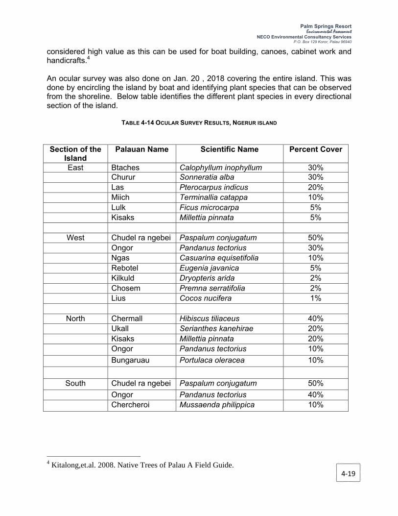
4-19
Palm Springs Resort Environmental Assessment
NECO Environmental Consultancy Services P.O. Box 129 Koror, Palau 96940
considered high value as this can be used for boat building, canoes, cabinet work and handicrafts.4 An ocular survey was also done on Jan. 20 , 2018 covering the entire island. This was done by encircling the island by boat and identifying plant species that can be observed from the shoreline. Below table identifies the different plant species in every directional section of the island.
TABLE 4-14 OCULAR SURVEY RESULTS, NGERUR ISLAND Section of the
Island Palauan Name Scientific Name Percent Cover
East Btaches Calophyllum inophyllum 30% Churur Sonneratia alba 30% Las Pterocarpus indicus 20% Miich Terminallia catappa 10% Lulk Ficus microcarpa 5% Kisaks Millettia pinnata 5%
West Chudel ra ngebei Paspalum conjugatum 50% Ongor Pandanus tectorius 30% Ngas Casuarina equisetifolia 10% Rebotel Eugenia javanica 5% Kilkuld Dryopteris arida 2% Chosem Premna serratifolia 2% Lius Cocos nucifera 1%
North Chermall Hibiscus tiliaceus 40% Ukall Serianthes kanehirae 20%
Kisaks Millettia pinnata 20% Ongor Pandanus tectorius 10% Bungaruau Portulaca oleracea 10%
South Chudel ra ngebei Paspalum conjugatum 50% Ongor Pandanus tectorius 40% Chercheroi Mussaenda philippica 10%
4 Kitalong,et.al. 2008. Native Trees of Palau A Field Guide.

4-20
Palm Springs Resort Environmental Assessment
NECO Environmental Consultancy Services P.O. Box 129 Koror, Palau 96940
4.2.5 Bird Survey The bird survey conducted followed the National Bird Monitoring Protocol developed by the Belau National Museum. The protocol requires a 15-minute count for species diversity at a central location on the site where you can simultaneously observe forest and sky. A bird count was carried out by Ms. Heather Ketebengang of Palau Conservation Society on Jan. 20, 2018 at the proposed development site. The count was conducted in the middle of the island. This particular counting station allows a partial view of the sky, partial view of the ocean, the savannah forest and the other big tree forest. There were a total of seven (7) birds recorded during the survey. Most of the birds that were counted, were seen or heard from the center of the proposed development site or the surrounding areas. Before the actual count, a White-tailed tropicbird was observed as well as a Palau Fruit Bat.

4-21
Palm Springs Resort Environmental Assessment
NECO Environmental Consultancy Services P.O. Box 129 Koror, Palau 96940
FIGURE 4- 14, BIRD SURVEY RESULTS

Palm Springs Resort Environmental Assessment
NECO Group of Companies P.O. Box 129 Koror, Palau 96940
5-1
5 IMPACT ASSESSMENT & MITIGATIONS
An impact is any change to the existing condition of the environment caused by human activity or an external influence. Impacts therefore may be positive (beneficial) or negative (adverse), direct or indirect, long-term or short-term, and extensive or local in effect. Impacts are termed cumulative when they add incrementally to existing impacts. Both positive and adverse environmental impacts could arise during the site preparation, construction and operational phases of the Palm Springs Resort. These are discussed in this section.
The EQPB is advised that some predicted impacts discussed in this EA were taken from the “Final EIS Report for the Quest Resort Palau.” As the Project Proponent, PPSIDL, intends to follow the original project design approved by the EQPB, except for the submarine cable installation, it was deemed necessary to include the impacts and the mitigating measures presented in the Final EIS Report.
5.1 Impacts During Design & Construction of the Project
5.1.1 Potential Failure/Collapse of the Building if Not Properly Designed & Constructed
Buildings, like all structures, are designed to support certain loads without deforming excessively. The loads are the weights of people and objects, the weight of rain and the pressure of wind called “live loads” and the “dead load” of the building itself. For tall buildings consisting of many floors, the roof is a minor matter, and the support of the weight of the building itself is the main consideration. Like long bridges, tall buildings are subject to catastrophic collapse.
Structural integrity is an aspect of engineering which deals with the ability of a structure to support the designed load, i.e., both live load and dead load, without breaking, tearing apart, or collapsing, in order to prevent failures in future designs.
The following are some of the major causes of building collapse:
§ The structure is not strong enough to support the load and hence it fails when it reaches a critical stress level. The structure may be weak due to its shape, size, or choice of its material.
§ The instability due to geometry, design, or material choice, will cause the structure to fail from fatigue or corrosion.
§ Failure may also occur due to improper selection of materials, incorrect sizing, improper heat treating, or shoddy workmanship.
§ Failure may also occur from use of defective materials. The material may have been improperly manufactured, or may have been damaged from prior use.

Palm Springs Resort Environmental Assessment
NECO Group of Companies P.O. Box 129 Koror, Palau 96940
5-2
§ Vandalism, sabotage, and natural disasters can overstress a structure to the point of failure. Improper training of those who use and maintain the construction can also overstress it, leading to potential failures.
Mitigating Measures:
§ Geotechnical/Soil investigation of the site was undertaken by Geolabs, Inc. In 1999. Based on the field exploration and the proposed building designs:
- a shallow foundation system consisting of posts-and-beams can be used to support the one to three-storey buildings planned for the proposed resort development.
- a 16 inch octagonal precast prestressed concrete piles end-bearing can be used to support the proposed waterfront structures (harbor facilities).
§ Other recommendations by the geotechnical expert provided in Appendix B-1 of the “Final EIS Report for the Quest Resort Palau” must be revisited by the resort designer and contractor.
§ The structural designs must be prepared by highly qualified and experienced Structural Engineer.
§ Koror State Government must ensure that the structural plans are reviewed by its Structural Engineer, or by an external structural consultants for the purpose. This will prevent faulty structural designs that may result iin building failure.
§ The site execution of construction work, especially with respect to the foundations and columns must be supervised by an external licensed supervising engineer appointed by the project proponent.
§ The final copies of design and drawings must be kept which will become useful when any structural repairs are to be done in future.
5.1.2 Loss of Land Use Options
The construction of the Palm Springs Resort will involve the erection of permanent concrete structures on what used to be a conservation site. This will result in a loss of the options for alternative land use and thus represents an irreversible commitment of land resources.
In September 1999, the area was re-zoned from “CD” or “conservation” to “RV” or “Resort Center Zone” in accordance with the KSPL No. K6-102-1999. As such the proposed project is consistent with the current zoning/land use of the area.

Palm Springs Resort Environmental Assessment
NECO Group of Companies P.O. Box 129 Koror, Palau 96940
5-3
Mitigating Measure:
§ Rather than leaving the island unused, construction and operation of a permanent structure intended for tourism purposes are expected to result to positive economic impacts. Therefore, no mitigating measure for the loss of land use options in the area is recommended.
§ The master plan for the Palm Springs Resort was designed to reduce the long-term stress on the environment to approximately one fourth of the impacts of the legally permitted alternative (high density hotel development). This significantly enhances the quality of the resort ambiance of the proposed project and also represents a decisive and dramatic environmental mitigation element.
5.1.3 Vegetation Removal
As indicated in the “Final EIS Report for Quest Resort Palau”, the flora on Ngerur Island has the following characteristics:
§ No listed threatened or endangered species were observed on Ngerur. � § A plant that can be harmful to humans (Abrus precatorius) does exist on Ngerur. � § Vegetative communities on Ngerur are neither unique nor worthy of preservation. �
The removal of some existing vegetative species including a single floristic element in the form of Mangrove trees or Sonneratia alba (urur, white mangrove) at the southeastern coastline of the island is expected to occur. Due to its paucity, this element is not considered to represent a Mangrove association. Approximately 85 percent of Ngerur Island will be disturbed due to construction.
Mitigating Measures:
§ The remaining undisturbed 15 percent consists of areas along the shoreline where existing vegetation will be preserved as much as possible. �
§ Where possible, the building and hardscape elements will be positioned so as to allow the large trees throughout the island to remain in place. �
§ With the exception of the buildings and hardscape areas, all of the island will be replanted with locally available species. �

Palm Springs Resort Environmental Assessment
NECO Group of Companies P.O. Box 129 Koror, Palau 96940
5-4
5.1.4 Erosion and Sedimentation
Potential erosion and sedimentation could occur as a consequence of localized alterations and land disturbing activities (grading and excavations). Bare soils will be subjected to erosion and subsequently deposited into the ocean.
Loose soils are susceptible to erosion, especially if it rains heavily during construction period. Storm water runoff from the site may carry loose soil particles into the ocean, having a detrimental effect on the water quality. Potential adverse impacts are expected to be short term and temporary.
Mitigating Measures:
§ Erosion and Sedimentation Control Plan (ESCP) required by the EQPB shall be strictly implemented. These erosion control measures include silt fence, berm, sedimentation pond and silt curtains. These structures shall be installed in appropriate locations and regularly maintained throughout the duration of construction activity. A site specific ESCP will be developed in consultation with the EQPB prior to the project implementation.
§ Earthmoving will not be undertaken during heavy rains.
§ All erosion and sedimentation control structures in place shall be inspected regularly and observed, when safe to do so during heavy rainfall to verify efficiency and effectiveness.
§ All damaged erosion control structures shall be repaired.
§ Additional erosion control measures shall be implemented if found necessary.
5.1.5 Impacts to Coastal and Marine Resources
Impacts to coastal and marine resources may occur from project actions that generate runoff, siltation and pollution. Potential impacts may also occur from direct physical damage associated with activities such as dredging.
Construction of harbor, dock, dive grotto and beach will impact on the existing condition of the seabed. Dredging of the intertidal and subtidal reef flat will be necessary to construct a harbor and associated docks and mooring facilities. If not controlled, proposed dredging and filing activities may increase turbidity and sediment loads to the coral reef in the vicinity of these activities.
Sedimentation resulting directly and indirectly from shoreline earthmoving, grading, vegetation removal and related site-preparation activities could impact coastal and

Palm Springs Resort Environmental Assessment
NECO Group of Companies
P.O. Box 129 Koror, Palau 96940
5-5
marine resources and sensitive species in the vicinity of Ngerur Island. The topography
of Ngerur Island is not unduly steep, with elevations generally ranging between 7 and
20 meters characterizing most of the island. There are no intermittent or permanent
streams on the island. Therefore, erosion is not expected to produce any serious or
long-term effect. However, Palau's high annual rainfall and the probable presence of
highly erodible soils is likely to result in occasional small erosion events that will have
the potential to negatively impact coastal and lagoon water quality and biota.
Heavy equipment and fuel transfer operations, and the activities of construction crews
may result in an occasional accidental discharge of lubricating oil, hydraulic fluids and
fuels on the project site. This could directly affect protected species and their habitats
or the forage of such species.
Mitigating Measures:
§ Silt curtains will be deployed prior to seabed disturbance. Silt curtains will be
installed at appropriate place minimizing the potential impacts of pile driving.
§ The implementation of Best Management Practices (BMPs) such as the
deployment of silt curtains, the construction of dredged cells or dikes designed
to confine and settle suspended solids help to control and/or minimize erosion
and sedimentation impacts.
§ "Construction of stormwater detention basins and related BMP controls should
reduce the silt and sediment loading to acceptable levels in adjacent coastal
waters. A properly designed and implemented drainage plan should reduce silt
and sediment loading to coastal waters.
§ "Development and compliance with an oil-spill prevention and control plan
would reduce the opportunity for deleterious impacts upon water quality and
marine biota.
§ Marine areas undergoing no project-related changes should be avoided and
left undisturbed.
§ Dredging sites should be accessed by heavy equipment via common corridors.
Erosion- and sedimentation-control plans should be developed and
implemented.
§ An enforceable water quality and environmental monitoring plan encompassing
the potentially affected harbor environmental should be implemented.
§ Dredged channel bottoms should be left uneven and irregular to provide bottom
relief and vertical surfaces that can encourage recolonization of corals and
other benthic and epibenthic flora and fauna.
§ Natural tide and water circulation patterns should be maintained.

Palm Springs Resort Environmental Assessment
NECO Group of Companies P.O. Box 129 Koror, Palau 96940
5-6
5.1.6 Impacts to Historical and Archaeological Resources
All archaeological features identified during the inventory survey of Ngerur Island (refer to the report by IARII, 1999) "are considered to be significant under criteria of the Palau National Code Title 19, the Palau Historical and Cultural Preservation Act. The island, Site OR-12:47, possesses integrity of location, design, setting, materials, workmanship, feeling, and association; and has yielded, or may be likely to yield, information important in prehistory or history (Criterion D).
Details of archaeological features found in Ngerur Island are discussed in Appendix B-6 of the “Final EIS Report for Quest Resort Palau.”
Mitigation requiring consultation with the Division of Cultural Affairs, the preparation of a mitigation plan, and data recovery recording and excavations in accordance with the mitigation plan had been undertaken in 2000. Efforts had been made to avoid and preserve in place as many features as possible.
The presence of buried human remains adds the element of cultural value and sensitivity to the historical importance of the site. The Treatment Plan for Burials Located on Ngerur Island, Republic af Palau (IARII, 1999b) addresses the request by the Palau Division of Cultural Affairs (DCA) to develop a plan for the ultimate disposition and long-term protection of human burial remains located on Ngerur Island. Disinterment will occur prior to the commencement of construction activities on Ngerur Island, in accordance with the stipulations in the burial treatment plan (refer to Appendix C-3).
The Division of Cultural Affairs (DCA) had reviewed the required Treatment and Monitoring Plan for Burials on Ngerur Island, Koror, Republic of Palau and given its concurrence for the implementation of the plan. On August 12,1999, a Memorandum of Agreement was signed between DCA and Ngerur Corporation. According to this agreement, the removal and treatment of human remains and artifacts will follow DCA guidelines.
Mitigating Measures: § Preservation of the cultural properties is preferred; however, as the planned
development of the island will not be compatible with preservation, mitigation though data recovery and disinterment and reburial of human remains is an alternative.
§ Mitigation of the non-burial features should be straightforward and consist of a
minimal amount of work, involving more detailed recording, photography, and videotaping of the features. This work will insure the preservation of information about this important episode in Palau's history.
§ The proponent shall conduct meeting with the Bureau of Arts and Culture for the
proposed Palm Springs Resort. A new Historical Clearance shall be secured to

Palm Springs Resort Environmental Assessment
NECO Group of Companies P.O. Box 129 Koror, Palau 96940
5-7
indicate the remaining mitigation measures that need to be complied with prior to implementation of the proposed project.
5.1.7 Construction Waste Disposal
Solid waste generated during site preparation and construction work would include typical construction waste (e.g. wasted concrete, steel, wooden scaffolding and forms, bags, waste earth materials, etc.). This waste would negatively impact the site and surrounding environment if not properly managed and disposed of at an approved dumpsite.
Waste materials burned onsite would generate smoke, possibly impacting negatively on ambient air quality and human health. Vegetation and solid waste, if allowed to accumulate in drainage ways, could cause localised pooling and flooding. Pooling of water, in turn, would create conditions conducive to the breeding of nuisance and health-threatening pests such as mosquitoes. Poor construction waste management constitutes a short-term, possibly long-term, negative impact.
Soil excavation in land will be required for building foundation. There may be a need to address any excess soils during construction of inland structures. A detailed engineering design and quantity take off will provide the estimated excess soil materials from the proposed project.
Mitigating Measures:
§ A site waste management plan should be prepared prior to commencement of building construction. This should include the designation of appropriate waste storage areas, collection and removal schedule, identification of approved disposal site and a system for supervision and monitoring.
§ Vegetation and combustible waste must not be burned on the site.
§ Unusable construction waste, such as damaged pipes, formwork and other construction material, must be disposed of at an approved dumpsite.
§ Excavated soils will be temporarily stockpiled within flat area and surrounded with silt fences. Excavated soils should be stockpiled away from drainage features and used for in filling where necessary.
§ If in case the soil stockpile is left overnight, it will be covered by tarpaulin to prevent erosion.

Palm Springs Resort Environmental Assessment
NECO Group of Companies P.O. Box 129 Koror, Palau 96940
5-8
5.1.8 Wastewater and Litter Management
Construction activities are expected to generate wastewater including domestic wastewater from the workers and construction wastewater (e.g., de-watering of excavations, wastewater resulting from equipment washing, etc.). All types of wastewater shall not be allowed to be discharged directly into the ocean.
Inadequate provision of toilets for use by workers can lead to ad hoc defecation in secluded areas on the site, thus creating unsanitary conditions and sources of fly infestation.
Improper disposal of food cartons and other domestic forms of construction camp garbage could lead to littering of the site and pollution of adjacent coastal waters.
Mitigating Measures:
§ Portable toilets shall be installed at the site during construction phase of the project. Regular cleaning and/or desludging of the portable toilets shall be done.
§ Wastewater from the excavations will be diverted into an excavation and allowed to settle prior to discharge, if necessary. Otherwise, the water will be left on the excavation until it dries up.
§ Proper solid waste receptacles and storage containers should be provided in sufficient numbers, particularly for the disposal of lunch and drink boxes, so as to prevent littering of the site.
5.1.9 Air Pollution
Unmanaged air pollution—especially from particulate and gaseous emissions generated by construction machinery—may create nuisance and, in extreme cases, adverse health impacts and property damage. Construction will require breaking up, digging, crushing, transporting, and dumping of large quantities of dry material and will generate dust in and around construction areas.
Dust emissions may result from the excavation works while gaseous pollutant concentrations from construction vehicle activities, such as site preparation, earthmoving/grading may increase at the project site, but these impacts are largely unavoidable and temporary (short term).
This situation will be worst during the dry season and during the afternoons when the trade winds are most prevalent. High rainfall in Palau is expected to help minimize fugitive dust emission from the mentioned activities. The occurrence of dusting is periodic and short-

Palm Springs Resort Environmental Assessment
NECO Group of Companies P.O. Box 129 Koror, Palau 96940
5-9
term, lasting for the duration of the construction activity.
Mitigating Measures:
§ Enclosing construction sites;
§ Access roads and exposed ground should be regularly wetted in a manner that effectively keeps down the dust;
§ Maintaining moisture on construction materials;
§ Stockpiles of fine materials (e.g. sand) should be wetted or covered with tarpaulin during windy conditions;
§ Covering exposed soil or storage areas,
§ Limiting excavation and land leveling works to rainy season, and
§ Minimizing the onsite storage time of construction material.
§ Workers on the site should be issued with dust masks during dry and windy conditions.
5.1.10 Noise
Noise generation is expected in any construction activity. The use of heavy equipment such as grader and excavator is expected to generate noise level in the area. However, it is expected that the noise during construction will not impact the residents of Koror due to the seclusion of Ngerur Island.
Construction noise may disturb wildlife and birds. However, the increase in noise level due to the construction activity will only be temporary (short term) and is not considered to be a significant threat to the health or well being of humans.
Mitigating Measures:
§ All equipment operating within the construction area will be properly muffled.
§ Construction activities that will generate disturbing sounds should be restricted to normal working hours, i.e.,work hours will be limited between 7:00 AM and 6:00 PM, Monday through Saturday.
§ No night time activity, that will generate noise, will be performed at the project

Palm Springs Resort Environmental Assessment
NECO Group of Companies P.O. Box 129 Koror, Palau 96940
5-10
site.
§ Local residents should be given notice of intended noisy activities so as to reduce the degree of annoyances.
§ Workers operating equipment that generates noise should be equipped with noise protection gear.
§ Workers operating equipment generating noise levels greater than 80 dBA continuously for 8 hours or more should use earmuffs.
§ Workers experiencing prolonged noise levels of 70 – 80 dBA should wear earplugs.
5.1.11 Vibration
Vibration during construction arises not only from the excavation method, but also from other associated construction activities, some of which can be as disturbing, or more so, than the main excavation method. These include drilling, operation of construction equipment or compaction of cast in situ linings. The duration for which vibration impacts occur for these can be significantly longer than for the excavation per se, so the impacts may be potentially longer and hence more significant.
Mitigating Measures:
§ Operate earthmoving equipment on the construction area as far away from vibration-sensitive sites as possible.
§ Phase earthmoving and ground-impacting operations so as not to occur in the same time period.
§ Avoid nighttime activities. People are more aware of vibration in their homes during nighttime hours.
§ Avoid vibratory rollers and packers near sensitive areas.
5.1.12 Earth Material Sourcing
Earth materials needed for construction, e.g., sand and gravel, are normally obtained from quarry and mining operations. Conscious or unwitting purchase of these materials from unlicensed operations indirectly supports, encourages and promotes

Palm Springs Resort Environmental Assessment
NECO Group of Companies P.O. Box 129 Koror, Palau 96940
5-11
environmental degradation at the illegal quarry sites and causes medium to long-term negative impacts at source.
Mitigating Measures:
§ Sand, gravel and other earth materials must be obtained from officially licensed and approved quarries and if imported overseas, these materials should be transported through legal channel.
5.1.13 Material Transportation
The various materials required for construction and building (e.g. steel, blocks, lumber, sand, asphalt, etc.) will be obtained mainly from Malakal, Koror State and transported to the site. Transportation of these materials, typically in over-laden and sometimes uncovered trucks, usually results in undue road damage. In addition, transportation of these materials in barge may potentially cause spillage and damage to the ocean bed and marine environment.
In the case of fine earth materials, dusting and spillages occur on the roadways between source and site. Dusting degrades local air quality and material spillages worsen driving conditions and increase the risk of road accidents. These occurrences represent indirect, short-term, reversible, negative impacts on public health and safety.
The transport of materials from source to site would entail use of heavy trucks, which have the potential to produce polluting gaseous emissions and dust and falling objects, depending on the material being transported.
Mitigating Measures:
§ Trucks used for that purpose should be fitted with tailgates that close properly and with tarpaulins to cover the materials.
§ Fine earth materials must be enclosed during transportation to the site to prevent spillage and dusting.
§ The cleanup of spilled earth and construction material on the main roads should be the responsibility of the contractor and should be done in a timely manner (say within 2 hours) so as not to inconvenience or endanger other road users. These requirements should be included as clauses within the contracts made with relevant sub-contractors.
§ The transportation of lubricants and fuel to the construction site should only be done in the appropriate vehicles and containers, i.e. fuel tankers and sealed

Palm Springs Resort Environmental Assessment
NECO Group of Companies P.O. Box 129 Koror, Palau 96940
5-12
drums.
§ Transport of construction materials should be scheduled for off-peak traffic hours. This will reduce the risk of traffic congestion and of road accidents on the access roads to the site.
§ Appropriate traffic warning signs, informing road users of a construction site entrance ahead and instructing them to reduce speed, should be placed along the main road in the vicinity of the entrance to the Palau Portovino Hotel property.
§ Flagmen should be employed to control traffic and assist construction vehicles as they attempt to enter and exit the project site.
§ Any damaged road surfaces must be restored after completion of the building construction.
§ During summer, the existing road must be watered to reduce dust emission generated by the construction vehicles and trucks.
5.1.14 Material Stockpiling/Storage
Improper siting of stockpiles and storage of sand, gravel, cement, etc., at the construction sites could lead to fine materials being washed away, during heavy rainfall events, into the drainage system and ultimately into the adjacent marine environment. This would contribute to turbidity and sedimentation with consequent negative impacts on inshore marine water quality and ecology of the shallow marine environments, including corals.
Hazardous and flammable materials (e.g. paints, thinner, solvents, etc.) improperly stored and handled on the site are potential health hazards for construction workers and spilled chemicals would have the potential to contaminate soil and inhibit plant growth in localized areas. It is anticipated that refueling or maintenance of large vehicles will take place on the construction site and therefore there will be a requirement to store fuel and lubricants in a safe manner on the site.
Mitigating Measures:
§ Stockpiling of construction materials should be properly controlled and managed. Sands and other fine grained materials should be stockpiled away from surface drainage channels and features.
§ Sand/Fine material stockpiles should be surrounded by about 1m bund and/or covered with tarpaulin to prevent them from being washed away during rainfall.

Palm Springs Resort Environmental Assessment
NECO Group of Companies P.O. Box 129 Koror, Palau 96940
5-13
§ Safe storage areas should be identified and retaining structures put in place prior to the arrival and placement of material.
§ Hazardous chemicals (e.g. fuels) should be properly stored in appropriate containers and should be safely locked away. Conspicuous warning signs (e.g. ‘No Smoking’) should be posted around hazardous waste storage and handling facilities.
5.1.15 Modification of Surface Water Drainage
Covered building and other structures on site will create impervious surface in the island. Add to this the surface areas of corected roadways and it becomes apparent that the site will generate considerable volumes of runoff during the periods of prolonged rainfall.
Mitigating Measures:
§ Storm water drainage system must be properly designed and appropriately constructed.
5.1.16 Employment/Income Generation
A short-term social impact associated with the proposed project may result from a construction crew of approximately 100 to 125 foreign workers that will be housed in Koror for the duration of the construction period of approximately 18 to 24 months. The number of foreign workers in Palau would therefore increase for the duration of the construction period. These levels of short-term employment opportunities would have a positive impact on the local economy and on regional unemployment.
Mitigating Measures:
§ The project proponent shall give the residents of Koror State and Palau in general, priority in hiring construction workers, subject to qualification and experience.
§ On the job training should be provided to some Palauan residents who are not qualified to do the work.
§ The construction contractor will coordinate and manage a labor compound that will support the needs of the project. The contractor will provide housing facilities, a dining facility, laundry facilities, toilet facilities, refrigeration units, and various sundries and smallware to support anticipated manpower requirements. The

Palm Springs Resort Environmental Assessment
NECO Group of Companies P.O. Box 129 Koror, Palau 96940
5-14
contractor will also handle the catering, housekeeping and maintenance of the labor compound in order to satisfy the needs of the project.
5.2 Impacts During Operation of the Project
5.2.1 Impacts from Infrastructure Facilities
5.2.1.1 Water Supply System
Completion of the Palm Springs Resort will generate no demand for the Koror water service because all potable water demands will be met by the on-site system. However, measures to conserve water would still be implemented.
The proposed Palm Springs Resort will be supplied with potable water service via an on-site water supply system. A Reverse Osmosis (RO) desalination system will remove the salinity (chloride) from the ocean water. Two self-contained skid mounted units each rated for 45,000 gpd will be used. The desalinated water will be disinfected and treated on-site prior to storage and distribution. Brine with an estimated concentration of approximately 90,000 ppm will be diluted and discharged via a perforated pipe located on the sea floor within the harbor area.
Although a salinity concentration of 90,000 ppm in large volumes can be toxic to marine life, the brine will be combined with returning cooling water from the air conditioning system such that its diluted concentration would be approximately 40,000 ppm. The volume of discharged water from the Palm Springs Resort Palau project will be small and its discharge through a perforated pipe located at the bottom of harbor means that by the time this water reaches coral areas it will have the same salinity as the surrounding waters (approximately 30,000 to 33,000 ppm).
Mitigating Measures:
§ Water conservation shall be practiced at the resort accommodations. Each bungalow should be provided with the following water conservation devices or technologies in place.
- Water tank in toilet will use water saving device 3/6 liters per flush. - Faucets will be of low water consumption. - Guests will be encouraged to reuse towels as part of the ecological laundry
policy.
§ A comprehensive potable water monitoring plan will be submitted to EQPB. Potable water quality will be monitored daily or at the very least on a weekly basis. Monitored parameters may include and not be limited to turbidity, salinity,

Palm Springs Resort Environmental Assessment
NECO Group of Companies P.O. Box 129 Koror, Palau 96940
5-15
pH, residual chlorine, and e-coli. The RO units will be monitored for performance in accordance with the guidelines provided by the equipment manufacturer. A quarterly report that addresses water quality monitoring testing results, descriptions of performed operation and maintenance, and water use records will be filed with EQPB.
5.2.1.2 Wastewater Treatment and Disposal System
Completion of the Palm Springs Resort will generate no demand for municipal service because Ngerur Island will be served by the on-site wastewater collection, treatment and disposal systems. No mitigation is therefore proposed or considered warranted.
As indicated in the “Final EIS Report for Quest Resort Palau”, the on-site wastewater collection system will consist of gravity sewers and a single pump station. Collected effluent will be pumped to a Jokaso Wastewater Treatment System that is virtually self-contained. Treated effluent will be conveyed to discharge location that is approximately 100 feet (30.4 meters) below the ocean surface.
In order to quantify any potential impacts of discharging the treated effluent via a deep ocean outfall, a preliminary dispersion analysis was performed to ascertain the performance of such an outfall. The PLUME model developed by the EPA was used to predict the wastewater discharge plume dilution. This computerized program has become the accepted standard for modeling outfall plume behavior and is accepted by U.S. Federal regulatory agencies. The effluent characteristics initial dilution results are provided in the following table.
TABLE 5-1, WATER QUALITY PARAMETERS AFTER INITIAL DILUTION
Parameter Ambient Receiving
Water
Effluent Characteristics
Palau Standards (Class AA)
Concentration After Initial
Dilution Temperature (OC) 30.20 (Surface)
29.42 (Bottom) 31.0 ±0.9 29.47
Salinity (ppt) 32.65 (Surface) 32.78 (Bottom)
0 ±10% in the range of 29-35 ppt
32.70
pH 8.16 8.0 7.7 to 8.5 8.16
Dissolved Oxygen (mg/L)
6.84 0 NLT 6.0 or Saturation
6.83
Total Nitrogen (mg/L)
0.104 20 ±10% (0.014) or NTE 0.400
0.120
Total Phosphorus (mg/L)
0.010 8 ±10% (0.014) or NTE 0.400
0.017
Fecal Coliform (per 100 ml)
0 15,000 70 9
Analysis by Sea Engineering, Inc. based on computer modeling using EPA’s PLUME Model NLE = Not Less Than NTE = Not to Exceed

Palm Springs Resort Environmental Assessment
NECO Group of Companies P.O. Box 129 Koror, Palau 96940
5-16
The analysis indicates that the receiving water would rapidly dilute the small volume of the treated effluent generated by the proposed Quest Resort Palau project. The model indicates that the dilution will be so rapid that most Class AA water quality criteria will be met within the zone of initial dilution immediately above the discharge point; all Class AA criteria will be met within a zone of mixing with a radius of 130 feet around the discharge point.
The treated wastewater plume from the discharge would not reach the lagoon surface; at approximately 49 feet below sea level the plume would be virtually indistinguishable from the receiving water with an average dilution ratio of over 1,000 to 1. Computer analysis results indicate that there will be no significant water quality impact resulting from the discharge of this very small volume of wastewater. All the modeled water quality parameter values meet or exceed Palau standards for Class AA water within the zone of mixing.
The alignment for the marine outfall will bear northeast from the northeast side of the island. This alignment is reasonably close to the treatment facility and provides access to deep water relatively close to shore.
The outfall pipe must travel over live coral outcrops in some areas. For example, the first 100 feet (30.4 meters) off the island shoreline supports vigorous coral growth over almost 100 percent of the basin bottom. Much of this coral is finger-type that can be easily broken and/or damaged. Additionally, the bottom is uneven and not conducive to supporting the pipeline. For these reasons, the first 100 feet (30.4 meters) of the alignment for the pipeline is expected to include a narrow covered trench through the coral areas because of its advantages:
§ Coral damage will be limited; �
§ The pipeline will not be visible; �
§ The pipeline will be well protected; and �
Coral can be re-colonized over the covered trench. � The last point is particularly important from an environmental standpoint: coral ecology can be re-generated/re-established over the covered trench that is in effect locally removed from the eco-system. �
Increased nutrient loading from sewage and waste can cause eutrophication. Eutrophication causes changes in the original biological environment, including reducing species diversity and increasing marine floral bloom and habitation of undesirable species.
Mitigating Measures:
§ Employ a fully qualified operator to ensure proper operation and maintenance of the STP.

Palm Springs Resort Environmental Assessment
NECO Group of Companies P.O. Box 129 Koror, Palau 96940
5-17
§ Ensure preparation and provision of a plant operations and maintenance manual.
§ Undertake regular monitoring and testing of effluent to ensure compliance with EQPB sewage effluent standards and regulations.
§ A comprehensive monitoring plan for wastewater effluent will be submitted to EQPB. �
5.2.1.3 Drainage System
As a result of project actions, natural drainage systems on Ngerur Island will be replaced with a man-made drainage and irrigation system. No demand on municipal systems will occur as a result of the Palm Springs Resort project because the conveyance of storm runoff and the irrigation demand will be satisfied via the on-site system. No mitigation is therefore proposed or deemed warranted.
In the interior part of the island, runoff will be collected by 6-, 8- and 10-inch storm drains in infiltration trenches that are aligned parallel to the cart parthway system. On the seaward side of the guest bungalows, runoff will be collected by storm drains in infiltration trenches that are aligned along earthen dikes of native material topped with geofabric or matting. The disposal of the runoff will occur as waterfall features at individual discharge points located around the perimeter of the island. At three locations on the northeastern side of the island, sediment logs will be used in conjunction with silt curtains. The design of the drainage system does not include retention basins for storm runoff and instead the counter slopes of the extensive berrned areas will capture runoff and convey it to the surrounding waters through gravel and filter fabric. In this manner, direct surface runoff will be effectively reduced or eliminated.
Mitigating Measures:
§ Adequate drainage facilities such as those described above will be implemented and maintained.
§ Landscaping and the use of erosion control materials, earthen dikes with counter slopes, matting, geofabrics, and silt fences will slow the flow of sediment laden runoff to avoid erosion and sedimentation. A brief description of each feature or device is included below.
- Sediment logs are porous fiber rolls that allow water to filter through and trap sediment, slow runoff, and reduce sheet erosion. These logs are composed of biodegradable open weave netting.
- Earthen dikes will act as counter slopes and check dams. The ponding surface runoff trapped by the dams will be forced into perforated pipe that is part of the drainage system.
- Silt fences are barriers of permeable fabric designed to intercept and slow sheet flow runoff.

Palm Springs Resort Environmental Assessment
NECO Group of Companies P.O. Box 129 Koror, Palau 96940
5-18
- The waterfall feature will be constructed as a "T." The feature will include riprap that reduces the energy of flowing water.
5.2.1.4 Solid Waste Disposal System
Completion and operation of the Palm Springs Resort Palau will generate a demand for solid waste disposal service. Solid waste and wet garbage will be transported by boat for disposal at a designated landfill.
The resort operator has also expressed a desire to segregate waste in order to take advantage of existing (and hopefully expanding) recycling facilities in Palau. Conditions of the earthmoving permit will in all likelihood require the preparation of a waste minimizing plan addressing specifically aluminium can recycling and the composting of green waste.
Mitigating Measures:
§ The intent of the resort operator is to utilize a trash compactor to reduce the volume of refuse. Although the weigh of the waste remains the same, a reduced volume will extend the life of the new landfill.
§ Provisions for solid waste disposal will be coordinated with the BPW to ensure that refuse is
disposed at the appropriate site.
5.2.1.5 Power Supply System
The use of generators to supply power to the entire building implies the generation of noise, vibrations, and storage of diesel fuel and the related disturbances and nuisances as well as the threat of hydrocarbon spills the ground.
Mitigating Measures:
§ Sound proof structures will enclose the generators to prevent/minimize generation of noise and vibration.
§ Fuel storage facilities will comply with suppliers’ specifications for contained storage.
§ Secondary containment structures adequate to contain the maximum volume of fuel storage will be constructed.

Palm Springs Resort Environmental Assessment
NECO Group of Companies P.O. Box 129 Koror, Palau 96940
5-19
§ Spill prevention kits shall be maintained on site.
§ Resort maintenance personnel shall be trained on the use of spill kits.
5.2.1.6 Refrigeration/Air Conditioning Systems
The use of certain refrigerant in number of refrigeration and air conditioning systems has the potential to cause depletion of the ozone layer in the atmosphere leading to greenhouse effect. Some of these refrigerants include:
§ Dichlorodifluoromethane (R-12) is a colorless gas usually sold under the brand name Freon-12, and a chlorofluorocarbon halomethane (CFC) used as a refrigerant and aerosol spray propellant. its manufacture was universally banned in 1996, in compliance with the Montreal Protocol, due to concerns about its damaging impact to the ozone layer.
§ Chlorodifluoromethane, better known as HCFC-22 or R-22 is one of the most popular refrigerant used in cooling system. R22 is the halocarbon compound named monochlorodifluoromethane with chemical formula CHClF2 and it is the hydrochlorofluorocarbon (HCFC). However, it has very high potential to exacerbate ozone-depletion. R22 is also a global warming gas. The depletion of ozone layer from the upper layers of atmosphere results in ultraviolet rays of the sun to reach the surface of the earth. This leads to high temperature on the earth and the ultraviolet ray themselves are very harmful to the skin of human beings. To avoid the long-term dangers of the R22 and other CFCs, it has been decided to phase out the use and production of R22 completely along with other CFC refrigerants.
Mitigating Measures:
§ Ensure that refrigeration and air conditioning system to be used for the project do not use banned refrigerants, that include R-12.
§ If the proponent opted to use R-22 as refrigerant in the cooling system, permit must be applied with the EQPB prior to importation to Palau.
§ Consult with the EQPB on the proposed use of refrigerant for the project prior to importation of refrigerant to Palau.
5.2.2 Housing Demand
The Palm Springs Resort project will not impact the number of existing housing units in Palau; neither will it impact the presently existing balance between Palauan and

Palm Springs Resort Environmental Assessment
NECO Group of Companies P.O. Box 129 Koror, Palau 96940
5-20
non-Palauan residents. The proposed project is a resort development comprising luxury hotel guest bungalows only. The Palm Springs Resort is entirely oriented towards accommodating short-term visitors. The project does not include any condominium housing units intended for long-term residency.
The proposed project will have a short-term housing impact because the construction crew will have to be housed in Koror for the duration of the project (approximately 18 to 24 months).
Mitigating Measures:
§ It is expected that the construction Contractor will make the necessary arrangements for a temporary worker housing compound such that no mitigation is required.
§ The proponent must ensure that resort staff are provided with housing accommodations within the island resort.
5.2.3 Misuse of Coral Reef Resources
One of the main natural attractions that will be offered by the Ngerur Island is scuba diving and snorkeling on the famous Rock Islands and dive sites of Palau. Unless the marine resource is properly managed the increased use of the site for recreational diving could result in degradation of the habitat by damage to corals from boat anchors, souvenir collection, and poor diving practice.
Mitigating Measures:
§ Installation of boat mooring buoys for use of dive boats and banning of anchoring directly over reef.
§ Ban collection of coral reef souvenirs.
§ Provision of educational and environmental sensitization material on coral reef for guests and for hotel staff.
§ Institute and support coral reef monitoring programme for the Rock Islands.
5.2.4 Circulation and Traffic
It is the specific goal of the proposed Palm Springs Resort to be a backdrop for the experience of a luxurious exotic environment. Factors that enable this experience are the

Palm Springs Resort Environmental Assessment
NECO Group of Companies P.O. Box 129 Koror, Palau 96940
5-21
creation of a sense of seclusion and remoteness from the day-to-day world. The identity of the resort as a special place will be enhanced by the fact that the Ngerur Island must be accessed by boat. Affluent guests will be escorted from the airport to a shuttle that will transport them to the island. All necessary shuttle services for visitors and their luggage between the airport and the island will be executed by the resort operation with Sport Utility Vechicles (SUVs) or vans. Boats will ferry these guests to the Palm Springs Resort.
Boat traffic between the Arakebesan and Ngerur Islands will increase as a result of the proposed project. Boats will transfer all visitors and their luggage. Increased traffic resulting from increased number of tourists may cause nuisance and safety risks.
An assumed four-day length of stay on Ngerur Island will generate approximately 91 exchanges per year with an average of 81 visitors per each four-day stay. A theoretical average daily exchange rate would therefore imply 20 visitors leaving and 20 visitors arriving each day.
The number of resulting boat trips will depend on the carrying capacity of the boats. Another factor that will influence boat trips is the visitors' demand for sightseeing trips.
Employees of the Palm Springs Resort and all necessary supplies and waste will also be transported by boat. With an average of 20 visitors requiring one-way shuttle transportation every day and with an assumed occupancy rate of five visitors per SUV, the average number of daily round trips between Ngerur Island and Koror Airport would therefore be four trips. This number represents a theoretical minimum of terrestrial shuttle traffic generated by the proposed project.
Mitigating Measures:
§ Mitigation measures will include provision of a traffic management plan and close coordination between the resort management, traffic police and sea rangers for smooth execution.
§ Appropriate traffic warning signs instructing the motorists to reduce speed, should be placed along the main road.
5.2.5 Employment Generation
The proposed project will generate employment opportunities. This aspect of the project is considered a benefit that offsets the short-term impacts generated by the importation of temporary laborers required for project construction.
At project completion, a maximum guest population of 120 persons would require 110 support staff in three shifts. Alternately, the size of the work force may be equal to

Palm Springs Resort Environmental Assessment
NECO Group of Companies P.O. Box 129 Koror, Palau 96940
5-22
approximately 2.5 employees per bungalow or approximately 150 persons. The Palauan segment of employment opportunities within the proposed project is expected to be in the neighborhood of 80 percent.
Mitigating Measures:
§ In accordance with the Foreign Investment Approval Certificate, the proponent shall to the maximum extent possible, employ and train citizens of the Republic of Palau in the operation of the hotel project.
§ Whenever economically feasible and practical, the proponent shall favor Palauan citizens or entities as sub-contractors or concessionaires over non-Palauan individuals or entities.
5.2.6 Income from the Project
A positive impact of the project implementation is the income from the tourists and the annual taxes to be imposed by the Koror State Government from the operation of the Palm Springs Resort.
Mitigating Measures:
§ Ensure that taxes imposed on the real property, income, tourism and other related taxes are correct and are properly collected.
5.3 Checklist of Environmental Impacts & Mitigation
Table 5-2 provides a summary checklist of environmental impacts and the mitigating measures proposed for this project. Other mitigating measures to be recommended by the EQPB during the permitting process and project construction shall also be implemented.

Palm Springs Resort Environmental Assessment
NECO Group of Companies P.O. Box 129 Koror, Palau 96940
5-23
TABLE 5-2, MATRIX OF ENVIRONMENTAL IMPACTS & MITIGATING MEASURES
Impact
Timing/Occurrence of Impact Impact Assessment
Mitigating Measures Pre-
Construc-tion Phase
Construction
Phase
Operatio-nal Phase
Type Duration Scope Magnitude/Severity
Posi-tive
Nega-tive
Short Term
Long Term
Loca-lized
Wide-spread
Insigni-ficant
Mode-rate
Severe
1. Potential failure/ collapse of the building if not properly designed and constructed
√ √ √ √ √ √ √ § Recommendations by the geotechnical expert, Geolabs, Inc. must be strictly followed.
§ Structural designs to be performed by highly qualified and experienced Structural Engineer.
§ KSG to ensure the structural plans are reviewed by its Structural Engineer, or by an external structural consultants.
§ Construction to be supervised by an external licensed

Palm Springs Resort Environmental Assessment
NECO Group of Companies P.O. Box 129 Koror, Palau 96940
5-24
Impact
Timing/Occurrence of Impact Impact Assessment
Mitigating Measures Pre-
Construc-tion Phase
Construction
Phase
Operatio-nal Phase
Type Duration Scope Magnitude/Severity
Posi-tive
Nega-tive
Short Term
Long Term
Loca-lized
Wide-spread
Insigni-ficant
Mode-rate
Severe
supervising engineer.

Palm Springs Resort Environmental Assessment
NECO Group of Companies P.O. Box 129 Koror, Palau 96940
5-25
Impact
Timing/Occurrence of Impact Impact Assessment
Mitigating Measures Pre-
Construc-tion Phase
Construction
Phase
Operatio-nal Phase
Type Duration Scope Magnitude/Severity
Posi-tive
Nega-tive
Short Term
Long Term
Loca-lized
Wide-spread
Insigni-ficant
Mode-rate
Severe
2. Loss of land use option
√ √ √ √ √ § Master Plan for the Palm Springs Resort must be followed.
3. Vegetation removal
√ √ √ √ √ √ § The remaining undisturbed 15 percent consists of areas along the shoreline where existing vegetation will be preserved as much as possible. �
§ Where possible, the building and hardscape elements will be positioned so as to allow the large trees throughout the island to remain in place. �
§ With the exception of the buildings and hardscape areas, all of the island

Palm Springs Resort Environmental Assessment
NECO Group of Companies P.O. Box 129 Koror, Palau 96940
5-26
Impact
Timing/Occurrence of Impact Impact Assessment
Mitigating Measures Pre-
Construc-tion Phase
Construction
Phase
Operatio-nal Phase
Type Duration Scope Magnitude/Severity
Posi-tive
Nega-tive
Short Term
Long Term
Loca-lized
Wide-spread
Insigni-ficant
Mode-rate
Severe
will be replanted with locally available species.
4. Erosion and sedimentation
√ √ √ √ √ § Erosion and Sedimentation Control Plan (ESCP) shall be strictly implemented.
§ Earthmoving will not be undertaken during heavy rains.
§ All erosion control structures (silt curtains) in place shall be inspected regularly.
§ Additional erosion control measures shall be implemented if found necessary.

Palm Springs Resort Environmental Assessment
NECO Group of Companies P.O. Box 129 Koror, Palau 96940
5-27
Impact
Timing/Occurrence of Impact Impact Assessment
Mitigating Measures Pre-
Construc-tion Phase
Construction
Phase
Operatio-nal Phase
Type Duration Scope Magnitude/Severity
Posi-tive
Nega-tive
Short Term
Long Term
Loca-lized
Wide-spread
Insigni-ficant
Mode-rate
Severe
5. Impacts to coastal and marine resources (e.g., seabed disturbance, increase in turbidity, damage to corals, fish kill, etc.)
√ √ √ √ √ √ § Silt curtains will be deployed prior to seabed disturbance.
§ The implementation of Best Management Practices (BMPs) such as the deployment of silt curtains, the construction of dredged cells or dikes designed to confine and settle suspended solids help to control and/or minimize erosion and sedimentation impact.
§ A properly designed and implemented drainage plan should reduce silt and sediment loading to coastal waters.
§ Development and compliance with an oil-

Palm Springs Resort Environmental Assessment
NECO Group of Companies P.O. Box 129 Koror, Palau 96940
5-28
Impact
Timing/Occurrence of Impact Impact Assessment
Mitigating Measures Pre-
Construc-tion Phase
Construction
Phase
Operatio-nal Phase
Type Duration Scope Magnitude/Severity
Posi-tive
Nega-tive
Short Term
Long Term
Loca-lized
Wide-spread
Insigni-ficant
Mode-rate
Severe
spill prevention and control plan.
§ Marine areas undergoing no project-related changes should be avoided and left undisturbed.
§ An enforceable water quality and environmental monitoring plan should be implemented.
§ Dredged channel bottoms should be left uneven and irregular to provide bottom relief and vertical surfaces that can encourage recolonization of corals and other benthic and epibenthic flora and

Palm Springs Resort Environmental Assessment
NECO Group of Companies P.O. Box 129 Koror, Palau 96940
5-29
Impact
Timing/Occurrence of Impact Impact Assessment
Mitigating Measures Pre-
Construc-tion Phase
Construction
Phase
Operatio-nal Phase
Type Duration Scope Magnitude/Severity
Posi-tive
Nega-tive
Short Term
Long Term
Loca-lized
Wide-spread
Insigni-ficant
Mode-rate
Severe
fauna.
§ Natural tide and water circulation patterns should be maintained.
6. Impacts to historical and archaeological resources
√ √ √ √ √ § Preservation of the cultural properties is preferred; however, as the planned development of the island will not be compatible with preservation, mitigation though data recovery and disinterment and reburial of human remains is an alternative.
§ Mitigation of the non-burial features should consist of a minimal amount of work, involving more detailed

Palm Springs Resort Environmental Assessment
NECO Group of Companies P.O. Box 129 Koror, Palau 96940
5-30
Impact
Timing/Occurrence of Impact Impact Assessment
Mitigating Measures Pre-
Construc-tion Phase
Construction
Phase
Operatio-nal Phase
Type Duration Scope Magnitude/Severity
Posi-tive
Nega-tive
Short Term
Long Term
Loca-lized
Wide-spread
Insigni-ficant
Mode-rate
Severe
recording, photography, and videotaping of the features.
§ conduct meeting with the Bureau of Arts and Culture for the proposed Palm Springs Resort.
§ A new Historical Clearance shall be secured to indicate the remaining mitigation measures that need to be complied with prior to implementation of the proposed project.
7. Construction waste disposal
√ √ √ √ √ § A site waste management plan should be prepared and implemented.
§ Vegetation and
Palm Springs Resort Environmental Assessment
NECO Group of Companies
P.O. Box 129 Koror, Palau 96940
5-31
Impact
Timing/Occurrence of Impact Impact Assessment
Mitigating Measures Pre-
Construc-
tion Phase
Construc
tion
Phase
Operatio-
nal Phase
Type Duration Scope Magnitude/Severity
Posi-
tive
Nega-
tive
Short
Term
Long
Term
Loca-
lized
Wide-
spread
Insigni-
ficant
Mode-
rate
Severe
combustible waste
must not be burned
on the site.
§ Unusable
construction waste,
such as damaged
pipes, formwork and
other construction
material, must be
disposed of at an
approved dumpsite.
§ Excavated soils will
be temporarily
stockpiled within flat
area and
surrounded with silt
fences.
§ If in case the soil
stockpile is left
overnight, it will be
covered by tarpaulin to

Palm Springs Resort Environmental Assessment
NECO Group of Companies P.O. Box 129 Koror, Palau 96940
5-32
Impact
Timing/Occurrence of Impact Impact Assessment
Mitigating Measures Pre-
Construc-tion Phase
Construction
Phase
Operatio-nal Phase
Type Duration Scope Magnitude/Severity
Posi-tive
Nega-tive
Short Term
Long Term
Loca-lized
Wide-spread
Insigni-ficant
Mode-rate
Severe
prevent erosion.
8. Wastewater and litter management
√ √ √ √ √ § Portable toilets shall be installed at the site during construction. Regular cleaning and/or desludging of the portable toilets shall be done.
§ Wastewater from the excavations will be diverted into an excavation and allowed to settle prior to discharge.
§ Proper solid waste receptacles and storage containers should be provided in sufficient numbers, particularly for the

Palm Springs Resort Environmental Assessment
NECO Group of Companies
P.O. Box 129 Koror, Palau 96940
5-33
Impact
Timing/Occurrence of Impact Impact Assessment
Mitigating Measures
Pre-
Construc-
tion Phase
Construc
tion
Phase
Operatio-
nal Phase
Type Duration Scope Magnitude/Severity
Posi-
tive
Nega-
tive
Short
Term
Long
Term
Loca-
lized
Wide-
spread
Insigni-
ficant
Mode-
rate
Severe
disposal of lunch and
drink boxes, so as to
prevent littering of the
site.
9. Air pollution √ √ √ √ √ § Access roads and
exposed ground
should be regularly
wetted to keep
down the dust.
§ Maintain moisture
on construction
materials.
§ Stockpiles of fine
materials (e.g. sand)
should be wetted or
covered with
tarpaulin during
windy conditions.
§ Cover exposed soil

Palm Springs Resort Environmental Assessment
NECO Group of Companies P.O. Box 129 Koror, Palau 96940
5-34
Impact
Timing/Occurrence of Impact Impact Assessment
Mitigating Measures Pre-
Construc-tion Phase
Construction
Phase
Operatio-nal Phase
Type Duration Scope Magnitude/Severity
Posi-tive
Nega-tive
Short Term
Long Term
Loca-lized
Wide-spread
Insigni-ficant
Mode-rate
Severe
or storage areas.
§ Minimizing the onsite storage time of construction material.
§ Workers on the site should be issued with dust masks during dry and windy conditions.
§ Regular maintenance of construction vehicle.
10. Noise √ √ √ √ √ § All equipment operating within the construction area will be muffled.
§ Work hours will be limited between 7:00 AM and 6:00 PM, Monday through Saturday.

Palm Springs Resort Environmental Assessment
NECO Group of Companies P.O. Box 129 Koror, Palau 96940
5-35
Impact
Timing/Occurrence of Impact Impact Assessment
Mitigating Measures Pre-
Construc-tion Phase
Construction
Phase
Operatio-nal Phase
Type Duration Scope Magnitude/Severity
Posi-tive
Nega-tive
Short Term
Long Term
Loca-lized
Wide-spread
Insigni-ficant
Mode-rate
Severe
§ No nighttime activity will be performed at the project site.
11. Vibration √ √ √ √ √ § Operate earthmoving equipment on the construction area as far away from vibration-sensitive sites as possible.
§ Phase earthmoving and ground-impacting operations so as not to occur in the same time period.
§ Avoid nighttime activities.
§ Avoid vibratory rollers and packers near sensitive areas.

Palm Springs Resort Environmental Assessment
NECO Group of Companies P.O. Box 129 Koror, Palau 96940
5-36
Impact
Timing/Occurrence of Impact Impact Assessment
Mitigating Measures Pre-
Construc-tion Phase
Construction
Phase
Operatio-nal Phase
Type Duration Scope Magnitude/Severity
Posi-tive
Nega-tive
Short Term
Long Term
Loca-lized
Wide-spread
Insigni-ficant
Mode-rate
Severe
12. Earth material sourcing
√ √ √ √ √ § Sand and gravel must be obtained from officially licensed and approved quarries and if imported overseas, these materials should be transported through legal channel.
13. Material transportation
√ √ √ √ √ § Fine earth materials must be enclosed during transportation to the site.
§ The cleanup of spilled earth and construction material on the main roads should be done in a timely manner by the contractor.
§ Transportation of lubricants and fuel to the construction site should

Palm Springs Resort Environmental Assessment
NECO Group of Companies P.O. Box 129 Koror, Palau 96940
5-37
Impact
Timing/Occurrence of Impact Impact Assessment
Mitigating Measures Pre-
Construc-tion Phase
Construction
Phase
Operatio-nal Phase
Type Duration Scope Magnitude/Severity
Posi-tive
Nega-tive
Short Term
Long Term
Loca-lized
Wide-spread
Insigni-ficant
Mode-rate
Severe
only be done in the appropriate vehicles and containers, i.e. fuel tankers and sealed drums.
§ Transport of construction materials should be scheduled for off-peak traffic hours.
§ Any damaged road surfaces must be restored after completion of the project.
§ During summer, the existing road must be watered to reduce dust emission.
14. Material stockpiling/s
√ √ √ √ √ § Sands and other fine grained materials should be stockpiled away from

Palm Springs Resort Environmental Assessment
NECO Group of Companies P.O. Box 129 Koror, Palau 96940
5-38
Impact
Timing/Occurrence of Impact Impact Assessment
Mitigating Measures Pre-
Construc-tion Phase
Construction
Phase
Operatio-nal Phase
Type Duration Scope Magnitude/Severity
Posi-tive
Nega-tive
Short Term
Long Term
Loca-lized
Wide-spread
Insigni-ficant
Mode-rate
Severe
torage surface drainage channels and features.
§ Sand/Fine material stockpiles should be surrounded by about 1m bund and/or covered with tarpaulin.
§ Safe storage areas should be identified and retaining structures put in place prior to the arrival and placement of material.
§ Hazardous chemicals (e.g. fuels) should be properly stored in appropriate containers and should be safely locked away. Conspicuous warning signs (e.g. ‘No Smoking’) should be posted around hazardous waste

Palm Springs Resort Environmental Assessment
NECO Group of Companies P.O. Box 129 Koror, Palau 96940
5-39
Impact
Timing/Occurrence of Impact Impact Assessment
Mitigating Measures Pre-
Construc-tion Phase
Construction
Phase
Operatio-nal Phase
Type Duration Scope Magnitude/Severity
Posi-tive
Nega-tive
Short Term
Long Term
Loca-lized
Wide-spread
Insigni-ficant
Mode-rate
Severe
storage and handling facilities.
15. Modification of surface water drainage
√ √ √ √ √ √ § Storm water drainage system must be properly designed and appropriately constructed.
16. Employment/Income generation
√ √ √ √ √ √ § The project proponent shall give the residents of Koror State and Palau in general, priority in hiring construction workers, subject to qualification and experience.
§ On the job training should be provided to some Palauan residents who are not qualified to

Palm Springs Resort Environmental Assessment
NECO Group of Companies
P.O. Box 129 Koror, Palau 96940
5-40
Impact
Timing/Occurrence of Impact Impact Assessment
Mitigating Measures Pre-
Construc-
tion Phase
Construc
tion
Phase
Operatio-
nal Phase
Type Duration Scope Magnitude/Severity
Posi-
tive
Nega-
tive
Short
Term
Long
Term
Loca-
lized
Wide-
spread
Insigni-
ficant
Mode-
rate
Severe
do the work.
§ In accordance with
the Foreign
Investment Approval
Certificate, the
proponent shall to the
maximum extent
possible, employ and
train citizens of the
Republic of Palau in
the operation of the
hotel project.
§ Whenever economically
feasible and practical,
the proponent shall favor
Palauan citizens or
entities as sub-
contractors or
concessionaires over
non-Palauan individuals
or entities.
§ Ensure that taxes
imposed on the real

Palm Springs Resort Environmental Assessment
NECO Group of Companies P.O. Box 129 Koror, Palau 96940
5-41
Impact
Timing/Occurrence of Impact Impact Assessment
Mitigating Measures Pre-
Construc-tion Phase
Construction
Phase
Operatio-nal Phase
Type Duration Scope Magnitude/Severity
Posi-tive
Nega-tive
Short Term
Long Term
Loca-lized
Wide-spread
Insigni-ficant
Mode-rate
Severe
property, income, tourism and other related taxes are correct and are properly collected.
17. Impacts from the water supply system (brine waste disposal)
√ √ √ √ √ § Water conservation shall be practiced at the resort accommodations. Each bungalow should be provided with the following water conservation devices or technologies in place.
- Water tank in toilet will use water saving device 3/6 liters per flush.
- Faucets will be of low water consumption.
- Guests will be

Palm Springs Resort Environmental Assessment
NECO Group of Companies P.O. Box 129 Koror, Palau 96940
5-42
Impact
Timing/Occurrence of Impact Impact Assessment
Mitigating Measures Pre-
Construc-tion Phase
Construction
Phase
Operatio-nal Phase
Type Duration Scope Magnitude/Severity
Posi-tive
Nega-tive
Short Term
Long Term
Loca-lized
Wide-spread
Insigni-ficant
Mode-rate
Severe
encouraged to reuse towels as part of the ecological laundry policy.
§ A comprehensive potable water monitoring plan will be submitted to EQPB. Potable water quality will be monitored daily or at the very least on a weekly basis.
18. Impacts from the wastewater treatment and disposal (effluent disposal to the ocean).
√ √ √ √ √ § Employ a fully qualified operator to ensure proper operation and maintenance of the STP.
§ Ensure preparation and provision of a plant operations and maintenance manual.
§ Undertake regular

Palm Springs Resort Environmental Assessment
NECO Group of Companies
P.O. Box 129 Koror, Palau 96940
5-43
Impact
Timing/Occurrence of Impact Impact Assessment
Mitigating Measures Pre-
Construc-
tion Phase
Construc
tion
Phase
Operatio-
nal Phase
Type Duration Scope Magnitude/Severity
Posi-
tive
Nega-
tive
Short
Term
Long
Term
Loca-
lized
Wide-
spread
Insigni-
ficant
Mode-
rate
Severe
monitoring and testing of
effluent to ensure
compliance with EQPB
sewage effluent
standards and
regulations.
19. Impacts
from the
drainage
system
(flooding,
etc.)
√ √ √ √ √ § Adequate drainage
facilities such as those
described above will be
implemented and
maintained.
§ Landscaping and the
use of erosion control
materials, earthen dikes
with counter slopes,
matting, geofabrics, and
silt fences will slow the
flow of sediment laden
runoff to avoid erosion
and sedimentation.

Palm Springs Resort Environmental Assessment
NECO Group of Companies P.O. Box 129 Koror, Palau 96940
5-44
Impact
Timing/Occurrence of Impact Impact Assessment
Mitigating Measures Pre-
Construc-tion Phase
Construction
Phase
Operatio-nal Phase
Type Duration Scope Magnitude/Severity
Posi-tive
Nega-tive
Short Term
Long Term
Loca-lized
Wide-spread
Insigni-ficant
Mode-rate
Severe
20. Impacts from solid waste collection and disposal (littering, odor, proliferation of flies, insects/vectors)
√ √ √ √ √ § Utilize a trash compactor to reduce the volume of refuse. Although the weight of the waste remains the same, a reduced volume will extend the life of the new landfill.
§ Provisions for solid waste disposal will be coordinated with the BPW to ensure that refuse is disposed at the appropriate site.
21. Impacts from power supply system (noise, oil spill, etc.)
√ √ √ √ √ § Sound proof structures will enclose the generators to prevent/minimize generation of noise and vibration.

Palm Springs Resort Environmental Assessment
NECO Group of Companies P.O. Box 129 Koror, Palau 96940
5-45
Impact
Timing/Occurrence of Impact Impact Assessment
Mitigating Measures Pre-
Construc-tion Phase
Construction
Phase
Operatio-nal Phase
Type Duration Scope Magnitude/Severity
Posi-tive
Nega-tive
Short Term
Long Term
Loca-lized
Wide-spread
Insigni-ficant
Mode-rate
Severe
§ Fuel storage facilities will comply with suppliers’ specifications for contained storage.
§ Secondary containment structures adequate to contain the maximum volume of fuel storage will be constructed.
§ Spill prevention kits shall be maintained on site.
§ Resort maintenance personnel shall be trained on the use of spill kits.
22. Impact from refrigeration/air conditioning
√ √ √ √ √ § Ensure that refrigeration and air conditioning system to be used for the project do not use banned refrigerants, that

Palm Springs Resort Environmental Assessment
NECO Group of Companies P.O. Box 129 Koror, Palau 96940
5-46
Impact
Timing/Occurrence of Impact Impact Assessment
Mitigating Measures Pre-
Construc-tion Phase
Construction
Phase
Operatio-nal Phase
Type Duration Scope Magnitude/Severity
Posi-tive
Nega-tive
Short Term
Long Term
Loca-lized
Wide-spread
Insigni-ficant
Mode-rate
Severe
system include R-12.
§ If the proponent opted to use R-22 as refrigerant in the cooling system, permit must be applied with the EQPB prior to importation to Palau.
§ Consult with the EQPB on the proposed use of refrigerant for the project prior to importation of refrigerant to Palau.
23. Workers housing demand
√ √ √ √ √ √ § It is expected that the construction Contractor will make the necessary arrangements for a temporary worker housing compound such that no mitigation is required.

Palm Springs Resort Environmental Assessment
NECO Group of Companies P.O. Box 129 Koror, Palau 96940
5-47
Impact
Timing/Occurrence of Impact Impact Assessment
Mitigating Measures Pre-
Construc-tion Phase
Construction
Phase
Operatio-nal Phase
Type Duration Scope Magnitude/Severity
Posi-tive
Nega-tive
Short Term
Long Term
Loca-lized
Wide-spread
Insigni-ficant
Mode-rate
Severe
§ The proponent must ensure that resort staff are provided with housing accommodations within the island resort.
24. Misuse of coral reef resources
√ √ √ √ √ § Installation of boat mooring buoys for use of dive boats and banning of anchoring directly over reef.
§ Ban collection of coral reef souvenirs.
§ Provision of educational and environmental sensitization material on coral reef for guests and for resort staff.
§ Institute and support coral reef monitoring

Palm Springs Resort Environmental Assessment
NECO Group of Companies P.O. Box 129 Koror, Palau 96940
5-48
Impact
Timing/Occurrence of Impact Impact Assessment
Mitigating Measures Pre-
Construc-tion Phase
Construction
Phase
Operatio-nal Phase
Type Duration Scope Magnitude/Severity
Posi-tive
Nega-tive
Short Term
Long Term
Loca-lized
Wide-spread
Insigni-ficant
Mode-rate
Severe
program for the Rock Islands.
25. Increase in population
√ √ √ √ √ § Promote the use of renewable natural resources by using solar energy in the hotel.
§ Coordinate with the Koror State Government, EQPB and other organizations in encouraging the local residents and tourists to conserve natural resources (water, flora and fauna, etc.).

Palm Springs Resort Environmental Assessment
NECO Group of Companies P.O. Box 129 Koror, Palau 96940
6-1
6 CONCLUSION & RECOMMENDATIONS
6.1 Conclusion
The Island of Ngerur, which is the intended site for the proposed project is currently unutilized. If the project will push through as planned by the Proponent, the benefits are expected to outweigh the negative impacts of the Project.
The negative impacts of the proposed first class high-end resort development will include soil disturbance/erosion and sedimentation, sea disturbance, damage to corals and other marine resources, dust emission, vibration and noise from heavy equipment. These impacts are typical of any type of development and can be mitigated through proper erosion control measures and construction management. No substantial degradation to environmental quality is foreseen.
The negative impacts identified after completion of the project construction is the possible increased volume of storm water due to removal of ground cover and paving decreasing the capacity of the area to percolate. This is expected for all development projects. Hence, it is important to properly design the project and incorporate all mitigating measures, e.g., sediment retention/catch basins, rockfill outlets, energy dissipater, etc., in the project final design.
When the resort project becomes operational, the negative impacts identified include sea disposal of brine waste from the desalination process and treated effluent from the Jokaso wastewater treatment system, solid waste and stormwater management. The project will not impact the water and sewerage infrastructures in Koror. Sewage generated by the project will be treated independently onsite and discharge to ocean in compliance with the EQPB water quality standards.
In the long-term, the Palm Springs Resort will be an income-generating activity for the property owner that results in tax benefits to the local and national government. Proposed resort development will result in the productive use of the property, the generation of revenue, the creation of employment opportunities and the provision of recreational resources and accommodations for affluent visitors to Palau. These factors are all viewed as benefits of the Palm Springs Resort project.
An Environmental Impact Statement (EIS) has been prepared for the same scope of the project in 2000. After a series of consultations and public hearing in 2000 ~ 2001, the project was approved and granted an Earthmoving Permit (PEA 085-2001, copy attached in Appendix A). No unresolved issues were identified. The project was not implemented, however, due to financial problem of the former project proponent. PEA 085-2001 expired in 2005.
This EA is prepared and submitted to support the new Earthmoving Permit application by the new project proponent, Palau Palm Springs Investment Development, Limited, to implement the same project with a new project name. The only modification is the elimination of the then approved submarine cable installation for the power supply

Palm Springs Resort Environmental Assessment
NECO Group of Companies P.O. Box 129 Koror, Palau 96940
6-2
system. All other infrastructure components of the project remain the same.
The results of this assessment are that the negative impacts that have been identified in this document shall be adequately minimized by the suggested mitigation measures. Therefore, the proposed action should not result in significant impacts on the environment.
6.2 Recommendations
6.2.1 Revisit the Earthmoving Permit PEA 085-2001
It is recommended that the Earthmoving Permit PEA 085-2001 conditions be reviewed and applied to this Project due to the same scope of work proposed by Palau Palm Springs Investment Development, Limited. Some modifications are proposed such as the elimination of the submarine cable installation from Arakebesang to Ngerur Island.
Other mitigating measures found to be necessary by the EQPB should be included in the permit conditions.
6.2.2 Implement Proper Erosion Control Measures
Incorporate all mitigation measures in the design that will prevent or minimize erosion during construction and operational phases. Site-specific ESCP will be developed in consultation with the EQPB prior to the project implementation. Determination of the actual and appropriate locations of the silt fences, sediment basins and other erosion control structures shall be based on actual condition of the site. The project proponent shall ensure proper implementation of the ESCP.
6.2.3 Consultation with the EQPB on the Proposed Water and Sewage Treatment Systems
It is important to establish a good relationship with the EQPB particularly in the planning, operation and management of the proposed desalination process and sewage treatment systems for the resort. More importantly, on the proposed disposal of brine waste from the RO system and treated effluent from the Jokaso system into the ocean. It is strongly recommended that the project proponent should undertake regular monitoring and testing of water and effluent to ensure compliance with EQPB sewage effluent standards and regulations.
6.2.4 Consultation with the EQPB on the Proposed Air-conditioning System
The use of certain refrigerant in number of refrigeration and air conditioning systems has the potential to cause depletion of the ozone layer in the atmosphere leading to greenhouse effect. As such, it is important to consult with the EQPB on the proposed use of refrigerant for the project prior to importation of refrigerant to Palau.

Palm Springs Resort Environmental Assessment
NECO Group of Companies P.O. Box 129 Koror, Palau 96940
6-3
6.2.5 Develop and Implement Water Quality Monitoring Plan
An important task by the project proponent during operation of the project is the regular water quality monitoring. Therefore, a comprehensive water quality monitoring plan must be developed by the project proponent. The Plan must be developed in close coordination with the EQPB. Quarterly submission of the results of the water quality monitoring must be submitted to the EQPB and if any exceedance of water quality is identified, mitigating measures must be proposed.

Palm Springs Resort Environmental Assessment
NECO Group of Companies P.O. Box 129 Koror, Palau 96940
7-1
REFERENCES
Environmental Quality Protection Board (EQPB), Republic of Palau, Earthmoving Regulations.
Kitalong A. et.al. 2008. Native Trees of Palau. The Environment
Office of the Palau Automated Land and Resource Information System (PALARIS), Ministry of Finance
Pratt, H. Douglas and Etpison, Mandy. 2008 The Birds and Bats of Palau, Mutual Publishing, L.L.C. Honolulu, Hawaii
Sem, Graham and Yvonne Underhill, 1994. Implications of Climate Change and Sea Level Rise for the Republic of Palau, Report of a Preparatory Mission. March.
WCP, Inc. November 2000. Final Environmental Impact Statement for Quest Resort Palau
World Travel Guide
www.fujiclean.co.jp 2018
United State Army, Intelligence Division, Office of the Engineer, Headquarters United States Army Forces Far East and Eight United States Army (Rear) with personnel of the United States Geological Survey.1956. Military Geology of Palau Island, Caroline Island.
United States Department of Agriculture, Natural Resources Conservation Service. 2009. Soil survey of the Islands of Palau, Republic of Palau

Appendix1PEA085-2001EarthmovingPermitissuedtoMoritaHotelCorporation,Inc.forQuestResortinNgerurIsland


Appendix1
Appendix2MinutesofScopingMeetingforPalmSpringsResort

I. IntroductionofMembersNECO: Mr.JohnEricBasco Mr.NgelechelEtpison ArchitectKellyPinedaEQPB: Mr.MikeBlessam Engr.SoledadRevalo Ms.LynnaThomas
II. IntroductionofClient/ProponentMr.NgelechelEtpisongaveabriefbackgroundoftheClientorProponentoftheProject.TheClientisaChinesebasedorganization.TheyhavedevelopmentsinHongKongandShenzhen,China.TheirmainbusinessishoteldevelopmentlikeFourSeasonsHotelinHongKongandalsoinShenzhen.Theyhavebeeninthecountryamonthagoandwouldwishtodevelopahoteland/orresortwithanexistingplansubmittedthroughanEISdoneforNgerurin2001.AcompletedandapprovedEISisathand,waterreclassificationandalsohistoricaldocumentationandburialremovalwascompletedbackin1998.TheyalreadyremovedandrelocatedtheburialsitestoNgerkebsang.AlltheintensiveworkwasdonebacktowhenMoritaCorp.wasinterestedindevelopingtheislandandissupposedtobeapartofthedevelopmentofNecoMarinebutunfortunatelyMr.Moritabackedoutbackin2002.Alltheplans,andrenderingsofthehotelaredoneandthepresentclientwouldliketojustmirrorwhatMoritaCorp.previouslyplannedtodoandnotchangeanything.Iftherewillbechanges,itwillbestipulatedintheconditions.Thepermitwasgrantedin2001andexpiredin2005.
III. ScopeoftheProject.TheScopeofworkwillfollowalltheplansappliedbyMoritaCorp.asstipulatedintheEIS.Itwillbecomposedof60units.Waterreclassificationhasbeengrantedbuthasalsoanexpiredpermit.Thesitedevelopmentplan,architecturalplansandengineeringplanswasshowntotheEQPBstaff.SinceEQPBdoesn’thaveanydocumentspertainingtotheEIS,NECOwillprovideacopyincludingtheplansuponsubmissionoftheEA.
IV. WastewaterTheywillbeusingapackagedtypewastewatertreatmentplantandtreatedeffluentwillbedischargedtotheoceanapproximately150metersawayfromtheisland.TheeffluentdischargewillbepassingClassAstandardbutsincethesurroundingwatershavealreadybeenreclassifiedintoClassB,sotheeffluentdischargeevensurpassedthestandard.
V. WaterSupplyTheywillbeusingwaterdesalinationsystem.Laundryfacilitieswillnotbeinstalled.AlllaundrywillbebroughttoKoror.Environmental-friendlyshampooandotherproductswillbeimportedandshippedtoKororforthishotel.
VI. PowerSupply

AsperEIS,theyplantouseasubmersiblecabletappedfromPPRtotheisland.Theclientmaychangethistousegeneratorinsteadbutwillthiswillhavetobeconfirmedfromtheclient.EQPBstaffrecommendstheuseofsolarsystem.
VII. Socio-economicSurveyNosurveyneededtobedonesinceitisaprivateislandandnoneighboringhamlets/peoplewillbeaffectedwiththedevelopment.
VIII. TransportofMaterialsConstructionmaterialswillbetransportedthroughbargeandadingywillbeinstalled.
IX. DredgingTherearenoplanstodredge.
X. SiteVisitwithEQPB
AsitevisitwithEQPBwillbescheduledbeforesubmissionoftheEAprobablynextyear.Beforeconstructionofaproject,sitevisitwithEQPBstaffwillalsobescheduledtodiscussmatterspertainingtoplansthatshouldbeproperlyimplemented.
XI. ScopeofWorktobedoneforthenewEA-UpdatedFloraandFaunaontheMixingzone-LocationofWaterDischarge-WaterQuality-ProvideGPSLocationoftheMixingZone-FIBLicenseoftheProponent-UpdatedHistoricalClearance-UpdateBaselineInformationlikebirdsurveyandterrestrial-ProvidetheROSystemofthewaterdesalination.-ComputationofthevolumeofdischargeincludingthewastewaterplustherejectwaterfromtheROsystem.-Specifythequalityofthecombinedwater-Solidwastemanagement-Air-conditioningandrefrigeration-Designforrainwaterharvestingsystem-Sizeoftanksfortherawwaterandwastewater-FireSafetySystem-Planssuchassitedev.Plan,stormwater,sewer,shouldbeenlargedandprintedinA1paper-Countercheckallthefacilitiesintheplanswiththepermittedconditions-Updatedcostsanddetails-SubmitanelectroniccopyoftheEIS-Providesecondaryimpactsoftheprojectlikeimpactontherevenueofthishotelproject,foodsuppliesinthestore,andothers.

Appendix3ForeignInvestmentBoard(FIB)Certificate


Appendix4LeaseAgreementandCertificateofTitle


Appendix5DigitalCopyofFinalEISofQuestResort

Island of Ngerur State of Koror,
Republic of Palau
Prepared for:
Morita Hotel Corporation, Inc.
Accepting Authority:
Environmental Quality Protection Board Republic of Palau
November 2000

CONTENTS Page
1.0 INTRODUCTION AND SUMMARY 1 1.1 Overview 1 1.2 Project Setting 2 1.3 Project Location 3 1.4 Project Site Description 3 1.5 Scope and Authority 4 1.6 Project Information 4 1.7 Summary of Impacts and Mitigation Measures 5 1.8 Summary of Alternatives Considered 8 1.9 Surnmary of Unresolved Issues 8 1.10 Cornpatibility With Land Use Plans and Policies 8
2.0 PURPOSE AND NEED FOR THE PROPOSED ACTION 9 2.1 Purpose of the Proposed Action 9 2.2 Need for the Proposed Action 10
3.0 ALTERNATIVES INCLUDING THE PROPOSED ACTION 11 3.1 The Proposed Action 11
3.1.1 Architectural Considerations 12 3.1.2 Infrastructure Considerations 13 3.1.3 Marine Facilities and Improvements 20 3.1.4 Construction Features 25
3.2 Maximum Density Resort Development.. 28 3.3 Design Alternatives 29
3.3.1 Alternative Potable Water System 29 3.3.2 Alternative Wastewater Systems 30 3.3.3 Alternative Fire Protection Systems 33 3.3.4 Alternative Electrical Power Systems 34
3.4 No Action 35 4.0 ENVIRONMENTAL SETTING 36
4.1 Geography and Topography 36 4.2. Geology and Soils 37 4.3 Hydrology and Water Quality 42 4.4 Climate 46 4.5 Air Quality 47 4.6 Noise Quality 47 4.7 Flora 47 4.8 Fauna 50 4.9 Coastal and Marine Resources 52 4.10 Historical and Archaeological Resources 56 4.11 Hazardous and Toxic Materials Considerations 57 4.12 Land Use Considerations 58 4.13 Aesthetic Considerations 58 4.14 Public Services and Facilities 58
4.14.1 Water System 58 4.14.2 Wastewater System 59
Final Environmental Impact Statement for Quest Resort Palau

CONTENTS (Continued) Page
4.14.3 Drainage and Irrigation System 60 4.14.4 Solid Waste Disposal System 60 4.14.5 Electrical and Communication Systems 60 4.14.6 Circulation and Traffic 61 4.14.7 Docking Facilities 61 4.14.8 Public Safety and Fire Protection Services 61 4.14.9 Health Care and Emergency Services 62 4.14.10 Educational Services and Facilities 62 4.14.11 Parks and Recreational Facilities 63
4.15 Socio-Economic Considerations 63 4.15.1 Demographics 63 4.15.2 Housing 66 4.15.3 Labor and Employment 67 4.15.4 Economic Conditions 69
5.0 ENVIRONMENTAL CONSEQUENCES 70 5.1 Geography and Topography 70 5.2 Geology and Soils 71 5.3 Hydrology and Water Quality 73 5.4 Climate 75 5.5 Air Quality 75 5.6 Noise Quality 75 5.7 Flora 76 5.8 Fauna 77 5.9 Coastal and Marine Resources 78 5.10 Historical and Archaeological Resources 81 5.11 Hazardous and Toxic Materials Considerations 82 5.12 Land Use Considerations 83 5.13 Aesthetic Considerations 83 5.14 Public Services and Facilities 84
5.14.1 Water System 84 5.14.2 Wastewater System 84 5.14.3 Drainage and Irrigation System 86 5.14.4 Solid Waste Disposal 87 5.14.5 Electrical and Communication System 87 5.14.6 Circulation and Traffic 89 5.14.7 Docking Facilities 89 5.14.8 Public Safety and Fire Protection Services 90 5.14.9 Health Care and Emergency Services 90 5.14.10 Educational Services and Facilities 90 5.14.11 Parks and Recreational Facilities 90
5.15 Socio-Economic Considerations 90 5.15.1 Demographics 90 5.15.2 Housing 91
Final Environmental Impact Statement for Quest Resort Palau ii

CONTENTS (Continued) Page
5.15.3 Labor and Employment 91 5.15.4 Economic Conditions 92
6.0 CONCLUSIONS 94 6.1 Short-Term Use Versus Long-Term Productivity 94 6.2 Irretrievable and Irreversible Resource Commitments 94 6.3 Cumulative Impacts 95 6.4 Unresolved Issues 95
7.0 SOURCES CiTED 96 8.0 PREPARERS OF THE EIS 100 9.0 INDIVIDUALS AND AGENCIES CONSULTED 102
OVERSIZED PLANS
Map Pocket 1: Site Plan A - 1.0 Map Pocket 2: Grading Plan (Drawing No.1) Map Pocket 3: Civil Details (Drawing No. C - 13)
APPENDICES
Appendix A: Plume Modeling Reports Append ix B-1 : Geotechnical Engineering Exploration Report Appendix B-2: Water Reclassification Considerations Appendix B-3: Baseline Marine Environmental Survey Appendix B-4: Biological and Water Quality Reconnaissance Appendix B-5: Report on the Botanical Survey Appendix B-6: Archaeological Inventory Survey Appendix B-7: UXO Survey Report Appendix B-8: Zoning Considerations Appendix C-1: Predicted Noise Levels Appendix C-2: Plant Materials List and Landscaping Considerations Appendix C-3: Burial Plan Appendix D: Comment Letters and Responses
Final Environmental Impact Statement for Quest Resort Palau iii

TABLES Page
Table 1: Space Estimates by Function Type 13 Table 2: Estimated Water and Wastewater Demands 14 Table 3: Estimated Solid Waste Disposal Requirements 19 Table 4: Assumptions for Harbor Planning 21 Table 5: Primary Elements of the Dock Facility 22 Table 6: Estimated Dredged Volumes and Usage Requirements 25 Table 7: Comparison of the Daily Visitor Load 28 Table 8: Comparison of the Annual Visitor Load 28 Table 9: Evaluation of Soil Limitations for Construction Use 39 Table 10: Evaluation of Soil Sources for Construction Uses 40 Table 11: 1990 Population Distribution 64 Table 12: Economic Development Plan Population Projections 64 Table 13: Population Projections (High Growth Scenario) 65 Table 14: Population Projections (Moderate Growth Scenario) 65 Table 15: Population Projections (Sustainable Growth Scenario) 65 Table 16: Illustration of Projected Growth Scenarios 66 Table 17: Year 2000 Projected Labor Force in Tourism 68 Table 18: Year 2005 Projected Labor Force in Tourism 69 Table 19: Mitigation Recommendations for Identified Features 81 Table 20: Water Quality Parameters After Initial Dilution 85
FIGURES Page
Figure 1: Republic of Palau - Regional Map 1A Figure 2: Palau Archipelago - Main Lagoon 2A Figure 3: Republic of Palau - Political Subdivisions 3A Figure 4: Republic of Palau - Northeastern Koror State 3B Figure 5: Ngerur Island - Conceptual Plan 12A Figure 6: Ngerur Island - Building Layout... 12B Figure 7: Hotel - Front Elevation 13A Figure 8: Deluxe Guest Bungalows - Elevations 13B Figure 9: Water System - Water Intake Structure 15A Figure 10: Ngerur Island - Utility Plan 15B Figure 11: Marine Outfall - Route Alignment (Detail) 17A Figure 12: Outfall Profile and Effluent Plume 17B Figure 13: Underwater Cable - Preliminary Route Alignment... 20A Figure 14: Harbor Design - Rock/Sediment Bench Location 21A Figure 15: Harbor and Dock Facility - Proposed Layout... 22A Figure 16: Harbor and Dock Facility - Typical Revetted Mole Section 22B Figure 17: Breakwaters - Typical Section 22C Figure 18: Beach Improvements - Proposed Layout.. 23A Figure 19: Beach Improvements - Typical Groin Section 23B
Final Environmental Impact Statement for Quest Resort Palau iv

FIGURES (continued) Page
Figure 20: Dive Grotto - Proposed Layou!.. , 23C Figure 21: Erosion Control Measures - Floating Silt Curtain 24A Figure 22: Erosion Control Measures - Silt Fence 24B Figure 23: Erosion Control Measures - Floating Silt Curtain Deployment 26A Figure 24: Republic of Palau - Engineering Geology 37A Figure 25: Ngerur Island - Soil Map Units 37B Figure 26: Northeastern Koror State (Detail) - Water Classification 42A Figure 27: Palau Climate - Temperature 46A Figure 28: Palau Climate - Precipitation .46B Figure 29: Palau Climate - Prevailing Wind Direction .47A Figure 30: Palau Climate - Peak Gusts 47B Figure 31: Palau Climate - Wind Pattern at Ngerur Island 47C Figure 32: Ngerur Island - Archaeological Features 56A Figure 33: Koror State - Zoning Map (Detail) 58A
Final Enviranmentallmpact Statement far Quest Resart Palau v

[This page is intentionally blank.]
Final Environmental Impact Statement for Quest Resort Palau vi

1.0 INTRODUCTION AND SUMMARY
1.1 Overview
This report represents one of two documents that examine the impacts of inter-related projects in Koror State that are proposed by Morita Corp Palau, Inc.: the first-class, five-star Quest Resort Palau on Ngerur Island and the Malakal Marina Village on Malakal Island. An Environmental Assessment (EA) was separately prepared to address the Malakal Marina Village project. This Environmental Impact Statement (EIS) addresses the development of the Quest Resort.
Morita Corp Palau, Inc. proposes to develop an exclusive, low-density, high-end resort that will encompass the entirety of the existing, uninhabited, privately-owned island of Ngerur (also spelled Ngurur) in Koror State, Republic of Palau. Figure 1 depicts the general project location and regional vicinity. The land owner and developer have a lease agreement in effect. Completion of the proposed resort will result in no change to the land ownership or private status of the island.
The proposed Quest Resort Palau will be carefully master-planned with an overall density of approximately five (5) units per acre. Fifty-eight (58) deluxe guest bungalows and two (2) VIP bungalows are proposed. These spacious, luxurious, guest bungalows with lanais will be for the most part situated along the topographically elevated coastline of the island. A system of walkways shall connect the bungalows that are arranged in such a manner as to benefit from both the shade of the many existing mature trees and the rich panorama of scenic landmarks viewed from across an emerald lagoon.
Final Environmental Impact Statement for Quest Resort Palau

• !'No JtTT\8
r···· .. ·········,······················_····
PHILIPPINE COMMON· WEALTH OFTHE NORTHERN ·•SEA ·•MARIANA ISLANDS
..·············_·····fi··············_····_· GUAM
..........................................! - - , . Yap
REPUBLIC OF PALAU
.- .. Babek:Jaotl
' . PROJECT LOCATION Fanna
Sonsorol: • Ana
Merit FEDERATED STATES OF MICRONESIA o • • • Helen Reel
Tobl ................................ ..;
i. .
EQUA7DR
INDONESIA
Republic of Palau Regional Map Quest Resort Palau Karor Slale Republic of Palau Environmental Impact Statement WCP, Inc.
1A

The resort will be accessible only by boat. An entrance pavilion at a small marina on the southern end of the island will be used as a receiving area for visitors who will be guided to the lobby, lounge and front office located near the restaurants, outdoor dining terrace, outdoor bar, swimming pool and entertainment areas. The proposed resort will also include spa facilities including a gym/aerobic area and massage rooms as part of the fitness/wellness environment.
The proposed project features a "grotto" area consisting of a natural embayment along the southwest shore of the island. This area will be transformed into a protected saltwater pool that will be used primarily for SCUBA diving training. A small indentation along the irregular shoreline on the western side of the island is the chosen location for beach improvements.
Resort operations will generate employment opportunities for local Palauans. A maximum guest population of 120 persons is estimated to require 110 support staff in three (3) shifts. Alternately, the necessary hotel work force is estimated at 2.5 employees per bungalow or approximately 150 persons. It is further estimated that local labor will constitute approximately 65 to 70 percent of the available employment opportunities resulting from resort operations. The project therefore represents a major employment center for local labor.
The Palauan government will directly benefit from the proposed project through gross tax revenues generated on an annual basis. Indirect benefits are expected to be derived from income taxation of the employed work force and the businesses associated in one form or another with the development and operation of the Quest Resort Palau.
1.2 Project Setting
The Republic of Palau comprises some 340 high and low islands in the southwestern Pacific approximately 500 miles (805 kilometers) north of the equator at latitude 7"20'N and longitude 134°28'E. The Palau archipelago is part of Micronesia and represents the most Western group of the Caroline Islands. The nearest neighboring island groups of Papua New Guinea, the Philippines and Guam extend in a circular pattern around Palau at an approximate distance of 497 miles (800 kilometers) to the south, west and northeast, respectively.'
The main archipelago consists of an island group that spans an arc more than 100 miles (161 kilometers) in length in a north-south direction and 16 miles (26 kilometers) across at its widest point in an east-west direction (see Figure 2). Islands in the main archipelago include Kayangel, Babeldaob, Koror, Arakabesan, Malakal, Ngermalk Anguar and Peleliu. A fringing reef with a lagoon area of approximately 560 square miles (1,450 square kilometers) encloses the archipelago. The outer slopes of the reef system are steep and are in many instances near-vertical with depths of up to 1,000 feet (305 meters) within a short distance.2 It is in these locations that some of the most well known diving spots in Palau are found.
Republic of Palau jurisdiction extends beyond the fringing reef system. Kayangel and Ngeruangel are two atolls that lie north of the main island group. To the southwest of the main
, Sem and Underhill, 1994. 2 U.S. Army, 1956.
Final Environmental Impact Statement for Quest Resort Palau 2

Ngeruangel Reef b Kayangel (Ngcheangel) Atoll 0
\f
o Babeldaob
PROJECT LOCATION
,
Peleliu (Belilou)
Anguar (Ngeaur)
Palau Archipelago Main Lagoon Quest Resort Palau Koror State Republic of Palau Environmental Impact Statement WCP, Inc.
2A

archipelago lie a small cluster of atolls and patch reefs: Fanna, Sonsorol, Pula Anna, Merir, Hatohubei (Tobi) and Helen. The Republic of Palau also has "jurisdiction over a territorial sea (traditional baseline/O to 3 nautical miles offshore), an Exclusive Fishery Zone (3 to 12 nautical miles offshore), and an Exclusive Economic Zone (12 to 200 nautical miles offshore)."3
Islands within the great lagoon system represent two geomorphologically different types: the northern island group is composed of volcanic rock whereas the southern islands are composed of limestone4 The change from volcanic to limestone composition occurs in the Koror area.
Volcanic islands in the Koror vicinity include Koror, Arakabesan, Ngerur and southern Malakal. More than 300 coral limestone islands known as the Rock Islands extend between Koror and Peleliu. These islands have generally steep and rocky shorelines that are undercut at sea level. The resulting overhangs give the smaller islands the appearance of mushrooms. Forests that host an array of native bird life cover the heavily fractured topography.
The Republic of Palau is subdivided into 16 states (see Figure 3). Ten (10) of these states are located on Babeldaob Island. Koror is presently the most populated state and serves as the commercial and business center for the Republic of Palau. It is also the seat of the national government.
1.3 Project Location
The proposed development encompasses the entirety of the island of Ngerur. This island represents the smallest and northernmost element of the Koror conurbation that comprises three main inhabited islands (Koror, Arakabesan, Malakal) and three uninhabited islands (Ngerur, Ngerchaol and Ngermalk). The nearest landmass from Ngerur is Arakabesan Island. The westernmost point of Arakabesan is 2,460 feet (750 meters) southeast of Ngerur. The distance from Ngerur to the urban center of Koror is approximately 3.75 miles (6 kilometers).
Ngerur Island is geographically situated in the Palau Lagoon and away from major landmasses in the Palau archipelago. Figure 4 illustrates the project location in relation to the nearest landmasses. Its relatively unsheltered location means the island of Ngerur is exposed to prevailing winds from the northeast/east-northeast and peak gusts from the southwest.
1.4 Project Site Description
Ngerur Island is a small island of approximately 12.5 acres (approximately 5 hectares) situated within Palau Lagoon. The island extends about 1,150 feet (350 meters) in a north-south direction and approximately 820 feet (250 meters) in an east-west direction. A shallow fringing reef varying in width from 50 to 250 feet (15 to 76 meters) surrounds this uninhabited island.
3 Maiava, 1994. 4 U.S. Army, 1956.
Final Environmental Impact Statement for Quest Resort Palau 3

....·tKoror,•d NGCHEANGEL STATE L;
/'Beliliou Ngeaur
'.'.'." " " " " " " ........ SONSOROLSTATE "
" '... .... • ." ....
" '." " " " '." NGERCHELONG STATE.. ........
TOBI STATE o 100 km
NGARAARD STATE Southwestern States
NGIWAL STATE Hf!---
MELEKEOK STATE
'. NGCHESAR STATE
..-.",#A " PROJECT LOCATION
V " " " " r!- BELILIOU STATE" " " '" J) " '" '." NGEAUR STATE ",
Republic of Palau Political Subdivisions Quest Resort Palau Koror Slate Republic of Palau Environmental Impact Statement WCP, Inc.
3A

LAGOONNgorur AIRAI STATE
@r---------PROJECTLOCATION \ .. Arakabosan
Ngorchaol
Malakal Harbor
"' "'.... f i .......
(
..... ..._' .- ,..
...... .- ... ... " ...... ...... .......:.
i ....
PAC/FIC OCEAN .
./ .....
"..., ./ .... ......
/
Republic of Palau Northeastern Koror State Quest Resort Palau KOfor Slate
o;.__-:1 :2__.....:3 km Republic of Palau Environmental Impact Statement WCP, Inc.
38

Both flora and fauna resources on Ngerur Island are relatively limited. The vegetation on Ngerur Island has been heavily altered and the understory cleared. Fruit bats are present on the island 5 An extremely high density of roof rats on the island precludes successful nesting by birds as well as any herpetofaunal recruitment or long-term survival by terrestrial crabs.
Panoramic views from the island are largely unobstructed and most often spectacular. Main vistas from the island extend in a northeastern direction toward distant Babeldaob and in a southeastern direction toward the unspoiled verdant topography of the Rock Islands. To the southwest, the horizon is defined by the closet landmass to Ngerur: Arakabesan Island.
1.5 Scope and Authority
This Environmental Impact Statement has been prepared to comply with the intent of Palau National Code (PNC) Title 24, the Environmental Quality Protection Act, and the rules and regulations promulgated thereunder. The intent of this EIS is to insure that appropriate consideration of environmental consequences in addition to economic and technical factors is provided in decision making and the processing of permit applications.
The Republic of Palau Environmental Quality Protection Board (EQPB) establishes general standards for environmental review. In the Notice of Determination (EQPB NOD No. 09-00) dated November 11, 1999, the EQPB ruled that an EIS "needs to be prepared with respect to the impacts of [the proposed] project on Palau's environment" (EQPB, 1999).
1.6 Project Information
The proposed project as envisioned involves no public lands or funds. General project information is listed below.
THE APPLICANT: Morita Hotel Corporation, Inc. P.O. Box 7079 Koror, Palau PW 96940 ATTN: Daniel J. High
EIS PREPARER: WCP, Inc. 1400 Rycroft Street HMSA Center, Suite 928 Honolulu, Hawaii 96814
PROJECT LOCATION: Ngerur Island, Koror State LAND STATUS: Private ownership
(leased to the present Joint Venture) PARCEL AREA: approximately 12.5 acres (5 hectares)
5 Remily, 1999.
Final Environmenlallmpact Statement for Quest Resort Palau 4

AGENCI ES CONSULTED: Office of the President Ministry of Resources and Development
. Environmental Quality Protection Board Bureau of Public Works
ORGANIZATIONS CONSULTED: Palau Utilities Corporation Palau Conservation Society Coral Reef Research Foundation
ACCEPTING AUTHORITY: Environmental Quality Protection Board
1.7 Summary of Impacts and Mitigation Measures
Project actions would result in several beneficial impacts attributed to specific topics of concern:
o FLORA. Project actions include landscaping with attractive native plants and the development of a nature trail.
o FAUNA. Project actions to eradicate rats and landscape with attractive native plants are expected to encourage the restoration of native faunal resources on the island.
o HISTORICAL AND ARCHAEOLOGICAL RESOURCES. Project actions include the preservation of non-burial features in accordance with the recommendations of the Division of Cultural Affairs. Methods of preservation include detailed recording, photography, and videotaping. These actions assist in the preservation of information about important episodes in Palau's history. Human remains will be reinterned in accordance with an approved burial treatment plan.
o LAND USE CONSIDERATIONS. The project represents a superbly master-planned, low-density, resort development. An enhanced resort ambience will provide the affluent and discriminating international traveler with the physical framework for an intimate exploration of the pristine tropical environment of Palau. The resort with its lush setting will allure guests seeking a tranquil environment for relaxation and reflection. To create the desired setting, project designers abandoned the permitted density of 20 units per acre in favor of a lower density of approximately five (5) units per acre. The proposed resort project thereby generates fewer impacts on the environment as compared to higher density resort development allowed by the existing zoning regulations.
o AESTHETIC CONSIDERA nONS. Landscaping and the application of an overall master plan will improve the overall aesthetic quality of the site as compared to existing site conditions.
o SOC/O-ECONOMIC CONDITIONS. Completion of the project will result in the generation of tax revenue to the government of Palau and the creation of employment opportunities for local Palauans. The development of a small-scale luxury resort on Ngerur Island represents the more desirable category of tourism development in Palau and will contribute to the repositioning of Palau as a more upscale destination for international travelers.
Final Environmental Impact Statement for Quest Resort Palau 5

Impacts associated with the following topics of concern will be addressed by project actions that reduce or minimize effects:
o TOPOGRAPHY. Alterations to the topography (especially underwater areas of the proposed harbor) from earth moving, dredging and filling activities will be accomplished in an environmentally responsible manner. The construction contractor must adhere to EQPB earthmoving permit requirements and implement Best Management Practices during construction.
o SOILS. Disturbances to the earth and soils, erosion, soil loss, and silt runoff will be minimized with the implementation of temporary and permanent sedimentation and erosion control measures including initiatives identified in the Erosion Control Plan.
o WATER QUALITY. To prevent water quality concerns, wastewater generated by the resort will be treated on-island to a level equal to or better than wastewater treatment on Malakal. Treated wastewater from the Quest Resort Palau will be discharged from a deep water outfall. On-site treatment and effluent discharge via an outfall is proposed to avoid encumbering the municipal wastewater system on Malakal. The reverse osmosis water treatment system will generate brine (a concentrated seawater solution) as a by-product. Brine will be discharged into the dredged harbor in a manner that encourages mixing and circulation with the surrounding seawater. The harbor is naturally well-circulated and is not intended for recreational uses. As a result of the high level of treatment currently proposed, the effluent will be virtually indistinguishable from the surrounding Class AA water within approximately 100-feet of the zone of initial dilution. Generation of runoff and the possible accidental discharge of lubricating oils, hydraulic fluid or fuels will be addressed with the employment of measures to control runoff, compliance with Marine and Fresh Water· Quality Regulations, and the implementation of spill prevention and containment measures.
o AIR QUALITY. The creation of fugitive dust and pollutant emissions will be addressed with the implementation of measures for fugitive dust control, such as the proper operation and maintenance of equipment.
o NOISE QUALITY. Construction noise emissions will be controlled with the utilization of noise mufflers and the proper scheduling of excessively noisy activities.
o FLORA. The effects of partial disturbance or removal of the existing flora will be minimized with the preservation of large specimen trees and landscaping with native plants. Harmful plants will be removed.
u FAUNA. Disturbances to existing fauna will be offset with the implementation of a rodent eradication and long-term control program that allows the native fauna to return to Ngerur Island.
o COASTAL AND MARINE RESOURCES. Unavoidable damage to or removal of marine resources will be offset with the preservation of features such as the small freshwater cave on the west side of Ngerur Island. Coral will also be transplanted into the dive grotto and on the artificial reef created by the sunken vessel west of the dive grotto. The applicant is also interested in establishing a marine sanctuary/protected area around portions of Ngerur Island after construction is
Final Environmental Impact Statement for Quest Resort Palau 6

completed. Creation of a marine sanctuary/protected area will be coordinated with other interested agencies or organizations as applicable.
o HAZARDOUS AND TOXIC MATERIALS (HTM) CONSIDERA TlONS. Potential impacts associated with the introduction of HTM (including pesticides and herbicides) to the environment will be minimized with the implementation of spill prevention features and provisions for the safe handling and storage of HTM.
o PUBLIC SERVICES AND FACILITIES. • Solid Waste Disposal. Solid waste disposal will be coordinated with the BPW for
proper disposal to a designated municipal landfill. • Electrical Power and Communication Systems. The overall design of the project
reflects a conscientious effort to provide for passive energy efficient applications within the program. The architecture of the Quest Resort Palau embodies the Pacific tropical style using earth tone materials that reduce solar heat gain. Broad overhangs at the roof lines will provide a visual transition zone while shading windows and doors. The use of louvers will provide additional shading and allow for natural ventilation. Plumbing fixtures will utilize low flow rates. Low voltage light sources and energy efficient fixtures will be used. A dimming system will allow management to dim the lights in public areas, thereby conserving energy. The Public Utility Corporation (PUC) will supply electrical power to Ngerur Island from a location near the Palau Pacific Resort on Arakabesan Island. The steel armored submarine cable supplying electrical power will be housed in an underwater conduit along with fiber optic cable for telecommunications service. Damage to corals and marine resources that lie along the alignment corridor of the underwater conduit will be minimized by adherence to an alignment of least impact upon the existing corals.
o SOCIO-ECONOMIC CONSIDERA TlONS. Construction of the Quest Resort Palau may be accomplished with foreign labor. Manpower requirements for construction are estimated at approximately 100 to 125 persons. The contractor will provide the experience, ability, and appreciation for working with the people of Palau to minimize the social impact that imported laborers may have on the local population. The foreign worker impact reduction plan (FWI RP) will address the foreign labor force employed by any subcontractor. Responsibility for the preparation of the FWIRP rests with the general contractor. If EQPB determines that a FWIRP is a required permit condition, the applicant will include preparation and subsequent approval of the FWIRP as a contract requirement for the general contractor.
Project actions have the potential to disturb or destroy cultural resources that lie within areas that will be affected by construction activity. Mitigation for potential adverse impacts to cultural resources includes consultation with the Division of Cultural Affairs for resource preservation and strict adherence to the burial treatment plan.
Final Environmental Impact Statement for Quest Resort Palau 7

1.8 Summary of Alternatives Considered
In addition to the Proposed Action, the alternatives discussion in this EIS includes the consideration of no action, the alternative of maximum density resort development, and design alternatives (an alternative potable water system, alternative wastewater systems, alternative fire protection systems, and alternative electrical power systems).
1.9 Summary of Unresolved Issues
There are no unresolved issues.
1.10 Compatibility With Land Use Plans and Policies
The proposed Quest Resort Palau is situated in the "RV" Resort Center Zone and is therefore compatible with the legal land use regulation controls of Koror State. The reduced density of 4.8 units per acre for the proposed project is well within the allowable maximum density of 20 units per acre.
Final Environmental Impact Statement for Quest Resort Palau 8

• -.. .- .-... • • • 2.1 Purpose of the Proposed Action
The purpose of the proposed action is to provide a first class, five-star resort on Ngerur Island in the Republic of Palau. Design improvements, physical facilities and service levels provided to the public and hotel guests will illustrate elegant sophistication within the framework of reasonable development and responsible consideration and stewardship of the environment.
Completion of the Quest Resort Palau will expand the opportunities for leisure and recreation in Palau. The proposed resort is intended for a growing number of affluent, international travelers to Palau. As envisioned, the Quest Resort Palau will be a small scale, high-end resort of 60 deluxe visitor accommodations on Ngerur Island. In its existing state, Ngerur Island is privately owned and accessible only by boat; these conditions will remain unchanged as a result of resort development. Visitors will venture to the island resort to experience privileged seclusion in exotic tropical surroundings. A spectacular background of fiery sunsets on an emerald horizon will provide each guest with a memorable backdrop upon which to define and fulfill their individual quest.
Main vistas from Ngerur Island are of the large main island of Babeldaob to the northeast and the distinctive silhouette of distant Rock Islands to the southeast. To the southwest lies Arakebesan Island; it is the nearest landmass to Ngerur Island and the feature that defines the horizon. The remaining western and northern views are of the unobstructed and open lagoon and ocean waters.
Final Environmental Impact Statement for Quest Resort Palau 9

The design and master plan of the Quest Resort Palau will take full advantage of the spectacular views and existing natural environment that contribute to the remote island character of Ngerur. A proposed dive grotto on the southwestern corner of the island and beach improvements along the western coast are additional luxuries intended to promote Ngerur Island as an exceptional destination for recreation and retreat.
2.2 Need for the Proposed Action
As stated in the Economic Development Plan of the Republic of Palau, the Palauan government will support the responsible growth of tourism as the leading sector of the economy as long as that growth takes place in a manner consistent with the environmental and cultural heritage of the islands. Income tax revenue generated directly or indirectly from the proposed project will benefit the Republic of Palau Government (ROPG).
Tax revenues from tourism development have to be assessed within the context of the fixed size of the natural environment, which represents the base for tourism development. The same amount of tax revenue can be generated either by a greater number of visitors procuring lower-priced accommodations or by a smaller number of visitors obtaining higher-priced accommodations. The size of the natural environment remains the same for both situations; therefore, the alternative with fewer visitors is more desirable because of its lesser impact on the environment. The proposed Quest Resort Palau is an example of the second category of development and is therefore representative of a more desirable form of tourism development in Palau. With a favorable ratio of generated government tax benefits per number of introduced yearly visitors, the proposed action is an excellent example of the kind of sustainable tourism project that is advocated in ROPG policies.
The proposed resort will further benefit the people of Palau because it will serve as a major employment source for local labor. The Palauan segment of employment opportunities within the proposed project is estimated at approximately 65 to 70 percent.
Final Environmental Impact Statement for Quest Resort Palau 10

3.0 ALTERNATIVES INCLUDING THE PROPOSED ACTION
3.1 The Proposed Action
The proposed project represents an exclusive, first-class, low-density resort development. As previously stated in Section 2.1, the completed resort will provide 60 luxury visitor accommodations (58 deluxe guest bungalows and two VIP bungalows) for affluent international travelers in Palau. The proposed development encompasses the entire remote island of Ngerur and is designed to take full advantage of the spectacular views and existing tropical island environment. The successful operation of the proposed resort will promote Ngerur Island in particular and Palau in general as a premiere destination for recreation and retreat. Additionally, the Quest Resort Palau will provide employment opportunities for local labor and generate tax revenue to the government.
Access to the Quest Resort Palau will be by boat. Guests will be ferried from the Welcome Center on Malakal Island, received at a small marina on the southern end of Ngerur Island, and escorted to the lobby, lounge and front office. From there, guests and their luggage will be transported to the guest bungalows via silent electric cars. Amenities at the resort will include restaurants, the outdoor dining terrace, an outdoor bar, the swimming pool, entertainment areas, meeting space, and spa/wellness facilities. Guest bungalows will be spacious and luxurious. Interconnected walkways will lead guests to sweeping vistas around the island.
A natural embayment along the southwestern shore of Ngerur Island will be transformed into a grotto area with a protected saltwater pool to be used primarily for SCUBA diving training. Transplanted corals will enhance the attraction of this feature and at the same time introduce the divers and snorkelers to the beauty of the underwater environment around the island.
Final Environmental Impact Statement for Quest Resort Palau 11

Beach improvements in the vicinity of a small indentation along the irregular shoreline on the western portion of the island will provide additional outdoor recreation opportunities for resort guests.
The proposed project is well equipped to accommodate persons with physical disabilities. Disabled guests arriving in Palau will be transported, with any assistance they need, from the airport to the Welcome Center at Malakal Marina Village. Transport boats will include the ability to handle wheel chairs and potential other needs.
Upon arrival at the resort, wheelchair access from the dock to the main area of the resort will include a ramp and an elevator. Within the resort grounds, electrical carts will be available for the transport of all guests to their bungalows; at least one such cart will be designated to accommodate the needs of a disabled guest.
The resort will offer, under current plans, special disabled facilities in two ground floor bungalows. Additionally, certain types of disabled guests can be accommodated in the regular ground floor bungalows.
3.1.1 ARCHITECTURAL CONSIDERATIONS
As currently proposed, the masterfully designed Quest Resort Palau will encompass 60 visitor accommodations with an overall density of approximately five (5) units per acre. The general organization of the proposed project is as follows: 58 deluxe bungalows and two (2) VIP bungalows will be situated in the northern two-thirds of the island (see Figures 5 and 6 and Site Plan A-10 in map pocket 1). Forty-four (44) deluxe bungalows are proposed to be accommodated in 11 two-story buildings whereas 14 deluxe bungalows will be accommodated in seven (7) single-story duplex buildings. Forty (40) guest bungalows will be arranged along the elevated coastline of the island and 20 bungalows will be aligned within the interior of the island.
The southern third of the island will contain the public areas used for guest arrival/departure, lobby functions, restaurants, a conference room, the swimming pool with outdoor bar, and a fitness area including a gym, Jacuzzi pools, massage/treatment, and aerobics room. Spaces for management, housekeeping and engineering functions will also be situated in this part of the island. A harbor area including a guest dock and recreational equipment storage area will be located along the southeastern shoreline of Ngerur Island.
The total square footage of the proposed Quest Resort Palau is estimated at approximately 110,000 to 118,800 square feet (10,220 to 11,037 square meters). Deluxe guest bungalows will comprise approximately 770 square feet (72 square meters). Lanai, garden and deck areas associated with each bungalow will be roughly 460 square feet (43 square meters). A general breakdown of the square footage estimates for the various spaces or functions is presented in the following table.
Final Environmental Impact Statement for Quest Resort Palau 12

Cart Path
Upper Pool
"Infinity Edge':...'-,=::" Pool
Source: Tongg Clarke & McCelvey, 1999.
Cart Path
Ngerur Island Conceptual Plan Quest Resort Palau Koror Slate Republic of Palau Environmental Impact Statement
Interpretive Nature Trail
No scale WCP, Inc. 12A

Ngerur Island Building Layout Quest Resort Palau Koror Slale Republic of Palau Environmental Impact Statement wep, Inc.
0:...__:80: ';;;60 Feel 126

TABLE 1: SPACE ESTIMATES BY FUNCTION TYPE.
SPACE/FuNCTION 64,000 :·=77=,3=0:c::c----IGuest bungalows O
Public Areas 8,300 - 11,500 Administration 2,000 Food and Beverage 6,600 Housekeeping 2,000 - 3,000 SpalWellness 3,200 - 7,000 Mechanical, Storage, Service _---=9-'-,4:.:0().._ 11,402. . ..1
Design elements such as style, materials and color for the proposed Quest Resort Palau will have the following characteristics as reflected in Figures 7 and 8:
• The architecture of the Quest Resort Palau will reflect a Pacific tropical style, with gracious accommodations in the very traditional and informal manner of Palau.
• Native stonewalls, earth tone materials, broad overhangs, lanais, pools, etc., are indicated in building forms and materials used throughout the site.
• Thin slate style tile in natural green color will be used for roofs. • Walls will have rich colored plaster finish used in conjunction with local natural
black rock at columns, piers and base walls. • Natural stained hardwood such as teak or mahogany will enrich the buildings. • Louvers will be used extensively to provide natural shading and ventilation. • Random cut stone will be used throughout the buildings and lanais. • Building structures will be primarily precast or cast in place concrete. Concrete
masonry units (blocks) are also being considered. • Walls and roof framing are currently being evaluated as either galvanized metal
framing or pressure treated wood.
3.1.2 INFRASTRUCTURE CONSIDERATIONS
The required infrastructure for the proposed resort must accommodate up to 120 guests and 110 support staff in three shifts. Equipment and facilities for water storage, reverse osmosis desalination, water treatment, wastewater treatment and pumping will all be located in an dedicated building situated partially underground in the southeastern portion of the island in close proximity to the service dock area. Infrastructure considerations at the time of this writing are summarized in the following paragraphs.
o WATER SYSTEM. As shown in Table 2, the potable water demand for the Quest Resort Palau is estimated at approximately 45,000 gallons per day (gpd). The daily flow would be approximately 20 gpm with peak flow at 60 to 80 gpm. Potable water storage for the resort including the required fire protection storage plus the peak day demand is estimated at approximately 150,000 gallons.
Final Environmental Impact Statement for Quest Resort Palau 13

Front Elevation
Hotel Front Elevation Quest Resort Palau Koror Slate
10o 20 Feet _:--- Republic of Palau
Environmental Impact Statement WCP, Inc. 13A

Entry Elevation
View Elevation
Deluxe Guest Bungalows Elevations Quest Resort Palau Karor Stale
o 10 Republic of Palau Environmental Impact Statement WCP, Inc.
13B

TABLE 2: ESTIMATED WATER AND WASTEWATER DEMANDS. - - ----------------- --- -- --. -- -----------------_._---- --------- ----- --------
No. Unit of Value Water Wastewater" Measure (gpdlunit)__(gpd) (gpJlL
Guest Bungalows 60 Sungalow 315 18,900 15,120 'Manager's Cottage 1 Apartment 200 200 160 Main Structure
Basement Lobby Lounge Level
Lobby Reception 7 Seats 2 14 11 Women's Restroom 150 Flushes 1.5 225 180 Men's Restroom 150 Flushes 1.5 225 180 Women's Locker Room 50 Showers 20 1,000 800 Men's Locker Room 50 Showers 20 1,000 800 Staff Dining/Kitchen 150 Employees 10 1,500 1,200
Restaurant Level Men's Restroom 100 Flushes 1.5 150 120 Women's Restroom 100 Flushes 1.5 150 120 Main Dining 60 Seats 30 1,800 1,440 Wine Dining 40 Seats 30 1,200 960 Outside Dining 40 Seats 30 1,200 960 Sar Dining 50 Seats 20 1,000 800
Executive Offices 8 Employees 11 88 70 Spa/Recreation Facilities
Salon 20 Uses 10 200 160 Multi-purpose Room 2 Units 75 150 120 Hydrotherapy 2 Units
Vichey Shower 2 (estimate)' 960 1,920 1,536 Hydrotherapy Pool 2 Gal refill/day 77 154 123
Spa Suite 15 Uses 50 750 600 Swim Up Pool Sar 18 Seats 2 36 29 Pool Sar 10 Seats 2 20 16 Pool 150 Persons 10 1,500 1,200 Changing Rooms
Toilets 100 Flushes 1.5 150 120 Lavatories 100 Uses 1.5 150 120 Cold Plunge 2 Gal refill/day 50 100 80 Jacuzzi 2 Gal refill/day 100 200 160 Washer 2 Units 75 150 120 Dryer 2 Units 75 150 120 Showers 4 (estimate)' 500 2,000 1,600 Sauna 2 Gal/day 100 200 160 Steam 2 Gal/day 100 200 160
Staff Housekeeping 40 Uses 20 800 640 Water Features
System 1 2,240 Sq. Footage 0.312 698 Systems 2, 3, and 4 6,680 Sq. Footage 0.312 2,082 System 6 2,080 Sq. Footage 0.234 486 System 7 5,365 Sq. Footage 0.234 1.254 Plunge Pools 36 Gal refill/day 50 1,800
Total 43,802 29,986 Total (Rounded) 45,000 30,000
Average GPD/Unit 750 500 • Wastewater quantities equal 10 approximately 80% of potable water values '4 per day at 12gpm limes 20 minutes I'.g.o __ __ __ __ ._
Final Environmental Impact Statement for Quest Resort Palau 14

Ngerur Island does not appear to have an aquifer that can sustain the average daily water demand for the proposed resort. An on-site potable water supply system will therefore include the treatment of seawater via a process of reverse osmosis (RO). The ocean water has a salinity (chloride) concentration of approximately 30,000 to 33,000 parts per million (ppm). The RO system will extract the salt from the seawater through fine membranes. Concentrated waste (called brine) will be generated as a by-product of the RO system and discharged into the dredged harbor. The harbor is not intended for recreational uses (Le., swimming, kayaking, snorkeling, etc.). The RO system will operate as follows:
• A submerged water intake structure will supply approximately 130,000 gallons of seawater with a total suspended solids (TSS) characteristic of 30,000 to 33,000 ppm to the system. The intake structure will be made of concrete with stainless steel bar screens on all four sides (see Figure 9). The bar screens will have a 2-inch by 2-inch mesh to prevent fish from entering the intake structure. The suction velocity will be less than 0.1 mph or near the equivalent of the ambient water velocity. The intake structure will be covered to prevent material from falling into it. The intake structure will take in seawater via the 12-inch diameter high density polyethelene (HOPE) pipeline (see Figure 10). An access hatch will be provided for the maintenance of corrosion resistant fiberglass reinforced plastic (FRP) components. The structure will be partially filled with concrete to prevent it from floating.
• Antiscalant (at a dosage rate of 12 ppm) will be added to the collected seawater to inhibit fouling of piping/membranes.
• Pretreatment will occur via a 5 micron cartridge system that removes particles. • Pressure will be increased to 1,000 pounds per square inch (psi) and the
pretreated seawater will be passed through the RO membranes. The RO units (one duty with one standby) will have a recovery rate of approximately 35 to 40 percent. Each RO unit will be rated for 45,000 gpd. The two separate RO units will operate in DUTY/STANDBY mode and be alternated from on-line to off-line on a scheduled basis (per the manufacturer's recommendations).
• Pretreated seawater will be recovered as purified water and treated for hardness and taste with calcium carbonate and zinc orthophosphate (at dosage rates of 10 and 12 ppm, respectively).
• The purified water will be disinfected using sodium hypochlorite (at a dosage rate of approximately 10 ppm). The RO system will be sized to achieve the projected water demand of 45,000 gpd with TSS of 500 ppm.
• Treated purified water will be stored in a 150,000-gallon watertight reservoir located in the infrastructure building. From the storage tank, on-island water distribution will occur via below ground piping, fire posts, distribution pumps, and a hydropneumatic tank (refer to Figure 10). The piping will be sized to accommodate the average daily flows and peak flows. For this particular project, however, a fire flow of 500 gpm with a 20 psi residual dictates that the pipeline size should be 6 inches in diameter. The pipelines will be installed beneath or near the circuitous pathways around the island at an average depth between 2.5 and 3 feet. The distribution piping will be looped to provide
Final Environmental Impact Statement for Quest Resort Palau 15

r--.B I 5,00 316 STAINLESS STEEL
Vi I 1/2' DIAMETER BARS 2' X 2' PATTERNI=i (TYPICAL EACH SIDE)3,00--1
I A
..
..
,
,
i , I I I I
\. /
, ..
..
--,--J,
-
3,00
1
r 5.00
A I
PLAN (N.T,S) SECTICIN A-A (N.T's)
- B
/
3' X 3' CORROSION RESISTANT ACCESS HATCH (BOLTED DO\lN \1/ 316 SS BOLTS)
PRECAST
INFILL
CONCRETE
r '---'I---"""--r--I' 1.00
CONCR"ET.. I =-:.;::-, ,,;',-:-:.:. /,PRECAST
_ _ -, .. :'·.. i: <..... ':. J
; -CONCRETE . ".' .-
(".;:::::; ..
FLANGE CONNECTION (BOLTED \1/ 316 SS BOLTS)
..
DIRT
SECTION B-B (NU)
Water System Water Intake Structure Quest Resort Palau Koror State Republic of Palau Environmental Impact Statement WCP, Inc.
15A

, ..'f'
Infrastructure building
'-
Ngerur Island Utility Plan Quest Resort Palau Koror Slate a 80 160 Feet Republic of Palau Environmental Impact Statement WCP, Inc.
158

reliable service with minimal pressure drop. Isolation valves will be strategically located to enhance maintenance. Distribution pumps located in the infrastructure building adjacent to the storage tanks will be part of the skid mounted packaged system that includes a hydropneumatic tank. The system will operate in LEAD/LAG/STANDBY mode. The hydropneumatic tank will provide pressurized storage to minimize pump starts and stops during low demand conditions.
• Brine (with pH of 8.3, temperature of 78°F with no chlorine residue) will be returned to the harbor for dilution into surrounding waters. Approximately 85,000 gpd of brine with TSS of 50,000 to 60,000 will be discharged as a result of the RO system. The brine will be diluted to less than 35,000 ppm prior to its discharge through a perforated pipe(s) installed at the base of the harbor rip-rap embankments (refer to Figure 10). Dilution of the brine will be accomplished for compliance with point-source discharge allowances applicable to all water classes, including Class B. To achieve the dilution, approximately 600 to 700 gpm of fresh seawater will be mixed with the brine. An intake pump station will draw the seawater from outside the harbor area. The intake will be located adjacent to the outer (or seaward) portion of the harbor breakwater whereas the perforated discharge pipe will be located near the base of the interior portion of the harbor breakwater. Dilution pumps (between 15 to 20 horsepower) will run continuously to match the continuous generation of brine by the RO units. Water in the harbor is well circulated as a result of its open configuration. Approximately one-third of the harbor waters are flushed or exchanged with every tide cycle; therefore, the discharged brine is expected to be sufficiently circulated and diluted prior to its contact with any coral or marine life beyond the harbor.
The RO system has a self-cleaning system that can be automated or manually activated. The system will be backwashed using stored treated water. Maintenance of the RO system will be accomplished per the manufacturer's recommendations. The pretreatment cartridge filters can be individually isolated for cleaning/replacement and multiple cartridges can be out of service without affecting the on-line treatment capacity. RO membranes will be cleaned using the integral self-cleaning system. Water quality can be monitored in the storage reservoirs using chlorine residual analyzers and samples taken on a scheduled basis for laboratory analysis. Compliance with local regulatory agency guidelines will be achieved.
o WASTEWA TER SYSTEM. The wastewater generation rate for the proposed project is estimated at approximately 30,000 gpd of domestic wastewater (refer to Table 2). This equates to an average daily flow of 20 gpm. The on-site wastewater collection system (refer to Figure 10) will include 6-inch gravity sewers that convey effluent to the treatment plant located in the infrastructure building. One (1) small sewage pump station located adjacent to the infrastructure building will serve only the kayak hut bathroom. Pumps (around 1 horsepower) and
Final Environmental Impact Statement for Quest Resort Palau 16

alarms (indicating pump failure, high water levels, etc.) will be provided. The wet well will be slightly oversized to provide additional storage thereby allowing corrective actions to be taken prior to a spill event. The treatment system will consist of an on-site packaged wastewater treatment plant (WWTP). Packaged WWTPs are virtually self-contained with only chemical feed and storage equipment needed to supplement the treatment process. The WWTP shell is manufactured from y.' thick carbon steel with appropriate corrosion protection through material coatings and/or materials of construction (i.e. 316 stainless steel). Collected effluent will undergo secondary treatment via an extended aeration activated sludge process in which organic solids are biologically oxidized. The effluent will receive secondary treatment in the extended aeration process with supplemental disinfection using an ultraviolet (UV) system. The UV disinfection method is effective and leaves no undesirable residual contaminants (as compared to chemical treatment) in the effluent. The effectiveness of UV is directly related to the dose (quantity of energy) absorbed by microorganisms. The dose is the product of the rate at which energy is delivered (intensity) and the duration of exposure to this energy. UV disinfection is expected to reduce/kill fecal coliform below typical secondary effluent levels of 15,000 per 100 ml. Effluent characteristics will meet the following minimum standards: 30 ppm TSS and 30 ppm biochemical oxygen demand (BOD). The treatment facilities will most likely exceed these standards. Average values are expected to be 20 ppm TSS and 20 BOD or less. The UV system will be installed on the discharge side of the WWTP inside the infrastructure building. A recirculation system will be provided for continual UV lamp submergence to prevent overheating. The units will operate in DUTY/STANDBY mode with automatic switchover in the event of unit malfunction. Maintenance of the system will be performed in accordance with the manufacturer's recommendations; however, the key maintenance actions are mostly limited to lamp replacement and cleaning. Treated wastewater will be conveyed via a 6-inch HOPE pipe to a location northeast of the island (refer to Figure 10) and discharged approximately 100 feet (30.5 meters) below the ocean surface (see Figure 11). Analysis using the PLUME model that was developed by the U.S. Environmental Protection Agency (EPA) indicates that "the receiving water would rapidly dilute the small volume of treated wastewater effluent generated from the Quest Resort" and "the dilution would be so rapid that all Class AA water quality criteria would be easily met within a zone of mixing 130 feet in radius around the discharge point" (Sea Engineering, Inc., 1999). The studies by Sea Engineering, Inc. (refer to Appendix A) indicate that the discharge plume will not reach the lagoon surface because at 49 feet below sea level the plume becomes virtually indistinguishable from the receiving water (see Figure 12) with an average initial dilution ratio of over 1,000 to 1. HOPE is recommended for the outfall pipe. This material combines cost effectiveness, ease of construction, and long life. One of the primary construction concerns for the Ngerur outfall will be to minimize any damage to corals. During the reconnaissance diving, it was observed that many coral outcrops could be avoided by using the flexibility of the HPDE pipe.
Final Enviranmentallmpact Statement far Quest Resart Palau 17

NGERUR ISLAND
Marine Ou!fall ent (Detail)Route Ahgnm ! Resort PalauQues
o 100 Feet Kacoc State ! men! Republic of Palau t I Impact Sta eEnvironmen a WCP, Inc.
17A

MSL -- - --------- -------- - --,,",,--- - ---10 6" HPDE Outfall Pipe - 20 Zone or. Mixi':"9 - 30 I'
Q) -ill -40 (L
c -50 c 0 - 60 :;:; Trapping Depth > -70'" - 49 Feet MSLill iii -80
-90 Diffuser Location -100 " -105 Feet MSLVertical Exageration 2 to 1 -110 -120
0 50 100 150 200 250 300 350 400 450 500 550 600
Offshore Distance in Feet
Note: The illustrated plume outfall for the discharge of approximately 30,000 gpd of effluent reflects the most conservative assumptions: 100 percent concentration levels and 10 percent currents. with a plume diameter of 260 feel and a trapping depth of -49 feet MSL. A more realistic assumption would be 75 percent concentration levels and average currents whIch results in a plume diameter of 165 feel and a trapping depth at -55 feet MSL.
Outfall Profile & Effluent Plume Quest Resort Palau Karot State Republic of Palau Environmental Impact Statement WCP, Inc.
17B

The section of HDPE pipeline that must cross the first 100 feet from the island shoreline is proposed to be trenched into the bottom because the area supports vigorous coral growth over almost 100 percent of the bottom surface. A narrow trench will not only protect the pipeline well but would also allow the coral to recolonize the covered trench, thereby allowing the coral ecology to regenerate while locally removing the pipeline from the ecosystem.
o DRAINAGE AND IRRIGA nON SYSTEM. Runoff will be collected by an island-wide system of storm drains associated with infiltration trenches. The following elements will direct drainage:
• There is one major hardscape pavement area of Porous pavement. It is located near the service building and service dock. The runoff from this area will be collected and discharged into the enclosed harbor area.
• Matting material (i.e., filter strips) will be placed on top of all construction berms dispersed around the perimeter of the island. These berms provide a barrier to surface discharge over the island edge and contain runoff for a more controlled discharge using perforated pipe and discharge feature. The landward side will have a filter fabric/silt curtain with a small impoundment area drained by a buried perforated pipe, wrapped in filter fabric and installed in a gravel trench with discharge to a waterfall feature.
• Infiltration trenches will run primarily along cart service paths. Precipitation will flow on the surface of the paths and infiltrate into the gravel trenches paralleling the cart paths. Perforated pipes located in these trenches will be wrapped in a filter fabric in order to minimize sediment transport. They will convey the collected surface runoff to a controlled discharge point.
• Stormwater quality inlets will be used. Filter fabric wraps will be used for entrance points into the conveyance piping. This should minimize transport of sediment through the system which eventually discharges into the surrounding ocean. The permanent storm drainage system will catch both surface runoff and roof downspouts. Each building will be surrounded by underground piping which includes connections to both the downspouts and surface inlets. These features will convey the water underground to a controlled discharge point.
• Existing vegetation to be removed during construction will be turned into mulch and spread on the ground in disturbed areas as a temporary ground cover in order to dissipate rain energy.
• The project does not include any retentionldetention basins on the island. Drainage and grading elements of the proposed project are illustrated in the Grading Plan (Drawing No.1 in map pocket 2) and Civil Details - 3 (Drawing No. C - 13 in map pocket 3).
o SOLID WASTE DISPOSAL SYSTEM. According to the estimates in Table 3, the proposed Quest Resort Palau will generate approximately 760 pounds per day of solid waste.
Final Environmental Impact Statement for Quest Resort Palau 18

TABLE 3: ESTIMATED SOLID WASTE DISPOSAL REQUIREMENTS.
-------Un-i-t Solid Waste ·Solid Waste-i __-,,(I:::b'C;s/u.nitL__U!)S/d.a
Guest Bungalows Manager's Cottage Main Structure
Basement Lobby Lounge Level
Lobby Reception Women's Restroom Men's Restroom Women's Locker Room Men's Locker Room Staff Dining/Kitchen
Restaurant Level Men's Restroom Women's Restroom Main Dining Wine Dining Outside Dining Bar Dining
Executive Offices Spa/Recreation Facilities
Salon Muiti-purpose Room Hydrotherapy
Vichey Shower Hydrotheraphy Pool
Spa Suite Swim Up Pooi Bar Pool Bar Pool Changing Rooms
Toilets Lavatories Cold Plunge Jacuzzi Washer Dryer Showers Sauna Steam
Staff Housekeeping
60 Bungalows 3.3 1 Apartment 3.3
7 Seats 0.1 150 Uses 0.1 150 Uses 0.1 50 Uses 0.1 50 Uses 0.1
150 Employees 0.5
100 Uses 0.1 100 Uses 0.1 60 Seats 1.6 40 Seats 1.6 40 Seats 1.6 50 Seats 1.6
8 Employees 3.7
20 Uses 0.1 2 Units 0.1 2 Units 2 Units 0.1 2 Units 0.1
15 Uses 0.1 18 Seats 1.6 10 Seats 1.6
150 Persons 0.1
100 Uses 0.1 100 Uses 0.1
2 Units 0.1 2 Units 0.1 2 Units 0.1 2 Units 0.1 4 Units 0.1 2 Units 0.1 2 Units 0.1
40 Uses 0.1 Total
Total (Roul:'d..,e...d"1.) _
198.0 3.3
0.7 15.0 15.0 5.0 5.0
75.0
10.0 10.0 96.0 64.0 64.0 80.0 29.6
2.0 0.2
0.2 0.2 1.5
28.8 16.0 15.0
100 10.0 0.2 0.2 0.2 0.2 0.4 0.2 0.2 4.0
760.1 ____760.0
Solid waste will be transported by boat to the service center at the Malakal Marina Village site where it will be kept cold. By arrangement, a commercial garbage company will pick up the garbage at pre-arranged times for dumping at the landfill. The intent of the resort operator is to install a trash compactor at the proposed project and thereby reduce the volume of refuse. Although the weight of the waste remains the same, a reduced volume will extend the life of the landfill.
Final Environmental Impact Statement for Quest Resort Palau 19

The operator has also expressed a desire to segregate waste in order to take advantage of existing, and hopefully expanding, recycling facilities in Palau. Conditions of the earthmoving permit will in all likelihood require the preparation of a waste minimization plan addressing specifically aluminum can recycling and the composting of green waste.
o ELECTRICAL AND COMMUNICA TlON SYSTEM. Electrical power for the Quest Resort Palau will be supplied by the Public Utility Corporation (PUC). Power will be transmitted from Arakabesan Island via a steel armored submarine cable from a location near the Palau Pacific Resort (see Figure 13). The submarine cable will be installed in a "cut and cover" trench until deeper water is reached, where it will be laid on the ocean bottom over hard rock or coral. Anchors will be used only to the extent necessary to stabilize the submarine cable within the alignment corridor. No anchoring is required along the sandy areas that comprise approximately 75 percent of the entire alignment. In the event of interruption of power, a stand-by diesel generator will be used to supply power for Ngerur Island. This generator will be housed in a separate building east of the entry to the Palau Pacific Resort (PPR). From this building, the power cable will follow an alignment along the north-eastern boundary of the employee parking area of the PPR and reach the lagoon north of the PPR. Telecommunications service to Ngerur Island will be provided via fiber optic cable. The telecommunication cables will be housed along with the power cables in the underwater conduit.
o FIRE PROTECTION SYSTEM. Potable water will be used for the fire protection system consisting of fire pumps and water storage facilities. The fire storage volume of 60,000 gallons along with an emergency water storage volume of 90,000 gallons means the potable water reservoir (including the fire storage allotment) should contain, at a minimum, 150,000 gallons. This volume meets the intent of emergency and fire storage requirements. The fire pumps are proposed to be located in the basement of the main structure on Ngerur Island and be plumbed into the potable water distribution system. Two fire pumps will be installed for DUTYISTANDBY operation. Each pump will have a 50 horsepower motor and be rated for 500 gpm at 100 psi.
3.1.3 MARINE FACILITIES AND IMPROVEMENTS
Resort features such as harbor and dock facilities, beach improvements and the dive grotto will be designed with regard for environmental and marine engineering concerns.
o HARBOR AND DOCK FACILITY. A small harbor is proposed for the southeast corner of the island. The harbor would support the docking of vessels that carry resort guests and their luggage from Malakal to Ngerur Island, vessels that would be used for water recreation activities, and vessels that transport employees and supplies to
Final Environmental Impact Statement for Quest Resort Palau 20

! i ! i ! i ! i j i ! geru
Islan + + + + + + + + + + + + -+ + + + + + + + + + -
+ + + + + + + + + + + -+ + + + + + .-¥9 ': + + \jo + + + + + -+ + + + + + + + + + + + -
Arakabesan Island
+ + + + + + + + + + + -Preliminary Route + + + + +Alignment -
+ + + + + + + -(} \ -i ! i i ! ! i i i
Source: Sea Engineering, Inc., 1999.
Underwater Cable Preliminary Route Alignment Quest Resort Palau Koror Slale
a 500 m Republic of Palau Environmental Impact Statement WCP, Inc.
20A

the island. The docking facility must be protected from wave approach to be fully functional during all reasonable wind, wave and weather conditions. Proposed harbor and dock facilities will be designed to account for oceanographic conditions at the site, user vessel characteristics and use requirements. Oceanographic parameters include wind and wave conditions, nearshore bottom profiles and water depths, and water level fluctuations. Vessel characteristics include length, width, draft and maneuverability. Dock usage refers to parameters such as passenger loading, cargo type and handling, and special berthing requirements. Vessels that will dock at the proposed resort include those used to ferry guests from Malakal to the resort, vessels used for tours and water recreation activities such as scuba diving, sightseeing, fishing, kayaking, and vessels used to transport resort workers and supplies to the island. These vessels are generally expected to be powerboats ranging in size from about 25 feet (7.6 meters) to 50 feet (15 meters) in length. Consequently, the following dimensions have been used for harbor planning.
TABLE 4: ASSUMPTIONS FOR HARBOR PLANNING. ---------
DESCRIPTION DIMENSION
DesiqnlTypical Vessel Length 50 It. (15.2 m.) Width 18 It. (5.5 m.) Draft 4ft (1.2m.)
Channel and Basin Depth (as determined by four lactors) vessel draft 4 ft. (1.2 m) low tide 41t.(1.2m) vessel motion 2fL(06m) bottom clearance 2 ft. (06 m) Total 12 ft. (3.65 m.)
Entrance channel width (minimum three vessel widths) 3 X 18 ft. = 54 It. but use larger value 60 ft. (18.2 m.)
Turning Basin Diameter (minimum 1.5 X vessel length) 1.5 X It (22.8 m.) but use 1 100 It. (30.4 m.)
The proposed harbor is located in an area where a wide (100 to 200 feet or 30 to 61 meters), shallow, rock, cobble and sediment bench extends in front of the shore (see Figure 14). The 10-foot (3-meter) depth is up to 400 feet (122 meters) offshore. This location is partially sheltered from prevailing trade winds and direct wave approaches. The sediment bench is almost daily exposed when the water level is at -2 feet (-0.6 meters) MSL. Dredging for the entry channel and turning basin for the harbor is proposed to create a depth of -12 feet (-3.65 meters) MSL, which means that the lagoon floor will be excavated to an average of 10 feet (3 meters) below its existing depth. Approximately 50 percent of the area proposed to be dredged for the harbor development including the entry channel and turning basins is located on the sediment bench, thereby keeping the coral areas to be disturbed by dredging activities to a minimum.
Final Environmental Impact Statement for Quest Resort Palau 21

•••••• N 497 200
Limit of harbor deveiopment Edge of Rock Outcrops
Existing rock/sediment bench within harbor development
N 497 000
NGERUR ISLAND
-=1'74:ifP7L;/-;rW'-h''-k-----\,--\\I:-----,..------------
m m g; g:
tI__._. m g8 SOUTH REVETTED MOLE rn AND BREAKWATER rn g
Harbor Design Rock/Sediment Bench Location Quest Resort Project Koror Slate Republic of Palau
o 100 200 FEEl Environmental Impact Statement WCP, Inc. Page 21A

The harbor configuration will be very open such that the flow between the channel and the two basins is clear of any obstacles or turns. As a result of this design, there are no confined areas that could reduce circulation by trapping water. Additionally, the entrance will be large relative to the interior area. The harbor is shallow (-12 feet or -3.65 meters MSL) relative to the average tidal prism (±2 feet or ±O.6 meters MSL) that occurs twice a day. Each tide cycle can exchange about one-third of the harbor water, and complete exchange of harbor water should occur everyone and one-half to two days. In addition to water flow through the harbor entrance, the rubblemound breakwaters are somewhat permeable (particularly at high tide when the water level is up to the level of the underlayer and armor stone) whereby water will flow through the structure. Thus, flushing of the harbor and water exchange should be good, and will prevent water quality impacts such as lowered dissolved oxygen levels. The conceptual dock, channel and basin, and protective structure layouts are illustrated in Figures 15 through 17. Appropriate dock design will enable comfortable loading and unloading of passengers and their luggage. The resort developer desires the docking facility to be attractive, as befits the entrance to a first-class resort. A further requirement is the visual and physical separateness of the service dock from the guest dock. Boats and the docking facility provide the only access to and from the resort. The docking facility must therefore be fully functional during all reasonable wind, wave and weather conditions. With the given layout, the dock would be protected from wave approach. Primary elements of the dock facility layout are summarized in Table 5.
TABLE 5: PRIMARY ELEMENTS OF THE DOCK FACILITY.
DESCRIPTION SIZE ESTIMATE ._.. . Guest Docks (concrete floating docks with guide piles and access
ramps) main landing (covered) 16 X 60 fI (4.8 X 18.2 m.) tour/recreation dock, 2 sides, with an effective length 01 120 ft. 8 X 60 ft (2.4 X 18.2 m.) (36.5 m.) access ramps, 2 ea. 4 ft. (1.2 m.) wide
6 It. (1.8 m) wide Service Docks (iloating docks)
solid lill wharf (concrete capped sheet pile bulkhead) 50 It. (15.2 m.) long floating dock, accessed by a 6-1t. ramp 18 X 60 ft. (5.4 X 18.2 m.)
Entrance Channel 60 ft. (18.2 m.) wide Turning Basins (2 areas between entrance channel and berths) 100 It. (30.4 m.) diameter
12 It. (3.6 m.) deep Protective Structures (rock rubblemound breakwaters, with crest
elevations 01 +8 ft., 2 ea.) North breakwater 413 ft (125.0 m.) long South breakwater , ::0.: _ . ......... _ 409
Final Environmental Impact Statement for Quest Resort Palau 22

"
Ngerur ;Island
a 50 100 Feet
}
.,r-.
South Revetted Mole and Breakwater
Harbor and Dock Facility Proposed Layout Quest Resort Palau Koror State Republic of Palau Environmental Impact Statement WCP, Inc.
22A

HARBOR SIDE OCEAN SIDE
1,500 TO 2,500 LB ARMOR STONE, t 7.0' TWO STONES THICK, RANDOM PLACEMENT
CREST EL. + 8' 100 TO 250 LB UNDERLAYER STONE --- - - - .-------'.-
DEDGED MATERIAL VMSL
3,000 LB (MIN) TOE STONE
EXISTING BonOM (VARIES)
Harbor and Dock Facility Typical Revetted Mole Section Quest Resort Palau Koror Slale Republic 01 Palau
o 5 10 Feet Environmental Impact Statement WGP,lnc. 22B

HARBORSIDE OCEANSIDE
1 70'1- 1,500 TO 2,500 LB ARMOR STONE, TWO STONES THICK, RANDOM PLACEMENT
CREST EL. + 8' 100 TO 250 LB UNDERLAYER STONE
1.5 GEOTEXTILE FILTER FABRIC 1.01./
V MSL --- - ---..;::;;-'" ." S7 MSL ,..': DREDGED 2.0'" " MATERIAL' • 3,000 LB (MIN) TOE STONE
..,-,,"- . . . .' OR '. . /
/ . . . QUARRY RUN STONE
GROnOSIDE OCEAN SIDE
2,000 TO 3,000 LB ARMOR STONE, ONE STONE THICK, UNIFORM KEYED AND FIT PLACEMENT
CRESTEL. +5
100 TO 250 LB UNDERLAYER STONE
,,- ..... 2.5'
S7 MSL MSL
SPALLSTO 5LBSTONE 3,000 LB (MIN) TOE STONE
Breakwaters Typical Section Quest Resort Palau
o 5 Koror Stale Republic of Palau Environmental Impact Statement WCP, Inc.
22C

Dock construction involves the creation of interior land. A central area of approximately 0.5 acres (0.2 hectares) between the two dock facilities will be created with dredged material and protected by a vertical cemented rock wall. The area will serve as water access for kayaks as well as provide building space for kayak storage, scuba equipment, and maintenance, etc. Landscaping will be provided. The calculated elevation of this area will be +6 feet (1.8 meters) minimum and vary upwards depending upon the distance from the edge of the water.
o BEACH IMPROVEMENTS. The proposed site for beach improvements is located along the western coast at the beginning of the northern third of the island. A small natural embayment is the chosen location for the development of beach improvements (see Figure 18). The shape and shallow depth of the embayment provides a reasonable opportunity for beach construction. The relatively exposed nature of the shoreline, however, with little or no natural protection from storm waves, necessitates the use of beach stabilization structures. These structures will help control the beach configuration, reduce maintenance requirements and insure that the sand is not moved offshore where it could impact the marine environment. Proposed stabilization structures will be rock groins constructed perpendicular to the shore at both ends of the beach (see Figure 19). The groins will be constructed using 1,000 to 2,500 pound armor stone similar in characteristics to that occurring naturally around the island, placed over a core of 5 to 250 pound stone. The stone will be placed to form an irregular surface, and the crest elevation shall vary from +5 feet (+1.5 meters) to +7.5 feet (+2.3 meters), in order to create a more natural appearance. Cavities in the crest will be created for landscaping with salt tolerant vegetation. The beach crest will be about 150 feet (45.6 meters) long and approximately 50 feet (15.2 meters) wide. Including the beach slope, this will result in a dry beach width of about 50 to 70 feet (15.2 to 21.2 meters) at high tide and over 100 feet (30.4 meters) at low tide. The sand fill will be stabilized by a north and south groin, each approximately 120 feet (36.4 meters) long. The relatively shallow near shore water depth at this location necessitates constructing the beach toe at an approximate depth of minus 4 feet (1.2 meters).
o DIVE GROTTO. A small natural embayment on the southwest corner of the island will be developed into a protected saltwater pool (see Figure 20). Creation of a rock grotto to be used primarily for SCUBA diving training will require excavation into the existing rocky nearshore area. This shallow, roughly circular rock formation is located immediately seaward of the embayment, which is exposed at low tide and barely submerged at high tide. The rock formation provides some wave protection, particularly at low tide. Additional protective structures will still be required to provide a sheltered area for swimming and SCUBA lessons. The nearshore area is shallow and requires dredging to create adequate water depth for swimming and diving. Wave protection will be provided by two offshore breakwaters of similar design to the rock groins used for beach stabilization (refer to Figure 19). A breakwater crest elevation of +5 feet (1.5 meters) is calculated to provide wave protection for the grotto
Final Environmental Impact Statement for Quest Resort Palau 23

NGERUR ISLAND \.
STATION 0+00 N497422 E15S838
.,"
., r'/. A
. ".'
../i I , J
,
Beach Improvements Proposed Layout Quest Resort Palau Koror State Republic of Palau Environmental Impact Statement we?, Inc. o 20 40 Fect
23A-

1,000 TO 2,500 LB ARMOR STONECREST WIDTH TWO LAYERS FORMING AN5 FT (MIN) IRREGULAR SURFACE { BUT VARYING {
CREST El. VARYING +5 TO +7.5 FT ---------.-.- - - -- 100 TO 250 LB UNDERLAYER STONE
,-2.5'
V MSl S7 MSl
SPALlSTO 3,000 lB (MIN) TOE STONE 5 laSTONE
NOTE: GROINS HAVE PLANTING CAVITIES FOR lANDSCAPING WITH TYPICAL SHORELINE VEGETATION THAT IS INDIGENOUS TO THE AREA
Beach Improvements Typical Groin Section Quest Resort Palau
o 5 10 Feet Koror State Republic of Palau Environmental Impact Statement WCP, Inc.
236

'I·'
···Ngerur
Dive Grotto Proposed Layout Quest Resort Palau Koror Slale
o 20 40 Feet Republic of Palau Environmental Impact Statement WCP,lnc.
23C

users during times of prevailing and moderate westerly wind conditions. The breakwaters are expected to overtop during severe storm conditions. Both breakwaters will be approximately 60 feet (18.2 meters) long. These will protect the dredged pool that is 120 feet (36.4 meters) in diameter and approximately 6 to 8 feet (1.8 to 2.4 meters) deep. The breakwaters will be detached from land. There will be a 10-foot (3.0-meter) wide and 8-foot (2.4-meter) deep circulation channel to facilitate water exchange and provide access to deeper water for SCUBA divers.
o DREDGING. It is estimated that approximately 20,000 cubic yards (CY) of bottom material will have to be removed to bring the harbor area to approximately 12 feet (3.6 meters) below sea level. Approximately 50 percent of the area proposed to be dredged for an entry channel and turning basin would occur within the area defined by the sediment bench, Approximately 65 percent of this sediment bench area will be dredged to -12 feet (3,6 meters) MSL; the remaining 35 percent will be filled to +6 feet (1,8 meters). The damage to vibrant coral areas would therefore be kept to a minimum, The dredged material is expected to be characterized as primarily volcanic breccia with pockets of sand and coral fragments. It is proposed that this material be used for construction on the island. Dredging in the nearshore grotto area to create adequate depths for swimming and diving is expected to remove approximately 3,500 CY of bottom material. The dredged material is expected to be characterized as primarily volcanic breccia with pockets of sand and coral fragments. It is proposed that this material be also used for construction on the island. Several methods may be employed to physically isolate the dredging activity from the surrounding area, prevent the spread of turbid water, and otherwise minimize sedimentation and turbidity. Dredging may involve a small barge with a backhoe and the stockpiling of materials whereby the following measures are deemed necessary.
• Confine the dredge site with the deployment of silt curtains vertically suspended from floats (see Figure 21). The floating silt curtain will be installed prior to proceeding with construction. This measure includes continuous monitoring of silt material buildup, removal of material buildup from the site, and proper disposal of silt material prior to removal of the silt curtain.
• Limit operational dredging to within confined borrow areas, • Surround stockpiles and stored materials by a silt fence (see Figure 22), A silt
fence is a temporary barrier of permeable fabric designed to intercept and slow the flow of sediment laden sheet flow runoff, Silt fencing allows runoff to settle, and releases filtered water slowly, The silt fence will be Class F geotextile, at least 16-inches in width, with a minimum of 36-inch fence posts at not more than 10 feet apart. The geotextile will be placed a minimum of 12 inches below grade,
• Situate stockpiles such that no runoff flows to reef flats, • Situate borrow pit drainage outlets where they have the least impact to the
surroundings,
Final Environmental Impact Statement for Quest Resort Palau 24
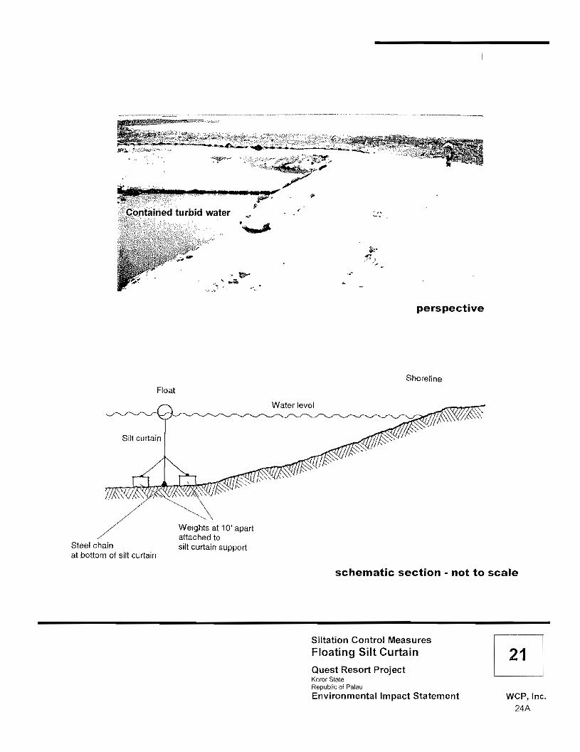
turbid water
"
,.-
perspective
Float Shoreline
Silt curtain
Steel chain at bottom ot silt curtain
Weights at 10' apart attached to silt curtain support
schematic section - not to scale
Siltation Control Measures Floating Silt Curtain Quest Resort Project Koror State Republic of Palau Environmental Impact Statement WCP, Inc.
24A

direction of flow
r-- wood post 2x4 inches
I I
I i '. __ woven wire fence 6x6 inches 11 __----
_------ geolexlile filler fabric ,---c: E direction
of flow
schematic section • not to scale
Siltation Control Measures Silt Fence
Quest Resort Palau Ngerur Island, Koror Slale Republic of Palau Environmental Impact Statement WCP, Inc.
246

3.1.4 CONSTRUCTION FEATURES
The total cut volume on the island is estimated at approximately 18,500 CY with approximately 9,000 CY or roughly 50 percent of the total cut volume attributed to the main structure of the resort. The total fill volume is projected at 2,800 CY. Excess cut volume (15,700 CY) will be exported off-island and be available for sale as fill material to private customers, to the government, or to quarries for further processing.
The projected dredged volume generated by project actions is estimated at approximately 23,500 CY. Roughly 20 percent of this material will be used as fill material for the marine facilities and improvements. The remaining dredged material will be exported off-island for sale as fill material.
Estimated quantities generated and required for proposed marine facilities and improvements are depicted in the following table.
TABLE 6: ESTIMATED DREDGED VOLUMES AND USAGE REQUIREMENTS.
I ESTIMATED VOLUME DREDGED / REQUIRED
Creation 20,000 CY Breakwater armor stone 7,000 CY Breakwater underlying stone 3,250 CY Breakwater center fill (can be dredged material) 4,500 CY
Beach Improvements Sand fill 3,500 CY Groin armor stone 1,000 CY Groin underlying stone 800 CY Groin center fill (can be dredged material) 400 CY
Grotto Improvements 3,500 CY Breakwater armor stone 500CY Breakwater underlying stone 400 CY
center fill (can material_) ._ 200 CY
Envisioned construction activities will be accomplished in an environmentally responsible manner. The following considerations will be observed.
o ENVIRONMENTAL PROTECTION PLAN. The environmental protection plan (EPP) includes the following elements:
• The construction contractor will provide standard 20·foot containers with proper markings for hazardous materials. This storage area will be provided for all fuel tanks, oil drums and other hazardous material. A liner and a berm will surround the containment area.
• All hazardous and toxic materials transported by truck or boat will be equipped with spill kits, sufficient to contain and absorb the amount of material being transported.
Final Environmental Impact Statement for Quest Resort Palau 25

o All gas and diesel equipment will be properly maintained to avoid smoking. If dry conditions develop creating fugitive dust emissions, sprayer or sprinklers sufficient to reduce dust, without creating runoff or erosion will be used.
o All equipment operating in construction areas will be properly muffled. Work hours will be limited to between 0700 and 1800 hours on Monday through Saturday. No pile driving or other excessive noisy activities will be accomplished during the early morning and late evening periods.
o EROSION CONTROL PLAN. The erosion control initiative for all activities incorporates several elements: o Minimize earth movement; o Minimize vegetation removal; o Limit the amount of exposed areas at anyone time; o Treat completed cut and fill slopes with erosion control matting; o Cut interceptor ditches along the top of the cut slopes; o Sequence earthmoving activities, starting at high points and proceeding to lower
points; o Avoid earthwork during heavy rains, as much as practicable; o Incorporate water quality protection measures; and o Focus on erosion and siltation control measures and containment of hazardous
materials.
The construction contractor also proposes to implement the following management strategies to achieve the erosion control objectives:
o Employ a site superintendant who is responsible for implementing and maintaining the approved erosion control plan.
o Increase personal awareness through weekly meetings to review and discuss environmental as well as safety issues.
o Operate and maintain all equipment according to the requirements of erosion control objectives.
o Handle, store, and dispose of all material in accordance with the manufacturer's recommendations and the erosion control objectives.
o Dispose of all packaging and waste to a permitted site (and not on Ngerur Island). o Employ an inspection team that will monitor stormwater runoff from construction
activities, keep an erosion control log, and take necessary action to correct observed deficiencies.
The construction contractor will further implement the following erosion control measures:
o Install a floating silt curtain prior to construction that confines the entire island of Ngerur including dredge sites (see Figure 23).
o Install additional silt fences around any temporary stockpiles of materials.
Final Environmental Impact Statement for Quest Resort Palau 26

Erosion Control Measures Floating Silt Curtain Deployment Quest Resort Palau
o 100 200 Feet Koror Slate -,- Republic of Palau Environmental Impact Statement wep,lnc.
26A

• Maintain sediment control devices throughout the duration of the project until such time that landscaping features (or other permanent measures) provide sufficient erosion and sedimentation control.
• Place sediment logs (i.e., porous fiber rolls that allow water to filter through fibers and trap sediment) to slow runoff and reduce sheet flow erosion in down-slope areas characterized by steep terrain (i.e., along cliff lines).
• Install earthen dikes, silt curtains, and perforated storm drain piping around each building as necessary to dam the storm or ponding surface water and force this water into the perforated pipe.
• Utilize sandbags as necessary to deter erosion during the construction phase.
o LOGISTICS AND MOBILIZA TlON. Material, equipment and supplies will be consolidated and shipped from West Coast U.S. ports to Palau. Three ocean carriers with service originating in the U.S. provide service to Palau. Sealand Services and Matson Navigation move cargo off the West Coast of the U.S. to Guam and connect with Palau Shipping Co. in Guam. Palau Shipping moves the cargo from Guam to Koror, Palau. Sealand and Matson Navigation have weekly service from the U.S. West Coast. Sealand also connects Guam with most major Southeast Asian Ports. Palau shipping has scheduled arrivals each week in Koror. The shipping duration from a West Coast port to Koror via Guam is normally 21 days. Pacific, Micronesia and Orient (PM&O) Lines move cargo directly to Palau. PM&O Lines depart the West Coast every 21 days. Transit time from the West Coast to Palau is 28 days. Matson Navigation and PM&O Lines will accept both breakbulk (non-containerized) cargo and containers. Sealand accepts full containers only. Upon arrival in Koror, and after completion of customs formalities at the Customs Terminal, the cargo will proceed from the Port of Koror to a staging area at the project camp. All cargo will be received and inspected before being delivered to the Quest Resort Palau site. Cargo will be transported to Ngerur Island by a small tug and barge. Project personnel scheduled for the Quest Resort Palau site will be ferried to and from Ngerur Island by a couple of 25-passenger workboats.
o LABOR HOUSING AND LABOR FORCE. The project construction managers (CM&D) estimate the manpower requirements for construction of the proposed project to be 100 to 125 persons. The applicant wants to utilize the local labor force and its existing infrastructure in order to reduce and/or mitigate impacts on the local economy and reduce overhead costs. The applicant is soliciting proposals from local general contractors, as well as encouraging local subcontractors to submit proposals to the general contractors. Additional labor and craftsmen to supplement the local workforce will be recruited outside of Palau. The use of imported laborers (i.e., Filipinos) is expected to have a minimal impact on the local Palauan community because of the widespread practice of importing these laborers. The construction contractor is expected to provide the experience, ability and appreciation for working with the people of Palau to minimize the social impact that imported laborers may have on the local population. The construction contractor will coordinate and manage a labor compound that will support the needs of the project. The contractor will provide housing facilities, a
Final Environmental Impact Statement for Quest Resort Palau 27

dining facility, laundry facilities, toilet facilities, refrigeration units, and various sundries and smallware to support anticipated manpower requirements. The contractor will also handle the catering, housekeeping and maintenance of the labor compound in order to satisfy the needs of the project.
o PERMITS. Separate permit applications will need to be submitted for earthmoving activities, discharges to receiving waters, utility systems, and auxiliary facilities (i.e., workers' barracks). The responsibility for permits pertaining to new auxiliary facilities rests with the general contractor if that contractor does not use local labor forces. A general contractor has not yet been selected; therefore, the applicant has requested that the permit application for auxiliary facilities be included as a condition of the earthmoving permit. The applicant is encouraging the use of local contractors, local labor, and existing infrastructure. Appropriate supporting documentation for any proposed toilet facilities or connection to the public water system will need to be submitted to EQPB and coordinated with the BPW.
3,2 Maximum Density Resort Development
This alternative represents resort development on a substantially larger scale as allowed by the existing Koror State zoning designation for Ngerur Island (refer to Section 5.12 for a more detailed discussion of land use considerations). Tables comparing the estimates of the daily and annual visitor load are provided below.
TABLE 7: COMPARISON OF THE DAILY VISITOR LOAD.
MAXIMUM DENSITY PROPOSED DENSITY RESORT DEVELOPMENT RESORT DEVELOPMENT ------:-._----- ----
Resort bungalows per acre 20.0 bungalows 4.8 bungalows Total acreage X 12.5 acres X 12.5 acres Total number of resort bungalows 250 bungalows 60 bungalows
Assumed occupancy rate (75%) 188 bungalows 45 bungalows
Daily visitor load 338 persons 81 persons Jbased on 1.8persons
TABLE 8: COMPARISON OF THE ANNUAL VISITOR LOAD.
I Dally VI:tor load Table 4) .. --- I Assumed turn over rate (365 days per year'" 4-day length of stay)
Annuat visitor toad 30,758 persons . __7,371persons
Final Environmentat Impact Statement for Quest Resort Palau 28

A large-scale resort project based on the maximum allowable density for Ngerur Island would generate substantially greater environmental impacts as compared to the proposed action due to the substantially higher (more than four times greater) annual visitor load supported by maximum density development. Infrastructure considerations would therefore encompass larger systems that can accommodate the higher potable water demand and the disposal of greater volumes of effluent and solid waste.
The alternative of a large-scale resort project on Ngerur Island would presumably function as a major revenue-source and employment center; however, the number of visitors accommodated by a maximum density resort project would also generate a substantially larger load on the natural environment whereby deleterious effects could occur. Degradation of the environment could in turn lead to a deterioration of the image of Palau as a diving paradise, thereby contributing to a reduction in the annual flow of visitors. The potential for serious long-term environmental degradation as a result of maximum density resort development led to the elimination of this alternative from further consideration.
3.3 Design Alternatives
Design alternatives pertaining to water and wastewater options that would present different environmental impacts have been considered but eliminated from further consideration. The following paragraphs present the relevant discussions.
3.3.1 ALTERNATIVE POTABLE WATER SYSTEM
Implementation of an off-site water supply system would include several components including the expansion of the existing Koror-Airai water treatment plant, installation of an underwater transmission pipeline from Arakabesan Island to Ngerur Island, and potable water purchase from the local water service provider.
The alternative of connecting to an off-site water supply system has inherent advantages since the operation and maintenance of the system would be the responsibility of the service provider. The infrastructure requirement for this option would be primarily associated with the transbay connection to an existing system on the island of Arakabesan. The following characteristics of this option are noted:
• Multiple service providers are available on the main islands; • Less land on Ngerur Island may be required for facilities and infrastructure; • Less power would be required on Ngerur Island for the water supply system; • Less manpower would be required for operation and maintenance; • Capital expenditure may be reduced if the transbay pipeline is used for power and
communications; and • No waste products from the water treatment process would be generated or disposed
with this option (as compared to the proposed action that involves seawater intake and brine disposal).
Final Environmental Impact Statement for Quest Resort Palau 29

This alternative has several disadvantages related to the absence of control over the system and the dependence on the transbay pipeline for water conveyance.
• The Ngerur Island water supply would be dependent on the off-island supply; • The Ngerur Island water supply would be dependent on the transbay pipeline; • There would be less control over water quality and extended pipeline residence time
may further deteriorate potable water quality; and • A back-up water production system may be warranted to increase reliability.
As indicated in the above discussion, the alternative of an off-site potable water supply system implies damage to coral and marine resources along the transbay pipeline corridor. Considerable environmental analysis of off-site systems, the transbay pipeline corridor and mitigation for the irrevocable loss of marine resources would be required for the option to connect to an off-island water supply system such that it was eliminated from further consideration in favor of the proposed potable water system (with on-site supply and reverse osmosis treatment) that is more typical within the framework of an island environment.
3.3.2 ALTERNATIVE WASTEWATER SYSTEMS
o WASTEWATER COLLECTION VIA A VACUUM SYSTEM. The alternative of utilizing a vacuum system for wastewater collection implies smaller diameter collection pipes that can be installed at a shallower average depth. This option eliminates the need for pump stations since the system operates under a vacuum created by vacuum pumps located at a central collection location and through a number of pockets, valves, and clean-outs dispersed along the collection pipeline route. Collection pipelines would be 3-inches in diameter with an average depth of 3 to 5 feet. There is a limit to the amount of vacuum the system can sustain (typically not more than 15 to 25 inches of mercury (in Hg). The lower elevations in the main structure may not be serviceable by a vacuum system such that this alternative was deemed unfeasible and subsequently dismissed in favor of the proposed wastewater collection system utilizing conventional gravity collection pipelines and pump stations.
o OFF-SITE WASTEWA TER TREA TMENT AND DISPOSAL. The alternative of off-site treatment and disposal involves an underwater pipeline between Ngerur Island and Arakabesan Island and conveyance of the effluent to the Malakal WWTP. The underwater pipeline would be a a,OOO-foot HDPE submarine forcemain of 3 to 4 inches in diameter. The pipe would be of a continuous length such that it can be pulled out, sunk and hand placed between any corals encountered along the pipeline corridor. The underwater pipeline would be connected to the wet well at the public pump station on Arakabesan island and discharged into the public sewer system for conveyance to the Malakal WWTP. Notable disadvantages of this system are as follows: • Waste storage facilities would be required on Ngerur Island because the Malakal
WWTP is at near capacity and is characterized by an inadequate conveyance system (pipelines and pump stations);
Final Environmental Impact Statement for Quest Resort Palau 30

• With this option, the Quest Resort Palau would be reliant on the Malakal wastewater collection and treatment system that is prone to failure when the system is not well maintained;
• Considerable environmental concerns are associated with the underwater piping of raw wastewater and the consequences of potential failure of the system;
• This option implies dependency on an off-site service provider and associated annual costs for treatment and disposal;
• There is an increased potential for odors on Ngerur Island due to the storage of raw wastewater on the island; and
• This option implies substantial construction costs associated with the pipeline and wastewater storage facilities.
Pumping wastewater to the Arakabesan-Malakal collection system would require an in-depth analysis of the available capacity and reliability of the existing collection, treatment, and outfall facilities. Based upon data obtained from the Malakal Wastewater Master Plan (1994) and discussions with Public Works personnel, the existing collection system is approaching maximum capacity and many of the pump stations are in poor to fair condition. Untreated sewage spills are not uncommon at various locations in the collection system. Although there are plans for expansion of the Malakal WWTP, the treatment plant is operating above its rated capacity and frequently discharges wastewater into the ocean without proper secondary treatment according to applicable standards. In addition, the ocean outfall discharge for the treatment plant is only about 50 feet deep and located very close to the shore such that the effluent frequently surfaces and migrates to the shoreline. Without significant improvements to the existing Malakal system, proper conveyance, treatment, and disposal of wastewater cannot be guaranteed. The addition of new flows to the already overburdened municipal collection and conveyance system would require substantial infrastructure improvements requiring planning studies and substantial new/rehabilitation construction. Costs are expected to be exorbitant. For example, the underwater forcemain alone would cost in excess of $500,000. The cost for other required improvements is unknown but can be conservatively estimated at over $1,000,000. In light of the above considerations, the alternative of off-site wastewater treatment and disposal has been eliminated from further consideration.
o ON-S/TE WASTEWATER TREATMENT AND OFF-SITE DISPOSAL. With this alternative, the effluent would first be treated on Ngerur before its conveyance through a submarine pipeline to Arakabesan. As with the previously evaluated alternative, the effluent would be discharged to the public collection system for ultimate treatment and disposal via the Malakal WWTP. This alternative allows for the effluent to be treated twice; however, the Quest Resort Palau would then be dependent on the public collection/conveyance and treatment system. With this option, the Quest Resort Palau would be contributing liquid inputs to a system that is characterized as unreliable because it may be already at or near capacity.
Final Environmental Impact Statement for Quest Resort Palau 31

Costs for on-site wastewater treatment and off-site disposal would include the costs attributed to off-site treatment and disposal (refer to Section 3.3.2.2) in addition to the cost of constructing on-site treatment facilities. On-site treatment with off-site disposal is therefore one of the more costly options addressed in this EIS. On-site treatment with off-site disposal is considered to be an expensive option that contributes new flows to an already overburdened municipal collection and conveyance system. For all these reasons, this option has been dismissed from further consideration.
o ON-SITE WASTEWATER TREATMENT AND DISPOSAL. Tertiary treatment (treatment beyond secondary level standards) was considered but dismissed in favor of proposed secondary treatment with UV. • Tertiary treatment is typically utilized when the wastewater is intended for use as
recycled water. Recycled water is employed in areas where water is scarce/expensive for irrigation purposes. This is not the case in Palau where the average rainfall is around 150 inches per year. Therefore, tertiary treatment for reuse is impractical and/or unnecessary.
• The tertiary treatment process involves substantial use of chemicals to coagulate suspended particles and requires filtering with disinfection for subsequent reuse in a separate distribution system. Substantially more physical space would be needed for the additional chemical storage and equipmenUstructures to employ their use. Space is already at a premium on Ngerur Island. The size of the structure where all treatment facilities are contained would have to increase by 100 percent to include the additional treatment components. Tertiary treatment would also entail greater cost for the treatment facilities and require the transport, storage, and use of numerous chemicals and/or fuel. Furthermore, tertiary treatment exponentially increases the complexity of the treatment process. All in all, the additional cost (approximately $250,000 to $500,000) to treat the effluent to a tertiary level is not practical or cost effective, hence, the dismissal of this option in lieu of secondary treatment with UV (a compact, cost-effective option estimated at $25,000 that requires no chemicals) and ocean disposal via a deep outfall.
The utilization of mounds/leach-fields or overland treatment was also considered and dismissed (in favor of the proposed on-site packaged WWTP). • The overland treatment was discounted due to the amount of land required, its
potential for odors, and a perceived negative response of guests to a wastewater treatment process co-mingled within the public areas.
• A septic tank system employing a series of mounds and/or leach-fields was investigated but determined to be unfeasible because Ngerur Island is characterized by a thin layer of top soil underlain by a basaltic conglomerate material of unknown depth. The percolation capacity of this type of material is not favorable for a septic tank system utilizing a series of mounds andlor leach-fields. When these existing conditions are evaluated in conjunction with typical precipitation rates and the land requirement for even favorable percolation soils, the viability of such a system does not appear to be favorable.
Final Environmental Impact Statement for Quest Resort Palau 32

The utilization of injection wells was also considered and dismissed (in favor of proposed disposal via ocean outfall). • Injection wells are a common means of effluent disposal in-lieu of ocean outfalls.
Due to diurnal fluctuations in the wastewater flow, the injection wells would draw from an effluent forebay to allow for more constant discharge rates. The injection wells would be drilled to a depth much greater than any extraction wells (400 to 500 feet) if such wells were used by the potable water system, in order to eliminate the potential for migration into the seawater supplying the RO system.
• Injection wells do require an additional treatment process over that required for an ocean outfall. In order to prevent fouling/clogging of the injection wells, the wastewater effluent must be filtered to reduce the number and size of particulates in the liquid being injected through the well screens.
• Advantages associated with injection wells are that facilities are small and can be contained in the WWTP area, no off-shore construction is required, and there are minimal environmental impacts with this option. The disadvantages of this system are that it requires a high power demand, requires a redundant system for reliability, and implies operational and maintenance activities on-island. The primary environmental concerns related to this option are the increased potential for noise from continuous pump activity.
• Geotechnical analysis for Ngerur Island indicated that permeability was inadequate for injection wells since at +200 feet into the subsurface the material is so compressed that no water can travel through it (refer to Appendix B-1). As a result of the analysis, the option to utilize injection wells was determined to be impracticable and was therefore dismissed from further consideration.
3.3.3 ALTERNATIVE FIRE PROTECTION SYSTEMS
o SEAWATER F/RE PROTECTION SYSTEM. Implementing a seawater fire protection system would require construction of a fire pump house on the docks and a separate looped piping system. To satisfy the 500 gpm flow requirement, a 6-inch diameter piping system would be required. The advantage of the seawater system is that no fire storage is required since the ocean is the system forebay. Saltwater, however, is very aggressive on system materials. This aggressive attack translates into frequent and extensive maintenance that can result in decreased reliability. In addition, the need for a separate piping system counters the advantage of no storage requirements. Furthermore, using saltwater for the main structure sprinkler system is impractical. Lastly, in the event of a fire, saltwater would have a detrimental effect on vegetation in and around the fire. Given the above considerations, the use of seawater for fire protection was eliminated from consideration in favor of using the potable water system for fire protection.
Final Environmental Impact Statement for Quest Resort Palau 33

o CA TCHMENT FIRE PROTECTION SYSTEM. A catchment system would likely utilize water features of the project for storage with the fire pumps drawing from those impounds. A piping system separate from the potable water system would be required since the catchment water would not be filtered or disinfected. An advantage of using catchment water is the reduced potable water storage requirements; however, the need for a separate piping system around the island negates the potential storage reduction advantage. Moreover, if the main structure were provided with a sprinkler system, the entire structure would have to be plumbed with separate catchment piping for the sprinkler system. The option of an independent catchment fire protection system was therefore eliminated from further consideration in favor of using the proposed potable water system for fire protection.
3.3.4 ALTERNATIVE ELECTRICAL POWER SYSTEMS
o ON-SITE FACILITY. Generating on-site power would require two generators each sized to handle the entire island demand. The generators would operate in a DUTY/STANDBY mode with scheduled alternation to allow for maintenance and proper exercising of the equipment. Fuel could be diesel, natural gas, or propane. Advantages of this system are that the electrical power source would be close to end users, thereby incurring less system losses. A safety critical (emergency) electrical supply is inherent to this option. Disadvantages of this alternative include the on-site land requirements, the on-site fuel storage requirements, the potential need for a redundant system to insure reliability, the generation of engine emissions and associated noise, and the on-island staffing requirements with respect to the operation and maintenance of the system. Primary environmental concerns associated with this option include the increased potential for fuel spills and the increased potential exhaust from power generation. In light of the above considerations, this option was dismissed in favor of the proposed off-site power system with a standby emergency generator (refer to Section 3.1.2, Electrical and Communication Systems).
o OFF-SITE FACILITY. Obtaining power from an off-site power plant located on Arakabesan Island would require construction of a power plant on Arakabesan and installation of a transmission line such as a steel-armored submarine cable to Ngerur Island. The conduit would house power and telecommunications cables. It would have to be installed in a "cut and cover" trench until deeper water is reached where it would be laid on the lagoon bottom. Anchors would be used only to the extent necessary to stabilize the cable within the alignment corridor. No anchoring would be required along the sandy lagoon bottom areas that comprise 75 percent of the entire proposed alignment. This alternative would require two generators each sized to handle the entire island demand. Generators would operate in a DUTY/STANDBY mode with scheduled
Final Environmental Impact Statement for Quest Resort Palau 34

alternation to allow for maintenance and proper exercising of the equipment. Diesel fuel would be used. The advantages of this option are independence from the PUC power supply, less congestion on the island from equipment, no fuel transportation to and storage on the island, and reduced air and noise emissions on the island. Fewer on-island staff would be required, however, operational and maintenance staff would instead be required on Arakabesan. The disadvantages of this alternative include the dependency on the integrity of the submarine cable, the potential line losses, and the potential need for a back-up system to increase reliability. The alternative of an off-site facility was dismissed in favor of obtaining power from PUC. The preferred alternative will nevertheless require that power be transmitted from Arakabesan to Ngerur Island via a submarine cable as outlined above.
3.4 No Action
As a result of the no action alternative, the island of Ngerur would remain in an undeveloped state. Short- and long-term environmental impacts, both beneficial and adverse, that are associated with the construction and operation of a resort facility would not occur. The potential impacts discussed in this EIS would be avoided as a result of no action.
Selection of the no action alternative would result in no income generation to the property owner from resort activity on Ngerur Island. No capital resources would be expended as a result of the no action alternative despite the apparent interest of the investor to create a first-class resort project on the uninhabited island of Ngerur. The ROPG would receive no benefits in terms of tax revenues or employment opportunities for local Palauans as a result of this alternative. The opportunity to stimulate the tourist environment in Palau would also be missed with no action. Based on the above considerations, the no action alternative has been eliminated from further consideration in this EA.
Final Environmental Impact Statement for Quest ResoJ1 Palau 35

4.0 ENVIRONMENTAL SETTING
This chapter presents the relevant resource components of the existing environment that would be affected by the alternatives under consideration if they were implemented. In other words, this chapter describes the baseline environment. The discussions presented in this chapter are necessary to understand and evaluate the effects of considered alternatives (i.e., those options that remain from Chapter 3.0).
4.1 Geography and Topography
The project site encompasses the entire island of Ngerur consisting of approximately 12.5 acres (5 hectares) within the Palau Lagoon. Arakabesan Island is the nearest landmass to the island and lies approximately 2,460 feet (750 meters) southeast of Ngerur. Koror is approximately 3.75 miles (6 kilometers) southeast of Ngerur Island.
The island is characterized by small crescent or irregularly shaped rocky beaches that occur around the perimeter of the island. Beach areas are mostly bounded by vertical to near-vertical rock escarpments and headlands. As indicated previously in Section 3.2, the remaining island topography is relatively flat at roughly 30 to 45 feet (9 to 14 meters) above sea level. A few dramatic rock formations are situated in the eastern part of the island; the highest of these formations rises to an elevation of approximately 70 feet (21 meters).
Final Environmental Impact Statement for Quest Resort Palau 36

4.2. Geology and Soils
The general geology of Ngerur Island is identical with the geology of Arakabesan Island insofar as both islands consist of volcanic rocks, representing the Arakabesan member (Andesitic volcanic breccia) of the Oligocene Ngeremlengui formation. Figure 24 illustrates these existing conditions.
A shallow fringing reef varying in width from 50 to 250 feet (15 to 76 meters) surrounds Ngerur Island. In general, the nearshore bottom material is consolidated rock, with cobbles and some sediment, to a depth of approximately -4 feet (-1.2 meters) which is roughly equal to extreme low tide. Soft and hard coral growth starts at about the 4 to 5-foot depth (1.2 to 1.5 m).
The following excerpt is from the geotechnical engineering exploration report prepared by Geolabs, Inc. and dated October 28,1999 (refer to Appendix B-1).
"In general, the Islands of Ngerur, Arak[a]besang, and the western portion of Koror are composed of the accumulation of Tertiary Epoch volcanic materials including tuff and tuffaceous breccia along the crest of the Palau Ridge structure. The geomorphology of the islands is controlled by many factors including faulting, repeated historic and submergence and emergence episodes resulting from sea level fluctuation, submarine erosion, and subaerial deep tropical weathering.
"The ground surface of the island typically consists of some thin soil cover derived from the in-situ weathering of the basaltic and andesitic parent rock. The thin soils overlie dense volcanic breccia rock with increasing depth below the ground surface. The surficial soil thickness may vary widely depending on location. Volcanic breccia may be defined as a relatively coarse-grained volcanic rock composed of various broken rock fragments (called clasts) that are welded together by heat and pressure within a generally fine-grained mineral rock matrix. Breccia rock is typically formed by volcanic eruptions and/or volcanic debris flows consisting of super-heated rock masses.
"Ngerur Island is essentially oblong in shape and generally consists of a centrally located highland that slopes down toward the perimeter shoreline. The perimeter shoreline consists of banks elevated from the coastal waters. The banks may have formed from the effects of tidal fluctuation and coastal erosion. A relatively shallow depth marine shelf surrounds the island before abruptly dropping off with increasing water depth. The shelf contains deposits of marine sediments and coral growth that may overlie volcanic rock buried at greater depths.""
Two different soil types exist on Ngerur Island. The dominant soil type that covers roughly 90 percent of the island is the Nekken-Ollei complex, 12 to 30 percent slopes (No. 410). The soil type that extends along the shore of the island from northeast counterclockwise to southwest is the Ollei-Nekken complex, 50 to 70 percent slopes (No 429). Figure 25 illustrates the soil distribution on Ngerur Island. In general, soils on Ngerur Island are very shallow. The characteristics of the two soil types found on Ngerur Island are hereby excerpted from Soil Survey of Islands of Palau, Republic of Palau (1983).
6 Geolabs, Inc., 1999.
Final Environmental Impact Statement for Quest Resort Palau 37

·It" NGERUR PROJECT LOCATION
ARAKABESAN
:Rm.gothu
"
Ko/xuanv libr.
KOROR NGERCHAOL
Malakaf ULEBSECHEL
. 1/.• '1.0- f
VOLCANIC ROCKS Source: Military Geology of ttle Palau Islands
1IIIIIIII Trap and
indurated volcanic breccia (At or neor surfoce) SEDIMENTARY ROCKS
Weathered volcanic breccia
(Extends foodeptll of IO'ormore) .]]
Mode land -Coralline limestone
Republic of Palau Engineering Geology Quest Resort Pa lau Karor Stale ReplItllic of Palau
o 2km Environmental Impact Statement WCP, Inc.---._-- 37A

reef
............_._+-
i 410 1
.1 Nekken-Ollei complex
429 Ollei-Nekken complex
Source: us Oepanmenl 01 Agriculture Soil Survey 01 Islands of Palau
Ngerur Island Soil Map Units Quest Resort Palau Koror State Republic of Palau
o 50 100 Environmental Impact Statement WCP, Inc. 378

o 410 - NEKKEN-OLLEI COMPLEX. 12 TO 30 PERCENT SLOPE. This map unit is on low-lying foothills and ridgetops. This unit is 65 percent Nekken very gravelly silt loam and 25 percent Ollei very gravelly loam. Slopes are convex. The vegetation is mainly tropical forest. Cleared areas support savanna vegetation. The Nekken soil is moderately deep and well drained. It formed in residuum derived dominantly from andesitic and basaltic breccia and tuff. Typically, the surface is covered with a mat of undecomposed and partially decomposed forest litter 3 centimeters thick. The surface layer is very dark brown very gravelly silt loam 20 centimeters thick. The upper 56 centimeters of the subsoil is dark yellowish brown very gravelly silty clay loam, and the lower 10 centimeters is very dark brown very gravelly silt loam. Very hard, bedded tuff is at a depth of 56 centimeters. Bedrock is at a depth of 50 to 76 centimeters. Permeability of the Nekken soil is moderate. Effective rooting depth is 50 to 76 centimeters. If the vegetation is removed, runoff is medium and the hazard of water erosion moderate. The Ollei soil is shallow and well drained. It formed in residuum derived dominantly from hard andesitic and basaltic breccia and tuff. The surface layer is very dark brown silt loam 18 centimeters thick. The subsoil is brown very gravelly loam 10 centimeters thick. The substratum to a depth of 43 centimeters is dark yellowish brown extremely flaggy loam. Hard, bedded tuff is at a depth of 43 centimeters. Bedrock is at a depth of 25 to 51 centimeters. Permeability of the Ollei soil is moderate. Effective rooting depth is 25 to 51 centimeters. If the vegetation is removed, runoff is medium and the hazard of water erosion is moderate. This map unit is well suited to use as pasture. Grasses and legumes grow well if adequate fertilizer is used. Proper grazing management, weed control, and fertilization are needed for maximum quality of forage. This unit is moderately suited to use as woodland. The main concerns in producing and harvesting timber are shallow rooting depth and droughtiness of the Ollei soil. This map unit is poorly suited to homesite development. The main limitations are slope and depth to rock. The deep cuts needed to provide essentially level building sites expose bedrock. Erosion is a hazard on the steeper slopes. Only the part of the site that is used for construction should be disturbed. Structures to divert runoff are needed if buildings and roads are constructed. Topsoil can be stockpiled and used to reclaim areas disturbed by cutting and filling. This unit is poorly suited for use as roadfill because of the low strength of the subsoil. The bedrock underlying the soils is well suited to use as a source of rock for road construction. This map unit is poorly suited to on-site waste disposal systems because of the shallow and moderate depth to bedrock and the steepness of slope.
o 429 - OLLEI NEKKEN COMPLEX. 50 TO 75 PERCENT SLOPES. This map unit is on high hills and ridge tops. This unit is 55 percent Ollei very gravelly loam and 25 percent Nekken very gravelly silt loam. Slopes are convex. The vegetation is mainly tropical forest. Cleared areas support savanna vegetation.
Final Environmental Impact Statement for Quest Resort Palau 38

This map unit is poorly suited for use as roadfill because of the low strength of the subsoil. The bedrock underlying the soils is well suited to use as a source of rock for road construction. This unit is poorly suited to on-site waste disposal systems because of the shallow and moderate depth to bedrock and the steepness of slope.
Table 9 shows the degree and kind of soil limitations that affect shallow excavations, dwellings without basement, local roads and lawns and landscaping. The limitations are considered slight, moderate or severe according to the following conditions:
o Slight limitations exist if soil properties and site features are generally favorable for the indicated use and limitations are minor and easily overcome;
o Moderate limitations exist if soil properties or site features are not favorable for the indicated use and special planning, design or maintenance is needed to overcome or minimize the limitations; and
o Severe limitations exist if soil properties or site features are so unfavorable or so difficult to overcome that special design, significant increases in construction costs, and possibly increased maintenance are required.
TABLE 9: EVALUATION OF SOIL LIMITATIONS FOR CONSTRUCTION USE.
SOIL SHALLOW DWELLINGS SMALL LOCAL ROADS LAWNS AND TYPE EXCAVATIONS WITHOUT COMMERCIAL LANDSCAPING
BASEMENTS BUILDINGS
Nekken severe: depth to severe: slope severe: slope severe: low severe: small (410) rock slope strength, slope stones, slope Ollei (410) severe: depth to severe: slope, severe: slope, severe: depth to severe: slope,
rock slope depth to rock depth to rock rock slope thin layer ...... .. .. ..
Ollei (429) severe: depth to severe: slope, severe: slope, severe: depth to severe: slope, rock slope depth to rock depth to rock rock slope thin layer
Nekken severe: depth to severe: slope severe: slope severe: low severe: small (429) rock slope strength, slope stones, slope
The following five features types are evaluated in Table 9:
o Shallow excavations are trenches or holes dug to a maximum depth of 150 to 180 centimeters.
o Dwellings and small commercial buildings are structures built on shallow foundations on undisturbed soil.
o Local roads and streets have an all-weather surface and carry automobile and and light truck traffic all year. They have a a subgrade of cut or fill soil material, a base of gravel, crushed rock, or stabilized soil material and a flexible or rigid surface. Cuts and fills are generally limited to less than 180 centimeters.
Final Environmental Impact Statement for Quest Resort Palau 39

o Lawns and landscaping require soils on which turf and ornamental trees and shrubs can be established and maintained. Flooding, wetness, slope, stoniness, and the amount of sand, clay or organic matter in the surface layer affect trafficability after vegetation is established.
Table 10 gives information about tile soils as a source of roadfill, sand, gravel, and topsoil. The soils are rated good, fair, or poor as a source of roadfill and topsoil. They are rated as a probable or improbable source of sand and gravel. Each soil is evaluated to a depth of 150 to 180 centimeters.
o Roadfill is soil material that is excavated in one place and used in road embankments in another place. Soils rated poor have a plasticity index of more than 10, a high shrink-swell potential, many stones, or slopes of more than 25 percent.
D Sand and gravel are natural aggregates suitable for commercial use with a minimum of processing. A soil rated as a probable source has a layer of clean sand or gravel or a layer of sand or gravel that is up to 12 percent silty fines. This material must be at least 90 centimeters thick and less than 50 percent, by weight, large stones. All other soils are rated as an improbable source.
D Topsoil is used to cover an area so that vegetation can be established and maintained. The upper 100 centimeters of a soil is evaluated for use as topsoil. The reclamation potential of the borrow area is also evaluated.
TABLE 10: EVALUATION OF SOIL SOURCES FOR CONSTRUCTION USES.
SOIL ROADFILL SAND GRAVEL TOPSOIL TYPE
Nekken poor: area reclaim, improbable: excess improbable: excess poor: small stones, (410) low strength, thin fines fines slope
layer aile; (410) poor: area reclaim improbable: excess improbable: excess poor: area reclaim,
fines, large stones fines, large stones small stones, slope
Ollei (429) poor: area reclaim, improbable: excess improbable: excess poor: area reclaim, thin layer, slope fines, large stones fines, large stones small stones, slope
Nekken poor: area reclaim, improbable: excess improbable: excess poor: small stones, (429) low strength, thin fines fines slope
layer
Plant growth is affected by toxic material and by such properties as soil reaction, available water capacity, and fertility. The ease of excavating, loading, and spreading is affected by rock fragments, slope, a water table, soil texture, and thickness of suitable material. Reclamation of the borrow area is affected by slope, a water table, rock fragments, bedrock and toxic material.
Soils rated poor are very sandy, or clayey, have less than 50 centimeters of suitable material, have a large amount of gravel, stones, or soluble salts, have slopes of more than 15 percent, or have a water table at or near the surface.
Final Environmental Impact Statement for Quest Resort Palau 40

Information about the soils and subsurface conditions on Ngerur Island are hereby excerpted from the geotechnical investigation conducted in 1999 by Geolabs, Inc.
"The perimeter of the island generally consists of steep, near-vertical slopes with bedrock exposure. In general, there are three areas along the perimeter of the island that are underlain by soil materials with a gentle sloping terrain down to the shoreline. One of these areas may be characterized as a mangrove environment and is located at the southeastern portion of the island. The ground surface of the island is generally flat with the east side having higher elevations and the west side lower in elevations. The ground surface elevations generally range from about +66 feel MSL on the east side of the island to about +18 MSL on the west.
"The island is generally accessed by a north-south trending access trail, which connects with the equipment stand-by area at the north. Due to the high moisture content and thickness of the near-surface soils, a large portion of the island is currently not accessible by normal vehicles. Surface drainage and the infiltration characteristics of the native soils appear to be good except along the access trail, where the soils have been reworked and compacted. In these areas, potholes and standing water were observed, indicating poorly drained near-surface soil conditions.
"Other features of interest on the island include the occurrences of faulVfracture zone traces in the rock outcrops along the perimeter of the island. Most of the traces are near-vertical and trending approximately in and east-west direction. The faulVfracture zone traces are generally observed in homogeneous rock types and consist of mineral veins. In general, these fault/fracture zone traces do not appear to be active fault traces.
"The subsurface conditions at Ngerur Island were explored by drilling and sampling eight borings, designated as Boring Nos. 1 through 8, for a total footage of approximately 265 lineal feet of field exploration. Three of the eight borings (Boring Nos. 1 through 3) were drilled on the mud flats between the shoreline and the future breakwater structures. Boring Nos. 1 through 3 extended to depths of about 17 to 47 feet below the mud flat surface. The remaining five borings (Boring Nos. 4 through 8) were generally drilled for the main hotel building. The five borings extended to depths between about 13 and 47.3 feet below the existing ground surface. In addition, the subsurface conditions below the [proposed] one and two-story buildings were explored by excavating 10 test pits, designated as Test Pit Nos. 1 through 10, to a maximum depth of about 12.5 feet below the existing ground surface.
"Based on our field exploration, the island surface is generally blanketed by a mantle of soil on the order of about 3 to 5 feet below the existing ground .surface. In a few areas, the surface soil layer extended to about 10 to 15 feet below the existing ground surface. The near-surface soils generally consist of stiff to very stiff clayey silts and silty clays with high moisture contents. The near-surface soils are generally the products of mechanical and chemical weathering of the underlying volcanic rock. Volcanic breccia rock formation generally underlies the surface soil horizon. In the southeastern portion of the island, the volcanic breccia rock was exposed at the ground surface. The volcanic breccia rock formation encountered generally was very dense and massive (with few fractures).
Final Environmental Impact Statement for Quest Resort Palau 41

4.3
"Based on the off-shore borings (Boring Nos. 1 through 3) drilled for the proposed harbor facilities, it appears that the future harbor area enclosed within the shoreline and the proposed breakwater structures is generally underlain by dense volcanic breccia rock formation near the mud flat surface expect in Boring No.1, where the dense breccia rock was encountered at a depth of about 10 feet deep below mud flat surface.'"
Hydrology and Water Quality
Ngerur Island does not possess specific hydrological elements that are generally supportive of high biodiversity such as streams, ponds, freshwater marshes, and swamp forests. The following excerpt is from the geotechnical engineering exploration report for Ngerur Island prepared by Geolabs, Inc. (1999).
"Groundwater was not encountered in the test pits excavated on the island; however, a significant amount of seepage water was observed below the surface soil horizon at and around the interface between the soil and rock. However, it should be noted that groundwater (likely seepage water) was encountered in the borings drilled on the island. Due to the nature of the island locality, the water levels measured in the drilled borings and excavated test pits during our field exploration were likely affected by tidal influences. In addition, the water levels at the project site may be influenced by seasonal precipitation and storm surge conditions."a
Water quality standards pertaining to the marine waters of Palau are contained in the regulations by the EQPB, established pursuant to the Environmental Quality Protection Act, Chapter 1, Marine and Fresh Water Quality Standard regulations. Coastal waters are classified in accordance with uses (Chapter 2401-11-05). During the session of the Sixth Koror State Legislature, April/May 2000, a resolution was passed to recommend the waters around Ngerur Island be reclassified from Class "AA" to Class "B" (refer to Appendix B-2). Figure 26 illustrates the water quality classifications for the affected area. The draft of an Amendment to the Marine and Freshwater Quality regulations that would allow for necessary changes was endorsed by the EQPB in September 2000 and forwarded to the Office of the President for final review and approval. The President, Republic of Palau, used his authority under the law to approve the amendment as drafted (refer to Appendix B-2).
The effective date of the proposed Amendment is October 6, 2000. The current process provides the public with a 30-day comment period. The OEK has a 120-day period during which a potential repeal of the reclassification would be possible.
Water quality investigations were conducted in September 26 through 28, 1998 by PENTEC Environmental, Inc. (refer to Appendix B-3) and in October 14 through 16, 1998 by AECOS Consultants (refer to Appendix B-4). Parameters such as temperature, salinity, dissolved oxygen (DO), turbidity, pH, and nutrients were measured. ---_... -------7 Geolabs, Inc., 1999. B Ibid.
Final Environmental Impact Statement for Quest Resort Palau 42

AA PROJECT LOCATION
."..._.- .....' , '.,.I ' .. .., # ••..... '" .... .
, .,.'."# ..... _....... I '\. KA 19 iAA \
.. "';.: ;:;':t: 1..... _ \, KA ARAKABESAN • .., .........
20 .. .. .
I" A\ ..... A, .Mn'."
• , KA21 .,: " .........'I r' .......
"
MAlAKAL -:.:.::;':': :',. ,::.;
. .', . . .. ... ".;, •.•••• .o .o .• :..",., ....,. ..... " .' ',\'"
+t#Ii. ", ",ill\\' o
• Inventory Site locatton
Protected Use Class B Boundary liIi·jllin
Northeastern Koror State (Detail) Water Quality Classification Quest Resort Palau KOfor State Republic of Palau Environmental Impact Statement WCP, Inc.o 2km
42A--'--

The findings in the water quality investigation report by PENTEC Environmental, Inc. (1999) reveal the following conditions pertaining to the waters around the perimeter of Ngerur Island:
"With the exception of temperature, water quality parameters were generally within the expected ranges for coastal lagoon waters in the equatorial western Pacific Ocean.
"Water temperatures recorded during the September 1998 survey averaged at least 1°C above normal ambient lagoon water temperatures.
"Temperature data recorded during the surveys suggest that lagoon water temperatures were still under the influence of the ongoing [EI Nifio Southern Oscillation or] ENSO event.
"The salinity values are somewhat lower than would normally be expected . .. .prevailing ENSO drought conditions, and a presumed reduction in surface- and groundwater runoff, do not appear to have produced any corresponding increase in lagoon salinity in surface waters around Ngerur Island.
"DO concentrations were low.... Percent DO saturation ... appear to reflect a range more or less typical of lagoon surface waters.
"Turbidity readings...suggest that in its undeveloped state, the vegetation cover of the island is effective in retaining silt and sediment that might otherwise run off into coastal waters.
"All 12 samples [for pH] were within Palau's water quality standards for Class AA, A and B waters."g
The investigation report by AECOS Consultants (2000) reveals the following conditions pertaining to the marine waters around Ngerur Island:
"There was little difference in temperature, salinity or pH between any of the stations around Ngerur Island, ... indicating that these lagoon waters are generally well mixed. The somewhat elevated dissolved oxygen (DO) saturation levels at Station 3 indicate that there is likely a well developed coral community andlor benthic algal community in this area. Zooxanthellae (microscopic plants) which live within corals and benthic algae produce oxygen during the daytime photosynthetic process and this can result in supersaturation of DO in the water column during part of the day. Also, the slightly higher pH at Station 3... is further evidence suggesting productivity is high in this area. Carbon dioxide is consumed by plants during photosynthesis, decreasing carbonic acid in the water, and increasing pH.
"Low mean turbidity level at Station 4 seems to be due to the fact that this station was located over deeper waters (i.e., off the Ngerur reef area) and on the NW side of the island. This station was sampled only on October 16, 1998...when a morning storm was blowing out of the NW and, thus, while other stations were subject to stirring up of the shallow reef sediments, Station 3 was receiving clearer water from the deeper channel area west of Ngerur Island.
9 PENTEC Environmental, Inc., 1999.
Final Environmental Impact Statement for Quest Resort Palau 43

"Nutrient levels were low in the vicinity of Ngerur Island ... during the survey period and characteristic of pristine coastal tropical environments. The nitrate + nitrite levels recorded are considered to be 'growth-rate limiting.' That is, inorganic nitrogen is present in such low quantities that plant growth (phytoplankton and benthic algae) would be severely restricted at this location and, together with low turbidity levels, accounts for the pristine nature of this area."
"Water quality conditions in the vicinity of Ngerur Island were well within the standards specified by the [Republic of Palau] for the parameters measured....The high water quality levels that characterize this area occur for several reasons. Firstly, Ngerur Island is small relative to the surrounding marine environment (lagoon) and has little influence on this water body. There is, for example, little runoff directly into the marine environment and that which does occur... is small and probably inconsequential .... Secondly, water movement in this area in not restricted; i.e., the area is well exposed, especially to the north and west. Such exposure encourages water movement, or flushing, by wind-driven surface currents and deeper tidal movements. Such flushing maintains a steady supply of food and nutrients for the coral communities and aids in removing waste products. Finally, Ngerur Island is fairly well removed from developed areas that might contribute to water quality degradation. And even though it is close to the western side of [Arakabesan], this part of [Arakabesan] is mostly uninhabited and Ngerur Island is further isolated by a channel of some depth which separates the two islands. ,,10
Relevant findings pertaining to the measured water quality parameters are hereby summarized from the appended investigations.
o TEMPERA TURE. The water temperature of samples collected in September 1998 ranged from 30.4 to 31.1°C. 11 "A mean temperature of 30.rC was recorded for all stations. Overall, recorded temperatures were unusually high. The normal range of water temperature is about 23.8 to 29.4°C."12 The water temperature of samples collected in October 1999 ranged from 30.7 to 31.0°C with an overall mean of 30.8°C B
o SALINITY. Salinity values of samB'es collected in September 1998 ranged from 30.5 to 32.0 parts per thousand (ppt). 4 "Mean surface salinity was lowest on the south side of the island (30.6 ppt) and highest on the north side of the island (31.4 ppt). Mean midwater salinity was lowest on the west side of the island (30.7 ppt) and highest on the south and east sides of the island (31.1 ppt). A mean salinity value of 31.0 ppt was calculated for all stations.,,15
"All salinity concentrations were within Palau's standard for salinity.',16
10 AECOS Consultants, 2000. 11 PENTEC Environmental, Inc., 1999. 12 Ibid. 13 AECOS Consultants, 2000. 14 PENTEC Environmental, Inc., 1999. 15 Ibid. 16 Ibid.
Final Environmental Impact Statement for Quest Resort Palau 44

The salinity values of samples collected in October 1998 ranged from 33.44 to 33.75 ppt with a mean of 33.61 ppt. 17
o DISSOL VED OXYGEN. DO concentrations in the September 1998 samples ranged from 4.7 to 6.1 parts per million (ppt) excluding the highest reading recorded midwater on the east side of the island on September 27, 1998.18 "The mean DO values for surface and midwater on the east side of the island were 5.1 and 5.5 ppm, respectively. The mean DO values for surface and midwater on the west side of the island were 5.2 and 5.0 ppm, respectively. There was no difference between the surface and midwater DO values for the south side of the island (5.1 ppm), or the island's north side (5.4 ppm).,,19
"DO values were influenced by the degree of wind and surface chop exposure. DO readings on the lee sides of the island (south and west) had a mean of 5.1 ppm (N = 6), whereas readings on the wind-exposed north side had a mean of 5.4 ppm (N = 6). DO saturation values ranged from 75 to 98 percent. A mean saturation value of 81.8 percent was calculated for the sampling station on the lee side, whereas a mean value of 86.1 percent characterized the windward sampling station. A mean DO value of 5.2 ppm (N = 14) was calculated for all stations.
"Measurements obtained within dark, organic, sedimentary deposits at sampling station 5 showed dissolved oxygen levels of 0.2 ppm. This site appears to be a depositional zone for organic materials transported by surface-water runoff from the island, or where lagoon-derived organic detritus is naturally deposited by water currents. Both of these mechanisms may contribute material to this area, as there is evidence of leaf litter and debris of anthropogenic origin ... in the sediment. The organic deposits form a soft, unconsolidated organic slurry in an area of about 10 to 12 square meters adjacent to the vertical rock shoreline along the southeast shoreline of the island.
"Excluding Station 5, all DO concentrations met or exceeded the saturation standards .... The concentration of DO is dependent on the salinity and temperature of the water. The lower-than-normal DO values can be attributed to the warmer-than-normal water temperatures. Station 5 readings are the result of unique physical or hydrological circumstances and are not relevant in terms of the regulatory standards. Samples of this material returned to the surface for closer examination indicated the strong presence of hydrogen sulfide, indicating anaerobic conditions typical of the natural degradation of organic material in this environment.'@ The DO values of samples collected in October 1998 ranged from 6.47 to 7.92 ppm with a mean of 7.07 pj;m; DO saturation values ranged from 104 to 128 percent with a mean of 114 percent. 1
o TURBIDITY. Turbidity levels in the September 1998 samples ranged from 0.7 to 1.40 nephelometric turbidity units (NTU).22 'The highest turbidity reading was recorded on
17 AECOS Consultants, 2000. 18 PENTEC Environmental, Inc., 1999. 19 Ibid. 20 Ibid. 21 AECOS Consultants, 2000. 22 PENTEC Environmental, Inc., 1999.
Final Environmental Impact Statement for Ouest Resort Palau 45

the south side of the island. The south side also demonstrated the highest mean value (1.1 NTU). A mean value of 1.0 NTU was calculated for all stations."23 All samples met Class B turbidity standards; however, Class AA and A standards were exceeded during the rainfall event on September 27, 1998.24
The turbidity levels of samples collected in October 1998 ranged from 0.08 to 0.36 NTU with a mean of 0.23 NTU.25
o I2H pH values for all the September 1998 samples ranged from 7.7 to 8.2.26 "The lowest reading was recorded on the west side of the island. A mean pH of 7.9 was calculated for all stations.,,27
"All 12 samples were within the range for Class AA, A and B waters.,,28 The pH levels of samples collected in October 1998 ranged from 8.17to 8.20 with a mean of 8.1829
4.4 Climate
The Palau islands have a maritime tropical rainy climate that is characterized by small seasonal changes. Temperature and barometric pressure are fairly uniform throughout the year. The prevailing winds have seasonal characteristics.
The following climatological information is from climate and historical weather data compiled by the United States Department of Commerce, National Oceanic and Atmospheric Administration (NOAA) in 1991.
o TEMPERA TURF Both the annual and diurnal temperature ranges are small, with the annual range being smaller than the diurnal one. The mean diurnal range is 10°F (5.55°C). The mean monthly temperature is 81.rF (27.6°C). The mean of the warmest month (May) is 82.3°F (27.9°C) and the means of the coldest months (January and February) are 81.0°F (27.2°C). Figure 27 illustrates the monthly average temperatures. Relative humidity is high throughout the year with an annual mean of 82 percent.
o PRECIPITATION. The mean yearly precipitation is 147.9 inches (375.6 centimeters). The mean monthly precipitation varies between 8.09 inches (20.5 centimeters) during February and 17.46 inches (44.3 centimeters) in July (see Figure 28). The driest months are from February through April when the rainfall usually is between six and eight inches (15.2 and 20.3 centimeters) per month. During the rest of the year rainfall is usually between 10 and 20 inches per month. The maximum rainfall is in July.
23 PENTEC Environmental, Inc., 1999. 24 Ibid. 25 AECOS Consultants, 2000. 26 PENTEC Environmental, Inc., 1999. 27 Ibid. 28 Ibid. 29 AECOS Consultants, 2000.
Final Environmental Impact Statement for Quest Resort Palau 46
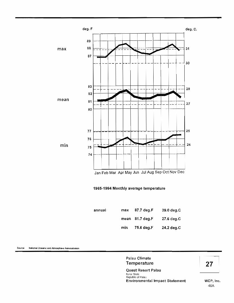
deg.F deg. C.
89
max 88
87 - "'"l.'"
/'r- - ...... --- -... t..i'" I""'". ,- 31
- - - -- r- --- -- f-- -- -- - -- - - 30
83 - -- -- -- -- 28loA.- ---- -- - - - f--- .::..iO..
82 J I'.. mean 81 27-- -- - - -- -- -- -- -- I-- -- -- --
80
min
77
76
75
74
I-
.-. .".. '-.J - - -
--,. - -
25
24
II
Jan Feb Mar Apr May Jun Jul Aug Sep Oct Nov Dec
1965-1994 Monthly average temperature
annual max
mean
min
87.7 deg.F
81.7 deg.F
75.6 deg.F
39.0 deg.C
27.6 deg.C
24.2 deg.C
Source National OCe8"IIC and Almosph9nc AdrmfllslrallOO
Palau Climate Temperature Quest Resort Palau Koror Slate Republic of Palau Environmental Impact Statement WCP, Inc.
46A

Inches cm
40r-- -- - -f-- --- - - -f--r---15
.- 30r r- I- t-
10
t-
20-f-
5
Jan Feb Mar Apr May Jun Jul Aug Sep Oct Nov Dec
1965-1994 Mean monthly precipitation
Mean yearly precipitation: 147.97 inches 376 cm
Source National Oceanic and Atmospheric AdmlrJIstrlllton
Palau Climate Precipitation Quest Resort Palau Koror Siale Republic of Palau Environmental Impact Statement WCP, Inc.
46B

o PREVAILING WIND DIRECTION. The prevailing wind direction is northeast to east-northeast (see Figure 29). This is the direction of the trade winds that dominate from November to June. During May and June, east winds predominate. From July to October the prevailing winds shift to northwest, west and southwest.
o PEAK GUSTS. The dominant direction of a recorded occurring monthly peak gusts is southwest (83 mph, November 1990). The dominant direction of monthly peak gusts with an average speed greater than 50 mph (80A kmph), recorded between 1985 and 1994 is northwest (1 occurrence), west (2 occurrences), southwest (3 occurrences). Figure 30 illustrates the wind conditions. The geographical location of Ngerur Island is such that the approach not only of the prevailing winds from the northeast/east-northeast sector but also of the peak gusts from southwest is over water and therefore unobstructed. Figure 31 illustrates this condition. Calms predominate an average of 18 percent of the time and reach their yearly maximum in the month of June.
4.5 Air Quality
Air pollution regulations as promulgated by EOPB have been in effect since 26 May 1996. The regulations incorporate specific ambient air quality standards with respect to pollutants such as sulfur oxides, particulate matter, carbon monoxide, photochemical oxidants, hydrocarbons and nitrogen oxides.
No major air pollutant sources exist on the uninhabited island of Ngerur or within its general vicinity. The air quality in the general project vicinity and on Ngerur Island is therefore expected to be pristine.
4.6 Noise Quality
No major stationary noise pollutant sources currently exist on the uninhabited island of Ngerur or within its general vicinity. Intermittent noise events may occur from motorized watercraft and overhead aircraft. Noise quality in the general project vicinity and on Ngerur Island is therefore expected to be good.
4.7 Flora
The following information is excerpted from the Report on the Botanical Survey of Ngerur Island, Republic of Palau (Herbst, 1998). Refer to Appendix B-5 for the botanical report.
"The vascular flora of Ngerur Island consists of 104 taxa in 51 families. Seventy-eight of the 104 taxa are believed to be native to Palau, but are common species widely distributed in the islands; another 23 taxa are adventive or naturalized, while the remaining [three] consist of [two] ornamental shrubs planted in a graveyard, and a fruit tree purposely introduced. These cultivated plants have not reproduced nor increased
Final Environmental Impact Statement for Quest Resort Palau 47

NE
sEsw
s
1963 Prevailing monthly wind direction and number of occurrence
1963 Prevailing monthly wind direction by month
Source: National OceanIC and Atmosptlefic Admini$tration
Palau Climate Prevailing Wind Direction Quest Resort Palau Koror Slale Repubhc of Palau Environmental Impact Statement WCP, Inc.
47A
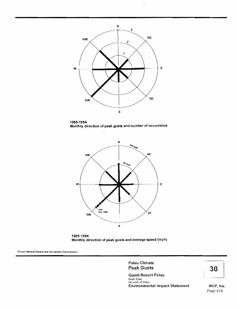
N
NENW
W+-_-+-_..... ;"'-+o--i._- E
SW SE
s
1965-1994 Monthly direction of peak gusts and number of occurrence
NW
N
'""'.. NE
____.+----+ E
SW
Nov 1990 SE
S
1965-1994 Monthly direction of peak gusts and average speed (mph)
Source" Na'!lOOal OceanIC and Atmospheric AdmlrllslTallOn
Palau Climate Peak Gusts Quest Resort Palau Koror State Republic of Palau Environmental Impact Statement WCP,lnc.
Page 476

NE ENE
) 50% of prevailing ) monthly wind direction
W
// (
Ngerur
N
--------
III
NE
ENE
E
Arakabesan
SW
SW Direction of monthly peak gusts with greatest number of occurrence and with average speeds greater than 50 mph
o 2 3km
Palau Climate Wind Pattern at Ngerur Island Quest Resort Palau Koror Stale Republic of Palau Environmental Impact Statement WCP, Inc.
47C

in number from the original plantings. Other useful plants, such as the coconut and breadfruit, which also were introduced to the island have reproduced and spread and are therefore considered naturalized components of the island's flora.
"The most comprehensive classification of Palauan plant communities probably is that of Cole et al. (1987). Their survey, which was designed primarily to assist foresters and land-use developers, divides the islands of Palau into four major land classes, based upon their vegetation: these are forest, agroforest, secondary vegetation, and nonforest. The four classes are further divided into vegetation types and subtypes, delineated on the basis of their drainage patterns and community structure. Variations in species composition occur within each general community type, and are influenced by site edaphic factors and disturbance history. While humans have utilized all of the vegetation communities in Palau, the last three listed are maintained by recent human activity; activities which have shaped these anthropogenic communities for thousands of years.,,30 Two of the five vegetation community types recognized by Muller-Dornbois and Fosberg in their recently published book, Vegetation of the tropical Pacific Islands, Mueller-Dombois and Fosberg (1998), are represented on Ngerur Island: the Interior Upland Forest and the Savanna vegetation associations.31 A single floristic element of a third association (the Mangrove and Freshwater Swamp Forest) is also present in the form of five Sonneratia alba (urur, white mangrove) trees growing in the shallow reef waters on the eastern part of the island such that this element can not be considered a Mangrove vegetation association 32
"Ngerur Island has a long history of human disturbance. At various times in the past, the island has been inhabited; it has been cleared for agricultural purposes, a chicken farm was once established on the island, and the island was used as a leper colony. As a result of the disturbance, and, additionally, perhaps the small land area of the island, the present vegetation is secondary, and a depauperate, poor example of the vegetation communities present. Many of the species ...which are used to characterize the two vegetation associations are lacking.,,33
o INTERIOR UPLAND FOREST VEGETA TlON ASSOCIATlON. "Upland forests are restricted to the volcanic islands of Palau. Floristically, the Palauan upland forest is the most species diverse vegetation type in Micronesia. Examples of trees characteristic of this vegetation type include Maranthes corymbosa, Gmelina palauensis, Rhus taitensis, Elaeocarpus joga, Garcinia spp., Pouteria obovata, Alphitonia carolinensis, Semecarpus venenosus, Calophyllum inophyllum, Serianthes kanehirae, and Pterocarpus indicus. Perhaps the most common tree in the canopies of upland forests is Campnospermum brevipetiolata, but it usually is found on flat, lower elevation lands near streams or rivers, rather than in the drier environment of this island. Common understory species of the Upland Forest vegetation type include the palms Pinanga insignis and Heterospathe elata, Ixora casei, Osmoxylon oliveri, Alpinia spp, Symplocos racemosa, Pandanus
30 Herbst, 1999. 31 Ibid. 32 Ibid. 33 Ibid.
Final Environmental Impact Statement for Quest Resort Palau 48
aimiriikensis, Manilkara udoido, Caesaria hirtella., Aglaia palauensis, Astronidium palauense, and Cyathea lunulata. Understories of the upland forests usually are relatively open. The vegetation on the eastern half of Negrur is most similar to the Interior Upland Forest vegetation type, but lacks many of the common characteristic species enumerated above that are found in the more extensive examples on Babeldaob.,,34
o SAVANNA VEGETATION ASSOCIATION. "Most, if not all, of the grassland/savanna vegetation in Palau is the result of human activity: wildfire, land clearing, or mining. These anthropogenically maintained open uplands are also quite species-rich, although they are floristically much less diverse than the upland forests sites. Cole et al. (1987) recognize five major sUb-types of the Grassland/Savanna vegetative community: Bare, Fern Lands, Grasslands, Shrubs, and Abandoned Agriculture. The sUb-types are based upon former land use and the amount and type of vegetation present.,,35 .
''The western half of Ngerur supports Grassland/Savanna vegetation. Although not a particularly good example, the vegetation fits best within the parameters of Cole's Grasslands sUb-type which comprises grasses and grass-like species frequently with ferns, shrubs, and pandanus as elements of the vegetation. Common graminoid species used to characterize this vegetative sUb-type include the grasses Ischaemum polystachyum var. chordatum, Paspalum orbiculare, and Dimeria chloridiformis, with Rhynchospora rubra, Sclera spp., and Fimbristylis dichotoma being common sedges. Associated ferns, fern allies, and shrubs may include Gleichenia linearis; Lygodium spp.; the club moss, Lycopodium cernuum; and shrubs, such as Melastoma malabathricum, Eurya japonica, Decaspermum fruticosum, and Wikstroemia elliptica.
"A list of threatened and endangered wildlife compiled by the government of Palau includes the following six plant taxa:
Gulubia palauensis (Becc.) Moore & Fosb. (bochela, uchreerak, esbouch, rock island palm), Ptychosperma palauensis (Kaneh.) Moore & Fosb. (esboLlch, Palau palm), Parkia parvifolia Hosok. (kmekumer, parkia), Pericopsis mooniana (Thw.) Thw. (amansis, kamanois, ngimet tree), Cinnamomum carolinense Koidz. (ochod, Caroline cinnamon tree), and Cinnamomum pedatinervium Meissn. (ochod, cinnamon tree).
''The two species of palms typically are members of Limestone Forest or Rock Island Forest vegetation associations, while Pericopsis usually is found in Swamp Forest communities or along sections of streams or rivers influenced by the tides. These vegetation types do not occur on Ngerur island. The other three taxa are found in Interior Upland Forest vegetation associations, and potentially could occur on Ngerur
34 Herbst, 1999. 35 Ibid.
Final Environmental Impact Statement for Quest Resort Palau 49

Island, however, none were found during the survey; all plants observed were common species widely distributed throughout the volcanic islands of Palau.
"Several plants present on Palau can be harmful to humans. Perhaps the best known of these is Semecarpus venenosus, the tonget or poison tree, Individuals allergic to relatives of this tree, which includes poison ivy, poison oak, mango, sumac, and cashew, can react painfully to exposure to its sap. Such an incident could destroy a tourist's vacation and the resort potentially could be held responsible for knowingly harboring a harmful object in their public areas. The tree was not found on Ngerur Island during this survey, however, Abrus precatorius (black-eyed Susan, rosary pea), a slender, non-native vine in the bean family is established on the island, but is not common. The hard coated, brilliant scarlet, pea-sized seed with a black spot at its point of attachment to the pod, is attractive and would attract the attention of adults and children alike; it contains the toxin abrin, a toxalbumin which inhibits protein synthesis in growing cells of the intestinal wall. Because of its hard coat, the seed is considered harmless if swallowed whole, but the ingestion of a single well-chewed seed could be fatal.36
"The island has a history of disturbance, as a result, the vegetation is secondary; the vegetative communities on the island are neither unique nor particularly good examples of their types, and are not considered worthy of preservation.,,37
4.8 Fauna
The following information is excerpted from the Biological and Water Quality Reconnaissance Surveys on Ngerur Island, Palau Lagoon, Republic of Palau (AECOS Consultants, 2000).
o INVERTEBRA TES. The diversity of species on Ngerur Island appears to be "relatively low. ...this may be due to the island's isolation, but more significantly it is likely a result of the small range of habitats and the disturbed nature of the vegetation. Terrestrial aquatic environments (streams, swamp and marshlands, etc.) are absent, eliminating a fairly important component of terrestrial ecology in wet, tropical Palau. Vegetation types are limited (see Herbst, 1999) and therefore many habitats for insects and other small invertebrates are absent or poorly represented."38
"A number of the terrestrial molluscs (snails) collected on the Island are native species. Included are two snails (Omphalotropis cheynei and Palaua babelthuapl) that are listed in the 1994 IUCN Red List of Threatened Animals.39 Robert Cowie relates the following:
"The single species [of Assimineidae] found during the survey, Omphalotropis cheynei, was widespread, occurring at 11 of 31 terrestrial sites on Babeldaob, at the single site on Koror, where it was extremely abundant. and on both Rock Islands. It appears
36 Lampe & McCann, 1985 in Herbst, 1999. 37 Herbst. 1999. 38 AECOS Consultants. 2000. 39 Groombridge, 1993, cited in Cowie, et al. 1996 in AECOS Consultants, 1999,
Final Environmental Impact Statement for Quest Resort Palau 50

highly tolerant of human disturbance, being found at some of the most disturbed sites surveyed.
"Identification of species within the genus Palaua is tentative40"
"The results ... of the taxonomic study of insects collected from Ngerur in October are still somewhat preliminary. The collection represents mostly the common species present on the island in October 1998. Many of these are introduced (naturalized species). However, one member of a presumed endemic genus of beetle (Lophothetes) was collected."41
o VERTEBRATES. Despite the comparatively rich vertebrate fauna that characterizes most areas of Palau, the island of Ngerur lacks terrestrial vertebrate biodiversity.42 Furthermore, foraging or roosting opportunities for Palauan fruit bats is limited because the vegetation currently found on Ngerur Island [refer to Herbst, 1999] is highly disturbed with almost no understory and few fruiting trees. Single bats were detected on each of three mornings on site. Palauan fruit bats are known to both forage and roost in small numbers in the forested parts of Ngerekebesang, Ngerchaol and in large numbers on Ngeruktabel.43 "The resident sheath-tailed bat is ubiquitious being present in almost all habitats in Palau even in the most heavily developed industrial areas. The dominate mammalian species on Ngerur is the roof rat. Densities encountered were extremely high. It is also likely that at least one other species of the rat the Polynesian rat may also inhabit the Island. One other species of muridae, the house mouse was also seen during our survey. We did not detect any other mammalian species on the Island. Given the high densities of roof rats on the Island it is not surprising that other vertebrate species diversity and densities were found to be low. No trapping program was undertaken in conjunction with our reconnaissance surveys in an attempt to ascertain any quantitative data on introduced mammalian species. During the course of our survey we collected anecdotal information indicating that a monkey had been reported several times from the Island. We did not detect this animal while on Island, given the coverage we gave the Island it is unlikely that the animal is still present. The other five species of terrestrial mammalian species known from the Republic of Palau are comensal or domesticated farm animals. Because the Island is currently uninhabited it is not surprising that none of these species were encountered.,,44
o AMPHIBIANS AND REPTILES. "Unlike other area in Palau [the investigators] found very little diversity in the terrestrial reptiles encountered. Recent surveys on Babaldaob would suggest that most of the resident terrestrial amphibians and reptiles found in Palau are relatively common and widely distributed throughout the Republic of Palau.45 During the course of [the October 1999] survey [the investigators] encountered only three of the 30 plus species of lizards previously recorded in Palau,
40 Cowie, pers. com. in AECOS Consultants, 1999. 41 AECOS Consultants, 2000. 42 Ibid. 43 Engbring 1992, Wiles and Engbring 1993 in AECOS Consultants, 2000. 44 AECOS Consultants, 2000. 45 Cowie et al. 1996, AECOS, Inc. 1998b in AECOS Consultants, 2000.
Final Environmental Impact Statement tor Quest Resort Palau 51

and only one of the [five] species of snakes. [The investigators] did not record either of the amphibian species commonly found throughput the rest of the country. The lack of understory and the high density of roof rats undoubtedly combine to limit terrestrial reptile diversity and populations to a minimum.
o AVIAN RESOURCES (BIRDS). The avifauna currently found on Ngerur Island is depauperate when compared to that of [Arakabesan] and other surveyed areas of Palau. Forested areas on [Arakabesan] are regularly utilized by some 28 species of resident breeding birds, whereas only 12 forest bird species were detected on Ngerur, and only one was found to be nesting 46 "This disturbed nature of the vegetation coupled with the high density of rats currently found on Ngerur Island contributes to the limited avian diversity and population densities on the island. The avifauna found on Ngerur is dominated by native and indigenous species as is that found on other Islands located in close proximity to the Island. There is little habitat on the Island suitable for migrating shorebirds.,,47 During the course of the survey conducted in October 1999, three such species utilizing the benthic shelf exposed at low tide were detected. Of the approximately 57 migratory and extralimital shorebirds and passerines that have been recorded in Palau, three of the more common ones were detected during this survey.
"The Lagoon and the Daerur straits separating Ngerur from Ngererbesang are utilized by a number of seabird species, most of the 13 species of resident seabirds use this area at least occasionally; in addition, 11 other species of migratory and extralimital seabirds recorded from Palau may upon occasion utilize resources within the lagoon and possibly the Daerur straits.
"There is no habitat on the Island of Ngerur suitable for the endangered Micronesian Scrubfowl. Ngerur does not support any suitable habitat for three of the other listed avian species found in Palau, these being the Pacific Black Duck, Common Moorhen, and White-breasted Woodswallow. Although there is no suitable habitat on the Island to attract or support the Nicobar Pigeon, it is likely that this species does occasionally utilize resources on the Island, and they may overfly the site on their way from roosting sites in the Rock Islands to foraging sites on Babeldaob.,,48
4.9 Coastal and Marine Resources
A bathymetric survey, accomplished during October 1998, shows that the 10-foot depth is typically reached at a distance of between 50 and 250 feet from the shore, and thereafter the bottom typically drops reasonably uniformly with a 1V:4H (25%) to 1V:5H (20%) slope. A wide (100 to 200 feet), shallow, rock, cobble and sediment bench is located on the southeast corner of the island, and the 1O-foot depth is up to 400 feet offshore. On the northeast and northwest corners of the island the 100-foot depth is reached within about 500 feet off the shore. A diving reconnaissance off the north end of the island showed high relief coral coverage to
46 AECOS Consultants. 2000. 47 Ibid. 48 Ibid.
Final Environmental Impact Statement for Quest Resort Palau 52

about the 3D-foot depth, and thereafter a rock, sediment and scattered coral head bottom sloping uniformly to the 100 foot plus depth.
The following excerpt is from the report prepared by PENTEC Environmental, Inc. (1999).
"The coastal and marine habitats surrounding Ngerur Island demonstrate pristine conditions, though they do not, in general, conform to classic reef flat physiography or biological zonation patterns associated with coastal reef flats. This conclusion is supported by a nonexistent to limited intertidal and subtidal sandy reef flat and the preponderance of an intertidal basalt bench. Because of limited sand and coral rubble deposits, algal density and diversity is low. Seagrass (anthophyte) stands, often abundant in coastal mudflats and sand areas around the larger island in Palau (and occurring in high-density meadows on nearby [Arakabesan] Island), do not occur at Ngerur.
"A distinctive zone of Porites lutea, in both massive and micro-atoll morphologies, characterizes the reef flats around the island, as does a narrow but conspicuous soft coral zone (family Alcyoniidae) comprised of Sinularia sp. and Sarcophyton sp. However, an estimated 95 percent of the alcyoniid corals were bleaching (yielding, in these two species, a bright yellow coloration), and moribund, and many were in an advanced stage of decomposition. A vertical and undercut basalt headland characterizes the shoreline on the south side of the island.
"Small crescent- to irregularly shaped rocky beaches occur around the perimeter of the island, though sand deposits are limited and probably experience a fugitive existence between major tropical cyclonic disturbances. Several pronounced rocky headlands protrude seaward roughly 30 meters on the west side of the island, and a massive boulder appears to have recently slumped into the intertidal zone on the east side of Ngerur.
"A massive, roughly 65-m-long basalt outcrop that partially exposes during low-tide periods forms a somewhat unusual wave-protected rocky intertidal moat an the southwest side of the island. Vertical to near-vertical rock escarpments and headlands dominate the back beach areas around most of the island, with some (on the north and west sides of the island) having steps cut into them to provide for foot access to the interior of the island from the shoreline.
"Except for a small stand of white mangrove (Sonneratia alba) occurring on the island's east side, there are no wetland or estuarine plant communities occurring on or adjacent to Ngerur Island. Coastal strand and terrestrial vegetation ranges from a mixed grassland and fern understory with scattered Pandanus and Cocos nucifera palms, to dense upland forest vegetation and planted coconut groves in areas with deeper soils. Stands of the introduced tree casuarina (Casuarina equisitifolia) occur on some rocky, wind-exposed coastal headlands and rock outcrops where soils are thin to nonexistent.
"A small, possibly hand-dug, water-filled shoreline cave exists in the supratidal zone along the west side of the island....The cave may have been excavated into the near-vertical cliff face to create a source of fresh water for drinking and bathing. Despite months of drought conditions, the small cave was filled with fresh water and harbored
Final Environmental Impact Statement for Quest Resort Palau 53

a small population of an unidentified, nearly transparent shrimp (possibly Palaemon sp; family Palaemonidae), and profuse growths of a filamentous green algae.,,49 After observed torrential rains, sheetflow cascades that originate between the island's bedrock and thin soil veneer covered most of the shoreline cliff faces. Due to relatively undisturbed vegetation and soils, runoff water appeared free of significant amounts of sil1.5o
"Assessment of the status of coral communities (and coral-associated biota) on the subtidal habitats fronting Ngerur Island has indicated the existence of a stressed benthic community. Coral bleaching and the apparent decline in coral health appears to be the result of the 1998 ENSO event, which may have produced water temperatures debilitating and perhaps lethal to corals and other benthic species. It is uncertain at this time whether the bleached corals will survive or if overall coral diversity will be reduced, at least in the near term.
"A total of 39 coral, 72 fish, 15 algal, and 43 macroinvertebrate species were recorded in the course of baseline marine surveys conducted in inshore waters around Ngerur Island. These numbers compare with 163 corals, 66 fish, 33 algae, and 13 large, noncoral invertebrate species recorded on the reef flat and lagoon slopes in January 1976, and the then-proposed marine outfall site adjacent to the southern tip of Malakal Island.51
"The existing ENSO drought and high water temperatures may account in part for the few fish and macroinvertebrates recorded at the Ngerur Island site, though this event would not have affected the abundance or distribution of represented corals. Drought conditions and assumed low surface- and groundwater runoff could pose a limiting factor governing the presence, distribution, and abundance of algae, and directly or indirectly affect fish and other organisms depending on primary production.
"In general, coral community structure, diversity, and coverage in waters fronting the project site reflect a species composition that would be expected to occur on shallow, lagoon reef flats. These communities are dominated by hardy, robust, and relatively sediment-tolerant massive, submassive, and columnar corals, interspersed with occasional colonies of small foliaceous species.
"The impact of the warm ENSO water temperatures may eventually be reflected in the amount of live versus dead coral near Ngerur Island. Clearly, many of the hard corals were stressed and many appeared moribund. It is uncertain at this time whether these corals will survive. The fate of the soft-coral community is perhaps more precarious. An estimated 95 percent of the Sinularia and Sarcophyton appeared dead, with many colonies observed in an advanced state of decomposition.,,52
The following excerpt is from the report prepared by AECOS Consultants (2000).
"Two species of listed sea turtles, the green and hawksbill turtles, are known to nest in Palau. Both have been recorded nesting in small numbers on the beaches of the
49 PENTEC Environmental, Inc., 1999. 50 Ibid. 51 Birkeland et aI., 1976 in PENTEC Environmental, Inc.. 1999. 52 PENTEC Environmental, Inc., 1999.
Final Environmental Impact Statement for Quest Resort Palau 54

Island of Babeldaob; however, the majority of the Palauan populations of both species nest south of NgeruktabelS3 There are no extensive tidal mudflats and attendant algae and sea grass in close proximity to Ngerur to attract green sea turtles. Hawksbills, on the other hand, feed principally on sponges, crabs, sea urchins and jellyfish, thus might be more likely to be found in the waters off the Island. In talking with local residents familiar with the Ngerur area, they all stated that they very rarely saw sea turtles in close proximity to the Island.
'The resident saltwater crocodile population has undergone a major drop in numbers due to human persecution. Messel and King estimate that at it's height the resident population of crocodiles in Palau was close to 1,500 animals. Results from their extensive and very comprehensive survey conducted in 1991, indicate that the current population of this endangered crocodile is between 85 and 150 animals. They identified two remaining viable populations in Palau; one on Babeldaob in Ngerdok lake, and the other on Peleliu Island. They did encounter straggler animals in very small numbers in Airai, Ngeremeduu Bay, and along the west central coast on the Irur and Iwekei rivers. 54 From their interviews with resident Palauans, Messel and King also reported that there is some movement of young crocodiles through the Rock Islands. There is no habitat on Ngerur Island suitable to support crocodiles.,,55 Only one of the three species of legally protected marine mammals known to occur in Palau has ever been recorded within the lagoon or close to the Island of Ngerur: the dugong (Dugong dugon). Both the blue whale and sperm whales are known from the oceanic regions of the Indio-Pacific area, but neither is expected to frequent the project vicinity.
"... the resident population of dugong in Palauan waters is estimated to number between 26 and 50 animals56 It has been estimated that the current food supply available in Palau is sufficient to support some 2000 animals. 57 However, given the low reproductive rate of this species and the unlikely chance of natural recruitment from other populations, this resident species is severely endangered. The principle predator of dugong are humans. If illegal poaching continues it will not be long before this species is extirpated from the Republic of Palau.
"Through most of their range dugongs spend their day in deep water, returning to shallower sea grass beds in the evening to forage. In Palau, dugongs forage in mixed seagrass beds made up of a variety of seagrass species including; Enhalus acoroides, Thalassia hemprichii, Halophila ovata, Cymodocea rotundata and Syringodium isoetfolium. 58 They have also been recorded ingesting crabs, and in Palau, at least two species of sea cucumbers (Holothuria atra and H. scabra. 59 In Palau, dugongs usually graze in lagoonal waters deeper than 7 meters which support relatively low biomass seagrass beds 60
53 Prichard 1982 in AECOS Consultants, 2000. 54 Messel and King 1991 In AECOS Consultants, 2000. 55 AECOS Consultants, 2000 56 Brownell et al. 1981, Marsh et al. 1992, 1995 In AECOS Consultants, 2000. 57 Helnsohm et aI1977, Anderson and BIrlles 1978, in Brownell et al. 1981 in AECOS Consultants, 2000. 58 Marsh et al 1992, 1995 in AECOS Consultants, 2000 59 Brownell et al. 1981, Walker 1983 in AECOS Consultants, 2000. 60 Marsh et al. 1992, 1995 in AECOS Consultants, 2000.
Final Environmental Impact Statement for Quest Resort Palau 55

-------------------
"Aerial surveys of dugong in Palau in 1978, 1983 and 1991 all found that the largest number of dugong were consistently found in the Malakal Harbor area.61 During the course of these same aerial surveys the closest that animals were detected to Ngerur Island, other than those recorded in the Malakal Harbor, was approximately 20 kilometers away62 There are no suitable sea grass beds in close proximity to the Island; however, it is possible that animals occasionally pass close to the Island on their way to foraging areas located close to the outer reef and off of the north west coast of Babeldaob."63
4.10 Historical and Archaeological Resources
During the Japanese administration, around the year 1930, a leper colony was established on Ngerur Island. Most of those banished to the island were Palauans, although a few foreigners were included. The fear associated with this disease attributed Ngerur Island a status of kapu. This fact was partially responsible for the lack of military defense installations there, despite the island's proximity (only 2 and 3 kilometers respectively) to the Arakabesan seaplane bases and strategic benefit (it would have provided control of the northern access to Malakal Harbor).
Thus Ngerur was excluded from the Japanese military build-up and avoided becoming a bombing and strafing target during U.S. air strikes launched from Aircraft Carriers on March 30 and 31, 1944 and July 25 through 27, 1944. Seaplane bases on nearby Arakabesan were destroyed during those bombing operations.
The presently remaining archaeological features on the island are almost entirely associated with the leper colony. A few of these features were presumably constructed or reconstructed after World War II when members of the Etpison family lived on the island.
Ngerur Island is practically devoid of remains of traditional Palauan culture. Eighteen (18) shovel tests placed across the island revealed no cultural deposits.
Fifty-eight (58) archaeological features with a wide range of feature-types were recorded on the island during the survey in October/November of 1998 (see Figure 32 and refer to Table 3 in Appendix &6). The features are the result of domestic and farming activities by the leper colony established under the Japanese administration. Recorded features include a cemetery containing some 23 individuals. Additional burial sites, scattered on the island are assumed.
Ngerur Island is identified as Site OR-12:47 and is evaluated as "significant" under Criterion D of the Palau National Code, Title 19, the Palau Historical and Cultural Preservation Act. Criterion D defines significance as "possession of integrity of location, design, setting, materials, workmanship, feeling, and association and a potential to yield information important in Palau's history.,,64
61 Marsh et al. 1992, 1995, Rathbun et al. 1988, Brownell et al. 1981 in AECOS Consultants, 2000_ 62 Ibid. 63 AECOS Consultants, 2000. 64 Palau National Code, Title 19.
Final Environmental Impact Statement for Ouest Resort Palau 56

5956 *9
55
2
38
(opp.ro.,mol. scole)
"'" /Cutlx>N\ o xcUllfcd c<>bbCs ..r-' rQ(Q11X1enl ..- Red d><jnmetllc:J Rock Jeol.... __ goo<
O\&leIop o "".,..,*Pc:Lt 8uriolfPolttlllol 'o<.r'd oao
Ngerur Island Archaeological Features Quest Resort Palau Koror Stale Republic of Palau
o 20 Environmental Impact Statement WCP, Inc. 56A

4.11 Hazardous and Toxic Materials Considerations
For the most part, Hazardous and Toxic Materials (HTM) are not yet critical issues in the Republic of Palau due to the absence of heavy industry. Areas that have not yet been touched by modern development and consumer lifestyles remain notably pristine with respect to HTM. Nevertheless, the use and disposal of HTM is expected to increase in conjunction with urban development. Potential environmental degradation may be associated with HTM misuse, illicit disposal or spills. Sources of contamination may include fueling stations and storage area, power plants, quarries, construction sites and asphalt batching plants.
The ROPG, through the Pesticide Program, undertakes use inspections, import monitoring, market surveillance, monitoring of pesticide container disposal and pesticide application testing. Currently, there are no specific HTM substance regulations other than for pesticides. EOPS currently performs limited testing for environmental contaminants.
Considerations pertaining to a potential ordnance hazard are associated with the militarization of the Palau Islands by Japan after the First World War and from military buildup during World War II. Ammunition stockpiles that were dumped into streams, thrown over cliffs or abandoned at remote storage sites continue to be discovered. Other potential ordnance sites include terrestrial and marine post-war dumpsites, reef areas and mangrove channels that were subjected to severe American bombardment during the World War II.
The absence of military use on Ngerur Island suggest that the potential for discoveries of unexploded ordnance (UXO) is low. A UXO field reconnaissance survey was conducted by Bombs Away, Inc. (refer to the appended report). The UXO Consultants "walked the perimeter of Ngerur Island and criss-crossed the island on foot using hand-held magnetometry equipment."65 A hydrographic survey was also accomplished in the waters around the island using divers who visually inspected the area to a depth of sixty feet.
The following information is excerpted from the UXO Survey Report, Ngerur Island, Palau (Bombs Away, Inc.). Refer to Appendix B-7 for the investigation report.
"An ordnance item was found on the shoreline. The item was a projectile. This item was brought to the island recently and it appeared to be modified. The filler is cement and perhaps the item is now used as some sort of anchor for a buoy perhaps. The item poses no hazard. Normally, this type of item would pose a high explosive threat. The island has many 'hot' rocks. This means that many of the rocks on the island have the signature of a piece of ferrous metal. This is not uncommon. Outside the rocks, no other magnetic anomalies were found."66
65 Bombs Away, Inc., (no date). 66 Ibid.
Final Environmental Impact Statement for Quest Resort Palau 57

4.12 Land Use Considerations
During the session of the Sixth Koror State Legislature, July/August 1999, the Koror State Zoning Map was amended to re-zone Ngerur Island from CD "Conservation" to RV "Resort Center Zone" (refer to Appendix B-8). Figure 33 illustrates the existing land use classifications. The intent of the RV "Resort Center Zone" is intended to provide areas for integrated resort development that would include a variety of visitor-oriented uses and to encourage economic development by protecting areas particularly suited to resort use from encroachment by other
67uses
Per §3162 of the Koror Zoning Law, no building or land shall be used and no building erected except for one or more of the following specified uses in the "RV" Resort Center Zone.
• Hotels; • Restaurants, nightclubs, bars and other similar uses; and • Accessory buildings and uses customarily incident to the above uses.
Per §3164 of the Koror Zoning Law, area and bulk requirements are the following:
• Maximum density is 20 guest bungalows per acre; • No minimum lot size required; • Front yard setback is 20 feet; • Side yard setbacks are 10 feet; and • Rear yard setback is 10 feet.
4.13 Aesthetic Considerations
The remote island of Ngerur is situated in the Palau lagoon and away from the main islands such that panoramic views from the island are largely unobstructed and most often spectacular. Main vistas from Ngerur Island extend in a northeastern direction toward the large rnain island of Babeldaob; views to the southeast encompass the distinctive silhouettes of distant Rock Islands. To the southwest lies Arakebesan Island; it is the nearest landmass to Ngerur Island and the feature that defines the horizon. The remaining western and northern views are of the unobstructed and open lagoon and ocean waters.
4.14 Public Services and Facilities
4.14.1 WATER SYSTEM
In its current state, the uninhabited and undeveloped island of Ngerur has no water system and generates no demand for this service. The island is situated outside the area served by the nearest municipal water supply system.
67 Koror Zoning Law
Final Environmental Impact Statement for Quest Resort Palau 58

Ngerur Js.
PROJECT LOCATION
Arakabesan Is.
Ngerchaof Is. Koro, Is
1-1 i ....""\_ _._.1.__.1 )
. I , I
co </1-1i
/ \ . I ,. I
..v"....,! ,./'.' ,. Malakalls. 00<::> o
0°Ufebsechells.Sources: Zoning Map, Koror - Koror Planning Commission 1998 {\ /KSPL No K6·102·99 (Bill No. 6-42, LD1)
Koror State Zoning Map (Detail) Quest Resort Palau Koror Slale
o Republic of Palau 2km Environmental Impact Statement WCP, Inc.
58A

The Republic of Palau Office of the Minister, Ministry of Resources and Development, Bureau of Public Works (BPW) is responsible for the operation and maintenance of the Koror-Airai water supply system. Water sources for the Koror water supply system are generated in Airai State at Ngirimel dam and Ngirikiil River. The total average discharge is 40 million gallons (150 million liters) per day. The water from these two sources is processed at the Airai Water Treatment Plant and then supplied to the consumers in the urbanized Koror-Airai areas.
Currently, an uninterrupted supply of potable water is not guaranteed by the BPW. A new water treatment plant is nearing completion, but is not expected to be fully operational until the year 2000. With its completion, an uninterrupted supply of water can be anticipated; however, the distribution system has undersized pipelines that may restrict the ability to deliver water and/or deliver at an adequate pressure.
4.14.2 WASTEWATER SYSTEM
In an undeveloped and uninhabited state, the island of Ngerur contains no wastewater system and generates no demand for this service. Ngerur Island is situated outside the area served by the nearest municipal wastewater collection and disposal system.
Koror is the only state in Palau that has a centralized wastewater collection and disposal system. The Sewer Branch of the BPW is the government agency that handles the day-to-day operations of the wastewater collection system. The primary functions of the BPW with respect to the municipal system include the operation, maintenance, repair and overhaul of the system, including sewage pump stations.
The Sewer Branch of the BPW also operates and maintains the Malakal WWTP located in the southeastern part of Malakal Island. Treated effluent is conveyed downwards via a 2,000-foot (616-meter) long sewage outfall pipe with a diameter of 18 inches (46 centimeters) to a depth of approximately 60 feet (18 meters) in Malakal Harbor. There, the effluent is discharged through two 6-inch (15-centimeter) diameter pipe diffusers and dispersed with the tidal currents.
Malakal WWTP was originally designed for a treatment capacity of one million gallons of domestic wastewater per day and put in operation in the late 1970's. Indications are that this WWTP is presently operates only in primary treatment plant despite its design which allows for secondary treatment.
Wastewater flows received at the plant have been steadily increasing. This is expected to continue. The plant averaged about 1.3 mgd during the first three months of 1993. Flows during prolonged periods of wet weather have reached as high as 2.4 mgd. Available studies project a potential average of 1.7 mgd by the year 2000. Accordingly, the expansion of the treatment capacity of the Malakal WWTP is "one of the highest priorities of both the Palau National Government and the Koror State Government.,,68 Proposed expansion of the WWTP
6B Republic of Palau Office of the Minister, 1999.
Final Environmental Impact Statement for Quest Resort Palau 59

"is designed to double the capacity of the treatment facility, up from 1.0 mgd to 2.0 mgd.,,69 With the canceling of the expansion contract, the ROPG is exploring renovation of the existing plant and the subsequent implementation of a wetland treatment system. The ROPG is contemplating construction contracts and pursuing adequate funding for the improvements. Wastewater lines continue to be problematic for the collection system in areas where the full load of the collection system is concentrated (e.g., Malakal). Wastewater has surcharged the manhole lids during heavy storm events and infiltration/inflow (11/) problems plague the system.
4.14.3 DRAINAGE AND IRRIGATION SYSTEM
The undeveloped and uninhabited island of Ngerur contains no manmade storm drainage systems at this time. Storm runoff must either percolate through the surface soils or drain by undirected sheetflow via natural drainage routes.
4.14.4 SOLID WASTE DISPOSAL SYSTEM
The undeveloped and uninhabited island of Ngerur is not currently served by an organized garbage collection system. In its current state, Ngerur Island generates no demand for solid waste disposal service and lies outside the service area. Nevertheless, numerous instances of litter presumably left by periodic visitors have been noted on the island.
The public dump site is located on a bund over reef flats adjacent to "M" Dock in central Koror. A study for the closure and relocation of this primary public disposal site was recently completed. A site selection effort for the new landfill site in the Nekken/Oisca region is presently underway by the Ad Hoc Committee on Aimeliik State Sanitation Facility. The Australian firm of Golder Associates has already been contacted to do the initial design and establish project costs. Preparation for the transfer of the landfill site would also involve excavation of materials in the old dump and their relocation for final disposal at the new site.
4.14.5 ELECTRICAL AND COMMUNICATION SYSTEMS
Ngerur Island lacks electrical and communication systems at this time. In its undeveloped and uninhabited state, Ngerur Island generates no demand for electrical or communication service. The project site lies outside the service area for electrical and communication service.
The Republic of Palau, like many Pacific Island nations, relies heavily on imported petroleum fuels to generate electricity. Electrical power generation accounted for 44 percent of petroleum consumption in 1993 and is a major sector of the economy. The ROPG in the form of the Public Utility Corporation (PUC) is the only entity to produce and sell the power as a utility service.
69 Republic of Palau Office of the President, 1999.
Final Environmental Impact Statement for Quest Resort Palau 60

Two main power-generating facilities are the 12.8-megawatt Aimeliik power plant and the 6.25-megawatt Malakal plant. Electrical power is distributed via overhead lines on concrete poles that have that have largely replaced wood poles. PUC is responsible for maintaining assets, retailing electric power to consumers and operating the government-owned power system.
Palau National Communication Corporation (PNCC) is a public corporation and provides and operates both domestic and international telecommunication services within the Republic of Palau. Overhead cables are being replaced with an underground copper distribution system. Fiber optics and microwave technologies are also being utilized to expand the telecommunications system.
ROPG involvement extends to cable TV service and the radio broadcasting system. Expansion of the cable TV network is occurring with the expansion of the underground fiber optic network. A privately owned and operated 175-kilowatt radio broadcasting system (KHBN) provides and alternative to the Republic of Palau-owned and operated 5-kilowatt station (WSZB).
4.14.6 CIRCULATION AND TRAFFIC
Ngerur Island is presently uninhabited and accessible only by boat. Since it is in private ownership and there are few visitors, the island lacks a landing dock for small vessels. Due to the topography of the island, there are few areas where access from boat is relatively easy. All circulation on the island is by foot.
4.14.7 DOCKING FACILITIES
The privately owned, undeveloped and uninhabited island of Ngerur contains no docking facilities at this time. The low usage of the island by the owners or their guests generates little demand for formal docking facilities at this time.
4.14.8 PUBLIC SAFETY AND FIRE PROTECTION SERVICES
Ngerur Island in its undeveloped and uninhabited state generates little demand for public safety or fire protection services. These services are administered by the national government through the Ministry of Justice. Koror has been the center for a majority of the services now under this ministry for most of the years since World War II. Limited services were extended to Airai in 1976 with the connection of the K-B Bridge and to other Babeldaob states in 1980 as roads were established. Further expansion of facilities (i.e., sub-stations) and services is being developed. Infrastructure strengthening and development to streamline and improve the information system for the Ministry is ongoing. Improvements are expected to enhance reporting and management.
Final Environmental Impact Statement for Quest Resort Palau 61

4.14.9 HEALTH CARE AND EMERGENCY SERVICES
In an uninhabited state, the island of Ngerur hosts no permanent resident population requiring health care and emergency services. These services are provided by the ROPG through the Ministry of Health as mandated under Article 6 of the Constitution and 24 PNC. The government-operated Belau National Hospital (BNH) is a fairly new 80-bed facility that is situated on the island of Arakabesan. Public health services include preventive and primary health care services are provided through regular outreach services via boat and motor vehicles.
Belau Medical Clinic and the Seventh Day Adventist Clinic are private facilities staffed with physicians who have hospital privileges at BNH. The clinics provide medical and primary care services. Optical and dental services are available at the Seventh Day Adventist Clinic.
4.14.10 EDUCATIONAL SERVICES AND FACILITIES
In an undeveloped and uninhabited state, the island of Ngerur hosts no permanent resident population requiring educational services and facilities. The educational system in the Republic of Palau is generally modeled after the U.S. system in terms of goals, curricula, technology and governance. The ROPG provides free and compulsory education to all Palauan children between six and fourteen years old through an eight-year elementary program in accordance with PNC Title 22, Subchapter IV, §159.1414. The Ministry of Education budget for the 1995-1996 school year was $5,398,771, or an equivalent of $1,912 per student.7o Every child in Palau has had the opportunity to subsidized education within the proximity of his/her home for the past 50 years. The public school student/teacher ratio averages ten students to one teacher. 71
There are twenty-two public and two parochial elementary schools distributed throughout the sixteen states of the Republic of Palau. Of this number, Koror has three public and two parochial schools. There are five parochial high schools and one public high school in the Republic of Palau. Of this number, three schools are located in Koror and three are on Babeldaob. Free education services are provided at the public high school to ninth to twelfth grade students who pass the high school entrance examination.
Palau Community College, formerly a trade school, is becoming a two-year college offering basic liberal arts courses. Specific courses in tourism-related and business areas are being developed to meet local needs and the increased demands of a developing economy.
70 PRI 1996 71 SAGRIC Ply. Ltd., 1996.
Final Environmental Impact Statement for Quest Resort Palau 62
4.14.11 PARKS AND RECREATIONAL FACILITIES
The island of Ngerur does not contain a public park nor does it serve as a public recreation resource. In an uninhabited state, the island of Ngerur hosts no permanent resident population requiring parks or recreational facilities.
4.15 Socio-Economic Considerations
4.15.1 DEMOGRAPHICS
In its undeveloped state, the island of Ngerur contains no resident human population. The island therefore makes no contribution to the population of the Republic of Palau.
The 1990 Census indicated a population of 15,122. The median age was 25.7 years. In 1995 the total population of the Republic of Palau was estimated to be 17,408, consisting of 13,384 Palauans and 4,024 foreigners. The average growth trends during the last three decades were as follows:
During the 1950's 3.1 percent During the 1960's 2.5 percent During the 1970's: relatively stagnant During the 1980's: 2.4 percent During 1990 to 1995: 2.9 percent (estimated)
It appears that the increased growth rate during the 1990's is due to the influx of foreign labor, 75 percent of which originates in the Philippines and 10 percent originates in Taiwan and China. Foreign workers totaled an estimated 4,300 in 1992.
The geographic distribution of Palau's population is extremely uneven, with 69 percent of the population being concentrated in the State of Koror. The next highest populated States are Airai (8 percent), Peleliu (4 percent), and Aimeliik (2.9 percent). The average of the remaining states is 1.3 percent.
Assuming a proportional growth in State population with the national trend, Koror will have a population of 14,106 by the year 2000, or 69 percent of a projected total population of 20,314.
The following table shows the population distribution for the year 1990. Slightly more than 30 percent was less than 15 years of age. At the other end the age distribution, about six percent of the population was 65 years old and over.
Final Environmental Impact Statement for Ouest Resort Palau 63

TABLE 11: 1990 POPULATION DISTRIBUTION.
I······ AGE GROUP IN 1990 TOTAL .MALE FEMALE TOTAL PERCENT
Less than 5 1.513 766 747 9.4 --
5-9 1,529 793 747 10.1 10 - 14 1,534 807 727 10 1 15 - 19 1,464 795 669 9.7 20- 24 1,340 738 602 8.9
I
25-29 1,403 799 604 9.3 30 - 34 1,338 768 570 8.8 35-39 1,243 720 523 8.2 40-44 873 514 359 6.3
-. 45-49 666 ---- 375 291 "' --- 4.4
50 - 54 513 279 234 3.4 55 -59 403 208 195 2.7 60- 64 387 181 206 2.6 65-69 332 154 178 2.2 .. 70 -74 249 117 132 1.6 75 plus
YTAL. ;,;,,,,+:i:):)/.. I'· 335 125
.15;1221') .. 210
,"i ..·'·,···.· 2.2 100 ... ,ii,
Economic Development Plan population projections based trends of birth, death, and migration rates are provided below for a projection period up to the year 2020:
TABLE 12: ECONOMIC DEVELOPMENT PLAN POPULATION PROJECTIONS.
YEAR POPULATION GROWTH RATE (%) 2000 20,314 2.609% 2005 22,947 2.262% 2010 25,513 1.95% 2015 27,967 1720% 2020 30,326 1.543%
I
The Republic of Palau Committee on Population and Children has developed another set of population growth projections through the year 2020. This committee considered three population scenarios:
• A high growth scenario estimates the 2020 population to be 35,298; • A moderate growth scenario estimates the 2020 population to be 25,885; and • A sustainable growth scenario estimates the 2020 population to be 20,279.
Final Environmentallrnpact Statement for Ouest Resort Palau 64

__
TABLE 13: POPULATION PRO,IECTIONS (HIGH GROWTH SCENARIO),
..'.•. ....(;; ••1' :Y;.·\\!C}··•.C;.;•.•.; .......'.:;. .•.• ···;1•. .•.·• 2005' Palauan population Potential Palauan labor force Labor force participatiCl.r1..___..___ Palauans in the labor force
Workers required by economy
Non-Palauan workers Non-Palauan population
TOTAL POPULATION
13,120 14,193 8,133 9,509 62% 75%----_._. --_.. 5,029 7,134 -_..
7,759 24,932
N/A 18,155 4,105 21,105
17,225 35,298 -
". 20.10 ,.' .....' 2920' 15,222 16,350 17,445 10,351 - 11,281 12,211 77% 79% 80% -7,970 8,912 ._- --
9,769 ---- .•._,....------- ----
33,198 42,170 53,546
25,625 33,704 44,265 30,688 40,068
45,910 56,418 TABLE 14: POPULATION PROJECTIONS (MODERATE GROWTH SCENARIO),
Palauan population Potential Palauan labor force Labor force participation Palauans in the labor force
Workers required by economy
woe''';Non-Palauan population
TOTAL POPULATION
13,120 14,193 15,222 16,350 17,445 8,133 9,509 10,351 11,281 12,211 62% 75% 77% 79% 80% ----5,029 7,134 7,970 8,912 9,769
7,759 16,547 21,196 26,313 32,810
n.a. 9,770 13,624 17,847 23,529 4,105 11,687 15,932 20,583 26,807
17,225 25,880 31,154 36,933 44,252
TABLE 15: POPULATION PROJECTIONS (SUSTAINABLE GROWTH SCENARIO),
1IIIIIIIlllllll,,:i••.·....... ;:........,(; ·i/· _1:V"""'m& ...., ...../.,;:ii?, .. Palauan population 13,120 14,193 15.222 16,350 17,445 Potential Palauan labor force 8,133 9,509 10,351 11,281 12,211 Labor Force participation 62% 75% 77% 79% 80% Palauans in the labor force 5,029 7,134 7,970 8,912 9,769
Workers required by economy 7,759 11,492 13,682 16,147 19,045 _... -
Non-Palauan workers n.a 4,715 6,110 7,681 9,764-,.-_Non-Palauan population 4,105 6,086 7,633 9,373 11,6481--- ...-
._......-TOTAL POPULATION 17,225 20,279 22,855 25,723 29,093-- ..L.
Final Environmental lrnpact Statement for Quest Resort Palau 65

••••••••••••••
An illustration of the three population projection growth scenarios is presented below.
TABLE 16: ILLUSTRATION OF PROJECTED GROWTH SCENARIOS.
70,000
60,000
50,000
40,000
ustainable Growth30,000 ...
20,000
Palauan Population
10,000
1995 '---------;2'"""0=00 2005 2010 2020
The Office of the President's Committee on Population Policy and Children formulated a Draft National Population Policy. Two of its main recommendations are listed below:
• That population growth be contained in balance with Palau's environment and infrastructure; and
• That an effective balance be maintained between Palauan and non-Palauan residents.
4.15.2 HOUSING
There is currently no resident human population on Ngerur Island resulting in no housing demand. As a result of its undeveloped and uninhabited state, the island of Ngerur makes no contribution to the available housing supply
So far, homelessness and lack of shelter are relatively unknown in the Republic of Palau. This fact is most certainly influenced by the traditional Palauan culture and is expected to continue as long as this traditional influence remains strong.
Final Environmental Impact Statement for Quest Resort Palau 66

Census data indicates that in 1990 there were 3,312 houses as compared to 2,496 in1986. This reflects an increase of 816 houses or 33 percent. Of the total housing stock in the Republic of Palau, 63 percent or over 2,00 housing units are located in Koror State.
4.15.3 LABOR AND EMPLOYMENT
In an undeveloped state, the island of Ngerur contains no activities that generate employment opportunities or create a labor demand. Ngerur Island therefore makes no contribution to the labor supply and job market in the Republic of Palau.
Palau's labor force as a percentage of the total population sixteen years and older has been rising from approximately 40 percent in 1980 to approximately 60 percent in 1990. In 1990, slightly more than 50 percent of the potential Palauan work force was participating in the formal labor force.
Of the total 1990 labor force of 6,072 persons. 68.5 percent were Palauans and 31.5 percent were foreigners. Nearly four fifths of the foreigners were from the Philippines.
Palauan workers generally dominate the public sector, whereas foreign labor force increasingly dominates the private sector.
Employment projections for the year 2000 for different industry categories show that four categories are projected growing to represent more than 10 percent each of the total projected employed work force of 8,533 in that year:
• The tourist sector to 16.7 percent; • The professional service sector to 15.0 percent; • The construction sector to 14.6 percent; and • The retail trade sector t013.1 percent.
In order to assess local recruitment opportunities for employment and training in the tourist sector during the next ten years, the population figures of 199072 were be extrapolated. The two most important age groups of 1990 in this respect are age 5 to 9 and age 10 to 14 years. The 5 to 9 year old population group of 1990 will be 15 to 19 years old in 2000. This segment of the population had a 1990 total of 1,529 persons (counting both sexes). The 10 to 14 year old population group of 1990 will be 20 to 24 years old in 2000. This group had a 1990 total of 1,534 persons (counting both sexes).
The extrapolated figures represent an important segment of the local population available to the future labor market in general and the tourist sector specifically. It is presumed that within this age group the motivation for work is very high since it might include training and prospects for career advancement.
72 ROP Economic Development Plan 1995-99.
Final Environmental Impact Statement for Quest Resort Palau 67

The combined total of the two age groups described above is 3,063 persons. Experience shows that the out migration rate in this age group is approximately 14 percent or roughly 420 persons. The remaining total number is therefore 2,640 persons.
Employment of the tourist sector is projected to represent approximately 17 percent of the work force. If the same percentage of 15 to 24 year olds in the year 2000 decides to work in the tourist sector, their available work force in this sector would represent approximately 450 persons (counting both sexes) in the year 2000.
A combination of these figures with the above mentioned growth scenarios results in the following conditions:
• The sustainable growth scenario projects approximately 1,860 newly required jobs in the year 2000. By assuming that 17 percent of the labor force is in the tourist sector, the newly required work force in the tourist sector would be approximately 320. In this growth scenario the newly required work force in the tourist sector in 2000 could be supplied by the available local population growth in the 15 to 24 year old age sector.
• The moderate growth scenario projects approximately 4,400 newly required jobs in the year 2000. By assuming that 17 percent of the labor force is in the tourist sector, the newly required work force in the tourist sector would be approximately 750. In this growth scenario the newly required work force in the tourist sector in 2000 could not be fully supplied by the available local population growth in the 15 to 24 year old age group. Either local workers from other sectors, other local age groups or imported workers would have to be considered to fill the job vacancies.
The following tables illustrate the labor need in the tourist sector for the years 2000 and 2005 not only in relation to a specific age group but in relation to the whole Palauan population. The data is based on the projection numbers of the three mentioned growth scenarios furnished by Palau's Committee on Population and Children. A continuing 17 percent labor ratio in the tourist sector is assumed.
TABLE 17: YEAR 2000 PROJECTED LABOR FORCE IN TOURISM.
Total work Required work Palauan work Required foreign force required force in tourism force in tourism work force in tOLJrism_
_.
High Growth Scenario 16,345 2,770 1,033 1,737
.. _. Moderate Growth
Scenario 12,153 2,060 1,033 1,027
Sustainable Growth Scenario _. 9,625
. 1,632 1,033 .__._.. __. 599
Final Environmental Impact Statement for Quest Resort Palau 68

TABLE 18: YEAR 2005 PROJECTED LABOR FORCE IN TOURISM.
Total work Required work Palauan work Required foreign force required force in tourism force in tourism work force in tourism
High Growth Scenario 24,932 4,238 1,212 3,026
Moderate Growth Scenario 16,547 2,812 1,212 1,600
Sustainable Growth Scenario 11,492 1,953 1,212
-741
I
4.15.4 ECONOMIC CONDITIONS
The island of Ngerur is undeveloped such that it contains no income-generating activities. Ngerur Island therefore makes relatively no contribution to the national or local economy.
Since the basis for a self-reliant economy is to pay for its own domestic consumption and investment needs, the Palau government will pursue the course of redirecting consumption as much as feasible from imports to domestic production of both goods and services. The service sector, including government services is the predominant part of the Palauan economy. The service sector represented 60 percent of the Gross Domestic Product (GOP) in 1992, whereas government services alone accounting for 16 percent.
Hotels and restaurants represent a growing segment of this sector; however, tourism growth represents a decisive challenge insofar as it must be accomplished in a sustainable manner in order to remain a centerpiece of Palau's market economy. This can only be achieved if the conservation and sustainable management of Palau's unique terrestrial and aquatic resources are guaranteed in spite of invited tourism growth.
The key to the survival of Palau's pristine environment and incomparable marine resources depends, as tourism projects in other parts of the world demonstrate, in the attraction of predominantly small scale, unique resort projects designed to attract a limited but affluent number of travelers.
Final EnYironmentallmpact Statement for Quest Resort Palau 69

5.0 ENVIRONMENTAL CONSEQUENCES
This chapter is organized according to the resources that may be affected by the proposed action. Discussions and evaluations of the environmental consequences for other alternatives and no action are unnecessary because all of the other options and no action were eliminated from further consideration (refer to Chapter 3.0).
5.1 Geography and Topography
Project actions are expected to have no effect on the geography of the project site. No mitigation with respect to the geography is therefore warranted.
Localized alteration to the topography of Ngerur Island from earth moving and land filling activities will occur as a result of construction activities such as grading and excavation for the placement of structures. Creation of the harbor will also affect the underwater topography in areas of proposed dredging. The above-mentioned activities are necessary for the development of the proposed resort and its related features.
The beneficial use of the island as a result of proposed resort development is expected to partially offset unavoidable impacts associated with construction. Specific mitigation measures that minimize impacts from erosion, runoff and sedimentation are described in subsequent sections of this document (refer to Sections 5.2 and 5.3).
Construction practices will be accomplished with best management practices (BMPs) in an environmentally responsible manner consistent with the required earthmoving permit issued by
Final Environmental Impact Statement for Quest Resort Palau 70

EQPB. The construction Contractor will employ the environmental protection measures described in the EPP. Dredging will be accomplished only to the extent necessary for the dive grotto area and for harbor creation; other earthmoving activities (e.g., grading, excavation, the placement of fill) will be similarly accomplished only to the extent necessary for buildings and project features. As a result of these measures that are included as project features, no mitigation is proposed or considered warranted.
5.2 Geology and Soils
The underlying geology of the area will be minimally affected by project actions associated with proposed resort development. No mitigation with respect to the geology is therefore proposed or considered warranted.
Potential erosion could occur as a consequence of localized alterations and land-disturbing activities (grading, excavation, the placement of fill). Exposed soils are susceptible to erosion, especially if it rains heavily during site work periods. Wind erosion is expected to cause some unavoidable soil loss, but the greater concern is silt runoff. Potential adverse impacts are expected to be short-term and temporary; however, completion and operation of the resort project is expected to result in no adverse impacts to soils. As a result of the proposed action, developed areas will consist of impermeable surfaces and bare subsoil areas that have been landscaped to generally re-establish the soil retention value of removed vegetation.
Disturbances to the ground surface will be accomplished only to the extent necessary for construction. General recommendations from the geotechnical engineering exploration report (Geolabs, Inc., 1999) are listed below; specific recommendations pertaining to shallow foundations, retaining structures, the utility building, walkway slabs, pile foundations, site grading, breakwater structures, utility trenches and drainage are included in the appended geotechnical engineering exploration report.
"... a shallow foundation system consisting of posts-and-beams may be used to support the one to three-story buildings planned for the resort development. An allowable bearing pressure of up to 3,500 pounds per square foot (psf) may be used for the design of the post footings bearing on the stiff soils and/or volcanic rock surface. The recommended bearing pressure may be increased to 10,000 psf for footings embedded into the dense volcanic breccia rock formation anticipated at shallow depths. A minimum footing embedment of 1 and 4 feet may be used for footings bearing on the dense volcanic breccia rock and the near-surface stiff soils, res pectively.
"For the docking facilities and boat canopy structures planned for the proposed resort development, ... 16-inch octagonal, precast prestressed concrete piles end-bearing in the dense volcanic breccia rock formation [may] be used to support the proposed structures. The driven piles may be designed based on an allowable compressive load of about 200 kips (100 tons). A preliminary pile length of up to about 30 feet may be used for the recommended pile foundation design. Installation of the driven pile foundation should be conducted after the harbor dredging operation to reduce the
Final Environmental Impact Statement for Quest Resort Palau 71

potential for disturbance to the driven pile foundation and reduction in pile capacity. In order to facilitate the pile driving operation into the dense volcanic breccia rock formation, predrilling at the proposed pile location to Elevation -22 feet MSL (10 feet below the finished dredged elevation) will be required prior to pile installation. The diameter of the predrilled holes should be at least 24 inches in diameter to facilitate socketing the pile into the dense volcanic breccia rock formation and to provide the necessary lateral load resistance to the pile foundations. The annular space between the drilled hole and the pile should be grouted.
"... the proposed harbor area enclosed within the shoreline and the breakwater structure will be dredged to a depth of about Elevation -12 MSL. Based on the subsurface materials encountered in [the] borings, ... the materials encountered within the harbor area may be excavated tot a slope inclination of about 2H:1V from the existing mudline down by about 5 feet to account for the sediments in the area. Below the upper 5 feet measured from the existing mudline, ...a slope inclination of O.5H:1V may be used for the dredged excavations, which will likely expose the dense volcanic breccia rock formation.
"... the surface soils appear to be relatively porous with good percolation characteristics when the soils are left undisturbed, or in its natural state. However, drainage and infiltration characteristics will become very poor when the on-site soils are being disturbed and/or recompacted. Therefore, ... disturbance to the on-site soils should be kept to a minimum during the earthwork operations. In areas where the surface soils have been reworked or recompacted, a surface water runoff collection system may need to be incorporated into the project construction for proper drainage and erosion protection.,,73
Temporary and permanent erosion and sedimentation control measures will be implemented as project features. The construction Contractor will implement an Erosion Control Plan. Features of the erosion control initiative are hereby reiterated from Section 3.1.4:
• Minimize earth movement. • Minimize vegetation removal. • Limit the amount of exposed areas at anyone time. • Treat completed cut and fill slopes with erosion control matting. • Cut interceptor ditches along the top of the cut slopes. • Sequence earthmoving activities and proceed from high points to lower points. • Avoid earthwork during heavy rains, as much as practicable. • Incorporate water quality protection measures. • Focus on erosion and siltation control measures and containment of HTM. • Install 6- to 12-inch thick compacted coral subsequent to the clearing of vegetation
on temporary access roads as a means to contain and seal off exposed clay materials along the routes to building sites.
• Stockpile suitable organic soils from the road and building site excavation for use as topsoil during the landscaping phase. Protect stockpiled material with tarps.
73 Geolabs, Inc., 1999.
Final Environmental Impact Statement for Quest Resort Palau 72

o Trench and form a sediment pit approximately 3 feet long by 3 feet wide by 3 to 4 feet deep next to each stockpile of earth/dirt. Position a silt curtain to allow the overflow from the sediment pit including fine sediments to filter through the cloth.
o Provide a trench around each building site that will drain to the lower end. Install a sediment pit and filter cloth trap at the lower end that will protect surrounding areas from sediment runoff. Install a silt curtain around each excavated area to catch any runoff that may occur in these areas. Bury the lower end of a silt fence approximately 2 feet high some 12 inches below the ground surface as a means to catch potential runoff.
o Stockpile and cover the material from sediment pits prior to its removal from the site by a dump truck.
o Install a floating silt curtain with 1-inch separation and 2-foot silt screen around the entire island of Ngerur.
o Monitor stormwater runoff from construction activities. Inspect stormwater controls and potential construction areas exposed to stormwater runoff following storm events characterized by 0.5 inches rainfall or greater in 24 hours. Annotate all deficiencies in the erosion control system on an inspection log. Take the necessary action to correct observed deficiencies.
As a result of all the measures described above that will be implemented as project features, no mitigation is proposed or considered warranted with respect to soils.
5.3 Hydrology and Water Quality
The proposed action is expected to result in no alteration to hydrological systems since no such systems presumably exist on Ngerur Island or within its general vicinity. No mitigation with respect to hydrology is warranted or proposed.
Construction activities including dredging have the potential to increase erosion events (sediment runoff) that may impact water quality in the short-term. Impervious surfaces created by pavement and development will increase localized runoff and decrease the total time of concentration since runoff (as would occur from rainfall events) will be directed to man-made drainage systems versus being allowed to percolate through the bare earth and soils. Occasional accidental discharges of lubricating oil, hydraulic fluid or fuels associated with heavy equipment operation could impact water quality in the short- and long-term according to the nature of the hydrocarbon, its toxicity and volatility, the volume of the spill and the sensitivity of the affected habitat. The accidental disposal of wastes such as sewage and garbage could also occur once the resort is operational.
The proposed action includes runoff control both during construction and on a long-term basis. General practices that should be followed during the construction period to minimize erosion are hereby excerpted from the report by AECOS Consultants (2000):
"Minimize earth movement - fit the construction to the terrain. Minimize grading.
Final Environmental Impact Statement for Quest Resort Palau 73

"Minimize impervious coverage - use stepping stones or natural chips instead of concrete walkways. Keep paths as natural as possible.
"Minimize vegetation removal - preserve trees, grass and other natural vegetation in order to maintain site stability. Locate structures to minimize the need for clearing.
"Grading schedule - grading should be halted during storm events and afterwards when the soil is in a wet, saturated, muddy, or unstable condition.
"Phasing Clearance -land disturbance activities should be planned and staged so that only a small area is exposed at anyone time.,,74
Other structural controls that may be required to prevent sediment runoff into nearshore waters during the construction phase include mulch mats,75 sodding,76 siltation berms,77 silt fences,78 and/or sediment barriers?9 "Additional permanent structural controls may be required to retard freshwater runoff and encourage percolation once construction is completed."8D
Spill prevention and containment measures will be implemented as a feature of the EPP and are hereby reiterated from Section 3.1.4:
• The construction contractor will provide standard 20-foot containers with proper markings for hazardous materials. This storage area will be provided for all fuel tanks, oil drums and other hazardous material. A liner and a berm will surround the containment area.
• All hazardous and toxic materials transported by truck or boat will be equipped with spill kits, sufficient to contain and absorb the amount of material being transported.
During the operational phase of the project, treated effluent will be discharged via ocean outfall in a manner that will not degrade the water quality of receiving waters. Analysis using the PLUME model that was developed by the EPA indicates that the dilution of the treated effluent would be so rapid that all Class AA water quality criteria would be easily met within the zone of initial dilution immediately above the discharge point. 81
Proposed water uses, especially along the western and northern perimeter of the island will be recreational and aesthetic. It is therefore in the best interest of the applicant to maintain the highest possible level of water quality for the long-term enjoyment of resort guests.
Water quality monitoring is proposed as a project feature (see Sections 5.14.1 and 5.14.2). The testing results will be incorporated into quarterly reports that are submitted to EQPB.
74 ABAG, 1995; Goldman et aI., 1986; and USEPA, 1993 in AECOS Consultants, 2000. 75 NRCS, 1996 and Rickson, 1994 in AECOS Consultants, 2000. 76 USEPA, 1993 in AECOS Consultants, 2000. 77 Engle and Jarrett, 1990 in AECOS Consultants, 2000. 78 Munson, 1991 in AECOS Consultants, 2000. 79 USEPA, 1993 in AECOS Consultants, 2000. 80 AECOS Consultants, 2000. 81 Sea Engineering, Inc., 1999.
Final Environmental Impact Statement for Quest Resort Palau 74

As a result of all the measures described above that will be implemented as project features, no mitigation is proposed or considered warranted with respect to water quality.
5.4 Climate
No noticeable or measurable impacts to the climate are anticipated as a result of the proposed action. Thus, no mitigation measures are warranted or proposed relative to the overall climate.
5.5 Air Quality
Short-term air quality impacts generated by the proposed action are primarily attributed to construction activity. Automotive pollutant concentrations from construction vehicle activity may increase at the project site, but these impacts are largely unavoidable and temporary. Other short-term or temporary air quality impacts are anticipated from activities (such as earth moving, grading, concrete and asphalt batching, and site preparation) that generate fugitive dust or particulate emissions; however, the high rainfall in Palau is expected to help minimize fugitive dust emission from the mentioned activities.
Heavy rains have little effect on gaseous pollutants with low solubility such as carbon monoxide, nitrogen oxides and ozone82 The potential but unlikely occurrence of air pollutant buildup in the area may result from a lack of ventilation, low wind speeds and calm conditions.
In the long-term, there will be no gasoline-powered cars on the island. Transportation during the operational phase of the resort will be via electric carts.
Project features include controlling emissions from gas or diesel engines with proper maintenance and operation of the engines. Fugitive dust emissions will presumably be controlled during dry conditions through the use of sprayers or sprinklers as a feature of the EPP (refer to Section 3.1.4). As a result of these measures that will be implemented as project features, no mitigation is proposed or considered warranted with respect to air quality.
5.6 Noise Quality
Construction noise will be generated in the short-term as a result of project action. An evaluation of predicted noise levels were based on hoe ram noise measurements at 90 and 1,600 feet from the equipment (refer to Appendix C-1). "Noise from hoe ram operations will probably be audible at the northwest end of Arakabesan, and range between 42 to 58 dBA (decibels, Lmax, or maximum, A-weighted, Sound Level). Hoe ram noise, predicted to range between 30 to 40 dBA, may not be audible in the central and eastern sections of Arakabesan. Risks of adverse noise impacts from hoe ram operations (or construction activities of similar noise level), appear to be very low."s3
82 Morrow, 1998. 83 Y. Ebisu and Associates, 1999.
Final Environmental Impact Statement for Quest Resort Palau 75

Long-term noise impacts may be attributed to the intermittent movement of watercraft transporting goods andlor people to and from Ngerur Island. Powered watercraft predictions are based on noise measurements at 100 and 300 feet from various watercraft. It should be noted that the closest distance between the ground track of the watercraft and any island between [Ngerur] and Malakal is approximately 656 feet (200 meters). "At that distance predicted maximum noise level from offshore watercraft are in the mid-50 dBA range. These levels are similar to voice conversations at 20 feet separation distance between the talker and listener. In order for the cumulative noise exposure level to exceed 55 DNL (the move conservative noise impact threshold) on an island along the transit route, over 10,000 daily trips of watercraft are required along the ground track shown between [Ngerur] and Malakal. Therefore, risks of adverse noise impacts from watercraft operations appear to be very 10w."84
In the long-term, there will be no gasoline-powered cars on the island. Transportation during the operational phase of the resort will be via electric carts.
Noise control measures are included as part of the construction Contractor's EPP (refer to Section 3.1.4). All equipment operating in construction areas will be properly muffled. Work hours will be limited to between 0700 and 1800 hours on Monday through Saturday. No pile driving or other excessively noisy activities will be accomplished during the early morning or late evening periods. As a result of these measures, no mitigation with respect to noise quality is proposed or considered warranted.
5.7 Flora
As indicated in Section 4.7, the flora on Ngerur Island has the following characteristics:
• No listed threatened or endangered species were observed on Ngerur. • A plant that can be harmful to humans (Abrus precatorius) does exist on Ngerur. • Vegetative communities on Ngerur are neither unique nor worthy of preservation.
The removal of some existing vegetative species including a single floristic element in the form of five Mangrove trees or Sonneratia alba (urur, white mangrove) at the southeastern coastline of the island is expected to occur. Due to its paucity, this element is not considered to represent a Mangrove association BS
Approximately 85 percent of Ngerur Island will be disturbed due to construction. The remaining undisturbed 15 percent consists of areas along the shoreline where existing vegetation will be preserved as much as possible.
Where possible, the building and hardscape elements will be positioned so as to allow the large trees throughout the island to remain in place. This includes approximately 319 trees. In addition, approximately 116 existing trees will be relocated on island. With the exception of the buildings and hardscape areas, all of the island will be replanted with locally available species.
84 Y. Ebisu and Associates, 1999. 85 Herbst, 1999.
Final Environmental Impact Statement for Quest Resort Palau 76

A listing of the plant materials that will be used is included in Appendix C-2, along with a description of proposed landscaping actions.
As a result of the findings of the botanical investigation, no mitigation with respect to the flora is proposed or considered warranted. Nevertheless, the recommendations from the botanical report (Herbst, 1999) that are expected to be incorporated in the project are listed below.
"Abrus and other harmful plants, if any are found during the landscaping and subsequent grounds maintenance phases of the resort development [should) be removed and destroyed.
"As much of the native vegetation as possible should be preserved, especially the large specimen trees.
"The landscaping should consist of native plants or, at the least, a mixture of native and exotic species. The ubiquitous ornamentals used throughout the tropical and subtropical regions of the world have been over used; employing attractive native plants would add a unique, interesting aspect to the landscaping.
"The development of a nature trail with labeled plants or a printed guide would be an additional recreational opportunity of interest to many guests of the resort."SB
5.8 Fauna
Pertinent findings from the Biological and Water Quality Reconnaissance Surveys on Ngerur Island, Palau Lagoon, Republic of Palau (AECOS Consultants, 2000) are hereby excerpted.
"From a terrestrial biological perspective, Ngerur Island is currently not in good shape ecologically. The vegetation has been heavily altered and the understory cleared. The extremely high density of roof rats all but precludes successful nesting by birds as well as any herpetofaunal recruitment or long term survival by terrestrial crabs."S?
As a result of the findings of the biological investigation, no mitigation with respect to the fauna is proposed or considered warranted. Nevertheless, pertinent recommendations with respect to the fauna that are expected to be incorporated in the project are hereby excerpted.
"The roof rat population on the Island constitutes both the major limiting factor to terrestrial vertebrate resources but also poses a human disease threat. It is recommended that efforts be launched to eliminate this population as soon as feasible. Because it will require a combination of methods, and multi-applications of all methods, it is recommended that a comprehensive rodent eradication and long term control program be developed and implemented.
"Landscaping with native and indigenous trees especially fruiting ones will help restore native faunal resources to the Island. Birds and butterflies are highly desirable
86 Herbst, 1999. 87 AECOS Consultants, 2000.
Final Environmental Impact Statement for Quest Resort Palau 77

aesthetic ecological components for upscale and ecotourism clients. Many of the currently absent species commonly found on [Arakabesan] and other Islands, will rapidly re-colonize Ngerur, following the control and/or removal of rats and the replanting of the Island with more desirable plants.,,88
Rat eradication will involve setting up bait locations and baiting the rats with locally available, over-the-counter rat and mouse poison bait bars. This form of poison comes in solid bar pieces and is weather resistant. Unlike granular poisons, this form of poison resists erosion and therefore reduces the impact to the environment. Dead rats and unused portions of the bait are easily picked up for proper disposal. The material will be handled in accordance with the manufacturer's recommendations.
5.9 Coastal and Marine Resources
Impacts to coastal and marine resources may occur from project actions that generate runoff, siltation, and pollution. Potential impacts may also occur from direct physical damage associated with activities such as dredging. The following excerpts are from the baseline marine investigation report (PENTEC Environmental, Inc., 1999).
Dredging of the intertidal and subtidal reef flat will be necessary to construct a harbor and associated docks and mooring facilities. If not controlled, proposed dredging and filing activities may increase sediment loads to the coral reef in the vicinity of these activities. "...when sediment loads increase beyond that normally experienced, the living organisms that make up the coral reef system, especially corals, can be adverselyaffected.,,89
"Reef flats adjacent to dredging operations and down-current areas may be impacted to some degree as a result of silt and sediment deposition.... When dredging is completed, fish and certain noncoral invertebrates normally associated with intertidal and subtidal reef flats will likely be replaced by organisms associated with deep channels, channel walls, and sandy lagoon basins. Sea cucumber populations are expected to increase in density and diversity in dredged basins in response to the availability of detrital deposits, favorable substrates, and a possible lack of competitor organisms.
"Dredging is expected to suspend silt, organically rich detrital materials and suspended solids within the water column in the immediate vicinity of active dredging operations, and temporarily increase on-site turbidity levels by at least two orders of magnitude over baseline conditions. Stockpiled materials may also contribute to siltation of adjacent waters unless controlled. Lower turbidity levels would be found at successively greater distances down-current from the dredging site. The magnitude of turbidity increases would be a function of site-specific geological conditions and prevailing water circulation patterns.
88 AECOS Consultants, 2000. 89 PENTEC Environmental, Inc., 1999.
Final Environrnentallmpact Statement for Quest Resort Palau 78

"Sedimentation resulting directly and indirectly from shoreline earthmoving, grading, vegetation removal, and related site-preparation activities could impact coastal and marine resources and sensitive species in the vicinity of Ngerur Island. ...The topography of Ngerur Island is not unduly steep, with elevations generally ranging between 7 and 20 meters characterizing most of the island. There are no intermittent or permanent streams on the island. Therefore, erosion is not expected to produce any serious or long-term effect. However, Palau's high annual rainfall and the probable presence of highly erodible soils is likely to result in occasional small erosion events that will have the potential to negatively impact coastal and lagoon water quality and biota.
"Construction of piers and docks in support of smallcralt operations could result in a small loss of intertidal and subtidal habitat.
"Pier and dock construction is anticipated to produce only small, localized impacts as a direct result or indirect consequence of the alterations of water circulation patters, and minor benthic substrate and habitat changes resulting from the placement of piles or similar structures. These losses will be offset by the development of benthic communities on piles and other submerged structures, such as are found currently on existing docks and seawalls win the area (e.g., at PPR). These benthic communities are expected to attract fish and other organisms and, as a function of siting, could increase marine biodiversity over that of baseline conditions.
"Bulldozers, trucks, graders, and dredging equipment are likely to produce low-level sound waves that may be detected by protected marine mammals (e.g., dugongs) and sea turtles. Noises would be generated intermittently during the construction phase of the project. Several studies have indicated that low-level noise and vibrations generated by heavy equipment operations have no adverse affect on marine mammals.9o Sea turtles are likely to avoid locations characterized by high ambient noise levels.
"Heavy equipment and fuel transfer operations, and the activities of construction crews may result in an occasional accidental discharge of lubricating oil, hydraulic fluids, and fuels on the project site ... could ...directly affect protected species and their habitats, or the forage of such species. These events could produce short-term impacts as a function of the nature of the hydrocarbon, and its toxicity and volatility, the volume of the spill, and the sensitivity of the affected habitat. However, the project site is not steeply sloping and there is small likelihood that such pollutants would reach coastal waters in sufficient volume to produce any significant or long-term damage.,,91
Project features intended to ensure that water quality meets or exceeds the Class B standards will be implemented such that no mitigation is proposed or considered warranted. Nevertheless, recommendations from the baseline marine investigation report (PENTEC Environmental, Inc., 1999) that are expected to be accomplished are listed below.
90 Fraker, 1981; Johnson, 1983 in PENTEC Environmental, Inc., 1999. 91 PENTEC Environmental, Inc., 1999
Final Environmental Impact Statement for Quest Resort Palau 79

The implementation of BMPs such as the deployment of silt curtains, the construction of dredged cells or dikes designed to confine and settle suspended solids help to control and/or minimize erosion and sedimentation impacts.92
"Construction of stormwater detention basins and related BMP controls should reduce the silt and sediment loading to acceptable levels in adjacent coastal waters.
"A properly designed and implemented drainage plan should reduce silt and sediment loading to coastal waters.
"Development and compliance with an oil-spill prevention and control plan would reduce the opportunity for deleterious impacts upon water quality and marine biota."93 Marine areas undergoing no project-related changes should be avoided and left undisturbed. Dredging sites should be accessed by heavy equipment via common corridors. Erosion- and sedimentation-control plans should be developed and implemented. An enforceable water quality and environmental monitoring plan encompassing the potentially affected harbor environmental should be implemented. Dredged channel bottoms should be left uneven and irregular to provide bottom relief and vertical surfaces that can encourage recolonization of corals and other benthic and epibenthic flora and fauna. Natural tide and water circulation patterns should be maintained.
"The small, possibly hand-dug, freshwater cave on the island's west side harbors at least one shrimp species and a filamentous algae that do not occur elsewhere on the island. Consideration should be given to retaining this feature, as it represents a unique (to the island) semicryptic freshwater habitat. The biota inhabiting this cave has been observed by the [investigator] in coastal springs and in small permanent and intermittent streams elsewhere in Palau. Therefore, this site feature does not appear to represent an especially uncommon or rare aquatic habitat in Palau." 94
The applicant has expressed an interest in establishing a marine sanctuary/protected area around portions of Ngerur Island after completion of construction. A marine protected area (MPA) encourages the proliferation of marine life by providing an area where fishing, shell collecting, and coral touching is prohibited. Similar areas have been designated in other resort areas like the Florida Keys and the Great Barrier Reef. The applicant intends to pursue such a designation and will explore this issue with the proper agencies and organizations.
The Palau National Government currently does not have a mechanism to establish MPAs; however, Koror State Government does. Palau Conservation Society assists villages and state governments in setting aside and establishing MPAs.
92 Ibid. 93 Ibid 94 PENTEC Environmental, Inc.. 1999.
Final Environmental Impact Statement for Ouest Resort Palau 80

5.10 Historical and Archaeological Resources
All archaeological features identified during the inventory survey of Ngerur Island (refer to the report by IARII, 1999) "are considered to be significant under criteria of the Palau National Code Title 19, the Palau Historical and Cultural Preservation Act. The island, Site OR-12:47, possesses integrity of location, design, setting, materials, workmanship, feeling, and association; and has ¥ielded, or may be likely to yield, information important in prehistory or history (Criterion 0).,,9
MITIGATION: "Preservation of the cultural properties is preferred; however, as the planned development of the island will not be compatible with preservation, mitigation though data recovery and disinterment and reburial of human remains is an alternative."96 Mitigation measures from the archaeological inventory survey report are hereby excerpted.
"Mitigation will require consultation with the Division of Cultural Affairs, the preparation of a mitigation plan, and data recovery recording and excavations in accordance with the mitigation plan. Efforts should be made to avoid and preserve in place as many features as possible.
"Mitigation of the non-burial features should be straightforward and consist of a minimal amount of work, involving more detailed recording, photography, and videotaping of the features. This work will insure the preservation of information about this important episode in Palau's history."97 The following table lists the individual features identified during the archaeological inventory survey and recommendations for the mitigation of adverse impacts.
TABLE 19: MITIGATION RECOMMENDATIONS FOR IDENTIFIED FEATURES. -
RECOMMENDATIONS FEATURE NO. COMMENTS No further work 1,2,6,10,12,13,14,16,17,18, All require videotaping
19,20,21,22,23,24,26,29,30, 31, 32, 33, 34, 35, 37,39, 40,41,43,
44,45,46,51,53,54,56,57,58 More detailed recording 4,15,28,36,38,52,55 Feature 55 - remove portion of
humerus found during survey Test to determine if 3,5, 8, 25, 27, 28,36, 42, 47, 48, 49, Features 27, 28, 36, 42 and 50 are
burial feature 50 likely hearth features but need positive identification
Disinter human remains 9 Feature 9 - at least 23 and possibly as many as 30 individuals buried here
.
The presence of buried human remains adds the element of cultural value and sensitivity to the historical importance of the site. The Treatment Plan for Burials Located on Ngerur Island,
9' tARII, 1999a. 96 IARtl, 1999a. 97 Ibid.
Final Environmental Impact Statement for Quest Resort Palau 81

Karar, Republic af Palau (IARII, 1999b) addresses the request by the Palau Division of Cultural Affairs (DCA) to develop a plan for the ultimate disposition and long-term protection of human burial remains located on Ngerur Island. Disinterment will occur prior to the commencement of construction activities on Ngerur Island, in accordance with the stipulations in the burial treatment plan (refer to Appendix C-3).
At the time of this writing, the Division of Cultural Affairs (DCA) had reviewed the required Treatment and Monitoring Plan for Burials on Ngerur Island, Karar, Republic of Palau and given its concurrence for the implementation of the plan. On August 12,1999, a Memorandum of Agreement was signed between DCA and Ngerur Corporation. According to this agreement, the removal and treatment of human remains and artifacts will follow DCA guidelines. Ngerur Corporation will also secure a place for reinternment of human remains at Sakurakai cemetery in Ngerbodel, Koror State.
5.11 Hazardous and Toxic Materials Considerations
The proposed Quest Resort Palau project is expected to involve the use of HTM associated with equipment operation and boating functions whereas landscaping may involve the use of pesticides and herbicides. Impacts may occur from any potential releases to the environment.
Locally available pesticides and herbicides will be used as much as possible, if needed for the successful growth of plants on Ngerur Island. Herbicides will include locally available products such as "Roundup", "Image", and "Ronstar." Minor spraying with a non-selective herbicide (such as "Image" or "Roundup") may be required to spot control weeds. These herbicides do not have any chemicals that move beyond the immediate contact with the plant. Chemicals that are deemed restricted or unpermitted by the EQPB will not be used.
Ngerur Island "has no signs of UXO."98 As indicated in the UXO survey report, the UXO Consultant recommends "no further action be taken as far as UXO is concerned.,,99
Equipment operations and boating functions will include spill prevention features and provisions for the safe handling and storage of fuels, oils and lubricants.
A grease recovery system will be provided similar to the American Pumps System, Inc. "Low Grease Recovery Unit" on the grease waste line from the restaurant kitchen. The units mechanically remove the grease and transfer it to a container that will be located near the service level at the Hotel Pavilion. Manufacturer data indicates that the interceptors will remove up to 99 percent of the free-floating oils and grease.
As a result of the above considerations, no mitigation with respect to hazardous and toxic materials contamination is proposed or considered warranted. Nevertheless, the applicant acknowledges the need to identify hazardous substances that may be used as a result of the project. The applicant has requested that the preparation and submission of a hazardous
98 Bombs Away, Inc. (no date). 99 Ibid.
Final Environmental Impact Statement for Quest Resort Palau 82

materials management plan be made a condition of the earthmoving permit and be deliverable prior to the operation of the proposed project, as applicable.
5.12 Land Use Considerations
The project is situated in the "RV" Resort Center Zone. It is therefore compatible with the legal land use regulation controls of Koror State. 1OO No mitigation measures are warranted or proposed.
It is hereby noted that §3164 of the Koror Zoning Law allows a maximum density of 20 units per acre. If the island area of 12.5 acres were developed with an allowed maximum density of 20 guest bungalows per acre, this would result in a total of 250 guest bungalows on Ngerur Island. The resulting appearance and impacts of such a resort would be dramatically different from the proposed project. Instead, the design of the proposed project follows a master plan that includes a total of 60 guest bungalows. This results in a highly reduced density of only 4.8 units per acre.
An important aspect of the impact load of a resort development upon the environment is the average daily visitor count. Fewer visitors equates to a reduced load factor on the physical and social environment. The following discussion is reiterated from Section 4.2.
With an assumed hotel occupancy rate of 75 percent and an assumed unit occupancy rate of 1.8 persons per unit, the maximum permitted density of 20 units per acre would result in an average daily visitor count of 338 visitors. In contrast, the proposed project would result in an average daily visitor count of only 81 visitors under similar assumptions of hotel and unit occupancy rates. A comparison on a yearly basis would show the following figures: with an assumed average four-day stay, a 20-unit per acre resort development would result in approximately 30,758 yearly visitors whereas the proposed project will result in approximately 7,371 yearly visitors.
The master plan for the proposed project therefore reduces the long-term stress on the environment to approximately one fourth of the impact of the legally permitted alternative. This significantly enhances the quality of the resort ambiance of the proposed project and also represents a decisive and dramatic environmental mitigation element.
5.13 Aesthetic Considerations
The Quest Resort Palau as proposed will be a low-density master-planned development. Resulting structures on the island are expected to have no significantly adverse impact on views. The overall design and siting of permanent structures will be accomplished to take full advantage of the splendid vistas that are available from the remote location of Ngerur Island. In light of these considerations, no mitigation is warranted or proposed.
100 Koror Zoning Law. 31 PNCA.
Final Environmental Impact Statement for Quest Resort Palau 83

5.14 Public Services and Facilities
5.14.1 WATER SYSTEM
Completion of the Quest Resort Palau will generate no demand for municipal water service because all potable water demands will be met by the on-site system. No mitigation is therefore proposed or considered warranted.
As indicated in Section 3.1.2, the proposed Quest Resort Palau will be supplied with potable water service via an on-site water supply system. A RO desalination system will remove the salinity (chloride) from the ocean water. Two self-contained skid mounted units each rated for 45,000 gpd will be used. The desalinated water will be disinfected and treated on-site prior to storage and distribution. Brine with an estimated concentration of approximately 90,000 ppm will be diluted and discharged via a perforated pipe located on the sea floor within the harbor area.
Although a salinity concentration of 90,000 ppm in large volumes can be toxic to marine life, the brine will be combined with returning cooling water from the air conditioning system such that its diluted concentration would be approximately 40,000 ppm. The volume of discharged water from the Quest Resort Palau project will be small and its discharge through a perforated pipe located at the bottom of harbor means that by the time this water reaches coral areas it will have the same salinity as the surrounding waters (approximately 30,000 to 33,000 ppm).
A comprehensive potable water monitoring plan will be submitted to EQPB. Potable water quality will be monitored daily or at the very least on a weekly basis. Monitored parameters may include and not be limited to turbidity, salinity, pH, residual chlorine, and e-coli. The RO units will be monitored for performance in accordance with the guidelines provided by the equipment manufacturer. A quarterly report that addresses water quality monitoring testing results, descriptions of performed operation and maintenance, and water use records will be filed with EQPB.
5.14.2 WASTEWATER SYSTEM
Completion of the Quest Resort Palau will generate no demand for municipal service because Ngerur Island will be served by the on-site wastewater collection, treatment and disposal systems. No mitigation is therefore proposed or considered warranted.
As indicated in Section 3.1.2, the on-site wastewater collection system will consist of gravity sewers and a single pump station. Collected effluent will be pumped to a packaged WWTP that is virtually self-contained. Disinfection of the effluent by UV leaves no residual contaminants in the treated water. Treated effluent will be conveyed to discharge location that is approximately 100 feet (30.4 meters) below the ocean surface.
In order to quantify any potential impacts of discharging the treated effluent via a deep ocean outfall, a preliminary dispersion analysis was performed to ascertain the performance of such
Final Environmental Impact Statement for Quest Resort Palau 84

an outfall. The PLUME model developed by the EPA was used to predict the wastewater discharge plume dilution. This computerized program has become the accepted standard for modeling outfall plume behavior and is accepted by U.S. Federal regulatory agencies. The effluent characteristics initial dilution results are provided in the following table.
TABLE 20: WATER QUALITY PARAMETERS AFTER INITIAL DILUTION.
PARAMETER AMBIENT EFFLUENT PALAU CONCENTRATION RECEIVING CHARACTERISTICS STANDARDS AFTER INITIAL
WATER (CLASS AA) DILUTION Temperature (DC) 30.20 (Surface) 31.0 ±0.9 29.47
29.42 (Bottom) Salinity (ppt) 32.65 (Surface) 0 ±1 0% in the range 32.70
_"u.__ 32.78 (Bottom) of 29-35 ppt
.. pH 8.16 80 7.7 to 8.5 8.16 Dissolved Oxygen 6.84 0 NLT 6.0 or 6.83
(mgtl) Saturation Total Nitrogen (mgtl) 0.104 20 ±10% (0.114) or 0.120
NTE 0.400
Total Phosphorus 0.010 8 ±10% (0.011) or 0.017 (mgtl) NTE 0.025
Fecal Coliform (per 0 15,000 70 9 100 ml)
Analysis by Sea Engineering, Inc. based on computer modeling using EPA's PLUME Model. NLT = Not Less Than NTE = Not To Exceed
The analysis indicates that the receiving water would rapidly dilute the small volume of the treated effluent generated by the proposed Quest Resort Palau project. The model indicates that the dilution will be so rapid that most Class AA water quality criteria will be met within the zone of initial dilution immediately above the discharge point; all Class AA criteria will be met within a zone of mixing with a radius of 130 feet around the discharge point.
The treated wastewater plume from the discharge would not reach the lagoon surface; at approximately 49 feet below sea level the plume would be virtually indistinguishable from the receiving water with an average dilution ratio of over 1,000 to 1. Computer analysis results indicate that there will be no significant water quality impact resulting from the discharge of this very small volume of wastewater. All the modeled water quality parameter values meet or exceed Palau standards for Class AA water within the zone of mixing.
The al ignment for the marine outfall will bear northeast from the northeast side of the island. This alignment is reasonably close to the treatment facility and provides access to deep water relatively close to shore.
Final Environmental Impact Statement for Quest Resort Palau 85

The outfall pipe must travel over live coral outcrops in some areas. For example, the first 100 feet (30.4 meters) off the island shoreline supports vigorous coral growth over almost 100 percent of the basin bottom. Much of this coral is finger-type that can be easily broken and/or damaged. Additionally, the bottom is uneven and not conducive to supporting the pipeline. For these reasons, the first 100 feet (30.4 meters) of the alignment for the pipeline is expected to include a narrow covered trench through the coral areas because of its advantages:
• Coral damage will be limited; • The pipeline will not be visible; • The pipeline will be well protected; and • Coral can be re-colonized over the covered trench.
The last point is particularly important from an environmental standpoint: coral ecology can be re-generated/re-established over the covered trench that is in effect locally removed from the eco-system.
A comprehensive monitoring plan for wastewater effluent will be submitted to EQPS.
5.14.3 DRAINAGE AND IRRIGATION SYSTEM
As a result of project actions, natural drainage systems on Ngerur Island will be replaced with a man-made drainage and irrigation system. No demand on municipal systems will occur as a result of the Quest Resort Palau project because the conveyance of storm runoff and the irrigation demand will be satisfied via the on-site system. No mitigation is therefore proposed or deemed warranted.
In the interior part of the island, runoff will be collected by 6-, 8- and 10-inch storm drains in infiltration trenches that are aligned parallel to the cart parthway system. On the seaward side of the guest bungalows, runoff will be collected by storm drains in infiltration trenches that are aligned along earthen dikes of native material topped with geofabric or matting. The disposal of the runoff will occur as waterfall features at individual discharge points located around the perimeter of the island. At three locations on the northeastern side of the island, sediment logs will be used in conjunction with silt curtains. The design of the drainage system does not include retention basins for storm runoff and instead the counter slopes of the extensive berrned areas will capture runoff and convey it to the surrounding waters through gravel and filter fabric. In this manner, direct surface runoff will be effectively reduced or eliminated. No oil/water separators are anticipated since there are only electrically powered vehicles on the island.
Landscaping and the use of erosion control materials, earthen dikes with counter slopes, matting, geofabrics, and silt fences will slow the flow of sediment laden runoff to avoid erosion and sedimentation. A brief description of each feature or device is included below.
Final Environmental Impact Statement for Quest Resort Palau 86

• Sediment logs are porous fiber rolls that allow water to filter through and trap sediment, slow runoff, and reduce sheet erosion. These logs are composed of biodegradable open weave netting.
• Earthen dikes will act as counter slopes and check dams. The ponding surface runoff trapped by the dams will be forced into perforated pipe that is part of the drainage system.
• Silt fences are barriers of permeable fabric designed to intercept and slow sheet flow runoff.
• The waterfall feature will be constructed as a "T." The feature will include riprap that reduces the energy of flowing water.
Hose bibs will be provided for irrigation with potable water. Grey water irrigation is also being considered but no definite plans are available for discussion at this time.
5.14.4 SOLID WASTE DISPOSAL
Completion and operation of the Quest Resort Palau will generate a demand for solid waste disposal service. Approximately 760 pounds per day of solid waste may be generated (refer to the discussion in Section 3.1.2). Solid waste and wet garbage will be transported by boat to the service center at Malakal prior to ultimate disposal at a designated municipal landfill.
The intent of the resort operator is to utilize a trash compactor to reduce the volume of refuse. Although the weigh of the waste remains the same, a reduced volume will extend the life of the new landfill.
The resort operator has also expressed a desire to segregate waste in order to take advantage of existing (and hopefully expanding) recycling facilities in Palau. Conditions of the earthmoving permit will in all likelihood require the preparation of a waste minimizing plan addressing specifically aluminum can recycling and the composting of green waste.
Provisions for solid waste disposal will be coordinated with the BPW to ensure that refuse is disposed at the appropriate site. Coordination is especially important given that a new landfill site is being considered (refer to the discussion in Section 4.14.4). No mitigation is proposed or deemed warranted.
5.14.5 ELECTRICAL POWER AND COMMUNICATION SYSTEM
Completion and operation of the Quest Resort Palau will generate a demand for electrical power and telecommunications service. The electrical peak demand of the project is estimated at 600 to 700 kVA. As indicated in Section 3.1.2, an underwater conduit will house both electrical power and telecommunication cables.
The length of the cable is estimated at 6,500 feet or 1,900 meters. The maximum water depth of the alignment traversed by the cable is 120 feet (36.4 meters). The alignment for the
Final Environrnentallmpact Statement for Quest Resort Palau 87

submarine cable is generally benign with the exception of some sections near the shore landings. The following paragraphs summarize the three overall sections of the alignment.
• From the Ngerur Island shoreline to the 85-foot (25.8-meter) water depth. For a distance of approximately 150 feet (45.6 meters) from the shoreline and to a water depth of 30-feet (9.1 meters), existing coral growth is dense. Additional protection of the cable will be necessary, either by trenching or by cast iron split pipes. Between the 30- and 70-foot (9.1- and 21.3-meter) depth, coral heads of one- to two-feet in diameter are present. These coral heads are sufficiently scattered on a smooth bottom to allow the cable to be laid between them. In water depths exceeding 70 feet (21.3 meters), the bottom areas are smooth and consist mostly of silt and sand. This represents a very benign situation for the location of the cable.
• Mid-section between the two islands. This section of the cable alignment covers over 70 percent of the total alignment. Water depths range from 85 to 120 feet (25.8 to 36.4 meters). The very smooth bottom consists of sand and silt. Currents and wave action in this area is minimal. No additional protection of the cable is therefore required.
• Between the 85-foot (25.8-meter) water depth and Arakabesan Island. Between the depths of 85 to 50 feet (25.8 to 15.2 meters) are some coral heads. These are sufficiently scattered to allow the cable to be positioned without crossing them. Between the water depths of 50 and 30 feet (15.2 to 9.1 meters), there is dense coral coverage for about 100 feet (30.4 meters). A well-defined channel is already present such that the cable can be positioned with only minor coral cutting or removing. Between 30 and 18 feet (9.1 to 5.4 meters) of water depth there is a smooth sandy bottom for 200 feet (60.8 meters). The next 300 feet (91.2 meters) of alignment towards the shoreline of Arakabesan will require some extra protection of the cable and also some removal of coral heads that are between two and five feet in diameter.
Coordination with the PUC and telecommunication providers will be accomplished for the provision of necessary services to Ngerur Island. Anchors will be used only to the extent necessary to stabilize the underwater conduit within the alignment corridor. The underwater conduit will be flexible enough to follow an alignment of least impact upon the existing coral heads. In order to reduce anchoring measures, the addition of a second armor layer will add weight to increase not only protection but also stability to the submarine cable. This action is more economical to other additional anchoring measures.
The overall design of the project reflects a conscientious effort to provide for passive energy efficient applications within the project program. The architecture of the Quest Resort Palau embodies the Pacific tropical style using earth tone materials that reduce solar heat gain. Board overhangs at the roof lines provide a visual transition zone while shading windows and doors. The use of louvers provides additional shading and allows for natural ventilation. Plumbing fixtures utilize low flow rates. Low voltage light sources and energy efficient fixtures will be used. Compact fluorescent lamps will be used wherever possible to reduce wattage. A
Final Environmental Impact Statement for Quest Resort Palau 88

dimming system with presets will allow management to dim the lights in public areas, thereby conserving energy.
5.14.6 CIRCULATION AND TRAFFIC
It is the specific goal of the proposed Quest Resort Palau to be a backdrop for the experience of a luxurious exotic environment. Factors that enable this experience are the creation of a sense of seclusion and remoteness from the day-to-day world. The identity of the resort as a special place will be enhanced by the fact that the Ngerur Island must be accessed by boat. Affluent guests will be escorted from the airport to a shuttle that will transport them to the Welcome Center on Malakal Island. All necessary shuttle services for visitors and their luggage between the airport and Welcome Center on Malakal Island will be executed by the resort operation with Sport Utility Vechicles (SUVs) or vans. Boats will then ferry these guests to the Quest Resort Palau.
Boat traffic between the Welcome Center on Malakal Island and Ngerur Island will increase as a result of the proposed project. Boats will transfer all visitors and their luggage.
An assumed four-day length of stay on Ngerur Island will generate approximately 91 exchanges per year with an average of 81 visitors per each four-day stay. A theoretical average daily exchange rate would therefore imply 20 visitors leaving and 20 visitors arriving each day.
The number of resulting boat trips will depend on the carrying capacity of the boats. Another factor that will influence boat trips is the visitors' demand for sightseeing trips. This demand is expected to fluctuate and cannot be predicted at this time.
Employees of the Quest Resort Palau and all necessary supplies and waste will also be transported by boat between Malakal and Ngerur. With an average of 20 visitors requiring one-way shuttle transportation every day and with an assumed occupancy rate of five visitors per SUV, the average number of daily round trips between the Welcome Center on Malakal Island and Koror Airport would therefore be four trips. This number represents a theoretical minimum of terrestrial shuttle traffic generated by the proposed project. No mitigation is therefore proposed or deemed warranted.
5.14.7 DOCKING FACILITIES
The completion and operation of the Quest Resort Palau will result in no demand for public docking facilities since privately owned facilities on Malakal Island (at the Welcome Center) and Ngerur Island will be used. No mitigation is proposed or considered warranted.
Final Environmental Impact Statement for Quest Resort Palau 89

5.14.8 PUBLIC SAFETY AND FIRE PROTECTION SERVICES
Resort security for the protection of guests' public safety will be the responsibility of the resort operator. Additionally, the project design includes a fire protection system consisting of fire pumps and water storage facilities (refer to Section 3.1.2). The resort will also have telephone and radio communication with the Bureau of Public Safety.
5.14.9 HEALTH CARE AND EMERGENCY SERVICES
The resort will include a nursing station for first aid and over-the-counter medication. No demand for public health care and emergency services will be generated as a result of the proposed project such that no mitigation is proposed or considered warranted.
5.14.10 EDUCATIONAL SERVICES AND FACILITIES
No new demand for educational services and facilities will result from the completion and operation of the Quest Resort Palau on Ngerur Island. No mitigation is deemed necessary.
5.14.11 PARKS AND RECREATIONAL FACILITIES
Ngerur Island is in private ownership and access is restricted. Resort development on this island would therefore not constitute any change in established traditional public recreational and resource gathering use patterns on public lands or lands which are presently available to the public for these purposes. Additionally, the Quest Resort Palau project would not constitute any loss of lands presently available for recreational purposes, nor any reduction in the presently available opportunities for recreational activities. Furthermore, the completion and operation of the Quest Resort Palau will result in no resident population requiring public parks and recreational facilities. No mitigation is deemed necessary.
Recreational features (e.g., a beach, dive grotto, spa, fitness center, pool, and nature trail) will be created as a result of resort development. These features are expected to be reserved for exclusive use by resort guests. Additionally, the project owner proposes to establish a Marine Sanctuary Area around Ngerur Island where no fishing is allowed.
5.15 Socio-Economic Considerations
5.15.1 DEMOGRAPHICS
Completion and operation of the Quest Resort Palau will not impact the social demographics of the project area. The proposed project is a resort development that will be entirely oriented towards accommodating short-term visitors. The resident population would therefore be unaffected by the influx of visitors such that no mitigation is warranted or proposed.
Final Environmental Impact Statement for Quest Resort Palau 90

The short-term impact of foreign laborers is expected to be minimal because these workers would be live in a specific worker housing compound. The construction Contractor has the experience, ability and appreciation for working with the people of Palau to minimize the social impact that imported laborers (probably Filipinos) may have on the location population during a construction period estimated at 18 to 24 months.
5.15.2 HOUSING
The Quest Resort Palau project will not impact the number of existing housing units in Palau; neither will it impact the presently existing balance between Palauan and non-Palauan residents. The proposed project is a resort development comprising luxury hotel guest bungalows only. The Quest Resort Palau project is entirely oriented towards accommodating short-term visitors. The project does not include any condominium housing units intended for long-term residency. No mitigation is proposed or considered warranted.
The proposed project involves developing a private island that is presently uninhabited. Project actions will therefore involve no displacement of a residential population.
The proposed project will have a short-term housing impact because the construction crew will have to be housed in Koror for the duration of the project (approximately 18 to 24 months). It is expected that the construction Contractor will make the necessary arrangements for a temporary worker housing compound such that no mitigation is required.
5.15.3 LABOR AND EMPLOYMENT
The proposed project will generate employment opportunities. This aspect of the project is considered a benefit that offsets the short-term impacts generated by the importation of temporary laborers required for project construction. No mitigation is therefore proposed or considered warranted.
A short-term social impact associated with the proposed project may result from a construction crew of approximately 100 to 125 foreign workers that will be housed in Koror for the duration of the construction period of approximately 18 to 24 months. The number of foreign workers in Palau would therefore increase for the duration of the construction period.
The construction contractor will coordinate and manage a labor compound that will support the needs of the project. The contractor will provide housing facilities, a dining facility, laundry facilities, toilet facilities, refrigeration units, and various sundries and smallware to support anticipated manpower requirements. The contractor will also handle the catering, housekeeping and maintenance of the labor compound in order to satisfy the needs of the project.
At project completion, a maximum guest population of 120 persons would require 110 support staff in three shifts. Alternately, the size of the work force may be equal to approximately 2.5
Final Environmental Impact Statement for Quest Resort Palau 91

employees per bungalow or approximately 150 persons. The Palauan segment of employment opportunities within the proposed project is expected to be in the neighborhood of 80 percent.
5.15.4 ECONOMIC CONDITIONS
The overall cost of the proposed Quest Resort Palau project is estimated at approximately $66 million. The project will be privately funded. No government funds will be used.
Construction could begin in the latter part of the year 2000 if all necessary EQPB approvals are granted by the fall of 2000. The construction period is estimated to be approximately 18 to 24 months. Projected completion of the project would therefore be in the latter part of the year 2002.
Through gross income taxation tile government of Palau will economically benefit from the completion of the proposed Quest Resort Palau project. The government of Palau will also glean an economic benefit from income taxation of the local labor force employed by the proposed project and from local businesses associated in one form or another with the proposed project. No mitigation is proposed or considered warranted.
The Quest Resort Palau is expected to create a significantly more memorable resort experience with its reduced density. This is expected to attract more affluent and discriminating visitors as opposed to a high-density visitor development. Government income per visitor in the form of taxation is expected to be greater as a result of the proposed action as compared to a higher density resort.
For example, if the 12.5 acres Ngerur Island were developed according to the maximum density of 20 units per acre allowed in the "RV" Resort Center Zone, the total unit count would be 250. With an assumed hotel occupancy rate of 75 percent and a guest unit occupancy rate of 1.8, there would be 338 visitors per day at this higher density resort. With an assumed 4 day length of stay each unit would receive 90 occupancies per year and would generate a total yearly volume of 30,758 visitors. With an assumed daily room rate of $150, the average daily income (from bookings alone) generated by the resort would be $28,200. The yearly income (from bookings alone) would be $10,293,000 of which government revenue would be $411,720. In this scenario, the government income per yearly visitor is $13.38.
By comparison, the 60 units at the Quest Resort Palau would house an average of 81 visitors per day (with an assumed occupancy rate of 75 percent and a guest unit occupancy of 1.8). Again, with an average four day length of stay, each unit would receive 90 occupancies per year and would generate a yearly volume of 7,371 visitors. Assuming a daily room rate of $500, the Quest Resort Palau would generate a daily income (from bookings alone) of $22,500. The yearly income from room rates alone would be $8,212,500 and government revenue would be $328,500. In this scenario, the government income per visitor is $44.56.
Final Environmental Impact Statement for Quest Resort Palau 92
As shown by the comparison, a high-end resort project such as the Quest Resort Palau can generate more than three times the government income per yearly visitor as compared to a high-density resort. With fewer visitors per year, the lower density, high-end resort also reduces the load on the natural and social environments of Palau.
Final Environmental Impact Statement for Quest Resort Palau 93

6.0 CONCLUSIONS
6.1 Short-Term Use Versus Long-Term Productivity
In the short-term, the private landowner will not be able to use those portions of Ngerur Island that will be affected by resort development. The landowner's use of Ngerur Island for leisure activities will therefore be curtailed for the duration of proposed construction activities. Ngerur Island is not a public resource such that restrictions on its use by the public may not be attributed to proposed construction activities.
In the long-term, the Quest Resort Palau on Ngerur Island will be an income-generating activity for the property owner that results in tax benefits to the local and national government. Proposed resort development will result in the productive use of the property, the generation of revenue, the creation of employment opportunities and the provision of recreational resources and accommodations for affluent visitors to Palau. These factors are all viewed as benefits of the Quest Resort Palau project.
6.2 Irretrievable and Irreversible Resource Commitments
Proposed resort development will result in the disturbance and/or removal of existing natural resources on and marine resources around Ngerur Island. Resource commitments may also be imported specifically for the project (e.g., aggregate for concrete, steel and other building materials for structures, plants for landscaping, etc.).
Final Environmental Impact Statement for Quest Resort Palau 94

6.3 Cumulative Impacts
The proposed Quest Resort Palau project, when considered with other recently completed, on-going or planned resort projects, cumulatively increases the number and kinds of accommodations that are available to visitors to Palau. In contrast to the majority of new resort projects that provide mid-range, high-density accommodations, the Quest Resort Palau is tailored for the affluent, low-density tourist market.
Future conditions without the proposed Quest Resort Palau include the provision of additional tourist accommodations primarily on the islands of Arakabesan, Koror and Babeldaob. Environmental impacts would occur from these projects on a magnitude that is influenced by site-specific conditions and the sensitivity of the design with respect to those conditions. Disturbances to man-made systems such as utilities and traffic may be more significant if development occurs in urbanized areas or along major utility or transportation corridors. Socio-economic effects such as the increase in employment opportunities, revenue and recreational amenities would be considered benefits.
The incremental impacts of the proposed Quest Resort Palau include the proVIsion of additional first-class tourist accommodations on the remote island of Ngerur that is physically isolated from the islands of Arakabesan, Koror and Babeldaob. Environmental impacts associated with the project are described in Chapter 6.0 of this document; the consideration of environmental conditions has been an important facet of the project. Disturbances to man-made systems such as utilities and traffic will be minimal because of the remote location of Ngerur Island and the absence of any connections to existing municipal systems at this time. The incremental development of necessary utility systems will be accomplished to provide Ngerur Island with its own separate water and wastewater service; connection to the municipal system will be necessary for electrical power and telecommunications service. Impacts to vehicular and boat traffic are expected to be minimal, again, in part to the remoteness of Ngerur Island. Beneficial socio-economic effects are anticipated from the Quest Resort Palau project.
6.4 Unresolved Issues
There are no unresolved issues.
Final Environmental Impact Statement for Quest Resort Palau 95

7.0 SOURCES CITED
AECOS Consultants. 2000. Biological and Water Quality Reconnaissance Surveys on Ngerur Island, Palau Lagoon, Republic of Palau. April 14.
AECOS, Inc. 1998. An Assessment of the Impacts of Quarry Sites for the Palau Compact Road EIS, Babeldaob Island, Republic of Palau. (As cited in AECOS, 1999).
Birkeland, C., R.T. Tsuda, R.H. Randall, S.S. Amesbury, and F. Cushing. 1976. Limited water current and underwater biological surveys of a proposed sewer outfall site on Malakal Island, Palau. University of Guam Marine Laboratories, Techinical Report No. 25. (As cited in PENTEC Environmental, Inc., 1999.)
Bombs Away, Inc. (no date). UXO Survey Report, Ngerur Island, Palau.
Brownell, R.L., P.K. Anderson, RP. Owen and K. Ralls. 1981. The status of dugongs at Palau, an isolated island group. As found in The Dugong: Proceedings of a seminar/workshop, James Cook University, Queensland, Australia. May 8 - 13, 1979. (ed.) Helene Marsh. (As cited in AECOS Consultants, 1999.)
Cowie, RH., A. Allison, F.G. Howarth, GA Samuelson, and N.L. Evenhuis. 1996. Impacts of construction of the Palau Compact Road: Survey of the non-marine fauna of the island of Babeldaob. 13 September. (As cilied in AECOS, 1999).
Engle, B.W. and A.R Jarrett. 1990. Improved Sediment Retention Efficiencies of Sedimentation Basins. (As cited in AECOS Consultants, 1999).
Final Environmental Impact Statement for Quest Resort Palau 96

Fraker, M.A. 1981. Responses of blowhead whales Balanea mysticetus to activities related to offshore oil and gas exploration. Journal of the Acoustical Society of America, Supplement I. (As cited in PENTEC Environmental, Inc., 1999.)
Geolabs, Inc. 1999. (Draft) Geotechnical Engineering Exploration: Quest Resort at Ngerur Island, Ngerur Island, Republic of Palau (WO. 4169-00). October 28.
Herbst, Derral R., Ph.D. 1999. Report on the Botanical Survey of Ngerur Island, Republic of Palau (1998). February 26.
International Archaeological Research Institute, Inc. (IARII). 1999a. (Draft) Archaeological Inventory Survey of Ngerur Island, Koror, Republic of Palau. February.
1999b. Treatment Plan for Burials Located on Ngerur Island, Koror, Republic of Palau. January.
Johnson, J.H. 1983. Compatibility of ships and whales in Glacier Bay. Journal of the Acoustical Society of America, Supplement I. (As cited in PENTEC Environmental, Inc., 1999.)
Lampe, K.F. and M.A. McCann. 1985. AMA handbook of Poisonous and injurious plants.
Marsh, H., G. Rathbun, T.J. O'shea and A.R. Preen. 1992. An assessment of the status of dugongs in Palau including comments on sea turtles: a report to the Ministry of Natural Resources, Republic of Palau, March 1992, Environmental Studies Unit, James Cook University, Townsville, Australia. (As cited in AECOS Consultants, 1999.)
Miava, losefa and the Bureau of Natural Resources and Development. 1994. Republic of Palau National Environmental Management Strategy. In association with the South Pacific Regional Environment Programme. Apia, Western Samoa: South Pacific Regional Environment Programme.
Morrow, J.w. 1998. Air Quality Impact Report (AQIR), Compact Road, Republic of Palau. April 17.
Munson, T. 1991. A flume Study Examining Silt Fences. In: Proceedings of the 5th Federal Interagency Sedimentation Conference. (As cited in AECOS Consultants, 1999).
National Resources Conservation Service (NRCS). 1996. National Handbook of Conservation Practices. Technical References. (As cited in AECOS Consultants, 1999).
Palau Resource Institute. 1996. Pathway to Change: A Social Impact Assessment, Palau Compact Road. 30 August.
Final Environmental Impact Statement for Quest Resort Palau 97

PENTEC Environmental, Inc. 1999. Baseline Marine Environmental Survey, Ngerur Island Resort, Koror State, Republic of Palau. April 8.
Remily, Jeff. 1999. (Project correspondence.)
Republic of Palau. Koror Zoning Law.
Republic of Palau. Palau National Code, Title 19.
Republic of Palau. 1994. Economic Development Plan, Fiscal Years 1995 - 1999.
Republic of Palau, Office of the Minister, Ministry of Resources and Development. 1999. Letter from Marcelino Melairei, Minister of Resources and Development to Mr. Chee, Wil Chee - Planning, Inc. June 9.
Republic of Palau, Office of the President. 1999. Letter from Koichi L. Wong, National Planner to Mr. Wilbert C.F. Chee, President, Wil Chee - Planning, Inc. May 14.
Republic of Palau, Sixth Koror State Legislature, Fourth Regular Session, JulylAugust 1999. 1999. (An act to amend the Koror State Zoning Map to re-zone the area commonly known as "Ngerur Island" - KSPL No. K6-102-99, Bill No. 6-42-LD1). Passed September 1.
Republic of Palau, Sixth Koror State Legislature, Tenth Special Session, April/May 2000. 2000. (A resolution to recommend to EQPB that the water classification for Ngerur Island be reclassified from Class "AA" waters to Class "8" waters to accommodate the proposed Quest Resort Palau - Resolution No. 6-41, LD1). Adopted May 10.
SAG RIC International Pty. Ltd. 1996. Palau National Master Development Plan, Revised Final Report.
Sea Engineering, Inc. 2000. Plume Modeling for Revised Wastewater Estimates at Quest Resort, Ngerur Island, Republic of Palau. ,Iuly.
1999. Site Investigations and Plume Modeling for the Quest Resort Marine Outfall, Ngerur Island, Republic of Palau. December.
Sem, Graham and Yvonne Underhill. 1994. Implications of Climate Change and Sea Level Rise for the Republic of Palau, Report of a Prepatory Mission. March.
Final Environmental Impact Statement for Quest Resort Palau 98

Tongg, Clarke and McCelvey, Inc. 2000. (Information pertaining to Landscaping Considerations and the Plant List). September 29.
United States Army, Intelligence Division, Office of the Engineer, Headquarters United States Army Forces Far East and Eighth United States Army (Rear) with personnel of the United States Geological Survey. 1956. Military Geology of Palau Island, Caroline Islands.
United States Department of Agriculture, Soil Conservation Service. 1983. Soil Survey of Islands of Palau, Republic of Palau. March.
United States Department of Commerce, National Oceanic and Atmospheric Administration (NOAA). 1991. National Weather Service climate and historical weather data.
United States Environmental Protection Agency (USEPA). 1993. Guidance specifying management measures for sources of nonpoint pollution in coastal waters. EPA-840-B-93-001c. (As cited in AECOS, 1998.)
Y.Ebisu & Associates. 1999. Letter of report for Quest Resort, Ngerur Island, Republic of Palau (YEA Job #37-023). May 21.
Final Environmental Impact Statement for Quest Resort Palau 99

8.0 PREPARERS OF THE EIS
PREPARER Chee, Wilbert
Tilgenkamp, Ivan
Tom, Claire
RESPONSIBILITIES Production
Field Manager Assistant Production Manager
Writer Document Processor Production Manager
AFFILIATION WCP, Inc.
WCP, Inc.
WCP, Inc.
Final Environmental impact Statement for Quest Resort Palau 100

[This page is intentionally blank.]
Final Environmental Impact Statement for Quest Resort Palau 101

Individuals (continued)
Teale, Cindy, Klages Carter Vail & Partners Toelkes, Robert, International Bridge Corporation, Inc. Welch, David, International Archaeological Research Institute White, Diane, Klages Carter Vail & Partners Wong, Kolchi, Republic of Palau Office of the President
Agencies
Office of the President Ministry of Resources and Development Environmental Quality Protection Board Bureau of Public Works, Sewer Branch Bureau of Public Works, Water Branch Palau Division of Cultural Affairs
Other Organizations and Groups
Coral Reef Research Foundation Palau Conservation Society Palau Utilities Corporation
Individuals, Agencies, or Organizations Who Commented po the DEIS
Environmental Quality Protection Board Palau Conservation Society
Final Environmental Impact Statement for Quest Resort Palau 103

9.0 INDIVIDUALS AND AGENCIES CONSULTED
Individuals
Bells, Youlsau, Executive Director, Palau Conservation Society Brewer, William, PENTEC Environmental, Inc. Cattell, S. Allen, AECOS Consultants Clarke, Alan, FASLA, Tongg Clarke & McCelvey Demeo, Robin, USDA-NRCS David, Reginald, AECOS Consultants Guinther, Eric, AECOS Consultants Herbst, Derral, Ph.D., Bernice P. Bishop Museum Johanes, Gillian, Chairman, Koror Planning Commission Klages, David, FAIA, Klages Carter Vail & Partners Koshiba, Joshua, Senator Kvandal, Scott, P.E., Berryman & Henigar Lehnhoff, Curt, P.E., Berryman & Henigar Mandranchar, Marhence, Executive Officer, Palau EQPB Mangham, Richard, Republic of Palau Ministry of Resources and Development Melairei, Marcelino, Republic of Palau Ministry of Resources and Development Ngwal, Erma Ongidobel, Ernest Remily, Jeff, P.E., Berryman & Henigar Shay, Dave, U.S. Environmental Protection Agency Smith, Don, J.A. Jones Construction Sullivan, Scott, Sea Engineering, Inc.
Final Environmental Impact Statement for Quest Resort Palau 102


ApperidixA .-._...---"'-"'" '--._.-._. '. "_.'- .- - .. ---. --.,------.----
Plume Modeling Reports (Sea Engineering, Inc.,/l999 and 2000)
!

PLUME MODELING FOR REVISED WASTEWATER ESTIMATES AT QUEST RF-SORT, NGERUR ISLAND, REPUBLIC OF PALAU
Preparedfor: Morita Hotel Corporation, Inc.
Koror, Republic of Palau
Prepared by: Sea Engineering, Inc. Makai Research Picr
Waimnnalo, H196795
July 2000
Introduction Additional information gathered since release ofthe Sea Engineering, Tnc. (SFI) report '·Site Investigations and Plume Modeling for the Quest Resort Marine Outfall, Ngerur Island, Republic of Palau" in Dcc\:mber, 1999 has produced a revised estimate of the total wastewater discharge projected for the QU?st Resort. The revised total is 30,000 gallons per day (GPD), or twice the previous estimate. The increased flow is primnri.ly linked to increased projections of shower usc. Wastewater treatment facilities will not increase proportionally in size as the higher usage will result in increased greywater, without a proportional increase in biologicalloadinl;.
Ifoo new nutrient load is added to the wastewater, initial concentrations will be halved. This is not a realistic scenario, as the greywatt:r is likely to have some small nutrient content. As new nutrient levels have not dearly specified at this time, WO
conservative scenarios have been chosen for modeling: 1) maintain previous nutrient concentrations as described in the December 1999 repon, and 2) use 75% of the previous nutrient concentrations levels to reflect some dilution prior to discharge by the increase in grey water volume.
Results As mth the previous report, effluent plume modeling was conducted using the EPA- approved PLUMES software developed by Bawngartner, Frick, and Roberts (1993). The results of the modeling are swnmarized in Table I for 10 percentile current speeds, and compared with the original modding effort with lower flow conditions.
The characteristics of the plume are the same for both scenarios, since they are functions of the ambient water density profile and both the density and flow parameters of the effluent. With the increased flow from the outfall pipe, the effluent plume will rise higher in the water column before equilibrating. The plume will therefore be trapped at a depth of49 ft for the higher flow, versus 55 it for the original conditions.
Because the diffuser is a single port, the geometry ofthe rising plume is similar for both the original and the higher flow conditions. The diameter of the plume at its highest level in the water column is the zone of initial dilution (ZlD) diameter, and it is only slightly increased with the new flow conditions (28 ft versus 26 ft),
Aftcr rising in the water column the effluent plume will travel with the currents and Wldt=rgo secondary dilution. This is a slower process than initial dilution in the rising plume. For Scenario 1, using 100 % of the original nutrient concentrations, water quality standards are met when the plume has traveled a distance of 130 ft from the diffuser. The zone of mixing (20M) is therefore a circle 260 ft in diameter around the diffuser, or an increase of 37% from the original conditions. For scenario 2, It:ss dilution is required and the 20M is 210 ft in diameter, or an increase of 10%.
Table 1. Comparison ofOriginal a:."1d Revised Flow Rate and Concentration Levels (J Current Sneeds)
Original Revised, 100% Levels Revised, 75% Levels (15,000 GPo) (30,000 GPO) (30,000 GPO)
Plume Trapping Denth (ft)
55 49 49
2m Diameter tft) 26 28 28 20M Diameter (it) 190 260 210
2
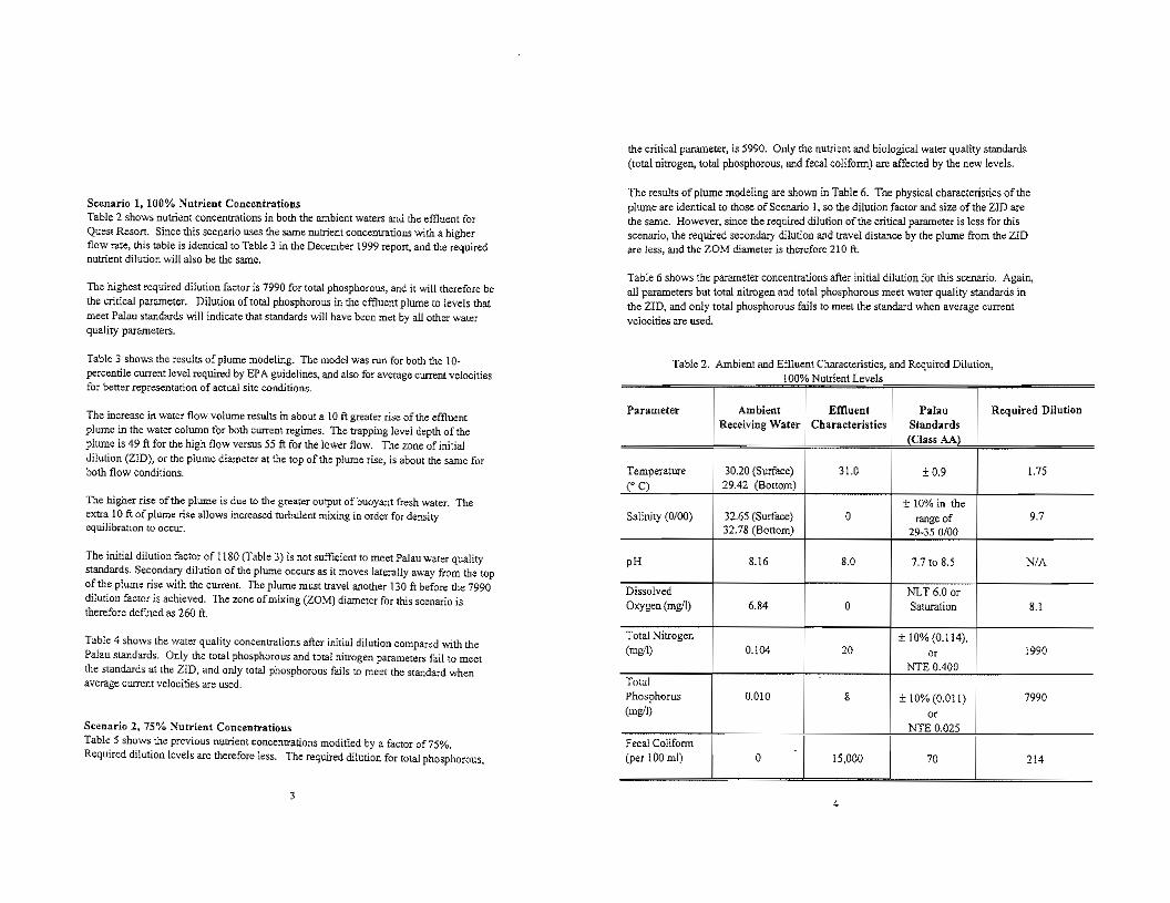
ScenariG I, 100% Nutrient Conccntrdtions Table 2 shows nutrient concentratio:ns in both the ambient waters and the effluent for Quest Resort. Since this scenario uses the same nutrient concentrations wiLl], a higher flow rate, this table is identical to Table 3 in the December 1999 report, and the required nutrient dilution will also be the same.
The highest required factor is 7990 for (Ota! phosphorous, and it will therefore be tht: vTitical parameter. Dilution of total phosphorous in the effluent plume to levels that meet Palau standards -..vi!! indicate that standards will have bt:en met by aU other water quality parameters.
Table 3 shows the result,> of plume modeling. The model was run for both the 10-percentile current level required by EPA guidelines, and also for average cum:nt velocities for better representation of actual site conditions.
The increase in water flow volume results in about a lOft greater rise of the effluent plume in the water column for both current regimes. The trapping level depth of the plwne is 49 ft for the high flow versus 55 ft for the lower flow. The zone of initial dilution (Z1O), or the plume diameter at the top of the plume rise, is abom the same for both flow conditions.
The higher rise of the plume is due to the greater output of buoyant fresh water. The extra 10 ft of plume rise allows increased turbulent mixing in order for density equilibration to occur.
The initial dilution factor of 1180 (Table 3) is not sufficient to meet Palau water quality standards. Secondary dilution of the plume occurs as it moves laterally away from the top of the plume rise with the current. The plume must travel another 130 it before the 7990 dilution factor is achieVed. The zone of mixing (ZOM) diameter for this scenario is therefore deflned as 260 ft.
Tabk 4 shows the water quality concentrations after initial dilution compared with the Palau standards. Only the rota! phosphorous and total nitrogen parameters fail to mcct the standards althe zm. and only total phosphorous fails to meet the standard when average current vclocitie!o are used.
Scenario 2, 75% Nutrient Concentralions Table 5 shows the preVious nutrient concentrations moditled by a factor of75%. Required dilution levels are therefore less. The required dilution for total phosphorous,
3
the critical parameter, is 5990. Ouly the nutrient and biological waler quality standards (total nitrogen, total phosphorous, and fecal coliform) arc affected by the new levels.
The results of plume modeling are shown in Table 6. The physical characteristics of the plume are identical to those of Scenario I, so the dilution factor and size of the 2m are the same. However, since the required dilution ofllie critical parameter is less for this scenario, the required secondary dilution and travel distance by the plume from the 2m are less, and the ZOM diameter is therefore 210 ft.
Table 6 shows the parameter concentrations after initial dilution for this scenario. Again, all parameters but total nitrogen and total phosphorous meet water quality standards in the lID. and only total phosphorous fails to meet the standard when average current velocities are used.
Table 2. Ambient and EfJluem Characteristics) and Required Dilution, 100% Nutr',ent Levels•
Parameter Ambient Effluent Palau Required DHution Receiving Water Characteristics Standards
(Class AA)
Temperature 30.20 (Surface) 31.0 ±0.9 1.75 ro C) 29.42 (Bottom)
:t 10% in the Salinity (0/00) 32.65 (Su."facc) 0 range of 97
32.78 (Bottom) 0/00
pH 8.16 8.0 7,7 to 8.5 NlA
Dissolved :t\oTLT 6.0 or Oxygen (mgll) 6.84 0 Saturation 8.1
Total Nitrogen ± 10% (0.114), (mgl1) 0.104 20 0' 1990
NTE 0.400 Total Phosphorus 0.010 8 ± 10% (0.011) 7990 (mgl1) 0'
NTE 0.025 Fecal Colifonn (pe' 100 ml) 0 15,000 70 214I
4

Table 3. Comparison of Length Scales and Dilution for 10% and Average Currents 30000 GPO 10Do/! Concentration Levels 0
Plume Diameter Rise (Ft) (Ft)
Depth of Plume Dilution Factor
ZID 40 28 1180 (10% Currents)
ZOM 49 260 7990 (10% Currents) (Trapping Level)
ZID 50 37 2217 (Average Currents)
ZOM 55 210 7990 (Average Currents) (Trapping Level)
5
Table 4. Parameter Concentrations after Initial Dilution 100%0 Nutr'1en(Concentration Levels
Parameter Ambient Effluent Receiving Water Characteristics
Temperature 30.20 (Surface) 31.0 29.42 (Bottom)CC)
Salinity (0/00) 32.65 (Surface) 0 32.78 (Bottom)
pH 8.16 8.0 Dissolved Oxygen (mgll) 6.84 0 Total Nitrogen (mw1) 0.104 20
Total Phosphorus 0.010 8 (mgll)
Fecal Colifonn (1"'<100 mI) 0 15,000
i
Notes: Discharge Volwne: 30,OOOGPD Port Characteristics: Single 4-inch Port Discharge Depth: IDS ft Current Speed: 0.1 ftlsec fecal Coliform T90 "" 30 minutes DO IDOD: 5 mgil Initial Dilution, 10% Currents: i 180 Initial Dilution, Average Currents: 22 t7
6
Palau Standards (CIa'" AA)
± 0.9
± 10% in the range of
29-35 0/00
7.7 to 8.5 NLT 6.0 or Saturation
± 10% (0.114), 0'
NTE 0400
± 10% (0.011)
0' NTE 0.025
70
Concentration After Initial Dilution
!P% i Average Currents I Currents
29.47 29.45
32.70 32.72
8.16 8.16
6.RJ 6.84
0.120 0.113
0.OJ7 0.013
9 5

Table 5. Ambient and Effluent Characteristics. and Required Dilution, 750/1, Nutrient Concentration Levels
Parameter Ambient Effluent Palau Receiving Water Characteristics Standards
(Class AA)
Temperature 30.20 (Surface) 31.0 ± 0.9 CC) 29.42 (Bottom)
± 10% in the Salinity (0/00) 32.65 (Surface) 0 range of
32.78 (Bottom) 29-350/00
pH 8.16 8.0 7.7 to 8.5
Dissolved NLT 6.0 or Oxygen (mgll) 6.84 0 Saturation
Total Nitrogen ± 10% (0.114), (mgll) 0.104 15 or
NTE 0.400 Total Phosphorus 0.010 6 ± 10% (0.011) (mgll) or
NTE 0.025 Fecal Colifonn (per 100 ml) 0 11,250 70
Required Dilution
1.75
9.7
NJA
8.1
1490
5990
161
Table 6. Comparison ofLength Scales and Dilution for 10% and Average Currents "0000 GPD 750/10 Concentration Levels , ,
Depth of Plume Plume Diameter Dilution FactGr Rise (Ft) (Ft)
ZID 40 28 1180 (10% Currents)
ZOM 49 210 5990 (10% Currents) (Trapping Level)
ZID 50 37 2217 (Average Currents)
ZOM 55 165 5990 (Average Currents) (Trapping Level)
7 8

Table 7. Parameter Concentrations after Initial Dilution 75°1;0.Nutrient Concentration Levels
Parameter Ambient Effluent Receiying Water Characteristics
Temperature 30.20 (Surface) 31.0 (' C) 29.42 (Bottom)
Salinity (0/00) 32.65 (Surface) 0 32.78 (Bottom)
DH 8.16 8.0 Oissolved 0",'"'" (mwl) 6.84 0 Total Nitrogen (mg/l) 0.104 15
Total Phosphorus 0.010 6 (mgil)
Fecal Colifonn (per 100 ml) 0 11,250
Notes: Discharge Volume: 30,ODOGPD Pon Characteristics: Single 4-inch POrt Discharge Depth: 105 ft Current Speed: D.l ftlsec Fe<:al Colifoml T90 := 30 minutes DO moo: 5 mg/l Initial Dilution, 10% Currents: 1180 Initial Dilution, Average Currents: 2217
Palau Standards (Ct." AA\
±09
± 10% in the range of
0/00
7.7 to 8.5 NLT 6.0 or Saturation
± 10% (0.114), m
NTE 0.400
± 10%(0.011) m
NTE 0,025
70 .. ___ 1.
Concentration After l!litial Dilution
10% Average Currents Currents
29.47 29.45
32.70 32.72
816 816
6.83 6.84
0,116 0.\11
0.015 0.013
6 3
,
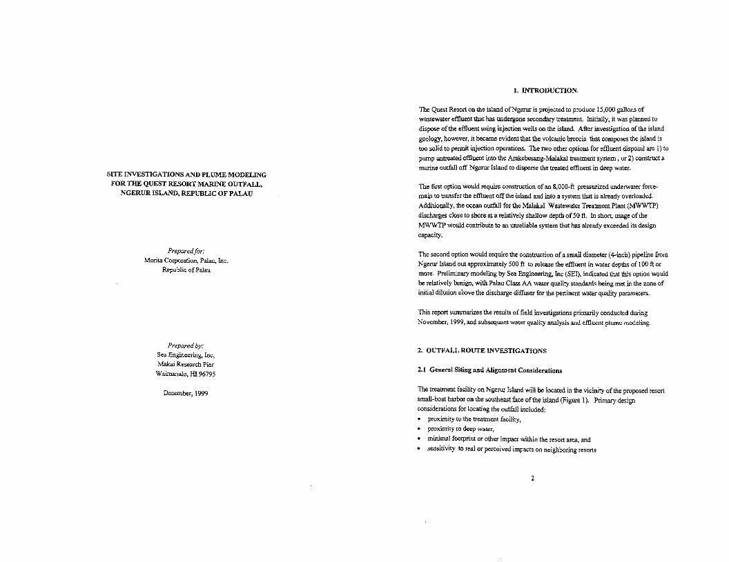
SiTE INVESTIGATIONS AND PLUME MODELING FOR TIlE QUEST RESORT MARINE OUTFALL,
NGERUR ISLAND, REPUBLIC OF PALAU
Preparedjor: Morita Corporation, Palau, Inc,
Republic ofPalau
Prepared by: Sea Engineering, Inc, Makai Research Pier
Waimanalo, HI 96795
December, 1999
I. INTRODUCTION,
The Quest Resort on the island ofNgerur is projected to produce 15,000 g:allons of wastewater effluent that has undergone secondary treaUOent. Initially, it was plarmed to dispose ofthe effluent using injection wells 00 the island. After investigation of the island geology, however, it became evident that the volcanic breccia that composes the island is too solid to pennit injection operations. The two other options for effluent disposal are j) to pump 1llltreated effluent into the Arakebesang-Malakal treaonent system, or 2) construct a marine outfall off Ngerur Island to disperse the treated effluent in deep water.
The first option would require construction ofan 8,OOO-ft pressurized underwater force-main to transfer the effluent o:{fthe ·island and into a system that is already overloaded. Additionally, the ocean outfull for the Malakal Wastewater Treatment Plant (MW'WTP) discharges close to sbore at a relatively shallow depth of50 ft. In short, usage ofthe MWWTP would contribute to an unreliable s)'Btem that has already exceeded its design capacity.
The second option would require the construction ofa small diameter (4-iDch) pipeline from Ng<!ruT Island out approximately 500 it to release the effluent in water depths of 100ft or more. Preliminary modeling by Sea Engineering, Inc (SEl), indicated that tbis option would be relatively benign, with Palau Class AA water quality standards being met in the zone of initial dilution above the discharge diffuser for the pertinent water quality parameters.
This report summarizes the results offield investigations primarily conducted during Noyember, 1999, and subsequent water quality analysis and effluent plume modding.
2. OUTFAlL ROUTE INVESTIGATIONS
2.1 General Siting and Alignment Considerations
The treatment facility on Ngeror Island wi!! be located in the vicinity ofthe proposed resort small-boat harbor on the southeast face of the island (Figure 1). Primary design considerations for locating the outfa]1 included:
proximity to the treatment facility, proximity to deep Water,
• minimal footprint or other impact within the resort area, and sensitivity to teal Or perceived impacts on neighboring resorts
2

LOCA noW1 OCATIDN 2
NGERUR ISLAND :\
,
LOCATI'O
-r · /"/";0"' ,,,''v,, " n '"
Figura 1: Site Location
3
The west side ofNgerur island is plarmed to be a very active part ofthe resort, with plans including a dive grotto as well as a man-made beach, and was therefore excluded as a site for the outfall. Three possible alignments were considered; I} bearing northwest from the north side ofthe island., 2) bearing northeast from the northeast side ofllie island, and 3) bearing southeast from the proposed harbor entrance. Option 1 was considered to be too far from the treatment plant Option 3 was attractive due to the proximity ofthe plant and also because associated environmental damage would be minimized by using the navigation channel to cross the sensitive nearshore area. However the presence of nearby resorts on Arakebesang island make discharges on the south side ofNgerur undesirable.
Option 2 was selected as it is reasonably close to the treatment facility and has access to deep water relatively close to shore. As part of further site investigations, SEI conducted a detailed bathymetric survey and Wlderwater route reconnaissance on the northeast side ofNgerur Island. The bathymetric survey was conducted on November 19, 1999, and the underwater route investigations were done on the following day.
2.2 Bathymetric Survey
The detailed bathymetric survey included the offshore area for the entire northeast coast ofthe island our a depth of 120 ft. Survey lines were spaced at 25-ft intervals. Differential GPS (DGPS) with sub-meter accuracy was used for positioning, and DGPS latitudes and longitudes were transformed into the project plane coordinate system in feet. The bathymetry data were plotted and a preliminary route alignment was chosen for further inspection.
2.3 Route Rec.onnaissance
The route alignment was chosen using the detailed bathymetry coupled with visual shallow water recQnnaissance. Route selection criteria included 1) minimizing impacts on local corals by using sand channels as far as practicable in the shallow water areas, and 2) reducing construction difficulties by avoiding steep rocky terrain in the deeper water.
The selected alignment is sho'i'iIl in Figure 2. The route is 478 ft in length from about-4 ft elevation MSL to - I06 ft MSL, at an azimuth of 31.9" from true North. Route coordinates are;
4

---, 50 100
SCALE I INCH '" 100 n
NGERUR ISLAND
SEA ENGINEERING, DECEIoIBER. t999
INC. J L-- --.t;;;;:;;-;:-!;::;;;;:;;o::::;::CO-;:";::TO::"::'::'"::';::'_"_'_'_'_"_"_'_
Hgw'O 2; Outfall Route Alignment
5
N497506, El 56475 (shallow end) N497913. E156729 (diffuser end)
There are a number ofdistinct topographic features that characterize the prQfile ofthe rise of the island from the depths <lfthe lagoon (Figure 3). The lagoonal plain is flat and rather featureless, and lies at a depth of 120 ft, As the island is approached there is a rise that slopes mildly at about 8° for a distance of 100 to 175 ft and to a depth of 90 to 100 ft. The island escarpment follows, a relatively steep slope of 15° to 22° over a horizontal distance ofabout 200 feet up to a depth between 30 and 35 feet. Between the 60 and 90 foot water depLh the slope is much steeper along some sections oithe escarpment. and avoiding these sections became a major factor in choosing the route. From the edge of the escarpment to the island shoreline the slope is mild at about 9° over a distance oi200 to 300 feet. These topograpbkally distinct zones are used in the route reconnaissance to charactt;rize observed features along the alignment
The route reconnaissance was wnducted by laying a transect line along the route in order to establish positioning. The line was marked at 25-ft intervals, for a total distance of 600 feet, with the transect zero positioned near the island shoreline in about 4 ft of water depth. Divers using SCUBA followed the transect line from deep water to shallow. Table 1 is a summary of the physical charac!enstics of the route observed during the reconnaissance dive. Follo",,.ing the route profile (Figure 3), the route is divided into five topographically and ecologically distinct zones in the table.
From the 4-ft depth to the island shoreline the bottom is composed primarily of eroded coralline limestone and volcanic bedrock without live coral growth, as rhcse shallow water areas are exposed during (ow tides.
3, OCEANOGRAPHIC DESIGN PARAMETERS
3.1 Currents and Circulation
The CLUTent speed, direction and persistence at the proposed outfall location, and the general circulation past the island. is the single most important oceanographic consideration for ocean outfall design and evaluation. The current speed at the discharge point affects the initial effluent dilution. The speed, direction and. persistence offlow is the primary detenninant of secondary dispersion of the waste field as a result oftransport by water CUITents.
6

T bl Ia e . DMarin Outfall R e oute escnpuon
Offshore Distance
(Feet)
Water Depth (Fcet)
Slope Notes
600 - 550
I
120- 116 Flat Zone I; flat lagoonal plain; the bottom is composed ofvery :fme silt permeated with burrows and other evidence ofin·faunal biota.
ZONE 5 lNNER REEF ZONE 4
550-375 116 -95 60. 100
(av.8°) I Zone 2; me to the dmd the bottom
composition changes abruptly from silt to sand. The sand is formed illto small mounds 1 ft to 1.5 ft ill
I1SL
-,"
-20 C -30
" -<e z 9 -5C < - ..0 > w -'0d
-oc -'%
-100 -llO
-120
VE:.lHICAL €)(AGGERf<TlON 2'1
HORIZONTAl. SCALE· 1 IN .. 100 fT
ISLAND ESCARPMENT ZONE 3
TRANSECT PROFILE
'""0350
ISLAND R!SE ZONE 2
I DIFFUSER LDCATlON\
\
300250 TRANSECT DISTANce crT>
200150
OUTE:R REEF
'DO
NGERUR rSLAND
50
LAGOl:N 'LAT
ZONE L
sso
375 - 200
200- 100
95-35
35-20
IS0 _220
I 9'
height by Ul-faunal blOts --Zone 3; island escarpment. This is the steepest part ofthe route. Isolated coral and rock outcrops.are inter-mixed with a substrate of sand, coral cobbles, and reef detritus. The amount of coral coverage gradually increases with decreasing water depth; a maximum of about 60% coraJ and rock coverage occurs at the edge of the escarpment at a water depth of about 35 ft.
Zone 4. This is the ou1er part ofthe shallow shelf around the island and is composed of banks of coral interspersed with sand channels. The amount of coral coverage decreases from the edge ofthe escarpment to about 30% for most of the zone.
Figure 3: RautB Profile 100-0 20-4 9' Zone 5. This is the inner part ofthe shallow shelf around the island and is distinguished by an abrupt increase to about 80% to 100 % coral coverage.
,7

In the global circulation system the Palau Islands CQrne under the influence of both the equatorial countercurrent and the north eqt.lS.torial current. "The north equatorial current is westerly and influences Palau north ofabout 7°N during the winter months ofDeumbet Table 2: Cl.lmInt Mater Hi$mgram
through Febroary. The rest oflhe year the islands lie in the east flowing equatorial QOl>ST RtSORT '" ••'UU'U#iM••
StMHlCo. Outfall .,,,pth,$O O"pl0l"""nt .."dod: in the passages have been reported with speeds up to 4 and 5 knots. Ngerur Island, OVERALL. " Sin U crn/s ", d"".,:,
countercurrent. Currents o.eo.r the islands C3Il attain rates of 1 to 1.5 knots, and tidal currcrns ••• ••
• ........ ••• •• 0 •••• _ •••• , ••3. _ ••• __ ••• _ •• <" •• •• •••n. _. __•• _ •• _
however, is within the large lagoon that is fonned and protected by the barrier reefthat ::1</.., 'm< , , WSW • liNW 'l"01'M-0·0. 00 0.0 0.0 "0.0 00 '"0.0 0.0 u 0.' '"U "0.0 0.' U • , " o , surrounds much ofPalau. The cWTents at the project site can therefore be ex.pected to be '"' " '" , • 1_1. 9 0.0 0.' 0' '.0 0.0 •. 0 '.0 0.1 0' 0.' O•• , 0 0.1 ..." 2+2.9 '.0 .0 0.0 .., 00 •. 0 .., ., ., 5 " much less than those in surrounding open waters outside of the barrier reef or than those in 0.' 15.7 13 .3 U U 65.6
,"). , 0.0 O•• 0 0 , , U O. , 24.6the deep oonstricted channels between islands. 00 0' O' • 0 0 • .0 " • 9 00 0.' 0.0 0 O•• 0.0 O•• " "•. 0 0.0 o" 0 u 0.0 0.0 0 .••$-5.9 00 0.0 0.0 0.0 0.0 0.' 0.0 "• 0 •• 0.0 00 0.0 0.0 0' 0 0.0
During the course of investigations and field measurements, SEI conducted 0.0 0.0 0.0 0.0 0.0 • . 0 0 • 0.' U 0.0 U • • 0.0" 0 0 0.0 0.0 0.0 0.0 00 0 0 0.' 0.0 0.' "0.0 0 0 0.0 measurements of the currents at the project site. A General Oceanics Mode16011T current " 0 0 0.0 0.0 00 '.0 0 0 0.0 "0.0 0.0 0.0 0.0 >0 C.O" meter was deployed on a taught line mooring in 106 feet of water close to the proposed 'l'OTM. , 0.0 ,. , 0.0 O.l 0.0 , '0 0.0 o. , , , 11. , 19. :; 25.2 13.1 1.1 100.0
,,'If; '" ,. 0.0 0.' ., 0.0 U ", , , ,. ,., ,.. , ,outfall discharge location (see Figure 2). The meter was placed at a depth of SO feet from ,. O. ,. ., " , , ... , , ,., October 14 through November 20, 1999. a total of37 days. The meter measures current STD '"0" 0 0 00 ,. • 0 ., "" " • 0 0.0 • , 0.' •• " ., .., " 0.'
" • ..." "I".A.Y. 0 U
" speed and direction, as well as water temperature, at 10-mio.ut<: intervals.
Following retrieval the current meter readings were vector averaged to obtain hourly resultant speeds and directions. The cak:ulated hourly values were then used as the wua baJ>e for subsequent computer analysis. summarized as follows:
I. The hourly data were used to construct percent frequency histograms ofcurrent speed and dirt:l;tioa. The histogram is shown in Table 2.
2. Current rose diagrams, graphical representations \lfthe histograms, are shown on figure 4. The net transport (vector average ofall hourly readings) \.VaS I;;alcwated and is also shov.n on the figures.
3. The houriyvalues were used to generate a time series plot ofthe alongshore and onshore/offshore (crosshore) flow components, as shown on Figure 5. This plot shows the long-term characteristics ofthe current.
The recorded current speeds are low, averaging 2.7 cm/sec (0.09 ftfsec). Maximwn recorded speeds were 4.1 em/sec (0.134 ftlsec).
The net transport is almost due west at 266°, with a slight trend for stronger currents in the 3 to 4 cm/sec range (D.IO to 0.13 ftJsec) (0 bear west-northwest. parallel to the trend of the bathymetry.
9

Figure 5' Cl.uNot Mater Time seMi
OFF QUEST RESORT OUTFALL Pt>f";OQ' :0/,4/99 - 11I20/'3'3 St'l.tior" Outtc.ll ""li'nrfVQtef" Dep"''' 50 ftl106 ft
115 116117 18 j 19 20121 122 231 (:"4 25 26 27 28 29 30 31 i 01 102 ' 0:) I04 1CS 06 iQ7 0810"- 10 11 i 12 13
:fi" '.'Al:11 '1"'1 IV' IV(IY
il' ,f , . IA I nUI ! f
Il' J1, r-"! \I, I
,- f-- f- ,-- f- +-!I I,
DVO:RALL
: :'. i -,.... " 7 " 19 1 20 !
"let Tf"o.nspor" 2.2 ::,....1$ 266
AV[RAG[ CURRENT SP[[DS
• (:-1 • ,-2 2-3 03-4 o >4
Figura 4: Current Rose Diagram
11

Current drogue studies were also completed during on-site investigations and current meter deployment. Current drift drogues are designed to lock into a water mass., and subsequently move with it. Whereas current provide detailed measurement of flow past a tix.ed point, drogues move with the flow to provide informacion on Cl11Tent and circulation patterns over a larger area. The drogues used for this srudy were of the "window·shade" type, with a weighted "sail" approximately 48 square feet suspended at a fixed depth of 15 ft from a small surface float. Positioning was accomplished with OOPS. The results of the drogue studies are shown in Figure 6.
The drogue srudies occurred dwing a late flood and early ebb tide with light winds blowing at 5 to 10 knots from the south·southeast. In all cases the drogues moved downwind to the northwest and north, strongly indicating that near-surface circulation is primarily wind-driven.
Although the histograms and current rose diagrams for current meter data indicate that the deep currents are also uni-directional. there is a deftnite semi-diumal (twice daily) component manifest in the time·series plots that suggests a dependency on tide. Currents that are strongly influenced by the tide are usually fOWld to be reversing, that is, they flow in two diametrically opposed directions, In cases such as this, where the circulation is primari.ly wind-driven or otherwise uni-directfonal, the effect of the tide can be to slow or speed the current, rather than cause an actual teversal.
3.2 Receiving Water Quality
Density Structure Oceanic waters in tropical regions are typically well·mixed and homogenous in the upper regions. A em (Conductivity, Temperature, and Depth) profile was made near the island on 11120/99 to measure the salinity. temperature and resulting water density. Figures. 7, 8 and 9 are plots ofthe temperature, salinity, and density derived from the em data. The temperature data (Figure 7} show alec temperature decrease between the surface and the 4O-ft depth caused by wanning ofthe swface water. The salinity data (Figure 8) show a sudden decrease in the first 10 feet (probably due to surface evaporation) and then a gradual increase in salinity with depth. with an overall range of about 0.2 ppth. The density, a function ofboth temperatille and salinity, shows a mild gradient between the surface and about 70 feet. Although mild. this gradient will prevent tile effluent plume from surfacing.
13
i + + +
CURRENT DROGUE MOVEMENTS '3>1
NGERUA ISLAND 10/13/98
+ + HINO: 5-10 knots. Gag. TN TIDE: 07:282.1ft
13: 5.3ft 1246 20: 00 3.6ft
, T
""r 21 .1 ,
+ T ,
.,,1 NGERUR ISLAND
-¥'91000+ + +
+ + +
Figure 6: SbJdi9S, Ngerur Istand 14

----------,
o 0
::0 '0 40
'5 60 0-Y
" 80 SO
lDD 100
I :0 I
:29 ...':. :;:9,5 296 29 7 29.9 30.0 30. i ]C .2 Tempen.lture (Gee; C) 50linily (0/00)
Figure 7: Temperature Profile, Ngerur Island. 11120199 Figure S; 5ainity profile, Ngerur Island. 11120199
15 16

o
FiQ:ure 9; Density Profile, Ngerur Island, 11120199
17
Water Quality and Nutrient Levels Water quality and nutrient levels were Illeasured by AECOS consultants between October 12 and October 16, 1998, and are contained in their report., "Biological and water quality reconnaissance surveys on Ngerur Island, Palau Lagoon. Republic ofPalau" (Draft Rcpt. No. AC06B, 8/12199). Salinity and temperature measurements were conducted by SEI on November 20, 1999. Water quality and nutrient levels are shown in both Table 3, Seaion 4.4, and Table 4, Section 4.6.
Water quality standards for the Republic ofPalau are contained in Chapter 2401 11 Marine and Fresh WaterQualitv Regulations, promulgated by the Republic ofPalau Environmental Quality Protection Board (effective May 26, 1996), The coastal waters around Ngerur Island are designated Class AA Waters. The regulations state that the uses to,be protected in this class ofwater are oceanographic research, the support and propagation ofshell-fish and other marine life, conservation ofcoral reefs and wilderness areas, compatible recreation and other aesthetic enjoyment; and that this class ofwaters remain as near to their natlU'al state as possible "with an absolute minimum ofpollution from any source. The water quality standards applicable to Class AA Waters are contained in both Table 3, Sectioo 4.4, and Table 4. Section 4.6. A Zone of Mixing (20M) for the proposed outfall will be required in accord with Sections The 20M defines an area in which the water quality may be expected to exceed the standards as the effluent discharge mixes with the receiving' water and is diluted. The 20M includes both the Zone ofInitial Dilutioo (ZID) in the immediate vicinity of the discharge point, as well as any required additional secondary dilution achieved during transport ofthe effluent plwne by the prevailing currents.
4. PLUME MODELING
4,1 Wastewater EffiuHJt Characteristics
The wastewater effluent will be treated to a secondary level using an extend aeration activated sludge process. Effluent characteristics were provided by Berryman & Henigar, Inl:., and are I:ontained in both Table 3, Section 4.4, and Table 4, Section 4.6.
4,2 Plume Bebnior
The complex behavior of owfall effluent is difficult to predict without the aid of computer modeling, Mixing and dilution are functions ofjet characteristics at the diffuser port,
18

dynamics of the rising effluent plmne interacting with ambient waters, and the geometry and velocity ofthe effluent plwne at the surface.
The near field dilution ofthe effluent is a result ofthe process of initial mixing. Initial mixing OCCUIS due 10 the effects ofmomentum and buoyancy as the plume is discharged as a jet or series ofjets at the diffuser ports, and subsequent entrainment and turbulent mixing of the effluent with the receiving water as the buoyant plume rises toward the surface. The rale ofdilution is quit< rapid immediately after discharge, but decreases significantly after the momerrtwn and buoyancy ofthe plume aredissipat.ed. The plume rises until the mixture of the effluent and the receiving water is stable within the water column. At this point, the dilution obtained is called the initial dilution.
Following the initial dilution, the effluent plume moves with the prevailing l:UITents and is further diluted by diffusion as a result oflaJ:eral mixing and Qeearuc turbulence. 'This secondary, or far field, dispersion is ofmuch less magnitude than the initial dilution. While the initial dilution ofa well designed diffuser is typically on the order of 100 to I or more and occurs in a matter ofminutes, secondary mixing typically increases the additional dilution by a factor ofonly 5 to 10 over a matter ofbours.
Initial dilution depends primarily upon the effluent discharge volume. the length and depth ofthe diffuser, and the prevailing currents and density stratification. At a given site. the diffuser length and depth are the primary variables controlled by the designer. Increased initial dilution can be obtained by increasing either the discharge depth or the length of the diffuser. A single port will be used for the Ngerur outfall, as the volume of flow will be so low that a multi-port diffusers would result in a significant loss ofjet velocity and consequent loss in efficient initial mixing.
The density structure of the receiving water has a major effect on the behavior of the effluent plume. With a sufficiently stratified water column., a buoyant sewage plume may mix sufficiently with the more dense bottom water so that it will stay submerged and not reach the surface. However, since the initial dilution is a function ofthe distance traveled by the rising plwne. a submerged waste field will have lessinitial dilution than a surfacing plume at the same site. The tropical waters of Palau are typically well·mixed and homogenous. meaning there is little or no stratification with depth. and are nonnaHy conducive to plwne swfacing. However, the deep depth of the Ngerur outfall and the low flow volume. coupled with the observed mild vertical density gradient, ensure that the plwne wiU not surface in this case.
Although initial dilution increases with increasing ambient current speeds, higher currents increase the distance over which the initial and far field dilution takes place. For strong currents, the process can extend down-current a dist<mce equaJ to multiples of the diffuser length. The scale ofthe subsequent far field dilution is also dired.1y related to the current speed, bealuse the diffusing plume is being mO'o'ed at a higher speed. The EPA regulations for a waiver ofsecondary treatment under Section 301 (h) ofthe Clean Water Act (USEPA, 1982) are concerned with derennining a set of receiving water and effluent conditions that would approach a worst case scenario. The EPA requires the use ofthe lO-percentile ctOTent speed for the calculation ofthe critical initial dilution value for waiver applications.
The cWTent speeds are very low off ofNgerur Island, and the secondary dilution process will not: be particularly efficient It is therefore desirable to accomplish the required dilution during the initial dHution process. that is, during the ascent ofthe plume above the diffuser.
4.4 Plume Analysis
Effluent plume modeling was undertaken using the oceanographic data collected during this study to evaluate a range ofoutfall alternatives. Software developed for the EPA by Baumgartner, Frick, and Roberts (1993) was used for the modeling. This software bas become the accepted standard for modeling outfall effluent plume behavior, and is accepted by federal regulatory agencies. PLUMES is the model interface and manager. and incorporates a variety ofprevious models. The model "UM" is used for inilia! dilution modeling. The PLUMES software also includes two far-field dilution models. One is based 00 Richardson's 4/3 power law for the diffusion coefficient. and the other aD a oonstant coefficient ofdiffusivity. The former model is typically used for open ocean situadons and was therefore used in this case.
Critical Parameter Table 3 compares the ambient water quality parameters values measurcd in the receiving waters with both the Palau water quality standards and the characteristics of the effluent. The dilution required to meet the standards is also shown in the table. The: required dilution for total phosphorous is greater by far than that for any other parameter. Total phosphorous is therefore considered the critical parameler, since proper dilution of phosphorous to meet the standards will ensure that the standards will be met for all other water quality parameters.
Input Parameters
20

fllTba Ie 3. Ambient and E uent Characteristics. and Reuuired Dilution PLU1V1ES requires user input which describes the receiving water body, the physical properties ofthe effluent, and the characteristics of the diffuser. The input parameters
Parameter Ambient Effluent Palau Required Dilution include effluent and receiving water temperarure and salinity. from which density is
Receiving Water Characteristics Standards calculated, effiuent flow rate, current characteristics, water depth and the diffuser port (a."AA) configuration.
,
Temperature 30.20 (Surface) 31.0 ± O.9 1.75 Flow Rate. Flow Rate wM; 15,000 gallons per day. (' C) 29.42 (Bottom)
Salinity (0100) 32.65 (Surface) 0 ±10%in the
range of 9.7 Density Profile. TemperatUre and salirtity were measured at the site.
32.78 (Bottom) 29-35 0/00 CU!I'ents. To meet the EPA worn-case scenario. lo-percentile currents were used. These
PH I 8.18 8.0 7.7 to 8.5 I N/A were calculated from frequency distributions ofcurrent meter data collected at the site. Although the slower ct1l'W1t:S result in less initial dilution, faster current speeds can result in
Dissolved Oxygen (mgJl) 6.84
,
0 NLT6.0or Saturation I 8.1
increased far·field transpon, To ilIustralethis. the average current speeds were also modeled. These are probably more representative ofprevailing conditions at the site. The
Total Nitrogen (mg/l) 0.104 20
± 10% (O.114), or
i
1990
10 percentile current speed is 0.05 ftlsec (1.5 cmlsec) and the average current speed is 0.085 ft/sec (2.6 cmtscc).
Total Phosphorus I (mg/l) 0.010 I 8
N'IE0.400
± 10% (0,011) 7990 Water Depth. The water depth ofthe diffuser is I06 ft MSL. Deep water is dose to the island and accessible.
or
Fecal Coliform NTE 0.025
Port Configuration. The diffuser will essentially be an open pipe C<Jnsisting ofone pan at (per 100 ml) 0 15,000 70 214 the nomina! pipe diameter (4-inches). Constriction ofthe port is not advisable for a small
I diameter pipe, and multiple ports would reduce the effiuentjet velocity and consequent plume dilution.
4.5 Modeling Results
Table 4 is a comparison of the plume rise and trapping level, and also plwne length scales (Le. plume diameter for the lID and distance traveled for the 20M) using the required dilution oftotal phosphorous as the critical value for the lOM. While EPA regulations require the use ofthe 10010 current value to calculate the ZOM, the average currents are 3.
better representation of actual site conditions. In both cases it should be poin.ted out that the current speeds are very low and the plume is diluted primarily from the turbulent miXing associated with the buoyant rise of the plume. Secondary dilution in this case is a slow process due to the low current spuds.
2. 22

Table 4. Comoarison ofLenQth Scales and Dilution for 10% and Currents
Depth or plume Plume Diameter (ZID) Dilution Factor Rise (Ft) Plume Distance (ZOM)
(Ft)
ZID 50 26 1700 (10% Currents)
ZOM 55 95 7990 (10% Currents.) (Trapping Level) _ , I
"" -w ZID 59 38 4200 -20 (Average Currents)-30
b -<0 z e -50 ZOM 65 80 7990NGERUR ISLAND < (Average Currents) (Trapping Level) -'" lRp.??!NG !lO'TH IOUTr ALL PROFILE-70 55 i="r -"
-90 ..-- DlfTUSCR LOCATlON Using 10% current values as per EPA guidelines., the zone ofmixing will extend to a
-101) VERTlC,l,L 2 TO 1 /" -105 n MSL radius of95 feet around the diffuser. -1,0
-120 , The trapping depth ofthe plume is where the plwne density matches ambient conditions. 50 100 150 200 250 300 350 400 "0 SOO SSD Me In this case, the observed density gradient (see figure 9) will ensure that the plume will
mSTANCE (fT) remain at its trapping level and will not surface. The plume will rise slightly above the trapping level due to excess momentum from its buoyant rise, but will then fall slowly.
Figure 10: OutfaU Profile and Effluent Plume The plume rise and trapping level is higher for the lower current speeds as there is less turoulent mixing and dilution during the rise. Figure lOis a schematic representation of the pipeline on the seafloor with the plume rise and propagation.
4.6 Water Quality Impacts
Table 5 lists the concentrations ofwater quality parameters at the zone of initial dilution, or the highest rise ofthe plume for both 10% and average cwrents. All parameters except total phosphorous meet or exceed Palau water quality standards after initial dilution. Tota! phosphorous very nearly meets the standards at the ZID, and in fact is weB within the not-to-exceed limit of0.025 mgl!.
23 24

, aft lni'a1D'! .T bl 5 Pammeter concentratlons I uttona " " Parameter Ambient Emuent I Palau
Receiving Water Characteristics ! Standards (Class AA)
Temperature 30.20 (Surrac,) 31.0 ±O.9 (0 e) 29.42 (Bottom) I
, ± 10% in the Salinity (0/00) 32.65 (Swface)
32.78 (Bottom) I 0 range of 29·35 OiOO
PH 8.18 8.0 7.7 to 8.5 Dissolved NLT 6.0 or Oxv••n (me/I) 6.84 0 Saturation Total Nitrogen ± 10% (0.114), (mgtl) 0.104 20 "' NTE 0.400 I
Tota! Phosphorus (mgtl) 0.010 8 ± 10% (0.011) II
or
Fecal Coliform , NTE 0.025
(per 100 ml) 0 I, 15,000 70
Notes: Discharge Volume: 15,OOOGPD Port Characteristics: Single 4-inch Port Discharge Depth: 106 ft Current Speed: 0,1 ftlsec Fecal Coliform T90 == 30 minutes DO lDQD, 5 mgtl Initial Dilution. 10% Currents; 1700 Initial Dilution, Average Currents: 4200
Concentration After Initial Dilution
10% I Average Currents i Currents
29.45 29.44
32.72 32.74
8.16 8.16
6.83 6.84
0.115 0.109
0.014 0.012
I12 5 I
25
All parameters except dissolved oxygen (DO) and fecal coliform counts are consel'V3.tive, and the concentrations were calculated by,
(c,-c.) +Cc S •
where, C = concentration of parameter C. = ambient concentration ofparameter 4"'= effluent concentraiion of parameter S = dilution at zone ofmixing (20M) boundary (Table
The DO concentration following initial dilution is calculated using the follo\\wg equation:
(DO,-fDOD-DO,) + ID
where. II> = initial dilution DOl' "" ambient concentration· DOE"" effluent concentration IDOD = immediate dissolved oxygen demand
An IDOD value of5 mgt! is used.
The fecal colifonn count is a parameter because the bacteria are in a hostile environment and rapidly die-.off. The die..off rate is expressed by the T90 value, or the time over which 90% of the bacteria are killed. The die-off offecal colifonn as a function oftime can be expressed by,
B(I) =BA+(BE - BA) eiO
Where. 8(t) = colifonn bacteria count as a funtion oftravel time, t SA"" ambient colifonn bacteria cowrt BE = effluent coliform. bacteria count K = decay rate constant
A T"IJ of 30 minutes is used, or K = 4.6 per hour.
26

Use ofthis equation was not necessary as water quality standards were easily met during initial dilution.
5. PIPELINE DESIGN AND CONSTRUCTION RECOMMENDATIONS
5.1 Outfall Pipeline Material Selection
Considerations that affect the selection of the type of pipe used for the outfiill include: (1) ease ofconstruction for the given physical and environmental conditions at the project site: (2) cost effectiveness; and (3) reliability and minimum maintenance. In addition, the material selected affects the configuration ofpipeline anchoring and protection.
TIuee types ofmaterials are commonly used for ocean pipelines: reinforced concrete pipe with bell and spigot joints, ductile iron pipe with mechanical joiIUs, and high-density polyethylene pipe. Concrete pipe has been extensively and successfully used for large ocean outfalls in Hawaii lU1d other regions. The bell and spigo[ joints used for concrete pipe are usually joined in situ on the seafloor. a labor intensive and therefore
operation. For this reason, reinforced concrete pipe is usually not used for small pipeline construction. Similarly, ductile iron pipe is mechanically joined on the seafloor with tlangC9 or ball joints, and must be constroeted section by section.
High density polyethylene is recommended. for the new outfall at Ngeror. Polyethylene combines cost effectiveness., ease ofconstruction and long life. Long sections ofpipe can be pre-assembled on land, and floated into place and sunk. Its suitability has been proven in recent years by use for deep ocean intake pipes associated with Ocean Thermal Energy Conversion (OTEC) projects and the Hawaii Ocean Science and Technology Park at Keaho[e Point,lsland ofHawaii. Sea Engineering, Inc., has used polyethylene pipe in the design ofoutfalls on the Pacific islands ofRoi Namur, Kosrue, and Saipan. On the island of Rota, a polyethylene pipe is currently for the design ofa new wastewater outfall to replace a flanged steel pipeline that was destroyed by Typhoon KBryn in 1990.
5.2 Constnlction Methods
Ngerur Island is located within the Palau Lagoon and is surrounded by an extensive barrier reef system that affords prote<:tion from extreme storm wave activity. The kind of protection and anchoring necessary for outfall construction on open and exposed coasts is therefore not necessary in this case. Simple methods, such as the use of concrete blocks and
27
saddles., can be used to sink the pipe and anchor it to the substrate. Ifneeessary, additional anchori.og in the sand substrate can be achieved by strappiog the pipe and using "MantaTM"" anchors - small anchors that are burrowed into the sand. Figure 10 contains a schematic representation ofthe pipeline on the route profile.
One ofthe primary construction concerns for the Ngeruroutfall will be to minimize any damage to live coral. During the reconnaissance diving, it was observed that many coral outcrops could be avoided by using the flexibility ofthe IIDPE pipe. Other outcrops are small enough thal they can be re-located by divers. Howeverthere are some areas where the outfall pipe must travel over live outcrops. In particular, the first 100 feet offthe island shoreline supportS vigorous coral growth over almost 100% ofthe bottom. Much of this coral is finger-type that can be easily broken and damaged. In addition, the bottom is uneven and not conducIve to supporting the pipeline. It is recommended that the first 100 feet of the offshore pipeline be trenched into the bottom. A narrow trench through the coral areas has the following advantages:
• Coral dacnage will be minimized The pipeline will not be visible The pipeline will be
CorBl can be re-colonized over the covered trench.
The last point is perhaps roost environmentally significant - by trenching the pipeline the coral ecology can be re-generated and the pipeline will in effect be locally removed from the eco-system.
28

Appendix B-1 Geotechnical Engineering Exploration Report
(GeoLabs, Inc., 1999)

FACSIMILE TRANSMITIA.L
DATE: November 30, 2000 TIME: 5;27 PM TO: Wi! Chee Planning FROM; Robin M. Lim ATTN; Mr. Wi! Chee W.O. No.: 4168-00 SUBJECT: Quest Resort at Ngerur Island NO. OF PAGES; 6
RepubUc of Palau (Including cover sheet) FAX NO.: 942-1851 FAX OPERATOR: Cindy I Tiffany
REMARKS; As discussed over the telephone, we had to ietrieve our informatIon from the files in archives for thIs project. Therefore, we just got the files for review. and we are sending you the attached information.
As indicated to you, a final report was not issued for the drilling of the extraction and jnjection wells at the site. Although we were commissionecl to drill up to five extraction and injection wells on Ngerur Island, it was mutually agreed (between the o\"mer's representative and GeoJabs) that the drilling afthe wells be terminated after the results of the first well (EW-1) was drilled to about 240 feet.
The permeability tests conducted on the first well indica,e that the ground was generally with coefficients of permeability on the order of about 10-5 to 10.7 centimeters per second. The following attachment is e, communication betNeen Geolabo and the hydrogeologist hired by the ownel to evaluate the test results from the wells Basically, the communicatior, transmits the permeability test data (up to t!"',al lime) for evs.luation by the hydrogeologist. At the time of the communication, only two or the four permeability tests had been completed.
Subsequent to that memorandum, two more permeability tests were completed, and the results of the test were prOVided to the hydrogeoJogist in the field. We have included tne two additional permeability tests (at depths of 200.5 feet and 240.5 feet) for your use. In general. the test results indicate that the ground at Ngerur Island down to a depth of about 240 feet may be considered to be "irnpenneable."
If you have questions or need additlonallnformatlon, please call,
xc. Mr. Stan Gamble, CM & D (545-2695)
Hard Copy will be in the Mail ( ) Hard Copy will not be Sent ( X )
Please call our fax operator should any problems occur with the receIpt offaC$lmlle mes.eage-.
i 2006 KaIlhl Slreet. Honolulu, Hawaii 9ti819 Telephone: • FacsimJle: (SOB) 847·1749 .. E-mail: [email protected]
_____. ..:...:.• ..:T.:o.:"iw:::an"__ _L

--
c.w ASSOCIATES, lNG, dba
GEQLABS - HAWAII PERCOLATION TEST Geotechnical Engineering, Geology and Environmental SeNices Well No.· EW-1 Dale of Test· 5/31f199,g
Bottom of Hole: 1::5::o.::5 -'F"e"e'-'__Screened Depth: 15.5 Feet FACSIMILE TRANSMITTAL Bottom of casing:_---".:;3"'.,,0 ;'F,,e"e.c'__Test Metr:<>d: Falling Head
Pia. of Hole: 3,S Inches 0101, of Casing: 3,0
GWL before Test: 23.1 Feet DATE: June 2,1999 TIME: 5:14 PM TO: Earth TBCh FROM: Robin M. Um !Depth to water Head above : Depth to water: HefJd aboveTime AnN: Mr. Doug Roft W.O. No.: level waterievel I/,::vel water level
,SUBJECT: Percolation Test Results NO. OF PAGES: 3 I! (min) i (Feet) (Feet) (min) I (Feel) (Feet)
Ngerur Island Resort (Including cover sheet) ii 0.0 .1 -0.70 23.8 j ,1.0 -0.30 23_<10"F.;.AX=N.:.;O:.;';,,:_1;..-6;..1:.:9-..;5,,3.:.6-.::56.::2:.;0'--- ----:.F.:.;AX:.:....::O.;.P.::E.:.;RA:.;T.:.O.:.R..:.::....::,Ci:.;nd.:.;Y.:.;/M"a.:.;ry,-A:..:n..:.n,-J - --i2.0 -0.15 23.25 -- -- ._--3.0 I 0.10 23.00REMARKS: As requested, the following sheets are the results of the two injection tests --- -----=:t=-= conducted for the Extraction Well (EW-1) at the island. The results indicate 4.0 ...__._.0.22 __ ._!5.0 0.34 22.76veIl' poor permeability, even at 200 feet, which yielded the same results --.-._. 6.0 0.50 22.60_. IWe don·t have the test results to send, but they are very similar occording to -- .I
Yoshi. So, expect similar for the test at 200 feet. .j". !l.o 0,74 22.36
1-- .]·2 0.59 , I ....
...._._--_.-----F0.30 22.30They have achieved 200 feet depth at this time and are awaiting further -
, ----,._-
I
, -=1110.0 0.95 22.15instructions. My thoughts are to continue coring to about 225 or 230 feet ... _... ,and perform another injection test to provide additional permeability data 11.0 ! 1,05
j 22.05 ,
i No point in performing the pump test in these conditions. Do you agree 12.0 1.17 21.93 ._-_.. with this? 13.0 1.33 21.77
, i 1-= I ---- I
Another note is that we need to send them more casing and HQ rods to 19.0 '.90 2i.20 I . iI continue the boring to 300-foot depth. ! was just informed that some of the 24.0 2.34 , 20.76 I ,rods and casing were damaged from the off..shore drilling when the barge 29.0 I 2.68 1 20.42
movement sheared off some of the rods and casing. Therefore, they can 34.0 ! 20,03 ! get to Cl'boul 230 feet only at this time until we send them more rods to 39.0 I 3.50 _... --- ---. -- .. ..
continue to 300 feet. 44.0 3.79 19.31 l _._._---' 4-20 1890I let me know of your thoughts If you have questions or need 64.0 4.43 1S.67
information, please c<JlJ.
[ __.:.X::;C.:.'_"M.:.r.:..D::.a::;n.:..:.:H"i9'Ch,,-,.:.M:::,o"ri::;ta"P-,a"la::;u"C=orp=o"ra:::ti::.on.:..:.:(0:.:':.:',,-6:::8:::D_-4,,8"8,,-3:.:5,,2.:.',,,) __ COM. of PQrmeabiHty k: o_143E-06 iem{s 1.01248E-051 feetfmin
Hard Copy will be in the Mail ( ) Hard Copy will not be Sent (X )
Please call our fax Dperator should any Dc:cur with th9 tllceipt offllcsimi\c message.
20D6 Kalihi S1ree\. Honolulu. hawaII 96619 Telepr.Of'le: (8Da) 841.506t1. F<lClilmile. (608) 847·17<.S W.O. 4168-00 GEOLABS-HAWAII PLATE c.1

PERCOLATION TEST PERCOLATION TEST Well No.. EW-1 Date ofTest 5/31/1999 Wei! No.: EW-1 Date otTest: 61211999 Bottom of Hole: 175.0 Feet Screened Depth: 10 Feet Bottom of Hole: __ __Screened Depth: 115.5 Feel Bottom of Casing. 185.0 Feet Test Method Falling Head Bottom of Casing: 85.0 Feet Test Method: Failing Hesd Dia. of Hole: ..__'_.o of Casing: 3,0 Inches Dia, of Hole' 3.5 lr\ches Dia. of Casing: 3.0 Inches GWL before Test 250 Feet GWL Defore Test. 25.6 Feet
IDepth to water 1 Head above I Depth to water I Head above ': Depth to water i Head above TIme Depth 10 wclecI He-ad above I , level i water level TIme i level ,water !evel ; i water level level water level
(min) ! (yeet). __ II (Feet) (min); (FeeQ .' (Fee.-.9..=. (min) ! (Fee!) i (Feet) (min) I (Feel) L_ 0.0 I -0.39 25.99 0.0, 0,00 25.6.0
Tims Time
0.0 -09' 25.95 .-----,------1--_---1 ,- 1.0 i -0.21 25.81 1.0-' -l 0.30 25.30 __-UJ... "J-" 0.41 .... --+-- I
2.0 25.53 2.0 0.55 "'+'-'-Zi05 _ ,- _.1---- I
f--?..Q 0.63: .._24.. __.. +!.. 1
3.0 ! 048 I 2512 S.O 0.70 -- ..
f--- -r .. 1 __ ... -+-- ._.- ,+... -1 .. - ... 1. j ..!7. __ . . .-----... ! ··1·
5.0 .1;_" 1.20 I ".i4.40 7.0 I 1.61 r 23,36 11.0 ..-----+-!. 1.52 I 24.08 ._. L9.. . ..;._",,__ i 24,25 ... 8.0 1.80!. 23.11. 16.0 i 2.07 23.53 .. 1.50 24.10
21.0 2.65 22.95 9.0 i 1.72 23.889,0 .+_. 1.:g?. _ I 23.02 1
10.0 __,-- 2.:.-1J. ._ i 2:2..87,_. _.__ ?6.0 _] 15 22.45 __ 10.0 : 1.84 23_76 11.0 2.31 __ .__I +-__ 1-_--""",,0__ I 363 . 21.117 11.0 _.. __ 1 23.63 "'I' 16.0 3.0S I 21.89 _ __. __ 12.0 2.12 2',.0 i 3.87 21.10 46.0 I, f,.07 I 20.53" ._--- 13.0 _.- 2.24 l-...
'" 26.0 I 4.55 20,42 I __ ._.. _ - .... -+I --+ --+__
1_ .. .- ----.-..-+-----!I----- ..30..0....__'_.1J.5.... 1 22.451 __
25.0 T 3.80 21.8011-----::4"'6.;:°-----'1:----;7,-:':;7--+,56.0 8.27 ;6.70 30.0 4.38 I
) 35_0 5.02 J. 20.58 _,. __... i ! 40.0 I 5.60 20.00i ________ T -..1 ... _._ 45.0 6.02 i 1958I
.J _...l I--------!-------+i 1_ +_ 50.0 ..__-- I 55.0 7.11 18.49 I 60.0 7.66 -- -:. 17.941------, .- --
coer. of Petmeabillty 1.216E-ll5 ernie 7.0.0 842 1718 2.3937E.lI5 feetfmin 100.0 11.11 14.-49·--------+I---+-I--_.-. 130.0 ! 12.35 13.251
Coer. or Permeability k: 11.122E-D6 2.2086E.OG
WO 4168-00 GEOLABS·HAWAII PLATE "2 W.O. 4168-00 GEOLABS-HAWAIl PLATE' .3

PERCOLATION TEST Well No. EW-1 Date otTest 6f7!1999 Bottom of Hole: __ __ Depth: Bottom of Casing: 0.0 Feet Teat Method: Dia. of Hole: 3,5 Inches DIs. 01 Casing: 3.5 Inches GWL before Test: 50.0 Feet
r= n I Depth to water Head above : Deoth to water' Head abovE! i Ime I 12vel water lavel Time
levt!1 ,I water laval (min) i (Feet) (Feet) (min) (Feet) (Feet)
If-_-'O",.o 0.00 ! 50.0 I __ __ I•• __"j __.. ·f·-- ..-":::::::::
. ... _-If---,".o::--- ._-. ----,' - .._- ..-
6.0- __ J,. .-..- ["---"-"I -,- -c''- _
47.15 1 ! II _.::4"'6.,,82,....-+ --1' --, _
10.0 -. "-i- ..}.48 ! 46.52 ..-..-·-tl-----,------! r----l?·:2. i 4.60 I. 45.40 .I"._ .....
!\ "_._ 5.78 I I .._- 25.0 6.75 I, _. 43.25 ...;_
11-_-,3",0"-,0_ r 7.60 _ _.__ .. . ...-+_" C' -j, ,"-_-,30;,,,,.0.. ._?:50 " 41.50 II I !-+ .. _","," 8.18'---__ .__"
45-0 f),90 I 40.10 - --50.0 I --'1050 1 J -!-
55.0 11,12 38.88 I 60.0 I 1.1.71 38.29
L i-
Coef. of Penlleabilily k: 7.325E-07 emf$ 1.44188E-oG fG£rl}mln
w.o 4168-00 GEOLABS-HAWAII PLATEH

DRAFT
GEOTECHNICAL ENGINEERING EXPLORATION QUEST RESORT AT NGERUR ISLAND
NGERUR ISLAND, REPUBLIC OF PALAU
W.O. 4168·00 OCTOBER 28, 1999
Prepared for
MORITA CORP PALAU, INC.
GEOLABS, INC. Geotechnical Engineering and Drilling Services
2006 Kalihi Street 4 Honolulu, HI 96819
Hawaii· California· Taiwan
DRAFT
October 28.1999 W.O. 4168-00
Mr. Joe Hideo Morita Morita Corp Palau, Inc.
Dear Mr. Morita:
Geolabs, Inc. is pleased to submit our report entitled "Geotechnical Engineering Exploration, Quest Resort at Ngerur Island, Ngerur Island, Republic of Palau" prepared for the design and construction of the proposed resort.
Our work was performed in general accordance with the scope of services outlined in our fee proposal of November 23, 1998.
Detailed discussion and specific design recommendations are contained in the body of this report. If there is any point that is not clear, please contact our office.
Very truly yours,
GEOLABS, INC.
DRAFT
Robin M. Lim, P.E. Vice President
RML:
(u:l99rep<)ftS\41S8-00.n1_pg.44j

DRAFT
GEOTECHNICAL ENGINEERING EXPLORATION
QUEST RESORT AT NGERUR ISLAND
NGERUR ISLAND, REPUBLIC OF PALAU
W.O. 4168-00 OCTDBER 28, 1999
SUMMARY OF FINDINGS AND RECOMMENDATIONS
Based on our field exploration, the island surface is generally blanketed by a mantle of soil on the order of about 3 to 5 feet thick, with some localized areas extending to depths of about 10 to 15 feet below the existing ground surface. The near-surface soil horizon is generally underlain by volcanic breccia formation except in the southeastem portion of the island, where the volcanic breccia rock was exposed at the ground surface. Offshore borings drilled in the proposed harbor and docking area generally encountered dense volcanic breccia rock formation near the mud flat surface.
Based on our field exploration and the current design concept, we recommend that a shallow foundation system consisting of posts-and·beams be used to support the one to three-story buildings planned for the proposed resort development. An allowable bearing pressure of up to 3,500 psf may be used for the design of the post footings bearing on the stiff soils and/or volcanic rock surface. The recommended bearing pressure may be increased to 10,000 psf for footings embedded by at least 1 foot into the dense volcanic breccia rock formation anticipated at shallow depths. A minimum footing embedment of 1 and 4 feet may be used for footings bearing on the dense volcanic breccia rock and the surface soils, respectively.
For the harbor facilities planned for the proposed resort development, we recommend that 16-inch octagonal, precast prestressed concrete piles end-bearing in the dense volcanic breccia rock formation be used to support the proposed waterfront structures. The driven piles may be designed based on an allowable compressive load capacity of about 200 kips (100 tons). A typical pile length of about 30 feet may be used for the recommended pile foundation design.
GEOLABS, INC.
W.O. 4168-00 DRAFT Page 2
Installation of the pile foundation should be conducted after the harbor dredging operations to reduce the potential for disturbance to the driven pile foundation and reduction in pile capacity. In order to facilitate the pile installation operations into the dense volcanic breccia rock formation, predriUlng at the proposed pile locations to Elevation -22 feet MSL will be required prior to pile installation. The diameter of the predrilled holes should be about 24 inches to facilitate socketing the pile into the dense volcanic breccia rock formation and to provide the lateral load resistance to the pile foundations. The annular space between the pile and the drilled hole should be grouted with tremie concrete.
The proposed harbor area between the shoreline and the breakwater structures will be dredged to a depth of about Elevation -12 feet MSL. Based on the subsurface materials encountered in our borings, we believe that the materials encountered within the harbor area may be excavated to a slope inclination of about 2H:1V from the existing mudline down by about 5 feet to account for the sediments in the area. Below the upper 5 feel measured from the existing mudline, we believe that a slope inclination of O.5H:1V may be used for the dredged excavations, which will likely expose the dense volcanic breccia rock formation.
Our field observations indicate that the near-surface soils appear to be relatively porous with good percolation characteristics when the soils are left undisturbed or in a natural state. However, drainage became very poor when the soils have been disturbed or recompacted. Therefore, we believe that disturbance to the on-site soils should be kept to a minimum during the earthwork operations. In areas where the near-surface soils nave been disturbed or recompacted, a surface water runoff collection system may need to be incorporated into the project construction for proper drainage and erosion control.
The text of this report should be referred to for detailed discussion and specific design recommendations.
INTRODUCTION This report presents the results of our geotechnical engineering exploration performed
for the proposed Quest Resort at Ngerur Island development in the Republic of Palau. The geotechnical engineering exploration was performed in general accordance with the scope of
GEOLABS, INC.

W.O. 4168-00 DRAFT Page 3 W.O. 4168-00 DRAFT Page 4
services outlined in our fee proposal dated November 23, 1998. The general location and
vicinity of the project site are shown on the Project Location & Vicinity Map, Plate 1.
This report summarizes our findings and geotechnical engineering recommendations
derived from our field exploration, laboratory testing, and engineering analyses for the
proposed project. These recommendations are intended for the design of foundations,
retaining structures, walkway slabs, dredge excavations, and site grading only. The findings
and recommendations presented herein are subject to the limitations noted at the end of this
report.
PROJECT CONSIDERATIONS
The proposed Quest Resort at Ngerur Island development is located on an uninhabited
island in the Republic of Palau, as shown on the Project Location & Vicinity Map. Plate 1. The
island is situated approximately 0.5 miles west of the westernmost point of Arakebesang Island
and is about 1.5 miles from the existing Palau Pacific Resort.
Based on the inforrnation provided, we understand that 20 one and twcrstory buildings
will be constructed for the Quest Resort at Ngerur Island development, as shown on the Site
Plan, Plate 2. In addition, a two to three-story main hotel building will be constructed at the
southern portion of the island. In general. we envision that the bUilding structures will be
constructed using a post·and·beam type of foundation system, which would not require
substantial grading of the building areas to attain level building pads for construction.
Based on the information provided, we understand that structural loads on the post
footings for the one and two-story building structures may be on the order of about 6 to 65 kips
per column. Due to the sloping nature of the island, the proposed building structures will have
about 7 to 10 feet of elevation differential between the opposite comers of the buildings.
Therefore. we anticipate that there will be some retaining walls at the structure locations (as
part of the building) to provide for grade separation.
GEOLABS, INC.
We understand that the finished floor elevations for the various buildings will be set at about 2 to 5 feet above the existing ground elevations. Therefore, we anticipate only minor
cuts and fills on the order of about less than 3 feet relative to the existing ground would be required to achieve the design finished grades at the site. In addition, we understand that
there will be several site retaining walls of up to about 15 feet in height at the southern portion of the island to provide for grade separation.
The harbor location of the island (to the east side of the main hotel building) will also
have a retaining wall (bulkhead) near the shoreline. We also understand that the harbor will
be dredged to a depth of about Elevation -12 feet Mean Sea Level (MSL) and will be enclosed
by two breakwater structures. In addition, we envision that some precast concrete piles will
be installed at the harbor location ior the wharf structure and boat canopy structure. The
existing harbor mudline ranges from about Elevation +1 to -10 feet MSL; therefore, dredge
excavations on the order of about 2 to 13 feet will be required to attain the design finished
elevations in the harbor. The schematic layout of these structures and facilities are shown on
the Site Plan, Plate 2.
PURPOSE AND SCOPE
The purpose of our geotechnical engineering exploration for the resort development
was to obtain a general overview of the surface and subsurface conditions at the project site.
The subsurface information obtained was utilized to develop an idealized subsurface data set
for the formulation of geotechnical engineering recommendations pertinent to the design of
foundations, retaining structures, walkway slabs, dredge excavations, and site grading for the
proposed Quest Resort at Ngerur Island project. Our work was performed in general
accordance with the scope of services outlined in our fee proposal dated November 23, 1998.
The scope of our work included the following tasks and worK efforts:
1. and review of available in-house soils and geologic information pertment to the project site and its vicinity.
2. Mobilization and demobilization of our drilling equipment using a barge by International Bridge Corporation to the island and back.
GEOLABS, INC.

W.O. 4168-00 DRAFT Page 5
3. Drilling and sampling of eight borings for a total of about 265 lineal feet offield exploration. The exploration included three off-shore borings (Boring Nos. 1 through 3) extending to depths of about 17 to 47 feet below the existing mud flat surface inside the proposed harbor area, and five on-land borings (Boring Nos. 4 through 8) extending to depths of about 13 to 47.3 feet below the existing ground surface for the main hotel building.
4. Mobilization and demobilization of a rubber-tired excavator and operator for clearing access trails to the proposed boring and test pit locations.
5. Excavation of 10 test pits extending to a maximum depth of about 12.5 feet below the existing ground surface.
6. Coordination of the field exploration and logging of the borings and test pits by a geologist from our finn.
7. Laboratory testing of selected soil samples obtained during the field exploration as an aid in classifying the materials encountered and evaluating their engineering properties.
8. Analyses of the field and laboratory data for the formulation of geotechnical engineering recommendations pertinent to the design of foundations, retaining structures, walkway slabs, dredge excavations, site grading, and some other geotechnical related items for design of the proposed resort development.
9. Preparation of this report summarizing our work and presenting our findings and recommendations.
10. Coordination of our overall work on the project by an engineer from our firm.
11. Quality assurance and client-design team consultation by a principal engineer from our firm.
12. Miscellaneous work efforts such as drafting. word processing, and clerical support.
Detailed descriptions of our field exploration and Logs of Borings are presented in
Appendix A of this report. The logs of the test pits excavated are presented in Appendix B.
Results of the laboratory tests performed on selected soil samples are presented in
Appendix C.
GEOLABS, INC,
W.O. 4166-00 DRAFT Page 6
GEOLOGY OF NGERUR ISLAND
The Palau Islands are a part of Micronesia located in the western corner of the
North Pacific Ocean. It lies approximately 550 miles to the east of the Philippines and
about 815 miles to the southwest of Guam. The Island of Ngerur is part of the Palau
Islands, which form a curved chain of islands of approximately 100 miles in length
extending from the north toward the southwest. The Palau Islands are the exposed crest
of the Palau Ridge expressed as a series of long arcuate submarine ridges separating the
Philippine Sea and the Pacific Ocean. There are about 350 larger islands that comprise
the Palau Island chain. The Palau barrier and fringing reefs enclose most of the Palau
Islands. The reefs form broad shallow water lagoons occasionally separated by deep
water passages. Babeldaob Island is the largest island of the Palau chain and is located
to the north of Koror Island. Ngerur Island is located less than 1 mile toward the northwest
of Arakebesang Island, which is linked by a causeway with Koror Island.
In general, the Islands of Ngerur, Arakebesang, and the western portion of Koror
are composed of the accumulation of Tertiary Epoch volcanic materials including tuff and
tuffaceous breccia along the crest of the Palau Ridge structure. The geomorphology of
the islands is controlled by many factors including faulting, repeated historic land
submergence and emergence episodes resulting from sea level fluctuation, submarine
erosion, and subaerial deep tropical weathering.
The ground surface of the island typically consists of some thin soil cover derived from the invsitu weathering of the basaltic and andesitic parent rock. The thin soils overlie
dense volcanic breccia rock with increasing depth below the ground surface. The surficial
soH thickness may vary widely depending on location. Volcanic breccia may be defined
as a relatively coarse-grained volcanic rock composed of various broken rock fragments
(called clasts) that are welded together by heat and pressure within a generally fine-
grained mineral rock matrix. Breccia rock is typically formed by volcanic eruptions and/or
volcanic debris flows consisting of super·heated rock masses.
GEOLABS, INC.

w.O. 4168-00 DRAFT Page 7 w.O. 4168-00 DRAFT Page 8
Ngerur Island is essentially oblong in shape and generally consists of a centrally located highland that slopes down toward the perimeter shoreline. The perimeter shoreline consists of banks elevated from the coastal waters. The banks may have formed from the effects of tidal fluctuation and coastal erosion. A relatively shallow depth marine shelf surrounds the island before abruptly dropping off with increasing water depth. The
shelf contains deposits of marine sediments and coral growth that may overlie volcanic rock buried at greater depths.
SITE DESCRIPTION The project site is located on an uninhabited island, Known as Ngerur Island, in
Korar State in the Republic of Palau. The island is situated approximately 0.5 miles west of the westernmost point of Arakebesang Island and is about 1.5 miles from the existing Palau Pacific Resort facility. Ngerur Island is approximately 12.5 acres in size and is heavily vegetated over the entire island.
The perimeter of the island generally consists of steep, near-vertical slopes with bedrock exposure. In general, there are three areas along the perimeter of the island that are underlain by soil materials with a gentle sloping terrain down to the shoreline. One of these areas may be characterized as a mangrove environment and is located at the southeastern portion of the island. The ground surface of the island is generally flat with the east side having higher elevations and the west side lower in elevations. The ground surface elevations generally range from about +66 feet MSL on the east side of the island to about +18 feet MSL on the west.
The island is generally accessed by a trending access trail. which connects with the equipment area at the north. Due to the high moisture content and thickness of the near-surface soils, a large portion of the island is currently not accessible by normal vehicles. Surface drainage and the infiltration characteristics of the native soils appear to be good except along the access trail, where the soils have been
GEOLABS, INC.
reworked and compacted. In these areas, potholes and standing water were observed.
indicating poorly drained near-surface soil conditions.
Other features of interest on the island include the occurrences of faulUfracture zone traces in the rock outcrops along the perimeter of the island. Most of the traces are near-vertical and trending apprOXimately in an east-west direction. The fault/fracture zone traces are generally observed in homogenous rock types and consist of mineral veins. In general, these faulUfracture zone traces do not appear to be active fault traces.
SUBSURFACE CONDITIONS The subsurface conditions at Ngerur Island were explored by drilling and sampling eight
borings, designated as Boring Nos. 1 through 8, for a total footage of approximately 265 lineal feet of field exploration. Three of the eight borings (Boring Nos. 1 through 3) were drilled on the mud flats between the shoreline and the future breakwater structures. Boring Nos. 1 through 3 extended to depths of about 17 to 47 feet below the mud flat surface. The remaining
five borings (Boring Nos. 4 through 8) were generally drilled for the main hotel building. The five borings extended to depths between about 13 and 47.3 feet below the existing ground surface. In addition, the subsurface conditions below the one and two-story buildings were explored by excavating 10 test pits, designated as Test Pit Nos. 1 through 10, to a maximum depth of about 12.5 feet below the existing ground surface. The approximate locations of the borings drilled and test pits excavated are shown on the Site Plan, Plate 2.
Based on our field exploration, the island surface is generally blanketed by a mantle of soil on the order of about 3 to 5 feet below the existing ground surface. In a few areas, the surface soil layer extended to about 10 to 15 feet below the existing ground surface. The near-surface soils generally consist of stiff to very stiff clayey silts and silty clays with high moisture contents. The soils are generally the products of mechanical and chemical weathering of the underlying volcanic rock. Volcanic breccia rock fonnation generally underlies
the surface soil horizon. In the southeastem portion of the island, the volcanic breccia rock
GEOLABS, INC.

w.O. 4168-00 DRAFT Page 9
was exposed at the ground surface. The volcanic breccia rock formation encountered generally was very dense and massive (with few fractures).
Based on the off-shore borings (Boring Nos. 1 through 3) drilled for the proposed harbor facilities, it appears that the future harbor area endosed within the shoreline and the proposed
breakwater structures IS generally underlain by dense volcanjc breccia rock formation near the
mud flat surface except in Boring No.1, where the dense breccia rock was encountered at a depth of about 10 feet deep below mud flat surface.
Groundwater was not encountered in the test pits excavated on the island; however,
a significant amount of seepage water was observed below the surface soil horizon at and
around the interface between the soil and rock. However, it should be noted that groundwater
(likely seepage water) was encountered in the borings drilled on the island. Due to the nature
of the island locality, the water levels measured in the drilled borings and excavated test pits
during our field exploration were likely affected by tidal influences. In addition, the water levels
at the project site may be influenced by seasonal precipitation and stonn surge conditions.
Detailed descriptions of the materials encountered and water levels observed are
presented on the Logs of Borings, Plates A-1 through A·8 of Appendix A. Materials
encountered in the test pits excavated are presented on the Logs of Test Pits, Plates BM1
through 8·5 of Appendix B. Results of the laboratory tests performed on selected soil samples
are presented in Appendix C.
DiSCUSSiON AND RECOMMENDATIONS
Based on our field exploration, the island surface is generally blanketed by a mantle
of soil on order of about 3 to 5 feet thick, with some localized areas extending to
depths of about 10 to 15 feet below the existing ground surface. The near-surface soil
horizon is generally underlain by volcanic breccia formation except In the southeastern
portion of the island, where the volcanic breccia rock was exposed at the ground surface.
GEOLABS, INC.
w.O. 4168-00 DRAFT Page 10
The offshore borings drilled in the proposed harbor and docking area generally encountered dense volcanic breccia rock formation near the mud flat surtace.
Based on the results of our exploration and engineering analyses, the principal
geotechnical engineering considerations for the proposed resort development include the
following:
shallow foundation design for the proposed one to three-story cottages and main hotel building;
• pile design and pile driveability for the deep foundation system supporting the proposed docking facilities and boat canopy structures;
• slab-onMgrade design for the meandering walkways and utility building;
• soil parameters for design of the various retaining structures;
• dredge slope design for the harbor area; and
• site preparation.
Based on our field exploration and the current design concept, we recommend that a
shallow foundation system consisting of posts·and-beams may be used to support the one to
three-story buildings planned for the resort development. AA allowable bearing pressure of up
to 3,500 pounds per square foot (pst) may be used for the design afthe post footings bearing
on the stiff soils and/or volcanic rock surface. The recommended bearing pressure may be
increased to 10,000 psf for footings embedded into the dense volcanic breccia rock formation
anticipated at shallow depths. A minimum footing embedment of 1 and 4 feet may be used for
footings bearing on the dense volcanic breccia rock and the near-surface stiff soils,
respectively.
For the docking facilities and boat canopy structures planned for the proposed resort
development, we recommend that 16-inch octagonal, precast prestressed concrete piles end-
bearing in the dense volcanic breccia rock formation be used to support the proposed
structures. The driven piles may be designed based on an allowable compressive load of
GEOLABS, INC.

W.O. 4168-00 DRAFT Page 13
live loads and may be increased by one·third for transient loads, such as those caused by
wind or seismic forces. In addition, an adhesion value of 600 psf may be used for the
design of the post footings, if needed. However, the frictional contribution from the upper 3 feet of soils should be neglected due to the potential for shrinkage crack development
and soil disturbance resulting from construction activities.
For the post footings bearing on the stiff soils and/or volcanic rock, the bottom of
the footings should be relatively free of soft and/or loose materials prior to the placement
of reinforcing steel and concrete. If soft and/or loose materials are encountered at the
bottom of the footings, they should be removed to expose the underlying firm materials.
The bottom of footings may be extended down to the undertying competent material. The annular between the 18-inch diameter precast concrete pier and the 36-inch diameter
drilled hole should be backfilled with concrete up to the finished grade. Footing
excavations should be observed by a representative of Geolabs prior to placement of
reinforcing steel or concrete to confirm the foundation bearing conditions and the required
embedment depths.
Footings located adjacent to planned retaining walls or other below-grade structures should be embedded deep enough to avoid surcharging the retaining wall foundations or
below-grade structures, If foundations are located next to utility trenches or easements, they
should be embedded below a 45-degree imaginary plane extending upward from the bottom edge of the utility trench or as deep as the inverts of the utility lines. This requirement is
necessary to avoid surcharging adjacent below-grade structures with additional strueturalloads
and to reduce the potential for appreciable foundation settlement.
If the foundations are designed and constructed in accordance with our
recommendations, we estimate that total settlements of footings supported on the stiff
in-situ solis or dense volcanic rock formation may be on the order of about 1 inch. We
estimate that the differential settlements between adjacent foundations may be on the
order of about 0.5 inches,
GEOLABS.INC.
W.O. 4168-00 DRAFT Page 14
Lateral loads acting on the foundations may be resisted by frictional resistance
developed between the bottom of the foundation and the bearing materials and by passive
earth pressure acting against the near-vertical faces of the foundation system. A coefficient
of friction of 0.35 and 0.60 may be used for footings bearing on the stiff in-situ soils and dense volcanic breccia rock, respectively. Resistance due to passive earth pressure may be
estimated using an equivalent fluid pressure of 300 pounds per square foot per foot of depth
(pet). This assumes that the soils around footings are generally undisturbed or well
compacted. Unless covered by pavements or slabs, the passive resistance in the upper 12
inches of soil should be neglected. The recommended passive earth pressure may be
increased to 4,000 psf (uniform pressure distribution) for the portion of the footing embedded
into the dense volcanic breccia formation provided that the concrete is cast neat against the
dense volcanic breccia rock formation.
Retaining Structures
We understand that some retaining walls as high as 16 feet may be required at the
southeastern portion of the resort development. In addition, we envision that a retaining wall
will be required to provide grade separation with adjacent to the new harbor area to serve as
a bulkhead structure. In general, the following guidelines may be used for preliminary design
of the retaining structures.
Wall Foundations In general, we believe that retaining wall foundations may be designed in accordance
with the "Shallow Foundations" section presented in this report. The foundations
should have a minimum width of 18 inches and should be embedded a minimum of 24
inches below the lowest adjacent finished grade on relatively flat areas. For sloping
ground conditions, the footings should extend deeper to obtain a minimum 8-foot
setback distance measured horizontally from the outside edge of the footing to the face
of the slope. The horizontal setback distance may be reduced to a minimum of
3 feet if the footings are embedded at least 1 foot into the dense volcanic breccia
GEOLABS. INC.

W.O. 4168-00 DRAFT Page 11
about 200 kips (100 tons). A preliminary pile length of up to about 30 feet may be used for the recommended pile foundation design. Installation of the driven pile foundation should be conducted after the harbor dredging operation to reduce the potential for disturbance to the driven pile foundation and reduction in pile capacity. In order to facilitate the pile driving
operation into the dense volcanic breccia rock formation, predrilling at the proposed pile
locations to Elevation -22 feet MSL (10 feet below the finished dredged elevation) will be
required prior to pile installation. The diameter of the predrilled holes should be at least
24 inches in diameter to facilitate socketing the pile into the dense volcanic breccia rock
formation and to provide the necessary lateral load resistance to the pile foundations. The annular space between the drilled hole and the pile should be grouted.
We understand that the proposed harbor area enclosed within the shoreline and the breakwater structures will be dredged to a depth of about Elevation -12 feet MSL. Based on the subsurface materials encountered in our borings. we believe that the materials encountered within the harbor area may be excavated to a slope inclination of about 2H:1V from the existing mudline down by about 5 feet to account for the sediments in the area. Below the upper 5 feet measured from the existing mudline. we believe that a slope inclination of O.5H:1V may be used for the dredged excavations. which will likely expose the dense volcanic breccia rock formation.
Our field observations indicate that the surface soils appear to be relatively porous with good percolation characteristics when the soils are left undisturbed, or in its natural state. However, drainage and infiltration characteristics will become very poor when the on·site soils are being disturbed and/or reeompacted. Therefore. we believe that disturbance to the on-site soils should be kept to a minimum during the earthwork operations. In areas where the surface soils have been reworked or recompacted, a surface water runoff collection system may need to be incorporated into the project construction for proper drainage and erosion protection. Detailed discussion of these items and our geotechnical engineering recommendations are presented in the following sections of this report.
GEOLABS, INC.
W.O. 4168-00 DRAFT Page 12
Shallow Foundations
For the one, two, and three-story bUilding structures. we understand that a shallow foundation system consisting of posts-and-beams will be used to transmit the building loads to the supporting soils. Based on the information provided. we understand that the post footings will generally consist of an 18-inch diameter precast concrete pier embedded into a 36-inch diameter cast-in-place concrete drilled shaft foundation.
Due to the high moisture content of the near surface soils on the island, there is potential for shrinkage cracks to develop when the building areas are covered and surface drainage is diverted around the building structures. Therefore, we strongly recommend that the building foundations be embedded deeper than normal. below the zone of potential shrinkage crack development due to potential drying out of the high moisture soils. Based on our experience. we recommend that the post footings be embedded at least 4 feet below the lowest adjacent finished grade. Where hard volcanic rock is encountered in the footing excavations at an elevation higher than the 4-foot embedment,
the footings may bear directly on the hard volcanic rock surface. As a minimum. we recommend that the footings bearing on the volcanic rock be embedded a minimum of 12 inches below the lowest adjacent finished grade.
For pier footings constructed near the tops of slopes or on sloping ground conditions, the footings should be embedded deep enough to provide a minimum horizontal setback distance of 8 feet measured from the outside edge of the footings to the face of the slope. The horizontal setback distance may be reduced to a minimum of 3 feet if the footings are embedded at least 1 foot into the dense volcanic breccia rock formation.
Based on the above recommendations for foundation embedment depths. we
believe that an allowable bearing pressure of up to 3.500 psf may be used for the design
of footings bearing on the stiff in-situ soils and/or volcanic rock surface. If needed, the bearing pressure may be increased to 10,000 psffor footings embedded at least 1 foot into the volcanic rock formation. The bearing values recommended above are for dead plus
GEOLABS, INC.

w.o. 4168-00 DRAFT Page 15
rock fannation. Wall footings oriented parallel to the direction of the slope should be constructed in stepped footings.
Lateral Earth Pressures
Retaining structures should be designed to resist the lateral earth pressures due to the
adjacent soils and surcharge effects. The recommended lateral earth pressures for design of retaining structures, expressed in equivalent fluid pressures of pounds per square foot per foot of depth (pet), are presented in the following table. The values
provided in the following table generally correspond to a friction of 28 degrees and a moist unn weight of 11 0 pef.
LATERAL EARTH PRESSURES FOR DESIGN OF RETAINING STRUCTURES
Earth Pressure Backfill Condition Component Active foCi) I
Level Horizontal 40 60 Backfill Vertical None None
Maximum 2H: 1V Horizontal 64 80 Sloping Backfill Vertical 32 40
The values provided above assume that granular fill or the excavated on-sfte soils with a maximum particle size of 3 inches or less will be used to backfill behind the retaining structures. It is assumed that the backfill behind retaining structures will be compacted to between 90 and 95 percent relative compaction. Over..compaction of the retaining structure backfill should be avoided.
In general, an active condition may be used for gravity retaining walls and retaining structures that are free to deflect by as much as 0.5 percent of the structure height. If the tops of the structures are not free to deflect beyond this degree, or are restrained, the retaining structures should be designed for the at-rest condition. These lateral earth
GEOLABS, INC.
w.O. 4168-00 DRAFT Page 16
pressures do not include hydrostatic pressures that might be caused by groundwater trapped behind the structures.
Surcharge stresses due to areal surcharges, line loads, and point loads within a horizontal distance equal to the depth of the retaining structures should be considered in the design. For uniform surcharge stresses imposed on the loaded side of the structure, a rectangular distribution with uniform pressure equal to 36 percent of the vertical surcharge p-essure acting on the entire height of the structure, which is free to deflect (cantilever), may be used in design. For retaining structures that are restrained, a rectangular distribution equal to 54 percent of the vertical surcharge pressure acting over the entire height of the structures may be used for design. Additional analyses during design may be needed to evaluate the surcharge effects of point loads and line loads.
Drainage Retaining structures should be well drained to reduce the of hydrostatic pressures. A typical drainage system would consist of a 12-inch wide zone of permeable material, such as No. 3B Fine gravel (ASTM C 33, No. 67 gradation), immediately around a perforated pipe (perforations down) at the base of the retaining structure discharging to an appropriate outlet or weepholes. As an
alternative, a prefabricated drainage product, such as MiraDrain or EnkaDrain, may be used in-lieu of the drainage material. The prefabricated drainage product should also be hydraulically connected to a perforated pipe at the base of the wall.
Backfill behind the permeable drainage zone may consist of granular fill or excavated on-site soils less than 3 inches in maximum dimension. Unless covered
by concrete slabs, the upper 12 inches of backfill should consist of the excavated on-site materials to reduce the potential for water infiltration behind the retaining structures.
GEOLABS, INC.

w.o. 4168-00 DRAFT Page 17 w.o. 4168-00 DRAFT Page 18
Utility Building Based on the information provided, we understand that a new utility building will be
constructed to serve the proposed resort development. Our review of the proposed building
location and its surrounding topography indicate that the new utility building will likely be
constructed by excavating into the existing hillside to create a relatively level pad for the
building construction. Therefore, we envision that retaining walls with concrete slabs-on-grade will be used for construction of the new utility building planned at the project site.
tn general, we believe that foundations and retaining walls for the new utility building
may be designed in accordance with the "Shallow FoundationsM and "Retaining Structures"
sections of this report. Based on the subsurface conditions encountered in our field
exploration, we envision that concrete slabs-on-grade for the new utility building will likely bear
on the dense volcanic breccia anticipated at shallow depths. Since the floor slab of the utility
building wilt be subjected to vibrations from equipment loads, an 8-inch layer of aggregate
subbase material or similar granular fill (structural fill) material is recommended
in-lieu of the normal gravel cushion and vapor barrier. The aggregate subbase or structural
fiJi should conform to the requirements presented in the "Fill subsection of this report
and should be compacted to a minimum of 95 percent relative compaction.
We recommend that the concrete floor slab be designed by a structural engineer
for the intended loads and should be reinforced as a structural slab to accommodate some
amount of differential movement. For design of structural slabs, a modulus of subgrade
reaction of 250 pounds per square inch per inch of deflection (pci) may be used for the
compacted aggregate subbase or structural fiJi material. Provisions should be made for
proper load transfer across the slab joints, which may be subjected to vehicular traffic. The
subgrade soils beneath these slabs should be prepared in accordance with the
recommendations presented in the USite Grading" section of this report.
The thickened edges of slabs adjacent to unpaved areas should be embedded at least
12 inches below the lowest adjacent grade. Areas adjacent to the slab should be backfilled
GEOLABS, INC.
tightly against the slab with relatively impervious soil (compacted soils) and graded to
divert water away from the slab to reduce the potential for water ponding around the foundations.
Walkway Slabs We anticipate that a sUbstantial amount of meandering concrete walkways will be
provided across the island for access. We also anticipate that these walkway slabs will likely
be subjected to light vehicular traffic. Therefore, we recommend that the walkway slabs be
supported on a minimum of 6 inches of aggregate subbase material or similar well-graded
granular fill (structural fill) material. We recognize that these types of granular fills may not be
readily available on the island and will likely need to be transported to the island. Granular
materials generated from the dredging operations may also be considered for use below the
walkway slabs. In general, the 6-lnch granular fill material below the walkway slabs should be
compacted to a minimum of 95 percent relative compaction.
Crack control joints should be provided in the walkway slabs at intervals equal to the
width of the walkways with expansion joints at right-angle intersections. The subgrade soils
beneath the walkways should be prepared in accordance 'Nith the recommendations presented
in the "Site Grading" section of this report.
Pile Foundations
Based on the current design concept, we understand that harbor facilities, such as
docking structure and boat canopies, are planned at the shoreline within the breakwater
structures to serve the proposed resort development. Therefore, we envision that driven pile
foundations will be used to support these waterfront structures planned at the project site.
Detailed information pertaining to the design grades and structural loads of these harbor
facHities were not available at the time this report was prepared.
In general, we believe that 16-inch octagonal, precast prestressed concrete piles may
be used to support the proposed marina facilities. As an altemative, 15-inch square, precast
GEOLABS, INC.

w.O. 4168-00 DRAFT Page 19
prestressed concrete piles may be used in-lieu of the 16-inch octagonal, precast prestressed concrete piles. The piles would derive support principally from end-bearing on the dense
volcanic breccia formation underlying the site at shallow depths, as encountered in our borings drilled for the project. An allowable compressive load of up to about 200 kips (100 tons) may be used for the recommended pile foundation design. The allowable compressive load for the piles is for dead plus live loads and may be increased by up to 50 percent for transient loads, such as for wind or seismic forces. Piles should be spaced a minimum of 4 feet centerwto-center to avoid reduction in vertical capacity due to group action and 10 facilitate installation of piles in a group.
Based on the subsurface conditions encountered at the project site, we anticipate that a typical pile length of up to about 30 feet may be used for the recommended pile foundation. The typical pHe length is based on a dredged depth of Elevation -12 feet MSL, an embedment depth of 10 feet below the dredged depth, and a top of pile of about Elevation +8 feet MSL. The estimated pile length is provided for cost estimation purposes only. The actual production pile lengths should be estimated after completion of a test pile (probe pile) program. Due to possible variation in the length of the piles, line items for add-ons, shorter piles, etc. should be induded in the contract documents, Considering the relatively short pile lengths of up to about 30 feet, pile splicing should be avoided in order to utilize the bending and uplift capacities of the precast concrete piles. Therefore, we recommend that the proposed piles be cast in one piece for the proposed pile installation.
Predrilling Our borings indicated that dense volcanic breccia rock formation would likely be encountered near the existing mud flat surface. In order to facilitate the pile installation operations and to socket the pile into the dense volcanic breccia, predrilling at the proposed pile locations to a minimum depth of 10 feet into the dense breccia rock formation would be required prior to pile installation.
GEOLABS, INC.
w.O. 4168-00 DRAFT Page 20
The diameter of the predrilled hole should be at least 24 inches to facilitate placement of concrete grout into the annular space between the drilled hole and the pile. Detailed recommendations pertaining to predrilling would be presented after completion of the test pile program and/or submittal of the contractor's work plan for pile installation.
Uplift Load Resistance
Uplift loads imposed on the pile foundations may be resisted by a combination of the dead load of the driven pile and by shear along the pile surface and the grout. An ultimate uplift load capacity of 30 kips may be used in design of the pile foundation. The uplift bad capacity indudes the weight of the pile. The structural capacity of the pile member in tension should be checked by the project structural engineer.
Lateral Load Resistance Lateral loads imposed on the harbor facilities supported on piles may be resisted by the lateral load capacity of the driven piles. Lateral load resistance for driven piles is a function of the stiffness of the surrounding material, the stiffness of the pile, allowable
deflection at the top of the pile, and the induced moment in the pile. The lateral load capacities and maximum induced moments for piles, where the lops of piles are either free or fixed against rotation, based on an associated horizontal deflection of 'h inch assumed at the top of the 16-inch octagonal precast prestressed concrete pile, are presented in the following table.
A minimum pile spacing of 10 feet is required in order to utilize the full lateral load capacity shown for the single pile condition. For piles that are spaced less than 10 feet on center, additional analysis should be conducted to evaluate the effect of group
action by inclUding an efficiency factor in the direction of loading. The maximum induced moments for the fixed·head boundary condition should occur near the top of the pile. The depths at which the maximum moments occur for the boundary condition are provided in the table.
GEOLABS, INC.

w.O. 4168-00 DRAFT Page 22 W.O. 4168-00 DRAFT Page 21
,-LATERAL LOAD CAPACITY AND MAXIMUM INDUCED MOMENT
FOR 16-INCH OCTAGONAL PRECAST CONCRETE PILES Maximum Depth to
Lateral Load Lateral I Induced Maximum Capacjty Deflection Moment I (kiDS) (inches) tkiD-feet) feet)
Single Pile 1.0 0.5 18 19.3!Free Head Single Pile 3.7 0.5 43 0Fixed Head
Pile Foundation Settlements Settlements of pile foundations will result primarily from the elastic compression of the
pile member and 5ubgrade response. We estimate the total settlement of the pile-supported foundation to be less than one-half (%) inch with differential settlements
between columns supported on piles not exceeding about one-half that amount. We
believe that these settlements are essentially elastic and should occur as the loads are
applied.
Site Grading We envision that site grading for this project will consist generally of minor cuts and
fills on the order of less than 3 feet thick for the one and two-story buildings. Deeper
excavations are anticipated for the construction of the new utility building planned for the
proposed resort development. For the new harbor area located to the southeast of the
main hotel building, dredge excavations on the order of about 2 to 13 feet will be required
to attain the design finished elevations in the harbor. Items of grading that are addressed in the following subsections include the following:
Site Preparation; Fill Materials; Fill Placement and Compaction Requirements; • Excavations; Cut and Fill Slopes; and • Surface Runoff and Subdrainage.
GEOLABS, INC.
Site grading operations should be observed by a representative of Geolabs. It is
important that a representative from our office be present \0 observe the site preparation
to evaluate whether undesirable materials are encountered during the excavation and
scarification process, and whether the exposed ground conditions are similar to those
encountered in our exploration.
Site Preparation
At the on-set of earthwork, areas within the contract grading limits should be
thoroughly cleared and grubbed. Vegetation, debris, and other unsuitable materials
should be removed and disposed of properly off-site to reduce the potential for
contamination of the excavated materials. If soft or wet soils are encountered
during clearing and grubbing, over-excavation should be required to remove the
soft or wet soils to expose firm soils.
After clearing and grubbing, subgrades designated to receive fills or improvements
should be proof-rolled to a minimum of 85 percent relative compaction. Relative
compaction refers to the in-place dry density of soil expressed as a percentage of
the maximum dry density of the same soil detenTIined in accordance with AsTM
Test Designation D using the moist preparation method (wet to dry).
Optimum moisture is the water content (percentage by dry weight) corresponding
to the maximum dry density. Saturation and subsequent yielding of the exposed
subgrade due to inclement weather and poor drainage may require over-€xcavation
of the soft areas and replacement with compacted general fill.
Our field exploration indicated that the in-situ soils near the existing ground surface
generally exists in a very moist to wet condition. Therefore, it would be very difficult
to achieve the normal 90 percent relative compaction requirement without
significant aeration of the in-situ soils. Since the project site is located in an area
that is subjected to high rainfall throughout the year, substantial aeration of the
in-situ soils may not be feasible and practical during the project construction. As
GEOLABS, INC.

W.O. 4168-00 DRAFT Page 24 W.O. 4168-00 DRAFT Page 23
a result, we believe that the compaction requirement will need to be lowered to a
minimum of 85 percent relative compaction for subgrade preparation and general
fill placement operations. Use of the vibratory action of a compactor shouid be carefully controlled to avoid inducing a pumping subgrade condition.
If the subgrade soils are pumping (or yielding) during sUbgrade preparation, the
subgrade should be stabilized prior to fill placement andfor construction of
improvements. Subgrade stabilization measures may include the use of additives,
such as cement or lime treatment, andfor the incorporation of ground stabilization
fabrics. For pumping subgrade conditions, we recommend that a woven geotextile.
such as Mirafi SQOX or equivalent, be placed on the subgrade prior to placement
of fill material and/or construction of improvements.
Fill Materials
In general, the excavated soils may be as a source of general fill
material (outside building and improvement areas) provided that they are free of
particles (rock fragments) larger than 6 inches in maximum dimension. In addition,
the general fill soils should be free of soft/wet soils and should be free of vegetation
and other deleterious materials. The cut materials generated from excavations into
the underlying volcanic breccia rock formation may be used as a source of structural
fill materials provided that they are screened of materials (greater than
3 inches in largest dimension) and processed to provide a relatively well..graded
material to prevent the occurrence of voids in the compacted mass.
Boulders and overMsized rocl< fragments generated from excavations into the underlying
rock formation may be disposed of or broken down to smaller·sized materials
(less than 3 inches) and incorporated into the fiU material. If the excavated materials do not contain sufficient fines to produce a well-graded material, off·site borrow or
rock crUShing of large-sized rock. fragments or boulders should be considered
to provide the required gradation and partide size to develop a well-graded material.
GEOLABS, INC.
Aggregate subbase and structural fills required underneath the buildings and
walkways should consist of crushed coral, volcanic breccia, limestone, or basalt.
The material should be well graded from coarse to fine with no particles larger than
3 inches in largest dimension. In addition, the fill material should contain not more
than 30 percent particles passing the No. 200 sieve. The material should have a
CBR value of 20 or more and a swell value of 1 percent or less when tested in
accordance with ASTM D 1883.
Fills or backfills below the water level should consist of clean granular material,
such as ASTM C 33, No.4 gradation or ASTM C 33, No. 67 gradation up to a
minimum of 12 inches above the highest anticipated water level. For backfilling
operations below the water level, the excavated trenches Of building footprint areas
should be lined on all sides with a layer of filter fabric, such as Mirafi 180N or
equivalent, prior to backfilling. This is to reduce the potential for migration of the
finer adjacent soils into the openMgraded clean granular fill materials resulting in
future ground settlements. A layer of filter fabric should also be provided between
the clean granular fill materials and the backfill above.
Where imported fill materials will be required, the imported nil materials should
conform to the requirements presented above for structural fill and backfil1. The
materials should be tested and approved prior to delivery to the project site to
confirm that the materials are suitable for the intended purpose.
Fill Placement and Compaction Requirements
General fills and backfills above the water table should be placed in level lifts not
exceeding 8 inches in loose thickness, to above the optimum
moisture content, and compacted to a minimum of 85 percent relative compaction. Relative compaction refers to the in-place dry density of soil expressed as a
percentage of the maximum dry density of the same soil determined in accordance
GEOLABS, INC.

W.O. 4168-00 DRAFT Page 25
with ASTM Test Designation D 1557-91 using the moist preparation method (wet
to dry). Optimum nioisture is the water content (percentage by dry weight)
corresponding to the maximum dry density.
Aggregate subbase and structural fills should be placed in level lifts not exceeding
8 inches in loose thickness, moisture-conditioned to above the optimum moisture
content, and compacted to a minimum of 95 percent relative compaction. In
addition, trench backfills within 2 feet of the walkway grades should be compacted
to a minimum of 90 percent relative compaction.
As previously indicated, fills or backfjlls below the water level should consist of
free-draining granular materials, such as ASTM C 33, No. 4 gradation or
ASTM C 33, No. 67 gradation, as recommended above. Mechanical compaction
of these materials will not be required during placement. However, densification by pounding the material with the bucket of a backhoe or other vibratory action should
be performed during placement.
Excavations
Our field exploration disclosed that the island is generally underlain by very dense and
massive volcanic breccia rock formation at shallow depths. It is anticipated that the
volcanic rock may be excavated with normal heavy excavation equipment, such as ripping with large bulldozers, where the rock is near the existing ground surface.
However, excavations into the deeper formations may require the use of hoerams,
chipping, or blasting.
As previously indicated, we understand that the harbor area between the shoreline and the breakwater structures will be dredged to a depth of about Elevation -12 feet MSL. Based on the subsurface materials encountered in our borings, we
believe that the materials encountered within the harbor area may be excavated to
a slope inclination of about two horizontal to one vertical (2H:1V) from the existing
GEOLABS, INC.
W.O. 4168-00 DRAFT Page 26
mudline down by about 5 feet to account for the sediments in the area. Below the
upper 5 feet measured from the existing mudline, we believe that a slope inclination
of O.5H:1V may be used for the dredged excavations, which will likely expose the
dense volcanic breccia rock formation.
Cut and Fill Slopes
Based on the sUbsurface conditions encountered in our field exploration, we believe
that the planned cut slopes may consist of materials ranging from the high moisture
soils near the existing ground surface to the dense volcanic breccia rock formation at
shallow depths. In general, the cut slopes planned at the project site may be
designed with a slope inclination of 1H:1Vorfiatter, with the exception of the upper
5 feet of the cut extending down from the existing natural ground surface. Because
the upper 5 feet of materials is generally composed of high moisture soils, the
upper 5 feet of the cut slope should be flattened to an inclination of 2H:1V to account for the less competent soil material. We envision that the cut slopes will
likely expose the weathered volcanic breccia formation below a depth of 5 feet
below the existing ground surface.
In certain areas where the hard volcanic breccia rock formation is near the existing
ground surface, we believe that cut slopes with inclinations as steep as O.5H:1V
may be used below the upper 5 feet of near-surface materials. Where the steeper
cut slope inclination is used for cut slope design in the hard rock formation, a small
rock catchment area of at least 5 feet should be provided at the toe of the cut slope.
We recommend that Geolabs be consulted for any planned cut slope where the
steeper cut slope inclination of 0.5H:1V is desired.
Permanent fill slopes constructed using the on-site materials (or imported fill
materials) may be designed with a slope inclination of 2H:1V or flatter. Fills placed
on slopes steeper than 5H:1V should be keyed and benched into the existing slope
to provide stability of the new fill against sliding. The filling operations should start
GEOLABS, INC.

-,W"."O-,-.::.41,,6::8=-0,,0c- !"Page 27
at the lowest point and continue up in level horizontal compacted layers in
accordance with the above fill placement recommendations. Fill slopes should be
constructed by overfilling and cutting back to the design slope ratio to obtain a well-compacted slope face. In addition, slope planting should be provided as soon
as possible to reduce the potential for erosion of the finished slopes
Surface Runoff and Subdrainage
Based on our field observations conducted OIl Ngerur Island, it appears that the surface
soils are relatively porous with good percolation characteristics when the soils are left
undisturbed or in its natural state. However, the infiltration characteristics of the on·site
soils appear to alter considerably when the soils are disturbed or recompacted.
Drainage became very poor and generaily resulted in an increase in surface water
runoff. This is evident by the presence of potholes and standing water along the
access trails cleared for our field exploration, where the soils have been disturbed and
recompacted. Therefore, we believe that disturbance to the on·site soils should be kept
to a minimum during the grading operations. Where the near·surlace soils have been
disturbed or recompacted, a surface water runoff collection system may need to be
incorporated into the project construction for proper drainage and erosion control.
Seepage conditions may be present at localized areas across the project site as evident
in some of the drilled borings conducted during our field exploration. Therefore, we
recommend that provisions be inCO/1X>rated into the construction documents to provide
for subdrains in the following areas:
at all springs and seepage areas observed during the course of construction:
• in other areas of the site where seepage is observed during and after grading or as recommended by the Engineer during construction.
Where needed, subdrains should consist of perforated pipes with perforations
placed facing down and should be at least 4 inches in diameter. All subdrains
GEOLABS, INC.
W.O. 4168-00 DRAFT Page 28
should be surrounded and underlain by at least 4 inches of drain rock. A
non-woven geotextile, such as Mirafi 180N or equivalent, should wrap around the
drain rock. In general, subdrain trenches should be at least 12 inches wide and at
least 2 feet deep. Subdrains should be daylighted into drainage ditches, culverts,
or other drainage structures for proper drainage.
Since the project site is located in a high rainfall environment, we wish to
emphasize that drainage features, such as interceptor ditches and subdrains, are
critical to the stability of the cut and fill slopes and performance of the retaining
structures. Excessive surface water runoff over the slope face may cause erosion
of the exposed soils, thus potentially jeopardizing the long·term stability and
performance of the cut and fin slopes. Accumulation of water behind the retaining
structures will result in the build-up of hydrostatic pressures and may cause
structural distress and potential instability. Infiltration of water below the walkway
section will likely soften the silty and clayey subgrade soils, and cause premature
failure of the walkway structure. Therefore, we recommend that special attention
be given to the design and implementation of these drainage features at the project
site.
Breakwater Structures
Based on the current design concept, two breakwater structures are planned in the
proposed harbor area for protection against the erosive forces of wave action. We
envision that the breakwater structures may consist of a graded stone or boulder riprap.
Proper sizing of the graded stone or boulder riprap for the design of protection against
wave action will be provided by others.
In general, we recommend that a layer of woven armored erosion control fabriC
{Mirafi 700X or equivalent} be placed underneath the graded stone or boulder riprap. The
fabric serves to reduce the potential for the underlying fines or sediments from being
eroded away through the voids between the graded stones or boulders. Placement of the
GEOLABS, INC.

W.O. 4168-00 DRAFT Page 29
woven armored erosion control fabric below the riprap should be in accordance with the
manufacturer's requirements. It is also recommended that the riprap and fabric layer be
extended to appropriate depths below the level of scour potential.
Some cuts into the dredged slope may be anticipated for the construction of the
breakwater structures. At the location of the breakwater structures, a bench with a
horizontal distance of at least 5 feet should be maintained between the toe of the
breakwater structure and the top of the dredged cut slope.
Utility Trenches
It is anticipated that most of the trenches for utilities on the island will be excavated
in the surface soils and the underlying dense volcanic breccia rock formation, depending
on the depth of the new utility trenches. In general, granular bedding consisting of 6 inches
of drain rock (ASTM C 33, No., 67 gradation) is recommended under the pipes. FreEHlraining
drain rock should also be used for the initial trench backfill up to about 12 inches above the
pipes to provide adequate support around the pipes. It is critical that free-<iraining granular
materials be used to reduce the potential for formation of voids below the haunches of pipes
and to provide adequate support for the sides of the pipes. Improper backfill material and
placement procedures could result in settlement of the backfill and damage to the pipes. Sand
and/or well-graded granular materials may be used in·lieu of the drain rock materials. Where
sand and/or well-graded granular materials are used for the bedding and initial trench backfill,
the welJ-graded granular materials should be compacted to a minimum of 90 percent relative
compaction.
The upper portion of the trench backfill from the level 12 inches above the pipes to the
top of the sUbgrade or finished grade should consist of granular materials generally less than
6 inches in maximum size. The backfill material should be moisture-conditioned to above the
optimum moisture, placed in maximum 8-inch level loose lifts, and mechanically compacted to
not less than 90 percent relative compaction to reduce the potential for future ground
subsidence. Where trenches are below walkway areas, the upper 2 feet of the trench backfill
GEOLABS, INC.
W.O. 4168-00 DRAFT Page 30
below the walkway slab sUbgrade should be compacted to at least 95 percent relative
compaction.
Since volcanic breccia rock formation was encountered at shallow depths during our
field exploration, it appears that the trench work for the utility line installation will likely involve
excavation in the volcanic breccia rock formation and may require hard ripping or hoerams.
Care must be exercised by the contractor to avoid oveNipping, which would disrupt the
structure of the rocl<: formatk>n resulting in a potential loss of bearing strength for footings in the
vicinity.
Drainage The finished grades outside the buildings should be sloped to shed water away from
foundations and to reduce the potential for ponding. It is also advised that gutter systems be
installed around the buildings and that the discharge be diverted away from the foundation and
slab areas. Excessive landscape watering near the foundations and slabs should also be
avoided. Planters next to foundations should be avoided or have concrete bottoms and drains
to reduce the potential for water infiltration into the subsoils. Drainage swales should be
provided as soon as possible and maintained to drain surface water runoff away from the
foundations and slabs.
Design Review Final drawings and specifications for the construction of the proposed Quest Resort
at Ngerur Jsland project should be forwarded to Geolabs, Inc. for review and written
comments prior to construction. This review IS needed to evaluate conformance of the
plans and specifications with the intent of the foundation and earthwork recommendations
provided herein. If this review is not made, Geolabs, Inc. cannot be responsible for
misinterpretation of our recommendations.
Construction Monitoring
GEOLABS, INC.

w.o. 4168-00 DRAFT Page 31
It is recommended that Geolabs be retained to provide geotechnical engineering
services during construction of the proposed Quest Resort development project. The items of construction monitoring that are critical requiring "SpeciallnspectionH include the
following:
observation of subgrade preparation; • observation of building foundation excavation and preparation; and • observation of the test pile and production pile installation.
Other aspects of earthwork construction should also be observed by a
representative from Geolabs. This is to observe compliance with the intent of the design
concepts, specifications, and/or recommendations, and to expedite suggestions for design
changes that may be required in the event that subsurface conditions differ from those
anticipated at the time this report was prepared. The recommendations presented in this
report are contingent upon such observations. If the actual exposed soil conditions
encountered during construction differ from those assumed or considered in this report,
Geolabs should be contacted to review and/or revise the geotechnical engineering
recommendations presented herein.
LIMITATIONS
The analyses and recommendations submitted in this report are based in part upon
information obtained from the field borings and test pits. Variations of subsoil conditions
bet'-Neen and beyond the field borings and test pits may occur, and the nature and extent
of these variations may not become evident until construction is underway. If variations
then appear evident, Geolabs should be contacted to re-evaluate the recommendations
presented in this report.
The locations of the field borings and test pits indicated in this report have been
stakedvout in the field by a surveyor prior to our mobilization. Elevations of the field
borings and test pits were estimated by interpolation from the contour lines shown on the
Site Plan provided by Berryman & Henigar, Inc. on September 30, 1999. The physical
GEOLABS. INC.
w.O. 4168·00 DRAFT Page 32
locations and elevations of the field borings and test pits should be considered accurate
only to the degree implied by the methods used.
The stratification lines shown on the graphic representations of the borings depict
the approximate boundaries between the soil types, and as such, may denote a gradual
transition. Water level data from the borings and test pits were measured at the times
shown on the graphic representations and/or in the text of this report. These data have
been reviewed and interpretations made in the formulation of this report. However, it must
be noted that fluctuation may occur due to variation in rainfall, tides, temperatures, and
other factors.
This report has been prepared for the exclusive use of Morita Corp Palau, Inc. and
other project consultants for specific application to the proposed Quest Resort at Ngerur
Island in accordance with generally accepted geotechnical engineering principles and
practices. No warranty is expressed or implied.
This report has been prepared solely for the purpose of assisting the architect and
design engineers in the design of the proposed project. Therefore, this report may not
contain sufficient data, or the proper information. to serve as the basis for preparation of
construction cost estimates. A contractor wishing to bid on this project should retain a
competent geotechnical engineer to assist in the interpretation of this report and/or in the
performance of additional site specific exploration for bid estimating purposes.
The owner/client should be aware that unanticipated soil conditions are commonly
encountered. Unforeseen soil conditions, such as perched groundwater, soft deposits.
hard layers, or cavities, may occur in localized areas and may require additional probing
or corrections in the field (which may result in construction delays) to attain a properly
constructed project. Therefore, a sufficient contingency fund is recommended to
accommodate these possible extra costs.
GEOLABS.1NC.

W.O. 4168-00 DRAFT Page 33
PLATES AND APpENDICES
The following plates and appendices are attached and complete this report:
Plate 1 Project Location & Vicinity Map
Plate 2 Site Plan
Appendix A Field Exploration
Plate A Boring Log Legend
Plates A-1 Logs of Borings thru A-a
Appendix B Test Pit Exploration
Plates B-1 Logs atTest Pits thru 8-5
Appendix C Laboratory Testing
Plates C-1 Laboratory Test Data and C-2
-00000000000000000000-
Respectfully submitted,
GEOLABS, INC.
By _ Teddy S.T. Kwok. P.E. Senior Project Engineer
By ___ THIS WORK WAS PREF'ARED BY ME
OR UNDER MY SUPERVISION. Robin M. Lim, P.E.
Vice President RML:TK: (u:199rtlpOrtsI4158-QO.lkl-pg.33)
GEOLABS, INC.

REFERENCE: U.S.G.S. TOPOGRAPHIC MAPS OF CREOR (1983) & CHElBACHEB (1984), REPUBLIC OF PAlAU, CAROLINE I$lANDS.
. '... f
I
.'+ PROJECT SITE +
o " VICINITY MAP
PROJECT LOCATION & VICINITY MAP QUEST RESORT AT NGERUR ISLAND
NGERUR ISLAND REPUBUC OF PALAU N
GEOLABS, INC.t---+----+---i EnQineorlng .." PlATE
OCTOBER 1MPROJECT LOCATION "'" NOSCAl..E

/;; :,)ibJN HOTEl BUILqlNG '5 .
.' -
".-..,
............... ...•....
........ " \ ...
................::.:.:/ .......... .. :::)(;;
SITE PLAN QUEST RESORT AT NGERUR ISlAND
NGERUR ISLAND lEGEND-.: REPUBLIC OF PALAU
GEOLABS, INC. APPROXIMATE BORING LOCATION Z -_""'E----<_o: __ nGttor.chtllcal Engir)oorVig
APPROXIMATE TEST PIT LOCATION PeATE OCT06ER19!$O;,=""... ;;;ii360 FT.
REFER.EIYCE: SITE PlAN PROVlOEO BY BERRYMAN & HfNlGAR,lNC. .,"'" 00 SCPT'EMeER 30, 1iXlQ. GRAPHIC SCALE "'" '·"12l)' "..., 2

DRAFT
APpENDIX A
Field Exploration
The subsurface conditions at the Quest Resort at Ngerur Island were explored by drilling and sampling eight borings, designated as Boring Nos, 1 through 8, extending to depths ranging from about 13 to 47.3 feet below the existing groundlwater surface. The approx'lmate locations of the drilled borings are shown on the Site Plan, Plate 2. The borings were drilled using a truck-mounted drill rig or portable drilling equipment equipped with continuous flight augers and coring tools.
The materials encountered in the borings were classified by visual and textural examination in the field by our geologist, who monitored the drilling operations on a near-continuous basis. These classifications were further reviewed visually and by testing in the laboratory, Soils were classified in general conformance with the Unified Soil Classification System, as shown on Plate A. Graphic representations of the materials encountered in the borings are presented on the Logs of Borings, Plates A-1 through A-8.
Relatively "undisturbed" soil samples were obtained in general accordance with ASTM Test Designation D 3550-84, RingMUned Barrel Sampling of Soils, by driving a 3-inch 00 Modified California sampler with a 14Q-pound hammer falling 30 inches, In addition, some samples were obtained from the drilled borings in general accordance wjth ASTM Test Designation D 1586·84, Penetration Test and Split-Barrel Sampling of Soils, by drjving a 2·inch OD standard penetration sampler using the same hammer and drop. The blow counts needed to drive the sampler the second and third 6 inches of an 18-inch drive are shown as the Resistance" on the Logs of Borings at the appropriate sample depths.
Pocket penetrometer tests were perfonned on selected cohesive soil samples in the field. The pocket penetrometer test provides an indication of the unconfined compressive strength of the sample, Results of the pockel penetrometer tests are summarized on the Logs of Borings at the appropriate sample depths.
Core samples of rock materials encountered at the site were obtained using diamond core drilling techniques in general accordance with ASTM Standard Practice D 2113-83, Diamond Core Drilling for Site Investigation. Core drilling is a rotary drilling method, which uses a hollow bit to cut into the rock formation. The rod\ material left in the hollow core of the bit is mechanically recovered for examination and description,
Recovery (REG) is used as a sLlbjective guide to the interpretation of the relative quality of rock masses. Recovery is defined as the actual length of material recovered from a coring attempt versus the length of the core attempt. For example. if 3,7 feet of material is recovered from a core run, the recovery would be 74 percent and would be shown on the Logs of Borings as REC = 74%,
W.O. 4168-00 OCTOBER 1999 Page B-1
DRAFT
Appendix A (continued) W.O. 4166-00
The Rock Quality Designation (ROD) is also a subjective guide to the relative quality of rock masses. ROD is defined as the percentage of the core run that is sound material in excess of 4 inches in length without discontinuities, discounting drilling-induced fractures or breaks. If 2.5 feet of sound material is recovered from a 5.D-foot core run, the RQD would be 50 percent and would be shOwn on the Logs of Borings as ROO = 50%. Generally, the following IS used to describe the relative quality of the rock, based on Ihe "Practical Handbook of Physical Properties of Rocks and Minerals."
Rock Quality (%)f--Very Poor 0-26
Poor 25 - 50 Fair 50-75
C------Good 75- 90
Excellent 90 - 100
The rippability of a rock mass is a function of the relative hardness of the rock, its relative quality, brittleness, and fissile characteristics. A dense rock fonnation with a high ROD would be very difficult to rip and would probably require more arduous methods of excavation.
(u .199reports\4166--00.ll<1"P9 .401
W.O. 4166-00 OCTOBER 1999 Page B-2

Dille Started: SU/99 Drill Rig: CME·75G UNIFIED SOIL CLASSIFICATION SYSTEM (USCS) DrlUlng MethOd: 4" Auaer HQ CoringDale Completed: SI7I99
Logged By: Y. ChibaTYPICAL Driving Energy: 140 lb. WI. 30 In. dropMAJOR DIVISIONS uses DESCRIPTIONS Total Depth: 47.0 feel
FIELD LABORATORY GRAVELS, GRAVEL-SANDClEAN GW Urfl..E OR NO FINES DESCRIPTIONGRAVELS ... ::EGRAVELS ... :I C II r:-LESS T1-!AN 5% POORLY-GRADED GRA.VELS, GRAVEL-SAND ... 01 LCGPFINES MlXTURES, UTTLE OR NO FINES \II ..... .a."
:0 c: .....- C Ii 1. ....
COARSE-GRAINED
SOilS
MORE THAN:5O"J', QFMATERIAl RETAINED ON NO 200 SlEVE
MORE THAN!IO% OF CQAP.SE FAACTlON RETAINED ON NO.4 SIEVE
I SANDS
GRAVELS WITH FINES
MORETHAN1;z%. FINES
ClEAN SANDS LESS THAN 5%
FINES
GM
GC
SW
SP
SILTY GRAVELS. GRAVEL·SAND-SILT MIXTURES
CLAYEY GRAVELS, GRAVEL-SANO-SilT MIXTURES
WELL-GRADeD SANDS. GRAVELLY SANDS, UTTLE 01'1 NO FINES
POORlY-GRADED SANOS. GRAVELLY SANDS. UTTl..E OR NO FINES
5
7
4Q
(.'1/000 0 ..CIa
i Approximate Surface Elevation (it): 1.5*
.11 Gray poorly graded GAAVEL AND r ... ·1 \COBBLES (GP) with thin coverl
Tannish brown (SP) with some coral o() fI and ments, loose, wet r
01 \(near shore depOSit :g white CORAL FRAGMENTS (GP)
gO With some sand, medium dense
-
FINE-GRAINED
COARSE FRACTION PASSING THROUGH NO.4 SIEVE
SILTS AND
CLAYS
SANDS WiTH FINES
MORETHAN'2"'(' FINES
UOUID UMIT uss THAN 50
SM
SC
ML
CL
SILTY SANDS. SAND-SILT MIXTURES
--CLAYEY SANDS. SAND-CLAY MIl(T1.JRES
INORGANIC SILTS AND VERY FINE SANDS. ROCK FLOUR. SILTY OR CLAYEY FINE SANDS OR CLAYEY SILTS WITH SLIGHT PLASTICITY
INORGANIC CLA,YS OF LOW TO MEOIUM PLASTICITY. GRAVELLY CLA,YS. SANOY CLAYS. SlLTV ClAYS. LEAN CLAYS
'0- RUN 1 AEC,,92% AQD zo 83% AUN2 REC= 100% RQD=lOO,%
'0, '0 g
6 6
6 6
6 6
6 6
Grayish green mottled with gray V9LCAN"IC BRECCIA, slightly fractured. slightly weathered, hard (volcanic breCcia formation)
SOILS 6
I
5O"-,ORMOI'lEOF MATER1AL PASSING THROUGH NO. 200 SILTS SIEVE AND
CLAYS
HIGHLY ORGANIC SOILS
UQUIDUMIT 500RMQRE
OL
MH
CH
OH
PT
ORGANIC SILTS AND ORGANIC SILTY CLAYS OF LOW PLASnclTY
INORGANIC SILT. MICACEOUS OR DIATOMACEOUS FINE SAND OR SILTY SOILS
INORGANIC CLAYS OF HIGH PLASTICITY
ORGANIC CLAYS OF MEDIUM TO HIGH pL.A5ncrrv ORG.ANIC SILTS
PEAT. HUMUS, SWAMP SOILS WrTl-l HIGH ORGANIC CONTENTS
25
!
RUN 3 REC=l00% AOO=100%
RUN4 REC=100% RQO=100%
6 6 6
6 6
6
6 6
6
grades to dense, massive, very hard
6 NOTE: DUAl SYMBOLS ARE USEO TO INDICATE BORDEAUNE SOIL CLASSIFICATIONS 6
RUNS 6 grades w'lth some voids, medium hard to AEC=100% 6LEGEND: nardRQO=l00% 6 2-INCH 0.0 $Ti\NOARD PENETRATION TEST II LIQUID LIMIT 6 30- -
H i 6 J-INCH 0.0. MODIFIED CALIFORNIA SAMPLE PLASTICITi' INDEX 6" 6SHEL6Y TUSE SAMPLE TV TORVANE SHEAR (lSI) RUN6 6
I REC,,100%. 6CORE SAMPLE POCKET PENETROMETER (lSf) n ,," RQD,otO(l% 6 REC CORE RECOVERY * WATER LEVEL OBSERVED IN BORING
ROD ROCK QUAUTY DESIGNATlON g GRAB SAMPLE eo12 m,'·''''.' PLATELOG OF BORING 1 BORING LOG LEGEND PLATE GEOLABS, INC.GEOLABS, INC. QUEST RESORT AT NGERUR ISLAND
- QUeST RESORT AT NGERUR ISLAND Geotechnical Engineering NGERUR ISLAND Geotechnical Engineering A-1.1NGERUR ISLAND A REPUBUC OF PALAU REPUBUC OF PALAU WORK ORDER NO. 416&-00 T5K Jul99
WORK ORDER NO. 4168-00 Jul99
DRAFT DRAFT

55
Oat8 Started; __ _ OrilIRig: CME-75G DESCRIPTION Drllllng Method: 4" Casing HQ Goring Oat.• Driving Energy: 140 lb. wt 30 in. drop 110m previous plate) o o•
Grayish green mottled With gray dense VOLCANIC BRECCIA with some yoids,
RUN 7 massive. slightly weathered, medIum hard REC=l00% to hard RQD=100%
-
RUNS REC.,lOO% RQD'dOO%
Boring terminated at 47 feet
Groundwater level at: 50- Depth Hours Date
TIlt: 1350 577T99 1 1750 5/7/99
*Elevations estimated from Sitl!' Plan provided by Berryman & Henlgar, Inc. on September 30,1999.
60- -
70- -
75 _ __.l_Ll
i LOG OF BORING 1 PLATE OUEST RESORT AT NGERUR ISLAND
Geotechnical Engineering NGERUR ISlAND A·l.2 REPUBLIC OF PALAUl WORK ORDER NO. 4168-00 TSK Jul99
DRAFT
LABORATORY
5 .
L
f o
RUN 1 REC:100% AOD=79% AUNZ REG .. 100% ROO= 100%
10-
RUN3 REC = 100% RQO=100%
AUN4 AEC=100% RQO=100%
20-
25
30-
DESCRIPTION
Approximate Surface Elevation (tt): -05-
Grayish green mottled with whitish gray and gray VOLCANIC BRECCIA, slightly fractured, slightly weathered, very hard (volcanic breccia formatio'"!) grades with some small VOids at 3 feet grades to massive
-
Boring terminated at 17 feet
Groundwater level at: Depth Hours Date -
2.1 ft. 1301 574799 104ft. 1454 5/4/99
-
35 H_--L-.l._Ll__
" LOG OF BORING 2 PLATEGEOLABS, INC. QUEST RESORT AT NGERUR ISLAND
Geotechnical Engineering NGERUR ISLAND A·2 REPUBUC OF PALAUWORK ORDER NO. 416&-00 TSK Jui 99
DRAFT
1

--
Dale Started: 5/5/fS Drill Rig: FIELD I LABORATORY Drilling Method: 4" Casing HQ CoringDate Completed: 515 199 DESCRIPTION
Logged By: V Chiba .. 1.._ '\. ... >C :i- I- I ' •
Ct. QI.- ..
Driving Energy: 140 lb. wt. 30 in. drop - ... '" \It ._ Total Depth: 31.51eet - • IS t: ... --c i ... "•
'" 1II QI- I.. WU 00 L , <!: " <5 0
5 Irom p<<lVIOUS pt.lle}FIELD LABORATORY "-
DESCRIPTION.. • .- • H o. • ..... 0i- -Ct. ",.-:.<II'" __
• " E C:: .. 0 •• C tt. • 2<lI QI"_ ,,00 0 •• rn o. " 0 "-• Approximate Surt&ce Elevation (fl):
RUN t Tannish white FRAGMENTS (GWi--:-;"REC",so% f{: medium hard. lJe moist RQD",O% 0
0 Greenish gray VOLCANIC BRECCIA,RUN2 0 massive wrth some void/vesides, slightlyAEC .. 100% 0 weathered, hard (volcanic brecciaAQD", 100% 0 0
0
5 - formation)
RUN3 0 REC",100% grades to slightly fractured0 ,RQO", 100%
0 10- 0
0 grades to massive with voids, medium hard -0RUN4 0
REC"'100% 0 RQD=l00% 0
015- 0 0 grades to dense, hard
0RUNS 0REC=l00% 0ROD", 100% 0
20-
.
RUN6 REC", too% ROD= 100%
25 RUN 7 •REC",loo% 0 ROD:<l00% 0
30- •• - Boring terminated at 31.5 feet
35
" ._-,,-.. LOG OF BORING 3 PLATEGEOLABS. INC. OUEST RESORT AT NGERUR ISLAND
Geotechnical Engineering NGERUR ISlAND A-3.1
WORK ORDER NO. 4168-00 TSK Julgg REPUSUC OF PALAU
DRAFT
Groundwater level at: Depth Hours Date 2.1 ft. 1314 s75Tw
I , 1.B ft. 1430 S/6/W
..
J 1
5O-j
-
1 55
60- -
65 I
..:]j I
PLATELOG OF BORING 3GEOLABS. INC. QUEST RESORT AT NGERUR ISLAND
Geotechnical Engineering NGERUR ISLAND REPUBUC OF PALAUWORK ORDER NO. 4168-00 TSK Jul99
DRAFT A-3.2

FIELD LABORATORY Drilling Method: 4' Auger He Coring
I Date Started: 6/10/99 Drill Rig; CME·7SG I
Dale 6/11/99 t . DESCRIPTION..1..._, ...i- LLogged By; Y,Chjba 11/ o •• tDriving Energy: 14() lb. Wl 30 In. droo £ - .... .., ... .. " 0 Ci' ;J>t! ....••Total Depth: 45.8 feet • -0 •g • • c .. ClIIl1_
0• (/) a..a::1lD i!.8x 0 0• • (Colllir.uGd Itom pi"9\'>oos pl81El) FIELD LABORATORY • _L
Bluish gray and gray VOLCAN1C BRECCIA,; . DESCRIPTION RUN8 A• .. A massive, slightly weathered, very hard II " .... , .... H
•• t AEC"'100% (volcanic brecclS formation)"'.... :a .- co c Af. Il. ClI·- :l •• • AQD"'100%
l< &uo c .. l' ;: c A•• J 0..&;0 • ApprOldmate Surface Elevation (ft): 38.2- A0 0 0 A •
r.'l\park brown CLAYEY SILT (MH), stiff, moist I 40 I A -
RUN 1 Co (residual) . RUNg A REC"'100% ACo Bluish gray and gray VOLCANIC BRECCIA. AEC",100%ROD", 100%
(.>. massive slightly weathered, very hard AOO'" 100% A
: (volcanic brecCIa formation) A0
A A45 A·- l.&RUN2 A Boring terminated at 45.8 feetREC"'100% A
RQDm100% A A Groundwater level at A Depth Hours Date
lO- -A so- H.8fi. 0850 6712T99grades to slightly fractured -A 14.8 fi. 0805 6/14/99RUN3 IREC",100% A A
AOO=l00% A A
15 A IA 55 RUN4 A
AREC=100% AROD" 100% A A A grades to massive -"'- A 60- -
RUNS A REC=lOO% A
AROD=100% A A ,
2' A IA 65-AUN6 A i I
IREC=l00% A AQD=l00% A
A A
3D- A -A 70- -RUN 7
REC=100% A RQD=tOO% A
A A
35- I A
7' ls«!12 .." .. _,
PLATELOG OF BORING 4GEOLABS. INC, PLATEQUEST RESORT AT NGERUR ISLAND LOG OF BORING 4GEOLABS. INC,Geotechnical Engineering --- QUEST RESORT AT NGERUR ISLANDNGERUR ISLAND A-4.1 Geotechnical NGERUR ISlANOREPUBUC OF PALAUWORK ORDER NO. 4163-00 1$< Jul99 A-4.2
rWORK OROER NO. 4168-00 1$< Jul'il9 REPUBUC OF PALAU I
DRAFT DRAFT

FIELD LABOMTORY Date S1artod: 6/a(gg Drill Rig: ConcoreElL ;Drilling Method: 4" Apg'¥ NX Corinn , • DESCRIPTION
Dale 619 /99 , • L >c : L CLogged By; Y. Chiba { • • . ••
Driving Energy: 14n lb. wt. 30 in. drop • o > :JIC'" .- C t .... " : i'• f----
TotaIOep'h; 36.8 feet • • • • l • frQm plekl) ;; e c •e
FIELD LABORATORY ; . DESCRIPTION .. , •
H : t L{ a.. ".- ;) . I!i C" 0 • • • i' 'll .. w-
Q..Q:: 1CI e •• Vl
s <5 • Approximate Surface Elevation (It): 30"
0 Dark brown ClAYEY SILT (MH) I" '6 with roots rootlets, stiff, moist 41Jj.3' ,RUN 1 Orangish brown mottled with dark brown ReI. to weathered VOLCANICREC", 100% rr:RQO'" 100% R FRAGMEN S in a clayey silt matrix,
5 - 0 medium hard, wet (residual) , 0 0 wades to highty weathered fragrry8i1ts,
0 ard (highty weathered volcaniC breccIa) at RUN 2 0 2 teet REC",lQO% 0 Dark gra1 and bluish light gray VOLCANICROO"'l00% 0 BRECCI fractured wIth some 0 -10- small voids, sightly weathered, hard 0 (volcanic breccia formation) 0 AUN3 0 grades to massive at 6.3 feet
0REC"'88% 0ROD ",88% 0 15 - 0
0 0
AUN 4 0 0REC"'100'¥,
0RQO=l00% , 0 -I 120- 0 0
0 RUNS 0 AEC= 100% 0 RQO=100%
I
0" 25- 0
"0 RUN6 0 REC=lOQ% 0 ROD", 100% 0
30- -0RUN7 0
REC"100% 0 ROD"'lOO% 0
35 eo12 'u.'·"" ,
PLATELOG OF BORING 5 GEOlABS, INC. - QUEST RESORT AT NGERUR ISLAND Geotechnical Engineering NGEAUR ISLAND A-5.1
REPUBUC OF PAlAUWORK ORDER NO. 4168-00 TSK Jul99 I I
DRAFT
6
Boring terminated at 36,8 feet
Groundwater level at 40- Hours Date -
1. ft. 1048 6/87991.3 ft. 0831 6/9/991.3 ft. 1450 6/14/99
45
50- -
J55-
-
••j
-
I
I7S
PLATE! LOG OF BORING 5 GEOlABS, INC. - I QUEST RESOAT AT NGERUR ISLAND Geotechnical Engineering
I NGERUR ISLAND -"--WORK ORDER NO. 4166-00 TSK Ju199 I REPUBUC OF PALAU
DRAFT A-5.2

FIELD lABORATORY
: . . Ii".. > [. ... u'I ....
€ OJ L .... ' - "1I'IUl/l. G/.-:J It t ...• E. C "" 0• '" 6161- 00 0 .... " 0 (J) c..O:::llJ I:O;;:-:(.)oo..l(
4<l- I
L l' •
" •0
RUNS REC",100% RQD", 100%
"-
DESCRIPTION
IrtllTl prWioos plal&)
6 BluiSh gray and gray VOLCANIC BRECCIA. 6 massive, slightly fractured, hard (volcanic
6 breccia formation) 6
6
" 6
6" -
: £••0
Dale Started: 6/15/99
Dale 6/15/99 logged Sy: Y. Chlba TotalOepth: 13.0 feet
f!ELD LABORATORY
• ."... > '" t.. .. , ,C ••- .... " .. L C ll. "'-:1 • H ••Ii l;" 0 -c • .. GO "'- LoU
f/) Q. Cl::llJ 00 U <1'..>/.1
I10
L•" 0 :•0
Drill Rig: CME-75G Drilling Uethod:
DrlvlngEnergy: 140 lb. 'MOl 30 in. drop
i DESCRIPTION
t 2• ApproximaTe Surface Elevation (It): 30.2·•
iHHl Brown SILTY CLAY (CH), soft, saturated 2.0 red with multi-eolor mottling
45
I RUNg REC", 100% AQO=l00%
6 6 6
6 6
" 5 14 3.5
CLA EY SILT (MH) with some friable °0 1\tra9ments which down to clayey Sittj DO bv linaers, stiff, moist saprolite) 0 brown with multi-color mottling'0 0 FRIA LE FRAGMENTS, breaks down to
I
" Boring terminated at 47.31eet
Groundwater level at: Deeth Hours Date 1. ft. 1458 61f4T99 2.3 ft. 1540 6/15/99
- 10- I 34
15/.0'
'6 dayay silt by fingers, stiff, moist (saprolite)":0
>4.5 r:. Grayish tan with multi-color mottling 6 extremely to highly weathered VOLCANIC
6 ROCK. fnabla knife. medium dense to dense y to highly weathered "\ volcanic rock
/
-
55 15 Re" Boring terminated at 13 feet
Groundwater level at: Depth 9.4 ft.
Hours 1509
Date 6J15l99
60- - 20-6.8 ft. 5.8 ft.
1532 1505
6/15/99 6/16/99 -
.. J - 25
70- - 30·- -
75 35 1 tk ,,",.,,,,-,
GEOLABS, INC. Geotechnical Engineering
WORK ORDER NO. 4168-00 TSK Jul99
LOG OF BORING 7 OUEST RESORT AT NGERUR ISLAND NGERUR ISLAND REPUBUC OF PALAU
PLATE
A-7.2
GEOLABS, INC. Geotechnical Engineering
WORK ORDER NO. 4168-00 TSK Jul99
LOG OF BORING 8 OUEST RESORT AT NGERUR ISLAND NGERUR ISLAND REPUBUC OF PALAU
PLATE
A-8
DRAFT DRAFT

Date Started: 6(14199 Drill Rig: COOCOUl 121g Date Started: 6/11/99 Drill Rig: Cancore 1218 Drilling Method: 4" Auger NX Corino Drilling Melhod:n.te Completed: 6/15(99 Date Completed: 6/14/99 4" A!.KJer NX Corina
Logged By' Y, Chlba Logged By: Y. ChibaDrIvIng Energy: 14{) lb. 'Nt. 30 in. drop
Driving Energy: 140 lb. wt. 30 In. dropTotal Depth: 26.Sfeet Tolal Depth: 47.3 feet
FIELD ..
i CI t.+-, _ +- ... III 0. QI'-:l
E C" 0• .. QlQI-0 <II f:l.a:1O
• 10/.1' Ref.
5
10-
LABORATORY.£•, oc •••
L H
•'n -:; •do 0
I
RUN 1 REG,,98'*. ROD"'98%
RUN 2 REC"'l00% ROD=100%
2•
0.5
0 0
0 0
0 0
0 0
0 0
0
DESCRIPTION
Approximate Surface Elevation (ft): 37'
Dark brown CLAYEY SILT (MH) with some and organics, medium stiff, moist Fresidual)
to weathered VOLCA C K FRAGMENT in a dark brown clayey silt matrix, hard, moist to extremelv'weathered volcanic breccia Bluish gray and gray VOLCANIC BRECCIA, slightly fractured. slightly weathered, hard (volcanic breccia formation) grades to massive at 5.3 feet -
AELD LABORATORY : . • .£.. ,
f. W t._, 'C ••- -"' ... ..w·- :)
e CillO o•• ;a WQl- 0 (J) 0. 0::«1 -2u:-:.
17
35/S +25/.3'
Ref.
5
to-
L• " •0 0
RUN' REC=l00% ROD= 100%
RUN2 REC=100% RQD", 100%
r. 2•
10
" "0 0
0 0
DESCRIPTION
Approximate Surface Elevation {ttl: 30.2-
Browmsh orange CLAYEY SILT (MH) with friable fragments, stiff, mOIst (reSIdual) grades wrth mottling, extremely r
volcamc rock, fnable by hand, medIum hard (saprolite)
rades to tannish gray at 2.5 feet Bluish gray and gray VOLCANIC BRECCIA, slightly fractured, shghtty weathered, hard (volcanic breccia formation) grades to massive at 6.5 feet
-0 0
RUN 3 6 0
0 0 grades to slightly fractured
REC z 90% 0 RUN3 0
15
ROD", 90% 0 0 0 15
REC:100% ROD" 100%
0 0
0 0
RUN 4 0 0
0 0
REC", 100% 0 RUN4 "ROD=100% 0 REC,.l00% 0
20-0
0 - 20- ROD=l00%
0 -0 0
RUN 5 REG=100% RQD"lOO%
0 0
0 0
RUNS REC=100%
0 0
0 0
grades to massive
25 0 0 25
ROD"l00% "
0 "Boring terminated at 26.6 feet
Groundwater level at RUN6 REC=100%
0 0 0
0
30- 7.8 ft.
Hours 1305 1545
Date 6Tf5l99 6(15(99
- 30- ROO=100% 0
" 0 0
-
RUN7 0
35
REC"'100% RQO"'100%
"0 0
tk ",.",''''" 1_12 ,,,_..
GEOlABS, INC. Geotechnical Engineering
WORK ORDER NO. 416&-00 TSK Jul99
lOG OF BORING 6 QUEST RESORT AT NGERUR ISLAND NGERUR ISLAND REPUBLIC OF PALAU
i PLATE
I A-6
GEOlABS, INC. Geotechnical Engineering
WORK OROER NO. 4168-00 TSK Jul99
lOG OF BORING 7 QUEST RESORT AT NGERUR ISLAND NGERUR ISLAND REPUBUC OF PALAU
PLATE
A-7.1
DRAFT DRAFT

LOGS OF TEST PITS
Quest Resort at Ngerur Island Ngerur Island
Republic of Palau
DRAFT
UPENDIX B
Test Pit Exploration
The subsurface conditions across the project site were also explored by excavating 10 test pits, designated as Test Pit Nos. 1 through 10. extending to a maximum depth of about 12.5 feet below the existing ground surface. The approximate locations of the test pits excavated are shown on the Site Plan, Plate 2. The test pits were excavated using a rubber-tired Ford 6550 excavator.
The materials encountered in the test pits were classified by visual and textural examination in the field by our geologist, who monitored the excavation operations on a near-continuous basis. These classifications were further reviewed visually and by testing in the laboratory. Soils were classified in general conformance with the Unified Classification System, as shown on Plate A of Appendix A. Logs of the matenals encountered in the test pits are presented on the Logs of Test Pits, Plates B-1 through 8-5.
Pocket penetrometer tests were perfonned on selected cohesive soil samples in field. The pocket penetrometer test provides an indication of the unconfined compressive strength of the sample. Results of the pocket penetrometer tests are summarized on the Logs of Test Pits at the appropriate sample depths.
Test Pit No.
TP-1 Approx. EJev. ±34.5 feet MSL
TP-2 Approx. Elev. ±57 feet MSL
TP-3 Approx. Elev. ±49 feet MSL
Depth Below Surface
(feet)
0-0.5
0.5- 8.0
8.0 - 9.0
0-0.5
o
Description
Brown SILTY CLAY (CH-MH) with rootJrootlets, stiff, damp. (residual) pp; 1.5-2.0tsf
Reddish brown to brownish orange with multi-color mottling extremely weathered VOLCANiC BRECCiA.. Breaks down to clayey silt with friable fragments, hard, damp. (saprolite) pp = 3.0 - 3.5 tst
Grades to grayish tan with multi-color mottling.
Test pit tenninated at 9.0 feet of May 26, 1999. Groundwater was not encountered.
Dark brown CLAYEY SILT (MH) with rootJrootlets stiff, damp. (residual) PP;0.5-1.0tsf
Test pit tenninated at 0.5 feet on May 26,1999. Groundwater was not encountered.
VOLCANIC BRECCIA at surfa"".
Test pit tenninated at 0 feet on May 26, 1999.
w.O. 4168-00 OCTOBER 1999 Page B-1 w.o. 4166-00 GEOLABS-HAWAII JULY 1999 PLATE B-1

Test Pit No.
TP-4 Approx. Elev. ±27 feet MSL
TP-5 Approx. Elev. ±40feet MSL
Logs of Test Pits (Continued) Logs of Test Pits (Continued)
Test Pit No.
TP-6 Approx. Elev. ±41 feet MSL
TP-7 Approx. Elev. ±42 feet MSL
Depth Below Surrace (feet)
0-0.5
0.5- 2.5
2.5 - 3.5
35
0-10
1.0-6.5
Description
Tannish brown SiLTY CLAY (CH) with some gravel and root/rootlets, stiff, damp to moist. (residual) PP = 2.0 - 2.5 lsf
Brownish orange with multi-color mottling SILTY CLAY (CH·MH) with friable fragments, very stiff, damp. (saprolite) PP = 2.5 - 3.0 lsf
Grades to extremely weathered VOLCANIC BRECCIA. Breaks down 10 dayey silt (MH) with friable fragments, hard, moist. PP = 3.5 - 4.0 lsf
Test pit terminated at 3.5 feet on May 26, 1999 Groundwater was not encountered.
Dark brown SILTY CLAY (CH) with some gravel and root/rootlets, stiff. moist. (residual) PP = 0.5 -1.0 lsf
Bluish gray with multi-color mottling extremely to highly weathered VOLCANiC BRECCIA Breaks down to sandy gravellfragments with some silt, medium dense, damp to moist. (saprolite)
Test pit terminated at 6.5 feet on May 26, 1999. Groundwater was not encountered.
Depth Below Surface
(feet)
0-1.0
1.0-9.0
9.0 -10.0
0-0.5
0.5-2.5
2.5 - 3.5
Description
Brown SILTY CLAY (CH) with roots/rootlets, stiff, moist. (residual) PP=1.0-1.5tsf
Orangish red with multi-color mottling extremely weathered VOLCANIC BRECCIA. Breaks down to clayey silt (MH) with friable fragments, very stiff, moist to wet. (saprolite) PP = 3.0 - 3.5 lsf
Grades to grayish tan with multi·color mottling.
Test pit terminated at 10.0 feet on May 26, 1999. Groundwater was not encountered.
Brown SILTY CLAY (CH) with some highly weathered volcanic rock gravel and root/rootlets, stiff, moist. (residual) PP=1.0-1.5tsf
Brownish orange mottled with black, tan and gray extremely weathered VOLCANIC BRECCIA. Breaks down to friable fragments in a clayey silt (MH) matrix, medium hard, moist. (saprolite) PP = 2.0 - 2.5 Isf
Bluish gray mottled with gray and black extremely to highly weathered VOLCANIC BRECCLA. Friable by fingers wI some diffiaJlty, medium hard, moist.
Test pit terminated at 3.5 feet on May 26,1999. Groundwater was not encountered.
w.o. 4168-00 GEOLABS·HAWAII JULY 1999 PLATE B-2 w.o. 4168-00 GEOLABS-HAWAII JULY 1999 PLATE B-3

Logs of Test Pits (Continued) Logs of Test Pits (Continued)
Test Pit No.
TP-B Approx. Elev. ±28 feet MSL
TP-9 Approx. Elev. ±2.7 feet MSL
Depth Below Surface
(Ieet)
0-0.25
0.25-2.0
2.0- 4.0
0-0.5
0.5 -10.0
10.0 -12.5
Description
Dark brown SILTY CLAY (CH) with some gravel and root/rootlets, stiff, moist. (residual) PP= 1.0-1.5tsl
Orangish brown mottled with black SILTY CLAY (CH·MH) with some gravel and friable fragments, very stiff, moist. (residual) PP = 2.5 - 3.0 lsi
Brownish orange with multi-color mottling extremely weathered VOLCANIC BRECCIA. Breaks down to clayey silt (MH) with friable fragments, stiff, moist. (saprolile) PP =2.5 - 3.0 tsl
Test pit terminated at 4.0 feet on May 26, 1999. Groundwater was not encountered.
Tannish brown SILTY CLAY (CH) with rootsfrootlets, soft, wet. (residual) PP = <0.5tsl
Orangish bright red with multi-color mottling CLAYEY SILT (MH) with friable fragments, sliff, moist. (saprolite) PP = 2.0 - 2.5tsl
Grades to extremely weathered VOLCANIC BRECCIA. Breaks down to clayey silt (MH) by hand, very stiff. (saprolite) PP = 3.0 - 3.5tsl
Test pit terminated at 12.5 feet on May 27, 1999. Groundwater was not encountered.
Test Pit No.
TP-l0 Approx. Elev. ±26feet MSL
Depth Below Surface
(Ieet)
0.0 - 0.5
0.5 - 3.5
3.5-6.5
Description
Brown SILTY CLAY (CH) with some gravel and root/rootlets, soft, wet. (residual) PP = <0.5tsl
Brownish orange CLAYEY SILT (MH) with bluish gray highly weathered volcanic rock gravel, very stiff, moist. (residual/saprolite) PP = 2.0 - 2.5 tsl
Grayish tan with multi-eolor mottling highly 10 extremely weathered VOLCANIC BRECCiA. Friable by fingers with some difficulty, medium dense, moist. (saprolite)
Test pit teminated at 6.5 feet on May 27,1999. Groundwater was not encountered.
W.O. 4168-00 GEOLABS-HAWAJI JULY 1999 PLATE B-4 W.O. 4168·00 GEOLABS·HAWAII JULY 1999 PLATE B-5

100
DRAFT
APPENDIX C
90
80 I
..
Laboratory Testing
Moisture content (ASTM 0 2216) determinations were performed on selected samples as an aid in the classification and evaluation of soil properties. The results of these tests are presented on the Logs of Test Pits at the appropriate sample depths.
One Atterberg Limits test (ASTM D 4318) was performed on a selected soil sample to evaluate the liquid and plastic limits. Graphic presentation of the test results is provided on Plate C-1.
One sieve analysis test (ASTM C 136 & ASTM D 1140) was performed on a selected soil sample to evaluate the gradation characteristics of the soils and to aid in soil classification. Graphic presentation of the grain size distribution is provided on Plate G-2.
(u:\S9reports\41S8-00.tk l.ps 41)
70 @ @) A-LINE V
7p
s T
650 V V
, y 1
40 /' , V N ./
30 , 20
/
o· ./ E0 "
e "
!
0 CL-ML @ e
o 20 40 60 80 100 120 LIQUID UMrT (Ll.)
• Location
TP·a
Depth (feet)
1.3 Description
Orangish brown ClAYEY SILT (MH) with some gravel LL 79
PL
40
PI 39
ATTERBERG UMITS SUMMARY
GEOLABS, INC. PROJECT; QUEST RESORT AT NGERUR ISLAND NGERUR ISLAND DATE Iwo REPUBLIC OF PALAU Oct 99 4168-00
PLATE C·l
DRAFT

--
100
US SIEVE OPENING IN INCHES I .. ;I 1 1/2 :I, , ,,, '" , , , •
u·s. SIEVE NUMBERS" .• 141 20 30 «l !SO 70100140200
" 1
HYDROMETER
90 1\ ,
I
0
80
P E R7 C E N '60 , I
N E50 R
I
\ \ ,
I ,
\
,
B Y", W E I
T
\ I I
, !
20 ,
I ,
0
0 00, 10 1
GRAIN SIZE IN MILLIMETERS 0.1
r. , I
I 1 "
0.01
I
0.001
COBBLES GRAVEL coarse fine-
SAND medium fine SILT OR CLAY
l.ocation Depth (feet) Description TP -5 25 Bluish gray wall.graded GRAVEL (GW-GM) wi silt & sand
PROJECT: QUEST RESORT AT NGERUR ISLAND NGERUR ISLAND REPUBLIC OF PALAU
SIEVE ANALYSIS \
GEOLABS, INCj
I DATEOct 99 'I W.O. 4166-00
PLATE C-2
DRAFT

-------- ----------Appendix B-2
Water Reclassification Considerations

Resolution No.
SIXTH
KOROR STATE LEGISLATURE Tenth Special Session
April-May 2000
A RESOLUTION
To recommend to EQPB that the classification for Ngerur Islan6 be reclassified Clasg HAA" wetere to Class -Bn waters to aCcommodate the proposed "Quelilt ResoJ::'1: Palau.nll
lNt'RODUCED BY':,__ __
DAT£.lNTitODUC£D:,....:R",p"r:.:':.:',-,,'.:.'!..'..:':.:0,,0"'0 _
L£ElISLATIVE. ACTION Committee Referred to Rosources and Development
Standinq Committee Report No. 69
Adoption May 10, 2000
Final Action May 10, 2000
SIxTH KOROR STAn LEGISLATURE
Teach Spech1 S=ion, ApciJ 2000 Raolution NO.__c'.""LlIJDlIL_
A RESOLtrr10N
To reo::>.D:l!Uelld to EQPB that the W2ter d=ifieation for be red=i£i<:d from Closs"AA" W::l.teu to CI.2U Waters to =mmod.:tte the prop<:>sed "QUe:l1 Re:'IOrt Pa12u.M
THE PEOPU OF THE STATE OF KOROR REPRESENTED IN THE STATE LEGISLATURE DO RESOLVE AS FOLLOWS,
w::HEREAS, the.islmd of Ngerur is situ.ata:l in. the Cerr.lto.rUllV:lters of the Suce of Koror.
2 :and is pri'nte1y owned land situated within :a building md zoaiog zone shown on
3 the officW Zoning M.a.p of the Sute of Kororj and
WHEREAS, Mont" Hotel Corpontion h1S that ic to build a world
5 cbs:s, envirol1llJ.e;Qtally friendly resort facility on Ngt:rur Islmd. which includes inf=roaun: for
re1:ated "W"ater recreation activities aCId S1Jppon services; and
, WHEREAS. Morita Hotd Corporation b.2S caused ;;tdvertiseoo.ents to be pb.ced i.n roe
local newspapers Worming the public :otbout :<. public meeting to discuss :wd Je:un :about Iht I
9 projea, and inviti.og the public to have i.cput 1o.to the Envif'Onme.ctc:U J.cnp:aet State.tnellt process;
10
11 WHEREAS, the w:aun surrounding Ngeror !shad :ue CWTelJtly cl:lssified :as
12 waten, which m intended ro remain in their JUrura.1 state with the :absolute mi.aim1.1 pollution
13 from any source. and includes the of the wilderness ch.:u:ieter of roch 2,rea5 to the
14 greatest enent possible; :a.o.d
15 WHEREAS, the of the waters to Cla3>S wners will allow for tbe
16 development of :l small boat harbor :md compatible recre::ational :lCtivities, :l.!:ld
17 eojoyme.otj 1U1d
1 e WHEREAS, the nrl=ification ofwue>:s from (0 wo..ud enend for 200 meters
19 I from w mOle ofNgernrIs1wd,:and:all. other surroundiDg= would bt cl.a.ssified a.s.AM
2 a Igiven some otherspeci£cnion. :all Qualicy l'rocoction Board and
21 !Fresh Water Quality RegulationsM, section 2-401·11-05; :and
22 WHEREAS, the reclassification to Cl.2ss wa.ters still requires that of my
Page 1 ()f 3

SIXTH ROROR ST1\TB UG1SLATUM
Tenth Special Session, April 2000 Rdoluoon No.__ _
poU\IU.Qt'l be to the ntlXimum alent possible and clu.t semge and iudustria.l effluCllt
2 :receive thebighesr d.eg:ne of pr:zeticable undu erimog tc::h.nologica1 and economic
3 conditions. shill be com.p:lcible with the STanUrrls for Ckss all ti;rt forth 10
EQPB wMuioe and W::I.tcJ' Qu::W.ty Regulatio.ll$". 24-01-11-05{C) :w.d rcl.:lIed
5 provisioos; and
6 'WHBRE.AS, the Sixth Koror$l.lte Legislature supportS the propo.>ed dcvdopme.ot of :1.0
7 ecologic:illy lUld environmentally friendly resOrt development at blUld, to the
8 extent Uut such development is :UloW':l.ble by to the extent clu.t:my pollutantS of any
9 .lU.u.d be to the greatest possible degree; U1d
10 W'HEREAS. the Legislatw:e &sires to support the project that is envirotllDroully friendly
11 itt order to 2.ttt2cl: similar to the st:lte of Koror; :u:u:I
12 WHERE.A.S, the Legid1tUn: is Wt Ngerut Island is situ::l.te4 in 'the pristine waters
13 of the State of Kornr, and that any pollutants that enter the warer during COnstruction Uld
14 during opentiom JIl:JY have;l, rignifiCUlt impact all the nwUlc £Ion:and hwn,:urd poteotiilly
15 with me health:md weUare of the people ofKotlJr;
16 WHEREAS. the hea{th :mel: we1fm of the people of Koror, 2.1ld of the marine
17 . . f ncenl alId prevails over:my economic coosideratioDS relating to er:JvuoJJ.roeo:t, lS" 0 p._, ,
16 tbe costs of mitig.a.tion of the effects of construction 2.1ld opeN.tioo of the project, and whereas
19 the wdfare of the people of Karar prevills economic colUidentions rela.ting to
20 theCCJStt z.od of the highd'c dcgrt:e ofJew2ge and wastl:'r.ltec treatment pomble under
21 existing technology; :and
22 WHEREAS, the I...egisbture supportS the ndasmicatioo of the waters to the extent that
23 sedimentation, runoff, md erosion phtos will be utilized to the grett¢St degree U1d nw:imum
allU pcGSiblc, wd tb2t ally SC"I'Iav' or othl:%" clischuge of receive the hit;hen degree
25 of tremocttt possible under erlsti.ng technology, regudlets of any ecOllODJ.iC mndard th:n m:ty
26 ltCl: iSIlimit:nion under the EQPB and chat ill othu Wa5tts, including solid waste and
Page 1 of 3
SIXnI KOROR STATE llGISLA,TURE
Tenth SpecUi Ses.sioo, April 2000 Resolution NC,__
chemiC::I.I or oil wastes, be properly STOred :ll;Id dUposed of 2Jld do not pose a thl"C::ll to the 2 environment; :and
3 IT IS:HEREJ)Y RESOtYEO we the Sinh Komr Statr iu suppon
for the proposed Qw::tt PaJau lit Ngenu-15lwd, JUid requeru- the Environmeot<L! Quiliry 5 Protection Bcrud to recb.ss-ify W'ithin 200 meters of Ng:emr lsh.nd from CUss to
Chs:s Il.D.d further. in issuing this request, tb;r.t the Sinh Koro! St2te Leg:i.ll:uun: requite th:at
7 .zIl appliable be strialy observed, and Uut the effects of my potential poUUtwt e:ltenng
8 into the wmeJ'9 of the St:ate of Koror be prtVeOted to the greatest extent possilile uttder existi.ng , technology, of cost; and
10 IT IS FURTIiER RESOtYED that certi6<:d. copies of this Rero!ution shall be tr:uumined
11 lO the QuWty Protection 8o:u'd; the HononbleJohn C. Gibbons, Governor of
12 the St:tte of Korol"; House of Traditional Leaders- of Kocor Sure; Speaker of the HOuse of
13 and the Pmident of the S=te of the Fifth Olbill En K.clulau; Moriu. Corporation;
14 Ng=-ls1and CotpOJ':ltio!l;:rod the 01 the Sirth Korof State Legis12rure.
ADOPTION, May 10,.2000
CER11FLED BY, ATTESTED TO BY,
6'}, Koror State Lcgis1tture
Page J of J

Appendix B-3 Baseline Marine Environmental Survey (PENTEC Environmental, Inc., 1999)

Pentec
Baseline Marine Environmental Survey Ngerur Island Resort Koror State, Republic of Palau
Final Report
Prepared for:
Wil Chee Planning, Inc.
Prepared by:
Pentec Environmental, Inc. Project No. 296-003 120 Third Avenue S, Suite 110 Edmonds, WA 98020 (425) 775·4682
April 8, 1999
Baseline Marine Environmental Survey Ngerur Island Resort, Koror State,
Republic of Palau
Final Report
Prepared for:
Wil Chee Planning, Inc. HMSACenter
1400 Rycroft Street Suite 928 Honolulu, HI 96814
Prepared by:
Pentec EnVironmental, Inc. Project No. 296·003
120 Third Avenue S, Suite 110 Edmonds, WA 98020
(425) n5-4682
April 8, 1999

TABLE OF CONTENTS
1.0 Introduction 1 1.1 Scope of Work.. . 1 1.2 Regional Overview.. . , .........................3
1.2.1 Physical Environment .. . 3 1.2.2 Biological Environment 4
2.0 Methods 7 2.1 Physical and Chemical Measurements .. 7 2.2 Marine Biological Surveys . 7
3.0 Results 10 3.1 Water Quality...................... .. 10
3.1.1 Temperature , 10 3.1.2 Salinity...... . , 10 3.1.3 Dissolved Oxygen............... .. 13 3.1.4 Turbidity.................. ...14 3.1.5 pH . 15
3.2 Marine Biological SW'Veys .. . 16 3.2.1 Transects la. lb. and Ie........ . 18 3.2.2 Transects 2a. 2b, and 2c..... . 30 3.2.3 Transect 3 .. 34 3.2.4 Transect 4.............................. .. 38
4.0 Discussion 42 4.1 Water Quality.... . 42 4.2 Biota....... . .. 43 4.3 Direct Impacts.... .. 45
4.3.1 Dredging and Filling....... .. 45 4.3.2 Earthmoving Activities ... 48 4.3.3 Dock and Pier Construction........ .. 50 4.3.4 Heavy Equipment and Equipment Operations... . 51
4.4 Indirect Impacts . 52
April S. 1999 00296\OO3V1gerurlsU.doc:ws.b
TABLE OF CONTENTS (continued)
4.4.1 Ciguatera Poisoning.. ..52 4.4.2 Crown-of-Thoms Starfish....... . 53 4.4.3 Tourism Expansion and Economic Development and Diversification 53
4.5 Endangered and Threatened Species 54 4.5.1 Saltwater Crocodile . 54 4.5.2 Dugong............. . 55 4.5.3 Sea Turtles ,._. . 56 4.5.4 Whales .. , 58
4.6 Proposed Mitigation Measures And Reconunendations 58
5.0 References 60
Appendix-Transect Photos
AprilS. 1999 00296\OO3\r1gerurlsU.doc:wab pago iii

Figure 1 Figure 2 Figure 3 Figure 4
Table I Table 2 Table 3 Table 4 Table 5
Aprit 8. 19in
LIST OF FIGURES
Site vicinity map........... .. "." .., Ngerur IsI:md, northMto·south perspective................ Water quality sampling and transect locations Ngerur Island transect substrates ,
LIST OF TABLES
Water quality data Checklist of corals............. CheckJist of algae Checklist of fish Checklist of macroinvertebrates
2 . , 5
II 17
.. 12 . , 20
23 .. 25
, 28
pag&lv
Pentec
BASELINE MARINE ENVIRONMENTAL SURVEY NGERUR ISLANO RESORT
KOROR STATE, REPUBLIC OF PALAU
1.0 INTRODUCTION
1.1 SCOPE OF WORK
This report presents the results of baseline water quality and marine environmental surveys conducted around the perimeter of Ngerur Island, Koror State, Republic of Palau (ROP) (Figure 1).
The rationale for the surveys was based UPOD the need to gather both general and site·specific water quality and marine environmental data for use in the planning and conceptual siting of a proposed resort development. Preliminary conceptual design drawings suggest that the resort will feature a number of low-rise bungalows and cottages, a reception area, a restaurant, a marina and C3Igo handling area, a manmade sand beach, and a "coral garden" snorkeling area. To construct the project. temporary barge landing ramps and coastal revetments will be required to provide access for heavy equipment and construction materials. Minor ftUing, placement of submarine piles, and some coastal modifications are expected to be required. The information contained in this report is also expected to be used for scientific input into an ROP Environmental Quality Protection Board (EQPB)-required environmental assessment, and related technical repom and pennit applications required by the EQPB and other national and state government agencies.
A combination of survey methods and techniques were used to gather water quality and marine biological data. Water temperature, salinity, dissolved oxygen, rurbidity, and pH data were gathered using field-portable instrumentation (see Section 2.1). Marine biological data were acquired through underwater surveys, photographic documentation, and underwater video surveys conducted around Ngerur Island.
An extended drought. the result of the El Nino Southern Oscillation (ENSO), has affected Palau (and most of the central and western Pacific Ocean) for over I year, The effects of the
Apn!8.1999 002S5\Q03\ngellJrisU.doc:wab pIlge 100295\O()3\1lgerurts13.doc:wab

Ngerur Island Baseline Marine Survey
drought roay have influenced baseline water quality conditions as well as the distribution and abundance of coastal and marine biotic assemblages reported herein. Therefore, the data reported herein may be atypical of normal, "non-ENSO" conditions. Water temperature values recorded during the survey were above the normal range for Palau's lagoon waters. The high water temperatw"es may have influenced the distribution and abundance of cenain marine organisms in the vicinity of the project site.
1.2 REGIONAL OVERVIEW
1.2.1 Physical Environment
The Palau CBetau) Islands are the westernmost group of the Caroline Islands and fonn a curving arc that extends in a north-south direction from 6"57' nonh latitude to 8°12' north latitude, and from 134"43' to 13S00S' east longitude. The Palau Islands are located within the southern portion of the North Pacific Equatorial Current. which sets from east to west across the Pacific Ocean between latitudes of roughly 5" 10 20" Surrounding tbe majority of the islands within the archipelago is an e,.;.teosive barrier reef system accounting for approximately 560 square miles (mP) (1,455 square kilometers [kIn']) of protected lagoons.
Babeldaob is the largest island in the ROP, with an area exceeding 396 Ian', and comprises about 33 percent of all land in the Caroline Islands. Babeldaob is one of 586 large, intermediate, and small islands that compose the ROP (Maragos and Meier 1993). Between the barrier reef and main islands within Palau's southern lagoon are many isolated and clustered groups of raised limestone islets, popularly referred to as [he "Rock Islands." These islands are characterized by their haystack shape and a deep notch cut at the intertidal zone.
Within the lagoon, numerous patch reefs reach the surface. These reefs typically range from small isolated pinnacles to linear and irregularly curved and branched reefs up to several kilometers or more in length. Curved and branched patch reefs often enclose both shallow and deep secondary lagoons. Secondary lagoons also occur on some of the lagoon fringing reefs (Maragos et al. 1994).
A diversity of marine habitats is found on the seaward and lagoon barrier reef slopes and terraces around most of the islands. These habitats include reef flat platforms. barrier reef passes, lagoon channels, lagoon patch reefs, lagoon fringing reefs, coral knolls and banks,
ApnI8.1999 00296\OO3\nItOrurisl_r.OOC:wub
Ngerur Island Baseline Marine Survey
shallow lagoon terraces, lagoon basin floors. enclosed secondary lagoons, river estuaries, and mangrove swamps (Randall 1990).
Fringing reefs and shallow, sandy, shoreface terraces border most of the larger islands. Shorelines with developed beach sands are found at a few places on some limestone islands, but shorelines are poorly developed and patchy in distribution on the larger islands. Shoreface terraces border most of Ngerur Island (Figure 2) and sand beaches are narrow, possibly seasonal, and not well developed. The shoreline of Ngeror Island appears to be in a largely undisturbed condition. The only apparent alteration is a set of stair steps cut into the baserock at two locations to provide access to the interior of the island from the shore.
Ngerur Island is of volcanic origin and has a maximum elevation of about 20 meters (m). Total land area is some 6 hectares (ha), with the majority covered by either upland forest or shrub vegetation.
The Komebail Lagoon fronts the north and west side of Ngerur Island and immediately to the east lies Ngerekebesang (Arakabesan) Island. Around most of the island's perimeter is found a lagoon fringing reef flat that is divided into a number of habitats or biotopes reflective of changing physiographic and biological community structure.
1.2.2 Biological Environment
Due to Palau's geographic location in the center of the Indo-Pacific basin. it hosts one of the most biologically diverse marine environments in the world. This is manifest by at least 400 species of stony (hermatypic) corals. The species and genera totals are comparable to those of the areas of highest coral diversity reported from Indonesia., Australia, and the Philippines (Maragos et aL 1994). Spedes diversity is highest in the lagoon surrounding Babeldaob and around some of the other large islands. Highest coral abundance and diversity are generally found in reef·slope habitats. These habitats are found at the lagoon edge of deep passes, on lagoon patch reefs removed from areas of siltation, on deep ocean reef slopes off the western side of the barrier reef, and at serniprotected ocean walls or drop-offs (Maragos et al. 1994),
An estimated 1,357 inshore fish species occur within the Palau archipelago. Some 733 species, including about 136 new entries, were recorded during the Rapid Ecological Assessment
AprilS. 1999

Ngerur Island Baseline Marine Survey Penrec
study conducted in 1992 (Otobed and Maiava 1994; Donaldson 1993). By comparison, the Eastern Caroline Islands is estimated to have 1,149 fish species and the Marshalllslands some 827 species. Palau also has five endemic species of marine fish (Myers 1989).
The diversity of noncoral is similarly high in Palau. encompassing several hundred to over one thousand species. Nearly 300 species of invertebrates were recorded during a survey near Ngerukewid (Smith 1989). Sponges. pearl oysters, trochus, seven species of giant clams, mangrove crabs, lobster, deepwater shrimp, and sea cucumbers constitute some of the economically valuable marine invertebrates found in Palau.
Fifteen coastal or marine areas located in Palau have been proposed as "ecologically sensitive areas" in the Palau National Economic Development Master Plan (Mangos et al. 1994). These include the Northern Lagoon, Ngerecbur and NgerkekJau island beaches, and Ngmegai Pass (Ngerechelong State); Ngerebelong and Ngaraard seagrass beds, Yasuba "snake" Island, and Ngiit Channel (Ngaraard State); Meteul Toachel Pass, Ngiwal seagrass beds, and Ngibtal (NgiwaI State); M.elekeok and Lake Ngerdok (Melekeok State); Ngedbaet Pass, Toachel Suul, and Ngemelachel (Metkerel) Pass (Ngchesar State); and the Ngetngod Pass, and Ngerduai and Ngeream islands and their mangrove swamp forests (Airai State). There are no proposed ecologically sensitive areas located on or adjacent to Ngerur Island.
Aprl18,1999 00296\OO3\ngerunslj.ooc:wab pa98 I>
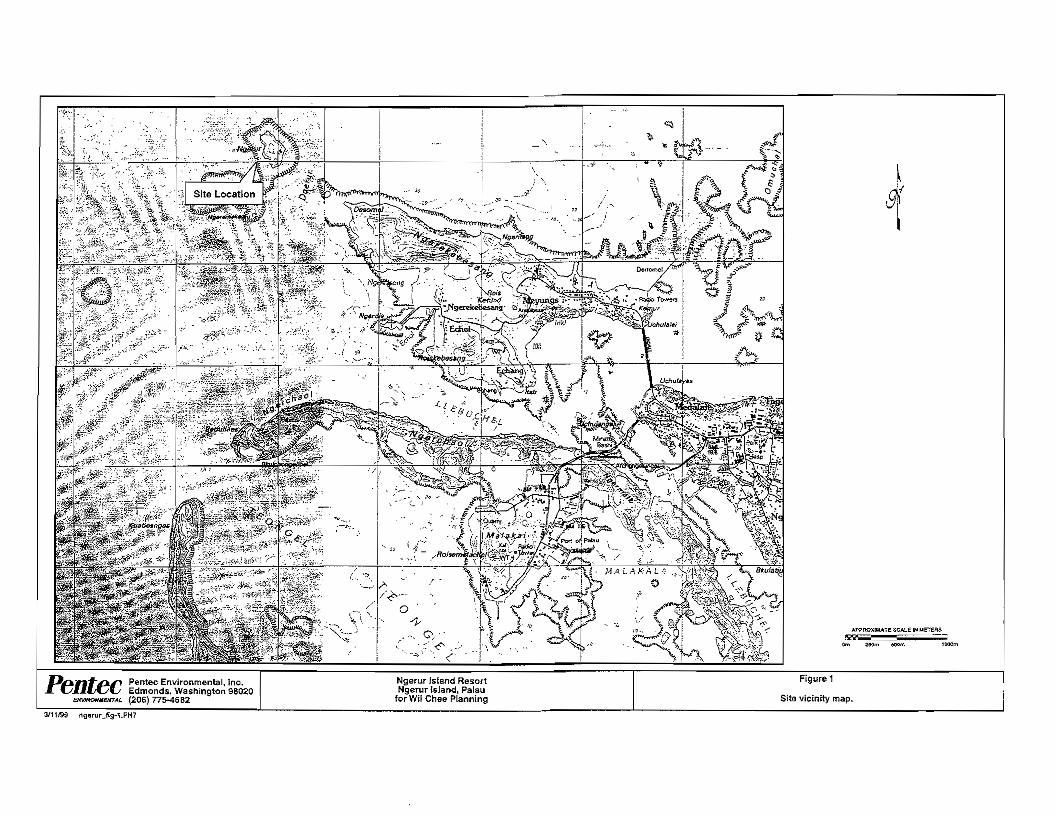
.. •
0
• •
"--'
APPfIOXIMATE SCALE IN ",ErEIlS M:;;;;;e::::::
Om 250m SOOm l00Qm
Pentec Environmental, Inc. Ngerur Island Resort Figure 1 r Edmonds, Washington 98020 Ngerur Is.land, Palau (206) 775-4682 for Wi! Chee Planning Site vicinity map.
3/11199 ngarur3ig-1.FH7

Dnntec Pentec Environmental, Inc. Ngerur Island Resort Figure 2 Ngerur Island, Palau Ngerur Island, e Edmonds, Washington 98020 for Wil Chee Planning north to south perspective (425) 775-4682
416199 ngeruUlg.2.FH8

Ngerur Island Baseline Marine Survey PenleC
2.0 METHODS
2.1 PHYSICAL AND CHEMICAL MEASUREMENTS
The water quality parameters measured were dissolved oxygen (DO), temperature, salinity, turbidity, and pH.
Temperature and DO were measured using a Yellow Springs Instrument Co. (YSI) Mode! 58 DO meter. The instrument was alr,;alibrated at 100 percent saturation at sea level. Manufacturer-reported accuracy is ± 0.02 milligrams/liter (mgll). Temperature was measured in degrees Celsius (QC).
Salinity measurements were made using a YSI Model 33 salinity/conductivity/temperature meter. Manufacturer·reported accuracy is ± 0.9 parts per thousand (ppt). The probes for each of the above measurements were positioned at approximately 20 centimeters (em) below the surface and at roughly midwater depth at each sampling location.
Turbidity was measured using a LaMorre Model 2008 photoelectric turbidimeter. The rurbidimeler was using a. LaM:otte AMCO standard of 5 nephelometric turbidity unitS (NTU). Water samples were collected at approximately 10 to 20 cm below the surface. Manufacturer-reported accuracy is ± 2 percent of the reading, or ± 0.05 NTU, whichever is grea1er. Therefore, measurement accuracy was ± 0.05 NTU. However, some instrument readings may have been influenced by measurements conducted in a boat under conditions that sometimes included modest surface chop. Therefore, insuument error could exceed the range reported by the manufacturer.
pH was measured using an Oaklon pH Testra 2 meter calibrated with a pH 7.0 reference sample. Manufacturer-reported accuracy of the pH measurements is ± 0.1 pH units. Measurements were taken approximately 10 10 20 cm below the surface.
2.2 MARINE BIOLOGICAL SURVEYS
Semiquantitative coral and benthic invertebrate baseline surveys were conducted by divers using mask and snorkel apparatus along random, prepositioned underwater transect lines.
"pOlS. 1999 00296\OO3'v1garurisU.doc:wab page 7
Ngerur Island Baseline Marine Survey PenleC
Transect locations were identified on the basis of conceptual design suggestions provided by the client (e.g., candidate areas for construction of barge landing ramps, sand beaches, marina), areas potentially subject to upland runoff, and sites reflecting a representative of coastal and reef flat biotopes or habitats.
Transects were established by placing a plastic surveyor's tape along the substrate. The surveyor's tape was randomly placed perpendicularly to the shoreline at lengths ranging from roughly 40 to 100 m as a function of the width of the reef flat, zonation patterns (determined by analysis of aerial photographs), and bathymetry (Figure 3). The tapes were typically secured to rocks or logs within the high intertidal or supratidal zone (as detennined by the preseoce of shoreline flotsam and jetsam) to permit definition of physiographic features, biological zonation patterns, and benthic assemblages from the supratidal zone to the lagoon reef margin or stope. Once the tape was secured to the bottom (with transect interval numbers visible), an observer swam the length of the transect and recorded the physical and biological features intercepting the transect tape. At intervals of 5 to 10 m (intervals are a function of transect length) the observer took a single photograph of benthic features using an underwater camera. Although varying as a function of water depth and vertical relief, the photographs typically encompassed an area of from 0.5 to 2 m'l. The phowgraphs provide a permanent data record of each transect. (See Appendix.)
Divers also conducted roving underwater surveys in the general vicinity of each transect to identify and enumerate corals and other species not recorded in the transect data. Such surveys typically averaged about 30 minutes. Some of the roving surveys were conducted by the diver being pulled behind a boat.
Underwater video surveys were also conducted along all study !raDsects to provide additional baseline data, and to record and enumerate species that may have been overlooked during the reconnaissance surveys. A scuba-equipperl diver performed the surveys, swimming along a defined compass bearing at each of the transect locations. The tapes provide a permanent record of the study area
All underwater observations were recorded on waterproof Dura-Rite Field Notebooks. All surveys were conducted during the day. Additional species would likely have been observed had sUlVeys also been conducted at night.
ApmS,1999 0021l6\003\ngarurisU.doc:wab ,.""

Ngerur Island Baseline Marine Survey
No anempt was made to identify or enumerate cryptic species or infauna dwelling within the substrate, except for certain types of large or otherwise conspicuous coral-embedding clams, mussels, and oysters. Observations were generally limited to the larger and more conspicuous invertebrates, because another consultant was to provide a detailed description of invertebrate populations.
Macrothallic algae and coral coverage was determined by visual eslimates of abundance andlor percent coverage along each survey transect. Identification and enumeration of benthic invertebrates was generally limited to individuals exceeding 2 em in body length (macroinvertebrates). Certain especially numerous, albeit smaller invertebrates were, however, occasionally recorded. Counts or population density estimates of certain bemhic invertebrate populations were occasionally made using an underwater s1.ate to roughly delineate 0.05-m2
quadrats or by making density estimates.
Fish identification and abundance estimates were made by recording all species sighted within about 5 m to either side of each survey transect. In some instances, semiquantitative estimates of fish abundance were made using stationary and small plOI counts (the latter technique was useful in enumerating the number of fish inhabiting single, isolated coral heads).
Apn18.1999 00296\OO3V1gan.ulsU.doc:wab pagEl 9
Ngerur Island Baseline Marine Survey
3.0 RESULTS
3.1 WATER QUAUTY
Water quality parameters were measured on September 26-28, 1998. The results of the water quality surveys are shown in Table 1. Four sampling stations were selected in the vicinity of the project site and scattered on all :>ide:> of Ngerur Island (Figure 3). Sampling stations were located roughly 30 [0 50 m from shore at each site. A fifth water quality sampling station, reflecting an area of detrital deposition, was subject to measurements on September 28 (Figure 3).
3,1.1 Temperature
Water temperatures ranged from 30.4 to 31.1 °C (Table 1). The coolest temperature (30.4°C) was recorded at the west side of the istand during an incoming tide on September 27, 1998. Tbe wannest temperature (31.1 0c) was recorded at the same sampling location during an incoming tide on the same day. A mean temperature of 30.7"C was calculated for aU stations. Overall, recorded temperatures were unusually high. The DOnna! range of water temperature is about 23.8 to
Palau's Marine and Fresh Water Quality Regulations (ROP 1996; Chapter 2401-11-15) defines its temperature standard as follows:
Temperature shall not vary by more than 1.5 degree Fahrenheit (0.9 degrees C) from the narural conditions in marine and fresh waters ....All Waters.
The unusually high temperature measurements should not be used as a baseline temperature regime for the project site, because they no doubt originated as a result of the ongoing ENSO event.
3.1.2 Salinity
Excluding sampling station 5 (described below), salinity values ranged from 30.5 to 32.0 ppt (Table 1). Mean surface salinity was lowest on the south side of the island (30.6 ppt) and highest
April B. 19119 pagll10

\
\
/
o i
1l'.'lon'
T1A---{
\ , \ , \ .,
" ",
o S ••,1on
\
\
l )( I
/LEGEND:i """Roof
Slatlon4 Wast sida (long t>each), 30 m off shora
Table 1 Water qualtty dati.
Statio!>, South sid, (laDder), 30 m olf shora
Station 2 East side SO m off shc'e
Stello!> 5 ShICk sediment, 30 m north of stalion 1
Slallon3 North Side (craggy :'.'l, 50 m 011 sho'e
Date
ll.'2S1flS !l-'2S198 9/2.7/98 9/2.7/SB 9/27/98 9/27/98
9126/98 "'26/98 9127/98 9/27/98 9/27/98 9/27/98
9'26/90 W26198 9/27/98 9127/98 9/27/98 9/27/98
9/26/98 9/26 'S8 9127/9S 9/27/98 S/2719B 9127198
9/2S1SB 9128/98 g,'2a'98 s/2/l1ga
Time nda\nl
&:38 ,., 6;41 ,., 9;36 '.0 8:42. "12:20 5.' 12:21 5.'
8;47 52 8:48 5' 8:44 "8:46 "12:24 5.' 1:2:25 5.'
6:53 5.' 6:55 5.' 8:48 " 8;51 '.5 12:29 5, 12:30 5.'
6:59 5.' ,-'
8:53 '.5 a:S5 ,., 12:33 5.0 12:34 '0
9:04 ""9:10 '.0 9:24 "9:25 "
Probe c;ieplh
lvrtSC<l 15t:
surface
'" sUrface
'" surtace
'" surtace
'" suriace
'" sUrlace
'" surface
'" surtece
'" suriac... " ,
surlaee
'" surlace
'" o'ganic sunac'
in &admenl surface
in sediment
lllmp. Sallnlty DO I"C) (ppt) lI>pm)
" M.' ""'., 31.S "301 30,8 "30.6 31.0 '.9 31,0 30.6 5.2 31.0 30.8 5..
30.7 3l.8 "30.7 32.0 "30.5 '" '.30.6 '" 5.0 3\,0 30.9 5' '" SO.8 ,., 30.1 32.0 5.' 30.1 .310 5.' 30.' 31,1 5.0 30.' 31.1 5.0 31,1 31.0 '.0 30.9 30,8 '.0
30.7 31.0 ,.."'., 31.0 '.0 30-' 32.0 '.1 30.6 30.7 "31,1 "" '.0
"" "" 5.'
30.7 30.0 "30.a 22.5 0.2 30.7 30.0 "SO,7 22.0 0'
DO luibldlty $lltuTatlon iNTU) pH
,,% " 1.'
'"19% 0.a2 1.' 70%,,,. 0.95 '.0 86%
85% " "87% 76% 0.1 9.0 79% 65% e,9:;! 1.' 98%
85% 1.20 92 82% 71l% 0.73 '.0 79% ,,% 0.78 7.' '9% m 1.10 '",,% 75% 0.S8 '.0 75% 96% 0.77 '.0
/lS'l'.
''"' .-...... ..
\ , ,
"- , ,
"-- , --', -
\ , (
APPROXiMATE ===: SCALE II\: METERS J'
Pentec /
No«ur Island.
!'or Wll Choe PlanRr1\1
Figure
Wtar-_. .aamplIng and

Ngerur Island Baseline Marine Survey FeRree
on the north side of the island (31.4 ppt). Mean midwater salinity was lowest on the west side of the island (30.7 ppt) and highest on the south and east sides of the island (31.1 ppt). A mean salinity value of 31.0 ppt was calculated for all stations.
Station 5 salinity readings in a deposit of unconsolidated organic sediment were 22.0 to 22.5 ppt. Additional information on physical enviroruneotal conditions observed at station 5 are found in Section 3.1.3.
ROP (1996; Chapler 2401-11-14) establishes the following standard for salinity:
No change in channels. basin geometry or water influx shall be made which would cause permaneot changes in isohaline pattems of more than 10% from natural conditions or change in salinity outside the range of 29-35 parts per thousand or which would otherwise adversely affect the indigenous biota and natural sedimentary patterns. . All Waters.
All salinity concentrations were within Palau's standard for salinity.
3.1.3 Dissolved Oxygen
DO concentrations ranged from 4.7 to 6.1 parts per million (ppm), excluding station 5 (Table I). The highest reading was recorded midwater on the east side of the island on September 27. 1998, The mean DO values for surface and midwater on tbe easl side of the island were 5.1 and 5.5 ppm, respectively. The mean DO values for surface and midwater on the west side of island were 5.2 and 5.0 ppm. respectively. There was no difference between the surface and midwater DO values [or the south side of the island (5.1 ppm), or the island's north side (5.4 ppm).
DO values were influenced by the degree of wind and surface chop exposure. DO readings on the lee sides of the island (south and west) had a mean of 5.1 ppm (N=6), whereas readings on the wind-exposed north side had a mean of 5.4 ppm (N=6). DO saturation values ranged from 75 to 98 percent. A mean saturation value of 81.8 percent was calculated for the sampling station on the lee side, whereas a mean value of 86.1 percent characterized the windward sampling station. A mean DO value of 5.2 ppm (N=14) was calculated for all stations.
AprU 8. 1999 00296\OO31n9&rurisIJ,doc:wab
Ngerur Island Baseline Marine Survey
Measurements obtained within dark. organic. sedimentary deposits at sampling station 5 showed dissolved oxygen levels of 0.2 ppm (Plate 1). This site appears to be a depositional zone for organic materials transported by surface-water runoff from the island, or where lagoon-derived organic detritus is naturally deposited by water currents. Both of these mechanisms may contribute material to this area, as there is evidence of leaf litter and debris of anthropogenic origin (plate I) in the sediment. The organic deposits form a soft. unconsolidated organic sluny in an area of about 10 to 12 m2 adjacent to the vertical rock shoreline along the southeast shoreline of the island.
ROP (1996; Chapter 2401*11· 13) establishes the following standards for DO;
A. Dissolved oxygen concentrations shall not vary by more than 25% from natural conditions .....AU Waters.
B. Except for concentrations attributable to natural causes dissolved oxygen concentration shall not be less than;
i) the greater of 6.0 mgll, 75 percent of saturation AA and 1 waters 2.) 5.0 mg/L..................... . A and 2 waters 3) 4.5 mgll B waters
Excluding station 5, all DO concentrations met or exceeded the saturation standards; however only four times were the DO measurements at or above 6.0 mg/l. The concentration of DO is dependent on the salinity and temperature of the water. The lower-than·normal DO values can be attributed to the warmer·than-normal water temperatures. Station 5 readings are the result of unique physical or hydrological circumstances and are not relevant in tenns of the regulatory standards. Samples of this material returned to the surface for closer examination indicated the strong presence of hydrogen sulfide. indicating anaerobic conditions typical of the natural degradation of organic material in this environment.
3.1.4 Turbidity
Turbidity readings ranged from 0.1 to lAO N11J (Table I). The highest turbidity reading was recorded on the south side of the island. The somh side also demonstraled the highest mean value (1.1 !'.'TU). A mean value of 1.0 NTU was calculated for all stations.
April S. 1999 OQ29S\OO3\1'lg6rulisU.doc:wab paG!' 14

Ngerur Island Baseline Marine Survey l'enrec
There were discernible differences between sampling dates. Sampling that occurred on September 26, 1998, had a mean of 1.25 NTU (N=4), whereas sampling that occurred on September 27 had a mean of 0.82 NTU (N=8). This difference was likely the result of heavy rainfall that occurred on September 26.
ROP (1996; Chapter 2401-11-16) defines its turbidity standard as follows:
Turbidity as measured by NTU shall not be:
A. greater than 1 NTU Class AA and A waters B. greater than 2 NTU .. Class B waters C. greater than 5% above natural conditions . Class 1 Waters D. greater than 10% above natural conditions . Class 2 waters
All turbidity measurements met Class B standards. However, the turbidity standard for Class AA and A waters was exceeded during the rainfall event on September 27,1998.
3.1.5 pH
pH values for all samples ranged from 7.7 to 8.2 pH units (Table 1). The lowest reading was recorded on the west side of the island. A mean pH of 7.9 was calculated for all Stations. Insufficient information is available to draw any significant conclusions from these data.
ROP (1996) (Chapter 2401-11-11) deflUes the pH standard as follows:
A. pH variation shall be within 7.7 and 8,5 units ....Class AA, A, and B waters
B. pH variation shall not be greater than 0.2 pH units from natural conditions; but not lower than a pH of 6.5 or higher than a pH of 8.5 from other than natural causes .....Class 1 waters
C. pH variation shall not be greater than 0.5 pH units from narural conditions; but not lower than a pH of 6.5 or higher than a pH of 8.5 from other than natural causes ...Class 2 waters
Apnl B. 0029ll\003\ngerunsl_,.dOc:wab ps;ge 15
Ngerur island Baseline Marine Survey l'enrec
All 12 samples were within the range for Class AA, A, and B waters.
3.2 MARINE BIOLOGICAL SURVEYS
The coastal and marine habitats surrounding Ngerur Island· demonstrate pristine conditions, though they do not, in general, conform to classic reef flat physiography or biological zonation patterns associated with coastal reef flats. This conclusion is supported by a nonexistent to limited intertidal and subtidal sandy reef flat and the preponderance of an intertidal basalt bench (Figure 4). Because of limited sand and coral rubble deposits, algal density and diversity is low. Seagrass (anthophyre) stands, often abundant in coastal mudflats and sand areas around the larger islands in Palau (and occurring in high-density meadows on nearby Ngerekebesang Island), do not occur at Ngerur.
A distinctive zone of Porites lutea coral, in both massive and micro-atoll morphologies, characterizes the reef flats around the island, as does a narrow but conspicuous soft coral zone (family Alcyoniidae) comprised of Sinularia sp. and Sarcophyton sp. However, an estimated 95 percent of the alcyoniid corals were bleached (yielding, in these two species, a bright yellow coloration), and moribund, and many were in an advanced stage of decomposition. A vertical and undercut basalt headland characterizes the shoreline on the south side of the island
Small crescent- to irregularly shaped rocky beaches occur around the perimeter of Ngerur, though sand deposits are limited and probably experience a fugitive existence between major tropical cyclonic disturbances. Several pronounced rocky headlands protrude seaward roughly 30 m on the west side of the island. and a massive boulder appears (Q have recently slumped into the intertidal zone on the east side of Ngerur.
A massive, roughly 65-m-long basalt outcrop that partially exposes during low-tide periods forms a somewhat unusual wave-protected rocky intertidal moat on the southwest side of the island. Vertical to near-venical rock escarpments and headlands dominate the back beach areas around most of the island, with some (on the north and west sides of the island) having steps cut into them to provide foot access to the interior of the island from the shoreline.
Except for a small stand of white mangrove (Sonneratia alba) occurring on the island's east side, there are no wetland or estuarine plant communities occurring on or adjacent to Ngerur Island. Coastal strand and terrestrial vegetation ranges from a mixed grassland and fern
April B. 1999 00296\OO3\ngerunsl_r.doc:1'<1lb page 16

Ngerur Island Baseline Marine Survey Penree
understory with scattered Pandanus and Cocos nucifera palms, to dense upland forest vegetation
110 and planted coconut groves in areas with deeper soils. Stands of the introduced tree casuarina (Casuarina equisitlfolia) occur on some rocky, wind-exposed coastal headlands and rock
100 outcrops wherc soils are thin to nonexistent. 90
CI Coral wI coral rubble ! A small, possibly hand-dug, water-filled shoreline cave exists in the supratidal zone along the
I•u c .i
80
70
60
50
•• ..•••• •• 1 121 Basalt reel
'I,"S"dWI'"'' BSand wi coral rubble
i SCoral
! I
!
west side of the island (adjacent to study area 1). The cave may have been excavated into the near-vertical cliff face to create a source of fresh water for drinking and bathing. Despite months of drought conditions, the small cave was filled with fresh water and harbored a small population of an unidentified, nearly transparent shrimp (possibly Palaemon sp; family Palaemonidae), and profuse growths of a filamentous green algae. Although there was evidence of small coastal
c 40
30
20
II + + + + + + + +
, I 'I b'och wi ",d I
.Cobble beaCh.
springs and surface-water runoff (denoted by erosion cuts into the underlying rock strata and small gullies), there was no evidence of runoff in these areas during the first two days of the survey period. However, on September 26, torrential rains associated with a 3-hour-long thunderstonn inundated the island. During this period most of the western shoreline cliff face
10 IIii was covered by sbeetflow cascades that originated between the island's bedrock and thin soil veneer. As befitting an area with relatively undisturbed vegetation and soils, runoff water
0 Ii
'a ,b 2, 2b 3 4' appeared free of significant amounts of silt and coastal turbidity readings indicated only a small increase in turbidity from tbat associated with nonrunoff conditions (Section :3.}.4 and Table [).
Transects
• Substrale based on estimated coverage. 3.2.1 Transects 1a, lb, and lc
Figure 4 Ngerur h.lill1d transect aubslrates. Study area 1 was located in a small, roughly 7Q-m-wide embayment on the west side of Ngerur Island (Figure 3). The site was selected for survey based on its potential use as a barge landing area (for heavy equipment transport) and, after the upland construction phase of the project, as a potential area for development of a manmade sand beach and swim.rning area.
The back beach area in study area 1 is dominated by boulders, basaltic rock, and cobbles. The intertidal zone varies between 22 m and 43 m in width, with the [agoonward terminus located in a zone of the coral Porites [urea, in both micrcratoll and nodular growth forms. The intenidal zone is largely a solid rock shelf interspersed with basalt and coral rocks and cobbles. Lagoonward of roughly the lower low water line hard corals are abundant, as are numerous
Apti18.1999 002S6\003\ngl'lfurlsCr.OOC:wab page 18

Ngerur Island Baseline Marine Survey
colonies of the soft corals Sinularia J sp. and Sarcophylon J sp. However, an estimated 95 percent of the soft corals and an estimated lO to 15 percent of the hard corals were bleached. The soft corals, in particular, were flaccid and appeared moribund. with many colonies showing evidence of decomposition.
Three transects were randomly laid out to cover the extreme north, south, and middle sections of the bay (Plates 2 and 3, Figure 3). As graphically depicted in Figure 4, each transect was characterized by a low-relief basalt pavement with occasional basalt outcrops or coral rubble. A thin sand veneer was evident in some places. most notably in small holes or depressions on the intertidal bench. A noticeably low, well-cropped (by herbivorous fishes) greenish to gray algal turf was evident on the intertidal basalt shelf in most areas surveyed.
3.2.1.1 Corals
Twenty-five species of scleractinian (bard) corals (excluding milleporids, zooanthids, and alcyoniids) were recorded along transects 1a, lb. and Ie, or during roving surveys conducted in the vicinity of each transect (Table 2). P. lutea, represented by micro-atoll, massive, submassive, and nodular growth fonns. was the dominant species on all transects, followed by P. amJrewsi and P. (Synaraea) convexa. P. lutea colonies provided an indication of the approximate mean lower low water level, with numerous partial to full, albeit small (to roughly 0.5 m across the longest axis) micro-atoll growth foons evident along all three transects. Many of the P. lurea micro-atolls (in this bay and at all survey locations around Ngerur) are partially dead. with lumpy living portions occupying parts of their peripheral margins that remain covered by water during low tides. That single colonies exhibit both live and dead portions is not unusual. Notable. however, were numerous, bleached, massive and submassive P. [urea colonies, in places
The family Alcyoniidae is curren!ly undergoing taxonomic re... ision, and there are a number of uncenainties regarding existing taxonomic identification. For example. distinguishing between the genera Sinularia and Sarcophyton generally involves analysis of calcareous spicules (sdcrites) within their body tissues, rather than relying on colony morphology. Therefore, in this report, soft corals with a low-spreading base with upward projections that divide and subdivide to form numerous finger-like apices will be identified as Sinuiaria sp.; the generally larger. leathery, large-bladed colonies will be identified as Sarcophyron sp.
AprilS. 1999 00296\OO3\ngerurlsl_r.doc:wab palla 19
Table 2 Checklist of corals.
Taxa Genuslsnecies
Poritidae Porites andrewsi Vaughan Porites compressa Dana Porites (8.) convexa Verrill Porites (8.) /wayamaensis Eguchi Porites lutea Milne·Edwan::!s and Heime Porites (8.) rus Afveopora sp.
Thamnasteriidae PS<lmmocora samoaensis Hoffmeister Psammocora conriguB (Esper)
Acorporidae Acropora echinatB (Dana) Acropora sp. 1 (arb. ) Acropora sp. 2 (blue tips) Montipora digitate (Dana) MOflfipora divan'cala Brueggemann Monlipora tobu/ata Bernard Monripora tuberculosa (Lamarck) MOflfipora sp. 1 (tuberculate)
Agariclldae Pachyseris Pavona frond/fera Lamarck
Pocilloporidae Poeillopora damicomis {linnaeus} Poe/Hopora meandrina Dana
Funglidae Fungia echinata Fungia sp. 1 Fungia sp. 2
Mussldae Lobophyifia Lobophylfia sp.
Favlidae Favia speciosa FaNia padilfida Goniastrea pectinata
PIBtygyra lameffina (Ehrenberg)" Lepfaslrea purpurea {Dana}
Alcyonlldae 8inule.ria sp. (soft, finger-like) Sarcophylon sp. (leathery)
Milleporidae Milfepora sp. 1 (line branched, yellow)" MJl!entlra SI"I. 2 ;Iine branched, oranneY
Transect no.
" ,b 1c 2a 2b 2c 3 4
, , , , , , , , , , , , , , , , , , , , , , , , , , , , , , , , , , , , , ,
, , , , , , , , , , , , , , , , , , , , , , , , , , , , , , , , , , , , , , , , , , x x x , , , , , , ,x ,
x , , x
x
, •, ,
x x
, x x , x , , , , -x
x x , , x , x , , , , , , x x x
, x , x x
contlnued.

Ngerur Island Baseline Marine Survey Penrec Table 2 (continued).
Taxa GenusiSDecles
Zooanthldae Palythoa tuberculosa sp.1 Palythoa tuberculosa sp. 2
Stichodactylidae Heterae/is sp. (kelly green) Heteraeris sp. (gray/green)
Total species
• Not observed on transect.
Transect no. 1a ,. 10 2a 2. 20 3 4
x x x x x x x x x x
x x x x x x
22 21 18 21 20 21 14 13
accounting for as much as 10 percent surface-area coverage on the subtidal reef flat and upper lagoon slope zones.
As reponed above, an estimated 95 percent of all Sinularia sp. and Sarcophyton sp. were bleached, with most appearing moribund or dead, and many demonstrating early stages of decomposition. The majority of these colonies occur in a zone about 7 to 1.0 m wide, with many colonies growing epiphytically on reef limestone, coral rubble, or on the nonliving parts of massive P. lulea colonies. However, despite the near-.eomplete death of these species, an occasional, nonnally pigmented, apparently healthy colony was observed.
Other common to less·comrnon corals recorded on all or most of the transects included P. compressa, Alveopora sp., Montipora labulata, Monripora digitala, Pocillopora damicomis. various Fungia, Plarygyra lamellina, and Leptastrea purpurea. An unidentified orange milleporid (Millepora sp.) and the zooanthid Palythoa tuberculosa were also commonly observed throughout the study area. Overall, coral coverage ranged from 0 in the intertidal zone to an estimated 80 percent on the upper lagoon slope zone.
3.2.1.2 Algae
Thirteen (13) species of algae were recorded along or in the vicinity of transects la, lb, and Ie (Table 3). A mixed turf composed of Entophyso.lis deusra, Microcoleus lyngbyaceus, and Schizothrix sp. is common in most reaches of the intertidal zone, where it was observed to form a slippery film on reef limestone. basalt Outcrops, and limestone cobbles. The filamentous green algae Enreromorpha sp. was also conspicuous in some areas and usually demonstrated a well-cropped appearance resulting from the apparent grazing by herbivorous fish.
Small patches of Halimeda opuntia and an unidentified Halimeda species (Halimeda sp.) were occasionally noted in the intertidal zone and across the outer reef flat and upper lagoon slope zones, though density was low. Other common species observed included Valonia venlricosa, Turbinaria ornata, and rarely, PtUiina sp., Jania capilIacea, and an unidentified coralline algae (listed as Corallinaceae sp.). Hydrolithon reinboldii had a patchy distribution and was usually observed in areas exposed to wave surge.
ApriIS.1W9 OQZ95\003l,ngen.nis(J.doc:wab page 22

Table 3 Checklist of alsae.
Taxa Genua/SDecie_
Cyanophyta Entophysafis deusta (black film) MicrocoJeus Iyngbyaceus Schizothrix sp.
Chlorophyta Enteromorpha clathrata Halimeda opuntia Halimeda sp. Valonia ventricosa
Phaeophyta Dictyotil bartayresU Padins sp. Sphacelaria tribuloides Turb/naria omata
Rh<ldophyta Jania capillacea Polysiphonia scopulorum Coraffinaceae sp. Hydrolithion reignbo/eii
Total soecles
Transect no. ,. ,. ,. 2a 2b 2c 3 4
x x x x x x x x x x x x x x X
x x x x x x x x
x x x x
x x x x x x
x x x x x x x x
x x x
x x x x x x
9 8 7 8 6 7 2 3 •.."."."",....
Ngerur Island Baseline Marine Survey Fenree
3.2.1.3 Fish
Forty-nine species of fish representing 15 families were recorded on or in the vicinity of trans.ects la, lb, and 1c (Table 4). Dontinant families included acanthurids (surgeonfis.hes), apogonids (cardinalfishes), labrids (wrasses), and pomacentrids (damselfishes).
The pomacentrids dontinated the fish fauna in terms of total number of species (14), with Chromis caerulea, Chrysiptera cyanea, and an unidentified yellow juvenile pomacentrid (Chromis sp. 2) abundant in areas dominated by large foliose corals. Schools composed of hundreds of individuals hovered around nearly every coral head, where they would seek refuge upon the approach of the diver. Abudefdufcoelestinus and Abudefdufsordidus were abundant on transect la, but Jess common on transect Ib, and was not recorded along transect lc. Two anemone-associated pomacentrids, Amphiprion melanopus and Amphipn'on sp. (clownfishes), were recorded along the upper edge of the lagoon slope. Both species were associated with expansive and irregularly shaped 0.3- to O.5-m-diameter colonies of kelly·green and gray-green anemones (Heteractis sp.),
A large school of unidentified sardines (family Clupeidae) was recorded over the upper lagoon slope at the end of transect la, but this species was not observed elsewhere in the bay.
Apogonids were also abundant, but their cyptic behavior (generally residing within the branches of foliose corals) made taxonomic identification problematic and enumeration impossible. A total of seven apogonid species (including three unidentified species) were recorded. It is likely that the actual number of apogonid species could exceed that of other families. The apogonid Cheilodipterus quinqueUneatus was ubiquitous along all transects.
The wrass Halichoeres hoeveni was common along all transects and Srerhojulis bandanensis was locally common in schools of 10 to 30 individuals in the vicinity of transects la and Ie,
A single barracuda (Sphyraena barracuda) was observed over the upper lagoon slope beyond the tenninus of transect lb. This was the largest fish observed in the study area.
Overall, fish diversity in the vicinity of transects la. Ib, and Ic represented a fairly typical cross·section of families and species that would be expected to occur in shallow inshore waters lacking seagrass beds, No especially rare or unusual families or species were observed.
April 8. 1999 0029S\OO3\ngeruflsU.doc;wab p.lQ(t24

Table 4 (continued).Table 4 Checklist 01 fish. Taxa Transect no. Taxa Transect no. GenuslsD9cie$ 'a 1b 1c 28 2b 2c 3 4 Genusls"'ecles 'a 1b 1c2a2b2c 3 4 Holocentrlda& (aquirrelfishes) Acanthuridae (surgeonfishes) Flammeo sammara x ,
Acanthurus lineatus x x x x x x x Unidenl. holocentrids x x AcanthufUS nigrofuscus x x x x x x , x Labridall (wrasses) Acanthurus lriostegus x x x HaJichoeres hoevsni x x x x x x x x Acanthurus xanlhopterus x x x x x x Halichoeres margaritaceous x Acsnthurus sp. UUlJeniles) x Hafichoeres trimacufatus x ,Naso x Halichoeres sp. Uuvenile) x Naso unicomis' x Stethojulis bandanBnsis x x x x xGtenochaeluS s/riatus (Quoy & Gaimard) , x x , x x x x Tha/assoma sp.1 uuvenilej x x x Ctenochaefus sp. Uuveniles) x Lutjanld8s (snappers) Apogonidae (cardlnalfishes) ,Lutjanus fulvvs Cheifodipterus lineatus , x x ,Monotaxis grandoculis x x Cheilodipterus quinquelineatvs x x x x ,
Mullidae (goatfishss) Cheilodiplerus sp. (darkhlOr. stripes) x Unident juv. goatfish x Sphaeramia nematoptera x x. x Pomacanthldae (angetfishes) Unident. apogonid sp. 1 x Pygolites diacanrhus x Unident apogonid sp. 2 x Pomacentridae (damselfishes) ,Unident apogcnid sp. 3 (yellow) x Abudefduf ooefsstinus x x x x x Atherinidae (sJiversidas) , , Unident. atherinids x x Xix. Abudefduf sordidus x x x
Arnblygfyphidodon curacao x Ballstidae (triggerlishes) Amphiprion melanopus associated) x x, x Rhinecanthus aculeatus , Ampniprion sp. (anemone associated) x x x
Rhinecanlhus verrucosus , Chromis caeTlJ/ea X x X X X x Biennidae Chromis sp. 1 (green IUV.) x x
Cirripectes sp. '- , , , Chromis sp.2 (yellow jUv.) x Istiblennius sp. 1 (white x Chrysiptera cyanea x x x x x x x x Meiacanthus gremmistes x x x Dascy{/us aruanus· x x Unident. blenny sp. 1 (green/grey) x x Oischistodus perspic/11atus x xUnident. blenny sp. 2 (grey) x x x Glyphidodontops cyaneus x x x x x Uflident blenny sp. 3 (blue/green) x
Pomacentrus pavG x Caranldae (jacks, trevallY) Pomacentrus sp. , uuveniles) X x X , X x Caranyx melampygus (juvenile) Pomacentrus sp. 2 Guveniles) x , x x x xChaetodontidae (butterflyflshes) Unident. pomacentrid sp. 1 (brown) x , , x Unident pomacenlrid sp. 2 (blue)" x x x
,Chaetodon auriga x x x x Chaetodon ephippium , x Scaridae (parrotflshes) Chaetodon kleinii ,
Unidenl. juv. scarids sp. 1" x xGhaetodon lunuia x x Unident. juv. scarids sp. 2 xChaetodon trifasciatus x x
Sphyraenidae (barracudes) Ch8eradan vagBbundus x x Sphyraenf:J barracuda x Chaetodon sp. uuveniles) x x x
Synodontidae (llzardflshes) Clrrhitidae (hawldishes) Saurida sp.* x x Par1J.cirrhites forsteri x
Tetraodontldae (puffers) Clupeidae (sardines) , Canthigastsr sp_ x Uniden\. sardines Gobiidae (gobles) Zanclidae (moorish idol)
Zancfus cornutus (linnaeus) x x x , x Amblvaobius afbimaculatus , Amblygobius sp. x x x x x x
Total scecies continued. 28 3' 30 31 31 23 16 13 !l6'OO31<a ...lIoJondl.blM2.<1o
• Not observed on transect.

Ngerur Island Baseline Marine Survey Tabl., 5 Checklist of macrolnvertebnltes.
Taxa Transect no. 3.2.1.4 Macroinvertebrates ,. 1.Genus/s"ecles 10 2. 2. 20 3 4
The most conspicuous noncoral macroinvertebrate recorded in the study area was T. crocea, which was ubiquitOus ro all transects (Table 5). This coral--embedding clam inhabits the upper horizontal surfaces of massive and submassive P. iu/ea coionies, and is occasionally found in fossil reef limestone. TItis clam is characterized by brightly colored mantle tissue derived from symbiotic algae. often in near-fluorescent shades of blue. blue-green, and purple. Fourteen clams were counted in one large P. lutea colony, with a resultant estimated density of about 28/ m2 • The mussel Septifer bilocularis and the oyster Pedum spondyloideum often occurred in the same coral head with T. crocea. Whereas T. crocea lives largely off food products produced by symbiotic zooxanthellae that reside in mantle tissue, both S. biloculan's and P. spondyloideum are filter feeders that live entirely embedded in P. {uCea and occasionally in fossil limestone. Lopha crisragalli. a small, embedding oyster with a very sharp and irregular aperture, was occasionally seen in some coral heads.
Two individuals of the giant clam Tridacna squamosa were observed at the upper edge of the lagoon slope zone past the terminus of transect Ie. These clams represent popular local delicacies. The presence of this clam in relatively shallow water indicates that the island is not often used for reef gleaning by day picnickers.
The edible rock oyster Samscrea mordax was also common throughout both the upper and mid-intertidal zones, where it lives attached to the bottom strata or on the venical sides of boulders and rocks. Densities of between Z and 221m2 were recorded in several I-m2 quadrats roughly laid out along transects la and Ie. Numerous small snails (Littorina sp. and Nuita sp.) and an unidentified limpet (Patella sp.) were common on rocks and crevices in the upper intertidal and supratidal zones. Unidentified cerithiid snails (family Cerirhiidaej and snail shells occupied by unidentified hennit crabs composed the dominanl fauna of·the rocky high intertidal zone. An unidentified barnacle (family Cirripedia) was also common anached to rocks in the high and mid-intertidal zones.
The largest noncoral invertebrate observed in the study area was the coral-eating sea star Acanrhaster planci. A single individual was recorded near transect la This individual was approximately 0.5 m in diameter. Other sea stars recorded in the study area included Culcita novaeguineae (three recorded), the brilliant blue Linckia laevigata (two recorded), and Linckia
Apnl S. 19i19 002g6IOOO\ngerurisl_r.doc:wab page 27
Porifera (sponges) Doryp/er9$ sp. (orange, encrusting) Theonells sp. (brown upright tubes) Unioonl. brown encrusting sponge Unidenl. yellow encrusting sponge
Sabellldae (sebeilld worms) Sabel/astarte indica Unident. sabellid
Cerlthlldae (snails) Unident. oerilhiid snail
Stl"Ombida8 (conch) Lambis IBmbi$
Chromodorldldae (nudlbranchs) Unidenl. green nudibranch
Conldae (cone shells) Conus marmoreus Conus nussatelJa Conus sp.
Mytll1dae (bivalves) Septifer bifocularis (ooral embedding) Pe<:Jum spondyloideum (coral embedding)
Ostreldae (oysters) Lopha cristagalli Saxas/rea mordax
Trldacnldae (giant clam) TrJdacna croces Tridacna squamosa
Cyprseidae (cowries) CyprafJa mona/a (dead only)
Pmellidae (limpets) Patella sp.
Terebrldse Terebrs macufafa
TUrblnldae (turbln snails) Littorina sp. Narita sp.
Xanthldae Carpilius macula/us
Grapsldae Grapsus sp.
Clrripedla Unidenl. Barnacle
Palaemonldae Palaemon sp.
, , , , , x , , , , , , x , , , x
, , ,
, , , , , , x
, x x , , , , x , , , , x , xx
, , , , , , x x , , , x , , x
, x x , , , , x , ,
, x x x , , x
x
, , , , ,x x x , , , ,x x x
x
x x, ,x x x x x
x· continued.

Table 5 (continued).
Tn. Trans.ect no Genus/sDecio8 ,. ,. 2.
Aslerfodea (sea stars) " Acanthasfer plBllCi , , Culcila novagIJin/3B/3 , , Lirwk.ia guildingi , , Linck.ia laevigala , ,
Echinoidea (sea urchins) Diadema savignyl' , , , , EchinOm6tra mBlhB/3i ,
Holothurldae (se. cucumbers) H%!hlJria aim , , H%muria adulis , , Holothuria chforono/us Holo/huria (Thymiosycia) hilla Slichopus sp. , , ,
Ophluroldea (brittle stars) Ophlothrix sp. ,
Dldemnidsll' Didemnum mol/e , , , , Didsmnum sp. 1 (orange} Didemnum sp. 2 (olive green) , Unident. COlonial ascidian , , , Totals.....cie8 25 " 20 22
• In lrashwater pool on beach, nOl on transect.
Ngerur Island Baseline Marine Survey l'enleC
guildingi (one recorded). Echinoids (sea urchins) observed in the study area included the black, long-spined DiadeTM savignyi, and the burrowing Echinomerra marhaei. 2. 2, , 4
Holothurians (sea cucumbers) were generally uncommon in the area, a finding that no doubt , , reflects the lack of extensive sand or coral nibble deposits in the study area. However, three , , , species were recorded, including Holothuria atra, H. edulis, and Stichopus sp. All three species were associated with narrow, sandy troughs between coral heads and small pockets of coral , , , robble.
, , , The didemnid (nol an invenebrate, but a member of the Phylum Chordata, Class Ascidiacea) , Didemnum moUe was a conspicuous feature along all transects and was abundant along the upper , , lagoon slope zone in the vicinity of each transect. , , , ,
3.2.2 Transects 2a, 2b, and 2c
, , , , Study area 2 was located in a small, roughly embayment on the southwest side of , , Ngerur Island (plates 4, 5, and 6, Figure 3). The site was selected as a survey location on the , basis of its potential use as a barge landing area where a ramp would be constructed to provide heavy equipment access to the island. Following land-based construction, it has been proposed 21 16 20 12 that the bay's intertidal reef flat be converted into a dive "gratia." The grono would be excavated on the intertidal reef platfoUD to create a permanently subtidal basin within whkh corals and other benthic species would be planted and maintained as a resort amenity for snorkelers.
The most conspicuous physical attribute of the bay is a massive, roughly 65-m-long by 7- to 11-m-wide, elevated basalt outcrop that runs roughly parallel to the shoreline and partially exposes during low-tide periods. The exposed section of the outcrop is not populated by epibenthic organisms. During moderate to low-tide periods this somewhat linear outcrop creates a surge-protected rocky intertidal basin on its landward (east) side.
Figure 4 depicts the physical substrate encountered along transects 2a, 2b, and 2c. Despite the small size of the bay, physical and biological conditions differed between the bay's south and north sides. In particular, coral development IS significantly greater along transects 2a and 2b as contrasted with transect 2c. Transects 2a and 2c were limited in length to about 46 m by the barrier imposed by the aforementioned basalt outcrop. Roving surveys were, however, conducted south (lagoonward) of the outcrop.
Apr,1 6, , 999 00296\OO3\ngerurI&U.doc,wab pago130

Ngerur Island Baseline Marine Survey
The north and south side of the bay is delimited by rocky basalt headlands. Between the headlands is a rocky beach and a vertical to near-vertical basalt cliff. The bay lacks a sand beach, though small sand deposits occur as a mostly thin veneer on or between rocks and cobbles in the intertidal zone. A large, rusted, World War projectile, about 20 cm in diameter, was observed in the high intertidal zone at the south end of the bay (Plate 7). The position of the projectile atop the intertidal bench and the absence of attached organisms suggest that it may have been placed there during recent human activity on the island.
3.2.2.1 Coral
The coral community associated with transects 2a, 2b, and 2c was composed of 21 scleractinian coral species (excluding milleporids, zooanthids, and alcyoniids) (Table 2). P. lutea was the dominant species on aU transects, and was composed of micro-atoll and small nodular growth fonns in the low intertidal zone, grading to massive and submassive colonies in subtidal areas and across the reef margin and lagoon slope zones. Other abundant species, often represented in expansive colonies or outcrops up to 2 m across, included P. andrewsi, P.(S.) conve::uJ. P. compressa, M. lobulata, M. digitara, and P. rus. Coral coverage ranged from zero in the high intertidal zone, to an estimated 80 percent on the reef margin and upper lagoon slope z.ones.
The pocilloporid P. damicomis was also common along all transects, with perhaps 20 percent of the colonies demonstrating evidence of bleaching. Fungiid corals were also common. with three species, two of which were unidentified, recorded. The zooanthid P. tuberculosa (not a true coral) was also of conunon occurrence across the low intertidal zone, with densities of up to 51m2 recorded on shallow, rocky substrata.
Other less common corals observed included scattered colonies of Alveopora sp., Favia speciosa, Lobophyllia hemprichii, and P. lamellina.
An estimated 95 percent of all Sinularia sp. and Sarcophyron sp. observed appeared moribund or dead, with some colonies demonstrating evidence of decomposition. The apparent death of this soft coal community is likely the result of thermal injury associated with the 1998 ENSO event.
April 8, 1999 00296\OO3\rlg9JvnsU.doc:wab pa91;31
Ngerur Island Baseline Marine Survey l'entee
Two species of milleporids were observed in study transects, with one species (listed as Millepora sp. 1) representing an unusual growth fonn with finely branched. upright yellow branches.
3.2.2.2 Algae
The flora of the intertidal reef platform in study area 2 was similar in species composition to that recorded in study area 1, except that E. deusta and Corillinaceae sp. were not observed (Table 3). The cyanophyte conununity was dominated by M. lyngbyaceus and Schizorhrix sp., which together created a slippery, silt-retaining mm across the limestone pavement and upon basalt rocks and cobbles.
The green filamentous algae E. clalhrara was recorded on transect 2b in small upright tufts, but was not recorded on either of the remaining two transects. This species is, however, grazed upon by herbivorous fish and invertebrates and is often difficult to discern when closely cropped. H. opuncia and a second unidentified Halimeda species were also recorded In the reef margin and upper lagoon slope zone. Both species were found in coral thickets and in areas of coral and coralline-algae rubble.
T. omara was the most frequently encountered brown algae, followed by occasional patches of Padina sp., and Sphacetaria rribuloide:s. Overall algal density was low. T. omara was observed in the lower intertidal and reef margin zones. Padina sp. frequently demonstrated a sickly, flaccid appearance, suggesting old growths or perhaps thermal stress.
Red algae were not abundant. Represented species included Polysiphonia scopulorum and H. reinbo/dii.
3,2.2.3 Fish
Forty-five species of fish representing 16 families were recorded along or in the vicinity of transects 2a, 2b, and 2c (Table 4). Pomacentrids accounted for the greatest number of species (11), followed by acanthurids (7), apogonids (4), chaetodontids (4), and labrids (4). As reported in Section 3.2.1.3, apogonids may represent the most diverse family, as well as the most abundant species, but [heir small size and cryptic behavior, combined with the near-transparency
1999 OOZ9S\003\ngeNnsU.Qoc:WEIb

Ngerur Island Baseline Marine Survey Penrec Ngerur Island Baseline Marine Survey Penrec
of some species, makes them difficult to accurately identify and enumerate within dense coral thickets where they are typically found.
The pomacentrids A. coelestinus and A. sordidus were abundant on all transects, as were C. caerulea, juvenile, C. cyanea. and two species of juvenile Pomacentrus (Pomacentrus sp. 1 and Pomacentrus sp, 2). C. cyanea and Pomacentrus sp. I and 2 were always recorded in assemblages of 50 to an estimated 150 individuals hovering over or atop large foliaceous corals within the reef margin and upper lagoon slope zones. Several anemone-associated clownfish (Amphiprion sp.) were obselVed within an aggregation of small anemones on the upper lagoon slope zone near transect 2c. The black·and-white-striped pomacentrid Dascyllus aruanus was recorded on transect 2b and was not observed elsewhere around the perimeter of the island. Eight individuals representing at least two Or possibly three age classes were recorded around a single P. damicornis colony.
Wrasses were also abundaIlt on all transects, with H. hoeveni and S. bandanensis recorded from the intertidal zone to well down the lagoon slope zone. Several large (200 to 300 individuals) roving schools of juvenile wrasses (Thalassoma sp.), all of the same age class, were recorded along each of the study transects.
At least two species of unidentified juvenile parrotfisbes (scarids) were recorded in the study area. This was the only record of parrotfish observations around the Ngerur Island during this survey.
Other species recorded in the area, but not observed in other study sites, include the balistid Rhinecanthus aculearus, Cheilodipterus sp. (dark with horizontal stripes), an unidentified blenny, Chaetodon ephippium, the hawkfish Paracirrhitesforsteri.the angelfish (family Pomacan!hidae) Pygolites diacanthus. and the pomacentrid Pomocentrus pavo.
3.2.2.4 Mac:rolnvertebrates
A total of 30 macroinvenebrate species were recorded along transects 2a, 2b, and 2e, or during roving surveys conducted in the vicinity of the bay (Table 5). The number of species observed aIld enumerated was comparable between transects and was nut unlike the species checklist for study area 1, which demonstrated similar physical environmental conditions (e.g., broad intertidal reef platform and a southerly exposure).
AprilS, 1999 00296\003\ngeruc1sJJ.ooc:wab pBge 33
The snails Littorina sp. and Nerira sp. were the dominant organisms associated with the supratidal and high intertidal zones, often occurring in groups of betw«:o 50 and 100 individuals (by estimation) in protected indentations on large, exposed basaltic rocks and boulders. An unidentified barnacle also occurred in the high intertidal zone at densities less than either of the two previously described snails. However, the barnacle's small size and dark coloration, a color close to that of its basalt rock habitat, makes enumeration of this species difficult. S. mordax was also conunon across the broad reef flat platform, where it lives either attached to bottom strata or upon the vertical sides of larger, surge·stable rocks and boulders.
At least three species of sponges were observed within the coral community on the reef margin, on the upper slope, or in coral rubble pockets. Only Theonella sp. was distinctive in its morphology (brown, upright siphons), whereas the two other sponges (both unidentified) were low, prostrate species.
Coral- or limestone-embedding mollusks were conspicuous along all transects. Represented species included T. crocea, S. biiocularis. L. cristagalli, and P. spondyloideum. The majority of these species were observed embedded within or massi ve P. lurea colonies, though T. crocea was occasionally detected within dense thickets of P. andrewsi and P.(S.) convexa.
3.2.3 Transect 3
Study area 3 was identified by the presence of a stand of white mangrove (the only occurrence of this species around the perimeter of the island) and the presence of a representative cross section of marine habitats (as suggested by aerial photographs) associated. with the east side of the island (Figure 3). No project-related development or resort activity area has been proposed at this time for any coastal area in the vicinity of study area 3.
The shoreline is dominated by a vertical to near-vertical shoreline cliff and a narrow basalt rock and coral cobble beach that exposes during periods of intermediate and low tide (Figure 3). Sand is mostly absent except in small depressions on the beach or in areas where larger rocks and boulders offer some degree of protection from wind-fetch-generated wave action. As depicted in Figure 4, the transect substrata is dominated by a basalt bench with a thin sand veneer, a sandy zone with mixed hard and soft corals, and a zone of coral and coral rubble along the easternmost portion of the loo-m transect (Plates 8 and 9).
Apnl8.1999 00296\OO3\ngerurislJ.doc:wab

Ngerur Island Baseline Marine Survey Pentee
The most distinctive biological feature of study area 3 is a stand of the white mangrove Sonneraria alba, which forms a near complete vegetative canopy, some 20 m deep, along the shoreline's supratidal zone and across portions of the intertidal zone (Plate 10). S. alba pneumatophores (breathing organs), averaging an estimated 30 em in height above the rocky substratum are conspicuous features of the rocky intertidal zone and extend approximately 35 m lagoonward (east) from the shoreline cliff and about 15 m beyond the edge of tbe vegetative canopy. Unlike the more wind- and wave-protected coastline on the adjacent Ngerekebesang Island, water currents and small, wind-generated chop appear to minimize mangrove leaf litter deposition beneath the tree canopy. However, organic material derived from mangrove leaf litter could account for the low DO readings associated with the apparent depositional area described in section 3.1.3. Lagoon water-current patterns observed (not measured) during the survey period indicated a pronounced southerly flow that could result in the transport of leaf litter from the mangrove sland to the area where dark, anoxic, detrital deposits were observed.
A second biological feature associated with this study site is a distinct zone of alcyoniid corals, which were visible from the surface during the survey period, as well as in a color aerial photograph taken some months (date unknown) before the survey period (Figure 1). This zone occurs between 50 and 60 m east of the shoreline cliff, as measured by transect analysis. Although the undated aerial photograph depicts a distinct band of gray-colored soft corals against a contrasting white sand and coral rubble substrate, this same zone was yellow to yellowish-white during the survey period. This is believed to be the result of the apparent earlier expulsion of symbiotic zoox.anthel[ae from the majority of the Sinularia sp. and Sarcophyton sp. that this zone comprises. When healthy, both species normally ex.hibit a gray to brown pigmentation. In the absence of zooxanthellae, the colonies are rendered a yellowish-white color. An estimated 95 percent or more of the soft coral in this zone was dead and fragmenting, with some colonies showing evidence of being in an advanced stage of decomposition. In some areas, however, an isolated, normally pigmented, and healthy-appearing colony of either Sinularia sp. or Sarcophyton sp. was occasionally observed. The near complete destruction of these species is likely the result of water temperatures associated with the 1998 ENSOevent.
April B. 1999 00296\OO3\llgeC\lMU.do\;;wtI,b
Ngerur Island Baseline Marine Survey
3.2.3.1 Coral
As reported above, the decimation of the soft coral zone, presumably the result of high water temperatures, was both interesting and disturbing. Aside from the near-total death and decay of this roughly community, the majority of the soft corals found along the remainder of the lOO-m transect also appeared dead, and many showed evidence of advanced decay. Coverage of dead and decaying alcyoniid corals accounted for an estimated 3 to 5 percent coverage.
Eleven species of scleractinian corals (excluding alcyoniids and zooanthids) were recorded on or around transect 3 (Table 2). and nodular growth forms of P. lurea formed a conspicuous zone between the 60- and 80-m transect intervals, and occasionally intermixed with P. andrewsi, low robust colonies of P.(S.) convexa, M. lobulara, and sometimes expansive patches of coral rubble and sand. An estimated 15 percent of all observed P. lutea colonies had a bleached. appearance and it was not unusual to see bleached individuals between otherwise healthy in appearance, robust. normally pigmented brownish-green) colonies.
The small, foliose coral P. damicomis was common in scattered patches between .he 70- and 90-m transect intervals, though an estimated 80 percent of all colonies recorded appeared bleached. However, there was no evidence of epiphytic algae or other fouling organisms on any of the corals observed, suggesting that expulsion of zooxanthellae was recent and that coral polyps were still viable.
Two species of fungiid corals were abundant (a lolal of 34 individuals recorded) in areas of coral rubble on or in the vicinity of transect 3. Both F. echinara and a second unidentified species (Fungia sp. 1) frequently displayed a yellowish-green coloration that is atypical for the genus. It is assumed that the yellow pigmentation is a direct consequence of the expulsion of zooxanthellae as a result of thermal stress. Other than the unusual pigmentation, all of the individuals appeared healthy and no evidence of epiphytic algae growth on any of the colonies was observed.
3.2.3.2 Alga.
Algae were poorly represented on or around transect 3 (Table 3). Only two species were recorded and neither was abundant. H. opunria occurred in occasional patches among areas of
AprilS, 1999 00296\O()J\tlgltflJl1sU.doc:wab
Ngerur Island Baseline Marine Survey
coral rubble and live coral and an unidentified coralline algae (recorded as Corallinaceae sp.) was occasionally observed between transect interVals of 55 and 70 m. The blue-green algal film characteristic of other intertidal or subtidal reef flats on the west side of the island was not observed in the vicinity of transect 3. However, this often ubiquitous mixed-species film could have been occluded by a sandy·silt veneer that was evident between the shoreline and about the 55-m transect interval.
3.2.3.3 Fish
Only 16 species of fish were recorded along transect 3 and in the course of roving surveys conducted in the general area (Table 4). Overall, the reef fiat fisb population could be regarded as sparse compared to similar habitats elsewhere around the perimeter of Ngerur Island, where nearly twice the number of species were reCOrded. Not only was the number of fishes recorded unusually small, but the popUlation size for the represented species was also very low. A total of only 56 individual fishes were recorded in the course of diver surveys in this area.
Represented fishes included acanthurids (two species), apogonids (two species), atherinids (one species), balistids (one species), blennids (one species), chaetodontids (one species), gobiids (one species), holocentrids (twO species),labrids (one species), and pomacentrids (four species).
There is no apparent or otherwise observable reason for the small number of species and individuals recorded in study area 3, other than the presence of extensive stands of decaying soft corals and bleached sc1eractinian corals. It is possible that the decaying soft corals, or intermediate decomposition products thereof, produce some type of tox.ic, inhibitory, or otherwise offensive chemical substance that reef fishes avoid by relocating, at !cast temporarily, elsewhere.
3.2.3.4 Macroinvertebrates
The turbinid snails Liuorina sp. and Nerita sp. were cornman on large rocks and boulders in the high intenidal zone and were occasionally observed attached to S. alba pneumatophores (Table 5). Compared to the west side of the island, their densities were considerably lower. This observation may reflect reduced primary production resulting from tree shading across much of the supratidal and high intertidal zone in study area 3. Both Lirtorina sp. and Nerira sp. are
1999 00296\OO$It1gerunsl_f.dcc:wab page 37
Ngerur Island Baseline Marine Survey l'eI1WC
herbivores and shading by S. alba could reduce the abundance of epiphytic algae upon which these small snails graze.
Coral and limestone-embedding mollusks were the dominant and largest macroinvertebrates in study area 3. T. crocea, S. bilocularis, P, spondyloideum, and L cristagalli were abundant in many P. lutea coral beads, but often absent in other colonies of the same species. Many of the T. crocea colonies demonstrated unusually pale mantle tissue, which may be the result of thennal stress or injury to the clam or to their symbiotic zooxanthellae. Zooxanthellae are responsible for imparting the fluorescent color to clam mantle tissue. This observation is qualitative and does not lend itself to quantification. Nonetheless, the difference in mantle tissue coloration was distinctive between clams observed along this transect as contrasted with clams recorded on the west side of the island.
The rock oyster S. mordax was abundant in the high and mid-intertidal zone, where it lives attached to rocks, dead coral, and bottom strata. Three dead cowries (Cypraea moneta) were also noted. This was the only record of this small cowrie around the perimeter of the island during this survey.
The sabelJid worm Sabellaslarre indica was recorded in two locations within coral thickets between the and 85-m transect interval, as was a second unidentified sabellid.
Single individuals of the sea stars L. laevigata and L.. guildingi were observed in a zone of coral rubble, as were the holDlhurians H. arm, H. (Thymiosycia) hilla, and Srichopus sp.
Two ascidians were also common in coral thickets. D. moUe was ubiquitous in coral areas along the transect, as was an especially common unidentified colonial ascidian that was observed growing attached to rock and dead P. lurea.
3.2.4 Transect 4
Study area 4 is located off the southeast side of Ngerur Island and is distinguished by relatively deep water and the absence of an intertidal or subtidal shelf or reef flat platform (Figure 3). This site has been conceptually identified as a proposed location for a divemaster pavillion, arrival plaza, marina, and cargo operations center for the proposed resort.
April 8. 1999 002961OO3\ngerunsU.c.oe:wab page 38

Ngerur Island Baseline Marine Survey Pentec
Water depths during the survey period ranged from about 3 m immediately adjacent to the shoreline, to at least 20+ m deep about l20 m southeast of the shoreline, Coverage of live and dead coral is about 95 percent throughout the study area (Plates 11 and 12). Nearshore coral composition at this location was more typical of what would be expected within a lagoon reef margin community. Roving surveys conducted in the area indicated that this zone of high coral coverage extended several hundred meters south (toward the small, unnamed, rocky islet hosting a single coconut palm), forming a somewhat linear and continuous lagoon reef.
The intertidal zone at this location is composed of a vertical to undercut solid basalt wall, rougWy 4 m in height, extending iota uoconsolidated lagoon sediment and coral outcrops dominated by massive P. lutea and P.(S.) convexa. Except for occasional, widely scattered barnacles and small patches of turf algae, the submarine cliff was mostly devoid of epibenthic biota.
3.2.4.1 Coral
Nine species of scleractinian corals were recorded in study area 4. The number of corals recorded is smaller than that enumerated along other study transects around Ngerur Island. However, this result is a function of the high coral density that composes the reef margin conununity. Coral coverage lhroughout the area is about 95 percent. This study area is dominated by a dense assemblage of massive corals, panicularly P. lurea, F.(S.) convexa, and P. andrewsi, as contrasted with shallow-water subtidal communities found elsewhere around the perimeter of the island, where there is a preponderance of smaller submassive corals, P. lutea micro-atolls, greater vertical relief, and patches of coral rubble that can acconunodate small, pioneer coral species. Thus there are fewer niches available for coral growth in this study area as contrasted with other study sites around the perimeter of Ngerur Island.
This site was also distinguished by the near-complete death of all represented alcyoniid corals and near-loo percent bleaching of all recorded P. damicomis colonies. Bleaching of many massive and submassive P. lutea colonies was evident throughout the study area. with bleached individuals accounting for an estimated 15 percent of surface-area coverage. The soft corals Sinularia sp. and Sarcophyton sp. appeared to have suffered destruction, with most individuals observed demonstrating evidence of being in an advanced stage of decomposition. Although bleached colonies of P. damicomis and P. lutea were commonly
April 8, 1999 00296\O03Ii1gerunsI3.dOC:waIJ pa.ge39
Ngerur Island Baseline Marine Survey Pentec
observed, none showed evidence of epiphytic algae or sponge growth on bleached tissues, suggesting that the coral polyps were alive during the study period. However the long-term fate of the bleached corals remains uncertain.
3.2.4.2 Algae
Algae were uncommon and were not conspicuous in any of the areas surveyed. Small patchy growths of H. opuntia were occasionally noted, as was V. ventricosa and tufts of an unidentified whitish·pink coralline algae (identified as Corallinaceae sp. in Table 3).
3.2.4.3 Fish
Only 13 species of fish were recorded during surveys conducted in study area 4, and few of these were represented by more than a few dozen individuals (Table 4). This low census is inexplicable, given the extent of live coral coverage and the presence of otherwise diverse coral and corallUbble habitats throughout the study area.
Represented families included acanthurids (four species recorded), apogonids (one species recorded), chaetodontids (one species recorded), holocentrids (one species recorded), labrids (one species recorded), and pomacentrids (five species recorded) (Table 4). Pomacentrids were represented by C. cyanea, two unidentified juvenile Chromis sp. (Chromis sp. 1 and 2), Dascyllus aruanus, and a single school of an unidcntified blue juvenile pomacentrid which was observed hovering above two separate, largeHbranching Monripora coral heads.
Acanthwids were represented by A. lineatus, A. nigrofuscus, A. xanthopterus, and C. striatus, all of which were recorded in small, roving, monotypic to sometimes mixed schools of 3 to Ii individuals.
There was no readily apparent explanation for the few fish recorded in the study area other than the presence of dead and decomposing stands of alcyoniid corals and bleached hard corals (as was previously described for study area 3).
April 8, 1999 00296\OO3\rlgerurlsU.doc;wab page 40

Ngerur Island Baseline Marine Survey
3.2.4.4 Macroinvertebrates
Only 12 macroinvenebrate species were recorded in study area 4, or about half the number of species recorded along other transects or within other study areas around Ngerur Island (Table 5). This low diversity probably reflects both the ex.pansiveness and morphology of the live and dead corals composing the lagoon reef margin community and the resulting low habitat diversity. Macroinvertebrates normally associated with intertidal and shallow, subtidal reef flats, sandy basins, and coral rubble habitats were therefore not represented within this expansive and mature coral community. This observation does not take into ac<:ount cryptic species residing within the dense coral matrix, which are impossible to identify without destroying the coral community.
Coral-embedding mollusks were the dominant macroinvertebrates and were recorded in moderate densities of up to 111m2 in massive and submassive P. lutea coral heads, and occasionally in areas of exposed fossil reef limestone. T. crocea was conspicuous as a result of their colorful exposed mantle tissue, though in some sites the colors were subdued and atypical of the fluorescent hues that are often associated with this species. This same observation was also made in study area 3. As was reported in Section 3.2.3.4, this may be the result of thermal stress or injury, though reduced or faded coloration in clam mantle tissue was not apparent in study areas on the west side of the island. Other coral-embedding species observed included S. bilocularis, P. spondyloideunt, and L cristagalli. The rock oyster S. mordax was occasionally observed along the shoreline's vertical basalt ledge, but was nOI common.
Other macroinvertebrates recorded in the study area included two species of unidentified encrusting sponges, sabeUid wonns (family Sabellidae), the sea stars C. novaguineae and L. laevigata, the holothuroids H. atra and Stichopus sp.• and the didemnid D. molle.
April B.1999 00296\OO3\ngerurisl_r .00c:W3t1
Ngerur Island Baseline Marine Survey
4.0 DISCUSSION
4.1 WATER QUALITY
With. the exception of temperature, water quality parameters were generally within the expected ranges for coastal lagoon waters in the equatorial western Pacific Ocean.
Water temperarures ranged from 30.4 to 31.1"C, with a mean temperature of 30.7°C recorded for all stations. Although seasonal changes in water temperature are experienced in Palau. water temperatures are normally in the range of 27.5 to 29.9°e based on the results of water temperature analyses conducted over the past 22 years. A mean temperature of 28.3°e characterized lagoon waters on January 9, 1976, at the site of the then·proposed sewage outfall al the south side of Malaka! Island (Birkeland et al. 1976). A mean temperature of 29.9°e characterized coastal marine waters on November 24, 1977, in waters fronting what is now Palau Pacific Resort (PPR) (Randall et al. 1978). A mean temperature of 29.6 and 29.8°e characterized lagoon waters fronting PPR on January 22. 1990, and September 22·23, 1992, respectively (BrewerlBrandman Associates 1990). Water temperatures recorded during the September 1998 survey averaged at least 1"e above normal ambient lagoon water temperatures.
Anecdotal reports from several sources (Coral Reef Research Foundation [CRRF] staff; Larry Sharron, Belau Aquaculture) contacted during the field survey period indicated that Palau experienced water temperatures up to 33°C (91°P) in early September 1998. This temperature was recorded in Malakal Harbor and at sites in ocean passes at depths exceeding 30 m. Temperature data recorded during the surveys suggest that lagoon water temperatures were still under the influence of the ongoing ENSO event.
Salinity values ranged from 30.5 to 32.0 ppt (excluding station 5). Salinity readings of 32.0 ppt were recorded at sampling stations on the east, north, and west sides of the island and do not appear to be location-dependent. A mean salinity value of 31.0 ppt was calculated for all stations. The salinity values are somewhat lower than would nonnally be expected. By comparison, a mean salinity value of 32.3 ppt was rtX:orded on January 9, 1976, at the then-proposed site of the Malakal sewage outfall in Malakal Channel (Birkeland et al. 1976). A mean salinity value of 33.0 ppt was recorded on November 24, 1977, in coastal waters fronting what is now PPR (Randall et al. 1978). Salinity readings demonstrated a mean value of 34.0 ppt
April B. 1999 0029'51OO3'\1l1ilerurisl_r.doc:wab page 42

Ngerur Island Baseline Marine Survey Pentee
in lagoon waters fronting PPR on January 22, 1990, and a mean of 32.5 ppt on September 22-23, 1992 (BrewerlBrandman Associates 1990; MBA International 1992). Thus, prevailing ENSO drought conditions, and a presumed reduction in surface- and groundwaLer runoff, do not appear to have produced any corresponding increase in lagoon salinity in surface waters around Ngerur Island.
DO concentrations were low and ranged from 4.7 to 6.1 ppm (excluding station 5). Percent DO saturation ranged from 75 to 98 percent and appear to reflect a range more or less typical of lagoon surface waters. As was described in the results section, a DO reading of 0.2 ppm was recorded in a confined area adjacent to the southeast side of the island. Such low readings are consistent with a depositional zone characterized by organic enrichment from terrestrial or lagoon sources.
Turbidity readings ranged from 0.7 to lAO NTU. The mean mrbidity value for all stations was 1.0 NTU (N=12). Turbidity readings demonstrated a mean value of 1.3 NYU (N=4) on September 26 during a period of no rainfall, and a mean of 0.82 NTU (N=8) on September 27, a period of very heavy rainfall and rainfall runoff. These data suggest that in its W1devc1oped state, the vegetation cover of the island is effective in retaining silt and sediment that might otherwise run off into coastal waters.
pH values ranged from 7.7 to 8.0 pH units. All 12 samples were within Palau's water quality standards for Class AA. A. and B waters.
4.2 BIOTA
Corals are the most important organisms in the community structure of shallow-water habitats in tropical and subtropical oceans and lagoons worldwide. corals (including scleractinian, octocorallian. and hydrozoan corals) are sessile organisms with potentially long life spans and distribution patterns that depend upon the particular environmental setting found from one habitat to another. Their calcium carbonate skeletons are major contributors to both in siru framework and detrital reef deposits in fringing reef environments, the remnants of which are found in the vicinity of the proposed project site.
Characteristic coral communities develop in response to variable environmental conditions in different habitats. These conditions may range from unfavorable to optimum conditions, in
AprilS, 1999 CO:296\OO3\ngerurisU.doc:wal:l page 43
Ngerur Island Baseline Marine Survey
which corals are the dominant organisms in the community. Corals arc sensitive to many environmental variables, including suspended materials in the water column, sediment accumulation on the substrate upon which they grow, water currents, seawater dilution from surface drainage and groundwater discharge, temperature fluctuations, exposure during low tides, and pollution from toxic SUbstances and thermal, stenn drain, and sewage discharges (Randall 1990).
Assessment of the status of coral communities (and coral-associated biota) on the subtidal habitats fronting Ngerur Island has indicated the existence of a stressed benthic community. Coral bleaching and the apparent decline in coral health appears to be the result of the 1998 ENSO event, which may have produced water temperatures debilitating and perhaps lelbal to corals and other benthic species. It is uncertain at this time whether the bleached corals will survive or if overall coral diversity will be reduced, at least in the near tenn. Future monitoring surveys should be conducted to ascertain the long-tenn status of the affected coral communities.
A total of 39 coral, 72 fish, 15 algal, and 43 macroinvertebrate species were recorded in the course of baseline marine surveys conducted in inshore waters around Ngerur Island. These numbers compare with 163 corals, 66 fish, 33 algae, and 13 large, noncoral invertebrate species recorded on the reef flat and lagoon slopes in January 1976, at the thenvproposed marine outfall site adjacent to thC"Southern tip of Malakal Island (Birkeland et al. 1976).
As an additional comparison, a cumulative total of 159 coral spe.::ies were recorded from disturbed and undisturbed reef flat platform, channel margin, and upper channel slope zones near the Toachel Mid near Ngesaol, on the east side of Koror Island (Randall 1990). Although demonstrating high coral biodiversity. physical environmental conditions in the vicinity of Ngesaol are different from those at Ngerur Island, and the latter site did not have any significant seagrass or mangrove development. Any comparison of community structure or composition between these rn.'o sites would not be entirely relevant. A taxonomic inventory of the fish fauna associated with the Ngesaol area accounted for at least 253 species (Myers 1991).
The existing ENSO drought and high water temperatures may account in part for the few fish and macroinvertehrales recorded at the Ngerur Island site, though this event would not have affected the abundance or distribution of represented corals. Drought conditions and assumed low and groundwater runoff could pose a limiting factor governing the presenCe.
April a. 1999 00295\C03\ngElrurlsl_r.doc:wab ""'"

Ngerur island Baseline Marine Survey PeoteeNgerur Island Baseline Marine Survey Pentee
distribution, and abundance of algae, and directly or indirectly affect fish and other organisms depending on primary production.
In general, coral community s.tructure, diversity, and coverage in waters fronting the project site reflect a species composition that would be expected to occur on shallow, lagoon reef flats. These communities are dominated by hardy, robust, and relatively sedimenHolerant massive, submassive, and columnar corals, interspersed with occasional colonies of small foliaceous species.
The impact of the warm ENSO water temperatures may eventually be reflected in the amount of Jive versus dead coral near Ngerur Island. Clearly, many of the hard corals were stressed and many appeared moribund. It is uncertain at this time whether these corals will survive. The fate of the soft·coral community is perhaps more precarious. An estimated 95 percent of the Sinularia and Sarcophytofl appeared dead, with many colonies observed in an advanced state of decomposition.
4.3 DIRECT IMPACTS
4.3.1 Dredging and Filling
Potential dredging and filling activities associated with the project are likely to increase sediment loads to the coral reef in the vicinity of these activities around the project site. Allhough the production, storage, transport, and deposition of sediments are critically important geomorphological processes in coral reef development and maintenance, when sediment loads increase beyond that normally experienced, the living organisms that make up the coral reef system, especially corals, can be adversely affected. The extent of these effects on corals generally varies according to the following factors: (1) the source of the increase in sediment; (2) sedimentation variables of size, rate, and persistency; and (3) coral susceptibility to sediments as a function of colony morphology and rejection ability. The impacts of increased sedimentation on corals and other reef organisms can result in long-tenn degradation of the living resources and the existing and potential economic value of the entire reef ecosystem (Holthus 1991).
Currently, it is nol known if dredging will be required at the project site. However, dredging of the intertidal and subtidal reef flat may be necessary to construct a marina and associated
Apnl B, 1999 00296\OO3\r1garurisl_r.dcc:wat! """
docks and mooring facilities. Dredging is expected to be required for the construction of the proposed "coral garden."
Dredging would likely be accomplished using a clamshell bucket from a crane positioned on a barge, or from the shoreline. Dredged materials are likely to be temporarily stockpiled on shore, on a barge, or within previously.defined project staging areas (including the intertidal reef flat), where they could represent a potential silt and sediment source unless properly confined. Dredging and stockpiling of dredged spoils could each represent potential water pollution sources that could affect marine water quality and biota near Ngerur Island.
The conversion of subtidal and intertidal habitats to dredged basins and channels will change the species composition from preconstruction conditions within the affected areas. Coral, sand, and coral rubble biotopes, and many sessile benthic organisms would be directly destroyed by physical removal during dredging. Mobile organisms, such as fish, would likely flee from the site of disturbance. Displaced fish and other mobile organisms may not find suitable alternative habitats or niches not already occupied, and could ultimately be lost. Inter· and intraspecies competition for food and habitat could also increase with the potential to negatively impact both territorial and nonterritorial reef fish and other species.
Reef flats adjacent to dredging operations and down-current areas may be impacted to some degree as a result of silt and sediment deposition, and a short-term degradation in water quality is to be expected during dredging operations. When dredging is completed, fish and certain noncoral invertebrates nonnally associated with intertidal and sobtidal reef flats will likely be replaced by organisms associated with deep channels, channel walls, and sandy lagoon basins. Sea cucumber populations are expected t9 increase in density and diversity in dredged basins in response to the availability of detrital deposits, favorable substrates, and a possible lack of competitor organisms.
Biological recovery in dredged areas is expected to be limited to species tolerant of unconsolidated sediments. Because of their fine consistency and possibly anaerobic conditions, the shifting, unconsolidated bottom sediments that typically persist following dredging generally provide poor habitat for most coral reef species. However, this material could be removed, if desired, and the site maintained in a manner to facilitate recolonization by corals and other species. Assuming water circulation is not unduly restricted and temperatures do not exceed the
AprilS, 1999 00296\OO3\ngel\lrisU·ooc:wab pagl) 46

Ngerur Island Baseline Marine Survey Fenree
range of tolerance for reef flat organisms, some recolonization by corals and algae is expected to occur. Coral, algae, and seagra..'is recolonization was extensive within formerly dredged channels and basins at the Renrak dredging site on the east side of Koror (Randall 1990). However, these ba..'iins were characterized by high water circulation associated with strong reversing tidal flow in the adjacent channel, conditions which do not appear to occur around Ngerur Island.
Although dredging activities in some Pacific Island locales have been known to promote habitat and species diversity. such reports have generally been associated with shallow reef flats in high-energy environments (US Army Corps of Engineers 1986; Losey 1973; Nolan et al. 1975; Maragos and Carpenter 1989). Comparable conditions do not exist within the vicinity of Ngeror Island.
Re-establislunent of coral may occur naturally on some dredged slopes and ba..'iins. Constant movement of unconsolidated sediments and silt are known to inhibit coral growth (Wood and Johannes 1975). However. a 200-oo-long dredged channel at the Renrak dredging site demonstrated 100 percent coral recolonization (including the presence of several very rare species of corals) within 10 years following excavation (Randall 1990). However, prevailing channel depths averaged about 3 m and the Renrak site was subject to strong water currents. A comparable rate of coral recovery is not expected in dredged area..'i adjacent to Ngernr Island. However, coral transplantation, rigorous maintenance of dredged basins, and sediment removal in affected areas could ameliorate the negative consequences of dredging.
Dredging is expected to suspend silt. organically rich detrital materials, and suspended solids within the water column within the immediate vicinity of active dredging operations, and temporarily increase oo¥site turbidity levels by at least two orders of magnitude over baseline conditions. Stockpiled materials may also contribute to siltation of adjacent waters unless controlled. Lower turbidity levels would be found at successively greater distances down-current from the dredging site. The magnitude of turbidity increases would be a function of site-specific geological conditions and prevailing water circulation patterns.
Because of the prevailing shallow waters and gentle lagoon slopes adjacent to Ngerur Island. best management practices (BMPs) such as silt curtains, construction of dredged cells, or dikes designed to confine and settle suspended solids should not only be practical, but also effective. As a result, impacts to benthic marine species and infauna are expected to be controllable and
AprH 6.1999 00296\OOO\ngerurisU·doc:wab page 47
Ngerur Island Baseline Marine Survey Fentec
could be minimized through implementation and strict enforcement of BMPs. However. impacts could include clogging of mter-feeding organs in infaunaI clams and crustaceans, direct habitat coverage, reduced coral growth rates, loss of coral infauna (coelobites), a reduction in sunlight penetration and photosynthetic rates, reduction in DO levels within the water column, and a decline in primary production. Dredging is expected. to adversely impact a much larger area than that lost as a direct consequence of the physical removal of the substrate. However, because the amount of dredging, if any, is expected to be small, any such impacts are judged to be short-term and minor. Adjacent areas subject to only moderate silt and sediment loading are expected to incur only impacts, none of which is likely to be significant.
4.3.2 Earthmoving Activities
Sedimentation resulting directly and indirectly from shoreline earthmoving, grading, vegetation removal, and related site-preparation activities could impact coastal and marine resources and sensitive species in the vicinity of Ngerur Island. Vigorous implementation and enforcement of BMPs, together with various erosion control and abatement measures, should ameliorate most impacts upon coastal water quality and biota in the vicinity of the project site. The topography of Ngerur Island is not unduly steep, with elevations of between 7 and 20 ill characterizing most of the island. There are no intermittent or permanent streams on the island. Therefore. erosion is not expected to produce any serious or long-term effects. However, Palau's high annual rainfall and the probable presence of highly erodible soils is likely to result in occasional small erosion events that will have the potential to negatively impact coastal and lagoon water quality and biota. Construction of stormwater detention basins and related BMP controls should reduce the silt and sediment loading to acceptable levels in adjacent coastal waters.
It is difficult to predict the degree of impacts, if any, and extent of any coral reef or other habitat losses that would result from an erosion event. The interplay of several physical and biological factors will likely determine the short- and long-term consequences of an erosion event on corals and associated biota. These include: (1) reef position, (2) sediment size, (3) sedimentation rate, (4) mitigating biological factors, (5) water currents, and (6) coral susceptibility to sedimentation (Holthus 1991). The rate of sediment input directly influences its accumulation on reef corals. Sedimentation rates greater than that which can be shed or rejected
AprilS. 1999 00296\OO3\ngerurisl_,.doc:wab page4!!

Ngerur Island Baseline Marine Survey Penrec
by corals may build up on horizontal surfaces. smothering them from the top down. Conversely, sediments may accumulate around the base of corals, burying them from the bottom up.
Hydrodynamic conditions. including tidal range and periodicity, episodic stonn winds and waves, wind direction and strength, and wave action, will collectively determine the fate and consequences of any sediment loading on corals at or near the project site. A properly designed and implemented drainage plan should reduce silt and sediment loading to coastal waters. Overall, however. silt and sediment loading is expected to increase above baseline levels during and following project construction.
Acroporid corals (Acropora hyacinthus, A. corymbosa,and other Acropora spp.), Fungia spp., and certain Porites spp. have been found to be highly to moderately sensitive to sedimentation. Montastrea, Siderastrea, and Pocillopora spp. have demonstrated low sensitivity to sedimentation (Pastorek and Bilyard 19&3). The effects of increased sediment loads upon corals can result in coral mortality or partial mortality, a reduction in growth, and "bleaching" caused by the death or loss of symbiotic algae (zooxanthellae) found within coral polyps (Holthus 1991). P. lutea. the most common coral found around the project site, is known to be moderately sensitive to silt and sediment. However, the distribution and abundance of this species in or adjacent to chronic sources of silt and sediment loading suggest that it can, in many instaJ:1ces, be highly resistant to sediment effects.
The recovery or regrowth of habitats previously impacted by sediment may be slow or nonexistent. In general, coral communities experiencing high levels of sedimentation have less abundant coral cover, fewer colonies, reduced species diversity, and a dominance of branching growth forms when compared to similar areas with significantly less turbidity and sediment depositioo (Randall and Birkeland 1978). The dynamics of coral communities can also be altered by increased sedimentation. Planktonic coral planula, which require clean. hard substrates to settle upon, will not colonize silt-covered reef substrate or sediment accumulations. thus possibly limiting new coral establishment in affected areas.
Sediment transported from upland areas following construction and la."ldscaping may have attached fertilizers or pesticide chemicals or contain petroleum hydrocarbons that could increase the potential for harmful effects when these sediments settle within the marine environment. Resuspension by dredging of sediment layers containing potential hannful substances could
April a. 1999 page49
Ngerur Island Baseline Marine Survey Penrec
make them again available for transport to other areas. Also, dredging-induced resllspension of sediments may result in chemical or biological oxygen demand that could result in localized oxygen depletion and die-off of certain coral reef organisms.
4.3.3 Dock and Pier Construction
Construction of piers and docks in suppon of smallcraft operations could result in a small loss of intertidal and subtidal habitat.
Pier and dock construction is anticipated to produce only small. localized impacts as a direct or indirect consequence of the alterations of water circulation patterns, and minor benthic substrate and habitat changes resulting from the placement of piles or similar structures. These losses wUl be offset by the development of benthic communities on piles and other submerged structures. such as are found currently on existing docks and seawalls in the area (e.g.. at PPR). These benthic communities are expected to attract fish and other organisms and, as a function of siting, could increase marine biodiversity over that of baseline conditions.
Piers, docks, and manmade channels have the potential to interrupt natural coastal tidal and water current patterns and littoral processes, and to result in a redistribution of beach sand and other sedimentary deposits. The redistribution of coastal sedimentary deposits could indirectly impact benthic habitats via scouring or sediment deposition and result in a loss of biodiversity in localized areas. However, since the effective surface area of these proposed structures would be small, any such impacts will likely be negligible.
Hard. elevated surfaces used as seawalls, revetments, or bulkheads can enhance biodiversity in localized areas by providing solid substrate for attachment of benthic organisms such as corals. algae, and invertebrates (Maragos and Carpenter 1989). Growth of benthic and epibentbic organisms on such substrate will provide habitat and food for fish and other organisms. and will, in part, mitigate for other unavoidable habitat losses.
The construction of docks and elevated, overwater boardwalks would result in a loss of an unquantified amount of primary productivity as a result of the full or panial exclusion of sunlight from the water column. This loss in primary productivity is judged to be minor and could be partially mitigated by providing space between individual boards constructing the docks and boardwalks. Other mitigation would be in the fonn of the benthic and epibenthic conununities
Apnl e. 1999 OO:296\OO3\n.gerurlsU.c:loc,wab page 50

Ngerur Island Baseline Marine Survey Ngerur Island Baseline Marine Survey PelJ1ec
that would colonize submerged surfaces and provide new habitats, niches, and food sources for reef fishes and other organisms.
4.3.4 Heavy Equipment and Equipment Operations
Bulldozers, trucks, graders, and dredging equipment are likely to produce low-level sound waves that may be detected by protected marine mammals (e.g., dugongs) and sea turtles. Noises would be generated intermittently during the constrUction phase of the project. Several studies have indicated that noise and vibrations generated by heavy equipment operations have no adverse affect on marine mammals (Fraker 1981; Johnson 1983). Sea turtles are likely to avoid locations characterized by high ambient noise levels.
Heavy equipment and fuel transfer operations, and the activities of construction crews may result in an occasional accidental. discharge of lubricating oil, hydraulic fluids, and fuels on the project site, thus impacting water quality. Such spills could also directly affect protected species and their habitats, or the forage of such species. These events could produce shon-term impacts as a function of the nature of the hydrocarbon, and its toxicity and volatility, the volwne of the spill, and the sensitivity of the affected habitat. However, the project site is not steeply sloping and there is small likelihood that such pollutants would reach coastal waters in sufficient volume to produce any significant or long-tenn damage. Implementation and compliance with construction-based BMPs should minimize the chance of any such event occurring during the construction phase of the project.
The impact of a hydrocarbon spill on a coral reef could be severe if such an event coincided with a minus tide, when shallow-water corals may experience subaerial exposure. Subaerial exposure would provide the opportunity for coral zooxanthellae to be coated with a hydrocarbon flim that could prove injurious or lethal. The affect of such an event could also be greater in the near-tenn, given the bleached and stressed. appearance of many corais observed during the September 1998 survey period. Potential long-term chronic effects could occur when oils mix with suspended materials and settle onto reef flats. In such instances, mter-feeding organisms, coral, and detrital feeders could be potentially subjected to long-term toxic effects. Development and compliance with an prevention and control plan would reduce the opponunity for deleterious impacts upon water quality and marine biota.
April8,l999 00296\OO3\J1g8I\lriSU.doc,wab pageSl
Dredging and heavy equipment operations could result in the accidental detonation of World War II ordnance. Such an event would pose a direct hazard to construction crews and the public. Sympathetic ordnance detonation, in which shock waves from a primary detonation cause detonation of ordnance some distance away, also may occur. A "low-order" detonation, or the rupturing of an explosive shell, mortar, or canister, could result in the release of one or more chemicals into the marine environment. Such chemicals may be toxic to marine organisms in even low concentrations. Complex organic chemicals such as hexanitrodiphenylamine, picric acid, trinitrotoluene, and trinitroanisolc were frequently used as explosives during World War II. Toxicity testing of an ammonium picrate-based explosive on the damselfish Dascyllus aruanus indicated a 48-hour TL50 (totalletbal dose to 50 percent of the population) value of 1,200 mgll and a 96-bour TLSO value of 1,000 mgll (Jameson 1975). The potential for an explosion or release of hazardous or toxic chemicals into the marine environment is, however. thought to be low.
4.4 INDIRECT IMPACTS
4.4.1 Ciguatera Poisoning
Ciguatera poisoning is one form of ichthyosarcotoxism that occurs in cenain reef and pelagic fish in the tropical and subtropical Pacific Ocean. Ciguatera poisoning is associated with ingestion of fish that have, through biological amplification, concentrated the toxin of the dinoflagellate Gambierdiscus toxicus within their tissues or viscera (Bagnis 1973; Banner and Helfrich 1964). Many unknown pathogenic aspects of ciguatera poisoning remain and numerOUS reports are based upon anecdotal evidence. However, outbreaks throughout the tropical Pacific have often been associated with dredging, filling, shipwrecks, ocean or lagoon dumping, massive stormwater runoff evcnts, tropical cyclonic disturbances, and various construction activities on submerged lands. Such an outbreak could occur as an indirect consequence of project-related dredging or marine construction activities in the vicinity of the project site.
Bagnis (1973) identified 36 species or species groups of marine fishes known to have been implicated in ciguatera poisoning in the Mariana and Caroline islands. The source and etiology of ciguatoxism in the RQP is not well understood, but appears to be infrequent. The opportUnity for cigua1era poisoning associated with relatively minor coastal construction activities is thought to be remote.
AprilS. 1999 00296\OO3\ngarurtsl_r.doe:wab

Ngerur Island Baseline Marine Survey Penwc
4.4.2 Crown-of-Thorns Starfish
Localized increases in the population levels of the coral-eating crown-of·thorns starfish (Acanthaster plancl) could occur as an indirect consequence of dredging operations. Dredging operations on coral reefs may enhance the opportunity for Acanrhaster larvae to settle and grow. A major Acanthaster "outbreak" occurred during the late 1960s and early 1970s in Palau and throughout many of the island groups ic the central and western Pacific. It is uncertain whether this population explosion was a part of the normal ecology of Pacific coral reefs or the result of
changes in regional weather and water circulatiOD patterns (e.g.• ENSO) or other environmental phenomena. The opportunity for any measurable increase in local Acanthaster populations is remote because of the small surface area of disturbance and limited areas of coral reef development located in the vicinity of the project site.
4.4.3 Tourism Expansion and Economic Development and Diversification
The development of a hotel. restaurant, and marina facilities is expected to contribute to an increase in tourism and related economic development activities in Malaka! and Koror and elsewhere in the ROP. Such actions are consistent with the policy of the ROP government to foster economic development and diversification. Individually and collectively, such actions have the potential to negatively impact coastal and marine biological communities by contributing to increased use of and impacts upon marine resources.
An increase in commercial fishing may represent an economically beneficial consequence of the proposed project. Expansion of Palau's commercial fishing industry has been historically impeded by geographic isolation, distance to seafood markets. cold-storage limitations, high shipping costs, and limited local markets. However, local tourist seafood demands would provide a readily available local market for many types of presently underharvested lagoon and oceanic food fishes and other high-demand marine products. The proposed project could therefore indirectly increase the use of marine resources locally and throughout the territorial waters and Exclusive Economic Zone of the ROP.
Increased tourism resulting from the proposed project is likely to create additional demand fot deep-sea charter-boat fishing directed at pelagic (tunas, billfish, mahimahi) and lagoon fisheries. This likely future demand has the potential to increase annual pelagic fishery harvests in the ROP. Except for certain tuna stocks, many pelagic fisheries are thought to be largely
AprIlS. 19>19 OQ2S6\OQ3\ngerUl1sU.doc:wab pegeS3
Ngerur Island Baseline Marine Survey Penwc
unduexploited. However, along with increased demand for charter-boat fishing would be a commensurate increao;e in demand for new marinas and an increase in alr and water pollutants associated with boating operations. The proposed project is expected to provide facilities to handle the likely increase in demand.
Increased tourism is also expect.ed to indirectly impact coral reef communities as a consequence of an increase in the number of sport divers visiting Palau. Although anecdotal evidence suggests that impacts have occurred by negligent divers at several popular dive sites in Palau. over 10 years of continuous beach use at PPR did not result in any discernible adverse impacts to the inshore coral community (Birkeland et al. 1990). Marine surveys conducted at PPR following the passage of Typhoon Mike on November 11, 1990, indicated that approximately 10 percent of the coral community occupying the lagoon slope zone fronting the resort was panially destroyed (MBA International 1993). Damage to coral communities was incurred as a direct result of the downslope movement of massive P. Iutea colonies by stann wave action. It is therefore unlikely that tourism-related impacts upon coral reefs would even begin to approach the severity of disturbance incurred during natural tropical cyclonic events or adverse thermal impacts associated with the existing or future ENSO events.
4.5 ENDANGERED AND THREATENED SPECIES
4.5.1 Saltwater Crocodile
4.5.1,1 Existing Conditions
The endangered estuarine or saltwater crocodile (Crocodylus porosus) is known to maintain a breeding population in Palau (Messc! and King 1991). The Palau population represents the only island group in Oceania outside of Melanesia where crocodiles maintain breeding populations.
Historically, the saltwater crocodile is believed to have ranged throughout the main islands of Palau. However, hunting for adult crocodiles and their eggs has taken a great toll and an estimated 150 individuals are tbought to remain (Otobed and Maiava 1994). Crocodiles are known to occur in Ngeremeduu Bay, in the estuarine reaches of Urrung Bay (T8och ra Klebeang). in Airai Bay, in several marine lakes in Palau's southern lagoon, within the mangrove fotest on the northeast side {)f PeleHu, and within the Taoch Ngerdorch watershed (inclusive of
AprilS, 1999 0029'6\OO3\ngarul1slJ.tloc:wab pageS4

Ngerur Island Baseline Marine Survey Penrec
Ngerdorch [Ngerdok] Lake, and the Ngerdorch River and coastal esruary) (Messel and King 1991). A single crocodile is believed to reside within an interior lake on Angaur (Maragos et al. 1994).
Crocodiles are unlikely to occur near the project site because of the absence of suitable esruarine habitat. No critical habitat designations apply to the saltwater crocodile in the ROP.
4.5.1.2 Impacts
No direct impacts on Palau's crocodile population are anticipated. Indirect, minor potential impacts, such as increased human accessibility to crocodile habitat, could accompany hotel and conunercial development as a result of a greater number of tourists coming to Palau. Other fonus of indirect impact, such as econorrUc development and diversification, urbanization, and increased recreational and subsistence usage within Palau's wetlands, river systems, and coastlines, pose additional opportunities far potentiallong-tenn and cumulative adverse impacts on crocodile populations.
4.5.2 DU90n9
4.5.2.1 Existing Conditions
The dugong (Dugong dugon) is a US-liMed endangered species that occurs in Palau. The dugong has a small breeding population in Palau, the only area outside of Melanesia where they are established (Marsh et ai. 1992). The dugong is listed by the International Union for the Conservation of Nature (IUeN) as "vulnerable," and it is severely depleted or extinct from much of its original range (Nishlwaki and Marsh 1985). .
Palau's dugong population has suffered severe declines due to years of overharvesting and poaching. The use of modem hunting gear (firearms, harpoons, and speedboats) and the decline of traditional (culturally based) controls has exacerbated hunting pressure. These factors, combined with the dugong's slow reproduction and growth rates, currently jeopardize Palau's small remaining population.
Dugongs are known to forage within seagrass beds off the northern side of Babeldaob, at Ngos Reef, and off the islands of Ngerechur and Ngerkeklau, at Kayangel (Ngcheangel) Atoll,
AprilS, 1999 002961OO3\11gelunsCr.doc::Wllb page 55
PenteeNgerur Island Baseline Marine Survey
with the highest densities generally recorded along the west side of Babeldaob's Ngerechelong peninsula and offshore of Ngaraard. Dugongs have also been recorded off Ngardmau and AimeHik, and have been frequently sighted along the fringing reefs and lagoons offshore of central and southern Babeldaob (Marsh et al. 1992). They have also been observed in seagrass beds near Ngiwal, Ngchesar, and eastern Airai Bay (Maragos et al. 1994). Dugongs have also been reported in Malakal Harbor, and one investigator considered Malak-al Harbor as one of the two most important dugong habitats in Palau (Marsh et al. 1992).
Because of locally heavy boat traffic and the absence of appropriate dugong foraging areas, it is unlikely that the coastal waters surrounding Ngerur provide important feeding or resting
habitat.
No critical habitat designations apply to Palau's dugong population.
4.5.2.2 Impacts
Impact on Palau's dugong population is not expected to occur because of the small scale of the proposed resort development and the projected minor, short-tenn disturbances to the marine
environment.
Indirect impacts to the dugong population will come from expanded tourism and marine-related activities that will result in increasing development and urbanization along island shorelines, and further intrusion into dugong foraging and resting habitats.
4.5.3 Sea Turtles
4.5.3.1 ExIsting Conditions
Five species of sea turtles are known to occur in ocean and lagoon waters of the ROP: the US-listed threatened green sea turtle and the Pacific Ridley sea turtle (Lepidochelys olivacea), the US-listed endangered hawksbill (Eretmochelys imbricata) sea tuttle, and the leatherback (Dennochelys coriacea) and loggerhead (Caretta caretta) sea turtles. Only the green and hawksbill sea turtles have established nesting populations in Palau. The International Union for the Conservation of Nature lists five of seven listed species of sea turtles :.IS endangered (including the hawlcibill) and another as "vulnerable." All species are listed in Appendix I of the
AprIl 8, 1999 page 56

Ngerur Island Baseline Marine Survey
Convention on International Trade in Endangered Species of Wild Fauna and Flora, which prohibits commercial trade. Sea turtles are also protected under Title 24, Chapter 12, Subchapter I of the Palau National Code, though there is some question as to the current legal status of dus subchapter.
Poaching of turtle eggs and the taking of gravid females from nesting beaches have contributed to the decline in sea turtles in the ROP. Nesting has declined or disappeared in 25 to 30 of the historically known nesting beaches. Other factors contributing to the decline in sea turtles include the encroachment of picnickers and dwellings ioto nesting areas, disturbance of nesting turtles or their eggs, and poaching of adults and eggs (Maragos 1992; Geennans and Honigman 1992).
Sea turtles are known to nest at Ngerechur and Ngcrkeklau islands off the northern coast of Babeldaob (Di Rosa 1992; Guilbeaux 1992). The southern lagoon remains as the most important hawksbill nesting area in the main Palau Islands and in Micronesia as a whole (Maragos et al. 1994). Important nesting areas include the Ngerukewid and Kmekumcr islands, Ulong Island, Ngkesiil Island, and the Omekang Islands. Angaur supports several sea turtle nesting areas, though poaching of gravid females and eggs is rampant (Guilbeaux 1992).
There are no known nesting bCM:hes on or in the vicinity of Ngerur Island (Di Rosa 1992; Guilbeaux 1992; Maragos et aI. 1994). Sea turtles occur throughout Palau's lagoon and ocean waters, however, and have been observed in the vicinity of the project site.
4.5.3.2 Impacts
No significant direct impacts to green or hawksbill sea turtle populations are expected to result from the proposed project. Indirect impacts upon sea turtles are expected to increase. Noise and vibrations resulting from dredging operations and construction activities may result in turtles avoiding areas of disturbance. Any Such disturbances will be largely shon·term in nature, lasting only through the construction phase of the project
ProjecHelared dredging could impact sponge aggregations and result in a small loss of forage for the hawksbill sea turtle. However, this impact is judged to be minor because sponges are not a significant componenl of the nearshore ecosystem in the vicinity of the proposed
Apn'18.1999 00296\003\ngen.JrisU·OOC:wal> page 57
Ngerur Island Baseline Marine Survey PenleC
project site. Any such losses would likely be offset by the provision of new piles and docks upon which sponges are likely to settle and grow.
Under the US Endangered Species Act. the green sea turtle can be taken on a subsistence basis in Rap waters, subject to certain local harvest restrictions. The hawksbill sea turtle is totally protected. ROP laws provide s}ze restrictions for the taking of sea turtles; the removal of eggs or destruction of turtle nests is unlawful. Unfortunately, illegal poaching of adults, subadl.llts. and eggs is widespread (Otobed and Maiava 1994). There are no critical habitat designations that apply to any US· or ROP-listed endangered or threatened sea turtle species.
4.5.4 Whale.
Five species of protected whales are known to occur within the territorial waters of Palau: spenn whale (Physerer catadon), blue whale (Balaenoprera musculus), sei whale (8. borealis), fioback whale (8. physalis), and the humpback whale (Megaprera novaeangliae). All of the whales are US·listed endangered species. The sperm and blue whale are listed as endangered On the ROP endangered species list. However, all of the whales are oceanic species and are unlikely to be directly or indirecdy affected by project actions.
There are no critical habitat designations or other special controls that apply to any US· or ROP-listed endangered whale species.
4.6 PROPOSED MITIGATION MEASURES AND RECOMMENDATIONS
Construction·related impacts from land clearing, and hotel and dock construction can be largely mitigated by using construction BMPs. Mitigation measures should include the following:
• Avoid disturbance to marine areas undergoing 00 project-related changes.
• Use heavy-equipment "common corridors" for accessing dredging sites.
• Develop, implement, and enforce erosion· and sediment-control plans.
Apri18,l:199 00296\OO3\ngllfUrtsl_r.l1oc:wab page 58

Ngerur Island Baseline Marine Survey Penrec
Implement an enforceable water quality and environmental monitoring plan encompassing all potentially affected harbor environments.
•
• Leave uneven and irregular dredged channel bottoms to provide bottom relief and vertical surfaces thaI would encourage recolonization of corals and other benthic and epibenthic flora and fauna.
• Maintain natural tidal and waler circulation patterns.
The small, possibly hand-dug, freshwater cave on the island's west side harbors at least one shrimp species and a filamentous algae that do not occur elsewhere on the island. Consideration should be given to retaining this site feature, as it represents a unique (to the island) semicryptic freshwater habitat. The biota inhabiting this cave has been observed by the author in coastal springs and in small permanent and intermittent streams elsewhere in Palau. Therefore, this site feature does not appear to represent an especially uncommon or rare aquatic habitat in Palau.
The Sonneratia alba trees occurring in the intertidal zone on the east side of the .Ngerur Island.should be retained as a natural site amenity, because this is the only occurrence of this mangrove tree on the island. Modest pruning could probably be undertaken if desired, without jeopardizing the health or vigor of the trees.
AprlI8.1999 00296\OO3\ngerur<SU·OOC:Wlltl page S9
Ngerur Island Baseline Marine Survey Penree
5.0 REFERENCES
Bagnis, R. 1973. Fish poisoning in the South Pacific. South Pacific Cornrnission, New Caledonia.
Banner, A.H., and P. Helfrich. 1964. The distribution of ciguatera in the tropical Pacific. Hawaii Marine Laboratory, Technical Report No.3, Honolulu, Hawaii.
Birkeland, c., R.T. Tsuda. R.H. Randall, S.5. Amesbury, and F. Cushing. 1976. Limited water current and undetwater biological surveys of a proposed sewer outfall site on Malakal Island, Palau. University of Guam Marine Laboratories, Technical Report No. 25, MangiJao, Guam.
Birkeland, c., R.H. Richmond, E.A. Matson, P. Holthus, and N.S. Convard. 1990. Palau coastal resource survey (phase 1 Babelthuap and Koror - selected sites). South Pacific Regional Environment Programme, Noumea, New Caledonia.
BrewerlBrandman Associates, 1990. Environmental assessment for beach and coastal improvements, Palau Pacific Resort, Arakabesan Island, Koror State, Republic of Palau. Prepared for Land Corp., Tokyo.
Di Rosa, R. 1992. Palau trip report - Rapid Ecological Assessment, September 26 to Octoher 9, 1992. 10 pp.
Donaldson, T.1. 1993. Distribution patterns of the marine fish of Palau, Palau Rapid Ecological Assessment, Part II, Main Palau Islands. University of Georgia, Athens.
Fraker, M.A. 1981. Responses of blowhead whales Balanea mysticetus to activities related to offshore oil and gas exploration. Journal of the Acoustical Society of America, Supplement I, 7:583.
Geennans. S.H., and L. Honigman. 1992. Rapid Ecological Assessment: marine turtles, seabirds, and Micronesian megapodes of Babeldaob, Peleliu, and Ngemelis, RepUblic of Palau.
AprilS. 1999 OO29S\OO3\ngarurisU.doc:Wllb page 60

Ngerur Island Baseline Marine Survey
Guilbeaux, M. 1992. Summary report of sea turtle nesting beach suitability survey, September to October, 1992. Palau Rapid Ecological Assessment. University of Georgia, Athens.
Holthus, P. 1991. Effects of increased sedimentation on coral reef ecosystems. In Workshop on coastal processes in the South Pacific Island Nations, Lae. Papua New Guinea, 1·8 October 1987. SOPAC Technical Bulletin 7:145-154. Suva, Fiji.
Jameson, S.c. 1975. Toxic effect of the explosive depth charge chemicals from the ship Sankisan Moru on the coral reef fish Doscyllus aruanus (L.). Micronesica 11(1): 109-113.
Johnson, I.H. 1983. Compatibility of sbJps and whales in Glacier Bay. Journal of the Acoustical Society of America, Supplement I, 7:553.
Losey, G.S. 1973. Study of environmental impact for Kwajalein Missile Range. Prepared for US Army Engineer Division, Pacific Ocean, Honolulu, Hawaii.
Maragos, J.E. 1992. Sea turtle conservation plan for the Republic of Palau (draft). Prepared by the Nature Conservancy, Pacific Region, for Ministry of Resources and Development, Republic of Palau, Koror.
Maragos. J.E.• and RA Carpenter. 1989. How to assess environmental impacts on tropical islands and coastal areas. South Pacific Regional Environment Programme (SPREP) Training Manual. Environment and Policy Institute, East-West Center, Honolulu, Hawaii.
Maragos, J.E., and K.Z. Meier. 1993. Reefs and corals of the southwest islands of Palau. In Rapid Ecological Assessment of Palau, Part 1. The southwest islands of Palau. in press.
Maragos, J.T., C. Birkeland, C. Cook, K. Dcs Rochers, R. Di Rosa, T.1. Donaldson, S.H. Geennans, M. Guilbeaux, H. Hirsh, L. Honigman, N. Idechong, P.S. Lobel, E. Matthews, K.J. McDermid, K-Z. Meier. R. Myers, D. Otobed, R.H. Richmond, B. Smith, and R. Smith. 1994. Marine and coastal areas survey of the main Palau Islands. Part 2. Rapid Ecological Assessment synthesis report Technical repon prepared for the Ministry of Resources and Development, Republic of Palau.
April 8. W99 00296\OO3\ng6runsCr.doc:waI:l page 61
Ngerur Island Baseline Marine Survey
Marsh, H.G., G. Tathbun, T. O'Shea, and T. Preen. 1992. An assessment of the status of dugongs in Palau, including comments on sea turtles. Report to the Ministry of National Resources, Republic of Palau.
MBA internationaL 1992. Environmental assessment for marine improvements, Palau Pacific Resort, Arakabesan Island, Keror State, Republic of Palau. Prepared for Pacific Islands Development Corp.rrokyu Land Corp.. Tokyo.
11BA Intemational. 1993. Coral transplantation, Palau Pacific Resort, a pilot-demonstration project, PODeO No. 2156. Te<::hnical report submitted to US Army Corps of Engineers, Honolulu Engineer District, Hawaii.
Messel, H., and F.W. King 1991. Survey of the crocodile populations of the Republic of Palau, Caroline Islands, Pacific Ocean June 1991. Prepared for the Government of the Republic of Palau, Karor, Palau.
Myers, R.F. 1989. Micronesian reef fishes. Coral Graphics, Guam.
Myers, R.F. 1991. The fish fauna of Ngesaol Reef, Korcr State, Republic of Palau. Technical Report. Appendix I in BrewerlBrandman Associates 1991. Environmental assessment for Ocean Development Company. lac. Palau Resort Development, Ngesaol, Koror State, Republic of Palau. Honolulu, Hawaii.
Nishiwaki. M., and H. Marsh. 1985. Dugong Dugong dugan (Sirenia: Dugongide). Pages 1-31 in S.H. Ridgeway and R. Harrison, editors. Handbook of marine manunals, volume 3. The Sirenians and baleen whales. Academic Press, London.
Nolan, R.S., R.R. McConnaughey, and c.R. Steams. 1975. Fishes inhabiting two small nuclear test craters at Enewetak Atoll. Marshall Islands. Micronesica II (2):205-217.
Otobed, D.O.. and LA. Maiava. 1994. Republic of Palau, state of the environment report 1994. United Nations Development Programme (UNDP) and South Pacific Regional Environment Programme, Apia, Western Samoa.
Apn18.1999 00296\OO31rlgsrunsU.doc:W8b pagEl 62

Ngerur Island Baseline Marine Survey
Pastorok, R.A., and G.R. Bilyard. 1983. Review of the effects of sewage pollution on coral reefs. Marine Ecology Progress Series 21;
Randall, R.H. 1990. The general geographic and geologicaJ setting, physiographic description, and conununity structure of the reef-building corals of Ngesaol Reef, Palau. University of Guam Marine Laboratory, Environmental Survey Report No. 24, MangHao, Guam.
Randall, R.B., and C. Birkeland. 1978. Guam's reefs and beaches. Part 2. Sedimentation studies at Fohua Bay and Ylig Bay. University of Guam Marine Laboratory, Technical Report, Mangilao, Guam.
Randall, R.H., C. Birkeland, 5.S. Amesbury, D. Lassuy, and l.R. Eads. 1978. Marine survey of a proposed resort site at Arakabesan Island, Palau. University of Guam Marine Laboratory, Technical Report No. 44, Mangilao, Guam.
(ROP) Republic of Palau, Environmental Quality Protection Board. 1996. Regulations. Koror, Palau.
Smith, B.D. 1989. Marine invertebrates of the Ngerukewid IslandS Wildlife Preserve. Pages 131-147 in C. Birkeland and H. Manner, editors. Re:;ource swvey of Ngerukewid Islands Wildlife Preserve, Republic of Palau. South Pacific Regional Environment Prograrrune, Noumea.
US Army Corps of Engineers. 1986. Final environmental impact statement, US Depanment of the Army permit application, discharge of fill material for the Kwajalein Atoll Causeway Project. Kwajalein AIOll, Republic of the Marshall Islands. US Army Corps of Engineers, Honolulu District, Hawaii.
Wood, E.J.F., and R.E. Johannes. 1975. Tropical marine pollution. Elsevier Scientific Publishing Co., New York.
AprilS, 1999 002S6\003\ngerurisU.ooc:wab
Appendix-Transect Photos

Intenidal basal! platform. 1D-m transect interval showing silty-cyanophyta veneer on reef platform.Area 01 dark deposiw.:m 1m eastside of island. Note he Tridacn.a squamosa clam In lower cenler between nonnally pigmented Porilss!lJtea colonies. Bleached Porites ancJrewsi cOlonies are visible In lower right center of photo.
Subtidal basalt platform. 4O-m transect interval showing massive (lett) and nodular (light center) Porites lutea colonies, and small foliose Pocillopora dsmicomis colonltls (righl).
Plate , Plate 2

Intertidal basalt platform. 1O-m transect interval showing cyenophyte veneer on consolidated rock Subtidal basalt platform. 48 rn transect interval showing massive Porites lutea colonies (upper right substrale. and lower right) among basalt and llmestone rubble.
Subtidal basalt platform. SO-m transect Interval showing the co!onlal zooanthid PafythoaReel margin and upper lagoon slope zone demonstrating 95 percent coral coverage. Live and ruberoufosa. (upper left) against rock strata. bleached (lower center) Poritas (utes. colonies are visible, as well as colonies of P. (S.) conve-xa and P. andrewst'o
Plale4Plate 3

Vertical rock. c\ifflirle In study area 2, wilh strand vegetation and small, rocky beach. Upper lagoon slope lone. 4Q·m transect interval showil'1g dense Por/lss anorewsi thicket Note bleached appearance of cOlal brano::;h in center of photo.
lagoon slope zone. Acanthurid lishEtS among corallhickets. NOle bleached alcyonfid corals In loreground and canter, bleached Porites lutea is visible al right cooter of photo.
PlateS Plate 5

World Wax II projectile in high inteJ1idal in study area 2 (camere l8flS cap on projectile to show Intertidal reef flat. 30·m transect interval showing rocky inlertidai platform in partially shaded area
relative size). beneath stand ollhe coastal mangrove tree, Sonncratia alba.
Sublidal reef flat. SO-m tranS41cl interval &hawing basalt rockS atop limestone bench. Note small, embedding Tridacna Cf'O(;t'J<1 clam with blue manlle in upper center of photo.
Plate 7
Plate 8

Subtidal rl;ll;lf flal. 8O-m transact Interval showing bleached and partially fragmented cQkJnias of sibs stand on &as! side of Ngerur Island. alcyonild corals and 6mall nodular Porites (ulea (lower lett},
Reef margin zone. 9l>-m transect interval showing live Pon"es Mea and P. (S.) oonvexs coral rubble.
Plate 9 Plate 10

Upper lagoon slope :tone showing normally pigmented (right} and bleached (Ielt foreground} maSl>IVB colonies of Poriles (uIEld. Note absences offish in the photo.
Reef margin :tone showing mixeO U$8mblage ot normaUy pigmented and bleached massive Pod/es Ivrea among P. ($.) convexa thicKets. Nole absence 01 tlsh In photo.
Upper lagoon slope zone showing normally pigmented (left) and bleached (right) colony of abSl3nce of fish in The phoTo. Prx;i(fopora dllmiGomis growing atop normally pigment colonies of Poritesl·jtea. Reef margin zone showin9 thlcket of Porites (5.) convex3 approximately 5 m in diameter. Note
Plate 11 Plate 12

--------Appendix 8-4
Biological and Water Quality Reconnaissance (AECOS Consultants, 2000)

Biological and water quality reconnaissance surveys on Ngerur Island, Palau Lagoon, Republic of Palau'
Apri114,2000 Rept. No. AC06B
Eric B. Guinther, Reginald David, and S. Allen cattell AECOSConsuitants - 45-309 Akimala Pl., Kane' ohe, Hawai" I 96744 Phone: (808) 247-4906 fax: (808) 236·1782 Email: guinther©hawan.rr.com
Introduction
Presented herein are results of a field survey conducted on the small island of Ngerur located due west of Ngerekebe.sang Island,. in the Republic of Palau. The purpose of the field survey and report is to describe environmental resources (particularly biological resources) found on Ngerur and assess the environmental impacts potentially arising from construction of a resort propDsed to substantially involve much of the land area of the island. Our survey concentrated on terrestrial environments, but included shoreline and nearshore areas as well. Supplemental to \his report are additional environmental reconnaissance reports prepared by Darrel Herbst (botanist) and William Brewer (pente\: Environmental, 1m).
Methods
Water quality samples were collected from four stations arOllild Ngerur Island (fable 1). The coordinates of each station were deteunined with a Magellan GPS 4000 XL. Water samples were collected from the marine environment around the island using a Niskin closing bottle at selected depths. Samples were stored in clean, pre-rinsed bottles and then stored on ice in a sealed cooler. Turbidity and pH samples were analyzed on the day they were colle<:ted using a Hach 21(X)P Turbidimeter and Orion SA 150 meter, respectively. The nutrient and salinity samples were frozen and returned to Hawaii for analysis in the AECOS laboratory on O'ahu. A Tecluticon AutoAnalyzer II was used for the nutrietlt analyses and a AGE Model 2100 saliniome!er was used to measure salinity. Water tcrn.perature and dissolved oxygen (DO) levels were measured in the field with a YSI Model 57 DO merer. An additional set of samples was obtained by Richard Stook of Wi! awe Planing in December 1999. For these samples, a measured volume of each sample was
Report prepared for Wi! Chee Planning, Inc. fur their Environmental Assessment entttled "." This report IS proprietary until incorpon.ted into public infonnationa! document(s).
Arcos COrt.sultaIlts (AC06b.doc] Page I
filtered through a pte-weighed V'/hatman® GFC filter. The filters were then stored frozen in individual sealed plastic containers for TSS analyses upon return to the AECOS Inc. laboratory in Kailua, Hawai'i.
____ .£! water . Coord,nlltes (VTM") Description
Zona EBsting Northlno
Station 1 D4 37 061 08 13 950 _75 m 011 the SE end of Ngarur
Station 2 04 37 028 OB 14 2B4 _75 m oft the NE $1<:109 of Ngerur
Station 3 D4 36 600 06 14 161 -75 m olltMW Sldto 01 Ngerur
Station 4 04 36 240 08 14 370 -1oem oflthe NW side 01 Ngarur • ...'''',''''''IT..,....•...,Meralo<
Swfllce drogues were deployed in the nearshore environment on several occasions to estimate the speed and direction of 5urface currents around Ngerur bland. Finally, some water samples were collected from springs at various locatioClS around the island to assess ground water quality.
Terrestrial survey methods on the island consisted of several days of trekking over all parts of the land mass and along the shoreline bench, by two field zoologists. The island was visited daily between the 12lh and 16th of October 1998. Due to the paucity of understory vegetation, much of which had been cleared shortly before the survey dates, we were able to easily access most of the Island on foot. The entire Island was searched for terrestrial vertebrates and invertebrates on a daily basis.
In addition to daily treks, at least one beginning before sunrise, the Island's avifaWla (birds) was assessed using techniques described in the 1991 U. S. Fish & Wildlife Service (USFVVS) survey of the forest birds of Palau. Six unlimited distance variable circular plot (VCP) bird count stations were established (£figbring 1992, Reynolds et al. 1980). These count stations were each sampled twice during the course of the field survey. Field observatioIlS were made with the aid of Leica 10 X 42 binoculars and by listetling for vocalizations. \'/hen it became apparent that there was a remarkable lack of avian species on the Island we supplemented ow standard survey tedmi.ques by using tape recorded playback of bird songs and calls in an attempt to.find any missed species. Additionally MO sets of VCP bird COW1tS were also conducted on Ngerekebesang Island immediately a<:roSS the Daerur strait from Ngerur for comparison pwposes.
A running tally was kept Qf ail vertebrate species Qbserved and heard while on the Island. The survey of both native and feral mammals was limited to visual and auditory detection, as well as observation of scat and tracks. No trapping study was conducted to obtain data on their relative abundances. Similarly, observations of amphibians and reptiles were of an incidental nature.
AECOS C=ultants [AC06b.doc] Page 2
l

Invertebrates were surveyed on land as well as along the shore by tape-recording field notes and, as needed for identification purposes, collecting specimens for later examination in Hawai'i at the author's laboratory or by invertebrate specialists at the B. P. Bishop MuselUI\ in Honolulu. Flying insects were sampled with insect nets. Rotting logs and boulders were searched for cryptic invertebrate species. Limited (see below) terrestrial aquatic environments present were sampled with fine-mesh, hand fishing nets.
Brief underwater snorkeling surveys wt:re made in selected areas to obtain a general understanding of the distribution of coral reef organ.i.sms (partirularly corals) immediately off the shore of the island. Video tape transects were made by to document conditions of the underwater environment around the island. These efforts were meant to supplement the efforts of William Brewer, as reported in Pentec (1999). Additional marine survey work was conducted by Sea Engineering Inc. (SEl, 1999).
Avian phylogenetic order used in this report follows Birds Of The World: A Checklist (Oements 1991); and the 1st and 2nd Supplements to Birds Of The World: A Checklist 4th Edition (Clements and Principe, Jr. 1992, Clements 1997); scientilic nomenclature follows Distribution arid Taxonomy of the Birds of The World (Sibley & Monroe 1990). Sub-.specific nomenclature follows The Avijinma of Micronesia, Its Origin, Evolution, and Distributirm (Baker 1951), A 1991 Survey of the Farest Birds of the Republic of Paiau (Engbring 1992), Kingfish..'7s, BU-alters and Rollcrs (Fry et a1. 1992), and Munias and Mannikins (Restalll997). Manunalian taxonomy and nomenclature follow Walker's Mammals of the World Vol. 1 and Vol. 2 (Walker 19S3). Reptile and amphibian nomenclature follows Reptiles from the Mariana and Ul,o[ine Islands (Dryden and Taylor 1969).
Description of Ngerur Island
Ngerur Island is a relatively small ( ac) volcanic island located some m off the west end of Ngerekebesang Island, the latter being one of three main islands (in addition to Koror and Malakal) over which spreads Palau's largest town of Koror. Ngerur Island rises to an approximate maximum elevation of 20 m (60 ft) and is moderately covered by trees in the eastern aspect, but mostly having open Pandanus savannah in its western aspect (see Herbst, 1999). Much of the Ngerur shoreline is a vertical cliff between 2 and 4 m high, making landing and accessing the more gently sloping interior somewhat difficult. A marine bench surrounds the island and this bench is exposed at low tide, so that it is possible to walk completely around the island below the shoreline cliffs. In Palau, the tidal range is typically on the order of two There exists only a few areas of beach shoreline. Cobble/boulder deposits are deposited in various coves and a coarse sand deposit occurs as a tombolo between the island and an isolated rock just off the island's west side.
AECOS Consultants [AC06b.docj Page 3
The marine bench is of variable width and also somewhat variable elevation relative to tidal parameters, no doubt reflecting different wave regimes that impinge on the island from various directions.
Soil deveJopment varies from place to place, but at the coast is fairly distinct from an underlying rock of volcanic origin. Although this rock base is fractured in places, penneability must be generally low. Yllhen rain falls on the island, runoff can be observed around the perimeter coming from the interface between the upper, soil layer and the rock base.
The nearshore bottom (seaward of the marine bench) descends steadily into deeper water, such that there is no shallow reef flat nor any distinct reef margin such as typifies most nearshore areas off the vokanic islands of Palau. The slopes are well populated with COrals, which appear a short distance off the marine bench in depths of 2 m, and cover out to unspecified depths (see Pentec, 1998).
An interesting feature just above the shore on west side of the island is a spring containing a pool of fresh water extending back into the cliff. Dimensions of the pool are something on the order of 2 m long (most within il cave), 0.5 to 1 m wide, and about 0,3 m deep. Although unique to the extent that no other semi-permanent (or perhaps permanent) fresh water features are fo be found on the island, the circwnstance of its formation is not entirely unique. At various places along the dilled shore fractures occur which have been widened out by marine action (waves). All of these features contain fresh water dripping from above. In the case of the existing "spring" some man-made (and perhaps some natural) placement of boulders, creates a deeper pool to receive this input of fresh water. Also, by raising the front (exposed) edge of the pool, only storm waves could reach the pool to "contaminate" it with salt water. The "spring" is located in. one of several areas around the shore notable for the fact that fresh water outflow is especially strong and persistent.
Waler Quality Survey
Marine Waters Winds were light and variable on October 14 and 15, 1998, ranging from 0-3 kts out of the W to SSE (Table 2). Surface currents near Ngerur Island on these h'lo days were basically 'wind-driven flOWing in a ENE to N direction with speeds ranging from 0.06 kts in the lee of Ngerur Island (winds calm) to 0.54 kts with winds at 8 to 9 kts. The exception to this pattern was observed at Station 2 off the SW shore of Ngerur Island where currents were diverted slightly to the west as they approached the island and flowed in \'/N1,'V direction. A storm was passing through this area on the morning of October 16, 1999 and winds were from the NV>' at about 13 kts with 2 foot seas.
AEeos Consultants [ACll6b.doc) Page 4

The; wate;rs oU Ngerur Island we;re sampled primarily during rising tide; conditions (see Appendix A). It is therelore not cle;ar What influence; tides might have on water quality in the Ngerur Island area. Howe;ver, because; Ngerur Island is relatively removed from most land masses, exce;pt Ngerekebesang Island, it is probable that tides have minimal influence on water quality in this area.
Table 2. Wind and surface current characteristics near Ngerur Island
.. ._...._. ._.. _. 14 - ..._"__.._""__..__._,__..._.._.._ Date Time Station Wind Spood Current
Direction (k!s) DJrecbon rkts)
14.()::t·98 1115 W 3 1200 0 ENE 0.19
"" 0 NNE 0.06 1315 SW '-3 1317 , ENE 0.30 1350 3 SSW 0-3
'''' 3 WNW 0.30
"" , SSW 0-1 N 0.12 1520 SSE 0-2
15-Oct-98 1030 2 SW 8-9 N 0.54
1130 SSE 0-3 N 0.23
16-0ct-\18 0910 NW 13 __._". . _N_E ' . . . ._._
Station 1 was sampled frequently to determine if: (1) there was a pattern in physical water quality related to water depth; and (2) there were notable temporal diflerences over the space of several days (Appendix B). As there were no :notable differences or patterns, either spatially or temporally at this station, it is preswned that these waters are well mixed and adequately represented by samples lrom a single depth. The mean values for physical water quality paramete;rs near Ngerur Island are shown in Table 3.
There was little diffe.ence in temperature, salinity, or pH between. any of the stations around Ngerur Island, again i.ndicating that these lagoon waters are ge;nerally well mixed. The somewhat elevated dissolved oxygen (DO) saturation levels at Station 3 indicate that there is likely a well developed coral community and/or benthic algal community in this arE!a. Zooxanthellae (microscopic plants) which live within corals and benthic algae produce oxygen during the daytime photosynthetic process and this can result in supersaturation of DO in the water COhurUl during part of the day. Also, the slightly higher average pH at Station 3 (pH'" 8.20) is further evidence suggesting productivity is high in this area. Carbon
AECOS COf\Sl,lltants [AC06b.docl PageS
dioxide is consumed by plants during photosynthesis, decreasing catbartic acid in the water, and increasing pH.
-----_.__._.._...--_._._--_._-----_._._--_..._-------Table 3. A sununary of basic water quality
.... __._.._.. . .. __._._._, __. LocatiO!1 Temp. Salinity DO 00 pH Turbidity
IC') ('l;.) (mgll) (% sat) (nM
Slation 1 30.7 33.52 6,47 104% 8.18 0.26 Statioo2 30.8 33.75 6.8<1 111% lUG 0,36
SllIlion 3 31.0 33.73 7.92 128% 8.20 0.21
Slatlon 4 33.44 8.17 0,08
Low mean turbidity level at Station 4 seems to be due to the fact that this station was located over deeper waters (ie., off the Ngerur reef area) and on the NW side of the island. This station was sampled only on October 16 1998 (see Appendix B) when a morning storm. was blOWing out ol the NW and, thus, while other stations were: subject to stirring up of the shallow reef sediments, Station 3 was receiving dearer water from the deeper channel area west ol Ngerur Island.
Nutrient levels were low in the vicini.ty of Ngerur Island (Table 4) during the survey period and characteristic ol pristine coastal tropia! environments. The nitrate + nitrite levelS' recorded are considered to be "growth-rate limiting". That is, inorganic nitrogen is present in such low quantities that plant growth (phytoplankton and benthic algae) would be severely restricted at this location and, together with low turbidity levels, accounts for the pristine nat\l.e of this are:a. Turbidity and TSS Additional water quality samples were collected on December 5, 1999 at essentially the sa.me fou. locations (see Table 1) sampled in October 1998 off Ngerur Island. The purpose of these additional samples was to include, at the request of EQPB, ISS measwements not obtained during the October 1998 sampling e;ve;nt. On Dece;mber 5, the tide was falling and near ebb condition during sample collection. Winds were; out of the northeast and skies were overcast.
The samples were analyzed for tot<ll suspended solids (ISS) and turbidity. These data are pre:sented in Table 5.
Table 4. Mean nutrient concentrations at selected stations ___._.. ._. . .." _
AECOS Consultants [AC06b.doc] Page 6

---------------
NO,....Ncn Total N Total P (mg/l} lmgll) (mgll)
1 <0.001 0.110 0.00< Slation2 0.001 0.104 0.010
Slallon3 0.003 0.103 0.012
Slalion4 <0.001 0.005 0.010
grand mean 0.002 0.103 0.010
.-----c---c-c-------------Table 5. Particulate (turbidity & TSS) levels off Ngerur Island
sampled December 5, 199J_. . _ Parameter Station , TSS (mgll) surface " 0.2 0.10.'
0.1 01 0.1 D.S
geameiln 0.4 0> 0.1 0.'
(nlv) surfa.ce 040 0.52 0.56 0.39
0.45 0.28 028 0.34 g&OmOOf'< 0.46 0.38 0.40 0.36
Turbidity and TSS levels were found to be generally low on December 5, 1999, except for 1$5 in the surface waters at Station 1. Since turbidity at this station was not noticeably different from the other stations where TSS was low, it is probable that the elevated TSS measured at Station 1 was caused by a piece of debris, rather than an aggregation of silt or other small particulate matter. In aU caSes, turbidity levels were lower than the limit of 1 nro specified for Class A waters. Presently, there is no water quality standard for TSS in the marine waters of Palau.
Turbidity and TSS levels recorded at Ngerur Island are compared in Table 6 with values from offshore (forereef waters) stations arolUld Babeldaob Island (lagoon and ocean sites). Particulate levels observed off Ngerur tend to be lower than all sites listed here, with the exception of turbidity level measured at the open ocean site off Melekeok. These data indicate that the marine waters near Ngerur Island are typically low in particulate matter and represent excellent water quality conditions.
Table 6. A comparison of particulate levels in offshore waters __ aroWld Palau (this report and AECOS __.
AECOS lAC06t-.doc] Page 7
location Turbidity TSS
Date (n1v) (mg/l)
Urrung 10111199 0.59 U
Ngalpang 10113199 0.46 " Almelilk 9/29/99 0.57 0.' Mlliekook 10/12/!19 0.31 " Ngerur 10114-16196 0.23 Ngerur 12/5199 0.41 D.S
Terrestrial Seeps Water samples collected from various seeps and springs on Ngerur Island typically had nutrient levels lower than the surrounding marine environment (Table 7). This is important because it means the island does not contribute significantly to the nutrient pool of the marine waters surrounding the island and this helps to maintain the high water quality conditions present in the adjacent reef areas. The single exception is an elevated nitrate + nitrite level at Spring L This input may be partially responsible for the high 00 saturation levels at Station 3; i.e., nitrate + nitrite promotes photosynthesis which produces high 00 saturation levels.
Note in Table 7 that there appears to be a trend between increasing conductivity levels and decreasing nutrient levels. It may be that runofI water which hasn't had a chance to percolate deeply into the ground (and therefore is closer to rainwater in haVing low conductivity) Is, however, higher in nutrients - especially nitrate + nitrite. Thus, main/emmet practices which encourage the pcrcoiation of rllin water into the ground may help preserve Jaw nutrient /e"oJels in the nearslwre emrironment.
Table 7. Nutrient and conductivity levels from selected
."_..._ .._..._, ._. __".. .._._,__._._. . Dale Location NO:l...NO:! Total N P04 Total p Conduc1illily
(mal\) (mQ/l) (mgl!! (mQ/ll (umhoslcml lS-oct·98 Spring 1 0.015 0.070 <0.001 0,002 88
Spring 1A <0.001 0.030 <0.C101 0.003 117
Spring:2 <0.001 0,010 <0.001 0.001 122
_.._.__. Q.2j.i _:;Q,Q<1L._..Q:Q.9J.. _.,__ .. .._..__
Invertebrate FaLma:
Appendix C. lists the specimens of invertebrates identified from field observations and collections made on and around Ngerur lsland. With respect to the mollusks, at least, the collection included several native (endemic) species.
A£CQS Consultants {AC06b.d(}c] PageS

Terrestrial Seeps Fresh water that falls on Ngerur as rainfall can form temporary puddles in some areas, but mostly seeps down through the soil to the rocky subsoil layer. While fractures in rock layer certainly exist, and perhaps there is a permeable aquifer or aquiclude (water bearing rock IOmlations), the observed rapid response of multiple seeps aroWld the perimeter of the island, most arising at the interface between rock and soil above, suggest that rainwater seeps through a relatively thin layer of soil, encounters impermeable (or saturated) rock formations beneath the soil, and then moves laterally to the margins of the island. Internal structure focuses this subsurface flow lo locations that become springs. In a few places, linear cracks collect the water and direct it to the shore nearer the foot of the cliff. One such fonnation was modified by a small rock dam to form a permanent pool of water, mostly hidden within a cave, on the west side of the island.
The freshwater pool on the west supported (at the time of the survey) a thicjk growth of green, filamentous algae where the pool was exposed to sunlight. The pool was fOUIld to harbor several species of freshwater pravro, includ.ing Macrobrachium lar and an Atyid, Caridena typus. Both of these species are common in streams on Baheldaob (AECOS, 1998). Also, both species have a marine larva. Thus, it is not unusual to find these shrimp in the isolated pool on Ngerur. In fact, their presence does not even indicate a long permanence to the pool, as individuals would recruit to the pool from storm waves or by migration across the beach soon after suitable habitat were available. Nonetheless, the owner indicated this particular pool has long been known as a reliable source of fresh water on the island.
Water quality measurements for the freshwater pool and other seeps/springs on the
are discussed above. Vertebrate Fauna
The relative lack of terrestrial verlebrate biodiversity encountered on Ngerur Island is .in direct contrast with the comparatively rich vertebrate fauna present in most areas of Palau. Palau's diverse vertebrate fauna is due in part to the relative close proximity of Palau to both the Philippines and New Guinea.
Amphibians and Reptiles We did not reconi either 01 the two amphibian species currently known from Palau during the course of this sUIVey. That neither of these common species was detected attests to the large population of roof rats on the Island and the minimal aquatic habitat present. Ordinarily rats tend to avoid marine toads (Bufo marinus) As with other terrestrial species the diversity and density of lizards was surpri!.ingly low; we encountered curious skinks (Cari/ia jusr:J2), blue-tailed skinks (Emoia caeruleocauda) and several emerald tree skinks (lJlmprolepis smaragdina),
We also unearthed a Philippine blind snake (Rilmphotypl:/ops bramirlus) from beneath a log.. No other snakes were detected - not surprising given the disturbed nature of the site. In talking with local residents familiar with the Island, no one could recaU ever so::eirlg a snake on this particular Island, although at least two species of snake are common on Babeldaob Island.
A.ECOS Consultants [AC06b.d<>c1 Page 9
No crocodiles or sea turtles were seen. This is not surprising given the lack of any suitable habitat present. It is wilikely that there is any significant usage of the area immediately adjacent to the Island by any marine reptile species.
More than 30 species of reptiles have been recorded from Palau. These include two species of sea turtles; the green sea turtle (Chelonin mydllS) and hawksbill sea turtle (Erennochelys coriacceae); the saltwater crocodile (Crocodylu5 porosus) and at least 5 species of snake and more than 20 species of lizards. Two amphibian species are known from Palau; one, the Palauan tree frog (Platymantis pekwellsis) is endemic, the other, the giant or cane toad (Bufo rrwrinus) is introduced. The herpetofauna of Palau is still not completely known, new species continue to be discovered as resea:rch efforts are mounted. The systematics of many of the lizards and several of the snakes are currently WIder review and it is expected that many of the resident reptiles will be found to be endemic (Cowie, et oIl., 1996; A. Allison, pers. comm.).
Of special concern is the status of both the green and hawl<sbill sea turtles, as well as three oceanic species: the loggerhead sea turtle (Caretta caretta),leatherbac.k sea turtle (Dmnochelys coriaceae), and olive ridley sea turtle (Lepidochelys olivacea). The Palauan populations of the green sea turtle and the hawksbill sea turtle are listed as threatened and endangered respectively by USfWS. The oceanic populations of loggerhead and olive ridley sea turtle are listed as threatened by the usroS. The leatherback sea turtle is listed as endangered. Additionally, the saltwater crocodile is also listed as endangered by the USFV'iS (USfWS, 1996). All 6 of the previously mentioned species are also listed on the Pahman provisional endangered species list (PNCA Section 24).
Birds During the course of our survey we detected 19 avian species representing 13 separate families (Table 1). Twelve 01 these are native or indigenous forest birds, 4 were seabirds, and the remaining 3 were migratory shOrebirds seen resting on the marine bench exposed at low tide. Species density was extremely low. The highly disturbed nature of the vegetation, coupled with a high density of roof rats has dearly limited both avian diversity and populatiDn densities on the Island. Of interest was an active Palau Flycatcher (Myiagra erythrops) nest located in the midst of the densest remaining \'egetation almost in the center of the Island.
One hundred and forty two a,,'ian species representing 32 families have been recorded from Palau (Momiyama, 1922; Mayr, 1945; Marshall, 1949; Baker. 1951; Owen, 1977; Pyle & Engbring, 1985; Engbring. 1992; Wiles et at, ]999). In addition, another 12 species have been tentatively documented, and are currently considered hypothetical (Engbring, 1992; Wiles et aI., 1999). One fonnerly established alien species has been extirpated. Nine avian species are endemic at the species level, and at least 9 are endemic at the sub-specific level (Baker, 195]; Sibley & Monroe, 1990; Engbring, 1992; Fry et al., 1992; Clement et aI., 1993; Restall, ]997).
The Palauan avifauna can be split into three major groups: Resident land birds, resident seabirds, and migrant and extralimital speees. Of the 35 known resident land, 25 are native
AECOS Consultants [AC06b.tloc] Page 10

forest birds, 7 are native wetland species, and 3 are introduced species. Thirteen species of resident seabirds have been recorded from Palau. To date, 11 species of migratory and extralimital seabirds and 81 migratory and extralimital shorebirds and passerines have also been recorded (Engbring, 1992; Wiles et al., 1999).
Of special concern is the status of the Micronesian Scrubfowl (Megapodius laperouse St71e.:c), a species currently listed by the both the USFWS and the Palauan Government as an endangered species (Federal Register, 1998; PNCA, Section 24). Four other Palauan endemic. avian sub-species; Pacific Blac.k Duck (Ann.> superciliosa pe1wensis), Common Moorhen (Gallinula chlorrlpus pe/wensis), Nicob:u: Pigeon (Ca/oenas nicDbllrica pelewensis), and White-breasted Woodswaliow (ArJamus It:lJ.eorhynchus pelewensis) are also listed on the Palauan provisional endangered species list (pNCA, Section 24). None of these sub-species is protected underV.S. statutes (Federal Register, 1998).
Terrestrial The only native terrestrial mammals known from Palau are two species of fruit bats (PterDplLS mariannus pelewenis) and (P. pilosus) and an insectivorous sheath-tailed bat. Three fruit bats (Pleropus mariannus pelewenis) were seen during our survey; one each on three separate mOrnings. The bats appeared to be foraging and none was detected roosting. Several sheath-tailed bats (EmballDnura semicaudata) were seen foraging over the Island as well as crossing both to and from Ngerekebesang. Of spedal note was the large number of roof rats (Rattus raltus) encountered on the Island. Although no trapping program was undertaken to assess the density of rodents, some idea of the sheer numbers can be conveyed by mentioning that during one 8 minute stationary bird count we recorded 34 rats, and 2 house mice (Mus musculus). We did not deted any other marrunalian species during the course of this survey.
It is currently thought that P. pilosus has been extirpated from Palau (Wiles and Engbring.. 1993). The remaining mammals found in Palau have all been introduced to the islands by humans. These include four species of murids: the roof rat, Norway rat (Rattus norvegicus), Polynesian rat (Rattus exulans), and the house mouse (Storer, 1962). One monkey species, the crab eating Macaque (Macaca jascicullJris) was successfully introduced to Anguar around the tum of the century. The bulk of the macqacue population is still limited to the island of Anguar; however, they are occasionally kept as pets in other locales in Palau. This has resulted in a nwnber of escaped animals and the establishment of a small population on the Island of Korror centered around the vegetable and fruit farms in the Ngesaul area (Etpison, 1997). Additionally, at least five domesticated mammalian species :u:e also found in Palau. These include: dog (Canis jamiliaris), cat (Felis catus), pig (Sus serofa), goat (Capra hlrcUS), and cattle (Bas UlUrus). These, by in large, remain in a domesticated state, although pigs are fOWld in a feral state in the interior of Babeldaob.
Marine Mammals We did nol detect any marine mammals. This fact is not surprising given the location of Ngenu Island. Inspection of the seabed in front of the site revealed no sea grass beds. Although there is no suitable habitat within the immediate vicinity of the Island it should be borne in mind that dugongs have been regularly seen in waters to the north of the Island and in some numbers in the Malakal Harbor area.
Two whales: the blue whale (Balnenoptera musculus) and sperm whale (Physeter macrocephalus), as well as a seacow or dugong (Ougong dug011) arc known from Palauan waters and are listed by the United States Fish & Wildlife Service (USFWS) as endangered sp«:ies (Federal Register, 1998). All three species are also listed on the provisional endangered species list that is being proposed as part of section 24 of the Palau Nationill Code Annotated (pNCA, Section 24).
The resident Palauan dugong population represents the most geographically isolated population of Sirenia on the planet. Recent surveys have indicated thilt this population is declining. The current population is estimated to number between 26 and 50 animals (Brownell et aI., 1981; Marsh et aI., 1992, 1995).
Discussion
Water Quality Water quality standards pertaining to the marine waters of Palau are contained in The Environmental Quality Protection Act, Chapter 1, Marine and Fresh Water Quality Standard Regulations (24 PNC, Environmental Protection, 1990). The Ngeror Island area is rated as a Class AA waler type which applies to waters suitable for oceanographic research, propagation of shellfish and other marine life, conservation of corill reefs and wilderness areas, compatible recreational activities, and other aesthetic enjoyment uses.
SpeciIic water quality criteria for Class AA waters are as follows:
Mo=robioiogy: The median Iota: or lecaJ colilorm bacleria count shall not exc:eed 70 per 100 ml lor any 10 cC'nsecutive 68mples nC'r shall any s;ng\& sample exceG'd 230 p",. 100 mi.
Enterococc\ cC'unt shall nC't excelld a geometric mean of 33 per 100 ml
for any 5 samples In a given 30 day NC' sir.gle sample sl1all exc:eed 60 p(lf 100 ml.
pH: pH valiatlC'n shaJll:>e v.lt/lln 7,7 and 8.5 pH units
Nutrients: The ratID Dl lDtal nitrogen to lotal phosphorus shall 00
w1ltlln 11.110 27.1.
The of 10\1:11 nltro-gen ""d tC'tal phC'sphorus shall rool vary
by mOrfl then 10% !rom lh", natural conditions.
Except II)[ altJiblltablQ 10 natufal causes, 10laJ P
concentration shall rIOt exceed 0.025 mg PI!.
AECOS Consultants [AC06b.doc] Page 12 AfCOS Consultants [AC06b.doc:j Page 11
Except for concooliatiOl'lS atlriwtabla 10 nallira! causes, lotal N
shall nolllxce&d 0":00 mg l-ltt
Dissolved Oxygen: Dissolved oxroan concentratoos shBll nol vary by morlt thllll 25% from nillJraI
Except for coocent-aijOl1s to natural causes. 00
concanlration shall not 00 lass than 6.0 or 75% of saturallon.
Salinity, currents: No crw.nge in chllllnals, basin goomelJy ()( fresh waler ;nnux shall be made vktIch woukj cauSG jXlrmanent changes )n i9':lhaline patterns of
more than 10% or ehat1gllln salinity olJlsidll the range ol 29 - 35 ppl
or which would othalWise adversely affect the indigenous biota and
nalural sedimenlary palterns.
Tempoerature: Temperature shall not vary by m()(e lhllll 1.5 FO (0.9 CO) from 1M
nallJrlll conditions.
TulbJdlty: Tul1;lkllty shall not be gra810r than 1 nlo;.
Water quality cooditions in the Vicinity of Ngerur Island were well within the standards specified by the ROP for the parameters.measured. (Note: of the standards specified, only bacterial determinations were not induded in this survey). The high water quality levels that characterize this area occur for several reasons. Firstly, Ngerur Island is small relative to the surrounding marine environment (lagoon) and has little influence on this water body. There is, for example, little runoff directly into the marine environment and that which does occur (such as the seeps noted above) is small and probably inconsequential, except perhaps at Spring 1. Secondly, water movement in this area is not restricted; i.e., the area is well exposed, especially to the north and west. Such exposure encourages water movement, or flushing, by wind-driven surface currents and deeper tidal movements. Such flushing maintains a steady supply of food and nutrients for the coral corrul"nmities and aids in removing waste products. Fi.nally, Ngerur hland is fairly well removed hom developed areas that might contribute to water quality degradation. And even though it is close to the western side of Ngerekebesang. this part of Ngerekebesang is mostly uninhabited and Ngerur Island is further isolated by a channel of some depth which separates the two islands.
Invertebrates Although work remains on identifying specimens collected hom the island, the diversity of species is relatively low. In part this maybe due to the island's isolation, but more significantly it is likely a result of the small range of habitats and the disturbed nature of the vegetation. Terrestrial aquatic environments (streams, swamp and matshlands, elc.)
AEcas Consultants [AC06b.doc] Page 13
are absent, eliminating a fairly important component of terrestrial ecology in wet, tropical Palau. Vegetation types are limited (see Herbst, 1999) and therefore many habitats for insects and other small invertebrates are absent or poorly represented.
A number of the terrestrial molluscs (snails) collected on the Island are native species (see Appendix C). Induded are two snails (Omphalotropis cheynei and Palaua babelthuapl) that are listed in the 1994 [UeN Red List ofThretltetled Animals (Groornbridge, 1993, cited ill Cowie, et al. 1996). Robert Cowie (in Cowie et al., 1996, p. 16) relates the follOWing:
The single species [of Assimineidae] found during the survey, Omphalotropis cheynei, was widespread, occurring at 11 of 31 terrestrial sites on Babeidaob, at the single site on Koror, where it was extremely abundant, and on both Rock Islands. It appears highly tolerant of human disturbance, being found at some of the most disturbed sites surveyed.
Identification of species within the genus Palaua is tentative (Cowie, pers. com.).
The results (Appendix C) of the taxonomic study of insects collected from Ngerur in October are still somewhat preliminary. The collection represents mostly the common species present on the island in October 1998. M1iny of these are introduced (naturalized species). However, one member of a presumed endemic genus of beetle (Lophothetes) was collected.
Vertebrates Unlike much of the rest of the RepUbliC of Palau the Island of Ngerur was not surveyed during the course of the systematic country wide avian and bat surveys conducted by the USFWS and cooperating agencies in 1991 (Engbring. 1992). There are no published faunal surveys of the Island that we ate aware of. Thus, our interpretation of the likely faunal components associated with the Island are based on our one week survey, past experiences conducting faunal surveys in the Republic of Palau, and comparison counts performed on Ngerekebasang during this survey effort.
The vegetation currently found on the Island (Herbst, 1999) is highly disturix'd with almost no understory and few fruiting trees, thus does not offer much in the way of foraging or roosting opportunities for Palauan fruit bals. We detected Single bats on each of three roomings on site. Palauan fruit bats are kno...m to both forage and roost in small numbers in the forested parts of Ngerekeix'sang, Ngerchaol and in large numbers on Ngeruktabel (Engbring 1992, Wiles and Engbring 1993). The resident sheath-tailed bat is ubiquitious being present in almost all habitats in Palau even in the most heavily developed industrial areas. The dominate mammalian species on Ngerur is the roof rat. Densities encountered were extremely high. It is also likely that at least one other species of the ral the Polynesian rat may also inhabit the Island. One other spe.cies of muridae, the house mouse was also seen during our survey. We did not detect any other mammalian species on the Island. Given the high densities of roof rats on the Island it is not surprising that other vertebrate species diversity and densities were fOlU\d to be low. No trapping program was undertaken in
AEcas Consultants IAC06b.doc] Page 14

conjunction with our reconnaissance surveys in an attempt to ascertain any quantitative data on introduced manunalian species. During the course of our survey we collected anecdotal information indicating that a monkey had been reported several times from the Island. We did not deted this animal while on Island, given the coverage we gave the Island it is unlikely that the animal is still present. The other five species of terrestrial mammalian species known form the Republic of Palau are cornensal or domesticated farm animals. Because the Island is currently uninhabited it is not surprising that none of these species were encountered.
Marine Mammals Of the 3 species of legally protected marine mammals known to occur in Palau the only one that has ever been recorded within the lagoon or dose to the Island of Ngerur is the dugong. Both the blue whale and spenn whales are known from the oceanic regions of the Indio-Pacific area, but neither is likely to be impacted by construction of this project.
As previously mentioned the resident population of dugong in Palauan waters is estimated to number between 26 and 50 animals (Brownell et al., 1981; Marsh et at, 1992, 1995). It has been estimated that the current food supply available in Palau is sufficient to support some 2000 animals (Heinsohm et aI., 1977; Anderson and Birtles, 1978 in Bro\\TleU et aI., 1981). However, given the low reproductive rate of this species and the unlikely chance of natural recruitment hom other populations, this resident species is severely endangered. The principle predator of dugong are humans. II illegal poaching continues it will not be long before this species is extirpated from the Republic of Palau.
Through mosl o! their range dugongs spend their day in deep water, returning to shallower sea grass beds in the evening to forage. In Palau, dugongs forage in mixed seagrass beds made up of a variety of seagrass species including; Enlullus acoroides, Thalllssia hemprichii, HaJophila O'.)a:ta, Cymodocca rotul1data and Syringodium isoetfolium (Marsh et al 1992, 1995). They have also been recorded ingesting crabs, and in Palau, at least two species of sea cucumbers (Holothurja: aira and H. scabra:)(Brownell et al., 1981; Walker, 1983). In Palau, dugongs usually graze in lagoonal waters deeper than 7 m that support relatively low biomass seagrass beds (Marsh et al., 1992,1995).
Aerial surveys of dugong in Palau in 1978, 1983 and 1991 all found that the largest number of dugong were consistently found in the Malakal Harbor area (Marsh et aI., 1992, 1995; Rathbun et ai., 1988; Brownell et al., 1981). During the course of these same aerial surveys the closest that animats were detected to Ngreur Island, other than those recorded in the Malakal Hamor, was approximately 20 kilometers away (Marsh et al., 1992, 1995; Rathbun et aL, 1988; Brownell et al, 1981). There are no suitable sea grass beds in close proximity to the Island; however, it is possible that aniIrulls occasionally pass close to the Island on their way to foraging areas located dose to the outer reef and off of the north west coast of Babeldaob.
AECOS Consultants [AC06b.doc] Page 15
Avian Resources The avifauna currently found on Ngerur is depauperate when compared to that of Ngerekebe:sang and other surveyed areas of Palau. The forest found on Ngerekebesang is regularly utilized by some 28 species of resident breeding birds, we detected only 12 forest bird species on Ngerur, and only one was found to be nesting. TItis difference is due to the disturbed nature of the vegetation and the high density of rats currently found on Ngerur Island. The avifauna found on Ngerur is dominated by native and indigenous species as is that found on other Islands located in close proximity to the Island. There is little habitat on the Island suitable for migrating shorebirds. During the course of our survey we detected three such species utilizing the benthic shell exposed at low tide. Some 57 migratory and extralintital shorebirds and passerines have been recorded in Palau. We detected three of the more common ones during this survey. For a more detailed discussion on the occurrence of migrant and extralimital avian species in Palau see Pyle & Engbring (1985), Pratt et al. (1987), and Engbring (1992).
The Lagoon and the Daerur straits separating Ngerur from Ngererbesang are utilized by a number of seabird species, most of the 13 species of resident seabirds use this area at least occasionally; in addition, 11 other species of migratory and extrallm.i.tal seabirds recorded from Palau may upon occasion utilize resources within the lagoon and possibly the Daerur straits.
There is no habitat on the Island of Ngerur suitable for the endangered Micronesian ScrubIowL Ngerur does not support any suitable habitat for three of the other listed avian species found in Palau, these being the Pacific Black Duck, Common Moorhen, and White-breasted Woodswallow. Although there is no suitable habitat on the Island to attract or support the Nicobar Pigeon, it is likely that this species does occasionally utilize resources on the Island, and they may overfly the site on their way from roosting sites in the Rock Islands to foraging sites on Babeldaob.
Amphibians and Reptiles We are unaware of any published surveys of the herpetofauna of the lslimd at Ngerur. Unlike other area in Palau we found very little diversity in the terrestrial reptiles encountered. Recent surveys on Babaldaob would suggest that most of the resident terrestrial amphibians and reptiles found in Palau are relatively common and widely distributed throughout the Republic of Palau (Cowie et aI., 1996; AECOS, Inc., 1998b). During the course of our su..-vey we encountered only three of the 30 plus species of lizards previously recorded in Palau, and only one of the 5 species of snakes. We did not r&orded either of the amphibian species colI\IIlonly found throughput the rest of the country. The lack of understory and the high density of roo! rats undoubtedly combine to limit terrestrial reptile diversity and populations to a minimum.
Two species of listed sea turtles, the green and hawksbill turtles, are known to nest in Palau. Both have been recorded nesting in small numbers on the beaches of the Island of BabeJdaob; however, the majority of the Palauan populations of both species nest south of Ngeruktabel (Prichard, 1982). There are no extensive tidal mudflats and attendant algae and
A£COS Consultants [AC06b.docl Page 16

sea grass in dose proximity to Ngerur to attract green sea turtles. Hawksbills, on the other hand, feed principally on sponges, crabs, sea urchins and jellyfish, thus might be more likely to be fOW'ld in the waters off the Island, In talking with local residents familiar with the Ngerur area, they ail stated that they very rarely saw sea turtles in dose proximity to the Island.
The resident saltwater crocodile population has undergone a major drop irl numbers due to human pcr;.eculion. Messel and King estimate that at it's height the resident population of crocodiles in Palau was close to 1500 animals. Results from their extensive and very comprehensive survey conducted in 1991, indicate that the current population 01 this endangered crocodile is between 85 and 150 animals. They identified two remaining viable populations in Palau; one on 6abeldaob in Ngerdok take, and the other on Peleliu Island. They did encounter straggler animals in very small numbers in Aitai, Ngeromeduu Bay, and along the west central coast on the lrur and Iwekei rivers (Messel and King, 1991). From their interviews with resident Palauans. Messel and King also reported that there is some movement of young crocodiles through the Rock Islands. There is no habitat on Ngerur Island suitable to support crocodiles.
Impacts and Recommendations
Water Ouality Development of a resort on Ngerur Islartd could result in degradation of water quality in the nearshore eJlvironment around the island, Spedfically, these impacts could include: (1) increased erosion (sediment runoff) from the island dwing grading and construction activities; (2) increased .freshwater runoff due to constructed imper.'ious surfaces (e.g., roofs, lanais, walkways, etc.) once construction is complete; and (3) disposal of wastes (sewage, garbage, etc.) to the marine environment when the resort is operational.
Because of the small size of Ngerur, careful attention must be paid to contrclling runoff frOID
this island both during construction and on an on-going basis once construction is completed. Such considerations (best management practices or BMPs) are based upon general principles for handling drainage concerns at construction sites. While site-specilic BMPs must be determined by the design architects and engineel:'S, the following is a list of general practices that should be followed during the construction period to minimize erosion (A6AG, 1995; Goldman et al, 1986; USEPA, 1993):
Minimize earth movement - fit the construction to the terrain. 1iinimixe grading.
Minioti.z.c impervious coverage - use stepping stones or natural chips UlStead of concrete wal.kways. Keep paths as natural as possible.
Minimize vegetation temoval - preserve trees, grass and other nahlfal vegetation in order to maintain site stability. Locate structures to minimize the need for clearing.
AECOS Consultants lAC06b.doc] Page 17
Grading Schedule - grading should be halted during storm events and aftenvards when the soil is in a wet, saturated, muddy, or unstable condition,
Phasing Oearance -land disturbance activities should be planned and staged 50 that only a small area is exposed at anyone time.
Some erosion on a small site such as Ngerur is unavoidable even using the 6MPs recommended above. Thus, other structural controls will likely be requi.red to prevent sediment runoff into the nearshore marine waters during the construction phase. These might indude (but not necessarily limited to) mulch/mats (!'l"RCS, 1996; Rickson, 1994), sodding (USEPA, 1993), siltation berms (Engle and Jarrett, 1990), silt fences (Munson. 1991), and/or sediment barriers (USEPA, 1993). Additional permanent stroctural controls may be required 10 retard freshwate( runoff and encowage percolation once construction is completed.
Disposal of sewage wastes (and other wastewater) and garbage, once the resort is operational, is also a concern. All garbage should be removed from the island by boat or barge and disposed of in a proper landfill area. Sewage wasl:es should either be removed from the island and delivered to a sewage treatlnent facility, disposed of via a deep injection well on Ngerw, or treated and discharged in a manner that will not degrade water quality in the receiving waters.
Biology From a terrestrial biological perspective, Ngerur Island is currently not in good ecological shape. The vegetation has been heavily altered and the understory cleared. The extremely high density of roof rats all but precludes successful nesting by birds as well as any herpetofaunal re<:ruitment or long term survival by terrestrial crabs.
The most significant potenliallmpacts that the development of the Island might have on the ecosystem as a whole is to marine resources through runoff, siltation, physical damage and pollution. Extreme care should be exercised when planning and implementing the build out phase of the proje<:t, so as to ensure that as little damage as possible is done to the corals, nearshore faunal resources, and other marine organisms.
The SIJlaU mangrove located on the south eastern end of the Island is important in that it is the only mangrove on the Island, and mangroves are important in the life cycles of many marine organisms as well as necessary for a number of endemic avian species. In addition mangroves can help prevent siltation of reefs and watenvays, by retaining particulate matter in runoff waters
The roof rat population on the Island constitutes both the major limiting factor to terrestrial vertebrate resources but also poses a hwnan disease threat- H is recommended that efforts be laUIlched to e1iminate this population as SOOn as feasible. Because it will require a
AECOS Consultants [ACG6b.doe] Page 18

combination of methods, and multi-applications of aU methods, it is reconunended that a comprehensive rodent eradication and long term control program be developed and implemented. It is further suggested if feasible toxicants used be introduced to the Island in bait stations and that toxicants with minimal secondary toxicity characteristics be utilized, such as Diphacinone.
Landscaping with native and indigenous trees especially fruiting ones will help restore native faunal resources to the Island. Birds and butterflies are highly desirable aesthetic e<:ological components for upscale and ecotourism clients. Many of the currently absent species commonly found on Ngerekebesang and other Islands, will rapidly re-colonize Ngerur, followmg the control and / or removal of rats and t....e replanting of the Island with more desirable plants.
Literature Oted
AECOS, Inc. 1998a. Information Report on Aquatic Environments for the Palau-Compact Road ErS, Babeldaob Island, Republic of Palau. Prep. for Wi! Otee - Planning, Honolulu. AECOS No. 850A: 81 pp.
___. 1998b. An Assessment of the Impacts of QuarTy Sites for the Palau Compact Road on Terrestrial and Aquatic Environments of Babeldaob Island, Republic of Palau. Prep. for Wi! Chee - Planning, Honolulu. SA. Cattell, R David, D.Herbst, and S. Montgomery. AECOS No. 850B: 39 pp.
AECOS Consultants. 1999. Environmental surveys for channel navigation improvements and coastal material storage sites. Palau Compact Road, Baheldaob Island, Republic of Palau. Prep. for Wi! Chee Planning, Inc., Honolulu. AfCOS Consultants No. AC014.
Association of Bay Area Governments (ABAG). 1995. Manual of Standards for Erosion and Sediment Control Measures. Association of Bay Area Governments. Oakland, California.
Cowie, R H., A. Allison, F. G. Howarth, G. A. Samuelson, and N. 1. Evenhuis. 1996.lmpacts of construction of the Palau Compact Road: Survey of the non-marine fauna of the Island of Babeldaob. Prep. for Wil Chee Planning. B. P. Bishop Museum. 44 p.
Engle, B. W. and A. R. Jarrett. 1990. Improved Sediment Retention Efficiencies of Sedimentation Basins. American Society of Agricultural Engineers, Chicago, Illinois. Paper No. 90-2629.
Goldman, S. J., K. Jackson, and T. A. Borstztynsky. 1986. Erosion and Sediment Control Handbook. McGraw-Hill, Inc.
AECOS Consultants !ACQ(,b.d"c] Page 19
Munson, T. 1991. A flume Study Examining Silt Fences. In: Proceedings of the 5th Federal Interagency Sedimentation Conference, Las Vegas, Nevada. March, 1991.
National Resources Conservation Service (NRCS). 1996. National Handbook of Conservation Practices. Technical References. U.s. Department of Agriculture. Washington, DC.
Pentec Envirorunental, Inc. 1999. Baseline marine environmental survey, Ngerur Island report, Koror State, Republic of Palau. Prep. for Wil Chee Planning, Honolulu. Pentec Environmental, Edmonds, WA. 63 pp.
Rickson, R J. 1994. Natural Fibre Mats for Erosion Control and Vegetation Establishment. Paper given at the PIKA Conference on Non-Wood Fibres for Industry at Silsoe Research Institute, March 1994.
U.S. Environmental Protection Agency (USEPA). 1993. Guidance Specifying Management Measures for Sources of Nonpoint Pollution in Coastal Waters. Office of Water. EPA-84G-B-93--001c. Washington, DC.
AECOS Consultants (AC06b.d(}c) Page 20

Appendix B: WATER QUAUTY CONDITIONS AROUND NGERUR ISLAND,
Appendix A: TIDE CONDmONS AT PALAU DURING THE NGERUR ISLAND SURVEY (OCTOBER 1998). 14-0ct48
OCTOBER 14 -16, 1998
Station'
depth
(m)
Time
1130
Temp.
10<)
Salinity
(%.j
DO
(mgil)
DO (%5al)
," Turtidily
(nlu)
_ 'I
<1 0E ,
U£ 3 ;; , U:., I- 0 ____ ._ 14 Ocl- __ Ocl•• -- Oct-••---- .\
moen
2
dOjJth
1m)
Tima
""
"'.9 "'., ",.
"" 3o.s
Temp.
IC)
Salin;ty
1%0)
6.25
6.1S
700
7.41
6.71
DO (rng/l)
", "" '" '" ".
DO (%$31)
8.16
8.16
,"
0.28
".
Turtidity
(ntu)
Date 1998
nolo' 1M grayed areas Indicate sampling penods. 0
, 3
mean
31.5
30.7
30A
30.'1
30.8
7.90
,." '53
'" 6."
'" ",",". '"
8.22
• .22
0.22
0."
Statio.... 1
depth
1m)
Time
1315
Temp.
(e)
SaJlt1lry
1"1
DO (mgll)
00 (%sal)
," Turbidity
(nlu)
0 31.5
30.6 ,." 6.93
'" '"
8.21 0.25
30.5 6.88 '" moan
30.5
30.6
6.94
•.n '" '" 8.21 0.25
SI"Uon 3
'''''''' Iml Time
'''0 Temp.
(C)
Salinity
I")
DO (rng/l)
DO (% sat)
," Turbldlty
(....tuj
0 32.3 9.11 '" 8.33 0.27
31.2 7.61 '" '.5
mean
31.2
31.6
9.01 ..'" '" "0 8.33 0.3
AECOS COnSultants {AC06b.doe] Page 21 AECOS Consultants [AC06b.docj Page 22

APPENDIX B. (continued) APPENDIX B. (continued)
14..oc(·98
SlaM" 1
dllplh
(m)
TIIM
1440
Temp.
Ie)
SeJinlty
DO
(mgil)
DO
(o/.sal)
pH TUrbidity
{Illu}
15-0cl-98
1
dep1h
(m)
Tima
1130
Temp.
(C)
Salinity
(0100)
DO
(mgil) DO
(% sal)
pH Turbtdity
(ntll)
NO,...NO,
(mgli)
TN
TP
(mgli)
mean
2.5
31.2 31.0
30.9
30.6
30.9
6.29
6.14
6.48 7.03
6.49
102
100
105
113
10&
8.16
8.16
0.4"\
0.41
2
3 ,
30.6
30.6
30.6
30.6
30.5
30.5
33.64 6.02
6.02 6.04
6" 6.04
6.18
" " " 98
" '"
8.18
8.12
8,20
8.17
8.20
8.17
0.38
0.36
0.23
0.27
0.25
0.24
<0.001 0.133 o.oos
Steticn i 30.6 33.64 6." 98 8.17 0.28 <0.001 0.133 0.005
depth
Iml Time
1515
Temp,
Ie)
SaJllllty
1'01 DO
DO
(% s(1)
pH Turbidity
(nM 16.()ct49
Slallcll 1
31.0
30.' 6.07
6.16
98
100
8-19 depth
Iml 0910
Time Tamp.
Ie) (0100)
Salinity DO
(mgll) DO
(%sal) pH TIIfbidity
{mu}
(mgil) '" (mg/l)
TP
(mgl1)
2
2.5
30.' 30.' 30.8
6.32
6,67
6.31
102
108
102 8.19 0." 33<3 ,...
8.36
8.36
0.19
0." 0.07
<0.001 0.093 0.""
15-0cl·98 mean 33.43
8.39
8.39
0.24
0.12 -dl.oo1 0.093
Stat"Jn 3
depth
Iml Time
1030
Temp.
(e)
Salinity
(0100)
DO
(mgll)
DO
(%sat)
pH Turbidity
(nlu)
(mgll) '" (mg/l)
Staticn 3
Time
0930
Temp.
Ie)
SalinITy {cloo)
DO (mgil)
00 (%sat)
pH TUrbidity
(nlu) NOr>NO,
(mgl1) TN
(mg/I)
TP
(mgll)
2
3 ,
30.6
30.6
30.4 30.4
30.4
30-'
31.75 7.23
7.2
7.08
7.01
7.29
7.72
117
116
114
113
117
124
8.19
8.19
8.17
8.15
814
0.41
0.42
0.42
0.50
0.35
o.oos 0.\22 0.019
3
5
mean
33.79
33.79
8.35
8.36
8.42
8.37
8.38
0.00
0.16
0.11
0.24
0.13
0.""
0.003
0,097
0.097
0006
0.006
30.S 31.75 7.26 117 8.17 0.42 0."" 0.122 0.019
AECOS Consultants [AC06b.dce] Page 24AEeos Consultants [ACObb.dor] Page 23

APPENDIXB. (continued) APPENDIX B. (continued)
16..oct·98
Slalion4
depth
(ITo)
TIm,
OS50
Tamp.
(C)
Salinity
(0100)
00
{mglll
00
(%SB.t)
pH Turbid,ty
(ntu) ""-'A'
(mgll)
TN
(mlVl)
TP
(mQl\I
16-0et-98
Station 3
""" (m)
Tome
1320
Tamp
(C)
SQllnity
(0100)
00
(mgll)
DO (%sal)
pH Turoldity
(ntu)
NO..NO,
(mgfl)
TN (mgll)
T?
(mgfl)
, 3 ,
mh'
33.24
33.24
'.43 8.42
8.39
8.37
."
DOS 023 0.15
0.'" 0.14
<0.001
<:0.001
0055
0.085
0.013
0.013
0
mh'
"."
"."
7.97
,." 'OS 7.89
,."
0.00
0.00
0.02
0." 0."
0.001
0.001
0.090
O.OGO
0.011
0.011
Station 2
depth
(m)
Time 1010
T9lTlp.
(C)
Sallnlly
(0100)
DO (moo)
DO (%sat)
pH TUrbidity
Intu) NO.+NOt
(mg/l)
TN (mgll}
TP (mgll)
Stal1Or14
dt>plh
(m)
T,me
",'" Temp.
(C) s.J'''''' (oleo)
00
(mgll)
DO (%sal)
pH Turbidity
(nM
NO,..NO,
(mgll)
TN
(mgll)
TP
(mgll)
3 , meen
""
".68
.." 8.37 .."" .." 8.37
0.74
1.08 1,09
0.58
0."
0002
0.002
0.11S
0.113
0.016
0.016
3
mean
33."
33.&4
782 7.97
7.97
,.%
T.'"
0.01 0.01
0.07
0,01
0.02
<0.001
<0.001
0.105
0.105
0.008
0.008
Stallon 1
depth
(m)
Time
'330
Temp
(e)
Salinity
(oIoo)
DO
(mgll)
00
(%satj
pH TUrbklity
(ntu)
NO..No,
(mgA)
TN (mgti)
TP (mgtl)
(m) Time
,"" Temp.
(0)
Salinity
(0100)
00 (mgll)
00
("lOss!)
pH
(ntu)
No,,+No,
(mgll)
TN (mgtl)
TP (mI'll)
mun
33.48
".48
7.95
,.",." 7.95
1.95
0.01
0.16
0.07
0.01
0.00
<:0.001
<0.001
0.104
0.104
0,005
O.OOS
, 3 ,
mh'
""
"."
7.97
7.78
7,95
7.78
7.87
0.D7
0.Q1
0.08
001
om·
<:0.001
<:0.001
0.096
0.096
0.00<
0.00<
hEeDS Consultant$ [AC06b.docJ Page 26 AECOS Consultants [AC{)6b.doc) Page 25

APPENDIX C. LIST OF THE INVERTEBRATE SPECIES OBSERVED OR COLLECTED FROM NGERUR ISLAND, REPUBLIC OF PALAU ARlBROPODA, INSECTA
ORTHOPTERA MOLLUSCA, GASTROPODA GRYLLIDAE A$SIMIN"EIDAE Ci1.rdiodactylus sp. 22 T
Omphalotropis cheynei (Dohm & Semper) end. 22 T Trigonidium sp. 22 T ELLOBIIDAE ACRIDIDAE
Pythia scarabtleus (1.) indo 22 E Oxya hyla intricata (Stal) 22 T HELICARIONIDAE COLEOPTERA
PalaWl d. babeIthUllpi Baker end. 22 E CURCUUQNIDAE PUPlNIDAE Laphothetes sp. ,nd 22 r
Pupina dlficilis Semper indo 22 T DIPTERA SUBULINIDAE CALUPHORlDAE
Subulina aelona (Bruguiere) nat. 22 T Calliphora vomitOTIQ (L.) 22 T SUCCINEIDAE CUllClDAE
Succinea sp. end. 22 T Aedes albapictus (Skus) nat 22 A Aedes albopictus (Skus) adult oat 22 T
ARlBROPODA, CRUSTACEA Aedes aegypti (L) ",dult nat. 22 T ISOPODA DRQSQPHILIDAE PORCELLlONIDAE Drosaphila sp. 22 T
Parcel/io /.aeuis Latreille sow bug 22 T PLATY$TOMATIDAE Scholastes bimaculatus Hend! 22 T
BALAWDAE Plo.giostenapterina sp. 22 T indet. TACHINIDAE
CHTIiAMAUDAE Plwsioormia sp. 22 T Euraphia caudala nat. 22 M TIPUUDAE
DECAPODA Limonia sp. 22 T ATYIDAE HETEROPTERA (=HEMIPTERA)
CaridelUl typus ind 20 A NOTONECTIDAE COENOBITIDAE indet. 20 A
Coenobita sp. hermit c:ab Ind. 20 T VELIIDAE PALAEMONIDAE indet. 20 A
Macrobrachium lar indo 20 A HYMENOPTERA FORMlCIDAE
Anoplolepis longipes Jerdon long·legged ant 22 T ARlBROPODA, SPIROBOLIDA SPHECIDAE
PACHYBOLIDAE Chalybian ben.galen.sis (Dahtbom) wasp 23 T Trigoniulus lumbricimls rusty miWpede 22 TERMITIDAE
nr Constticlolennes sp. tennile 22 T LEPIDOPTERA CRAMBIDAE
indet. adult 22 T APPENDIX C. (continued) GELECHIIDAE
AECO$ Consultants {AC06b.doc] Page 27 AECOS COllSuJt3.lIts lACOllb.dQC] Page 28

indet. 22 T NOCTUIDAE
nr. Agrotis sp. larva 22 T PIERIDAE
Eurema sp. 22 T
ARANEAE spklers ARANEIDAE
Argiope sp. garden ea' 22 T OXyOPIDAE
Oxyopes sp. Iyro: 22 T $ALTICIDAE
m, M1levia sp. jumping spider 22 T lNDET
indet. spider 22 T
AECOS Consultants {ACO&l:>.doc] Page 29

------- -----------Appendix 8-5
Report on the Botanical Survey (Herbst, 1999)

REPORT ON THE BOTANICAL SURVEY
OF
NGERUR ISLAND
REPUBLIC OF PALAU
1998
Prepared for:
Wil Chee Planning, Inc. Honolulu, Hawai'i
Prepared by:
Derral R. Herbst, Ph.D. Bemice P. Bishop Museum
Honolulu, Hawaj'i
February 26, 1999
Table of Contents
Introduction.. ..............3
Methods..... . 3
Flora . .....3
Vegetation . . 3
Findings.. . 5
Recommendations.. . 6
Useful References. . 6
Appendix 1 . .................7
2

-------------------------
Introduction
Ngerur Island is a small, relatively flat island of volcanic origin. It is about ten aetas in area, and has an elevation of approximately 70 feet at its highest The island is located approximately 0.5 miles northwest of the northwestem point of Arakabesan Island. The week of October 11th, 1998, was spent surveying or collecting information on the flora and vegetation of the island. The purpose of the survey was to inventory and assess the botanical resources of the island to determine if the vegetation or any members of the flora were significant, unique, or protected by local regulations.
A survey of the island was conducted. The island was completely circled, walking on the reef flat at low tide, to identify the plants growing on the low cliffs of the island, or them. North/south and eastlwest transects on the island completed the survey. Observations conceming the flora and vegetation were recorded and a species list was prepared (Appendix 1).
Flora
The vascular flora of Ngerur Island consists of 104 taxa in 51 families. Seventy-eight of the 104 taxa are believed to be native to Palau, but are common species widely distributed in the islands' another 23 taxa are adventive or naturalized, while the remaining 3 consist of 2 omamental shrubs planted in a graveyard, and a fruit tree purposely introduced. These cultivated plants have not reproduced nor increased in number from the original plantings. Other useful plants, such as the coconut and breadfruit, which also were introduced to the island have reproduced and spread and are therefore considered naturalized components of the island's flora (Table 1).
Table l' Status of species
Adventive or Cultivated Native naturalized or persisting TOTAL
Pteridophyta 17 (100%) 0(0%) Q (0%) Monocolyledoneae 22 (76%) 6 (21%) 1 (3%) Dicotyledoneae 39 (67%) 17 (29%) 2 (4%)
TOTAL 78 (75%) 23 (22%) 3 (3%) 104
vegetation
The most comprehensive dassification of Palauan plant communities probably is that of Cole et al. (1987). Their survey, which was designed primarily to assist foresters and
developers, divides the islands of Palau into four major land classes, based upon their vegetation: these are forest, agroforest, secondary vegetation, and nonforest. The four classes are further divided into vegetation types and subtypes, delineated on the basis of their drainage pattems and community structure. Variations in species composition oceurwithin each general community type, and are influenced by site edaphic factors and disturbance history. While humans have utilized all of the vegetation communities in Palau, the last three
listed are maintained by recent human activity, activities which have shaped these anthropogenic communities for thousands of years.
In a recently pUblished book, Wg6tation of the tropical Pacific Islands, Mueller-Dombois and Fosoorg (1998) briefly characterize the vegetation communities of Palau. The Mueller-DomboiSIFosberg system divides the vegetation on the Palauan Islands with volcanic soils into five major types: Mangrove and Freshwater Swamp Forests, Strand and Lowland Vegetation, Interior Upland Forest, Ravine and Riparian Forest, and Savanna. The Dombois/Fosberg dassification is followed in this report. Of the five vegetation community types recognized by and Fosberg, two are represented on Ngerur Island: the Interior Upland Forest and the Savanna vegetation associations, and a single floristic element of a third, the Mangrove and Freshwater Swamp Forest association. Five Sonneratia alba (urur, white mangrove) trees grow in the shallow reef waters on the eastem part of the island, but. as this is the only element of the mangrove community present, it can not be considered a Mangrove vegetation association.
A brief description of the two vegetation associations is given below. It should be remembered that Ngerur Island has a long history of human disturbance. At various times in the past, the island has been inhabited; it has been cleared for agricultura! purposes, a chicken farm was once established on the island, and the island was used as a leper colony. As a result of the disturbance, and, additionally, perhaps the small land area of the island, the present vegetation is secondary, and a depauperate, poor example of the vegetation communities present. Many of the species listed below which are used to characterize the two vegetation associations are lacking. A list of the plant species present on the island is given in Appendix 1.
1. interior Upland Forest vegetation association: upland forests are restricted to the volcanic islands of Palau. Floristically, the Palauan upland forest is the most species diverse vegetation type in Micronesia. Examples of trees characteristic of this vegetation type indude Maranthes corymbosa, Gmelina palauensis, Rhus taftensls, ElaffJocarpus jogs, Gan::lrna spp., Pomaria obovata, Alphnonia carolinensis, Semecarpus venenoStls, Calophyllum inophyllum, SerianthffJs kanehirae, and Pterocarpus indicus. Perhaps the most common tree in the canopies of upland forests is Campnospermum brevipefio/ata, but it usually is found on flat, lower elevation lands near streams or rivers, rather than in the drier environment of this island. Common understory species of the Upland Forest vegetation type include the palms Pinanga insignis and HetffJrospathe elata. fxora casei. Osmoxyfon oliveri, Alpinia spp, Symplocos racemosa, Pandanus aimiriikensis, Manilkara udoido, Caesaris hirlella., Aglaia pa/auens1S, Astronidium ps/auense, and CyathffJB lunulata. Understories of the upland forests usually are relatively open. The vegetation on the eastem half of Negrur is most similar to the Interior Upland Forest vegetation type, but lacks many of the common characteristic species enumerated above that are found in the more extensive examples on Babeldaob.
2. Savanna vegetation association: most, if not all, of the grassland/savanna vegetation in Palau is the result of human activity: wildfire, land dearing, or mining. These anthropogenicalty maintained open uplands are also quite species-rich, although they are flOristically much less diverse than the upland forests sites. Cole et al. (1987) recognize five major sub-types of the Grassland/Savanna vegetative community: Bare, Fem Lands, Grasslands, Shrubs, and Abandoned Agriculture. The sub-types are based upon former land use and the amount and type of vegetation present.

The western half of Ngerur supports Grassland/Savanna vegetation: Although not a particularfy good example, the vegetation fits best within the parameters of Cole's Grasslands sub-type which comprises grasses and grass-like spedes frequently with ferns, shrubs, and pandanus as elements of the vegetation. Common graminoid species used to characterize this vegetative sub-type include the grasses fschaemum polystachyum var. chordatum, Paspalum Orbiculare, and Dimeria chloridiformis, with Rhynchospora rubra, Sclera spp., and Fimbristylis dichotoma being common sedges, Associated fems, fern allies, and shrubs may indude Gleichania Iinearis; Lygodium spp.; the dub moss, LycopOdium r;emuum; and shrubs, such as Melastoma malabathricum, EuryajaponiCa, Decasp6nT1um trulicosum, and Wikstroemia ell/ptica.
1. Throatened and endangered species; a list of threatened and endangered wildlife compiled by the government of Palau includes the following six plant taxa:
Gulubia palauensis (Bece.) Moore & Fosb, {bochela, uchreerak, esbouch, rock island palm) Ptychosperma palauensis (Kaneh.) Moore & Fosb. (esbouch, Palau palm) Parkia parvifolia Hosok. (kmekumer, parkia) Perlcopsis moQniBna (Thw.) Thw. (amansls, kamanois, ngimet tree) Cinnamomum carolinense Koidz. (Oched, Caroline cinnamon tree) Cinnamomum pedatinervium Meissn. (ochod, cinnamon tree)
The two species of palms typically are members of Limestone Forest or Rock Island Forest vegetation associations, while PBricopsis usually is found in Swamp Forest communities or along sections of streams or rivers influenced by the tides. These vegetation lypeS do not occur on Ngerur island. The other three taxa are found in Interior Upland Forest vegetation associations, and potentially could occur on Ngerur Island, however, none were found during the survey; all plants observed were common species widely distributed throughout the volcanic islands of Palau.
2. Several plants present on Palau can be harmful to humans Pertlaps the best known of these is Semecarpus vanenosus, the tonget or poison tree. Individuals allergic to relatives of this tree, which indudes poison ivy, poison oak, mango, sumac, and cashew, can react painfully to exposure to its sap. Such an incident could destroy a tourist's vacation and the resort potentially could be held responsible for knowingly harboring a harmful object in their pUblic,areas. The tree was not found on Ngerur Island during this survey, however, Abrus precatorius (black-eyed Susan, rosary pea), a slender, non-native vine in the bean family is established on the island, but is not common. The hard coated, brilliant scarlet, pea-sized seed with a black spot at its point of attachment to the pod, is attractive and would attract the attention of adults and children alike; it contains the toxin abrin, a toxalbumin which inhibits protein synthesis in grOWing cells of the intestinal wall. Because of its hard coat, the seed is considered harmless if swallowed whole, but the ingestion of a single well-chewed seed could be fatal (Lampe & McCann 1985).
3. The island has a history of disturbance, as a reSUlt, the vegetation is secondary; the vegetative communities on the island are neither unique nor particular1y good examples of their types, and are not considered worthy of preservation.
Recommendations
1. Abrus and other harmful plants, if any, found during the landscaping and sUbsequent grounds maintenance phases of the resort development be removed and destroyed.
2. As much of the native vegetation as possible should be preserved, especially the large specimen trees.
3. The landscaping should consist of native plants or, at the least, a mixture of native and exotic species. The ubiquitous ornamentals used throughout the tropical and subtropical regions of the world have been over used; employing attractive native plants would add an unique, interesting aspect to the landscaping.
4. The development of a nature trail with labeled plants or a printed guide would be an additional recreational opportunity of interest to many guests of the resort.
Cole, T.G., M.C. Falanruw, C.D. Maclean, C.D. Whitesell, and A.H. Ambacher. 1987. Vegetation Survey of the Republic of Palau. Resource Bulletin PSW·22. Pacific Southwest Forest and Range Experiment Station. U.S. Department of Agriculture, Forest Service. 13 pp. + 17 maps.
Crabbe, J.A., A.C. Jermy, and JoT. Mickel. 1975. New generic sequence for the pteridophyte herbarium. Fem Gazette 11: 141-162.
Fosberg, F.R., D. Otobed, M.-H. Sachet, R.L. Oliver, D.A. Powell, and J.E. Canfield. 1980. Vascular plants of Palau with vemacular names. Department of Botany, Smithsonian Institution, Washington, D.C. 43 pp.
Fosberg, FR., M.-H. Sachet, and R.L. Oliver. (1979). A geographical checklist of the Micronesian Dicotyledonae. Micronesica 15(1·2): 41-295.
(1982). Geographical checklist of the Micronesian Pteridophyta and Gymnospermae. Micronesica 18(1): 23-82.
___. (1987). A geographical checklist of the Micronesian Monocotyledonae. Micronesica 20(1·2): "19--129.
Lampe, K.F. and M.A. MCCann. 1985. AMA handbook af Poisonous and injuriOUs plants. American Medical Association, Chicago, Illinois. 432 pp.
Muelier-Dombois, D. and F.R. Fosberg. (1998). Vegetation of the Tropical Pacific Islands. Springer-Ver1ag, New YOll;. 733 pp
Staples, G.W. and DR. Herbst. (in prep.) In gardens of Hawai'i I\. Completed manuscript presently being edited at the B.P. Bishop Museum, Honolulu.
6

1" 2 3 4APPENDIX 1: Checklist of the 'Vascular Plant Species of Ngerur Island, Palau ========================================================================= MONOCOTYLEDONAEThe following checklist was compiled from observations made by Herbst on the 12th, 13th. ancl AGAVACEAE. (century plant family) 15th of October 1998. The entries are arranged alphabetically under their family names and include l/1e Cordyline fruricosa (L) Chev. (sia, 1i) NIP S Tscientific name, the common name, the stalus of the species, and its habit and habitat. With 8 few
modifications, the nomenclature of the native aflCl naturalized plants follows that of Fosberg, Sachet, and AMARYLLIDACEAE (amaryllis family) DINer (1979, 1982, 1987), except for the ferns which also are based upon Ihe taxonomy of Crabbe, et al.
(1975). The cultivated plants follow the taxonomy of Staples and Herbst (in prep). The common names Curculigo orchioides Gaertn. (brekengela beab) N H T are taken mostly from FOSberg, et at. (1980).
ARECACEAE (PALMAE) (palm family) 1" 2 3 4 Areca catechu L. (betel nut; buuCh) X T T ========================================================================= Cocos nucifera l. (coconut; lius) X T T
PTERIDOPHYTES Heterospathe e/ata ....ar. palauensis (Becc.) Becc. (demailei; ebouch) N T T ASPLENIACEAE (asplenium family) AsplfH1i'um laserpitifolium Lam. (likar bedaoch) N F T COMMELINACEAE (dayf!ower family)
Murdannia nudinora (l.) Brenan (NCN) N H TAspienium nidus l. (bulee! beluu, ochema remarx, biro's nest fern) N F EfT
CYPERACEAE (sedge family) CYATHEACEAE (tree fern family) Cyperus eyperinus (Retz.) SUringar (NCN) N G TCyathea lunulara (FOrsU.) Copel. (efuu. tree fern) N F T Fimbristylis dichofoma (L.) Vahl (kemgimesked) N G T Seleria sp. (unknown) N G TOAVALLIACEAE (davalha family)
DavalJia solida (Forsl.!.) Sw, (liker bedaoch, davaUia) N F E DIOSCOREACEAE (yam family) Diosoorea bulbifera l. (bitter yam; balloO N V T NEPHROlEPIDACEAE (sword fern family)
Nephrolepis saligna Carr. (teroter. sword fern) N F T ORCHIDACEAE (orchid Family) Dendrobium sp. (unkown) N H E OPHIOGLOSSACEAE (adder's tongue family) TasniophyJium petropIJilum Schltr. (bukitang) N H EHelminthosfaetlys zey/anlca (L) Hook. (oredekal) N F T Orchid sp. 1 (unknown) N H E
POLYPODIACEAE (polypod fern family) PANDANACEAE (screw pine family) Grammitis palauensis Hosok. (NCN) N F T Pandanus tectorius Parl\. (ongor) N T TPolypodium punctafum (L.) Sw. (bukel befuu) N F E
Microsorium scolopendria (Burm.f.) Copel. (ebechab. scented fern, lau'ae) N F EfT POACEAE (GRAMINEAE) (grass family) Pyrrosia lanceofata (L.) Farw. (ar ra beluu) N F E Bambusa atnllindl. (NCN) N G T Bambus8 vulgan's Schrad. ex Wendl. (bambuu; esel, bamboo) X G TPTERIOACEAE (pteris fern family)
Acrostichum aureum L (okkuam, swamp fern) N F A Gentosteca lappaCt1a (L.) Desy. (ouemoket; moibibul) N G T Chrysopogon aciculafus (Retz.) Trin. (luI) N G T Cynodon dactylon (L,) Pers. (Bermuda grass) X G T
Cheilanthes fenuifolia (Burro.f.) SW. (NCN) N F T
Digitaria sefigera Roth (crabgrass) N G TSCHIZAEACEAE (climbing fern family) Digitalia vio/ascans Link (sau) X G TLygodium circinnatum (Burro. f.) Sw. (ngidech, dimbing fern) N F V (schaemum pofySfachyum var. chord8fum (Trin.) Fosb. & Sachet (NCN) N G T OpJismenus hiltsllus ....af. imbecilis (R.Br.) Fosb.&Sachet (NCN) N G T
Lygodium microphylfum (Cav.) R.er. (osuchedechui, climbing fern) N F V
Paspalum conjugatum BerQ_ (udel ra ngebel; Hilo grass) X G TTHELYPTERIDACEAE (maiden fern family) PaspaJum orbieulare Forst.!. var. orbiGu/are (desum) N G T Schizachyrium brevifollum vaL paradoxus (8use) Ohwi (NCN) N G T
VITTARIACEAE (tape fern family) SporolXJ{us tertilis (Steud.) Clayton (NCN) N G T AntrophyUm plantagineum (Cay.) Kaulf. (NCN) N F EfT Viftan"a incurvBta Cay. (albeluu) N F E TACCACEAE (Iacca family)
TaGGa IeontopetaJoides (l.) O.Kae. (sebaseb; ubechub, Polynesian arrowroot) N H T
Thelypteris dentata (Forsk.) E. St.John (NCN) N F T
ZINGIBERACEAE (ginger family) Alplnla pubitk>ra (Benlh.) K.Schum. (SUi; delebedebes) N H T
•

2 3 4 2 3 4'" '" OICOTYLEOONAE
ANACARDIACEAE (sumac family) Mangifera indica{ L. 0edel, mango) Rhus taitensis Guill (aues. sumac) Spondias dulcis Parle (meseiadel)
APlACEAE. (UMBELLlFERAE) (carrol family) Centella asiatica (L) Urn. (elsichur)
APOCYNACEAE (dogbane family) Cerbera manghas l, (emerideCh)
ARALIACEAE (panax family) SChefflera elliptiea (81.) Harms (bungaruau)
CASUARINACEAE (irollWoOd family) Casuarina equisetifolia l. (ngas; ironwood)
CELASTRACEAE (bitter-sweet family) Loesneriel/a macrantha var.pa/auics (Loesn.) Fosb. (kerangel)
CLUSIACEAE (GUTTIFERAE) (mangosteen family) CaJophyfJum inopnyllum L. var. if)()phyllum (D\aches, kamani, portia tree)
COMBRETACEAE (combrelum family) Termina/ia catappa L. (miich, tropical almond, false kamani)
CONVOlVULACEAE (morning glOry family) Merremia peitafa (L.) Merr. (kebeas)
EUPHORBlACEAE (spurge family) Chamaesyoo thymifolia (L) Milisp. (NCN) Codiaeum variagatum (L.) BI. (kesuk., kesuk (8 oreomel, croton) GlochicJion ramiflorum Forst? (NCN) Macaranga earofinens;s Volk. var. carolinensis (bedel) Phyllanthus amarus Sch.& Th. (ukalla ruche!)
FABACEAE (LEGUMfNOSAE) (pea family) Abrus precatorius L. (rosary bead, black-eyed Susan) Adenanthera pavonins L. (telentundalel, false wiJiwili) Alysicarpus vaginalis (L.) DC. (NCN) Crotalaria pal/ida Ait. (kuroleraria, rattle pod) Derris elliptica (RoXb.) Benth. (delis; dub (Mael, derris rool) Derris lttfoliata Lour. (karnokem) Dal00rgia candenetensis (Dennst.) Prain (iult) Desmodium heterocarpum var. strigosum v.Meeowen (okula beluu) DfJsmodlum triflorum {L.)DC. (olumud, beggar's Hee) Leucaena!euCOC(tphala (Lam.) de Wit. (telenlund, koa haole) Pterocarpus indicus Willtt (las) Serianthes kanehirae Fosb. var. kanehirae (ukall)
9
MALVACEAE {mallow family} Hibiscus tiliaceu$ L. (ennal, haul
X T T N T T MELASTOMATACEAE (melastoma family) X T T Melastoma mal8bathricum var. mariannum (N8Ud.) Fosb. & Sachet
MORACEAE (mulberry family} N H T Artocarpus alt/lis (Parle:.) Fosb. (arandu; meduu, breadfruit)
Ficus microcarpa U. (Iulk, Chinese banyan) Ficus tinctoria Forst.f. (oseked)
N T T MYRTACEAE (myrtle family) Eugenia reinwaldtiana (BI.) DC. (kasiiQ
N V T OXALIDACEAE (wood sorrel family) Oxafis corniculata L. (omis, yellow wood-sorrel)
N T T PASSIFL.ORACEAE (passion flower family) Passiflora foetida L. (kudamono, passion flower)
N V T P1PERACEAE (pepper family) PeperomJa peflucida (L) HBK (rtertiil, peperomia)
N T T POLYGALACEAE (milkwort family) Polygafa panicu}ala L. (keskus ra mekasong)
N T T Sa/omonia cantoniensis Lour. (NCN)
PORTULACACEAE (purslane family) N V T Portulaca australis Endl. (portulaca, pUrslane)
X XIP N N X
H s S T H
T T T T T
RUBIACEAE (coffee family) Hedyotis strigu!osa (Bartl. ex DC.) Fosb. (radii kelelamalk) Ixora casei Hance (kerdeu, ixora) Morinas CitrifOlia L. var. citJifOJls (ngel, Indian mulbeny) Mussaends philippics ARichard (erecheroQ Psyr;hotrla leplothyrsa var. Jongicarpa Val. (NCN)
X X
V T
T T
RUTACEAE (rue family) Citrus sp. (unknown)
X X X
H H V
T T T
SAPOTACEAE (sapote family) Pouferia obovata (R.Br.) Baehni (elangel)
N N N
V V H
T T T
SCROPHUlARlACEAE (figwort family) Lindemia crustacea (L.) F.Muell. (ilemeJakel)
X X N
H S T
T T T
SONNERATIACEAE (while mangrove family) Sonneratia alba J.E.Sm. (urur, white mangrove)
N T T STERCUUACEAE (cacao family) Commersonia tJartranJia (L.) Merr. (eremaliueang)
10
N T T
(matakUl) N S T
X N N
T T T
T T T
N T T
N H T
X V T
X H T
N N
H H
T T
N H T
N N N N N
H S T S S
T T T T T
YJP T T
N T T
N H T
N T M
N S T

2 3"=========================================================================4
TILIACEAE (linden family) Con;horus aestuans L (NCN) X H T Trichospermum ledarmanrol Burrel (elsau) N T T
TURNERACEAE (turnera family) Piriqueta ovata (BeHo y Esp.) Urban (NCN) X H T
VERBENACEAE (verbena family) Callicarpa candicans (BuIfflJ.) Hochr. (dub; rtachel) N S T Premna serralifolia L. (osam) N T T stachytarphe/a urticifolia Sims (louch beluu, false verbena) X H T Vrtex cofassus Reinw. ex Bt (bars; beakel) N T T
VITACEAE (grape family) Cayraria rrifolia (L.) Domin (bernakl) N V T
*EXPLANATION OF COLUMN HEADINGS AND SYMBOLS: Column 1 (CLASSIFICATION): The information in this column relates to the classification of the plan!. The first entry is the scientific name of the plant, including the authority: the second entry, in parentheses. is lhe common name of the plant {NCN {no common name] indicates thai in Palau a common name for the plant has nol been found). Some plants were neither in flower nor fruit so could not be identified to the specific level; these have the genus name, followed by ·sp." meaning that the species is unknown. Column 2 (STATUS): N =native to Palau; P =planted or persisting, a native or non-native plant which was planted in ii's present locality and has not reproduced nor spread since; X '" exotic, non-native specias of accidental or deliberate introduction. Column 3 (HABIT OR GROWTH FORM): F '" fern; G =grass or grass-like plant; H =hero, a plant with little or no woody growth; S = shrub, woody plants with several major stems, usually low growing; T = tree, woody plants usually with one major stem; V'" vine or liana, non-woocty or woody plants which can not support themselves, but sprawl or climb over the ground or on other plants, Column 4 (HABITAT OR PLACE IN THE VEGETATIVE COMMUNITY): A = aquatic, rooted, emergent, or floating in water; E '" epiphyte, attached to another plants, but using that plant for support only: M = marine; T =terrestrial. rooted in relatively dry soil.
II

Appendix 8-6
Archaeological Inventory Survey (IARII, Inc" 1999)

-draft-Archaeological Inventory Survey ofNgerur Island, Korar, Republic of Palau
by
Jolie Liston
INT£RNATJONALARCflAEOI.OGICAL RESEARCH LVSTlTUTE,'!J.,'C. FEBRUARY 1999
ARCHAEOLOGICAL INVENTORY SURVEY
OF NGERUR ISLAND, KOROR,
REPUBLIC OF PALAU
by Jolie Liston, M.A.
draft prepared for
Wil Chee-Planning Inc. HMSA Center
1400 Rycroft, No. 928 Honolulu, Hawai'i 96814
International Archaeological Research Institute, Inc. 949 McCully Street, Suite 5 Honolulu, Hawai'i 96826
February 1999

Inve,ntory Survey ofNgerur Island, Palau '"
ABSTRACT
At the request of Wil Chee-Planning Inc., international Archaeological Research Institute, Inc. (lARII) conducted an archaeological inventory survey of Ngerur Island, Koror State, Republic of Palau. Construction ofan elite resort is planned for the island. As Ngerur has been previously recorded as Site OR-12:47, the Palau Division of Cultural Affairs (DCA) requested that archaeological investigations occur prior to any proposed construction activities. The purpose of the survey was to locate and record cultural properties on the island and to provide significance evaluations and recommendations for avoidance or mitigation of these properties should construction proceed.
Fieldwork consisted of a pedestrian survey of the 4 acre parcel, recording of encountered archaeological featUres through verbal descriptions, pho,ographs, and maps, and subsurface testing where warranted. Oral history documentation pertaining to the project area was conducted by Dr. Victor Yano and Jennifer Sugiyama.
Fifty-seven archaeological featurcs were identified during fieldwork. These include concrete structures, rock mounds, rock-faced terrace platforms, earth platforms and small rectangular platforms, modified outcrops, alignments, depressions, furrows, rock shelters, trails, wells, a cemetery, a dock, a midden, a rock-circle, a rock-ring, and a utility pole. Thirteen features either contain or potentially contain human burials. Of these, five are likely hearth features bill need positive identification. Twenty-three graves have been recorded in the cemetery, although it is probable that more are present
All the cultural properties on Ngerur date to the 1930s when the island was an asylum for those with Hansen's Disease, A few of the features were reconstructed in the J950s when members of the Etpisoll family lived on Ngerur.
The archaeological features identified during the sUl"ey are considered to be significant under criteria established by the Palau Historical and Cultural Preservation Act. Most of these features have been sdficientJy recorded during the intensive survey; a few require more detailed recording and/or testing to determine if human buriais are present. {t is recommended that all human remains be disinterred prior to construction activities in accordance with a Burial Treatment Plan lho.t has been prepared for Ngcrur Island (Liston 199903).

Inventory Swvey ofNgerur Island, Palo1.l
ACKNOWLEDGMENTS
The author would like to thank the many people who assisted in the successful completion of the Ngerur Island Survey project. These include Vicky Kanai, Historic Preservation Officer for Palau; Rita Olsudong, Palau Senior ;\rchaeologist; Mandy and Shallum Etpison; and Ben and Jose at Neco Marine. The hard work and enthusiasm shown by field supervisor Vince Blaiyok and field worker Jarnes Johanes is greatly appreciated. Dr. Victor Yano and assistant Jennifer Sugiyama were diligent a.'1d enthusiastic in collecting oral histories concerning Ngenir. Their eITons in this work of vital imponance are gratefUlly acknowledged.
Special thanks go to Ihe people at IARII whl:> contributed to the repon construction: Roger 81ankfein for all the drawings, Coral Magnuson for editing, formaning, and assistance with the photography, David Welch for editing, and Celeste LeSuer for repon production.
TABLE OF CONTENTS
page
ABSTRA.CT ._ .. iii ACKNOWlEDGMENTS. ;, LIST OF F1GURES .. ,; LIST OF PHOTOS .. vi UST OF TABLES .. vii
1. INTRODUCTION .. ScojX: oiWork .. Summary of Fieldwork and Results ....
II. PROJECT AREA BACKGROUND ... 5 Physical Sening and Environment. 5 Pre-Contact Context .. 9 Early Settlement Period (ca. 1800 Be - AD 600) .... 9
Terrace Period (AD 600 - 1200)... II Village Period (AD 1200-1800) .. II
Contact to Present Day .. _... 12 Previous Archaeoiogical Research .. 15
Ill. ORAL HiSTORY DOCUMENTATION .. 17 Overview ... 17 Oral History ofNgerur .. 20
IV. FIELD INVESTIGAnONS ... Field Methods .. 27 Feature Descriptions .. 28 Test Excavations. 56
V. CONCLUSIONS. 59 Significance Assessments.. 59 Recommendations ... 60 Discussion and Summary .. 61
REFERENCES .. 63

rmlenfory Survey ojNgerur Island, Palau
LIST OF FIGURES
1. Location of cultural features on Ngerur Island, .. 3 2. Map of the western Pacific showing the location of the Republic of Palau .. 6 3. Map of the central section of the Republic of Palau.. 7 4. Ngerur Island located northwest of Desomel Point on 0lgekerbesang Island .. 8 5. Archaeological features on northern part ofNgerur Island .. 30 6. Cemetery (Fea. 9). earth platforms (Feas. 56, 57, 58), and rock alignment
(Fea. 55) on northern p<lrt of Ngerur Island ... 33 7. Archaeological features on the southwest portion ofNgerur Island .. 36 8. Archaeological features on the southeast portion ofNgeror Island. 43 9. Dock, well, and steps to well on southeast portion ofNgeror Isla,'d ... 51 10. Stone-faced eart.h-fille<i platform surrounded on three sides by a low
earth apron. 54
LIST OF PHOTOS
I. Photo of the leper asylum on Ngerur Island taken in 1930" 19 2. A burial plot in the cemetery (Fea, 9) outlined in basalt cobbles.
Basalt boulder and inverted bottles serve as a headstone.. 34 3. Grave in cemetery (Fea. 9)... 34 4. Two burial plots in the cemetery (Fea, 9) outlined in basalt cobbles.. 35 5. Stone steps of path leading from the western cove across the center of
Ngerur Island (Fca. 15).. 37 6. Top step and basalt border of path leading from western cov\: across the center
of the island (Fea 15).. 38 7. Rectangular stone platform at the back of a terrae\: platform.. 41 8. Stone-faced terrace platform in the It}N':r colony.. 42 9. Concrete latrine llSed by the leper colony (Fea. 30).. 44 10. Concrete water catchment (rea. 32).... 45 11. One ofthree concrete structural foundations (Fea. 35). 46 12. Steps leading to eastern cove (Fea 38).. . 47 13. Path (Fea. 39) leading down to stone-lined well (Fea. 40) in the western cove... 48 14. Stone dod.:. associated with the leper colony (Fea. 44). 50 15. A stone well on a level faced platform (Fea 46). 52 16. A rectangular stone-faced platform which might have functioned as a
cooking hearth.. 54
LIST OF TABLES
1. Pre-contact Palauan Cultural Sequence .. 9 2. People Known to Have Lived on Ngerur Island 'Wnile It Was a Leper Colony .. 21 3. Archaeological Features on Ngerur Island (OR-12:4i), Koror.. 29 4. Shovel Tests Excavated on Ngerur Island .. 51 5. Mitigation Recommendations for Archaeological Features on Ngerur Island. 60

I. INTRODUCTION
This report presents results of an archaeological inventory survey of Ngeror Island, Karor State, Republic of Palal;. conducted by International Archaeological Research Institute, Inc. (IARIl) on behalf of Wil Chee-Planning, Inc. An elite resort is proposed for construction on the island. As Ngerur had been previously recorded as Site OR-12:47, the Palau Division of Cultural Affairs (DCA) requested that archaeological investigations occur prior to any proposed construction activities. All aJchaeological investigations were undertaken in accordance with the provisions of Tille \9, the Palau Historical and Cultural Preservation Act. Objectives of fieldwork were to determine what cultural resources were present in the project area, evaluate these resources for significance, and recommend what further action-avoidance and/or mitigation-might be necessary to ensure that all information pertinent to Ihe prehistory and history of the people of Palau is collected and preserved.
The planned resort will be constructed on the 4 acres of land that comprise Ngerur Island. ln additlOn, support facilities, including a boal dock, will be constructed along a portion of the northeastern shore of Malakal Island. As this area consists only of fill and previoUS archaeological monitoring of trenches in the v:cinity of this parcel revealed no l:u\rural remains, no archaeological investigations were undertaken on Malakal. The project will have no adverse effect on cultural resources in this area.
Archaeoklgical investigations undertaken for this project consisted of a pedestrian survey of the entire 4·acre island. All cultural properties encotlnterec were recorded and photographed and detailed plan maps were prepared of the individuai features. Subsurface testing was under:aken where warranted. Emphasis was placed on locating and identifying grave plots so that appropriate measures could be taken fot the removal of human remains prior to construction. Oral history documentation pertaining to the project area was conducted in conjunction with the archaeological survey,
Fieldwork was carried out between 27 October and 6 November 1998 under the direction of [ARll archaeologist JoEe Liston, M.A. She was assisted by field supervisor Vince Blaiyok, BA. and field worker James Johanes. Principal investigator David J. Welch, Ph.D., visited the island or. the initial day of fieldwork.. Dr. Victor Yano and Jennifer Sugiyama conducted oral history interviews with people who once lived on Ngeru..
SCOPE OF WORK
Archaeological investigations were conducted in accordance with the scope of work dated April ]998. Following Title 19 guidelines, the purpose of an archaeological inventory survey is to identify and evaluate for significance any cultural resources located within the

2 3
In\1<Jntor/ Survey ojio/genu Island, Palau 1JI. Oral History DOClO7lentation
project area. The scope of work developed for this project called for the completion of the following tasks:
[I J Complete the survey of the island, identifying all archaeological features that are present.
[2} Complete the mapping, locating all the features on the island.
PJ Describe and photograph each feature no! previously descnbcd.
["J Conduct limited small seale test excavations. These were to be oriemed toward determining the extent arId depth of subsurface deposits, recovering in situ charcoal or sheH thai could be used for radiocarbon dating to determine the age of the deposits, and derermining whether burials were present under srone features that appeared to be burial markers.
[5J Conduct background research reviewing any sources of information about the history of the island, including its use by the Japanese as a leper colony and for wwn dcfensive purposes.
[6) Conduct oral history research concerning the traditional village on the island. Because the island appears 10 be the site of a traditional village about which little Or nothing appears 11'\ written accoums, the oral history would be imponant in assessing the possible historical significance oflhe site as well as its imponance in Palauan traditions, myths, and legends.
[7J Analyze excavated materials and submit samples for radiocarbon dating to assist in determining age lind func'.ion of the features.
[8J Prepare a report summarizing survey results, describing features on the island and their probable functions, evaluating historical significance of the island features, and making recommendations regarding the need for preservation or further mitigation work.
SU1\1MARY OF FIELDWORK AND RESULTS
Fifty-seven archaeological features were identified during inventory survey, These include nine rock mounds, six concrete foundations or six terrace platforms, five earth platforms, five stone-lined trails, four modified outcrops, three alignments, three depreSSIons, three sets of furrows, two stone-lined wells, two disrurbed [eaMes, a set of rock shelters, a cemetery, dock, midden, rock circle, rock-ring, and a utility pole, In addition, five smaH rectangular stone platforms, two of which are located on terrace platforms, were identified. Thirteen features either contain or potentially contain human burials. Of these,
five are likely heanh features but need testing for positive identificalJOn. At least 23 graves are in the cemetery, although it is probable more are prcsenl. Figure I shows Ihc relative location of each cultural property on Ngerur Island. Those features containing or potentially containing human burials are marked with a star.
The cultural properties on Ngerur date to the 19305 when Ihe island was used as a leper colony. Some of these may be constructed from traditional features such as stone platforms and palhs. A few of the fearures were reconstructed in the 19505 when members of the Etpison family lived on Ngerur.
All archaeological features identified during the survey are to be SIgnificant under criteria of the Palau National Code Title 19, the Palau Historical and Cultural Preservation Act The island, Site OR-12:4i, PQSSCSScs integrity of design. setting, materials, workma.'1ship, feeling, and associ,llion: am;! has yielded. or mil)" be likely to yield, informarion important in prehistory or history (Crite.ion OJ. Preserv"tion of the cult.... ral propenies is preferred; howcver. as the planned dcveiopment oflhc i:oland will not be compatible with prcservation. mitigation through data rCCQvery and disinterment and reb'lfIal of human remair.s is an alternati ...e

f"",t
.c,,,,. ()x,
2Ou><:,e"
Key: ,:; Scollt/cd -r' 10,«1 ,,1'0\ _ Roc, .1'qM'llnl t:=l Roc, I,olul' ... Slope .\j "uk,,,,,
*F;?' Ix.I'ol
Figure I. Location of cultural features on Ngcrm Island. Burial or potential burial features arc marked with a star.

6!I. f>roject Area Background Inventory Survey ojNgerur Island. Palau.
II. PROJECT AREA BACKGROUND
PHYSICAL SETTING AND
Ngeror Island is pari of the ?a1auan archipelago, a collection of over 300 islands and islets spread along a 150 kIn long north-south arc in the western Pacific (Fig. 2). The center of the chain, a part of the western Caroline Islands of Micronesia, is located neat 7 degrees north latitude and 134 degrees east longitude, 650 km north oflria11 Jaya and 900 km east of Mindanao in the Philippines.
Thc geology of Palau cOnsiSLS chiefly of volcanic material and organic limestone (U.s. Army 1956). Babeldaob, the largest of the islands, partS of the central island of Koror, a11Q several small islands close to Koror, including Ng'1:rur. originated from Eocene and Oligocene volcanic activity and are composed of basalt and andesite (Fig. 3). The limestone component of the archipelago consists of three Types of islands: I) high or rock islands, uplifted by tectonic forces then lIDdercut by persistent wave action, 2] low platform islands, such as pans of Angaur and. Peleliu thai are moderately uplifted reef flats; and 3) <;lassic coral atolls such as Kayangel. A reef, panly barrier a.'ld partly fringing, encloses most of the islands from Babeldaob south to Peleliu.
Palau has a maritime tropical rainy climate with little varialion in temperaliJre or baromelric pressure throughout !he year (U.S. Army 1956:19). Mean temperature is 81 degrees F. with a mean temperature deviation of only I degree between the warmeSI and coldest months The diurnal variation in temperature is about 10 degrees f. Relative humidity is high with a:1 annual mean of 82 percent Prevailing [fade winds are from the northeast and east during winter and spring and from the southwes: in summer and autumn.
Rainfall is abundant Ihroughout the year, with an annual total of 150 inches (380 cm). The lowest precipitation (about 6 to 8 inches per month) occurs from February through April (U.s. Army 1956:20). The remaining months register between 10 to 20 inches of rain, wilh July typically the wettest month. Rec.urrenc.e of the EI Nino system in the past years has radically altered these typical weather patterns. Most rainfall occurs in the form of short but torrential storms.
Ngerur Island is located 734 m nonhwest of Desomel Point on Ngekerbesang Island, Karor (Fig. 4). The island comprises is ca. 250 m wide, east to west, and 350 m, north to south. In the center of the island. on both the east and west sides, are small, rock-bonom inlets. There is enough seawater present in the western cove for boats to dock. CurrentlY, the eastern cove and the southern tip of Ihe isla.id are too shallow, even at high tide, to allow boats emry.
40'
'0
'" 30'
t 20' I,
SU>
i
Figure 2. Map of the. western Pacific showing the. 10catlOn of the Republic of Palau.

brvenrory Swyey o[Nge:rvr Isiand, Palo"
ProjectArea ac"6'B l-""oWld 7
8
tI
20 kilometers
Figure 3. Map 0f •UJI;.. centra! se:tion oflhe Republic of Palau.

10 Inventory Survey ofNgeror Island, Palau II. Project Area BackgroWld 9
Ngerur is volcanic in origin, composed primarily of volcanic breccia, conglomerate, and ruff. The island's surface rises gently towards the center, to gain an elevation of approximately 20 m above sea level. Basalt outcrop, ca. 3 to 4 m high, frames a bench varying between 15 to 20 m wide around the south and southeast sides ofNgerur. A steep 1 to 4 m high cliff abuts the rocky beach surrounding the island. Fresh water is provided by several flumes which flow from the side of the cliff.
The majority of the island is a lush secondary forest containing a variety of trees such as coconut (fius, Cocos nucifera), mango (iedel, Mangifera indica), wild hibiscus (cheramal, Hibiscus IIlzaceus), breadfruit (meduu, Autocarpus a/tibs), uJ:all (Senanthes kanehJrae), and lemon (debechel, Cirrus sp.). The quantity and variety of edible plants provided ample food resources for residents of the island. The west side of Ngerur is characterized by level ked (savanna) covered in grasses and screw pine (ongor e ra ked, Pandanus leclon·us). Ti (sis, Cordyline /rutlcosa) and croton (CrotOn) plants are found around the cemetery. A small clwnp of mangroves borders the southern coast.
PRE-CONTACT CONTEXT
Pre-contact cultural sequences for Palau have been proposed by Osborne (1966), Masse (1989, J 990), and recently by lARlI (Wickler et al. 1998: 138-143; Liston 1999b). The latter incorporates new data gathered during extensive research in support of construction of the Compact Road and expands upon Masse's 1989 sequence. This proposed sequence divides Palauan cultural history into three major periods, which has been further subdivided into seven roughly dated phases (Table 1). A brief synopsis of each of the periods is provided below.
Table 1. Pre-Contact Patauan Cultural Sequence Partly Following Wickler et al. (1998:138).
Colonization Phase 1800 Be-AD l Expansion Phase AD 1-600
Terrace Period Early Phase AD 600-900 Late Phase AD 900·1200
Village Period Early Phase AD 1200-1400 Intermediate Phase . --Late-Phase----
AD 1400-1600 f- ..- ·A6T66ii=rwo--- -,.
EARLY SETTLEMENT PERIOD (CA.1800 BC - AD 600)
Limited archaeological data are currently available which document the initial period of in Palau. There are three radiocarbon dates from cultural deposits dating to the second millennium BC (Liston 1999b). These date pre-terrace culturai activity at terrace sites in Ngiwal to 1439·1110 BC (Nl.] :T9, WK 5937), in Ngatpang to 1131-811 BC (NT-3: lO, WK 5926), and in Ngeredubech village to J410-998 BC (NT·3:9a., \VK 5904). Seven charcoal samples have produced radiocarbon assays dating to the first millennium BC (Wickler et 201. 1998; Liston et al. 1998; Liston I 999b). These assays derive from intact cultural deposits in village, terrace, and sherd scatter sites, and redeposited cultural deposits in terrace sites.
All these assays were obtained by Accelerated Mass Spectrometry CAMS) from extremely small samples of scattered charcoal, a far from ideal context for the gathering of radiocarbon dating samples. The dates however, are calibrated at two sigma and associated with deposits containing pottery and flaked stone.
The collective radiocarbon evidence thus presents a clear case for settlement during the second millennium BC. The inland location of many sites suggests earlier coastal occupation, indicating initial colonization of Babeldaob occurred by at least 1800 BC.
Indirect evidence for a slightly earlier human settlement than that documented by the archaeological record were obtained from paleocnvironmental cores taken on Babeldaob (Athens and Ward 1998). Coconut (CocUJ nucifera), potentially introduced by humans. iniiialiy appears In a core interval a few centimeters above a sample that yielded a radiocarbon date of BC. One core shows a dramatic upsurge in both charcoal particles and pollen indJcative of savannas during the second millennium BC, just after the mitial appearance of coconut. Based on these data, humans probably settled Palau by at least 2000 Be, a.nd possibly as much as 500 years earlier.
The expansion of settlement across Babeldaob during the first half of rhe fest millennium AD is documented from a variety of geographical locations from which reliable radiocarbon dates were obtained. Charcoal samples from a posthole feature and assOCIated cullllral deposit on Ngerulmud Hili. Melekeok produced a combined cfI!ibrated age range of AD 18-601 at two sigma (Liston et al. 1998). Terrace sites in Ngatpang (NT-2:2), Melekeok CME-6:617), and Ngaraard (NA-4:4) produced calibrated dates ranging from AD 88-789 (Wick1er et 201. 1998:89). Although each of the dates appear to be associated with cultural activity predating the principal period of terrace construction, two of the samples arc from fill layers which may be associated with the initial stages oflerrace construction.
It is therefore possible that terraces were being constn!cted during the first half of the first millennium. Wnether this is the case or not, evidence of inland occupation locations, coupled with evidence from the paleoenvirorunentaJ coring of the expanSion of the savanna at this time, clearly indicate inland expansion of human settlement from AD 1·600.

12 Inventory Suro.·ey ofNgeror Island, Palmi 11 Project Area Background 11
TERRACE PERIOD (AD 600 - 1200)
During the Terrace Period, there is a marked increase in the number and disnibution of archaeological sites with more intensive use of resources and exploitation of diverse envjronments throughOUt the archipelago. Despite this, human settlement on Palau remains poorly understood during this period.
Terrace construction expansion is emphasized since nearly all the radiocarbon dates from Babddaob are associated with terrace sites. Terraces occur in a wide range of morphological types and are associated with a variety of artifacts and features. Some terraces appear to have served one purpose, while at others numerous activities took place. Likely they were primarily agricultural, with the absence of evidence for irrigation suggesting dryland cultivation of a crop such as taro. Terraces may have also been used for defensive purposes, habitation, rituals, and burials.
Terrace construction and use appear 10 have dimmished and of the massive features abandoned beginning AD 900-1200. However, this hypothesis is based for the most pan on negative evidence (Le., the lack ofterrace-asseciated dates after ca. AD 1200) rather than direct evidence for terrace abandonment. One potential cause of te:Tace aban<lonment is increased conflict after AD 1000, suggested by the construction of defensive features (trenches and embankments) on agricultural (Osborne 1979; Lucking 1984; Masse et at 1984). However, these defensive features may have already been in place. Another possible factor IS a shift in agricultural production from dryland taro grown on terraces to wetland taro cultivated in lower elevations. Potential explanations for this agricultural transformation include: [] massive erosion and depletion of the agricultural soils OT) terraces; 2J increase in wetlands suitable for ta.re production as a result of geomorphological changes (e.g., transfonnation of embayments into marshes and swamps); andlor 3J increased agricultural output from intensive wetland taro production linked to population growth {Wickler et al. 1998:J41).
The issues of terrace construction, function, and abandonment will need to be addressed with large-scale archaeological investigations including extensive stratigraphic trenching, areal excavation of terrace sites, and additional paleoenviror:mcntal coring.
There is evidence for expansion intO the marginal areas of the archipelago, either for sustained habitation or short-tenn occupation of the rock islands from AD 600 to 900 with their decline in use by AD 900-1200 (Masse et al. 1984:68).
VILL... GE PERIOD (AD 12Qt)..lSOO)
The Village Period refers to the time of village system development on Babeldaob which culminated in the traditional villages observed at European contact during the late] 8th century. During this period there was a dramatic increase in the number of samples yielding
radiocarbon ages which provide a more solid foundation for interpreting complexities of cultural change in Palau.
Samples were obtained from cultural deposits within the boundaries of traditional village sites. The earliest of these are suggestive of less intensive or temporary villages due to absence of buried stone structural remains compared with the presence of multiple feat"..lres and denser midden deposits found in later village deposits (Wiclder et aJ. 1998: 142).
At least 11 sizable villages, some with defensive features, were established on the rock islands from AD 1200-1400. The development of village systems took place significantly earlier here than on Babeldaob. Tnis may be in part due to inueased conflict that forcibly displaced populations from the volcanic islands. The defensive features found in the rock island villages and terrace sites hint at this possibility.
The collapse of the rock island village systems by AD \450 may have fueled development of traditional Villages on Babeldaob (Masse et al. 1984:76). At this lime, an increase in subsurface :eatures such as postholes and refuse pits, and presence of dense midden demonstrate a more intensive habitation of the volcanic islands. [t is assumed thaI irrigated pondfiel<l cultivation of taro intensified in response to population growth and expansion of traditional villages Taro pondfields were rea<lily accessible to traditional villages.
The physical and social organization ohraditional villages during the Village Period was most likely in place by the 17th century. It was formed by a pattern of shifting alliances linking vi\\age federations across Babeldaob. Oral histories, lists of title holders, and first hand accounts of Europeans add cor.siderable depth and breadth to the picture of Palauan culture provided by the archaeological record during this phase.
CONTACT TO PRESENT DAY
Allhough initial Eutopean conlact with Palau occurred in the 16th century, it was not untillWo centuries laler mat outside influences brought about the irrevocable transformation of Palauan culture.
Spanish explorers were the first Europeans to spot the Palau Islands. Magellan's 1521 expedition sighted the Sonsorols, in the southwest islands 1992a:324). Englishman Fra.'l.cis Drake made the first recorded landing in Palau in October 1579. The ship's chaplain wrote of canoes meeting the boat, bearing men with trade items of "Cocquos, fish, Potaros, and certain fruits to small purpose" (Levesque 1992'0:492). He described the Palauans as having long earlobes that were cut round and hung down low on their cheeks, long fingernails, and black teeth developed from the eating of "an herbe (betel), with a kind of powder [lime]." The 17th century saw only imenninent contact with Westerners. a!though Jesuit missionaries made a concerted but generally lIIlSuccessful evangelical effort in the area.

14 Inventory Survey ojNgel'UT Island, PalauII. Project Area Backgrolilld 13
Sustained European contact with Palau began after 1783 when the English schooner, the Anrelope, ran aground on th(: reef west of Ulang Island. In exchange for the village federation of Koror helping them in reconstructing their boat, the sailors introduced the Palauans to fireanns. At this time, the two most powerful village federations: Korar (Ngerekldeu) a.,d Melekeok (Ngetelngal) were competing with one another to expand their range of influence. On three occasions the men of the Antelope assisted Koror in battles against their enemies (Keate 1788).
During the next century, British sea captains entering Palauan waters were commonly met by high chiefs desiring support for their militaIY expeditions. Koror usually had the upper hand in terms of gaining suppon for its wars since the large Ew-opean ships were more likely to dock in Koror's natural harbor. As a result, the political influence of Koror rose,
Palau saw few foreign vessels during the early 19th century as the islands were too near Manila to selVe as a reprovisioning port and too far from the major Pacific Whaling groW'!ds. Additionally, trading vessels plying the Pacific were reluctant to land in the archipelago as several instances of Palauans attacking passing ships were reponed. By the mid-1800s, a few foreigners had begun to harvest sea cucumbers, gather turtle shell, and produce copra on Palau. Its waters soon became over-harvested and its copra production was minimal. Besides the introduction of weStern crops, that probably included manioc, maize, papaya, pineapple, and possibly sweet potato, Palau was little affected by outSide intluences and retained its CUltural traditions_ Society continued to be organized around traditlonal villages and clans.
Although Spain claimed all the Caroline lslar.ds, she did little in the way of administering Palau. Her nominal title was largely ignored by Britain, Germany, and the liS. Germany, envisioning the Carolines as part of its military perimeter in the Pacific, attempted to claim the islands in 1885 (HezeI1983:308). Spain opposed its claim and counterattacked by sending ships into the western islands to gather information, sign treaties, and plan commercial enterprises. The dispute over who would rule Palau was settled by Pope Leo XIII in 1885. He gave Spain jurisdiction over Palau, but allowed Germany to establish a n3.val station, a coaling station, plantations, and other agriculrc.rally related projects (Palau Community Action Agency [PCAA) 1976: 181).
Germany bought Palau and the remainder of the Caroline archipelago from Spain at the close of the Spanish-American War in 1989. The Germans fostered mercantile enterprises and social reforms. They operated several phosphate mining companies and copra plantations, and instigated public works projects such as the construction of piers and navigation beams. LabOrers for these endeavors were young Palauan men. In addition, the Germans relocated people into larger villages.
Subsequent to a period of trading in Micronesia, the Japanese acquired the German held Pacific islands in 1914, at the onset of World War l. The southward advancement was considered strategically imponant for protection of the motherland in the event of a war and
the initial patriotic expansion of the Japanese empire. By the 1919 League of Nations official mandate granting Micronesia to the Japanese, a civil government was already established with a developing infrastructure, Japanese schools and hospitals, and growing commercial and industrial endeavors. Headquarters for the colonial administration, or Bureau of the South Seas was located in Korar with branches in Saipan, Truk, Pohnpei, JaJuit. and Yap. They were to govern for the next 30 years with the goal of creating an extension of their own culture and economy in Micronesia (Peattie 1988).
Japanese and Okinawans were encouraged .to emigrate to Palau to work on plantations. in phosphate and bauxite mines, Md other economic enterprises. This resulted in roughly twice as many foreigners as indigenous people living in Palau. The commercia! center was established in Koror, which by 1938 had grown imo a substantial, primarily Japanese city. Native people were considered a source of cheap labor for these enterprises and were ,reated as second class citizens. Purchase of extensive tracts of land for agricultclral purposes resulted in the large-scale relocation of Palauans away from traditional villages. Substantial improvements were made in social services, including establishment of mandator)" prima....y schools, taught in Japanese, and construction of modem water and electrical systems, Palauans at the time did not view the years of Japanese dtrect rule, forced acculturation, and economic exploitation as oppressive (Parmentier 1987:50).
In preparation for what appeared to be the inevitable war. Japan secretly fOl1ified Palau, even though the League of Nations mandate cxpiicit!y prohibited such moves. Airfields, military bases, arnmunition depots, coastal defense and anti-aircraft gun emplacements were constmcted, and close to 60,000 troops arrived in Palau to train before deployment to New Guinea or the Solomon Islands (Bailey 1991 :8; Grant 1998). 9y the end of 1942, as the war tumed against the Japanese, ,he Palauans began (0 fed the strain of the restrictions and shortages. [slanders, many of them relocated from Koror and Peleliu to Babeldaob, were forced tnto labor gangs to help build defenses aod increase food production on the plantations.
In 1944, the brunt of the war reached Palau as the US begao intensive air Slrikes (Operation Desecrate One) on the islands of Peleliu and Angaur and the surrounding waters in preparation for an amphibious assault. The battles for Peleliu and were particularly bloody and bitter (Falk 1974; Grant 1998). The coralline limcs(one formations were aptly suited for the Japanese defensive fortresses of interlocking tunnels, bunkers, and gun positions. For 66 days, the Americans were forced to take one key defensive position at a time. ultimately al the cost ofan entire Marine division. This bloody experience led the US forces 10 the 30,000 or so Japanese troops remaining on Koror and Babeldaob, as they moved on to the Philippines.
To remind the Japanese of their presence, US aircraft conducted daily harassmen! raids. Japanese and Palauans were driver! into caves and tunnels for protection. Food supplies dwir!dled, and starvation and disease took a taB on the population prior to the surrender and repatriation of Japanese forces.

!I. Project Area Background 15 16 Inventory Survey o[Ngerur Island,
In 1947, the interim Naval Administration for Micronesia was replaced with an American administration under a Uniced Nations agreement. Under the ousteeship, the US was allowed to fortify the islands for security reasons and thus focused attention and funding on military facilities on Guam and Kwajalein and nuclear testing in the northern Marshalls. Palau ret:eived little in economic aid or political development Wltii the 1960s, when the US became cognizant of its colonialism (Pannenlier 1987:52). However, the renewed interest may have been a direct result of a need for a strategic backup for Subic Bay and Clark Air Force Bay in the Philippines, for a deep-water port, and a dumping ground for nuclear waste. The US began to provide educational and health services, promote local democracy, and supply the islands with Western commercial goods.
Although the Pan-Micronesian entity of the Federated States of Micronesia was created in 1918, Palau voted to remain independent so it could negotiate for increased capital investment, direct economic assistance and social services, and for recognition as 3 self· governing constitutional republic (Parmentier 1987:52). Internal negotiations were strongly factionalized howoever, and it was not until 1994 that Palau signed a Compact of Free Association with the US and became the independent Republic of Palau.
PREVIOUS ARCHAEOLOGICAL RESEARCH
Late 19th and early 20th century ethnographic accounts provide detailed descriptions of traditional wa)'s of life on Palau (Kubary 1885; Kramer 1917; Semper 1982). Kramer also drew numerous maps of traditional villages. Archaeological investigations of Palau began during the Japanese administration when Japanese anthropologist, Hisakatsu Kijikata, studied portery, kinship systems, and stonc carvings (Hijikata 1993, 1995). Following the war, extensive archaeological research was conducted by Douglas Osborne (Osborne 1966). He systematically described numerous village and terrace Slles, as well as ceramics, stone carvings, and glyphs. Upon returning to Palau in 1968, Osborne (979) conducled a series of excavations at eight arChaeological sites, from which he devised typologies of ceramics, adzes, Slone carvings, and terraces.
In the mid-1970s, archaeological research in Palau was boosted by the enforcement of laws that require evaluating the impact to cultural resources of projects funded and licensed by US agendes. 1 Compliance with these laws resulred in a decade of relatively intensive archaeological research. Much of this cultural resource management work was conducted by graduate student archaeologists from the Center for Archaeological Investigations at Southern Illinois University (SIU), under the auspices of the Micronesian Resources Study of the Micronesian Endowment for Historic Preservation, the US Trust Territory Historic Preservation Office, the US National Park Service, and DCA.
The SlU group focused their rescan:h on (Snyder and Butler 1990:2): IJestablishing the antiquity of the traditional settlement patterns and the organization of traditional villages;
Parallel laws (palau Natiomu Code Tille 19) nave been impkmenlcd by the Republic of Palau.
determining age and precise function of terrace systems, as well as characterizing between terrace-associated villages and coastal settlements; and 3] identifying
stratJfied, dateable archaeological contexts, which had been rare in previous excavations.
From the mid-1980s to early 1990s, much of the archaeological work in Palau has been carried out by the Palau Division of Cultural Affairs (DCA) within a cultural resource management framework and as pan of an ongoing state-by-state survey program. The DCA survey teams have focused on recording surface remains and collecting oral histories. [n the absence of excavation, the chronDlogical frarnework for prehistoric occupation was not established in most areas. This framework was 10 form the basis for research designs developed by JARlJ for Ihe extensive archaeological work conducted in support of the construction of the Compact Road around Babeldaob (WickJer and Welch 1996, 1997).
Ngerur Island was briefly surveyed by a team of IARlJ archaeologists during an inventory survey conducted in February 1998 of the northwest portion of Ngerekebesang Island (Magnuson and Liston 1998). Some of the cultural properties present on the island were recorded, photographed, and mapped at that time (Magnuson, [cner dated 16 July 1998). No other archaeological research has been conducted on the property.

18Ill. Oraf History Documentation 17 Inventory Survey ofNgeror Isfand, Palau
III. ORAL HISTORY DOCUMENTATION
. Oral history documentation for Ngerur Island traces back as far as the Japanese era. Other than the distinction of being referred to as the "playground of the Ibedul," no slories relating to its place in prehistoric or traditional Palau were found. During the Japanese era, the island served as a leper colony. Some oflhe 01;1;upants of tile island at that time are still alive and it is these people who provided the information presented below.
Oral history documentation was conducted in October and November 1998 by Dr. Victor Yano with the assistance of Jennifer Sugiyamo. Interviews were held with infonnams who lived on Ngerur Island when it was a leper colony. The author ulilizcd a combination of lhis oral history documentation and information from a literature review to proouce the following section of the report.
The oral histories presented in this section were collected to specifically aid in imerpreutions and evaluations of archaeological sites. Oral hislor)' research was conducted in conjunction with archaeological investigations in prepa.-ation for proposed construction on Ngerur Island and should not be used for other purposes. Exceptions to this include research in history, ar::haeology, culture and tradition, and use for educational purposes.
OVERVIEW
A physician stationed on Yap provided medical care for Palauans during the German administration (PCAA 1973:369). In 1909, the doctor for the phosphate company on Angaur began making irregular trips to Korer and Babeldaob to care for the sick. By 1915, Japanese military doctors and a few civilian do<;tors had started to care for the sick; however, government hospitals were not opened until 1922.
Japanese improvements to public health and sanitation included subsidies for building community washing places and water tanks, cisterns constructed of concrete, tours to show and explain sanilaf)' housing, and the installment of toilets on outlying islands (?CAA 1973:373). Public inoculations agaillS1 potential epidemic disease were held once a year and those working in hotels and restaurants had physicals each year. Lectures on public health were given by physicians with the assistance of film clips and magic lanterns.
During the Japanese administration, the most widespread island diseases were intestinal parasites, mben::ulosis (haibio), venereal disease (n-mbo), dysentery, framboesia (kerdik), and leprosy lchebedes) (PCAA 1973:321). Severe outbreaks of dengue fever occurred three times prior to 1930.
Hansen's Diseasel was prevalent in Micronesia by the time the Japanese arrived in the islands. The disease was thought to have spread from Yap where a German radio operator had introduced the disease to the populatkm sometime before j 900 (PCAA 1973:371). There was a total of 21 cases of leprosy in Palau in 1914 and 1915 (PCAA 1973:372). According to the Navy Department (1944:104):
Leprosy has been prevalent among the aborigines for many years. ln 1931 it was estimated that there were 40 lepers in :he Yap district and 21 In the Palau district. In 1937 there were reporred to be 27 lepers In the Yap district and 22 in the Palau district. In the same year four natives in the Yap district and two In the Palau district were reported to have died from leprosy.
Since islat1ders al lhe time were considered "unable to stand by themseives under the strenuous conditions of the modem world," policies implemented in Micronesia did not include we rapid Japanization of the local population (Jilpan, Ministry of Foreign Affairs in Higuchi 1986:2). However, as health and sanitation was a critical issue of the Nan'yo-cho. laws applicable to the home islands were enforced in lhe colonies
One such law required the segregation of those with Hansen's Disease from the remainder of the population. The Palauans did not consider leprosy to be a contagious disease, and it was only with difticulty that the Japancse were able to segregate lepers into asylums (Navy Department 1944:104). In Palauan society, those with Hansen's Disease were accepted into the community ;md not ostracized. In contrast, the Japanese had stlch a fear of leprosy that those with any type of SKin disease were isolated from society.
Island-wide health screenings were held to identify people with leprosy Leper colonies were established in Sal pan in 1926 (closed shortly aftenvards but reopened in 1929), in laluit in 1928, on island of'Sgerur in Palau in 1931, and in Yap in 1932 (PCAA 1973:372). According to PCAA, 1928 and ]931,22 lepers were treated in hiuit. 20 on Saipan. ]S in Palau, and 13 m Yap.
In a Spanish mission pUblication Father Francis Elias wrote (Hezel
There are lepers in these islands and the Japanese government has decided to isoiate them. The lepers were brought to a tiny island of little more than a hectare ca. 7 kIlometers from here (the church in Koror). Three Japanese style houses and a water catchment were built for them.. Altogether there were about 10 or 15 lepers in this place.
In another publication Elias menlions 20 lepers on Ngerur as well as family members who are not afflicted with the disease (Hezel 1936). He visited the leper colony repeatedly from 1931 until 1933, when the Governor prohibited further visits. The priest goes on to report that (Bezel 1936):
D,seilSC in r.o\\' the accepted term for Leprosy.

IN Oral History Documentation 19 '0 Inventory Survey ojNgen;r Island. Palau
The kind of leprosy here is relatiyely mild. It m:lkes the face wrinkled and pimply, and joillts of the fingers and tocs afe lost, but without the repugnant sores that are sometlmes associated with leprosy. Those from Sonsorol, however, are mocc disfigured and suffer m<lre arthritic symptoms in their hands and feet. They have many lepers from those islands; I believe that perhaps 20% of the population is more or less afflicted. They begin to limp a little, then their legs become crooked; the feet and hands become gnarled and horrible sores appear... Tobi has lcss of this disease than Sonsaro!... Similar to leprosy is the cancer on Sonsocol. There are two men whose nose and upper mandible was eaten away by the disease, and their nose and mouth is now one lllfge opening.
The Japanese called Ngerur Raibyo Shima (translated to "leper island"). A 1930 photo shows some of the structures in the Ngcrur leper colony (Photo 1). The 1930 date on the photograph does not correspond with the reported date of 1931 for the leper colony's establishment.
Photo 1. Photo of the leper asylum on Ngerur island taken in 1930 (Navy Department 1944:211). The three structures on the left side of the photo are Feas. 53, $4, and 55. Nothing remains of the two structures on the right side of the photo.
ORAL HlsrORY OF NGERUR
Table 2 lists the inhabitantS of Raibyo Shima, their place of origin, gender, known reiatives, and whether they are buried on the island. The information was gathered from those who once Eved in the colony. The table shows 33 people lived on the island, all but one having Hansen's Disease--or, at the very least, some form of skin disease. Of these, \7 are 1010"''11 to be male and seven to be female. Six are from NgaremJengui, five from Ngardmau, three from Melekeok, two from Oikull, and one eacn from Ngaraard, Ngerchemai in Koror, Ngeschar, Meyuns, Peleliu, and Tobi. Non·Palauan residents include two from Saipan, two from Korea, and one each from Indonesia, Japan, Okinawa, and Yap.
According to the informants, 12 people are known to be buried on the island, with only half afthose interred in the cemetery. Since there are at least 23 graves in the cemelery, either many of those listed in Table 2 as not huried in Ngerur actually are, or there are people who once lived on Ngerur that are not listed.
One of the informantS, Odiu Rengos, lold stories of his life at Ngerur. V"'hen he was 10 years old he lived in Oikul1 with his adopted mother Nglodech (lkerebar;, a widow of Ngimgemelas. Odiu did not feel sick but had all the asymptolic rashes similar to "ringworm" on his back, arms, and face. One day police officer Waikasang and Dr. Iseksang came to the village and broui;ht him to Koror, where he lived with his uncle Sbal before being transferred to Ngerur for confinement.
Odiu's mother accompanied him to the island and lived there with him until she died when he was 15 years old. Apparently, she did not suffer from any rashes but did have a non-healing uicer in the palm of her hand. Although she traveled to Angaur for treatment, the ailment never healed. It did not debilitate her in any way and she was able to do her daily work.
At the time of his confmement, there were three other young men on the island: Mesengei, Ngirchokebai. and You Tamag from Yap. Odiu was the youngest oflhe four. He lived on the island for 10 to 15 years, leaving when he was between 20 and 25 years of age.
Island life was easy since the soil was fenile and food was abundant. They ate tapioca, pumpkins, taro, watermelons, and breadfruit. Canoes were carved from meduu (breadfruit, Artocarpus a/titis), kele! a ch.arm (Campnosperma breviperio[ata), or ubI! (Serianlhes grandiflora) trees. Sailboats were rigged and both sc:ihng and fishing were a favorite pastime. Others made ngot and ai (mortar and pestle). Tools were available to construct houses of wood, bamboo, and thatch, and make caskets. Tne rest of the day was spent resting and tecuperating.

Francisco "Saipan __ Male _ Killed!'.y Japanese ill _ l"lMool71iO-- Male 1NCI ofOlmcl, brolhcr of Snbzlfo ['led from lhe Island Afler Ihe war was (rated In
: DClllk lillian CmrenUy JIWS In
Kabrma lobi (Eangl I emale 1 Yes" - -rflad rekJdel- II roiKhl,on lhal len I, her blond (?) r iii; - - ........ Salpan--- Male --'No-- - -- - ----it Killed by Japanese -
FciTialc- Mamcd 10 Youlamag(Yapese) -- - - pregM;11 Was III JOs YOll Nglralngcr I ,I Iwhen ofllslalld Hlld (Wll1 daughters who did not
-Mcsenger'" No -- ""1-- ..--...-..---- Bukringang iNgeschar: 'from cancer. Not imcrviewcd as poor
i I I I Lived wilh Rellgiil and Gibbons 011
i _ . .. .. Male 'No INodular growth on his face. Ww; aboui-70"YeaJs 'oi,T-Mesiwet
; whilo:: on tho:: _ Male .._, Ifled f.rom thO..ISlan-d 1111.'.. '''.U kille<J by Ja. pano::seNgiraehcrlOlIT Ngardmilil- I ___.__ ..1".___ . in Ngiraehellong iNo -NgiiaTbi:dcC-t;al-- Ngaremlengll' TNo--···· \l(i'l(e" by io·Ngiiipang.·--·-'" .. -Ngirailal; ----- -- II Ngaremlcllgu,
-Ngi;aos,r' - :- MelekeoC Male -: Mak
- i,1 G,""", Ngirehokebai ! M'iiic
... . _.__ ,hearillg,
, . Moii;e'('ofOdi;,' 10 ::::.. Nglodo::ch. rOikull. Ai",i Ngimgell\dt< 110 Ngcrur, (lkercbal) !
O('liu-Rciigos 1oikulC.i,iral Male-" j'No of I Wcni to wllC'il'ile waS 10-ycar;;-oid'(f930) and married ((I Ilumie; brother or D;lubeeh, 10.t.5 ycars IlIler. Still alive. Mother lived 011 isllUld
I. ___. ! nephew OfSb.11 i wilh him unlll she died whell he was 15.
Omlei Demk INgurdmuu : No . -Married-to Dcmk;-ni'oliier of frrcong: '1 k:iled lJ;'-Japiiicsc'w'ld1C:ri and - -Female Remeliik, $aka:z:iro, Kuimi, MUl;dnlena; a iNgarchdong. sistCf of Omlei gave binh 10 John Rehuher. I First inhab,tant of the island. Leprosy Oil her toe
I, Maria Demk, Paulinu Demk, and Paula Dewk Rivera born in Ngcrur . Maria & . i I Pauhna deceased, Paula was III Ngeurur llll i the oD yrs mal adopted Estunlil'" I
__ .. , __'__ ,_.__ __.. ' .._
Table 2.
iOrigin ICammcnll I i
lived on NgClU' Island to aCC{\lllpuIIY a rdative 1101 buried ;n cemetery Ollonie Obslruelive Pulmo"ary Disc<,se

III. Oral Hls/ory Documentation 242J Inventory Swvey ojNgerw Island. Palau
Housing was organized into separate island style dwellings for from different regions of Palau: a unit for Melekeok and Ngchesar, one for NgaremJcngui, one for those from Ngardmau, and one for Korar residents. Terrace platforms such as Feas. 28 and 29 are island style dwellings but the structures built on the concrete foundations (Feas. 33, 34. and 35) an: Japanese in design. Both types wen: used for housing.
A militaJ;' Ship (musashi) may haw: moored once near the island so that a medical team could disembark to obtain fluid and biopsy specimens from the lepers. One informant. however, refutes this information.
Once every two weeks, or possibly every month, a public health official-usually Dr. Iseksang and some nurses-visited the island for a few hours to perform check-ups and dispense medicine. Dr. Takeo Wada was also a physician in Palau at the time but it is not known if he visited Ngerur. While some patients had tubercles and others had sores, none had facial defonnities or limb amputations. Medications were oil based and came in a plastic contJ.iner. They were administered to all and had a terrible taste. Odiu wQuld often spit the medicine out. No one improved with the treatment. Another informant says the inhabitants had to be fumigated with a special spray both before and after the medical team's visits.
The doctor was accompanied by Japanese kairisaka (police officers) Waikasang, Rebetuu, and Rechesengel, and a Palauan officer from Kayangel, Kemsong Kodep. They punished lawbreakers by whipping with a belt. Kemsong acted as an inte;preter. It was on these monthly visits that supplies such as rice and cigarettes were delivered to the colonists.
One act requiring punishment was leaving the island, a common event for the colonists. Odiu would sail from me island to AimeJiik with Secharaimul in order to mesauch (to climb) betelnut trees and to Koror to acquire oil and kerosene for their lamps. This illicil activity was done at night.
Takataro, a male in his late 20s from Ngiwal, often drove hts boat between Koror and Ngerur transporting colonists or their relatives. He rented Ihe boat out between 7 and 8 at night so as fo avoid detection of the illegal activity. One time he transporred a pig from the island to be sold by people from Ngirarois. Reksid attempted to buy the animal but in the end it was sold to a buyer from Peleliu. Reksid proceeded to report the transaction to the Japanese officials who called Takataro in for questioning. He fought wilh the police officer and had to be subdued by being whipped with a dried horse tail. He was incarcerated for 14 days as punishment for his crime.
Many died of causes other than leprosy. According ,0 the informant, burial sites were not marked by stones but were generally kept in the same area, behind a large outcrop. There is a large O'cltCrop just 10 the south of the cemetery but, before vandalism, a large propot1ion of the graves were outlined in cobbles. Perhaps the informant does not ciearly remember this, or it indicates there (!Ie additional interments in the cemctcry which are nOI visible on the surface.
As the Japanese were terrified of the illness, none of them came to the island, barring the police officers and the wife of a high official. Palauan relatives, however, often visited the island and would stay on for months. None of iliese visitors ever contracted any form of illness. Another informant reports that only Japanese nurses carne to the island to check on patknts and iliat the three Palauan nurses, Adelina Polloi, Katey Ngiraked, and Faustina Uehara, working at the central hospital in Koror stayed behind.
Ngirarois of Ngaraard caplUred the isolation and sadness inhabitants of Ngerur felt on New Ye(!I as they imagined the celebration in Koror and the rest of Palau in a composed for the occasion. The song was translated by Kathy Kesolei. In the song below, the "Midori" boat refers to the Japanese boat which traveled around Palau transporting people and goods from place to place. "Arkemais" is Ihe Palauan name for T-dock iIXld Ihe ochaieu bird is an Audubon shearwater (Pv./finus Iherminierz).
Ngerur It's New Year again. and yOLl are all having fun. You are having fun, whUe I am here by mY5elf and feeling lonely My dear friends, let me tell yOll abOllt OLlf island Our island is small and considerably removed. it is twilight, once again, and j am at the lookout point Vihilc atthc lookout point, 1saw Midori boal. I saw Midori boat moored at A.kemais, and we were yeaming for company. When the birds start to cry in the early morning, it reminds me of good times long ago. The most cursed a;1d shamefui disease befeIi on us and it has broken our hearts and spirits. Sadly there is nothing that can be done about it.
One time. a started between Sechedui and regarding the ownership of some firewood. It escalated into a fight where Ngiracheliong speared Sechedui from the right shoulder through the cheSI and abdomen and the barb lodged in his right groin. When police officers Waikaseng and Iseksang came to investigate the incident, Waikasang asked lseksang if Sechedui would survive should the spear be pulled out. Iseksang replied in the negative. Sure enough, when the spear was pulled out Sechedui gasped his final brealh. He was buried on the island. Ngiracheliong was punished by being cuffed at me ankle to the post of his dwelling
At the outset ofWWlI, the colonists fled to Babeldaob. Because they had Hansen's Disease, a pUblic announcement was made asking for infurrnation as to their whereabouts. Japanese soldiers tracked some of them down a'ld killed them. Rengiil, Ngirailab, Ngiraibedechal, and two Saipanese were killed in Ngatpang: Omlei and Ngiracheliong in Ngerchelong; and Ngiraosei was killed in Melekeok. Others hid in caves and the local policemen kept their whereabouts a secret.

26 Inventory Survey olNger,Jr Island, Palau Ill. Oral 111s10ry Documentation 25
Odiu fled to Ngerodobotar where he hid with the natives of Koror during the war. He befriended Samsel, from Medonn, and often went fishing with him. Upon hearing that soldiers were Joaking for Odiu but lacked a way to identify him, Samsel recommended lllat he change his name to avoid being detained. Odiu's friend from Koror, Delulaoch, suggested that "Gibbons" be his new name. Only later, after the end of the war, did Odiu find out that "Gibbons" was the name of William Gibbons, a member of the Ngaramekerii (the Koror Council of Chiefs) and father of Charlie and James Gibbons. However, he kept the name out of fear that government officials might detain him and return him to Ngerur.
During the war, several of the colonists returned to Ngerur when food became scar.:e on Babeldaab. The Japanese did not want anyone on the island and soon foilowed Vou Tamag (a Yapese), Mechuderngul, Kabrina, two Koreans, and an Indonesian, Japanese, and Okinawan ta Ngerur to hunt them down. While trying to escape, the Indonesian jumped off Ihe escarpment surrounding the island and broke his leg. All but You Tamag, who swam across the channel 10 kuabes ngas (west passage of Malakal) and hid in the rock isb.nds, were killed by the soldiers. These seven are buried away from the Ngerur cemetery but it is not known where on rhe island they were interred. Mechuderngul, You's wife, was four monlhs pregnant when she was beheaded on Ngerur. Japanese soldiers of:.en resorted to beheading their captives in order to save their bullets. After the war, You Tamag crossed over to Omekang (one oftbe rock islands) and finally returned ta Yap.
In 1948, during the American administratIon of Palau, six Palauans Wilh Hansen's Disease were sent to the leprosarium on Tinian in the Commonwealth of the Northern Marianas (Richards 1957 in Jones 1991 :27J). It is not known ifsome of these Palauans had once lived on Ngcrur.
After the war, the island was bought by the Elpison family from lbedlll Ngoriakl for $400 US plus ajeep. The island is still owned by members of the Etpison family. Kekereldil Etpison, now 105 years old and living in Koror, lived fOr many years or. Ngerur. During the I960s and 1970s, her grandchildren would spend their Summers and weekends with her. She lived in a house built on a stone platform (fea. 36) with her kitchen on a set OfcOncrele posts (Feas. JJ, ]4, or 35) and utilized the conCrete outhouse (Fea. 30). She also kept chickens and goats in a building with a concrete slab foundation (Fea. 37) and farmed tapioca, sweet p01a1oes, and pumpkin. SmaH boats were used to commute between Koror and Ngerur. The vessels docked at one of [Wa landings; the dock in t.'Je western cove or eithe. :he eastern coye or the dock (Fea. 44) on the southeast side of the island. Currently, there is not enough water in the eastern cove and no method of ascending from the dock on the southeast side.

IV Field Investigation 2827 Inventory SlD'\iey ojNgerw Islallli Palau
IV, FIELD INVESTIGATIONS
This chapter details results of archaeological fieldwork conducted on Ngerur Island. It describes field methods, summarizes Survey results, and provides detailed feature deSGriptions. The main objective of inventory survey was to identify, locate, and record all prehistoric and historic cultural properties On Ngerur Island, and to evaluate these resources in terms of the significance criteria of the Palau Historical and Cultural Preservalion Act. Fieldwork was conducted between 27 October and 6 November 1998 under the direction of Jolie Liston with the assistance of principal investigator David Welch, supervisor Vince Blaiyok, and field worker James Johanes. Fifty-seven archaeological features were recorded and 18 shovel tests were excavated on Ngerur Island.
FlELD METHODS
A systematic sur/ey was conducted in areas which had not been recorded in the brief survey carried out in February 1998. The pOrLion of the island previously documented was mapped and recorded in greater detail. Prior [0 current investigations, much of the understory and saplings, but nol the large old trees, were cleared under the direction of property owners in order to assist the work of land surveyors, archaeologists, and pre-construction crews.
Features encountered were described, photographed, and mapped in plan with a tape and compass. In some instar\<:;es, features not adequately cleared of vegetation and hand clearing was necessary to delineate boundaries and expose morphological characteristics.
Subsurface tesring was employed as a means to determine th.e extent, and depth of subsurface deposits and to ascertain whether burials are present in cerrain features thOUght to be burial markers. Testing was in the form of 50 cm square shovel tests which were dug until saprolite or bedrock was reached. Reco...ered material was screened through 1/4 inch wire mesh. Stratigraphic profiles and basic soil descriptions were recorded in each test. The units were backfilled once investigations were complete.
A hindrance to the adequate' documentaticn of cultural resources on Ngerur Island was the destruction of several archaeological features between the brief survey in february and the inventory survey in October. UpOn returning to Ngerur to conduct rIle inventory sur..-ey, it was noted by the projecr director and supervisor, both ofwhcm had been involved in the earlier work, that several of the previously recorded stone features had been destroyed. The land surveyor, also present on both occasionS, noted that two slOne features, which he interpreted as grave markers because of their appearance and the surrounding plants, in the north central part of the island had been completely destroyed as well. He had pinpointed tb.eir location on his February map, but archaeologists had not yet recorded those features. It
is possible additional cultural properties were vandalized before being documented. On 6 November, DCA visited the island to assess the damage to the site.
The archaeologists noted five vandalized features. These include: three small stOne-faced, earth-filled platforms (Fea. 27, and those on Feas. 28 and 36); two stone-faced terrace platforms (Feas. 28 and 29); a set of stone steps (part of Fea. 28); and a linear rock mound (Fea.. 8), which might be one of the features noted by the larld surveyor. Each feature's constituent stones had been thrown or carried ca. 15 m. The earth fill in the three small platfonns had been dispersed so that none of the original form remained.
Additiona!!y, the cemetery (Fea. 9) in the northern pan of tI-,e island had been extensively dam",ged by the remOval of grave markers consisting of a layer of stones or an
of inverted bottles on five, and likely more, burial plots. The bottles are missing, but the stones are spl"¢ad in a 20 m radius around the graves. The graves themselves do not appear to have vandalized. A detailed map of the cemetery had yet to be drawn.
FEATURE DESCRIPTIONS
Fifty·seven archaeological features were identified during inventory survey. The range of feat,Jre types present ind<ldes: rock mounds (n0<9). concrete foundations or structures (n=6). terrace platfomls (n"'6), earth platforms (n=:)), stone-lined tmils (r,"'5), modified outcrops (n=4), alignments (n"'3), depressions (n=3), sets of fUITCWS (n=3), stone-lined wells (n=2), disturbed features (n=2), a set of rock shelters, a cemetery, dock, midden. rock circle, r<lck-ring, and a utility pole:. In addition, Jive small rectangular stone platforms, two of whlch arc situated on terrace platforms, were located.
Thirteen archaeological features either contain or potentially contain human burials. Qfthese, five (Feas. 27, 28, 36, 42, a:ld 50) are likely hearth features btlt need further testing for definite determination. At lellst 23 graves are in the cemelery (Fea. 9), although it is ?robable more are prescnt.
Table 3 lists each fealure, its type, function, condition, and possibility for containing human remains. Figure 1 shows Ihe relative localion of each cultural property en Ngerur Island. Those features containing or potentially containing human burials are marked with a star, Each feature is described below.
Feature I is a low rock mound found close to the western cove (Fig. 5). The mound is composed of subangular to subrou:;ded basalt cobbles and is 75 cm in diameter and 10 to 15 cm high. The feature is too Small to be a converllion:tlly sized grave site, but may be a clearing mound.

30 lnvenlory SWVf!)f ofNgerw Island, Palau IV. Field Investigation 29
Table 3. Archaeological Features on Ngerur Island (OR·12:47), Koror.
Feature Type Feature Function Condition Burial? INo. I
/ Dlsturbed fealure I 3, 4 I? : poor 'Fea- 3 migh: be a
I Ii:burial
-Emhplarfoml" ... I i for Slruc!urcs I
i or CuluvSllon? I Earth terrace \2, \4., 16, I foundal;o'ls for 12, \4. \6 poor; 28, :--platform (rock- 2&,19,36 j i29,36-excellent faced) I 'unul dismantled Furrows 10,13,23 Icultivation : good Modified outcrop 6, resting or deari:\g Ipoor
54 :
Rock aiignmcm
"Rockci;,i;-'- - i 5_5_ Rock'mound . 11,5,8,21, .5,8,25,41.de?ol1ngor 12\,25,47,48,53- 5,8,25,41-
: 25,26,41, I buns!; t. 21, 26.53 - ,fair, \, 5, 26 - good, poSSibly: 48 -likely ..L 48,53 __ - -20--' I, Ig<lod but re<::endy
1 ; utilized Rock shelter i 31 (twO Istorage or hiding place Ifalr -----------
.._- ..h;:;TdJen------ ..- -- ., __ -"-- . ..-_.._.
D9,45 i :-fair; 15. 38-good ' Stone platform I 27; 28, 36. : kitchen platform or burial, 21, 28,.36 -c;<;cdlem 'all five are likely (small, rectangular) I 41,50 i I ILil disas-scmblcd; :f2, hearths but need
i ! 50 - : testing Slone well 40, 46 i freshwater well 140·po¢r; 46-:;000

32 Inventory Survey ofNger.lJ' Island, Palau31
Feature 2 is a small circular depression located along the west side of the island north of the ,ross-island path (Fea. 15) (see Fig. 5). The feature is 0.9 by 1.0 m wide, OJ m deep, and bears an azimuth of 308 degrees. It is lined with large pebbles and small cobbles. The depression may be the first stage in the construction of a foxhole, an outhouse, or a well. A Japanese brown bottle is associated with the feature.
Feature 3 is a disturbed rock feature located on a raised soil mound next to the depression (Fea. 2) (see Fig. 5). The mound is 3.5 m long, ca. OJ m high, and oriented at 224 degrees. The few rocks remaining on the mound almost form an alignment. Because of its shape and length, it is possible that the fearure is a grave site.
Feature 4 is a scaner of rocks in the east central part of tile island (see Fig. 5). The feature, composed of subangular basall cobbles, measures 0.9 by I,] m and bears an azimulh of 292 degrees. Due to considerable disturbance, the function of the feature Ca..1 not be determined.
Feature 5 is 3. roc\:: mound found in the east central pan of the island (see Fig. 5). It is ca. J. J5 m in diameter. The mound is constructed of subangular to subrounded basalt pebbles and cobbles, and tises 40 cm above ground surface. Several bottles dating to the Japanese era are associated with the feature. Its shape and size suggest the featutt may be a grave site.
Feature 6 is a basal! outcrop modified :0 form a relatively level platform (see Fig. 5). Basalt cobbles are haphazardly placed about the outcrop. The outcrop is 3 by 5 m wide, 0.5 m high, and bears an azimuth of25 degrees. It may have served as a mound for ,he agricultural fields which line the northwest coast of Ngerur. AlternatIvely, 11 could have been a resting spot for the cultivatOrs. Japanese porcelain and glass are localed on the northeast side of the feature.
Feature 7 is a rock alignment in the east central pan of the island (see Fig. 5). It measures 0.5 by 4.2 m and is oriented at 337 degrees. The feature is composed of subrounded cobbles partially embedded in the earth. The alignment rnay be the remnants of a trail.
Feature 8 is a linear rock mound in the north central section of the island (see Fig 5) 1.5 by 7.7 m wide, OJ rn high, and it is oriented at 350 degrees. The mound is c,omp?sed of medium sUbangular basall cobbles. It may be a clearing mound, although Its sIze and orientation suggest it mighc .also be a grave site.
The feature was recorded during a reconnaissance survey in February ]998. Upon returning to the island in October \998 10 conduct the inventory survey, it was found the rock mound had been disassembled. Cobbles were spread through(Jut the area where the feature was once located.
Feature 9 is an historical period cemetery located on the north side of the island (Fig 6). Since this was the cemetery used for the leper colony, the burials probably dale to the 1930s. There are at least 23 and maybe as many as 30 individuals buried here. Since the cemetery was extensively vandalized prior 10 the inventory survey in October, the exal;\ burial count is not known.
During reconnaissance survey in February 1998, thick vegetation prevented delineating all the plots. Since it was reconnaissance work, the area was not cleared and the cemetery was not mapped, Upon returning 10 Ngerur in October 1998 to conduct the inventory survey, it was dis,;overed that the cemetery had been heavily vandalized. All the upturned bottles had been dislodged from their position around the graves and removed from the island. The stones outlining the remainder of the plots had been extracted and distributed up to 25 m away. Three burials are still in place along the cemetery's western margin and two previously disturbed ones On the row just east. The remainder of grave sites bear deep depressions at the prior locations of the stones and bottles. None of the burials appeared to have been disturbed below ground. In addition to vandalism, a few burials are disturbed by large tree rOOlS. Some trees have grown on top of the graves.
The cemetery is 10 by 14 m wide and is orientated at i5 degrees. It is symmetrically aligned in five rows of 10 burial plots each. However, not every plOI contains a burial. Fifty centimeters separates each row and 50 to 70 cm separates each plot. One plots measute ca. ] by 2.2 m.
At leas! two of the burial plOlS were outlined with Dai Nippon bottles embedded upside down in the earth. Another had an appendage formed by a 60 by 70 em square outlined in bottles and filled with small basalt cobbles and a larger headstone (Photo 2). Currently, none (Jf the bottles remaln.
The burial on the southwest comer is in a 1 b)' 2.1 m depression filled with large cobbles and small boulders (photo :». Two medium boulders mark the west edge and one medium boulder marks the east edge. The grave appears to have once contained a wooden coffin which has disintegrated, causing the large rocks placed on top of the lid to drop ca. 20 em below surface. This burial was not disturbed during the desecration of the cemetel)'.
The majority of remaining plots were outlined in medium subangular cobbles and earth-filled (photo 4). A few, however, could only be distinguished by a rectangular patch of earth depressed about 10 cm below ground surface; an indicalor of a disintegrated wooden coffin. One grave had an upright coral slab headstone.
Two graves on the northwest comer of me cemetery remain in SiN and are in good condition. They each measure 1.1 by 2.5 m and are outlined in two courses of small subangular basalt cobbles. The lower course extends outward from the upper one to fom, a small apron around the plot. The stones are embedded in the ground so only 5 to 7 em remain above surface. Within the Slone rectangle, earth is slightly mounded up; however, the current low mound could be due to erosion rather than initial construction.

34 Inventory Survey ofNgerur Island. Pala" IV, Field Investigorion 33
Photo 2. A burial plot in the cemetery (Fca. 9) outlined in basalt cobbles Basalt boulder and inverted boUles serve as a headstone.
Photo 3. Grave in cemelery (Fea 9). Rocks were once on lOp a wooden coffin which has since disintegrated.

36 Invenrory Survey ofNgerur Island. Palau IV Field Investlgaflon 35
Photo 4. Two burial in the cemetery (Fea. 9) outlined in basalt cobbles.
Fea[ure 10 is a set of planting furrows on the northwest tip of the isiand. The furrows are ca. 4 m long and 0.2 m deep and run in a northeasterly direc.tion. Furrows are found intermittently along the west side of the island between the cross-island path (Fea. 15) and Fea. 10. However, it is at the northwest comer of the island that they are most prominent. The area was likely cultivated during the time the lsland was a leper colony.
Feature 11 was recorded in the October reconnaissance survey. During the February intensive survey it was documented as Fea. 48 as it was thought to be a diffcrent feature. Once it was discovered the descriptions corresponded to the same feature, it was designated Fea 48. Feature number 11 was eliminated.
Feature 12 is onc of three small earth terrace platforms next 10 the western cove (Fig. 7). The platform is 5.1 by 6 m wide, 0.4 m high, and oriented parallel to the slope at 350 degrees. Thc edgcs of the feature are outlined in small subangular cobbles. A coconut tree currently grows out or the center of the platform. The feature may have been used as a resting pla!fonn for people waiting for boats to land at the covc.
f:\ Outcrop /'///// Level aree
A Forest exler'lt
(11 Height in cm
1
Figure 7. Archaeological features on the southwest ponion ofNgerur Island.

38 Invenlory Survey ofNgerur Island, Palau flJ. Field Jl1vesllgatiol1 37
Feature 13 is a set of planting furrows located in the center of the island (sec Fig. 5). The furrows arc I m wide, 0.2 m high, and oriented at 247 degrees. A 50 em wide depression separates each of the furrows. The once cultivated area is 6.5 by 8 m.
Feature 14 is one of three small eanh terrace plalfonns neXl to the weslern cove (sec Fig. 7). The feature is 1.5 by 3 m wide, 0.5 m high, and is oriented parallel to the slope at 350 degrees. Its edges are outlined with small cobbles. Erosion has caused the sides to slope outward. Two halves of a small Tridacna shell arc associated with the feature. The platfonn might have been a resting platform for those waiting to board boats landing at the cove.
Feature 15 is a stone path extending from the western eove across the center of the island (see Fig. 5). Scattered COtal and limestone embedded in the steep bluff are all that remain of the 22 steps leading from the cove up to the lOp of the island (Photo 5). Each step is 10 to 20 em high and 40 em wide. The lap step is still in place and is constructed with three small basalt boulders. The remainder of the gravel and pebble paved path is 2.2 m wide with an outside edge delineated by ro,"nded cobbles (Photo 6). A small ditch 30 em wide and 10 em deep is located on either side of the trail.
The feature extends ca. 60 m to the center of the island where it abruptly ends at a row of basalt stones lying across the width of the path. No features were encountered near where the trail terminates. It is reasonable to assume the path once continued south \0 the concrete structures of the leper colony as the trail is aimed in this general direction. RernnanlS of the path not disturbed by the heavy vegctation may likely be found between here and the concrete structures.
Photo 5. SlOne steps of path leading from the western cove across the center of Ngerur Island (Fea. 15).
Photo 6. Top step and basalt border of path leading from western cove across the center of the island (rea. 15).
Feature 16 is one of three small eanh terrace platfonns next to the western cove (see Fig. 7). The feature measures 2.0 by 4.0 m wide and 0.4 m high. The platfonn, oriented true north, lies paral!el to the slope. Several1arge coconut trees arc growing on the feature. Like Feas. 12 and 14, the feature might have been a wailing platfonn for those ready [0 board vessels coming into the cove.
Feature 17 is a circular depression, 1.9 by 2.6 m wide and 0.4 m deep, located in the jungle between two earth terrace platforms (Fea. 12 and 16) (see Fig. 7). A few small cobbles are present along the feature's sloped sides. Lack of addiflonal rocks on the boltom of the depression argue against it once being rock-lined. The feature may be the remains of a privy hole, a trash pit, ora well.
Feature 18 is an elongated depression close to the western cove (see Fig. 7). The depression is 1.8 by 2.8 m wide, 0.6 m deep, and is orientated at 40 degrees. The sides of the feature are only very slightly eroded suggesling a more recent construction No rocks are present in the depression. it may have functioned as a privy hole or a trash pit.
Feature 1915 the base ofa wood pole located next to the embankment of the western cove (see Fig.. 7). The wooden pole, 20 em in diameter and 90 em high, is finnly embedded directly in the ground wi010ut a concrete base. The pole likely served as a support for electric or communication utility lines.

rv. Field Investigation 39 40 Inventory Survey ojNgerw Island. Palau
Feature 20 is a hearth located on the plain adjacent to the south side of the western cove (see Fig. 7). The fire.rmg, composed of four medium basalt cobbles, is 45 em in diameter and rises 20 em above ground surface. No ash is visible but recently bumt shell and pandanus keys are present in the hearth. Upon returning to the island for the inventory survey in October 1998, it was noted the fire-ring had been utilized during the five months between site visits. A shovel probe of tfte feature revealed no buried ash or charcoal.
Feature 21 is a rock mound on the level plain south of the western cove (see Fig. 7). It is 1.6 m in diameter and 0.5 m high. The mound is formed of small to medium basalt cobbles. The feature has been disturbed by a pandanus growing out of its cerlter. As the surrounding landscape is devoid of rocks, it is likely the feature is a clearing mound.
Feature 22 is a stone path remnant found on the level plain south of the western cove (see Fig. 7). The feature is highly disturbed and only distingllished by a 5 m long double alignment of rocks. The alignment shifts several times from one side to the other of a level earth strip I m wide. Although located in the center of the plain, the path appears to continue north from the cross-island path (Fea. IS) south to the colony's garden area.
Feature 23 is a large square garden defined by mounded furrows running both eastlwest and north/south (see Fig, 7). The garden plot lies in the northern portion of the open ked region on the west side of the island. It is bounded on the north, west, and south sides by a low earth benn with an alignment of medium basalt cobbles on its Outer edges and is ca. 21 by 30 m and oriented at 162 degrees. Due to erosion, the benn is c\Jrrently in poor condition.
The garden is associated with two earth platfonns (feas. 24 and 41), some clearing mounds (Feas. 25 and 53), a modified outcrop likely the result of land clearing (Fea. 51), and a rock circle (Fea. 52). Outside of the feature are numerous smalJ rock piles and scatters of cobbles. These were aho created during tile preparation of the area for cultivation. As the homes of the inhabitants of the island are nearby to the northeast, these gardens were probably the result of their labor.
Feature 24 is an earth platfonn outlined by a small ditch (see Fig. 7). It is 35 by 9 m and oriented at 80 degrees. The ditch is 50 cm wide and IS em deep. Beyond the ditch on the west side of the feature is a 50 em wide, 10 cm high earth berm. A few subangular basalt cobbles forming an alignment are eroding from its outer edge. The berm begins at the northwest comer of the platform and continues for ca. 5 m to the south. Since the platform is located next to the agricultural furrows, it likely held a farming structure.
is an elongated rock mound 2.3 m long by 1.8 m wide, 0.5 m high, and oriented at 280 degrees (see Fig. 7). A small piece of branch coral lies on top of the small basalt boulders composing the mound. The mound's shape and the presence of coral are suggestive of a burial feature, yet its placement close to a gardening area suggests it may be a clearing mound.
26 is a circular rock mound l.S In in diameter and 0.4 m high (see Fig. 7). It is constructed of medium basalt cobbles. Because of its location next to an area used for cultivation and its shape, the feature is likely a clearing mound.
Feature 27 is a small stone·faced, earth-filled platform just southwest of the colol1Y's concrete structures (see Fig. 7). The rectangular shaped feature, 1 by 3.1 m Wide, OJ m high. is oriented at 80 degrees. The platform is composed of two courses of angular to subangular large basalt cobbles carefully facing an eanh interior.
During the initial visit to Ngerur in February 1998, the platfonn was in excellent condition. Documentation was completed at that time. since, by the end of Oclober 1998. the platform had been disassembled. The area where rhe feature once stood was covered in a thick layer of recently felled small trees and brush. An exhaustive search produced no sign of the inlact feature, but a large quantity of small boulders and large cobbles were spread within a is mradius of its approximate location. As these rocks were not present in February 1998, it is highly probable they arc the remains of the dismantled platform.
This structure is almost identical to Feas. 28, 36, 42, and 50. These features are all thought to be cooking although there is the slight possibility they are burials.
Feature 28 is a stone-faced terrace platfonn placed on a 22 m wide bench between the high rock outcrop to the west and the cliFf to the ocean on the east (see Fig. 7). The platform, 7.4 by 7.6 m wide, is oriented at 18 degrees. As the bench slopes slightly towards the cliff, only three sides of the feature risc above ground surface and are faced with large basalt boulders. The west 'side is level with the surrounding soil. The three course high east side rises ca. 50 em above surface; both north and soulh sides gradually loose height unti I becoming level with the surrounding soil at the back of the platfonn. The interior of the platfonn is earth.
As at fea 36, a stone-faced eanh-filled fire heanh rises ca. 50 cm above surface at the center back of the platform (photo 7). The hearth measures 1.1 by 2.2 m and. is oriented at 18 degrees. The three to four course high fac'mg is composed of large basalt cobbles. A set of four stone steps is localed on the southwesT corner of the platform. This set is 2.4 m iong and rises roughly 1.5 m to the west. The steps lead up to a soil slope which passes through the bedrock escarpment. Each step is one long flattened basalt cobble embedded in the soil.

42 InvenforySurvey ojNgerw Island, Palau41
Recording of the platfonn, hearth, and steps of Fea. 28 took place during the brief survey in February 1998. At the time of the inventory survey in October 1998, the three stone structures had been disassembled. All that remained were indentions in the soil where stones had fonned the steps and platform facing. The raised hearth was leveled so that only a slightly darker soil and a few glass fragments remained to indicate its location.
Feature 29 is a stone-faced terrace platform located 12 m south and on the same bench as the fea. 28 platform (Photo 8, Fig. 8). The feature is oriented at 32 degrees and measures 4.8 by 7.6 m. The eastern side rises 40 em above swface and is faced with three courses of large basalt cobbles. The western side was cut 50 em below the natural slope in order to make the platform flush with the ground surface. A few basalt and coralline limestone cobbles are scattered about the surface of the feature but the majority of the surface is leveled eanh.
As with the nearby platfonn Fea. 28, this platform was recorded during the brief survey in February 1998 and found to have been disassembled by the lime of the inventory survey in October 1998. Only an earth slope remains.
Photo S. Stone-faced terrace pJatfonn in the leper colony (Fca. 29).
Feature 30 is a concrele latrine near the clifT circling the southeast side of the island (Fig. 8, Photo 9). The feature is 2.0 by 2.9 m wide and oriented parallel to the cliff at 36 degrees. The latrine contains three compartments distinguished only by differentially elevated concrete floors. To the south are two privies formed by 30 by 60 cm holes in the concrete. The concrete pad in this 1.2 m long section is raised 0.3 m above ground surface. Short metal rods project from the concrete at the corners and center of the pad. These likely once stabilized wooden walls around the privies. The center compartment is 14 cm lower than the its southern neighbor. This 0.8 m long concrete pad has a 1.4 m high and 0.2 m wide concrete wall along its eastern side. This section was likely the entry into the structure. The northern compartment is separated from the central section by a 10 cm high, 15 em wide concrete partition. The concrete wall from the central section continues to fonn the east, north, and west sides of this 92 em long section. A drainage hole is found in the northeast comer of the structure. This compartment may have been a shower stall. The latrine is in good condition.
In the cliff face off the southeast comer of the latrine. a large ceramic pipe hangs over the ocean after protruding from beneath a layer under concrete and earth. A basalt cobble alignment stretches from the cliff edge east past the southeast comer of the struclUre for 4.6 m. As the ground to the northwest of the structure rises immediately and several basalt cobbles are presently embedded in the soil, it is possible steps once led from the latrine 10 the two terrace platforms to the north (Feas. 28 and 29).

44 Inventory Survey ofNgerur Island. Palau IV. Field Investigation 43
T
t I
K' OUl"op ,; Slop. • lleSlroyell
Con".t. -'-'/// area
',I) Height in ,......,..-
Figure 8. Archaeological features on the southeast portion ofNgerur Island.
Photo 9. Concrete latrine used hy the leper colony (Fea 30).
Feature 31 consists of rack shelters incorporated into the base of a bedrock outcrop on the bench above the stone dock (Fea. 44) (see Fig. 8). The two shelters were constructed by excavating the soil undemeath the bedrock to form small cavities. Both entrances have an inward facing retaining wall constructed of two courses of basalt cobbles in order to stabilize the soil so erosion would nO! fill in the cavities. The northernmost shelter is 1.2 m wide by 2.5 m deep and faces the ocean at 110 tjegrees. The interior of the shelter descends 70 em below surface. Entrance is gained via a 2 m long. 0.7 m wide rOCk-lined path leading to the nonhero side of the sheller. The second shelter is located 2.7 m south and is 1.7 m wide and 2.1 m deep. It is not known what the shelters were used for as the island was not occupied during WWII when such features were necessary for protection. Perhaps they were wnstructed by the lepers while hiding from the Japanese. The shellers are in fair condition.
Feature 32 is a concrete waler catchment in the same hollow as the three structural foundations (Feas. 33, 34, and 35) (Photo 10, see Fig. 8). The 3.2 by 4.3 m wide and 1.7 m deep catchment has an axis of 294 degrees. Its walls are 25 cm thick. Metal rods projecting from the structure's four comers likely once held the roof in place. The east side of the catchment is connected to :l: 0.5 m high stone platform measuring 2.7 m wide and 1.9 m long. On Ihe platform and adj::tcent 10 the catchment wall is a low 80 by 93 em concrete step. A concrete basin 50 em square is located \0 the south, 70 em above the step. It drains into the cistern. The catchment is in excellent condition, While the stone platform has lost some of its constituent rocks on its southern side.

46 Inventory Sun>ey oflvgerur Island, Palau IV Field InveSJIgolion 45
Photo 10. Concrete water catchment (Fea. 32).
A shallow narrow soil drainage leads from the waler catchment east to the ocean 3S m away. A meter to the south of the catchment is a 9.2 m long rock alignment which makes a right angle tum at the structure's southeast comer and continues for 3 m.
Features 33 34 and 35 are concrete house foundations lined up northeast to southwest in a hollow below the concrete foundation (Fea. 37) to the south and the terrace platform (Fea. 36) to the nonh (Photo 11, see Fig. 8). They have a long axis 0[202 degrees, and are separated from one another by a distance of3.4 m. Each foundation consists of 12 rectangular posts embedded into the soil with a set of steps at either end. The posts arc uniformly spaced aiong the 4.0 by 5.7 m feature, foml three lines of four posts each. Each 27 em square post is 80 cm high. The steps. of which there are two to each set, arc 25 em high. The base measures 60 by 150 em and the second step measures 30 by 97 cm. The structures arc in fair condition.
Feature 36 is an eanh terrace platform faced on three sides with cobbles and small boulders (see Fig. 8). The subangular basalt descends from three courses on the front or south side, where it rises 67 em. to onC course along the back sides where it is 15 em high. The platform is 9.2 by 10 m (front to back) and orientated at 336 degrees. It is constructed on a slightly sloping hill, so a 50 cm deep cut into the slope al its northeast comer creates a level surface. A set of stone steps are located in the center of the platform's south side. A stone-faced hearth rises ca. 50 em above the surface at the eenler back of the feature.
Photo 11. One of three concrete structural foundations (Fea. 35).
The 1.6 by 4.5 m hearth is orientated parallel to the width of the platform. Nearby Feas. 23 and 29 are also Slone-faced terrace platfonns. However, construction oflhcir facings was not as carefully fitted as that of Fca. 36. It is therefore assumed that Pea. 36, ifnot of more recent construction than the others, is reconstructed. The platfonn may have been used while members of the Etpison family lived on Ihe island.
Six meters to the west of the feature is a 1 by 1m and 0.7 m deep cavity in the ground which likely held garbage. On the slope above the nonh side of the platfonn is a bottle dump composed of about 10 Sakura Beer bottles, sake bottles. and several light blue hollies with "360" or "750 ml" embossed on the basal surface.
The hearth on the platform was recorded during the brief survey in February 1998. AI the time of the inventory survey in October 1998, the hearth had been dismantled so that no sign of it remained. The remainder of the platfonn is in excellent condition.
Feature 37 is a rectangular concrete foundation on the slope above and to the south of the three structural foundations (Feas. 33, 34. and 35) (see Fig. 8). The foundation is 3.0 by 5.7 m wide, and oriented at 24 dcgn:es. A structural wall both 25 em thick and high encompasses all but 1.7 m of tne northeastern section of the concrete pad. Here, the doorway opens onto a concrete slab poured on level basalt outcrop that once fonned the porch. The steps leading from the foundation to the suuctural foundations below are no longer present. It is not known what was once housed in the structure. The feature is in good condition.

48 Inventory Survey o/Ngerur Island. Palau IV. Field Investigation
An elongated soil mound covered in small cobbles and measuring 1.4 by 2.1 m wide and 0.3 m high is located outside the southeast comer of the concrete foundation. A traditional 11 mm thick briGk-red rim sherd with parallel sides was located on the mound. An alignment of rocks parallels the foundation 2.0 m from the east wall.
Feature 38 is a limestone-lind path leading from the top of the island downslope to the castern cove (see Fig. 5). The shoreward side of the path is lined in flat limestone cobbles partially embedded into the surface. The inland side consists of a dirt embankment whose height is similar to Ihe depth the path has descended. The 2.9 m wide trail proceeds al 22 degrees as it descends on a ca. 18 degree slope. The land drops 45 degrees on the shoreward side of the cobbles. Because of the steepness of the descent, the path turns sharply into a switchback after 12 m. A 20 em high step composed of three flat limestone cobbles marks this tum. For the nela II m the path bears an axis of 140 degrees and a slope of ca. 20 degrees.
The path then turns sharply towards the ocean and descends in a series of seven steps each made offive cut limestone blocks (Photo 12). Each step is 1.7 m long, OJ m wide, and 0.8 m high. Allhis point it is likely the path terminated at a wide landing platform; however, only the faintest outlines of this structure can be seen extending to the north. The remainder has been swept away b)' a succession of unusually high tides or storms. At this point, the cove is very shallow even at high tide causing all watercraft great difficulty while docking close to the stairs.
Photo 12. Steps leading to eastern cove (Fea, 38).
hamre 39 is a limestone and basalt-lined path leading from the western edge of the cross-island path (Fea 15) down to a stone-lined well (Fea. 40) adjacent to the westero cove (Photo 13, see Fig. 5). The path curves slightly as it follows the contours of the Gave but it generally takes a northwesterly dircclion. The initial 9 m of the IJ m wide path is lined in basalt cobbles while the final 10 m consists of only a series of single cobble steps in the center of the level path. The west side ofthe steep trail falls abruptly to the cove below. The dirt cliff face forms the eastern side ofthe trail. The feature is in fair condition.
Fearure 40 is a stone-lined well in the western cove of Ngerur Island (Photo 13, see Fig. 5). The 1.4 m diameter OJ m deep well is fed by a freshwater stream emerging from a crack in the cliff face 10 the east. A I m drop to the cove floor on the well's west side is partly shored up by basalt boulders. To the south is a limeslOne·lined path (Fea. 39) descending dowo to the well from the cross-island path (Fea. 15) above. The well is in poor condition as many of the large basalt cobbles lining its interior have fallen inward.
Feature 4 I is an earth plalfonn demarcated from ,he surrounding topography by a shallow ditch (see Fig, 7). The platform is 4 by 7 m wide and bears an azimuth of 36 degrees. The surrounding ditch measures ca. 10 cm wide and from 20 to 40 em deep. An additional ditch radiates from the platform's southwest comer west for 5 m, On the platform's east side, adjacent to the ditch, is a 60 em high outcrop partially modified at its northern extreme (Fea. 54). The surface of the feature bears no marks such as furrows and
Photo 13. Path (Fea 39) leading down to well (Fea. 40) in the western cove.

IV. Field Investigatwn 49 50 Inwntory Survey ofNgerur Island. Palau
contains no rocks. It is assumed the platform served an agricultural purpose, even if only to provide the foundation for a shed, as the primary area used for cultivation by the island's inhabitants lies directly southwest.
Feature 42 is a small rectangular stone platform located on the sllope ca. 26 m northwest of a terrace platform (Fea. 36) (see Fig. 8). The platfonn is 1.3 b}" 2.2 m wide, 0.5 m high, and bears an azimuth of 346 degrees. Its exterior is cOIl5Tructed of haphazardly placed angular basalt cobbles and an interior of earth with a scattering of rocks across the surface. A giant Tridacna shell fragment is embedded in the northeast comer of the structure and a large circular metal cooking pot lies next to its eastern side. The feature is in fair condition. Four other platforms of the same type are found on Ngerur (Feas. 27, 28, 36, and 50). Its association with a cooking pot and its affinity with those on two terrace platforms (Feas. 28 and 36) suggest the feature was a cooking hearth. However, because human burials are sometimes located in rock mounds such as this, it can nOt be entirely ruled out that the feature is a grave site.
Feature 4) is a shell scatter composed almost exclusively of delebekai (a class of bivalve) a few defsangel (Nerila polita) (see Fig. 8). The area of the scatter is ca. 50 cm square and 9 em deep. The non-deteriorated condition of the shell argues for the scatter dating to recent times, possibly when members of the Ep!ison family occupied the island or even more recently.
Feature <:4 is a Slone dock located on the southeast side of the island below the concrete structures (Photo 14, Figs. 8 and 9). This would have been the primary docking facility for Ngerur during its use as a leper colony. The dock faces ihe north side of Desomel POlOI and by e;'(tension KorOL At low lide the ocean is 20 m away through scanered mangrove trees while':ll high lide water surrounds the dock.
The dock measures 3 by 8 m and is oriented due soulh, parallel to the cliff face. In front, the three to four courses of carefully placed basalt boulders rises 60 cm above surface. The dock's surface lapers down 10 the shoreline where naturally occurring beach s,one converges with the structure. The feature is in fair condition with tumbled sides but the front still retaining its integrity.
It is difficult to discern where the freight and pas:;cngers of incoming vessels disembarked as the cliff rises almost sheer along this side of lhe island. The well (Fea. 46) and adjoining steps (Fea. 45) up to the top of the islan<:! are 15 m to the north through water at high tide. Directly behind the dock there is a narrow earth passage up through tbe cliff face. The passage is steep enough that the route is treacherous without stairs. No stairs currently exist, although it is possible they once were present, since erosion and tree roots have heavily disturbed the area.
Feature 45 is the remna..'1ts of a stone path likely once leading from the cistern (Fea. 32) 40 m east-southeast to the well (Fea. 46) (see Figs. 8 and 9). Flat basalt cobbles
Photo 14. Stone dock associated with the leper colony (Fea. 44). Photo taken from cliff looking down on dock.
aligned from north to south are occasionally found embedded in the soil along a course between the two features. Erosion has heavily disturbed the path, as the land slopes gently towards the ocean. Steps from the top ofthe cliff down to the well are formed by five stones, each 6 to 12 em in height (Photo J5). The basalt steps average 40 em long and 25 em wide. Large trees on the cliff edge have rcmoved the uppcr steps from their original p05ition.
Two meters south of the former path is a ditch leading from the south side of the cistern down 10 thc cliff face where it dumps out inlo the ocean. The ditch measures 1.2 m wide and averages 0.2 m deep, although it descends to 0.5 m within 7 m of the cliff face. This ditch likely served as the drainage for the inhabilane; of the concrete stl1lctures next to the cistern (Feas. 33, 34. and 35).
Feature 46 is a stone-lined well at the base of the cliff adjacent to the concrete structures of the leper colony (Photo 15, see Figs. g and 9). The 1.0 by 1.5 m wide and 0.7 m deep well is fed by a freshwater spring flowing from Ihe cliff face. The inside and bottom of the well are carefully faced with small flattened basalt boulders. The nonhem facing has tumbled into the well. East of the well is a I m wide consuucted shelf which drops 0.5 m to the fioor of the inlet, to the south a carefully stacked basalt cobble retaining waJJ separating Ihe well from the inlet, to the west the cliff, and to the nonh a constructed level area raised from 0.7 to 1.0 m above the floor of the inlet. This area measures 6.5 m from the well north

rv. Field Investigatian 51 52 1m-emory S1VVey ofNgerur Island Palau
, Mangrove[
)\I f Beach 0 \
\4meten
-"" Slop" ,...,.,-.,,... Tumbled cr"a ///// Coe ...,,1 aree
Co] Height in cm ............... Cliff foce
figure 9. Dock, well, and steps to well on southeast portion ofNgerur Island (Feas. 44, 45, and 46).
Photo !5. A stone well on a level faced platfonn (Fea. 46). Stone steps leading down from above are located in right background (Fca. 45).
to the cliff face and 3 m from the cliff face to the inlet. Tts outer edge still bears faint signs of Slacked basalt facing Steps (Fea. 45) descend from above onto this level platform north of the well.
Feature 47 is a low earth and rock mound close to the eastern cove (see Fig. 5). The mound is 1.2 by 2.9 m wide, 0.2 m high, and oriented at 320 degrees. The feature is considerably eroded. Its function is unknown, but because of its shape it is postulated that it might be a grave site.
Fealure 48 was recorded in the October inventory survey but was later found to correspond with Fea. 11 of the February reconnaissance survey. Feature number 48 is used in this repon and feature number 11 was eliminated.
The feature is an earth and rock mound in the center of the island close to the eastern cove (see Fig. 5). The mound is 2.3 m in diameter and almost square in shape. Medium subangular basalt cobbles are placed haphazardl)' atop the 40 em high mound. A piece of branch coral is on top of the feature and fragments of a soy sauce bonle, a Dai Nippon bottle, and a bonle with "750 ml" embossed on the basal surface lie off the southern edge of the mound. The center of the mound is sunken ca. 7 em. The function of the mound is not known, but the presence of coral and the fact that decomposed coffins often cause the surface above to cave in suggests the feature mighl contain a burial.
54 Inventory Survey ojNgerur Island, Palau IV. Field Investigation 53
Feature 49 is a square.shaped rock alignment constructed of small sut-angular basalt cobbles (see Fig. 5). {t is located in the center of the island close to the eastern cove. The feaultoe is 1.5 by 2.2 m wide, and oriented at 322 degrees. The earth in the center of the mound rises 7 em above surface. The alignment outlining the eastern and northern sides of the mound is unbroken, while the other two sides have been disturbed and only half of their original structure remains. One red brick is incorporated into the alignment. Although the function of the feature is unknown, there is Ihe possibility it could be a grave.
Fe3ture 50 is a small stone·faced earth·filled platform in the center of the island (see Fig. 5 and 10, Photo 16). The structure is 1.3 by 2.6 m wide, 0.45 m high, and bears an azimuth of 66 degrees. The platform is composed of two to three courses of angUlar to subangular basalt cobbles carefully piaced to face an earJl interior. Several cobbles are also located on top of the platform. A 0.6 m high earth apron extends out! m from the north side of the platform and 0.5 m from the west and south sides. It may have also been prescnt on the east side but vegetation has disturbed the integrity of the apron. Sections of the apron are outlined in small basalt cobbles. The feature is in good condition although portions of the south and east sides have tumbled
Artifacts associated with the pla:form apron include several brown glass sherds, a 32 cm diameter cooking pOt, and a white ceramic sherd. Tridacna shell fragments and a piece of coralline aiC incorporated into the construction of the platfonn.
Except for the presence of the apron, this structure is almost identical with Feas. 27, 28, 42, and 36. These fealUres are :Ill [nought to be cooking hearths although there is the slight possibmry they are burials
feature 51 is modified outcrop located just east of an earth platform (Fea. 24) in the cultivation area (see Fig. 7). The 6 m long basalt cobble strewn outcrop bears an azimuth of 335 degrees. The feature is a result of rock clearing in the surrounding area.
Feature 52 is a rock circle 2.3 m from the southwest comer of the earth platform (Fea. 24) in the cultivation area (see Fig. 7). The mound is 1.8 by 2.2 m wide and 0.2 m high with a prominent 0.4 m diameter area in the center lacki;lg rocks. The fealu;e is randomly constmcted with medium subangular basalt cobbles. It is located on a slightly raised ewh semi-circle which is open to the southeast. The function of the rock circle is unknown.
Feature 53 is a rock mound located south of the earth plarform (Fea. 24) in the cultivation area (see Fig. 7). The mound is 0.8 by I m wide ar.d composed of medium to large subangular basalt cobbles. The feature is a clearing mound.
Feature 54 is modified basalt outcrop located adjacent to an ea."1h platfonn (Fea. 41) associated with the cultivation area (see Fig. 7). The outcrop forms an "L shape with the longer arm adjacent to the length of the platform and the right angle at the platform's northeast comer. It is at this corner and along the 4 m short arm of the "L" that medium to
FSO [45] t I
2 meters
///// Level area [#} Height in em
Figure 10. Stone·faced earth·filled platform surrounded on three sides by a iow earth apron.
Photo 16. A rectangular stone-faced platform which might have functioned as a cooking hearth (Fea. 50).

IV. Field Investigation 55 56 InvenlorySurvey ofNgerur Island, Palau
large subangular basalt cobbles are randomly placed. A level area with indications of eroded furrows extends to the northeast of the outcrop, inside the crook of the "L." Because both the earth platform (Fea. 41) and the level are free of cobbles, it is likely the modifications to the outcrop are a result of clearing within the two areas.
Feature 55 is a rock aligrunent bordering the southern side of :hree earth platforms (Feas. 56, 5i, and 53) (see Fig. 6). The 10 to 15 cm long subangular basalt cobbles are placed end to end, embedded almost flush with the ground surface, and are one course high. Due to the alignment is in poor COndition with only roughly one-third of its origlnal 22 m still 10 place. Its eastern end forms a 90 degree angle, as if to mark the boundary of the feature, yet only two cobbles of the angle currenlly remain_ With a long axis of 226 degrees the alignment stretches from the western edge of the cemetery (Fea. 9), paraJlel to the southern edge of three earth platforms (Feas. 56, 57, and 58), and tenninates abruptly at the dItch marking the western boundary of the platforms_ Rock (lutcrop to the west prevents the path from ccnlinuing further in that direction and there is no indication the alignment turned either north or south. The alignment ;s on the apex of 0.40 cm h1gh embankment bordering the southern side of the mounds.
The alignment may have scrved to mark the outer edge of an earth path as the terrain to the south of the feature appears artificially leveled for ca. 2 rn. Although ;he path connects to the cemetery, it does l';OI apparently lead anywhere. Alternatively, the alignment may have func;ioned to protect the adjacent eanh mOunds from erosion.
Shovel Tests 1 and 2 were placed in the level soil along the southern side of the alignment. Neither tests contained cultural deposits. However, the proximal end of a human radius was located ca. 5 em below surface in the western half of {he alignment. The bone fragment is in good condition with only minimal weathering. It is nm known from where the bone originated. although the ncarby cemetery seems likely. The fragment was not collected.
Feature 56 57 and 58 are earth platforms located near the western side of the cemetery (Fea. 9) (see Fig. 6). Each platform is delineated from the olhers and thc surrounding ground surface by shallow ditches. Connected to OGe another, they metch from east to west for 20 m and from north to sourh for S to 11 m. Forty centimeters above lhe ditch bordering the southern stde of the platforms is a rock alignment (Fea. 55). The surface of each feature consists of level earth with no rocks or furrows present.
The platforms' sizes are mirrored by the size of lheir surrounding or partially surrounding ditch. Feature 56, the platform to the east, measures 4.5 by 12 m, There is no ditch marking the northern boundary of this platform. Feature 57, the cenrer p,atfonn, is 2.0 by 9.5 m and is completely surrounded by a ditch except for a 1.3 m space at its northeast comer. Feature 58. to the west, measures ca. 10m square. The eastern half of the platform has no northern border while the western half displays two parallel ditches separated by 1 m. The northern most of the two is 2.5 m in length and the other is 5.5 m in length.
All ditches except for the center one measure roughly 50 em wide and are currently 2 to 9 cm below surface. Alluvium has covered their original surfaces. The center ditch that separates Feas. 57 and Sg is 90 cm wide and 13 em deep. Each channel tapers at its terminus. Although the first impression is that the ditches served as drainages for the platforms, the design of the channels does not foHow such a pattern. Rather than haVing a northern terminus at the ocean, they do not extend all the way to the ocean. Also, three of them, including the widest O!1e, continue to the west following a 90 degree tum.
Since the platforms were located close to tl'le cemetery it is probable that additional burial plots were located within them. Furthermore, it seems unlikely that an area adjacent 10 a cemetery would be used for gardening or habitation. A series of 11 shovel tests lliaced on the earth plaiforms and in the ditches disclosed no clues about the function of the
TEST EXCA VATIONS
Eighteen shovel tests were excavated on Ngerur Island during the im'entory survey. Table 4 provides locations and depths for each shovel test, along with a description of stra:igraphic layers and cultural contents..
Thirteen tests were placed adjacent to the west side of the cemetery (Fea. 9): two in Ihe level ground next to the rock allgnment (Fea. 55) and 11 in the three soil platforms (Feas. 56, 57, a"d 58). The goal of the tests was to determine the function of these puzzling features. Because they are located so near the cemetery j! appears unlikely they would serve as house foundations or gardening areas. It was therefor!': pos;u:ated they are an extension of the cemetery and also contained burials. However, no cuitural materiai or human remains were encountered in these excavations.
A shovel tcst was placed in two of the three terrace platforms next te' the we,lem cove (Feas. 12 and 14). These plalforms are more likely to have served as structural foundations than the three platforms above. The tests were excavated to determine the presence, extent, and depth of subsurface deposits. In the upper 18 em of Fea. 12, one traditional brick red body sherd with a black core was recovered. The smail sherd measured 9 mm thick and 7 cm long. The test placed in the nearby tmace platform was sterile.
Sample tests were excavated in the bottom of each of the tWO depressions near the western cove (Feas. 17 and IS). These were dug in order to ascertain Ihe function cfthe features. Feature 17 was sterile, but the water table was reached a; ca. 31 em below surface in the elongated depression. This suggests the feature once served as a well.
The final shovel test was dug in the shell midd-::n (Fea. 43). The midden proved to be only 9 cm deep and contain !WO shell types: delebekal (2 bivalve) and few de!sangd (/'ienta) mixed in, The shells were bleached white by the sun but were not greatly deteriorated. It is therefore likely the shells date to relativelY recent times, perhaps to the period when members of the Etpison family lived on the island.

58rv. Field Investigation 57 Imemory Suntey a/Ngerur Island, Palau
All the tests contained the same srtatigraphic layers: a dark brown loamy silt from 20 10 30 cm thick superimposed over an orangelbrown B horizon, Only the test placed in the shell midden varied 10 a certain extent as the unit above the 8 horizon is only 9 cm thick.
Table 4, Shovel Tests Excavated on Ngerur Island.
SlIovel Locat;<;10 Deptll Layers Comments Test No. , (below surface) ,
Fea 55 35 cm : I. dark brown loamy silt wi1ll rOO\5, : :ca, 20 cm thick :II. orangelbrown B horizon
__3 Fe3. 58 33 cm same as ST I sterile J I Fete 58 --3Qc·;n--··--saffiC-a;·s'fl--·---·--·---- .. --
-} 58 - 1
. .j 8 ,Fea-58· 3Qem ,o;ameasSTl :stenle
. J::: -- .. __ 10 ! Fea 57158 21 cm same as ST I slerile II' .. "Fc-a-:-3"7"'''-- 3'6"cm -"s'ifficassfr" ---"--"-'-"s;e[-"il;;'-
:-.- __.. ._' lJ •. t. Fca.56 34cm o;ameasSTI 'sterile __"._._ .•._,.... _
'j"4 -pea:'i·.:i"' --39cm'----:·sameasSf\--· -':sit:rife' "15 ·"Fea.Tf-- ---- --f6-cm --;'r-:-dilikbro;n-sii'tY-\ow;18 cm--··7bOdY
tnlck. cult'llrallayer brick red wan black core, 111. olal\ge/brown B Horizon : 9 mm (nick, 7 em long
.. 43 cm---· brown silty' loam, i9--Zm- ------.. ;thick
j .."." .'1':,'
__-FC"i:-IS---,'O '-3"8"cm __ __
dark brown silty loam, 30em reaeh.erat :\hiek ell., 31 em below surface 'II. orangefbrown B horizon :'1' "9 c-m:-"dark" browo';;;iiy-cla")::" . 'of . cultural : bivalve very 'I!. orange/bro'lm B horizon few N"erita (de/!ar.gtf)

V. Conclusions 59 60 Inventory Survey ofNgerur Island. Palau
v. CONCLUSIONS
This chapter presents significance assessments and recommendations for mitigation of archaeological features assigned significance on Ngerur Island. Although Ngerur is recorded with one site number--0R-12A7-the 57 archaeological features composing the site possess different levels of significance and therefore require differing mitigation strategies. Recommendations are provided at the feature level rather than as a whole site.
SIGNIFICANCE ASSESSi\1ENTS
Site significance is evaluated using criteria initially established by the U.S. National Register for Historic Places (NRl-IP), as defined in the Code DfFedenl Regulations, Title 36, Part 60.6 (36 CFR 60.6). These c.riteria have been adopted by the Republic of Palau under Palau NatiDnal Code Title 19, the Palau Historical and Cultural Preservation Act. Sites are evaluated for historical significance, as foHows'
The quality of significance in American history, archi(ecture, archaeology, arld clliture is prescnt in districts, sites, buildings. structures, and objeCl" of state and local importance that possess ifl\egrity of location, dcsign, sel'ling, materials, workmanship, feeling, an<l association, and:
A. That are asSOCialed with events thal have made a significant conlribution to the broad patterns of our history; or
B. That are associated with the jives of persons significant in our past; or
C. That embody thc distinctive characteristics ofa type, period. or melhoe of construction, or !hat represcnl Ihe work of a master, or that h',gh artistic values, or that represent a and distinguishable entity whose components may lack individual distinction; or
D. That have yielded, Of likely to yield, irlformation important in prehistory of history
Ngerur Island is evaluated as significant under Crilerion D of Title 19. The island (OR-12:47) pDssesses integrity of location, design, setting, materials, workmanship, feeling, and association; and has yielded, or may be likely to yield, information impOl'1anc in Palau's history (Criterion D). The types of cultural features present al1d the pattern of their distribution across the landscape augment the meager historical information available concerning tbe leper colony. The presence of buried human remains, some of known individuals, adds elements of cultural value and sensitivity to the historical importance of the site.
RECOMMENDATIONS
As the preferred management strategy, it is recommended that the cultural features and burials associated with OR-12:47 be left undisturbed and in place. !t is our understanding, however, that the planned development of the island wiH not be compatible with in situ preservation of all the features and burials. As this will adversely impact signiiicant cultural properties, measures te mitigate these impacts will need to be developed and implemented. While preservation is the preferred alternative, mitigation through data recovery and disinterment and reburial of human remains is an alternative. Mitigation will reqUire consultation with the Division of Cultural Affairs, the preparatIon of a mitigation plan, and data recovery recording and excavations in accordance with the mitigation plan. Efforts should bc made 10 avoid and preserve in piace as many fealUres as possible.
Mitigation of tte non-burial features should be straightfoli'lard and consist of a minimal amount of work, involving more detailed recording, photography, and videotaping of the features. This work will insure the preservE-tion of information about this important episode in Palau's history. More research will be required to test petential burial features (0 determine whether or nOI butials are present Table 5 lists the individual features identified during inventory survey and recommendations for mitigation of adverse impacts.
Possible burial fearures are scanered throughoul the island. Rock mound 3. 5,8,25,47, and 49 possibly contain human remains. and a rock mound (Fell.. 48) is almost cel1amly a burial site. Five small, rectangular, platforms are likely kitchen hearths but as there is a siight possibility they contain burials (Feas. 27, 28, )6, 42, 50).
Table 5 Mitigation Recommendations for Archaeological Features on Ngerur Island (OR-12:47), Koror
I Feature No. Comments No Funher Worl:: 1. 2, 6,10,12, ,3, 14, 16, 17, ,!l,1I require
Ig.19,20,21,22,23,24,26, 29,30,31,32,33,34,35,37, 39.40.41,43,44,45.46,51,
53. 54, 56, 57, 58 More Detailed 4, 15,28, 36, 38, 52, 55 ! Fea. 55- remove por\ion of a humerus
Recording .• "''''C;;;''''''''c;;;:;;;;;;Test to Determine1f3, 5, 8, 25, 27, 28. 36. 42, 47, ! Feas. 21, 28, 36, 42, and 50 are likely hearth Burial Feature 48,49.50! features but need po,i,ive iderltificalion Disilller Human 9! fea. 9- at least 23 and possibly as marlY as Remains i 30 individuals buried here
1. Prcservation is the preferred alternative for all archacological fcatures.

62 Inventory Swvey ofNgenu Island, Palau V. Conclusions 61
The removal of human burials is a sensitive issue and will require meticulous planning on the part of the applicant seeking to disinter the remains. If it is deemed necessary to remove the burials, they should he treated with the utmost resPCl:t and reinterred at a place agreed upon by all concerned. MethodS to be used in the treatment of human remains must be stipulated in a burial treatment plan, which will need to be approved by DCA prior to disinterment (Liston 1999b). Careful excavation and detailed recording will be essential elements in the burial reoovery process.
DISCUSSION AND SUl\1MARY
Ngerur contains little in the way of traditional Palauan remains. An isolated pottery sherd was recovered during excavations. Also, it is possible the rounded basalt boulders used in the current structures may have once fonned traditional features such as stone platforms and paths. The 18 shovel tests placed across the island revealed no cultural deposits. It is likely the island was not used as a permanent habitation area but was visited from time to time by people living on the larger nearby islands to fish, gather fruit, or relax.
After gaining control of Palau in 1914, the Japanese established a leper colony on Ngerur around 1930 because of a profound fear of leprosy. Those banished to the island were mostly Palauan, although a few foreigners were included. The 57 archaeological features on the island today are almost all remains of the leper colony. A few of these features were probably constructed or reconstructed after WWll when members of the Etpison family lived on the island.
Fifty-seven archaeological features were identified on the island during the inventory survey. The wide range of feature types present includes: rock mounds, concrete foundations or structures, terrace platforms, earth platforms, stone-lined trails, modified outcrops. aligmnents, depressions, sets of furrows. stone-iined wells. disturbed features, a set of rock shelters, a cemetery, dock, midden, rock circle, rock-nng, and a utility pole. In addition, five small rectangular stone platforms, two of which are located on terrace platfoffils, were located.
The cultural landscape and features of the island provide evidence of its use by the inhabitants of the leper colony for domestic activities and farming. The ploughed furrows and earth platfoffils testify to the farming of the land for vegetables. Fruit was garhered from the islands abundant fruit trees. A cistern and at least two wells indicate an ample supply of fresh water. The island's inhabitants slept and rested in houses constructed on terrace platforms or concrete foundations. Stone paths led from one area of the island to another. In addition, the three piers on the island assured that the monthly boat bringing fresh supplies from Koror had a place to dock.
Burials were interred in the cemetery (Fea. 9) at the nonhem end of Ngerur. Some of the plots were-until recent disturbance--delineated with inverted glass bottles or stones and others were covered with a layer of cobbles. These markers, along with empty spaces
between plots and depressions in the ground surface caused by decayed wooden coffins, suggest the cemetery may contain at least 23 individuals, and probably more. The cemetery may extend east of the marked plots although no markers are currently present. Shovel tests placed to the west of the cemetery on earth platform Feas. 56, 57, and 58 did not encounter human remains. However, a portion of a humerus was buried ca 5 em below ground surface just south of Fea 58.
Oral historical documentation and the presence of several stone features highly reminiscent of graves indicate burials are not confined to the cemetery boundaries. An informant reports that seven people returned to Ngerur during wwn when food became scarce on Babeldaob. Eventually they were tracked down and killed by Japanese soldiers, and buried in an area removed from the cemetery. These burials likely had no headstones or other surface indications or possibly only simple wood markers long since rotted. Outside the cemetery, possible burial features are scattered throughout the island. Rock mourld fcatun:s 3,5,8,25,47, and 49 possibly contain human remains, and rock mound Feature 48 is almost certainly a burial site. Five small, rectangular, rock-faced platforms are likely kitchen hearths but there is a slight possibility they contain burials (Feas. 27, 28, 36, 42, 50).
References 63 64 Inventory Survey 0/Ngenu Island, Palau
REFERENCES
Athens, Stephen 1. and Jerome V. Ward 1998 Inventory Archaeological Survey for the Palau Compact Rood, Babeldaob
Island, Palau. Historic Prese"'ation Investigatfans Phase I. Volume IV: Paleoenvironmental and Prehisloric Landscape Change: Wetland Sediment Cores. Dtaft prepared for U.S. Anny corps of Engineers, Pacific Ocean Division, Fort Shafter, Hawai'i. International Archaeological Research Institute, Inc., Honolulu,
Bailey, Dan 1991 WW II Wrecks ofPalau North Valley Diver Publications. Redding, California.
Falk, Stanley L. 1974 Bloodiest Victory: Pa/aus. Ballatine Books, N'ewYork.
Grant, David 1998 Historic Era Archival and field Investigations. In Archaeoiogical Data
Recovery for rhe Compacr Road. Babeldaob lsland. Republic 0/ Palau. His/one Preservation Investigations Phose II. Volume 11: Fieldwork Reports edited bv Jolie Liston, Michael Desilets, and H. David Tuggle. Draft prepared for U.S Anny Corps of Engineers, Pacific Ocean Division, Fort Shafter, Hawai'i. International Archaeological Research Institute, In<:., Honolulu.
Hezel, Fran<:is X. 1936 Angel de las Carolmas, June. Out of print manusnipt e-mailed by Hezel.
1943 Anuorio Caro/(nas. Out of print manuscript e-maiIed by Hezei,
1983 The First Taint ojCiyilization. A History ofrhe Coroline and Marshall Islands m Pre-Colonial Days. 1521-1885. Paeifi<: Islands Monograph Series No.1. University ofHawai'j Press. Honolulu.
Higuchi, Wakako 1986 Micronesians and rhe Pacific War' The Palauans. Oral Historiographical
Project sponsored by the Japan Foundation, Mi<:ronesian Area Research Center, University of Guam, Mangilao.
Hijikata. Hisakatsu 1993 Collectivi! Works. oj Hijikata HisoXatsu, Volume J: Society and Life in Palau.
Translated and edited by Endo HisashL Reprinted. The Sasakawa Pea<:e Foundation. Tokyo, Japan. Originally Published 1940, Kagaku Nanyo.
1995 Collective Works' ojHijikoto Hisakatsu, Volume 11: Gods r:md Religion in Palau. Translated and edited by Endo Hisashi. Reprinted. The Sasakawa Peace Foundation. TOKyo, Japan. Originally Published 1940, Kagaku Nanyo.
Japan, Ministry of Foreign Affairs 1933 Documents Relating to the Japanese }dandate jar the Gennan Possessions in the
Pacific Ocean Lying North a/the Equaror. Tokyo.
Jones. Ja<:k B. 1991 Archaeologicai ajNon-Indigenous HIStoric Resources on Ihe Portion cj
the Island oj Tinian. Commonwealrh oj {he Northern Mananas (CNWj Leased jor Mililary Purposes. Prepared for the Pacific Division of the Naval Fadlitles E.ngi'leering Command.
Keate, George 1788 An Accounl oj the Pelew Islands, Situated in the Western Parr of {hI! Pacific
Ocean, Composed /rom the Journals and Communications oj Captain Henry Wilson. and Some ojhls Officers, who. in Augusr 1783, were there Shipwrecked. in the Antelope, A Packer Belonging 10 the Honourable Easr Indio Company. G. Nicol. London.
Kramer, Augustin 1917 Palau. 1n Ergebnisse derSudsee-Expedl/ion. 1908-1910, G. ThiJenius, ed.,
Etbnographie, B. Mikronesien, ll, S, Bd. 3, I Tei\band, SiedeJungen und Demographie. L. Friederi<:hsen, Hamburg.
Kubary, Johann Stanislaus 1885 Ethnographiscne Beitrage zur Kenntnis der Karolinischen lnselgruppe lmd
Nachbarscltaft, l. Die Sozialen Einrichtngen der Pelauer (list of plates) translated by anonymous. A.. Asher and Co., Berlin.
Levesque. Rodriquc 1992a HistoryajMlcronesia, Volume!. EuropeanDiscovery. Doc J522C,Espinosa's
Voyage - Prtmary ACcount by a Genoese Pilot. Levesque Publications,
1992b Hl$!ory ojMfcronesla. Volume 11: Prelude to Conquesi. 00<: 1579B, Voyage of Francis Drake and the Discovery of Palau in 1579. Levesque Publications, Quebec.

References 66 Inventory Survey ofNgerur lsfand, Palau65
Liston, Jolie 1999a Treatment Plan for BUrials Located on Ngerur Island, Koror, Republic ofPalau.
Prepared for the Ngerur Corporation. International Archaeological Research Institute, Inc., Honolulu.
1999b Archaeologlcal Data Recovery for the Compoct Road, Babeldaob Island, Palau. Historic Preservation Investigations Phase II. Volwne IV: Scope, Background, Results, Evaluation, and Recommendations. Draft in preparation for U.S. Army Corps of Engineers, Pacific Ocean Division, Fort Shafter Honolulu International Archaeological Research Institute, Inc., Honolulu.' .
Liston, Jolie, Michael W. Kaschko, and David 1. Welch 1998 Archaeological Inventory Survey of the CapItol Reloca/ion Site, Melekeok.
Republic of Palau. Prepared for Architects Hawaii, Inc. International Archaeological Research institute, Inc.• Honolulu.
Lucking, Laurie 1. 1984 An ArchaeologIcal Investigation of Prehistoric Palauan Terraces. Ph.D.
Dissertation, Department of Anthropology, University of Minnesota, Minneapolis.
Magnuson, Coral M. 1998 Letterto David Wickline of Haas and Haynie dated 16 July.
Magnuson, Coral M. and Jolie Liston 1998 Archaeological Inventory Survey. Palau Peninsula Resort, Ngerekebesang
Island, Koror, Republic ofPalau. Prepared for Haas a",d Haynie. international Archaeological Research Institute, Inc., Honolulu.
Masse, W. Bruce 1989 The Archaeology and Ecology of Fishing in the Belau Islands, Micronesia.
Ph.D. Dissertation, Southern Illinois University at Carbondale.
1990 Radiocarbon Dating, Sea-Level Change and the Peopling of Belau. In R. Hunter-Anderson (ed.), MicroneSlca Supplement 2:213-230.
Masse, W. Broce, David Snyder and George 1. Gurnerman 1984 Prehistoric and Historic Settlement in the Palau Islands, Micronesia. New
Zealand Journal ofArchaeology 6: I07-127.
Navy Department 1994 Civil Affairs Handbook, West Caroline Islands (OPNAV 50E-7). Office of the
Chief of Naval Operations. Washington, D.C.
Osborne, Douglas 1966 The Archaeology ofthe Palau Islands: An Inventory Survey. Bishop Museum,
Bulletin 230, Bishop Museum Press, Honolulu.
1979 Archaeological Test ExcavatIons, Palau Islands, 1968-1969. Micronesica Supplement 1, Journal of the University of Guam, Mangilao.
PCAA (palau Community Action Agency) 1973 A History of Palau, Volume Ill: Japanese Administration, US Naval Military
Governmenl. U.S. Office of Community Services Administration, Paiau.
]976 A History afPalau. Vol. I: Traditional Palau, The First Europeans. U.S. Office of Community Services Administration, Palau.
Parmentier, Richard J. 1987 The Sacred Remams: Myth, His/ory, and Polity in Be/au The University of
Chicago Press, Chicago.
Peattie, Mark R. 1988 Nan'yo: The Rise and Fall of the Japanese In Micronesia, 1885-1945. Pacific
Islands Monograph Series, No.4. University ofHawai'i Press, Honolulu.
Richards, Dorothy E., LTCDR USN 1957 United States Naval Administra/lon ofthe Trust Terri/ory of the Pacific Islands.
Vol. I. U.S. Office ofNaval Administration.
Semper, Karl 1982 The Palau Islands in the Pacific Ocean. Translated by Mark L. Berg.
Micronesian Area Research Center, University of Guam, Mangilao.
Snyder, David and Brain M. Butler 1990 Archaeology and Historic Preservation In Palau. The Micronesian Resources
Project. Prepared for the Micronesian Resources Study, Commonwealth of the Northern Mariana Islands. Southern Illinois University, Carbondale.
U.S. Army 1956 },.fili/ary Geology of Palau Islands, Caroline Islands. U.S. Geoiogical Survey,
Washington, D.C.
Wickler, Stephen K. and David J. Welch 1996 Research Design for Inventory Archaeological Survey, Phase I HistOriC
Preservation Investigations, Babeldaob Palau Compact Road. Republic of Palau. Prepared for Honolulu Engineering District, U.S. Anny Corps of Engineers. International Archaeological Research Institute, Inc., Honolulu.

67 References
Wick/er, Stephen K. and David 1. Welch (cont.) 1997 Data Recover! Plan. Phase 11 Historic preservarion Investigations, Palau
Compact Road, Republic 0/Palau Prepared for Honolulu Engineering District, U.S. Anny Corps ofEng{neers. International Archaeological Research Institute, Inc., Honolulu.
Wickler, Stephen f, DaVId J. Welch, MJ. Tomonari-Tuggle, Jolie Liston, and H. David Tuggle
1998 Inventory Archaeologrcal Survey for the Palau Compact Road, Babeldaoo Island, Palau, Historic Preservation Investigations Phase 1. Volume r Scope, Background. Results, Evaluation, and Recommendations. Draft prepared for U.S. AffilY corps of Engineers, Pacific Ocean Division, Fort Shafter. Hawai'i. lntemational Archaeological Research Institute, Inc., Honolulu.

------- ------Appendix B-7
UXO Survey Repoli (Bombs Away, Inc.)

BOMBS AWAY UNEXPLODED ORDNANCE
CONSULTANTS
UXO SURVEY REPORT
NGERUR ISLAND PALAU
Bombs Away, Inc, 388 South MClrlne Drive,
Tamuning, Guam 96911 FaX/Phone (671) 769·7887
E·mail: [email protected]
1. Existing conditions
A. Results of literature search:
Region: Research et the Micronesi!! . esearch Center (MARC) and Palau National Museum, revealed Palau was the headquarters for the Japanese Navy in the southWBGt Pacmc doring World War II. Facilities included a large Japanese administrative headquarters, a major fleet anchorage and heavy defensive fortifications. Though bypassed during the island hopping campaign. the region was the scene of intensive aerial attacks by US Naval forces. On March 30 and 31. 1944 Japenese facilities in Palau were destroyed during Operation Desecrate 1, the carrier raid of three US task groups ofTasl< Force 58 under Rear Admiral Marc Mitscher. U. S. Naval forces included air assets comprising several hundred US Navy fighter and attack aircraft. All significant shore facilities were bombed, 14 Japanese support ships were sunk and defensive positions attacked with bombs, rockets and guns. The Japanese were aware the attack was coming and put up a fierce antiaircraft barrage. Repeated bombing by US Army Air Corps 824's continued in the area through the middle of 1944. A second carrier based raid was launched later in 1944 prior to the assaufts on Peleliu and Angaur in the outer Palauan island chain.
Site: There are no specific records of permanent or defensive structures located at the project site. The island was used as a leper colony by the Japanese. Later, the island was a chicken farm. This is the only information on the site that we could find.
B. Summary of field reconnaissance methods:
The BOMBS AWAY UXO Consultants walked the perimeter of Ngerur island and criss·crossed the island on foct using hand·held magnelometry equipment. The Consultants also drove (in the beat) around the island several times to determine the depth of the water, Mer determining the depth of the water, the hydrographic survey lastad for two days. Using the beat in conjunction with the divers, the water around the island was visually inspected to a depth of sixty feel.
C. Report of field reconnaissance results:
1. Ordnance: An ordnance item was found on the shoreline. The item was a projectile. Thi8 item was brought to the island recently and It appeared 10 be modified. The filler is cement and perhaps the item is now used as some sort of an anchor for a bUOy perhaps. The item poses no hazard. Normally. this type of item would pose a high explosive threat. The island has many 'hot" rocks. ThiS means that

many of the rocks on the island have the signature of a piece of ferrous metal This is not uncommon, Outside the rocks, no other magnetic anomalies were found
0, Recommendations for future "land:
The island has no signs of UXO. BOMBS AWAY can only recommend that no further action be taken as far as UXO is concerned.
The UXO Consultant spent two days on the seven acre site on Malakal. B&CSuse of the eXisting buildings and debris. the magnetomtry equipment is not accurate. Tha \'isual search found no UXO
UXO has been found on Malakal in the past on the Mobil tank farm and the road to the rock quarry. Because Of this past history. I can only recommend that a UXO Specialist be brought in to monitor the excavation on the site. If UX.O is encountered, the Specialist can take action immediately to not impede with the excavation prooess. The other alternative is to wait for the Palauan Govemment to show up. This has proved to be unreliable in the past.
EXPLOSIVE FILLER REPLACED WITH CEMENT
SIDE VIEW OP pJl,.OJEcrlLE
[Photo is unreproducible due to copy.]

----Appendix 8-8
Zoning Considerations

;iif )1 SrxTH KOROR STATE LEGISLATURE
I rounh R<."\:;ulu SesslOn,July-August 1999 KSPLNO. K6-102-99 {Bill No. (,.42 Inn
AN ACT
iTo amend the Koror Sme Zooing Map to re-zone the area. coro.monly known :os "Ngerur II!sl:l1ld...
THE PEOPLE OF KOROR REPRESENTED IN THE LEGISLATURE OF PiE. STATE OF KOROl'. DO ENACT AS FOLLOWS,
i
SECTION 1. fINDINGS. The Sixth Koror State Legishture hereby finds that the
Koror Zoning M3p is omd1ted:wd requires signific:wr adjuHlnentS to meet the ever-
needs of Palau's growiIlg popub.tion by crelting more ava..ihble Sp'ICes to illow ror " : I im?J'ovcd infustructure :wd economic development opportu.n..lties for the State of Koror.
IThe Legis\Hure funher finds that, until a comprehensive zoning map is prepared to meet
Itht:Sc demand" cb.flges must be m.de regarding specific projecrs that are conducive to future
Ii economic ae\'e]Oprnenl e:r.:pansion The Legislature further finds that it is j[l the best interests
II of the people af the Stoue of Koror to re-zone the area commonly k.oowa:1.5 "Ngerur Island"
1,1 10 RV (Reson Center Zone).
10 I SECTION 2. AMFNTIMENT Of KOROR ZONING MAp. The offici:a.l Karor
Il I, Zoning lvhp is hereby ;uuended to re-zone the area known:lS "Ngerur Islwd" from CD
12 II ("ConservJ.tion") 10 RV ("Resort Cellter Zone"); the new zone Olpplies to the afe,3
13 I hig,hlighrt:d in red cn the Olmchee copy of the offici.l1 Koror Zoning wd :lS of the
:: i ,if",' ';, II
16 II tllll my pan or ponion of this law is iov:l.1id, then the offendingporrion or
17 II ponions filly he stricken, and the remainiJJ.g ponions shall continue in full force and effect,
I'IS II SECTION 4. HFFrTlvg DAIF This Aa shoJI become effeetiveupoo iu
'IIIS> bcwm.ing hw by operation of the KOl'Or State Constitution. ! I PASSED S"PC(',,[Jf( 1, 1999
!
SIXTH i\ORQR 5TATE LEGISLATURE
KSPL NO. K6-102-99 (Bill No. (, - 42 TDn
CERTIFrED BY: ATTESTED TO BY:
Charly e U g., Clerk 6'), Koror ute LegiUOlture I[ "" Ko'" Sm, Log"'''"''
I \PPROVED THIS DAYOP ____" 1999.
i John C. Gibbon$
Governor, Kotor
APPROVED THIS;;;-O DAY OF " 1'199
Page 1 of Z P.1ge2ofZ

, (
0<0 ... ., .. '4.
ZONes A A,-riculfure
R·t Single famify P.·2 family Residedi,lf R'3 Multiple family Resid'eatial RC Resic:fer.:ia( ComlQerci.d C .Commercial
RV 'ReS<lrt Center 1-1 ,Iodastria! 1 ,·z "'dastrial 2 CO Coaservatioa fep. Historic EXHIBIT APO Pi••ned Development
Attochm,nt to Bill b 6-42, LDI o

---
Appendix C-1 Predicted Noise Levels
(Y. Ebisu and Associates, 1999)

> 110 Z -i n 100 z'O Cor
Q::; Hit" m 90-CJ>m -0mO
80-r:cm> w<z >
70-P'GlCJ>m z " ::l 60-<0
V> " Conversoflonol Voice850 -0"-0 >-
CJ>::= '" :;;!m '" 40-z:C IOm « mO 30 -
OJ0 20 - I-----+--t----+--+-+-+-++-I-----I----+--+--+----I-+-++> .... I
10 I
20 I
30 I
50 I
70 I
100 I
200 I
300 I
500 I
700 I
1000 - DISTANCE FROM SOURCE IN FEET
KEY, Typical range of noise levels from powered boots within harbor or marina.
Typical noise level of powered bools outside harbor.

Y. Ebisu & Associates Ac"OIJStl<:il ele<:troniC EngineerS
"26 12tn Avenue Room 305
lfot'1olulu, 1O;lW2U %816 YEA Job #37·023 UI08l73S·1634 May21,1999
Wll Chee - Planning, Inc. 1400 Rycroft Street, Suite 928 Honolulu, Hawaii 96814
Attention: Ms. Claire Tom
Subject: Quest Resort, Ngurur Island, Republic of Palau
Dear Claire:
The enclosed Figures 1 and 2 depict the predicted noise levels at various distances from hoe ram operations and powered water craft. The hoe ram predictions are based on hoe ram noise measurements at 90 and 1,600 feet from the equipment. The powered water craft predictions are based on noise measurements at 100 to 300 feet from various water craft.
Hoe Ram Noise: Noise from hoe ram operations will probably be audible at the northwest end of Arakabesan, and range between 42 to 58 dBA (Lmax, or maximum, A-Weighted, Sound Level). Hoe ram noise, predicted to range between 30 to 40 dBA, may not be audible in the central and eastern sections of Arakabesan. Risks of adverse noise impacts from hoe ram operations (or construction activities of similar noise level), appear to be very low.
Water Craft Noise: The closest distance between the water crafts' ground track and any island between Ngurur and Malakal is approximately 200 meters (or 656 feet). At that distance predicted maximum noise level from offshore water craft are in the mid-50 dBA range. These levels are similar to voice conversations at 20 feet separation distance between the talker and listener. In order for the cumulative noise exposure level to exceed 55 DNL (the most conservative noise impact threshold) on an island along the transit route, over 10,000 daily trips of water craft are required along the ground track shown between Ngurur and Malakal. Therefore, risks of adverse noise impacts from water craft operations appear to be very low
Sincerely,
encl.
0 "
"-"I " '"
'"
/' " V>,, /. N w '" w
0/0
'"
0
« '" ! '" w1/ 0
0 0
'"'" z0/ 0 ;::" «V '" '" w
0 "-0 0 / '" 0I '"
'" -0
z 0 w u
«0 "- V>
/ 0c
/ i '" 1/ 0
'" / 0
7 '" , i 0 I
0 0 0 0 0 0 0 0..
0 m co <0"- '"- BP NI 13A31 ONnOS '"
ANTICIPATED RANGE OF HOE RAM I INOISE LEVELS VS. DISTANCE

-------Appendix C-2
Plant Materials and Landscaping Considerations (Tongg, Clarke and McCelvey, Inc., 2000)

Landscaping Considerations
Approximately 85 percem of the island will be disturbed due to construction. The remaining undisturbed 15 percent consists of areas along the shoreline where existing vegetation will be preserved as much as possible.
Where possible, the building and hardscape element> have been positioned so as to allow the large trees throughout the island to remain in place. This includes approximately 3J9 trees. In addition, approximately 116 existing trees will be relocated on the island. With the exception of the buildings and hardscape area,>, all of the island will be replanted with locally available species (refer to the Quest Resort Plant List).
TOP SOn... During the initial clearing and grubbing of the areas being disturbed, the existing top soil will be removed and stockpiled on the island. As part of the planting operations, this top soil will be spread throughout the planting areas and amended with organic materials (mulch, compost, etc.) to improve the water holding capacity of the soil. In addition, the green waste on the site will be. chipped and placed throughout the planting beds. FERTUJZERS. Based on the soil test, organic and chemical fertilizers will be added if required. It is not anticipated thal a large amount of chemical fertilizers will be required in light of the successful growth of plants on the isbnd. HERBICIDES & PESTICIDES. Minor spraying with a non-selective herbicide (such as Image or Round·up) may be required to spot control weeds. These herbicides do not have any chemicals that move beyond the immediate contact with the plan!. Locally available pesticides and practices will only be used as needed. NURSERY. A temporary nursery is pianned for the propagation of plams, shrubs, ground cover, and trees to be planted 00 Ngerur Island as part of the landscape effort. The nursery will be developed during the construction phase of the project and it is expected that it will be dismantled shortly after construction is complete, once the landscaping is established at the resort. The off·site nursery will be organized into five distinct areas of operation. These area') are the shade house, the mist house, the compost area, the open nursery, and the office/storage/oper.!tion Mea.
Shade House. Approximare1y 9,600 square feet of area covered by a simple pole, cable, and shllde cloth structure would be used for the propagation and growth of shrubs and ground cover before they are moved to the open nursery. This area will be supplied with planting benches and an irrigation water supply. Mist House. A smaller area of approximalely 4,000 square feet constructed of the same pole, cable, $hade cloth structure wiH be used for the initial propagation of cuttings and seedlings. As these become established, they will he moved to the Shade House and then into the open nursery. Planting benches and a mist irrigation system will be provided in the Mist House.
Source: Ttmgg, Clarke and McCelvey, lr.c., September 29, 2000.
Compost Area. A 4,OOO-square fOOf area will be set aside fOT the composting of shredded and mulched vegetation. These materials will be used as soil conditioner and for making topsoil for use at the proposed projoct. This area will also be used for storing topsoil and other soil amendrneots that are not weather sensitive. Open Nursery. Approximately one to two acres will be cultivated as open nursery area. This area will be organized into areas by plant s.pecies. Trees, shrubs, ground cover, turf grass, flowers, and plants will bc propagated here until time for transplantation on Ngcrur Island. A simple hose bib irrigation system will be installed in the open nursery area. Native trees will provide shade. Office/Storage/Operation Area. A relatively small area will be needed for the office/storage/operation functions. A lOO-square foot office is planned, as well as a 200-square foot secure storage container. The operations facilities will include space for a 1O,OOO·gallon water storage lank, and water pressure system. Utilities such as water, telephone, and electricity will be pro"ided in the office/storage/operations area. A portable, :;elf-contained, construction-site type outhouse facility is planned for the nursery employees. A utility sink for washing tools and hands is also planned.
Source: Tongs. Clarke and McCe]vey, Inc., September 29,2000.

QUEST RESORT Plant List
i 1 PLAN FILLER TOTAL CODE COMMON NAME BOTANICAL NAME 1 SIZE HEIGHT SPD CAL SPACING I QTY. QTY. QTY.
i 1
Palms I
DYP LUT ARECA PALM CHRYSALIDOCARPUS LUTESCE'NS 15GAL 6'-8' , I
, ,
I 50'
, SO 100
COCNUC COCONUT - "A" COCOS NLiCIFERA F.s. 40'+ I 1 1 351 35 COCNUC COCONUT - "B" COCOS NUCIFERA F.S. 30'-39' I 521 3 55_ COCNUC COCNUC
COCONUT - "C" COCONUT - "0"
COCOS NUCIFERA COCOS NUCIFERA
F.S. F.S.
20'-29' 10'-19'
i !
I
i 511 351
3 3 38
CYCCIR CYCAD PALM CYCAS CIRCINALIS 5 GAL 6"-12" : 21 15 361 CYC REV ISAGO PALM CYCAS REVOLUTA SGAL 6"-12" 21 15 36 CYR LAK ,SEALING WAX PALM CYRTOSTACHYS LAKKA 15GAL 6'-8' 1 75 20 95 PANODO jHALA PANDANUS ODORATISSIMUS 25 GAL 6'-8' I 0 10 10 PAN 000 IHAlA VARIEGATED 1PANDANUS ODORATISS,MUS 25 GAL 6'-8' 12 6 18 PRI PAC FIJI FAN PALM IPRITCHARDIA PACIFICA 5 GAL 3' ! 6 , 15 21 PTYMAC MACARTHUR PALM 1PTYCHOSPERMA MACARTHURII 15GAL 4'-6' ) 325 i 50 375 RAVMAD TRAVELLER'S TREE IRAVENALA MADAGASCARIENSIS 25 GAL 5'-7' , 3 i 8 11 RHAEXC RHAPISPALM RHAPIS EXCELSA 15GAL 4'-6' I 50 j 2S 75
Total Palms! 1 i 1 I I
Trees 1 !
1 ART INC BREADFRUIT ARTOCARPUS INCISA 15GAL 6'-8' 2" i 3 3 BAR ASI BARRINGTONIA BARRINGTONIA ASIATICA 25 GAL 15'-20' 6 6' CAS THE BE-STILL CASCABELA THEVETIA 5GAL 4'-6' 3' 20 20' CASRAI SHOWER. RAINBuW CASSIA XNEALIAE 'WIUHELMINA TENNEY' F.S. 12'-15' 4"-6" I 3 I 3 6 CER MAN CERBERA CERBERA MANGHAS 25 GAL 6'-8' 6' 10 10 CLU ROS CLU ROS
AUTOGRAPH TREE AUTOGRAPH TREE
CLUSIA ROSEA CLUSIA ROSEA
F.S. 15GAL
10'-12' 4'-6'
10' 4' 2"
,,, 5 6
5 6
COCUVI SEA GRAPE COCCOLOBA UVIFERA 25 GAL 6'-8' 2" 1 14 10 24 DEL REG I ROYAL POINCIANA/FLAME TREE DELONIX REGIA F.S. 15'-20' 10' 12" 3 3 ERYCRI CORAL TREE ERYTHRINA CRISTA-GALLI 25 GAL 6'-8' 8' 6" I 20 I 6 26 HER NYM JAT HAS
HERNANDIA JATROPHA
HERNANDIA NYMPHAlFOLIA JATROPHA HASTATA
25 GAL 5 GAL
1 10'-12' , 4'-6' 4" I 9
15 6
10 15 25
MESARG BEACH HELIOTROPE MESSERSCHMIDIA ARGENTEA 15GAL 4'-6' 4' 3" , 5 51 NOREMA PLU ACU
IMADAGASCAR OLIVE PLUMERIA YELLOW/CREME
,NORONHIA EMARGINATA IPLUMERIA ACLIMINATA I
15GAL 15GAL
6'-8' 6'-8'
, 4' 6'
I , 2" 61 6 3
12: 31
PLU OBT PLUMERIA. SINGAPORE PLUMERIA OBTUSA F.S. 10'-12' 8' 6" 10 10 PLU OBT PLUMERIA. SINGAPORE PLUMERIA OBTUSA 15GAL 6'-8' 6' 62 6 681 PLU RUB PLU RUB
PLUMERIA. PINK IPLUMERIA. I<AINBOW
PLUMERIA RUBRA PLUMERIA RUBRA
15GAL 15GAL
6'-8' 6'-8'
6' 6' , 6
3 61 31
PLU RUB SPP
TER CAT
PLUMERIA. RED MANGROVE FALSE KAMANI
PLUMERIA RUBRA RYIZOPHORA SP. TERMINAUA CATAPPA
15GAL 15GAL
F.S.
6'-8' 8'-10'
18'
6' 3" 12"
12 3
3 31 12, 3
TER CAT FALSE KAMANI TERMINAUA CATAPPA 15GAL 6'-8' 4" 31 5 36 THE POP MILO / UMBRELLA TREE ITHESPESIA POPULNEA 15GAL 6'-8' 2" 6 5 11
Total - Trees! 1
Projects/IRP/Documents/Plant-List.xls/Plant List Page 1 of 3

QUEST RESORT Plant List
I FILLER TOTAL CODE COMMON NAME BOTANICAL NAME SIZE HEIGHT SPD I CAL I SPACING QTY. QTY. QTY.,
I ! :
Shrubs and Vines , ALC APE. CHINESE ALOCASIA CUCULLATA . 1 GAL ,
I 18" 2·-D"O.C. 20 50 70 ALM APE, GIANT / ELEPHANT EAR ALOCASIA MACRORHIZA I GAL 2' 467 50 517 ALP GINGER. RED (Shrub) ALPINIA PURPURATA I GAL 2' 1'-6" O.c. 2,400 200 2.600 ALS GINGER. SHELL (Shrub) ALPINIA SPECIOSA I GAL 2' 2'-D" O.c. 1.951 200 2.151 ALV GINGER. SHELL VARIEGATED ALPINIA SPECIOSA ! I GAL 100 50 150 ASA AUSTRALIAN TREE FERN ALSOPHILA AUSTRALIS ! 2 GAL 3' 66 35 101 ANA BIRDS NEST FERN ASPLENIUM NIDUS 2 GAL 3' 21 25 46 BAG BAMBOO. GOlDEN BAMBUSA AUREUO·VARIEGATA 15GAL 20' 6' O.c. 581 50 631 BAV BAMBOO. GREEN BAMBUSA VULGARIS 15GAL 20' 6'O.C. 233 50 283 BRO BROMELIADS. ASSORTED BROMELIACEAE 2 GAL 12" 41 50 91 CAL CROWN FLOWER CALOTROPIS GIGANTEA 2 GAL 3' 25 25 CAG CANNA CANNA INDICA I GAL 2' 195 100, 295 NEO NIGHT BLOOMING CESTRUM CESTRUM NOCTURNUM 2 GAL 3' 251 25 CVR CROTON. RED CODIAEUM VARIEGATUM 2 GAL 3' 20 20 CVY CROTON. YELLOW CODIAEUM VARIEGATUM 2GAL 3' I 20 20 CTG TI. GREEN CORDYLINE TERMINALIS I GAL 2' 2'-D" O.C. 50 50 CTR TI. RED CORDYLINE TERMINALIS 1 GAL I 2' 3'O.C. 133 50 183 CRA SPIDER LILY / SWAMP ULY ,CRINUM ASIATICUM 2GAL 3' 3'O.C. 597 100 697 DTS DIEFFENBACHIA TROPIC SNOW IDIEFFENBACHIA 'TROPIC SNOW' 2 GAL 2'-3' I IY8 50 248 ERV GARDENIA PINWHEEL ERVATAMIA CORONARIA 2 GAL 3' 513 50. 563: GAT IGARDENIA TIARE GARDENIA TAITENSIS 5 GAL 3' 3' 57 50 1071 HEC GINGER. WHITE (Shrub) HEDYCHIUM CORONARIUM 1 GAL 2' 1'-6"O.C. I 100 100 HEY GINGER. YELLOW (Shrub) HEDYCHIUM FLAVESCENS I GAL 2' 1'-6"O.C. , 220 200 420 HCR HELICONIA CARIBAEA (RED HELICONIA CARIBAEA 2GAL 4' 3'O.C. 244 20 264 HCY HELICONIA CARIBAEA (YELLOW) HELICONIA CARIBAEA 2 GAL 4'-6' 3'O.C. 22 20 42
HEUCONIA LOBSTER CLAW :HELICONIA HUMULIS 4'-6' 3'O.C. I 20 20 HEM HELICONIA RED·LEAVED HEUCONIA METALUCA 2GAL 4'-6' 3'O.C. 42 20 62 HPR HELICONIA DWARF (Shrub) HELICONIA PSITTACURUM 2'-D"O.C. 100 100 HIS HIBISCUS. HYBRID HIBISCUS HYBRID 2 GAL 3' I 637 50 687 HIT HAU HIBISCUS TILIACEUS RTD CUT 6'-8' 2"-3"O.C. 244 50 294 STF ISTEPHANOTiS VINE MARSDENIA FLORIBUNDA I GAL 6 6h,MDE MONSTERA MONSTERA DELICIOSA i 2 GAL 2'-D"O.C. 660 50 710' MUN BANANA LOCAL VARIETY MUSANANA RTDCORM 2'-4' 6'O.C. 25 25 PHM GINGER. TORCH PHAEOMERIA MAGNIFICA I GAL 2' 3'O.C. 50 50 PHS PHILODENDRON SELLOUM PHILODENDRON SELLOUM 2 GAL 3' 5'O.C. 25 25 PSR ERANTHEMUM. GOLDEN PSEUDERANTHEMUM RETICULATUM 1 GAL 2' 100 100 STR BIRD OF PARADISE STRELITZIA REGINAE 2 GAL 3' 2'-0" a.c. 64 20 84 THG THUNBERGIA WHITE THUN BERGIA GRAN IFLORAALBA I I GAL 2' 3'O.C. 6 6
Totol - Shrubs and Vines I
_.
Ground Covers
1211AS ASPARAGUS FERN ASPARAGUS SPRENGERI 1 GAL 2'-D" O.C. 300 300,BM BACOPA BACOPA MONNIERI PLUG 2" eo.c. SF 200 200 SF
Projects/IRP/Documents/Plant-List.xls/Plant List Page 2 of 3

QUEST RESORT Plant List
I . PLA" ! FILLER TOTAL CODE COMMON NAME BOTANICAL NAME I
i SIZE HEIGHT ! SPD I
! I , CAL SPACING QTY. I
I QTY. QTY.
BM BH
BOUGAINVILLEA MISS MANILA BOUGAINVILLEA. HYBRID
BOUGAINVILLEA HYBRID BOUGAINVILLEA HYBRID
I 1 GAL 1 GAL
12" 2'.{j" O.G 2'.{j" O.G
SF 1,320 SF
251 50i
25 J.370
SF SF
BT BP
BOUGAINVILLEA. 'fEMPLE FIRE' BOUGAINVILLEA. PURPLE/LAVENDER
BOUGAINVILLEA HYBRID BOUGAINVILLEA SPECTABLIS
1 I
1 GAL 1 GAL
! 12" 12"
2'-0" O.G i 2'.{j" O.G 1
SF SF
25 1 501
25 50
SF SF
CG CH CC
CARISSA DWARF SPIDER PLANT COSTUS
CARRISSA GRANDIFLORA'PROSTATA' CHLOROPHYTUM COSMOSUM COSTUS CURVIBRACTEUS
I I
1 GAL 1 QT.
2 GAL
12" 6" 12"
1'-6"O.C·1 1'-0" O.c. I
110 SF SF SF
100 2001 100
210 SF 200 SF 100 SF
FM FICUS, WAX FICUS MICROCARPA V. CRASSIFOLIA I 1 GAL 12" ! I 500 SF 100 600 SF GR GARDENIA. TRAILING GARDENIA RADICANS 1 1 GAL 12" l'-o"O.C, SF 50 50 SF HA HINAHINA HELIOTROPIUM ANOMALUM i 1 Qr. 6" SF 75 75 SF 1M IMPATIENS. MIXED IMPATIENS SULTANI 1 1 QT. i 12" 1'.{j" O.C. 295 SF 200 495 SF IP BEACH MORNING GLORY IPOMOEA PES-CAPilAE RTD CUT l'-o"O.C. 400 SF 200 600 SF LM L1RiOPE L1RIOPE MUSCARI SPRIG 6"O.C. 200 SF 200 SF NG WALKING IRIS NEOMARICA GRACILIS RTD DIV 12" 1'.{j" O.G 4.480 SF 100 4,580 SF NB FISHTAIL FERN NEPHROLEPIS BISERRATA 1 GAL 12" 1'-3"O.C. 100 100 NO BOSTON FERN NEPHROLEPIS BOSTONIENSIS 1 GAL 12" 1'-3" O.C. 100 100 NE SWORD FERN. LOCAL NEPHROLEPIS EXALTATA 1 GAL ! 12" 1'-3" O.G 62.297 SF 500 62.797 SF OJ MONDO GRASS. LI LY TURF OPHIOPOGON JAPONICUS SPRIG 4"O.C. 3,651 SF 100 3.751 SF PP LAUA'E FERN POLYPODIUM PHYMATODES 1 QT. 12" 1'.{j" O.C. 66.190 SF 200 66,39O! SF PA POTHOS POTHOS AU REUS LINER 2" l'-o"O.C. 92.785 SF 500 93.285! SF RF KINA KINA RUBIA CEAE FOETIDA 1 QT. 6" l'-o"O.C. SF 50 50 SF RE FIRECRACKER PLANT RUSSELIA EQUISETIFORMIS 1 GAL 12" 1'-3"O.C. SF 25 25 SF SF SM
NAUPAKA / BEA<. H LETTUCE SPATHIPHYLLUM, MAUNA LOA
SCAEVOLA FRUTESCENS SPATHIPHYLLUM HYBRID MAUNA LOA
1 QT. 1 GAL
6" 12"
! !, l'-3"O.C.
2'.{j" O.C. 38,653 SF 100
50 38, 53
50 SF
Total· Ground Covers , I
Turf Grass I , !
BG BERMUDA GRASS. LOCAL CYNODON DACTYLON Total· Turf Grass
STOLON 74.480 SF !
I 74.480 SF
!
, Relocated Trees
RELOCATED CANOPY TREES I .8"-36" 110 110 RELOCATED COCONUT
Total - Relocated Trees 12'-35' 39 .oJf---
Miscellaneous SOIL PREP / WEED CONTROL
i , ! 348.311
T0101 - Miscellaneous
,GRAND TOTAL I I
Projects/IRP/Docurnents/Plant-List.xls/Plant List Page 3 of 3

Appendix C-3 -
Burial Plan (IARII, Inc., 1999)

MEMORANDUM OF AGREEMENT BBTVr'l!ENNGEltUR CORPORATION AND
DIVISION OF Cl)LTlJRAL AFFAIRS
WHEIU!AS.... Appliealloo foc • Hi8lotic Clear""'" was filed 00 Augu.. 5. 1999 by NIl"<W' Coq>OnUOll to COOSllUct • = on Nge"" Isl:u\d$. Karor Store: and
WHEREAS. Ngerur is: a 4-o6Creos of land located 734 mete:ls aonhwesl Qf Poim on I>lwl. Koror Smre; aIlC
WHERE.AS. pIior to the filing oftb= application, Kverai consultaliom Detween the Division of0lIlural1l!Wl:> (DCA) and til» OJIponUion took place. Ngew Co'l"""lloo """'ll''''.ed til» IA1tIl atehoeoIogist to <my QUI an illVOlllory of the CUltural >.lid hiAOrica1 in tb= ls1aDd inc1u.dhtg , colNlctioo of the ethnographic infonr...tion. As amuk ill camplet.c te:pcrt =dl1ed ArchalologicaJ.lnvenl'CJry- S"rwy ofNgeru,.lsiand,Ko1Yf7". Rcpllblk ofPaIau 'MS Wbmitted to DCA for revio-w; aoo WHl'lRBAS. based 00 til» af_tiooe<l ..po<t ",Qich was reviewe.j b."Id concuneo byDCA anel DCA IMidga.] tinclliJgs, Nprur bland c.ontain£ several a:chaeologicai and human burUls t!l&t ",ill bo Bd.orsely oJkcred by the proposed project; ana
WHERBAS. as • resulI of "adveGt offset on historic properties". the required Tre."""nJ ond MoniIorillg Planp BurW, l.ceQ/t4 Oft Ngerur [sland. Koror.1I.tpublk ofPalau ..,., compl.-.d .nG wbmiUCd to DCA (or ",view &tid has beell cor.curt«! by DCA for impl.-ntalion. .m NOW tha Ngerur Corporation >.lid the DCA ogroe tlw the Utlocrulung shall be in wirll follo;wing s.tipuJitions in ordu 10 tab;: inIQ a.ccounl mt: eff«:t or tho eulluraJ and historic proporti...
STIPULATIONS
l. Ngc:rur Carpozatiotl sbaIle=liIat • pcofc,uotlal archsoologUt IInpicmellCSo=tl!JniIy tho T= Illld MonilOriltg Plan ill Ngerur Island.
2. Naenr Carpo:atloa. &hall em;uce !bat a tinal report is cornplttcd and submit'tt!d to DCA as &wed w tho plm f« review.-ui coac:u.ae.aoe.
3. NFN' Co<powioll.baIlellSUl'O tbat a t<lllj>O("",loc.tion ror hulll'" mnains '" be <oUoaod",.., aU .pt:d5c·_. as staled ill the plaD, lIlId that • d<sigll4tod place .t NECO Mmr.e, Malabl. Kotor State., be a tempoary stora,e:t for the. human before their reinterme.rl!.
4. Tb<. r=.a1l1l1d crealDlelll ot hllmilllS tetnalns IlrtifoclS will tollow DCA gui6eiJnes.
S. ShaillmI Btpi>cnwoo is the p",sJdout at NgortlI Colporation s\lA1l .eoure 0 pl:tce for rein_I ofhuman mnaiJ:u; " SoIauakai """''''tY i, Nptbo<lol Koror SlJIle A eopy of ane.asem=cJettetfromlCo:lwStaSt:: ,?rapprQpriate penon(s) witb su<;h aulhQri:t1 to tl1Qw tM. &ball be- $8Dl to DCA prior tQ 'the. blJOilS. .
6. N.erur iha111Dform DCA ot lima and dac.:; or romtcmlc:nt.
8.lhllY ot tho .ip&1oQu oft!IJs MOA be&v.. !bat 'emu of thi, MOA canno' .,. eamed out or tho< lUI &nea:ldmc.o. must bBlIWle. tlIal pall)' ,hall IlOtIIi' tho orlle< .lg....'Y aIlO s\lA1l "'l'JO'l CODSnltatioo 10 lho _JllOlIt The1"=o( &melldmg !hi> MOA.ball be tlle_as liIat....-c.isecl inCll:IIioc 1lJo ociiinal_manc
BEITI\SSOLVEDTHATtbB OXCCUllodlllldilDplem<ntBIiOD of this MOA will ,atisfy the otTilIe 19 ol'tbB Palau NIIioIlaI COd<,
NQIll',UR CORPORA11Ol'I
DIVISION OF CULnJRAL AFFAIRS

TREATMENT PLAN FOR BURIALS LOCATED ON
NGERUR ISLAND, KOROR, REPUBLIC OF PALAU
by Jolie Liston, ivtA.
prepared for Ngerur Corporation
P.O. Box 129 Koror, RepUblic of Palau 9694D
Imemational !\rchaeological Research Institute, Inc 949 McCully Street. Suite 5 Honolulu. Hawai'i 96826
January 1999
TREATMENT PLAN FOR BURIALS LOCATED ON
NGERUR ISLAND, KOROR, REPUBLIC OF PALAU
by Jolie Liston, M.A
prepared for l':gerul Corporation
P.O. Box 129 KorOl, Republic of Palau 96940
Intemational Archaeological Research lnstttute, Inc. 949 McCully Street, Suite 5 HonolulU, Hawai'i 96826
Jan\Jar)' 1999

-ii -
TABLE OF CONTENTS
UST OF FIGURES ..
LIST OF TABLES .. [Ii
rNTRDDUCTIO/,\ .
SACKG:'OVND .. Proposed Deve!opmen, on Ngerur IsJ<;rld Deser:pt;ofl of't'<gerur Islar:d ..
DESCRiPTION OF BUR1ALS ...
RECOVERY AND CvRATION OFTHE RE:\"JAiNS. Prior 10 2xh1.lmation .. eXnt,:-r.al;OI'\ Procedures .. Cmalion of lhe Remains ...
OF THE REMAINS .. tor iZeinterment. 8
.. S Long-Term '\iaintenance. S
8ROCl-fURES AND SHRINE. 9
DISCOVERY OF HUMAN REMA!\'S 9
REFERENCES .. 10
APPENDIX A EXAMPLE OF PUBUC NOTICE OF DISINTER.MENT OF HUMAN II
-iii-
LIST OF FIGURES
of"iiIlifO.I fca1\trcS on Ngerur Island ..
LlST OF TABLES
Burial 0, Pater-lia: Feaiure:; on :'\'ger\lr Island (OK-I .

- 2-
INTRODUCTION
This Burial Treatment Plan is prepared by In:crnat:onal lnsnMe, Inc. (IARli) ill response to a request by the Palau Division of Cll!II.Jr2:1 Affair-;; (DCA) to develop a plan for the disposlt;on and long-term prote<;tion of h;l'Tlan bJ;":1; remains localed on Ngerur Island, Korol", Republic of Palau (OR-12A7). Preparation of the plan [0110v.s an archaeological inventory survey conducted as par, of the environmental asscssment p60r to the proposed development of Ngenlf in,o a resort property. "-ne survey
a !listori:; c,:mta,ning at least 20 burials plus eight potential grave sites ;:iispcrsed ,hro,lgho\ll (he island. In addition, oral history indicates seven placed gravcs without hadstones or other su:face indicators, This bUrial treatment plan iES been prc;)ll\ed on behalf 01 L1{ Ngerur Corporation.
The pi"n fhe: history of the Ngcrur b\1rillls, presents the r<ltionale t"r fhei; re"lOval. la;s ow the ;JroccdL'res (or exhumation, euratlon, and reinterment of the re:-nains, Mid dfers methods to enSLile the long-rem maintenance and proH:cltOn ot' the preservation area, Creation ofsignag.e:, brochureS, snd shrines to the Ngerur Island burials arc
T\e bur:al pl,2r. is int<:r.ded to be used in conjunction with a da:a rcco\-ery pl"n which has ye,;0 be !w:pared for t-;g;:rur island Ali aspects ofthc folio\\-lI1g plan will
catm:·:;1 QUI I:'! close constiltiition with the DiviSion of Cultural Affairs.
BACKGROUND
PROPOSl::D 0."" N<;[lllll.
level topography, nOt commonly found 0\1 Palauar. its nelg:1boring Korn" ;lila the beauty of the property have led to to an reSQI1 or. the island. The resort design includes individual coltages dispe"sed across :I,e landsc<lpc. a docking area. and "- The entire isi<lnd wiil utll;r.cd to accomr:localc ,he buiidings and connecting pathways,
In the face of lhis development, t\.\.o altcm<ltive5 c:-:ist for the humar. Q\,r;als on Ngc;"ur: (i ] comn\lt to Irl situ preservation or [2J pian for and of ,he remalrls. In either case, the proposed burial treatment ""jil have 10 be approved by DCA. The I'ecommended method of treatment of human ;$ in piace
In a meeting with representatives of DCA r; November 1998, the Clrcpe:1)' OV.Dtts a request for the removal and reiocat'on ot :hc inlerments on Ngerur. This reques:
was based on two factors: [IJ rein!ennefl! on Ihe ;sland IS not possible the sod i.s too shallow and [2} the presence of human graves proeuces a bad tmage for the type of developmem proposed for Ngerur, Thus, due to the nature of the development orojeet, the in
situ preservaliOil alternative is Ltct feasible. It was therefore proposed to remove the human remains from Ngerur lsland and relocate them in a designated preser.ration area in KoroL
the Ie construct a buriai treatment plan for the appropriate diSpOSItIOn of the remains. The pla.'1 would then be presented 10 DCA for their authorization.
DESCRIPTION OF" NCERUR ISLA:"O
Ngcrm Island an histor;cally and culturally significant site desier.atcd OR-) 2:47 h is loealed 734 m northwest of Desomel Point on Ngekerbesang lslane!. KorN. RDL:.2:hlv 4 acres. the isiar:c is volcanic in origin, composed primarily of volcanic breccia. anc tuff. The surface oflhe island rises gently towards the middle to roughly 2Q ....e level A Sleep cliff of varying heights abulS the rocky beach around the isl,md The soil on lile Is!and is shallow wi'h a slightly thtcker deposit in the nortb part of the Island where the
[5 located.
Ngerurccmalns little In the of traditional Palauan remains. It is like!v ,he Islp.rH.1 n0: used as a perma.'lcnt habitation area btlt "...as visit:=:ct from tQ t:me by veop:, li'i,ng, on
nearby islands to fish, gather or to 'ela.':.,
r\fter ga:ning control of Palau in :914, tr.(; p"ofmmdly feUr',ii .. established a leper cO.ony on N'.;erur arOund 1)30 Anvone Infecled wi:h skin
leprosy wa" removed f:om Babeidaob ,nd Those banlsh;:d iO the islar,':.' predominalel;, P"lauan, altLOtlgh a few fxc;g,;crs were mcltlrkd. Thc
fe:ltl."es <m th<; toda;- .'m: ali '<;r:r.ilng of lhe JeDe; colonv A fev,' of these <I.e l'keiy ,)l" '.Vor!d War n'when m;mbers of the family !i,'ed on the I,·l.and
nftY·C'lghl ..)gic<il were on !I,e: IsJund during tile intenSive survey (j \999). Tlte w"h" r;t<1ge of :C<it"rc ty::l6 includes: platton,lS
'Jck-facea), reck :ncunds, concrete Strl;cturtS, ston", patl1s, rnodinca outcrops, depr,·,Slons, sets of ;'urrows, stone alig:<mems ar,d possible Stone alignments, ;'ectangular
rock ,!lellel"l>, wells, a cemetery, a shod: midden, the of"-wood pO)f', a stone circle, Elstonc dock, Jnd a fIrc hearth. Figure! sho,vs the relative of each 01' !i"te cultural propcl1ics on NgemL f<:aiures contain;ng or poten:ialiy comair;ing human bt.:rial3 are ma:ked wi,h a star.
Ngerur lsland is evaluated as .'>igniflcanr under Criterion 0 of Palau N<ltlonal Code Tide 19, the HiStorical and Cul!Ulal Preservation Act The isiand, Site OR-l2AI, possesses in;egrity ')f !oeatiorl, ccsign, malerials, workmansllip, feeling, and
has yielded, or may be likely to yield, informatlon impOl1anl in prehistOry or (Cmenon Dj. The types of cultural features present and the pattern of 6e'r
dIStribution across the landscape augment troe meager historical information <Ivaibbk concerning the leper colony. Presence ofbmied human remains, some of known ind\vlduals adds lhc element of cultural value and sensitivity to the historical importance of lhe sileo '

- 3 - - 4_
\ ii.....,. "
__/c" .... '"-- '... ..... ........ -"1",.., t=:J"""' ....... ,-.. """""..."..
Figt;rc 1 Location of cultural features on Ngerur Island. Burial or potential burial fealures are with a star.
DESCRIPTION OF BURIALS
The colonizers of the leper colony were buried in the ce:,nett:!Y (Fe;;. 9) at the north end of Ngerur. Some of the plots were delineated with upsll:k-dow:l glass bott!es or stones and others were covered in a layer of cobbles. These markers. along w:,h e;npty 3paces between plots and depressions In the ground surface caused by decayed wooden coffins, suggest the <;emete1')' contains at least 20 individuals, arid pr<lbably more. The cemetcl')' may exte:;d east of the marked plots, although flO markers are .;urrent:y present. Shovel tests p:ao;:ed to ,he '-\'e51. of the cemetery on earth mound fC3wres 56, 57, and 53 C:id not encourlter human remains. A portion ofa humeflls was bUrled ca. $ ern below ground sur(acejust south of Pea. 58, however
Oral historical do<:umema,iQn ?ore the presence of several s:one ;c::w.:rcs highly reminis:en. of giaves in,:;licate b'lrials are not confined to the boundaries of the cer.1e!ery .-\;; informa."l' teports that people returned to Ngcr\lf during World \Val 11 when fcoOc'. became scarce on 8abeldaob, They were evel'.tua!!y tracked down and killed by Japar.ese solcicrs, and titen in <In <lrea removed from ,he Cemele;"y. These burials llkel}' had no
or otr,er irldications or posslbiy Dnl; simple woed mal'kers iong sirtce rotted. 0,H5ide the cerne;ery. possible bllrial ;eat:.1res are scattered throughout the islll:"lr.. Rod mour.d fC<J.tt:r<:s 1,5.8,23, and <Ii possibly con:ain human remains, and rock mound femu;.:': :5 al:nosc cc.rta:n'.y a burial site. The small re:mngu!ar stOne platform featu:'cs 2"'). 28.36,42, and 50 may either grave sites or kltcl1en olatfonr:s. Table 1 lists feawres,vhlch tithel con,ain 0, pOlen<;Ii!ly cCncJin human remains
Ngerur was briefly by a ,eam of IARlJ archaeologists during ar, survey conducted in February 1998 of '.he nortr.wcst flortion ofNgerek<:besling lslaf!c.
of the cultural properties prcser.t on the isl?;)o were recorded at tha: time. Upon rC!;Lming:o Ngerur In November Df the same 10 condllc, the ifJvenwl')' SLlI've)', the pl'oJecc director ard Stlpervisor, bDth of whom lu.d been 1[1\'01'-"'0 1:1 lile earl:er work, ;lO;ec :11,;( of the pl'evlollsly ,ecorded stone femllres :1at'l since been ccsrro>·e':.
Table I. Bunal or Burial on )'..'gwx isiar:d .
Fea. ,"JQ. . Type PuHible Func!illn Comments . cemetery ccmClcr)' at least 20 graves; more are likely
:
1,4,5,8, III -"'Fe:i:-""-i m"';und' 25.47, ;'Ul othe,s might be also 27,25, J6, . stone plarform. . kilchen platform? burial? likely kitche-n platform as iwo arc' 4;<,50 small, foun:::! on :op of earth pianonns
. 57:-5'8' .ea-ri"h'plalrofm foucldatiQns to cultNa:ion? function as ei:hcr garden area or
. for placement of slTUcrures

- 5 - - 6-
smaJi rectangular stone platfonns (Fea. 27, and those on Feas. 29 and 36), two stone-faced platforms (Feas, 2& and 29), and a set of stone steps (part of Fea 28) had
dismantled and their constituent stones thrOwn or carned ca. 15 m from their origir.a\ IOC2IlOD. Additionally, at least five, and more, burials at the: c.emetery (Fea. 9) had
extensIVely by the removal of grave markers consisling of a layer of stones or an outl ine of cottles. The removed bOtiles are missing, but the stones are spread in <l 20 m rfldius around the graves FOT1unately, mos, of these features were previously mapped, described, and A detailed map of the cemetery had ye: to be drawn. The land surveyor noted two stone fealUres in the norlh centra: pan of the island, which he interpreted <IS grave markers because of their appearance and the s'lrrour.ding plants being, Ihose normaily associate(\ with burials. These had also been comple1ely destroyed. He hac! pinpomted their iocaliol1 on his map constructed in February, but the archaeologists had not
recorded those On 6 November, representatives of DCA visited lhe iSl2r,d to a,sess the damage LO sllC.
The 10lal number and eX""Cl location of on Ngenlr lslane! can !'lot be determined. .;:emetc,·y (Fell. 9) is knOwn to contilin 20 g,aves, althougll mO:'e are likely. One fealLtre (Fea. 4). a rock mound, IS almost ceT1ainiy a grave. Oro', i"dicates there are at leas; seven individuals buried OutSide cf the cemetery grollnds. Ten poSSible gl'avc
as indica:ed by roc:" lnollnds und stone pl'llfo':l\S. are dispersed throughout the property. In <lcdi,lon, there Inay graves In the cemctery possessir,g no surface indicntions TllUS. 28 b"ria:s ,,"e defEnitc!:' iceatcd on the v.lththc posslb',:,()· of .uleasl an add'lie'",,1 10.
As the b:Jrials display 1'10 signs of distllrb?,nce--except the recent var.dallsm \\!1ich apparently only affected the grave. not the skekl2.1 material· ·it :s pl'esumcd rhey arc inl,lCl burials. rragmclll<lr)' encountered, S'Jch .1S the 11lIIllerus bone I()c:'.ted during the invc:ltOl'Y survey, probabl} :'cpll::scnt burials that have been distul'bed 0;- elosior. or rodents.
Oral history t:1::1, the majority of 11\lmo.l\ Ort Ihc Isi<lrld arc
who were b\lried 50 to 60 ycal'S wh>::n the island was a leper colony. In
informant leports four of the ',nay be forelgners Lom Indonesia, Japan, KOle", and Okmawa.
RECOVERY AKD CURATION Of THE RE:>1A£NS
Disinterment will be carried out prior 10 the commem;ement of construcllon work on (he isJand.
Hansen's is a chronic infeclious disease caused by :'4ycobaclenw71 leprae. According to Dr. Bru,e ClemenlS oftbc Hans(;:n's Disease Center in Carvl!k, louisiana, the disca,e is believed (0 be nc longer communicabie \0 to 14. days after bnial of an infected individ.tal (Bruce Clements, pers. comm. Deeember 1998). Dr. Thomas Shennick, Oranch Chief of the Nal10nal Center :or Infectious Disease, Tuberculosis and Mlcrobacteria Branch. knows of one study proving the bac.erium can survive about a year in a dry open
environment. Although the precise route of infection is unlmown, it is believed transmission through cuts ..nd abrilsians is the most likely method. The disease, however, is not easily transmitted (Thomas Shennick, pers. comm. December; 'i98) While l)H::re have been no 101lg-teml studies of the resilienC) of ).{ycobac:;:num leprae, it is Improbable thm the bacterium is active in the Ngerur Island burials after 50 However, in order protect the ardaeoioglsts removing the burials from contracting the disease. wiil wear long-sleev<: shirts. pan;s, gloves. and boots when cx,;:uv;;'lir.g
PRtORTO EXlIu:\v,nON
The undertaking will be preceded by a pub:ic of tbe e:..:h'.,mntion of the hi.lman remains on Ngertlr Island and their relocation ,0 J preserv"tion area Ir, Koror. An example of slIch an "nnouncemen, is proVided in AppendL'( A. A public will be helc; in Kotor fv!lowmg :h" announcement. TIle pUl"pose of the meeting is to infonn Interesteo pil"ies of the prOiJoscd treatment of the remains and co provide a pl.Jbl)c [oruln for disClissior, of these intentions meeting wilt be chaired by Shailum Eptison alld attended by representatives fl'oJ7l DCA and the developer, the Monta Corporation.
Jf it is appropriate, specific cerelnon,es can be held on Ngerur Island before cx:h\lmJtion begins.
Pfl.OCEDURt:S
Dlsir"e,men! of t!1e burials wii! bc p::rformcd by profcsslOnlll of one arch",eoiogisl and the same phYSical an,hopoiogist.
The graves wiil be syslematk:al:y exc<lv<lted by hand (maer comroiled conci(Jans Detailed plan and prank maps will be drawCl of both Ihe grave stfl:ctme (InG as attendan', human remains. The primary goal of .he :neticlilolJS hand excavi:'ion is to remove the skeletal remains inme. and in a respectful manner The secondary goal lS to discover evidence of a burial pi! or a coflln and esta\)lish lhe onentatlon end bunai position of th<; individual. Excavatil't1 in each g"lVc site will cease when there is no further <:vidence of skeletal remains 0, disturbed sedimerm. It is likely tila! bedrock will be JUSt bcnealh the interr:te'lts.
t\Jl remains wil) be documc!1led as they arc removed :'"rom ttle grour.d to determine duplication ofskeletnt. elemenlS or any commingllng ofre:nains. The bones will be placed in cle:;n dry paper and caref'Jlly wrapped, recorded a5 to provenience and body part, and stored aJo(lg with other bones f:om the same individuaL Individuals wil! be curated separately.
After reeovery of the large s:,eletal the matrix surrounding the burial will bc screened through 1/8 inch mesh to ensure recovery of all remains, Should gravc gaoes be

- 7- -,-
1':>ca1ec during the cx.hul'l"tioi"!s. they wiil be recorded and photog:aphec, ami
\vith the individual in preservatIon area.
The decision of \\hether or not to conducl osteological analysis of :l-:e "".ill be made by the property owners, individuals claiming ancestry to the Ngerur btlria:s, :lrlC DC/I,. if the decision for analysis is agreed upon by the irVerested parties. the skeletal elements will be exammcd to dctennme metric and non-n-.etfic amibttws that would facilitate a determination of pOpi.ilation affinity. If.eluded Would be documentation of the age, se,,:, and ca"se of death oflhe mdlvidual. Osteological ar.alys;s is [0 be conducted H1 a laboratory b;; a
physical anthropologisT.
Should the imeresled osteologil;al analysis 0; Ihe rema;ns is not called for. the remain.; be ,noveo directly from lhe field to the ctlration facility ""h.:rt: the:_ re:na;;1 unlll :hdr reimennent.
CU!l·\TIO,," OF THE
During Ihc period be,\Yecn exhumalion and reburial, Ihe r:milins ar.c: fllnerilry objects are 10 be "ntted in a protecte:lloc<Hion and in a respectfu: ,nanr,cr T'1is storage of the 11t1r.lan skelelai 1n3u::r1al ,hould DIl as short as pOSSIble 10 tlSst,rc protecllOn Of bones, Thll !Ou.t;::);] IS 10 be large enough that the are not siacked a,op one anotl)er but laid OUI by Individual bmial, The remains sl,ould not be exoosed lQ the c!cmenls nor to the general p\lbllC and should be lnnintained in a sec:.tre and rlre-proof room. An Inventory of the remains ,,,illl be to check the complctcne:>s an': COndition ofthc assemblagc upon bolll i:s "nd ,'err, oval fror.l dlC curalion site. Proposcd cmalion 10cmlOfls are thc I;OOCI·C[C ;,orago: 100:" benCU11J :Ilc Eptison ,v!useUIn or the general I'ospl;al on Ngerekebesang Island,
REINTERME:"iT OF THE
ThiS seClion of (riC plan glvcs ,<:commcnd<lt;olls for ens:..;ring that hllrnan re:nai.ns from N9.,erur fsland will be preserved in [tlays out procedures and gLlidelines tor [1 J rein;erme!!t of burial,: [2] location and design of tbe preservation area: and [3] long-term
of the preservation uea.
Skeietai remain, disinterred from N"ger\lr w:ll ce relocated ;0 a preservation Jre:l p,eservation area "'ill be In a cemetery in KorN This reinleprem site provides
for a central repository that can be se<lled for protcWCrt. Any buri?ls or I,ola,ed remains Ihilt may be inadvcrtently uncovered during development \vo"ld also be inle"ed at this presentation arca.
PROCEDCRES fOR RH'ITER;\IWT
Ii It i; felt to be stlitablc, culturally appropriate services or ceremonies can be held at the reintc(mo::nl location prior to reburial of the 0igerur remains_
The individual bUrials are to be placed in trench iea,l leel deep. Arrangement of Ihe buials wia mimic as closely as possibie tha: Oflhc \:gcr1lr ecmeiery so :hat individuals will remain in their origlna; placement. The bur'als will be covtrcd with and capped Wilh large s,ones that will serve as a protective layer. Tf',e rebtlriaf pit wiil be completely covered wit:1 loamy soil suitable for landscaping.
PRESER\ .\TIO.\' ARL\
!f i, within a sped tic preser.'n;ion 1, is tnnt the arcn be raised a mawnum of IS inci1::s above the surface of the S1.CI-rounding rerrain aTld be demarcated by a rock alle<lS1 2<:. inches high This will creRte an elevated Islam: that wi:1 help to limit pedestrian RcceS3. This preservation area will be landsca?ed with io\v ma:ntenancc native vegelJ.liOrl common 10 th,,: <\I·ea. IfsuffiClC:mly dellse_ the vcgc;at;on IV;:I serve to Ilot un)j' the <.rcas visual separation but wiJl also help to funhe, dlscoul'age pedestr:an ;lUOS> lhe preserve area
If re;n,erment is withln a cemetery. the !andscapmg 'Nill mi:nTItain the chOlmctc, oftne ceme;(I"y A stone alig1ment will be placed al'01.lnd the perimeler of the reburial loca:;on to d'st:"gllish Ihe area fmm the remainder oflhe buriai gr01.mcl
A sign Indicating that tim is a p,c::;el·\'ati0r. S:li)lIld placed In !,:'Ornincn, The sign should dearly ,ha: is ;;l buriil! and ShOll:'" be treated
It Sllould be attractively wit:1 the 'andscaping. This memorral SlOne will be erected by ;he Ngcrur and Morita Co:-poriltions An e:»<1mple of an epiwph is given he'e. The wording should be in Palaulln, Engl >5'\, and <'.n;' olne,· appl·opnate lailgUi.!ge
To rcmemo<:I' ':Iose \ger'Jr isiand they rc;[ In
Please be respectrc:1
LOi'<C-T£R-\ll\'lAtl\"TENAJ',"CE
:he 101;at10:"1 of the reinterred remains is a bunal 11 should be treated respectfuUy. It is ;mperalive that the landscaping at the rejn(ermcn! ioeation be main!ainC'd and 1rash picked IIp.
To ensure lh;>1 lhe buriais are preserved in perpetutly, periodic monitoring of the burial/reburial sile should be carried OUI. "The purpose of the mOflitoring is to revlew and assess conditions to make certain tha' the burials have not been inadvertently or infC:1,iona1ly

- 10-- 9-
dis1Urbed. Should it appear that the ourii!.Js have been dismrbed, revised preservalion guidelines will need to be developed.
Landscaping ll:1d general maintenance will be conducted by sllrviving family members oflhose intel"!'ed On Ngerur. If they desire, it may be possible to gain assistance in maintenance through a custodianship program in which a local community grOllp becomes caretaker or steward of the siie.
BROCHURES AND SHRrNE
A ftef compleiion of fieldwork, an archaeoioglcal report will be writlen concerning the c;.;lltlmatiol1 and reimermenr of the bunals from Ngeruf Island. The report will iflci\lcie a background section on the history of the island and burials. maps clearly Inarking where each bUrla! was located, detmls of the osteological analYSIS, and a conclUSion regarding nature and distribution of human on Panions of this rep()rl (dn be to compose a brochure or leaflet to be distributed at ,he new resort development.
A shrine commemorating ,hose who lived died the leper colony will be erected Oil Ngerur j,land by ,he Morita Corpor<:.(ion. The si,c of the shrine can be incol·poraled into the proposed landscape of the development. Thu shrine should b..::ar a sign. written in Palauan and English. indicating its cons!rt:ction in hono: of the island colonists. It
be lceated with respecl. Landscaping anc general mainlenance of the site WIll be carried out by the gardeners for co:·pol"D.lion <lS they fullillll1l::ir other dUlies on ,he Island. Once the term of the Mori:a Corpor;ltion lease has the Ngerur Corporation will bear responsibility for maintnir.ing the shrine.
INADVERTENT DISCOVERY OF HUMAN REMAINS
Should additior.al human be uncovered during lhe conSln,ction phase of lhe Ngertlf project, or e.xposed by natl,ral processes, or found unintemionaily under c<lsunl conditions, their treatment will follow ,he proviSIOns or this Burial Treatme"t Plan.
As at least seven unmarked graves on Ngerur are documented, it ;5 recommended a professional arcrtaeoioglst knowledgeable in human osteology be present lO monitor earth· moving activities during the constrUCiJOn phase oflhe proJect. The monitoring a!'chaeologist would determine if any bones unearthed are human, if w:th DCA cOflcernmg their dispOSition. and thereupon earlY out the proposed course of action. MonitOring of const:'UCiton ac;ivities at >-lgerm requires a separate archaeologica! morlitormg plan.
REFERENCES
Liston. Jolie 1999 Archaeo!og£cal Intensive Survey of Ngerur Island, Korol', Republic of Palau.
Prepared for Wi! Chee.Pla:1ning, Inc. lnlernalional Archaeological Research !nSlltutc, Inc., Hor-olul\!.

-11-
APPENDIX A.
EXAMPLE OF PUBUC NOTICE OF D[SINTERMENT OF HUMAN REMAINS
Notice is hereby given :ha! the Ngerur Corpomior. may disinter, with appropr:ate dignity and respect. ht;man skeletal remains from the cemetery located on Ngerur lsiamt Koror and from individual gril.ve sites throughout the same island in accordance With the Bliriai Treatment Plan approved b) the ?alall ofClIltl'ral Afki,s. The wiil be rebterred in a preservation area in Koror. The .-emalr.s are almOSl .?:l Palmmn and date to the 1930s and eurly 1940s, when the isl,md -"'-il,S a leper colony.
A pUblic meeting will be held on [do/« (11".0' rime] at [!ocollOn] present ,he Burial Treatment Plan for Nserur Island to interested parties. Rep,,::s';rltJ.tives u[ the Ngerur Corporation. the Mor"lia Corporation. and the of Cultllral Affairs will be in attendance 10 discuss the proccdure answer questions concerning the disinterment.

Appendix D -- -
Comment Letters and Responses

Agencies Who Were Contacted But Had No Comment:
Bureau of Lands & Surveys, Ministry of State Bureau of Marine and Natural Resources Bureau of Public Utilities Bureau of Public Works Chamber of Commerce Council of Chiefs Ministry of Health Services Palau Community Action Agency Palau Public Utilities Corp. (consultation letter was returned) Palau Visitor Authority U.S. Department of Agriculture - Natural Resources Conservation Office
Organizations Who Were Contacted But Had No Comment:
Belau National Museum Coral Reef Research Foundation Council of Chiefs Palau Community College Palau Resources Institute The Nature Conservancy

Draft EIS Comments and Responses

Wit elitE ·l'l.ANIlIIIG,IHt.
October 6, 2000
Me- Marhence Madranchar, Executive Officer Environmental Quality Protection Board P.O. Box 100 Koror, Republic of Palau 96940
Subject: Draft Environmental Impact Statement - Quest Resort Palau Project
Mr. Madranchar:
Enclosed, please find the itemized responses to comments from the Environmental Quality Board of Palsu (EQPB) excerpted from the letter addressed to Mr. Daniel J. High dated September 1, 2000 (Serial No.: EQPBLtr-20/422). A Final Environmental Impact Statement (FEIS) that incorporates the responses to comments from EQPB is also being submitted such a final determination regarding the project can be made.
Comments from EQPB are italicized and the corresponding responses arc hereby provided.
Item 1. Section I. 7 ofthe EIS should identify impacts and mitigation measures associa&ed with rhe sewage and brine wastewater discharges.
Acknowledged. Additional narrative will be added to the water quality discussion in Section 1.7 of the FEIS. Please also note the fonowing infonnation:
Treated Wastewater Effluent Discharge. Wastewater collected from the: resort will be treated on-island to a level equal or greater than that of the wastewater treated in Malakal. Treated wastewater effluent will be discharged from a deep water outfall. On-island treatment and discharge into the harbor avoids any impacts to the existing municipal wastewater collection and treatment system. Analysis using the PLlJME model that was developed by the U.s. Envirorunental Protection Agency (EPA) indicates that the dilution of the effluent would be so rapid that all Class AA waler quality criteria would be easily met within the zone of initial dilution immediately above the discharge point (Sea Engineering, Inc., 1999).
Brine Discharge. A by.product of the reverse osmosis (RO) water treatment system is brine: a concentrated seawater solution. Brine will be discharged into the harbor where it will mix and circulate with the surrounding seawater before coming into contact with any coral or marine life outside the harbor. The harbor is not intended to be used for recreation. Water in the harbor is well circulated. due to existing conditions; the water will remain well circulated as a result of harbor
Lud ud 'DDutt'Df' HMU Canlu • 1UO Hl' rolt Snul • S,llI , ' HOM Iy!y , Hnil ii tllH • Pb "-IhI0ha.n II
Page 2
1.km..l, Discharge ojwaste brine is considered a point source 0/pollution. The estimated discharge flow ofwaste brin.e generaledfrom the reverse osmosis process and dilution water shouid be provided 11 is stated in Section 3.1.2 ofthe EIS that return cooling water will be used (0 dilute the brine wastewater. A characterization ofthe return cooling water should be prOVided.
The RO units have a recovery rate of35 to 40 percent. The projected water demand of 45,000 gpd would therefore require 112,300 gpd to 130,000 gpd (or 30 to 100 gpm) of seawater for processing. Approximately 67,000 to 85,000 gpd (or 45 to 60 gpm) of brine would therefore be ctischarged.
Please note that design changes (Le., return cooling water will not be used) are still being fonnulated. Pertinent infonnation will be included in the FElS.
Item 3. As noted in the ElS. the Ngerur Island project site is surrounded by "Class AA ,. designated waters under (he regulations which prohibif point source discharges and de.s/ruction ofcoral reejS, aquatic habitats or other resources. In ordltr 10 approve the E1S and permit the project, the Marine and Fresh Waler Quality Regulation:> will need to br1 ame.ndr1d to down grade the classification otwafer surrounding the site from "Class AA" {O "Class B. .. Amendment ofrhe regulations will require a 30 day notice pertod and public meeting if requested by the Board or another agency, and concurrence from rhe Presidenr and OEK.
Water quality standards pertaining to the marine waters of Palau are contained in lhe regulations by the EQPB, established pursuant to the Environmental Quality Protection Act, Chapter I, Marine and Fresh Water Quality Standard Regulations. Coastal waters are classified in accordance with uses (Chapter 240I ll-05).M
During the session of the Sixth Koror State Legislaturc, AprillMay 2000, a resolution was passed to recommend to EQPB that waters around Ngerur Island be reclassified from the existing Class AA waters to Class B waters (refer to Appendix A). The draft of an Amendment to the Marine and Freshwater Quality Regulations that would allow for necessary changes in the classification of the waters around Ngerur IslaI).d from Class AA to Class B has been endorsed by the Environmental Quality Protection Board ofPalau in September 2000 and forwarded to the Office of the President for nnal review and approval. The President, Republic of Palau, has llsed his authority under the law to approve the amendmenc as drafted (refer to Appendix A).
The effective date of the proposed Amendment is October 6, 2000. The current process provides the public with a 30.day commenting period. The OEK has a l20.day period during which a potential repeal of this reclassification would be possible.
Analysis using the PLUME model that was developed by the U.S. Environmental Protection Agency (EPA) indicates that the dilution of the effluent would be so rapid that all Class AA water quality criteria would be easily mel within the zone of initial dilution immediately above the discharge point (Sea Engineering, (nc., 1999).
Proposed water uses, especially along the western and northcm perimeter of the island will be recreational and aesthetic. It is therefore in the best interest of the applicant to maintain the highest possible level of water quality for the long-tenn enjoyment of resort guests.
Morita Hotcl Corporation (MHC) has expressed an interest in establishing a marine sanctuary/protected area around portions of Ngerur lsland after construction is complete. A marine protected area (MPA) encourages the proliferation of marine lifc by providing an area

Page 3
where fishing, shell collecting, and coral touching is prohibited. Similar areas have been designated in other resort areas like the Florida Keys and the Great Barrier Reef. Currently, Palau does not have legislation to set aside areas as a MPA. MHC intends to pursue such a designation and will explore Ihis issue through the proper agencies and organizations.
Item 4. The specifications and design data should be providedfor the wastewater treatmen! system so tha/the capability ojthe proposed treatment system to achieve secondary effluent standards can be evaluated. Palau's Marine and Fresh Water Quality Regulations state that mixing zones will not be granted in lieu ojreasonable control measures to reduce point source pollutant discharges but will be granted to compliment the applicable controls." Moreover. the Karor State Legislature passed Resolution No. 6-41, LD1sIaiing that the "discharge of pollutants be controiled to the maximum extem passihle and tkat sewage and industrial effluent receive the highest degree oflrealment practical under existing technologies and economic conditions ... "Alternative treatment technologies that can exceed secondary Ireatment standards and their associated costs must be evaluated and provided (0 the Board before it can mClke a determination regarding the wastewater discharge.
Acknowledged. Pertinent information will be included in the FEIS.
Item 5. From an environmental standpoint it is not desirable IlJ have was(ewuter discharges into the harbor because ofreduced and affected circulation patterns that may consequently lead to water quality degradation. Why was Ihe alternative ofdischarging Ihe dUuted brine wastewater through {he sewage deep outfall not evaluated?
The alternative ofdischarging the brine through the wastewa(er outfall was evaluated; however, the inclusion of the brine with treated sewage raises the sa.linity whereby the density of the effluent becomes much greater than thaI of the ambient receiving water. Under these conditions, the effluent plume will not rise and this severely curtails dilution of the effluent.
The more environmentally friendly option is therefore to discharge only the treated sewage through the outfall in order to maximize rapid dilution of the treated wastewater eftluent. This action also minimizes impacts on receiving water quality and the size of the zone of mixing.
The projecr will include a non-community public waste supply system as defined under the regulations. DeSign data and specificaTiOns should be providedjor the drinking waTer treatment system. Injol"mation should be proVided on how the system will be operaled and maintained and monitored to ensure that if complies with the EQPB drinking water regulations alld protects the health ofthe users.
Acknowledged. Pertinent information will be included in the FEIS.
Ikm..1. Design derails should be providedfor the water intake that will help to minimize disturbance to corals, fish and other marine organisms.
Acknowledged. The FEIS will include design details pertaining to the water intake.
Page 4
Item 8. It is stated in Table 5 that two harbor entrances are proposed. The table is in conflict with the Figure 14 drawing which shows only one harbor entrance.
Acknowledged. Figure 14 is correct. The mention of two harbor entrances in Table 5 is erroneous. The error will be corrected in the FEIS.
l!ro:L2. The harbor will he enclosed by breakwaJers exceptjor a 60 joot wide entrance according /(J Figure 14. Harburs are known /0 degrude water quality because their deSign geometry may cause stagnation zones leading to accumulation a/petroleum products and other toxic substances, lowered dissolved oxygen levels and deterioraJion ojother water quality standards. No provisions such as culverts to maintain adequate circulation were proposed in the harbor design, nor was analysis or modeling prOVided to show that adequale flushing and circulation will be maintained to avert water quality degradation.
The proposed harbor configuration has an open character. Its geometry is such that flow between the channel and the two basins is clear ofany obstacles or turns. Conseguently, there are no confined areas that could reduce circulation by "trapping" water. Furthennore, the width of the entrance is large relative to the interior area.
The harbor is shallow feet MSL) relative to the average tidal prism (+4 feet) that occurs tv.'ice a day. Each tidal cycle can be expected to exchange about one-third of the harbor waters, whereby a complete exchange ofharbOf waters can be expected every 1.5 to 2 days. In addition to water flow both in and out of the harbor entrance, the rubblc·mound breakwaters are somewhat permeable, particularly at high tide when the water level is up to the level of the underlayer and annor stone. This allows waler to flow through the structure. Flushing of the harbor and waler e;tchange should therefore be good such that negative water quality impacts (e.g., lowered dissolved oxygen levels) are averted.
The applicant will reconmlend that standard equipment for controlling any accidental fuel spills (e.g., oil containment booms) be readily available at the harbor for inunediate deployment in the event ofa spill. It is in the best interest of the applicant to have effective and immediate spill containment and cleanup to avoid thc disruption of harbor activities.
.I1mLlQ. It is stated in Section 3.1.2 ofthe EIS that the sewage collection system wfll require two to three sewage pump staTions. Injormarion ShOllld be provided on how the pump statjons will be designed and operated to prevent sewage overflows (e.g., standby emergency power, telemetry, storage capacity, holding tanks, etc.).
The wastewater system requires one small sewage pump station located adjacent to the service building servicing only the kayak hut bathroom. The pumps will be arOW1d J HP. AlalTIls (that indicate pump failure, high water level, etc.) will be provided. The wet well will be slightly oversized to provide extra storage to allow corrective action to be taken prior to a spill event.
Item It. In the Sea Engineering Report, the dime:nsionsjor the zone a/mixing (20M) given in Table 4 do not seem to correlate with the dimensions shown in Figure 10.
Acknowledged. Table 4 is excerpted from the Sea Engineering, Inc. report ofDecernber 1999 (which is now outdated). Figure 10 is excerpted from the Sea Engineering, Inc. report of July 2000. This figure illustrates Updated infolTIlation. The earlier report included the figure,

but only as a graphic illustration (not to scale) of the general plume pattern. The true dimensions of the plume will be illustrated in Figure! I of the FEIS,
[tern 11. It is stated in Section 3.1.2 ofthe EIS that the total wastewater generated by the project is estlmated to be 30.000 gallons per day (GPD); howe"l'er, an assumed wastewater flow of I5,000 GPD is used as the basisfor the modeling results and conclusions contained in the Sea Engineering, Inc. report which predicts the water quality impacts associated wirh the effluent plume and zone ojmixing.
Acknowledged. The initial/original Sea Engineering, Inc. report submitted in December 1999 used the volume of 15,000 gpd of generated wastewater effluent. In a revised report by Sea Engineering, Inc. dated July 2000, the volume of 30,000 gpd of generated wastewater effluent wag used, as shown in Table 1 on page 2 in Appendix A.
Itern.l1. Table 19 in the EfS includes total suspended (ISS) as a modeled water quality parameter. h(Jwever, this parameter is not presented in Table 5 ofrhe plume modeling report done by Sea Engineering. Inc., nor is there any discussion or analysis ofsuspended solids concentration after dilution. BOD oxygen demand, compliance with turbidity standards or sediment accumululion in the report.
The TSS value in Table 19 was included in error; it is not a modeled criteria. It should also be noted that the TSS concentration is not associated with a Palau Water Quality Standards criteria, or io. other words, there is no water quality standard reguirement to compare with any madded value for TSS concentration. An intuitive analysis suggests that if the TSS of the effiuent is low, and given the very high initial dilution rate (1180 for 10 percent currents, 2217 for average currents), impacts on water turbidity would not be significant.
BOD (oxygen demand) was addressed in the Sea Engineering, Inc. report (December 1999). This report also presented a methodology for calculating the dissolved oxygen (DO) concentration following initial dilution, assuming an immediate DO demand of 5 mgfl for the effluent (which has 0 oxygen after treatment). The analysis shows that the oxygen concentration in the receiving water will be at ambient concentration following initial dilution. ln swnmary, the discharge will have no impact on DO in the receiving water outside of the immediate zone of initial dilution.
Item lA. It is stated in Section 5.14.2 Of/he EIS tluIt the wastewater effluent may be disinfected by sodium hypochlorite. Chlorine compounds can be toxic to marine organisms: however. there was no discussion ofeffluenl chlorine concentrations and t(Jxicity, alternative methods or measures for de.chlorinating the e.ffluent,
The wastewater effluent will be disinfected by UV instead of sodium hypochlorite. Pertinent information will be included in the FEIS.
.Ilrol.U, Erosion and sedimentation identified 011. adverse impact in the Draft EIS. The EIS should contain a detailed site Jpecific erosion and sediment control plan shOWing all temporary and permanent comrols with appropriate narrative, supporring technical data, plan and detail drawings that complies with the intent ofthe EQPB regulations. instead ofa conceptual description ofproposed erosion and sediment control measures.
Page 6
A detaUed Erosion and Sedimentation Control Plan (ESCP) has been prepared for the Quest Resort Palau project by a licensed civil engineering firm. MHC will submit this ESCP under separate cover as required. by the eartlunoving pennit application. The ESCP provides additional detail and supplements the information contained in the EIS,
The ESCP is intended to be used as a guide by prospective contractors outlining the minimum requirements for erosion and sedimentation controL MHC will require that the selected contractor be responsible for the preparation, implementation, monitoring. performance, and maintenance of their own ESCP that meets the requirements ofthe earthmoving pennit.
Item 16. In general, maps andplans were difficult to read beca.use oftheir smali size or lack of labeling and detail. It would be helpful to have a plan that shows the differences between the old topography and new topography, or grading plan. and a good legible site plan.
Acknowledged. The FEIS will include various existing plans and maps in an enlarged scale. Additional plans and maps pertaining to the reviewer's concerns would also be included in an enlarged size. The proposed size of these maps and plans is 50 percent of their original size or 15 by 21 inches. These oversized maps and plans will be provided in envelopes or map sleeves/pockets.
&m..l1, Proposed cut andfill areas and "l'olurnes for the project should be estimated and tahulated. The needfor import offill materials or disposal afcut surplus materials should be addressed
The total cut requirements ace 18,500 cubic yards. The on-island fill requirement is 2,800 cubic yards. The remaining l 5,700 cubic yards ofmaterial will be expQrted Qff-islnnd. Suitable excess material may be used in the marine development features.
Exported material could potentially be sold as general fill material, sold to the government as land fill material, and/or sold to quarries for further processing.
Dredge andfill areas and volumes shouid be calculated and tabulated/or the proposed marine and shore modifications. including the beach, and supplemented (is needed with appropriate drawings and diagrams.
The estimated quantities of the marine development are as follows:
HARBOR dredging 20,000 cubic yards breakwater armor stone (contruelion material) 7,000 cubic yards breakwater undcrlying stone (construction material) 3,250 cubic yards breakwater center fill (constmction material) 4,500 cubic yards
BEACH sand fill 3,500 cubic yards groin amlOr stone 1,000 cubic yards groin underlying stone 800 cubic yards groin center fill (dredged material can be used) 400 cubic yards

Page 7
GROTIO dredging 3,500 cubic yards
breakwater armor stone 500 cubic yards break.water underlying stone 400 cubic yards breakwater center fill (dredged material can be used) 200 cubic yards
Item 19. A drainage plan and drainage details/or the project should be included in the EIS. or included as permanent controls in the erosion and sedimentation controlplan/grading plan.
Acknowledged. A detailed drainage plan and the pertinent details will be included in the FEIS. The plan will consist of four sheets, each decaiHng one-fourth of the island and showing drainage details. The sheets will be 50 percent of original size and measure 15 by 21 inches. These will be placed in envelopes or map pockets/steeves.
The EIS provides very /jule specific in/ormation about what the applicant intends fo do with re:,pect to landscaping the site beyond that "as much ofthe native vegetation as possible shou.ld be preserved.·' There is nol estimate ofhow much vegetation will be removed and how much wilt be replaced with either the previously existing vegetation or new introduced }'egetalion and what types. Will there be a plan! nursery? Will topsoil be imported?
Approximately 85 percent of the island will be disturbtd due to construction. The remaining undisturbed 15 percent consists of areas along the shoreline where existing vegetation will be preserved as much as possible.
Where possible, the building and hardscape elements have been positioned so as to allow the large trees throughout the island to remain in place. This includes 319 trees. An additional 116 existing trees will be relocated on the lsland. With the exception of the buiidings and hardscape areas, all of the island will be replanted with locally available species. A list of plant materials will be included in the FEIS.
TOP SOlI.... During the initial clearing and grubbing of the areas being disturbed, the existing lop soil will be removed and stockpiled on the island. As part of the planting operations, this top soil will be spread throughout the planting areas and amended with organic materials (mulch, compost, etc.) to improve the water holding capacity of the soil. In addition, the green waste on the site will be chipped and placed throughout the planting beds.
FERTlLIZERS. Based on the soil test, organic and chemical fertilizers will be added if required. It is not anticipated that a large amount of chemical fertilizers wilJ be required in light of the successful growth ofplants on the island.
HERBICIDES & PESTICIDES. Minor spraying with a non-selective herbicide (such as Image or may be required to spot control weeds. These herbicides do not have any chemicals that move beyond the immediate contact with Lhe plant. Locally available pesticides and practices will only be used as needed.
NURSERY. A temporary off·site nursery is planned for the propagation of plants, shrubs, ground cover, and trees to be planted on Ngerur Island as part of the landscape effort. The nursery will be developed during the construction phase of the project and it
Page 8
is expected that it will be dismantled shortly after construction is complete, once the landscaping is established at the resort. The off·site nurseIY will be organized into five distinct areas ofoperation. These areas are the shade house, the mist house, the compost area, the open nursery, and the office/storage/operation area.
Shade House. Approximately 9,600 square feet of area covered by a simple pole, cable, and shade cloth structure would be used for the propagation and growth of shrubs and ground cover before they are moved to the open nursery. This area will be supplied with planting benches and an irrigation water supply. Mist House. A smaller area of approximately 4,000 square feet constructed of the same pole, cable, shade cloth structure will be used for the initial propagation of cuttings and seedlings. As these become established, they will be moved to the Shade House and then into the open nursery. Planting benches and a mist irrigation system will be provided in the Mist House. Compost Area. A 4,OOO-square fool area will be set aside for the composting of shredded and mulched vegetation. These materials will be used as soil conditioner and for making topsoil for use al the proposed project. This area will also be used for storing topsoil and other soil amendments that are not weather sensitive. Open Nursery. Approximately one to two acres will be cultivated as open nursery area. This area will be organized into areas by plant species. Trees, shrubs, ground cover, turf grass, flowers, and plants will be propagated here until time fnr transplantation on Ngerur Island. A simple hose bib irrigation system will be installed in the open nursery area. Native trees will provide shade. Office/Storage/Operation Area. A relatively small area will be needed for the office/storage/operation functions. A foot oftke is planned, as well as a
foot secure storage container. The operations facilities wiH include space for a 10,OOO·gallon waler storage lank, and water pressure system. Utilities such as water, telephone, and electricity will bc provided in the office/storage/operations area. A portable, self-contained, construction·site type outhouse facility is planned for the nursery employees. A utility sink for washing tools and hands is also planned.
in Section 5.14.8 a/the EIS it is staled that the project "will result in no resident population requiring pilblic safety protection.·' No reasons were given to support this conclusion or a description 0/what private security measures will be providedfor the project.
Resort security for the protection of guests' safety will he responsibility of the resort operators. Additionally, the project design includes a fire protection system consisting of fire pumps and water storage facilities (refer to Section 3.1.2). The resort will also havc telephone and radio communication with the Bureau of Public Safety.
Item 22. No mitigation measures were proposed {a reduce energy requirements, such as energy efficient malerials, equipmenr and operational controls.
The overall design oflhe projecl offers a conscious effort to provide for more passive energy efficient applications within the program of the project. The architecture reflects thc

Page 9
Pacific Tropical style using earth tone materials thai reduce solar heat gain, broad overhangs at the roof lines to provide shading at windows and doors, and use of louvers to provide for both shading and allow for natural ventilation through the buildings.
The light fixtures are being selectively placed to create a non-uniform system of illumination with light on the features of the space as well as the fUnctional areas. This helps to create drama while at the same time reduces the number of light fixtures used as the light is concentrated where it is most needed. Decorative features are used in this fashion to help provide functional light as well.
Energy efficient fixtures and sources are being used. Low voltage sources provide all the light of an incandescent light but at a reduced wattage. Compact fluorescent lamps are being used wherever possible to cut dOWn on wattage. On the exterior, metal halide sources are being used to provide a higher quality light with better color rending at reduced waUilge consumption as compared to high pressure sodium or other typical exterior light sources.
A dimming system with presets will allow the management to dim the lights in public areas which results in saved energy. By being set at a lower level, the drama of the lighting is increased and the wattage is reduced. Also, during the day and late at night, certain fixtures can be turned off or dimmed down with the touch of a button so that lights are not on when they are not needed.
Item 23. No specific mirigation was proposed to minimize impacrs from foreign workers such as training, culruralorientation, complaint/conflict resolulio/1 or a foreign worker impact reductjon plan.
CM&D, the project construction managers, estimate the manpower requirement for the construction of the proposed project to be approximately 100 to 125 persons. MHC wants to take advantage of the local labor force and its existing infrastructure in order to reduce and/or mitigate impacts on the local economy and minimize overhead costs. MHC is soliciting proposals from local general contractors, as well as encouraging local subconlJaCtors to submit proposals to the general contractors. Additionalillbor and craftsmen to supplement the local workforce will be recruited from outside ofPalau.
A general contractor has not yet been detennined. Responsibility (or preparation ofa foreign worker impact reduction plan (FWIRP) rests with the contractor. {fit is detennined by EQPB that a FWIRP is a required permit condition, MHC will include preparation and subsequent approval of the FWIRP as a contract requirement for the general contractor. TIle FWIRP would also address the foreign labor force employed by any subcontractor.
Item 24. Restaurants in rhe development will require Ihe insrallafjeJn ohJl'ew;e1oil interceptors approved by EQPB, unless the wasrewater aeration unir is designed ro accommodate grease/oU loadingfrom restaurants.
A grease recovery system will be provided similar to the American Pump System Inc. "Lowe Grease Recovery Unit" on the grease waste line from the restaurant kitchen. The units mechanically remove grease and transfer it to a container that will be located near the service level at the Holel Pavilion. Manufacturer data indicates that the interceptors will remove up to 99 percent of the oils and grease. Wastewater aeration will not be used.
Page 10
Item 25. The Geolabs, inc. report contained the results ofa geo-technical investigation rhat provided dara and recommendations primarilylorfoundation and structural design: however, Seclion 3.3.2.4 ofrhe EiS states rhar the resulr olrhe analysis "indicated that permeabiliry was inadequarelor injection wells since at + 200leet into the subsurface the material is so compressed that no water can travel through it. " Although logical, the Geolab report contained no slalemenJS or conclusions regarding deep injection wells or permeability ar depths of+200 feet; boreholes were drilled to depths 01not more than approximately 47 feel.
Geolabs, Inc. was contracted to perform two separate functions at Ngerur. One function was to perform a geoteehnicallnvestigation with respect to foundations and structures (refer to Appendix B-1). The other function was to drill and install 4 wells (2 extraction wells and 2 injection wells)
Geolabs, Inc. drilled to 250 feet at boring EW·l, a proposed extraction well for the extraction of the potable water supply. A falling head test was performed and the results were so poor that the well program was tenninated after this hole. A memorandum describing what was found at EW-l, the results of the falling head test, and the bore hole log from EW-l will be appended to the FErs.
llrol.lQ. it is stated in the EIS lhal approximately 760 poundr ofsolid waste will be generated by the project. Beyond a statement thaf garbage will be tranrporJed by boaf and disposal coordinared with the BPW, no mirigalion measures were proposed to minimize, reuse and recycle solid waste
The intent of the operator is to install a trash compactor at the proposed project site and thereby reduce the volume of refuse. Although the weight remains the same, a reduced volwne will extend the life of the landfill.
The operator has also expressed a desire to segregate waste in order to take advantage of existing (and hopefully expanding) recycling facilities in Palau. MHC respectfully requests that the preparation and submission of a waste minimization plan (addressing specifically aluminum I;an n:::cycling and composting of green wastes) be made conditions oftllc earthmoving permit
ltem 27. A hazardous materials managemenJ plan should be provided that describes measures /0 minimize reuse. recycle and disposal o/hazardous wastes, both during cons/ruction and operation. Measures should be proposedfor containment and srorage and clean up ofspills The plan shouldpropose the use of products/or cleaning, operation and maintenance, to rhe extent practical, as opposed to toxic products containing hazardous substances. Section 5.11 does nor menrion the' use o/sodium hypo-chlorite and calcium carbonate which are proposed ta be used in the operafion o/the wastewater and water frea(menl 5yslems.
MHC acknowledges the need to identify hazardous substances that will be used as a result of the project, including materials used in the water treatment system. Please note that sodium hypo-chlorite will not be used due to a design change to UV disinfection.
MHC respectfully requests that the preparation and submission ofa hazardous materials management plan be made a condition of the earthmoving pennit and be deliverable prior to the operation of the proposed project, as applicable.

Page II
Item 28 It is recommended in the ElS that a rat eradication program be implemented. In/ormation will need to be provided regarding the program's methods and materials /0 ensure there it poses no health or environmental threats.
MHC proposes to implement a vet}' simple rat eradication program as recommended and currently being implemented by Palauan residents and business operators. Rat eradication will involve setting up bait locations and baiting the rats with locally available over-the-counter rat and mouse poison bait bars. Unlike granular poisons, this form of poison comes in solid bar pieces that are weather resistant and Jess harmful to the environment. Dead rats and unused portions of the bait may be easily picked up for proper disposal. The bait material will be handled in strict confonnance with the manufacturer's recommendations.
Item 29. Additional permits will be requiredfor construction ofany auxiliaryfacilities such as workers ba"Qcks or temporary toilet facilities.
MHC acknowledges the regulation requiring that new auxiliary facilities such as workers' barracks require separate pennits. This requirement will be the responsibility of the general contractor (not yet selected) if that contractor does not use local labor forces.
MHC respectfully requests that the application for such permits, if needed, be included as a condition of the earthmoving permit. MHC would also like to reiterate its encouragement of the use of local contractors, labor force, and existing infrastructure as described in Item 23.
Item 30. Comprehensive monitoring plans, including monitoring plans/or marine water quality, wastewater ejJIuent. drinking water and storm water runoffwill need to be prepared and submitted to EQPE and receive approval before permilling and any construction can begin once a determinalion is made by EQPB regarding the EIS and project.
MHC acknowledges the regulation requiring submission and approval of comprehensive monitoring plans for the marine water quality, treated wastewater effluent quality, and drinking water quality. Some ofthcsc plans depend on completion oftbe design. Some of the plans are the responsibility of the contractor during the construction phase of the proposed project. Others are the responsibility of the resort operator during the operational phase.
MHC respectfully requests that the preparation and submission of these monitoring plans be made conditions of tile earthmoving Wrmit and be deliverable either prior to the start of construction or prior to the operation of the proposed project, as applicable.
We hope you eoncur with our responses. Should you have any additional questions regarding this letter of response, please feel free to contact myself, Ivan Tilgenkamp or Wil Chee by phone, fax, or email. We look forward to EQPB's final detennination regarding this project.
Sincerely,
Claire Tom Planner

-- Septemba- 1; 2000 Sco:ria..l No.: EQPBLtr-20/422
Mr. J..:High, VICe President- Morita Hotd--Corpof2.uon, Inc. --- P.O. Box 7919 -Koror, Palau: .96940-RE: c:Qrnmenm 00 Draft Enyjronmental Swemem:
QlU;sr ·R¢sorr Island gfKpmr $t;rte -D= Mr. High:
The letter serves to -norify. you that EQPB reviewed the Drt§tE!ltiro1I1J'M1l/dlmpat:tStd1b6Olt(EIS) jqrQu'JI RNm PaI4N, dated July 2000. Our 3g'=f1cy commenu on the Dr.lft ElS 2rC provided below. EQPB las not recciv'ed :my comments from other inte«:3ted penolU, agenCe5 :and oq;:anmtions; however, if.late comments should come in to oUt office you mgy bt: to lUpond to them up until the time tm.t the FimJ IUS is filed md accepted. All comments roust be satis&ctoriJy responded to before the F'tnaI EIS C3n be considered complete and ucep.ted by the Boud.
1. Stt."tiOI1 1.7 of the EIS should identify impa<..:1;:l and mitigation Int::i.Sures associated with the sewagc and brine wastewater dtscharges.
2. ofwaste bOM is considered a point of poUution. The esti.lruwed.discharge flow of W'aStc:' brine generated from the osmosis proCelS and dilution watef"shouJd be provided. 1$ st;:Lted in Section 3.1.2 of the ElS th:-.t return cooling wAter will be used to dilute the brUle wastewater. A charact:erintion ofthe return cooling water should be provided.
3. As noted in the EIS, the Ngerur Island project site is surrounded by "Class AA" designated waters undet' the reguhtions which prohibit point SQl.lt"Ce disch'a.."'ges lUlcl de:;ttuet:ion ofcoral reefs, 2l:jwt\.C habitats or other resources. In order to approve the .b:1S and permit the proieet, the Marine and Freili W.i.tet'Qu:ility Regubtionswill need to be :lJnended to down gntde the c1usificationofwaters surroundmgthe site: from "C!assAA" to "Class D." Amendmentofthe 30 day notice period and public meecingifrequested by the Board or anothc:r agency. and wnCUlTOlce from the President and OEK.
4. The spec:ifiC2.uom and design du2 should be provided for me wasteW'a.tet" treatment system 50 du.t the capability of the proposed 1n:3tment 5j'3tem to achieve secondary effluent standards can be evaluated. Palau's Marine and Fresh Water QJality Regulations state th:u mixingrones will not be granted in lieu of reasonable control measures to reduce point source pollutant discharges but will be@'l-lltedtocompfu:nentth-c:appliCl.bh:<;ootro.!s," Moreove:-, the Koror State LegisLature p"-Ssed Resolution No. 6-41, LDl11'tatingthat tht' "di:schatg(: ofpollut:anC5 be controUed to the maximum
possible and ttl-at sewage :ll1d industrial effluent receive Ihe highest degree of tratmcnt practlcal under existing technok>gica1 and economic conditions..... Alternative treatment
teehnoJogiea 't;hat em 'secOAdary tre:a.tment md 'COSts to the Bo2rd before it <= m:a:e detttmina:tioo·te:g:Udingthewia:Smwat:er
<>.<>=g..
S. Prom is not desinblc to becaulJe of -gnd cin:ulation p.a.tttms ttut to
of the diluted through the ' .... deep """'"otithl!''\¥enl'''';&/ '
6. The public water supply systt;m as defined the t.hould be prqt.i#d. for
system., -l"nfi;:..a-nW6n pronded on how the system.will be and nw,o:t;iJn:ci! and with the EQPB the
. ,.,i:..-,"·
7 =;;:;:.'W2!C' thotwill to
8. It is st:attfd-in:T3ble 5 tI:r.li-;tWo ·barbae entr.mces PropOse9. FIgUt'e 14 &rwingwhich llhaws only one fw:borentranee.
9. The h:uborwill be enclosed by breakwaters except for a 60 footwide 14. Harbors known to degr3de water quality because their design geometry may- sognarion zones 1c:ading to accumula.tion of petrOleum produet:I other toxic lowettd dissolved orygen levcl.s 2nd detttiotation ofother quality,standards. No proVlSlons such as o;Ivects to maintain adequate circulation were proposed in the harbor design. nor was analygis ormodcltng provided to :sh ow that adequate flushing and c:ircubtionwill be maint2in:ed to avert W2ter quality degradation.
10. It is stated in Secmn 3.1.2 oftheEIS collection system'will two to three pump stttio:u. Infomwion should be provided on howthe pump stl.tiDnswill be designed
and opeated to pccvent!CW3ge (e.g.) standby emergency power. capacityj holdmg t2nks, etc.).
11. In the Sea.EngineeringR.epott. the dimensions for the zone ofmixing·(ZOM) gi"'cn in Tab'le4do not seem to com:1m: with the dimensions shown in Figure 10.
12. It-is stu:ed in Section ofthe EIS that the rotaiwastewatet'genecated by the project to be 30,000 gal:lons per d%y (GPD); however. -an as.sumedwa!tewatcr i:s used as the basis for the modeling results and conclusions conb.ined in the Se2 Engineering. Inc.. :cf'0rt which predicts me watec quality impacts with the effluent plume :and zone of mtXUlg,
13. Table 19 in the E15 includes. total wspendcd sow (ISS) a$ a modeled however, this parameter iB not presented in Table 5 of the plume modeling rt:port dont: by Sea

14. It iJ stated-in 5.1.. be
hyp<x:hlottte. O-JoODe compounds an be to orgmiams; no discu..ssion·o(e:fffuent 3l1d roncity. alternative disinfection rne:tiiOdI or
".
1S. Erosion 'idmti6ed as ,an in tile Dof{:erS.· The· COOWIJ 3. detiiiW. and ,edirno1t conttol plan showing<alt- and
.upporting that compucfWith thc:-ia:b::nt of.ibe"BQPD rcgub.tioll5, iD:I.tcad or ¥. dc::!crip1:ion of
- .' " -
16. In be=ue at lad: detail. . pl:a.n that shows"the ropOgt:lpb.Y'!,I.O.?-cew Qr..gtYdingplan. and '" good.•le.. .
17. Propooed forme project __The need for irnpol:t of fill ma.teri2ls·or- CUsponl ofcut .-.
18. llicdge calculatedwd tabul:att:d shore mcxl.ifk::ations, including the be:i.ch. and supplemented as needed·with
19. /I. dr:Unag:e plm. and details fOr the project: be included in the EIS, or included a3 permanent controls in the erosion and sedimenwion contrOl plAA/pding plan.
20. The EJ.S provid¢$ very littl.e specific information -abo!;t wmt tht: 1ntellds to do with =peett'<:l land:!leapingthc "ite beyondthat 1'a.s much ofthe natire..-egetation po1i&i"ble should be
The:teis no Cllti.mate ofbow much vegcta.ti:onwill be removed andbaw muc:hwill be repbced with.either the vegeta.tion Of: new Will there be .... plant nurnry? Will toploil be imported?
21. In Section 5.14.8 of the EIS it is stated that the project "will cesult in no residen[ population requiring public safety protection." No rt:2U)n$ Wtte gi"ve1l to support thts conclusion oc <I dc::laiption ofwhat pmue $W.lrity measures will be provided for the project.
22 No mitigation measures were propo$ed to reduce eneqrv requirements, such» cno::gr dTic.ienr rnaterWs, equipmoH ;md opentional controls.
23. No $pecific mitig::i.tion was propo&ed b;) minim.iu: imp2Cts from foreign worUn such;lS training, cultural orimtation, complaint/coallier or a foltign worker impact rcduaiQn pIa.n.
24. R=t:w.=t:iI in the deTelopment will requite the install:uion of oil inte«:eptocs 2f'prt)ved by EQPB. un.k:sa the 'w.U"tJew-a.ter ;c:r;ttion unit is. designed to accornmod:lte. greue/oilloading!rom ==ts.
25. The Geolabs., the:: resuh::s.of a inve:stig<stiOtI that-provided "dam and primari1{fuc fout1d2tiorl and stt'UCtU!":tl dellign; how-ev.er-. Section 3-.3,2.4:of the EIS the the: ge:O-tedltdcal an21ysi!; "Uuiicate4·
injection the :rubsurface th.e materia1-iS,,Q th.u no W2ter AlthOlJ&h logical. the Gcobb or at depth! of +200 feet: boreholes wcr¢ drilleGfto approidmately47 feet. '
26. It i5 stlted of lolici wute will be.gen.aated bytheproject Beyonrl.z:ftate:ment be ttanspot'ted by boat the
BPW, DO prQposed to minimize, reuse 2nd ..
Z7. A pbn provided ttut to minitriize m=, recyde during
andcbn up ofs:pill.!. the 1,l$e .. oppos:ed to tQxic produalJ con"tiliniog b:a.zardoouuhsbtlC-e$. Section ofsodium- proposed the 2nd w:l1leC treatment systems.
28. h is recommended in the: IUS that a r.r.t endication progr2m b<: "lnfuinutfun 'Will neeci to provided regaroing- the pl:"ogrnm's method.. md tn:lt:ctials to then- it poses. no he;l!th 0: envimnmetlal mre::lt3.
29. Additional permits 'W'iII be requin:d for construction of any auxiliary facilities such as woclrers tempor:uy toilet
30. Compreheru.ivc monitoringplan:s, includmg moniroringpbM for mttinewaterqw.lity. waso::w:uer effiue.nt, drinking W3.k:t and rtorrn vnter runoffwill need to be and ro-bmiu:cd to BQ"PB md approval before permitting and any coMttU<:ti.on can begin once ;I; det::etmi.rution is mad.: by the EQPB the EIS:wd pro',e<;t-
If you have quertions or-would ill:e to makt:: an appointment to discuss the comments on the Dnft EIS the Pifl2l EIS is pr-epued, please contlCt me ...t 488a 1639/36-00.
?czmlt Application Iilr:::

Page 3
classification of the waters around Ngerur Island from Class AA to Class B has been endorsed by the Envirorunental Quality Protection Board of Palau in September 2000 and forwarded to the Office ofllie President for final review and approval. The President, Republic ofPalau, has used his authority under the law to approve the amendment as drafted (refer to Appendix A).
The effective date of the proposed Amendment is October 6, 2000. The current process provides the public with a 3D-day commenting period. The OEK has a 120-day period during which a potential repeal oftrus reclassification would be possible.
Analysis using the PLUME model that was developed by the U.S. Environmental Protection Agency (EPA) indicates that the dilution ofthe effluent would be so rapid that all Class AA water quality criteria would be easily met within the zone of initial dilution immediately above the discharge point (Sea Engineering, Inc., 1999).
Proposed water uses, especially along the western and northern perimeter of the island will be recreational and aesthetic. It is therefore in the best interest of the applicant to maintain the highest possible level ofwater quality for the longMterm enjoyment of re.<;ort guests.
Morita Hotel Corporation (M:HC) has expressed an interest in establishing a marine sanctuary/protected area around portions ofNgerur Island after construction is complete. A marine protected area (MFA) encourages the proliferation of marine life by providing an area where fishing, shell collecting, and cmsl touching is prohibited. Similar areas have been designated in other resort areas like the Florida Keys and the Great Barrier Reef. Currently, Palau does not have legislation to set aside areas as a MPA. MHC intends to pursue such a designation and will explore this issue through the proper agencies and organizations.
We hope you concur with our responses. Should you have any additional questions rcgarding this letter of response, please feel free to contact myself, Ivan Tilgenkamp or Wi! Chee by phone, fax, or email. Again, we thank you for your organization's interest in the proposed project and your review of the Draft BIS.
Sincerely,
Claire Tom Planner

WIL
October 6, 2000
Ms. Youlsau Bells, Executive Director Palau Conservation Society P.o. Box 181! Kocor, Republic ofPalau 96940
Subject: Draft Environmental Impact Statement (DEIS) - Quest Resort Palau Project
Ms. Bells:
On behalf of Morita Hotel Corporation, we thank you for your organization's participation in the environmental review process. Your organization's comments are hereby acknowledged. A Final Environmental Impact Statement (FEIS) that incorporates the responses to all comments on the DEIS is currently being prepared. Your organization wilt be notified when the PElS is available for review.
Comments from the letter addressed to Ms. Paula Holm, Chair, EQPB dated Septcmber 15, 2000 are italicized below. The corresponding responses are hereby provided.
Item 1, While we agree with the general erosion and sedimentation control methods proposed in Section 3.1.4, the erosion and sedimentation control plan (ESC?) should be more detailed and site specific. Tht: ElS refer to and include the ESCP that accompanied the permit application.
A detailed Erosion and Sedimentation Control Plan (ESCP) has been prepared for the Quest Resort Palau project by a licensed civil engineering finn. MHC will submit this ESCP under separate cover as required by the earthmoving pennit application. The ESCP provides additional detail and supplements the information contained in the EIS.
The ESCP is intended to be used as a guide by prospective contractors outlining the minimum requirements for erosion and sedimentation control. MHC will require that the selected contractor be responsible for the preparation, implementation, monitoring, performance, and maintenance of their own ESCP that meets the requirements of the earthmoving permit.
!/wusrewater effluent is to be (reated by chlorination (Section 5.14.2), then a de· chlorination step must be included if! the wastewater treatment plan.
The wastewater effluent will be disinfected by IN instead ofsodium hypochlorite. Pertinent information will be included in the FElS.
Pagel
Item 3. The proposed action is expected to produce 760 per day a/solid waste, When evaluating environmental impacts from solid waste, the proponent should cot1sider that it may be se\'era/ years before a new natlonal landfill is opened. Additionalfy, the project will produce some toxic waste such as waste oil and peslicides. The proponent should recognize also fhat Palau has no means or plan/or the disposal oftoxic waste and 'hat any amount ojtoxic wasle is thus a very serious problem.
The intent of the operator is to install a trash compactor at the proposed project sife and thereby reduce the volume of refuse, Although the weight remains the same, a reduced volume will extend the life of the landfill.
The operator has also expressed a desire to segregate waste in order to take advantage of existing (and hopefully expanding) recycling facilities in Palau. MHC intends to prepare and submit a waste minimization pl:m (addressing specifically aluminum can rt.'Cycling and composting ofgreen wastes) as part of tbe earthmoving pennit process.
MHC acknowledges the need to identify hazardous substances that will be used as a result of the project, including materials used in thc watcr treatment system. Please note that sodium hypo-chlorite will not be used due to a design change to UV disinfection. MHC intends to prepare and submit a hazardous materials management plan as part of the earthmoving pennit process.
Item 4. The reverse osmosis potable water production facility will require a point SOl/rce discharge permitfor the brine which is a by-product ofreverse osmosis, pursuant to Section 2401·} 1-22 ofthe EQPB rigulalions. In addition, a notification ofintent and permit wifl be requiredfor the comrruction ofa public water supply system. pursuant to Section 2401·51·06 and 2401·51-09 ofthe EQPB regulations.
Acknowledged.
.lli:m2. Construction and operation ofthe project as designed will require a reclassification of the water around Ngerur islandfrom AA to B. WhIle we recognize that some waterfront development is in AA waters to achieve Palau's goals of toUT ism indusrry developmenr as set forth in the Master Plan, ctown·grading Koror's pristine warers should be avoided whenever possible.
Reclassification will require the approval aIthe people ofPalau through their elected representatives and should only occurfollowing a clear determination thaI the attendant irrevocable loss a/natural resources will be offset by the economic benejlrs o/the project (0 the people 0/Palau.
Water quality standards pertaining to the marine waters of Palau are contained in the regulations by the EQPB, established pursuant to the Environmental Quality Protection Act, Chapter I, Marine and Fresh Water Quality Standard Regulations. Coastal waters are classified in accordance with uses (Chapter 2401·11-05).
During the session of the Sixth Koror State Legislature, AprilfMay 2000, a resolution was passed to recommend to EQPB that waters around Ngerur Island be reclassified from the existing Class AA waters to Class B waters (refer to Appendix A). The draft of an Amendment to the Marine and Freshwater Quality Regulations that would allow for necessary changes in the
MW5A Cantlr ftyerQf! Slre,t • # sa ,HIWlil Hll(. i'hGfll toa·BHOIi. Fax IU·lU,ISS1. Ollobl.nll I

80,{}/D OF [J/!l:ECYORS Seplcmbe:r 15, 2000
MOl huls. HQlm, Chair cnvironmcnt31 Quality Protection BOaId
OffICl:R;S.
eM" P.O. Box roo [X I<!II'<lI.I/P'. Koror, PW 96940
Quest DrnB. Environrnentallmpa.ct Statement"''''''''''Y',ti'" i':',,' r,,,,,,,,,,,. """'<.u:k.Jr, lXM Chairperson Holm:
'Thank you fer your revi<:w Cofour oororneilts concerning Quest Resort develQpmalt proposal Draft Environmental Iropact Stllt<:ment (DES) prepared by Will Chcc Planni::u:g.
Th<: DElS is a -and infonnative docwnent, drafted by!l respectubleconsulwot WlU1 constdc:r:able knowledge: ofand in Palau. 11x: cornpo:tcnO': ofWiH Chee Panning to
p,.eps.re enVL.-:onmenta1 impact &f:lttm<::nt:> for use in IS unql.le$tioned . . .,..)",
·-""".r W,!h regard to the proposed action, we tha: th:s type of low volume, upscale to'-lnsrn :$ <:onSlste:Q.t With the vision oftk ROP mltlCt131 as tnllnifesl in the National Maste, D<:velopmem Pilm. We: also rc:cog:l'!Ize that some signjflDant environ,rner,tal Md soeiallmp3cl.s are wcvita';lle ifPalau is to develop a vibnnt, sustxinableo=.o-tourism industry, We would lik<::, however, to draw your attention to the following cnvi.'"OnmcnUll
()J.I·UITY\o, OI>o:£CTOR V.1u1e we agree Ytitll. the g=l crostOr, 9.Od sedimentation ooJltrol methods proposed Iii Sec/;on
3.1.4, the erosion and sediment3noo eontrol (2SCP) shol.lld be more detailed and silt' The £IS to and in(:lude the ESC? Wt 3ccompanied the permit appli<::iltiQn.
l(wastewattr effiut:llt is to be tra.ted by chlorination (Section 5.142), then a de-chlonnanon step must be mcluded in the. wastewater plan..
'fl,e proposed lI.ctil).fl is expected wproduce 760 pounJs pet" day of sclld Wa$tc< When evahlanr,g envIronmental Impacts fro", solid WllSlc, the proptlnort :>hould thaI II mllY b<: sever:.;.: .............""
,,...J, ...'" before II ne''''' national landfill js. opened. AddItionally, the project will prodl./Cc some ,I"", 1.11.;"'. such as waste oi!1.Ild pesticidcs. The proponent should rrcognizc also that Palau has no mews or
plan for the disposaJ ofto"ic waste and that any amount of toxic waste is thus 8 very s:e!1'lU.'.
,.Ie.<r,&' problem
,,-.' :.J<I'l
PROnC11NG QUI: NATUKAl.. HOOT ....CO£
'rc.ll poi."'l.t pennil !to Section 2401-11·22·ofthe
, '( will be required far the '.', 'on 1.oWl.5 l-DO snd 2401-51-09 of
C<rn.struetion and operation of the:: pcoject as deliigned iI. reclassification of the water .uQtmd Ngerur LSIw.d from'AA to B. While we r=ogniu.'!hf.t SCale waterfront development necessary in AA wale:rs to Palau'l; goals of tourism indcstty development as set [0:1:' In tlx M2steT Plan, down-grading remaining pristine wa:t:as s.houk:l be avoided whenev"Cr possible.
Reclassification wiH reqt.Ure: th(: approV<l.l ofthc people: ofFa1au [.W:J1J.gi' their ekcte<l rqm:ser.tatives ;md ...hQuld (lnly following c1= iliat th<: at:efldtlnt lIT<:;vucu).,!t: los:s ofnatural re.wurc.c::s: will be otThet by the long-term .economic benefits of the prOJcct to people of Palau.
The Palau CQr.sc.rvation Society wouJd like to n:iteI!lte its support for desirable CC<JnVllU(.
dt'{dopmcnt. which includes activities promoting low volume, high-end tourism.
TIwlk you very much fur your cooslderstion ofour comments.
Pfl.OTOCTlNG OUR N.KruRAL XWTACf.

Scoping Comments and Responses

WJl eHEE . PLANNING, INC.
June 26, 2000
Ms. Erma NgwaJ P.O. Box 962 Koror, Palau 96940
RE: Comments Pertaining to the Quest Resort Palau at Ngerur Island, Koror State
Dear Ms. Erma Ngwal:
Thank you for taking the time to express your thoughts regarding the Quest Resort Palau project. Your written comments dated April 28, 2000 pertaining to the issue of persons with disabilities deals with an area very important to Joe Morita, the person behind this project.
At his ski resort in Japan, Mr. Morita hosts the "Legends Ski Race" each year. It includes races and activities for disabled skiern, who receive strong support from Morita-san.
Disabled guests arriving in Palau will be transported, with any assistance they need, from the airport to the Welcome Center at Malakal Marine Village (now Neco Marine). Access from there, into the guest transport boats, will include the ability to handle wheel chairs, or other needs. The guest boats will have side entry, level with the dock facility.
On arrival at Quest Resort Palau, again the exit will be at dock level, through the boats side door. To go from the dock level, to the main area of the hotel, there will be a ramp. an elevator, as well as the stair access. Electric carts are a....ailable to transport all guests to their suites. This is expected to work well for disabled access. In addition. the resorL will have at least one such cart, designated to accommodate the needs of a disabled guest.
Quest Resort Palau will offer disabled facHities, undercurrent plans, in two units. Given Ulat only 60 total suite::; and certain type::; of di:::iablcd can be accommodated in Ihe regular ground floor SUites. the developers of the project feel chis is. sufficient.
The swimming pool will also have shallow areas, where with staff assistance, pen:;om; with disabilities can safely enjoy that experience.
We apologize for not addressing this issue at the public hearing. Thank you for letting us address the subject now. Your valuable comment" will also be addressed in the Environmental Impact Statement (EIS).
IlMSA 1400 StlW' SU:le 1m' Hawlii 96314' PhCH Fu [·Mail @alGhanet
page 2
Please note that you will be infonned when the Draft EIS becomes available for public review and comment. If you have additional question:;, please do not hesitate to contact Dan and Debbie High, the Project Coordinators at the Morita Hotel Corporation, Inc.
Sincerely,
Claire Tom, Planner Wi! Chee - Planning, Inc.

PUBLIC COMMENT MAIL-IN FORM
PUBLIC SCOPINOIINFORMATlON MEETING FOR THE!
QUEST RESORT PALAU AT NGERUR ISLAND, KOROR STATE
This form offers a convenient way to provide comments pertaining to the Quest Resort Palau at Ngerur Islaud. Write your commeuts, ford the funn, tape, Sl3lllp and mail by May 17, 1000. Thank you! •
To: Morita HOleI Corponilion, Inc., Attn.: Daniel J. High, P. O. !lox 7079 Koror, Palau PW. 96940
Subject: Quest Resort Palau at Ngernr Island, state ofKoror, Republic ofPalau
My concern is probably non:reIated to the IDS subject; however Sli!ttics show that there are" peOple on 'lligh=ends" who have some form of djgthilities and they also loves to traycl and epjoy speDding m2rJey. Palau unfnmmat!:ly anuot acyommo4ate this group ofpeople maybe because we do not believe that they should enjOY the same priyilege like '"normal people" should I beHeye that theS people should be given the opportunity to enjoy what you and I can epjoy provided that we should We available the i'ffif" they need I am pretty san: it will not be a loss to the hotel but will be yery beneficial in all parties inyolyed, I was there at the Seeping Mt#jpg !loPing to find out lithe hotel will be accessible to people with disabilities but it was not mmtioned BIKI I'm glad I had this opportuoity to re.a:cb YOU by this fOrm And by way l do not have physical diOO!ities but I
"- .-eyi. +atE sbk to welcome everYbody ofall _ .... . ..
Signed: Dale: 1Jod c!J', oi'tlZJ
Name and address (please print) _
P. O. B03962
Koror. RePUblic ofP;Uau 96940
Ph9nC!'4Sg-1793 E-Mail- Patric@palauuetcom

---------------------------
PUBLIC COMMENT MAIL-IN FORM
PUBLIC SCOPING I INFORMATION MEETING FOR THE
QUEST RESORT PALAU AT NGERUR ISLAND, KOROR STATE
This form offers a convenient way to provide comments pertaining to the Quest Resort Palau at Ngerur Island. Write your comments. fold the {onn, tape, stamp and mail by May 21, 2000. Thank you!
To: Morita Hotel Corporation., Inc.• Attn: Daniel J. High, P.O. Box 7079 Karar, Palau PW 96940
Subject: Quest Resort Palau at Ngerur Island, State of Karor, Republic of Palau
__ Date iPi)J= Name and address (please print):
__Kor-oc fP. bote 7t- '7 L/o

Wit CHEE • PLANNING. INC.
June 26, 2000
Ms. Robin Demeo USDA-NRCS P.O. Bo}; 6057 Karor, Palau 96940
RE: Comments Pertaining to the Quest Resort Palau at Ngerur hland, Koror Stale
Dear Ms. Robin Demeo:
Thank you for your written comments dated April 28, 2000 pertaining to the Quest Resort Palau project. In response to your comments, please note that the manufacture of water and the disposal of wastewater at Ngerur Island are both dependent on the latest advances in technology.
Potable water will be manufactured using reverse osmosis (RO) units because the results of ex.plordtory geolechnical invesligaLions consisting of drilling tests to 250 feet revealed that the sub-surface of Ngerur Island consists of solid rock, thereby preventing the intake of water, even salt water, from island wells. Instead, the project developers will use salt water intakes located in water, at least 60 feet, offshore of Ngerur Island. Additional filtration of this water prior to iLs introduction into the RO units will be necessary because ocean turbidity may be e,xperienced at certain periods.
Based on reSC3J'ch :1t similar tropical resorts, the project developers expect to produce approx.imately 600 gallons per day, per guest. The RO system wi!! have two units to provide backup capability.
The resort will also have storage tanks for potable water on the island with a storage capacity of 100,000 gallons. Use of some catchment water from roofs, possibly to be stored in small tanks of approximately 1,500 gallons under some of the guest units, is presently being ex.plored. Tbis water would be used for irrigation and emergency situations.
Your question about the sewage treatment was addressed at the Public Hearing. You may recall that the possibility of bringing the island wastewater back to the MaJakal Treatment Plant via underwater pipeline to an area near the PPR was discussed at that Hearing; however, since a break in the line could occur, the project developers insiM that the wastewater be completely treated on the island before pumping it back to the mainland. Furthermore, once on the mainland, the existing collection system from the PPR area to the Malakal treatment plant includes 2t least five sewage lift stations.
page 2
Once the treated wastewaler from Ngerur Island is placed into the existing sewer system and into the lift systems, it is mixed with raw, untreated wastewater from Arakaba<;an, Koror and Malakal areas. Once at the Malaka! treatment plant, this mixed wastewater is treated again if the plant is working and then disposed via the existing system into the lagoon waters at a current depth of about 50 feet.
The plan that the developers presented as their preferred option would involve treatment on the island of all wastewater, with discharge about 478 feet off shore, on the northeast side of Ngerur Island at a depth of 100 feet. Current studies show that the treated discharge water will be carried away from Ngerur and Arakaba·;an. Furthermore, studies and plume models show that from a distance of 55 feet above the outfall diffuser, water quality standard of Class AA would already be met.
The project developers and officials at the Mimstry of Resources and Development believe that as long as the island treatment plant meets or exceeds the treatment levels of the MaIakal treatment plant, discharging into the ocean at a depth of 100 feet makes more sense than adding to the volume treated at the Malakal treatment plant, where, afler treatment, the dfuent is discharged at 50 feet and in a more pUblic area near the Mad culture Center.
The project developers are also looking at tbe possibility of using some of the treated wastewater for irrigation needs during dry spells on the island. This practice is commonly used in resorts located in the Virgin Islands. It is also done with success .Ill a 5-acre, 30-guest unit, bungalow style resort on an island in the Florida Keys-Little Palm Island. All of these resorts use on-site treatment systems for wastewater.
Other alternatives were considered. Septic lank;;, which require leech fields arld permeable soil, are not a desirable option at QRP due to the space required and the luxury n<lturc of tbe reson. The use of deep injections wells for Iht: dis<,;h<lrgc of treated wastewater was also considered. but the solid rock subsurface of Ngerur Island renders this. option unfea.sible.
We hope the foregoing reply is responsive to your questions. Please note that you will be informed when the Draft ElS becomes available for public review and comment. If you have additional question8, please do not hesitate to contact Dan and Debbie High, the Project Coordinators at the .\1or1ta Hotel Corporation, Inc.
Sincc:rdy,
Claire Tom, Planner Wi! Chee - Planning, Inc.

Wil CHEE • PLAIININ6, INC.
June 26, 2000
Senator Jm;hua KOc;hiha P.O. Box 238 Korer, Palau 96940
RE: Comments Pertaining to the Quest Resort Palau at Ngerur Island, Koror State
Dear Senator Joshua Koshiba:
Your favorable written comments dated April 27, :WOO percaining to the Quest Resort Palau project are most appreciated. With respect to your comments pertaining to the pOlitical nature of projects in Palau, the project de,..elopers also hope that politics do not negatively influence the Quest Resort Palau project.
For your infonnation, lhe Morita Holel Corporation, Inc. has selected Ros.ewood Hotels & Resorts, a finn Qut of Dallas, Texas, as the operator of Quest Resort Palau and Marina Village. This oompany is very knowledgeable of the market, and believes it can bring a very affluent tourist to Palau.
You can obtain an idea as to the quality level of their current resorts by checking the fmn's wcbsite at www.roscwoodhotels.com. Please thcn dick on "resorts."
We greatly appreciate your interest in the environmental review process and your resJXlnse to the Public Scopingllnfonnation Meeting. Thank you for your statement of full sUpJXlrt for the project. You will be informed when the Draft EIS becomes available for public review and comment.
Sincerely,
Claire Tom, Planner Wil Chee • Planning, Inc.
PUBLIC COMMENT MAllr-IN FORM
PUBLIC SCOPING / INFORMAnON MEETING FOR THE
QUEST RESORT PALAU AT NGERUR ISLAND, KOROR STATE
This fonn offers a way to provide comments pertaining to the Quest Resort Palau at Ngerur Island. Write your commctl.ts, fold the form, tape, stamp and mail by May 27, 2000. Thank you!
To: Morita Hotel Corporation, Inc., Attn: Daniel J. High, P.O. Box 1079 Koror, Palau PW 96940
Subject: Quest Resort Palau at Ngerur Island. Stare ofKoror, Republic ofPaJau
he: [lwrg;.T 14 (b 13£ BUILt c>1V P!Z-,'>IV1'I-T€ ?,&P@2fJ ' 4'? L",I,/C- /Yo fr,/v;a4VMBY"T.4L_-
If, u;'Ak!IZ-7li!lJ AND eY E"QP;S KYLes" b ;2c-C'"flAG.4-7/cYV S &,/j)
$ ,-<-\-e /,....A-NPK 1: / tv'- I N
Do,,\) / -/-
\4-C r-zg'E"-T
L!nd Use Planners Enrircnmenal CDnSullars _
flMSA Cfnler' HDO Rycroft Streel' , m· Honolulu. Hawaii 35814' Phone SOa·555·5m· fu 801·942·1851' lHP C.I"h.

PUBLIC COMMENT MAIL-IN FORM
Wil CHEE • PLANNING, INC. PUBLIC SCOPING I INFORMATION MEETING FOR TIlE
June 26, 2000 QUEST RESORT PALAU AT NGERUR ISLAND, KOROR STATE
Mr. Ernest Ongidobel This fonn offers a convenient way to provide comments pertaining to the Quest Resort Palau at Ngerur P.O. Box 1785 Island. Write your comments, fold the fo.rm. tape, stamp and mail by May 27, 2000. Thank you! Karor, Palau 96940
To: Morita Hotel Corporation, Inc., Attn: Daniel 1. High, P.O. Box 7079 Koror, Palau PW 96940RE: Comments Pertaining to the Quest Resort Palau at Ngerur Lsland, Koror State
Subject Quest Resort Palau at Ngerur Island, State ofKoror, Republic ofPalau Dear Mr. Ernest Ongidobel: Af; A '-...J.- """,\,0, "l P E QI::>r., '" -U WC<1
. I. ......--1 Thank you for your attendance at the Public Hearing for the Quest Resort Palau project ",,+;/ +""" "''''''3 '0 ,.g '/I"t- -..,.'ft-.-and ror your supportive written comments dated ApriI2?, 2000. Your comment that this project will generate substantial revenue for Koror State is definitely correct Rosewood pro s.J n.u-nf Pi"" ,., -4 'f-<....-. E"QPI3. \ Hotels & Rcsons has been selected by Morira Hotel Corporation, Inc. to manage both the Quest Resort Palau and Marina Village. The latter will be upgraded to a four star hotel level, although it will on I)' have <l. maximum of 42 rooms.
Rosewood is a company that is very knowledgeable of the guest marker. The average room rate lheir resorts obtain is higher than either Four Seasons or Ritz Carlton. Their most recene hotel is in Saudi Arabia, and owned by the King.
The Mori(a Hotel Corporacion, Inc. expects co start major construction in very early 2001 if all appropriate environmental permits are secured from EQPB and building pennies arc issued by Koror State. Work at the Marina ViUage site is already underway.
Thank you again for your statement of support for the Quest Resort Palau projeet. You will be informed when the Draft EIS becomes available for public review and comment.
Sincerely,
Claire Tom, Planner Wil Chee - Planning, Inc.
Cf!>S- %/r (+1) 'fBB- 2, ).J7 ((> fr)

1kotor ,talanning l!tommi5'5'ion P. O. Box 116
December 14, 1998
Mr. Shallum Etpison President, NEea Group ofCompanies P.O. Box 1Z9 Koror, Rep. ofPalau 96940
Re NgerurlMa1akal Project
Dear Mr. Etpison:
Afte:r talking to you About your proposed projects, you made me unde.rstand you would like soroethi.ng in writing from to reassure your foreign partn.as, Morita Corporntioo, about the stable pOtltical and pennitting process ofKoror State:!lt thiJ time.
After reviewing your plans for the projects. a 5·st&t, 57 unit Island Resort on Ngerur, and a Marina village at Malakal, with 30 botel rooms. shQps and restaurants, and boat slips with power and water access for rent, r 'WOuld lik:e to comment as follows;
1) Looking at yQlll' plans, this seems to be the "high ead" style tourist d....elopment with rcinim.al oovironmerr...s.l impact that we need. for Karor and Palau in general. The development on your MalakaJ leasehold will be s. luge improvement to the building. as well as to provide the lim roa.I IllBriDa in Palau for people to anchor their boat.. Your lease allows for. M4rinB, and the "'.... arouod th.... have already boeo '.l.Se<f for bOa! anchoring for m.uJy by you,. and are zoned "'class B".
2) if most of the retail spaces on the MaJakaJ property VltilI be leaseQ. out as we disaJssed,. this also provides opportunity for local vendors, since there is always a shoTtagl: of retail space with sufficient parting available, as well as provide an additioo.al sight $«U1g dest.in&tioD for tourism.
3) After reviewing your plaIlS, and th. opportunity you have to work with legitlnu1e foreign pa.rtn« like Joe Morita, I would like to reassure you that as loilg as your proposed projects can Illeet all the requimDont • of Koror Stale as fer as sewage di>pooal, llJinimal enYironmontal imp<ct, rufliciont parking spa.,.. for the d....eIoplllet!t, the marin. not blocking tho surrounding properties or waterways, and other such con= we would b. willing to ..>lie you the building permits needed for these projects.
Sin=cly,

REPUBLIC OF PALAU OFFICE OF THE MINISTER T"opbooc; (680) 488-2701/6099
"'JNlS1RY OF RESOURCES AND DEVEl.OPMEHl Pax: (680) 488·33110 PO Box 100, Gort, Palau
Komr. RepiJbUe or PJ.lau 9694l)
SCOt( Kvandal, PE Benyman & Henigar 115900 West Bernardo Coun, Suite 100 San Diego CA 92127-1624
SUbject. Consultation on the Proposed Quest Resort on Ngurer Island
Dear Mr Kvanda!:
Thank you for providing our office with an update as to your on-going site inve>1ig.ations and infrastructure development plans ror" the Quest Resort and the Malaka! Marina \image. We are pleased with the approach and that Morita Palau Corp is displaying on this project with regard to the protection afPalau's environment and natural resources.
Based on the bncfing that you provided Ric r-.f.angham and me in my office on October 27, J999, it is our understanding thai the a1temative for injecting treated wastcwatcr into deep wells on Ngurcr Island ""ill not be feasible due to the results of the exploratory well drilling. Consequently. we understand that you are exploring the following two alternatives for wastewater treatment and disposal
1 Conveying the waslevtater via a submarine pipeline from Ngurer Island to Arakebesan,g Island for ultimate treatment at the Malak-al Wastewater Treatmen! Plant (\VWTP) and disposal through the existing outfall offMa1ak.al Island.
2. Providing se«lndary wastewater treatment on Ngurer Island and disposal ofthe treated effluent through a deep ocean outtall (I aO-foot depth) located olfthe northern part ofN,gurcr Tr;land
We understand that you are currently collecting additional oceanographic data to confirm your preliminary plume modeling rcsults.
Based on the infonnation that you have presented to us to date, we believe that the preferred method to be the second of the alternatives, as indicated above, for tbe following reasons First, the level oftre.arment as you discussed will equal or exceed the level of treatment at the prorosed upgrade to the Malakal WWTP. Second, the W3S!ewater flow generated from the proposed Quest Resort development is quite small and \\111 immedillrely be mi1\ed at the point ofdischarge (with no LOne of mixing required) meeting Class At\. water quality !;tandards at the point ofdischarge. Finally, there would be no additional ""'stress" placed on our existing wastc:watcr pump stations and coliection sewers.
We look forward (0 discussing the project funher as your design proceeds Thank you again for sharing the proposed development plans with us during your design process so that we can provide our input into the project. Based on what we have seen to date, it appears that this represents the type of development that is good for Palau.
Please contact me ifyou have any questions on the information 300ve.
Sincerely,
REPUBLIC OF PALAU OFFICE OF THe MINISTER
W1NIITRY OFRe80UROD AHD DEVELOPMENT I'OJoIll;I;I,
T"""""" (610) ....2701/60.. f&.l: (680) ofSJ.oJJIO
c.lU: O<m. Paw.
9 )OOtl 1999
WII Ch•• Planning, Inc. Land Use Planners &. Environmcntal Consultants HMSACenter 1400 Rycroft Street, Suite #92S Honolulu, Hawaii 96814
Via Fax; 808·942·1851 No. ofpages, includIng this 1
Subject: Con&u1tation on Proposed Ngerur Mand Reon and Marina Villa.ge Projects
Dear Mt. Chee: lllanK you tor YOlJ1leUer or .. May 1";1":1":1 COIll,;C:;l1lllljS mc plVpu:OC;U l"'l1QHU lbl<Ul" .........."V...." .........
Marina ViUagl) It was:it meeting with you the. foHowing week to discuss lJlese projects. and learn more about th6se developments.
In re,ard to the your concem over Karor's wastewater treatment plant capacity, as I montIoned 1n out recent meeting, the Republic ofPallU is cornntitccd to expRnding the capacity, aa well oItS improving the level oftrea.tment of the Malalcal Wastewater Treatment Plant which aeN!;s the capital. As you know, the plant is ourrently overloaded, but it is one oCthe highes.t pl'lorltles of both the Palau National Govornment and the Karat SLate Ooverrunont to expand and improve this facility. Obviously, proper treatment is Ofthe m05t critical item. in protecting Palau's unique and fragile environment and laying the foundation for a ,trong tourist industry that our nation willrel)' upon.
I might also bring to your attention that the Palau Environmental Quality Protection Bo.rd (EQPB) is cWTently consi<kriflg negotiating cc-rtlin "Impact fees" v.r:Ith !'Ill Ii.>; 10
assist the government in its task otmaintaining our bzsic infrslJtrueture upon which Iiueh new d;:vclopments have an effect. are working With EQPB 10 make sute that any "impact fees" auigned to a project are actually targeted toward our infrUt!llcture operllliotls and maintenance, You may have already contacted the- EQPB to commenco discUlision on thill- matter,
Please contact me ifyou have any quoilion or oomment on tho information above, Thank you,
Sincerely,
Ministor ofResources and Dcvelopment
Minister of Rewurccs and Development

REpUBLIC· OF PALAU
P.O./kU}W. 1:.010'· Phlvtr: (680) >t88·240312541_ Fa.r.: (680) 488.1662
May 14, 1999
Mr. Wilbert C.F. Chee President Wi! Chee-Planning,lne. 1400 Rycroft Street Suite # 928 Honolulu, Hawaii 96814
Dear Mr. Chee;
Reference is made to the consultation meeting held in my office in the late morning of !vfay 11. 1999, relative to JX)tential environmental impact that could result from the development of the proposed Ngerur Island Resort and the Marina ViHage projects. I appreciate the effort of the developer ofsubject projects for aiming at the high-end of the tourism trade by developing high class mcilities. The selection of the finn of Wil Chee-Planning, Inc." fum higbly qualified to undertake the ",quired environmental studies on the project sites is an assurance that the potential adverse impact that may be caused by construction activities will be clearly identified/quantified and mitigation measures will be outlined. in the resulting EA and EIS and implemented during construction phase to prevent and/or minimized such impacts.
AJ;, I stated in our meeting. I believe that the development of the Marina Village project will bave minor impact on the environment only during the constI1lction phase. In fact, the development of the site will actually improve the environment as the runoff will be relatively clean water compared to the present situation. Plans call for substantial part of tho area to be beautifully landscaped and planted. Other areas will be paved for parking areas and the rest under buildings.. COnstructiOD activities in the water such as dredging. construction of stru=s for docking and mooring facilities (Marina facilities) will be easily controlled by conventional mitigation measures and Mil not have detrimental impact in the marine pan (offshore areas) of the site.
As far as wastewater is in a recent meetmg with representatives of Koror State, the Minister ofResources and Development, an agreement was reached whereby 11iruster Melairei was to immediately award the contract for the expansion of the Wastewater treatment plant as designed. The expansion of the treattnent plant IS desIgned to double capacity of the treatment facility, up from IMGD to 2MGD. Wastewater emanating from the proposed Marina'VilIage project could be
to a nearby existing sewer main, and therefore will flow by gravity and by pumpmg to the expanded Malakal wastewater treatment plant for treatment and disposal.
In short, it is my opinion that a full blown Environment Impact Statement is Dot for the development of the proposed Marina Village project. Only an
EnV1ronmental Assessment should suffice.
As far as Ngerur Island Resort project is concerned, the development of which entails much dredging , the island being rather exposed to winds and stroDg currents,
of Its waste. 'Water collection, treatment and disposal and possible substanbal earthmovmg, an EnVlIonmeotal Impact Statement for the project is -in order.
Thank you for your concern, interest., and participation in projects to enhance the economic advancement of the Republic ofPalau.
Sincerely yours,

Appendix6KSGRezoningPermit

Scanned by CamScanner


Appendix7
SignedAmendmentandWaterReclassification


Appendix8HistoricalClearance