stratigraphy and paleontology of some miocene sediments in ...
ELSEVIER Palaeogeography, Palaeoclimatology, Palaeoecology 147 (1999) 151–167
Paleogeographic evolution of the Late Miocene Lake Pannonin Central Europe
Imre Magyar a,1, Dana H. Geary a,Ł, Pal Muller b
a Department of Geology and Geophysics, University of Wisconsin–Madison, 1215 West Dayton Street, Madison, WI 53706, USAb Geological Institute of Hungary, Stefania ut 14, H-1143 Budapest, Hungary
Received 2 March 1998; revised version received 21 September 1998; accepted 21 September 1998
Abstract
The paleogeographic evolution of Lake Pannon within the Pannonian basin is reconstructed with eight maps, rangingfrom the Middle Miocene to the Early Pliocene. The maps are based on the distribution of selected biozones and specificfossils, and on complementary sedimentological and seismic information. Our reconstruction shows that the history ofLake Pannon can be divided into three distinct intervals: an initial stage with low water level, which resulted in isolationfrom the sea at about 12 Ma and might have led to temporary fragmentation of the lake; an interval of gradual transgressionlasting until ca. 9.5 Ma; and a long late interval of shrinkage and infilling of sediments that persisted into the EarlyPliocene. The deep subbasins of the lake formed during the transgressive interval, in more basinward locations than thedeep basins of the preceding Sarmatian age. The southern shoreline, running parallel with the Sava and Danube riversalong the northern foot of the Dinarides, changed very little during the lifetime of the lake, while the northern shorelineunderwent profound changes. 1999 Elsevier Science B.V. All rights reserved.
Keywords: Neogene; Paratethys; Pannonian basin; lakes; paleogeography; biogeography
1. Introduction
Lake Pannon was a large, long-lived, brackishwater body, filling the Pannonian basin from the endof the Middle Miocene to the Early Pliocene. It wasisolated from the sea about 12 million years ago;its basin gradually filled with sediments during thesubsequent 7 million years. Sediments of the lakeare found in 10 countries: Austria, the Czech Repub-
Ł Corresponding author. Tel.: C1-608-263-7754; Fax: C1-608-262-0693; E-mail: [email protected] MOL Hungarian Oil and Gas Company, Batthyany u. 45,H-1039 Budapest, Hungary.
lic, Slovakia, Ukraine, Hungary, Romania, Slovenia,Croatia, Bosnia and Herzegovina, and Yugoslavia.
Political fragmentation of the Pannonian basinhas complicated the task of stratigraphic correla-tion within the region, and is probably responsiblefor the fact that no comprehensive paleogeographicstudy has been published about Lake Pannon. Earlierstudies were confined to certain regions, or to onecountry at best (e.g. Marinescu et al., 1977; Jiricek,1990; Pogacsas et al., 1992). Previously publishedmaps that depict the entire lake are based on themodern geographic distribution of Lake Pannon sed-iments, and do not reflect the temporal changes thattook place throughout the 7 million year lifetime
0031-0182/99/$ – see front matter 1999 Elsevier Science B.V. All rights reserved.PII: S 0 0 3 1 - 0 1 8 2 ( 9 8 ) 0 0 1 5 5 - 2
152 I. Magyar et al. / Palaeogeography, Palaeoclimatology, Palaeoecology 147 (1999) 151–167
of the lake (e.g. Steininger and Rogl, 1985). Mapscorrectly showing the lake in its late phase of ex-istence (‘Pontian age’) are always sketchy and verysmall scale (Gillet, 1943; Steininger and Rogl, 1985;Stevanovic, 1990c).
The reliability of any paleogeographic reconstruc-tion eventually depends on the accuracy of the appliedstratigraphy. Earlier paleogeographic reconstructionsof Lake Pannon were based on lithostratigraphy,seismic stratigraphy, or biostratigraphy. ‘Paleogeo-graphic’ maps based on the distribution of lithostra-tigraphic units (Korossy, 1968; Dank and Jambor,1987; Berczi et al., 1988) can be regarded as faciesmaps only, because it is clear that many Lake Pannonformations are time-transgressive. A number of pale-ogeographic maps of the southern and eastern partsof the Alfold based on seismic stratigraphic studieshave been published in recent years (Pogacsas et al.,1988, 1992, 1993; Korpas-Hodi et al., 1992; Ujszasziand Vakarcs, 1993; Vakarcs et al., 1994). Distinctiveseismic horizons have been dated by magnetostrati-graphic and radiometric methods, thus opening newopportunities for subsurface paleogeographic stud-ies. Paleogeographic sketches based on the distri-bution of selected guide fossils were also compiledand published recently (Suto-Szentai, 1991; Mullerand Magyar, 1992; Pogacsas et al., 1993; Magyar,1995). These maps display the same paleogeographi-cal trends through time as do the seismic stratigraphicstudies, although with less spatial accuracy.
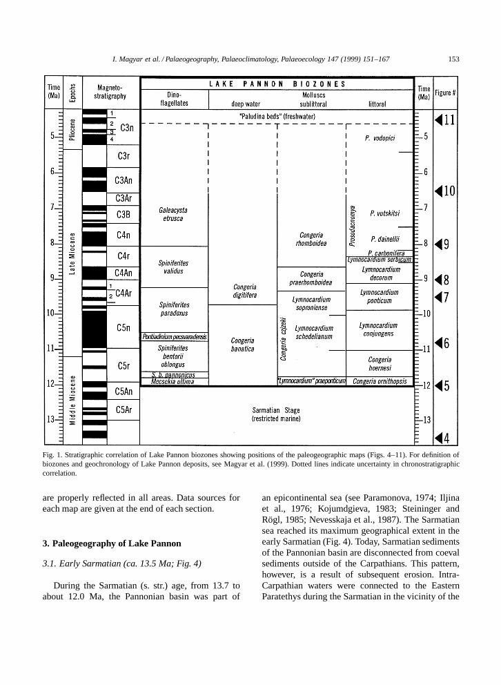
In this paper we present eight paleogeographicmaps, based primarily on the geographic distributionof fossils. The stratigraphic positions of the biozonesbased on these fossils are given in Fig. 1.
2. Methods
Although the intra-Carpathian realm was the siteof considerable horizontal tectonic movement andblock rotation during the Neogene (Balla, 1987), re-cent studies indicate that by the end of the MiddleMiocene the structural units of the area occupiedpositions very close to their modern ones (Csontos,1995). This fact enables us to reconstruct the Mid-dle Miocene to Early Pliocene paleogeography ofthe region within its modern geographic framework.Vertical structural movements, however, strongly in-
fluence this reconstruction. Detailed mapping of in-dividual block movements is beyond the scope ofthis paper. However, we considered the timing of theuplift of the Carpathians and major intra-Carpathianranges and the subsidence of the major subbasins inour reconstruction.
The paleogeographic maps presented here arebased on three kinds of data. First, the geographicdistributions of certain fossils were taken into ac-count. We focused on fossils used for biostrati-graphic subdivision of Lake Pannon sediments be-cause the stratigraphic range of these forms is wellestablished (Magyar et al., 1999). We preferred sub-littoral mollusc zones, which were deposited underseveral tens of meters water depth, to the littoralones. The former were compatible with dinoflagel-late zones and with seismic mapping of the ‘shelf-break’. The littoral zone of the lake was less stable,as it was subject to frequent climate-driven fluc-tuations. For the transgressive phase of the lake’shistory, we correlated our maps to the top of thebiozones, whereas in the regressive phase we usedthe base of the biozones, so that our maps reflect themaximum geographic distribution of each biostrati-graphic unit. This method is illustrated in Fig. 2.Second, we utilized descriptions of outcrops, drillcores, and a few seismic interpretations from differ-ent parts of the Pannonian basin in order to establishthe stratigraphic position of regional unconformities.Third, we adapted geologic and paleogeographicmaps compiled by other authors for certain regionsof the basin. In each case, we made sure that thedatabase of the adapted map was compatible withour stratigraphic correlation.
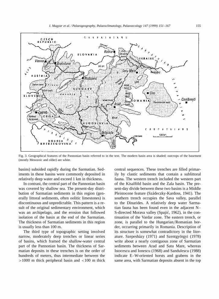
In this study, we focus on the reconstruction of thegeographic distribution of Lake Pannon. We do notdiscuss other paleogeographic features of the basin,such as the extent of fluvial plains and swampsor coeval volcanic activity. In our maps, only theinternational boundaries and some major cities ofthe region are shown for reference; other geographicfeatures referred to in the text are indicated in Fig. 3.
The accuracy of our maps depends on the qualityand quantity of available data. In general, we hadaccess to more data from Hungary than from anyother country. Consequently, we consider the Hun-garian part of the maps the most reliable. However,we believe that general trends in the lake’s evolution
I. Magyar et al. / Palaeogeography, Palaeoclimatology, Palaeoecology 147 (1999) 151–167 153
Fig. 1. Stratigraphic correlation of Lake Pannon biozones showing positions of the paleogeographic maps (Figs. 4–11). For definition ofbiozones and geochronology of Lake Pannon deposits, see Magyar et al. (1999). Dotted lines indicate uncertainty in chronostratigraphiccorrelation.
are properly reflected in all areas. Data sources foreach map are given at the end of each section.
3. Paleogeography of Lake Pannon
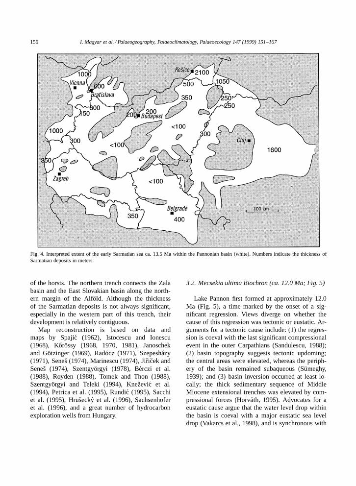
3.1. Early Sarmatian (ca. 13.5 Ma; Fig. 4)
During the Sarmatian (s. str.) age, from 13.7 toabout 12.0 Ma, the Pannonian basin was part of
an epicontinental sea (see Paramonova, 1974; Iljinaet al., 1976; Kojumdgieva, 1983; Steininger andRogl, 1985; Nevesskaja et al., 1987). The Sarmatiansea reached its maximum geographical extent in theearly Sarmatian (Fig. 4). Today, Sarmatian sedimentsof the Pannonian basin are disconnected from coevalsediments outside of the Carpathians. This pattern,however, is a result of subsequent erosion. Intra-Carpathian waters were connected to the EasternParatethys during the Sarmatian in the vicinity of the
154 I. Magyar et al. / Palaeogeography, Palaeoclimatology, Palaeoecology 147 (1999) 151–167
Fig. 2. Illustration of the use of paleobiogeographic data for reconstruction of the lake’s distribution. These data form the basis for Fig. 8.In this example, the occurrences of four fossil species with nearly contemporaneous FADs are plotted (see Fig. 1). In places wherepaleontological data are rare or missing, the shoreline of the lake is reconstructed along the modern basin margin. Island areas are thosein which the base of the lacustrine sequence is represented by younger strata, or where no lacustrine strata have been deposited at all.Thinner lines indicate international boundaries within the Pannonian basin.
Iron Gate (where the Danube crosses the SouthernCarpathians today; Senes, 1974), across the EasternCarpathians at the town of Comanesti (Marinescu,1985), and possibly in more northerly straits as well(Steininger and Rogl, 1985). These straits betweenthe Pannonian basin and the rest of the sea resultedin the complete mixing of waters.
Reconstruction of the geography of the Sarmatiansea is difficult because a lack of Sarmatian sedi-ment can reflect either non-deposition or subsequenterosion. Therefore, some of the islands indicatedon our map may have been under water during theearly Sarmatian. In the central part of the basin,however, the littoral facies of the Sarmatian rocksindicates that many islands existed there. These is-lands were not necessarily the same as the modern
elevated blocks of the basement. There are exampleswhere Sarmatian sediments are present in today’s up-lifted blocks but are missing in adjacent deeper areas(Szepeshazy, 1971; Korossy, 1990, 1992). The Sar-matian basin topography thus bore little resemblanceto modern basement topography; it was considerablyflatter, lacking deep depressions. Most of the deeptectonic trenches that opened earlier in the MiddleMiocene had been filled by volcanic and sedimentarymaterial by the beginning of the Sarmatian.
Within the Carpathians, the thickness and faciesof Sarmatian sediments and the inferred bathymetryshow a regular pattern. Three kinds of topographicsettings can be distinguished using these criteria.Small basins close to the Carpathian thrust fronts(Styrian, Vienna, East Slovakian, and Transylvanian
I. Magyar et al. / Palaeogeography, Palaeoclimatology, Palaeoecology 147 (1999) 151–167 155
Fig. 3. Geographical features of the Pannonian basin referred to in the text. The modern basin area is shaded; outcrops of the basement(mostly Mesozoic and older) are white.
basins) subsided rapidly during the Sarmatian. Sed-iments in these basins were commonly deposited inrelatively deep water and exceed 1 km in thickness.
In contrast, the central part of the Pannonian basinwas covered by shallow sea. The present-day distri-bution of Sarmatian sediments in this region (gen-erally littoral sediments, often oolitic limestones) isdiscontinuous and unpredictable. This pattern is a re-sult of the original sedimentary environment, whichwas an archipelago, and the erosion that followedisolation of the basin at the end of the Sarmatian.The thickness of Sarmatian sediments in this regionis usually less than 100 m.
The third type of topographic setting involvednarrow, moderately deep trenches or linear seriesof basins, which framed the shallow-water centralpart of the Pannonian basin. The thickness of Sar-matian deposits in these trenches is on the order ofhundreds of meters, thus intermediate between the>1000 m thick peripheral basin and <100 m thick
central sequences. These trenches are filled primar-ily by clastic sediments that contain a sublittoralfauna. The western trench included the western partof the Kisalfold basin and the Zala basin. The pre-sent-day divide between these two basins is a MiddlePleistocene feature (Szadeczky-Kardoss, 1941). Thesouthern trench occupies the Sava valley, parallelto the Dinarides. A relatively deep water Sarma-tian fauna has been found even in the adjacent N–S-directed Morava valley (Spajic, 1962), in the con-tinuation of the Vardar zone. The eastern trench, orzone, is parallel to the Hungarian=Romanian bor-der, occurring primarily in Romania. Description ofits structure is somewhat contradictory in the liter-ature. Szepeshazy (1971) and Szentgyorgyi (1978)write about a nearly contiguous zone of Sarmatiansediments between Arad and Satu Mare, whereasIstocescu and Ionescu (1968) and Sandulescu (1988)indicate E–W-oriented horsts and grabens in thesame area, with Sarmatian deposits absent in the top
156 I. Magyar et al. / Palaeogeography, Palaeoclimatology, Palaeoecology 147 (1999) 151–167
Fig. 4. Interpreted extent of the early Sarmatian sea ca. 13.5 Ma within the Pannonian basin (white). Numbers indicate the thickness ofSarmatian deposits in meters.
of the horsts. The northern trench connects the Zalabasin and the East Slovakian basin along the north-ern margin of the Alfold. Although the thicknessof the Sarmatian deposits is not always significant,especially in the western part of this trench, theirdevelopment is relatively contiguous.
Map reconstruction is based on data andmaps by Spajic (1962), Istocescu and Ionescu(1968), Korossy (1968, 1970, 1981), Janoschekand Gotzinger (1969), Radocz (1971), Szepeshazy(1971), Senes (1974), Marinescu (1974), Jiricek andSenes (1974), Szentgyorgyi (1978), Berczi et al.(1988), Royden (1988), Tomek and Thon (1988),Szentgyorgyi and Teleki (1994), Knezevic et al.(1994), Petrica et al. (1995), Rundic (1995), Sacchiet al. (1995), Hrusecky et al. (1996), Sachsenhoferet al. (1996), and a great number of hydrocarbonexploration wells from Hungary.
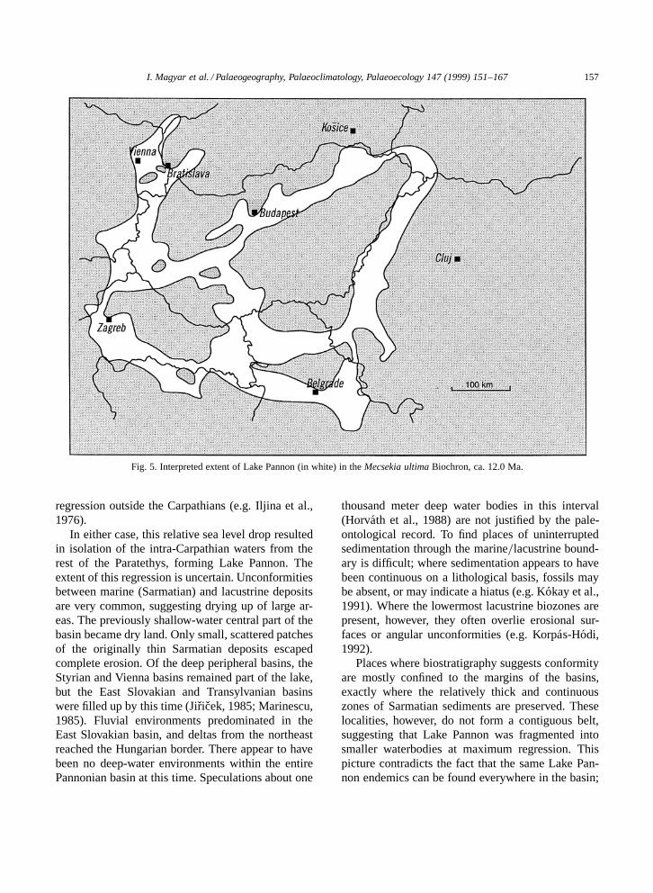
3.2. Mecsekia ultima Biochron (ca. 12.0 Ma; Fig. 5)
Lake Pannon first formed at approximately 12.0Ma (Fig. 5), a time marked by the onset of a sig-nificant regression. Views diverge on whether thecause of this regression was tectonic or eustatic. Ar-guments for a tectonic cause include: (1) the regres-sion is coeval with the last significant compressionalevent in the outer Carpathians (Sandulescu, 1988);(2) basin topography suggests tectonic updoming;the central areas were elevated, whereas the periph-ery of the basin remained subaqueous (Sumeghy,1939); and (3) basin inversion occurred at least lo-cally; the thick sedimentary sequence of MiddleMiocene extensional trenches was elevated by com-pressional forces (Horvath, 1995). Advocates for aeustatic cause argue that the water level drop withinthe basin is coeval with a major eustatic sea leveldrop (Vakarcs et al., 1998), and is synchronous with
I. Magyar et al. / Palaeogeography, Palaeoclimatology, Palaeoecology 147 (1999) 151–167 157
Fig. 5. Interpreted extent of Lake Pannon (in white) in the Mecsekia ultima Biochron, ca. 12.0 Ma.
regression outside the Carpathians (e.g. Iljina et al.,1976).
In either case, this relative sea level drop resultedin isolation of the intra-Carpathian waters from therest of the Paratethys, forming Lake Pannon. Theextent of this regression is uncertain. Unconformitiesbetween marine (Sarmatian) and lacustrine depositsare very common, suggesting drying up of large ar-eas. The previously shallow-water central part of thebasin became dry land. Only small, scattered patchesof the originally thin Sarmatian deposits escapedcomplete erosion. Of the deep peripheral basins, theStyrian and Vienna basins remained part of the lake,but the East Slovakian and Transylvanian basinswere filled up by this time (Jiricek, 1985; Marinescu,1985). Fluvial environments predominated in theEast Slovakian basin, and deltas from the northeastreached the Hungarian border. There appear to havebeen no deep-water environments within the entirePannonian basin at this time. Speculations about one
thousand meter deep water bodies in this interval(Horvath et al., 1988) are not justified by the pale-ontological record. To find places of uninterruptedsedimentation through the marine=lacustrine bound-ary is difficult; where sedimentation appears to havebeen continuous on a lithological basis, fossils maybe absent, or may indicate a hiatus (e.g. Kokay et al.,1991). Where the lowermost lacustrine biozones arepresent, however, they often overlie erosional sur-faces or angular unconformities (e.g. Korpas-Hodi,1992).
Places where biostratigraphy suggests conformityare mostly confined to the margins of the basins,exactly where the relatively thick and continuouszones of Sarmatian sediments are preserved. Theselocalities, however, do not form a contiguous belt,suggesting that Lake Pannon was fragmented intosmaller waterbodies at maximum regression. Thispicture contradicts the fact that the same Lake Pan-non endemics can be found everywhere in the basin;

158 I. Magyar et al. / Palaeogeography, Palaeoclimatology, Palaeoecology 147 (1999) 151–167
the fauna does not reflect long-term fragmentation.Our reconstruction of a continuous belt of water isbased on this unity of the fauna. It is possible that re-gression went even further, forming a series of lakes,and later transgression incorporated these lakes againinto the big Lake Pannon.
Map reconstruction is based on the distribution ofthe basal biozones of Lake Pannon [Mecsekia ultimaZone (14 data points), ‘Lymnocardium’ praepon-ticum Zone (14 data points), Congeria ornithopsisZone (16 data points); Jambor and Korpas-Hodi,1971; Korpas-Hodi, 1985; Suto-Szentai, 1991], andon the presence or absence of an unconformity be-tween the Sarmatian and Lake Pannon sediments,both in outcrops and subsurface, in a great numberof local and regional reports and descriptions. Forthe southeastern part of the basin, we adopted themap of Marinescu et al. (1977).
Fig. 6. Interpreted extent of Lake Pannon at the end of the Spiniferites bentorii oblongus Biochron, ca. 10.8 Ma.
3.3. Spiniferites bentorii oblongus Biochron (ca.10.8 Ma; Fig. 6)
The lake gradually flooded significant land areas,especially in the central part of the basin. Formerlycontiguous dry lands were separated into smallerislands. As relatively flat areas were flooded, fine-grained sediments were deposited directly on thelake bottom, often leaving no sedimentological evi-dence of transgression (Fig. 6; Jambor and Korpas-Hodi, 1971). Carbonate precipitation prevailed inthe southern half of the basin, whereas the northernshore was dominated by clastic sedimentation.
The Transylvanian basin was flooded by the lake,although the exact location of this connection isunknown (Marinescu et al., 1977). In most parts ofUkrainian Transcarpathia, however, a fluvial regimereplaced the lake (Krstic and Uljanova, 1970).
At around this time rather rapid subsidence beganin several parts of the basin, forming deep sub-
I. Magyar et al. / Palaeogeography, Palaeoclimatology, Palaeoecology 147 (1999) 151–167 159
basins (Drava, Mako, Bekes, Derecske depressions).In some of these subbasins, particularly in those far-ther from terrigenous sediment sources, water depthsquickly approached or even surpassed 1 km.
Map reconstruction is based on the geographic dis-tribution of the Spiniferites bentorii oblongus Zone(25 data points; Suto-Szentai, 1991), ‘Slavonian Sub-stage’ (Stevanovic, 1985), and C and D zones of Papp(1951). In some places we interpolated between theprevious and the subsequent maps (Figs. 5 and 7, re-spectively), based on the general transgressive trend.For the southeastern part of the basin, we adopted themap of Marinescu et al. (1977).
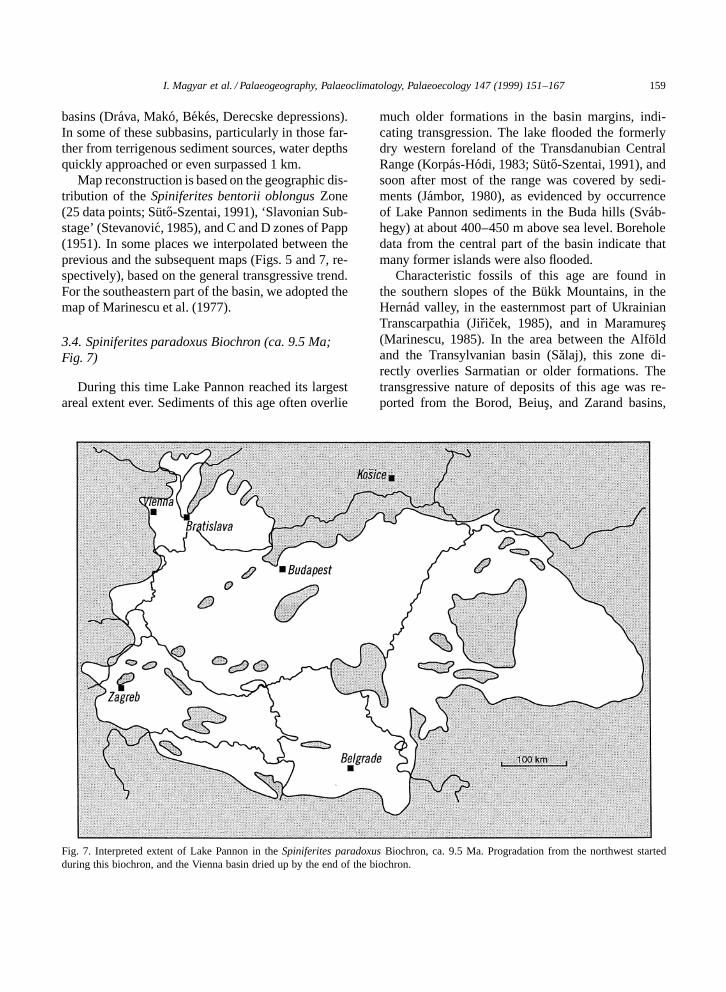
3.4. Spiniferites paradoxus Biochron (ca. 9.5 Ma;Fig. 7)
During this time Lake Pannon reached its largestareal extent ever. Sediments of this age often overlie
Fig. 7. Interpreted extent of Lake Pannon in the Spiniferites paradoxus Biochron, ca. 9.5 Ma. Progradation from the northwest startedduring this biochron, and the Vienna basin dried up by the end of the biochron.
much older formations in the basin margins, indi-cating transgression. The lake flooded the formerlydry western foreland of the Transdanubian CentralRange (Korpas-Hodi, 1983; Suto-Szentai, 1991), andsoon after most of the range was covered by sedi-ments (Jambor, 1980), as evidenced by occurrenceof Lake Pannon sediments in the Buda hills (Svab-hegy) at about 400–450 m above sea level. Boreholedata from the central part of the basin indicate thatmany former islands were also flooded.
Characteristic fossils of this age are found inthe southern slopes of the Bukk Mountains, in theHernad valley, in the easternmost part of UkrainianTranscarpathia (Jiricek, 1985), and in Maramures(Marinescu, 1985). In the area between the Alfoldand the Transylvanian basin (Salaj), this zone di-rectly overlies Sarmatian or older formations. Thetransgressive nature of deposits of this age was re-ported from the Borod, Beius, and Zarand basins,
160 I. Magyar et al. / Palaeogeography, Palaeoclimatology, Palaeoecology 147 (1999) 151–167
the Banat (Marinescu, 1985), and from northeasternBosnia (Rundic, 1995).
In contrast to the general transgressive trend,the Vienna basin became an alluvial plain by themiddle of the Spiniferites paradoxus Biochron. Theyoungest lacustrine layers of the Vienna basin belongto the L. schedelianum Subzone and L. conjungensZone, whereas the sediments onlaping the Trans-danubian Central Range belong to the L. sopronienseSubzone and L. ponticum Zone (Szilaj et al., 1999;see Fig. 1 for age of these biozones).
Map reconstruction is based on the distributionof the Spiniferites paradoxus Zone (41 data points;Suto-Szentai, 1991), Lymnocardium soproniense (10data points), Congeria zsigmondyi (28 data points),Lymnocardium conjungens (25 data points), Conge-ria czjzeki (42 data points), and on regional descrip-tions in Papp et al. (1985) and Stevanovic et al.(1990). For the southeastern part of the basin, weadopted the map of Marinescu et al. (1977).
Fig. 8. Interpreted extent of Lake Pannon in the Congeria praerhomboidea Biochron, ca. 9.0 Ma.
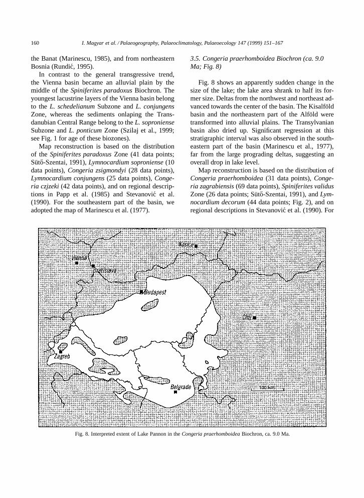
3.5. Congeria praerhomboidea Biochron (ca. 9.0Ma; Fig. 8)
Fig. 8 shows an apparently sudden change in thesize of the lake; the lake area shrank to half its for-mer size. Deltas from the northwest and northeast ad-vanced towards the center of the basin. The Kisalfoldbasin and the northeastern part of the Alfold weretransformed into alluvial plains. The Transylvanianbasin also dried up. Significant regression at thisstratigraphic interval was also observed in the south-eastern part of the basin (Marinescu et al., 1977),far from the large prograding deltas, suggesting anoverall drop in lake level.
Map reconstruction is based on the distribution ofCongeria praerhomboidea (31 data points), Conge-ria zagrabiensis (69 data points), Spiniferites validusZone (26 data points; Suto-Szentai, 1991), and Lym-nocardium decorum (44 data points; Fig. 2), and onregional descriptions in Stevanovic et al. (1990). For
I. Magyar et al. / Palaeogeography, Palaeoclimatology, Palaeoecology 147 (1999) 151–167 161
the southeastern part of the basin, we adopted themap of Marinescu et al. (1977).
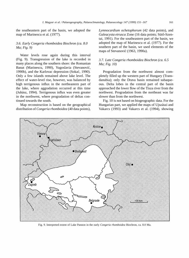
3.6. Early Congeria rhomboidea Biochron (ca. 8.0Ma; Fig. 9)
Water levels rose again during this interval(Fig. 9). Transgression of the lake is recorded inmany places along the southern shore: the RomanianBanat (Marinescu, 1990), Yugoslavia (Stevanovic,1990b), and the Karlovac depression (Sokac, 1990).Only a few islands remained above lake level. Theeffect of water-level rise, however, was balanced byhigh terrigenous influx in the northeastern part ofthe lake, where aggradation occurred at this time(Juhasz, 1994). Terrigenous influx was even greaterin the northwest, where progradation of deltas con-tinued towards the south.
Map reconstruction is based on the geographicaldistribution of Congeria rhomboidea (40 data points),
Fig. 9. Interpreted extent of Lake Pannon in the early Congeria rhomboidea Biochron, ca. 8.0 Ma.
Lymnocardium ochetophorum (42 data points), andGaleacysta etrusca Zone (16 data points; Suto-Szen-tai, 1991). For the southeastern part of the basin, weadopted the map of Marinescu et al. (1977). For thesouthern part of the basin, we used elements of themaps of Stevanovic (1963, 1990a).
3.7. Late Congeria rhomboidea Biochron (ca. 6.5Ma; Fig. 10)
Progradation from the northwest almost com-pletely filled up the western part of Hungary (Trans-danubia); only the Drava basin remained subaque-ous. Delta lobes in the central part of the basinapproached the lower flow of the Tisza river from thenorthwest. Progradation from the northeast was farslower than from the northwest.
Fig. 10 is not based on biogeographic data. For theHungarian part, we applied the maps of Ujszaszi andVakarcs (1993) and Vakarcs et al. (1994), showing

162 I. Magyar et al. / Palaeogeography, Palaeoclimatology, Palaeoecology 147 (1999) 151–167
Fig. 10. Interpreted extent of Lake Pannon in the late Congeria rhomboidea Biochron, ca. 6.5 Ma.
the position of the ‘shelf break’ of the lake asreconstructed upon seismic profiles. The positionof southern shoreline is based on the assumption thata slight regression took place since the time of theprevious map (Fig. 9).
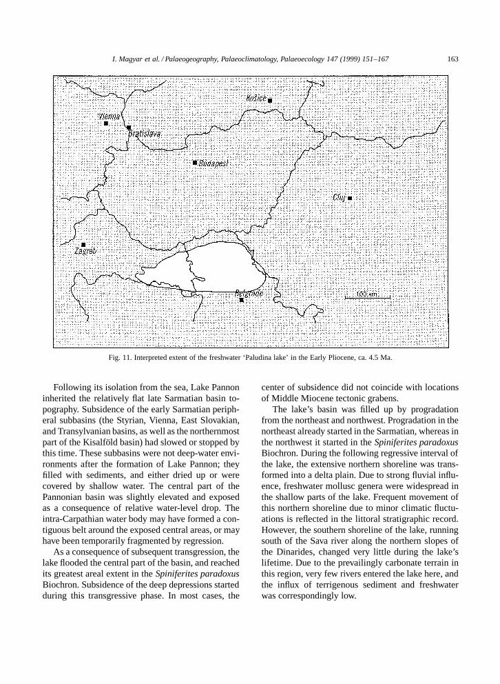
3.8. Early Pliocene (‘Paludina lake’; ca. 4.5 Ma;Fig. 11)
As the basin filled with sediments from the north,the lake was limited to northern Yugoslavia andnortheastern Croatia and the biota lost its ‘caspi-brackish’ character (Fig. 11). Representatives of thebrackish endemic genera (mostly cardiids and dreis-senids) became extinct. According to Stevanovic(1990b), replacement of the brackish endemic mol-luscs with freshwater endemic species of Unio,Viviparus (D ‘Paludina’), and other genera was grad-ual, and the ‘Paludina beds’ conformably overlie theLake Pannon sequence. If so, the Paludina lake was
the last, shallow, freshwater vestige of Lake Pannon.The age of the Paludina beds is poorly constrained,but generally considered Early Pliocene.
Map reconstruction is based on distribution ofParadacna radiata (11 data points) and Prosodacno-mya vodopici (7 data points), two of the last cardiidsof the lake, and on remarks by Stevanovic et al. (1990)about the presence or absence of the rich freshwaterfauna of the ‘Paludina lake’ in different localities.
4. Summary
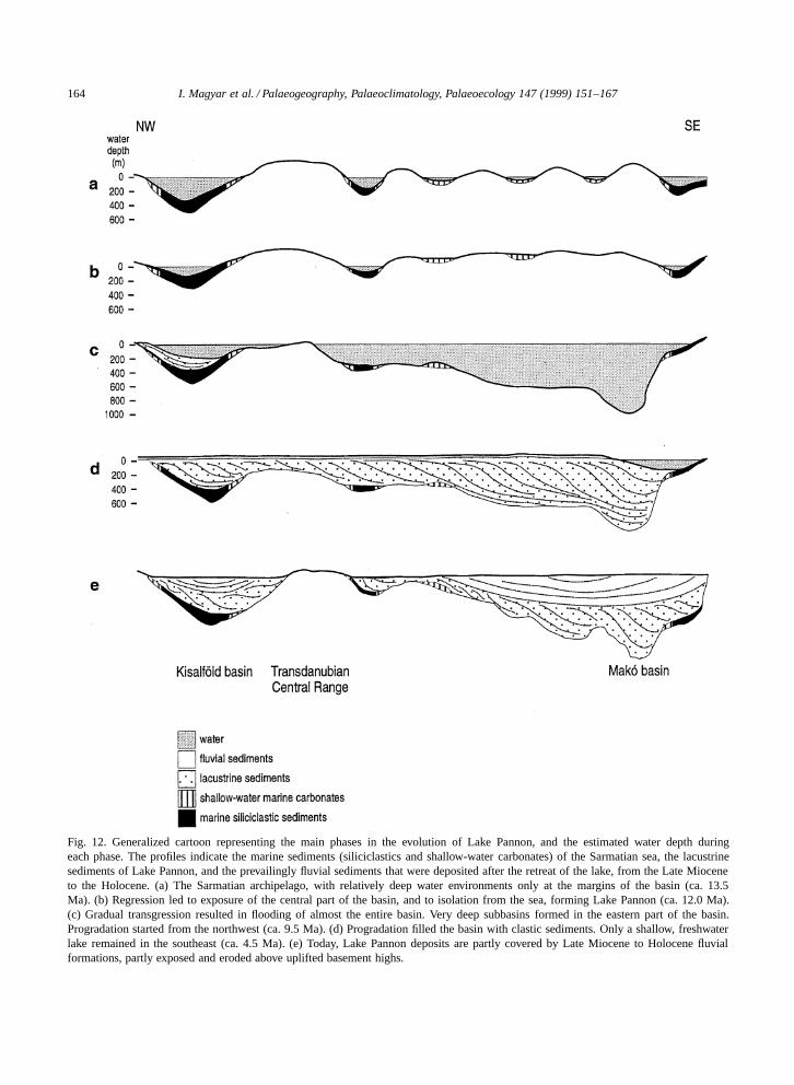
The paleogeographic evolution of Lake Pannon issummarized in Fig. 12. The lake’s history can thusbe divided into three distinct intervals: an initial,regressive stage that resulted in isolation from thesea, a second interval of gradual transgression, anda long third interval of shrinkage and filling up withsediments via progradation.
I. Magyar et al. / Palaeogeography, Palaeoclimatology, Palaeoecology 147 (1999) 151–167 163
Fig. 11. Interpreted extent of the freshwater ‘Paludina lake’ in the Early Pliocene, ca. 4.5 Ma.
Following its isolation from the sea, Lake Pannoninherited the relatively flat late Sarmatian basin to-pography. Subsidence of the early Sarmatian periph-eral subbasins (the Styrian, Vienna, East Slovakian,and Transylvanian basins, as well as the northernmostpart of the Kisalfold basin) had slowed or stopped bythis time. These subbasins were not deep-water envi-ronments after the formation of Lake Pannon; theyfilled with sediments, and either dried up or werecovered by shallow water. The central part of thePannonian basin was slightly elevated and exposedas a consequence of relative water-level drop. Theintra-Carpathian water body may have formed a con-tiguous belt around the exposed central areas, or mayhave been temporarily fragmented by regression.
As a consequence of subsequent transgression, thelake flooded the central part of the basin, and reachedits greatest areal extent in the Spiniferites paradoxusBiochron. Subsidence of the deep depressions startedduring this transgressive phase. In most cases, the
center of subsidence did not coincide with locationsof Middle Miocene tectonic grabens.
The lake’s basin was filled up by progradationfrom the northeast and northwest. Progradation in thenortheast already started in the Sarmatian, whereas inthe northwest it started in the Spiniferites paradoxusBiochron. During the following regressive interval ofthe lake, the extensive northern shoreline was trans-formed into a delta plain. Due to strong fluvial influ-ence, freshwater mollusc genera were widespread inthe shallow parts of the lake. Frequent movement ofthis northern shoreline due to minor climatic fluctu-ations is reflected in the littoral stratigraphic record.However, the southern shoreline of the lake, runningsouth of the Sava river along the northern slopes ofthe Dinarides, changed very little during the lake’slifetime. Due to the prevailingly carbonate terrain inthis region, very few rivers entered the lake here, andthe influx of terrigenous sediment and freshwaterwas correspondingly low.
164 I. Magyar et al. / Palaeogeography, Palaeoclimatology, Palaeoecology 147 (1999) 151–167
Fig. 12. Generalized cartoon representing the main phases in the evolution of Lake Pannon, and the estimated water depth duringeach phase. The profiles indicate the marine sediments (siliciclastics and shallow-water carbonates) of the Sarmatian sea, the lacustrinesediments of Lake Pannon, and the prevailingly fluvial sediments that were deposited after the retreat of the lake, from the Late Mioceneto the Holocene. (a) The Sarmatian archipelago, with relatively deep water environments only at the margins of the basin (ca. 13.5Ma). (b) Regression led to exposure of the central part of the basin, and to isolation from the sea, forming Lake Pannon (ca. 12.0 Ma).(c) Gradual transgression resulted in flooding of almost the entire basin. Very deep subbasins formed in the eastern part of the basin.Progradation started from the northwest (ca. 9.5 Ma). (d) Progradation filled the basin with clastic sediments. Only a shallow, freshwaterlake remained in the southeast (ca. 4.5 Ma). (e) Today, Lake Pannon deposits are partly covered by Late Miocene to Holocene fluvialformations, partly exposed and eroded above uplifted basement highs.
I. Magyar et al. / Palaeogeography, Palaeoclimatology, Palaeoecology 147 (1999) 151–167 165
By the Early Pliocene Lake Pannon became ashallow, freshwater lake. Its characteristic brackishfauna became extinct, and endemic freshwater formsevolved in the lake.
Acknowledgements
This publication was sponsored by the NationalScience Foundation (EAR-9706230), by the U.S.–Hungarian Science and Technology Joint Fund underproject JFNo 511, by the Hungarian OTKA (project#T 019679), and by the Albert and Alice Weeks Fundof the Department of Geology and Geophysics, Uni-versity of Wisconsin–Madison. We thank DirectorIstvan Berczi, MOL Hungarian Oil and Gas Com-pany, for his support. Charles Byers, Alan Carroll,Miklos Kazmer, Fritz Steininger and Finn Surlykprovided useful comments on the manuscript. Wethank Mary Diman for assistance with the figures.
References
Balla, Z., 1987. Neogene kinematics of the Carpatho-Pannonianregion. Ann. Hung. Geol. Inst. 70, 193–199.
Berczi, I., Hamor, G., Jambor, A., Szentgyorgyi, K., 1988. Neo-gene sedimentation in Hungary. In: Royden, L.H., Horvath,F. (Eds.), The Pannonian Basin: a Study in Basin Evolution.AAPG Mem. 45, 57–67.
Csontos, L., 1995. Tertiary tectonic evolution of the Intra-Carpathian area: a review. Acta Vulcanol. 7, 1–13.
Dank, V., Jambor, A., 1987. Allgemeine geologische Merkmaleder Ablagerungen des Pannonien s. str. (Kunsag-Stufe) inUngarn. Ann. Hung. Geol. Inst. 69, 9–25.
Gillet, S., 1943. Les limnocardiides des couches a Congeries deRoumanie. Mem. Inst. Geol. Roman. 4, 1–118.
Horvath, F., 1995. Phases of compression during the evolutionof the Pannonian Basin and its bearing on hydrocarbon explo-ration. Mar. Pet. Geol. 12, 837–844.
Horvath, F., Dovenyi, P., Szalay, A., Royden, L.H., 1988. Subsi-dence, thermal, and maturation history of the Great HungarianPlain. In: Royden, L.H., Horvath, F. (Eds.), The PannonianBasin. A Study in Basin Evolution. AAPG Mem. 45, 355–372.
Hrusecky, I., Sefara, J., Masaryk, P., Lintnerova, O., 1996. Thestructural and facies development and exploration potential ofthe Slovak part of the Danube Basin. In: Wessely, G., Liebl,W. (Eds.), Oil and Gas in Alpidic Thrustbelts and Basins ofCentral and Eastern Europe. EAGE (Eur. Assoc. Geosci. Eng.)Spec. Publ. 5, 417–429.
Iljina, L.B., Nevesskaja, L.A., Paramonova, N.P., 1976. Za-konomernosti razvitija molljuskov v opresnennih basseinah
neogena Evrazii (pozdnij miocen–rannij pliocen) (Regular-ities of mollusc development in the Neogene semimarineand brackishwater basins of Eurasia ([Late Miocene–EarlyPliocene]). Nauka, Moskva, 288 pp.
Istocescu, D., Ionescu, Gh., 1968. Geologia partii de nord adepresiunii pannonice (sectorul Oradea–Satu-Mare) (Geologyof the northern part of the Pannonian depression [Oradea–SatuMare area]). Dari Seama Sedintelor 60, 73–87.
Jambor, A., 1980. A Dunantuli-kozephegyseg pannoniai kepzod-menyei (Pannonian in the Transdanubian Central Mountains).Ann. Hung. Geol. Inst. 62, 1–259.
Jambor, A., Korpas-Hodi, M., 1971. A pannoniai kepzod-menyek szintezesi lehetosegei a Dunantuli-kozephegyseg DK-ielotereben (Stratigraphische Horizontierungsmoglichkeiten inden Pannonablagerungen im sudost-Vorland des Transdanu-bischen Mittelgebirges). Annu. Rep. Hung. Geol. Inst. 1969,155–192.
Janoschek, R.H., Gotzinger, K.G.H., 1969. Exploration for oiland gas in Austria. In: Hepple, P. (Ed.), The Exploration forPetroleum in Europe and North Africa. Institute of Petroleum,London, pp. 161–180.
Jiricek, R., 1985. Die Transkarpatischen Becken. In: Papp, A.,Jambor, A., Steininger, F.F. (Eds.), Chronostratigraphie undNeostratotypen. Miozan der Zentralen Paratethys VII, M6,Pannonien. Akad. Kiado, Budapest, pp. 77–80.
Jiricek, R., 1990. Pontien in der Tschechoslowakei. In: Ste-vanovic, P.M., Nevesskaja, L.A., Marinescu, Fl., Sokac, A.,Jambor, A. (Eds.), Chronostratigraphie und Neostratotypen.Neogen der Westlichen (‘Zentrale’) Paratethys VIII, Pl1, Pon-tien. JAZU and SANU, Zagreb–Beograd, pp. 276–284.
Jiricek, R., Senes, J., 1974. Die Entwicklung des Sarmats in denBecken der Westkarpaten der CSSR. In: Papp, A., Marinescu,Fl., Senes, J. (Eds.), Chronostratigraphie und Neostratotypen.Miozan der Zentralen Paratethys IV, M5, Sarmatien. VEDA,Bratislava, pp. 77–85.
Juhasz, Gy., 1994. Sedimentological and stratigraphical evi-dences of water-level fluctuations in the Pannonian Lake.Foldt. Kozl. 123, 379–398.
Knezevic, S., Spajic, O., Pavlovic, M., Ercegovac, M., Petrovic,M., 1994. Stratigraphy of Tertiary deposits in hole G-1 atGrocka. Ann. Geol. Peninsule Balkan 58 (1), 39–49.
Kojumdgieva, E., 1983. Palaeogeographic environment duringthe desiccation of the Black Sea. Palaeogeogr., Palaeoclima-tol., Palaeoecol. 43, 195–204.
Kokay, J., Hamor, T., Lantos, M., Muller, P., 1991. A Berhida3. sz. furas paleomagneses es foldtani vizsgalata (The paleo-magnetic and geological study of borehole section Berhida 3).Annu. Rep. Hung. Geol. Inst. 1989, 45–63.
Korpas-Hodi, M., 1983. Palaeoecology and biostratigraphy ofthe Pannonian Mollusca fauna in the northern foreland of theTransdanubian Central Range. Ann. Hung. Geol. Inst. 66, 1–163.
Korpas-Hodi, M., 1985. Die Molluskenfaunen an denGebirgsrandern im Pannonien von Ungarn. In: Papp, A.,Jambor, A., Steininger, F.F. (Eds.), Chronostratigraphie undNeostratotypen. Miozan der Zentralen Paratethys VII, M6,Pannonien. Akad. Kiado, Budapest, pp. 161–172.
166 I. Magyar et al. / Palaeogeography, Palaeoclimatology, Palaeoecology 147 (1999) 151–167
Korpas-Hodi, M., 1992. A Szombathely II. sz. furas pannoniai(s.l.) molluscai (The Pannonian (s.l.) molluscs of boreholesection Szombathely II). Annu. Rep. Hung. Geol. Inst. 1990,505–525.
Korpas-Hodi, M., Pogacsas, Gy., Simon, E., 1992. Paleogeo-graphic outlines of the Pannonian s.l. of the southern Danube–Tisza Interfluve. Acta Geol. Hung. 35, 145–163.
Korossy, L., 1968. Entwicklungsgeschichtliche und palao-geographische Grundzuge des ungarischen Unterpannons.Acta Geol. Acad. Sci. Hung. 12, 199–217.
Korossy, L., 1970. Entwicklungsgeschichte der neogenen Beckenin Ungarn. Acta Geol. Acad. Sci. Hung. 14, 421–429.
Korossy, L., 1981. Regional geological profiles in the PannonianBasin. Earth Evol. Sci. 3–4, 223–231.
Korossy, L., 1990. A Delkelet-Dunantul koolaj- es foldgazku-tatasanak foldtani eredmenyei (Hydrocarbon geology of SETransdanubia, Hungary). Altalanos Foldt. Szemle 25, 3–53.
Korossy, L., 1992. A Duna-Tisza koze koolaj- es foldgazku-tatasanak foldtani eredmenyei (Hydrocarbon geology of theDuna–Tisza interfluve, Hungary). Altalanos Foldt. Szemle 26,3–162.
Krstic, N., Uljanova, A., 1970. Correlation of the Pannonian s.str. of the south-eastern and north-eastern part of the Pannon-ian basin (northern Bosnia and Zakarpatskaya region, USSR).Acta Geol. Acad. Sci. Hung. 14, 431–436.
Magyar, I., 1995. Late Miocene mollusc biostratigraphy in theeastern part of the Pannonian basin (Tiszantul, Hungary).Geol. Carpath. 46, 29–36.
Magyar, I., Geary, D.H., Suto-Szentai, M., Lantos, M., Muller,P., 1999. Integrated bio-, magneto- and chronostratigraphiccorrelations of the Late Miocene Lake Pannon deposits. ActaGeol. Hung. (in press).
Marinescu, Fl., 1974. Le Sarmatien s. str. dans le domaineintracarpathique de la Roumanie. In: Papp, A., Marinescu,Fl., Senes, J. (Eds.), Chronostratigraphie und Neostratotypen.Miozan der Zentralen Paratethys IV, M5, Sarmatien. VEDA,Bratislava, pp. 101–104.
Marinescu, Fl., 1985. Der ostliche Teil des Pannonischen Beck-ens (Rumanischer Sektor): Das Pannonien s. str. (Malvensien).In: Papp, A., Jambor, A., Steininger, F.F. (Eds.), Chronostrati-graphie und Neostratotypen. Miozan der Zentralen ParatethysVII, M6, Pannonien. Akad. Kiado, Budapest, pp. 144–148.
Marinescu, Fl., 1990. Le Pontien du Bassin Pannonique (‘In-tracarpathique’) de Roumanie (Generalites). In: Stevanovic,P.M., Nevesskaja, L.A., Marinescu, Fl., Sokac, A., Jambor, A.(Eds.), Chronostratigraphie und Neostratotypen. Neogen derWestlichen (‘Zentrale’) Paratethys VIII, Pl1, Pontien. JAZUand SANU, Zagreb–Beograd, pp. 251–255.
Marinescu, Fl., Olteanu, R., Rogge-Taranu, E., Popescu, A.,1977. Le Pannonien du Banat. Dari Seama Sedintelor 63, 65–133.
Muller, P., Magyar, I., 1992. A Prosodacnomyak retegtani jelen-tosege a Kotcse kornyeki pannoniai s.l. uledekekben (Strati-graphic significance of the Upper Miocene lacustrine cardiidProsodacnomya [Kotcse section, Pannonian basin, Hungary]).Foldt. Kozl. 122, 1–38.
Nevesskaja, L.A., Goncharova, I.A., Iljina, L.B., Paramonova,
N.P., Popov, S.V., Voronina, A.A., Chepalyga, A.L., Babak,E.V., 1987. History of Paratethys. Ann. Hung. Geol. Inst. 70,337–342.
Papp, A., 1951. Das Pannon des Wiener Beckens. Mitt. Geol.Ges. Wien 39–41, 99–193.
Papp, A., Jambor, A., Steininger, F.F. (Eds.), 1985. Chronostrati-graphie und Neostratotypen. Miozan der Zentralen ParatethysVII, M6, Pannonien. Akad. Kiado, Budapest, 636 pp.
Paramonova, N.P., 1974. Das Sarmatien s. lato in der OstlichenParatethys. In: Papp, A., Marinescu, Fl., Senes, J. (Eds.),Chronostratigraphie und Neostratotypen. Miozan der ZentralenParatethys IV, M5, Sarmatien. VEDA, Bratislava, pp. 132–136.
Petrica, R., Rijavec, L., Dozet, S., 1995. Stratigraphy of theUpper Oligocene and Miocene beds in the Trobni Dol area(Kozjansko). Rud. Metal. Zb. 42, 127–141.
Pogacsas, Gy., Lakatos, L., Ujszaszi, K., Vakarcs, G., Varkonyi,L., Varnai, P., Revesz, I., 1988. Seismic facies, electro faciesand Neogene sequence chronology of the Pannonian basin.Acta Geol. Hung. 31, 175–207.
Pogacsas, Gy., Szabo, A., Szalay, J., 1992. Chronostratigraphicrelations of the progradational delta sequence of the GreatHungarian Plain. Acta Geol. Hung. 35, 311–327.
Pogacsas, Gy., Muller, P., Magyar, I., 1993. The role of seis-mic stratigraphy in understanding biological evolution in thePannonian lake (SE Europe, Late Miocene). Geol. Croat. 46,63–69.
Radocz, G., 1971. A Cserehat pannoniai kepzodmenyekkelfedett teruletenek meyfoldtani felepıtese (TiefengeologischerBau des mit Pannon bedeckten Gebietes von Cserehat [NW-Ungarn]). Annu. Rep. Hung. Geol. Inst. 1969, 213–234.
Royden, L.H., 1988. Late Cenozoic Tectonics of the PannonianBasin System. In: Royden, L.H., Horvath, F. (Eds.), ThePannonian Basin. A Study in Basin Evolution. AAPG Mem.45, 27–48.
Rundic, L., 1995. A hiatus between Sarmatian and Pannonian inDonja Trnova area, NE Bosnia. Ann. Geol. Peninsule Balkan.59 (2), 103–116.
Sacchi, M., Horvath, F., Magyari, O., 1995. High resolutionseismics in the Lake Balaton: insights into the evolution ofthe western Pannonian Basin. In: Horvath, F., Tari, G., Bokor,Cs. (Eds.), Extensional Collapse of the Alpine Orogen andHydrocarbon Prospects in the Basement and Basin Fill of theWestern Pannonian Basin. AAPG Int. Conf. and Exhibition,Nice, Guideb. Field Trip 6, Hungary, pp. 171–185.
Sachsenhofer, R.F., Sperl, H., Wagini, A., 1996. Structure, de-velopment and hydrocarbon potential of the Styrian Basin(Pannonian Basin system, Austria). In: Wessely, G., Liebl,W. (Eds.), Oil and Gas in Alpidic Thrustbelts and Basins ofCentral and Eastern Europe. EAGE (Eur. Assoc. Geosci. Eng.)Spec. Publ. 5, 393–414.
Sandulescu, M., 1988. Cenozoic tectonic history of the Carpathi-ans. In: Royden, L.H., Horvath, F. (Eds.), The PannonianBasin. A Study in Basin Evolution. AAPG Mem. 45, 17–25.
Senes, J., 1974. Palaogeographie der Zentralen Paratethys imSarmatien s. str. In: Papp, A., Marinescu, Fl., Senes, J. (Eds.),Chronostratigraphie und Neostratotypen. Miozan der Zentralen

I. Magyar et al. / Palaeogeography, Palaeoclimatology, Palaeoecology 147 (1999) 151–167 167
Paratethys IV, M5, Sarmatien. VEDA, Bratislava, pp. 140–144.
Sokac, A., 1990. The Pontian in Croatia. In: Stevanovic, P.M.,Nevesskaja, L.A., Marinescu, Fl., Sokac, A., Jambor, A.(Eds.), Chronostratigraphie und Neostratotypen. Neogen derWestlichen (‘Zentrale’) Paratethys VIII, Pl1, Pontien. JAZUand SANU, Zagreb–Beograd, pp. 180–195.
Spajic, O., 1962. Miozan zwischen Svilajnac und Bagrdan. Ann.Geol. Peninsule Balkan. 29, 19–26.
Steininger, F.F., Rogl, F., 1985. Die Palaogeographie der Zen-tralen Paratethys im Pannonien. In: Papp, A., Jambor, A.,Steininger, F.F. (Eds.), Chronostratigraphie und Neostrato-typen. Miozan der Zentralen Paratethys VII, M6, Pannonien.Akad. Kiado, Budapest, pp. 46–50.
Stevanovic, P.M., 1963. Pontische Ablagerungen (Pont s. str.) inSave-Ebene sudlich von der Stadt Brcko (Nordbosnien). Ann.Geol. Peninsule Balkan. 30, 1–15.
Stevanovic, P.M., 1985. Diskussion der Unterstufen Slavonienund Serbien. In: Papp, A., Jambor, A., Steininger, F.F. (Eds.),Chronostratigraphie und Neostratotypen. Miozan der ZentralenParatethys VII, M6, Pannonien. Akad. Kiado, Budapest, pp.82–85.
Stevanovic, P.M., 1990a. Pontische Ablagerungen im sudlichenTeil des Pannonischen Beckens in Jugoslawien (Fazies, Hori-zonte, Kohlenbecken). In: Stevanovic, P.M., Nevesskaja, L.A.,Marinescu, Fl., Sokac, A., Jambor, A. (Eds.), Chronostratigra-phie und Neostratotypen. Neogen der Westlichen (‘Zentrale’)Paratethys VIII, Pl1, Pontien. JAZU and SANU, Zagreb–Beograd, pp. 113–119.
Stevanovic, P.M., 1990b. Pontien nordlich von der Sava undDonau, in Syrmien, Backa und Banat. In: Stevanovic, P.M.,Nevesskaja, L.A., Marinescu, Fl., Sokac, A., Jambor, A.(Eds.), Chronostratigraphie und Neostratotypen. Neogen derWestlichen (‘Zentrale’) Paratethys VIII, Pl1, Pontien. JAZUand SANU, Zagreb–Beograd, pp. 195–212.
Stevanovic, P.M., 1990c. Ruckschau auf pontische Stufe inGriechenland. In: Stevanovic, P.M., Nevesskaja, L.A., Mari-nescu, Fl., Sokac, A., Jambor, A. (Eds.), Chronostratigra-phie und Neostratotypen. Neogen der Westlichen (‘Zentrale’)Paratethys VIII, Pl1, Pontien. JAZU and SANU, Zagreb–Beograd, pp. 339–352.
Stevanovic, P.M., Nevesskaja, L.A., Marinescu, Fl., Sokac, A.,Jambor, A. (Eds.), 1990. Chronostratigraphie und Neostrato-typen. Neogen der Westlichen (‘Zentrale’) Paratethys VIII,Pl1, Pontien. JAZU and SANU, Zagreb–Beograd, 952 pp.
Sumeghy, J., 1939. A Gyori-medence, a Dunantul es az Alfoldpannoniai uledekeinek osszefoglalo ismertetese (Zusammen-
fassender Bericht uber die pannonischen Ablagerungen desGyorer-Beckens, Transdanubiens und des Alfold). — A Ma-gyar Kir. Foldt. Intezet Evkonyve 32, 67–254.
Suto-Szentai, M., 1991. Szervesvazu mikroplankton zonak Ma-gyarorszag pannoniai retegosszleteben. Ujabb adatok a zona-ciorol es a dinoflagellatak evoluciojarol. Oslenytani Vitak(Discuss. Palaeontol.) 36–37, 157–200.
Szadeczky-Kardoss, E., 1941. Osfolyok a Dunantulon. Foldt.Ertesıto 6, 119–134.
Szentgyorgyi, K., 1978. The Sarmatian formations in the Tiszan-tul area (Eastern Hungary) and their stratigraphic position.Acta Mineral.–Petrogr. Szeged 23, 279–297.
Szentgyorgyi, K., Teleki, P., 1994. Facies and depositional en-vironments of Miocene sedimentary rocks. In: Teleki, P.,Mattick, R., Kokai, J. (Eds.), Basin Analysis in PetroleumExploration. A Case Study from the Bekes Basin, Hungary.Kluwer, Dordrecht, pp. 83–97.
Szepeshazy, K., 1971. A Tiszantul kozepso reszenek miocenkepzodmenyei a szenhidrogenkutato melyfurasok adataialapjan (Miozanablagerungen im zentralen Raum von Tiszan-tul [Gebiet ostlich der Theiss] anhand Tiefbohrungen aufKohlenwasserstoff). Annu. Rep. Hung. Geol. Inst. 1968, 297–325.
Szilaj, R., Szonoky, M., Muller, P., Magyar, I., 1999. Stratig-raphy, paleoecology, and paleogeography of the ‘Congeriaungulacaprae beds’ (D Lymnocardium ponticum Zone) in NWHungary: study of the Daka outcrop. Acta Geol. Hung. (inpress).
Tomek, C., Thon, A., 1988. Interpretation of seismic reflectionprofiles from the Vienna Basin, the Danube Basin, and theTranscarpathian Depression in Czechoslovakia. In: Royden,L.H., Horvath, F. (Eds.), The Pannonian Basin. A Study inBasin Evolution. AAPG Mem. 45, 171–182.
Ujszaszi, K., Vakarcs, G., 1993. Sequence stratigraphic analysisin the south Transdanubian region, Hungary. Geophys. Trans.38, 69–87.
Vakarcs, G., Vail, P.R., Tari, G., Pogacsas, Gy., Mattick, R.E.,Szabo, A., 1994. Third-order Middle Miocene–Early Pliocenedepositonal sequences in the prograding delta complex of thePannonian basin. Tectonophysics 240, 81–106.
Vakarcs, G., Hardenbol, J., Abreau, V.S., Vail, P.R., Tari, G., Var-nai, P., 1998. Correlation of the Oligocene–Middle Mioceneregional stages with depositional sequences, a case study fromthe Pannonian Basin, Hungary. In: De Graciansky, P.-C., Hard-enbol, J., Jacquin, T., Vail, P.R., Farley, M.B. (Eds.), SequenceStratigraphy of European Basins. SEPM Spec. Publ. 57 (inpress).
Copyright © 2022 FDOKUMEN