P. Verhagen, S. Polla and I. Frommer (2014). Finding Byzantine junctions with Steiner trees
26
FINDING BYZANTINE JUNCTIONS WITH STEINER TREES 73 Philip Verhagen*, Silvia Polla**, Ian Frommer*** Finding Byzantine junctions with Steiner trees 1 Introduction In archaeology, computational approaches to the study of movement practices have become more and more popular in recent years, especially when applied to prehistoric contexts (Bell / Lock 2000; Llobera 2000; De Silva / Pizziolo 2001; van Leusen 2002; Fábrega Álvarez / Parcero Oubiña 2007; Snead et al. 2009; Llobera et al. 2011). The main aim of these methods is not just to reconstruct paths and road systems, but to use these models to understand the establishment and transformation of a hierarchical network of settlement nodes, also including a focus on off-site land use practices. In this paper, we will introduce an example of the use of GIS-based modelling tech- niques for the study of the Roman-Byzantine communication system in the Roman Prov- ince of Cappadocia, in modern Turkey. We will argue that adopting a landscape archaeology approach to the analysis of an historic road system contributes to a deeper understanding of settlement dynamics (Bell et al. 2002). A GIS-based, spatial approach allows us to study settlements and pathways in a more formal manner and, by doing so, to address questions about ancient cognitive geography and past decision-making processes (Rock- man / Steele 2003). By systematically analysing the structure and phenomenology of the Roman provincial landscape, indicators of power and social order can be extracted from ag- ricultural centuriation and communication systems (Witcher 1998; Laurence 1999). In the cultural context of Roman and Byzantine communication systems, GIS methods are usually employed to reconstruct ancient routes in the landscape. These reconstructions are constrained by the possibilities of testing the model with material evidence of roads (re- mains, milestones, bridges; see Graßhoff / Mittenhuber 2009). A further limitation con- cerns the integration of path models created at a micro-regional scale with a macro-regional approach that considers the road system as a coherent planned network of connections. We therefore aim here to combine path models constructed on the basis of topo- graphic and environmental constraints at the micro-regional level – like slope, distance to natural resources, and visibility – with a model of macro-regional movement in a strategic network composed of nodes and junctions. In this network, movement is structured and af- fected by “cultural” constraints, like site density and distribution, and the position of stra- tegic administrative, economic, religious and/or military centres. *** Vrije Universiteit Amsterdam. *** Freie Universität Berlin. *** US Coast Guard Academy. Brought to you by | Vrije Universiteit Amsterdam Authenticated | 10.248.254.158 Download Date | 9/16/14 2:20 PM
Transcript of P. Verhagen, S. Polla and I. Frommer (2014). Finding Byzantine junctions with Steiner trees

FINDING BYZANTINE JUNCTIONS WITH STEINER TREES 73
Philip Verhagen*, Silvia Polla**, Ian Frommer***
Finding Byzantine junctions with Steiner trees
1 Introduction
In archaeology, computational approaches to the study of movement practices have becomemore and more popular in recent years, especially when applied to prehistoric contexts(Bell / Lock 2000; Llobera 2000; De Silva / Pizziolo 2001; van Leusen 2002; FábregaÁlvarez / Parcero Oubiña 2007; Snead et al. 2009; Llobera et al. 2011). The main aim ofthese methods is not just to reconstruct paths and road systems, but to use these models tounderstand the establishment and transformation of a hierarchical network of settlementnodes, also including a focus on off-site land use practices.
In this paper, we will introduce an example of the use of GIS-based modelling tech-niques for the study of the Roman-Byzantine communication system in the Roman Prov-ince of Cappadocia, in modern Turkey. We will argue that adopting a landscape archaeologyapproach to the analysis of an historic road system contributes to a deeper understandingof settlement dynamics (Bell et al. 2002). A GIS-based, spatial approach allows us tostudy settlements and pathways in a more formal manner and, by doing so, to addressquestions about ancient cognitive geography and past decision-making processes (Rock-man / Steele 2003). By systematically analysing the structure and phenomenology of theRoman provincial landscape, indicators of power and social order can be extracted from ag-ricultural centuriation and communication systems (Witcher 1998; Laurence 1999). In thecultural context of Roman and Byzantine communication systems, GIS methods areusually employed to reconstruct ancient routes in the landscape. These reconstructions areconstrained by the possibilities of testing the model with material evidence of roads (re-mains, milestones, bridges; see Graßhoff / Mittenhuber 2009). A further limitation con-cerns the integration of path models created at a micro-regional scale with a macro-regionalapproach that considers the road system as a coherent planned network of connections.
We therefore aim here to combine path models constructed on the basis of topo-graphic and environmental constraints at the micro-regional level – like slope, distance tonatural resources, and visibility – with a model of macro-regional movement in a strategicnetwork composed of nodes and junctions. In this network, movement is structured and af-fected by “cultural” constraints, like site density and distribution, and the position of stra-tegic administrative, economic, religious and/or military centres.
*** Vrije Universiteit Amsterdam.*** Freie Universität Berlin.*** US Coast Guard Academy.
Brought to you by | Vrije Universiteit AmsterdamAuthenticated | 10.248.254.158
Download Date | 9/16/14 2:20 PM

74 PHILIP VERHAGEN, SILVIA POLLA, IAN FROMMER
The integration of these two approaches is realized by combining a GIS approach formodelling segments of the system (paths), based on the environmental context, with aSteiner tree vector-based approach that takes into account the nodes and edges of the sys-tem. As an example, we use the documented inter-regional road system of Cappadocia thatwas established in the Roman period. It follows the previous pattern of macro- (PersianRoyal Road)1 and micro-regional (tribal villages) movement axes (Mitford 2000). Writtensources and archaeological remains document this pattern of communication routes, con-sisting of strategic connections along a set of way stations. It can still be recognized in thepattern of Seljuk caravanserais in historical times (Hild 1977).
2 The Roman and Byzantine road system in Cappadocia
For this case study we focus on the methodological aspects of reconstructing and analysingthe inter-regional road system of the Roman/Byzantine province of Cappadocia in AsiaMinor (current Kapadokya in Turkey). The road system of Roman/Byzantine Cappadocia isan inter-regional communication system, from which we will analyse only one segment andwe will focus on path modelling at the micro-regional scale. For this, we will integrate pathmodelling and network modelling approaches, and take into account topography-basedconstraints (Llobera 2000; 2001), as well as the structure of the macro-regional network.
The study region (Fig. 1) is dominated by mountains and characterized by a continen-tal climate with snow from November to April in the area above the tree line. The areastudied is a high plateau, enclosed to the south by the Taurus mountain range and cut trans-versely by the Antitaurus massif. The regional settlement pattern and the road system ofCappadocia are strongly structured and defined by topography. From the Bronze Age on-ward, the river plains were the main areas of settlement and acted as the primary axes ofcommunication. Assyrians, Hittites, Phrygians, Lydians and Persians successively occu-pied the territory of Cappadocia, and were later followed by Seleucid, Roman, Byzantine,Seljuk and Ottoman rulers. The region has been subject to a centralized administrationsince the Persian period, and this clearly influenced the strategic construction and long-term use of the road systems. A strong relationship is evident, for example, between theRoman road system and the Seljuk caravanserais.
During the Roman Empire, strategic routes were set up from the provincial capital ofCaesarea (currently Kayseri; Greek: Kaisarea) to connect it to Melitene (currently Malatya),over a total distance of approximately 250 km.2 Caesarea, the starting point, was a central
1 Herodotus 5.52–54; French (1998). On the Cappadocian pathways cf. Herodotus 52.2.2, French (1998, 18) andHild (1977, 99 and Abb. 68) on the route from Elbistan to Melitene. For a localization of the route on modern top-ography cf. French (1998, 28: Kayseri sheet: Kayseri-(Aydinlar)-Kamber-Akmescit).2 The modern road connection measures 339 km.
Brought to you by | Vrije Universiteit AmsterdamAuthenticated | 10.248.254.158
Download Date | 9/16/14 2:20 PM

FINDING BYZANTINE JUNCTIONS WITH STEINER TREES 75
Fig.
1|O
verv
iew
map
of
Cap
pado
cia
and
the
con
side
red
regi
on. S
ourc
e: h
ttp:
//vi
sibl
eear
th.n
asa.
gov/
view
_rec
.ph
p?id
=813
9.
Brought to you by | Vrije Universiteit AmsterdamAuthenticated | 10.248.254.158
Download Date | 9/16/14 2:20 PM
76 PHILIP VERHAGEN, SILVIA POLLA, IAN FROMMER
place from Assyrian times. It became a Hellenistic polis and then capital of the Romanprovince of Cappadocia and it was a central node of the road system in central Asia Minorduring both Roman and Byzantine times. The connection we are studying was the south-ern alternative to reach Melitene, via Comana (Caesarea – Arasaxa – Comana – Kokousos –Melitene; Hild 1977, 85; Mitford 2000, 991). Along the route, way stations were built at dis-tances of approximately 40 km. A number of milestones, some of them found in situ, are at-tested along the route to Comana (Hild 1977, 85; French 1988 and 2012), and trace the cor-ridor used by the Roman road. The so-called Roman Itineraria list the distances between thestations along the roads. For this area, the Itinerarium Antonini (ItAnt) and the TabulaPeutingeriana (TabPeut) provide geographical information about the paths used.
The pathway to Melitene passing by Comana seems to have been in use only until theEarly Byzantine period (4th – 7th century AD; Hild 1977, 84). In the 7th century, an alter-native northern route passed via the fortress of Taranta to Melitene (for documentation andsources see Hild 1977, 84 n. 73). According to the sources, the area of the Antitaurus moun-tains, made desolate by the Byzantine campaigns against the Arabs, was re-organized dur-ing the 8th century. The eastern frontiers of the Byzantine Empire were restructured andthe road system changed. In the Middle Byzantine period (9th – 11th century AD) a new al-ternative route diverged from Arasaxa – the first node of the Roman road and maintained asa Byzantine junction – to the north, passing via Tzamandos and Ariaratheia to Arabissos (asdocumented by Arab itinerary sources: Hild 1977, 90 and n. 108). This last connection is analternative route that passes via Arabissos. Arasaxa still seems to have been used as a waystation during the Mamluk campaign against Caesarea in 1277. The northern variant viaTaranta was re-established in the Seljuk period and still serves today as the main route fromKayseri to Malatya (Hild 1977, 84, note 75). The southern variant is no longer used for mod-ern traffic (Hild 1977, 88).
3 Case study
For this paper, we only consider the first stretch of the route, from Caesarea to Arasaxa, thefirst way station on the route listed in the ItAnt. It was still in use as a caravanserai in Otto-man times. The straight-line distance between these sites is 34.87 km. In order to reachArasaxa from Caesarea, the route has to move uphill and pass between the high Argaeosmountain to the south,3 and a lower mountain range to the north. On this stretch, the roadhas to cross several river valleys that are dry most of the year. As far as we know, no othersettlements were connected by the road in Roman times.4 In Byzantine times, however,
3 The extinct volcano of Erciyes Dagı, the highest mountain in central Anatolia, with its summit reaching 4013 m.4 The TabPeut links Caesarea first to Sinispora (?) (35.52 km) and then to Arasaxa (19.24 km; cf. Mitford 2000,990). The name Sinispora is corrupt, however (it mixes two other toponyms), and should be eliminated (Ramsey2010 [1890], 272). For an approach comparing Itinerary sources to reconstructed roads see French (1974).
Brought to you by | Vrije Universiteit AmsterdamAuthenticated | 10.248.254.158
Download Date | 9/16/14 2:20 PM

FINDING BYZANTINE JUNCTIONS WITH STEINER TREES 77
a new military and religious settlement pattern developed along the road and probably rede-fined it.
The reconstruction of the stretch by Hild (1977, 85 and map 6; Fig. 2) shows a routethat passes through the sites of Moutalaske (currently Talas; a Byzantine 6th – 13th centuryhermitage site with religious buildings), Sari Han (a Seljuk caravanserai dating from the13th century, partly built from Byzantine spolia) and Meskiran Kalesi (currently Meskuan;a Byzantine castle). The sites of Iskokson (a small Byzantine site with a church) and Sakal-tutan (a possible Byzantine castle where a Roman milestone was found, not in situ) areindicated as additional waypoints (Hild 1977, map 6). About 4 km west of Sakaltutan, theroute passes north of the excavated rock-cut monastic complex at Kepez (Hild / Restle 1981,map; Decker 2007, 242). Obviously, these are all post-Roman sites, and the reconstructionis therefore only pertinent for the Byzantine period.5 The sources attest to the changing pat-tern of communication routes in this region. The Byzantine and Medieval phases show arestructuring of the road from Caesarea to Arasaxa along a new settlement pattern consti-tuted by religious (Moutalaske is a birthplace of saints) and military landmarks (Sari Han isa caravanserai; Meskiran Kalesi a Medieval fortress).
5 According to Hild / Restle 1981 the settlements in this area date from the 4th – 13th centuries AD.
Fig. 2 | Reconstruction of the stretch between Caesarea and Arasaxa (Hild 1977, map 6).
Brought to you by | Vrije Universiteit AmsterdamAuthenticated | 10.248.254.158
Download Date | 9/16/14 2:20 PM
78 PHILIP VERHAGEN, SILVIA POLLA, IAN FROMMER
The existing information about the diachronic settlement pattern, roads and com-munication system in this macro-region offers a convenient dataset for exploratory pur-poses. However, no comprehensive archaeological survey at the micro-regional scale hasbeen undertaken across eastern Cappadocia.6 Only some isolated surveys have been done,focusing on churches and Byzantine paintings, and almost all physical remains from theancient world have been destroyed or re-used. Apart from the displaced Roman milestoneat Sakaltutan, the only known traces of the Byzantine road have been discovered near Mes-kiran Kalesi (Hild 1977, 85). Modern travel journals from the 19th century (see Mitford2000, 985–986) provide some additional descriptions locating places and roads (Ramsey2010 [1890]). However, these are not always reliable.
In order to analyse the course of the paths, and their stability or possible change overtime in relation to the documented pattern of settlements, we have used the following da-taset including topography, historical geography, archaeological and epigraphic sources:– Digital elevation model: Aster DEM at 30 m resolution;– GUGK (Glawnoe Uprawlenie Geodesii i Kartografi) Maps (scale 1 : 200,000)– Sites, bridges, road remains:
x Google Earth-based localizations of ancient sites on the basis of the modern names;x Hild / Restle (1981);
– Milestones: French (1988, 2012);– Road system description: Hild (1977);– General information: Map 64 Caesarea-Melitene (Mitford 2000) in the Barrington
Atlas of the Greek and Roman World (Talbert 2000).– Itinerary Sources:
x Itinerarium Antonini (Cuntz 1990);x Tabula Peutingeriana (Miller 1988).The ancient geographical dataset of the Roman Itineraria contains explicit information
about settlements and distances as well as implicit information about the regional road net-work as a coherent infrastructure, connecting central places and a pattern of secondarysettlements or stations. Archaeological information about the nature and typology of thesecondary settlements related to the road system is not available for the region. Stations in-dicated in the Itinerary sources cannot always be located on the ground.
4 Roman road building and least cost path modelling
In the current case study we are dealing with the construction and maintenance of theroads that were administered by the Roman and Byzantine Empire. The archetypical
6 For an archaeological survey focusing on roads and paths in Cappadocia in the Sivas region, see Tuba Ökse(2007).
Brought to you by | Vrije Universiteit AmsterdamAuthenticated | 10.248.254.158
Download Date | 9/16/14 2:20 PM
FINDING BYZANTINE JUNCTIONS WITH STEINER TREES 79
image of a Roman road is that of a straight route, paved with slabs of stone. The Romanadministration indeed placed special emphasis on the efficiency of connections. Theemperor Vespasian, for example, when advancing into Galilee in AD 67, records that hestraightened and levelled existing tracks (Hucker 2009). All over the Roman Empirewe find evidence that the construction of the major roads was aimed at creating speedyand reliable connections that could also be easily maintained. Even though constructinga Roman road must have been an expensive venture, once the roads were built theyproved to be highly persistent, as is witnessed all around the former Roman Empire,where many Roman routes are still in use. However, in many instances the landscapeoffered challenges to Roman engineers, like steep slopes or wet areas that made the con-struction of straight stretches difficult (Quilici 1995). The Romans therefore adopteda flexible approach to road construction. Evidence for complex engineering solutionscan be found in many places, in particular bridges, dikes and switchbacks, and some-times even tunnels. All in all, the Roman road system is more variable than is oftenthought.
Where to put the roads must have been dictated by military, political and economic fac-tors, for which the speed, reliability and comprehensiveness of the connections between ad-ministrative centres must have been of primary importance. Two aspects of Roman roadbuilding make it somewhat different in terms of route (least cost path) modelling than mostother cases considered in archaeology. These are connected to the primarily military func-tion of the roads. In fact, most major roads in the Roman provinces were initially built to ac-commodate the army advancing into enemy territory, and were only later fixed in place as“imperial highways.”7 The roads had to accommodate not just the soldiers and horses, butalso the supply trains of wagons and carts.8
From a modelling perspective, this poses a challenge: while extensive (experimental)research has been done to define equations that adequately model speed and energy expen-diture for travel on foot (see e.g. Herzog 2013), similar data are not available for wheeledtransport using transport animals. One of the few authors who has made an effort to collectthis information is Raepsaet (2002). He produced an equation that gives the traction forceneeded to get a cart moving, depending on the weight of the cart, the paving used, andthe slope.9 If we use this equation with the figures for a typical Roman cart, the carpentum,
7 On the organization and infrastructure of the cursus publicus see Kolb (2000).8 For a short introduction to Roman land transport based on literary, epigraphic and legal sources see Meijer /van Nijf (1992, 136–140).9 T = kP + PiwhereT = traction force needed for movementP = weight of loaded cart in kgk = rolling coefficienti = slope in m/mThe rolling coefficient k is composed of a pavement friction factor and an axle friction factor.
Brought to you by | Vrije Universiteit AmsterdamAuthenticated | 10.248.254.158
Download Date | 9/16/14 2:20 PM

80 PHILIP VERHAGEN, SILVIA POLLA, IAN FROMMER
drawn by 2 mules with a supposed maximum load of 500 kg (Roth 1998, 208–212), it in-dicates that it would be impossible to get these carts moving up a slope of more than 9%.While we can assume that in the case of steeper slopes wagonloads would be reduced, mostRoman roads never take slopes > 15% (Hucker 2009; Quilici 1995). “Normal” least costpath calculations using hiking functions, like those defined by Tobler (1993) or Minetti et al.(2002) are therefore not best suited for Roman road modelling.
Secondly, the positioning of Roman roads in various parts of the empire seems to in-dicate that visibility was an important consideration as well. In Britain for example, Romanroads consistently follow ridges and plateaus instead of valleys when given the choice(Hucker 2009). This may only partly have been for reasons of preventing ambush: whensetting out the road, Roman engineers (gromatici) would have had to set up survey stationsand sighting points on the route that should be intervisible. Typical distances between sur-vey points would be in the order of 2–3 km, but if braziers were used longer distances couldbe measured as well (Hucker 2009). The Roman road system in our study area was prob-ably constructed in the same way.
Much less is known about the construction and maintenance of the Byzantine roadsystem. The major waypoints were still maintained as traffic nodes, but instead of emphas-izing speedy connections between the major administrative centres, the Byzantine roadsystem constitutes a more fine-grained transport network that also connected the minor re-ligious and military centres in the area. In eastern Cappadocia we have several archaeologi-cal remains that relate to the Byzantine road system (Hild 1977; Hild / Restle 1981): in thearea of interest a bridge on the road from Kayseri to Malatya is documented (Hild 1977,Abb. 68). From the material remains it is also clear that difficult topography was sometimespreferred over wetlands (Hild 1977, 95 and Abb. 62, 68; Fig. 3).
Fig. 3 | Ancient road remains in Cappadocia (Hild 1977, Abb. 62: road remains west of Elbistan;Abb. 68: Byzantine bridge west of Akçadag).
Brought to you by | Vrije Universiteit AmsterdamAuthenticated | 10.248.254.158
Download Date | 9/16/14 2:20 PM

FINDING BYZANTINE JUNCTIONS WITH STEINER TREES 81
5 Modelling the Roman route with least cost paths
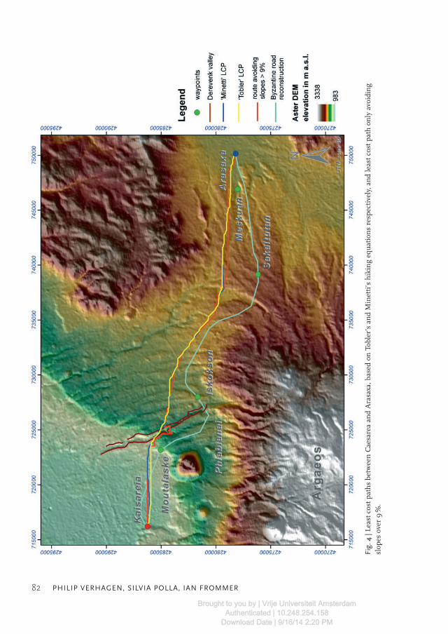
Because of the lack of applicable cost functions that take into account wheeled transport, wehave compared the two most commonly used hiking functions (Tobler’s and Minetti’s) anda least cost function avoiding all slopes over 9% (which might have been prohibitive forwheeled transport). We have calculated least cost paths between Caesarea and Arasaxabased on these functions using a slope map derived from the Aster DEM.10 The modelledpaths between Caesarea and Arasaxa all show similar routes, passing north of all the Byzan-tine sites mentioned as waypoints by Hild (Fig. 4). The distance of the Tobler and Minettipaths is 37.26 and 37.5 km respectively, and both routes are relatively straight, with a sinu-osity11 of 1.07 and 1.08 respectively. According to the ItAnt (Cuntz 1990) and TabPeut (Mil-ler 1988), the length of the route from Caesarea to Arasaxa measures 35.52 km (24 Romanmiles (mp); 1 mp = 1.48 km (French 1998, 146, fig. 2). The walking time needed to followthe shortest (Tobler) route is approximately 9 hours and 15 minutes,12 and would thereforefit well within a day’s travel. The route avoiding all steep slopes is 39.69 km long (sinuosity1.14, approximately 10 hours walking).
These figures are in line with the available information on travel speeds in the RomanEmpire. For pedestrian movement, Kolb (2000, 310, tab. 1 and note 1; ibid. 311) gives anaverage of 20–25 mp (30–37 km) per day. Similar figures are supplied for transport usingpack animals like mules, donkeys, horses and in some regions even camels and drom-edaries (on average 24 mp or 35 km per day; Kolb 2000, 312, tab. 2). Higher speeds could ofcourse be achieved by riders on horseback or carts, especially with a regular change of ani-mals.
The sources are less clear about travel speeds of heavy transport with wagons and carts.For ox-carts, a speed of 8 mp (12 km) per day is given by Kolb (2000, 316, Tab. 5). This, how-ever, seems to be on the low end of the scale. For the Early Medieval period Bachrach (1993,717) estimates a maximum speed of 9 mp (15 km) per day. Roth (1998, 211), however,reports that 19th-century American ox-carts could cover 19 to 24 km (12 to 15 mp) per day.Mule-carts are faster and could easily cover 19 mp (30 km) per day (Bachrach 1993, 717).Since there are no equations that specify the relationships between slope and travel speedsfor various kinds of animals and carts, it is impossible to be more specific about the effi-ciency of the modelled paths with regard to the various modes of transport. In either case,it seems impossible for ox-carts to cover the whole distance between Caesarea and Arasaxain one day, and even for mule carts it seems improbable.
10 The paths were calculated in ArcGIS 9.2, using the Path Distance module in order to account for the effect ofanisotropic slope (see Herzog 2013).11 The sinuosity index (Mueller 1968) is a measure of the directness of a route, it calculates the deviation from astraight line by dividing the route’s length by the straight-line distance.12 The walking time calculations are based on Tobler’s hiking equation.
Brought to you by | Vrije Universiteit AmsterdamAuthenticated | 10.248.254.158
Download Date | 9/16/14 2:20 PM
82 PHILIP VERHAGEN, SILVIA POLLA, IAN FROMMER
Fig.
4|L
east
cos
t pat
hs
betw
een
Cae
sare
a an
d A
rasa
xa, b
ased
on
Tob
ler’
s an
d M
inet
ti’s
hik
ing
equ
atio
ns
resp
ecti
vely
, an
d le
ast c
ost p
ath
on
ly a
void
ing
slop
es o
ver
9%
.
Brought to you by | Vrije Universiteit AmsterdamAuthenticated | 10.248.254.158
Download Date | 9/16/14 2:20 PM
FINDING BYZANTINE JUNCTIONS WITH STEINER TREES 83
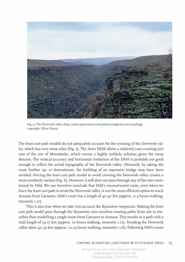
The least cost path models do not adequately account for the crossing of the Derevenk val-ley, which has very steep sides (Fig. 5). The Aster DEM allows a relatively easy crossing justeast of the site of Moutalaske, which seems a highly unlikely solution given the steepdescent. The vertical accuracy and horizontal resolution of the DEM is probably not goodenough to reflect the actual topography of the Derevenk valley. Obviously, by taking theroute further up- or downstream, the building of an expensive bridge may have beenavoided. Forcing the least cost path model to avoid crossing the Derevenk valley creates amore southerly variant (Fig. 6). However, it still does not pass through any of the sites men-tioned by Hild. We can therefore conclude that Hild’s reconstructed route, even when weforce the least cost path to avoid the Derevenk valley, is not the most efficient option to reachArasaxa from Caesarea. Hild’s route has a length of 40.97 km (approx. 11.5 hours walking,sinuosity 1.17).
This is also true when we take into account the Byzantine waypoints. Making the leastcost path model pass through the Byzantine sites involves creating paths from site to site,rather than modelling a single route from Caesarea to Arasaxa. This results in a path with atotal length of 39.17 km (approx. 10 hours walking, sinuosity 1.12). Avoiding the Derevenkvalley takes 40.39 km (approx. 10.25 hours walking, sinuosity 1.16). Following Hild’s route
Fig. 5 | The Derevenk valley (http://static.panoramio.com/photos/original/20000398.jpg;copyright: Efkan Sinan).
Brought to you by | Vrije Universiteit AmsterdamAuthenticated | 10.248.254.158
Download Date | 9/16/14 2:20 PM

84 PHILIP VERHAGEN, SILVIA POLLA, IAN FROMMER
Fig.
6|L
east
cos
t pat
hs
betw
een
Cae
sare
a an
d A
rasa
xa (
base
d on
Tob
ler’
s h
ikin
g eq
uat
ion
), av
oidi
ng
the
Der
even
k va
lley,
an
d pa
ssin
g th
rou
gh th
e w
aypo
ints
.
Brought to you by | Vrije Universiteit AmsterdamAuthenticated | 10.248.254.158
Download Date | 9/16/14 2:20 PM

FINDING BYZANTINE JUNCTIONS WITH STEINER TREES 85
from Caesarea to Arasaxa would therefore add at least one hour extra walking. But since hisreconstruction is plotted on 1:800,000 scale topographic maps, it is probably not very ac-curate.
By comparing different sources we can conclude that the use of least cost pathmethods for road reconstruction conflicts with the unpredictability of past decision-makingprocesses as a result of non-optimal environmental and/or cultural choices. However, wecan gain a better understanding of these processes using a model based on formal criteriathat involve quantitative and qualitative aspects related to environment and settlement his-tory.
For example, if we include visibility into the model, by calculating a total viewshed ofthe area and letting this progressively weigh as a cost factor, the modelling results indicatethat the routes with best visibility are found further to the north (Fig. 7). This suggests thatRoman road building in the area was probably not dictated by optimal visibility. It alsoprompts the question if there was something like “good enough” visibility for the Romangromatici, and whether using a total viewshed would be the best way to model this (see alsoVerhagen / Jeneson 2012).
6 Junctions and Steiner trees
Hild’s reconstruction shows a junction that is located approximately halfway between thesites of Phlabianai (a Byzantine church site, 4th – 13th century AD) and Iskokson. Here, asecond route branches off to the southeast, leading to the Byzantine settlements of Cebirand Tomarza and onwards to the Late Roman/Early Byzantine site of Kiskisos (Hild / Restle1981, 206).
Additionally to slope, which influences the feasibility and stability of the paths, a struc-turing role in movement is played by nodes and junctions (Gibson 2007). Junctions are im-portant elements in a coherent road system, but have been neglected in many case studies,in part because few applications of GIS in the field of Roman and Medieval archaeology areavailable (Witcher 1998; Bell et al. 2002; Fiz/Orengo 2008; Bellavia 2006; Gaffney 2006;de Soto / Carreras 2008; de Soto 2010). A GIS-based path modelling procedure using onlyarchaeological sites as waypoints does not allow for the creation of junctions that optimizemovement along the whole strategic network. From a mathematical point of view, the prob-lem of finding the optimal interconnection of a set of points is covered by the Steiner TreeProblem, a generalization of the Minimal Spanning Tree Problem. Given a set of nodes(points) with edges (connecting lines) that connect various pairs of points and have associ-ated costs, the minimal spanning tree seeks the least cost tree (i.e. a collection of edges hav-ing no loops, and the points they connect) containing each of the given points. In a SteinerTree Problem, additional points (Steiner points) may be utilized if they can help lower thecost of the tree (Fig. 8). To avoid confusion, the original points that must be connected are
Brought to you by | Vrije Universiteit AmsterdamAuthenticated | 10.248.254.158
Download Date | 9/16/14 2:20 PM

86 PHILIP VERHAGEN, SILVIA POLLA, IAN FROMMER
Fig.
7|L
east
cos
t pat
hs
betw
een
Cae
sare
a an
d A
rasa
xa, b
ased
on
Tob
ler’
s h
ikin
g eq
uat
ion
an
d di
ffer
ent w
eigh
ts f
or v
isib
ility
.
Brought to you by | Vrije Universiteit AmsterdamAuthenticated | 10.248.254.158
Download Date | 9/16/14 2:20 PM

FINDING BYZANTINE JUNCTIONS WITH STEINER TREES 87
referred to as “terminal nodes.” These problems are often situated in the Euclidean plane,in which case costs are the Euclidean distances. Since distances between settlements in reallandscapes should not be measured as Euclidean distances, but as (non-uniform) cost dis-tances, an additional complication is found in creating the optimal network connections.The Euclidean Non-Uniform Steiner Tree Problem, described by Frommer / Golden(2007a), aims to efficiently solve the Steiner Tree Problem for a network of points usingnon-uniform distances. In the Euclidean Non-Uniform Steiner Tree Problem, each locationin the Euclidean plane has an associated cost. An edge connecting two points will have acost that depends on the cost of the locations through which it passes (a least cost path). De-vising a network of paths connecting sites in a rugged mountainous landscape can be for-mulated as a Euclidean Non-Uniform Steiner Tree Problem, with location costs dependenton land use, slope, elevation and other factors.
Along these lines, the problem of trying to find possible routes between archaeologicalsites given known waypoints can be formulated as a Euclidean Non-Uniform Steiner TreeProblem. The existing sites can be thought of as the terminal points in the tree that must beconnected in a reconstruction of an ancient network of paths or roads. Steiner points helpto lower the cost of the overall tree, i.e., they result in more efficient pathways. Furthermore,Steiner points always have at least three edges leading to/from them, and hence may func-tion as junctions in a (road) network. Generating Steiner trees for larger sets of points iscomputationally intensive, however. Furthermore, no implementations of algorithms thatgenerate Steiner trees from point data are available in GIS.13
13 The v.net.steiner module in GRASS (grass.osgeo.org) only finds the optimal connection between a subset ofpoints in an existing network (i.e. with predefined edges); it will not create a new network.
Fig. 8 | Steiner tree connecting points T1, T2, T3, and T4 by usingSteiner points S1 and S2. The four terminal points could be connectedwithout using S1 and S2, but the cost (i.e., length of the tree in this case)would be higher.
Brought to you by | Vrije Universiteit AmsterdamAuthenticated | 10.248.254.158
Download Date | 9/16/14 2:20 PM

88 PHILIP VERHAGEN, SILVIA POLLA, IAN FROMMER
7 A genetic algorithm to solve the Euclidean non-uniform Steiner tree problem
Frommer and Golden (2007a) developed a genetic algorithm to solve the Euclidean Non-Uniform Steiner Tree Problem, and applied this to sample problems with structured land-scapes (e.g. hills, rings, etc.). The algorithm was later combined with GIS data in an exer-cise aimed at connecting recreational sites in Stowe, Vermont (Frommer / Golden 2007b).A weighted combination of layers of GIS data (elevation, land use and slope) was used tospecify the underlying cost structure.
The problem is situated on a hexagonal grid. Each hexagonal cell on the grid may con-tain at most one point, and has a cost associated with it. Given two points, the edge connect-ing them is defined as the shortest path between them, which is not necessarily the straightline segment connecting the points. The cost of the edge equals the sum of the costs of thecells through which the edge passes plus one half the costs of the two end points’ cells.Using a grid reduces the size of the solution search space from infinite to finite, though itis still potentially very large. It also allows the problem to be represented in network(or weighted graph) form. A genetic algorithm is only one possible solution, and some ofthe trade-offs between the genetic algorithm and other approaches are discussed inFrommer / Golden 2007a. What is important for this work is that the genetic algorithmfinds good (and in some cases optimal) solutions for reasonably sized problems relativelyquickly. It may not necessarily be the fastest or best performing algorithm, but it is quiteflexible to changes in problem formulation.
Genetic algorithms are based on biological evolution and natural selection. They typi-cally consist of a population of individuals representing solutions that change over timethrough the application of crossover and mutation operators. A fitness function assigns avalue to each individual in the solution with regard to how well it meets the problem goal.In the genetic algorithm we employ, each individual in the genetic algorithm population isdefined by a set of potential Steiner points. The fitness function is the cost of the minimalcost tree connecting the terminal points and possibly using some of the Steiner points.Lower cost solutions are chosen with higher probability than higher cost solutions, and arethen used to generate new individuals through the use of crossover and mutation. This gen-etic algorithm is discussed more fully in Frommer / Golden 2007a.
8 Application
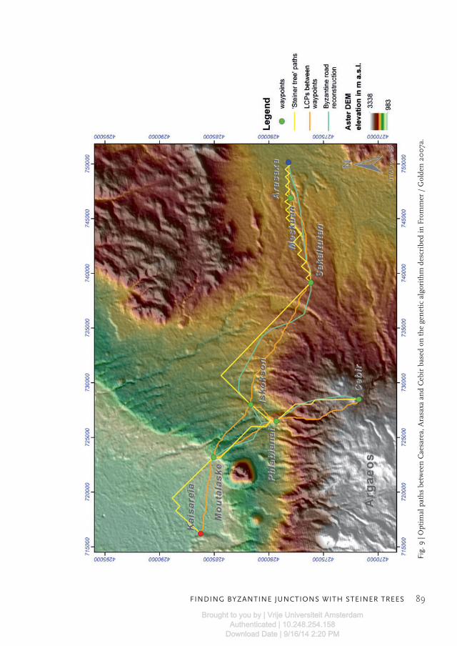
The genetic algorithm was applied to find the minimal spanning tree that connects the way-points on the route from Caesarea to Arasaxa and those on the route branching off to thesoutheast towards Cebir via Phlabianai, as specified by Hild (1977). The results are shownin Fig. 9. The genetic algorithm solution does an effective job of connecting the terminalpoints, while avoiding high cost regions wherever possible. The deviations from the Tobler
Brought to you by | Vrije Universiteit AmsterdamAuthenticated | 10.248.254.158
Download Date | 9/16/14 2:20 PM
FINDING BYZANTINE JUNCTIONS WITH STEINER TREES 89
Fig.
9|O
ptim
al p
ath
s be
twee
n C
aesa
rea,
Ara
saxa
an
d C
ebir
bas
ed o
n th
e ge
net
ic a
lgor
ith
m d
escr
ibed
in F
rom
mer
/ G
olde
n 2
00
7a.
Brought to you by | Vrije Universiteit AmsterdamAuthenticated | 10.248.254.158
Download Date | 9/16/14 2:20 PM
90 PHILIP VERHAGEN, SILVIA POLLA, IAN FROMMER
least cost paths calculated between the way points are clear. The two detours to the north(right from the start in Caesarea, and between Iskokson and Sakaltutan) are more in linewith Hild’s reconstruction than with the least cost path. The junction near Phlabianai isclose to where Hild hypothesized it. Note that the genetic algorithm finds a detour in theupper left that is not found in the other models. This solution uses a narrow low-cost path ofapproach to Moutalaske that yields a cost approximately 3% less than the next best route.A question to consider is how likely people would be to find the less intuitive detour when itonly provides relatively small savings. Such considerations can be incorporated in the algo-rithm, as described below.
Since the algorithm works on a hexagonal grid, the number of directions of edges islimited to six. So solutions sometimes exhibit staggered (zigzag) paths when they need tomove in a direction other than one of the six. Because of this, the efficiency of the calculatedroute appears to be very low. The connection created between Caesarea and Arasaxa has alength of 50.84 km (approx. 13.5 hours walking, sinuosity 1.46). The zigzags could be re-placed by the lines they are attempting to follow in a post-processing routine. Given thatthis work represents only an initial exploration, the post-processing has not been imple-mented. Alternatively, the current set-up could be replaced with a rectilinear grid and edgesallowed to take on any direction. Cost would be calculated using numerical line integrals.Steiner point locations would still need to be restricted, possibly to the centre of each cell. Inaddition, the grid could have multiple resolutions, with a finer grid used in areas of highlyvariable cost structure.
9 Concluding remarks
We have shown that the traditional application of least cost path algorithms will only calcu-late optimal pathways between pairs of points, and are not effective for finding intermediatewaypoints, like those hypothesized in Hild’s reconstruction of the Byzantine route betweenCaesarea and Arasaxa. The only way in which least cost paths will approach the location ofthe supposed route is by progressively including known waypoints and calculating leastcost paths between them. Even then, the resulting path network will not be the optimal sol-ution to connect a set of known points. It also deviates substantially from the route sug-gested by Hild. We applied the Euclidean Non-Uniform Steiner Tree Problem using thegenetic algorithm developed by Frommer and Golden (2007a, 2007b) to the issue of find-ing the optimal connection between the waypoints on the route. This resulted in a modelledroute network that, while not perfectly fitting the reconstruction, shares important charac-teristics with it, especially the presence of a junction outside the set of known points, as wellas deviations from the least cost paths that are more in line with the reconstructed route.From this we can (cautiously) conclude that the Byzantine road system was constructedwith the aim of creating optimal connections for the whole micro-regional network. This
Brought to you by | Vrije Universiteit AmsterdamAuthenticated | 10.248.254.158
Download Date | 9/16/14 2:20 PM
FINDING BYZANTINE JUNCTIONS WITH STEINER TREES 91
clearly contrasts with the system of macro-regional connections that characterizes theRoman road network as described by the itinerary sources. The results fit with what we al-ready know about the Byzantine road system. The new religious14 and military geography ofthe area restructured the micro-regional communication and transport network, using theRoman way stations as points of departure. Both the Byzantine settlement pattern and themodelled reconstructions suggest that the Roman road itself was not in use anymore.
As alluded to above, the actual paths used in the Byzantine period may not have beenoptimal with regard to the cost landscape, since their creators would obviously not have hadaccess to the full range of cost information, nor to any sophisticated algorithms. An optimaltopography-based model may be inappropriate and unsuitable for reconstructing past deci-sion-making processes (see e.g. Whitley 2002). These, on the one hand, involve a certaindegree of environmental knowledge (Rockman 2003), and on the other hand concern thedynamics of changing land use, settlement pattern and functional or symbolic landmarks(military and religious sites; the caravanserai system), which influence the structure of acommunication system. Depending on the function and aims of the paths and roads, spa-tial models can provide multiple optimal paths corresponding to the minimization or maxi-mization of specific environmental or cultural criteria, as we did in the case of the visibilitycriterion (see also Howey 2011). However, the choice of which costs to use in the model,their values and their respective weights are all subjective, and so results will vary depend-ing on these decisions. Furthermore, least cost path modelling will not easily allow us toanalyse alternative options. The least cost path routines in GIS will give a single optimal sol-ution, not the second best or nth-best. Even though k-shortest path algorithms, designed tofind less optimal solutions, are described in various computer science publications (e.g.Yen 1971; Eppstein 1998; Hershberger et al. 2007), they are very difficult to achieve withcomputational efficiency, and have not been implemented in GIS.
The genetic algorithm described by Frommer and Golden (2007a, 2007b) is in factwell suited to address these issues. First of all, the algorithm generates an entire populationof solutions, not just one. Furthermore, because it has an element of randomness, it maynot return the same “best” solution each time. Uncertainty in costs and their weightingscan be reflected in multiple runs of the algorithm. One potentially useful approach wouldbe to run the genetic algorithm numerous times with different cost settings and count howoften a given location is found in the least cost solution (or within a set of the top solutions).The results of this simulation across various cost value settings would be to assign a prob-ability that a path passed through a particular location for each location on the map.
The study of the development of settlement distribution, density and hierarchy hasrecently been carried out using GIS-based techniques that support the interpretation or re-interpretation of the dynamic relationship between supra-regional roads, regional path-ways, sites and off-site land use over time (cf. Bell et al. 2002; Fairén Jiménez 2004; Zaksek
14 For churches as proxies for settlements in the area around Caesarea see Decker (2007, 241).
Brought to you by | Vrije Universiteit AmsterdamAuthenticated | 10.248.254.158
Download Date | 9/16/14 2:20 PM

92 PHILIP VERHAGEN, SILVIA POLLA, IAN FROMMER
et al. 2008). Other (landscape) theoretical questions still need to be explored, like the in-fluence of different environmental costs and sociocultural factors, and landmarks thatattract movement over the long term (Murrieta Flores 2010), especially where they concernthe coherence of road networks, their function and the articulation and use by the localpopulation of primary (i.e., viae publicae) and secondary networks (regional paths) in theRoman period.
Did the local population of the Cappadocian upland, a territory at the eastern frontierof the Roman and then Byzantine Empire, use the structured Roman and Byzantine roadsystem? To what extent is the strategic network connecting central places and stations aproduct of the previous regional pattern of sites and infrastructures, and/or related to landuse and resource exploitation, like mixed farming, agropastoralism and a mining econ-omy?15 In this respect we also consider it a relevant issue to examine the location and func-tion of junctions unifying and subdividing the movement (Gibson 2007) along a diach-ronic network.
The feasibility of exploring these issues is for this case study restricted by the availabil-ity of archaeological survey data and fine-grained chronology. However, even for relativelywell-known regions it is still very much limited by the availability of software solutions.Even when using off-the-shelf GIS packages, setting up and executing a multitude of dif-ferent least cost path variants and comparing these is a complex task. The current imple-mentation of the genetic algorithm for the Euclidean Non-Uniform Steiner Tree Problem issuitable for the experimental purpose for which it was applied here, but still needs to besubstantially improved in speed, flexibility and accessibility to other users before it can beused to effect in landscape archaeology.
Acknowledgements
The writing of this paper was made possible partly by a VENI research grant from NWO(the Netherlands Organization for Scientific Research) awarded to Philip Verhagen.
The dataset on Cappadocia was collected by Silvia Polla within the framework of the“Ancient Cartography” Project (2006–2008) at The Karman Center for Advanced Studiesin the Humanities (University of Bern).
15 On agropastoralism see Decker 2007, 256; on the Hittites control of markets and over regional routes formetal exploitation see Yakar (1976); Kaptan 1990, 78.
Brought to you by | Vrije Universiteit AmsterdamAuthenticated | 10.248.254.158
Download Date | 9/16/14 2:20 PM

FINDING BYZANTINE JUNCTIONS WITH STEINER TREES 93
References
Bachrach, B.S. (1993)“Animals and Warfare in Early Medieval Europe”, in: B.S. Bachrach (ed.), Armies and Politicsin the Early Medieval West, Aldershot, 708–751.
Bellavia, G. (2006)“Predicting Communication Routes”, in: J.E. Haldon (ed.), General Issues in the Study of Medi-eval Logistics, Leiden, 185–198.
Bell, T. / Wilson, A. / Wickham, A. (2002)“Tracking the Samnites: Landscape and Communication Routes in the Sangro Valley, Italy”,in: American Journal of Archaeology 106, 169–186.
Bell, T. / Lock, G. (2000)“Topographic and Cultural Influences on Walking the Ridgeway in Later Prehistoric Times”,in: G. Lock (ed.), Beyond the Map: Archaeology and Spatial Technologies, Amsterdam, 85–100.
Bevan, A. (2011)“Computational Models for Understanding Movement and Territory”, in: V. Mayoral / S. Ce-lestino (eds.), Sistemas de Información Geográfica y Análisis Arquelógico del Territorio. V Simpo-sio Internacional de Arqueología de Mérida (Anejos de Archivo Español de Arqueología,383–394.
Chevalier R. (1997)Les voies romaines, Paris.
Cuntz, O. (ed.) (1990)Itineraria Romana. Bd. 1: Itineraria Antonini Augusti et Burdigalense, Stuttgart.
Decker, M. (2007)“Frontier Settlement and Economy in the Byzantine East”, in: Dumbarton Oaks Papers 61,217–267.
De Silva, M. / Pizziolo, G. (2001)“Setting up a ‘Human Calibrated’ Anisotropic Cost Surface for Archaeological LandscapeInvestigation”, in: Z. Stancic / T. Veljanovski (eds.), Computing Archaeology for Understandingthe Past. Computer Applications and Quantitative Methods in Archaeology 2000, Oxford,279–286.
de Soto P. / Carreras, C. (2008)“Anàlisi de la xarxa de transport a la Catalunya romana: alguns apunts”, in: Revista d’Arqueo-logia de Ponent 16–17, 177–191.
de Soto, P. (2010)Anàlisi de la xarxa de comunicacions i del transport a la Catalunya romana: estudis de distribució imobilitat, Barcelona.
Eppstein, D. (1998)“Finding the k Shortest Paths”, in: SIAM Journal on Computing 28(2), 652–673.
Brought to you by | Vrije Universiteit AmsterdamAuthenticated | 10.248.254.158
Download Date | 9/16/14 2:20 PM
94 PHILIP VERHAGEN, SILVIA POLLA, IAN FROMMER
Fairén Jiménez, S. (2004)“¿Se hace camino al andar? Influencia de las variables medioambientales y culturales en elcálculo de caminos óptimos mediante SIG”, in: Trabajos de Prehistoria 61(2), 25–40.
Fiz, J. / Orengo, H. (2008)“Simulating Communication Routes in Mediterranean Alluvial Plains”, in: A. Posluschny /K. Lambers / I. Herzog (eds.), Layers of Perception. Proceedings of the 35th International Con-ference on Computer Applications and Quantitative Methods in Archaeology (CAA), Berlin,Germany, April 2–6 2007. Bonn, 316–321.
Fábrega Álvarez, P. / Parcero Oubiña, C. (2007)“Proposals for an Archaeological Analysis of Pathways and Movement”, in: Archeologia e Cal-colatori 18, 121–140.
French, D. H. (1974)“A Study of Roman Roads in Anatolia: Principles and Methods”, in: Anatolian Studies 24,143–149.
French, D. H. (1988)Roman Roads and Milestones of Asia Minor, Oxford.
French, D. H. (1998)“Pre- and Early-Roman Roads of Asia Minor. The Persian Royal Road”, in: Iran 36, 15–43.
French, D. H. (2012)Roman Roads and Milestones of Asia Minor, Vol 3. Milestones, Fasc. 3.3 Cappadocia, British In-stitute at Ankara, Electronic Monograph 3.
Frommer, I. / Golden, B. (2007a)“A Genetic Algorithm for Solving the Euclidean Non-Uniform Steiner Tree Problem”, in:E.K. Baker / A. Joseph / A. Mehrotra / M.A. Trick (eds.), Extending the Horizons: Advances inComputing, Optimization, and Decision Technologies, New York, 31–48.
Frommer, I. / Golden, B. (2007b)“Solving the Euclidean Non-Uniform Steiner Tree Problem Using a Genetic Algorithm”,paper presented at INFORMS ICS 2007, College Park (MD), 3 January. http://www.rhsmith.umd.edu/faculty/bgolden/recent_presentation_pdfs_links/2007_jan_ics_frommer.pdf.
Gaffney, H. (2006)“Superiority of Numbers: Methodologies for Modelling the Behaviour of Armies”, in: Hal-don J.E. (ed.), General Issues in the Study of Medieval Logistics, Leiden, 251–272.
Gibson, E. (2007)“The Archaeology of Movement in a Mediterranean Landscape”, in: Journal of MediterraneanArchaeology 20(1), 61–87.
Golledge R. (2003)“Human Wayfinding and Cognitive Maps”, in M. Rockman / J. Steele (eds.), Colonization ofUnfamiliar Landscapes: The Archaeology of Adaptation, London, 25–43.
Brought to you by | Vrije Universiteit AmsterdamAuthenticated | 10.248.254.158
Download Date | 9/16/14 2:20 PM
FINDING BYZANTINE JUNCTIONS WITH STEINER TREES 95
Graßhoff, G. / Mittenhuber, F. (2009)Untersuchungen zum Stadiasmos von Patara: Modellierung und Analyse eines antiken geographi-schen Streckennetzes, Bern.
Hershberger, J. / Maxel, M. / Suri, S. (2007)“Finding the k Shortest Simple Paths: A New Algorithm and its Implementation”, in: ACMTransactions on Algorithms 3(4), 45:1–19.
Herzog, I. (2013)“Theory and Practice of Cost Functions”, in: F. Contreras / M. Farjas / F.J. Melero (eds.),Fusion of Cultures. Proceedings of the 38th Annual Conference on Computer Applications andQuantitative Methods in Archaeology, Granada, Spain, April 2010. Oxford, 375–382.
Hild, F. (1977)Das Byzantinische Strassensystem in Kappadokien, Vienna.
Hild, F. / Restle, M. (1981)Tabula Imperii Byzantini 2, Kappadokien (Kappadokia, Charsianon, Sebasteia und Lykandos),Vienna.
Hogarth, D.G. (1893)“Modern and Ancient Roads in Eastern Asia Minor. Part 2: The Military Road from Caesareato Melitene on the Euphrates”, in: Royal Geographical Society (RGS) Supplementary Papers 3,678–718.
Howey, M.C.L. (2011)“Multiple Pathways across Past Landscapes: Circuit Theory as a Complementary GeospatialMethod to Least Cost Path for Modeling Past Movement”, in: Journal of Archaeological Science38.10, October 2011, 2523–2535, Accepted Manuscript, Available online 26 March 2011.
Hucker, R.A. (2009)“How Did the Romans Achieve Straight Roads?”, Paper Presented at International Feder-ation of Surveyors (FIG) Working Week 2009: Surveyors’ Key Role in Accelerated Develop-ment, Eilat 3–8 May.
Kaptan, E. (1990)“Findings Related to the History of Mining in Turkey”, in: Mineral Resource Exploration Bull-etin 111, 75–84.
Kolb, A. (2000)Transport und Nachrichtentransfer im Römischen Reich, Berlin.
Laurence, R. (1999)The Roads of Roman Italy: Mobility and Cultural Change, New York.
Llobera, M. (2000)“Understanding Movement: A Pilot Model towards the Sociology of Movement”, in: Lock, G.(ed.), Beyond the Map: Archaeology and Spatial Technologies, Amsterdam, 65–84.
Llobera, M. (2001)“Building Past Perceptions with GIS: Understanding Topographic Prominence”, in: Journalof Archaeological Science 28, 1005–1014.
Brought to you by | Vrije Universiteit AmsterdamAuthenticated | 10.248.254.158
Download Date | 9/16/14 2:20 PM

96 PHILIP VERHAGEN, SILVIA POLLA, IAN FROMMER
Llobera, M. (2003)“Extending GIS-based Visual Analysis: The Concept of Visualscapes”, in: International Jour-nal of Geographical Information Science 17(1), 25–48.
Llobera, M. / Fábrega-Álvarez, P. / Parcero-Oubiña, C. (2011)“Order in Movement: A GIS Approach to Accessibility”, in: Journal of Archaeological Science38(4), 843–851.
Meijer F. / van Nijf O. (1992)Trade, Transport and Society in the Ancient World. A Sourcebook, London.
Miller, K. (1988)Itineraria Romana. Römische Reisewege an der Hand der Tabula Peutingeriana, Bregenz.
Minetti, A.E. / Moia, C. / Roi, G.S. / Susta, D. / Ferretti, G. (2002)“Energy Cost of Walking and Running at Extreme Uphill and Downhill Slopes”, in: Journal ofApplied Physiology 93, 1039–1046.
Mitford, T.B. (2000)“Map 64 Caesarea-Melitene” in: R.J.A. Talbert (ed.), Barrington Atlas of the Greek and RomanWorld, Princeton.
Mueller, J. (1968)“An Introduction to the Hydraulic and Topographic Sinuosity Indexes”, in: Annals of theAssociation of American Geographers 58(2), 371–385.
Murrieta-Flores, P. (2010)“Travelling in a Prehistoric Landscape: Exploring the Influences that Shaped Human Move-ment”, in: B. Frischer / J. Webb Crawford / D. Koller (eds.), Making History Interactive. Com-puter Applications and Quantitative Methods in Archaeology (CAA). Proceedings of the 37thInternational Conference, Williamsburg, Virginia, United States of America, March 22–26,2009. Oxford, 258–276.
Quilici, L. (1995)“La Via Salaria da Roma all’alto Velino: la tecnica costruttiva dei manufatti stradali”, in:L. Quilici / S. Quilici Gigli (eds.), Strade romane: percorsi e infrastrutture, Atlante tematico ditopografia antica 2, Rome, 85–154.
Raepsaet, G. (2002)Attelages et techniques de transport dans le monde gréco-romain, Brussels.
Ramsay, W.M. (2010)The Historical Geography of Asia Minor, Cambridge. First published 1890.
Rockman, M. / Steele, J. (eds.) (2003)Colonization of Unfamiliar Landscapes: The Archaeology of Adaptation, London.
Rockman, M. (2003)“Knowledge and Learning in the Archaeology of Colonization”, in: M. Rockman / J. Steele(eds.), Colonization of Unfamiliar Landscapes: The Archaeology of Adaptation, London, 3–24.
Brought to you by | Vrije Universiteit AmsterdamAuthenticated | 10.248.254.158
Download Date | 9/16/14 2:20 PM

FINDING BYZANTINE JUNCTIONS WITH STEINER TREES 97
Roth, J.P. (1998)The Logistics of the Roman Army at War (264 B.C. – A.D. 235), Leiden.
Snead, J.E. / Erickson, C.L. / Darling, J.A. (2009)“Making Human Space: The Archaeology of Trails, Paths, and Roads”, in: J.E. Snead /C.L. Erickson / J.A. Darling (eds.), Landscape of Movement. Trails, Paths and Roads in Anthro-pological Perspective, Philadelphia, 1–19.
Tobler, W. (1993)Three Presentations on Geographical Analysis and Modelling, Santa Barbara, CA.
Tuba Ökse, A. (2007)“Ancient Mountain Routes Connecting Central Anatolia to the Upper Euphrates Region”,Anatolian Studies 57, 35–45.
van Leusen, M. (2002)Pattern to Process: Methodological Investigations into Deformation and Interpretation of SpatialPatterns in Archaeological Landscapes, Groningen, http://dissertations.ub.rug.nl/faculties/arts/2002/p.m.van.leusen/ (seen on 12/03/2013)
Verhagen, P. / Jeneson, K. (2012)“A Roman Puzzle. Trying to Find the Via Belgica with GIS”, in: K. Papadopoulos / P. MurrietaFlores / A. Chrysanthi (eds.), Thinking beyond the Tool: Archaeological Computing and the In-terpretive process, Oxford, 123–130.
Whitley, T.G. (2002)“Modeling Archaeological and Historical Cognitive Landscapes in the Greater YellowstoneRegion (Wyoming, Montana and Idaho, USA) Using Geographic Information Systems”, in:G. Burenhult / J. Arvidsson (eds.), Archaeological Informatics: Pushing the Envelope. CAA2001. Computer Applications and Quantitative Methods in Archaeology. Proceedings of the29th Conference, Gotland, April 2001. Oxford, 139–148.
Witcher, R.E. (1998)“Roman Roads: Phenomenological Perspectives on Roads in the Landscape”, in: C. Forcey /J. Hawthorne / R.E. Witcher (eds.), TRAC 97. Proceedings of the Seventh Annual TheoreticalRoman Archaeology Conference, University of Nottingham, April 1997. Oxford, 60–70.
Yakar, J. (1976)“Hittite Involvement in Western Anatolia”, in: Anatolian Studies 26, 117–128.
Yen, J.Y (1971)“Finding the k Shortest Loopless Paths in a Network”, in: Management Science 17, 712–716.
Zaksek, K. / Fovet, E. / Nuninger, L. / Podobnikar, T. (2008)“Path Modelling and Settlement Pattern”, in: A. Posluschny / K. Lambers / I. Herzog (eds.),Layers of Perception. Proceedings of the 35th International Conference on Computer Appli-cations and Quantitative Methods in Archaeology (CAA), Berlin, Germany, April 2–6 2007.Bonn, 309–315.
Brought to you by | Vrije Universiteit AmsterdamAuthenticated | 10.248.254.158
Download Date | 9/16/14 2:20 PM

Brought to you by | Vrije Universiteit AmsterdamAuthenticated | 10.248.254.158
Download Date | 9/16/14 2:20 PM