Organic Geochemical, Isotopic, and Seismic Indicators of Fluid ...
34
10 Organic Geochemical, Isotopic, and Seismic Indicators of Fluid Flow in Pressurized Growth Anticlines and Mud Volcanoes in Modern Deep-water Slope and Rise Sediments of Offshore Brunei Darussalam: Implications for Hydrocarbon Exploration in Other Mud- and Salt-diapir Provinces John K. Warren 1 International Graduate Program in Petroleum Geoscience, Department of Geology, Chulalongkorn University, Bangkok, Thailand Alwyn Cheung Petronas Malaysia, Kuala Lumpur, Malaysia Ian Cartwright School of Geosciences, Monash University, Melbourne, Australia ABSTRACT Modern slope and rise sediments of offshore Brunei contain thermogenic gases and bitumens atop or adjacent to actively growing mud-cored compressional ridges. This is particularly so where pressurized fluid and mud periodically breakout onto the sea floor as mud volcanoes or chimneys along ridge axes. Where modern sediment is actively accumulating in areas away from the ridges, the sediment contains organic signatures and gases that are biogenic (nonther- mogenic) and related to the bacterial breakdown in and below the sulfate reduction zone. Seismic signature implies that ridge-top volcanoes are regions of pressure buildup, and incipient fluid breakout is indicated by a combination of convex-upward seismic reflectors and zones of discontinuity in the bottom-simulating reflector (BSR, a seismic indicator of the base of stability of methane hydrates). Areas where the BSR weakens or disappears are likely zones where rising warm fluids have melted part or all of the hydrate layer. Following fluid pressure 163 Warren, John K., Alwyn Cheung, and Ian Cartwright, 2010, Organic geochemical, isotopic, and seismic indicators of fluid flow in pressurized growth anticlines and mud volcanoes in modern deep-water slope and rise sediments of offshore Brunei Darussalam: Implications for hydrocarbon exploration in other mud- and salt-diapir provinces, in L. Wood, ed., Shale tectonics: AAPG Memoir 93, p. 163 – 196. 1 Former address: Shell Chair in Carbonate Studies, Sultan Qaboos University, Muscat, Oman. Copyright n2010 by The American Association of Petroleum Geologists. DOI:10.1306/13231314M933424
-
Upload
khangminh22 -
Category
Documents
-
view
3 -
download
0
Transcript of Organic Geochemical, Isotopic, and Seismic Indicators of Fluid ...
10Organic Geochemical, Isotopic, and SeismicIndicators of Fluid Flow in PressurizedGrowth Anticlines and Mud Volcanoes inModern Deep-water Slope and RiseSediments of Offshore Brunei Darussalam:Implications for Hydrocarbon Explorationin Other Mud- and Salt-diapir Provinces
John K. Warren1
International Graduate Program in Petroleum Geoscience, Department of Geology, ChulalongkornUniversity, Bangkok, Thailand
Alwyn CheungPetronas Malaysia, Kuala Lumpur, Malaysia
Ian CartwrightSchool of Geosciences, Monash University, Melbourne, Australia
ABSTRACT
Modern slope and rise sediments of offshore Brunei contain thermogenic gases and bitumensatop or adjacent to actively growing mud-cored compressional ridges. This is particularly sowhere pressurized fluid andmud periodically breakout onto the sea floor asmud volcanoes orchimneys along ridge axes. Where modern sediment is actively accumulating in areas awayfrom the ridges, the sediment contains organic signatures and gases that are biogenic (nonther-mogenic) and related to the bacterial breakdown in and below the sulfate reduction zone.
Seismic signature implies that ridge-top volcanoes are regions of pressure buildup, andincipient fluid breakout is indicated by a combination of convex-upward seismic reflectors andzones of discontinuity in the bottom-simulating reflector (BSR, a seismic indicator of the base ofstability of methane hydrates). Areas where the BSR weakens or disappears are likely zoneswhere rising warm fluids havemelted part or all of the hydrate layer. Following fluid pressure
163
Warren, John K., Alwyn Cheung, and Ian Cartwright, 2010, Organic geochemical,
isotopic, and seismic indicators of fluid flow in pressurized growth anticlines
and mud volcanoes in modern deep-water slope and rise sediments of
offshore Brunei Darussalam: Implications for hydrocarbon exploration in
other mud- and salt-diapir provinces, in L. Wood, ed., Shale tectonics: AAPG
Memoir 93, p. 163 – 196.
1Former address: Shell Chair in Carbonate Studies, Sultan Qaboos University, Muscat, Oman.
Copyright n2010 by The American Association of Petroleum Geologists.
DOI:10.1306/13231314M933424
release at the sea floor and a subsequent period of inactivity, sediment layers within andadjacent to a mud volcano collapse, sediment reflectors bend downward into the neck of thevolcano, and a BSR re-establishes in the now-inactive neck.
Mud volcanoes in the continental slope and rise of Brunei occur along a series of gravity-driven compressional ridges. Seismic geometries are similar to the salt-cored compressionalridges of the slope and rise setting of the circum-Atlantic salt basins. In the case of the shale-cored ridges andmud chimneys of Brunei, however, the disrupted ridge and chimney cores arezones of sediment disruption created by the presence of pressurized gas and fluid. This disruptedridge sediment has a different set of rheotropic properties compared to that of a salt-cored ridge.Where the disrupted zone has reached the Brunei sea floor, the mud-filled structure depres-surizes and sediment flow ceases. Little or no evidence exists for widespread lateral flow ofdisrupted sediment across the Brunei sea floor, although evidence of debris-flow initiation existsin zones of instability created by ridge collapse. In contrast, where halokinetic salt breaks outonto the land surface or the sea floor, the halite mass continues to flow and spread across thedeep-sea floor and ultimately constructs large allochthonous tongues and namakiers.
Active mud and salt diapirs create highs in the landscape and zones of adjacent with-drawal; this means thatmost reservoir styles and traps are similar in intervals above the sourcekinetic layer, whether it is composed of mud or salt. Once salt reaches the surface, it can flowover the landscape, but pressurized mud cannot, so no known argillokinetic equivalents tosuballochthon traps are observed, nor argillokinetic equivalents to cap-rock traps.
INTRODUCTION
The Brunei deep offshore sea floor is characterized byan interesting association of gravity-driven growth anti-clines, mud volcanoes, and mass transport complexes.The whole region is gas prone, and until now, certainregions of the sea floorwere not known to contain gaseswith a thermogenic source. This article aims to (1) placethe organic geochemical and sedimentological charac-ter of modern deep sea-floor sediments of Brunei into aseismic framework, (2) provide a better understandingof the nature and extent of thermogenic fluid flow andhydrocarbon seepage in amud-dominated andpressur-ized sediment prism, (3) discuss hydrocarbon sourcesignatures in the fluid outflow zone in sea-floor sedi-ments of the modern slope and rise, and (4) comparecharacteristics of amud-diapir compressional provinceto similar geometries in salt-diapir ridge provinces.
The literature dealing with occurrences of subma-rine mud volcanoes and diapirs has expanded greatlyin the last decade, and so the same terms are given dif-ferent emphasis by differentworkers.As a consequence,terminological disparities andoverlap areobservedwithvarious and commonly overlapping usage of the termsmudvolcano, shale (mud)diapir,mudmound,diatreme,etc. Usage in this article follows that of Milkov (2000),whereby a submarine mud volcano is considered as atopographically expressed sea-floor edifice fromwhichwater, brine, gas, or oil flows or erupts. Craters, mud-flows with hummocky peripheries, and gryphons arethemainmorphological elements of amudvolcano.Mud
(shale) diapirs are structures that have risen from thedeep subsurface into shallow sediments and in somecases pierce the sea floor (sea-floor-piercing diapirs).Milkov’s definitions encapsulate the important differ-ence between a mud volcano and a diapir, namely allmudvolcanoes (mudchimneys) are associatedwithmuddiapirs but not vice versa. Kopf (2002) further refinedthe definitions by observing that a shale or mud diapiris a slowly upward-migrating mass of buoyant, clay-rich sediment that does not pierce all of its overburden,and themud is behaving as a single-phase viscous fluid.Mud volcanoes, in contrast, are characterized by lique-fied mud where the effective stress reaches zero.
Overpressured shale intervals act as detachments oras decollements facilitating the gravity-driven glidingor sliding of overlying more competent examples inmany areas around theworld, including offshore Brunei,the southChina Sea, offshoreNigeria, Trinidad, and thesouthern Gulf of Mexico (Gee et al., 2007). The sea floorof offshore Brunei is characterized by the effects ofmudvolcanoes fed from deeper shale (mud)-cored diapiricridges defining zones of overpressure.
Mud volcanoes in many places on Earth are com-monly associated with compressional tectonics at con-vergent margins (Kopf, 2002, 2003). Their abundanceshows a positive correlation with (1) sediment over-pressuring associatedwith thick, rapidly deposited sed-iments with high clay mineral contents; (2) sedimentoverpressuring caused by hydrocarbon formation and/or compaction disequilibrium; (3) a structural associa-tion caused by tectonic shortening and/or earthquake
164 WARREN ET AL.

activity; (4) fluid emission such as gas, brines, andwaterfrom mineral dehydration and gas hydrate dissocia-tion; and (5) polymictic assemblages of the surround-ing rock present in the ejected argillaceous matrix.
Hence, mud volcanoes are predominantly alignedaround subduction zones and orogenic belts where sedi-ments suffer tectonic stress and are incorporated intoaccretionary wedges that later can be imbricated anduplifted in compressional belts (Milkov, 2000; Kopf,2002). Both pore water and organic matter in a subsid-ing marine sediment prism may be buried by severalkilometers of sediment. Increasing overburden stressdrives sediment compaction and fluid expulsion,where-as increasing temperature drivesmaturation of organicmaterial and expulsion of hydrocarbon fluids. Trappedpore waters and hydrocarbons in such sediments cancreate considerable overpressures in muds as well aszones of anomalous porosity. As a consequence of theresulting porosity and density inversion, themud eitherslowly ascends through the overburden rock (mud dia-pirs) or extrudes vigorously (mudvolcanoes, diatremes)along focused zones of structuralweakness such as faultsand fractures (Stewart andDavies, 2006). Focused escapeof fluids fromsuch zonesmay liquefy already (partially)consolidated sedimentary rock. The admixture of smallamounts of gas has been shown to cause a dramatic in-crease in extrusion rate, so thatblocks of severalmeters indiametermay bemobilizedduringmud eruption (Clariet al., 2004).
REGIONAL GEOLOGICAL SETTING
The deep sea floor of the Brunei offshore lies northwestof theBruneiDarussalamshelf and spans an area ofmorethan 10,000 km2 (3861 mi2), centered on 58N latitudeand 1148E longitude (Figure 1a). Sea-floor topography inthe eastern part of the study area is the continental slopeand rise of Brunei and is made up of several partiallysediment-coveredanderoded fold ridges (Figures 1b, 2b).
Present-day geological expression indicates a longerterm geological history. Antecedent structures to thefold and thrust belt that today outcrops or immediatelyunderlies all of the slope and rise of modern Brunei Da-russalam were also developed in the deep-water equiv-alents of the middle Miocene–Pliocene shelf sequences(Morley, 2007a). Modern growth faults located near thepresent shelf-slope break are prograding over older, in-active innermost deeper water folds (Figure 1c). Theaveragedipof the slope is between 1 and 1.58 toward thedeepest region of the South China Sea, the northwestBorneoTrough.The slope is affectedbyanextensive trainof folds, spaced between 5 and 15 km (3.1 and 9 mi)apart, that verge offshore. They appear to be mostly
fault propagation folds that sole out into one or moredetachments (Figure 2b).
The northwest Borneo Trough is today the site of aninactive subduction zone, where the oceanic crust ofthe proto-South China Sea was subducted during theearly Tertiary (Morley 2007a). Heat-flow calculations,using aspects of the same organic geochemical data andcores detailed in this article, confirm Morley’s conclu-sion of a now-inactive subduction zone underlying theBrunei sediment prism (Figure 1c) (Zielinski et al., 2007).The subduction zone became jammed in the latest earlyMiocene, when a thinned continental crust of the Dan-gerous Grounds block entered the subduction zone. Thecurrent fold and thrust belt developed mostly duringthe Pliocene–Holocene; therefore, the present deforma-tion is unrelated to active subduction. Global position-ing system measurements show no difference in dis-placement direction or rate between northwest Borneoand mainland Southeast Asia, so today, no suggestionof an active plate boundary exists (Hall and Morley,2004). The sediments forming the fold and thrust beltare not scraped off from the subducting plate but arederived from reworking of the hinterland.
The active thrust-cored growth anticlines that out-crop or underlie much of the slope and rise act as sedi-ment baffles and sediment catchment dams (Figure 1b).These anticlines are cored by mud diapirs. Betweenthe growing ridges are several northeastward-trendingsediment-filled depressions that parallel the shelf mar-gin and range from 2 to 10 km (1.2 to 6 mi) wide and 20to 60 km (12 to 37 mi) long. The folds are the result of adownslope gravitational compression, which started inthe upper Miocene and continues today (Hutchison,2005; Demyttenaere et al., 2000; Ingram et al., 2004;Morley, 2007a, b). The remainder of the study area is arelatively flat terrain, mostly covered by a mass trans-port complex or landslide (McGilvery and Cook, 2003;Gee et al., 2007). This flow complex represents a cata-strophic event that occurred in the relatively recent pastand was perhaps emplaced as a single landslide andnot as a series of time-separate debris flows (Gee et al.,2007).Most of its internal structure is chaotic, but locally,it still retains coherent blocks that can be kilometersacross and are made up of relatively consolidated sedi-ment with an internal layering that was not completelydestroyed during emplacement. The headwall of thismass transport complex lies updip and immediatelyoffshore from the Baram Delta (Figure 1a) (Gee et al.,2007).
In summary, the various sediment dispersal path-ways that typify the slope and rise of Brunei aremadeupof four interactive elements (Figures 1b, 2b) (McGilveryand Cook, 2003): (1) gravity-drivenmass movement, dif-ferentiated further into short-distance transport, through
Organic Geochemical, Isotopic, and Seismic Indicators of Fluid Flow 165
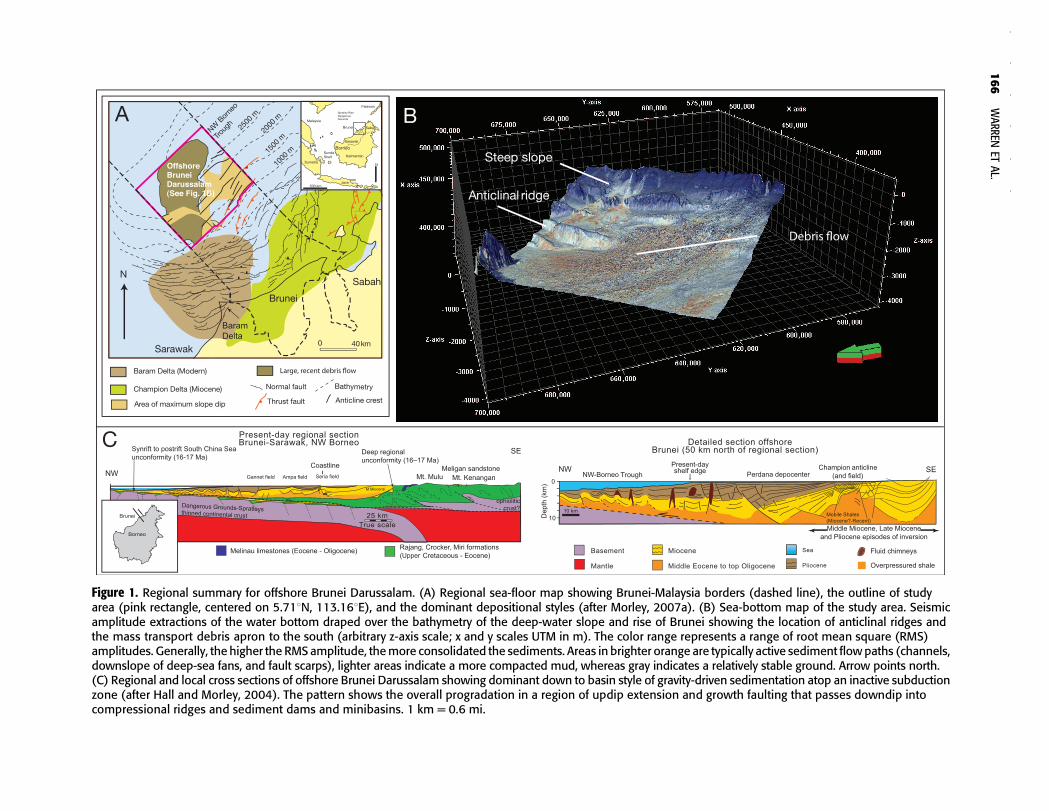
Figure 1. Regional summary for offshore Brunei Darussalam. (A) Regional sea-floor map showing Brunei-Malaysia borders (dashed line), the outline of studyarea (pink rectangle, centered on 5.718N, 113.168E), and the dominant depositional styles (after Morley, 2007a). (B) Sea-bottom map of the study area. Seismicamplitude extractions of the water bottom draped over the bathymetry of the deep-water slope and rise of Brunei showing the location of anticlinal ridges andthe mass transport debris apron to the south (arbitrary z-axis scale; x and y scales UTM in m). The color range represents a range of root mean square (RMS)amplitudes. Generally, the higher the RMS amplitude, themore consolidated the sediments. Areas in brighter orange are typically active sediment flowpaths (channels,downslope of deep-sea fans, and fault scarps), lighter areas indicate a more compacted mud, whereas gray indicates a relatively stable ground. Arrow points north.(C) Regional and local cross sections of offshore Brunei Darussalam showing dominant down to basin style of gravity-driven sedimentation atop an inactive subductionzone (after Hall and Morley, 2004). The pattern shows the overall progradation in a region of updip extension and growth faulting that passes downdip intocompressional ridges and sediment dams and minibasins. 1 km = 0.6 mi.
166
WARREN
ETAL.
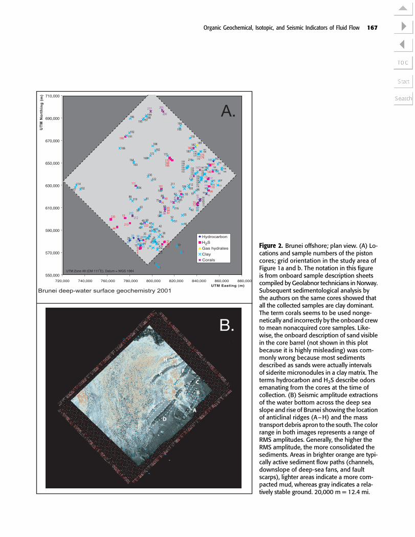
Figure 2. Brunei offshore; plan view. (A) Lo-cations and sample numbers of the pistoncores; grid orientation in the study area ofFigure 1a and b. The notation in this figureis from onboard sample description sheetscompiled by Geolabnor technicians in Norway.Subsequent sedimentological analysis bythe authors on the same cores showed thatall the collected samples are clay dominant.The term corals seems to be used nonge-netically and incorrectly by the onboard crewto mean nonacquired core samples. Like-wise, the onboard description of sand visiblein the core barrel (not shown in this plotbecause it is highly misleading) was com-monly wrong because most sedimentsdescribed as sands were actually intervalsof siderite micronodules in a clay matrix. Theterms hydrocarbon and H2S describe odorsemanating from the cores at the time ofcollection. (B) Seismic amplitude extractionsof the water bottom across the deep seaslope and rise of Brunei showing the locationof anticlinal ridges (A–H) and the masstransport debris apron to the south. The colorrange in both images represents a range ofRMS amplitudes. Generally, the higher theRMS amplitude, the more consolidated thesediments. Areas in brighter orange are typi-cally active sediment flow paths (channels,downslope of deep-sea fans, and faultscarps), lighter areas indicate a more com-pacted mud, whereas gray indicates a rela-tively stable ground. 20,000 m = 12.4 mi.
Organic Geochemical, Isotopic, and Seismic Indicators of Fluid Flow 167

slope creep, and long-distance transport by debris flowor landslides; (2) depressions, or submarine canyons,resulting fromgravitymasswasting along the forelimbsof thrust-cored features; breaches allow the continua-tion of sediment transport across the thrust-cored struc-tures; (3) point source outlets of canyons feeding deepsubmarine fans; and (4) sediment dispersal fairwaysranging from 2 to 5 km (1.2 to 3.1 mi) in width, resem-bling a terrestrial braided channel in that the fairwayscontain multiple channels that may be straight or ero-sional, sinuous or leveed.
Indications of Thermogenic Seepage
The deep offshore of Brunei is a highly prospective re-gion for hydrocarbons and has been the focus of severalongoing studies, in part funded by the Brunei govern-ment, including a regional three-dimensional (3-D) seis-mic study and a detailed piston coring program to testfor hydrocarbon seeps.Wherever hydrocarbons are pre-sent in a sedimentary basin, they ultimately escape vialeakage and are dispersed into ocean waters. Escapinghydrocarbons can be found in deep-sea-floor sedimentsworldwide and so, if identified by piston coring, can beused as prospectivity indicators to upgrade intervals ina prospective basinwhere amature hydrocarbon sourcerock is present (Abrams, 2005).
Two end-member styles ofmature hydrocarbon leak-age patterns on the sea floor exist (O’Brien et al., 1999,2005). One is focused leakage via conduits into narrowzones on the sea floor, such as when a fault or mud vol-canobreaks a seal layer andallows focusedpassage to thesea floor. The seal or cap to such a pattern is commonlya tight shale or salt layer, butwith appropriate sea-floorconditions, the seal layer can be a clathrate (Kennettet al., 2000). The other style ismore diffuse thermogenicfluid leakage through an imperfect seal over a larger areaor structural culmination, so that hydrocarbons migrateto the surface over broader regions of the sea floor anddo not show a highly focused outcrop trend. However,the notion of either hydrocarbon pattern residing innear-surface sediments and pointing to an underlyingmature kitchen is ever balanced by the possibility thathydrocarbons and organicmaterial in near-surface sedi-ment originate from other organic reservoirs (Abrams,2005). The organic signature may be derived from de-composition of recentlydeposited organicmatter (ROM)or from biogenic methane created bymethanogenic bac-terial decomposition of dispersed organics in shallow-ly buried organic-rich muds. Therefore, distinguishingwhether hydrocarbons in sea-floor sediments are resi-dues of hydrocarbons generated frommature kerogens orfrom shallow and dispersed biogenic and recent sourcesis important.
Core Sampling and Analysis
Core recovery was attempted at 222 sites across theslope and rise of the Brunei offshore, covering an areaof approximately 100� 100 km (62 � 62 mi) (Figure 2).Of these, cores were successfully recovered from 188sites and sent for geochemical analysis. The remainingsites were beset with collection problems (as noted inthe onboard description sheets), mostly hard rock sur-faces (described as corals by shipboard technicians) orvery loose fine-grained sediment, which prevented re-covery of any useful material fit for core descriptionand analysis. Locations for each piston core site werepinpointed by a shipboard global positioning system.Figure 2 shows the locations and sedimentary associa-tions of the relevant coring sites, as noted by the on-board description sheets. However, shipboard descrip-tions of corals and sands are incorrect, and sea-floorcoral pavements are actually nonpenetrated nodularzones, whereas the sands are fine-grained sedimentswith numerous sand-size micronodules of diageneticdolomite and siderite in a mud matrix (see for detailsthe section titled Sedimentology of the Slope and Rise,Brunei Offshore Realm).
A 30-cm (12-in.) section from each recovered pistoncore was selected, typically from intervals free of car-bonate nodules and cements, for gas analysis and chro-matography. It was immediately canned, frozen, andshipped to the Geolabnor lab in Norway for analysis oforganics andgases. Thevisible character of exposed coreends was recorded by on-board technicians during thesampling process (observations included); live oil oroil odor, presence of gas hydrates, sediment type, grainsize, and color. After the removal of the 30-cm section,the remaining sections of the various piston cores wereshipped to the Department of PetroleumGeoscience atthe University of Brunei Darussalam for sedimentolog-ical analysis. There, coreswere split, photographed, andsedimentologically described, and nodule sampleswereselected for stable isotope analysis.
ORGANIC GEOCHEMISTRY
Gas Analysis
Compositional analyses of frozen and canned coreweredone on the headspace, occluded, and adsorbed gases(Figure 3). Gas compositions in the various cores en-compass a list of light hydrocarbon gases from single-carbon (methane) to seven-carbon chains (heptane andheptene), to branched, cyclic, and aromatic compounds(isobutane, cyclopentane, and benzene, respectively).Among the gases, methane was present in the highest
168 WARREN ET AL.
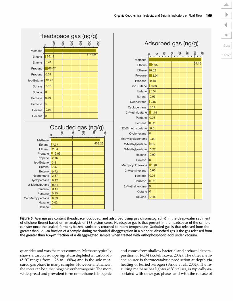
quantities andwas themost common.Methane typicallyshows a carbon isotope signature depleted in carbon-13(d13C ranges from �28 to �60%) and is the sole mea-sured gas phase inmany samples. However, methane inthe cores can be either biogenic or thermogenic. Themorewidespread and prevalent form of methane is biogenic
and comes from shallow bacterial and archaeal decom-position of ROM (Kotelnikova, 2002). The other meth-ane source is thermocatalytic production at depth viaheating of buried kerogen (Birkle et al., 2002). The re-sulting methane has lighter d13C values, is typically as-sociated with other gas phases and with the release of
Figure 3. Average gas content (headspace, occluded, and adsorbed using gas chromatography) in the deep-water sedimentof offshore Brunei based on an analysis of 188 piston cores. Headspace gas is that present in the headspace of the samplecanister once the sealed, formerly frozen, canister is returned to room temperature. Occluded gas is that released from thegreater than 63-Mm fraction of a sample during mechanical disaggregation in a blender. Absorbed gas is the gas released fromthe greater than 63-Mm fraction of a disaggregated sample when treated with orthophosphoric acid under vacuum.
Organic Geochemical, Isotopic, and Seismic Indicators of Fluid Flow 169

cracked liquid hydrocarbons. The high proportion ofmethane, compared to other hydrocarbon gases, impliesthat much of the methane in near-surface sediments ofoffshore Brunei is produced from shallow biogenic in-stead of thermogenic processes.
The amount of nonmethane gases and other non-biogenic associated compounds, such as the branchedand cyclic compounds, and thermogenic gas (oil or hy-drate and condensate associated) occurrences in severalsubareas are much more useful diagnostics than meth-ane purity. Based on this analysis, broad subareas, show-ing consistency in occurrence of thermogenic gas, can beseen in the east and in one locality in the southern cen-tral part of the study area (Figure 4a). Gas isotope dataalso suggest the possibility of two populations of seep-age hydrocarbons: one in the oil-window maturity up-ward field (0.8% vitrinite reflectance [Ro]) and the otherin the condensate window upward field (1.5% Ro). Geo-graphically, the former association is mostly restrictedto the eastern part of the study area.
Gas Chromatography
The preceding gas analysis implies that piston coresfrom the deep sea floor of offshore Brunei contain twotypes of hydrocarbons: (1) thermogenic hydrocarbonsand (2) hydrocarbonsderived fromROM.Asamplewithbitumens that yields high amounts of extractable or-
ganicmatter (EOM)does not necessarily have oil-relatedinterest; the EOMmay also come from variably decom-posedROM.Gas chromatograph (GC) analysis can helpdistinguish the two sources (Peters et al., 2005a, b). Ac-cordingly, quantitative GC analysis was performed onbitumens extracted from the cannedand frozen sedimentusing a hexane solvent. Results showa series of aliphaticn-alkanes and selected isoprenoids, together with re-maining byproducts of unresolved complex organicmixtures (UCOM).
Based on GC signature, analyzed piston core sam-ples are divided into five groupings, ranging from in-dicators of active oil seeps to inactive seeps (Figure 4b).The ideal GC signature of bitumens in an active hydro-carbon macroseep on the deep sea floor shows a com-bination of well-developed light and heavy molecularpeaks and a well-developed hump in the undefinedenvelope, indicating active bacterial biodegradation(Figure 5a) (Peters et al., 2005a, b). Samples from theBrunei piston cores showvariousdegrees of hydrocarbonbiodegradation, along with fresher hydrocarbon signa-tures tied to numerous occurrences of ROM(Figure 5b–f,Table 1).
Subgroup 1A
Samples are generally found to have elevated amountsof EOM. Degrees of biodegradation were determined
Figure 4. Plot of gas and organic associations in modern deep sea-floor sediment offshore Brunei. (A) Gas sources based on gaschromatography interpretation of headspace, occluded, and adsorbed gases. (B) Organic group associations based on gaschromatograms (see the text for the explanation of groups). 20,000 m = 12.4 mi.
170 WARREN ET AL.
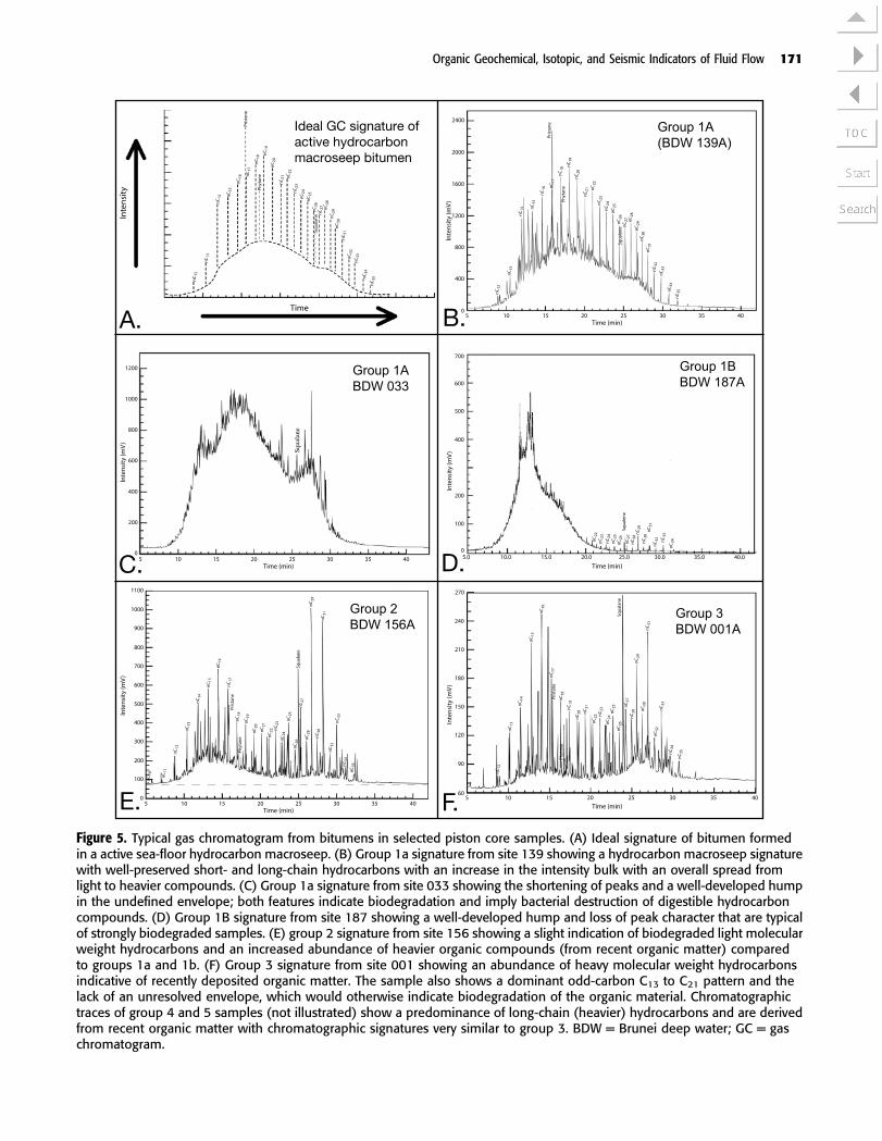
Figure 5. Typical gas chromatogram from bitumens in selected piston core samples. (A) Ideal signature of bitumen formedin a active sea-floor hydrocarbon macroseep. (B) Group 1a signature from site 139 showing a hydrocarbon macroseep signaturewith well-preserved short- and long-chain hydrocarbons with an increase in the intensity bulk with an overall spread fromlight to heavier compounds. (C) Group 1a signature from site 033 showing the shortening of peaks and a well-developed humpin the undefined envelope; both features indicate biodegradation and imply bacterial destruction of digestible hydrocarboncompounds. (D) Group 1B signature from site 187 showing a well-developed hump and loss of peak character that are typicalof strongly biodegraded samples. (E) group 2 signature from site 156 showing a slight indication of biodegraded light molecularweight hydrocarbons and an increased abundance of heavier organic compounds (from recent organic matter) comparedto groups 1a and 1b. (F) Group 3 signature from site 001 showing an abundance of heavy molecular weight hydrocarbonsindicative of recently deposited organic matter. The sample also shows a dominant odd-carbon C13 to C21 pattern and thelack of an unresolved envelope, which would otherwise indicate biodegradation of the organic material. Chromatographictraces of group 4 and 5 samples (not illustrated) show a predominance of long-chain (heavier) hydrocarbons and are derivedfrom recent organic matter with chromatographic signatures very similar to group 3. BDW = Brunei deep water; GC = gaschromatogram.
Organic Geochemical, Isotopic, and Seismic Indicators of Fluid Flow 171

Table 1. Summary of gas chromatography of organic matter in piston cores from deep-water sea-floor sediment of offshore Brunei.*
Group 1 Group 4
Group 1A Group 1B Group 2 Group 3 Group 4A Group 4B Group 5
Sample sites 011, 023, 033,037, 072, 073,082, 084, 139,165, 173, 174,175, 176, 212
048, 065, 094, 135,137, 148, 180, 185,187, 189
044, 090, 100, 105,118, 132, 156, 164,182, 183, 186, 188,196, 198
001, 002, 003, 053,056, 091, 112, 123
005, 007, 015, 027,039, 051, 052, 219
004, 021, 022, 024,025, 034, 035, 036,040, 041, 046, 047,069, 078, 122, 163,171, 192, 221, 222
006, 008, 009, 010, 012 to014, 016 to 020, 026, 028to 032, 038, 042, 043, 045,049, 050, 054, 055, 059 to064, 066, 068, 070, 075 to077, 080, 081, 086, 089,092, 093, 096 to 099, 101to 104, 106 to 111, 113 to115, 119 to 121, 124 to130, 133, 134, 136, 138,140 to 146, 149 to 155,157 to 162, 166 to 170,177 to 179, 190, 192 to195, 197, 199, 210, 211,213 to 218, 220
Characterand likelyorganicprovenanceof analyzedbitumen
Minorbiodegradedoil (activehydrocarbonmacroseep)
Biodegraded light-molecular-weightoil/condensate(likely biodegradedmaterial is from anactive hydrocarbonmacroseep)
Slight indicationof biodegradedlight-molecular-weight hydrocarbons(possibly a slightindication of somehydrocarbonmicroseepactivity exists)
Restricted rangeof light-molecular-weight and ROMhydrocarbons withlow UCOM (activehydrocarbonseep sourceunlikely)
Large abundanceof heavy-molecular-weight hydrocarbonsfrom ROM and largeUCOM (no activeseep source)
Large abundanceof heavy-molecular-weight hydrocarbons(ROM) and slightlyless UCOM than 4A(active seep sourceunlikely, a partcould be fromrelict seep)
Large abundance ofhydrocarbons fromROM; no or very minorUCOM; typical modernsea-floor organics, nohydrocarbon seepactivity
*See the text for the explanation. ROM = recent organic matter; UCOM = unresolved complex organic material.
172
WARREN
ETAL.
by the presence of shorter, or the absence of, distinctpeaks on the chromatogramwhen compared toGC tracesof ROM (compare Figure 5b, f). Group 1A samples areinterpreted as derived from relatively less biodegradedthermogenichydrocarbons coming to the surface throughfocused conduits ormacroseeps. This hydrocarbon stylealways shows variable levels of biodegradation becauseit was sequestered in near-surface sediments (compareFigure 5b, c).
Subgroup 1B
Samples generally have lower EOMwhen compared tothe higher end of group 1A. They are typified by a largeunresolved envelope in theGC trace, itself indicative ofbiodegradedhydrocarbons (Figure 5d). Theunresolvedenvelope is typically located in the earlier times of thechromatogram curve, normally indicative of the first ap-pearanceof lightermolecularhydrocarbons. Thepatternsin the gas chromatograms are similar to those more bio-degraded samples in subgroup 1A but show more per-vasivebiodegradation overprints.Group1Bassociationsare thought to indicate more diffuse or less active seep-age (microseeps) than group 1A signatures (less over-turn = more biodegradation). Thus, these condensateswere derived mainly from hydrocarbon seepages andmay not entirely be related to the original EOM withinthe sediments. The lowpeaks ofC21–C33 in theGC curvestrengthens the interpretation of biodegraded conden-sates (little or no terrestrial plant waxes) (Peters et al.,2005a, b).
Group 2
Samples show low amounts of EOM and an increasedabundance of the GC signature coming from higherplant material (as indicated by C23 peaks and higher),along with a marine signature from lighter molecularchains, C11–C20 peaks (Peters et al., 2005a, b). The un-resolved envelope is located in the same range as ingroup 1B, possibly indicating a contribution from bio-degraded condensates (Figure 5e). However, the asso-ciation ofGCpeaks is not conclusive for this group. Thevarious hydrocarbons may have been oil associated ormay have been derived from ROM.
Group 3
Samples show low abundances of all hydrocarbons.Likewise, the level of EOM is also low. The predomi-nance of odd-numbered n-alkanes (in the C13–21 range),along with the lack of aromatic compounds, indicatesthat the hydrocarbon signature is mostly derived fromROM (Figure 5f) (Peters et al., 2005a, b).
Group 4
Samples contain large amounts of unresolved com-pound organic mixtures and an abundance of long-chain hydrocarbons fromROM.They can be assigned nomore than an ambiguous genesis (Peters et al., 2005a, b).
Group 4A. Samples have UCOM of up to 40 mg/gdry sediment with a large odd-carbon predominance(C23–35).
Group 4B. Samples have a UCOM of 20–40mg/g drysediment and possibly contain some completely bio-degradedhydrocarbons; some4B samplespossibly camefrom earlier seeps that are no longer active.
Group 5
Samples have UCOM values less than 20 mg/g drysediment. They showanabundance of long-chainhydro-carbons from ROM and little or no UCOM. The signa-ture is typical ofmodern sea-floor organicmaterialwithno indication of hydrocarbon seep activity (Peters et al.,2005a, b).
The transition from group 3 to 5 marks an increasingabundance of heavier and more complex carbon com-pounds indicative of ROM. The severity of biodegrada-tion, in contrast, decreases from100mg/gdry sedimentto very little to none in groups 3 through 5.Worldwide,an odd-carbon preference from around the C23 peak up-ward in all ROM samples indicates the contribution ofterrestrial plant waxes, independent of whether it isfound in coals, lakes, or marine environments (Waples,1985). The preference is strongest in immature, leastbiodegraded samples. It gradually disappears as rocksare buried, and their kerogen evolves. Thus, groups 4and 5 GC signatures are dominantly those of modernmarine organics with contributions from both marineorganisms (<C20) and terrestrial plant waxes. The aver-age Pr/Ph ratio of 1.6 of the Brunei offshore is lowerthan for most coals (Waples, 1985); therefore, the ter-restrial organic component was probably directly de-posited in its shaly matrix without spending much timestored in a coal swamp prior to its final deposition.
In the context of groups 3 to 5 signatures, note thatseveral piston core samples with elevated amounts ofgas did not have elevated amounts of EOM. These aresamples 020, 025, 048, 061, 068, 069, 096, 099, 110, 115,135, 148, 161, and 167. All these samples have very drygas, i.e., the gas composition is dominated by biogenicmethane from biodegradation of organic material. Allof these sample sites have groups 3–5 GC signaturesexcept for sites 135 and 148, which have group 1B sig-natures, and 025, which has a group 2 signature.
Organic Geochemical, Isotopic, and Seismic Indicators of Fluid Flow 173
In summary, hydrocarbons within the oil windowhave a bulging intensity on the left side of the chro-matogram in the C11–22 parts of a curve, which grad-ually flattens farther to the right in the C23–35 range(Figure 5a). The height of each peak is proportional tothe concentration of the compound(s). Biodegradationdestroys both n-alkanes and isoprenoids, leaving behindan unresolved envelope of short peaks. Groups 1 and 2have these chromatographic patterns of partially bio-degraded to heavily biodegraded seep hydrocarbons(Figure 5b–e). Group 3 is also biodegraded. However,its chromatographic pattern also shows two bulges, al-beit at low intensity, in both the right and left side of thechromatogram curve (Figure 5f). So, group 3 can alsobe seen as an intermediate between diminishing con-tent from hydrocarbons and increasing abundance ofROM. From group 3 to group 5, the destruction to thepeaks causedby biodegradation is less common, and anobvious increase in levels of ROM in their GC curves isobserved. Groups 2–5 are not considered to be directlyassociatedwith recognizable hydrocarbon seeps, and so,to relate thermogenic seepage to structure, only group 1sites are considered in the rest of this article. That is,group 1 signatures in sea-floor sediments define siteswhere deep thermogenic fluids have arrived at themodern sea floor. In the context of seismic interpreta-tion, a group 1 signature on the sea floor offers a very
powerful and independent tool for testing the timingand location of pressure release and the nature of thereleasing structure as interpreted from seismic data.
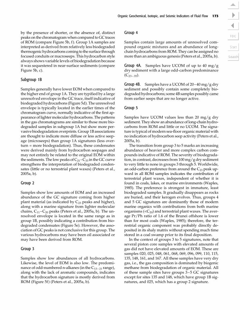
One of themost commonly used source provenanceparameters in the oil industry is the relative abun-dance of theC27:C28:C29aaa 20R steranes (Huang andMeinschein, 1979). Plots from subgroup 1A (i.e., fromsamples not as greatly affected by biodegradation andthe effects of ROM) are plotted in Figure 6a. It impliesthat all the likely thermogenic seep samples, with theexception of sample 037, have an estuarine or terrestrialorganic source. This estuarine or terrestrial signature isconsistentwith earlier source rock studies inBrunei (e.g.,Curiale et al., 2000), which show that source rocks in theproducing regions of Brunei tend to be from gas-proneestuarine or terrestrial (tidal-coastal embayment) shalesand not from a marine-algal oil-prone precursor.
The regional plot of the GC grouping shows that thedistribution of likely hydrocarbon seeps in offshore Bru-nei is localized to areas in the east of the survey area,along with a few sites in the south (Table 1; Figures 4b).Thebitumens from thegroup1 samples also indicate thatmost of the samples have diahopane values, indicatinga vitrinite equivalence (Ro) between 0.6 and 0.8%, andso lie in the oil generationwindow, althoughwe empha-size that the dominant source for Brunei hydrocarbonsis undeniably gasprone (Figure 6b) (Curiale et al., 2000).
Figure 6. Source rock characteristics of group 1a organic material in piston core sediments. Sample numbers as listed, seeFigure 2 for the sample locations. (A) Vitrinite reflectance (Ro) maturation equivalents based on a plot of diahopanes. (B) Source-rock typing based on C27 to C29 plots. For explanation and derivation of these commonly used standard oil-industry plots, seePeters et al. (2005, a, b). Ts = 22,29,30-trisnorneohopane; Tm = 22,29,30-trisnorhopane.
174 WARREN ET AL.

Sedimentology of the Slope and Rise, BruneiOffshore Realm
Sea-Floor Sediment
From 222 listed coring sites, 188 cores were recoveredand slabbed at the University of Brunei Darussalam.Shipboard descriptions by Geolabnor technicians wereuseful in determining the original state of core hardness(i.e., soft, stiff,mediumhard, hard), for confirmingodorsof H2S and hydrocarbons in the slabbed core and forrelating odors (oil versusH2S) to the presence or absenceof nodules in later sedimentological work (Figure 2a).During the sedimentological logging, special attention
was given to cores described onboard as containing sandlayers because these couldpossibly be related to featuresseen in seismic sea-bottommaps. As an initial guide, theonboard description was used to slab first those coreslikely to contain sands.We found that onboard descrip-tions such as bottomed in coral andnumerous notationsof sand in the core barrel were incorrect. No coral frag-mentswere ever recovered in any cores.Only carbonate-cemented nodules and almost all of the sands noted inthe onboard descriptionswere actually sand-size sider-itemicronodules; they grew in situ andwere visible witha hand lens.
Only a few centimeter- to decimeter-thick siliciclas-tic sand intervals were recovered in any of the piston
Figure 7. Seismic sections through sites of isotopic interest. (A) Site 094: the upper image is a part of inline 7276 and the lowerimage is a part of crossline 7862. The intersect of the two lines is shown by a red line, which is also piston core site 094.This organic group 1B site sits atop a shale-cored growth anticline with fluid plumes rising to the sea-floor surface and associatedevidence of plume-related sediment collapse. The ridge is a result of ongoing gravity-driven compressional deformation, whichalso causes the bottom-simulating reflector (BSR) horizon to rise and break up as it approaches the sea floor. Note the disturbanceand the discontinuity of the BSR caused by rising fluid plume in the vicinity of sample site 094. See Figure 9 for the locationon the sea-bottom map. (B) Site 013 is part of inline 3750 where the vertical red line shows the piston core site. The sea floorat the site is not disturbed by pluming, and this is confirmed by the occurrence of group 5 organics at the site. (C) Site 161 is partof inline 10198 where the vertical red line shows the piston core site. Although mounded at the sea-floor surface, the layersunderlying the sea floor at this site are not broken by fluid pluming, and this is confirmed by the occurrence of group 5 organicsat the sample site. The horizontal scale bar in all images is 1 km (0.6 mi) long, and the vertical bar indicates 100 ms.
Organic Geochemical, Isotopic, and Seismic Indicators of Fluid Flow 175
cores. From 188 cores, 67 contained dispersed siliciclas-tic sand grains, in places in centimeter-scale layersand never in beds thatweremeters thick (Table 2).Mostof these 67 slabbed cores (with up to 3 m [10 ft] of pen-etration into the sea floor) that contain siliciclastic sandtypically contain it in only one, or less commonly two tothree, thin sand laminae in an otherwise mud core.The sand layer is typically less than 1–3 mm (0.03–0.11 in.) thick, with a few layers ranging up to 4 cm(1.5 in.) thick. The thickest recovered sand layer in all67 sand-entraining cores was some 10 cm (4 in.)-thickat site 061 (Figure 8a, b). This layer was part of a 20-cm(8-in.)-thick layer composed of sand and wood frag-ments within a silty clay matrix. No meter-scale sandlayer was penetrated by any of the 222 piston cores.
Mud- to sand-size organic particulates and debriswere dispersed throughmany cores so that the organicmaterial in core samples collected for organic analysisaverages 0.9% total organic carbon (and ranges from0.3 to 1.4%. Higher values are found nearer the shelfin the eastern and southern regions of the study area.Centimeter- to decimeter-scale fragments ofwoodwere
commonly present in a core composed only ofmud andnodules, and no corresponding layer of siliciclastic sandwas observed. Thus, this wood is not a lag tied to asiliciclastic bed-load transport (unlike site 061), instead,it indicates a waterlogged plant material sinking to thesea bottom.
Volumetrically, aside from the ubiquitous clays andmuds, the most interesting features in the cores are thenumerous intervals with calcareous mottles and nod-ules (Figure 8c–e). Varying combinations of nodules andmicronodules are found in 107 cores. Nodule dimen-sions range from small micronodules (<0.5 cm [<0.1 in.]in diameter) to large elongate burrowlike nodules andfragments that can exceed the diameter of the core tube(>6 cm [>2.3 in.], Figure 8c). These nodules are diageneticfeatures that tend to be better developed in intervalsthat also show elevated carbonate content from plank-tonics,whole shells, and shell fragments (Figure 8f). Thenodules are early diagenetic features growing at depthsranging from a few centimeters (inches) below the seafloor, down to the full 3-m (10-ft) maximum depth sam-pled by the deepest penetrating piston core sites.
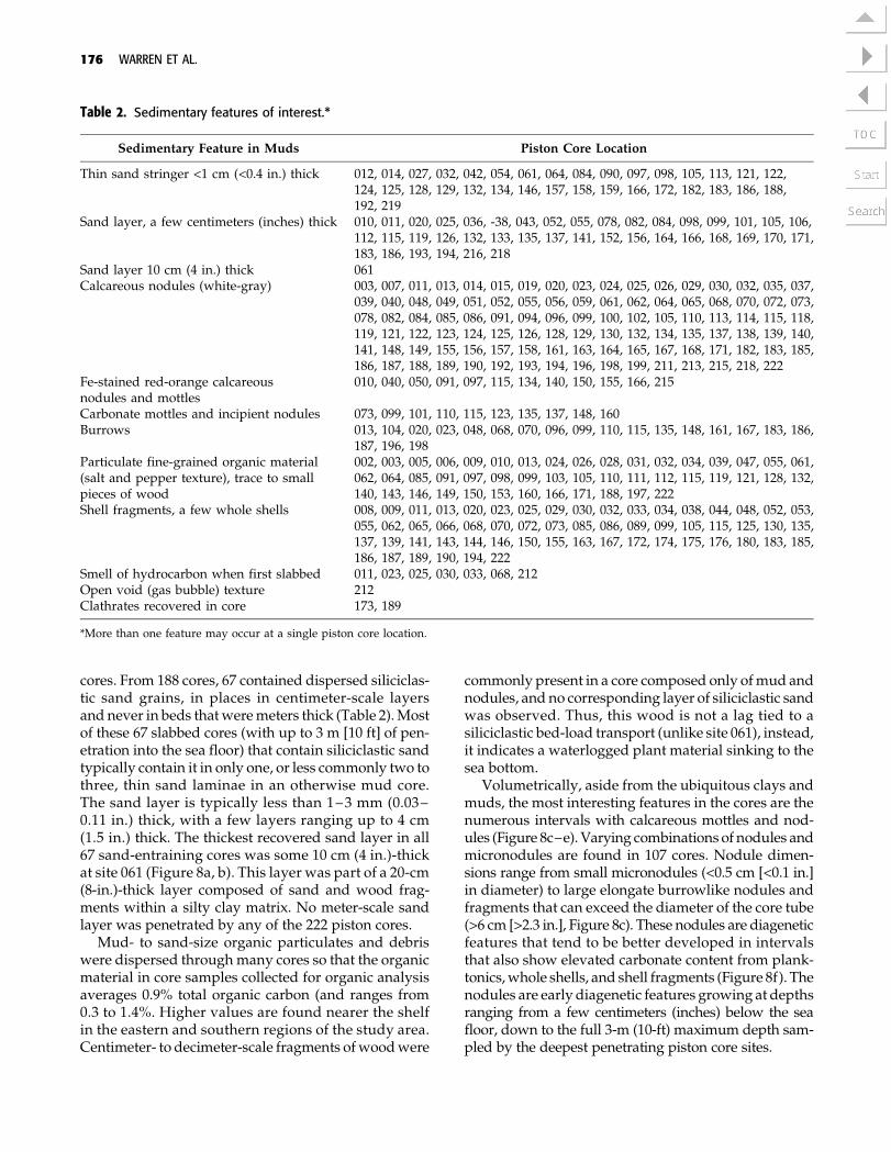
Table 2. Sedimentary features of interest.*
Sedimentary Feature in Muds Piston Core Location
Thin sand stringer <1 cm (<0.4 in.) thick 012, 014, 027, 032, 042, 054, 061, 064, 084, 090, 097, 098, 105, 113, 121, 122,124, 125, 128, 129, 132, 134, 146, 157, 158, 159, 166, 172, 182, 183, 186, 188,192, 219
Sand layer, a few centimeters (inches) thick 010, 011, 020, 025, 036, -38, 043, 052, 055, 078, 082, 084, 098, 099, 101, 105, 106,112, 115, 119, 126, 132, 133, 135, 137, 141, 152, 156, 164, 166, 168, 169, 170, 171,183, 186, 193, 194, 216, 218
Sand layer 10 cm (4 in.) thick 061Calcareous nodules (white-gray) 003, 007, 011, 013, 014, 015, 019, 020, 023, 024, 025, 026, 029, 030, 032, 035, 037,
039, 040, 048, 049, 051, 052, 055, 056, 059, 061, 062, 064, 065, 068, 070, 072, 073,078, 082, 084, 085, 086, 091, 094, 096, 099, 100, 102, 105, 110, 113, 114, 115, 118,119, 121, 122, 123, 124, 125, 126, 128, 129, 130, 132, 134, 135, 137, 138, 139, 140,141, 148, 149, 155, 156, 157, 158, 161, 163, 164, 165, 167, 168, 171, 182, 183, 185,186, 187, 188, 189, 190, 192, 193, 194, 196, 198, 199, 211, 213, 215, 218, 222
Fe-stained red-orange calcareousnodules and mottles
010, 040, 050, 091, 097, 115, 134, 140, 150, 155, 166, 215
Carbonate mottles and incipient nodules 073, 099, 101, 110, 115, 123, 135, 137, 148, 160Burrows 013, 104, 020, 023, 048, 068, 070, 096, 099, 110, 115, 135, 148, 161, 167, 183, 186,
187, 196, 198Particulate fine-grained organic material(salt and pepper texture), trace to smallpieces of wood
002, 003, 005, 006, 009, 010, 013, 024, 026, 028, 031, 032, 034, 039, 047, 055, 061,062, 064, 085, 091, 097, 098, 099, 103, 105, 110, 111, 112, 115, 119, 121, 128, 132,140, 143, 146, 149, 150, 153, 160, 166, 171, 188, 197, 222
Shell fragments, a few whole shells 008, 009, 011, 013, 020, 023, 025, 029, 030, 032, 033, 034, 038, 044, 048, 052, 053,055, 062, 065, 066, 068, 070, 072, 073, 085, 086, 089, 099, 105, 115, 125, 130, 135,137, 139, 141, 143, 144, 146, 150, 155, 163, 167, 172, 174, 175, 176, 180, 183, 185,186, 187, 189, 190, 194, 222
Smell of hydrocarbon when first slabbed 011, 023, 025, 030, 033, 068, 212Open void (gas bubble) texture 212Clathrates recovered in core 173, 189
*More than one feature may occur at a single piston core location.
176 WARREN ET AL.
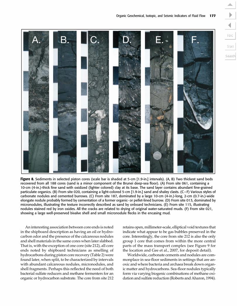
An interesting association between core ends is notedin the shipboard description as having an oil or hydro-carbon odor and the presence of the calcareous nodulesand shellmaterials in the same coreswhen later slabbed.That is, with the exception of one core (site 212), all coreends noted by shipboard technicians as smelling ofhydrocarbons duringpiston core recovery (Table 2)werefound later, when split, to be characterized by intervalswith abundant calcareous nodules, micronodules, andshell fragments. Perhaps this reflected the need of bothbacterial sulfate reducers andmethane fermenters for anorganic or hydrocarbon substrate. The core from site 212
retains open,millimeter-scale, elliptical void textures thatindicate what appear to be gas bubbles preserved in thecore. Interestingly, the core from site 212 is also the onlygroup 1 core that comes from within the more centralparts of the mass transport complex (see Figure 9 forthe location and Gee et al., 2007, for deposit detail).
Worldwide, carbonate cements and nodules are com-monplace in sea-floor sediments in settings that are an-oxic andwhere bacteria and archaea break down organ-ic matter and hydrocarbons. Sea-floor nodules typicallyform via varying biogenic combinations of methane oxi-dation and sulfate reduction (Roberts andAharon, 1994).
Figure 8. Sediments in selected piston cores (scale bar is shaded at 5-cm [1.9-in.] intervals). (A, B) Two thickest sand bedsrecovered from all 188 cores (sand is a minor component of the Brunei deep-sea floor). (A) From site 061, containing a10-cm (4-in.)-thick fine sand with oxidized (lighter colored) clay at its base. The sand layer contains abundant fine-grainedparticulate organics. (B) From site 020, containing a light-colored 5-cm [1.9-in.] sand and shaley clasts. (C–F) Various styles ofcarbonate nodules and cemented burrows. (C) From site 187, dominated by a large 10-cm (4-in.)-long, 2-cm (0.7-in.)-wideelongate nodule probably formed by cementation of a former organic- or pellet-lined burrow. (D) From site 013, dominated bymicronodules, illustrating the texture incorrectly described as sand by onboard technicians. (E) From site 115, illustratingnodules stained red by iron oxides. All the cracks are related to drying of original water-saturated muds. (F) From site 021,showing a large well-preserved bivalve shell and small micronodule flecks in the encasing mud.
Organic Geochemical, Isotopic, and Seismic Indicators of Fluid Flow 177
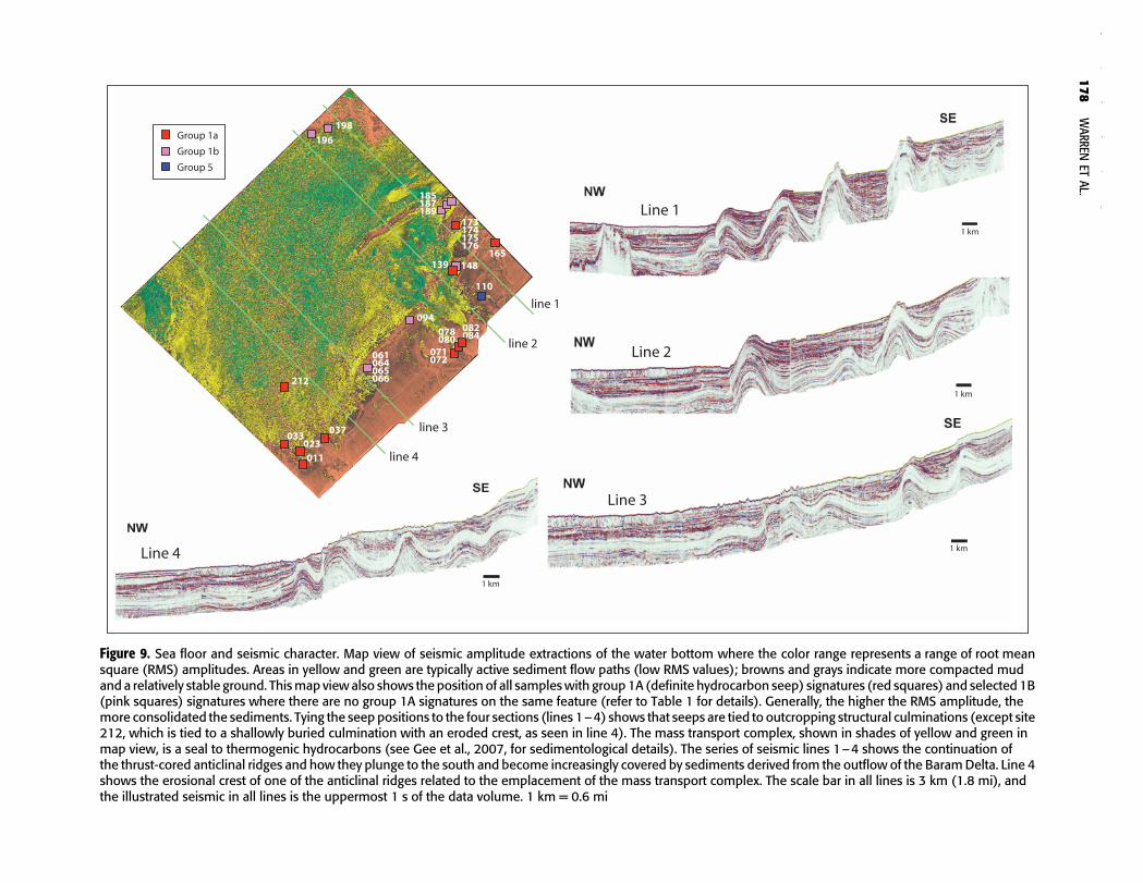
Figure 9. Sea floor and seismic character. Map view of seismic amplitude extractions of the water bottom where the color range represents a range of root meansquare (RMS) amplitudes. Areas in yellow and green are typically active sediment flow paths (low RMS values); browns and grays indicate more compacted mudand a relatively stable ground. Thismap viewalso shows the position of all sampleswith group1A (definite hydrocarbon seep) signatures (red squares) and selected 1B(pink squares) signatures where there are no group 1A signatures on the same feature (refer to Table 1 for details). Generally, the higher the RMS amplitude, themore consolidated the sediments. Tying the seep positions to the four sections (lines 1–4) shows that seeps are tied to outcropping structural culminations (except site212, which is tied to a shallowly buried culmination with an eroded crest, as seen in line 4). The mass transport complex, shown in shades of yellow and green inmap view, is a seal to thermogenic hydrocarbons (see Gee et al., 2007, for sedimentological details). The series of seismic lines 1–4 shows the continuation ofthe thrust-cored anticlinal ridges and how they plunge to the south and become increasingly covered by sediments derived from the outflow of the BaramDelta. Line 4shows the erosional crest of one of the anticlinal ridges related to the emplacement of the mass transport complex. The scale bar in all lines is 3 km (1.8 mi), andthe illustrated seismic in all lines is the uppermost 1 s of the data volume. 1 km = 0.6 mi
178
WARREN
ETAL.
Bacterially mediated carbonate precipitation first oc-curs in early burial where methane, H2S, organics, andbicarbonate are present in anoxic interstitial waters, forexample
CH4 þ SO2�4 ! HCO�
3 þHS� þH2O ð1Þ
The bicarbonate released during anaerobic bacterialactivity increases the alkalinity and hence drives theprecipitation of authigenic carbonate.
Ca2þ þ 2HCO3 ! CaCO3�ðsolidÞ þ CO2 þH2O ð2Þ
Bicarbonate released fromdissolution of buried shellfragments can also be involved in the precipitation ofsea-floor nodules. Thus, the isotopic compositions incarbonate nodules on the Brunei deep sea floor are es-sentially inherited from varying combinations of meth-ane, organics, and marine bicarbonate sources.
Stable Isotopes in Nodules
Figure 10 plots d13CPDB (Pee Dee belemnite) and d18OPDB
values for various calcareous nodules, diffusely ce-mented muds, and bivalve shells (as listed in Table 3).Nodules are varying combinations of siderite and do-lomite. Some larger nodules are made up of coalescedsmaller nodules; other nodules are transitional intolighter colored, less distinct, diffuse mottled zones of ce-mented mud. Isotopic compositions range from �50.8to + 11.0% d13CPDB and +2.3 to +6% d18OPDB. Mostoxygen values cluster around +5% PDB, consistentwith precipitation in cold marine bottom waters on a�1000-m (�3281-ft)-deep sea floor. Carbon values plotin three distinct zones: an upper zone with heavier car-bon contents (d13CPDB > �10%), an intermediate car-bon cluster (d13CPDB of�10 to�40%), and a groupwithquite depleted carbon-13 (d13CPDB > �35%).
The upper cluster encompasses both nodules andmarine shellmaterial,with the shellymaterial clusteredin the typical field for shell in deep cold sea water (indi-cated by the dashed rectangle in Figure 10) (Matsumoto,1989; Warren, 2000). The typical d18O range of +4 to+6% for this group and the clustering of d13C around0% indicate a marine carbon-bicarbonate source thatwas not fractionated by the activities of sulfate-reducingbacteria or methanogens.
One sample from site 094 comes from a nodule col-lected from the deeper part (�3-m [�10-ft] depth) of therecovered piston core has a d13C value of +11%. Thisvalue lies well outside the normal carbon range for
marine-associated bicarbonate precipitates and evenfarther outside values in nodules typical of sulfate re-duction or methane oxidation. Some layers of ferroandolomite and siderite nodules inMiocene reservoir sands(shoreface and tidal deposits) in the Champion oil fieldshow similar positive carbon values (+4 to +16%) andare the result of CO2 produced by biogenic fermenta-tion in a growth-fault-focused zone of methane-rich hy-drocarbon seepage just below the Miocene sea floor(Warren et al., 2004). The 094 nodule is perhaps a mod-ern example of this same set of processes. Its organicassociation is group 1B; thus, it is a condensate with amixed biogenic and thermogenic source. Such heavycarbon is not uncommon a fewmeters below of themod-ern sea floor in areas where CO2-limited methanogenicfermentation is occurring, and it is sometimes associatedwithmethane seeps and chemosynthetic bacterial com-munities (Roberts andAharon, 1994).Unfortunately, onlynodules andnomarine shellmaterialwas recovered fromcore site 094 to isotopically test this chemosynthetichypothesis. The 094 coring site is at the apex of an anti-clinal structure and near an eroded collapsed surfaceoverlying a ramping thrust structure (Figure 7a). A ho-mogeneous layer of weak amplitude (hydrate cement-ed?) and the associated bottom-simulating reflector(BSR) run updip and terminate adjacent to the core lo-cation. The suspected condensate might have risen ver-tically via the indicated plume pathway or have flowedlaterally along the base of the low-amplitude unit toreach the surface.
All marine shells and fragments from the variouscores plot within the fractionation field for a typicaldeep-water oxic biota (all plot in the dashed rectanglein Figure 10). Almost none of the organic matter asso-ciated with the sediment hosting bivalve shells in thevarious cores indicates any hydrocarbon seep associ-ation (i.e., no association with group 1A organics). Thearticulated shell in the core from location 011 is an ex-ception in that it is associated with group 1A organics,yet it has a normal marine isotopic signature. This im-plies that healthy bivalves grew on the local sea floor inthe vicinity of a hydrocarbon seep, yet the shells pre-cipitated with a normal marine signature. Hence, noobvious evidence of a chemosynthetic signature in anyof the analysed shells exists, except at site 094.
Most of the recovered nodules have carbon and oxy-gen isotope signatures that plot in the accepted rangefor sulfate reduction occurring during normal shallow-burial marine diagenesis (Matsumoto, 1989; Warren,2000; Kotelnikova, 2002; Malone, 2002; Raiswell et al.,2002). Sulfate reducers are ubiquitous in the anoxic wa-ters that occur in the first fewmillimeters to centimetersbelow the sea floor. These bacteria digest organics asthey remove SO2�
4 and convert it toH2Swhile increasing
Organic Geochemical, Isotopic, and Seismic Indicators of Fluid Flow 179

alkalinity and so create a rising saturation state in thepore water that ultimately precipitates authigenic car-bonate cement. The accepted carbon isotopic values forsuch carbonate precipitates in shallow sea-floor sulfatereduction lie in the range of �15 and �45%, with oxy-gen values being dependent on the ambient seawatertemperature.
The lower end of this carbon isotope range (>35–40%) overlaps with isotopic signatures related to theinfluence ofmethane oxidation and thermogenicmeth-ane. This brings us to the lower cluster of carbon isotopicvalues in Table 3 and Figure 10 (site 013 and site 161).Depleted carbon-13 values place both samples in a pos-sible transition range into the isotope field of carbonate
Figure 10. Carbon and oxygen stable isotope signatures from selected nodules, tied to the organic group of the host sediment.Open (unfilled) symbols indicate determinations using bivalve shell material. The dashed rectangle shows the plot fieldtypical of oxic deep-marine shelly fauna worldwide. The inset labeled hydrates lists d13CPDB values for various gases frommethane hydrate samples recovered in piston cores from sites 173 and 189. Interpretive plot fields are from Matsumoto(1989,) and Warren (2000). PDB = Pee Dee belemnite.
180 WARREN ET AL.
cements and nodules derived from thermogenic meth-ane, but the values lie only at theupper endof this range.Both samples can be just as readily interpreted as theresult of biogenic sulfate reductionormethane oxidation.
Based on its gas composition analysis, the sedimentat site 013 does not show elevated levels ofmethane perdry sediment weight. The presence of an obvious H2Ssmell in the sediment core when slabbed, instead of thehydrocarbon odor (noted by shipboardGeolabnor tech-nicians), and a group5 organic association argue that thenodules at site 013 are the product of bacterial sulfatereduction. Seismic data in the vicinity of this core sitelikewise show a well-layered sediment with little evi-dence of fluids actively rising from depth (Figure 7b).For all the same reasons, the nodules at site 161 are alsointerpreted as byproducts of bacterial sulfate reduction
acting onmarinepore fluids. Site 161does lie off the edgeof a thrust-cored growth anticline and so has a higherpotential than site 013 to be sourced by thermogenic wa-ters, but the lack of any internal disturbance in seismicdata beneath the coring site argues that it too is a normalsea-floordiagenetic productwherenodules formedwith-out any influence from thermogenic gas (Figure 7c).
In summary, prior to isotope analysis, we thoughtthat the tie of hydrocarbon odor (noted by GeoLabnorshipboard technicians) to carbonate nodules logged inslabbed cores could perhaps be useful as an indicator oflocal chemosynthetic and seep associations. However,when various group 1–5 nodules were sampled isoto-pically, almost all of the resulting carbon and oxygenvalues are consistent with precipitation in the sulfatereduction zone, whereas the shell material shows a typ-ical cold-water marine signature.
Thermogenic Sea-Floor Fluids (Group1 Sediment)Tied to Seismic Character and Structure
The upper sedimentary section of the northwest Borneotrough of offshore Brunei is made up of layers and cha-otic units that are faulted andhave collapsed and flowedaround and atopdiscontinuous thrust-cored growth anti-clines with numerous slope failures of varying extentsalong the flanks of various thrust anticline-controlledminibasins (Figures 1, 9). Regionally, the deep-sea floorof offshore Brunei is characterized by two depositionalstyles. First is an extensive, relatively flat-lying zonethat defines the upper surface of a mass transport com-plex. It has a chaotic seismic character and extends west-ward and northward across the survey area tomake uptwo thirds of the surface sedimentary section (Gee et al.,2007). Second is an undulating and sloping sea floor inthe continental slope and rise with a more finely lay-ered seismic signature (Morley, 2007b). The sea-floorridges are the surface expression of several anticlines(A–H in Figure 1). These growth anticlines act as acatchment for point-sourced shelf sediments movingdownslope along the eastern and northeastern parts ofthe survey area. The anticlines are in turn the shallowexpression of several gravity-glide-driven toe thrustsramping up from an underlying unit of shale that isprobably equivalent to the Setap Formation (middleMiocene) in its more landward and stratigraphicallylower sections (Demyttenaere et al., 2000; McGilveryand Cook, 2003). When overpressured, this shale is sus-ceptible to focuseddeformation andmuddiapirism thatthen drives the formation of the various mud-coredridges, walls, and chimneys (Figure 9).
Thus, the stepped, slope anticline-cored features(A–H) and the various intraslope minibasins in this
Table 3. Carbon and oxygen isotope signatures of carbonatenodules, shells, and cements listed against organic typingof host sediment.
PistonCore
OrganicGroup D
13CPDB D18OPDB Description
11 1A 1.3 4.2 Shell11 1A �0.5 5.5 Nodule11 1A �1.3 5.1 Nodule11 1A �4.6 0.4 Nodule13 5 1.8 4.3 Shell13 5 �49.3 4.9 Nodule20 5 1.4 5.1 Shell23 1 �17.2 5.9 Nodule44 2 1.8 6.0 Shell44 2 �1.3 5.9 Shell44 2 �7.4 5.5 Nodule61 5 �19.0 2.3 Nodule61 5 �19.2 5.6 Micronodules
(sand)65 1B �4.6 4.2 Shell65 1B �17.7 2.5 Nodule65 1B �22.1 6.5 Nodule65 1B �22.8 5.8 Nodule65 1B �22.8 5.6 Nodule65 1B �22.9 5.4 Nodule72 1A �27.1 5.0 Nodule94 1B 11.0 6.1 Nodule
110 5 �27.1 2.7 Nodule110 5 �31.6 3.4 Cemented mud135 1B �23.8 4.9 Nodule148 1B �42.4 3.8 Nodule161 5 �50.8 5.7 Nodule185 1B �28.4 4.2 Nodule185 1B �29.8 4.6 Nodule185 1B �29.9 4.7 Nodule187 1B �29.9 4.2 Nodule189 1B �16.1 3.9 Nodule
Organic Geochemical, Isotopic, and Seismic Indicators of Fluid Flow 181

region are a direct consequence of gravitationally driventoe thrusts and gravity slides facilitated by decollementsurfaces in the shale section (Figures 1, 9). The ridgesplunge southward and underlie the upper and morelandward parts of the Baram landslide (Figure 9) (Geeet al., 2007). A BSR is visible inmany seismic lines and isvariably present across extensive parts of the surveyedarea (e.g., Laird, in press). That the BSR in the slope andrise sediments of offshore Brunei is an indicator of thebase of the methane-hydrate stability zone is confirmedby clathrates recovered in piston cores 173 and 180and the ubiquitous presence of methane in headspacegases from all piston cores. A BSR tied to the base ofclathrate horizons is a common feature of slope and risesediments worldwide (Miller et al., 1991; Grauls, 2001).Fault scarps can be seen in the south that extend towarda toe thrust in the middle and southern region of thesurvey area (Figure 9). When seeps identified by theirorganic signature (Table 1) are tied to geological fea-tures seen in seismic data, most hydrocarbon seepagesin the eastern third of the study area seem to be focusedby underlying geological structures (ridges and mudvolcanoes). This association is not so obvious in thesouth, where an impervious mass-flow unit buries theridges (Figure 9) (Gee et al., 2007).
Zones of Disturbed Mud and Diapirs and Anticlinal Ridges
At amore local scale, the various antiformal axial ridgeslocally encompassdisturbed,overpressured, and inplacesdiapiric mud and gas plumes, which are most obviousalong faults and atop the axial core of some of the anti-formal structures (Figures 11–13). Seismic data showthat these disturbed and fluid-escape zones are typicallyaccompanied by an abrupt termination of the ridge lay-ers, commonly combined with a narrow folding of re-flectors around the discontinuous core of the volcano orchimney structure (Figures 11, 12). Reflection amplitudein the middle of an anticlinal ridge or more locally in adiapiric core typically becomes weaker and more cha-otic. Independent of whether or not mud has actuallyflowed, these weakened amplitudes and poorer reflec-tivities are interpreted as a seismic response to disturbed,somewhat overpressured or previously overpressuredmuddy and gassy cores to the ridges (e.g.,Milkov, 2000).
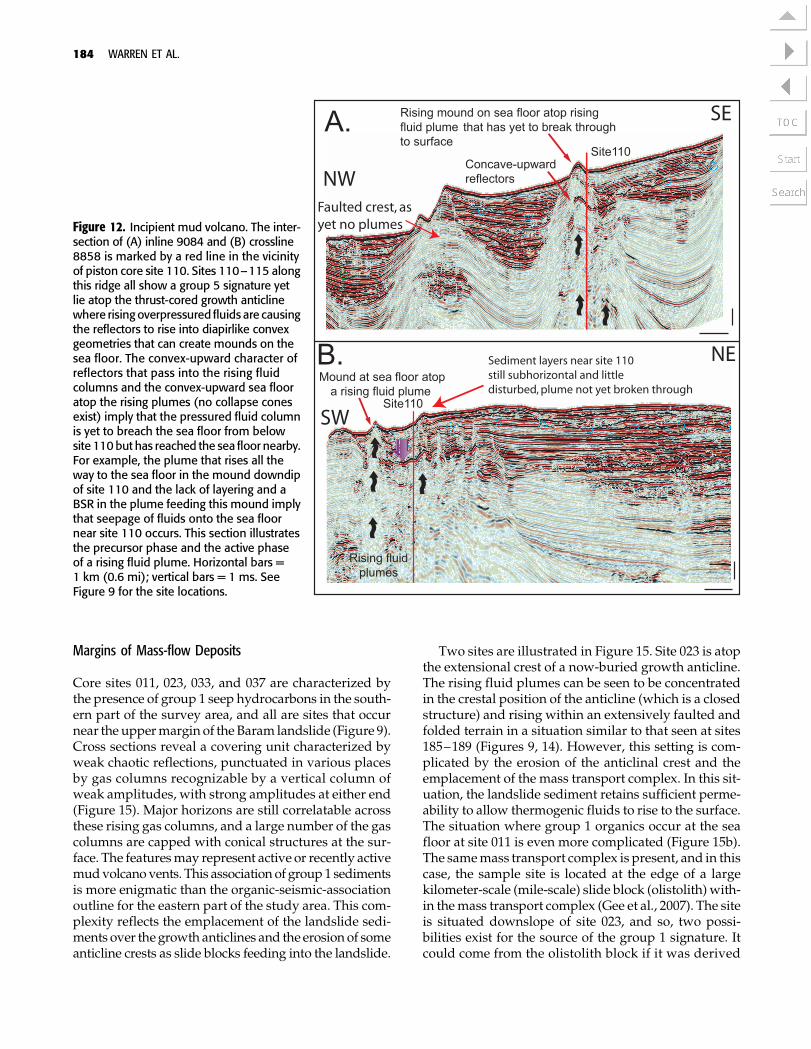
The effects of fluid pressure buildup and its escapeare clearly seen in the contrasting organic signatures insediments above and adjacent to collapsed mud vol-canoes and pockmarks in various ridges (A–H) thatconstitute the undulating part of the slope and rise ofBrunei (e.g. Figure 11, sites 173–176) and in sea-floorsediments atop an actively growing and pressurizeddiapir mound that has yet to breach and collapse
(Figure 11, sites 110–115). In the region of sites 173–176, the sea-floor sediments within or near the collapsecone of the formerly activemudvolcano vent are charac-terized by group 1 (hydrocarbon seep) signatures. Deeppore fluids have breached the sea floor, whereas in theregion beneath sites 110–115, the structure is still in-flated and sea-floor sediments only contain the group 5organic signature of ROM (Figure 12). Likewise, thegroup 1 signatures that characterize sites 065, 082, and084 are also tied to collapse features; interestingly, boththese sites are now sediment spillover sites alonggrowthridges that are capturing sediment on their updip sidesin ponded minibasins (Figure 13a, b). The sea-floor col-lapse that sometimes accompanies the depressurizingof mud volcanoesmay have generated a landscape lowthat then allowed the sediment to pass across the ridgeand down into the next minibasin. Sample site 065 isnot in, but in close proximity to, a pressurized mud vol-cano (Figure 13b). Dimitrov (2002), in a worldwide re-view of mud volcanoes, pointed out that gas and fluidmaybe emitted somedistance away from themain ventvia smaller secondary vents called gryphons. Thesegryphons commonly spew out fluid andmud that sub-sequently get captured in the near-bottom sedimentsand may explain the group 1 signature at site 065.
Fault-Breached and Eroded Anticlinal Ridges
Additional group 1 (hydrocarbon seep) sites are tiedto anticlinal ridges, but these sites are not as tightlyrelated to a single fluid conduit feature, unlike thosedescribed in the previous section. Instead, they consti-tute more diffuse zones of extensional normal fault-ing (Figure 14). Typically, they occur on the upper ex-posedparts of the basinward sides of growing anticlinalridges, where ridge collapse has yet to occur and crestalsediment is yet to be redeposited as a debris flow (thedebris flow lens from such a collapse is imaged inFigure 7b). Sample sites 185, 187, and 189 all containgroup 1 hydrocarbons, and narrow fault-facilitated gas-sy fluid columns are a common occurrence at the seafloor along this part of the hosting thrust-cored ridge(Figure 14). Onlapping the landward side of this ridge isamuddy sedimentary unit sampled at site 183. There, thesea-floor muds contain only group 5 hydrocarbons, im-plying that this ponded sedimentary unit acts as a sealto rising deeper pore fluids. This is also a site whererates of rise were sufficiently slow to allow some of therising fluid to be trapped as a methane hydrate, as re-covered in core 189. Unlike the organics, the carbon iso-tope signatures in the carbonate nodules from the ridgepiston cores do not show any other signature other thanthat of early marine concretions (Table 3; Figure 10).
182 WARREN ET AL.
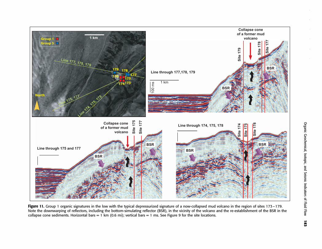
Figure 11. Group 1 organic signatures in the low with the typical depressurized signature of a now-collapsed mud volcano in the region of sites 173–179.Note the downwarping of reflectors, including the bottom-simulating reflector (BSR), in the vicinity of the volcano and the re-establishment of the BSR in thecollapse cone sediments. Horizontal bars = 1 km (0.6 mi); vertical bars = 1 ms. See Figure 9 for the site locations.
Organic
Geochem
ical,Isotopic,
andSeism
icIndicators
ofFluid
Flow183
Margins of Mass-flow Deposits
Core sites 011, 023, 033, and 037 are characterized bythe presence of group 1 seep hydrocarbons in the south-ern part of the survey area, and all are sites that occurnear the uppermargin of the Baram landslide (Figure 9).Cross sections reveal a covering unit characterized byweak chaotic reflections, punctuated in various placesby gas columns recognizable by a vertical column ofweak amplitudes, with strong amplitudes at either end(Figure 15). Major horizons are still correlatable acrossthese rising gas columns, and a large number of the gascolumns are capped with conical structures at the sur-face. The featuresmay represent active or recently activemudvolcano vents. This associationof group1 sedimentsis more enigmatic than the organic-seismic-associationoutline for the eastern part of the study area. This com-plexity reflects the emplacement of the landslide sedi-ments over thegrowth anticlines and the erosionof someanticline crests as slide blocks feeding into the landslide.
Two sites are illustrated in Figure 15. Site 023 is atopthe extensional crest of a now-buried growth anticline.The rising fluid plumes can be seen to be concentratedin the crestal position of the anticline (which is a closedstructure) and rising within an extensively faulted andfolded terrain in a situation similar to that seen at sites185–189 (Figures 9, 14). However, this setting is com-plicated by the erosion of the anticlinal crest and theemplacement of the mass transport complex. In this sit-uation, the landslide sediment retains sufficient perme-ability to allow thermogenic fluids to rise to the surface.The situation where group 1 organics occur at the seafloor at site 011 is even more complicated (Figure 15b).The samemass transport complex is present, and in thiscase, the sample site is located at the edge of a largekilometer-scale (mile-scale) slide block (olistolith) with-in themass transport complex (Gee et al., 2007). The siteis situated downslope of site 023, and so, two possi-bilities exist for the source of the group 1 signature. Itcould come from the olistolith block if it was derived
Figure 12. Incipient mud volcano. The inter-section of (A) inline 9084 and (B) crossline8858 is marked by a red line in the vicinityof piston core site 110. Sites 110–115 alongthis ridge all show a group 5 signature yetlie atop the thrust-cored growth anticlinewhere risingoverpressured fluids are causingthe reflectors to rise into diapirlike convexgeometries that can create mounds on thesea floor. The convex-upward character ofreflectors that pass into the rising fluidcolumns and the convex-upward sea flooratop the rising plumes (no collapse conesexist) imply that the pressured fluid columnis yet to breach the sea floor from belowsite 110but has reached the sea floor nearby.For example, the plume that rises all theway to the sea floor in the mound downdipof site 110 and the lack of layering and aBSR in the plume feeding this mound implythat seepage of fluids onto the sea floornear site 110 occurs. This section illustratesthe precursor phase and the active phaseof a rising fluid plume. Horizontal bars =1 km (0.6 mi); vertical bars = 1 ms. SeeFigure 9 for the site locations.
184 WARREN ET AL.

Figure 13. Mud volcanoes and the relationship to cross-ridge sediment dispersal pathways. (A) A series of active and collapsedmud volcanoes occur in the vicinity of sites 72–84 as shown in the map view. The inline shows a northwest–southeast sectionperpendicular to the structural strike showing location site 72 (group 1) at the edge of an active fluid plume and mud volcano.The southwest–northeast crossline through site 72 shows a depression to the northeast of the volcano where sediment isfaulted and spilling down to the northwest to accumulate in the next downslope minibasin. Sediment breakout from theupdip side of the ridge appears to be focused by a collapse zone located immediately northeast of the volcano. If it doesnot initiate sediment flow, it is highly likely that rising plumes help maintain the instability of the breach point and allow sedimentto move from the updip minibasin to the downdip minibasin. (B) Site 65 is another group 1 site that the northwest–southeastinline shows located at the edge of an active fluid plume and mud volcano. Unlike site 72, this site is at a more maturestage of volcano evolution where the low created by depressurization has focused the zone of sediment crossover into thelower minibasin. Note the lack of the bottom-simulating reflector (BSR) and downwarped beds in the vicinity of the collapse.Horizontal bars = 1 km (0.6 mi); vertical bars = 1 ms. See Figure 9 for the site locations. Map views in panels A and B areseismic amplitude extractions of the water bottom where lighter colors are typically active sediment flow paths and darker colors(blues) indicate more compacted mud and relatively stable ground.
Organic Geochemical, Isotopic, and Seismic Indicators of Fluid Flow 185
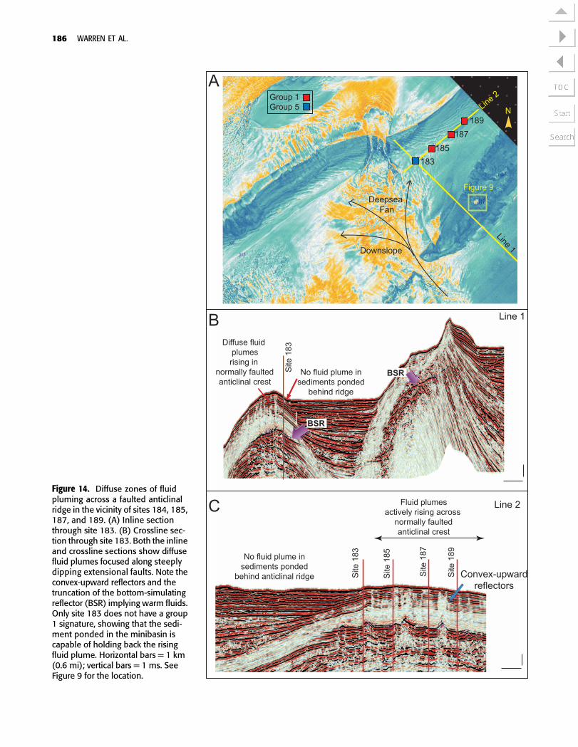
Figure 14. Diffuse zones of fluidpluming across a faulted anticlinalridge in the vicinity of sites 184, 185,187, and 189. (A) Inline sectionthrough site 183. (B) Crossline sec-tion through site 183. Both the inlineand crossline sections show diffusefluid plumes focused along steeplydipping extensional faults. Note theconvex-upward reflectors and thetruncation of the bottom-simulatingreflector (BSR) implying warm fluids.Only site 183 does not have a group1 signature, showing that the sedi-ment ponded in the minibasin iscapable of holding back the risingfluid plume. Horizontal bars = 1 km(0.6 mi); vertical bars = 1 ms. SeeFigure 9 for the location.
186 WARREN ET AL.
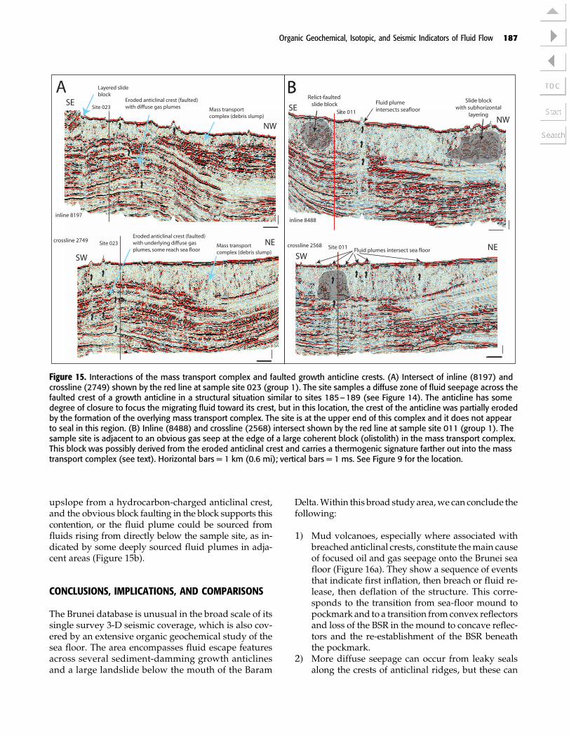
upslope from a hydrocarbon-charged anticlinal crest,and the obvious block faulting in the block supports thiscontention, or the fluid plume could be sourced fromfluids rising from directly below the sample site, as in-dicated by some deeply sourced fluid plumes in adja-cent areas (Figure 15b).
CONCLUSIONS, IMPLICATIONS, AND COMPARISONS
The Brunei database is unusual in the broad scale of itssingle survey 3-D seismic coverage, which is also cov-ered by an extensive organic geochemical study of thesea floor. The area encompasses fluid escape featuresacross several sediment-damming growth anticlinesand a large landslide below the mouth of the Baram
Delta.Within this broad study area,we can conclude thefollowing:
1) Mud volcanoes, especially where associated withbreached anticlinal crests, constitute themain causeof focused oil and gas seepage onto the Brunei seafloor (Figure 16a). They show a sequence of eventsthat indicate first inflation, then breach or fluid re-lease, then deflation of the structure. This corre-sponds to the transition from sea-floor mound topockmark and to a transition fromconvex reflectorsand loss of the BSR in the mound to concave reflec-tors and the re-establishment of the BSR beneaththe pockmark.
2) More diffuse seepage can occur from leaky sealsalong the crests of anticlinal ridges, but these can
Figure 15. Interactions of the mass transport complex and faulted growth anticline crests. (A) Intersect of inline (8197) andcrossline (2749) shown by the red line at sample site 023 (group 1). The site samples a diffuse zone of fluid seepage across thefaulted crest of a growth anticline in a structural situation similar to sites 185–189 (see Figure 14). The anticline has somedegree of closure to focus the migrating fluid toward its crest, but in this location, the crest of the anticline was partially erodedby the formation of the overlying mass transport complex. The site is at the upper end of this complex and it does not appearto seal in this region. (B) Inline (8488) and crossline (2568) intersect shown by the red line at sample site 011 (group 1). Thesample site is adjacent to an obvious gas seep at the edge of a large coherent block (olistolith) in the mass transport complex.This block was possibly derived from the eroded anticlinal crest and carries a thermogenic signature farther out into the masstransport complex (see text). Horizontal bars = 1 km (0.6 mi); vertical bars = 1 ms. See Figure 9 for the location.
Organic Geochemical, Isotopic, and Seismic Indicators of Fluid Flow 187
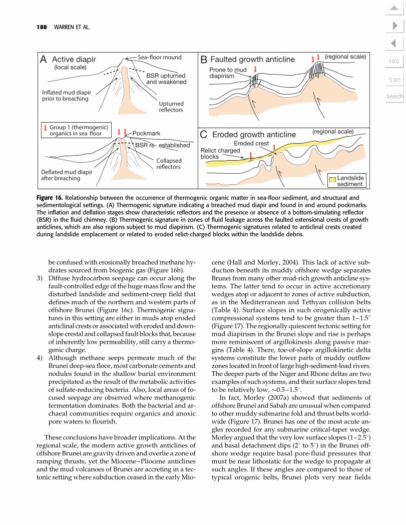
be confusedwith erosionally breachedmethane hy-drates sourced from biogenic gas (Figure 16b).
3) Diffuse hydrocarbon seepage can occur along thefault-controlled edge of the hugemass flow and thedisturbed landslide and sediment-creep field thatdefines much of the northern and western parts ofoffshore Brunei (Figure 16c). Thermogenic signa-tures in this setting are either in muds atop erodedanticlinal crests or associatedwith erodedanddown-slope crestal and collapsed fault blocks that, becauseof inherently low permeability, still carry a thermo-genic charge.
4) Although methane seeps permeate much of theBrunei deep-sea floor,most carbonate cements andnodules found in the shallow burial environmentprecipitated as the result of the metabolic activitiesof sulfate-reducing bacteria. Also, local areas of fo-cused seepage are observed where methanogenicfermentation dominates. Both the bacterial and ar-chaeal communities require organics and anoxicpore waters to flourish.
These conclusions have broader implications. At theregional scale, the modern active growth anticlines ofoffshore Brunei are gravity driven and overlie a zone oframping thrusts, yet the Miocene–Pliocene anticlinesand the mud volcanoes of Brunei are accreting in a tec-tonic setting where subduction ceased in the earlyMio-
cene (Hall and Morley, 2004). This lack of active sub-duction beneath its muddy offshore wedge separatesBrunei frommany other mud-rich growth anticline sys-tems. The latter tend to occur in active accretionarywedges atop or adjacent to zones of active subduction,as in the Mediterranean and Tethyan collision belts(Table 4). Surface slopes in such orogenically activecompressional systems tend to be greater than 1–1.58(Figure 17). The regionally quiescent tectonic setting formud diapirism in the Brunei slope and rise is perhapsmore reminiscent of argillokinesis along passive mar-gins (Table 4). There, toe-of-slope argillokinetic deltasystems constitute the lower parts of muddy outflowzones located in front of large high-sediment-load rivers.The deeper parts of the Niger and Rhone deltas are twoexamples of such systems, and their surface slopes tendto be relatively low, �0.5–1.58.
In fact, Morley (2007a) showed that sediments ofoffshore Brunei and Sabah are unusualwhen comparedto other muddy submarine fold and thrust belts world-wide (Figure 17). Brunei has one of the most acute an-gles recorded for any submarine critical-taper wedge.Morley argued that the very low surface slopes (1–2.58)and basal detachment dips (28 to 58) in the Brunei off-shore wedge require basal pore-fluid pressures thatmust be near lithostatic for the wedge to propagate atsuch angles. If these angles are compared to those oftypical orogenic belts, Brunei plots very near fields
Figure 16. Relationship between the occurrence of thermogenic organic matter in sea-floor sediment, and structural andsedimentological settings. (A) Thermogenic signature indicating a breached mud diapir and found in and around pockmarks.The inflation and deflation stages show characteristic reflectors and the presence or absence of a bottom-simulating reflector(BSR) in the fluid chimney. (B) Thermogenic signature in zones of fluid leakage across the faulted extensional crests of growthanticlines, which are also regions subject to mud diapirism. (C) Thermogenic signatures related to anticlinal crests createdduring landslide emplacement or related to eroded relict-charged blocks within the landslide debris.
188 WARREN ET AL.

occupied by compressional beltswith a salt decollement(Figure 17). As Ford (2004) noted in her study of someof the world’s orogenic belts, the presence of salt in acompressional terrain means a very low surface slope(<18) in the slope and rise prism. Put simply, any sedi-ment pod sitting atop a thick salt mass will tend to sinkor slide and rotate atop the salt mass as it seeks gravita-tional equilibrium atop the fluidlike salt body (Warren,2006).
Because of halite’s inherently low strength and fluid-like character, all salt-cored compressional wedges, asplotted in Figure 17, lie below the dashed red line thatindicates a 18 surface slope. Interestingly, the offshorewedges of Brunei and Barbados, two well-documentedshale diapir terrains, also plot on or near this 18 line, yetboth are salt free. They are, however,made upof prismsof sediment sitting atop pressurizedmud terrains, withpressures in the deeply buriedmuds approaching litho-static and the near-surface sediments characterized bymud chimneys and mud volcanoes.
An overburden adjustment to the fluidlike rheologicnature of both salt wedges and overpressured mudprisms occurs in a continental margin wherever zonesof extremely weak sediment (salt or pressured [litho-static]mud) lie beneath actively loading sediment pods(Table 4; Figure 17). Independent of whether the de-collement sits in salt or overpressured mud, the shelfpart of the continental margin is characterized by re-gional updip extension and growth faulting, which isbalanced by gravity gliding and downdip compressionof the toe-of-slope sediments. Toe-of-slope compres-sional anticlines in both settings tend to occur atop over-lapping or stacked thrust sheets,whichmerge continent-ward into a lower decollement zone that is hosted ineither salt or overpressured mud. The rising compres-sional ridges or growth anticlines that form above thethrust culminations act as sedimentdams, thus creatingminibasins between rising ridges. In terms of sedimentthicknesses and sedimentationpatterns in theminibasinfill, they showsame-scale geometric similarities, as is seenwhen seismic profiles from offshore Brunei (Figure 9)are compared toprofiles across salt-cored anticlinal ridgeprofiles across the Mississippi or Perdido fold belts inthe Gulf of Mexico (e.g., Rowan, 1997, his figures 4, 6).Both settings showwell-developed thrust-flooredgrowthanticlines acting as downslope sediment barriers thatpond sediment in interridge minibasins. Loads that de-veloped in the minibasin feed back into the pulsedgrowth of the adjacent diapiric structures, alongwiththe local collapse and sediment breaching of the anti-clinal ridges (e.g., Rowan, 1997; Morley, 2007b).
However, key horizons generating or facilitating fluidflow within mud-cored versus salt-cored growth anti-clines cannot be considered analogous (Table 4). At the
scale of the interior to anticlinal growth ridges, risingpore fluids sourced fromor below the decollement layerfollow somewhat different escape pathways. In a muddiapir, the actual volume of deeply sourced fluid that isflowing in the diapir is tied to the distribution of over-pressuredmuds that areperiodically leakingpore fluids.What we resolve as a seismically disturbed zone in amud-diapir province or in an overlying mud volcanoor chimney is not necessarily a sediment matrix thathas experiencedNewtonian flow. Instead, the sedimentis acoustically disturbed because it contains, or oncecontained, overpressured fluid on itsway to the surface(VanRensbergen andMorley, 2003). In contrast,what isseismically imaged in the compressional core of a growthanticline where a body of flowing salt is squeezed to-ward the surface is halokinetic salt. The salt is not a flowof gas-charged fluid, instead, the salt is a plastic massmoving through or over the adjacent sediment as a co-herent impermeablewhole. Halokinetic salt tends to actas a seal to gas-charged fluid, with the peripheries of thesalt mass acting as foci for the flow and ultimate escapeof underlying buoyant or overpressured fluids (Morleyand Guerin, 1996; Warren, 2006).
Because properties and the seismic responses differbetweengas-chargedmuddiapirs or chimneys, and saltdiapirs or allochthons, the distribution of organic ma-turity indicators can alsodiffer.Disturbed anticlinal coresand associated mud diapirs, volcanoes, or chimneys inoffshore Brunei and elsewhere indicate sea-floor inter-sections with regions of overpressured mud. Withinsuchmuddiapirs, the structure itself is the source of thefluid signature on the sea floor (Figure 18a). In the caseof halokinetic features, deeply circulated subsalt porefluids tend to move laterally along the underside of thesalt mass and only leak upward at the featheredge of awidespread salt allochthon sheet or across a salt weld(Figure 18b). Salt withdrawal can facilitate the rapidsubsidence of muddy suprasalt sediments, and theirdewatering can drive suprasalt argillokinesis. In somesuprasalt situations, a combination of salt withdrawaland rapid sedimentation of water-saturated muds intothe resultant suprasalt accommodation space can createinstability and diapirism in the suprasalt or supraweldmud column, even if themud itself is not overpressured.This is the case with shale diapirs of the Port Isobel foldbelt, western Gulf of Mexico (Camerlo et al., 2004).
Whenever the overpressured plume of fluids, whichconstitutes a typical mud volcano or mud diapir, breaksout onto the sea floor, the system quickly depressurizesand collapses. Flowing mud stops flowing soon afterreaching the sea floor (Figure 16a). In contrast, on reach-ing the sea floor, a pressurized salt mass can continueto flow and spread and can even initiate a new subhori-zontal allochthon tier and a new set of sediment dams.
Organic Geochemical, Isotopic, and Seismic Indicators of Fluid Flow 189

Table 4. Features of typical mud diapirism and salt diapirism.*
Mud Diapir (Argillokinetic) Salt Diapir (Halokinetic)
Tectonic setting whereargillokinesis and/orhalokinesis occurs
Rift to drift (passivemargin (extensional)with depositionalloading)
Yes, gravity-driven fold belt (especially intoe of slope). Examples: Mexican ridges andPort Isobel fold belts of western Gulf ofMexico; fold belts in the Sergipe-Alagoas andPara-Maranhao basins of Brazil, Niger Deltafold belt; McKenzie delta fold belt, ArcticCanada; Yangtze delta, East China Sea.
Yes, gravity-driven fold belt (especially intoe of slope). Examples: slope and rise fold beltsof the circum-South Atlantic salt basins and thenorthern Gulf of Mexico; fold belts in the YemeniRed Sea; Nile deep-sea fan; Rhone deep-sea fan;Scotian margin, eastern Canada.
Collisional accretionarybelts, transpressionalbelts; both can overprinta former passive margin
Yes (forearc and backarc basins). Examples:Barbados accretionary prism; MediterraneanSea and Tethyan belt, spanning from southof Greece over the Black and Caspian seasinto Azerbaijan, the Crimea and Tamanpeninsulas, Iran, and Turkmenistan into theMakran coast; Borneo; South China Sea.
Yes (Especially in zones of continent-continentcollision, compression can reactivate formerextensional salt diapirs). Examples: Qom Basinand Zagros fold belt, Iran; Kuqa fold belt,Tarim; Betics; Carpathians; Appenines; SierraMadre; Neuquen, Argentina.
Intracratonic sag No No (unless basin inversion occurs, e.g., AmadeusBasin, Australia)
Depositional association Marine Typical of muddy continental slope and rise Typical of continental slope and rise
Lacustrine Foreland basin Foreland basin
Movement styleand drivers
Requires overpressure. Shale can pass fromductile to fluidized, and back to ductile,numerous times as the structure oscillatesbetween inflation (gas explosions and diapirwings) and deflation (collapse after the landsurface is breached).Overpressure is caused by a combinationof burial compaction, diagenesis of clay,organic maturation, and compressivetectonics. Overpressure is lost whenfluid-charged mass reaches the surface, andtypically only a relatively minor lateralflow component exists when the fluidescapes onto the surface.Mud-diapir provinces can form zones ofextremely rapid subsidence atop saltwithdrawal zones even if the mud sourceinterval is not overpressured (Fort Isobelfold belt).
Thick beds of wet salt undergoing loadingor extension can be autokinetic, almost fromthe time of deposition. Salt continues to movein response to extension or loading andmaintains its flow until overburden touchdownoccurs. Salt in compression will fold but notpierce the overburden, except under particularcircumstances (see Warren, 2006, Chapter 6).When the salt reaches the surface, a stronglateral component (downslope) to flow(allochthons and namakiers) is observed, saltflow can continue via gravity spreading formany kilometers way from the vent.Overpressure is commonly focused beneathan allochthon as the salt mass is an excellentseal. Overpressure is also common in suprasaltminibasins where the feedback betweenloading and salt withdrawal facilitates rapidsedimentation until touchdown.
190
WARREN
ETAL.
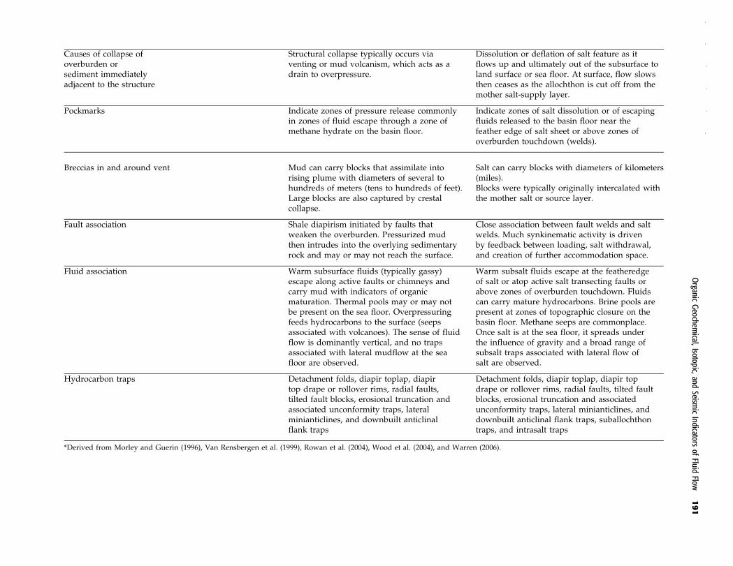
Causes of collapse ofoverburden orsediment immediatelyadjacent to the structure
Structural collapse typically occurs viaventing or mud volcanism, which acts as adrain to overpressure.
Dissolution or deflation of salt feature as itflows up and ultimately out of the subsurface toland surface or sea floor. At surface, flow slowsthen ceases as the allochthon is cut off from themother salt-supply layer.
Pockmarks Indicate zones of pressure release commonlyin zones of fluid escape through a zone ofmethane hydrate on the basin floor.
Indicate zones of salt dissolution or of escapingfluids released to the basin floor near thefeather edge of salt sheet or above zones ofoverburden touchdown (welds).
Breccias in and around vent Mud can carry blocks that assimilate intorising plume with diameters of several tohundreds of meters (tens to hundreds of feet).Large blocks are also captured by crestalcollapse.
Salt can carry blocks with diameters of kilometers(miles).Blocks were typically originally intercalated withthe mother salt or source layer.
Fault association Shale diapirism initiated by faults thatweaken the overburden. Pressurized mudthen intrudes into the overlying sedimentaryrock and may or may not reach the surface.
Close association between fault welds and saltwelds. Much synkinematic activity is drivenby feedback between loading, salt withdrawal,and creation of further accommodation space.
Fluid association Warm subsurface fluids (typically gassy)escape along active faults or chimneys andcarry mud with indicators of organicmaturation. Thermal pools may or may notbe present on the sea floor. Overpressuringfeeds hydrocarbons to the surface (seepsassociated with volcanoes). The sense of fluidflow is dominantly vertical, and no trapsassociated with lateral mudflow at the seafloor are observed.
Warm subsalt fluids escape at the featheredgeof salt or atop active salt transecting faults orabove zones of overburden touchdown. Fluidscan carry mature hydrocarbons. Brine pools arepresent at zones of topographic closure on thebasin floor. Methane seeps are commonplace.Once salt is at the sea floor, it spreads underthe influence of gravity and a broad range ofsubsalt traps associated with lateral flow ofsalt are observed.
Hydrocarbon traps Detachment folds, diapir toplap, diapirtop drape or rollover rims, radial faults,tilted fault blocks, erosional truncation andassociated unconformity traps, lateralminianticlines, and downbuilt anticlinalflank traps
Detachment folds, diapir toplap, diapir topdrape or rollover rims, radial faults, tilted faultblocks, erosional truncation and associatedunconformity traps, lateral minianticlines, anddownbuilt anticlinal flank traps, suballochthontraps, and intrasalt traps
*Derived from Morley and Guerin (1996), Van Rensbergen et al. (1999), Rowan et al. (2004), Wood et al. (2004), and Warren (2006).
Organic
Geochem
ical,Isotopic,
andSeism
icIndicators
ofFluid
Flow191

Regionally, a multitiered allochthon style of salt inshelf progradation is more likely if the mother salt beltwas deposited in a postrift, instead of a synrift, setting(Warren, 2008). Mobile salt allochthon sheets roll outover the landscape carrying along their still-accretingoverburden section,much in the sameway the tracks ofa military tank carry the tank and its crew. In regionsof mud diapirism, no same-scale equivalents to saltallochthons flowing over the sea floor are observed, nor
muddy equivalents to merged salt canopies or nama-kiers (salt glaciers).
In argillokinetic provinces, local, typically narrowand cylindrical, subvertical chimney structures (mudvolcanoes) rise from the underlying zone of overpres-sure (muddiapir). Smallwings to themud chimneymaybe visible where fluidized sediment first reached thesea floor, but there is never an extensive allochthonsheet spreading over the sea floor for kilometers (miles)
Figure 17. Pressure and wedge character showing the relationship between surface slope (A), basal detachment dip (B),and pore-fluid ratio for orogenic wedges and submarine fold and thrust belts at critical taper, assuming a Coulomb materialbehavior (from Ford, 2004; Morley, 2007a). Orogenic belts with salt entrained in the decollement are indicated by (S). M =postulated coefficient of internal friction for the wedge; Mb = coefficient of internal friction at the base of the wedge; Lb = ratioof pore-fluid pressure to lithostatic pressure at the base of the wedge; ESA = east Swiss Alps; WSA = west Swiss Alps. Thegreen triangle plots the region of the low basal friction wedge of Davis and Engelder (1985). As shown by Ford (2004), theregion of low basal friction created by a salt decollement extends beyond the region indicated by Davis and Engelder (1985) andis indicated by the interval below the dashed red line (surface slopes <18). Offshore Brunei and offshore Barbados lie onthis boundary, although either sediment wedge entrains no salt, this is an indication of a muddy and highly pressured characterin both prisms (see Morley, 2007a, for a detailed discussion of the significance of the Brunei taper).
192 WARREN ET AL.

away from the vent. Sea-floor pockmarks in a mud-diapir province define the vent and escape positions ofchimneys atop overpressured fluids and commonlyline up along fault zones. Regions of abundant sea-floorpockmarks in a salt-diapir province are commonly alsotied to fault intersections with the sea floor but can alsodefine the edge of the underlying salt mass or seal.
Similarities and differences in the nature of diapir-ism in salt and mud also lead to similarities and dif-ferences in the distribution of diapir-related hydrocarbontraps (Figure 19). Styles of reservoir distribution in sandsatop salt ormuddiapirs are similar (Table 4, Figure 19a).Bothmud and salt diapirs tend to create local highs andridges in the landscape, with consequent distributionsof coarser grained sediments and/or reefs related to thedepth of water over the high at the time the reservoirunit was deposited (e.g., Warren, 2006, chapters 6, 10).
Onlap, pinch-out, rollover anticlines, growth faults, re-gional and counterregional faults, collapse faults, anddrape traps are common to both settings (Figure 19a).
Differences in trap styles come from differences inthemechanismdriving flowand in that, over the longerterm, salt tends to maintain its seal integrity, whereasoverpressuredmud leaks. Salt can flow up and out overthe sea floor for distances of several kilometers (miles).Equivalents to subsalt traps, which are tied to a stronglateral flow of salt across the landscape, are not knownin argillokinetic provinces (Figure 19b). Dissolution ofsalt, via subsurface cross-flow of undersaturated waters,creates a residual carapace of anhydrite and limestoneknown as a cap rock. This too has no argillokineticcounterpart but can host low-volume hydrocarbontraps in and about a salt-diapir crest. Cap-rock trapstend to occur in relatively shallow parts of a salt-diapir
Figure 18. Comparison of signatures ofmud and salt diapirism. (A)Mud diapirism indicates a zone of fluid-charged overpressuredfine-grained sediment (mostly mud). It can rise via stoping subvertical mud chimneys and periodically break out onto thesea floor. The seismic signature indicates zones of active or former fluid charge. The diapir as seen in the seismic signature isnot a lithology but typically a gas effect. As such, the diapir zone can expand and encapsulate or cannibalize adjacent sedimentswithout disturbing the bed orientation. (B) Salt diapirism indicates a zone of flowing impermeable salt (halokinesis). There isboth a vertical and horizontal component to this flow and a strong response to sediment loading, and, on salt reaching the seafloor, it is tied to downslope gravity spreading. The seismic signature of a salt diapir or allochthon is a direct indicator of thesalt mass, which is always impermeable. Flow sets up a mobile mass of impervious salt with edges subject to dissolution (likea block of ice). This mass and its brine halo focus fluid flow and overpressuring about its edges (see Warren, 2006, chapters 6and 8 for a detailed discussion of relevant literature).
Organic Geochemical, Isotopic, and Seismic Indicators of Fluid Flow 193

province and are the first zones to be exploited in diapir-related oil fields of onshore Texas and Louisiana duringthe first 30 yr of the last century (Warren, 2006).
In summary, gas-charged faults and mud chimneys(volcanoes) lead down to zones of disturbed mud thatconstitute the diapiric cores of anticlinal ridges in Bruneimud diapirs and similar structures in the Niger Deltaand elsewhere (e.g., Graue, 2000; Ludmann andWong,2003; McGilvery and Cook, 2003). Unlike impermeablesalt allochthon sheetswhere fluid flowoccurs in deform-ing sediments adjacent to the salt, the site of the imagedmud diapir is the actual zone of overpressure and ther-mogenic (hydrocarbon-bearing) fluid flow. Thus, in aseismic line through a disturbed mud-diapir system,we are resolving the state of the fluid conduit itself(reflectors tend to bend upward when the system ispressurized and bend down or indicate collapse oncethe pressurized fluid has vented). In a salt allochthonprovince, we are resolving the edge of the salt and notthe state of the fluid flow in the core of the structure.The edge of the salt mass may well act as the focus toany subsalt fluid escaping from a pressurized unit be-neath the salt, but the interior of a thick flowing saltmass is impermeable.
ACKNOWLEDGMENTS
The authors thank the Brunei Petroleum unit, TotalBrunei, BHPBilliton, andShell InternationalDeepwaterfor their support of this project. The senior author alsothanks his former fellow faculty at Universiti Brunei
Darussalam, Chris Morley, Martin Gee, Joe Lambiase,andAngus Ferguson for the lively discussions and help-ful criticisms that helped shape the ideas in this article.
REFERENCES CITED
Abrams, M. A., 2005, Significance of hydrocarbon seepagerelative to petroleum generation and entrapment: Marineand Petroleum Geology, v. 22, p. 457–477, doi:10.1016/j.marpetgeo.2004.08.003.
Birkle, P., J. J. Rosillo Aragon, E. Portugal, and J. L. FongAguilar, 2002, Evolution and origin of deep reservoir wa-ter at the Activo Luna oil field, Gulf of Mexico, Mexico:AAPG Bulletin, v. 86, p. 457–484.
Camerlo, R., D. Meyer, and R. Meltz, 2004, Shale tectonismin the northern Port Isobel fold belt, in P. J. Post, ed., Salt-sediment interactions and hydrocarbon prospectivity: Con-cepts, applications and case studies for the 21st Century:Gulf Coast Section SEPM, 24th Annual Bob F. PerkinsResearch Conference, (CD-ROM), p. 817–839.
Clari, P., S. Cavagna, L. Martire, and J. Hunziker, 2004, AMiocene mud volcano and its plumbing system: A cha-otic complex revisited (Monferrato, NW Italy): Journalof Sedimentary Research, v. 74, p. 662–676, doi:10.1306/022504740662.
Curiale, J., W. Mueller, J. Morelos, and J. Lambiase, 2000,Brunei Darussalam: Characteristics of selected petroleumsand source rocks: Organic Geochemistry, v. 31, p. 1475–1493, doi:10.1016/S0146-6380(00)00084-X.
Davis, D. M., and T. Engelder, 1985, The role of salt in fold-and-thrust belts (Canada): Tectonophysics, v. 119, p. 67–88, doi:10.1016/0040-1951(85)90033-2.
Demyttenaere, R., J. P. Tromp, A. Ibrahim, P. Allman-Ward,
Figure 19. Hydrocarbon trap configuration. (A) Typical trap styles common to both mud and salt diapirs. (B) Subsalt traps withno documented equivalents in mud-diapir terrains.
194 WARREN ET AL.
and T. Meckel, 2000, Brunei deep water exploration fromsea floor images and shallow seismic analogs to deposition-al models in a slope turbidite setting: Gulf Coast SectionSEPM, 20th Annual Bob F. Perkins Annual Research Con-ference, p. 304–317.
Dimitrov, L. I., 2002, Mud volcanoes-the most importantpathways for degassing deeply buried sediment: Earth-Science Reviews, v. 59, p. 49–76.
Ford,M., 2004, Depositional wedge tops: Interaction betweenlow basal friction external orogenic wedges and flexuralforeland basins: Basin Research, v. 16, p. 361–375, doi:10.1111/j.1365-2117.2004.00236.x.
Gee, M. J. R., H. S. Uy, J. K. Warren, C. K. Morley, and J. J.Lambiase, 2007, The Brunei slide: A giant submarine land-slide on the northwest Borneo margin revealed by 3Dseismic data: Marine Geology, v. 246, p. 9–23, doi:10.1016/j.margeo.2007.07.009.
Graue, K., 2000, Mud volcanoes in deep water Nigeria: Ma-rine and PetroleumGeology, v. 17, p. 959–974, doi:10.1016/S0264-8172(00)00016-7.
Grauls, D., 2001, Gas hydrates: Importance and applicationsin petroleum exploration: Marine and Petroleum Geology,v. 18, p. 519–523, doi:10.1016/S0264-8172(00)00075-1.
Hall, R., and C. K.Morley, 2004, Sundaland basins, in P. Clift,P. Wang, W. Kuhnt, and D. E. Hayes, eds., Continent-ocean interactions within the east Asian marginal seas:AmericanGeophysicalUnionGeophysicalMonograph149,p. 55–85.
Huang, W. Y., andW. G. Meinschein, 1979, Sterols as ecolog-ical indicators: Geochemica et Cosmochimica Acta, v. 43,p. 730–745.
Hutchison, C. S., 2005, Geology of Northwest Borneo: Frank-furt, Germany, Elsevier, 444 p.
Ingram, G. M., T. J. Chisholm, C. J. Grant, C. A. Hedlund, P.Stuart-Smith, and J. Teasdale, 2004, Deepwater northwestBorneo: Hydrocarbon accumulation in an active fold andthrust belt: Marine and Petroleum Geology, v. 21, p. 879–887, doi:10.1016/j.marpetgeo.2003.12.007.
Kennett, J. P., K. G. Cannariato, I. L. Hendy, and R. J. Behl,2000, Carbon isotopic evidence for methane hydrate in-stability during Quaternary interstadials: Science, v. 288,p. 123–128.
Kopf, A. J., 2002, Significance of mud volcanism: Reviewsof Geophysics, v. 40, no. 2, 1005, p. 2.1–2.52, doi:10.1029/2000RG000093.
Kopf, A. J., 2003, Global methane emission through mudvolcanoes and its past and present impact on the Earth’sclimate: International Journal of Earth Sciences, v. 92,p. 806–816, doi:10.1007/s00531-003-0341-z.
Kotelnikova, S., 2002, Microbial production and oxidation ofmethane in deep subsurface: Earth-Science Reviews, v. 58,p. 367–395.
Laird, A., and C. K. Morley, in press, Development of gashydrates in a deepwater anticline based on attribute analysisfrom 3D seismic data: Geosphere, doi:10.1130/GS00598.1.
Ludmann, T., and H. K. Wong, 2003, Characteristics of gashydrate occurrences associated with mud diapirism andgas escape structures in the northwestern Sea of Okhotsk:
Marine Geology, v. 201, p. 269–286, doi:10.1016/S0025-3227(03)00224-X.
Malone, M. J., 2002, Variable methane fluxes in shallowmarine systems over geologic time: The composition andorigin of pore waters and authigenic carbonates on theNew Jersey shelf: Marine Geology, v. 189, p. 175–196,doi:10.1016/S0025-3227(02)00474-7.
Matsumoto, R., 1989, Isotopically heavy oxygen-containingsiderite derived from the decomposition of methane hy-drate: Geology, v. 17, p. 707–710, doi:10.1130/0091-7613(1989)017<0707:IHOCSD>2.3.CO;2.
McGilvery, T. A., and D. L. Cook, 2003, The influence of localgradients on accommodation space and linked deposi-tional elements across a stepped slope profile, offshoreBrunei, inH.H. Roberts, N. C. Rosen, R. H. Fillon, and J. B.Anderson, eds., Shelfmargin deltas and linked downslopepetroleum systems: Global significance and future explo-ration potential: Gulf Coast Society SEPM 23rd AnnualBob F. Perkins Research Conference (CD-ROM), p. 387–420.
Milkov, A. V., 2000, Worldwide distribution of submarinemud volcanoes and associated gas hydrates: Marine Ge-ology, v. 167, p. 29–42, doi:10.1016/S0025-3227(00)00022-0.
Miller, J. J.,M.W. Lee, andR. VonHuene, 1991,An analysis ofa seismic reflection from the base of a gas hydrate zone,offshore Peru: AAPG Bulletin, v. 75, p. 910–924.
Morley, C. K., 2007a, Interaction between critical wedge ge-ometry and sediment supply in a deep-water fold belt:Geology, v. 35, p. 139–142, doi:10.1130/G22921A.1.
Morley, C. K., 2007b, Development of crestal normal faults as-sociated with deep water fold growth: Journal of Struc-tural Geology, v. 29, p. 1148–1163, doi:10.1016/j.jsg.2007.03.016.
Morley, C. K., and G. Guerin, 1996, Comparison of gravity-driven deformation styles and behaviour associated withmobile shales and salt: Tectonics, v. 15, p. 1154–1170.
O’Brien, G. W., M. Lisk, I. R. Duddy, J. Hamilton, P. Woods,and R. Cowley, 1999, Plate convergence, foreland devel-opment and fault reactivation: Primary controls on brinemigration, thermal histories and trap breach in the TimorSea, Australia: Marine and Petroleum Geology, v. 16,p. 533–560, doi:10.1016/S0264-8172(98)00070-1.
O’Brien,G.W.,G.M.Lawrence,A.K.Williams,K.Glenn,A.G.Barrett, M. Lech, D. S. Edwards, R. Cowley, C. J. Boreham,andR. E. Summons, 2005, Yampi shelf, BrowseBasin, north-west shelf, Australia: A test-bed for constraining hydro-carbonmigration and seepage rates using combinations of2D and 3D seismic data andmultiple, independent remotesensing technologies: Marine and Petroleum Geology,v. 22, p. 517–549, doi:10.1016/j.marpetgeo.2004.10.027.
Peters, K. E., J. M. Moldowan, and C. C. Walters, 2005a, Thebiomarker guide: Biomarkers and isotopes in the envi-ronment and human history: Cambridge, UK, CambridgeUniversity Press, v. 1, 490 p.
Peters, K. E., C. C. Walters, and J. M. Moldowan, 2005b, Thebiomarker guide: Biomarkers and isotopes in petroleumsystems and earth history: Cambridge, UK, CambridgeUniversity Press, v. 2, 700 p.
Organic Geochemical, Isotopic, and Seismic Indicators of Fluid Flow 195

Raiswell, R., S. H. Bottrell, S. P. Dean, J. D. Marshall, A. Carr,and D. Hatfield, 2002, Isotopic constraints on growthconditions of multiphase calcite-pyrite-barite concretionsinCarboniferousmudstones: Sedimentology, v. 49, p. 237–254, doi:10.1046/j.1365-3091.2002.00439.x.
Roberts, H. H., and P. Aharon, 1994, Hydrocarbon-derivedcarbonate buildups of the northern Gulf of Mexico con-tinental slope:A reviewof submersible investigations:Geo-Marine Letters, v. 14, p. 135–148.
Rowan, M. G., 1997, Three-dimensional geometry and evo-lution of a segmented detachment fold, Mississippi Fanfold belt, Gulf of Mexico: Journal of Structural Geology,v. 19, p. 463–480, doi:10.1016/S0191-8141(96)00098-3.
Rowan, M. G., F. J. Peel, and B. C. Vendeville, 2004, Gravity-driven fold belts on passive margins, in K. McClay, ed.,Thrust tectonics and hydrocarbon systems: AAPG Mem-oir 82, p. 157–182.
Stewart, S. A., and R. J. Davies, 2006, Structure and emplace-ment of mud volcano systems in the south Caspian Basin:AAPGBulletin, v. 90, p. 771–786, doi:10.1306/11220505045.
van Rensbergen, P., and C. K. Morley, 2003, Re-evaluationof mobile shale occurrences on seismic sections of theChampion and Baram deltas, offshore Brunei, in P. vanRensbergen, R. R. Hillis, A. J. Maltman, and C. K. Morley,eds., Subsurface sediment mobilization: Geological Soci-ety (London) Special Publication 216, p. 395–409.
van Rensbergen, P., C. K. Morley, D. W. Ang, T. Q. Hoan, andN. T. Lam, 1999, Structural evolution of shale diapirs fromreactive rise to mud volcanism: 3D seismic data from theBaram Delta, offshore Brunei Darussalam: Journal of the
Geological Society, v. 156, p. 633–650, doi:10.1144/gsjgs.156.3.0633.
Waples, D., 1985, Geochemistry in petroleum exploration:Boston, International Human Research Development Cor-poration, 232 p.
Warren, J. K., 2000, Dolomite; occurrence, evolution and eco-nomically important associations: Earth-Science Reviews,v. 52, p. 1–81.
Warren, J. K., 2006, Evaporites: Sediments, resources andhydrocarbons: Berlin, Springer, 1036 p.
Warren, J. K., 2008, Salt as sediment in the Central EuropeanBasin system as seen from a deep time perspective (chap-ter 5.1), in R. Littke, ed., Dynamics of complex intra-continental basins: The central European basin system:Berlin, Elsevier, p. 249–276.
Warren, J. K., L. L. Quoc, and I. Cartwright, 2004, Ongoingdolomite cementation in the Neogene sediment prism ofoffshore Brunei Darussalam (abs.): Proceedings of the 32ndInternational Geological Congress, Florence, August 20–28,2004.
Wood, L. J., S. Sullivan, and P.Mann, 2004, Influence ofmobileshales in the creation of successful hydrocarbon basins, inP. J. Post, ed., Salt-sediment interactions and hydrocarbonprospectivity: Concepts, applications and case studies forthe 21st Century: Gulf Coast Section SEPM, 24th AnnualBobF. PerkinsResearchConference, (CD-ROM), p. 892–930.
Zielinski, G. W., M. Bjoroy, R. L. B. Zielinski, and I. L.Ferriday, 2007,Heat flow and surface hydrocarbons on theBrunei continental margin: AAPG Bulletin, v. 91, p. 1053–1080, doi:10.1306/01150706117.
196 WARREN ET AL.