Options of sustainable groundwater development in Beijing Plain, China
16
This article appeared in a journal published by Elsevier. The attached copy is furnished to the author for internal non-commercial research and education use, including for instruction at the authors institution and sharing with colleagues. Other uses, including reproduction and distribution, or selling or licensing copies, or posting to personal, institutional or third party websites are prohibited. In most cases authors are permitted to post their version of the article (e.g. in Word or Tex form) to their personal website or institutional repository. Authors requiring further information regarding Elsevier’s archiving and manuscript policies are encouraged to visit: http://www.elsevier.com/copyright
-
Upload
unesco-ihe -
Category
Documents
-
view
2 -
download
0
Transcript of Options of sustainable groundwater development in Beijing Plain, China

This article appeared in a journal published by Elsevier. The attachedcopy is furnished to the author for internal non-commercial researchand education use, including for instruction at the authors institution
and sharing with colleagues.
Other uses, including reproduction and distribution, or selling orlicensing copies, or posting to personal, institutional or third party
websites are prohibited.
In most cases authors are permitted to post their version of thearticle (e.g. in Word or Tex form) to their personal website orinstitutional repository. Authors requiring further information
regarding Elsevier’s archiving and manuscript policies areencouraged to visit:
http://www.elsevier.com/copyright

Author's personal copy
Options of sustainable groundwater development in Beijing Plain, China
Yangxiao Zhou a,⇑, Liya Wang b, Jiurong Liu b, Wenpeng Li c, Yuejun Zheng c
a UNESCO-IHE Institute for Water Education, P.O. Box 3015, 2601 DA Delft, The Netherlandsb Beijing Geo-environmental Monitoring Station, Beiwa Road 90, Beijing 100037, People’s Republic of Chinac China Institute of Geo-environmental Monitoring, Dahuisi 20, Beijing 100081, People’s Republic of China
a r t i c l e i n f o
Article history:Available online 10 September 2011
Keywords:Groundwater overexploitationNegative impactsDevelopment scenariosScenario simulationsSustainable developmentBeijing Plain
a b s t r a c t
Overexploitation of groundwater resources has supported rapid social and economical developments inBeijing City in last 30 years. The newly constructed emergency well fields have saved Beijing from a crit-ical water crisis caused by a long drought spell of eight consecutive years from 1999 to 2006. But thisunsustainable development has resulted in serious consequences: discharges to rivers ceased, large num-ber of pumping wells went dry, and land subsidence caused destruction of underground infrastructure.The completion of the middle route of South to North water transfer project to transfer water fromYangtze river to Beijing City by 2010 provides opportunity to reverse the trend of groundwater depletionand to achieve a long-term sustainable development of groundwater resources in Beijing Plain. Fouroptions of groundwater development in Beijing Plain were formulated and assessed with a regional tran-sient groundwater flow model. The business as usual scenario was used as a reference for the compara-tive analysis and indicates fast depletion of groundwater resources. The reduction of abstraction scenariohas immediate and fast recovery of groundwater levels, especially at the cone of depression. The scenarioof artificially enhanced groundwater recharge would replenish groundwater resources and maintain thecapacity of present water supply well fields. The combined scenario of the reduction of abstraction andthe increase of recharge could bring the aquifer systems into a new equilibrium state in 50 years. Ahydrological sustainability of groundwater resources development could then be achieved in BeijingPlain.
� 2011 Elsevier Ltd. All rights reserved.
1. Introduction
Beijing City, the capital of China, has experienced rapid populationgrowth, urbanization and industrialization in last 30 years. The totalpopulation was nearly 17 million and the GDP was around 9075 US$per capita in 2008 (Beijing Statistics Bureau, 2009). With a temperatecontinental climate, water resources are limited. The total water re-sources was estimated around 38� 108 m3/year, only 225 m3/yearper capita, which is much lower than the world average and belongsto absolute water scarcity (Yang and Zehnder, 2001; Rijsberman,2004). The inflows of surface water have been substantially de-creased due to the construction of reservoirs and water diversionsin upper stream areas. Water demand for rapid social and economicaldevelopments has been met with overexploitation of groundwater inlast 30 years. Groundwater supply accounts for two-third of watersupply for Beijing municipality: roughly 60% for irrigation, 25% fordrinking water and 15% for industrial water supply (Beijing Geo-envi-ronmental Monitoring Station, 2002). The consequences of long-last-ing groundwater overexploitation are serious: continuous decline ofgroundwater levels, drying streams and degraded ecosystems, drying
shallow wells, and land subsidence (Beijing Engineering GeologicalSurvey Institute, 2007).
The severe water shortage in North China Plain in general, andin Beijing and Tianjing cities in particular, has led China to imple-ment the middle route of South to North water transfer projectsince 2003 (Construction Committee of South to North WaterDiversion, 2008). The planned project will transfer water fromDanjiangkou reservoir in Yangtze river to Beijing with a totallength of diversion canal of 1241 km. According to the plan, BeijingCity would receive a total of 1000 � 106 m3/year water from 2010to 2020, and 1400 � 106 m3/year from 2020 to 2030. The trans-ferred water will be used mainly for urban water supply. It is antic-ipated that groundwater abstraction would be reduced once thetransferred water supplies Beijing City. However, many questionsarise: (1) what are impacts of the planned reduction of groundwa-ter abstraction? (2) Can groundwater development be sustainablein future? (3) How to achieve sustainable groundwater develop-ment in Beijing Plain?
The principle of the sustainability defined by the UnitedNation’s Commission on Sustainable Development in 1987 as tosatisfy current needs without compromising the needs of futuregenerations was adopted for the management of groundwaterresources development. Alley et al. (1999) defined groundwater
1474-7065/$ - see front matter � 2011 Elsevier Ltd. All rights reserved.doi:10.1016/j.pce.2011.09.001
⇑ Corresponding author. Tel.: +31 15 2151 790; fax: +31 15 2122921.E-mail address: [email protected] (Y. Zhou).
Physics and Chemistry of the Earth 47–48 (2012) 99–113
Contents lists available at SciVerse ScienceDirect
Physics and Chemistry of the Earth
journal homepage: www.elsevier .com/locate /pce

Author's personal copy
sustainability as development and use of groundwater in a mannerthat can be maintained for an infinite time without causing unac-ceptable environmental, economic, or social consequences. Llamaset al. (2006) considers groundwater sustainability as a manifoldconcept consisting of nine dimensions: hydrological, ecological,economical, social, legal, institutional, political, inter and intra-generational sustainability. They recognized difficulties to complywith all nine conditions in most cases. To achieve the hydrologicalsustainability should be the first step for the overexploited aquifersystems. From hydrological point of view, approaches to achievegroundwater sustainability include liming groundwater abstrac-tion, increasing groundwater recharge, conjunctive use of surfaceand groundwater, and better use of groundwater storage (Alleyet al., 1999; Galloway et al., 2003). The numerical groundwatermodel is suited to assess the groundwater development plans sinceit can simulate the dynamic response of the groundwater systemsto a proposed abstraction pattern and pumping rates (Bredehoeft,2002). It can also predict if a new equilibrium state can be reachedunder the development scheme and how long it takes to reach thenew equilibrium state.
Several studies have been carried out on the impacts of the con-struction of transfer canals, storage reservoirs, and water treat-ment plants of the South to North water transfer project in theBeijing area (Rong et al., 2010). Strategies and polices on the
combined use of transferred water, local surface water, andgroundwater have been analysed (Shibo et al., 2001; Lei andShumei, 2003; Beijing Geological Survey, 2008). Environmentalimpacts related to possible increase of groundwater levels havebeen assessed (Beijing Hydrogeological and Engineering GeologicalSurvey, 2004; Yu et al., 2005; Weiping et al., 2009). Numericalmodels have been used to simulate the increase of groundwaterlevels by reducing groundwater abstraction for urban water supply(Yu et al., 2005; Jia et al., 2009). However, there is no systematicanalysis of options to achieve sustainable groundwater develop-ment in the Beijing Plain.
Based on the 11th Five-Year Plan for the protection and utiliza-tion of water resources in Beijing (Beijing Water Authority, 2006),options for sustainable groundwater resources development inBeijing Plain were formulated and analysed in this paper. In theapplication, a transient numerical groundwater model was cali-brated first with the historical measurements. Second, fourgroundwater development scenarios were formulated under thegeneral framework of integrated water resources planning anddevelopment in Beijing City. Third, the calibrated numerical modelwas applied to simulate the impacts of different scenarios. Com-parative analysis of different scenarios indicates that the combinedscenario of increasing recharge and reducing abstraction canachieve the hydrological sustainability of groundwater use in
Fig. 1. Topographic map of Beijing Plain.
100 Y. Zhou et al. / Physics and Chemistry of the Earth 47–48 (2012) 99–113

Author's personal copy
Beijing Plain. Finally, sensitivities of the combined scenario on theuncertainties in recharge, abstraction for irrigation, and hydrogeo-logical parameters were analysed.
2. Groundwater resources and development in Beijing Plain
2.1. Groundwater resources
Beijing Plain is located in the northwest corner of North ChinaPlain (Fig. 1). Surrounded by mountains in west and north andbounded by the Hebei province and Tianjin city in east and south,the area of the Beijing Plain is around 6032 km2. The Beijing Plain isformed by alluvial fans and plains of two largest rivers and severalsmall rivers. Land elevation is high in northwest and gradually de-creases towards southeast. The capital city of China, Beijing, is lo-cated in the middle west of the Beijing Plain.
Beijing Plain has the temperate continental climate, cold anddry in winter, hot and humid in summer, spring and autumn withmoderate temperature. The long-term (1959–2006) average an-nual precipitation from 11 rainfall stations was calculated around590 mm, with the lowest average annual precipitation of340 mm in 1999 and the highest of 980 mm in 1959 (Fig. 2). Beijinghas suffered a long lasting drought spell of eight consecutive yearsfrom 1999 to 2006. The average annual precipitation in this periodis around 460 mm, only 78% of the long-term annual average. Thelong-term (1979–2006) average annual evaporation measured inevaporation pan from 14 stations in Beijing Plain is around1725 mm. The pan water evaporation is almost three times theprecipitation.
The precipitation occurs mainly in the summer months fromJune to September, accounting for 81% of the annual total precipi-tation. The peak evaporation occurs in April, May and June. Theevaporation is smaller in winter time (Fig. 3). Irrigation in springseason is necessary for most crops since it is very dry.
Five large rivers flow cross Beijing Plain. The combineddischarge of two largest rivers, Yongding and Chaobai, accountsfor 90% of the total surface water inflow to Beijing Plain. Thesetwo largest rivers are dammed by Guanting Reservoir and MiyunReservoir, respectively. River inflows have been drastically de-creased since 1970s. The consecutive droughts since 1999 hadsignificant impact on further reduction of river inflows (Fig. 4).The river discharge during 2000s is only around 10% of natural dis-charge in 1950s.
Beijing Plain consists of Quaternary deposits formed by alluvialfans and plains. The thickness of Quaternary deposits varies fromtens meters to more than 500 m. The aquifer system is complexwith variable sediment thickness and lithology. Five hydrogeolog-ical sub-systems may be distinguished (Fig. 5). Yongding river allu-vial fan-plain and Chaobai river alluvial fan-plain occupy majorityarea of the Beijing Plain. Nankou-Wenyu river alluvial fan is lo-cated in between these two large systems. Daqing river alluvialfan is located in the southwest corner while Jiyun river alluvialfan is located in the northeast corner.
From the alluvial fans to plain, the sediment thickness increasesand grain size decreases, aquifer systems change from a singlegravel aquifer to multiple aquifer systems of sand layers separatedby silt and clay layers (Fig. 6). The water bearing layers within adepth of around 50 m is called the shallow aquifer. The large part
100300500700900
110013001500170019002100
1959
1961
1963
1965
1967
1969
1971
1973
1975
1977
1979
1981
1983
1985
1987
1989
1991
1993
1995
1997
1999
2001
2003
2005
Yea
rly
tota
ls (m
m)
YearPrecipitation Evaporation
Fig. 2. Annual total precipitation and evaporation in Beijing Plain.
0
50
100
150
200
250
300
1 2 3 4 5 6 7 8 9 10 11 12
Ave
rage
mon
thly
val
ues
(mm
)
MonthLong-term monthly precipitation Long-term monthly evaporation
Fig. 3. Monthly distribution of precipitation and evaporation.
Y. Zhou et al. / Physics and Chemistry of the Earth 47–48 (2012) 99–113 101

Author's personal copy
0
500
1000
1500
2000
2500
3000
3500
4000
1956
1958
1960
1962
1964
1966
1968
1970
1972
1974
1976
1978
1980
1982
1984
1986
1988
1990
1992
1994
1996
1998
2000
2002
2004
Ann
ual r
iver
dis
char
ge (
106
m3 )
Year
Chaobai River Yongding River
Fig. 4. Annual discharges of Yongding and Chaobai rivers.
Fig. 5. Hydrogeological sub-systems and aquifer lithology of Beijing Plain.
102 Y. Zhou et al. / Physics and Chemistry of the Earth 47–48 (2012) 99–113

Author's personal copy
of the shallow aquifer is unconfined. It receives all natural ground-water recharge. Majority of agricultural wells are located in theshallow aquifer. Some water supply well fields are installed inthe shallow aquifer on the top of alluvial fans. The deep aquifersare confined. The recharge to the deep aquifers comes mainly fromthe leakage of the shallow aquifer. Majority of industrial watersupply wells and some drinking water well fields are drilled inthe deep aquifer.
Under natural conditions, pattern of groundwater recharge,flow and discharge is similar for five hydrogeological sub-systems.Groundwater receives recharge from lateral inflow, river leakageand direct recharge on the top of alluvial fans. Groundwater flowstowards downstream and discharges as seepage to rivers and asunderground outflow to downstream areas.
A groundwater resources assessment study (Beijing Geo-envi-ronmental Monitoring Station, 2002) has compiled a groundwaterbalance table (Table 1) of Beijing Plain in 2000. Areal recharge fromprecipitation infiltration forms major groundwater recharge. Lat-eral inflow from surrounding mountains and leakage from riversare important natural groundwater recharge, but river leakage issubstantially reduced since rivers are dry during most time ofthe year. Abstraction for irrigation and urban water supply domi-nates groundwater discharge. Seepage to rivers has almost ceased.Underground groundwater outflow to downstream is reduced tominimum. The evapotranspiration loss is small since the water ta-ble is deep. It is very clear that groundwater is severely overex-ploited, the depletion of groundwater storage in 2000 amounts to50% of the total recharge.
2.2. Groundwater overexploitation and side effects
The beginning of groundwater development in Beijing can betraced back to more than 2000 years ago when dug wells were con-structed for drinking water supply (Beijing Annals Committee,2002). The first well field for public water supply was constructedfrom 1939 to 1942 (Fig. 7). A total of 20 tube wells produced50,000 m3/day supplying drinking water for 640,000 populations.The second well field was completed in 1949 with a capacity of86,200 m3/day. From 1958 to 1965, another four well fields wereconstructed with a total of 170 tube wells. In 1979, the seventhwell field was constructed along the Chaobai river and the pumpedwater is transported to Beijing city for drinking water supply. By1980, seven groundwater well fields supplied a total of 1.5 mil-lion m3 water per day. There were in addition 1800 self-water sup-ply wells produced 1.0 million m3/day for industrial water supply,and 40,000 shallow wells were constructed for irrigation. The totalgroundwater abstraction was reached 2600 million m3/year andexceeded the average annual recharge of 2450 million m3/year.Around two-third of the total water supply (4000 million m3/year)was derived from groundwater, one-third was from surface water.Since 1999 Beijing suffered from consecutive dry years and watersupply shortage reached a crisis point. To cope with the severedrought, six emergency groundwater well fields were constructedbetween 2002 and 2004 with a combined capacity of 1.1 mil-lion m3/day (Fig. 7).
The long lasting overexploitation since 1980s has caused rapiddecline of groundwater levels in Beijing Plain (Fig. 8). Beijing facedfirst water supply crisis during a severe drought of five consecutivedry years from 1980 to 1984. The crisis was overcome with allocat-ing all surface water to Beijing urban water supply and large scalegroundwater development for rural water supply. The combinedeffects of decreasing natural recharge and increasing abstractioncaused the first rapid decline of regional groundwater levels. Therecent water supply crisis in the last eight consecutive dry yearsfrom 1999 to 2006 was managed with the construction of sixemergency groundwater well fields. This triggered another regio-nal scale decrease of groundwater levels. The accumulated de-crease of groundwater levels is more than 20 m and the area ofthe cone of depression reached around 1100 km2. The negativeconsequences have been observed: groundwater storage is beingdepleted; discharge to rivers ceased; large number of pumpingwells went dry; the area with the accumulated land subsidenceof 100 mm is reached to almost 3000 km2 (Beijing EngineeringGeological Survey Institute, 2007).
Fig. 6. Hydrogeological cross-section along Yongding river of Beijing Plain.
Table 1Groundwater balance components of Beijing Plain in 2000.
Components Annual rate (106 m3) Percentage
RechargeAreal recharge 1140 65Lateral inflow and river leakage 625 35Total 1765 100
DischargeAbstraction 2559 96Outflow to downstream 49 2Evapotranspiration 42 2Total 2650 100
Change of storage �885 50 of recharge
Y. Zhou et al. / Physics and Chemistry of the Earth 47–48 (2012) 99–113 103

Author's personal copy
Fig. 7. Well fields for urban water supply of Beijing City.
0
10
20
30
40
50
60
0
100
200
300
400
500
600
1958195919601961196219631964196519661967196819691970197119721973197419751976197719781979198019811982198319841985198619871988198919901991199219931994199519961997199819992000200120022003200420052006
Gro
undw
ater
leve
ls (
m)
Mon
thly
pre
cipi
tati
on (
mm
)
Years
Precipitation Well 22
Fig. 8. Decline of groundwater levels in Beijing Plain.
104 Y. Zhou et al. / Physics and Chemistry of the Earth 47–48 (2012) 99–113

Author's personal copy
3. Options of sustainable groundwater resources development
3.1. Formulation of scenarios
It is very clear that water shortage is serious and groundwaterdevelopment is not sustainable in Beijing Plain. Urgent measuresare required to reverse the further depletion of groundwater re-sources and degradation of environment. In the 11th Five Year Plan(from 2006 to 2010) for the protection and utilization of water re-sources in Beijing (Beijing Water Authority, 2006), various mea-sures were introduced to reduce the water demand and toincrease water supply. On the water demand side, by the year2010, the water demand would be controlled at 4000 � 106 m3/year, of which urban water demand as 1500 � 106 m3/year; indus-trial as 700 � 106 m3/year; agricultural as 1300 � 106 m3/year; andenvironmental water demand as 500 � 106 m3/year. Comparing toprevious situation, the major change was to reduce agriculturalwater use by 400 � 106 m3/year using irrigation water saving tech-nology and to allocate more water for environmental water require-ment. On the water supply side, three major actions have beentaken to increase the supply source. The first action is to expandthe wastewater re-use to 600 � 106 m3/year. By 2008, a total of14 wastewater treatment plants were operated for the treatmentof 90% of urban wastewater; 30 wastewater treatment plants wereconstructed in townships with a treatment capacity of 50% of totalwastewater. The second action is the completion of the middleroute of the South to North water transfer project to divert waterfrom Yangtze river to Beijing. By 2010 (it is now delayed to 2014),the diverted water to Beijing would reach 1000 � 106 m3/year. Un-der the normal hydrological year, local surface water supply isaround 400 � 106 m3/year, and groundwater abstraction can becontrolled at 2200 � 106 m3/year. The combined water supplysource amounts to 4200 � 106 m3/year. The third action is the reha-bilitation of Yongding and Chaobai rivers. Both rivers have beendesignated as ecological corridors. The planned Yongding river eco-logical corridor has an area of 1500 km2 and a total river length of170 km: mountainous reach is 92 km and alluvial river reach inthe plain area is 78 km. According to the plan (Beijing WaterAuthority, 2009), two constructed wetlands and four lakes will belinked by flowing streams. The wetlands serve for inflow watertreatment from pre-treated domestic wastewater and rainfall har-vesting. The lakes are for water storage and enhanced groundwaterrecharge. The total water surface area is around 1000 ha and esti-mated groundwater recharge is around 100 � 106 m3/year. Theconstruction has started in 2010 and will be completed by 2014.
The implementation of the 11th 5 year water resources plan forBeijing City provides the opportunity to restore groundwater re-sources. The necessary condition to achieve sustainable groundwa-ter resources development is to sustain groundwater abstractionwith the increased recharge and decreased discharge (Zhou,2009). In Beijing Plain, all natural groundwater discharges areceased and all rivers are dry, there are no options to induce naturalrecharge and to reduce natural discharge. Artificially enhancedgroundwater recharge methods are to be used to increase ground-water recharge, and reduction of groundwater abstraction is theonly way to reduce groundwater discharge. Therefore, four basicscenarios were formulated to investigate options to achieve sus-tainable groundwater resources development in Beijing Plain (Ta-ble 2). In the normal hydrological year, the total groundwaterrecharge is estimated at 2300 � 106 m3/year. Under the businessas usual scenario, the total groundwater abstraction of2600 � 106 m3/year would continue. The reduction of abstractionand the increase of recharge scenarios will bring the groundwaterin a positive balance to recover the depleted resources. The morerealistic scenario is the combined increasing recharge and decreas-
ing abstraction. Under this scenario, the excess of 200 � 106 m3/year supply source will be used for artificially enhanced groundwa-ter recharge, and groundwater abstraction is reduced by400 � 106 m3/year. The effectiveness of these scenarios in restoringgroundwater resources were analysed quantitatively with a tran-sient groundwater flow model.
3.2. Development of a simulation model
To assess the effects of the proposed four scenarios, a transientregional groundwater flow model was constructed for the BeijingPlain. The hydrogeological conceptual model consists of five aqui-fers separated by four aquitards. The aquifers and aquitards areheterogeneous and anisotropic. The horizontal hydraulic conduc-tivities were divided into parameter zones based on sedimentproperties. The vertical hydraulic conductivities were estimatedas one-tenth of the horizontal hydraulic conductivities. The topaquifer is unconfined and rest aquifers are semi-confined. Imper-meable basement of Tertiary formations was used as no-flow bot-tom of the aquifer systems. The mountain fronts in the north andwest were defined as inflow boundaries while the administrationboundaries in the east and south were head-dependent flowboundaries. The inflow components from the top of the aquifer in-cluded direct recharge from precipitation, river and canal leakage.The discharge components included abstraction, evapotranspira-tion and seepage to rivers.
The numerical model was constructed using the conceptualmodel approach (Brigham Young University – Environmental Mod-elling Research Laboratory, 2000). The model consisted of ninemodel layers and calibration time was 11 years from 1995 to2005. The model grids consist of 116 rows and 138 columns witha uniform grid size of 1000 m � 1000 m. The calibration time wasdivided into monthly stress period resulting in 132 stress periods.The model inputs included model layer elevations and properties,boundary conditions, recharge and discharges, and initial ground-water levels. The top elevation of the top aquifer is the land surfaceelevation defined by DEM. More than 500 borehole data were ana-lyzed to create a scatter point file consisted of top and bottom ele-vations of nine model layers. Top and bottom elevations of modelcells were interpolated from the scatter point data. Model layerproperties included hydraulic conductivities and storage coeffi-cients. Initial parameter values were collected from previous stud-ies (Beijing Hydrogeological and Engineering Geological Survey,1982) and assigned to parameter zones. Boundary inflow valueswere estimated from water resources assessment projects (BeijingGeo-environmental Monitoring Station, 2002; Beijing WaterAuthority, 2005) in 1995, 2000 and 2005 and were interpolatedinto other years using rainfall-inflow relations. Inputs for head-dependent boundaries included groundwater levels and conduc-tance at boundary cells. Groundwater levels were interpolatedfrom measured water levels and conductance were calculated withhydraulic conductivity values and cell sizes and layer thickness.Areal recharge from precipitation was calculated with arealmonthly rainfalls multiplied by rainfall infiltration coefficients(Xie et al., 2003). Leakages from the rivers and seepage to the rivers
Table 2Groundwater development scenarios under a normal hydrological year (unit: 106 m3/year).
Scenarios Recharge Abstraction Balance
Business as usual 2300 2600 �300Reduction of abstraction 2300 2000 +300Increase of recharge 2900 2600 +300Combined 2500 2200 +300
Y. Zhou et al. / Physics and Chemistry of the Earth 47–48 (2012) 99–113 105

Author's personal copy
were simulated with the MODFLOW river package (McDonald andHarbaugh, 1988). Monthly groundwater abstraction by well fieldswere available from the water supply company, abstraction for irri-gation were collected from reported statistics data. The initialgroundwater levels of nine model layers were generated by a stea-dy state model of the same structure, but with average stresses of1995.
The transient model was calibrated with the manually adjust-ment of hydraulic conductivity and storage coefficient values.The calculated groundwater levels were compared with measuredgroundwater levels in observation wells. There are 97 long-termgroundwater level observation wells with complete observationdata, 33 in the first aquifer, 30 in the second, 14 in the third, 11in the fourth, and 9 in the fifth. Fig. 9 shows an example how cal-culated groundwater level fitting to the observed levels in the coneof depression. Fig. 10 shows the changes of yearly groundwaterstorage. It is clear that groundwater is under depletion since 1999.
4. Simulation of development scenarios
The calibrated transient groundwater model was used to simu-late effects of proposed development scenarios. The simulationtime was taken 50 years from 2006 to 2055. The calculatedgroundwater levels at December 2005 were used as the initial con-ditions. Natural groundwater recharge and boundary inflows under
a normal hydrological year were used for all simulations. The cur-rent abstraction pattern and rates would continue for the businessas usual scenario. For the reduction of abstraction scenario, threeemergency well fields in the plain and most deep self-supply wellswould be stopped, and pumping rates in another two well fieldswould be reduced. The total reduction of annual abstraction ratesamounts to 600 � 106 m3. To implement the increase of rechargescenario, reclaimed wastewater and transferred surface waterwould be artificially recharged to groundwater in river alluvialfans. The annual total artificial recharge reaches 600 � 106 m3.The combined scenario could be more realistically implemented:closure of three emergency well fields and most self-supply wellswould reduce the annual abstraction rate of 400 � 106 m3, an an-nual total of 200 � 106 m3 would be artificially recharged in thealluvial fans of Yongding and Chaobai rivers. To compare differentscenarios, the annual total recharge would exceed the totalabstraction by 300 � 106 m3 in the last three scenarios.
The responses of groundwater levels and storage changes weresimulated to assess the effects. Fig. 11 shows the change of ground-water levels at Chaobai alluvial fan and the cone of depressions un-der four development scenarios. It is clear that groundwater levelswould continue to decline under the business as usual scenario.The rate of decline is much larger in the Chaobai river fan becauseof the operation of the emergency well field. The reduction ofabstraction scenario would have immediate and fast recovery ofgroundwater levels, especially at the cone of depression. The
-28
-24
-20
-16
-12
-8
-4
0 365 730 1095 1460 1825 2190 2555 2920 3285 3650 4015
Gro
undw
ater
leve
ls (
m)
Time (days)
TJ16-2-Computed TJ16-2 - Observed
Fig. 9. Computed and measured groundwater levels at the cone of depression.
-1500
-1000
-500
0
500
1000
1500
2000
2500
3000
3500
1995 1996 1997 1998 1999 2000 2001 2002 2003 2004 2005
Ann
ual t
otal
(106
m )
3
YearTotal recharge Total discharge Change of storage
Fig. 10. Changes of groundwater storage from 1995 to 2005.
106 Y. Zhou et al. / Physics and Chemistry of the Earth 47–48 (2012) 99–113

Author's personal copy
increase of recharge scenario would also reverse the trend ofgroundwater level decrease. However, it would take longer timefor recharged water to have the significant impacts on the recoveryof groundwater levels, especially at the cone of depression. Thecombined scenario is less effective in recovering groundwater lev-els compared to the reduction of abstraction, but it is better thanthe increase of recharge scenario.
Fig. 12 shows the change of groundwater balance under thecombined scenario. Under the constant groundwater recharge lar-ger than abstraction, groundwater storage is gradually increasing.The rising groundwater levels result in the increase of dischargeto the rivers and evapotranspiration rate (Fig. 13). So, total ground-water discharge is gradually increasing until a new equilibriumstate is reached. Under the new equilibrium condition, total
-30
-20
-10
0
10
20
30
40
50
2006 2012 2018 2024 2030 2036 2042 2048 2054
Gro
undw
ater
leve
ls (
m)
Years
Chaobai River
Business as usual Reduction of abstraction
Increase of recharge Combined scenario
-25
-20
-15
-10
-5
0
5
10
15
Gro
undw
ater
leve
ls (
m) Cone of depression
-302006 2012 2018 2024 2030 2036 2042 2048 2054
YearsBusiness as usual Reduction of abstractionCombined scenario Increase of recharge
Fig. 11. Responses of groundwater levels to the development scenarios.
0
1000
2000
3000
4000
5000
6000
1600
1800
2000
2200
2400
2600
2006 2013 2020 2027 2034 2041 2048 2055
Stor
age
(106
m3 )
Rec
harg
e/di
scha
rge
(10
6 m3 )
YearsCumulative change of storage Recharge Discharge
Fig. 12. Change of groundwater balance under the combined scenario.
Y. Zhou et al. / Physics and Chemistry of the Earth 47–48 (2012) 99–113 107

Author's personal copy
groundwater recharge equals total discharge and the net change ofgroundwater storage becomes zero. The time to reach the approx-imate equilibrium state under the combined scenario is around50 years. At that time, the total increased storage amounts to4500 � 106 m3, which is equivalent to the annual total water sup-ply to Beijing City. The increase of groundwater levels range be-tween 10 and 35 m in the Chaobai river catchment, 10–25 m inthe Yongding river catchment (Fig. 14). A hydrological sustainabil-ity of groundwater resources development could be achieved un-der the combined scenario.
5. Sensitivity analysis
Model predictions are always uncertain because of uncertain-ties in conceptualizing hydrogeological systems, calibrating hydro-geological parameters, and estimating recharge and discharges. Inorder to assess uncertainties of the model simulation of the com-bined scenario, sensitivity analysis was performed. The modelstructure is assumed representing hydrogeological formations
and boundary conditions in the Beijing Plain. The most uncertainquantities in the Beijing Plain model are the estimation of recharge,abstraction for irrigation, and hydrogeological parameters(hydraulic conductivity and specific storage coefficient). For thepurpose of the comparison of effects of uncertain quantities ongroundwater levels and storage changes, the simulation model ofthe combined scenario was taken as the reference model. Ground-water recharge, abstraction for irrigation, hydraulic conductivityand specific storage coefficient were systematically increased anddecreased by 25%. For each change, the model was run underthe same transient state for 50 years, and the calculated cumula-tive storage changes and groundwater levels were compared withthe combined scenario. The differences in the cumulative storagechanges and groundwater levels indicate the sensitivities of thecombined scenario model with respect to the changed quantities.
Fig. 15 plots the sensitivity of cumulative storage changes on re-charge (Fig. 15a), abstraction for irrigation (Fig. 15b), specific stor-age coefficient (Fig. 15c) and hydraulic conductivity (Fig. 15d). Thecumulative storage changes are very sensitive to recharge, and the
0
20
40
60
80
2006 2013 2020 2027 2034 2041 2048 2055
Dis
char
ge (
106 m
)3
YearsET rate Discharge to rivers
Fig. 13. Increase of discharge to rivers under the combined scenario.
Fig. 14. Contour map of the increase of groundwater levels when a new equilibrium state reached under the combined scenario compared to the groundwater levels inDecember, 2005.
108 Y. Zhou et al. / Physics and Chemistry of the Earth 47–48 (2012) 99–113

Author's personal copy
sensitivity increases over the time. An increase of 25% of rechargeincreases 100% of cumulative storage changes in 50 years, and adecrease of 25% of recharge reduces almost 310% of cumulativestorage changes in 50 years. The cumulative storage changes arealso very sensitive to abstraction for irrigation. A decrease or in-crease of abstraction by 25% cause an increase of cumulative stor-age changes by 68%, or a decrease of cumulative storage changes
by 120% in 50 years, respectively. The cumulative storage changesare less sensitive to specific storage coefficient, and not sensitive tohydraulic conductivity.
Fig. 16 plots the sensitivity of groundwater levels at a represen-tative well in the Chaobai river fan on recharge (Fig. 16a), abstrac-tion for irrigation (Fig. 16b), specific storage coefficient (Fig. 16c)and hydraulic conductivity (Fig. 16d). The groundwater levels are
-100
-80
-60
-40
-20
0
20
40
60
80
100
2005 2010 2015 2020 2025 2030 2035 2040 2045 2050 2055
Cum
ulat
ive
chan
ge o
f st
orag
e (1
08 m3 )
Years
Increase of recharge (25%) Combined scenario Decrease of recharge (25%)
8
Fig. 15a. Sensitivity of cumulative storage changes on recharge.
-20
0
20
40
60
80
100
8m
3 )
-100
-80
-60
-40
2005 2010 2015 2020 2025 2030 2035 2040 2045 2050 2055
Cum
ulat
ive
chan
ge o
f st
orag
e(10
Years
Decrease of abstraction (25%) Combined scenario Increase of abstraction (25%)
Fig. 15b. Sensitivity of cumulative storage changes on abstraction for irrigation.
-100
-80
-60
-40
-20
0
20
40
60
80
100
2005 2010 2015 2020 2025 2030 2035 2040 2045 2050 2055
Cum
ulat
ive
chan
ge o
f sto
rage
(108 m
3 )
YearsIncrease of specific storage (25%) Combined scenario Decrease of specific storage (25%)
Fig. 15c. Sensitivity of cumulative storage changes on storage coefficient.
Y. Zhou et al. / Physics and Chemistry of the Earth 47–48 (2012) 99–113 109
Author's personal copy
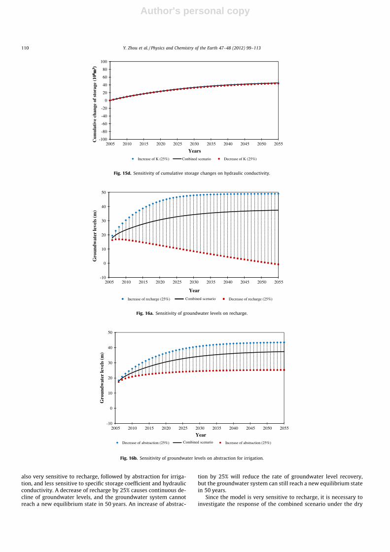
also very sensitive to recharge, followed by abstraction for irriga-tion, and less sensitive to specific storage coefficient and hydraulicconductivity. A decrease of recharge by 25% causes continuous de-cline of groundwater levels, and the groundwater system cannotreach a new equilibrium state in 50 years. An increase of abstrac-
tion by 25% will reduce the rate of groundwater level recovery,but the groundwater system can still reach a new equilibrium statein 50 years.
Since the model is very sensitive to recharge, it is necessary toinvestigate the response of the combined scenario under the dry
-20
0
20
40
60
80
100
8 m3 )
-100
-80
-60
-40
2005 2010 2015 2020 2025 2030 2035 2040 2045 2050 2055
Cum
ulat
ive
chan
ge o
f st
orag
e (1
08 m3 )
Years
Increase of K (25%) Conbined scenario Decrease of K (25%)
Fig. 15d. Sensitivity of cumulative storage changes on hydraulic conductivity.
-10
0
10
20
30
40
50
2005 2010 2015 2020 2025 2030 2035 2040 2045 2050 2055
Gro
undw
ater
leve
ls (m
)
Year
Increase of recharge (25%) Combined scenario Decrease of recharge (25%)
Fig. 16a. Sensitivity of groundwater levels on recharge.
20
30
40
50
-10
0
10
2005 2010 2015 2020 2025 2030 2035 2040 2045 2050 2055
Gro
undw
ater
leve
ls (m
)
Year
Decrease of abstraction (25%) Combined scenario Increase of abstraction (25%)
Fig. 16b. Sensitivity of groundwater levels on abstraction for irrigation.
110 Y. Zhou et al. / Physics and Chemistry of the Earth 47–48 (2012) 99–113

Author's personal copy
years. The average annual precipitation from 1999 to 2006 is488 mm/a, and was used as the precipitation for the dry years.
Fig. 17 shows the response of cumulative storage changes(Fig. 17a) and groundwater levels (Fig. 17b) under the dry years.
-10
0
10
20
30
40
50
2005 2010 2015 2020 2025 2030 2035 2040 2045 2050 2055
Gro
undw
ater
leve
ls (m
)
YearDecrease of specific storage (25%) Combined scenario Increase of specific storage (25%)
-10
0
10
20
30
40
50
Fig. 16c. Sensitivity of groundwater levels on storage coefficient.
20
30
40
50
-10
0
10
20
30
40
50
2005 2010 2015 2020 2025 2030 2035 2040 2045 2050 2055
Gro
undw
ater
leve
ls (m
)
YearDecrease of K (25%) Combined scenario Increase of K (25%)
Fig. 16d. Sensitivity of groundwater levels on hydraulic conductivity.
-100
-80
-60
-40
-20
0
20
40
60
80
100
2005 2010 2015 2020 2025 2030 2035 2040 2045 2050 2055
Cum
ulat
ive
chan
ge f
o st
orag
e (1
08m
3 )
YearsNormal year Dry year
Fig. 17a. Response of cumulative storage changes under the dry years.
Y. Zhou et al. / Physics and Chemistry of the Earth 47–48 (2012) 99–113 111

Author's personal copy
It is clear that groundwater storage is depleted during the dryyears, but the rate of decrease in groundwater levels is much smal-ler comparing to the business as usual scenario (Fig. 11). It is ex-pected that the depleted storage would be recovered during thewet years.
6. Concluding remarks
Large scale groundwater development in Beijing Plain has sup-ported the rapid social and economic development of Beijing Cityin last 30 years. Construction of emergency well fields has helpedthe Beijing City to cope with severe consecutive drought lastedfrom 1999 to 2006. However, present groundwater developmentin Beijing Plain is not sustainable. Simulation of the business asusual scenario indicates continuous rapid decline of groundwaterlevels leading to fast depletion of groundwater storage. Water scar-city is a reality in Beijing City. Implementation of water savingmeasures has controlled the annual water demand at around4000 � 106 m3 in last 20 years. The re-use of wastewater has allo-cated environmental flow for urban water systems and reducedirrigation use of groundwater. These measures have reduced watershortage situation, but have not fundamentally changed water bal-ance deficits. The middle route of South to North water transferproject to transport water from Yangtze river to Beijing City pro-vides the opportunity to restore depleted groundwater resourcesand eventually to achieve hydrological sustainability of groundwa-ter use. When the first transferred water arrives at Beijing in 2014,this water could be used to substitute groundwater abstraction.The plan of rehabilitation of Yongding and Chaobai rivers providesgood opportunity for artificial groundwater recharge through riv-erbeds consisting of thick layers of gravels and coarse sands. Thereduction of abstraction scenario would have immediate and fastrecovery of groundwater levels in the deep aquifers, especially atthe cone of depression, while artificial groundwater rechargewould replenish groundwater resources and maintain the presentwater supply well fields. The simulation of the combined scenarioof a reduction of abstraction by 400 � 106 m3/year and an increaseof recharge by 200 � 106 m3/year indicates that an approximatenew equilibrium state would be reached in 50 years. A hydrologi-cal sustainability of groundwater development could then beachieved.
The sensitivity analysis of the combined scenario indicates thatthe cumulative groundwater storage changes and groundwaterlevels are very sensitive to recharge and abstraction for irrigation.A decrease of recharge by 25% will cause rapid depletion of ground-
water storage and continuous decline of groundwater levels, sothat the groundwater system cannot reach a new equilibrium statein 50 years. An increase of abstraction by 25% will reduce the rateof groundwater level recovery, but the groundwater system canstill reach a new equilibrium state in 50 years.
The ecological, economical, and social sustainability of the com-bined scenario for groundwater development in Beijing Plainshould be investigated in future research. The water footprintmethod may be used to analyse water use policy in order to furtherreduce groundwater use for irrigation (Ma et al., 2006; Liu andSavenije, 2008).
References
Alley, W.M., Reilly, T.E., Franke, O.L., 1999. Sustainability of Ground-WaterResources. US Geological Survey Circular 1186.
Beijing Annals Committee, 2002. The Annals of Beijing Water Supply. BeijingPublishing (in Chinese).
Beijing Engineering Geological Survey Institute, 2007. Investigation and Monitoringof Land Subsidence in Beijing (Internal Report in Chinese).
Beijing Geo-environmental Monitoring Station, 2002. Second Round GroundwaterResources Assessment in Beijing (Internal Report in Chinese).
Beijing Geological Survey, 2008. Groundwater Storage Strategy with Diverted Waterfrom South to North Water Transfer Project (Internal Report in Chinese), 30p.
Beijing Hydrogeological and Engineering Geological Survey, 1982. GroundwaterResources Evaluation in Beijing (Internal Report in Chinese).
Beijing Hydrogeological and Engineering Geological Survey, 2004. Geo-environmental Assessment of Beijing Section of South to North WaterTransfer Project (Internal Report in Chinese), 50p.
Beijing Statistics Bureau, 2009. Beijing Statistical Year Book (in Chinese).Beijing Water Authority, 2005. Water Resources Bullet of Beijing: 1995–2005
(Internal Report in Chinese).Beijing Water Authority, 2006. The 11th 5 year Plan of Water Resources
Development and Protection in Beijing (Internal Report in Chinese).Beijing Water Authority, 2009. Plan for Rehabilitation and Ecological Corridor
Construction of Yongding River (Internal Report in Chinese).Bredehoeft, J.D., 2002. The water budget myth revisited: why hydrogeologists
model. Ground Water 40 (4), 340–345.Brigham Young University – Environmental Modelling Research Laboratory, 2000.
Groundwater Modelling System (GMS), GMS 3.1 Tutorials.Construction Committee of South to North Water Diversion, 2008. The Middle
Route of the South to North Water Transfer Project. <http://www.nsbd.gov.cn/zx/english/mrp.htm>.
Galloway, D.L., Alley, W.M., Barlow, P.M., Reilly, T.E., Tucci, P., 2003. Evolving Issuesand Practices in Managing Groundwater Resources: Case Studies on the Role ofScience. US Geological Survey Circular 1247.
Jia, Zheng, Yanbing, Dou, Jingli, Shao, Yali, Cui, et al., 2009. Prediction ofgroundwater level changes in western Beijing area after the completion ofSouth to North Water Transfer project. Geotech. Invest. Survey. 5, 22.
Lei, Wang, Shumei, Ren, 2003. South to North Water Transfer project and waterallocation in Beijing. In: Proceedings of Water and Olympics, Beijing, China.
Liu, J., Savenije, H.H.G., 2008. Food Consumption Patterns and Their Effect on WaterRequirement in China. Value of Water, Research Report Series No. 30. UNESCO-IHE, Delft, The Netherlands, 40p.
20
30
40
50
-10
0
10
20
30
40
50
2005 2010 2015 2020 2025 2030 2035 2040 2045 2050 2055
Gro
undw
ater
leve
ls (m
)
Year
Dry years Normal year
Fig. 17b. Response of groundwater levels under the dry years.
112 Y. Zhou et al. / Physics and Chemistry of the Earth 47–48 (2012) 99–113

Author's personal copy
Llamas, M.R., Martinez-Santos, P., de la Hera, A., 2006. The manifold dimensions ofgroundwater sustainability: an overview. In: Ragone, S., de la Hera, A.,Hernandez-Mora, N. (Eds.), Proceedings of the International Symposium onGroundwater Sustainability, National Ground Water Association Press, Ohio,USA, pp. 105–116. ISBN 1-56034-131-9
Ma, J., Hoekstra, A.Y., Wang, H., Chapagain, A.K., Wang, D., 2006. Virtual versus realwater transfers within China. Philos. Trans. Roy. Soc. B 361, 835–842.doi:10.1098/rstb.2005.1644.
McDonald, M.G., Harbaugh, A.W., 1988. A Modular Three-Dimensional Finite-Difference Ground-Water Flow Model. US Geological Survey Open-File Report83-875, Book 6.
Rijsberman, F.R., 2004. Water scarcity: fact or fiction? In: Proceedings of the 4thInternational Crop Science Congress of New Directions for a Diverse Planet,Brisbane, Australia. <http://www.cropscience.org.au>.
Rong, Zhao, Zhenhai, Li, Qiumei, Zhu, 2010. Environmental impact on groundwaterand countermeasures of the Beijing Section of the Middle Route of the South toNorth Water Transfer project. J. South North Water Trans, Water Sci. Technol. 4.
Shibo, Hui, Senchuan, Xie, Sicong, Zhang, 2001. Allocation of Water Resources inBeijing with Diverted Water from South to North Water Transfer Project. ChinaWater Resources, Special Subject, vol. 1, pp. 14–16.
Weiping, Wang, Baode, Wu, Sanman, Jia, Yi, Wang, 2009. Ecological environmentalimpact assessment of Beijing section of South to North Water Transfer project.Chin. J. Geol. Hazard Control 20 (2), 70–75.
Xie, Z.H., Wang, Y.H., Zhang, S.C., 2003, Investigation and Assessment ofGroundwater Resources and Environment in Beijing (Internal Report inChinese).
Yang, H., Zehnder, A., 2001. China’s regional water scarcity and implications forgrain supply and trade. Environ. Plan. 33, 79–95.
Yu, Liu, Ying, Sun, Kun, Yin, 2005. Prediction of groundwater environment in Beijingafter the completion of South to North Water Transfer project. J. Hydrogeol. Eng.Geol. 5, 93–96.
Zhou, Y., 2009. A critical review of groundwater budget myth, safe yield andsustainability. J. Hydrol. 370, 207–213.
Y. Zhou et al. / Physics and Chemistry of the Earth 47–48 (2012) 99–113 113