Optimal exploitation of AMSR-E signals for improving soil moisture estimation through land data...
12
IEEE TRANSACTIONS ON GEOSCIENCE AND REMOTE SENSING, VOL. 51, NO. 1, JANUARY 2013 399 Optimal Exploitation of AMSR-E Signals for Improving Soil Moisture Estimation Through Land Data Assimilation Long Zhao, Kun Yang, Jun Qin, and Yingying Chen Abstract—Regional soil moisture can be estimated by assimilat- ing satellite microwave brightness temperature into a land surface model (LSM). This paper explores how to improve soil moisture estimation based on sensitivity analysis when assimilating Ad- vanced Microwave Scanning Radiometer for the Earth Observing System brightness temperatures. By assimilating a lower and a higher frequency combination, the land data assimilation system (LDAS) used in this paper estimates first model parameters in a calibration pass and then estimates soil moisture in an assimila- tion pass. The ground truth of soil moisture was collected at a soil moisture network deployed in a semiarid area of Mongolia. Analyzed are the effects of assimilating different polarizations, frequencies, and satellite overpass times on the accuracy of the estimated soil moisture. The results indicate that assimilating the horizontal polarization signal underestimates soil moisture and assimilating the daytime signal overestimates soil moisture. The former is due to improper parameter estimation perhaps caused by high sensitivity of the horizontal polarization to land surface heterogeneity, and the latter is due to the effective soil temperature for microwave emission in the daytime being close to the one at a soil depth of several centimeters but not to the surface skin temper- ature simulated in the LSM. Therefore, assimilating the nighttime vertical polarizations in the LDAS is recommended. A further analysis shows that assimilating different frequency combinations produces different soil moisture estimates, and none is always superior to the others, because different frequency signals may be contaminated by varying clouds and/or water vapor with different degrees. Thus, an ensemble estimation based on frequency combi- nations was proposed to filter off, to some extent, the stochastic frequency-dependent biases. The ensemble estimation performs more robust when driven by different forcing data. Index Terms—Advanced Microwave Scanning Radiometer for the Earth Observing System (AMSR-E), frequency-based ensem- ble, land data assimilation system (LDAS), soil moisture. Manuscript received November 13, 2011; revised February 20, 2012; ac- cepted April 15, 2012. Date of publication June 15, 2012; date of current version December 19, 2012. This work was supported in part by the Global Change Program of the Ministry of Science and Technology of China under Grant 2010CB951703, by the CMA Special Fund for Scientific Research in the Public Interest under Grant GYHY201206008, and by the “Hundred-Talent” Program of the Chinese Academy of Sciences. L. Zhao is with the Key Laboratory of Tibetan Environment Changes and Land Surface Processes, Institute of Tibetan Plateau Research, Chinese Academy of Sciences, Beijing 100085, China, and also with the Graduate Uni- versity of the Chinese Academy of Sciences, Beijing 100049, China (e-mail: [email protected]). K. Yang, J. Qin, and Y. Chen are with the Key Laboratory of Tibetan Environment Changes and Land Surface Processes, Institute of Tibetan Plateau Research, Chinese Academy of Sciences, Beijing 100085, China (e-mail: [email protected]; [email protected]; [email protected]). Digital Object Identifier 10.1109/TGRS.2012.2198483 I. I NTRODUCTION S OIL moisture plays an important role in terrestrial water cycle and land–atmosphere interactions [1], [2], particu- larly in semiarid regions where strong coupling between soil moisture and precipitation occurs [3]. Data assimilation is a promising way to estimate land state variables, including soil moisture with acceptable accuracy and high-temporal reso- lution, and has been widely developed [4]–[8]. Considering the importance of model parameters, some pioneer studies developed different assimilation methods to simultaneously estimate both model parameters and state variables [9], [10]. In addition, it is widely recognized that assimilating microwave data can improve surface soil moisture estimation [11]–[13]. Nevertheless, it is not yet clear how different microwave signals (i.e., polarization, frequency, and satellite overpass time) may affect the accuracy of the estimated soil moisture in a data assimilation system, although previous studies have provided some experiences in soil moisture estimation through remote sensing or data assimilation, as summarized hereinafter. First, different information contained in vertically and hori- zontally polarized microwave signals has been investigated by many researchers. Njoku and Entekhabi [14] indicated that the increase of vegetation can obviously decrease the sensitivity of brightness temperature to soil moisture. As summarized by Prigent et al. [15], the surface emissivity for vertical polar- ization decreases with increasing soil moisture and vegetation density; the emissivity for horizontal polarization decreases with increasing soil moisture, too, but it increases with in- creasing vegetation density. In addition, the relationships of the polarizations with soil moisture and vegetation density are frequency-dependent, and polarization ratios are often used to derive soil moisture and vegetation information [16], [17]. Assimilating different polarizations of microwave signals may yield different soil moisture estimates, because they exhibit different sensitivities to soil moisture. Yang et al. [10] selected vertical polarizations to be assimilated into a land surface model (LSM), which was followed by Qin et al. [18]. Tian et al. [19] assimilated both polarized signals into an LDAS, which showed that assimilating the vertical one generated reasonable soil moisture estimates, whereas assimilating the horizontal one produced time-invariant soil moisture estimates. The results in [19] are preliminary, because their assimilation is not a full LSM. Further studies are needed to examine which polarization signals (vertical or horizontal) should be assimilated in order to better estimate soil moisture. Second, polar-orbit satellites carrying microwave radiome- ters usually revisit the same place twice a day. For example, 0196-2892/$31.00 © 2012 IEEE
Transcript of Optimal exploitation of AMSR-E signals for improving soil moisture estimation through land data...

IEEE TRANSACTIONS ON GEOSCIENCE AND REMOTE SENSING, VOL. 51, NO. 1, JANUARY 2013 399
Optimal Exploitation of AMSR-E Signalsfor Improving Soil Moisture Estimation
Through Land Data AssimilationLong Zhao, Kun Yang, Jun Qin, and Yingying Chen
Abstract—Regional soil moisture can be estimated by assimilat-ing satellite microwave brightness temperature into a land surfacemodel (LSM). This paper explores how to improve soil moistureestimation based on sensitivity analysis when assimilating Ad-vanced Microwave Scanning Radiometer for the Earth ObservingSystem brightness temperatures. By assimilating a lower and ahigher frequency combination, the land data assimilation system(LDAS) used in this paper estimates first model parameters in acalibration pass and then estimates soil moisture in an assimila-tion pass. The ground truth of soil moisture was collected at asoil moisture network deployed in a semiarid area of Mongolia.Analyzed are the effects of assimilating different polarizations,frequencies, and satellite overpass times on the accuracy of theestimated soil moisture. The results indicate that assimilating thehorizontal polarization signal underestimates soil moisture andassimilating the daytime signal overestimates soil moisture. Theformer is due to improper parameter estimation perhaps causedby high sensitivity of the horizontal polarization to land surfaceheterogeneity, and the latter is due to the effective soil temperaturefor microwave emission in the daytime being close to the one at asoil depth of several centimeters but not to the surface skin temper-ature simulated in the LSM. Therefore, assimilating the nighttimevertical polarizations in the LDAS is recommended. A furtheranalysis shows that assimilating different frequency combinationsproduces different soil moisture estimates, and none is alwayssuperior to the others, because different frequency signals may becontaminated by varying clouds and/or water vapor with differentdegrees. Thus, an ensemble estimation based on frequency combi-nations was proposed to filter off, to some extent, the stochasticfrequency-dependent biases. The ensemble estimation performsmore robust when driven by different forcing data.
Index Terms—Advanced Microwave Scanning Radiometer forthe Earth Observing System (AMSR-E), frequency-based ensem-ble, land data assimilation system (LDAS), soil moisture.
Manuscript received November 13, 2011; revised February 20, 2012; ac-cepted April 15, 2012. Date of publication June 15, 2012; date of currentversion December 19, 2012. This work was supported in part by the GlobalChange Program of the Ministry of Science and Technology of China underGrant 2010CB951703, by the CMA Special Fund for Scientific Research in thePublic Interest under Grant GYHY201206008, and by the “Hundred-Talent”Program of the Chinese Academy of Sciences.
L. Zhao is with the Key Laboratory of Tibetan Environment Changesand Land Surface Processes, Institute of Tibetan Plateau Research, ChineseAcademy of Sciences, Beijing 100085, China, and also with the Graduate Uni-versity of the Chinese Academy of Sciences, Beijing 100049, China (e-mail:[email protected]).
K. Yang, J. Qin, and Y. Chen are with the Key Laboratory of TibetanEnvironment Changes and Land Surface Processes, Institute of Tibetan PlateauResearch, Chinese Academy of Sciences, Beijing 100085, China (e-mail:[email protected]; [email protected]; [email protected]).
Digital Object Identifier 10.1109/TGRS.2012.2198483
I. INTRODUCTION
SOIL moisture plays an important role in terrestrial watercycle and land–atmosphere interactions [1], [2], particu-
larly in semiarid regions where strong coupling between soilmoisture and precipitation occurs [3]. Data assimilation is apromising way to estimate land state variables, including soilmoisture with acceptable accuracy and high-temporal reso-lution, and has been widely developed [4]–[8]. Consideringthe importance of model parameters, some pioneer studiesdeveloped different assimilation methods to simultaneouslyestimate both model parameters and state variables [9], [10].In addition, it is widely recognized that assimilating microwavedata can improve surface soil moisture estimation [11]–[13].Nevertheless, it is not yet clear how different microwave signals(i.e., polarization, frequency, and satellite overpass time) mayaffect the accuracy of the estimated soil moisture in a dataassimilation system, although previous studies have providedsome experiences in soil moisture estimation through remotesensing or data assimilation, as summarized hereinafter.
First, different information contained in vertically and hori-zontally polarized microwave signals has been investigated bymany researchers. Njoku and Entekhabi [14] indicated that theincrease of vegetation can obviously decrease the sensitivityof brightness temperature to soil moisture. As summarized byPrigent et al. [15], the surface emissivity for vertical polar-ization decreases with increasing soil moisture and vegetationdensity; the emissivity for horizontal polarization decreaseswith increasing soil moisture, too, but it increases with in-creasing vegetation density. In addition, the relationships ofthe polarizations with soil moisture and vegetation density arefrequency-dependent, and polarization ratios are often usedto derive soil moisture and vegetation information [16], [17].Assimilating different polarizations of microwave signals mayyield different soil moisture estimates, because they exhibitdifferent sensitivities to soil moisture. Yang et al. [10] selectedvertical polarizations to be assimilated into a land surface model(LSM), which was followed by Qin et al. [18]. Tian et al. [19]assimilated both polarized signals into an LDAS, which showedthat assimilating the vertical one generated reasonable soilmoisture estimates, whereas assimilating the horizontal oneproduced time-invariant soil moisture estimates. The results in[19] are preliminary, because their assimilation is not a fullLSM. Further studies are needed to examine which polarizationsignals (vertical or horizontal) should be assimilated in order tobetter estimate soil moisture.
Second, polar-orbit satellites carrying microwave radiome-ters usually revisit the same place twice a day. For example,
0196-2892/$31.00 © 2012 IEEE
400 IEEE TRANSACTIONS ON GEOSCIENCE AND REMOTE SENSING, VOL. 51, NO. 1, JANUARY 2013
the Earth Observing System (EOS) Aqua satellite crosses theequator at about local solar time (LST) 1:30 P.M. in the ascend-ing mode and LST 1:30 A.M. in the descending mode everyday. The on-board Advanced Microwave Scanning Radiometerfor the Earth Observing System (AMSR-E) sensor provides adaytime measurement and a nighttime measurement. As a mat-ter of fact, both daytime and nighttime brightness temperaturescontain soil moisture information. Previous studies commonlyuse nighttime brightness temperature for soil moisture retrievaldue to its stability [16], but it is valuable to explore the feasibil-ity of assimilating the daytime observations in order to reduceuncertainties in soil moisture estimates.
Third, after the suitable polarization and orbit microwavesignals are confirmed, it is still important to choose a suit-able frequency or frequency combination of microwave datafor soil moisture retrieval. Microwave signal at L-band is anideal choice for soil moisture retrieval [14], [20] but absent inglobal applications until recent years [21]–[23]. Consideringthe measuring frequencies employed in AMSR-E, previousstudies usually use C-band and X-band microwave signals toderive soil moisture or vegetation properties [17], [24]. Jacksonand Hsu [25] also indicated that microwave observations at10-GHz frequency have the potential for improving soilmoisture estimates, as adopted by some researchers [26].Vinnikov et al. [27] showed that microwave observations withfrequencies less than or equal to 18 GHz are useful informationsources for retrieving soil moisture over sparse vegetation.Meanwhile, Prigent et al. [15] pointed out that microwaveobservations at frequencies greater than or equal to 19 GHzare more sensitive to vegetation than to soil moisture. Regard-ing AMSR-E, these studies suggest that microwave brightnesstemperatures at frequencies of 6.9 and 10.7 GHz contain moresoil moisture information, whereas those at higher frequencies(except 89.0 GHz that is mainly used for snow-water equiva-lent estimate) contain more vegetation information. Therefore,a combination of 6.9-GHz (or 10.7-GHz) and 18.7-GHz (orhigher frequency) signals is likely to filter off the influenceof vegetation and get better estimates of soil moisture, but itis not clear how such a frequency combination may affect theaccuracy of soil moisture estimation.
This paper is intended to explore the optimal use of AMSR-Esignals for improving soil moisture estimation in a dual-pass LDAS developed at The University of Tokyo byYang et al. [10]. Compared to the AMSR-E sensor, recentmicrowave sensors can provide better soil moisture estimates,such as the on-board METOP-A (the first satellite of theMeteorological Operational satellite programme) AdvancedScatterometer (ASCAT) (C-band) [28], the Soil Moisture andOcean Salinity (SMOS) mission (L-band) [21], and the plannedSoil Moisture Active Passive (SMAP) mission (L-band) [29].The individual sensors may have radio frequency interference(RFI) in different regions; for instance, the RFI of SMOS issevere in China [30], while the RFI of AMSR-E at 10.7 GHzis not evident in Asia, except in Japan [31]. Considering thatthe AMSR-E provided a long-term data set and, particularly, itfills the gap in time window since its launch until 2006 whensoil moisture from other missions became available, this paperwill test the sensitivity of soil moisture estimates to assimi-lated AMSR-E signals (different polarizations, frequencies, andsatellite overpass times) in the dual-pass LDAS. This LDASapplies a time-split approach to estimate model parameters
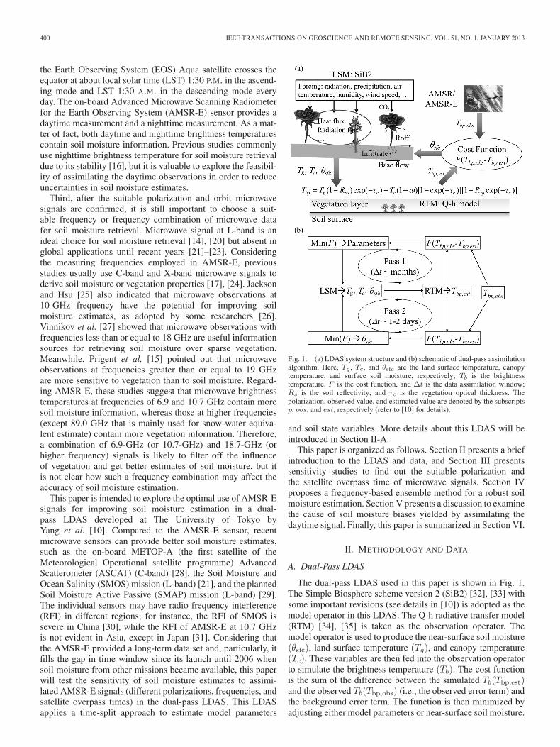
Fig. 1. (a) LDAS system structure and (b) schematic of dual-pass assimilationalgorithm. Here, Tg , Tc, and θsfc are the land surface temperature, canopytemperature, and surface soil moisture, respectively; Tb is the brightnesstemperature, F is the cost function, and Δt is the data assimilation window;Rs is the soil reflectivity; and τc is the vegetation optical thickness. Thepolarization, observed value, and estimated value are denoted by the subscriptsp, obs, and est, respectively (refer to [10] for details).
and soil state variables. More details about this LDAS will beintroduced in Section II-A.
This paper is organized as follows. Section II presents a briefintroduction to the LDAS and data, and Section III presentssensitivity studies to find out the suitable polarization andthe satellite overpass time of microwave signals. Section IVproposes a frequency-based ensemble method for a robust soilmoisture estimation. Section V presents a discussion to examinethe cause of soil moisture biases yielded by assimilating thedaytime signal. Finally, this paper is summarized in Section VI.
II. METHODOLOGY AND DATA
A. Dual-Pass LDAS
The dual-pass LDAS used in this paper is shown in Fig. 1.The Simple Biosphere scheme version 2 (SiB2) [32], [33] withsome important revisions (see details in [10]) is adopted as themodel operator in this LDAS. The Q-h radiative transfer model(RTM) [34], [35] is taken as the observation operator. Themodel operator is used to produce the near-surface soil moisture(θsfc), land surface temperature (Tg), and canopy temperature(Tc). These variables are then fed into the observation operatorto simulate the brightness temperature (Tb). The cost functionis the sum of the difference between the simulated Tb(Tbp,est)and the observed Tb(Tbp,obs) (i.e., the observed error term) andthe background error term. The function is then minimized byadjusting either model parameters or near-surface soil moisture.
ZHAO et al.: OPTIMAL EXPLOITATION OF AMSR-E SIGNALS FOR IMPROVING SOIL MOISTURE ESTIMATION 401
This assimilation system adopts a time-split approach. Asshown in Fig. 1(b), pass 1, the so-called calibration pass, isused to optimize model parameters with a long-term assimi-lation window (several months). The optimized parameters arethen transferred into pass 2, the so-called assimilation pass, toestimate soil moisture with a short-term assimilation window(approximately one day). Pass 1 merely needs a single execu-tion, whereas pass 2 is a normal data assimilation pass. Theessence of the dual-pass LDAS is that the model parameters areconsidered time-invariant and have a long-term effect on modelstate variables (e.g., θsfc, Tg, Tc), and thus, they are estimatedwithin a relatively long time window. By contrast, the surfacesoil state variables change rapidly, and therefore, they may beestimated within a relatively short time window.
In pass 1, a combination of two microwave signals withdifferent frequencies is used to define a soil wetness index(SWI) [18]
SWI =TF1bq
TF2bq
(1)
where TF1bq is a higher frequency of AMSR-E brightness
temperature, TF2bq is a lower frequency one, and q denotes
polarization. A high SWI value corresponds to a wet surfacecondition, while a low value corresponds to a dry condition.
In pass 1, model parameters are obtained by explicitly mini-mizing the observation error term defined as
Fobs=1
2
tpass1∑t=0
[(TF1bq,est−TF1
b,obs
)2+(TF2bq,est−TF2
b,obs
)2](2)
where the subscripts obs and est denote the observed and thesimulated value, respectively.
The background error term in pass 1 is related to SWI andis implicitly taken into account by adjusting the near-surfacesoil moisture at each observing time such that the recalculatedSWI is close to (SWIest,bg + SWIobs)/2. Here, SWIest,bgis the estimated background SWI at the observing time, andSWIobs is the observed SWI. Note that the observation errorterm is taken into account for the entire calibration period, butthe background error term is considered at each observing time.
In pass 2, the near-surface soil moisture is estimated with anassimilation window (tpass2) of one day. The cost function inpass 2 is defined as
Fobs =1
2
tpass2∑t=0
[(TF1bq,est − TF1
b,obs
)2+(TF2bq,est − TF2
b,obs
)2]
+1
2
[(TF1bq0,bg − TF1
bq0
)2+(TF2bq0,bg − TF2
bq0
)2](3)
where Tbq0,bg is the simulated brightness temperature at theinitial time of each assimilation cycle using the backgroundvalue of near-surface soil moisture (θsfc) and Tbq0 is therenewed one.
This design of the dual-pass or the time-split approach isdistinct from other methods that estimate state variables andparameters simultaneously or adaptively by state augmentationunder the framework of Kalman filter [36] or particle filter [18].
It also differs from the Kalman-filter- or particle-filter-baseddual-pass data assimilation [9], [37], in which both parametersand state variables are interactively estimated in a sequentialassimilation framework. The dual-pass LDAS was first appliedto a Coordinated Enhanced Observing Period (CEOP) [38]reference site over the Tibetan Plateau, and the results areencouraging [10], [39]. This dual-pass assimilation concept hasbeen further applied [19], [40], [41].
B. Data
The data include in situ measurements, AMSR-E microwaveobservations, and other LSM parameter data sets. They areintroduced as follows.
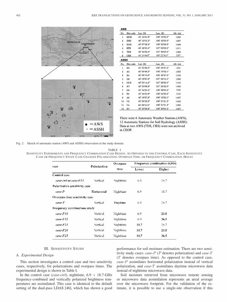
The in situ data were collected at a CEOP reference site inthe southern region of Ulaanbaatar, Mongolia. Soil moistureand related meteorological/hydrological variables within anarea of 160 km × 120 km were monitored by six automaticweather stations (AWSs) and 12 Automatic Stations of SoilHydrology (ASSH) (Fig. 2). Data at two AWSs (TDS and CRS)are not available. This semiarid region is covered by grasses.At the ASSH, soil moisture and temperature were measuredat depths of 3 and 10 cm with a time resolution of 60 min.The AWS measurements include air temperature, air humidity,wind speed, precipitation, air pressure, as well as soil moistureand temperature. All the data were archived in the CEOPdata sets. The high-quality data collected on this relativelyuniform ground surface provide an ideal test bed for evaluatingsoil moisture estimates through both remote sensing and dataassimilation. The near-surface soil moisture and temperaturedata measured at 3-cm depth at the ASSH and AWS are usedin this paper. The meteorological data at the AWS (hereinafterreferred to as observed forcing data) are averaged to drive theLDAS, except that downward radiations are taken from theGlobal Land Data Assimilation System (GLDAS) [4] 1◦ × 1◦
data, because they were not measured at these stations. Theperiod of concern is from May 1 to September 27, 2003, duringwhich soil moisture exhibited great temporal variability due tomonsoon precipitation. All the data are available online via theCEOP website (http://www.ceop.net/).
The satellite microwave signals were observed by theAMSR-E sensor onboard the National Aeronautics and SpaceAdministration (NASA) EOS Aqua satellite, which providesglobal passive microwave measurements at six frequencies (6.9,10.7, 18.7, 23.8, 36.5, and 89.0 GHz) and both the horizontaland vertical polarizations at a viewing angle of 55◦ from swathspace to grids. In this paper, the data used are the AMSR-E/Aqua Daily Global Quarter-Degree Gridded Brightness Tem-peratures product [42] that were available at the National Snowand Ice Data Center (NSIDC).
Other parameters needed to run an LSM are derived fromseveral data sets. Leaf area index (LAI) is obtained from Mod-erate Resolution Imaging Spectroradiometer (MODIS) 0.25◦ ×0.25◦ gridded eight-day leaf area index products [43]. Soilparameters (thermal and hydraulic properties) are optimizedthrough data assimilation, but they are initialized with 1◦ × 1◦
International Satellite Land Surface Climatology Project(ISLSCP) Initiative II soil data [44]. Vegetation type and cov-erage come from 1◦ × 1◦ ISLSCP Initiative II vegetation data[45]. The other vegetation properties are set as default in SiB2.
402 IEEE TRANSACTIONS ON GEOSCIENCE AND REMOTE SENSING, VOL. 51, NO. 1, JANUARY 2013
Fig. 2. Sketch of automatic-station (AWS and ASSH) observation in the study domain.
TABLE ISENSITIVITY EXPERIMENTS AND FREQUENCY COMBINATION CASE DESIGN. AS OPPOSED TO THE CONTROL CASE, EACH SENSITIVITY
CASE OR FREQUENCY STUDY CASE CHANGES POLARIZATION, OVERPASS TIME, OR FREQUENCY COMBINATION (BOLD)
III. SENSITIVITY STUDY
A. Experimental Design
This section investigates a control case and two sensitivitycases, respectively, for polarizations and overpass times. Theexperimental design is shown in Table I.
In the control case (case-ctrl), nighttime, 6.9 + 18.7-GHzfrequency-combined and vertically polarized brightness tem-peratures are assimilated. This case is identical to the defaultsetting of the dual-pass LDAS [46], which has shown a good
performance for soil moisture estimation. There are two sensi-tivity study cases: case-P (P denotes polarization) and case-T(T denotes overpass time). As opposed to the control case,case-P assimilates horizontal polarization instead of verticalpolarization, and case-T assimilates daytime microwave datainstead of nighttime microwave data.
Soil moisture retrieved from microwave remote sensingor microwave data assimilation represents an areal averageover the microwave footprint. For the validation of the es-timate, it is possible to use a single-site observation if this
ZHAO et al.: OPTIMAL EXPLOITATION OF AMSR-E SIGNALS FOR IMPROVING SOIL MOISTURE ESTIMATION 403
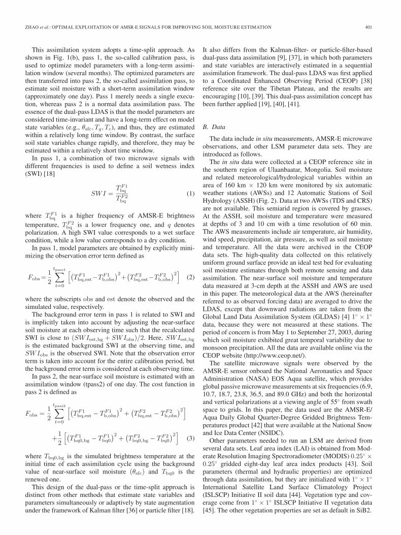
Fig. 3. Observed daily mean near-surface soil moisture variations at 12 ASSHand 4 AWSs.
site is highly representative for the corresponding footprintof the microwave sensor [47]. However, as pointed out byPrigent et al. [15], the representativeness of point measurementsfor regional applications is often questioned; this is mainlydue to the high spatial heterogeneity of soil moisture [46],[48]. Fig. 3 shows the observed daily mean near-surface (3-cm)soil moisture observations at all stations. All the stations havesimilar response to precipitation while exhibiting great spatialvariability. In addition, as indicated by some researchers [46],[49], regional-averaged soil moisture estimate is little affectedby subpixel heterogeneity of soil moisture and soil properties.Compared to point measurements, station-averaged soil mois-ture is likely to provide a reliable representation of the areal-average near-surface condition [50], [51]. Herein, we evaluatethe soil moisture estimate against the station-averaged dailymean near-surface soil moisture. First, the observed hourly dataare averaged to get daily mean time series at all the 16 stations(12 ASSH and 4 AWSs), and second, an average of all the sta-tion daily observations is used as the ground truth. Correlationcoefficient (R), mean bias error (MBE), and root-mean-squareerror (RMSE) between the estimated and the observed dailymean soil moisture are used to evaluate the LDAS performance.
B. General Results
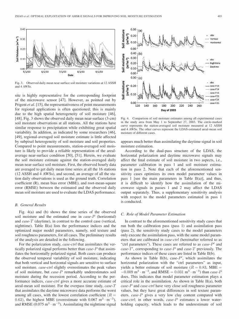
Fig. 4(a) and (b) shows the time series of the observedsoil moisture and the estimated one in case-P (horizontal)and case-T (daytime), in contrast to the control case (vertical,nighttime). Table II(a) lists the performance indices and theoptimized major model parameters, namely, soil texture andsoil roughness parameters, for all cases. The preliminary resultsof the analysis are detailed in the following.
For the polarization study, case-ctrl that assimilates the ver-tically polarized signal performs better than case-P that assim-ilates the horizontally polarized signal. Both cases can producethe observed temporal variability of soil moisture, indicatingthat both vertical and horizontal signals are sensitive to surfacesoil moisture. case-ctrl slightly overestimates the peak valuesof soil moisture, but case-P remarkably underestimates soilmoisture during the recession period. According to the per-formance indices, case-ctrl gives a more accurate estimate ofareal-mean soil moisture. For the overpass time study, case-Tthat assimilates the daytime microwave data performs the worstamong all cases, with the lowest correlation coefficient (R =0.62), the highest MBE (overestimate with 0.067 m3 · m−3),and RMSE (0.075 m3 · m−3). Assimilating the nighttime signal
Fig. 4. Comparison of soil moisture estimates among all experimental casesin the study area from May 1 to September 27, 2003. The circle-markedcurve represents the station-averaged soil moisture measured at 12 ASSHand 4 AWSs. The other curves represent the LDAS-estimated areal-mean soilmoisture of different cases.
appears much better than assimilating the daytime signal in soilmoisture estimation.
According to the dual-pass structure of the LDAS, thehorizontal polarization and daytime microwave signals mayaffect the final estimate of soil moisture in two aspects, i.e.,parameter calibration in pass 1 and soil moisture estima-tion in pass 2. Note that each of the aforementioned sen-sitivity cases optimizes its own model parameter values inpass 1 [see the main parameters in Table II(a)], and thus,it is difficult to identify how the assimilation of the mi-crowave signals in passes 1 and 2 may affect the LDASoutput separately. Thus, a supplementary sensitivity analysiswith respect to the model parameters estimated in pass 1is conducted.
C. Role of Model Parameter Estimation
In contrast to the aforementioned sensitivity study cases thatrun both the calibration pass (pass 1) and assimilation pass(pass 2), the sensitivity study cases to the model parametersonly execute the assimilation pass, with the same model param-eters that are calibrated in case-ctrl (hereinafter referred to as“ctrl parameters”). These cases are referred to as case-P ′ andcase-T ′, corresponding to case-P and case-T previously. Theperformance indices of these cases are listed in Table II(b).
As shown in Table II(b), case-P ′, which assimilates thehorizontal polarization with the “ctrl parameters” as input,yields a better estimate of soil moisture (R = 0.83, MBE =−0.009 m3 · m−3, and RMSE = 0.031 m3 · m−3) than case-Pdoes. This indicates that model parameter estimation plays acritical role in the assimilation. As shown in Table II(a), bothcase-P and case-ctrl have very close soil roughness parametervalues, but they have great differences in soil texture param-eters. case-P gives a very low clay content compared withcase-ctrl; in other words, case-P estimates a lower water-holding capacity, which leads to the underestimate of soil
404 IEEE TRANSACTIONS ON GEOSCIENCE AND REMOTE SENSING, VOL. 51, NO. 1, JANUARY 2013
TABLE IIPERFORMANCE INDICES OF ALL CASES ON SOIL MOISTURE ESTIMATION IN THE STUDY AREA FROM MAY 1 TO SEPTEMBER 27, 2003,TOGETHER WITH THE OPTIMIZED MODEL PARAMETERS (a) ORIGINAL SENSITITY STUDY CASES; (b) MODEL PARAMETER SENSITIVITY
moisture in the drying process. In principle, vertical polar-ization is less sensitive to changes in soil moisture than thehorizontal one [52], and thus, it is reasonable to use the hori-zontal polarization for soil moisture retrieval [53]. However, thehorizontal polarization is also sensitive to land surface hetero-geneity, while the vertical one is not so [54]. As a consequence,the former is not suitable for optimizing model parameters,because the LSM in the LDAS does not explicitly take landsurface heterogeneity into account. Given proper parametervalues, retrievals from the horizontally polarized signal witha consideration of land surface heterogeneity can produce areliable soil moisture estimate, as shown by Fujii et al. [54].
According to the performance statistics in Table II(b),case-T ′, which assimilates the daytime polarization with the“ctrl parameters” as input, only slightly improves soil moistureestimation (R = 0.59, MBE = 0.033 m3 · m−3, and RMSE =0.045 m3 · m−3) than case-T does. This poor performance isnot only attributed to different values of the surface roughnessparameters [see Table II(a)] but also due to another problem thatwill be discussed in Section V.
According to the preceding analysis, the vertically polarizednighttime microwave signals are the most suitable in the currentLDAS for soil moisture estimation. The next focus is howto optimally use nighttime vertical polarization with differentfrequency combinations for soil moisture estimations, as willbe presented in the next section.
IV. FREQUENCY-BASED ENSEMBLE ESTIMATION
A. Frequency Combination Study
Several cases are designed to investigate the performanceof the LDAS under different frequency combinations. All ofthem employ the vertically polarized signals, as shown inTable I. Case-F (F denotes frequency) changes the frequencycombination used in the dual-pass LDAS (here, we use Arabicnumbers 1–5 to denote frequencies of 6.9, 10.7, 18.7, 23.8, and36.5 GHz, respectively), and case-ctrl is the control case that
Fig. 5. LDAS-estimated soil moisture of all frequency combination casescompared with observed areal-mean daily near-surface soil moisture. (a) Drivenby CEOP-observed forcing data. (b) Driven by GLDAS data.
assimilates signals with frequencies of 6.9 and 18.7 GHz, alsoreferred to as case-F13. The results are shown in Fig. 4(c) andTable II(a). Similar to case-P ′ and case-T ′, some supplemen-tary cases are designed to study the sensitivity of frequencycombinations on the model parameters, and the results areshown in Table II(b).
According to Table II(a), all frequency sensitivity cases pro-duce similar performance indices and similar model parametervalues, except for case-F15. case-F15, which yields a low claycontent (19.5%), also behaves similarly to case-P that under-estimates soil moisture during recession periods. In addition,when the “ctrl parameters” are used in pass 2, the performancesof all the sensitivity study cases to the model parameters do notshow significant differences compared to the original ones. Itis hard to find a frequency combination that is always muchsuperior to others. The estimate of one case may match the
ZHAO et al.: OPTIMAL EXPLOITATION OF AMSR-E SIGNALS FOR IMPROVING SOIL MOISTURE ESTIMATION 405
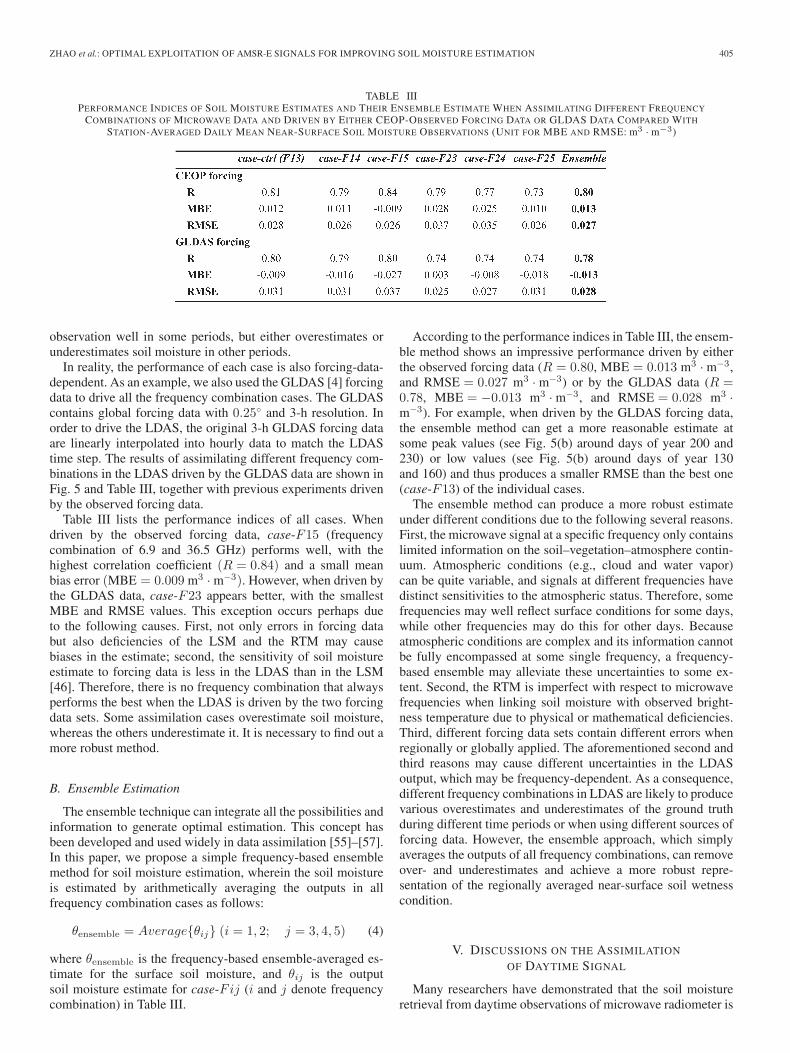
TABLE IIIPERFORMANCE INDICES OF SOIL MOISTURE ESTIMATES AND THEIR ENSEMBLE ESTIMATE WHEN ASSIMILATING DIFFERENT FREQUENCY
COMBINATIONS OF MICROWAVE DATA AND DRIVEN BY EITHER CEOP-OBSERVED FORCING DATA OR GLDAS DATA COMPARED WITH
STATION-AVERAGED DAILY MEAN NEAR-SURFACE SOIL MOISTURE OBSERVATIONS (UNIT FOR MBE AND RMSE: m3 · m−3)
observation well in some periods, but either overestimates orunderestimates soil moisture in other periods.
In reality, the performance of each case is also forcing-data-dependent. As an example, we also used the GLDAS [4] forcingdata to drive all the frequency combination cases. The GLDAScontains global forcing data with 0.25◦ and 3-h resolution. Inorder to drive the LDAS, the original 3-h GLDAS forcing dataare linearly interpolated into hourly data to match the LDAStime step. The results of assimilating different frequency com-binations in the LDAS driven by the GLDAS data are shown inFig. 5 and Table III, together with previous experiments drivenby the observed forcing data.
Table III lists the performance indices of all cases. Whendriven by the observed forcing data, case-F15 (frequencycombination of 6.9 and 36.5 GHz) performs well, with thehighest correlation coefficient (R = 0.84) and a small meanbias error (MBE = 0.009 m3 · m−3). However, when driven bythe GLDAS data, case-F23 appears better, with the smallestMBE and RMSE values. This exception occurs perhaps dueto the following causes. First, not only errors in forcing databut also deficiencies of the LSM and the RTM may causebiases in the estimate; second, the sensitivity of soil moistureestimate to forcing data is less in the LDAS than in the LSM[46]. Therefore, there is no frequency combination that alwaysperforms the best when the LDAS is driven by the two forcingdata sets. Some assimilation cases overestimate soil moisture,whereas the others underestimate it. It is necessary to find out amore robust method.
B. Ensemble Estimation
The ensemble technique can integrate all the possibilities andinformation to generate optimal estimation. This concept hasbeen developed and used widely in data assimilation [55]–[57].In this paper, we propose a simple frequency-based ensemblemethod for soil moisture estimation, wherein the soil moistureis estimated by arithmetically averaging the outputs in allfrequency combination cases as follows:
θensemble = Average{θij} (i = 1, 2; j = 3, 4, 5) (4)
where θensemble is the frequency-based ensemble-averaged es-timate for the surface soil moisture, and θij is the outputsoil moisture estimate for case-Fij (i and j denote frequencycombination) in Table III.
According to the performance indices in Table III, the ensem-ble method shows an impressive performance driven by eitherthe observed forcing data (R = 0.80, MBE = 0.013 m3 · m−3,and RMSE = 0.027 m3 · m−3) or by the GLDAS data (R =0.78, MBE = −0.013 m3 · m−3, and RMSE = 0.028 m3 ·m−3). For example, when driven by the GLDAS forcing data,the ensemble method can get a more reasonable estimate atsome peak values (see Fig. 5(b) around days of year 200 and230) or low values (see Fig. 5(b) around days of year 130and 160) and thus produces a smaller RMSE than the best one(case-F13) of the individual cases.
The ensemble method can produce a more robust estimateunder different conditions due to the following several reasons.First, the microwave signal at a specific frequency only containslimited information on the soil–vegetation–atmosphere contin-uum. Atmospheric conditions (e.g., cloud and water vapor)can be quite variable, and signals at different frequencies havedistinct sensitivities to the atmospheric status. Therefore, somefrequencies may well reflect surface conditions for some days,while other frequencies may do this for other days. Becauseatmospheric conditions are complex and its information cannotbe fully encompassed at some single frequency, a frequency-based ensemble may alleviate these uncertainties to some ex-tent. Second, the RTM is imperfect with respect to microwavefrequencies when linking soil moisture with observed bright-ness temperature due to physical or mathematical deficiencies.Third, different forcing data sets contain different errors whenregionally or globally applied. The aforementioned second andthird reasons may cause different uncertainties in the LDASoutput, which may be frequency-dependent. As a consequence,different frequency combinations in LDAS are likely to producevarious overestimates and underestimates of the ground truthduring different time periods or when using different sources offorcing data. However, the ensemble approach, which simplyaverages the outputs of all frequency combinations, can removeover- and underestimates and achieve a more robust repre-sentation of the regionally averaged near-surface soil wetnesscondition.
V. DISCUSSIONS ON THE ASSIMILATION
OF DAYTIME SIGNAL
Many researchers have demonstrated that the soil moistureretrieval from daytime observations of microwave radiometer is
406 IEEE TRANSACTIONS ON GEOSCIENCE AND REMOTE SENSING, VOL. 51, NO. 1, JANUARY 2013
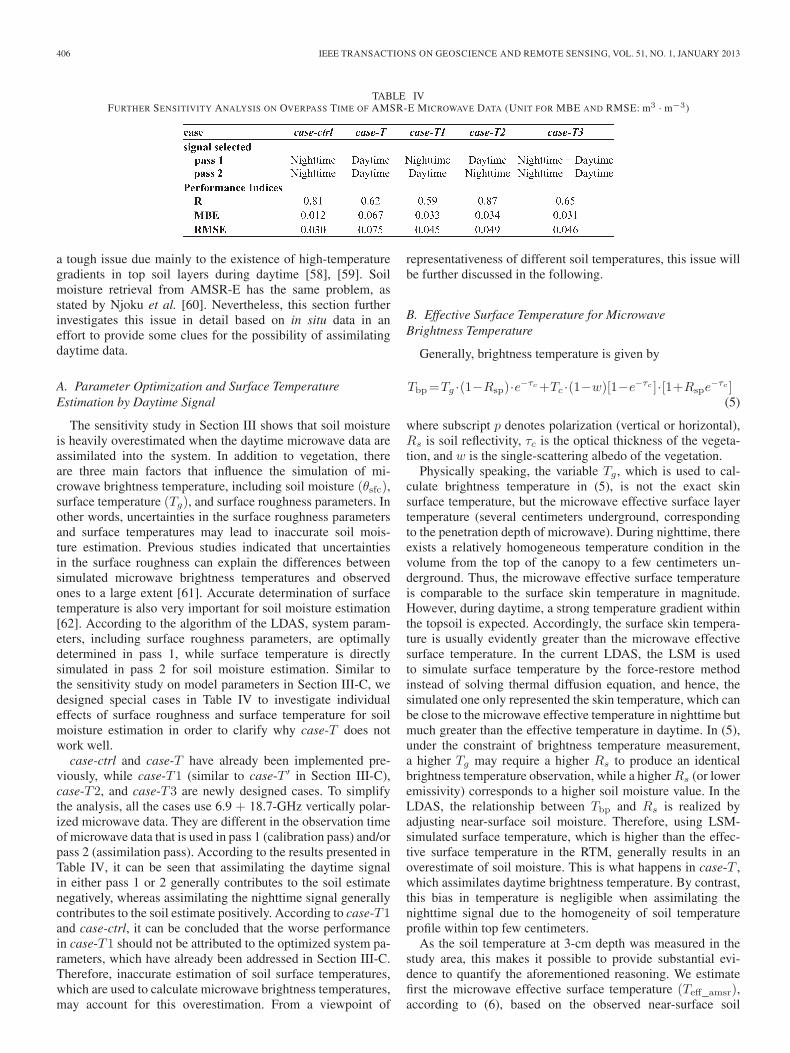
TABLE IVFURTHER SENSITIVITY ANALYSIS ON OVERPASS TIME OF AMSR-E MICROWAVE DATA (UNIT FOR MBE AND RMSE: m3 · m−3)
a tough issue due mainly to the existence of high-temperaturegradients in top soil layers during daytime [58], [59]. Soilmoisture retrieval from AMSR-E has the same problem, asstated by Njoku et al. [60]. Nevertheless, this section furtherinvestigates this issue in detail based on in situ data in aneffort to provide some clues for the possibility of assimilatingdaytime data.
A. Parameter Optimization and Surface TemperatureEstimation by Daytime Signal
The sensitivity study in Section III shows that soil moistureis heavily overestimated when the daytime microwave data areassimilated into the system. In addition to vegetation, thereare three main factors that influence the simulation of mi-crowave brightness temperature, including soil moisture (θsfc),surface temperature (Tg), and surface roughness parameters. Inother words, uncertainties in the surface roughness parametersand surface temperatures may lead to inaccurate soil mois-ture estimation. Previous studies indicated that uncertaintiesin the surface roughness can explain the differences betweensimulated microwave brightness temperatures and observedones to a large extent [61]. Accurate determination of surfacetemperature is also very important for soil moisture estimation[62]. According to the algorithm of the LDAS, system param-eters, including surface roughness parameters, are optimallydetermined in pass 1, while surface temperature is directlysimulated in pass 2 for soil moisture estimation. Similar tothe sensitivity study on model parameters in Section III-C, wedesigned special cases in Table IV to investigate individualeffects of surface roughness and surface temperature for soilmoisture estimation in order to clarify why case-T does notwork well.
case-ctrl and case-T have already been implemented pre-viously, while case-T1 (similar to case-T ′ in Section III-C),case-T2, and case-T3 are newly designed cases. To simplifythe analysis, all the cases use 6.9 + 18.7-GHz vertically polar-ized microwave data. They are different in the observation timeof microwave data that is used in pass 1 (calibration pass) and/orpass 2 (assimilation pass). According to the results presented inTable IV, it can be seen that assimilating the daytime signalin either pass 1 or 2 generally contributes to the soil estimatenegatively, whereas assimilating the nighttime signal generallycontributes to the soil estimate positively. According to case-T1and case-ctrl, it can be concluded that the worse performancein case-T1 should not be attributed to the optimized system pa-rameters, which have already been addressed in Section III-C.Therefore, inaccurate estimation of soil surface temperatures,which are used to calculate microwave brightness temperatures,may account for this overestimation. From a viewpoint of
representativeness of different soil temperatures, this issue willbe further discussed in the following.
B. Effective Surface Temperature for MicrowaveBrightness Temperature
Generally, brightness temperature is given by
Tbp=Tg ·(1−Rsp)·e−τc+Tc ·(1−w)[1−e−τc ]·[1+Rspe−τc ]
(5)
where subscript p denotes polarization (vertical or horizontal),Rs is soil reflectivity, τc is the optical thickness of the vegeta-tion, and w is the single-scattering albedo of the vegetation.
Physically speaking, the variable Tg, which is used to cal-culate brightness temperature in (5), is not the exact skinsurface temperature, but the microwave effective surface layertemperature (several centimeters underground, correspondingto the penetration depth of microwave). During nighttime, thereexists a relatively homogeneous temperature condition in thevolume from the top of the canopy to a few centimeters un-derground. Thus, the microwave effective surface temperatureis comparable to the surface skin temperature in magnitude.However, during daytime, a strong temperature gradient withinthe topsoil is expected. Accordingly, the surface skin tempera-ture is usually evidently greater than the microwave effectivesurface temperature. In the current LDAS, the LSM is usedto simulate surface temperature by the force-restore methodinstead of solving thermal diffusion equation, and hence, thesimulated one only represented the skin temperature, which canbe close to the microwave effective temperature in nighttime butmuch greater than the effective temperature in daytime. In (5),under the constraint of brightness temperature measurement,a higher Tg may require a higher Rs to produce an identicalbrightness temperature observation, while a higher Rs (or loweremissivity) corresponds to a higher soil moisture value. In theLDAS, the relationship between Tbp and Rs is realized byadjusting near-surface soil moisture. Therefore, using LSM-simulated surface temperature, which is higher than the effec-tive surface temperature in the RTM, generally results in anoverestimate of soil moisture. This is what happens in case-T ,which assimilates daytime brightness temperature. By contrast,this bias in temperature is negligible when assimilating thenighttime signal due to the homogeneity of soil temperatureprofile within top few centimeters.
As the soil temperature at 3-cm depth was measured in thestudy area, this makes it possible to provide substantial evi-dence to quantify the aforementioned reasoning. We estimatefirst the microwave effective surface temperature (Teff_amsr),according to (6), based on the observed near-surface soil
ZHAO et al.: OPTIMAL EXPLOITATION OF AMSR-E SIGNALS FOR IMPROVING SOIL MOISTURE ESTIMATION 407
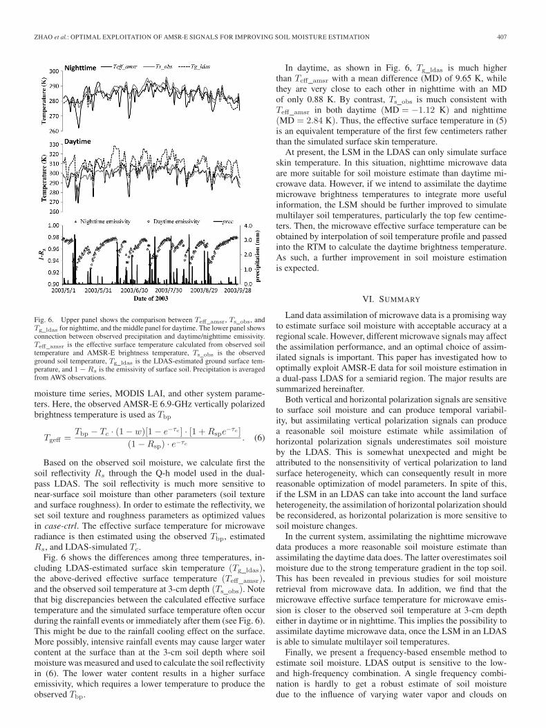
Fig. 6. Upper panel shows the comparison between Teff_amsr, Ts_obs, andTg_ldas for nighttime, and the middle panel for daytime. The lower panel showsconnection between observed precipitation and daytime/nighttime emissivity.Teff_amsr is the effective surface temperature calculated from observed soiltemperature and AMSR-E brightness temperature, Ts_obs is the observedground soil temperature, Tg_ldas is the LDAS-estimated ground surface tem-perature, and 1−Rs is the emissivity of surface soil. Precipitation is averagedfrom AWS observations.
moisture time series, MODIS LAI, and other system parame-ters. Here, the observed AMSR-E 6.9-GHz vertically polarizedbrightness temperature is used as Tbp
Tgeff =Tbp − Tc · (1− w)[1− e−τc ] · [1 +Rspe
−τc ]
(1−Rsp) · e−τc. (6)
Based on the observed soil moisture, we calculate first thesoil reflectivity Rs through the Q-h model used in the dual-pass LDAS. The soil reflectivity is much more sensitive tonear-surface soil moisture than other parameters (soil textureand surface roughness). In order to estimate the reflectivity, weset soil texture and roughness parameters as optimized valuesin case-ctrl. The effective surface temperature for microwaveradiance is then estimated using the observed Tbp, estimatedRs, and LDAS-simulated Tc.
Fig. 6 shows the differences among three temperatures, in-cluding LDAS-estimated surface skin temperature (Tg_ldas),the above-derived effective surface temperature (Teff_amsr),and the observed soil temperature at 3-cm depth (Ts_obs). Notethat big discrepancies between the calculated effective surfacetemperature and the simulated surface temperature often occurduring the rainfall events or immediately after them (see Fig. 6).This might be due to the rainfall cooling effect on the surface.More possibly, intensive rainfall events may cause larger watercontent at the surface than at the 3-cm soil depth where soilmoisture was measured and used to calculate the soil reflectivityin (6). The lower water content results in a higher surfaceemissivity, which requires a lower temperature to produce theobserved Tbp.
In daytime, as shown in Fig. 6, Tg_ldas is much higherthan Teff_amsr with a mean difference (MD) of 9.65 K, whilethey are very close to each other in nighttime with an MDof only 0.88 K. By contrast, Ts_obs is much consistent withTeff_amsr in both daytime (MD = −1.12 K) and nighttime(MD = 2.84 K). Thus, the effective surface temperature in (5)is an equivalent temperature of the first few centimeters ratherthan the simulated surface skin temperature.
At present, the LSM in the LDAS can only simulate surfaceskin temperature. In this situation, nighttime microwave dataare more suitable for soil moisture estimate than daytime mi-crowave data. However, if we intend to assimilate the daytimemicrowave brightness temperatures to integrate more usefulinformation, the LSM should be further improved to simulatemultilayer soil temperatures, particularly the top few centime-ters. Then, the microwave effective surface temperature can beobtained by interpolation of soil temperature profile and passedinto the RTM to calculate the daytime brightness temperature.As such, a further improvement in soil moisture estimationis expected.
VI. SUMMARY
Land data assimilation of microwave data is a promising wayto estimate surface soil moisture with acceptable accuracy at aregional scale. However, different microwave signals may affectthe assimilation performance, and an optimal choice of assim-ilated signals is important. This paper has investigated how tooptimally exploit AMSR-E data for soil moisture estimation ina dual-pass LDAS for a semiarid region. The major results aresummarized hereinafter.
Both vertical and horizontal polarization signals are sensitiveto surface soil moisture and can produce temporal variabil-ity, but assimilating vertical polarization signals can producea reasonable soil moisture estimate while assimilation ofhorizontal polarization signals underestimates soil moistureby the LDAS. This is somewhat unexpected and might beattributed to the nonsensitivity of vertical polarization to landsurface heterogeneity, which can consequently result in morereasonable optimization of model parameters. In spite of this,if the LSM in an LDAS can take into account the land surfaceheterogeneity, the assimilation of horizontal polarization shouldbe reconsidered, as horizontal polarization is more sensitive tosoil moisture changes.
In the current system, assimilating the nighttime microwavedata produces a more reasonable soil moisture estimate thanassimilating the daytime data does. The latter overestimates soilmoisture due to the strong temperature gradient in the top soil.This has been revealed in previous studies for soil moistureretrieval from microwave data. In addition, we find that themicrowave effective surface temperature for microwave emis-sion is closer to the observed soil temperature at 3-cm deptheither in daytime or in nighttime. This implies the possibility toassimilate daytime microwave data, once the LSM in an LDASis able to simulate multilayer soil temperatures.
Finally, we present a frequency-based ensemble method toestimate soil moisture. LDAS output is sensitive to the low-and high-frequency combination. A single frequency combi-nation is hardly to get a robust estimate of soil moisturedue to the influence of varying water vapor and clouds on
408 IEEE TRANSACTIONS ON GEOSCIENCE AND REMOTE SENSING, VOL. 51, NO. 1, JANUARY 2013
microwave signals at different frequencies, imperfect RTM,bias in input forcing data, and so on. None of the assimilatedmicrowave frequency combinations is superior to the otherswhen driven by different forcing data. By simply averagingsoil moisture estimates by assimilating individual frequencycombinations, the frequency-based ensemble can produce amore robust estimate of surface soil moisture. This may bepromising for large-scale soil moisture estimation by usinga global or regional forcing data set (e.g., GLDAS) to drivethe LDAS.
Future studies may explore the optimal use of L-band datasuch as SMOS and SMAP, which is expected to have betteraccuracy for soil moisture estimation. Sensitivity studies forL-band-based soil moisture retrieval can also be conducted fordifferent polarizations in the framework of data assimilation,and more robust results might be expected, as some uncer-tainties due to vegetation absorption can be reduced owing toL-band’s greater penetration of vegetation.
ACKNOWLEDGMENT
The authors would like to thank the two anonymous review-ers for their valuable suggestions. The AMSR-E/Aqua DailyGlobal Quarter-Degree Gridded Brightness Temperatures arecollected through the NSIDC, Boulder, Colorado, USA (http://nsidc.org/). The CEOP-Mongolia project was implemented un-der the framework of JAXA-JRA “Ground Truth for Evaluationof Soil Moisture and Geophysical/Vegetation Parameters Re-lated to Ground Surface Conditions with AMSR and GLI in theMongolian Plateau.” GLDAS data sets are collected from theNASA Goddard Earth Sciences Data and Information ServicesCenter (http://ldas.gsfc.nasa.gov/gldas/).
REFERENCES
[1] D. Entekhabi, I. Rodriguez-Iturbeb, and F. Castellic, “Mutual interactionof soil moisture state and atmospheric processes,” J. Hydrol., vol. 184,no. 1/2, pp. 3–17, Oct. 1, 1996.
[2] A. K. Betts, J. H. Ball, A. C. M. Beljaars, M. J. Miller, andP. A. Viterbo, “The land surface–atmosphere interaction: A reviewbased on observational and global modeling perspectives,” J. Geophys.Res.—Atmos., vol. 101, no. D3, pp. 7209–7225, Mar. 20, 1996.
[3] R. D. Koster, P. A. Dirmeyer, Z. Guo, G. Bonan, E. Chan, P. Cox,C. T. Gordon, S. Kanae, E. Kowalczyk, D. Lawrence, P. Liu, C.-H. Lu,S. Malyshev, B. McAvaney, K. Mitchell, D. Mocko, T. Oki, K. Oleson,A. Pitman, Y. C. Sud, C. M. Taylor, D. Verseghy, R. Vasic, Y. Xue,and T. Yamada, “Regions of strong coupling between soil moisture andprecipitation,” Science, vol. 305, no. 5687, pp. 1138–1141, Aug. 20, 2004.
[4] M. Rodell, P. R. Houser, U. Jambor, J. Gottschalck, K. Mitchell,C. J. Meng, K. Arsenault, B. Cosgrove, J. Radakovich, M. Bosilovich,J. K. Entin, J. P. Walker, D. Lohmann, and D. Toll, “The global land dataassimilation system,” Bull. Amer. Meteorol. Soc., vol. 85, no. 3, pp. 381–394, Mar. 2004.
[5] R. H. Reichle, W. T. Crow, R. D. Koster, H. O. Sharif, and S. P.P. Mahanama, “Contribution of soil moisture retrievals to land data assim-ilation products,” Geophys. Res. Lett., vol. 35, pp. L01404-1–L01404-1,Jan. 10, 2008.
[6] X. Han and X. Li, “An evaluation of the nonlinear/non-Gaussian filters forthe sequential data assimilation,” Remote Sens. Environ., vol. 112, no. 4,pp. 1434–1449, Apr. 15, 2008.
[7] X. K. Shi, J. Wen, J. Liu, H. Tian, X. Wang, and Y. D. Li, “Applicationand improvement of an adaptive ensemble Kalman filter for soil moisturedata assimilation,” Sci. Chin. Earth Sci., vol. 53, no. 11, pp. 1700–1708,Nov. 2010.
[8] M. Rasmy, T. Koike, S. Boussetta, H. Lu, and X. Li, “Development of asatellite land data assimilation system coupled with a mesoscale model inthe Tibetan Plateau,” IEEE Trans. Geosci. Remote Sens., vol. 49, no. 8,pp. 2847–2862, Aug. 2011.
[9] H. Moradkhani, S. Sorooshian, H. V. Gupta, and P. R. Houser, “Dual state-parameter estimation of hydrological models using ensemble Kalmanfilter,” Adv. Water Resour., vol. 28, no. 2, pp. 135–147, Feb. 2005.
[10] K. Yang, T. Watanabe, T. Koike, X. Li, H. Fujii, K. Tamagawa,Y. Ma, and H. Ishikawa, “Auto-calibration system developed to assimilateAMSR-E data into a land surface model for estimating soil moisture andthe surface energy budget,” J. Meteorol. Soc. Jpn., vol. 85A, pp. 229–242,Feb. 2007.
[11] S. A. Margulis, D. McLaughlin, D. Entekhabi, and S. Dunne, “Land dataassimilation and estimation of soil moisture using measurements from theSouthern Great Plains 1997 field experiment,” Water Resour. Res., vol. 38,no. 12, p. 1299, Dec. 2002.
[12] W. T. Crow and E. F. Wood, “The assimilation of remotely sensed soilbrightness temperature imagery into a land surface model using EnsembleKalman filtering: A case study based on ESTAR measurements duringSGP97,” Adv. Water Resour., vol. 26, no. 2, pp. 137–149, 2003.
[13] A. Loew, M. Schwank, and F. Schlenz, “Assimilation of an L-bandmicrowave soil moisture proxy to compensate for uncertainties in precip-itation data,” IEEE Trans. Geosci. Remote Sens., vol. 47, no. 8, pp. 2606–2616, Aug. 2009.
[14] E. G. Njoku and D. Entekhabi, “Passive microwave remote sensing of soilmoisture,” J. Hydrol., vol. 184, no. 1/2, pp. 101–129, Oct. 1, 1996.
[15] C. Prigent, F. Aires, W. B. Rossow, and A. Robock, “Sensitivity of satellitemicrowave and infrared observations to soil moisture at a global scale:Relationship of satellite observations to in situ soil moisture measure-ments,” J. Geophys. Res.—Atmos., vol. 110, pp. D07110-1–D07110-15,Apr. 13, 2005.
[16] M. Owe, R. de Jeu, and J. Walker, “A methodology for surface soilmoisture and vegetation optical depth retrieval using the microwave po-larization difference index,” IEEE Trans. Geosci. Remote Sens., vol. 39,no. 8, pp. 1643–1654, Aug. 2001.
[17] S. Paloscia, G. Macelloni, and E. Santi, “Soil moisture estimates fromAMSR-E brightness temperatures by using a dual-frequency algorithm,”IEEE Trans. Geosci. Remote Sens., vol. 44, no. 11, pp. 3135–3144,Nov. 2006.
[18] J. Qin, S. Liang, S. Liang, K. Yang, I. Kaihotsu, R. Liu, andT. Koike, “Simultaneous estimation of both soil moisture and modelparameters using particle filtering method through the assimilation ofmicrowave signal,” J. Geophys. Res.—Atmos., vol. 114, pp. D15103-1–D15103-13, Aug. 2009.
[19] X. J. Tian, Z. Xie, A. Dai, C. Shi, B. Jia, F. Chen, and K. Yang, “A dual-pass variational data assimilation framework for estimating soil moistureprofiles from AMSR-E microwave brightness temperature,” J. Geophys.Res.—Atmos., vol. 114, pp. D16102-1–D16102-12, Aug. 2009.
[20] X. Zhan, P. R. Houser, J. P. Walker, and W. T. Crow, “A method for retriev-ing high-resolution surface soil moisture from hydros L-band radiometerand radar observations,” IEEE Trans. Geosci. Remote Sens., vol. 44, no. 6,pp. 1534–1544, Jun. 2006.
[21] Y. H. Kerr, P. Waldteufel, J.-P. Wigneron, J. Martinuzzi, J. Font, andM. Berger, “Soil moisture retrieval from space: The Soil Moisture andOcean Salinity (SMOS) mission,” IEEE Trans. Geosci. Remote Sens.,vol. 39, no. 8, pp. 1729–1735, Aug. 2001.
[22] J. M. Sabater, A. Fouilloux, and P. de Rosnay, “Technical implementa-tion of SMOS data in the ECMWF integrated forecasting system,” IEEEGeosci. Remote Sens. Lett., vol. 9, no. 2, pp. 252–256, Mar. 2012.
[23] K. D. McMullan, M. A. Brown, M. Martin-Neira, W. Rits, S. Ekholm,J. Marti, and J. Lemanczyk, “SMOS: The payload,” IEEE Trans. Geosci.Remote Sens., vol. 46, no. 3, pp. 594–605, Mar. 2008.
[24] R. H. Reichle, R. D. Koster, P. Liu, S. P. P. Mahanama, E. G. Njoku,and M. Owe, “Comparison and assimilation of global soil moistureretrievals from the Advanced Microwave Scanning Radiometer for theEarth Observing System (AMSR-E) and the Scanning MultichannelMicrowave Radiometer (SMMR),” J. Geophys. Res.—Atmos., vol. 112,pp. D09108-1–D09108-12, May 8, 2007.
[25] T. J. Jackson and A. Y. Hsu, “Soil moisture and TRMM microwaveimager relationships in the Southern Great Plains 1999 (SGP99) exper-iment,” IEEE Trans. Geosci. Remote Sens., vol. 39, no. 8, pp. 1632–1642,Aug. 2001.
[26] M. F. McCabe, H. Gao, and E. F. Wood, “Evaluation of AMSR-E-derivedsoil moisture retrievals using ground-based and PSR airborne data duringSMEX02,” J. Hydrometeorol., vol. 6, no. 6, pp. 864–877, Dec. 2005.
[27] K. Y. Vinnikov, A. Robock, S. Qiu, J. K. Entin, M. Owe, B. J. Choudhury,S. E. Hollinger, and E. G. Njoku, “Satellite remote sensing of soil moisturein Illinois, United States,” J. Geophys. Res.—Atmos., vol. 104, no. D4,pp. 4145–4168, Feb. 27, 1999.
[28] Z. Bartalis, W. Wagner, V. Naeimi, S. Hasenauer, K. Scipal, H. Bonekamp,J. Figa, and C. Anderson, “Initial soil moisture retrievals from the
ZHAO et al.: OPTIMAL EXPLOITATION OF AMSR-E SIGNALS FOR IMPROVING SOIL MOISTURE ESTIMATION 409
METOP-A Advanced Scatterometer (ASCAT),” Geophys. Res. Lett.,vol. 34, pp. L20401-1–L20401-5, Oct. 2007.
[29] D. Entekhabi, E. Njoku, P. O’Neill, K. H. Kellogg, W. Crow,W. N. Edelstein, J. K. Entin, S. D. Goodman, T. Jackson, J. Johnson,J. S. Kimball, J. R. Piepmeier, R. Koster, N. Martin, K. C. McDonald,M. Moghaddam, S. Moran, R. Reichle, J. C. Shi, M. Spencer,S. W. Thurman, L. Tsang, and J. Van Zyl, “The Soil Moisture ActivePassive (SMAP) mission,” Proc. IEEE, vol. 98, pp. 704–716, May 2010.
[30] Y. Kerr, News From the L1PP Team on RFI!, Apr. 20, 2010. [Online].Available: http://www.cesbio.ups-tlse.fr/SMOS_blog/?p=632
[31] E. G. Njoku, P. Ashcroft, T. K. Chan, and L. Li, “Global survey andstatistics of radio-frequency interference in AMSR-E land observations,”IEEE Trans. Geosci. Remote Sens., vol. 43, no. 5, pp. 938–947, May 2005.
[32] P. J. Sellers, S. Los, C. Tucker, C. Justice, D. Dazlich, G. Collatz, andD. Randall, “A revised land surface parameterization (SiB2) for atmo-spheric GCMs.2. The generation of global fields of terrestrial biophysicalparameters from satellite data,” J. Clim., vol. 9, no. 4, pp. 706–737,Apr. 1996.
[33] P. J. Sellers, D. A. Randall, G. J. Collatz, J. A. Berry, C. B. Field,D. A. Dazlich, C. Zhang, G. D. Collelo, and L. Bounoua, “A revisedland surface parameterization (SiB2) for atmospheric GCMs.1. Modelformulation,” J. Clim., vol. 9, no. 4, pp. 676–705, Apr. 1996.
[34] J. R. Wang and B. J. Choudhury, “Remote sensing of soil moisture contentover bare field at 1.4 GHz frequency,” J. Geophys. Res.-Oceans Atmos.,vol. 86, no. C6, pp. 5277–5282, Jun. 1981.
[35] T. Mo, B. J. Choudhury, T. J. Schmugge, J. R. Wang, and T. J. Jack-son, “A model for microwave emission from vegetation-covered fields,”J. Geophys. Res.-Oceans Atmos., vol. 87, no. C13, pp. 1229–1238, 1982.
[36] P. C. Young, “Advances in real-time flood forecasting,” Philosoph. Trans.R. Soc. London Ser. A, Math. Phys. Eng. Sci., vol. 360, pp. 1433–1450,Jul. 15, 2002.
[37] C. Montzka, H. Moradkhani, L. Weihermüller, H.-J. H. Franssen,M. Canty, and H. Vereecken, “Hydraulic parameter estimation byremotely-sensed top soil moisture observations with the particle filter,”J. Hydrol., vol. 399, no. 3/4, pp. 410–421, Mar. 18, 2011.
[38] T. Koike, “The coordinated enhanced observing period—An initial stepfor integrated global water cycle observation,” WMO Bull., vol. 53,pp. 115–121, 2004.
[39] K. Yang and T. Koike, “Satellite monitoring of the surface water andenergy budget in the Central Tibetan Plateau,” Adv. Atmos. Sci., vol. 25,no. 6, pp. 974–985, Nov. 2008.
[40] B. H. Jia, Z. H. Xie, X. J. Tian, and C. X. Shi, “A soil moisture assimilationscheme based on the ensemble Kalman filter using microwave brightnesstemperature,” Sci. Chin. Ser. D, Earth Sci., vol. 52, pp. 1835–1848, 2009.
[41] T. R. Xu, S. Liang, and S. Liu, “Estimating turbulent fluxes throughassimilation of geostationary operational environmental satellites datausing ensemble Kalman filter,” J. Geophys. Res.—Atmos., vol. 116,pp. D09109-1–D09109-16, May 12, 2011.
[42] K. W. Knowles, M. H. Savoie, R. L. Armstrong, and M. J. Brodzik,AMSR-E/Aqua Daily Global Quarter-Degree Gridded Brightness Temper-atures. Boulder, CO: Nat. Snow Ice Data Center Digital Media, 2011.
[43] Y. Knyazikhin, J. Glassy, J. L. Privette, Y. Tian, A. Lotsch, Y. Zhang,Y. Wang, J. T. Morisette, P. Votava, R. B. Myneni, R. R. Nemani, andS. W. Running, MODIS Leaf Area Index (LAI) and Fraction of Pho-tosynthetically Active Radiation Absorbed by Vegetation (FPAR) Prod-uct (MOD15) Algorithm Theoretical Basis Documents, 1999. [Online].Available: http://eospso.gsfc.nasa.gov/atbd/modistables.html
[44] G. S. D. Task, “Global Soil Data Products CD-ROM (IGBP-DIS),” Int.Geosphere-Biosphere Programme-Data Inf. Avail. Serv., 2000. [Online].Available: http://www.daac.ornl.gov
[45] T. R. Loveland, B. C. Reed, J. F. Brown, D. O. Ohlen, Z. Zhu, L. Yang,and J. W. Merchant, “Development of a global land cover characteristicsdatabase and IGBP DISCover from 1 km AVHRR data,” Int. J. RemoteSens., vol. 21, pp. 1303–1330, Apr. 15, 2000.
[46] K. Yang, T. Koike, I. Kaihotsu, and J. Qin, “Validation of a dual-passmicrowave land data assimilation system for estimating surface soil mois-ture in semiarid regions,” J. Hydrometeorol., vol. 10, no. 3, pp. 780–793,Jun. 2009.
[47] J. M. Sabater, P. de Rosnay, and G. Balsamo, “Sensitivity of L-band NWPforward modelling to soil roughness,” Int. J. Remote Sens., vol. 32, no. 19,pp. 5607–5620, Oct. 2011.
[48] H. Vereecken, T. Kamai, T. Harter, R. Kasteel, J. Hopmans, andJ. Vanderborght, “Explaining soil moisture variability as a function ofmean soil moisture: A stochastic unsaturated flow perspective,” Geophys.Res. Lett., vol. 34, pp. L22402-1–L22402-6, Nov. 2007.
[49] E. J. Burke and L. P. Simmonds, “Effects of sub-pixel heterogeneity onthe retrieval of soil moisture from passive microwave radiometry,” Int. J.Remote Sens., vol. 24, no. 10, pp. 2085–2104, May 20, 2003.
[50] T. J. Jackson, M. H. Cosh, R. Bindlish, P. J. Starks, D. D. Bosch,M. Seyfried, D. C. Goodrich, M. S. Moran, and J. Du, “Validation ofadvanced microwave scanning radiometer soil moisture products,” IEEETrans. Geosci. Remote Sens., vol. 48, no. 12, pp. 4256–4272, Dec. 2010.
[51] Z. Su, J. Wen, L. Dente, R. van der Velde, L. Wang, Y. Ma, K. Yang, andZ. Hu, “The Tibetan Plateau observatory of plateau scale soil moistureand soil temperature (Tibet-Obs) for quantifying uncertainties in coarseresolution satellite and model products,” Hydrol. Earth Syst. Sci., vol. 15,pp. 2303–2316, 2011.
[52] K. J. C. Tien, J. Judge, and J. M. Jacobs, “Passive microwave remotesensing of soil moisture, evapotranspiration, and vegetation propertiesduring a growing season of cotton,” in Proc. IEEE IGARSS, 2004, vol. 4,pp. 2795–2798.
[53] H. Gao, E. F. Wood, T. J. Jackson, M. Drusch, and R. Bindlish, “Us-ing TRMM/TMI to retrieve surface soil moisture over the southernUnited States from 1998 to 2002,” J. Hydrometeorol., vol. 7, pp. 23–38,Feb. 2006.
[54] H. Fujii, T. Koike, and K. Imaoka, “Improvement of the AMSR-E algo-rithm for soil moisture estimation by introducing a fractional vegetationcoverage dataset derived from MODIS data,” J. Remote Sens. Soc. Jpn.,vol. 29, no. 1, pp. 282–292, Jan. 2009.
[55] J. L. Anderson, “An ensemble adjustment Kalman filter for data assimila-tion,” Mon. Weather Rev., vol. 129, no. 12, pp. 2884–2903, 2001.
[56] J. S. Whitaker and T. M. Hamill, “Ensemble data assimilation withoutperturbed observations,” Mon. Weather Rev., vol. 130, no. 7, pp. 1913–1924, 2002.
[57] P. L. Houtekamer and H. L. Mitchell, “Data assimilation using an ensem-ble Kalman filter technique,” Mon. Weather Rev., vol. 126, no. 3, pp. 796–811, Mar. 1998.
[58] J. P. Wigneron, J. C. Calvet, T. Pellarin, and A. A. van de Griend, “Retriev-ing near-surface soil moisture from microwave radiometric observations:Current status and future plans,” Remote Sens. Environ., vol. 85, no. 4,pp. 489–506, 2003.
[59] A. A. van de Griend and M. Owe, “The influence of polarization oncanopy transmission properties at 6.6 GHz and implications for large scalesoil moisture monitoring in semi-arid environments,” IEEE Trans. Geosci.Remote Sens., vol. 32, no. 2, pp. 409–415, Mar. 1994.
[60] E. G. Njoku, T. J. Jackson, V. Lakshmi, T. K. Chan, and S. V. Nghiem,“Soil moisture retrieval from AMSR-E,” IEEE Trans. Geosci. RemoteSens., vol. 41, no. 2, pp. 215–229, Feb. 2003.
[61] B. J. Choudhury, T. J. Schmugge, A. Chang, and R. W. Newton, “Effectof surface-roughness on the microwave emission from soils,” J. Geophys.Res.-Oceans Atmos., vol. 84, no. C9, pp. 5699–5706, 1979.
[62] Y. Guo, J. Shi, and K. Mao, “Surface temperature effect on soil mois-ture retrieval from AMSR-E,” in Proc. IEEE IGARSS, 2007, vol. 1–12,pp. 1192–1195.
Long Zhao received the B.Eng. degree fromTsinghua University, Beijing, China, in 2008. He iscurrently working toward the Ph.D. degree in physi-cal geography at the Institute of Tibetan Plateau Re-search, Chinese Academy of Sciences, Beijing. Heis also with the Graduate University of the ChineseAcademy of Sciences, Beijing. The topic of his studyis microwave land data assimilation for soil moistureestimation.
Kun Yang received the B.Eng. and M.Eng. degreesfrom Tsinghua University, Beijing, China, in 1994and 1997, respectively, and the D.Eng. degree fromThe University of Tokyo, Tokyo, Japan, in 2000.
He was appointed as an Associate Professor withThe University of Tokyo in 2003 and the Coordi-nated Enhanced Observing Period Project—Waterand Energy Budget Study (CEOP-WEBS) Chair in2007. Since 2007, he has been a Full Professor withthe Institute of Tibetan Plateau Research, ChineseAcademy of Sciences (CAS), Beijing, and the Vice
Director of the Key Laboratory of Tibetan Environment Changes and LandSurface Processes, CAS. His research interests are in land surface modeling,data assimilation, and plateau land–atmosphere interactions.

410 IEEE TRANSACTIONS ON GEOSCIENCE AND REMOTE SENSING, VOL. 51, NO. 1, JANUARY 2013
Jun Qin received the B.S. degree in meteorologyfrom the Nanjing Institute of Meteorology, Nanjing,China, in 2001 and the Ph.D. degree in remotesensing and geographic information systems fromBeijing Normal University, Beijing, China, in 2006.
He finished his postdoctoral program in 2008 atthe Institute of Geographic Sciences and NaturalResources Research, Chinese Academy of Sciences(CAS), Beijing. Since then, he has been an Assis-tant Professor with the Institute of Tibetan PlateauResearch, CAS. His current research interests are
in retrieving land surface parameters from remote sensing data, land surfaceprocess modeling, land surface data assimilation, and optimization algorithms.
Yingying Chen received the B.S. and M.S. degreesin geography from Lanzhou University, Lanzhou,China, in 2002 and 2005, respectively, and the Ph.D.degree in geo-information system and remote sens-ing from the Institute of Remote Sensing Applica-tions, Chinese Academy of Sciences, Beijing, China,in 2008.
He finished his postdoctoral program in 2011 atthe Institute of Tibetan Plateau Research, ChineseAcademy of Sciences, where he is currently an As-sistant Research Scientist. He is affiliated with the
American Mathematical Society and the American Geophysical Union. Hisresearch interests include land surface model improvement, land surface dataassimilation, and micrometeorological observation and data analysis.