Olesen, C. R. & K. Bork-Pedersen 2011: Gammel Strand excavations 2010. KBM 3828. Archaeological...
218
KØBENHAVNS MUSEUM MUSEUM OF COPENHAGEN / ARCHAEOLOGICAL REPORT 2012 Gammel Strand excavations 2010 KBM 3828 Claus Rohden Olesen, archaeologist, mag.art. Karen Bork-Pedersen, archaeologist, cand.mag.
Transcript of Olesen, C. R. & K. Bork-Pedersen 2011: Gammel Strand excavations 2010. KBM 3828. Archaeological...

KØBENHAVNS MUSEUM MUSEUM OF COPENHAGEN / ARCHAEOLOGICAL REPORT 2012
Gammel Strand excavations 2010
KBM 3828
Claus Rohden Olesen, archaeologist, mag.art.
Karen Bork-Pedersen, archaeologist, cand.mag.

Københavns Museum
Vesterbrogade 59
1620 København V
Telefon: +45 33 21 07 72 Fax: +45 33 25 07 72
E-mail: [email protected]
www.copenhagen.dk
© Københavns Museum 2011

3
Contents
1 Summary ...................................................................................................... 7
1.1 Abstract (English version) .................................................................... 7
1.2 Abstrakt (Dansk version) ...................................................................... 7
2 Results ......................................................................................................... 8
2.1 English version .................................................................................... 8
2.2 Dansk version .................................................................................... 10
3 Introduction ................................................................................................ 13
3.1 Schedule ............................................................................................ 13
3.2 Client .................................................................................................. 13
3.3 Client consultant ................................................................................ 13
3.4 Construction company ....................................................................... 13
3.5 Archaeological management and staff ............................................... 13
3.6 Reponsibility and rights ...................................................................... 14
3.7 Finance .............................................................................................. 14
4 Cultural historical background and topography .......................................... 15
4.1 Cultural historical background ............................................................ 15
4.2 Topography ........................................................................................ 21
5 Archaeological background ........................................................................ 23
5.1 Earlier work ........................................................................................ 23
5.2 The Gammel Strand watching brief 2008 ........................................... 24
6 Cultural historical potential and aims .......................................................... 26
6.1 Introduction ........................................................................................ 26
6.2 The harbour ....................................................................................... 26
6.3 Social economics ............................................................................... 26
6.4 Infrastructure ...................................................................................... 27
7 Methodology ............................................................................................... 28
7.1 Excavation and documentation methodology .................................... 28
7.2 Finds retrieving and registration parameters ...................................... 32
7.3 Sampling methodology ...................................................................... 33
7.4 Remains and preservation ................................................................. 35
7.5 Finds Material (Report by Stuart Whatley) ......................................... 37
7.6 Scientific analysis/environment .......................................................... 63
8 Cultural historical interpretation .................................................................. 66
8.1 Natural ground ................................................................................... 66
8.2 Natural vegetation .............................................................................. 66
8.3 Fence ................................................................................................. 67
8.4 Wharf ................................................................................................. 67
8.5 Roads ................................................................................................ 79
8.6 Water supply network ........................................................................ 80
8.7 Land development ............................................................................. 86

4
8.8 Gutter canals ..................................................................................... 91
8.9 Sewer canals ................................................................................... 102
8.10 Buildings .......................................................................................... 112
9 Assessment .............................................................................................. 154
9.1 Preservation conditions .................................................................... 154
9.2 Cultural history ................................................................................. 154
9.3 Finds material (by Stuart Whatley) ................................................... 154
9.4 Scientific analysis (by Hoda El-Sharnouby) ..................................... 155
10 References .......................................................................................... 157
10.1 Literature .......................................................................................... 157
10.2 Archaeological reports and archive material .................................... 160
10.3 External reports ............................................................................... 160
10.4 Museum of Copenhagen strategy documents ................................. 161
10.5 Internet references ........................................................................... 161
10.6 Abbreviations ................................................................................... 161
11 Administrative data .............................................................................. 163
12 Appendix ............................................................................................. 164
12.1 List of Figurees ................................................................................ 164
12.2 List of tables ..................................................................................... 165
12.3 IntraSiS registration parameters ...................................................... 165
12.4 Consultant reports............................................................................ 210

5
Figure 1. Map over the Copenhagen area and the place for the excavation.
6
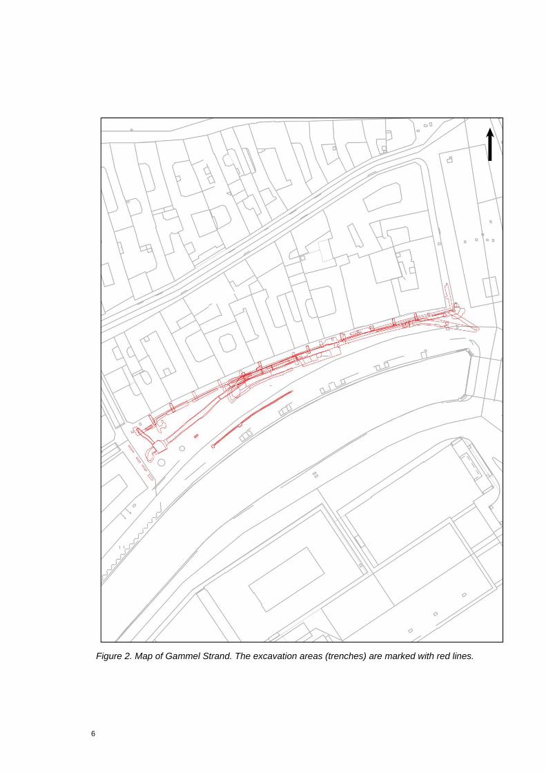
Figure 2. Map of Gammel Strand. The excavation areas (trenches) are marked with red lines.

7
1 Summary
1.1 Abstract (English version)
Prior to the construction of the metro station on Gammel Strand, facilitated by Metroselskabet I/S, Museum of Copenhagen found it relevant to perform an evaluation excavation in order to assess the culture-historical potential of a large scale archaeological excavation of Gammel Strand.
The archaeological field work was performed as watching briefs. A total of 47 trenches of variable size, primarily situated along the northern side of Gammel Strand, were examined.
The area was characterized by extraordinarily good preservation conditions. Hence, the amount of Pre-Industrial (until the 19th century) cultural remains, i.e. structures, finds etc. related to the use of the harbour of Copenhagen was massive. In that respect, the remains of Christoffer Valkendor‟s Vejerhus, dated to 1581, several stone structures from Late Medieval time and the Renaissance, and multiple well preserved artefacts are worth mentioning.
1.2 Abstrakt (Dansk version)
Forud for Metroselskabet I/S‟ byggeri af en metrostation på Gammel Strand fandt Københavns Museum det relevant at foretage en arkæologisk undersøgelse af området med henblik på at vurdere det kulturhistoriske potenitale i en arkæologisk undersøgelse af området.
Det arkæologiske feltarbejde udførtes om en tilsynssag. Samlet set blev 47 grøfter af variabel størrelse, fortrinsvis beliggende langs Gammel Strands nordside, undersøgt.
Gammel Strand var karakteriseret af ekstraordinært gode bevaringsforhold, hvorfor mængden af bevarede materielle levn af kulturhistorisk art relateret til Københavns før-industrielle havnemiljø, f.eks. fund, jordfaste anlæg m.m., var ganske betragtelig. I den henseende er identificeringen af resterne af Christoffer Valkendorfs Vejerhus fra 1581, flere grundmurede bygninger fra såvel senmiddelalder som renæssancen samt uhørt mange genstandsfund væsentlig at nævne.
Periods: Late Middle Ages to 18th century.
Features: Harbour, Trade, Butchers, Bulwarks, Gutters, Sewers, Water pipes, Pottery, Buildings
Keywords: Wharf construction, Water supply systems, Administrative buildings, Imported artefacts

8
2 Results
2.1 English version
The extensive cable replacement works were spread across most of Gammel Strand. Excavation of the numerous cable trenches was carried out over the course of 2010.
In the High Medieval Era Gammel Strand was a beach area, which, as of the middle of the 14th century, became more densely urbanised and got actual harbour structures. Significant signs of this development were documented during the 2010 excavation work. Considerable finds of well preserved Late Medieval and Renaissance harbour structures were found. These finds were divided among different types of structures, comprising aspects of town planning, such as land development, bulwarks and administrative buildings related the operation of the harbour. Additionally more common infrastructure, such as streets, water supply and waste water organisation etc. was also identified during the work.
Written sources suggest that several administrative functions related to the operation of harbour were established at the end of the Medieval period. A few stone foundations, relating to these administrative buildings, were found. Remains of a wall, thought to represent the remains of the medieval accise booth (duty booth) were found. However this interpretation is only supported by the artefacts found in relation to the foundation remains.
The possible location Late Medieval Vejerhus (the house in which the town weight was placed) isb however, supported by more evidence. The building remains found consisted of at least one room, dated to the Late Medieval period, and a 17th century cellar. The outline of this building is not known, as it was truncated by younger buildings, water pipes etc. and not fully excavated. A 17th century written source states that the Medieval Vejerhus was located on the western side of Christoffer Valkendorf‟s younger, and well documented Renaissance Vejerhus, dated to 1581. A number of artefacts found in relation to the building remains give a rough date that supports the hypothesis that it is the Medieval Vejerhus, though; it could not be verified with certainty.
If focus is pointed towards Christoffer Valkendorf‟s Vejerhus the written sources are of exceptionally good quality, as this solid four-storied building frequently occurs in many accounts and is shown on a handful of historical maps. Also, it is depicted on the oldest photo from Copenhagen, dated to c.1839. The knowledge about the design and history is relatively detailed. It was identified in several trenches in 2010 and subsequent cross reference with the records give the overwhelming impression that the structure excavated was Valkendorf‟s Vejerhus . Moreover the investigations were a great opportunity to obtain an
9
increased understanding of how the Humlegård (yard in which the hops was classified) was used. That structure is known to situated on the western side of the Vejerhus in the 16th and 17th century. Another result was the identification of the foundation of the courtyard wall related to the eastern courtyard which, allegedly, was raised in the later part of the 17th century or early in the 18th century. Interestingly, the rest of the Vejerhus foundation is probably still buried underneath the cobblestones on Gammel Strand.
Remains of other structures related to the duty handling procedures and the operation of the harbour was located nearby the remains Valkendorf‟s Vejerhus. Consequently, elements of the foundation of the wall surrounding the Vragerbro (the area were the food brought into Copenhagen by sea was controlled), the wooden build fieleboder (small booths) and small brick built butcher booths were recorded. These structures represented the business on Gammel Strand from the Renaissance up until the square was opened in the middle of the 19th century.
Numerous finds of bulwarks, probably representing four wharf sequences, was found. These remains were consisting of rammed down piles, possibly including plank shoring, stone packing and land development. The date of bulwark construction, was between 1600 and the end of the 18th century, based on artefacts alone. Since earlier excavations on Gammel Strand has shown the bulwarks were built in 15th and 16th century, we can not exclude the possibility that the bulwarks identified were constructed in the same period.
As early as in the 16th century sanitary initiatives in the form of general water supply network consisting of wooden water pipes were present on Gammel Strand. The water supply network did, however, represent a change, as the earlier water supply mainly consisted of wells. The new system was kept in use up until the great sanitary reform in 1854, where iron pipes came in use. In relation to the former system two E-W orientated supply lines and a single NW-SE orientated wooden pipeline were identified. In relation to two of these lines another N-S orientated service canal was found, this lead into the houses, and replaced older worn down supply lines.
During the 17th and 18th century further sanitary initiatives were undertaken, such as establishing of sewer networks and other waste water handling systems. Remains of fourteen wooden supported gutters and five stone build sewers, intended to canal the water away and into the sea, were found. As it was not possible to date these constructions thoroughly on the basis of natural science, written sources and artefacts become the main source to generate datable material – consequently they are dated to the 17th century.
Furthermore a number of deposits interpreted as early land build were thought to be associated with the establishment of the harbour area, while others are related to land development in the 16th and 17th century.

10
Finally remains of two possible roads were also identified. One of them represented by multiple leveling layers, probably related to a paved area on the northern side of Valkendorf‟s Vejerhus. Besides those leveling layers three sections of paving were excavated. This amounted to a total of 10m of paving. Artefact dates indicate that the road was build around the year 1700.
2.2 Dansk version
Området ved Gammelstrand var i højmiddelalderen et strandområde, som antageligvis i midten af 1300-tallet begyndte at få en tættere bymæssig karakter og egentlige havnefunktioner tilknyttet. De omfattende kabelomlægninger, fordelt over størstedelen af på Gl. Srand, foranledigede en række prøvergravninger, som strakte sig over adskillige måneder af 2010. I forbindelse hermed blev der gjort betydningsfulde fund af særdeles velbevarede strukturer relateret til senmiddelalderens og renæssancens havnemiljø. Fundene fordeler sig på en række anlægtyper, heriblandt matrialiseringer af byplanlægning i form af byggemodningsfaser, havneinfrastruktur i form af bolværker og administrative bygninger knyttet til havnens drift. Hertil kommer desuden almindelig infrastruktur så som gader samt vandforsyningsanlæg, kloakering etc..
Det fremgår af de skriftlige kilder, at flere administrative funktioner relateret til Københavns Havns drift etableres i slutningen af middelalderen. Partier af enkelte stenfundamenter antages at relatere sig til de bygninger, der har huset disse administrative funktioner. Således blev der påtruffet rester af en mur, som muligvis kunne vise sig at repræsentere resterne af den middelalderlige accisebod. Imidlertid støttes den hypotese kun af en række genstandsfund fundet i relation til fundamentsresterne.
Mere tyngde er der i udsagnet, når det postuleres, at det senmiddelalderlige Vejerhus antageligvis blev lokaliseret. Den fundne bygning, som oprindelig bestod af mindst et rum med et plankegulv, er dateret til senmiddelalderen, og siden, formentlig i begyndelsen af 1600-tallet, forsynet med en kælder. Hele denne bygnings udstrækning er imidlertid ikke kendt, da den dels er blevet forstyrret af yngre bygninger og vandrør m.m. og dels ikke er udgravet i sin fulde udstrækning. Det oplyses i en kilde fra begyndelsen af 1600-tallet, at det middelalderlige Vejerhus lå på den vestlige side af Valkendorfs Vejerhus fra 1581, hvis eksakte placering på Gammel Strand er veldefineret. En række genstande fundet i relation til bygningen giver en dateringsramme for bygningen, og støtter hypotesen om, at der er tale om det middelalderlige Vejerhus, om end det ikke kunne verificeres direkte.
Rettes fokus mod Christoffer Valkendorfs Vejerhus er kildesituationen derimod særdeles gunstig, idet denne solide 4-etages renæssancebygning optræder i adskillige skriftlige kilder samt figurer på flere historiske kort og opmålinger samt optræder på det ældste fotografi over København, dateret til ca. 1839. Forhåndskendskabet til såvel bygningens udformning og funktioner gennem tiden er således ret detaljeret. Da den blev påtruffet i flere grøfter i 2010 og
11
siden krydsreferet med arkivalierne vedrørende området, blev enhver tvivl om dens identitet ryddet af vejen. Endvidere gav undersøgelserne også mulighed for at opnå en øget forståelse af udnyttelsen af Humlegården, der var tilknyttet Vejerhuset i 15-1600-tallet og som lå på dennes vestside, samt identificerede etableringen af Vejerbodsgården på bygningens østside, angiveligt i slutningen af 1600-tallet eller begyndelsen af 1700-tallet. Resten af bygningens fundament ligger formentlig fortsat bevaret umiddelbart under brolægningen på Gammel Strand.
Rester af andre strukturer relateret til funktioner, tilknyttet afgiftsadministreringen og havnens drift, eller beliggende umiddelbart i forbindelse med Vejerhuset, er ligeledes identificeret over store dele af Gammel Strand. Dels blev der fundet partier af den mur, der omkrandser Vragerbroen samt fundamenter tilhørende de træbyggede fieleboder og de grundmurede slagterboder, som repræsenterede erhvervslivet på Gammel Strand fra renæssancen og frem til pladsen blev åbnet op i midten af 1800-tallet.
Der blev også gjort talrige fund af formodede bolværksrester, som antagligvis repræsenterende fire bolværkssekvenser. Konstruktionsresterne bestod hovedsagligt af nedrammede pæle, eventuelt med kantstillede planker, stenopfyldninger og opfyldslag. Deres datering, som alene tager udgangspunkt i genstandsfund relateret til bolværkstømmeret, indikerer at de stammer fra ca. 1600-sl 1700-tallet. Da der ved tidligere undersøgelser på Gammel Strand er fundet bolværksrester, som er dendrokronologisk dateret til 1400-1500 tallet, kan ikke udelukkes at enkelte af de her fundne sekvenser kan henføres til samme periode.
Allerede i 1500-tallet er sanitære tiltag i form af vandforsyning forbundet i et overordnet forsyningssystem bestående af trævandrør til stede på Gammel Strand. Systemet, der repræsenterer et nybrud, idet den ældre vandforsyning hovedsagelig udgjordes af brønde, vedblev at være i brug frem til kloakeringsreformen i 1854, hvor man gik over til at anvende jernvandrør. I den forbindelse blev der identificeret to øst-vest orienterede forsyningsledninger, udgjort af indbyrdes forbudne trævandrør samt en enkelt nordvest-sydøstgående forsyningsledning. Til to af disse forløb kunne der ydermere knyttes nordgående stik ind til husrækken på Gammel Strand, formentlig erstatninger af ældre, nedslidte ledninger.
I løbet af 1600-1700 tallet ses yderligere en række sanitære tiltag, så som kloakering og anden spildevandshåndtering. Der er således fundet rester af 14 træsatte rendesten og 5 murede kloakker til at lede vandet bort og ned i kanalen. Da det kun i begrænset omfang var muligt at datere disse konstruktioner på baggrund af naturvidenskabelige analyser, er det fortrinsvis skriflige efterretninger samt genstandsfund, som leverer data til en rammedatering til 1600-tallet.

12
Endvidere er en række lag er tolket repræsenterende den tidlige opfyldning i forbindelse med etableringen af et egentlig havneområde, mens andre akkumuleringer er henført til byggemodningsaktiviter, som fandt sted 1500-1600-tallet.
Endelig er rester af to mulige vejforløb ligledes identificeret. I det ene tilfælde drejer det sig om en række planeringslag, sandsynligvis relateret til etableringen af et brolagt område nord for Valkendorfs Vejerhus. Derudover er der tale om tre sektioner af brolægning, over en strækning på knap 10m. Fundmaterialet herfra indikerer, at denne vejbelægning er etableret efter 1700.
13
3 Introduction
3.1 Schedule
Archaeologists from Museum of Copenhagen were commissioned by Metroselskabet I/S (Metro Company) to undertake the supervision of the building contractors (NCC) as part of the ongoing service trenching at Gammel Strand. The work was initiated the 26th of February 2010 and ended at the 27th of September 2010.
However, the fieldwork process was subdivided into three main phases: 1) March 26th-April 19th. 2) June 24th-July 6th. 3)September 13th-September 27th.
Due to the fact that the fieldwork was organised as watching briefs, the interruptions in the work procedures were caused by standstills in the construction work. The areas affected by the excavation work is depicted on Figures 1 and 2.
3.2 Client
Client was Metroselskabet I/S, Metrovej 5, 2300 København S. The contact between the client and Museum of Copenhagen was handled by Consultant Engineer Niels Gustafsson.
3.3 Client consultant
Client consultant work was handled by Cowi A/S, Parallelvej 2, 2800 Kongens Lyngby, represented by Niels Gustafsson (see above).
3.4 Construction company
The construction work related to the archaeological fieldwork was handled by NCC Construction Danmark A/S, Tuborg Havnevej 15, 2900. Leif Nielsen was construction site manager, while Hanni Garib was project manager.
3.5 Archaeological management and staff
The initial casework related to the archaeological evaluation excavation was handled by curator and project manager Lene Høst-Madsen. Responsible for the excavation was curator Jane Jark Jensen, while fieldleader Gemma Stevenson was site manager.
In addition a significant number of archaeologists were involved in the excavation work: Mads Drevs Dyhrfeld-Johnsen, Claes Hadevick, Ed Lyne, Michael Alrø Jensen, Signe Fog Mogensen, Camilla Haarby Hansen, Karin
14
Roug, John Howorth, Rachel Ceridwen Morgan, Samuel Keenan, Mie Pedersen, Astrid W. Jensen, Olle Heimer, Per Jansson and Lars Haugesten.
Different aspects of the finds registration were handled by Finds Co-ordinator Stuart Whatley, archaeologists Olle Heimer, Vivi Lena Andersen and Rikke Kristensen, while the report was written by archaeologists Claus Rohden Olesen and Karen Bork-Pedersen.
3.6 Reponsibility and rights
Museum of Copenhagen was responsible for the archaeological investigation and own the rights to this report. For quotation, inspiration and use hereof check guidelines on www.kulturstyrelsen.dk.
3.7 Finance
Due to agreement the client, Metroselskabet I/S, Metrovej 5, 2300 København S, financed the investigation.

15
4 Cultural historical background and topography
4.1 Cultural historical background
4.1.1 First mention of Gammel Strand in written sources
Nearly a thousand years ago the first mention of Copenhagen occurred in the written sources. In 1043 the village Hafn (eng.: Harbour) is mentioned in relation to a naval battle between the Danish King Magnus the Good (1042-1047) and his Earl, the later King Sven Estridsøn (1047-1074). Here in the later part of the Viking Age a harbour, supposedly the predecessor to Gammel Strand, is situated where Copenhagen later evolved.
In the following 120 years the sources are silent. When, around 1160, the Bishop of Roskilde, later the Archbishop of Skandinavia, Absalon (1128-1201), is granted with the village Hafn as a fief by King Valdemar the Great (1157-1182). The Medieval Copenhagen is now starting to take shape (Nielsen 1977 p. 1).
4.1.2 Prope mare
The harbour is first mentioned in 1294, when the Bishop granted the town privileges (Københavns stadsret af 1294). At this time the harbour is just referred to as such. However, it is mentioned that it was surrounded by planks and its gates should be closed when the town bell rang.
In 1377 prope mare, i.e. By the Sea (dan: Ved Havet) is mentioned. Where this harbour, which also is referred to as Gamlebodehavn, was situated is unclear. The sourthen entrance to the harbour was a more shallow water than its northern equivalent. Thus, the access to Gamlebodehavn from the sea is thought to have been facilitated between Slotsholmen and Gammelholm. The foreshore area, where the ships were pulled ashore, is probably to found in close proximity of the current Højbro area.
Although the harbour is only referred to as such in 1294, it is obvious to assume, that Gamlebodehavn was the harbour of the town until the middle of the 14th century. At that time the harbour began expanding all the way to the Højbro area. Hence, it is suggested that remnants of a booth settlement still stood at this time. Unfortunately, the layout of the Medieval harbour is generally to be considered as a poorly or uninvestigated archaeological topic.
The whole area from the current Vandkunsten and to Bremerholm was called Ved Stranden (eng.: By the Sea) in the Middle Ages. It was not before the 18th
16
century it was refered to as Gammel Strand (eng.: Oldbeach) – officially Gammel Strand after 1716 (Fabricius 2006 pp. 63-64).
4.1.3 The Medieval coastline
Beneath the houses no. 34 and 40 on Gl. Strand (cf. fileno.: NSL 177), multiple fragments of small boats were found at several occasions. The location of these vessels, which are thought to have been left to sink off the former coastline, gives basis for the definition of the Medieval coastline, although the line drawn seems rather questionable.
In the 1990s archaeologists discovered multiple rows of posts in the middle of the street Naboløs. Dendrochronological analysis dated them to the middle of the 14th century. Hence they might be related to the filling-up of the coastal area in that period (cf. fileno.: KBM 2847).
4.1.4 Buildings on Gammel Strand
4.1.4.1 Deeds
The oldest deeds referring to town houses on Gammel Strand is from the later part of the 14th century. In 1423 two booths, situated to the northeast of a town manor called Strandgården (eng.: The Manor by the Sea), is mentioned. From the 15th century several manors, houses and booths were raised in the harbour area.
4.1.4.2 The Medieval Vejerbod
―Item skal Raadet have et Hus dertil, som de deres Pundere og Skaalvægt udi.‖1 King Christoffer III of Bavaria (king 1440-1448) orders a such a house built in 1443 (Nielsen 1881 p. 152). Although the ambition was to build a vejerhus (eng.: The Weighthouse – house in which the town weight stood), there is no evidence the desicion was executed at that time. However, around the year 1500 a Vejerhus was present on Gammel Strand (Wolf 1654 p. 157).
A deed on a town manor, mentioned in Kjøbenhavns Diplomatarium (KD) and dated to February 15th 1554, describes its location on Gammel Strand. According to this source the Medieval vejerhus was:
1 Translation: ”Also the Council must have a house to this, where their weights and bowl weight (should be)”.
17
“liggendis y Kiøpnehaffn strax nordenn till Strandenn, sødenn for Anders Knudzens gaard, szom fordom tilhørde forscrreffnne Peder Kiempe, och østen nest optill by Weygerhuss (KD I p. 297).‖2
Hence the older vejerhus was located between Kompagnistræde, Snaregade and a small alley that gave it access to the harbour.
According to historian Oluf August Nielsen (1838-1896) the Medieval Vejerhus decayed in the 16th century and it was transferred to the town, which started using it as a humlegård (building in which the hop was sorted according to quality). To the north of this Vejerhus the town accisehus was situated (accise – supplementary tax on food). Whether the origin of the town Vejerhus dates further back in time is unknown, but it is not unlikely, so solid evidence of a relation between the Medieval Vejerhus and the Accisehus is missing.
4.1.5 Valkendorf’s Vejerhus
In 1581 the King‟s chancellor Christoffer Valkendorf (1525-1601) erected a new and much larger Vejerhus in front of the southern end of the present day Naboløs. Valkendorf‟s Vejerbod now included room for the Accisehus administration, but in spite of that the old accisehouse was still standing as late as in 1656, where it was the recidence of the accise bookkeeper. Valkendorf‟s Vejerbod stood until 1857 (for details about the Valkendorf‟s Vejerbod – cf. Cultural historical interpretation).
4.1.5.1 Salt booths
According to the 1620 source, mentioned above, two salt booths were supposedly located right next too Valkendorf‟s.Vejerhus.
4.1.5.2 Stone-lined wharf
Same Valkendorf cleaned the harbour in the 1580s and he ordered the building of a stone-lined wharf, covering the quay side from the Vejerhouse up to Gammelholm.
In 1902 a bulwark, rammed down along the streets Nybrogade and Gammel Strand, and a boat slip intended for small boats were found. The outline of the boat slip agreed with the layout of the Assistenshuset, the current Ministry of Cultural Affairs. It is suggested that the boat slip dates back to 1400-1500s, but very little is known about its origin.
Another possibility is that the slip represents the scarce remains of a small Medieval repair shipyard (Fabricius 2006 p. 61).
2 Translation: ”situated in Copenhagen, directly north of the beach, south of Anders Knudsens town manor, which had Peder Kiempe as it‟s former owner, and (to the) east right next to (the) Vejerhus”.
18
4.1.5.3 Højbro
The connection between the town and the castle on Slotsholmen was facilitated by the bridge Højbro. It is unknown when it was raised, but it seems logical that it was present when Absalon build his castle (1167-1171).
It is not possible to state whether the remains of the bridge is identified or not. Though in 1905, right next to the canal, a row of strong oak posts were located on Slotsholmen. Equivalent posts were found forming a straight line from the corner of Gammel Strand towards Højbro Plads. As the orientation of these two rows was identical, they were interpreted as remnants of Absalons Højbro – maybe a rather optimistic interpretation.
Archaeological investigations carried out at Højbro Plads in the mid 1990s gave insight into how the citizens dropped their garbage into the canal as early as the 12th century. However, the village-like settlement character of the area changed in the 14th century as a new cobblestone paving, made of flat lime stones, were laid.
As the deepest part of the harbour was in front of current day Højbro Plads, it has been suggested that a ferry harboured here at some point (Fabricius 2006 pp. 63-68).
4.1.5.4 Højbro Plads
Højbro Plads did not emerge until after the Fire of Copenhagen in 1795. Initially Højbrostræde was facing the Medieval streets Gammel Strand and Store Færgestræde one side and Saint Nikolaj Church on the other.
4.1.5.5 Færgebroen
Færgebroen (Ferry bridge), which was mentioned for the first time in 1526, was located next to Færgestræde. From here the ferry sailed to Amager and Skåne. However it probably dates further back i.e. the ferry man is mentioned in a deed dated to 1449. At the end of the 16th century the bridge seems to have disappeared. Hence it does not occur in written sources after 1580, and is not shown on the oldest map of Copenhagen, dated to c. 1598-1602 (Fabricius 2006 s. 64-65).
4.1.5.6 Other bridges
In 1275 the town skibbro (wharf) occurs in a written sources and in 1377 Ladbroen (eng.: the loading bridge) is also mentioned. In the 1275-document and the Bishop‟s privileges of 1294 a skibbro located by the harbour is mentioned. It is likely that Ladbroen also gave its name to Ladbrostæde (mentioned c. 1400). In 1342 the so-called Blithebro occurred in a source; in

19
1359 Magna Pons (Store Bro), in 1443 Vindebro and in 1433 Høwbro (probably Højbro) (Fabricius 2006 pp. 64-65).
How these bridges were constructed is unknown. Were they extending far out into the canal or were they built as bulwarks? What we do know is that wood was used to build Højbro. In the 15th century, King Christian I (1448-1481) prohibited the Copenhageners to moor their ships to Højbro; the citizens were to ram down their own mooring post in the harbour and moor their ships to them.
4.1.5.7 The Cadaster of 1496
The cadaster of 1496 mentions multiple booths located east of the City Hall. According to the privileges of 1294 foreign merchants were not allowed to sell their goods directly off the ships. They were only permitted to trade at the town square (east of the City Hall).
4.1.5.8 The coastline until the 14th century
Until the middle of the 14th century the coastline followed present day Læderstræde and Kompagnistræde. During the 1300s the expansion of the coastal area towards the current Gammel Strand coastline was initiated. Unfortunately, little is known about the Medieval settlement along the sides of Kompagnistræde and Læderstræde. However, H. Fabricius sees it as a part of the town characterized by narrow alleys, flanked by small wooden houses and storage buildings. The larger merchants‟ houses were located in Tyskemanne Gade (curr. Vimmelskafet)
Figure 3. The building belonging to the Bargemen’s Guild. Bymuseets Billedarkiv.

20
4.1.5.9 Læderstræde
Læderstræde is mentioned for the first time in 1428, but it is probably much older, and it has been suggested that it arose as a foreshore or a street by the harbour. Others suggest that the Læderstræde word is a popular misrepresentation of Ladbrostræde. However, it seems more likely that Ladbrostræde is identical with Rådhusstræde (Fabricius 2006 pp. 69-70).
4.1.5.10 The Bargemen Guild’s building
The Bargemen Guild‟s building was located between Accisehuse and Vejerhuse. (cf. photo of Gammel Strand on front page, dated to c. 1839).
Figure 4. Section of 1839-map of Gammel Strand. The building belonging to the Bargemen’s
Guild is seen on the right side of the map.
21
4.1.5.11 Oktrojeret Ostindisk Kompagni’s building
In the 1620s the Danish Eastindia Company (1616-1650) had its house on Gammel Strand. It was located opposite the Islandic Company‟s (1619-1787) house that was found on Slotsholmen (Christophersen 1985 pp. 95-96).
4.1.5.12 Urbanization by the Harbour, around 1370
Most densely populated was the area along the harbour between Vestervoldgade and Højbro Plads. Out of the 560 town parcels posted in the Bishop of Roskilde‟s cadaster of 1370, 146 are referred to as curiae, i.e. a large manor house or building complex. A total of 77 (53%) of these were to be found in the area between the beach and the line Vimmelskaftet-Amagertorv, bounded on the NE by the cemetery of the Church of Saint Nicolai; in all covering an area of 50,000m2 (Christophersen 1985 pp. 69-70).
4.1.5.13 A Water Mill
A water mill located by the beach is mentioned in 1419, “...in plathea lathbrostrede sitas orientaliter a molendina...”.
Remains of the mill have not been identified during previous archaeological excavation work, but it‟s pond was examined by the eager amateur archaeologists Hans Nielsen Rosenkjær (1851-1907) and Holger Utke Ramsing (1868-1946) at Løngangsstræde 16 and Løngangsstræde 5, respectively (Rosenkjær 1902, 1906; Ramsing 1940; Christophersen 1985 p. 78).
A mill sluice and a drain canal is identified by Ramsing. The drain was examined on the lot Løngangsstræde 1/Rådhusstræde 2, while the pond and sluice were found by historian Chrstian Axel Jensen (1878-1952) on Vandkunsten in 1950.
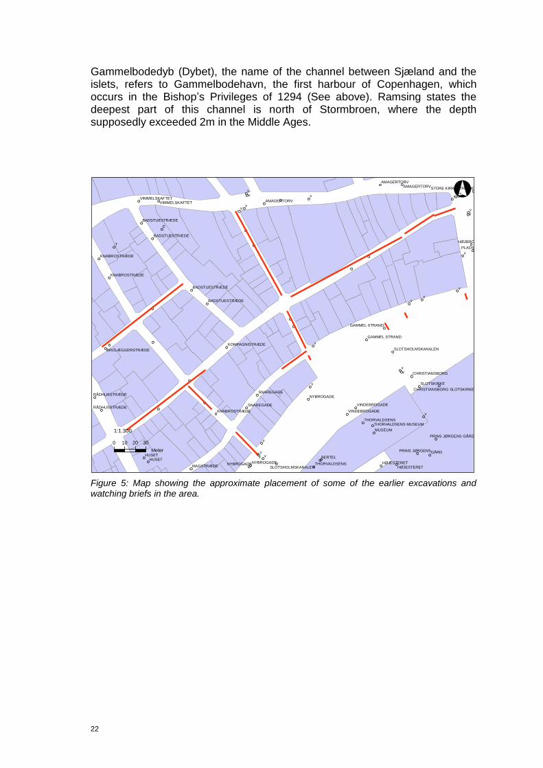
4.2 Topography
Before the urbanisation of Gammel Strand the area had the character of a beach environment, which faced the islets right off the coast. It was an ideal natural harbour. The urbanization processes did not begin until in the middle of the 14th century.
In the area between northwest of Strandholmen/Slotsholmen and the beach were found the small islets the so-called Skarnholme. They were first mentioned in 1549 when the magistrate is permitted to build a landing place and a careening place (KD I s. 423). The name “Scarnholmen” occurs in 1641, which is rather late.
22
Gammelbodedyb (Dybet), the name of the channel between Sjæland and the islets, refers to Gammelbodehavn, the first harbour of Copenhagen, which occurs in the Bishop‟s Privileges of 1294 (See above). Ramsing states the deepest part of this channel is north of Stormbroen, where the depth supposedly exceeded 2m in the Middle Ages.
Figure 5: Map showing the approximate placement of some of the earlier excavations and watching briefs in the area.
vv
v
v
v
v
vv
v
v vvv
v
vv
v
v
vv
v
vv
E
T
GÅRDHUSET
HUSET
PLADS
BERTEL
MUSEUM
HØJBRO
NYBROGADENYBROGADE
SNAREGADE
SNAREGADE
MAGSTRÆDE
NYBROGADE
HØJESTERETHØJESTERET
SLOTSKIRKE
AMAGERTORVAMAGERTORV
AMAGERTORV
THORVALDSENS
THORVALDSENS
RÅDHUSSTRÆDE
RÅDHUSSTRÆDE
KNABROSTRÆDE
KNABROSTRÆDE
VINDEBROGADE
VINDEBROGADE
KNABROSTRÆDE
PRINS JØRGENS
VIMMELSKAFTETVIMMELSKAFTET
BADSTUESTRÆDE
BADSTUESTRÆDE
BADSTUESTRÆDE
BADSTUESTRÆDE
GAMMEL STRAND
GAMMEL STRAND
CHRISTIANSBORG
KOMPAGNISTRÆDE
BROLÆGGERSTRÆDE
SLOTSHOLMSKANALEN
STORE KIRKESTRÆDE
SLOTSHOLMSKANALEN
PRINS JØRGENS GÅRD
THORVALDSENS MUSEUM
CHRISTIANSBORG SLOTSKIRKE
°
0 10 20 30
Meter
1:1.300

23
5 Archaeological background
5.1 Earlier work
Several archaeological observations have been made in the Gammel Strand area, mainly in relation to watching briefs. The consistent features seem to be wooden structures such as singular posts and bulwark remains.
In the archives, information about finds of archaeological interest since the beginning of the 20th century is found. Most of the information is assessed to be very reliable. Yet it was not until 1972 that the first professional archaeological observations were made in the area. Nationalmuseets Skibshistorisk Laboratorium (today Vikingeskibsmuseet) was called upon to investigate finds made at Gammel Strand 34, where they found a keel with bow and a frame with bollard. They had already been summoned in the 1960‟s where 2-3 smaller boats had been found under the facade of Krogh‟s Fiskerestaurant. The boats were not removed and should still be in place today.
These finds provides us with obvious, but nonetheless important, information about the place:
1) Preservation conditions for organic material are excellent.
2) The former coastline is in the vicinity, but not at its present location.
All the later excavations, watching briefs and core samples support the assumption that the former coastline is to be found to the north of the present day houses on Gammel Strand, and landfill to the south, along with associated bulwarks, provide its present location.
To the northwest of Gammel Strand, analysis of macrofossil samples testify that Snaregade was a periodically flooded area with some kind of settlement activity nearby, as the lower cultural layers have been AMS-dated to the middle of the 12th century. In this period the beach seems to be located somewhere between Snaregade and Brolæggerstræde (Poulsen 2005).
The landfill process is illustrated by the bulwarks: some of the earliest bulwark remains have been found in the street of Naboløs and in the western part of Gammel Strand. Here dendrochronological dating suggests that the bulwarks were established some time after 1270. In Naboløs they are dated to “after 1260”, “1324” and “1396”, and at Gammel Strand after 1270 and c. 1332; yet ceramic finds suggest a date between 1400-1500. Marine gyttja further south has been dated to 1293, which implies that at this time water is still present here, and this corresponds well with the former dates for bulwarks (Poulsen 2005; Jensen & Søndergaard 2003).
24
In Snaregade, bulwark dated between 1516 and 1617 was reinforced after 1630. In Nybrogade substantial bulwark remains have been dated to after 1688. Further to the east on Gammel Strand two bulwarks have been dated „after 1500‟ and “winter 1405/1406” (Poulsen 2005).
The watching brief KBM2908, which ran across several streets from Skindergade in the north to Snaregade in the south, provides valuable information about differences in the terrain along with the accumulation of cultural layers and the subsoil level in the area. Measurements showed that while todays drop in the terrain from Skindergade to Snaregade is 4.8m, the drop in the level of the natural geology is 5.8m. This tells us that the original drop in the terrain towards the Gammel Strand area was greater before the deposition of the cultural layers (KBM 2908; Poulsen 2005 p. 9).
5.2 The Gammel Strand watching brief 2008
A preliminary investigation prior to the main Metro excavation was conducted in 2008 on Gammel Strand in order to facilitate the planning of the future work. Three north-south trenches were dug, no deeper than the water table, and only till the first archaeological feature was identified. South of Gammel Strand 42 bulwark was found and dated to „after 1500‟. Futher south, remains of floor and walls typologically dated to 1700-1800 were found. Further to the east additional bulwark remains were found in the trench outside Gammel Strand 36/38. The last trench was located south of Gammel Strand 26, right near the corner of Gammel Strand/Højbro Plads. No bulwark was found here.
File no. Type of remains
NSL 177 Ship parts
KBM 1213 Building structures
KBM 2244 Building structures, pavement
KBM 2487 Posts, bulwark
KBM 2747 Posts, bulwark
KBM 2908 Building structures, water pipes, roads, moats and gardens
KBM 3290 Cultural deposits
KBM 3785 Building structures, bulwark, waterpipe
KBM 3862 Building structures
KBM 3893 Building structures
KBM 3903 Building structures
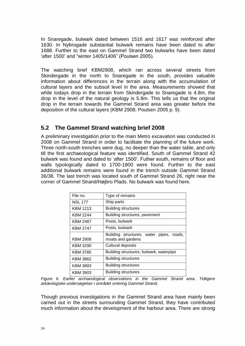
Figure 6. Earlier archaeological observations in the Gammel Strand area. Tidligere arkæologiske undersøgelser i området omkring Gammel Strand.
Though previous investigations in the Gammel Strand area have mainly been carried out in the streets surrounding Gammel Strand, they have contributed much information about the development of the harbour area. There are strong

25
indicators that the former coastline is to be found somewhere to the north of Gammel Strand. The area between the former and the present coastline was filled up between 1200 and 1700. This was probably done in different stages as implied by the bulwark dates.

26
6 Cultural historical potential and aims
6.1 Introduction
As the previous chapters 3 and 4 show, the area of Gammel Strand has played a central role in the development of the maritime infrastructure of Copenhagen, and it has been the place of several administrative buildings which were essential to the economic growth of the town. This report deals with the many watching briefs that took place ahead of the actual excavation of Gammel Strand in relation to the establishment of a metro station. It should therefore not only be dealt with as an investigation of its own, but also as a precursor of what is to be expected in the coming excavation.
6.2 The harbour
The area has been subject to land reclamation and its closeness to water makes it a rather waterlogged area. The houses on Gammel Strand stand on a foundation of piles that have been preserved to this day due to the waterlogging of the area.
The archaeological remains of the area, such as bulwarks dendrochronologically dated to the 15th century and the find of ship fragments at earlier excavations, must be considered high potential in terms of studying the establishment and development of the harbour area with its land reclamation and quay construction. In the forthcoming excavation there is a real possibility of finding evidence of the earliest harbour at the place.
6.3 Social economics
The archaeological finds from Gammel Strand carry a high potential for studying trade that was so vital for the town. Whether locally produced or imported goods, they all bear witness to the trade patterns, trade connections and the industries themselves and their development. By studying the archaeological evidence it may be possible to address issues such as the social topography of the the town when comparing to the rest of the archaeological material of Copenhagen, and tell us about the socio-economic capacity of the society.
The finding of buildings that can be assigned to the administration of the town and in particular the harbour, provides valuable information about the organisational design that was to continuously secure the order and the prosperity of the town.

27
6.4 Infrastructure
With the finding of several sewers, gutters and waterpipes and a few traces of possible roads on Gammel Strand it is possible to study the layout and changes of some of the infrastructural systems in the town. By studying those, valuable information is added to the understanding of the layout of the streets, parcels and probably also the social differences in the quarters. Comparing with the written sources, that have been preserved or the late part of the Post-Medieval period, it will also be possible to see if the regulations were met as required.

28
7 Methodology
7.1 Excavation and documentation methodology
This chapter describes the excavation techniques, sampling, documentation, terminology and registration applied to this watching brief. It also describes the ongoing work practices and field conditions concerning this specific watching brief.
7.1.1 Watching brief methodology
The watching brief on Gammel Strand was characterized by a number of more or less incoherent trenches, dug by machine. When digging a specific trench the archaeologist was summoned by the NCC to supervise the work. The trenches were primarily dug by machine under the supervision of an archaeologist. The identification of archaeological features lead to further investigation by trowel or shovel, and were excavated single context to the extent that the conditions allowed this. Some major archaeological features such as fill layers, were, to some extent, removed by machine after documenting and in some cases, sampling was performed.
7.1.2 Documentation methodology
The aim was to record all archaeological features according to the stratigraphical, single context method as described in Roskams (2001). This means that archaeological contexts should be recorded and described down to the smallest visible event that can be identified by the archaeologist.This means documenting the contexts the way they are dug; in a reverse chronological order starting with the most recent remains first and working back in time. When it comes to watching briefs, this method is subject to some modifications. Many contexts are only to be seen and recorded in sections, and the full extent of these are therefore rarely identified. Some features could only be registrered without further investigations, standing on top of the trench, because of the hazards of collapsing profiles and pollution.
In practice, the registration of each context and in-situ find was recorded by giving it all relevant coordinates and boundaries along with a unique identification number generated by the total station. Regarding features that only appears on section drawings, these were given unique numbers afterwards in IntraSiS. Most of these do not have any geoobject attached, and can therefore not be shown in maps other than by the section number. Due to the nature of the watching brief, primarily consisting of narrow trenches, this has resulted in higher number of contexts recorded without individual geoobjects attached than an actual excavation probably would.
29
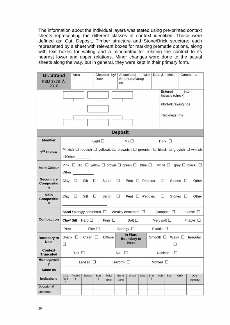
The information about the individual layers was stated using pre-printed context sheets representing the different classes of context identified. These were defined as: Cut, Deposit, Timber structure and Stone/Brick structure; each represented by a sheet with relevant boxes for marking premade options, along with text boxes for writing and a mini-matrix for relating the context to its nearest lower and upper relations. Minor changes were done to the actual sheets along the way, but in general, they were kept in their primary form.
Gl. Strand
KBM 3828 År 2010
Area Checked by/ Date
Associated with Structure/Group no.
Date & Initials Context no.
Entered into Intrasis (check)
Photo/Drawing nos.
Thickness (m)
Deposit
Modifier Light □ Mid□ Dark □
2nd
Colour Pinkish □ reddish □ yellowish□ brownish □ greenish □ bluish □ greyish □ whitish
□Other ____
Main Colour Pink □ red □ yellow □ brown □ green □ blue □ white □ grey □ black □
Other ______
Secondary Compositio
n
Clay □ Silt □ Sand □ Peat □ Pebbles □ Stones □ Other _____________
Main Compositio
n
Clay □ Silt □ Sand □ Peat □ Pebbles □ Stones □ Other _____________
Compaction
Sand Strongly cemented □ Weakly cemented □ Compact □ Loose □
Clay/ Silt Hard □ Firm □ Soft □ Very soft □ Friable □
Peat Firm □ Spongy □ Plastic □
Boundary to Next
Sharp □ Clear □ Diffuse
□
In Plan, Boundary to
Next
Smooth □ Wavy □ Irregular
□
Context Truncated Yes □ No □ Unclear □
Homogeneity Lensed □ Uniform □ Mottled □
Same as
Inclusions Charcoa
l
Pebbles
Stones Bone
Twig/
Bark
Burnt
Bone
Wood Slag Shell
Ash Soot CBM Other
(specify)
Occasional
Moderate

30
Frequent
Other Inclusions
Finds Ceramics
CBM Wood Fe Textile Slag Bone Glass Worked
Stone
Flint Leather Other (specify)
Occasional
Moderate
Frequent
Finds Notes
Interpretative Tools
Angle of finds etc Horizontal □ Vertical □ Mixed □ Not Perceivable □ Angled__________(add
direction below)
Deposition Process
Rapid Backfill □ Dump □ Naturally Accumulated □
Natural Accumulated with Dumped Elements □ Cultural Accumulation (in situ) □
Extra Description
Interpretation Basic Interpretation
(see Typology)

31
Sketch (Including North arrow for plans and facing
direction for profiles or sections. Not to scale.)
Excavation Conditions Dry □ Light Rain □ Wet □ Sunny □ Cloudy □ Frozen □
Excavation Method Machine □ Spade/Mattock □ Hoe □ Trowel □
Sample ID
C14 □ Botanical □ Dendro □ Insect □ Pollen □
Other_________________
Taken by Sample Notes
Figure 7. The type of context sheets used at Gammel Strand in 2010.
During the fieldwork phase the information on the context sheets was transferred to the corresponding IntraSiS Explorer database for further analysis and storing. Entering information into IntraSiS also included grouping according to the principles in the “Guidelines for contextual documentation” (Thomasson 2011). In addition, all the features were entered into an overall site matrix.
32
7.1.3 Archive material
All documentation regarding the watching briefs on Gammel Strand is stored by the Museum of Copenhagen. This means that all paperwork: context sheets, diaries, drawings and such are kept in the museum storage. Digital material, such as photos, Intrasis database, e-mail correspondance and so on, have been saved on the museums terminal server with relevant back-up.
7.2 Finds retrieving and registration parameters
7.2.1 Retrieving
All the archaeological finds retrieved on the excavation have been added into IntraSiS as Finds Units. Special finds have been measured by totalstation, whereby finds unit identities waere generated in the IntraSiS database. Finds Units for bulk finds have been created by the archaeologist with special responsibility for finds. The excavating archaeologist has split the finds material collected in the same context/excavations unit into various material types, and placed it with a tag in a bag, and label with KBM number, context number and Finds Unit ID number. KBM Collections department staff have been consulted and used in the lifting procedure of selected artefacts.
Procedure: Special finds Archaeologist measure Finds Units; Bulk finds Archaeologist retrieve by hand selection material/bag/context Archaeologist with special responsibility Finds Units
The finds were brought to the museum, processed (cleaned, weighed, counted, placed in bags and marked) then transformed within IntraSiS from Finds Units into Finds Objects, whilst the fieldwork was ongoing.
Procedure: Finds coordinator Finds objects Registration
Within the documentation process, artefacts have been registered in the Finds Object section of IntraSiS. In this way they have been further sorted using appropriate typologies, dated and split into function type. Through this process, information regarding chronology, trade, wealth, and land use has been discerned.
Procedure: Finds coordinator registered finds to Specialists; Specialist analyse and report to Finds coordinator; Finds coordinator draft to Excavation Leader.
7.2.2 Registration
Each Find Unit created was registered as a Finds Object. Usually many Finds Objects were created from a single Finds Unit as the finds were retrieved and
33
placed together due to their material type. Each Finds Object was registered in two phases; the Basic Registration phase (whilst the excavation was ongoing) and then the Specialist Stage (post-excavation phase). The Specialist stage differed as extra analysis was undertaken after conservation and the whole assemblage could be viewed at one time.
Each Finds Object is given an auto generated number in the database. The Finds Object consists of a Class section and Subclass section. The Class section comprises various fields such as material type, type of object, date, measurement, location within the project and provenance. The Sub-class section consists of finds grouped together with other finds of similar types and functions. These groups relate to categories used by NOM (Nomina Rerum Mediævalium) and (MOLAS) Museum of London Archaeological Services.
Each Finds Object comprises information on the bag such as:
KBM-number Context number (SD number) Finds Object ID Material or Special Find type
7.3 Sampling methodology
This chapter describes the overall methodological framework of how and why sampling for scientific analysis is undertaken. Samples for environmental and scientific analysis have been taken from selected structures and layers, artefacts and materials. The primary aim of taking samples is to have analysis carried out in order to establish content; determination of material, identification of species or dating of a feature.These types of analysis can herafter contribute in determining how remains or features were constructed or created, give terminus post quem or terminus ante quem datings for occurring features etc.
7.3.1 Sampling techniques
All the samples have been extracted by archaeologists or consultants on site. Hereafter the samples were prioritized by the archaeologists in order to secure that only the ones with most potential in providing answers to relevant questions were sent to specialists. Further sampling has been undertaken in the laboratories by consultants. All the samples have been accompanied by a written motivation for each analysis, which has been entered into the free text field for the sample in IntraSiS. The Museum‟s Collections Department and the Finds Coordinator were responsible for conservation, while scientific analysis were within the domain of the Antiquarian Department and the Science Coordinator. Thus sampling from finds for scientific analysis concerns both departments but has ultimately been the responsibility of the Antiquarian Department.

34
7.3.2 Procedures and organisation
Sampling has been conducted according to the principles laid out in this text. The museum Science Coordinator was responsible for the contact with consultants, writing requisitions, defining timeframes as well as the scope of the analyses, to oversee that the results have been recorded in IntraSiS and that reports have been done according to the given instructions. The Science Coordinator was furthermore in charge of functional procedures concerning sieving and flotation of macro samples as well as the transportation of samples from the museum to the consultants. The consultants have been responsible for entering the results of the analysis
directly into the Museum of Copenhagen’s IntraSiS database. Templates for
this purpose have been developed in cooperation between the consultants and the Museum. The consultants were responsible for producing reports for each set of analyses.
Procedure: Archaeologist/consultant samples; Excavation Leader and Museum Science Coordinator analysis; Consultant record results in IntraSiS
7.3.3 Recording of Bulk, Monolith and Core sampling
All samples taken within the field work phase have been measured in by total station. Sample identities were then generated in the IntraSiS database. If the sample was to be analysed, it was the responsibility of the analyst to create a sample analysis ID in the IntraSiS database.
Procedure: Archaeologist (measure) sample ID; Consultant Sample analysis ID
7.3.4 Sample recording from finds
The finds have been entered and registered in the IntraSiS database according to the principles laid out in the Finds Handbook (2010). When a sample has to be taken from a find, it was the responsibility of the Finds Coordinator to create a sample ID in the IntraSiS database. If this sample was to be analysed, it was the responsibility of the consultant to create a sample analysis in the IntraSiS database.
Procedure: Finds coordinator sample ID; Consultant Sample analysis ID 5.4.1.3 Recording of samples taken from other samples It has been the responsibility of the consultant to create sample ID‟s in the IntraSiS database, e.g. when picking out organic material from Macro samples for C14 analysis. The sample analysis ID was created by the consultant conducting the analysis.
Procedure: Consultant Sample ID; Consultant Sample analysis ID

35
7.3.5 Principial procedures for sending samples to analysis
Mechanical sampling is conducted regarding macro analysis (sampling motivation is to be found in Method Statement). The field archaeologists record the sample circumstances. The Excavation Leader has responsibility to take initiative to assess the sample/group of samples for its analysis potential. An analysis motivation is filled in by a Field Leader and sent to the Science Coordinator. The motivation should be related to cultural historical questions from the Method Statement. The Science Coordinator sees to it that the samples are assessed (cultural-historical potential) by the consultant. The Science Coordinator, together with the Excavation Leader, takes the decision to send sample for analysis.
Procedure: Field archaeologist takes sample according to directives in this document, if macro describes sample circumstances; Field leader cultural historical motivation for analysis; Excavation leader Science Coordinator order analysis Consultant
7.3.6 Sample documentation
All samples taken were surveyed by totalstation, creating a unique number for the sample while linking it directly to the context from which it was sampled. On the context sheet the motivation for taking the sample is stated. This was then transferred into IntraSiS. The individual consultant was responsible for creating sample ID in the IntraSiS database. The sample analysis ID was then created by the consultant conducting the analysis.
Procedure: Consultant Sample ID; Consultant Sample analysis ID
7.3.7 Actual procedures for sending samples to analysis
Mechanical sampling was conducted regarding macro analysis (sampling motivation is found in the Method Statement). The field archaeologists have recorded the sample circumstances. The Science Co-ordinator was responsible for assessing the sample analysis potential and to make sure that the cultural historical assessment performed by external consultat is filed correctly.
Procedure: Field archaeologist takes sample according to directives in this document.
Field leader cultural historical motivation for analysis; Science Coordinator order analysis ConsultantResults.
7.4 Remains and preservation
Bearing in mind the history of Gammel Strand, it was not surprising that timber and other wooden contexts were some of the most frequent structures to be found on Gammel Strand. These remains could in many cases be assigned to

36
either bulwarks, sewers, water pipes, fences or buildings. The preservation conditions for organic material are excellent here due to the waterlogged area.
The table shows the context types found, based on their basic interpretation.
Type: Number:
Alluvial deposit 9
Barrel 1
Beam 5
Bulwark 15
Construction cut 22
Demolition layer 18
Dump layer 38
Fill 31
Floor 7
Foundation layer 5
Foundation wall 21
Foundation wattle 1
Geological layer 1
Levelling layer 51
Natural vegetation 1
Paved surface 5
Pit 5
Plank 30
Post 118
Primary construction fill 5
Quay side 1
Sewer 13
Sill beam 1
Stake 1
Wall 21
Water pipe 21
Wooden floor 1
Total: 448
Figure 8. Registered contexts.
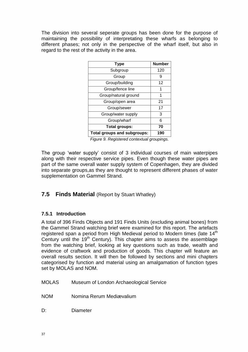
A total of 70 contextual groups were formed based on the 448 contexts and 120 subgroups. 21 groups belong to the category „open area‟. This group mainly contains contexts categorized as „land development‟ meaning deposits or structures which have been interpretated as being part of a continuous land reclamation, that seems to have taken place in Medieval and Post-Medieval time. Other groups belonging to the category „open area‟ are levelling layers, roads and courtyards.
6 groups are denoted as “wharf”, though it could be stated that there can only be one wharf which all the bulwarks and wharf sections somehow are part of.
37
The division into several seperate groups has been done for the purpose of maintaining the possibility of interpretating these wharfs as belonging to different phases; not only in the perspective of the wharf itself, but also in regard to the rest of the activity in the area.
Type Number
Subgroup 120
Group 9
Group/building 12
Group/fence line 1
Group/natural ground 1
Group/open area 21
Group/sewer 17
Group/water supply 3
Group/wharf 6
Total groups: 70
Total groups and subgroups: 190
Figure 9. Registered contextual groupings.
The group „water supply‟ consist of 3 individual courses of main waterpipes along with their respective service pipes. Even though these water pipes are part of the same overall water supply system of Copenhagen, they are divided into separate groups,as they are thought to represent different phases of water supplementation on Gammel Strand.
7.5 Finds Material (Report by Stuart Whatley)
7.5.1 Introduction
A total of 396 Finds Objects and 191 Finds Units (excluding animal bones) from the Gammel Strand watching brief were examined for this report. The artefacts registered span a period from High Medieval period to Modern times (late 14th Century until the 19th Century). This chapter aims to assess the assemblage from the watching brief, looking at key questions such as trade, wealth and evidence of craftwork and production of goods. This chapter will feature an overall results section. It will then be followed by sections and mini chapters categorised by function and material using an amalgamation of function types set by MOLAS and NOM.
MOLAS Museum of London Archaeological Service
NOM Nomina Rerum Mediævalium
D: Diameter
38
G: Gauge
L: Length
T: Thickness
W: Width
7.5.2 Results (General observations)
The assemblage comprises a mixture of a common urban assemblage from destruction layers from buildings and various dump deposits at certain periods in time from High Medieval to Modern period.
Deposits (200251) and (200252) were the earliest deposits dating from the High Medieval to the early Renaissance. They both contain a mixture of different types of finds (pottery, animal bone, building materials, textiles etc.) dumped in two clay rich dump layers, the earliest (200251) being dirty alluvial clay. The waterlogged anaerobic soil conditions have preserved many organic objects so they provide much more information on society that cannot be seen in other areas on site from the finds. It should also been mentioned that a cubic metre sample from (200252) was sieved for finds, so many more small organic finds was retrieved.
These two large deposits contain a plethora of artefacts representing the whole spectrum of finds from building materials and household goods, animal bones, pottery glass and personal equipment comprising clothing and shoes and some toys. The pottery from these deposits consist red wares (glazed and unglazed) in the forms of jugs and storage vessels from Zealand and proto stoneware and stoneware drinking vessels from the Rhine area. Evidence of ships and fishing was also apparent with small wooden fragments of ships recovered (parts of rigging and a spar), nails used in either ships or structures and wooden floats used in fishing.
Suggests either rubbish disposal in the river by private citizens as it‟s the nearest easy access refuse site or a public controlled dumping ground to create extra land. Results from the excavation should determine this issue.
The other early Post Medieval and later Post Medieval finds relate to occupation in Gammel Strand, in particular from the former Tax office building. These finds, and in particular the coins, are common finds and do not portray any evidence of high or low status or international trade.
7.5.3 Trade import/export
The main evidence of import is from the pottery and glass. There are German stonewares from the High and Late Medieval periods from the Rhine area and
39
earthenware and faience from Holland from the 16th and 17th century. There is also some glass from Rhine area from late Medieval period. The high numbers of imports may possibly represent rubbish from castle residents or perhaps by elites living nearby. It is noticeable that there are more imports in the trenches than those that have been currently found at Kongens Nytorv and Rådhuspladsen. It should be noted however, the East and West gateways of the city would be kept clean for defensive purposes as well as being a public space and somewhat ostentatious entry points into the city. The refuse area for the people around these gateways must be found elsewhere.
The majority of the finds were probably manufactured or produced locally, which is to be expected as Copenhagen was a large city by the Renaissance period and would have had their own sizable population of craftspeople. For example the pottery and tile are mostly oxidised fabric and are probably fired in Zealand. The cost of transportation of these everyday objects, especially tile and bricks, would be high. We will get a much idea of import and export when the excavation begins
7.5.4 Industry/manufacturing
Production waste from woodworking, metalworking and glassmaking were collected but not in large quantities, and no kiln structures or manufacturing structures were uncovered. From the trenches that were opened it has been suggested that the Gammel Strand was not used as a production site. This may of course change when the excavation trenches are open in 2013.
7.5.5 Building Materials
Building materials comprise of all materials relating to and belonging to structures; bricks, daub, roof tiles, stone blocks etc. From the watching brief a total 22 Finds Objects created. Most building materials were collected as a sample, as it was decided at the beginning that the main excavation will feature more analysis so the budget was best spent on registering a sample of the materials. The result of the fieldwork was that there were very few fragments of building materials seen with only the remains of Tax office preserved. The Stove tiles date from the early Post Medieval (16th Century) and are useful as a dating tool as well as evidence of wealth and trade.
7.5.6 Bricks
Two Post Medieval bricks were taken as a representative sample, no. (200512), found in (2647) and no. (200611), found in (2347). Both oxidised bricks were dumped after they were broken. Due to the high cost of transporting CBM they are probably locally fired at a site near Copenhagen and date to the Post Medieval period (1550-1850). No Medieval bricks were found on site. Brick (200512) measures L: 140mm W: 95mm T: 65mm. Brick (200611) measures L: 20mm W: 5mm T: 5mm.
40
7.5.7 Daub
One Finds Object dating from Late Medieval deposit. The Finds Object consists of 8 grey fragments of daub from a wattle and daub structure in a deposit dating from the Late Medieval period. The daub contains combed and plant marks most likely adding the daub to the structure. (200455), found in (200252). The most common form of townhouse in Copenhagen would have been constructed with an outer layer comprising wattle and daub. It is believed to have been discoloured grey due to its deposition in the waterlogged deposit.
7.5.8 Floor tiles
Two finds objects, believed to be from a wealthy townhouse, castle or a religious building due to their usual occurrence at these building types. (Gaimster, D; & Nenk, B; 1997, pp. 183-5).One fractured green glazed floor tile (200668) found in (6307), a Post Medieval deposit. Another green glaze tile (200676) probably dates from the Late Medieval to early Renaissance period and was thrown into dump deposit (6869).
7.5.9 Mortar Sample
Mortar (200466) collected from (2638). This fragment may be analysed in the main excavation as part of the natural sciences budget. The mortar is believed to date from the 17th or 18th centuries from the surrounding finds in the deposit.
7.5.10 Roof tiles
Three red oxidised roof tiles: (200468), found in (2453) (unglazed), (200470), found in (3671) (olive colour glaze), both Post Medieval in date in form, and (200613), found in (200251), which seems to be late Medieval, and one reduced fired tile no. (200469), found in (2234). Perhaps they were manufactured locally due to the cost of transportation.
7.5.11 Stove tiles
Six stove tiles dating from the 16th and 17th Centuries. These were mostly imported in the 16th Century before Danish production in the 17th Century. These tiles were used to decorate stoves and replicate the large iron stove tiles used in wealthy households. These ceramic tile stoves became fashionable because they created a smokeless central heating environment and were enjoyed the urban middle class consumers over North-western Europe. (Gaimster, D.; & Nenk, B.; 1997, p. 179).
Three stove tiles are green glazed but plain (200607) from 2380 (1500-1700), (200597) from 6869 (1500-1600) and (200472) from 6661 (1500-1700). The two vessel tiles are the earliest in date; (2OO671) and (200672), both from (6307) are dated respectively (1475- 1525) and (1500-1550). The Madjon stove tile, no. (200670) from (6307,) was imported from Germany and can be loosely dated from 1500-1575.

41
7.5.12 Lead pipes
Two lead pipes were collected as a representative sample of the many water pipes uncovered in the watching brief. Both lead pipe fragments were registered. Lead water pipe terminus (200794) and water pipe joint (200783), they both date to the Post Medieval period and have been discarded due to the large quantity found throughout Copenhagen.
7.5.13 Ceramic (By Olle Heimer (Medieval), Rikke Kristensen (Post Medieval)
7.5.13.1 Introduction
147 Finds Objects. All the type 4 ceramics from the Gammel Strand watching brief have been weighed and counted in Finds Units. In IntraSIS the numbers have been written into the Finds Units in question under “attribute”. At least one sherd from each Finds Unit has been taken out for registration. The most informative sherds concerning dating, import, local production and preservation has been prioritized for registration. Total amount of all the Post-Medieval ceramic is 71 Finds Objects.
In comparison, all the Medieval sherds were registered as finds objects (a total of 81). This was for reasons linked to the aims of the Metrocityringen project to discover the early origin of Gammel Strand and also that samples from Medieval deposit 200251 were sieved for finds.
The assemblage consisted in total of 147 finds objects registered, which comprised a total of 333 sherds weighing 10,942.5 grams.
Results
Medieval Number of sherds Weight in grams
Early red ware 32 982
Late red ware 5 355
Late grey ware 29 856
Majolica 1 8
Stoneware uncertain 5 235
Siegburg older type 125 6112,5
Frechen 1 12
Waldenburg 1 87
199 8647,5
Post Medieval
Late red ware 94 1536
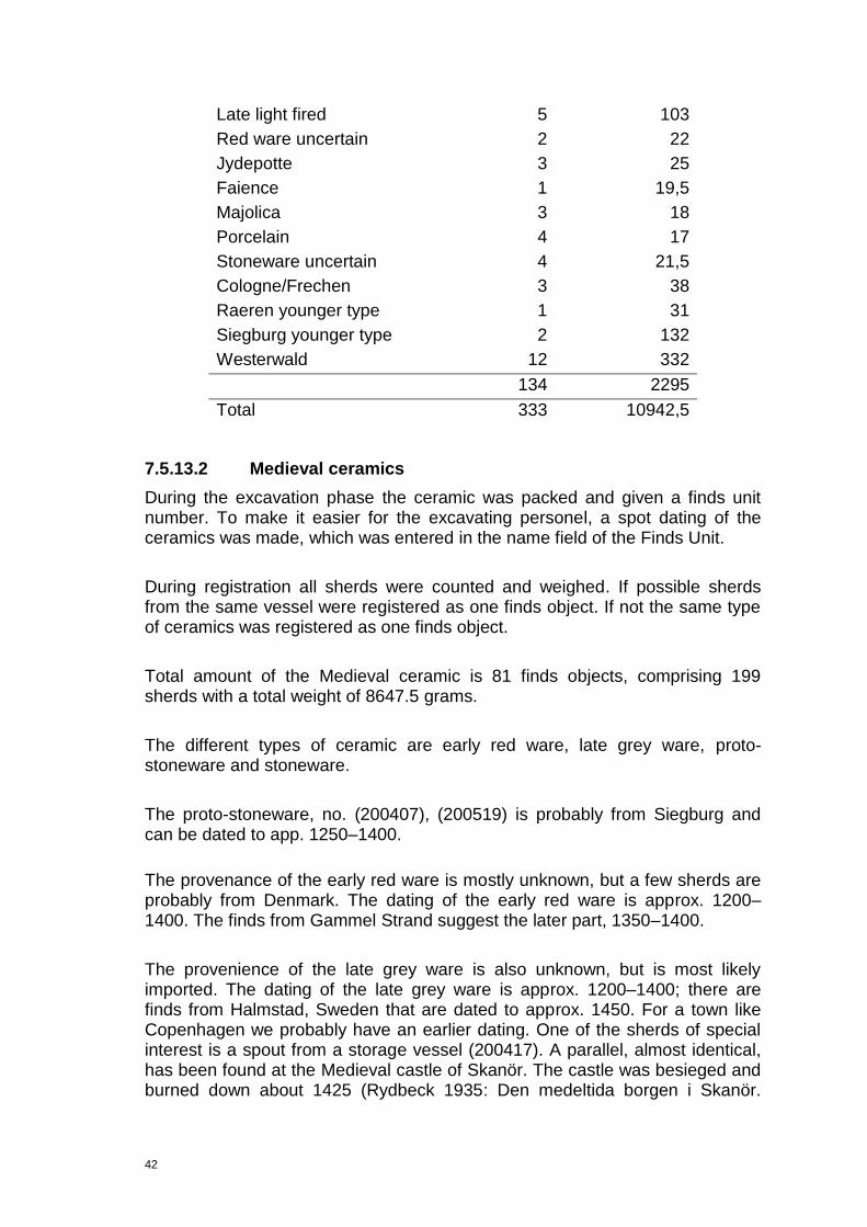
42
Late light fired 5 103
Red ware uncertain 2 22
Jydepotte 3 25
Faience 1 19,5
Majolica 3 18
Porcelain 4 17
Stoneware uncertain 4 21,5
Cologne/Frechen 3 38
Raeren younger type 1 31
Siegburg younger type 2 132
Westerwald 12 332
134 2295
Total 333 10942,5
7.5.13.2 Medieval ceramics
During the excavation phase the ceramic was packed and given a finds unit number. To make it easier for the excavating personel, a spot dating of the ceramics was made, which was entered in the name field of the Finds Unit.
During registration all sherds were counted and weighed. If possible sherds from the same vessel were registered as one finds object. If not the same type of ceramics was registered as one finds object.
Total amount of the Medieval ceramic is 81 finds objects, comprising 199 sherds with a total weight of 8647.5 grams.
The different types of ceramic are early red ware, late grey ware, proto-stoneware and stoneware.
The proto-stoneware, no. (200407), (200519) is probably from Siegburg and can be dated to app. 1250–1400.
The provenance of the early red ware is mostly unknown, but a few sherds are probably from Denmark. The dating of the early red ware is approx. 1200–1400. The finds from Gammel Strand suggest the later part, 1350–1400.
The provenience of the late grey ware is also unknown, but is most likely imported. The dating of the late grey ware is approx. 1200–1400; there are finds from Halmstad, Sweden that are dated to approx. 1450. For a town like Copenhagen we probably have an earlier dating. One of the sherds of special interest is a spout from a storage vessel (200417). A parallel, almost identical, has been found at the Medieval castle of Skanör. The castle was besieged and burned down about 1425 (Rydbeck 1935: Den medeltida borgen i Skanör.

43
Historik, undersökningar och fynd. C. W. K. Gleerups förlag. Lund. p. 151, fig. 88). That is a good dating of the sherd and is probably slightly older than that.
The provenance of the stoneware is mostly from Siegburg, with a few sherds possibly from Waldenburg. The dating of the Medieval stoneware from Siegburg is approx. 1300–1550, The Waldenburg ceramic can be dated to app. 1400–1525. It is very interesting regarding the high number of Siegburg pottery in the Late Medieval period. Is the assemblage representative of the local population nearby or are we just seeing a single dump in a single period of time from a nearby trader who had the vessels broken in transportation?
According to the composition of the pottery (red ware from 1350-1400, late grey ware from the end of the 1300 and stoneware dated to 1300–1550) I would suggest that the deposit from where the most Medieval pottery was collected (200251) and (200252) should be dated to around 1400.
7.5.13.3 Post Medieval ceramics
A total of 35 Finds Objects of the Post-Medieval ceramics are from the early Post-Medieval period (1550-1650). 6 are of stoneware, 2 are of majolica and the rest is of earthenware. The total weight of the late Post-Medieval ceramic is 1570g.
Of special interest is (200592), found in (2453): a sherd from a Siegburg schnelle (mug) decorated with the Tudor coat of arms and the year [...]5. The vessel is dated to c.1545-1625. (200615), found in (2453): a sherd from a North Dutch polychrome majolica dish dated 1575-1700. (200633), found in (3392) is a sherd, which derive from a cow horn painted money box, probably of dutch orgin, or from the Werra area in Germany. (FO200634), found in (200112) a sherd from a stoneware schnelle (mug) from Raeren decorated with the Swedish royal coat of arms and portrait of a king maybe Gustav Vasa (1523-60). This mug type is dated to 1550-1630. Finally (200662), found in (7360) is a sherd from an early red-fired dripping pan from the Netherlands dated to c.1300-1600.
Among the early Post-Medieval ceramic there are many imported sherds, especially earthenware from Netherlands and Niedersachsen/Weser, stoneware from Germany e.g. Siegburg, Westerwald and Raeren and majolica of North Dutch type. The main bulk of ceramics are shreds of locally produced late red wares, mostly pots and pan often with stjerts.
A total of 7 Finds Objects can be dated to the Late Post-Medieval period (1650-1848). 2 of these are of porcelain, 1 of majolica, and 4 are of earthenware. The total weight of the Late Post-Medieval ceramic is 134g. The porcelain is Chinese dated 1725-1775, the earthenware is both locally produced and imported from Netherlands and the majolica is of late North Dutch type dated 1650-1750.

44
The collection of 23 Finds Objects that are just registered as Post-Medieval ceramic since no precise date was possible according to the types and preservation stage. The total weight is 500g. Among these ceramics there are also earthenware imports from the Netherlands and stoneware imports from Westerwald in Germany.
Figure 10. A sherd from a Siegburg schnelle (mug) decorated with the Tudor coat of arms and
the year …5 dated 1545-1625.
7.5.14 Clay Pipes (by Mie Pedersen)
A total of 5 clay pipe finds objects. The small assemblage consists of 5 fragments weighing 32g.
When smoking was introduced in Denmark is unknown. However, it is suggested that it was first happened in Elsinore in the later part of the 16th century. In the beginning of the 17th century, in 1606 specifically, an estate

45
belonging to a deceased citizen who sold clay pipes for a living, mentions a dusin clay pipes (Bardenfleth 2002 p. 25).
The earliest known Danish production of pipes was in Elsinor in the mid 17th century. Some vague attempt to get a pipe production started in Copenhagen was made in the late 17th century, but lack of evidence from the production and no written sources where the production sites were placed makes it rather uncertain whether or not an actual production took place.
From the beginning of the 18th century a new and evidently a more successful attempt was made and from the mid 18th century the Copenhageners could easily acquire locally produced pipes (Bardenfleth, 2002, pp. 112-123).
Of note: Probably Dutch stem with heal stamped with a badly preserved rose or scales. 17th Century style heel (200459, (1335).
Bowl with stamp containing the letters R and P. Probably relating to a design from Amsterdam dating between the years 1625-40 (200471), found in (6307).
The other 3 clay pipes finds objects consist of 3 undecorated stems which have no real use in dating (200363), (200264) and (200265).
7.5.15 Flint
Only one fragment of flint was registered, most were found to be un-worked when processing the finds.
One flint flake, FO 201109, believed to be residual within (200251). Measures L: 22.5mm W: 21.7mm T: 6mm.
7.5.16 Glass (by Kirstine Haase)
The registered glass consists of 23 finds objects which include 77 sherds of glass dating from the Late Medieval period to the Modern age. The assemblage comprised 9 finds objects of bottle sherds, 7 finds objects of drinking glass, 4 finds objects of window glass and 3 finds objects of undefined glass.
Of note were the glass sherds from deposits (2453), (200251) and (200252). An early mouth blown Caste bottle (200566) was retrieved from deposit (2453). Although Post Medieval in date, it is a rare glass style on the Metrocityringen excavations. Remains of a wine bottle (200379) was retrieved from (200251).
The most interesting glass remains were from the Late Medieval deposit (200252). These sherds were from more vessels that were imported and used by the Copenhagen elite. Sherds from a Humpen type drinking glass (200578)
46
were found, imported from Germany. A Strangen type glass vessel, probably German as well, linked to the date of the pottery (200579). There were also 2 rim sherds of a hexagonal or octagonal Pas Glas bottle with Writhen ribbing decoration technique, also German.
7.5.17 Metallurgical waste
A total of 3 Finds objects were registered comprising burnt clay, iron slag and glass slag. Listed below are the interpretations and descriptions. These objects will be registered along with the other metallurgical waste in the main excavation report.
7.5.18 Burnt clay
A single fragment of burnt clay perhaps relating to metal production. This fragment may have come from a forge wall. (200658), found in (200252). Early Post Medieval deposit containing dump material, dumped from a forge nearby?
7.5.19 Glass slag
A single fragment of glass slag from (200666), found in (2876) probably dated to Early Post Medieval/Renaissance time, i.e. 16th-Century.
7.5.20 Iron rich slag
Four fragments of iron rich slag. (200453), found in (200252). Believed to represent metalworking in the town in the Late Medieval/Early Post Medieval period.
7.5.21 Numismatic
A total of 11 possible coins have been retrieved. They are between fair and poor condition with only a few with visible faces, they have been corroded within the ground conditions. They are listed Pre Danafae before they are sent into the National Museum, although they have been spot dated by them, mainly to the 18th and 19th Centuries. They appear to comprise of an alloy of copper and are not important economically. The majority of the coins are from the remains of the tax building, from deposits (3871) (5 coins) and (1886) (3 coins). Listed below are the various coins and tokens.
Copper alloy, possibly a Danish coin. Dates from the Post Medieval period. Measures D: 17mm T: 1mm. (200076), found in (1886).
Copper alloy, possibly a Danish skilling. Dates from the late Post Medieval period. Measures D 16mm T: 2mm. (200077), found in (1886).

47
Copper alloy, possibly a Danish coin. Dates from the Post Medieval period. 18th Century. Measures D: 16mm T: 1mm. FO (200273), found in (1886).
Copper alloy, possibly a Danish coin, Dates from the Post Medieval period, probably the 18th-century. Measures D: 30mm T: 1mm (200274), found in (3871).
Copper alloy, possibly a Danish coin. Dates from the late 18th-century. Measures D: 32mm T: 1mm. (200275), found in (3871).
Copper alloy, possibly a Danish coin. Dates from the late 18th-century. Measures D: 30mm T: 2mm. (200276), found in (3871).
Copper alloy, possibly a Danish coin dating to the 1830s and interpreted as coins from the bankruptcy period with the coins devalued. Measures D: 20mm T: 1mm. (200277), found in (3871).
Copper alloy coin, very corroded. No spot date given by National Museum. From a Post Medieval deposit. Measures D: 22 T: 4mm. (200278), found in (2347).
Copper alloy coin fused to lump of iron. Very corroded, no face visible. Measures D: 22mm T 1mm. (200442), found in (3871).
Copper alloy coin, also possibly a button (200446), found in (3871). No spot date by National Museum. Post Medieval date from surrounding finds. Measures D: 15mm T 6mm.
7.5.22 Household Items
The assemblage consists of various objects from the household i.e. cutlery, non ceramic storage items, furniture. None of these recovered objects were of great prestige, wealth or representing foreign trade (although there is a possibility that some of these items could have imported) they mostly represent common day objects from the normal Copenhagener. A total of 9 Finds objects. The organic objects generally were well preserved and as expected the metal objects were fairly corroded.
7.5.22.1 Barrel tap
Copper alloy barrel tap retrieved from the basement of the former tax office. (200157), found in (2453). Post Medieval in style. Barrel is presumed to have contained alcohol, although type of alcohol is unknown. Measures L: 163mm W: 85mm.

48
7.5.22.2 Base of a wooden bucket
Late Medieval in date, no distinguishing features. (200595), found in (200251). Half of the base is missing. From the remaining fragment the base measures L: 98mm W: 38mm. Presumed originally 196mm in diameter.
7.5.22.3 Wooden plate
Base of a wooden plate, some part missing. Hollowed internal area with edges sloping upwards, no decoration. (200586), found in (200252). L: 150mm W: 63mm T: 18mm.
7.5.22.4 Wooden lid
Small lid of an incomplete barrel. No decoration. (200494), found in (200252). Late Medieval-Early Post Medieval in date. L: 74mm W: 30mm.
7.5.22.5 Barrels stave
Simple undecorated single wooden stave from a barrel. (200492), found in (200252). Late Medieval, Early Post Medieval in date. Split into 3 fragments in antiquity.
7.5.22.6 Copper alloy cup
Small, dented cup very corroded from the soil conditions. Very little metal quality left, mainly just corrosive growth, may be a highly corroded crucible. (200249) found in (200102). Measures D: 55mm
7.5.22.7 Undefined wood
Wooden fragment, possibly from an unidentified piece of furniture. (200477), found in (200252). Late Medieval/Early Post Medieval in date. Measures L: 77mm W: 30mm.
6.5.9 Leather items (By Vivi Lena Andersen)
The majority of the leather items found on this site can be linked to shoes or shoe production. Therefore the listing below is split up in the different shoe parts, production waste and leather of unknown function.
Total amount of find objects of leather registered is 63, which comprised a total of 81 parts/types consisting of 178 fragments.
Results:
Medieval
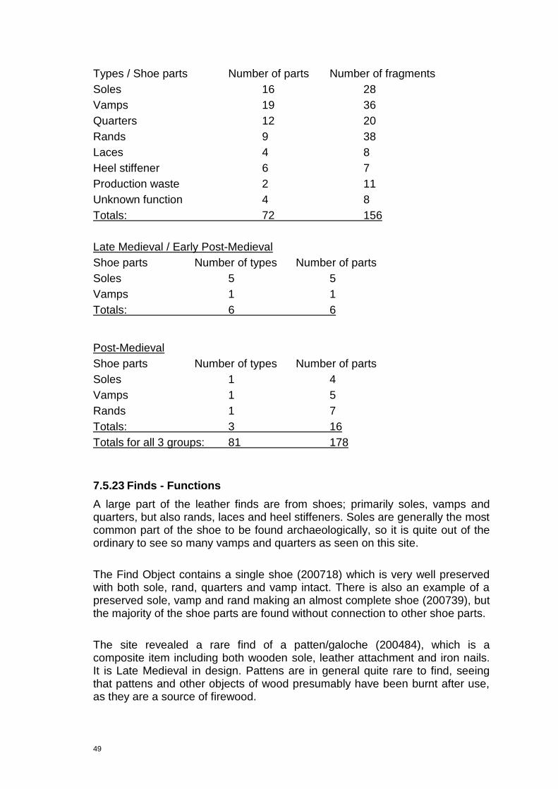
49
Types / Shoe parts Number of parts Number of fragments
Soles 16 28
Vamps 19 36
Quarters 12 20
Rands 9 38
Laces 4 8
Heel stiffener 6 7
Production waste 2 11
Unknown function 4 8
Totals: 72 156
Late Medieval / Early Post-Medieval
Shoe parts Number of types Number of parts
Soles 5 5
Vamps 1 1
Totals: 6 6
Post-Medieval
Shoe parts Number of types Number of parts
Soles 1 4
Vamps 1 5
Rands 1 7
Totals: 3 16
Totals for all 3 groups: 81 178
7.5.23 Finds - Functions
A large part of the leather finds are from shoes; primarily soles, vamps and quarters, but also rands, laces and heel stiffeners. Soles are generally the most common part of the shoe to be found archaeologically, so it is quite out of the ordinary to see so many vamps and quarters as seen on this site.
The Find Object contains a single shoe (200718) which is very well preserved with both sole, rand, quarters and vamp intact. There is also an example of a preserved sole, vamp and rand making an almost complete shoe (200739), but the majority of the shoe parts are found without connection to other shoe parts.
The site revealed a rare find of a patten/galoche (200484), which is a composite item including both wooden sole, leather attachment and iron nails. It is Late Medieval in design. Pattens are in general quite rare to find, seeing that pattens and other objects of wood presumably have been burnt after use, as they are a source of firewood.

50
Some of the leather finds cannot be identified, so these are registered as having unknown function. The majority of the found leather pieces are smaller, badly preserved leather.
A few of the finds are in the category of production waste, e.g. (200755) which consist of large pieces of well preserved leather with traces of stitching and/or decorative holes – though of unknown function. Large pieces of leather are fairly rare to find, seeing that large leather pieces where easy to reuse as e.g. shoe parts. The (200730) also looks like production waste. It is a find of small pieces of worn, cut up shoe parts and leather pieces. This find could very well be waste from a workshop, a shoe maker or a shoe repairer. It is most likely to be from a shoe maker‟s workshop, where not only production of new shoes took place, but also reparation of shoes – seeing that the majority of the pieces are from worn shoes. Shoe repairers also often used old shoes to cut up into spare parts, but the shoe repairer as a “craft”, separated from the shoe maker, did not appear until after the Middle Ages, and this unit in question seems to be Medieval, based on its context.
7.5.24 Preservation
Some of the leather items are very well preserved, e.g. a Medieval vamp (200728), while other finds are very badly preserved, e.g. a Medieval ankle boot (200830).
The majority of the finds are related to find units (200327) and (200338). The find unit contains both very well preserved leather and very badly preserved leather. Even the same type of shoe parts (same type of skin) have a difference in the level of preservation from that specific context.
7.5.25 Status and age
Some shoe parts have a lot of wear, while others have been worn very little before being thrown away. There are examples of very good quality leather and fine hand craft (with very little wear), but also bad hand craft with great irregularities in seams and stitching (and with a great degree of wear, i.e. worn holes in the soles). All this means that there are both ends of the status scale represented, and also finds in the middle of the scale.
The shoe parts are primarily from shoes belonging to adults, but one very fine, well preserved vamp is from a child shoe (200752).
7.5.26 Import/local production
The leather finds shows no sign of import. The finds are most likely of local production. Copenhagen had many shoe makers within the boundaries of the city in both Medieval and Post Medieval times, and there doesn´t seem to be any foreign types or techniques in this find.
51
No heels were found, which could imply that the find units in question are dated to before 1600, which is the time, where heels become part of the shoe for the first time in Scandinavia. The Post-Medieval shoe (200821), consisting of sole, vamp and a rand has originally had a heel, but the heel is now missing. So (200821), related to find unit (200809), must be the youngest leather item in the finds.
7.5.27 Dating
Of the 63 find objects registered 56 find objects are Medieval, 6 find objects are in the period crossing Late Medieval and the beginning of the Renaissance and 1 find objects is Post-Medieval.
The leather finds are typologically dated from the shoe parts. The typological elements are the toe of the shoe, the shape of the sole, the fastening and the construction of the shoe /the technique.
The earliest finds could stylistically be from the 14th century (200765) and (200766), but this is uncertain seeing that the rest of the leather finds in (200338) are younger.
There is a category of finds of soles and a vamp which is difficult to date specifically to either Medieval or Post-Medieval, so therefore these are separated in a category called Late Medieval/Early Post-Medieval (200786) and (200791).
7.5.28 Personal Items
Personal items comprise a broad spectrum of the finds catalogue relating to objects that display extra information about people. Examples are clothing accessories, decorative portable jewellery, relics and Figureines. They may represent the everyday lives of Copenhageners, sometimes showing wealth, fashion, trade and technology. A total of 13 Finds Objects were registered. The small assemblage portrayed the average Copenhagener, not any real objects portraying wealth or imports from outside Copenhagen.
7.5.29 Black Pearl bead
Bead retrieved from sieving. Half of object is missing. Comprises hole through centre and polished exterior. Either from necklace, bracelet or perhaps a rosary. Dated to the Late Medieval period from surrounding finds. (200812), found in (200251). Measures D: 6mm T: 4mm.

52
Figure 11. Black Pearl bead (200812). Late Medieval–Early Post Medieval in date.
7.5.30 Bone comb
End part fragment of a comb with ring and dot style decoration. One quarter comprises 7 ring and dots and the other quarter has 8 ring and dots. Very common late Viking period to Post Medieval style of decoration. (200714), found in (200252). Measures L: 60mm W: 31mm T: 1mm.
7.5.31 Button
Copper alloy, poor condition and very corroded, fractured on edges with back fastener missing. FO 200819 SD 200251. Measures D: 15mm T: 2mm.
7.5.32 Buckle
A small copper alloy buckle, plain with no decoration. Consists of an oval frame with central prong. Post Medieval in style. FO 200296 Un-stratified, retrieved from a soil dump. Measures L: 63mm W: 20mm T: 2mm.
7.5.33 Clasp from a belt
Copper alloy clasp from a belt, undecorated with fair preservation. (200448), found in (200252). Measures L: 64mm W: 11mm T: 1mm.
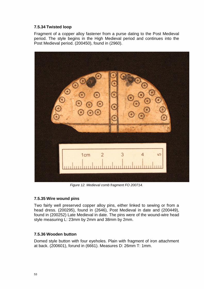
53
7.5.34 Twisted loop
Fragment of a copper alloy fastener from a purse dating to the Post Medieval period. The style begins in the High Medieval period and continues into the Post Medieval period. (200450), found in (2960).
Figure 12. Medieval comb fragment FO 200714.
7.5.35 Wire wound pins
Two fairly well preserved copper alloy pins, either linked to sewing or from a head dress. (200295), found in (2646), Post Medieval in date and (200449), found in (200252) Late Medieval in date. The pins were of the wound-wire head style measuring L: 23mm by 2mm and 38mm by 2mm.
7.5.36 Wooden button
Domed style button with four eyeholes. Plain with fragment of iron attachment at back. (200601), forund in (6661). Measures D: 26mm T: 1mm.

54
7.5.37 Toys
7.5.37.1 Marble gaming piece
Ceramic, a „‟marble‟‟ gaming piece. Can also be interpreted as a bottle stopper, as was common. Many have been found on the Kongens Nytorv and Radhuspladsen excavations (report forthcoming). Light brown. (200447), found in (2453). Measures D: 13mm.
7.5.37.2 Bone toys
Bone toys (throwing game called Kaste kegler). Two phalanxes of a pig. Evidence of this can be seen in a famous painting by Peter Breugel from the Renaissance period with a child throwing these bone toys. (Grunfeld. 1978, pp. 228-9). (200514), (200526) and (200653). All found deposit (200252). Average measurement L: 45 W: 19 T: 18.
7.5.38 Rope (by Charlotte Rimstad)
7.5.38.1 Introduction
Rope plays an important role in many everyday events, even today. Rope from the 13th-17th century would have been used for maritime purposes as well as on construction sites and in the daily household. Many so-called ropewalks were found in Copenhagen in the periods in question and it must therefore be assumed that all the ropes found at Gammel Strand were locally made.
7.5.38.2 Analyses
The rope fragments have been measured and their twining directions on all cord levels have been recorded and entered in the IntraSIS database. The record consists of 16 FO number with various fragments of rope made of plant or animal fibres. It is a real mixture of rope types for various functions hard to decipher.
7.5.38.3 Rope of plant fibres
Rope of plant fibres were the most normal type. They were usually made of hemp, especially for maritime use (link 2). Other fibres as flax or bast could also be used, but only fibre analyses can reveal exactly what kind of fibres the Gammel Strand ropes are made of.
Very thick rope of plant fibres, light brown, no. (200770), found in (200525): Dimensions: L: 850 mm, D: 50 mm. Z-twined of 3 smaller S-twined ropes (2.5 cm thick each), which again are made of 8 S-spun cords (1 cm thick each).
55
Large fragment of thick rope of plant fibres, dark brown, no. (200772) found in (200252). Dimensions: L: 230 mm, D: 35 mm. Z twined of two smaller ropes (1.7cm thick and S-spun). Each of the smaller ropes are made of four cords (1.4cm thick and S-spun).
Fine piece of plant fibres rope, yellow brown, no. (200776), found in (200252). Dimensions: L: 270 mm, D: 10 mm. Made of 3 S-spun cords (0.6 cm thick each) and Z-twined into a rope.
Rope of plant fibres, yellow brown, no. (200778), found in (200252). Dimensions L: 65, D: 23 mm. Z-twined of 2 smaller S-spun cords (1.2 cm thick each).
Very thick rope of plant fibres, yellow brown. (200779). Dimensions: L: 165 mm, D: 40 mm. The rope is Z-twined and consists of 3 S-twined big cords (2 cm thick each), each made of 8 S-spun smaller cords (0.8 cm thick each).
Rope fragment comprising plant fibres with a knot in the end, yellow brown colour, no. (200780), found in (200252). Dimensions: L: 85 mm, D: 30 mm. Knot measures 3.4 by 3 cm. The rope is Z-twined of three smaller S-spun ropes (0.7 cm thick each).
Several rope fragments of plant fibres, yellow brown, no. (200840), found in (200252). Dimensions: L: 60 mm, D: 12 mm. The rope is S-twined out of 5 S-spun cords (0.6 cm thick each). The shape and twining direction suggest that these fragments derive from a bigger (Z-twined?) rope.
Rope fragment made from plant fibres, yellow brown colour, no. (200842), found in (200252). Dimensions: L: 85 mm, D: 20 mm. S-twined of 3 S-spun cords (1 cm thick each).
Thick rope of plant fibres, dark brown, no. (200843), found in (200251). Dimensions: L: 270 mm, D: 40 mm. Made of 10 smaller cords. Twining angle is very loose, 70 degrees.
Tiny rope of plant fibres, light brown, no. (200845), found in (200251). Dimensions: L: 150 mm, D: 10 mm. Z-twined, made of two S-spun cords (0.6 cm thick each).
Many rope fragments of plant fibres, dark brown, no. (200846), found in (200251). Dimensions: L: 230 mm, D: 13 mm. The rope is S-twined of 4 small S-spun cords (0.6 cm thick each). The rope might have been part of a bigger (Z-twined?) rope.
56
7.5.38.4 Rope of animal fibres
Rope of animal fibres, such as horse hair, may have had different purposes than the ropes made from plant fibres.
A total of 7 felted cords made of an unidentified type of animal hair, dark brown, no. (200777), found in (200252). Dimensions: L: 210 mm, D: 10 mm. They have been S-spun and are probably part of a bigger rope.
Two fragments of a felted rope made of animal hair, no. (200841), found in (200252). Dimensions: L: 190 mm, D: 20 mm. One of the fragments is clearly S-spun.
Felted rope, of animal hair, dark brown colour, no. (200844), found in, (200251). Dimensions: L: 300 mm, D: 25 mm It consists of two smaller S-spun cords (1.4 cm thick each).
Two fragments of felted rope made of animal hair, dark brown, no. (200847), found in (200251). Dimensions: L: 370 mm, D: 17 mm. The rope is S-twined of two smaller S-spun cords (1 cm thick each).
Small felted rope of animal hair, dark brown colour, no. (200848), found in (200251). Dimensions: L: 200 mm, D: 15 mm. Z-twined of two S-spun cords (0.5 cm thick each).
7.5.38.5 Location
All ropes come from two deposits, (200251) and (200252). The two deposits have been interpreted as being part of a wharf, filling the space between the wooden structures. Both deposits were anaerobic, wet and humic.
7.5.38.6 Preservation
The preservation of the ropes varies a lot. Some of the ropes are almost perfectly preserved, with all twists intact. Others are nearly falling apart and only a few twists reveal that the fragments were actually once a rope. Due to the waterlogged deposits the fibres have, however, survived nicely in all ropes.
7.5.38.7 Dating
The dating of the rope is based on the dating of the ceramics from the same deposits. The ceramics from deposit (200251) is, unfortunately, very broadly dated, i.e. 13th-17th century. This is a problem as the rope has a very general appearance, which is not likely to have changed much during the period in question. The overall date is, thus, still considered to be High Medieval to Renaissance.
57
7.5.39 Copper alloy padlock
The only object retrieved from the watching brief relating to the security function of the household. Standard copper alloy padlock with round tab and collar. comprises 3 strips attached to a cast circular plate. Attached arm has bolt for mechanism. Key missing. Common Medieval type, no. (200451), found in (200252). Measures D: 10mm Lock mechanism L: 24 W: 26mm. Similar to Medieval lock no. 234. (Egan, G 1993. 94)
7.5.40 Shipping and fishing
Finds in this theme comprise objects linked to ships or tools linked to fishing. All but 2 of the 8 finds objects are from the organic rich waterlogged deposits (200251) and (200252) hence the preservation of wooden objects has been good.
7.5.41 Netting needle fragments?
Three fragments of netting needles. None of these objects have been well crafted. Comprise two wooden needles: 1) (200426), found in (200374). Lenght: 88mm Diamter: 14mm. 2) (200428), found in (200251). L: 70mm D: 7mm and bone needle fragment, no. (200430), found in (200252).
7.5.42 Spar
A wooden tool used in sailing. The spar comprises handle at one terminus with point at other to de-thread rope. Late Medieval in style. Very well preserved due to soil conditions. No. (200498), found in (200252). Measures L: 158 W: 27mm T: 25mm.
7.5.43 Rigging object/float
Two very similar pulley type objects used in rigging, (200582), found in (200251). Parts missing. Measures D: 67mm T: 28mm. The object (200677), found in (200251) also had parts missing, oval shaped. Measured L: 65mm W: 52mm.
7.5.44 Miscellaneous item
Wooden object possibly linked to a structure from a ship. Singular wooden rod that decreases in diameter from one terminus to the other. Perhaps it was formerly attached to a ship. (200623), found in (200251). Measures Lenght: 67mm, Thickness: 28mm.

58
7.5.45 Bindebor
Bone object for net making, polished with break points at both ends, no. (201273), found in (3871). Measures L: 132 W: 19mm T: 6,8mm (cf. fig. 13).
Figure 13. Bindebor used in net making. FO 201273. Post Medieval period.
7.5.46 Textiles (by Charlotte Rimstad)
7.5.46.1 Introduction
Textiles from the Middle Ages and the Renaissance (Early Post Medieval period) in Denmark are few and rare. Some have been well kept in museum collections through the passing centuries but most have disappeared for good – if not only to be discovered in archaeological contexts. The textiles from the excavation at Gammel Strand thus have a lot to offer when it comes to adding more information about the production, use and waste of textiles of the periods in question.
7.5.46.2 Analyses
The textiles have been looked at with the naked eye only, as no microscope was available. If possible, the weave, the spinning direction of the thread, the amount of threads pr. cm and the thread thickness have been observed. Moreover, the present colour and a possible fibre have been noted. All data have been entered in the IntraSIS database. They will be identified with a microscope for the main report.
The record consists of seven Finds Objects, including ten textile fragments. Six of the FO numbers contain wool fragments and one is a silk fragment. Analyses
59
of fibres colour and fleece type would be worth doing in the future, as well as a more thorough microscopic analysis are needed.
7.5.46.3 Wool fragments
Wool is one of the oldest fibres used in Denmark for textile production. The clothes from the Bronze Age oak coffins (12th century BC) are all made of wool and in the Middle Ages and Renaissance wool still played an important part in the making of fabric. Wool textiles were useful for many different things and must be considered the most basic kind of fabric, available for all parts of society.The Gammel Strand fragments of wool are mainly tabby woven, but a few twill woven fragments were also found.
Textile fragment, very coarse. The function is not obvious, but it is more likely to be some sort of wrapping fabric or a coarse blanket, rather than a clothing fragment. Most likely locally produced and possibly from the lower part of society. (200771), found in (200252). Dimensions: H: 420 mm, W: 390 mm, T: 5 mm. Wool, dark brown. Tabby woven, spinning Z/Z. Thread thickness 3 mm, 2/2 threads pr. cm. Clothing fragment. Asymmetrical with six button holes on one edge. In the middle of the fragment a raised point is found, beautifully sewn. The use of the fragment is unknown and it was wrongly interpreted as a cod piece. It seems to be a former fragment of a coat or jacket which has been reused for a reason. The point has definitely been made with a distinct purpose, but what it is remains unknown. (200773), found in (200251). Dimensions: H: 170 mm, W: 140 mm, T: 3 mm. Wool, dark brown. Twill woven, felted. Thread thickness 0.5 mm. Textile fragment of twill woven textile, perhaps from warm clothing. Difficult to see what is warp and weft. Locally made, probably not from a particularly wealthy member of society. FO200774, SD200252. Dimensions: H: 160 mm W: 110mm, T: 2 mm. Wool, light brown. 2/1 twill woven, spinning S/Z. Thread thickness 1/ 1.5 mm, 7/7 threads pr. cm. Two fragments of coarse textile. One of the thread directions has thicker threads than the other (warp and weft unknown). Function unknown, probably locally made. FO200775, SD200251: Dimensions: H: 360 mm, W: 220 mm, T: 1mm. Wool, dark brown. Tabby woven, thread thickness 1.2/0.8 mm, 8/6 thread pr. cm. Two textile fragments from the same fabric. One thread system is clearly thicker than the other. Could be from clothing, but could also have other purposes. One Z-spun blue colour, probably from indigo, was found between the Z-spun threads and this emphasizes the interpretation as a clothing fragment. Imported? FO201106, SD200251. Dimensions: H: 360 mm W: 220 mm T: 1 mm. Wool, dark brown. Tabby woven, spinning Z/S. Thread thickness 1.2/ 0.8 mm, 8/6.
60
Textile fragment, felted. No obvious function, probably locally made. (201107), found in (200252). Dimensions: H: 95 mm W: 30 mm T: 1.5 mm. Wool, dark brown. Tabby woven, spinning S/S. Thread thickness 1/1 mm, 7/7 threads pr. cm.
7.5.46.4 Silk fragment
Evidence of silk textiles in Denmark can be traced all the way back to the Viking Age (Munksgaard 1974, p. 19). In the Medieval period, silk was imported from other parts of Europe, but in 1620 the King Christian IV opened his own silk production in Silkegade (“Silk Street”) in Copenhagen (Heiberg 1988, pp. 160 et seq.). However, this had to close in 1628, probably because of the lack of knowledge about the production of this kind of fibre. Silk was used for dresses and other elegant clothing items and belonged to the upper classes.
The silk fragment from Gammel Strand is brocade woven, which could be done on a so-called draw loom.
Silk fragment of triangular shape. An original edge is preserved at one of the sides. The fragment is brocade woven with a visible pattern, probably flower like, and it has a 1.4 cm wide, light brown edge. A microscope is needed in order to determine the exact weave types. Very fine fragment, most likely from clothing and probably imported. (200782, found in (200252). Dimensions: H: 80 mm, W: 35 mm, T: 0.5 mm. Silk, dark brown. Brocade, thread thickness 0.05 mm.
7.5.46.5 Location
The textiles come from two deposits, (200251) and (200252). The two deposits have been interpreted as being part of a wharf, filling the space between the wooden structures. Both deposits were anaerobic, wet and humic.
7.5.46.6 Preservation
The overall preservation of the textiles from Gammel Strand is very good. Due to the humic state of the deposits, the textiles have not decomposed in the same way they would have in dry deposits. However, their original colours are gone and today they all have different shades of brown. Their original colours could most likely be determined with a colour analysis of the fibres.
It is remarkable that only textiles of animal fibres (wool and silk) have survived. Though the preservation conditions were generally good, plant fibres such as flax or hemp may not have been strong enough to survive, which is a well known archaeological problem (Munksgaard 1974, p. 14). Since flax was used in the Danish Viking Age (Rimstad 2009, p. 13) and linen textiles moreover are known from Medieval finds from e.g. excavations in London (Crowfoot et al. 1992, p. 80), linen fabrics have certainly have played a great role in the Danish
61
Middle Ages and Renaissance as well (Dalgaard 1982, p. 17). Hopefully, future excavations at Gammel Strand will reveal more linen finds.
After the excavation of Gammel Strand, most of the textiles have been stored in a fridge, in water filled plastic bags. This saves them from shrinking and keeps them soft. Four textile fragments from three FO numbers (200774), (201106) and (201107) were sent to Finland to be part of a conservation exercise for conservation students at the Metropolia University, Vantaa. They were returned in a dry, soft state and will be very useful for future exhibitions.
7.5.46.7 Dating
The dating of the textiles is based on the dating of the ceramics from the same deposits. The ceramics from (200251) and (200251) unfortunately have a very broad dating, from the 13th century to the 17th century, this is a problem as most of the textiles remain rather anonymous and none of them have enough characteristics to be dated from their style only. The overall date thus remains High Medieval to Renaissance.
7.5.46.8 Clothing
Only two pieces of textiles most certainly derive from clothing. (200773) seems to originally be the fragment of a jacket or coat, with 6 buttonholes along the edge. However, the fragment has been reused to create a new item with a point, of unknown use. (200782) is a tiny brocade silk fragment, probably from a dress or another high status clothing item.
7.5.46.9 Other textiles
Most of the textiles are scrap pieces and their original function is impossible to tell. (200771) could have been used for wrapping or perhaps it is a coarse blanket. (200774), (200775), (201106) and (201107) are quite anonymous pieces and with their plain wool appearance, they could have been useful almost anywhere – either for clothes, blankets, furniture or other things.
7.5.46.10 Wealth
The overall impression of the textiles from Gammel Strand is that of a lower class assemblage. The fact that most textiles are of wool and rather coarsely woven underlines that they could have been used anywhere and that they are not high status objects. Only the silk fragment (200782) gives a tiny glimpse of the wealthier classes, but its fragmentation does not allow any suggestions about clothing type or provenance.
62
7.5.46.11 Import/export
It must be assumed that most of the basic wool textiles were locally made and their coarse appearance suggests that this is the case of the Gammel Strand textiles. Finer wool fabrics could have been imported from England, Germany or The Netherlands (link 1) and a fibre analysis would be able to determine a possible import for sure. The silk fragment (200782) is the only fragment likely to have been imported, if it is not the product of Christian IV‟s silk factory in Silkegade. This remains unknown so far.
7.5.47 Tools
An assemblage comprising a real mixture of tools linked with the construction industry and general all purpose tools. Some non metal production waste has also been included here. A total of 33 Finds Objects are catalogued in the text. It should be noted that the large number of wooden finds here is due to the waterlogged soil conditions.
7.5.47.1 Unidentified Lead/Pewter
Unidentified object, a fastener or attachment to another object. Comprises one forked arm, the other part of the object has been lost, hence discarded. (200381), found in (7360). Post Medieval in date. L; 124, D: ranges between 27 & 12mm.
7.5.47.2 Iron nails
A total of 8 finds objects, comprising 17 fragments. Mostly small carpenter nails badly corroded. Numbers and measurements in database. A mixture of cast for the later Post Medieval nails and handmade earlier ones.
7.5.47.3 Tack
A small iron tack, a small nail used on furniture. (200458), found in (3671). Measures L: 12 W: 10 T: 3mm.
7.5.48 Wooden artefacts
7.5.48.1 Wooden wedges
Two wooden trapezium shaped artefacts, perhaps wedges used in construction or perhaps in boats, possibly used as same purpose as now, no. (200434) and (200436) both from (200252). They could also be off-cuts of wood. Measures L: 80mm W: 20mm & L: 92mm W: 45mm.

63
7.5.48.2 Wooden Production waste
A total of 3 objects. All wooden off-cuts from manufacturing wooden objects or repairing them. Recovered from deposit (200252), a Late Medieval marsh dump deposit. (200432), (200435) and (200474).
7.5.48.3 Undefined wood
Two fragments (200434) (200436) of objects, purpose unknown, and both from (200252). Late Medieval, early Renaissance in date. Measurements in database.
7.5.48.4 Wooden point fragments
A total of 4 wooden points from tools, broken in antiquity, so discarded. They have all survived due to the anaerobic conditions. (200506) and (200508) from (200251), and (200504) (200716) from (200252). They measure between L: 90-16mm D: 4-12mm.
7.5.48.5 Wooden needles
Two wooden needles, possibly used in sails? Polished and sharpened to a point at one terminus each. (200490, found in (200252), (200500), found in (200251). Measure L: 60mm, D: 4-12mm.
7.5.48.6 Wooden rivets and dowels
A total of 7 rivet fragments, parts missing. Presumably from structures or from boats. (200496) and (200500), both from (200252).
The two wooden dowels were in fair condition. (200482) and (200488), both from (200252). Measuring L: 117mm T: 38mm, L: 60mm T25mm.
7.5.48.7 Wooden handles
A collection of 5 wooden handles from either knives or other handheld tools. All 3 were polished with a hole at one terminus for a tang. Medieval handles (200582) (200585) were retrieved from (200251) and (200488) from (200252). Post Medieval handles, (200716) from (200323) and (200596) from (7360). They were all similar in style and manufacture and only the finds from their deposits would assigned them their dates.
7.6 Scientific analysis/environment
Id Name Class Subclass

64
2277 Telebox Sample Charcoal
2278 Telebox (Missing) Sample Wood species
2279 Telebox (Missing) Sample Wood species
2366 Telebox Sample Environment
2465 Telebox Sample Environment
2466 Telebox (Missing) Sample Wood species
2585 Waterpipe Sample Dendro
2586 Waterpipe Sample Dendro
2675 Telebox Sample Metal
3051 Telebox: extra work: old gas pipe
Sample
3728 Water pipe north east Sample Environment
3846 Waterpipe east Sample Dendro
3986 Waterpipe east Sample Environment
4045 Waterpipe east Sample Dendro
4925 Telebox east Sample Dendro
7587 Waste pipe Sample Environment
8204 Telebox east Sample Wood species
200075 Telebox Sample Osteology
200098 Telebox east Sample Dendro
201198 Sample Environment
Figure 14. Samples collected.
7.6.1 Charcoal
One charcoal sample was initially collected for dating. In the postexcavation phase it was decided that this, as other finds already carried enough information to date the context in question. As expected the charcoal was related to a building erected after 1650. So, consequently, a usefull date could not be provided, as radiocarbon dating method usually does not give usefull results then it comes to finds dated to c.1650-1950.
7.6.2 Environmental
Six environmental samples were collected. Two of those were to examined for their macro-fossil content. Only one of those, (201198), has been processed and analysed. However, it did contain hazel (Corylus avellana).
7.6.3 Wood Species
Four samples were specifically collected for wood species analysis. One of these was determined by Hans Linderstöm to be “possible pine”.
7.6.4 Osteology
One sample (200075), a metatarsal from a sheep, Ovis aries, has been collected and sent off for core-DNA analysis at the Zoological Museum (Zoologisk Museum).
65
7.6.5 Dendrochronology
The dendrochronology was perfomed by Hans Linderson from Nationella laboratoriet för Vedanatomi och Dendrokronologi at Lund University, and the result stated in the report no. 2011:73. Six samples for dendrochronological dating were collected, but only two these were suitable for dating: ID: 2586 which has been determined as Quercus robur, also known as oak and its logging time has been established to c.1589-1613.
Sample ID. (4045) has been determined as Pinus Silvestris, also known as pine. It has been established that the logging time for this tree was in the winter of 1790/1791.
The remaining four samples could not be dated, but analysis of the wood species has been carried out for three of them: Sample ID: (2585), (4925) and (200098). All were determined as pine. (Linderson, 2011).
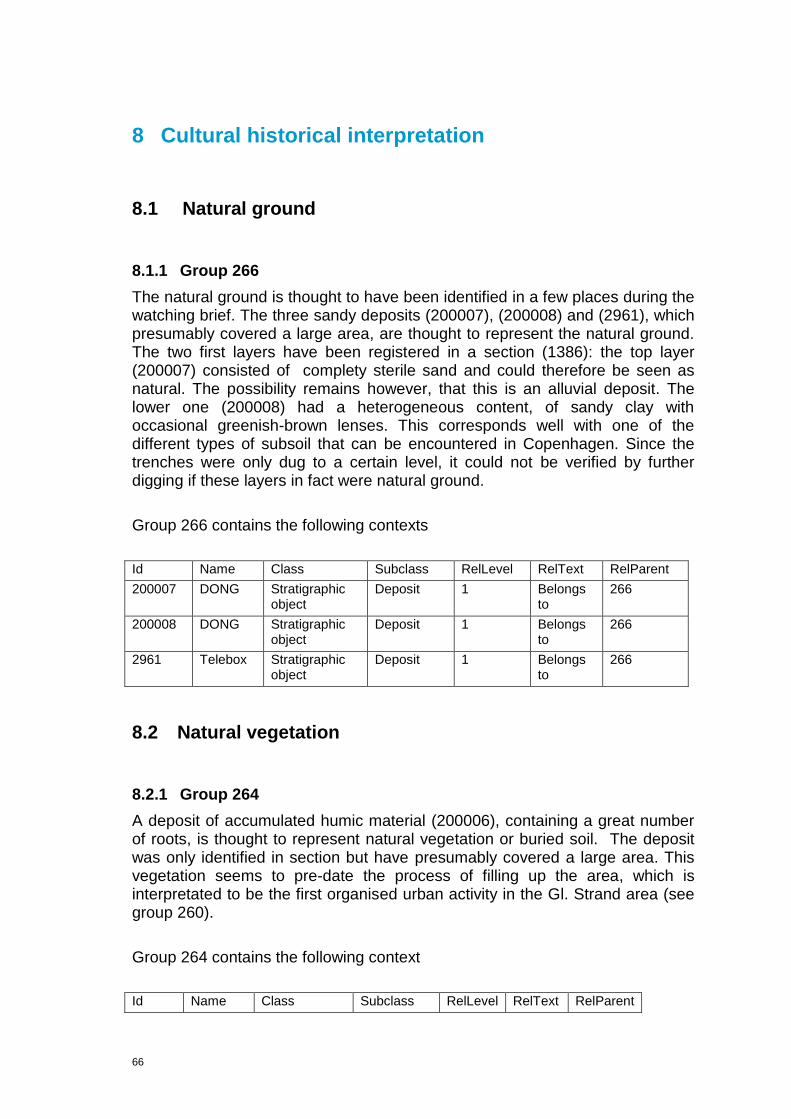
66
8 Cultural historical interpretation
8.1 Natural ground
8.1.1 Group 266
The natural ground is thought to have been identified in a few places during the watching brief. The three sandy deposits (200007), (200008) and (2961), which presumably covered a large area, are thought to represent the natural ground. The two first layers have been registered in a section (1386): the top layer (200007) consisted of complety sterile sand and could therefore be seen as natural. The possibility remains however, that this is an alluvial deposit. The lower one (200008) had a heterogeneous content, of sandy clay with occasional greenish-brown lenses. This corresponds well with one of the different types of subsoil that can be encountered in Copenhagen. Since the trenches were only dug to a certain level, it could not be verified by further digging if these layers in fact were natural ground.
Group 266 contains the following contexts
Id Name Class Subclass RelLevel RelText RelParent
200007 DONG Stratigraphic object
Deposit 1 Belongs to
266
200008 DONG Stratigraphic object
Deposit 1 Belongs to
266
2961 Telebox Stratigraphic object
Deposit 1 Belongs to
266
8.2 Natural vegetation
8.2.1 Group 264
A deposit of accumulated humic material (200006), containing a great number of roots, is thought to represent natural vegetation or buried soil. The deposit was only identified in section but have presumably covered a large area. This vegetation seems to pre-date the process of filling up the area, which is interpretated to be the first organised urban activity in the Gl. Strand area (see group 260).
Group 264 contains the following context
Id Name Class Subclass RelLevel RelText RelParent

67
200006 DONG Stratigraphic object
Deposit 1 Belongs to
264
8.3 Fence
8.3.1 Group 316
Remains of a possible fence was identified south of the facades of Gammel Strand no.38 and Gammel Strand no. 40. It consists of three aligned posts surveyed with the same number (8057). The dimensions of the western one was c. 0.12X0.09m, whereas the middle and the eastern one were rounded with a diameter of c. 0.07m. Interpretating the three posts as originating from some sort of fence, is mainly based on its NW-SE orientation.
Group 316 consist of the following context:
Id Name Class Subclass RelLevel RelText RelParent
8057 Telebox east
Stratigraphic object
Timber Structure
1 Belongs to
316
8057 Telebox east
Stratigraphic object
Timber Structure
1 Belongs to
316
8057 Telebox east
Stratigraphic object
Timber Structure
1 Belongs to
316
8.4 Wharf
8.4.1 Group 282
Possible wharf construction consisting of at least 19 posts, placed in an E-W orientated row, which has a length of approximately 30m. The majority of the posts, 16 in number, were square in shape and an average dimension of 0,1mx0,15m. The preserved or identified length was often not recorded, but lies between 0,2-0,5m by those recorded. The three remaining posts were roundish in shape and were slighty larger than the square ones with dimensions of c. 0,2mx0,2m. Just behind the bulwark a large deposit of 10mx10m, with a recorded thickness of 0,5m, is situated. The content of the deposit, including a moderate amount of shells, leads to the assumption that this is probably redeposited alluvial canal accumulations, which has been dumped as wharf fill. Sieving has produced finds that provide a terminus post quem for the redepositing of the fill to 16thC.

68
Figure 15: The brown markings show the wharf 282.
Group 282 contains the following contexts and subgroups:
Id Name Class Subclass RelLevel RelText RelParent
7204 Waste pipe
Stratigraphic object
Timber Structure
3 Belongs to
269
7210 Waste pipe
Stratigraphic object
Timber Structure
3 Belongs to
269
7250 Waste pipe
Stratigraphic object
Timber Structure
3 Belongs to
278
7379 Waste pipe
Stratigraphic object
Timber Structure
3 Belongs to
278
7403 Waste pipe
Stratigraphic object
Timber Structure
3 Belongs to
263
7407 Waste pipe
Stratigraphic object
Timber Structure
3 Belongs to
263
7411 Waste pipe
Stratigraphic object
Timber Structure
3 Belongs to
263
7438 Waste pipe
Stratigraphic object
Timber Structure
3 Belongs to
263
7442 Waste pipe
Stratigraphic object
Timber Structure
3 Belongs to
263
7501 Waste pipe
Stratigraphic object
Timber Structure
3 Belongs to
263
7531 Waste Stratigraphic Timber 3 Belongs 263
°
0 10 20 30
M
1:150
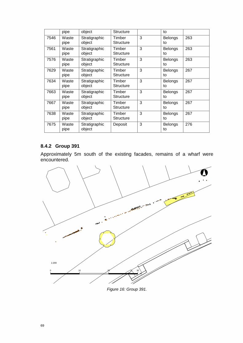
69
pipe object Structure to
7546 Waste pipe
Stratigraphic object
Timber Structure
3 Belongs to
263
7561 Waste pipe
Stratigraphic object
Timber Structure
3 Belongs to
263
7576 Waste pipe
Stratigraphic object
Timber Structure
3 Belongs to
263
7629 Waste pipe
Stratigraphic object
Timber Structure
3 Belongs to
267
7634 Waste pipe
Stratigraphic object
Timber Structure
3 Belongs to
267
7663 Waste pipe
Stratigraphic object
Timber Structure
3 Belongs to
267
7667 Waste pipe
Stratigraphic object
Timber Structure
3 Belongs to
267
7638 Waste pipe
Stratigraphic object
Timber Structure
3 Belongs to
267
7675 Waste pipe
Stratigraphic object
Deposit 3 Belongs to
276
8.4.2 Group 391
Approximately 5m south of the existing facades, remains of a wharf were encountered.
Figure 16: Group 391.
°
0 10 20 30
M
1:200
70
The wharf sequence (262) consists of eight posts; seven of them with a whole cross-section, and one with a square cross-section. The complete posts differed only marginally in sizes from 0.1m x 0.1m to 0.2m x 0.2m; the square one was a bit larger; 0.5mx0.3m. Further to the west another wharf sequence (317) has been identified. It comprises approx. 50 posts in an east-west orientated row along with an unknown number of horizontal planks (the exact number cannot be established due to uncertainties in the measuring and description processes).
To the southeast of the sequence (262), a minor E-W orientated bulwark (378) was encountered. Due to multiple disturbances, only a minor part of the original bulwark is preserved. It is not entirely parallel with the sequence of 262, but has a slightly more SE-NW orientation. This could be due to the many modern disturbances in the area, and it is therefore considered to part of the same wharf. Two deposits (200252) and (200251), which have been interpreted as being part of the wharf filling the space between the wooden structures, contain ceramic dating from the 13thC to the 17thC.
Group 391 contains the following contexts and subgroups:
Id Name Class Subclass RelLevel RelText RelParent
2569 Waterpipe Stratigraphic object
Timber Structure
3 Belongs to 322
2585 Waterpipe Sample Dendro 4 Collected From
2560
6017 Waste pipe Stratigraphic object
Timber Structure
3 Belongs to 216
6017 Waste pipe Stratigraphic object
Timber Structure
3 Belongs to 216
6017 Waste pipe Stratigraphic object
Timber Structure
3 Belongs to 216
6017 Waste pipe Stratigraphic object
Timber Structure
3 Belongs to 216
6017 Waste pipe Stratigraphic object
Timber Structure
3 Belongs to 216
7079 Vendsyssel N Stratigraphic object
Deposit 3 Belongs to 249
7202 Waste pipe Find unit Wood 4 Found In 200251
7587 Waste pipe Sample Environment 4 Collected From
200251
7743 Water pipe east southern extension
Stratigraphic object
Timber Structure
2 Belongs to 262
7744 Water pipe east southern extension
Stratigraphic object
Timber Structure
2 Belongs to 262
7932 Telebox east Stratigraphic object
Timber Structure
3 Belongs to 249
7933 Telebox east Stratigraphic object
Timber Structure
3 Belongs to 249
7968 Telebox east Stratigraphic object
Timber Structure
3 Belongs to 249

71
7969 Telebox east Stratigraphic object
Timber Structure
3 Belongs to 249
7970 Telebox east Stratigraphic object
Timber Structure
3 Belongs to 249
7971 Telebox east Stratigraphic object
Timber Structure
3 Belongs to 249
7972 Telebox east Stratigraphic object
Timber Structure
3 Belongs to 249
7973 Telebox east Stratigraphic object
Timber Structure
3 Belongs to 249
7974 Telebox east Stratigraphic object
Timber Structure
3 Belongs to 249
7975 Telebox east Stratigraphic object
Timber Structure
3 Belongs to 249
8105 Telebox east: extra work: N-S trench
Stratigraphic object
Timber Structure
3 Belongs to 249
8107 Telebox east Stratigraphic object
Timber Structure
3 Belongs to 249
8191 Telebox east Stratigraphic object
Stone/Brick Structure
3 Belongs to 256
8191 Telebox east Stratigraphic object
Stone/Brick Structure
3 Belongs to 256
8191 Telebox east Stratigraphic object
Stone/Brick Structure
3 Belongs to 256
8191 Telebox east Stratigraphic object
Stone/Brick Structure
3 Belongs to 256
8191 Telebox east Stratigraphic object
Stone/Brick Structure
3 Belongs to 256
8191 Telebox east Stratigraphic object
Stone/Brick Structure
3 Belongs to 256
8191 Telebox east Stratigraphic object
Stone/Brick Structure
3 Belongs to 256
8191 Telebox east Stratigraphic object
Stone/Brick Structure
3 Belongs to 256
8191 Telebox east Stratigraphic object
Stone/Brick Structure
3 Belongs to 256
8191 Telebox east Stratigraphic object
Stone/Brick Structure
3 Belongs to 256
8191 Telebox east Stratigraphic object
Stone/Brick Structure
3 Belongs to 256
8191 Telebox east Stratigraphic object
Stone/Brick Structure
3 Belongs to 256
8191 Telebox east Stratigraphic object
Stone/Brick Structure
3 Belongs to 256
8204 Telebox east Sample Wood species
4 Collected From
8006
8205 Telebox east Stratigraphic object
Timber Structure
3 Belongs to 249
8206 Telebox east Stratigraphic object
Timber Structure
3 Belongs to 249
8207 Telebox east Stratigraphic object
Timber Structure
3 Belongs to 249

72
8208 Telebox east Stratigraphic object
Timber Structure
3 Belongs to 249
8209 Telebox east Stratigraphic object
Timber Structure
3 Belongs to 249
8210 Telebox east Stratigraphic object
Timber Structure
3 Belongs to 249
8211 Telebox east Stratigraphic object
Timber Structure
3 Belongs to 249
8217 Telebox east Stratigraphic object
Timber Structure
3 Belongs to 249
8218 Telebox east Stratigraphic object
Timber Structure
3 Belongs to 249
8219 Telebox east Stratigraphic object
Timber Structure
3 Belongs to 249
8220 Telebox east Stratigraphic object
Timber Structure
3 Belongs to 249
8229 Telebox east Stratigraphic object
Timber Structure
3 Belongs to 249
8230 Telebox east Stratigraphic object
Timber Structure
3 Belongs to 249
8231 Telebox east Stratigraphic object
Timber Structure
3 Belongs to 249
8232 Telebox east Stratigraphic object
Timber Structure
3 Belongs to 249
8612 Telebox east: extra work
Stratigraphic object
Timber Structure
3 Belongs to 249
8613 Telebox east: extra work
Stratigraphic object
Timber Structure
3 Belongs to 249
8614 Telebox east: extra work
Stratigraphic object
Timber Structure
3 Belongs to 249
8615 Telebox east: extra work
Stratigraphic object
Timber Structure
3 Belongs to 249
8616 Telebox east: extra work
Stratigraphic object
Timber Structure
3 Belongs to 249
8617 Telebox east: extra work
Stratigraphic object
Timber Structure
3 Belongs to 249
8618 Telebox east: extra work
Stratigraphic object
Timber Structure
3 Belongs to 249
8619 Telebox east: extra work
Stratigraphic object
Timber Structure
3 Belongs to 249
8620 Telebox east:extra work
Stratigraphic object
Timber Structure
3 Belongs to 249
8621 Telebox east: extra work
Stratigraphic object
Timber Structure
3 Belongs to 249
8622 Telebox east: extra work
Stratigraphic object
Timber Structure
3 Belongs to 249
200252 Waste pipe Stratigraphic object
Deposit 3 Belongs to 285
7933 Telebox east Stratigraphic object
Timber Structure
3 Belongs to 249
8006 Telebox east Stratigraphic object
Timber Structure
3 Belongs to 249
73
8188 Telebox east Stratigraphic object
Timber Structure
3 Belongs to 249
8188 Telebox east Stratigraphic object
Timber Structure
3 Belongs to 249
8233 Telebox east Stratigraphic object
Timber Structure
3 Belongs to 249
8233 Telebox east Stratigraphic object
Timber Structure
3 Belongs to 249
2549 Waterpipe Stratigraphic object
Timber Structure
3 Belongs to 203
2557 Waterpipe Stratigraphic object
Timber Structure
3 Belongs to 322
2560 Waterpipe Stratigraphic object
Timber Structure
3 Belongs to 203
2566 Waterpipe Stratigraphic object
Timber Structure
3 Belongs to 203
2566 Waterpipe Stratigraphic object
Timber Structure
4 Belongs to 2560
2570 Waterpipe Stratigraphic object
Timber Structure
3 Belongs to 203
2574 Waterpipe Stratigraphic object
Timber Structure
3 Belongs to 203
2602 Waterpipe Stratigraphic object
Timber Structure
3 Belongs to 203
6017 Waste pipe Stratigraphic object
Timber Structure
3 Belongs to 216
6017 Waste pipe Stratigraphic object
Timber Structure
3 Belongs to 216
6017 Waste pipe Stratigraphic object
Timber Structure
3 Belongs to 216
6017 Waste pipe Stratigraphic object
Timber Structure
3 Belongs to 216
6017 Waste pipe Stratigraphic object
Timber Structure
3 Belongs to 216
6017 Waste pipe Stratigraphic object
Timber Structure
3 Belongs to 216
6017 Waste pipe Stratigraphic object
Timber Structure
3 Belongs to 216
6017 Waste pipe Stratigraphic object
Timber Structure
3 Belongs to 216
6017 Waste pipe Stratigraphic object
Timber Structure
3 Belongs to 216
6613 Waste pipe Stratigraphic object
Timber Structure
2 Belongs to 378
6613 Waste pipe Stratigraphic object
Timber Structure
2 Belongs to 378
6613 Waste pipe Stratigraphic object
Timber Structure
2 Belongs to 378
6613 Waste pipe Stratigraphic object
Timber Structure
2 Belongs to 378
6613 Waste pipe Stratigraphic object
Timber Structure
2 Belongs to 378

74
6613 Waste pipe Stratigraphic object
Timber Structure
2 Belongs to 378
6638 Waste pipe Stratigraphic object
Deposit 3 Belongs to 275
6894 Vendsyssel N Stratigraphic object
Timber Structure
3 Belongs to 249
6908 Vendsyssel N Stratigraphic object
Timber Structure
3 Belongs to 249
7062 Vendsyssel N Stratigraphic object
Timber Structure
3 Belongs to 249
7075 Vendsyssel N Stratigraphic object
Timber Structure
3 Belongs to 249
7722 Waterpipe east southern extension
Stratigraphic object
Timber Structure
2 Belongs to 262
7729 Water pipe east southern extension
Stratigraphic object
Timber Structure
2 Belongs to 262
7736 Water pipe east southern extension
Stratigraphic object
Timber Structure
2 Belongs to 262
7759 Water pipe east southern extension
Stratigraphic object
Timber Structure
2 Belongs to 262
7776 Telebox east Stratigraphic object
Timber Structure
2 Belongs to 262
7788 Telebox east Stratigraphic object
Timber Structure
2 Belongs to 262
7896 Telebox east Stratigraphic object
Timber Structure
3 Belongs to 249
7896 Telebox east Stratigraphic object
Timber Structure
3 Belongs to 249
7896 Telebox east Stratigraphic object
Timber Structure
3 Belongs to 249
8011 Telebox east Stratigraphic object
Stone/Brick Structure
3 Belongs to 256
8011 Telebox east Stratigraphic object
Stone/Brick Structure
3 Belongs to 256
8011 Telebox east Stratigraphic object
Stone/Brick Structure
3 Belongs to 256
8011 Telebox east Stratigraphic object
Stone/Brick Structure
3 Belongs to 256
8011 Telebox east Stratigraphic object
Stone/Brick Structure
3 Belongs to 256
8011 Telebox east Stratigraphic object
Stone/Brick Structure
3 Belongs to 256
8011 Telebox east Stratigraphic object
Stone/Brick Structure
3 Belongs to 256
8011 Telebox east Stratigraphic object
Stone/Brick Structure
3 Belongs to 256
8011 Telebox east Stratigraphic object
Stone/Brick Structure
3 Belongs to 256
8011 Telebox east Stratigraphic object
Stone/Brick Structure
3 Belongs to 256
8011 Telebox east Stratigraphic object
Stone/Brick Structure
3 Belongs to 256
75
8011 Telebox east Stratigraphic object
Stone/Brick Structure
3 Belongs to 256
8011 Telebox east Stratigraphic object
Stone/Brick Structure
3 Belongs to 256
8011 Telebox east Stratigraphic object
Stone/Brick Structure
3 Belongs to 256
8011 Telebox east Stratigraphic object
Stone/Brick Structure
3 Belongs to 256
8011 Telebox east Stratigraphic object
Stone/Brick Structure
3 Belongs to 256
8011 Telebox east Stratigraphic object
Stone/Brick Structure
3 Belongs to 256
8011 Telebox east Stratigraphic object
Stone/Brick Structure
3 Belongs to 256
8011 Telebox east Stratigraphic object
Stone/Brick Structure
3 Belongs to 256
8011 Telebox east Stratigraphic object
Stone/Brick Structure
3 Belongs to 256
8011 Telebox east Stratigraphic object
Stone/Brick Structure
3 Belongs to 256
8011 Telebox east Stratigraphic object
Stone/Brick Structure
3 Belongs to 256
8101 Telebox east: extra work: N-S trench
Stratigraphic object
Timber Structure
3 Belongs to 249
8137 Telebox east: extra work:Svejgaard-Galst
Stratigraphic object
Timber Structure
3 Belongs to 249
8329 Telebox east Stratigraphic object
Timber Structure
3 Belongs to 249
8333 Telebox east Stratigraphic object
Timber Structure
3 Belongs to 249
8368 Telebox east Stratigraphic object
Stone/Brick Structure
3 Belongs to 256
8368 Telebox east Stratigraphic object
Stone/Brick Structure
3 Belongs to 256
8368 Telebox east Stratigraphic object
Stone/Brick Structure
3 Belongs to 256
8368 Telebox east Stratigraphic object
Stone/Brick Structure
3 Belongs to 256
8368 Telebox east Stratigraphic object
Stone/Brick Structure
3 Belongs to 256
8368 Telebox east Stratigraphic object
Stone/Brick Structure
3 Belongs to 256
8368 Telebox east Stratigraphic object
Stone/Brick Structure
3 Belongs to 256
8368 Telebox east Stratigraphic object
Stone/Brick Structure
3 Belongs to 256
8368 Telebox east Stratigraphic object
Stone/Brick Structure
3 Belongs to 256
8578 Telebox east:extra work
Stratigraphic object
Timber Structure
3 Belongs to 249
8604 Telebox east: extra Stratigraphic Timber 3 Belongs to 249
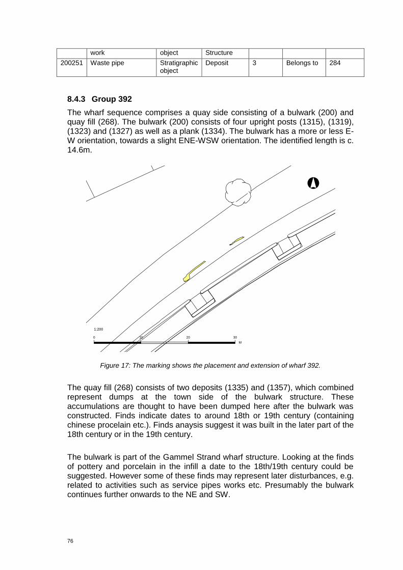
76
work object Structure
200251 Waste pipe Stratigraphic object
Deposit 3 Belongs to 284
8.4.3 Group 392
The wharf sequence comprises a quay side consisting of a bulwark (200) and quay fill (268). The bulwark (200) consists of four upright posts (1315), (1319), (1323) and (1327) as well as a plank (1334). The bulwark has a more or less E-W orientation, towards a slight ENE-WSW orientation. The identified length is c. 14.6m.
Figure 17: The marking shows the placement and extension of wharf 392.
The quay fill (268) consists of two deposits (1335) and (1357), which combined represent dumps at the town side of the bulwark structure. These accumulations are thought to have been dumped here after the bulwark was constructed. Finds indicate dates to around 18th or 19th century (containing chinese procelain etc.). Finds anaysis suggest it was built in the later part of the 18th century or in the 19th century.
The bulwark is part of the Gammel Strand wharf structure. Looking at the finds of pottery and porcelain in the infill a date to the 18th/19th century could be suggested. However some of these finds may represent later disturbances, e.g. related to activities such as service pipes works etc. Presumably the bulwark continues further onwards to the NE and SW.
°
0 10 20 30
M
1:200
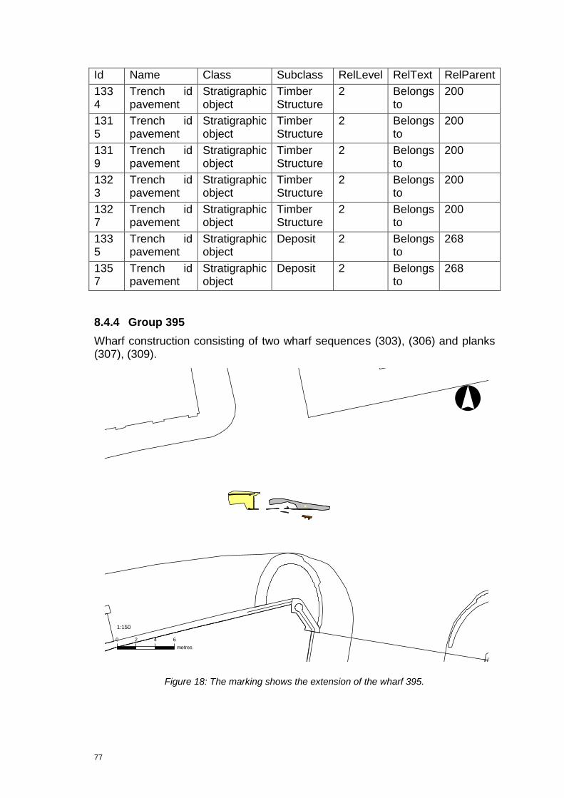
77
Id Name Class Subclass RelLevel RelText RelParent
1334
Trench id pavement
Stratigraphic object
Timber Structure
2 Belongs to
200
1315
Trench id pavement
Stratigraphic object
Timber Structure
2 Belongs to
200
1319
Trench id pavement
Stratigraphic object
Timber Structure
2 Belongs to
200
1323
Trench id pavement
Stratigraphic object
Timber Structure
2 Belongs to
200
1327
Trench id pavement
Stratigraphic object
Timber Structure
2 Belongs to
200
1335
Trench id pavement
Stratigraphic object
Deposit 2 Belongs to
268
1357
Trench id pavement
Stratigraphic object
Deposit 2 Belongs to
268
8.4.4 Group 395
Wharf construction consisting of two wharf sequences (303), (306) and planks (307), (309).
Figure 18: The marking shows the extension of the wharf 395.
°
0 2 4 6
metres
1:150
78
Two parallel rows of E-W orientated plank courses with a spacing of approximately 1.5m. A transverse plank course is seen in the eastern end of the northern, fragmented, plank course. The space between the two courses was filled by a silty, grey deposit (6808) containing late redware ceramics and clay pipes, which gives a Post Medieval date. To the east of the transverse plank coursing, a stone paving was found. Whether it was part of the wharf fill or should been seen as an actual paving is unclear.
In front of the southern plank course (303), another horizontally placed plank was located (6726). Two posts were placed on the south side of the plank.
Group 395 consists of the following subgroups and contexts:
Id Name Class Subclass RelLevel RelText RelParent
6692 Teleblock Højbro
Stratigraphic object
Timber Structure
3 Belongs to
215
6692 Teleblock Højbro
Stratigraphic object
Timber Structure
3 Belongs to
215
6692 Teleblock Højbro
Stratigraphic object
Timber Structure
3 Belongs to
215
6714 Teleblock Højbro
Stratigraphic object
Timber Structure
2 Belongs to
307
6720 Teleblock Højbro
Stratigraphic object
Timber Structure
2 Belongs to
307
6726 Teleblock Højbro
Stratigraphic object
Timber Structure
2 Belongs to
307
6735 Teleblock Højbro
Stratigraphic object
Timber Structure
3 Belongs to
215
6735 Teleblock Højbro
Stratigraphic object
Timber Structure
3 Belongs to
308
6741 Teleblock Højbro
Stratigraphic object
Timber Structure
3 Belongs to
215
6747 Teleblock Højbro
Stratigraphic object
Timber Structure
3 Belongs to
215
6747 Teleblock Højbro
Stratigraphic object
Timber Structure
3 Belongs to
215
6747 Teleblock Højbro
Stratigraphic object
Timber Structure
3 Belongs to
215
6747 Teleblock Højbro
Stratigraphic object
Timber Structure
3 Belongs to
215
6747 Teleblock Højbro
Stratigraphic object
Timber Structure
3 Belongs to
215
6760 Teleblock Højbro
Stratigraphic object
Timber Structure
3 Belongs to
213
6800 Teleblock Højbro
Stratigraphic object
Deposit 3 Belongs to
304
6808 Teleblock Højbro
Stratigraphic object
Deposit 3 Belongs to
302
6853 Teleblock Højbro
Stratigraphic object
Stone/Brick Structure
4 Is cut by
6692

79
6853 Teleblock Højbro
Stratigraphic object
Stone/Brick Structure
3 Belongs to
302
7237 Højbro tele Stratigraphic object
Timber Structure
3 Belongs to
213
200272 Teleblock Højbro
Stratigraphic object
Timber Structure
3 Belongs to
213
200272 Teleblock Højbro
Stratigraphic object
Timber Structure
3 Belongs to
213
200272 Teleblock Højbro
Stratigraphic object
Timber Structure
3 Belongs to
213
6869 Teleblock Højbro
Stratigraphic object
Deposit 3 Belongs to
302
8.5 Roads
8.5.1 Group 335
Near the corner of Gammel Strand and Naboløs, a possible road surface has been identified. It consists of a series of leveling layers and a demolished road surface.
A series of four leveling layers (340) with a combined thickness of c.1.25m, sealing of the possible bulwark (338), has been interpreted as a build up of the surface to facilitate movement in the area. The date of these layers cannot be exactly established due to the lack of finds in them, however it seems likely that they should be seen as Post-Medieval. In this light it makes sense to relate these deposits to the leveling layer (339) further towards west (at least the deepest layers (200081) and (200080), which have a similar Z-value).
The leveling layer (339) to the west, seals off the bulwark (203). Pottery finds from this deposit can be dated to the late 16th century (saltglazed and unglazed stoneware) and it is therefore possible to see this layer as a build-up of the surface perhaps to facilitate a paved area or road north of Valkendorf‟s Vejerhus (see below).
Group 335 contains the following contexts and subgroups
Id Name Class Subclass RelLevel RelText RelParent
2587 Waterpipe Stratigraphic object
Deposit 1 Belongs to
339
200079 Waterpipe Stratigraphic object
Deposit 1 Belongs to
340
200080 Waterpipe Stratigraphic object
Deposit 1 Belongs to
340
200081 Waterpipe Stratigraphic object
Deposit 1 Belongs to
340
80
200084 Waterpipe
8.5.2 Group 350
Three sections of paving, extending over approximately 9.18m, with gaps in between (6903), (7037) and (7980), were identified. The orientation was approximately E-W, 5m from the current facade. The stones vary in size (0.12x0.11m and 0.25x0.29m; 0.15x0,1m and 0.17x0.16m), with an unfinished surface. Most of the stones could only be measured from top of the trench due to risk of this narrow trench collapsing, so the exact extent of the paving is unknown. Some were furthermore just surveyed as points rather than polygons, because they were only visible in section. A leveling layer (200487) for the pavement was also identified, though not surveyed, but created later in Intrasis. The deposit contained ceramic finds of late redware (15th-18th-Century) and older Siegburg jug (14th-16th-Century).
Group 350 contains the following contexts:
Id Name Class Subclass RelLevel RelText RelParent
7980 Telebox east
Stratigraphic object
Stone/Brick Structure
1 Belongs to
350
7980 Telebox east
Stratigraphic object
Stone/Brick Structure
1 Belongs to
350
7980 Telebox east
Stratigraphic object
Stone/Brick Structure
1 Belongs to
350
7980 Telebox east
Stratigraphic object
Stone/Brick Structure
1 Belongs to
350
7980 Telebox east
Stratigraphic object
Stone/Brick Structure
1 Belongs to
350
7980 Telebox east
Stratigraphic object
Stone/Brick Structure
1 Belongs to
350
7980 Telebox east
Stratigraphic object
Stone/Brick Structure
1 Belongs to
350
7980 Telebox east
Stratigraphic object
Stone/Brick Structure
1 Belongs to
350
6903 Vendsyssel N
Stratigraphic object
Stone/Brick Structure
1 Belongs to
350
7037 Vendsyssel N
Stratigraphic object
Stone/Brick Structure
1 Belongs to
350
8.6 Water supply network
8.6.1 Group 242
The northernmost identified water supply network on Gammel Strand consists of multiple elements in a major E-W oriented wooden waterpipe (204) in connection with three minor service pipes (315), (368) and (369), which provided the buildings to the north with water.
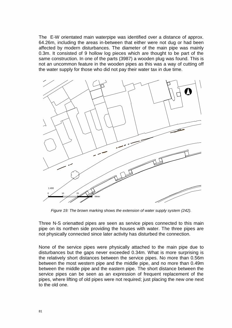
81
The E-W orientated main waterpipe was identified over a distance of approx. 64.26m, including the areas in-between that either were not dug or had been affected by modern disturbances. The diameter of the main pipe was mainly 0.3m. It consisted of 9 hollow log pieces which are thought to be part of the same construction. In one of the parts (3987) a wooden plug was found. This is not an uncommon feature in the wooden pipes as this was a way of cutting off the water supply for those who did not pay their water tax in due time.
Figure 19: The brown marking shows the extension of water supply system (242).
Three N-S orienatted pipes are seen as service pipes connected to this main pipe on its northen side providing the houses with water. The three pipes are not physically connected since later activity has disturbed the connection.
None of the service pipes were physically attached to the main pipe due to disturbances but the gaps never exceeded 0.34m. What is more surprising is the relatively short distances between the service pipes. No more than 0.56m between the most western pipe and the middle pipe, and no more than 0.49m between the middle pipe and the eastern pipe. The short distance between the service pipes can be seen as an expression of frequent replacement of the pipes, where lifting of old pipes were not required; just placing the new one next to the old one.
°
0 10 20 30
Meter
1:400
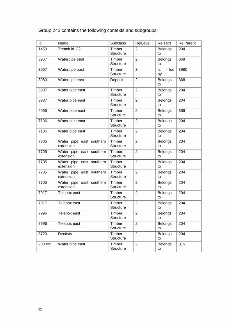
82
Group 242 contains the following contexts and subgroups:
Id Name Subclass RelLevel RelText RelParent
1450 Trench id. 32 Timber Structure
2 Belongs to
204
3967 Waterpipe east Timber Structure
2 Belongs to
368
3967 Waterpipe east Timber Structure
3 Is filled by
3980
3980 Waterpipe east Deposit 2 Belongs to
368
3987 Water pipe east Timber Structure
2 Belongs to
204
3987 Water pipe east Timber Structure
2 Belongs to
204
4056 Water pipe east Timber Structure
2 Belongs to
369
7106 Water pipe east Timber Structure
2 Belongs to
204
7106 Water pipe east Timber Structure
2 Belongs to
204
7705 Water pipe east southern extension
Timber Structure
2 Belongs to
204
7705 Water pipe east southern extension
Timber Structure
2 Belongs to
204
7705 Water pipe east southern extension
Timber Structure
2 Belongs to
204
7705 Water pipe east southern extension
Timber Structure
2 Belongs to
204
7705 Water pipe east southern extension
Timber Structure
2 Belongs to
204
7917 Telebox east Timber Structure
2 Belongs to
204
7917 Telebox east Timber Structure
2 Belongs to
204
7996 Telebox east Timber Structure
2 Belongs to
204
7996 Telebox east Timber Structure
2 Belongs to
204
8720 Dentists Timber Structure
2 Belongs to
204
200099 Water pipe east Timber Structure
2 Belongs to
315
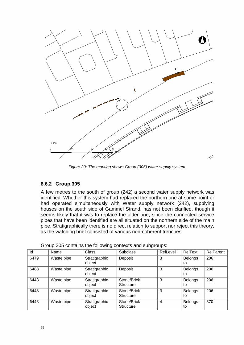
83
Figure 20: The marking shows Group (305) water supply system.
8.6.2 Group 305
A few metres to the south of group (242) a second water supply network was identified. Whether this system had replaced the northern one at some point or had operated simultaneously with Water supply network (242), supplying houses on the south side of Gammel Strand, has not been clarified, though it seems likely that it was to replace the older one, since the connected service pipes that have been identified are all situated on the northern side of the main pipe. Stratigraphically there is no direct relation to support nor reject this theory, as the watching brief consisted of various non-coherent trenches.
Group 305 contains the following contexts and subgroups:
Id Name Class Subclass RelLevel RelText RelParent
6479 Waste pipe Stratigraphic object
Deposit 3 Belongs to
206
6488 Waste pipe Stratigraphic object
Deposit 3 Belongs to
206
6448 Waste pipe Stratigraphic object
Stone/Brick Structure
3 Belongs to
206
6448 Waste pipe Stratigraphic object
Stone/Brick Structure
3 Belongs to
206
6448 Waste pipe Stratigraphic object
Stone/Brick Structure
4 Belongs to
370
°
0 10 20 30
Meter
1:300

84
6448 Waste pipe Stratigraphic object
Stone/Brick Structure
4 Belongs to
370
6472 Waste pipe Stratigraphic object
Timber Structure 3 Belongs to
206
6472 Waste pipe Stratigraphic object
Timber Structure 4 Belongs to
370
6480 Waste pipe Stratigraphic object
Cut 3 Belongs to
206
6554 Telebox east Stratigraphic object
Timber Structure 2 Belongs to
209
7258 Vendsyssel N Stratigraphic object
Timber Structure 2 Belongs to
209
7258 Vendsyssel N Stratigraphic object
Timber Structure 3 Belongs to
6554
7536 Waste pipe Stratigraphic object
Timber Structure 2 Belongs to
209
7536 Waste pipe Stratigraphic object
Timber Structure 2 Belongs to
209
7536 Waste pipe Stratigraphic object
Timber Structure 2 Belongs to
209
7536 Waste pipe Stratigraphic object
Timber Structure 2 Belongs to
209
7536 Waste pipe Stratigraphic object
Timber Structure 2 Belongs to
209
7536 Waste pipe Stratigraphic object
Timber Structure 3 Belongs to
6554
7536 Waste pipe Stratigraphic object
Timber Structure 3 Belongs to
6554
7536 Waste pipe Stratigraphic object
Timber Structure 3 Belongs to
6554
7536 Waste pipe Stratigraphic object
Timber Structure 3 Belongs to
6554
7536 Waste pipe Stratigraphic object
Timber Structure 3 Belongs to
6554
7808 Telebox east Stratigraphic object
Stone/Brick Structure
3 Belongs to
206
7808 Telebox east Stratigraphic object
Stone/Brick Structure
4 Belongs to
6448
7844 Telebox east Stratigraphic object
Timber Structure 2 Belongs to
209
7844 Telebox east Stratigraphic object
Timber Structure 2 Belongs to
209
7844 Telebox east Stratigraphic object
Timber Structure 3 Belongs to
6554
7844 Telebox east Stratigraphic object
Timber Structure 3 Belongs to
6554
200251 Waste pipe Stratigraphic object
Deposit 3 Is cut by 200373
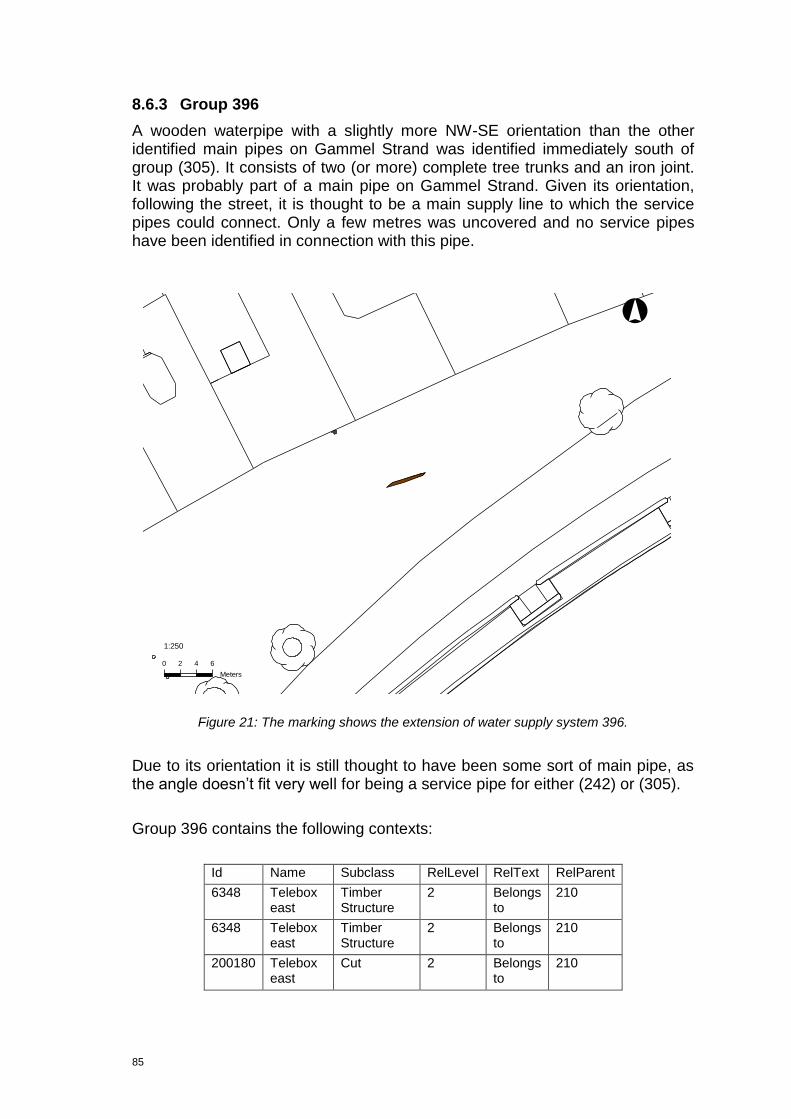
85
8.6.3 Group 396
A wooden waterpipe with a slightly more NW-SE orientation than the other identified main pipes on Gammel Strand was identified immediately south of group (305). It consists of two (or more) complete tree trunks and an iron joint. It was probably part of a main pipe on Gammel Strand. Given its orientation, following the street, it is thought to be a main supply line to which the service pipes could connect. Only a few metres was uncovered and no service pipes have been identified in connection with this pipe.
Figure 21: The marking shows the extension of water supply system 396.
Due to its orientation it is still thought to have been some sort of main pipe, as the angle doesn‟t fit very well for being a service pipe for either (242) or (305).
Group 396 contains the following contexts:
Id Name Subclass RelLevel RelText RelParent
6348 Telebox east
Timber Structure
2 Belongs to
210
6348 Telebox east
Timber Structure
2 Belongs to
210
200180 Telebox east
Cut 2 Belongs to
210
°
0 2 4 6
Meters
1:250
86
8.7 Land development
8.7.1 Group 260
A series of accumulated sandy deposits (200003), (200004) and (200005), presumably covering a large area, are thought to represent a process of filling up the former beach area in order to create a dry port area. It seems to be the first organised urban activity in the Gl. Strand area. The two youngest deposits (200003) and (200004) contained quite a lot of building debris and waste, indicating the intended use of this material as a stabilizer in filling up the area. The oldest of the deposits (20005) was completely sterile sand, which could indicate that it was naturally deposited, but could also be the first levelling layer.
The underlying alluvial accumulation (200007), including the supposed natural vegetation (20006) in between the two former, are thought to represent periodic or seasonal flooding. It seems obvious to relate the deposits in this group to the many bulwarks in the area, ie. as bulwark fill. However, the absence of bulwark timber in the specific trench rules out the possibility of establishing a valid relation for the time being.
Group 260 contains the following contexts:
Id Name Class Subclass RelLevel RelText RelParent
200003 Trench id.23
Stratigraphic object
Deposit 1 Belongs to
260
200004 Trench id.23
Stratigraphic object
Deposit 1 Belongs to
260
200005 Trench id.23
Stratigraphic object
Deposit 1 Belongs to
260
8.7.2 Group 272
Two deposits (200010) and (200011) are thought to represent accumulations at the town side of the bulwark structure, i.e. land development with the purpose of increasing the terrain height in the area, possibly in connection with a bulwark construction, which could be the bulwark (249) immediately to the south, relating it to the wharf construction (391).
Group 272 contains the following contexts
Id Name Class Subclass RelLevel RelText RelParent
200010 Trench id.32
Stratigraphic object
Deposit 1 Belongs to
272
200011 Trench id.32
Stratigraphic object
Deposit 1 Belongs to
272
87
8.7.3 Group 336
This group consists of three dump deposits (2057), (2085), (2091), all interpreted as part of the general terrain levelling. The matrix revealed an "interface" of terrain levelling between the destruction of building (301/311) and the creation of the cut for the culvert (207). Since the culvert construction has truncated the levelling layers, it must be concluded that the terrain was leveled after the destruction of the building but before the establishing of the culvert.
The description of the contexts within this group does not correspond with that of a typical demolition layer, however this terrain levelling is possibly a mixture of demoiltion material and soil that has been spread across the area.
8.7.4 Group 349
This group is only represented by a single dark deposit (6307) seen in the northern part of the trench (4259). The deposit was truncated to the south, but probably covered a greater part of Gammel Strand. Due to the fact that the context was stratigraphically younger than bulwark (214), it is most likely not related to this, because another bulwark, north of the Vejerbod and presumably older, is in between the two.
The deposit contained numerous finds of ceramics, leather etc. The find of claypipes in the deposit suggests a dating to the 17th-century.
Id Name Class Subclass RelLevel RelText RelParent
6307 Telebox east
Stratigraphic object
Deposit 1 Belongs to
349
8.7.5 Group 351
Two areas of presumably the same deposit, (6907) and (200365), deposited on top of the road (350), after this went out of use. Both deposits were dark, sandy deposits with clay, pebbles and charcoal in.
Group 351 contains the following context:
Id Name Class Subclass RelLevel RelText RelParent
6907 Vendsyssel Stratigraphic Deposit 1 Belongs 351
Id Name Class Subclass RelLevel RelText RelParent
2057 Northern extension of the Telebox trench
Stratigraphic object
Deposit 1 Belongs to
336
2085 Telebox Stratigraphic object
Deposit 1 Belongs to
336
2091 Telebox Stratigraphic object
Deposit 1 Belongs to
336

88
N object to
8.7.6 Group 355
This group consists of a single, dark, clayish deposit (200486), in which ceramics, such as late redware were found. Though there is limited information of the deposit, which was only observed in section, it is thought to represent one of the many leveling layers in this area. These were part of the ongoing land reclaimation in order to create a dry port area. The content of late redware indicates a date no older than 16th-17th century.
Group 355 contains the following context:
Id Name Class Subclass RelLevel RelText RelParent
200486 Telebox east Stratigraphic object
Deposit 1 Belongs to
355
8.7.7 Group 360
Series of leveling layers which are thought to be part of a land development in the eastern part of Gammel Strand and truncated by the construction cut (200090) for a building on Højbro Plads (Group 247).
One of the middle layers in this sequence (3607) contains late redware which should probably not be seen as indicative for a date, but instead as re-deposited because (3607) is overlying (3617), which again is overlying wooden waterpipes.
Id Name Class Subclass RelLevel RelText RelParent
3655 Waterpipe east Stratigraphic object
Deposit 2 Belongs to
344
3655 Waterpipe east Stratigraphic object
Deposit 3 Belongs to
3617
3537 Waterpipe east Stratigraphic object
Deposit 2 Belongs to
343
3584 Waterpipe east Stratigraphic object
Deposit 2 Belongs to
343
3607 Waterpipe east Stratigraphic object
Deposit 2 Belongs to
343
3617 Waterpipe east Stratigraphic object
Deposit 2 Belongs to
344
3729 Waterpipe north east
Stratigraphic object
Deposit 2 Belongs to
344
3790 Waterpipe north east
Stratigraphic object
Deposit 2 Belongs to
344

89
8.7.8 Group 362
In the north facing section (1478), two deposits (200013) and (200014), were identified and interpreted as levelling layers as part of a general land development process. Based on the retrieval of a sherd of Westerwald-stoneware, the date of the bottom layer (200013) cannot be earlier than the 17th century.
Due to the heavily polluted soil in trench (1482) no pollen samples were collected.
Group 362 contains the following contexts:
Id Name Class Subclass RelLevel RelText RelParent
200013 Trench id.32
Stratigraphic object
Deposit 1 Belongs to
362
200014 Trench id. 32
Stratigraphic object
Deposit 1 Belongs to
362
8.7.9 Group 365
In the northfacing section (4887) two deposits were identified and interpreted as being part of the general land development process after reclaimation of land. They consist of a levelling layer (200160) and what could be described as a demolition layer (200159), containing mortar and brick fragments. The deposits have accumulated prior to the raising of a building (291) on the eastern side of Vejerboden.
Group 365 contains the following contexts:
Id Name Class Subclass RelLevel RelText RelParent
200159 Telebox east
Stratigraphic object
Deposit 1 Belongs to
365
200160 Telebox east
Stratigraphic object
Deposit 1 Belongs to
365
8.7.10 Group 366
A single dump layer, stratigraphically over a N-S orientated wooden waterpipe (7909), with a recorded minimum thickness of 0,15m is interpreted as part of the general process of the land development on Gammel Strand. Animal bones were found in it but were not retrieved due to pollution of the soil, which also prohibited any sampling.
Group 366 consists of the following context
Id Name Class Subclass RelLevel RelText RelParent

90
200460 Telebox east
Stratigraphic object
Deposit 1 Belongs to
366
8.7.11 Group 277 Open area (pit)
A rectangular E-W orientated pit, (2491) with vertical sides and the dimensions 1.7mx0.2mx 0.2m. The pit was filled with dark brownish and grey, silty sand. The fill layer (2511) contained pebbles, CBM and charcoal. One sherd of late redware was found and provides us with an terminus ante quem to c. 1400 for the filling of the pit. The purpose of the pit could not be clarified.
Group 277 consists of the following contexts:
Id Name Class Subclass RelLevel RelText RelParent
2511 Telebox Stratigraphic object
Deposit 1 Belongs to
277
2491 Telebox Stratigraphic object
Cut 1 Belongs to
277
2491 Telebox Stratigraphic object
Cut 2 Is filled by
2511
8.7.12 Group 281: Open area (pit)
Circular pit (2912) with the dimensions 0.44mx0.2mx0.1m. The cut was disturbed by truncation.The pit was filled by dark brownish and grey, silty sand. The fill layer (2923) contained pebbles, CBM, charcoal and bones, and probably represents dump from the vicinity. From the surface two sherds of late redware were collected, providing a terminus post quem date to 1400. However, this sherd could also stem from disturbances
The original function of the pit was not clarified but the shallow depth suggests that it may in fact be a depression from a stone instead of an actual pit. Early Renaissance.
Group 282 consists of the following contexts:
Id Name Class Subclass RelLevel RelText RelParent
2923 Telebox Stratigraphic object
Deposit 1 Belongs to
281
2912 Telebox Stratigraphic object
Cut 1 Belongs to
281
2912 Telebox Stratigraphic object
Cut 2 Is filled by
2923
91
8.8 Gutter canals
8.8.1 Brief Cultural History of the Gutters in Copenhagen
In the past the gutters were much deeper than nowadays. The local authorities imposed the house owners to keep the gutters in front of their houses clean and to make sure that the wooden lid which covered the gutter was not washed away during the rain. The gutters were placed along the sides of the streets, but around the year 1700 attempts to place the gutters in the middle of the road were made: a solution that was quickly abandoned as the wagons could not pass each other. Normally the streets were established without considering the natural slope of the terrain which meant that water was allowed to slowly seep into the ground. Furthermore, it was a common that the gutters had to drain to both the harbour and canal, but as the accumulation of the water along the rampart of the town fortification reached an unacceptably large scale it was allowed to penetrate the fortification banks in order to dispose of the water permanently, as early as 1584.
The design and functionality of the gutters were closely related to the pavement of the streets. This is why the records regarding the preparation of the regulation report “Forordning ang. Steenbrolægningen med anden dertil hørende Indretning paa Gaderne Torvene og Pladserne‖, published in 1777, obviously relates to these topics. The initiatives which the town magistrate approved with their acceptance of the regulation report, was a result of an extensive committee work initiated by the Board of Public Construction Work (Bygningsdirektionen). Initially the proposals which were prepared by the French road engineer Jean Marmillod (1720-1786), who was called in by Gehejmestatsminister (Prime Minister) J. H. E. von Bernstoff (1712-1777) in 1764, were supplemented by a promemorium containing a drawing depicting seven different types of gutters. Regardless of fact that the reactionary approach of the town magistrate towards urban infrastructure resulted in a strongly diluted version of the original recommendations, Marmillod‟s illustration is quite interesting, as it portray existing gutter types and puts forward new gutter type concepts. (Wiene 2011 pp. 11-13).
Over time, drains linking the gutters to minor mud traps situated in the road (tværkister) were also added. These mud traps, which often penetrated the back yards of the individual property, were canalled into larger communal sewers where they merged. Though due to escalating urbanisation many of these back yards were expropriated. Because of that the mud traps were in many cases covered, resulting in complete loss of knowledge about the exact location of the individual sewer canals. Consequently, the sewers were often blocked and the streets flooded; a catastrophic situation in a town with such an extensive utilization of the basements, as it was the case in Copenhagen.
In spite of all this filthiness, no understanding of a need to subsidize these essential infrastructural facilities existed amongst the citizens, the communal authorities and central administration. Hence, an extensive application of poor

92
low-tech solutions, including cheap and slight materials, was facilitated. The result was obviously as expected: an inconsistent distributed sewer network consisting of open and closed narrow grooves and sewers, which only received scant maintenance. Apparently a call for a change in the mindset of the citizens and the authorities was needed, before sizeable changes of the public health could be considered. Changes which the discovery of microbiological life made by the French biologist Louis Pasteur (1822-1895) and the cholera epidemic in 1853 probably catalyzed.
8.8.2 Land use gutter canals (sewer system)
Multiple contexts interpreted as gutter remains were recorded during the Gl. Strand fieldwork phase. These contexts are all grouped in IntraSiS (222), (223), (224), (228), (229), (230), (231), (232), (234), (235), (236), (237), (2389 and (314). However, deducing from observations related to the physical layout of the gutters, it has become evident that none of these groups can be linked as part of a larger sewer network.
As they all are thought to represent individual gutters orientated alike, it seems clear that they were built with the purpose of distributing water away from the buildings on the northern side of Gl. Strand and Højbro Plads and into the canal to the south. In that sense are they representing the same type of use of the land, i.e. as a sewer system. Hence, the land use category is only representing the gutter canals thematically.
Id Name Class Subclass RelLevel RelText RelParent
222 Telebox east Stratigraphic object
Group 1 Belongs to
Land use
223 Vensyssel N/
Wastepipe
Stratigraphic object
Group 1 Belongs to
Land use
224 Vensyssel N/
Wastepipe
Stratigraphic object
Group 1 Belongs to
Land use
228 Wastepipe Stratigraphic object
Group 1 Belongs to
Land use
229 Teleblock Højbro
Stratigraphic object
Group 1 Belongs to
Land use
230 Vensyssel N/
Telebox East
Stratigraphic object
Group 1 Belongs to
Land use
231 Wastepipe Stratigraphic object
Group 1 Belongs to
Land use
232 Waterpipe E Stratigraphic object
Group 1 Belongs to
Land use
234 Wastepipe Stratigraphic object
Group 1 Belongs to
Land use
235 Wastepipe Stratigraphic object
Group 1 Belongs to
Land use
236 Wastepipe Stratigraphic object
Group 1 Belongs to
Land use
237 Wastepipe Stratigraphic Group 1 Belongs Land use

93
object to
238 Wastepipe Stratigraphic object
Group 1 Belongs to
Land use
312 Telebox East Stratigraphic object
Group 1 Belongs to
Land use
8.8.3 Group 222 Gutter canal
Group (222), which consists of five pieces of timber, is supposedly representing the remains of a wood lined gutter. It has an approximate NNW-SSE orientation and is sloping towards SSE. Due to the observations regarding the slope of the gutter, it could be concluded that the gutter led waste water away from one of the buildings on the northern side of Gl. Strand during its period of use. The five remaining pieces of timber show the original rectangular profile of the gutter. They incorporate a horizontally laid plank made of oak (Quercus sp.) which is thought to represent the base of the gutter, and an overlying board that is thought to be the remains of the lid of the gutter (6319). At each long side the base and lid of the gutter were flanked by two planks (6535), set on their narrow side. Finally, support for the entire construction is provided by a single upright post.
Figure 22. Different street paving profiles. Jean Marmillod 1776.
The archaeological investigations did not provide sufficient information in relation to the facilitation of the continuation of the transportation of the waste water beyond group (222). However, the gutter was probably connected to a
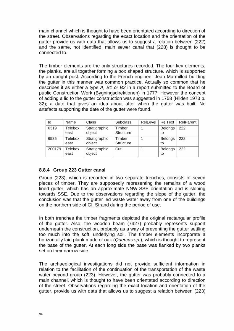
94
main channel which is thought to have been orientated according to direction of the street. Observations regarding the exact location and the orientation of the gutter provide us with data that allows us to suggest a relation between (222) and the same, not identified, main sewer canal that (228) is thought to be connected to.
The timber elements are the only structures recorded. The four key elements, the planks, are all together forming a box shaped structure, which is supported by an upright post. According to the French engineer Jean Marmillod building the gutter in this manner was common practice. Actually so common that he describes it as either a type A, B1 or B2 in a report submitted to the Board of public Construction Work (Bygningsdirektionen) in 1777. However the concept of adding a lid to the gutter construction was suggested in 1758 (Hilden 1973 p. 32); a date that gives an idea about after when the gutter was built. No artefacts supporting the date of the gutter were found.
Id Name Class Subclass RelLevel RelText RelParent
6319 Telebox east
Stratigraphic object
Timber Structure
1 Belongs to
222
6535 Telebox east
Stratigraphic object
Timber Structure
1 Belongs to
222
200179 Telebox east
Stratigraphic object
Cut 1 Belongs to
222
8.8.4 Group 223 Gutter canal
Group (223), which is recorded in two separate trenches, consists of seven pieces of timber. They are supposedly representing the remains of a wood lined gutter, which has an approximate NNW-SSE orientation and is sloping towards SSE. Due to the observations regarding the slope of the gutter, the conclusion was that the gutter led waste water away from one of the buildings on the northern side of Gl. Strand during the period of use.
In both trenches the timber fragments depicted the original rectangular profile of the gutter. Also, the wooden beam (7427) probably represents support underneath the construction, probably as a way of preventing the gutter settling too much into the soft, underlying soil. The timber elements incorporate a horizontally laid plank made of oak (Quercus sp.), which is thought to represent the base of the gutter, At each long side the base was flanked by two planks set on their narrow side.
The archaeological investigations did not provide sufficient information in relation to the facilitation of the continuation of the transportation of the waste water beyond group (223). However, the gutter was probably connected to a main channel, which is thought to have been orientated according to direction of the street. Observations regarding the exact location and orientation of the gutter, provide us with data that allows us to suggest a relation between (223)

95
and the same, not identified, main sewer canal as (222) and (228) are thought to have been connected to.
As only the timber elements were recorded, no artefacts and samples for dendrochronological analysis related to the gutter were collected. Consequently, the date of the construction of the gutter is an issue that has to be dealt with differently. Valid information regarding the type and, subsequently, the date of the gutter is then to be found in a report submitted to the Board of Public Construction Work in 1777. The French engineer Jean Marmillod, who wrote the report, described the gutter as a type, that has found widespread use in Copenhagen for decades. Actually, the type was so common that he describes it as either a type A, B1 or B2 in the report.
Id Name Class Subclass RelLevel RelText RelParent
6965 Vendsyssel N
Stratigraphic object
Timber Structure
1 Belongs to
223
7427 Waste pipe Stratigraphic object
Timber Structure
1 Belongs to
223
7456 Waste pipe Stratigraphic object
Timber Structure
1 Belongs to
223
7517 Waste pipe Stratigraphic object
Timber Structure
1 Belongs to
223
8.8.5 Group 224 Gutter canal
This group (224) consists of two subgroups (313) and (314) and four contexts (6956), (7446), (7477) and (7489), all thought to represent the remains of a wood lined gutter, showing a mostly rectangular profile. In all, four timber elements were recorded in two separate trenches. The entire timber structure, which has an approximate NNW-SSE orientation, is sloping down towards NNW. A slope which is opposite to the other gutters in the area with the same orientation. Why this is so cannot be explained for the time being.
In both trenches the timber fragments show the original rectangular profile of the gutter. However, due the problems related to the excavation of the structure the material to be categorized is insufficient. This means that it is uncertain whether the gutter is of a common type, described by Jean Marmillod in 1777 (cf. below), or it is a more unique type, comprising a hollow plank as a base.
As only the timber elements were recorded, no artefacts related to the gutter were collected, and dendrochronological analysis is not carried out either. Consequently, the date of the construction of the gutter is an issue that has to be dealt with in different way. Valid information regarding the type and, subsequently, the date of the gutter is then – maybe - to be found in a report submitted to the Board of Public Construction Work (Bygningsdirektionen) in 1777. The French engineer Jean Marmillod, who wrote the report, described a gutter, as a type that has found wide spread use in Copenhagen for decades. The types, which he describe as A, B1 and B2, are possibly variations over the

96
present gutter. But as described above, this interpretation is not fully satisfactory.
Id Name Class Subclass RelLevel RelText RelParent
313 Gutter element
Subgroup - 1 Belongs to
224
314 Gutter sequence
Subgroup - 1 Belongs
To
224
6956 Vendsyssel N
Stratigraphic object
Timber Structure
2 Belongs to
313
7446 Waste pipe Stratigraphic object
Timber Structure
2 Belongs to
314
7477 Waste pipe Stratigraphic object
Timber Structure
2 Belongs to
314
7489 Waste pipe Stratigraphic object
Timber Structure
2 Belongs to
314
8.8.6 Group 228 Gutter canal
Group (228) represents the remains of a wood lined gutter with a rectangular profile. The NNW-SSE orientated structure was presumably built with the purpose of canalling waste water away from one of the buildings on the northern side of Gl. Strand. It was due to observations regarding its slope that a relation to one of the buildings was made possible. The survey data did show that the structure was situated 0.65m above sea level farthest to the north, while it was only 0.54m above sea level farthest to the south. Unfortunately, confirming the assumption with such a narrow margin is problematic. Thus, the main concern is the potential inaccuracies in measurement. It is currently imposible to reject the hypothesis that the gutter instead was a drain related to the Vragerbro situated towards south.
The archaeological investigations not provide any solid information about how the waste water was transported beyond the current gutter . However, gutter (228) was most likely to have been connected with a main channel, which is thought to have been orientated according to direction of the street. Another solution was to lead the gutter directly towards the channel. On the other hand, this solution was problematic, as the gutter had to be led across the Vragerbro area to the south (cf. chapter 7.11).
Only the timber structure related to the gutter was recorded, thus no artefacts were sampled. The questions regarding the time of the establishment of the gutter and the extent of its use phase remain unanswered for the time being. Unfortunately, the typology is not of any help either, as it is a well known gutter type, here described as a Marmillod type A or B1 after Jean Marmillod, which were in use for centuries. (Wiene 2011 pp. 11-13). Regrettably, no sample for dendrochronological analysis was collected.
Id Name Class Subclass RelLevel RelText RelParent

97
7603 Waste pipe
Stratigraphic object
Timber Structure
1 Belongs to
228
8.8.7 Group 229 Gutter canal
This group, which only consists of one context (6834), is thought to represent the scarce remains of a wood lined wastepipe and on a near N-S orientation. It is only preserved over a 0.70m long stretch, but observations regarding its slope indicate a southern orientation. It seems likely that the gutter was built with the purpose of leading waste water away from one of the now demolished buildings, which burned down in 1795, on the current Højbro Plads and out into the canal. Interestingly enough, the gutter truncates an old stone paving (6853) which is thought to represent a road established before the second fire of Copenhagen in 1795.
The archaeological investigations did not provide sufficient information in relation to the facilitation of the continuation of the transportation of the waste water beyond group (229). Was the current gutter leading the wastewater directly into the canal or was it connected to a main canal? These questions remain unanswered, as only a limited part of the original gutter is preserved.
As only the timber elements were recorded, no artefacts and no samples for dendrochronological analysis were collected. Consequently, the date of the construction of the gutter is an issue that has to be dealt with differently. Valid information regarding the type and, subsequently, the date of the gutter is then to be found in a report submitted to the Board of Public Construction Work in 1777. The French engineer Jean Marmillod, who wrote the report, described the gutter as a type, that has found wide spread use in Copenhagen for decades. Actually, the type was so common that he describes it as either a type A, B1 or B2 in the report.
Id Name Class Subclass RelLevel RelText RelParent
6834 Teleblock Højbro
Stratigraphic object
Timber Structure
1 Belongs to
229
8.8.8 Group 230 Gutter canal
This group (230) consists of three contexts (7002), (7976) and (200485), located in two separate trenches. They are thought to represent the remains of a wood lined gutter, showing a mostly rectangular profile. The entire timber structure, which has an approximate NNW-SSE orientation, seems to slope down towards north, indicating that it led wastewater out of the Vragerbro area to the south.
Its relation to the Vragerbro was inferred due to observations regarding the slope. However, the survey data did only show a slight difference between the measured heights in the northern end, compared to those farthest to the south
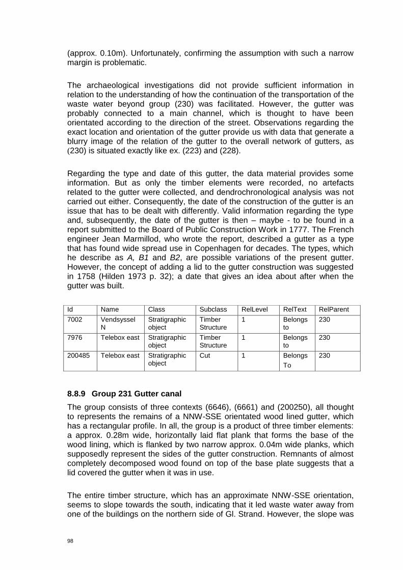
98
(approx. 0.10m). Unfortunately, confirming the assumption with such a narrow margin is problematic.
The archaeological investigations did not provide sufficient information in relation to the understanding of how the continuation of the transportation of the waste water beyond group (230) was facilitated. However, the gutter was probably connected to a main channel, which is thought to have been orientated according to the direction of the street. Observations regarding the exact location and orientation of the gutter provide us with data that generate a blurry image of the relation of the gutter to the overall network of gutters, as
(230) is situated exactly like ex. (223) and (228).
Regarding the type and date of this gutter, the data material provides some information. But as only the timber elements were recorded, no artefacts related to the gutter were collected, and dendrochronological analysis was not carried out either. Consequently, the date of the construction of the gutter is an issue that has to be dealt with differently. Valid information regarding the type and, subsequently, the date of the gutter is then – maybe - to be found in a report submitted to the Board of Public Construction Work in 1777. The French engineer Jean Marmillod, who wrote the report, described a gutter as a type that has found wide spread use in Copenhagen for decades. The types, which he describe as A, B1 and B2, are possible variations of the present gutter. However, the concept of adding a lid to the gutter construction was suggested in 1758 (Hilden 1973 p. 32); a date that gives an idea about after when the gutter was built.
8.8.9 Group 231 Gutter canal
The group consists of three contexts (6646), (6661) and (200250), all thought to represents the remains of a NNW-SSE orientated wood lined gutter, which has a rectangular profile. In all, the group is a product of three timber elements: a approx. 0.28m wide, horizontally laid flat plank that forms the base of the wood lining, which is flanked by two narrow approx. 0.04m wide planks, which supposedly represent the sides of the gutter construction. Remnants of almost completely decomposed wood found on top of the base plate suggests that a lid covered the gutter when it was in use.
The entire timber structure, which has an approximate NNW-SSE orientation, seems to slope towards the south, indicating that it led waste water away from one of the buildings on the northern side of Gl. Strand. However, the slope was
Id Name Class Subclass RelLevel RelText RelParent
7002 Vendsyssel N
Stratigraphic object
Timber Structure
1 Belongs to
230
7976 Telebox east Stratigraphic object
Timber Structure
1 Belongs to
230
200485 Telebox east Stratigraphic object
Cut 1 Belongs
To
230
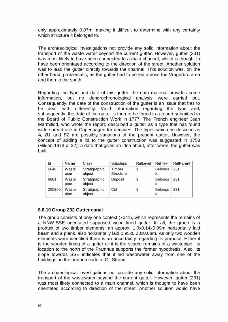
99
only approximately 0.07m, making it difficult to determine with any certainty which structure it belonged to.
The archaeological investigations not provide any solid information about the transport of the waste water beyond the current gutter. However, gutter (231) was most likely to have been connected to a main channel, which is thought to have been orientated according to the direction of the street. Another solution was to lead the gutter directly towards the channel. This solution was, on the other hand, problematic, as the gutter had to be led across the Vragerbro area and then to the south.
Regarding the type and date of this gutter, the data material provides some information, but no dendrochronological analysis were carried out. Consequently, the date of the construction of the gutter is an issue that has to be dealt with differently. Valid information regarding the type and, subsequently, the date of the gutter is then to be found in a report submitted to the Board of Public Construction Work in 1777. The French engineer Jean Marmillod, who wrote the report, described a gutter as a type that has found wide spread use in Copenhagen for decades. The types which he describe as A, B1 and B2 are possibly variations of the present gutter. However, the concept of adding a lid to the gutter construction was suggested in 1758 (Hilden 1973 p. 32); a date that gives an idea about, after when, the gutter was built.
Id Name Class Subclass RelLevel RelText RelParent
6646 Waste pipe
Stratigraphic object
Timber Structure
1 Belongs to
231
6661 Waste pipe
Stratigraphic object
Deposit 1 Belongs to
231
200250 Waste pipe
Stratigraphic object
Cut 1 Belongs to
231
8.8.10 Group 232 Gutter canal
The group consists of only one context (7041), which represents the remains of a NNW-SSE orientated supposed wood lined gutter. In all, the group is a product of two timber elements: an approx. 1.0x0.14x0.09m horizontally laid beam and a plank, also horizontally laid 0.95x0.23x0.08m. As only two wooden elements were identified there is an uncertainty regarding its purpose. Either it is the wooden lining of a gutter or it is the scarce remains of a wastepipe. Its location to the north of the Pramhus supports the former hypothesis. Also, its slope towards SSE indicates that it led wastewater away from one of the buildings on the northern side of Gl. Strand.
The archaeological investigations not provide any solid information about the transport of the wastewater beyond the current gutter. However, gutter (231) was most likely connected to a main channel, which is thought to have been orientated according to direction of the street. Another solution would have
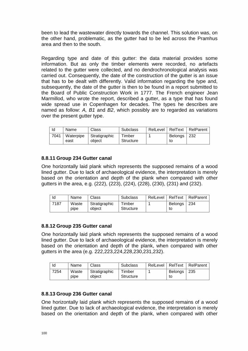
100
been to lead the wastewater directly towards the channel. This solution was, on the other hand, problematic, as the gutter had to be led across the Pramhus area and then to the south.
Regarding type and date of this gutter: the data material provides some information. But as only the timber elements were recorded, no artefacts related to the gutter were collected, and no dendrochronological analysis was carried out. Consequently, the date of the construction of the gutter is an issue that has to be dealt with differently. Valid information regarding the type and, subsequently, the date of the gutter is then to be found in a report submitted to the Board of Public Construction Work in 1777. The French engineer Jean Marmillod, who wrote the report, described a gutter, as a type that has found wide spread use in Copenhagen for decades. The types he describes are named as follow: A, B1 and B2, which possibly are to regarded as variations over the present gutter type.
Id Name Class Subclass RelLevel RelText RelParent
7041 Waterpipe east
Stratigraphic object
Timber Structure
1 Belongs to
232
8.8.11 Group 234 Gutter canal
One horizontally laid plank which represents the supposed remains of a wood lined gutter. Due to lack of archaeological evidence, the interpretation is merely based on the orientation and depth of the plank when compared with other gutters in the area, e.g. (222), (223), (224), (228), (230), (231) and (232).
Id Name Class Subclass RelLevel RelText RelParent
7187 Waste pipe
Stratigraphic object
Timber Structure
1 Belongs to
234
8.8.12 Group 235 Gutter canal
One horizontally laid plank which represents the supposed remains of a wood lined gutter. Due to lack of archaeological evidence, the interpretation is merely based on the orientation and depth of the plank, when compared with other gutters in the area (e.g. 222,223,224,228,230,231,232).
Id Name Class Subclass RelLevel RelText RelParent
7254 Waste pipe
Stratigraphic object
Timber Structure
1 Belongs to
235
8.8.13 Group 236 Gutter canal
One horizontally laid plank which represents the supposed remains of a wood lined gutter. Due to lack of archaeological evidence, the interpretation is merely based on the orientation and depth of the plank, when compared with other

101
gutters in the area, e.g. (222), (223), (224), (228), (230), (231), (232), (234) and (235).
Id Name Class Subclass RelLevel RelText RelParent
7383 Waste pipe
Stratigraphic object
Timber Structure
1 Belongs to
236
8.8.14 Group 237 Gutter canal
One horizontally laid plank which represents the supposed remains of a wood lined gutter. Due to lack of archaeological evidence, the interpretation is merely based on the orientation and depth of the plank, when compared with other gutters in the area, e.g. (222), (223), (224), (228), (230), (231), (232), (234), (235), (236).
Id Name Class Subclass RelLevel RelText RelParent
7521 Waste pipe
Stratigraphic object
Timber Structure
1 Belongs to
237
8.8.15 Group 238 Gutter canal
One horizontally laid plank which represents the supposed remains of a wood lined gutter. Due to lack of archaeological evidence, the interpretation is merely based on the orientation and depth of the plank, when compared with other gutters in the area, e.g. (222), (223), (224), (228), (230), (231), (232), (234), (235), (236), (237).
8.8.16 Group 312 Gutter canal
The group consists of one context (7859), which is thought to represent the remains of a NNW-SSE orientated wood lined gutter, with a box-like profile.The group consists of four timber elements. Its orientation suggests it led wastewater away from one of the buildings on the northern side of Gl. Strand.
The archaeological investigations not provide any solid information about the transport of the wastewater beyond the current gutter. However, gutter (312) was most likely connected to a main channel, which is thought to have been orientated according to direction of the street. Another solution would have been to lead the wastewater directly towards the channel. This solution was, on the other hand, problematic, as the gutter had to be led across the Vragerbro area and then to the south.
Id Name Class Subclass RelLevel RelText RelParent
7650 Waste pipe
Stratigraphic object
Timber Structure
1 Belongs to
238
102
Regarding the type and date of this gutter, the data material provides some information. But as only the timber elements were recorded, no artefacts related to the gutter were collected and no dendrochronological analysis was carried out either. Consequently, the date of the construction of the gutter is an issue that has to be dealt with differently. Valid information regarding the type and, subsequently, the date of the gutter is then to be found in a report submitted to the Board of Public Construction Work in 1777. The French engineer Jean Marmillod, who wrote the report, described a gutter as a type that has found wide spread use in Copenhagen for decades. The types he describes are named as follow: A, B1 and B2, which possibly are to be regarded as variations over the present gutter type.
Id Name Class Subclass RelLevel RelText RelParent
7859 Telebox east
Stratigraphic object
Timber Structure
1 Belongs to
312
8.9 Sewer canals
8.9.1 Brief Cultural History of the Sewers of Copenhagen
‖At færdes i Københavns gader er ikke noget problem. I august, hvor det er varmt og solrigt, er gaderne tørre og uden mudder, og de mellemliggende 11 måneder går jo hurtigt‖.3
Ludvig Holberg (1684-1754)
In this quote Ludvig Holberg is making an ironic comment about the frustrations the citizens of Copenhagen had in relation to the standard of sanitation in their capital during the double monarchy of Denmark-Norway in the first half of the 18th century. But as numerous bans and penalty clauses described in Københavns Diplomatarium plus many archeological investigations have shown, problems related to the communal renovation is closely associated with urban areas in pre-industrial time.
Until reformation of the communal sewer in 1857, which culminated in the establishing of the founding of Københavns Vandforsyning (the water supply company of Copenhagen), the renovation of Copenhagen was, for hygienic reasons, separated into day and night. The refuse collection consisted of kitchen waste etc. and the night renovation was of human origin which due to its foul nature was disposed of at night by the so-called men-of-the-night, who at least in the 18th century were organized in specific guild.
3 Translation: “Walking the streets of Copenhagen isn‟t a problem. In August, when it‟s hot and sunny, the streets are dry and free of mud, luckily the 11 months in between will go pretty fast”.

103
The origin of the guild is uncertain but the ever present need for someone to handle and dispose of the latrine waste makes it plausible that it was quite old. The term natmænd (men-of-the-night) was already known in the Middle Ages where, besides handling the night renovation, they also had to butcher and dispose of fallen animals, lead convicted felons to the scaffold and bury dead delinquents. The men-of-the-night together with the chimney sweeps, executioners and pig and horse emasculators belonged to the dishonest people of the town. As compensation for this unpleasant social status the men-of-the-night made good money. In spite of this, multiple written sources show us how difficult it was to hire sufficient staff for the necessary work.
Their main job was to empty the latrine pits in the back yards of houses in the town. Then the latrine was towed away by the carriages belonging to the guild of the men-of-the-night and emptied into the communal latrine pit that was situated on Amager. However, as late as in the 19th century no regulations concerning the emptying frequency of the latrines existed. This meant that the citizens often just sealed the filled-up latrine pit and dug a new one instead of emptying it. Unfortunately, this quite common practice caused an extensive problem with contamination of the ground water. In addition to this, an incredibly poor air quality was also generated in the back yards of the town.
Before the middle of the 19th century, the latrine was almost exclusively constructed as the pits referred to above It was not until Bygningsreglementet (the rules public construction work) of 1856 that the latrine construction became subject to communal regulations. As mentioned, the latrines were mostly found the back yards of houses of the town. However, houses were in some cases so narrow that it was impossible to place a latrine there. Then the latrine was built into the house, either at ground floor level or in the basement. Putting the latrine here obviously lead to significant odour problems, as the stink spread through the floors and staircases of the houses. The barrel system, which later became dominant, was introduced after the Fire of Copenhagen in 1795, but it did not gain ground at this time. In spite of the dominance of the latrines, a few water closets were installed at residences of the bourgeois people before 1850. Unfortunately this solution ended up in the upmost disgusting filthiness, as the flush lead out to the open gutters on the street, which canalled the stools thought the sewers into the canals and harbours around Copenhagen. This practice was abandoned in 1856.
Using the services of the-man-of-the-night was not the only solution when the citizens of Copenhagen desired to facilitate the disposal the night soil. It is known how multiple latrines were directly connected to the moat and the canals around the town. In general, the drains from the houses, stables, latrines, urine corners and accumulated waste piles on the streets were canalled into the gutters, and we do not find many rules and prescripts specifically dealing with the sewer drains.
It is difficult to throw light on the development of the sewers in Copenhagen. One of the initiatives the sources document is the attempt to broaden the street

104
lanes by putting the gutters into grooves of hard wood and covering them with a removable wooden lid. However, this solution was only used to a limited extent and as the wagons damaged the system and no maintenance took place it was finally abandoned.
The first brick built sewers saw the light of day at the end of the 16th century. It is in relation to these early initiatives that the heavily built drain found on Kgs. Nytorv during the excavations KBM 1410 and 1910 in 1996-1997 should be seen. It was a 14.6m long, heavily built brick drain, which was lead through the so-called Vandport (Watergate) that was an access-way through the bastions of King Christian IV (the drain is referred to as LI in the reports, cf. KBM 1410 and KBM 1910). The drain was in use concurrently with the Watergate, and it seems to have been operational until the filling of the moat in the third quarter of the 17th century. Unfortunately, the stratigraphical relations established during the excavations 1996-1997 could not give a clear sign of when it was abandoned (Svart Kristiansen 1998 p. 130).
An additional initiative was the establishing of the mud traps (Dk: slamkisterne), that are to be considered as a kind of a early waste water treatment plant. Originally they were just pits or deep holes constructed with an inlet spout placed at a lower level than the outlet spout. So when the water ran into the mud trap the system made it possible for the more solid particles to settle at the bottom, as the water necessarily had to rise up to the higher placed outlet spout in order to continue it‟s journey towards the harbour and canal. The specific rules for the design of the mud traps of 1758 stated how their inlets now were to be covered in hard wood in order to prevent obstruction of the water flow. From 1789 and onwards they were to be built of rough granite. The early mud traps had their drain in the harbour and canal but as the town grew they also found use in relation to the confluence of the major gutters and sewer canals. Regulations dated to 1744 stated that they were to be dredged and the sludge disposed of when required by the harbour commission. The payment for this service was imposed on the residences situated at the harbour and by the canals.
8.9.2 Land use Sewer/wastepipe
A little less than a handful of contexts recorded during the Gl. Strand fieldwork phase are interpreted as sewer remains. These contexts are grouped in IntraSiS (201), (207), (208), (255) and (324). However, deducing from observations related to the physical layout of these sewers/wastepipes, it is evident that none of them can be linked together as part of a larger sewer network.
As they all are thought to represent individual sewers canals, orientated alike, does it seem clear that they are constructed with the purpose of distributing water away from the buildings on the northern side of Gl. Strand and Højbro Plads and into the canal to the south. In that sense they are representing the

105
same type of use of the land, i.e. as a sewer system. Hence, the land use category is only representing the sewer/wastepipes thematically.
Id Name Class Subclass RelLevel RelText RelParent
201 Telebox: extra work: old gas pipe
Stratigraphic object
Group 1 Belongs to Land use
207 Telebox: extra work: old gas pipe and the northern extension of the Telebox trench
Stratigraphic object
Group 1 Belongs to Land use
208 Waterpipe east southern extension
Stratigraphic object
Group 1 Belongs to Land use
255 Waterpipe east Stratigraphic object
Group 1 Belongs to Land use
324 Water reduction Stratigraphic object
Group 1 Belongs to Land use
8.9.3 Group 201 Sewer/wastepipe
This supposed sewer canal consists of two fully laid, brick built walls orientated NW-SE. The walls, which so far, are identified over a distance of 2.8m were both approximately 0.5m wide. It was not recorded to what height the walls were preserved, so no data about the construction height is currently available. These brick structures are thought to represent the long sides of a sewer canal or wastepipe leading wastewater towards the canal. The bottom of the structure was formed of a wooden floor.
It is possible that this structure is a sewer, i.e. a fully built pipe, however no roof/vault elements were identified. Due to significant similarities with other comparable brick structures found in the Gl. Strand Area, the sewer suggestion was made, e.g. (207), (208), (255) and (324). Nonetheless, as there are some doubts related to the interpretation of the structure, it is still possible that it should be seen as a wood lined gutter covered by a wooden lid.
On the 1683 map of Vejerhuset two NW-SE running parallel lines, forming a 19.9m long and 0.9m wide structure, is depicted (cf. figure 28). It is situated between the Humlegård on the western side of the Vejerhus itself and the large rectangular Fielebod situated immediately to the east of the current Ministry of Cultural affairs. These lines could either represent a paved surface or sewer walls, but that question is still not answered. Hence, the sewer canal/wastepipe is thought to lie beneath the paving, a procedure that probably also explains why the sewer was so solidly build (it had to carry the weight of the paving). Situating the sewer canal/wastepipe here was not a random choice as the path between the two gates in the western side of the Vejerhus was an open area without any crossing foundations.
Deducing from the knowledge about the date of the other sewer canals in the area, a suggested date of 17th century can be made. However, no artefacts support the date suggestion in this case.
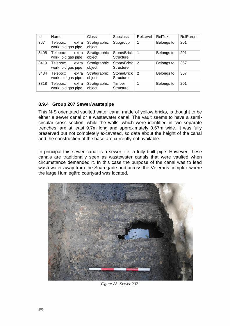
106
Id Name Class Subclass RelLevel RelText RelParent
367 Telebox: extra work: old gas pipe
Stratigraphic object
Subgroup 1 Belongs to 201
3405 Telebox: extra work: old gas pipe
Stratigraphic object
Stone/Brick Structure
1 Belongs to 201
3419 Telebox: extra work: old gas pipe
Stratigraphic object
Stone/Brick Structure
2 Belongs to 367
3434 Telebox: extra work: old gas pipe
Stratigraphic object
Stone/Brick Structure
2 Belongs to 367
3818 Telebox: extra work: old gas pipe
Stratigraphic object
Timber Structure
1 Belongs to 201
8.9.4 Group 207 Sewer/wastepipe
This N-S orientated vaulted water canal made of yellow bricks, is thought to be either a sewer canal or a wastewater canal. The vault seems to have a semi-circular cross section, while the walls, which were identified in two separate trenches, are at least 9.7m long and approximately 0.67m wide. It was fully preserved but not completely excavated, so data about the height of the canal and the construction of the base are currently not available.
In principal this sewer canal is a sewer, i.e. a fully built pipe. However, these canals are traditionally seen as wastewater canals that were vaulted when circumstance demanded it. In this case the purpose of the canal was to lead wastewater away from the Snaregade and across the Vejerhus complex where the large Humlegård courtyard was located.
Figure 23. Sewer 207.

107
Deducing from the knowledge about the date of the other sewer canals in the area, a suggested date of 17th century can be made. However, some rather remarkable artefacts were found in the fill of the construction cut: especially a piece of Italian Urbina Faienze, dated to around 1550 is of great interest. The fact that the colour of the bricks were yellow is relevant, i.e. possibly from the time of Christian IV or later.
8.9.5 Group 208 Sewer/wastepipe
N-S orientated water canal, partly made of yellow and red bricks and lime stones. The structure is thought to be either a sewer canal or a wastewater canal which is disturbed by modern truncation to the south. It has a “lid” which was made of lime stone ashlars presenting a rough finish on the upper surface, a fact which indicates secondary use of Late Medieval building stones. The bottom of the canal was also made of these lime stone ashlars. The walls were not made of lime stones, but of yellow bricks: 20x8.5x4cm. As the sewer canal was not fully excavated no data about the depth is currently available.
Id Name Class Subclass RelLevel RelText RelParent
371 Telebox: extra work: old gas pipe and the northern extension of the Telebox trench
Stratigraphic object
Subgroup 1 Belongs to
207
372 Telebox: extra work: old gas pipe and the northern extension of the Telebox trench
Stratigraphic object
Subgroup 1 Belongs to
207
374 Northern extension of the Telebox trench
Stratigraphic object
Subgroup 1 Belongs to
207
374 Telebox: extra work: old gas pipe and the northern extension of the Telebox trench
Stratigraphic object
Subgroup 1 Belongs to
207
2861 Telebox: extra work: old gas pipe Stratigraphic object
Deposit 2 Belongs to
371
2876 Telebox: extra work: old gas pipe Stratigraphic object
Deposit 2 Belongs to
372
2877 Telebox: extra work: old gas pipe Stratigraphic object
Stone/Brick Structure
2 Belongs to
373
3154 Northern extension of the Telebox trench
Stratigraphic object
Deposit 2 Belongs to
371
3186 Northern extension of the Telebox trench
Stratigraphic object
Deposit 2 Belongs to
372
7350 Telebox Stratigraphic object
Stone/Brick Structure
2 Belongs to
373

108
Figure 24. Sewer (208).
In principal this sewer canal is a genuine sewer, i.e. a fully built pipe. However, these canals are traditionally seen as wastewater canals that were vaulted when circumstance demanded it. In this case the purpose of the canal was to lead wastewater away from the northern side of Gl. Strand and across the marked area towards the canal to the south.
Deducing from knowledge about the date of the other sewer canals in the area, a suggested date of the 17th century can be made. However no artefacts found in relation to the structure supports this hypothesis, but do not reject it either. The fact that the bricks were yellow is also relevant, i.e. possibly from the time of Christian IV or later.
k

109
Figure 25. Sewer 208.
Id Name Class Subclass RelLevel RelText RelParent
332 Waterpipe east southern extension
Stratigraphic object
Subgroup 1 Belongs to
208
333 Waterpipe east southern extension
Stratigraphic object
Subgroup 1 Belongs to
208
7709 Waterpipe east southern extension
Stratigraphic object
Stone/Brick structure
2 Belongs to
333
200378 Waterpipe east southern extension
Stratigraphic object
Construction cut
2 Belongs to
332
8.9.6 Group 255 Sewer/wastepipe
This group (255), which consists of the contexts (3594), (3828), (3847), (3871), (5442) and (5450) and the subgroups (325), (326) and (327), supposedly represents the remains of a sewer canal made of two stone built sidepieces. The walls of this approximately 1.90m wide structure are orientated NE-SE and are identified over a distance of 1.91m. The height was not recorded and no elevation plan was made. These brick structures are thought to represent the long sides of a sewer canal or wastepipe, leading wastewater towards the canal. Its base is formed by multiple wooden planks creating some kind of a floor upon which the waste was transported.
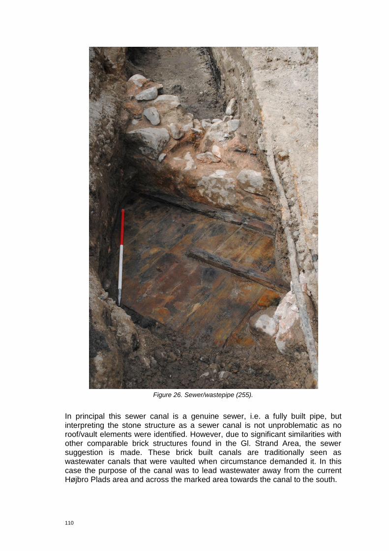
110
Figure 26. Sewer/wastepipe (255).
In principal this sewer canal is a genuine sewer, i.e. a fully built pipe, but interpreting the stone structure as a sewer canal is not unproblematic as no roof/vault elements were identified. However, due to significant similarities with other comparable brick structures found in the Gl. Strand Area, the sewer suggestion is made. These brick built canals are traditionally seen as wastewater canals that were vaulted when circumstance demanded it. In this case the purpose of the canal was to lead wastewater away from the current Højbro Plads area and across the marked area towards the canal to the south.

111
The finds, i.e. coins, indicate that the construction took place late in the 18th century or early in the 19th century. However, the circumstances under which they were found are not fully clarified. The problem is that they were found in/on/at the timber structure (3847) that is thought to be the sewer floor. Hereby it becomes unclear whether it is found underneath the structure (i.e. terminus ante quem), upon the floors (i.e. during it‟s use (sub quem) or after it went out of use.
Id Name Class Subclass RelLevel RelText RelParent
325 Waterpipe east
Stratigraphic object
Subgroup 1 Belongs to
255
326 Waterpipe east
Stratigraphic object
Subgroup 1 Belongs to
255
327 Waterpipe east
Stratigraphic object
Subgroup 1 Belongs to
255
3594 Waterpipe east
Stratigraphic object
Stone/Brick Structure
2 Belongs to
255
3826 Waterpipe east
Stratigraphic object
Stone/Brick
Structure
2 Belongs to
255
3847 Waterpipe east
Stratigraphic object
Timber
Structure
2 Belongs to
255
3871 Waterpipe east
Stratigraphic object
Stone/Brick
Structure
2 Belongs to
255
5442 Waterpipe east
Stratigraphic object
Stone/Brick
Structure
2 Belongs to
255
5450 Waterpipe east
Stratigraphic object
Timber
Structure
2 Belongs to
255
8.9.7 Group 324 Sewer/wastepipe
This group, which only consists of one group (3630), represents the remains of a stone structure consisting of a 0.5mx0.42m fragment of a stone foundation interpreted as a side piece of a sewer canal/wastepipe. The structure extends out of the trench to the north and west, so the interpretation is problematic. The excavators saw it as a corner of a building to begin with, but on the other hand its location in the middle of the street (the layout of the present day street is identical to its Renaissance layout) indicates that it not a building. Because similar stone structures, interpreted as stone built sewer canals/wastepipes, are found on Gammel Strand it seems likely that this interpretation is more trustworthy.
In principal this sewer canal could be a genuine sewer, i.e. a fully built pipe, but interpreting the stone structure as a sewer canal is not unproblematic, as no roof/vault elements were identified. However, due to significant similarities with other comparable brick structures found in the Gl. Strand Area, the sewer suggestion seems probable. These brick built canals are traditionally seen as wastewater canals that were vaulted when circumstance demanded it. In this
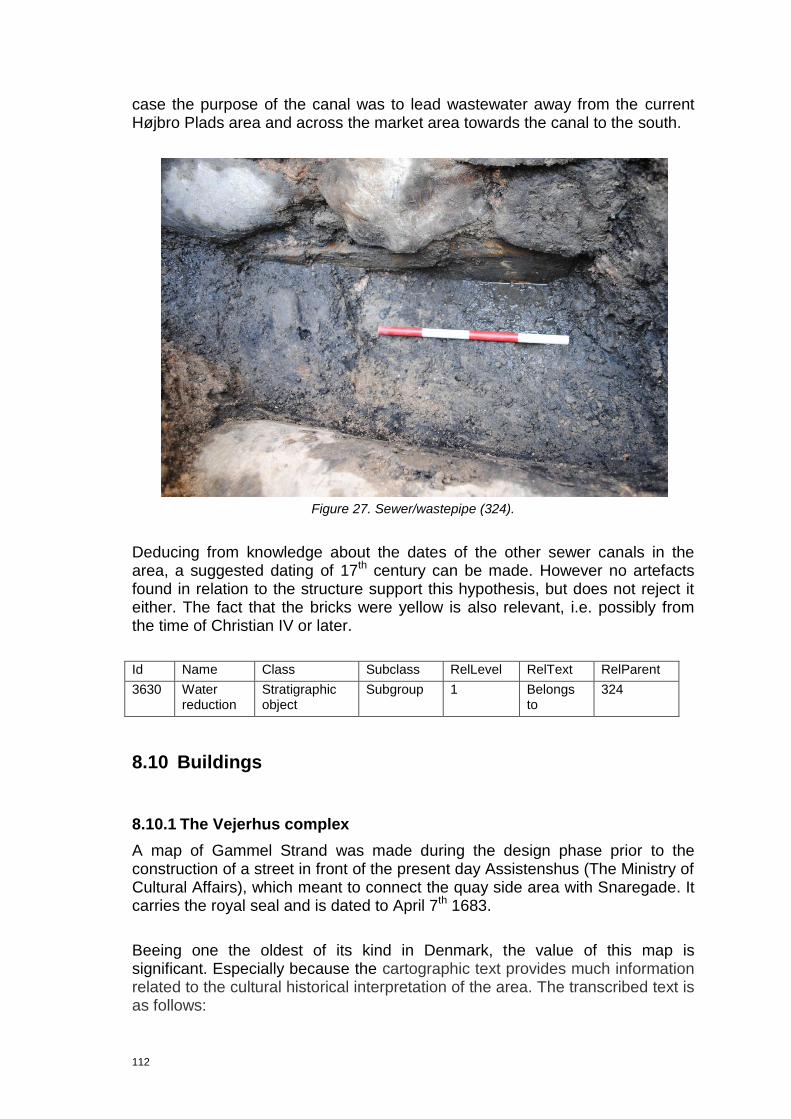
112
case the purpose of the canal was to lead wastewater away from the current Højbro Plads area and across the market area towards the canal to the south.
Figure 27. Sewer/wastepipe (324).
Deducing from knowledge about the dates of the other sewer canals in the area, a suggested dating of 17th century can be made. However no artefacts found in relation to the structure support this hypothesis, but does not reject it either. The fact that the bricks were yellow is also relevant, i.e. possibly from the time of Christian IV or later.
Id Name Class Subclass RelLevel RelText RelParent
3630 Water reduction
Stratigraphic object
Subgroup 1 Belongs to
324
8.10 Buildings
8.10.1 The Vejerhus complex
A map of Gammel Strand was made during the design phase prior to the construction of a street in front of the present day Assistenshus (The Ministry of Cultural Affairs), which meant to connect the quay side area with Snaregade. It carries the royal seal and is dated to April 7th 1683.
Beeing one the oldest of its kind in Denmark, the value of this map is significant. Especially because the cartographic text provides much information related to the cultural historical interpretation of the area. The transcribed text is as follows:
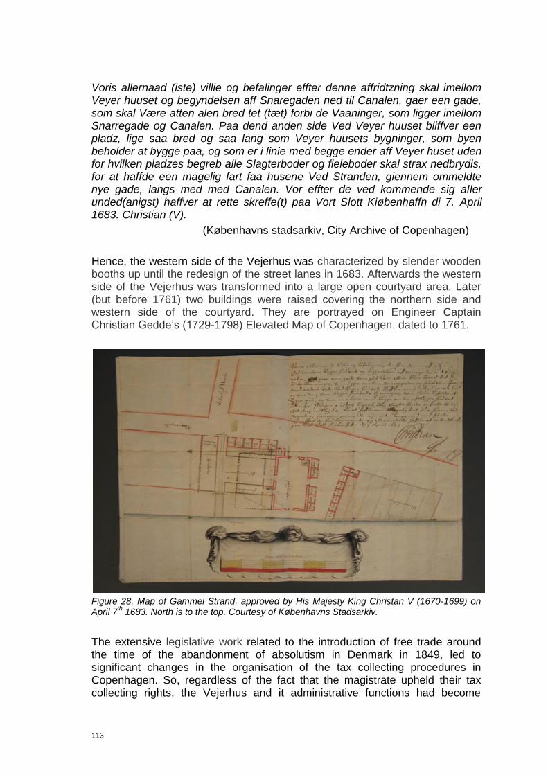
113
Voris allernaad (iste) villie og befalinger effter denne affridtzning skal imellom Veyer huuset og begyndelsen aff Snaregaden ned til Canalen, gaer een gade, som skal Være atten alen bred tet (tæt) forbi de Vaaninger, som ligger imellom Snarregade og Canalen. Paa dend anden side Ved Veyer huuset bliffver een pladz, lige saa bred og saa lang som Veyer huusets bygninger, som byen beholder at bygge paa, og som er i linie med begge ender aff Veyer huset uden for hvilken pladzes begreb alle Slagterboder og fieleboder skal strax nedbrydis, for at haffde een magelig fart faa husene Ved Stranden, giennem ommeldte nye gade, langs med med Canalen. Vor effter de ved kommende sig aller unded(anigst) haffver at rette skreffe(t) paa Vort Slott Kiøbenhaffn di 7. April 1683. Christian (V).
(Københavns stadsarkiv, City Archive of Copenhagen)
Hence, the western side of the Vejerhus was characterized by slender wooden booths up until the redesign of the street lanes in 1683. Afterwards the western side of the Vejerhus was transformed into a large open courtyard area. Later (but before 1761) two buildings were raised covering the northern side and western side of the courtyard. They are portrayed on Engineer Captain Christian Gedde‟s (1729-1798) Elevated Map of Copenhagen, dated to 1761.
Figure 28. Map of Gammel Strand, approved by His Majesty King Christan V (1670-1699) on April 7
th 1683. North is to the top. Courtesy of Københavns Stadsarkiv.
The extensive legislative work related to the introduction of free trade around the time of the abandonment of absolutism in Denmark in 1849, led to significant changes in the organisation of the tax collecting procedures in Copenhagen. So, regardless of the fact that the magistrate upheld their tax collecting rights, the Vejerhus and it administrative functions had become

114
obsolete in the middle of the 19th century. The decision to demolish the entire Vejerhus Complex was taken in 1857. Afterwards the lot was used as a flea market for many years.
The ownership of these buildings is listed in the land register of Gammel Strand in the years 1689, 1756, 1806 and 1857. Here it can be seen that the area was the property of the local authorities throughtout the entire period.
8.10.2 Group 221 Valkendorf’s Vejerhus (1581-1857)
This group consists of 7 subgroups (218) (western foundation wall), (219) (eastern foundation wall), (220) (northern foundation wall), (289) (demolition sequences), (320) (stone foundation) (346) (outhouse), (347) (structural elements) and 28 contexts, representing the remains of a large brick built structure. These quite well preserved structural remains, which were found in the western half of Gammel Strand but close to its centre, represent the northern foundation in its full length of 9.5m, but not full width (only 1.1m), the 2.15m of the c. 2.2m wide western foundation and 1.76m of the also c.2.2m wide eastern foundation. Additionally, the remains of a supposed lean-to/outhouse, located on the western side of the building and the possible remains of structural elements, which potentially could be room division elements, are supposedly related to the building.
Figure 29. Western foundation wall (218) of Valkendorf’s Vejerhus.

115
A close look at the N-W orientated foundation, represented by (218), (219), (220), enables us to recognise the method of construction chosen by the master builder. The construction cut was filled with multiple large, unfinished and uneven/uncoursed granite rocks, measuring more than 1.2m in diameter and laid without use of bonding material. In the northern wall coursing is apparently identified, represented by (4298) (lower) and (4350) (upper), which forms two uneven rows.
Figure 30. Northern foundation wall. Lower course (4298) is hardly visible, while the upper course (4350) is right underneath the brick structure (4453)
The brick structure is resting on top of the rock built foundation (4298) and (4453). Approximately ten courses were identified. From the bottom: a lower irregular course. Second course, is laid as a running/stretcher bond, while the third course is in cup bond. The third course is also forming a 1 skin thick cornice, clearly a decorative feature. The following four courses seem rather irregular, but some indications of both cup bond running/stretcher bonds are observed.
Finally the five uppermost courses are “cut off”, while the underlying courses extend out of the trench in its eastern end. This terminus of wall is a fold/rabbet made to form an access way. On the 1683 a major gate is in the northern wall of the Vejerhus, the fold is probably the remains of this entrance.
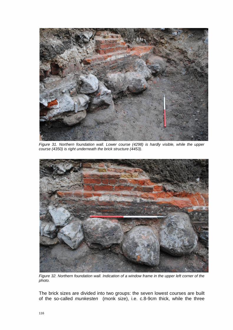
116
Figure 31. Northern foundation wall. Lower course (4298) is hardly visible, while the upper course (4350) is right underneath the brick structure (4453).
Figure 32. Northern foundation wall. Indication of a window frame in the upper left corner of the photo.
The brick sizes are divided into two groups: the seven lowest courses are built of the so-called munkesten (monk size), i.e. c.8-9cm thick, while the three

117
upper courses are of a typical Renaissance size (Christian IV-type), i.e. c.5.5cm thick in light red or yellow colours and dated to c.1600. Why two different sizes are chosen is not evident, but the wish to apply a decorative effect by mixing the traditional monk size and the new smaller brick type could explain it. Another reason could by a delivery change early in the building process.
Figure 33. The remains of Valkendorf’s Vejerhus compared with the map of 1683 and 1839, the latter is represented by the green line. Due to inaccuracies related to older cartographic work in 1683 and 1839 significant differenties between those and the modern survey are present.
118
A subgroup (347) classified as structural elements is almost solely consisting of vertical set wooden posts. It is subdivided into two separate timber structures; bulwark (4395) and bulwark (4275). The first of these is composed of four posts displaying square cross sections and measuring 0.09-0.17m, but they do not seem to have been set in a specific order. The latter is also comprised of posts displaying a square cross section and measuring 0.16-0.27m, but standing in a line in this case. Additionally, the bottom of the most western set post was retrieved for dendro-chronological dating (200098), but the sample result was useless.
The posts, which all are stratigraphically younger than the foundation of the Vejerhus, are interpreted as internal dividers or interior wooden structures, e.g. wall foundation etc. Finally the levelling layer (4395) is related to this subgroup by the field work staff, but no description why this is so exists. However, it does seem to have been an element in some sort of land development process carried out prior to the construction of the room dividers.
Due to the small quantity of these so-called room dividers found, the interpretation of the structure is rather questionable. They are maybe just rammed down with the purpose of stabilizing the sub-soil in a area characterized by significant softness.
A subgroup (346), consisting of a supposed levelling layer (4243) and a bulwark (4183) is thought to relate to building (221). The remains of the bulwark are represented by seven vertical set posts, showing a square section, two upright set planks and a horizontally laid board, forming a NW-SE orientated, 0.7m long line, and an area characterized by what seems to be randomly set posts, covering 0.85x1.0m.
As little of these structural elements were exposed the interpretation has become quite difficult. But according to the field work staff this wooden structure was an outhouse attached to or leaning up against the western wall of the Vejerhus. Thus, it was positioned immediately west of the large stone foundation (4075) of the western wall. The related levelling layer (4243) is interpreted to have been laid out to prepare the ground for the wooden foundation.
Identifying the structure as an outhouse is, however, questionable, as the interpretation is based on sparse/poor evidence. The depicted fielebod (minor wooden outhouse) on the 1683-map seem to have influenced the interpretation process to a certain degree. Potentially the 1683-map shows a lean to, under which various activities related to either the Vejerhus or the small booths surrounding it took place.
Due to the date of the pottery, c.1600-1800, found in the levelling layer (stratigraphically) underneath the timber elements, the structure is
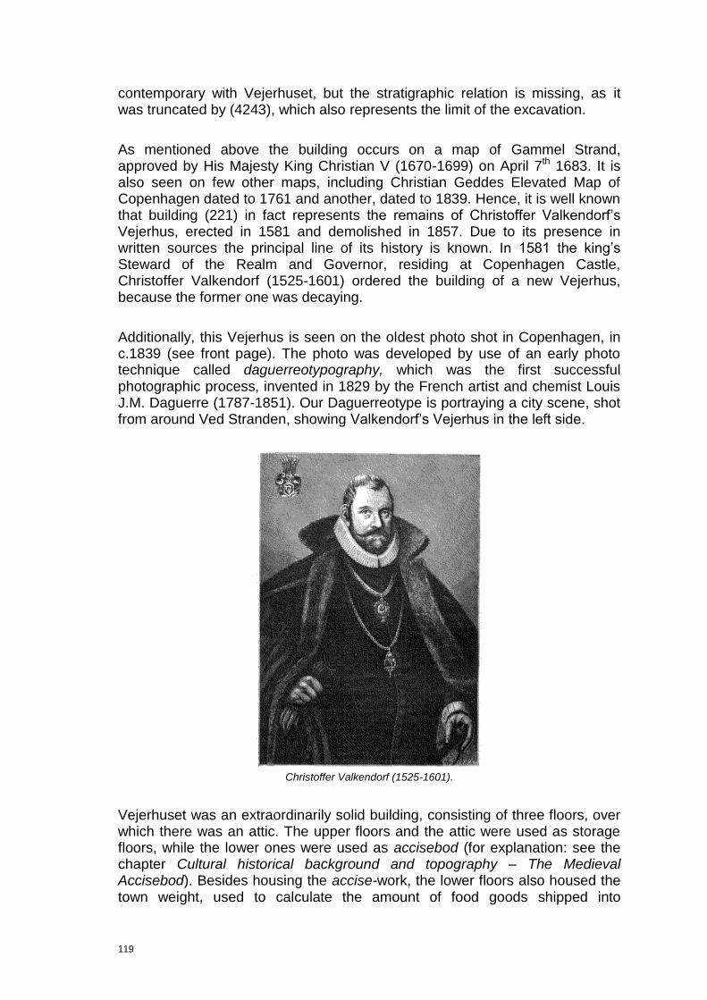
119
contemporary with Vejerhuset, but the stratigraphic relation is missing, as it was truncated by (4243), which also represents the limit of the excavation.
As mentioned above the building occurs on a map of Gammel Strand, approved by His Majesty King Christian V (1670-1699) on April 7th 1683. It is also seen on few other maps, including Christian Geddes Elevated Map of Copenhagen dated to 1761 and another, dated to 1839. Hence, it is well known that building (221) in fact represents the remains of Christoffer Valkendorf‟s Vejerhus, erected in 1581 and demolished in 1857. Due to its presence in written sources the principal line of its history is known. In 1581 the king‟s Steward of the Realm and Governor, residing at Copenhagen Castle, Christoffer Valkendorf (1525-1601) ordered the building of a new Vejerhus, because the former one was decaying.
Additionally, this Vejerhus is seen on the oldest photo shot in Copenhagen, in c.1839 (see front page). The photo was developed by use of an early photo technique called daguerreotypography, which was the first successful photographic process, invented in 1829 by the French artist and chemist Louis J.M. Daguerre (1787-1851). Our Daguerreotype is portraying a city scene, shot from around Ved Stranden, showing Valkendorf‟s Vejerhus in the left side.
Christoffer Valkendorf (1525-1601).
Vejerhuset was an extraordinarily solid building, consisting of three floors, over which there was an attic. The upper floors and the attic were used as storage floors, while the lower ones were used as accisebod (for explanation: see the chapter Cultural historical background and topography – The Medieval Accisebod). Besides housing the accise-work, the lower floors also housed the town weight, used to calculate the amount of food goods shipped into

120
Copenhagen through Gammel Strand. Weighing the freight was a job undertaken by the town weight master and his men, whose job it was to ensure the correct accise (tax) was paid. The building was demolished in 1857.
Based on the excavation results and knowledge about the post-Vejerhus settlement in the area, it is very clear that most of the building, including floor layers, stair towers etc., probably lies buried underneath the asphalt. On the basis of this knowledge it is of extraordinary importance that the area receives maximum attention in relation to future archaeological excavations in the Gammel Strand area, especially because Vejerhuset, as type of building dating from the Renaissance, is unique in Denmark.
Id Name Class Subclass RelLevel RelText RelParent
218 Telebox east
Stratigraphic object
Subgroup 1 Belongs to
221
219 Telebox east
Stratigraphic object
Subgroup 1 Belongs to
221
220 Telebox east
Stratigraphic object
Subgroup 1 Belongs to
221
289 Telebox east
Stratigraphic object
Subgroup 1 Belongs to
221
320 Telebox east
Stratigraphic object
Subgroup 1 Belongs to
221
346 Telebox east
Stratigraphic object
Subgroup 1 Belongs to
221
347 Telebox east
Stratigraphic object
Subgroup 1 Belongs to
221
4067 Telebox east
Stratigraphic object
Deposit 2 Belongs to
221
4075 Telebox east
Stratigraphic object
Stone/Brick Structure
2 Belongs to
221
4183 Telebox east
Stratigraphic object
Timber Structure
2 Belongs to
221
4243 Telebox east
Stratigraphic object
Deposit 2 Belongs to
221
4275 Telebox east
Stratigraphic object
Timber Structure
2 Belongs to
221
4298 Telebox east
Stratigraphic object
Stone/Brick Structure
2 Belongs to
221
4350 Telebox east
Stratigraphic object
Stone/Brick Structure
2 Belongs to
221
4364 Telebox east
Stratigraphic object
Timber Structure
2 Belongs to
221
4387 Telebox east
Stratigraphic object
Deposit 2 Belongs to
221
4395 Telebox east
Stratigraphic object
Timber Structure
2 Belongs to
221
4453 Telebox east
Stratigraphic object
Stone/Brick Structure
2 Belongs to
221
4458 Telebox east
Stratigraphic object
Timber Structure
2 Belongs to
221

121
4703 Telebox east
Stratigraphic object
Stone/Brick Structure
2 Belongs to
221
4806 Telebox east
Stratigraphic object
Stone/Brick Structure
2 Belongs to
221
200091 Telebox east
Stratigraphic object
Deposit 2 Belongs to
221
200092 Telebox east
Stratigraphic object
Deposit 2 Belongs to
221
200093 Telebox east
Stratigraphic object
Deposit 2 Belongs to
221
200094 Telebox east
Stratigraphic object
Deposit 2 Belongs to
221
200095 Telebox east
Stratigraphic object
Deposit 2 Belongs to
221
200096 Telebox east
Stratigraphic object
Deposit 2 Belongs to
221
200101 Telebox east
Stratigraphic object
Deposit 2 Belongs to
221
200102 Telebox east
Stratigraphic object
Deposit 2 Belongs to
221
200103 Telebox east
Stratigraphic object
Deposit 2 Belongs to
221
200123 Telebox east
Stratigraphic object
Deposit 2 Belongs to
221
200124 Telebox east
Stratigraphic object
Deposit 2 Belongs to
221
200125 Telebox east
Stratigraphic object
Deposit 2 Belongs to
221
8.10.3 Group 291 17th century Slagterbod
This group, which consists of two subgroups (292) (foundation), (293) (demolition) and two deposits (4926) (foundation wall), (200158) (demolition layer), is solely recorded in section (cf. section (4887)/drawing (200148). It is interpreted as the remains of the northern slagterbod on the eastern side of Valkendorf‟s Vejerhus, seen on the 1683 map.
This quite lightly built foundation, only 0.20m thick, is made of bricks and fully laid. It is two skins thick and made of two different types of bricks. The lower courses were made of 0.035m thick bricks (probably Flensburg type), while the upper courses were thicker, c.4-5cm. Both types were yellow. According to the field work staff bonding material was applied, but its character and quality is not documented. The wall rested upon an uneven course of unfinished large granite rocks with a diameter between c.0.7 to 1.0m.
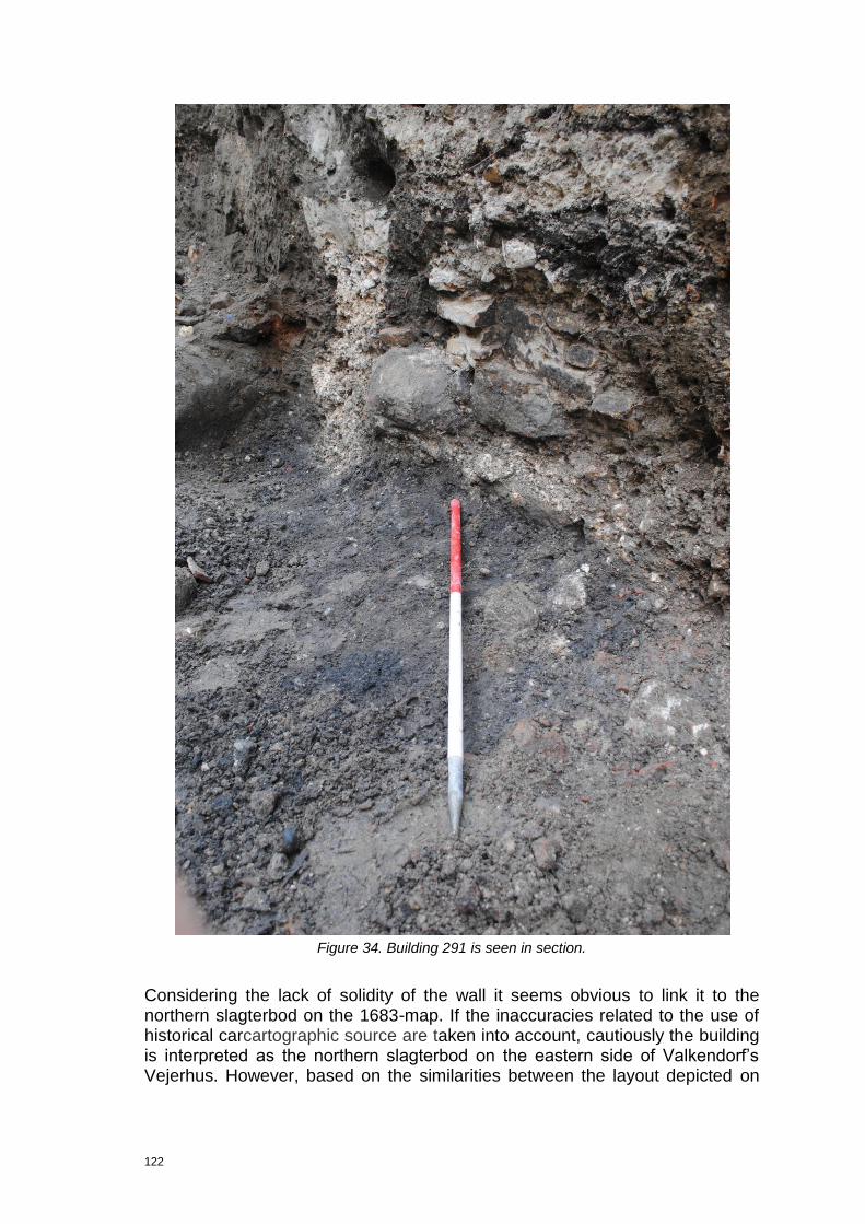
122
Figure 34. Building 291 is seen in section.
Considering the lack of solidity of the wall it seems obvious to link it to the northern slagterbod on the 1683-map. If the inaccuracies related to the use of historical carcartographic source are taken into account, cautiously the building is interpreted as the northern slagterbod on the eastern side of Valkendorf‟s Vejerhus. However, based on the similarities between the layout depicted on
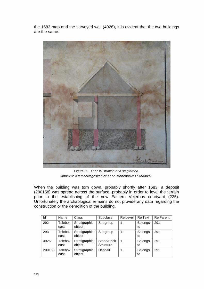
123
the 1683-map and the surveyed wall (4926), it is evident that the two buildings are the same.
Figure 35. 1777 Illustration of a slagterbod.
Annex to Kæmnerregnskab of 1777. Københavns Stadarkiv.
When the building was torn down, probably shortly after 1683, a deposit (200158) was spread across the surface, probably in order to level the terrain prior to the establishing of the new Eastern Vejerhus courtyard (225). Unfortunately the archaological remains do not provide any data regarding the construction or the demolition of the building.
Id Name Class Subclass RelLevel RelText RelParent
292 Telebox east
Stratigraphic object
Subgroup 1 Belongs to
291
293 Telebox east
Stratigraphic object
Subgroup 1 Belongs to
291
4926 Telebox east
Stratigraphic object
Stone/Brick Structure
1 Belongs to
291
200158 Telebox east
Stratigraphic object
Deposit 1 Belongs to
291

124
8.10.4 Group 297 17th century Slagterbod
This group is formed by one subgroup 329 (foundation wall) and one stratigraphic object (3890) which are thought to represent the identified remains of a small booth on the southern side of Snaregade.
A large boulder found in the bottom of the trench is probably the remains of the eastern section of the northern wall in the small booth. The interpretation is, however, based on the coincidence between the current group and the wall seen on the 1683 map.
In spite of c.2m inaccuracy between the archaeological recording and the historical map the boulder is still to be considered as part of the wall due to the inaccuracies documented in relation the northern wall of Valkendorf‟s Vejerhus are of similar scale.
Nothing is known about the time of the construction, but it seems likely that it was torn down in relation to the establishment of the new Western Vejerhus courtyard after 1683.
Figure 36. The remains (3890) of the northern wall of small booth (297).
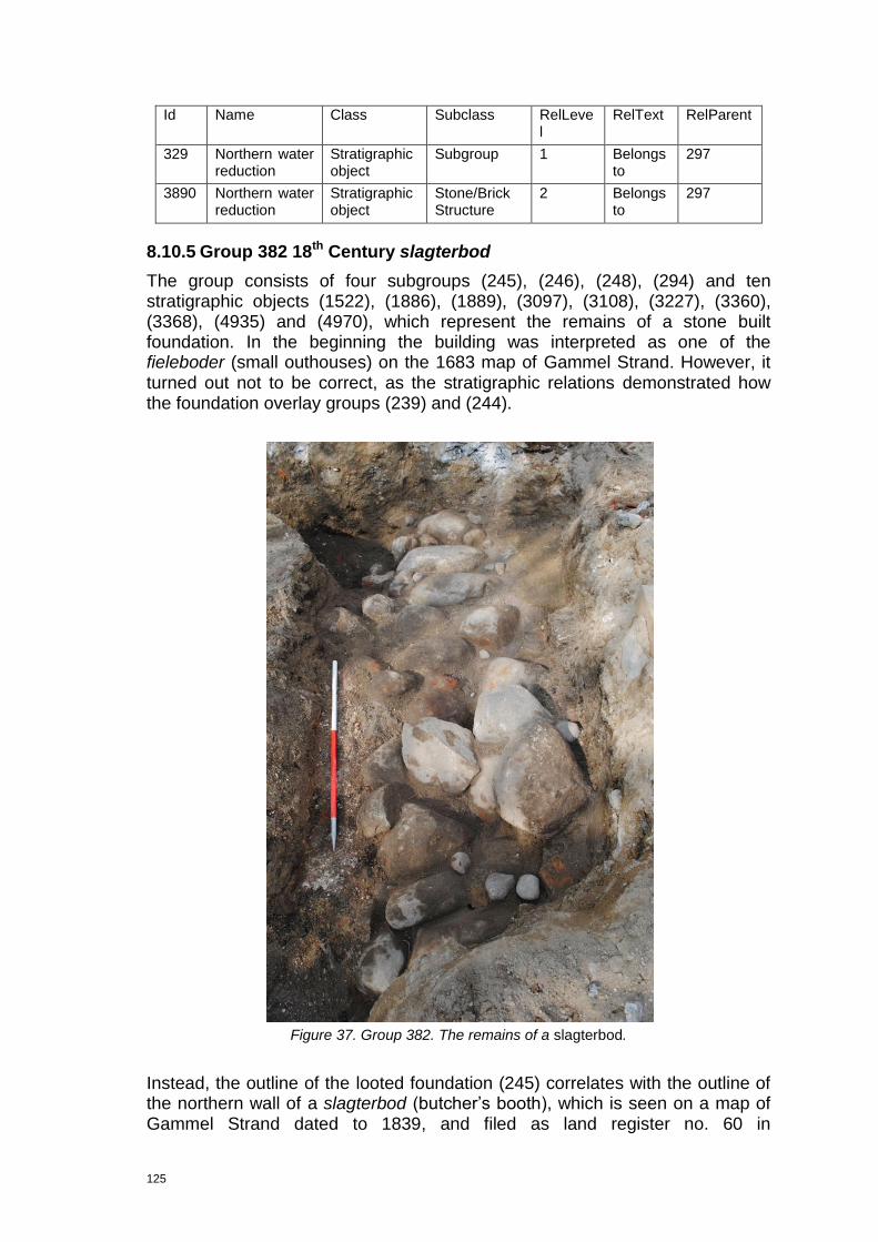
125
Id Name Class Subclass RelLevel
RelText RelParent
329 Northern water reduction
Stratigraphic object
Subgroup 1 Belongs to
297
3890 Northern water reduction
Stratigraphic object
Stone/Brick Structure
2 Belongs to
297
8.10.5 Group 382 18th Century slagterbod
The group consists of four subgroups (245), (246), (248), (294) and ten stratigraphic objects (1522), (1886), (1889), (3097), (3108), (3227), (3360), (3368), (4935) and (4970), which represent the remains of a stone built foundation. In the beginning the building was interpreted as one of the fieleboder (small outhouses) on the 1683 map of Gammel Strand. However, it turned out not to be correct, as the stratigraphic relations demonstrated how the foundation overlay groups (239) and (244).
Figure 37. Group 382. The remains of a slagterbod.
Instead, the outline of the looted foundation (245) correlates with the outline of the northern wall of a slagterbod (butcher‟s booth), which is seen on a map of Gammel Strand dated to 1839, and filed as land register no. 60 in

126
Københavnske Jævnførelsesregister of 1689, 1756 and 1806 (Westerbeek 2010, Strand Kvarter, land register no. 60). Also, the outline of the foundation fragments (246) and (248) correlate roughly with the corresponding southern and western walls of the slagterbod on the 1839-map. However, in this case only minor fragments of the walls were identified/preserved, making the relation more questionable (Westerbeek Dahl 2010, Strand Kvarter, land register no. 60).
Figure 38. Group (382). The remains of a slagterbod. The outline of the slagterbod on the 1839 map is marked with a thin black line.

127
What kind of a building was this slagterbod? Based on the archaeological remains it is possible to state that it was solid built stone/brick building, whose northern wall rested upon a 1.1m wide and 0.5m high stone foundation (245) made of large granite rocks (dia. c.0.3-0.5m), laid without the use of bonding material. The fragmentary preservation of the supposed western and southern walls of the building shows sign of them being built in the same manner. Hence, large boulders, i.e. (3097), (3108), (3227), seem to represent the bas upon which the brick built wall was resting. While smaller unfinished stones represent the remains of the southern wall. The bonding material recorded is of normal quality, i.e. high content of lime mortar. It is usual for the bonding material to be poor quality in the 18th century, but it does not seem to be the case here.
One course was preserved of the brick built wall resting upon the foundation. It was fully laid and more than 4 courses thick. The bricks came in various colours ranging between pale yellow and red, and their size was recorded to be 22.5x11x5cm. Interestingly, the character of the foundation and the type and size of the bricks used to build base of the structure correspond with other foundations dated to the 18th century, e.g. the foundation belonging to a building located in the southern end of Kgs. Nytorv and seen on Geddes maps of 1761, but replaced by Perschiers gaard c. 1796 (current Danske Bank) (Møller 1964; pers. comm. M. Steineke 2012).
Figure 39. Fragment of foundation (246), upon which the rest of the brick built wall (3227) is preserved.
128
When this building was raised is not known, but it probably happened between 1683 and 1761, maybe after the Fire of Copenhagen in 1728. This is thought to be because the building is present on Geddes Elevated Map of Copenhagen dated to 1761. The suggested date is supported by two coin finds (200077) and (200273) found in the fill of the construction cut (1886), and dated to the 18th century. In this respect coin (200077) is of special interest, as it is a “1-skilling” dated to 1700-1730. Documentation of the demolition of the building does, however, exist; it was torn town in 1857 when the entire Gammel Strand area was opened up.
Furthermore, Geddes map of 1761 depicts a building as tall as Valkendorf‟s Vejerhus. And fortunately, the photo of Gammel Strand dated to c.1839 shows the three storey Vejerhus.
Unfortunately, little is known about the butchering activites inside the building as no floor layers were identified.
Figure 40. Section of Chr. Gedde’s (1729-1798) Map of Copenhagen. Courtesy of Museum of Copenhagen.
Id Name Class Subclass RelLevel RelText RelParent
245 Telebox Stratigraphic object
Subgroup 1 Belongs to
382
246 Telebox: extra work: old gas pipe
Stratigraphic object
Subgroup 1 Belongs to
382
248 Telebox east Stratigraphic object
Subgroup 1 Belongs to
295
294 Telebox east Stratigraphic object
Subgroup 1 Belongs to
295

129
1522 Telebox Stratigraphic object
Stone/Brick Structure
2 Belongs to
382
1886 Telebox Stratigraphic object
Deposit 2 Belongs to
382
1889 Telebox Stratigraphic object
Cut 2 Belongs to
382
3097 Telebox: extra work: old gas pipe
Stratigraphic object
Stone/Brick Structure
2 Belongs to
382
3108 Telebox: extra work: old gas pipe
Stratigraphic object
Stone/Brick Structure
2 Belongs to
382
3227 Telebox: extra work: old gas pipe
Stratigraphic object
Stone/Brick Structure
2 Belongs to
382
3360 Telebox: extra work: old gas pipe
Stratigraphic object
Cut 2 Belongs to
382
3368 Telebox: extra work: old gas pipe
Stratigraphic object
Deposit 2 Belongs to
382
4935 Telebox east Stratigraphic object
Stone/Brick Structure
2 Belongs to
295
4970 Telebox east Stratigraphic object
Deposit 2 Belongs to
295
8.10.6 Group 225 Eastern Vejerhus Courtyard
This group consists of the following subgroups; (226) (northern courtyard wall), (227) (paved surface), (283) (latticed planks), (348) (levelling), (364) (levelling), (379) (external surface), (380) (foundation cut fill) and stratigraphic objects (4864) (foundation wall), (4889) (foundation wall), (5150) (paved surface), (5202) (leveling layer), (5211) (dump layer), (5217) (foundation wall), (5670) (construction cut), (5676) (foundation cut fill), (5704) (foundation wall), (5857) (foundation wall), (5879) (foundation fill), 5880 (foundation fill), (200107) (leveling), (200108) (leveling), (200112) (leveling), (200113), (dump layer), (200114) (dump layer), (200121) (demolition layer), (200126) (construction cut fill), (200127) (construction cut fill). De facto are the contexts forming this group, representing the levelling, construction cut, foundation and the northern wall of the eastern courtyard belonging to the Vejerhus. De jure is the group representing the eastern Vejerhus courtyard, including the northern wall. Thus, only a few deposits, having a quite limited total area of distribution, represent the external surface which forms the actual courtyard.
Prior the establishment of the eastern Vejerhus Courtyard, the area was seemingly prepared for the supposed extra weight. Evidently a series of accumulations (5211), (5217), (200107), (200108) and (200121) caused a change in the terrain level; probably with the purpose of developing the land. Hence this is the stratigraphically oldest activity recorded in relation to the eastern Vejerhus Courtyard.
The actual courtyard is represented by two subgroups (227) and (379), forming an older (227) and a younger (379) phase of the courtyard. The first phase is identified as a silty foundation layer (5202) and a cobbled floor pavement (5150), mainly consisting of 0.1-0.8m rough stones distributed evenly but

130
closely across the surface. Unfortunately, not much of this pavement was exposed during the excavation work, so the overall layout of this stone surface and therefore the eastern courtyard remains unidentified, but the concept of construction is probably clear.
Figure 41. The older paving (1
st phase) on the eastern Vejerhus courtyard.
The younger, 2nd phase (379 – external surface) is only indirectly identified in form of sandish dump deposits (200112), (200113) and (200114), accumulated as levelling underneath the now removed paving laid during the later part of the lifespan of the eastern Vejerhus courtyard. Acknowledging this courtyard sequence merely on the basis of a few dump deposits recorded in section seems exceptionally rash, however nothing speaks against this interpretation, but not much supports it either. Seeing this levelling as a 19th century/modern levelling is definitely also possible.
The building sequence of the northern wall (226) of the eastern Vejerhus courtyard is well defined. The construction cut (5670) was identified as the southern edge of the original foundation trench. In the bottom of this trench a wooden foundation, referred to as interlacing planks (4864), was laid out. It consisted of two parallel main beams up to 6.8m long, orientated NE-SW, which rested upon seven shorter transverse beams up to c. 1.8m long. The transverse beams are each supported by two or three posts or stakes, driven c.0.75m vertically into the ground. The stakes and the beams were held together by dowels or pegs.

131
Figure 42. The interlacing planks below the northern wall of the eastern courtyard.
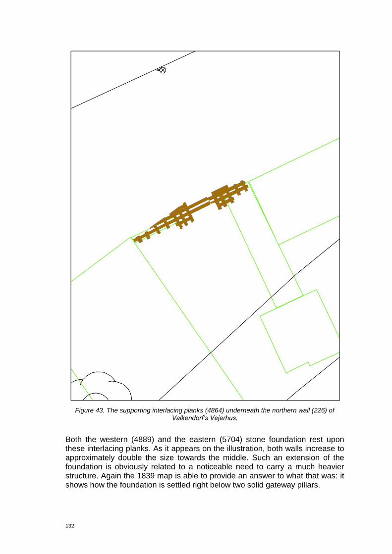
132
Figure 43. The supporting interlacing planks (4864) underneath the northern wall (226) of
Valkendorf’s Vejerhus.
Both the western (4889) and the eastern (5704) stone foundation rest upon these interlacing planks. As it appears on the illustration, both walls increase to approximately double the size towards the middle. Such an extension of the foundation is obviously related to a noticeable need to carry a much heavier structure. Again the 1839 map is able to provide an answer to what that was: it shows how the foundation is settled right below two solid gateway pillars.
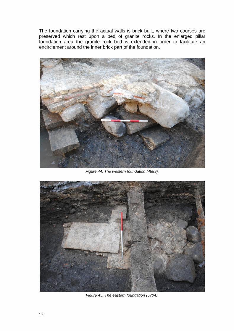
133
The foundation carrying the actual walls is brick built, where two courses are preserved which rest upon a bed of granite rocks. In the enlarged pillar foundation area the granite rock bed is extended in order to facilitate an encirclement around the inner brick part of the foundation.
Figure 44. The western foundation (4889).
Figure 45. The eastern foundation (5704).
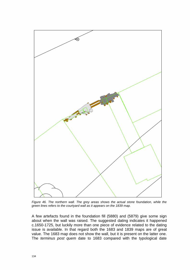
134
Figure 46. The northern wall. The grey areas shows the actual stone foundation, while the green lines refers to the courtyard wall as it appears on the 1839 map.
A few artefacts found in the foundation fill (5880) and (5879) give some sign about when the wall was raised. The suggested dating indicates it happened c.1650-1725, but luckily more than one piece of evidence related to the dating issue is available. In that regard both the 1683 and 1839 maps are of great value. The 1683 map does not show the wall, but it is present on the latter one. The terminus post quem date to 1683 compared with the typological date
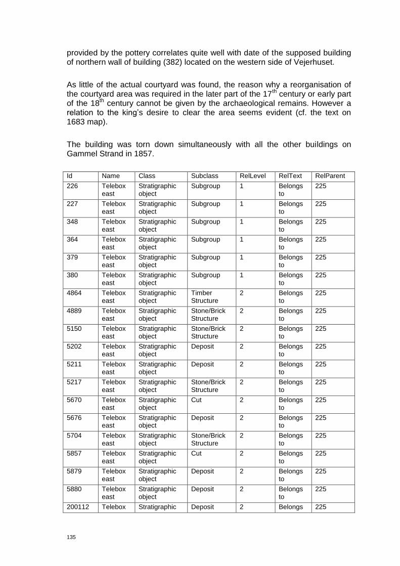
135
provided by the pottery correlates quite well with date of the supposed building of northern wall of building (382) located on the western side of Vejerhuset.
As little of the actual courtyard was found, the reason why a reorganisation of the courtyard area was required in the later part of the 17th century or early part of the 18th century cannot be given by the archaeological remains. However a relation to the king‟s desire to clear the area seems evident (cf. the text on 1683 map).
The building was torn down simultaneously with all the other buildings on Gammel Strand in 1857.
Id Name Class Subclass RelLevel RelText RelParent
226 Telebox east
Stratigraphic object
Subgroup 1 Belongs to
225
227 Telebox east
Stratigraphic object
Subgroup 1 Belongs to
225
348 Telebox east
Stratigraphic object
Subgroup 1 Belongs to
225
364 Telebox east
Stratigraphic object
Subgroup 1 Belongs to
225
379 Telebox east
Stratigraphic object
Subgroup 1 Belongs to
225
380 Telebox east
Stratigraphic object
Subgroup 1 Belongs to
225
4864 Telebox east
Stratigraphic object
Timber Structure
2 Belongs to
225
4889 Telebox east
Stratigraphic object
Stone/Brick Structure
2 Belongs to
225
5150 Telebox east
Stratigraphic object
Stone/Brick Structure
2 Belongs to
225
5202 Telebox east
Stratigraphic object
Deposit 2 Belongs to
225
5211 Telebox east
Stratigraphic object
Deposit 2 Belongs to
225
5217 Telebox east
Stratigraphic object
Stone/Brick Structure
2 Belongs to
225
5670 Telebox east
Stratigraphic object
Cut 2 Belongs to
225
5676 Telebox east
Stratigraphic object
Deposit 2 Belongs to
225
5704 Telebox east
Stratigraphic object
Stone/Brick Structure
2 Belongs to
225
5857 Telebox east
Stratigraphic object
Cut 2 Belongs to
225
5879 Telebox east
Stratigraphic object
Deposit 2 Belongs to
225
5880 Telebox east
Stratigraphic object
Deposit 2 Belongs to
225
200112 Telebox Stratigraphic Deposit 2 Belongs 225

136
east object to
200113 Telebox east
Stratigraphic object
Deposit 2 Belongs to
225
200114 Telebox east
Stratigraphic object
Deposit 2 Belongs to
225
200126 Telebox east
Stratigraphic object
Deposit 2 Belongs to
225
200127 Telebox east
Stratigraphic object
Deposit 2 Belongs to
225
8.10.7 Group 300 Western Vejerhus Courtyard
This group consists of one subgroup (328) (levelling) and four stratigraphic objects (2348), (2367), (2380) and (2422), which are thought to represent the remains of the levelling layers underneath the western Vejerhus courtyard.
Allegedly the exact purpose was to facilitate a general levelling of the terrain in the area between the Vejerbod and the small outhouse (311). This process is probably related to the use phase of the building (311).
Id Name Class Subclass RelLevel RelText RelParent
328 Telebox Stratigraphic object
Subgroup 1 Belongs to
300
2348 Telebox Stratigraphic object
Deposit 2 Belongs to
300
2367 Telebox Stratigraphic object
Deposit 2 Belongs to
300
2380 Telebox Stratigraphic object
Deposit 2 Belongs to
300
2422 Telebox Stratigraphic object
Deposit 2 Belongs to
300
8.10.8 Group 247 Building
On the western side of the corner of Gammel Strand and Højbro Plads remains of a house were found. The identified features consist of two subgroups: a construction cut and a north-south orientated foundation wall (257), and subgroup (258) consisting of two demolition layers with lots of charcoal in them.
The well preserved bottom part of the wall was built of yellow and red bricks of various sizes. The rest of the wall was of almost rubble-like character. The mortar consisted of greyish-white lime and gravel.
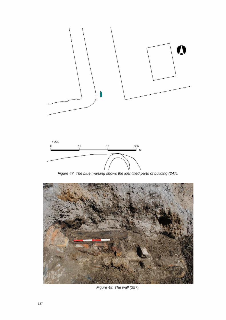
137
Figure 47. The blue marking shows the identified parts of building (247).
Figure 48. The wall (257).

138
The demolition layers have most likely accumulated as a direct result of the fire of Copenhagen in 1795, where the buildings on Højbro Plads were destroyed. After the fire the area was cleaned, but a some of the burnt material was clearly scattered over the place, which also could be seen when excavating the houses on the eastern side of Højbro Plads in 2010. After this fire it was decided to turn the place into a square, as we know it today. No remains representing the usage phase of this house were identified.
Under occasional finds 'other' covers animal teeth, a copper alloy button/coin, a few copper alloy fragments and a carbonized wooden board.
A long fully carbonized wooden board (c.0.7 x 0.2m) was found lying flat in the deposit and at the eastern side it 'curved' c.8cm downwards. This board was picked up as a find, in fragments.
An environmental sample (3728) was taken both for making C14-dating of several pieces of charcoal, and also to know what else was in this deposit as it contained several pieces of iron and copper alloy.
Id Name Class Subclass RelLevel RelText RelParent
3671 Waterpipe north east
Stratigraphic object
Deposit 2 Belongs to
258
3697 Waterpipe north east
Stratigraphic object
Stone/Brick Structure
2 Belongs to
257
200090 Waterpipe north east
Stratigraphic object
Cut 2 Belongs to
257
200087 Waterpipe north east
Stratigraphic object
Deposit 2 Belongs to
258
8.10.9 Group 250 Building
This group consists of two subgroups (383), (384) and six stratigraphic objects (3813), (5302), (5310), (5341), (5345) and (6597) which are thought to represent the remains of a building on the corner of Gammel Strand and the now disappeared alley Højbrostræde. It is of a rather fragmentary character and the field work description is contradictory and incomplete. Consequently, the interpretation work is made quite complex, especially as the structure extends out of the trench in both the northern and southeastern end.
The building consists of a foundation (384) and a wall (383), formed by two sub-groups of three contexts each (3813), (5302), (6597) and (5310), (5321), (5345).
The documentation of the foundation is insufficient. However, it seems to have been built partly of stone and brick rubble, upon which the actual brick wall was settled. At its widest, the foundation was approximately 0.65m wide. Also, the

139
orientation was almost N-S. The brick wall rested upon this foundation. Of the wall, 10 brick courses were preserved in the southeastern corner of the trench. The thickness of the wall is set to two skins, except in the southeastern corner, where the eastern wall supposedly meets the southern wall. The type of coursing used is not recorded, but the brick size is 0.28x0.14x0.06m; a size that seems to correspond with the size of 17th century style bricks.
On top of part of the N-S orientated wall (5345) a horizontally laid fragment of a wooden beam was placed (5341). It‟s orientation correspond with that of the wall it rests upon. So, in spite of the fact that this timber piece is broken at both ends, it seems reasonable to interpretate it as a sole-piece/sill-beam. This means that the building probably is a half-timber house.
Figure 49. Group (250). The remains of a building on the coner of Gammel Strand and Højbrostræde.
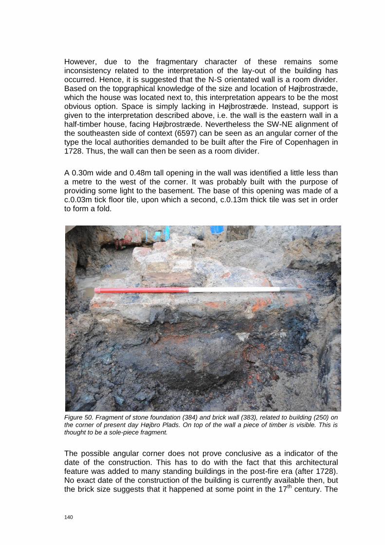
140
However, due to the fragmentary character of these remains some inconsistency related to the interpretation of the lay-out of the building has occurred. Hence, it is suggested that the N-S orientated wall is a room divider. Based on the topgraphical knowledge of the size and location of Højbrostræde, which the house was located next to, this interpretation appears to be the most obvious option. Space is simply lacking in Højbrostræde. Instead, support is given to the interpretation described above, i.e. the wall is the eastern wall in a half-timber house, facing Højbrostræde. Nevertheless the SW-NE alignment of the southeasten side of context (6597) can be seen as an angular corner of the type the local authorities demanded to be built after the Fire of Copenhagen in 1728. Thus, the wall can then be seen as a room divider.
A 0.30m wide and 0.48m tall opening in the wall was identified a little less than a metre to the west of the corner. It was probably built with the purpose of providing some light to the basement. The base of this opening was made of a c.0.03m tick floor tile, upon which a second, c.0.13m thick tile was set in order to form a fold.
Figure 50. Fragment of stone foundation (384) and brick wall (383), related to building (250) on the corner of present day Højbro Plads. On top of the wall a piece of timber is visible. This is thought to be a sole-piece fragment.
The possible angular corner does not prove conclusive as a indicator of the date of the construction. This has to do with the fact that this architectural feature was added to many standing buildings in the post-fire era (after 1728). No exact date of the construction of the building is currently available then, but the brick size suggests that it happened at some point in the 17th century. The
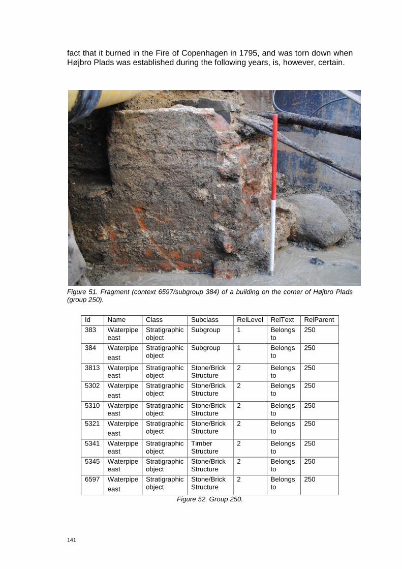
141
fact that it burned in the Fire of Copenhagen in 1795, and was torn down when Højbro Plads was established during the following years, is, however, certain.
Figure 51. Fragment (context 6597/subgroup 384) of a building on the corner of Højbro Plads (group 250).
Id Name Class Subclass RelLevel RelText RelParent
383 Waterpipe east
Stratigraphic object
Subgroup 1 Belongs to
250
384 Waterpipe
east
Stratigraphic object
Subgroup 1 Belongs to
250
3813 Waterpipe east
Stratigraphic object
Stone/Brick Structure
2 Belongs to
250
5302 Waterpipe
east
Stratigraphic object
Stone/Brick Structure
2 Belongs to
250
5310 Waterpipe east
Stratigraphic object
Stone/Brick Structure
2 Belongs to
250
5321 Waterpipe
east
Stratigraphic object
Stone/Brick Structure
2 Belongs to
250
5341 Waterpipe east
Stratigraphic object
Timber Structure
2 Belongs to
250
5345 Waterpipe east
Stratigraphic object
Stone/Brick Structure
2 Belongs to
250
6597 Waterpipe
east
Stratigraphic object
Stone/Brick Structure
2 Belongs to
250
Figure 52. Group 250.
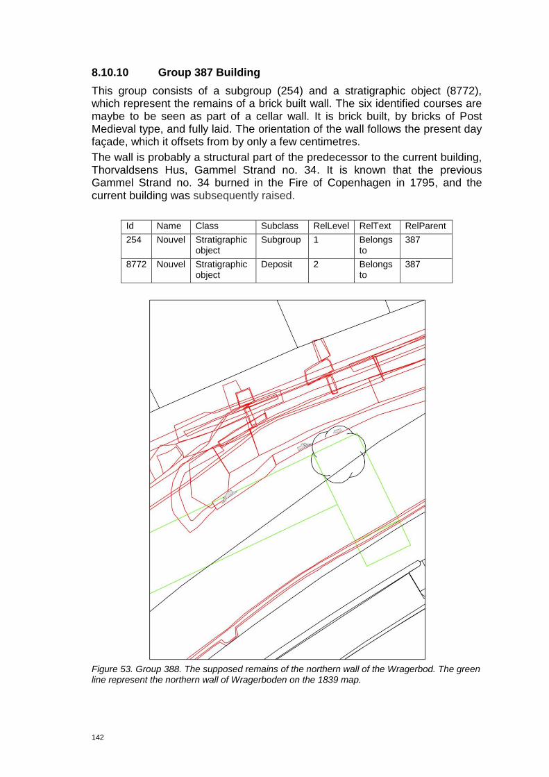
142
8.10.10 Group 387 Building
This group consists of a subgroup (254) and a stratigraphic object (8772), which represent the remains of a brick built wall. The six identified courses are maybe to be seen as part of a cellar wall. It is brick built, by bricks of Post Medieval type, and fully laid. The orientation of the wall follows the present day façade, which it offsets from by only a few centimetres.
The wall is probably a structural part of the predecessor to the current building, Thorvaldsens Hus, Gammel Strand no. 34. It is known that the previous Gammel Strand no. 34 burned in the Fire of Copenhagen in 1795, and the current building was subsequently raised.
Id Name Class Subclass RelLevel RelText RelParent
254 Nouvel Stratigraphic object
Subgroup 1 Belongs to
387
8772 Nouvel Stratigraphic object
Deposit 2 Belongs to
387
Figure 53. Group 388. The supposed remains of the northern wall of the Wragerbod. The green line represent the northern wall of Wragerboden on the 1839 map.
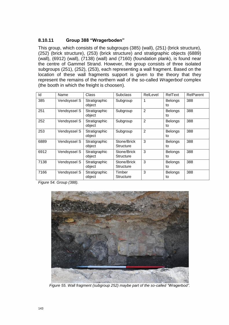
143
8.10.11 Group 388 “Wragerboden”
This group, which consists of the subgroups (385) (wall), (251) (brick structure), (252) (brick structure), (253) (brick structure) and stratigraphic objects (6889) (wall), (6912) (wall), (7138) (wall) and (7160) (foundation plank), is found near the centre of Gammel Strand. However, the group consists of three isolated subgroups (251), (252), (253), each representing a wall fragment. Based on the location of these wall fragments support is given to the theory that they represent the remains of the northern wall of the so-called Wragerbod complex (the booth in which the freight is choosen).
Id Name Class Subclass RelLevel RelText RelParent
385 Vendsyssel S Stratigraphic object
Subgroup 1 Belongs to
388
251 Vendsyssel S Stratigraphic object
Subgroup 2 Belongs to
388
252 Vendsyssel S Stratigraphic object
Subgroup 2 Belongs to
388
253 Vendsyssel S Stratigraphic object
Subgroup 2 Belongs to
388
6889 Vendsyssel S Stratigraphic object
Stone/Brick Structure
3 Belongs to
388
6912 Vendsyssel S Stratigraphic object
Stone/Brick Structure
3 Belongs to
388
7138 Vendsyssel S Stratigraphic object
Stone/Brick Structure
3 Belongs to
388
7166 Vendsyssel S Stratigraphic object
Timber Structure
3 Belongs to
388
Figure 54. Group (388).
Figure 55. Wall fragment (subgroup 252) maybe part of the so-called ‖Wragerbod‖.

144
8.10.12 Group 389 Medieval Vejerbod
This group consists of the following subgroups: (233) (wooden floors), (273) (Stone foundation), (299) (Stone foundation), (301) (Room), (319) (Land development) and the stratigraphic objects (2136) (Construction cut), (2158) (Foundation layer), (1915) (Dump layer), (2702) (Dump layer) and (2907) (Foundation layer). The remains, which were found close to the western end of Gammel Strand, c.15m east of the eastern facade of The Ministry of Cultural Affairs, are the remnants of a stone building that might be older than the Renaissance Vejerhus (Group 221).
Figure 56. Foundation wall (299) for building (389).
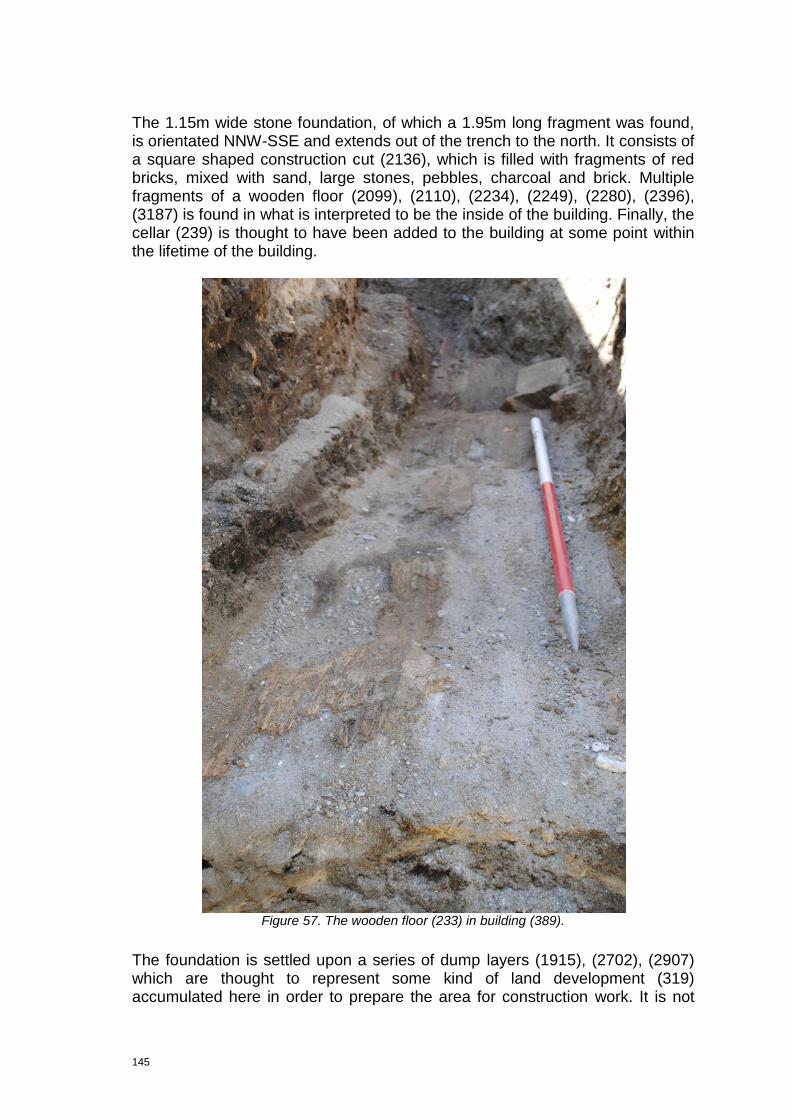
145
The 1.15m wide stone foundation, of which a 1.95m long fragment was found, is orientated NNW-SSE and extends out of the trench to the north. It consists of a square shaped construction cut (2136), which is filled with fragments of red bricks, mixed with sand, large stones, pebbles, charcoal and brick. Multiple fragments of a wooden floor (2099), (2110), (2234), (2249), (2280), (2396), (3187) is found in what is interpreted to be the inside of the building. Finally, the cellar (239) is thought to have been added to the building at some point within the lifetime of the building.
Figure 57. The wooden floor (233) in building (389).
The foundation is settled upon a series of dump layers (1915), (2702), (2907) which are thought to represent some kind of land development (319) accumulated here in order to prepare the area for construction work. It is not

146
known whether these accumulations were dumped here explicitly in relation to the construction of the building or are to be regarded as general land build. The foundation (299) was built by use of brick fragments (2828) accumulated in the construction cut (2812). Regrettably little is known about the layout of the foundation, as it extends out of the trench towards north and was heavily disturbed in the southern end. The date of this foundation is quite remarkable: a piece of Rhinish stoneware of Medieval type was found in the foundation fill. It was a piece of Siegburg pottery dated to c.1300-1500. The wooden floor (233) inside the building consists of a sequence of floors, originally thought to have been coherent, but appeared fragmented when found. A construction date is, however, not available, as no datable finds were discovered, but it is expected, provided that the building was built with the floor, that it would have been renewed several times during the liftime of the building. Thus it is thought to represent the later part of the life of the building. The overall layout of the floors is, unfortunately, unknown, as it is heavily disturbed, especially due to truncation by the northern wall of building 382 and sewer (207). However, using wooden floors in ordinary houses was not customary in the later part of the Medieval period. So either a person of a certain social class or importance resided in the building or it was an administrative building of a certain significance.
Figure 58. Fragment of the floor sequence (240) in cellar 244.
At some point the cellar (244) was added to the building. A cut (2639) was made in which the surface was prepared for the planned stone foundation by laying out a timber structure, so-called interlacing planks (283). Such interlacing planks (fletværk) were used when the subsoil is either soft or swampy, such as upon wharfs etc. The concept of using interlacing planks has parallels within urban architecture of the Netherlands, especially in Amsterdam, in High and Late Medieval era (Regteren Altena 1970, pp. 128-140).

147
The foundation wall (239) was settled upon these interlacing planks. Due to truncation by modern pipe to the south does it appear L-shaped in plan. The actual construction of the foundation is almost beyond description: it is built by various materials including recycled red bricks (Medieval size), and stones in different sizes lumped together by a liberal use of sandish clay and other unspecified bonding materials. On the backside is it supported by large boulders (2762). This 3.85x1.0m large strurcture is preserved to a height of approximately 1.0m and is to be considered as bungled work completed by unskilled labour, e.g. by the owner of the building in which it was found. In the cellar a floor, represented by the floor sequence (240), was laid out. Theis sequence comprises multiple clayish deposits accumulated on top of each other and mixed with what appears to be activity remains and levelling layers. Hence, the floor seems to have been renewed more than once.
Figure 59. Cellar (244). An example of incosistent use of materials.
The activities related to the bulding (389) in general and the cellar (244) in particular, are probably deducible from the artefacts. Not much was found, which gives a clear indication of a room whitout much activity, such as in a storage cellar. The artefacts found are all more or less related to domestic purposes, i.e. pottery (2634), (2676), ceramic building material (2634), (2676), (2634), charcoal (2634), (2671), (2676) and a few pieces of slag (2634), (2671). Of even more relevance is a barrel (243) truncating the floors found in the corner of the cellar. It is not a latrine, but probably a barrel-based drainage system thought to have been used as a water gathering facility/cellar sewer system. Similar cellars are found elsewhere in Copenhagen, e.g. barrel (60142), phase 6 in Lille Kongens Gade, j.no. KBM3829. The barrel in the cellar is filled with artefacts, including a metal winetap (200157). However most of what was found in the barrel cut and inside the barrel was related to

148
domestic purposes. The fill in the cut was dominated by animal bones, suggesting household or butchering waste was accumulating in the area when the barrel was sat down. Inside the barrel the content was different. Besides multiple animal bones, a lot of pottery, such as Rhinish stone and finer tableware are dominant. As the purpose of the barrel was to drain the cellar, it can be assumed that it was regulary emptied. The artefacts found are then thought to represent the latest use phase within the life of the cellar. The finds suggest the cellar demolished around 1600-1650, cf. (200598), (200600), (200609).
Figure 60. The cellar (244).

149
Figure 61. Barrel 243 in cellar (244).
The artefacts found in the foundation fill indicate that the building was raised in the later part of the Medieval period. A date that corresponds with the time when the Medieval Vejerhus was first mentioned, i.e. c.1500. According to other sources the Medieval Vejerhus is to be found on the western side of Valkendorf‟s Vejerhus (cf. Chapter 3 Cultural historical background) - also circumstantial evidence. The finds found inside the cellar suggest the building was in use until first half of the 17th century. If this in fact is the medival Vejerhus, all the elaborate finds are also explained. Hence a person having a certain living standard was living here – e.g. a civil servant (acciseskriveren).

150
Figure 62. The later phase of Building (389).
Id Name Class Subclass RelLevel RelText RelParent
233 Northern extension of the Telebox trench
Stratigraphic object
Subgroup 1 Belongs to
389
239 Telebox Stratigraphic object
Subgroup 1 Belongs to
389
240 Telebox Stratigraphic object
Subgroup 1 Belongs to
389
243 Telebox Stratigraphic Subgroup 1 Belongs 389
151
object to
244 Telebox Stratigraphic object
Subgroup 1 Belongs to
389
273 Telebox Stratigraphic object
Subgroup 1 Belongs to
389
274 Telebox Stratigraphic object
Subgroup 1 Belongs to
389
280 Telebox Stratigraphic object
Subgroup 1 Belongs to
389
283 Telebox Stratigraphic object
Subgroup 1 Belongs to
389
298 Telebox Stratigraphic object
Subgroup 1 Belongs to
389
299 Telebox Stratigraphic object
Subgroup 1 Belongs to
389
301 Telebox Stratigraphic object
Subgroup 1 Belongs to
389
319 Telebox Stratigraphic object
Subgroup 1 Belongs to
389
1915 Telebox Stratigraphic object
Deposit 2 Belongs to
389
2136 Telebox Stratigraphic object
Cut 2 Belongs to
389
2158 Telebox Stratigraphic object
Deposit 2 Belongs to
389
2702 Telebox Stratigraphic object
Deposit 2 Belongs to
389
2907 Telebox Stratigraphic object
Deposit 2 Belongs to
389
8.10.13 Group 390 Medieval building
This group, which consists of the subgroups (390) (building), (290) (foundation) and the stratigraphic objects (4917) (stone structure) and (5691) (deposit), represents the remains of a minimum 5.5m long and 0.9m wide stone structure, orientated SW-NE. The structure, which was found on the eastern side of Valkendorf‟s Vejerhus, is located near the centre of Gammel Strand, extending out of the trench to the north and west. Finding so few remains makes the interpretation problematic. Nevertheless, the excavators saw the foundation fragment as the northern façade of a stone building which stretches further to the south. It is made of large unfinished, uncoursed granite stones (8 were found) laid without use of bonding material.
The date of the pottery found in context (5691), suggest the building was raised in the later part of the Medieval period (Siegburg stoneware without salt-glaze (c.1300-1500). A date which led to the assumption that the foundation (290) in fact was related to the late Medieval tax/accise acitivites carried out at the end of the Middle Ages. In support for that hypothesis are the observations regarding the stratigraphy: first, the foundation is stratigraphically older than the Vejerbod courtyard (group 225) under which it was situated. Secondly, group

152
(390) is identified on both sides of the the supposed courtyard entrance-gateway.
Figure 63. Building 390. The foundation (290) is visible in the section to the right.

153
Figure 64. Building (390), Late Medieval building.
Id Name Class Subclass RelLevel RelText RelParent
290 Telebox east
Stratigraphic object
Subgroup 1 Belongs to
390
4917 Telebox east
Stratigraphic object
Stone/Brick Structure
2 Belongs to
390
5691 Telebox east
Stratigraphic object
Deposit 2 Belongs to
390
2136 Telebox Stratigraphic object
Cut 2 Belongs to
389
Figure 65. Group (390).

154
9 Assessment
9.1 Preservation conditions
The excavations on Gammel Strand proved how the area was characterized by extremely good preservation conditions. In this respect, the fact that the square was kept clear of larger brick/stone built structures after its establishment in 1857 is of significant importance. However, the composition of the accumulations in which the cultural remains were found was also of importance, i.e. waste dumps, sub-marine deposits etc. Hence, well preserved cultural remains can be expected right underneath the paving, i.e. less than 0.5m below the cobblestones.
9.2 Cultural history
From an archaeological point of view the excavations on Gammel Strand also prove to be of significant interest, as the remains were found of multiple large structures, dated to c. 15th et seq., to which a number of special functions were connected. Hence, knowledge regarding the economic history of Denmark in general and the harbour and maritime infrastructure of Copenhagen in particular was found. In that regard are the administrative buildings and small booths unique finds, while the bulwarks are found elsewhere in Denmark at numerous occasions. Similar organisational buildings, dated to the era in question, are not found during archaeological fieldwork in Denmark before. Why harbour structures, dated to the period, never get to be found in Denmark, is an issue, which is probably related to the harbour extensions during industrialization (c. 1870 et seq.), combined with the fact that not that many of this type of building were raised in Denmark.
These exceptionally good preservation conditions mean that we can express hope in relation to the wish of achieving knowledge about the activities – including the possibility of finding ship remains - in the area in the Early and High Medieval period. Hence it is recommended that future construction work, such as infrastructural and environmental changes, including reduction of the water flow in the Slotsholm Canal, must result in an archaeological examination of the area in question, as the risk of losing valuable knowledge of unique importance for our understanding of the rise and early history of Copenhagen.
9.3 Finds material (by Stuart Whatley)
When assessing the finds from the watching brief we can clearly spot two different levels of importance linked to preservation and also to the dating of the objects. The assemblage can be split between the well preserved finds from waterlogged deposits of (200251) and (200252), and the more poorly preserved finds from the possible Tax office and areas surrounding deposits

155
(200251) and (200252). The finds from deposits (200251) and (200252) are of a fairly high standard of importance. They represent a dump of well preserved late Medieval and Renaissance period finds. The fantastic anaerobic soil conditions have preserved a significant amount of organic objects such as textiles, wood, bone and rope. They also comprise a large percentage of foreign imports, especially represented by well preserved Siegburg stoneware from the Rhine area of Germany. These finds are of great interest portraying the change of Copenhagen from a Medieval city into a capital city. These finds are very similar to the large moat dumps seen at Kongens Nytorv and Rådhuspladsen, but here they contain a larger, better preserved assemblage of Siegburg drinking vessels. These finds may represent a dump from wealthy houses, the castle or perhaps, in case of the Siegburg ware, a dump from a ship. Of lesser importance are the finds from the possible tax office and other trenches surrounding (200251) and (200252). These are only of local importance relating to the development of Gammel Strand. The preservation conditions are generally poor, especially seen by metal finds such as coins and the barrel tap. The finds in this assemblage represent a standard Post Medieval assemblage as seen in many watching briefs around Copenhagen. It is expected that the full excavation of Gammel Strand should provide a fantastic assemblage of finds, linked to the creation of the harbour front. A truncated area is expected behind the harbour frontage from the construction. There will be a large quantity of Post Medieval finds (1600 to the present) directly south of the watching brief areas. It is hoped that there will be the opportunity to find stratified layers of an earlier date. The expected preservation conditions will provide a large quantity of organic finds.
9.4 Scientific analysis (by Hoda El-Sharnouby)
When assessing the material from Gammel Strand from a natural scientific point of view one must conclude that preservation linked to the waterlogged deposits is excellent. A wide range of organic material including plant macrofossils, insect remains and animal bone from mammals, fish and birds is represented.
Plant macrofossil analysis was not prioritized as very few of the contexts were sampled. Hence, focus needs to be pointed towards such scientific work during the coming archaeological excavations on the site.
Special attention was paid to the zoological material, which revealed the presence of a wide variety of animal species (cf. Appendix – consultant reports). Especially fish was well represented, i.e. 41 species was present, including fresh water fish like pike (Esox lucius), common bream (Abramis brama) and perch (Preca fluviatilis), migrating species like trout/salmon (Salmon salar/Salmo trutta) and several marine species, including cod (Gadus morhua), haddock (Melanogrammus aeglefinus), various flatfish species and herring (Clupea harengus). The presence of tuna (Thunnus thynnus) is noteworthy as very few bones of this species are represented in zoological material collected from the cultural-historical context related to the Danish past.

156
Remains of reptiles, birds and mammals are also present in the material from Gammel Strand.
Deposits (200251) and (200252) yielded a vast zoological material representing dump layers dated to Late Medieval time and the Renaissance. The dump layers appear to represent waste from common as well as high-status households where a broad variety of fish, birds and mammals were exploited.
The extraordinarily good preservation conditions for deposits and artefacts found in waterlogged environments on the Gammel Strand site gives us the chance to perform a wide range of scientific analysis. Hence, our expectation are that the natural scientific analysis preformed during the upcoming archaeological excavation will contribute with extraordinarily good data related to the future study of everyday life of the town, including food consumption and the fishing industry as well as trade throughout the centuries.
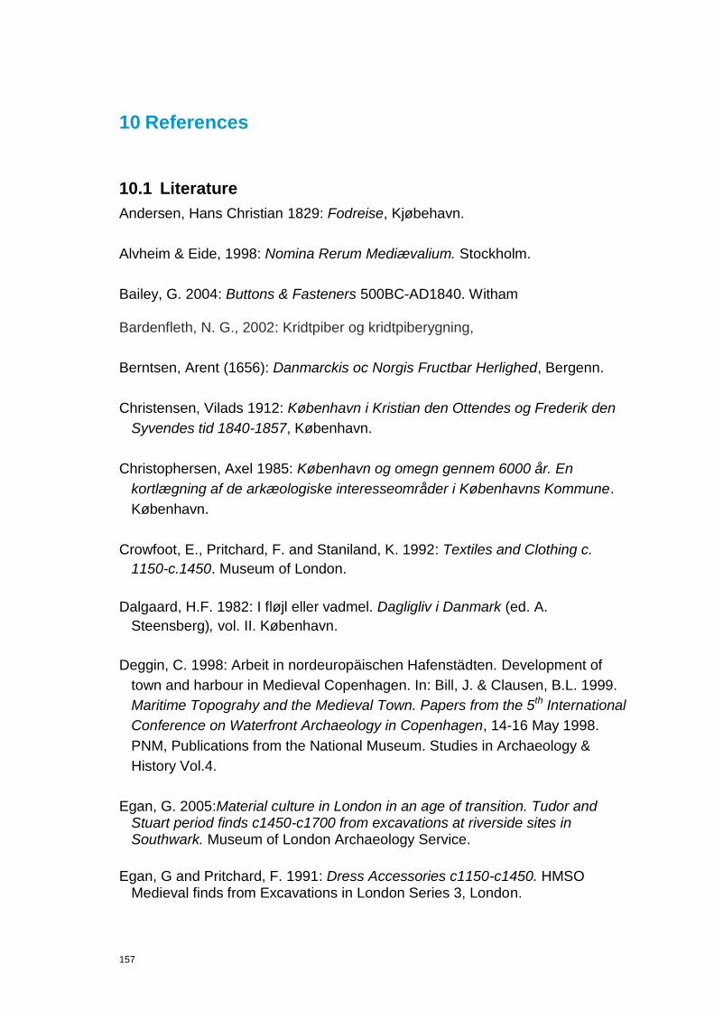
157
10 References
10.1 Literature
Andersen, Hans Christian 1829: Fodreise, Kjøbehavn.
Alvheim & Eide, 1998: Nomina Rerum Mediævalium. Stockholm.
Bailey, G. 2004: Buttons & Fasteners 500BC-AD1840. Witham Bardenfleth, N. G., 2002: Kridtpiber og kridtpiberygning,
Berntsen, Arent (1656): Danmarckis oc Norgis Fructbar Herlighed, Bergenn.
Christensen, Vilads 1912: København i Kristian den Ottendes og Frederik den
Syvendes tid 1840-1857, København.
Christophersen, Axel 1985: København og omegn gennem 6000 år. En
kortlægning af de arkæologiske interesseområder i Københavns Kommune.
København.
Crowfoot, E., Pritchard, F. and Staniland, K. 1992: Textiles and Clothing c.
1150-c.1450. Museum of London.
Dalgaard, H.F. 1982: I fløjl eller vadmel. Dagligliv i Danmark (ed. A.
Steensberg), vol. II. København.
Deggin, C. 1998: Arbeit in nordeuropäischen Hafenstädten. Development of
town and harbour in Medieval Copenhagen. In: Bill, J. & Clausen, B.L. 1999.
Maritime Topograhy and the Medieval Town. Papers from the 5th International
Conference on Waterfront Archaeology in Copenhagen, 14-16 May 1998.
PNM, Publications from the National Museum. Studies in Archaeology &
History Vol.4.
Egan, G. 2005:Material culture in London in an age of transition. Tudor and Stuart period finds c1450-c1700 from excavations at riverside sites in Southwark. Museum of London Archaeology Service.
Egan, G and Pritchard, F. 1991: Dress Accessories c1150-c1450. HMSO Medieval finds from Excavations in London Series 3, London.

158
Fabricius, H. 1999: Development of town and harbour in Medieval
Copenhagen. Maritime Topograhy and the Medieval Town. Papers from the
5th International Conference on Waterfront Archaeology in Copenhagen (ed.
Bill, J & B. L. Clausen), 14-16 May 1998. PNM, Publications from the National
Museum. Studies in Archaeology & History Vol. 4. København, pp. 221-236.
Fabricius, H. 2006: Gader og mennesker i middelalderens og renæssancens
København. Inden for middelaldervolden, København.
Gaimster, D & Nenk, B. 1997: English Households in Transition c.1450- 1550: The ceramic evidence. The Age of Transition, the Archaeology of English Culture. (ed. Gaimster, D and P. Stamper). The society for Medieval Archaeology Monograph 15. Oxbow Monograph 98, pp. 172-191.
Grunfeld, F. 1978: All Jordens spel och lekar. Bra Bocker.
Heiberg, S. 1988: Christian 4. – En europæisk statsmand. København.
Henderson, John 1992: The Black Death in Florence: Medical and Communal
Responses. Urban Responses to the Dying and the Dead 100-1600 (ed.
Steven Bassett), Leicester, pp. 136-147.
Hilden, Hans Peter 1973: Skrald, storby og miljø. En beretning om Københavns
kamp mod affaldet gennem 200 år. København.
Kofod, Niels (ed.) 2007: Fra stinkende rendestene til computerstyrede kloaker.
Københavns kloakker gennem 150 år. København.
Lindegaard, Hanne 2008: Ud af røret. København.
Macgregor, A, Mainman A, & Rogers, N. 1999: Bone, Antler, Ivory and Horn from Anglo-Scandinavian and Medieval York. The Archaeology of York The Small Finds 17/12, Craft Industry and Everyday Life. Published by Council of British Archaeology for York Archaeological Trust.
Margeson, S. 1993: Norwich Households: The Medieval and Post-Medieval Finds from Norwich Survey Excavations 1971-78. East Anglian Archaeology. Report No.58. Munksgaard, E. 1974: Oldtidsdragter. København.
Møller, Elna 1964: Tegl 8 — 800 år i Danmark, Teglindustriens tekniske
Tjeneste, København.
159
Nielsen, Oluf (ed.) 1872: Kjøbenhavns Diplomatarium, vol. I, Kjøbehavn.
Nielsen, Oluf 1877: Kjøbenhavns Historie og Beskrivelse I. Kjøbenhavn i
Middelalderen, Kjøbenhavn.
Nielsen, Oluf 1881: Kjøbenhavns Historie og Beskrivelse III (1. del). Aarene
1536-1660, Kjøbenhavn.
Nielsen, Oluf 1885: Kjøbenhavns Historie og Beskrivelse IV (2. del). Aarene
1536-1660, Kjøbenhavn.
Nielsen Oluf (ed.): Kjøbenhavns Diplomatarium, bd. I-X, Kjøbenhavn 1872-
1887.
Parby, Jakob Ingemann 2007: Storbystrømme. Københavnernes vand, varme,
lys og latrin gennem 150 år. København.
Ramsing, H.U. 1940: Københavns Historie og Topografi i Middelalderen, vol I-
III. København.
Regteren Altena, H. H. van 1970: "The origins and deveopment of Dutch Towns". World Archaeology 2, pp. 128-140. London. Rimstad, C. 2009: Vikinger i Uld og Guld.
Rosenkjær, H.N. 1902: Fra det gamle København. Frem, no. 48. København.
Rosenkjær, H.N. 1906: Fra det underjordiske København. Geologiske og
historiske undersøgelser. København.
Salomonsens Konservationsleksikon, vol. 1-26, København (2. udg.) 1915-
1930.
Venge, Mikael 1987: Dansk Toldhistorie 1. Fra åretold til toldetat.
Middelalderen indtil 1660, København 1987.
Watkinson, D. 1987: First Aid for Finds. Archaeology Section of the United Kingdom Institute.
Westerbeek Dahl, Bjørn 2010: Københavnske Jævnførelsesregistre 1698- 2008. København. Wiene, Inger 2011: Kiøbenhavns Folk plages tit af skidne Gader, (upublished

160
manus.) Københavns Museum. Wolf, Jens Lauridsen 1654: Encomion regni Daniæ, Kiøbenhaffn.
10.2 Archaeological reports and archive material
Jensen, J.J. & Søndergaard, S. 2003: Udfor Gammel Strand 52, Naboløs 5,
samt Snaregade 4-8, KBM2747.
Kristensen, Mette Svart: Beretning for den arkæologiske undersøgelse af KBM
1410/1910 Kgs. Nytorv. Københavns Bymuseum 1998.
Linde, Helle: Arkivalier vedrørende Københavns tekniske styrelse til ca. 1858 i
Københavns Stadsarkiv. Københavns Stadsarkiv 1989.
Ravn, Jeppe: Beretning for den arkæologiske undersøgelse af KBM 3455
Christiansborg Ridebane II. Københavns Bymuseum 2007.
Poulsen, L.: 2005: Boreprøver på tre lokaliteter i København, KBM3290, int.
No. 1102.
Poulsen, L. 2005: Knabrostræde m.fl., KBM2908.
Pedersen, M. 2010: Gammel Strand 48, KBM3893.
Sørensen, L.S. 2002: Nybrogade, etape I, KBM2487.
Wiene, Inger 2011: Kiøbenhavns Folk plages tit af skidne Gade. Unpublished
manuscript, Museum of Copenhagen, pp. 1-24.
Wozniak S. & Søndergaard, M. 2003: Nybrogade, etape II, KBM2487.
10.3 External reports
Linderson, Hans 2011: Dendrokronologisk och Vedanatomisk analys av prov
Från Kongens Nytorv och Gammelstran, Köpenhamn, Danmark. Nationella
Laboratoriet för Vedanatomi och Dendrokronologi, rapport nr 2011:73. Lund
University.
Enghoff, Inge Bødker: Report on animal bones from Gammel Strand, KBM
3828. Natural History Museum of Denmark, journr.: Z.M.K. 57/2011.
161
10.4 Museum of Copenhagen strategy documents
Field Manual 2010: Københavns Museum.
Finds Handbook 2010: Københavns Museum.
Projekthåndbog 2009: Københavns Museum.
Project Design 2009: Project design for archaeological investigations to be
carried out on the Cityring Metro, stage 4 project in Copenhagen. Introductory
report on the background knowledge, objectives, organisation and
methodology. Københavns Museum.
Rammeavtal, Bilag 1 2009: Public Procurement nr 2009-070118 Københavns
Bymuseum. Arkæologi I forbindelse med Cityringen. Konservering og
Naturvidenskap. Københavns Museum.
Report management 2010: Policy, Management and structure regarding
reports at Copenhagen Museum. Københavns Museum.
Thomasson, J. 2011: Guidelines for Contextual Documentation. Definitions and
typology for contexts, sub groups and groups, principles for contextual
grouping of contexts. Københavns Museum.
10.5 Internet references
KUAS Vejledning 2010. Vejledning om gennemførelse af arkæologiske
undersøgelser, kapitel 6. Konservering og Naturvidenskab, Antropologiske
analyser. Kulturarvsstyrelsens hjemmeside per 11. Available at:
http://www.kulturarv.dk/fortidsminder/forvaltning-og-tilsyn/arkaeologi-paaland/vejledning-om-arkaeologiske-undersoegelser/kap-6-konservering-og-
naturvidenskab/ [Accessed 2.10.2009].
10.6 Abbreviations
AA: Antikvarisk Arkiv (The Antiquarian and Topographical Archive), archive
numbers used at the museum until 1988.
Cf.: An abbreviation for the Latin word confer, meaning "compare." The use of this abbreviation indicates that another section of a particular work or another case or volume contains contrasting, comparable, or explanatory opinions and text.

162
E.g.: An abbreviation for exempli gratia (Latin, for the sake of an example).The phrase e.g. is applied in lieu of the phrase "for example."
Et seq.: An abbreviation for the Latin et sequentes or et sequentia, meaning
"and the following."
Et al.: An abbreviated form of et alia, Latin for "and others." When affixed after the name of a person, et al. indicates that additional persons are acting in the same manner, such as several plaintiffs or grantors. When et al. is used in a quoting context, it means that the quoted words referres to all authors.
F: Finds objects number, refer to IntraSiS database
Fig: Figuree
G: Group identity, refer to IntraSiS database
KBM: Museum of Copenhagen (Københavns Museum) also used as Archive
reference numbersto cases from 1988. Museum of Copenhagen.
KD: Kjøbenhavns Diplomatatium.
MC: Metroselskabet I/S (The Metro Company).
P: Sample analysis identity, refer to IntraSiS database.
S: Stratigraphical object identity, refer to IntraSiS database.
KUAS: Kulturarvsstyrelsen (The National Heritage Agency).

163
11 Administrative data
Case number KUAS:
Case number KBM: 3828
County:
Municipality/City: København
Parish:
Street/block: Gammel Strand
Duration field phase: Watching brief
Staff: Claes Hadevik, Mads Drevs Dyhrfeld, Gemma Stevenson, Frederik Grehn, Signe Fog Mogensen, Michael Alrø
Investigated area (m2) and % of
total
Investigated volume (m3) and %
of total
Coordination system
X-coordinate
Y-coordinate
Height system
Metres above sea level
Contractor/Client: Metroselskabet
Archive material: state what‟s stored (types) in the archive
Finds material: state what‟s stored in the storage and storage number
164
12 Appendix
12.1 List of Figurees Figure 1. Map over the Copenhagen area and the place for the excavation. .................................................................. 5 Figure 2. Map of Gammel Strand. The excavation areas (trenches) are marked with red lines. ..................................... 6 Figure 3. The building belonging to the Bargemen‟s Guld. Bymuseets Billedarkiv. ....................................................... 19 Figure 4. Section of 1839-map of Gammel Strand. The building belonging to the Bargemen‟s Guild is seen in the right side of the map. ........................................................................................................................................................... 20 Figure 5: Map showing the approximatey placement of some of the earlier excavations and watching briefs in the area. .................................................................................................................................................................................... 22 Figure 6. Earlier archaeological observations in the Gammel Strand area. Tidligere arkæologiske undersøgelser i området omkring Gammel Strand. ............................................................................................................................... 24 Figure 7 The type of context sheets used at Gammel Strand in 2010. ......................................................................... 31 Figure 8. Registered contexts. ..................................................................................................................................... 36 Figure 9. Registrered contextual groupings. ................................................................................................................. 37 Figure 10. A sherd from a Siegburg schnelle (mug) decorated with the Tudor coat of arms and the year …5 dated 1545-1625. .................................................................................................................................................................. 44 Figure 11. Black Pearl bead. FO 200812. Late Medieval –Early Post Medieval in date. ............................................... 52 Figure 12. Medieval comb fragment FO 200714. ......................................................................................................... 53 Figure 13. Bindebor used in net making. FO 201273. Post Medieval period. ................................................................ 58 Figure 14. Samples collected. ...................................................................................................................................... 64 Figure 15: The brown markings show the wharf 282. ................................................................................................... 68 Figure 16: Group 391. .................................................................................................................................................. 69 Figure 17: The marking shows the placement and extension of wharf 392. .................................................................. 76 Figure 18: The marking shows the extension of the wharf 395. .................................................................................... 77 Figure 19: The brown marking shows the extension of water supply system 242. ........................................................ 81 Figure 20: The marking shows Group 305 water supply system................................................................................... 83 Figure 21: The marking shows the extension of water supply system 396. .................................................................. 85 Figure 22. Different street paving profiles. Jean Marmillod 1776. ................................................................................. 93 Figure 23. Sewer 207. ............................................................................................................................................... 106 Figure 24. Sewer (208). ............................................................................................................................................. 108 Figure 25. Sewer 208. ............................................................................................................................................... 109 Figure 26. Sewer/wastepipe 255. ............................................................................................................................... 110 Figure 27. Sewer/wastepipe 324. ............................................................................................................................... 112 Figure 28. Map of Gammel Strand, approved by His Majesty King Christan V (1670-1699) on April 7
th 1683.North is up.
Courtesy of Københavns Stadsarkiv. ......................................................................................................................... 113 Figure 29. Western foundation wall (218) of Valkendorf‟s Vejerhus. ........................................................................... 114 Figure 30. Northern foundation wall. Lower course (4298) is hardly visible, while the upper course (4350) is right underneath the brick structure (4453) ........................................................................................................................ 115 Figure 31. Northern foundation wall. Lower course (4298) is hardly visible, while the upper course (4350) is right underneath the brick structure (4453). ....................................................................................................................... 116 Figure 32. Northern foundation wall. Indication of a window frame in the upper left corner of the photo. .................... 116 Figure 33. The remains of Valkendorf‟s Vejerhus compared with the map of 1683 and 1839, the latter is represented by the green line. Due to inaccuracies related to older cartographic work in 1683 and 1839 significant differenties between those and the modern survey are present. ................................................................................................................. 117 Figure 34. Building 291 is seen in section. ................................................................................................................. 122 Figure 35. 1777 illustration of a slagterbod. ............................................................................................................... 123 Figure 36. The remains (3890) of the northern wall of small booth (297). ................................................................... 124 Figure 37. Group 382. The remains of a slagterbod. .................................................................................................. 125 Figure 38. Group 382. The remains of a slagterbod. The outline of the slagterbod on the 1839 map is marked with a thin black line. ............................................................................................................................................................ 126 Figure 39. Fragment of foundation (246), upon which the rest of the brick built wall (3227) is preserved. ................... 127 Figure 40. Section of Chr. Gedde‟s (1729-1798) Map of Copenhagen. Courtesy of Museum of Copenhagen. ........... 128 Figure 41. The older paving (1
st phase) on the eastern Vejerhus courtyard. ............................................................... 130
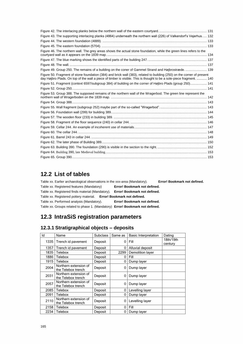
165
Figure 42. The interlacing planks below the northern wall of the eastern courtyard. ................................................... 131 Figure 43. The supporting interlacing planks (4864) underneath the northern wall (226) of Valkendorf‟s Vejerhus. .... 132 Figure 44. The western foundation (4889). ................................................................................................................ 133 Figure 45. The eastern foundation (5704). ................................................................................................................. 133 Figure 46. The northern wall. The grey areas shows the actual stone foundation, while the green lines refers to the courtyard wall as it appears on the 1839 map. ........................................................................................................... 134 Figure 47. The blue marking shows the identified parts of the building 247. ............................................................... 137 Figure 48. The wall. ................................................................................................................................................... 137 Figure 49. Group 250. The remains of a building on the coner of Gammel Strand and Højbrostræde. ....................... 139 Figure 50. Fragment of stone foundation (384) and brick wall (383), related to building (250) on the corner of present day Højbro Plads. On top of the wall a piece of timber is visible. This is thought to be a sole-piece fragment. ........... 140 Figure 51. Fragment (context 6597/subgroup 384) of building on the corner of Højbro Plads (group 250).................. 141 Figure 52. Group 250. ................................................................................................................................................ 141 Figure 53. Group 388. The supposed remains of the northern wall of the Wragerbod. The green line represent the northern wall of Wragerboden on the 1839 map. ....................................................................................................... 142 Figure 54. Group 388. ................................................................................................................................................ 143 Figure 55. Wall fragment (subgroup 252) maybe part of the so-called ”Wragerbod”. .................................................. 143 Figure 56. Foundation wall (299) for building 389....................................................................................................... 144 Figure 57. The wooden floor (233) in building 389. .................................................................................................... 145 Figure 58. Fragment of the floor sequence (240) in cellar 244. .................................................................................. 146 Figure 59. Cellar 244. An example of incoherent use of materials. ............................................................................. 147 Figure 60. The cellar 244. .......................................................................................................................................... 148 Figure 61. Barrel 243 in cellar 244. ............................................................................................................................ 149 Figure 62. The later phase of Building 389. ................................................................................................................ 150 Figure 63. Building 390. The foundation (290) is visible in the section to the right. ..................................................... 152 Figure 64. Building 390, late Medieval building. ............................................................................................................ 153 Figure 65. Group 390. ................................................................................................................................................ 153
12.2 List of tables Table xx. Earlier archaeological observations in the xxx-area (Mandatory). Error! Bookmark not defined. Table xx. Registered features (Mandatory) Error! Bookmark not defined. Table xx. Registered finds material (Mandatory). Error! Bookmark not defined. Table xx. Registered pottery material. Error! Bookmark not defined. Table xx. Performed analysis (Mandatory). Error! Bookmark not defined. Table xx. Groups related to phase 1. (Mandatory) Error! Bookmark not defined.
12.3 IntraSiS registration parameters
12.3.1 Stratigraphical objects – deposits
Id Name Subclass Same as Basic Interpretation Dating
1335 Trench id pavement Deposit 0 Fill 18th/19th century
1357 Trench id pavement Deposit 0 Alluvial deposit
1835 Telebox Deposit 2299 Demolition layer
1886 Telebox Deposit 0 Fill
1915 Telebox Deposit 0 Dump layer
2004 Northern extension of the Telebox trench
Deposit 0 Dump layer
2031 Northern extension of the Telebox trench
Deposit 0 Dump layer
2057 Northern extension of the Telebox trench
Deposit 0 Dump layer
2085 Telebox Deposit 0 Levelling layer
2091 Telebox Deposit 0 Dump layer
2110 Northern extension of the Telebox trench
Deposit 0 Levelling layer
2158 Telebox Deposit 0 Fill
2234 Telebox Deposit 0 Dump layer
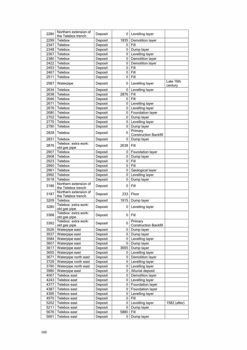
166
2280 Northern extension of the Telebox trench
Deposit 0 Levelling layer
2299 Telebox Deposit 1835 Demolition layer
2347 Telebox Deposit 0 Fill
2348 Telebox Deposit 0 Dump layer
2367 Telebox Deposit 0 Levelling layer
2380 Telebox Deposit 0 Demolition layer
2422 Telebox Deposit 0 Demolition layer
2453 Telebox Deposit 0 Fill
2467 Telebox Deposit 0 Fill
2511 Telebox Deposit 0 Fill
2587 Waterpipe Deposit 0 Levelling layer Late 16th century
2634 Telebox Deposit 0 Levelling layer
2638 Telebox Deposit 2876 Fill
2646 Telebox Deposit 0 Fill
2671 Telebox Deposit 0 Levelling layer
2676 Telebox Deposit 0 Levelling layer
2680 Telebox Deposit 0 Foundation layer
2702 Telebox Deposit 0 Dump layer
2775 Telebox Deposit 0 Levelling layer
2790 Telebox Deposit 0 Dump layer
2828 Telebox Deposit 0 Primary Construction Backfill
2831 Telebox Deposit 0 Dump layer
2876 Telebox: extra work: old gas pipe
Deposit 2638 Fill
2907 Telebox Deposit 0 Foundation layer
2908 Telebox Deposit 0 Dump layer
2923 Telebox Deposit 0 Fill
2960 Telebox Deposit 0 Fill
2961 Telebox Deposit 0 Geological layer
2992 Telebox Deposit 0 Levelling layer
3018 Telebox Deposit 0 Dump layer
3186 Northern extension of the Telebox trench
Deposit 0 Fill
3187 Northern extension of the Telebox trench
Deposit 233 Floor
3209 Telebox Deposit 1915 Dump layer
3280 Telebox: extra work: old gas pipe
Deposit 0 Levelling layer
3368 Telebox: extra work: old gas pipe
Deposit 0 Fill
3392 Telebox: extra work: old gas pipe
Deposit 0 Primary Construction Backfill
3526 Waterpipe east Deposit 0 Dump layer
3537 Waterpipe east Deposit 0 Dump layer
3584 Waterpipe east Deposit 0 Levelling layer
3607 Waterpipe east Deposit 0 Dump layer
3617 Waterpipe east Deposit 3655 Dump layer
3655 Waterpipe east Deposit 0 Levelling layer
3671 Waterpipe north east Deposit 0 Demolition layer
3729 Waterpipe north east Deposit 0 Levelling layer
3790 Waterpipe north east Deposit 0 Levelling layer
3980 Waterpipe east Deposit 0 Alluvial deposit
4067 Telebox east Deposit 0 Demolition layer
4243 Telebox east Deposit 0 Levelling layer
4377 Telebox east Deposit 0 Foundation layer
4387 Telebox east Deposit 0 Foundation layer
4395 Telebox east Deposit 0 Levelling layer
4970 Telebox east Deposit 0 Fill
5202 Telebox east Deposit 0 Levelling layer 1582 (after)
5211 Telebox east Deposit 0 Dump layer
5676 Telebox east Deposit 5880 Fill
5691 Telebox east Deposit 0 Dump layer

167
5879 Telebox east Deposit 0 Fill
5880 Telebox east Deposit 5676 Fill
6307 Telebox east Deposit 0 Levelling layer
6479 Waste pipe Deposit 0 Fill
6488 Waste pipe Deposit 0 Fill
6638 Waste pipe Deposit 0 Levelling layer
6661 Waste pipe Deposit 0 Primary Construction Backfill
6800 Teleblock Højbro Deposit 0 Dump layer
6808 Teleblock Højbro Deposit 0 Levelling layer
6869 Teleblock Højbro Deposit 0 Dump layer
6907 Vendsyssel N Deposit 0 Levelling layer
7079 Vendsyssel N Deposit 0 Dump layer
7360 Telebox Deposit 200251 Dump layer
7675 Waste pipe Deposit 0 Alluvial deposit 16th century
8706 Journalist Deposit 200251 Dump layer
8718 Dentists Deposit 200251 Dump layer Late Medieval
200002 Trench id 23 Deposit 0 Levelling layer 20th century
200003 Trench id 23 Deposit 0 Levelling layer
200004 Trench id. 23 Deposit 0 Levelling layer
200005 Trench id. 23 Deposit 0 Alluvial deposit
200006 Trench id. 23 Deposit 0 Natural vegetation
200007 Trench id. 23 Deposit 0 Alluvial deposit
200008 Trench id. 23 Deposit 0 Levelling layer
200009 Trench id pavement Deposit 0 Alluvial deposit
200010 Trench id. 32 Deposit 0 Levelling layer
200011 Trench id. 32 Deposit 0 Levelling layer
200013 Trench id. 32 Deposit 0 Levelling layer 17th century
200014 Trench id. 32 Deposit 0 Levelling layer
200079 Waterpipe Deposit 0 Levelling layer
200080 Waterpipe Deposit 0 Levelling layer
200081 Waterpipe Deposit 0 Levelling layer
200084 Waterpipe Deposit 200014 Levelling layer
200087 Waterpipe north east Deposit 0 Dump layer
200088 Waterpipe north east Deposit 0 Levelling layer
200091 Telebox east Deposit 0 Dump layer
200092 Telebox east Deposit 0 Dump layer
200093 Telebox east Deposit 0 Dump layer
200094 Telebox east Deposit 0 Dump layer
200095 Telebox east Deposit 0 Dump layer
200096 Telebox east Deposit 0 Fill
200101 Telebox east Deposit 0 Demolition layer
200102 Telebox east Deposit 0 Demolition layer
200103 Telebox east Deposit 0 Demolition layer
200106 Telebox east Deposit 0 Fill Modern
200107 Telebox east Deposit 0 Levelling layer
200108 Telebox east Deposit 0 Levelling layer
200109 Telebox east Deposit 0 Fill Modern
200110 Telebox east Deposit 0 Fill Modern
200112 Telebox east Deposit 0 Levelling layer
200113 Telebox east Deposit 0 Dump layer
200114 Telebox east Deposit 0 Dump layer
200116 Telebox east Deposit 0 Levelling layer
200117 Telebox east Deposit 0 Levelling layer
200118 Telebox east Deposit 0 Levelling layer
200119 Telebox east Deposit 0 Levelling layer
200120 Telebox east Deposit 0 Levelling layer
200121 Telebox east Deposit 0 Demolition layer
200122 Telebox east Deposit 0 Levelling layer
200123 Telebox east Deposit 0 Dump layer
200124 Telebox east Deposit 0 Demolition layer
200125 Telebox east Deposit 0 Demolition layer

168
200126 Telebox east Deposit 0 Fill
200127 Telebox east Deposit 0 Fill
200150 Telebox east Deposit 0 Fill Modern
200151 Telebox east Deposit 0 Fill Modern
200152 Telebox east Deposit 0 Fill Modern
200153 Telebox east Deposit 0 Demolition layer
200154 Telebox east Deposit 0 Demolition layer
200155 Telebox east Deposit 0 Demolition layer
200156 Telebox east Deposit 0 Demolition layer
200158 Telebox east Deposit 0 Demolition layer
200159 Telebox east Deposit 0 Demolition layer
200160 Telebox east Deposit 0 Levelling layer
200162 Waterpipe east Deposit 0 Levelling layer
200164 Waterpipe east Deposit 0 Dump layer
200165 Waterpipe east Deposit 0 Dump layer
200166 Waterpipe east Deposit 0 Fill
200251 Waste pipe Deposit 7360 Dump layer
200252 Waste pipe Deposit 0 Alluvial deposit
200271 Teleblock Højbro Deposit 0 Levelling layer
200365 Vendsyssel N Deposit 0 Levelling layer
200374 Waste pipe Deposit 0 Fill
200460 Telebox east Deposit 0 Levelling layer
200486 Telebox east Deposit 0 Levelling layer
200487 Telebox east Deposit 0 Levelling layer
200569 Telebox; extra work; old gas pipe
Deposit 0 Dump layer
200817
Deposit 0 Quay side
201455
Deposit 0
201456
Deposit 0
201457
Deposit 0
201458
Deposit 0
201459
Deposit 0
201461
Deposit 0
201462
Deposit 0
201463
Deposit 0
201465
Deposit 0
201466
Deposit 0
201467
Deposit 0
201468
Deposit 0
201469
Deposit 0
201470
Deposit 0
201471
Deposit 0
201472
Deposit 0
201473
Deposit 0
201474
Deposit 0
201475
Deposit 0
201477
Deposit 0
201481
Deposit 0
201483
Deposit 0
12.3.2 Stratigraphical objects – cuts
Id Name Subclass Basic Interpretation Dating Shape in plan Fill numbers
1889 Telebox Cut Construction cut
Rectangular 1886
2136 Telebox Cut Construction cut
Rectangular 2158
2491 Telebox Cut Pit
Sub Rectangular 2511
2607 Telebox Cut Pit
Rectangular 2467
2630 Telebox Cut Construction cut
2638
2639 Telebox Cut Construction cut
Rectangular 2646
2812 Telebox Cut Construction cut
Rectangular 2828
2861 Telebox: extra work: old gas pipe
Cut Construction cut
Linear 2876, 2877

169
2885 Telebox Cut Construction cut Post Medieval Rectangular 2907, 2902
2912 Telebox Cut Pit
Circular 2923
2929 Telebox Cut Pit
Sub Rectangular 2960
3154 Northern extension of the Telebox trench
Cut Construction cut
Sub Rectangular 3186
3360 Telebox: extra work: old gas pipe
Cut Construction cut
Linear 3368
5670 Telebox east Cut Construction cut
Linear 5676
5857 Telebox east Cut Construction cut
Rectangular 5880, 5879
6480 Waste pipe Cut Construction cut
Linear SD6479, SS6448, ST6472, SD6488
200090 Waterpipe north east Cut Construction cut
3697
200111 Telebox east Cut Pit Modern
200106, 200109, 200110
200149 Telebox east Cut Pit Modern
200150, 200151, 200152
200163 Waterpipe east Cut Construction cut
200166
200179 Telebox east Cut Construction cut Post Medieval Linear 6319
200180 Telebox east Cut Construction cut
Linear 6348
200250 Waste pipe Cut Construction cut
Linear 6646, 6661
200373 Waste pipe Cut Construction cut
7536, 200373
200377 Water pipe east southern extension
Cut Construction cut
Linear ST7705
200378 Waterpipe east southern extension
Cut Construction cut
Linear SS7709
200461 Telebox east Cut Construction cut
Linear 7909
200485 Telebox east Cut Construction cut
Linear 7976
12.3.3 Stratigraphical objects – stone/brick structure
Id Name Subclass Basic Interpretation Dating Material
255 Sewer Stone_Brick Structure Sewer 17th century
1522 Telebox Stone_Brick Structure Foundation wall
Stone
2647 Telebox Stone_Brick Structure Wall
Stone
2762 Telebox Stone_Brick Structure Foundation wall
Stone
2877 Telebox: extra work: old gas pipe
Stone_Brick Structure Sewer 17th century Brick
3097 Telebox: extra work: old gas pipe
Stone_Brick Structure Foundation wall
Stone
3108 Telebox: extra work: old gas pipe
Stone_Brick Structure Foundation wall
Stone
3227 Telebox: extra work: old gas pipe
Stone_Brick Structure Foundation wall
Brick & Stone
3405 Telebox: extra work: old gas pipe
Stone_Brick Structure Wall
Stone
3419 Telebox: extra work: old gas pipe
Stone_Brick Structure Wall
Stone
3434 Telebox: extra work: old gas pipe
Stone_Brick Structure Wall
Stone
3594 Waterpipe east Stone_Brick Structure Wall
Stone
3630 Water reduction Stone_Brick Structure Wall
Stone
3697 Waterpipe north east
Stone_Brick Structure Wall
Brick
3813 Waterpipe east Stone_Brick Structure Foundation wall
Brick & Stone
3826 Waterpipe east Stone_Brick Structure Wall
Stone
3871 Waterpipe east Stone_Brick Structure Wall
Stone
3890 Northern water reduction
Stone_Brick Structure Foundation wall
Stone
4075 Telebox east Stone_Brick Structure Foundation wall
Stone
4298 Telebox east Stone_Brick Structure Foundation wall
Stone
4350 Telebox east Stone_Brick Structure Foundation wall
Stone
4453 Telebox east Stone_Brick Structure Wall
Brick
4462 Telebox east Stone_Brick Structure Foundation wall
Stone
4703 Telebox east Stone_Brick Structure Foundation wall
Stone
4806 Telebox east Stone_Brick Structure Wall
Brick
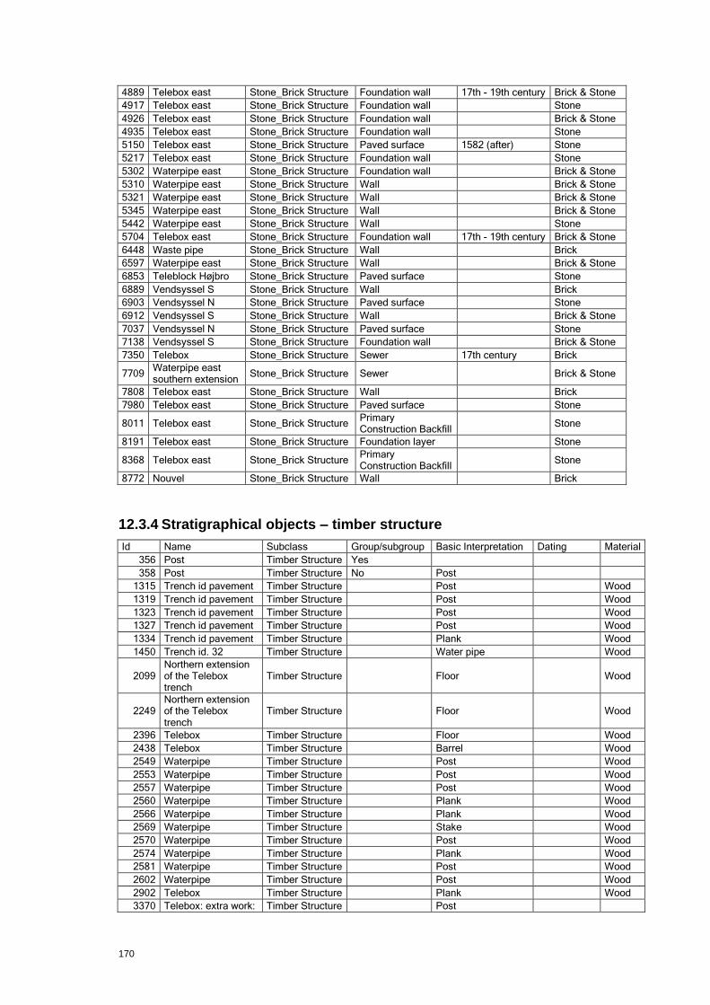
170
4889 Telebox east Stone_Brick Structure Foundation wall 17th - 19th century Brick & Stone
4917 Telebox east Stone_Brick Structure Foundation wall
Stone
4926 Telebox east Stone_Brick Structure Foundation wall
Brick & Stone
4935 Telebox east Stone_Brick Structure Foundation wall
Stone
5150 Telebox east Stone_Brick Structure Paved surface 1582 (after) Stone
5217 Telebox east Stone_Brick Structure Foundation wall
Stone
5302 Waterpipe east Stone_Brick Structure Foundation wall
Brick & Stone
5310 Waterpipe east Stone_Brick Structure Wall
Brick & Stone
5321 Waterpipe east Stone_Brick Structure Wall
Brick & Stone
5345 Waterpipe east Stone_Brick Structure Wall
Brick & Stone
5442 Waterpipe east Stone_Brick Structure Wall
Stone
5704 Telebox east Stone_Brick Structure Foundation wall 17th - 19th century Brick & Stone
6448 Waste pipe Stone_Brick Structure Wall
Brick
6597 Waterpipe east Stone_Brick Structure Wall
Brick & Stone
6853 Teleblock Højbro Stone_Brick Structure Paved surface
Stone
6889 Vendsyssel S Stone_Brick Structure Wall
Brick
6903 Vendsyssel N Stone_Brick Structure Paved surface
Stone
6912 Vendsyssel S Stone_Brick Structure Wall
Brick & Stone
7037 Vendsyssel N Stone_Brick Structure Paved surface
Stone
7138 Vendsyssel S Stone_Brick Structure Foundation wall
Brick & Stone
7350 Telebox Stone_Brick Structure Sewer 17th century Brick
7709 Waterpipe east southern extension
Stone_Brick Structure Sewer
Brick & Stone
7808 Telebox east Stone_Brick Structure Wall
Brick
7980 Telebox east Stone_Brick Structure Paved surface
Stone
8011 Telebox east Stone_Brick Structure Primary Construction Backfill
Stone
8191 Telebox east Stone_Brick Structure Foundation layer
Stone
8368 Telebox east Stone_Brick Structure Primary Construction Backfill
Stone
8772 Nouvel Stone_Brick Structure Wall
Brick
12.3.4 Stratigraphical objects – timber structure
Id Name Subclass Group/subgroup Basic Interpretation Dating Material
356 Post Timber Structure Yes
358 Post Timber Structure No Post
1315 Trench id pavement Timber Structure
Post
Wood
1319 Trench id pavement Timber Structure
Post
Wood
1323 Trench id pavement Timber Structure
Post
Wood
1327 Trench id pavement Timber Structure
Post
Wood
1334 Trench id pavement Timber Structure
Plank
Wood
1450 Trench id. 32 Timber Structure
Water pipe
Wood
2099 Northern extension of the Telebox trench
Timber Structure
Floor
Wood
2249 Northern extension of the Telebox trench
Timber Structure
Floor
Wood
2396 Telebox Timber Structure
Floor
Wood
2438 Telebox Timber Structure
Barrel
Wood
2549 Waterpipe Timber Structure
Post
Wood
2553 Waterpipe Timber Structure
Post
Wood
2557 Waterpipe Timber Structure
Post
Wood
2560 Waterpipe Timber Structure
Plank
Wood
2566 Waterpipe Timber Structure
Plank
Wood
2569 Waterpipe Timber Structure
Stake
Wood
2570 Waterpipe Timber Structure
Post
Wood
2574 Waterpipe Timber Structure
Plank
Wood
2581 Waterpipe Timber Structure
Post
Wood
2602 Waterpipe Timber Structure
Post
Wood
2902 Telebox Timber Structure
Plank
Wood
3370 Telebox: extra work: Timber Structure
Post

171
old gas pipe
3374 Telebox: extra work: old gas pipe
Timber Structure
Post
Wood
3378 Telebox: extra work: old gas pipe
Timber Structure
Plank
Wood
3384 Telebox: extra work: old gas pipe
Timber Structure
Plank
Wood
3648 Waterpipe east Timber Structure
Post
Wood
3783 Waterpipe north east Timber Structure
Post
Wood
3818 Telebox: extra work: old gas pipe
Timber Structure
Floor
Wood
3847 Waterpipe east Timber Structure
Floor
Wood
3932 Water reduction trench
Timber Structure
Bulwark
Wood
3967 Waterpipe east Timber Structure
Water pipe
Wood
3987 Water pipe east Timber Structure
Water pipe
4056 Water pipe east Timber Structure
Water pipe
Wood
4183 Telebox east Timber Structure
Bulwark
Wood
4275 Telebox east Timber Structure
Bulwark
Wood
4364 Telebox east Timber Structure
Bulwark
Wood
4458 Telebox east Timber Structure
Post
4864 Telebox east Timber Structure
Foundation wall 17th-19th Wood
5298 Waterpipe east Timber Structure
Post
Wood
5341 Waterpipe east Timber Structure
Sill beam Post Medieval
Wood
5361 Waterpipe east Timber Structure
Post
Wood
5450 Waterpipe east Timber Structure
Floor
Wood
5748 Telebox east Timber Structure
Post
Wood
5898 Telebox east Timber Structure
Bulwark
Wood
6017 Waste pipe Timber Structure
Bulwark
Wood
6273 Telebox east Timber Structure
Bulwark
Wood
6319 Telebox east Timber Structure
Sewer
Wood
6348 Telebox east Timber Structure
Water pipe
Wood
6472 Waste pipe Timber Structure
Water pipe
Wood
6535 Telebox east Timber Structure
Plank Post Medieval
Wood
6554 Telebox east Timber Structure
Water pipe
Wood
6613 Waste pipe Timber Structure
Bulwark
Wood
6646 Waste pipe Timber Structure
Sewer
Wood
6680 Waste pipe Timber Structure
Post
Wood
6692 Teleblock Højbro Timber Structure
Bulwark
Wood
6714 Teleblock Højbro Timber Structure
Post
Wood
6720 Teleblock Højbro Timber Structure
Post
Wood
6726 Teleblock Højbro Timber Structure
Plank
Wood
6735 Teleblock Højbro Timber Structure
Plank
Wood
6741 Teleblock Højbro Timber Structure
Plank
Wood
6747 Teleblock Højbro Timber Structure
Bulwark
Wood
6760 Teleblock Højbro Timber Structure
Post
Wood
6834 Teleblock Højbro Timber Structure
Sewer
Wood
6894 Vendsyssel N Timber Structure
Plank
Wood
6908 Vendsyssel N Timber Structure
Post
6956 Vendsyssel N Timber Structure
Plank
6965 Vendsyssel N Timber Structure
Sewer
Wood
7002 Vendsyssel N Timber Structure
Sewer
Wood
7041 Waterpipe east Timber Structure
Sewer
Wood
7062 Vendsyssel N Timber Structure
Plank
Wood
7075 Vendsyssel N Timber Structure
Plank
Wood
7080 Vendsyssel S Timber Structure
Beam
Wood
7084 Vendsyssel S Timber Structure
Bulwark
Wood
7100 Vendsyssel S Timber Structure
Plank
Wood
7106 Water pipe east Timber Structure
Water pipe
Wood
7166 Vendsyssel S Timber Structure
Foundation wattle
Wood
7187 Waste pipe Timber Structure
Plank
Wood
7204 Waste pipe Timber Structure
Post
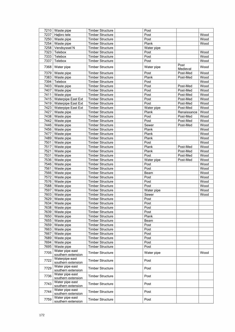
172
7210 Waste pipe Timber Structure
Post
7237 Højbro tele Timber Structure
Post
Wood
7250 Waste pipe Timber Structure
Post
Wood
7254 Waste pipe Timber Structure
Plank
Wood
7258 Vendsyssel N Timber Structure
Water pipe
7323 Telebox Timber Structure
Post
Wood
7333 Telebox Timber Structure
Post
Wood
7337 Telebox Timber Structure
Post
Wood
7368 Water pipe Timber Structure
Water pipe Post Medieval
Wood
7379 Waste pipe Timber Structure
Post Post-Med Wood
7383 Waste pipe Timber Structure
Plank Post-Med Wood
7394 Telebox Timber Structure
Post
Wood
7403 Waste pipe Timber Structure
Post Post-Med Wood
7407 Waste pipe Timber Structure
Post Post-Med Wood
7411 Waste pipe Timber Structure
Post Post-Med Wood
7415 Waterpipe East Ext Timber Structure
Post Post-Med Wood
7419 Waterpipe East Ext Timber Structure
Post Post-Med Wood
7423 Waterpipe East Ext Timber Structure
Water pipe Post-Med Wood
7427 Waste pipe Timber Structure
Plank Renaissance Wood
7438 Waste pipe Timber Structure
Post Post-Med Wood
7442 Waste pipe Timber Structure
Post Post-Med Wood
7446 Waste pipe Timber Structure
Sewer Post-Med Wood
7456 Waste pipe Timber Structure
Plank
Wood
7477 Waste pipe Timber Structure
Plank
Wood
7489 Waste pipe Timber Structure
Plank
Wood
7501 Waste pipe Timber Structure
Post
Wood
7517 Waste pipe Timber Structure
Plank Post-Med Wood
7521 Waste pipe Timber Structure
Plank Post-Med Wood
7531 Waste pipe Timber Structure
Post Post-Med Wood
7536 Waste pipe Timber Structure
Water pipe Post-Med Wood
7546 Waste pipe Timber Structure
Post
Wood
7561 Waste pipe Timber Structure
Post
Wood
7566 Waste pipe Timber Structure
Beam
Wood
7572 Waste pipe Timber Structure
Post
Wood
7576 Waste pipe Timber Structure
Post
Wood
7588 Waste pipe Timber Structure
Post
Wood
7597 Waste pipe Timber Structure
Water pipe
Wood
7603 Waste pipe Timber Structure
Sewer
Wood
7629 Waste pipe Timber Structure
Post
7634 Waste pipe Timber Structure
Post
7638 Waste pipe Timber Structure
Post
7639 Waste pipe Timber Structure
Post
7650 Waste pipe Timber Structure
Plank
7655 Waste pipe Timber Structure
Beam
7659 Waste pipe Timber Structure
Post
7663 Waste pipe Timber Structure
Post
7667 Waste pipe Timber Structure
Post
7689 Waste pipe Timber Structure
Post
7694 Waste pipe Timber Structure
Post
7695 Waste pipe Timber Structure
Post
7705 Water pipe east southern extension
Timber Structure
Water pipe
Wood
7722 Waterpipe east southern extension
Timber Structure
Post
7729 Water pipe east southern extension
Timber Structure
Post
7736 Water pipe east southern extension
Timber Structure
Post
7743 Water pipe east southern extension
Timber Structure
Post
7744 Water pipe east southern extension
Timber Structure
Post
7759 Water pipe east southern extension
Timber Structure
Post
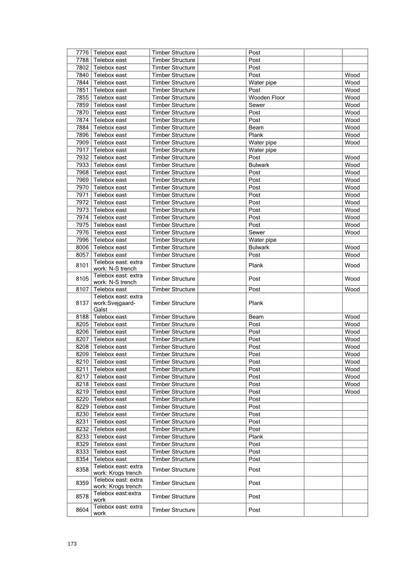
173
7776 Telebox east Timber Structure
Post
7788 Telebox east Timber Structure
Post
7802 Telebox east Timber Structure
Post
7840 Telebox east Timber Structure
Post
Wood
7844 Telebox east Timber Structure
Water pipe
Wood
7851 Telebox east Timber Structure
Post
Wood
7855 Telebox east Timber Structure
Wooden Floor
Wood
7859 Telebox east Timber Structure
Sewer
Wood
7870 Telebox east Timber Structure
Post
Wood
7874 Telebox east Timber Structure
Post
Wood
7884 Telebox east Timber Structure
Beam
Wood
7896 Telebox east Timber Structure
Plank
Wood
7909 Telebox east Timber Structure
Water pipe
Wood
7917 Telebox east Timber Structure
Water pipe
7932 Telebox east Timber Structure
Post
Wood
7933 Telebox east Timber Structure
Bulwark
Wood
7968 Telebox east Timber Structure
Post
Wood
7969 Telebox east Timber Structure
Post
Wood
7970 Telebox east Timber Structure
Post
Wood
7971 Telebox east Timber Structure
Post
Wood
7972 Telebox east Timber Structure
Post
Wood
7973 Telebox east Timber Structure
Post
Wood
7974 Telebox east Timber Structure
Post
Wood
7975 Telebox east Timber Structure
Post
Wood
7976 Telebox east Timber Structure
Sewer
Wood
7996 Telebox east Timber Structure
Water pipe
8006 Telebox east Timber Structure
Bulwark
Wood
8057 Telebox east Timber Structure
Post
Wood
8101 Telebox east: extra work: N-S trench
Timber Structure
Plank
Wood
8105 Telebox east: extra work: N-S trench
Timber Structure
Post
Wood
8107 Telebox east Timber Structure
Post
Wood
8137 Telebox east: extra work:Svejgaard-Galst
Timber Structure
Plank
8188 Telebox east Timber Structure
Beam
Wood
8205 Telebox east Timber Structure
Post
Wood
8206 Telebox east Timber Structure
Post
Wood
8207 Telebox east Timber Structure
Post
Wood
8208 Telebox east Timber Structure
Post
Wood
8209 Telebox east Timber Structure
Post
Wood
8210 Telebox east Timber Structure
Post
Wood
8211 Telebox east Timber Structure
Post
Wood
8217 Telebox east Timber Structure
Post
Wood
8218 Telebox east Timber Structure
Post
Wood
8219 Telebox east Timber Structure
Post
Wood
8220 Telebox east Timber Structure
Post
8229 Telebox east Timber Structure
Post
8230 Telebox east Timber Structure
Post
8231 Telebox east Timber Structure
Post
8232 Telebox east Timber Structure
Post
8233 Telebox east Timber Structure
Plank
8329 Telebox east Timber Structure
Post
8333 Telebox east Timber Structure
Post
8354 Telebox east Timber Structure
Post
8358 Telebox east: extra work: Krogs trench
Timber Structure
Post
8359 Telebox east: extra work: Krogs trench
Timber Structure
Post
8578 Telebox east:extra work
Timber Structure
Post
8604 Telebox east: extra work
Timber Structure
Post

174
8612 Telebox east: extra work
Timber Structure
Post
8613 Telebox east: extra work
Timber Structure
Post
8614 Telebox east: extra work
Timber Structure
Post
8615 Telebox east: extra work
Timber Structure
Post
8616 Telebox east: extra work
Timber Structure
Post
8617 Telebox east: extra work
Timber Structure
Post
8618 Telebox east: extra work
Timber Structure
Post
8619 Telebox east: extra work
Timber Structure
Post
8620 Telebox east:extra work
Timber Structure
Post
8621 Telebox east: extra work
Timber Structure
Post
8622 Telebox east: extra work
Timber Structure
Post
8705 Journalist Timber Structure
Post
8720 Dentists Timber Structure
Water pipe
200015 Trench id. 32 Timber Structure
Bulwark Possibly the 16th-17th century
Wood
200016 Trench id. 32 Timber Structure
Post
Wood
200017 Trench id. 32 Timber Structure
Water pipe
Wood
200078 Waterpipe Timber Structure
Post
200099 Water pipe east Timber Structure
Water pipe
Wood
200272 Teleblock Højbro Timber Structure
Bulwark
Wood
12.3.5 Stratigraphical objects – subgroups
Id Name Subclass Group/subgroup Basic Interpretation Dating
200 Bulwark Subgroup
Bulwark Probably 18th / 19th century
201 Sewer canal Subgroup No
203 Bulwark Subgroup
Bulwark Late 16th century (before)
204 Water supply - main pipe Subgroup
Water pipe Post medival
205 Bulwark Subgroup
Bulwark
206 Water supply - service pipe Subgroup No Water pipe
209 Water supply - main pipe Subgroup No Water pipe
210 Water supply - main pipe Subgroup No Water pipe
211 Water supply - service pipe Subgroup No
212 Water supply - service pipe Subgroup No
Post Medieval
213 Bulwark Subgroup No Bulwark
214 Wharf sequence Subgroup No Bulwark Post Medieval
215 Bulwark Subgroup No Bulwark Post Medieval
216 Bulwark Subgroup No Bulwark Post Medieval
218 Western wall - The Vejerbod Subgroup Yes Foundation wall 1582
219 Eastern wall - The Vejerbod Subgroup Yes Foundation wall 1581
220 Northern wall - The Vejerbod Subgroup Yes Foundation wall 1581
226 Northern wall - Vejerbod courtyard Subgroup No Wall 1582 (after)
227 Paved surface - Vejerbod courtyard Subgroup No Paved surface 1582 (after)
233 Floor sequence - small booth Subgroup No Floor 1582 (after)
239 Cellar wall Subgroup Yes Wall
240 Floor sequence Subgroup No Floor Post Medieval
241 Water supply - service pipe Subgroup No
243 Barrel Subgroup No Sewer Post Medieval
245 Foundation Subgroup No Foundation wall Post Medieval
246 Foundation Subgroup No Foundation wall Post Medieval
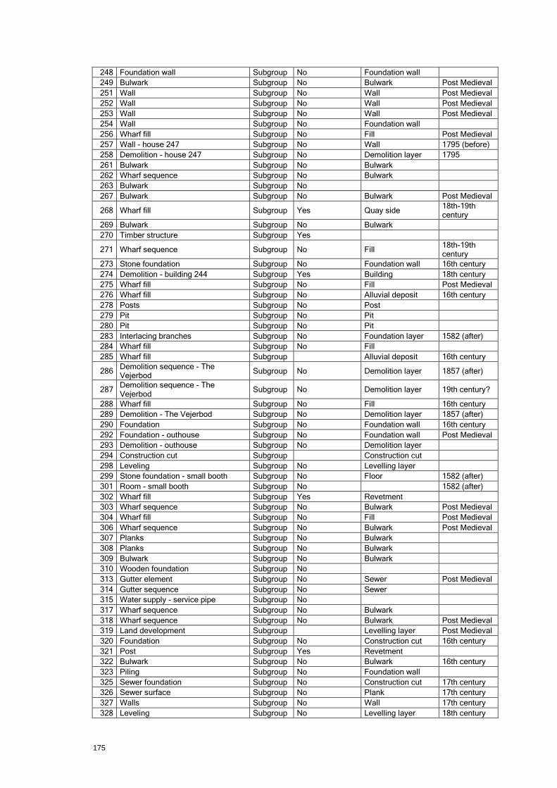
175
248 Foundation wall Subgroup No Foundation wall
249 Bulwark Subgroup No Bulwark Post Medieval
251 Wall Subgroup No Wall Post Medieval
252 Wall Subgroup No Wall Post Medieval
253 Wall Subgroup No Wall Post Medieval
254 Wall Subgroup No Foundation wall
256 Wharf fill Subgroup No Fill Post Medieval
257 Wall - house 247 Subgroup No Wall 1795 (before)
258 Demolition - house 247 Subgroup No Demolition layer 1795
261 Bulwark Subgroup No Bulwark
262 Wharf sequence Subgroup No Bulwark
263 Bulwark Subgroup No
267 Bulwark Subgroup No Bulwark Post Medieval
268 Wharf fill Subgroup Yes Quay side 18th-19th century
269 Bulwark Subgroup No Bulwark
270 Timber structure Subgroup Yes
271 Wharf sequence Subgroup No Fill 18th-19th century
273 Stone foundation Subgroup No Foundation wall 16th century
274 Demolition - building 244 Subgroup Yes Building 18th century
275 Wharf fill Subgroup No Fill Post Medieval
276 Wharf fill Subgroup No Alluvial deposit 16th century
278 Posts Subgroup No Post
279 Pit Subgroup No Pit
280 Pit Subgroup No Pit
283 Interlacing branches Subgroup No Foundation layer 1582 (after)
284 Wharf fill Subgroup No Fill
285 Wharf fill Subgroup
Alluvial deposit 16th century
286 Demolition sequence - The Vejerbod
Subgroup No Demolition layer 1857 (after)
287 Demolition sequence - The Vejerbod
Subgroup No Demolition layer 19th century?
288 Wharf fill Subgroup No Fill 16th century
289 Demolition - The Vejerbod Subgroup No Demolition layer 1857 (after)
290 Foundation Subgroup No Foundation wall 16th century
292 Foundation - outhouse Subgroup No Foundation wall Post Medieval
293 Demolition - outhouse Subgroup No Demolition layer
294 Construction cut Subgroup
Construction cut
298 Leveling Subgroup No Levelling layer
299 Stone foundation - small booth Subgroup No Floor 1582 (after)
301 Room - small booth Subgroup No
1582 (after)
302 Wharf fill Subgroup Yes Revetment
303 Wharf sequence Subgroup No Bulwark Post Medieval
304 Wharf fill Subgroup No Fill Post Medieval
306 Wharf sequence Subgroup No Bulwark Post Medieval
307 Planks Subgroup No Bulwark
308 Planks Subgroup No Bulwark
309 Bulwark Subgroup No Bulwark
310 Wooden foundation Subgroup No
313 Gutter element Subgroup No Sewer Post Medieval
314 Gutter sequence Subgroup No Sewer
315 Water supply - service pipe Subgroup No
317 Wharf sequence Subgroup No Bulwark
318 Wharf sequence Subgroup No Bulwark Post Medieval
319 Land development Subgroup
Levelling layer Post Medieval
320 Foundation Subgroup No Construction cut 16th century
321 Post Subgroup Yes Revetment
322 Bulwark Subgroup No Bulwark 16th century
323 Piling Subgroup No Foundation wall
325 Sewer foundation Subgroup No Construction cut 17th century
326 Sewer surface Subgroup No Plank 17th century
327 Walls Subgroup No Wall 17th century
328 Leveling Subgroup No Levelling layer 18th century
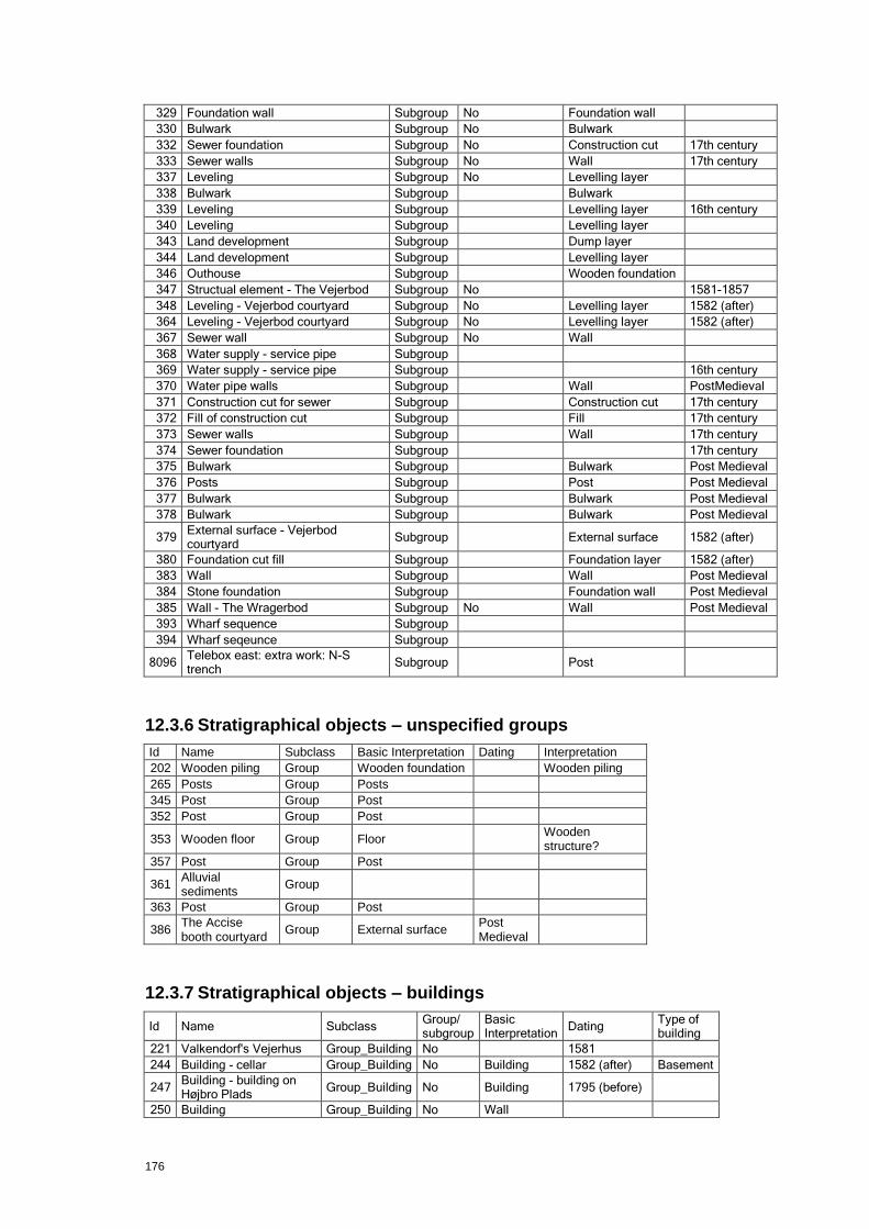
176
329 Foundation wall Subgroup No Foundation wall
330 Bulwark Subgroup No Bulwark
332 Sewer foundation Subgroup No Construction cut 17th century
333 Sewer walls Subgroup No Wall 17th century
337 Leveling Subgroup No Levelling layer
338 Bulwark Subgroup
Bulwark
339 Leveling Subgroup
Levelling layer 16th century
340 Leveling Subgroup
Levelling layer
343 Land development Subgroup
Dump layer
344 Land development Subgroup
Levelling layer
346 Outhouse Subgroup
Wooden foundation
347 Structual element - The Vejerbod Subgroup No
1581-1857
348 Leveling - Vejerbod courtyard Subgroup No Levelling layer 1582 (after)
364 Leveling - Vejerbod courtyard Subgroup No Levelling layer 1582 (after)
367 Sewer wall Subgroup No Wall
368 Water supply - service pipe Subgroup
369 Water supply - service pipe Subgroup
16th century
370 Water pipe walls Subgroup
Wall PostMedieval
371 Construction cut for sewer Subgroup
Construction cut 17th century
372 Fill of construction cut Subgroup
Fill 17th century
373 Sewer walls Subgroup
Wall 17th century
374 Sewer foundation Subgroup
17th century
375 Bulwark Subgroup
Bulwark Post Medieval
376 Posts Subgroup
Post Post Medieval
377 Bulwark Subgroup
Bulwark Post Medieval
378 Bulwark Subgroup
Bulwark Post Medieval
379 External surface - Vejerbod courtyard
Subgroup
External surface 1582 (after)
380 Foundation cut fill Subgroup
Foundation layer 1582 (after)
383 Wall Subgroup
Wall Post Medieval
384 Stone foundation Subgroup
Foundation wall Post Medieval
385 Wall - The Wragerbod Subgroup No Wall Post Medieval
393 Wharf sequence Subgroup
394 Wharf seqeunce Subgroup
8096 Telebox east: extra work: N-S trench
Subgroup
Post
12.3.6 Stratigraphical objects – unspecified groups
Id Name Subclass Basic Interpretation Dating Interpretation
202 Wooden piling Group Wooden foundation
Wooden piling
265 Posts Group Posts
345 Post Group Post
352 Post Group Post
353 Wooden floor Group Floor
Wooden structure?
357 Post Group Post
361 Alluvial sediments
Group
363 Post Group Post
386 The Accise booth courtyard
Group External surface Post Medieval
12.3.7 Stratigraphical objects – buildings
Id Name Subclass Group/ subgroup
Basic Interpretation
Dating Type of building
221 Valkendorf's Vejerhus Group_Building No
1581
244 Building - cellar Group_Building No Building 1582 (after) Basement
247 Building - building on Højbro Plads
Group_Building No Building 1795 (before)
250 Building Group_Building No Wall
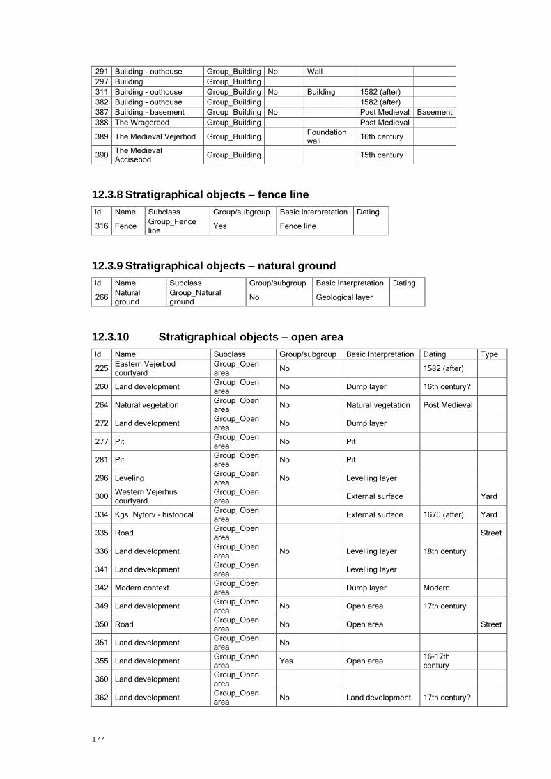
177
291 Building - outhouse Group_Building No Wall
297 Building Group_Building
311 Building - outhouse Group_Building No Building 1582 (after)
382 Building - outhouse Group_Building
1582 (after)
387 Building - basement Group_Building No
Post Medieval Basement
388 The Wragerbod Group_Building
Post Medieval
389 The Medieval Vejerbod Group_Building
Foundation wall
16th century
390 The Medieval Accisebod
Group_Building
15th century
12.3.8 Stratigraphical objects – fence line
Id Name Subclass Group/subgroup Basic Interpretation Dating
316 Fence Group_Fence line
Yes Fence line
12.3.9 Stratigraphical objects – natural ground
Id Name Subclass Group/subgroup Basic Interpretation Dating
266 Natural ground
Group_Natural ground
No Geological layer
12.3.10 Stratigraphical objects – open area
Id Name Subclass Group/subgroup Basic Interpretation Dating Type
225 Eastern Vejerbod courtyard
Group_Open area
No
1582 (after)
260 Land development Group_Open area
No Dump layer 16th century?
264 Natural vegetation Group_Open area
No Natural vegetation Post Medieval
272 Land development Group_Open area
No Dump layer
277 Pit Group_Open area
No Pit
281 Pit Group_Open area
No Pit
296 Leveling Group_Open area
No Levelling layer
300 Western Vejerhus courtyard
Group_Open area
External surface
Yard
334 Kgs. Nytorv - historical Group_Open area
External surface 1670 (after) Yard
335 Road Group_Open area
Street
336 Land development Group_Open area
No Levelling layer 18th century
341 Land development Group_Open area
Levelling layer
342 Modern context Group_Open area
Dump layer Modern
349 Land development Group_Open area
No Open area 17th century
350 Road Group_Open area
No Open area
Street
351 Land development Group_Open area
No
355 Land development Group_Open area
Yes Open area 16-17th century
360 Land development Group_Open area
362 Land development Group_Open area
No Land development 17th century?

178
365 Land development Group_Open area
No Fill
366 Land development Group_Open area
Yes Open area
12.3.11 Stratigraphical objects – sewer
Id Name Subclass Group/subgroup Basic Interpretation Dating
207 Sewer Group_Sewer No Sewer Post Medieval
208 Brick/lime stone build sewer
Group_Sewer No Sewer 16th century
222 Gutter Group_Sewer No Sewer Post Medieval
223 Gutter Group_Sewer No Sewer Post Medieval
224 Gutter Group_Sewer No Sewer Post Medieval
228 Gutter Group_Sewer No Sewer Post medival
229 Gutter Group_Sewer No Sewer Post Medieval
230 Gutter Group_Sewer No Sewer Post Medieval
231 Gutter Group_Sewer No Sewer Post Medieval
232 Gutter Group_Sewer No Sewer Post Medieval
234 Gutter Group_Sewer No Sewer Post Medieval
235 Gutter Group_Sewer No Sewer Late post Medieval
236 Gutter Group_Sewer No Sewer Post Medieval
237 Gutter Group_Sewer No Sewer Late postMedieval
238 Gutter Group_Sewer No Sewer Post Medieval
312 Gutter Group_Sewer No Sewer Post Medieval
324 Sewer Group_Sewer No Wall
12.3.12 Stratigraphical objects – water supply
Id Name Subclass Basic Interpretation Dating Type of water supply
242 Water supply network (group)
Group_Water supply
Renaissance or younger
Water pipe
305 Water supply network (group)
Group_Water supply
396 Water supply network Group_Water supply
Water pipe
12.3.13 Stratigraphical objects – wharf
Id Name Subclass Group/subgroup Dating
217 Wharf Group_Wharf Yes Post Medieval
282 Wharf Group_Wharf Yes
391 Wharf Group_Wharf
392 Wharf Group_Wharf
395 Wharf Group_Wharf
397 Wharf Group_Wharf Yes
12.3.14 Finds objects – animal bones
Id Material Fragmentation code Age Dental Species
200303 Bone 0 U
Mammalia
200304 Bone 8 J/A
Sus domesticus
200366 Bone 0 U
Mammalia
200367 Bone 7 U
Anser domesticus
200368 Bone 9 U
Mammalia
200369 Bone 0 U
Mammalia
200408 Bone 0 U
Thunnus thynnus

179
200558 Tooth 1
200678 Bone 9 U
Mammalia
200681 Bone 9 U
Mammalia
200682 Bone 9 U
Mammalia
200683 Bone 9 U
Mammalia
200684 Bone 9 U
Mammalia
200685 Bone 9 U
Mammalia
200686 Bone 8 J
Bos taurus
200689 Bone 8 A
Bos taurus
200690 Bone 9 U
Mammalia
200691 Bone 8 U
Mammalia
200762 Bone 0 U
Mammalia
200850 Bone 1 J
Sus domesticus
200851 Bone 1 J
Sus domesticus
200852 Bone 4 J
Sus domesticus
200853 Bone 1 J
Sus domesticus
200854 Bone 1 J
Sus domesticus
200855 Bone 1 J
Sus domesticus
200856 Bone 1 J
Sus domesticus
200857 Bone 1 J
Sus domesticus
200858 Bone 1 J
Sus domesticus
200859 Bone 1 J
Sus domesticus
200860 Bone 1 J Lower I3 Sus domesticus
200861 Bone 1 J
ovis aries/C. hircus
200862 Bone 1 J
ovis aries/C. hircus
200863 Bone 7 J
ovis aries/C. hircus
200864 Bone 0 U
ovis aries/C. hircus
200865 Bone 0 U
ovis aries/C. hircus
200866 Bone 4 J
ovis aries/C. hircus
200867 Bone 1 U
ovis aries/C. hircus
200868 Bone 1 U
ovis aries/C. hircus
200869 Bone 3 J
ovis aries/C. hircus
200870 Bone 0 J
ovis aries/C. hircus
200871 Bone 0 J
ovis aries/C. hircus
200872 Bone 0 U
ovis aries/C. hircus
200873 Bone 0 U
ovis aries/C. hircus
200874 Bone 0 U
ovis aries/C. hircus
200875 Bone 0 U
ovis aries/C. hircus
200876 Bone 1 U Lower I1 ovis aries/C. hircus
200877 Bone 1 U Lower I2 ovis aries/C. hircus
200878 Bone 1 U Lower I3 ovis aries/C. hircus
200879 Bone 1 J
Canis familiaris
200880 Bone 1 J Lower M1 Canis familiaris
200881 Bone 0 J
Sus domesticus
200882 Bone 0 U
Mammalia
200883 Bone 0 J
Gallus domesticus
200884 Bone 6 J
Gallus domesticus
200885 Bone 0 J
Gallus domesticus
200886 Bone 1 J
Gallus domesticus
200887 Bone 1 J
Bos taurus
200888 Bone 7 A
Bos taurus
200889 Bone 7 J
Bos taurus
200890 Bone 1 A
Bos taurus
200891 Bone 1 A
Bos taurus
200892 Bone 1 J/A
Bos taurus
200893 Bone 1 A
Bos taurus
200894 Bone 9 J/A
Bos taurus
200895 Bone 8 J
Bos taurus
200896 Bone 9 J
Bos taurus
200897 Bone 0 A
Bos taurus
200898 Bone 0 A
Bos taurus
200899 Bone 0 U
Bos taurus
200900 Bone 7 A
Bos taurus

180
200901 Bone 9 A
Bos taurus
200902 Bone 9 A
Sus domesticus
200903 Bone 7 J
Sus domesticus
200904 Bone 1 J
Sus domesticus
200905 Bone 7 A
Sus domesticus
200906 Bone 5 J
Sus domesticus
200907 Bone 9 J
Sus domesticus
200908 Bone 7 J
Sus domesticus
200909 Bone 9 J/A
Sus domesticus
200910 Bone 1 U
Sus domesticus
200911 Bone 1 U
Esox lucius
200912 Bone 7 J
Anser domesticus
200913 Bone 1 J
Gallus domesticus
200914 Bone 8 A
Ovis aries
200915 Bone 8 A
Ovis aries
200916 Bone 8 A
Canis familiaris
200917 Bone 1 A
ovis aries/C. hircus
200918 Bone 9 U
ovis aries/C. hircus
200919 Bone 0 A
ovis aries/C. hircus
200920 Bone 0 A
ovis aries/C. hircus
200921 Bone 0 A
ovis aries/C. hircus
200922 Bone 1 J Lower dP4
ovis aries/C. hircus
200923 Bone 0 U
ovis aries/C. hircus
200924 Bone 0 A
ovis aries/C. hircus
200925 Bone 8 J
ovis aries/C. hircus
200926 Bone 1 J
ovis aries/C. hircus
200927 Bone 2 J
ovis aries/C. hircus
200928 Bone 9 J
ovis aries/C. hircus
200929 Bone 0 U
ovis aries/C. hircus
200930 Bone 0 A
Phocaena phocaena
200931 Bone 1 A
Bos taurus
200932 Bone 9 A
Bos taurus
200933 Bone 7 J/A
Bos taurus
200934 Bone 0 A
Bos taurus
200935 Bone 1 A
Bos taurus
200936 Bone 8 A
Bos taurus
200937 Bone 8 A
Bos taurus
200938 Bone 4 J
Bos taurus
200939 Bone 0 A
Bos taurus
200940 Bone o J/A
ovis aries/C. hircus
200941 Bone 7 J
ovis aries/C. hircus
200942 Bone 8 J
ovis aries/C. hircus
200943 Bone 9 A
Sus domesticus
200944 Bone 8 J
Sus domesticus
200945 Bone 1 J
Sus domesticus
200946 Bone 0 A
Sus domesticus
200947 Bone 7 J
ovis aries/C. hircus
200948 Bone 1 A
Gallus domesticus
200949 Bone 2 A
Corvis corone/C. frugilegus
200950 Bone 9 U
Aves unspec.
200951 Bone 0 J/A
Mammalia
200952 Bone 7 A
Equus caballus
200953 Bone 8 A
Canis familiaris
200954 Bone 9 J
Cervus elaphus
200955 Bone 8 A
Ovis aries
200956 Bone 1 A
Ovis aries
200957 Bone 1 A
Uria aalge
200958 Bone 8 A
Oryctolagus cuniculus
200959 Bone 7 J
ovis aries/C. hircus
200960 Bone 9 A
ovis aries/C. hircus
200961 Bone 9 A
ovis aries/C. hircus
181
200962 Bone 5 J
ovis aries/C. hircus
200963 Bone 0 U
ovis aries/C. hircus
200964 Bone 7 U
ovis aries/C. hircus
200965 Bone 8 J
ovis aries/C. hircus
200966 Bone 1 A
ovis aries/C. hircus
200967 Bone 9 U
ovis aries/C. hircus
200968 Bone 1 A
ovis aries/C. hircus
200969 Bone 0 J
ovis aries/C. hircus
200970 Bone 9 J
Sus domesticus
200971 Bone 9 J
Sus domesticus
200972 Bone 9 A Upper dP4
Sus domesticus
200973 Bone 8 A
Sus domesticus
200974 Bone 9 U
Sus domesticus
200975 Bone 9 A Lower C Sus domesticus
200976 Bone 9 J
Sus domesticus
200977 Bone 1 A
Bos taurus
200978 Bone 9 A
Bos taurus
200979 Bone 9 A
Bos taurus
200980 Bone 1 A
Bos taurus
200981 Bone 7 A
Bos taurus
200982 Bone 9 J/A
Bos taurus
200983 Bone 9 A
Bos taurus
200984 Bone 7 A
Gallus domesticus
200985 Bone 1 A
Cygnus cygnus
200986 Bone 0 A
Ovis aries/C. hircus/C. capreo
200987 Bone 0
Gadidae
200988 Bone 1
Gadus morhua
200989 Bone 1
Gadus morhua
200990 Bone 1
Gadus morhua
200991 Bone 1
Gadus morhua
200992 Bone 1
Trachinus draco
200993 Bone 1
Trachinus draco
200994 Bone 0
Belone belone
200995 Bone 0
Gadus morhua
200996 Bone 0
Gadus morhua
200997 Bone 0
Gadus morhua
200998 Bone 0
Gadus morhua
200999 Bone 0
Gadus morhua
201000 Bone 0
Gadus morhua
201001 Bone 0
Gadus morhua
201002 Bone 0
Gadus morhua
201003 Bone 0
Gadidae
201004 Bone 0
Gadidae
201005 Bone 0
Gadidae
201006 Bone 0
Gadidae
201007 Bone 0
Gadidae
201008 Bone 0
Gadidae
201009 Bone 0
Gadidae
201010 Bone 0
Gadidae
201011 Bone 0
Gadidae
201012 Bone 0
Gadidae
201013 Bone 0
Gadidae
201014 Bone 0
Gadidae
201015 Bone 0
Gadidae
201016 Bone 0
Gadidae
201017 Bone 0
Gadidae
201018 Bone
Gadidae
201019
0
Gadidae
201020 Bone 0
Gadidae
201021 Bone 0
Gadidae
201022 Bone 0
Gadidae

182
201023 Bone 0
Gadidae
201024 Bone 0
Gadidae
201025 Bone 0
Gadidae
201026 Bone 0
Gadidae
201027 Bone 0
Gadidae
201028 Bone 0
Gadidae
201029 Bone 0
Gadidae
201030 Bone 0
Belone belone
201031 Bone 1
Merlangius merlangus
201032 Bone 0
Merlangius merlangus
201033 Bone 0
Melanogrammus aeglefinus
201034 Bone 0
Merlangius merlangus
201035 Bone 0
Merlangius merlangus
201036 Bone 0
Melanogrammus aeglefinus
201037 Bone 0
Melanogrammus aeglefinus
201038 Bone 1
Molva molva
201039 Bone 0
Molva molva
201040 Bone 0
Molva molva
201041 Bone 1
Molva molva
201042 Bone 1
Molva molva
201043 Bone 1
Belone belone
201044 Bone 0
Scomber scombrus
201045 Bone 0
Scomber scombrus
201046 Bone 0
Scomber scombrus
201047 Bone 1
Anguilla anguilla
201048 Bone 1
Anguilla anguilla
201049 Bone 1
Anguilla anguilla
201050 Bone 1
Anguilla anguilla
201051 Bone 0
Anguilla anguilla
201052 Bone 1
Anguilla anguilla
201053 Bone 1
Anguilla anguilla
201054 Bone 1
Anguilla anguilla
201055 Bone 1
P. platessa/p. flesus/l. liman
201056 Bone 1
P. platessa/p. flesus/l. liman
201057 Bone 0
P. platessa/p. flesus/l. liman
201058 Bone 1
P. platessa/p. flesus/l. liman
201059 Bone 1
P. platessa/p. flesus/l. liman
201060 Bone 0
P. platessa/p. flesus/l. liman
201061 Bone 0
P. platessa/p. flesus/l. liman
201062 Bone 0
P. platessa/p. flesus/l. liman
201063 Bone 0
P. platessa/p. flesus/l. liman
201064 Bone 0
P. platessa/p. flesus/l. liman
201065 Bone 0
P. platessa/p. flesus/l. liman
201066 Bone 0
P. platessa/p. flesus/l. liman
201067 Bone 1
P. platessa/p. flesus/l. liman
201068 Bone 1
P. platessa/p. flesus/l. liman
183
201069 Bone 0
P. platessa/p. flesus/l. liman
201070 Bone 0
P. platessa/p. flesus/l. liman
201071 Bone 0
P. platessa/p. flesus/l. liman
201072 Bone 1
P. Maxima/S. rhombus
201073 Bone 1
Myoxocephalus scorpius
201074 Bone 0
Myoxocephalus scorpius
201075 Bone 0
Myoxocephalus scorpius
201076 Bone 1
Myoxocephalus scorpius
201077 Bone 0
Myoxocephalus scorpius
201078 Burnt clay
0
Myoxocephalus scorpius
201079 Bone 0
Myoxocephalus scorpius
201080 Bone 0
Myoxocephalus scorpius
201081 Bone 0
Myoxocephalus scorpius
201082 Bone 0
Myoxocephalus scorpius
201083 Bone 0
Myoxocephalus scorpius
201084 Bone
Myoxocephalus scorpius
201085 Bone 0
Myoxocephalus scorpius
201086 Bone 0
Clupea harengus
201087 Bone 0
Clupea harengus
201088 Bone 0
Clupea harengus
201089 Bone 0
Clupea harengus
201090 Bone 0
Clupea harengus
201091 Bone 0
Clupea harengus
201092 Bone 0
Clupea harengus
201093 Bone 0
Clupea harengus
201094 Bone 0
Clupea harengus
201095 Bone 0
Clupea harengus
201096 Bone 0
Clupea harengus
201097 Bone 0
Clupea harengus
201098 Bone 0
Clupea harengus
201099 Bone 0
Clupea harengus
201100 Bone 0
Clupea harengus
201101 Bone 0
Cyprinidae
201102 Bone 1
Abramis brama
201103 Bone 0
Cyprinidae
201104 Bone 0
Cyprinidae
201105 Bone 0
Cyprinidae
201110 Bone 7 J
Sus domesticus
201111 Bone 8 J
Sus domesticus
201112 Bone 9 J
Sus domesticus
201113 Bone 7 U
Anser domesticus
201114 Bone 6 J
Anser domesticus
201115 Bone 7 A
Ovis aries
201116 Bone 1 J/A
ovis aries/C. hircus
201117 Bone 1 A
Capreolus capreolus
201118 Bone 1 A
Capreolus capreolus
201119 Bone 9 A
Bos taurus
201120 Bone 7 J
Bos taurus
201121 Bone 7 A
Bos taurus

184
201122 Bone 9 J
Bos taurus
201123 Bone 6 J
Sus domesticus
201124 Bone 9 A
Bos taurus
201125 Bone 9 A
Bos taurus
201126 Bone 9 A
Bos taurus
201127 Bone 8 J
Bos taurus
201128 Bone 0 J
Bos taurus
201129 Bone 9 U
ovis aries/C. hircus
201130 Bone 7 J
Sus domesticus
201131 Bone 1 A Lower I1 Bos taurus
201132 Bone 1 A Lower I2 Bos taurus
201133 Bone 7 J
ovis aries/C. hircus
201134 Bone 7 J
ovis aries/C. hircus
201135 Bone 8 A
ovis aries/C. hircus
201136 Bone 0 A
Bos taurus
201137 Bone 6 J
Bos taurus
201138 Bone 7 A
Bos taurus
201139 Bone 8 A
Bos taurus
201140 Bone 8 J
ovis aries/C. hircus
201141 Bone 8 A
ovis aries/C. hircus
201142 Bone 9 J
ovis aries/C. hircus
201143 Bone 8 J
ovis aries/C. hircus
201144 Bone 9 J
ovis aries/C. hircus
201145 Bone 7 J
ovis aries/C. hircus
201146 Bone 9 J
ovis aries/C. hircus
201147 Bone 8 J/A
Bos taurus
201148 Bone 9 J
Bos taurus
201149 Bone 9 J
Bos taurus
201150 Bone 4 J
Bos taurus
201151 Bone 7 J/A
Bos taurus
201152 Bone 8 J
Bos taurus
201153 Bone 9 A
Bos taurus
201154 Bone 7 A
Bos taurus
201155 Bone 9 A
Bos taurus
201156
6 J
Ovis aries
201157 Bone 9 J
Sus domesticus
201158 Bone 9 J
Sus domesticus
201159 Bone 9 J
Sus domesticus
201160 Bone 5 J
Sus domesticus
201161 Bone 7 A
Bos taurus
201162 Bone 1 A
Sus domesticus
201163 Bone 1 J
Gallus domesticus
201164 Bone 8 J
Gallus domesticus
201165 Bone 9 U
Gallus domesticus
201166 Bone 8 A
Anser domesticus
201167 Bone 7 U
Anser domesticus
201168 Bone 8 P
Felis catus
201169 Bone 1 A
Lepus europaeus
201170 Bone 1 A
Lepus europaeus
201171 Bone 1 A
Lepus europaeus
201172 Bone 0 A
Anser domesticus
201173 Bone 8 A
ovis aries/C. hircus
201174 Bone 7 J
Sus domesticus
201175 Bone 9 A
Sus domesticus
201176 Bone 7 J
Sus domesticus
201177 Bone 7 A
Sus domesticus
201178 Bone 8 J
Sus domesticus
201179 Bone 7 J
Sus domesticus
201180 Bone 1 A
Bos taurus
201181 Bone 8 J
Bos taurus
201182 Bone 8 A
Bos taurus
201183 Bone 1 A
Bos taurus
201184 Bone 1 A
Bos taurus

185
201185 Bone 9 U
Bos taurus
201186 Bone 9 U
Bos taurus
201187 Bone 7 U
Bos taurus
201188 Bone 9 U
Bos taurus
201189 Bone 9 U
Bos taurus
201190 Bone 6 J
Bos taurus
201191 Bone 8 A
Bos taurus
201192 Bone 9 A
Bos taurus
201193 Bone 9 A
Bos taurus
201194 Bone 0 A
Bos taurus
201195 Bone 9 A
Bos taurus
201196 Bone 1 J Lower P Bos taurus
201197 Bone 0 J
Bos taurus
201199 Bone 1 A
Bos taurus
201200 Bone 7 A
Bos taurus
201201 Bone 9 A
Bos taurus
201202 Bone 9 A
Bos taurus
201203 Bone 8 A
Bos taurus
201204 Bone 0 J
Bos taurus
201205 Bone 0 J
Bos taurus
201206 Bone 7 A
Bos taurus
201207 Bone 8 A
Bos taurus
201208 Bone 0 A
Bos taurus
201209 Bone 1 A
Bos taurus
201210 Bone 4 J
Bos taurus
201211 Bone 9 J
ovis aries/C. hircus
201212 Bone 9 J
ovis aries/C. hircus
201213 Bone 0 A
ovis aries/C. hircus
201214 Bone 9 J/A
ovis aries/C. hircus
201215 Bone 6 J
ovis aries/C. hircus
201216 Bone 9 J
ovis aries/C. hircus
201217 Bone 9 J
ovis aries/C. hircus
201218 Bone 7 J
ovis aries/C. hircus
201219 Bone 9 J
ovis aries/C. hircus
201220 Bone 1 J/A
ovis aries/C. hircus
201221 Bone 1 A
ovis aries/C. hircus
201222 Bone 6 J
ovis aries/C. hircus
201223 Bone 4 J
ovis aries/C. hircus
201224 Bone 9 J
ovis aries/C. hircus
201225 Bone 7 A
ovis aries/C. hircus
201226 Bone 7 J
ovis aries/C. hircus
201227 Bone 7 A
ovis aries/C. hircus
201228 Bone 1 A
Canis familiaris
201229 Bone 9 A
Sus domesticus
201230 Bone 9 J/A
Sus domesticus
201231 Bone 0 U Upper C Sus domesticus
201232 Bone 5 J
Sus domesticus
201233 Bone 6 P
Sus domesticus
201234 Bone 1 U
Sus domesticus
201235 Bone 9 P
Sus domesticus
201236 Bone 9 J
Ovis aries
201237 Bone 1 A
Ovis aries
201238 Bone 0 A
Ovis aries
201239 Bone 6 J
Gallus domesticus
201240 Bone 9 A
Gallus domesticus
201241 Bone 8 U
Gallus domesticus
201242 Bone 8 U
Gallus domesticus
201243 Bone 6 J
Gallus domesticus
201244 Bone 8 J
Gallus domesticus
201245 Bone 7 A
Anser domesticus
201246 Bone 1 A
Anser domesticus
201247 Bone 9 A
Mammalia
201248 Bone 9 U
Mammalia

186
201249 Bone 9 A
Mammalia
201250 Bone 9 U
Mammalia
201251 Bone 0 J
Mammalia
201252 Bone 9 U
Aves unspec.
201253 Bone 8 J
ovis aries/C. hircus
201254 Bone 8 U
Mammalia
201255 Bone 9 U
Mammalia
201256 Bone 9 U
Mammalia
201257 Bone 9 U
Mammalia
201258 Bone 9 U
Mammalia
201259 Bone 7 U
Mammalia
201260 Bone 9 U
Mammalia
201261 Bone 8 J
Gallus domesticus
201262 Bone 8 U
Anser domesticus
201263 Bone 7 J
ovis aries/C. hircus
201264 Bone 0 U
ovis aries/C. hircus
201265 Bone 9 J
Bos taurus
201266 Bone 9 U
Mammalia
201267 Bone 9 U
Mammalia
201268 Bone 0 U
Mammalia
201269 Bone 9 U
Mammalia
201270 Bone 9 U
Mammalia
201271 Bone 9 U
Mammalia
201272 Bone 9 U
Mammalia
201274 Bone 7 J
Bos taurus
201275 Bone 9 J/A
Bos taurus
201276 Bone 9 A
Bos taurus
201277 Bone 8 A
Bos taurus
201278 Bone 7 A
Bos taurus
201279 Bone 8 J/A
Bos taurus
201280 Bone 7 A
Bos taurus
201281 Bone 9 A
Bos taurus
201282 Bone 1 A
Bos taurus
201283 Bone 1 A
Bos taurus
201284 Bone 1 A
Bos taurus
201285 Bone 9 A
Bos taurus
201286 Bone 9 A
Bos taurus
201287 Bone 7 A
Bos taurus
201288 Bone 7 J
Bos taurus
201289 Bone 9 U
Bos taurus
201290 Bone 1 A Lower I1 Bos taurus
201291 Bone 1 A Upper M Bos taurus
201292 Bone 1 A Upper P Bos taurus
201293 Bone 1 A
Bos taurus
201294 Bone 1 A
Bos taurus
201295 Bone 9 J
Bos taurus
201296 Bone 9 U
Bos taurus
201297 Bone 9 J
Bos taurus
201298 Bone 8 A
Bos taurus
201299 Bone 9 A
Bos taurus
201300 Bone 7 J
Sus domesticus
201301 Bone 4 J
Sus domesticus
201302 Bone 1 A Lower I1 Sus domesticus
201303 Bone 1 A Lower C Sus domesticus
201304 Bone 8 J
Sus domesticus
201305 Bone 6 J
Sus domesticus
201306 Bone 7 J
Sus domesticus
201307 Bone 6 J
Sus domesticus
201308 Bone 8 A
Sus domesticus
201309 Bone 9 J/A
Sus domesticus
201310 Bone 8 J
Sus domesticus
201311 Bone 6 J
Sus domesticus
201312 Bone 6 J
Sus domesticus

187
201313 Bone 7 A
Sus domesticus
201314 Bone 9 U
Sus domesticus
201315 Bone 9 J
Sus domesticus
201316 Bone 9 U
Sus domesticus
201317 Bone 9 U
Sus domesticus
201318 Bone 9 J
ovis aries/C. hircus
201319 Bone 9 J
ovis aries/C. hircus
201320 Bone 2 J
ovis aries/C. hircus
201321 Bone 9 U
ovis aries/C. hircus
201322 Bone 9 U
ovis aries/C. hircus
201323 Bone 9 J
ovis aries/C. hircus
201324 Bone 1 U
ovis aries/C. hircus
201325 Bone 6 J
ovis aries/C. hircus
201326 Bone 7 A
ovis aries/C. hircus
201327 Bone 8 U
ovis aries/C. hircus
201328 Bone 9 J
ovis aries/C. hircus
201329 Bone 9 J
ovis aries/C. hircus
201330 Bone 9 U
ovis aries/C. hircus
201331 Bone 9 U
ovis aries/C. hircus
201332 Bone 7 J
ovis aries/C. hircus
201333 Bone 7 J
ovis aries/C. hircus
201334 Bone 3 J
ovis aries/C. hircus
201335 Bone 9 J
ovis aries/C. hircus
201336 Bone 8 A
Gallus domesticus
201337 Bone 1 U
Gallus domesticus
201338 Bone 8 U
Gallus domesticus
201339 Bone 7 U
Gallus domesticus
201340 Bone 9 U
Capreolus capreolus
201341 Bone 9 A
Mammalia
201342 Bone 9 U
Mammalia
201343 Bone 9 U
Mammalia
201344 Bone 9 J
Mammalia
201345 Bone 9 U
Mammalia
201346 Bone 9 U
Mammalia
201347 Bone 9 U
Mammalia
201348 Bone 9 U
Mammalia
201349 Bone 7 U
Aves unspec.
201350 Bone 9 U
Mammalia
201351 Bone 9 U
Mammalia
201352
0 U
Pisces
201353
0
Perca fluviatilis
201354
1
Salmo sp.
201355
1
Trachurus trachurus
201356
1
Eutrigla gurnardus
201357
1
Eutrigla gurnardus
201358
0
Pisces
201359
1
Perca fluviatilis
201360
1
Esox lucius
201361
0
Esox lucius
201362
0
Esox lucius
201363
1
Perca fluviatilis
201364
1
Cyprinidae
201365
1
Perca fluviatilis
201366
1
Perca fluviatilis
201367
1
Perca fluviatilis
201368
1
Perca fluviatilis
201369
1
Raja clavata
201370
1
Rajidae
201371
1
Squalus acanthias
201372
0
Gadus morhua
201373
1
Gadus morhua
201374
9
Gadus morhua
201375
1
Gadus morhua
188
201376
0
Gadus morhua
201377
1
Gadidae
201378
0
Gadidae
201379
1
Clupea harengus
201380
0
Uidentificeret
201381 Bone 8 A
Bos taurus
201382 Bone 8 A
Bos taurus
201383 Bone 6 J
Bos taurus
201384 Bone 7 A
Bos taurus
201385 Bone 1 A
Bos taurus
201386 Bone 9 U
Bos taurus
201387 Bone 8 A
Bos taurus
201388 Bone 4 J
Bos taurus
201389 Bone 4 J
Bos taurus
201390 Bone 7 J
Bos taurus
201391 Bone 1 A
Bos taurus
201392 Bone 9 U
Bos taurus
201393 Bone 8 U
Bos taurus
201394 Bone 7 U
Bos taurus
201395 Bone 7 A
Bos taurus
201396 Bone 9 A
Bos taurus
201397 Bone 9 U
Bos taurus
201398 Bone 9 J
Bos taurus
201399 Bone 9 A
Bos taurus
201400 Bone 6 J
Bos taurus
201401 Bone 5 J
Bos taurus
201402 Bone 1 A
Bos taurus
201403 Bone 1 A
Bos taurus
201404 Bone 1 A
Bos taurus
201405 Bone 8 U
Bos taurus
201406 Bone 9 U
Bos taurus
201407 Bone 7 A
Bos taurus
201408 Bone 9 U
Bos taurus
201409 Bone 9 U
Bos taurus
201410 Bone 9 U
Bos taurus
201411 Bone 3 J
Bos taurus
201412 Bone 8 J
Sus domesticus
201413 Bone 9 J/A
Sus domesticus
201414 Bone 7 J
Sus domesticus
201415 Bone 5 J
Sus domesticus
201416 Bone 6 J
Sus domesticus
201417 Bone 7 J
Sus domesticus
201418 Bone 6 J
Sus domesticus
201419 Bone 8 J
Sus domesticus
201420 Bone 1 A Lower P3 Sus domesticus
201421 Bone 9 A
Sus domesticus
201422 Bone 1 A
Sus domesticus
201423 Bone 4 J
Sus domesticus
201424 Bone 6 J
Sus domesticus
201425 Bone 6 J
Sus domesticus
201426 Bone 7 J
Sus domesticus
201427 Bone 6 J
Sus domesticus
201428 Bone 6 J
Sus domesticus
201429 Bone 1 J
Sus domesticus
201430 Bone 5 J
Sus domesticus
201431 Bone 1 U
Sus domesticus
201432 Bone 1 U
Sus domesticus
201433 Bone 1 U
Sus domesticus
201434 Bone 9 A
Sus domesticus
201435 Bone 7 U
Sus domesticus
201436 Bone 7 J
Sus domesticus
201437 Bone 4 J
Sus domesticus
201438 Bone 7 J
ovis aries/C. hircus
189
201439 Bone 6 J
ovis aries/C. hircus
201440 Bone 8 J
ovis aries/C. hircus
201441 Bone 9 U
ovis aries/C. hircus
201442 Bone 8 J
ovis aries/C. hircus
201443 Bone 7 J
ovis aries/C. hircus
201444 Bone 9 J
ovis aries/C. hircus
201445 Bone 9 J
ovis aries/C. hircus
201446 Bone 9 J
ovis aries/C. hircus
201447 Bone 1 U
ovis aries/C. hircus
201448 Bone 1 A Lower I2 ovis aries/C. hircus
201449 Bone 1 U Lower I3 ovis aries/C. hircus
201450 Bone 1 J Upper dP ovis aries/C. hircus
201451 Bone 1 J Lower dP4
ovis aries/C. hircus
201452 Bone 7 J
ovis aries/C. hircus
201453 Bone 9 U
Aves unspec.
201454 Bone 0
201460 Bone 1
Gadus morhua
201464 Bone 0
Gadus morhua
201476 Bone 1
Gadus morhua
201478 Bone 0
Gadus morhua
201479 Bone 0
Melanogrammus aeglefinus
201480 Bone 0
Gadus morhua
201482 Bone 1
Gadus morhua
201484 Antler 0
Melanogrammus aeglefinus
201485
0
Gadus morhua
201486 Bone 1
Gadus morhua
201487 Bone 0
Gadus morhua
201488 Bone 0
Gadus morhua
201489 Bone
Gadidae
201490 Bone 1
Gadidae
201491 Bone 0
Gadus morhua
201492 Bone 0
Gadidae
201493 Bone 0
Pisces
201494 Bone 5 J
ovis aries/C. hircus
201495 Bone 0
Gadidae
201496 Bone 9 J
ovis aries/C. hircus
201497 Bone 9 J
ovis aries/C. hircus
201498 Bone 0
Gadidae
201499 Bone 1 A
ovis aries/C. hircus
201500 Bone 5 J
ovis aries/C. hircus
201501 Bone 0
Gadidae
201502 Bone 1
Melanogrammus aeglefinus
201503 Bone 0
Gadidae
201504 Bone 1
Gadidae
201505 Bone 5 J
ovis aries/C. hircus
201506 Bone 4 J
ovis aries/C. hircus
201507 Bone 1 J
ovis aries/C. hircus
201508 Bone 4 J
ovis aries/C. hircus
201509 Bone 6 J
ovis aries/C. hircus
201510 Bone 6 J
ovis aries/C. hircus
201511 Bone 1 A
ovis aries/C. hircus
201512 Bone 7 J
ovis aries/C. hircus
201513 Bone 1 U
ovis aries/C. hircus
201514 Bone 9 J
Ovis aries
201515 Bone 7 J
ovis aries/C. hircus
201516 Bone 9 U
ovis aries/C. hircus
201517 Bone 7 J
ovis aries/C. hircus
201518 Bone 9 J
ovis aries/C. hircus
201519 Bone 9 J
ovis aries/C. hircus
201520 Bone 9 A
ovis aries/C. hircus
190
201521 Bone 9 U
ovis aries/C. hircus
201522 Bone 9 U
ovis aries/C. hircus
201523 Bone 9 U
ovis aries/C. hircus
201524 Bone 6 J
Ovis aries
201525 Bone 9 J
Ovis aries
201526 Bone 1 A
Capreolus capreolus
201527 Bone 8 A
Felis catus
201528 Bone 6 J
Felis catus
201529 Bone 8 U
Anser domesticus
201530 Bone 8 U
Anser domesticus
201531 Bone 8 J
Gallus domesticus
201532 Bone 6 J
Gallus domesticus
201533 Bone 1 A
Gallus domesticus
201534 Bone 9 U
Gallus domesticus
201535 Bone 1 U
Gallus domesticus
201536 Bone 9 U
Gallus domesticus
201537 Bone 1 A
Rattus sp.
201538 Bone 7 A
Canis familiaris
201539 Bone 1 A
Canis familiaris
201540 Bone 1 A
Canis familiaris
201541 Bone 6 J
Phoca sp.
201542 Bone 3 J
Mammalia
201543 Bone 9 U
Mammalia
201544 Bone 9 U
Mammalia
201545 Bone 9 U
Mammalia
201546 Bone 9 U
Mammalia
201547 Bone 9 U
Mammalia
201548 Bone 0 U
Aves unspec.
201549 Bone 9 U
Rattus sp.
201550 Bone 1 U
ovis aries/C. hircus
201551 Bone 7 U
Capreolus capreolus
201552 Bone 6 J
Muridae indet.
201553 Bone 8 U
Anser domesticus
201554 Bone 9 J
Rodentia
201555 Bone 9 U
Gallus domesticus
201556 Bone 0 U
Mammalia
201557 Bone 8 J
Ovis aries/C. hircus/C. capreo
201558 Bone 7 A
ovis aries/C. hircus
201559 Bone 7 J
ovis aries/C. hircus
201560 Bone 7 J
ovis aries/C. hircus
201561 Bone 6 J
Sus domesticus
201562 Bone 8 J
Sus domesticus
201563 Bone 6 J
Sus domesticus
201564 Bone 6 J
Sus domesticus
201565 Bone 8 J
Sus domesticus
201566 Bone 7 U
Sus domesticus
201567 Bone 9 A
Sus domesticus
201568 Bone 9 A
Sus domesticus
201569 Bone 6 J
Sus domesticus
201570 Bone 6 J
Sus domesticus
201571 Bone 6 J
Sus domesticus
201572 Bone 1 A
Sus domesticus
201573 Bone 6 J
Sus domesticus
201574 Bone 4 J
Sus domesticus
201575 Bone 8 U
Sus domesticus
201576 Bone 1 A
Sus domesticus
201577 Bone 1 J/A
Sus domesticus
201578 Bone 6 J
Sus domesticus
201579 Bone 4 J
Sus domesticus
201580 Bone 1 U
Sus domesticus
201581 Bone 5 J
Sus domesticus
201582 Bone 8 J
Sus domesticus
191
201583 Bone 5 J
Sus domesticus
201584 Bone 4 J
Sus domesticus
201585 Bone 1 U
Sus domesticus
201586 Bone 1 U
Sus domesticus
201587 Bone 5 J
Sus domesticus
201588 Bone 5 J
Sus domesticus
201589 Bone 1 U Lower P2 Sus domesticus
201590 Bone 1 U Lower I3 Sus domesticus
201591 Bone 1 U Lower I2 Sus domesticus
201592 Bone 1 A
Sus domesticus
201593 Bone 6 J
ovis aries/C. hircus
201594 Bone 6 J
ovis aries/C. hircus
201595 Bone 9 U
ovis aries/C. hircus
201596 Bone 8 J
ovis aries/C. hircus
201597 Bone 8 J
ovis aries/C. hircus
201598 Bone 9 U
ovis aries/C. hircus
201599 Bone 8 J/A
ovis aries/C. hircus
201600 Bone 8 J/A
ovis aries/C. hircus
201601 Bone 9 J
ovis aries/C. hircus
201602 Bone 8 U
ovis aries/C. hircus
201603 Bone 4 J
ovis aries/C. hircus
201604 Bone 5 J
ovis aries/C. hircus
201605 Bone 9 U
ovis aries/C. hircus
201606 Bone 9 U
ovis aries/C. hircus
201607 Bone 9 U
ovis aries/C. hircus
201608 Bone 7 A
ovis aries/C. hircus
201609 Bone 7 U
ovis aries/C. hircus
201610 Bone 6 J
ovis aries/C. hircus
201611 Bone 4 J
ovis aries/C. hircus
201612 Bone 6 J
ovis aries/C. hircus
201613 Bone 6 J/A
ovis aries/C. hircus
201614 Bone 1 U
ovis aries/C. hircus
201615 Bone 1 J
ovis aries/C. hircus
201616 Bone 5 J
ovis aries/C. hircus
201617 Bone 6 J
ovis aries/C. hircus
201618 Bone 5 J
ovis aries/C. hircus
201619 Bone 1 U
ovis aries/C. hircus
201620 Bone 1 U
ovis aries/C. hircus
201621 Bone 1 U
ovis aries/C. hircus
201622 Bone 1 U
ovis aries/C. hircus
201623 Bone 1 U
ovis aries/C. hircus
201624 Bone 7 J
ovis aries/C. hircus
201625 Bone 9 J
ovis aries/C. hircus
201626 Bone 9 U
ovis aries/C. hircus
201627 Bone 1 U Upper M ovis aries/C. hircus
201628 Bone 1 J Upper dP2
ovis aries/C. hircus
201629 Bone 1 J Upper dP3
ovis aries/C. hircus
201630 Bone 1 U Lower I2 ovis aries/C. hircus
201631 Bone 1 U Lower I3 ovis aries/C. hircus
201632 Bone 1 U Lower I2 ovis aries/C. hircus
201633 Bone 1 A Lower P1 ovis aries/C. hircus
201634 Bone 1 A Lower P1 ovis aries/C. hircus
201635 Bone 1 J Lower dP3
ovis aries/C. hircus
201636 Bone 9 U
ovis aries/C. hircus
201637 Bone 9 J
ovis aries/C. hircus
201638 Bone 9 U
ovis aries/C. hircus
201639 Bone 9 U
ovis aries/C. hircus
201640 Bone 9 J
ovis aries/C. hircus
201641 Bone 9 U
ovis aries/C. hircus
201642 Bone 9 U
ovis aries/C. hircus
201643 Bone 9 U
ovis aries/C. hircus

192
201644 Bone 9 J/A
ovis aries/C. hircus
201645 Bone 9 A
ovis aries/C. hircus
201646 Bone 1 A
Bos taurus
201647 Bone 7 J/A
Bos taurus
201648 Bone 9 A
Bos taurus
201649 Bone 6 J
Bos taurus
201650 Bone 7 J/A
Bos taurus
201651 Bone 8 A
Bos taurus
201652 Bone 6 J
Bos taurus
201653 Bone 7 A
Bos taurus
201654 Bone 9 J
Bos taurus
201655 Bone 9 U
Bos taurus
201656 Bone 9 U
Bos taurus
201657 Bone 9 A
Bos taurus
201658 Bone 9 A
Bos taurus
201659 Bone 9 J
Bos taurus
201660 Bone 6 J
Bos taurus
201661 Bone 7 J
Bos taurus
201662 Bone 7 U
Bos taurus
201663 Bone 1 U
Bos taurus
201664 Bone 1 U
Bos taurus
201665 Bone 1 U
Bos taurus
201666 Bone 1 U
Bos taurus
201667 Bone 7 U
Bos taurus
201668 Bone 4 J
Bos taurus
201669 Bone 1 U
Bos taurus
201670 Bone 1 A Upper P2 Bos taurus
201671 Bone 1 U
Canis familiaris
201672 Bone 7 J
Sus domesticus
201673 Bone 9 A
Sus domesticus
201674 Bone 9 J
Sus domesticus
201675 Bone 8 J
Sus domesticus
201676 Bone 1 J/A
Felis catus
201677 Bone 1 J
Felis catus
201678 Bone 1 J
Felis catus
201679 Bone 9 U
Mammalia
201680 Bone 9 U
Mammalia
201681 Bone 9 U
Mammalia
201682 Bone 9 U
Mammalia
201683 Bone 9 U
Mammalia
201684 Bone 9 U
Mammalia
201685 Bone 9 U
Mammalia
201686 Bone 9 U
Mammalia
201687 Bone 9 U
Mammalia
201688 Bone 9 U
ovis aries/C. hircus
201689 Bone 6 J
ovis aries/C. hircus
201690 Bone 9 U
ovis aries/C. hircus
201691 Bone 9 U
ovis aries/C. hircus
201692 Bone 9 U
Mammalia
201693 Bone 9 U
Mammalia
201694 Bone 9 U
Mammalia
201695 Bone 9 U
Mammalia
201696 Bone 9 U
Mammalia
201697 Bone 9 U
Mammalia
201698 Bone 9 U
Mammalia
201699 Bone 9 U
Mammalia
201700 Bone 6 J
Bos taurus
201701 Bone 8 J
ovis aries/C. hircus
201705 Bone 1
Rattus sp.
201706
0
Gadidae
201707 Bone 0
Gadidae
201708 Bone 0
Gadidae
201709
1
Abramis brama
193
201710
1
P. platessa/p. flesus/l. liman
201711 Bone 1
P. platessa/p. flesus/l. liman
201712 Bone 1
Psetta maxima
201713 Bone 0
P. platessa/p. flesus/l. liman
201714 Bone 0
P. platessa/p. flesus/l. liman
201715 Bone 1
P. platessa/p. flesus/l. liman
201716 Bone 0
P. platessa/p. flesus/l. liman
201717 Bone 1
P. platessa/p. flesus/l. liman
201718
1
P. platessa/p. flesus/l. liman
201719 Bone 0
Clupea harengus
201720 Bone 0 U
Mammalia
201721 Bone 8 U
Mammalia
201722 Bone 9 U
Mammalia
201723 Bone 9 U
Mammalia
201724 Bone 9 U
Mammalia
201725 Bone 9 U
Mammalia
201726 Bone 9 U
Mammalia
201727 Bone 9 U
Mammalia
201728 Bone 9 U
Mammalia
201729 Bone 9 U
Mammalia
201730 Bone 9 U
Mammalia
201731 Bone 9 J
ovis aries/C. hircus
201732 Bone 9 U
Bos taurus
201733 Bone 9 U
Mammalia
201734 Bone 9 U
Mammalia
201735 Bone 0
Clupea harengus
201736 Bone 9 U
Mammalia
201737 Bone 9 U
Mammalia
201738 Bone 0
Clupea harengus
201739 Bone 1
Clupea harengus
201740 Bone 0
Clupea harengus
201741
0
Clupea harengus
201742 Bone 1
Clupea harengus
201743 Bone 1
Clupea harengus
201744 Bone 0
Clupea harengus
201745 Bone 0
Clupea harengus
201746 Bone 0
Clupea harengus
201747 Bone 9 U
Mammalia
201748 Bone 0 U
Mammalia
201749 Bone 9 U
Aves unspec.
201750 Bone 9 U
Mammalia
201751 Bone 0 U
Mammalia
201752 Bone 9 U
Mammalia
201753 Bone 9 U
Mammalia
201754 Bone 5 J
Sus domesticus
201755 Bone 9 U
ovis aries/C. hircus
201756 Bone 1 J/A
Mammalia
201757 Bone 1
Eutrigla gurnardus
201758 Bone 0
Myoxocephalus scorpius
201759 Bone 1
Myoxocephalus scorpius
201760 Bone 1
Myoxocephalus scorpius
201761 Bone 1
Esox lucius
201763 Bone 0
Pisces
201764 Bone 1
Pisces

194
201765 Bone 9 U
Mammalia
201766 Bone 9 U
Mammalia
201767 Bone 9 U
Mammalia
201768 Bone 9 U
Mammalia
201769 Bone 9 U
Mammalia
201770 Bone 0 U
Mammalia
201771 Bone 9 U
Mammalia
201772 Bone 1
Melanogrammus aeglefinus
201773 Bone 9 U
Mammalia
201774 Bone 0
Pisces
201775 Bone 9 U
Mammalia
201776
0
Aves unspec.
201777 Bone 9 U
Mammalia
201778 Bone 9 U
Mammalia
201779 Bone 9 U
Mammalia
201780 Bone 3 J
Mammalia
201781 Bone 4 J
Bos taurus
201782 Bone 9 A
Bos taurus
201783 Bone 9 A
Bos taurus
201784 Bone 7 J
Sus domesticus
201785
1
Merluccius merluccius
201786 Bone 0
Merluccius merluccius
201787 Bone 9
Gadidae
201788 Bone 9
Gadidae
201789 Bone 7
Esox lucius
201790 Bone 1
Esox lucius
201791 Bone 9
Belone belone
201792
9
Belone belone
201793 Bone 9
Belone belone
201794 Bone 1
Belone belone
201795 Bone 9
Gadus morhua
201796 Bone 9
Gadus morhua
201797 Bone 9
Gadus morhua
201798 Bone 9
Gadus morhua
201799
7
Gadus morhua
201800 Bone 7
Gadus morhua
201801 Bone 7
Gadus morhua
201802 Bone 1
Gadus morhua
201803
9
Gadus morhua
201804 Bone 1
Belone belone
201805 Bone 9
Gadidae
201806 Bone 1
Gadidae
201807 Bone 7
Gadidae
201808 Bone 1
Gadidae
201809 Bone 9
Gadidae
201810 Bone 0
Gadidae
201811 Bone 9
Gadidae
201812 Bone 1
Gadidae
201813 Bone 1
Gadidae
201814 Bone 1
Gadidae
201815 Bone 1
Gadidae
201816 Bone 1
Gadidae
201817 Bone 9
Gadidae
201818 Bone 1
Gadidae
201819 Bone 1
Gadidae
201820 Bone 1
Gadidae
201821 Bone 1
Gadidae
201822 Bone 1
Gadus morhua
201823 Bone 9
Gadidae
201824 Bone 1
Gadidae
201825 Bone 0
Gadidae
195
201826 Bone 7 J
ovis aries/C. hircus
201827 Bone 7 J
ovis aries/C. hircus
201828 Bone 1
Gadidae
201829 Bone 7 J
Bos taurus
201830 Bone 0
Belone belone
201831 Bone 0
P. platessa/p. flesus/l. liman
201832 Bone 9
P. platessa/p. flesus/l. liman
201833 Bone 1
P. platessa/p. flesus/l. liman
201834 Bone 1
P. platessa/p. flesus/l. liman
201835 Bone 1
P. platessa/p. flesus/l. liman
201840 Bone 9
P. platessa/p. flesus/l. liman
201841 Bone 9
Clupea harengus
201843 Bone 1
Clupea harengus
201847 Bone 8
Clupea harengus
201848 Bone 9 U
Bos taurus
201849 Bone 9 J
Bos taurus
201850 Bone 3 J
Mammalia
201851 Bone 3 J
Mammalia
201852 Bone 8
Clupea harengus
201853 Bone 9
Clupea harengus
201854 Bone 7 U
ovis aries/C. hircus
201855 Bone 9 J
ovis aries/C. hircus
201856 Bone 9 U
ovis aries/C. hircus
201857 Bone 9
Clupea harengus
201858 Bone 1
Clupea harengus
201859 Bone 1
Clupea harengus
201860 Bone 9
Clupea harengus
201861 Bone 1
Clupea harengus
201862 Bone 1
Clupea harengus
201863 Bone 9
Clupea harengus
201864 Bone 9
Clupea harengus
201865 Bone 0
Clupea harengus
201866 Bone 9
Clupea harengus
201867 Bone 0
Clupea harengus
201868 Bone 8
Melanogrammus aeglefinus
201869 Bone 9
Melanogrammus aeglefinus
201870 Bone 1
Melanogrammus aeglefinus
201871 Bone 1
Melanogrammus aeglefinus
201872 Bone 9
Belone belone
201873 Bone 9
Anguilla anguilla
201874 Bone 1
Trachinus draco
201875 Bone 1
Squalus acanthias
201876 Bone 9
Squalus acanthias
201877 Bone 9
Chondrichtyes
201878 Bone 1
Anguilla anguilla
201879 Bone 9
Anguilla anguilla
201880 Bone 1
Perca fluviatilis
201881 Bone 1
Perca fluviatilis
201882 Bone 9
Perca fluviatilis
201883 Bone 9
Belone belone
201884 Bone 1
Cyprinidae
201885 Bone 9
Myoxocephalus scorpius
201886 Bone 1
Clupea harengus
201887 Bone 1
Merlangius
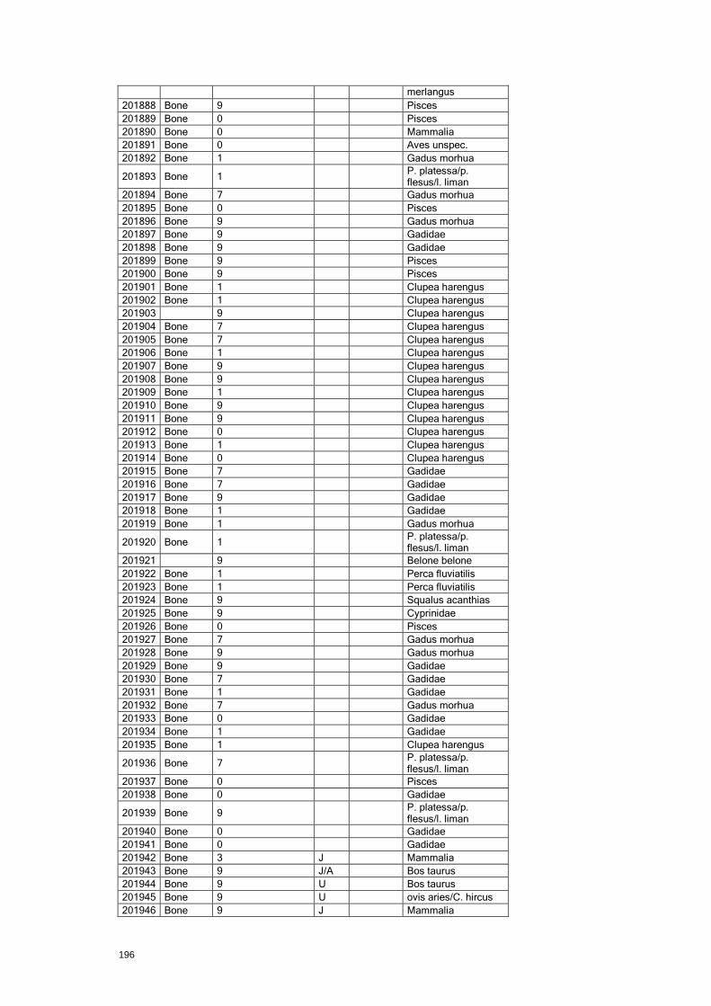
196
merlangus
201888 Bone 9
Pisces
201889 Bone 0
Pisces
201890 Bone 0
Mammalia
201891 Bone 0
Aves unspec.
201892 Bone 1
Gadus morhua
201893 Bone 1
P. platessa/p. flesus/l. liman
201894 Bone 7
Gadus morhua
201895 Bone 0
Pisces
201896 Bone 9
Gadus morhua
201897 Bone 9
Gadidae
201898 Bone 9
Gadidae
201899 Bone 9
Pisces
201900 Bone 9
Pisces
201901 Bone 1
Clupea harengus
201902 Bone 1
Clupea harengus
201903
9
Clupea harengus
201904 Bone 7
Clupea harengus
201905 Bone 7
Clupea harengus
201906 Bone 1
Clupea harengus
201907 Bone 9
Clupea harengus
201908 Bone 9
Clupea harengus
201909 Bone 1
Clupea harengus
201910 Bone 9
Clupea harengus
201911 Bone 9
Clupea harengus
201912 Bone 0
Clupea harengus
201913 Bone 1
Clupea harengus
201914 Bone 0
Clupea harengus
201915 Bone 7
Gadidae
201916 Bone 7
Gadidae
201917 Bone 9
Gadidae
201918 Bone 1
Gadidae
201919 Bone 1
Gadus morhua
201920 Bone 1
P. platessa/p. flesus/l. liman
201921
9
Belone belone
201922 Bone 1
Perca fluviatilis
201923 Bone 1
Perca fluviatilis
201924 Bone 9
Squalus acanthias
201925 Bone 9
Cyprinidae
201926 Bone 0
Pisces
201927 Bone 7
Gadus morhua
201928 Bone 9
Gadus morhua
201929 Bone 9
Gadidae
201930 Bone 7
Gadidae
201931 Bone 1
Gadidae
201932 Bone 7
Gadus morhua
201933 Bone 0
Gadidae
201934 Bone 1
Gadidae
201935 Bone 1
Clupea harengus
201936 Bone 7
P. platessa/p. flesus/l. liman
201937 Bone 0
Pisces
201938 Bone 0
Gadidae
201939 Bone 9
P. platessa/p. flesus/l. liman
201940 Bone 0
Gadidae
201941 Bone 0
Gadidae
201942 Bone 3 J
Mammalia
201943 Bone 9 J/A
Bos taurus
201944 Bone 9 U
Bos taurus
201945 Bone 9 U
ovis aries/C. hircus
201946 Bone 9 J
Mammalia

197
201947 Bone 8 U
ovis aries/C. hircus
201948 Bone 0 U
ovis aries/C. hircus
201949 Bone 9 J
ovis aries/C. hircus
201950 Bone 9 U
ovis aries/C. hircus
201951 Bone 9 A
Bos taurus
201952 Bone 9 U
ovis aries/C. hircus
201953 Bone 1 U
Sus domesticus
201954 Bone 9 U
Sus domesticus
201955 Bone 8 J
Sus domesticus
201956 Bone 0 U
Mammalia
201957 Bone 3 J
Bos taurus
201959 Bone 7 J
Anas domesticus
201960 Bone 9 J
Gallus domesticus
201961 Bone 6 J
Anas domesticus
201962 Bone 7 J
Gallus domesticus
201963 Bone 7 J
Gallus domesticus
201964 Bone 6 J
Gallus domesticus
201965 Bone 7 J
Gallus domesticus
201966 Bone 9 U
Gallus domesticus
201967 Bone 8 J
Anas domesticus
201968 Bone 6 J
Felis catus
201969 Bone 8 J
Felis catus
201970 Bone 1 A
Rattus sp.
201971 Bone 4 J
Bos taurus
201972 Bone 1 J
Felis catus
201979 Bone 9 U
Aves unspec.
201980 Bone 7 U
Aves unspec.
201981 Bone 9 U
Aves unspec.
201982 Bone 9 U
Aves unspec.
201983 Bone 9 U
Aves unspec.
201984 Bone 8 U
Aves unspec.
201985 Bone 1 A
Aves unspec.
201986 Bone 4 J
Aves unspec.
201987 Bone 9 U
Mammalia
201988 Bone 6 J
Mammalia
201989 Bone 1 U
Aves unspec.
201990 Bone 6 J
Mammalia
201991 Bone 5 J
Sus domesticus
201992 Bone 7 U
Phoca sp.
201993 Bone 9 U
Emys orbicularis
201994 Bone 0 U
Mammalia
201995 Bone 0 U I Mammalia
201996 Bone 8 U
Mammalia
201997 Bone 6 J
Felis catus
201998 Bone 8 U
Muridae indet.
201999 Bone 1 U
Muridae indet.
202000 Bone 8 U
Bos taurus
202002 Bone 9 U
Mammalia
202003 Bone 9 U
Mammalia
202004 Bone 9 U
Mammalia
202005 Bone 9 U
Mammalia
202006 Bone 9 U
Mammalia
202007 Bone 3 J
Mammalia
202008 Bone 9 J
Mammalia
202009 Bone 9 U
Mammalia
202010 Bone 5 J
ovis aries/C. hircus
202011 Bone 1 J
ovis aries/C. hircus
202012 Bone 6 J
ovis aries/C. hircus
202013 Bone 4 J
ovis aries/C. hircus
202014 Bone 9 U
Mammalia
202015 Bone 7 J
ovis aries/C. hircus
202016 Bone 9 J
Mammalia
202017 Bone 0 U
Mammalia

198
202018 Bone 8 U
Mammalia
202019 Bone 1 J Lower dP3
Sus domesticus
202020 Bone 1 U Lower M2 Canis familiaris
202021 Bone 1 U Lower P Canis familiaris
202022 Bone 1 U
Anser domesticus
202023 Bone 9 U
Anser domesticus
202024 Bone 7 U
Gallus domesticus
202025 Bone 9 U
Gallus domesticus
202026 Bone 8 J
Aves unspec.
202027 Bone 9 U
Aves unspec.
202028 Bone 7 J
Aves unspec.
202029 Bone 8 U
Aves unspec.
202030 Bone 9 U
Aves unspec.
202031 Bone 9 U
Aves unspec.
202032 Bone 0 U
Aves unspec.
202033 Bone 1 U
Aves unspec.
202034 Bone 1 A
Mammalia
202035 Bone 1 U
Rattus sp.
202036 Antler 0 U
Gadidae
202037 Bone 0
Pisces
202038 Antler 0 U
Mammalia
202040 Bone 0
Bos taurus
202042 Bone 0 U
Aves unspec.
12.3.15 Finds objects – Building materials
Id Name Subclass Material Type Dating Decorated Glazed
200455 Daub matey Building Materials_Metro Burnt clay
Daub matey
Late Medieval
200466 Mortar sample? Building Materials_Metro
200468 Roof tile Building Materials_Metro CBM Roof tile Post Medieval
200469 Roof tile Building Materials_Metro CBM Roof tile
200470 Roof tile Building Materials_Metro CBM Roof tile
200472 Stove tile Building Materials_Metro CBM Stove tile
Early post-Medieval
200473 Floor tile Building Materials_Metro CBM Floor tile
200512 Brick Building Materials_Metro CBM Brick
200513 Stone floor tile Building Materials_Metro Stone
200597 1500-1600 stove tile Building Materials_Metro CBM Stove tile
Early post-Medieval
True True
200607 1500-1700 stove tile Building Materials_Metro CBM Stove tile
Early post-Medieval
200611 Brick Building Materials_Metro CBM Brick
200613 Roof tile Building Materials_Metro CBM Roof tile Late Medieval
200631 1550-1600 stove tile Building Materials_Metro CBM Stove tile
Early post-Medieval
True True
200632 19th-20th cent. wall tile
Building Materials_Metro CBM Wall tile Late post-Medieval
True True
200668 Floor tile Building Materials_Metro CBM Floor tile
True
200670 Madaljon stove tile 1500-1575
Building Materials_Metro CBM Stove tile
Early post-Medieval
True True
200671 Vessel stove tile, 1475-1525
Building Materials_Metro CBM Stove tile
Early post-Medieval
True
200672 Vessel stove tile, 1500-1550
Building Materials_Metro CBM Stove tile
Late Medieval
True
200676 Floor tile Building Materials_Metro CBM Floor tile
True
200783 Water pipe metal joint. Add to intraSIS
Building Materials_Metro Lead
Post Medieval
200794 Fragment of iron waterpipe
Building Materials_Metro Iron

199
12.3.16 Finds objects – ceramics
Id Name Material Provenance Ceramic ware Fabric Provenance Earliest dating
Latest dating
200383 Siegburg older type stone jug
Ceramic West Germany (Rhineland)
Stoneware Siegburg older type Siegburg 1300 1550
200384 Siegburg older type stone jug
Ceramic West Germany (Rhineland)
Stoneware Siegburg older type Siegburg 1300 1550
200385 Siegburg older type stone jug
Ceramic West Germany (Rhineland)
Stoneware Siegburg older type Siegburg 1300 1550
200386 Siegburg older type stone jug
Ceramic West Germany (Rhineland)
Stoneware Siegburg older type Siegburg 1300 1550
200387 Siegburg older type stone jug
Ceramic West Germany (Rhineland)
Stoneware Siegburg older type Siegburg 1300 1550
200388 Siegburg older type stone jug
Ceramic West Germany (Rhineland)
Stoneware Siegburg older type Siegburg 1300 1550
200389 Siegburg older type stone jug
Ceramic West Germany (Rhineland)
Stoneware Siegburg older type Siegburg 1300 1550
200390 Siegburg older type stone jug
Ceramic West Germany (Rhineland)
Stoneware Siegburg older type Siegburg 1300 1550
200391 Siegburg older type stone jug
Ceramic West Germany (Rhineland)
Stoneware Siegburg older type Siegburg 1300 1550
200392 Siegburg older type. Uncertain type
Ceramic West Germany (Rhineland)
Stoneware Siegburg older type Siegburg 1300 1550
200393 Late grey ware cooking pot
Ceramic Unknown Earthenware Late Grey ware Unknown 1200 1450
200394 Late grey ware jug
Ceramic Unknown Earthenware Late Grey ware Unknown 1200 1450
200395 Early redware jug
Ceramic Unknown Earthenware Early redware Unknown 1200 1400
200396 Early redware jug
Ceramic Unknown Earthenware Early redware Unknown 1200 1400
200397 Late redware. Uncertain type
Ceramic Unknown Earthenware Late redware Unknown 1400 1600
200398 Late redware. Uncertain type
Ceramic Unknown Earthenware Late redware Unknown 1400 1600
200399 Siegburg older type stone jug
Ceramic West Germany (Rhineland)
Stoneware Siegburg older type Siegburg 1300 1550
200400 Siegburg older type stone jug
Ceramic West Germany (Rhineland)
Stoneware Siegburg older type Siegburg 1300 1550
200401 Stone jug Ceramic Unknown Stoneware unknown Germany 1300 1650
200402 Early redware jug
Ceramic Unknown Earthenware Early redware Unknown 1200 1400
200403 Late redware plate
Ceramic Unknown Earthenware Late redware Unknown 1400 1700
200404 Early redware. Uncertain type
Ceramic Unknown Earthenware Early redware Unknown 1200 1400
200405 Early redware. Uncertain type
Ceramic Unknown Earthenware Early redware Unknown 1200 1400
200406 Early redware jug
Ceramic Unknown Earthenware Early redware Unknown 1200 1400
200407 Siegburg stone jug
Ceramic West Germany (Rhineland)
Proto-stonewere
Siegburg
1275 1375
200409 Early redware jug
Ceramic Unknown Earthenware Early redware Unknown 1200 1400
200410 Late redware pot
Ceramic Unknown Earthenware Late redware Unknown 1400 1700
200411 Siegburg older type stone jug
Ceramic West Germany (Rhineland)
Stoneware Siegburg older type Siegburg 1300 1550
200412 Early redware dripping pan
Ceramic Unknown Earthenware Early redware Unknown 1200 1400
200413 Late redware stjert pot
Ceramic Unknown Earthenware Late redware Unknown 1400 1600
200414 Early redware jug
Ceramic Unknown Earthenware Early redware Unknown 1200 1400
200415 Siegburg older type stone jug
Ceramic West Germany (Rhineland)
Stoneware Siegburg older type Siegburg 1300 1550
200416 Late grey ware.
Ceramic Unknown Earthenware Late Grey ware Unknown 1200 1450

200
Uncertain type
200417 Late grey ware pot
Ceramic Unknown Earthenware Late Grey ware Unknown 1200 1450
200419 Siegburg older type stone jug
Ceramic West Germany (Rhineland)
Stoneware Siegburg older type Siegburg 1300 1550
200420 Stoneware. Uncertain type
Ceramic Unknown Stoneware unknown Unknown 1300 1600
200421 Siegburg older type stone jug
Ceramic West Germany (Rhineland)
Stoneware Siegburg older type Siegburg 1300 1550
200422 Early redware jug
Ceramic Unknown Earthenware Early redware Unknown 1200 1400
200423 Early redware jug
Ceramic Unknown Earthenware Early redware Unknown 1200 1400
200424 Early redware jug
Ceramic Unknown Earthenware Early redware Unknown 1200 1400
200425 Siegburg older type stone jug
Ceramic West Germany (Rhineland)
Stoneware Siegburg older type Siegburg 1300 1550
200515 Siegburg older type stone bowl
Ceramic West Germany (Rhineland)
Stoneware Siegburg older type Siegburg 1300 1550
200516 Siegburg older type stone beaker
Ceramic West Germany (Rhineland)
Stoneware Siegburg older type Siegburg 1300 1550
200517 Siegburg older type stone jug
Ceramic West Germany (Rhineland)
Stoneware Siegburg older type Siegburg 1300 1550
200518 Siegburg older type stone jug
Ceramic West Germany (Rhineland)
Stoneware Siegburg older type Siegburg 1300 1550
200519 Siegburg stone jug
Ceramic
Proto-stonewere
Siegburg
1250 1375
200520 Early redware jug
Ceramic Denmark Earthenware Early redware Denmark 1200 1400
200521 Early redware jug
Ceramic Unknown Earthenware Early redware Unknown 1200 1400
200522 Late grey ware pot
Ceramic Unknown Earthenware Late Grey ware Unknown 1200 1450
200523 Siegburg older type stone jug
Ceramic West Germany (Rhineland)
Stoneware Siegburg older type Siegburg 1300 1550
200524 Siegburg older type stone jug
Ceramic West Germany (Rhineland)
Stoneware Siegburg older type Siegburg 1300 1550
200525 Siegburg older type stone jug
Ceramic West Germany (Rhineland)
Stoneware Siegburg older type Siegburg 1300 1550
200527 Siegburg older type stone jug
Ceramic West Germany (Rhineland)
Stoneware Siegburg older type Siegburg 1300 1550
200528 Siegburg older type stone jug
Ceramic West Germany (Rhineland)
Stoneware Siegburg older type Siegburg 1300 1550
200529 Siegburg older type stone jug
Ceramic West Germany (Rhineland)
Stoneware Siegburg older type Siegburg 1300 1550
200530 Early redware jug
Ceramic Denmark Earthenware Early redware Denmark 1200 1450
200531 Early redware jug
Ceramic Denmark Earthenware Early redware Denmark 1200 1450
200532 Siegburg older type stone bowl
Ceramic West Germany (Rhineland)
Stoneware Siegburg older type Siegburg 1300 1550
200533 Siegburg older type stone bowl
Ceramic West Germany (Rhineland)
Stoneware Siegburg older type Siegburg 1300 1550
200534 Siegburg older type. Uncertain type
Ceramic West Germany (Rhineland)
Stoneware Siegburg older type Siegburg 1300 1550
200535 Late grey ware. Uncertain type
Ceramic Unknown Earthenware Late Grey ware Unknown 1200 1450
200536 Late grey ware jug
Ceramic Unknown Earthenware Late Grey ware Unknown 1200 1450
200537 Late grey ware pot
Ceramic Unknown Earthenware Late Grey ware Unknown 1200 1450
200538 Early redware. Uncertain type
Ceramic Denmark Earthenware Early redware Denmark 1200 1450
200539 Jydepotte. Pot Ceramic Denmark Earthenware Jydepotte Jutland 1500 1850

201
200540 Early redware. Uncertain type
Ceramic Denmark Earthenware Early redware Denmark 1200 1450
200541 Frechen stone jug
Ceramic West Germany (Rhineland)
Stoneware Frechen Frechen 1450 1875
200542 Early redware pot
Ceramic Denmark Earthenware Early redware Denmark 1200 1450
200543 Early redware jug
Ceramic Denmark Earthenware Early redware Denmark 1200 1450
200544 Late grey ware bowl
Ceramic Unknown Earthenware Late Grey ware Unknown 1200 1450
200545 Siegburg older type stone jug
Ceramic West Germany (Rhineland)
Stoneware Siegburg older type Siegburg 1300 1550
200546 Siegburg older type stone jug
Ceramic West Germany (Rhineland)
Stoneware Siegburg older type Siegburg 1300 1550
200547 Siegburg older type stone jug
Ceramic West Germany (Rhineland)
Stoneware Siegburg older type Siegburg 1300 1550
200548 Siegburg older type stone jug
Ceramic West Germany (Rhineland)
Stoneware Siegburg older type Siegburg 1300 1550
200591 KMKR Ceramic Holland/ Netherlands
Earthenware Late redware Netherlands 1550 1650
200592 Tudor coat of arms year...5
Ceramic West Germany (Rhineland)
Stoneware Siegburg younger type
Siegburg 1545 1625
200593 Late redware stjert pot
Ceramic Denmark Earthenware Late redware Denmark 1550 1625
200594 Late lightfired Niedersachsen pot
Ceramic Germany Earthenware Late light fired Niedersachsen 1525 1625
200598 Late redware dish
Ceramic
Earthenware Late redware
1525 1625
200599 Late redware dish
Ceramic Denmark Earthenware Late redware Denmark 1550 1800
200600 Late lightfired Weser pot
Ceramic Germany Earthenware Late light fired Weser 1580 1630
200602 Cologne/ Frechen stone jug
Ceramic West Germany (Rhineland)
Stoneware Cologne/Frechen Cologne/ Frechen
1500 1630
200603 Stone ointment jar
Ceramic Germany Stoneware
Germany 1500 1800
200604 Late redware pot
Ceramic Denmark Earthenware Late redware Denmark 1500 1600
200605 Late redware pot
Ceramic Denmark Earthenware Late redware Denmark 1500 1600
200606 Late redware Nederland dish
Ceramic Holland/ Netherlands
Earthenware Late redware Netherlands 1500 1600
200608 Late redware dish
Ceramic
Earthenware Late redware
1500 1700
200609 Westerwald stone jug
Ceramic West Germany (Rhineland)
Stoneware Westerwald Westerwald 1580 1675
200612 Westerwald stone jug
Ceramic West Germany (Rhineland)
Stoneware Westerwald Westerwald 1580 1675
200615 North Dutch polykrome Majolica dish
Ceramic
Majolica
1575 1700
200616 Late redware pot
Ceramic
Earthenware Late redware
1400 1650
200617 Late redware pot
Ceramic Denmark Earthenware Late redware Denmark 1400 1800
200618 North Dutch Majolica dish
Ceramic
Majolica
1550 1650
200619 Late redware jug
Ceramic
Earthenware Late redware
1400 1700
200620 Late redware pot
Ceramic
Earthenware Late redware
1400 1800
200621 Latre redware pot
Ceramic
Earthenware Late redware
1500 1800
200622 Late redware pot
Ceramic Denmark Earthenware Late redware Denmark 1550 1700
200624 Late redware pot
Ceramic
Earthenware Late redware
1500 1800
200625 Late redware Ceramic Denmark Earthenware Late redware Denmark 1600 1800

202
dish
200626 Late redware pot
Ceramic Denmark Earthenware Late redware Denmark 1400 1800
200627 Late redware pot
Ceramic Denmark Earthenware Late redware Denmark 1500 1800
200628 Late redware pot
Ceramic
Earthenware Late redware
1400 1800
200629 Late redware pot
Ceramic Denmark Earthenware Late redware Denmark 1550 1700
200630 Late lightfired Niedersachsen pot
Ceramic Germany Earthenware Late light fired Niedersachsen 1550 1650
200633 Late redware money box
Ceramic Holland/Netherlands Earthenware Late redware Netherlands 1550 1650
200634 Swedish royal coat of arms with king por
Ceramic North Belgium-Flanders
Stoneware Raeren younger type
Raeren 1550 1630
200635 Chinese plate Ceramic <<No data>> Porcelain Chinese China 1725 1775
200636 Chinese saucer
Ceramic
Porcelain Chinese China 1725 1775
200637 Late redware Nederland frying pan
Ceramic Holland/Netherlands Earthenware Late redware Netherlands 1650 1800
200638 Late lightfired Weser dish
Ceramic Germany Earthenware Late light fired Weser 1580 1630
200639 Late redware pot
Ceramic Denmark Earthenware Late redware Denmark 1550 1700
200640 Late redware Niedersachsen dish
Ceramic Germany Earthenware Late redware Niedersachsen 1550 1650
200641 Late North Dutch Majolica dish
Ceramic
Majolica Late North Dutch
1650 1750
200642 Late redware Nederland pot
Ceramic Holland/Netherlands Earthenware Late redware Netherlands 1400 1700
200643 Late redware pot
Ceramic
Earthenware Late redware
1400 1800
200644 Westerwald stone jug
Ceramic West Germany (Rhineland)
Stoneware Westerwald Westerwald 1650 1725
200645 Siegburg younger type stone mug
Ceramic West Germany (Rhineland)
Stoneware Siegburg younger type
Siegburg 1500 1650
200646 Waldenburg stone jug
Ceramic East Germany Stoneware Waldenburg Waldenburg 1400 1525
200647 Late redware stjert pot
Ceramic Denmark Earthenware Late redware Denmark 1650 1850
200648 Late redware plate
Ceramic Denmark Earthenware Late redware Denmark 1700 1800
200649 Late redware dish
Ceramic
Earthenware Late redware
1575 1675
200650 Late grey ware pot
Ceramic Unknown Earthenware Late Grey ware Unknown 1200 1450
200651 Late redware pot
Ceramic Denmark Earthenware Late redware Denmark 1525 1625
200652 Late redware pot
Ceramic Denmark Earthenware Late redware Denmark 1400 1800
200654 Late redware pot
Ceramic Denmark Earthenware Late redware Denmark 1400 1700
200655 Late grey ware pot
Ceramic Unknown Earthenware Late Grey ware Unknown 1200 1450
200657 Cologne/ Frechen stone jug
Ceramic West Germany (Rhineland)
Stoneware Cologne/Frechen Cologne/Frechen 1500 1630
200659 Late redware Netherland bowl
Ceramic Holland/Netherlands Earthenware Late redware Netherlands 1400 1600
200660 Siegburg older type stone jug
Ceramic West Germany (Rhineland)
Stoneware Siegburg older type Siegburg 1300 1550
200661 Late redware earpot add to
Ceramic Holland/Netherlands Earthenware Late redware Netherlands 1400 1600

203
type
200662 Late redware dripping pan
Ceramic Holland/Netherlands Earthenware Late redware Netherlands 1300 1600
200663 Late redware lug type bowl
Ceramic Denmark Earthenware Late redware Denmark 1600 1800
200664 Late redware pot
Ceramic Denmark Earthenware Late redware Denmark 1400 1800
200667
Firenze majolica dish(post-med.ref.col.)
Ceramic
Majolica
1500 1550
200669 Stone jug Ceramic Unknown Stoneware unknown Unknown 1400 1550
200673 Late redware pot/ jug
Ceramic
Earthenware Late redware
1400 1700
200674 Late redware pot
Ceramic Denmark Earthenware Late redware Denmark 1500 1700
200758 Siegburg older type stone jug
Ceramic West Germany (Rhineland)
Stoneware Siegburg older type Siegburg 1300 1550
200759 Siegburg older type stone jug
Ceramic West Germany (Rhineland)
Stoneware Siegburg older type Siegburg 1300 1550
200784 Siegburg mug Ceramic Unknown Stoneware Siegburg younger type
Unknown 1400 1600
200795 Siegburg older jug
Ceramic West Germany (Rhineland)
Stoneware Siegburg older type Siegburg 1300 1550
200796 Siegburg older type
Ceramic West Germany (Rhineland)
Stoneware Siegburg older type Siegburg 1300 1550
200797 Redware Ceramic Unknown Earthenware redware Unknown 0 0
200831 Late redware dish
Ceramic
Earthenware Late redware
1450 1650
200832 Stoneware mug
Ceramic
Stoneware
1500 1800
200833 late redware jug
Ceramic
Earthenware Late redware
1450 1800
200834 blue decor. faience not yet identified
Ceramic
Faience
1500 0
12.3.17 Finds objects – clay pipes
Id Name Material Type Dating Stamp
200459 Stamped heel Pipeclay Clay pipe
True
200463 Clay pipe stem Pipeclay Clay pipe
Post Medieval
200464 Clay pipe stem Pipeclay Clay pipe
200467 Clay pipe stem Pipeclay Clay pipe
200471 Clay pipe. Decorated dutch 1625-40
Pipeclay Clay pipe
Early post-Medieval
True
12.3.18 Finds objects – coins
Id Name Subclass Material Fragmentation Dating Provenance Currency
200076 Coin Coin_Metro Copper alloy Complete Early post-Medieval
Denmark
200077 Coin Coin_Metro Copper alloy Complete Post Medieval Denmark Skilling
200273 Coin Coin_Metro Copper alloy Complete Late post-Medieval
200274 Coin Coin_Metro Copper alloy Fragment
200275 Coin Coin_Metro Copper alloy Fragment Post Medieval
200276 Coin Coin_Metro Copper alloy Fragment
200277 Coin Coin_Metro Copper alloy Complete
200278 Coin Coin_Metro Copper alloy Complete Modern time
200279 Coin Coin_Metro Copper alloy Fragment
204
200442 Coin fused to iron lump
Coin_Metro Copper alloy Complete Post Medieval
200446 Corroded coin or button
Coin_Metro Copper alloy Intact
200837 Coin? Coin_Metro Copper alloy Fragment
12.3.19 Finds objects – combs
Id Name Type Provenance
200714 Bone comb
Comb N/A
12.3.20 Finds objects – Flint
Id Name Subclass Material Type Provenance
201109 Flint flake
Flint_Metro Flint Flake Denmark
12.3.21 Finds objects – glass
Id Name Class Subclass Material Type Dating
200379 Glass beaker Find Glass_Metro Glass Beaker
200380 Glass bottle Find Glass_Metro Glass Bottle
200560 Drinking glass Find Glass_Metro Glass Tankard
200561 Window glass Find Glass_Metro Glass Window glass
200562 Glass bottle sherd Find Glass_Metro Glass Bottle
200563 Glass bottle sherd Find Glass_Metro Glass Bottle
200564 Glass bottle sherd Find Glass_Metro Glass Bottle
200565 Glass sherds Find Glass_Metro Glass Sherd
200566 Glass case bottle sherds
Find Glass_Metro Glass Bottle
200567 Window glass Find Glass_Metro Glass Window glass
200568 Window glass Find Glass_Metro Glass Window glass
200570 Glass bottle neck Find Glass_Metro Glass Bottle
200571 Window glass Find Glass_Metro Glass Window glass
200572 Glass bottle base Find Glass_Metro Glass Bottle Late post-Medieval
200573 Glass bottle base Find Glass_Metro Glass Bottle Post Medieval
200575 Drinking glass. Pas glass
Find Glass_Metro Glass
200576 Drinking glass Find Glass_Metro Glass Beaker
200577 Drinking glass Find Glass_Metro Glass Beaker
200578 Drinking glass Find Glass_Metro Glass Beaker
200579 Drinking glass Find Glass_Metro Glass Beaker
200580 Glass bottle base Find Glass_Metro Glass Bottle Post Medieval
200581 Glass bottle sherds Find Glass_Metro Glass Bottle
200822 drinking glass Find Glass_Metro Glass Beaker Early post-Medieval
12.3.22 Finds objects – iron
Id Name Class Subclass Number Weight Status
200030 Telebox Find unit
Iron 0 0 Fragment
200049 Telebox Find unit
Iron 2 126
200052 Telebox Find Iron 0 0 Fragment
205
unit
200061 Telebox Find unit
Iron 0 0 Fragment
200068 Telebox Find unit
Iron 0 0
200140 Waterpipe north east
Find unit
Iron 0 0
200144 Waterpipe east Find unit
Iron 0 0
200147 Waterpipe east Find unit
Iron 0 0
200286 Waste pipe Find unit
Iron 0 0
200343 Waste pipe Find unit
Iron 0 0
200344 Waste pipe Find unit
Iron 0 0
12.3.23 Finds objects – copper alloy
Id Name Class Subclass
200298 Waste pipe
Find unit
Copper alloy
200348 Waste pipe
Find unit
Copper alloy
200818 Wastepipe Find unit
Copper alloy
200835 Wastepipe Find unit
Copper alloy
12.3.24 Finds objects – household materials
Id Name Material Type Dating
200157 Possible copper alloy tap from a barrel
Copper alloy
Post Medieval
200249 Copper alloy vessel or crucible Copper alloy
Vessel Post Medieval
200477 Structural wood Wood Uncertain Late Medieval
200478 Miscelllaneous wooden object Wood
Late Medieval
200492 Wooden stave Wood Stave Late Medieval
200494 Wooden lid Wood Lid Late Medieval
200584 Wooden plate fragment Wood Plate Late Medieval
200586 Wooden plate fragment Wood Plate Late Medieval
200595 Small wooden bucket base Wood Barrel Late Medieval
12.3.25 Finds objects – knives
Id Name Subclass Material Type Dating
200813 wooden knife handle
Knifes Wood Handle Late Medieval
200814 Wooden knife handle
Knifes Wood Handle Late Medieval
12.3.26 Finds objects – Leather and leather clothing
Id Name Type Dating Heel Rand Sole Quarters Vamp
206
stiffener
200484 Patten/Galoche leather & wood
Late Medieval
True
200717 Leather sole Shoe Medieval
True
200718 Leather shoe Shoe Late Medieval
True True True True
200719 Leather quarters Shoe Medieval
True
200720 Leather sole Shoe Late Medieval
True
200721 Leather sole Shoe Late Medieval
True
200722 Leather sole Shoe Medieval
True
200723 Leather sole Shoe Late Medieval
True
200724 Leather sole Shoe Late Medieval
True
200725 Leather sole Shoe Late Medieval
True
200727 Leather quarter Shoe Late Medieval
True
200728 Leather vamp Shoe Late Medieval
True
200729 Leather rands Shoe
True
200730 Leather Uncertain type
200731 Leather vamp Shoe Late Medieval
True
200733 Leather vamp Shoe Late Medieval
True
200734 Leather vamp Shoe Late Medieval
True
200735 Leather rands Shoe
True
200736 Leather vamp and quarter
Shoe Late Medieval
True True
200737 Leather heel stiffener
Shoe
True
False False
200738 Leather lace Lace Medieval
200739 Leather sole, vamp and rands
Shoe Late Medieval
True True
True
200740 Leather vamp Shoe Late Medieval
True
200741 Leather vamp Shoe Medieval
True
200742 Leather heel stiffener
Shoe Medieval True
200743 Leather heel stiffener
Shoe Medieval True
200744 Leather heel stiffener
Shoe Medieval True
200745 Leather vamp Shoe Medieval
True
200746 Leather piece Uncertain type
200747 Leather quarter Shoe Medieval
True
200748 Leather quarter Shoe Medieval
True
200749 Leather quarter Shoe Medieval
True
200750 Leather quarter Shoe Medieval
True
200751 Leather quarter Shoe Medieval
True
200752 Leather vamp Shoe Late Medieval
True
200753 Leather sole Shoe Late Medieval
True
200754 Leather sole Shoe Late Medieval
True
200755 Large leather off cuts
Production waste
200756 Leather piece Uncertain type
200757 Rands Shoe Medieval
True
200763 Leather Uncertain type
200764 Leather Production waste
200765 Leather vamp and quarter
Shoe Medieval
True True
200766 Leather quarter Shoe Medieval
True
200767 Leather laces Lace Medieval
200768 Leather heel stiffener
Shoe Medieval True
200769 leather sole Shoe Medieval
True
200785 Leather rand Shoe Medieval
True
200786 Leather sole Sole Late Medieval
True
200787 Leather sole Sole Late Medieval
True
207
200788 Leather sole Sole Late Medieval
True
200789 Leather sole Sole Late Medieval
True
200790 Leather vamp Shoe Late Medieval
True
200791 Leather sole Sole Late Medieval
True
200792 Leather sole Sole Early Medieval
True
200793 Leather vamp Shoe Early Medieval
True
200821 Leather shoe Shoe Post Medieval
True True
True
200825 Leather rands and vamp parts
Shoe Medieval
True
True
200826 Leather vamp
Medieval
True
200827 Leather vamp and laces
Medieval
True
200828 Leather rand and vamp
Medieval
True
True
200829 Leather sole with wooden pegs
Shoe Medieval
True
False
200830 Leather shoe Shoe Medieval True True True True True
12.3.27 Finds objects – other organic items
Id Name Class Subclass
200372 Hazelnuts Find Other Organic
200703 Hazelnut Find Other Organic
200704 Charcoal Find Other Organic
200705 Hazelnut Find Other Organic
200706 Organic material
Find Other Organic
200707 Hazelnut Find Other Organic
200708 Charcoal Find Other Organic
200709 Bark Find Other Organic
200710 Charcoal Find Other Organic
200711 Seed Find Other Organic
200712 Hazelnut Find Other Organic
200713 Hazelnut Find Other Organic
201958 Egg shell Find Other Organic
202039 Coprolite Find Other Organic
12.3.28 Finds objects – personal items
Id Name Class Material Type Dating
200295 Copper alloy pin Find Copper alloy
Pin Post Medieval
200296 Copper alloy buckle Find Copper alloy
Buckle Post Medieval
200447 Ceramic marble ball Find Ceramic Ball
200448 Copper alloy clasp Find Copper alloy
Clasp
200449 Copper alloy pin Find Copper alloy
Pin
200450 Copper alloy twisted loop from purse
Find Copper alloy
Twisted loops
Post Medieval
200514 Bone toy Find Bone Toy Late
208
Medieval
200526 Bone toy Find Bone Toy Late Medieval
200574 Bone dice Find Bone Dice Late Medieval
200601 Wooden button Find Wood Button
200653 Bone toy Find Bone Toy Late Medieval
200812 pearl from sieving Find Pearl
Late Medieval
200819 copper alloy button Find Copper alloy
Button
12.3.29 Finds objects – rope
Id Name Material Type Twining direction
Number of cords
Material Knot Ends preserved
200770 Rope, plant
Rope Z 3 Plant fibres No No
200772 Rope, plant
Rope Z 2 Plant fibres No No
200776 Rope, plant
Rope Z 3 Plant fibres No No
200777 Rope, hair Hair Cord S 1 Animal fibres
No No
200778 Rope, plant
Rope Z 2 Plant fibres No No
200779 Rope, plant
Rope Z 3 Plant fibres No No
200780 Rope, plant
Rope Z 3 Plant fibres Yes No
200840 Rope, plant
S 5 Plant fibres No No
200841 Rope, hair
S 1 Animal fibres
No No
200842 Rope, plant
Rope S 3 Plant fibres No No
200843 Rope, plant
S 10 Plant fibres No No
200844 Rope, hair
Z 2 Animal fibres
No No
200845 Rope, plant
Z 2 Plant fibres No No
200846 Rope, plant
S 4 Plant fibres No No
200847 Rope, hair
S 2 Animal fibres
No No
200848 Rope, hair
Z 2 Animal fibres
No No
12.3.30 Finds objects – shell
Id Name Class Subclass Material Type Number Weight Species
200701 blue mussel Find Shell Sea Shell Mussel 2 2 Mytilus edulis
200702 common cockle Find Shell Sea Shell Mussel 6 1 Cerastoderma edule
201702 grey top shell Find Shell Sea Shell
1 0 Gibbula cineraria
201703 Netted Dog Welk Find Shell
1 0 Hinia reticulatus
201704 blue mussel Find Shell Sea Shell
3 0 Mytilus edulis
201973 blue mussel Find Shell Sea Shell
12 8 Mytilus edulis
201974 common cockle Find Shell Sea Shell
6 4 Cerastoderma edule
201975 common cockle Find Shell Sea Shell
23 9 Cerastoderma edule
201976 common periwinkle
Find Shell Sea Shell
34 20 Littorina littorea
209
201977 species of Anodonta
Find Shell
1 0 Anodonta sp.
201978 blue mussel Find Shell Sea Shell
3 0 Mytilus edulis
12.3.31 Finds objects – ship and fishing
Id Name Class Subclass Material Type Fragmentation Dating
200426 Wooden netting needle
Find Ship and fishing
Wood Netting needle
Complete
200428 Wooden needle Find Ship and fishing
Wood Needle Fragment
200430 Wooden needle Find Ship and fishing
Wood Needle Fragment Late Medieval
200498 Wooden spar from ship
Find Ship and fishing
Wood Spar Fragment Late Medieval
200582 Wood. Part of rigging Find Ship and fishing
Wood
Fragment Late Medieval
200623 Wood. Check with roskilde museum
Find Ship and fishing
Wood
Fragment Late Medieval
200677 Wooden float or part of rigging
Find Ship and fishing
Wood
Fragment
201273 Polished bindebor for net making
Find Ship and fishing
Bone
Fragment
12.3.32 Finds objects – slag
Id Name Class Subclass Material Type
200453 Slag iron Find Slag Slag
200658 Forge wall clay Find Slag Burnt clay
Forge wall
200666 Add to intrasis. Glass
Find Slag Slag
12.3.33 Finds objects – textile
Id Name Class Type Dating Material Colour
200771 Wrapping textile?
Find Fabric Late Medieval
Wool Dark brown
200773 Clothing fragment
Find Fabric Late Medieval
Wool Dark brown
200774 Textile fragment Find Fabric Late Medieval
Wool Light brown
200775 Textile fragment Find Fabric
Wool Dark brown
200782 Silk fragment Find Fabric Late Medieval
Silk Dark brown
201106 Textile fragment Find Fabric
Wool Dark brown
201107 Felted textile Find Fabric
Wool Light brown
12.3.34 Finds objects – tools
Id Name Class Subclass Material Type Fragmentation Dating
200381 Miscellaneous lead object. research need
Find Tools_Metro Lead
Fragment
200432 Wooden production waste
Find Tools_Metro Wood Waste Intact Late Medieval
200433 Wooden production waste
Find Tools_Metro Wood Waste Intact Late Medieval
200434 Wooden wedge Find Tools_Metro Wood Wedge Intact Late Medieval
200436 Wooden wedge Find Tools_Metro Wood Wedge Fragment Late Medieval
210
200438 Wooden undefined object
Find Tools_Metro Wood Uncertain Fragment Late Medieval
200441 Iron nail Find Tools_Metro Iron Nail Fragment
200443 Iron nail Find Tools_Metro Iron Nail Fragment
200444 Iron nail Find Tools_Metro Iron Nail Fragment
200445 Iron nail Find Tools_Metro Iron Nail Complete
200454 Iron nail Find Tools_Metro Iron Nail Fragment
200456 Iron nail Find Tools_Metro Iron Nail Fragment
200457 Iron nail Find Tools_Metro Iron Nail Fragment
200458 Pins..resembles tacks
Find Tools_Metro Horn Pin Fragment
200474 Bark production waste
Find Tools_Metro Bark Production waste
Fragment Late Medieval
200475 Wooden handle Find Tools_Metro Wood Handle Complete Late Medieval
200480 Wooden needle Find Tools_Metro Wood Needle Fragment Late Medieval
200482 Wooden dowel Find Tools_Metro Wood Dowel Fragment Late Medieval
200488 Wooden handle Find Tools_Metro Wood Handle Intact Late Medieval
200490 Wooden needle Find Tools_Metro Wood Needle Fragment Late Medieval
200496 Wooden rivet Find Tools_Metro Wood Rivet Intact Late Medieval
200500 Wooden rivet Find Tools_Metro Wood Rivet Intact Late Medieval
200502 Wood undefined Find Tools_Metro Wood Uncertain Fragment Late Medieval
200504 Wooden point from a tool
Find Tools_Metro Wood Point Intact Late Medieval
200506 Wooden point from a tool
Find Tools_Metro Wood Point Intact Late Medieval
200508 Wooden point from a tool
Find Tools_Metro Wood Point Intact Late Medieval
200549 Iron nail Find Tools_Metro Iron Nail Fragment
200583 Wood undefined Find Tools_Metro Wood Uncertain Fragment Late Medieval
200585 Wooden handle Find Tools_Metro Wood Handle Fragment Late Medieval
200596 Wooden handle for tool
Find Tools_Metro Wood Handle Fragment
200715 Pointed artefact Find Tools_Metro Wood Point Fragment
200716 Wooden handle Find Tools_Metro Wood Handle Complete
200836 copper alloy needle Find Tools_Metro Copper alloy
Needle Intact
12.4 Consultant reports
12.4.1 Report on animal bones from Gammel Strand, KBM 3828,
(by Inge Bødker Enghoff Natural History Museum of Denmark Copenhagen 20 February, 2012, journr.: Z.M.K. 57/2011 Introduction Archaeologists from Copenhagen Museum were commissioned by the Metro Company to undertake the supervision of the building contractors (NCC) as part of the ongoing service trenching at Gammel Strand from March – December 2010. From these trenches finds of animal bones, ceramics, leather, textiles, wood etc. have been recovered. This report documents the animal bone material excavated from a number of contexts at Gammel Strand, Copenhagen. Material and methods Datings

211
The datings of the various contexts combined cover the interval from the 13th to the 19th century AD. Most contexts each represent a very long time interval including, unfortunately the two which yielded the largest animal bone samples: SD200251 and SD 200252. Excavation method Most contexts were excavated by trowel, but a few of them were done by machine such as SD 200251 and 200252. Big bags from the two last mentioned contexts were sieved, mesh size 3 + 5 mm. Material from the two kinds of sieves were combined into one sample. Preservation of bones The animal bones are generally exceptionally well-preserved as they have been retrieved from anaerobic conditions. Even the smallest skeletal elements from e.g. herring are present, remains from several species of cartilaginous fishes have been preserved, and the surface of the bones is so well-preserved that for example cutmarks still exhibit sharp edges. Most exceptionally, horn sheaths from cattle have been found. Indentification of all fragments was attempted, using the reference collection in the Natural History Museum of Denmark. Results List of species Identification of the animal bone material from Gl. Strand showed that all together at least 41 different species are represented, i.e., at least 21 species of fish, 1 species of reptiles, 6 species of birds and 13 species of mammals, see table 1. Fish The variety of fish species is especially rich. There are bones fragments from freshwater fish (pike, common bream and perch), migrating species (salmon/trout and eel) as well as marine fish (all the remaining species). By far most of the bones belong to gadids among which cod, haddock, whiting and ling are represented. Identification to the level of species within gadids was conducted on the most species-specific elements, and the rest of the fragments were referred to gadid unspec. Hake, (a close relative of gadids) is also represented in the material. Second-important on the list are flatfishes: plaice/flounder/dab and turbot, followed by herring. The importance of herring was probably much higher than read from the list, as many of the small herring bones might have slipped through the rather coarse mesh size in the sieves (and some of the contexts were not sieved at all). Four of the marine species on the list are guests in Danish waters during the summer season, namely: garfish, mackerel, horse mackerel and tuna, which proves activity in the area during this season. The find of tuna is interesting, because we have not got many of these from the Danish past. There has only been found 17 tuna bones from layers spanning the period from Stone Age to Medieval (1000-1536 AD) most of them are from the Medieval period. Some of the species, like ling and hake, are deep water species while another species, bull-rout, spend its whole life in shallow water in the eel grass zone.
212
Pike, common bream and perch are all very common species in Danish fresh water. Bones from cartilaginous species like spurdog and thornback ray are also present. All the species found are considered to be worth eating also today – most of them highly appreciated. Reptiles Only one species of reptile, European pond turtle, has been found - a single plate from the shield. The find is interesting, because this species died out in Denmark presumably during the youngest part of the Subboreal period. Birds The bird bones were identified to domestic birds (domestic goose, hen and duck) as well as to three wild species (whooper swan, common murre and crow/rook). Mammals Most of the mammal bones belong to common species of domestic animals (sheep, cattle, pig, horse, cat and dog). Among these bones from sheep and sheep/goat are the most frequent – only sheep has been positively identified. The wild species are represented by red deer, roe deer, hare, rabbit, seal, harbour porpoise and rat. The individual contexts The amount of animal bones from the each context is listed by weight in table 2 For detailed information of species and the representation of skeletal elements please see table 3 2110. Northern extension of telebox. Levelling layers for floors. Undated: A few fish bones were found belonging to cod and gadids unspec 2234. Telebox – burnt layer, maybe from floor. Undated: Only one unidentifiable fragment of mammal bone.. 2347. Telebox – upper fill in barrel. Post Medieval, ca. 1525 – 1675: A few bones from domestic goose and hen, pig, cattle and cat were found, it seems to be a rather random selection of skeletal elements. Six bones from at least feet of hare were also found as well as two bones from cod and flatfish 2467. Telebox – fill in a barrel. Dating ca. 1600-1800: One or two bones from domestic cattle, sheep/goat and pig as well as one bone from flatfish. 2638. Telebox – fill in cut 2603. Dated to 1500 – 1800. A few bones from domestic goose and cattle. 2923. Telebox – fill in early Post Medieval small pit, stone depression or posthole. Dated to 1525 – 1625: One or two bones from cattle and cod. 2960. Telebox – fill in pit 2929. Dated to ca. 1550 – 1650. A few bones from domestic goose, sheep, sheep/goat, pig and gadids. 3607. Waterpipe east – dump layers post Medieval. Jug dated to ca. 1400 – 1700: A few bones from domestic cattle, sheep/goat and pig.
213
3671. Waterpipe, northeast. Demolition layers, maybe formed as part of the clearing of Højbro Plads after the fire (1795). No datings: One tooth of cattle. 3871. Waterpipe east – rubble repair to port of wall (3826). Dated to ca. 1600 – 1830: Nineteen fragments of cattle bones from all parts of the skeleton as well as a few bones from goose, sheep/goat and pig. 6307. Telebox east – leveling layer, for creating the Gl. Strand area. Dated to ca. 1475 – 1800: A few bones from cattle, sheep/goat and gadids. 200251. Waste pipe. Medieval dump/leveling layer related to the bulwarks. Dated to 1200 – 1700. This context is very rich in animal bones. Twenty-eight fragments of bird bone were identified to domestic duck, goose and hen. Most of them belong to hen and there seem to be bones from all parts of the skeleton (78 fragments could not be identified to species). Eighty fragments could be identified to domestic cattle, and there are bones from all parts of the skeleton. Even two horn sheaths are represented, and this is rarely seen because preservation of the material horn demands especially good conditions for preservation. Two hundred and fifteen fragments were identified to sheep and sheep/goat, and as for the cattle, all parts of the skeleton is represented. All in all 103 fragments were identified to pig, and there are remains from every parts of the skeleton. Dog – apparently a rather random selection of bones Roe deer: Two pieces of antler and two phalanges (antler and hide?) Cat: vertebrae, ribs, scapula, pelvis and phalanx. A rather random selection. A few bones from mice and rats were also found. As an interesting addition a single fragment of a femur from seal (Phoca sp.) could be identified as the only fragment from a marine mammal. The only exotic animal that was represented in the material is Emys orbicularis, European pond turtle - a single fragment of the shield (marginal plate) was found. This species is not a member of the natural wild fauna in Denmark at this time and must have been imported to Copenhagen (Central Europe including Germany is the region closest to Denmark with natural populations of this species). From this context a lot of fish bones were retrieved representing at least 19 specis - freshwater, marine and migrating species. Bones from gadids (cod, haddock, whiting and ling) among which cod is the most frequent, are dominating the sample, see tab 3 for further details. 200252. Wastepipe. Medieval (alluvial?) deposit with dump material. Dated to 1200 –1559. This context is very rich in animal bones. Twenty-six fragments of bird bone were identified to domestic goose and hen. A few bones from whooper swan and common murre represented the wild avian fauna. Bones from domestic mammals like cattle,
214
sheep, sheep/goat and pig are very common in the sample, and all parts of their skeleton are evenly represented. A few fragments of dog and horse were also found. The wild mammalian fauna is represented by roe deer and red deer, a fragment of the calvarium and ulna, respectively. Among this garbage were also two mandibles from rat. A single tibia from rabbit was also found. In this context the marine mammalian fauna is represented by harbour porpoise (one vertebra). Just like for context 200251 very many fish bones were found and at least 17 species were identified – some fresh water but above all salt water species are dominating. Most frequent are bones from gadids (especially cod, but also haddock and whiting) and herring. A few fin rays from tuna is also worth mentioning. Discussion A quite large and exceptionally well-preserved material of animal bones has been excavated from Gammel Strand. Unfortunately the datings of the material generally covers very wide time intervals, which prevents a detailed interpretation. The material is rich in species (not so many bird species, however). This is in particular true of fishes of which at least 21 species have been identified, representing catches from freshwater as well as marine fishing. The freshwater fishes are represented the commonest species like pike, bream and perch. Eel and salmonids may have been caught in both fresh and marine water. Most of the species are marine, and among these, gadids and herring are best represented. From a modern point of view it may be more surprising that bones from bullrout are relative frequent. Due to the good conditions for preservation bones from cartilaginous fishes like thornback ray and spurdog have been preserved. Finds of bones from species like bullrout show that fishing was conducted on shallow water close to the coast. Many of the other species may likewise have been caught near the coast, e.g., whiting, garpike and weever. However, there are also deep-water species, including ling and hake which require considerable water depths. The fish remains from Gammel Strand therefore derives from several types of fishing. The fishing must at least in part have been done during the summer half of the year as indicated by the seasonal species, garpike, mackerel, horse mackerel and tuna. There are surprisingly few finds of tuna from Denmark‟s past, but the occurrence of tuna in these Medieval sediments, together with numerous herring bones, make sense because tuna is known to follow the herring schools during their feeding migrations into Danish waters.. Some of the species on the list have had different ‟status‟ through time: In the late 16th
century mackerel from Helsingør belonged on a good dinner table, whereas in other periods people didn‟t like to eat mackerel because it had a reputation of eating flesh from drowned sailors. Weever is the only poisonous fish in Danish waters but it is very tasty. Weever is most abundant in Kattegat, and in the 18th century weevers were imported to Copenhagen from Jutland and were only served for the very finest people. During the 16th-17th centuries rays were highly appreciated, and ray fishers had to pay a tax of their catch. In the 18th century by contrast rays were only eaten by the poor, and train oil was also made from rays (and sharks). Rays might be caught using fish weirs along the coasts as well as by hook fishing on deeper water. In general the fish bones represent all parts of the skeleton, indicating that the material represents household refuse rather than refuse form processing of fish. The only exotic species in the material is European pond turtle, which must have been imported from the South.
215
Most of the bird bones are from domestic geese, hens and ducks. Strictly speaking there are no morphological differences between domestic goose and the wild grey lag goose, nor between domestic duck and the wild mallard. But since goose and duck bones were found together with bones from domestic hens, mainly in contexts from the Medieval or younger, the geese and duck bones presumably all or at least mainly are from the domestic forms. A single bone from whooper swan was found. Royal swan hunts were very popular during the 16th-18th centuries. In addition to the meat, swan downs were also highly coveted. A single bone from murre is difficult to interpret. Nowadays murre breeds on Græsholmen and Christiansø near Bornholm, and murre is a very frequent winter visitor in Danish waters. The mammal bone material is dominated by the most common domestic species: cattle, sheep, sheep/goat, swine, dog and cat, especially the edible species. There are bones from all parts of the skeleton of these species, and cutmarks are frequent. Apparently the material represents ordinary household refuse. In no case it was possible to document an over-representation of certain skeletal elements which might indicate special activities/ workshops. The wild terrestrial mammalian fauna is represented by red deer, roe deer and hare (plus mice and rats). Red deer is represented by a single ulna which might derive from an imported deer shoulder. Roe deer is represented by two antler fragments (useful as a raw material), part of a calvarium and two digits – here the use is harder to interpret. There is also a single bone of rabbit. Rabbit does not belong to the Danish wild fauna, but is native of the western part of the Mediterranien area. The oldest known record for rabbit in Denmark is from ”Kong Valdemars Jordebog” (1200 years AD) (released on Danish islands for game). There was a single bone of harbour porpoise in the material. This small whale has been hunted in Denmark from the Stone Age up to quite recently (but it is now protected). Porpoise hunting has been mentioned in writing since the 14th century. Two fragments of femur from a seal, Phoca sp., indicate that seals were also eaten in Copenhagen. The fragments cannot be identified to species, but the harbour seal is by far the commonest species of the Phoca genus in Denmark in the time period under consideration. As for porpoise there have been special rules for seal hunting through historical times with special privileges for the king. The main reason for hunting seals has, however, been their habit of plundering fishermens‟ nets. All taken together the animal bone material from Gammel Strand appears to represent refuse from households where a broad variety of fish, birds and mammals have been exploited. There are some indications that the refuse in part derived from high-status households. Finds of rats are not surprising considering that the contexts represent refuse. It would be interesting to spend some more time on the identification of the rat bones in order to find out whether they represent black or brown rats. The latter has been documented in Denmark back to 1690-1750 (Esplanaden) and has now replaced the black rat. Table 1.Species list for all contexts combined. Species (or higher rank).
Scientific name English name Danish name Number of fragments
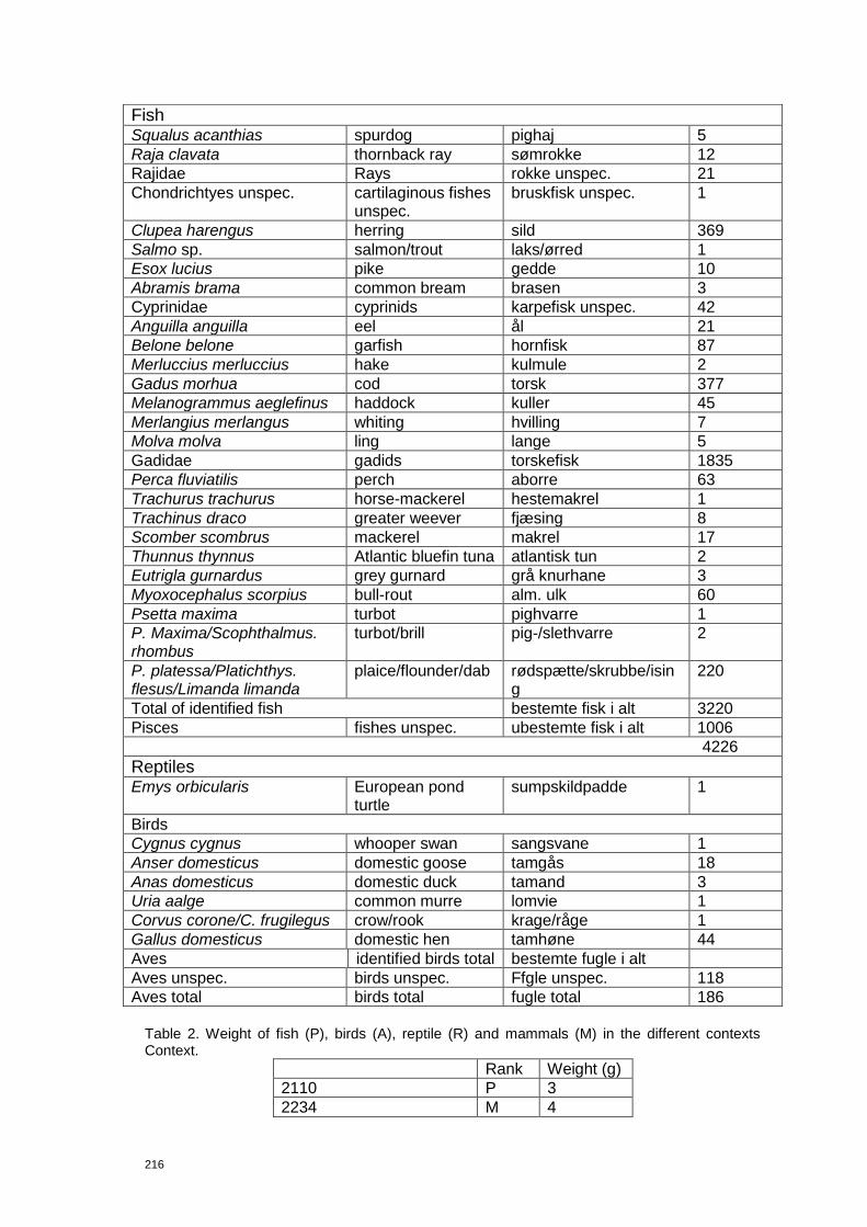
216
Table 2. Weight of fish (P), birds (A), reptile (R) and mammals (M) in the different contexts Context.
Rank Weight (g)
2110 P 3
2234 M 4
Fish Squalus acanthias spurdog pighaj 5
Raja clavata thornback ray sømrokke 12
Rajidae Rays rokke unspec. 21
Chondrichtyes unspec. cartilaginous fishes unspec.
bruskfisk unspec. 1
Clupea harengus herring sild 369
Salmo sp. salmon/trout laks/ørred 1
Esox lucius pike gedde 10
Abramis brama common bream brasen 3
Cyprinidae cyprinids karpefisk unspec. 42
Anguilla anguilla eel ål 21
Belone belone garfish hornfisk 87
Merluccius merluccius hake kulmule 2
Gadus morhua cod torsk 377
Melanogrammus aeglefinus haddock kuller 45
Merlangius merlangus whiting hvilling 7
Molva molva ling lange 5
Gadidae gadids torskefisk 1835
Perca fluviatilis perch aborre 63
Trachurus trachurus horse-mackerel hestemakrel 1
Trachinus draco greater weever fjæsing 8
Scomber scombrus mackerel makrel 17
Thunnus thynnus Atlantic bluefin tuna atlantisk tun 2
Eutrigla gurnardus grey gurnard grå knurhane 3
Myoxocephalus scorpius bull-rout alm. ulk 60
Psetta maxima turbot pighvarre 1
P. Maxima/Scophthalmus. rhombus
turbot/brill pig-/slethvarre 2
P. platessa/Platichthys. flesus/Limanda limanda
plaice/flounder/dab rødspætte/skrubbe/ising
220
Total of identified fish bestemte fisk i alt 3220
Pisces fishes unspec. ubestemte fisk i alt 1006
4226
Reptiles Emys orbicularis European pond
turtle sumpskildpadde 1
Birds
Cygnus cygnus whooper swan sangsvane 1
Anser domesticus domestic goose tamgås 18
Anas domesticus domestic duck tamand 3
Uria aalge common murre lomvie 1
Corvus corone/C. frugilegus crow/rook krage/råge 1
Gallus domesticus domestic hen tamhøne 44
Aves identified birds total bestemte fugle i alt
Aves unspec. birds unspec. Ffgle unspec. 118
Aves total birds total fugle total 186
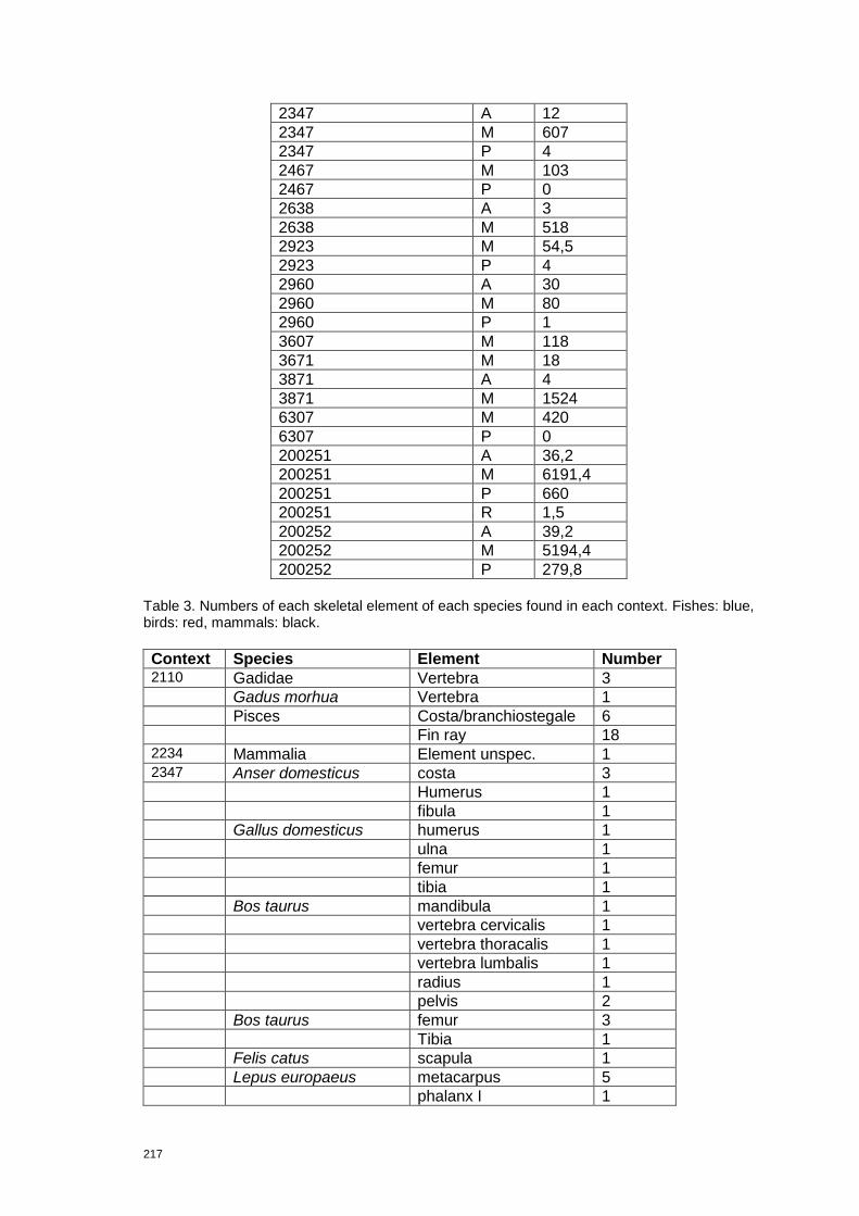
217
2347 A 12
2347 M 607
2347 P 4
2467 M 103
2467 P 0
2638 A 3
2638 M 518
2923 M 54,5
2923 P 4
2960 A 30
2960 M 80
2960 P 1
3607 M 118
3671 M 18
3871 A 4
3871 M 1524
6307 M 420
6307 P 0
200251 A 36,2
200251 M 6191,4
200251 P 660
200251 R 1,5
200252 A 39,2
200252 M 5194,4
200252 P 279,8
Table 3. Numbers of each skeletal element of each species found in each context. Fishes: blue, birds: red, mammals: black.
Context Species Element Number 2110 Gadidae Vertebra 3 Gadus morhua Vertebra 1 Pisces Costa/branchiostegale 6 Fin ray 18 2234 Mammalia Element unspec. 1 2347 Anser domesticus costa 3
Humerus 1
fibula 1
Gallus domesticus humerus 1
ulna 1
femur 1
tibia 1
Bos taurus mandibula 1
vertebra cervicalis 1
vertebra thoracalis 1
vertebra lumbalis 1
radius 1
pelvis 2
Bos taurus femur 3
Tibia 1
Felis catus scapula 1
Lepus europaeus metacarpus 5
phalanx I 1

218
Mammalia unspec. element unspec. 22
costa 7
long bone unspec. 1
phalanx I 1
Ovis aries calcaneus 1
Ovis aries/Capra hircus mandibula 1
præmolar/molar 1
vertebra thoracalis 1
costa 5
scapula 2
pelvis 3
Ovis aries/Capra hircus tibia 1
Sus domesticus vertebra cervicalis 1
vertebra thoracalis 3
femur 1
phalanx I 1