OCCL: TF CDUA: HA-3885 Acceptance Date: January 3, 2022 ...
240
DAVID Y. IGE GOVERNOR OF HAWAII SUZANNE D. CASE CHAIRPERSON BOARD OF LAND AND NATURAL RESOURCES COMMISSION ON WATER RESOURCE MANAGEMENT ROBERT K. MASUDA FIRST DEPUTY M. KALEO MANUEL DEPUTY DIRECTOR - WATER AQUATIC RESOURCES BOATING AND OCEAN RECREATION BUREAU OF CONVEYANCES COMMISSION ON WATER RESOURCE MANAGEMENT CONSERVATION AND COASTAL LANDS CONSERVATION AND RESOURCES ENFORCEMENT ENGINEERING FORESTRY AND WILDLIFE HISTORIC PRESERVATION KAHOOLAWE ISLAND RESERVE COMMISSION LAND STATE PARKS STATE OF HAWAII DEPARTMENT OF LAND AND NATURAL RESOURCES OFFICE OF CONSERVATION AND COASTAL LANDS POST OFFICE BOX 621 HONOLULU, HAWAII 96809 REF: OCCL: TF CDUA: HA-3885 Acceptance Date: January 3, 2022 180-Day Exp. Date: July 2, 2022 H 478 S. King Street Honolulu, HI 96813 SUBJECT: Publication of Final Environmental Assessment & FONSI Conservation District Use Application (CDUA) HA-3885 for the Roehrig Single-Family Residence, Landscaping, and Related Improvements project located at 14-3543 Government Beach Road, Waawaa Subdivision, -4-028:008 To whom it may concern: Attached, please find the Final Environmental Assessment (EA) for Conservation District Use Application (CDUA) HA-3885 and our Department's determination of a Finding of No Significant Impact (FONSI). The Final EA will be published in the Environmental Review Program April 23 rd , 2022 edition of The Environmental Notice. These documents may also be found online at our website dlnr.hawaii.gov/occl under current applications. Please make this information readily available to those people who may wish to review it. Should you have questions, contact Trevor Fitzpatrick of our Office of Conservation and Coastal Lands staff at (808) 798-6660 or [email protected]. Sincerely, Michael Cain, Acting Administrator Office of Conservation and Coastal Lands Attachments
-
Upload
khangminh22 -
Category
Documents
-
view
3 -
download
0
Transcript of OCCL: TF CDUA: HA-3885 Acceptance Date: January 3, 2022 ...
DAVID Y. IGEGOVERNOR OF
HAWAII
SUZANNE D. CASECHAIRPERSON
BOARD OF LAND AND NATURAL RESOURCESCOMMISSION ON WATER RESOURCE MANAGEMENT
ROBERT K. MASUDAFIRST DEPUTY
M. KALEO MANUELDEPUTY DIRECTOR - WATER
AQUATIC RESOURCESBOATING AND OCEAN RECREATION
BUREAU OF CONVEYANCESCOMMISSION ON WATER RESOURCE MANAGEMENT
CONSERVATION AND COASTAL LANDSCONSERVATION AND RESOURCES ENFORCEMENT
ENGINEERINGFORESTRY AND WILDLIFEHISTORIC PRESERVATION
KAHOOLAWE ISLAND RESERVE COMMISSIONLAND
STATE PARKS
STATE OF HAWAIIDEPARTMENT OF LAND AND NATURAL RESOURCES
OFFICE OF CONSERVATION AND COASTAL LANDSPOST OFFICE BOX 621
HONOLULU, HAWAII 96809REF: OCCL: TF CDUA: HA-3885
Acceptance Date: January 3, 2022180-Day Exp. Date: July 2, 2022
H478 S. King StreetHonolulu, HI 96813
SUBJECT: Publication of Final Environmental Assessment & FONSIConservation District Use Application (CDUA) HA-3885 for the Roehrig Single-Family Residence, Landscaping, and Related Improvements project located at 14-3543 Government Beach Road, Waawaa Subdivision,
-4-028:008
To whom it may concern:
Attached, please find the Final Environmental Assessment (EA) for Conservation District Use Application (CDUA) HA-3885 and our Department's determination of a Finding of No Significant Impact (FONSI). The Final EA will be published in the Environmental Review Program April 23rd, 2022 edition of The Environmental Notice. These documents may also be found online at our website dlnr.hawaii.gov/occl under current applications.
Please make this information readily available to those people who may wish to review it. Should you have questions, contact Trevor Fitzpatrick of our Office of Conservation and Coastal Lands staff at (808) 798-6660 or [email protected].
Sincerely,
Michael Cain, Acting AdministratorOffice of Conservation and Coastal Lands
Attachments
From: [email protected]: DBEDT OPSD Environmental Review ProgramSubject: New online submission for The Environmental NoticeDate: Tuesday, April 12, 2022 10:01:21 AM
Action Name
Roehrig Single-Family Residence in the Conservation District in Wa‘awa‘a
Type of Document/Determination
Final environmental assessment and finding of no significant impact (FEA-FONSI)
HRS §343-5(a) Trigger(s)
(2) Propose any use within any land classified as a conservation district
Judicial district
Puna, Hawaiʻi
Tax Map Key(s) (TMK(s))
(3) 1-4-028:008
Action type
Applicant
Other required permits and approvals
County of Hawai‘i: Special Management Area Permit Plan Approval and Grubbing, Grading, and BuildingPermits Driveway Access Permit State of Hawai‘i: Conservation District Use Permit Wastewater SystemApproval Chapter 6E SHPD Approval of Archaeological Survey
Discretionary consent required
Conservation District Use Permit
Approving agency
Hawaii Department of Land and Natural Resources
Agency contact name
Trevor Fitzpatrick
Agency contact email (for info about the action)
Email address or URL for receiving comments
Agency contact phone
(808) 798-6660
Agency address
1151 Punchbowl Street #131Honolulu, HI 96813United States
Map It
Applicant
Christopher and Wendi Roehrig
Applicant contact name
James Leonard
Applicant contact email
Applicant contact phone
(808) 987-4826
Applicant address
64-629 Kololala PlaceKamuela, HI 96743United StatesMap It
Was this submittal prepared by a consultant?
Yes
Consultant
GEOMETRICIAN ASSOCIATES, LLC
Consultant contact name
RON TERRY
Consultant contact email
Consultant contact phone
(808) 987-5239
Consultant address
10 Hina StreetHilo, HI 96720United StatesMap It
Action summary
Applicants propose a home on their 0.459-acre shoreline property within a subdivision in Puna. The 1-story home will be set back 70 feet from the shoreline and will have 2,356-square of interior space, 2bedrooms, 2 baths, a front fence and gate, and a garage and lanai. The off-grid home will have rooftopsolar PV. The project includes landscaping with the natural hala/naupaka vegetation and replaces halatrees that need to be removed within areas that have or will have invasive trees removed. No threatenedand endangered plants are present, and no archaeological sites are present. Grading will be minimal andmitigated by BMPs. Clearing timing restrictions will help prevent impacts to endangered Hawaiian hoarybats. Cultural practices in the form of fishing and gathering sometimes occur makai of the lot and wouldnot be adversely affected.
Reasons supporting determination
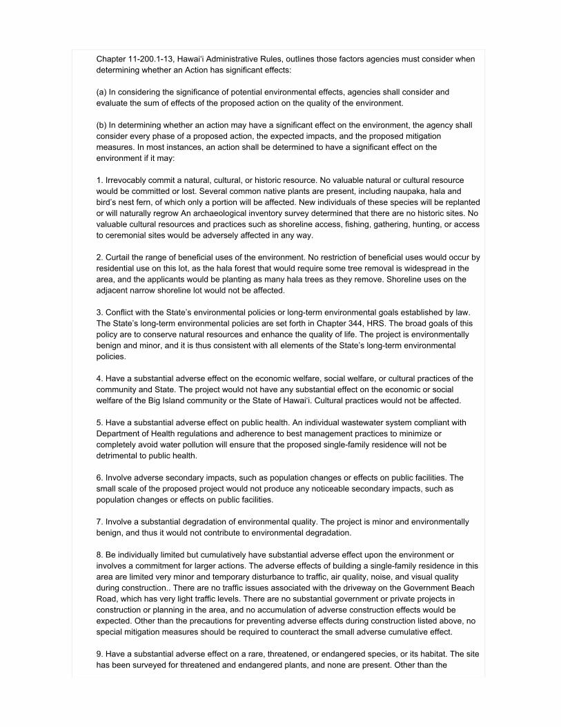
Chapter 11-200.1-13, Hawai‘i Administrative Rules, outlines those factors agencies must consider whendetermining whether an Action has significant effects:
(a) In considering the significance of potential environmental effects, agencies shall consider andevaluate the sum of effects of the proposed action on the quality of the environment.
(b) In determining whether an action may have a significant effect on the environment, the agency shallconsider every phase of a proposed action, the expected impacts, and the proposed mitigationmeasures. In most instances, an action shall be determined to have a significant effect on theenvironment if it may:
1. Irrevocably commit a natural, cultural, or historic resource. No valuable natural or cultural resourcewould be committed or lost. Several common native plants are present, including naupaka, hala andbird’s nest fern, of which only a portion will be affected. New individuals of these species will be replantedor will naturally regrow An archaeological inventory survey determined that there are no historic sites. Novaluable cultural resources and practices such as shoreline access, fishing, gathering, hunting, or accessto ceremonial sites would be adversely affected in any way.
2. Curtail the range of beneficial uses of the environment. No restriction of beneficial uses would occur byresidential use on this lot, as the hala forest that would require some tree removal is widespread in thearea, and the applicants would be planting as many hala trees as they remove. Shoreline uses on theadjacent narrow shoreline lot would not be affected.
3. Conflict with the State’s environmental policies or long-term environmental goals established by law.The State’s long-term environmental policies are set forth in Chapter 344, HRS. The broad goals of thispolicy are to conserve natural resources and enhance the quality of life. The project is environmentallybenign and minor, and it is thus consistent with all elements of the State’s long-term environmentalpolicies.
4. Have a substantial adverse effect on the economic welfare, social welfare, or cultural practices of thecommunity and State. The project would not have any substantial effect on the economic or socialwelfare of the Big Island community or the State of Hawai‘i. Cultural practices would not be affected.
5. Have a substantial adverse effect on public health. An individual wastewater system compliant withDepartment of Health regulations and adherence to best management practices to minimize orcompletely avoid water pollution will ensure that the proposed single-family residence will not bedetrimental to public health.
6. Involve adverse secondary impacts, such as population changes or effects on public facilities. Thesmall scale of the proposed project would not produce any noticeable secondary impacts, such aspopulation changes or effects on public facilities.
7. Involve a substantial degradation of environmental quality. The project is minor and environmentallybenign, and thus it would not contribute to environmental degradation.
8. Be individually limited but cumulatively have substantial adverse effect upon the environment orinvolves a commitment for larger actions. The adverse effects of building a single-family residence in thisarea are limited very minor and temporary disturbance to traffic, air quality, noise, and visual qualityduring construction.. There are no traffic issues associated with the driveway on the Government BeachRoad, which has very light traffic levels. There are no substantial government or private projects inconstruction or planning in the area, and no accumulation of adverse construction effects would beexpected. Other than the precautions for preventing adverse effects during construction listed above, nospecial mitigation measures should be required to counteract the small adverse cumulative effect.
9. Have a substantial adverse effect on a rare, threatened, or endangered species, or its habitat. The sitehas been surveyed for threatened and endangered plants, and none are present. Other than the

Hawaiian hoary bat, an island wide-ranging species that will experience no adverse impacts due tomitigation in the form of timing of vegetation removal, no rare, threatened or endangered species of faunaare known to exist on or near the project site, and none would be affected by any project activities. Onlyvery minor exterior lighting is planned, and it will be shielded and will consist blue-deficient lighting suchas filtered LED lights or amber LED lights, with a Correlated Color Temperature (CCT) of 2700 Kelvin.This will reduce the risk that transiting threatened or endangered seabirds may be attracted to and thendisoriented by the lighting.
10. Have a substantial adverse effect on air or water quality or ambient noise levels. No substantialeffects to air, water, or ambient noise would occur. Erosion and sedimentation impacts will be avoided byimplementation of Best Management Practices during grading, which will occur in a very limited area.Brief, temporary noise effects would occur during construction, but sequential house construction is anormal fact of life in rural Puna subdivisions and does not represent an undue impact to neighbors, whothemselves underwent the same process. No parks, medical facilities, or other sensitive uses are nearby.
11. Have a substantial adverse effect on or be likely to suffer damage by being located in anenvironmentally sensitive area such as a flood plain, tsunami zone, sea level rise exposure area, beach,erosion-prone area, geologically hazardous land, estuary, fresh water, or coastal waters. The proposedhome site is not located in a flood zone nor would it affect one. In general, geologic conditions do notimpose undue constraints on the proposed action, although, as with all of the Puna District, there issubstantial volcanic hazard. The house will meet or exceed all seismic hazard standards. The housewould be set back a minimum of 70 feet from the shoreline, and at an elevation of about 30 feet abovesea level, it is unlikely to be affected directly by sea level rise or the very slow retreat of shoreline cliffs.The project has adapted to climate change by accounting for the potential for larger storms, throughminimizing hard surfaces that generate runoff and removing nearby tall invasive trees. The applicantsunderstand that there are hazards associated with homes in this geologic setting and has made thedecision that a residence is not imprudent to construct or inhabit.
12. Have a substantial adverse effect on scenic vistas and viewplanes, during day or night, identified incounty or state plans or studies. No protected scenic views are located nearby or would be affected inany way. The proposed use is consistent with other single-family residential uses in the area, includingthe adjacent home on the west, another home one lot away to the east, and homes across the street.Due to the small size of the lot, the home will be visible, but not obtrusive. It will not be visible from thenearest State highway (State Highway 130). Only very minor exterior lighting is planned, and it will beshielded and will consist blue-deficient lighting such as filtered LED lights or amber LED lights, with aCorrelated Color Temperature (CCT) of 2700 Kelvin. This will protect dark skies and reduce the risk thatthe threatened or endangered seabirds may be attracted to and then disoriented by the lighting.
13. Require substantial energy consumption or emit substantial greenhouse gases. Negligible amounts ofenergy input and greenhouse gas emission would be required for construction and occupation of theresidence. The residence is designed as a single structure with efficient use of energy and materials andnatural ventilation and lighting. Electrical power to the home would be provided primarily by rooftop solarphotovoltaic panels. A rooftop solar water heater would supply hot water. Even with a propane gas tankto support cooking and the back-up generator and water heater, energy use and greenhouse gasemissions from use of the home would be minimal.
Attached documents (signed agency letter & EA/EIS)
FONSI-Roehrig-SFR-in-Waawaa-part-1-signed.pdfFinal-EA-Roehrig-Single-Family-Residence-in-Conservation-District.pdf
Shapefile
The location map for this Final EA is the same as the location map for the associated Draft EA.
Action location map

Roehrig-Property.zip
Authorized individual
Ron Terry
Authorization
The above named authorized individual hereby certifies that he/she has the authority to make thissubmission.
Final Environmental Assessment
Roehrig Single-Family Residence in the Conservation District in Wa‘awa‘a
April 2022
TMK (3rd): 1-4-028:008 Wa‘awa‘a, Puna District, County of Hawai‘i, State of Hawai‘i
APPLICANTS: Christopher and Wendi Roehrig 64-629 Kolohala Place Kamuela, Hawai‘i 96743 DETERMINING AGENCY:
State of Hawai‘i Department of Land and Natural Resources Office of Conservation and Coastal Lands 1151 Punchbowl Street, Room 131 Honolulu, Hawai‘i 96813
CONSULTANT:
Geometrician Associates LLC 10 Hina Street Hilo, Hawai‘i 96720

Final Environmental Assessment
Roehrig Single-Family Residence in the Conservation District in Wa‘awa‘a
TMK (3rd): 1-4-028:008 Wa‘awa‘a, Puna District, County of Hawai‘i, State of Hawai‘i
APPLICANTS: Christopher and Wendi Roehrig 64-629 Kolohala Place Kamuela, Hawai‘i 96743 DETERMINING AGENCY:
State of Hawai‘i Department of Land and Natural Resources Office of Conservation and Coastal Lands 1151 Punchbowl Street, Room 131 Honolulu, Hawai‘i 96813
CONSULTANT:
Geometrician Associates LLC 10 Hina Street Hilo, Hawai‘i 96720
CLASS OF ACTION:
Use of Land in Conservation District
This document is prepared pursuant to: The Hawai‘i Environmental Policy Act, Chapter 343, Hawai‘i Revised Statutes (HRS), and Title 11, Chapter 200.1, Hawai‘i Department of Health Administrative Rules (HAR)

[This page intentionally left blank]
Roehrig Single-Family Residence in Wa‘awa‘a Environmental Assessment
Page i
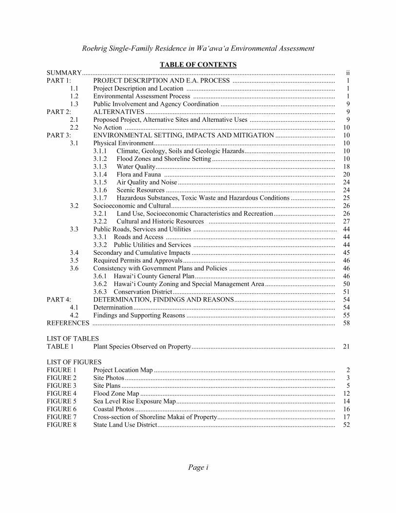
TABLE OF CONTENTS SUMMARY .................................................................................................................................................... ii PART 1: PROJECT DESCRIPTION AND E.A. PROCESS ............................................................ 1
1.1 Project Description and Location ....................................................................................... 1 1.2 Environmental Assessment Process ................................................................................... 1 1.3 Public Involvement and Agency Coordination ................................................................... 9
PART 2: ALTERNATIVES ............................................................................................................... 9 2.1 Proposed Project, Alternative Sites and Alternative Uses .................................................. 9 2.2 No Action ........................................................................................................................... 10
PART 3: ENVIRONMENTAL SETTING, IMPACTS AND MITIGATION ................................... 10 3.1 Physical Environment .......................................................................................................... 10
3.1.1 Climate, Geology, Soils and Geologic Hazards ..................................................... 10 3.1.2 Flood Zones and Shoreline Setting ........................................................................ 10 3.1.3 Water Quality ......................................................................................................... 18 3.1.4 Flora and Fauna .................................................................................................... 20 3.1.5 Air Quality and Noise ............................................................................................ 24 3.1.6 Scenic Resources ................................................................................................... 24 3.1.7 Hazardous Substances, Toxic Waste and Hazardous Conditions .......................... 25
3.2 Socioeconomic and Cultural ................................................................................................ 26 3.2.1 Land Use, Socioeconomic Characteristics and Recreation .................................... 26 3.2.2 Cultural and Historic Resources .......................................................................... 27
3.3 Public Roads, Services and Utilities .................................................................................... 44 3.3.1 Roads and Access ................................................................................................... 44 3.3.2 Public Utilities and Services ................................................................................... 44
3.4 Secondary and Cumulative Impacts .................................................................................... 45 3.5 Required Permits and Approvals ......................................................................................... 46 3.6 Consistency with Government Plans and Policies .............................................................. 46
3.6.1 Hawai‘i County General Plan .................................................................................. 46 3.6.2 Hawai‘i County Zoning and Special Management Area ......................................... 50 3.6.3 Conservation District ............................................................................................... 51
PART 4: DETERMINATION, FINDINGS AND REASONS ........................................................... 54 4.1 Determination ...................................................................................................................... 54 4.2 Findings and Supporting Reasons ....................................................................................... 55
REFERENCES .............................................................................................................................................. 58 LIST OF TABLES TABLE 1 Plant Species Observed on Property .................................................................................... 21 LIST OF FIGURES FIGURE 1 Project Location Map .......................................................................................................... 2 FIGURE 2 Site Photos ........................................................................................................................... 3 FIGURE 3 Site Plans ............................................................................................................................. 5 FIGURE 4 Flood Zone Map .................................................................................................................. 12 FIGURE 5 Sea Level Rise Exposure Map ............................................................................................. 14 FIGURE 6 Coastal Photos ..................................................................................................................... 16 FIGURE 7 Cross-section of Shoreline Makai of Property ..................................................................... 17 FIGURE 8 State Land Use District ........................................................................................................ 52
Roehrig Single-Family Residence in Wa‘awa‘a Environmental Assessment
Page ii
APPENDIX 1a Comments in Response to Early Consultation APPENDIX 1b Comments to Draft EA and Responses APPENDIX 2 Archaeological Inventory Survey APPENDIX 3 Coastal Erosion Study APPENDIX 4 Cultural Consultation Report
SUMMARY OF PROJECT, ENVIRONMENTAL IMPACTS AND MITIGATION MEASURES
Christopher and Wendi Roehrig (the applicants) seek a Conservation District Use Permit (CDUP) to build a single-family residence on their 0.459-acre property located makai of the Government Beach Road in the Conservation District in the Wa‘awa‘a Residential Subdivision. This area is between the Hawaiian Shores Subdivision and the Four Corners area of Kapoho, in Lower Puna on the Island of Hawai‘i. The plan for the home, which they have named “Uluhala” (Hala Grove), consists of an approximately 2,356-square foot, 2-bedroom, 2-bath, single-story structure with a living room, kitchen and dining area, pantry, lanai, breezeway and garage. The home will feature roof-mounted solar photovoltaic and solar water heating panels, rainfall water catchment and storage, propane gas for cooking and backup water heating and electric power, a gravel driveway, fencing and a driveway gate on the mauka road boundary, and an individual wastewater system. The project includes minimal landscaping emphasizing the natural hala/naupaka vegetation and replaces hala trees that need to be removed for the driveway and home site in areas that have already had or will have invasive trees removed. The proposed home site would be subtly placed in the middle of the lot, partially hidden from the Government Beach Road by existing and new planted hala trees. It will be set back a minimum of 70 feet from the shoreline, which is within a long, narrow common Beach Reserve lot that lies between the coastal residential lots of the subdivision and the sea. The house location is in a slightly elevated, relatively level portion of the property that is outside the native coastal vegetation zone of naupaka, avoiding any coastal hazards and effects on shoreline resources and processes. Landclearing and construction activities would occur over an area of less than 0.2 acres, with very minor short-term impacts to noise, air and water quality and scenery. These would be mitigated by Best Management Practices associated with the CDUP and grading permit. The applicants will ensure that all earthwork and grading conforms to applicable laws, regulations and standards. No streams or other water features are present on the lot. The site has been surveyed for threatened and endangered plants, and none are present. Impacts to the island wide-ranging endangered Hawaiian hoary bat will be avoided through timing of vegetation removal. Cultural practices in the form of fishing and gathering sometimes occur makai of the lot and would not be adversely affected. An archaeological inventory survey determined that no sites are present. In the unlikely event that additional undocumented archaeological resources, including shell, bones, midden deposits, lava tubes, or similar finds, are encountered during construction, work in the immediate area of the discovery will be halted and the State Historic Preservation Division will be contacted to determine the appropriate actions.
Roehrig Single-Family Residence in Wa‘awa‘a Environmental Assessment
Page 1
PART 1: PROJECT DESCRIPTION AND E.A. PROCESS
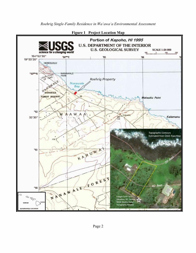
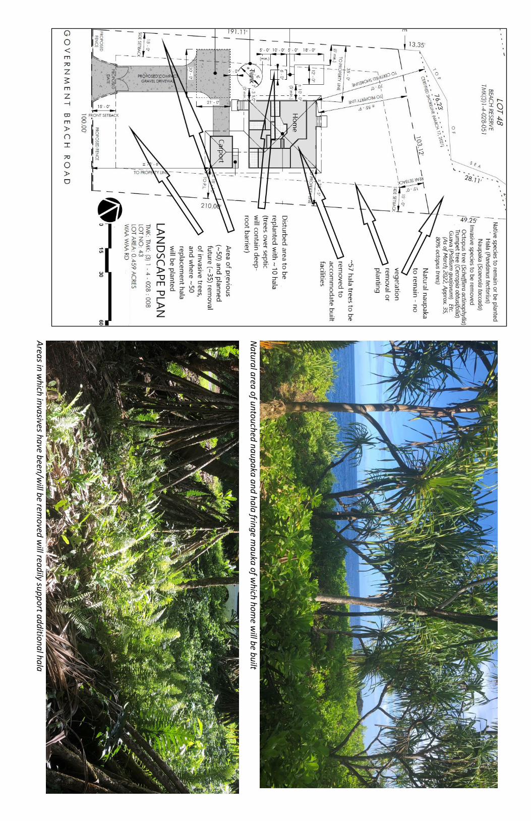
1.1 Project Description and Location Christopher and Wendi Roehrig (the applicants) seek a Conservation District Use Permit (CDUP) to build a single-family residence on their 0.459-acre property located makai of the Government Beach Road in the Conservation District in the Wa‘awa‘a Residential Subdivision (Figures 1-2). This area is between the Hawaiian Shores subdivision and the Four Corners area of Kapoho, in Puna on the Island of Hawai‘i. The plan for the home, which they have named “Uluhala” (Hala Grove), consists of an approximately 2,356-square foot, 2-bedroom, 2-bath, single-story structure with a living room, kitchen and dining area, pantry, lanai, breezeway and garage. The home will feature roof-mounted solar photovoltaic and solar water heating panels, rainfall water catchment and 10,000-gallon storage tank, propane gas for cooking and backup water heating and electric power, a redwood panel-gated gravel driveway, redwood panel fencing on the mauka boundary, and an individual wastewater system. The project includes minimal landscaping emphasizing the natural hala/naupaka vegetation and replaces hala trees that need to be removed for the driveway and home site in areas that have already had or will have invasive trees removed (see Landscape Plan, page 8). The Total Development Area for the residence, per Title 13-5, HAR, Exhibit 4, which includes such features such as water and propane storage tanks, is 2,573 sf. No streams, threatened or endangered plants or archaeological sites are present on the lot. The proposed home site would be subtly placed in the middle of the lot, partially hidden from the Government Beach Road by existing and new planted hala trees. It will be set back a minimum of 70 feet from the shoreline, which is within a long, narrow common Beach Reserve lot that lies between the coastal residential lots of the subdivision and the sea. The house location is in a slightly elevated, relatively level portion of the property that is outside the native coastal vegetation zone of naupaka, avoiding any coastal hazards and effects on shoreline resources and processes. Landclearing and construction activities including the home, driveway, turnaround area, utility structures, catchment tank, and septic system would occur over an area of less than 0.2 acres. Very minor short-term impacts to noise, air and water quality and scenery would be mitigated by Best Management Practices associated with the CDUP and grading permit. 1.2 Environmental Assessment Process This Environmental Assessment (EA) is being conducted in accordance with Chapter 343 of the Hawai‘i Revised Statutes (HRS). This law, along with its implementing regulations, Title 11, Chapter 200.1, of the Hawai‘i Administrative Rules (HAR), is the basis for the environmental impact assessment process in the State of Hawai‘i. According to Chapter 343, an EA is prepared to determine impacts associated with an action, to develop mitigation measures for adverse impacts, and to determine whether any of the impacts are significant according to thirteen specific criteria. Part 4 of this document states the preliminary finding that no significant impacts are expected to occur, based on the findings for each criterion made by the consultant in consultation with the Hawai‘i State Department of Land and Natural Resources (DLNR), the determining agency. If, after considering comments to the Draft EA, DLNR concludes that no significant impacts would be expected to occur, then the agency will issue a Finding of No Significant Impact
Roehrig Single-Family Residence in Wa‘awa‘a Environmental Assessment
Page 2
Figure 1 Project Location Map
Roehrig Single-Family Residence in Wa‘awa‘a Environmental Assessment
Page 3
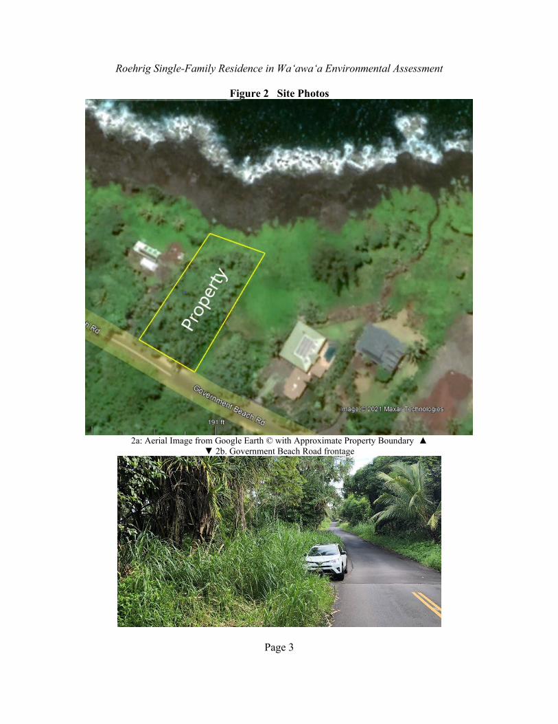
Figure 2 Site Photos
2a: Aerial Image from Google Earth © with Approximate Property Boundary ▲
▼ 2b. Government Beach Road frontage

Roehrig Single-Family Residence in Wa‘awa‘a Environmental Assessment
Page 4
Figure 2. Site Photos
2c. ▲ Interior of lot
▼ 2d. Shoreline area, naupaka and hala zone

G O V E R N M E N T B E A C H R O A D
PROPOSED 2 BEDRM / 2 BATH DWELLING W/ 1-CAR GARAGE
PROPOSED SEPTIC SYSTEM(REFER TO ENGINEERED DRAWINGS)
PRO
POSE
D C
OM
PAC
T G
RAVE
L D
RIVE
WA
Y
PROPOSED WATERCATCHMENT TANK
TO PRO
PERTY LINE
± 55' - 9"
TO PROPERTY LINE
± 23' - 5"
TO P
R OPE
RTY
LIN
E
± 7
3' -
6"
FRO
NT
SETB
ACK
15' -
0"
SIDE SETBACK
15' - 0"
REAR SETBACK
15' - 0"
SIDE SETBACK
15' - 0"
210.
00'
100.00'
103.12'
191.
11'
(5' min.)
7' - 3 1/2"
TO C
ERTIFIED SH
ORELIN
E70' - 0"
76.23'
28.1
1'
24.38'
49.2
5'
13.3
5'
TIE-LINE
CERTIFIED SHORELINE (MARCH 17, 2021)
P A C I F I C O C E A N
TO PROPERTY LINE
35' - 0"
TO P.L.
± 18' - 10"
PROPOSED GATE
PROPOSED FENCEPROPOSED
FENCE
(5' min.)
± 10' - 0"
18' -
0"
5' -
0"
10' -
0"
(min
.)
5' -
0"
(5' min.)
5' -
0"
ø 15
' - 6"
CONSTRUCTION STAGING AREA
30' - 0"
21' -
0"
LOT 48BEACH RESERVE
TMK(3)1-4-028-051
85.8
5'
12' - 0"
6' - 0"
T O P
O F
P A
L I
PROPOSED PROPANE STORAGE TANK (3' 6" X 8')
S E
A
DEVELOPMENT AREA TABULATION
RESIDENCELiving AreaGarageCovered LanaiBreezewayExterior Steps and LandingsTOTAL AREA - RESIDENCE
WATER STORAGE TANK
PROPANE STORAGE TANK
TOTAL DEVELOPMENT AREA
1,344.50 SF280.00 SF419.50 SF200.00 SF112.30 SF
2,356.30 SF
188.71 SF
28.00 SF
2,573.01 SF
SCALE:A P R O P O S E D N E W C O N S T R U C T I O N F O R :
HOME OWNER SIGNATUREBY SIGNING ABOVE, I ACKNOWLEDGE THAT I ACCEPT THE PRELIMINARY DRAWINGS APPROVED ABOVE AS MY FINAL DESIGN. I'M READY TO MOVE FORWARD WITH PREPARING CONSTRUCTION DOCUMENTS FOR MY PROJECT, AND UNDERSTAND THAT ANY CHANGES TO THE SCOPE OF THE PROJECT OR REVISIONS TO THE DESIGN/SPECIFICATIONS MAY RESULT IN ADDITIONAL DRAFTING OR PROJECT COSTS AND AFFECT MY PROJECT TIMELINE.
DATE:
REVISION NO.:
HOME PLANNING & DESIGN SERVICES BYHPM BUILDING SUPPLY
SHEET NO.:
As indicated
1 of 311/09/2021 CHRISTOPHER J ROEHRIG &
WENDI L ROEHRIGTMK: (3) 1 - 4 - 028 : 008
SITE PLANSCALE: 1" = 30' - 0"TMK: TMK: (3) 1 - 4 - 028 : 008LOT NO: 43LOT AREA: 0.459 ACRESWAA WAA RD, HAWAIIAN BEACHES, HAWAII
5
15 30 60 900
1' = 30'
jamesmleonard
16ʻ
jamesmleonard
jamesmleonard
jamesmleonard
6’ high fencing and gate to beconstructed using 6’ x 8’ lattice-topped, redwood panels
jamesmleonard
jamesmleonard
ENTRY GATE / FENCING

LIVING RM
6 "
P
L U
M B
I N
G
W A
L L
DINING
TUB/SHOWERCOMBO UNIT
W.C.
LAV.
CURT. ROD
L.T.
M/BEDRM.
COVERED LANAI
COVERED LANAI
KITCHEN
PANTRY
BEDRM #2M/BATH
12' - 6" 11' - 6" 5' - 6" 12' - 6"
42' - 0" OVERALL
10' -
6"
8' - 0" 3' - 6"
4' -
0"
2' -
0"
6' -
6"
2' -
6"
5' -
0"
14' -
0"
10' -
0"
26' -
0"
16' -
0"
66' -
0"
2' -
0"
14' -
0"
20' -
0"
6' -
0"
6' -
6"
3' -
6"
2' - 0" 10' - 0" 2' - 0" 10' - 0" 2' - 0" 14' - 0" 2' - 0"
24' - 0"
13' - 0"
5' -
0"
± 7' - 0"
2' -
0"
4' -
0"
16' -
6"
6' -
0"
13' -
6"
LITE-FANCOMBO
LITE-FANCOMBO
(INTE
RIO
R BR
AC
ED W
ALL
)
INTE
RIO
R BR
AC
ED W
ALL
)
(INTERIOR BRACED WALL) (INTERIOR BRACED WALL)
LAV
ROD & SH.
ROD & SH.
ROD
& S
H.
(5) - 1X12
BATH 2
FRAMED PONY WALL
UNDER
D.C. S/S SINK
W/ DISPO
SAL
(60" MIN.)
5' - 2"
5' - 6"
TOWELCLO.
5'-0" W X 4'-0"H 6'-0" W X 4'-0"H
2'-0" W X 3'-0"H 6'-0" W X 3'-6"H 4'-0" W X 1'-4"H
6'-0
" W X
3'-6
"H4'
-0" W
X 3
'-0"H
8'-0
" W X
4'-0
"H
5'-0
" W X
3'-6
"H5'
-0" W
X 3
'-6"H
4'-0
" W X
1'-4
"H
RANGE SPACE
REFRIG. SPACE
FIN
ISH
3' -
0"
ATTICACCESS
4' - 6" X 7'CONCRETE LANDING
10' - 0"
FINISH
3' - 0"
PLMG WALL
W.C.
TUB
/SH
OW
ERC
OM
BO
UN
IT
BREAKLINE OF CEILING CONDITION
5' - 6"
BRE
AK
LIN
E O
F C
EILI
NG
CO
ND
ITIO
N
VAU
LTED
CEI
LIN
GVA
ULT
EDC
EILI
NG
VAULTEDCEILING
4' - 6" X 7'CONCRETE LANDING
(2 min.)2' - 2"
(min.)3' - 0"
(5) - 1X12
(STEP)
(STEP)
'SOLAR W/HTR. STOR. TANK
VAULTEDCEILING
(STEP)
(STEP)
ENTRY
CU
RT.
ROD
(RAILING) (RAILING)
(RA
ILIN
G)
(RA
ILIN
G)
(RAILING)
(RA
ILIN
G)
(RA
ILIN
G)
(RA
ILIN
G)
SINGLE CAR GARAGE
BREEZEWAY
20' - 0"
14' -
0"
6'-0" W X 4'-0"H
2' -
0"
10' -
0"
2' -
0"
(RA
ILIN
G)
(SLO
PE S
LAB
TO
WA
RDS
ENTR
Y)
SOLAR WATERHEATINGPANELS
42' -
0"
4' - 3'- 6"CONC. LANDING
(STEP)
(STEP)
(STEP)
(STEP)
(SIMPSON 'MSTA36' PER CWSP REQ.)
(SIMPSON 'MSTA36' PER CWSP REQ.)
(SIMPSON 'MSTA36' PER CWSP REQ.)
(ENERGY STAR CEILING FAN)
(ENERGY STAR CEILING FAN)
(ENERGY STAR CEILING FAN)
(ENERGY STAR CEILING FAN)
PROPANE STORAGE TANK
8' - 0" 4' - 0"
(SO
LAR
BATT
ERY
LOC
ATI
ON
)
RESIDENCE AREA TABULATION
RESIDENCELiving AreaGarageCovered LanaiBreezewayExterior Steps and LandingsTOTAL AREA - RESIDENCE
1,344.50 SF280.00 SF419.50 SF200.00 SF112.30 SF
2,356.30 SF
SCALE:A P R O P O S E D N E W C O N S T R U C T I O N F O R :
HOME OWNER SIGNATUREBY SIGNING ABOVE, I ACKNOWLEDGE THAT I ACCEPT THE PRELIMINARY DRAWINGS APPROVED ABOVE AS MY FINAL DESIGN. I'M READY TO MOVE FORWARD WITH PREPARING CONSTRUCTION DOCUMENTS FOR MY PROJECT, AND UNDERSTAND THAT ANY CHANGES TO THE SCOPE OF THE PROJECT OR REVISIONS TO THE DESIGN/SPECIFICATIONS MAY RESULT IN ADDITIONAL DRAFTING OR PROJECT COSTS AND AFFECT MY PROJECT TIMELINE.
DATE:
REVISION NO.:
HOME PLANNING & DESIGN SERVICES BYHPM BUILDING SUPPLY
SHEET NO.:
As indicated
2 of 311/09/2021 CHRISTOPHER J ROEHRIG &
WENDI L ROEHRIGTMK: (3) 1 - 4 - 028 : 008
FLOOR PLANSCALE: 1/8" = 1' - 0"
5
2 4 8 12 16 20 240
1/8" = 1'
jamesmleonard
jamesmleonard
SOLAR BATTERYSTORAGE
jamesmleonard

FLOOR LINE
CEILING LINE
RIDGE LINE
FIN. GRADE
± 9
' - 6
"8'
- 0
"
(MA
X.)
2' -
0"
± 2
0' -
2"
PITCH
TOP OF CURB
5
12
PRE-PAINTED CORR. METAL ROOFING
5/8"th. PRECISIONSMART SIDINGOPEN TO LANAI OPEN TO LANAI OPEN TO LANAI
SOLAR WATER HEATING PANELS
(20) SOLAR PV PANELS
SCALE:A P R O P O S E D N E W C O N S T R U C T I O N F O R :
HOME OWNER SIGNATUREBY SIGNING ABOVE, I ACKNOWLEDGE THAT I ACCEPT THE PRELIMINARY DRAWINGS APPROVED ABOVE AS MY FINAL DESIGN. I'M READY TO MOVE FORWARD WITH PREPARING CONSTRUCTION DOCUMENTS FOR MY PROJECT, AND UNDERSTAND THAT ANY CHANGES TO THE SCOPE OF THE PROJECT OR REVISIONS TO THE DESIGN/SPECIFICATIONS MAY RESULT IN ADDITIONAL DRAFTING OR PROJECT COSTS AND AFFECT MY PROJECT TIMELINE.
DATE:
REVISION NO.:
HOME PLANNING & DESIGN SERVICES BYHPM BUILDING SUPPLY
SHEET NO.:
1/8" = 1'-0"
3 of 311/01/2021 CHRISTOPHER J ROEHRIG &
WENDI L ROEHRIGTMK: (3) 1 - 4 - 028 : 008
FRONT ELEVATIONSCALE: 1/8" = 1' - 0"
EXTERIOR PERSPECTIVESFACING OCEAN
FACING ROAD
2 4 8 12 16 20 240
1/8" = 1'
4
SOLAR WATER HEATING PANELS
(20) SOLAR PV PANELS
N
atural area of untouched naupaka and hala fringe mauka of w
hich home w
ill be built
Areas in w
hich invasives have been/will be rem
oved will readily support additional hala
Roehrig Single-Family Residence in Wa‘awa‘a Environmental Assessment
Page 9
(FONSI), and the action will be permitted to proceed to other necessary permits. If the agency concludes that significant impacts are expected to occur as a result of the proposed action, then an Environmental Impact Statement (EIS) will be prepared. 1.3 Public Involvement and Agency Coordination The following agencies, organizations and individuals have been consulted during the EA process: County: Planning Department County Council Civil Defense Agency Fire Department Department of Public Works Police Department
State: Department of Health Department of Land and Natural Resource (DLNR), Land Division and OCCL Office of Hawaiian Affairs Private: Sierra Club Hawai‘i Island Chamber of Commerce Three Adjacent Property Owners: Surdock, Blair, Bilinsky, Nelson Trust Malama O Puna
Copies of communications received during early consultation are contained in Appendix 1a. Notice of the availability of the Draft EA was published in the February 8, 2022 Environmental Notice. Appendix1b contains written comments on the Draft EA and the responses to these comments. Various places in the EA have been modified to reflect input received in the comment letters; additional or modified non-procedural text is denoted by double underlines, as in this paragraph. PART 2: ALTERNATIVES 2.1 Proposed Project, Alternative House Sites and Alternative Uses The proposed project and its location are described in Section 1.1 above and illustrated in Figures 1-3. The lot size is only 0.459 acres, limiting choices for location of the home site. As shown in Figure 3a, the home would be located roughly in the middle of the property, perched on a subtle rise that ascends out of the makai portion of the property. This maximizes shielding for viewers from the both the Government Beach Road and the sea. It affords coastal views and coastal breezes while avoiding shoreline hazards and interfering with shoreline processes and recreation. While a number of hala trees would require removal, disturbance would avoid the shoreline naupaka zone, and there is ample room on the property for additional hala to be planted, utilizing the abundant hala keiki. Other locations on the property could also serve as the site for a residence, but none have the advantages of the proposed site in terms of all three factors: breezes, views and shoreline hazard/resource avoidance. There are no known environmental or other reasons for seriously considering other sites on the property.
Roehrig Single-Family Residence in Wa‘awa‘a Environmental Assessment
Page 10
No other alternative uses for the property that are identified in the Conservation District Rules, such as a farm or tourist nature park, are desired by the applicants, and thus none are addressed in this EA. 2.2 No Action Under the No Action Alternative, the residence would not be built. The lot would remain unused, except for perhaps temporary camping and picnicking by the owner and his guests. This EA considers the No Action Alternative as the baseline by which to compare environmental effects from the project. PART 3: ENVIRONMENTAL SETTING, IMPACTS AND MITIGATION 3.1 Physical Environment 3.1.1 Climate, Geology, Soils and Geologic Hazards Environmental Setting Temperatures are warm year-round at the project site, with slightly cooler winters, and annual rainfall is about 103 inches. Winds are generally trade winds from the east/northeast, often with light downslope land breezes at night (UH Hilo Dept. of Geography 1998; Giambelluca et al. 2013). There is a scientific consensus that the earth is warming due to manmade increases in greenhouse gases in the atmosphere, according to the United Nations’ Intergovernmental Panel on Climate Change (UH Manoa Sea Grant 2014). Global mean air temperatures are projected to increase by at least 2.7°F by the end of the century. This will be accompanied by the warming of ocean waters, expected to be highest in tropical and subtropical seas of the Northern Hemisphere. Wet and dry season contrasts will increase, and wet tropical areas in particular are likely to experience more frequent and extreme precipitation. For Hawai‘i, where warming air temperatures are already quite apparent, not only is the equable climate at risk but also agriculture, ecosystems, the visitor industry and public health. Guidance to federal agencies for addressing climate change issues in environmental reviews was released in August 2016 by the Council on Environmental Quality (US CEQ 2016). The guidance urged that when addressing climate change, agencies should consider: 1) the potential effects of a proposed action on climate change as indicated by assessing greenhouse gas emissions in a qualitative, or if reasonable, quantitative way; and 2) the effects of climate change on a proposed action and its environmental impacts. It recommends that agencies consider the short- and long-term effects and benefits in the alternatives and mitigation analysis in terms of climate change effects and resiliency to the effects of a changing climate. The State of Hawai‘i in HRS §226-109 encourages a similar analysis, Title 11, Chapter 200.1 now require analysis of sea-level rise and greenhouse gases in environmental impact statements. It is possible, and even likely, that warmer temperatures and larger and more frequent tropical storms and hurricanes will affect Hawai‘i in the future. As discussed in Section 3.1.2, accelerating sea level rise is also expected. The project site is located on the flank of the active volcano Kilauea in the District of Puna, in the Wa‘awa‘a Ahupua‘a, on lava flows 750 and 1,500 years in age. It is about 1,000 feet southeast of an 1840

Roehrig Single-Family Residence in Wa‘awa‘a Environmental Assessment
Page 11
lava flow. A littoral (shoreline) cone created by the 1840 flow is present approximately a half mile to the northwest (Wolfe and Morris 1996). Soil in the area is Opihikao extremely rocky muck (3-25% slopes), part of a series of well-drained thin organic soils developed over pahoehoe bedrock. They are found from sea level to 1,000 feet in elevation and are rapidly permeable, with slow run-off and slight erosion hazard (U.S. Soil Conservation Service 1973). This soil is within subclass VIIs, which means it has limitations that make it unsuitable for cultivation and restrict its use to pasture, range, woodland or wildlife. The entire Big Island is subject to geologic hazards, especially lava flows and earthquakes. Volcanic hazard as assessed by the U.S. Geological Survey in this area of Puna is Zone 2 on a scale of ascending risk 9 to 1 (Heliker 1990:23). The relatively high hazard risk is because Kilauea is an active volcano. Zone 2 includes areas adjacent to and downslope of active rift zones. About 15 to 25 percent of the area has been covered by lava since 1800, and about 25 to 75 percent has been covered in the last 750 years. As such, there is some risk of lava inundation over a 50-year project span. Several towns and villages in Puna, including Pāhoa and Kalapana (as well as Kapoho, now covered by lava), are within Zone 2. The Island of Hawai‘i experiences high seismic activity and is at risk from earthquake damage (USGS 2000), especially to structures that are poorly designed or built, as the 6.7-magnitude quake of October 2006 and the 6.9-magnitude quake of May 2018 demonstrated. The property is moderately sloped and there are no issues with steep or unstable slopes. There does not appear to be a substantial risk at the site from subsidence, landslides or other forms of mass wasting. Impacts and Mitigation Measures In order to deal with the potential for larger and more frequent tropical storms that could be part of a changing climate, the home has been designed to withstand hurricane force winds. Electricity would be provided primarily by rooftop solar photovoltaic panels. A rooftop solar water heater would supply hot water. Propane would be used as backup for electrical power and hot water. These features would help minimize the greenhouse gas emissions from use of the residence. The implications of climate change and resulting sea level rise and coastal erosion are dealt with in the next section. In general, geologic conditions do not impose undue constraints on the proposed action. The applicants understand that there are hazards associated with homes in this geologic setting and have made the decision, like tens of thousands of other residents of the island, that a home in this area is not imprudent to construct or inhabit.
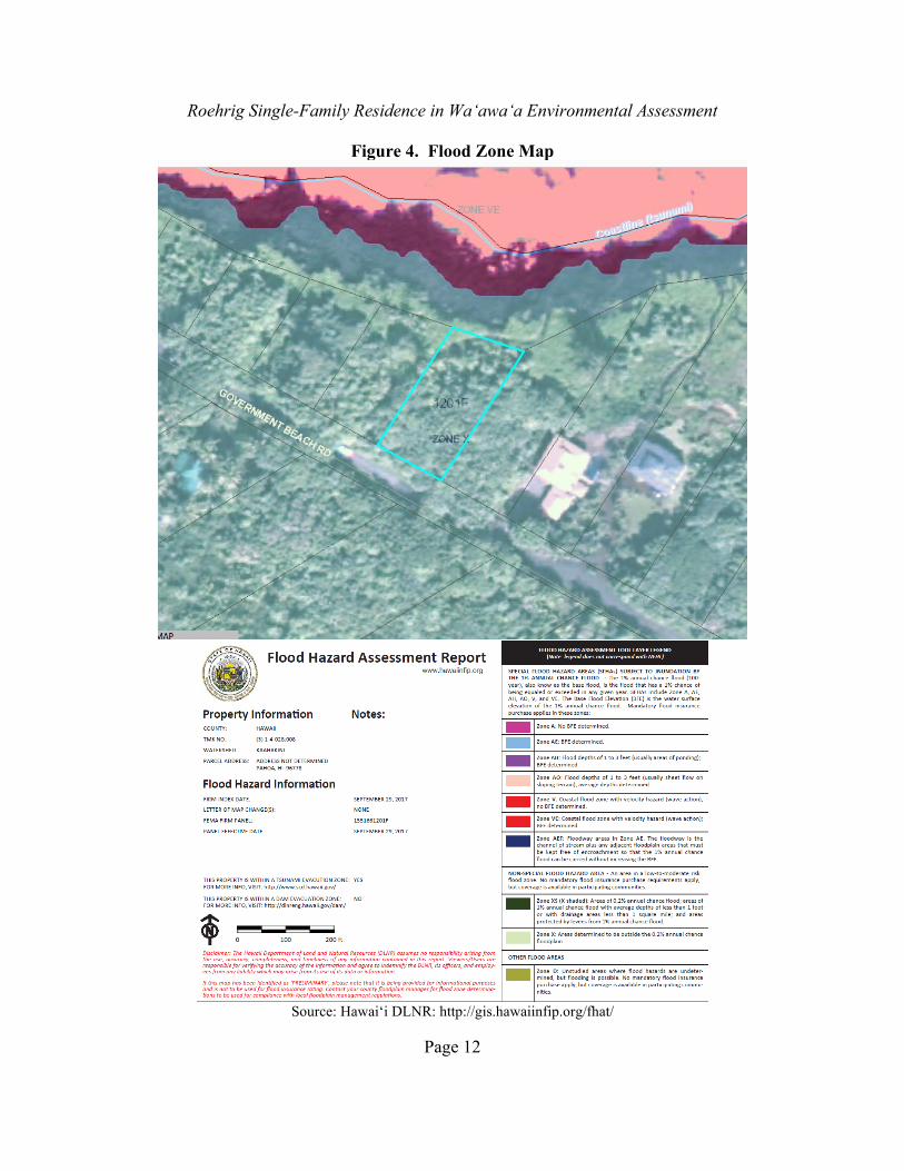
3.1.2 Flood Zones and Shoreline Setting Floodplain Environmental Setting, Impacts and Mitigation Measures Floodplain status for many areas of the island of Hawai‘i has been determined by the Federal Emergency Management Agency (FEMA), which produces the National Flood Insurance Program’s Flood Insurance Rate Maps (FIRM). The flood zones for this region were recently mapped, and digital maps are available from the Department of Land and Natural Resources at http://gis.hawaiinfip.org/fhat/ (Figure 4). The entire property is classified in Flood Zone X, areas with minimal flood hazards, including tsunami inundation.
Roehrig Single-Family Residence in Wa‘awa‘a Environmental Assessment
Page 12
Figure 4. Flood Zone Map
Source: Hawai‘i DLNR: http://gis.hawaiinfip.org/fhat/

Roehrig Single-Family Residence in Wa‘awa‘a Environmental Assessment
Page 13
Coastal Erosion, Coastal Hazards and Sea Level Rise Property near the shoreline is subject to natural coastal processes including erosion and accretion, which can be affected by human actions such as removal of sand or shoreline hardening. Erosion may adversely affect not only a lot owner’s improvements but also State land and waters, along with the recreational and ecosystem values they support. Hwang (2005) recommended that all hazards facing coastal areas – not just erosion – should be considered when planning for zoning in Hawai‘i. In a USGS-sponsored study, Fletcher et al. (2002) portrayed generalized hazards assessments for long sections of Hawai‘i’s coastlines. There are individual ratings for Tsunami, Stream Flooding, High Waves, Storms, Erosion, Sea Level Change, and Volcanic/ Seismic, culminating in an Overall Hazard Assessment. Based on Tsunami and High Waves, most of the Puna Coastline is rated 5 or 6 out of 7 for Overall Hazard. The Wa‘awa‘a area is rated 5. Because the proposed use of a single-family residence on this coastal property has an expected useful lifetime of 40 to 70 years, it is important to examine the potential for future sea level rise. Sea level rise also factors into future rates of coastal retreat and erosion. An overall global (or eustatic, meaning not attributable to local factors) rise in sea level of 3.3 feet by the end of the 21st century was proposed by Fletcher (2010) and others. More recent scientific assessments (e.g., Rahmstorf et al. 2012) posit 4 feet as a reasonable upper bound. Some recent research that concentrates on the potential for Antarctic melting to contribute more to sea level than generally modeled envisions as much as an additional 3 feet of sea level rise (DeConto and Pollard 2016). Not only the magnitude of sea level rise but also the timing is the subject of debate. According to the Hawaiʻi Climate Change Mitigation and Adaptation Commission (HCCMAC) (2017:v):
While the IPCC’s “business as usual” scenario, where GHG emissions continue at the current rate of increase, predicts up to 3.2 feet of global sea level rise by year 2100 (IPCC 2014), recent observations and projections suggest that this magnitude of sea level rise could occur as early as year 2060 under more recently published highest-end scenarios...
Relative sea-level rise is a result of the combined eustatic water rise and land subsidence. In some locations, the effects of eustatic sea level rise can be magnified substantially. The 1975 Kalapana earthquake on Kilauea’s rift caused land in Kapoho to drop 0.8 feet (based on Hawaiian Volcano Observatory (USGS) data in Hwang et al. (2007:6). This episodic, seismic-induced subsistence is difficult to estimate over human-scale time periods. On the basis of InSAR (Synthetic Aperture Radar Interferometry) remote sensing data, Hwang et al. (ibid.) stated that the coastline at Kapoho (prior to the 2018 eruption that completely covered the area) was subsiding at a continuous rate of between 0.31-0.67 in/yr. Rates of subsidence at the subject property are certainly much lower as a result of its distance from Kilauea’s tectonically active rift zone, as well as its position on the west side of the rift zone, where land is supported by the bulk of Mauna Loa. A rate in the middle of this estimate, or a little less than 0.5 in/yr., is probably conservative. A highly conservative estimate of overall sea level change by the year 2070, accounting for a eustatic rise of 5 feet and local tectonic sinking of about 2, is 7 feet. The greatest rate of SLR will take place during the second half of this century according to recent modeling (e.g., Cazenave and Le Cozannet 2014). Sea level rise exposure maps from the State of Hawai‘i indicate that the property
Roehrig Single-Family Residence in Wa‘awa‘a Environmental Assessment
Page 14
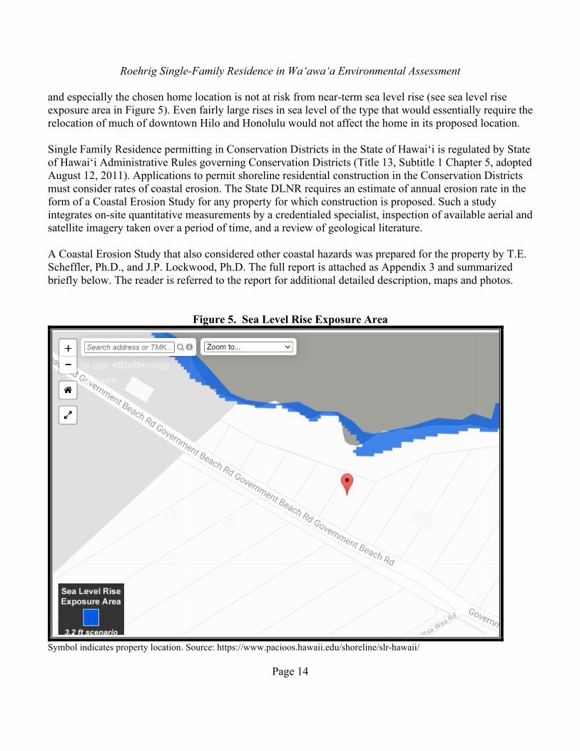
and especially the chosen home location is not at risk from near-term sea level rise (see sea level rise exposure area in Figure 5). Even fairly large rises in sea level of the type that would essentially require the relocation of much of downtown Hilo and Honolulu would not affect the home in its proposed location. Single Family Residence permitting in Conservation Districts in the State of Hawai‘i is regulated by State of Hawai‘i Administrative Rules governing Conservation Districts (Title 13, Subtitle 1 Chapter 5, adopted August 12, 2011). Applications to permit shoreline residential construction in the Conservation Districts must consider rates of coastal erosion. The State DLNR requires an estimate of annual erosion rate in the form of a Coastal Erosion Study for any property for which construction is proposed. Such a study integrates on-site quantitative measurements by a credentialed specialist, inspection of available aerial and satellite imagery taken over a period of time, and a review of geological literature. A Coastal Erosion Study that also considered other coastal hazards was prepared for the property by T.E. Scheffler, Ph.D., and J.P. Lockwood, Ph.D. The full report is attached as Appendix 3 and summarized briefly below. The reader is referred to the report for additional detailed description, maps and photos.
Figure 5. Sea Level Rise Exposure Area
Symbol indicates property location. Source: https://www.pacioos.hawaii.edu/shoreline/slr-hawaii/
Roehrig Single-Family Residence in Wa‘awa‘a Environmental Assessment
Page 15
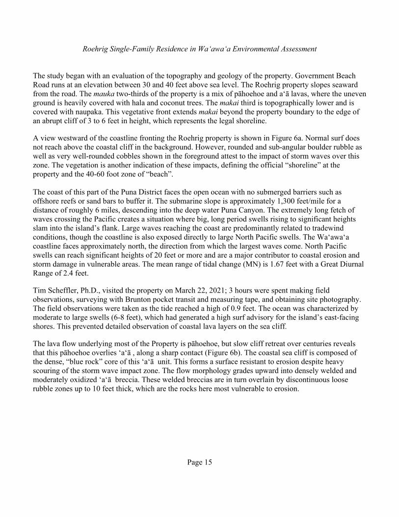
The study began with an evaluation of the topography and geology of the property. Government Beach Road runs at an elevation between 30 and 40 feet above sea level. The Roehrig property slopes seaward from the road. The mauka two-thirds of the property is a mix of pāhoehoe and a‘ā lavas, where the uneven ground is heavily covered with hala and coconut trees. The makai third is topographically lower and is covered with naupaka. This vegetative front extends makai beyond the property boundary to the edge of an abrupt cliff of 3 to 6 feet in height, which represents the legal shoreline. A view westward of the coastline fronting the Roehrig property is shown in Figure 6a. Normal surf does not reach above the coastal cliff in the background. However, rounded and sub-angular boulder rubble as well as very well-rounded cobbles shown in the foreground attest to the impact of storm waves over this zone. The vegetation is another indication of these impacts, defining the official “shoreline” at the property and the 40-60 foot zone of “beach”. The coast of this part of the Puna District faces the open ocean with no submerged barriers such as offshore reefs or sand bars to buffer it. The submarine slope is approximately 1,300 feet/mile for a distance of roughly 6 miles, descending into the deep water Puna Canyon. The extremely long fetch of waves crossing the Pacific creates a situation where big, long period swells rising to significant heights slam into the island’s flank. Large waves reaching the coast are predominantly related to tradewind conditions, though the coastline is also exposed directly to large North Pacific swells. The Wa‘awa‘a coastline faces approximately north, the direction from which the largest waves come. North Pacific swells can reach significant heights of 20 feet or more and are a major contributor to coastal erosion and storm damage in vulnerable areas. The mean range of tidal change (MN) is 1.67 feet with a Great Diurnal Range of 2.4 feet. Tim Scheffler, Ph.D., visited the property on March 22, 2021; 3 hours were spent making field observations, surveying with Brunton pocket transit and measuring tape, and obtaining site photography. The field observations were taken as the tide reached a high of 0.9 feet. The ocean was characterized by moderate to large swells (6-8 feet), which had generated a high surf advisory for the island’s east-facing shores. This prevented detailed observation of coastal lava layers on the sea cliff. The lava flow underlying most of the Property is pāhoehoe, but slow cliff retreat over centuries reveals that this pāhoehoe overlies ‘a‘ā , along a sharp contact (Figure 6b). The coastal sea cliff is composed of the dense, “blue rock” core of this ‘a‘ā unit. This forms a surface resistant to erosion despite heavy scouring of the storm wave impact zone. The flow morphology grades upward into densely welded and moderately oxidized ‘a‘ā breccia. These welded breccias are in turn overlain by discontinuous loose rubble zones up to 10 feet thick, which are the rocks here most vulnerable to erosion.
Roehrig Single-Family Residence in Wa‘awa‘a Environmental Assessment
Page 16
Figure 6. Coastal Photos
6a. View of Beach Reserve with Roehrig property in background, view to west. ▲
▼ 6b. Property line, legal shoreline (from shoreline survey) and flow contact line (red-dashed).
Roehrig Single-Family Residence in Wa‘awa‘a Environmental Assessment
Page 17
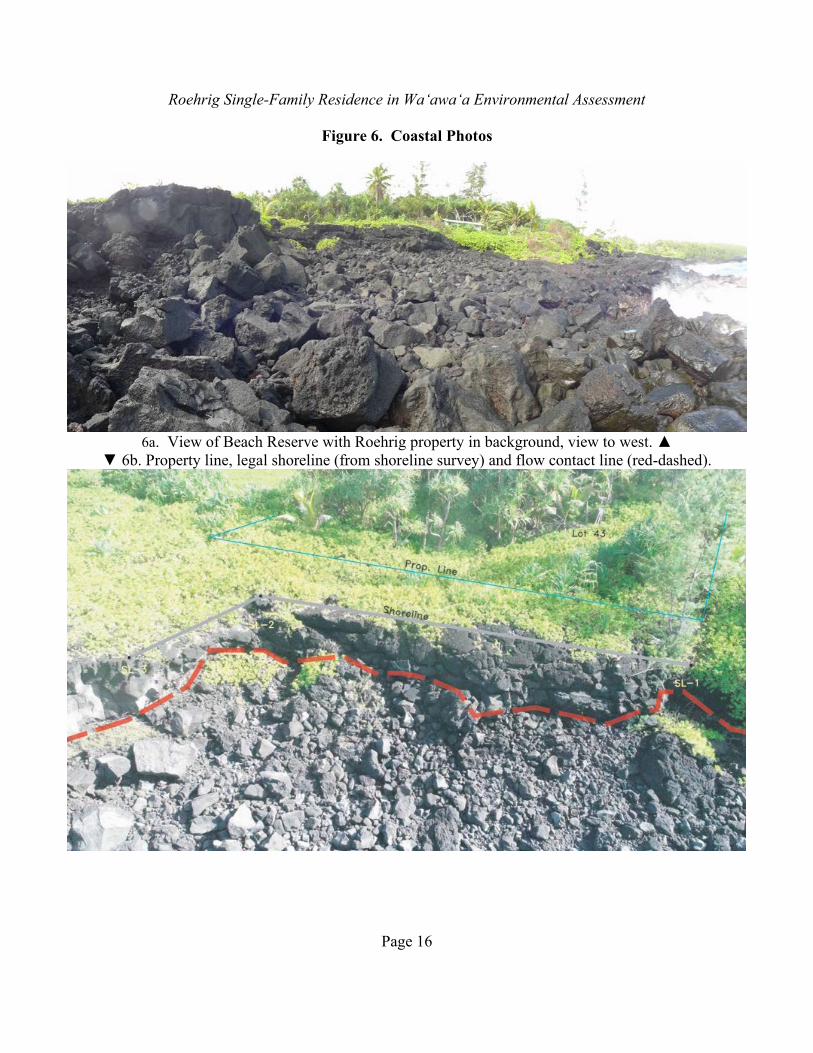
Atop the looser ‘a‘ā breccia lies the surface pāhoehoe flow, which consists of a single 2-3 meter thick flow unit where exposed along the shoreline cliff. The pāhoehoe flow is too thin to contain pyroducts (“lava tubes”) beneath the property. The interface of these two flow-types largely defines the geomorphology of the area. The weak joint between the ‘a‘ā and pāhoehoe allows pāhoehoe “skin” to be peeled back, thus creating the beach bench. Sub-rounded storm-tossed boulders, remains of the upper pāhoehoe lip, overlie the a‘ā .These large blocks are slowly crumbling in the face of extreme wave run-up. The beach, per se, is a slightly sloping (12-15 degrees) accumulation of well-worn cobbles and boulders overlying the basal substrate of ‘a‘ā described above. The toe of this ‘a‘ā shelf, or beach bench, is mostly scoured clean of debris by storm waves. It ends abruptly at the water’s edge, which at low tide is about 2-3 feet above sea level. Debris accumulates against the rear of this bench, in the recess created by the cliff. The majority of this rubble talus is material eroded from the surface of the ‘a‘ā bench heavily worn by the ocean and occurring as smaller very-well rounded clasts. The cliff is highly resistant to erosion, even by powerful marine wave action, as there is little jointing or fracturing of its interior. Large sub-rounded to sub-angular detached boulders at its base, intermingled with the more heavily weathered storm tossed ‘a‘ā debris, indicate that minor sea-cliff erosion is occurring. However, this occasional weathering and the stochastic block failures do not seem to contribute to any significant rate of retreat of the cliff. These relationships are illustrated in Figure 7, a scaled schematic profile of the beach bench, cliff face and property. During the occasional storms that generate waves at the cliff face, the talus material serves as a sort of revetment and protective shield to direct impacts on the cliff face. This is likely one factor in the relative lack of evidence for active erosion along this edge.
Figure 7. Cross-section of Shoreline Makai of Property

Roehrig Single-Family Residence in Wa‘awa‘a Environmental Assessment
Page 18
The inspection of digital aerial photographs from 1954, 1965, 1977 and 2019 showed no measurable change in position of the overall coastal sea-cliff or of the vegetation line since the earliest 1954 photos. The large scale (and thus limited resolution) of the aerial photographs inspected does not allow quantifying fine-scale morphological changes of the shoreline or sea-cliff. Given the maximum 600 dpi resolution of the images, a single pixel represents around 10 feet, so changes of less than 10 feet cannot be detected. Given these confounding variables, any shoreline determinations must rely more heavily upon primary indicators – as discussed above, mainly active erosion indicators such as freshly cut cliff faces or presence of angular erosional debris. The geologists also broadened the examination to include comparisons over this time of the prominent lava fingers to the east. These also do not seem to have undergone any significant change in the last half century. There is no visible indication that either the shoreline vegetation or the width of the ‘a‘ā bench has changed over the 67 year period since the first aerial photographic record began. Nor are there measurable changes in sea cliff (coastline) position. It appears that the maximum amount of coastal erosion fronting the property is 10 feet or less. The Average Annual Erosion Rate (AAER) of the shoreline at the property over the past 67 years is thus estimated to be a maximum of 0.15 feet per year. If erosion occurred at the maximum rate calculated for the past nearly 70 years, 70 years from now there would be additional erosion causing a retreat of 10.5 feet or less. If sea level rises by 3 to 5 feet over this period, there could be additional erosion because of the area of wave attack would move forward and upward within the zone between the water’s edge and the shoreline, which itself lies about 20 feet above sea level. Even under these circumstances, the proposed location of the Roehrig home would not appear to be vulnerable to coastal erosion, as it would be 70 feet from the shoreline and 110 feet from the water’s edge. The combination of the buffering Beach Reserve lot, the substantial distance to the shoreline from the proposed home, the elevation of the proposed home at approximately 30 feet above sea level, and the hard rock lava surface indicates that shoreline erosion is not a significant risk for the proposed home.
3.1.3 Water Quality The house would be set back a minimum of 70 feet from the shoreline and no grading activities would occur makai of this area. No streams, springs, or anchialine ponds are found on or near the proposed home site or any affected area. With home construction, the primary activity with potential to affect water quality is grading. Overall, the proposed improvements will require relatively little grading due to the compact arrangement of the proposed home, driveway and utility areas. Grubbing and grading will occur in the areas of the driveway and parking/turnaround area; the water catchment tank, house site; construction staging area, and the trenches required for the septic system. Extracted material from the trenching will be used to refill trenched areas and to blend the areas with the surrounding topography so as to avoid the need for any off-site disposal of material. The total area of grading is less than 0.2 acres. A County grading permit will be required. Grading will include Best Management practices (BMPs) to minimize the potential for sedimentation, erosion and pollution of coastal waters. The applicants will ensure all earthwork and grading is conducted in conformance with:

Roehrig Single-Family Residence in Wa‘awa‘a Environmental Assessment
Page 19
(a) “Storm Drainage Standards,” County of Hawai‘i, October, 1970, and as revised. (b) Applicable standards and regulations of Chapter 27, “Flood Control,” of the Hawai‘i
County Code. (c) Applicable standards and regulations of the Federal Emergency Management Agency
(FEMA). (d) Applicable standards and regulations of Chapter 10, “Erosion and Sedimentation Control,”
of the Hawai‘i County Code. (e) Any additional best management practices required by the Board of Land and Natural
Resources.
The applicants will require that the construction contractor implement the following BMPs:
• Keeping the total amount of land disturbance to a minimal area, which will be delineated to the construction contractor prior to the commencement of any onsite work. The makai limits of grading will be marked and fenced at the construction areas to avoid any possible disturbance to the ground or vegetation within makai area during construction activities.
• No concrete truck washout or equipment servicing will be allowed on site. • The contractor will take special precautions so as to not allow any sediment to leave the work
areas, particularly towards the sea. Prior to the start of construction, contractors will implement erosion control measures, including silt fences along the lower margin of grading, silt barriers (snakes) around stockpiles etc., to prevent any sediment from leaving the construction areas, especially towards the ocean.
• Construction activities with the potential to produce potential stormwater run-off will not be allowed during periods of unusually heavy rains or storm conditions.
• Graded areas will be replanted or stabilized as soon as possible following grading activity. The general Puna Coast, including the specific Wa‘awa‘a area, already supports hundreds of homes and there are no reported water quality problems from these uses. Upon its completion, the home would appear similar to the homes on shoreline lots in the area, and it would be not expected to contribute to sedimentation, erosion, and pollution of coastal waters. There are no known wells located within the Property; therefore, no permit for well abandonment is required. According to the Hawaii Groundwater & Geothermal Resource Center database (https://www.higp.hawaii.edu/hggrc/projects/hawaii-state-waterwells/), existing wells are located on properties approximately 300 feet away, mauka from the owners’ property. The owners’ single-family residence should not impact these wells.

Roehrig Single-Family Residence in Wa‘awa‘a Environmental Assessment
Page 20
3.1.4 Flora and Fauna Environmental Setting: Flora Prior to human settlement of Hawai‘i, the natural vegetation of this part of this part of Puna shoreline was mostly coastal forest and strand vegetation, dominated by naupaka (Scaevola taccada), hala (Pandanus tectorius), ‘ōhi‘a (Metrosideros polymorpha), nanea (Vigna marina) and various sedges and coastal herbs (Gagne and Cuddihy 1990). The site was systematically inspected for plants by Dr. Ron Terry in January 2021. Special attention was paid during several field visits to potential endangered species, particularly Ischaemum byrone, a State and federally listed endangered grass known to grow in the general area. As illustrated in the photos in Figure 3, aside from a roadside fringe of non-native species and a makai area with naupaka (Scaevola taccada), over most of its extent, the project site is dominated by the native hala (Pandanus tectorius) and coconut palms (Cocos nucifera). Most of the other species present are non-native species, and all of the natives are very common in Puna and throughout the State of Hawai‘i. No Ischaemum byrone or any other rare, threatened or endangered plant species was found on or near the property. A list of all species detected on the property is found in Table 1. Environmental Setting: Fauna Typical expected birds in this part of Puna include common myna (Acridotheres tristis), northern cardinal (Cardinalis cardinalis), spotted dove (Streptopelia chinensis), Japanese white-eye (Zosterops japonicus), and house finch (Carpodacus mexicanus). Common shorebirds, such as Pacific golden-plover (Pluvialis fulva), ruddy turnstone (Arenaria interpres), and wandering tattler (Heteroscelus incanus), are often seen on the Puna coastline feeding on shoreline resources. The property itself is unlikely habitat, because it is away from the shoreline and densely vegetated. They are found in the shoreline area makai of the property. Site visits identified no species of native forest birds, which in general are unlikely to use the project site due to its low elevation, alien vegetation and lack of adequate forest resources. However, two native forest birds are likely to make use of the general area. The Hawaiian hawk (Buteo solitarius) was formerly listed federally as endangered, and is still listed by the State of Hawai‘i. It generally prefers ‘ōhi‘a forest habitat but is known to breed successfully in both native and non-native forests. It occurs throughout the island of Hawai‘i from sea level to 8,530 feet in elevation. Hawks often forage in forests near agricultural tracts and nest in tall trees of a variety of species. Most nesting occurs in native ‘ōhi‘a trees, although hawks may also nest in non-native trees, including eucalyptus, ironwood, mango, coconut palm and macadamia. Nest construction is protracted, beginning up to two months before the first egg is laid and continuing into the nestling period. Egg-laying generally occurs from March to June, and fledging from July to September. Both sexes contribute to nest-building. Clutch size is nearly always one, but clutches of two and three have been reported. Both sexes incubate, although females perform most of the brooding of nestlings; males provide most of the food to chicks and female. Both adults feed fledglings, which are dependent on adults for up nine months. When nests are present, grading, tree removal and other construction activities can disturb them. Given the vegetation context with only fairly short-stature hala
Roehrig Single-Family Residence in Wa‘awa‘a Environmental Assessment
Page 21
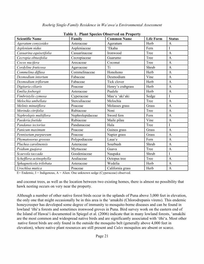
Table 1. Plant Species Observed on Property Scientific Name Family Common Name Life Form Status Ageratum conyzoides Asteraceae Ageratum Herb A Asplenium nidus Aspleniaceae ‘Ekaha Fern I Casuarina equisetifolia Casuarinaceae Ironwood Tree A Cecropia obtusifolia Cecropiaceae Guarumo Tree A Cocos nucifera Arecaceae Coconut Tree A Cordyline fruticosa Agavaceae Ti Shrub A Commelina diffusa Commelinaceae Honohono Herb A Desmodium intortum Fabaceae Desmodium Vine A Desmodium triflorum Fabaceae Tick clover Herb A Digitaria ciliaris Poaceae Henry’s crabgrass Herb A Emilia fosbergii Asteraceae Pualele Herb A Fimbristylis cymosa Cyperaceae Mau‘u ‘aki‘aki Sedge I Melochia umbellata Sterculiaceae Melochia Tree A Melinis minutiflora Poaceae Molasses grass Grass A Morinda citrifolia Rubiaceae Noni Tree A Nephrolepis multiflora Nephrolepidaceae Sword fern Fern A Paederia foetida Rubiaceae Maile pilau Vine A Pandanus tectorius Pandanaceae Hala Tree I Panicum maximum Poaceae Guinea grass Grass A Pennisetum purpureum Poaceae Napier grass Grass A Phymatosorus grossus Polypodiaceae Laua‘e Fern A Pluchea carolinensis Asteraceae Sourbush Shrub A Psidium guajava Myrtaceae Guava Tree A Scaevola taccada Goodeniaceae Naupaka Shrub I Schefflera actinophylla Araliaceae Octopus tree Tree A Sphagneticola trilobata Asteraceae Wedelia Herb A Urochloa mutica Poaceae California grass Herb A E= Endemic, I = Indigenous, A = Alien. One unknown sedge (Cyperaceae) observed. and coconut trees, as well as the location between two existing homes, there is almost no possibility that hawk nesting occurs on very near the property. Although a number of other native forest birds occur in the uplands of Puna above 3,000 feet in elevation, the only one that might occasionally be in this area is the ‘amakihi (Chlorodrepanis virens). This endemic honeycreeper has developed some degree of immunity to mosquito-borne diseases and can be found in lowland ‘ōhi‘a forests and sometimes ironwood groves in Puna. Bird survey work on the eastern end of the Island of Hawai‘i documented in Spiegel et al. (2006) indicate that in many lowland forests, ‘amakihi are the most common and widespread native birds and are significantly associated with ‘ōhi‘a. Most other native forest birds are only found in the outside the mosquito belt (generally above 4,000 feet in elevation), where native plant resources are still present and Culex mosquitos are absent or scarce.

Roehrig Single-Family Residence in Wa‘awa‘a Environmental Assessment
Page 22
As with all of the island of Hawai‘i, several listed seabirds may overfly the Wa‘awa‘a area between the months of May and November, including the endangered Hawaiian petrel (Pterodroma sandwichensis), the endangered band-rumped storm petrel (Oceanodroma castro), and the threatened Newell’s shearwater (Puffinus auricularis newelli). These seabirds hunt over the ocean during the day and fly to higher elevations at night to nest. The Hawaiian petrel was formerly common on the Island of Hawai‘i. This pelagic seabird reportedly nested in large numbers on the slopes of Mauna Loa and in the saddle area between Mauna Loa and Mauna Kea, as well as at the mid-to-high elevations of Hualālai. It has within recent historic times been reduced to relict breeding colonies located at high elevations on Mauna Loa, Kohala and, possibly, Hualālai. The Hawaiian petrel (as well as the band-rumped storm petrel) generally nest on the Big Island well above 5,000 feet in elevation. Some Hawaiian petrel nests have recently been found at lower elevations on Kohala volcano. Both the Newell’s shearwater and Hawaiian petrel are known to burrow under ferns on forested mountain slopes. These burrows are used year after year, usually by the same pair of birds. Although capable of climbing shrubs and trees before taking flight, they need an open downhill flight path through which they can become airborne. Once abundant on all the main Hawaiian islands, most Newell’s shearwater colonies are today found in the steep terrain between 500 to 2,300 feet on Kaua‘i. Band-rumped storm petrels have recently been discovered to be nesting on the Mauna Loa side of the saddle between this mountain and Mauna Kea. Although each of these seabirds may fly over on their way to and from mountain nesting areas and the open ocean, no suitable nesting habitat for any of them is present on the property. The primary cause of mortality in these seabird species in Hawai‘i is thought to be predation by alien mammals at the nesting colonies. Collision with man‐made structures is another significant cause. Nocturnally flying seabirds, especially fledglings on their way to sea in the summer and fall, can become disoriented by exterior lighting. Disoriented seabirds may collide with manmade structures and, if not killed outright, become easy targets of predatory mammals including cats and mongooses. It is highly likely that Hawaiian hoary bats (Lasiurus cinereus semotus), the only native Hawaiian land mammals, are sometimes present on the property. They have been found throughout most areas on the island of Hawai‘i. Bats may forage for flying insects on the property on a seasonal basis and may also roost in trees and large shrubs. Bats are often visible while they are feeding on flying insects near dusk and dawn at various locations around the island of Hawai‘i. The presence of these bats can also be verified by echolocation detectors. If a bat is detected during a night’s study, this merely indicates that they were present in the area. Conversely, the absence of bat detections does not indicate an absence of bats, which may have been absent for only a night, a week, or a season, or may have simply gone undetected. Determination of bat populations or usage patterns requires much more sophisticated, long term studies. No bats were observed in our surveys, which took place in daylight and did not use any detection equipment. For the purposes of this assessment, it is assumed that Hawaiian hoary bats are present at least some of the time, as they have been frequently seen and detected in forests with hala and coconuts. Hawaiian hoary bats are vulnerable to disturbance during the summer pupping season and require special mitigation, as discussed below. Other mammals in the project area are all introduced species, including feral cats (Felis catus), feral pigs (Sus scrofa), small Indian mongooses (Herpestes a. auropunctatus) and various species of rats (Rattus
Roehrig Single-Family Residence in Wa‘awa‘a Environmental Assessment
Page 23
spp.). None are of conservation concern and all are deleterious to native flora and fauna. There are no native terrestrial reptiles or amphibians in Hawai‘i. No reptiles were seen but there may be species of skink (Family: Scincidae) and gecko (Gekkonidae) present. The highly invasive coqui frog (Eleutherodactylus coqui) is present in the area. No invertebrate survey was undertaken as part of the survey, but in general, no rare invertebrates would be expected from this property. The coastal and marine fauna and flora are typical of the high-energy coasts of Puna, which are young ecosystems with limited coral growth but a variety of algae, fish and invertebrates. Marine mammals and reptiles, some of them endangered, also visit the Puna coastal waters. Impacts and Mitigation Measures Some grading will be required, but as discussed in Section 3.1.3, the location of the home has been chosen to entirely avoid the most sensitive location on the property, the naupaka patch inland of the shoreline. While a maximum of 57 hala trees would require removal for the driveway, turnaround area and home, along with about a dozen coconut trees and various invasive trees, there is ample room on the property for additional hala to be planted, utilizing the abundant hala keiki. The project includes minimal landscaping emphasizing the natural hala/naupaka vegetation and replaces hala trees that need to be removed for the driveway and home site in areas that have had (through previous approvals) or will have approximately 100 invasive trees removed (see Landscape Plan, page 8). The owners will continue to monitor for the reemergence of the common invasive tree species such as octopus tree (Schefflera actinophylla), guava (Psidium guajava), trumpet tree (Cecropia obtusifolia) and melochia (Melochia umbellata). Once removed, these trees will be replaced with hala trees or naupaka, as appropriate. Because of the minor nature of the project and the lack of sensitive terrestrial ecosystems and threatened or endangered plant species, and the negligible effect to the lowland hala ecosystem, construction and use of the single-family residence are not likely to cause adverse biological impacts. The following measures will be implemented to help avoid impacts to endangered native birds and the Hawaiian hoary bat:
• To avoid potential seabird downing through interaction with outdoor lighting, no construction or unshielded equipment lighting will be used after dark between the months of April and October. Minimal exterior lighting will be included, and it will be shielded in strict conformance with the Hawai‘i County Outdoor Lighting Ordinance (Hawai‘i County Code Chapter 9, Article 14). Lighting will be constrained to utilize only low light-emitting fixtures using blue-deficient filtered LED lights with a Correlated Color Temperature (CCT) of 2700 Kelvin or less, shielded to protect both transiting seabirds and dark skies.
• To minimize impacts to the endangered Hawaiian hoary bat, trees taller than 15 feet will not be removed or trimmed during the bat birthing and pup rearing season (June 1 through September 15).

Roehrig Single-Family Residence in Wa‘awa‘a Environmental Assessment
Page 24
The following measures will assist in preventing the spread of invasive species:
• The applicant will balance cut and fill and utilize the existing soil and rock material on the property for the driveway base and house pad. No soil fill will be imported. Any rock fill will come from a clean source that is monitored for invasive species such as fire ants.
• All heavy equipment will be cleaned of excess soil and debris prior to entering the property to minimize the risk of spreading invasive species.
It should be noted that no ōhi‘a trees are present and there should be no risk of spreading the Rapid ʻŌhiʻa Death pathogen. The precautions for preventing effects to water quality during construction listed above in Sections 3.1.3 and 3.1.6 will reduce adverse impact on aquatic biological resources in coastal waters to negligible levels.
3.1.5 Air Quality and Noise
Environmental Setting Air quality in the area is generally excellent, due to its rural nature and minimal degree of human activity, although vog from Kilauea volcano is occasionally blown into this part of the island when this volcano is erupting, which it currently is. Noise on the site is fairly low and is derived from natural sources (such as surf, birds and wind), nearby homes and passing traffic. Impacts and Mitigation Measures Low-density, low-intensity residential use should not result in deleterious impacts on air quality and the acoustical environment. Brief and minor adverse effects would occur during construction, and there will be occasional noise from the backup generator. However, the only sensitive noise receptors in the vicinity are residences producing similar impacts, and given the small scale of the project, noise mitigation does not appear to be necessary. Given the small scale and short duration of any noise impacts, coupled with the lack of sensitive receptors, noise mitigation would not be necessary.
3.1.5 Scenic Resources Environmental Setting The area shares the quality of scenic beauty along with most of the Puna coastline. The County of Hawai‘i General Plan contains Goals, Policies and Standards intended to preserve areas of natural beauty and scenic vistas from encroachment. The General Plan discusses the black sand beaches and tidal ponds as noted features of natural beauty in Puna. The General Plan specifically lists as examples of natural beauty a shoreline area about one mile to the north (Honolulu Landing) at TMK 1-4-003:019, and three areas at Kahuwai about one mile to the south (the black sand beach at Kapela Bay, Makaukiu Point and the shoreline) at TMK 1-4-003:013. There are also Exceptional Trees protected by County ordinance present on the Old Government Road in the form of a mango grove that lines both sides of the roadway. The area
Roehrig Single-Family Residence in Wa‘awa‘a Environmental Assessment
Page 25
near the project site was inspected as part of the biological research, and it does not contain mango trees (see photos in Figure 2). Coastal views from the Government Beach Road are mostly obstructed by hala vegetation along the lot front. Impacts and Mitigation Measures The home will be subtly visible from the sea in the midst of the hala grove and from the road through existing and newly planted hala trees. The home will be modest in size and consistent with the Conservation District rules (Hawai‘i Administrative Rules 13-5), which require subtle and sensitive colors and architectural styles, minimal height, and landscaping utilizing almost exclusively native and Polynesian species. Replacement of the roadside fringe of weedy vegetation with hala will improve the visual character along the road. No scenic areas discussed in the General Plan will be affected. Minimal exterior lighting will be included. It will be constrained to utilize only low light-emitting fixtures using blue-deficient filtered LED lights with a Correlated Color Temperature (CCT) of 2700 Kelvin or less, shielded to protect dark skies and transiting seabirds. The overall effect would be a landscape in harmony with the rural landscape of Puna. 3.1.7 Hazardous Substances, Toxic Waste and Hazardous Conditions Based on onsite inspection and the lack of any known former and current uses on the project site, it appears that the site contains no hazardous or toxic substances and exhibits no other hazardous conditions. In addition to the measures related to water quality detailed in Section 3.1.3, in order to ensure to minimize the possibility for spills of hazardous materials, the applicants proposes the following:
• Unused materials and excess fill (if any) will be disposed of at an authorized waste disposal site. • During construction, emergency spill treatment, storage, and disposal of all hazardous materials,
will be explicitly required to meet all State and County requirements, and the contractor will adhere to “Good Housekeeping” for all appropriate substances, with the following instructions:
o Onsite storage of the minimum practical quantity of hazardous materials necessary to complete the job;
o Fuel storage and use will be conducted to prevent leaks, spills or fires; o Products will be kept in their original containers unless unresealable, and original labels and
safety data will be retained; o Disposal of surplus will follow manufacturer’s recommendation and all regulations; o Manufacturers’ instructions for proper use and disposal will be strictly followed; o Regular inspection by contractor to ensure proper use and disposal; o Onsite vehicles and machinery will be monitored for leaks and receive regular maintenance; o Construction materials, petroleum products, wastes, debris, and landscaping substances
(herbicides, pesticides, and fertilizers) will be prevented from blowing, falling, flowing, washing or leaching into the ocean; and
o All spills will be cleaned up and properly disposed of immediately after discovery.
Roehrig Single-Family Residence in Wa‘awa‘a Environmental Assessment
Page 26
3.2 Socioeconomic and Cultural
3.2.1 Land Use, Socioeconomic Characteristics and Recreation Existing Environment Because of the gradual occupation of lots developed during widespread land subdivision about fifty years ago, the Puna District where the project site is located has been the Big Island’s fastest-growing district over the last thirty years. Population as measured in the 2010 U.S. Census was 45,326, a 66 percent increase over the 2000 count of 27,232. Preliminary totals for Puna from the 2020 Census indicate a population of 51,704 (Hawai‘i Tribune Herald, Nov. 3, 2021), indicating a substantial increase but at a slower rate. Despite a lack of basic infrastructure such as paved roads and water in most subdivisions, the relatively inexpensive lots, which typically range in size from one to three acres, have attracted residents from the U.S. mainland and other parts of the State of Hawai‘i seeking more affordable property. The basis of the economy of Puna has evolved from cattle ranching and sugar to diversified agriculture, various services for the growing populations, commuting to Hilo, and tourism, which has been stimulated by being home to Kilauea, one of the world’s most active volcanoes. Some of the subdivisions have become essentially bedroom communities for Hilo’s workforce, as evidenced by the heavy flow of Hilo-bound traffic during the AM rush hour. The Wa‘awa‘a area is part of the Hawaiian Beaches Census Designated Place (CDP). In the 2010 Census, Hawaiian Beaches contained a population of 4,280, with an average household size of 2.91 persons. The population was 31.2% White, 14.4% Asian, 14.4% Native Hawaiian or Pacific Islander, and 35.8% two or more races (http://factfinder2.census.gov/faces/nav/jsf/pages/index.xhtml#none). The bulk of the population in this CDP is in the Hawaiian Beaches/Hawaiian Shores subdivisions several miles north of the project area. The immediate community surrounding the property is referred to as the Wa’awa’a Residential Subdivision. Created in the 1960s, it contains 170 lots, most of which are 3 acres in size, with smaller lots fronting the ocean. Wa’awa’a can be characterized as sparsely developed with largely unimproved gravel and dirt roads and scattered houses, with about a quarter of the properties having homes. There is no County water or sewer service available. Electrical service does not extend past the Hawaiian Shores subdivision to Wa’awa’a. Residents of the area elect to live in this remote setting for the privacy and self-sufficient lifestyle. The property is bordered by the shoreline reserve property to the north, by the Government Beach Road to the south, and by a single-family residence to the west, and an unoccupied private lots to the east. The growing population in Puna, including such areas as Hawaiian Shores and Hawaiian Beaches, induces a high demand for coastal recreation in Puna. Despite the long coastline, there are few beaches in Puna, and areas such as Kapoho, Pohoiki and Kehena experience heavy use. In most locations, however, ocean recreation is much more scattered and consists primarily of fishing from the cliffs and enjoying limited bathing in tidepools. There is relatively little use of the rough and irregular shoreline in this area. The nearest mauka-makai shoreline public accesses from the Government Beach Road is at the northwestern corner of the Wa‘awa‘a Subdivision, about 750 feet from Roehrig lot, within a 78.33-acre parcel (TMK 1-4-003:018). This property is owned by the State of Hawai‘i, which is a portion of the
Roehrig Single-Family Residence in Wa‘awa‘a Environmental Assessment
Page 27
Nānāwale Forest Reserve. This parking spot and trail provide access to the Forest Reserve coastline to the west as well as the shoreline Beach Reserve property to the east that is held in common by the Wa‘awa‘a Subdivision owners. This strip provides a setback from the shoreline and an area for residents and the public to walk, fish or gather. Fishers and gatherers are often seen on this long shoreline lot fishing for papio or menpachi or gathering opihi. Illegal dumping is a severe problem on this portion of Old Government Road, especially in the area around Pu‘u One (Sand Hill). Periodically, the road margins and parts of adjacent properties become covered with hundreds of tons of cars, appliances, household rubbish and even animal waste. This unsightly mess has unpleasant odors and negatively impacts the health of humans and wildlife through creating a breeding environment for mosquitoes and other insects, rats and pathogens, as well as causing a physical safety hazard through jagged metal and glass. The chronic dumping lowers the quality of life and decreases property value for residents. There have been many volunteer and County-organized cleanups to deal with this problem, but ultimately, it is the presence of a critical mass of vigilant residents in the many subdivided lots that will discourage dumping. Impacts and Mitigation Measures The residence and associated improvements will not adversely affect population or demand for services. No adverse socioeconomic impacts would occur from adding another home to this slowly growing neighborhood. Building the home will employ construction workers and have a small but positive economic impact for the County of Hawai‘i. The residence and associated improvements will not adversely impact recreation, as access along the shoreline will not be affected. In the current socioeconomic context, every additional resident guarding against illegal dumping and illegal activity and cleaning up when necessary assists in keeping the area safer and cleaner.
3.2.2 Cultural and Historic Resources
An archaeological assessment survey of the project was conducted and is attached as Appendix 2. As part of assessing cultural resources, early consultation for the EA for general issues but also listing cultural resources was conducted with the Office of Hawaiian Affairs, the Lower Puna Councilperson, the Sierra Club, Malama O Puna, and several neighbors. A more focused cultural consultation was also undertaken, which is documented in Appendix 4 and summarized below. Historical and Cultural Background The first inhabitants of Hawai‘i were believed to be settlers who had undertaken difficult voyages across the open ocean. For many years, researchers have proposed that early Polynesian settlement voyages between Kahiki (the ancestral homelands of the Hawaiian gods and people) and Hawai‘i were underway by A. D. 300, although recent work suggests that Polynesians may not have arrived in Hawai‘i until at least A. D. 1000 (Kirch 2011). The first voyagers are believed to have come from the southern Marquesas Islands and settled initially on the windward side, eventually expanding to leeward areas. Early Hawaiian farmers developed new strategies and tools for their new environment (Kirch 2011; Pogue 1978). Societal
Roehrig Single-Family Residence in Wa‘awa‘a Environmental Assessment
Page 28
order was maintained by their traditional philosophies and by the conical clan principle of genealogical seniority (Kirch 2011). Universal Polynesian customs brought from their homeland included the observance of major gods Kane, Ku, and Lono; the kapu system of law and order; cities of refuge, various beliefs, and the concepts of mana and the ‘aumakua (Fornander 1969). The Development Period, believed under Kirch’s new concept to have occurred from A. D. 1100 to 1350, brought an evolution of traditional tools, including a variation of the adze (ko‘i), and some new Hawaiian inventions such as the two-piece fishhook and the octopus-lure breadloaf sinker. That was followed by the Expansion Period (A. D. 1350 to 1650) which saw greater social stratification, intensive land modification, and population growth. This period was also the setting for the second major migration to Hawai‘i, this time from Tahiti. Also established during this period was the ahupua‘a, a land-use concept that incorporated all of the eco-zones from the mountains to the shore and beyond. The usually wedge-shaped ahupua‘a provided a diverse subsistence resource base (Hommon 1986) and added another component to what was already becoming a well-stratified society (Kirch 2011). As population grew during the following centuries so did the reach of inland cultivation in the upland environmental zones and consequent political and social stresses. During the Proto-Historic Period (A. D. 1650-1795), wars reflective of a complex and competitive social environment are evidenced by heiau building. During this period, sometime during the reign of Kalaniopu‘u (A. D. 1736-1758), Kamehameha I was born in North Kohala. Ahupua‘a were ruled by ali‘i ‘ai ahupua‘a or lesser chiefs and managed by a konohiki. Ali‘i and maka‘ainana, or commoners, were not confined to the boundaries of ahupua‘a as resources were shared when a need was identified. Ahupua‘a were further divided into smaller sections such as ‘ili, mo‘o‘aina, pauku‘aina, kihapai, koele, hakuone and kuakua. The chiefs of these land units have their allegiance to a territorial chief or mo‘i (literally translated as king) (Hommon 1986). The Roehrig property is located within the ahupuaʻa of Wa‘awa‘a, in the traditional moku-o-loko or district of Puna, which comprises some fifty ahupuaʻa on the eastern/windward shores of Hawaiʻi Island. The meaning of the name Wa‘awa‘a is not translated in Place Names of Hawai‘i (Pūkuʻi et al. 1974, although it may be noted that wa‘awa‘a is the Hawaiian word for furrowed. Most ahupua‘a encompassed mauka agricultural and forest resources and makai fisheries, so that residents were once able to procure nearly all that they needed to sustain their families and contribute to the larger community from within the land division. Although the mauka boundary of Waʻawaʻa Ahupuaʻa extends to only roughly 230 feet in elevation, the upper reaches of the ahupuaʻa were formerly covered by a dense growth of ʻōhiʻa lehua trees, indicating its likely extent into the lower limits of the upland forested zone or wao akua as it exists within this portion of Puna. The Pre-Western contact population of the Puna District lived in small settlements along the coast where they subsisted on marine resources and agricultural products. As McGregor stated in reference to the lava flows that periodically alter the district, “Puna is where new land is created and new growth and new life sprout. The new land is sacred, fresh, clean, and untouched. After vegetation begins to grow upon it, it is
Roehrig Single-Family Residence in Wa‘awa‘a Environmental Assessment
Page 29
ready for human use.” (2007:145). The villages of Puna, McEldowney notes, were similar to those of the Hilo District, and they:
…comprised the same complex of huts, gardens, windbreaking shrubs, and utilized groves, although the form and overall size of each appear to differ. The major differences between this portion of the coast and Hilo occurred in the type of agriculture practiced and structural forms reflecting the uneven nature of the young terrain. Platforms and walls were built to include and abut outcrops, crevices were filled and paved for burials, and the large numbers of loose surface stones were arranged into terraces. To supplement the limited and often spotty deposits of soil, mounds were built of gathered soil, mulch, sorted sizes of stones, and in many circumstances, from burnt brush and surrounding the gardens. Although all major cultigens appear to have been present in these gardens, sweet potatoes, ti (Cordyline terminalis), noni (Morinda citrifolia), and gourds (Lagenaria siceraria) seem to have been more conspicuous. Breadfruit, pandanus, and mountain apple (Eugenia malaccensis) were the more significant components of the groves that grew in more disjunct patterns than those in Hilo Bay (McEldowney 1979:17).
Located along the coast, the property falls within the Coastal Settlement Zone (Zone I) as modeled by McEldowney (1979:15-18), where families often lived clustered around sheltered bays (McEldowney 1979). In their refinement of the model as it applies to Puna, Burtchard and Moblo (1994) elaborate on McEldowney’s concept of the Coastal Settlement Zone:
As with her model, [the Coastal Settlement Zone] includes coastal terrain to about one-half mile inland. This is the zone expected to have the greatest density and variety of prehistoric surface features in the general study area. Primary settlements are expected in places where agriculturally productive sediments (principally well-weathered ʻaʻā flows) co-occur with sheltered embayments and productive fisheries. Settlements within this zone are expected to be logistically linked to inland agricultural and forest exploitation zones accessed through a network of upslope-downslope (Mauka-makai) trails. Larger settlements and resource acquisition areas may have been connected by cross-terrain trail networks (1994:26).
The rugged, young state of the lava flows here were not a limiting factor for the cultivation of sweet-potato or ʻuala, which requires practically no soil to flourish. Its propagation is discussed in detail by many nineteenth and early twentieth century visitors to the district, who describe seeing the ʻuala growing from mounds of lava stones. In the following passage, published under the title “Hawaii-Nei” in Harper’s Magazine, Charles Nordhoff (1873a:382-402) described the vegetation of Puna and mention early commercial coffee production in the district. Nordhoff also provided observations of the narrow coastal trail “across unceasing beds of lava” that “was actually hammered down to make it smooth enough for travel” in some places (1873a:401). According to Nordhoff, “most of the lava is probably very ancient, though some is quite recent, and ferns and guava bushes and other scanty herbage grow through it” (ibid.). Nordhoff’s narrative continued:

Roehrig Single-Family Residence in Wa‘awa‘a Environmental Assessment
Page 30
...after a descent to the sea-shore, you are rewarded with the pleasant sight of groves of cocoa-nuts and umbrageous arbors of pandanus, and occasionally with a patch of green. Almost the whole of the Puna coast is waterless...
It will surprise you to find people living among the lava, making potato patches in it, planting coffee and some fruit trees in it, fencing in their small holdings, even, with lava blocks. Very little soil is needed to give vegetation a chance in a rainy season, and the decomposed lava makes a rich earth. But, except the cocoa-nut, which grows on the beach, and seems to draw its sustenance from the waves, and the sweet-potato, which does very well among the lava, nothing seems really to thrive. (ibid.).
In another installment titled “Hawaii-Nei-II”, Nordhoff (1873b:544-559) wrote of the lack of fresh water in Puna and how Dr. Coan had told him about how Native Hawaiians collected freshwater for his use during his missionary tour “from the drippings of dew in caves” (1873b:550). For, “wells are here out of the question, for there is no soil except a little decomposed lava, and the lava lets through all the water which comes from rains” compounded by the lack of mountain streams (ibid.). Nordhoff also presented the following observations of the communities in Puna as well as traditional sweet potato planting methods:
There are no fields, according to our meaning of the word. Yet formerly the people in this district were numbered by thousands: even yet there is a considerable population, not unprosperous by any means. Churches and schools are as frequent as in the best part of New England. Yet when I asked a native to show me his sweet-potato patch he took me to the most curious and barren-looking collection of lava you can imagine, surrounded too, by a very formidable wall made of lava, and explained to me that by digging holes in the lava where it was a little decayed, carrying a handful of earth to each of these holes, and planting there in a wet season, he got a very satisfactory crop. Not only that, but being desirous of something more than a bare living, this man had planted a little coffee in the same way, and had just sold 1600 pounds, his last crop. (ibid.)
Although ‘uala was cultivated widely, Handy et al said that it did not appear to have been a staple food of Puna, a district “most famous for its breadfruit” (1991:190). Handy opined:
. . . Despite the fact that sweet potatoes were planted almost universally and many patches are still maintained, the Puna natives seem to regard this vegetable with little interest, probably because Puna people prided themselves upon and relished their breadfruit, and also because potato was nowhere and at no time the staple for this rainswept district. (1940:165)
Breadfruit (‘ulu) was a kinolau (physical manifestation) of the goddess Haumea, the “patron of childbirth,” and the principal staple food of Puna, where it was most famous (Beckwith 1970:283; Handy et al. 1991). Careful and gentle propagation was required, which entailed the removal and replanting of the root sucker cutting while ensuring it remained within its original, undisturbed soil casing. With respect to ‘ulu as a sustainable food source, Handy et al. explained that, “except in Puna, Hawaii, breadfruit was

Roehrig Single-Family Residence in Wa‘awa‘a Environmental Assessment
Page 31
wholly secondary to taro and sweet potato as a staple. I am told that in Puna in a good year, breadfruit may be eaten for 8 months of the year, beginning with May” (1991:152). Although ʻulu appears to have been the preferred source of sustenance for residents of Puna, taro (kalo) rivaled it as a staple food source. Puna’s lack of flowing streams made growing wetland kalo impossible. Despite this freshwater stream deficit, Puna received plentiful rainfall throughout the year, which made the cultivation of dryland kalo possible, even along the coast as far north as Hilo (Handy 1991). Handy et al. related that, “the wet and sometimes marshy pandanus forests from Kapoho through Poho-iki to ‘Opihikao used to be planted with taro in places” (1991:541). The method of planting dryland taro in the lowland forests of Puna is described by Handy et al. as the “pa-hala (pandanus clearing) method” (1991:104). It had the advantage of not requiring the constant weeding necessitated by better soils. The Pa-hala planting process is as follows:
Make holes in the ʻaʻa (broken lava) by taking out some of the stones. Be sure that the place chosen is in a pu hala grove, to save the labor of hauling hala branches into the patch later on. Fill the hole with whatever weeds can be found and leave them there for six weeks or more. The weeds will rot and make soil. When the weeds have rotted away, the taro huli are wrapped in lau hala (hala leaves) to keep them moist and are planted. When there or four leaves have appeared on each huli, then that is the time to cut down the pu hala to let in the sun. The branches of the hala are cut off and the patch covered with them until this is not a trace of the taro to be seen. This is left until sufficiently dry to set on fire. The fire does not hurt the taro much as the huli are already well rooted. The hala reduced to ashes, give the taro the needed nourishment and they grow so tall that a man can be hidden under their leaves (Handy et al. 1991:104–105).
Hala was valued for its fragrance and harvested for more utilitarian purposes. The inhabitants of Puna were recognized for their skilled lauhala (hala leaf) weaving. The dried leaves were used to plait lauhala mats for thatching onto house rafters and walls in a method typically employed in Puna and the neighboring district of Hilo in the absence of pili grass. Plaited lauhala was also used for pillows, fans, floor coverings, canoe sails, baskets, and occasionally as clothing (Handy et al. 1991). According to Fornander (1918-1919), two styles of lauhala mats were associated with Puna; the makaliʻi, a braided, small-stranded mat, and the puahala or hīnano, made from the male pandanus blossom. The latter was highly valued, and “...is only made in Puna where the hala tree is very abundant. It is a regular article of trade among the natives who greatly prize it as a choice mat to sleep on” (Summers 1999:17). Hala had many other significant uses and came to be identified with the people of Puna. In addition to hala, kalo, ‘ulu, and ti mentioned above, other crops such as coconut (niu) and ʻawa were cultivated in Puna. Niu thrived in coastal Puna and is frequently mentioned in historical accounts. With respect to varieties, Handy et al. (1991) list only two: the niu hiwa (particularly used for ceremony, medicine, and cooking), and the niu lelo (used primarily for nonreligious purposes). Water from the niu was palatable and flavorful. It could also be utilized on a spiritual level by priests practicing divination. The raw meat was edible and could be scraped out of the shell with a large ‘opihi to be eaten as is or incorporated into the preparation of various sweets including haupia (haukō), kūlolo, and pi‘epi‘e ‘ulu. Besides being utilized for human consumption, coconut meat could also be used to feed animals.

Roehrig Single-Family Residence in Wa‘awa‘a Environmental Assessment
Page 32
Puna was a region famed in legendary history for its associations with the goddess Pele and god Kāne. Because of the persistent volcanic activity, the region has a strong association with Pele. However, the connection to Kāne is perhaps more ancient. Kāne, ancestor to both chiefs and commoners, is the god of sunlight, fresh water, verdant growth, and forests. It is said that before Pele migrated to Hawai‘i from Kahiki, Puna was esteemed by many as the most beautiful place in the islands. Contributing to that beauty were the groves of fragrant hala and forests of ‘ōhi‘a lehua for which Puna was famous. The inhabitants of Puna were likewise famous for their expertise and skill in lauhala weaving. Many ‘ōlelo no‘eau (traditional sayings) speak of Puna, and most mention the land – which could at any time be covered in steaming lava left in Pele’s furious wake – and the air, which was sweetly scented with the heavenly fragrances of hala, maile, and lehua blossoms. The following ‘ōlelo no‘eau are from Mary Kawena Pūkuʻi (1983):
Ka makani hali ‘ala o Puna. The fragrance-bearing wind of Puna Puna, Hawai‘i, was famed for the fragrance of maile, lehua, and hala. It was said that when the wind blew from the land, fishermen at sea could smell the fragrance of these leaves and flowers. (p. 158) Ke one lau‘ena a Kāne. The rich, fertile land of Kāne. Puna, Hawai‘i, was said to have been a beautiful, fertile land loved by the god Kāne. Pele came from Kahiki and changed it into a land of lava beds, cinder, and rock. (p.191)
The fragrant breezes of Puna were also celebrated in Hawaiian mele (songs). One such mele, Ke Ha‘a Lā Puna i ka Makani, accompanied the very first recorded hula of the Pele and Hiʻiaka saga (Kanahele and Wise 1989). A tale of jealousy and spite is recounted in the legend Hopoe the Dancing Stone, published by Westervelt (1916). Pele called upon each of her sisters to fetch her dream lover Lohiʻau from Kauaʻi. Knowing Pele’s tempestuous temper, each feared possible repercussions and refused to go. After being denied by all but one sister, Pele rumbled her home, the volcano, sending out burning smoke and vapors, impatiently beckoning her very last option. Hiʻiaka finally relented, leaving behind her dear friend Hōpoe, a skilled and graceful hula dancer who had spent much time teaching Hiʻiaka old Hawaiian hula. Before Hi‘iaka could return, Pele’s impatient fury caused her to shake the earth with great ferocity and heaved her lava in a torrent of devastation, annihilating Hiʻiaka’s ‘ōhiʻa lehua forest, obliterating much of Puna, and finally cornering Hōpoe as she lingered by the sea:
Hopoe was the last object of Pele’s anger at her younger sister, but there was no escape. The slow torrent of lava surrounded the beach where Hopoe waited death. She placed the garlands Hiiaka had loved over her head and shoulders. She wore the finest skirt she had woven from lauhala leaves. She looked out over the death-dealing seas into which she could not flee, and then began the dance of death. (Westervelt 1916:94)

Roehrig Single-Family Residence in Wa‘awa‘a Environmental Assessment
Page 33
In her death, Hōpoe was transformed. She was rebirthed as a stone, carefully balanced alongside the sea where she could continue her graceful dance throughout the centuries when touched by the soft breeze or the rumbling of the earth. And Hiʻiaka, her heart bitter with her sister’s betrayal, brought Lohiʻau back to Pele, faithfully as she swore she would. Many other stories, chants and songs deal with legendary events in Puna that still bring meaning to the landscape today. Some of them dealt with ʻaumakua, which are certain animals, trees, flowers, insects, and natural phenomena who were half god and half human and communicated through mediums, possessed by their spirits. Of special significance are ʻaumakua manō (shark deities) who are frequently venerated in Hawaiʻi. A traditional mo‘olelo (story), “The Heart Stirring Story of Ka-Miki” (Kaao Hooniua Puuwai no Ka-Miki), originally appeared in Ka Hoku o Hawai‘i (a Hawaiian language newspaper) between 1914 and 1917. The story tells of two supernatural brothers, Ka-Miki and Maka-‘iole, who were skilled ‘ōlohe (competitors/fighters) and their travels around Hawai‘i Island by way of the ancient trails and paths (ala loa and ala hele), seeking competition with other ‘ōlohe. Among several tales involving Puna, during an expedition through the uplands, Ka-Miki and Maka-‘iole encountered a man named Pōhakuloa who was intensely working on a large koa log. They were headed to Kea‘au but had lost their way. They stopped and asked Pōhakuloa for directions, but he was startled by the unexpected appearance of the brothers and replied impolitely. Taunts were exchanged between the two parties, which led to a physical altercation. It was at this point that Pōhakuloa realized that these two men were not only extraordinarily skilled but also spiritually protected, and he admitted his defeat. Pōhakuloa wished to prepare a meal and drink of ‘awa with his newfound friends, and solicited the help of his brother in law, an ‘ōlohe chief named Kapu‘euhi. However, Kapu‘euhi had plans of his own. He intended to compete with and conquer the brothers but was defeated by them instead. Kapu‘euhi was infuriated by his defeat, and by Pōhakuloa’s refusal to aid in retaliation against Ka-Miki and Maka-‘iole. Kapu‘euhi invited the brothers back to his house to partake in a meal and a particularly potent type of ‘awa, scheming to get them drunk. Unbeknownst to Ka-Miki and Maka-‘iole, this was common practice for Kapu‘euhi, who often housed weary travelers, intoxicated them with ‘awa, then killed them and stole their belongings. Kapu‘euhi waged a bet with the brothers; if they couldn’t drink five cups of the ‘awa, then he would throw them out and they would be at the mercy of the Puna forest. Ka-Miki and Maka-‘iole agreed and counteracted his bet with one of their own; if they were able to drink five cups, they would throw Kapu‘euhi out of his own house. The brothers prayed and chanted to their ancestral goddess and were able to consume the entire quantity of ‘awa without getting drunk. As agreed upon, Kapu‘euhi was thrown out. Stunned, and angered that he was thwarted once again, Kapu‘euhi requested assistance from Kaniahiku (a much feared Puna ‘ōlohe and forest guardian) and her grandson Keahialaka. “At that time, Keahialaka was under the guardianship of Pānau and Kaimū, and he enjoyed the ocean waters from Nānāwale to Kaunaloa, Puna” (Ka Hoku o Hawai‘i October 28, 1915; translated by Maly 1998:20), which Maly suggests is symbolic of controlling those regions. Together, Kapu‘euhi and Kaniahiku conspired to lead the brothers deep into the Puna forest, where Kaniahiku would be able to murder them, all the while maintaining the façade that they were taking them
Roehrig Single-Family Residence in Wa‘awa‘a Environmental Assessment
Page 34
to the ‘awa grove of Mauānuikananuha. Once Ka-Miki and Ka-‘iole were well within the domain of Kaniahiku, she created a dark and murky environment, spreading gloomy mists and an overgrowth of twisted vegetation intended to ensnare the brothers. Ka-Miki and Maka‘iole were overcome, and left for dead by Kapu‘euhi, who made his way back to safety, led by Kaniahiku’s sister. They prayed to their ancestor, Ka-uluhe-nui-hihi-kolo-i-uka for help. All at once, her presence became apparent, and the brothers were able to continue on to the ‘awa grove. Another attempt by Kaniahiku to kill the brothers was made, however, Ka-uluhe’s protection over them was too strong, and she failed (Maly 1998). The ‘ōlelo no‘eau of Puna, and the stories of Ka-Miki and Ka-‘iole, Pele and Hiʻiaka and Hōpoe, and other legendary beings illustrate the intricate and deep connection the people of Puna had with their forests, a link still cherished by many. Traditional life in Hawai‘i’ took a sharp turn on January 18, 1778 with the arrival of British Capt. James Cook in the islands. On a return trip to Hawai‘i ten months later, Kamehameha visited Cook aboard his ship the Resolution off the east coast of Maui and helped Cook navigate his way to Hawai‘i Island. Cook exchanged gifts with Kalaniopu‘u at Kealakekua Bay the following January and left Hawai‘i in February. However, Cook’s ship then sustained damage to a mast in a severe storm off Kohala and returned to Kealakekua, setting the stage for his death on the shores of the bay. During the Proto-Historic Period there was a continuation of the trend toward intensification of agriculture, ali‘i-controlled aquaculture, settling of upland areas and development of traditional oral history. The Ku cult, luakini heiau and the kapu system were at their peaks, but the influence of the western world was being felt in the introduction of trade for profit and a market-system economy. By 1810, the sandalwood trade established by Europeans and Americans twenty years earlier was flourishing. That contributed to the breakdown of the traditional subsidence system, as farmers and fishermen were required to toil at logging, which resulted in food shortages and a decline in population. The rampant sandalwood trade played a large role in the first Hawaiian national debt, as promissory notes and levies granted by American traders were enforced by American warships. The assimilation of western ways continued with the short-lived whaling industry to the production of sugarcane, which was more lucrative but carried a heavy environmental price. Following the death of Kamehameha I in 1819, the customary relaxing of kapu took place. But with the introduction of Christianity shortly thereafter, his successor, Kamehameha II, renounced the traditional religion and ordered that heiau structures either be destroyed or left to deteriorate. The family worship of ‘aumakua images was allowed to continue. In 1823, British missionary William Ellis and members of the American Board of Commissioners for Foreign Missions (ABCFM) toured the island of Hawai‘i scouting communities in which to establish church centers for the growing Calvinist mission. Ellis recorded observations made during this tour in a journal (Ellis 2004). His writings contain descriptions of residences and practices elsewhere in Puna that are applicable to the general study area:

Roehrig Single-Family Residence in Wa‘awa‘a Environmental Assessment
Page 35
The population in this part of Puna, though somewhat numerous, did not appear to possess the means of subsistence in any great variety or abundance; and we have often been surprised to find desolate coasts more thickly inhabited than some of the fertile tracts in the interior; a circumstance we can only account for, by supposing that the facilities which the former afford for fishing, induce the natives to prefer them as places of abode; for they find that where the coast is low, the adjacent water is usually shallow. We saw several fowls and a few hogs here, but a tolerable number of dogs, and quantities of dried salt fish, principally albacores and bonitos. This latter article, with their poë [poi] and sweet potatoes, constitutes nearly the entire support of the inhabitants, not only in this vicinity, but on the sea coasts of the north and south parts of the island. Besides what is reserved for their own subsistence, they cure large quantities as an article of commerce, which they exchange for the vegetable productions of Hilo and Mamakua [Hāmākua], or the mamake and other tapas of Ora [‘Ōla‘a] and the more fertile districts of Hawaii.
Ellis and the ABCFM missionaries travelled along the coast of the ahupua‘a of Kahuwai (where they rested and then addressed the people of the place), Waʻawaʻa and Nānāwale (with no mention or description), and then then turned mauka toward a village in the woods of Honolulu Ahupuaʻa (Ellis 2004:294). On August 8, 1823, the Ellis and the missionaries left Honolulu and visited the village of Waiakahiula, which is now the site of the Hawaiian Beaches subdivision, west of the project site. Ellis’ journal provides a brief first-hand description of the village’s location relative to the coast:
We arose early on the 8th, and Mr. Thurston held morning worship with the friendly people of the place [Honolulu]. Although I had been much indisposed through the night, we left Honoruru soon after six a.m. and, travelling slowly towards the sea-shore, reached Waiakeheula about eight, where I was obliged to stop, and lie down under the shade of a canoe-house near the shore. Messrs. Thurston and Bishop walked up to the settlement about half a mile inland, where the former preached to the people… (Ellis 2004:295).
After preaching, Bishop continued on alone toward Waiakea, while Thurston returned to fetch Ellis from the canoe shed. Upon reaching the village, Ellis found its residences to be interspersed among the agricultural fields rather than in a single, nucleated settlement:
The country was populous, but the houses stood singly, or in small clusters, generally on the plantations, which were scattered over the whole country. Grass and herbage were abundant, vegetation in many places luxuriant, and the soil, though shallow, was light and fertile. (Ellis 2004:296)
A year after Ellis’ visit, in 1824, the ABCFM established a base church in Hilo. From that church (Haili), the missionaries traveled to the more remote areas of the Hilo and Puna Districts. David Lyman, who came to Hawai‘i in 1832, and Titus Coan, who arrived in 1835, were two of the most influential Congregational missionaries in Puna and Hilo. As part of their duties they conducted a census of the areas
Roehrig Single-Family Residence in Wa‘awa‘a Environmental Assessment
Page 36
within their missions. In 1835, 4,800 individuals were recorded as residing in the district of Puna; the smallest total district population on the island of Hawai‘i. In 1841, Titus Coan stated that most of the 4,371 recorded residents of Puna lived near the shore, though hundreds also lived inland. In 1835, the United States Exploring Expedition under the direction of Commander Charles Wilkes toured Hawai‘i Island and traveled through the Puna District. Wilkes produced a map of Puna that illustrated the coastal round-the-island trail or ala loa and showed forests covering the lands mauka of the property (see Figure 13 of Appendix 2). Construction of the Government Road through Puna, which extends immediately adjacent to the southern boundary of the property, and is also referred to as the Puna Trail, began in the 1840s (Maly 1999). In many places the new road overlaid the older ala loa. Work on the road was funded in part by government appropriations, and through the labor or financial contributions of area residents and prisoners working off penalties. Wilkes description of the trail through Puna attests to its extremely rugged condition:
In some places they have taken great pains to secure a good road or walking path; thus, there is a part of the road from Nanavalie to Hilo which is built of pieces of lava, about four feet high and three feet wide on the top; but not withstanding this, the road is exceedingly fatiguing to the stranger, as the lumps are so arranged that he is obliged to take a long and short step alternately; but this the natives do not seem to mind, and they pass over the road with great facility, even when heavy laden…(Wilkes 1845, Vol. IV:188-193).
The Mahele ‘Aina took place in 1848, placing all land in Hawai‘i into three categories: Crown Lands, Government Lands and Konohiki Lands. Ownership rights were “subject to the rights of the native tenants,” or those individuals who lived on the land and worked it for their subsistence and for their chiefs. Native tenants of the lands that were divided up among the Crown, Konohiki, and Government could claim, and acquire title to, kuleana parcels that they actively lived on or farmed. In the Māhele, Waʻawaʻa Ahupuaʻa was retained as Government Land. No claims were made for kuleana within Waʻawaʻa Ahupuaʻa during the Māhele (Waihona ‘Āina database). In conjunction with the Māhele ‘Āina of 1848, the King authorized the issuance of Royal Patent Grants to applicants for tracts of land, larger than those generally available through the Land Commission. The process for applications was clarified by the “Enabling Act,” which was ratified on August 6, 1850. The Act resolved that portions of the Government Lands established during the Māhele should be set aside and sold as grants. The stated goal of this program was to enable native tenants, many of whom were not awarded kuleana parcels during the Māhele, to purchase lands of their own. Despite this goal, many of the Government Lands were eventually sold or leased to foreigners. A total of four land grants were sold in the mauka half of Waʻawaʻa Ahupuaʻa: Royal Patent Grant Nos. 997 ʻāpana 1 and 2 to Haole in 1852, 1363 to Pakaka in 1854, and 2687 ʻāpana 2 to Manamana in 1860 (Table 1 and Figure 15). Hawaiʻi Registered Map No. 1684 prepared in October 1893 by Loebenstein (see Figure 16 of Appendix 2) depicts the project area within Grant No 3687 in an expanse of “open country below gov’t road” along the coastline. The project area is shown immediately makai of the “Government Road,” the alignment of which is coterminous with the current trajectory of the Government Beach Road,
Roehrig Single-Family Residence in Wa‘awa‘a Environmental Assessment
Page 37
and just makai of Grant No. 997 ʻāpana 1 located on the opposite edge of the roadway. There appears to have been very little activity, including agriculture, subsequent to these grants. During the development of the grants in the area, Puna’s population had suffered a sharp decline. Within a quarter of a century, Puna’s population declined by more than half, from 4,800 in 1835 to 2,158 in 1860 (Anderson 1865). In 1868 volcanic activity emanating from Mauna Loa volcano devastated Hawai‘i Island with lava flows, earthquakes and a tsunami. This transformed the landscape of the southern part of island forever, and further contributed to the depopulation of the District of Puna. Even with this disaster, however, transportation infrastructure in the project area continued to improve in order to serve the growing commercial sugar, timber and coffee operations in Puna. The Puna District population fell further to a mere 1,043 in 1878, and it reached an unsurpassed low of 944 persons by 1884 (Thrum 1885 and 1886). Post-Māhele historical accounts of Puna were mostly authored by visitors to the Hawaiian Islands and generally take the form of travelogues. These writings demonstrate a considerable transformation from the almost exclusive traditional native subsistence lifestyle discussed in earlier chronicles to a new way of life. As discussed in Appendix 3, such accounts include those of famous travelers Mark Twain and Isabella Bird, as well as lesser known authors such as Henry Whitney, George Chaney and John Roy Musick. Many mention the Government Beach Road, which evolved from earlier trail routes and was under construction as a true road by the 1840s. The road remained the preferred route of travel between Hilo and the outlying areas of Puna until 1895, when the Kea‘au-Pāhoa Road (now Highway 130) was established to access the growing inland population centers and agricultural areas (Maly 1999:6). A small settlement at Maku‘u reached after traveling through miles of hala groves is frequently mentioned. By 1900 Puna was on the verge of major economic growth, spurred by the sugar and lumber industries. The rise and fall of these industries can be traced along the rusted railroad tracks that litter the landscape mauka of the study area. In 1899, the ‘Ōla‘a Sugar Company began operating in the Kea‘au area. The directors of the company realized early that the lack of cargo transportation facilities would hinder their success. As a result, they organized the Hilo Railroad Company and, on April 8, 1899, were granted a 50-year charter (Best 1978). The railroad’s infrastructure developed quickly. Rail service to ‘Ōla‘a (Keaʻau) from Hilo began on June 18, 1900. Puna Sugar Company, located near the village of Kapoho, had been organized within the Puna District on March 2 of that same year. Puna Sugar had cane fields scattered all over lower Puna from Kapoho to Pāhoa Town itself. The scattered geography of suitable agricultural lands in Puna (the product of scattered areas with ash-based soils) hindered the growth of the sugar industry. As with ʻŌlaʻa Sugar’s early Keaʻau operations, the lack of a reliable transportation system made it expensive to collect and transport the cane from the scattered fields to the mill. So, when Hilo Railroad proposed to lay four miles of track from Kapoho to Pāhoa, the Puna Sugar Company paid for half the cost. By March 1, 1902, the Hilo Railroad was making regular stops at the ‘Ōla‘a Sugar Mill, the town of Pāhoa, and in lower Puna. By 1905 the harvests of the Puna Sugar Co. were being ground at the ‘Ōla‘a Mill, and the Puna Sugar Co. was operating as a division of the ‘Ōla‘a Sugar Co. (Dorrance and Morgan 2000). The railroad in this area lasted until 1948.

Roehrig Single-Family Residence in Wa‘awa‘a Environmental Assessment
Page 38
The route of the railroad in this part of Puna was well inland. The railroad did not induce population gain or economic booms in isolated shoreline hamlets, as it did in the inland towns of Kea‘au and Pahoa. The railroad was actually so far mauka that it did not penetrate into the Wa‘awa‘a Ahupua‘a. The thin, sticky, rocky, acidic soils did not encourage sugar cane cultivation. Nonetheless, some agriculture was practiced in Wa‘awa‘a in this era. Between 1890 and 1931 the area from Wa‘awa‘a to Puala‘a (likely including Grant No. 3687 to R. A. Lyman) was ranched by the Lyman Estate. The lease for cattle was transferred to Kamau in 1931. Other inland portions of the ahupua‘a may have seen limited sugarcane cultivation by the Puna Sugar Company. Lumber also became a big business in Pahoa for a little over a decade. Although the lumber industry did not last, the roots of the town of Pahoa were established during this period. By 1946 rail travel was becoming less popular, and less profitable, due to improved roads and increased trucking. In March of that year, stockholders of Hawai‘i Consolidated Railway voted to abandon all railroad operations. This decision was further reinforced on April 1, 1946 when a devastating tsunami ravaged Hilo Bay, including all the rail lines, a drawbridge in the bay, and part of the Waiākea freight yards. On November 20, 1946 the company shut down its remaining lines, including all Puna railroad operations, and began auctioning off all its assets. The ‘Ōla‘a railroad line remained in operating condition and continued to be used for hauling sugar until December of 1948. In that year the sugar industry began phasing out its operations in Puna and closed the tracks permanently. Throughout this period of large-scale agricultural trends in parts of Puna, Wa‘awa‘a remained undeveloped. The 1924 USGS Makuu quadrangle shows just a single structure makai of the Government Beach Road along the coast of Wa‘awa‘a Ahupua‘a during the early twentieth century. The modern world began to intrude in May of 1958, when the Puna Investment Co. received final approval from the Hawaiʻi County Planning and Traffic Commission to subdivide a large portion of Wa‘awa‘a Ahupua‘a, extending from the coast to the mauka boundary of Grant No. 3687, into 177 residential farm lots (including the Roehrig property), the area now known as the Wa‘awa‘a Residential Subdivision (Hilo Tribune-Herald 1958). Lacking electricity and water, these lots were not quickly developed. The 1965 USGS Kapoho quadrangle and an aerial photograph taken on February 6 of that same year indicate that by that time the subdivision roads had been bulldozed, but that none of the parcels had yet been developed. During the mid-1960s, the lands to the northwest of the project site were subdivided into the Hawaiian Beaches, Hawaiian Parks, and Hawaiian Shores subdivisions. This appears to have triggered construction on many lots between these subdivisions and Kapoho. In the last several decades hundreds of residences have been constructed on the subdivided lots in various parts of Wa‘awa‘a, with the coastal lots approaching buildout more slowly. Despite development, traditional Hawaiian fishing practices in the area have continued and even thrived, as discussed in the Consultation section below. Archaeological Investigations and Resources As discussed in the archaeological assessment survey contained in Appendix 2, based on the specific location, terrain, and small size of the property, the archaeological expectations were limited. The results of the background research and the review of prior archaeological work indicated that the primary areas of
Roehrig Single-Family Residence in Wa‘awa‘a Environmental Assessment
Page 39
Pre-Western contact habitation along this section of the Puna coast were located several miles to the east and west. Nearby Historic-era habitation may have occurred mauka of the property, on the opposite side of the Government Beach Road (at Grant No. 997 to Haole). Feature types previously recorded at coastal parcels within Wa‘awa‘a Ahupua‘a included modified depressions, excavated pits, modified outcrops, mounds, terraces, retaining walls, enclosures, platforms, a trail, and a possible cairn that were used for Precontact and early Historic habitation, agriculture, and burial purposes, as well as walls that were created for Historic ranching activities. Most of these previously recorded features were located much farther inland. Those nearest the property were temporary habitation and agricultural features. Also, if any entrances to lava tubes are present, it was recognized that they might contain human skeletal remains (Rechtman 2009). Fieldwork for the current study was conducted on October 15, 2020 by Lauren Kepaʻa and Matthew R. Clark (Principal Investigator). Fieldwork consisted of an intensive (100%) coverage survey of the entire surface of the project area utilizing systematic east-west pedestrian transects with fieldworkers spaced at roughly three-meter intervals. The entire project area was accessible at the time of the survey, and the boundaries were clearly identifiable in the field; vegetation cover slightly limited ground visibility. No cultural material of any kind was identified within or near the property during the fieldwork. Effect to Archaeological Resources Given the absence of archaeological resources, the archaeologists concluded that the development of the proposed single-family residence would not impact any historic properties. Therefore, the proposed determination of effect for the proposed project is “no historic properties affected.” Furthermore, their recommendation was that no further work needs to be conducted within the Roehrig property prior to or during project implementation. However, in the unlikely event that archaeological resources are discovered during ground disturbing activity associated with the proposed development, the applicants or contractors must cease work in the area of the discovery and the State Historic Preservation Division (SHPD) must be contacted pursuant to HAR 13§13-280-3. The archaeological assessment survey was submitted by DLNR-OCCL to SHPD via the HI-CRIS system following completion of the Draft EA and acceptance of the CDUA for processing, which by SHPD interpretation of its regulations is the earliest possible submittal point. A letter of February 24, 2022 stated that the survey was reviewed and approved by SHPD, which concurred with OCCL’s project effect determination of “no historic properties affected,” pursuant to HAR § 13-284-7(a)(1) (see Appendix 1b), which concludes the HRS 6E historic preservation review process. Cultural Resources and Practices: Consultation When assessing potential cultural impacts to resources, practices, and beliefs, it is vital to gather input from community members with genealogical ties and/or long-standing residency relationships to the study area. It is primarily these individuals who retain traditional knowledge and beliefs unavailable elsewhere in the historical or cultural record and who also ascribe meaning and value to traditional resources and practices.

Roehrig Single-Family Residence in Wa‘awa‘a Environmental Assessment
Page 40
As stated in the OEQC Guidelines for Assessing Cultural Impacts, the goal of seeking interviews is to identify and help determine the significance of potential cultural resources, practices, and beliefs associated with the affected study area, along with potential cultural impacts and appropriate mitigation as necessary. This EA first describes results from an extensive history of consultation concerning resources derived from interviews for other single-family residences in the Conservation District and other projects located between Wa‘awa‘a and Maku‘u on the Puna coast (Ewart and Luscomb 1974; Glennon et al 2018; Ketner and Rechtman 2011; Rechtman 2011; 2013; Rechtman and Bautista 2009). The EA then discusses consultation specifically for the Roehrig residence and weaves together the current and previous findings to better inform the identification of cultural resources and practices and impacts to them. When a single-family residence was proposed by Joan Shafer for a shoreline property about a quarter-mile west of the Roehrig property about a decade ago, Rechtman and Bautista (2009) conducted an interview with Jesse Ka‘awaloa. Mr. Ka‘awaloa is from a family with strong genealogical ties to the area, having descended from Hawaiians residing in Kalapana dating from pre-Māhele and likely Pre-Western contact times. His recollection of the general area extends back to the 1950s, when he was a small boy walking the trails and roads to his auntie and uncle’s house in Wa‘awa‘a to go fishing and swimming in the warm pond. He explained that even before the Hawaiian Beaches Subdivision was created, coastal Wa‘awa‘a was a great place to fish and gather limu and opihi. Access to Wa‘awa‘a from his home in Kalapana was by way of trails and the Old Government Road. Jesse stated, “when we were young we used to walk the whole way,” stopping only to swim in the warm pond, of which he said, “the pond was great! It was the only warm pond with white sand, but the owners started charging 10 cents then they raised it to 25 cents that’s when we stopped coming because a quarter was a lot of money in those days.” When asked how he felt about the construction of the Shafer single-family dwelling, Jesse indicated that as long as the house was not an “eyesore,” that ocean access was never denied to people wanting to fish, and that no cultural sites were impacted, it would be acceptable. Later, when an inadvertent burial in a hidden cave was found during biological survey of the Shafer property, several members of a Native Hawaiian cultural organization known as the Kanaka Council were asked to inspect the area and provide their advice about the proposed preservation treatment for the burial and cave. They worked with the landowner so that she truly understood her kuleana with respect to the preserved iwi and their environs. They also stated that as long as cultural resources and traditional coastal access were protected, they did not object to building a home. To this day, the burial remains completely protected and fishers and gatherers are not impeded as they traverse and utilize the shoreline areas in front of the Shafer property. Another single-family residence proposed by Françoise Bourzat a few miles to the northwest in Keonepoko Ahupua‘a involved consultation (Glennon et al 2018) with several individuals knowledgeable about the area. Hidi Boteilho, a kamaʻāina and Vice Principal of Keonepoko Elementary School, recounted a moʻolelo (tale) that dealt with battle involving an aliʻi of Puna named Pahoa that occurred mauka of the property, near the location of Keonepoko Elementary School. Hidi stated that she was unaware of any traditional customs or practices associated with the Bourzat property itself. Also consulted for this residence was Piʻilani Kaʻawaloa, a Hawaiian cultural practitioner from Kupahuʻa in Puna. Piʻilani was an active community member in the Puna District who held positions in several important cultural organizations and was a recognized cultural expert for the Keonepoko area. Her knowledge of Puna came from her long residence here and stories passed down in her ‘ohana (family). She explained
Roehrig Single-Family Residence in Wa‘awa‘a Environmental Assessment
Page 41
that this knowledge was a kuleana (responsibility) given to her at a young age from her kūpuna (ancestors). She spoke of several significant events that occurred in the area, the genealogy of the people here, and also various moʻolelo. When asked about traditional practices associated with the Bourzat property, Piʻilani shared that her ‘ohana and friends continue to fish in that area. Although the fishing grounds along this coast are normally accessed by boat, local fisherman also used four-wheel drive roads to the coast. She added that the Keonepoko area is a popular fishing grounds for moi (threadfish) and āholehole (Hawaiian flagtail). Pi‘ilani recalled that kū‘ula (fishing shrines) existed at various places along the Puna coast, including one in the Keonepoko area, the location of which she was unsure. When asked about her thoughts on the proposed Bourzat home construction, Piʻilani stated that any development has the potential to disturb the cultural landscape. Although she noted that the landscape has already been affected by a number of factors, including natural disasters, Piʻilani shared that development or construction projects within Keonepoko should consider the possibility of encountering iwi kupuna. She also described a series of caves and lava tubes that extend throughout this portion of the Puna District and noted that these caves had been used to obtain fresh water and for burial purposes. Pi‘ilani mentioned another traditional Puna burial practice in which lua (pits) were lined with kukui before placing the iwi within. In light of the information shared, including the large size of the property, she suggested that a cultural monitor should be present to observe all ground disturbing activities. Another property in Keonepoko where David Yermian wished to build a single-family residence was also the subject of interviews with knowledgeable Puna residents (Rechtman 2013). Mark Lindsey Franklin was a 40-year resident of lower and upper Puna. He was of Hawaiian ancestry, and his family roots also extended to Maui, where his ‘ohana are cultural practitioners involved in the preservation of traditional lands. Mark was an expert in native flora and was working on a project to identify and protect remnant stands of ‘iliahi (sandalwood) on Mauna Kea. He was also an active member of Malama o Puna, a Hawai‘i non-profit corporation and volunteer service organization that is focused on environmental protection, education, and preservation. Mr. Franklin met with an interviewer at the project site and related that he had fished in the area, accessing the coastline along an old road located to the northwest of the property. After walking the entire property, he suggested that given the past disturbances to the property and the widespread growth of invasive species, the proposed development would be a welcome addition as long as the invasive vegetation could be controlled and replaced with a landscape of native species. Interviewers also spoke to William Makanui about the Yermian property. Mr. Makanui was formerly a project manager for the Department of Hawaiian Home Lands and was responsible for the establishment of farm lots, agricultural lots, and water systems in the inland portions of Maku‘u Ahupua‘a, located 4 to 6 miles to the southwest of the project site. He was not aware of any specific resources in the immediate vicinity of the Yermian property, but he pointed out the cultural concerns related to protection of any identified caves and burial sites. Further northwest along the coast at Maku‘u, a number of interviews have been conducted with residents of this area or their descendants in association with various proposed projects. Almost 50 years ago, Ewart and Luscombe (1974) talked to residents about a plan, never carried out, to make a coastal highway from Kapoho in Puna to Keaukaha in Hilo. Mrs. Mary Ann Kamahele recalled in an interview that a few hundred yards to the east of the Kamahele property was Opunaha, a canoe landing spot, as well as Kula, a ko‘a (fishing ground) where āholehole were caught. Later cultural impact assessments for single-family
Roehrig Single-Family Residence in Wa‘awa‘a Environmental Assessment
Page 42
residences at or near Maku‘u (e.g., Ketner and Rechtman 2011) were able to conduct interviews with Richard Ha, a grandson of Mrs. Kamahele, about practices during the 1960s when he was a boy:
We could not wait to go down the beach. Once she took us kids to catch ‘ohua—baby manini. She used a net with coconut leaves as handles that she used to herd the fish into the net. I don’t recall how she dried it, but I remember how we used to stick our hands in a jar to eat one at a time. They were good. She would get a few ‘opihi and a few haukeuke and we spent a lot of time poking around looking at this sea creature and that. Between the ocean in the front and the taro patch, ulu trees, bananas and pig pen in the back, there was no problem about food. I know how Hawaiians could be self-sufficient because I saw it in action. The house was full of rolls of stripped lauhala leaves. There were several lauhala trees and one was a variegated type. I don’t recall if it was used for lauhala mats but it dominated the road to the house. There were lauhala mats all over the place, four and five thick.
When asked about the proposed development of various homes in and around the Maku‘u area, Richard has indicated that if the landowner adhered to the Conservation District rules and the treatment plans for the archaeological and burial sites, development of proposed single-family residences would be fine. Another informal consultation was conducted by Ketner and Rechtman (2011) with Melani Dominguez at her home in Kea‘au in association with a proposed shoreline home for John and Maureen Gapp. Melani had strong genealogical ties to the area, having descended from Hawaiians residing in Maku‘u dating from at least Māhele times. Her personal recollection of the Maku‘u area extended back to the late 1970s, when she was a small girl. She recalled picking limu and fishing with her grandmother Theresa Kamahele at her property on TMKs: 3-1-5-10:009 and 010. She also remembered hearing about a menehune trail that meandered through their property mauka/makai. When asked how she felt about the construction of the single-family dwelling on the Gapp property (which was closer to Hawaiian Paradise Park), Ms. Dominguez indicated that she would feel alright about the proposed development as long as no cultural sites are impacted. In addition to distilling the information from previous nearby consultations, cultural resource specialists ASM Affiliates conducted consultation specifically for the proposed Roehrig single-family residence. The consultation record is contained in Appendix 4 and summarized below. A notice describing the proposed home and its location was published in the Office of Hawaiian Affairs (OHA) newspaper Ka Wai Ola (April 1, 2021) and the Hawai‘i Tribune Herald (March 9, 2021). To date, no response has been received from the public notices. In addition, ASM staff made efforts via email or phone to contact six individuals known to have genealogical ties, long-standing residency, or knowledge of cultural and or historical properties in Waʻawaʻa Ahupuaʻa specifically for this project. These included Ikaika Marzo, Ryan McCormack, Hidi Botelho, Leila Kealoha, Linda Saffery, and Keone Kalawe. All but Ms. Saffery were able to be contacted; the section below presents some observations made by the four individuals who graciously provided interviews.
Roehrig Single-Family Residence in Wa‘awa‘a Environmental Assessment
Page 43
Ryan McCormack shared that there are waʻa (canoe) traditions associated with Waʻawaʻa, specifically in the area known as Honolulu Landing. He noted that hālau waʻa (canoe sheds) can be found along this portion of the Puna coastline. Ryan recalled that students from Kua O Ka Lā public charter school used to visit the Waʻawaʻa area as part of their curriculum. Aside from traditions associated with the broader Waʻawaʻa Ahupuaʻa, he did not note any specific cultural practices associated with the property. Ryan also recommended that ASM staff speak to Leila Kealoha and Keone Kalawe. Hidi Botelho recalled fishing along the Waʻawaʻa coastline once before as a child, although this was not her ʻohana’s preferred spot to gather marine resources. She noted that it may be preferred for other ʻohana. She stated that if there is a reasonable setback from the coastline to allow for the perpetuation of traditional marine resource gathering, there would likely be minimal to no impact on traditional gathering practices. Hidi recommended ASM staff speak to Leila Kealoha. Leila requested and received maps of the project area. She said she aware of hala trees in the area, and recommended that ASM staff contact Keone Kalawe and Linda Saffery. Keone shared that he was aware of some ʻohana platform burials on the mauka side of Government Beach Road in Wa‘awa‘a, as well as burials located near the sand dunes by Kapoho. He was not aware of any burials or other valued resources and traditional and customary practices occurring on or near the property itself. Summary of Cultural Resources and Practices on or near Roehrig Property Several conclusions were reached regarding cultural resources and practices in the general Puna coastline by ASM Affiliates cultural consultants based on the environmental and cultural context and current and previous interviews. Hawaiian cultural practitioners have long gathered and continue to gather lauhala (pandanus leaves) from the Puna District. It is from the hala plant that various items of cultural importance and ornamental value were woven: hīnaʻi (burial baskets); moena (mats); uluna (pillows); and cordage. Additionally, hala is a key bio-cultural feature that has and continues to be synonymous with Puna District. Another constant through history has been the tradition of fishing and collecting food and other resources from the ocean, shoreline and nearby groves. This orientation to the shoreline and the traditional practices developed in Hawai‘i are still passed down from generation to generation. Fishers and gatherers employ knowledge of their ancestors to select fishing locations, proper bait, and techniques. Fishers throw net, fish by rod and reel, or spear fish at different locations along the shoreline including the Wa‘awa‘a area to catch āholehole, ‘āweoweo, kala, kole, kūmū, manini, mamo, moana and many other types of fish. They catch pūhi to fish for ‘ulua along the cliffs. In addition, the traditional collection of ‘ōpihi, ‘a‘ā ma, and limu along the rocky shoreline is still practiced. Lauhala and lei material are also gathered. Some also fish by boat out of Hilo (and previously, and perhaps in the future, out of Pohoiki) for akule, kawele‘ā, mahimahi, ono, ‘ōpakapaka, and other species. Traditional Hawaiian fishing practices, shoreline gathering practices, and ocean access are protected by State law. Some parts of Puna contain legendary hills, stone formations or islands with legendary significance. Finally, the Puna coast area is well known to contain iwi kupuna and consultees have repeatedly stressed that landowners should take a proactive approach for the care and preservation of human remains. The small Roehrig property does not contain any caves, famed groves of trees, legendary rock formations, springs, or similar natural resources with specific cultural importance. No specific traditional cultural
Roehrig Single-Family Residence in Wa‘awa‘a Environmental Assessment
Page 44
practices were identified to exist or have taken place within the property itself. Meticulous archaeological survey demonstrated the absence of historic properties and iwi kupuna. Like the entire Wa‘awa‘a subdivision, hala trees are abundant on the property, and while some would be removed, when planted hala are counted, there may actually be more in the future than currently. In any case, hala is a widespread resource that is readily available in the Puna area, including on much of the 1,275 acres directly adjacent to the subdivision in the Nānāwale Forest Reserve and adjacent County property. In terms of shoreline resources, the makai boundary of the Roehrig property does not actually extend to the shoreline; there is a long, narrow Beach Reserve lot between all the residential lots and the sea, where all fishing and gathering occur. This lot is accessed by a short, well-worn trail through the Nānāwale Forest Reserve only 750 feet to the west. Knowledgeable individuals consulted for this and other single-family residence projects noted the importance of unhindered coastal access for traditional cultural practices. Impacts and Mitigation Measures for Cultural Resources The cultural practices of shoreline fishing and gathering on the narrow Beach Reserve lot between the Roehrig property and the sea would not be affected by the construction or occupation of the home. The home will be set back 70 feet from the shoreline, which is itself on the lot makai. The applicants are fully committed to not hindering in any active or passive manner lateral shoreline access for fishing, gathering or any other cultural purpose. The project does not involve effects on shoreline processes or the resources utilized by those fishing and gathering in the area. There will continue to be abundant areas for gathering of hala for use in customary crafts and practices. No iwi kupuna or access to them will be affected. Given these facts, it is reasonable to conclude that exercise of native Hawaiian rights related to gathering, access or other customary activities will not be affected, and there will be no adverse effect upon cultural practices or beliefs. The Draft EA was distributed to agencies and groups who might have knowledge in order to confirm this finding. No party reviewing the Draft EA supplied any cultural information. 3.3 Public Roads, Services and Utilities
3.3.1 Roads and Access Existing Environment, Impacts and Mitigation Measures The access to the property would be via a proposed driveway on Government Beach Road. This lightly traveled, single-lane paved road connects several miles to the east to County Highway 132 at “Four Corners” and to Kahakai Boulevard several miles to the west. The addition of a driveway for the property would not cause any traffic impacts. Sight distance is adequate for speeds of 30 MPH or less. 3.3.2 Public Utilities and Services Environmental Setting, Impacts and Mitigation Measures Electrical power to the home would be provided primarily by rooftop solar photovoltaic panels. The proposed roof-mounted photovoltaic (PV) panels are shown on the Elevation Perspectives (Sheet 3 of 4)
Roehrig Single-Family Residence in Wa‘awa‘a Environmental Assessment
Page 45
of the Site Plans in Figure 3. The solar system is planned to consist of 8 Q Cells-brand 400-watt solar panels, 2 lithium ferrous phosphate Fortress eFlex batteries, and a Sol-Ark 12K inverter. The conduit and wire from the solar panels on the roof extend straight through the attic and down below to minimize any visible equipment on the exterior of the house. The battery and solar equipment storage is located at the rear (south end) of the planned garage, as shown on the Floor Plan (Sheet 2 of 4) of Figure 3. A rooftop solar water heater would supply hot water. A propane gas tank would support a gas stove and oven, as well as a back-up generator and water heater. Telecommunications would be provided by cell service and satellite receivers. No poles or lines are required. Domestic water would be supplied from rooftop catchment with a 10,000-gallon tank, which the abundant rainfall on the site makes possible (see Figure 3 for location). The proposed rooftop catchment and storage are expected to be more than adequate to meet the home’s demand, based on the applicants’ expected use of less than 300 gallons per day (with no need for irrigation), as well providing sufficient reserve capacity to meet the fire-flow requirements for the planned residence. Wastewater would be treated with a septic system in conformance with requirements of the State Department of Health that would have a tank capacity of 1,000 gallons and a 320-sf absorption field (see Figure 3 for location). No parks, schools or other public facilities are present nearby. Police, fire and emergency medical service are available about seven road miles away at new facilities on Highway 130 in Pahoa. There will be no adverse impact to any public or private utilities. The addition of one single-family home will have no measurable adverse impact to or additional demand on public facilities such as schools, police or fire services, or recreational areas. The applicants acknowledge and understand that this lot, along with the great majority of lots in the Puna District, is not located within a mile of emergency services. 3.4 Secondary and Cumulative Impacts The adverse effects of building a single-family residence in this area are limited very minor and temporary disturbance to traffic, air quality, noise, and visual quality during construction. There are no traffic issues associated with the driveway on the Government Beach Road, which has very light levels of traffic. There are no substantial government or private projects in construction or planning in the area, and no accumulation of adverse construction effects would be expected. Other than the precautions for preventing adverse impacts during construction listed above in Sections 3.1.3 and 3.1.7, no special mitigation measures should be required to counteract the small adverse cumulative effect.

Roehrig Single-Family Residence in Wa‘awa‘a Environmental Assessment
Page 46
3.5 Required Permits and Approvals County of Hawai‘i: Special Management Area Permit Plan Approval and Grubbing, Grading, and Building Permits Driveway Access Permit State of Hawai‘i: Conservation District Use Permit Wastewater System Approval 3.6 Consistency with Government Plans and Policies
3.6.1 Hawai‘i County General Plan
The General Plan for the County of Hawai‘i is the document expressing the broad goals and policies for the long-range development of the Island of Hawai‘i. The plan was adopted by ordinance in 1989 and revised in 2005. The General Plan’s Land Use Allocation Guide Map designates the property as Open. The General Plan is organized into thirteen elements, with policies, objectives, standards, and principles for each. There are also discussions of the specific applicability of each element to the nine judicial districts comprising the County of Hawai‘i. Below are pertinent sections followed by a discussion of conformance. ECONOMIC GOALS (a) Provide residents with opportunities to improve their quality of life through economic development that enhances the County’s natural and social environments. (b) Economic development and improvement shall be in balance with the physical, social, and cultural environments of the island of Hawaii. (d) Provide an economic environment that allows new, expanded, or improved economic opportunities that are compatible with the County’s cultural, natural, and social environment. Discussion: The proposed construction and occupation of a single-family residence would be in balance with the natural, cultural and social environment of the County, would create temporary construction jobs for local residents, and would indirectly boost the economy through construction industry purchases from local suppliers. A multiplier effect takes place when these employees spend their income for food, housing, and other living expenses in the retail sector of the economy. Such activities are in keeping with the overall economic development of the island.
Roehrig Single-Family Residence in Wa‘awa‘a Environmental Assessment
Page 47
ENVIRONMENTAL QUALITY GOALS (a) Define the most desirable use of land within the County that achieves an ecological balance providing residents and visitors the quality of life and an environment in which the natural resources of the island are viable and sustainable. (b) Maintain and, if feasible, improve the existing environmental quality of the island. (c) Control pollution. ENVIRONMENTAL QUALITY POLICIES (a) Take positive action to further maintain the quality of the environment. ENVIRONMENTAL QUALITY STANDARDS (a) Pollution shall be prevented, abated, and controlled at levels that will protect and preserve the public health and well being, through the enforcement of appropriate Federal, State and County standards. (b) Incorporate environmental quality controls either as standards in appropriate ordinances or as conditions of approval. (c) Federal and State environmental regulations shall be adhered to. Discussion: The proposed construction and occupation of a single-family home would not have a substantial adverse effect on the environment and would not diminish the valuable natural resources of the region. The home would be compatible with the existing rural single-family homes and recreational uses on the makai side of the subdivision and residential, farming and grazing uses on the mauka side. Pertinent environmental regulations would be followed, including those for mitigation of water quality impacts. HISTORIC SITES GOALS (a) Protect, restore, and enhance the sites, buildings, and objects of significant historical and cultural importance to Hawaii. (b) Appropriate access to significant historic sites, buildings, and objects of public interest should be made available. HISTORIC SITES POLICIES (a) Agencies and organizations, either public or private, pursuing knowledge about historic sites should keep the public apprised of projects. (b) Amend appropriate ordinances to incorporate the stewardship and protection of historic sites, buildings and objects. (c) Require both public and private developers of land to provide historical and archaeological surveys and cultural assessments, where appropriate, prior to the clearing or development of land when there are indications that the land under consideration has historical significance.

Roehrig Single-Family Residence in Wa‘awa‘a Environmental Assessment
Page 48
(d) Public access to significant historic sites and objects shall be acquired, where appropriate. Discussion: An archaeological inventory survey determined that no archaeological sites were present. Cultural practices in the area consist of fishing and gathering on the adjacent narrow shoreline lot, which will be unaffected by the proposed residence. FLOOD CONTROL AND DRAINAGE GOALS (a) Protect human life. (b) Prevent damage to man-made improvements. (c) Control pollution. (d) Prevent damage from inundation. (e) Reduce surface water and sediment runoff. (f) Maximize soil and water conservation. FLOOD CONTROL AND DRAINAGE POLICIES (a) Enact restrictive land use and building structure regulations in areas vulnerable to severe damage due to the impact of wave action. Only uses that cannot be located elsewhere due to public necessity and character, such as maritime activities and the necessary public facilities and utilities, shall be allowed in these areas. (g) Development-generated runoff shall be disposed of in a manner acceptable to the Department of Public Works and in compliance with all State and Federal laws. FLOOD CONTROL AND DRAINAGE STANDARDS (a) “Storm Drainage Standards,” County of Hawaii, October, 1970, and as revised. (b) Applicable standards and regulations of Chapter 27, “Flood Control,” of the Hawaii County Code. (c) Applicable standards and regulations of the Federal Emergency Management Agency (FEMA). (d) Applicable standards and regulations of Chapter 10, “Erosion and Sedimentation Control,” of the Hawaii County Code. (e) Applicable standards and regulations of the Natural Resources Conservation Service and the Soil and Water Conservation Districts. Discussion: The proposed home site is within Zone X, or areas outside of the 500-year floodplain as determined by detailed methods in the Flood Insurance Rate Maps (FIRM). The project will conform to applicable drainage regulations and policies of the County of Hawai‘i. NATURAL BEAUTY GOALS (a) Protect, preserve and enhance the quality of areas endowed with natural beauty, including the quality of coastal scenic resources. (b) Protect scenic vistas and view planes from becoming obstructed.
Roehrig Single-Family Residence in Wa‘awa‘a Environmental Assessment
Page 49
(c) Maximize opportunities for present and future generations to appreciate and enjoy natural and scenic beauty. NATURAL BEAUTY POLICIES (a) Increase public pedestrian access opportunities to scenic places and vistas. (b) Develop and establish view plane regulations to preserve and enhance views of scenic or prominent landscapes from specific locations, and coastal aesthetic values. Discussion: The improvements are minor and consistent with neighboring uses within the subdivision and will not cause scenic impacts or impede access. NATURAL RESOURCES AND SHORELINES GOALS (a) Protect and conserve the natural resources from undue exploitation, encroachment and damage. (b) Provide opportunities for recreational, economic, and educational needs without despoiling or endangering natural resources. (c) Protect and promote the prudent use of Hawaii’s unique, fragile, and significant environmental and natural resources. (d) Protect rare or endangered species and habitats native to Hawaii. (e) Protect and effectively manage Hawaii’s open space, watersheds, shoreline, and natural areas. (f) Ensure that alterations to existing land forms, vegetation, and construction of structures cause minimum adverse effect to water resources, and scenic and recreational amenities and minimum danger of floods, landslides, erosion, siltation, or failure in the event of an earthquake. NATURAL RESOURCES AND SHORELINES POLICIES (a) Require users of natural resources to conduct their activities in a manner that avoids or minimizes adverse effects on the environment. (c) Maintain the shoreline for recreational, cultural, educational, and/or scientific uses in a manner that is protective of resources and is of the maximum benefit to the general public. (d) Protect the shoreline from the encroachment of man-made improvements and structures. (h) Encourage public and private agencies to manage the natural resources in a manner that avoids or minimizes adverse effects on the environment and depletion of energy and natural resources to the fullest extent. (p) Encourage the use of native plants for screening and landscaping. (r) Ensure public access is provided to the shoreline, public trails and hunting areas, including free public parking where appropriate. (u) Ensure that activities authorized or funded by the County do not damage important natural resources. Discussion: The home would be located about 30 feet above sea level, a minimum of 70 feet back from the shoreline, in an area that is clearly out of the flood zone, and it would not affect shoreline resources or be damaged by waves or tides.
Roehrig Single-Family Residence in Wa‘awa‘a Environmental Assessment
Page 50
PUNA COMMUNITY DEVELOPMENT PLAN The Puna Community Development Plan (CDP) encompasses the judicial district of Puna, and was developed under the framework of the February 2005 County of Hawai‘i General Plan. Community Development Plans are intended to translate broad General Plan Goals, Policies, and Standards into implementation actions as they apply to specific geographical regions around the County. CDPs are also intended to serve as a forum for community input into land-use, delivery of government services and any other matters relating to the planning area. The Puna CDP does not specify land use in the project area, but contains the following Goals for Managing Growth that are relevant to the action.
3.1.1 Goals (for Managing Growth) a. Puna retains a rural character while it protects its native natural and cultural resources. b. The quality of life improves and economic opportunity expands for Puna’s residents. d. Exposure to high risk from natural hazards situations is reduced. f. Native vegetation, coastal and historic resources are provided new forms of protection.
Discussion: The proposed single-family home helps the area retain a rural character. Through provision of housing and expansion of a market for local goods and services, it improves the quality of life and economy. The lot shares the same volcanic and seismic hazard as much of Puna. Owing to the home’s proposed location on the lot, substantial coastal hazard would be avoided. No rare species, coastal resources or historic sites will be adversely affected. Effects to native vegetation in the form of clearing for the home site will be mitigated by continuing removal of invasives and replanting of hala. The construction of a single-family home is not inconsistent with the Puna CDP.
3.6.2 Hawai‘i County Zoning and Special Management Area The entire property is zoned by the County of Hawai‘i as within the Agricultural District, minimum lot size of 3 acres (A-3a), although County zoning per se does not apply in the Conservation District. The area is classified as ‘Open’ by the Hawai‘i County General Plan Land Use Pattern Allocation Guide (LUPAG) Map. No aspect of the project appears to be inconsistent with County zoning or LUPAG designation. The entire property is within the Special Management Area (SMA). An SMA Assessment Application (SMAA) has been prepared and will be submitted to the Hawai‘i County Planning Department in order to specifically address SMA-related issues. With the SMAA Application, the Planning Director will make the determination that the proposed development of the single-family residence and related uses are not considered “development” under Special Management Area Rules and Regulations of the County of Hawai‘i, Section 9-4 (10) (B) and, therefore, exempt from SMA Use Permit requirements; or, alternatively, that Minor SMA Use Permit is required to allow the proposed use. In order to meet the County’s application processing requirements, the submittal of the SMA Assessment Application generally follows after the State DLNR’s acceptance of the Draft EA. A copy of the County’s SMA

Roehrig Single-Family Residence in Wa‘awa‘a Environmental Assessment
Page 51
determination will be provided to the DLNR, Office of Conservation and Coastal Lands upon receipt from the County Planning Department. The application will contain detailed information on the project and will summarize the applicants’ position on the consistency of the project. The following is a brief summary of the projectʻs effects on the resources of the SMA that are relevant to an EA. The proposed use would be consistent with Chapter 205A because it would not affect public access to recreational areas, historic resources, scenic and open space resources, coastal ecosystems, economic uses, or coastal hazards, and would not result in any substantial adverse impact on the surrounding environment. The house site is set back sufficiently from the shoreline as to not be exposed to coastal hazards or restrict any shoreline uses such as hiking, fishing or water sports. Views towards the property will not be adversely impacted, as the lot is one of many residential lots in the area and a subtly placed home is consistent with neighborhood views. The property contains mostly native vegetation, and although removal of hala trees is necessary to create a building pad and driveway, an equal number of hala trees or greater will be replanted in areas formerly occupied by invasives, which the owner has removed with prior permission from DLNR. on-native and several common native plants. Standard seasonal clearing and lighting mitigation will be employed to ensure no adverse impacts to threatened or endangered animals. There will be no adverse effect on the economy. The property is not situated over any natural drainage system or water feature that would flow into the nearby coastal ecosystem. No floodplains are present in the affected area. In terms of beach protection, construction is set back from the shoreline and would not affect any beaches nor adversely affect public use and recreation of the shoreline in this area. With implementation of Best Management Practices associated with grading permits, there should be no impacts on marine resources. No historic sites are present and none will be adversely affected. No effects to cultural resources and practices will occur, and the cultural use of the shoreline area for fishing and gathering uses will be accommodated.
3.6.3 Conservation District The State Land Use (SLU) District for the Roehrig property is Conservation. Although the SLU District Boundary Map available through the State of Hawai‘i GIS System depicts a small portion of the property with the Agricultural district, a recent (November 8, 2021) Boundary Interpretation and map provided by the SLU Commission Office determined that the entire property is within the Conservation District (see determination letter in Appendix 1a, and portion of map in Figure 8). The Office has determined that the boundary between the two districts lies mauka of the Government Beach Road. The property lies within the Resource subzone, for which a single-family residence is an identified use, according to Hawai‘i Administrative Rules (HAR) §13-5-24 R-7. The applicants have prepared a Conservation District Use Application (CDUA), to which this EA is an appendix. The CDUA contains a detailed evaluation of the project’s consistency with the criteria of the Conservation District permit process. Briefly, the following consistency criteria should be noted:

Roehrig Single-Family Residence in Wa‘awa‘a Environmental Assessment
Page 52
1. The proposed land use is consistent with the purpose of the Conservation District; The development of the single-family residence is in conformance with the purpose of the Conservation District. It is an identified use within the Conservation District, requiring a Board Permit for such use. The proposed use will not impact the public’s ability to access and utilize the narrow Beach Reserve shoreline lot that contains the shoreline and is the site for fishing and gathering. Additionally, due to the careful and limited nature of the proposed development, there would be no significant impacts to the natural or cultural resources of the area. 2. The proposed land use is consistent with the objectives of the subzone of the land on which the use will occur; The objective of the Resource subzone “…is to develop, with proper management, areas to ensure sustained use of the natural resources of those areas.” A single-family residence is an identified land use in the Resource Subzone of the State Land Use Conservation District that may be applied for pursuant to HAR, §13-5-24 R-7 SINGLE FAMILY RESIDENCE (D-1): A single family residence that conforms to design standards as outlined in Chapter 13-5, HAR. This identified use, which conforms to the design standards in 13-5-41 as applicable, will ensure the sustained use of the natural resources in the project area by mitigating potential impacts as outlined in this document.
Figure 8. State Land Use District
Source: Hawai‘i State Land Use Commission, Boundary Interpretation 21-04, November 8, 2021, map portion (see Appendix 1a)

Roehrig Single-Family Residence in Wa‘awa‘a Environmental Assessment
Page 53
3. The proposed land use complies with provisions and guidelines contained in Chapter 205A, Hawaii Revised Statutes (HRS), entitled "Coastal Zone Management," where applicable; The proposed land use complies with provisions and guidelines contained in Chapter 205A, Hawai‘i Revised Statutes (HRS), entitled Coastal Zone Management, as discussed in detail above in Section 3.6.2. 4. The proposed land use will not cause substantial adverse impact to existing natural resources within the surrounding area, community or region; Because of the context and the relatively minor nature of the project, no valuable natural resources would be substantially impacted. Several common native plants are present, including naupaka, hala and bird’s nest fern, of which only a portion will be affected. New individuals of these species will be replanted or will naturally regrow. Impacts to the island wide-ranging endangered Hawaiian hoary bat will be avoided through timing of vegetation removal. No effect on any coastal ecosystem will occur, because of the wide setback to the shoreline along with planned precautions for preventing soil runoff during construction. The proposed action will also have no impact on the public’s current or traditional access to or use of the shoreline area. 5. The proposed land use, including buildings, structures and facilities, shall be compatible with the locality and surrounding areas, appropriate to the physical conditions and capabilities of the specific parcel or parcels; The proposed use is consistent with other single-family residential uses in the area. As presented in detail in Section 1, the plan consists of an approximately 2,356-square foot, 2-bedroom, 2-bath, single-story structure with a living room, kitchen and dining area, pantry, lanai, breezeway and garage. The home will feature roof-mounted solar photovoltaic and solar water heating panels, rainfall water catchment and storage, propane gas for cooking and backup water heating and electric power, a gravel driveway, and an individual wastewater system. The Total Development Area (TDA) for the residence, per the Conservation District Rules (Title 13-5, HAR, Exhibit 4), is 2,573 sf. The maximum height above existing grade will be 20’2”. The project includes minimal landscaping emphasizing the natural hala/naupaka vegetation that will replace in number any hala trees that need to be removed for the driveway and home site within areas that have had or will invasive trees removed. The proposed home site would be subtly placed in the middle of the lot, partially hidden from the Government Beach Road by existing and new planted hala trees. The proposed home site is not located in a flood zone nor would it affect one. Despite the relatively high volcanic hazard, which is shared by all of Puna and much of the Island of Hawai‘i, geologic conditions do not impose undue constraints on the proposed action, and the home will meet or exceed all seismic hazard standards. The house location is in a slightly elevated, relatively level portion of the property that is outside the native coastal vegetation zone of naupaka, avoiding effects on shoreline resources and processes. The house would be set back a minimum of 70 feet from the shoreline, and will not be affected directly by coastal hazards, sea level rise or the slow retreat of shoreline cliffs. No protected scenic views are located nearby or would be affected in any way. The proposed use matches other single-family uses in the area. Due to the small size of the lot, the home will
Roehrig Single-Family Residence in Wa‘awa‘a Environmental Assessment
Page 54
be visible, but not obtrusive. It will not be visible from the nearest State highway (State Highway 130). Only very minor exterior lighting is planned, and it will be shielded and will consist blue-deficient lighting such as filtered LED lights or amber LED lights, with a Correlated Color Temperature (CCT) of 2700 Kelvin. This will protect dark skies and reduce the risk that the threatened or endangered seabirds may be attracted to and then disoriented by the lighting. This identified use, which conforms to the design standards in HAR 13-5-41, will ensure the sustained use of the natural resources in the project area by mitigating impacts. The use will not adversely affect nearby properties or how these properties are utilized, which are for single-family residences. This land use will be attractive and compatible with the area. 6. The existing physical and environmental aspects of the land, such as natural beauty and open space characteristics, will be preserved or improved upon, whichever is applicable; The proposed use of the subject property for a single-family residence – particularly given the ongoing, permitted removal of invasive trees and replanting of hala – will help conserve, protect and preserve the natural features of the area. 7. Subdivision of land will not be utilized to increase the intensity of land uses in the Conservation District; The proposed action does not involve or depend upon subdivision and will not lead to any increase in intensity of use beyond the requested single-family residence. 8. The proposed land use will not be materially detrimental to the public health, safety and welfare. An individual wastewater system compliant with Department of Health regulations and adherence to best management practices to minimize or completely avoid water pollution will ensure that the proposed single-family residence will not be detrimental to the public health, safety, and welfare. PART 4: DETERMINATION, FINDINGS AND REASONS 4.1 Determination Based on the findings below, and upon consideration of comments to the Draft EA, the applicants expect that the State of Hawai‘i, Department of Land and Natural Resources, will determine that the proposed action will not significantly alter the environment, as impacts will be minimal, and that this agency will accordingly issue a Finding of No Significant Impact (FONSI).
Roehrig Single-Family Residence in Wa‘awa‘a Environmental Assessment
Page 55
4.2 Findings and Supporting Reasons Chapter 11-200.1-13, Hawai‘i Administrative Rules, outlines those factors agencies must consider when determining whether an Action has significant effects:
(a) In considering the significance of potential environmental effects, agencies shall consider and evaluate the sum of effects of the proposed action on the quality of the environment.
(b) In determining whether an action may have a significant effect on the environment, the agency shall consider every phase of a proposed action, the expected impacts, and the proposed mitigation measures. In most instances, an action shall be determined to have a significant effect on the environment if it may:
1. Irrevocably commit a natural, cultural, or historic resource. No valuable natural or cultural resource would be committed or lost. Several common native plants are present, including naupaka, hala and bird’s nest fern, of which only a portion will be affected. New individuals of these species will be replanted or will naturally regrow An archaeological inventory survey determined that there are no historic sites. No valuable cultural resources and practices such as shoreline access, fishing, gathering, hunting, or access to ceremonial sites would be adversely affected in any way. 2. Curtail the range of beneficial uses of the environment. No restriction of beneficial uses would occur by residential use on this lot, as the hala forest that would require some tree removal is widespread in the area, and the applicants would be planting as many hala trees as they remove. Shoreline uses on the adjacent narrow shoreline lot would not be affected. 3. Conflict with the State’s environmental policies or long-term environmental goals established by law. The State’s long-term environmental policies are set forth in Chapter 344, HRS. The broad goals of this policy are to conserve natural resources and enhance the quality of life. The project is environmentally benign and minor, and it is thus consistent with all elements of the State’s long-term environmental policies. 4. Have a substantial adverse effect on the economic welfare, social welfare, or cultural practices of the community and State. The project would not have any substantial effect on the economic or social welfare of the Big Island community or the State of Hawai‘i. Cultural practices would not be affected. 5. Have a substantial adverse effect on public health. An individual wastewater system compliant with Department of Health regulations and adherence to best management practices to minimize or completely avoid water pollution will ensure that the proposed single-family residence will not be detrimental to public health.
6. Involve adverse secondary impacts, such as population changes or effects on public facilities. The small scale of the proposed project would not produce any noticeable secondary impacts, such as population changes or effects on public facilities.
Roehrig Single-Family Residence in Wa‘awa‘a Environmental Assessment
Page 56
7. Involve a substantial degradation of environmental quality. The project is minor and environmentally benign, and thus it would not contribute to environmental degradation.
8. Be individually limited but cumulatively have substantial adverse effect upon the environment or involves a commitment for larger actions. The adverse effects of building a single-family residence in this area are limited very minor and temporary disturbance to traffic, air quality, noise, and visual quality during construction.. There are no traffic issues associated with the driveway on the Government Beach Road, which has very light traffic levels. There are no substantial government or private projects in construction or planning in the area, and no accumulation of adverse construction effects would be expected. Other than the precautions for preventing adverse effects during construction listed above, no special mitigation measures should be required to counteract the small adverse cumulative effect. 9. Have a substantial adverse effect on a rare, threatened, or endangered species, or its habitat. The site has been surveyed for threatened and endangered plants, and none are present. Other than the Hawaiian hoary bat, an island wide-ranging species that will experience no adverse impacts due to mitigation in the form of timing of vegetation removal, no rare, threatened or endangered species of fauna are known to exist on or near the project site, and none would be affected by any project activities. Only very minor exterior lighting is planned, and it will be shielded and will consist blue-deficient lighting such as filtered LED lights or amber LED lights, with a Correlated Color Temperature (CCT) of 2700 Kelvin. This will reduce the risk that transiting threatened or endangered seabirds may be attracted to and then disoriented by the lighting. 10. Have a substantial adverse effect on air or water quality or ambient noise levels. No substantial effects to air, water, or ambient noise would occur. Erosion and sedimentation impacts will be avoided by implementation of Best Management Practices during grading, which will occur in a very limited area. Brief, temporary noise effects would occur during construction, but sequential house construction is a normal fact of life in rural Puna subdivisions and does not represent an undue impact to neighbors, who themselves underwent the same process. No parks, medical facilities, or other sensitive uses are nearby. 11. Have a substantial adverse effect on or be likely to suffer damage by being located in an environmentally sensitive area such as a flood plain, tsunami zone, sea level rise exposure area, beach, erosion-prone area, geologically hazardous land, estuary, fresh water, or coastal waters. The proposed home site is not located in a flood zone nor would it affect one. In general, geologic conditions do not impose undue constraints on the proposed action, although, as with all of the Puna District, there is substantial volcanic hazard. The house will meet or exceed all seismic hazard standards. The house would be set back a minimum of 70 feet from the shoreline, and at an elevation of about 30 feet above sea level, it is unlikely to be affected directly by sea level rise or the very slow retreat of shoreline cliffs. The project has adapted to climate change by accounting for the potential for larger storms, through minimizing hard surfaces that generate runoff and removing nearby tall invasive trees. The applicants understand that there are hazards associated with homes in this geologic setting and has made the decision that a residence is not imprudent to construct or inhabit.

Roehrig Single-Family Residence in Wa‘awa‘a Environmental Assessment
Page 57
12. Have a substantial adverse effect on scenic vistas and viewplanes, during day or night, identified in county or state plans or studies. No protected scenic views are located nearby or would be affected in any way. The proposed use is consistent with other single-family residential uses in the area, including the adjacent home on the west, another home one lot away to the east, and homes across the street. Due to the small size of the lot, the home will be visible, but not obtrusive. It will not be visible from the nearest State highway (State Highway 130). Only very minor exterior lighting is planned, and it will be shielded and will consist blue-deficient lighting such as filtered LED lights or amber LED lights, with a Correlated Color Temperature (CCT) of 2700 Kelvin. This will protect dark skies and reduce the risk that the threatened or endangered seabirds may be attracted to and then disoriented by the lighting. 13. Require substantial energy consumption or emit substantial greenhouse gases. Negligible amounts of energy input and greenhouse gas emission would be required for construction and occupation of the residence. The residence is designed as a single structure with efficient use of energy and materials and natural ventilation and lighting. Electrical power to the home would be provided primarily by rooftop solar photovoltaic panels. A rooftop solar water heater would supply hot water. Even with a propane gas tank to support cooking and the back-up generator and water heater, energy use and greenhouse gas emissions from use of the home would be minimal.
Roehrig Single-Family Residence in Wa‘awa‘a Environmental Assessment
Page 58
REFERENCES Beckwith, M. 1970. Hawaiian Mythology. Honolulu: University of Hawai‘i Press. Best, G. 1978. Railroads of Hawai‘i. San Marino, CA: Golden West Books. Cazenave, A., Le Cozannet, G. 2014. Sea level rise and its coastal impacts, Open-Access American Geophysical Union Journal of Earth’s Future, DOI: 10.1002/2013EF000188. Coan, T. 1882. Life in Hawaii: An Autobiographic Sketch of Mission Life and Labors 1835-1881. Randolph, New York. DeConto, R.M. and D. Pollard. 2016. “Contribution of Antarctica to past and future sea-level rise” Nature 531, 591–597 (31 March 2016). doi:10.1038/nature17145. Dorrance, W., and F. Morgan. 2000. Sugar Islands: The 165-Year Story of Sugar in Hawaii. Honolulu: Mutual Publishing Co. Ellis, W. 1963. Journal of William Ellis. Honolulu: Advertiser Publishing Co., Ltd. Ewart, N., and M. Luscomb. 1974. Archaeological Reconnaissance of Proposed Kapoho-Keaukaha Highway, District of Puna, Island of Hawai‘i. Manuscript 020574. B.P. Bishop Museum, Honolulu. Prep. for Sam O. Hirota, Inc. and County of Hawai‘i, Department of Public Works. Fletcher, C. H., Grossman, E. E, Richmond, B. M. and Gibbs, A. E. 2002. Atlas of Natural Hazards in the Hawaiian Coastal Zone. U.S. Geological Survey, Geologic Investigations Series Map I-2761, scale 1:50,000. Fletcher, C. H., Boyd, R., Neal, W. J., and Tice, V. 2010. Living on the Shores of Hawaii – Natural Hazards, the Environment, and our Communities. Honolulu: University of Hawai‘i Press. Fornander, A. 1918-1919. Hawaiian Antiquities and Folklore (Vol. 5). Memoirs of the Bernice Pauahi Bishop Museum. Honolulu: Bishop Museum Press. _____. 1969. An Account of the Polynesian Race: Its Origin and Migrations. Tokyo: Charles E. Tuttle Co., Inc. Gagne, W., and L. Cuddihy. 1990. “Vegetation,” pp. 45-114 in W.L. Wagner, D.R. Herbst, and S.H. Sohmer, eds., Manual of the Flowering Plants of Hawai‘i. 2 vols. Honolulu: University of Hawai‘i Press. Giambelluca, T.W., Q. Chen, A.G. Frazier, J.P. Price, Y.-L. Chen, P.-S. Chu, J.K. Eischeid, and D.M. Delparte. 2014. Online Rainfall Atlas of Hawai‘i. Bull. Amer. Meteor. Soc., doi: 10.1175/BAMS-D-11-00228.1. Glennon, G., and L. Brandt, A. Santos and R. Rechtman. 2018. A Cultural Impact Assessment for the Proposed Residential Development of TMK: (3) 1-5-009:053. Prep. for Françoise Bourzat and Aharon Grossbard. Appendix 3 in Geometrician Associates, 2019, Final Environmental Assessment Grossbard/Bourzat Single-Family Residence in the Conservation District at Keonepoko. Hilo, Hawai‘i.

Roehrig Single-Family Residence in Wa‘awa‘a Environmental Assessment
Page 59
Handy, E.S.C., E.G. Handy (with M. Pukui). 1991. Native Planters in Old Hawaii: Their Life, Lore and Environment. B.P. Bishop Museum Bulletin 223 (rev. ed.). Honolulu: Department of Anthropology, Bishop Museum Press. Hawaiʻi Climate Change Mitigation and Adaptation Commission. 2017. Hawaiʻi Sea Level Rise Vulnerability and Adaptation Report. Prepared by Tetra Tech, Inc. and the State of Hawaiʻi. Department of Land and Natural Resources, Office of Conservation and Coastal Lands, under the State of Hawaiʻi Department of Land and Natural Resources Contract No: 64064. Hawai‘i County Planning Department. 2005. General Plan, County of Hawai‘i. Hilo. Hawai‘i County Planning Department. 2008. Puna Community Development Plan. Hilo. Hommon, R. 1986. Social Evolution in Ancient Hawai‘i. IN Kirch, P. (editor), Island Societies: Archaeological Approaches to Evolution and Transformation:55-88. Cambridge: Cambridge University Press. Hwang, D. J., 2005. Hawaii Coastal Zone Mitigation Handbook: Hawaii Coastal Zone Management Program. DBEDT, State of Hawaii. ______. 2007. Coastal Subsidence at Kapoho, Puna, Island and State of Hawaii. Private report for Hawai‘i County Planning Department. Kanahele, P. and D. Wise. 1989. Ka Honua Ola (The Living Earth): An Introduction to Pele and Hiʻiaka with Annotated Bibliography. The Center for Hawaiian Studies at the University of Hawaiʻi at Mānoa. Ketner, A., and R. Rechtman. 2011. Cultural Impact Assessment for Proposed Development Activities on TMK 3-1-5-010:032, Maku‘u Ahupua‘a, Puna District, Island of Hawai‘i. RC Report RC-0723. Prep. for John and Maureen Gapp. Appendix 3 in Geometrician Associates, 2012, Final Environmental Assessment Gapp Single-Family Residence in the Conservation District at Maku‘u. Hilo, Hawai‘i. Kirch, P.V. 2011. “When did the Polynesians Settle Hawaiʻi? A Review of 150 Years of Scholarly Inquiry and a Tentative Answer.” Hawaiian Archaeology 12:3-26. Maly, K. 1998. Puna, Ka ‘Āina I Ka Hikina A Ka Lā” A Cultural Assessment Study – Archival and Historical Documentary Research and Oral History Interviews For the Ahupua‘a of ‘Ahalanui, Laepāo‘o, and Oneloa (with Pohoiki), District of Puna, Island of Hawai‘i. Report HiPu-15b (073198). Prepared for David Matsuura, A & O International Corporation, Oneloa Development. Hilo, Hawai‘i. _____. 1999. The Historic Puna Trail––Old Government Road (Kea‘au Section): Archival-Historical Documentary Research, Oral History and Consultation Study, and Limited Site Preservation Plan, Ahupua‘a of Kea‘au, Puna District, Island of Hawai‘i (TMK:1-6-01 various parcels). Prepared by Kumu Pono Associates Report HiAla-17 (011199). Prepared for Na Ala Hele Program, Hawai‘i State Division of Forestry and Wildlife. McGregor, D. 2007. Nā Kua‘āina: Living Hawaiian Culture. Honolulu: University of Hawai‘i Press.

Roehrig Single-Family Residence in Wa‘awa‘a Environmental Assessment
Page 60
Moore, J. G. 1970. “Relationship between subsidence and volcanic load, Hawaii.” Bulletin of Volcanology 34:562-576. Nordhoff, C. 1873a. “Hawaii Nei” Harper’s Magazine. No. CCLXXIX. August 1873. Volume XLVII. _____. 1873b. “Hawaii Nei II.” Harper’s Magazine No. CCLXXX. September 1873.Volume XLVII. Pogue, J. 1858 [1978]. Moolelo Hawaii. Hale Paipalapala Aupuni, Honolulu (Rev. Ed.). Pukui, M.K. 1983. ʻOlelo Noʻeau. Bishop Museum Special Publication 71. Honolulu: Bishop Museum Press.
Pukui, M.K., S.H. Elbert, and E.T. Mookini. 1976. Place Names of Hawaii. Honolulu: University of Hawai‘i Press. Rahmstorf, S., M. Perrette, and M. Vermeer. 2012. “Testing the robustness of semi-empirical sea level projections.” Climate Dynamics 39: 861-875, doi:10.1007/s00382-011-1226-7. Rechtman, R. 2011. Cultural Impact Assessment Associated with the Proposed Construction of a Single-Family Dwelling in the Wa‘awa‘a Subdivision (TMK: 3-1-4-028:007). Appendix 3 in Geometrician Associates, 2013, Final Environmental Assessment Magsalin Single-Family Residence in the Conservation District at Wa‘awa‘a. Hilo, Hawai‘i. Rechtman. R. 2013. A Cultural Impact Assessment for the Single-Family Development of TMK: 3-1-5-09:035. Prep. for David Yermian. Appendix 4 in Geometrician Associates, 2013, Final Environmental Assessment Yermian Single-Family Residence in the Conservation District at Keonepoko Iki. Hilo, Hawai‘i. Rechtman, R. and O. Bautista. 2009. Cultural Impact Assessment Associated with the Proposed Construction of a Single-Family Dwelling in the Wa‘awa‘a Subdivision (TMK: 3-1-4-028:001). Appendix 2 in Geometrician Associates. 2010. Final Environmental Assessment, Joan Shafer Single-Family Residence in the Conservation District at Wa‘awa‘a. Hilo, Hawai‘i. Spiegel, C.S., and P.J. Hart, B.L. Woodworth, E.J. Tweed and J.J. Lebrun. 2006. “Distribution and abundance of forest birds in low-altitude habitat on Hawai‘i Island: evidence for range expansion of native species.” Bird Conservation International 16:175–185. Summers, C. 1999. Material Culture. The J.S. Emerson Collection of Hawaiian Artifacts. Honolulu: Bishop Museum Press. Thrum, T. 1885. Hawaiian Almanac and Annual for 1885, A Hand Book of Information On Matters Relating to the Hawaiian Islands, Original and Selected, of Value to Merchants, Planters, Tourists and Others. Thos. G. Thrum, Honolulu. _____. 1886. Hawaiian Almanac and Annual for 1887, A Hand Book of Information on Matters Relating to the Hawaiian Islands, Original and Selected, of Value to Merchants, Planters, Tourists and Others. Honolulu: Press Publishing Company.

Roehrig Single-Family Residence in Wa‘awa‘a Environmental Assessment
Page 61
U.S. Council on Environmental Quality (CEQ). 2016. Final Guidance for Federal Departments and Agencies on Consideration of Greenhouse Gas Emissions and the Effects of Climate Change in National Environmental Policy Act Reviews. Guidance dated August 1, 2016, signed by C. Goldfuss, CEQ. U.S. Dept. of Commerce, Economics and Statistics Administration, Bureau of the Census, 2011, http://factfinder.census.gov/. U.S. Fish and Wildlife Service (USFWS). 2004. Recovery Plan for the Nēnē or Hawaiian Goose (Branta sandvicensis). Region 1, USFWS. Portland, Oregon. _____. 2012. Endangered Species in the Pacific: Hawaiian Goose/Branta sandvicensis/Nēnē. Available at: http://www.fws.gov/pacificislands/fauna/HIgoose.html. Accessed March 2015. U.S. Geological Survey (USGS). 2000. Seismic Hazard Maps for Hawaii. By F.W. Klein, A.D. Frankel, C.S. Mueller, R.L. Wesson and P.G. Okubo. U.S. Soil Conservation Service. 1973. Soil Survey of Island of Hawai‘i, State of Hawai‘i. Washington: U.S. GPO. University of Hawai‘i at Hilo, Dept. of Geography. 1998. Atlas of Hawai‘i. 3rd ed. Honolulu: University of Hawai‘i Press. University of Hawai‘i at Manoa, Sea Grant College Program. 2014. Climate Change Impacts in Hawai‘i - A summary of climate change and its impacts to Hawai‘i’s ecosystems and communities. UNIHI-SEAGRANT-TT-12-04. Wilkes, C. 1856. Narrative of the United States Exploring Expedition During the Years 1838–1842, Under the Command of C. Wilkes, U.S.N. Vol. Volume IV. New York: G.P. Putnam and Co. Wolfe, E.W., and J. Morris. 1996. Geologic Map of the Island of Hawai‘i. USGS Misc. Investigations Series Map i-2524-A. Washington, D.C.: U.S. Geological Survey. Wolfe, E.W Wise, W.S., and Dalrymple, G.B. 1997. The geology and petrology of Mauna Kea volcano, Hawaii – a study of post shield volcanism. US Geological Survey Professional Paper 1557.

[This page intentionally left blank]
Environmental Assessment
Roehrig Single-Family Residence in the Conservation District in Wa‘awa‘a
APPENDIX 1a Comments in Response to Early Consultation

[This page intentionally left blank]


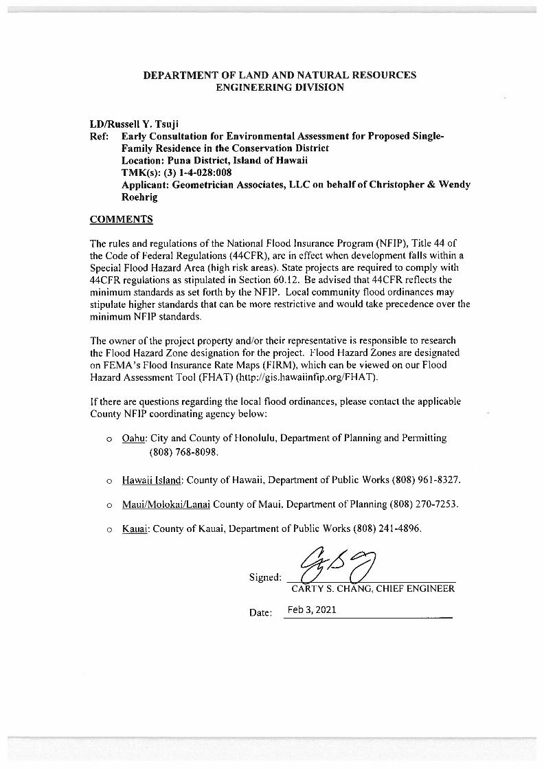


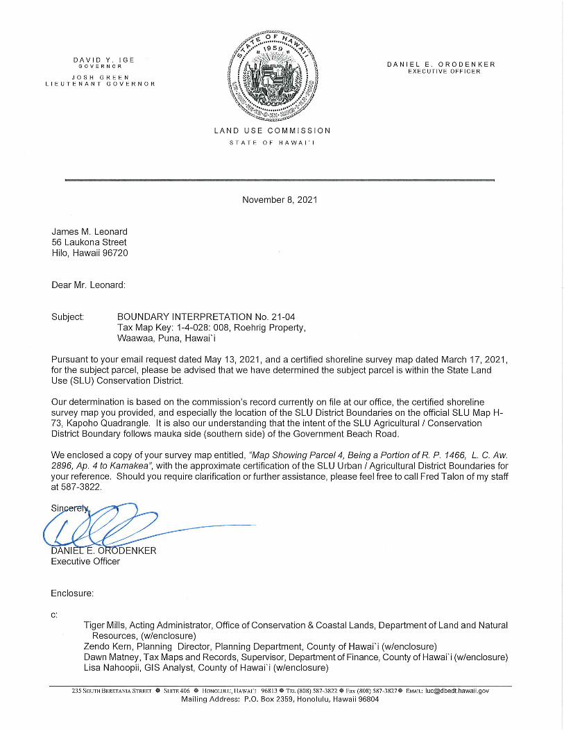


[This page intentionally left blank]
Environmental Assessment
Roehrig Single-Family Residence in the Conservation District in Wa‘awa‘a
APPENDIX 1b Comments to Draft EA and Responses

[This page intentionally left blank]
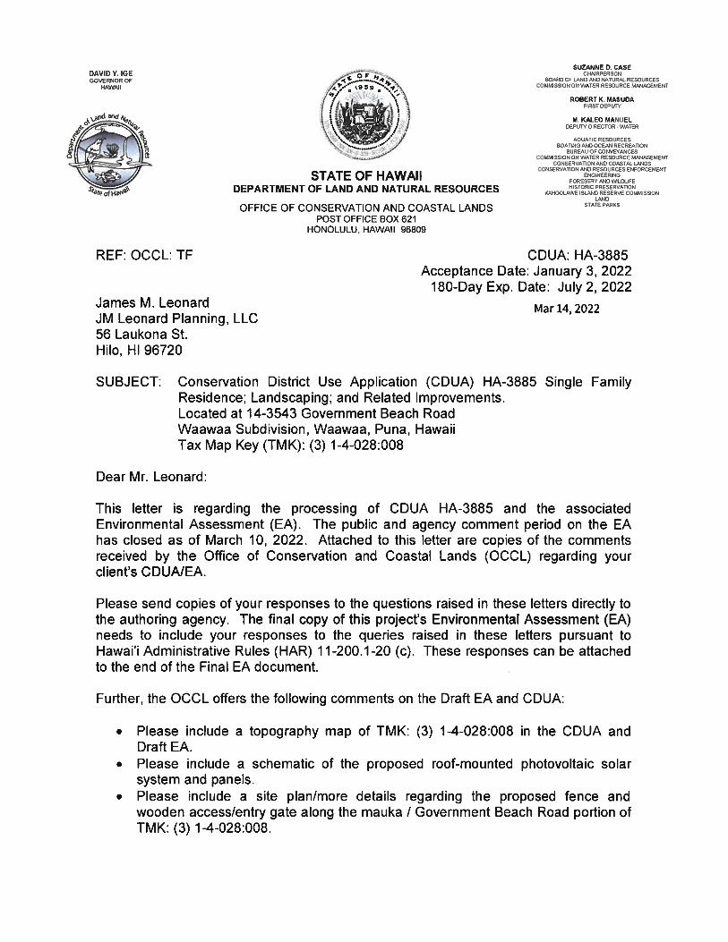

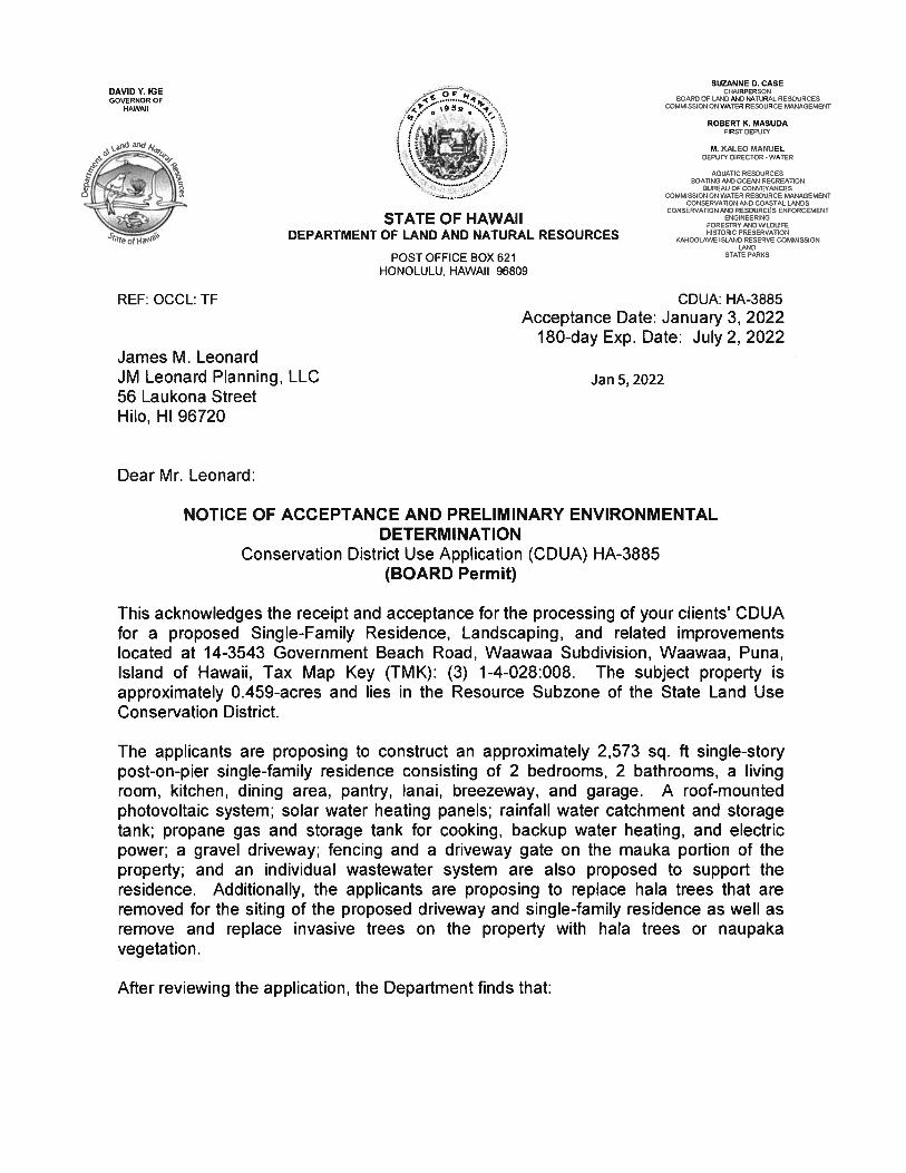


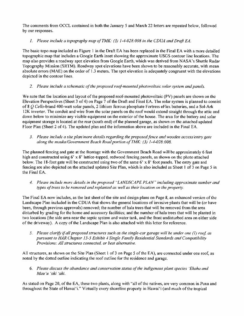

G O V E R N M E N T B E A C H R O A D
PROPOSED 2 BEDRM / 2 BATH DWELLING W/ 1-CAR GARAGE
PROPOSED SEPTIC SYSTEM(REFER TO ENGINEERED DRAWINGS)
PRO
POSE
D C
OM
PAC
T G
RAVE
L D
RIVE
WA
Y
PROPOSED WATERCATCHMENT TANK
TO PRO
PERTY LINE
± 55' - 9"
TO PROPERTY LINE
± 23' - 5"
TO P
R OPE
RTY
LIN
E
± 7
3' -
6"
FRO
NT
SETB
ACK
15' -
0"
SIDE SETBACK
15' - 0"
REAR SETBACK
15' - 0"
SIDE SETBACK
15' - 0"
210.
00'
100.00'
103.12'
191.
11'
(5' min.)
7' - 3 1/2"
TO C
ERTIFIED SH
ORELIN
E70' - 0"
76.23'
28.1
1'
24.38'
49.2
5'
13.3
5'
TIE-LINE
CERTIFIED SHORELINE (MARCH 17, 2021)
P A C I F I C O C E A N
TO PROPERTY LINE
35' - 0"
TO P.L.
± 18' - 10"
PROPOSED GATE
PROPOSED FENCEPROPOSED
FENCE
(5' min.)
± 10' - 0"
18' -
0"
5' -
0"
10' -
0"
(min
.)
5' -
0"
(5' min.)
5' -
0"
ø 15
' - 6"
CONSTRUCTION STAGING AREA
30' - 0"
21' -
0"
LOT 48BEACH RESERVE
TMK(3)1-4-028-051
85.8
5'
12' - 0"
6' - 0"
T O P
O F
P A
L I
PROPOSED PROPANE STORAGE TANK (3' 6" X 8')
S E
A
DEVELOPMENT AREA TABULATION
RESIDENCELiving AreaGarageCovered LanaiBreezewayExterior Steps and LandingsTOTAL AREA - RESIDENCE
WATER STORAGE TANK
PROPANE STORAGE TANK
TOTAL DEVELOPMENT AREA
1,344.50 SF280.00 SF419.50 SF200.00 SF112.30 SF
2,356.30 SF
188.71 SF
28.00 SF
2,573.01 SF
SCALE:A P R O P O S E D N E W C O N S T R U C T I O N F O R :
HOME OWNER SIGNATUREBY SIGNING ABOVE, I ACKNOWLEDGE THAT I ACCEPT THE PRELIMINARY DRAWINGS APPROVED ABOVE AS MY FINAL DESIGN. I'M READY TO MOVE FORWARD WITH PREPARING CONSTRUCTION DOCUMENTS FOR MY PROJECT, AND UNDERSTAND THAT ANY CHANGES TO THE SCOPE OF THE PROJECT OR REVISIONS TO THE DESIGN/SPECIFICATIONS MAY RESULT IN ADDITIONAL DRAFTING OR PROJECT COSTS AND AFFECT MY PROJECT TIMELINE.
DATE:
REVISION NO.:
HOME PLANNING & DESIGN SERVICES BYHPM BUILDING SUPPLY
SHEET NO.:
As indicated
1 of 311/09/2021 CHRISTOPHER J ROEHRIG &
WENDI L ROEHRIGTMK: (3) 1 - 4 - 028 : 008
SITE PLANSCALE: 1" = 30' - 0"TMK: TMK: (3) 1 - 4 - 028 : 008LOT NO: 43LOT AREA: 0.459 ACRESWAA WAA RD, HAWAIIAN BEACHES, HAWAII
5
15 30 60 900
1' = 30'
jamesmleonard
16ʻ
jamesmleonard
jamesmleonard
jamesmleonard
6’ high fencing and gate to beconstructed using 6’ x 8’ lattice-topped, redwood panels
jamesmleonard
jamesmleonard
ENTRY GATE / FENCING

LIVING RM
6 "
P
L U
M B
I N
G
W A
L L
DINING
TUB/SHOWERCOMBO UNIT
W.C.
LAV.
CURT. ROD
L.T.
M/BEDRM.
COVERED LANAI
COVERED LANAI
KITCHEN
PANTRY
BEDRM #2M/BATH
12' - 6" 11' - 6" 5' - 6" 12' - 6"
42' - 0" OVERALL
10' -
6"
8' - 0" 3' - 6"
4' -
0"
2' -
0"
6' -
6"
2' -
6"
5' -
0"
14' -
0"
10' -
0"
26' -
0"
16' -
0"
66' -
0"
2' -
0"
14' -
0"
20' -
0"
6' -
0"
6' -
6"
3' -
6"
2' - 0" 10' - 0" 2' - 0" 10' - 0" 2' - 0" 14' - 0" 2' - 0"
24' - 0"
13' - 0"
5' -
0"
± 7' - 0"
2' -
0"
4' -
0"
16' -
6"
6' -
0"
13' -
6"
LITE-FANCOMBO
LITE-FANCOMBO
(INTE
RIO
R BR
AC
ED W
ALL
)
INTE
RIO
R BR
AC
ED W
ALL
)
(INTERIOR BRACED WALL) (INTERIOR BRACED WALL)
LAV
ROD & SH.
ROD & SH.
ROD
& S
H.
(5) - 1X12
BATH 2
FRAMED PONY WALL
UNDER
D.C. S/S SINK
W/ DISPO
SAL
(60" MIN.)
5' - 2"
5' - 6"
TOWELCLO.
5'-0" W X 4'-0"H 6'-0" W X 4'-0"H
2'-0" W X 3'-0"H 6'-0" W X 3'-6"H 4'-0" W X 1'-4"H
6'-0
" W X
3'-6
"H4'
-0" W
X 3
'-0"H
8'-0
" W X
4'-0
"H
5'-0
" W X
3'-6
"H5'
-0" W
X 3
'-6"H
4'-0
" W X
1'-4
"H
RANGE SPACE
REFRIG. SPACE
FIN
ISH
3' -
0"
ATTICACCESS
4' - 6" X 7'CONCRETE LANDING
10' - 0"
FINISH
3' - 0"
PLMG WALL
W.C.
TUB
/SH
OW
ERC
OM
BO
UN
IT
BREAKLINE OF CEILING CONDITION
5' - 6"
BRE
AK
LIN
E O
F C
EILI
NG
CO
ND
ITIO
N
VAU
LTED
CEI
LIN
GVA
ULT
EDC
EILI
NG
VAULTEDCEILING
4' - 6" X 7'CONCRETE LANDING
(2 min.)2' - 2"
(min.)3' - 0"
(5) - 1X12
(STEP)
(STEP)
'SOLAR W/HTR. STOR. TANK
VAULTEDCEILING
(STEP)
(STEP)
ENTRY
CU
RT.
ROD
(RAILING) (RAILING)
(RA
ILIN
G)
(RA
ILIN
G)
(RAILING)
(RA
ILIN
G)
(RA
ILIN
G)
(RA
ILIN
G)
SINGLE CAR GARAGE
BREEZEWAY
20' - 0"
14' -
0"
6'-0" W X 4'-0"H
2' -
0"
10' -
0"
2' -
0"
(RA
ILIN
G)
(SLO
PE S
LAB
TO
WA
RDS
ENTR
Y)
SOLAR WATERHEATINGPANELS
42' -
0"
4' - 3'- 6"CONC. LANDING
(STEP)
(STEP)
(STEP)
(STEP)
(SIMPSON 'MSTA36' PER CWSP REQ.)
(SIMPSON 'MSTA36' PER CWSP REQ.)
(SIMPSON 'MSTA36' PER CWSP REQ.)
(ENERGY STAR CEILING FAN)
(ENERGY STAR CEILING FAN)
(ENERGY STAR CEILING FAN)
(ENERGY STAR CEILING FAN)
PROPANE STORAGE TANK
8' - 0" 4' - 0"
(SO
LAR
BATT
ERY
LOC
ATI
ON
)
RESIDENCE AREA TABULATION
RESIDENCELiving AreaGarageCovered LanaiBreezewayExterior Steps and LandingsTOTAL AREA - RESIDENCE
1,344.50 SF280.00 SF419.50 SF200.00 SF112.30 SF
2,356.30 SF
SCALE:A P R O P O S E D N E W C O N S T R U C T I O N F O R :
HOME OWNER SIGNATUREBY SIGNING ABOVE, I ACKNOWLEDGE THAT I ACCEPT THE PRELIMINARY DRAWINGS APPROVED ABOVE AS MY FINAL DESIGN. I'M READY TO MOVE FORWARD WITH PREPARING CONSTRUCTION DOCUMENTS FOR MY PROJECT, AND UNDERSTAND THAT ANY CHANGES TO THE SCOPE OF THE PROJECT OR REVISIONS TO THE DESIGN/SPECIFICATIONS MAY RESULT IN ADDITIONAL DRAFTING OR PROJECT COSTS AND AFFECT MY PROJECT TIMELINE.
DATE:
REVISION NO.:
HOME PLANNING & DESIGN SERVICES BYHPM BUILDING SUPPLY
SHEET NO.:
As indicated
2 of 311/09/2021 CHRISTOPHER J ROEHRIG &
WENDI L ROEHRIGTMK: (3) 1 - 4 - 028 : 008
FLOOR PLANSCALE: 1/8" = 1' - 0"
5
2 4 8 12 16 20 240
1/8" = 1'
jamesmleonard
jamesmleonard
SOLAR BATTERYSTORAGE
jamesmleonard
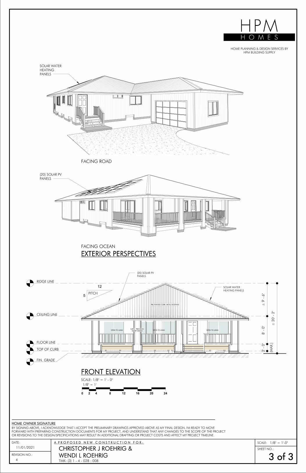
FLOOR LINE
CEILING LINE
RIDGE LINE
FIN. GRADE
± 9
' - 6
"8'
- 0
"
(MA
X.)
2' -
0"
± 2
0' -
2"
PITCH
TOP OF CURB
5
12
PRE-PAINTED CORR. METAL ROOFING
5/8"th. PRECISIONSMART SIDINGOPEN TO LANAI OPEN TO LANAI OPEN TO LANAI
SOLAR WATER HEATING PANELS
(20) SOLAR PV PANELS
SCALE:A P R O P O S E D N E W C O N S T R U C T I O N F O R :
HOME OWNER SIGNATUREBY SIGNING ABOVE, I ACKNOWLEDGE THAT I ACCEPT THE PRELIMINARY DRAWINGS APPROVED ABOVE AS MY FINAL DESIGN. I'M READY TO MOVE FORWARD WITH PREPARING CONSTRUCTION DOCUMENTS FOR MY PROJECT, AND UNDERSTAND THAT ANY CHANGES TO THE SCOPE OF THE PROJECT OR REVISIONS TO THE DESIGN/SPECIFICATIONS MAY RESULT IN ADDITIONAL DRAFTING OR PROJECT COSTS AND AFFECT MY PROJECT TIMELINE.
DATE:
REVISION NO.:
HOME PLANNING & DESIGN SERVICES BYHPM BUILDING SUPPLY
SHEET NO.:
1/8" = 1'-0"
3 of 311/01/2021 CHRISTOPHER J ROEHRIG &
WENDI L ROEHRIGTMK: (3) 1 - 4 - 028 : 008
FRONT ELEVATIONSCALE: 1/8" = 1' - 0"
EXTERIOR PERSPECTIVESFACING OCEAN
FACING ROAD
2 4 8 12 16 20 240
1/8" = 1'
4
SOLAR WATER HEATING PANELS
(20) SOLAR PV PANELS

N
atural area of untouched naupaka and hala fringe mauka of w
hich home w
ill be built
Areas in w
hich invasives have been/will be rem
oved will readily support additional hala


[This page intentionally left blank]
Environmental Assessment
Roehrig Single-Family Residence in the Conservation District in Wa‘awa‘a
APPENDIX 2 Archaeological Inventory Survey

[This page intentionally left blank]
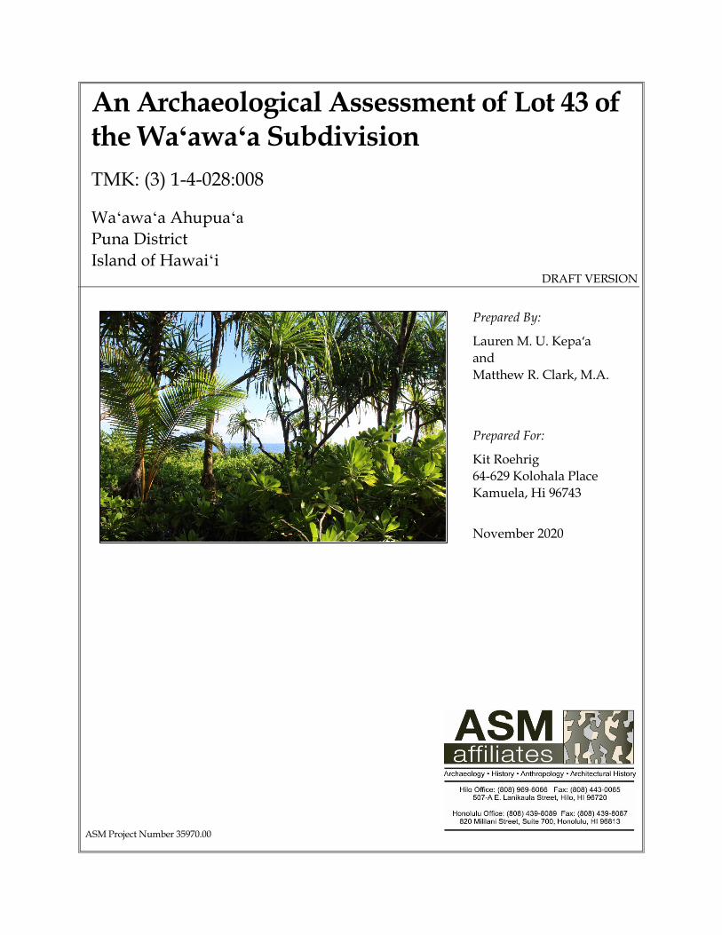
An Archaeological Assessment of Lot 43 of the Waʻawaʻa Subdivision
TMK: (3) 1-4-028:008
Waʻawaʻa Ahupuaʻa Puna District Island of Hawaiʻi
DRAFT VERSION
Prepared By:
Lauren M. U. Kepa‘a and Matthew R. Clark, M.A. Prepared For:
Kit Roehrig 64-629 Kolohala Place Kamuela, Hi 96743 November 2020
ASM Project Number 35970.00


An Archaeological Assessment of Lot 43 of the Waʻawaʻa Subdivision
TMK: (3) 1-4-028:008
Waʻawaʻa Ahupua‘a
Puna District Island of Hawaiʻi


Executive Summary
An Archaeological Assessment of Lot 43 of the Waʻawaʻa Subdivision, Waʻawaʻa, Puna, Hawaiʻi i
EXECUTIVE SUMMARY At the request of Kit Roehrig (landowner), ASM Affiliates conducted an Archaeological Inventory Survey (AIS) of a 0.459-acre project area located on Tax Map Key (TMK): (3) 1-4-028:008 within the Waʻawaʻa Residential Subdivision in Waʻawaʻa Ahupuaʻa, Puna District, Island of Hawaiʻi. A Conservation District Use Application (CDUA) is being prepared for the proposed development of a single-family dwelling on the parcel (in accordance in Hawai‘i Revised Statues (HRS) Chapter 343), and this document is intended to inform that application process. This study was undertaken in accordance with Hawai‘i Administrative Rules (HAR) 13§13–284, and complies with the Rules Governing Minimal Standards for Archaeological Inventory Surveys and Reports as contained in HAR 13§13–276. Compliance with the above standards is sufficient for meeting the historic preservation review process requirements of both the Department of Land and Natural Resources–State Historic Preservation Division (DLNR–SHPD) and the County of Hawai‘i Planning Department. According to HAR 13§13-284-5(b)(5)(A), when no archaeological sites are found during an AIS, the results of the AIS shall be reported as an Archaeological Assessment.
Fieldwork for the current study was conducted on October 15, 2020 by Lauren Kepaʻa and Matthew R. Clark (Principle Investigator). Fieldwork consisted of an intensive (100%) coverage survey of the entire surface of the project area utilizing systematic east-west pedestrian transects with fieldworkers spaced at roughly three-meter intervals. The entire project area was accessible at the time of the survey, and the boundaries were clearly identifiable in the field; vegetation cover on slightly limited ground visibility.
No cultural resources of any kind were identified within the current project area as a result of the fieldwork. Thus, it is the conclusion of this study that the proposed development of a single-family dwelling on the subject parcel will have no effect on any historic properties. With respect to the historic preservation review process of both the Department of Land and Natural Resources–State Historic Preservation Division (DLNR–SHPD) and the County of Hawai‘i Planning Department, our recommendation is that no further work needs to be conducted prior to or during project implementation. In the unlikely event that significant archaeological resources are discovered during the proposed development activities, work shall cease in the area of the discovery and DLNR-SHPD shall be contacted pursuant to HAR 13§13-280-3.

Table of Contents
An Archaeological Assessment of Lot 43 of the Waʻawaʻa Subdivision, Waʻawaʻa, Puna, Hawaiʻi iii
CHAPTERS Page
1. INTRODUCTION ......................................................................................................... 1 PROJECT AREA DESCRIPTION ...................................................................................... 5
2. BACKGROUND ............................................................................................................ 8 CULTURE-HISTORICAL CONTEXT ............................................................................... 8 WAʻAWAʻA AHUPUAʻA AND THE GREATER PUNA DISTRICT .............................. 9
Select Mo‘olelo of Waʻawaʻa and the Greater Puna District ....................................... 14 Traditional Agricultural and Gathering Practices of Waʻawaʻa and Puna ................... 26 Early Historic Accounts of Waʻawaʻa, the Lava Flow of 1840, and the Early Development of the Alanui Aupuni (1823-1847) ......................................................... 31 The Legacy of the Māhele ‘Āina of 1848..................................................................... 36 Royal Patent Land Grants and Land Patent Grants Sold in Waʻawaʻa Ahupuaʻa ....... 37 Boundary Commission Testimony (1862-1876) .......................................................... 43 Nā Inoa ʻĀina and Places of Interest in Waʻawaʻa Ahupuaʻa ..................................... 44 Waʻawaʻa Ahupuaʻa During the Late Nineteenth and Early Twentieth Centuries, Later Historic Accounts, and a Concise History of the Waʻawaʻa Residential Subdivision ................................................................................................................... 47
PREVIOUS ARCHAEOLOGICAL STUDIES ................................................................. 52
3. PROJECT AREA EXPECTATIONS........................................................................ 54 4. FIELDWORK, CONCLUSION, AND RECOMMENDATIONS .......................... 55 REFERENCES CITED ................................................................................................... 56
FIGURES
Page 1. Project area location. ................................................................................................................................. 2 2. Tax Map Key plat (3) 1-4-028 showing location of current project parcel (008). .................................... 3 3. Google Earth™ satellite image showing project area location (outlined in red). ..................................... 4 4. Southern boundary of project area along the edge of the Government Beach Road, view to the
northwest.................................................................................................................................................. 5 5. Geological units in the current project area (Sherrod et al. 2007). ........................................................... 6 6. Soils within the project area (Soil Survey Staff 2019). ............................................................................. 6 7. Northwestern, coastal portion of project area, view to the northwest. ...................................................... 7 8. Typical vegetation pattern in makai portion of the project area, view to the southwest. .......................... 7 9. Typical vegetation in mauka portion of project area, view to the northwest. ........................................... 8 10. Hawai‘i Registered Map No. 2060 (Donn 1901)showing location of the project area (shaded
red) within Waʻawaʻa Ahupuaʻa (shaded yellow) and the Puna District (shaded gray). ....................... 13
Table of Contents
iv An Archaeological Assessment of Lot 43 of the Waʻawaʻa Subdivision, Waʻawaʻa, Puna, Hawaiʻi
11. Man standing in a Puna pū hala grove in 1888 (Brigham and Stokes 1906:28). .................................. 29 12. An engraving prepared by Lahainaluna School students Kaleohano and Nuʻuanu of the lava
flow entering the ocean at Nānāwale as published in The Polynesian (Kaleohano and Nuuanu 1840). ..................................................................................................................................................... 33
13. Portion of Hawaiʻi Registered Map No. 424 prepared in 1841 during the United States Exploring Expedition showing approximate location of the current project area. ................................ 34
15. Land Grants sold within Waʻawaʻa Ahupuaʻa. ..................................................................................... 39 16. Hawaiʻi Registered Map No. 1684 prepared by A.B. Loebenstein in June 1893 showing project
area location (outlined in red) within Waʻawaʻa Ahupuaʻa. .................................................................. 40 17. Newspaper clipping from January 22, 1894 (The Hawaiian Star 1906) ............................................... 41 18. An 1894 map showing approximate location of the project area (shaded red) within Grant No.
3687 to R.A. Lyman (www.kipukadatabase.com). ................................................................................ 41 19. Approximate location of project area (shaded red) within the government remnant portion of
Waʻawaʻa (www.kipukadatabase.com). ................................................................................................ 42 20. Portion of Hawaiʻi Registered Map No. 1883 prepared by A.B. Loebenstein in 1895 showing
project area location (outlined in red) within Waʻawaʻa Ahupuaʻa....................................................... 43 21. Locations of place names in and associated with Waʻawaʻa Ahupuaʻa compiled from Historic
maps. ...................................................................................................................................................... 45 22. Portion of Hawaiʻi Registered Map No. 568 prepared by J.M. Lydgate in 1875 showing
approximate location of the project area in relation to the Alanui Aupuni. ........................................... 48 23. Portion of Hawaiʻi Registered Map No. 2191 prepared in December 1902 as surveyed by E.D.
Baldwin and prepared by T.E. Cook showing the project area location (outlined in red). .................... 49 24. Portion of the 1924 USGS Makuu quadrangle with project area outlined in red. ................................ 50 25. Portion of 1965 USGS Kapoho quadrangle with the project area outlined in red. ............................... 51 26. 1961 USGS aerial photograph showing the location of the project area (outlined in red). .................. 51 27. Previous archaeological studies conducted in the vicinity of the project area. ..................................... 53
TABLES Page
1. Grant parcels purchased within Waʻawaʻa Ahupuaʻa. ............................................................................ 39 2. List of place names/places of interest in Waʻawaʻa noted on historical maps. ....................................... 46

1. Introduction
An Archaeological Assessment of Lot 43 of the Waʻawaʻa Subdivision, Waʻawaʻa, Puna, Hawaiʻi 1
1. INTRODUCTION At the request of Kit Roehrig (landowner), ASM Affiliates conducted an Archaeological Inventory Survey (AIS) of a 0.459-acre project area located on Tax Map Key (TMK): (3) 1-4-028:008 within the Waʻawaʻa Residential Subdivision in Waʻawaʻa Ahupuaʻa, Puna District, Island of Hawaiʻi (Figures 1, 2, and 3). A Conservation District Use Application (CDUA) is being prepared for the proposed development of a single-family dwelling on the parcel (in accordance in Hawai‘i Revised Statues (HRS) Chapter 343), and this document is intended to inform that application process. This study was undertaken in accordance with Hawai‘i Administrative Rules (HAR) 13§13–284, and complies with the Rules Governing Minimal Standards for Archaeological Inventory Surveys and Reports as contained in HAR 13§13–276. Compliance with the above standards is sufficient for meeting the historic preservation review process requirements of both the Department of Land and Natural Resources–State Historic Preservation Division (DLNR–SHPD) and the County of Hawai‘i Planning Department. According to HAR 13§13-284-5(b)(5)(A), when no archaeological sites are found during an AIS, the results of the AIS shall be reported as an Archaeological Assessment. This report contains background information outlining the project area’s physical and cultural contexts, a presentation of previous archaeological work in the vicinity of the project area, and current survey expectations based on that previous work. Also presented is an explanation of the project’s methods and a description of the findings, followed by recommendations and a determination of effect for the proposed project.

1. Introduction
2 An Archaeological Assessment of Lot 43 of the Waʻawaʻa Subdivision, Waʻawaʻa, Puna, Hawaiʻi
Figure 1. Project area location.

1. Introduction
An Archaeological Assessment of Lot 43 of the Waʻawaʻa Subdivision, Waʻawaʻa, Puna, Hawaiʻi 3
Fig
ure
2. T
ax M
ap K
ey p
lat (
3) 1
-4-0
28 sh
owin
g lo
catio
n of
cur
rent
pro
ject
par
cel (
008)
.
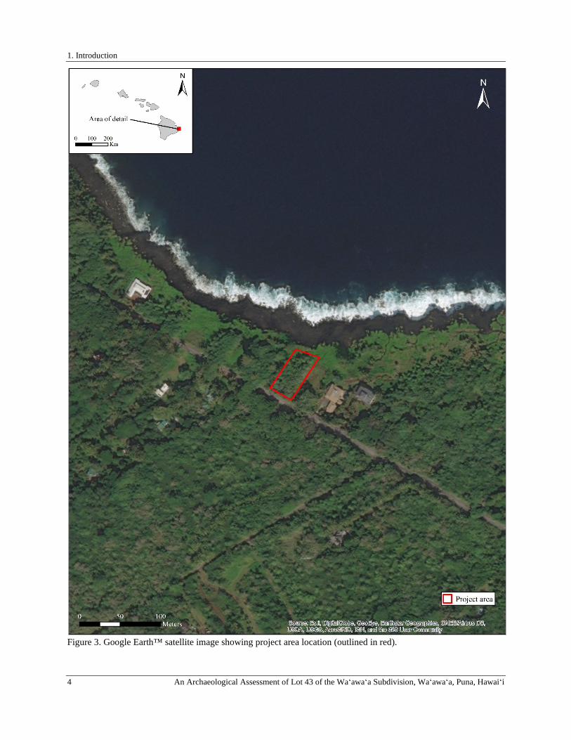
1. Introduction
4 An Archaeological Assessment of Lot 43 of the Waʻawaʻa Subdivision, Waʻawaʻa, Puna, Hawaiʻi
Figure 3. Google Earth™ satellite image showing project area location (outlined in red).

1. Introduction
An Archaeological Assessment of Lot 43 of the Waʻawaʻa Subdivision, Waʻawaʻa, Puna, Hawaiʻi 5
PROJECT AREA DESCRIPTION The project area is situated within Waʻawaʻa Subdivision, which encompasses the entire makai portion of Waʻawaʻa Ahupuaʻa along the Puna coast of Hawai‘i Island between Nānāwale and Kahuwai ahupuaʻa (see Figure 1). The project area (TMK: (3) 1-4-028:008), also identified as Lot 43 of the Waʻawaʻa Subdivision, is located in the northwestern portion of the subdivision between the Government Beach Road and the coast at an elevation of 8 to 15 meters (26 to 49 feet) above sea level. It is bounded to the west by a recently developed residential parcel (Lot 44), to the east by an undeveloped residential parcel (Lot 42), to the south by the Government Beach Road, and to the north by a thin, 12.6-acre conservation-zoned oceanfront parcel (jointly owned by all of the subdivision lot owners) that extends along the entire coast of the Waʻawaʻa Subdivision. The project area is accessed from the Government Beach Road (Figure 4), and at the time of the current fieldwork all four corners of the parcel had been recently marked by a surveyor with lathe and flagging tape.
The underlying geology of this portion of the Puna District is generally formed of pāhoehoe lava flows, mapped as Puna Basalt (Sherrod et al. 2007), that originated from Kīlauea Volcano between 750 and 1,500 years ago (labeled Qp3 in Figure 5). Soils that have formed on these lava flows are classified as dry Opihikao highly decomposed plant material on 2 to 20 percent slopes (Figure 6). These shallow, well-drained soils are formed of highly decomposed plant material overlying pāhoehoe bedrock (Soil Survey Staff 2017). Terrain within the project area is characterized by a gentle makai (northeast) slope which terminates at a low pali (cliff) overlooking a wave-swept pāhoehoe bedrock shelf (Figure 7).
The climate in the vicinity of the project area is generally warm and wet with temperatures ranging between 70° to 77° Fahrenheit throughout the year, and a mean annual rainfall of approximately 2,620 millimeters (103 inches) (Giambelluca et al. 2014). Vegetation within of the project area is dominated by a dense growth of beach naupaka (naupaka kahakai; Scaevola sericea) near the coast (Figure 8), which transitions to a growth of primarily hala (screw pine; Pandanus odoratissimus) interspersed with niu (coconut; Cocos nucifera), lauaʻe (maile-scented fern; Phymatosorus grossus), ʻamaʻumaʻu (Sadleria cyatheoides), and kupukupu (sword fern; Nephrolepis exaltata), scattered kī (ti; Cordyline fruticose), wedelia (Sphagneticola trilobata) nearer to the Government Beach Road (Figure 9).
Figure 4. Southern boundary of project area along the edge of the Government Beach Road, view to the northwest.

1. Introduction
6 An Archaeological Assessment of Lot 43 of the Waʻawaʻa Subdivision, Waʻawaʻa, Puna, Hawaiʻi
Figure 5. Geological units in the current project area (Sherrod et al. 2007).
Figure 6. Soils within the project area (Soil Survey Staff 2019).
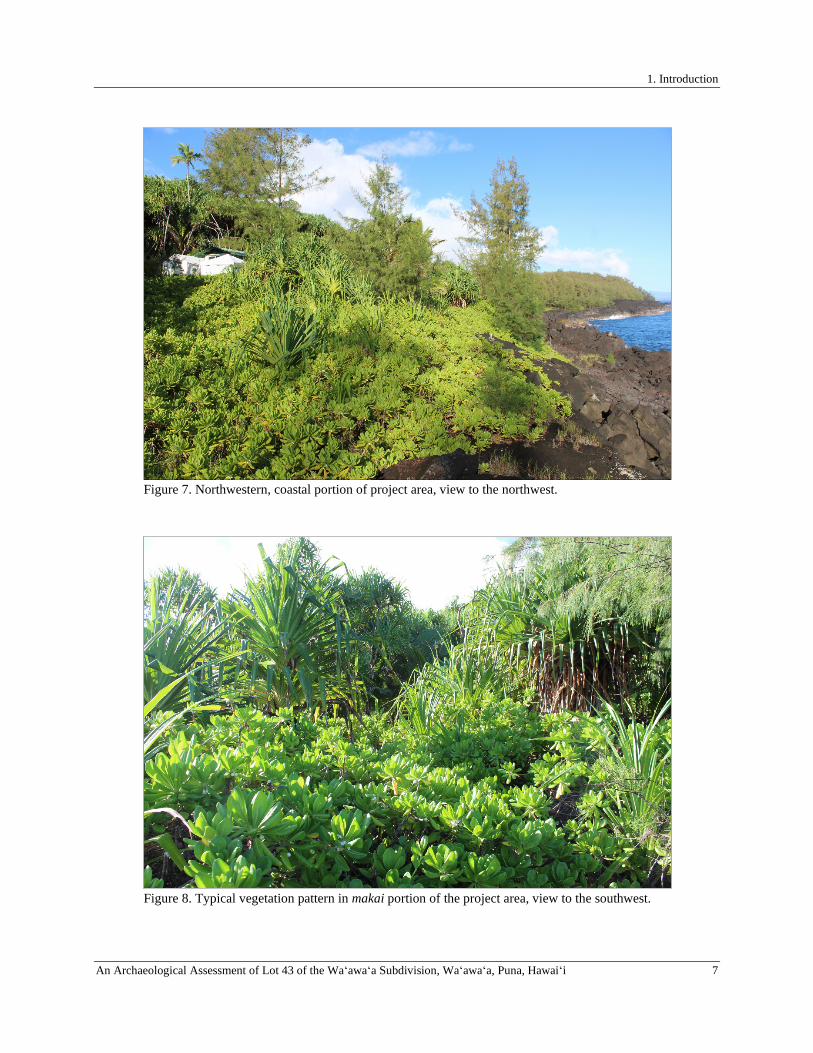
1. Introduction
An Archaeological Assessment of Lot 43 of the Waʻawaʻa Subdivision, Waʻawaʻa, Puna, Hawaiʻi 7
Figure 7. Northwestern, coastal portion of project area, view to the northwest.
Figure 8. Typical vegetation pattern in makai portion of the project area, view to the southwest.

2. Background
8 An Archaeological Assessment of Lot 43 of the Waʻawaʻa Subdivision, Waʻawaʻa, Puna, Hawaiʻi
Figure 9. Typical vegetation in mauka portion of project area, view to the northwest.
2. BACKGROUND To generate a set of expectations regarding the nature of archaeological resources that might be encountered within the current project area, and to establish an environment within which to assess the significance of any such resources, a general culture-historical context for the Puna region that includes specific information regarding the known history of Waʻawaʻa Ahupuaʻa and the project area is presented. This is followed by a discussion of relevant prior archaeological studies conducted in the vicinity of the project area.
CULTURE-HISTORICAL CONTEXT The chronological summary presented below begins with the peopling of the Hawaiian Islands and includes a presentation of a generalized model of Hawaiian Prehistory containing legendary references to and a discussion of the general settlement patterns for Puna. The discussion of prehistory is followed by a summary of historical events in the district that begins with the arrival of foreigners in the islands and then continues with the history of land use in Puna in the vicinity of Waʻawaʻa after contact. The summary includes a discussion of the changing lifeways and population decline during the early Historic Period, a review of land tenure in the study ahupua‘a during the Māhele ‘Āina of 1848, and the subsequent transition into a residential subdivision in the last half of the twentieth century.
A Generalized Model of Hawaiian Prehistory
While the question of the timing of the first settlement of Hawai‘i by Polynesians remains unanswered, the current archaeological consensus derives from various sources of information (i.e., archaeological, genealogical, mythological, oral-historical, radiometric). With data from advances in palynology and radiocarbon dating techniques, Kirch (2011) and others (Athens et al. 2014; Wilmshurst et al. 2011) have argued that Polynesians arrived in the Hawaiian Islands, sometime between A.D. 1000 and A.D. 1200 and expanded rapidly thereafter. Other versions of the peopling of the islands, including various native Hawaiian traditions, place the event earlier in time—and as early as the creation of the world (e.g., Beckwith 1951; Liliuokalani 1978; Malo 1951). What is more widely accepted is the answer to the question of where Hawaiian populations came from and the transformations they went through on their way to establishing a uniquely Hawaiian culture. The initial migration to Hawai‘i is believed to have occurred from Kahiki (the ancestral homelands of Hawaiian gods and people) with long-distance voyages occurring fairly regularly through at least the thirteenth century. It has been generally reported that the sources of the early Hawaiian populations
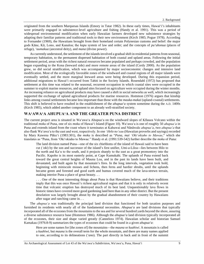
2. Background
An Archaeological Assessment of Lot 43 of the Waʻawaʻa Subdivision, Waʻawaʻa, Puna, Hawaiʻi 9
originated from the southern Marquesas Islands (Emory in Tatar 1982). In these early times, Hawai‘i’s inhabitants were primarily engaged in subsistence-level agriculture and fishing (Handy et al. 1991). This was a period of widespread environmental modification when early Hawaiian farmers developed new subsistence strategies by adapting their familiar patterns and traditional tools to their new environment (Kirch 1985; Pogue 1978). According to Fornander (1969), the Hawaiians brought from their homeland certain Polynesian customs and belief: the major gods Kāne, Kū, Lono, and Kanaloa; the kapu system of law and order; and the concepts of pu‘uhonua (places of refuge), ‘aumakua (ancestral deity), and mana (divine power).
As currently understood, the settlement of the islands involved a gradual shift in residential patterns from seasonal, temporary habitation, to the permanent dispersed habitation of both coastal and upland areas. Following the initial settlement period, areas with the richest natural resources became populated and perhaps crowded, and the population began expanding to the Kona (leeward side) and more remote areas of the island (Cordy 2000). As the population grew, so did social stratification, which was accompanied by major socioeconomic changes and intensive land modification. Most of the ecologically favorable zones of the windward and coastal regions of all major islands were eventually settled, and the more marginal leeward areas were being developed. During this expansion period, additional migrations to Hawai‘i occurred from Tahiti in the Society Islands. Rosendahl (1972) has proposed that settlement at this time was related to the seasonal, recurrent occupation in which coastal sites were occupied in the summer to exploit marine resources, and upland sites focused on agriculture were occupied during the winter months. An increasing reliance on agricultural products may have caused a shift in social networks as well, which increasingly supported the exchange of upland agricultural products for marine resources. Hommon (1976) argues that kinship links among coastal settlements became less important than those with the mauka-makai (upland-coastal) settlements. This shift is believed to have resulted in the establishment of the ahupua‘a system sometime during the A.D. 1400s (Kirch 1985), which added another component to an already well-stratified society.
WAʻAWAʻA AHUPUAʻA AND THE GREATER PUNA DISTRICT The current project area is situated in Waʻawaʻa Ahupua‘a on the windward slopes of Kīlauea Volcano within the traditional moku of Puna, one of six moku of Hawai‘i Island (Figure 10). Waʻawaʻa is one of roughly 50 ahupuaʻa in Puna and extends inland from the coast where it terminates at Kahuwai and Nānāwale ahupuaʻa, two ahupuaʻa that also flank Waʻawaʻa to the east and west, respectively. In one ʻōlelo noʻeau (Hawaiian proverbs and sayings) recorded by Mary Kawena Pūkuʻi (1983:301), the moku is described as “Puna, mai ʻOkiʻokiaho to Mawae,” which she translates as “Puna, from ʻOkiʻokiaho to Mawae.” Handy et al. (1991:539-542) further describe the moku of Puna:
The land division named Puna—one of the six chiefdoms of the island of Hawaii said to have been cut (ʻoki) by the son and successor of the island’s first unifier, Umi-a-Liloa—lies between Hilo to the north and Kaʻu to the south, and it projects sharply to the east as a great promontory into the Pacific. Kapoho is its most easterly point, at Cape Kumukahi. The uplands of Puna extend back toward the great central heights of Mauna Loa, and in the past its lands have been built, and devastated, and built again by that mountain’s fires. In the long intervals, vegetation took hold, beginning with miniscule mosses and lichens, then ferns and hardier shrubs, until the uplands became green and forested and good earth and humus covered much of the lava-strewn terrain, making interior Puna a place of great beauty. . . . . . One of the most interesting things about Puna is that Hawaiians believe, and their traditions imply that this was once Hawaii’s richest agricultural region and that it is only in relatively recent time that volcanic eruption has destroyed much of its best land. Unquestionably lava flows in historic times have covered more good gardening land here than in any other district. But the present desolation was largely brought about by the gradual abandonment of their country by Hawaiians after sugar and ranching came in. . .
The ahupuaʻa was traditionally the principal land division that functioned for both taxation purposes and furnished its residents with nearly all of the fundamental necessities. Ahupua‘a are land divisions that typically incorporated all of the ecozones from the mountains to the sea and for several hundred yards beyond the shore, assuring a diverse subsistence resource base (Hommon 1986). Although the ahupua‘a land division typically incorporated all of the ecozones, their size and shape varied greatly (Cannelora 1974). Hawaiian scholar and historian Samuel Kamakau (1976:8-9) summarizes the types of ecozones that could be found in a given ahupua‘a:
Here are some names for [the zones of] the mountains—the mauna or kuahiwi. A mountain is called a kuahiwi, but mauna is the overall term for the whole mountain, and there are many names applied to one, according to its delineations (‘ano). The part directly in back and in front of the summit
2. Background
10 An Archaeological Assessment of Lot 43 of the Waʻawaʻa Subdivision, Waʻawaʻa, Puna, Hawaiʻi
proper is called the kuamauna, mountaintop; below the kuamauna is the kuahea, and makai of the kuahea is the kuahiwi proper. This is where small trees begin to grow; it is the wao nahele. Makai of this region the trees are tall, and this is the wao lipo. Makai of the wao lipo is the wao ‘eiwa, and makai of that the wao ma‘ukele. Makai of the wao ma‘ukele is the wao akua, and makai of there is the wao kanaka, the area that people cultivate. Makai of the wao kanaka is the ‘ama‘u, fern belt, and makai of the ‘ama‘u the ‘apa‘a, grasslands. A solitary group of trees is a moku la‘au (a “stand” of trees) or an ulu la‘au, grove. Thickets that extend to the kuahiwi are ulunahele, wild growth. An area where koa trees suitable for canoes (koa wa‘a) grow is a wao koa and mauka of there is a wao la‘au, timber land. These are dry forest growths from the ‘apa‘a up to the kuahiwi. The places that are “spongy” (naele) are found in the wao ma‘ukele, the wet forest. Makai of the ‘apa‘a are the pahe‘e [pili grass] and ‘ilima growths and makai of them the kula, open country, and the ‘apoho hollows near to the habitations of men. Then comes the kahakai, coast, the kahaone, sandy beach, and the kalawa, the curve of the seashore—right down to the ‘ae kai, the water’s edge. That is the way ka po‘e kahiko [the ancient people] named the land from mountain peak to sea.
Although the mauka boundary of Waʻawaʻa Ahupuaʻa extends to only roughly 230 feet in elevation, the upper reaches of the ahupuaʻa were formerly covered by a dense overgrowth of ʻōhiʻa lehua (Metrosideros polymorpha) trees, indicating its likely extent into the lower limits of the wao akua as it exists within this portion of Puna. The transition from the wao akua towards the makai extent of Waʻawaʻa is abrupt, and aside from the cultivatable lands termed by Kamakau (1976) as the wao kanaka, appear to swiftly transition to kahakai lands encompassing the current project area. Within Waʻawaʻa, and all other ahupuaʻa, the makaʻāinana (commoners; Lit. people that attend the land) who lived on the land had rights to gather resources for subsistence and tribute (Jokiel et al. 2011). As part of these rights, the ahupua‘a residents were also required to supply resources and labor that supported the royal communities of regional and/or island kingdoms. The ahupuaʻa became the equivalent of a local community, with its own social, economic, and political significance, and served as the taxable land division during the annual Makahiki procession (Kelly 1956). During this annual procession, the highest chief of the land sent select members of his retinue to collect ho‘okupu (tribute and offerings) in the form of goods from each ahupua‘a. The makaʻāinana who resided in the ahupua‘a brought their share of ho‘okupu to an ahu (altar) that was symbolically marked with the image of a pua‘a (pig). Ahupuaʻa boundaries, in most instances, were established along rational lines, following mountain ridges, hill, rivers or ravines, however, Chinen (1958:1) reports that “oftentimes only a line of growth of a certain type of tree or grass marked a boundary; and sometimes only a stone determined the corner of a division.” Ahupua‘a were ruled by ali‘i ‘ai ahupua‘a or chiefs who controlled the ahupua‘a resources; who, for the most part, had complete autonomy over this generally economically self-supporting piece of land (Malo 1951). Ahupua‘a residents were not bound to the land nor were they considered the property of the ali‘i. If the living conditions under a particular ahupua‘a chief were deemed unsuitable, the residents could move freely in pursuit of more favorable conditions (Lam 1985). This structure safeguarded the well-being of the people and the overall productivity of the land, lest the chief loses the principal support and loyalty of his or her supporters. Ahupua‘a lands were in turn, managed by an appointed konohiki or lesser chief-landlord, who oversaw and coordinated stewardship of an area’s natural resources (Lam 1985). In some places, the po‘o lawai‘a (head fisherman) held the same responsibilities as the konohiki (Jokiel et al. 2011). When necessary, the konohiki took the liberty of implementing kapu (restrictions and prohibitions) to protect the mana of the area’s resources from physical and spiritual depletion.
Many ahupua‘a were further divided into smaller land units termed ‘ili and ‘ili kūpono (often shortened to ‘ili kū). ‘Ili were created for the convenience of the ahupua‘a chief and served as the basic land unit, which hoa‘āina (native tenants) often retained for multiple generations (Jokiel et al. 2011; MacKenzie 2015). As the ‘ili themselves were typically passed down in families, so too were the kuleana (responsibilities, privileges) that were associated with it. The right to use and cultivate ‘ili was maintained within the ‘ohana, regardless of any change in title of the ahupua‘a chief (Handy et al. 1991). Malo (1951) recorded several types of ‘ili: the ‘ili pa‘a, a single intact parcel and the ‘ili lele, a discontinuous parcel dispersed across an area. Whether dispersed or wholly intact, the ‘ili land division required a cross-section of available resources, and for the hoa‘āina, this generally included access to agriculturally fertile lands and coastal fisheries. While much of the same resource principles applied to the ‘ili kūpono, these land units were politically independent of the ahupua‘a chief. This designation was applied to specific areas containing resources that were highly valued by the ruling chiefs, such as fishponds (Handy et al. 1991).
2. Background
An Archaeological Assessment of Lot 43 of the Waʻawaʻa Subdivision, Waʻawaʻa, Puna, Hawaiʻi 11
The ali‘i who presided over the ahupua‘a (ali‘i-‘ai-ahupua‘a), in turn, answered to an ali‘i ‘ai moku, or chief who claimed the abundance of the entire moku or district (Malo 1951). On Hawaiʻi Island, there are six traditional moku: Kona, Kaʻū, Puna, Hilo, Hāmākua, and Kohala. Although moku contained multiple ahupua‘a, they were considered geographical subdivisions with no explicit reference to rights in the land (Cannelora 1974). Other land units were also used. In what is now South Kohala, for example, the kalana was a division of land that was smaller than a moku but composed of several ahupuaʻa and ʻili ʻāina. The term ʻokana was also sometimes used interchangeably with kalana (Lucas 1995; Pukui and Elbert 1986), but Kamakau (1976), equates a kalana to a moku and states that ʻokana is merely a subdistrict.
This form of district subdividing was integral to Hawaiian life and structurally supported the resource management planning by ali‘i and konohiki. As knowledge of place developed over the centuries and was passed down intergenerationally by direct teaching and experience, detailed information of an area’s natural cycles and resources were retained and well-understood. Decisions were based on generations worth of highly informed knowledge and sustainably adapted to meet the needs of a growing population. This highly complex land management system mirrors the unique Hawaiian culture that coevolved with these islands.
As Waʻawaʻa encompasses both mauka agricultural and forest resources and makai fisheries, residents were once able to procure nearly all that they needed to sustain their families and contribute to the larger community from within the land division while also supporting the ruling aliʻi of the moku. In Puna, a few small communities were initially established along sheltered bays with access to fresh water and rich marine resources. The communities shared extended familial relations, and there was an occupational focus on the collection of marine resources, and the Precontact population of the moku resided in small settlements clustered around sheltered bays along the coastline where they subsisted on marine resources supplemented by agricultural products. According to McEldowney (1979), there were six villages present along the coast between Hilo and Cape Kumukahi (Keaʻau or Hāʻena, Makuʻu, Waiakahiula, Honolulu, Kahuwai, and Kula or Koaʻe. The current project area is located between the villages of Honolulu and Kahuwai. Each in Puna were similar to those of the Hilo District, and they:
. . . comprised the same complex of huts, gardens, windbreaking shrubs, and utilized groves, although the form and overall size of each appear to differ. The major differences between this portion of the coast and Hilo occurred in the type of agriculture practiced and structural forms reflecting the uneven nature of the young terrain. Platforms and walls were built to include and abut outcrops, crevices were filled and paved for burials, and the large numbers of loose surface stones were arranged into terraces. To supplement the limited and often spotty deposits of soil, mounds were built of gathered soil, mulch, sorted sizes of stones, and in many circumstances, from burnt brush and surrounding the gardens. Although all major cultigens appear to have been present in these gardens, sweet potatoes, ti (Cordyline terminalis), noni (Morinda citrifolia), and gourds (Lagenaria siceraria) seem to have been more conspicuous. Breadfruit, pandanus, and mountain apple (Eugenia malaccensis) were the more significant components of the groves that grew in more disjunct patterns than those in Hilo Bay. (McEldowney 1979:17)
Located along the coast, the project area falls within the Coastal Settlement Zone (Zone I) as described by McEldowney (1979:15-18). While this model is largely based on early historical accounts, it also considers environmental variables and human resource needs, and offers insights into the prehistoric past (Burtchard and Moblo 1994). In their refinement of the model as it applies to Puna, Burtchard and Moblo (1994) elaborate on McEldowney’s (1979) concept of the Coastal Settlement Zone:
As with her model, [the Coastal Settlement Zone] includes coastal terrain to about one half mile inland. This is the zone expected to have the greatest density and variety of prehistoric surface features in the general study area. Primary settlements are expected in places where agriculturally productive sediments (principally well-weathered ʻaʻā flows) co-occur with sheltered embayments and productive fisheries. Settlements within this zone are expected to be logistically linked to inland agricultural and forest exploitation zones accessed through a network of upslope-downslope (Mauka-makai) trails. Larger settlements and resource acquisition areas may have been connected by cross-terrain trail networks. (Burtchard and Moblo 1994:26)
In addition to mauka-makai trails, one of the primary trail networks utilized during the Precontact to early Historic Period was the alaloa (literally meaning the long road or trail), which served as an idealized route of travel that theoretically circled the entire island. The alaloa provided access to all of the island’s districts and their respective ahupua‘a, facilitating commodity exchange between otherwise isolated adjacent coastal communities such as those in the vicinity of the current project area, as well as more upland regions (Mills 2002). The concept of the alaloa as a

2. Background
12 An Archaeological Assessment of Lot 43 of the Waʻawaʻa Subdivision, Waʻawaʻa, Puna, Hawaiʻi
trail that circled the entire island likely developed over time as local trails in different areas connected to each other to form a cohesive trajectory of travel. Kirch (1985) notes that while heavy loads could be carried by canoe between coastal areas, the 175-mile long alaloa and the expansive terrestrial trail network that it accessed, allowed people, information, and material goods to travel overland to virtually any location on the island, providing an important network of Precontact/early Historic Period communication. As related by Cordy, long-distance travel between ahupua‘a was rare until post-1800, as communities relied almost entirely on resources procured from their own land unit. Cordy elaborates:
The common use of the ala loa was for interaction between people of adjacent communities. The residents of the ahupuaʻa prior to the 1800s rarely travelled far from their ahupuaʻa. Farming, fishing, and gathering of forest resources were usually done within the bounds of their own ahupuaʻa. Most marriage partners came from the same ahupuaʻa or from nearby lands. Many small sets of ahupuaʻa commonly interacted in the past. The main means of travelling between these communities was on the ala loa. Longer distance travel by commoners, although less frequent, would also have been along the ala loa, its upland branches, across the mountain trails, or by canoe. Some of this traffic may have been for the overlord chiefs and the rulers, such as the bringing in of daily food supplies and water. Travel along the ala loa also was done for chiefly affairs. Messengers were sent along trails or by canoe to call in other chiefs for meetings, to call for tribute, to summon warriors in for battle, to gather in laborers to build public works projects such as temples, and so on. (Cordy in Mills 2002:151)
The alaloa extends from ‘Ūpolu Point in North Kohala, through Ka‘ū, and into the Puna District and served as the principal interaction route between people of adjacent coastal communities, and as previously mentioned, was also used (albeit less frequently) for long distance travel, for chiefly affairs, and for tax collection during the annual Makahiki season (Cordy 1994; Mills 2002; Mills and Irani 2000; National Park Service 2009). As related by the National Park Service’s Ala Kahakai National Trail program:
Travel along the ala loa was often done for chiefly affairs. Messengers (kukini, or swift runners) were sent along the trails or by canoe to call in other chiefs for meetings, to call for tribute, to summon warriors in for battle, to gather in laborers to build public works projects such as temples, and to spy on rival chiefs. Occasionally, the ruler and the court circled the island to check on the state of affairs of production, population, or potential rivals, or to rededicate temples. This circuit might be at a brisk pace, or leisurely movement from one of the favored royal centers to another over the period of several months. The highest chiefs (Ali‘i nui) traveled the ala loa to reach their own residences and smaller courts in their own ahupua‘a, which they occasionally used when not at the royal court. (National Park Service 2009:15)
The significance of the alaloa, that served as the primary route of travel across the lands across the Puna District (and thus Waʻawaʻa Ahupuaʻa) prior to the subsequent construction and widespread use of the Alanui Aupuni, or Government Road system; see below), is imbued in its association with significant, traditional events in Hawai‘i’s history, in particular the Makahiki procession. The Makahiki involved a series of rituals, prayers, offering, and processions asking Lono to bestow plenty in the coming year Hommon (2013). Ritual activities were centered on the hale o Lono temples, but also occurred throughout each island’s districts:
Other religious ceremonies and special sporting events were held honoring Lono, the god of Agriculture. For tax collection, a procession of priests, attendants, and athletes carried a wooden image of Lono clockwise around the island on the ala loa in a circuit of 23 days. In theory, the procession halted at the ahu or altar of each ahupua‘a, collected tribute, and traveled on. In practice, several of the 600 ahupua‘a most likely gathered their tribute in one place to expedite the collection. (National Park Service 2009:15)
Over time, as the populations of desirable coastal locations increased, early Hawaiians expanded their settlements into upland regions and more marginal areas of Puna. As competition for resources intensified, so too did political competition that resulted in conflict and further expansion into upland areas as political exiles sought asylum in remote places and hidden lava tubes (Burtchard and Moblo 1994). Although the boundaries of the Puna District are strictly political, the lands encompassed by it possess a unique environment that played a large role in determining the boundaries and shaping its history from the time of Polynesian settlement to the modern day. Barrère (1959:15) summarizes the Precontact geopolitics of the Puna District as follows:
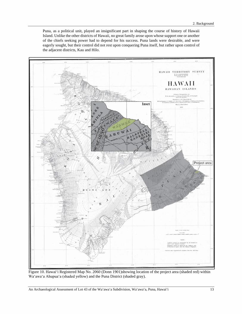
2. Background
An Archaeological Assessment of Lot 43 of the Waʻawaʻa Subdivision, Waʻawaʻa, Puna, Hawaiʻi 13
Puna, as a political unit, played an insignificant part in shaping the course of history of Hawaii Island. Unlike the other districts of Hawaii, no great family arose upon whose support one or another of the chiefs seeking power had to depend for his success. Puna lands were desirable, and were eagerly sought, but their control did not rest upon conquering Puna itself, but rather upon control of the adjacent districts, Kau and Hilo.
Figure 10. Hawai‘i Registered Map No. 2060 (Donn 1901)showing location of the project area (shaded red) within Waʻawaʻa Ahupuaʻa (shaded yellow) and the Puna District (shaded gray).
2. Background
14 An Archaeological Assessment of Lot 43 of the Waʻawaʻa Subdivision, Waʻawaʻa, Puna, Hawaiʻi
Select Mo‘olelo of Waʻawaʻa and the Greater Puna District Prior to first contact with Europeans in the late eighteenth century and the development of a written Hawaiian language, the history of ancient Hawai‘i was transmitted orally from generation to generation. After the arrival of the first missionaries in 1820, Hawaiian culture underwent major transformations, one of which included the adoption of the written language. Although oral traditions were still maintained, many natives and foreigners began writing down versions of these oral traditions, which provide invaluable insight into Hawai‘i’s past by recording elements of Hawaiian culture such as historical figures, beliefs, traditions, wahi pana (legendary places), inoa ‘āina (place names), and mo‘olelo (legendary accounts, stories, and myths), mele and oli (songs and chants), and ‘ōlelo no‘eau; all of which contribute to an in-depth understanding of the people, their culture and place. Traditional mo‘olelo specifically associated with Waʻawaʻa are limited, but the moku of Puna features prominently in numerous stories. The examples presented below illustrate the legacy of Puna and its intimate relationship with exalted deities such as the goddess Pele, her sister Hiʻiaka, and the god Kāne, enumerate the legends of Puna aliʻi, famed Moaniʻala and Uahipele winds, and discuss the names of traditional ʻaumakua manō (family/personal shark ancestral gods).
Pelehonuamea in Puna
Most closely associated with the powerful and temperamental volcanoes of Hawai‘i, Pele was perhaps both feared and respected equally by the people of the islands. Nimmo (1990:44) related that, “although the actual worship of Pele was most important in the districts of Hawai‘i that experienced active volcanism, the mythology of the goddess was widespread throughout the Hawaiian Islands.” And that, “there is no evidence that Pele was worshipped extensively beyond the volcano area of Hawai‘i, although her mythology was apparently widespread throughout the Hawaiian Islands and members of her family were important in ritual throughout the archipelago” (ibid.). Puna’s association with Pele is strong and goes back many years because of the region’s relatively young geological age and ongoing volcanic activity. It is said that before Pele migrated to Hawaiʻi from Kahiki, there was “no place in the islands. . . more beautiful than Puna” (Pukui 1983:11).
King David Kalākaua (1972) indicated that active worship of Pele was ongoing between the 12th and 19th centuries, and that the abolition of the kapu system in the late 19th century had little to no effect on this practice, which remains ongoing. In addition to being revered as a goddess, Pele was also worshipped as an ‘aumakua (ancestor god/guardian spirit) by her descendants. According to Nimmo, “most Hawaiians living in the volcano areas of Hawai‘i, the districts of Ka‘ū, Puna, and Kona, at the time of European contact traced their ancestry to Pele” (1990:43). Pele appears throughout Hawaiian mythology and history; tales of Pele’s migration from Kahiki to Hawai‘i abound. According to Beckwith:
The Pele myth is believed to have developed in Hawai‘i, where it is closely associated with aumakua worship of the deities of the volcano, with the development of the hula dance, and with innumerable stories in which odd rock or cone formations are ascribed to contests between Pele and her rivals, human or divine. The myth narrates the migration or expulsion of Pele from her distant homeland and her effort to dig for herself a pit deep enough to house her whole family in cool comfort or to exhibit them in their spirit forms of flame and cloud and other volcanic phenomena. (1970:168)
According to one version of the migration legend, Pele, daughter of Haumea and Moemoe-a-aulii, was tempted with the urge to travel. Nestling her favorite sister (who was born in the shape of an egg), Hi‘iaka-i-ka-poli-o-Pele, safely under her armpit, Pele traveled to the Hawaiian islands with aid from her brothers Pu-ahiuhiu (whirlwind), Ke-au-lawe/Ke-au-miki (tide), and Ke-au-ka (current). She landed on the island of Kaua‘i, and became enamored with a young chief named Lohi‘au. She then continued her journey through the islands in an attempt to secure a location where she could dig a home for her and her new lover (Beckwith 1970). Beckwith (ibid.:172) presents a mo‘olelo that recounts the migration of Pele and company from Kahiki to Hawai‘i:
No Kahiki mai ka wahine o Pele Mai ka aina mai o Polapola
Mai ka punohu a Kane mai ke ao lapa i ka lani
Mai ka opua lapa i Kahiki Lap aku i Hawai‘i ka wahine o Pele
Kalai i ka wa‘a o Honua-ia-kea Ko wa‘a, o kalai Honoua-mea o holo
Mai ke au hele a‘e, ue a‘e ka lani
“The woman Pele comes from Kahiki, From the land of Polapola,
From the ascending mist of Kane, from the clouds that move in the sky
From the pointed clouds born at Kahiki. The woman Pele was restless for Hawai‘i.
‘Fashion the canoe Honua-ia-kea, As a canoe, O Kamohoali‘i, for venturing to the island.
Completed, equipped, is the canoe of the gods,
2. Background
An Archaeological Assessment of Lot 43 of the Waʻawaʻa Subdivision, Waʻawaʻa, Puna, Hawaiʻi 15
A i puni mai ka moku, a e a‘e kini o ke ‘kua
Iawai ka hope, ka uli o ka wa‘a? I na hoali‘i a Pele a e hue, e
Me la hune ka la, kela ho‘onoho kau hoe O luna o ka wa‘a, o Ku ma laua o Lono
Holo i honua aina, kau aku I ho‘olewa ka moku, a‘e a‘e Hi‘iaka na‘i
au ke ‘kua Hele a‘e a komo I ka hale o Pele
Huahua‘i Kahiki lapa uila Uila Pele e hua‘i e
Hua‘ina hoi e
The canoe for (Pele)-of-the-sacred-earth to sail in. From the straight course the heavenly one turned
And went around the island, and the multitude of the gods stepped ashore.
‘Who were behind at the stern of the canoe?’ ‘The household of Pele and her company,
Those who bail, those who work the paddles, On the canoe were Ku and Lono.’
It came to land, rested there, The island rose before them, Hi‘iaka stepped ashore
seeking for increase of divinity, Went and came to the house of Pele.
The gods of Kahiki burst into lightening flame with roar and tumult,
Lightning flames gushed forth, Burst forth with a roar.”
Kalākaua (1972:140) estimated the arrival of Pele and Hi‘iaka to have occurred during the reign of Kamiole, or more specifically, in approximately A.D. 1175, and noted that “every tradition refers to them as deities at the time of their arrival at Hawai‘i.” When Pele arrived on the shores of Puna, she discovered that a fire god by the name of ‘Ai Lā‘au already had jurisdiction of Hawaiʻi Island:
When Pele came to the island Hawai‘i, she first stopped at a place called Ke-ahi-a-laka in the district of Puna. From this place she began her inland journey towards the mountains. As she passed on her way there grew within her an intense desire to go at once and see Ai-laau, the god to whom Kilauea belonged, and find a resting-place with him as the end of her journey. She came up, but Ai-laau was not in his house. Of a truth he had made himself thoroughly lost. He had vanished because he knew that this one coming toward him was Pele. He had seen her toiling down by the sea at Ke-ahi-a-laka. Trembling dread and heavy fear overpowered him. He ran away and was entirely lost. When Pele came to that pit she laid out the plan for her abiding home, beginning at once to dig up the foundations. She dug day and night and found that this place fulfilled all her desires. Therefore, she fastened herself tight to Hawai‘i for all time. (Westervelt 1916:3)
Kalākaua related that Pele’s “favorite residence was the vast and ever-seething crater of Kīlauea, beneath whose molten flood, in halls of burning adamant and grottoes of fire, she consumed the offerings of her worshippers and devised destruction to those who long neglected her or failed to respect her prerogatives” (1972:139). Ho‘oulumāhiehie (2006) indicated that on her way to Kīlauea, Pele initially carved out a crater called Malama just inland of her landing place at Keahialaka. However, Pele was dissatisfied with this crater, and proceeded to feverishly excavate two more craters called Pu‘ulena and Pohoiki, both of which she was also displeased with and abandoned as she continued her pursuit for a suitable home.
Hōpoe the Dancing Stone
A tale of jealousy and spite is recounted in the legend Hōpoe the Dancing Stone, published by Westervelt (1916). Pele called upon each of her sisters to fetch her dream lover Lohiʻau from Kauaʻi. Knowing Pele’s tempestuous temper, each feared possible repercussions and refused to go. After being denied by all but one sister, Pele rumbled her home, the volcano, sending out burning smoke and vapors, impatiently beckoning her very last option. At long last, her youngest sister, Hiʻiaka appeared to her, adorned in beautiful lei made by her dearest friend Hōpoe who she had abandoned at the seashore upon hearing her sister’s call. Hōpoe was a skilled and graceful hula dancer, and had spent much time teaching Hiʻiaka old Hawaiian hula until she became exceptional herself. She also taught her how to make beautiful flower lei, and the pair very much enjoyed their time together.
The irascible Pele demanded that Hiʻiaka travel to Kauaʻi to fetch Lohiʻau and sent her on her way with stern instructions. Hiʻiaka was not to take him as her own husband, she was not to touch him, and she was to take no longer than 40 days on her journey. While Hiʻiaka agreed to her sister’s demands, she realized that in her absence, Pele would become incensed with a burning and vehement fury and destroy whatever she desired. So Hiʻiaka set forth two stipulations; her beloved ʻōhiʻa and lehua groves were to be spared from destruction, and Pele was to protect Hōpoe in her absence. Pele agreed to Hiʻiaka’s requests, and Hiʻiaka departed on her journey to retrieve Pele’s lover. In a

2. Background
16 An Archaeological Assessment of Lot 43 of the Waʻawaʻa Subdivision, Waʻawaʻa, Puna, Hawaiʻi
sympathetic act, Pele bestowed a share of her power upon Hiʻiaka so that she would be protected against the supernatural dangers she would undoubtedly meet along the way.
Hiʻiaka hadn’t ventured very far when she realized that the volcano had begun to smoke thickly, trailing towards Hōpoe’s home of Keaʻau. It was long before the smolder of smoke burst into a scorching fire. Filled with a sense of dread and sensing that her sister had betrayed her promise, Hiʻiaka continued her journey. Days passed slowly, utterly too slowly for Pele, but Hiʻiaka finally found Lohiʻau. By this time, Pele was furious. She shook the earth with great ferocity and heaved her lava in a torrent of devastation, annihilating Hiʻiaka’s ‘ōhiʻa lehua forest, obliterating all of Puna, and finally cornering Hōpoe as she lingered by the sea:
Hopoe was the last object of Pele’s anger at her younger sister, but there was no escape. The slow torrent of lava surrounded the beach where Hopoe waited death. She placed the garlands Hiiaka had loved over her head and shoulders. She wore the finest skirt she had woven from lauhala leaves. She looked out over the death-dealing seas into which she could not flee, and then began the dance of death. (Westervelt 1916:94)
In her death, Hōpoe was transformed. She was rebirthed as a stone, carefully balanced alongside the sea where she could continue her graceful dance throughout the centuries when touched by the soft breeze or the rumbling of the earth. And Hiʻiaka, her heart bitter with her sister’s betrayal, brought Lohiʻau back to Pele, faithfully as she swore she would.
The Legend of Kuapāka‘a and the Wind-Gourd of La‘amaomao
Two famed winds of Puna, the Moaniʻala and Uahipele, are enumerated in a traditional mo‘olelo featuring the famous wind-gourd La‘amaomao, which was said to contain all the winds of Hawai‘i. Originally published by Moses Kuaea Nakuina (2005), the legend relates the story of Pāka‘a, son of La‘amaomao and Kūanu‘uanu and the highly trusted, personal attendant and favorite of the ali‘i ‘ai moku Keawenui a ‘Umi, grandson of celebrated ali‘i nui ‘Umi a Līloa. Pāka‘a succeeded his father as kahu (personal attendant) of Keawenui a ‘Umi, and had charge over many belongings, and he dutifully served the the ali‘i by keeping a close and careful watch over his material possessions. But Pāka‘a’s greatest and most cherished responsibility was the keeping of a highly treasured personal possession: a very special and sacred ipu (gourd) passed down to him from his mother. Originally, the ipu, known as the wind-gourd of La‘amaomao, belonged to Pāka‘a’s grandmother. Nakuina (ibid.: 14-15) explained the gifting of the ipu to Pāka‘a and the instructions from his mother:
Then La‘amaomao lifted the lid of a large calabash and took out a small, long, highly polished gourd in a woven bag. The gourd was covered securely. She [La‘amaomao] turned to her keiki and said, “I’m giving you this gourd which belonged to your extraordinary kupunawahine for whom I was named. Her bones are inside the gourd. While she was alive, she controlled all the winds of the islands—she had them under a supernatural power. She gathered all the winds and put them into this gourd, where they’re still kept. She memorized one by one the names of all the winds of Hawai‘i to Ka‘ula. On windless days, she could remove the cover and call out the name of a wind, and the wind in this gourd would blow. This gourd, called ‘the wind gourd of La‘amaomao,’ was famous. Before she died, she entrusted me to put her bones inside this gourd and care for them until I had a child. Then I was to give the gourd to the child to watch over. You’re my only child, so now I’m giving the gourd to you. You must look after it according to the wishes of your extraordinary kupunawahine. You must care for this gourd because it had been handed down from the kupuna. This gourd has great value—you may not think so now, but when you sail with the ali‘i and arrive at an area where no wind blows and the canoes are becalmed, say that the winds are at your command; all you have to do is call, and the winds will blow. “When you’re laughed at, remove the lid of the gourd and call for a wind. The wind will blow and bring the canoes to shore. The ali‘i will be grateful to you, and you’ll be loved and valued by him.” Before Pāka‘a sailed off, La‘amaomao taught him the names of all the winds, along with the prayers, songs and chants concerning them, and when she was done, Pāka‘a had memorized everything. Then he took the wind gourd and tied it with a cord he had made, prepared his other things for the voyage, and left home.
Pāka‘a settled into his role as kahu, and he became the utmost favorite of Keawenui a ‘Umi. However, the favoritism of Pāka‘a inspired considerable virulence and collusion against him by two men, Ho-okele-i-Hilo and
2. Background
An Archaeological Assessment of Lot 43 of the Waʻawaʻa Subdivision, Waʻawaʻa, Puna, Hawaiʻi 17
Ho‘okele-i-Puna. The pair conspired to entrap Pāka‘a in scandal by spreading untruths about him to Keawenui a ‘Umi and slandered his name in an effort to undermine Pāka‘a’s prestige in the eyes of his haku (master). Keawenui a ‘Umi was incensed, and relinquished all of Pāka‘a’s gifted lands and authority, transferring all power to the two antagonistic men who had usurped Pāka‘a’s power with their cruel deception. Utterly hurt by Keawenui a ‘Umi’s naivety to the slander that had befallen his name, Pāka‘a gathered some of the belongings of his former haku, placed them inside his special family heirloom, departed from Waipi‘o, and eventually made a life for himself on Moloka‘i. While on Moloka‘i, Pāka‘a fathered a son, Kūapāka‘a whom he groomed the way his own father had groomed him, to one day serve the man who would one day become his haku and avenge Pāka‘a’s enemies.
Meanwhile, the true character of the two schemers who deposed Pāka‘a of his esteemed position began to surface, and Keawenui a ‘Umi grew regretful of his decision to scorn his former kahu in their favor. The tale continues with Keawenui a ‘Umi’s frantic and persistent search for Pāka‘a, with whom he had been communicating with in dreams. Pāka‘a and Kūapāka‘a knew that the ali‘i would come searching for them, and strategically positioned themselves in their canoe where they fished for uhu (parrot fish) in the dark of morning off the shore of Moloka‘i. Keawenui a ‘Umi’s party approached the pair, but unsuspected their true identity, especially because Pāka‘a had assumed the guise of a hunched-over deaf fishermen. The six fleets of men and chiefs from each district on Hawai‘i Island approached Pāka‘a and Kūapāka‘a, led by the ali‘i of Puna, Huaʻā:
Then the canoe of Huaʻā passed by, and Kūapākaʻa called out loudly: “Huaʻā goes by, our aliʻi of Puna. He’s not an aliʻi, but a kaukaualiʻi, the thorny eyes of the lau hala of Puna. Since he enjoys the bounty of Puna, he’s called an aliʻi.” (Nakuina 2005:32)
With each passing fleet, Kūapāka‘a continued to hurl insults, incensing each district ali‘i, who continued past the father and son allowing Keawenui a ‘Umi’s bevy closer and closer to them. Just before dawn, as Keawenui a ‘Umi’s party approached, Kūapāka‘a chanted to his haku at the request of his father. His chant was rivaled by a chant from the Kuhina Nui, Kahikuokamoku, who was part of Keawenui a ‘Umi’s party and unaware of the youth’s true identity. Kūapāka‘a, in an effort to lure Keawenui a ‘Umi’s party onshore so he could isolate Ho-okele-i-Hilo and Ho‘okele-i-Puna, continued his chants implicating impending stormy weather. However, Kahikuokamoku challenged his prophecy, arguing the impossibility of poor weather, and refused to come ashore. Furthermore, Kahikuokamoku challenged Kūapāka‘a’s knowledge of Hawai‘i Island’s winds, for how could a young native boy from Moloka‘i possibly understand and foretell that strong winds would be heading towards them from Hawai‘i Island and cause havoc enough that they would be forced upon the shore. In response, Kūapāka‘a drew upon his heirloom gourd and his ancestral knowledge, and began chanting his warning of destruction (bolded and italicized emphasis added):
Hurry, hurry, The source of the storms of Hilo, Is the wind called ua kea, Shearing off the edges of a hale and breaking it up, Kēpia is of Hilo of the upright cliffs, Uluau is of Waiākea, Ulumano, ‘Awa, Pu‘ulena, Moani‘ala are of Puna, The winds of Kuamoa‘e have gathered, My Moa‘e, the wind that is swelling, Apaiahaa is at Kanakaloloa, Hau is of Kapalilua, ‘Eka is of Kona, Kipu is of Kahuā, ‘E‘elekoa is of Uli, Kīpu‘upu‘u is of Waimea, ‘Ōlauniu is of Kekaha, Pa‘ala‘a is in the ocean, Nāulu is of Kawaihae, A wind that comes And dashes the milo leaves of Makaopau, Kalāhuipua‘a, ‘Āpa‘apa‘a is of Kohala’s upland cliffs, The wind that flies about like vapor, Pu‘ukolea is of Kapa‘au, Holopo‘opo‘o is of Waipi‘o,
2. Background
18 An Archaeological Assessment of Lot 43 of the Waʻawaʻa Subdivision, Waʻawaʻa, Puna, Hawaiʻi
‘Aeloa is of Hāmākua, Kona is the wind of the sky Above the ‘Alenuihāhā sea, You should come ashore, The spray of the sea flies up, The spray of the wind, a storm is coming (Nakuina 2005:39–40)
Keawenui a ‘Umi was rapt with attention at the youth’s enumeration, so Kūapāka‘a continued chanting the winds of Hawai‘i:
At Ka‘ū’s windy cape is Ka ‘Īlio a Lono, The paddle is dipped into the sea of Kāiliki‘i, At Puna’s foundation turns the sun, the light, Go and feel the wind of Kumukahi, Hilo’s wind-blown rain at sea, The rain is seaward, over the hala of Leleiwi, The spray of rain is at Hāmākua, Hāmākua is the bridge to the cliffs, At Kohala-iki is the Moa‘e wind, the Moa‘e blows, Kona awakens with the Kēhau breeze, Kona’s burden diminishing with the Kēhau breeze, Keawenuia‘umi, come ashore, a storm is coming. (ibid.:40)
He continued: There, there are the winds rising from the earth, The ‘Āpa‘apa‘a is of Kohala, The rainy wind called Nāulu is of Kawaihae, The Kīpu‘upu‘u is of Waimea, A cold wind that hurts the skin, A wind that whips the kapa of that land about, Tossing up dust before it, Frightening the procession of travelers, ‘Ōlaniu is the wind, Pili-a is of Kanikū, A‘e is of Kala‘au, Pohu and ‘Eka are the winds of Kona, Ma‘a‘akuulapu is of Kahalu‘u, Pilihala is of Ka‘awaloa, Kēhau is of Kapalilua, Piuohooilo is of Ka‘ū, Ho‘olapa is of Kamā‘oa, Kuehulepo is of Nā‘ālehu Uahipele is of Kīlauea, ‘Awa is of Leleiwi, Pu‘ulena is of Waiākea, Uluau is of Hilo-pali-kū, Koholālele is of Hāmākua, Holopo‘opo‘o is of Waipi‘o, The tip of that wind, The tip of this wind, They will twist into a whirlwind, The bundle of bones at the back of the canoe exhaling, Breaking off the buoy floating at the front; Taking the load from the swamped canoe, The small canoe will be swamped, Destroyed with the large canoe, The ali‘i will die, the kahuna will die, The weak will die, the strong will die,
2. Background
An Archaeological Assessment of Lot 43 of the Waʻawaʻa Subdivision, Waʻawaʻa, Puna, Hawaiʻi 19
The dark wisemen, the bright wisemen, They will search out, they will confer To locate the stars of the wave, O Hōkū‘ula, O Hōkūlei, They will swim singly, they will swim by twos, Yesterday was a calm day, A crowd of fishermen was at sea, The paddling of the good canoes, The strength of the hoewa‘a, The wisdom of the ho‘okele, Don’t go far out to sea, ē dear ones, Stop here, those from Hawai‘i, Come here over the sea surface, You will be possessed on O‘ahu, There will be darkness only on calm O‘ahu, Yesterday was calm, today will be stormy; Keawenuia‘Umi, come ashore, a storm is coming. (ibid.:41-42)
After Kūapāka‘a’s recital of the winds of Hawai‘i, O‘ahu, Kaua‘i, Maui, and Ka‘ula, Keawenui a ‘Umi became unsettled with suspicion that the boy’s forecast would be realized. Perturbed at the possibility of meeting certain death in the face of violent weather, Keawenui a ‘Umi consulted with his two advisors, and thus the ultimate targets of the trickery, who adamantly insisted that Kūapāka‘a was lying and that they should depart. Kūapāka‘a continued chanting his warning, enumerating upon the winds of Maui and Moloka‘i in an effort to beguile them onshore, but Keawenui a ‘Umi’s party still retained suspicion and were not sure if they were being duped. Kahikuokamoku demanded the youth’s name, but Kūapāka‘a denied him, arguing that he would reveal his name once the men landed, but they did not comply, and instead the canoes sailed off to O‘ahu.
Soon after their departure, and upon the command of his father, Kūapāka‘a chanted: Ē winds that I’ve called, Blow here, those of Ka‘ula and Kaua‘i first, Those of O‘ahu and Hawai‘i from the sides, Those of Maui and Moloka‘i last, Blow true, and overtake the canoe fleet Of Keawenuia‘umi, the ali‘i. (ibid.:63)
And with this utterance, every wind that had escaped Kūapāka‘a’s lips through chant ravaged the atmosphere, wreaking utter havoc upon Keawenui a ‘Umi’s fleet. Soon, the survivors and their ali‘i made their way back to Moloka‘i to escape the mayhem, and were led safely to shore by Kūapāka‘a and his father, who continued to play the role of the unassuming fisherman. Keawenui a ‘Umi was cold and wet from the escapade, and Kūapāka‘a was concerned for his well-being:
By evening, all the canoes had landed, but Keawenuia‘umi remained on the platform of his double-hulled canoe because he had no dry kapa or malo to wear since all his clothing had been lost at sea. Kūapāka‘a saw his haku shivering on the canoe, so he went to speak to his father: “I pity my haku because he’s suffering from the cold. He just sits there in a wet malo on the canoe, without any kapa covering.” Pāka‘a took out one of Keawenuia‘umi’s malo which he had cared for when he was the ali‘i’s kahu; he gave it to his keiki: “Here’s one of your haku’s malo. Take it to him. Ask him to remove the wet malo he’s wearing and bring it back here. Tell him that this malo you give him is yours.” Kūapāka‘a took the dry malo and offered it to Keawenuia‘umi saying, “Here’s my insignificant malo for you. Please remove your wet one.” Keawenuia‘umi gave his wet malo to Kūapāka‘a, and the keiki gave the ali‘i the dry one. Keawenuia‘umi noticed the dry malo looked very much like one of his own. He said to Kūapāka‘a, “Perhaps this is one of my malo—it looks like one of mine.” The keiki said, “The malo is mine. My mother beat the kapa for it and I was saving it until I could wear it in public as an adult. But now it’s yours, my haku.” After the ali‘i had taken off his wet malo and put on the dry one, he placed the wet one in the keiki’s care.
2. Background
20 An Archaeological Assessment of Lot 43 of the Waʻawaʻa Subdivision, Waʻawaʻa, Puna, Hawaiʻi
The keiki returned with it and when he reached the door of Pāka‘a’s hale, his father asked him, “Where is your haku’s malo?” “Here it is.” “Hang it at the door of my hale, so that the ‘ā‘ipu‘upu‘u can no longer come in here.” “I’ve hung it at the door.” Pāka‘a said, “Now only you can enter here because you’ve been made sacred for your haku by the handling of his kapa. From now on, you’ll distribute the food in here to the ‘ā‘ipu‘upu‘u who come, because they can longer enter.” (ibid.:66-67)
The scenario repeated with Pāka‘a giving Kūapāka‘a a beautifully-scented kapa that he had cared for over the years for Keawenui a ‘Umi. Although suspicious, the ali‘i presumed the tale told to him by the boy was true, that it was a kapa of the same fragrance as his but from Wailau, Moloka‘i and not in fact one of his own. Being that Keawenui a ‘Umi had lost everything in the storm, Kūapāka‘a continued to care for his haku, who was still clueless as to the boy’s true identity. He dutifully attended to his every need, just as his father Pāka‘a had in previous years. Meanwhile, Pāka‘a continued to craft his revenge plot on Ho‘okele-i-Hilo and Ho‘okele-i-Puna, and in order to facilitate this, his son let loose the winds of his gourd to keep the weather just unstable enough so Keawenui a ‘Umi would not be able to leave the island. Four months later the weather became agreeable once more, and Keawenui a ‘Umi and his men readied their canoes for sailing. That night, Kūapāka‘a chanted to each of the six district ali‘i and their men to awaken from their slumber and ready themselves for sailing to Kaʻula:
Get up, Puna, Puna, land fragrant with hala, From the heights to the seashore grass. (Nakuina 2005:75)
Kūapākaʻa continued his attempt at awakening each aliʻi, chanting for each land and mentioning each chief by name as a last resort to rouse them. For Puna, he chanted:
Ge up, get up, it’s day, there’s light, The sun emerges at Kumukahi, Shining like Makanoni, Puna whose bowers are fragrant with hala, From the heights of Akoakoa, Puna is a proud land for her people, Get up, get up, Puna, The land of Huaʻā. (Nakuina 2005:77)
Although Huaʻā rose at the sound of Kūapākaʻa’s beckoning, he became irate when he realized it was still evening and exclaimed:
“Kā! Here it’s still evening and we’re being awakened. The keiki is strange. It’s not this keiki’s duty to drive us from our hale.” He said angrily, “You’re wahaheʻe, ē ke keiki. Who says the lā (sun) emerges at Kumukahi when it’s still evening?” Kūapākaʻa said, “Lā does appear. The native son waits at the cape of Kumukahi and when the sun sets, he lies down for a while but doesn’t sleep. He gets up when the ʻōpelu runs, and goes down to the seashore, boards his canoe, hoists his lā (sail), and sets off. Thus, lā does appear at Kumukahi when it’s still evening.” “You’re right, ē ke keiki,” said the gathering of kānaka. “Huaʻā is forced to rise because lā appears in his land both night and day.” (Nakuina 2005:77-78)
Once all district aliʻi and their men were awakened, all fleets departed Molokaʻi at the urging of Kūapākaʻa who instructed them to set sail to Ka‘ula in search of his father, explaining to them that he and Keawenui a ‘Umi would shortly follow. However, Kūapāka‘a did not wake his haku, and allowed him to sleep in. When day broke, Keawenui a ‘Umi requested that Kūapāka‘a accompany him to Ka‘ula to search for Pāka‘a, which he agreed to do as this was part of his father’s plan. As part of Pāka‘a’s conspiracy to exact revenge on his enemies, he had instructed his son to load the double-hulled canoe of the ali‘i with a hollowed-out tree trunk secretly filled with food, drink, palm fronds, and a large stone to be used as an anchor.
Meanwhile, the district aliʻi were en route to Ka‘ula, and stalled in the waters of O‘ahu to wait for their ali‘i, but he never arrived. Exhausted from their journey, the men fell asleep. When they awoke, they unexpectedly found that they had drifted to Hawai‘i Island, and found themselves on the shores of Kawaihae. In the meantime, Keawenui a

2. Background
An Archaeological Assessment of Lot 43 of the Waʻawaʻa Subdivision, Waʻawaʻa, Puna, Hawaiʻi 21
‘Umi, his men, and Kūapākaʻa were voyaging to Ka‘ula, with Ho‘okele-i-Hilo and Ho‘okele-i-Puna steering the canoe, oblivious to their imminent, discretely planned demise. To carry out the final segment of the grand scheme, Kūapāka‘a allowed the winds out of La‘amaomao, and the weather became severe. He anchored the canoe with his big rock and encouraged the men to ride out the storm in place, arguing that it would be better than fighting the bad weather. The bitter wind and rain chilled the men to the bone, and they began to show signs of hypothermia. Just before they reached the verge of death, Kūapāka‘a then revealed the hidden trove of food secreted away in the hollowed-out tree trunk. He gave palm fronds for protection and food and drink for strength to everyone on board except his father’s enemies, Ho‘okele-i-Hilo and Ho‘okele-i-Puna, who inevitably succumbed to the cold and perished.
As the weather cleared and became pleasant, Kūapāka‘a assumed the role of the now-deceased steersmen, and set sail for Ka‘ula. However, that night when everyone was sleeping, the boy opened his wind-gourd yet again, and the winds wafted them to Hawai‘i Island where they landed at Kawaihae. Once there, joy and excitement overcame Keawenui a ‘Umi and his party, and they rushed to lovingly greet their families while Kūapāka‘a was utterly forgotten, abandoned, and alone. Eventually, word of a canoe race that the boy participated in reached the ears of Keawenui a ‘Umi by a messenger, and it was realized that Kūapāka‘a’s neglect had been inadvertent, as it was mistakenly presumed that the youth had been taken in and cared for. As part of the wager for the canoe race against Keawenui a ‘Umi’s favorite fishermen, it was agreed that should Kūapāka‘a reign victorious, the losers be baked in an imu (underground oven). During their conversation, Kūapāka‘a informed his haku that he intended to make true on his wager and kill the men. But he was met with opposition from Keawenui a ‘Umi, who did not want to see his men perish. Eventually, a deal was made in which Kūapāka‘a would fetch Pāka‘a from Moloka‘i if Keawenui a ‘Umi agreed that the fishermen be put to death.
Though Pāka‘a longed to serve his haku once more, he refused to travel back to Hawai‘i Island without having his land, position as navigator, and other rights restored. When Keawenui a ‘Umi was informed of this, he immediately consented, eager to reconcile. Only once Keawenui a ‘Umi agreed to restore everything that had been revoked from Pāka‘a, did his beloved kahu return to him to serve him faithfully for the rest of his days.
The Pōhaku of Kumukahi
The Dancing Stone of Hōpoe is not the only physical evidence of Pele’s wrath found in Puna. In the tale of Pele and the Chiefs of Puna, Westervelt (1916) recounted the tale of Pele’s vengeful spirit against Kumukahi. a tall, strong, and handsome Puna chief, who relished playing traditional Hawaiian games. In the middle of playing one day, he was approached by an elderly woman who commanded he allow her to play. Not realizing that the old woman was actually Pele, who he had only seen in her younger and more alluring form, the chief mocked her scornfully. Pele’s temper flared at his contempt and she pursued him as he fled to the ocean. Cornered, Kumukahi was swallowed by a torrent of lava unleashed by Pele who also heaped fractured lava upon him. His fortune, much like Hōpoe, was to remain eternally as a great pōhaku (stone) at the seashore where he marked the easternmost extremity of Hawaiʻi known today as Cape Kumukahi.
Seven other storied stone monoliths are present in the immediate vicinity of Cape Kumukahi. June Gutmanis (1986) was informed by Mary Kawena Pūkuʻi that these named stones are the physical forms of Kumukahi’s former wives: Makanoni (“speckled face”) marked the beginning of a cool season and the end of summer, Kanono (“very-red-sunburn”) indicated the first day of winter when struck by the rising sun, and Paupoulu (“skirt-made-of-breadfruit-bark”) implied the beginning of summer when struck by the rising sun. Additionally, there are several other stones nearby that represent Kumukahi’s other wives: Hanakaulua (“Take-plenty-of-time-to-work”), Haehae (“Rent-assunder”); Haula (“Fall Leaves”), and Kahinaakala, (“Sunrise”) (ibid.). These stones are less explicit in their functions, but allegedly also mark astronomical events such as solstices and equinoxes.
Kumukahi and the rocky point that bears his name are featured in another legend, as told by Pūkuʻi (Green and Beckwith 1926). Kumukahi is portrayed as a god and kin of Pele who made the easternmost point on Hawai‘i Island his home, upon his and Pele’s from their home in Tahiti. Kumukahi was a shapeshifter, able to transmogrify from a mortal man to a kolea (plover) at will and could inhabit spirit mediums (haka) inducing miracles to occur. It was to this god, embodied by “a red stone at the extreme end of the point” that offerings were left by the sick seeking healing, and likewise by those paying reverence to the sun (Beckwith 1970:119). For those who were ill and wished to obtain healing, a very specific protocol for presenting offerings is required:
. . . As it is essential for such an offering that the extreme point [of Kumukahi] be reached and before sunrise, the patient had to be paddled early in the morning in a canoe, accompanied by a priest and carrying an offering in the shape of a whole pig if the patient can afford it, otherwise a fish called nukunuku-puaa, or “pig-snout,” together with squid, olena root, awa drink, and other articles all wrapped in ti leaves. At the exact point of the reef, the priest holds the offering and chants,

2. Background
22 An Archaeological Assessment of Lot 43 of the Waʻawaʻa Subdivision, Waʻawaʻa, Puna, Hawaiʻi
E hoopakele i na pulapula mai no ino mai, Deliver your progeny from evil A e hoopomaikai mai, i nap ono a pau And bless in all good things.
Then the offering is dropped quickly into the water and the canoe paddled swiftly away. Neither priest nor patient could look back, else “he has his labor for his pains,” (Green and Beckwith 1926:188-189)
The significance of Kumukahi as a wahi pana, or sacred place, is also evident in its incarnation as a leina a ka ‘uhane (leaping place for souls) where the death of the physical body results in the separation of its spirit which is subsequently accompanied by its ‘aumākua (family or personal ancestral gods) on a journey to the underworld. It is there that the ‘aumākua help guide their keep into either Milu (a place of darkness also referred to as ka lua o Milu) or Wākea (a place of light). Beckwith (1970) described this leaping place for souls thusly:
. . . There is a place of the dead, reached at some leaping place, with which is connected a branching tree as roadway of the soul. Elaborations enter into these basic ideas as a result of the part conceived to be played by the aumakua in protecting and sheltering the soul and leading it to its aumakua world. The worst fate that can befall a soul is to be abandoned by its aumakua and left to stray, a wandering spirit (kuewa) in some barren and desolate place, feeding upon spiders and night moths. Such spirits are believed to be malicious and to take delight in leading travelers astray; hence the wild places which they haunt on each island are feared and voided. . . (ibid.:154)
The Heart Stirring Story of Ka-Miki
The name of a land division sometimes indicates its importance, records its history, or reveals something about its resources or population. A traditional mo‘olelo, “The Heart Stirring Story of Ka-Miki” (Ka‘ao Ho‘oniua Pu‘uwai no Ka-Miki), originally appeared in the Hawaiian language newspaper Ka Hōkū o Hawai‘i between 1914 and 1917. This mo‘olelo was likely authored during the late 1800s through early 1900s by noted Hawaiian scholars John Wise and J.W.H.I. Kihe. Maly, who translated their story, noted:
While “Ka-Miki” is not an ancient account, the authors used a mixture of local stories, tales, and family traditions in association with place names to tie together fragments of site specific history that had been handed down over the generations…While the personification of all the identified individuals and their associated place names may not be entirely “ancient,” the site documentation within the “story of Ka-Miki” is of both cultural and historical value. (Maly 1999b:23-24)
The story tells of two supernatural brothers, Ka-Miki and Maka-‘iole, who were skilled ‘ōlohe, and their travels around Hawai‘i Island by way of the ancient trails and paths (alaloa and ala hele), seeking competition with other ‘ōlohe. The two brothers were born to Pōhaku-o-Kāne (male) and Kapa‘ihilani (female), who were the ali‘i of the lands of Kohanaiki and Kaloko, North Kona. Upon the mysterious and premature birth of Ka-Miki, he was placed in the cave of Pōnahanaha and given up for dead. He was eventually saved and raised by his ancestress, Ka-uluhe-nui-hihi-kolo-i-uka, a manifestation of the goddess Haumea, at Kalama‘ula, an area located on Hualālai. Ka-miki was later joined by his elder brother Maka‘iole where their ancestress Ka-uluhe-nui trained her grandsons into ‘ōlohe, or experts skilled in fighting, wrestling, debating, riddle solving, and running, and taught them how to use their supernatural powers. Given the lengthy nature of this account, special attention is given to the portion of the story that takes place in the forested uplands of Puna.
During an expedition through the uplands of Puna, Ka-Miki and Maka-‘iole encountered a man named Pōhakuloa who was intensely working on a large koa log. They were headed to Kea‘au, but had lost their way. They stopped and asked Pōhakuloa for directions, but he was startled by the unexpected appearance of the brothers and replied impolitely. Taunts were exchanged between the two parties, which led to a physical altercation. It was at this point, that Pōhakuloa realized that these two men were extraordinarily skilled as well as spiritually protected, and he admitted his defeat. Pōhakuloa wished to prepare a meal and drink of ‘awa with his newfound friends, and solicited the help of his brother in law, an ‘ōlohe chief named Kapu‘euhi. However, Kapu‘euhi had plans of his own. He intended to compete with and conquer the brothers but was defeated by them instead. Kapu‘euhi was infuriated by his defeat, and by Pōhakuloa’s refusal to aid in retaliation against Ka-Miki and Maka-‘iole.
Kapu‘euhi invited the brothers back to his house to partake in a meal and a particularly potent type of ‘awa, scheming to get them drunk. Unbeknownst to Ka-Miki and Maka-‘iole, this was common practice for Kapu‘euhi, who often housed weary travelers, intoxicated them with ‘awa, then killed them and stole their belongings. Kapu‘euhi waged a bet with the brothers; if they couldn’t drink five cups of the ‘awa, then he would throw them out and they would be at the mercy of the Puna forest. Ka-Miki and Maka-‘iole agreed, and counteracted his bet with one of their
2. Background
An Archaeological Assessment of Lot 43 of the Waʻawaʻa Subdivision, Waʻawaʻa, Puna, Hawaiʻi 23
own; if they were able to drink five cups, they would throw Kapu‘euhi out of his own house. The brothers prayed and chanted to their ancestral goddess and were able to consume the entire quantity of ‘awa without getting drunk. As agreed upon, Kapu‘euhi was thrown out. Stunned, and angered that he was thwarted once again, Kapu‘euhi requested assistance from Kaniahiku (a much feared Puna ‘ōlohe and forest guardian) and her grandson Keahialaka. “At that time, Keahialaka was under the guardianship of Pānau and Kaimū, and he enjoyed the ocean waters from Nānāwale to Kaunaloa, Puna” Maly (1998:20), which may perhaps be symbolic of controlling those regions.
Together, Kapu‘euhi and Kaniahiku conspired to lead the brothers deep into the Puna forest, where Kaniahiku would be able to murder them, all the while maintaining the façade that they were taking them to the ‘awa grove of Mauānuikananuha. Once Ka-Miki and Ka-‘iole were well within the domain of Kaniahiku, she created a dark and murky environment, spreading gloomy mists and an overgrowth of twisted vegetation intended to ensnare the brothers. Ka-Miki and Maka‘iole were overcome, and left for dead by Kapu‘euhi, who made his way back to safety, led by Kaniahiku’s sister. They prayed to their ancestor, Ka-uluhe-nui-hihi-kolo-i-uka for help. All at once, her presence became apparent, and the brothers were able to continue on to the ‘awa grove. Another attempt by Kaniahiku to kill the brothers was made, however, Ka-uluhe’s protection over them was too strong, and she failed.
Ka-Miki and Ka-‘iole realized that Kapu‘euhi had deceived them and had been in affiliation with Kaniahiku. They were angered and trapped him in the ‘awa grove. In an effort of retaliation, Kaniahiku summoned for her grandson, Keahialaka, and readied herself for a battle. Ka-Miki and Maka-‘iole reprimanded Kaniahiku for her deceitful actions, which only served to anger her even further. Aggressively, Kaniahiku attacked Ka-Miki with her tripping club and spear, but Ka-Miki was far too elusive for her. He swiftly evaded each attempt at injury made on his behalf. In desperate need of assistance, Kaniahiku beckoned to Keahialaka by playing her nose flute, urging him to hurry to her side. Although Keahialaka was strong and skillful in the arts of ‘ōlohe, he was all too easily overcome by Ka-Miki. His grandmother was also captured, in an attempt to free him from Ka-Miki.
Kaniahiku was astounded at the dexterity of the brothers. Their skill was incomparable to any other ‘ōlohe she had ever encountered, and even her own skill paled in comparison, for she had never been defeated. All at once she surrendered to Ka-Miki and Maka‘iole, who in turn released her and her grandson. Back at Kaniahiku’s house, a meal was prepared, the ‘awa of Kali‘u was enjoyed, and the gods were honored with offerings. Kaniahiku requested that the brothers take Keahialaka with them as they continued their journey on the ala loa, declaring that if they did, they would be welcomed wherever their travels took them in Puna. Ka-Miki and Maka‘iole approved of this request, and took Keahialaka on as their companion. Together, the three men journeyed throughout various districts of Hawai‘i island, and competed in many ‘ōlohe competitions.
ʻAumakua Manō of Kohala
Beckwith (1917:503) related that the worship of ʻaumakua (family or personal ancestral gods) was directed towards certain stones, animals, trees, flowers, insects, and natural phenomena who are “half god, half, human, who utter their counsels through the lips of some medium, who becomes for the moment possessed with their spirit.” Though ʻaumakua embodied by animals are greatly varied, including birds such as ʻio (hawks), pueo (owls), reptiles such as moʻo (lizards), and marine animals like honu (turtles), manō (sharks) were commonly venerated as ʻaumakua manō. Emerson (1892:8) argues that the “shark was perhaps the most universally worshipped of all the aumakuas, and, strange to say, was regarded as peculiarly the friend and protector of all his faithful worshippers.”
‘Aumākua (plural form of ‘aumakua) served as intermediaries that played an important role in guiding the soul of a departed family member in the afterlife and were capable of leading it into either the desirable and peaceful realm of Wākea or the miserable depths of Milu. To ensure a peaceable afterlife, it was, therefore, vital to maintain good relations with one’s ‘aumākua. Emerson (1892:22-23) elaborated on ʻaumākua forms, practices of veneration, and consequenses of accidental disrespect by its kahu (keeper):
Every family had its aumakua, to whom each individual owed allegiance and worship, and from whom he expected aid and guidance in all the affairs of life. So long as a person devoutly observed the kapus, fulfilled his vows, and rendered due worship, the aumakua was his best friend and protector. But let him fail in any of these particulars, thereby becoming hewa [wrong, or guilty], he incurred its wrath and displeasure, which was visited upon him by pain and sickness. The kahuna must then be called in to determine which of the aumakuas was offended and for what cause, and to atone for the fault by the proper prayer and offerings. One of the grave faults that a person might commit was “pepehi aumakua,” that is, injuring or destroying any animal of the class held sacred by his family. This fault [hewa] was never done intentionally, and, when commited by an unlucky accident, the offender was bound to make a feast of such articles as awa, a pig, fowls, squid, the

2. Background
24 An Archaeological Assessment of Lot 43 of the Waʻawaʻa Subdivision, Waʻawaʻa, Puna, Hawaiʻi
fishes called aholehole, anae, kala, kumu, and palani, together with kalo, potatoes, bananas and sugar cane as an offering to the offended god… As the children inherited the aumakuas of both father and mother, the tendency was for every family to have a large number of aumakuas. It is claimed, that the primary idea of the word aumakua is the spirit of an ancestor, deified and rendered potent for good or evil, by the long continued hoomanamana of its posterity. The spirits of those who had become famous for skill or power would very naturally after death receive the worship of those their craft or profession. Many of these aumakuas still retain the shadowy form of a human spirit. Others have been transformed into various animal forms, or, as some people prefer to consider it, manifest themselves through those animals. Other have taken up their abode in trees, stones, and other objects.
Of particular note are shark ʻaumākua who are frequently worshipped in coastal areas of Hawaiʻi. Beckwith explained that:
Their worship is handed down from father to son, a special keeper (Kahu) being intrusted with their care. They are invoked with particular prayers and have temples erected for their worship. Their special function is to aid in the food supply of the household—generally by giving the fisherman good luck at sea—and to protect him from drowning. They are, in fact, regarded as spirits of half-human beings which, rendered strong by prayer and sacrifice, take up their abode in some shark body and act as supernatural counselors to their kin, who accordingly honor them as household divinities. (1917:508)
They are considered as both a friend and protector of their kahu, yet at the same time rank as kauwā (slaves/servants) because of their obligatory servitude (Beckwith 1917; Emerson 1892). Ancestral deity worship is considered a quintessential spiritual practice of the Native Hawaiians of old, and it stands today as a heritable custom, belief, and connection to the past preserved by rich oral traditions many of which are associated with mythological tales. While the thirteenʻaumākua manō enumerated by Emerson (in Beckwith 1917:511-512) below for Puna do not appear to be directly associated with Waʻawaʻa, they are nonetheless examples of those belonging to the moku of Puna as a whole:
Ke-alii-holo-i-ka-moana (the chief sailing over the ocean) (k) lives in Kekaha, Puna, from Ka-lai-o-kawili in Apua district to Ka-lai-o-wili-ea in Panau-nui. “He began life a human child living on land, was a kaukau-alii (low chief) under Iwakakaoloa, the blind chief of Puna. He was an expert fisherman, frequenting the sea in a canoe. At death, wrapped in Kapa-ahu-na-lii, he was cast into the sea at Kealakomo and became a shark-god of the class called akua-noho who were supposed to ʻdwell with or be over men as guardians. Ka-pani-la (the shutting out of the sun) (k) is so named “because his enormous bulk would obscure the sun should he come to land. He is the largest of the sharks. His usual haunts extended from the point Ka-lae-o-lamaulu in Kapoho, Puna, to Kumukahi point in Kapele.”
ʻŌlelo No‘eau of Puna
The oral traditions of Hawai‘i are perhaps best preserved in ‘ōlelo no‘eau, which have been passed down throughout the generations. Many ‘ōlelo no‘eau speak of Puna, a land covered in inky lava left in Pele’s furious wake and the atmosphere, which was sweetly scented with the heavenly fragrances of hala, maile, and lehua blossoms. The following proverbs illustrate the character of Puna in great detail, and appear below as they were interpreted and published in ‘Ōlelo No‘eau, Hawaiian Proverbs & Poetical Sayings by Pūkuʻi (1983):
Ha‘alele i Puna na hoaloha e. Left in Puna are the friends. Said of one who has deserted his friends. Originally said of Hi‘iaka when she left Puna. (50) Hao‘e na ‘ale o Hōpoe i ka ‘ino. The billows of Hōpoe rise in the storm. His anger is mounting. Hōpoe, Puna, has notoriously high seas. (57) He moku ‘āleuleu. District of ragamuffins.

2. Background
An Archaeological Assessment of Lot 43 of the Waʻawaʻa Subdivision, Waʻawaʻa, Puna, Hawaiʻi 25
Said by Kamehameha’s followers of Ka‘ū and Puna because the people there, being hard-working farmers, lived most of the time in old clothes. (90) Lilo i Puna i ke au a ka hewahewa, ho‘i mai ua piha ka hale i ke akua. Gone to Puna on a vagrant current and returning, finds the house full of imps. From a chant by Hi‘iaka when she faced the lizard god Pana‘ewa and his forest full of imps in a battle. It was later used to refer to one who goes on his way and comes home to find things not to his liking. (216) Ka ua Līhau o Pāhoa. The Līhau rain of Pāhoa. The icy cold rain of Pāhoa, Puna, Hawai‘i (170) Mai ka lā ‘ō‘ili i Ha‘eha‘e a hāli‘i i ka mole o Lehua. From the appearance of the sun at Ha‘eha‘e till it spreads its light to the foundation of Lehua. Ha‘eha‘e is a place at Kumukahi, Puna, Hawai‘i, often referred to in poetry as the gateway of the sun. (224) Pō‘ele ka ‘āina o Puna. The land of Puna is blackened [by lava flows]. (292) Ka makani hali ‘ala o Puna. The fragrance-bearing wind of Puna Puna, Hawai‘i, was famed for the fragrance of maile, lehua, and hala. It was said that when the wind blew from the land, fishermen at sea could smell the fragrance of these leaves and flowers. (158) Puna maka kōkala. Puna of the eyelashes that curve upward like the thorns of the pandanus leaves. The placenta of a newborn was buried under a pandanus tree so that the child’s eyelashes would grow long like the pandanus thorns. (301) Ka ua moaniani lehua o Puna. The rain that brings the fragrance of the lehua of Puna. Puna is known as the land of fragrance. (172) Ma‘ema‘e Puna i ka hala me ka lehua. Lovely is Puna with the hala and the lehua. Refers to Puna, Hawai‘i. (221) Puna pāia ‘ala i ka hala (Puna, with walls fragrant with pandanus blossoms) Puna, Hawai‘i, is a place of hala and lehua forests. In olden days the people would stick the bracts of hala into the thatching of their houses to bring some of the fragrance indoors. (301) Nani Puna pō i ke ‘ala. Beautiful Puna, heavy with fragrance. Praise for Puna, Hawai‘i, where the breath of maile, lehua, and hala blossoms are ever present. (248) Puna, kai nehe i ka ulu hala. Puna, where the sea murmurs to the hala grove. (300) Niuniu Puna, pō i ke ‘ala. Puna is dizzy with fragrance. Puna is a land heavily scented with the blossoms of hala and lehua.

2. Background
26 An Archaeological Assessment of Lot 43 of the Waʻawaʻa Subdivision, Waʻawaʻa, Puna, Hawaiʻi
(252) ‘Ulu pilo. Stinking breadfruit. A term of contempt for the kauwā of Puna, Hawai‘i, comparing them to rotted breadfruit. (314) ‘Awa kau lā‘au o Puna. Tree-growing ‘awa of Puna. Tree-grown ‘awa of Puna was famous for its potency. It was believed that birds carried pieces of ‘awa up into the trees where it would grow. (29) Puna, ‘āina ‘awa lau o ka manu. Puna, land of the leafed ‘awa planted by the birds. (300) Ke one lau‘ena a Kāne. The rich, fertile land of Kāne. Puna, Hawai‘i, was said to have been a beautiful, fertile land loved by the god Kāne. Pele came from Kahiki and changed it into a land of lava beds, cinder, and rock. (ibid.:191) Ka wahine ‘ai lā‘au o Puna. The tree-eating woman of Puna. (177) Lohi‘au Puna i ke akua wahine. Puna is retarded by the goddess. Refers to Pele, ruler of volcanoes. The lava flows she pours into the district retard the work and progress of the people. (217) Maka‘u ka hana hewa i ka uka o Puna. Wrongdoing is feared in the upland of Puna. Wrongdoing in the upland of Puna brings the wrath of Pele. (228) Weliweli Puna i ke akua wahine. Puna dreads the goddess. Puna dreads Pele. Said of any dreaded person. (321)
Traditional Agricultural and Gathering Practices of Waʻawaʻa and Puna Despite its appearance as a desolate landscape under constant threat of the fires of Pele, Puna remained a dynamic land of rebirth that was capable of sustaining an abundance of life through traditional farming practices of crops like kalo and the collection of various forest resources. Gathering practices conducted in woodland areas included the collection of bark from māmaki (Pipturus sp.), wauke (Broussonetia papyrifera), and olonā (Touchardia latifolia), whose fibers were prepared and fashioned into ahu‘ula (feathered cloaks), lei hulu (feathered lei), and mahi‘ole helmets that were used exclusively by those of royal bloodline. The forested areas of Puna also provided habitat for several now-extinct birds including the mamo (black Hawaiian honey creeper; Drepanis pacifica) and ʻōʻō (black honey eater; Moho nobilis). Feathers of these birds are known to have been obtained through kāpili manu (bird-catching) by ka poʻe lawaiʻa manu (the people who fished for birds) and poʻe kia manu (those who caught birds with pīlali, or birdlime made from the hardened kukui sap).
Bird-catching was a specialized form of hunting that provided highly-valued feathers to craft specialists, who transformed them into high status goods that included lei, kāhili (royal insignial plumes), ̒ ahu ʻula (capes and cloaks), mahiole, and ‘akua hulu manu (feathered images of gods) (Brigham 1899, 1903, 1918; Buck 1944, 1957; Emerson 1894) plaiting them with fibers, thread, and cord of plants such as olonā. The aliʻi controlled the collection of feathers through specific requests (Kamakau 1992), as tribute during the Makahiki, and through a “standing order” (palala) for this item of hoʻokupu (Malo 1951). Kamakau relates that the aliʻi of Kona longed for control over Laʻa, the traditional name of ʻŌlaʻa (now Keaʻau) Ahupuaʻa for the prized black and yellow feathers of the mamo and ʻoʻō. It is likely that the collection of bird feathers by maka‘āinana also occurred throughout the more forested areas of Waikā and neighboring ahupuaʻa on a part-time basis as well based on similar habitat. As Menzies (1920:82-83) explains,
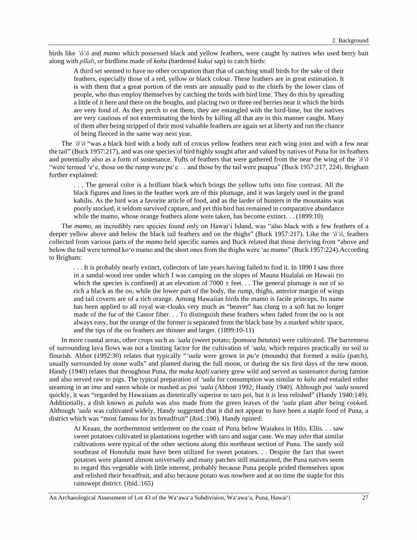
2. Background
An Archaeological Assessment of Lot 43 of the Waʻawaʻa Subdivision, Waʻawaʻa, Puna, Hawaiʻi 27
birds like ʻōʻō and mamo which possessed black and yellow feathers, were caught by natives who used berry bait along with pīlali, or birdlime made of kohu (hardened kukui sap) to catch birds:
A third set seemed to have no other occupation than that of catching small birds for the sake of their feathers, especially those of a red, yellow or black colour. These feathers are in great estimation. It is with them that a great portion of the rents are annually paid to the chiefs by the lower class of people, who thus employ themselves by catching the birds with bird lime. They do this by spreading a little of it here and there on the boughs, and placing two or three red berries near it which the birds are very fond of. As they perch to eat them, they are entangled with the bird-lime, but the natives are very cautious of not exterminating the birds by killing all that are in this manner caught. Many of them after being stripped of their most valuable feathers are again set at liberty and run the chance of being fleeced in the same way next year.
The ʻōʻō “was a black bird with a body tuft of crocus yellow feathers near each wing joint and with a few near the tail” (Buck 1957:217), and was one species of bird highly sought after and valued by natives of Puna for its feathers and potentially also as a form of sustenance. Tufts of feathers that were gathered from the near the wing of the ʻōʻō “were termed ʻeʻe, those on the rump were puʻe. . . and those by the tail were puapua” (Buck 1957:217, 224). Brigham further explained:
. . . The general color is a brilliant black which brings the yellow tufts into fine contrast. All the black figures and lines in the feather work are of this plumage, and it was largely used in the grand kahilis. As the bird was a favorite article of food, and as the larder of hunters in the mountains was poorly stocked, it seldom survived capture, and yet this bird has remained in comparative abundance while the mamo, whose orange feathers alone were taken, has become extinct. . . (1899:10)
The mamo, an incredibly rare species found only on Hawaiʻi Island, was “also black with a few feathers of a deeper yellow above and below the black tail feathers and on the thighs” (Buck 1957:217). Like the ʻōʻō, feathers collected from various parts of the mamo held specific names and Buck related that those deriving from “above and below the tail were termed koʻo mamo and the short ones from the thighs were ̒ ae mamo” (Buck 1957:224).According to Brigham:
. . . It is probably nearly extinct, collectors of late years having failed to find it. In 1890 I saw three in a sandal-wood tree under which I was camping on the slopes of Mauna Hualalai on Hawaii (to which the species is confined) at an elevation of 7000 ± feet. . . The general plumage is not of so rich a black as the oo, while the lower part of the body, the rump, thighs, anterior margin of wings and tail coverts are of a rich orange. Among Hawaiian birds the mamo is facile princeps. Its name has been applied to all royal war-cloaks very much as “beaver” has clung to a soft hat no longer made of the fur of the Castor fiber. . . To distinguish these feathers when faded from the oo is not always easy, but the orange of the former is separated from the black base by a marked white space, and the tips of the oo feathers are thinner and larger. (1899:10-11)
In more coastal areas, other crops such as ʻuala (sweet potato; Ipomoea batatas) were cultivated. The barrenness of surrounding lava flows was not a limiting factor for the cultivation of ʻuala, which requires practically no soil to flourish. Abbot (1992:30) relates that typically “‘uala were grown in pu‘e (mounds) that formed a māla (patch), usually surrounded by stone walls” and planted during the full moon, or during the six first days of the new moon. Handy (1940) relates that throughout Puna, the maka koali variety grew wild and served as sustenance during famine and also served raw to pigs. The typical preparation of ‘uala for consumption was similar to kalo and entailed either steaming in an imu and eaten whole or mashed as poi ‘uala (Abbott 1992; Handy 1940). Although poi ‘uala soured quickly, it was “regarded by Hawaiians as dietetically superior to taro poi, but it is less relished” (Handy 1940:149). Additionally, a dish known as palula was also made from the green leaves of the ‘uala plant after being cooked. Although ‘uala was cultivated widely, Handy suggested that it did not appear to have been a staple food of Puna, a district which was “most famous for its breadfruit” (ibid.:190). Handy opined:
At Keaau, the northernmost settlement on the coast of Puna below Waiakea in Hilo, Ellis. . . saw sweet potatoes cultivated in plantations together with taro and sugar cane. We may infer that similar cultivations were typical of the other sections along this northeast section of Puna. The sandy soil southeast of Honolulu must have been utilized for sweet potatoes. . . Despite the fact that sweet potatoes were planted almost universally and many patches still maintained, the Puna natives seem to regard this vegetable with little interest, probably because Puna people prided themselves upon and relished their breadfruit, and also because potato was nowhere and at no time the staple for this rainswept district. (ibid.:165)
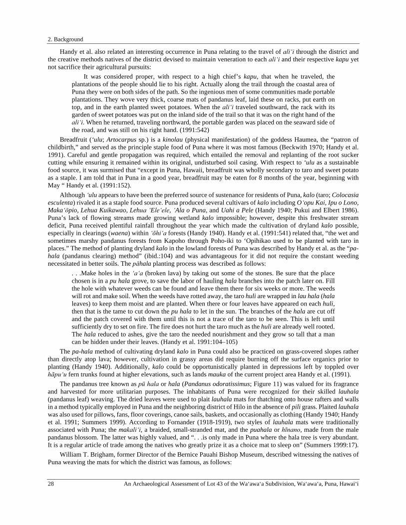
2. Background
28 An Archaeological Assessment of Lot 43 of the Waʻawaʻa Subdivision, Waʻawaʻa, Puna, Hawaiʻi
Handy et al. also related an interesting occurrence in Puna relating to the travel of aliʻi through the district and the creative methods natives of the district devised to maintain veneration to each aliʻi and their respective kapu yet not sacrifice their agricultural pursuits:
It was considered proper, with respect to a high chief’s kapu, that when he traveled, the plantations of the people should lie to his right. Actually along the trail through the coastal area of Puna they were on both sides of the path. So the ingenious men of some communities made portable plantations. They wove very thick, coarse mats of pandanus leaf, laid these on racks, put earth on top, and in the earth planted sweet potatoes. When the aliʻi traveled southward, the rack with its garden of sweet potatoes was put on the inland side of the trail so that it was on the right hand of the aliʻi. When he returned, traveling northward, the portable garden was placed on the seaward side of the road, and was still on his right hand. (1991:542)
Breadfruit (‘ulu; Artocarpus sp.) is a kinolau (physical manifestation) of the goddess Haumea, the “patron of childbirth,” and served as the principle staple food of Puna where it was most famous (Beckwith 1970; Handy et al. 1991). Careful and gentle propagation was required, which entailed the removal and replanting of the root sucker cutting while ensuring it remained within its original, undisturbed soil casing. With respect to ‘ulu as a sustainable food source, it was surmised that “except in Puna, Hawaii, breadfruit was wholly secondary to taro and sweet potato as a staple. I am told that in Puna in a good year, breadfruit may be eaten for 8 months of the year, beginning with May “ Handy et al. (1991:152).
Although ʻulu appears to have been the preferred source of sustenance for residents of Puna, kalo (taro; Colocasia esculenta) rivaled it as a staple food source. Puna produced several cultivars of kalo including Oʻopu Kai, Ipu o Lono, Makaʻōpio, Lehua Kuikawao, Lehua ʻEleʻele, ʻAla o Puna, and Uahi a Pele (Handy 1940; Pukui and Elbert 1986). Puna’s lack of flowing streams made growing wetland kalo impossible; however, despite this freshwater stream deficit, Puna received plentiful rainfall throughout the year which made the cultivation of dryland kalo possible, especially in clearings (waena) within ʻōhiʻa forests (Handy 1940). Handy et al. (1991:541) related that, “the wet and sometimes marshy pandanus forests from Kapoho through Poho-iki to ‘Opihikao used to be planted with taro in places.” The method of planting dryland kalo in the lowland forests of Puna was described by Handy et al. as the “pa-hala (pandanus clearing) method” (ibid.:104) and was advantageous for it did not require the constant weeding necessitated in better soils. The pāhala planting process was described as follows:
. . .Make holes in the ʻaʻa (broken lava) by taking out some of the stones. Be sure that the place chosen is in a pu hala grove, to save the labor of hauling hala branches into the patch later on. Fill the hole with whatever weeds can be found and leave them there for six weeks or more. The weeds will rot and make soil. When the weeds have rotted away, the taro huli are wrapped in lau hala (hala leaves) to keep them moist and are planted. When there or four leaves have appeared on each huli, then that is the tame to cut down the pu hala to let in the sun. The branches of the hala are cut off and the patch covered with them until this is not a trace of the taro to be seen. This is left until sufficiently dry to set on fire. The fire does not hurt the taro much as the huli are already well rooted. The hala reduced to ashes, give the taro the needed nourishment and they grow so tall that a man can be hidden under their leaves. (Handy et al. 1991:104–105)
The pa-hala method of cultivating dryland kalo in Puna could also be practiced on grass-covered slopes rather than directly atop lava; however, cultivation in grassy areas did require burning off the surface organics prior to planting (Handy 1940). Additionally, kalo could be opportunistically planted in depressions left by toppled over hāpu‘u fern trunks found at higher elevations, such as lands mauka of the current project area Handy et al. (1991).
The pandanus tree known as pū hala or hala (Pandanus odoratissimus; Figure 11) was valued for its fragrance and harvested for more utilitarian purposes. The inhabitants of Puna were recognized for their skilled lauhala (pandanus leaf) weaving. The dried leaves were used to plait lauhala mats for thatching onto house rafters and walls in a method typically employed in Puna and the neighboring district of Hilo in the absence of pili grass. Plaited lauhala was also used for pillows, fans, floor coverings, canoe sails, baskets, and occasionally as clothing (Handy 1940; Handy et al. 1991; Summers 1999). According to Fornander (1918-1919), two styles of lauhala mats were traditionally associated with Puna; the makaliʻi, a braided, small-stranded mat, and the puahala or hīnano, made from the male pandanus blossom. The latter was highly valued, and “. . .is only made in Puna where the hala tree is very abundant. It is a regular article of trade among the natives who greatly prize it as a choice mat to sleep on” (Summers 1999:17).
William T. Brigham, former Director of the Bernice Pauahi Bishop Museum, described witnessing the natives of Puna weaving the mats for which the district was famous, as follows:

2. Background
An Archaeological Assessment of Lot 43 of the Waʻawaʻa Subdivision, Waʻawaʻa, Puna, Hawaiʻi 29
Puna was a famous region for hala mats, and in 1864, the author, when journeying through the district with that noble missionary the Reverend Titus Coan, saw many a party in the curious open caves (caused by a breakdown of the lava crust in some of the many streams of lava, ancient and recent, that form much of the surface of Puna) busily engaged in weaving mats, a work for which the comparative coolness and dampness of the caves was most suited. (Brigham and Stokes 1906:29)
Hala was significant on a spiritual level as well. Handy and Pūkuʻi (1998a) conveyed the significance of the hala, which played a role in the protection of a newborn baby’s placenta (ʻiewe). Hala groves were abundant in Puna and concealing the ʻiewe high up in the leaves thereby preventing it from being pilfered. The people of Puna were sometimes referred to as maka kōkala (thorny eyes) by the inhabitants of the neighboring moku of Kaʻū, correlating the spiny leaves of the hala with the long eyelashes of the baby whose ʻiewe it was sheltering, providing a “bright keen look” (Handy and Pukui 1998a; Pukui and Elbert 1986:160). Maly related, “to this day, Puna is known for its growth of hala, and the floors and furniture of some of the old households are still covered with fine woven mats and cushions. Weaving remains an important occupation of many native families of Puna.” Maly (1998:6).
Figure 11. Man standing in a Puna pū hala grove in 1888 (Brigham and Stokes 1906:28).
In addition to these resources, other crops such as niu (coconut) thrived in coastal Puna and “has always had the greatest continuous planting area for coconuts in the Hawaiian islands; today old coconut groves are scattered everywhere along the wet lava-covered coastal plain” (Handy 1940:193). With respect to varieties, Handy et al. (1991) listed only two: the niu hiwa (particularly used for ceremony, medicine, and cooking), and the niu lelo (used primarily for nonreligious purposes). Water from the niu was palatable and flavorful. It was also utilized on a spiritual level by priests practicing divination. The raw meat was edible, and could be scraped out of the shell with a large ‘opihi (limpet) to be eaten as is or incorporated into the preparation of various sweets including haupia (haukō), kūlolo, and pi‘epi‘e ‘ulu. Besides being utilized for human consumption, coconut meat could also be used to feed animals:
In some localities in Puna, pigs were taught to open their own coconuts. When the owners of the pigs expected to be absent for some time, they husked a quantity of the nuts, leaving a strip of husk on each one about two inches in width. When a pig wanted to open a nut, he grasped it by this strip of husk and dashed it against a rock. Thus the pigs were assured of fresh food until the owners returned. (Handy 1991:174)
The meat of the coconut could also be crafted into fresh coconut oil; Handy et al. describe the process thusly: In Puna, manoʻi or coconut oil was made as follows: The fresh gratings, with maile or other kupukupu (any odoriferous plant) to give fragrance, were placed in a container in the hot sun. When

2. Background
30 An Archaeological Assessment of Lot 43 of the Waʻawaʻa Subdivision, Waʻawaʻa, Puna, Hawaiʻi
the oil separated away from it, the mass was squeezed through ahuawa and the refuse (oka) thrown away. The oil was used for anointing the body and hair and washing the hair. (1991:192)
Niu also provided husk fibers to plait sennit ‘aha (cordage) to be used for lashing house timbers, adzes, and canoe parts, making food containers (‘umeke) and the main body of the pahu hula drum. The shell could be cut in half to be used for drinking, medicinal, or ceremonial cups, using leaf stems and midribs to clean pig intestines, make brooms, shrimp snares, and for stringing kukui nuts to be burned as candles, plaiting leaflets to make fans and playing balls for children, and using the end of the leaf as kapu markers along the coastline or to frighten fish out from under ocean ledges (Handy et al. 1991). The method of propagating niu involved burying a sprouted nut on top of an octopus (he‘e) at a hole deep enough to bury it completely. The buried he‘e was purported to “give the root a spread and grip like its own and to produce nuts that were bulbous like its head or body (pu)” (ibid.:172).
Uhi (yam; Dioscorea alata) was cultivated throughout Puna and served to supplement more primary sources of sustenance such as kalo and ‘uala during times of famine. Unlike kalo, the uhi did not make fine poi, and as such was steamed in an imu and consumed in its whole form rather than being mashed. In addition to being a supplementary form of nourishment, the uhi also possessed value medicinally and it was a beneficial treatment of a wide variety of ailments. Within Puna specifically, the white-fleshed poni and alela varieties were cultivated, the former of which was purple-skinned, as well as the ke‘oke‘o and ulaula varieties the former of which was only utilized for food purposes and the latter which was consumed both as food and could be dually utilized for its medicinal value (Handy 1940). Handy (ibid.) described a method of planting uhi in ʻŌlaʻa, Puna:
The following old Hawaiian method of planting uhi in Hamakua and Olaa was described to me by Judge George Tucker of Olaa whose Hawaiian forbears taught him yam culture. On the ground in the forest a great bin of tree-fern trunks (hapuu) was built 3 to 4 feet high on the sides, the fern trucks being laid horizontally. The bin was filled with decaying fern leaves and other rubbish. The seedling tubers (hua uhi) were then stuck in the rubbish a few inches below the surface. No earth was put in, but as the rubbish in the bin decayed and sank, more rubbish was heaped on top. Fully matured tubers grown by this method are said to have weighed up to 50 pounds. . . . . . Another interesting practice in planting yams on steep hillsides and the sides of gulches on the Hamakua coast and in North Hilo was to dig a vertical hole in the side of the slope, 2 to 3 feet deep, and place a large flat stone in it. The hole was then filled with earth and decaying leaves, and the seed yam planted near the top of the hole. The rock at the bottom of the hole prevented the tuber, which grew downward, from growing deep into the ground and forced it to spread out. When time for digging, the earth on the side of the hill or gulch was simply dug away and the tubers extracted. (169–170)
Also utilized as a famine food is the pia (Polynesian arrowroot; Tacca leontopetaloides), which Abbott (1992) relates was commonly grown in close proximity to loʻi kalo (wetland taro). Within Puna specifically, pia was likely cultivated but also grew wild Handy (1940).
Other sources mention the gathering of māmaki (Pipturus spp.) from the wao lāʻau (upland forests) of Puna, a practice which may also have occurred in the mauka portion of Waʻawaʻa as well. While wauke (paper mulberry; Broussonetia papyrifera) was commonly used for kapa (tapa) production, kapa was also made from the bark of the wild māmaki (primarily on Hawaiʻi Island) and was known for being quite exceptional, though considered second best in comparison (Brigham 1911; Kamakau 1976). Kapa wauke paled in comparison to kapa māmaki, which was exceedingly soft and strong and used to make items such as malo (loincloth), pāʻū (skirt), kīhei (shawl covering), and kapa moe (sleeping kapa) (Handy and Pukui 1998b; Kamakau 1976; Neal 1965). However, unlike the former, kapa māmaki could not withstand getting wet, making it a poor choice for items that would need to be washed. According to Kaaiakamanu and Akina (1922), the strength of māmaki wood also made it a prime choice for kapa beater implements.
Puna boasted three types of kapa māmaki specifically associated with the district: kapa oʻu holo wai o Laʻa, kapa palaʻā, and kapa ʻeleuli o Puna. TheʻŌlaʻa region of Puna specifically was famed for its kapa ʻoʻu holo wai o Laʻa, a special kapa dyed differently on both sides which was associated with the patron of hula, the goddess Laka (Fornander 1918-1919; Kent 1986). This kapa was utilized during Hawaiian kuni divination ceremonies which entailed the burning of maunu (bait consisting of the body refuse of the victim including saliva, hair, and/or nails) wrapped in kapa ʻoʻu holo wai o Laʻa in order to bring death upon the kahuna (sorcerer) who was responsible for the praying to death of the victim (Alexander 1891). Kapa palaʻā was another type of kapa māmaki directly associated with Puna which was dyed a reddish-brown color using the palaʻā (lace fern; Sphenomeris chinensis) which grew
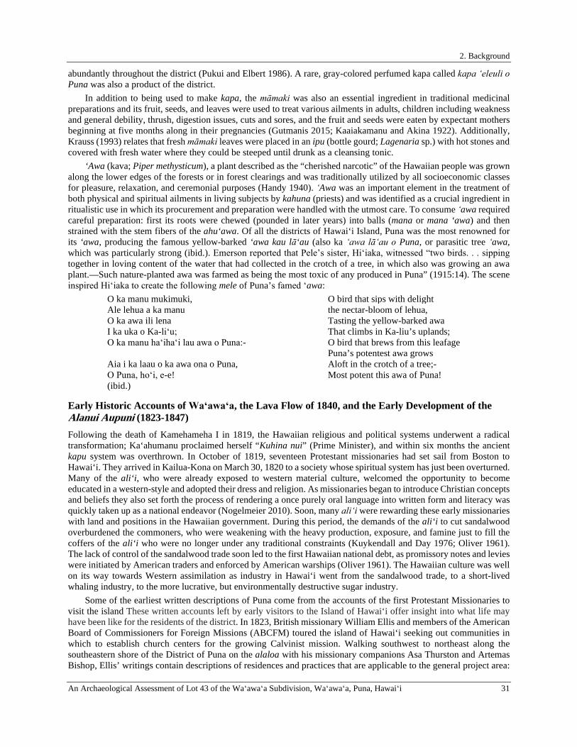
2. Background
An Archaeological Assessment of Lot 43 of the Waʻawaʻa Subdivision, Waʻawaʻa, Puna, Hawaiʻi 31
abundantly throughout the district (Pukui and Elbert 1986). A rare, gray-colored perfumed kapa called kapa ʻeleuli o Puna was also a product of the district.
In addition to being used to make kapa, the māmaki was also an essential ingredient in traditional medicinal preparations and its fruit, seeds, and leaves were used to treat various ailments in adults, children including weakness and general debility, thrush, digestion issues, cuts and sores, and the fruit and seeds were eaten by expectant mothers beginning at five months along in their pregnancies (Gutmanis 2015; Kaaiakamanu and Akina 1922). Additionally, Krauss (1993) relates that fresh māmaki leaves were placed in an ipu (bottle gourd; Lagenaria sp.) with hot stones and covered with fresh water where they could be steeped until drunk as a cleansing tonic.
‘Awa (kava; Piper methysticum), a plant described as the “cherished narcotic” of the Hawaiian people was grown along the lower edges of the forests or in forest clearings and was traditionally utilized by all socioeconomic classes for pleasure, relaxation, and ceremonial purposes (Handy 1940). ʻAwa was an important element in the treatment of both physical and spiritual ailments in living subjects by kahuna (priests) and was identified as a crucial ingredient in ritualistic use in which its procurement and preparation were handled with the utmost care. To consume ʻawa required careful preparation: first its roots were chewed (pounded in later years) into balls (mana or mana ‘awa) and then strained with the stem fibers of the ahu‘awa. Of all the districts of Hawai‘i Island, Puna was the most renowned for its ‘awa, producing the famous yellow-barked ‘awa kau lā‘au (also ka ʻawa lāʻau o Puna, or parasitic tree ʻawa, which was particularly strong (ibid.). Emerson reported that Pele’s sister, Hiʻiaka, witnessed “two birds. . . sipping together in loving content of the water that had collected in the crotch of a tree, in which also was growing an awa plant.—Such nature-planted awa was farmed as being the most toxic of any produced in Puna” (1915:14). The scene inspired Hiʻiaka to create the following mele of Puna’s famed ʻawa:
O ka manu mukimuki, O bird that sips with delight Ale lehua a ka manu the nectar-bloom of lehua, O ka awa ili lena Tasting the yellow-barked awa I ka uka o Ka-liʻu; That climbs in Ka-liu’s uplands; O ka manu haʻihaʻi lau awa o Puna:- O bird that brews from this leafage
Puna’s potentest awa grows Aia i ka laau o ka awa ona o Puna, Aloft in the crotch of a tree;- O Puna, hoʻi, e-e! Most potent this awa of Puna! (ibid.)
Early Historic Accounts of Waʻawaʻa, the Lava Flow of 1840, and the Early Development of the Alanui Aupuni (1823-1847) Following the death of Kamehameha I in 1819, the Hawaiian religious and political systems underwent a radical transformation; Ka‘ahumanu proclaimed herself “Kuhina nui” (Prime Minister), and within six months the ancient kapu system was overthrown. In October of 1819, seventeen Protestant missionaries had set sail from Boston to Hawai‘i. They arrived in Kailua-Kona on March 30, 1820 to a society whose spiritual system has just been overturned. Many of the ali‘i, who were already exposed to western material culture, welcomed the opportunity to become educated in a western-style and adopted their dress and religion. As missionaries began to introduce Christian concepts and beliefs they also set forth the process of rendering a once purely oral language into written form and literacy was quickly taken up as a national endeavor (Nogelmeier 2010). Soon, many aliʻi were rewarding these early missionaries with land and positions in the Hawaiian government. During this period, the demands of the ali‘i to cut sandalwood overburdened the commoners, who were weakening with the heavy production, exposure, and famine just to fill the coffers of the ali‘i who were no longer under any traditional constraints (Kuykendall and Day 1976; Oliver 1961). The lack of control of the sandalwood trade soon led to the first Hawaiian national debt, as promissory notes and levies were initiated by American traders and enforced by American warships (Oliver 1961). The Hawaiian culture was well on its way towards Western assimilation as industry in Hawai‘i went from the sandalwood trade, to a short-lived whaling industry, to the more lucrative, but environmentally destructive sugar industry.
Some of the earliest written descriptions of Puna come from the accounts of the first Protestant Missionaries to visit the island These written accounts left by early visitors to the Island of Hawai‘i offer insight into what life may have been like for the residents of the district. In 1823, British missionary William Ellis and members of the American Board of Commissioners for Foreign Missions (ABCFM) toured the island of Hawai‘i seeking out communities in which to establish church centers for the growing Calvinist mission. Walking southwest to northeast along the southeastern shore of the District of Puna on the alaloa with his missionary companions Asa Thurston and Artemas Bishop, Ellis’ writings contain descriptions of residences and practices that are applicable to the general project area:
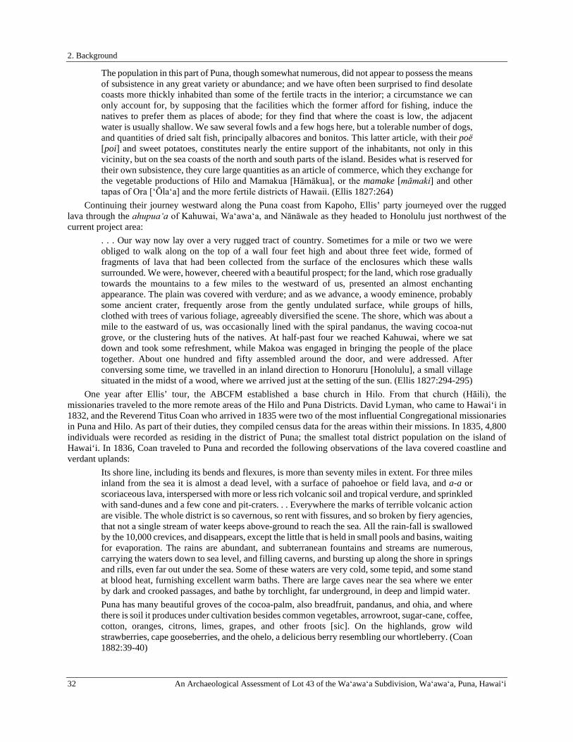
2. Background
32 An Archaeological Assessment of Lot 43 of the Waʻawaʻa Subdivision, Waʻawaʻa, Puna, Hawaiʻi
The population in this part of Puna, though somewhat numerous, did not appear to possess the means of subsistence in any great variety or abundance; and we have often been surprised to find desolate coasts more thickly inhabited than some of the fertile tracts in the interior; a circumstance we can only account for, by supposing that the facilities which the former afford for fishing, induce the natives to prefer them as places of abode; for they find that where the coast is low, the adjacent water is usually shallow. We saw several fowls and a few hogs here, but a tolerable number of dogs, and quantities of dried salt fish, principally albacores and bonitos. This latter article, with their poë [poi] and sweet potatoes, constitutes nearly the entire support of the inhabitants, not only in this vicinity, but on the sea coasts of the north and south parts of the island. Besides what is reserved for their own subsistence, they cure large quantities as an article of commerce, which they exchange for the vegetable productions of Hilo and Mamakua [Hāmākua], or the mamake [māmaki] and other tapas of Ora [‘Ōla‘a] and the more fertile districts of Hawaii. (Ellis 1827:264)
Continuing their journey westward along the Puna coast from Kapoho, Ellis’ party journeyed over the rugged lava through the ahupuaʻa of Kahuwai, Waʻawaʻa, and Nānāwale as they headed to Honolulu just northwest of the current project area:
. . . Our way now lay over a very rugged tract of country. Sometimes for a mile or two we were obliged to walk along on the top of a wall four feet high and about three feet wide, formed of fragments of lava that had been collected from the surface of the enclosures which these walls surrounded. We were, however, cheered with a beautiful prospect; for the land, which rose gradually towards the mountains to a few miles to the westward of us, presented an almost enchanting appearance. The plain was covered with verdure; and as we advance, a woody eminence, probably some ancient crater, frequently arose from the gently undulated surface, while groups of hills, clothed with trees of various foliage, agreeably diversified the scene. The shore, which was about a mile to the eastward of us, was occasionally lined with the spiral pandanus, the waving cocoa-nut grove, or the clustering huts of the natives. At half-past four we reached Kahuwai, where we sat down and took some refreshment, while Makoa was engaged in bringing the people of the place together. About one hundred and fifty assembled around the door, and were addressed. After conversing some time, we travelled in an inland direction to Honoruru [Honolulu], a small village situated in the midst of a wood, where we arrived just at the setting of the sun. (Ellis 1827:294-295)
One year after Ellis’ tour, the ABCFM established a base church in Hilo. From that church (Hāili), the missionaries traveled to the more remote areas of the Hilo and Puna Districts. David Lyman, who came to Hawai‘i in 1832, and the Reverend Titus Coan who arrived in 1835 were two of the most influential Congregational missionaries in Puna and Hilo. As part of their duties, they compiled census data for the areas within their missions. In 1835, 4,800 individuals were recorded as residing in the district of Puna; the smallest total district population on the island of Hawai‘i. In 1836, Coan traveled to Puna and recorded the following observations of the lava covered coastline and verdant uplands:
Its shore line, including its bends and flexures, is more than seventy miles in extent. For three miles inland from the sea it is almost a dead level, with a surface of pahoehoe or field lava, and a-a or scoriaceous lava, interspersed with more or less rich volcanic soil and tropical verdure, and sprinkled with sand-dunes and a few cone and pit-craters. . . Everywhere the marks of terrible volcanic action are visible. The whole district is so cavernous, so rent with fissures, and so broken by fiery agencies, that not a single stream of water keeps above-ground to reach the sea. All the rain-fall is swallowed by the 10,000 crevices, and disappears, except the little that is held in small pools and basins, waiting for evaporation. The rains are abundant, and subterranean fountains and streams are numerous, carrying the waters down to sea level, and filling caverns, and bursting up along the shore in springs and rills, even far out under the sea. Some of these waters are very cold, some tepid, and some stand at blood heat, furnishing excellent warm baths. There are large caves near the sea where we enter by dark and crooked passages, and bathe by torchlight, far underground, in deep and limpid water. Puna has many beautiful groves of the cocoa-palm, also breadfruit, pandanus, and ohia, and where there is soil it produces under cultivation besides common vegetables, arrowroot, sugar-cane, coffee, cotton, oranges, citrons, limes, grapes, and other froots [sic]. On the highlands, grow wild strawberries, cape gooseberries, and the ohelo, a delicious berry resembling our whortleberry. (Coan 1882:39-40)
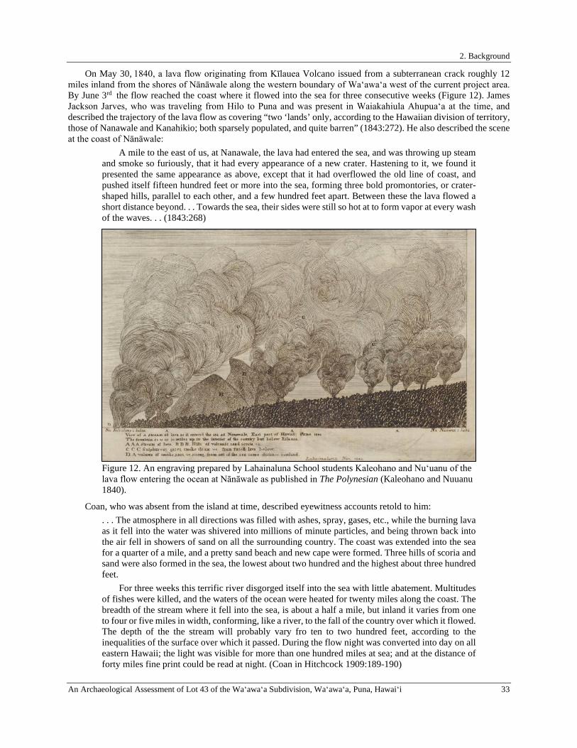
2. Background
An Archaeological Assessment of Lot 43 of the Waʻawaʻa Subdivision, Waʻawaʻa, Puna, Hawaiʻi 33
On May 30, 1840, a lava flow originating from Kīlauea Volcano issued from a subterranean crack roughly 12 miles inland from the shores of Nānāwale along the western boundary of Waʻawaʻa west of the current project area. By June 3rd the flow reached the coast where it flowed into the sea for three consecutive weeks (Figure 12). James Jackson Jarves, who was traveling from Hilo to Puna and was present in Waiakahiula Ahupuaʻa at the time, and described the trajectory of the lava flow as covering “two ‘lands’ only, according to the Hawaiian division of territory, those of Nanawale and Kanahikio; both sparsely populated, and quite barren” (1843:272). He also described the scene at the coast of Nānāwale:
A mile to the east of us, at Nanawale, the lava had entered the sea, and was throwing up steam and smoke so furiously, that it had every appearance of a new crater. Hastening to it, we found it presented the same appearance as above, except that it had overflowed the old line of coast, and pushed itself fifteen hundred feet or more into the sea, forming three bold promontories, or crater-shaped hills, parallel to each other, and a few hundred feet apart. Between these the lava flowed a short distance beyond. . . Towards the sea, their sides were still so hot at to form vapor at every wash of the waves. . . (1843:268)
Figure 12. An engraving prepared by Lahainaluna School students Kaleohano and Nuʻuanu of the lava flow entering the ocean at Nānāwale as published in The Polynesian (Kaleohano and Nuuanu 1840).
Coan, who was absent from the island at time, described eyewitness accounts retold to him: . . . The atmosphere in all directions was filled with ashes, spray, gases, etc., while the burning lava as it fell into the water was shivered into millions of minute particles, and being thrown back into the air fell in showers of sand on all the surrounding country. The coast was extended into the sea for a quarter of a mile, and a pretty sand beach and new cape were formed. Three hills of scoria and sand were also formed in the sea, the lowest about two hundred and the highest about three hundred feet. For three weeks this terrific river disgorged itself into the sea with little abatement. Multitudes of fishes were killed, and the waters of the ocean were heated for twenty miles along the coast. The breadth of the stream where it fell into the sea, is about a half a mile, but inland it varies from one to four or five miles in width, conforming, like a river, to the fall of the country over which it flowed. The depth of the the stream will probably vary fro ten to two hundred feet, according to the inequalities of the surface over which it passed. During the flow night was converted into day on all eastern Hawaii; the light was visible for more than one hundred miles at sea; and at the distance of forty miles fine print could be read at night. (Coan in Hitchcock 1909:189-190)
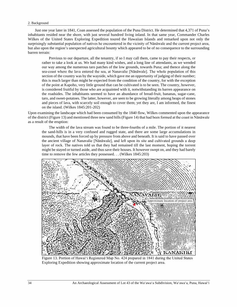
2. Background
34 An Archaeological Assessment of Lot 43 of the Waʻawaʻa Subdivision, Waʻawaʻa, Puna, Hawaiʻi
Just one year later in 1841, Coan assessed the population of the Puna District. He determined that 4,371 of Puna’s inhabitants resided near the shore, with just several hundred living inland. In that same year, Commander Charles Wilkes of the United States Exploring Expedition toured the Hawaiian Islands and remarked upon not only the surprisingly substantial population of natives he encountered in the vicinity of Nānāwale and the current project area, but also upon the region’s unexpected agricultural bounty which appeared to be of no consequence to the surrounding barren terrain:
Previous to our departure, all the tenantry, if so I may call them, came to pay their respects, or rather to take a look at us. We had many kind wishes, and a long line of attendants, as we wended our way among the numerous taro patches of the low grounds, towards Puna; and thence along the sea-coast where the lava entered the sea, at Nanavalie [Nānāwale]. The whole population of this section of the country was by the wayside, which gave me an opportunity of judging of their number; this is much larger than might be expected from the condition of the country, for with the exception of the point at Kapoho, very little ground that can be cultivated is to be seen. The country, however, is considered fruitful by those who are acquainted with it, notwithstanding its barren appearance on the roadsides. The inhabitants seemed to have an abundance of bread-fruit, bananas, sugar-cane, taro, and sweet-potatoes. The latter, however, are seen to be growing literally among heaps of stones and pieces of lava, with scarcely soil enough to cover them; yet they are, I am informed, the finest on the island. (Wilkes 1845:201-202)
Upon examining the landscape which had been consumed by the 1840 flow, Wilkes commented upon the appearance of the district (Figure 13) and mentioned three new sand hills (Figure 14) that had been formed at the coast in Nānāwale as a result of the eruption:
The width of the lava stream was found to be three-fourths of a mile. The portion of it nearest the sand-hills is in a very confused and rugged state, and there are some large accumulations in mounds, that have been forced up by pressure from above and beneath. It is said to have passed over the ancient village of Nanavalie [Nānāwale], and left upon its site and cultivated grounds a deep layer of rock. The natives told us that they had remained till the last moment, hoping the torrent might be stayed or turned aside, and thus save their houses. It however swept on, and they had barely time to remove the few articles they possessed. . . (Wilkes 1845:203)
Figure 13. Portion of Hawaiʻi Registered Map No. 424 prepared in 1841 during the United States Exploring Expedition showing approximate location of the current project area.
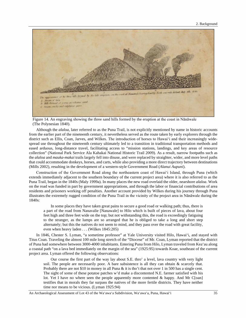
2. Background
An Archaeological Assessment of Lot 43 of the Waʻawaʻa Subdivision, Waʻawaʻa, Puna, Hawaiʻi 35
Figure 14. An engraving showing the three sand hills formed by the eruption at the coast in Nānāwale (The Polynesian 1840).
Although the alaloa, later referred to as the Puna Trail, is not explicitly mentioned by name in historic accounts from the earlier part of the nineteenth century, it nevertheless served as the route taken by early explorers through the district such as Ellis, Coan, Jarves, and Wilkes. The introduction of horses to Hawaiʻi and their increasingly wide-spread use throughout the nineteenth century ultimately led to a transition in traditional transportation methods and eased arduous, long-distance travel, facilitating access to “mission stations, landings, and key areas of resource collection” (National Park Service Ala Kahakai National Historic Trail 2009). As a result, narrow footpaths such as the alaloa and mauka-makai trails largely fell into disuse, and were replaced by straighter, wider, and more level paths that could accommodate donkeys, horses, and carts, while also providing a more direct trajectory between destinations (Mills 2002), resulting in the development of a western-style Government Road (Alanui Aupuni).
Construction of the Government Road along the northeastern coast of Hawaiʻi Island, through Puna (which extends immediately adjacent to the southern boundary of the current project area) where it is also referred to as the Puna Trail, began in the 1840s (Maly 1999a). In many places the new road overlaid the older, nearshore alaloa. Work on the road was funded in part by government appropriations, and through the labor or financial contributions of area residents and prisoners working off penalties. Another account provided by Wilkes during his journey through Puna illustrates the extremely rugged condition of the Puna Trail in the vicinity of the project area in Nānāwale during the 1840s:
In some places they have taken great pains to secure a good road or walking path; thus, there is a part of the road from Nanavalie [Nanawale] to Hilo which is built of pieces of lava, about four feet high and three feet wide on the top; but not withstanding this, the road is exceedingly fatiguing to the stranger, as the lumps are so arranged that he is obliged to take a long and short step alternately; but this the natives do not seem to mind, and they pass over the road with great facility, even when heavy laden . . . (Wilkes 1845:205)
In 1846, Chester S. Lyman, “a sometime professor” at Yale University visited Hilo, Hawai‘i, and stayed with Titus Coan. Traveling the almost 100 mile long stretch of the “Diocese” of Mr. Coan, Lyman reported that the district of Puna had somewhere between 3000-4000 inhabitants. Entering Puna from Hilo, Lyman traveled from Kea‘au along a coastal path “on a lava bed immediately on the margin of the sea” (1925:95) towards Koae, southeast of the current project area. Lyman offered the following observations:
Our course the first part of the way lay about S.E. thro’ a level, lava country with very light soil. The people are necessarily poor. A bare subsistence is all they can obtain & scarcely that. Probably there are not $10 in money in all Puna & it is tho’t that not over 1 in 500 has a single cent. The sight of some of these potatoe patches w’d make a discontented N.E. farmer satisfied with his lot. Yet I have no where seen the people apparently more contented & happy. And Mr C[oan] testifies that in morals they far surpass the natives of the more fertile districts. They have neither time nor means to be vicious. (Lyman 1925:94)
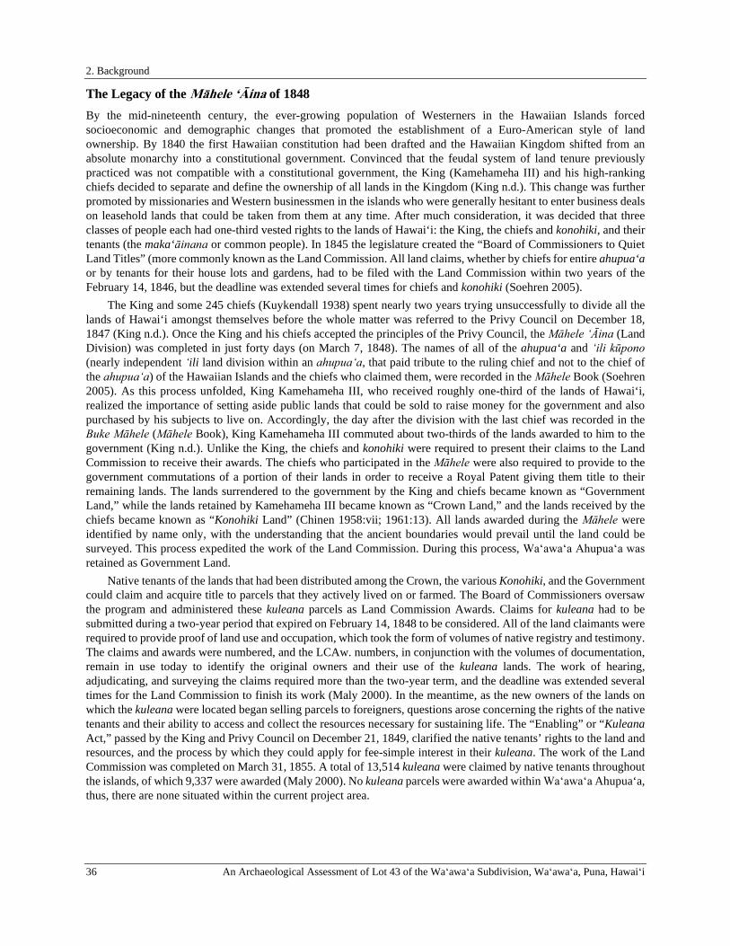
2. Background
36 An Archaeological Assessment of Lot 43 of the Waʻawaʻa Subdivision, Waʻawaʻa, Puna, Hawaiʻi
The Legacy of the Māhele ‘Āina of 1848 By the mid-nineteenth century, the ever-growing population of Westerners in the Hawaiian Islands forced socioeconomic and demographic changes that promoted the establishment of a Euro-American style of land ownership. By 1840 the first Hawaiian constitution had been drafted and the Hawaiian Kingdom shifted from an absolute monarchy into a constitutional government. Convinced that the feudal system of land tenure previously practiced was not compatible with a constitutional government, the King (Kamehameha III) and his high-ranking chiefs decided to separate and define the ownership of all lands in the Kingdom (King n.d.). This change was further promoted by missionaries and Western businessmen in the islands who were generally hesitant to enter business deals on leasehold lands that could be taken from them at any time. After much consideration, it was decided that three classes of people each had one-third vested rights to the lands of Hawai‘i: the King, the chiefs and konohiki, and their tenants (the maka‘āinana or common people). In 1845 the legislature created the “Board of Commissioners to Quiet Land Titles” (more commonly known as the Land Commission. All land claims, whether by chiefs for entire ahupua‘a or by tenants for their house lots and gardens, had to be filed with the Land Commission within two years of the February 14, 1846, but the deadline was extended several times for chiefs and konohiki (Soehren 2005).
The King and some 245 chiefs (Kuykendall 1938) spent nearly two years trying unsuccessfully to divide all the lands of Hawai‘i amongst themselves before the whole matter was referred to the Privy Council on December 18, 1847 (King n.d.). Once the King and his chiefs accepted the principles of the Privy Council, the Māhele ‘Āina (Land Division) was completed in just forty days (on March 7, 1848). The names of all of the ahupua‘a and ‘ili kūpono (nearly independent ʻili land division within an ahupuaʻa, that paid tribute to the ruling chief and not to the chief of the ahupuaʻa) of the Hawaiian Islands and the chiefs who claimed them, were recorded in the Māhele Book (Soehren 2005). As this process unfolded, King Kamehameha III, who received roughly one-third of the lands of Hawai‘i, realized the importance of setting aside public lands that could be sold to raise money for the government and also purchased by his subjects to live on. Accordingly, the day after the division with the last chief was recorded in the Buke Māhele (Māhele Book), King Kamehameha III commuted about two-thirds of the lands awarded to him to the government (King n.d.). Unlike the King, the chiefs and konohiki were required to present their claims to the Land Commission to receive their awards. The chiefs who participated in the Māhele were also required to provide to the government commutations of a portion of their lands in order to receive a Royal Patent giving them title to their remaining lands. The lands surrendered to the government by the King and chiefs became known as “Government Land,” while the lands retained by Kamehameha III became known as “Crown Land,” and the lands received by the chiefs became known as “Konohiki Land” (Chinen 1958:vii; 1961:13). All lands awarded during the Māhele were identified by name only, with the understanding that the ancient boundaries would prevail until the land could be surveyed. This process expedited the work of the Land Commission. During this process, Waʻawaʻa Ahupuaʻa was retained as Government Land.
Native tenants of the lands that had been distributed among the Crown, the various Konohiki, and the Government could claim and acquire title to parcels that they actively lived on or farmed. The Board of Commissioners oversaw the program and administered these kuleana parcels as Land Commission Awards. Claims for kuleana had to be submitted during a two-year period that expired on February 14, 1848 to be considered. All of the land claimants were required to provide proof of land use and occupation, which took the form of volumes of native registry and testimony. The claims and awards were numbered, and the LCAw. numbers, in conjunction with the volumes of documentation, remain in use today to identify the original owners and their use of the kuleana lands. The work of hearing, adjudicating, and surveying the claims required more than the two-year term, and the deadline was extended several times for the Land Commission to finish its work (Maly 2000). In the meantime, as the new owners of the lands on which the kuleana were located began selling parcels to foreigners, questions arose concerning the rights of the native tenants and their ability to access and collect the resources necessary for sustaining life. The “Enabling” or “Kuleana Act,” passed by the King and Privy Council on December 21, 1849, clarified the native tenants’ rights to the land and resources, and the process by which they could apply for fee-simple interest in their kuleana. The work of the Land Commission was completed on March 31, 1855. A total of 13,514 kuleana were claimed by native tenants throughout the islands, of which 9,337 were awarded (Maly 2000). No kuleana parcels were awarded within Waʻawaʻa Ahupua‘a, thus, there are none situated within the current project area.

2. Background
An Archaeological Assessment of Lot 43 of the Waʻawaʻa Subdivision, Waʻawaʻa, Puna, Hawaiʻi 37
Royal Patent Land Grants and Land Patent Grants Sold in Waʻawaʻa Ahupuaʻa In conjunction with the Māhele, the King also authorized the issuance of Royal Patent Grants to applicants for tracts of land, larger than those generally available through the Land Commission. The process for applications was clarified by the “Enabling Act,” which was ratified on August 6, 1850. The Act resolved that portions of the Government Lands established during the Māhele of 1848 should be set aside and sold as grants ranging in size from one to fifty acres at a cost of fifty cents per acre. Despite the stated goal of the land grant program, this provided the mechanism that allowed many foreigners to acquire large tracts of the Government Lands. Unlike in the kuleana claims, where claimants stated their use of the land, the grant records are silent regarding the grantees’ intended use. The Royal Patent deeds and survey notes do contain some limited information about geographical features of the grant lands, and describe boundary markers, such as rock piles and vegetation, but they generally do not say anything about improvements to the land or land use.
Although the Māhele ‘Āina and the selling of government lands in the form of grants during the middle to late 1800s was directed at encouraging native tenants onto fee-simple parcels of land from which they could earn a living, it actually resulted in the land becoming a commodity to be bought and sold (Kelly 1969). Those with money could buy land, and those without, could not. As one Hawaiian writer put it, “if anyone of us becomes assistants of the chiefs, his pay for the most part is in goods; the most of the dollars are for the foreign chiefs… foreigners come on shore with cash, ready to purchase land; but we have not the means to purchase lands; the native is disabled like one who has long been afflicted with a disease upon his back…we are not prepared to compete with foreigners” (Kenui et al. 1845:119). The majority of the Hawaiian population at this time was still participating in a subsistence economy, while foreigners had access to extensive monetary resources. As a result, many Hawaiian families, who were new to land ownership and the market economy, were dispossessed of their homes and fields, and foreigners were able to buy up large tracts of land. The Kuleana Act of August 6, 1850, even prohibited the landless maka‘āinana from conducting economic activities on unassigned government lands from which they had previously secured a living. These lands were increasingly falling into the hands of foreigners through government leases.
A total of four land grants were sold in the mauka half of Waʻawaʻa Ahupuaʻa: Royal Patent Grant Nos. 997 ʻāpana 1 and 2 to Haole in 1852, 1363 to Pakaka in 1854, and 2687 ʻāpana 2 to Manamana in 1860 (Table 1 and Figure 15). The makai portion of Waʻawaʻa, encompassing 437 acres, was characterized as Government remnant land, and the boundaries of the entire ahupuaʻa were surveyed and mapped by A.B. Loebenstein in 1893 (Figure 16). A description of Waʻawaʻa’s government remnant boundaries as surveyed by Loebenstein were published in a Copy of Survey Furnished (C.S.F. No. 596) description as follows:
Beginning at the East corner of this, at the foot of the Kokolau ridge, & the lower edge of the Government road, the initial point bearing N. 64°31’ W “true”, distant 122 feet from the large rock with a ▲, marking the Haw’n Gov’t Survey ▲2nd Station “Kokolau,” – the boundary runs 1-S.58°31’W. “true” 5910 ft. along Kahuwai. L.C.A. 1713-Kamamalu, to the centre one of three large piles of stones, a rock marked ▲ under the centre pile. Thence 2-N. 34°40’W. “ 3824. Along apana 2 of Gr. 2687 Manamana, to the north angle thereof, a rock marked ▲ under the centre pile of three large piles of stones. Thence 3-N.57°48’E. “ 2755. The boundary running along the edge of the lava flow of 1840,-to
the west angle of apana 1 of Gr. 997-Haole. Thence 4-S.61°52’W. “ 1056. Along said Grant to the South angle thereof, thence 5-N.20°38’E “ 645. “ “ “ “ East “ “ at upper edge of
the Gov’t road, thence 6-N.58°10’W. “ 930, along said grant to the north angle thereof in the hollow at the edge
of the gov’t road at the edge of the lava flow of 1840, thence 7-S.79°48’E. “ 3420, along the seacoast, the boundary following the winding of thereof
at high water mark, to the North angle of Grant 1363 – Pakaka, at a projecting point of the sea coast just West of the old canoe landing & the spring
8-S.39°54’W. “ 1136, along said grant to the Puhala at the end of the stone wall which marks the West angle of said grant, thence
9-S.71°25’E. “true” 1965 ft. along said grant to the Initial Point. Containing an area of 437.00 acres.
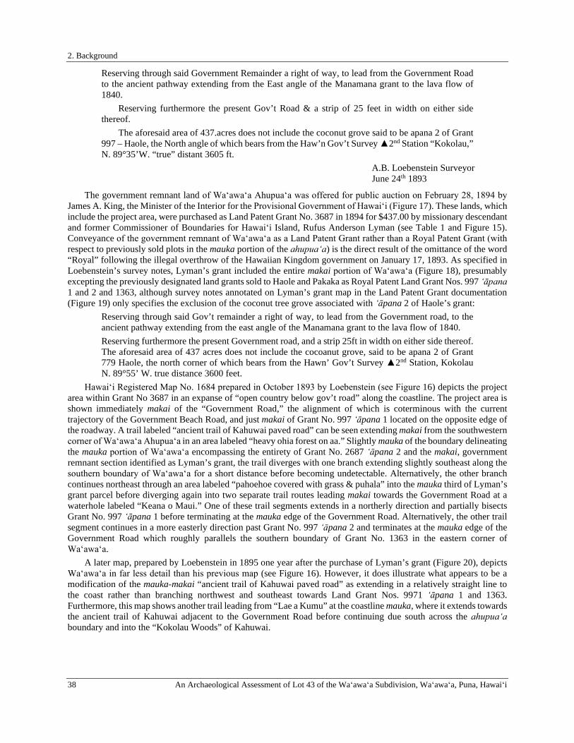
2. Background
38 An Archaeological Assessment of Lot 43 of the Waʻawaʻa Subdivision, Waʻawaʻa, Puna, Hawaiʻi
Reserving through said Government Remainder a right of way, to lead from the Government Road to the ancient pathway extending from the East angle of the Manamana grant to the lava flow of 1840. Reserving furthermore the present Gov’t Road & a strip of 25 feet in width on either side thereof. The aforesaid area of 437.acres does not include the coconut grove said to be apana 2 of Grant 997 – Haole, the North angle of which bears from the Haw’n Gov’t Survey ▲2nd Station “Kokolau,” N. 89°35’W. “true” distant 3605 ft.
A.B. Loebenstein Surveyor June 24th 1893
The government remnant land of Waʻawaʻa Ahupuaʻa was offered for public auction on February 28, 1894 by James A. King, the Minister of the Interior for the Provisional Government of Hawaiʻi (Figure 17). These lands, which include the project area, were purchased as Land Patent Grant No. 3687 in 1894 for $437.00 by missionary descendant and former Commissioner of Boundaries for Hawaiʻi Island, Rufus Anderson Lyman (see Table 1 and Figure 15). Conveyance of the government remnant of Waʻawaʻa as a Land Patent Grant rather than a Royal Patent Grant (with respect to previously sold plots in the mauka portion of the ahupuaʻa) is the direct result of the omittance of the word “Royal” following the illegal overthrow of the Hawaiian Kingdom government on January 17, 1893. As specified in Loebenstein’s survey notes, Lyman’s grant included the entire makai portion of Waʻawaʻa (Figure 18), presumably excepting the previously designated land grants sold to Haole and Pakaka as Royal Patent Land Grant Nos. 997 ̒ āpana 1 and 2 and 1363, although survey notes annotated on Lyman’s grant map in the Land Patent Grant documentation (Figure 19) only specifies the exclusion of the coconut tree grove associated with ʻāpana 2 of Haole’s grant:
Reserving through said Gov’t remainder a right of way, to lead from the Government road, to the ancient pathway extending from the east angle of the Manamana grant to the lava flow of 1840. Reserving furthermore the present Government road, and a strip 25ft in width on either side thereof. The aforesaid area of 437 acres does not include the cocoanut grove, said to be apana 2 of Grant 779 Haole, the north corner of which bears from the Hawn’ Gov’t Survey ▲2nd Station, Kokolau N. 89°55’ W. true distance 3600 feet.
Hawaiʻi Registered Map No. 1684 prepared in October 1893 by Loebenstein (see Figure 16) depicts the project area within Grant No 3687 in an expanse of “open country below gov’t road” along the coastline. The project area is shown immediately makai of the “Government Road,” the alignment of which is coterminous with the current trajectory of the Government Beach Road, and just makai of Grant No. 997 ʻāpana 1 located on the opposite edge of the roadway. A trail labeled “ancient trail of Kahuwai paved road” can be seen extending makai from the southwestern corner of Waʻawaʻa Ahupuaʻa in an area labeled “heavy ohia forest on aa.” Slightly mauka of the boundary delineating the mauka portion of Waʻawaʻa encompassing the entirety of Grant No. 2687 ʻāpana 2 and the makai, government remnant section identified as Lyman’s grant, the trail diverges with one branch extending slightly southeast along the southern boundary of Waʻawaʻa for a short distance before becoming undetectable. Alternatively, the other branch continues northeast through an area labeled “pahoehoe covered with grass & puhala” into the mauka third of Lyman’s grant parcel before diverging again into two separate trail routes leading makai towards the Government Road at a waterhole labeled “Keana o Maui.” One of these trail segments extends in a northerly direction and partially bisects Grant No. 997 ʻāpana 1 before terminating at the mauka edge of the Government Road. Alternatively, the other trail segment continues in a more easterly direction past Grant No. 997 ʻāpana 2 and terminates at the mauka edge of the Government Road which roughly parallels the southern boundary of Grant No. 1363 in the eastern corner of Waʻawaʻa.
A later map, prepared by Loebenstein in 1895 one year after the purchase of Lyman’s grant (Figure 20), depicts Waʻawaʻa in far less detail than his previous map (see Figure 16). However, it does illustrate what appears to be a modification of the mauka-makai “ancient trail of Kahuwai paved road” as extending in a relatively straight line to the coast rather than branching northwest and southeast towards Land Grant Nos. 9971 ʻāpana 1 and 1363. Furthermore, this map shows another trail leading from “Lae a Kumu” at the coastline mauka, where it extends towards the ancient trail of Kahuwai adjacent to the Government Road before continuing due south across the ahupuaʻa boundary and into the “Kokolau Woods” of Kahuwai.
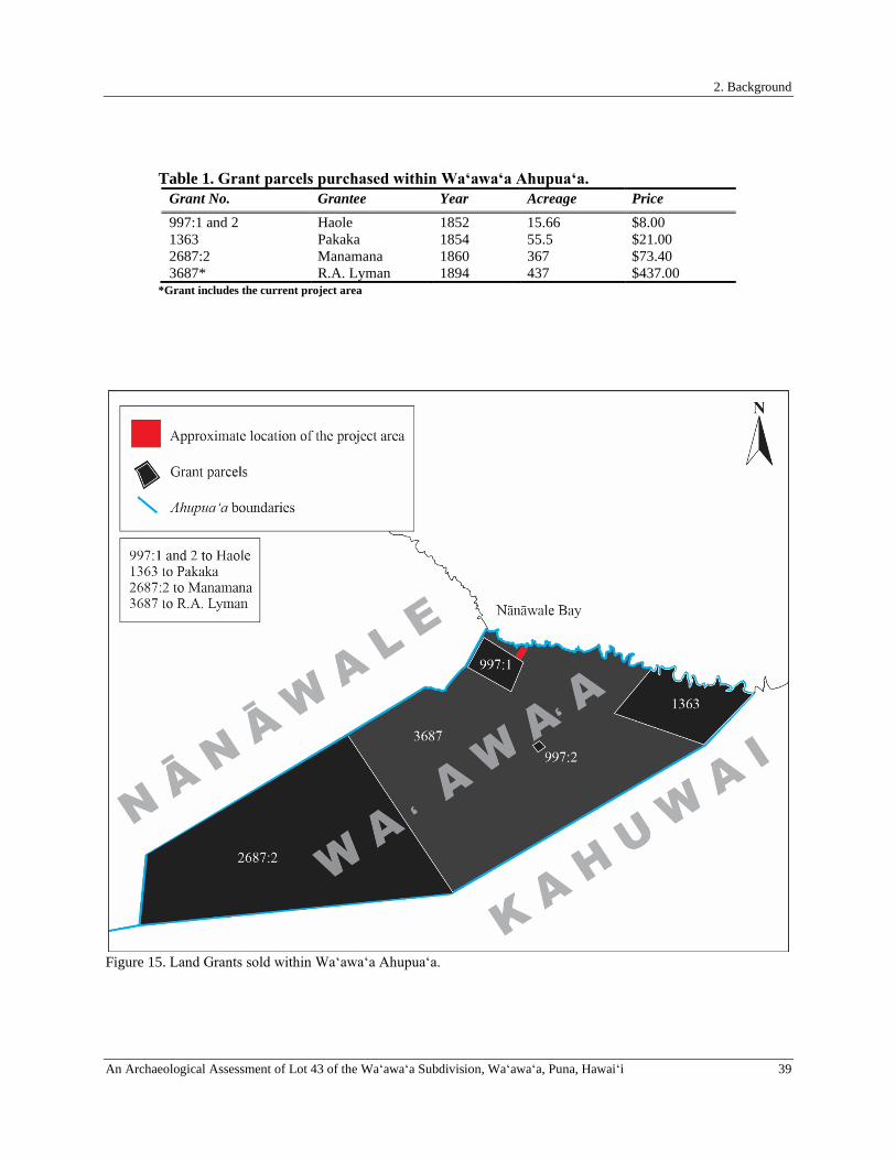
2. Background
An Archaeological Assessment of Lot 43 of the Waʻawaʻa Subdivision, Waʻawaʻa, Puna, Hawaiʻi 39
Table 1. Grant parcels purchased within Waʻawaʻa Ahupuaʻa. Grant No. Grantee Year Acreage Price 997:1 and 2 Haole 1852 15.66 $8.00 1363 Pakaka 1854 55.5 $21.00 2687:2 Manamana 1860 367 $73.40 3687* R.A. Lyman 1894 437 $437.00
*Grant includes the current project area
Figure 15. Land Grants sold within Waʻawaʻa Ahupuaʻa.

2. Background
40 An Archaeological Assessment of Lot 43 of the Waʻawaʻa Subdivision, Waʻawaʻa, Puna, Hawaiʻi
Figu
re 1
6. H
awai
ʻi R
egis
tere
d M
ap N
o. 1
684
prep
ared
by
A.B
. Loe
bens
tein
in Ju
ne 1
893
show
ing
proj
ect a
rea
loca
tion
(out
lined
in re
d) w
ithin
Waʻ
awaʻ
a A
hupu
aʻa.
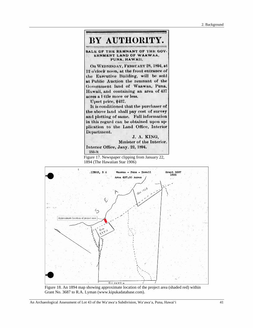
2. Background
An Archaeological Assessment of Lot 43 of the Waʻawaʻa Subdivision, Waʻawaʻa, Puna, Hawaiʻi 41
Figure 17. Newspaper clipping from January 22, 1894 (The Hawaiian Star 1906)
Figure 18. An 1894 map showing approximate location of the project area (shaded red) within Grant No. 3687 to R.A. Lyman (www.kipukadatabase.com).
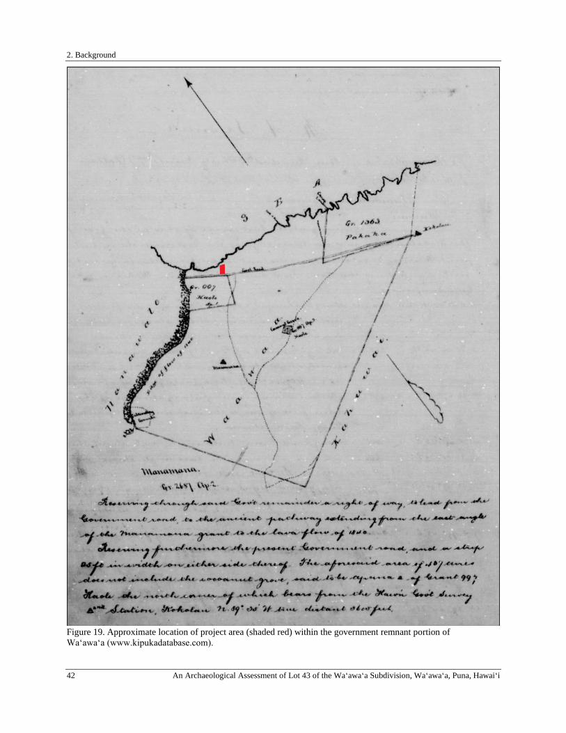
2. Background
42 An Archaeological Assessment of Lot 43 of the Waʻawaʻa Subdivision, Waʻawaʻa, Puna, Hawaiʻi
Figure 19. Approximate location of project area (shaded red) within the government remnant portion of Waʻawaʻa (www.kipukadatabase.com).
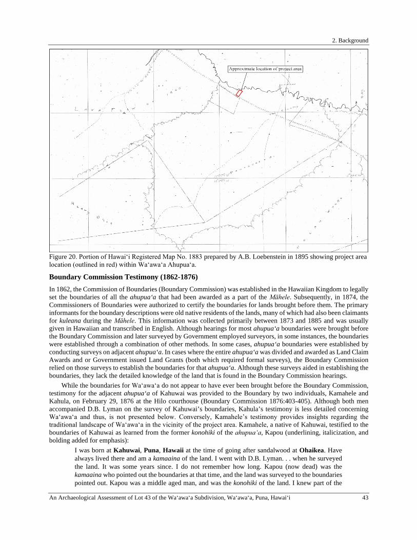
2. Background
An Archaeological Assessment of Lot 43 of the Waʻawaʻa Subdivision, Waʻawaʻa, Puna, Hawaiʻi 43
Figure 20. Portion of Hawaiʻi Registered Map No. 1883 prepared by A.B. Loebenstein in 1895 showing project area location (outlined in red) within Waʻawaʻa Ahupuaʻa.
Boundary Commission Testimony (1862-1876) In 1862, the Commission of Boundaries (Boundary Commission) was established in the Hawaiian Kingdom to legally set the boundaries of all the ahupua‘a that had been awarded as a part of the Māhele. Subsequently, in 1874, the Commissioners of Boundaries were authorized to certify the boundaries for lands brought before them. The primary informants for the boundary descriptions were old native residents of the lands, many of which had also been claimants for kuleana during the Māhele. This information was collected primarily between 1873 and 1885 and was usually given in Hawaiian and transcribed in English. Although hearings for most ahupua‘a boundaries were brought before the Boundary Commission and later surveyed by Government employed surveyors, in some instances, the boundaries were established through a combination of other methods. In some cases, ahupua‘a boundaries were established by conducting surveys on adjacent ahupua‘a. In cases where the entire ahupua‘a was divided and awarded as Land Claim Awards and or Government issued Land Grants (both which required formal surveys), the Boundary Commission relied on those surveys to establish the boundaries for that ahupua‘a. Although these surveys aided in establishing the boundaries, they lack the detailed knowledge of the land that is found in the Boundary Commission hearings.
While the boundaries for Waʻawaʻa do not appear to have ever been brought before the Boundary Commission, testimony for the adjacent ahupua‘a of Kahuwai was provided to the Boundary by two individuals, Kamahele and Kahula, on February 29, 1876 at the Hilo courthouse (Boundary Commission 1876:403-405). Although both men accompanied D.B. Lyman on the survey of Kahuwai’s boundaries, Kahula’s testimony is less detailed concerning Waʻawaʻa and thus, is not presented below. Conversely, Kamahele’s testimony provides insights regarding the traditional landscape of Waʻawaʻa in the vicinity of the project area. Kamahele, a native of Kahuwai, testified to the boundaries of Kahuwai as learned from the former konohiki of the ahupuaʻa, Kapou (underlining, italicization, and bolding added for emphasis):
I was born at Kahuwai, Puna, Hawaii at the time of going after sandalwood at Ohaikea. Have always lived there and am a kamaaina of the land. I went with D.B. Lyman. . . when he surveyed the land. It was some years since. I do not remember how long. Kapou (now dead) was the kamaaina who pointed out the boundaries at that time, and the land was surveyed to the boundaries pointed out. Kapou was a middle aged man, and was the konohiki of the land. I knew part of the
2. Background
44 An Archaeological Assessment of Lot 43 of the Waʻawaʻa Subdivision, Waʻawaʻa, Puna, Hawaiʻi
boundaries before, but had never been all around the land with the kamaaina, and had the boundaries pointed out to me. The land of Halepuaa bounds this land at the shore on the Puna side, and the boundary between them is at a place called Ka. Kapaheʻe’s purchase on Halepuaa bounds it there, mauka of that Kanalaeole’s land bounds it. We surveyed across the land from one side to the other at Govt road, and surveyed up this side along boundary of Waawaa. Place called Ponelu [Poʻonelu] is the boundary at shore between this land and Waawaa, thence the boundary runs mauka along Pakaka’s purchase on Waawaa & Govt Road, and mauka to a place called Kawakahikukui. There we returned to Govt road and surveyed up old trail in middle of land to Heakeo a point at lava flow of 1840; There we surveyed across the land to boundary of Nanawale on Hilo side of this land, and built a pile of stones there on boundary. The land of Waawaa ends a little mauka of Pakakas purchase, and then land of Nanawale bounds this land on the Hilo side, at place called Keakuapio where the old trails from Nanawale and this land join, and from this point to Heakeo the trail is boundary of this land. Altogether we surveyed across land to boundary of the land of Kanehiki to hau grove called Mauu. Part of hala was covered by lava flow. We built a pile of stones on the boundary. . . From Heakeo we surveyed up old trail on boundary between this land and Nanawale across the lava flow to place on the Hilo side of the flow called Naakiolaola where old trail from the Hilo side of Nanawale joins this road; Thence mauka the land of Nanawale is the road, and the land of Kahuwai lays on the Puna side of road, and land of Waiakahiula on Hilo side to place called Kawaimaohiohi the mauka end of this land. There used to be water there, and maohiohi [perhaps māʻohiʻohi, Hawaiian mint] is now growing there. We arrived to a stone and marked it, at this point the land of Nanawale again spreads out and cuts this land off. We surveyed across the land at place called Pahoa to cocoanut tree called Kanaana, and marked the tree. I do not remember whether we surveyed across the land anywhere between Heakeo and Wainaohiohi or not. Manamana owned a piece of land at the mauka end of Kahuwai. This land had ancient fishing rights extending out to sea. Cross-examined Kahula went with us when we surveyed the land.
Nā Inoa ʻĀina and Places of Interest in Waʻawaʻa Ahupuaʻa Toponymy or the study of inoa ‘āina (Hawaiian place names) provides additional information about a place and its history. Inoa ‘āina are recorded and recounted in a variety of Hawaiian oral arts including, oli (chants), mele (songs), mo‘olelo (stories), nane (riddles) and ‘ōlelo no‘eau (proverb and poetical expressions). Since the introduction of the written language, place name information has been recorded in ethnographic surveys, historic maps, and a number of early historical documents including Māhele ‘Āina records, Boundary Commission testimonies, and maps available from the Hawai‘i Department of Accounting and General Services and the United States Geological Survey Kikiloi (2010) asserts that the recovery of traditional place names “help to transform once-empty geographic spaces into cultural places enriched with meaning and significance.” Place names serve as vehicles of ancestral memory, and when we remember the old name of a place, we remember the words of the kūpuna (ancestors), and we recall the wisdom of their teachings (Olivera 2009). Renee Pualani Louis, a Native Hawaiian place name research scholar contends that:
[place names] are powerful cognitive mechanisms that unfold the richness of the Hawaiian landscape incorporating a plethora of cultural values and are a convergence of the Hawaiian cultural, social, political, and economic order. They are often understood with the mo‘olelo (historical account) that accompanies them and usually only by those with its genealogical proximity. As such, they provide a key to the lives and imaginations of Hawaiians. They indicate a holistic and harmonious relationship with the environment and are constant reminders of past events, cautionary tales, and epic tragedies. Knowledge of their meaning provides insight on the importance these place names had in shaping Hawaiian cultural identities. Sharing the names and meanings of places was a conscious act of cultural regeneration. Hawaiian incorporated their culture into the islandscape and used place names as storied symbols in their cartographic tradition. (Louis 2008:1–2)
The following section is a presentation and brief discussion of inoa ‘āina that were compiled throughout the course of this study and is by no means intended to be comprehensive. Rather, the place names presented below should
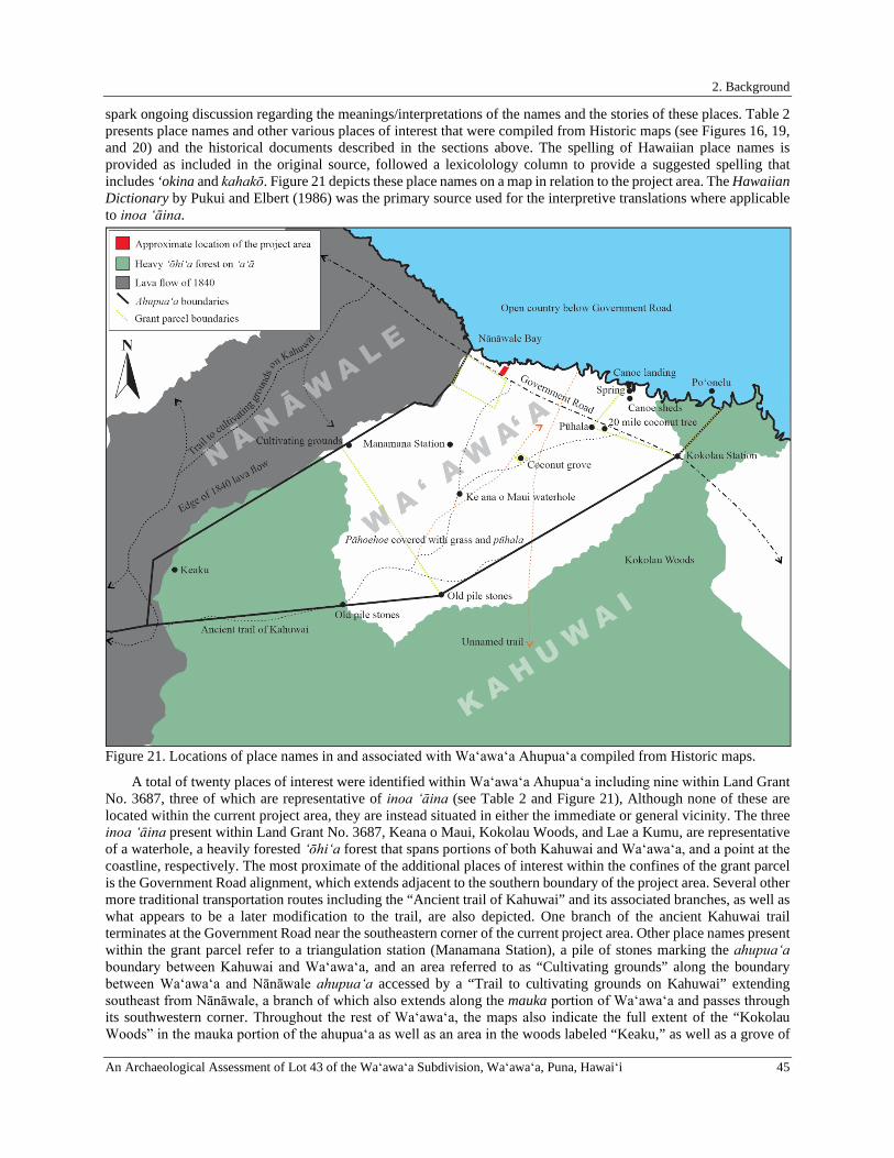
2. Background
An Archaeological Assessment of Lot 43 of the Waʻawaʻa Subdivision, Waʻawaʻa, Puna, Hawaiʻi 45
spark ongoing discussion regarding the meanings/interpretations of the names and the stories of these places. Table 2 presents place names and other various places of interest that were compiled from Historic maps (see Figures 16, 19, and 20) and the historical documents described in the sections above. The spelling of Hawaiian place names is provided as included in the original source, followed a lexicolology column to provide a suggested spelling that includes ‘okina and kahakō. Figure 21 depicts these place names on a map in relation to the project area. The Hawaiian Dictionary by Pukui and Elbert (1986) was the primary source used for the interpretive translations where applicable to inoa ʻāina.
Figure 21. Locations of place names in and associated with Waʻawaʻa Ahupuaʻa compiled from Historic maps.
A total of twenty places of interest were identified within Waʻawaʻa Ahupuaʻa including nine within Land Grant No. 3687, three of which are representative of inoa ‘āina (see Table 2 and Figure 21), Although none of these are located within the current project area, they are instead situated in either the immediate or general vicinity. The three inoa ʻāina present within Land Grant No. 3687, Keana o Maui, Kokolau Woods, and Lae a Kumu, are representative of a waterhole, a heavily forested ʻōhiʻa forest that spans portions of both Kahuwai and Waʻawaʻa, and a point at the coastline, respectively. The most proximate of the additional places of interest within the confines of the grant parcel is the Government Road alignment, which extends adjacent to the southern boundary of the project area. Several other more traditional transportation routes including the “Ancient trail of Kahuwai” and its associated branches, as well as what appears to be a later modification to the trail, are also depicted. One branch of the ancient Kahuwai trail terminates at the Government Road near the southeastern corner of the current project area. Other place names present within the grant parcel refer to a triangulation station (Manamana Station), a pile of stones marking the ahupuaʻa boundary between Kahuwai and Waʻawaʻa, and an area referred to as “Cultivating grounds” along the boundary between Waʻawaʻa and Nānāwale ahupuaʻa accessed by a “Trail to cultivating grounds on Kahuwai” extending southeast from Nānāwale, a branch of which also extends along the mauka portion of Waʻawaʻa and passes through its southwestern corner. Throughout the rest of Waʻawaʻa, the maps also indicate the full extent of the “Kokolau Woods” in the mauka portion of the ahupuaʻa as well as an area in the woods labeled “Keaku,” as well as a grove of

2. Background
46 An Archaeological Assessment of Lot 43 of the Waʻawaʻa Subdivision, Waʻawaʻa, Puna, Hawaiʻi
coconut trees associated with Grant No. 997 ʻāpana 2, a single coconut tree marking the 20 mile point of the Government Road leading from Hilo adjacent to a pū hala tree marking the southwestern corner of Grant No. 1363, another triangulation station (labeled “Kokolau”), and an additional pile of stones marking the boundary between Kahuwai and Waʻawaʻa. Also depicted are the locations of canoe sheds, a canoe landing, and a freshwater spring associated with Grant No. 1363 situated in the northwestern portion of the ahupuaʻa along its boundary with Kahuwai.
Table 2. List of place names/places of interest in Waʻawaʻa noted on historical maps. Place Name Lexicology Literal
Translation Interpretation
20 mile coconut tree - - Coconut tree marking mile 20 along the Government Road Ancient Trail of Kahuwai Paved Road
- - Branching trail leading makai from junction of “trail to cultivating grounds on Kahuwai” at the southwestern corner of Waʻawaʻa Ahupuaʻa. One branch terminates along boundary between Waʻawaʻa and Kahuwai, the other branches at “keana o Maui waterhole” with both segments terminating at the Government Road.
Canoe Landing - - Canoe landing located in small bay at northwestern corner of Grant No. 1363 to Pakaka
Canoe Sheds - - Canoe sheds located in northwestern portion of Grant No. 1363 to Pakaka
Coconut grove - - Coconut grove associated with Grant No. 997 ʻāpana 2 to Haole
Cultivating Grounds - - Area of cultivation located in northwestern corner of Grant No. 3687 to Lyman adjacent to 1840 lava flow and northern boundary of Waʻawaʻa
Government Road - - Constructed in 1840s, overlaid older alaloa/Puna Trail Keana o Maui Ke ana o Maui Cave of Maui Waterhole located at a junction of the “ancient trail of
Kahuwai” Keaku Unknown Unknown Unidentified area within ʻōhiʻa forest near mauka boundary
of Waʻawaʻa along edge of 1840 flow Kokolau Kokolau/
Koʻokoʻolau - Triangulation station.
Kokolau Woods Kokolau/ Koʻokoʻolau
- ʻŌhiʻa forest on ʻaʻā comprising the northeastern corner and mauka portion of Waʻawaʻa. Kokolau may be an alias of koʻokoʻolau (Bidens sp.), an endemic medicinal plant
Lae a Kumu Lae a Kumu Cape of Kumu
Refers to point on coast northeast of the current project area
Manamana Station Manamana - Triangulation station possibly associated with Grant No. 2687 to Manamana
Old pile stones - - Boundary marker between Waʻawaʻa and Kahuwai situated at edge of ʻōhiʻa forest along Grant No. 2687 ʻāpana 2 to Manamana
Old pile stones - - Boundary marker marking boundary between Grant No. 2687 to Manamana and Grant No. 3687 to Lyman along Waʻawaʻa/Kahuwai ahupuaʻa boundary
Ponelu Poʻonelu Fat head Boundary at shore between Waʻawaʻa and Kahuwai Pūhala Pū hala Pandanus tree Pū hala tree located at southwestern corner of Grant No.
1363 to Pakaka Spring - - Unnamed freshwater spring located between canoe landing
and canoe sheds in northwestern portion of Grant No. 1363 to Pakaka
Trail to cultivating grounds on Kahuwai
- - Branching mauka-makai trail extending through 1840 lava flow in Nānāwale from Government Road along the top edge of Waʻawaʻa and into Kahuwai Ahupuaʻa. Branches southeast towards Waʻawaʻa across flow and leads to “cultivating grounds” in northwestern corner of Grant No. 3687 to Lyman.
Unnamed trail - - Appears to be a modification of the “Ancient trail of Kahuwai”
2. Background
An Archaeological Assessment of Lot 43 of the Waʻawaʻa Subdivision, Waʻawaʻa, Puna, Hawaiʻi 47
Waʻawaʻa Ahupuaʻa During the Late Nineteenth and Early Twentieth Centuries, Later Historic Accounts, and a Concise History of the Waʻawaʻa Residential Subdivision Throughout the Precontact and early Historic Period, the current project area and vicinity surrounding it appears to have only been sparsely inhabited. Historic descriptions of Waʻawaʻa are mostly limited to accounts of individuals traveling over the Puna Trail from Hilo into the Puna District through Nānāwale towards Kahuwai, and thus through Waʻawaʻa. Although these accounts do not explicitly reference Waʻawaʻa by name, they do describe the environs of the ahupuaʻa which are useful for gleaning insight into the characteristics of the project area vicinity during the late nineteenth and early twentieth centuries. One such account entitled “Hawaii-Nei” provided by American author Charles Nordhoff (1873a), was published in Harper’s Magazine in 1873. Nordhoff provided observations of the narrow coastal trail extending “across unceasing beds of lava” that “was actually hammered down to make it smooth enough for travel” in some places, and also noted that “most of the lava is probably very ancient, though some is quite recent, and ferns and guava bushes and other scanty herbage grow through it” (ibid.:401). Nordhoffs narrative continued thusly:
. . . after a descent to the sea-shore, you are rewarded with the pleasant sight of groves of cocoa-nuts and umbrageous arbors of pandanus, and occasionally with a patch of green. Almost the whole of the Puna coast is waterless. . . It will surprise you to find people living among the lava, making potato patches in it, planting coffee and some fruit trees in it, fencing in their small holdings, even, with lava blocks. Very little soil is needed to give vegetation a chance in a rainy season, and the decomposed lava makes a rich earth. But, except the cocoa-nut, which grows on the beach, and seems to draw its sustenance from the waves, and the sweet-potato, which does very well among the lava, nothing seems really to thrive. (ibid.:401).
In another installment titled “Hawaii-Nei-II” Nordhoff (1873b) speaks again of the lack of fresh-water in Puna and that Dr. Coan had told him about how Native Hawaiians collected freshwater for his use during his missionary tour “from the drippings of dew in caves” (ibid.:550). For, “wells are here out of the question, for there is no soil except a little decomposed lava, and the lava lets through all the water which comes from rains” compounded by the lack of mountain streams (ibid.). Nordhoff also presented the following observations of the communities in Puna as well as traditional sweet potato planting methods:
There are no fields, according to our meaning of the word. Yet formerly the people in this district were numbered by thousands: even yet there is a considerable population, not unprosperous by any means. Churches and schools are as frequent as in the best part of New England. Yet when I asked a native to show me his sweet-potato patch he took me to the most curious and barren-looking collection of lava you can imagine, surrounded too, by a very formidable wall made of lava, and explained to me that by digging holes in the lava where it was a little decayed, carrying a handful of earth to each of these holes, and planting there in a wet season, he got a very satisfactory crop. Not only that, but being desirous of something more than a bare living, this man had planted a little coffee in the same way, and had just sold 1600 pounds, his last crop. (ibid.:550)
Isabella Bird visited Hilo in 1873 and published her experiences in The Hawaiian Archipelago: Six Months Among the Palm Groves, Coral Reefs, & Volcanoes of the Sandwich Islands Bird (1875). Her firsthand accounts of her journey from Hilo to Puna are dreamy and romanticized. In the following excerpt, she provides a vivid depiction of the stark contrast between the districts and describes what is presumed to be the 1840 lava flow and the environs of the general vicinity of Waʻawaʻa near the turn of the century:
At some distance from Hilo there is a glorious burst of tropical forest, and then the track passes into green grass dotted over with clumps of the pandanus and the beautiful Eugenia. In that hot dry district the fruit was already ripe, and we quenched our thirst with it. The “native apple,” as it is called, is of such a brilliant crimson colour as to be hardly less beautiful than the flowers. . . We were always near the sea, and the surf kept bursting up behind the trees in great snowy drifts, and every opening gave us a glimpse of deep blue water. The coast the whole way is composed of great blocks of very hard black lava, more or less elevated, upon which the surges break in perpetual thunder. Suddenly, the verdure ceased, and we emerged upon a hideous scene, one of the many lava flows from Kilauea, an irregular branching stream, about a mile broad. It is suggestive of feartul work on the part of nature, for here the volcano has not created but destroyed. The black tumbled

2. Background
48 An Archaeological Assessment of Lot 43 of the Waʻawaʻa Subdivision, Waʻawaʻa, Puna, Hawaiʻi
sea mocked the bright sunshine, all tossed, jagged, spiked, twirled, thrown heap on heap, broken, rifted, upheaved in great masses, burrowing in ravines of its own making, full of broken bubble caves, and torn by a-a streams. Close to the track crystals of olivine lie in great profusion, and in a few of the crevices there are young plants of a fern which everywhere has the audacity to act as the herald of vegetation. (Bird 1875:360-361)
It was not long after the time of Bird’s journey through Puna that the Alanui Aupuni was modified, although it still remained the primary form of transportation to and from the Puna District and frequently mentioned in the Historic accounts of travelers to the district (Maly 1998). In 1875, Kauaʻi native and journalist, Henry Martyn Whitney journeyed along the Alanui Aupuni (labeled “Puna road” in Figure 22) from Hilo into Puna, through the luxuriant, ʻōhiʻa-filled Panaʻewa forest before reaching “groves of the pandanus, and at Kaea [Keaʻau] the ocean appears and the houses in Puna. Cocoanut trees here begin to form a prominent part of the landscape, clustered in groups of hundreds and thousands” (Whitney 1875:79). In 1892, a petition for the continuance of the road through the Puna District southeast to Kaimū was initiated. According to Loebenstein,, the portion of the Alanui Aupuni extending from Hilo into Puna was easily passable particularly in the vicinity of the current project area and related that “a bullock cart can run over the pahoehoe as far as the 19th mile now” (Advertiser 1892).
In 1898, American author and lawyer John Roy Musick arrived to the shores of Hawaiʻi aboard the SS. Australia. Upon traveling into the Puna District from Hilo, Musick provided an account of the Puna Road and described the groves of pū hala studded with coconut trees that characterize the landscape in the vicinity of the project area as well as the natural curiosities left behind in the wake of the 1840 lava flow in Nānāwale:
The Puna district which joins the district of Hilo on the south is one of the most interesting in Hawaii. The general appearance from the road is sterile, especially at the southern part, where there are considerable tracts covered with lava-rock, supporting only the scantiest vegetation. The northern part of the district is covered with dense lauhala forest and is thinly inhabited. About eighteen miles from Hilo the country begins to improve, and away from the main road, upon the slopes of the mountain, there are many acres of excellent land suitable for coffee-growing. The southeastern part of Puna is celebrated for its groves of coconuts. In 1840 the lava-flow from the volcano, after pursuing an underground course for many miles, suddenly burst forth in the woods and rushed down to the sea, overwhelming small villages in its course. The lava-flows have left many strange figures in the forest. (Musick 1898:170)
Figure 22. Portion of Hawaiʻi Registered Map No. 568 prepared by J.M. Lydgate in 1875 showing approximate location of the project area in relation to the Alanui Aupuni.
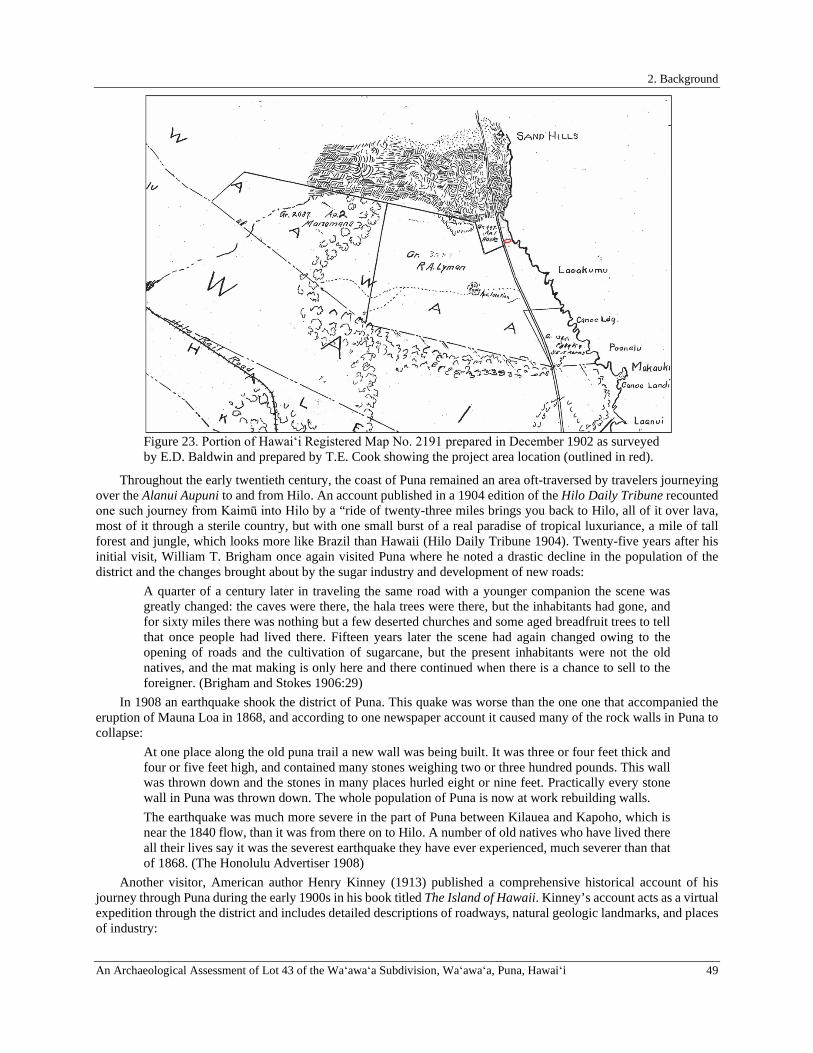
2. Background
An Archaeological Assessment of Lot 43 of the Waʻawaʻa Subdivision, Waʻawaʻa, Puna, Hawaiʻi 49
Figure 23. Portion of Hawaiʻi Registered Map No. 2191 prepared in December 1902 as surveyed by E.D. Baldwin and prepared by T.E. Cook showing the project area location (outlined in red).
Throughout the early twentieth century, the coast of Puna remained an area oft-traversed by travelers journeying over the Alanui Aupuni to and from Hilo. An account published in a 1904 edition of the Hilo Daily Tribune recounted one such journey from Kaimū into Hilo by a “ride of twenty-three miles brings you back to Hilo, all of it over lava, most of it through a sterile country, but with one small burst of a real paradise of tropical luxuriance, a mile of tall forest and jungle, which looks more like Brazil than Hawaii (Hilo Daily Tribune 1904). Twenty-five years after his initial visit, William T. Brigham once again visited Puna where he noted a drastic decline in the population of the district and the changes brought about by the sugar industry and development of new roads:
A quarter of a century later in traveling the same road with a younger companion the scene was greatly changed: the caves were there, the hala trees were there, but the inhabitants had gone, and for sixty miles there was nothing but a few deserted churches and some aged breadfruit trees to tell that once people had lived there. Fifteen years later the scene had again changed owing to the opening of roads and the cultivation of sugarcane, but the present inhabitants were not the old natives, and the mat making is only here and there continued when there is a chance to sell to the foreigner. (Brigham and Stokes 1906:29)
In 1908 an earthquake shook the district of Puna. This quake was worse than the one one that accompanied the eruption of Mauna Loa in 1868, and according to one newspaper account it caused many of the rock walls in Puna to collapse:
At one place along the old puna trail a new wall was being built. It was three or four feet thick and four or five feet high, and contained many stones weighing two or three hundred pounds. This wall was thrown down and the stones in many places hurled eight or nine feet. Practically every stone wall in Puna was thrown down. The whole population of Puna is now at work rebuilding walls. The earthquake was much more severe in the part of Puna between Kilauea and Kapoho, which is near the 1840 flow, than it was from there on to Hilo. A number of old natives who have lived there all their lives say it was the severest earthquake they have ever experienced, much severer than that of 1868. (The Honolulu Advertiser 1908)
Another visitor, American author Henry Kinney (1913) published a comprehensive historical account of his journey through Puna during the early 1900s in his book titled The Island of Hawaii. Kinney’s account acts as a virtual expedition through the district and includes detailed descriptions of roadways, natural geologic landmarks, and places of industry:

2. Background
50 An Archaeological Assessment of Lot 43 of the Waʻawaʻa Subdivision, Waʻawaʻa, Puna, Hawaiʻi
The district of Puna may, for the sake of clearness, be divided into two sections, the Olaa region, the north half, and Puna proper. The former consists of the great Olaa sugar plantation, and forest which has been partially cleared, while some tracts are used for cattle. The middle part of the district, with Pahoa as the center, is used for extensive lumber operations. The remainder, Puna proper, is covered by forest and old lava flows, most of them covered with vegetation. . . Where the road from the station runs into the road to Pohoiki at a right angle, a road continues northward through KOAE, a particularly pretty Hawaiian village, and extends for about mile, when it continues as a good trail on to the beach, where, beyond some towering and hills, lies Honolulu, which consists of only a couple of huts. Hence a trail runs along the coast to the Shipman ranch, below Olaa Mill. It passes a few huts, called by courtesy the villages of Waiakahiula and Makuu. Trails lead from these to Pahoa (Kinney 1913:83)
Throughout the latter part of the nineteenth century land use within Wa‘awa‘a Ahupua‘a began to change drastically, and Yent and Ota (1982:11) noted that the “native agricultural system began to decline around 1840 as the population declined.” The inland portions of the ahupua‘a (portions of Grant No. 2687 and 3687) appear to have been used for cattle ranching and possibly sugarcane cultivation. Between 1890 and 1931 the area from Wa‘awa‘a to Puala‘a (likely including Grant No. 3687 to R. A. Lyman) was ranched by the Lyman Estate. The lease for cattle was transferred to Kamau in 1931 (Yent and Ota 1982). Other portions of the ahupua‘a may have been used for sugarcane cultivation. The Puna Sugar Company operated in the vicinity of the current project area from 1900 until the 1980s (Haun and Henry 2004). The current project area does not seem to have been used for either purpose. The 1924 USGS Makuu quadrangle shows a single structure makai of the Government Beach Road along the coast of Wa‘awa‘a Ahupua‘a during the early twentieth century (Figure 24).
Figure 24. Portion of the 1924 USGS Makuu quadrangle with project area outlined in red.
This changed during the second half of the twentieth century when, in May of 1958, the Puna Investment Co. received final approval from the Hawaiʻi County Planning and Traffic Commission to subdivide a large portion of Wa‘awa‘a Ahupua‘a, extending from the coast to the mauka boundary of Grant No. 3687, into 177 residential farm lots (including the subject parcel) now known as the Wa‘awa‘a Subdivision (Hilo Tribune-Herald 1958). Lacking electricity and water, these lots were not quickly developed. The 1965 USGS Kapoho quadrangle, and an aerial photograph taken on February 6 of that same year, indicate that by that time the subdivision roads had been bulldozed, but that none of the parcels had yet been developed (Figures 25 and 26). Many of the coastal lots within the subdivision have only been developed only relatively recently, and most of those developments have been accompanied by archaeological studies, the results of which are summarized below.

2. Background
An Archaeological Assessment of Lot 43 of the Waʻawaʻa Subdivision, Waʻawaʻa, Puna, Hawaiʻi 51
Figure 25. Portion of 1965 USGS Kapoho quadrangle with the project area outlined in red.
Figure 26. 1961 USGS aerial photograph showing the location of the project area (outlined in red).
2. Background
52 An Archaeological Assessment of Lot 43 of the Waʻawaʻa Subdivision, Waʻawaʻa, Puna, Hawaiʻi
PREVIOUS ARCHAEOLOGICAL STUDIES Archaeological studies previously conducted in Wa‘awa‘a Ahupua‘a in the vicinity of the current project area have been limited to coastal lots within Wa‘awa‘a Subdivision (Figure 27). The parcels on either side of the current project area were both previously surveyed for cultural resources (Clark and Rechtman 2011; Corbin 2008; O’Shaughnessy 2008), as were seven lots further to the southeast (Clark 2018; Clark and Rechtman 2006; Haun and Henry 2002, 2004, 2010; Kirkendall and Hunt 1990) and two lots further to the northwest (Clark and Rechtman 2008; Rechtman 2008, 2009). Collectively these prior studies have identified several feature types along the coast of Wa‘awa‘a Ahupua‘a, including modified depressions, excavated pits, modified outcrops, terraces, walls, enclosures, platforms, a trail, a lava tube, and a possible cairn. These features have been interpreted as having functions related to Precontact to early Historic Period habitation, agriculture, and burial, as well as Historic Period ranching. The findings of each of the studies listed above are briefly summarized below in chronological order below.
Kirkendall and Hunt (1990) conducted an archaeological inventory survey of the inland (agriculturally zoned) portions of two coastal parcels within the Wa‘awa‘a Subdivision (TMKs: (3) 1-4-028:041 and 042) located to the southeast of the current project area (see Figure 27). As a result of their survey a single archaeological site (Temporary Site 1) containing 14 distinct features (Features A-N) was recorded. The identified features included two platforms (Features A and L), a modified outcrop (Feature B), four enclosures (Feature C, I, M, and N), three walls (Features D, F, and G), a walkway (Feature E), a historic roadway (Feature H), and two modified depressions (Features J and K). Six of these features (Features A, E, G, H, J, and K) were located within TMK: (3) 1-4-028:041, while the remaining 8 features were located within TMK: (3) 1-4-028:042. Kirkendall and Hunt (1990) interpreted Temporary Site 1 as a residential complex with extensive agricultural features surrounding it. They noted that, “the two platforms, Features A and L are likely house platforms, with adjacent animal enclosures,” and that “the agricultural features are primarily unfaced depressions in the a’a [with] rock having been removed and piled on the sides or used for walls” (Kirkendall and Hunt 1990:7), and suggested that the depressions were used for the cultivation of sweet potato and taro. They also noted that the walkway (Feature E) was likely older than the Historic roadway (Feature H), and that Feature B, based on its large size and construction, likely functioned as a heiau (Kirkendall and Hunt 1990:7).
Haun and Henry (2002) conducted an archaeological inventory survey of a parcel (TMK: (3) 1-4-028:038) located to the southeast of the current project area (see Figure 27). The survey identified five sites containing a total of 37 features. The recorded sites included a ranch wall (Site 23389), three agricultural complexes (Sites 23390, 23391, and 23393), and a habitation terrace (Site 23392). Feature types identified at the three sites included twenty-four planting depressions, five modified outcrops, three terraces, two enclosures, a wall, a platform, and a possible cairn. In addition to these features, Haun and Henry (2002) also identified a portion of a Historic road, but did not assign a site number to it.
Haun and Henry (2004) conducted an archaeological inventory survey of two adjoining parcels (TMKs: (3) 1-4-028:033 and 034) located to the southeast of the current project area (see Figure 27). The survey identified six sites containing a total of 42 distinct features. The recorded sites included two permanent habitation complexes (Sites 23997 and 23998), a ranch wall (Site 23999), a permanent habitation enclosure (Site 24000), a burial platform (Site 24001), and an agricultural complex (Site 24002). Feature types identified at these sites consisted of fourteen excavated pits, eight enclosures, eight modified outcrops, six terraces, five walls, and one platform. The agricultural features were similar to those recorded on TMK: (3) 1-4-028:038 by Haun and Henry (2002), which Haun and Henry suggest may have been enclosed by walls during the Historic Period to keep cattle out. Excavations within the features interpreted as foundations for habitation structures (comprised of eight enclosures, two terraces, and several wall segments) yielded primarily volcanic glass flakes, charcoal, and marine shell, but also produced a glazed ceramic fragment indicating Historic use of the features. A charcoal sample collected from Site 23998 Feature A by Haun and Henry (2004) and submitted for radiocarbon analysis indicated that the feature may have been initially occupied sometime between 1530 and 1630 A.D. Excavation at the Site 24001 platform revealed a vaulted crypt containing human skeletal remains.
Clark and Rechtman (2006) conducted an archaeological inventory survey of one of the parcels (TMK: (3) 1-4-028:041) previously studied by Kirkendall and Hunt (1990) to the southeast of the current project area (see Figure 27). All of the features recorded by Kirkendall and Hunt (1990) in the mauka portion of that parcel were relocated by Clark and Rechtman (2006), and additional features were recorded in the seaward portion. The identified feature types included five modified depressions, a modified outcrop, a wall, a raised walkway, a terrace, and two enclosures that were assigned to five archaeological sites including two agricultural complexes (Site 25516 and 25520), a core-filled wall (Site 25517), a raised trail (Site 25518), and a habitation complex (Site 25519). The sites were interpreted as representing Precontact to early Historic Hawaiian use of the project area for habitation and agricultural purposes.
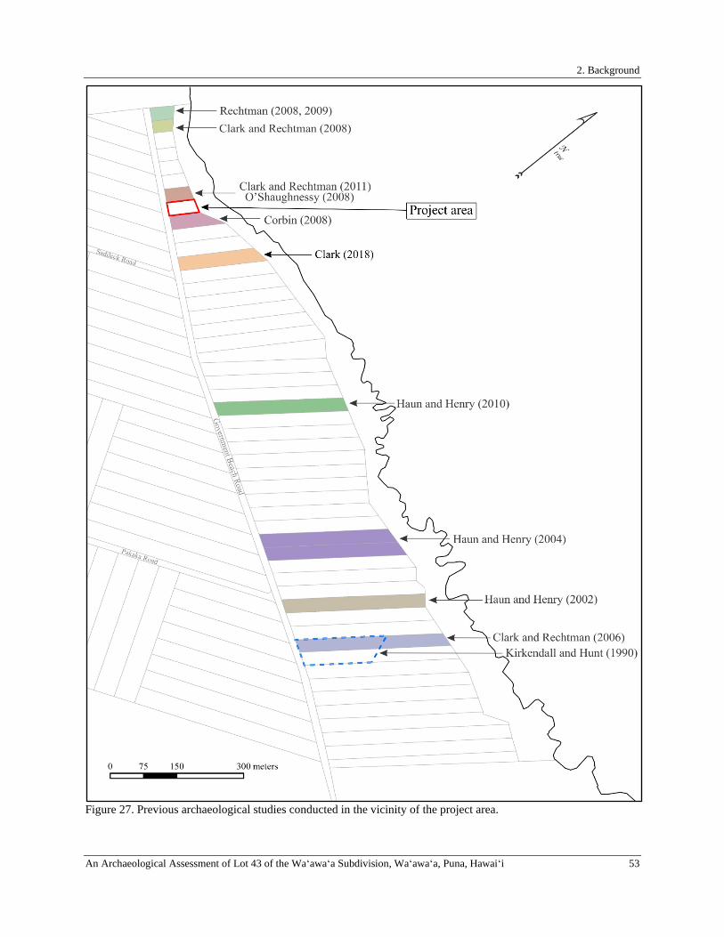
2. Background
An Archaeological Assessment of Lot 43 of the Waʻawaʻa Subdivision, Waʻawaʻa, Puna, Hawaiʻi 53
Figure 27. Previous archaeological studies conducted in the vicinity of the project area.

3. Project Area Expectations
54 An Archaeological Assessment of Lot 43 of the Waʻawaʻa Subdivision, Waʻawaʻa, Puna, Hawaiʻi
Corbin (2008) conducted an archaeological inventory survey of a parcel (TMK: (3) 1-4-028:009) located adjacent to the southeastern boundary of the current project area (see Figure 27). As a result of the study Corbin recorded a single archaeological site (Site 26465) containing three features (Features A, B, and C) including a stone platform (Feature A) interpreted as a temporary habitation or viewing structure, a stone clearing mound (Feature B), and a C-shaped wall (Feature C) that may have been a wind break or a planting feature. Feature A was completely dismantled by Corbin (2008), revealing that most of the platform was actually natural bedrock, and that it lacked any associated cultural debris. Corbin (2008:16) concluded that all of the features within the parcel were likely related to the agricultural use of the area during the Precontact Period.
Rechtman (2008) surveyed the easternmost coastal parcel in Wa‘awa‘a Subdivision (TMK: (3) 1-4-028:001; see Figure 27) and initially reported no findings. Subsequent to the completion of the archaeological fieldwork, an opening to a small lava tube was discovered beneath an area of dense naupaka ground cover. The lava tube was explored and found to contain a single set of poorly preserved human skeletal remains (Rechtman 2009). This inadvertent discovery was reported to DLNR-SHPD, and a burial treatment plan was prepared.
Clark and Rechtman (2008) prepared an archaeological assessment for TMK: (3) 1-4-028:002 located to the northwest of the current project area (see Figure 27). No archaeological sites were identified on that parcel, but a potential site consisting of a pile of cobbles was noted and excavated. The results of the excavation indicated that the pile was likely a modern construction, and therefore not an archaeological resource.
Haun and Henry (2010) conducted an archaeological inventory survey of a parcel (TMK: (3) 1-4-028:023) located to the east of the current project area (see Figure 27). That study identified two archaeological sites (Sites 28138 and 28139) containing a total of nineteen features. Site 28138 consisted of a rectangular-shaped platform located near the Government Beach Road that was tested and found to contain human skeletal remains within an oval-shaped, stone-lined crypt. Site 28139 consisted of a complex of 18 agricultural features spanning the inland two-thirds of the parcel. The features of this site included eight mounds, six pits, two modified outcrops, and two retaining walls. The mounds and modified outcrops were interpreted as clearing features, while the pits were interpreted as planting features, and the retaining walls were interpreted as agricultural plot boundary walls that helped retain soil.
Clark and Rechtman (2011) conducted an archaeological assessment survey of a 0.415-acre parcel (TMK: (3) 1-4-028:007) located adjacent to the southeastern boundary of the current project area (see Figure 27). Their 2011 study reexamined the findings of an earlier archaeological assessment conducted by O'Shaughnessy (2008). Clark and Rechtman (2011) identified seven discrete cobble features on that parcel, all of which were interpreted as modern constructions. The identified features include a retaining wall, five cement and rock features that were part of a “hippy camp,” and the base of a memorial erected in honor of Dana Ireland.
Most Recently, in 2018, ASM Affiliates (Clark 2018) conducted an archaeological field inspection of a 1.460-acre parcel (TMK: (3) 1-4-028:012) located to the southeast of the current project area (see Figure 27). No archaeological sites or features were reported as a result of that study.
3. PROJECT AREA EXPECTATIONS Based on the specific location, terrain, and small size of the project area, the archaeological expectations for the current study are limited. The results of the background research and the review of prior archaeological work presented above indicates that the primary areas of Precontact habitation along this section of the Puna coast were located to the east and west of the project area, and that nearby Historic habitation may have occurred mauka of the parcel on the opposite side of the Government Beach Road (at Grant No. 997 to Haole). Feature types previously recorded at coastal parcels within Wa‘awa‘a Ahupua‘a to the east of the current study parcel include modified depressions, excavated pits, modified outcrops, mounds, terraces, retaining walls, enclosures, platforms, a trail, and a possible cairn that were used for Precontact and early Historic habitation, agriculture, and burial purposes, as well as walls that were created for Historic ranching activities. The locations of most of these previously recorded features relative to the coast, however, places them further inland than the mauka boundary of the current study parcel. Nearest the project area, on the neighboring parcel to the southeast, Corbin (2008) recorded potential Precontact Period temporary habitation and agricultural features and, on the neighboring parcel to the northwest ,Clark and Rechtman (2011) reported features related to a modern residential “camp.” It is possible that similar features to those recorded by either Corbin (2008) or Clark and Rechtman (2011) could be present within the current project area. Also, if any entrances to lava tubes are present, they may contain human skeletal remains (Rechtman 2009).
4. Fieldwork, Conclusion, and Recommendations
An Archaeological Assessment of Lot 43 of the Waʻawaʻa Subdivision, Waʻawaʻa, Puna, Hawaiʻi 55
4. FIELDWORK, CONCLUSION, AND RECOMMENDATIONS Fieldwork for the current study was conducted on October 15, 2020 by Lauren Kepaʻa and Matthew R. Clark (Principle Investigator). Fieldwork consisted of an intensive (100%) coverage survey of the entire surface of the project area utilizing systematic east-west pedestrian transects with fieldworkers spaced at roughly three-meter intervals. The entire project area was accessible at the time of the survey, and the boundaries were clearly identifiable in the field; vegetation cover on slightly limited ground visibility.
No cultural resources of any kind were identified within the current project area as a result of the fieldwork. Thus, it is the conclusion of this study that the proposed development of a single-family dwelling on the subject parcel will have no effect on any historic properties. With respect to the historic preservation review process of both the Department of Land and Natural Resources–State Historic Preservation Division (DLNR–SHPD) and the County of Hawai‘i Planning Department, our recommendation is that no further work needs to be conducted prior to or during project implementation. In the unlikely event that significant archaeological resources are discovered during the proposed development activities, work shall cease in the area of the discovery and DLNR-SHPD shall be contacted pursuant to HAR 13§13-280-3.

References Cited
56 An Archaeological Assessment of Lot 43 of the Waʻawaʻa Subdivision, Waʻawaʻa, Puna, Hawaiʻi
REFERENCES CITED Abbott, I. A.
1992 Lāʻau Hawaiʻi, Traditional Hawaiian Uses of Plants. Bishop Museum Press, Honolulu.
Advertiser, D. P. C. 1892 Wonders of Puna. The Honolulu Advertiser [Honolulu]. March 15, 1892: 5. Electronic document,
https://www.newspapers.com/image/259366164/?terms=puna%2Btrail, , accessed 01/24/2019.
Alexander, W. D. 1891 A Brief History of the Hawaiian People. American Book Company, Chicago.
Athens, J. S., T. Rieth, and T. S. Dye 2014 A Paleoenvironmental and Archaeological Model-Based Age Estimate for the Colonization of
Hawaiʻi. American Antiquity 79(1):144-155.
Barrère, D. 1959 Political History of Puna. In Natural and Cultural History Report on the Kalapana Extension of the
Hawaii National Park, vol. I, pp. 15-65. Department of Anthropology, B. P. Bishop Museum, Honolulu.
Beckwith, M. W. 1917 Hawaiian Shark Aumakua. American Anthropologist N.S. 19:503-517.
Barrère, D. 1951 The Kumulipo A Hawaiian Creation Chant. University of Hawaii Press, Honolulu.
Beckwith, M. W. 1970 Hawaiian Mythology. University of Hawai'i Press, Honolulu.
Bird, I. 1875 The Hawaiian Archipelago: Six Months among the Palm Groves, Coral Reefs, & Volcanoes of the
Sandwich Islands. John Murray, London.
Brigham, W. 1899 Hawaiian Feather Work. Memoirs of the Bernice Pauahi Bishop Museum Volume 1, Number 1.
Bishop Museum Press, Honolulu.
1903 Additional Notes on Hawaiian Feather Work. Memoirs of the Bernice Pauahi Bishop Museum Volume 1, Number 3. Bishop Museum Press, Honolulu.
1911 Ka Hana Kapa: The Making of Bark-cloth in Hawaiʻi. Bishop Museum Press, Honolulu.
1918 Additional Notes on Hawaiian Feather Work: Second Supplement. Memoirs of the Bernice Pauahi Bishop Museum, vol. 7. Bishop Museum Press, Honolulu.
Brigham, W. and J. F. G. Stokes 1906 Mat and Basket Weaving of the Ancient Hawaiians, Described and Compared With the Basketry of
the Other Pacific Islanders With An Account of Hawaiian Nets and Nettings. Memoirs of the Bernice Pauahi Bishop Museum, vol. II, Number 1. Bishop Museum Press, Honolulu.
Buck, P. H. 1944 The Local Evolution of Hawaiian Feather Capes and Cloaks. The Journal of the Polynesian Society
53(1):1-16.
1957 Arts and Crafts of Hawaii. B. P. Bishop Museum Special Publication 45. Bishop Museum Press, Honolulu.
Burtchard, G. and P. Moblo 1994 Archaeology in the Kīlauea East Rift Zone, Part 1: Land-Use Model and Research Design, Kapoho,
Kamāʻili and Kīlauea Geothermal Subzones, Puna District, Hawaiʻi. Prepared for U.S. Department of Energy, Oak Ridge Operations Office, Tennessee.

References Cited
An Archaeological Assessment of Lot 43 of the Waʻawaʻa Subdivision, Waʻawaʻa, Puna, Hawaiʻi 57
Cannelora, L. 1974 The origin of Hawaii land titles and of the rights of native tenants. Security Title Corp.
Chinen, J. J. 1958 The Great Mahele: Hawaii’s Land Division of 1848. University of Hawaii Press, Honolulu.
1961 Original Land Titles in Hawaii. Privately published.
Clark, M. R. 2018 Letter Report FINAL: Archaeological Field Inspection of TMK: (3) 1-4-028:012, Waʻawaʻa
Ahupuaʻa, Puna District, Island of Hawaiʻi. ASM Affiliates Project Number 30050. Prepared for David Lippe (landowner).
Clark, M. R. and R. B. Rechtman 2006 An Archaeological Inventory Survey of TMK: 3-1-4-028:041, Waʻawaʻa Ahupuaʻa, Puna District,
Island of Hawaiʻi. Rechtman Consulting Report RC-0384. Prepared for James and Van Donald, Emu Park, AU.
2008 An Archaeological Assessment Survey of TMK: 3-1-4-028:002, Waʻawaʻa Ahupuaʻa, Puna District, Island of Hawaiʻi. Rechtman Consulting,LLC Report RC-0565. Prepared for Jan and Marty Weekley, Palos Verdes Estates, CA.
2011 An Archaeological Assessment Survey of TMK: 3-1-4-028:007, Waʻawaʻa Ahupuaʻa, Puna District, Island of Hawaiʻi. Rechtman Consulting, LLC RC-0710. Prepared for Shon Magsalin, Ninole, HI.
Coan, T. 1882 Life in Hawaii: An Autobiographic Sketch of Mission Life and Labors 1835-1881. Randolph, New
York.
Corbin, A. 2008 Archaeological Inventory Survey Waawaa Coastal Parcel, Land of Waawaa, Puna District, Island
of Hawaiʻi (TMK:3-1-4-28:9). Paul H. Rosendahl, Ph.D. Inc. Report 2735-040308. Prepared for Pahoa Properties, LLC.
Cordy, R. 1994 The Ala Kahakai Trail – Or the Ala Loa: An Archaeological & Historic Preservation Perspective.
Revised w/notes and references added, January 1995. Prepared for State Historic Preservation Division, Department of Land and Natural Resources, State of Hawaii.
2000 Exalted Sits the Chief, The Ancient History of Hawaiʻi Island. Mutual Publishing, Honolulu.
Donn, J. M. 1901 Hawaii, Hawaiian Islands. Hawaii Territorial Survey Map. Registered Map 2060. Electronic
document, http://hdl.handle.net/10524/49272, accessed Aug 9, 2017.
Ellis, W. 1827 Narrative of a Tour of Hawaii, or Owhyee; with Observations on the Natural History of the
Sandwich Islands, and Remarks on the Manners, Customs, Traditions, History, and Language of their Inhabitants. Second ed. H. Fisher, Son, and P. Jackson, London.
Emerson, J. S. 1892 The Lesser Hawaiian Gods. Second Annual Report of the Hawaiian Historical Society for the Year
1892 1:1-24.
Emerson, N. B. 1894 The Bird Hunters of Ancient Hawaii. In Thrum’s Hawaiian Annual for 1895, pp. 101-111. edited
by T. A. Thrum. Thos. A Thrum, Honolulu.
1915 Pele and Hiiaka; a myth from Hawaii. Honolulu Star Bulletin Limited, Honolulu.

References Cited
58 An Archaeological Assessment of Lot 43 of the Waʻawaʻa Subdivision, Waʻawaʻa, Puna, Hawaiʻi
Fornander, A. 1918-1919 Fornander Collection of Hawaiian Antiquities and Folk-lore. The Hawaiians' Account of the
Formation of their Islands and Origin of their Race, with the Traditions of their Migrations, etc., as Gathered from Original Sources. Memoirs of the Bernice Pauahi Bishop Museum Volume V. Bishop Museum Press, Honolulu.
1969 An Account of the Polynesian Race: Its Origins and Migrations, and the Ancient History of the Hawaiian People to the Times of Kamehameha I. Edited by J. F. G. Stokes. Charles Tuttle & Co., Inc., Tokyo.
Giambelluca, T. W., X. Shuai, M. L. Barnes, R. J. Alliss, R. J. Longman, et al. 2014 Evapotranspiration of Hawaiʻi. Prepared for Water Resource Management, State of Hawaiʻi.
Green, L. and M. Beckwith 1926 Hawaiian Customs and Beliefs Relating to Sickness and Death. American Anthropologist 28:176-
208.
Gutmanis, J. 1986 Pohaku: Hawaiian Stones. Brigham Young University - Hawaii Campus, Laie.
2015 The Secrets and Practice of Hawaiian Herbal Medicine. Island Heritage Publishing, Honolulu.
Handy, E. S. C. 1940 The Hawaiian Planter. Bernice P. Bishop Museum Bulletin No. 126. Published by the Museum,
Honolulu.
Handy, E. S. C., E. G. Handy, and M. K. Pukui 1991 Native Planters in Old Hawaii: Their Life, Lore, and Environment. Bernice P. Bishop Museum
Bulletin 233. Bishop Museum Press, Honolulu.
Handy, E. S. C. and M. K. Pukui 1998a The Polynesian Family System in Ka‘u, Hawai‘i. Mutual Publishing, Honolulu.
1998b The Polynesian Family System in Kaʻu, Hawaiʻi. Mutual Publishing, Honolulu.
Haun, A. E. and D. Henry 2002 Archaeological Inventory Survey of TMK: (3) 1-4-28:38, Land of Waawaa, Puna District, Island of
Hawaii. Haun and Associates Report 189-042602. Prepared for Scot and Mary Goodwin, Kaaawa, HI.
2004 Archaeological Inventory Survey of TMK: (3) 1-4-28:33 and 34, Land of Waawaa, Puna District, Island of Hawaiʻi (Revised). Haun and Associates Report 277-042004. Prepared for Mr. Dennis Davis, Guerneville, CA.
2010 FINAL, Archaeological Inventory Survey TMK: (3) 1-4-28:023, Land of Waʻawaʻa, Puna District, Island of Hawaiʻi. Haun and Associates 708-031611. Prepared for Dean Cail, Pahoa, HI.
Hilo Daily Tribune 1904 The Desolate Trail From Volcano House. Hilo Daily Tribune [Hilo]. December 20, 1904: 7.
Electronic document, https://www.newspapers.com/image/555580207/?terms=puna%2Btrail.
1958 Subdivisions Approved. Hilo Tribune-Herald [Hilo, Hawaii]. May 13, 1958: 4. Electronic document,https://www.newspapers.com/image/556163769/?terms=waawaa%2Bpuna%2Binvestment, accessed October 19, 2020.
Hitchcock, C. 1909 Hawaii and Its Volcanoes. The Hawaiian Gazette Company, LTD., Honolulu.
Hommon, R. 1976 The Formation of Primitive States in Pre-Contact Hawaii. Ph.D. Dissertation, University of Arizona,
Department of Anthropology, Tucson, AZ.

References Cited
An Archaeological Assessment of Lot 43 of the Waʻawaʻa Subdivision, Waʻawaʻa, Puna, Hawaiʻi 59
1986 Social Evolution in Ancient Hawaiʻi. In Island Societies: Archaeological Approaches to Evolution and Transformation, pp. 55-88. edited by P. Kirch. Cambridge University Press, Cambridge, Massachusetts.
2013 The Ancient Hawaiian State: Origins of a Political Society. Oxford University Press, New York.
Hoʻoulumāhiehie 2006 The Epic tale of Hi‘iakaikapoliopele. Translated by M. P. Nogelmeier. Awaiaulu, Honolulu.
Jarves, J. 1843 Scenes and Scenery in the Sandwich Islands, and a Trip Through Central America: Being
Observations from My Note-book During the Years 1837-1842. James Munroe and Company, Boston.
Jokiel, P., K. Rodgers, W. Walsh, D. Polhemus, and T. Wilhelm 2011 Marine Resource Management in the Hawaiian Archipelago: The Traditional Hawaiian System in
Relation to the Western Approach. Journal of Marine Biology 2011:1-16.
Kaaiakamanu, D. M. and J. K. Akina 1922 Hawaiian Herbs of Medicinal Value: Found Among the Mountains and Elsewhere in the Hawaiian
Islands, and Known to the Hawaiians to Possess Curative and Palliative Properties Most Effective in Removing Physical Ailments. Board of Health of the Territory of Hawaii.
Kalākaua, D. 1972 The Legends and Myths of Hawaii. The Fables and Folk-Lore of a Strange People. Charles E. Tuttle
Co., Inc., Rutland, Vermont and Tokyo, Japan.
Kaleohano and Nuuanu 1840 View of a stream of lava as it entered the sea at Nanawale, East part of Hawaii: June 1840. The
Polynesian [Honolulu].
Kamakau, S. M. 1976 The Works of the People of Old, Na Hana a ka Poʻe Kahiko. B.P. Bishop Museum Special
Publication 61. Bishop Museum Press, Honolulu.
1992 Ruling Chiefs of Hawaii. Revised ed. Kamehameha Schools Press, Honolulu.
Kelly, M. 1956 Changes in Land Tenure in Hawaii, 1778-1850. Manuscript. Hawaiian-Pacific Collection, Masterʼs
thesis. University of Hawaii at Manoa. 1956.
Kelly, M. 1969 Historical Background of the South Point Area, Kaʻu, Hawaii. Pacific Anthropological Records No.
6. Anthropology Department, B.P. Bishop Museum, Honolulu.
Kent, H. W. 1986 Treasury of Hawaiian Words in One Hundred and One Categories. Masonic Public Library of
Hawaii, Honolulu.
Kenui, M., Tiona, Nawaakoa, Kilipina, Paele, et al. 1845 Concerning Foreigners Taking the Oath of Allegiance. The Friend 3(15):119.
Kikiloi, S. K. 2010 Rebirth of an Archipelago: Sustaining a Hawaiian Cultural Identity for People and Homeland.
Hūlili: Multidisciplinary Research on Hawaiian Well-Being 6:73-115.
n.d. Hawaiian Land Titles. n.d. Electronic document, https://ags.hawaii.gov/wp-content/uploads, accessed May 15, 2020.
Kinney, H. 1913 The Island of Hawaii. Hilo Board of Trade, Hilo.
References Cited
60 An Archaeological Assessment of Lot 43 of the Waʻawaʻa Subdivision, Waʻawaʻa, Puna, Hawaiʻi
Kirch, P. V. 1985 Feathered Gods and Fishhooks: An Introduction to Hawaiian Archaeology and Prehistory.
University of Hawaii Press, Honolulu.
2011 When did the Polynesians Settle Hawaiʻi? A Review of 150 Years of Scholarly Inquiry and a Tentative Answer. Hawaiian Archaeology 12:3-26.
Kirkendall, M. and T. Hunt 1990 Archaeological Inventory Survey for Two Parcels. Waʻa Waʻa Ahupuaʻa, District of Puna, Island
of Hawaii.
Krauss, B. H. 1993 Plants in Hawaiian Culture. A Kolowalu Book. University of Hawaii Press, Honolulu.
Kuykendall, R. 1938 The Hawaiian Kingdom 1778–1854. Foundation and Transformation, vol. 1. 3 vols. University
Press of Hawaii, Honolulu.
Kuykendall, R. and A. G. Day 1976 Hawaii: A History; From Polynesian Kingdom to American Statehood. Prentice-Hall, Englewood
Lam, M.
Cliffs, New Jersey. 1985 The Imposition of Anglo-American Land Tenure Law On Hawaiians. Journal of Legal Pluralism
and Unofficial Law 23:104-128.
Liliuokalani 1978 An Account of the Creation of the World According to Hawaiian Tradition, Translated from
Original Manuscript Preserved Exclusively in Her Majesty's Family. Pueo Press, Kentfield.
Louis, R. 2008 Hawaiian Place Names: Storied Symbols in Hawaiian Performance Cartographies. Ph.D.
Dissertation, University of Hawaiʻi, Mānoa, Geography Department, Honolulu.
Lucas, P. 1995 A Dictionary of Hawaiian Legal Land-Terms. Native Hawaiian Legal Corporation. University of
Hawaiʻi Committee for the Preservation and Study of Hawaiian Language, Art and Culture, Honolulu.
Lyman, C. 1925 Around the Horn to the Sandwich Islands and California, 1845-1850. Yale University Press, New
Haven.
MacKenzie, M. K. 2015 Native Hawaiian Law, A Treatise. Kamehameha Publishing, Honolulu.
Malo, D. 1951 Hawaiian Antiquities. Second ed. Translated by N. B. Emerson. B. P. Bishop Museum Special
Publication 2. B. P. Bishop Museum Press, Honolulu.
Maly, K. 1998 “Puna, Ka ʻĀina I Ka Hikina A Ka Lā”, A Cultural Assessment Study – Archival and Historical
Documentary Research and Oral History Interviews For the Ahupuaʻa of ʻAhalanui, Laepāoʻo, and Oneloa (with Pohoiki), District of Puna, Island of Hawaiʻi. Kumu Pono Associates, LLC Report HiPu-15b (073198/060203). Prepared for A & O International Corporation, Oneloa Development. Hilo, HI.

References Cited
An Archaeological Assessment of Lot 43 of the Waʻawaʻa Subdivision, Waʻawaʻa, Puna, Hawaiʻi 61
1999a The Historic Puna Trail––Old Government Road (Keaʻau Section): Archival-Historical Documentary Research, Oral History and Consultation Study, and Limited Site Preservation Plan, Ahupuaʻa of Keaʻau, Puna District, Island of Hawaiʻi (TMK:1-6-01 various parcels). Kumu Pono Associates HiAla-17 (011199). Prepared for Na Ala Hele Program, State Division of Forestry and Wildlife, Hilo, Hawaii.
1999b Nā Ala Hele Ma Kai O Kohala Hema (The Coastal Trails of South Kohala): Archival-Historical Documentary Research, Oral History—Consultation Study and Limited Site Preservation Plan Kawaihae-ʻAnaehoʻomalu Trail Section: Lands of Kawaihae 2nd, ʻŌuli, Lālāmilo, Waikōloa, Puakō, Waimā, Kalāhuipuaʻa, and ʻAnaehoʻomalu; District of Kohala, Island of Hawaiʻi (TMK Overview Sheets: 6-2, 6-8 & 6-9). Kumu Pono Associates Report HiAla-17K (043099). Prepared for Na Ala Hele, Hilo, Hawaii.
2000 Nā Kūkiʻo Ma Ka ʻĀina Kaha: A Collection of Traditional and Historical Accounts of Kūkiʻo at Kekaha, North Kona. Kumu Pono Associates Hiku38b(030300). Prepared for Steven S. C. Lim, Hilo, HI.
McEldowney, H. 1979 Archaeological and Historical Literature Search and Research Design: Lava Flow Control Study,
Hilo, Hawaiʻi. Department of Anthropology, B.P. Bishop Museum. Prepared for the U.S. Army Engineer Division, Pacific Ocean.
Menzies, A. 1920 Hawaii Nei, 128 Years Ago. Honolulu, T.H., Honolulu.
Mills, P. 2002 Social Integration and the Ala Loa: Reconsidering the Significance of Trails in Hawaiian Exchange.
Asian Perspectives 41(1):148-166.
Mills, P. and M. Irani 2000 A Walk Through History: Pedestrian Survey Along the Old Government Beach Road, Honalo to
Honuaʻino, North Kona, Hawaiʻi, Volume I. Prepared for Department of Anthropology, University of Hawaiʻi, Hilo, HI.
Musick, J. R. 1898 Hawaii...Our New Possessions. An Account of Travels and Adventure, With Sketches of the Scenery,
Customs and Manners, Mythology and History of Hawaii to the Present, and an Appendix Containing the Treaty of Annexation to the United States. Funk & Wagnalls Company, New York.
Nakuina, M. 2005 The Wind Gourd of Laʻamaomao (translated by Esther T. Mookini & Sarah Nākoa). University of
Hawai'i Press, Honolulu.
National Park Service, Ala Kahakai National Historic Trail 2009 Ala Kahakai National Historic Trail Comprehensive Management Plan.
Neal, M. C. 1965 In Gardens of Hawaii, vol. 50. Bishop Museum Press, Honolulu.
Nimmo, H. A. 1990 The Cult of Pele in Traditional Hawaiʻi. B.P. Bishop Museum Occasional Papers 30:41-87.
Nogelmeier, M. P. 2010 Mai Paʻa I Ka Leo: Historical Voices in Hawaiian Primary Materials, Looking Forward and
Listening Back. Bishop Museum Press, Honolulu.
Nordhoff, C. 1873a Hawaii-Nei. In Harper's Magazine. vol. XLVII.
1873b Hawaii-Nei II. In Harper's Magazine. vol. XLVII.

References Cited
62 An Archaeological Assessment of Lot 43 of the Waʻawaʻa Subdivision, Waʻawaʻa, Puna, Hawaiʻi
O'Shaughnessy, M. 2008 An Archaeological Assessment Survey of TMK: 3-1-4-028:007. Prepared for Maria S. Magsalin.
Oliver, D. 1961 The Pacific Islands. University of Hawaii Press, Honolulu.
Olivera, K. 2009 Wahi a Kahiki: Place Names as Vehicles of Ancestral Memory. AlterNative 5(2):101-115.
Pogue, J. F. 1978 Moolelo of Ancient Hawaii. Translated by C. W. Kenn. Topgallant Press, Honolulu.
Pukui, M. K. (editor) 1983 ʻŌlelo Noʻeau: Hawaiian proverbs & poetical sayings. Bishop Museum Press, Honolulu.
Pukui, M. K. and S. H. Elbert 1986 Hawaiian Dictionary: Hawaiian-English, English-Hawaiian. Revised and english ed. University of
Hawaii Press, Honolulu.
Rechtman, R. B. 2008 Request for determination of “no historic properties affected” associated with the Conservation
District Use Application (CDUA) on a 0.392-acre parcel (TMK:3-1-4-028:001). Rechtman Consulting, LLC Report RC-0566. Prepared for Joan Shafer, Maggie Valley, NC.
2009 Letter Report a Single Set of Human Skeletal Remains Inadvertently Discovered in a Lava Tube, the entrance to which is located on TMK:3-1-4-028:001 in Waʻawaʻa Ahupuaʻa, Puna District, Island of Hawaiʻi. Rechtman Consulting, LLC Letter Report RC-0654. Prepared for Joan Shafer, Maggie Valley, NC.
Rosendahl, P. H. 1972 Archaeological Salvage of the Hapuna-Anaehoomalu Section of the Kailua-Kawaihae Road (Queen
Kahumanu Highway), Island of Hawaii. Department of Anthropology Departmental Report Series 72-5. B. P. Bishop Museum.
Sherrod, D., J. Sinton, S. Watkins, and K. Brunt 2007 Geologic Map of the State of Hawaiʻi. U.S. Department of the Interior, U.S. Geological Survey.
Open-File Report 2007-1089. Electronic document, http://pubs.usgs.gov/of/2007/1089, accessed Apr 27, 2018.
Soehren, L. 2005 A Catalog of Hawaiʻi Place Names Compiled from the Records of the Boundary Commission and
the Board of Commissioners to Quiet Land Title of the Kingdom of Hawaii. Part 2: Hāmākua and Kohala. 2005. Electronic document, http://ulukau.org/cgi-bin/hpn?, accessed September 14, 2016.
Soil Survey Staff (United State Deparment of Agriculture, Natural Resources Conservation Service) 2017 Web Soil Survey. Electronic document, http://websoilsurvey.nrcs.usda.gov/.
Summers, C. 1999 Material Culture: The J. S. Emerson Collection of Hawaiian Artifacts. B. P. Bishop Museum Press,
Honolulu.
Tatar, E. 1982 Nineteenth Century Hawaiian Chant. Pacific Anthropological Records. Prepared for Department of
Anthropology, B.P. Bishop Museum.
The Hawaiian Star 1906 By Authority. Sale of the Remnant of the Government Land of Waawaa, Puna, Hawaii. The
Hawaiian Star [Honolulu]. January 23, 1894: 3. Electronic document, https://www.newspapers.com/image/79741892/?terms=waawaa%2Bpuna, accessed October 19, 2020.
References Cited
An Archaeological Assessment of Lot 43 of the Waʻawaʻa Subdivision, Waʻawaʻa, Puna, Hawaiʻi 63
The Honolulu Advertiser 1908 Puna Rent By the Earthquake. The Honolulu Advertiser [Honolulu]. October 4, 1908: 1. Electronic
document, https://www.newspapers.com/image/259033244/?terms=puna%2Btrail.
The Polynesian 1840 The Appearance of Three Hills formed by the late eruption, on the coast at Nanawale
bearing East by north one mile distant July 9, 1840. The Polynesian [Honolulu]. August 29, 1840.
Westervelt, W. D. 1916 Hawaiian Legends of Volcanoes. G.H. Ellis Press, Boston.
Whitney, H. M. 1875 The Hawaiian Guide Book, Containing a Brief Description of the Hawaiian Islands, Their Harbors,
Agricultural Resources, Plantations, Scenery, Volcanoes, Cimate, Population, and Commerce. Henry M. Whitney, Honolulu.
Wilkes, C. 1845 Narrative of the United States Exploring Expedition During the Years 1838, 1839, 1849, 1842, vol.
IV. Lea and Blanchard, Philadelphia.
Wilkes, C. Wilmshurst, J., T. Hunt, C. Lipo, and A. Anderson
2011 High-Precision Radiocarbon Dating Shows Recent and Rapid Colonization of East Polynesia. Proceedings of the National Academy of Sciences 108:1815-1820.
Yent, M. and J. Ota 1982 Archaeological Reconnaissance Survey, Nanawale Forest Reserve, Halepuaʻa Section, Puna,
Hawaii Island. Division of State Parks and Historic Sites, Department of Land and Natural Resources. Prepared for Division of Forestry, Department of Land and Natural Resources.

[This page intentionally left blank]

Environmental Assessment
Roehrig Single-Family Residence in the Conservation District in Wa‘awa‘a
APPENDIX 3 Coastal Erosion Study

[This page intentionally left blank]
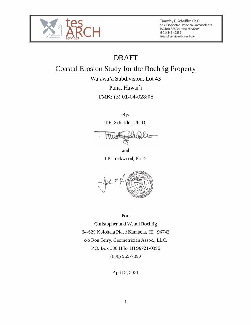
1
DRAFT
Coastal Erosion Study for the Roehrig Property Wa’awa’a Subdivision, Lot 43
Puna, Hawai`i TMK: (3) 01-04-028:08
By:
T.E. Scheffler, Ph. D.
and
J.P. Lockwood, Ph.D.
For:
Christopher and Wendi Roehrig
64-629 Kolohala Place Kamuela, HI 96743
c/o Ron Terry, Geometrician Assoc., LLC.
P.O. Box 396 Hilo, HI 96721-0396
(808) 969-7090
April 2, 2021
- This page left intentionally blank –

Executive Summary This Coastal Erosion Survey (CES) has been prepared in accordance with HRS-343 (Hawaii Environmental Policy Act) and HAR Ch. 200-16 (Environmental Impact Statement Rules) for inclusion in an Environmental Assessment for the “Roehrig Property” (TMK: (3) 1-4-028:008) in the Wa`awa`a Subdivision of Puna District, Hawaii Island.
The Average Annual Erosion Rate (AAER) of the shoreline at the property over the past 67 years is estimated to be a maximum of 0.15 feet per year (4.6 cm/yr). This estimate is based on geological field observations and the quantitative evaluation of historic aerial photos as prescribed in the Hawaii Coastal Zone Mitigation Handbook (Hwang et al. 2005).

Contents Introduction ..................................................................................................................................... 1
Study Requirement ...................................................................................................................... 1 Property Location and Physical Setting ...................................................................................... 1
Geological Background .................................................................................................................. 3 Marine Conditions .......................................................................................................................... 4
Wave Climate .............................................................................................................................. 4 Tides ............................................................................................................................................ 5
Findings of the Field Inspection ..................................................................................................... 6 Lithology and Internal Structures of the Lava Substrate ............................................................ 6 Unconsolidated Cobble and Boulder deposits on the “Beach Bench” ....................................... 8 Beach Profile and Granulometry ................................................................................................ 9
Calculation of Average Annual Erosion Rate (AAER) ................................................................. 12 Analysis of Historic Aerial Photos ............................................................................................ 12 Effects of Subsidence and Sea Level Rise on Shoreline ........................................................... 13
General Coastal Zone Hazards...................................................................................................... 14 Volcanic/Seismic Hazards ......................................................................................................... 14 Stream Flooding Hazards .......................................................................................................... 14 Tsunami ..................................................................................................................................... 15 Hurricane and Storm Surge ....................................................................................................... 15
Summary and Conclusion ............................................................................................................. 16 References Cited ........................................................................................................................... 17

List of Figures Figure 1 Roehrig Property on Tax Map Key. .................................................................................. 1 Figure 2 Roehrig Property on Google Earth image (5/11/2019). ................................................... 2 Figure 3 Wave Direction and Magnitude (Vitousek and Fletcher 2008) ........................................ 4 Figure 4 Tidal levels at Hilo Bay, Hawaii. ...................................................................................... 5 Figure 5 Property line, shoreline (from dlb and Associates 2021) and flow contact line (red-dashed). ........................................................................................................................................... 8 Figure 6 Project area geology and location of beach profile (A – A’). ......................................... 10 Figure 7 Beach profile at the Roehrig property. ........................................................................... 10 Figure 8 Portions of 1954, 1977 and 2019 aerial photos with Roehrig property indicated. ......... 13
List of Tables Table 1 Aerial photography reviewed for the project. .................................................................. 12 Table 2 Natural hazards along the Roehrig Property coastline (Fletcher et al., 2002:150). ......... 14
List of Photos Photo 1 Overview of Beach Reserve with Roehrig property in background, view to west. .......... 2 Photo 2 Pāhoehoe shelf, view south. .............................................................................................. 6 Photo 3 Close-up of lava flow contact (pāhoehoe above, red (oxidized) `a`ā, below). .................. 7 Photo 4 `a`ā beach fronting the Roehrig property, view to east-northeast. ....................................11
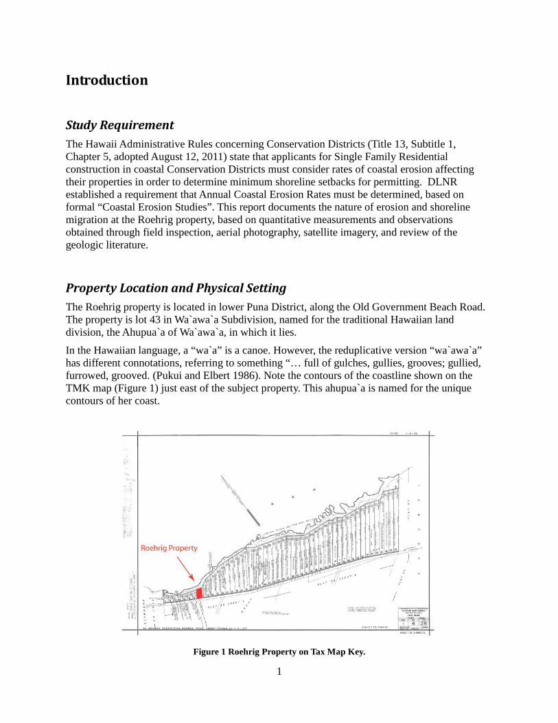
1
Introduction
Study Requirement The Hawaii Administrative Rules concerning Conservation Districts (Title 13, Subtitle 1, Chapter 5, adopted August 12, 2011) state that applicants for Single Family Residential construction in coastal Conservation Districts must consider rates of coastal erosion affecting their properties in order to determine minimum shoreline setbacks for permitting. DLNR established a requirement that Annual Coastal Erosion Rates must be determined, based on formal “Coastal Erosion Studies”. This report documents the nature of erosion and shoreline migration at the Roehrig property, based on quantitative measurements and observations obtained through field inspection, aerial photography, satellite imagery, and review of the geologic literature.
Property Location and Physical Setting The Roehrig property is located in lower Puna District, along the Old Government Beach Road. The property is lot 43 in Wa`awa`a Subdivision, named for the traditional Hawaiian land division, the Ahupua`a of Wa`awa`a, in which it lies.
In the Hawaiian language, a “wa`a” is a canoe. However, the reduplicative version “wa`awa`a” has different connotations, referring to something “… full of gulches, gullies, grooves; gullied, furrowed, grooved. (Pukui and Elbert 1986). Note the contours of the coastline shown on the TMK map (Figure 1) just east of the subject property. This ahupua`a is named for the unique contours of her coast.
Figure 1 Roehrig Property on Tax Map Key.
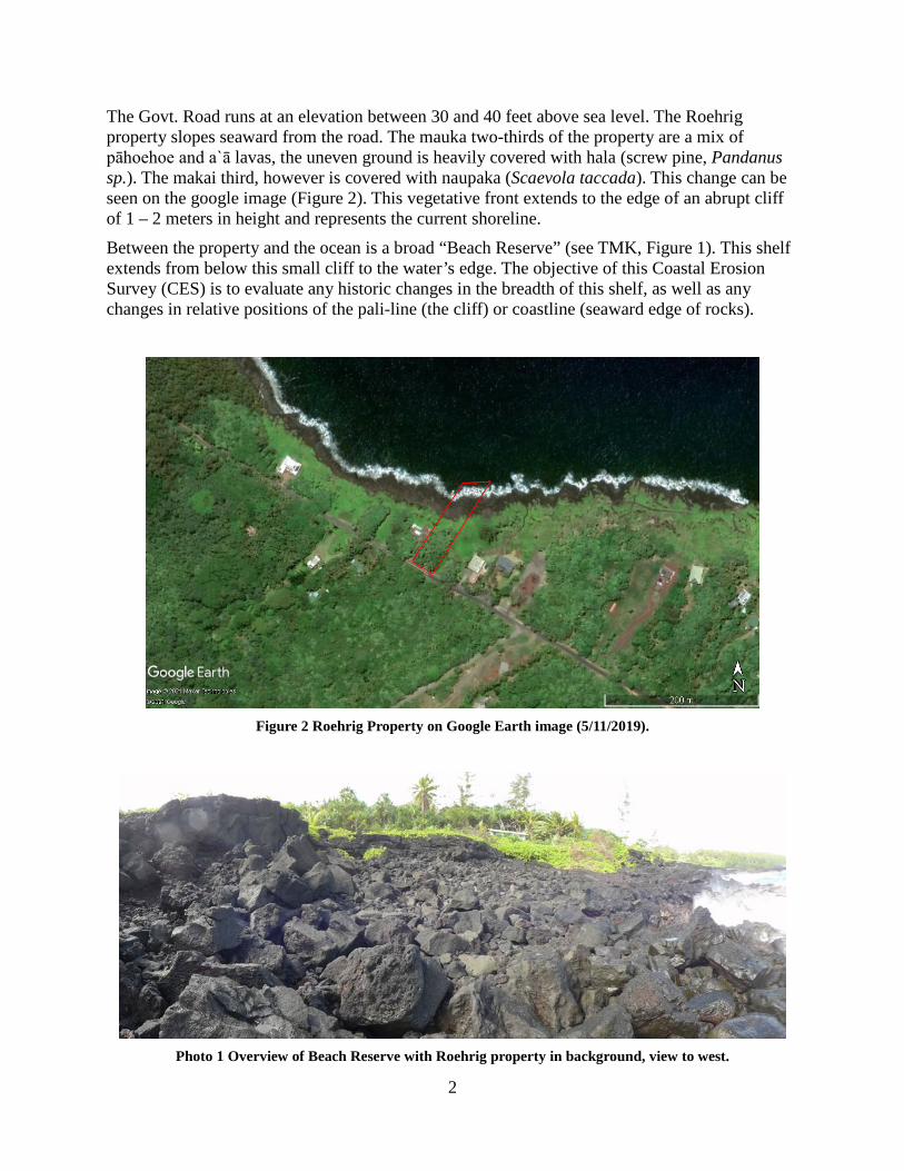
2
The Govt. Road runs at an elevation between 30 and 40 feet above sea level. The Roehrig property slopes seaward from the road. The mauka two-thirds of the property are a mix of pāhoehoe and a`ā lavas, the uneven ground is heavily covered with hala (screw pine, Pandanus sp.). The makai third, however is covered with naupaka (Scaevola taccada). This change can be seen on the google image (Figure 2). This vegetative front extends to the edge of an abrupt cliff of 1 – 2 meters in height and represents the current shoreline.
Between the property and the ocean is a broad “Beach Reserve” (see TMK, Figure 1). This shelf extends from below this small cliff to the water’s edge. The objective of this Coastal Erosion Survey (CES) is to evaluate any historic changes in the breadth of this shelf, as well as any changes in relative positions of the pali-line (the cliff) or coastline (seaward edge of rocks).
Figure 2 Roehrig Property on Google Earth image (5/11/2019).
Photo 1 Overview of Beach Reserve with Roehrig property in background, view to west.

3
A view westward of the coastline fronting the Roehrig property is shown in Photo 1 (above). Normal surf does not reach above the coastal cliff in the background. However, rounded and sub-angular boulder rubble as well as very well-rounded cobbles shown in the foreground attest to the impact of storm waves over this zone. The vegetation is another indication of these impacts, defining the official “shoreline” at the property and the 40 – 60 foot zone of “beach”.
Geological Background The lava flows underlying the property, a geological unit known as “Qp3,” have estimated ages of 750-1,500 years before present (Trusdell et al. 2007 and Moore and Trusdell 1991). This unit is described as mostly consisting of dense pāhoehoe lava, but it is underlain by ‘a’a at this site. The basalt rock is typical tholeiitic basalt, of the Holocene Puna Basalts (Sherrod et al. 2007).
Kilauea volcano is extremely active, perhaps one of the most active volcanos in the world (Sigurdsson et al. 2015). Directly to the west, less than a quarter of a kilometer away, Pele sent a lava flow (“Qp5”) to the sea in 1840. This eruption built the large littoral cone at Honolulu. A little more than a kilometer to the east is a lava flow (“Qp4y”) that is merely 200 – 400 years old.
This dynamic volcanic environment and the fluid basalt lava flows create a unique topography and landscape in Wa`awa`a. The hard rock coastline is dramatic in this respect. The grooved or, serrated appearance of the coast is a result of this volcanism. The fingers are remnants of lava tubes and channels in which denser rock ponded and solidified, leaving weaker less dense portions of the flow to be worn away.
The relatively old (for Puna) age of the coastline along the Roehrig property may be used to argue that erosive forces have reached a more or less stable equilibrium, independent of allochthonous changes such as sea level rise, or island subsidence. These factors are discussed below.
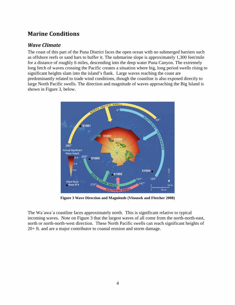
4
Marine Conditions
Wave Climate The coast of this part of the Puna District faces the open ocean with no submerged barriers such as offshore reefs or sand bars to buffer it. The submarine slope is approximately 1,300 feet/mile for a distance of roughly 6 miles, descending into the deep water Puna Canyon. The extremely long fetch of waves crossing the Pacific creates a situation where big, long period swells rising to significant heights slam into the island’s flank. Large waves reaching the coast are predominantly related to trade wind conditions, though the coastline is also exposed directly to large North Pacific swells. The direction and magnitude of waves approaching the Big Island is shown in Figure 3, below.
Figure 3 Wave Direction and Magnitude (Vitousek and Fletcher 2008)
The Wa`awa`a coastline faces approximately north. This is significant relative to typical incoming waves. Note on Figure 3 that the largest waves of all come from the north-north-east, north or north-north-west direction. These North Pacific swells can reach significant heights of 20+ ft. and are a major contributor to coastal erosion and storm damage.
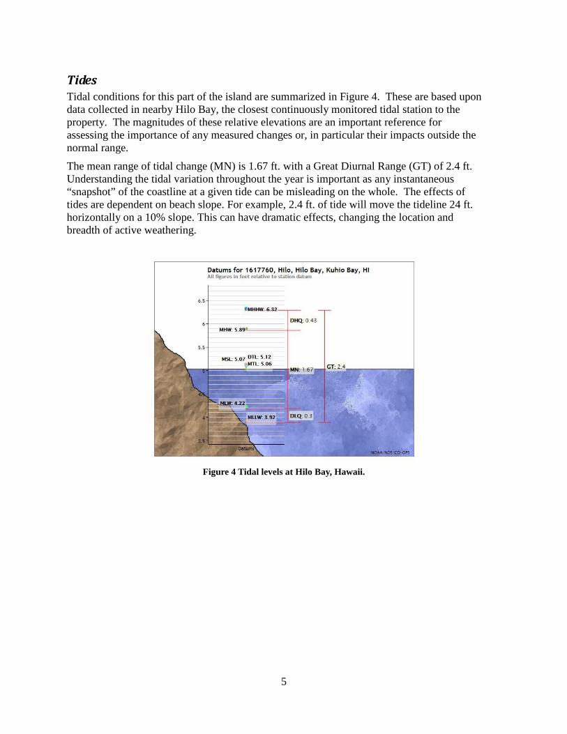
5
Tides Tidal conditions for this part of the island are summarized in Figure 4. These are based upon data collected in nearby Hilo Bay, the closest continuously monitored tidal station to the property. The magnitudes of these relative elevations are an important reference for assessing the importance of any measured changes or, in particular their impacts outside the normal range.
The mean range of tidal change (MN) is 1.67 ft. with a Great Diurnal Range (GT) of 2.4 ft. Understanding the tidal variation throughout the year is important as any instantaneous “snapshot” of the coastline at a given tide can be misleading on the whole. The effects of tides are dependent on beach slope. For example, 2.4 ft. of tide will move the tideline 24 ft. horizontally on a 10% slope. This can have dramatic effects, changing the location and breadth of active weathering.
Figure 4 Tidal levels at Hilo Bay, Hawaii.

6
Findings of the Field Inspection Tim Scheffler visited the subject property on March 22, 2021; 3 hours were spent making field observations, surveying with Brunton pocket transit and measuring tape, and obtaining site photography.
The field observations of observed water line were taken as the tide reached a high of 0.9 feet. The ocean was characterized by moderate to large swells (6 - 8 feet), which generating surf necessitating a high surf advisory for the County of Hawaii’s east facing shores and prevented detailed observation of coastal lavas along the sea cliff.
Lithology and Internal Structures of the Lava Substrate The lava flow underlying most of the Property is pāhoehoe, but coastal erosion reveals that this pāhoehoe overlies ‘a’a, along a sharp contact (Photo 2, 3 and Figure 5). The coastal sea cliff is composed of the dense, “blue lava” core of this ‘a’a unit. The flow morphology grades upward into densely welded and moderately oxidized ‘a’a breccia. These welded breccias are in turn overlain by discontinuous loose rubble zones up to 10 feet thick. The (slightly) older ‘a’a lavas were formed during the same eruption that produced the overlying pāhoehoe, during earlier phases of the eruption sequence, during which discontinuous high fountaining favored ‘a’a production. The pāhoehoe was formed during later phases of this eruption when major lava fountaining ceased and copious pāhoehoe was erupted at steady rates and mostly buried the earlier ‘a’a flows. The fact that both the pāhoehoe and ‘a’a were produced by the same eruption is demonstrated by their identical mineralogic and textural characteristics (next section).
Photo 2 Pāhoehoe shelf, view south.

7
Photo 3 Close-up of lava flow contact (pāhoehoe above, red (oxidized) `a`ā, below).
The ‘a’a and pāhoehoe lavas underlying the Property have similar mineralogy and textural characteristics, indicating that they were emplaced as separate phases of the same eruption. Both lava types are olivine-rich, with olivine typically varying between 20-25% in the pāhoehoe, and between 8-20% in the ‘a’a. The olivine phenocrysts in the pāhoehoe are light apple-green in color, sub-rounded to sub-hedral (crystalline) in form, and mostly 2-4 mm in size. Some distinctive olivine crystals are lath-shaped (<0.5 mm thick), appearing as “needles” in cross-section. Olivine crystals in the ‘a’a are typically more oxidized than in the pāhoehoe, with brownish-green colors and some oxidation to red-brown colors – especially in the upper portions of the flow. Vesicles (gas bubbles) are sub-rounded in the pāhoehoe, but angular and contorted in the ‘a’a. Some orthopyroxene may be present in both flow types, but no microscopic confirmation of this was attempted.
This Pāhoehoe lava overlies looser 'a'a breccia. The overlying pāhoehoe flow consists of a single 2 – 3 meter thick flow unit where exposed along the shoreline cliff. However, the pāhoehoe flow is too thin to contain pyroducts (“lava tubes”) beneath the Property. The interface of these two flow-types largely defines the geomorphology of the area. The weak joint between the `a`ā and pāhoehoe allowed the 2 – 3 meter thick pāhoehoe “skin” to be peeled back, thus creating the beach bench (see Figure 6).

8
Unconsolidated Cobble and Boulder deposits on the “Beach Bench” The ‘a’a beneath the Property consists of a single thick flow, and is highly variable in internal structure where exposed makai of the Property, becoming denser and more homogenous with depth. The flow is of unknown thickness, but middle sections as exposed at the sea cliff consist of very dense, erosion resistant “blue rock” in the normal wave impact zone. This “blue rock” core of the flow is gradationally overlain by dense, internally brecciated ‘a’a with tightly welded fragments. This forms an erosion-resistant surface despite the scouring of this storm wave impact zone.
Note the sub-rounded storm-tossed boulders overlying this ‘a’a closer to the vegetation-defined shoreline. These large blocks are remains of the upper pāhoehoe lip, slowly crumbling in the face of extreme wave run-up.
Figure 5 Property line, shoreline (from dlb and Associates 2021) and flow contact line (red-dashed).
In the uppermost sections of this ‘a’a flow pockets of unwelded, looser ‘a’a fragments directly underlie a cap of the younger pāhoehoe. These fragmental zones are more vulnerable to erosion by the highest reaches of storm waves. The relationship of this contact to the shoreline is shown in Photos 2 and 3). Notice in Figure 5 that some vegetation has established below this pali-line, indicating the rarity of such extreme events reaching this elevation, which is at least 20 feet above sea level.
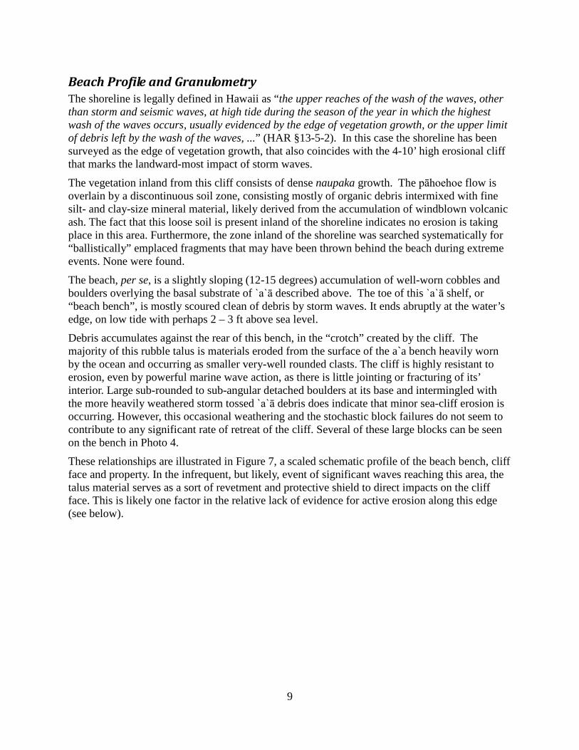
9
Beach Profile and Granulometry The shoreline is legally defined in Hawaii as “the upper reaches of the wash of the waves, other than storm and seismic waves, at high tide during the season of the year in which the highest wash of the waves occurs, usually evidenced by the edge of vegetation growth, or the upper limit of debris left by the wash of the waves, ...” (HAR §13-5-2). In this case the shoreline has been surveyed as the edge of vegetation growth, that also coincides with the 4-10’ high erosional cliff that marks the landward-most impact of storm waves.
The vegetation inland from this cliff consists of dense naupaka growth. The pāhoehoe flow is overlain by a discontinuous soil zone, consisting mostly of organic debris intermixed with fine silt- and clay-size mineral material, likely derived from the accumulation of windblown volcanic ash. The fact that this loose soil is present inland of the shoreline indicates no erosion is taking place in this area. Furthermore, the zone inland of the shoreline was searched systematically for “ballistically” emplaced fragments that may have been thrown behind the beach during extreme events. None were found.
The beach, per se, is a slightly sloping (12-15 degrees) accumulation of well-worn cobbles and boulders overlying the basal substrate of `a`ā described above. The toe of this `a`ā shelf, or “beach bench”, is mostly scoured clean of debris by storm waves. It ends abruptly at the water’s edge, on low tide with perhaps 2 – 3 ft above sea level.
Debris accumulates against the rear of this bench, in the “crotch” created by the cliff. The majority of this rubble talus is materials eroded from the surface of the a`a bench heavily worn by the ocean and occurring as smaller very-well rounded clasts. The cliff is highly resistant to erosion, even by powerful marine wave action, as there is little jointing or fracturing of its’ interior. Large sub-rounded to sub-angular detached boulders at its base and intermingled with the more heavily weathered storm tossed `a`ā debris does indicate that minor sea-cliff erosion is occurring. However, this occasional weathering and the stochastic block failures do not seem to contribute to any significant rate of retreat of the cliff. Several of these large blocks can be seen on the bench in Photo 4.
These relationships are illustrated in Figure 7, a scaled schematic profile of the beach bench, cliff face and property. In the infrequent, but likely, event of significant waves reaching this area, the talus material serves as a sort of revetment and protective shield to direct impacts on the cliff face. This is likely one factor in the relative lack of evidence for active erosion along this edge (see below).
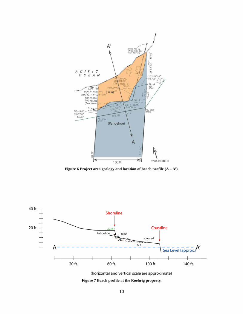
10
Figure 6 Project area geology and location of beach profile (A – A’).
Figure 7 Beach profile at the Roehrig property.

11
Photo 4 `A`ā beach fronting the Roehrig property, view to east-northeast.
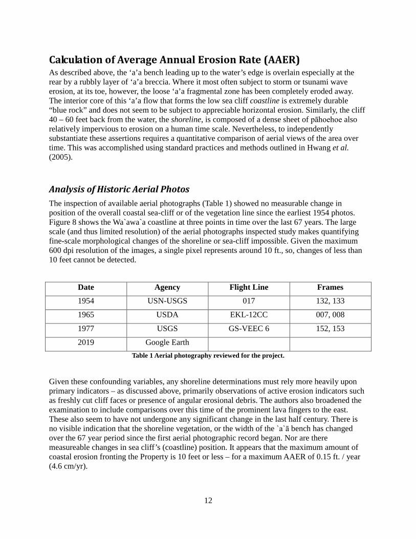
12
Calculation of Average Annual Erosion Rate (AAER) As described above, the ‘a’a bench leading up to the water’s edge is overlain especially at the rear by a rubbly layer of ‘a’a breccia. Where it most often subject to storm or tsunami wave erosion, at its toe, however, the loose ‘a’a fragmental zone has been completely eroded away. The interior core of this ‘a’a flow that forms the low sea cliff coastline is extremely durable “blue rock” and does not seem to be subject to appreciable horizontal erosion. Similarly, the cliff 40 – 60 feet back from the water, the shoreline, is composed of a dense sheet of pāhoehoe also relatively impervious to erosion on a human time scale. Nevertheless, to independently substantiate these assertions requires a quantitative comparison of aerial views of the area over time. This was accomplished using standard practices and methods outlined in Hwang et al. (2005).
Analysis of Historic Aerial Photos The inspection of available aerial photographs (Table 1) showed no measurable change in position of the overall coastal sea-cliff or of the vegetation line since the earliest 1954 photos. Figure 8 shows the Wa`awa`a coastline at three points in time over the last 67 years. The large scale (and thus limited resolution) of the aerial photographs inspected study makes quantifying fine-scale morphological changes of the shoreline or sea-cliff impossible. Given the maximum 600 dpi resolution of the images, a single pixel represents around 10 ft., so, changes of less than 10 feet cannot be detected.
Date Agency Flight Line Frames
1954 USN-USGS 017 132, 133
1965 USDA EKL-12CC 007, 008
1977 USGS GS-VEEC 6 152, 153
2019 Google Earth Table 1 Aerial photography reviewed for the project.
Given these confounding variables, any shoreline determinations must rely more heavily upon primary indicators – as discussed above, primarily observations of active erosion indicators such as freshly cut cliff faces or presence of angular erosional debris. The authors also broadened the examination to include comparisons over this time of the prominent lava fingers to the east. These also seem to have not undergone any significant change in the last half century. There is no visible indication that the shoreline vegetation, or the width of the `a`ā bench has changed over the 67 year period since the first aerial photographic record began. Nor are there measureable changes in sea cliff’s (coastline) position. It appears that the maximum amount of coastal erosion fronting the Property is 10 feet or less – for a maximum AAER of 0.15 ft. / year (4.6 cm/yr).
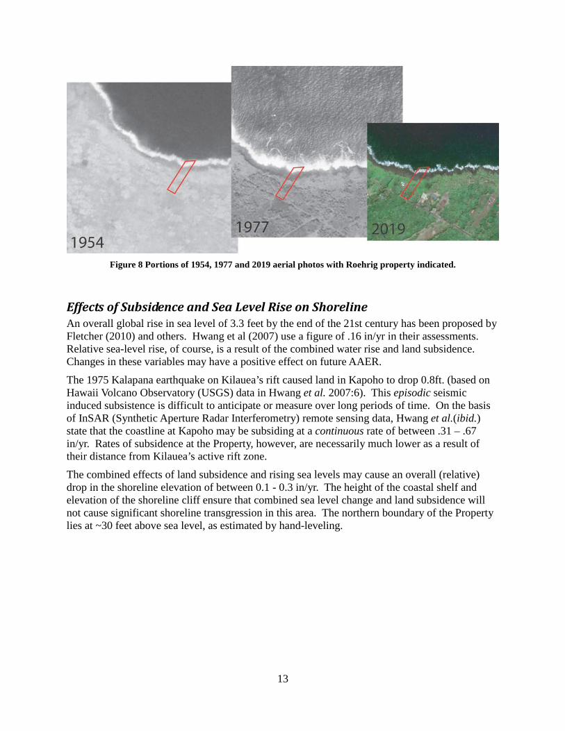
13
Figure 8 Portions of 1954, 1977 and 2019 aerial photos with Roehrig property indicated.
Effects of Subsidence and Sea Level Rise on Shoreline An overall global rise in sea level of 3.3 feet by the end of the 21st century has been proposed by Fletcher (2010) and others. Hwang et al (2007) use a figure of .16 in/yr in their assessments. Relative sea-level rise, of course, is a result of the combined water rise and land subsidence. Changes in these variables may have a positive effect on future AAER.
The 1975 Kalapana earthquake on Kilauea’s rift caused land in Kapoho to drop 0.8ft. (based on Hawaii Volcano Observatory (USGS) data in Hwang et al. 2007:6). This episodic seismic induced subsistence is difficult to anticipate or measure over long periods of time. On the basis of InSAR (Synthetic Aperture Radar Interferometry) remote sensing data, Hwang et al.(ibid.) state that the coastline at Kapoho may be subsiding at a continuous rate of between .31 – .67 in/yr. Rates of subsidence at the Property, however, are necessarily much lower as a result of their distance from Kilauea’s active rift zone.
The combined effects of land subsidence and rising sea levels may cause an overall (relative) drop in the shoreline elevation of between 0.1 - 0.3 in/yr. The height of the coastal shelf and elevation of the shoreline cliff ensure that combined sea level change and land subsidence will not cause significant shoreline transgression in this area. The northern boundary of the Property lies at ~30 feet above sea level, as estimated by hand-leveling.

14
General Coastal Zone Hazards Hwang (2005) recommends that all hazards facing coastal areas should be considered when planning for land-use zoning in Hawaii, and not just erosion. Fletcher et al. (2002) portray generalized hazards assessments for long areas of Hawaii’s coastlines. They rate the specific hazards for the area of Puna fronting the Roehrig lot as shown in the following Table:
Hazard Type Scale (1-4)
Tsunami 4
Stream Flooding 3
High Waves 3
Storms 3
Erosion 2
Sea Level Change 3
Volcanic/Seismic 4
Overall Hazard Assessment 4 (on scale of 1-7) Table 2 Natural hazards along the Roehrig Property coastline (Fletcher et al., 2002:150).
Volcanic/Seismic Hazards Elevated risks associated with “Volcanic/Seismic” hazard types are due to the Wa`awa`a coast’s susceptibility to lava flows and the periodic morphological changes caused by Kilauea’s active East Rift Zone (ERZ). Kilauea’s south flank has generated many historic earthquakes and despite a current pause in eruptive activity, it will feel them in the future as well. For example, three more recent earthquakes in 1954, 1975 and 1989 registered 6.5, 7.2 and 6.1 on the Richter scale of magnitude (not to mention the most recent M=5.4 and 6.9 pair of tremblors that hit May 4, 2018 - which was felt strongly in this area). A hazard intensity rank of 4 indicates “frequent” seismic activity and recommends for a UBC seismic zone factor of >/= 2 (Fletcher et al. 2002:3). Other volcanic hazards include the threat of inundation by lava flows. The Roehrig property lies in a USGS defined hazard Zone 3 (Wright et al. 1992). It is a fair distance from the active East Rift Zone or summit of Kilauea (Zone 1).
Stream Flooding Hazards The 3 rating for stream flooding corresponds to the properties location in a watershed which can receive greater than 7.9 inches of rain per month and has few mitigation measure in place in the event of a flood (Fletcher et al. 2002:3). No evidence of past flooding was observed, although water can be expected to pond for short periods in low-lying areas.
15
Tsunami There is a possibility of tsunami (seismically generated “tidal”-waves) threatening this coastline. A hazard rank of 4 reflects this fact. The high rating is a result of the historical occurrence of tsunami as well as the generally low slope of the coastline. Exceedingly large “tidal waves” generated by local or wide ranging Pacific-Rim volcanic movements can severely impact this region. Data are available for historic tsunami heights from Hilo as well as from Cape Kumukahi (the property is about half-way between the two). In 1946 a tsunami reached 26 ft. above normal sea level in Hilo and 19 ft. at Cape Kumukahi. In 1957, waves of 13 and 12 ft. (respectively) were recorded at these locations. One of the largest tsunami of modern times to hit the island came in 1960 when a 35 ft. high wall of water, focused by Hilo Bay, completely decimated the low-lying coastal areas of Hilo. The effects of a tsunami are highly variable, dependent on both local and extra-regional factors. For example, on the southeast shore this wave amounted to only 13 ft. in height (Fletcher et al. 2002:7).
Hurricane and Storm Surge It is beyond the scope of this study to quantify changes in storminess or significantly higher wave heights due to climate change and a precise forecast of these positively contributing variables is impossible. However, rising sea surface temperatures in Hawaiian waters could, for example, influence hurricane storm tracks impacting the islands (Businger, 1998). The recurrence and intensity of wave energy focused on the coastline is obviously a critical factor in the discussion of erosion along any coast. Merrifield and Maltrud (2011) noted that trade winds have intensified across the Pacific gradually since the early 1990s, e.g. The intensification of trade winds and accompanying sea level rise is more pronounced in western Pacific waters, relative to other regions in the World Ocean, with some rates of rise as much as three times the global average. The probability and impact of sea level rise associated with climate change at the subject property is discussed in a separate section. For tropical waters, the incidence of “one-in-ten year” extreme waves impacting shorelines may double or triple as a consequence of the wind intensification described above (Wang et al. 2014). Substantial wave height increases—by as much as 40%-- have also been observed along some Pacific shores, though to what extent this relates to climate change or pulsating phenomena as the Pacific Decadal Oscillation is unclear (e.g.—Ruggiero and others, 2010). Hypothetically, the incidence of hurricanes in the eastern Pacific may actually decrease with warming climate, but the strongest storms will likely become even more intense (e.g.--Grinsted, 2012; Holland and Bruyére, 2013).
16
Summary and Conclusion The shoreline, beach and sea-cliff in front of the Property were surveyed in order to assess the erodibility of underlying rocks and the dynamic nature of geologic and marine processes that contribute to erosion. Where overlying loose ‘a’a rubble, a thin pāhoehoe flow defines the shoreline. It is susceptible to mechanical erosion by storm or tsunami waves, but no measurable lateral erosion could be documented in the past 67 years. Historical aerial photos dating back to 1954 were compared to 1965, 1977 and 2019 imagery in this calulation erosion rate for the area. No measureable change could be measured. Future migration of the shoreline will be affected predominantly by unpredictable and episodic events including subsistence due to seismicity or by accretion due to future eruptions of Kilauea and by the future impacts of sea level rise. The Roehrig Property shoreline is located 40-60 feet inland on a coastal shelf 30-35 feet above sea level, currently, and there is no indication of any immediate erosional threat to the Property.

17
References Cited Businger, S., 1998, poster, Hurricanes in Hawaii; Hurricane and Extreme Weather Phenomena Symposium; Center for the Study of Active Volcanoes, Federal Emergency Management Agency, and National Oceanographic and Atmospheric Administration, hht://www.soest.hawaii/edu/MET/Faculty/businger/poster/hurricane.
Fletcher, C. H., Boyd, R., Neal, W. J., and Tice, V. (2010) Living on the Shores of Hawaii – Natural Hazards, the Environment, and our Communities: University of Hawaii Press, 371 pp.
Fletcher, C. H., Grossman, E. E, Richmond, B. M. and Gibbs, A. E. (2002). Atlas of Natural Hazards in the Hawaiian Coastal Zone: U.S. Geological Survey, Geologic Investigations Series Map I-2761, scale 1:50,000.
Grinsted, A., Moore, J.C., Jevrejeva, S., 2012, Projected Atlantic hurricane storm threat from rising temperatures, Proceedings of the National Academy of Sciences, vol. 110, no. 4, pp. 5369-5373.
Holland, G., and Bruyére, C.L., 2013, Recent intense hurricane response to global climate change, Journal of Climate Dynamics (on line): DOI: 10.1007/s00382-013-1713-0.
Hwang, D. J. (2005). Hawaii Coastal Zone Mitigation Handbook: Hawaii Coastal Zone Management Program. DBED; State of Hawaii, 216 pp.
Hwang, D. J. (2007). Coastal Subsidence at Kapoho, Puna, Island and State of Hawaii: Private report for Hawaii County Planning Department, 82 pp.
Merrifield, M.A., and Maltrud, M., 2011, Regional sea level trends due to a Pacific trade wind intensification, Geophysical Research Letters (on-line), DOI: 1029/2011GLO49576.
Moore, J. G. (1970). Relationship between subsidence and volcanic load, Hawaii: Bulletin of Volcanology, V. 34, pp. 562-576.
Moore, J. G. and Fornari, D. J. (1984). Drowned reefs as indicators of the rate of subsidence of the Island of Hawaii: Journal of Geology, v. 92, p. 752-759.
Moore, R. B. and Trusdell, F. A. (1991). Geologic Map of the Lower East Rift Zone of Kilauea Volcano, Hawaii: U. S. Geological Survey Misc. Investigations Series, Map I-2225, Scale:1:24,000.
Pukui, M. K., & Elbert, S. H. (1986). Hawaiian Dictionary: Hawaiian-English English-Hawaiian Revised and Enlarged Edition. University of Hawaii Press.
Ruggiero, P., Komar, P.D., Allan, J.C., 2010, Increasing wave heights and extreme wave projections; the wave climate of the Pacific Northwest, Journal of Coastal Engineering, vol. 57, pp. 539-552
Sherrod, D. R., Sinton, J. M., Watkins, S. E., & Brunt, K. M. (2007). Geologic map of the State of Hawaii. US geological survey open-file report, 1089(8).
Sigurdsson, H., Houghton, B., McNutt, S., Rymer, H., & Stix, J. (Eds.). (2015). The encyclopedia of volcanoes. Elsevier.

18
Trusdell, F. A., Wolfe, E. W., & Morris, J. (2006). Digital database of the geologic map of the island of Hawai'i [Hawaii] (No. 144). US Geological Survey.
Vitousek, S., & Fletcher, C. H. (2008). Maximum Annually Recurring Wave Heights in Hawai ‘i1. Pacific Science, 62(4), 541-553.
Wang, X.L., Feng, Y., and Swail, V.R., 2014, Changes in global ocean wave heights as projected usingf CMIP5 simulations, Geophysical Research Letters (on line), DOI:1002/2013GLO58650.
Wright,,T L., Chun, J.Y.F., Esposo, Joan, Heliker, C., Hodge, J., Lockwood, J. P., and Vogt, S. M. (1992). Map showing Lava-flow Hazard Zones, Island of Hawaii: U.S. Geological Survey, Misc. Field Studies Map MF-2193, 1:250,000.

[This page intentionally left blank]

Environmental Assessment
Roehrig Single-Family Residence in the Conservation District in Wa‘awa‘a
APPENDIX 4 Cultural Consultation Report

[This page intentionally left blank]
ASM Project 35970.01
April 1, 2021
Kit Roehrig
64-629 Kolohala Place
Kamuela, HI 96743
Subject: Results of the Cultural Consultation in association with a Conservation District Use
Application and Environmental Assessment for a Proposed Single Family Residence
on Tax Map Key: (3) 1-4-028:008, Waʻawaʻa Ahupuaʻa, Puna District, Island of
Hawaiʻi
Dear Kit:
At your request, ASM Affiliates (ASM) has conducted consultation to assess the impacts of the proposed project on
traditional and customary practices and valued cultural resources that may be associated with the subject parcel, Tax
Map Key (TMK): (3) 1-4-028:008, Waʻawaʻa Ahupuaʻa, Puna District, Island of Hawaiʻi (Figures 1, 2, and 3). It is
understood that conducting consultation is an important part of the planning process and completion of the
Conservation District Use Application (CDUA) and Environmental Assessment. In 2020, ASM completed an
archaeological assessment survey (Kepaʻa and Clark 2020) of the subject parcel in which no historic properties were
identified. Extensive culture-historical background information specific to Waʻawaʻa and relevant to the subject parcel
were prepared as part of that study. This letter report presents the results of ASM’s outreach efforts along with the
findings of the consultation process in conjunction with the culture-historical background information included in the
Kepaʻa and Clark (2020) study.
Consultation Methodology
Gathering input from community members and cultural practitioners with genealogical ties and long-standing
residency or relationships to the project area is vital to the process of assessing potential impacts to traditional and
customary practices, and valued cultural resources. It is precisely these individuals that ascribe meaning and value to
traditional resources and practices of an area. These community members often possess traditional knowledge and in-
depth understanding that are unavailable elsewhere in the historical or cultural record of a place.
To identify individuals knowledgeable about past and ongoing customary and traditional cultural practices associated
with the project area, a public notice was submitted to the Hawaii Tribune-Herald and Ka Wai Ola, a monthly
newspaper published by the Office of Hawaiian Affairs. The Hawaii Tribune-Herald affidavit, which confirms
publication, and a copy of the Ka Wai Ola public notice are attached to this letter report as Appendix A and B. To
date, no response has been received from the public notices. Efforts were also made by ASM staff to contact cultural
practitioners and community members via email or phone; the names of these individuals are listed in Table 1 below.
These individuals were identified as persons who were believed to have genealogical ties, long-standing residency, or
knowledge of cultural and or historical properties in Waʻawaʻa Ahupuaʻa. Of the six individuals contacted, responses
were received from five individuals. If these five individuals, four provided cultural information.
Table 1. Persons contacted for consultation.
Name Initial Contact
Date Notes
Ikaika Marzo March 17, 2021 Responded to request but was not able to secure an interview.
Ryan McCormack March 23, 2021 See comments below.
Hidi Botelho March 23, 2021 See comments below.
Leila Kealoha March 23, 2021 See comments below
Linda Saffery March 23, 2021 Email request was sent however, email was returned as undeliverable.
Keone Kalawe March 24, 2021 See comments below.
April 1, 2021
Consultation Results
Page 2 of 8
Findings from Consultation
As a result of the consultation efforts, Mr. Ryan McComack shared that there are waʻa (canoe) traditions associated
with Waʻawaʻa, specifically in the area known as Honolulu Landing. He noted that along this portion of the Puna
coastline, hālau waʻa (canoe sheds) can be found. Mr. McCormack recalled that students from Kua O Ka Lā public
charter school used to visit the Waʻawaʻa area as part of their curriculum. Aside from traditions associated with the
broader Waʻawaʻa Ahupuaʻa, no specific cultural practices associated with the subject parcel were noted. Mr.
McCormack recommended ASM staff speak to Mrs. Leila Kealoha and Mr. Keone Kalawe.
In conversations with Mrs. Hidi Botelho, she shared that she recalled fishing along the Waʻawaʻa coastline once before
as a child. However, she explained that for her ʻohana (family) this was not their preferred spot to gather marine
resources. She noted that there may be other ʻohana that have and continue to gather marine resources from this area.
She believes that if there is a reasonable setback from the coastline to allow for the perpetuation of traditional marine
resource gathering, there would likely be minimal to no impact on traditional gathering practices. Mrs. Botelho
recommended ASM staff speak to Mrs. Leila Kealoha.
Concerning the conversation with Mrs. Leila Kealoha, she requested a map of the project area. Maps showing the
project area location were subsequently emailed to her. Generally speaking, Mrs. Kealoha noted that she was aware
of hala (Pandanus odoratissimus) in the project area. Aside from noting the presence of hala, Mrs. Kealoha
recommended that ASM staff contact Mr. Keone Kalawe and Mrs. Linda Saffery.
Mr. Keone Kalawe shared that he was aware of some ʻohana platform burials on the mauka (upland) side of the
government road near the project area as well as burials located near the sand dunes by Kapoho. Aside from noting
burials in the nearby area, Mr. Kalawe was not aware of any burial or other valued resources and traditional and
customary practices occurring in the project area.
Recommendations
A review of the culture-historical background information from the Kepaʻa and Clark (2020) study and as noted by
Mrs. Kealoha, hala is perhaps one of the most valued cultural resources found in Puna. Hawaiian cultural practitioners
have and continue to gather lauhala (pandanus leaves) from the district. It is from the hala plant that various items of
cultural importance (hīnaʻi [burial baskets]; moena [mats]; uluna [pillow]; cordage) and ornamental value were woven
(Abbott 1992). Additionally, hala is a key bio-cultural feature that has and continues to be synonymous with Puna
District. Efforts by the landowner to preserve, to the extent reasonable, any hala on the subject parcel would help to
maintain this valued cultural resource.
As a coastal property, it can inferred that practitioner and community member likely access the coast to gather a variety
of marine resources, including but not limited to, ʻopihi (limpets), pūpūʻawa (Drupa sp.), iʻa (fish), and puhi (eel).
While no coastal access trail was identified on the property, it should be anticipated that fishers likely traverse the
coastline in the area fronting the subject parcel. The makai boundary of the subject parcel does not extend to the sea,
and there is a long, narrow lot (TMK: (3) 1-4-028:008) that lies between the residential lots and the sea. The subject
parcel or the proposed project will not impede upon the shoreline area thus, adverse impacts to traditional marine
resource gathering are not anticipated.
Based on the findings of ASM’s consultation efforts in conjunction with the culture-historical background information
that was prepared as part of the Kepaʻa and Clark (2020) study, it is concluded that if efforts to preserve, to the extent
reasonable, the hala on the property there would be no foreseeable adverse impacts to any valued cultural resources,
traditional and customary practices, beliefs, or historic properties.
Should you have any questions or concerns, please don’t hesitate to contact me directly.
Sincerely,
Lokelani Brandt, M.A.
Senior Archaeologist

April 1, 2021
Consultation Results
Page 3 of 8
Figure 1. Project area.
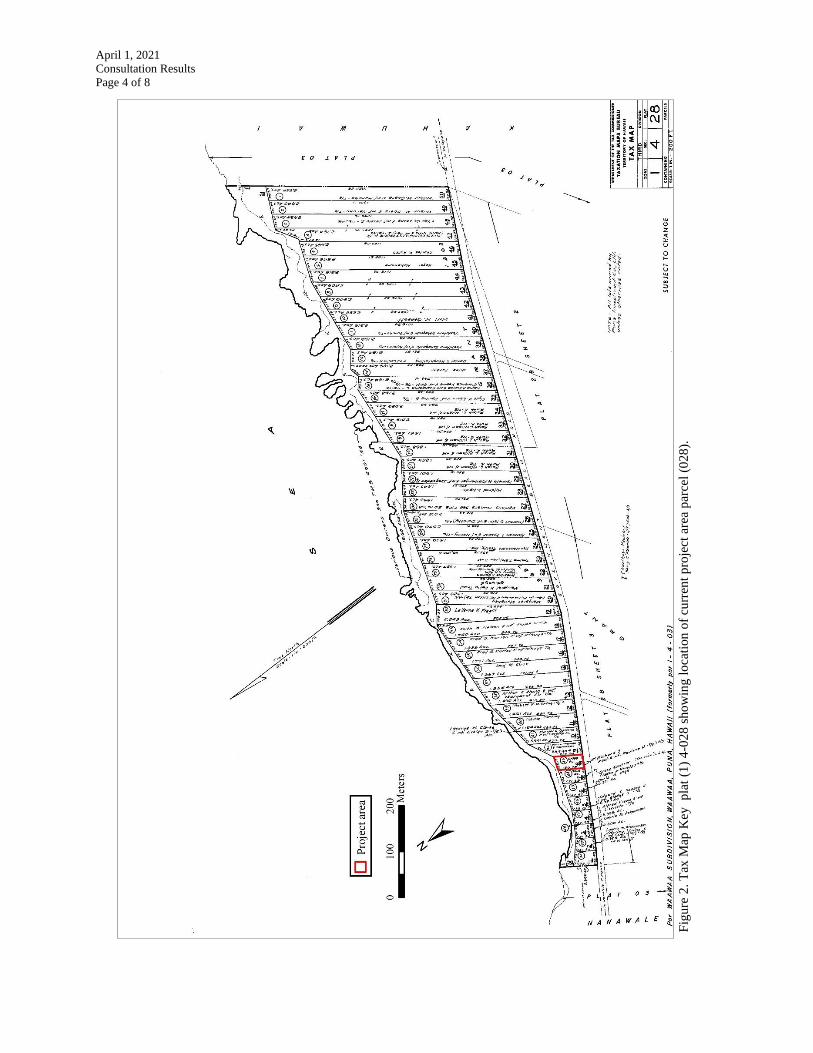
April 1, 2021
Consultation Results
Page 4 of 8
Fig
ure
2.
Tax
Map
Key
p
lat
(1)
4-0
28
sho
win
g l
oca
tion
of
curr
ent
pro
ject
are
a p
arce
l (0
28
).

April 1, 2021
Consultation Results
Page 5 of 8
Figure 3. Google Earth™ satellite image showing project area location.
April 1, 2021
Consultation Results
Page 6 of 8
References Cited
Abbott, I. A.
1992 Lāʻau Hawaiʻi, Traditional Hawaiian Uses of Plants. Bishop Museum Press, Honolulu.
Brandt, L.
2021 Public Notice. Ka Wai Ola [Honolulu]. April 1, 2021: 36. Electronic document,
https://iskh447eqhe3kks2q2rvzg06-wpengine.netdna-ssl.com/wp-
content/uploads/2021/03/KaWaiOla-April2021.pdf, accessed April 1, 2021.
Kepaʻa, L. M. U. and M. R. Clark
2020 An Archaeological Assessment of Lot 43 of the Wa'awa'a Subdivision, TMK: (3) 1-4-
028:008, Wa'awa'a Ahupu'a, Puna District, Island of Hawai'i. ASM Affiliates Project
Number 35970.00. Prepared for Kit Roehrig.
April 1, 2021
Consultation Results
Page 7 of 8
Appendix A
Hawaii Tribune-Herald Affidavit

April 1, 2021
Consultation Results
Page 8 of 8
Appendix B
Copy of Ka Wai Ola Public Notice
(Brandt 2021:22)