Oakwood Beach, NJ Feasibility Study - US Army Corps of ...
250
m US Army Corps of Engineers Philadelphia District Delaware Bay Coastline Delaware & New Jersey Oakwood Beach, NJ Feasibility Study FINAL FEASIBILITY REPORT AND INTEGRATED ENVIRONMENTAL ASSESSMENT April1999
-
Upload
khangminh22 -
Category
Documents
-
view
3 -
download
0
Transcript of Oakwood Beach, NJ Feasibility Study - US Army Corps of ...

m US Army Corps of Engineers Philadelphia District
Delaware Bay Coastline Delaware & New Jersey
Oakwood Beach, NJ Feasibility Study
FINAL FEASIBILITY REPORT
AND INTEGRATED ENVIRONMENTAL ASSESSMENT
April1999

DELAWARE BAY COASTLINE, DELAWARE & NEW JERSEY FEASffiiLITY STUDY
The Oakwood Beach study is the final study of seven feasibility studies conducted by the Corps of Engineers in the interest of shore protection and ecosystem restoration along the Delaware Bay coastline in the States of Delaware and New Jersey. Three of the studies were conducted jointly with the Delaware Department of Natural Resources and Envirorunental Control (DNREC) in the State of Delaware. These studies were Broadkill Beach completed in October 1996; Roosevelt Inlet-Lewes Beach completed in June 1997; and Port Mahon completed in September 1997. The remaining four studies were conducted jointly wjth the New Jersey Department of Environmental Protection (NJDEP). These studies were Maurice River scheduled for completion in January 1997 but terminated in April 1996; Villas and Vicinity completed in September 1998; Reeds Beach to Pierces Point completed in August 1998; and Oakwood Beach scheduled for completion in May 1999.

DELAWARE BAY COASTLINE, DELAWARE & NEW JERSEY
OAKWOOD BEACH, NEW JERSEY FINAL FEASIBILITY REPORT
AND INTEGRA TED ENVIRONMENTAL ASSESSMENT
SYLLABUS
The lead agency for the proposed action is the U.S. Army Corps of Engineers, Philadelphia District.
This report presents the results of a feasibility phase study to determine an implementable solution and the extent of Federal participation in a shore protection project for the community of Oakwood Beach, Elsinboro Township, Salem County, New Jersey. This feasibility study was conducted based on the recommendations of the Delaware Bay Coastline - Delaware and New Jersey Reconnaissance Study completed in 1992, which identified a possible solution to the storm damage problems in the study area. The reconnaissance study also determined that such a solution was in the Federal interest and identified the non-Federal sponsor. The Oal-wood Beach study is the final of seven feasibility studies conducted by the Corps of Engineers (COE) in the interest of shore protection and ecosystem restoration along the Delaware Bay coastline.
This feasibility study was cost shared between the Federal Government and the State of New Jersey through the New Jersey Department of Environmental Protection (NJDEP), and was conducted under the provisions of the Feasibility Cost Sharing Agreement executed in December ·1993. This feasibility study was initiated in May 1996.
Oakwood Beach is a bayfront community located in Elsinboro Township, Salem County, New Jersey in the upper region of the Delaware Bay. The study area limits e>..1end from the Salem River downshore to Elsinboro Point, a distance of approximately 3 miles. Significant beach erosion has left the study area vulnerable to storm damages. Continued erosion has resulted in a reduction in the height and width of the beach.
This feasibility study evaluated alternative plans of improvement formulated on storm damage reduction benefits and reduced Federal maintenance dredging benefits. The selected plan at Oakwood Beach consists of a 50 foot wide berm at an elevation of +6.0 feet NA VD for a total project length of 9500 feet. The selected p lan includes suitable beachfill with periodic nourishment to ensure the integrity of the design. The plan requires 332,000 cubic yards of initial fill and advanced nourishment to be placed on Oakwood Beach and subsequent periodic nourishment of 32,000 cubic yards every 8 years for 50 years. Sand from the Reedy Island range of the Delaware River main channel will be used for beachfill at Oakwood Beach.
A Section 404 (b)(l) evaluation has been prepared and is included in this Final Feasibility Report and Integrated Environmental Assessment. This evaluation concludes that the proposed action would not result in any significant environmental Impacts relative to areas of concern Wlder Section 404 of the Federal Clean Water Act.

This feasibility report ts based on a March 1998 price level and Federal discount rate of 7.125%. The economic analysis indicates that the selected plan will provide annual benefits of $648,000. which when compared to the annual cost of $336~000. yields a benefit to cost ratio of L9 with $312,000 in net benefits.
The total initial project cost of construction is currently estimated to be $3,314,000 (at a March 1998 price level). The Federal share of this first cost is $2,154,000, and the non-Federal share is $1,160,000 This cost sharing of the initial construction is in accordance with Section 103 uf WRDA 1986. The Administration has proposed a new cost sharing policy for the periodic nourishment of shore protection projects. Under the Administration's proposed new cost sharing policy, periodic nourishment will be cost shared 35% Federal and 65% non-Federal. The total cost of periodic nourishment per cycle (every 8 years) is estimated at $567,000 and will be cost shared 35%-65% over the life of the project. The ultimate project cost which includes the initial construction and fifty years of periodic nourishment (including major renourishment and project monitoring) is currently estimated to be $8,321 ,000 (at a March 1998 price level).
The non-Federal sponsor, NJDEP, supports cost sharing of the project features consistent with existing law and implementation of periodic nourishment consistent with cost sharing enacted by Congress in law.
FOR FURTHER INFORMATION ON TillS FINAL FEASIBILITY REPORT AND INTEGRATED ENVIRONMENTAL ASSESSMENT, PLEASE CONTACT:
JaneL. Jablonski, P.E. Basin Planning Section Telephone: 215-656-6588 US .. Aumy Corps of Engineers. Philadelphia District Wanamaker Building, 100 Penn Square East Philadelphia, Pennsylvania 19107-3390
OR
Gregory A. Wacik EnvironmentaJ Resources Branch Telephone: 2 15-656-6556 U.S. Army Corps of Engineers, Philadelphia District Wanamaker Building, 100 Penn Square East Philadelphia, Pennsylvania 19107-3390
il

DELAWARE BAY COASTLINE, DELAWARE & NEW JERSEY
OAKWOOD BEACH, NEW JERSEY FINAL FEASIBILITY REPORT
AND INTEGRA TED ENVIRONMENTAL ASSESSMENT
DESCRIPTION OF SELECTED PLAN
Project Title: Delaware Bay Coastline - Delaware and New Jersey Study; Oakwood Beach, New Jersey; Final Feasibility Report and Integrated Environmental Assessment
Description: The proposed project provides a protective beach to reduce the potential storm damages at Oakwood Beach, NJ. Use of the Reedy Island range of the Delaware River main channel as the borrow source for beachfill at Oakwood Beach also reduces Federal maintenance dredging costs.
Beachfill
Volume oflnitial Fill Volume ofRenourishment Fill Interval ofRenourishment
Length ofFill (including tapers)
Width of Berm
Elevation of Berm
Slope of Foreshore
Project Cost
Initial Cost Periodic Nourishment (includes major
renourishment and project monitoring) _,.\nnualized Periodic Nourishment Ultimate Project Cost Total Annualized
332,000 c.y 32)000 c.y.
8yrs
9500 l.f.
50 ft.
+ 6.0 ft.
lV:lOH
March 98 P.L. Updated to Oct. 98 P.L.
$ 3,314,000 $ 3.360,000
$ 5,007,000 $ 5,076,0.00 $ 79,000 $ 81,000 $ 8,321,000 $ 8.436,000 $ 336,000 $ 333,000 (Discounted 7.125%) (Discounted 6.875%)
NOTE: All elevations referenced to North American Vertical Datum, 1988 (NAVD88)
iii

Average Annual Benefits March 98 P.L. Updated to Oct. 98 P.L.
Storm Damage Reduction $518,000 $ 530,000 Reduced Federal Maintenance Dredging Costs $ l30,000 $ 130,000
Total $648,000 $660,000
Benefit/Cost Ratio March 98 P.L. Updated to Oct. 98 P.L.
1.9 2.0
Cost Apportionment (First Cost) March 98 P.L. Updated to Oct. 98 P.L.
Federal (65%) $2,154,000 $2,184,000 Non-Federal (35%) $1,160,000 $1 '176.000

SUMMARY
The Environmental Assessment has concluded that the project can be conducted in a manner which should not violate New Jersey's or Delaware's Surface Water Quality Standards. Pursuant to Section 401 of the Clean Water Act, a 401 Water Quality Certificate has been obtained from the New Jersey Department of Environmental Protection (NJDEP) and a letter was received from the Delaware Department of Natural Resources and Environmental Control (DNREC) indicating that the Department intends to issue a Water Quality Certificate upon review of the final project plans (refer to Appendix A, Section 3 of the main report). Based on the information developed during preparation of the Environmental Assessment, and the application of appropriate measures to minimize project impacts, it was determined in accordance with Section 307(c) of the Coastal Zone Management Act of 1972 that the plan complies with and can be conducted in a manner that is consistent with the approved Coastal Zone Management Programs of New Jersey and Delaware. A consistency determination was requested from NJDEP and DNREC. NJDEP concurred in the consistency determination in a letter dated 12 March 1999 and DNREC in a letter dated 12 February 1999 (refer to Appendix A. Section 3 of the main report).
MAJOR CONCLUSIONS AND FINDINGS
Berm restoration represents the least environmentally damaging structural method of reducing shoreline erosion at a reasonable cost. It is socially acceptable. Berm restoration is dynamic and adjusts to changing conditions until equilibrium can be achieved. Despite bemg structurally flexible, the created berm can effectively dissipate high storm energies, although at its own expense. Costly rigid structures like bulkheads and revetments utilize massive amounts of material foreign to the natural environment to absorb the force ofthe waves. Berm restoration uses material typical of adjacent areas. sand, to buffer the shoreline structures against erosional damage. Consequently, berm restoration is more aesthetically pleasing as it represents the smallest departure from natural conditions in a visual and physical sense.
Some of the suggested non-structural erosion damage reduction alternatives are currently practiced, such as flood insurance and development regulation. Consequently, implementation is somewhat a moot point. Others such as land acquisitions are prohlbitively expensiveo and are socially unacceptable.
AREAS OF CONCERN
A project of this nature wiJl have temporary adverse impacts on water quality and on aquatic organisms. Dredging will increase suspended solids and turbidity at the point of dredging and the berm restoration site. The area to be dredged and the area where the material will be deposited will be subject to extreme disturbance. Many existing benthic organisms will become smothered at the berm restoration site. Dredging will result in the temporary complete loss of the benthic community in the borrow area. These disruptions are expected to be of short duration and of minor significance if rapid recolonization by the benthic community occurs. Dredging will consequently temporarily displace a food source for some finfish.
v
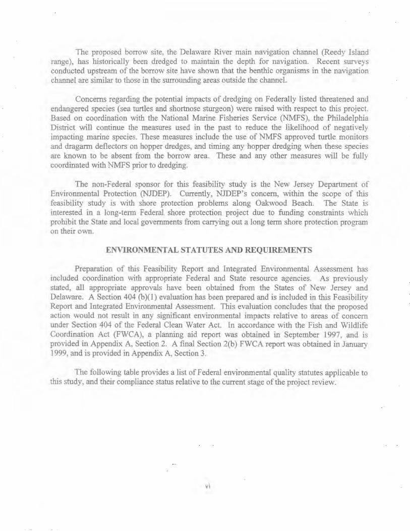
The proposed borrow site, the Delaware River main navigation channel (Reedy Island range), has historically been dredged to maintain the depth for navigation. Recent surveys conducted upstream of the borrow site have shown that the benthic organisms in the navigation channel are similar to those in the surrounding areas outside the channel.
Concerns regarding the potential impacts of dredging on Federally listed threatened and endangered species (sea turtles and shortnose sturgeon) were raised with respect to this project. Based on coordination with the National Marine Fisheries Service (NMFS), the Philadelphia District will continue the measures used in the past to reduce the likelihood of negatively impacting marine species. These measures include the use of NMFS approved turtle monitors and dragarrn deflectors on hopper dredges, and timing any hopper dredging when these species are known to be absent from the borrow area. These and any other measures will be fully coordinated with NMFS prior to dredging.
The non-Federal sponsor for this feasibility study is the New Jersey Department of Environmental Protection (NJDEP). Currently, NJDEP's concern, within the scope of this feasibility study is with shore protection problems along Oakwood Beach. The State is interested in a long-term Federal shore protection project due to funding constraints which prohibit the State and local governments from carrying out a long term shore protection program on their own.
ENVIRONMENTAL STATUTES AND REQUIREMENTS
Preparation of this Feasibility Report and Integrated Environmental Assessment has Included coordination with appropriate Federal and State resource agencies As previously stated, all appropriate approvals have been obtained from the States of New Jersey and Delaware. A Section 404 (b)( J) evaluation has been prepared and is included in this Feasibility Report and Integrated Environmental Assessment. This evaluation concludes that the proposed action would not result in any significant environmental impacts relative to areas of concern under Section 404 of the Federal Clean Water Act. In accordance with the Fish and Wildlife Coordination Act (FWCA). a planning aid report was obtained in September 1997, and is provided in Appendix A, Section 2. A final Section 2(b) FWCA report was obtained in January 1999. and is provided in Appendix A, Section 3.
The following table provides a list of Federal environmental quality statutes applicable to this study, and their compliance status relative to the current stage of the project review.
VI

Compliance with Environmental Quality Protection Statutes and Other Environmental Review Requirements at the Present Phase of the Project
Federal Statutes
Archeological - Resources Protection Act of 1979, as amended
Clean Air Act, as amended
Clean Water Act of 1977
Coastal Zone Management Act of 1 972, as amended
Endangered Species Act of 1973, as amended
Estuary Protection Act
Federal Water Project Recreation Act, as amended
Fish and Wildlife Coordination Act
Land and Water Conservation Fund Act, as amended
Magnuson-Stevenson Act
Marine Mammal Protection Act
Marine Protection, Research and Sanctuaries Act
National Historic Preservation Act of 1966
National Environmental Policy Act, as amended
Rivers and Harbors Act
Watershed Protection and Flood Prevention Act
Compliance w!Proposed Plan
Full
Full
Full
Full
Full
Full
N/A
Full
N/A
Full
Full
Full
Full
Full
Full
NIA
VII

Compliance with Environmental Quality Protection Statutes and Other Environmental Review Requirements at the Present Phase of the Project
Federal Statutes
Wild and Scenic River Act
Coastal Barrier Resources Act
Executive Orders~ Meruorandum, etc.
EO 11988, Floodplain Management
EO 11990, Protection of Wetlands
EO 12114, Environmental Effects of Major Federal Actions
EO 12989, Environmental Justice m Minority Populations and Low-Income Populations
Compliance w/Proposed Plan
N/A
NIA
Compliance w/Proposed Plan
Full
Full
Full
Full
Full Compliance- Requirements of the statute, EO, or other environmental requirements are met for the current state of review·.
Noncompliance- None of the reqwrements of the statute, EO, or other policy and related regulations have been met.
N/ A- Statute, EO, or other policy and related regulations are not applicable.
Ongoing - Coordmation is continuing.
\'iii

DELAWARE BAY COASTLINE, DELAWARE & NEW JERSEY OAKWOOD BEACH, NEW JERSEY
FINAL FEASIBILITY REPORT AND
INTEGRATED ENVIRONMENTAL ASSESSMENT
TABLE OF CONTENTS
SYLLABUS * ................ ....................... .............................................. ... .. .. ... . i
SUMMARY * ................................... .............................................................. ,.
MAJOR CONCLUSIONS AND FINDINGS* .... ..................................... .... ... . .. ....... v
AREAS OF CONCERN* ........ .. ...... .. ... .... .... ...................................................... v
ENVIRONMENTAL STATUTES AND REQUIREMENTS* ................................... vi
TABLE OF CONTENTS .. ................................................................................ ix
INTRODUCTION ....................................................................... ... ....... ....... 1 STUDY AUTHORITY* .......................................................... ... .. ....... ! STUDY AREA * .................... ... ............................... ...... ............ ...... 2 STUDY PURPOSE AND SCOPE* .. . ... ... ............... . ..... ..... ..... .................. 2 REPORT AND STUDY PROCESS .. .... ........................................ .... .. .. ....... 2 PERTINENT REPORTS AND STUDIES .. . ..................... ................. .. .. .. .. .. .5 RELATED FEDERAL PROJECTS .............................................. ... .... ..... ... 5 RELATED INSTITUTIONS ................................ .. ........... ...... .. ............ .... 10 RELATED INSTITUTIONAL PROGRAMS .......................................... 17
EXISTING CONDITIONS * ..................................................................... 21 SOCIAL AND ECONOMIC SETTING ................................ ............... .. 21 GEOTECHNICAL SETTING ....................... ... ...................... ... ... . .. ... 23 ENVIRONMENTAL SETTING .................. , ... .. .................. ......... ...... ... 28 CULTURAL SETTING .................................... ....... ...... ......... .......... 37 SHORE PROTECTION INVENTORY ....... ......... ............. .................. .. . 38 HYDRAULIC SETTING ....... .......... ....... ........... . ................... ... .... . .. .... 47 REAL ESTATE ... .. ....... . ... ... .................. ...... .. ......................... .. ... ... 51
WITHOUT PROJECT CONDITIONS ........................... ......... ....... ................. 53 WITHOUT PROJECT HYDRAULIC ANALYSIS .. ............. ................. ....... ... 53 WITHOUT PROJECT ECONOMIC ANALYSIS .......................................... 54
* Indicates information required for National Envirorunental Policy Act (NEPA) Compliance. ix
PROBLEM IDENTIFICATION ............................................. ........................ 67 LONG TERM SHORELINE EROSION ................................................. 67 STORM INDUCED EROSION ...................................... ...................... 68 FLOODING AND STORM DAMAGES .................................................. 82 IMPACTS OF FEDERAL NAVIGATION PROJECTS ................................. 82
PLAN FORMULATION* .............................................................................. 87 FEDERAL OBJECTIVES ........ ............................................................ 87 PLANNING OBJECTIVES ..................................................................... 87 PLANNING CONSTRAINTS ............................................................ 87 CYCLE 1 - SCREENING OF MEASURES .......................................... . ........ 90 APPLICABILITY SCREENING ............................................................ 94 CYCLE 2 - INlTIAL EVALUATION OF ALTERNATIVES ........................ 95 ALTERNATIVE PLANS RECOMMENDED FOR CYCLE 3 -DETAILED
OPTIMIZATION OF ALTERNATIVE PLANS .............................. 106 CYCLE 3- DETAILED OPTIMIZATION OF ALTERNATIVE PLANS ............ 106
SELECTED PLAN ............... .. ........................ .. ........ ... .............................. 119 DESCRIPTION OF SELECTED PLAN* ................................................ 119 REALESTATE .......................... . ................................................ 123 PUBLIC USE AND ACCESS ......................................................... 123 PROJECT MONITORING PLAN . . . ... . . . . . . .. . . . . . . . . . . . . . . . . . . . . . . . . . . .. . . .. . . . . . . . . . . . 124 NED BENEFITS SUMMARY . . . . . . . . . . . . . . . . . . . . . . . . . . . . . . . . . . . . . . . . . . . . . . . . . . . . . . . . . 124 PROJECT IMPACTS* ... ............................................................... 124 PROJECT COST ESTIMATE . . . . . . . . . . . . . . . . . . . . . . . . . . . . . . . . . . . . . . . . . . . . . . . . . . . . . . . . . 13 3 ANNUALIZED COSTS .................................................................... 135 ECONOMICS OF THE SELECTED PLAN ................................................ 135 COST APPORTIONMENT . . . . . . . . . . . . . . . . . . . . . . . . . . . . . . . . . . . . . . . . . . . . . . . . . .. . . . . . . . .. . . . . . . 135 CONSTRUCTION FUNDING AND SCHEDULE ....................................... 140 LOCAL COOPERATION .................................................................. 140
CONCLUSIONS .......................... .......................................................... 145
RECOMMENDATIONS
LIST OF PREP ARERS *
······························••••••\••····································
•·•··················•···••·•·•••···•• •·••• ·••••••••••••••·•••·······••····
147
149
PUBLIC INVOLVEMENT AND AGENCY COORDINATION * ............... ...... 151
EVALUATION OF 404(b)(1) GUIDELINES* ................................................... 155
FINDING OF NO SIGNIFICANT IMP ACT*................................................. ... 163
CLEAN AIR ACT STATEMENT OF CONFORMITY* ............................... 165
REFERENCES * .................................................................................... 167 * Indicates information required for National Environmental Policy Act (NEP A) Compliance.
X

LIST OFT ABLES
Number Title Paae
1 Pertinent Reports and Studies 6 '") Population Projections 21 , _.._ Average Housing Prices 22 4 Housing Unit Occupancy 22 5 1989 Money Income 23 6 Projections of Total Civilian Labor Force 23 7 Water Quality Data 30 8 Common Fish Species "'? .J~
9 Mean Density and Biomass for All Zones 34 10 Shannons · s and Pielous' s Evenness for Zone 5 34 11 Wildlife 36 12 Tidal Datum 48 13 Stage-Frequency 51 ]4 Shore Protection Structure Damage Frequencies 54 15 Marshall & Swift Estimator Program Input Data 58 16 Excerpt of Structural File 58 17 Sample Depth-Damage Curve 60 18 Value of Structure by Damage and Frequency 62 19 Value of AAD by Damage Category and Reach 63 20 Total Average Annual Damages 63 21 Dollar Damage & Number of Structures by Frequency 64 22 Average Annual Damage per Structure 65 23 Total Dollar Damage by Frequency 65 24 Cycle 1 - Screening of Measures 94 25 Cycle 2 - Initial Evaluation of Alternatives 96 26 With Project Condition (Erosion) 110 27 Stonn Damage Reduction Benefits by Alternative 112 28 Average Annual Damages by Alternative and Damage Category 112 29 Storm Damage Reduction Benefits by Alternahve 113 30 Reduced Federal Maintenance Dredging Benefits 113 31 lrutial Construction Quantities and Costs 114 .,, .J- Benefit/Cost Matrix for Alternatives 115 ...... Average Annual Damages for Structures for NED Plan 115 .J.J
34 Total Average Annual Damages for NED Plan 116 35 Economics ofNED Plan 116 36 Periodic Nourishment Quantities I 17
37 Benefit-Cost Comparison for Periodic Nourishment 117 38 Total Quantities for Selected Plan 119
39 Average Annual NED Benefits of Selected Plan 124
40 Metals Detected in Borrow Area 131 41 Total First Cost Summary 134
xi

42 43 44 4"
Present Worth Analysis Benefit-Cost Summary for Selected Plan Cost Sharing for the Selected Plan under WRDA · 86 Cost Shanng for the Selected Plan under Proposed New Cost Shanng
xii
136 138 138 140

LIST OF FIGURES
Number Title Paae
General Study Area .., .)
2 Study Area 4 .,
Salem River, NJ Navigation Project 7 .)
4 Delaware R. Philadelphia to the Sea, PA, NJ, & DE 9 5 C&D Canal ll 6 C&D Canal (Continued) 12 7 V ibrocore Locations 26 8 Proposed Borrow Areas 27 9 Local Shore Protection Structures (Photo) 39
10 Local Shore Protection Structures (Photo) 41 11 Local Shore Protection Structures (Photo) 43 12 Local Shore Protection Structures (Photo) 45 13 Shore Protection Structure Failure Locations 55 14 Reach Delineation 57 15 Local Shore Protection Structures (Photos) 69 16 Local Shore Protection Structures (Photos) 71 17 Local Shore Protection Structures (Photos) 73 18 Local Shore Protection Structures (Photos) 75 19 Local Shore Protection Structures (Photos) 77 20 Local Shore Protection Structures (Photos) 79 21 Typical Cross Section- Bulkhead (Cycle 2) 97 22 Typical Cross Section- Stone Revetment (Cycle 2) 98 ?.., _j Typical Cross Section- Beach.fill (Cycle 2) 99 24 Typical Cross Section- Beachfill (Cycle 3) 107 25 Typical Cross Section- Stone Revetment (Cycle 3) 108 26 Selected Plan (plan view) 120 27 Selected Plan (plan view) 121 28 Selected Plan (cross section) 122 29 Vibrocore and Benthic Macroinvertebrate Sample Locations 130
'{ijj
LIST OF APPENDICES
APPENDIX A - Pertinent Correspondence Section 1 - General Correspondence Section 2- USFWS Planning Aid Report Section 3 - Public Review Comments and Responses
APPENDIX B- Engmeering Technical Appendix APPENDIX C -Economics Appendix APPENDIX D- Real Estate Plan
XIV
DELAWARE BAY COASTLINE STUDY, DELAWARE AND NEW JERSEY OAKWOOD BEACH, NEW JERSEY
FINAL FEASffiiLITY REPORT AND
INTEGRATED ENVIRONMENTAL ASSESSMENT
INTRODUCTION
1. The Corps of Engineers (COE) was tasked with a study to examine the shoreline erosion, storm damage potential, and other problems along the Delaware Bay coastline. A reconnaissance report, entitled ''Delaware Bay Coastline-New Jersey and Delaware". was completed in August 1992. This report reviewed problems and opportunities throughout the Delaware Bay and made recommendations tor further studies in areas that demonstrated federal Interest in shore protection and other engineering improvements. The reconnaissance study covered approximately 130 miles of shoreline along the Delaware Bay between the Salem River and Cape May in New Jersey, and between the Chesapeake and Delaware Canal and Cape Henlopen in Delaware. The reconnaissance study also investigated the loss and degradation of fish and wildlife habitat throughout the Delaware Bay. Given the unique and significant ecological value of the Delaware Bay, opportunities for the restoration of the ecosystem were also identified.
2. As a result of the reconnaissance study, Federal interest in shore protection was identified at Oakwood Beach, New Jersey. This recommendation was based upon problem tdentjfication efforts conducted for the entire bay; results from detailed analyses conducted in the area; and the interest of the non-Federal sponsor for future study cost sharing. This Feasibility Report addresses the problems and potential solutions with regard to shore protection at Oakwood Beach and is the final study of seven feasibility studies conducted by the COE along the Delaware Bay.
STUDY AUTHORITY
3. Authorization to undertake this study was established by a resolution adopted by the Committee on Public Works and Transportation, United States House of Representatives, on October 1, 1986. The resolution states:
11RESOL VED BY THE COMMITTEE ON PUBLIC WORKS AND TRANSPORTATION OF THE UNITED STATES HOUSE OF REPRESENTATIVES, that the Board of Engineers for Rivers and Harbors is hereby requested to make a comprehensive review of the existing reports on communities within the tidal portion of the Delaware Bay and its tributaries with a view to developing and updating a physical and engineering data base as the basis for actions and programs to provide shoreline protection or to provide up-to-date information for state and local management of this coastal area and to determine whether any modifications of the conclusions and recommendations contained in the previous reports of the Chief of Engineers that pertain to the Delaware Bay Coasts of Delaware and New Jersey are advisable at the present time. Such modifications to previous conclusions and recommendations shal l be cognizant of, and
I
incorporate where feastble, the findings of the final report of the Chief of Engineers on the Shoreline Erosion Control Demonstration Program, Section 54, of Public Law 93-251."
STUDY AREA
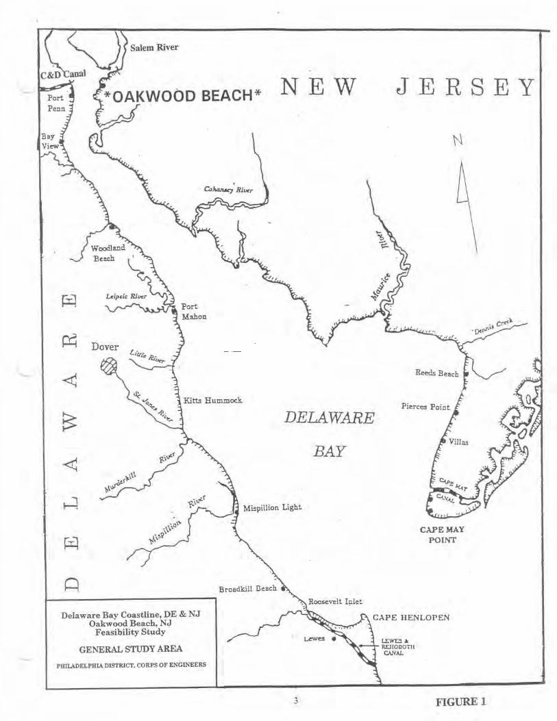
4. The study area is located at Oakwood Beach, Elsinboro Township, Salem County! New Jersey m the upper region of the Delaware Bay. Refer to Figure 1. The study area limits e>.iend from the Salem River downshore to Elsinboro Point, a distance of approximately three miles. Refer to Figure 2. It should be noted that the mean low water line at Oakwood Beach IS
l:onsidered the boundary between the states of New Jersey and Delaware. The study area below mean low water is located in New Castle County, Delaware.
STUDY PURPOSE AND SCOPE
5. The purpose of this study is to determine the magnitude and effect of shoreline erosion problems at Oak.-wood Beach. The study will determine the feasibility of providing shoreline protection in this area as well as provide up-to-date information for state and local management of the study area
6. The feasibility study used information from existing sources, supplemented by recent site inspections, aerial photography, field surveys, subsurface explorations, environmental inventories and cultural resources investigations. Interviews with local officials and residents were conducted to determine the extent of potential damages associated with tidal inundation, wave anac~ and erosion. Hydraulic analyses for erosion rate determinations were conducted and baywide wave climate models were developed Design, quantity! and cost estimates were based on generalized cross-sections, aerial photographs, surveys, and unit costs developed specifically for the study area. Preliminary cost estimates were used to compare alternative shore protection plans in choosing a selected plan of improvement. The plan of improvement was then analyzed further to determine its design features, quantities, and estimated project costs.
REPORT AND STUDY PROCESS
7 Planning by the Corps of Engineers for any Federal water resource project IS
accomplished in two phases: a reconnaissance phase and a feasibility phase. The reconnaissance phase is conducted at full Federal expense, while the cost of the feasibility phase ts shared equally between the Federal government and a non-Federal sponsor(s).
8. The reconnaissance phase, completed in August 1992, investigated shoreline erosion. potential storm damage, and other problems along the entire Delaware Bay. Due to the large study area, the reconnaissance phase conducted detailed studies at four specific priority problem areas (Broadldll Beach, DE; Mispillion Inlet, DE; Roosevelt Inlet, DE; and Oakwood Beach, NJ). These study areas served to identify Federal interest for involvement in shore protection and determined that further study was warranted. The reconnaissance phase also conducted a baywide assessment of problem areas, identifying a nwnber of areas being adversely impacted by erosion and inundation. Opportunities for ecosystem restoration were also identified given
2
Salem River
Delaware Bay Coastline, DE & NJ Oakwood Beach, NJ
Feasibility Study
GENERAL STUDY AREA
PHILADELPHIA DISTRICT, CORPS OF ENGINEERS
NEW
DELAWARE
BAY
JERSEY
CAPE MAY POINT
CAPE liENLOPEN
3 FIGURE 1

I UJ"U
"
' ·.. ~" ~I .,
ll ii , : !J . ...
.;· ~
·.
:::::: ,
-.
I~
.1· ·~
'\: I I
\ I.
' I
I . ;'
I "
!
· DE&NJ Coastline, Delaware Bay d Beach. NJ Oakwoo d 'b"lity Stu Y Feasl 1
TUDY AREA S F ENGINEERS RICT. CORPS 0 ' ,...,ELPHIA DIST PHI..,....

the ecological significance and uniqueness of the Delaware Bay. Based upon problem identification efforts conducted for the entire bay; results from detailed analyses conducted in the four priority problem areas; adherence to Federal law restricting Federal involvement along privately owned shorelines; and the interest of rhe non-Federal sponsors for future study cost sharing, seven interim feasibility phase studies were recommended to be conducted for problem areas along the Delaware Bay in the states of Delaware and New Jersey. Oakwood Beach, NJ was one of the seven areas recommended for further study.
9. This feasibility study, the second phase in the planning process, was initiated in May 1996 jointly by the Cotps of Engineers and the New Jersey Department of Environmental Protection (NJDEP). The objectives of the feasibility phase are to evaluate the specific engineering, environmental, and economic effects of the proposed solutions; to identify the optimal solution from both a Federal and non-Federal perspective; and to recommend a project for construction. if justified and supported by the non-Federal sponsor.
PERTINENT REPORTS AND STUDIES
l 0. Pertinent reports and studies which are applicable to the study area are listed m chronological order in Table 1.
RELATED FEDERAL PROJECTS
11. SALEM RIVER, NEW JERSEY NAVIGATION PROJECT. The previous project, adopted as HD 68-110 in 1925 and modified by Section 859 of WRDA 1986, provides for an entrance channel from the Delaware River to the fixed highway bridge in Salem with dimensions and limits as shown in Figure 3. including a cut-off and turning area adjacent to the Port of Salem. The unconstructed work under the previous project, dredging the channel in Little Salem River. was deautborized on 01 January 1990 by PL 99-662. The project length is about 5 miles.
12. In March 1995 the Secretary of the Army approved a modification to the previous project deepening the channel to 16 feet below mean lower low water between the Route 49 rughway bridge and the Delaware River, a distance of about 5 miles. The channel was Widened to 150-250 feet and a trapezoidal shaped turning basin with a width of 495 feet and average length of 1000 feet \Vas provided. The project also provides for 15.6 acres of wetland restoration to replace the loss of wetlands and shallow water habitat. The dredging portion of the project was completed in November 1996. The wetland restoration portion of the project (mitigation) was completed in June 1997.
5
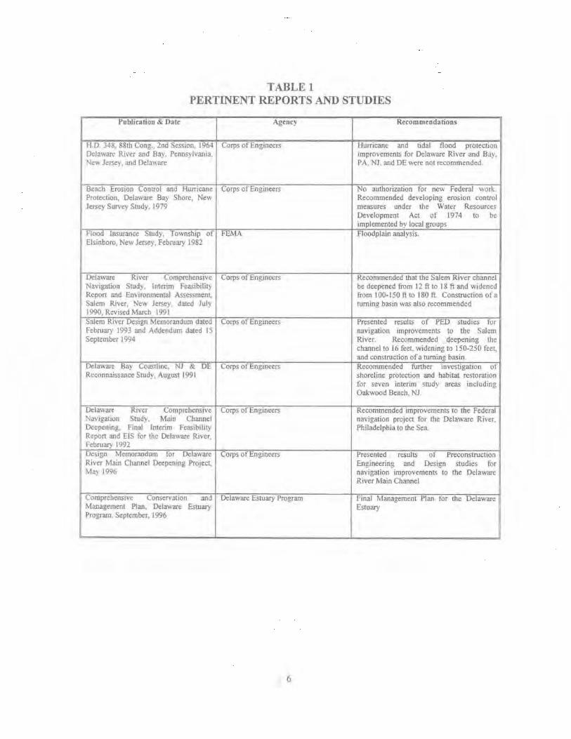
TABLEt PERTINENT REPORTS AND STUDIES
Publication & Date Agency Recommendations
H.D 348. 88th Cong., 2nd Session. 1964 Corps of Engineers Hurricane and tidal flood protection Delawan; River and Bay. Pennsylvania. Improvements for Delaware River and Bay. Nev. Jerse}. and DeJa,~ are PA. Nl, and DE were not recommended.
Beach Erosion Control and Hurricane Corps of Engineers No authorization for new Federal work. Protection, Delaware Bay Shore, New Recommended developing erosion control Jersey Survc} Study, J 979 measures under the Water Resource~
Development Act of 1974 to be implemented by local groups
Flood Insurance Study, Township of FEMA Floodplain analysis. Elsinboro, New Jersey, February 1982
Delaware River C l)rnprehensive Corps of Engineers Recommended that the Salem River channel Navigation Study., lnta1m Feasibility be deepened from 12 ft to I 8 ft and Widened Report and Environmental ASsessment.. from I 00-150 ft to 180 ft. Construction ola Salem River, New Jersey dared July turning basin was also recommended 1990, Revised March 1991 Salem River Design Memorandum dated Corps of Engineers Presented results of PED studies for February 1993 and Addendum dated IS navigation improvements to the Salem September 1994 River. Recommended deepening the
channel to l 6 feel widening to 150-250 feet., and construction of a turning basin.
Delaware Bay Coastline. NJ & DE Corps of Engineers Recommended further investigation of Rcconn:~issance Study, August 1991 shoreline protection and habitat restoration
for seven interim study areas including, Oakwood Beach, NJ.
Delaware Riva Comprehensive Corps of Engineers Recommended improvements to the Federal Nav1gJJtion Study. Main Channel navigation project for the Delaware River. Deepenmg. Final Interim Feasibility Philadelphia to the Sea Repon and EIS for the Delaware River. February 1992 Design Memorandum for Delaware Corps of Engineers Presented results of Preconstruct ion River Main Channel Deepcntng Project, Engineering and Design studies for M:ty 1996 navigation improvements to the Delaware
River Main Channel
Comprehensive Conservation and Delaware Estuary Progran1 Final Management Plan for the: Delaware Management Plan, Delaware Estuary Estuary Program. September. I 996
6

CORPS OF ENGINEERS
CHANNEL DIMENSIONS
LOCATION DEPTH I WIDTH
A-8 16FT. I 150-2SOFT
B-C 9FT. I 100FT
N TURNING BASIN 16FT. 1 495 X 1000 FT (iJ
(j) AVERAGE WIDTH
~ 4.J ~
l - Solem Q:
~ ., 4.J ~
~ ·j ~ ~ ~ ~ ~ "'t .. i ~ .,
"'t .. ..... ~ ~
SALEM
7
COUNTY
NOTE: B- C DEAUTHORiZED IN J9a9 REVERTING TO T.:.-lE 9' DEPTH CONSTRUC!'ED IN 1907.
PREVIOUS PROJECT WAS 12 FT. DEPTH
SALEM RIVER NEW JERSEY
REVISED ~0 JUNE 1968
1000 0
SCAL[ OF FEET
~ ~ ~ 3 .. 7 8000
U.S. AR~Y ENGINEER DISTRICT, PHILA.
FIGURE 3
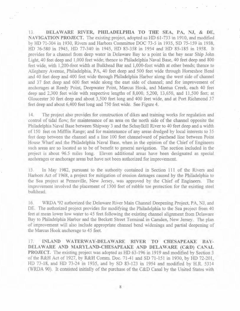
1; DELA 'V ARE RIVER, PHILADELPHIA TO THE SEA, PA, NJ, & DE. NAVIGATION PROJECT. The existing project, adopted as HD 61-733 in 1910, and modified by HD 71-304 in 1930, Rivers and Harbors Committee DOC 73-5 in 1935, SD 75-159 in 1938, HD 76-580 in 1945, HD 77-340 in 1945, HD 83-358 in 1954 and HD 85-185 in 1958. It provides for a channel from deep water in Delaware Bay to a point in the bay near Ship John Light, 40 feet deep and 1 ,000 feet wide; thence to Philadelphia Naval Base, 40 feet deep and 800 feet wide, with l ,200-foot width at Bulkhead Bar and 1,000-foot width at other bends; thence to Allegheny Avenue, Philadelplua PA, 40 feet deep and 500 feet wide through Horseshoe Bend and 40 feet deep and 400 feet Vvide through Philadelphia Harbor along the west side of channel and 3 7 feet deep and 600 feet wide along the east side of channel; and for improvement of anchorages at Reedy Point, Deepwater Point, Marcus Hook, and Mantua Creek, each 40 feet deep and 2,300 feet wide with respective lengths of 8,000, 5,200, 13,650, and 11,500 feet; at Gloucester 30 feet deep and about 3,500 feet long and 400 feet wide. and at Port Richmond 37 feet deep and about 6,400 feet long and 750 feet wide. See Figure 4.
14 The project also provides for construction of dikes and training works for regulation and control of tidal flow; for maintenance of an area on the north side of the channel opposite the Philadelphia Naval Base between Shipway 3 and the Schuylkill River to 40 feet deep and a width of ISO feet on Mifflin Range; and for maintenance of any areas dredged by local interests to 35 feet deep between the channel and a line 100 feet channelward of pierhead line between Point House Wharf and the Philadelphia Naval Base, when in the opinion of the Chief of Engineers such areas are so located as to be of benefit to general navigation. The section included in the project is about 96.5 miles long. Eleven additional areas have been designated as special anchorages or anchorage areas but have not been authorized for improvement.
15. In May 1982, pursuant to the authority contained in Section 111 of the Rivers and Harbors Act of 1968. a project for mitigation of erosion damages caused by the Philadelphia to the Sea project at Pennsville. New Jersey, was approved by the Chief of Engineers. The Improvement mvolved the placement of 1300 feet of rubble toe protection for the existing steel bulkhead.
I 6. WRDA •92 authorized the Delaware River Main Channel Deepening Project, P A, NJ. and DE. The authorized project provides for modifying the Philadelphia to the Sea project from 40 feet at mean lower low water to 45 feet following the existing channel alignment from Delaware Ba~ to Philadelphia Harbor and the Beckett Street Tenninal in Camden, New Jersey. The plan of improvement will also include appropriate channel bend widenings and partial deepening of the Marcus Hook anchorage to 45 feet.
17. INLAND WATERWAY-DELAWARE RJ\lER TO CHESAPEAKE BAYDELAWARE AND MARYLAND-CHESAPEAKE AND DELAWARE (C&D) CANAL PROJECT. The existing project was adopted as HD 63-196 in 1919 and modified by Section 3 of the R&H Act of 1927. by R&H Comm. Doc. 71-41 and SD 71-151 in 1930, by HD 72-201, HD 73-18, and HD 73-24 in 1935, and by SD 83-123 in 1954 and modified by H.R. 5314 (WRDA 90). lt consisted initially of the purchase of the C&D Canal by the United States with
8

r
CORPS OF ENGINEERS
•n• ~IIUt •n wu j (M4 1U ro •t ooot . ,. .. , '""' ~:o/~~
Ct!ANNEL DIMENSIONS
®
~f.W t:ASTI~[. COUNtY \
N E w E
~= !:· ' I " .•. : .
·····; : ••• , 1'
I ' ~
OE LAWAR£ COUHfV
A
P E N
s
/
'OO't • • , ..... -· ~ IIIIO.itCT OI'(IC"t"
1001 '""\I ·: tHJ ...
N
''""j (f.!'.t.
, .... , ......... I
./v ./ PUIL,\O£t.P~IA COUNfV
L v A N A
DELAWARE RIVER PHILADELPHIA TO THE SEA
PENNA., N. J , &. DEL 40 - FOOT CHANNEL
REVISED 30 SEPT 19G2
---~· ..... • ·) • • "!
r;lHE'3 ----u.s. ARMY ENGIN£ER DISTRICT. P ti iLA

subsequent modifications for enlargements and bridge crossings. The project provides a channel 35 feet deep and 450 feet wide from Delaware River through Elk River and Chesapeake Bay to water of natural 35-foot depth in Chesapeake Bay including a cutoff at Penn Central Railroad crossing, and having a minimum radius of curvature of 7,000 feet at bends; a high-level, fixed railroad bridge with vertical clearance of 135 feet and horizontal clearance of 600 feet at the railroad crossing over the cutoff~ high level fLxed highway bridges over th~ canal, with vertical clearance 135 feet and horizontal clearance 500 feet, at Reedy Point, St. Georges, Summit. and Chesapeake City; a bascule drawbridge across Delaware City Branch Channel; extension of entrance jetties at Reedy Point; an anchorage in Elk River, 35 feet deep and 1,200 feet wide, with an average length of 3, 700 feet; enlargement of anchorage and mooring basin in Back Creek to afford an area about 400 feet wide, 1,000 feet long, and 12 feet deep; dredging Delaware City Branch Channel to 8 feet deep and SO feet wide, and deepening existing basin to same depth; revetment of banks of canal as required between Delaware and Elk Rivers, and on banks of Delaware City Branch Channel east of Fifth Street Bridge; and construction of bulkheads. Total of section included in project, excluding Delaware City Branch Channel, which is about 2 mites tong, is about 46 miles. Refer to Figures 5 and 6.
18 The WRDA of 1990 authorized construction of a new highway bridge on U.S. Route 13 in the VIcinity of St. George's, Delaware, to meet the current and projected traffic needs, at a Federal cost of $115,000,000. The State has completed the bridge construction and is being reimbursed by the Federal Government for costs incurred. Studies are ongoing to evaluate options for disposition of the original St. George's Bridge.
19. The WRDA of 1996 authorized modification ofthe C&D Canal to provide deepening of the channel and safety improvements at Reedy Point and Sandy Point, as well as construction of an emergency anchorage at Howell Point. The depth of improvement is to be determined during ?reconstruction Engineering and Design.
RELATED INSTITUTIONS
20. An inventory has been made of public institutions in the study area which affect or may be affected by the implementation of plans developed as part of this study. The inventory tncludes Federal, State and local agencies. The primary agencies concerned with shore protection in the study area include the following:
FEDERAL AGENCIES.
2 1. U.S. Environmental Prote~tion Agency (EPA)-Region II. Tlus agency is generally responsible for enforcement of Federal laws regarding air and water quality, solid waste. and hazardous materials Relative to Federal navigational activities, the EPA and the Corps have established guidelmes for the evaluation of water quality impacts associated with the disposal of dredged material as required by Section 404(b) (1) of the Clean Water Act (CWA). Similarly, the EPA and the Corps have developed evaluative criteria for specification of ocean dumping sites in accordance with the Marine Protection, Research, and Sanctuaries Act. EPA also maintains a veto authority over decisions made by the Corps regarding specification of disposal
10

CORPS OF E N GINEERS
(? ....... ..
N
• • ,.. , .. '".'""'' ' N'/111 11/lll+rl .. ,. """"' •
..,.,,.In•-~• •' C • D {••"'' .,#,liN . ..... , , .. ~.,,,,,_., ,,, ,,. . /If
....... , ""''"'It"' ,,~,, r:;,,. """''•' ,,._.
.••. ··••t ., •••••.•• ,,0011 1.1' ,.,.. ....... . //,/:-"" W/,
INLAND WATERWAY D(IJoWARE RIVEII TO CH ISAI"t:AI\ £ 8H
OELAWAIII 6. IIIIAIIYV.N O
CHESAPEAKE d. D ELAWA R E CANAL R£111$[0 30 !EPT, 191~
• c-•L.t 0, l tlf
"" VS APMY E: NGINEE.f' DISTRICT, PHILA

CORPS OF ENGINEERS
.. ~-·==---··
'" . ======= SUMMIT BRIDGE
DELAWARE ST GEORGES BRIDGE
OELAWA!IE
CHESAP£AIIE CIT Y BRIDGE and ~ESI!lENT ENGINEER OFFICE IAARYLANO
( I
"
'· ... '•· 1
4> ••
<" '··, .....
U.S. ARMY
Nil
, .... , ...
REEDY POINT BRIDGE and Stn STREET BRIDGE DELAWARE
INLAND WATERWAY DELAWARE FIIVEFI TO CHESAPEAKE: 9AV
0£lAWAR£ & MAAVLANO
CHESAPEAKE&. DELAWARE CANAL RESIDENT ENGINEER OFFICE. a INSTALLATIONS
R!:VISED ~0 SEPT 1984 ae.ALt• A• SHO~H
V.S. ARMf ENGINE£R DISTRICT, PHlU.

s1tes under Section 404( c) of the CW A- In the Clean Air Act (Section 309), EPA has been given the authority to review and comment on actions subject to the National Environmental Policy Act (NEPA) and to refer those actions to the Council on Environmental Quality (CEQ) if the agency finds the action to be unacceptable from an overall environmental stand-point.
22. U-S. Fish and Wildlife Service (USFWS). This agency is responsible for evaluation of project impacts to Fish and Wildlife resources and recommendations conceming the conservation of those resources and mitigation of impacts. Those recommendations must be considered in project planning (Fish and Wildlife Coordination Act). Enforcement and coordrnation under the Endangered Species Act is primarily the responsibility of the FWS_ The FWS also is the responsible agency for compliance with the coordination and consultation requirements under the Coastal Barrier Resources Act.
23. National Marine Fisheries Service (NMFS), Department of Commerce. This agency is similarly responsible for evaluation of project impacts on marine life and enforcement coordination under the Endangered Species Act for endangered species in the marine environment.
24. National Park Service, Office of Archeological Services (OAS), U.S. Department of the Interior. This agency is charged primarily with overseeing the historic preservation program established as a result of the Archeological and Historic Preservation Act of 1974. A primary function is the review of historic preservation reports prepared by various Federal agencies.
25. Federal agencies are required to afford the Advisory Cotmcil on Historic Preservation (ACHP) an opportunity to comment on any Federally-funded or licensed activities that may have an effect on any District, building, site, structure. or object that is listed in or is eligible for inclusion in the National Register of Historic Places.
26. U.S. Coast Guard, Department of Transportation. Thls agency's authorit-y includes maritime law enforcement, placement and maintenance of aids to navigation, supervision over the anchorage and movement of vessels, the handling of explosives and other dangerous vessel cargoes, and safeguarding life and property on the high seas. It also enforces laws relating to oil pollution. immigration, quarantine and numerous statutes under the jurisdiction of other Federal agencies that require marine personnel and facilities.
27. Natural Resources Conservation Service, U.S~ Department of Agriculture. This agency has the responsibility for developing and carrying out a national soil and water conservation program in cooperation with landowners and operators and other land users and developers, with community planning agencies and regional resource groups, and with other Federal, State, and local government agencies. The Service also assists in agricultural pollution control, environmental improvement, and rural community development.
28. The Soil and Water Conservation Program is carried on through technical help to locally organized and operated conservation districts; local sponsors of watershed protection projects and resource conservation and development projects; and consultative assistance to other
13
individuals and groups. About 3,000 conservation districts cover more than 2 billion acres in the SO States, Guam, Puerto Rico, and the Virgin Islands.
29. U.S Army Corps of Engineers, Department of the Army. This agency performs the full range of real property activities (requirements, programming, acquisition, operation, maintenance, and disposal); manages and executes engineering, construction, and real estate programs for the Army and the United States Air Force; and performs research and development in support of these programs. The Corps manages and executes Civil Work Programs. These programs include research and development, planning, design, construction, operation and maintenance, and real estate activities related to rivers, harbors, and waterways; administration of laws for protection and preservation of navigable waters and related resources such as wetlands. The Corps also assists in recovery from natural disasters.
STATE AGENCIES.
30. New Jersey Department of Environmental Protection (NJDEP), Engineering and Construction, Coastal Engineering. This division is responsible for planning and designing shore prote.ction projects; conducting waterway maintenance dredging activities; and overseeing the development of the State's Shore Protection Plan. The agency also acts as tl1e local cooperative agency with the Philadelphia District, Anny Corps of Engineers on all matters of shore protect10n. Aids to Navigation installs all of the navigation monitoring aids on statecontrolled waterways and lakes.
31. NJDEP, Engineering and Construction, Floodplain Management. This division is responsible for providing matching grants to local governments for flood control projects; and planning long-term, state-supported flood control grants program. The agency also prepares flood plain delineation maps for state adoption and provides assistance to municipalities in the National Flood Insurance Program.
32. NJDEP, Green Acres. This division is responsible for providing planning assistance and low-interest loans and grants to municipalities and counties for open space acquisition and recreational development projects. The agency also furnishes matching grants to nonprofit organizations for open space acquisition projects, and serves as the NJDEP's land acquisition agent m purchasing land for state parks, forests and wildlife management areas. The agency also prepares and updates the Statewide Comprehensive Outdoor Recreation Plan, and manages all federal funds granted to New Jersey for open space preservation and recreational development.
33 N.IDEP, Di"·ision of Fish, Game and Wildlife, Central Services. This division has the following responsibilities:
- Administration is responsible for the division's licensing, revenue receipt and accountmg, budgeting, purchasing and billing functions.
- Endangered & Nongame provides scientific information and makes recommendations necessary to develop management programs for the state's endangered and threatened nongame species.
14

- Environmental Review coordinates the input and recommendations of the division's technical experts regarding the impacts of various types of development on wildlife.
- Education & Wildlife Information coordinates the dissemination of information describing division programs to the public and promoting the wise use of the state's natural resources.
- Laboratory Services monitors wildlife diseases and makes recommendations for their control. This group also monitors chemical substances in water which may negatively affect fish or their consumption by humans.
34. NJDEP, Division of Fish, Game and Wildlife, Marine Fisheries. This division provides scientific information and makes recommendations necessary to develop regulations governing the harvest of marine fish and shellfish and the protection of habitat.
35. NJDEP, Division of Fish, Game and Wildlife, Operations. This division has the following responsibilities:
- Development & Maintenance is responsible for administration of the 209,000-acre Wildlife Management Area system including wildlife habitat development, maintenance and construction of division facilities and lease administration.
-Freshwater Fisheries provides scientific information and makes recommendations necessary to develop regulations governing the harvest of fresh-water fish and the protection of habitat.
- Law Enforcement is responsible for the enforcement of all statutes and regulations dealing with the wildlife resources of the state and their habitat.
- Wildlife Management is responsible for conducting a variety of research and management efforts destgned to maintain healthy and productive wildlife populations while providing for \Vildlifc-oricnted recreational opportunities. Wildlife Management also addresses wildlife damage problems and operates the state pheasant farm.
36. NJDEP, Division of Parks and Forestry, Natural Lands Management. This division identifies and develops strategies to protect unique, rare, endangered and scenic habitats. The unit leads, prepares and implements management plans for state and designated natural areas; plans and develops the State Trail System; and implements the Wild and Scenic Rivers Act and the Open Lands Management Act. This unit also works with the Natural Lands Trust, an autonomous organization established to accept land donations for preservation.
37. NJDEP, Division of Parks and Forestry, New Jersey Historic Preservation Office. This division offers technical assistance to individuals, organizations and government agencies in the identification, evaluation and protection of historic resources. It also administers the following state and Federal programs: New Jersey and National Registers of Historic Places; Matching Grant Program for Historic Site Surveys, Preservation Planning and Predevelopment Projects; Matching Grant Program for Acquisition and Development Projects, Statewide
15

Comprehensive Planning and Preservation Education; Tax Act Program for Certified Rehabilitations Under the Tax Reform Act of 1986~ and Main Street New Jersey.
38. NJDEP. Division of Parks and Forestry, Resource Development. This division manages the capital improvements and land acquisition programs and special development programs.
39. NJDEP, Dh'ision of Parks and Forestry, State Forestry Sen·ice. Tilis dl.vtsion through programs of technical and/or financial assistance to communities, private property O\.Yners and state-owned lands, nurtures and sustains healthy biologically diverse forests that provide habitats for wildlife and plants including those that are threatened or endangered and y1eld quality water, air, and recreational and education opportunities~ wood products and supply for local economies; the protection of historical and aesthetic values; and the planting and care of community trees and protection of life and property threatened by wildfire.
40. NJDEP, Dn·ision of Parks and Forestry, State Park Service. This division administers the operations, maintenance, law enforcement and natural resources protection programs of 36 parks, 11 forests, four recreation areas, 42 natural areas, one golf course, 50 historic sites, and four marinas, providing a variety of quality recreational opportunities for the public. These units comprise over 325,000 acres incorporating facilities for camping, cabins, natural and historic interpretive programs. picnicking. bathing, hiking, boating, hunting, fishing and many other related outdoor activities and programs.
41. Delaware Department of Natural Resources & Environmental Control (DNREC). Established in the Spring of 1970, DNREC is charged with oversight of Delaware's natural resources and addressing its ecologtcal and environmental concerns. The Department is comprised of six divisions:
42. DNREC, Office of the Secretan•. This division provides overall direction. management and policy, as well as central administrative functions including human resources, financial management, information and systems management, business and permitting assistance and public information and education.
43 DNREC, Division of Fish and Wildlife. This division ts responsible for the conservation and wise use of the states fish and wildlife populations.
44 DNREC. Division of Parks and Recreation. This division operates and maintains 13 state parks and related preserves and greenways throughout Delaware totaling more than 15,000 acres. The state's land protection programs, as well as the state's Greenways program, are administered by the Division. TI1e Division is also responsible for providing recreational opportunities and educational and interpretive programs for the public needs.
45. DNREC, Division of Soil and Water Conservation. This division is responsible for preserving and protecting the state's soil, water, and coastal resources by managing the state's shoreline, coastal zone and navigable waterways, by regulating coastal and urban land use and construction activities and by promoting wise agricultural land management practices.
16
46. DNREC, Dhrision of Water Resources. This division assures that Delaware's rivers, ponds, streams, bays, wetlands and groundwater are properly managed and protected.
4 7. DNREC, Division of Air and Waste Management. This division oversees the handling. transfer and storage of solid and hazardous materials through regulations, monitoring, inspection, emergency response and enforcement. The Division also operates tl1e state's air monitoring, permitting and compliance programs.
48. COUNTY AND LOCAL AGENCIES.
Salem County, New Jersey Township ofElsinboro, New Jersey
RELATED INSTITUTIONAL PROGRAMS
49. NATIONAL ESTUARY PROGRAM- DELAWARE ESTUARY PROGRAM. The National Estuary Program (NEP) was established by Congress under the Water Quality Act of 1987, Section 320. The purposes of the NEP are: (1) to identify nationally significant estuaries threatened by pollution, development, or overuse; (2) promote comprehensive planning, conservation and management of nationally significant estuaries; and (3) encourage the preparation of management plans and enhance coordination of estuarine research. These goals are to be achieved for estuaries in the NEP by a Comprehensive Conservation and Management Plan (CCMP), developed in a management and study effort called a Management Conference.
50. The NEP is managed by the United States Environmental Protection Agency (EPA). The Administrator of the EPA selects estuaries for the program in response to nominations by State Governors, or, in the case of interstate estuaries. at the initiative of the EPA. Selection is based on issues of significant national concern regarding water quality, biological diversity, and recreational activities.
51. The Delaware Estuary Program (DELEP) is a Federally-:funded program which has been undertaken by the States of Delaware, New Jersey, and Pennsylvania and the EPA. Its study area includes: (1) the Delaware River and Bay from Morrisville, Pennsylvania and Trenton, New Jerseyo to Lewes, Delaware and Cape May, New Jersey; (2) all tributaries to these waters: and (3) the surrounding land areas. The DELEP was included into the NEP in 1988. A Management Conference was convened m July 1989, and five goals were established~
Provide for the restoration of living resources of the Delaware Estuary and protect their habitats and ecological relationships for future generations.
Reduce and control point and non-point sources of pollution, particularly toxic pollution and nutrient enrichment, to attain the water quality conditions necessary to support abundant and diverse living resources in the Delaware Estuary.
Manage water allocations within the Estuary to protect public water supplies and maintain ecological conditions in the Estuary for living resources.
17

Manage the economic growth of the Estuary in accordance with the goal of restoring and protecting the living resources of the Estuary.
Promote greater public understanding of the Delaware Estuary and greater participatiOn in decisions and program affecting the Estuary.
52. The final CCMP for the Delaware Estuary was signed in September 1996 by the EPA Admmistrator and the governors of New Jersey, Delaware, and Pennsylvania The program is now in an ongoing implementation phase. The CCMP docwnents actions for each of the priority areas of focus of the Delaware Estuary Program. The priority focus areas are: Land Management, Water Use Management, Habitat and Living Resources, Toxics, and Education and Involvement. The plan recommends solutions to guide future management of the Estuary's resources that will be implemented through existing and possibly new institutions and agencies. The Oakwood Beach study area is within the boundaries of the Delaware Estuary Program.
51. NORTH AMERICAN WATERFOWL MANAGEMENT PLAN. The North Amencan Waterfowl Management Plan (NA WMP) was established on 14 May 1986 by the United States Fish & Wildlife Service and the Canadian Wildlife Service. The purpose of the plan ts to reverse the decline of wetlands and waterfowl by establishing goals for conserving wetland habnats and for restoring waterfowl populations. Broad guidelines are provided for habitat protection and management through the year 2000. Each country, state, province, and territory will need to establish specific plans for habitat preservation and management in their respective jurisdictions. The implementation of the NA WMP takes place through "Joint Ventures", coalitions of State and federal agencies, conservation groups. and landowners.
54 About ten to twenty million shorebirds from over 48 species migrate annually from South America to Canada along the Atlantic Flyway, relying upon strategically placed habitats for food and rest. The Delaware Estuary is the largest staging site in the eastern United States for shorebirds migratmg along the Atlantic Flyway. It is also the second largest staging site in North Amenca. The conservation of the Delaware Estuary through the NA WMP is critical to the survival of the various species of migrating shorebirds as well as the Estuary's unique resources.
55. WESTERN HEMISPHERE SHOREBIRD RESERVE NETWORK. The Western Hemisphere Shorebird Reserve Network (WHSRN) was created in 1985 by the International Association of Fish and Wildlife Agenctes. The Network is an inclusive. multi-organizational efton. The objectives of the WHSRN are: ( 1) to promote the conservation of Western Hemisphere Shorebirds; and (2) sustenance of natural ecological processes in wetlands and other critical habitats upon which they depend. The member sites or "Sister Reserves" are Hemispheric, International, Regional, and Endangered Species sites. Throughout the Western Hemisphere. fifteen sites have been dedicated as of 1991
56. The lower 25 miles of the Delaware Bay shore of New Jersey and Delaware have been established as a "Sister Reserve" through a joint resolution by former Governor Thomas H. Kean of New Jersey and former Governor Michael M. Castle of Delaware. The objective of the joint resolution is to recognize and protect the critical migrating and feeding habitat for over one
IS

million shorebirds which utilize the Delaware Bay shore of both states during spring and fall migrations.
57. COASTAL AMERICA PARTNERSHIP. The Coastal America Program was established in 1991 . The goal of the program is to preserve, restore, and protect national coastal resources. The program is managed through the combined efforts of the U.S. Department of the Interior, the U.S. Environmental Protection Agency, the U.S. Army Corps of Engineers, and the National Oceanic and Atmospheric Administration.
58. These agencies provide the foundation for reaching the goal of the program by: ( 1) quickly responding to coastal management needs at the state and local level~ and (2) assisting local governments and states to obtain public participation in coastal management through educational programs.
59. Coastal America provides support for both short-term and long-term coastal management projects using a three-level strategy which consists of: (1) preventive measures applied to all coastal areas; (2) site-specific restoration; and (3) long-term plans for containing or removing pollutants in highly contaminated areas
60. MARINE FISH HABITAT RESTORATION AND CREATION PROGRAM. A cooperative agreement between the Corps and the National Marine Fisheries Service (NMFS) to establish a national NMFS-Corps program that will contribute toward balancing fish habitat conservation with orderly development and management of the Nation's water resources was signed on January 31, 1991. It states the Corps' policy to restore and create fish habitat at existing projects, some of which include wetlands. when habitat creation can be accomplished in an acceptable manner without added cost. If added costs are involved, the Corps will consider those opportunities using funds and authorities which may be available to them and with appropriate cost-sharing by non-Federal interests. Restoration and creation features may include marine, estuarine, and anadromous fish habitats.
19

EXISTING CONDITIONS
SOCIAL AND ECONOMIC SETTING
61. POPULATION AND LAND USE. Oakwood Beach is a small residential community consisting of approximately 3 miles of beach along the Delaware Bay, in Elsinboro Township, Salem County, New Jersey. It lies adjacent and roughly parallel to the entrance channel for the Salem River navigation project and is east of the Reedy Point entrance to the C&D Canal as it connects to the Delaware River shipping channel. The Port of Salem is located upstream of the study area. Vessels travel along both the Salem River and Delaware River navigation channels in the vicinity of the study area. The mean low water line at Oakwood Beach is considered the boundary between the States of New Jersey and Delaware.
62. The primary concern among residents of Oakwood Beach is the long tenn erosion along Locust A venue, River Lane and Shadroe Lane. The study area consists of approximately 133 structures, all residential with the exception of one commercial building, the Country Club of Salem. The shoreline at Oakwood Beach is primarily used by local residents. Public access to the site is limited.
63. Salem County, covering an area of 346 square miles, is the least populated of the eight southern most counties in New Jersey. Salem County had a total population of 65,294 people in 1990, an increase of only 1.0% since 1980. Elsinboro Township had an estimated population of 1 ,246 in 1990 with about 60% of that population residing in Oakwood Beach. It is projected that by the year 2005 Salem County will be the only county in the state to have a population of less than 100,000.
64. Although Oakwood Beach is not expected to experience significant development, both Salem County and New Jersey will continue to increase its population over the next twenty years, but at a decreasing rate of growth. Table 2 displays population projections for Salem County and New Jersey through the year 2010.
1960 Salem 58,711 County New 6,066,782 Jersey
TABLE2 POPULATION PROJECTIONS
1970 1980 1990 60,346 64,676 65,294
7,171 ,112 7,365,011 7,730,188
2000 2010 68.300 69,700
8,500,200 8,996,500
65. ECONOMIC DEVELOPMENT. There has been very little new development in Oakwood Beach with the exception of one structure near the southern boundary of the study area. Construction is not expected to continue along the shoreline due to the lack of vacant lots, as well the high cost incurred by homeowners along the shoreline for maintenance of local shore
2 1

protection structures. Two structures at the southern most end of the study area have been abandoned due to the high maintenance costs of necessary shore protection structures.
66. ln 1990 the medtan value of a single family home in Salem County was $79,800, almost 20% less than that of the State's median value. Refer to Table 3 for average housing prices for Salem County and the State of New Jersey. Less than half of the homes in Salem County are owner occupied with 12.6% renter occupied and 41.2% vacant. Refer to Table 4. Median rent for single family homes in Salem County is approximately $278. more than 65% of New Jersey's median rent. Unlike Salem County, however, residents of Oakwood Beach permanently occupy about 75% of the homes year round and the majority of homes are owner occupied rather than renter occupied.
Salem County New Jersey
TABLE3 AVERAGE HOUSING PRICES
BASED ON UNITS SOLD IN FY 1989 AND FY 1990
FY 1989, Average Units Sold FY 1990~ Average Housing Price Housing Price
$72,459 605 $81,873 $166,696 80,704 $166,399
TABLE4 HOUSING UNIT OCCUPANCY
Uruts Sold
511 69,682
Total Total %Owner %Renter %Vacant Households Housing Occupied Occupied
Units New 247.497 289,919 60.0 25.4 14.6 Jersey Salem 43,681 74253 46.2 12.6 41.2 County
Source. Upclose U S. Data Book 1993
67. Table 5 contains 1989 income information for Salem County as well as Elsinboro Township The estimated median per capita income in 1989 for Salem County was $13,961, almost $3,000 less than that of Elsinboro Township. Table 6 shows projections of the total civilian labor force for the State of New Jersey and Salem County.
22
TABLES 1989 MONEY INCOME AND PERCENT PERSONS BELOW POVERTY
Household Family Income Median Non Median Income Family Income Per Capita Income
Salem County 33,155 38,294 15,392 13,961 Elsinboro 38,512 44,583 21,375 17,370 Township
Source: 1990 Census of Population & Housing, Summary Tape File 3. Prepared by: New Jersey State Data Center, New Jersey Department of Labor, August 1992
TABLE6 PROJECTIONS OF TOTAL CIVILIAN LABOR FORCE
1980 1990 1995 2000 2005 2010 New 3,523,255 4,104,676 4,148,600 4,373,700 4,586,300 4,736,000 Jersey Salem 27,830 31,339 31,800 33,200 34,800 36,000 County
GEOTEC~CALSETTING
68. GENERAL. The project area lies entirely within the Atlantic Coastal Plain Physiographic Province. The geology of this province is characterized by a wedge of unconsolidated sediments which thicken and dip toward the Atlantic Ocean. These unconsolidated sediments, ranging in age from Cretaceous to Holocene, rest unconformably upon the crystalline basement of Precambrian schists and gneiss and consist of pervious and impervious materials, which form a series of aquifers and aquicludes. The Coastal Plain deposits thicken seaward from nothing at the fall line to more than 6,500 feet at the southern tip of Cape May.
69. SITE GEOLOGY AND GROUNDWATER. The Oakwood Beach study area is underlain by roughly 1,400 feet of unconsolidated Quaternary, Tertiary and Cretaceous sediments. These sediments overlie bedrock which consists of metamorphic and igneous rocks of the upper Precambrian age. The unconsolidated formations dip to the southeast and generally thicken oceanward. The older formations are at or near the surface jn the vicinity of the Delaware River and are progressively deeper toward the Atlantic Ocean.
70. The geologic units within the vicinity of Oakrwood Beach belong to the Wenonah Formation and Mount Laurel Sand of Cretaceous age; the Vincentown Formation of Tertiary age and the Cape May Formation of Pleistocene age. The Wenonah Formation and Mount Laurel
23

Sand and the Vincentown Fom1ation outcrop in and around the Salem River in bands trending southwest to northeast while the Cape May deposits blanket areas of the older formations. In some locations tn or adJacent to the Salem River, recent alluvial deposits mantle these geologic units
71. The Wenonah Formation and overlying Mount Laurel Sand function as a single hydrologic unit. They comprise a highly used aquifer and are an important source of water for future development. The Wenonah Formation overlies the Cretaceous Marshalltown Fom1ation, a leak-y aquiclude composed of sandy clay. The Woodbury Clay. also of Cretaceous age. underlies the Marshalltown Formation and constitutes a widespread major aquiclude.
72. The Mount Laurel Sand is overlain by the Navesink Formation of Cretaceous age. which is in turn overlain by the scarcely distinguishable Hornerstown Sand of Tertiary age. These deposits are composed of sand with varying amounts of silt and clay, and function together as a leaky confining unit for the underlying Mount Laurel aquifer. The Vincentown Sand overlies the Homerstown Sand and is an important local source of water supply.
73. The Cape May Formation is predominantly composed of sands and gravels. In areas where the Cape May deposits are not thick enough to function as an aquifer, their chief hydrologic function is to absorb precipitation and transmit it to the underlying formations. If these fonnations are pervious, a hydraulic connection exists between the shallow water table in the Cape May Formation and the underlying materials.
74. GROUNDWATER QUALITY. Groundwater in the vicinity of Salem Cove generally has natural total dissolved solids concentrations of less than 500 mg/1: this corresponds with New Jersey Department of Environmental Protection (NJDEP) Groundwater Class GW2. Designated uses and quality criteria for this class are:
Suitable for potable, industrial, or agricultural water supply, after conventlonal water treatment (for hardness, pH, Fe, Mn, and chlorination) where necessary, or for the continual replenishment of surface waters to maintain the quantity and quality of the surface waters of the State and other reasonable uses (NJDEP 1978).
75 Groundwater beneath the study area in the Cape May Formation, Mount Laurel Sand and Wenonah Formation, and Raritan Formation is influenced by the major recharge areas of these respective aquifers. Recharge from or toward the Delaware River is topographically dependent. The Cape May Formation receives induced recharge from the Delaware River between Wilmington and Trenton and is also recharged by rainwater infiltration. The Format10n's hydraulic gradient in the study area, however, is generally toward the Delaware River. Tidal action and supply well pumpage can locally control or reverse groundwater gradients. The relatively impermeable Holocene alluvium acts as only a partial barrier to saltwater intrusion from the Delaware River.
76 The groundwater recharge area of the Mount Laurel Sand and Wenonah Formation is approximately parallel to and midway between the Delaware River and the Atlantic Ocean. The major source of recharge is rainwater infiltration and leakage from the overlying Cape May
24
Formation. The hydraulic gradient is generally toward the southwest; however, local reversals occur due to the effect of pumping wells for water supply and tidal action. Leakage from the Cape May Formation has introduced salt water into this aquifer. In addition, iron concentrations are extremely high in the formation.
77. Because of the overlying aquiclude, groundwater in the Raritan Formation aquifer is recharged mainly in outcrops in urbanized areas immediately west of the Delaware River, including the city of Philadelphia, and by the Delaware River reach extending from Wilmington to Trenton. The aquifer historically has provided good quality water. However, in recent years groundwater quality has been degraded in portions of the aquifer upgradient of the study area. Changes have occurred in concentrations of dissolved solids, chlorides, alkalinity, iron, and manganese. Concentrations of iron and manganese greatly exceed the New Jersey groundwater standards. The changes in groundwater quality can be attributed in part to conditions characteristic of an urban recharge area and can be expected to eventually affect groundwater quality in the study area.
78. POTENTIAL BORROW AREAS. A series of ten vibrocores were taken in the Delaware River main channel north of the study area. An additional seven vibrocores were taken m the Delaware River main channel south of the study area and three vibrocores were taken in the vicinity of the channel flair for the proposed Chesapeake and Delaware Canal deepening project. Refer to Figure 7. The subsurface exploration program identified three distinct locations as potential borrow areas for the project.
79. The first location, and the proposed borrow area for the project, is located in the Delaware River main channel south of the study area. Refer to Figure 8. The northern extent of the area lies directly adjacent to the northern limit of Reedy Island in the Reedy Island range of the Delaware River. The proposed borrow area extends from this point approximately two miles down river. There is an estimated quantity of 5.3 million cubic yards of beach quality sand located in this borrow area. Vibrocores DRV-38 through DRV-42 were used to characterize this borrow area.
80. The second potential borrow area is located in the Delaware River main channel north of the study area adjacent to Pea Patch Island. This borrow area is approximately one mile in length and contains an estimated 3.1 million cubic yards of beach quality sand A complicating factor weighing against the use of this borrow area is the fact that there is documented cable crossings near the middle of the area. Vibrocores DRV-45 through DRV-47 were used to characterize this borrow area.
81 . The third potential borrow area located by the subsurface ex-ploration program lies adjacent to Killcohook in the Bulkhead Bar Range and the downstream extent of the Deepwater Point Range. This borrow area is not quite one mile in length and contains an estimated 2 million cubic yards of beach quality sand. Vibrocores DRV-52 through DRV-54 were used to characterize this borrow area.
82. A fourth potential source for borrow material is the channel of the Chesapeake and Delaware Canal. No intrusive investigations were conducted during the feasibility study.
25

Reedy Point South
Delaware Bay Coastline, DE & KJ Oakwood Beach. NJ
Feastbility Study
VIBROCORE LOCATIONS
PBU..-U>ELPBIA OrsTRlCT. CORPS OF ENGINEERS
Reedy . Point / South
Delaware Bay Coastline, DE & NJ Oakwood Beach, NJ
Feasibility Study
BORROW AREA
PHlLADELPKlA OISTRJCT, CORPS OF ENGlNEERS

Howe-vet, histoncal information was evaluated and it is estimated that from station 0+000 to statton 10+000 the canal's channel contains at a minimum one million cubic yards of beach quality sand.
83 A fifth potential source for borrow material, Reedy Point South Disposal Area. was evaluated dunng the feasibility study aliliough no intrusive investigations were conducted. Based upon historical information, it is estimated that this area contains approximately 850,000 cubic yards of beach quality sand.
84. Other dredged material disposal areas that were evaluated included Reedy Point North. Killcohook, Artificial Island and Penns Neck. These areas are estimated to contain 160,000 cubic yards, 14,000 cub1c yards, 70,000 cubic yards and 13,000 cubic yards of sand respectively.
ENVIRONMENTAL SETTING
85. GENERAL. The study area is located along the Delaware Bay in Salem County, New Jersey. The study area consists of 2 miles of developed shoreline, which is part of Elsinboro Townshtp. The boundary between the states of Delaware and New Jersey follows the mean low water line adjacent to the Oakwood Beach shoreline The study area below mean low water 1s 1ocared in New Castle County, Delaware.
86. The Delaware Bay and its tidal tributaries constitute a unique and extremely important ~stuary contnbuting to the environmental resources of the mid-Atlantic region. The Delaware Estuary has vast areas of coastal wetland habitat that is vital resting area for migrating shore birds along the Atlantic flyway. The study area is also within a focus area as defined by the Atlantic Coast Venture of the North American Waterfowl Management Plan. Focus areas contain critical waterfowl wmtering, ffilgratory or breeding habitat, particularly for black duck (A nos rubnpes). Erosion and inw1dation of these ecological resources results in adverse impacts to the crucial fish and wildlife habitat found within the Delaware Estuary.
87 VEGETATION. The shoreline in the study area is characterized by being residentially developed. Most of the plants are ornamental. The yards are mowed grasses. The land use/cover types for the project area would be described as urban, range herbaceous, range shrub, range mtx. water riverine. and wetland non-forest.
88 WETLANDS. There are no wetlands directly on the project area, but they can be found at the extreme ends of Oakwood Beach. Due to the oligohaline water characteristics (0.5 to 5.0 ppt) the coastal wetlands of this area are characterized by the presence of salt-tolerant species. The two dominant plants in these wetlands are the common reed (Phragmites australis) and cord grass (Spartina allern[flora). The common reed is evidence of diked or otherwise altered marshlands. Other common plants in the marshes are wild rice (Zizania aquatica), cattail (Typha sp.). salt hay (Spartina patens), spikegrass (Distich/is spicata), groundsel bush (Baccharis habmijolia). and marsh elder (Iva frurescens). The wetlands surrounding the project area are designated as prtority wetlands by the Department of the Intenor under the Emergency Wetlands Resources Act of 1986 (1 00 Stat. 3582) because of the national ecological significance of these wetlands.
28

89. WATER QUALITY. The Delaware River Basin Commission (DRBC). a four-state Federal compact agency, is responsible for managing the water resources within the entire Delaware River Basin. Pursuant to Section 305(b) of the Clean Water Act, the DRBC prepares biennial assessments of water quality for the Delaware River. In order to more accurately characterize the entire river, the DRBC has divided the area into six water quality zones. The study area falls into zone five, which extends from the Pennsylvania-Delaware-New Jersey border at Marcus Hook to Liston Point, Delaware. The information provided in this section was obtamed from the DRBC's 1988 and 1989 Delaware River water quality assessment reports. Table 7 provides the 1988-1989 water quality data collected by the DRBC for the two closest stations to the study site. The DRBC characterizes water quality in this portion of the Delaware estuary as fair to good. This portion of the estuary is a transition zone between urbanized upstream areas and rural Delaware Bay. Minimum dissolved oxygen (DO) levels for the sununer seasons did not meet DRBC standards, but sununer averages were consistently above DRBC standards. pH levels were generally within the range ofDRBC standards. Nutrient levels appear to be high enough to support algal blooms, but chlorophyll A concentrations are low. Bacteria levels remained well below the DRBC and USEP A recommended criteria for primary contact recreation during the summer seasons of 1988 and 1989.
90. This zone is the transitional area between the freshwater habitats upstream and more saline areas downstream. The salinity ranges from 0.5 to 5.0 ppt, The largest salinity variation occurs around, and below the C&D Canal. this limits the organisms that can inhabit this region to a relatively few hearty species (Sutton. 1996).
29

TABLE 7. SUMMARY OF 1988 AND 1989 \VATER QUALITY DATA COLLECTED BY THE DELAWARE RIVER BASIN COMMISSION FOR WATER QUALITY ZONE 5
Closest Sites to Dissolved Fecal E. Coli Enterococci Total Dissolved Nitrate Ammonia pH Alkalinity BODj Oakwood Beach Oxygen Coliform (#/100 ml) (#/100 ml) Phosphorus Ortho- Nitrogen Nitrogen (mg/1)
(mg/1) M-TEC (mg/1) Phosphate (mg/1) (mg/1) (#/100 ml) (mg/1}
Pea Avg 7.5 43 33 9 0.15 .05 1.85 0.37 7.7 44.8 <2.4 Patch Island RM61
Max 12.7 166 146 46 0.27 .08 2.38 1.38 8.7 67 3.0
Min 4.3 7 4 I 0.08 .02 1.30 <0.05 6.5 31 <2.4
#of 35 38 38 38 35 10 35 45 35 35 samples
Reedy Avg 8.2 19 15 7 0.14 0.05 1.69 0.26 7.6 49.9 <2.4 Island RM55
Max 12 220 200 38 0.32 0.08 2.50 0.94 8.4 70 2.7
Min 6 4 2 I 0.02 <0.02 1.27 <0.05 6.5 31 <2.4
#of 36 38 38 38 36 10 36 46 34 36 samples

91. FINFISH. The finfish population of the Delaware Estuary is extensive and diverse, because of the large salinity range fresh water and marine species utilize the habitat. Some of the species spend only part of their life cycle in the area, others just migrate through, and finally some spend their whole life in the this part of the estuary. Table 8 is a list of conunon fish and their scientific names that utilize the estuary between Wilmington and Liston Point, Delaware at some point in their life cycle. Fisheries of the Delaware Estuary have declined since the late 19th century. Factors contributing to this decline include loss of habitat, water quality degradation, toxic substances and fishing pressures. Species of current recreational and commercial importance that can be found near the study site include: weakfish, American shad, white perch, striped bass, windowpane flounder, summer flounder, spot, and Atlantic sturgeon. The State of New Jersey, Department of Environmental Protection, Bureau of Marine Fisheries state that the Oakwood Beach location is a nursery area for many fish species, including striped bass, bluefish (Pomatomus saltatrix), silverside, anchovy, spot, shortnose sturgeon (A. brevirostrum) and menhaden. Oakwood Beach is also an established juvenile striped bass survey site. The following list summarizes the species that have been found at the site from 1 980 to 1995: alewife, American eel, American shad, Atlantic croaker (Micropogocia undulatus), Atlantic menhaden, Atlantic needlefish (Strongylura marina), Atlantic silverside, banded killifish, bay anchovy , black drum (Pogania cromis), blueback herring, bluefish, bluegill sunfish (Lepomis macrochirus) , brown bullhead, carp, channel catfish, crevalle jack (Caranx hippos). gizzard shad (Dorosoma cepedianum), harvestfish (Peprilus alepidotus), hogchoker, inland silverside (menidia beryllina), inshore lizardfish (Synodus foetens) , mummichog, northern kingfish (Menticirrhus saxatilis), northern pipefish (Syngnathus fuscus) , rough silverside (Membras martinica), Spanish mackerel (Scomberonorus maculatus), spot, spottail shiner, striped anchovy (Anchoa hepsetus) , striped bass, summer flounder, weakfish, and white perch. The eastern mosquito fish (Gambusia holbrooki) is an ecologically important fish found in the nearby brackish water marshes.
92. BENTHOS. Benthic sampling was not conducted in the proposed borrow areas located in the Delaware River main navigation channel. These proposed borrow areas are disturbed areas that have been dredged on several occasions. In 1993 the Delaware Estuary Program sponsored a study that examined the benthos from the C&D Canal to Trenton (Environmental Consulting Services, Inc., 1993). This study was divided into different salinity zones defined by DRBC water quality regions. The study' s downstream most zone is part ofDRBC's zone 5, and ends at the C&D Canal. The end ofthe sampling area is approximately 4 miles upstream of the proposed Reedy Island range borrow area for the Oakwood Beach project. The study also djvided the samples into three depth strata; intertidal, shallow/intermediate, and the navigational channeL
93. For all zones the shallow/intermediate and the navigational channel had similar mean densities and biomasses, and were both higher than the figures for the intertidal region. Refer to Table 9. The Shannons's Diversity and Pielous's Evenness are similar for all depth categories, in all zones.
31

TABLE 8: COMMON FISH SPECIES THAT UTILIZE THE ESTUARY BETWEEN WILMINGTON AND LISTON POINT, DELAWARE.
Species Common Migrate Spawn in Nursery in Residence Anadromous Area Area
or Catadromous
Atlantic sturgeon Anadromous March - May ? Acipenser oxyrhnchus (spring)
American eel Catadromous Feb . - April Anquilla rostrata (adults in
fall)
Blueback herring Anadromous late April -Alosa aestivalis (Mar . - May) Nov.
Alewife Anadromous April - Nov. Alosa pseudoharengus (Mar . - May)
American shad Anadromous . .l!.losa sapidissima (Mar. - May)
Atlantic menhaden summer -Brevoortia tyrannus early fall
Bay anchovy year May - Sept. May - Nov. .l\nchoa mitchilli round
Carp year May - fall Cyprinus carp.1.o round
Silvery minnow year Hybognathus nuchalis round
Spot tail shiner April - fall Nocropis hudson ius
White catfish year May - fall Ictalurus catus round
Brown bullhead year Ictalurus nebulosus round
Channel catfish year Ictalurus punctatus round
Banded killifish year Fundulus diaphanus round
Mummichog year April - May - Dec. Fundulus round Sept. heteroclitus
32

TABLE 8 (CONTINUED) : COMMON FISH SPECIES THAT UTILIZE THE ESTUARY BETWEEN WILMINGTON AND LISTON POINT, DELAWARE.
Species Common Migrate Spawn in Nursery in Residence Anadromous Area Area
or Catadromous
Atlantic silverside year April - Aug. Menidia menidia round
White per ch win!:er April. - Oct. Monroe americana
Striped Bass year Early April Early April -Monroe Saxatilis round -Early July Fall
Weakfish mid May -Cynoscion regal is Fall
Spot year June - Dec. Leiostomus round xanchur us
Summer f lounder fall - spring Paralichtys dentatus
Windowpane flounder year late April - late summer -Scophthalumus round Dec. fall aquosus
Hogchoker year May - Aug. May - fall Trinactes maculatus round
33

TABLE9 MEAN DENSITY AND MEAN BIOMASS FOR ALL ZONES
All Zones Intertidal Shallow/ Navigational Intermediate Channel
Total Mean Density (n/m2)
1486.2 3744.8 2888.5
Total Mean Biomass 1.1258 18.1005 15.5750 (g/m2)
Shannons' s Diversity 2.5400 2.6702 2.3746
Pielous's Evenness 0.6591 0.5712 0.5783
94. In Zone 5 the dominant ta.'<a in order of decreasing abundance were polychaetes. bivalves, oligochaetes. isopods, and arnphipods accounting for over 96% of the total mean btomass. The total mean density (nlm2
) for Zone 5 was 1352.9, while the total mean biomass (g/m2
) was 4.6374. The Shannons's Diversity and Pielous's Evenness are similar for all depth categories in Zone 5. Refer to Table I 0.
TABLElO SHANNONS'S DIVERSITY AND PIELOUS'S EVENNESS FOR ZONE 5
Zone 5 Overall Intertidal Shallow/ Navigational Intermediate Channel
Shannons's Diversity 2.3875 2.6528 2.6855 1.9936 Pielous's Evenness 0.5919 0.7169 0.5648 0.4877
q" There has been a Loss of sandy substrate along the project site. The clay layer has been exposed. This clay layer is a less suitable habitat for many benthic species.
96. SHELLFISH. The New Jersey, Bureau of Marine Fisheries states that the Oakwood Beach area is important to juvenile and aduJt blue crabs (Calinecres sapidus), and that there is a SIZeable commercial fishery for blue crabs at Oakwood Beach.
97 ln the Delaware Estuary, copepods provide the major food for developing fishes, including the larvae stage of economically important species. The following copepods are known to tolerate oligohaline waters and are found in abundance around Oakwood Beach: Halicyclops fosteri, Eurytemora affinis, Acaryia tonsa. A. hudsonica, arid Pseudodiaptomus pe/agzcus Another important food item for juvenile fish are mysid shrimp. The mysid shrimp (Neomysis americana) is omnivorous, consuming algae, plankton, arid plarit detritus. Other ecologically important crustaceans that can be found in the surrounding waters are grass shrimp <Palaemonetes spp ). and fiddler crabs (Uca minax, U. pugnax. and U. pugilator).
34

98. The wedge rangia (Rangia cuneata) is an important bivalve filter feeder in soft bottom areas with oligohaline waters. The coffee-bean snail (Melampus bidentatus) serves as a detrital/algal grazer in the marsh.
99. WILDLIFE. Due to the developed nature of the project site, most of the wildlife that can be found in the area will either be transient in nature or very adaptable to human intervention. Table 11 shows the faunal species that might be found at or around the project site.
100. THREATENED AND ENDANGERED SPECIES. The U.S. Fish and Wildlife Service states, with exception for the occasional transient species bald eagle (Haliaeetus leucocephalus) and peregrine falcon (Falco peregrinus), no Federally listed or proposed threatened or endangered species under their jurisdiction are known to exist in the project area. According to Service records, the diamondback terrapin (Malaclemys terrapin terrapin), a species of special concern, occurs within the vicinity of the study area. Other Federally endangered and threatened species that frequent Delaware Bay include several aquatic species not known to breed within the bay.
10 l. The National Marine Fisheries Service has jurisdiction over the endangered shortnose sturgeon (Acipenser brevirostrum), Kemp's Ridley turtle (Lepidochelys kempii), hawksbill turtle (Eretmochelys imbricata), loggerhead turtle (Caretta caretta) and green turtle (Chelonia mydas). The shortnose sturgeon has been found throughout the estuary though spawning is thought to be limited to areas well upstream from the project area. The sea turtles are known to use the estuary as far upriver as the Delaware Memorial bridge during the summer.
102. Some marine mammals may be classified as threatened or endangered species, but all fall under the jurisdiction of the Marine Mammal Protection Act. The marine mammal species that are commonly encountered in the Delaware Estuary are bottlenose dolphin (Tursiops truncatus), harbor porpoise (Phocoena phocoena), humpback whale (Megatera novaeangliae), harbor seal (Phoca vitulina concolor), and gray seal (Halichooerus grypus). Species not commonly sighted but whjch may incidentally utilize the estuary are pygmy sperm whale (Kogia breviceps). longfirmed pilot whale (Globicephala melaena), fin whale (Balaenoptera physalus), northern right whale ( Eubalaena glacialis), harp seal (Cystophora cristata), and ringed seal (Poca hispida).
1 03. VISUAL. The shore protection structures along Oak-wood Beach range in size, shape, height and materiaL There are concrete walls, timber or steel bulkheads, stone revetment, concrete rubble, random stone and concrete fill, groins, gabions, and miscellaneous materials including tire breakwaters and open beach. Some of the strUctures have beaches in front of them others do not. ln some areas the underlying clay layer shows through. Due to the variety of shore protection structures, the shoreline is visually haphazard. At low tide a mud flat is visible and is known for shorebird viewing.
35

TABLE 11 WILDLIFE IN VICINITY OF OAKWOOD BEACH
Amphibians American toad Bufo americanus leopard frog Ranapipens
Reptiles Common snapping turtle Chelydra se1pentine eastern garter snake Thanmophi sirtalis Smooth green snake Opheod1ys vernalis Kemp's Ridley turtle Lepidochelys kempii Hawksbill turtle Eretmochelys imbricata loggerhead turtle Caretta caretta Dimondback terrapin Malaclemys terrapin terrapin green tUttle Chelonia mydas
Birds Peregine falcon Falco perginus osprey randion halieatus bald eagle Haliaeetus leucocephalus northern harrier Circus cyaneus American bittern Botaurus lentiginosus least bittern Ixobrychus exilis great blue heron Ardea herodias little blue heron Egretta caerulea tri-colored heron Egretta tricolor green-back heron Butorides stratus black-crowned night heron Nycticorax nyticorax snowy egret Egretta thula Yellow-crowned night heron Nycticorax violaceus great egret Casmerodius a/bus Glossy egret Plegadis falcinellus black duck Anas rubripes Mallard A nas platyrhynchos green-winged teal Anas crecca king rail Rallus elegans black rail Laterallus jamaicensis Northern clapper rail Rallus longerostris crepitans marsh wren Cistothorus palustris Coastal plain swamp sparrow Melospiza georgiana
Mammals Raccoon Procyon lotor eastern grey squirrel Sciurus carolinensis Striped skunk Mephitis mephitis woodchuck Marmotoa monax white-footed mouse Perornyscus leucopus house mouse Mus musculus Norway rat Rattus norvegicus eastern cottontail Sylvilagus jloridanus marsh rice rat Oryzomys palustris muskrat Ondatra zibethicus

104. AIR QUALITY AND NOISE LEVEL. The project area is rural in nature. The air quality is good since there are no major sources of emissions in the area. Noise at the project site is very low and is not disturbing to animals or human users of the area.
105. RECREATION. The recreational resources of the area are bird watching, fishing, and crabbing. There is limited recreational use of the project area by nonresidents due to the location and lack of public access.
ClJL TURAL SETTING
106. In preparing the Final Feasibility Report and Integrated Environmental Assessment, the Corps has consulted with the New Jersey State Historic Preservation Office (NJSHPO), the Delaware State Historic Preservation Office (DESHPO) and other interested parties to identify and evaluate historic properties in order to fulfill our responsibilities under the National Historic Preservation Act of 1966, as amended, and its implementing regulations, 36 CFR Part 800. As part of this work, the Philadelphia District conducted an evaluation of existing site conditions and previous cultural resources investigations to determine the potential for significant cultural resources in the Oakwood Beach project area. The results of this review indicate that the likelihood for intact and undisturbed cultural resources along the project shoreline and in the proposed Delaware River main channel borrow area is extremely minimal.
1 07. The Oakwood Beach study area is located along the eastern shore of the Delaware River in an area that became an important regional center of maritime activity during the seventeenth, eighteenth and nineteenth centuries. Significant historic maritime and military sites are located within four miles of the project area. These include the approximate location of Fort Elfsborg (Elsinboro Point), Fort Dupont (Delaware City), Fort Delaware (Pea Patch Island) and Fort Mott (Finns Point), the entrance to the Chesapeake and Delaware Canal at Delaware City, the Ice Harbors at Port Penn and Reedy Island, and Salem Cove -- the site of intense nineteenth century shell fishing activity.
108. Historic maritime activity within the project area was almost exclusively transient as most commercial vessels were passing the area in route to northern ports such as Wilmington and Philadelphia, or south along coastal networks linking the Delaware River ports and New York with other ports from Maine to Central and South America. Over the years, many types of ships and vessels have wrecked while enroute up and down the river. Adverse river conditions, storms, treacherous northeast winds and swift tidal currents caused the loss of dozens of documented sailing vessels, steamships. barges, tugs and large modem ships in the Delaware River. A variety of potential submerged cultural resource types in the project vicinity could date from the first half of the seventeenth century through the Second World War.
109. There are no National Register of Historic Places properties located within the project boundaries. Numerous residential structures dating from roughly the 1920's to the present are located along the shoreline landward of the existing shore protection structures. The project area shoreline, which lies riverward of the existing shore protection structures, has never been systematically investigated for cultural resources. However, numerous cultural resources investigations have been conducted within the immediate project vicinity and were conducted in
37

associat10n v.rith the proposed deepening of the Delaware River Main Channel (Cox, 1986 and 1988; Dolan Research, Inc. and Hunter Research, Inc. 1995 and 1 995a; GAl Consultants Inc .. 1983, Gilbert/Commonwealth, 1979; Heite and Heite 1986). The proposed project borrow area, which is located in the existing Delaware River Channel between River Mile 252+000 and 262+000, was investigated for submerged cultural resources as part of the proposed Delaware Rlver Main Channel Deepening project (Cox, 1995). Researchers did not identify any srgmficant cultural resources in the proposed project borrow area.
SHORE PROTECTION INVENTORY
110. GENERAL. In August of 1996, a site inspection of the shore protection structures along the existing beachfront was conducted. All of the shore protection structures are privately owned and constructed. The structures range in size, shape, height, and material. Some strucrures extend more hayward than others. The structures were constructed at various times, some in the last few years, while others were constructed over 50 years ago. Many of these structures were not engineenngly designed to include filter material and toe protection. The following paragraphs provide a swnmation of the coastal structures present on Oakwood Beach. Refer to Figures 9 through 12 as well as the Engineering Technical Appendix (Appendix B) for representative photographs of the structures.
Ill CONCRETE WALLS. There are numerous variations of concrete walls, ranging from sloped walls to stepped walls to vertical walls. There are also walls that are a combination of sloped and stepped. The condition of these walls range from good to poor. There are a few walls that were recently constructed within the last few years.
112. BULKHEADS.
Timber. There are a number of timber bulkheads located along Oakwood Beach. Some of these bulkheads are made up of only timber piles or only timber sheeting, while others have a combination of the two. The condition of the timber bulkheads ranges from good to severely Jeteriorated.
Steel. There are two steel sheet pile bulkheads along Oakwood Beach. These bulkheads are considered to be in good condition.
Shore Guard Vinyl Sheetpile. Ten contiguous Shore Guard vinyl sheet pile bulkheads were recently installed by local residents in the Fall of 1996. These bulkheads are in very good condition. Previously this area had been protected by a natural beach.
113. REVETMENT.
Stone. There are a few locations that have stone revetment placed on the beach. The stone revetment is m good condition and seems to be providing adequate protection.
Concrete Rubble. There are numerous locations that have concrete rubble placed on the beach and/or on the land. The rubble is made up of various shapes and sizes and consists mainly of
38
Photo #1: Sloped concrete wall fronted b) timber bulkhead (southem 1/3 ofbeach).
Photo i.i!_ · Stone revetment (southem 1/3 o:beach).
FIGL~9

Photo #3: Timber bulkhead (middle l '3 of beach).
Photo #4: Sloped concrete \\a lis ~middle 1 '3 o~ beach .
FIGliR£ !0

- _-.::. -Ph::>to ~:-: Sloped concrete walls (middle : '3 of beach).
Pno:o ~6: "\:mu:al beach are3 i:1 July 1996 (micdle,:. of beach).
fiGlJRE 11

Photo #7: Timber bulkhead (middle 1 3 of beach).
Pnoto ~8: Natu:-al beach area in November 1996 protected b: Sl1ore Guard vinyl s 1eetpile bulkhead (nidu~e: 13 of beach).
FIGl:"'RE 12
broken-up concrete slabs. This concrete rubble revetment seems to be providing some degree of protection, however, the long term reliability of these structures is poor.
114. RANDOM STONE AND CONCRETE FILL. There are a number of areas that have stone and broken-up concrete, of different shapes and sizes, randomly placed on the beach. This fill provides minimal protection in the areas where it is located.
115. GROINS. There are a few wooden groins existing along Oakwood Beach. These groins are in poor condition and appear not to be functioning.
116 GABIONS. There is one location on Oakwood Beach that has stone and concrete rubble tilled gabions. These gabions are located in front of an existing concrete rubble revetment, and a tlmber bulkhead. These gabions are in fair condition and, combined with the existing revetment and bulkhead, are providing some protection.
117. MISCELLANEOUS. There are a few locations that have interlocking steel sheet piling placed in front of an existing concrete walL This steel sheeting protrudes above the existing beach by approximately 6 inches, and goes down 5 to 6 feet. This type of structure is being used to provide toe protection to the existing structure. The construction of this sheeting will prevent any further undermining damage to existing structures.
118. Most of the houses along Oakwood Beach have a combination of the previously mentioned shore protection structures. As an example, sloped concrete walls with timber bulkhead or revetment in front~ or stepped concrete walls with random stone and concrete fill in front. The condition of these combined structures range from good to poor. In addition, some properties have no shore protection structures at all, but have a natural beach.
HYDRAULIC SETTING
119. CLIMATE. The study area is situated in the mid-Atlantic temperate zone. The climate of Delaware Bay is moderated somewhat by its proximity to the Atlantic Ocean. In the summer, weather is relatively constant with uniform warm temperatures, high humidity and low windspeeds, but there may also be frequent unstable showers and thunderstorms. Hurricane season extends from June to October. In the winter, storms may be accompanied by strong gusty winds and rain or snow. Large amounts of ice form in the Delaware River and Bay during severe winters. Ice pressures and impacts by floe ice can damage shore protection structures. Wann spells. sometimes with abundant rain, alternate with cool, dry weather in the spring. The mean annual precipitation totals at Wilmington. Delaware, about 1 0 miles north of Oakwood Beach, is 41.4 inches. The mean annual temperature at Wilmington is 54.2 degrees Fahrenheit. Precipitation is well distributed throughout the year, but somewhat heavier during July and August. Temporary droughts or periods of subnormal rainfall, however, are not uncommon for the area.
120. WIND. Prevailing wind direction reported :from different weather stations within the study region vary :from southwest to northwest. At Philadelphia, the prevailing wind direction for the summer months is from the southwest, while winds from the northwest prevail during the
47
winter·. Wind data from the Dover (Delaware) Air Force Base show that the most frequently occurring winds blov. from the northwest. Monthly data show the wind regime varies from season to season, with stronger winter winds prevailing from the northwest and summer winds prevailing from the southwest. The dominant winds (highest velocity) are from the northeast. Data from the U.S. Weather Bureau Break'Water Harbor station (Lewes. Delaware) show that southwest is the prevailing wind direction, but winds from other directions occur nearly as often. Gale force winds. those over 30 miles per hour, blow most often from the northwest and winds of more than 60 miles per hour have originated from seven of the eight principal compass directions.
121. WAVES. There are no known quantitative wave data, either observed or hindcast, for the immediate vicinit) of the study area. The study area shoreline is exposed to maximum fetches of abouT 7 miles from the northwest, and about 8 miles from the south-southwest. Because of the orientation of the study area shoreline with respect to the configuration of the Delaware River wind from other than these critical directions experience significantly shorter fetches. Winds blowing along the crincal directions are capable of producing the largest waves at the Oakwood Beach shoreline. Maximum calculated wave heights at the shoreline, using shallow-water restricted-fetch procedures from the USACE ACES (Automated Coastal Engineering System) program, are on the order of 3 to 4 feet for windspeeds of 50 to 60 miles per hour along the directions of the critical fetches.
122. TIDES. Tides in the study area are semi-diurnal; i.e. two high waters and two low waters occur in a period of 24 hours and 50 minutes. In this area, successive normal high waters differ by less than a foot in elevation. The same is also true of successive low waters.
12J The National Ocean Service (NOS) presently operates five tide gages m the Delaware estuary. The gages are located in Breakwater Harbor (DE), Cape May Canal Entrance (NJ), Reedy Point (DE), Philadelphia (PA), and Trenton <NJ). The Oakwood Beach study area is located on the east shore of the Delaware River, directly across from the tide gage located at Reedy Point at the entrance to the C&D Canal. Table 12 lists the mean high water and mean low water elevations relative to NAVD88 and NGVD29 for these tide stations. It requires about 7 hours for the high-water phase to propagate from Breakwater Harbor to the head of tide at Trenton, NJ, and 8.5 hours for the low-water phase to travel the same distance.
TABLE 12 TIDAL DATUMS, PERMANENT NOS GAGING LOCATIONS
DELAWARE RIVER AND BAY
Location Mean High Water Mean Low Water ft NA VD88/(ft NGVD29) ft NAVD88/(ft NGVD29)
Breakwater Harbor 1.4/(2.2) -2.8/(-2.0) Cape May Canal 1.8/(3.1) -3.1/(-1.8)
Reedy Point 2.4/(3.2) -3.1/ (-2.3) Philadelphia 2.9/(4.0) -3.2/(-2.2)
Trenton 4.2/(5.3) -3.9/(-2.8)
48

124. In addition to the five recording tide stations. NOAA also publishes tidal parameters for secondary tide stations, including the mouth of the Salem River adjacent to Oakwood Beach. NOAA reports a mean tide range of5.5 feet, and a spring range of6.0 feet for this location.
J 25. CURRENTS. Tidal currents play an important role in transport processes within the estuary, as they are the principal mechanism by which ocean-derived salinity is transported and distributed in the system. Currents represent the horizontal motion of water in the estuary. as distmct from the vertical motion of the water surface due to the tide. Currents in the Delaware estuary largely result from water surface differentials caused by the tide. When the tide is high at the bay mouth, locations upstream. such as Oak-wood Beach, are ex-periencing lower tidal water levels. As a result of this head difference, a tidal current is induced in the direction from higher to lower water levels. The current corresponding to high tide at the mouth flows upstream and is referred to as the flood tidal current. Likewise, the current induced by low tide at the mouth flows downstream, and is referred to as ebb. Because tidal currents are driven by the tides. the tidal currents also exhibit a semidiurnal periodicity; an average of 12.4 hours is required to go through a full tidal current cycle, from slack before flood, through flood maximum, slack before ebb, and ebb maxunum, before returning to slack before flood.
126. The National Ocean Service (NOS) conducted a comprehensive survey of tides and currents in the Delaware Estuary between 1984 and 1985. This effort included measurements from the head of tide at Trenton downstream to the bay mouth and out onto adjacent portions of the continental shelf. The results of this measurement program were utilized in a subsequent NOS model mvestigation to calculate tidal currents over the entire estuary system on a model grid of approximately 0.5 nautical miles, under mean tidal conditions. Because this was a twodimensional model, the calculated tidal current velocities represent the average velocity over the water column at any point.
127. The model results were synthesized into an NOS report titled "Delaware River and Bay Tidal Circulation and Water Level Forecast Atlas" (1987.) This report graphically depicts the spattal distribution of currents over the entire estuary at one-hour intervals beginning witl1 the time of high tide at Breakwater Harbor (Lewes, DE). The results show that the highest velocities typically occur near the longitudinal axis of the estuary, where the navigation channel is located, and at locations where significant localized constrictions of the estuary shoreline occur. For mean tide conditions, typical mid-channel peak velocities during the flood phase range from 1 to 1.5 knotS, or from about 1.7 to 2.5 feet per second, with comparable values indicated for peak ebb conditions. Locations within the estuary with localized constrictions, such as at Artificial Island (about 3 miles south of Oakwood Beach) can experience mean maximum flood or ebb velocities which may exceed 2 knots, or 3.4 feet per second. The typical values cited here can be modified, either increased or decreased, by a number of factors. These factors include spring (or other astronomic effect) tides, wind speed, direction and duration, and freshwater discharges.
128. Additional current data specific to the Oakwood Beach study area were developed in 1996 for a 2-D hydraulic model study of tidal currents for the Salem River navigation project This study showed that Delaware River currents inunediately offshore of Oakwood Beach typically attain speeds of 1 to 1.5 feet per second at ebb or flood maximum under ordinary tidal conditions. The study also demonstrated that tidal currents in the Salem Cove channel, located
49
about 2,000 feet offshore of the Oakwood Beach shoreline, flowed essenttally parallel to the shorelme. with northeasterly flow (toward the mouth of Salem River) when tide in the Delaware River was rising, and southwesterly flow when tide in the Delaware was falling. The model mvestigation also showed a progressive decrease in current speed, at any phase of the tidal cycle, from the Salem Cove channel to the Oakwood Beach shoreline.
129. SEDIMENT TRANSPORT. The study area is situated in a reach of the Delaware Estuary which is transitional between the broad, open-water conditions of Delaware Bay to the south, and the more confined geometry typical of Delaware River to the north. In this regard, the study area is subject to a range of forcing functions which may contribute to sediment transport at the shoreline. For example, tidal currents flow past the shoreline continuously, except for four bnef periods each tidal day when the current direction reverses and slack tide occurs. Addiuonally, depending ou wind direction and speed, the Oakwood Beach shoreline is exposed to over-water fetches of between 2.5 and 8 miles, from northeast counter-clockwise to southsouthwest, which generate waves impacting the shoreline. There are also ship-generated waves whtch ongmate from vessels transiting the main navigation channel of the Delaware River. the centerline of which is about 3,000 feet from the Oakwood Beach shoreline at its closest.
130. The sediment regime at Oakwood Beach is characterized by a relatively small lens of fine to coarse sand along portions of the study area shoreline. Underlying this sand is a much more extensive (laterally and vertically) layer of dense clay which IS resistant to erosion and thus not subject to sediment transport considerations.
131. The Oakwood Beach study area includes a total of about 9,000 lineal feet of developed shoreline. There is a non-uniform distribution of sand along this shoreline. The southern 4,000 hneal feet of this frontage has essentially no existing sandy beach above the plane of mean low water This reach consists of upland property fronted by a continuous line of heterogeneous bulkheads and seawalls constmcted of a variety of materials. Immediately north of this area is a zone about 2,000 feet long with a sand beach of variable cross-shore and vertical dimensions. At its widest. this beach is about 100 feet wide between the profile crest and the plane ofML W, and about 40 to 50 feet wide between the profile crest and the plane of MHW. The beach width tapers to "zero'' at its southern and northern limits. This zone contains a volume of sand estimated to be on the order of30,000 cubic yards, perched atop the underlying clay layer. North of the "beach" zone is a second reach, about 3,000 feet long, with little or no sand beach above the plane of ML W. Most of this zone is fronted by a discontinuous series of bulkheads. revetments, and seawalls, separated by several small pockets of sandy beach.
132. Sediment transport within the study area is driven by a combmation of tidal currents and wind-generated waves. There is a long but poorly defmed history of sediment deficit along Oakwood Beach, with reported problems of little or no beach for portions of the shoreline over the past five decades or more. Reports by current residents of the study area suggest that there is a net northward transport of sandy sediment, and a pattern of small seasonal changes, with onshore transport during the summer. and offshore transport in the winter. Residents also indicate that the southern end of the "beach" zone has been migrating northward at a rate on the order of 100 lineal feet per year for the past 5 to 1 0 years. This behavior is consistent with two principal fetch directions relative to the shoreline alignment Wind from the northwest fetch
50

dtrection generates waves which approach the shoreline nearly normal to the shore. Further, there are several dredged material disposal islands and shoals about 2,000 to 2,500 feet offshore of the subject shoreline which intercept some of the wave energy from the northwest. Wind from the south-southwest fetch direction generates waves which approach the shoreline obliquely and would lead to northward transport along Oakwood Beach.
133. STORMS AND STORM SURGE. Elevated storm water levels can be caused by tropical (hurricanes) or by extra-tropical (northeasters) storms. Both can cause beach erosion and damage to coastal structures. Hurricanes are associated with extreme low pressure systems and can result in large increases in water level. A hurricane can cause significant flooding and damage when the elevated water levels are coincident with high tides and waves. Northeasters cause their damage principally through wave attack of the shoreline and adjacent structures. They can be as damaging or more damaging than hurricanes depending on their duration, which can extend over several tidal cycles.
134. Table 13 presents the Delaware River and Bay stage-frequency relationship at the location of Oakwood Beach. NJ. It is based on the empirical stage-frequency analysis conducted for the entire tidal Delaware River and Bay in 1981 by the Philadelphia District. The original stage data are referenced to NGVD. The table below presents the stage values in NGVD. and a]so converted to NA VD, using the 0.94 foot difference reported by COPRSCON for the latitude and longitude of the center of the Oakwood Beach shoreline. (Note: the plane of 0.0 NA VD lies above the plane of 0.0 NGVD by 0.94 feet at Oak.--wood Beach.) For further reference in this study. only NA VD elevations will be used. Table 13 is presented in both datums for purposes of referencing the stage frequency from the source study in its original datum (NGVD).
TABLE 13 STUDY AREA STAGE-FREQUENCY
Event (yrs) Annual Water Surface Water Surface Probability of Elevation Elevation (ft, NA VD) Exceedance (ft, NGVD)
2 0.500 5.9 5.0 5 0.200 6.5 5.6 10 0.100 7.0 6.1 20 0.050 7.8 6.9 50 0.020 8.8 7.9 100 0.010 9.6 8.7 200 0.005 10.4 9.5 500 0.002 11.5 10.6
REALEST ATE
135. The study area is fairly densely developed in the immediate area of the coastline. All parcels are privately-owned with no public access to the shoreline in the project area. The properties are residential, with the exception of the Country Club of Salem, and approximately
51

90% of the parcels have houses on them. Approximately 75% of the beachfront properties are occupied by their owners as primary residences
136. Submerged lands below the Mean High Water Line (MHWL) of the Delaware River to the Mean Low Water Line (ML WL) are owned by the State of New Jersey and managed by the NJDEP Bureau of Tidelands Management. The ML WL demarcates the state boundary between New Jersey and Delaware with Delaware owning the submerged land from the ML WL on the 1\.few Jersey shoreline to the MHWL on the shoreline ofDelaware.

WITHOUT PROJECT CONDITIONS
WITHOUT PROJECT HYDRAULIC ANALYSIS
137. IDSTORIC SHORELINE EROSION ANALYSIS. The shoreline history of much of the Oakwood Beach study area has been characterized by narrow beach widths and a small background erosion trend for about the last century. Topographic maps, nautical charts, and aerial photographs were reviewed in an attempt to quantify the study area erosion rates. A review of this shoreline position information reveals that there have been periods of small accretion interspersed with periods of small erosion. The overall condition at Oakwood Beach has involved less than 100 feet of shoreline retreat from the date of the earliest mapped shoreline (1843) to the most recent (1996), for an average long-tenn erosion rate of less than one foot per year.
138. Although the background erosion rate for Oakwood Beach is small compared to other sites on Delaware Bay and the Atlantic Ocean coast, the relatively narrow, sandy barrier strip, combined with the location of the bulkheads and seawalls protecting residential structures, has led to the present condition in which little or no beach width exists on the bay side of many of the structures. Even the small values of long-term erosion are sufficient to increasingly expose the existing structures to threat of damage or loss during storm conditions.
139. STORM-INDUCED EROSION ANALYSIS. The principal damage mechanism for the study area relates to the potential for failure of the bulkheads and seawalls fronting most residential properties followed by the failure of the residential structures themselves. Most of the shore protection structures have been built either on top of or into the surface of the clay layer underlying the study area. There is little or no protective buffer offered by sandy beaches due to the paucity of sand in the study area nearshore.
140. The upper surface of the clay layer is approximately at the elevation of mean lower low water (MLL W). The beach in the southern part of the study area has been completely eroded away, leaving the clay layer at the beach level at the base of the protective structure. Behind the shore protection structures is granular material which supports the residential structures. This granular material is subject to storm-induced erosion. During storm events, exposure of the seawall and bulkhead toes allows upland soil to be displaced, causing washout (erosion) of soil supporting the residential structures behind the walls, and ultimately, damage to or loss of the protection works and residential structures. The upland soils eroded from behind the seawall/bulkheads during storms lie above and are geologically distinct from the clay layer encountered at 0 feet MLL W. Many of the existing protective structures are not founded in the clay layer and therefore are exposed to continual scour and wave damages. Given the critical age and condition of many of the shoreline protective structures, continued periodic exposure to storm waves, currents, and elevated water levels will lead to an accelerated rate of loss and damage to the adjacent upland property and residential structures. Refer to the Problem Identification section for further discussion.
141. Because most of the 133 contiguous segments of bulkheads. seawalls, and other protective measures were planned and constructed independently, and at different times by
53
mdividual landowners. it is not practical to attempt to rigorously define the individual damage frequency for each protective structure. Analytical tools such as SBEACH are not appropriate for simulation of without-project storm erosion damages as there is virtually no sandy beach remaining along most of Oakwood Beach. Instead, the District used a team that included a nwnber of experienced civil, structural, and coastal engineers to classify the total population of protective structures into three broad classes of ''erosion susceptibility" based on the combined judgment of the team.
142. A subjective analysis of seawall/bulkhead conditions and degree of exposure was conducted to rate the structures in terms of degree of protection under existing conditions. The weakest group of structures was assigned to Category 1 (0-5 year life expectancy beyond the base year), with Category 2 (5-20 year life expectancy beyond the base year) considered intermediate in terms of level of protection, and Category 3 (greater than 20 year life expectancy beyond the base year) considered the structures offering the greatest protection against stormand erosion-related failure. Table 14 presents the inferred storm event frequency required to cause failure of each of the groups of shore protection structures. Figure 13 shows the shore protection structure failure categories by location.
TABLE 14 WITHOUT PROJECT
SHORE PROTECTION STRUCTURE F AlLURE CATERGORIES BY FREQUENCY
RETURN PERIOD SHORE PROTECTION STRUCTURE (yrs) CATEGORIES EXPERIENCING F AlLURE
(Category 1 fails first, Category 3 last)
2 none fail 5 none fail 10 Category l
20 Category 1 50 Categories I and 2 100 Categories 1, 2, & 3 200 Categories 1. 2, & 3 500 Categories I, 2, & 3
143. STORM-INDUCED INUNDATION ANALYSIS. The potential for inundation damage at Oakwood Beach is determined by the stage-frequency relationship presented previously in the section on "Storms and Storm Surge'' (Table 13) and is not repeated here
WITHOUT PROJECT ECONOMIC ANALYSIS
144. GENERAL. The purpose of this section is to describe the infonnat10n and methods used in the economic analysis of storm damage reduction and erosion protection benefits for the developed area along the Delaware Bay at Oakwood Beach, New Jersey.
54

FIGURE 13'
Dolaware Bay Coo.stlioe, DE & NJ Oakwood :Be11eh. NJ
Feo.sibility Study
SHORE PROTECTION STRUCTURE F'All.URJ;; LOCA'fiONS
fiUIJ..ADF.LPUV. DI.S'nCICT. CORPS Of £NCI~&D.S

145 REACH DELINEATION. The study area was divided into 5 reaches as shown in F1gure 14. Reach 1 extends from the southernmost structure to a point approximately 4000 feet northward where a natural beach begins. Reach I has essentially no existing sandy beach above the plane of mean low water. This reach consists of upland property fronted by a continuous line of heterogeneous bulkheads and seawalls constructed of a variety of materials. Immediately nurth of this area is Reach 2, a zone about 1800 feet long, with a sand beach of variable crossshore and vertical dimensions. The beach width tapers to zero at its southern and northern limits. Approximately, twelve properties in the southern most part of Reach 2 also have some type of shore protection. Reach 3 which e>..1ends from the end of the beach zone northward approximately 1000 feet to the end of Slape A venue, at which pomt the Country Club of Salem property begins. From this point northward approximately 600 feet is Reach 4, which consists of the Country Club of Salem property. From the end ofReach 4 northward to the northern limit of the study area is Reach 5, which is approximately 1600 feet in length. Reaches 3 through 5 have little or no sand beach above the plane of mean low water, Most of this area is fronted by a cliscontmuous senes of bulkheads, revetments. and seawalls, separated by several small pockets of sandy beach
146. ECONOMIC CONDITIONS. A December 1996 price level, 50 year project life, and a base year of 2002 were used in the economic analysis. Damages were converted to an annual equivalent time basis using a 7.375% discount rate as applicable to public works projects for FY 1997. The "with'' and "Without" project damages were evaluated at the same price level and discount rate. The benefits were subsequently updated to reflect a March 1998 price level and an FY 1998 discount rate of 7.12 5%.
1 47. STORM DAMAGE METHODOLOGY AND ASSUMPTIONS. Without project condition damages were calculated for eight frequency storm events (2, 5, 10, 20, 50, 1 00, 200 and 500 year events) for erosion and inundation damages to residential and commercial structures, as well as for eros10n damages to shore protection structures and improved property
148. Residential and Commercial Structures. A structure inventory survey was undertaken to gather data pertairung to the structural characteristics of all residential and commercial structures in the study area. The information was then placed in the Marshall & Swift Residential and Commercial Estimator program, where the structural value was determined through the manipulation of such data as: the number of stories. square footage, quality, busement, garages, etceteras. An example of the input is shown in Table 15. The Marshall & Swift Estimator Program calculates the depreciated structural replacement cost value The average associated content value of each structure is estimated to be 40% of the structural replacement cost. This estimate is based on interviews with locals as well as through field observations. Interviews with local realtors also confirmed estimated structural replacement costs. Affluence was evaluated and fow1d not to be significant and therefore not claimed.
56
2i
41
: ' \ \
• 2
.:.-;
46
I I I I I I I ~ 1/
I i '-....o f ~' I I I I
I I I
16
\
\'-\
::>l tgnt
f I
I
I I
I I 47
FIGURE 14
'
<$'
z
\
8 '
15
-::. 24
; liQtll01
g
36
,. 2
/;/ /k I !
! \
l/
1
4~~
!'45 : ~ y·
<.>~ J
8
1
2
I
I j·
3
3
/
57
-~l..Jgnt
2
Delaware Bay Coastline, DE & NJ Oakwood Beach, NJ
Feasibility Study
REACH DELINEATION PHlLWELPBJA DlSTRJCT. CORPS OF ENGINEERS
TABLE IS MARSHALL & SWIFT ESTIMATOR PROG~l INPUT DATA
Address: 3001 City, State ZIP: Oakwood Beach NJ 08079
Floor Area: l ,800 square feet Quality: A vg
Style: Two Story Heating and Cooling: Wanned and Cooled Air Exterior Wall. Siding Roofmg: Composition Shingle Floor Structure: Wood Subfloor Floor Cover: Standard Allowance Appliances: Standard Allowance
R<:placement Cost
Condition: A vg
1,800 65.56 118,000
-------------------------·---------------------------------------------------------
149. Damage calculations for residential and commercial structures were performed using COSTDAM. COSTDAM is a Fortran program originally written by the Wilmington District and updated for the Philadelphia District. COSTDAM reads an ASCII "Control" file which contains storm frequency parameters for each reach and an ASCII "Structure" file which contains the database information of each structure as previously described. An excerpt from the structure tile is sho'A-n in Table 16.
TABLE 16 EXCERPT OF STRUCTURE FILE
l 1002 20.0 2 2004 20.0 3 3016 20.0 4 4076 100.0
Columns 1-3 contain the Reach lD Columns 4-9 contain the Structure ID. Columns 10-19 are blank..
40.0 5.5 0.9 45.0 5.6 3.2 50.0 52 2.9
120.0 5.5 1.2
Columns 20-27 contain the dtstance to the front of the structure Columns 28-35 contain the dtstance to middle of structure. Columns 36-40 contain the ground elevation. Columns 41-44 contain distance between the first floor and ground. Columns 45-53 contain structure replacement cost value. Columns 54-62 con tam content replacement cost value. Columns 63-65 contain structure depth damage curves. Columns 66-68 contain content depth damage curves. Columns 69-70 contain a code to make the structure "active". Columns 71-72 contain the damage category.
58 23SOlS02 1-1 106 42S03S04 1-1 101 40S03S04 1-1 188 75S03S04 1-l
150. COSTDAM 1rutially evaluated a structure for damages caused by erosion followed by damages caused by inundation. Storm waves were not significant in this area and therefore were not evaluated. COSTDAM calculated inundation damages if the water elevation was higher than
58

the first floor elevation based on Federal Insurance Administration (FIA) depth-damage curves adjusted for increased salt water damagability. To avoid double counting, if damages occurred by more than one mechanism, COSTDAM took the maximum damage of any given mechanism (erosion or inundation) and eliminated the remaining damages from the structure's total damages. Average annual damages were then calculated and aggregated for the study area.
1 51. Storm -Induced Erosion Damages. COSTDAM evaluated the expected storm erosion damages to the residential and commercial structures caused by a range of storm events. It was assumed that once a shore protection structure failed, approximately 25 feet of land behind the protective works eroded as well. As was previously described in the Without Project Hydraulics section of this report, the shore protection structures were classified into three categories of failure for damage assessment purposes. Category 1 shore protection structures were of the lowest quality and Category 3 shore protection structures were estimated to be of the highest quality. Based on engineering judgement a storm event frequency was associated with the failure of each of the groups of shore protection structures. Refer to Table 14. The assumption of 25 feet of land lost from behind the wall upon failure of the wall is considered reasonable given that erosion of about 1 0 feet of upland has occurred even without structural failure of the protective works. The analysis assumed that if a structure on a slab foundation had minimum and ma.ximwn distances of 10 and 30 feet respectively from the reference line, complete failure of the structure occurred upon failure of the shore protection structure. Based on engineering judgement, it was assumed that if the structure was not on a pile foundation, it was destroyed at the point that the land below the structure was eroded halfway through the structure. If the structure was on piles, erosion needed to retreat entirely through the footprint before the total damage was claimed. Before total failure, for both foundation types, the percent damage claimed was equal to the proportion of erosion under the structure's footprint compared to the total footprint_ It should be noted however that there are no structures on piles at Oakwood Beach. The total damages for the residential and commercial structures were calculated by COSIDAM and entered directly into an Excel file to annualize all damages accrued.
152. The assumption that erosion damage claimed is equal to the proportion of erosion under the structure's footprint compared to the total footprint prior to total destruction is an assumption that was made based on engineering judgement. This assumption is used in all shore protection studies in the Philadelphia District as well as other districts throughout the Corps which use tl1e economic model COSTDAM. This assumption is inherent in the model.
153. Storm-Induced Inundation Damages. The percentages of total depreciated replacement costs used to calculate damages by the depth-damage function curves for inundation damages reflect various characteristics of a structure. The depth-damage curves display the percent damaged at various depths relative to the first floor. These depth-damage curves used to estimate the damage of structures were derived from previous studies of saltwater areas and FIA curves. The distinguishing characteristics were construction type (frame, concrete block, or masonry), and the number of stories in a structure as well as the presence of a basement. Refer to Table 17 for a sample depth-damage curve. The stage-frequency data used in the analysis is shown in Table 13.
59

TABLE 17 SAMPLE DEPTH-DAMAGE CURVE
Residential Structures S03 (2 story, no Residential Contents (S04) #of rows (free basement) # of rows (free format) 13 format) 13 Depth Damage (expressed as a decimal) Depth Damage (expressed as a decimal) (free format) (free format)
-2 0 -2 0 -I .01 -I 0 0 . 10 0 .22 1 .24 1 .31 2 .30 2 .40 ., J .36 3 .54 4 .39 4 .61 5 .42 5 .67 6 .47 6 .76 7 .49 7 .81 8 .56 8 .88 9 .64 9 .88
lO .67 10 .96
154 Sbm·e Protection Structures and Improved Property. Shore protection structure damage and loss of improved property, due to erosion, was also calculated for each reach. Without project damages were evaluated using the Corps of Engineers' Hydrologic Engineering Center's (HEC) Expected Annual Damage (EAD) Computation Program. This program is based on the principle that damages to an individual category or damage categories can be estimated by determining the dollar value of damages for different magnitudes of stonn events. The damage mechanism in the study area is attributed to the effects of erosion.
155. Unlike most coastal communities Oakwood Beach does not have a single uniform type of shore protection maintained by the township, but rather individual shore protection structures which are maintained by each property owner. Because these structures are so unique, it was necessary to determine the condition of each of these shore protection structures and place them into one of three categories to make the data more manageable. These categories are based on the life expectancy of the shore protection structures beyond the base year. The categories are Category 1 (0-5 years~ fair), Category 2 (5-20 years; average) and Category 3 (>20 years; good). The natural beach section in Reach 3 where the structures are fronted only by the natural beach was classified as Category 3. A damage frequency for each of these categories was detennined based upon engineering judgement. Refer to the previously mentioned Table 14 which displays the shore protection structure failure categories by damage frequency. Failure does not begin until the 1 0 year event for Category 1 structures.
156 The assumption was made that the shore protection structures damaged at Oakwood Beach would be replaced in-kind. Values for the shore protection structures were estimated
60
using standard engineering criteria. Once damages were calculated for the shore protection structures for the storm events they were placed into EAD to calculate the Expected Annual Damages. An in-kind replacement cost for the mix of shore protection structures is estimated to be $460 p~r linear foot with an estimated lot size of 50 feet per house.
157. The EAD model was also used to calculate the annual damages to improved property from erosion. The land value was determined by comparing market value of a typical 50' x 100' non-shorefront lot, compared to the cost of filling in the eroded land for reutilization, and using the least expensive of the two values. The cost of filling/restoring the land is based on a typical 50' x 1 00' lot for the different depths, widths and cubic yards of erosion produced by the storms. The cost of filling/restoring the eroded developed land was determined to be the cheaper of the two, and the cost of fill was prorated for the width of each reach to estimate total damages for the reach. The unit cost of fill was not a fixed value. It decreased with greater quantities eroded, therefore reflecting economies of scale.
158. Loss of landscaping was calculated by estimating the value of landscaping for each reach. Structures were individually placed into two categories of landscaping fair and low. Once the mdividual structures were assigned a rating the reach received a general rating based on the overall ratio of structures within each category. "Fair" landscaping was estimated to have a replacement cost of $300 per linear foot of recession for a 50' x 1 00' lot, while "low" was estimated to be $200.
159. WITHOUT PROJECT DAMAGE SUMMARY. Table 18 displays the total value of structures and contents by damage frequency and damage category. Table 19 displays the average annual damages for structures and contents by damage category and reach. Average annual damage results for structures (including contents), improved property and shore protection structures were combined to provide total "without project" average annual damages of $884,000, as shown in Table 20. Table 21 shows the dollar damage and number of stntctures impacted by frequency for each reach. Table 22 shows the average annual damage per structure by reach and Table 23 shows the total dollar damage by frequency.
6J

Erosion
Inundation
Total
TABLEtS WITHOUT PROJECT CONDITIONS
VALUE OF STRUCTURES AND CONTENTS BY DAMAGE FREQUENCY AND CATEGORY VALUES ARE IN $000S
5 10 20 50 100 200
Structure Content Structure Content Structure Content Structure Content Structure Content Strusture Content
0 0 1,776 710 6,035 2,413 6,033 2,413 8,797 3,519 8,797 3,519
242 97 386 154 1.23 I 492 2,394 957 3,628 1,451 5,130 2,052
339 3,026 10,171 11,797 17,395 19,498
~< There are 11 residential and 1 commercial buildings which do not receive damages at the 500 year event.
500
Structure Content
8,797 3,519
6,458 2,583
21,357

TABLE19 WITHOUT PROJECT CONDITIONS
AVERAGEANNUALDAML~GESFORSTRUCTURES AND CONTENTS BY DAMAGE CATEGORY AND REACH
DECEMBER 1996 P.L. & 7.375% DISCOUNT RATE (VALVES ARE IN $000S)
Erosion Inundation Total Reach 1 (4000 ft) 248 27 275 Reach 2 ( 1800 ft) 118 49 167 Reach 3 (1000 ft) 136 12 148 Reach 4 (600ft) 0 0 0 Reach 5 (1600 ft) 70 5 75 Total (9000 ft) 572 93 665
TABLE 20 WITHOUT PROJECT CONDITIONS
TOTAL AVERAGE ANNUAL DAMAGES DECEMBER 1996 P .L. & 7.375% DISCOUNT RATE
STRUCTURES SHORE IMPROVED TOTAL AND PROTECTION PROPERTY
CONTENTS STRUCTURES
Reach 1 $275,000 $60,000 $35,000 $370,000
Reach 2 $167,000 $26,000 $15,000 $208,000 Reach 3 $148,000 $25,000 $15,000 $ 188,000 Reach 4 $0 $0 $0 $0
Reach 5 $75,000 $27,000 $16,000 $118,000
Total $665,000 $138,000 $81,000 $884,000
63
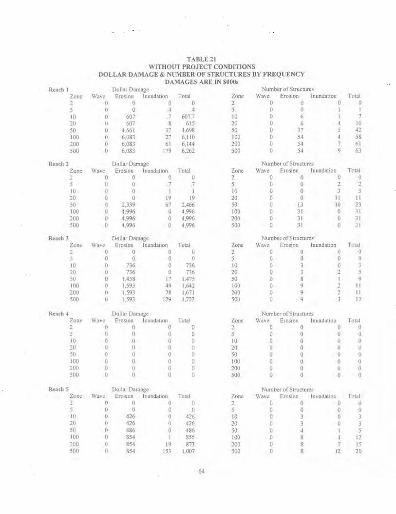
TABLE 21 WITHOUT PROJECT CONDITIONS
DOLLAR DAMAGE & NUMBER OF STRUCTURES BY FREQUENCY DAMAGES ARE IN $000s
Reach I Dollar Damage Number of Structures Zone Wave Erosion Inundation Total Zone Wave Erosion Inundation Total 2 0 0 0 0 2 () u 0 0 .5 () 0 . l 4 5 () 0 I I
10 0 607 7 607 7 10 0 6 I 7 20 0 607 8 615 20 u 6 4 10 50 tl 4,661 r 4.698 so 0 37 5 4~ 100 () 6,083 27 6,110 100 0 54 4 58 200 () 6.083 61 6,144 200 0 54 7 (il 500 () 6.083 179 6,262 500 () 54 9 63
Reach 2 Dollar Damage Number of Structures Zone Wave EroSIOn Inundauon l otal Zone Wave Eros1on Inundation Total 2 0 0 0 () 2 0 0 0 0 :5 0 0 7 ..
. I 5 () 0 2 2 10 0 0 I 1 10 0 0 3 3 20 0 0 19 19 20 0 0 11 11 50 0 2.339 67 2,466 50 0 13 10 2) 100 0 4,996 0 4.996 100 0 31 0 31 200 0 4,996 0 4.996 200 0 3 1 0 31 500 0 4.996 0 4.996 500 0 31 0 31
Rench 3 Dollar Damage Number of Structures Zone Wave Eros•on Inundation Total Zone Wave Erosion Inundation T'otal 2 0 0 0 () 2 0 0 0 0 5 0 0 0 0 5 0 0 0 fl
10 0 736 0 736 10 0 3 0 .. .. 20 0 736 0 n6 20 0 3 :! j
'0 0 1.458 17 1.47-i 50 0 8 9 100 0 1.593 49 1.642 100 () 9 1 II 200 0 1.593 78 1.671 200 0 9 2 11 500 0 1.593 129 1,722 500 0 9 3 1:!
Re~~ch 4 Dollar Damage Number of Structures Zone Wave ErosiOn Inundation Total Zone Wave Eros10n Inundation Total 2 () 0 0 0 1 0 0 0 ()
5 () 0 () 0 5 0 0 0 ()
10 I) 0 0 0 10 (l 0 0 u 20 0 0 0 0 10 () 0 0 IJ 50 0 0 0 0 so u 0 0 IJ
100 0 0 0 () 100 () 0 () 0 200 iJ 0 0 0 200 0 0 0 II
500 (I 0 0 0 500 0 0 0 0
~ach '5 Dollar Damage Number of Structures Zone Wave Erosion lnundauon Total Zone Wave Erosion Inundation I otaJ 2 0 0 0 0 2 0 0 0 u 5 () 0 0 0 5 0 0 0 0 lO () 426 0 426 10 0 ) 0 3 20 0 426 0 426 20 0 3 0 3 50 () 486 0 486 50 0 ol 5 100 I) 854 I 855 100 0 & 4 11 200 I) 854 JO 873 200 0 8 7 15 -iOO n 854 153 1,007 500 0 8 12 20
64

Reach
l 2 3 4 5
Total
TABLE22 WITHOUT PROJECT CONDITIONS
AVERAGE ANNUAL DAMAGE PRR STRUCTURE DECEMBER 1996 PRICE LEVEL & 7.375% DISCOUNT RATE
#of Total Structure & *Average Total Average Average Structures Content Value Structure Annual Annual Damage
Value Damages Per Structure
68 $1 1,264,400 $118,324 $275,000 $4,044 31 $5,000,800 $115,226 $167,000 $5,387 12 $3, 13 1,800 $186,417 $148,000 $12,333
1 $68 1,000 $681 ,000 $0 $0 21 $4,102,000 $139,524 $75,000 $3,571
133 $24,180,000 $129,865 $665,000 $5,038
*Average Structure Value column is only for structure values and does not include contents
% ofDamage to Structure
Value
3.42% 4.68% 6.62%
0% 2.56% 3.88%
**Reach 4 contains the only commercial structure in the study area and it is not included in the total Average Structure Value
TABLE 23 TOTALDOLLARDAMAGEBYFREQUENCY
Storm Event Cumulative Dollar Damage % of Structure & By Storm Event Contents Damaged by
Storm Event 2 $0 0% 5 $0 0%
lO $1 ,770,000 8% 20 $1.796,000 8% 50 $9,125,000 39%
100 $13,603,000 58% 200 $13,684,000 58% 500 $13,987,000 60%
65
PROBLEM IDENTIFICATION
160 Water resource problems identified within the study area are described in the following paragraphs. The problems were identified during site visits with local officials and residents: literature review~ public and interagency coordination, a local workshop; beach profile surveys; and recent and historic aerial photography
161. Problems identified in the study area include 1) long term shoreline erosion as a result of natural forces; 2) storm damage vulnerability with potential for storm-induced erosion, inundation and wave attack exacerbated by long term erosion; and 3) shoreline erosion as a result of Federal navigation projects in the vicinity.
LONG TERM SHORELINE EROSION
162. Oakwood Beach has eroded both horizontally and vertically through the years. Postcards dating back to the 1800s depict a sjgnificant beach which ran the entire length of the community. In the 1930s, local residents constructed a concrete seawall along the southem one-third of the community. The beach elevation bas dropped significantly from the time the seawall was constructed to the present The seawall has not been maintained systematically or regularly through the years and is deteriorated. Erosion has caused undermining of the wall and occasional loss of backfill from behind the seawall which poses a tlrreat to the foundations of the houses behind the wall. Throughout the years, local residents have made individual efforts to place additional shore protection in front of the seawall to prevent its undermining. Without attempts to halt the erosion, the seawall will increasingly be subject to failure, ultimately resulting in the loss of homes behind the wall during a storm of sufficient severity.
163. Most of the remainder of the shoreline at Oakwood Beach is fronted by a heterogeneous collection of gravity walls and wooden bulkheads, some dating back more than fifty years. Several feet of vertical beach erosion has occurred in front of the walls and bulkheads. The erosion protection structures at Oakwood Beach basically represent a collection of individual efforts by the homeowners in both the construction and maintenance of the structure. Concrete is used in the majority of structures even though the form of the concrete structures varies considerably. Other structures use other material such as steel and vinyl sheet piling, timber, cinderblocks, concrete rubble, various sizes of stone and even rubber tires. These materials are used in many combinations and proportions. Long term vertical erosion threatens to undermine these structures. Material then washes out from underneath and behmd the structures. threatening failure to the houses behind the structures. In most instances, the foundations of the houses rest on the backfill behind the shore protection structures. The entire shoreline at Oakwood Beach, with the exception of a small segment in the middle, has some type of shore protection provided by each individual homeowner. The shore protection structures do not provide a consistent level of protection nor were they designed to meet any ''standard" . Figures 15 through 19 show the various types of shore protection structures along the beach. These protective structures are increasingly subject to failure due to scouring at the toe and washout of
67
material from behind the structure. Ultimately the homes behind the protective structw·es will be lost dw-ing a storm of sufficient severity
STORJ\1-INDUCED EROSION
164 The study area has experienced erosion damage within the past ten years due to localized mmor seawall/bulkhead failures Most of these damages have occurred as a result of waves and elevated water levels during storms, at locations where progressive beach erosion has exposed the bulkhead or seawall toe. Exposure of the structure toes during storms allows upland soil to be displaced, and several homes have incurred structural damage due to washout of supporting soli from behind a protective structure. This was evident in March 1996 during a field trip following a winter storm event. Several homes had decks and beachfront structures or steps damaged to some degree. One home with a porch founded on a seawall had a room-sized cavity under the porch where granular material had been washed out from behind the seawall. Refer ro Figure 20. To help remedy this type of problem, a number of Oakwood Beach homeowners have driven sheetpile cutoff walls on the bay side of the older seawalls/bulkheads, followed by poured concrete to seal the base of the wall from further washout. Although this approach has been successful to date in preventing further erosion damages at those locations, it is only a partial solution, as it does not remedy the problem associated with the deteriorated wall above the toe.
165. Following the winter of 1996 storms, 10 property owners in the unprotected beach area drove vinyl sheet piling varying in length from 12 to 16 feet mto the ground to protect their property. The sheet piling is exposed about 3-4 feet above the ground. Refer to Figure 12, photo #X. It is estimated that the 10 homeowners spent approximately $10,000 each. These estimates did not include labor provided by the local residents. A local contractor also repaired several walls following these storms. A long-time local resident living in this area of the beach noted that in the mid-1970s he could walk off the top of his roof onto a 6-7 foot high dune. Another nearby resident noted a loss of about 60 feet from his property through the years.
I 66. Following the March 1996 storm, the local newspaper noted that "sections of the shoreline looked victimized by an earthquake or bombing with the remains of broken seawalls.'· The article also noted how concrete steps leading down to where the beach should have been were hanging in mid-a1r. The article indicated that property owners have spent thousands of dollars to maintain their seawalls. It was estimated that about half of the residents experienced undermining of their seawalls. The article also noted that one property owner had five seawalls one behind the other. Every time one failed, another was constructed
167 Local officials have indicated that within the last 6 to 8 years, about 5 property owners per year have spent between $10,000 and $20.000 each on local shore protection structures. One property owner at the southern end of the beach recently placed an additional footer on his concrete wall at a cost of $10,000. Local residents at the southern end of the natural beach area noted that over the last 1 0 years they have vertically lost about 6 feet of sand. Local residents noted that the vertical erosion has occun-ed down to the clay layer in many areas and that many of thetr seawalls have been undermined 6 to 8 inches. They fear that the walls will tumble over.
68
Photo n:9: Southern I '3 of beach. Note the staged construction of the protective strucntres uder:ake:; hy indiv:duaJ homeowners. '\otc the vertical concrete wall fronting the l)ropertrcs . . ollO\ved by a sloped concrete '-ValL followed b) a timber bulkhead.
Photo =:::10: Sout:1er:1 113 of beach. :\otc concrete steps adjacen: to the walL -;'hese steos \\ere co:1s"lructed du:-inQ: <::later ~ime oe:ioc ~-ollovving a n~:-t:ca1 droo ~n the beach elevm:or:.
'"'"' ... - ~
FIGURE 15

Photo #11: Southern 113 of beach. Stone revennent recently placed by a local resident in from o: a deterior·ated concrete wall. 1\ote the condition of 6e concrete wall on the right (i.e. substantial p:·mection nex: to deteriorated :-rotect:on allows tla11king to occur- no consistent p ·nt.!-:tior .
Detenoratcd concrete wall and timber bulkhead. Remain:: c;· a timb~r t,rro:r: :n the foreground.
FIGURE 16

Photo #13: Remains of a tailed wall fronting a deteriorated concrete venical wall.
Photo #14: Southern 1/3 of beach. :.Jote the remains of a crude buikhead in the foregrow1d.
FIGURE 17
Photo #15: Northern 1/3 of beach. 1\ote the steps adjacent to the concrete v.:all and the vertical e:·osio·, of tile beach.
Photo i:J6:. \:orthcrn !/3 of beac~- Historica. photo f:o:n 1973. Compare oe<tch elev:lt:on rclr'.tJvc !0 concrete steps \\ith Photo::! 15
FIGL"RE 18
Photo ;:::17: Souther;: 113 of beach. :-Jote the step and wail extensions to the vertical concrct.:· waJ undertaken by local residents as sand was lost rhrough the years.
Photo #18: ~o:tnerr: : ·3 o:' beach. Note the vernca: :oss o~~ beach from the bottom of the bddc:-
FIGURE 19

Photo #19: Middle 1/3 of beach. Gnprotected beach area follov.ing March 1996 storm. :\ote me debris and deck damage and the underrn::1in.g of the str..Icrures. Foliov.ing this storm, :oca:. residents bu.i.kheaded the area (refer to Figt.i..l-e 12. photo #8). ~?.i! +.:#:""i,;·' '" --:1-.. -• .. -~-:.
- Photo #20: Note the loss of backfill from behind the concrete wall following the March 1996 storm.
FIGURE20

-
168. Over the last 20-25 years local officials estimate that about 25 property owners at the southern end of the beach have spent approximately $20,000 each. One local resident at the southern end of the beach who has lived there for over 50 years has invested approximately $30,000 in local shore protection measures. Local officials noted that following a major storm approximately 20 years ago, interest-free Federal loans were granted to local residents to repair their local shore protection structures. The loans were paid back over time until repayment was no longer required. Following this storm Oakwood Beach was declared an official disaster area. One long-time restdent noted that at one time there were approximately 30 piers located along the beach. There are now only about three piers with onJy one or two that are useable. Due to damage from storms and permitting issues the piers were not maintained.
169. Local township officials conducted a survey in October I 998 of property owners along the bayfront requesting information on costs of bulkhead/seawall repairs incurred through the years. Forty-four of the approximately 124 property owners were surveyed. From 1985 on, forty-two property owners have spent a total of approximately $450.000 This averages approximately $805 per year per property owner since 1985.
170. Local township officials also conducted a survey in November 1998 of five property owners along the bayfront requesting additional information on storm-related damages to their houses and properties as opposed to their shore protection structures. On average each property owner spent a total of about $32,000 during both the 1980s and 1990s. These costs included preventative measures taken such as sealing windows, sandbagging, and using swnp pumps. Storm-related costs incurred included: replacement of screens, furniture. decks, porches, steps, landscaping, sidewalks, water pumps and heaters; repairs to house walls, siding, roofing, and foundations~ replacement of plumbing and electrical equipment; and emergency clean-up costs. Some of the foundations of the houses were also strengthened and raised.
1 71. ln 1973, the Corps of Engineers conducted a survey study along the Delaware Bay shore ofNew Jersey. Information contained in the 1973 report indicated the following: four adjoining property owners constructed a common wooden bulkhead at a cost of $20>000 in 1973 ; the Country Club of Salem installed 600 feet of rip-rap at a cost of $60,000; one property owner spent $500 in material and $1000 for labor to repair 50 feet of wall and the same propeny owner estimated an annual ex-penditure of $500 for each 50 foot lot; one property owner spent $3000 in 1973 for approximately 50 feet of new wall; one property owner estimated that he spent $10,000 for protection since living at Oakwood Beach; one resident gathered information from 58 residents who claimed to have spent $201,500 collectively (or $3500 each) for repair and replacement over a 5 year period prior to 1973 and the same resident estimated that the 120 Oakwood Beach property owners spent between $400,000 and $500,000 during the same time period; and eight completely new bulkheads were constructed in the area in 1973.
172. Due to the significant erosion of the beach both horizontally and vertically through the years, there is currently very limited protection against future storms at Oakwood Beach. A storm of sufficient severity would pose a threat to the foundations of the houses behind the shore protection structures should these structures be undermined and the backfill material be washed
81

away. It should also be noted that two homes have already been abandoned at the extreme southern end of the study area.
FLOODING AND STORM DAMAGES
173 Long term erosion of Oak-wood Beach has made the area more susceptible to flooding and storm damage. Significant economic damages would occur in the event of a major storm. Major floods may occur during any season of the year, particularly in the late summer and early fall when high tides are generated in the Delaware Bay and River by hurricanes and tropical storms moving up the Atlantic Coast. There have been three major floods along the Delaware Bay associated with a hurricane in 1933, and two northeasters in 1950 and 1962. The high tide of the November 25, 1950 storm was recorded at 8.5 feet MSL on the Delaware River at the mouth of the Cohansey River m Cumberland County, New Jersey. Tide waters reached 7.3 feet MSL during the 1962 northeaster. The flood of March 1962 produced high tides of 7.9 feet: (NGVD) at Lewes, Delaware, the highest elevation of water recorded at Lewes, DE. The floodmg from these storms produced extensive damage along the entire Delaware Bay shoreline. Storm damages were estimated at $5.4 million at that time along the Delaware bayshore commwlities.
174. Houses along Oakwood Beach have been subjected to inundation damages in the past. Evidence provided by Oakwood Beach homeowners indicates that low-elevation portions of the study area experienced flooding on at least two recent occas10ns, in 1978 and 1985. A I 973 Corps of Engineers survey study of the Delaware Bay shore of New Jersey indicated that in the early 1970s the Locust Street area was exposed to repeated flooding when waves either breached or broke through the bulkheads. Basements along the beach were subject to flooding. resulting in damages to water pumps and heaters. Flooding problems during storms were also reported in the southern portion of the study area due to the lower elevations. In the 1973 report, the residents attributed flooding not only to storm activity but also to outsized waves generated by shtp traffic in the Delaware Bay. It was reported that ship wakes often crested the bulkhead, especially during high tide. The houses and properties along Oakwood Beach are such that there is approximately a 3 to 7 foot drop from the houses and properties to the beach. For significant inundation to occur the water level would need to rise above this height range. As such, flood damages are infrequent in the study area. At Oakwood Beach, the primary damage mechanism ts the continual erosion resulting from currents and wave action that undermines the shore protection structures and poses a risk to the homes and properties immediately behind the shore protective works. Should a storm of sufficient severity occur, the homes behind the protective works would be destroyed.
IMPACTS OF FEDERAL NAVIGATION PROJECTS ON EROSION AT OAKWOOD BEACH
I 5. GENERAL. Local res1dents also have a concern that since the deepening of the Salem River navigation project by 5 feet in the Fall of 1996, erosion at Oakwood Beach has increased at a much faster rate. Locals have noticed increased wave activity along Oakwood Beach. A
82
technical analysis was conducted to detennine if Federal navigation projects. including the Delaware River, Philadelphia to the Sea, and the Salem River, have adversely affected the Oak-wood Beach study area. On several occasions during the last approximately 20 years, some local interests have e>..lJressed the opinion that the Federal navigation projects are responsible in whole or in part for the shoreline erosion problems at Oakwood Beach. The analysis performed for thts study indicates that there are no significant adverse impacts from the Federal navigation projects on the Oakwood Beach shoreline. The following sections of this analysis summarize the history of navigation features constructed in the vicinity of the Oakwood Beach study area, a review of the shoreline history of Oakwood Beach, and finally an assessment of navigation project impacts on the Oakwood Beach study area.
176. IDSTORIC OVERVIEW OF NAVIGATION IMPROVEMENTS. The follovving paragraphs describe the historic overview of navigation improvements in the vicinity of Oakwood Beach.
177. Delaware River, Philadelphia to the Sea, PA, NJ, & DE, Federal Navigation Project. The existing Delaware River, Philadelphia to the Sea project was adopted in 1910 and has been modified several times since that date. The project extends from Allegheny A venue in Philadelphia to deep water in Delaware Bay. Authorized channel depth is 40 feet MLL W, and widths range from 400 feet in Philadelphia Harbor to 1,000 feet in Delaware Bay. The channel is 800 feet wide in the general vicinity of Oakwood Beach. The project also provides for widening at critical bends, 19 anchorages, and 12 training dikes constructed to reduce shoaling in the channel and anchorages or minimize dredging and disposal costs.
178. Prior to 1885. there was no formal "Philadelphia to Sea" project; instead, shoal locations in the Delaware River and Bay were considered (and dredged) individually. The first systematic improvement was authorized in an 1885 Board of Engineers recommendation for 26 X 600 ft. channel, from Allegheny A venue in Philadelphia to naturally deep water in the bay. This improvement was completed by 1898. Subsequently, a March 1899 plan was adopted to deepen the channel from Philadelphia to naturally deep water in the bay, with dimensions of 30 X 600 feet. The June 1910 River and Harbor Act (House Document 61-733) adopted a plan to further deepen the channel from Allegheny Avenue to deep water in the bay to 35 X 800 feet, with widening to 1000 or 1200 feet at several locations. This project was completed in 1934. and the dredged 35 X 800 feet channel length thus extended 63 miles from Philadelphia Harbor to the lower end of Liston Range, south of the location of Oakwood Beach. The June 1938 River and Harbor Act (SO 75-159) authorized additional deepening from the Philadelphia-Camden Bridge to the Philadelphia Navy Yard to 37 feet, and from the Navy Yard to deep water in the bay to 40 X 800 feet and 40 X 1,000 feet. Most of the 40ft. project dredging from the Navy Yard to deep water in the bay was accomplished between December 1940 and February 1942.
179. In addition to the dredged improvements to the Delaware River navigation channel in this period, there were also a number of other modifications made in or adjacent to the river. These improvements included in-river training dikes, and shore-connected dikes constructed for the purpose of creating confined upland dredged material disposal sites. Within a distance of about
83

5 miles upstream and dovvnstream of Oakwood Beach, these improvements included. the construction of Artificial Island in 1900, as Baker Shoal and Stony Point Shoal were enclosed by hulkheads to create a disposal area; the construction of Reedy Island Dike in 1917 (an in-river training dike); construction of Bulkhead Bar and Killkohook Dikes by 1926, also for purposes of creating additional dredging disposal area: and the construction of Pea Patch Island (training) dike m 1932
180. Salem River, NJ Federal Navigation Project. The Salem River navigation project was adopted in 1871 tO provide access between the Delaware River and the Port of Salem. The port facilities are located approximately 1.5 miles above the entrance to Salem River, which lies at the northeast end of Oakwood Beach. The earliest improvements included removal of shoals in Salem Cove between 1871 and 1880. Salem Cove is the name of the broad, shallow embayment on the east side of the Delaware River, bounded by the deep water of the Delaware River main channel on the west and the shoreline of Oakwood Beach on the east. In 1909, a 9 X 100 ft. channel was completed across Salem Cove to a point about 1 mile above the port. Between 1927 and 1928, the project dimensions were enlarged to 12 X 150ft. for the approach channel across Salem Cove, parallel to the Oakwood Beach shoreline, and to 12 X 1 00 ft. for the channel from Sa! em Cove to the upstream end of the project. The 12 ft channel was dredged for maintenance purposes several times between 1928 and 1992, with most of the dredged material discharged on the west side of the Salem River channel in Salem Cove. In 1995 and 1996, project dimensions were enlarged to 16 X 150 ft. from the entrance channel upstream to the port facilities in Salem.
181 The Salem River navigation channel across Salem Cove is generally parallel to the Oakwood beach shoreline, at a distance of between 1.600 and 2,200 feet. The zone between the Oakwood beach shoreline and the channel is shallow, with depths increasing gradually from 0 at the shoreline to about 8 feet below MLL W immediately east of the dredged Salem River project channel. The Salem project has no structural features comparable to the training dikes or diked disposal areas of the Delaware River, Philadelphia to the Sea project. However, there are several man-made islands and intertidal flats located on the north and west side of the Salem channel across Salem Cove. These features were created through the disposal of dredged material from ne\\< work and maintenance dredging on the Salem project.
182. Local interests from Oak.-wood Beach alleged that the gradual shoreline erosion of their community resulted at least in part from the cumulative effects of improvements in the Delaware River and Salem River navigation projects m the period from about 1900 to the present This Investigation was designed to assess the potential changes in currents and water levels at Oak.-wood Beach attributable to navigation improvements in the Delaware and Salem Rivers.
183. OAKWOOD BEACH SHORELINE lllSTORY. Narrow beach widths and a small background erosion trend for about the last century have characterized the shoreline history of much of the Oakwood Beach study area. Topographic maps, nauticaJ charts, historical picture postcards, and aerial photographs were reviewed in order to quantify the study area erosion rates. I\ review of this shoreline position infonnation revealed that there have been periods of small accretion interspersed with periods of small erosion. The overall condition at Oakwood Beach
84

has involved less than 100 feet of shoreline retreat from the date of the earliest mapped shoreline (1843) to the most recent ( 1996), for an average long-term erosion rate ofless than one foot per year.
184. Although the background erosion rate for Oakwood Beach is small compared to other sites on Delaware Bay and the Atlantic Ocean coast, the relatively narrow, sandy barrier strip. combined vvith the location of the bulkheads and seawalls protecting residential structures, has led to the present condition in which little or no beach width exists on the bay side of many of the structures. Even the comparatively small values of long-term erosion at Oakwood Beach are sufficient to increasingly expose existing structures to potential damage or loss during stonn condttions.
185. There is a long but poorly defined history of sediment deficit along Oakwood Beach, with reported problems of little or no beach for portions of the shoreline over the past five decades or more. Reports by current residents of the study area suggest that there is a net northward transport of sandy sediment, and a pattern of small seasonal changes, with onshore transport during the summer and offshore transport in the winter. Residents also indicate that the southern end of the present "beach" zone has migrated northward at a rate on the order of 100 lineal feet per year for the past 5 to 1 0 years. This behavior is consistent with two principal fetch directions relative to the shoreline alignment. Wind from the northwest fetch direction generates waves that approach the shoreline nearly normal to the shore. Further, there are several dredged material disposal islands and shoals about 2,000 to 2,500 feet offshore of the subject shoreline that intercept some of the wave energy from the northwest. Wind from the south-southwest fetch direction generates waves that approach the shoreline obliquely and would lead to northward transport along Oakwood Beach.
186. NAVIGATION PROJECT IMPACTS ON OAKWOOD BEACH. The prev10us sections of this discussion have demonstrated that persistent erosion at Oakwood Beach occurred during a period of at least 50 years during which significant modifications were made to adjacent portions of the Delaware River and Salem River projects in the interest of navigation. To detennine if there is a plausible cause-and-effect relationship between the navigation improvements and the Oakwood Beach erosion problem, a hydraulic model investigation was conducted.
187. This problem was addressed through application of a 2-dimensional hydrodynamic modeJ of the entire Delaware Estuary, with emphasis on the portion of the estuary adjacent to the Oakwood Beach study area. The analysis was conducted using RMA-2V, a two-dimensional finite element hydrodynamic model that has been applied in a wide range of estuarine and fluvial hydraulic investigations within the Corps of Engineers and by others. The original purpose of this application of the model was to provide boundary condition currents for a ship simulation study accomplished as part of the Delaware River Main Channel deepening project in 1993-94. However, the model scale. resolution, and coverage, combined with model geometry representing the existing 40 ft. channel. made the model ideal for determining if historic
85

navtgation improvements had caused current velocity changes, and thus increased shoreline erosion potential.
I 88. In addition to the "existing conditions, (i.e .. 1996) model geometry. a second model geometry was constructed to reflect channel and shoreline conditions that existed in 1890 in the Delaware River and Bay. The 1890 geometry thus reflected conditions that existed prior to most of the numerous improvements made in the interest of navigation, including incremental channel deepening projects and construction of in~river training dikes and diked disposal areas.
189. Boundary conditions for the model runs consisted of 70 hours (approximately 3 days) of observed tide data from October 1992 applied at the bay mouth. Tide conditions experienced during this time interval approximated spring tides in terms of semi-diurnal range. There were no significant deviations from predicted astronomical tides at the bay mouth. The analysis was conducted by selecting tive model nodes at which model-predicted current and water level data were saved. Four of the nodes were located along the approximately 9,000 foot long Oakwood Beach shoreline, and the fifth node was located on the west side of the Delaware River navigation channel. The model was run first with existing conditions (1996) geometry, and then with the 1890 geometry. Velocity and head values were saved and incorporated into a spreadsheet database. The current and water level data from the two model runs were then plotted and compared. The complete set of plots displaying current and water level comparisons IS included in the Engineering Technical Appendix B, Section 2. The current and water level data were evaluated to detem1ine the magnitude of velocity or water level differences between the two model runs. Velocity differences between the 1996 and 1890 model runs are small enough. with no consistent pattern of mcreased current velocity, to reasonably attribute the Oakwood Beach erosion to current changes arising from the modification to the Philadelphia to the Sea and Salem River navigation projects between 1890 and the present.
86

PLAN FORMULATION
1 90. The purposes of this section are to provide the backgrotmd on the criteria used in the formulation process and to present the procedures followed from the identification of the study objectives to the designation of the selected plan. The formulation process involved establishment of plan formulation rationale. identification and screening of management measures, and assessment and evaluation of detailed plans which are responsive to the identified problems and needs.
FEDERAL OBJECTIVES
191. The Federal objective of water and related land resources project planning is to contribute to the national economic development (NED) consistent with protecting the nation's environment, pursuant to national environmental statutes, applicable executive orders, and other Federal planning requirements. The objective was established by the U.S. Water Resources Council's Economic and Environmental Principles and Guidelines for Water and Related Land Resources Implementation Studies on 10 March 1983.
PLANNING OBJECTIVES
192. General planning objectives for the Delaware Bay study area are to take an integrated approach to the solution of erosion and inundation problems and storm vulnerability. Specific objectives include the following:
• Provide shore protection measures to reduce shoreline erosion, and potential storm and inundation damages at Oakwood Beach.
* Minimize degradation of the natural environment in areas impacted by such shore protection measures and protect fish and wildlife resources. Where possible, the environmental character of the study area will be preserved and maintained. This will include such considerations as aesthetic, environmental and social concerns, as directly related to plans formulated for implementation by the Corps.
PLANNING CONSTRAINTS
193 The formulation and evaluation of alternative plans are constrained by technical and economic considerations, socio-envirorunental awareness and institutional policies. The following constraints affect the formulation and evaluation of plans of improvement:
* Analyses of project benefits and costs are to be conducted in accordance with Coips of Engineers' regulations and must assure that any plan is complete within itself, efficient and safe. and economically feasible in terms of current prices.
* Any project resulting from this study must comply with the policies of Federal and state agencies having regulatory jurisdiction.
87
.. Appropriate measures must be taken to ensure that any resultmg project IS consistent with local. regional and state plans, and that the necessary environmental pennits/certificates and approvals are obtamed.
194. TECHNICAL CRITERIA. These constraints include physical or operational limitations. The followmg criteria, within a plannmg framework, were adopted for use in plan formulation:
* Natural berm elevations and foreshore beach slopes, including marsb/wetland locations and elevations, should be used at least as a preliminary basis for the restoration of beach profiles. The design of protective structures should be constructed to adequate dimensions so as to mmuruze the effect of shoreline erosion processes. A beach berm, if included in the plan of protectron, should have height and width dimensions adequate to dissipate the storm wave energy and resist erosion.
" Federal participation in the cost of restoration of beaches shall be limited so that the proposed beach will not extend seaward of the historical shoreline of record.
Plans must represent sound, safe. acceptable engineering solutions.
Plans must comply with Corps requlations.
195 ECONOMIC CRITERIA. Economic constraints limit the range of alternatives considered. The following items constitute the economic constraints foreseen to impact the formulation of alternative plans:
* Tangible benefits should exceed project economic costs for NED analyses. Any project recommended shall be based on the NED benefit-cost ratio being greater than 1.0 and maximized net benefits. unless there are overriding reasons for recommending another plan. based on other Federal, State, or local concerns.
* The benefits and costs of all alternatives are expressed m comparable economic terms to the maximum practical extent. Costs for the alternative plans are based on preliminary designs and investigations, estimates of quantities, and a December 1996 price level. Costs for the Selected Plan are based on a March 1998 price leveL Annual costs are based on a 50 year amortization period and a discount rate of 7.125 percent. These costs include interest during construction and operation and maintenance costs throughout the project life.
196. INSTITUTIONAL CRITERIA. According to the Planning Guidance Notebook (ER I 105-2-1 00), Section IV --Shore Protection, "Current shore protection law provides for Federal participation in restoring and protecting publicly owned shores available for use by the general public". Typically, beaches must be either public or private with public easements/access to allow Federal involvement in providing shoreline protection measures. Private property can be mcluded. however, if the "protection and restoration is incidental to protection of publicly owned
ss

shores or if such protection would result in public benefits". Items which can affect the designation of beaches as public include the following:
* A reasonable beach user fee. uniformly applied to all, may be established to offset the local share of project costs.
* Sufficient parking facilities for the general public (including non-resident users) must be available within a reasonable walking distance on free or reasonable terms. Public transportation may substitute for, or compliment, local parking. Street parking may only be used if it will accommodate existing and anticipated demands.
* Federal aid to private shores owned by beach clubs and hotels is not compatible with the law if the beaches are limited to use by members or paying guests
* Reasonable public access must be furnished to comply with the planned recreational use ofthe area.
* Publicly owned beaches which are limited to use by residents of the community are not considered to be open to the general public and cannot be considered for Federal involvement.
197. SOCIO-ENVIRONMENT AL CRITERIA The following social well-being and environmental criteria were considered in the formulation of alternative plans.
* Consideration should be given to public health, safety, and social well-being, including possible loss of life.
* Wherever possible. provide an aesthetically balanced and consistent appearance.
* Avoid detrimental environmental and social effects, specifically eliminating or minimizing the following where applicable:
(1) Air, noise, and water pollution;
(2) Destruction or disruption of man-made and natural resources, aesthetic and cultural values, community cohesion, and the availability of public facilities and services;
(3) Adverse effects on employment as well as theta'{ base and property values;
(4) Displacement of people, businesses. and livelihoods; and,
(5) Disruption of normal and anticipated community and regional growth.
89

3 Maintain. preserve. and where possible and applicable, enhance the following in the study area
(I) Water quality;
(2) Wetlands;
(3) Sand as a geological resource;
( 4) Commerc1ally important aquatic species and their habitats;
(5) Migratory shorebird and waterfowl habitat.
CYCLE 1 -SCREENING OF MEASURES
198 Alternative measures considered for implementation m the study area are classified under non-structural and structural measures. Non-structural measures are those measures which control or regulate the use of land and buildings such that damages to property are reduced or eliminated. No attempt is made to control the erosion and/or physically reduce the potential inundation and wave damage. Structural measures are generally those which act to block or otherw1se interfere v.~th erosive coastal processes and/or control the inundation and wave damage.
199 Measures were evaluated individually and in combination on the basis of their suitability, applicability, and merit in meeting the specific objectives ofthe study. In addition, technical and economic feasibility and environmental and social acceptability were of significant concern in the screening of the measures.
100. The alternative measures considered during the screening of measures are as follows:
a Non-structural measures
(I) No Federal Action (2) Floodplain Management (3) Permanent Evacuation
b Structural measures
(I) Berm Restoration (2) Berm Restoration With Dune (3) Groins (4) Bulkheads (5) Offshore Detached Break'Water (6) Seawall
90
(7) Perched Beach (8) Revetment
201. NON-STRUCTURAL MEASURES. A general discussion of the non-structural measures considered during the screening of measures is presented in the following paragraphs.
202. No Federal Action. TI1e no Federal action alternative does not involve any Federal measure to provide erosion control or storm and inundation damage protection to structures landward of the bayfront. This alternative would not stop or reduce the continuing erosion of the beach, nor would it prevent property from being subjected to higher storm damages from beach recession, flooding, and wave attack. This measure fails to meet any of the objectives or needs of the study and is used as a basis of comparison for any alternatives analyzed.
203. Floodplain Management. Floodplain management consists of the implementation of land use control ordinances, flood insurance participatio~ and comprehensive planning that prevents flood damage to future development and reduces flood damage to existing development.
204. Participation in the National Flood Insurance Program provides a means of compensation for flood damages suffered and also requires restrictions on floodplain development. Insurance does not reduce flood damages but lessens the economic impacts on participants. The Township of Elsinboro participates in the National Flood Insurance Program administered by the Federal Emergency Management Agency. Floodplain land use controls have traditionally been within the purview of local interests. This measure only partially meets the study objective to reduce storm damages to the Township of Elsinboro and should be retained as part of any formulated Federal plan.
205. Permanent Evacuation. Permanent evacuation of existing developed areas subject to potentiaL storm damage involves the acquisition of lands and structures thereon either by purchase or through the exercise of powers of eminent domain, if necessary. Following this action, all commercial and industrial developments and residential property in areas subject to storm damage potential are either demolished or relocated to another site. Due to the obvious social and economic costs of tlus measure it was not considered a practical measure and will be given no further consideration in Cycle 2.
206. STRUCTURAL MEASURES. A general discussion of the structural measures considered during the screening of measures is presented in the following paragraphs.
207. Berm Restoration. This measure involves the placement of sand directly onto tl1e eroded beach. Usually, the sand is pumped onto the existing shore using a dredge and an offshore borrow source. The Delaware River main channel was assumed as the borrow source for beachfill for initial screening purposes.
91

208. .1\n appropriate design uses borrow material that has similar properties to the eXIstmg beach sand. In addition, the restored beach is graded to a specific design elevation and width to provide the desired level of storm protection. This alternative requires renourishment on a periodic basis to maintain the design berm width and elevation. Berm restoration has a relatively lo·w cost and is a technically feasible measure to address the erosion problem. For these reasons. thls measure will be given further consideration in Cycle 2.
209. Berm Restoration With Dune. This measure provides the berm restoration described above with additional beachfill material to create a dune at a specific elevation and width beyond that required for berm restoration. The dune will provide storm surge protection in addition to the eroston protection provided by the berm. However. due to the limited damage potential from inundation this measure would not be economically feasible. The existing bulkheads and seawall currently provide protection from mundation. The height of the dune would need to be higher than existing shore protection structures to provide additional protection. Inundation reduction benefits will not offset the cost of a dune. Therefore this measure will be given no further consideration
2 10. Groins. Groins are structures built perpendicular to the shoreline that extend from the upper beach face into the surf zone. In many instances, groins are made up of a timber bulkhead type structure at the landward end and a rubble mound stone structure at the outer end extending into the water. A properly designed groin field will reduce erosion by trapping some of the littoral drift, thereby reducing the need for renourishment. However, a groin field built on an eroded beachface will not necessarily provide adequate storm surge protection, unless it is combined with a properly designed berm and dune restoration. Groins would only be included in the Federal project if their costs are offset by a savings realized from a decrease in cost for periodic nourishment of the berm. This measure is not feasible due the configuration of the shoreline and the limited beach width required to resist erosion and inundation. Therefore no further consideration will be given to this measure.
21 I Bulkheads. Bulkheads are structures placed parallel, or nearly parallel, to the shoreline to separate a land area from a water area. The primary purpose of a bulkhead is to retain land or prevent landsliding, with the secondary purpose of affording protection to the upland against damage by wave action. Bulkheads are normally vertical walls of concrete, timber, or steel sheetpile. Depending on the wave climate to which bulkheads are exposed, beach nourishment or revetment toe protection may be required in front of the bulkhead. This measure meets the study objectives and is technically feasible. However, it has a relatively high cost. Despite the high cost, this measure will be given further consideration. Shore Guard vinyl sheetpile bulk.heading was recently installed along 10 properties at Oakwood Beach in the Fall of 1996.
212. Offshore Detached Breakwaters. A breakwater is an offshore structure which reduces the wave energy and beach erosion on landward beaches. Breakwaters have been constructed using a variety of materials. As part of the Section 54 Program (Low Cost Shore Protection), floating tire breakwaters were installed in the Delaware Bay at Pickering Beach, DE. Three types of fixed offshore breakwaters: rubble mound: nylon sandbags; and precast concrete boxes
92

were constructed at Kitts Hummock, Delaware under the Section 54 Program. The breakwaters atKins Hummock were partially effective in preventing loss of the beachfill at the end of the Section 54 monitoring period in 1980. The sandbag breakwater is no longer visible. The low concrete and rubble mound breakwaters are submerged during highwater and are a navigation hazard. The State of Delaware plans to place more buoy markers around the breakwaters. In order for this measure to be justified, the costs of this measure would have to be offset by the savings from a decrease in periodic nourishment costs and reduced wave energy during storms. The cost of this measure will not offset the cost of periodic nourishment in the study area hence no further consideration will be given to this measure.
213. Seawalls. These structures are similar in nature and construction to bulkheads, though typically more massive. Unlike bulkheads, seawalls are designed to withstand direct wave attack and to dissipate or deflect the wave energy. Costs of constructing a seawall could be prohibitively high, with values of thousands of dollars per linear foot not uncommon. Construction of a seawall without a periodic beach nourishment program creates potential for impairing natural sediment transport processes which in turn can result in narrowing and deepening of the downdrift beaches in the vicinity of a seawall. Also, scouring in front of the seawall and increased erosion can be expected during storms due to the reflection of waves. The widening and maintenance of the beach in front of the structures would be necessary to reduce scour. Due to the high maintenance and prohibitive cost of seawalls, no further consideration will be given to this measure.
214. Perched Beach. A perched beach consists of a submerged structure or sill, usually rubble mound, which is used to trap sediment carried by incoming waves. This eliminates the outer part of the beach restoration profile near its closure with the ocean bottom. Therefore, the actual amount of fill material to be placed is less than in a typical beachfil l. A perched beach was constructed at Slaughter Beach. Delaware as part of the Section 54 Program but its effectiveness was determined to be negligible. The sill did not fill with sand as expected due to the lower wave energy and limited sediment transport of the Delaware Bay. The Town of Slaughter Beach has requested that the State remove the sill. They believe that the sill is not having a positive effect and is a navigation hazard. Because the perched beach is unsuitable for the Delaware Bay environment, and the expense of high maintenance, this measure will not be considered further.
215. Revetment. A revetment is, in general, a stone or concrete face placed to protect an embankment or existing shore protection structure against erosion by wave action or currents. Revetments are similar in nature and construction to seawalls, though they are typically sloped structures along a beach, dune, or bluff. Revetments, like seawalls, are designed to stand up to and dissipate wave energy. Revetments depend on the underlying soil for support, therefore, there is a vulnerability to damage and failure due to undermining. This measure meets the study objectives, is technically feasible, and has a relatively moderate cost. For these reasons. this measure will be given further consideration.
93

APPLICABILITY SCREENING
216. During the applicability screening the management measures discussed in the previous section were reviewed to determine the acceptability and potential to control erosion, wave attack, and inundation in the problem area. Consideration was given to factors such as potential technical performance, whether it meets the study objectives and relative cost. Based on the information shown in Table 24, the alternative measures were screened and only those measures which were considered to have potential viability were carried forward as plans or features of plans in initial formulation analyses.
TABLE24 CYCLE 1- SCREENING OF MEASURES
ALTERNATIVES MEETS STUDY TECHNICALLY RELATIVE COST CONSIDER OBJECTIVES? FEASIBLE AND FURTHER?
EFFECTIVE? NON-STRUCTURAL No Federal Action No N!A - NIA No Floodplain Partially N/A N/A No Management Permanent Partially No High No Evacuation
STRUCTURAL Berm Restoration Berm provides Yes Low Yes
erosion protection but no storm damage protection.
Berm Restoration Berm provides No Low No with Dune erosion protection
and dune provides additional storm damage protection.
Groins Yes No High No Bulkheads Yes Yes High Yes Offshore Detached Partially No High No Breal'Waters Seawalls Yes Yes High No Perched Beach Partially No Moderate No Stone Revetment Yes Yes Moderate Yes
94
CYCLE 2- INITIAL EVALUATION OF ALTERNATIVES
217. GENERAL. The objective of initial evaluation of alternatives is to evaluate and compare alternatives resulting from Cycle 1 - Screening of Measures. During Cycle 2, the alternative plans were evaluated over two different project lengths. Since there were no potential damages associated with Reach 4, consideration was given to placement of a project in Reaches 1 through 5 (9500 ft) and Reaches 1 through 3 (7300 ft). In the case of the beachfill plans, the optimal project length was associated with Reaches 1-5, as was also the case with the stone revetment plan. The optimal bulkhead length was associated with Reaches 1-3. however neither bulkhead plan had a benefit-cost ratio greater than one. As a result, further analyses focused on placement of a project in Reaches 1-5 only. The details of the Cycle 2 screening analyses are shown for a project in Reaches 1-5 only. Evaluations were based on design, environmental, and socio-economic considerations as well as preliminary cost comparisons. Table 25 summarizes the design, envirorunental, and socio-economic considerations, as well as the annualized costs and benefit-cost ratios associated with each alternative plan.
218. DESCRIPTION OF ALTERNATIVE PLANS. The following paragraphs provide descriptions of the alternative plans.
2 I 9. Bulkhead. This alternative consists of 9,500 linear feet of timber bulkhead with a top elevation of +8.0 ft NA VD along Oakwood Beach which would provide a continuous level of storm protection in the study area. This alternative was designed similar to the timber bulkhead shown in Figure 21. With bulkheacling, it is expected that the existing beach would eventually be lost due to scouring in the front of the bulkhead proving this to be an unacceptable alternative. Table 25 shows that this alternative will be given no further consideration.
220. Stone Revetment. This alternative consists of a 9,500 foot-long stone revetment plan designed with a top elevation of +3.0 ft NAVD. The revetment plan has a top width of 5 feet with a 1 V :2H hayward slope and a 2 foot by 2 foot toe protection. The revetment plan wilJ provide protection from erosion by waves and currents and stabilize the existing shoreline. A typical cross section is shown in Figure 22. Table 25 shows that this alternative will be considered further in Cycle 3.
221. Berm Restoration. The berm along Oakwood Beach will be restored for approximately 9500 feet. Two different berm widths, 25 feet and 50 feet, both at an elevation of +6.0 feet NAVD were analyzed. The beach quantities used for cost estimating purposes were obtained using typical cross sections and a project length of 9500 feeL The initial quantities required for the 25 and 50ft wide berms, including advanced nourishment, are 430,000 and 527,000 cubic yards respectively. Periodic nourishment is estimated at 30,000 cubic yards every six years throughout the life of the project. The sand for both the initial quantity and periodic nourishment was asswned to come from the Reedy Island range of the Delaware River main channel. A fill factor of 1.25 is assumed. Reedy Island range provides the closest source of suitable quality and quantity of sand for beachfill at Oakwood Beach. Typical cross sections for the plans are shown in Figure 23. Table 25 shows that this alternative will be considered further in Cycle 3.
95

TABLE25 CYCLE 2- INITIAL EVALUATION OF ALTERNATIVES
,\lternativc Design Environmental Socio-Economic Preliminary Totnl Preliminary Further Remarks Considerations Considerations Consideration!> Annualized Without Benefit-Cost Consideration in
Costs Project Ratio Cycle 3'! Annualized Damages
Berm 25ft wide berm Temporary Provides useable beach $467,500 $884,000 0 .78 Yes. Potential for Adverse environmental Restoration at elev. +6.0 ft destruction of area and reduces erosion (includes dredge mob & impacts may be
NAVD over benthic habitat in and wave damages. periodic demob cost minimized through 9500 linear feet borrow area. A nounshment reductions if coordination with
minor increase in over 50 year coincidental environmental agencies. turbidity in prqject life) maintenance Another potential benefit construction area. dredging of the category includes reduced Increases beach Delaware River Federal maintenance habitat. main channel is dredging costs if the
assumed. Delaware River main channel is the borro"" source for beachfill.
50 ft wide berm Same as above. Same as above. $505.700 $884,000 1.0 I Yes. Potential for Same as above at elev. +6.0 ft (includes dredge mob & NAVD over periodic demob cost 9500 linear feet 11ourishment reductions if
over 50 year coincidental project life) maintenance
dredging ofthe Delaware River main channel is assumed.
Stone 9500 linear feet A minor increase Provides protection $353,600 $884,000 1.44 Yes Revetment top width = 5 ft in turbidity in against erosion by wave
elev. =+3.0 ft construction area. action or currents NAVD Reduces sandy
environment. Bulkhead 9500 linear feet A minor increase Provides protection $793,000 $884,000 0.89 No
elev. =+8.0 ft in turbidity in against erosion by wave NAVD construction area. action or currents. Also
reduces inundation.

r--a'o"---1 1-J'o::....;
J/J..:. :W//.Bf.AC~ BOL~S.IIIT.'>ii1 W.~SHES." ll .----! \....:;_"r- :-t • '1 - · , C -~#I • .,.. ";..·• ,,.. . <· ,. II . .• • t!f
I
~rx,5· r- cc~ ., · ·- :-1 a: ••·• ~
l'--r---r-1 (,) .. "' 1J 6 X 8 .,-, f-,-..;:,CCAT-r-1 Gl 1~8_ .. : _ •U • 1'1
II I i
2 X 10
·.
' ·/ ~~~
CCA
'v \ J v
II ·t+
!/ ''
PILE
II ! I ! I I I
v
II'~L!li' ·r~ ·:, I .·1
·I I! ~ til
I
I· I I ·.'
'V d
r-..!
1\i
rl f-,, ·.-:. !~
I ;,
l I
I l I
I t:
\. v
'.
• H
! . I
ll ~-/ ~
T T T
:-"~ ~ T
/8'0"
I ?.5' o·
1
Delaware Bay Coastline, DE & NJ Oakwood Beach, NJ
Feasibility Study
TYPICAL CROSS-SECTION TIMBER BULKHEAD (CYCLE 2)
PHILADELPHIA DISTRIC'l', CORPS OF ENGINEERS

ELEV. VARIES
~----5.0' +3.0 ' NAVD
-.l-~-----8, . o'----.~
Delaware Bay Coastline, DE & NJ Oakwood Beach, NJ
Feasibility Study
TYPICAL CROSS-SECTION STONE REVETMENT (CYCLE 2)
PHILADELPHIA OIS'rRIC'I'. CORPS OF ENGINEERS

~
0 > <(
z
f-LJ._
.......__,..
z 0 f-<( > w _J
w
DESIGN BASELINE I 50'
10 ELEV. VARIES
+6.0 5
0
-5
-10 --~--------~--------~----------~--------~----------~---
-100 0 '100 200
DISTANCE (FT.)
300 400
Delaware Bay Coastline, DE & NJ Oakwood Beach, NJ
Fensibility Study
TYPICAL CROSS-SECTION BEACHFILL (CYCLE 2)
PHILADELPHIA DISTRICT, CO HI'S OF ENGINEERS

222. ENVIRONMENTAL EVALUATION OF ALTERNATIVE PLANS. The following paragraphs describe the environmental impacts associated w1th the alternative plans. Impacts associated with the No Action alternative are also described.
223. Impacts on Vegetation.
224. No Action: The no action alternative would cause a slow erosion and loss of terrestrial environment. A catastrophic failure of the present shore protection structures would cause loss of vegetated yards.
225. Bulkheads: Bulkheads should have no adverse impact on the vegetation of the area The bulkheads would prevent the erosion of the shore and thus prevent the loss of vegetated yards.
226. Stone Revetment: Stone revetment should have no adverse impact on the vegetation of the area. The revetment would prevent the erosion of the shore and thus the loss of vegetated yards.
227. Berm Restoration: Berm restoration would prevent the erosion of the shore and thus prevent the loss of vegetated yards. The berm would provide a new habitat for beach plants to colonize.
228 lmpacts on Wetlands. Since there are no wetlands on the site none of the alternatives will have an impact on wetlands.
229. Impacts on Water Quality.
230. No Action: The no action alternative may lower water quality by allowing erodible material to enter the water column. These materials may be a source of chemical pollutants. The erodible material may increase the turbidity levels for an extended period of time. High turbidity levels can stress aquatic organisms by clogging respiratory organs. The turbidity may also decrease the hunting capacity of visual predators. With the eventual failure of the shore protection structures would come an increase in contact with non-point source pollution from the surrounding areas These sources would allow heavy metals, pesticides, fertilizers, discarded oils. detergents. yard wastes and debris to enter the water.
231 . Bulkheads: Bulkhead placement may have a short-term effect on turbidity levels during the limited excavation and the placement of timbers. The river current in this area should carry the limited turbidity out of the area in a short time period. High turbidity levels can stress aquatic organisms by clogging respiratory organs. The turbidity may also decrease the hunting capacity of visual predators. This alternative should have limited or no impact on pH. nutrient levels, bacteria. or dissolved oxygen (DO). It also should not change the DRBC characterization of the water as fair to good.
100

232. Stone Revetment: Stone revetment construction may have a short-term effect on turbidity levels during the limited excavation and the placement of stones. The river current in this area should carry the limited turbidity out of the area in a. short time period. High turbidity levels can stress aquatic organisms by clogging respiratory organs. The turbidity may also decrease the hunting capacity of visual predators. This alternative should have limited or no impact on pH. nutrient levels, bacteria, or DO. It also should not change the DRBC characterization of the water as fair to good.
233. Berm Restoration: Berm restoration may have a short-term effect on turbidity levels during both excavation of the borrow site and the placement of sand along the shore. Elevated levels of particulate concentrations at the discharge location may also result from "washout'' after beachfill is placed. The river current in this area should carry the limited turbidity out of the area in a short time period. High turbidity levels can stress aquatic organisms by clogging respiratory organs. The turbidity may also decrease the hunting capacity of visual predators.
234. Short-term adverse impacts to water quality in the immediate vicinity of the dredging and placement site can occur. Aquatic ecosystems concentrate biological and chemical substances such as organic matter, nutrients, heavy metals, and toxic chemical compounds in bottom sediments. When introduced into the water column, these substances tend to bind with suspended particulate matter and eventually settle to the bottom. Dredging operations typically elevate levels of suspended particulates in the water column through excessive agitation of the sediment Adverse impacts to the water quality may include oxygen depletion and the release of chemical substances, making them biologically available to aquatic organisms through ingestion or respiration.
235. The borrow material is not expected to be chemically contaminated. The use of sand, coupled with the absence of nearby dumping activities, industrial outfalls, or contaminated water infer the low probability that the borrow material is contaminated by pollutants.
236. This alternative should have limited or no impact on pH, nutrient levels, bacteria, or DO. It also should not change the DRBC characterization of the water as fair to good.
237. Impacts on Finfish.
23 8. No Action: This alternative may impact finfish in the area by allowing the introduction of non point source pollution. These chemicals may have an impact on the reproductive capability, and survivability of finfish. The turbidity may also decrease the hunting capacity of visual predators
239. Bulkheads: This alternative will have a limited and short-term impact on finfish. Fish are transient and mobile by nature, this will lead to them avoiding the construction area.
240. Stone Revetment: This alternative will have a limited and short-term impact on finfish. Fish are transient and mobile by nature, this will lead to them avoiding the construction area. The
101

pnmary 1mpact to fisheries will be felt from the disturbance of benthic and epibenthic communities. The loss of the benthos and epibenthos smothered during stone placement will disrupt the food chain in the impact area. This effect is expected to be significant as these areas can not become recolonized by pioneering species due to the covering of the benthic sediment ·with stones. Some colonization of the stone may occur which would provide a unique hard bottom habitat to the area. Post construction the stone revetment would provide structure and hiding places for small fish during high tide.
241. Berm Restoration. This alternative will have limited and short-term impact on finfish. With the exception of some small finfish, most bottom dwelling and pelagic fishes are highly mobile and should be capable of avoiding turbidity impacts due to placement and dredging operat10ns. It is anticipated that some finfish may become attracted to the turbidity plume due to the suspenston of food particles in the water column. The primary Impact to fisheries will be felt from the disturbance of benthic and epibenthic communities. The loss of the benthos and epibenthos smothered dunng berm construction and removal during borrow activity will temporarily disrupt the food chain in the impacted areas. These effects are expected to be temporary as these areas become rapidly recolonized by pioneering species. Coordination will occur to prevent construction during critical spawning and over wintering periods.
242. Impacts on Benthos.
243. No Acuon: The no action alternative may have an impact on the benthic community. With the eventual failure of the existing shore protection structures would come an increase in contact with non-point source pollution from the surrounding areas. These sources allow heavy metals. pesticides, fertilizers, discarded oils. detergents. yard wastes and debris to enter the water. Some of these materials may settle out and become incorporated into the benthic sediments or ingested by benthic organisms. There would be a continued loss of sandy substrate, leading to larger areas of exposed clay, thus less suitable habitat.
244. Bulkheads: Only a small area of the intertidal benthic zone would be impacted by placement of bulkheads. There could be a continued loss of sandy substrate, leading to larger areas of exposed clay thus less suitable habitat.
245 Stone Revetment: Placement of stone revetment would impact a large area of intertidal and nearshore habitat. The organisms in the sediment would be buried and/or crushed. This benthic habitat would be transformed from a soft bottom sand habitat to a rocky intertidal habitat. There is no natural rocky intertidal habitat in the Delaware Estuary. This area is not likely to be colonized since there are few species in the estuary that are adapted for this habitat type.
246. Berm Restoration: The primary ecological impacts of dredging the sand borrow site will be the complete removal of the existing benthic community through entrainment into the dredge. Mortality of the benthic and epibenthic organisms will occur as they pass through the dredge and/or as a result of being transplanted into an unsuitable habitat. A benthic study performed for
102

the Delaware Estuary Program did not show significant differences between the navigation channel and the shallow/intermediate zone. The navigation channel should recover to predredged conditions. Benthic pioneer species will move in from neighboring areas. There will be an impact due to burial of the benthic community during placement activities in the intertidal and nearshore zone. The Delaware Estuary Program's study showed that this area had a lower density and biomass of benthic organisms than the other areas. This habitat should recover due to recruitment from surrounding areas.
247. Impacts on Shellfish.
248. No Action: The no action alternative would lead to a continued loss of sandy substrate, leading to larger areas of exposed clay thus less suitable habitat.
249. Bulkheads: Only a small area of the intertidal benthic zone would be impacted by placement of bulkheads. There could be a continued loss of sandy substrate, leading to larger areas of exposed clay thus less suitable habitat.
250. Stone Revetment: Placement of stone revetment would impact a large area of intertidal and nearshore habitat. The organisms in the sediment would be buried and/or crushed. This benthic habitat would be transformed from a soft bottom sand habitat to a rocky intertidal habitat The blue crab and other crustaceans would be able to utilize the spaces between the rocks as protective spaces.
251. Berm Restoration: There will be a short-term impact due to burial of bivalves during placement activities in the intertidal and nearshore zones. This habitat should recover due to recrwtment from surrounding areas and vertical migration through the sediment. The more mobile shellfish such as the blue crab will avoid the area during placement.
252. Impacts on Wildlife.
253. No Action: The no action alternative will have little or no effect on wildlife, since the area is already highly disturbed.
254. Bulkheads: The bulkhead alternative will have only short-term effects on wildlife. Most of the wildlife will avoid the construction area due to the noise of the construction activity. The wildlife will return to the area quickly after completion of the work.
255. Stone Revetment: The placement of stone revetment will have only short-term effects on wildlife. Most oftbe wildlife will avoid the construction area due to the noise of the construction activity. The wildlife will return to the area quickly after completion of the work.
256. Berm Restoration: Berm restoration will have only short-term eftects on wildlife. Most of the wildlife will avoid the construction area due to the noise of the construction activity The wildlife will return to the area quickly after completion of the work.
103

257. Impacts on Threatened and Endangered Species.
258. No Action: The increased turbidity and runoff caused by the no action alternative may make the area less suitable as a feeding area for Federally listed species. Most of the present shoreline protection structures prevent diamondback terrapins access to the area.
259. Bulkheads: The bulkhead alternative should have no effect on Federally listed threatened or endangered species. The occasional transients will avoid the construction activity. The diamondback ten·apin occurs primarily in emergent wetlands and shallow water habitat. Bulkheads would prevent terrapins from coming out of the water along lhe project site.
260. Stone Revetment: The stone revetment alternative should have no effect on Federally listed threatened or endangered species. The occasional transients will avoid the construction activity. The diamondback terrapin occurs primarily in emergent wetlands and shallow water habitat Stone revetment would prevent terrapins from coming out of the water along the project s1te.
261. Berm Restoration: The berm restoration alternative should have no effect on Federally listed threatened or endangered species. The occasional transients will avoid the construction activity. Dredging and placement will be timed and performed in such a manner as to limit the tmpact to sea turdes and shortnose sturgeon.
262. The diamondback terrapin occurs primarily in emergent wetlands and shallow water habitat. lt 1s expected that this species will not benefit from a berm restoration project, but Will not be adversely impacted by a berm restoration project.
263 Visual Impacts.
264 No Action: The no action alternative may allow the visual mtegrity of the area to degrade further As the present shore protection structures fail, rubble and sediment may be spread out and interrupt the visual flow of the shoreline and mud flats.
265 Bulkheads: The bulkhead will provide a continuous vista, made up of one type of shore protection structure. It will remove the haphazard view that is there presently.
266. Stone Revetment: Stone Revetment will provide a continuous vista of one type of shore protection structure It will remove the haphazard view that is there presently.
267. Berm Restoration: The berm restoration will provide a continuous vista, made up of one type of shore protection structure. It will remove the haphazard view that is there presently It will also proY1de a more natural look to the shoreline.
104
268. Impacts on Air Quality and Noise Level.
269. No Action: The no action alternative will have no impact on the air and noise quality of the proJect area.
270. Bulkheads: Minor short-term impacts to air quality and noise levels would result from the construction phase of the bulkhead alternative. Grading and pile driving equipment would produce noise levels in the 70 to 90 dBA (50 feet from the source) range. The noise would dissipate with distance. Ambient air quality would also be temporarily degraded, but emission controls and limited duration aid in minimizing the effects. The noise levels and air quality impacts would be limited to those produced by heavy equipment. No long-term significant impacts to the local air quality are anticipated.
27L Stone Revetment: Minor short-term impacts to air quality and noise levels would result from the construction phase of the stone revetment alternative. Stone placement and grading equipment would produce noise levels in the 70 to 90 dBA (50 feet from the source) range. The noise would dissipate with distance. Ambient air quality would also be temporarily degraded, but emission controls and limited duration aid in minimizing the effects. The noise levels and air quality impacts would be limited to those produced by heavy equipment. No long-term significant impacts to the local air quality are anticipated.
272. Berm Restoration: Minor short-term impacts to air quality and noise levels would result from the construction phase of the berm restoration alternative. Dredging activities and grading equipment would produce noise levels in the 70 to 90 dBA (50 feet from the sow·ce) range. The noise would dissipate with distance. Ambient air quality would also be temporarily degraded, but emission controls and limited duration aid in minimizing the effects. The noise levels and air quality impact would be limited to those produced by heavy equipment. No long-tenn significant impacts to the local air quality are anticipated.
273. Impacts on Recreation.
274. No Action: The no action alternative should not impact recreational use of the project area.
275. Bulkheads: The bulkhead alternative would provide a feature from which to fish and bird watch.
276. Stone Revetment: The placement of stone revetment would provide a feature from which to fish and bird watch. The revetment may also provide greater finfish catches due to its sheltering nature.
277. Berm Restoration: The berm restoration would provide opportunities for bird watching and fishing. There might be an increase in use of the area by nonresidents due to public access points being provided.
105

ALTERNATIVE PLANS RECOMMENDED FOR CYCLE 3 OPTIMIZATION ANALYSES
DETAILED
278 The Cycle 1 and 2 screening processes eliminated many of the measures considered in trus study. The alternatives recommended for further study in Cycle 3 include:
a. Berm Restoration; and b. Stone Revetment
279. In Cycle 3, detailed designs will be formulated and optimized to develop the NED plan for this study area. For beachfill alternatives, the evaluation will examine berm width, periodic nourishment cycle lengths, and dredging methods. During Cycle 3, the smallest scale plan possible for the stone revetment alternative will also be evaluated. This plan will then be compared with the beachfill alternatives.
CYCLE 3- DETAILED OPTIMIZATION OF ALTERNATIVE PLANS
280. Alternative plan evaluations are focused on the berm restoration and stone revetment plans. The berm restoration plans evaluated during Cycle 3 include periodic nourishment every six years. A fill factor of 1.25 is assumed for screening purposes. Upon identification of the NED plan, consideration will be given to optimization of periodic nourishment requirements, if applicable.
281 DESIGN TEMPLATE PARAMETERS. Beach restoration alternatives require optimization of the berm width. The methodology followed to optimize these features is accomplished by varying parameters between a set of boundary conditions established at the beginning of the analysis. Design of the beach restoration alternatives was done in accordance with CE1N-II-5 "Selecting Construction Profiles for Initial Placement of Beach Fills", the Shore Protection Manual, and accepted engineering practice. In addition, the smallest-scale stone revetment plan (toe protection) practical was evaluated and was designed in accordance with EM 11 I 0-2-1614 and accepted engineering practice. Listed below are the boundary conditions utilized to construct a logical methodology to efficiently identify the optimal plan.
282. Design Baseline. A design baseline was established along the length of the study area in order to determine the alignment of the proposed alternatives. The location of the design baseline was based on a line parallel to the most bayward structure in the study area.
283. Design Elevation. Design berm heights for each beachfill alternative have an elevation of +6.0 feet NA VD as determined by historical profiles. Refer to Figure 24 for typical cross sections. The design top elevation of the stone revetment plan (toe protection) is +3.0 ft NAVD. Refer to Figure 25 for a typical cross section.
106

10 ,-...... 0 > <(
5 z ~ l.J....
-....._,;
z 0 0 i= <(
-:-5 > w _j
w
-10
DESIGN BASELINE
1 oo·
ELEV. VARIES
-100 0 '100 200 300 400
DISTANCE (FT.)
Delaware Bay Coastli ne, DE & NJ Oakwood Beach, NJ
Feasibility Study
TYPICAL CROSS-SECTION BEACHFILL (CYCLE 3)
PHILADELPHIA DIS'fniCT. CORPS OF ENGINEERS

ELEV VARIES
+3.0
8.0'
DE &N,J Coastline, " Delaware Bay d Beach, NJ Oakwoo d
'bt'lity Stu y Feast
SS-SECTION TYPICAL CRO ENT (CYCLE 3) NEREVETM
STO ENGINEERS ICT CORPS OF PIIILADELI'HIA DISTR •

284. Design Width. The minimum design berm width considered is 25 feet. This design alternative requires beachfill to establish a consistent berm height, and includes advanced nourishment along the entire area to ensure a constant design template between nourishment cycles.
285. Various berm widths are evaluated to determine the optimal berm width. The berm widths are set wide enough to discern significant differences in costs and benefits between alternatives, but not so great that the NED plan cannot be accurately determined. In order to satisfy these criteria, the 25ft, 50ft, and 100ft. berm plans were evaluated. The 75 ft berm plan was also evaluated however the hydraulic performance of the 25 ft increment was indistinguishable from the hydraulic performance of the 50 and 100 ft berm plans. No further consideration was given to the 75 ft berm plan.
286. The design top width of the smallest-scale stone revetment plan practical is 12 feet. This width allows for vehicular access during construction.
287. Design Length. The design length (excluding tapers) for all alternatives is approximately 9000 feet.
288. Design Tapers. All alternatives include a taper at each project terminus to transition the constructed project into the existing beach outside the project area. A 250 ft taper was used at both the northern and southern limits of the project area.
289. Design Slope. The beachfill alternatives have a bayward slope from the edge of the berm to the existing ground of 1 V :20H. The stone revetment plan has a 1 V :2H bay ward slope.
290. Design Quantities. To determine quantities for each alternative, the proposed design templates were drawn on the existing beach survey cross sections. Average end area methods were used to compute volumes. Initial construction volumes presented in this report include quantities required to attain the design profile. Initial beachfill quantities also include advanced periodic nourishment
291. Periodic Nourishment. In order to maintain the design profile for the beachfill alternatives, an advanced nourishment fill is placed during initial construction in addition to the initial design beachfilL The nourishment volume is sacrificial and protects the design beachfill. At the end of the periodic nourishment cycle, the design profile remains.
292. OPTIMIZATION OF ALTERNATIVE PLANS. Benefits and costs for Oakwood Beach were developed for the alternative plans in order to identify the NED plan. This was accomplished using the same methods as described in the without-project analysis. Reduced damages based on the predicted reduction in storm impacts due to the with-project alternatives, were compared to the without-project results to generate project benefits. Costs for each alternative were estimated based on standard construction practices and District experience in the construction of such projects.
109
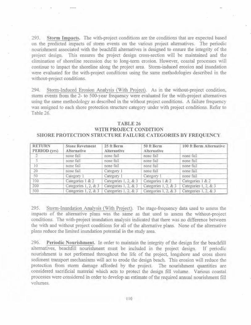
291. Storm Impacts. The with-project conditions are the conditions that are expected based on the predicted impacts of storm events on the various project alternatives. The periodic nourishment associated with the beachfill alternatives is designed to ensure the integrity of the project design. This ensures the project design cross-section will be maintained and the elimination of shoreline recession due to long-term erosion. However, coastal processes will continue to impact the shoreline along the project area. Storm-induced erosion and inundation were evaluated for the with-project conditions using the same methodologies descnoed in the v.1thout-project conditions.
294. Storm-Induced Erosion Analysis (With Project). As in the without-project condition, storm events from the 2- to 500-year frequency were evaluated for the with-project alternatives using the same methodology as described in the without project conditions. A failure frequency was assigned to each shore protection structure category under with project conditions. Refer to Table 26.
TABLE26 WITH PROJECT CONDITION
SHORE PROTECTION STRUCTURE F AlLURE CATEGORIES BY FREQUENCY
RETURN Stone Re,•etment 25ft Berm 50 ftBerm 100ft Berm Alternat ive PERIOD (vrs) Alternative Alternative Alternative
2 none fail none fail none fail none fail 5 none fail none fail none fail none fail
10 none fail none fail none fail none fail 20 none fail Category l none fail none fail 50 Category I Category l Category l none fail 100 Categories I & 2 Categories I, 2, & 3 Categories 1 & 2 Categories 1 & 2 200 Categories 1, 2, & 3 Categories 1, 2, & 3 Categories J , 2, & 3 Categories 1, 2, & 3 500 Categones I. 2. & 3 Categories 1, 2, & 3 Categories 1. 2, & 3 Categories 1, 2, & 3
295. Storm-Inundation Analysis (With Project). The stage-frequency data used to assess the tmpacts of the alternative plans was the same as that used to assess the without-project conditions. The wtth-project inundation analysis indicated that there was no difference between the with and without project conditions for all of the alternative plans. None of the alternative plans reduce the limited inundation potential in the study area.
296. Periodic Nourishment. In order to maintain the integrity of the design for the beachfill alternatives, beachflll nourishment must be included in the project design. If periodic nourishment is not performed throughout the life of the project, longshore and cross shore sediment transport mechanisms will act to erode the design beach. This erosion will reduce the protection from storm damage afforded by the project. The nourishment quantities are considered sacrificial material which acts to protect the design fil1 volume. Various coastal processes were considered in order to develop an estimate of the required annual nourishment fill volumes.
110

297. The nourishment rates for design were developed considering long term historic erosion losses, volumetric analysis of recent profiles, beachfill losses due to the predicted rate of sea level rise, and losses due to storm induced erosion. The results of these analyses were compared and the volumetric requirements were combined to obtain the total nourishment needs for the alternatives.
298. Periodic nourishment at Oakwood Beach was determined to be 5,000 cy/yr for all design alternatives. An overfill factor of 1.25 is applied to the periodic nourishment estimate. For purposes of screening the alternatives, a 6 year nourishment cycle was assumed.
299. Sea Level Rise. An evaluation was completed in accordance with current COE guidance ER~ 1105-2-100 section 5-25, which requires that The National Research Council (NRC) study on sea level rise, Responding to Changes in Sea Level: Engineering Implications, 1987 be used until more definitive data become available. COE policy calls for consideration of designs, which are most appropriate for a range of possible future rates of rise. Strategies such as beachfill, which can be augmented in the future as more definitive information becomes available. should receive preference over those that would be optimal for a particular rate of rise, but unsuccessful for other possible outcomes.
300. ER 1105-2-I 00 recommends a sensitivity test be conducted to determine any effect sea level change would have on plan evaluation and selection. The analysis should use the extrapolation of the local, historical record of relative sea level rise as the low level and Curve III from the NRC report as the high LeveL Based on historical gauge records dating from 1900 at Philadelphia and from 1919 at Lewes, Delaware, relative sea level has risen at a rate of approximately 0. 9 to 1.0 feet per century within the tidal portion of Delaware River and Bay. For practical purposes, this extrapolates to a 0.5 foot rise in sea level over a 50-year project life. Curve III of the NRC report indicates a 1.4 foot rise over a fifty year project life. The principal function of the proposed beachfill alternatives is to provide a buffer between the Delaware River and the nearly continuous line of aging protective structures along Oakwood Beach. There is no inundation-reduction purpose served by the beachfill. If the proposed beachfill alternatives experience some measure of accelerated sea level rise over the project life, it is reasonable to assume that a minor adjustment to the configuration the fill profile, or to the rate of periodic nourishment, will be adequate to offset any impacts from incremental sea level rise. It is concluded that the potential for accelerated sea level rise does not affect plan selection or plan justification.
301. Economic Evaluation of Alternative Plans. Economic benefits were derived from reduction in storm damages as well as reduced Federal maintenance dredging costs for the beachfill alternatives, and were used to determine the optimal plan. The benefits leading to project optimization are summarized below.
302. Storm Damage Reduction Benefits. The altemative plans will reduce storm damages by reducing proft.le recession. Damages for the with-project alternatives were calculated using the same methodologies and databases previously detailed for the without-project conditions. Table
Ill

27 shows the average annual damages for each alternative by damage category. The benefits for any g1ven alternative are the difference between the without-project and with-project damages. Average annual storm damage reduction benefits (including reductions in improved property and shore protection structure damages) for each alternative plan are shown in Table 28. Table 29 shows the storm damage reduction benefits for each alternative adjusted to a March 1998 price level and 7.125% discount rate.
TABLE27 AVERAGE ANNUAL DAMAGES
FOR EACH ALTERNATIVE BY DAMAGE CATEGORY (DECEMBER 1996 PRICE LEVEL AND 7.375% DISCOUNT RATE)
Alternative Plans Damage Category Elevation Structure Shore Improved Total (ftNAVD) (including Protection Property
contents) Structures Stone -3.0 $308,000 $45,000 $28,000 $381,000 Revetment 25ft berm +6.0 $405,000 $70,000 $45,000 $520,000 50 ftbenn -r6.0 $308.000 $45,000 $28,000 $381,000 100ft berm +6.0 $277.000 $37,000 $23,000 $337,000
TABLE28 STORM DAMAGE REDUCTION BENEFITS BY ALTERNATIVE
(DECEMBER 1996 PRICE LEVEL AND 7.375% DISCOUNT RATE)
Alternative Elevation Without With Project Average Percent Plan (ft NAVD) Project Average Annual Storm Reduced
Average Annual Storm Damage Annual Storm Damages Reduction
Damages Benefits Stone +3.0 $884,000 $381,000 $503,000 57
Revetment 25ft berm +6.0 $884.000 $520,000 $364,000 41 50ft berm +6.0 $884,000 $381.000 $503,000 57 100ft berm +6.0 $884,000 $337,000 $547,000 62
112

TABLE29 STORM DAMAGE REDUCTION BENEFITS BY ALTERNATIVE
(MARCH 1998 PRICE LEVEL AND 7.US% DISCOUNT RATE)
Alternative Plan Average Annual Storm Damage Reduction Benefits
Stone Revetment $515,000 25ft benn $373,000 50ft benn $515,000 100ft benn $560,000
303. Reduced Federal Maintenance Dredging Benefits. Reduced Federal maintenance dredging benefits for the Reedy Island range of the Delaware River main channel is a benefit category applicable to the beachfill alternatives at Oakwood Beach. Use of the Delaware River main channel as a source of borrow for the beach.fill at Oakwood Beach for both initial construction and periodic nourislunent will reduce Federal maintenance dredging costs. Assuming the Delaware River 45 ft deepening project is completed in year 2000 prior to the completion of construction of the Oakwood Beach project alternatives in year 2002, the initial construction and subsequent periodic nourishment of the Oakwood Beach project alternatives will eliminate the need for maintenance dredging of the Reedy Island range for a number of years. Based on an estimated shoaling rate of 23,000 cy/yr and a 4 year maintenance dredging interval for the Reedy Island range (45 ft project), the Oakwood Beach project alternatives eliminate the need for maintenance dredging of Reedy Island through Oakwood Beach project year I 8 for the 50 ft berm plan, project year 22 for the 50 ft berm plan, and project year 30 for the 100 ft berm plan. This results in average annual reduced Federal maintenance dredging benefits of $167,000, $181 ,000 and $199,000 for the 25 ft. 50 ft, and 100 ft berm plans respectively. Refer to Table 30.
TABLE30 REDUCED FEDERAL MAINTENANCE DREDGING BENEFITS (MARCH 1998 PRICE LEVEL AND 7.125% DISCOUNT RATE)
Alternative Plan Quantity (cy) Average Annual Reduced Federal Maintenance Dredging Benefits
25ft benn 430,000 $167,000 50ft benn 527,000 $181 ,000 100ft berm 723,000 $199,000
304. Economic Optimization of Alternative Plans. Optimization of the alternatives is based on the benefit category of storm damage reduction benefits as well as reduced Federal maintenance dredging benefits for the beachfill alternatives. A periodic nourishment cycle of 6 years for the beachfill alternatives was assumed for screening purposes. The initial construction
11 3

costs for each alternative, as well as the periodic nourishment costs associated with the beachfill alternatives are shown in Table 31. For the beachfill alternatives, two different dredging methods were given consideration. Consideration was given to use of both a hopper dredge (coincident with maintenance dredging of the Delaware River main channel) and a hydraulic pipeline dredge (independent contract). Use of a hydraulic pipeline dredge was determined to be more economical for initial construction and use of a hopper dredge (coincident with maintenance dredging of the Delaware River main channel) more economical for periodic nourishment Cost estimates are therefore based on use of a hydraulic pipeline dredge for initial construction and a hopper dredge (coincident with maintenance dredging of the Delaware River main channel) for periodic nourishment.
TABLE31 rNITlAL CONSTRUCTION AND PERIODIC NOURISHMENT
QUANTITIES AND COSTS FOR EACH ALTERNATIVE
INITIAL QUANTITIES AND COSTS
Alternative Elevation Initial Quantity (includes Total Cost (ft NAVD) advanced nourishment for (March 1998 P.L)
beachfill alternatives) (cubic yards of stone or sand)
Stone Revetment ( + 3.0 ft) 31,000 $5,976,000 25ft berm (+6.0 ft) 4.30,000 $3,685,000 50ft berm (+6.0 ft) 527,000 $4,116,000 IOO ft berm (+6.0 ft) 723,000 $5,098,000
PERIODIC NOURISHMENT QUANTITIES AND COSTS (6 YR CYCLE)
Alternative Elevation Quantity (cubic yards) (includes Total Cost (ft NAVD) an overfill factor of 1.25) (March 1998 P.L.)
25 ft berm (+6.0 ft) 30,000 $688,000 50 ft berm (+6.0 ft) 30,000 $688,000 100ft berm (+6.0 ft) 30,000 $688,000
305. Initial construction costs for each with-project alternative, including periodic nourishment costs for the beachfill alternatives, are annualized for comparison to the average annual benefits for each alternative. Costs are annualized over a 50 year project life at an FY 1998 discount rate of 7.125%. The average annual costs are subtracted from average annual benefits to calculate net benefits and determine the optimal plan which maximizes net benefits. Table 32 shows average annual benefits and costs. net benefits and the benefit-cost ratios associated with each alternative.
114

TABLE32 BENEFIT/COST MATRIX FOR WITH-PROJECT ALTERNATIVES
(MARCH 1998 PRICE LEVEL AND 7.125% DISCOUNT RATE)
Stone 25ft Berm 50ft Berm 100ft Berm Revetment
Average Annual Benefits Storm Damage Reduction 515,000 373,000 515,000 560,000 Reduced Federal Maintenance Dredging Costs 167,000 1&1,000 199,000
Total Average Annual Benefits 515,000 540,000 696,000 759,000 Average Annual Costs 479,000 393,000 425,000 498,000 Net Benefits 36,000 147,000 271,000 261,000 Benefit-Cost Ratio 1.1 1.4 1.6 1 5
Average Annual Costs include Interest During Construction (IDC) and Real Estate costs.
306. IDENTIFICATION OF THE NED PLAN. The National Economic Development (NED) plan is defined as the plan that maximizes beneficial contributions to the Nation while meeting the planning objectives. The NED plan is the plan that maximizes net benefits. The 50 ft berm plan is identified as the NED plan. This plan provides the maximum net benefits.
307. ECONOMICS OF THE NED PLAN. Table 33 shows the average annual residual damages for the structures (including contents) for the NED plan by reach and damage mechanism. Table 34 shows the total average annual residual damages (including structures, contents. shore protection structures, and improved property) for the NED plan. The residual damages for the NED plan equal $385,000 on an average annual basis. Table 35 presents the economics of the NED plan.
TABLE33 AVERAGE ANNUAL DAMAGES FOR STRUCTURES FOR NED PLAN
(MARCH 1998 PRICE LEVEL & 7.U5% DISCOUNT RATE)
Erosion Inundation Total
Reach 1 8&,000 38,000 126,000
Reach 2 51.000 63,000 114,000
Reach 3 37,000 13,000 50,000
Reach 4 0 0 0
Reach 5 17,000 7,000 24,000
Total 193,000 121,000 314,000
115

TABLE34 AVERAGE ANNUAL DAMAGES
(STRUCTURES, SHORE PROTECTION STRUCTURES, & IMPROVED PROPERTY) (MARCH 1998 PRICE LEVEL & 7.125% DISCOUNT RATE)
Reach 1 Reach 2 Reach 3 Reach 4 Reach 5 Total
Structures Shore Protection Improved Property Structures
126,000 21.000 114,000 9,000 50.000 6,000
0 0 24,000 8,000
314,000 44,000
TABLE35 ECONON.UCSOFNEDPLAN
Average Annual Benefits 696,000 Average Annual Costs 425,000 BCR 1.6 Net Benefits 271,000
12,000 7,000 4,000
0 4,000
27,000
Total
159,000 130,000 60,000
0 36,000
385,000
308. ECONOMIC OPTIMIZATION OF PERIODIC NOURISHMENT CYCLE. Once the NED plan was identified, the periodic nourishment cycle was economically optimized. Quantities for the 2 through 9 year nourishment cycles are shown in Table 36. Initial construction and periodic nourishment costs were computed for the cycles. Table 37 shows the economic comparison of the nourishment cycles including average annual costs, average annual benefits, net benefits and BCR. The 8 year cycle is the economically optimal cycle. Cost estimates for placement of beachfill at Oakwood Beach in 4 year intervals assume reductions in costs due to coincidental Federal maintenance dredging operations in the Delaware River at Reedy Island range.
I 16

TABLE36 PERIODIC NOURISHMENT QUANTITIES (CUBIC YARDS)
(2 THROUGH 9 YEAR NOURISHMENT CYCLES)
Nourishment Cycle Initial Construction Quantities Periodic Nourishment (years) (includes advanced nourishment) Quantities (cubic yards)
(cubic yards)
2 507,000 10,000 3 512,000 15,000 4 517,000 20,000 5 522,000 25,000 6 527,000 30,000 7 532,000 35,000 8 537,000 40,000 9 542,000 45,000
TABLE37 BENEFIT-COST COMPARISON FOR PERIODIC NOURISHMENT
(2 THROUGH 9 YEAR CYCLES) (7.125%, MARCH 1998 PRICE LEVEL)
Nourishment Cycle Average Annual Average Annual Net Benefits (years) Benefits Costs
2 696,000 568,000 121,000 .., J 696,000 531,000 158,000 4 696,000 418,000 I 271,000 5 696,000 457,000 232,000 6 696,000 433,000 256,000 7 696,000 432,000 257,000 8 696,000 377,000 312,000 9 696,000 407,000 282,000
BCR
1.21 1.30 1.65 1.51 1.59 1.59 1.83 1.69
309. REFINEMENT IN DESIGN OF NED PLAN. Prior to the final design of the NED plan it was determined that the slope of the berm foreshore could be steepened from 1 V :20H to lV:lOH. This resulted in an approximately 37% reduction in quantity and a 19% reduction in average annual costs of the NED plan. Prorating the quantities and costs of the other beachfill alternatives based upon these reductions and comparing them to associated reductions in potential benefits did not affect the outcome of the optimization analyses. The storm damage reduction benefits did not change as a result of the change in slope, however, the average annual reduced Federal maintenance dredging benefits were reduced from $181,000 to $149,000 due to the lesser quantity of material being removed from the channel. The 50 ft-wide berm was still identified as the NED plan. Design of the NED plan then proceeded with a berm slope of 1 V: 1 OH rather than 1 V :20H.
310. Average annual reduced Federal maintenance dredging benefits were further decreased from $149,000 to $130,000 following an adjustment made to have the maintenance dredging
117

cycle coincide with the periodic nourishment of the project. Assuming the Reedy Island range of the Delaware River 45 ft deepening project is completed in year 2002, the same year as the Oakwood Beach projec~ the initial construction and subsequent periodic nourishment of the Oakwood Beach project will eliminate the need for maintenance dredging of the Reedy Island range for a number of years. Based on an estimated shoaling rate of 23,000 cy/yr and a 4 year maintenance dredging interval for the Reedy Island range (45 ft project), the Oakwood Beach project eliminates the need for maintenance dredging of Reedy Island range up to Oakwood Beach project year 20. This corresponds to the elimination of four O&M dredging cycles. Should construction of the Reedy Island range of the Delaware River 45-foot Project never occur, reduced Federal maintenance dredging benefits would still accrue to a lesser degree under existing conditions. The proposed plan at Oakwood Beach would still be justified without deepening the Delaware River main channel. Appendix C (Economic Analysis) of the main report includes a benefit to cost analysis which assumes that the deepening project is not constructed
[ 18
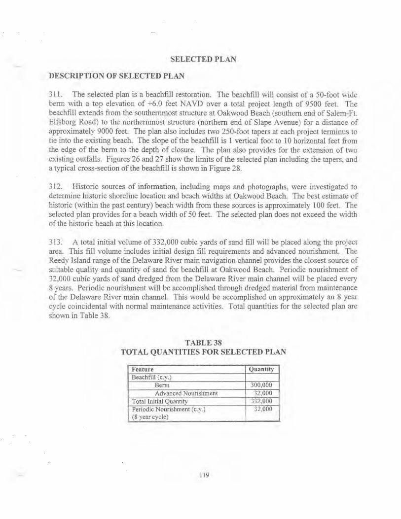
SELECTED PLAN
DESCRIPTION OF SELECTED PLAN
311. The selected plan is a beac.hfill restoration. The beachfill will consist of a 50-foot wide berm with a top elevation of +6.0 feet NA VD over a total project length of 9500 feet. The beachfill extends from the southernmost structure at Oakwood Beach (southern end of Salem-Ft. Elfsborg Road) to the northernmost structure (northern end of Slape Avenue) for a distance of approximately 9000 feet. The plan also includes two 250-foot tapers at each project terminus to tie into the existing beach. The slope of the beach fill is 1 vertical foot to 10 horizontal feet from the edge of the berm to the depth of closure The plan also provides for the extension of two existing outfalls. Figures 26 and 27 show the limits of the selected plan including the tapers, -and a typical cross-section of the beachfill is shown in Figure 28.
312. Historic sources of information. including maps and photographs, were investigated to determine historic shoreline location and beach widths at Oakwood Beach. The best estimate of historic (within the past century) beach width from these sources is approximately l 00 feet. The selected plan provides for a beach width of 50 feet. The selected plan does not exceed the width of the historic beach at this location.
313. A total initial volume of332,000 cubic yards of sand fill will be placed along the project area. This fill volume includes initial design fill requirements and advanced nourishment. The Reedy Island range of the Delaware River main navigation channel provides the closest source of suitable quality and quantity of sand for beachfill at Oakwood Beach. Periodic nourishment of 32,000 cubic yards of sand dredged from the Delaware River main channel will be placed every 8 years. Periodic nourishment will be accomplished through dredged material from maintenance of the Delaware River main channel. This would be accomplished on approximately an 8 year cycle coincidental with normal maintenance activities. Total quantities for the selected plan are shown in Table 38.
TABLE38 TOTAL QUANTITIES FOR SELECTED PLAN
Feature Q uantity Beachfill (c.y.)
Berm 300,000 Advanced Nourishment 32,000
Total Initial Quantity 332,000 Periodic Nourisl1ment ( c.y .) 32.000 (8 year cycle)
119

DELAWARE RIVER
0 0 -tv 0
0 c;; OC:J
D
0 D Qo ~
0 ' /)
_.--:~:-
0 0
0 ()Jl o,g o ' ·o D o 0 0 o ·" o
(Jnr
... N -
Delaware Bay Coastline, DE & NJ Oakwood Beach, NJ
Feasibility Study
SELECTED PLAN LAYOUT
PHILADELPHIA DISTRICT, CORPS OF ENGINEERS

Q N ..
--~-DELAWARE RIVER
~~----------------------- UN~~~~----------------------~~--~~ fOR sa..ECTED PlM
t POTENTIAL PUBLIC ACCESS AREAS
Delaware Bay Coastline, DE & NJ Oakwood Beach, NJ
Feasibility Study
SELECTED PLAN LAYOUT
PHILADELPHIA DISTRICT, CORPS OF ENGINEERS
~ L-----------------------------------------------------------====================~

~
0 > <{ z
............. ~ lL
- z IV tv
z 0 f-<{
> w _j w
10 ELEV.
5
0
-5
---~
VARIES '\
DESIGN LINE
DESIGN TEMPLATE
'-----___ /EXISTING PROFILE
-------------10--r---------~--------~--------~--------~--------~~--
-100 0 100 200
DISTANCE (FT.)
300 400
Delaware Bay Coastline, DE & NJ Oakwood Beach, NJ
Feasibility Study
SELECTED PLAN DESIGN TEMPLATE
PHJL, ADEI, PHIA DISTRICT, CORPS OP ENGINEERS

314. The granular material located in the proposed project borrow area may be classified as a poorly graded medium to coarse sand with some gravel. The borrow material is coarser than the granular material currently located on Oakwood Beach, and is significantly coarser than any other source of borrow used by the Philadelphia District anywhere in its beachfill progran1. As such, it is expected that the borrow material will have a long residence time on the beach. Based upon experience and additional vibrocore information, an overfill factor of 1.0 is applied to the selected plan quantities. More than enough quantity has been identified to provide the Oakwood Beach project with beach-quality sand for the entire life ofthe project.
REAL ESTATE
315. Refer to the Real Estate Plan as prepared by the Baltimore District in Appendix D which includes an assessment of the non-Federal sponsor's acquisition capabilities, baseline Real Estate cost estimate. and the Real Estate mapping.
PUBLIC USE AND ACCESS
316. SHORELINE OWNERSIUP. The shoreline at Oakwood Beach consists of seventy-five privately-owned parcels and one commercially owned parcel. The owners of these properties own the land out to the Mean High Water Line (MHWL). The bayward edge of these properties will be impacted by the proposed project. The construction, operation and maintenance of the proposed project will require a standard perpetual beach nourishment easement over 3.34 acres. Submerged lands below the Mean High Water Line (MHWL) of the Delaware River to the Mean Low Water Line (MLWL) are owned by the State of New Jersey and managed by the NJDEP Bureau of Tidelands Management The ML WL demarcates the state boundary between New Jersey and Delaware with Delaware owning the submerged land from the ML WL on the New Jersey shoreline to the MHWL on the shoreline of Delaware.
317. PUBLIC USE. Oakwood Beach is currently not a tourist destination nor is it anticipated to be following project construction. Recreational benefits are not being claimed for the project. The primary project purpose is hurricane and storm damage reduction. Changes in the visitation volume from the existing condition as a result of the project are anticipated to be minimal. Nearby townships that have small beaches along the Delaware River do not attract visitors from outside the immediate area. Nearby street parking is unrestricted and is expected to accommodate all anticipated public use. Non-residents that use the area now are primarily boaters that use the Salem River and Cove.
318. PUBLIC ACCESS. Public pedestrian access to the beach will be provided approximately every one-half mile. The non-Federal sponsor is responsible for maintaining the access ways. The final location and dimensions of these access points will be coordinated with the sponsor and the local community during the development of plans and specifications. The most likely locations as proposed by local township officials to date are shown on Figures 26 and 27. Coordination is ongoing to identify other areas as well. The easements required to provide public use of and access to the beach are interests beyond those required to construct, operate,
123
and maintain the project. The value of such easements is not included in total project costs and credit shall not be provided to the non-Federal sponsor.
PROJECT MONITORING PLAN
3 19. A beachfill project has a limited longevity and must undergo periodic inspection, maintenance and renourishment in order to preserve project functionality over the designed lifetime. The project monitoring plan will evaluate beachfill performance and determine conditions within the borrow areas over the project life. Periodic assessments and monitoring data analysis will assist in producing recommendations for modifications to the quantities, locations~ and cycle of future fills based on actual trends of fill behavior. The monitoring progratn for Oakwood Beach was developed in accordance with ER-1110-2-1004, ER-1110-2-1407, CETN-II-26, and CETN-II-35. The following items are to be included in the project monitoring plan: Pre-- and post-construction beach proftle surveys, annual monitoring proftle surveys, sediment sampling of beach and borrow areas, aerial photography. and vibrocore testing in the borrow area. The field data collection will be followed up by lab and data analyses. The proposed monitoring program will begin at the initiation of pre-construction efforts and will continue throughout the project life. The project monitoring plan is associated with the continuing construction of the project and will be cost-shared as a project cost. Costs of the project monitoring plan are estimated at $9~000 annually.
NED BENEFITS SUMMARY
320 Table 39 presents a summary of the average annual NED benefits associated with the selected plan.
TABLE39 AVERAGE ANNUAL NED BENEFITS OF SELECTED PLAN
MARCH 1998 PRICE LEVEL FY 98 DISCOUNT RATE OF 7.125%
Benefit Category Benefits
Structures and Contents $365,000 Shore Protection Structures $ 98,000 Improved Property $ 55,000 T ota1 Storm Damage Reduction Benefits $518,000 Reduced Federal Maintenance Dredging Costs $130,000 TOTAL $648,000
PROJECT IMP ACTS
321. . IMP A~S TO E~ONMENT AL RESOURCES. The following paragraphs descnbe the envtrorunental Impacts associated with the selected plan. As part of the berm restoration approximately 23.7 acres will be covered, of this approximately 3.3 acres. will be intertidal and 20.4 acres will be below mean water.
124

322. Impacts on Vegetation. The selected plan wil1 prevent the erosion of the shore and thus prevent the loss of vegetated yards. The berm would provide a new habitat for beach plants to colonize.
Impacts on Wetlands. Since there are no wetlands on the site none will be impacted.
324. Impacts on Water Quality. The selected plan may have a short-term effect on turbidity levels during both excavation of the borrow site and the placement of sand along the shore. Elevated levels of particulate concentrations at the discharge location may also result from "washout'' after beachfill is placed. The river current in this area should carry the limited turbidity out of the area in a short time period. High turbidity levels can stress aquatic organisms by clogging respiratory organs. The turbidity may also decrease the hunting capacity of visual predators. To minimize these effects, a proper erosion and sediment control plan shall be implemented during the construction phase.
325. Short-term adverse impacts to water quality in the immediate vicinity of the dredging and placement site can occur. Aquatic ecosystems concentrate biological and chemical substances such as organic matter. nutrients, heavy metals, and toxic chemical compounds in bottom sediments. When introduced into the water column, these substances tend to bind with suspended particulate matter and eventually settle to the bottom. Dredging operations typically elevate levels of suspended particulates in the water column through excessive agitation of the sediment. Adverse impacts to the water quality may include oxygen depletion and the release of chemical substances. making them biologically available to aquatic organisms through ingestion or respiration.
326. The borrow material bas very little chemical contamination. The use of sand, coupled with the absence of nearby dumping activities, industrial outfalls, or contaminated water infer the low probability that the borrow material is highly coot:anllnated by pollutants.
327 _ The selected plan should have limited or no impact on pH, nutrient levels, bacteria, or DO. It also should not change the DRBC characterization of the water as fair to good.
328. Impacts on Finfish. The selected plan will have limited and short-term impact on finfish. With the exception of some small finfish, most bottom dwelling and pelagic fishes are highly mobile and should be capable of avoiding turbidity impacts due to placement and dredging operations. It is anticipated that some finfish may become attracted to the turbiclity plume due to the suspension of food particles in the water column. The primary impact to fisheries will be felt from the disturbance of benthic and epibenthic communities. The loss of the benthos and epibentbos smothered during berm construction and removal during borrow activity will temporarily disrupt the food chain in the impacted areas. These effects are expected to be temporary as these areas become rapidly recolonized by pioneering species. Coordination with appropriate state and Federal agencies will occur to prevent construction during critical spawning and over wintering periods.
125

329. Jmpacts on Benthos. The primary ecological unpacts of dredging the sand borrow site will be the complete removal of the existing benthic corrununity through entrainment into the dredge. Mortality of the benthic and epibenthic organisms will occur as they pass through the dredge and/or as a result of being transplanted into an unsuitable habitat. A benthic study performed tor the Delaware Estuary Program did not show significant differences between the navigation channel and the shallow/intermediate zone. The navigation channel should recover to predredged conditions. Benthic pioneer species will move in from neighboring areas. There will be an 1m pact due to burial of the benthic community during placement activities in the intertidal and nearshore zone. The Delaware Estuary Program's study showed that this area had a lower density and biomass of benthic organisms than the other areas. This habitat should recover due to recruitment from surrounding areas.
3 30. Impacts on Shellfish. There will be a short-term IIDpact due to burial of bivalves during placement activities in the intertidal and nearshore zones. This habitat should recover due to recruitment from surrounding areas and vertical migration through the sediment. The more mobile shellfish such as the blue crab will avoid the area during placement.
33 1. Impacts on Wildlife. The selected plan will have only short-term effects on wildJife. Most of the wildlife will av01d the construction area due to the noise of the construction activity. The wildlife will return to the area quickly after completion of the work.
332 Impacts on Threatened and Endangered Species. The selected plan should have no effect on Federally listed threatened or endangered species. The occasional transients will avoid the construction activity. Dredging and placement will be timed and performed in such a manner as to l.irrut the impact to sea turtles and shortnose sturgeon.
333. The diamondback terrapin occurs primarily in emergent wetlands and shallow water habitat. It is expected that this species will not benefit from a berm restoration project, but will not be adversely impacted by a berm restoration project.
334. Visual Impacts. The selected plan will provide a continuous vista, made up of one type of shore protection structure. It will remove the haphazard view that is there presently. It will also provide a more natural look to the shoreline.
335. Impacts on Air Quality and Noise Level. Minor short-term impacts to air quality and noise levels would result from the construction phase of the selected plan. Dredging activities and grading equipment would produce noise levels in the 70 to 90 dBA (50 feet from the source) range. The noise would dissipate with distance. Ambient air quality would also be temporarily degraded, but emission controls and limited duration aid in minimizing the effects. The noise levels and air quality impact would be limited to those produced by heavy equipment. No longterm significant impacts to the local air quality are anticipated.
126

336. Impacts on Recreation. The selected plan wilJ provide opportunities for bird watching and fishing. There might be an increase in use of the area by nonresidents when additional public access points are established.
337. IMPACTS TO CULTURAL RESOURCES. Proposed project construction has the potential to impact cultural resources in three areas. These are the existing beach shoreline. the submerged near-shore sand placement area and the channel borrow area. In the beach and nearshore sand placement areas, potential impacts to cultural resources could be associated with the placement and compaction of sand during berm construction. Dredging activities in the channel borrow area could impact submerged cultural resources.
338. On the basis of the current project plan, the Corps is of the opinion that sand placement within the 50 foot wide shoreline and near-shore areas will have no effect on significant cultural resources. The soil deposits within tills very narrow 50 foot wide area have been severely eroded and reworked up to the existing shore protection strucrures. Because the likelihood for intact and undisturbed cultural resources .is considered extremely minimal due to this disturbance, no cultural resources investigations were conducted in this area.
339. Project construction will be conducted on the river-side of the existing shore protection structures and will have no effect on existing residential structures located adjacent to the construction area.
340. The project borrow area was investigated for cultural resources in 1993 as part of the larger Delaware River Channel Deepening project (Cox 1995). Previously undredged areas in the channel borrow area, including selected channel and channel side-slope areas, were investigated by remote sensing. Results of this study showed that no significant targets exhibiting cultural resources characteristics were located in the borrow area.
341. Considering the severely eroded conditions of the project area shoreline and the results of previous cultural resources investigations in the project borrow area, the Philadelphia District finds that the proposed project, as detailed in the Feasibility Report, will have no effect on significant cultural resources. Under Section 106 consultation, both the New Jersey and Delaware State Historic Preservation Offices support the No Effect decision.
342. GEOTECHNICAL IMP ACTS. The implementation of the selected plan will entail cutting a deeper channel into the Mount Laurel-Wenonah formation where it outcrops in the Delaware River main channel. A large portion of the Mount Laurel-Wenonah formation is currently directly exposed to the waters of the Delaware River in the vicinity of the project.
343. A review of available literature suggests that the Mount Laurel-Wenonah aquifer has already suffered some limited salt-water intrusion. by vertical leakage from the overlying Vincentown and Cape May formations and also potentially from where it currently daylights in the Delaware River main channel.
127

344 The hydraulic gradient of the aquifer runs from central New Jersey to the southwest and toward the Salem and Delaware Rivers. The potential for local reversal of this gradient exists due to overpumping, especially in the times of drought.
345. The selected plan will sllghtly increase the exposure of the Mount Laurel-Wenonah aquifer to waters of the Delaware River. However, the dredging action will not require the removal of any fme-grained sediment which would act as an aquiclude or an aquitard. The sednnent which is proposed to be removed from the borrow area is a coarse sand with some gravel-sized particles. As such the hydraulic conductivity of the material can be estimated from literature as 30 to 3000 feet per day.
346. Since the high permeability MoWlt Laurel-Wenonah aquifer is already directly exposed to the Delaware River. the potential for salt-water intrusion into the aquifer in the vicinity of the project already exists. The minimal additional exposure of the aquifer to the brackish water of the Delaware River is considered negligible. However, in an effort to minimize the area exposed, dredged cut depths will be kept as small as possible. It is estimated that the additional area of aquifer exposed to the Delaware River will be approximately 50,000 square feet over a two-mile stretch of the river.
147. HAZARDOUS, TOXIC AND RADIOLOGICAL \VASTE ASSESSMENT. ln accordance with ER 1165-2-132 entitled Hazardous, Toxic and Radioactive Wastes (HTRW) Guidance fot CiVIl Works Projects, dated 26 June, 1992, the Corps of Engineers is required to conduct investigations to determine the existence, nature and extent of hazardous, toxic and radioactive wastes wtthin a project impact area. Hazardous, toxic and radioactive wastes are defined as any "hazardous substance" regulated under the Comprehensive Environmental Response, Compensation and Ltability Act (CERCLA), 42 U.S.C. 9601 et seq, as amended. Hazardous substances regulated under CERCLA include "hazardous wastes" under Section 3001 of the Resource Conservation and Recovery Act (RCRA), 42 U.S.C. 6921 et seq; "hazardous substances" identified under Section 311 of the Clean Air Act, 33 U.S.C. 1321, "toxic pollutants" designated under Section 307 ofthe Clean Water Act, 33 U.S.C. 1317, "hazardous air pollutants" designated under Section 112 ofthe Clean Air Act, 42 U.S.C. 7412, and "imminently hazardous chemical substances or mixtures'' that EPA has taken action on under Section 7 of the Toxic Substance Control Act, 15 U.S C. 2606
348. A preliminary assessment was conducted for the Oakwood Beach study area to determine the potential of encountering HTR W during property acquisition and construction. A thorough literature search identified no areas of concern within a 2 mile radius of the Oakwood Beach shoreline. A report prepared by Environmental Risk Information and Imaging Services (ERJIS) for the U.S. Army Corps of Engineers Philadelphia District was the primary reference used to identify any HTRW concern sites in the study area. ERIIS is a service which provides information from numerous Federal and state environmental databases which monitor HTRW. As such, a Corps of Engineers project at Oakwood Beach will neither be impacted by nor will it 1m pact upon any HTR W sttes.
!28
349. The Greely-Polhemus Group, Inc .. prepared the report "Delaware River- Philadelphia to the Sea Chemical Analysis of Sediments'' for the US Anny Corps of Engineers (Urie and Ettinger, I 995). This report characterized chemically and geotechnically the sediment present in the navigational charmel of the Delaware River. Sediment cores were obtained using vibrocore equipment from two sites (DRV-13-94 and DRV-14-94) in the Reedy Island range of the Delaware River, the location of the proposed project borrow area. Refer to Figure 29 The cores, which were approximately ten feet in length, were subdivided based on sediment stratification. Each sample was subjected to extensive chemical and geotechnical analysis. Bulk sediment analyses were conducted to quantify the levels of metals, pesticides. PCBs volatile organic compounds, semivolatile organic compounds, and total organic carbon (TOC). In addition, Toxicity Characteristic Leaching Procedure (TCLP) testing was conducted on the sediment to determine the potential for contaminant release. Particle size analysis was performed to characterize the nature (i.e., amounts of gravel, sand, and sjlt/clay) of the sediment at each sampling location.
350. Site DRV-13-94 was well oxygenated (9.0 mg/1). Sediment grain size distribution was dominated by sand and gravel to 38 mm, with very little (I .3%) silt/clay (grain size < 0.075 mm). Measured total organic carbon was 0.0% in the top 3.5 feet of sediment. The sediment grain size distribution below this was dominated by sand and gravel to I 9 m.m, with 6.0% smaller than 0.075 rnrn (silt/clay) in size. Site DRV-14-94 had a sediment grain size distribution that was dominated by sand and gravel to 19 mm, with 5.0% smaller than 0.075mm (silt/clay) in size, in the top 7.9 feet of sediment. Below this point the sediment grain size distribution was dominated by sand and gravel to 38 mm, with 3.3% smaller than 0.075 (silt/clay) in size.
351. Table 40 lists the metals that were detected. Site DRV-13-94 showed a cadmium level (top segment - I .1 00 mg/kg, bottom segment - 2.2 I 0 rng/kg) that was slightly higher than the Residential Criteria (1 mg/kg) but much lower than the Non-Residential Criteria (100 mg/kg). These Criteria are from the New Jersey Department of Environmental Protection's "The Management and Regulation of Dredging Activities and Dredged Material in New Jersey's Tidal Waters (October 1997). At both sites acetone was detected at a level that was below the Residential and Non-Residential Criteria (1000 mglkg). The levels at DRY -13-94 were 0.0124 and 0.0131 mglkg for the top and bottom segments respectively, while the levels at DRV-14-94 were 0.0111 and 0.0109 mg/kg for the top and bottom segments respectively. Acetone is a common laboratory solvent, and it is most likely that the detection of acetone is the result of laboratory contamination rather than contaminants in the sediments. No other chemical contaminants were detected. The New Jersey Department of Environmental Protection has approved use of this material for beach nounslunent through issuance of a water quality certificate and a consistency determination with their Coastal Zone Management Regulations.
129

liQLNlJ
1994 SAUPt( lUCAtiiiiiS
• onv-12-9-t
SCAli 0 18000
lmr&t<:-...n ;;m;J . ri"fi
MJ\ ICII L!t!U_J liE I
FIGUI~[ :1-q VIOI~ OCOJ~[ AND OCI'r!IIIC MACI<OINVCI~ IEIJI~A ll SAiviPL[ LOCI\ liONS ORA,,; OY'·
SliS DAil: 12/7 /9•1
DEL/\W/\I~E (~IVEH - PI·IIL/\DlLPHI/\ 10 Ill[ SLJ\ Cll[tv11CAL ANAlYSIS ur SCDIM[I'I rs. c••tC1ltO o• lJI( f)( 14~ ,,.,
IS029Gil!> iii'"ii'O·
l~tO?!l.OG IDu
i '" =lOtlllll
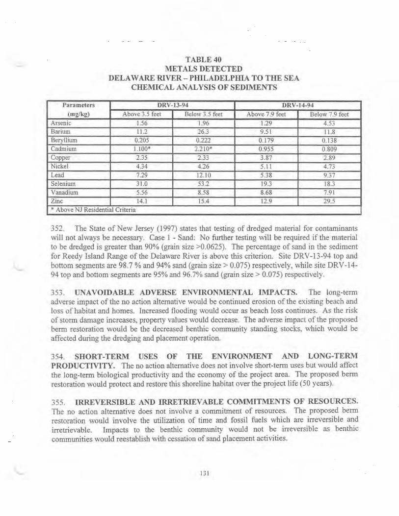
Parameters (mg/kg)
Arsenic Barium Beryllium Cadmium Copper Nickel Lead Selenium Vanadium Zinc
TABLE40 METALS DETECTED
DELAWARE RIVER- PHILADELPIDA TO THE SEA CHEMICAL ANALYSIS OF SEDIMENTS
DRV-13-94 DRV-14-94 Above 3.5 feet Below 3.5 feet Above 7.9 feet Below 7.9 feet
1.56 1.96 1.29 4.53 11.2 26.3 9.51 11.8
0205 0.222 0.179 0.138 1.100* 2.210* 0.955 0.809 2.35 ") ..,"'
-.~:J 3.87 2.89 4.34 4.26 5.11 4.73
7.29 12.10 5.38 9.37 31.0 53.2 19.3 183
5.56 8.58 8.68 7.91 14.1 15.4 12.9 29.5
* Above NJ Residential Criteria
352. The State of New Jersey (1997) states that testing of dredged material for contaminants will not always be necessary. Case 1 -Sand: No further testing will be required if the material to be dredged is greater than 90% (grain size >0.0625). The percentage of sand in the sediment for Reedy Island Range of the Delaware River is above thjs criterion. Site DRV-13-94 top and bottom segments are 98.7% and 94% sand (grain size> 0.075) respectively, while site DRV-14-94 top and bottom segments are 95% and 96.7% sand (grain size> 0.075) respectively.
353. UNAVOIDABLE ADVERSE ENVIRONMENTAL IMPACTS. The long-term adverse impact ofthe no action alternative would be continued erosion of the existing beach and loss of habitat and homes. Increased flooding would occur as beach loss continues. As the risk of storm damage increases, property values would decrease. The adverse impact of the proposed berm restoration would be the decreased benthic community standing stocks, which would be affected during the dredging and placement operation.
354. SHORT-TERM USES OF THE ENVIRONMENT AND LONG-TERM PRODUCTIVlTY. The no action alternative does not involve short-tem1 uses but would affect the long-term biological productivity and the economy of the project area. The proposed berm restoration would protect and restore this shoreline habitat over the project life (50 years).
355. IRREVERSIBLE AND IRRETRIEVABLE COMMITMENTS OF RESOURCES. The no action alternative does not involve a commitment of resources. The proposed berm restoration would involve the utilization of time and fossil fuels which are irreversible and irretrievable. Impacts to the benthic community would not be irreversible as benthic commuruties would reestablish with cessation of sand placement activities.
I 31
356 CUMULATIVE EFFECTS. Cumulative impacts as defined by CEQ regulations are the "impact on the environment which results from the incremental impact of the action when added to other past, present and reasonably foreseeable future actions regardless of what agency (Federal or non-Federal) or person undertakes such other actions. Cumulative impacts can result fwm individually minor but collectively significant actions talcing place over a period oftime."
357. Berm restoration projects are becoming increasingly common in coastal areas of high development. Numerous beach nourishment projects have been conducted along the Atlantic Ocean and Delaware Bay coasts since the 1960's by local, state. and Federal agencies, as well as private interests. Depending on circumstances such as the methods utilized to alleviate the coastal erosion and ensuing storm damages and the existing ecological and socio-econorruc conditiOns. it is difficult to gauge the net cumulative effects of these actions. The scientific literature generally supports beachfill projects over structural alternatives. If properly planned, tmpacts are short-term resultmg m minor ecological effects.
358 Since this project was designed to minilmze adverse environmental effects of all types the project should not culminate in adverse cumulative impacts on ecological or socio-economic resources. and should result in the overall improvement of the ecosystem.
359. There are a number of other Corps' projects planned in the Delaware Bay that involve either shoreline protection or ecosystem restoration. The Delaware River Main Channel Deepening Project would restore approximately 135 acres of tidal wetlands at Egg Island Point, New Jersey, and 60 acres at Kelly Island. Delaware. In addition, approximately 2 miles of tidal marsh would be protected with geotextile tubes from erosion. The proposed projects at Reeds Beach to Pterces Point, New Jersey and Villas and Vicinity, New Jersey provide for restoration of approximately 50 acres of horseshoe crab and shorebird habitat and 82 acres of horseshoe crab and shorebird habitat respectively. Another environmental restoration was evaluated at Port Mahon, Delaware, where approximately 21.4 acres of tidal marsh would be restored, as well as 4,900 feet of beach restoration. All of these projects have been planned in coordination with the appropriate state and Federal resource agencies, and should be valuable to fish and wildlife resources, especially horseshoe crabs and shorebirds. The Maurice River, New Jersey project was terminated due to emergency action undertaken by the sponsor. On the Delaware side, a final report was completed in May 1997 for a beach restoration project at Roosevelt Inlet-Lewes Beach. The project entails a small beachfill plan using the inlet as the borrow source and reconstructing the south jetty. No opportunity for ecosystem restoration was identified. Impacts to the area are minimal since the inlet is regularly maintained for navigation purposes. For the Broadkill Beach project, the fmal report was completed in October in 1996. The proposed project provides for a beachfill plan using an offshore borrow area Impacts to the borrow area are anticipated to be minimal.
360. MITIGATION MEASURES. Mitigation measures are utilized to minimize or mitigate for project in1pacts to environmental resources within the project area. The appropriate application of mitigation is to formulate a project that first avoids and then minimizes adverse impacts and last, compensates for unavoidable impacts.
l ... ~ .l-
361. Mitigation measures are either institutional in that environmental mit1gat10n is inherent in project alternative selection, or as measures incorporated into the construction and operation and maintenance of the project. The selection of a previously disturbed area as a borrow site reduces the impacts to the benthic environment. In addition, construction will occur during times when impact to spawning or overwintering shortnose sturgeon and sea turtles will be minimized.
362. The majority of the unavoidable impacts are likely to be incurred by the benthic communities within the borrow area and deposition site. One measure to reduce impacts includes conducting operations during months oflowest biological activity.
363. Air quality and noise impacts can be reduced by utilizing heavy machinery fitted with approved muffling apparatus that reduces noise, vibration, and emissions.
364. ENVIRONMENTAL JUSTICE. The selected plan described in this study complies with Executive Order 12989-Environmental Justice in Minority Populations and Low-Income Populations, dated February 11, 1994; and no impacts are expected to occur The project is not located in close proximity to a minority or low-income community area.
PROJECT COST ESTIMATE
365. INITIAL CONSTRUCTION COSTS. The estimated first cost for the selected plan is $3,314,000 (March 1998 price level) which includes real estate acquisition costs (including administrative costs), pre-construction engineering and design (PE&D), construction management (S&A) and associated contmgencies. PE&D costs include preparatiOn of plans and specifications; geotechnical testing; environmental, cultural and pre-construction monitoring; and the development and execution of the Project Cooperation Agreement (PCA). A summary of the first cost is shown in Table 41.
366. PERIODIC NOURISHMENT COSTS. Periodic nourishment is expected to occur at 8 year intervals subsequent to the completion of initial constntction. Based on a volume of 32,000 cubtc yards for each nourishment cycle, the total cost per operation (or cycle) is estimated to be $567,000 (March 1998 pnce level). A cyclical nourishment cost of$749,000 is expected every 8 years less $182,000 in savings associated with additional capacity at Artifidal Island and elimination of dredging and transportation costs to Artificial Island.
367. MAJOR RENOURISHMENT COSTS. Major renourishment quantities were developed in accordance with ER Ill 0-2-1407 to identify additional erosional losses from the project due to higher intensity (low frequency) storm events. The periodic nounshment rates developed for the project alternatives already include losses due to more frequent storms. Major renourishment costs have been factored into future costs based on an event in project year 24 (approximately mid-life for the project) which would require major beach renourishment during periodic nourishment in year 24. Major renourisbment costs are based on a quantity of 1 00.000 cubic yards which is approximately one-third of the initial construction quantity. The cost of major renourishment along with periodic nourishment in year 24 is estimated at $1.651,000.
133

Description of Item Quantity
Acquisitions (0 1 02) I Condemnations (0 I 03) 1 Appraisals (0105) l Real Estate Payments I (0 115) Tota) Lands and Damages
Mobilization, 1 Demobilization, and Preparatory Work (02.03.01) Timber Pile Supports 6 (02.03.18.02.03) 30-lnch Diameter 25 Ductile Iron Pipe (02.03.18.15.05) 12-lnch Diameter 50 Ductile Iron Pipe (02.03.18.15.06) Total Relocations
Mobilization, 1 Demobilization and Preparatory Work (17.00.01) Sand Fill Placement 332,000 (17 00.16.02.01) Total Beach Replenishment
Pre-construction I Engineering and Design (PE&D) (30 )
Construction I Management (S&A) (31.)
Total Project First Cost Total Project First Cost (Rounded)
TABLE41 TOTALF~TCOSTSUMMARY
(MARCH 1998 PRICE LEVEL)
Unit Unit Price Estimated Amount
Lands and Damages (01.) Job LS $173,400 Job LS $15,500 Job LS $12,000 Job LS $20,800
$221,700
Relocations (02.) Job LS $6,169
EA $1,785 $10,710
LF $208.52 $5,213
LF $65.98 $3,299
$25,391 Beach Replenishment (17.0)
Job LS $487,129
CY $4.63 $1,537,160
$2,024,289
Preconstruction Engineering and Design (30.) Job LS $403,000
Construction Management (31.) Job LS $220,000
Project Total $2,894,380
$2,895,000
134
Contingency Total Amount
$26,010 $199.410 $2,325 $17,825 $1,800 $13,800 $3,120 $23,920
$33,255 $254,955
$741 $6,910
$1,606 $12,316
$782 $5,995
$495 $3,794
$3,624 $29,015
$58,455 $545,584
$230,574 $1,767,734
$289,029 $2,313,318
$60,450 $463,450
$33,000 $253,000
$419,358 $3,313,738
$419,000 $3,314,000
368. OPERATION, MAINTENANCE, REP AIR, REPLACEMENT, AND REHABILITATION (OMRR&R) COSTS. The operation and maintenance of the project is the responsibility ofNJDEP, the non-Federal sponsor. The annual operation and maintenance of the project includes annual surveys of four profile lines estimated at $4000 annually. Also included as part of the non-Federal sponsor's OMRR&R responsibilities will be an annual cost of $2000 to correct localized accumulation or depletion of the beach berm and foreshore. The annual cost for this maintenance is estimated to be $6,000 annually, and is based on operation and maintenance experience for similar beachfill projects within the Philadelphia District. The non-Federal sponsor bears the full financial responsibility for these OMRR&R activities.
369. INTEREST DURING CONSTRUCTION. Interest during construction is estimated at $88,000. It is assumed that the construction costs would be evenly distributed over the construction period. The duration of construction for the project is estimated at four months. The preconstruction engineering and design phase will begin two years prior to the start of construction. Therefore. in accordance with ER 11 05-2-l 00, paragraph 6-153. interest during construction was based on 28 months.
ANNUALIZED COSTS
370. Initial costs and periodic nourishment costs were provided for the project life plan design. The first cost was estimated at approximately $3,314,000 for the proposed plan using a March 1998 price level and a 7.125% discount rate. A periodic nourishment cost of $749,000 is e>..'Pected every 8 years less $182,000 in savings associated with additional capacity at Artificial Island and the elimination of dredging and transportation costs to Artificial Island. There are also approximately $9,000 in average annual costs, for monitoring, associated with the selected plan. Table 42 presents the annualization of these costs. Interest during construction mcluded a 4 month construction period as well as a 2 year preconstruction engineering and design phase prior to the start of construction. Interest during construction is estimated at $88,000. Table 42 summarizes the total average annual cost for the proposed plan estimated at $336,000.
ECONON.UCSOFTHESELECTED PLAN
371. The selected plan provides total average annual benefits of $648,000 at a total average annual project cost of $336,000. Interest during construction is estimated to be $88,000. Total average annual benefits and costs are displayed by category in Table 43. The resuJt is a benefitcost ratio of 1.9 with $312,000 in annualized net benefits.
COST APPORTIONMENT
372. The cost apportionment between the Federal and non-Federal total first cost of the selected plan under the Water Resources Development Act of 1986 is shown in Table 44. The selected plan has been shown to be economically justified on benefits associated with storm damage reduction and reduced Federal maintenance dredging benefits. There are no separable recreation features included with this project.
135
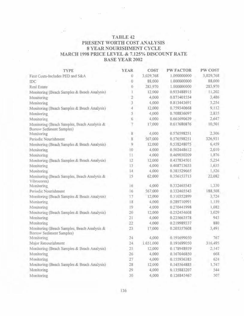
TABLE42 PRESENT WORTH COST ANALYSIS
8 YEAR NOURISHMENT CYCLE 1\'l.<\RCH 1998 PRICE LEVEL & 7.125% DISCOUNT RATE
BASE YEAR 2002
TYPE YEAR COST PWFACTOR PWCOST
F lfSt Costs-Includes PED and S&A 0 3,029,768 l .000000000 3,029,768
IDC 0 88.000 1.000000000 88,000
Real Estate 0 283,970 1.000000000 283,970
Momtoring (Beach Samples & Beach Analys1s) 12,000 0.933488915 11,202
Momtoring 2 4,000 0.871401554 3,486
Monitoring 3 4,000 0.813443691 3,254
Momtoring (Beach Samples & Beach Analysis) 4 12,000 0.759340668 9,112
Momtoring 5 4,000 0.708836097 2,835
Momtoring 6 4,000 0.661690639 2,647
Monitoring (Beach Samples, Beach Analysis & 7 17,000 0.617680876 10,501 Borrow Sediment Samples) Monitoring 8 4,000 0.576598251 2,306
Periodic Nounshment 8 567,000 0.576598251 326,931
Monitoring (Beach Samples & Beach Analysis) 9 12,000 0.538248075 6,459
Monitoring 10 4,000 0.502448612 2,010
Monitoring II 4,000 0.469030209 1,876
Monitonng (Beach Samples & Beach Analysis) 12 12,000 0.43783450 I 5,254
Momtoring 13 4,000 0.408713653 1.635
Monitoring 14 4,000 0.381529665 1,526
Monitoring (Beach Samples, Beach Analysis & 15 62,000 0.356153713 22.082 Vtbrocores) Momtoring 16 4,000 0.332465543 1.330
Penod1c Nounshment 16 567,000 0.332465543 188.508
Momtoring (Beach Samples & Beach Analysts) 17 12,000 0.310352899 3,724
Monitoring 18 4,000 0.289710991 1.159
Momtoring 19 4.000 0.270441998 1,082
Monitoring (Beach Samples & Beach Analysis) 20 12,000 0.252454608 3,029
Monitoring 21 4,000 0.235663578 943
Monitoring 22 4,000 0.219989337 880
Monitoring (Beach Samples, Beach Analys1s & ?" ~..> 17,000 0.205357608 3,491 Borrow Sediment Samples) Monitoring 24 4,000 0.191699050 767
Major Renourishment 24 1.651.000 0.191699050 316.495
Monitoring (Beach Samples & Beach Analys1s) 25 1:2,000 0.178948939 2.147
Monitoring 26 4.000 0.167046850 66R Monitoring 27 4,000 0.155936383 624 Monitoring (Beach Samples & Beach Analysis) 2S 12.000 0.145564885 U47
Monitoring 29 4,000 0.135883207 544
Monitoring 30 4,000 0.126845467 507
136

Monitoring (Beach Samples, Beach Analysis & 3\ 62,000 Vibrocores) Monitoring 32 4,000
Penodic Nourishment 32 567,000
Momtoring (Beach Samples & Beach Analysis) 33 12,000
Monitoring 34 4,000
Monitoring 35 4,000 Monitoring (Beach Samples & Beach Analys1s) 36 12,000 Monitoring 37 4,000 Monitoring 38 4000
Monitoring (Beach Samples, Beach Analysis & 39 17,000 Borrow Sediment Samples) Monitoring 40 4,000
Periodic Nourislunent 40 567,000
Monitoring (Beach Samples & Beach Analysis) 41 12,000
Monitonng 42 4,000
Monitoring 43 4,000
Monitonng (Beach Samples & Beacb Analysis) 44 12,000
Monitonng 45 4,000
Monitoring 46 4,000
Monitoring (Beach Samples, Beach Analysis & 47 62,000 Vibrocores) '
Monitoring 48 4,000
Perioclic Nourishment 48 567,000
Monitoring (Beach Samples & Beach Analysis) 49 12,000
Monitoring 50 4,000
CAPITAL RECOVERY FACTOR (50 YEARS@ 7.125%)
AVERAGE ANNUAL COSTS
O&MCOSTS TOTAL AVERAGE ANNUAL COSTS
Years l-50 all include $2,000 for Aenals and $2,000 for H&H Hired Labor
Years 15, 31 & 47 include $50,000 for Vibrocores
Years 7,23 & 39 include $5,000 for Borrow Sediment Samples
0.118408837 7,341
0.110533337 442
0.\10533337 62,672
0.\03 I 81645 1,238
0.096318922 385 0.089912646 360
0.083932458 1,007
0.0783 50019 313
0.073138874 293 0.068274329 ]J61
0.063733329 255 0.063733329 36,137
0.059494356 714
0.055537322 222
0.051843474 207
0.048395309 581
0.045176484 181
0.042171747 169
0.039366858 2 ,441
0 .036748526 147
0.036748526 20,836
0.034304342 412
0.032022723 128
TOTAL 4,480.432
0.073607100 329,792
6.000 335.792
Years [,4,7,9, 12,15,17.20,23,25,28,31,33,36.39,41,44.47, and 49 mclude $8,000 for Beach Samples and Analysis
Periodic Nourishment occurs on an 8 year cycle at $567,000
137
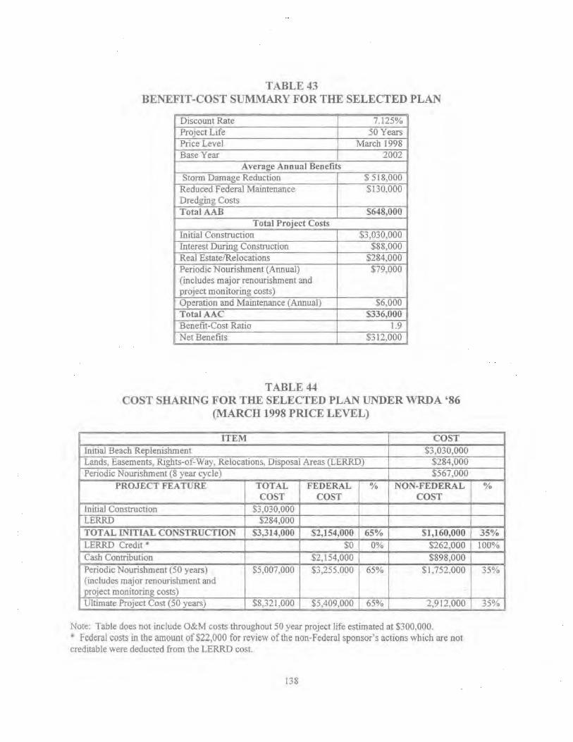
TABLE43 BENEFIT -COST SUMMARY FOR THE SELECTED PLAN
Discount Rate 7.125% Project Life 50 Years Price Level March 1998 Base Year 2002
Average Annual Benefits Storm Damage Reduction $ 518,000
Reduced Federal Maintenance $130,000 Dredging Costs TotalAAB $648,000
Total Project Costs Initial Construction $3,030,000 Interest During Construction $88,000 Real Estate/Relocations $284,000 Periodic Nourishment (Annual) $79,000 (includes major renourishment and project monitoring costs) Operation and Maintenance (Annual) $6,000 TotaiAAC $336,000 Benefit-Cost Ratio 1.9 Net Benefits $312.000
TABLE44 COST SHARING FOR THE SELECTED PLAN UNDER WRDA '86
(MARCH 1998 PRICE LEVEL)
ITEM COST Initial Beach Replenishment $3,030,000 Lands, Easements, Rights-of-Way, Relocations, Disposal Areas (LERRD) $284,000 Periodic Nourishment (8 year cycle) $567,000
PROJECT FEATURE TOTAL FEDERAL % NON-FEDERAL COST COST COST
Initial Construction $3,030,000 LERRD $284,000 TOTAL INITIAL CONSTRUCTION $3,314,000 $2,154,000 65% $1,160,000 LERRO Credit * $0 0% $262,000 Cash Contribution $2,154,000 $898,000 Periodic Nourishment (50 years) $5,007,000 $3,255.000 65% $1,752,000 (includes major renourislunent and project monitoring costs) Ultimate Project Cost (50 years) $8,321,000 $5,409,000 65% 2,912,000
Note: Table does not include O&M costs throughout 50 year project life estimated at $300,000. * Federal costs in the amount of$22,000 for review of the non-Federal sponsor's actions which are not creditable were deducted from the LERRO cost.
138
%
35% 100%
35%
35%

373. In accordance with Section 103 of the Water Resources Development Act of 1986 and appropriate Federal regulations, such as ER-1165-2-130, Federal participation in a project fonnulated for hurricane and storm damage reduction is 65 percent of the estimated total project first costs, including Lands, Easements, Rights-of-Ways, Relocations and Dredged Material Disposal Areas (LERRD). The estimated market value of LERRD provided by non-Federal interests is included in the total project cost, and they shall receive credit for the value of these contributions against the non-Federal cost share. Also included as part of LERRD are costs associated with the extensions of the outfall pipes for which the non-Federal sponsor will receive credit against the non-Federal cost share. The cost sharing for the Selected Plan is based on a total first cost of$3,314,000 and does not include interest during construction, which is used for economic justification purposes only. The total first cost is allocated $2,154,000 Federal and $1 ,160,000 non-Federal.
374. Under WRDA 1986 cost sharing, periodic nourishment would be cost shared in the same proportion as the initial construction. The total cost of this periodic nourishment (including major renourishment and project monitoring) is estimated at $5,007,000, allocated $3,255,000 Federal and $1 ,752,000 non-Federal, at March 1998 price levels. Based on a discount rate of 7.125% and a 50-year period of economic analysis, average annual initial construction costs are estimated at $250,000, while average annual costs for periodic nourishment (including major renourishment and project monitoring) are estimated at $79.000. The ultimate project cost. including initial construction and periodic nourishment (including major renourishment and project monitoring) is estimated at $8,321,000, allocated $5,409,000 Federal and $2,912,000 non-Federal.
375. The Administration has proposed a new cost sharing policy for the periodic nourishment of shore protection projects. Cost sharing of the initial cost of construction is unchanged and will continue to be specified by Section 103 of WRDA of 1986, as amended. Under the Administration's proposed new cost sharing policy, periodic nourishment will generally be 35 percent Federal and 65 percent non-Federal. WRDA 1986 cost sharing rules pertaining to shore ownership and public use will continue to be applied (i.e. protection of private undeveloped lands will continue to be 100 percent non-Federal). Under the Administration's proposed cost sharing policy, the cost sharing for the initial construction would remain unchanged, and would be cost shared as $2,154,000 Federal and $1,160,000 non-Federal. The cost of periodjc nourishment (including major renourishment and project monitoring) would be allocated $1,752,000 Federal and $3,255,000 non-Federal. The ultimate project cost, including initial construction and periodic nourishment (including major renourishment and project monitoring) is estimated at $8,321 ,000. allocated $3,906,000 Federal and $4,415,000 non-Federal Refer to Table 45 for cost sharing under the Administration's proposed cost sharing policy.
139

TABLE45 COST SHARING FOR THE SELECTED PLAN
ADMINISTRATION'S PROPOSED COST SHARING POLICY (MARCH 1998 PRICE LEVEL)
ITEM COST Initial Beach Replenishment $3,030,000 Lands, Easements, Rights-of-Way, Relocations, Disposal Areas (LERRD) $284,000 Periodic Nourishment (8 year cycle) $567,000
PROJECT FEATURE TOTAL FEDERAL % NON-FEDERAL COST COST COST
Initial Construction $3,030,000 LERRD $284,000 TOTAL INITIAL CONSTRUCTION $3,314,000 $2,154,000 65% $1,160,000 LERRD Credit * $0 0% $262,000 Cash Contribution $2,154,000 $898,000 Periodic Nourishment (50 years) $5,007,000 $1,752,000 35% $3,255,000 (includes major replacement and project monitoring costs) Ultimate Project Cost (50 Years) $8,321,000 $3,906,000 47% $4,415,000
Note: Table does not mclude O&M costs throughout SO year proJect hfe estunated at $300,000.
0/o
35% 100%
65%
53%
• Federal costs in the amount of $22,000 for review of the non-Federal sponsor's actions which are not creditable were deducted from the LERRD cost.
376. 1t should be noted that the Country Club of Salem located m Reach 4 of the project is a private facility. The parcel of land owned by the Country Club of Salem is developed. The land contains a clubhouse and golf course. The beach in front of the clubhouse is not private. it is open to the public. The selected plan includes Reach 4. As such the costs assigned to prevention of damage to privately-owned developed lands, where use of the shore meets criteria for public use, are 35% non-Federal. Design of a shore protection project is first based on its technical performance and adequacy. It is technically inappropriate to design short beachfills based on the net benefits of individual reaches. This would leave gaps in the line of protection and expose members of lhe same community having the same contiguous shoreline to potential storm damage.
CONSTRUCTION AND FUNDING SCHEDULE
377. The selected plan will be constructed over a period of four months. A schedule for destgn and construction of the project is included in Appendix B, Section 17,
LOCAL COOPERATION
378. In accordance with Section 105 (a)(l) of WRDA 1986, the Oakwood Beach interim feasibility study was cost shared 50%-50% between the Federal Government and the State of New Jersey. The contributed funds of the local sponsor, the New Jersey Department of Environmental Protection (NJDEP) demonstrates their intent to support a project at Oakwood Beach, New Jersey.
140
379. COORDINATION. In an effort to keep the non-Federal sponsor involved and the local government informed, meetings were held throughout the feasibility phase. Coordination efforts will continue, including coordination ofthis report with other State and Federal agencies.
380. PROJECT COOPERATION AGREEMENT. A fully coordinated Project Cooperation Agreement (PCA) package (to include the Sponsor's financing plan) will be prepared subsequent to the approval of the feasibility phase and will reflect the recommendations of this interim feasibility study. NIDEP, the non-Federal sponsor, has indicated support of the recommendations presented in this feasibility report and the desire to execute a PCA for the recommended plan. Other non-Federal interests. such as the Township of Elsinboro, have indicated their support of the project.
381. Toward satisfying its responsibilities oflocal cooperation, the non-Federal sponsor will:
a Non-Federal Costs. Provide non-Federal costs assigned to hun·icane and storm damage reduction and as further specified below:
(1) PED Cost Sharing Agreement. Enter into an agreement which provides. pnor to construction~ 25 percent of preconstruction engineering and design (PED) costs~
(2) PED Reimbursement. Provide, during construction, any additional funds needed to cover the non-Federal share ofPED costs;
(3) Lands, Easements, Rights-of-Way, Relocations, and Disposal. Provide all lands, easements, and rights-of-way, including suitable borrow and dredged or excavated material disposal areas. and perform or ensure the performance of all relocations determined by the Federal Government to be necessary for the initial construction, periodic nourishment, operation, and maintenance of the Project;
(4) Initial Construction Cost Share. Provide, during construction, any additional amounts as are necessary to make its total contribution equal to 35 percent of initial project costs assigned to hurricane and storm damage reduction;
(5) Periodic Nourishment Cost Share. Provide during construction of each periodlc nourishment 65 percent of periodic nourishment costs assigned to hurricane and storm damage reduction;
(6) Retaining Works and Disposal Areas. Provide all improvements required on lands, easements, and rights-of-way to enable the proper disposal of dredged or excavated material associated with the initial constructio~ periodic nourishment, operation, and maintenance of the project. Such improvements may include, but are not necessarily limited to, retaiillng dikes, wasteweirs, bulkheads, embankments, monitoring features, stilling basins. and dewatering pumps and pipes.
141
b. Operation and Maintenance. For so long as the Pr~ject remains authorized, operate. maintain, repair, replace, and rehabilitate the completed ProJect, or functional portion of the Project, at no cost to the Federal Government, in a manner compatible with the Project's authorized purposes and m accordance with applicable Federal and State laws and regulations and any specific directions prescribed by the Federal Government.
c. Government Access. Give the Federal Government a right to enter, at reasonable times and in a reasonable manner, upon property that the non-Federal sponsor, now or hereafter, owns or controls for access to the project for the purpose of inspection, an~ if necessary after failure to perform by the non-Federal sponsor, for the purpose of completing, operatmg, maintaining, repairing, replacing, or rehabilitating the project. No completion, operation, maintenance, repau. replacement, or rehabilitation by the Federal Government shall operate to relieve the non-Federal sponsor of responsibility to meet the non-Federal sponsor's obligations. or to preclude the Federal Government from pursuing any other remedy at law or equity to ensure faithful performance.
d. Hold and Save Clause. Hold and save the United States free from damages arising from the initial construction, periodic nourishment, operation, mamtenance, repair, replacement, and rehabilitation of the project and any project-related betterments, except for damages due to U1e fault or negligence of the United States or its contractors.
e Documentation. Keep and maintain books, records, documents, and other evidence pertaining to costs and expenses incurred pursuant to the project in accordance with the standards for financial management systems set forth in the Uniform Administrative Requirements for Grants and Cooperative Agreements to State and Local Governments at 32 Code of Federal Regulations (CFR) Section 33.20.
f. Investigation of Hazardous Substances. Perform, or cause to be performed. any mvestigations for hazardous substances as are determmed necessary to identify the existence and extent of any hazardous substances regulated under the Comprehensive Environmental Response, Compensation, and Liability Act (CERCLA), Public Law (PL) 96-510, as amended, 42 C .S.C. 960 1·9675, that may exist in. on, or under lands, easements, or rights-of-way that the Federal Government determines to be required for the initial construction. periodic nourishment. operation, and maintenance of the project. However, for lands that the Federal Govenunent determines to be subject to the navigation servitude, only the Federal Government shall perform such investigations unless the Federal Government provides the non-Federal sponsor with prior specific written directton, in which case the non-Federal sponsor shall perform such investigations in accordance with such written direction.
g. Cleanup of Hazardous Substances. Assume complete financial responsibility, as between the Federal Government and the non-Federal sponsor for all necessary cleanup and response costs of any CERCLA regulated materials located in, on, or under lands, easements, or nghts-of-way that the Federal Government detennines to be necessary for the initial construction, periodic nourishment, operation. or maintenance of the Project.
142

h. Liability for Hazardous Substances. As between the Federal Government and the non-Federal sponsor, the non-Federal sponsor shall be considered the operator of the project for the purpose ofCERCLA liability. To the maximum extent practicable, operate, maintain, repair, replace and rehabilitate the Project in a manner that will not cause liability to arise under CERCLA
i. Federal Real Estate Regulations. Comply with the applicable provisions of the Uniform Relocation Assistance and Real Property Acquisition Policies Act of 1970, Public Law 91 -646. as amended by Title IV of the Surface Transportation and Uniform Relocation Assistance Act of 1987 (Public Law 1 00-17), and the Uniform Regulations contained in 49 CFR Part 24, in acquiring lands, easements, and rights-of-way, required for the initial construction~ periodic nourishment, operation, and maintenance of the project, including those necessary for relocations, borrow materials, and dredged or excavated material disposal, and inform all affected persons of applicable benefits, policies, and procedures in connection with said Act.
j . Federal and State Regulations. Comply with all applicable Federal and State laws and regulations, mcluding, but not limited to, Section 601 of the Civil Rights Act of 1964, Public Law 88-352 (42 U.S. C. 2000d), and Department of Defense Directive 5500.11 issued pursuant thereto, as well as Army Regulation 600-7, entitled "Nondiscrimination on the Basis of Handicap in Programs and Activities Assisted or Conducted by the Department of the Army".
k. Cultural Mitigation. Provide 35 percent of that portion of total historic preservation mitigation and data recovery costs assigned to initial construction of hurricane and storm damage reduction and 65 percent of those costs assigned to periodic nourishment that are in excess of one percent ofthe total amount authorized to be appropriated for the project;
I Compliance with Floodplain Programs. Participate in and comply with applicable Federal flood plain management and flood insurance programs in accordance with Section 402 of the Water Resources Development Act of 1986, as amended (33 U.S.C. 70lb-12), requiring non-Federal preparation and implementation of floodplain management plans;
m. Floodplain Management Plan. Within one year after the date of signing a project cooperation agreement, prepare a floodplain management plan designed to reduce the impact of future flood events in the project area. The plan shall be prepared in accordance with guidelines developed by the Federal Government and must be implemented not later than one year after completion of construction of the project.
n. Assurance of Project Integrity. Prescribe and enforce regulations to prevent obstruction of or encroachment on the Project that would reduce the level of protection it affords or that would hinder operation and maintenance of the project.
o. Inform Interests of Extent of Project Protection. Not less than once each year inform affected interests of the extent of protection afforded by the project.
143

p. Floodplain Information. Publicize flood plain information in the area concerned and provide this information to zoning and other regulatory agencies for their use in preventmg unwise future development in the flood plain, and in adopting such regulations as may be necessary to prevent unwise future development and to ensure compatibility with the protection provided by the project.
q. Public Ownership. For so long as the project remains authorized, the non-Federal sponsor shall ensure continued conditions of public ownership and use of the shore upon which the amount of Federal participation is based
r. Public Access. Provtde and maintain necessary access roads, parking areas, and other public use facilities, open and available to all on equal terms
s. Local Cooperation Agreement. Recognize and support the requirements of Section 221 of Public Law 91-611, Flood Control Act of 1970, as amended, and Section 103 of the Water Resources Development Act of 1986, Public Law 99-662, as amended, which provides that the Secretary of the Anny shall not commence the construction of any water resources project or separable element thereof until the non-Federal sponsor has entered into a written agreement to furnish its required cooperation for the project or separable element; and
t Project Sun·eillance. At least twice annually and after storm events, perform surveillance of the beach to determine losses of nourishment material from the project design section and advance nourishment section and provide the results of such surveillance to the Federal Government.
382. LOCAL SUPPORT/SPONSOR FINANCING. The New Jersey Department of Environmental Protection has expressed support for a potential project. Their cooperation indicates a strong willingness to proceed with a potential solution to the storm damage problems identified at Oakwood Beach. The State of New Jersey has a stable source of funding for shore protection projects and has incorporated this project into its forecast of expenditures.
383 A fully coordinated Project Cooperation Agreement (PCA) package, including the Sponsor's financing plan and reflecting the recommendations of this feasibility study, will be prepared subsequent to the approval of the feasibility phase. The study sponsor, NJDEP, has provided funds to the District to cost share studies and projects for many years. NJDEP has a stable source of fundmg which provides at least $15 million annually for shoreline related projects. These funds will be used to cost share the Oakwood Beach project. Legislative efforts are underway to raise this limit to $25 million. The non-Federal sponsor has indicated their support for the proposed project, most recently in a letter dated March 2, 1999 (see Appendix A, Section 1).
144

CONCLUSIONS
PRECONSTRUCTION ENGINEERING AND DESIGN
384. As a requirement in completing the feasibility study, a public notice was issued to infonn all interested parties of the plan selected herein. Because the design of the recommended plan is not technically complex and is essentially complete, a typical Des1gn Docwnentation Report would not be required before the initiation of construction. The only technical work remaining consists of borrow area sampling and final environmental coordination and documentation, which can be accomplished concurrent with preparation of plans and specifications for construction. In the event that this study leads to construction, the costs for these activities shall be reimbursed by the non-Federal sponsor as a cost-shared item.
SELECTED PLAN
385. The selected plan generally extends 9500 feet along the commumty of Oal.-wood Beach and consists of the following:
• A 50-foot wide berm with a top elevation of +6.0 feet NAVD over a total project length of 9500 feet. The beachfill extends from the southenunost structure at Oakwood Beach (southern end of Salem-Ft. Elfsborg Road) to the northernmost structure (northern end of Slape Avenue) for a distance of approximately 9000 feet. The plan also includes two 250-foot tapers at each project terminus to tie into the existing beach. The total project length including tapers is 9500 feet. The slope ofthe beachfill is 1 vertical foot to 10 horizontal feet from the edge of the berm to the depth of closure. The plan also provides for the extension of two existing outfalls.
• A total initial volume of 332,000 cubic yards of sand fill will be placed along the project area. This fill volume includes initial design fill requirements and advanced nourislunent.
• Periodic nourishment of32,000 cubic yards of sand dredged from the Delaware River main channel will be placed at Oakwood Beach every 8 years. Periodic nourislunent will be accomplished through dredged material from maintenance of the Delaware River main channel. This would be accomplished on approximately an 8 year cycle coincidental with normal maintenance activities
• To properly assess the functioning of the proposed plan, monitoring of the placed beachfill, borrow area. and shoreline is included with the plan.
145

PROJECT COST SHARJNG
386. If this project goes to construction, the Federal Government shall contribute 65% of the first cost of the selected plan, which is currently estimated to be $2,154,000. The Federal Government shall contribute 35% of the periodic nourishment of the selected plan under the Administration's proposed cost sharing policy.
146

RECOMMENDATIONS
OVERALL ASSESSMENT
387. In making the following recommendations, the Philadelphia District has given consideration to all significant aspects in the overall public interest, including environmental quality> social effects, economic effects, engineering feasibility, and compatibility of the project with the policies, desires and capabilities of the State of New Jersey and other non-Federal interests. I have evaluated several alternative plans for the purpose of hurricane and storm damage reduction. A project has been identified that is technically sound, economically cost effective over the life of the project, socially and environmentally acceptable, and has local support. Therefore, it is recommended that Federal participation be continued in the planning, design, and construction of a hurricane and storm damage reduction project for Oakwood Beach~ New Jersey.
MODIFICATIONS
388. The recommendations contained herein reflect the information available at the tiine and current Departmental policies governing formulation of individual projects. These recommendations may be modified before they are transmitted to the Congress as proposals for authorization and implementation funding. However, prior to transmittal to Congress, the Sponsor, the States, mterested Federal agencies, and other parties will be advised of any modifications and will be afforded an opportunity to comment further.
Debra M. Lewis Lieutenant Colonel, Corps of Engineers District Engmeer
147

CENAD-OE (CENAP/July 98) (1105·2-10c) 1st End Mr. Pippens/8725 SUBJECT: Delaware Bay Coastline Delaware and New Jersey, Oakwood, Beach New Jersey, Final Feasibility Report and Integrated Environmental Assessment
Commander, North AtlantiC Division, Corps of Engineers. ATTN: CENAD-ET-P. FT. Hamilton Military Community, 301 General Lee Avenue, Brooklyn, New York 11252
FOR COMMANDER, HQUSACE ATTN; Policy Review Branch, Policy Review and Analysis D1vision Kingman Building, Fort Belvoir, Virginia 22060-5576
I generally concur 1n the Conclusions and Recommendations of the Distnct Commander. The plan developed is technically sound, economically justified, and socially and environmentally acceptable and Federal participation m design and construction of this hurricane and storm damage reduction project is recommended.
4e&/~ 1.0~ JERRY L. SINN ~ Major General, USA
Commanding
148
CoL t;A) Aci; b:v.,:c~ C,.,,.,u,lr

LIST OF PREP ARERS
389. The following individuals were primarily responsible for the preparation of this Draft Feasibility Report and Integrated Environmental Assessment.
Individual
JaneL. Jablonski, P.E. B.S. Civil Engineering M.S. Civil Engineering 13 years project management experience
Jerry J. Pasquale B.S. Biology M.S. Ecology 16 years environmental analysis e:A-perience
Nathan S, Dayan B.S. Marine Biology M.S. Marine Biology 2 years environmental analysis expenence
Michael L. Swanda B.A. Archaeology 26 years cultural resources investigation experience
Christine Bethke B.S. Economics 4 years experience
William Bauer 12 years project management experience
Jeffrey Gebert B.S. Geology/Geophysics 18 years experience oceanography /tidal hydraulics/ coastal engineering
Brian Murtaugh, P.E. B.S. Civil Engineering M.S. Civil Engineering 7 years geotechnical/engineering experience
149
Responsibility
Life Cycle Project Manager/ Planning Technical Manager
EA technical review
seeping, EA preparation
seeping, EA preparatJOn
Economic Analyses
Engineering Technical Manager
Hydraulic/Coastal Engineering
Geotechnical Analyses

Glem C. McKenzie B.S. Civil Engineering M E. Civil Engineenng .3 years project design experience
William Welk, P.E. B.S Civil Engineering M.S- Mechanical Engineering 5 years cost engineering expenence
Adam Oestreich
C1vil & Structural Des1gn
Cost Engineering
Real Estate Investigations & Analysis
ISO

PUBLIC INVOLVEMENT AND AGENCY COORDINATION
390. A copy of the Draft Feasibility Report and Integrated Environmental Assessment was provided to the following agencies/individuals for review:
FEDERAL
Ms. Rita Calvan Regional Director Federal Emergency Management Administration Region III, Liberty Square Building 105 South 7th Street Philadelphia, Pennsylvania 191 06
Comander · OAN Fifth Coast Guard District Federal Building 4 3 2 Craford Street Portsmouth. Virginia 23705-5004
Mr. Jim Daily NOAA National Ocean Semce Mapping & Charting Branch NCG-2211 6001 Executive Boulevard Rockville, Maryland 20852
Mr. Cliff Day, Supervisor U.S. Fish & Wildlife Service 927 N . Main St. Building D Pleasantville, New Jersey 08232
Mr. Stan Gorski National Marine Fisheries Service Habitat Conservation Branch Sandy Hook Laboratory Highlands, New Jersey 07732
!51
Number of Copies
2

Mr. Robert Hargrove USEP A (Region 2) Environmental Impacts Branch Room 1104 26 Federal Plaza New York. New York l 0278
Mr. Robert Kausch Delaware River Basin Commission P.O. Box 7360 West Trenton, New Jersey 08628
Mr. Robert Montgomerie USEP A (Region 2) Marine and Wetland Protection Branch Surveillance and Analysis Division 290 Broadway New York, New York 10278
NEW JERSEY
Mr Kevin Broderick NJ Department of Env1rorunental Protection 50 1 East State Street CN 401 Trenton, New Jersey 08625-0402
Mr. Andy Didun NJ Department of Environmental Protection CN 400- D1vision ofFish; Game & Wildlife Trenton, New Jersey 08625-0402
Ms. Dorothy P. Guzzo, Administrator New Jersey Historic Preservation Office New Jersey Department of Environmental Protection CN404 501 East State Street Trento~ NJ 08625
Mr. Gene Keller NJ Department of Environmental Protection Bureau of Coastal Engineering 1510 Hooper Avenue Toms River, New Jersey 08753
152

Mr. Richard Kropp. Administrator Land Use Regulation Program New Jersey Department of Environmental Protection CN401 5.01 East State Street Trenton, NJ 08625
Mr. Bernie Moore NJ Department ofEnvironmental Protection Bureau of Coastal Engineering 1 510 Hooper A venue Toms River, New Jersey 08753
Mr. Larry Schmidt, Director Office of Program Coordination NJ Department of Environmental Protection 402 East State Street, Floor 7E CN 418 Trenton, New Jersey 08625-0402
Mr. John Weingart, Director Division of Coastal Resources N.T Department of Environmental Protection CN 401 Trenton, New Jersey 08625-0402
DELA\VARE
Mr. William Moyer Delaware Department ofNatura1 Resources
and Environmental Control Division of Water Resources Wetlands and Aquatic Protection Section 89 Kmgs Htghway, P.O. Box 1401 Dover, Delaware 19901
Ms. Sarah Cooksey Delaware Department ofN atural Resources
and Environmental Control Division of Soil and Water Conservation Delaware Coastal Management Program 89 Kings Highway, P.O. Box 1401 Dover, Delaware 19901
153
1

Mr. Andrew T. Manus, Director Delaware Deparunent of Natural Resources
and Environmental Control Division of Fish and Wildlife 89 Kings Highway, P.O. Box 1401 Dover. Delaware 19901
Mr Charles A Salkm, Directm Delaware Department ofNaturaJ Resources and Environmental Control
Division of Parks and Recreation 89 Kmgs Highway, P.O. Box 1401 Dover. Delaware 19901
Mr. Roy Miller Delaware Div. Fish and Wildlife P.O. Box 1401 Dover, Delaware 1990 1
!\Is. Faye L. Stocum State ot Delaware Department of State Division ofHistoncal and Cultural Affairs 15 The Green Dover, Delaware 1990 I
OTHERS
Mr Ellis S V1eser President "'lew Jersey Alliance for Action Inc P.O. Box 6438 Raritan Plaza II Edison, New Jerse} 08818-6438
Ms. Mary Ellen Noble Delaware River Keeper P.O. Box 326 Washington Crossing. Pennsylvania 18977-0326
154
EVALUATION OF 404(b)(l) GUIDELINES
I. Project Description
A Location
The proposed project site includes the community of Oakwood Beach, Salem County, New Jersey. The project will use the Delaware River main navigation channel as a sand borrow area
B. General Description
The purpose of the proposed project is to prevent damages due to storms and persistent shoreline erosion. The selected plan includes the construction of a 50-foot wide berm with a top elevatwn of +6.0 feet NA VD over a total project length of 9500 feeL The beachfill extends from the southern most structure at Oakwood Beach (southern end of Salem-Ft. Elfsborg Road) to the northernmost structure (northern end of Slape Avenue) for a distance of approximately 9000 feeL The plan also includes two 250-foot tapers at each proJect terminus to tie into the existing beach. The slope of the beachfill is 1 vertical foot to l 0 horizontal feet from the edge of the berm to the depth of closure. The plan also provides for the extension of two existing outfalls.
C. Authority and Purpose
Authorization to undertake this study was established by a resolution adopted by the Committee on Public Works and Transportation, United States House of Representatives, on October 1, 1986. The resolution states:
"RESOLVED BY THE COMMITTEE ON PUBLIC WORKS AND TRANSPORTATION OF TilE UNITED STATES HOUSE OF REPRESENTATIVES, that the Board of Engineers for Rivers and Harbors is hereby requested to make a comprehensive review of the existing reports on communities within the tidal portion of the Delaware Bay and its tributaries with a view to developing and updating a physical and engineering data base as the basis for actions and programs to provide shoreline protection or to provide up-to-date information for state and local management of this coastal area and to determine whether any modifications of the conclusions and recommendations contained in the previous reports of the Chief of Engineers that pertain to the Delaware Bay Coasts of Delaware and New Jersey are advisable at the present time. Such modifications to previous conclusions and recommendations shall be cognizant of, and incorporate where feasible, the findings of the fmal report of the Chief of Engineers on the Shoreline Erosion Control Demonstration Program, Section 54, of Public Law 93-251."
The purpose of the project is to reduce erosion and storm damages to the beach and bayfront structures at Oakwood Beach, Salem County, New Jersey.
155

D. General Description of Dredged or Fill Material
I. The proposed dredged matenal is classified as a poorly graded medium to coarse sand with some gravel.
2 The quantity required is estimated to be approximately 332,000 cubic yards initially, with approximately 32,000 cubic yards every 8 years comprising periodic nourishment over a 50-year project life.
1 One borrow area was proposed as a source of sand material for this project. This borrow s1te 1s in the main navigation channel of the Delaware River - Reedy Island range. It is proposed that all material needed for the initial berm restoration and future nourishment will be obtained trom this borrow area (see Figure 8).
E. Description of Proposed Discharge Site
1. The proposed locauon 1s depicted in Figure 2 of this report.
1 The proposed discharge site is comprised of an eroding berm and various shoreline protection structures, with a minimum design width of 50 feet along Oakwood Beach's Delaware R1 ver shoreline.
3. The proposed discharge site 1s unconfmed with placement to occur on a shoreline area.
4 The type of habitat present at the proposed location is an oligohaline intertidal and nearshore habitat
:5 The berrn restoration will be accomplished by the placement of 332,000 cubic yards of sand for initial berm placement, with 32,000 cubic yards for periodic nourishment every 8 years over a 50 year project life. The berm restoration extends from the southern most structure at Oakwood Beach (southern end of Salem-Ft. Elfsborg Road) to the northernmost structure (northern end of Slape Avenue) for a distance of approximately 9000 feet. The plan also includes two 250-foot tapers at each project terminus to tie into the existing beach. The proposed berm restoration plan includes the construction of a 50-foot wide berm with a top elevation of +6.0 feet NA VD over a total project length of 9500 feet. The slope of the beachfill is 1 vertical foot to 10 horizontal feet from the edge of the berm to the depth of closure.
F. Description of Disposal Method
A hydraulic dredge or hopper dredge would be used to excavate the borrow material from the navigation channel The material would be transported using a pipeline delivery system to
15(>

the berm restoration site. Subsequently. final grading would be accomplished using standard construction equipment.
II. Factual Determination
A. Physical Substrate Determinations
1. The final proposed elevation of the beach substrate after fill placement would be -6.0 feet NA VD at the top of the berm. The proposed profile would be 1 OH: 1 V from the edge of the berm to the depth of closure.
2. The sediment type involved would be sand.
3. The planned construction would establish a construction template that is higher than the final intended design template or profile. It is expected that compaction and erosion would be the primary processes resulting in the change to the design template Also, the loss of fine grain material into the water column would occur during the initial settlement.
4. The proposed construction would result in removal of the benthic community from the borrow area, and burial of the existing beach and nearshore communities at the placement site.
5 Other effects would include a temporary increase in suspended sediment load and a change in beach profile, particularly in reference to elevatiOn.
Actions that will be taken to minimize impacts include selection of fill material that is similar in nature to the pre-existing substrate.
B. Water Circulation, Fluctuation and Salinity Determinations
Water. Consider effects on:
a. Salinity - No effect b Water Chemistry- No significant effect. c. Clarity - Minor short-term increase in turbidity during constructlon. d. Color- No effect. e Odor - No effect. f. Taste - No effect g. Dissolved gas levels -No significant effect. h. Nutrients- Minor short-term effect. 1. Eutrophication -No effect. J. Others as appropriate- None.
157

2. Current patterns and circulation
a. Current patterns and flow " Circulation would only be impacted by the proposed work in the immediate vicinity of the borrow area, and m the placement area where the existing circulation pattern would be offset seaward the width of the berm restoration.
b. Velocity- No effect on tidal velocity and longshore current velocity regimes.
c. Stratification - Thermal stratification occurs beyond the mixing region created by the surf zone There is a potential for both winter and summer stratification. Stratification does not occur m the placement area due to turbulence. The normal pattern should continue post construction of the proposed project.
d. Hydrologic regime " The regime is oligohaline and estuarine. This will remain the case following construction of the proposed project
3. Normal water level fluctuations -the tides are semidiumal with a mean tide range of 5.5 feet and a spring tide range of 6.0 feet in the Delaware River. Construction of the proposed work would not affect the tidal regime.
4. Salinity gradients - There should be no significant effect on the existing salinity gradients.
:3. Actions that will be taken to m.in.inuze unpacts - None are required; however; utilization of clean sand and its excavation with a hydraulic dredge would also minimize water chemistry impacts.
C. Suspended Particulate/Turbidity Determinations
I. Expected changes in suspended particulates and turbidity levels in the vicinity of the disposal and borrow sites - There would be a short-term elevation of suspended particulate concentrations dunng construction phases in the immediate vicinity of the dredging and discharge activities. Elevated levels of particulate concentrations at the discharge location may also result from "washout" after beachfill is placed.
2. Effects (degree and duration) on chemical and physical properties of the water column
a. Light penetration - Short-term, limited reductions would be expected at the borrow and placement sites from dredge activity and berm washout.
b. Dissolved oxygen- There is a potential for a decrease in dissolved oxygen levels but the anticipated low levels of organics in the borrow material should not generate a high, if any, oxygen demand.
158

c. Toxic metals and organics - Because the borrow material 1s essentially all medium to coarse sand. high levels of toxic metals or organics are not anticipated. Table 40 shows metals detected in the borrow area. Acetone was the only organic detected.
d. Pathogens - Pathogenic organisms are not known or expected to be a problem m the borrow or disposal area.
e. Aesthetics - Construction activities associated with the fill site results in a minor, short-term degradation of aesthetics.
3 Effects on Biota
a. Primary production, photosynthesis- Minor, short-term effects related to turbidity.
b. Suspension/filter feeders - Minor, short-term effects related to suspended particulates outside the immediate deposition zone. Sessile organisms would be su~ject to burial within the deposition area.
c. Sight feeders- Minor. short-term effects related to turbidity.
4 Actions taken to minimize impacts include selection of clean sand with a small fine grain component and low organic content. Standard construction practices would also be employed to minimize turbidity and erosion.
D. Contaminant Determinations
The discharge material is not expected to introduce, relocate, or increase contaminant levels at either the borrow or placement sites. This is assumed based on the characteristics of the sedjment, the proximity of borrow site sources of contamination. the area' s hydrodynamic regime, and existing water quality.
E. Aquatic Ecosystem and Organism Determinations
I . Effects on plank-ton - The effects on plankton should be minor and mostly related to light level reduction due to turbidity. Significant dissolved oxygen level reductions are not anticipated.
2. Effects on benthos - There will be a major disruption of the benthic community in the borrow area, when the fill material is excavated, and in the placement area due to burial or displacement. The loss is somewhat offset by the expected rapid opportunistic recolonization from adjacent areas that would occur following cessation of construction activities. RecolonizatiOn is expect to occur at the placement site by vertical migration also.
159

3 Effects on Nek-ton - Only a temporary displacement is expected as the nek-ton would probably avoid the active work areas
4 Effects on Aquatic Food Web - Only a minor, short-term impact on the food web 1s anticipated. This impact would extend beyond the construction period until the recolonization of the impacted area has occurred.
5 . Effects on Special Aquatic Sites - No special aquatic sites are to be signiticantly impacted.
6. Threatened and Endangered Species - Several species of threatened and endangered sea turtles may be migrating through the sand borrow area depending on time of year. Sea turtles have been known to become entrained and subsequently destroyed by suction hopper dredges. Both the Atlantic and shortnose sturgeon are known to inhabit the Delaware River. Use of a hopper dredge during a time of high likely presence in the area could potentially entrain and destroy a sea turtle or sturgeon.
7. Other wildlife- The proposed plan would not affect other wildlife.
8 Actions to minimize impacts - Impacts to benthic resources can be minimized at the borrow area by dredging in a manner as to avoid the creation of deep pits, using one borrow area as the pnmary source of mitial fill and nourishment activities, and choosing of an already disturbed area as a borrow site Depending on the timing of the dredging and the type of dredge to be used, potential impacts to Federal and State threatened or endangered sea turtles and sturgeon can be minimized by employing NMFS approved monitors, hardened dragarm deflectors and trawling in association with hopper dredges. The choice of when and what equipment to use will also reduce the chance of impacts occurring.
F Proposed Placement Site Detemlinations
I. Mtxmg zone determination
a. Depth of water - 0 to 5 feet mean low water b. Current velocity- generally under 3 feet per second mid channel c. Degree of turbulence -Low to moderate d Stratification - None c. Discharge vessel speed and direction- Not applicable f. Rate of discharge - Typically this is estimated to be 780 cubic yards per hour g . Dredged material characteristics- poorly graded medium-coarse sand with some gravel h. Nwnber of discharge actions per unit time- Continuous over the construction period
.., Determination of compliance with applicable water quality standards- Sectton 401 Water Quality Certificahons and consistency concurrence with approved State Coastal Zone Management Programs have been obtained from the States of New Jersey and Delaware.
160

3.
a. b. c. d. e. effect
G.
Potential effects on human use characteristics
Municipal and private water supply- No effect Recreational and commercial fisheries - Short-term effects during construction. Water related recreation- Short-term effect during construction. Aesthetics- Short-term effect during construction. Parks. national and historic monuments, national seashores, wilderness area, etc. - no
Determination of Cumulative Effects on the Aquatic Ecosystem- None anticipated.
H. Determination of Secondary Effects on the Aquatic Ecosystem - Any secondary effects would be minor and short in duration.
III. Finding of Compliance or Non-Compliance with the Restrict10ns on Discharge
A. No significant adaptation of the Section 404(b )(1) Guidelines were made relative to tlus evaluation.
B. The alternative measures considered for accomplishing the project are detailed in the Plan Formulation Section of this document.
C. Water quality certification has been obtained from the states of New Jersey and Delaware.
D. The proposed berm restoration will not violate the Toxic Effluent Standards of Section 307 ofthe Clean Water Act.
E. The proposed berm restoration will comply with the Endangered Species Act of 1973. Additional informal coordination will occur prior to construction.
F. The proposed berm restoration will not violate the protective measure for any Marine Sanctuaries designated by the Marine Protection, Research, and Sanctuaries Act of 1972.
G. The proposed berm restoration will not result in significant adverse effects on hwnan health and welfare. including municipal and private water supplies, recreation and commercial fishing, plankton, fish, shellfish. wildlife, and special aquatic sites. Significant adverse effects on life stages of aquatic life and other wildlife dependent on the aquatic ecosystem; aquatic ecosystem diversity, productivity, and stability, and recreational, aesthetic, and economic values will not occur.
161

H. Appropriate steps to minimize potential adverse impacts of the discharge on aquauc systems include selection of borrow material that is low in silt content, has little organic material. and is uncontaminated.
I. On the basis of the guidelines, the placement site for the dredged material is specified as complying with the requirements of these guidelines, with the inclusion of appropriate and practical conditions to minimize pollution or adverse effects on the aquatic ecosystem.
162

OVERVIEW
FINDING OF NO SIGNIFICANT IMPACT
DELAWARE BAY COASTLINE, DE & NJ OAKWOOD BEACH, NEW JERSEY
FEASffiiLITY STUDY
The U.S. Army Corps of Engineers proposes to construct a berm along the Delaware Bay shoreline at Oakwood Beach, Salem County, New Jersey. The project will use the Delaware River main navigation charmel as the borrow area for sand.
PURPOSE
The purpose of the proposed project is to prevent damages at Oakwood Beach due to stom1s and persistent shoreline erosion.
SPECIFICATIONS
The selected plan tncludes the construction of a 50-foot wide berm with a top elevation of +6.0 feet NA VD over a total project length of 9500 feet. The beachfill extends from the southern most structure at Oakwood Beach (southern end of Salem-Ft. Elfsborg Road) to the northernmost structure (northern end of Slape Avenue) for a distance of approximately 9000 teet. The plan also includes two 250-foot tapers at each project terminus to tie into the existing beach. The slope of the beachfill is 1 vertical foot to 10 horizontal feet from the edge of the berm to the depth of closure. The plan also provides for the extension of two existing outfalls. A total initial volume of332,000 cubic yards of sand fill will be placed along the project area. Approximately 23.7 acres will be covered, of these approximately 3.3 acres will be intertidal and 20.4 acres will be below mean low water.
COORDINATION
The Final Feasibility Report and Integrated Environmental Assessment for the project has been coordinated with the U.S. Fish and Wildlife Service, the U.S. Environmental Protection Agency, the National Marine Fisheries Service, the New Jersey Department of Environmental Protection (NIDEP), the Delaware Department of Natural Resources and Environmental Control (DNREC), and all other known interested parties.
CRITICAL HABITAT IMPACT
The Final Feasibility Report and Integrated Environmental Assessment has determined that the proposed activity is not likely to jeopardize the continued existence of any species or the critical habitat of any fish, wildlife. or plant species which is designated as endangered or threatened pursuant to the Endangered Species Act of 1973 as amended by P .L. 96-159.
163

Y..' A TER QUALITY /COASTAL ZONE COMPLIANCE
The Environmental Assessment has concluded that the project can be conducted in a manner which should not violate New Jersey's or Delaware's Surface Water Quality Standards. Pursuant to Section 401 of the Clean Water Act, a 401 Water Quality Certificate has been received from the New Jersey Department of Environmental Protection and a letter was received from the Delaware Department of Natural Resources and Environmental Control indicating the Department's intent to issue a Water Quality Certificate upon review of the final project plans. Based on the infom1ation developed during preparation of the Enviroiimental Assessment. and the application of appropriate measures to minimize project impacts, it was determined in accordance with Section 307 (c) of the Coastal Zone Management Act of 1972 that the plan complies with and can be conducted in a manner that is consistent with the approved Coastal Zone Management Programs ofNew Jersey and Delaware. Federal consistency determinations have been obtained from the NJDEP and DNREC.
CULTURAL IMPACTS
There are no known properties listed on, or eligible for hsting on, the National Register of Historic Places that would be affected by the proposed activity. The proposed project will avotd archaeologically sensitive areas and is therefore not expected to impact any cultural resources.
RECOMMENDATION
Because the Final Environmental Assessment concludes that the proposed project is not a major Federal action significantly affecting the hwnan environment. I have determined that an Environmental Impact Statement is not required.
Date
164
Debra M. Lewis Lieutenant Colonel, Corps of Engineers District Engineer
CLEAN AIR ACT STATEMENT OF CONFORMITY
CLEAN AIR ACT STATEMENT OF CONFORMITY
DELAWARE BAY COASTLINE, DE & NJ OAKWOOD BEACH, NEW JERSEY FEASIBILITY STUDY
SALEM COUNTY, NEW JERSEY
Based on the air quality analysis in the subject report, I have determined that the proposed action conforms to the applicable State Implementation Plan (SIP). The U.S. Environmental Protection Agency had no adverse comments under their Clean Air Act authority. No comments from the air quality management district were received during coordination of the draft feasibility report. The proposed project would comply with Section 17 6 (c) ( 1) of the Clean Air Act Amendments of1990.
Date
165
Debra M Lewis Lieutenant Colonel, Corps of Engineers District Engineer

REFERENCES
Cox., J. Lee, Jr. 1986. Sensitivity Level Investigation of Cultural Resources in the Vicinity of the Mam Navigational Channel, Delaware River, Wilmington to the Sea, and a Proposed Deepwater Port. Prepared for the U.S. Army Corps of Engineers, Philadelphia District
Cox, J. Lee, Jr. 1988. Submerged Cultural Resources Investigations, Delaware River Main Navigational Channel. Philadelphia, PA to Artificial Island, NJ. Prepared for the U.S. Army Corps of Engineers, Philadelphia District.
Cox, J. Lee, Jr. 1995 .Submerged Cultural Resources Investigations, Delaware River Main Channel Deepening Project, Delaware, New Jersey and Pennsylvania. Prepared for the U.S. Army Corps of Engineers, Philadelphia District.
Delaware River Basin Commission (DRBC). 1990. Delaware River and Bay Water Quality Assessment 1988-1989 305(b) Report. Delaware River Basin Commission, West Trenton, New Jersey. 56 pp.
Dolan Research, Inc. and Hunter Research, Inc. 1995 Submerged and Shoreline Cultural Resources Investigations, Disposal Areas and Selected Target Locations. Delaware River Mam Channel Deepening Project, Delaware, New Jersey & Pennsylvania (Draft). Prepared for the U.S. Army Corps of Engineers, Philadelphia District.
Dolan Research, Inc. and Hunter Research, Inc. 1995a. Supplementary Submerged and Shoreline Cultural Resources Investigations, Disposal and Shoreline Areas, Delaware River Main Channel Deepening Project, Delaware, New Jersey & Pennsylvania (Draft Executive Summary). Prepared for the U.S. Army Corps of Engineers, Philadelphia District.
Dove, L.E. and RM. Nyman ed. 1995. Living Resources of the Delaware Estuary. The Delaware Estuary Program. 530 pp. & appendices.
Environmental Consulting Services, Inc. 1993. Survey of Benthos: Delaware Estuary: From :\rea of C&D Canal through Philadelphia to Trenton. Delaware Estuary Program. 139 pp. + Appendix
GAl Consultants, Inc. 1983 .Delaware River Comprehensive Navigation Study (Interim): Cultural Resources Sensitivity Reconnaissance. Prepared for the U.S. Army Corps of Engineers, Philadelphia District.
Gilbert/Commonwealth 1979 Cultural Resources Overview and Sensitivity Analysis for the Delaware River and Shoreline. Prepared for the U.S. Army Corps ofEngineers. Philadelphia District.
167

Heite, Edward and Louise Heite 1986. Fort Elfsborg 1643: A Background Study of the History ofElsinboro Point or Fort Elfsborg, Elsinboro Township, Salem County, New Jersey and New Castle County, Delaware. Prepared for the U.S. Army Corps of Engineers. Philadelphia District.
State ofNew Jersey, 1997. The Management and Regulation of Dredging Activities and Dredged Material in New Jersey's Tidal Waters. Department of Environmental Protection.
Sutton, C C. J.C. O'Herrin II, R.T. Zappalorti. 1996. The Scientific Characterization of the Delaware Estuary. Delaware Estuary Program. 228 pp.
Urie, J.T and V/ S. Etunger. 1995. Delaware River- Philadelphia to the Sea Chemical -\nalysis of Sediments. The Greeley-Polhernus Group, Inc. WestChester, Pennsylvania.
ll S Army Corps of Engineers (US ACE). 1992. Delaware River Comprehensive Navigauon Study Main Channel Deepening Final Interim Feasibility Study and Environmental Impact Statement. Philadelphia District.
U.S. Army Corps of Engineers (USACE). 1997. Delaware River Main Channel Deeping Final Draft Supplemental Environmental Impact Statement. Philadelphia District.
U.S. Flsh & Wildlife Service (USFWS). l991. Planning Atd Report Delaware Bay, Delaware and New Jersey Reconnaissance Study. Prepared for U.S. Army Corps of Engineers, Philadelphia District.
168

APPENDIX A
PERTINENT CORRESPONDENCE
Section 1 (General Correspondence)
Section 2 (USFWS Planning Aid Report)
Section 3 (Public Review Comments and Responses)

APPENDIX A
PERTINENT CORRESPONDENCE
Section 1 (General Correspondence)
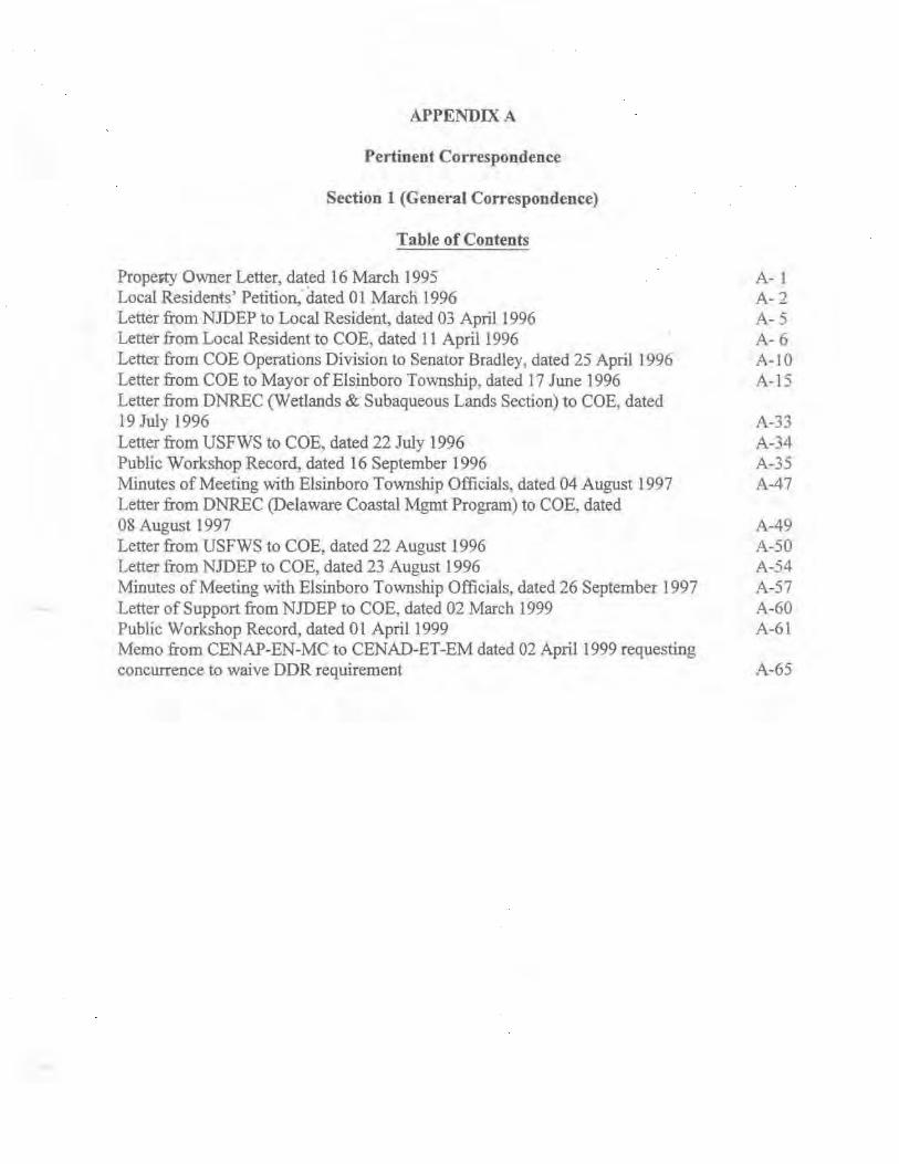
APPENDIX A
Pertinent Correspondence
Section 1 (General Correspondence}
Table of Contents
PropeR}' Owner Letter, dated 16 March 1995 A- 1 Local Residents' Petition; dated 0 1 Mar en 1996 A- 2 Letter from NJDEP to Local Resident, dated 03 April1996 A- 5 Letter from Local Resident to COE, dated 11 April 1996 A- 6 Letter from COE Operations Division to Senator Bradley, dated 25 April 1996 A-10 Letter from COE to Mayor of Elsinboro Township, dated 17 June 1996 A-15 Letter from DNREC (Wetlands & Subaque-Ous Lands Section) to COE, dated 19 July 1996 A-33 Letter from USFWS to COE. dated 22 July 1996 A-34 Public Workshop Record, dated 16 September 1996 A-35 Minutes of Meeting with Elsinboro Township Officials, dated 04 August 1997 A-47 Letter from DNREC (Delaware Coastal Mgmt Program) to COE, dated 08 August 1997 A-49 Letter from USFWS to COE, dated 22 August 1996 A-50 Letter from NJDEP to COE, dated 23 August 1996 A-54 Minutes of Meeting with Elsinboro Township Officials, dated 26 September 1997 A-57 Letter of Support from NJDEP to COE, dated 02 March 1999 A-60 Public Workshop Record, dated 01 Aprill999 A-61 Memo from CENAP-EN-MC to CENAD-ET-EM dated 02 April 1999 requesting concurrence to waive DDR requirement A-65

55 S. Locust- Avenue Salem, NJ 08079
March 16 , 1995
U.S . Army Corps of Engineers Wanamaker•s Building 100 Penn Square East Philadelphia, PA
Dear Sir:
Enclosed please find a petition that has been signed by most of the river f r o nt property owners in Elsinboro Township, Salem County, NJ. I would request you review same and either respond or forward these documents to whoever can possibly offer some desperately needed help in this area.
I am, by copy of this letter, forwarding copies of the petition to our legislatures, township committee and Mayor . Mr. Faulls of your office has been very helpful in our trying to deal with this matter. Apparently, other members of the community are in contact with the EPA and the Port Authority in regard to our plight .
Your anticipated prompt attention to this matter will be greatly appreciated. Our river front property owners cannot endure another winter, harsh or otherwise. Our homes are in jeopardy and without the much needed help from agencies such as the Corps, we stand a chance of losing them . Most cannot afford the exorbitant costs of steel bulkheads and many have already replaced existing walls with new concrete walls that are severely undermined. This is an obvious situation that requires immediate action.
I will await hearing from you. Thanking you, I am,
~';If:;;.~ DEBORAH W. BUECHLER
Encs . cc: Senator Raymond J. Zane
Assemblymen Collins and Stuhtrager Senators Bradley and Launtenberg Mayor Jack Elk Township Committee Members A-1 Congressman LoB i ondo Governor Christine Whitman

55 S. Locust Avenue Salem, NJ 08079
March 1, 1996
U. S. Army Corps of Engineers Wannamaker's Building loo Penn Square-cast Ph~ladelphia, PA
Dear Sirs:
. Please be advised that we, the undersigned, residents of the Township of Elsinboro, specifically, river front property owners, County of Salem, NJ, would like to make our problem known . As a result of the dredging and deepening of the Salem River and Delaware River, we have lost substantial amounts of beach resulting in destruction of bulk heads and total undermining of recently constructed sea walls. In the past eight to ten years, six feet of beach has disappeared.
No doubt, the problem is two-fold. First, nature has taken its toll on our beaches, however, secondly, and more importantly, dredging is an obvious and direct influence in this area. As you are aware, during the dredging the spoils have been pumped elsewhere. We have attempted to have these spoils pumped to our beaches to replenish some of what has been taken. This suggestion apparently has fallen on deaf ears and is, of course, still being offered as a possible and partial solution to this situation.
Your attention to the above matter will be greatly appreciated.
I "
;~ XJC~1uJq)
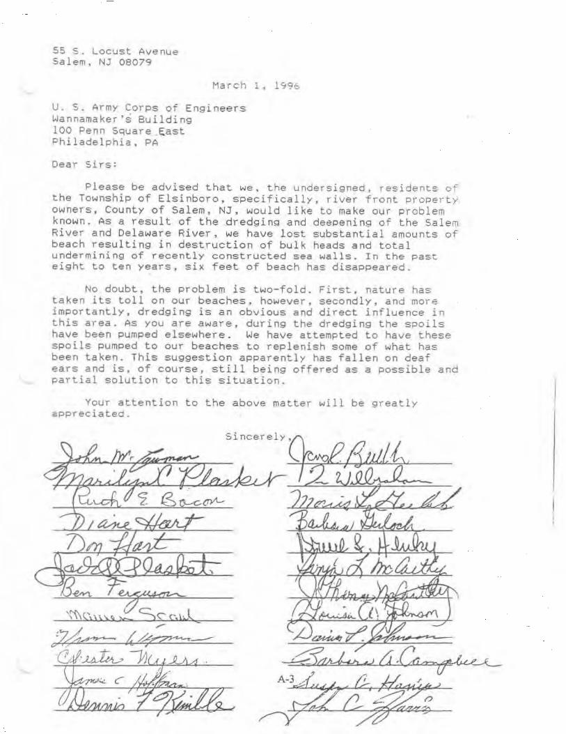
55 S. Locust Avenue Salem, NJ 08079
March 1, 1 ~96
U. S . Army Corps of Engineers Wannamaker's Building 100 Penn Square _~ast Philadelphia, PA
Dear Sirs=
Please be advised that we, the undersigned, residents of the Township of Elsinboro, specifically, river fron~ property owners, County of Salem, NJ, would like to make our problem known. As a result of the dredging and deePening of the Salem River and Delaware RiveY, we have lost substantial amounts of beach resulting in destruction of bulk heads and total undermining of recently constructed sea walls. In the past eight to ten years, six feet of beach has disappeared.
No doubt, the problem is two-fold. First, nature has taken its toll on our beaches, however, secondly, and more importantly, dredging is an obvious and direct influence in this area. As you are aware, during the dredging the spoils have been pumped elsewhere. We have attempted to have these spoils pumped to our beaches to replenish some of what has been taken. This suggestion apparentl y has fallen on deaf ears and is. of course, still being offered as a possible and partial solution to this situation.
Your attention to the above matter will be greatly appreciated.
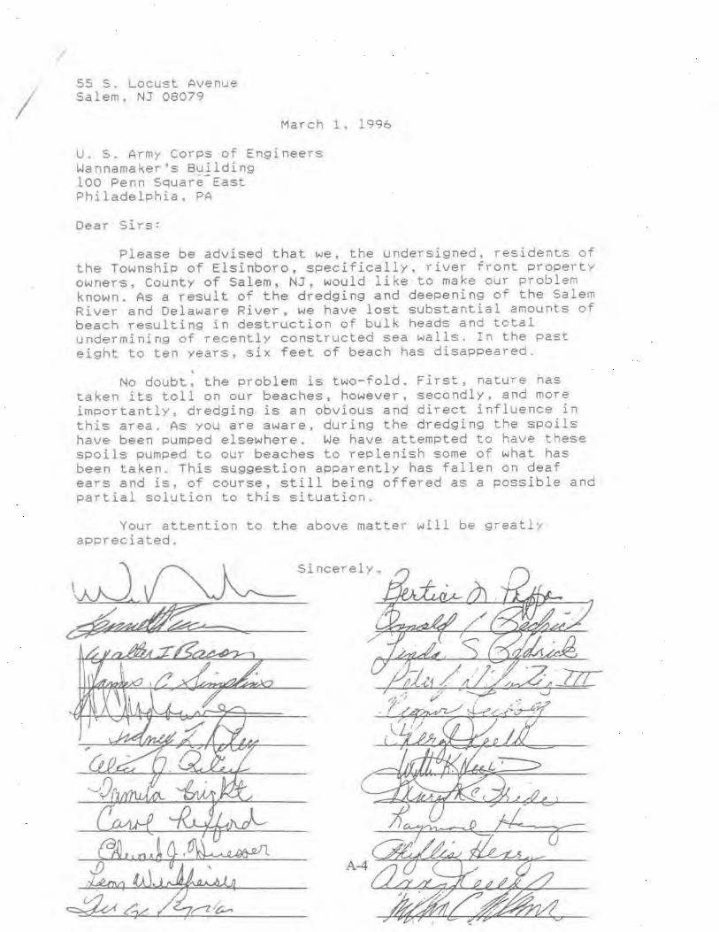
/
I 55 5. Locust Avenue Salem, NJ 08079
March 1, 1996
U. S. Army Corps of Engineers Wannamaker's Building 100 Penn Square-East Philadelphia. PA
Dear Sirs:
Please be advised that we, the undersigned, residents of the Township of Elsinboro, specifically, river front property owners, County of Salem, NJ, would like to make our problem known. As a result of the dredging and deepening of the Salem River and Delaware River. we have lost substantial amounts of beach resulting in destruction of bulk heads and total undermining of recently constructed sea walls. In the past eight to ten years, s1x feet of beach has disappeared .
. No doubt, the problem is two-fold. First, nature has
taken its toll on our beaches, however, secondly, and more importantlY. dredging is an obvious and direct influence in this area. As you are aware. during the dredging the spoils have been pumped elsewhere. We have attempted to have these spoils pumped to our beaches to replenish some of what has been taken. This suggestion app~rently has fallen on .deaf ears and is, of course, still being offered as a possible and partial solution to this situation.
Your attention to the above matter will be greatly appreciated.
Sincerely.,

~tnu of ~£fu Jjers£~ Chnstme Todd Whitman Governor
Department of Environmental Protection Robert C. Shinn. Jr.
Ms . Sheila Fretz
Natural and Historic Resources Division of Engineering and Construct~on
April 3, 1996
59 South Locust Ave. Oakwood Beach, NJ 08079
Dear Ms. Fretz:
Commzsswner
Reference is made to your letter of March 12, 1996 to Governor Christine Todd Whitman regardir.; the beach erosion at Oakwood Beach. Also, reference is made to our visit with you and members of the Township of Elsinboro on Friday, March 29, 1996.
As we discussed at our meeting, the State and Army Corps of Engineers will be looking at some interim resolution in order that minimum protection can be provided to the homeowners. At the same time, we will begin to look at long term solutions for this problem. Within the next week or so, the Army Corps of Engineers and this office will be back in contact with your officials to further discuss some of the solutions that we are looking at.
If you talk to other members of the community, please tell them that in order for public funds, both federal and state, to be used in any work along the beachfront, public access to that beach area must be obtained.
If you have any concerns, please feel free to contact me at Division of Engineering and Construction, 1510 Hooper Avenue, Toms River, New Jersey, 08753, 908-255-0770.
Sincerely,
~· ;--Ay~ Bern~ore Administrator
mm c Senator Raymond Zane /
Lee Weir, Phila. Dist. Corps of Engrs.
Phone (908) 255-0770
A-5
1510 Hooper Avenue, Toms River, NJ 08753
New Jersey tS an Equal Opporturuty Employer
Fax (908) 255-0774

April 11, 1996
Lee Weir Philadelphia District Corps of Engineers Wanamaker'aJBuilding 100 Penn Square East Philadelphia, PA 19107-3390
Dear Mr. Weir:
All Oakwood Beach residents appreciate the concern your Department and the NJ DEP have shown about our severe beach erosion problem.
The following is an update of what the Mayor and I have been doing on our end so that everyone concerned will be well informed when the time comes to discuss solutions.
Thank you again for your help. Please get in touch with me if there is anything you feel I can do to help bring this situation to a positive solution.
Sincerely,
~~-_,?~ Sheila B. Fretz 59 South Locust Avenue Salem, NJ 08079 (609} 935-1851 Ext. 115 - Fax (609) 935-7955
A-6

Fax Message Fax No: (908) 255- 0774
April 11, 1996
Mr. Bernard J . Moore Administrator
Page 1 of 3
New Jersey Department of Environmental Protection 15109 Hooper Avenue Toms River1 NJ 08753
Re: Oakwood Beach Planning
Dear Mr. Moore:
I was very pleased to receive your letter of April 3, 1996 informing us that your Department and the Corps were beginning to look at interim and long term solutions to our erosion problem . We are all most appreciative of the speed and concern with our problem. Daily these conditions worsen and I have had to take steps to repair my property just to prevent further structural damage.
The purpose of this letter is to bring you up to date on what I am doing as far as getting the necessary information to the property owners . I shared your letter with our Mayor , Jack Elk and together with him, have been putting together a plan to inform the property owners of where we stand at this point, to address some of their questions and to begin to form a solid knowledgeable group to work with your people .
I met with about 8 people from different areas along the affected area last night. In keeping the group small, we were able to go over some general information, be brought up to date of where things stand now and also begin to develop key leaders in the different areas who can talk to the other property owners without scattering forces. Th e meeting went very well with everyone willing to listen to your proposals and most appreciative of the fact that the two key groups, your Department and the Corps , have been so responsive. I will be meeting with Jack Elk today to bring him up to date on our discussions at the meeting.
Our aim is to work closely with you to solve this very serious problem. We hope to work the entire group into a close unit with a few{Key key people passing on the concerns and questions of the entire group to you . This will keep the discussions moving quickly and save you time. Let me stress here that everyone I have spoken with is most positive about the outcome and most willing to cooperate with you. It has been a pleasure to work with groups who have a common purpose and are all moving ~n the same direction.
~-7
Page 2 of 3
April 11, 1996
Mr. Bernard J. Moore Administrator New Jersey Department of Environmental Protection 15109 Hooper Avenue Toms River, NJ 08753
Re: Oakwood Beach Planning
We will be most anxious to hear from you so we can begin the next step. While we are waiting for your plans, I will continue to pass information on to the property owners. I feel the better we are all informed, the better we will be able to work effectively with you.
I have included in this fax Jack Elk's memo to the residents concerning our progress.
Again, my thanks and those of the property owners for your timely help. I truly feel this project can end positively for all concerned.
Sincerely,
Sheila H. Fretz 59 South Locust Avenue Salem, NJ 08079
Phone: {609) 935-1851 Ex. 115 - Fax: (609) 935-7955
cc: The Honorable Raymond Zane Senator, 3rd. District State of New Jersey
4 J
Lee Weir Philadelphia District Corps of Engineers Wanamaker's Building 100 Penn Square East Philadelphia, PA 19107- 3390
Jack Elk - Mayor - Elsinboro Township
A-8

ELSINBORO TOWNSHIP
Apri l 8, 1996
Memorandum
To: Riverfront Property owners
From: Jack. Elk., Mayor ~~ 2~ Re: POSSIBLE RIVERFRONT IMPROVEMENTS
With the accelerated beach erosion we have seen in the last year coupled with the severe weather we've had, it is more important than ever for all of us to take a close look. at the potential for severe problems as well as ways of handling them to minimize property losses and how we could handle emergency situations should they develop along the river.
As most of you know, carl Gaskill, Township Engineer and I, along with several of the Riverfront Property OWners have been in contact with the Army Corps of Engineers and the New Jersey Department of Environmental Protection. We had representatives from both Departments who did an actual site inspection on March 29. This site inspection brought home to them the fact that we all knew - we have a severe problem t hat will only get worse unless some uniform measures are taken to s t op the erosion. In many places as much as a foot of solid ground as well as all the beach sand has been lost. The sand will possibly return but the solid ground will not. It is just a matter of time before all properties will be effected.
I have asked that they give us some recommendations to stop this problem and they have agreed to do so. They see~ very willing to work with us. They will be working with me within the next few weeks in order to give us some options as well as what they will be able to do for us at a state Level.
Since we all have a s take ·. in this issue, I wi._ll keep all of you informed of any and al l discussions and possible solutions. At the point when these studies can be summed up into just what needs to be done and the methods of accomplishing it, I would like all of you to be a part of a meeting of all concerned parties, (property owners, Township Officials and any State and Federal Department Representatives. This meeting will give everyone involved a clear picture of what can be done and will give everyone input into our next step.
I'd appreciate a ny hel p any of you can give us in this decision making process. We all need to meet with t hese ~eople to see what they are able to offer.
A-9

Operat ions Division
Honorable Bill Bradley United States Senator One Newark Center, 16th Floor Newark, New Jersey 07102-5297
Dear sa~ator Bradley:
APR 2 5 1SS6
In the temporary absence of the District Engineer, I would like to response to your letter cf April 4, 1996. I am enclosing correspondence from Sheila H. Fretz in regards to property in Elsinboro, New Jersey and dredging of the Salem River.
Model studies performed in conjunction with an environmen~al assessment in the Salem Cove area substantiate the Coriolis Theory in the Delaware Estuary, showing that during flood tides the strongest current action takes place on the New Jersey side. Consequently, ~~is current action, and not the channel dredging, results in the extreme erosion of unprotected landforms like those seen from Elsinboro Point to the Salem River.
The erosion of the shoreline along the Elsinboro riverfront at Oakwood Beach has also been addressed in the Delaware Bay Coastline, Delaware and New Jersey Reconnaissance Study. This report identified that a shoreline protection project for the Oakwood Beach vicinity may be economically justified. However, Federal regulations prohibit involvement in shore protection projects along private shorelines where public use and access are not provided on a permanent basis. currently, public access and use of Oakwood Beach has been denied by the local residents.
Bottom samples of the channel were taken in accordance with the environmental assessment of this project. These samples indicate the dredge material is primarily made up of clay, organic material, silt and very fine sand and is not of sufficient grain size to provide adequate protection to the shoreline. Therefore, we do not endorse such a course of action. If the State of New Jersey would entertain the idea of utilizing the dredge material for this purpose we would reevaluate this option of disposal.
A-10

-2-
If you have any fur~er questions or desire addi~ional i nformation regarding this matte~, please do no~ hes i tate t o contact me.
Co"!)y Furnished :
Honorable William Bradley United States Senate Washington, DC 20515
CEN~~-CO-OP (2) . CENAP-OP (Nietta) './ CENAP-PA CENAP-OE CENAP-EX (Giovinco) Chip OePrefontaine
Since::-ely ,
David C. Schless~an Major, Corps of Enginee::-s Acting District Engineer
A-ll

e.~. aR;.DL::.V
TO:
RE·
Robe:t P ~[agnifico
Dtstrict Enginee:
Bmtai ~tares ~cnarc 'N-"Sriii':GIC:-.J. CC :OSlC-JOCi
:~C'rii ~. 1996
Uruted States Anny CO!J)S of Engine"!rs Philadelphia DiStrict Wannamaker Building. 100 Penn Square E3St
Philadelphia PA 19107
Proce:tV in Elsinboro. New Je:se•; . . .
s;:::·.;.L :=MMi'i"":"E: :'' ~c:..~c
I fotward the ~&.ached for your cans>der:mon and would appre:;iate re:e:ving iniormation in regard to this inquiry as soon as poss1ble. Ple:l.Se dir~t your correspondence £O Laurel Mac!an of my staff She em now be reached in my ~ewark office at One Newar:{ Center. 16th Floor. The zip code is 07102-5297.
Thank you very much for your ume and assistance tn thls mane:. and I look forward to your prompt reply
SincereLy.
tk I Bill Bradley united States Senator
BB/lmrn
A-12

, ? --r 1996
The Ecncrable Bill Bracley Unitec States Senator O~itec States Senate Wash~~qtonr DC 20510 3001
ac \0;: •..... ~~· .: . n1 J v ~ •• · ""'I J \,_,;. • \.,:
De:.~ Senator Brad.lev:
Re: D~~STIC BEACE ERCSION-~~~~W~-~~ RiveR ScORE O.=L7{"ACOD EEACE, S~ 'EM CCUNTY, NEW JE:RS:C:Y
I just read with inte~est your excellent a=~~cle en ~=ese~v~n~ ou= New Jersev beaches in o~e of cur lccal oaoe~s . I wa~~ to c:ll a crisis situa~icn to your attention conce~;ing the beac~es or lack t~erec::, along the Delaware Ri.ve~, es?e~ially an a~ea k..."'l.cwn as Oa~NCOc Eeac~ in Salem County, Sout~ Jersey. I am writing to you en behalf of all the prcoe~v owners alone the Delawa=: River Sho=e in the area ~CWO as o~~NOOd-Eeach in Sal~m Countv. w~. NEED IMMEDL~TE EELP. Our ongoing erosion problems hav~ new reac~ec a CRISIS STAT~. We no lance~ have time to debate wha~ c~~ ce done, what should have been done or who should have done i~. Your rec~=i speaks for itself in that you are will ing to step fcrNard and address problems of New Je~sey residents anc to step forNarci quickly . Ther e are houses which at one time were located 10 fee~ from the water line that are now in eminent danaer of beinc unde~ned by the river. This situation is mad~ worse each t~e the tide moves.
We k...~ow that we are technically dealing with the State of Delaware as well as New Jersey anc possibly more departments we don't even ~~ow about and we just co not ~1ow how to get results. What we do know is that time is of the essence. We need someone on the Fede~al level to take note of this local problem. I have always felt that beinc small did not mean that one can't be heard in our Countrt and this is certainly a time when our communi~y must be heard. Time has run out and we can no lonaer wait for anvone to realize the problem. We have to come to the powers that be who can open doors and assist us . We are not here to debate why this erosion has escalated in the last months but we feel strongly that the drecging by the Cor?s of Engineers performed last summer to deepen the channel created a situation that, couple~ w~th the sto~s of last year and the severe weather conditions of this winter caused the sand forming our beach and protection a= cur seawalls from the water to shift farther out into the c~annel. Our water=ront area has now eroded to' the point where clay earth ~s exnosed and our seawalls have either tumbled or have been unde~ned scme 6 to 8 inches . For whatever reason, we need assista~ce immediately to pro~ect what is left of our barriers froro the wa~er as well as help with finding a long term solution that we all can live with . We do not have the funds, the man~cwer or the
- ex?er~ise to correct this problem.
A-13
Page -2-
Se:1ator Eill Ne~.., Je::sey
::-.:...J .. o-,• -------!
Re : D~~ST!C EZ~C= E~CS:ON-:ZL~~~2E Riv~~ SeC~
G.ll.l\t'iOOD 3:C:ACE I S.!t:..Z!-1 c::: L11~'!'Y I NEW' J=:rtSZY
Our hands are ~ie~. Ma~y cf us have r~pai::eci se:~a:ls w~~~~~ ~~a last ~.;~o or ~~::ee yea::s at t~e cost c= thousands of cclla::s cn~y ~c have them des~=~yeci t~is yea7 anc t~is is before the heav~ spri~g rains we will ce~ainly expe=ience shor~ly. We MUST ASX TE~T SOMEC~rE ON A ST;..rr=; LEVEL S'E? IN WITS SOME TY?E OF RELIEF AND A P~~ TO SEC~ T~IS AP~ EE: JRE HOUSES BEG:N TC TOPPLE INTO T~Z RIVER . THIS IS JUST TOO EIG A PROJECT FOR INDIVIDUPLS. T~E DAYS OF TAKING CAlC OF TEIS PROE~Z!1 W:!:TE A "FINGER IN TEE DYXE" IS OV~?.. l-f...arc~ 12, 1996
This is just as much a catas:::cphe as a tor~aco or forest fi=e a~c I feel our Gcver~ent here i~ New Je=sey can see that this a=aa LS despera~ely in need of ass~s~=~ce. ~~1 of us pay our taxes, support our l~Nmake::s, strive for a good solid community and co cu= part in the State. We new m~5t ask fer practical immeCiate bel? ~~d expertise to solve this f:oblem.
I must rely on your office tc steer us in ~he right direction. May I expect a call :f=om someone -.,.ho can offe:: a solution?
We are readv to coocerate in ~ny way possible to help assess the situation. -Iceally: I would ~ike to see someone on t~e State leve~ meet with our Graue and make ~n on-site insoection. I know after such an inspection: there wo~~c be no question of the need. We have dc~c all We are able. ~~rely, the State of New Jersey will not s~and by while a portion ~f its shore relocates to Delaware.
\-ie have some of the fi::es"t. ~:i :.c~ife ·a::eas and natural resc~=e:::. 1.::-. the State and as prope::ty owr.~rs, we have a grea~ concern for t~ei= prese=vation. We also have a great conce::n for cur prese~atior. as well. Knowing your interest ~n this a::ea, we are appealing to yc~ for help and c1.rection.
Thank you for ycu:: Lnmeciia~e =~sponse to t~is letter.
Since::ely,
,,.,..-; .. ./ -:""" - -;---..__: lf/1""",1_ c « ,. _.,.-::- "' ..... .:......:....<.
Sheila E. Fre~z ~ 59 South Locust ll.'re. Oakwood Beach Ne•.;~ Jersey (609) 935-1851 Ex. 115 A-14

Planning Division
Honorable Jack Ilk Kayor, Elsinboro Township 619 Sal- - Ft. Elfaborg Road Salem, New Jersey 08079
Dear Mayor Elk:
JUN 1 7 1996
This is in follow up to the March 29, 1996 field visit by representatives of the Philadelphia District and subsequent coordination regardinq the erosion problea at oakwood Beach in Elsinboro.
We have considered several options and diacuased the situation further with Mr. Bernard Moore of the Nev Jersey Deparblant of Environaental Protection. Tba attached a .. ta anmmariza our conclusions on optiona vbich could be pursued ill the short tara. Thera are .. veral actiona inclwU.nq vinyl shaetpile and qeobagjqeotube protection which could be implemented locally aa a atop-qap aeaaura. We providecl carl Gaskill vith brochuraa on th ... and other low coat aeaauraa for consideration aa local projecta, since Federal participation in these meaauraa would not be possible in the aort tara.
Federal invol v~t uy be possible in aclvanca of the ongoing beach erosion study through beneficial uae of sandy material dredqed froa the Delaware River channel under the authority of Section 933 of the Water Resources Developaent Act of 1986. However, studiaa wou1·c1 be required which would' ·preclude this from occurrinq this year. Typically, the required atudiaa might cost $100,000 and take six •ontha and ~ould require that ve budget for thea in advance. I've enclosed aoae quidalinea for your referance~on this_authority.
other options ware considered to diacharqe aatarial unconfined near the beach. The material in the Sal- Cove disposal area is a Jlixtura of sand and fine grained aateriala which is not of good quality for beachfill and. would. create turbidity probleaa if pumped. unconfined on to oakWood Beach. Significant study would be needed of material aiqration and impacts which may not be possible in the ahort-te%11. We also considered dredqinq sand fro• the Delaware River (see Map, Attachment 3) and discb.arqing it into open water in the vicinity of Elsinboro Point, but cannot be placed close anouqh to have it nourish and protect the shoreline due to the liaitationa of -available Government pipeline and equipment.
A-15

-2-
This may be viable as a lonq-term solution usinq dredqinq contractors which have the capability and equipment to perfora the vork.
It aay be feasible for the town to haul dry, sandy material by truck troa the Corps' Artificial Island or Killcohok disposal areu tor placement alonq the beach, however this would require that the township bid competitively on advertised material alonq vith any interested contractors. Purchase coata •iqht be in the ranqe of $.20 to $.40 per cubic yard in addition to the coats tor excavation, hauling, and plac-ant incurred by the townahip.
Whatever actions are undertaken would require regulatory coapliance and any Deeaaaary atudiu to obtain it. A aimpli~iad procedure -Y be possible which avoid8 the need tor a Corps perait it the actions quality under the rules tor ~~aintenance, bank stabilization, ainor discharges, and/or t-porary construction access under existinq Nationwide perait authority. These conditions are explained in the attacbaent on Nationwide Permits. Otherwise a normal Corps and state regulatory process would apply. Additional information on the process tor applyinq jointly for these permits can be obtained troa Kr. Jill Boyer ot our Requlatory Branch at (215)656-6728.
I hope this into~tion is satisfactory tor your needs. We would be willinq to uet an4 discuss thia further at your c<mveniance.
Attachments: 1. option Evaluations 2. Map 3. Section 933 Guidance 4. Requlatory Tabla
Sincerely,
Robert L. calleqari Chief, Planninq Division
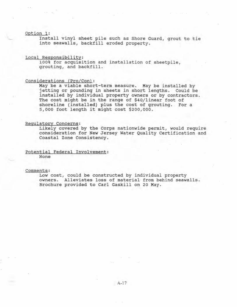
Option 1: - Install vinyl sheet pile such as Shore Guard, grout to tie
into seawalls, backfill eroded property.
Local Responsj~ility: lOOt for acquisition and installation of sheetpi le , grouting, and backfill.
Considerations CPro/Conl: Kay be a viable short-term measure. May be installed by jetting or pounding in sheets in short lengths . Coul d be installed by individual property owners or by contractors. The cost might be in the range of $40/linear foot of shoreline (installed) plus the cost of grouting. For a 5 ,000 foot lenqth it might cost $200,000.
Regulatory Concerns: Likely covered by the Corps nationwide permit, would require consideration for New Jersey Water Quality Certification and Coastal Zone consistency.
Potential Federal Involvement: None
comments: Low cost , could be constructed by individual property owners. Alleviates loss of material from behind seawalls. Brochure provided to carl Gaskill on 20 May.
A-17

Option 2: Geotubes or geobags along shoreline/base of revetment. Backfill eroded areas behind seawalls. Clean fill or soilcrete using contaminated material could be considered for f i ll.
Local Responsibility: 100% for placement, hauling material, and acquisition of borrow material. Real estate requirements would be a local responsibility.
Considerations CPro/Conl: May be viable in the short-term. Geobags might be more expensive and difficult to use in this area. Lack of readily available fill material would require transport from offsite. Granular fill is available at Corps of Engineers Artificial Island or Killcohook disposal areas at a cost of about $ . 20 to $.40 per cubic yard on a competitive basis or at other local sources. Hauling costs may run $20 per cubic yard . Potential to use soil-crete (contaminated) mixture rather than clean material. Access for equipment is difficult from landside and ramps/construction roads might be needed to install bags along the beach, working around tidal conditions. In addition, specialized equipment may be needed to fill and place the bags. Heavy traffic on local roadways may cause damage while hauling material. Geotubes may be easier to install, possibly using a small dredge to pump the sand/ silt mixture from the Salem Cove disposal area. This might require about 10,000 cy of material for a 5 , 000' length of shoreline. We estimate that there maybe about 25 ,000 cy of sand in the cove site and a total of about 60 , 000 cy of mixed quality material. With costs estimated as $75 to $150 per linear foot, the geotube option may cost $375 ,000 to $750,000.
Regulatory Concerns: May be covered by the Corps nationwide permit, would require consideration for New Jersey Water Quality Certification and Coastal Zone consistency. Any use of contaminated soilcrete would raise regulatory concerns over potential release of contaminants in an aquatic environment.
Potential Federal Involvement: None
Comments: Simil ar measures are described in the Low Cost Shore Protection Brochures provided to carl Gaskill on 20 May . Addi tional copies are available from Philadelphia District .
A-18

Option 3: Place Delaware River dredged material (sandy) at Oakwood Beach as a new open water disposal area.
Local Responsibility:
•
Any incremental cost increase in comparison to normal upland placement practices. This may involve difference in travel time for the dredge ($60,000/day), costs to move the mooring barge ($7,000/day), pipeline costs, and monitoring/inspection costs. Any grading or redistribution of material would have to be at local expense. Real estate requirements would be a local responsibility •
Considerations CPro/Con): This summer the Corps hopper dredge McFarland will be dredging sandy material in the Liston Range adjacent to and south of Artificial Island. Typically the McFarland would pump the 1200 to 1500 cy of sand it dredges per load into the northern end of Artificial Island or into Killcohook by way of a mooring barge hook-up. The dredge operates 24 hours a day and is expected to work about 25 days in that area. Typically, it might dredge and dispose of 3 or 4 loads of materia~ in a 24 hour period. The dredge requires a water depth up to 28 feet, which means it could get no closer than about 2000 feet from the southern end of the shoreline at Elsinboro Point. It would be feasible to move the mooring barge and pump from there to portions of Oakwood Beach as on open water disposal area except that the Philadelphia District has no vessels or equipment capable of laying pipe in such shallow water, nor does the District have sufficient length of submersible pipe to get material close to the shoreline. Landside access for support equipment would also be difficult. Consideration was also given to creating a sand stockpile which could be redredged onto the beach or possibly nourish the beach naturally. However, it is doubtful that natural forces would move the material onto the beach. Dispersal into other areas and Federal channels would be a concern and would require study.
Regulatorx Concerns: Water quality certification may be relatively simplified for sandy material placed near the beach, although a stockpile would likely cause more concern. Application would be made by the Township of Elsinboro for the stabilization of the shoreline and pre-application discussions could be held at joint processing ·meetings. It is assumed that New Jersey would have a lead role for permitting actions. Joint meetings are held in Trenton monthly with state and Federal regulatory agencies and corps representatives. Jim Boyer of the District's Regulatory Branch at (215) 656-6728 is the contact regarding the schedule of New Jersey joint
A-19

processing meetings. coordination would also be required with Delaware which holds meetings the third Thursday of the month, (contact is William Moyer of DNREC at (302) 739-4691) .
Potential Federal Involvement: Federal participation would be limited to the cost of normal practices.
Comments: The concepts are not feasible in the short-term due to the inability of the Government to install pipeline close to shoreline, potential for dispersal of a stockpile/ and analyses required to evaluate environmental effects. May be viable for a dredging contract in the future.
A~O

Option 4: Government dredging of material from the Corps' Salem cove disposal area, placing it at Oakwood Beach, to renew capacity at the Salem cove site.
Local Responsibility: Grading and redistributing dredged material onto beach. Real estate requirements would be a local responsibility.
Considerations (Pro/Con) : This might be advantageous to the Federal government and save costs in comparison to placing material at more costly, distant sites. However, sampling of the sand mounds during the Salem River study showed them to be a mixture of sand and finer grain material with a sand veneer on the surface. Due to the large percentage of fine materials turbidity would be a problem for unconfined placement. Material could also migrate into the channel.
Regulatory Concerns: The Town of Elsinboro would be the applicant for joint processing with New Jersey, Delaware and Federal agencies. Environmental agencies would likely object to removal of the mounds due to their value as bird habitat.
Potential Federal Involvement: Unlikely. It would need to be studied in a dredged material management plan to assess it's viability.
Comments: Federal interest, could possibly be established due to the potential economy of renewing Salem Cove disposal capacity. However, the fine nature of material ~akes this unattractive and infeasible as a short-term solution due to the necessary studies.
A-21

Option 5: Place Delaware River dredged material (sandy) at Oakwood Beach as a Section 933 beneficial use project.
Local Responsinility: Incremental costs beyond normal dredged material disposal practices (varies from 50% to 100%). Real estate requirements would be a local responsibility.
Considerations <Pro/Con): Section 933 of the Water Resources Development Act provides for beneficial use of dredged material from navigation project construction or maintenance. A reconnaissance type report is required to demonstrate that beach restoration is economical based on its incremental costs in comparison to the erosion it prevents. Due to the study requirements this could not be coordinated in time for dredging this season. This authority requires public access and is subject to Corps policy certif.ication. It has the advantage that all work including beach construction could be contracted or performed by the Federal government. Recent guidance and Section 933 authority are attached for reference.
Regulatory Concerns: The section 933 reevaluation report addresses environmental concerns and all necessary permits would be obtained by the Federal government during preparation of plans and specifications.
Potential Federal Involvement: Dependent on resolution of public access issues and costsharing requirements. Federal participation can vary from 0 to SO% of incremental costs.
comments: Report preparation time is about 6 months, might cost $100,000, and would have to be budgeted in advance. Analyses could be accomplished to a degree as part of the ongoing feasibility study as an option for long-term project implementation.
A·22
Federally Lisced Threatened and Endangered Species
Except for an occasional transient bald eagle (Haliaeetus leucocephalus) or peregrine falcon (Falco peregrinus), no other federally listed or proposed threatened or endangered flora or fauna under Service jurisdiction are known to occur in the projecc area. Therefore, the Service has determined that the proposed proje~~~s not likely to adversely affect federally listed threatened or endangered species under Service jurisdiction or their critical habitats. No fur~her consultation pursuant to Section 7(a)(2) of the Endangered Species Act is required by the Service If project plans change, this decerminacion may be reconsidered.
Principal responsibility for federally -~isted marine species, including whales and marine turtles , is vested with the National Marine Fisheries Service (NMFS). Therefore, the NMFS must be contacted to fulfill consultation requirements pursuant to Section 7(a)(2) of the Endangered Species Act . You may contact the NMFS at the following address:
National Marine Fisheries Service Habitat and Protected Resources Division Sandy Hook Laboratory Highlands, New Jersey 07732 (908) 872-3023
Species of Special Concern
According to Service records, the diamondback terrapin (nalaclemys terrapin terrapin), a species of special concern, occurs within the vicinity of the study area. Species of special concern are species under consideration by the Service for possible inclusion on the List of Endangered and Threatened Wildlife and Plants . Although these species receive no substantive or procedural protection under the Endangered Species Act, the Service encourages federal agencies and other planners to consider species of special concern in project planning.
The New Jersey Natural Heritage Program (NHP) provides the most up-to-date information for candidate species in New Jersey, as well as maintaining information on State-listed species. The NHP may be contacted at the following address:
Mr. Thomas Breden Natural Heritage Program Division of Parks aud Forestry CN 404 Trenton, New Jersey 08625 (609) 984-0097
A-5.1

?urt~er information on New Jersey's State-listed wildlife species may be obtained from the following office :
Mr . Larry Niles Endangered and Nongame Species Program Division of Fish , Game and Vildlife CN 400 Trenton, New Jersey 08625 (609) 292-9400
Other Resources of Concern
In che Service's 1991 planning aid report w~ addressed fish and wildlife resources wichin the proposed study area, specifically migratory waterfowl, migratory shorebirds , finfish, and shellfish. The Service recommends that the Corps refer to this planning aid report for information on fish and wildlife resources within the scudy area. Please contact this office if you have any questions or concerns regarding information presented in the report.
The wetlands within the proposed project site are designated as priority wetlands by the Depar~ent of the Interior under the Emergency Wetlands Resources Act of 1986 (100 Stat. 3582) because of the national ecological significance of these wetlands. The proposed project is also within a focus area as defined by the Atlantic Coast Venture of the North American Waterfowl Management Plan. Focus areas contain critical waterfowl wintering, migratory , or ~reeding habitat, particularly for black ducks (Anas rubripes)
Suoawna Meadows National Wildlife Refuge
The Supawna Meadows National Wildlife Refuge is within 0 . 5 mile of the proposed project area and may be directly or indirectly affected by the project activities. The refuge manager should be contacted at the following address in order to assist you in identifying any concerns that the Service may have regarding proposed projects adjacent to the Refuge.
Refuge Manager Supawna Meadows National Wildlife Refuge U.S . Fish and Wildlife Service 229 Lighthouse Road Salem, New Jersey 08709 (609) 935-1487
Information contaLned in this let~er and additional information obtained from the aforementioned sources represents the public interest for fish and wildlife resources and should warrant full ccnsideration in project planning. The Service requests chat no part of this letter be taken out of context and if reproduced, the letter should appear in its entirety.

Please concact John Staples or Eric Schrading of my scaff if you have any ~uescions or required further assistance regarding projecc-related fish and wildlife concerns.
Literature Cited
Sincerely,
ftc~ ~~Clifford G Day / Supervisor
U.S. Fish and Yildlife Service. 1991. Planning Aid Report on Delaware Bay, Delaware and New Jersey Reconnaissance Study. U.S. Department of the Interior, Fish and Yildlife Service, Pleasant:".r5.lle, New Jer!;ey.
A-53

Chnstme Todd. Whrtman Goverrtor
fotah of ~ efu 3lerse~ Department of Environmental Protec:tlon Robert C. Shmn, I '·
Comm1sszoner
Ausust 23, ~ 996
Robert L. Callegar1 Ch1ef, Planning Div1sion Department of ~he Army Philadelphia District, Corps of Engineers Wanamaker Building 100 Penn Square East Philadelphia. PA 19107-3390
RE ; De.aware Say. Oakwood Beach, New Jersey Inter1m Feasibility Study
Dear Mr . Callegari =
In resPonse to your recent request for informaLion and 1nput from the New Jersey Department of Environmental Protection for the above referenced project, please find attached the following documents:
a memorandum dated August 6, 1996 from Robert McDowell. Director, Division of Fish, Game and Wildlife;
- New Je-sey Natural Heritage Program Data request ro r m.
The U.S. Army Corps of Engineers should continue to coo rdinate the further development and review of this project with the Department through the Office of Program Coord:nation. If you have any questions, please contact me :t ( 609 ) 292-2662 .
s~~YWi-Lawrence Schmidt Dl.rector Office of Program Coordination
A-54
'W~o~ /~y is an Equal Opporturuty E.r:nployer
Recveff!d p,.._

~tat£ a£ ~£fu :1fersell Chnstlne Todd Whttman Co vern or
Department of Environmental Protection Di•t.II/Jft tf Fi<h. Came an</ WI/JIIfr
C.'IJOII T.-enwn N J. fllt615...0Jr1U
MEMORANDUM
To: Lawrence Schmidt, Director DEP, Office of Program Coordination
From: Robert McDowell, Director ~ , Division of Fish, Game and Wildiife~".
Da,e: August 6, 1996
Subject: Delaware Bay, Oakwood Beach, New Jersey Interim Feasibility Study
Robert C. Shinn, I r Commtsszoner
This serves to inform you of the Division ofFish, Game and Wildlife's comments and concerns relative to the Philadelphia District Army Corps ofEngineers' Delaware Bay, Oakwood Beach, New Jersey lntenm Feasibility Study. The pwpose of the study is to evaluate the locations and optimwn design for shore protection measures along Oakwood Beach., Elsinboro Township, Salem County, New Jersey-. The study area consists of two miles of developed shoreline with the mean low water line at Oakwood Beach being the boundary between the states of New Jersey and Delaware.
Due to the developed nature of the site, it is not expected that wildlife or endangered I threatened species will be impacted, however, this is dependent upon the type of project the ACOE is planning to implement. Wildlife known to utilize the immediate project area include river otter, muskrat, Canada goose and an assortment of waterfowl during migration and winter [September thru March). Their use of the area is considered transient; no special habitat is known to occur at the study site.
In regard to fish I sheilfish resources, however, the Bureau of Marine Fisheries emphasizes that the Oakwood Beach location is a nursery area for many fish species, including: stripeq bass; bluefish~
silverside; anchovy; spot and menhaden. Oakwood Beach is also an established juvenile striped bass survey site: surveys continue to be undertaken each summer and fall [since 1980] and the location is considered a principal seining site. A list summarizing spectes found at the site per year is attached for your information; additional fisheries information can be obtained from regional fisheries biologist. Russ Allen [609-748-2020). In addition, the area is also known to be important to juvenile I adult blue crab; there is a sizable commercial fishery for blue crabs in the Oakwood Beach area. Therefore, the Division ofFish, Game and Wildlife conludes that paramount concerns for consideration in the Interim Feasibility Study would be the protection of prime nursery habitat in the study area and the selection of project alternatives that provide shore protection without compromising that habitat.
We hope this information· is of service to you; please pass this information on to theACOE in its entirety.
c. R.Itchmoney, A.Didun, R.Allen, J.Dobarro, L.Widjeskog, K..Clark
A-55
New Jersey is an Equal Opporruruty Employ~

N.J. DIVISION OF F1SH, GAME & Wll.J)LIFE DELAWARE RIVER STRIPED BASS JUVENJLE SURVEY: 1980-1995 OAKWOOD BEACH
COl\tiMON NAME ,
YEARS COLLECTED
ALEWIFE ../"' 82, 86, 90, 93, 94
AMERICAN EEL / / 83, 86, 88, 93, 95
A.MERICAN SHAD -v 85-87, 89-91, 94, 95
A1LANTIC CROAKER )5, 89, 91-93, 95 ftl i C ro po'jo,,. · "-~ (}. V\ d. i.
ATLANTIC MENHADEN t;;./ 80, 82-95
ATLANTIC NEEDLEFISH ~6 135 'S..f-v-.?viC. .1 f, · ,/C }"r\.Q II"; V\..:'
ATLANTIC SILVERSIDE 7 80-95 I
BANDED KILLIFISH 7 82
BAY ANCHOVY / 80, 82-95
BLACK DRUM h~ 90, 91, 93-95 r.. r CC? C<.-n ;a..::; C v-c""' ,'s BLUEBACK HERRING / 82, 84-87, 89-95
BLUEFISH ~ 5'-1C/ 80, 82-95 p o ,--a_...J-c ""'· ,.._.; 5c; ~~..J..,r;f. BLUEGilL SUNFISH ~~ 88 'e -,_ :o,.,."" ,4 fY\ G.. c ro ch.;. r '. .. \)) BROWN BULLHEAD ~ 85
I
CARP ~7 83-85, 87, 90, 92, 93 . .
CHANNEL CATFISH 77 84, 87, 88, 94
CREV ALLE JACK )74 81-85, 87-90, 92, 93, 95 c~ rttl"l y. J, ; r>·!'d5 GIZZARD SHAD 33"3 80, 84, 85,87-90,92,95 £oro;c.·~q_ Cl?.oa;l;q 111 ""-))~ HARVESTFISH t{} <;<:; 91 Pap r.~/,,.; .-r I.<? -:l"f-1-4 I
HOGCHOKERv 81, 83-94
INLAND SIL VERSIDE s;.-1 88 me .. " ~d; ~ berv I r· "'~\ ~
INSHORE LIZARDFISH t,fos 93 S,tnoJ.u..s r a e. +-ev\') MUMMICHQG i.-7 95
NORTHERN KINGFISH (,d) 95 f'('l e "+; l_. , ,..,_ h '"' S()....1a....J.-:I-~ NORTHERN PIPEFISH J-30 80-82, 84, 86-88, 90, 93 . 5y ~-r 1\.~ Htv-s 1 k,;; cA ROUGH SlL VERSIDE i)i 82, 85, 87-95 Me..~OA b~"l (Y\ a. V' ~ i II\ ;- "''
SPANISH MACKEREL b11~ 89, 90 ScoM k.a ".("1m.. r.v u...~ f'r'.O.CIAin-t~ SPOT 7 81-86, 88-91, 93, 94
SPOTT A1L SHINER / 85
S1RIPED ANCHOVY ]85" 87, 88, 90-92, 95 A V\C~co. h Q·D c, p_-+ v'v5 STRIPED BASS / 82, 87-95 y
SUMMER FLOUNDER / 84, 86, 91, 92, 94
WEAKFISH v/ 85, 86, 89, 91, 92, 95
WHITE PERCH -7 . 80, 84-90, 92-95

CENAP-PL-PB 29 September 1 997
tvffiMORANDUM FOR FILES
SUBJECT: MEETING WITH ELSINBORO TWP OFFICIALS, SALEM COUNTY, AND NJDEP ON 26 SEPTEMBER 1997
1. Meeting Purpose and Attendees: To discuss potential financial sources for funding a project as well as to address NJDEP and COE public access requirements for a potential project. Those in attendance included the following:
Lee Ware, CENAP-PL-PB Jane Jablonski, CENAP-PL-PB Bernie Moore, NJDEP Jack Elk, Elsinboro Twp Mayor Lee Bacon. Elsinboro Twp Ping Conunission Patricia Dimatteo Knobloch, County of Salem, Dept of Economic Development Rita Shade Simpson, County of Salem, Dept of Economic Development
2. Summary of Discussions:
J. Jablonski briefly described ongoing feasibility study activities and explained that revetment and beachfill plans were being evaluated as long-term solutions for the area. It was noted that beneficial use of dredged material from maintenance dredging of the existing 40ft Delaware River main channel was also being evaluated. It was noted that beneficial use material is likely to come from the Liston range of the main channel. This is the most likely range that has the potential to provide a suitable quantity and type of material for placement at Oakwood Beach. Typically the material dredged from this range is placed at either Buoy 10, Artificial Island, or Killcohook Federal disposal areas depending on where in the range the material is removed. The length of the range is very long and extends toward the transition from the Delaware River to the Delaware Bay. Following identificatwn of the location of suitable material within the Liston range an incremental cost over normal dredging disposal practice will be determined. Development of the incremental cost is likely to take 2 months. Cost-sharing is 50% FederaV50% non-Federal for the incremental cosr beyond normal operations, as long as all conditions are met (economical, public access. etc.).
B. Moore noted that the state is willing to provide 75% of the non-Federal share Locals would be responsible for the remaining 25% of the non-Federal share. Salem County identified DCA grants, Blue Acres, and Green Acres as potential funding sources.
With regard to state public access requirements, B. Moore noted that a parking lot would not be required and provided there are no restrictions on street parking, street parking should be sufficient. He also noted that restrictions on swimming after dusk were allowable. He is to obtain copies of town ordinances along the shore to cite examples of
A-57

this. B. Moore did not think that riparian rights existed in the area. He will check with the state riparian and tidelands people. He will also obtain a legal opinion. L. Bacon noted that he thought the residents owned that the land to the high water mark and that the State of New Jersey owned the land from the high water mark to the low water mark and the State ofBelaware owned the land from the low water mark hayward. Deeds need to be researched to determine ownership. B Moore noted that a perpetual easement for the public to obtain access to the beach would be required. L. Bacon and 1. Elk plan to target areas where access may be easiest to obtain and may start planning to buy easements. R. Simpson indicated that she was willing to discuss tax advantages with property owners. J. Jablonski distributed copies ofCOE regulations concerning COE public use and access requirements (Attachment 1.).
R. Simpson noted that potential sources of funding for a project include DCA grants, Green Acres, and Blue Acres. Green Acres funding requires acquisition of land. Blue Acres funding might be suitable for easement purchases. B. Moore noted that if the state were to buy beach property it might cost $l/square foot. He also noted that an appraised value might be $2.50-$3.00/square foot. L. Bacon noted that the existing beach width ranges from 0 feet at the southern end of the beach to about 50 feet in the central portion. L. Bacon noted that about 5 properties/year invest in some type of shore protection. This has been going on for the last 6-8 years. It was noted that one property at the southern end just recently invested $10.000 to place additional footers on their shore protection structures. L. Bacon thought that the primary causes of damage (in descending order) in the area were the result of erosion; ice causing cracks in the bulkheads; and waves from stups and winds/storms.
R. Simpson noted that DCA grants were available for the residents to do bulkhead repairs . L. Bacon noted that about 20 years ago following a major stonn loans were granted to the residents for repairs. He noted that the loans were paid back for some time until repayment was no longer required.
B. Moore noted that the NJ Division of Fish & Game purchases land. He noted that Moores Landing and East Point were recently purchased by the NJ Fish & Game. lt was also noted that land purchased by Green Acres is managed by the NJ Fish & Game.
Beneficial use of dredged material was also discussed. Ware noted that the timing and cost of a beneficial use project is uncertain since it would depend on the quantity and location of material to be dredged. A COE policy guidance letter concerning requirements of a beneficial use study was distributed (Artaclunent 2). It was noted that beneficial use would consist of a one-time fill with no periodic nourishment requirements. B. Moore will send a letter to COE requesting a beneficial use study Salem County will further evaluate potential sources of funding. It was noted that NJDEP and Salem County should contact Adam Oestreich at the COE Baltimore Real Estate DivisiOn with regard to real estate issues and tax maps. Vacant areas for public access are being evaluated. It was noted that the average price of a home at Oakwood
A-58

Beach is approximately $100,000. It was thought that a 10 ft wide easement should be sufficient for public access.
Attachments- (handouts)
C;.~~~~ Project Engineer
A-59

~tah~ of ~ .efn W.ers.e~ Christme Todd Whln:nan Governor
Department of Environmental Protection Division of Engineering and Construction
Mr. Robert Callegari. Chief Planning Division . U.S. Army Corps of Engineers Philadelphia District Wanamaker Building l 00 Pew Square East Philadelphia, Pennsylvama 19107-3390
Subject: Oak-wood Beach, NJ Feasibility Study
Dear Mr. Callegari·
March 2, 1999
Robert C. ::.hmn, Jr Commissioner
I am wntmg this letter in support of the Oakwood Beach, NJ Feasibility Study. This study indicates that a shore protection project is economically justified, technically feasible, and environmentally sound. The plan provides for a 50-foot wide berm over a project length of 9,500 feet. The plan also provides for periodic nourishment over the 50-year life of the project We are in agreement with the proposed project and as the non-Federal sponsor support going forward with a favorable recommendation for Congressional authorization. We understand that consideration is being given to revised cost-sharing for periodic nourishment of shore protection projects and are willing to support cost-sharing acceptable to the Administration as enacted by Congress in law
The State of New Jersey is financially prepared to continue with cost-sharing of the subsequent pre-construction engineering and design study and have programmed funds from the New Jersey Shore Protect10n Fund for this purpose. We are, as well, prepared to finance this .,,ojcct through its construction. We look forward to participating with you in the plans and specifications and subsequ~nt construction phases of this project.
BM.swb
Sincerely,
~~~
A-60
Bernard J. Moore Administrator
New jersey lS an Equal Opportwuty Emplo.ver

CENAP-PL-PB 0 I April 1999
MEMORANDUMFORF~ES
Subject: Delaware Bay Coastline, DE & NJ; Oakwood Beach, N.J: Summary of Public Workshop held on 31 March 1999 at Elsinboro Township, NJ
1. A _public workshop was held on 31 March 1999 at 7:00pm in Elsinboro Township to discuss the results of the Oakwood Beach study with local residents. Those in attendance included the following: · ·
Lee Ware CENAP-PL.:PB Jane Jablonski CENAP-PL-PB Tony DePasquale CENAP-EN-DC Jeff Gebert CENAP-EN-H
Jack Elk, Mayor of Elsinboro Township Lee Bacon, Plng Commission, Elsinboro Township Bernie Moore, NJDEP David Faulhaber, Elsinboro Township
2. Mayor Elk called the meeting to order. Lee Ware then introduced Corps personnel and provided some brief opening remarks. Lee Ware noted that public access is a requirement for State and Federal involvement in a project and that the feasibility report was currently being finalized and would then be processed in Washington as a basis for Congressional authorization. He also noted that the necessary environmental permits had been obtained from the State of New Jersey for the project and similar permits from the State of Delaware would be forthcoming. Jane Jablonski then presented information on the background of the study and details on the proposed shore protection for Oakwood Beach. The meeting was then opened to the audience for questions and comments.
3. Mr. Mulford expressed concern over several sluices that empty water into the bay and whether or not their extensions would be incorporated into the project. The Corps responded that these outfalls would be extended as part ofLERRD and that they would remain functional as part of the beachfill plan.
4. One resident wanted to know the limits of the project and whether or not his house was in the project area. Lee Bacon addressed the limits of the project area.
5. Residents questioned the environmental quality of the beach.fill material. Is it toxic or good quality beach.fill? What percentage of the material is fines versus sand? If you place the sand from the southern end of the beach to the northern end, will the sand run out before the northern end of the project is completed? The Corps responded that the material is good quality coarse sand and gravel and will come from the Reedy Island range of the Delaware River, below the channel depth. The material is virgin material with up to 5% fines and has little organic matter. It is tan/gray sand which when pumped wil1look black, but will lighten up after waves winnow out the finer material. It is clean beachfill and there are over 2 million cubic yards of material available, more than enough for this project. Maintenance material may be somewhat finer sand, but is still good quality and might be used for nourishment.
A-6t

6. Mr. Mulford wondered if an offshore berm was placed on the outside of the existing islands over a 9500 foot length would this eliminate or reduce the direct flow of the tide and forceful water which is directed at the southern portion of the beach. The Corps responded that a submerged offshore berm may have some beneficial effect by reducing the amount of wave energy that reaches the shoreline. ln order to have much effect it would have to be built up significantly in order to impact winter storm waves, possibly during elevated tide conditions. An offshore berm was considered early on in the study however due to the environmentally sensitive cove area and the high cost this alternative wa~ eliminated from further consideration. The most efficient and effective use of dredged sediment at Oakwood Beach would involve direct placement on the beach
7. An individual associated with the Sierra Club in Delaware questioned the quality of the beachfill material being placed on Oakwood Beach. He stated that the material is not clean and that Delaware River sediments contain hot spots per independent reports. He noted that the river is particularly polluted in the sediments in the bends and shallow areas. He stated that the project (Delaware River 45 ft Project) is not justified and chemical analyses were inaccurate due to averaging of samples. He noted that DNREC has indicated that they are concerned about the quality of the sediment and its impact when disposed of and during dredging operations. The Corps responded that the~
Delaware River 45ft Project is independent from the Oakwood Beach Project and will not be discussed at the meeting. It was noted that there are separate meetings being held on the Delaware River Deepening project. The Corps noted that the borrow area for the Oakwood Beach project is below that of the proposed Delaware River main channel45 ft depth. The Corps also noted that DNREC is changing their analysis and it is the Corps understanding that they have no problem with the proposed Delaware River deepening project. Additional studies are being coordinated with WES to resolve issues on chemical testing. The tests for material at Reedy Island range showed slightly elevated readings for cadmium. The cadmium level is slightly above NIDEP's residential guideline but should not be of any concern. Metals do not bind to sand particles and will be washed away with the silt/clay particles in the sand. Acetone was also detected in the sediment however this was likely a result of lab contamination since it is a common laboratory solvent used in chemical testing procedures.
8. Residents questioned how much the project would cost Elsinboro Township and how the townshtp would obtain the funds. NIDEP responded that the non-Federal share of construction is about $1.2 million and Elsinboro Township ' s share would be 25% of this or about $300,000. For each nourishment cycle the cost would be $567,000 and Elsinboro Township' s share would be about $50,000 of the $200,000 local share. The ultimate project cost is $8.3 million over the 50 year project life, and Elsinboro Township 's share would be 25% of the State's 35% share.
9. Residents questioned how many public access areas were needed and what areas are identified as public access areas. Lee Bacon stated that three or four access areas would be needed, depending on their location. Access points can not be any more than Y2 mile apart. The PSE&G area is the only definite area so far.
A-62
10. One resident suggested that a vote on whether or not to proceed with the project be taken at the meeting. Lee Bacon reiterated that there would not be a vote at the meeting. He stated that the township was looking for informal feedback from the residents and that the township did not yet have all the answers on the plan or funding requirements and sources of funding.
11. One resident questioned whether the entire township would vote on the project or just the shorefront property owners. Lee Bacon responded that a vote was envisioned to be'among beach front property owner~ who may be called upon to contribute to some extent. Tliis vote will likely occur during PED when the plan is better defined.
12. Residents questioned what the elevation of the beach.fill at particular locations would be and whether the beach.fill would be higher than the existing bulkheads. They had a concern that the sand would wash into their yards or become airborne. The Corps responded that the material should be somewhat coarser than what is on the beach and therefore would have less tendency to erode or be carried elsewhere by waves or wind forces. The beachfill would not be higher than the yards or bulkheads and during design the beachfill elevation would be adjusted if necessary to prevent a "dune" effect. This is a flat berm, sloping toward the water after 50 feet and the elevation of +6.0 ft NAVD would be 3.5 feet above the current high tide level. It was noted that the material dredged will be of better quality than that dredged from Salem River and placed overboard at Gull Island.
13. Residents were concerned that if public access was given would the landowners need to worry about emergency services and who to contact during an emergency. They were also concerned about maintenance of the public access areas. debris, crime, etc. They also wanted to know if public access signs had to be posted. Local township officials noted that emergency access is currently obtained when needed for whichever state's forces arrive first. The Corps noted that the township will be responsible for maintenance costs, debris removal, and police monitoring. Regulations can be adopted locally to regulate hours of access and activities (fishing, vehicles, bond fires, etc.). Beach tags may be required to offset local costs. No advertising is needed, however small signs may be needed to identify beach access paths. Parking along the road should be sufficient. Significant visitation from outside the area is not anticipated but needs to be accommodated.
14. Residents questioned how the land ownership might change once the area was filled with sand and what the impact would be on taxes. The Corps and NJDEP responded that the underlying ownership, state boundaries, etc., would not change. The State of New Jersey would enter into an agreement with the State of Delaware regarding the Oakwood Beach project. Mayor Elk responded that he had coordinated with the tax assessor and was told that the beachfill would have no effect.
15. One resident questioned the feasibility of placing a jetty or sand dike in the Salem Cove to prevent erosion from waves resulting from vessels transiting the navigation channels. The Corps responded that numerical model studies were conducted to address
A-63
the causes of erosion and these concluded that the channel features do not contribute to any significant degree to the erosion problem at Oakwood Beach. A sand berm would have a less desirable effect in providing the shoreline with protection than sand placement on the beach. The Corps is prevented from considering vessel wakes by higher authorities to address channel related erosion. A jetty would be extremely costly (many millions of dollars for a 2 mile length) and would not be economically justified. In addition, the Salem Cove is very sensitive environmentally and the Corps was discouraged from impacting it any further.
17. Residents questioned whether an 8 year nourishment cycle was appropriate, noting that conditions can change as a result of hurricanes. The Corps responded that hurricanes were not considered but that the effects of one could be addressed with cost-shared emergency responses. The beachfill will be monitored and the need for nourishment determine~ considering funding constraints, storm effects, etc. The 8-year cycle is an estimated average.
18. One resident questioned why the project was designed for only 50 years. The Corps responded that Congressional cost caps apply and specify maximum costs for a finite period. Restudy and reauthorization of another project would be needed for longer periods. The State has been involved with other projects that were designed to include 10 or 25 years of now'ishment The State considers 50 years of nourishment to be a long time.
19. One resident expressed concern over how the nature of the area might change as a result of the project. Privacy is a desirable feature of the area. The Corps responded that the township has to make a choice whether to go ahead with the project or not and that public access is a prerequisite for State and Federal involvement. The State had proposed an $800,000 bulkhead project at Oakwood Beach back in the 1970s which jn today' s dollars would cost much more. NJDEP noted that it was the same public access issue which stopped the bulkhead project.
20. One resident commented that tremendous maintenance costs are incurred by local landowners many of whom are elderly and can no longer afford to protect their property. He noted that many of the older residents have given up on trying to protect their property. He noted that the township could no longer afford to "do nothing''.
2 I. The meeting was adjourned approximately I 0:00 pm with some closing remarks.
~~~~ Project Engineer
A-64

CEANP-EN-MC
DEPARTMENT OF THE ARMY Phlladelphia District, Corps of EngJneers
Wanamaker Building I 00 Penn Square East
Philadelphia. Pennsylvania 19 I 07·3390
0 2 APR 1999
MEMORANDUM FOR Commander, North Atlantic Division, AITN: CENAD-ET-EM
SUBJECT: Delaware Bay Coastline, Delaware and New Jersey, Oakwood Beach, New Jersey Final Feasibility Study, Apri11999 ·
1. References:
a. Su~ject Feasibility Report. b. CENAD-ET-P memo dated 9 October 1998 commenting on Reference la. copy
enclosed.
2. Recommendations. As discussed in Reference l a, the Philadelphia District recommends proceeding from the Feasibility Phase directly to the preparation of P lans and Specifications (P&S). The design of the recommended plan is not technically complex and is essentially complete. Therefore, the District has concluded that a typical Design Documentatjon Report (ODR. formerly referred to as Design Memorandwn or OM) would not be required prior to construction of the proposed proJect. The Distnct recommends proceeding directly from the Feasibility Phase to the preparation of P&S.
'3. Request. Concurrence to waive the DDR requirement is requested. As indicated in comment (d) of Reference I b, a copy of this request will be placed in the Pertinent Correspondence section of the Final version of Reference la.
FOR THE COMMANDER
Encl
J CF: CENAP-PL-PB
L. J. LIPSKI, P .E. Actg Chief, Engineering & Construction
Division
A-65

REPLY TO A T'I'ENTlON OF:
DEPARTMENT OF THE ARMY NORTH ATlANTIC DIVISION, CORPS OF ENGINEERS
FORT HAMILTON MILITARY COMMUNITY GENERAL LEE A VENUE, SLOG 301
BROOKLYN, NY 11252
CENAD-ET-P (1105-2-lOc) 9 October~ 1998
MEMORANDUM FOR CQmmander~ Philadelphia District, ATI"N: CENAP-PL-P
SUBJECT: .Delaware Bay Coastline, Oakwood Beach, NJ, Draft Feasibility Study, CENAD Quality Assurance (QA) Comments
1. The sllbject report is under concurrent review by HQUSACE and CENAD. The toll ow-ing CEAND Qualify Assurance (QA) comments arc enclosed for your action.
2. Th~sc comments should either be addressed prior to release of the subject draft report to the public or incorporated into the Quality Control Report (QCR) as appropriate~
3. POC for this is study Mr. Cornell Pippens at (718) 491-8725.
Encl.
A-66

DELAWARE BAY COASTLINE DELAWARE AND NEW JERSEY
OAKWOOD BEACH, NEW JERAEY DRAFT FEASffiiLITY REPORT
CENAD QUALITY ASSURANCE COMMENTS
a The Chief of Operations Division signed the Certification ofTndepcndent Technical Review, but there is no mention of the Operations Division as a study team member. There is no indication of the coordination efforts 'With the Operations Division as a team member of the district's QA process. The Operations Division should be mentioned as a technical review Learn element in the subjecr Quality Control Report (QCR).
b. It should be clearly stated in the Quality CoDtrol Report that supervisory chain) members' work efforts, (as lndependent Technical Review Team Members). are separately and independently preformed from their subordinate work efforts.
c. The Draft Fish and WildliJe Service Coordination Act (2b) (FWCA) should be included into the draft repon prior to public release. Additionally, the subject draft Main Report should contain a detailed point by point Corps response to ail significant FWS concerns or project recommendations.
d. The memorandum to waiver Design Memorandum should be included in the Pertinent Corres-pondence section of the subject final feasibility report.
A-67
APPENDIX A
PERTINENT CORRESPONDENCE
Section 2 (USFWS Planning Aid Report)

PLANNING AID REPORT
DELAWARE BAY COASTLINE - OAKWOOD BEACH, --NEW JERSEY INTERIM FEASIBILITY STUDY
FISH AND WILDLIFE RESOURCES
u.s. FISH &WRDLIFE
SERVICE
Prepared by:
U .S. Fish and Wildlife Service Ecological Services, Region 5
New Jersey Field Office Pleasantville, New jersey 08232
September 1997

United States Department of the Interior FISH AND WILDLIFE SERVICE
Ecologtcal Servtc:s 927 North Main Street (Bldg. Dl) Pleasantville, ~ew Jersey 08232
:•. lG'L '! ~E?S TO
FP-97 / 038
L~. Colonel Robert B. Keyser
Tel: 609-646-9310 FAX. 609-646-0352
District Engineer, Philadelphia District U.S. Army Corps of Engineers Wanamaker Building 100 Penn Square East Philadelphia. Pennsylvania 19107-3390
Dear Lt. Colonel Keyser·
Se~tember 9, 1997
Enclosed is the U. S. Fish and Wildlife Service (Service) planning aid ceport on the Philadelphia District Corps of Engineers (District) Delaware Bay Coastline - Oakwood Beach, New Jersey Interim Feasibility Study . The information presented in this planning aid report describes the fish and wildlife resources of the project area. This report has been prepared pursuant to a Fiscal Year-1997 interagency agreement becween the District and ::he Service.
This planning aid report is provided as technical assistance and does not constitute the report of the Secretary of Interior pursuant to Section 2(b ) of the Fish and Wildlife Coordination Act (48 Stat. 401; 16 U. S . C 661 et seq .). Planning aid is valid only for the described conditions and must be revisec i: changes to the proposed project take place prior co initiation .
The information presented in this report is also provided pursuant :o the Endangered Species Act of 1973 (87 Stat. 884 , as amended; 16 U.S .C. 1531 ec seq.) co ensure the protection of endangered and threatened species . These comments do not preclude separate review and comments by the Service on any forthcoming environmental documents pursuant co the National Environmen:al Policy Act of 1969 as amended (83 Stat. 852; 42 U. S. C. 4321 ec seq) .
FEDERALLY LISTED THREATENED AND ENDANGERED SPECIES
The bald eagle (Haliaeecus 1eucocepha1us) , a federally listed threatened species, has been documented to nest within 6 miles of Oakwood ~each. Additionally, bald eagles have been documented co periodically nest within different areas of the Salem River watershed. The bald eagle cypically nests atop large trees within sight of water in areas with little human disturbance Bald eagles are opportunistic feeders and will eat carrion or live prey , including fish, sma.ll mammals, and waterfowl. Following the nesting season , i f food is readily available. migratory eagles may temporarily roost in an area for several weeks before moving on to a more permanent winter roosting site .
PRINTED ON RECYa.ED PAPER

BaLd eagles are ofcen accracted to a waterbody, such as ~he Salem River adJacent to the subject propercy; therefore, eagles from the nearby nest sice may occasionally forage or roost in the vicinity of Oakwood Beach. While it: ~~ ~nlikely that shoreline protection ac~Lvities would adversely impact ~oos~:ng or fee~ing bald eagles in the vicinity of the project area, the Ser.•ice recommends that the Corps reini~iat:e consultation pursuant to Section 7 a)(2) of the Endangered Species Act prior to the start of any construction activities to ensure that proposed activi:ies do not adversely affect the bald eagle.
Other than the bald eagle and an occasional transient peregrine falcon (Falco peregrinus), no ocher federally listed or proposed endangered or threat:ened flora or fauna under Service jurisdic~ion are known to occur within the project area The National Marine Fisheries Service must be consultec concerning che presence of the federally listed (endangered) shortnose sturgeon (Acipenser brevirostrum). Atlantic Ridley turtle (Lepidochelys kemp!.i) , hawks bill turtle (EretnJochelys imbr icaca), and leatherback turtle (Dermochelys coriacea), and the federally listed (threatened) loggerhead turtle (Caretta carecca) and green turtle (Chelonia mydas) within the project area. Appendix A provides current summaries of the federally listed endangered and threatened and federal candidate species i~ New Jersey.
NATIONAL WILDLIFE REFUGE
The Supawna Meadows National Wildlife Refuge is within 0.5 mile of the proposed project site and may be directly or indirectly affected by projec~ acti,~i~ies. The refuge manager should be contacted at the following address to assist you in identifying any concerns that the Service may have regarding proposed projects adjacent to the Refuge
Refuge Manager Supawna Meadows National Wildlife Refuge U.S. Fish and Wildlife Service R.D. 3, P.O. Box 540 Salem, New Jersey 08079 (609) 935-1487
Any questions regarding this report or federally listed endangered or threatened species should be directed to John Staples or Eric Schrading of my staff. The Service looks forward to continued cooperation with the District in the planning stages of the proposed project,
Sincerely,
Supervisor E.nclosure:
2

PLANNING AID REPORT
DEL?\WARE BAY COASTLINE- OAKWOOD BEACH, NEW JERSEY INTERIM FEASIBILITY STUDY
FISH AND WILDLIFE RESOURCES
Prepared ror:
U.S. Army, Corps of Engineers Philadelphia District
Philadelphia, Pennsylvania 19107-3390
Prepared by:
U.S. Fish and Wildlife Service Ecological Services, Regton 5
New jersey Field Office Pleasamville, New jersey 08232
Preparers: Eric P. Schrading and Mark D. Eberle Assistant Project Leader: john C. Staples
Project Leader: Clifford G. Day
September 1997

EXECUTIVE SUMMARY
TheUS. Army Corps of Engineers , Philadelphia District's (Dist:rict:) Delaware Bay Coast:line F-easibility Study is being conducted through a series of interim studies. These interim studies include the Delaware Bay Coastline in the vicinity of Oakwood Beach, New Jersey, which is the subject of this planning aid report This planning aid report incorporates information compiled from the Service's New Jersey Field Office library and office files, site inspections, personal interviews, and other sources. The primary focus o: the subject Feasibility Study is to investigate and identify potential methods of protecting areas experiencing coastal erosion due to hurricane and storm damage, In the Oakwood Beach area, the District is currently examining beach nourishment or revetments as the primary methods to minimize erosion and provide shoreline protection (Dayan, pers . comm. ( 1997). Other alternatives , including structural (e.g., bulkheads, seawalls, groins, geotubes) and nonstructural systems, are also being considered by the District.
The Delaware Estuary provides important habitat for numerous fish and wildlife resources, including waterfowl , shorebirds, songbirds, raptors, and anadromous fish (Delaware River Basin Fish and Wildlife Management Cooperative, 1985) . The Oakwood Beach area generally does not support significant wildlife habitat because the shoreline has been degraded. Substantial bulkheads, revetments, seawal ls, and rip-rap provide the interface between uplands and shallow water areas, and residential development has encroached on the shoreline. However, since the nearshore area of Oakwood Beach is relatively shallow, it serves as an important nursery area for many fish species and supports significant recreational and commercial fisheries . In addition, islands and marshes adjacent to Oakwood Beach provide important habitat for waterfowl, wading birds , shorebirds, and other aquatic-dependent wildlife.
Despite temporary impacts on benthic invertebrates and finfish, beach nourishment would likely benefit fish and wildlife ~esources in the long term. Specifically, beach nourishment will provide potential forage and nesting areas for shorebirds and diamondback ~errapins (Malaclemys terrapin terrapin). In addition, adverse impacts to offshore benthic communities, associated with obtaining borrow material for beach nourishment, would be minimized if the Delaware River Main Channel Deepening project is used as a source of sand , Unlike beach nourishment, revetments provide li~tle to no habitat for fish and wildlife. Additionally, revetments may promote erosion of the foreshore. which may create a deep water zone in front of the structure, ~hereby lowering primary productivity in the immediate vicinity (Mulvihill et al ., 1980)
To summarize, of the alternatives examined, beach nourishment offers the best opportunity for enhancement of fish and wildlife habitat within the project area. The Service recommends the beach nourishment alternative since it would potentially create a wide, gently sloping beach and low dunes providing habitat for shorebirds and diamondback terrapins.
i

TABLE OF CONTENTS
EXECUTIVE SUMMARY
LIST OF FIGURES .
I . INTRODUCTION
II . PROJECT DESCRIPTION
III . METHODS AND PROCEDURES
IV . DISCUSSION
v.
VI .
A. B.
c .
D.
E.
F G
WATER QUALITY FISH AND WILDLIFE RESOURCES
l. 2 . 3 . 4 5 6 .
Benthic Organisms Finfish .. . .. Shorebirds and Wading Birds \Jaterfowl . . Rapcors . . .. Ocher Wildlife
FEDERALLY LISTED AND STATE-LISTED ENDANGERED AND THREATENED SPECIES . . . . .
~~UABLE AND UNIQUE HABITATS
POTENTIAL IMPACTS OF SHORELINE PROTECTION
l. 2 3
Beach Fill and Dune Creation Extraction from Borrow Areas Revetments
OPPORTUNITIES FOR HABITAT ENHANC~MENT . . . . . , DATA GAPS AND RECOMMENDATIONS FOR FUTURE STUDIES
SUMMARY OF RECOMMENDATIONS
REFERENCES
A. 5.
LITERATURE CITED PERSONAL COMMUNICATIONS .
ii
i
iil
1
3
4
4
4 5
5 6 6 7 7 8
9
10
11
11 12 13
14 14
15
17
17 20

Figure 1.
APPENDIX A.
LIST OF FIGURES
Oakwood Beach Project Area I • • I • t • •
LIST OF APPENDICES
Federally Listed Endangered and Threatened Species, Federal Candidate Species, and State-listed Endangered and Threatened Species in New Jersey
iii
2

DEPARTMENT OF THE ARMY PHilADElPHIA DISTRICT, CORPS OF eNGINEERS
WANAMAKER BUilOING IOO PENN SOUARE EAST
PI<ILADElPtiiA PENNSYLVANIA 19107 ·3~91
DEC "5 -
Environmental Resources Branch
RECE\VED
E HISTORtC f'ftESElNATION t
Ms. Dorothy P_ Guzzo, Admmistrator New Jersey Historic Preservation Office New Jersey Department of Environmental Protectiou CN404 Trenton, New Jersey 08625
CfC1- 3 z_ 7 I
I ql_qz.'d
Dear Ms. Guno:
Enclosed for your review and comment is a Draft Fcastbrlity Report and Integrated Environmental Assessment for a berm resroratton project ulong Oakwood Beach, Salem County, New Jersey. The purpose of the project is to reduce shoreline erosion and provide storm damage protection to Oakwood Beach. The proposed discharge stte is comprised of an eroding shoreline approximately 9500 feet long. The plan also provides for the extension of two extsting outfhlls. Approximately 23.7 acres of aquatic habitat will be covered, of this approximately 3.3 acres will be intertidal and 20.4 acres will be below mean low water. The quantity of sand required is estimated to be approximately 332,000 cubic yards mitially, with 32,000 cubtc yards every 8 years c,ompromising periodic nourishment over a SO-year project life.
Several alternatives were examined including the no-action alternative. Plan formulation can be found on page 71 of the enclosed report. The no-action alternative would allow continued erosion along the bank resuhing in increased susceptibility to storm damage. Berm restoration was considered to be the most cost-effective alternative for stabilizing the shoreline.
Tbc New Jersey portion of the project is the 3.3 a~rc inte111dal zone sittlated between th= shoreline bulkhead lind the mean low water line. The remaining project area lies beyond the low water line in Delaware waters. 1\ preliminary assessment of the intertidal zone was conducted to determine the probability for intact cultural resource~. A review of pertinent culh1ml resources reports, historical aerial photographs, and on site inspection Indicated that the potential for cultural resources in this area was e.xtremely minimal.
Based on this prelinunary asscssmem, it is the Philadelphia Distnct's opinion that the proposed project will hnve "No Effect" on significant cultuml resources in thl! New Jl!rsey portion of the project area. The ltk.clihood for intact, undisturbed cultural resources along this area of deflated shoreline is extremely minimal and we believe thot no further cultural resources
-2-
investigations are required. Please review the enclosed document ond prov1de tlus office with your opinion regarding our "No Effect" finding by 07 January 1999. If you have any questions regarding this letter, please contact Michael Swanda of the Environmental Resources Branch at (215) 656-6556.
Enclosure
Sincerely,
~ Rdbert L. ~~ll~gari Chief, Plan~ Divisio11
Based on available information, it is my opinion that there are no historic properties within the project's area of pctential effect. Consequently, pursuant to 36 CFR 800.t;'d), r.::> iuril1ar Sactlon 11.)6 consultation 1s required, L'i-,!:~~3 r:.<:o!.!rc:=s are c!i::'C~·;srsd during
~'::;:t'~'~L ;•:sua,nt to c; C:'R ~~~~q 9
Deputy Stats-Hi~toric p-;t:fervat•on c·;;,c;;r Dat~
US ARMY CORPS OF ENGINEERS COMMENT RESPONSE
Letter Date: 05 December 1998
Response:
• No Response Needed
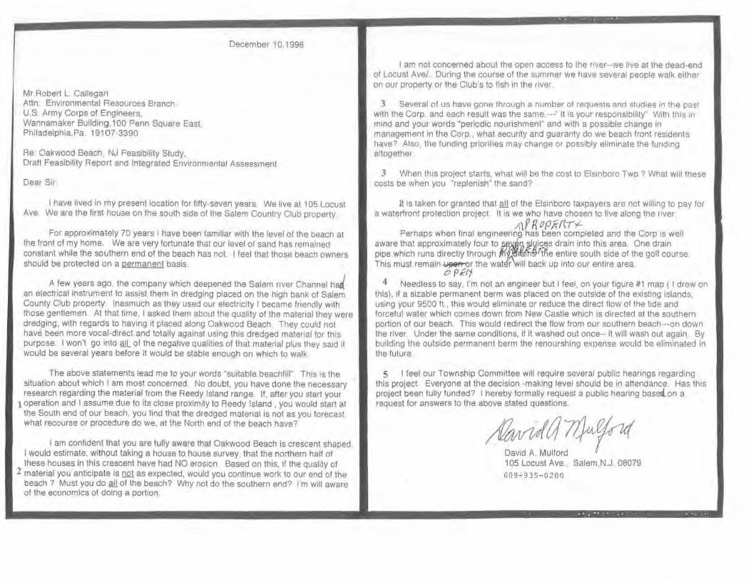
Mr.Robert L. Callegan Attn . Environmental Resources Branch. U.S. Army Corps of Engineers, Wannamaker Building,100 Penn Square East. Philadelphia.Pa. 19107-3390
Re: Oakwood Beach, NJ Feasibility Study,
December 10,1998
Draft Feasibility Report and Integrated Environmental Assessment
Dear Sir
I have ltved in my present location for ftfty-seven years We live at 1 05 Locust Ave. We are the first house on the south stde of the Salem Country Club property
For approximately 70 years I have been famtliar with the level of the beach at the front of my home. We are very fortunate that our level of sand has remained constant while the southern end of the beach has not. I feel that those beach owners should be protected on a permanent basis.
A few years ago. the company which deepened the Salem river Channel hJ an electrical instrument to assist them in dredging placed on the high bank of Salem County Club property Inasmuch as they used our electricity I became friendly with those gentlemen At that time. I asked them about the quality of the material they were dredging. with regards to having it placed along Oakwood Beach. They could not have been more vocal-direct and totally against using this dredged material for this purpose. I won't go into ruL. ot the negative qualities of that material plus they said it would be several years before il would be stable enough on which to walk.
The above statements lead me to your words "suitable beachfill" This is the situation about which I am most concerned No doubt, you have done the necessary research regarding the material from the Reedy Island range. If, after you start your
1 operation and I assume due to its close proximity to Reedy Island , you would start at the South end of our beach, you find that the dredged material is not as you forecasl , what recourse or procedure do we, at the North end of the beach have?
I am confident that you are ful ly aware that Oakwood Beach is crescent shaped I would estimate. without taking a house to house survey, that the northern half of these houses in this crescent have had NO erosion. Based on this, if the quality of
2 material you anticipate is !lQ1 as expected, would you continue work to our end of the beach ? Must you do sill of the beach? Why not do the southern end? I'm wilt aware of the economics of doing a portion.
I am not concerned about the open access to lhe river--we live at the dead-end of locust Ave/ .. During the course of the summer we have several people walk etther on our property or the Club's to fish in the nver
3 Several of us have gone through a number of requests anc1 stuc1tes in the past with the Corp. and each result was the same.---" it 1s your responsibility'' With this In mind and your words "periodic nourishment" and with a possible change in management in the Corp., what security and guaranty do we beach front residents have? Also, the funding priorities may change or possibly eliminate the funding altogether
3 When thts project starts, what will be the cost to Elsmboro Twp? What wtll these costs be when you "replenish' the sand?
it is taken for granted that all of the Elsinboro taxpayers are not Wtlling to pay for a waterfront protection project. It is we who have chosen to flve along the nver
/i\P R ~Pk({l'f-Perhaps when final engineering has been completed and the Corp ts well
aware that approximately four to ~~f), ~yices drain into this area. One drain pipe which runs directly through Jl'l~~€)~e entire south side of the golf course This must remain ~r the water will back up into our entire area.
o PKtf 4 Needless to say, I'm not an engineer but I feel. on your figure #1 map ( I drew on
this). if a sizable permanent berm was placed on the outside of the existing Islands, using your 9500 ft., this would eliminate or reduce the direct tiow of the tide and forceful water which comes down from New Castle which is directed at the southern portion of our beach. This would redirect the flow from our southern beach---on down the river. Under the same conditions, if it washed out once-- it will wash out again By building the outside permanent berm the renourshing expense would be eliminated in the future
5 I feel our Township Committee will require several public hearings regarding this project. Everyone at the decision -making level should be in attendance. Has this project been fully funded? I hereby formally request a public hearing base:ion a request for answers to the above stated questions.
105 Locust Ave., Salem,N.J. 08079
609-935-0200

\ \
\ \
\~·· , .. ~ ·" I I
• ·. I I
/Ti · :-F-.~r....,
I ;',• -~r----
1 ;_;--
u ....... . - . ,....,,,.,
..
Pelawa.re Bay CoastUao. DE 1!: NJ Oa.k,.ood Boacb. 1'/J
Featlbillty Study
S'l'tJDy AREA l"lll.\D,L-PDlA DLttl.tCT, CORPS OF t:PICftlr&A.S
US i\Ri\lY CORPS OF ENGINEERS COi\IMENT RESPONSE
Letter Date: I 0 December 1998
Response:
• (I) The granular matenal located in the proposed project borrow area may be classified as poorly graded medium to coarse sand with some gravel. The borrow material is coarser than the granular material currently located on Oakwood Beach, and is significantly coarser than any other source of borrow used by the Philadelphia Dist11ct anywhere in Its beachfill program. As such, it is expected that lhe bort'OW material will have a long residence time on the beach.
• (2) The progression of the beach fill would be established by the successful bidder at the time of constntction. Based on the sediment sampling conducted we fully anticipate that suitable coarse sand would be available from within the bon·ow area as noted above.
• (J) The State of New Jersey, acting through the New Jersey Department of Environmental Protection (NIDEP), is the sole non-Federal sponsor and as such will cost share the initial construction of the project with the Corps at 65% Federal and 35% NonFederal. NJDEP will also cost share in the periodic nourishment or contirwing construction of the project according to cost sharing agreeable to the Administration ns enacted by Congress in law. The non-Federal costs arc outlined in the report as $1,160,000 for initial construction and $3,255,000 for periodic nourislunent throughout the life of the project. Although the State of New Jersey is fully responsible for the nonFederal project costs; certain costs, operational responsibilities, and real estate requirements may be needed by the State from Elsinboro Township. These have not yet been fully enumerated. The non-Federal responsibilities include relocations, such as !ht: extension of outfall pipes.
• (4) A submerged offshore berm may have some beneficial effect by reducing the amount of wave energy that reaches the shoreline. In order to have much effect it would have to be built up significantly in order to impact winter storm waves, possibly during elevated tide conditions. However, the cove area was found to be a sensitive environmental area and these types of solutions were considered and eliminated earlier in the study. The most efficient and effective use of dredged sediment at Oakwood Beach however, would involve direct placement on the beach,
• (S) The Feasibility phase has been fully funded. The next phuse of study. wh1ch has not yet been funded , would be the Pre-constmotion Engineenng and Design phase which would be cost shared with non-Federal sponsor at 75% f-ederal and 25% non-Federal. A public workshop was held on 31 March 1999 with the Corps, NJDEP, and the Elsinbo10 Township residents to discuss the concerns of the toea I township officials and residents.

Salem County Planning Board 94 MARKET STREET • SALEM, NEW JERSEY 08079
Widdlfiold, Chatnn•n
609-935-7510 Ext. 412 FAX: 609·935-3830
December 3 I, 1998
Robert Callegari, CluefPianmng Divis1on Environmental Resources Branch US Army Corps of Engineers Wanamaker Building I 00 Penn Square East Philadelphia, Pa I Ql 07-3390
RE Oak"Wood Beach, N J Feasibility Study
~ear Mr Callegari,
The Salem County Planning Department supports the selected plan for storm protect1on and storm damage reduction for the Oakwood Beach community. We are particularly supportive of recycling the dredged sands from the Delaware main channel to benefit this community, and that public access has been successfully negotiated.
Sincerely
~ cC Rita Shade SiMon Environmental Plartner
cc. Elsinboro Township Committee
US ARMY CORPS OF ENGINEERS COMMENT RESPONSE
Letter Date: 31 December 1998
Response:
• No Response Needed

FISII ANU WILDLIFE COOROINATION ACT SECTION 2(h) REPORT
ASSESSMENT OF THE OAKWOOD BEACH INTERIM FEASffiiLITY STUDY, SALEM COUNTY, NEW JERSEY
u.s. FISH & WILDI.IF':F.
SERVICE
Prepared by.
U.S. Fish and Wildlife Serv1ce Ecological Services, Region 5
New Jersey Field Ofnce Pleasantville, New Jersey 08232
ranuary 191)(1
United States Department of the Interior FISH AND WILDLIFE SERVICE
Ecological Servicu 927 North Main Streer (Bldg, 01) Pleasanrvllle, New Jersey 08232
Lt. Colonel Debra M. Lewis District Engineer, Philadelphia District U.S. Army Corps of Engineers Wnnnmakcr Building I 00 Penn Square East
Tel: 609-646-9310 FAX: 609·646·0352
Philadelphia, Pennsylvania 191 07-3390
Dear Lt. Colonel Lewis;
January 6. I 999 .
This is the final report of the U.S. Fish and Wi ldlife Service (Service) ort anticipated impacts to fish and wildlife resources from the U.S. Army Corps of ~ngincers (Corps) proposed Oakwood Beach Project. This reporl was prepared pursuant to Section 2(b) of the Fish and Wildlife Coordination Act (FWCA) (48 Stat. 401, as amended; 16 U.S.C. 661 et seq.).
This report is provided in accordance wrth our Fiscal Year- I 998 scope-of-work agreement and is based on plans and lnfonnation provided in the Corps August 1998 Draft Oakwood Beach, New Jersey Feasibility Report and Integrated Environmental Assessment The Service previously provided the Corps with a Planning Aid Report (PAR) entitled, "Delaware Bay Coastline · Oakwood Beach, New Jersey Interim Feasibility Study, Fish and Wildlife Resources" (Septemher 1997). The 1997 PAR included information on fish and wildlife resources relevant to the Oakwood Beach Project.
The project purpose is to investigate and identify potential methods of protecting areas experiencing coastal erosion due to hurricane and storm damage. The Corps has identified that beachfill restoration is the selected method at Oakwood Beach to provide shoreline protection. Other alternatives that were considered include structural systems (e.g., bulkheads and stone revetments) and the no-action alternative. The selected plan involves lhe construction and maintenance of a 50-foot-wide berm immediately waterward of an existing re~ido:ntial community at Oakwood Beach. The Corps proposes to use beach nourishment material from the existing Delaware River main channel maintenance for initial fill and periodic renourishment of Oakwood Beach. This type of beneficial use of dredge material is typically encouraged by the Service.
Since the nearshore area of Oakwood Beach is relatively shallow. rl serves as an important nursery area for many fish species and supports significant recreational and commercial fisheries. In addition, islands and marshes adjacent to Oakwood Beach provide important

habitat for waterfowl. wading birds, shorebirds, and other aquatic-dependent wildlife. With appropriate mitigative measures, adverse impacts from the proposed project on these fish and wildlife resources can be tQinimized.
The b11ld eagle (Haliaeetus /eucocephalus), a federally listed (threatened) species, has been documented to nest within 6 miles of Oakwood Beach. Additionally, bald eagles have been documented to periodically nest within different areas of the Salem River watershed, While it is unlikely that shoreline protection activities would adversely impact roosting or feeding bald eagles in the vicinity of the project area, the Service recommends that the Corps re-initiate consultation pursuant to Section 7(a)(2) of the Endangered Species Act (87 Stat. 884. as amended; 16 U.S.C. 1531 et seq.) prior to the start of any construction activities to ensure that proposed activities du not adversely affect the bald eagle. Other than the bald eagle and an occasional transient peregrine falcon (Falco peregrlnus), no other federally listed or proposed endangered or threutened flora or fauna under Service jurisdiction are known to occur within the project area If additional information on federally listed or proposed species becomes available, this determination may be reconsidered
Additional information regarding this report can be provided by John Staples or F.ric Schradine of my staff. .,.
Sincerely,
Supervisor
Enrlosurc
2
FISH AND WILDLIFE COORDINATION ACT SECTION 2(b) REPORT'
ASSESSMENT OF TH~ OAKWOOD BEACH INTERIM FEASIBJLJ'IY STUDY, SALEM COUN'IY, NEW JERSEY
Prepared for:
U.S. Army Corps of Engineers Philadelphia District
Philadelphia, Pennsylvania 19107-3390
Prepared by:
U.S. Fish and Wildlife Service Ecological Services, Reg10n 5
New Jersey Field Of{ioe Pleasantville, New Jersey 08232
Preparer: Eric P. Schrading Assistant Project Leader: John C. Staples
Project Leader: Clifford G. Day
January 1999

EXECUTIVF. SUMMAR\'
The U.S. Army Corps-of Engineers, Philadelphia District (Corps) initiated the f?elllware Boy Coastllne, .Delaware and New Jersey Shore Protection Study, incqrpornting the Oakwood Beach Project, under the au thority of resolutions adopted by the Committee on Public Works and Transportation of the U.S. House of Representatives and the Committee on Environment and Public Works of the U.S. Senate in October 1986. The study area extends approximately !.8 miles along the Delaware River from Elsinboro Point to the Salem RIVer, Elsinboro Township, Salem County, New Jersey.
The Oakwood Beach Project (Project) is designed to protect a residential community from coastal erosion due to hurricane and storm damage. Oakwood Beach is a small commtmity comprised of primary residences and a few summer homes. The existing shoreline protection structures (e.g., seawalls, bulkheads, and revetments) vary in condition between new and very degraded. The Project involves 1.8 miles (10.9 acres) of beach nourislunent using a total of 332,000 cubic yards of sand along the Delaware Bay shorefi'ont of Oakwood Beach. Aotrow material would be generated from the Delaware River main channel and periodic Tenourishment would occur every 8 years (depending on need). Approximately 32,000 cubic yards of sand is anticipated for periodic nourishment and the material would also come from maintenance of the existing Delaware River main channel. I his type of beneficial use of dredge material is encouraged by the Service.
The Delaware Estuary provides i~pot1nnt habitat for numerous fish and wildli fe resources, including waterfowl, shorebirds, songbirds, raptors, and anadromous fish. The Oakwood Beach area generally does not support significant wildlife habitat because the shoreline has been degraded. Substantial bulkheads, revetments, seawalls, and rip-rap provide the interface between uplands and shallow water areas, and residentialtieveloprnent has encroached on the shoreline. However, since the nearshore area of Oakwood Beach is relatively shallow, it serves as an important nursery area for many fish species and supports significant recreational and commercial fisheries. In addition, islands and marshes adjacent to Oakwood Beach provide important habitat for waterfowl, wading birds, shorebirds, and other aquatic-dependent wildlife. With appropriate mitigative measures (e.g., seasonal restriction), adverse impacts on fish and wildlife resources can be minimized. Additionally, creation of a wide, gently sloping beach could potentially enhance fish and wildlife habitat within the project area by creating nesting areas for diamondback terrapin (Mafac/emy.~ terrapin terrapin) and providing a sand source to replenish offshore shoals used by finfish
TABLE OF CONTENTS
EXECUTIVE SUMMARY . , . , .. . . .... . ... i
LJST OF FIGURES I f I I
0 ' •
1 1 0 f I I • • • • t • • • • • • o 1 o I • o o t , ~ , • 0 , • , iii
APPENDICES .... • • a • • • , • , •• , • , , - • • , • • . - .... iii
l . INTRODUCTION ······· -· · ..... .. ... ... .. . ... .. . II. PROJECT DESCRIPTION ........ . , , , • . , . .... . , , • , • ....... . ,
Ill. METHODS AND PROCEDURES .. , • .. .• .... • . , • . • . . . . . • . , , .. •
IV. PHYSICAL CHARACTERISTICS ... • . . . • , . , . • .. _. . . , • . • .. _
v. FISH AND WILDLIFE RESOURCES ........ .• ... .... ' .. . ' ... VI. ENDANGERED AND THREATENED SPECIES ...
VII. IDENTIFICATION OF BENEFICIAL ANI> AI>VERSE IMI'ACTS AND MITlGATIVE MEASURES . . . . . . . . . . .. ........... ' ...... .
1\. BENEFfCfAL AND ADVERSE IMPACTS ' t I I o I I o o I o o I I I
L 2.
Extraction from Borrow Areas Beach Nourishment ...... .
• ' ' " • I ~ o o o I o o • • • 1 o • o
o • > o o o o 0 I o 0 f I .. o o • o • • •
B. MITIGATIVE MEASURES ............ . , .. . .... . . . , , . , • .
I. 2.
Extraction from Borrow Areas Beach Nourishment ....
• • o • • • • o • • • • • o o o o o • o I I 1
VIII. CONCLUSIONS AND RECOMMENDATIONS
IX. REFERENCES ................ • , • , ...... • .. . , • ' . • • . • • • I
5
6
7
8
!I 9
10
10 II
12
13
A. LITERATURE CITED . . . . • . . . . . . . . •• , , . . ..... _ • , . . , . • 13 B. PERSONAL COMMUNICATIONS ....... . ... , , .• , .... , . , , • , 14
it

Figure l Flgur~ 1.
Appendix A.
Appendix B.
LIST OF FIGURES
Oakwood Beach Pr~JCel Area _ Oakwood Beach Borrow Area • •
APPENDJCES
Coordination with the New Jersey Divls1on of !•ish, Game and Wildlife
Federally Listed and State-listed Endangered and Threatened Species in New Jersey
iri
? 4
I . INTRODUCTION
This constitutes the U.S. Fish and Wildlife Service's (Service) final Fish and Wildlife Coordination Act, Section 2(b) report describing the ftsh and wildlife resources and supporting ~cosystems· in the area of the U.S. Army Corps of Engineers (Corps) proposed Oakwood Beach Project (Project). This report is provided in accordance with a Fiscal Year-1998 scope-of-work agreement betwcer1 the Service and the Corps Philadelphia District. The information presented in this report: documents the fish and wildlife resources in the project area; identifies potential beneficial and adverse impacts to !hose resources; provides recommendations to minimize adverse impacts; and identifies additional opportunities for habitat enhancement. The study area e:dends approximately 1.8 miles along the Delaware River from Elsinboro Point to the Salem River, Elsinboro Township, Salem County, New Jersey (Figure I).
The Delaware Bay Coastline, Delaware and New Jersey Shore Protection Study, that incorporater. the Project, was authorized by resolutions adopt~::d by the Committee oh l'ublrc Works and Transportation of the U.S. House of Representatives and the Committee on Environment and Public Works of the U.S. Senate in October I 986. The authorization calls for defining coastal area problems associated with erosion and identifying: potential solutions; costs; environmental and social impacts of potential solutions; and an optimized National Economic Development Plan.
The Service requests that no part of this report be used out of context and if reproduced, the report should appear in its entirely. Furthermore, any data, opinions, figures, recommendations, or conclusions excerpted from the report should be properly cited ami include the page number from which the information was taken. This report should be cited as follows:
Schrnding, F.P. 1998. Assessment of the Oakwood Beach llllerim Feasibility Study. Cape May County, New Jersey. Final Fish and Wildlife Coordination Act Section 2(b) Report. U.S. Department of the Interior, f'ish and Wildlife Service, New Jersey Field Office. Pleasantville, New Jersey 15 pp. +appendices.
Questions or comments regarding lhis report are welcomed by the Service. Written inquiries should be addressed to:
Supervis~•r U.S. Fish and Wildlife Servrcc New Jersey Field Office, Ecological Services 927 North Main Street, Building D Pleasantville, New Jersey 08232

N
0
II . PROJECT OESCRJPTION . Tite objectives of the Project are to take an mtegrated approach to the solution ol eroSion and inundation problems and storm vulnerability of the shoreline Specifically. the .objectives include the following:
1. Provide shore protection to reduce shoreline erosion and potential storm and inundation damages at Oakwood Deach.
2. Minimize degradation of the natural environment in areas impacted by planned shore protection measures and protect fish and wildlife resources. Where possible, the environmental character of the study area will be preserved and maintained.
The proposed project would involve bench nourishment along the Oakwood Deach Delaware Bay shore front. Specifically, the project would provide a bcachfi ll with a berm width of 50 feet and a total length of 9,500 feet. The lnndwardmost berm elevation would be constructed at +6.0 feet based on the North American Vertical Datum of 1983 (U.S. Army Corps of Engineers, 1998). The beach nourishment would include two 250-foot tapers at each project tcm1inus to tie into the existing beach. The slope of the beachfill is I vertical foot to 10 horizontal feet from the edge of the berm to the depth of closUic. The Oakwood Beach Project would require approximately 332,000 cubic yards of material (i.e., sand) for initial Iii I. Subsequent maintenance would re.quire 32,000 cubic yards of material and would be provided on an 8-year cycle coincidental with normal maintenance activities within the existing Delaware Rjver main channel (U.S. Army Corps of Engineers, 1998). Two existing outfalls would be extended as part of the project. The proposed project life is 50 years
The Corps identified that the maintenance of the existing Delaware River main channel would provide all of the borrow material (for initial fill and periodic rcnourishment) for the Oakwood Beach Project. Specifically, an area on the Delaware River main channel beto,~.een river mile 54 and 57 would be used to generate borrow material for the Oakwood Beach project (Figure 2). The Corps proposes that material for initial fill would be obtained via hydraulic dredge; however, material for periodic rcnourishment would be obtained by hopper dredge. The borrow material from the Delaware River main channel is comprised of 94 to 99 percent sand with less than two percent total organic content (U.S. Anny Corps of Engineers, 1998). Sand and gravel size of the borrow material varies between 0.075 mm to 38 mm. The majority of the borrow material is classified as medium to coarse grained sand varying in size between 0.4 and 0.6 mm (Dayan, pcrs. comrn .. 1998).
3

0
10 d
Ill. METHODS AND PROCEDURES
The information and findings presented in this report are based on review of the August 1998 Onkwooc.l Beach, New Jersey, Draft Feasibility Repon and Integrated Envltonmental Assessment (US Army Corps of Engineers, \998) and review of additional information made available to the Service by the Corps. The content of this report. 1s also based on rey1ew Qf Service files and library material; coordination with the New Jersey Divrsion of F1sh, Game and Wildlife's (NIDFGW) Bureau of Marine fisheries, Bureau of Shellflsheties, and Endangered and Nong111Tle Spec1es Program and a s1tc visit conducted hy Service biologist~ on July 15, 1997
TV. PIIYSICAL CIIARACTERISTIC'S
I he proJect area IS I ll miles long nnd primnnly mcludes residential development nnrl shoreline protection structures (e.g., bulkhe11d, revetment, rip-rap) Oakwood Beach extends from Elsinboro Point north to the Salem River The southern one-th1rd of Oakwood Ueach has almost no beach at high tide. and limber bulkheads and concrete seawalls protect individual homes. The center one-third of Oakwood Beach con~1~ts of a narrow beach (approximately 30 to SO feet wide) with pla.shc and wood bulkheads placed immediately landward of the mtertidal area. The northern one-third has little to no beach wuh seawalls and revetments protecting homes. The limited extent of project area beaches and shallow water areas are typtcally comprised of a veneer of sand overlaymg a mud substrate that was likely former salt marsh Extensive shallow water habitat extend~ from the waterward extent of the project area to the Delaware River Channel The project area is bordered landWI!rd by residential development (mostly smgle-family houses) and comprises tho entire upland portiOn of the shoreline. Approximately 114 residential structures occur within the project area and include primary residences and a few summer homes.
The extstmg shoreline protection structures (e.g, seawalls. bulkheads, and revetments) thllt separate the beach from residential development vary in condition between new and very degraded. Several of the existing structures are being undermtned and are detenorating Shoreline protecllon structures appear to be constructed by individual property owners and are constructed from vanous materials (e.g., concrete, gabions, timber. and np-rap from hishway demolit1on)
Salt-water marsh areas border the northern Rlld southern ends of the proJect area Emergent wetlands 1n the vicinity of the project area are either dominated by Spar/ina spp or Phragmites australis. Forested and scrub-shrub wetlands in the vicinity of the project area nre typically dominated by red maple (Acer mbmm) with sweetgum (Liquidambar styraciflua), southern arrowwood (Viburnum clcmalllfll), Rlld highbush blueberry (Vuccr11111111 spp.) as co-dominants. The Service considers the marsh hab1tat value for fish and wildlife resources as good to excellent
Recorded shoreline erosion over the past 112 years has subjected shoreline properties to storm damage from waves and tidal inundations and resulted in substantial wetland losses (U.S Army Corps of Engineers, \99\) National Oceanic Rlld Atmospheric Administration maps

dating back to 1881 indicate long-term erosion of the shoreline at Oakwood A each. I Iowever, the shoreline has remained relatively stable horizontally, but not vertically, since 1946 as a result of placement and maintenance of erosion control structures.
V. FISH AND WILDLIFR RESOURCES
The Servioe's "Delaware Bay Coaslline -Oakwood Bench, New Jersey Interim Feasibility Study, Fish and Wildlife Resources" Planning Aid Report (Schrading, 1997) providt.ls a detailed description of benthic organisms, finfish, shorebirds, wading birds, waterfowl, raptors, and other terrestrial wildlife that occur in the project area. The project area provides valuable open water habitat for a variety of finfish and benthic organisms. Adjacent intertidal and wetland areas also provide valuable habitat for migratory birds and other wildlife.
The U.S. Environmental Protection Agency ( 1994) characterized the benthos of the Salem River area, immediately north of the proposed project site, as degraded. Due to degradation of benthic habitats, there is no significant shellfish industry (i.e., clams, oysters) in the Oakwood Beach area (Dobarro, per'S. comm., 1997). Additionally, due to the lack of beach above the mean high tide and the low salinity of the water, there appears to be no potential habitat for horseshoe crabs. Although shellfish and horseshoe crab habitats are lacking, the project area supports potential habitat for blue c1abs (U.S. Environmental Protection Agency, 1996) and there is a sizable commercial fishery for hlue crabs (Callinectes sapidus) in the Delaware !lay. Normant (pers. comm .• 199R) identified that the Oakwood Beach area is used by commercial harvesters for blue crabs.
The nearshore area of Oakwood Oeach is relatively shallow and acts ns an important nursery area for rnany fish species including: striped bass (Morone saxati/i.r), bluefish (Pomatomus sa/latrix), silverside (Menidia spp.), anchovy (Anc:Jwa spp.), spot (Leiostomus xantlwrus), and Atlantic menhaden (llrevoorfia tyrannus) (Allen, pers. comm., 1997). Oakwood Deach is an important samplrng station for the NJDFGW and surveys have been conducted tllt:re since 1980. ·n1e area supports significant recreat ional and commercial fisheries, primarily as a rc!sult of nutrient expnrt from wetlands.
The Emergency WetlAnds Resources Act of 1986 (P.L. 99-645) directs the Department of the Interior to identify the location and types of wetlands lhat should receive priority attention fo1 ac']uisilion by federal and State agencies using Land and Water Conservation Fund appropriations. The designated priority wetlands also include "focus areas" identified by the Atlantic Coast Joint Venture of the North American Waterfowl Management Plan (NA WMP) as containing critical waterfowl wintering, migratory, or hreeding habitat, with an emphasis placed on hlack duck habitat. Wetlands adjacent to the project area on the northern and southern ends arc classified ns both Service priority wetlands and NA WMP "focus areas. '' As such, while the shoreline within the project urea provides limited value for wildlife species, adjacent wetland areas pr·ovide habitat of high value for a variety of shorebirds, waterfowl. and rap tors.
6
The project area also provides feeding and limited nesting habitat for the diamondback terrapin (Ma/ac:lcmys terrapin). Local residents claim that these turtles historically have nested at Oakwood Beach. Bench renourishment of the Oakwood Bench area may restore some.nesting habitat for northern cliamondback terrapins, pr6vided beach areas arc constructed above the levels of nonnal high tides. '
VI. ENDANGERED AND THiillA'fENED SPECIES
The bald eagle (Ha/iaeetus leucocephalus), a federally listed (tlu·catencd) species, has been documented to nest within 6 miles of Oakwood Beach. Additionally, bald eagles have been documented to periodically nest within different areas of the Salem River watershed. The bald eagle typically nests atop large trees within sight of water in areas with little human disturbance. Bald eagles are opportunistic feeders and will eat carrion or live prey, including fish, small mammals, and waterfowl. Pollowing the nesting season, if food is readily available, migratory eagles may temporarily roost in an area for several weeks before moving on to a more permanent winter roosting site.
Bald eagles are often attracted to a waterbody, such es the Salem River adjacent to the subject project area; therefore, eagles from the nearby nest site may occasionally forage or roost in the vicinity of Oakwood Beach. While it is unlikely that shoreline protection activities would adversely impact roosting or feeding bald eagles in the vicinity of the project area, the Service recommends that the Corps re-initiate consultation pursuant to Section 7(a)(2) of the Endangered Species Act (87 Stat. 884, as amended; 16 U.S.C. 1531 ct sf!q.) prior to the start of any construction activities to ensure that proposed activities do not adversely affect the buld eagle.
Other than the bald eagle and an occasional transient peregrine falcon, no other federally listed or proposed endangered or threatened flo1'a or founa under Service jurisdiction are known to occur within the project orca.
Several federally listed marine species under the jurisdiction of the National Marine Pisheric~ Service (NMPS) may occur within the Oakwood Beach project area and within the proposed borrow area, Including the fedeially listed (endangered) shortnose sturgeon (Acipenser brevinJstrum), Atlantic Ridley turtle (Lepidochelys kempli), hawksbill turtle (Eretmocltelys imbrlcata), and leatherback h1rtle (Dermochelys coriocea), and the federally listed tthreatened) loggerhead turtle (Care/fa care/fa) and green turtle (Chelonia myda.v). Coordination with NMFS regarding potential adverse impacts to these species is recommended. Seasonal restrictions on dredging of the Delaware River main channel and placement of nourishment material at Oakwood Beach may be necessary to ovoid adverse impacts on these feder~lly listed species.
A variety of State-listed endangered and threatened species inhabit the beaches and marshes of the Oakwood Beach area. The State-listed (endangered) pled-billed grebe (Podilymbus podiccps) is known to occur within the marshes adjacent to the Oakwood Beach project a~en . The State-listed (threatened) American bittern (Botaurus lentlginn.ws) may also occur within
7

marshes and riparian corridors adjacent to the Oakwood Beach proJect aren (New Jer~cy Dlvtsion of fish, Game and Wildlife, 1997) Only breeding populations uf the 1\menctul bittcm arc State-hsted as threatei1ed Andrews (1•190) reports.breedtng populattons pf the State-hsted (threatened) great hluc' heron (Art/('(1 hr1 odw~) and little blue heron <Errr.ua cnerulell) using rca Patch Island Addihonally, a yellow-crowned night heron (Nycttnllcn . vinlnceus), State-listed as threatened. was recorded nt tht: mouth of the Solem Rrver, whtch ts immediately notth of the proposed project site (New Jersey Audubon Soc1ety, 1990).
The osprey, State-listed as threatened, is a common resident in the Oakw~o~ .Beach o~ca and the project are11 provtdes important habitat for this );pecies (New Jersey Otvts1on of ftsh, uame nnd Wildlife, 1997). ~evcral otht:r State-listed endangered and threatened raptms mtgrate or restde 111 marshes adJuccnt to Oakwood Beach, includint' the State·lt.stcd endangered short-eared owl (A.f/u jlwmmms), Cooper's hawk (.·lcdpl/rl' c:onpcru), nnll northem harrier (Circm cyllneus) and the State-listed threatened ted-shoulder.cd hawk ( llutt•o li11eatus). Due to the limited habitat available within the Oakwood Beach ProJect area and the trnnstenl nature of many ol the above-mentioned State-listed spectes, it IS unlikely thi:tl the proposed pro.iect would advcr~ely impact State-listed species.
VII. II>ENTIFICATION OF BENEFICIAL AND ADVERSE IMPAC TS, AND MlTlGATIVI~ MEASURES
A. OENf:FICIAL AND ADVERSE IMPACT"
Shoreline protcctton efforts that mclude extracttou uf .matcria~s lrotn olfshorc. borrow areas und related beach nourishment operations may result 111 n vanety ot adv~rse tmpact~ t~ benthic organisms, finfish, and wildlife. Beach nolllishmcnt and rcnounshment nc.ltvtttes abu
result in the loss of shalluw w:ttcr cover types.
1. Extracuon from Borrow Areas
Dredging burrow areas results in the removal of sedtment and orgamsms nnd adversely impacts water quality. Borrow material for bench nouris~ment n~ Oakwood ~each would b~ excavated from approximately 3 miles of the Delaware Rivet matn cha~nel (t.e .. 800-footwtde channel) This proposed dredging would adversely 1m pact approximately 291 acres .of benthic habitat, resulting in mortality of benthic organism~. '!'l~c Corps r;port'l that benthtc in fauna in terms of density (ranging from 1,486 to 3,744 mdtvtduals I m ) and bromnss (ranging from 1 1 and 18.1 g/m1), arc similar between the navigational channel ami ndJncem shallow and deeper water areas (U.S. Army Corps of Engineers, 1998) Howevc1, m~st . benthic orgnnisms within the Delaware Bay's dynamic ecosy~tem have adapted to penodtc changes in habitat that occur ns a result of northeasters, humcnnes, and other st.orm.s. 0s n result, benthic organisms typically recoloni7e an area quickly: provided the habttnt •~ _sttll suttable. Salomon eta/ (1982) concluded that benthic orgamsms recover from drcdgmg. events in approximately one year, wi th minor scdiment~logical ch~~gcs, and a small dcchn~ in diversity and nhundancc wi thm the benthic communtty. In nddtllon, smce borrow matenal
would regularly be removed from the navtgational channel, the envtronmental impacts associated with dredging would occur with or without the proposed shoreline protection project. The Service genernlly supports benelicinl us~ of dredge mnteri3l for purpo~es such ,,., shoreline protectton
rite borrow mate ·tal from the Uelaware Rtver mntn channel IS CQOlpn'lcd oi 1)4 to •><I percent sand with less th11n two percent total organic content (U.S. Amty Corp:; of EngmCCI'l), 1998} Sand and gravel size of the borrow material varies between 0.075 mm to 38 mm. ·1 he State of New Jersey does not require contaminant testing of dredged matcriul if the mntt:rial to be dredged is greater than 90 percent sand (gmin .~i:>:e > 0.0625 mm) (New Jen;ey Department of Environmental Protection. 19Q7). However, the State of Delaware owns all subaqueous lands to the low water line in New Jersey tn this por!IUII of the Delaware Lstuary and cxprcs5t:d concems regurding potential presence of polychlonnatc:d biphenyls (PCBs) in the borrow material As part of the Delaware River Main Channel Deepening Project, sediment cores within the Delaware River mam channel were tested to quantify the levels of mclaiN, pesticides, PCBs, volatile organic compounds, ;cmivolatile organic compounds, and total organic carbon (U.S. Army Corps of Engineers, 1991). Total organic carbon of the borrow material Is low, and was measured as 0 percent in the top 3.5 feet of sediment Of the heavy metals detected m the borrow aren sediments, only cadmium ( 1.1 to 2.2 mglkg) tested above the New .Jersey Residential Criteri:t (I mg/kg): however cadmnun levels are lower tha11 the New Jersey Non-Residential Criteria (100 mg/kg). No other chemical contaminants were detected withtn the proposed borrow area, including PCBs (U <; Amty C'orps of Engmeers, 1998).
fhe type of cqutptnent used and the time of yenr e~ttraction occurs may greatly influence the nature and extent of adverse impacts related tu dredging, For example, dredging by hydraulic dredge may reduce short-term adverse impacts on wtttcr quality but may impact eggs, young fish, and other slow-moving organisms unable to avoid entrainment The timing of dredging IS also important in that, tf initiated concurrently with a period of low btological 11ctivity (November to January), adverse impacts on fish and wildlife resources can be minimized
2. Beach Nourishment
The proposed beach nourishment would bury infnunal organisms and result in mortality within the shallow nearshore (littoral) zone. Approximately I 0 9 ltW!s ol subtidal area lbduw mean low wnter) would be unpacted by beach fill placement. Most of the organisms inhabiting the dynamic nearshore nnd intertidal zones are htghly mobile and adapt quickly t~l significant changes in abiotic factors. Reilly and Bellis ( 1983) determined that recovery of macrofauna is rapid after beach nourishment activities cease; however, the recolonitcd communi ty may differ considerably from the original community Differences in grnin siu between the original bench and sand provided for beach nouri~hmcnt may also alfcct the rntr. of recolonization and communi~y diversity. Da~cd on the recorded grain sizes it.lcntiliec.l in the Delawnre River main channel, some of the borrow material may have fairly large gram size (i.e., I 0 mm to 38 mm). Placing beach nourishment material on Oakwood Beach with
9

significantly different grain size from the existing grain size on the bench may limit the rate of recolonization and use by fish and wildllfe resources.
Beach nouri~lunent, when 'finfish such as the striped bass are using the shallow water areas as nursery habitat, could adversely impact juvcn,ile finfish (Allen, pers. comrn., 1997) Turbidity and rc-suspension of toxic materials such as cadmium cun adversely affect .JUVenile finfish during o life stage that is sensitive to changes in environmental factors. Avoidance of beach nourishment activities during use of the area as nursery habitat would rntmmtze adverse impacts on juvenile finfish.
Olue crabs spawn lhroughout the summer tn the low sahmty waters near the mouth of the Salem River. Larval stages develop in shallow water areas through Octoher (Nonnnnt, pers. comm., 1998). Beach nourishment activities could impact spawmng activities of blue crabs by increasing turbidity in the project area and re-suspending contaminated sediments, In addition, construction between May and October could result in burial of larval or juvenile hlue crabs.
The Service expects that the likelihood of shorebirds to nest on beaches witlun the project area is currently low due to the limited extent and narrow width of the beach. In addition, extensive human disturbance and the presence of man-made shoreline protection structures further limits the value of the beach orcas for shorebirds. I lowevcr, the proposed beach nourishment may create suitable nesting and feeding habitat for shorebirds. Occurrence and nesting of federally listed or State-listed threatened or endangered species may require restrictions on some recreational activtties and beach management activities to protect these species from adverse impacts. However, based on existing information. other thon transient shorebird feeding, it is unlikely that the project oren 'yould support substanlilll shorebtrd feeding or shorebird nesting.
'I he proposed long-terrn maintenance (e.g., 50 ye11rs) of a bench could provide il sand source fQr off-shore shoals. Off-shore shoals are used hy finfish and the re-supply of sand to such shonls could be important to matntaining the integrity of this finfish hnbitnt
B. MITIGt\TIVE MEASURES
I Extrachon from Oorrow Areas
llle Water Resources Development Act of 1<196 (33 U.S.C 2201 et 1eq., 100 S!ltt 4082) (WRDA) directs the Corps to place a greater emphasis on disposal of dredged material for beneficial uses, including bench nourislunent Sectton 207 of WRl>A of 1996 specifically allows the Corps to select a disposal method other than the least cost option, if the incremental costs arc reasonable in relation to the environmental benefits. The Service commends the Philadelphia District Corps f"r using mntcrial fl·om the Delaware River main channel maintenance for direct beneficial uses consistent with Sectron 207 of the WRDA of 1996.
10
rhe Corps proposes to use a hydraulic dredge with a pipeline delivery system to mmrmizc turbidity. ~d ~dverse impacts on adjacent shallow water for initial beach fill (U.S. Anny Corps of Engmcers, 1998). · However, the Co111s would use hopper dredging for subsequent perio~ic renoorishme~t. Typically hydraulic-pipeline dredging is prefctTcd over hopper'
·dredgmg by the Servtee because hydraulic dredging minimizes turbidity. Additionally, hydraulic-pipeline dre'dging minimizes the potential entrainment of federally listed sea turtles (Greene, pers. comm., 1996). Therefore, the Service recommends the use of hydraulicpipehne dredging over hopper dredging whenever feasible As identified previously, the ~MF~ s.hould be consulted regarding potential impacts on federally listed species (under its )UrtSdtchon) as a result of the proposed project The Service understands that the Corps has contact~d the NMFS regarding this proJect The Service also recommends dredging during the penod of lowest biological activity (November to January) to minimize impncts on benthic organisms
2. Beach Nourishment
Beach nomishmenl and subsequent renourishmelll would create npproximately 10.9 acres of new beach area along Oakwood Bench. Much of the area created and the cxisltng beach area would be considered upland It is a~sumed that the Corps would obtain an easement for the project nrea for the project life (e.g., 50 years) rn order to complete rcnourishment activities. However, it is unclear what type of casement would exist after the project tS completed In order to prevent residential or commercial development (including alternative shoreline protection ~tructures such as bulkheads and revetments) within the project area or adjacent beach area, the Service recommended that the Corps obtain a perpetual deed rcstrichon or conservation easement for the newly created beach and adjacent bench areas. The Co1ps identified that "temporary and permanent casements required for implementation of this project will be acquired prior to initiation of construction" (U.S. Army Corps of Engmcers, 1998). The Service concurs; however, the type of easement and associated restrictions shouiJ be identified aud provided to the Service for review and comment.
The Corps proposes to elttend tW(I existing outfall structures to ensure that stormwater is not bcmg discharged directly on the beach. Slonnwater outfall from adjacent r~:sidential areas and the Snlem Country Club golf course can discharge contammated matenal into the Delaware River including herbicides, pesticides, fertilizers, and petroleum products. Ensuring that all stonnwater that flows through the extended outfull pipes is treated (e.g., collected in u st?r~watcr treatment ba_sin) prior to dischurge is one opportunity to protect water quality wtthm the proposed project area. Therefore. the Service recommended thnt the Corps investigate any such opportunities to protect ur improve water quality in the proposed prOJect area (e.g., water treatment basin). The Corps identified that "treatment of the stonnwatcr prror to discharge is unrelatlld to the extension of the outfalls" and that "stonnwntcr mrutagcment is n local responsibility" (U.S. Army Corps of Engineers, 1998). The Service understands thut stormwater tnl!nagement is :t local responsibility. However, the Service presumes that the Corps has some discretion in project design to it1cludc environmental
II

improvements such as stonnwatcr treatment basins. The Service only requests that opportunities to improve the wnter quality at Oakwood Bench be investigated as part of this project.
The proposed bench nourishment ~;ould adversely tmpa~>t JUVentlc ,fin !ish (e.g., striped bass) during the nursery period due to increased turbidity and re-suspension <>f contaminated 'sedtments (e.g., cadmium). Spawning and juvenile production of blue crabs could also be adversely affected by construction of the proposed project. In order to minimize adverse impacts on juvenile finfish and spawning blue crabs, the Service recommemlct.l that the Corps avoid beach nourishment activities between April l and October 30. However, based on additional recommendations by the NJOFGW (Appendix A). the Service tecommemls extending this seasonal restriction from between March I and October 30 to avoid adverse tmpncts on in-river and shallow water aquatic resources, specifically American shad (Alosa vttpitlis.~lma). blueback herring (Aio.m aestivalis), and striped bass. The Corps has not committed to the recommended seasonal restriction and only identified that "full consideration will be given to implementing construction schedules that minimize adverse environmental impacts" (U.S. Army Corps of Engineers, I 99!!). The Service strongly recommends that the Corps adopt and imploment the recommended scasnnal restriction.
Northern diamondback terrapin nesting habitnt is limited in the project area due, in part, to the lack of beach area above the high tide line. Beach rcnomishmem of the Oakwood 13ea~;h area may restore nesting habitat for northern diamondback terrapins, especially if beach area~ are constructed above the levels of normal high tides. The preferred window for renourishment is September to March to avoid impacts to eggs and juveniles (Jenkins, pers. comm., 1997). llowever, due to the limited availability of nesting habitat for diamondback terrapins within the project area, this sensonnl restriction ts not considered applicable.
The Corps proposes to re-nourish the proposed project area every 8 years coincidental with normal navigational channel maintenance achvities. The Service concurs with the Corps proposal to maximize the timeframe between renourishment cycles. Renourishment on an 8-year cycle should allow tbr recolonization of the intertidal and subtidal substrate between tenourlshmcht cycles.
VIII. CONCLUSIONS AND I~ECOMMENDATIONS
The proposed project area is located in a developed region of New Jersey that currently supports limited wildlife resources. However, the Oakwood Beach area does support valuable finfish nursery habitat and blue crab spawning habitat. Overall, implementation of the Oakwood Beach project could enhance some fish and wtldlife habitat within the project area. The proposed project could create additional nesting areas for diamondback terrapin, create feeding areas for shorebirds, and provide sand material to maintain off-shore shoals used by finfish. The Service supports the Corps proposal to use dredge material for beneficial use at Oakwood Beach provided certain measures arc implemented to minimize adverse impacts on
12
fish and wildlife resources. Potential project-related adverse impacts to fish and Wtldhfc could be minimize.d by incorporating the following recommendations into the final project design ' • ·
I.
2
J
4.
(i,
7
A
Re-imtiatc informal consultation with the Service pursuant to Section 7 .of'the Endangered Species Act prior to initiating any construction activities to ensure that project activities do not adversely affect the bald eagle.
Continue to coordinate wtth the National Mnrinc Fisheries Service regarding potentml impacts on federally listed threatened or endangered species under its jurisdiction
Use a hydraulic-pipeline dredgmg method whenever teasible for periodic renourishment
Schedule dredging during the period of lowest biological activity (November 1<t .January) to minin117.C tmpacts on benthic organisms.
Identity the type uf conservation casement and associated restrictions for the newly created bc;,ch and adjacent beach areas and provide the S<.:rvicc with 11n opportunity to review the easement.
Investigate opportunities to improve water quality in the proposed project, such as ensuring that all stormwnter that flows through the extended outfall pipes is treated (e.g., collected in a stormwatcr treatment basin)
Adopt and implement a seasonal restriction for beach nourishment aclivitics between March 1 and October 30 to minimize adverse impacts on juvenile finfish and spawning blue crabs.
l X. REFERENCES
LITERATURE ClTED
Andrews, R. 1990. Coastal waterbird colonies: Maine to Virginia 1984-85 J\n update of an atlas based on 1972 data showing colony locations, species, and nesting pairs at both time periods. U.S. Department of the Interior, Fish and Wildlife Service, Region 5. Newton Comer, Massachusetts. 807 pp.
New Jersey Audubon Society. 1990. Records of New Jersey Uirds. 15(4): 62-75.
New Jersey Department of Environmental Protection. 1997. The management and regulation of dredging activities ~nd dredged material in New Jersey's tidal waters. New Jersey Department of Environmental Protection, Trenton, New Jersey. 55 pp. + appendices.
13
New Jersey Division of Fish, Game and Wildlife. 1997. Notable lnfonnation on New Jersey Animals Database. New Jersey Department of f!nvironmental Protection, 1 renton, New Jersey.
Reilly,·f.J. Jr .. and V . .J. Bellis. 1983. The ccologicnl impact of beach nourishment with dredged materials on the intertidal zone at Bogue Banks; North Carolina. U.S. Anny Corps of Engineers Constat Engineering Research Center, Vicksburg, Mississippi. 74 pp.
Saloman, C.H., S.P. Naughton, J.L. Taylor. 1982. Benthic community response to dredging borrow pits. Pannma City Beach, Florida. U.S. Army Corps of Engineers Coastal Engineering Research Center, Vicksburg, Mississippi.
Schrading, E.P. 1997. Delaware Bay coastline- Oakwood Beach, New Jersey interim feasibility study, fish and wildlife resources. Planning aid report. U.S. Depat1ment of Jnterior, Fish and Wildlife Service, Pleasantville, New Jersey. 20 pp. + appendices.
U.S. Army Corps of Engineers. 1991. Delaware River comprehensive navigation study, main channel deepening, environmental impact statement amendment. Department of the Army. Corps of Engineers, Philadelphia, Pennsylvania
__ 1998. Oakwood Beach, New Jersey. interim leasihility study, draft feasibility report and integrated environmental assessment. Department of the Army, Corps of Engineers, Philadelphia, Pennsylvania. 150 pp. + appendices.
U.S. Environmental Pmh:ction Agency. 1994. The Delaware Estuary: Discover its secrets, comprehensive conservation and management plan for the Delaware Estuary. Delaware Estuary Program. 294 pp. + 7 appendices.
__ 1996. Comprehensive conservation and management plan for the Delaware Estuary. Delaware Estuary Program. 300 pp. + appendices.
!3. PERSONAL COMMUNICATIONS
Allen, R. 1997. Fisheries Otologist. Bureau of Marine fisheries, New Jersey Division of Fish, Game and Wildlife. Trenton, New Jersey.
Dayan, N. 1998. Biologist. U.S. Army Corps of Engineers, Philadelphia Distl'ict, Planning Oivision. Philadelphia, Pennsylvania.
Dobarro, J . 1997. Director, Bivalve Shellfish Office, Bureau of Shelllisheries. New Jersey Division of Fish, Game and Wildlife. Trenton, New Jersey.
Greene, K. 1996. Biologist. National Marine fisheries Service. U.S. Department of Commerce. Sandy llook. New Jersey.
14
.
Jenkins, D. I 997. Biologist. Endangered and Nongame Species Program. New Jersey Division o£ Fish, Game and Wildlife. Trenton, New Jersey.
' Norman!, J. 1998. Shellftsh Biologist. Bureau of ShellfisherieS, New Jersey Division oJ Fis\1. Game, and Wildlife. Trenton, N~tw Jersey.
15
~ § ~ "0 1(i
., 01)
.,;: E "' < .,so
j;l( ·~ .g ... Q c ·-o"'-z ·~ <o l;;l
""' c s::
""' :t; 0 < ... ·-g.~
ua >. ., ~ .,
....... ~ ., z
•
(I}
~oil u -Q z ~
""' 1)..
<
-

e Todd Whum~•"
"
Clifford G. Day, Supervisor US Fish and Wildlife Service 927 N Main St. (131dg. D I) Plearatm die, NJ 08232
Dear Mr. Day.
~tute of ;Nefu JjerselJ , Drpartment nl Fn\'lronment•l Protoclipn
IJJ~Itf<1't Cl' F"''· Gumt 11m/ 11'1/,/lif.' HMh'H \fl"lhhh jll /Jm•clor
/'0 Ror~nn (r(''"'"' \) fl$611-IUOO
September t4. 1998
1\nht.•rl C Shinr ComU,$$'•
!'Iris serves to ittfonn )'OIIthntth< Division of f15h. Game 111td Wildlife IDFGW] COIICUIS with the usrws 2(b) Drntl Coordinntiott Act Report emit led, As.<,'HIIIt''" ufth~ Ookwood D~och lm~rlm F,•oslbility Stlld,t•, Salem CriiiiiiJ', New.Jur.leJ•, S~pt~mber 1998. Tit~ assessment constitutes the Service's rcpon on fish and wildlife impacts that can be c~pecttd to resuh from the US Army Corps of Engineers' [ACOE] plan to protect ngninst coastal erosion b~ constructing n 50-foot wide berm inllttrdintely waterwntd of the Oakwood !leach residential con11murity for a len~th of nppro~fmatcl)• 9,500 LF.
Whflc we concur with the 1epor1 as a whole, '" arc concctned about the titne restriction of April I tluough October JO for the protection of n~ar-shore aquatic resources I i.e. recommendation II 7 in the teponj. Bee11use oft he early presence of AmericAn shad. ri"er herring and str!p~d bnss in this reach of the river or channel (i c. the source of the beachfill], we recommend thnt the time reStriction be e~panded to include March I through October 30. This would avoid any connict in protecting both in-river and slmllow ll'ater aqontic resources if the recommended drcdgin~ perfod of November through January needs to be Cl\pandcd or changed bcc.1use of bad wc1rther or other del a~ s
Lastly, we note that the State of Delawnre ma~ need to be consulted on this project. The boundary betwccot Delaware and New Jersey is the meon low water line at Oakwood 13each. Since the proposed beach rill would be placed over that Mea. it could move the mean tow water line and impact resources undct Delaware's jurisdiction. The~ fore, Delaware's approval of the project should also be sought.
We hope this irrfonnation is or service to you
c. A Dldttto
Sincerely,
.--.~~ .\J~ Robert Me Do~~~~~ Division ofFish. Game and Wild lire
APPENDIX ll
Federally Listed and State-listed Endangered and Threatened Species in New Jersey

FEDERALLY LISTED ENDANGERED AND THREATENED SPECIES
IN NEW JERSEY
An ENDANGERED species is any species mar is in danger of extinction rhroughour all or a significant ponion of its range.
A THREATENED ~pecies is any species !hat is likely to become an endangered species wirhin !he foreseeable furure throughout all or a significant portion of i1s range.
COMMON 1'\AME SCIENTIFIC NAME STATUS
FISHES Shorlnose sturgeon• Aclptnrer brevirostrum E
REPTILES Bog lurtle Clcmmyr muhlenberg it T
Atlantic Rldley turtle• Li!pldochelys kemp£1 E
Green turtle• Chelonia mydos T
Rawksblll turtle• Eretmochelys imbrlcato E
Le.atherbacl< turtle• Dermachelyr cariacca E
Loggerhead turtle• Carena caretra T
BIRDS Americ:.:ln peregrine (:~Icon Falco peregrinus onatum E
Bald t<~gle Haliaeerus /eucocephalus T
Piping plover Charadrius me/ad us T
Roseate tern Sterna douga/1/i douga/lii E
MAMMAlS .Eastern eougar - Felir concolor couguar E+ . ·.· ... .. ..
Jndl:lna bnt• ... , ..... ... l. •. Myotis soda/is E
"J .. ,L . r. ! .... •. i• r :: )\· • Gray ~olr - ·:.: . ' : Canis lupus E+
Delm~'rva rox squidtl .. Sciums niger cinereus E+ Bl~e.wha!e• '
Balaenoptera nwsculu.r E . . Finbacl< whale• Bolaenoptera phyralus E
num~hack -wti·;, ,~·· Megopte'.!!_ novaeangllae E
Rtghi ,~hate• . ,. Balacna glaclalis E
Set whale• ' Balaenoptera borealis E
Sperm wh~lc• Physe1er macrocephalus E Rc•i•cd 2/91
COMMON K-\.\IE SCIENTIFIC NAME STATUS . .
JNVERTEBRA TES Dwarf "e<lgemussel Alas~ldoma heterodon E
Northeztern beach tiger beetle CiciluMa dorsalis dorsalis' T
Mitchell Sl)lr butterny Nt:OII)'mpha m. miuhellii E+
American burying beetle Nicrophorus amcrlcanu1 E+
PLANTS Small whorled pogonia /sotria mrdcoloides T
Swamp pink :. 4 Ht:lonias bu/lata T
Eastern prairie fringed orchid Platanthua leucophaea T+
Knieskern's beaked-rush Rhyncltospora knicskLmii T
American chnffseed Schwalbca americana E
·sensitive joint-vetch A,•schynomcne vlrginica T
Sea-bench pl~weed AmarontlriiS pumilur T+
STATUS:
E endangered species PE proposed endangered
T rhreatened species PT proposed rhre~lened
+ presumed extirpale.d
• Except for sea runle nesting habitat, principal responsibility for these species is vested wirh !he National Marine Fisheries Servk( .
Nott.• for a complttt lining of Endongutd and 1hrtoJtMd Wtldlift nnd PltJnts, nfer Ia .50 CFR 17. II cllld 17.11.
For further inronnation, please contact.: U.S. Fish an~ Wilulif~ Service Ntw Jersey Field Offico 927 N. Main Strw, Buihlins D Ptc.:~.unlville, N~w Jusq 08232 Phone: (609) 646·9310 Faxc (609) 6~6 0352

~ ENDANGERED AND THREATENED ~·' WILDLIFE OF NEW JERSEY
Tremblay's Salamander, Amb)•s tom<J tumhl~>l•i Blue·sponed Salamander. Ambrslomll IRietiJI~ E!ls rern Tioer Salamander, Amb ~stomiJ t. r•prinum Pine Barrens Treelroo. Hy/11 ttnder5onii
lcmg·l~il~d Saf11m~nrter, Etut·rra lonoicnudtJ Eastern Mud S>l~m•nd~r. Pseudotnfon monriii11•S
~~~~~~~~~~~~~~~~~~~~~~~~~~~~~~~~~~~~~~~~~~~~uso~h~nGr~T~enoo,H~t~rs"~~
Endangered Species are !hose who~e pro~p('cts fe>r survi\'<~.1 in New Jersey arc m rm· media\e danger bec ause of a loss or change in hahilat, over-exploitatic>n, predation.
competition, disease, dimnbance or CC'ntamlnatie>n. 1\s~ist.:lnce is needed to prevent future extinction in New Jersey.
Threatened Spedes are those who m<y become endangered if conditions surrounding them begin to or continue to deterior2te .
Endangered
Pied-billed Grebe, • Podt1ymbtJs podiceps Bald Eaole. l"'sliseerus leucoceahalus • • Northern Harrier, • Circus cyoneus CoooN's Hawk, .Accioirer cooper// Red-shouldered Hawk. Bureo linearus ro• .. d;,.,, Peregrine Falco'1. fslco aereprinus · ' Piping Plover, Cflaradrius metod us • • lJoland Sandpiper. Bsrrramis long!r;eud(J Roseate Tern, Srerns dougsllii Least Tern, Srerns entil/srum Black Skimmer, flynchops niger Shon·eared Owl. • Asio flammeus Sedoe Wren, Cisrothorvs alatensis Lopgerhead Shri~e. Lanius ludovic/(Jnus Vespel Sparrow. Pooecetes ursm•neus Henslow's Sparrow, Ammodrsmus henslow•i
Endangered
Boo Tunle, Clemmys mvhlenber()i Atlantic Hawksbill. Eretmoche/ys imbric4tll ' • Atlantic Loggerhead, Cert!/111 c/lretrll' • Atlantic Ridley, Lepidochelys kemp/' • Atlantic Leatherback. Dermochelys COriDCC6 • • Corn Snake, Elsphe u. ()UN8tll Timber Rat11esnaf\e, Crolslus h. hortidv:s
DI RDS
1111 enlen ed
American Binern •, Botaurus lentiginosos Great Blue Heron •, Ardeo 11ere>d•zs I ittle Slue Heron. for ella ceerult• • Yellow-crowned Night Heron, N1·cranasss l•lo18ctL·s Osorey, Pandlon flali.,erus Nonhern Go5hawr.. Acciptrer genrilis Red· !>hovldered Hawk, Boreo linesrus lllon-b•••d;not
Slack Rail, L erf!rallus iamsicens•s lono·eared Owl. Asio orus Barred Owl, Strill varia Red·headed Woodoecller. Melanerpes eq•rhrocep!:aiL Cliff Swallow, • H/rundo pyrrhonOIB Savannah Soarrow, l>asserculus .<andlvt'chensis Ipswich Sparrow, Passerculus sand1vichensis pnncet Grasshopper Sparrow, Ammodramus sBvannerum Bobollnlo:. Dolichonyx or)'zivorus
•o"l'l" b,••dir'O popuhUon co,u1dtl•d •ndenoe.ud or ~hrcthnt
• •r• d•t•Uy t ndano• r• d or 1hft t1t n•d
REPTILES
17rreaJened
Wood Tut1le, Clemmys insculpta Atlantic Green Tunle. Chelonia mydas • • Nonhern Pino Snake, Pituophis m. melanoleucus
ENDANGERED A ND NONGAME SPECIES PROGRAM
NEW JERSEY DEPARTMENT OF ENVIRONMENTAL PROTECTION AND ENERGY DIVISION OF FISH, GAME AND WILDLIFE
1\lAI\ 1 J\1ALS .JNVEHTEURATES
Endangered Entfan gcrctf
Bobcat. Lynx rufus Eastern Woodrat. NeoromfJ (/oridana Soerm Whale Pl'wsPter, macroceph;tlus • •
Mitchell's Satyr lbutterllvl. Neonvmoh11 m mt~chellil' • Nonheastern Beach Tiger Beetle, Ciclndela d. dorsalis Amerlcar1 Suryino Beet le. Nicrophorus emericanus • • Dwarf Wedge Mu~$<el . Ald.<mtdont8 hererodnn • • in Whal9. 8el~en.,otef8 l.'hy,al~·s • •
el Whale, Belaenoprer11 bores/is· • lve Wh>le, 88/aenoprera mvsculus· • lumpback Whale, Meoanrers no~ceanpllae • •
Black f11Qht Wltm@, Blll4tnll Olaetslis • •
Ust rerisions;
FISil
Endnngered
Shonnose Sturgeon. Acioenser brevirosrrum' •
Ma.rch29, 1979 January 17. 1984 May 6, 1985 July 20, 1987 June 3, 1991
The lists ol New Jersey's endangered end nonpame wildlife soecies are maintai,ed by the OEP&E's Division ol Fish. Game and Wild·
life's, Enda,gered and Nongame Species Program. These lists are used 10 determine protection and management act io'1s necessary to insure the survival ol the State's endangered and nongame wildlife. This work is made possible only through voluntary contributions received through the Wildlife Check·olf 011 the New Jersey State Tax Form. The Wildlife Check·off \s the only m<ojor funding source for the protection end maNge· ment of the State's endangered and nongame wildlife re ·
_source. For more information about \he Endangered end Nongame Species Program o r to report a sighting of endangered
or threatened wildlife contact: Endangered and Nongame Species Program. Northern District Office. Box 383 R.D. 1. Hampton, N.J.
08827 or call (9081 735-8975 . (~~e) ~!S~S~!>o .
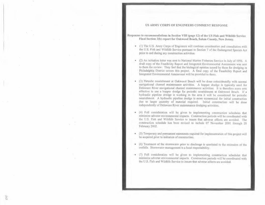
US ARMY CORPS OF ENGINEERS COMMENT RESPONSE
Responses to recommendAtions in Section VIII (page 12) of the US Fish and Wildlife Service Final Section 2(b) report for Oakwood Beach, Salem County, New Jersey.
• (I) The U.S. Anny Corps of Engineers will contmue coordination and consultation w1th the U.S. Fish and Wildlife Service pursuant to Section 7 of the Endangered Species Act prior to and during any construction activities.
• (2) An initiation letter was sent to NatiOnal Manne Fisheries Service in July of 1996. A dratl copy of the Feasibility Report and Integrated Env1rorunental Assessment was sent to them for review. They feel that the biological opinion issued by them for dredging in Philadelphia District covers this project. A final copy of the Feasibility Rep01t and Integrated Environmental Assessment will be provided to them
• (3) Periodic nourishment at Oakwood Beach will be dom: coincidentally with normal navigational channel maintenance activities. A hopper dredge is typically used for Delaware River navigational channel maintenance activities. It is therefore more cost effective to use a hopper dredge for periodic nourislunent at Oakwood Beach. l f a hydraulic pipeline dredge is working in the area it will be considered tbr periodic nourishment. A hydraulic pipeline dredge is more economical for initial construction due to larger quantity of material required. Tnit13l construction will be done independently of Delaware River maintenance dredging activities.
• (4) Full consideration will be given to implementing construction schedules that minimize adverse envirorunental impacts. Construction periods will be coordinated with the U.S. Fish and Wildlife Service to insure that adverse effects are avoided. The construction schedule has been revised to include 07 November 200 l through 28 February 2002.
• (5) Temporary and permanent easements required for implementation of this project will be acquired prior to initiation of construction.
• (6) Treatment of the stormwater prior to discharge is unrelated to the extension of the outfalls. Stormwatcr management is a local responsibility.
• (7) Full consideration will be given to implementing constructiOn sciH:dules that minimize adverse environmental impacts. Construction periods will be coordinated with the U.S. Fish and Wildlife Service to insure that adverse effects are avoided.

.. ~tate of ~efu 3}erse~
Department of Environmental f'n•t•ctwn
Office of Program Coordination PO Box 418
Mr Robert L. Callegari Chief, Planning Division
Trenton, NJ 08625·0418 Phone 609·292-2662
Fax 609-777·0942 [email protected]
January 11. 1999
Philadelphia District, Corps of Engineers Wanamaker Building, 1 00 Penn Square East Philadelphia, PA 19107-3391
RE: Draft EA Comments Oakwood Beach, Salem County
Dear Mr. Callegari:
The Office of Program Coordination of the New Jersey Department of Environmental Protection has completed its review of the Draft Environmental Assessment (EA) for the berm restoration project along Oakwood Beach (Eisinboro Township, Salem County). We offer the following comments on the Draft EA for your consideration regarding potentialtmpacts to natural resources. concurrence on your finding of "No Effect'' on significant cultural resources, land use permittmg, and public access
NATURAL RESOURCES
The Department's Dlviston of Fish, Game and Wildlife (DFGW) review of the Draft EA has concluded that they do not have any outstanding objections to the selected plan provided the recommendations expressed in the Draft 2(b) Coordinatron Act Report of the US Fish and Wildlife Servrce (USFWS) entitled Assessm ent of the Oakwood Beach Interim Feasibili ty Study, 1998 (Appendix A: page 12. Section VIII, Conclusions and Recommendations) ere incorporated into the project scope. The DFGW concurs with that report with one modification, that is, the extension of the time restriction in recommendation #7 (April 1 through October 30) to include the month of March. This would avoid any conflict tn protecting both in-river and shallow water aquatrc resources if the recommended dredgrng penod of November through January (recommendation #4) needs to be expanded or changed because of bad weather or other delays. The additional month is needed to protect the early
presence of anadromous fish (Amerrcan shad, river herring, and striped bass) in the lower Delaware River. As a result of the uncommitted Army Corps of Engineers (ACOE) responses to the most crucial recommendation in the USFWS report (see Appendix A), the DFGW believes it is necessary to get a commitment from the ACOE to comply with the recommended time restrictions for the benefit of the natural resources of the area
CULTURAL RESOURCES
Based on avaitabfe information, it Is the opinion of the Department's Historic Preservation Office (HPO) that there are no historic properties within the area of potential effect of the project Thus, pursuant to 36 CFR 800.4(d), no further Section 106 consultation is required, unless resources are discovered during project implementation pursuant to 36 CFR 800.11
LAND USE PERMITTING
The Draft EA notes that the proposed project will require a Water Quality Certificate and a concurrence of federal consistency with the Coastal Zone Management program of New Jersey. The Department's Land Use Regulation Program, as part of the certification and concurrence process. will identify any other land use permits required for the implementation of the proposed project.
PUBLIC ACCESS
The Selected Plan will includes pedestrian access to the beach approximately every one-half mile The Department endorses the increase of public access for recreational opportunities.
Thank you for giving the New Jersey Department of Environmental Protection the chance to comment on the Draft Environmental Assessment for the project.
c Bernard Moore Robert McDowell Ruth Ehinger Dorothy Guzzo Thomas Hampton
7~ Lawrence Schmidt Director Office of Program Coordination

US ARMY CORPS OF ENGINEERS COMMENT RESPONSE
Letter Date: 11 January 1999
Response.
• Natural Resources- Full cons1derahon will be given to implementing construction schedules that minimize adverse environmental impacts. Construction periods will be coordinated with the US Fish and Wildlife Service to ensure that adverse effects are avoided. The construction schedule has been revised and is expected to occur 07 November 2001 through 28 february 2002. All comments associated with the Final U.S Fish and Wildlife 2(b) Coordination Act Report recommendatiOns arc located at the end ofthe2(b) report appendices.
Cultural Resources· Comment noted.
• Land Use Permit ting- Water quality certificates and concurrence of Federal consistency with the New Jersey and Delaware coastal zone management programs have been obtained.
Public Access- Oakwood Beach is currently not a tourist destination nor is it anhcipatcd to be following project construction. Recreational benefits are not being claimed for the project. The primary project purpose is hurricane and storm damage reduction. Changes in the visitation volume from the existing condition as a result of the project are anticipated to be minimal. Nearby townships that have small benches along the Delaware R1ver do not attract visitors from outside the immediate area. Nearby street parking is Wlfestricted and is e;-.'Pected to accommodate all anticipated public usc. Nonresidents that use the area now are primarily boaters that use the Salem River and Cove. Public pedestrian access to the beach will be provided approximately every one-half mile.

Depanment of the Army Philadelphia Dtmitt, Corp of Engineers
Wanamaker Building I 00 Penn Square East Philndclphio, PA 19107-3391
Dear Mr. Dayan:
STATE Or' DnAWAR£ DIEPAAT~i!NT OF" NATURAL R£SOURCE5 8c
ENVIRON'MINTAl... CONTROL
DIVISION OF WATER RESOURCES 69 KINOS HIGHWAY
DOVER, DELAWARE t990t
January 12, 1999
This letter pmains to the Draft Feasibility Repon for the bem1 restoration project at Oakwood Beach, Salem County, NJ
The NPDES Stonn Water Program, created under the Clean Water Act, docs not directly address beach restoration. However. under the Municipal Segment of the Program land use. erosion and sediment control are addtcss~d . Thus, beach restoration and stabilization are tndirectly addressed.
I offer the following recommendations:
"· Comply with the Wetland and Subaqueous Land Section (WSLS) progmm regulations;
b Utilize the guidance, advise and cxpe11Jse from WSLS for shoreline stnbilizntion: and
c. Utilize the guidance. advise and cxpcnise from the DNREC, Division or Soil and Water Conservation tor shoreline rcs1oration and stabtlitatton.
If you have any questions. please call me at (302) 739-5731
Chuck Schadel Environmental Engineer Surface Wa1er Discharges Seclton
US ARMY CORPS OF ENGINEERS COMMENT RESPONSE
Letter Date; 12 January 1999
Response:
• Recommendations a-c have been noted
• Where applicable, coordination bas been in.itiated with the Delaware Depanmcnt of Natural Resources & Environmental Control, Division of Soil and Water Conservation and the Division of Water Resources. A water quality certificate and coastal zone management consistency statement has been requested from both the States of Delaware and New Jersey. All certificates and approvals will be obtained pnor to constmction.
STATE Of' DELAWARE
DEPARTMENT OF STATE n•V1'10N Q.:' ~~~TORIC"'AI ANO CULTURAL AFFAIRS
HISTORIC PRESERVATION OFFICE 1!5 THE GAl[."f
OOVlR • Ot • 1990,·36 t I
January IS. 199<)
Mr Robert L Callegari, Chief Planning Division Philadelphia District, Corps of Engineers I 00 Penn Square East Philadelphia, PA 19107-3191
ATTN Mike Swanda, Environmental Resources Branch
Dear Mr Callegari
This letter is pursuant to my review and comment on a draft report entitled Oakll'uod B.:ach, Mn11 Jersey: Draft Feasibtlity Report and lmewated Envtronmemal Assessment. Based on this review, it is our opinion no significant historic and/or archaeological resources are located in the area of proposed till below mean low water or at the proposed Reedy Island Range borrow source, which are Within the jurisdiction of the State of Delaware. Thus. pursuant to the Advisory Council on Historic Preservation's regulations (36 CFR 800), we can concur with a No Resources/No Effect determination for that portion of this project which is located within the State of Delaware.
(fyou have any questions or require any additional information, please do not hesttate to contact me at your convenience. Thank you
Sincerely,
&'d~~ Faye L Stocum Archaeologist
US ARMY CORPS OF ENGINEERS COMMENT RESPONSE
l.!.!tter Date. 15 January 1999
Response:
• No Response Needed

STATE OF DELAWARE
DEPARTMENT OF NATURAL RESOURCES & ENVIRONMENTAL CONTROL
D IVISIO N OF SOIL AN D WATER CONSERVATION
Mr. Robert Callegari U.S. J\.rrny Corps of Engineers Philadelphia District I 00 Penn Square East
89 KINGS H IGHWAY
COVER, DELAWARE, 19901
Phi !adelphia, Pennsylvania 191 07-3390
RE: Consistency Cet·tificatiun
12 Febnaary 1999
Oakwood Beach, NJ , Draft Feasibility Repurl ant.llntegrutcd Environmental Assessment
Dear Mr. Callegari:
The Deluware Coastal Management Program (DCMP) has received and rev1ewed your consistency determination for the above referenced project. Based upon our review and• pursuant to National Oceanic & Atmospheric Administration regulations ( J 5 CFR 930), the DCMP concurs with your consistency determination for the Oakwood Bcuch. NJ, Draft Feasibility Report and Integrated Environmental Assessment.
I Jowcver, we do have two specific comments regarding information contained in this document. First. it appears that the benefit-cost summary is based upon the assumption that the Delaware River 45-foot deepening project will be completed in the year 2000, yielding benefits from reduced maintenance dredging tltat total $181.000 (p96) or $ 149,000 (p ll 9). It is important to note that the Main Channel Deepening project has not yet been fully approved. and there are still remaining issues to be negotiated. The benefit-cost ratio for Oakwood Beach may be altered if calculutions are repeutcd a11d assumptions regarding the Muin Channel project are omitted.
Additionally. if for any reason the borrow site should change from the currently identified Reedy Island range of the Delaware River main navigation channd. we would need to evaluate the suitability of the:: new adcnt1ficd stte. We are currently utlhc prm:ess of examining the ultimate plans for disposal ofmatcnal removed from the bend widening lor the Main Channel Deepening project.
Our concurrence is based upon the restrictions and/orconditiOrlS placed on any and all pernuts issues to you for this project.
If you have any quest1ons regarding th1s determination, please Jo not hesitate to contact me ut (302) 739-345 I
Sincerely,
p~u~f-Sarah W. Cooksey Delaware Coastal Manage t P ram
SWC/jmr
cc: File 98.027
US ARMY CORPS OF ENGINEERS COMMENT RESPONSE
Letter Date: 12 February 1999
Response:
• Concurrence with the Federal conSIStency detern1ination bused upon the restrictions and/or conditions placed on all permits issued for this project is noted.
• Page C-23 of Appendix C (Economic Analysis) of the main report includes a benefitcost analysis should the deepening of the main channel not occur. Reduced Federal maintenance dredging benefits would still accrue to a lesser degree under existing conditions. The proposed shore protection project would still be justified without deepening of the main channel.
• Coordination will be re-initiated with appropriate resource agencies in the event a new borrow site is identified for the Oakwood Beach project.

Between: Nathan S. DJ.YflPp USACE 'I'~ 215-656-6562
Phone Conversation
and Anita Riportell:.l NMFS 732-872-3116
Topic: Oakwood Beach, New Jersey Drafi Feasibility Study and Integrated Environmental Assessment
Comment: National Marine Fisheries Service will not be responding in writing to tht: Environmental Assessment. They feel all their issues are covered in the report. They also feel the Biological Opinion issued by them for dredging projects in Philadelplna District covers this project.
US ARMY CORPS OF ENGINEERS COMMENT RESPONSE
Phone Conversation Log
Response:
• No Response Needed

Between: Nathan S. Dayan US ACE 21 S-656-6562
Phone Conversation
and Loren La Monica USEPA 212-637-3496
Topic: Oak\vood Beach, New Jersey Draft Feasibility Study and Integrated Environmental Assessment
Comment: U.S. Environmental Protection Agency will not be responding in writing to the Environmental Assessment. They feel all their issues are covered in the report. They also feel that the beneficial use of dredge material from the main channel will reduce the impact to the environment. They had further questions on historic erosion and were placed in contact with Jeff Gebert.
US ARMY CORPS OF ENGINEERS COMMENT RESPONSE
Phone Conversation Log
Response:
• No Response Needed

~inte of ~fef:o 3]crBey O~partment ol Em·~ronment•l Prnl!!clwn
Mr. Nathan Dayan Wanamaker Building Environmental Resources Branch 100 Penn Square East Philadelphia, PA 19107-3390
RE: Federal Consistency Determination Water Quality Certificate
Dear Mr. Dayan·
Oakwood Beach; Salem County, New Jersey File #1703-98-0003.1
HAR1ZIIIB
The New Jersey Department of Environmental Protection, Land Use Regulation Program, acting under Section 307 of the Federal Coastal Zone Management Act, as amended, has determined that the creation of 9,500 linear feet of 50 foot wide berm, at Oakwood Beach; Salem County is consistent with the Rules on Coastal Zone Management as amended to December 7, 1998
, :rhe source of the material along with the proposed construction techniques is detailed in a report entitled "Draft Feasibility Report and Integrated Environmental Assessment" prepared by the Army Corps of Engineers and dated August 1998
Issuance of this Federal Consistency Determination also includes the Department's authorization of a Water Quality Certificate to conduct a regulated activity in tidal waters.
Should you have any questions concerning this determination or wish to discuss the project further, please contact Kevin Broderick of my staff directly at (609) 984-0288.
Sincerely,
'J:/ "':fd H:Kio0~~~'•' and Use Regulati~~;:~
US ARM\ CORPS OF ENGINEERS COMMENT IU:SI'ONSE
Letter Date: 12 March 199'J
Response:
• No Response Needed

WETLANDS&. SUBAQUEOUS IANDSSEt'TtON
March 31, 1999
Robert L. Ca11egari Chief, Planning Division U.S. Army Corps of Eng meers CENAP-PL 100 Penn Square East Pht!adelphia, PA. 19107-3390
STATI!. OF DELAWARE
OIPAFITMI.NT OF NATUAAL AESOURC!S 8t
ENVI~ONMCNTAL CONTROl..
D I VISION OF WATER RESOURCES 89 KING$ HIG>iWAY
DOVER,OELAWARE 19901
TELEPIIONE (JOI)1l9-16'/l F"CSIMII-E tl0l)ll9-6JG<
RE: SP-377/98- Oakwood Beach Feasibility Study
Dear Mr. Cn11egari:
The Wetlands and Subaqueous Land Section has reviewed the uOakwood Beach, NJ Feastbility Study, Orafi Feasibility Report and Integrated Environmental Analysis," dnted August 1998 and received by this office on December I, 1999. Based on our current understanding of the project, we anticipate that we will issue water quality certification for this prOJect, after a review of the final project plans. Please be aw.are that this office can not make a final determination on water quality certification for the project until the final plans have been submttted and evaluated and public commenrs have been soliciled and reviewed.
Tf you have any questions, please contact us at (302) 739-4691 .
Program Manager I We!lands & Subaqueous Lnnds Section
Smcerely,
{J (£(, "'- j 1~~\t -~ 'V'~ Jl \ Wtlliam F. Moyer ProgrJm Manager II Wc!lnnds and Subaqueous
Lands Section
US ARMY CORPS OF ENGINEERS COMMENT RESPONSE
Letter Date: 31 March 1999
Response:
• No Response Needed