county of franklin, virginia comprehensive annual financial ...
Upload
khangminh22Category
view
1download
0
NORTHAMPTON COUNTY
VIRGINIA
ZONING ORDINANCE ADOPTED: APRIL 12, 2016

TABLE OF CONTENTS
Page 1 of 240
TABLE OF CONTENTS
TABLE OF CONTENTS ......................................................................................................................................................... 1
§154.2.001 – 004: GENERAL PROVISIONS ......................................................................................................................... 5
§ 154.2.001 AUTHORITY. ...................................................................................................................................................... 5 § 154.2.002 INTENT AND PURPOSE. ..................................................................................................................................... 5 § 154.2.003 DEFINITIONS. .................................................................................................................................................... 6 § 154.2.004 GENERAL CONDITIONS.................................................................................................................................... 41
§154.2.020 – 026: ZONING ADMINISTRATIVE STRUCTURE ESTABLISHED ....................................................................... 43
§ 154.2.020 ZONING ADMINISTRATOR............................................................................................................................... 43 § 154.2.021 SITE PLAN REVIEW AGENT ESTABLISHED. ....................................................................................................... 44 § 154.2.022 BOARD OF ZONING APPEALS AUTHORIZED. ................................................................................................... 44 § 154.2.023 HISTORIC PROTECTION REVIEW. ..................................................................................................................... 44 § 154.2.024 FILING FEES. .................................................................................................................................................... 44 § 154.2.025 ENFORCEMENT OF REGULATIONS. ................................................................................................................. 44 § 154.2.026 APPEALS. ......................................................................................................................................................... 44
§154.2.040 – 045: PERMITS AND PROCEDURES .............................................................................................................. 45
§ 154.2.040 ZONING CLEARANCE. ...................................................................................................................................... 45 § 154.2.041 CERTIFICATE OF OCCUPANCY. ........................................................................................................................ 45 § 154.2.042 SPECIAL USE PERMIT. ...................................................................................................................................... 46 § 154.2.043 AMENDMENTS. ............................................................................................................................................... 50 § 154.2.044 PROFFERING CONDITIONS TO ZONING DISTRICT REGULATIONS. ................................................................... 55 § 154.2.045 SITE PLANS. ..................................................................................................................................................... 56
§154.2.060 – 066: GENERAL REGULATIONS FOR ALL ZONING DISTRICTS ........................................................................ 65
§ 154.2.060 GENERAL APPLICATION OF DISTRICT REGULATIONS....................................................................................... 65 § 154.2.061 MEASUREMENT OF CERTAIN DIMENSIONS. ................................................................................................... 65 § 154.2.062 LOT REQUIREMENTS. ...................................................................................................................................... 66 § 154.2.063 TEMPORARY BUILDINGS. ................................................................................................................................ 66 § 154.2.064 ACCESSORY USES. ........................................................................................................................................... 68 § 154.2.065 PARKING AND LOADING.................................................................................................................................. 68 § 154.2.066 TRAFFIC VISIBILITY. ......................................................................................................................................... 68
§154.2.080 – 085: ZONING DISTRICTS AND MAPS .......................................................................................................... 69
§ 154.2.080 ZONING ORDINANCE TEXT AND MAPS ARE UNIFIED DOCUMENT. ................................................................. 69 § 154.2.081 ZONING DISTRICTS CREATED. ......................................................................................................................... 69 § 154.2.082 STATEMENTS OF INTENT FOR PRIMARY AND SECONDARY ZONING DISTRICTS. ............................................. 72
(A) Conservation District (C). ...................................................................................................................................... 72 (B) Agriculture/Rural Business District (A). ................................................................................................................ 72 (C) Hamlet/Residential District (H/R). ........................................................................................................................ 72 (D) Waterfront Hamlet/Residential District (WH/R). The intent of this District is: ................................................... 73 (E) Village District (V). ................................................................................................................................................ 73 (F) Waterfront Village District (WV). ......................................................................................................................... 73 (G) Existing Cottage Community/Residential District (ECC) ....................................................................................... 74 (H) Town Edge District (TE) ......................................................................................................................................... 74 (I) Existing Business District (EB). .............................................................................................................................. 75 (J) Existing Industrial (EI). .......................................................................................................................................... 75

TABLE OF CONTENTS
Page 2 of 240
(K) Existing Subdivision/Residential (ES/R). ................................................................................................................ 75 (L) Commercial (C-1) .................................................................................................................................................. 76 (M) WORKING WATERFRONT (WW). ...................................................................................................................... 76
§ 154.2.083 STATEMENTS OF INTENT FOR OVERLAY ZONING DISTRICTS. .......................................................................... 80 (A) Historic Preservation District (HP) ........................................................................................................................ 80 (B) Chesapeake/Atlantic Preservation District (CAP). ................................................................................................ 80
§ 154.2.084 STATEMENTS OF INTENT FOR FLOATING ZONE DISTRICTS. ............................................................................ 81 § 154.2.085 ZONING MAP. ................................................................................................................................................. 81
§154.2.100 – 120: SUPPLEMENTAL PERFORMANCE STANDARDS ................................................................................... 83
§ 154.2.100 GENERALLY. .................................................................................................................................................... 83 § 154.2.101 STANDARDS FOR CHESAPEAKE/ ATLANTIC PRESERVATION AREA. ................................................................. 83 § 154.2.102 STANDARDS FOR MARINA SITING. .................................................................................................................. 83 § 154.2.103 STANDARDS FOR DEVELOPMENT IN THE AGRICULTURAL DISTRICTS.............................................................. 83
(1) Conventional development use............................................................................................................................. 84 (2) Open space density bonus option. ........................................................................................................................ 84 (3) Base parcels .......................................................................................................................................................... 84 (4) Buildable area ....................................................................................................................................................... 84
§ 154.2.104 STANDARDS FOR OPEN SPACE PRESERVATION. .............................................................................................. 84 § 154.2.105 LANDSCAPE PLAN REQUIREMENTS AND STANDARDS. ................................................................................... 86 § 154.2.106 COMMERCIAL AND INDUSTRIAL ROAD FRONTAGE STANDARDS. ................................................................... 91 § 154.2.107 AIRPORT PERFORMANCE STANDARDS. ........................................................................................................... 92 § 154.2.108 AFFORDABLE HOUSING INCENTIVES AND STANDARDS. ................................................................................. 95 § 154.2.109 WIRELESS COMMUNICATIONS FACILITIES STANDARDS. ................................................................................. 96 § 154.2.110 DOMESTIC HUSBANDRY, TRADITIONAL HUSBANDRY AND INTENSIVE FARMING USES, FACILITIES, STRUCTURES AND BUILDINGS ...........................................................................................................................................101 § 154.2.111 AGRICULTURAL IRRIGATION PONDS. ............................................................................................................104 § 154.2.112 GENERAL LIGHTING STANDARDS. .................................................................................................................105 § 154.2.113 STANDARDS FOR WIND TURBINES AND WINDMILLS FOR ON-SITE RESIDENTIAL OR COMMERCIAL
PRODUCTION AND USE. ....................................................................................................................................................110 § 154.2.114 METEOROLOGICAL TOWER REGULATIONS AND PERFORMANCE STANDARDS. ...........................................113 § 154.2.115 STANDARDS FOR WIND ENERGY FACILITIES, WIND ENERGY TEST FACILITIES, AND WIND TURBINES, LARGE
AND UTILITY-SCALE. ..........................................................................................................................................................115 § 154.2.116 STANDARDS FOR CERTAIN AGRICULTURAL USES. ........................................................................................121 § 154.2.117 ACCESSORY DWELLINGS. ..............................................................................................................................123 §154.2.118 ADDITIONAL SINGLE-FAMILY DWELLINGS ON ONE LOT. ...............................................................................125 §154.2.119 EVENT VENUE ...........................................................................................................................................125
§154.2.125 – 128: USES, DENSITIES AND DIMENSIONS ................................................................................................ 127
§ 154.2.125 PURPOSE AND STRUCTURE. ..........................................................................................................................127 § 154.2.126 GENERAL REGULATIONS FOR RESIDENTIAL DISTRICTS. ................................................................................127 § 154.2.127 LOW IMPACT COMMERCIAL USES. ...............................................................................................................127 § 154.2.128 USE CATEGORIES. ..........................................................................................................................................131
§154.2.140 – 147: SUPPLEMENTAL REGULATIONS ........................................................................................................ 133
§ 154.2.140 PURPOSE. ......................................................................................................................................................133 § 154.2.141 GENERAL MODIFICATIONS TO YARD REGULATIONS. ....................................................................................133 § 154.2.142 FRONT SETBACK/YARD REGULATIONS. .........................................................................................................134 § 154.2.143 SIDE YARD REGULATIONS. ............................................................................................................................135 § 154.2.144 REAR YARD REGULATIONS. ...........................................................................................................................136 § 154.2.145 HEIGHT AND BULK REGULATIONS. ................................................................................................................136 § 154.2.146 ACCESSORY BUILDINGS AND FENCES. ...........................................................................................................137

TABLE OF CONTENTS
Page 3 of 240
§ 154.2.147 PERMITTED LOT FRONTAGE. .........................................................................................................................138
§154.2.160 – 165: OVERLAY DISTRICTS ......................................................................................................................... 139
§ 154.2.160 DISTRICTS ESTABLISHED. ...............................................................................................................................139 § 154.2.161 HISTORIC PRESERVATION DISTRICT (HP). ......................................................................................................139 § 154.2.162 AIRPORT PROTECTION DISTRICT (AP)............................................................................................................147 § 154.2.163 CHESAPEAKE/ATLANTIC PRESERVATION AREAS (CAP). ................................................................................149 § 154.2.164 US 13 CORRIDOR DISTRICT (US13C). .............................................................................................................171
§154.2.175 – 179: FLOATING ZONE DISTRICTS .............................................................................................................. 176
§ 154.2.175 FLOATING DISTRICTS. ....................................................................................................................................176 § 154.2.176 MOBILE HOME PARK (MHP). .........................................................................................................................180 § 154.2.177 BAYVIEW PLANNED UNIT DEVELOPMENT DISTRICT. ....................................................................................182 § 154.2.178 SOLAR ENERGY DISTRICT (SED). ....................................................................................................................182
§154.2.190 – 199: SIGNS ............................................................................................................................................... 186
§ 154.2.190 PERMITS REQUIRED FOR SIGNS. ....................................................................................................................186 § 154.2.191 TEMPORARY SIGNS. .....................................................................................................................................186 § 154.2.192 GENERAL SIGN RESTRICTIONS AND PROHIBITIONS PERTAINING TO ALL SIGNS. ..........................................187 § 154.2.193 PERMITTED SIGN STANDARDS. ....................................................................................................................188 § 154.2.194 COMPUTATION OF SIGN AREA. ....................................................................................................................190 § 154.2.195 SIGN ILLUMINATION AND SIGNS CONTAINING LIGHTS. ...............................................................................190 § 154.2.196 MAINTENANCE OF SIGNS AND REQUIRED PERMITS. ...................................................................................191 § 154.2.197 NONCONFORMING SIGNS. ...........................................................................................................................191 § 154.2.198 REMOVAL OR ABANDONMENT OF SIGNS. ...................................................................................................192
§154.2.205 – 213: OFF-STREET PARKING AND LOADING .............................................................................................. 193
§ 154.2.205 INTENT. .........................................................................................................................................................193 § 154.2.206 SPACE ON SAME LOT AND ADJACENT LOTS. .................................................................................................193 § 154.2.207 COOPERATIVE PARKING. ...............................................................................................................................193 § 154.2.208 SAFE AND CONVENIENT ACCESS REQUIRED. ................................................................................................193 § 154.2.209 PARKING AREA DESIGN. ................................................................................................................................193 § 154.2.210 GENERAL REQUIREMENTS. ...........................................................................................................................194 § 154.2.211 SITE REQUIREMENTS. ...................................................................................................................................195 § 154.2.212 OFF-STREET LOADING. ..................................................................................................................................196 § 154.2.213 MINIMUM IMPERVIOUS PARKING SPACES REQUIRED FOR PERMITTED USES. ............................................196
§154.2.225 – 230: BOARD OF ZONING APPEALS ........................................................................................................... 199
§ 154.2.225 COMPOSITION OF BOARD. ............................................................................................................................199 § 154.2.226 APPLICATION FOR VARIANCE. .......................................................................................................................199 § 154.2.227 PROCEDURES. ...............................................................................................................................................199 § 154.2.228 POWERS AND DUTIES. ..................................................................................................................................200 § 154.2.229 APPEALS TO BOARD. .....................................................................................................................................201 § 154.2.230 APPEALS FROM BOARD. ................................................................................................................................201
§154.2.245 – 999: NONCONFORMING USES AND VESTED RIGHTS POLICY ................................................................... 202
§ 154.2.245 INTENT. .........................................................................................................................................................202 § 154.2.246 NONCONFORMING USES, LOTS OR BUILDINGS. ...........................................................................................202 § 154.2.247 NONCONFORMITY IN GENERAL. ...................................................................................................................203 § 154.2.248 REPAIRS AND MAINTENANCE. ......................................................................................................................204 § 154.2.249 PROVISIONS FOR SPECIAL USES. ...................................................................................................................204 § 154.2.250 VESTED RIGHTS POLICY. ................................................................................................................................204

TABLE OF CONTENTS
Page 4 of 240
§ 154.2.998 VIOLATIONS. .................................................................................................................................................204 § 154.2.999 PENALTY. .......................................................................................................................................................205
APPENDICES .................................................................................................................................................................. 207
APPENDIX A: USE REGULATIONS ......................................................................................................................................207 Category 1 - Agricultural Uses ......................................................................................................................................207 Category 2 - Commercial Uses .....................................................................................................................................209 Category 3 - Community Service Uses ..........................................................................................................................216 Category 4 - Industrial Uses .........................................................................................................................................219 Category 5 - Marine-Related Uses ...............................................................................................................................224 Category 6 - Recreational Uses ....................................................................................................................................227 Category 7 SF - Single-Family Residential Uses ............................................................................................................231 Category 7 MF -Multi-Family Residential Uses ............................................................................................................233
APPENDIX B: DENSITIES, LOT SIZES AND DIMENSIONS ......................................................................................................234 APPENDIX C: MEASURING STANDARD SETBACKS AND RESOURCE PROTECTION AREA ...................................................237 APPENDIX D: 2000 ZONING ORDINANCE ................................................................................................................................ APPENDIX E: 1983 ZONING ORDINANCE ................................................................................................................................

§154.2.001 – 004: GENERAL PROVISIONS
Page 5 of 240
§154.2.001 – 004: GENERAL PROVISIONS
§ 154.2.001 AUTHORITY.
This chapter, to be cited as the Zoning Ordinance of Northampton County, Virginia, is ordained, enacted and published by the Board of Supervisors of Northampton County, Virginia, pursuant to the provisions of VA Code Title 15.2, Chapter 22, Article VII, as amended.
§ 154.2.002 INTENT AND PURPOSE.
(A) Intent. This chapter is intended to be in furtherance of and implement the goals, objectives and policies set forth in the Comprehensive Plan of Northampton County adopted by the Board of Supervisors of Northampton County and to implement the intents and goals of zoning ordinances set forth in the Code of Virginia, including but not limited to VA Code §§ 15.2-2200, 15.2-2283 and 15.2-2284. (B) Purposes. The regulations that follow are part of the county' s comprehensive program to guide and facilitate the orderly and economical growth of the community and to promote the public health, safety, convenience, comfort, prosperity and general welfare. More specifically, the purpose of these regulations is to:
(1) Provide for adequate light, air, convenience of access and safety from fire, flood and other dangers;
(2) Reduce or prevent congestion in the public streets; (3) Facilitate the creation of a convenient, attractive and harmonious community; (4) Assure that residential areas be provided with healthy surroundings for family life; (5) Facilitate the provision of adequate police and fire protection, medical services, disaster
evacuation, civil defense, transportation, water, sewerage, flood protection, schools, parks, forests, playgrounds, recreational facilities, airports and other public requirements;
(6) Protect against destruction of or encroachment upon historic areas; (7) Protect against the following: overcrowding of land, undue density of population in relation to
the community facilities or natural resources existing or available, including soil and groundwater supply, obstruction of light and air, danger and congestion in travel and transportation, or loss of life, health or property from fire, flood, panic or other dangers;
(8) Assure the growth of the community be consonant with the efficient and economical use of public funds;
(9) Encourage economic development activities that provide desirable employment and enlarge the tax base;
(10) Provide for the preservation of agricultural and forestal lands and other lands of significance for the protection of the natural environment, by measures including, but not limited to, the following: reducing and preventing sedimentation and soil erosion that may harm citizens or the natural environment; protecting the marine environment for the preservation of the waters of the Chesapeake Bay, the Atlantic Ocean, and the seafood industry; providing for the orderly development of the county in order to conserve valuable natural resources including farmland, forests, dunes, wetlands, waters and wildlife; and allowing for the safe and unobtrusive excavation or mining of soil or other natural resources;
(11) Protect surface water and ground water by means consistent with applicable state water quality standards;
(12) Allow for the provision within the county of a supply of safe, sanitary, affordable housing, in suitable environments, with a balance and variety of types of structures;
(13) Protect approach slopes and other safety areas of licensed airports and landing areas, including

§154.2.001 – 004: GENERAL PROVISIONS
Page 6 of 240
United States government and military air facilities.
§ 154.2.003 DEFINITIONS.
(A) General usage. Unless otherwise specified, all distances shall be measured horizontally and at right angles to the line in relation to which the distance is specified. In this chapter, words used in the present tense include the future tense; words in the singular number include the plural number and words in the plural number include the singular number; unless the obvious construction of the wording indicates otherwise. Certain frequently used words and terms are herein defined as follows:
(1) The word MAY is permissive;
(2) The word SHALL is mandatory;
(3) The word BUILDING includes STRUCTURES;
(4) The word LOT includes a PLOT and/or PARCEL;
(5) The word USED shall be deemed also to include DESIGNED, ERECTED, RECONSTRUCTED, ALTERED, PLACED or MOVED. (See also definition of USE in division (C) below;
(6) The terms LAND USE and USE OF LAND shall be deemed also to include BUILDING USE
and USE OF A BUILDING;
(7) The word STATE means the Commonwealth of Virginia;
(8) The word TOWN means the incorporated towns of Northampton County Commonwealth of Virginia, and the term TOWN BOUNDARY means any exterior boundary of an incorporated town;
(9) The word COUNTY means the County of Northampton, Commonwealth of Virginia, and the
term COUNTY BOUNDARY means any exterior boundary of the county or any boundary of unincorporated territory within the county; the word BOARD means the Board of Supervisors of Northampton County;
(10) The word PERSON includes a firm, association, organization, partnership, trust, company,
corporation, partnership and bodies politic and corporate as well as an individual;
(11) The terms BOARD OF APPEALS or BZA shall mean the Board of Zoning Appeals of Northampton County, Virginia and/or the incorporated town(s);
(12) The words PLANNING COMMISSION shall mean the Planning Commission of Northampton
County, Virginia, and/or the incorporated town(s);
(13) The words TOWN COUNCIL shall mean the governing body of the incorporated town(s) within Northampton County;
(14) The word ADJACENT means abutting, touching or contiguous to;
(15) The terms CODE OF VIRGINIA and VA CODE shall mean the Code of Virginia, 1950, as
amended;

§154.2.001 – 004: GENERAL PROVISIONS
Page 7 of 240
(16) The terms THIS CHAPTER and THIS ORDINANCE mean the Northampton County Zoning Ordinance;
(17) The term CIRCUIT COURT means the Circuit Court of Northampton County, Virginia;
(18) The term 2009 COMPREHENSIVE AMENDMENTS means the comprehensive text and map
amendments to this chapter adopted on October 20, 2009. The effective date of the October 21, 2009 Comprehensive Zoning Ordinance Amendments shall be 12:01 a.m. on the calendar day following their adoption;
(19) The term ADOPTION DATE means that date that this chapter, or a specific amendment
thereto, was adopted by the Board of Supervisors. The term EFFECTIVE DATE means that date that the chapter, or a specific amendment thereto, became effective and in force. If an adopted amendment does not specifically state an effective date, it shall become effective at 12:01 a.m. on the next calendar day following adoption.
(B) Interpretation by Zoning Administrator. In case of any dispute over the meaning of a word, phrase or sentence, whether defined herein or not, the Zoning Administrator is authorized to make a definite determination thereof, being guided in such determination by the purposes and intent of this chapter as set forth in § 154.2.002; provided, however, that an appeal may be taken from any such determination as provided in §§ 154.2.225 et seq. In the absence of a specific definition, words shall be given the generic meaning provided by the current edition of the Webster Collegiate Dictionary. (C) Specific definitions. For the purpose of this chapter, the following definitions shall apply unless the context clearly indicates or requires a different meaning. ACCESS. A way or means of approach or admission. ACCESSORY DWELLING. An attached or detached dwelling used as a residence that is subordinate to a single-family dwelling and is constructed in conformity with the performance standards in §154.2.117. ACCESSORY GOODS AND/OR SERVICES. Products, processes, or services related to the retail sale of locally-produced goods and services, which would reasonably and practicably add to the convenience, safety, or enjoyment of the service or the use or consumption of the primary product, or would further promote locally-produced goods and services, and which are clearly subordinate to the primary product or service. ACCESSORY USE OR STRUCTURE. A use or structure which is:
(1) Clearly incidental to and customarily found in connection with the principal use and structure;
(2) Subordinate to and serves the principal use or structure;
(3) Located on the same lot or parcel as the principal use or structure;
(4) Not, in case of accessory structures, attached by any common wall or by a common roof to a principal structure;
(5) Not considered to pose a demonstrated environmental hazard or to require a separate
authorization or permit from a regulatory authority other than the Health Department.

§154.2.001 – 004: GENERAL PROVISIONS
Page 8 of 240
ACREAGE. Any parcel of land described by metes and bounds on the county’s tax maps and not shown on a plat of a recorded subdivision legally admitted to record. ADMINISTRATOR. The Zoning Administrator of Northampton County and of incorporated towns under the jurisdiction of this chapter and her/his designee. See ZONING ADMINISTRATOR. ADULT DAY CARE. A facility equipped and staffed to provide daily caretaking of adults unable to care for themselves, or those who cannot be left alone, with no overnight accommodations. ADVERSE IMPACT. An impact that creates, imposes, aggravates, or leads to inadequate, impractical, unsafe, or unhealthy conditions on a site or degrades or damages environmental, cultural, or other resources on a site proposed for development or on off-site property or facilities. AFFORDABLE HOUSING. Housing, either rental or owned which is accessible to any or all of the HUD-defined income categories up to and including "low income," based on the "area median income," such that the occupant pays not more than 30% of his/her gross income for gross housing costs, including utilities, consistent with VA Code § 15.2-2201.
AGRICULTURE - DOMESTIC HUSBANDRY. Agricultural uses, structures and buildings
that meet the following criteria:
(1) Shall comply with §154.2.110 Domestic Husbandry, Traditional Husbandry and
Intensive Farming Uses, Facilities, Structures and Buildings;
(2) Shall be directly associated with the production and sale of farm animals or livestock kept for the majority of their lives unconfined within the property boundaries;
(3) Shall be fully for home consumption or hobby;
(4) May include riding / boarding and equine training activities; and
(5) Shall not include uses, structures and building defined as agricultural – traditional
husbandry; but may include smaller confined animal feeding operation, confined poultry operation or concentrated confined animal feeding operation regulated by the Va. Code which are not required to obtain an individual Virginia Pollution Abatement (VPA) Permit or an individual Virginia Pollutant Discharge Elimination (VPDES) Permit and have met the above criteria.
AGRICULTURE - INTENSIVE FARMING. Agricultural uses, structures and buildings that
meet the following criteria:
(1) Shall comply with §154.2.110 Domestic Husbandry, Traditional Husbandry and
Intensive Farming Uses, Facilities, Structures and Buildings; and
(2) Shall be directly associated with the production of farm animals or livestock which are
regulated by the Va. Code as an animal feeding operation, confined animal feeding
operation, confined poultry operation or concentrated confined animal feeding
operation; except those meeting the definition for agricultural – domestic husbandry or
agricultural – traditional husbandry.

§154.2.001 – 004: GENERAL PROVISIONS
Page 9 of 240
AGRICULTURE - TRADITIONAL HUSBANDRY. Agricultural uses, structures and
buildings that meet the following criteria:
(1) Shall comply with §154.2.110 Domestic Husbandry, Traditional Husbandry and
Intensive Farming Uses, Facilities, Structures and Buildings;
(2) Shall be directly associated with the production and sale of farm animals or livestock
kept for the majority of their lives unconfined within the property boundaries;
(3) May be fully for home consumption or a part of a person’s profession, livelihood or
business; and
(4) Shall not include uses, structures and building defined as agricultural – domestic
husbandry; but may include smaller confined animal feeding operation, confined poultry
operation or concentrated confined animal feeding operation regulated by the Va. Code
which are not required to obtain an individual Virginia Pollution Abatement (VPA)
Permit or an individual Virginia Pollutant Discharge Elimination (VPDES) Permit and
have met the above criteria.
AGRICULTURAL LANDS. Those lands used for the planting and harvesting of crops or plant growth of any kind in the open, pasture, horticulture, dairying, floriculture, silviculture, viticulture, or raising of poultry and/or livestock. AGRICULTURAL OPERATION. Any operation devoted to the bona fide production of crops, or animals, or fowl including the production of fruits and vegetables of all kinds; meat, dairy, and poultry products; nuts, tobacco, nursery, and floral products; and the production and harvest of products from silviculture activity and aquaculture. AGRICULTURAL PRODUCTS. Any livestock, aquaculture, poultry, horticultural, floricultural, viticulture, silvicultural, or other farm crops. AGRICULTURAL-RELATED PRODUCTS. Hand crafted agricultural theme items sold in conjunction with agricultural products and value added agricultural products at a farm market hand crafted by the owners or operators of the agricultural operation. Additional items may be displayed or sold as long as the display of these additional items does not exceed ten percent (10%) of the floor area of the farm market. AGRICULTURAL PRODUCE. Fruits and vegetables. AGRITOURISM ACTIVITY. Any activity carried out and compliant with § 154.2.116 (A) Standards for certain Agricultural Uses of the NCC on a farm or ranch that allows members of the general public, for recreational, entertainment, or educational purposes, to view or enjoy rural activities, including farming, wineries, ranching, historical, cultural, harvest-your-own activities, or natural activities and attractions. An activity is an agritourism activity whether or not the participant paid to participate in the activity. An agritourism activity shall not be deemed an agritourism activity solely by the reason of its taking place on a farm or ranch. AGRITOURISM PROFESSIONAL. Any person, including the land owner, who is engaged in the business of providing one or more agritourism activities, whether or not for compensation. AIRPORT. (Includes airfields, flight strips, heliports or glide ports). A place where aircraft may

§154.2.001 – 004: GENERAL PROVISIONS
Page 10 of 240
take off or land, discharge or receive cargoes and/or passengers. May be public or private and may or may not be licensed by the Virginia Department of Aviation. Does not include private airstrips. AIRSTRIP, PNU (Private Normal Use). Any pervious surface used for aircraft with a certified MGTOW under 3,500 pounds only between one hour before sunrise and one hour after sunset and with a frequency of not more than ten takeoffs and landings per day. The minimum takeoff distance plus clearway to fly over a 50-foot obstacle on a property used for this purpose must be at least 1,000 feet long and be located no closer than 300 feet to a property line. Compliance with FAR 91.117, Minimum Safe Altitudes, is essential. Agricultural aircraft engaged in crop spraying operations are limited to 16,000 pounds MGTOW. Agricultural aircraft engaged in oil-spill cleanup are exempted from the weight, frequency, and permit limits. AIRSTRIP, POU (Private Occasional Use). Any pervious surface used for aircraft with a certified MGTOW under 3,500 pounds only between one hour before sunrise and one hour after sunset with a frequency of not more than five takeoffs and landings per day. Compliance with FAR 91.117, Minimum Safe Altitudes, is essential. ALL-TERRAIN-VEHICLE (ATV) TRAILS. Marked, maintained, and supervised unpaved tracks or trails for mechanized ATVs and dirt bikes, with no ingress/egress to public or private roads, rights-of-way, or bicycle/hiking/walking trails; such ingress/egress shall be blocked by the trail operator. To mitigate such factors as noise, traffic, and dust, use of such trail facilities are only permitted by special use permit, and conditions may be imposed including, but not limited to, the following: setbacks, periodic noise-level studies, hours of operation, number of simultaneous users, vegetative buffers, fencing and restricting ingress/egress to a single owner-controlled entrance. ALTERATION. Change, such as any change in the total floor area, use or design of an existing structure. ALTERNATIVE SEWAGE SYSTEM or ALTERNATIVE SYSTEM. A wastewater treatment system that is not a conventional septic system consisting of a septic tank and drainfield and does not result in a point source discharge of effluent. Such systems must be approved by the Virginia Department of Health. AMEND or AMENDMENT. Any repeal, modification or addition to a regulation; any new regulation; any change in number, shape, boundary or area of a district; or any repeal or abolition of any map, part thereof, or addition thereto. AMUSEMENT PARK. An outdoor commercial recreational area of a permanent nature offering amusements, diversions and entertainments, whether operated seasonally or continually. APARTMENT or APARTMENT HOUSE. An arrangement of three or more attached dwelling units within a structure, each intended for occupation by a separate family. This arrangement can be side by side, in a row, up and down, or any combination thereof. A single apartment may be within or attached to a structure serving another non-residential use as an accessory attached dwelling unit. AQUACULTURE. The propagation, rearing, enhancement, and/or harvest of aquatic organisms, including but not limited to fish and shellfish, in controlled or selected environments, conducted in marine, estuarine, brackish, or fresh water. AQUACULTURE FACILITY. Any land, structure, or other appurtenance that is used for aquaculture, including any laboratory, hatchery, pond, raceway, pen, cage, incubator, or other equipment used in aquaculture. AQUACULTURE PRODUCTS. Any fish or shellfish harvested from aquaculture facilities.

§154.2.001 – 004: GENERAL PROVISIONS
Page 11 of 240
ARCHITECT. A person who is licensed by the state and who is registered with the Virginia Department of Professional and Occupational Regulation (DPOR) as a "licensed architect." ART GALLERY. A showroom/sales facility for two-dimensional and three-dimensional original and limited production art/artisan work, including video and audio technology. Sales are not limited to owner' s original work. ARTISAN. A skilled craftsman in the traditional media of clay, wood, metal, fiber, glass, stone, leather, or paper. ARTISAN STUDIO. An owner-operated workshop facility for creating products by hand, or with appropriate tools, in various media: wood, metal, paper, glass, leather, stone, ceramics, fiber, and mixed-media. May include sales/showroom for the artisan' s own work and may also include facilities for private instruction. Such a facility may have some outdoor production but no outdoor storage. ARTIST. One who is skilled, or works in, any of the fine arts (i.e. , drawing, painting, and sculpture). ARTIST STUDIO. An owner-operated workshop facility for creating two- and three-dimensional artwork, mixed-media artwork, and sculpture, by hand or with appropriate tools. May include sales/showroom area for the artist’s own work, both original and reproduction, and may also include facilities for private instruction. Such a facility may have some outdoor production but no outdoor storage. ASPECT. The outward appearance of the combined visual features of the community; visual attributes which contribute to the character of the area or entity. ASSISTED LIVING FACILITY. A congregate residential setting that provides or coordinates personal and health care services, 24-hour supervision, and assistance (scheduled and/or unscheduled) for the maintenance and care of four or more adults who are aged, infirm, or disabled and who are cared for in a primarily residential setting in accordance with VA Code § 63.2-100. ATHLETIC FIELD. A maintained field which may include restroom facilities and locker room facilities intended for scheduled sports events and other field activities. ATTACHED. Connected or, in the case of dwelling units, units that share a common wall(s). BARBER SHOP. A hair-cutting establishment which does not offer chemical treatments or processes. BASEMENT. The lowest story or level of a building having part but not less than one-half of its height below grade. BASE PARCEL(S). Those lawful parcels and their property lines existing in the public records of the county on October 21, 2009. However, if a parcel was legally in existence and zoned Agricultural on December 28, 2000, and if prior to October 21, 2009 that parcel was subdivided to allow the maximum number of bonus lots allowed under the zoning ordinance in effect at that time, the base parcel under the December 28, 2000, zoning ordinance shall be the base parcel for determining the development density of that parcel. BATTING CAGE. A screened facility for baseball/softball batting practice. BEACH. The shoreline zone composed of unconsolidated sandy material upon which there is
§154.2.001 – 004: GENERAL PROVISIONS
Page 12 of 240
mutual interaction of the forces of erosion, sediment transport and deposition that extends from the low water line landward to where there is a marked change in either material composition or physiographic form such as a dune, bluff, or marsh, or where no such change can be identified, to the line of woody vegetation (usually the effective limit of storm waves), or the nearest impermeable manmade structure, such as a bulkhead, revetment, or paved road. For the purposes of this chapter, BEACH is also included by reference in the definition of COASTAL PRIMARY SAND DUNE, consistent with VA Code § 28.2-1400. BEAUTY SHOP. A facility for hair washing, cutting, dressing and/or other processes which may include the use of chemical treatments and which often requires high water usage. May require licensing and Health Department approval. BED AND BREAKFAST. A dwelling unit, other than a motel, hotel, rooming or boarding house, or inn, occupied by the owner of the unit or a resident manager where up to nine separate sleeping rooms are provided, for compensation, to overnight transients and a morning meal is usually offered as part of the lodging charge. BEST MANAGEMENT PRACTICES or BMP’S. A practice, or a combination of practices, that is determined by a state or designated area-wide planning agency to be the most effective, practical means of preventing or reducing the amount of pollution generated by nonpoint sources to a level compatible with water quality goals. BILLBOARD. See SIGN, GENERAL OUTDOOR ADVERTISING. BIO-DIESEL PRODUCTION. The conversion of soybeans or other vegetable products into a non-petroleum-based fuel for diesel engines. BLADE THROW ZONE. Furthest distance from the tower base in which blades or other debris could be thrown from the wind turbine in the event of catastrophic failure. BLOCK. That property abutting one side of the street, and lying between the nearest intersection or intercepting streets or the nearest intersecting or intercepting street and railroad right-of-way, unsubdivided acreage, river or live stream, or between any of the foregoing in any barrier to the continuity of development. BOARD OF SUPERVISORS. The Board of Supervisors of Northampton County, Virginia. BOARD OF ZONING APPEALS. The Board of Zoning Appeals of Northampton County and any Board of Zoning Appeals of an incorporated town under the jurisdiction of this chapter. BOAT BUILDING AND REPAIR, STRUCTURAL. The construction or repair of hulls, rigging, and interiors of boats. BOAT HOUSE. A single-story structure limited to the storage of watercraft and/or watercraft equipment and constructed over the water. BOAT LANDING. A structure designed to launch and recover watercraft and including supporting facilities such as parking and storage. BOAT REPAIR, MECHANICAL. The repair of engines, motorized equipment, and electronic apparatus on boats. BOAT SALES AND RENTALS. A land-based boat yard or marina-based boat basin where boats are available for sale or rent.

§154.2.001 – 004: GENERAL PROVISIONS
Page 13 of 240
BORROW PIT. Any operation involving the breaking or disturbing of the surface soil or rock where the primary purpose of the operation is to facilitate or accomplish the extraction or removal of sand, soil, gravel, fill, or other similar material. Specifically exempt from this definition are the following:
(1) Any excavation for roads, drainage, stormwater management facilities, or similar features necessarily incidental to, and in accordance with, the approved construction plans for a residential subdivision or other similar development activity;
(2) Any excavation for the sole purpose of conducting a bona-fide agricultural operation, including, but not limited to, excavations to improve drainage, provide watering facilities for livestock, or create a holding lagoon for animal waste, or farm ponds or fish ponds; provided that none of the excavated material may be hauled off site or sold;
(3) Any excavation or excavations on any single lot or parcel of land which total less than one-
quarter acre in area and less than 12 feet in excavated depth as measured from the original ground level to the lowest point of the excavation;
(4) Any trench, ditch or hole for utility lines, drainage pipes or other similar public works
facilities or projects where the excavation is in accordance with the approved construction plans.
BUFFER AREA. An area of natural or established vegetation managed to protect other components of a resource protection area and state waters from significant degradation due to land disturbances. BUFFER (SCREENING). A device or vegetated growth, or a combination thereof, designed or used as a barrier to vision or noise between adjoining properties or land uses. A vegetated buffer may be opaque, intended to create a strong impression of spatial separation and to preclude visual contact; or semi-opaque, intended to maintain a sense of spatial separation and to partially block visual contact. BUILDABLE AREA. The area of a lot or parcel remaining after required yards, open spaces, parking, loading and access areas have been provided. When related to open space ratio, BUILDABLE AREA shall be the calculated upland portion of a base parcel, excluding any wetlands or ponds. BUILDING. Any structure used or intended for supporting or sheltering any use or occupancy for persons, animals, or property of any kind. BUILDING, ACCESSORY. See ACCESSORY USE OR STRUCTURE. BUILDING COVERAGE or LOT COVERAGE. All areas under roof or projection from buildings on a lot or parcel. BUILDING, HEIGHT OF. The vertical distance from the average finished grade at the building line to the top of the highest roof beam of a flat roof or to the peak of pitched or hip roofs or a mansard roof. BUILDING, MAIN. The building, or one of the principal buildings, housing the principal use on the lot or parcel. BUILDING OFFICIAL. An appointed official of the county responsible for enforcement of the Virginia Uniform Statewide Building Code (VUSBC) as described in VA Code § 36-105. BUILDING-INTEGRATED SOLAR ENERGY SYSTEM. A solar energy system that is an integral part of a principal or accessory building, rather than a separate mechanical device, replacing or substituting for an architectural or structural component of the building including, but not limited to, photovoltaic or hot

§154.2.001 – 004: GENERAL PROVISIONS
Page 14 of 240
water solar systems contained within roofing or building materials, windows, skylights, and awnings. BULK AGRICULTURAL PRODUCTS. Harvested but unprocessed vegetables, fruits, or grains. CAMP, DAY. A parcel of land devoted to outdoor/indoor recreation or cultural activities, not including overnight accommodations for users. CAMP, OVERNIGHT. A parcel of land used or designed to be used for overnight accommodations of individuals or groups and for use by such individuals or groups for sports, handcrafts and other outdoor-oriented activities and recreation. CAMPER. A trailer-type vehicle, not self-contained and not motorized; intended for temporary, recreational shelter. CAMPGROUND. An outdoor facility which accommodates paying guests for a stay of short duration in rustic cabins and shelters, tents, RVs, campers, or travel trailers owned by the guests. Parking, playgrounds, office, and retail uses such as snack bars or general stores for use by campground patrons shall be allowed as accessory uses. CAMPGROUND, RUSTIC. An outdoor facility which accommodates paying guests for a stay of short duration in tents, RVs, or travel trailers owned by the guests with no amenities provided. CARNIVAL. A traveling or transportable group or aggregation of rides, shows, games or concessions or any combination thereof. CARRY-OUT OR DRIVE-IN RESTAURANT. Any place or premises used for sale, dispensing, or serving of food, refreshments or beverages to customers in motor vehicles, including those establishments where customers may serve themselves and may eat or drink the food, refreshments or beverages in motor vehicles on the premises. CARRY-OUT OR DRIVE-IN RESTAURANT also includes refreshment stands, but not fast food establishments. CATERING, OFF-PREMISES SERVICE. The preparation of food, meals, or specialty products for off-premise consumption. May require Health Department approval. CELLAR. That portion of a building below the first floor joists at least half of whose clear ceiling height is below the mean level of the adjacent ground. CENTRAL WATER AND SEWER. Water, sewer, and wastewater treatment, including its infrastructure, provided by a developer, builder, or other private supplier, for a specific project or development, and serving three or more residential lots or a minimum of one non-residential lot. An approved plan for installation, upkeep, and maintenance must be recorded with the Clerk of the Court of Northampton County, and the system(s) must comply with all applicable State and Health Department regulations. CERTIFICATE OF OCCUPANCY. The certificate issued under the provisions of the Virginia Uniform Statewide Building Code (VUSBC) pertaining to the legal use and occupancy of buildings. New certificates of occupancy shall not be issued unless the structure complies with both the current edition of the VUSBC and this chapter. Temporary certificates of occupancy may be issued at the discretion of the Building Official and the Zoning Administrator in accordance with applicable state and local regulations. CHESAPEAKE/ATLANTIC PRESERVATION AREA or CAP. Any land designated by the Board of Supervisors pursuant to §62.1 -44.15:72. A CHESAPEAKE/ATLANTIC PRESERVATION AREA shall consist of a RESOURCE PROTECTION AREA and RESOURCE MANAGEMENT AREA as defined

§154.2.001 – 004: GENERAL PROVISIONS
Page 15 of 240
herein. CIRCUS. A traveling or transportable show or exhibition consisting of performances by persons and animals under one tent or similar structure, with or without side shows. CLUB. An association of persons for the promotion of some common object, such as literature, science, politics, good fellowship and the like created for the benefit of its members or the general public and not for profit. The term CLUB shall include LODGE. CLUSTER DEVELOPMENT; CLUSTER SUBDIVISION. An arrangement of residential structures or adjoining residential lots in groupings that would not be generally permitted under applicable ordinance requirements but are allowed under the concept of reducing lot size requirements to allow for the provision of additional open space within the development. COASTAL PRIMARY SAND DUNE. Hereinafter referred to as PRIMARY DUNE, shall mean a mound of unconsolidated sandy soil which is contiguous to mean high water, whose landward and lateral limits are marked by a change in grade from 10% or greater to less than 10%, and upon any part of which is growing any of the following species: American beach grass (Ammophila breviligulata); beach heather (Hudsonia tomentosa); dune bean (Strophostyles spp.); dusty miller (Artemisia stelleriana); saltmeadow hay (Spartina patens); seabeach sandwort (Honckenya peploides); sea oats (Uniola paniculata); sea rocket (Cakile edentula); seaside goldenrod ( Solidago sempervirens); Japanese sedge or Asiatic sand sedge (Carex kobomugi); Virginia pine (Pinus virginiana); broom sedge (Andropogon virginicus); and short dune grass (Panicum amarum). For purposes of this chapter, COASTAL PRIMARY SAND DUNE or DUNE shall not include any mound of sand, sandy soil, or dredge spoil deposited by any person for the purpose of temporary storage, beach replenishment or beach nourishment, nor shall the slopes of any such mound be used to determine the landward or lateral limits of a coastal primary sand dune. Also includes BEACH as defined above. COASTAL SECONDARY SAND DUNE. A mound of unconsolidated sandy soil which is contiguous to a coastal primary dune or shoreline, whose landward and lateral limits are marked by a change in grade from 2% to 50% and is classified as AsE 17-Assateague sand under the Northampton County Soil Survey. COMMERCIAL. Any wholesale, retail or service business activity established to carry on trade for profit; a use that is principally offered by its owner for a fee. COMMERCIAL CENTER. A group of retail or other business establishments, planned, developed, and owned and managed as a unit, with off-street parking provided on the property and related in size and type of shops to the trade area the unit serves. A neighborhood commercial center is designed to serve principally adjacent or nearby residential neighborhoods. A regional commercial center is designed to serve a larger geographic area than its immediate neighborhood. COMMERCIAL HOG FARM. A farm where hogs are kept and raised primarily for sale; the principal product or use of such a farm is hogs. COMMERCIAL POULTRY FARM. A farm where poultry are kept and raised primarily for sale; the principal product or use of such a farm is poultry. COMMON OPEN SPACE. Any space, tract or parcel of land owned in undivided interest, not devoted to residential uses or structures, but directly related and adjacent to a cluster development or planned development, as herein provided. COMMUNITY CENTER. A building or set of buildings designed or used to serve as a social

§154.2.001 – 004: GENERAL PROVISIONS
Page 16 of 240
center of a town, village, hamlet, subdivision or neighborhood. COMPATIBLE. Congruous with or having the same general characteristics as the existing entity and/or consistent with the organization of elements which make up the existing entity. COMPREHENSIVE PLAN. The adopted Comprehensive Plan for Northampton County, Virginia, including specifically the Land Use Plan, an element of the Comprehensive Plan, together with all other amendments and elements. CONDOMINIUM. Ownership of single units in a multiple unit structure or complex having common elements. CONFERENCE CENTER. A facility for work sessions, business meetings, and educational seminars, which may also offer on-site food service and overnight accommodations for clientele of the facility. CONSTRUCTION FOOTPRINT. The area of all impervious surface, including, but not limited to, buildings, roads and drives, parking areas, and sidewalks and the area necessary for construction of such improvements, such as land disturbance (grading, clearing, filling, and excavating), stormwater facilities, best management practices (BMPs), and utilities including drainfields, etc. The construction footprint may also include open space outside the buffer area up to 50 feet in width around the primary structure. CONTRACTOR, BUILDER/ CONSTRUCTION. An enterprise specializing in residential, commercial, or industrial construction, paving and utility installation, which may include heavy equipment and outdoor bulk storage. CONTRACTOR, HOME IMPROVEMENT/ INSTALLATION. An enterprise specializing in home repairs, remodeling, roofing, painting, siding, doors, windows, HVAC, plumbing, electric and similar residential building improvements, which does not include heavy equipment storage or extensive, unscreened outdoor storage. CONVENIENCE STORE, QUICK SERVICE. Any building, except a service station, which contains less than 5,000 square feet of net floor area and which is used for the retail sale of food, beverages, and other items. CONVENTIONAL ON-SITE SEWAGE SYSTEM. A wastewater treatment system consisting of one or more septic tanks with gravity, pumped, or siphoned conveyance to a gravity-distributed subsurface drainfield. CORN MAZE. A temporary series of trails cut through a corn or hybrid Sudangrass field for entertainment; its use may be offered for a fee. COUNTY RESIDENT ENGINEER. The Resident Highway Engineer of Northampton County, Virginia, of the Virginia Department of Transportation, or his/her designated assistant or deputy. CRITICAL ROOT AREA. A circular region measured outward from a tree trunk representing the essential area of the roots that must be maintained or protected for the tree’s survival. CRITICAL ROOT AREA is one foot of radial distance for every inch of tree DBH with a minimum of eight feet. DANCE HALL. A facility providing live or recorded music and a dance floor for the use and entertainment of patrons. DAY CARE CENTERS. Facilities providing day care or nursery services for children.

§154.2.001 – 004: GENERAL PROVISIONS
Page 17 of 240
DAY SPA. A private facility providing health, stress-reducing, and relaxation services such as facials, therapeutic massage, mineral baths, and beauty treatments. There shall be a maximum of ten clients at any given time, and no overnight accommodations shall be provided. DESIGN. The layout, arrangement, and composition of the main features of the community or other entity. DESIGN/PRODUCTION FACILITY. A facility for the design and production of specialty products, i.e., boat interiors, stage sets, specialty cabinetry intended for installation, acoustic musical instruments, hunting and fishing equipment. DESIGN STUDIO. A professionally- equipped studio for conceptual or abstract design. May include the production of prototypes for endeavors such as architecture, computer/internet design, engineering, urban planning, product design, advertising. DETACHED. Not attached to another structure or in the case of dwelling units, a dwelling surrounded by yards on all sides on the same lot. DEVELOPER. A person having legal title to any tract of land or parcel of land or authority to act for such person regarding the development or proposed development of property. DEVELOPMENT. Any man-made change to improved or unimproved real estate, including, but not limited to, buildings or other structures, mining, dredging, filling, grading, paving, excavation, or drilling operations, or storage of equipment or materials. DIAMETER BREAST HEIGHT or DBH. The diameter of a tree measured outside the bark at a point four and one-half feet above ground. DIRECTOR OF PLANNING AND ZONING. An appointed county official who serves as the Director of Planning and Zoning for Northampton County, Virginia, or his/her designated deputy or assistant. DISTRICT. A zoning district or category referred to in VA Code §§ 15.2-2280 and 15.2-2281. DOCK. A facility, including piers, pilings and boat slips, but excluding boathouses, for the mooring, berthing or securing of watercraft. DRIPLINE. A vertical projection to the ground surface from the furthest lateral extent of a tree’s leaf canopy. DRIVEWAY or ACCESSWAY. That space specifically designated and reserved on the site for movement of vehicles from one site to another or from a site to a public street or access easement. DROP-SHIP CENTER. A facility for storing, packing, and shipping of mail-, phone-, and internet-ordered merchandise. DUNE. See COASTAL PRIMARY SAND DUNE. DUPLEX. An arrangement of two attached dwelling units within the same structure, each occupied by a separate family and having the following specific characteristics: each unit has its own access to the outside, units have the same exterior architectural facade and treatment of materials, and units are not setback from each other and share the same roofline.

§154.2.001 – 004: GENERAL PROVISIONS
Page 18 of 240
DUSTLESS SURFACE. A surface adequately covered in practice with a minimum of either two applications of bituminous surface treatment, concrete, bituminous concrete, or equivalent paving material approved by the Director of Planning and Zoning and to be maintained in good condition at all times. DWELLING. A structure or part of a structure containing one or more dwelling units. Dwellings may be further identified as one-family (or single-family), duplex, multiple-family semi-detached, or attached. Dwelling units contain independent living facilities, and generally contain permanent provisions for living, sleeping, eating, cooking, and sanitation. DWELLING, ATTACHED. One of two or more residential buildings having a common or party wall separating dwelling units. DWELLING, CONDOMINIUM. A building or group of buildings in which dwelling units are individually owned, and the structure, common areas and facilities are owned by an association established under Virginia Law. DWELLING, MANUFACTURED HOME. A structure transportable in one or more sections, which, in the traveling mode, is eight body feet or more in width or 40 body feet or more in length, or when erected on site is 320 or more square feet and is built on a permanent chassis and is designed to be used as a dwelling with or without a permanent foundation when attached to the required utilities. The term MANUFACTURED HOME does not include a RECREATIONAL VEHICLE. DWELLING, MODULAR UNIT. A factory- fabricated transportable building designed to be used by itself or to be incorporated with similar units at a building site into a modular structure. The term is intended to apply to major assemblies and does not include prefabricated panels, trusses, plumbing trees and other prefabricated sub-elements incorporated into a structure at the site. DWELLING, MULTI-FAMILY. A structure containing three to five attached dwelling units, each intended for occupancy by a separate family. DWELLING, SEMI-DETACHED. One of two buildings, arranged or designed as dwellings located on abutting walls without openings, and with each building having a separate lot with minimum dimensions required by district regulations. DWELLING, SINGLE-FAMILY. A residential dwelling unit other than a single unit manufactured home designed for and occupied by one family only. DWELLING, SINGLE-WIDE, DOUBLE-WIDE OR TRIPLE-WIDE PORTABLE. A portable dwelling consisting respectively of one, two or three sections combined horizontally at the site to form a single dwelling, while still retaining their individual chassis for possible future movement. DWELLING, TEMPORARY. A manufactured home but not necessarily attached to a permanent foundation, intended for temporary use and occupancy. DWELLING UNIT. A single complete independent living facility for one or more families or persons physically separated from any other dwelling unit which may be in the same structure. An independent living facility includes permanent provision for living, sleeping, eating, cooking, and sanitation and must comply with Uniform Statewide Building Code requirements and Health Department regulations. The presence of a bathroom containing a sink and toilet shall constitute permanent provisions for sanitation. DWELLING UNITS are a unit of measurement used as one of the components to calculate density. EASEMENT. A grant by a property owner of the use of his/her land by another party for a specific purpose.
§154.2.001 – 004: GENERAL PROVISIONS
Page 19 of 240
ENCLOSED. Enclosed within a building. ENGINEER. A person who is licensed by the state and who is registered with the Virginia Department of Professional and Occupational Regulation (DPOR) as a ‘‘licensed professional engineer.’’ ENVIRONMENTALLY SENSITIVE AREAS. Land areas and/or water features vulnerable to degradation and/or destruction caused by flooding, erosion and sedimentation and/or subject to surface or groundwater contamination. ERECTED. Constructed, reconstructed, moved or structurally altered. ETHANOL PRODUCTION. The conversion of corn or other cellulosic matter into ethanol as the product is described in the Alternative Motor Fuels Act of 1988.
EVENT VENUE. The commercial use of land, structures and buildings established at a
permanent location where people assemble to take part in entertainment, educational, cultural,
organizational, ceremonial and / or celebratory events, open to the public or private parties for use, and
usually operated in exchange for remuneration. This use is separate from the use “agritourism” which
has separate standards establish by the Va. Code. EXISTING. Existing at the date of adoption of the ordinance set forth in this chapter. FABRICATION. The process of constructing or assembling a product from previously prepared parts, elements or materials which have been manufactured off-site of the fabrication activity. FAIRGROUND. A parcel or tract of land used either temporarily or permanently (as permitted herein), as the site of any fair, exposition or public display. FALL ZONE. Furthest distance from the tower base in which a wind turbine will collapse in the event of a structural failure. FAMILY. An individual, group of persons related by blood, marriage, adoption, or legal guardianship, or a group of no more than three unrelated persons living together as an independent housekeeping unit. FAMILY DAY HOME. A child day program as defined in VA Code § 63.2-100 where the care is provided in the provider' s home and is state regulated; locally approved or regulated homes are not included in this definition. FARM OR RANCH. One or more areas of land used for the production, cultivation, growing, harvesting or processing of agricultural products. FARM COTTAGES. As a commercial enterprise on a working farm, a group of up to 12 small separated structures, each with sleeping accommodations, and which may have cooking facilities, intended for short-term vacation rentals and subject to transient occupancy tax, not intended as permanent housing. FARM MARKET. A seasonal or year round business selling agricultural products, value added agricultural products and agricultural-related products from a permanent structure or building. FARM STAND. A seasonal business selling agricultural products and value added agricultural products. A farm stand shall not be a permanent structure or building, shall not be permanently affixed to the
§154.2.001 – 004: GENERAL PROVISIONS
Page 20 of 240
ground, shall comply with all applicable building codes and includes structures such as canopy tents and stands. Farm stands shall also include vehicles and mobile carts properly registered and licensed by the Virginia Department of transportation. FAST FOOD SERVICE OPERATION. A food service operation where food and/or beverages are prepared and dispensed either at a customer counter or through a drive-up window. Table seating may be provided, but table service is incidental to self-service. FASTLANDS. As used in the definition of shoreline, FASTLANDS means uplands. FENCE. A fixed structure designed to prevent escape or intrusion or to define property. FIRE LANE. A means of access of sufficient design to permit ingress and egress by firefighting equipment. FIRING RANGE, OUTDOOR. A maintained, supervised facility for firearm use. Includes the shooting of skeet and sporting clays and target practice. FLEA MARKET. A retail establishment or area of land on which are sold secondhand or antique goods. FLEXIBLE TERM RENTAL UNIT. An efficiency or suite apartment, available for rental for terms less than a full year and which includes cooking facilities and is considered a dwelling unit. FLOOR AREA. The total gross floor area of all floor or portions of floors in a structure and measured from outside to outside of exterior walls. FOOD PROCESSING. Any active change or transformation of farm crops, raw materials, or previously processed foodstuffs, using any physical or chemical means, which yields a new product or the same product in a different form. FOREST PRODUCT HARVESTING. The gathering of products yielded by naturally growing trees, shrubs and other forest plants, e.g., pine straw, decorative flora, and nuts. May include packaging for sale and distribution, but does not include logging or land clearing. FORM. The combination of visual qualities and elements, natural or man-made, which comprise a community or project. FRONTAGE. Lot width at the building set back line along a public road, private road or access easement. (See LOT WIDTH). FUNERAL PARLOR. A building used for the preparation of a deceased person for burial and the display of the deceased and ceremonies connected therewith before burial or cremation. GAME CENTER, COIN-OPERATED. An enclosed facility of no more than 1,500 square feet gross floor area containing coin-operated manual, electric, or electronic game machines. GARAGE, PRIVATE RESIDENTIAL. A structure which is accessory to a residential building and which is used for the parking and storage of vehicles owned and operated by the residents thereof, and which is not a separate commercial enterprise available to the general public. GARAGE, PUBLIC. A building, or portion thereof, other than a private residential garage used primarily for the parking and storage of vehicles and which is available to the general public.

§154.2.001 – 004: GENERAL PROVISIONS
Page 21 of 240
GARAGE, REPAIR. A building, together with the land upon which it is located and upon or within which a business, service or industry involving the maintenance, servicing, repair or painting of vehicles is conducted. GAZEBO. A residential accessory building consisting of a detached, covered, free-standing, open-air structure not exceeding 300 square feet and having a maximum height of 15 feet, designed for recreational use only and not for habitation. GO-KART TRACK. A maintained, fenced, non-impervious track for unlicensed mechanized vehicles. To mitigate such nuisance factors as noise, traffic, and dust, conditions may be imposed including but not limited to the following: setbacks; periodic noise-level studies; hours of operation; number of simultaneous users; vegetative buffers; fencing; and restrictions on ingress and egress to a single owner-manned entrance. GRAIN DRYER. A facility for drying grain. A COMMERCIAL GRAIN DRYER is one in which the grain dried is primarily grown by sources other than the owner and/or operator of the facility. A NONCOMMERCIAL GRAIN DRYER is one in which the grain dried is primarily grown by the owner and/or operator of the facility. GROSS ACREAGE. Total area expressed in acreage of a development or proposed development, including streets, recreational areas and other areas which function as part of the development, and easements, but excluding land classified as wetlands or conservation areas. GROUNDCOVER. The lowest vegetation stratum; generally all vegetation less than three feet in height and comprised primarily of herbaceous plants. GROUP HOME. A respite care service facility, retirement home or supervised living residential facility that houses more than eight individuals or otherwise is not a ‘‘residential facility’’ as defined herein. GUEST HOUSE. An accessory structure, clearly subordinate to the principal residence, intended to provide temporary accommodations for visitors and not intended for year-round occupancy. May be modular or stick-built with square footage not to exceed a maximum of 50% of the gross floor area of the primary dwelling on the parcel. Must meet all setback and water and wastewater/septic requirements. GUEST RANCH/LODGE. A commercial enterprise for guest accommodations with up to 12 rooms. May have one central building, or smaller separate units, for sleeping accommodations. Meals, entertainment and activities may be included as part of the accommodations, which are subject to transient occupancy taxation. GUIDE, OUTFITTER SERVICES. An operation established to provide information, direction, licensing and safety requirements to clients for recreational activities including, but not limited to, hunting, fishing, kayaking, hiking, bicycle and horseback riding, and bird watching. Includes conducting excursions, use, or rental of appropriate equipment, and incidental sales of associated gear and supplies. HEALTH CARE FACILITY. A facility or institution, whether public or private, principally engaged in providing services for health maintenance, diagnosis, or treatment of human disease, pain, injury, deformity, or physical condition. HEALTH CLUB/FITNESS CENTER. A facility which offers amenities for weight lifting, exercise and sports such as squash, racquetball, and basketball, exercise equipment and/or a swimming pool (with or without instruction), a steam room, and/or sauna. Such facility shall include restroom facilities and may provide locker room facilities and/or additional services such as dietary counseling and personal training.

§154.2.001 – 004: GENERAL PROVISIONS
Page 22 of 240
HEALTH OFFICIAL. The Director of Health for Northampton County or his/her designated agent or deputy. HELIPAD. Part of a heliport; a fabricated or grass surface for helicopter take-off and landing that does not include fuel or chemical storage. The surface must be maintained so that there is no flying debris. HELIPORT. A facility for helicopter take-off and landing which may include appurtenant facilities and services such as fuel, parking, maintenance, and storage. HISTORIC AREA. An area containing one or more buildings or places in which historic events occurred or having special public value because of notable architectural, archaeological or other features relating to the cultural or artistic heritage of the community and such significance as to warrant conservation and preservation. HISTORIC INN. A pre-1950 structure of historic or architectural significance as determined by the County' s Historic Review Board or the Board of Supervisors in which overnight lodging and/or food service is offered to guests. All such inns must meet applicable Health Department, Building Code or other county and state regulations. HOME OCCUPATION. A low-impact commercial use conducted in an owner- or renter-occupied dwelling or accessory structure(s) accessory to an owner- or renter-occupied dwelling in accordance with this chapter. HOMEOWNERS ASSOCIATION. A non-profit organization operating under recorded land agreements pursuant to the laws of the Commonwealth of Virginia and through which:
(1) Each lot and/or homeowner is automatically a member;
(2) Each lot is automatically subject to a charge for a proportionate share of the expenses for the organization’s activities, such as maintaining a common property or private road; and
(3) The charge if unpaid becomes a lien against the property.
HOSPITAL. A licensed and state-accredited health care institution in which sick or injured persons are given inpatient or outpatient medical or surgical treatment. HOTEL. Any building containing five or more guest rooms where, for compensation, lodging, and/or meals or baths are provided for guests. HOUSING FOR AGRICULTURAL WORKERS IN ASSOCIATION WITH AN AGRICULTURAL OPERATION. A shelter, building or portion of a building, or an area or piece of land where sleeping places or housing sites that may include cooking or eating facilities are provided by an agricultural employer for his/her agricultural employees or by another person, including a temporary housing operator, who is providing accommodations for agricultural employees and their families, for temporary, seasonal occupancy. The following definitions apply in the construction of this provision:
(1) AGRICULTURAL EMPLOYEE. Any person who renders services to, or under the direction of, an agricultural employer in connection with the employer' s agricultural activity.
(2) AGRICULTURAL EMPLOYER. Any person engaged in agricultural activity, including the growing, producing, or harvesting of farm, nursery, or aquaculture products.

§154.2.001 – 004: GENERAL PROVISIONS
Page 23 of 240
(3) OPERATOR. A person holding legal title to the land on which worker housing is located.
However, if legal title and the right to possession are in different persons, OPERATOR means a person having the lawful control or supervision over the temporary worker housing under a lease or other arrangement.
HOUSING FOR STUDENTS, FACULTY, AND STAFF IN ASSOCIATION WITH A LEARNING INSTITUTE. Dormitory-style accommodations with no individual housekeeping units. IMPERVIOUS COVER. A surface composed of any material that significantly impedes or prevents natural infiltration of water into the soil. Impervious surfaces include, but are not limited to: roofs, buildings, streets, parking areas, and any concrete, asphalt, or compacted gravel surface. INDUSTRIAL TRADE SCHOOL. School offering instruction and training in mechanical or industrial techniques. INOPERABLE VEHICLE. A motor vehicle, trailer, or attachment thereto, which is required by the Commonwealth and county to display current plates and/or meet safety standards as evidenced by display of an appropriate inspection sticker, which vehicle, trailer, or attachment thereto does not display the license plates and/or approved inspection sticker. JUNK YARD. Any land or building used for the abandonment, storage, keeping, collecting or bailing of paper, rags, scrap metals, other scrap or discarded materials, or for the abandonment, demolition, dismantling, storage or salvaging of automobiles or other vehicles not in running condition, machinery or parts thereof. The term JUNK YARD shall include automobile graveyard as defined by Virginia law. kW. Kilowatt. KENNEL, COMMERCIAL. A place prepared to house, board, breed, handle or otherwise keep or care for dogs and other domestic pets for sale or in return for compensation. LANDSCAPE CONTRACTOR/SITE WORK. A facility for storage of equipment and supplies for earth-moving, site preparation, ditch maintenance, dock and bulkhead work, and major site clearance. Such equipment and supplies may include, but are not limited to, large motorized equipment, trucks, trailers, bulk storage of mulch, earth, and gravel. LANDSCAPE DESIGN AND MAINTENANCE. A facility providing office space and storage of equipment and supplies associated with yard maintenance, such as lawn mowers and bagged bulk materials. LIGHT INDUSTRIAL. Any activity which includes production, processing, manufacturing, building, rebuilding, fabrication, storage, machining, repair, construction or other processes involving machinery, equipment, vehicles, shipping, receiving, and which creates noise, traffic, fumes, waste-stream or other run-off, off-site electrical interference and/or area lighting. LIVE/WORK UNIT. A structure which must include a residential dwelling unit but which may also include a commercial or business use operated by the owner/tenant. All uses must be allowed in the district in which the unit is located. LOADING SPACE. Any off-street space available for the loading or unloading of goods, not less than 15 feet wide, 25 feet long and 14 feet high, and having direct usable access to a street or alley, except where one such loading space has been provided, any additional loading space lying alongside, contiguous to and not separated from such first loading space need not be wider than 12 feet.

§154.2.001 – 004: GENERAL PROVISIONS
Page 24 of 240
LOT. A parcel of land occupied or intended to be occupied by a use permitted in this chapter, which may include a main building and its accessory buildings or by a group of dwellings and their accessory buildings, together with such open spaces as are required under the provisions of this chapter, having at least the minimum area required by this chapter for a lot in the zone in which such lot is situated and either shown on a plat of record or considered as a unit of property and described by metes and bounds. LOT, AREA. The total horizontal area included within the rear, side and front lines or proposed street lines of the lot, excluding any streets or highways, whether dedicated or not dedicated to public use, but including off-street automobile parking areas and other accessory uses. Lot areas shall not include portions under water except where the total area of a body of water is within a lot. LOT, CORNER. A lot abutting two or more roads, rights-of-way, or access easements at their intersection on the two sides of a corner lot; the front of the lot shall be the shorter of the two sides fronting on such roads, rights-of-way or access easements. LOT, COVERAGE. A measure of intensity of land use that represents the portion of a site that is impervious. This portion includes but is not limited to all areas covered by buildings, structures, driveways, roads, sidewalks, or other impervious surface. Lot coverage = total lot area --- open space. LOT, DEPTH OF. The average horizontal distance between the front lot line and the rear lot line, measured along a straight line. LOT, DOUBLE FRONTAGE. A lot with frontage on two streets, not at their intersection. LOT, INTERIOR. Any lot other than a corner lot. LOT, PIPESTEM. A lot which contains at least the minimum area required for a residential lot in the zone in which it is located but which lacks the minimum street frontage because of its unusual shape, and therefore requires, for access, a long narrow strip of land for a driveway or access road to connect the main portion of the lot with a public road. LOT, WIDTH. The average horizontal distance between side lot lines. LOT OF RECORD. A lot which has been recorded in the Clerk’s office of the Circuit Court of Northampton County. MW. Megawatt. MANUFACTURE and/or MANUFACTURING. The processing and/or converting of raw, unfinished materials or products, or either of them, into articles or substances of different character or for use for a different purpose. MANUFACTURED DWELLING. A structure, transportable in one or more sections, which in the traveling mode is eight body feet or more in width and 40 body feet or more in length, or when erected on site, is 320 square feet or more, and which is built on a permanent chassis and designed to be used as a dwelling with or without permanent foundation when connected to the required utilities, and includes the plumbing, heating, air-conditioning, and electrical systems contained therein. For mobile homes built prior to June 15, 1976, a label certifying compliance to the Standard for Mobile Homes, NFPA 501, in effect at the time of manufacture is required. MANUFACTURED HOME, MANUFACTURED HOME PARK. (Same as MOBILE HOME, MOBILE HOME PARK and the like.) Pursuant to VA Code §§ 36-85.3 through 36-85.11, references in this chapter to mobile home, mobile home park, or similar references shall be referred to as manufactured homes

§154.2.001 – 004: GENERAL PROVISIONS
Page 25 of 240
and the like. MARINE NAVIGATION AIDS. Lighted or unlighted, non-mechanical location-finding devices for use by boaters. MARINE RAILWAY. A stationary, mechanized system for conveying boats in and out of water for the purpose of repair and/or maintenance. MASS OR COMMUNITY SUBSURFACE DRAINFIELD. A sewage disposal system or systems which will discharge effluent to a single absorption area or multiple absorption areas with or without combined flows, such that the loading rate applied to any acre, in accordance with Virginia Sewage Handling and Disposal Regulations, exceeds 1,200 gallons per day. MEAN SEA LEVEL. The average between the mean low tide and mean high tide. MEDICAL CLINIC. Establishment wherein medical care is provided on an outpatient basis, as distinguished from a hospital or a professional office. MET TOWER or METEOROLOGICAL TOWER. A temporary tower used to measure wind speed and direction. METMAST. A guy-wired meteorological mast to measure at hub height and lower heights the wind speeds and other climatic variables such as temperature, air pressure, humidity, salt and dust concentrations, etc. MICRO-BREWERY. A limited-production facility for beer-brewing which may have on-site sales and a tap room. MIXED USE. Having more than one type of use adjacent to, or in close proximity to, each other, e.g. residential and commercial, commercial and industrial. MIXED-USE STRUCTURE, OTHER. A structure containing two or more separate, self-contained units, which may accommodate different uses concurrently. Different uses may occupy different levels in the structure, or may exist side by side, and all uses must be allowed in the district. MIXED-USE STRUCTURE, RESIDENTIAL. A structure containing two or more separate, self-contained units, which may accommodate different uses concurrently, at least one of which must be designated as a residential dwelling unit. Different uses may occupy different levels in the structure, or may exist side by side, e.g., residential/ commercial general, residential/neighborhood business, but all uses must be allowed in the district in which the structure is located. MOBILE HOME. A single-family dwelling unit which is manufactured as a single integrated unit and designed for transportation, after fabrication, on streets and highways on its own wheels or on flatbed or other trailers. Such unit is delivered to the site complete and ready for occupancy as a single-family dwelling except for minor or incidental unpacking and assembly operation, location on jacks or permanent foundations, connection to utilities and the like. MOBILE HOME PARK. Any area of five to ten acres designed to accommodate mobile homes intended for residential use where residence is in mobile homes exclusively and lots are rented rather than sold. MODULAR HOME. See MODULAR UNIT.

§154.2.001 – 004: GENERAL PROVISIONS
Page 26 of 240
MODULAR UNIT. A factory-fabricated transportable building designed to be used by itself or to be incorporated with similar units at a building site into a modular structure. This term is intended to apply to major assemblies and does not include prefabricated panels, trusses, plumbing trees and other prefabricated sub-elements incorporated into a structure at the site. MOTEL or MOTOR LODGE. See HOTEL. MOTOR HOME. See RECREATIONAL VEHICLE. MOTOR VEHICLE. Any equipment required to be licensed by the Department of Motor Vehicles as a motor vehicle, but not including junked cars or cars disabled to the point of not being operable. MUSEUM. A facility designed to display and provide an interpretive context to art, artifacts, lifestyles, industry, history, events, processes, and/or collections. NEWS STAND (OUTDOOR). A facility for the sale of print material. NONCONFORMING ACTIVITY, LAWFUL. The otherwise legal use of a building or structure or of a tract of land that does not conform to the use regulations of this chapter for the district in which it is located, either at the effective date of this chapter or as a result of subsequent amendments to this chapter. NONCONFORMING LOT, LAWFUL. An otherwise legally platted and recorded lot that does not conform to the minimum requirements of this chapter for the district in which it is located either at the effective date of this chapter or as a result of subsequent amendments of this chapter. NONCONFORMING STRUCTURE, LAWFUL. An otherwise legal building or structure that does not conform to the minimum requirements or permitted uses of this chapter for the district in which it is located either at the effective date of this chapter or as a result of subsequent amendments to this chapter. NON-MOTORIZED WATERCRAFT. Self-propelled, water-oriented recreational vehicles, such as kayaks, canoes, pedal boats, wind surfing boards and sails, and sailboats. NONPOINT SOURCE POLLUTION. Pollution consisting of constituents such as sediment, nutrients, and organic and toxic substances from diffuse sources, such as runoff from agriculture and urban land development and use. NONPROFIT ORGANIZATION. An incorporated organization or group whose charter prohibits profit-making endeavors and which enjoys tax exemption privileges. NOTICE. When used in this chapter, the word NOTICE shall mean the same as that required for advertising plans, ordinances and other pending public actions in VA Code § 15.2-2204. NONTIDAL WETLANDS. Those wetlands other than tidal wetlands that are inundated or saturated by surface or ground water at a frequency and duration sufficient to support, and that under normal circumstances do support, a prevalence of vegetation typically adapted for life in saturated soil conditions, as defined by the U.S. Environmental Protection Agency pursuant to § 404 of the Federal Clean Water Act (being 33 U.S.C. § 1344), in 33 C.F.R. § 328.3b, dated November 13, 1986. NOXIOUS WEEDS. Weeds that are difficult to control effectively, such as Johnson grass, Kudzu, and multiflora rose. NURSERY/DAY CARE CENTERS. Licensed facilities providing day care or nursery services for six or more children.

§154.2.001 – 004: GENERAL PROVISIONS
Page 27 of 240
NURSING HOME. An intermediate or long-term health care facility licensed or approved to provide full-time convalescent or chronic care to individuals who, by reason of advanced age, chronic illness or infirmity, are unable to care for themselves. OFF-ROAD VEHICLE. Four-wheel-drive vehicles, such as sport utility vehicles and pick-up trucks, designed and equipped for on- or off-road use. May be licensed for on-road use. OFF-SITE. A location that is not on the same lot or parcel; not on-site. OFF-STREET PARKING AREA OR PARKING BAYS. Space provided for vehicular parking outside the dedicated street right-of-way. ON-SITE. A location on all or on a portion of a parcel of land which is the subject of an application for approval by the Board of Supervisors, Planning Commission or Board of Zoning Appeals, and which parcel of land is in single ownership or under unified control; not off-site. ON-SITE CONSTRUCTION. The practice of building a structure on location as opposed to moving a manufactured structure on site. OPEN SPACE. Water or land left in undisturbed open condition, unoccupied by buildings, streets or parking lots or occupied by approved commonly owned recreational facilities. Open space = lot area - lot coverage. OUTDOOR ADVERTISING. See SIGN, GENERAL OUTDOOR ADVERTISING. OWNER. The fee simple owner(s) of a property. PACKING. The act of packaging agricultural or seafood products, often at the site of production or agricultural or site of landing for seafood products. There is no cooking or processing involved. PAINTBALL COURSE. A dedicated area, building, or playing field set up for team paintball competition involving the discharge of balls consisting of biodegradable, non-toxic, water-soluble materials. PARCEL. Any tract of land or water not subdivided and shown and identified on the Northampton County Tax Maps as an acreage parcel. PARK. A bordered open space, with planned upkeep and maintenance which may include children' s playground, tennis courts, fitness trail, nature trail, and other low-impact facilities. PARKING SPACE. A space of sufficient size and shape to park one standard size automobile and containing not less than 180 square feet of area. PASSIVE SOLAR ENERGY SYSTEM. A system that captures solar light or heat without transforming it to another form of energy or by transferring the energy via a heat exchanger. PAVILION. A permanent, open-sided shelter designed for commercial or recreational use only, but not for habitation; not to exceed 3,200 square feet in area. PEN. A small enclosure used for the concentrated confinement and housing of animals or poultry; a place for feeding and fattening animals or poultry; a coop. PERFORMANCE BOND. A bond of surety, and/or cash deposit approved by the Board of

§154.2.001 – 004: GENERAL PROVISIONS
Page 28 of 240
Supervisors equal to full cost of improvements required by these regulations and providing for completion of such improvements within a definite term. PHOTOVOLTAIC. Pertaining to the direct conversation of photons of sunlight into electricity. PIPE STEM LOT. See LOT, PIPE STEM. PLAN OF DEVELOPMENT. Site plans, subdivision plats, proffered rezoning plans, plans associated with approved special use permits, grading plans, and any and all other development-related plans used for review to ensure compliance with VA Code § 10.1-2109 and this chapter, prior to any clearing or grading of a site or the issuance of a building permit. PLAT. A document, prepared by a person who is licensed by the Virginia Department of Professional and Occupational Regulation as a licensed land surveyor or a licensed professional engineer that delineates property lines and shows monuments and other landmarks for the purpose of identifying property. When used in the Northampton County Subdivision Ordinance as a verb, PLAT is synonymous with SUBDIVIDE. PLEIN AIR EVENT. A painting/drawing event, usually one to three days, at which participants produce art on-site outdoors, for the enjoyment and edification of visitors. May include exhibition and sale of the work produced. PORCH. A covered or uncovered, open or enclosed, entrance to a building, or a gallery or room on the outside of a building, i.e., a balcony or portico. POULTRY. All domestic fowl and game birds raised in captivity. PREVAILING SETBACK. The prevalent and predominant (i.e. , most frequently occurring) setback in a defined area. PRINCIPAL USE. The primary use made or intended to be made of a parcel of land or a building or structure located on such parcel. PRIVATE. A use principally for the benefit of its owner, whether for his profit or not. The use may occasionally be offered to family and friends of the owner but when so offered shall not be for a fee or for profit to the owner. PRIVATE SCHOOL. Includes private schools, colleges, or universities and private instructional/training institutions. PROCESSING. A series of actions or operations upon a raw material or product resulting in a change of form of the product, usually adding value to that product. PROCESSING may involve cooking or industrial processing. PRODUCE STAND. A seasonal business selling primarily locally raised farm produce. PRODUCTION AGRICULTURE, AQUACULTURE AND SILVICULTURE. The bona fide production or harvesting of agricultural or silvicultural products but shall not include the processing of agricultural or silvicultural products or the above ground application or storage of sewage sludge or disposal of nonagricultural excavation material, waste and debris if the excavation material, waste and debris are not generated on the farm, subject to the provisions of the Virginia Waste Management Act. PROFESSIONAL OFFICE. The office of a person engaged in any occupation, vocation or calling,

§154.2.001 – 004: GENERAL PROVISIONS
Page 29 of 240
not purely commercial, mechanical or agricultural, in which a professed knowledge or skill in some department of science or learning is used in its practical application to the affairs of others, either advising or guiding them in serving their interest or welfare through the practice of an act founded thereon. PROPERTY. Any tract, lot or parcel or several of the same collected together for the purpose of subdividing, preparing a site development plan and/or developing. PUBLIC. A use owned by a government entity or agency. PUBLIC ACCESS EASEMENT. A legal easement, or series of easements, which grant and guarantee the right of access for emergency and public service vehicles to any given area or right-of-way. PUBLIC BUILDINGS. Any building owned by a governmental organization such as a county, city, town, state or federal government. Such buildings may include a city hall, a county courthouse, a state armory, a federal office building, a post office, an auditorium, a museum, an art gallery, a college or university, hospital, clinics, school, library, police station, fire or rescue squad station and the like. PUBLIC FACILITIES. Any public works supplied generally by a governmental organization or for governmental or public use. Such public works shall include, but not be limited to: public roads, schools, water supply and sewer facilities, police and fire protection facilities, and telecommunication facilities. PUBLIC SEWERAGE SYSTEM. A central system for the removal, carrying off, treatment and disposal of sewage serving or designed to serve three or more independent dwellings or structures and which may be owned and/or operated by a municipality, county, public service authority, home association, or other person(s) approved by the Board of Supervisors in accordance with VA Code Title 62.1, as amended, and licensed by the State Corporation Commission. PUBLIC WATER SUPPLY. A central system for supplying potable water to three or more independent dwellings and which may be owned and/or operated by a municipality, county, public service authority, home association or other person(s) approved by the Board of Supervisors and properly licensed by the State Board of Health in accordance with VA Code Title 62.1, as amended, and licensed by the State Corporation Commission. QUARRYING. The industry of extracting stone from an open excavation. QUARRYING shall be deemed to include both the extraction and processing of crushed stone for aggregate and related uses and the extraction of stone in blocks for building, monumental and related uses, but shall not be deemed to include sand and gravel operations nor extractive industries of a temporary nature. (See SAND OR GRAVEL PIT). RATED NAMEPLATE CAPACITY. The maximum rated output of electric power production equipment. The output is typically specified by the manufacturer with a "nameplate" on the equipment. RECLAMATION. The act or process of reclaiming a useful product from recycled material. RECLAMATION is a continuous industrial process conducted at a permanent site. RECORD, RECORDED, RECORDING. Admission to record in the offices of the clerk of a court of competent jurisdiction. RECREATIONAL AREA, COMMERCIAL. Any establishment operated as a commercial enterprise in which facilities are provided for patrons related to the following activities: camping, picnicking, boating, crabbing, fishing, swimming, outdoor games and sports and incidental uses which are customarily provided for patrons of such facilities, including refreshment stand, snack bar, café, and a general store. A commercial recreational area does not include go-kart tracks, ATV trails or tracks, shooting ranges or engine-propelled mechanical amusement devices.

§154.2.001 – 004: GENERAL PROVISIONS
Page 30 of 240
RECREATIONAL AREA, PUBLIC. Any establishment operated by the county or a local government in which public facilities are provided for indoor and outdoor recreation activities. RECREATIONAL EQUIPMENT SALES/RENTALS (MECHANICAL). An establishment for display, rental, and/or sale of mechanical, engine-driven recreational equipment. RECREATIONAL EQUIPMENT SALES/RENTALS (NON-MECHANICAL). An establishment for display, rental, and/or sale of non-mechanical recreational equipment such as bicycles, canoes, and kayaks. RECREATIONAL VEHICLE (RV). A vehicle which is:
(1) Built on a single chassis;
(2) Four hundred square feet or less when measured at the largest horizontal projection;
(3) Designed to be self-propelled or permanently towable by a light duty truck; and
(4) Designed primarily not for use as a permanent dwelling but as temporary living quarters for recreational camping, travel, or seasonal use.
RV/CAMPING EQUIPMENT SALES AND RENTALS. An establishment for display, rental, and/or sale of RVs, travel trailers, campers, tents, and other camping equipment. RECYCLING. The act of collecting materials for reuse or reclamation. RECYCLING COLLECTION SITE. A location for the collection of materials for recycling. Such a collection site may be either permanent for continuous or intermittent use or temporary. RECYCLING TRANSFER STATION. A permanent location where recyclable materials from several collection sites are collected and stored for large volume transfer to a reclamation center. REDEVELOPMENT. The process of developing land that is or has been previously developed. REHABILITATION CENTERS. Facilities to restore persons to a state of physical, mental or moral health through treatment and training. REPLACEMENT VEGETATION. That vegetation which replaces protected vegetation that has been removed. REQUIRED OPEN SPACE. Any space required in any front, side or rear yard. RESIDENTIAL FACILITY. (1) A group home or other residential facility for which the Virginia Department of Behavioral Health and Developmental Services is the licensing authority in which no more than eight individuals with mental illness, intellectual disability, or developmental disabilities reside, with one or more resident or nonresident staff persons. “Mental illness” shall not include current illegal use of or addiction to a controlled substance as defined in Va. Code § 54.1-3401. or (2) any assisted living facility or residential facility for which the Department of Social Services is the licensing authority and in which no more than eight aged, infirm or disabled persons reside, with one or more resident counselors or other staff. RESOURCE MANAGEMENT AREA or RMA. That component of the Chesapeake/Atlantic Preservation Area that is not classified as the resource protection area. RMAs include land types that, if

§154.2.001 – 004: GENERAL PROVISIONS
Page 31 of 240
improperly used or developed, have the potential for causing significant water quality degradation or for diminishing the functional value of the resource protection area. In Northampton County, this includes all land not designated as a resource protection area. RESOURCE PROTECTION AREA or RPA. That component of the Chesapeake/Atlantic Preservation Area comprised of lands at or near the shoreline that have an intrinsic water quality value due to the ecological and biological processes they perform or are sensitive to impacts which may result in significant degradation to the quality of state waters. RESPITE CARE FACILITY. A licensed facility that provides short-term, time-limited periods of care of an individual for the purpose of providing relief to the individual' s family, guardian, or regular care giver. Individuals providing respite care are recruited, trained, and supervised by a licensed provider. These services may be provided in a variety of settings including residential, in-home at a day-support facility, or in a sponsored residential home. RESTAURANT. Any building in which for compensation food or beverages are dispensed for consumption on the premises, including, among other establishments, cafeterias, cafes, tea rooms and confectionery shops. Includes prepared and carry-out food items. RESTAURANT shall not include FAST FOOD SERVICE OPERATION. RETAIL STORES AND SHOPS. Buildings for display and sale of merchandise at retail or for the rendering of personal services (but specifically exclusive of coal, wood and lumber yards) such as the following, which serve as illustrations only and are not to be considered to be exclusive: drug stores, newsstands, food stores, candy shops, milk dispensaries, dry goods and notions stores, antique stores and gift shops, hardware stores, household appliance stores, furniture stores, florists, opticians, music and radio stores, tailor shops, barber shops and beauty shops. RETAIL STORES AND SHOPS do not include quick service convenient stores. RETIREMENT HOME. A residential facility that provides accommodations, for a fee, to aged individuals, where the provider assumes responsibility for management of the daily physical environment of the residence. Staff supervision and monitoring are on a 24-hour basis. Such facilities may include, but not be limited to, private or semi-private accommodations, on-site food service, indoor and outdoor recreation opportunities, indoor and outdoor common space, and resident parking facilities. Must have all required licenses. RIGHT-OF-WAY. A strip of land dedicated or reserved for a road, crosswalk, railroad, sanitary or storm sewer, water main, drainage facility, public utility, or other special use. ROAD. See STREET. ROTOR DIAMETER. The diameter of the circle subject to moving wind turbine blades. RURAL BUSINESS. Any one of the specifically named types of business listed in this chapter and which conform to the criteria found herein. The RURAL BUSINESS designation shall be offered by special use permit only in several zoning districts as set forth in Appendix A. A business may be added to that list through the zoning ordinance text amendment process set forth in this chapter if it conforms to the prescribed criteria. RURAL FARMSTEAD, TRADITIONAL. A single-family, detached residence on a working farm, in addition to an existing primary residence occupied by the farm owner and on the same parcel as such primary residence, for the use of the farm family or the farm employees. The farmstead residence must conform to the underlying zoning density and must be supported by a traditional septic tank and required drainfields.
§154.2.001 – 004: GENERAL PROVISIONS
Page 32 of 240
SALTWATER INTRUSION. Displacement of fresh surface water or groundwater by the advance of sea water, sometimes caused by overdraft of a well. SAND OR GRAVEL PIT. A surface mine or excavation process used to remove sand, gravel or fill dirt for sale or off-site use. See QUARRY. SAND DUNES. Refer to definitions of COASTAL PRIMARY SAND DUNE and COASTAL SECONDARY SAND DUNE in this chapter. SAWMILL, PERMANENT. A sawmill permanently located for the purpose of processing timber from the property on which located, from adjoining property, or from properties removed from the sawmill or its environs without regard to place of origin. Such mill may or may not be held out for the processing of timber bought or sold on a price basis. SAWMILL, TEMPORARY. A portable sawmill located on private property for the processing of timber cut only from that property or from property immediately contiguous and adjacent thereto and incidental processing of timber transported from other property. SCHOOL, VOCATIONAL/TECHNICAL. School offering instruction in non-industrial trades for which specialized skills are required. SCHOOL OF SPECIAL INSTRUCTION. A school offering instruction or workshops in traditional regional skills (e.g., decoy carving, net-mending, crab and eel pot-making and mending, boat-building), or cultural, musical, dramatic, culinary, or artistic subjects. SCREENED. Not enclosed within a building but screened from view by an opaque vegetated buffer or opaque wall. SEMI-PUBLIC BUILDING. Any building designed for the use of the general public or any segment of the general public which is owned and/or operated by a nonprofit association. SETBACK. See YARD; the words SETBACK and YARD are interchangeable. SEWAGE TREATMENT. The process of removing contaminants from wastewater. It may include physical, chemical, and biological processes to remove physical, chemical, and biological contaminants, with the objective of producing treated effluent and sludge (solid waste.) SHADOW FLICKER. The visible flicker effect when rotating turbine blades cast shadows on the ground and nearby structures causing the repeating patterns of light and shadow. SHARED SENIOR HOUSING. A residential building with 24-hour on-site management, with separate sleeping quarters for up to six persons, 62 years of age or over, who need minimal assistance with daily living activities, and have no observed behavior indicative to mental illness, mental retardation, mental impairment, substance abuse, behavior disorders, no sign of high risk behavior and pose no health or safety threat to themselves or others. Accommodations may include on-site food service or provide use of central food preparation facility, and may provide common areas for the use of all residents but provides no medical or other health care related services. Must conform to all state licensing and Health Department regulations. SHOPPING CENTER. See COMMERCIAL CENTER. SHORELINE. The line where open tidal waters abut fastlands during mean high water or where wetlands, beaches and sand dunes, as defined herein, abut fastlands.

§154.2.001 – 004: GENERAL PROVISIONS
Page 33 of 240
SHRUB. Woody vegetation usually greater than three feet but less than 20 feet tall, including multi-stemmed, bushy shrubs and small trees. SIGN. Any display of any letters, words, numerals, figures, devices, emblems, pictures, advertising icon, or any parts of combination thereof, by any means whereby such letters and the like are made visible for the purposes of making anything known, whether such display be made on, attached to or as a part of a structure, surface or any other thing, including, but not limited to, the ground, a rock, a tree or other natural object, which display is visible beyond the boundaries of the parcel of land on which the same is made. A display of less than two square feet in area is excluded from this definition. SIGN, AREA. The area of a sign shall be determined from its outside measurements, including any wall work incidental to its decoration, but excluding supports, unless such supports are used to attract attention. In the case of a sign where lettering appears back-to-back, that is, on opposite sides of the sign, the area shall be considered to be that of only one face. In the case of an open sign made up of individual letters, figures, or designs, the area shall be determined as if such display were made on a sign with straight lines or circular sides. SIGN, AUCTION. A sign, not illuminated, advertising an auction to be conducted on or off the lot or premises upon which it is situated. Such signs may be erected not more than one month before the date of the auction advertised and shall be removed within 48 hours of the conclusion of such auction. SIGN, BUSINESS. A sign, either free standing, projecting or wall, which directs attention to a product, commodity and/or service available on the lot, premises or farm upon which such sign is situated. SIGN, DIRECTIONAL. A sign, one end of which is pointed, on which an arrow is painted or otherwise indicates the direction to which attention is called, not illuminated, four square feet or less in area, giving the name only of a person, farm, business or other establishment. SIGN, FREE STANDING. A business sign located upon a lot or parcel of ground outside the required setback area, not attached to the main building. SIGN, GENERAL OUTDOOR ADVERTISING. A sign which advertises products or businesses not available at nor connected with the site or building on which the sign is located. SIGN, HOME OCCUPATION. A sign not exceeding four square feet in area directing attention to a service available on the premises, but which service is clearly a secondary use of the dwelling. SIGN, HUNTING, FISHING OR TRESPASSING. A sign, not illuminated, one and one-half square feet or less in area, erected on the appurtenant premises solely as a warning or notice. SIGN, IDENTIFICATION. A sign which ide545454545454545454ntifies or otherwise describes the name, ownership or location of a lot or parcel of land upon which it is situated. SIGN, ILLUMINATED. A sign, or any part of a sign, which is externally or internally illuminated or otherwise lighted from a source specifically intended for the purpose of such illumination or lighting. SIGN, LOCATION. A sign which directs attention to the approximate location of an establishment from which the advertised products, service or accommodation may be obtained and not situated upon the premises upon which such establishment is located. SIGN, POLITICAL. A sign, not illuminated, in which there is presented a candidate or issue, subject to a federal, state, or local government plebiscite. Such sign may be erected not more than 45 days

§154.2.001 – 004: GENERAL PROVISIONS
Page 34 of 240
prior to the date of voting and shall be removed within ten days thereafter. SIGN, PORTABLE. Any sign that is not permanently affixed to a building structure or the ground. SIGN, PROJECTING. A business sign erected, projecting perpendicularly to the building wall surface to which it is attached, no part of which is more than six feet from the wall surface of the building on which such sign is erected. SIGN, PUBLIC. A sign owned by and erected at the instance of a federal, state or local government agency. SIGN, SALE OR RENTAL. A sign, not illuminated, which designates all or portions of the lot or premises upon which it is located to be for sale or lease. Such signs shall be removed within one week of sale or lease of the lot or premises upon which such sign is situated. The lettering or message on any one side of such sign may be different from any other side. SIGN, SUBDIVISION OR ENTRANCE. A sign, not illuminated, identifying a subdivision or business and located thereon at the entrance to such subdivision or business. SIGN, TEMPORARY DIRECTIONAL. A directional sign erected for a period of not more than ten days. SIGN, TEMPORARY EVENT. A sign, not illuminated, describing a seasonal, brief or particular event or activity to be or being conducted upon the lot or premises upon which such sign is located. Such sign may be erected not more than one month before the event or activity described, shall be removed within one week of its conclusion, and in no event shall such sign be displayed for a period longer than six months in any one calendar year. SIGN, WALL. A business sign erected or painted on a building front visible from the exterior thereof, no part of which is more than 12 inches from the surface of the building on which it is erected; such sign may be illuminated. SILVICULTURE. Any forest management activity, including, but not limited to, the harvesting of timber, the construction or roads and trails for the forest management purposes and the preparation of property for reforestation. SINGLE-FAMILY DWELLING. A structure containing one dwelling unit intended for occupancy by one family as defined in this section. SITE DEVELOPMENT PLAN. A detailed, certified drawing indicating building construction and land improvements, including landscape treatments and related information required by this chapter. SITE WORK. The preparation of land for a specific use, which may include clearing, grading, installing roads and utilities, bulkheading, fencing, and landscaping. SOLAR ENERGY FACILITY. A facility that:
(1) Utilizes photovoltaic technology directly to convert solar energy into electricity, consisting of an array of solar modules and other accessory structures, the primary purpose of which is to provide for electricity generation; components of such a facility may include, but are not limited to, transformers, transmission facilities, supporting systems and any and all components necessary for the generation, transmission and interconnection and monitoring of the power generated; or

§154.2.001 – 004: GENERAL PROVISIONS
Page 35 of 240
(2) Utilizes passive solar energy arrays for liquid transfer of heat to use within buildings.
SOLAR ENERGY FACILITY, LARGE SCALE. A photovoltaic solar energy facility, the primary purpose of which is to generate and sell electricity. A LARGE-SCALE SOLAR ENERGY FACILITY consists of a series of ground-mounted panels and appurtenant transmission facilities. Components of such a facility may include, but are not limited to, transformers, transmission facilities, supporting systems, and any and all components necessary for the generation, transmission, interconnection, and monitoring of the power generated. SOLAR ENERGY FACILITY, SMALL SYSTEM. A photovoltaic or passive solar energy conversion system primarily for onsite use and consumption. A SMALL-SYSTEM SOLAR ENERGY FACILITY is considered an accessory use and may be either roof-mounted or ground-mounted. A building-integrated solar energy system or a passive solar energy system as defined herein shall be considered a small-system solar energy facility. SOLAR MODULE. A device that converts energy from the sun’s rays into electric current. SOLID WASTE LANDFILL. A method of disposing of refuse on land without creating nuisance or hazards to public health or safety, by utilizing the principles of engineering to confine the refuse to the smallest practical volume, and to cover it with a layer of earth at the conclusion of each day’s operation or at such more frequent intervals as may be necessary. SPECIAL USE. A use of land authorized by a special use permit issued by the Board of Supervisors as a legislative action pursuant to VA Code § 15.2-2286(3). The definition of SPECIAL USE shall be interpreted to include special exception, conditional use or use permit. SPECIALTY FOOD PRODUCTION. Creation of limited production, artisanal food products; may include some retail area and shipping capacity. SPECIFICATIONS. A detailed, precise presentation of the materials and procedures to be employed in the construction of all physical improvements required by the applicable ordinances of the county. STORE. See RETAIL STORES AND SHOPS. STORY. That portion of a building, other than the basement, including between the surface of any floor and the surface of the floor next above it. If there be no floor above it, the space between the floor and the ceiling next above it. STREET. A strip of land intended primarily for vehicular traffic and providing the principal means of access to property. A street includes, but is not limited to, a lane, drive, avenue, highway, or other thoroughfare.
STREET (ARTERIAL). A highway utilized primarily as a supplement to, and as an extension of, the interstate highway system, defined in the Virginia State Highway Commission Standards as an arterial highway. A minimum right-of-way of 100 feet is required. STREET (COLLECTOR). A street that carries or is anticipated to carry a volume of through traffic exceeding 400 vehicles per day, the right-of-way of which shall not be less than 50 feet nor more than 80 feet depending upon existing or anticipated traffic volume. STREET (PRIMARY). A street or highway anticipated to carry a volume of traffic exceeding 3,000

PUBLIC HEARING DO CUMEN T
§154.2.001 – 004: GENERAL PROVISIONS
Page 36 of 240
vehicles per day, designed and maintained as a part of the Virginia Primary System, the right-of-way of which shall not be less than 80 feet or more than 160 feet. STREET (PRIVATE). A street which affords principal means of access to abutting property and encompassed by a right-of-way dedicated to public use and maintained by a private corporation or adjacent landowners within the platted subdivision, constructed to standards adopted by the county. The right-of-way shall not be less than 50 feet. STREET (PUBLIC). A street which affords principal means of access to abutting property and encompassed by a right-of-way dedicated to public use and maintained by the Commonwealth as a part of the state primary or secondary road system. The right-of-way shall not be less than 50 feet. STREET (SERVICE DRIVE). A public or private right-of-way, generally parallel with and contiguous to a major highway, primarily designed to promote safety by eliminating pernicious ingress and egress to a major highway by providing safe and orderly points of access to the major highway. STRUCTURAL ALTERATION. Any change in the supporting members of a building, such as bearing walls or partitions, columns, beams or girders, or any substantial change in the roof. STRUCTURE. Anything constructed or erected, the use of which requires permanent location on the ground, or attachment to something having a permanent location on the ground. This includes, among other things, dwellings, buildings, signs and the like. SUBSTANTIAL ALTERATION. As referenced in the Chesapeake/Atlantic Preservation District, the expansion or modification of a building or development that would result in a disturbance of land exceeding an area of 2,500 square feet. SUPERVISED LIVING RESIDENTIAL FACILITY. A licensed assisted living facility for adults who may have physical or mental impairments and require only minimal assistance with activities of daily living. They may include individuals who are dependent on medication administration as documented on a uniform assessment instrument. This definition includes the services provided by independent living facilities that voluntarily become licensed. SURVEYOR, LAND. A person who is recognized by the state and who is registered with the Virginia Department of Professional and Occupational Registration (DOPR) as a "registered land surveyor." TAXIDERMY SERVICES. Preserving and preparing the skins of birds, fish, and other animals and stuffing and mounting them in a lifelike manner. TAXIDERMY SHOP. An establishment for the preservation/mounting of animal, fish, and bird specimens; may include sale of supplies and finished products. TEMPORARY FAMILY HEALTH CARE STRUCTURE. A transportable residential structure, providing an environment facilitating a caregiver' s provision of care for a mentally or physically impaired person that is primarily assembled at a location other than its site of installation and is limited to one occupant who shall be the mentally or physically impaired person. The structure shall be no larger than 300 gross square feet and shall comply with all applicable building codes, including, but not limited to, Industrialized Building Safety Law and the Uniform Statewide Building Code. The structure shall not be placed on a permanent foundation. TEMPORARY HOUSING FOR MIGRANT AGRICULTURAL WORKERS. One or more permanent

PUBLIC HEARING DO CUMEN T
§154.2.001 – 004: GENERAL PROVISIONS
Page 37 of 240
buildings to be used as temporary living quarters for one or more migrant workers employed in production agricultural work as described in VA Code § 3.2-300 and as defined by the term AGRICULTURE in this section. Not intended for use as permanent, year-round single- or multi-unit residential occupancy. THEATRE, INDOOR. A building designed and/or used primarily for the commercial exhibition of motion pictures to the general public or used for performance of plays, acts and dramas by actors and/or actresses. TIDAL SHORE (SHORELINE). The line where open tidal waters, at mean sea level, and/or vegetated wetlands, beach area or primary dunes, where they exist, abut uplands. TIDAL WETLANDS. Vegetated and nonvegetated wetlands as defined in VA Code § 28.2-1300. TOURISM OFFICE. A staffed facility for distributing print material and information to tourists and other visitors; may assist with lodging and dining reservations and provide restroom facilities. TOURIST COTTAGES. A commercial enterprise consisting of small separated structures, each with sleeping accommodations, and which may have cooking facilities, intended for short-term vacation rentals and subject to transient occupancy taxation; not intended as permanent housing. TOWNHOUSE, ROWHOUSE, OR SIDE-BY-SIDE DWELLING. A specific arrangement of three to five attached dwelling units, whether or not part of the same structure, each occupied by a separate family and having the following specific characteristics: each unit has its own access to the outside, roof, not more than two of any five units have the same exterior architectural facade and treatment of materials, and not more than three abutting units having the same front and rear setbacks with a minimum offset of one foot. TRACTOR PULL. A staged event, which features standard, unmodified farm tractors towing weighted sledges or other objects, for public entertainment or fund-raising. TRAILER, BUSINESS OFFICE. An industrialized unit designed for transportation after fabrication on streets and highways on its own wheels or on a flatbed and arriving at the site where it is to be occupied as an office complete and ready for occupancy except for minor or incidental unpacking and assembly operation, located on jacks or a foundation, connected to utilities. TRAILER, TRAVEL AND RECREATION. A mobile unit less than 29 feet in length and less than 4,500 pounds in weight which is designed for temporary human habitation. TRIBUTARY STREAM. Any perennial stream that is so depicted on the most recent U.S. Geological Survey 7½ minute topographic quadrangle map (scale 1:24,000). TRUCK STOP, TRUCK PLAZA. A facility intended to provide full services to the trucking industry, including, but not limited to the following activities: dispensing of fuel, repair shops, automated washes, restaurants and motels, and overnight parking. UNDERSTORY TREE. Any and all trees in the intermediate stratum of vegetation between canopy trees and shrubs, usually over 20 feet tall at maturity. UPLANDS. Land areas which have no evidence of wetlands characteristics. USE. The principal purpose for which a lot or the main building thereon is designated, arranged or intended and for which it is or may be used, occupied or maintained.

PUBLIC HEARING DO CUMEN T
§154.2.001 – 004: GENERAL PROVISIONS
Page 38 of 240
USE, ACCESSORY. A subordinate use, customarily incidental to and located upon the same lot occupied by the main use. UTILITIES, PUBLIC. The use of land for public utility purposes by an entity providing pipeline, gas, electrical, communications, and water and/or sewage service that is subject to the jurisdiction of the State Corporation Commission. UTILITIES, PUBLIC, CLASS A. Facilities necessary to support development in a local area. Included in this type are facilities such as power lines; transformers; relay and booster devices; telephone electronics cabinets; broadband infrastructure, storm drainage facilities; distribution facilities for oil, propane, and natural gas; well, water, and sewer pump stations; electric substations that are screened by trees or shrubs that are at least eight feet in height, operate at a voltage of less than 150 kilovolts, and are located in any zoning districts other than residential districts or in existing subdivisions; and monopole transmission structures less than 150 kilovolts. UTILITIES, PUBLIC, CLASS B. Facilities serving a region, such as microwave substations; radio/television antennas; power transmission lines that require support structures consisting of two or more legs which are tied together by solid braces or exceed 150 kilovolts; electric stations or switching facilities with voltage in excess of 150 kilovolts; generating facilities; natural gas, oil, and propane transmission pipelines; water storage tanks; solid waste disposal or processing; community sewage or wastewater treatment plants. VALUE ADDED AGRICULTURAL PRODUCTS. Any product that is produced as an incident of an agricultural operation and made using an agricultural product(s) such as honey, maple syrup, breads, jams, jellies, preserves, relishes, juices, cider, milk, ice cream, peanut butter and cheese. VARIANCE. A relaxation of the terms of the zoning ordinance where such relaxation shall not be contrary to the public interest and where, owing to conditions peculiar to the property and not the result of the action of the applicant, a literal enforcement of this chapter would result in unnecessary and undue hardship. As used in this chapter, a VARIANCE is authorized only for height, area and size of structure or size of yards and open spaces; establishment or expansion of a use otherwise prohibited shall not be allowed by variance. VERANDAH. An open porch, usually roofed, extending along the outside of a building. VESTED RIGHTS. As set forth in VA Code § 15.2-2307. WATER BODY. Any temporary or permanent natural or man-made catchment, which, by its nature or construction, contains water (e.g., ponds, best management practices facilities, and perennial ditches). WATER BODY WITH PERENNIAL FLOW. A body of water that flows in a natural or man-made channel year-round during a year of normal precipitation. This includes but is not limited to streams, estuaries, and tidal embayments, and may include drainage ditches or channels constructed in wetlands or from former natural drainage ways, which convey perennial flow. Lakes and ponds through which a perennial stream flows are part of the perennial stream. Generally, the water table is located above the streambed for most of the year, and groundwater is the primary source for stream flow. WATER-DEPENDENT FACILITY. A development of land that cannot exist outside the resource protection area and must be located on the shoreline by reason of the intrinsic nature of its operation. These facilities include, but are not limited to:
(1) Ports;

PUBLIC HEARING DO CUMEN T
§154.2.001 – 004: GENERAL PROVISIONS
Page 39 of 240
(2) The intake and outfall structures of power plants, water treatment plants, sewage treatment
plants, and storm sewers;
(3) Marinas and other boat docking structures;
(4) Beaches and other public water- oriented, recreation areas;
(5) Fisheries or other marine resource facilities; and
(6) Aquaculture and aquacultural facilities and essential accessory uses and structures when it is demonstrated through the required Water Quality Impact Analysis that such accessory uses and structures will not create water quality impairments in the adjacent body.
WATERSHED. The region drained by or contributing water to a stream, creek, pond or other body of water. WATERTABLE. The upper surface of the free groundwater in a zone of saturation except when separated by an underlying of groundwater by unsaturated material. WETLANDS. See TIDAL AND NONTIDAL WETLANDS. WIND ENERGY FACILITY. An electricity-generating facility consisting of one or more wind turbines, utility scale or large scale, under common ownership or operating control that includes substations, cables/wires, foundations, access roads, crane platforms and other building accessories to such facility, whose main purpose is to supply electricity to off-site customers. WIND ENERGY TEST FACILITY. An electricity-generating facility consisting of one or more wind turbines, utility scale or large scale, under common ownership or operating control that includes substations, cables/wires, foundations, access roads, crane platforms and other building accessories and any testing equipment, such as but not limited to, METMASTS to such facility, whose main purpose is to test and certify new wind turbines. WIND TOWER. The structure on which the wind system turbine is mounted WIND TOWER HEIGHT. The height above grade of the fixed portion of the tower, excluding the rotor blades. WIND TURBINE. A structure that converts wind energy into electricity through the use of a wind turbine generator, along with its associated rotors, blades, tower, wiring and pad transformer. WIND TURBINE, LARGE SCALE. A wind turbine with a rated capacity of greater than 100 kW but less than one MW (primarily used for on-site utilization of electricity). WIND TURBINE, UTILITY SCALE. A wind turbine with a rated capacity of one MW or greater. WIND TURBINE HEIGHT. The highest point, above ground level, reached by the highest vertical extension of the blade plus the wind tower height. WINDMILL. A machine designed to convert the energy of the wind into more useful forms using rotating blades to turn mechanical machinery to do physical work, such as crushing grain or pumping water. A

PUBLIC HEARING DO CUMEN T
§154.2.001 – 004: GENERAL PROVISIONS
Page 40 of 240
windmill is not a wind energy conversion system. WORKFORCE HOUSING. Housing which is accessible to households whose primary source of reported income is from employment and whose income ranges between the weekly income available from minimum-wage salaries and the weekly income available from the current "average wage" salary as defined for Northampton County by the U. S. Bureau of Labor Statistics.
WORKING WATERFRONT USES, STRUCTURES AND BUILDINGS. Commercial and
public uses that depend upon water to function and are located on, over or adjacent to or have direct
access to a body of water such as, but not limited to, fishing, aquaculture, docks, wharfs, boat ramps,
marinas, marine transportation, shipping, ports, harbors, as opposed to a use that may be enhanced by
water such as, but not limited to, restaurants and housing.
WORKING WATERFRONT SUPPORT USES, STRUCTURES AND BUILDINGS. Uses,
structures and buildings that supply necessary services to the working waterfront such as, but not limited
to, boat building, repair, storage and hauling, seafood grading, packaging, processing and sales and
marine equipment sales and storage. YARD. A minimum distance between a building or use and the adjoining lot lines, unoccupied or unobstructed by any portion of a structure or use from the ground upward, except as otherwise provided herein. In measuring a yard for the purpose of determining the width of a side yard or the depth of a rear yard, the minimum horizontal distance between the lot line and the building shall be used. The words YARD and SETBACK are interchangeable. YARD, FRONT. The minimum horizontal distance between the right-of-way line and the building or any projection thereof other than steps or unenclosed porches, and extending between the two side lot lines. YARD, REAR. The yard between the rear of the building and the lot line most nearly parallel thereto and extending across the rear of the lot between the side lot lines. YARD, SIDE. A yard between the side of the building and the lot line most nearly parallel thereto and extending from the required front yard to the required rear yard. ZERO LOT LINE. A common lot line on which the wall of a structure may be constructed on each side of the line. ZERO LOT LINE DEVELOPMENT. An arrangement of housing on adjoining lots in which the required side yard offset is reduced on one side and increased on the other side so that the sum of the offsets on any lot is no less than the sum of the required offsets. ZONING ADMINISTRATOR or THE ADMINISTRATOR. The Zoning Administrator of Northampton County and of any incorporated towns under the jurisdiction of this chapter and her/his designee; the administrative officer designated to administer the zoning ordinance and issue zoning permits and approvals, as well as his/her designated agent(s). ZONING DISTRICT, FLOATING. An unmapped zoning district where all the zone requirements are contained in this chapter and the zone is fixed on the Zoning District Map only when an application for development meeting the zone requirements is approved by the Board of Supervisors as an amendment to this chapter.

PUBLIC HEARING DO CUMEN T
§154.2.001 – 004: GENERAL PROVISIONS
Page 41 of 240
ZONING DISTRICT, OVERLAY. A special purpose zoning district which overlays and supplements the primary and/or secondary zoning districts and which modifies or supplements the regulations thereof to achieve the special development objectives set forth in the Overlay Zoning District. ZONING DISTRICT, PRINCIPAL. A specifically delineated area within Northampton County, Virginia, within which the regulations governing the use of land, buildings and structures are designed to achieve a specific purpose of the district and the Comprehensive Plan. Unless modified by a secondary zoning district or an overlay zoning district, the requirements of the principal zoning district governing the use of land and buildings and the extent of such use shall apply uniformly to all uses and structures throughout the district. ZONING DISTRICT, SECONDARY. A district further dividing a principal zoning district with separate regulations governing the use of land, buildings and structures; the height of buildings or structures; and the size of yards. The requirements of the secondary zoning district are intended to apply uniformly to all uses and structures throughout the district. ZONING DISTRICT MAP. A map or maps of the County of Northampton which are adopted as part of the zoning ordinance and which delineate the boundaries of all zoning districts.
§ 154.2.004 GENERAL CONDITIONS.
(A) Repeal of conflicting ordinances. When provisions of this chapter are adopted or amended, they shall supersede and repeal any conflicting provisions previously adopted. (B) Conflict with other county ordinances. Whenever this chapter is at variance with the requirements of any other lawfully adopted county, state, or federal statutes, rules, regulations, or ordinances, the most stringent of the applicable provisions shall govern. (C) No county guarantees of development suitability. The zoning of any land and/or the granting of any permit or certificate for the use of land and/or structures shall not be interpreted as a guarantee or assurance or any kind by Northampton County of the suitability of such land or structure for development or use. (D) Severability clause. Should any section or provision of this chapter be declared by a court to be unconstitutional or invalid, it is the legislative intent of the Board of Supervisors that such decision shall not affect the validity of this chapter as a whole or any other part thereof other than that part so declared to be unconstitutional or invalid. (E) Nonexclusionary intent. It is not the intent of this chapter to exclude any economic, racial, religious or ethnic group from enjoyment or residence, land ownership or tenancy within the county; nor is it the intent of this chapter to use public powers in any way to promote the separation within the county of economic, racial, religious or ethnic groups. (F) Territory affected. This chapter shall apply to all lands, wetlands, islands, dunes and water areas within Northampton County, but not including the lands, wetlands, islands, dunes and water areas tying within the corporate limits of the county’s municipalities unless a municipality has adopted this chapter and by resolution requested Northampton County to exercise zoning control over its incorporated area and the Board of Supervisors, by resolution, has accepted such authority, in which case this chapter shall also apply to all lands, wetlands, islands and water areas within the requesting municipality. (G) Policy of county relating to homes for certain handicapped persons. It shall be the policy of Northampton County that physically handicapped, mentally ill, mentally retarded, and/or other developmentally disabled persons should not be excluded from the benefits of normal residential surroundings

PUBLIC HEARING DO CUMEN T
§154.2.001 – 004: GENERAL PROVISIONS
Page 42 of 240
consistent with the regulations set forth herein and in VA Code § 15.2-2291, as amended.

PUBLIC HEARING DO CUMEN T
§154.2.020 – 026: ZONING ADMINISTRATIVE STRUCTURE ESTABLISHED
Page 43 of 240
§154.2.020 – 026: ZONING ADMINISTRATIVE STRUCTURE ESTABLISHED
§ 154.2.020 ZONING ADMINISTRATOR.
(A) The office of zoning administrator is hereby established, subject to the following: The Zoning Administrator shall have all necessary authority on behalf of the governing body to administer and enforce the zoning ordinance. (B) Inspection Warrants. The Zoning Administrator or his/her agent may present sworn testimony to a magistrate or court of competent jurisdiction and if such sworn testimony establishes probable cause that a violation of this Chapter has occurred, request that the magistrate or court grant the Zoning Administrator or his/her agent an inspection warrant to enter a dwelling, structure, building or upon land for the purpose of determining whether violations of this Chapter exist. The Zoning Administrator or his/her agent shall make a reasonable effort to obtain consent from the owner or tenant of the dwelling, structure, building or land before seeking the issuance of an inspection warrant under this section. (C) Administration for the purpose of this ordinance is defined to be that person who shall be the primary source of information for service to the public, explaining the zoning ordinance in detail to those who seek to take actions within the allowable limits of the ordinance, assisting with presenting proposed changes to the ordinance and assisting citizens who apply for exceptions to the ordinance. (D) The authority to enforce the zoning ordinance includes:
(1) Enforcing this chapter and the official zoning map;
(2) Enforcing compliance on any matters arising under this chapter, including but not limited to, how a building, structure or use should be classified, explaining to the public what uses are permitted within a particular zoning district and why, whether a proposed building or structure complies with setback, height, bulk or other requirements, whether a building, structure, use or lot is nonconforming, and whether a lot meets minimum lot size requirements;
(3) Ordering in writing the remedying of any use or structure determined to be in violation of this chapter;
(4) Pursuant to §15.2-2311, any written notice of a zoning violation or written order of the zoning
administrator shall include a statement informing the recipient that he may have a right to appeal the notice of a zoning violation or a written order within 30 days to the Board of Supervisors. A copy of all written notices shall be provided to the Chairman of the Board of Supervisors;
(5) Insuring compliance with this chapter if necessary, by initiating legal action through the County attorney, including an action for injunction, abatement, civil penalties or other appropriate action proceeding subject to appeal as provided by Virginia Code §15.2-2311 and this chapter;
(6) In specific cases, making findings of fact and, with concurrence if the county attorney,
conclusions of law regarding determinations of rights under Virginia Code §§ 15.2-2307 and 15.2-2311(C).

PUBLIC HEARING DO CUMEN T
§154.2.020 – 026: ZONING ADMINISTRATIVE STRUCTURE ESTABLISHED
Page 44 of 240
§ 154.2.021 SITE PLAN REVIEW AGENT ESTABLISHED.
The Director of Planning and Zoning, or his/her designated agent, is hereby appointed by the Board of Supervisors of Northampton County as the Board' s agent for the administration of the site plan review section of this chapter. The scope of the agent' s authority includes the review, processing and approval/disapproval of site plans pursuant to standards given in §§ 154.2.045.
§ 154.2.022 BOARD OF ZONING APPEALS AUTHORIZED.
The Board of Zoning Appeals is hereby established pursuant to VA Code § 15.2-2308, as amended, with the powers and duties as defined in §§ 154.2.225 et seq.
§ 154.2.023 HISTORIC PROTECTION REVIEW.
The Historic Review Board is established pursuant to VA Code § 15.2-2306, as amended, with the powers and duties as defined in the Historic District regulations located in § 154.2.161.
§ 154.2.024 FILING FEES.
(A) The Board of Supervisors shall establish a schedule of fees and charges related to applications for variances, amendments, appeals, site plan reviews, and other matters pertaining to this chapter. (B) Such schedule shall be available to the public to examine and may be amended from time to time only by action of the Board of Supervisors.
§ 154.2.025 ENFORCEMENT OF REGULATIONS.
All departments, officials and public employees of Northampton County which are vested with the duty or and/or authority to issue permits, licenses and/or other approvals shall conform to the provisions of this chapter. Any permit issued in conflict with the provisions herein shall be null and void.
§ 154.2.026 APPEALS.
(A) To the Board of Zoning Appeals: Any person, officer, board, commission, or agency aggrieved by a decision, order, requirement or determination of the Zoning Administrator or any other officers, department or board of Northampton County in the administration or enforcement of this chapter may appeal such decision to the Board of Zoning Appeals in accordance with the provisions in §§ 154.2.225 et seq. , and Virginia state law. (B) To the Circuit Court: Any person, officer, board, commission, or agency allegedly aggrieved by a decision, order, requirement or determination of the Board of Zoning Appeals or the Board of Supervisors may be allowed to appeal such decision to the Circuit Court of Northampton County, Virginia, in the manner prescribed by Virginia Code. See §§ 154.2.042, 154.2.043, 154.2.160, 154.2.163, 154.2.230. (C) To the Board of Supervisors: Any landowner, zoning applicant, officer, board, commission, or agency aggrieved by a decision of the Zoning Administrator made pursuant to the administration and/or enforcement of conditions attached to a rezoning or zoning map amendment may petition the Board of Supervisors for review of the decision. See §§ 154.2.044, 154.2.160.

PUBLIC HEARING DO CUMEN T
§154.2.040 – 045: PERMITS AND PROCEDURES
Page 45 of 240
§154.2.040 – 045: PERMITS AND PROCEDURES
§ 154.2.040 ZONING CLEARANCE.
(A) It shall be unlawful to change the use of land or structures or to alter or erect structures until a zoning clearance is approved by and obtained from the Zoning Administrator except for certain very-low-impact uses as indicated in Appendix A of this chapter. (B) The Zoning Administrator shall review the application for the zoning clearance and approve it before the clearance is issued. When a building permit involving either change of use or change in building area is required, the application for zoning clearance shall be incorporated with the building permit and the Zoning Administrator shall approve the zoning clearance before such permit is issued. Where site plan review is required, the application for zoning clearance shall be incorporated into the application for site plan review, in which case the requirements for site plan review in this chapter shall apply. The intent of the zoning clearance is to ensure that land, structures and uses of land and structures are in conformity with the provisions of this chapter.
(1) Application for zoning clearance. An application for zoning clearance shall contain the following:
(a) Name, address, and phone number of the landowner and the applicant;
(b) Signature of the applicant attesting to the truth of all information required and contained
therein, and attesting to the knowledge and consent of the landowner to file the application. If the landowner is not an applicant, the landowner must still provide written consent to the application;
(c) Zoning district(s);
(d) Two plans or sketches, drawn to scale, showing lot dimensions, location and size of existing
and proposed structures and uses, yard dimensions, easements and street and highway rights-of-way; and
(e) Such other information as may be required by the Zoning Administrator in order for
him/her to determine conformity with this chapter.
(2) Approval of zoning clearance. Within 30 days of receipt of the application, the Zoning Administrator shall approve or disapprove the application. One copy of the plan, sketch, or site plan shall be returned to the applicant along with the zoning clearance or a written denial and reasons for denial. Zoning clearances incorporated into building permits and/or site plan review approvals shall expire in the same manner and time frame as building permits and/or site plan approvals. If a zoning clearance is approved for a particular use of a property and that use changes, the new use is required to fully comply with this chapter.
§ 154.2.041 CERTIFICATE OF OCCUPANC Y.
(A) Certificate of occupancy required. No change in the use or occupancy of any existing building (except for an existing single-family dwelling) may be made, nor may any new building or dwelling be occupied for

PUBLIC HEARING DO CUMEN T
§154.2.040 – 045: PERMITS AND PROCEDURES
Page 46 of 240
any purpose until a certificate of occupancy has been issued by the Zoning Administrator and the Building Official. Every certificate of occupancy must state that the new occupancy complies with all provisions of the ordinance. (B) Records. A record of all certificates of occupancy shall be kept on file in the office of the Building Official. (C) Notification of legal nonconformity. The Zoning Administrator may make inspections to identify lawful nonconforming uses; to notify in writing the owner(s) and/or occupant(s) that the building or land they occupy is a lawful nonconforming use; and if so determined to advise them of their right to continue the lawful nonconforming use and the conditions thereof or that their use is in violation of the chapter; and/or upon application, to issue a zoning clearance for the lawful nonconforming use.
§ 154.2.042 SPECIAL USE PERMIT .
(A) The Board of Supervisors may, after review and recommendation by the Planning Commission, and after proper notice and a public hearing, grant a special use permit where such special use or structure is permitted by the terms of this chapter. (B) The Board of Supervisors may grant, deny, or grant conditionally the permit. The special use permit may be granted along with safeguards, requirements, and conditions which may be imposed. The permit shall state whether it is issued to the applicant or whether it is issued for the use on the site and runs with the land. There shall be two types of special use permits: major special use permits and minor special use permits.
(1) Procedure. An application for a special use permit (major or minor) may be submitted by the property owner, or the contract owner, optionee, or lessee of the property affected with the owner' s written and notarized consent. Procedures for application and review shall be as follows:
(a) Major special use permits. When a major special use permit application is submitted, ONE
COPY of each of the following items must be submitted in conjunction with the application before it can be accepted:
1. The legal description of the property for which the special use permit is requested, as
well as the names of all owners of the properties involved.
2. A certified plat showing the property drawn at a scale with sufficient references to existing streets and subdivisions to enable the property to be located on county maps. The plat must include:
a. A scale and north arrow (if feasible, oriented to the top);
b. The locations, names, route numbers, and distances to existing and proposed on-
site and adjacent streets, roads, and rights-of-way;
c. A conceptual grading plan of the site;
d. The locations and distances to existing and proposed utility lines, property boundary lines, trails, bike and/or bridle paths, water bodies and Chesapeake Bay Preservation features;
e. The types and locations of the property' s soils;

PUBLIC HEARING DO CUMEN T
§154.2.040 – 045: PERMITS AND PROCEDURES
Page 47 of 240
f. The locations of the existing and proposed sewage disposal systems and water
supply;
g. The locations of open space areas;
h. The locations and distances to existing and proposed buildings, structures, and uses;
i. The names and numbers of all boundary roads/streets, as well as the widths of all
existing and proposed streets, roads and/or rights-of-way and parking areas;
j. Information in a tabulation chart identifying the zoning, the existing and proposed uses(s) of the properties, the existing and proposed number of dwelling units and supporting buildings or structures and their sizes in square feet (for proposed residential uses), the number of existing and proposed buildings or structures and their sizes in square feet and/or floor area ratio (for proposed non-residential uses), the proposed density for residential use;
k. The plat shall contain the seal and signature of the professional that prepared it.
Such professional must be licensed in the Commonwealth of Virginia to prepare and submit such plats/plans.
3. The names and addresses of the property owners abutting the application property and
across the street from it, and the county tax parcel numbers of their properties.
4. A completed application for major special use permit, on forms provided by the Zoning Administrator, including payment of the review fee.
5. A written Statement of Justification for the application addressing the guidelines set
forth in division (B) (4) below to the extent possible.
(b) Minor special use permits. When a minor special use permit application is submitted, the following items must be submitted in conjunction with the application before it can be accepted.
1. ONE COPY of a legal description of the property for which the special use permit is
requested, as well as the names of all owners of the properties involved.
2. ONE COPY of an accurately scaled drawing showing the property drawn at a scale with sufficient references to existing streets and subdivisions to enable the property to be located on county maps. The drawing must show:
a. The locations and distances to water bodies and Chesapeake Bay Preservation
features;
b. Soil types;
c. Open space areas;
d. The locations, names, route numbers, and distances to existing and proposed on-site and adjacent streets, roads, and rights-of-way;

PUBLIC HEARING DO CUMEN T
§154.2.040 – 045: PERMITS AND PROCEDURES
Page 48 of 240
e. The locations of the existing and proposed sewage disposal systems and water
supply;
f. The locations and distances to existing and proposed buildings, structures, and uses;
g. The signature of the applicant attesting that what is shown thereon is true and
accurate, complies all applicable zoning ordinance requirements or that the plat would necessitate modifications or exceptions of certain regulations to gain approval, along with a list fully identifying all exceptions or modifications needed.
3. The names and addresses of the property owners abutting the application property and
across the street from it, and the county tax parcel numbers of those properties.
4. A completed application for minor special use permit on forms provided by the Zoning Administrator, including payment of the review fee.
5. A written Statement of Justification for the application addressing the guidelines set
forth in division (B) (4) below to the extent possible.
(2) County staff review process. The Zoning Administrator shall refer all special use permit applications (major and minor) to the Director of Planning and Zoning who shall review the application and the comments made regarding the application by other agencies and formulate a recommendation to the Planning Commission and the Board of Supervisors. If necessary to fully review the application for compliance with this chapter and/or the Comprehensive Plan, the Director of Planning and Zoning is authorized to ask for additional information from the applicant.
(a) The Director of Planning and Zoning shall be responsible for sending out any written notice
required for the public hearings of the Planning Commission and Board of Supervisors.
(b) At least 15 days before the date of the public hearings before the Planning Commission and the Board, a notice shall be posted of the public hearing on the land or building involved in any application. The notice shall be prepared by the Department of Planning and Zoning and contain, at a minimum, the date, location and time of the public hearing, the nature of the proposed change, the name of the applicant and the application number. The notice shall be posted by the applicant or his/her agent(s) at reasonable intervals not to exceed 200 feet apart along every street abutting the subject property, or if there is no abutting street, then along the exterior boundary lines of the subject property.
1. The Planning Commission and Board of Supervisors shall hold public hearings after
notice in accordance with VA Code § 15.2-2204, according to a schedule to be established by the Board of Supervisors. This schedule shall include county matters.
2. The Planning Commission and Board of Supervisors will review the recommendation of the Director of Planning and Zoning, and/or any other report and/or pertinent information regarding the application, and may visit the site and/or meet with the applicant.
3. After its public hearing the Planning Commission shall make a recommendation to the
Board of Supervisors regarding the application. After its public hearing, the Board of

PUBLIC HEARING DO CUMEN T
§154.2.040 – 045: PERMITS AND PROCEDURES
Page 49 of 240
Supervisors will make a decision on the application and promptly notify the applicant of its decision in writing.
(3) Development conditions. In conjunction with the approval of a special use permit (major or
minor), the Board of Supervisors may impose conditions, limitations or other special safeguards and requirements as are reasonably necessary to protect the public health, safety and welfare, such as, but not limited to the following:
(a) Restricting noise, smoke, dust, vibration, odors, wastes or other elements that may affect
abutting or adjacent properties;
(b) Establishing greater setbacks (side, front, and rear) or other requirements necessary for orderly use and/or expansion and for preventing traffic congestion;
(c) Providing for adequate parking and ingress and egress to public streets and roads necessary
to prevent traffic congestion;
(d) Providing adjoining property with a buffer fence or line of evergreens or shield from view of the proposed use and/or structure;
(e) Establishing a period of time, not to exceed 18 months, during which the new special use
must begin and after which the permit shall no longer be valid, if the special use has not begun;
(f) Requiring a bond, in a reasonable amount determined by and payable to the Board of
Supervisors, to ensure compliance with the terms and conditions of any special use permit;
(g) Establishing hours of operation or specific time limits for the special permit use.
(4) Special use permit approval guidelines. Uses permitted by special use permit (major or minor), as listed in the zoning district provided for, shall be permitted only upon the obtaining of a special use permit from the Board of Supervisors, and subject to all other applicable provisions of the chapter. The Board of Supervisors may issue a permit for such use if the following criteria are adequately addressed:
(a) The proposed use and/or structure are allowed under the district regulations or elsewhere in
this chapter;
(b) The proposed use and/or structure complies with the regulations governing individual special uses;
(c) The proposed use and/or structure are consistent with the county' s Comprehensive Plan;
(d) The proposed use and/or structure will not change the character of the neighborhood, area,
or district in which it will be located;
(e) The proposed use and/or structure, and accompanying parcel development, are in harmony with the uses permitted by right in the zoning district and with the intent of the zoning district regulations and will not adversely affect the use of neighboring property or impair the value thereof;
(f) The proposed use and/or structure will not be hazardous or injurious to or in conflict with
PUBLIC HEARING DO CUMEN T
§154.2.040 – 045: PERMITS AND PROCEDURES
Page 50 of 240
the character of the neighborhood considering the size and location of the use, the nature and intensity of the operation involved or conducted in connection with it, its site layout, and its relation to roads giving access to it;
(g) The proposed use and/or structure will not adversely affect the health and safety of persons
residing or working in the neighborhood of the proposed use;
(h) The proposed use and/or structure will not be detrimental to public welfare or injurious to property or improvements in the neighborhood;
(i) The proposed use and/or structure will protect and not cause damage to the county' s fresh
water aquifer and water quality (including groundwater);
(j) The application, along with the development conditions and safeguards imposed, adequately mitigates the impacts of the proposed use and/or structure; and
(k) The proposed use and/or structure will otherwise be in accord with the provisions of the
chapter.
(5) Effect of approval. The issuance of a special use permit (major or minor) shall authorize the applicant to construct only such structure(s), and/or conduct only such use(s), as are specifically authorized by the special use permit. Any deviation, expansion, or other changes whatsoever are in violation of the permit and this chapter, are prohibited, and shall require that the applicant reapply for and gain approval of a new special use permit before such deviation, expansion, or other changes are lawful.
(6) Resubmission of applications. A property owner or other applicant who has filed for a special use permit (major or minor) may not submit substantially the same application for a special use permit within a period of 12 months from the date of the original denial by the Board of Supervisors.
(7) Appeals. Any action contesting the decision of the Board approving or failing to approve a
proposed special use permit shall be filed within 30 days of the decision with the Circuit Court.
§ 154.2.043 AMENDMENTS.
(A) Amending the zoning ordinance text or zoning map. (1) General requirements, intent, and factors to be considered.
(a) Whenever the public necessity, convenience or general welfare or good zoning practice justifies such action, and after consideration and recommendation by the Planning Commission, the Board of Supervisors may, by ordinance, change the text regulations set forth in this chapter and/or the official zoning map of the county.
(b) In the process of reviewing and considering proposed zoning text and/or map amendments, reasonable consideration shall be given to the applicable factors in VA Code §§ 15.2-2283 and 15.2-2284. Also in reviewing and considering proposed zoning map amendment(s), the proffers offered by an applicant shall be considered, so long as they were submitted in a timely manner and submitted in proper form.

PUBLIC HEARING DO CUMEN T
§154.2.040 – 045: PERMITS AND PROCEDURES
Page 51 of 240
(2) Receipt of application.
(a) A proposed change of zoning district boundaries or proposed change in the text of the ordinance may be initiated by one of the following methods:
1. By resolution of the Board of Supervisors;
2. By motion of the Planning Commission; or
3. By petition addressed to the Board of Supervisors of a property owner, or contract
purchaser with the owners' written and notarized consent, or of the owners' agent, of the property which is the subject of the proposed zoning map amendment.
(b) An application must be submitted in writing, on county-prepared forms, to the Zoning
Administrator. The application must be accompanied by the documents specified as "Documents to be Submitted" below in this chapter. All information provided by the applicant must be true and accurate.
(B) Analysis and processing of application.
(1) After receiving the application, the Zoning Administrator shall first determine if all of the submission requirements of this section have been met. Should additional information be required to satisfy the adopted minimum submission requirements, the Zoning Administrator shall inform the applicant within seven business days after receipt that the application is rejected until such time as the submission requirements are satisfied and identify which requirements have not been met.
(2) Upon receipt of an application satisfying all adopted submission requirements, the Zoning Administrator will submit the application to the Director of Planning and Zoning.
(3) The Director of Planning and Zoning shall notify, in writing, the applicant, the Chairperson of
the Planning Commission, and the Chairperson of the Board of Supervisors that the application has been received and judged to have met the minimum submission requirements to allow further processing. Conformance with the adopted minimum submission requirements does not mean that the application is in conformance with all applicable chapter requirements.
(4) The Director of Planning and Zoning, on behalf of the Board of Supervisors, will notify the
applicant, the Planning Commission and the Board of Supervisors of the proposed dates for the public hearings on the application before the Planning Commission and the Board of Supervisors. The Planning Commission shall hold its public hearing and take action on the application within 100 days of its first meeting following notification of application acceptance by the Zoning Administrator. The Board of Supervisors shall act on the application within a reasonable time not to exceed 12 months of acceptance. The applicant may consent to the extension of these time frames. Both the Commission and the Board may ask for additional information from the applicant during their reviews of the application.
(5) The Director of Planning and Zoning shall also provide other appropriate agencies with copies of
the application and other pertinent documents to allow them to comment on the application.
(6) At the option of the Planning Commission, the Commission may arrange with the applicant to have an informal briefing on the project for the Planning Commission prior to the required public hearing.

PUBLIC HEARING DO CUMEN T
§154.2.040 – 045: PERMITS AND PROCEDURES
Page 52 of 240
(7) In consultation with the Chairpersons of the Planning Commission and of the Board of
Supervisors, the Director of Planning and Zoning shall establish the actual dates for public hearings before the Commission and Board and coordinate for legal notice of the public hearings before the Commission and Board, and coordinate the legal notice of the public hearings before the Commission and Board.
(8) The Director of Planning and Zoning shall prepare an analysis of the proposed application and
prepare a written report to the Planning Commission and Board of Supervisors giving the staff findings and recommendations concerning the proposal prior to the public hearings, including the comments and conclusion of other agencies reviewing the application.
(C) Consideration of application by the Planning Commission. After public notice has been given in accordance with VA Code § 15.2-2204, the Planning Commission shall hold a public hearing on the proposed amendment. Failure of the Planning Commission to submit its recommendation regarding the application 100 days after the first meeting of the Planning Commission after the proposed amendment has been referred to the Planning Commission, or such shorter period as may be prescribed by the governing body, shall be deemed approval, unless the proposed amendment has been withdrawn by the applicant prior to the expiration of the time period. (D) Consideration of application by the Board of Supervisors. The Board of Supervisors shall consider the proposed amendment after notice and public hearing in accordance with VA Code § 15.2-2204. The Board of Supervisors and the Planning Commission may hold a joint public hearing, in which case the public notice may be handled and published concurrently.
(1) The Board of Supervisors may take up to one year from the date that the Zoning Administrator determines that the application met all adopted submission requirements in which to make its decision regarding the proposed amendment. Additional time may be taken when authorized by state law.
(2) After its public hearing, the Board of Supervisors may make appropriate changes or corrections in the proposed amendment, however, under no circumstances shall no additional land be rezoned, or a more intensive classification be approved, than was contained in the public notice required by VA Code § 15.2-2204.
(3) Each motion of intent to amend by the Board of Supervisors shall state the public purpose of the
amendment as required by VA Code § 15.2-2286. (E) Reconsideration of applications. A property owner or other applicant to amend this chapter may not submit substantially the same application for amendment within a period of 12 months from the date of the original denial by the Board of Supervisors. (F) Withdrawal of rezoning applications/ petitions. An applicant for rezoning may withdraw the application/petition from consideration at any time prior to the Board of Supervisors action without prejudice to being able to refile the same or a similar application within one year. (G) Conflict of interest. An application brought by a property owner, contract purchaser, or the agent thereof shall be sworn to under oath before a notary public or other official before whom oaths may be taken, stating whether or not:
(1) Any member of the Planning Commission or the Board of Supervisors has any interest in such

PUBLIC HEARING DO CUMEN T
§154.2.040 – 045: PERMITS AND PROCEDURES
Page 53 of 240
property, either individually, by ownership of stock in a corporation owning such land or partnership; or
(2) Whether a member of the immediate household of any member of the Commission or governing body has any such interest.
(H) Documents to be submitted for owner-initiated zoning map changes. When a zoning map change application/petition is submitted by a property owner, a contract purchaser with the owners' consent, or by the owners' agent, the following items must be submitted in conjunction with the application before it can be accepted:.
(1) Ten copies of a legal description of the property for which the change of zoning is requested, including a metes and bounds description of the application property and one for each zoning district proposed.
(2) Ten copies of a certified plat showing the property drawn at a scale with sufficient references to existing streets and subdivisions to enable the property to be located on county maps. The plat must include a scale and north arrow (if feasible, oriented to the top), and show the proposed streets/roads/rights-of-way, utility lines, trails, bike and/or bridle paths, water bodies and Chesapeake Bay Preservation features, soil types and their locations, and open space areas. The plat shall also show the locations and distances to existing and proposed buildings, structures and uses, the names and numbers of all boundary roads/streets; and the widths of all existing and proposed rights-of-way and parking areas. The plat shall also include a tabulation chart showing the existing and proposed zoning, the existing and proposed use(s), the number of dwelling units and supporting buildings or structures and their sizes in square feet (for proposed residential structures), the number of buildings or structures and their sizes in square feet and floor area ratio (for proposed non-residential uses), the amount and type of open space, the area used to calculate density/intensity of the proposed use, and the vehicle trips per day and by peak hour anticipated to be generated by the proposed use (ITE trip generation figures should be provided at a minimum). The plat shall contain the seal and signature of the professional that prepared it.
(3) The names and addresses, of the property owners abutting the application property and across the street from it, and the county tax parcel numbers of their properties.
(4) A completed application for zoning map change on forms provided by the Zoning Administrator,
including payment of the review fee and submission of any proffers being proposed.
(5) A written Statement of Justification for the application addressing:
(a) Whether and how the proposed application and its use(s) are consistent with the adopted Comprehensive Plan;
(b) Whether and how the proposed application and its use(s) are in compliance with all applicable zoning ordinance regulations;
(c) Whether and how the proposed application and its use(s) are consistent with the individual
zoning criteria in Va. Code §§ 15.2-2283 and 15.2-2284;
(d) Whether and how the proposed application and its use(s) will protect, and not damage the county' s fresh water aquifer and water quality (including groundwater);
(e) Whether and how the proposed application and use(s) are compatible with existing or

PUBLIC HEARING DO CUMEN T
§154.2.040 – 045: PERMITS AND PROCEDURES
Page 54 of 240
proposed uses in the neighborhood and with adjacent parcels;
(f) Whether and why there is sufficient existing or proposed landscaping, screening and buffering on the application property and/or in the neighborhood to adequately screen surrounding uses;
(g) Whether and how the proposed application and use(s) will result in the preservation of
topographic, physical, natural, scenic, archaeological and/or historic features of significance;
(h) Whether and why the traffic expected to be generated by the proposed use(s) will be adequately and safely served by roads, pedestrian connections, and other transportation services;
(i) Whether and why the proposed use(s) will not affect the structural capacity or the sewage
disposal functionality of the soils. (I) Documents to be submitted for a zoning text change. When a zoning text change is proposed by a property owner, a contract purchaser with the owners' consent, or by the owners' agent, the following items must be submitted in conjunction with the application before it can be accepted:
(1) The proposed wording or re-wording of the text to be amended with references to the article, section and subsection that is proposed to be amended.
(2) A narrative description of the purposes to be served by the proposed amendment and how it would change the regulations of the zoning ordinance.
(3) Completed application/petition for zoning text change on forms provided by the Zoning
Administrator, including payment of the review fee.
(4) A written Statement of Justification for the application addressing:
(a) Whether and how the proposed amendment is consistent with the adopted Comprehensive Plan;
(b) Whether and how the proposed amendment is consistent with the individual zoning criteria in Va. Code §§ 15.2-2283 and 15.2-2284;
(c) Whether, how, and to what extent the proposed amendment and its use(s) are in compliance
with all applicable zoning ordinance regulations;
(d) Whether, how, and to what extent the proposed amendment will protect the county' s fresh water and water quality (including groundwater);
(e) Whether and how the proposed amendment and its use(s) are compatible with existing or
proposed uses in the neighborhood and with adjacent parcels which may potentially be affected by the amendment;
(f) How the proposed amendment intends to mitigate any potentially adverse impacts caused by
the proposed use(s) or regulatory change(s). (J) Joint processing of applications permitted. In cases where applications, which are related to the same project, request amendments to the zoning map, amendments to the zoning text, the approval of a special use
PUBLIC HEARING DO CUMEN T
§154.2.040 – 045: PERMITS AND PROCEDURES
Page 55 of 240
permit, or other approvals required to be made by the Board of Supervisors, it is the policy of the county that such applications may be submitted and processed as if they were a single application. Notwithstanding the above, action by the Planning Commission and Board of Supervisors on each application shall be considered and voted on separately. (K) Appeals. Any action contesting the decision of the Board to adopt or failing to adopt a proposed zoning ordinance or amendment thereto shall be filed within 30 days of the decision with the Circuit Court. (L) Recording changes on zoning map. If, in accordance with the provisions of this chapter, changes are made in district boundaries or other matter portrayed on the official zoning map, such changes shall be entered on the official zoning map promptly after the change has been approved by the Board of Supervisors or no more than ten days after approval. Such changes shall be attested by the initials of the Zoning Administrator and the date of entry. A paper copy of such map or maps shall be filed with the Clerk of the Circuit Court of Northampton County. Changes to this chapter which involve matters portrayed on the official zoning map shall be entered onto the official zoning map. No change of any nature shall be made on the official zoning map or matter shown thereon except in conformity with the procedures set forth in this chapter. Any unauthorized change of whatever kind by any person shall be considered a violation of this chapter.
§ 154.2.044 PROFFERING CONDITIONS TO ZONING DISTRICT REGULATIONS.
(A) Purpose. Pursuant to VA Code § 15.2-2303, as amended, it is the purpose of this section to provide a more flexible and adaptable zoning method to cope with the situations found in various zones and applications through proffered re-zonings, whereby a zoning reclassification may be allowed subject to certain conditions voluntarily proffered by the applicant for the protection of the community that may or may not be generally applicable to land similarly zoned. (B) Proffer of conditions. In addition to the regulations provided for the zoning districts by this chapter, the Board of Supervisors may adopt, as part of an amendment to the zoning map, reasonable conditions when such conditions shall have been voluntarily proffered in writing, in advance of the Board of Supervisors public hearing, by the owner of the property submitting the zoning map amendment. Once proffered and accepted as part of an amendment to the zoning ordinance, such conditions shall continue in full force and effect until a subsequent amendment changes the zoning ordinance; provided, however, that such conditions shall continue if the subsequent amendment is part of a comprehensive implementation of a new or substantially revised zoning ordinance. (C) Proffered rezoning procedure.
(1) Once a rezoning application/petition has been filed and accepted by the Zoning Administrator, it shall be reviewed in keeping with the guidelines as found in this subchapter by the Director of Planning and Zoning. The Director of Planning and Zoning shall prepare a report and recommendation for presentation to the Planning Commission, a copy of which shall be transmitted to the applicant.
(2) The Director of Planning and Zoning' s report shall indicate those proffered conditions he/she believes that are necessary to mitigate the application' s impacts on adjacent landowners as well as the county and its citizens.
(3) The Planning Commission, at a duly conducted public hearing, shall consider the Director of
Planning and Zoning' s recommendations and discuss same with the applicant. The Commission shall forward its recommendations on the zoning application/petition to the Board of Supervisors.

PUBLIC HEARING DO CUMEN T
§154.2.040 – 045: PERMITS AND PROCEDURES
Page 56 of 240
(4) After the recommendation of the Commission is made and prior to the Board of Supervisors public hearing on the application/petition, the petitioner shall submit in writing and signed by the landowner, the final voluntary proffers being offered in conjunction with the zoning amendment request. The proffers shall be addressed to the Chairperson, Northampton County Board of Supervisors, with a copy provided to the Director of Planning and Zoning.
(5) If the rezoning application is approved with the proffered conditions, the proffers shall be
recorded in the Clerk of the Circuit Court' s office. Those proffers which condition the use of the land involved shall be made a part of the deed to such lands. The proffers, including those which require monetary payments, shall run with the land until removed by the Board of Supervisors as a result of an amendment to the original application or as a result of a subsequent rezoning petition.
(6) Petition for review. The Zoning Administrator is vested with all the necessary authority on behalf
of the Board of Supervisors to administer and enforce conditions attached to a rezoning or zoning map amendment pursuant to VA Code § 15.2-2299. Any zoning applicant or other person who is aggrieved by a decision of the Zoning Administrator made pursuant to the administration and/or enforcement of conditions attached to a rezoning or zoning map amendment may petition the Board of Supervisors for review of the decision. Petitions shall be filed with the Zoning Administrator and the Clerk of the Board of Supervisors within 30 days of the decision date for which the review is sought. The petition shall specify all of the grounds upon which the petitioner claims to be aggrieved.
§ 154.2.045 SITE PLANS.
(A) Purpose and intent. There is a mutual responsibility between the county and the developer to develop land in an orderly manner. The purpose of this section is to encourage innovative and creative design and facilitate use of the most advantageous techniques in the development of land in the county and to ensure the efficient use of land and to promote high standards in the layout, design, landscaping and construction of development. (B) Development or land use requiring a site plan. A site plan is required for the following:
(1) Any development in which an automobile parking space is to be used by more than one business;
(2) Any use or development, regardless of zoning district, where a plat is submitted pursuant to the Subdivision Ordinance. Single-family detached dwelling units constructed by property owner(s) on their individual lots are exempt from the provisions of this section;
(3) Any proposed change in an approved site plan;
(4) Any proposed change from an existing residential use to a business, industrial or multi-family
residential use;
(5) Any public or semi-public building;
(6) Any other use involving a structure required to be reviewed by the county under VA Code § 15.2-2286 (A) (8), as amended.
(C) Site plan information required. Every site plan must contain the following information:

PUBLIC HEARING DO CUMEN T
§154.2.040 – 045: PERMITS AND PROCEDURES
Page 57 of 240
(1) Location of tract or parcel by vicinity map at a scale of not less than one inch equals 2,000 feet showing streets, water bodies, property boundaries, and other landmarks sufficient to properly identify the location of the property;
(2) A boundary survey of the tract, or site plan limit, with an error of closure within the limit of one foot in 7,500 feet related to the true meridian and showing the location and type of boundary evidence;
(3) A certificate or plat signed by the engineer or surveyor setting forth the source and title of the
owner of the tract and the place of record of the last instrument in the chain of title;
(4) Existing and proposed streets and easements, including their names, numbers and widths; existing and proposed utilities of all types; water courses and their names; owners, zoning and present use of adjoining tracts;
(5) Location, type, dimensions, and size of ingress and egress to the site;
(6) Location, type, size and height of all structures and fencing, screening and retaining walls where
required under the provisions of applicable ordinances;
(7) All off-street parking and parking bays, loading spaces and walkways indicating type of surfacing, sizes of spaces and bays, angle of stalls, width of aisles and a specific schedule showing the number of parking spaces provided and the number required in accordance with the county zoning ordinance;
(8) Number of floors, floor area, height, location and proposed general use of each building; the
number, size and type of dwelling units for any multi-family residential building, town house, or patio house;
(9) All shoreline alteration, including dredging, filling and bulkheading; provisions for disposing of
spoils, for preventing saltwater intrusion, for preserving the ecology of the area, and for preventing damage to the groundwater supply;
(10) Existing and proposed water and sanitary sewerage facilities indicating all pipe sizes, types, and
grades and where connections are to be made to an existing or a proposed central water and sewerage system;
(11) Provision for the adequate disposition of stormwater in accordance with design criteria and
construction standards of the Commonwealth and/or the county in effect at the time the site plan is submitted, including the locations, sizes, types and grades of ditches, catch basins and pipes, and connections to existing drainage systems;
(12) Provision and schedule for the adequate control of erosion and sedimentation indicating proposed
temporary and permanent control practices and measures that will be implemented during all phases of clearing, grading and construction in keeping with the requirements of the County Soil Erosion and Sediment Control Ordinance;
(13) Existing topography shown with a maximum of two-foot contour intervals at a scale of not less
than 50 feet to the inch, or spot elevations if the gradient is less than 1%;
(14) Proposed finished grading shown with a maximum of two-foot contour intervals at a scale of not less than 50 feet to the inch, supplemented where necessary by spot elevations;

PUBLIC HEARING DO CUMEN T
§154.2.040 – 045: PERMITS AND PROCEDURES
Page 58 of 240
(15) All horizontal dimensions shown in feet and decimals of a foot to be closest to one hundredth of
a foot; all bearings shown in degrees, minutes, and seconds to the nearest ten seconds;
(16) A landscape design plan;
(17) Provisions for firefighting services and facilities, including emergency services. (D) Site plan processing.
(1) Any person submitting a site plan must submit written proof of notification of adjacent property owners. Notice sent by mail to the last known address of each owner as shown on the current real estate tax assessment books of Northampton County will be deemed adequate compliance with this requirement. The provision of notice is the responsibility of the owner or the developer. No site plan will be approved within ten days of any such notice. The notice must state: the type of use, the date of site plan submission, the specific location of the proposed development and the appropriate county office where the site plan may be viewed.
(2) The site plan and any portion thereof must be prepared by persons certified in the Commonwealth to do such work.
(3) The site plan must show the name and address of the owner or developer, magisterial district,
county, state, north point, date and scale of drawing and number of sheets. In addition, it must reserve a blank space four inches by four inches in size on the plan face for the use of the approving authority.
(4) The site plan must be prepared to the scale of one inch equals 50 feet or larger; no sheet may
exceed 42 inches in any dimension.
(5) The site plan may be prepared on one or more sheets. If prepared on more than one sheet, match lines must clearly indicate where the several sheets join.
(6) Nine clearly legible blue-line copies of a site plan must be filed with the county' s Agent
(designated in division (F) below).
(7) Profiles must be submitted for all sanitary and storm sewers, streets and curbs adjacent thereto, and other utilities and must be submitted on standard profile sheets. Special studies as required may be submitted on standard cross-section paper and must have a scale of one inch equal to 50 feet horizontally and one inch equal to five feet vertically. No sheet size may exceed 42 inches in any dimension. Any required flood plain limit studies must be shown on all profile sheets with reference to properties affected and center lines of streams.
(8) In addition to the information required on site plans above, the following specific items must also
be shown if applicable:
(a) Right-of-way line(s), center lines, departing lot lines, lot numbers, subdivision limits, limits of construction, and building locations;
(b) Center line curve data, including delta angle, radius, arc, chord, and tangent;
(c) Radius of all curb returns to face of curb and on streets where curb and gutter are not required indicate radius to edge of bituminous treatment;

PUBLIC HEARING DO CUMEN T
§154.2.040 – 045: PERMITS AND PROCEDURES
Page 59 of 240
(d) The edge of proposed street surface or the face of curb, as the case may be, for the full
length of all streets;
(e) The width of all rights-of-way and easements, the width of surface or distance between curb faces, and relation to center line; the purpose of any utility easement or right-of-way and a statement whether it is to be publicly or privately maintained;
(f) When proposed streets intersect with or otherwise adjoin existing streets or travel ways,
both edges of existing pavement surface or curb and gutter for a distance of 100 feet or the length of connection, whichever is greater;
(g) Existing and proposed drainage easements and the direction of drainage flow in streets,
storm sewer, streams, and subdrainage areas;
(h) All water mains, sizes, valves, and fire hydrant locations;
(i) All sanitary or septic tank systems and storm sewers and appurtenances, with appurtenances identified by both type and number and the stations on the plan conforming to the stations shown on the profile; the top and invert elevation of each structure must also be indicated;
(j) The contributing drainage area in acres, along with all culvert pipes, curb inlets, and other
entrances exclusive of driveway pipes;
(k) Flood plain limits, which must be established by current NFIP maps, soil survey, and/or engineering methods;
(l) The location of any springs either within the development or draining into street rights-of-
way, along with all proposed methods of treatment;
(m) The location of all streams and or drainage ways related to the street construction and any proposed drainage ditches or stream relocation, including details of a typical drainage section and type of stabilization to be provided. Easements will not be considered part of the street right-of-way;
(n) Type or class of concrete or treated metal drainage pipe to be installed, and any paved
roadside ditches as required;
(o) Location of "no through-street" signs where required on cul-de-sac streets or temporary cul-de-sac streets;
(p) The proper driveway entrance type, computed culvert size, and/or VDOT design
designation;
(q) Provision for erosion control measures;
(r) Typical street sections to be used;
(s) Symmetrical transition of pavement at intersection with existing streets;
(t) Connection to proposed VDOT construction;

PUBLIC HEARING DO CUMEN T
§154.2.040 – 045: PERMITS AND PROCEDURES
Page 60 of 240
(u) A minimum of two datum references for elevations used on plans and profiles and
correlated, where possible, to U.S. National Geodetic Survey datum;
(v) Any notes required to explain the intent and purposes of specific items on the plan or profile;
(w) All proffered conditions accepted as part of a rezoning of any part of the property.
(E) Minimum standards and required improvements.
(1) The developer is responsible for installing, at his/her cost, all improvements required under this section. For any cost-sharing or reimbursement agreement between the County of Northampton or its incorporated towns and the developer to apply, it must have been executed in writing prior to site plan approval and must be accepted by the Virginia Department of Transportation. The developer must follow any specifications that the Virginia Department of Transportation or this chapter has established for streets or related facilities and utilities. The developer' s performance guarantee will not be released until construction has been inspected and accepted by the county and by any state or local governmental agency, such as VDOT, that is to have ultimate maintenance responsibility.
(2) Prior to approval of any site plan, the developer (which may be the owner) must execute an agreement to construct all required physical improvements located within public rights-of-way or easements or connected to any public facility. The agreement must be secured by a performance guarantee (i.e. , certified check, performance bond with surety, or letter of credit) in a form and amount satisfactory to the Agent, conditioned upon the construction of the improvements. The Agent will determine the required amount of the performance guarantee after preparing or causing to be prepared a cost estimate of all improvements, based upon unit prices for new public or private sector construction in the county, and a reasonable allowance for estimated administrative costs, including inspection fees required, inflation, and potential damage to existing roads or utilities, which may not exceed 25% of the estimated construction costs.
(3) Condominium and common wall house projects of all types must indicate on the plat those areas
reserved for rental purposes and those areas reserved for sale purposes. All common wall housing projects where programmed for sale purposes must submit a subdivision plat showing all lots as required by the Subdivision Ordinance.
(4) Where the Comprehensive Plan indicates a proposed right-of-way greater than that existing along
the boundaries of the site, the additional right-of-way must be dedicated for public use as a condition the plan is approved. Where a site plan proposes development on a public street less than 50 feet wide, approval of the site plan is conditioned on the dedication of sufficient right-of-way so that the site' s boundary is at least 25 feet from the center line of the street. All building setbacks must be measured from the dedicated right-of-way.
(5) All street and highway construction and geometric design must conform to the standards
specified in the Subdivision Ordinance.
(6) Vehicular travel lanes or driveways designed to permit vehicular travel on the site and to and from adjacent property and parking areas must be at least 20 feet wide. On any site bordering a primary or arterial highway or adjacent to an existing service road in the state highway system, the developer, in lieu of providing travel lanes, parking areas and adjacent property, may dedicate land where necessary for such roads. In that event, the required setback will be no greater than

PUBLIC HEARING DO CUMEN T
§154.2.040 – 045: PERMITS AND PROCEDURES
Page 61 of 240
the setback required without the dedication, except that in no instance may a building be constructed closer than 50 feet to the nearest right-of-way line. Upon satisfactory completion and inspection, and after application by the developer, the county will take the necessary steps to have such a service road accepted by VDOT for maintenance.
(7) Where a site plan calls for pipestem residential lots, the width of any pipestem must be at least
25 feet, and the length of the pipestem must be no more than 200 feet from the right-of-way line for the street to which the lot has access; however, the Agent may approve a variation in the length if he/she determines that there is an unusual situation, such as topography that makes compliance with the requirements impractical, or that strict adherence to the general regulations would result in substantial injustice or hardship.
(8) Cul-de-sacs must be designed and constructed in accordance with the street standards specified in
the Subdivision Ordinance and may not be construed or used as parking bays.
(9) Any parking bay must be constructed to the same construction standard as the appurtenant public street to which the parking bay abuts and must be of a dustless surface. Pervious surfaces must be used whenever possible.
(10) Where geometric design standards are modified from those required in the Subdivision
Ordinance, as set forth above, the developer will be responsible for the placing of "No Parking" signs on all travel lanes, driveways or streets to prohibit parking.
(11) Adequate easements must be provided for drainage and all utilities. Any such easement must be
at least 15 feet wide. Where multiple structures or pipes are installed or the edge of any easement does not follow the established lot lines, the nearest edge of the easement must be at least five feet from any building.
(12) Adequate drainage for the disposition of storm and natural waters both on-site and off-site must
be provided. The extent and nature of both on- and off-site treatment are to be determined by the county' s Agent in conference with the developer.
(13) The developer must make adequate provision for all necessary temporary and permanent erosion
and sedimentation control measures, both on- and off-site. The Agent will establish the extent of the required and permissible control measures, based on recommendations by Eastern Shore Soil and Water Conservation District and approved by the Board of Supervisors.
(14) The developer must make adequate provision for all utilities, both onsite and offsite. Percolation
tests and/or other methods of soil evaluation deemed necessary by the Health Department will be the responsibility of the developer. When a central water and/or sewerage system with sufficient capacity either exists or is proposed within a reasonable distance of the site, the developer must make provisions to connect to the system(s).
(15) All public facilities, utility and drainage easements outside the right-of-way of public streets or
accessways must be shown on the final site plan. Utility installations in public streets and rights-of-way must be coordinated with street construction plans and profiles approved by the Virginia Department of Transportation' s Residency Administrator for Northampton County.
(16) The developer must provide adequate fire hydrants and distribution systems in areas where
central or public water systems are available.
(17) The developer must provide for sidewalks and pedestrian walkways that will enable patrons

PUBLIC HEARING DO CUMEN T
§154.2.040 – 045: PERMITS AND PROCEDURES
Page 62 of 240
and/or tenants to walk safely and conveniently from one building to another and to adjacent sites. Where appropriate, the developer must provide for pedestrian walkways and equestrian ways in relation to private and public areas of recreation and open space, such as schools, parks, gardens and similar areas. Wherever possible, walkways and equestrian ways must connect to similar facilities in adjacent developments.
(18) The developer must provide landscape planting, screening, fences, walks, curbs, gutters and
other physical improvements as required by county ordinances and VDOT regulations. The landscape planting area must meet the following, minimum requirements:
(a) At least 10% of the developed area covered by a site plan must be designated as green area,
which is to be planted with grass, ground cover, trees, shrubs, or other landscaping. At least one-half of the landscaped area must be between the street right-of-way or curb line and the building line;
(b) Existing trees within the green area must be left standing whenever practicable; if there are insufficient existing trees, the developer must plant new trees, so that there is at least one tree for every 400 square feet of green area. The trees must have a minimum trunk diameter of two inches measured 12 inches above the ground line. Planting of new trees will be deemed successful when, based on the Agent' s determination, 90% have survived at least one year after the completion of planting.
(c) Trees and plants that are native to the county or are, in the judgment of the Zoning
Administrator, compatible with native vegetation, are generally acceptable.
(19) One set of approved plans, profiles and specifications must be at the site at all times when work is being performed.
(20) When, during construction, any changes are made to improvements as shown on the approved site plan, the developer must submit to the Agent two copies of the completed as-built site plan or building location plat certified by a registered engineer, architect, surveyor, or certified landscape architect. The "as-built site plan" must be submitted at least one week prior to the anticipated occupancy of any building. The Agent will review the plan for conformity with the approved site plan and with the ordinances and regulations of the county and state agencies.
(21) Neither the approval of a site plan nor the construction or installation of improvements required
in this chapter will obligate the county to accept improvements for maintenance, repair or operation. Acceptance will be subject to county and/or state regulations, where applicable, concerning the acceptance of each type of improvement.
(22) Best Management Practices (BMPs) shall be designed such that the lowest outfall invert
elevations shall be at or near the seasonal high water table so as to minimize the non-beneficial withdrawal of ground water while still meeting all other applicable design specifications, e.g., water balance, and not adversely impacting upstream conveyance systems.
(F) Administration and procedures for processing site plans.
(1) The agent appointed by the Board of Supervisors (the Agent) is delegated the authority and power to administer this section.
(2) The Director of Planning and Zoning or his/her designated agent, is designated as the Agent to
PUBLIC HEARING DO CUMEN T
§154.2.040 – 045: PERMITS AND PROCEDURES
Page 63 of 240
review site plans for the county.
(3) The Agent is responsible for the receipt, review, processing, and approval of site plans.
(4) The Agent may request opinions and/or decisions from other departments, divisions, agencies or authorities of the county government, officials, departments, or agencies of the Commonwealth, or from other persons as may from time to time be retained.
(5) The Agent may, from time to time, establish reasonable administrative procedures necessary for
the proper administration of this section.
(6) Any person aggrieved by any decision of the Agent under this section may appeal that decision to the Board of Zoning Appeals as set forth in § 154.2.229.
(7) The processing of site plans is governed, to the extent applicable, by VA Code §§ 15.2-2258 to
15.2-2261. Approval, modification and approval, or disapproval of a site plan by the Agent should generally occur within 90 days of official submission, in the office of the Agent, of a complete site plan application. A site plan application is not complete, and is not officially submitted, unless it contains all of the required information in the proper form described in this section and is accompanied by the required fee in accordance with the fee schedule duly adopted by the Board and on file in the Department of Planning and Zoning. The Agent will inform a developer if a site plan application is incomplete.
(8) No public easement, right-of-way or public dedication shown on any site plan will be accepted
for dedication for public use until the Board of Supervisors has approved the proposed dedication and evidence of such approval is shown on the instrument to be recorded.
(9) Except as otherwise provided in state law, approval of a site plan pursuant to this chapter will
expire five years after the date of approval unless building permits have been obtained and have not expired. Before a site plan expires, the Agent may grant an extension up to five years upon written request by the developer; however, the owner or developer must also extend all pertinent agreements and performance guarantees must also be extended.
(10) No administrative officer or agent of the county may issue a permit for the construction of any
building or improvement requiring a site plan or in any area covered by a site plan except in conformity with the provisions of this chapter and after approval of a site plan.
(11) County agencies responsible for the supervision and enforcement of this chapter will periodically
inspect the site during the period of construction.
(12) The Agent must certify to the Building Official that the project complies with all applicable provisions of this chapter. That certification, upon ratification by the Board of Supervisors, will release any performance guarantee which may have been furnished.
(13) No change, revision, or erasure is permitted on any pending final site plan or on any
accompanying data sheet where approval has been endorsed on the plat or sheets unless the Agent has authorized such changes in writing.
(14) Any approved site plan may be revised; request for revision must be filed and processed in the
same manner as the original site plan. Revisions must comply with chapter provisions applicable at the time the revision is reviewed.

PUBLIC HEARING DO CUMEN T
§154.2.040 – 045: PERMITS AND PROCEDURES
Page 64 of 240
(15) The Board of Supervisors, by resolution, may establish from time to time a schedule of fees for the review of site plans.

PUBLIC HEARING DO CUMEN T
§154.2.060 – 066: GENERAL REGULATIONS FOR ALL ZONING DISTRICTS
Page 65 of 240
§154.2.060 – 066: GENERAL REGULATIONS FOR ALL ZONING DISTRICTS
§ 154.2.060 GENERAL APPLICATION OF DISTRICT REGULATIONS.
The regulations set by this subchapter within each district shall be minimum regulations and shall apply uniformly to each class or kind of building or use within such district. (A) Conformity with all regulations. No building or land shall hereafter be used or occupied, and no building or part thereof shall be erected, constructed, reconstructed, moved, or structurally altered except in conformity with all of the regulations herein specified for the district in which it is located or is to be located. (B) Conformity with density and dimensional regulations. No building shall hereafter be erected, constructed, used or altered so as to exceed height or bulk limits, density, percentage of lot area or size of rear yards, front yards, side yards, or other open spaces than herein specified. (C) Conformity with yard regulations. No new yard (also referred to as a setback) or lot shall hereafter be created nor shall any yard or lot existing at the time of enactment of this chapter be altered so that the requirements for width, depth or area; the requirements for front, side, or rear yards; or other requirements of this chapter are not maintained, except when a portion of a lot is acquired and/or used for public use. (D) Encroachment on existing required yard or open space. No part of a yard, or other open space, or off-street parking space or loading space, required in connection with any building shall be included as part of a yard or open space required for another building, except as provided herein. (E) Existing building permit valid. Nothing contained herein shall require any changes in the plans or construction of any building for which a valid building permit was granted prior to the effective date of this chapter. However, if such construction does not diligently commence within six months of issuance, any construction after such period shall be in conformity with the provisions of this chapter for the district in which the activity is located.
§ 154.2.061 MEASUREMENT OF CERTAIN DIMENSIONS.
(A) Lot width.
(1) The lot width at the front lot line shall be measured as the shortest distance between the two points created where the side lot lines intersect the front lot line.
(2) The lot width at the front building line shall be measured as the shortest distance along a straight line which passes through a point on each side lot line and the point on the building, structure, or use, subject to such regulation, nearest the front lot line.
(3) The lot width at the shoreline shall be measured at the straight line distance which is the shortest
of the following:
(a) A line between the points of intersection of the side lot lines with the shoreline;
(b) A line drawn perpendicular to a side lot line from the point of intersection with the shoreline and intersecting the other side lot line or such side lot line extended.

PUBLIC HEARING DO CUMEN T
§154.2.060 – 066: GENERAL REGULATIONS FOR ALL ZONING DISTRICTS
Page 66 of 240
(B) Wetlands, coastal primary sand dunes and water areas excluded from lot area. In calculating the area of any lot for the purpose of compliance with the minimum lot area requirements of the district regulations, tidal and non-tidal wetlands, coastal primary sand dunes, freshwater ponds, and areas waterward of the shoreline shall be excluded.
§ 154.2.062 LOT REQUIREMENTS.
(A) Frontage on public street or private road. Except for lots established pursuant to § 154.2.045 (E) (7), every lot established and used for single-family residential development shall have a frontage on a public street or private road of not less than 75% of the lot width at the required building setback line, except that the frontage of lots located on the turnaround of cul-de-sac streets may be reduced to 50% of the width at the building line. (B) Encroachment on area of existing lot prohibited. The area of an existing lot shall not be reduced or diminished so that the yards or other open spaces shall be smaller than the yards or open spaces required by the district in which the lot is located, nor shall any portion of a lot be used, sold or otherwise separated from the main tract which is not in conformity with the area and dimensional regulations for lots in the district in which the lot is located. (C) Required yards/setbacks cannot be reduced. No lot shall be reduced in area so as to make any yard/setback or any other open space less than the minimum required by this chapter, and, if already less than the minimum required, such yard/setback shall not further be reduced. No part of a required yard/setback or other open space shall be considered as part of the required yard/setback or other open space for another building, lot, structure, or use. (D) Double and reverse frontage lots prohibited. Except in situations specifically authorized by this chapter, or where no other access is physically possible, double and/or reverse frontage lots are prohibited in all residential developments and residentially-zoned districts.
§ 154.2.063 TEMPORARY BUILDINGS.
(A) Temporary construction structures. Temporary buildings and structures, including mobile homes, recreational vehicles, and other highway vehicles may be erected or placed on a construction site in all districts as an accessory structure if such buildings, structures, or vehicles are incidental and reasonably necessary to construction work on the premises. Such temporary buildings, structures, or vehicles shall be placed on a construction site only after a building permit has been issued for the on-site construction work to be performed. When such construction work is completed or abandoned, when the building permit expires or is revoked, whichever comes first, such temporary buildings, structures or vehicles shall be removed. (B) Temporary emergency housing. If an occupied single-family dwelling or mobile home in any district shall burn, flood or be otherwise damaged or destroyed by any cause to a degree so as to make it unsafe or unhealthy for human occupancy, nothing in this chapter shall prohibit the temporary placement of a mobile home on the property as an accessory structure for the purpose of providing emergency housing for the displaced occupants, provided the mobile home is placed in the location on the property specified by the Director of Planning and Zoning, and the mobile home is provided with a water supply and sewage disposal system approved by the Health Officer. The mobile home shall be removed from the site when the damaged dwelling is repaired or replaced or within 12 months, whichever shall come first, except that the Director of Planning and Zoning may grant, for good cause shown, an extension not to exceed an additional six months. (C) Temporary family health care structure. Temporary family health care structures shall be allowed by

PUBLIC HEARING DO CUMEN T
§154.2.060 – 066: GENERAL REGULATIONS FOR ALL ZONING DISTRICTS
Page 67 of 240
right in accordance with the following provisions.
(1) The structure shall be for use by a caregiver in providing care for a mentally or physically impaired person.
(2) The structure shall be located on property owned or occupied by the caregiver as his/ her
residence as a permitted accessory use in any single-family residential zoning district on lots zoned for single-family detached dwellings.
(3) A special use permit shall not be required. (4) The requirements stated in §154.2.064 "Accessory Uses" shall be met unless otherwise provided
for in this section. (5) Such structures shall comply with all setback requirements that apply to the primary structure. (6) Only one temporary family health care structure shall be allowed on a lot or parcel of land. (7) For the purposes of this subsection, the following terms shall have meanings as set forth herein.
(a) CAREGIVER means an adult who provides care for a mentally or physically impaired
person. The caregiver shall be related by blood, marriage, or adoption or be the legally appointed guardian of the mentally or physically impaired person for whom he/she is caring.
(b) MENTALLY OR PHYSICALLY IMPAIRED PERSON means a person who is a resident of Virginia and requires assistance with two or more activities of daily living, as certified in writing by a physician licensed by the Commonwealth of Virginia.
(c) TEMPORARY FAMILY HEALTH CARE STRUCTURE means a transportable residential
structure, providing an environment facilitating a caregiver' s provision of care for a mentally or physically impaired person that is primarily assembled at a location other than its site of installation and is limited to one occupant who shall be the mentally or physically impaired person. The structure shall be no larger than 300 gross square feet and shall comply with all applicable building codes, including, but not limited to, Industrialized Building Safety Law and the Uniform Statewide Building Code. The structure shall not be placed on a permanent foundation.
(8) The applicant shall provide evidence of compliance on an annual basis to the Zoning
Administrator as long as the structure remains on the property.
(9) The permit fee for the structure shall be as established by the Board of Supervisors and shall not exceed $100 for the permit.
(10) The temporary family health care structure shall be required to connect to any water, sewer and
electrical utilities serving the primary structure and shall comply with all applicable requirements of the Virginia Department of Health.
(11) No signage will be allowed on the temporary family health care structure or elsewhere on the
property except as provided in §154.2.190. (12) The temporary family health care structure shall be removed within 30 days once the mentally or
physically impaired person is no longer receiving or is no longer in need of the assistance as

PUBLIC HEARING DO CUMEN T
§154.2.060 – 066: GENERAL REGULATIONS FOR ALL ZONING DISTRICTS
Page 68 of 240
described within this subsection. (13) The Zoning Administrator may revoke the permit granted to a resident if the permit holder
violates any provision of this subsection.
§ 154.2.064 ACCESSORY USES.
(A) Location and height. No accessory structures, signs, or temporary structures, shall be located in any required front yard, unless the lot is situated such that a shoreline constitutes the rear lot line. On such waterfront lot, an accessory structure may be placed in the front yard, provided that the minimum front setback is met and any such structure visible from a public road is fully screened with opaque vegetation that would be expected to grow to the height of the building. On a corner lot, no accessory structure shall be located nearer a corner lot line than the minimum side building setback required in the district. No accessory structures within 15 feet of a lot line shall be more than 15 feet in height. (B) Not permitted prior to principal use or structure. No accessory use or structure shall be permitted on a lot until: (1) The principal use or structure has previously been established; or (2) Construction has begun on the principal structure and is diligently pursued. (C) Ingress and egress part of principal use. The route of ingress and egress to a use is considered to be accessory to the principal use and therefore required to be in a zoning district which permits the principal use which it serves.
§ 154.2.065 PARKING AND LOADING.
All buildings or structures erected or enlarged shall conform to the off-street parking and loading regulation for specific uses as specified for the district in which such building or structure is located.
§ 154.2.066 TRAFFIC VISIBILITY.
On a corner lot in any district, nothing shall be erected, placed, planted, or allowed to grow in such a manner as to impede a motorist' s vision between a height of two and one-half and ten feet above the centerline grades of the intersecting roads in the area bounded by the road rights-of-way adjoining such corner lot and a line joining points along such road rights-of-way 50 feet from this point of intersection.

PUBLIC HEARING DO CUMEN T
§154.2.080 – 085: ZONING DISTRICTS AND MAPS
Page 69 of 240
§154.2.080 – 085: ZONING DISTRICTS AND MAPS
§ 154.2.080 ZONING ORDINANCE TEXT AND MAPS ARE UNIFIED DOCUMENT .
(A) The purpose of this section is to establish zoning district classifications of such size and shape as the Board of Supervisors deems the best suited to carry out the purposes of VA Code Title 15.2, Chapter 22, Article VII, as amended. (B) The zoning district classifications identified in this subchapter and shown on a zoning district map, together with the written regulations set forth in this chapter, shall be considered and interpreted as a single, integrated document, and taken together they shall be known as the Zoning Ordinance of the County of Northampton, Virginia.
§ 154.2.081 ZONING DISTRICTS CREATED .
For purposes of this chapter, the following classes of districts and sub-districts are created: (A) Primary zoning districts. The entire territory under the jurisdiction of Northampton County, exclusive of the incorporated towns, is classified into primary zoning districts to be known and cited as: (1) Conservation District (C); (2) Agriculture/Rural Business District (A); (3) Hamlet/Residential District (H/R); (4) Waterfront Hamlet/Residential District (WH/R); (5) Village District (V); (6) Waterfront Village District (WV); (7) Existing Cottage Community/Residential District (ECC/R); (8) Town Edge District (TE); (9) Existing Business District (EB); (10) Existing Industrial District (EI); (11) Existing Subdivision/Residential District (ES/R); (12) Commercial District (C-1). (B) Secondary zoning districts. The Village District (V), Waterfront Village District (WV), Town Edge District (TE), and Existing Subdivision/Residential District (ES/R) are further classified into secondary zoning districts.
(1) The Village District (V) is sub-classified into three secondary zoning districts to be known and

PUBLIC HEARING DO CUMEN T
§154.2.080 – 085: ZONING DISTRICTS AND MAPS
Page 70 of 240
cited as:
(a) Village --- 1 District (V-1); (b) Village/Residential District (V/R); (c) Village --- Neighborhood Business District (V-NB).
(2) The Waterfront Village District (WV) is sub-classified into four secondary zoning districts to be known and cited as:
(a) Waterfront Village --- 1 District (WV-1);
(b) Waterfront Village/Residential2 District (WV/R); (c) Waterfront Village --- Neighborhood Business District (WV-NB); (d) Waterfront Village --- Waterfront Commercial District (WV-WC).
(3) The Town Edge District (TE) is sub-classified into four secondary zoning districts to be known and cited as:
(a) Town Edge --- 1 District (TE-1);
(b) Town Edge/Residential District (TE/R); (c) Town Edge --- Neighborhood Business District (TE-NB); (d) Town Edge --- Commercial General District (TE-CG).
The TE/R, TE-NB, and TE-CG Districts are available upon approval by the Board of Supervisors of a rezoning application in areas zoned TE-1.
(4) The Existing Subdivision District/Residential (ES/R) is sub-classified into eight secondary
districts to be known and cited as:
(a) Existing Subdivision/Residential --- Agricultural-1 District (ES/R-A-1);
(b) Existing Subdivision/Residential --- Rural Village --- Rural Residential District (ES/R-RV-RR);
(c) Existing Subdivision/Residential --- Rural Village --- Residential District (ES/R-RV-R);
(d) Existing Subdivision/Residential --- Rural Village --- Residential Mixed District (ES/R-RV-
RM);
(e) Existing Subdivision/Residential --- Community Development --- Rural Residential District (ES/R-CD-RR);
(f) Existing Subdivision/Residential --- Community Development --- Single-Family Residential
District (ES/R-CD-R1);

PUBLIC HEARING DO CUMEN T
§154.2.080 – 085: ZONING DISTRICTS AND MAPS
Page 71 of 240
(g) Existing Subdivision/Residential --- Community Development --- Residential Mixed District
(ES/R-CD-RM);
(h) Existing Subdivision/Residential --- Existing Business --- Commercial Waterfront (ES/R-EB-CW).
(C) Overlay zoning districts.
(1) In addition to the principal and secondary zoning classifications, special overlay districts are established to be known and cited as:
(a) Historic Preservation District (HP);
(b) Chesapeake/Atlantic Preservation District (CAP); (c) US 13 Corridor District (US13C).
(2) The overlay zoning districts shall apply only to the specific territory delineated on the zoning district map, together with other maps adopted by reference, as included within the boundaries of each respective overlay zoning district. Regulations of the overlay district supplement regulations of any principal or secondary zoning district in which the overlay zoning district is located and shall not be interpreted to diminish or replace such regulations.
(D) Floating zone districts.
(1) The following districts shall be known as floating zone districts. These districts apply to special categories of projects described in this subsection, and then only to the specific land upon which such developments are planned and approved pursuant to procedures set forth in this chapter.
(a) Mobile Home Park District (MHP);
(b) Bayview Planned Rural Village (PUD)
(2) Regulations established through the approval of a floating zone district by the Board of Supervisors shall have the following characteristics:
(a) They shall supplement and/or modify the regulations of the underlying principal or
secondary zoning district to the extent approved by the Board of Supervisors at the time the floating zone is created;
(b) Each floating zone district shall be established for the purpose of approving a specific
community development plan as an integral unit within the spirit and intent of the principal or secondary zoning district in which it is located and within the development goals in the county’s Comprehensive Plan;
(c) The application for approval of a floating zone shall be accompanied by a preliminary site
plan of the proposed development, together with any special conditions to be proffered, and those components identified in § 154.043(H) for owner- initiated zoning map amendments.

PUBLIC HEARING DO CUMEN T
§154.2.080 – 085: ZONING DISTRICTS AND MAPS
Page 72 of 240
§ 154.2.082 STATEMENTS OF INTENT FOR PRIMARY AND SECONDARY ZONING
DISTRICTS.
(A) Conservation District (C). The intent of this District is:
(1) To protect the resources of the Atlantic (Seaside) coastal area, the Barrier Islands, tidal marshes, and intercoastal waters between the islands and the mainland from any actions that would degrade the environment of those areas and threaten them as nursery and habitat for marine life, waterfowl, and other forms of wildlife;
(2) To help insure the viability of the seafood industry, which is dependent upon these fragile and environmentally important coastal areas;
(3) To protect limited areas in the Chesapeake Bay coastal area that may be identified as important nursery and habitat for marine life and waterfowl;
(4) To protect limited upland coastal areas identified as unique or unusual enough to warrant
preservation because of geology, habitat, or contribution to water quality. (B) Agriculture/Rural Business District (A). The intent of this District is:
(1) To preserve the prime agricultural soils of the county;
(2) To maintain the rural character of the county and its agricultural activities. (3) To provide an area in which the agricultural and forestry land use activities of the county may
freely practice the ‘‘Right to Farm’’ (as set forth in VA Code §3.2, as amended), including the right to till the soil, plant, grow, and harvest crops, livestock and timber, with the attendant noise, dust, odor, and chemical applications, including the authorized consideration of their impacts on ‘‘the health, safety or general welfare of the public’’, and provided that such activities are consistent with accepted agricultural and silvicultural practices;
(4) To provide for farm agritourism activities on agricultural operations, in an agriculturally
classified district, as defined in State Code §3.2 --- 6400, involving activities or events that are usual and customary at Virginia agricultural operations and, also including the authorized consideration of their impacts on ‘‘the health, safety or general welfare of the public’’.
(5) To recognize that there currently exist established low density, settled rural residential
neighborhoods in the District, and to provide for low density, rural housing compatible in aspect, design and form with the rural, agricultural quality of the District and arranged to minimize impact upon agricultural activities and to maximize open space which may be used for agriculture and forestry.
(C) Hamlet/Residential District (H/R). The intent of this District is:
(1) To recognize the county’s small rural settlements of historic or cultural significance, often located at crossroads, and which have, over the years, taken on the form of primarily residential neighborhoods.
(2) To provide for a mixture of residential and low-impact commercial uses which are compatible in aspect, design, and form with this rural setting.

PUBLIC HEARING DO CUMEN T
§154.2.080 – 085: ZONING DISTRICTS AND MAPS
Page 73 of 240
(D) Waterfront Hamlet/Residential District (WH/R). The intent of this District is:
(1) To recognize the county’s distinct, small, traditional residential and working-waterfront Hamlets situated on the seaside and bayside;
(2) To provide for their continued existence as long-established Hamlets that support water-dependent activities for working watermen and recreational use;
(3) To preserve environmentally-sensitive lands and protect water quality and viewsheds;
(4) To protect flood prone areas by discouraging residential land use
(E) Village District (V). The intent of this primary district is:
(1) To recognize the traditional villages of Northampton County and other such clusters of development in rural areas that have begun to take on the qualities of a village;
(2) To provide for a mixture of residential and neighborhood business uses which are compatible with a rural village setting. Accordingly, three secondary districts are provided.
(a) Village-1 (V-1). The intent of this secondary district is:
1. To provide a transition and potential future growth area between adjacent principally
agricultural areas and the more intensely developed residential village areas of the county. Farming activities continue to be permitted.
2. To provide for a mixture of farming activities and low density residential uses that will also allow areas for potential population expansion that is still in keeping with a rural lifestyle.
(b) Village/Residential (V/R). The intent of this primarily residential secondary district is to
provide residential lots large enough to accommodate both individual water systems and sewage disposal systems on the same site.
(c) Village --- Neighborhood Business (V-NB). The intent of this secondary district is:
1. To recognize small neighborhood commercial areas already established in rural villages.
2. To provide for additional small neighborhood-serving commercial areas compatible in nature, design and scope with a rural village setting. Mixed-use neighborhood business with limited compatible residential development may also be appropriate if impacts from such mixed-use development can be mitigated.
(F) Waterfront Village District (WV). The intent of this primary district is to recognize the distinct, established, traditional waterfront villages in Northampton County and to provide for a mixture of residential, commercial, and limited agricultural uses which are compatible in aspect, design, and form with a rural waterfront village setting, designed to preserve environmentally sensitive lands protect water quality and viewsheds, discourage residential land use in special flood hazard areas and serve to support its residents and the local economy with traditional propagation and harvesting of seafood products, farming, and related activities that are clean, environmentally low impact, and ecologically sound. Four secondary districts are

PUBLIC HEARING DO CUMEN T
§154.2.080 – 085: ZONING DISTRICTS AND MAPS
Page 74 of 240
provided.
(1) Waterfront Village-1 (WV-1). The intent of this secondary district is to provide for low-density rural housing while recognizing existing aquaculture and farming activities and ensuring that other uses and activities protect wetlands and ground and surface waters.
(2) Waterfront Village/Residential (WV/R). The intent of this secondary district is to provide a mix of housing types, with single-family units predominating, that are compatible in scale with the traditional characteristics of the village, and still ensuring that uses and activities protect wetlands and ground and surface waters.
(3) Waterfront Village --- Neighborhood Business (WV-NB). The intent of this secondary district is to
recognize existing commercial areas and to allow for environmentally low-impact commercial activities which preserve the pristine quality of ground and surface waters and other natural resources in the village. In addition, mixed-use neighborhood businesses with limited residential development outside of special flood hazard areas may also be appropriate if impacts from such mixed-use development can be mitigated, while still ensuring that uses and activities protect wetlands and ground and surface waters.
(4) Waterfront Village --- Waterfront Commercial (WV-WC). The intent of this secondary district is
to provide for those low-impact commercial uses which must be located on the waterfront due to the intrinsic nature of the activity, while still ensuring that uses and activities protect wetlands and ground and surface waters.
(G) Existing Cottage Community/Residential District (ECC). The intent of this District is to recognize existing rural residential development located on or near the water, predating the county’s adoption of a zoning ordinance or developed under old zoning standards, and which are not served by public utilities. It is the intent of Northampton County not to create any new Existing Cottage Community/Residential Districts, and the presence of an Existing Cottage Community/Residential shall not serve as justification for expansion of the District into surrounding Agriculture/Rural Business or Conservation Districts. (H) Town Edge District (TE). The intent of this primary district is to provide potential development areas adjacent to incorporated towns which may, in the future, be served by extensions of public water and sewer services from the towns. Growth and increased development are intended to occur simultaneously with the provision of public infrastructure, including, but not limited to, public sewer and water, to support such growth and development. Four secondary districts are provided:
(1) Town Edge --- 1 District (TE-1). The intent of this secondary district is to provide for a mix of farming activities, low density residential, and other low-impact uses at a density/intensity higher than that of the surrounding agricultural areas, but lower than may be appropriate in the TE/R district.
(2) Town Edge/Residential District (TE/R). The intent of this secondary district is to provide for a mix of residential, home business, low-impact commercial and community service uses at a density/intensity similar to that of the adjacent town, taking into consideration the feasibility of, and impacts from, infill development within the town.
(3) Town Edge --- Neighborhood Business (TE-NB). The intent of this secondary district is to provide
for a compatible mix of neighborhood-scale commercial, community service, very light industrial, and residential uses at a density higher than that in the Town Edge-1 District and similar to that of the adjacent town.

PUBLIC HEARING DO CUMEN T
§154.2.080 – 085: ZONING DISTRICTS AND MAPS
Page 75 of 240
(4) Town Edge --- Commercial General (TE-CG). The intent of this secondary district is to provide
for a mix of commercial, community-service, and light manufacturing/industrial uses adjacent to incorporated towns and at a density similar to that of the adjacent town.
(I) Existing Business District (EB).
(1) The intent of this District is to recognize commercial uses and zones outside of Village, Waterfront Village, Hamlet/Residential, Waterfront Hamlet/Residential, and Town Edge Districts which already exist, but in areas which are not recommended by the Comprehensive Plan for such use(s) or for further development or expansion of such use(s) on adjacent sites. The Existing Business designation shall apply to all parcels (or the portions thereof) that:
(a) Have legal, actively operating businesses existing on them as of October 21, 2009, or
(b) Parcels rezoned to the Rural Village --- Commercial, Community Development --- Commercial Neighborhood District and/or the Community Development --- Commercial General District between January 1, 2002, and October 21, 2009 to this chapter but which are located outside the Village, Waterfront Village, Hamlet/Residential, Waterfront Hamlet/Residential, and Town Edge zoning districts.
(2) Commercial uses in the EB District shall be those allowed in Appendix A for TE-CG.
(3) Existing Business Districts are not intended to be enlarged after October 21, 2009; however, a
use being performed within an Existing Business District may expand to the lawful limits of the existing site.
(4) Any lawful non-conforming commercial use which exists on a parcel rezoned to the EB District
on October 21, 2009, but does not appear in Appendix A, shall still be considered a permitted use on the parcel.
(J) Existing Industrial (EI). The intent of this District is to recognize existing industrial uses in the County as of October 21, 2009 as well as those proposed for industrial use in the adopted Comprehensive Plan.
(1) Existing Industrial Districts are not intended to be enlarged after October 21, 2009; however, a use being performed within an Existing Industrial District may expand to the lawful limits of the existing site.
(2) Any lawful non-conforming industrial or commercial use which exists on a parcel rezoned to the EI District on October 21, 2009, but does not appear in Appendix A, shall still be considered a permitted use on the parcel.
(K) Existing Subdivision/Residential (ES/R). The intent of this District is to recognize principally single-use, rural residential subdivisions and condominiums which have been developed or have been approved for six or more lots, or in the case of condominium development, six or more separate dwelling units on one parcel, on a 50-foot right-of-way or a state road as of October 21, 2009 , but which are located in areas which are not recommended by the Comprehensive Plan for such use(s) or for further development or expansion of such use(s) on adjacent sites.
(1) The developments zoned Existing Subdivision/Residential as the primary district will retain as a secondary district the zoning assigned on December 28, 2000, or that to which the property was

PUBLIC HEARING DO CUMEN T
§154.2.080 – 085: ZONING DISTRICTS AND MAPS
Page 76 of 240
rezoned between December 28, 2000, and October 21, 2009. See § 154.2.081. The uses and dimensional and area regulations associated with each secondary district as adopted on December 28, 2000, and as may have been subsequently amended, are hereby incorporated into this chapter and will constitute the regulations under which each existing subdivision may continue to be developed and/or used.
(2) Existing Subdivision/Residential Districts are not intended to be enlarged after October 21, 2009 ; however, a development may expand to the lawful limits of the approved subdivision plat and plan of development and in accordance with the applicable December 28, 2000, use and dimensional and area regulations.
(L) Commercial (C-1). The intent of this primary District is to provide places for the conduct of commerce and business as well as to provide places of employment and strengthen the local economic base. To that end, a mix of commercial, community service, and very light industrial uses will be allowed in this District. Commercial Districts are also intended to control and limit strip commercial development and regulate access to public streets and to ensure that commercial uses preserve and protect the groundwater aquifer recharge spine along U.S. Route 13.
(M) WORKING WATERFRONT (WW).
(1) The intent of the Working Waterfront district is to provide for commercial waterfront uses. This
district also provides for other non-residential uses. The following uses are permitted subject to the regulations of
this Chapter and more specifically: general provisions, design and performance standards for specific uses,
structures and buildings, supplemental and modification regulations, administration and procedures and design
and performance standards for improvements which are the subject of site plans.
Accessory uses, structures and buildings
Artist and artisan studio
Aquaculture operation
Basic utilities
Farm stand
Fishing, commercial
Marina
Nature tourism
Temporary construction office
Transit stop
Uses similar to permitted uses
Wildlife and marine life preservation area
Working waterfront uses, structures and buildings
Working waterfront support uses, structures and
buildings
(2) The following uses require the issuance of a special use permit and are subject to the regulations
of this Chapter and more specifically: general provisions, design and performance standards for specific uses,
structures and buildings, supplemental and modification regulations, administration and procedures and design
and performance standards for improvements which are the subject of site plans.
Dredge spoil disposal site
Government offices
Museum
Research facility
Uses similar to special use permit uses
Utility distribution plant or yard
Wind turbine, small scale and wind mill ≤ 35 ft. in total
height
Wind turbine, small scale > 35 ft. and ≤ 120 ft. in total
height
Wind turbine, small scale > 120 ft. and ≤ 199 ft. in
total height
Wireless communication facility

§154.2.080 – 085: ZONING DISTRICTS AND MAPS
Page 77 of 240
(3) The dimension and density regulations are shown in the chart below. Dimensions shall be
measured as defined and setbacks are measured from property lines unless otherwise specified in §154.2.003
Definitions. Dimensions may be modified as provided in supplemental and modification regulations, the
resource protection area buffer shall serve as and supersede all setbacks and shall be modified as provided in
§154.2.163 Chesapeake/Atlantic Preservation Areas (CAP).
1 Minimum lot frontage may be reduced to 25 feet when the lot fronts on a cul-de-sac or when the lot is designed in conformance with the
standards for a pipe stem lot.
2See setbacks and lot measurements for prevailing setback standards.
3 If a lot zoned WW, WV-NB, WV-WC, C-1 or EI abut a lot that is zoned WW, WV-NB, WV-WC, C-1 or EI, the side and rear minimum
setbacks shall be reduced to 0 feet.
4See height and bulk for modification and supplemental regulations.
Working Waterfront (WW)
Maximum Density – Dwelling unit(s) per Acre(s) (sfd = single family dwelling) (mfd = multi-family dwelling)
Not Applicable
Minimum
Lot Size 10,890 sq. ft.
Lot Frontage 50 feet1
Lot Width None
Shoreline Width 60 feet
Minimum Principal Structure and Building and Accessory Dwelling
Unit Setbacks
Front 30 feet (10 ft. for water
dependent uses only) or
Prevailing2
Rear 10 feet3
Side 8 feet3
Side – only for attached principal structures and buildings
adjacent to shared property lines 0 feet
Minimum Accessory Structure and Building Setbacks
Front 30 feet
Rear 5 feet3
Side 3 feet3
Minimum Setback from U. S. Route 13. Does Not Include Route 13
Business Routes N/A
Minimum Setback From Railroad Rights-Of-Ways N/A
Maximum Height4
Principal 35 feet
Accessory 20 feet
Accessory – only for structures and buildings located 15 feet or
less from any property line 15 feet

§154.2.080 – 085: ZONING DISTRICTS AND MAPS
Page 78 of 240
(4) Definitions. For purposes of this section the following definitions shall apply.
(a) ACCESSORY USES, STRUCTURES AND BUILDINGS. A use or structure which is: (a) Clearly incidental to and customarily found in connection with the principal use, structure or building; (b) Subordinate to and serves the principal use, structure or building; (c) Located on the same lot or parcel as the principal use, structure or building; and (d) Not, in case of accessory structures and building, attached by any common wall or by a common roof to a principal structure or building.
(b) ARTIST AND ARTISAN STUDIO. A workshop facility for creating art and artisan
works that may include sales, galleries and private instruction facilities. Each district may
further restrict this use by size and/or design. Size denotes the cumulative total building
footprints of all structures and buildings associated with this use.
(c) AQUACULTURE OPERATION. The propagation, rearing, enhancement, and
harvesting of aquatic organisms in controlled or selected environments, conducted in
marine, estuarine, brackish, or fresh water, and any land, structures, equipment and
buildings directly related and essential to the function of this operation such as, but not
limited to any landing, administrative office, laboratory, sales, hatchery, pond, raceway,
pen, cage, incubator, grader, washer, or other equipment used in aquaculture. This shall
not include processing of food or agricultural support businesses. Although other agencies
may consider washing and shucking of oysters and clams to be processing, for the purpose
of the NZC only, the washing and shucking of oysters and clams shall not be considered
processing. Each district may further restrict this use by size and/or design. Size denotes
the cumulative total building footprints of all structures and buildings associated with this
use.
(d) BASIC UTILITIES. The use of land by a public utility subject to the jurisdiction of the
Virginia State Corporation Commission or publicly owned to support and provide service
to developed areas within the locality related to water supply, stormwater, sanitary
sewage, oil, gas, electricity, telephone, cable, internet and broadband.
(e) DREDGE SPOIL DISPOSAL SITE. An area specifically designated and approved for
the collection of solid material generated by the dredging of marine bottom for the purpose
of navigational improvement.
(f) FARM STAND. A seasonal business selling farm produce and products including
value added products made from the agricultural produce or products. A farm stand shall
not be a permanent structure, shall not be affixed to the ground, shall comply with all
applicable building codes and includes structures such as canopy tents and stands. Farm
stands shall also include vehicles and mobile cart properly registered and licensed by the
Virginia Department of Motor Vehicles.
(g) FISHING, COMMERCIAL. A business use that catches finfish or shellfish for profit
including any land, structures, buildings and equipment directly related and essential to the
function of this uses, such as, but not limited to, any landing, administrative office,
equipment storage and grading and packing sheds. This shall not include processing of
finfish or shellfish. Although other agencies may consider washing and cleaning of finfish
and shellfish to be processing, for the purpose of the NZC only, the washing and cleaning
of finfish and shellfish shall not be considered processing. Each district may further

§154.2.080 – 085: ZONING DISTRICTS AND MAPS
Page 79 of 240
restrict this use by size and/or design. Size denotes the cumulative total building
footprints of all structures and buildings associated with this use.
(h) GOVERNMENT OFFICES. A building or structure owned, operated or occupied by
governmental agency to provide a governmental service to the public. Each district may
further restrict this use by size and/or design. Size denotes the cumulative total building
footprints of all structures and buildings associated with this use.
(i) MARINA. Any installation providing dockage or moorage for boats (exclusive of
paddle or row boats) and provides, through sale, rental or fee basis, any equipment, supply
or service (fuel, electricity or water) for the convenience of the public or its lessee, renters
or users of its facilities.
(j) MUSEUM. A facility designed to display and provide an interpretive context to art,
artifacts, lifestyles, industry, history, events, processes, and / or collections.
(k) NATURE TOURISM. Natural resource based recreation and tourism activities.
(l) RESEARCH FACILITY. Research, development, and testing laboratories that do not
involve the mass manufacture, fabrication, processing, or sale of products.
(m) TEMPORARY CONSTRUCTION OFFICE. Temporary structures, buildings and
vehicles, including manufactured industrial units, recreational vehicles and other highway
vehicles erected or placed on a construction site for accessory use incidental and
reasonably necessary to the construction work on the premises and not used as a dwelling.
(n) TRANSIT STOP. Improvements and facilities at selected points along transit routes for
passenger pickup, drop off, and waiting. Facilities and improvements may include
shelters, benches, signs, structures, and other improvements to provide security, protection
from the weather, and access to nearby services.
(o) USES SIMILAR TO. A use that has the same characteristics as the specifically cited
uses in terms of the following: trip generation and type of traffic, parking and circulation,
utility demands, environmental impacts, and physical space needs.
(p) UTILITY DISTRIBUTION PLANT OR YARD. The use of land by a public utility
subject to the jurisdiction of the Virginia State Corporation Commission or publicly
owned to support and provide service to developed areas within the region related to water
supply, stormwater, sanitary sewage, oil, gas, electricity, telephone, cable, internet and
broadband. Includes facilities for the distribution, storage and transmission of such
utilities.
(q) WILDLIFE AND MARINE LIFE PRESERVATION AREA. An area of property
dedicated to the preservation or protection of endangered species, a critical environmental
feature, or other natural feature.
(r) WIND TURBINE, SMALL SCALE. A system with a rated capacity of not more than
ten Kw for residential use and not more than one hundred Kw for other uses and used
solely for onsite use of electrical power. Each district may further restrict this use by size
and/or design. Size denotes the total height of the wind turbine.
(s) WIRELESS COMMUNICATION FACILITY (WCF). Any unstaffed facility for the
transmission and / or reception of wireless communications services, usually consisting of
an antenna array, transmission cables, equipment facilities, and a support structure.
(t) WORKING WATERFRONT USES, STRUCTURES AND BUILDINGS. Commercial
and public uses that depend upon water to function and are located on, over or adjacent to
or have direct access to a body of water such as, but not limited to, fishing, aquaculture,

§154.2.080 – 085: ZONING DISTRICTS AND MAPS
Page 80 of 240
docks, wharfs, boat ramps, marinas, marine transportation, shipping, ports, harbors, as
opposed to a use that may be enhanced by water such as, but not limited to, restaurants
and housing.
(u) WORKING WATERFRONT SUPPORT USES, STRUCTURES AND BUILDINGS.
Uses, structures and buildings that supply necessary services to the working waterfront
such as, but not limited to, boat building, repair, storage and hauling, seafood grading,
packaging, processing and sales and marine equipment sales and storage.
§ 154.2.083 STATEMENTS OF INTENT FOR OVERLAY ZONING DISTRICTS.
Overlay Zoning Districts. The purpose and intent of special overlay districts are set forth below and also within the regulations for such districts elsewhere in this chapter. (A) Historic Preservation District (HP). The intent of this Overlay District is to promote the general welfare by creating within the county an atmosphere of appreciation for our past heritage through the perpetuation of those historic landmarks, buildings or structures, herein referred to as historic landmarks, within the county as officially designated by the Virginia Historic Landmarks Commission or established by the Board of Supervisors as having historic or architectural significance. (B) Chesapeake/Atlantic Preservation District (CAP). The intent of this Overlay District is to:
(1) Implement the requirements of VA Code Title 62.1, Chapter 3.1, Article 2.5, § 62.1-44.15:67, as amended (The Chesapeake Bay Preservation Act). The intent of the Board of Supervisors and the purpose of the Overlay District is to:
(a) Protect existing high quality state waters;
(b) Restore all other state waters to a condition or quality that will permit all reasonable public
uses and will support the propagation and growth of all aquatic life, including game fish and shellfish, which might reasonably be expected to inhabit them;
(c) Safeguard the clean waters of the Commonwealth from pollution;
(d) Prevent any increase in pollution;
(e) Reduce existing pollution; and
(f) Promote water resource conservation in order to provide for the health, safety, and welfare
of the present and future citizens of Northampton County.
(2) This District shall be in addition to and shall overlay all other zoning districts where they are applied so that any parcel of land lying in the Chesapeake/Atlantic Preservation District shall also lie in one or more of the other zoning districts provided for by the zoning ordinance. Unless otherwise stated in the Overlay District, the review and approval procedures provided for in other applicable ordinances shall be followed in reviewing and approving development, redevelopment, and uses governed by this subchapter.

§154.2.080 – 085: ZONING DISTRICTS AND MAPS
Page 81 of 240
§ 154.2.084 STATEMENTS OF INTENT FOR FLOATING ZONE DISTRICTS.
(A) The intent of floating zoning districts is to allow innovative and creative development projects that conform to the goals and objectives of the Comprehensive Plan while allowing flexibility in design. (B) Three floating zone districts are created and defined in §§ 154.175 et seq. (1) Mobile Home Park District (MHP); (2) Bayview Planned Unit Development (PUD); (3) Solar Energy District (SED).
§ 154.2.085 ZONING MAP.
(A) Establishment of official zoning district map. The boundaries of the zoning districts are shown on the official Zoning Map of Northampton County, Virginia, which together with all notations, amendments, and explanatory matter thereon are hereby made a part of this chapter. The official zoning map shall be attested by the signature of the Chairman of the Board of Supervisors, whose signature shall be witnessed, and shall remain on file in the office of the Zoning Administrator where it shall be accessible to the general public. An exact copy of such map should be filed with the Clerk of the Circuit Court of Northampton County, Virginia. (B) Replacement of lost or damaged map.
(1) In the event of an approved change to the official zoning map, or if any part or all of the official zoning map becomes damaged, destroyed, lost or impractical to interpret because of the nature or number of changes and additions, the Board of Supervisors may, by resolution, adopt a new official zoning map.
(2) The new official zoning map may correct errors or omissions in the prior official zoning map, but no such correction shall have the effect of amending the zoning map.
(3) The new official zoning map shall be attested by the signature of the Chairman of the Board of
Supervisors and shall be witnessed.
(4) Unless the prior official zoning map or maps have been lost or totally destroyed, the prior map or maps, or any significant parts thereof, remaining shall be preserved together with all available records pertaining to the adoption and amendment, if any, of the prior map or maps. However, notation should be made on the prior map(s) that they have been superseded.
(C) Interpretation of district boundaries. Where uncertainty exists as to the boundaries of zoning districts as shown on the official zoning map, the following rules shall apply.
(1) Unless otherwise indicated, district boundaries shown follow the center lines of existing or proposed roads, streets, highways, alleys or railroads; the mean low water or center lines, as indicated, of streams, ponds, drainage ditches, or other natural and man-made bodies of water; and property lines or civil boundaries. In the event of change in shorelines, the boundary shall be construed as moving with the actual shoreline.
(2) Boundaries indicated as parallel to or extensions of features indicated in division (C) (1) shall be so construed. Distances not specifically indicated on the official zoning map shall be

§154.2.080 – 085: ZONING DISTRICTS AND MAPS
Page 82 of 240
determined by the scale of the map.
(3) If no distance, angle, curvature description, or other means is given to determine a boundary line accurately and the foregoing provisions do not apply, the same shall be determined by the size of the scale shown on the official zoning map.
(4) Where a district boundary line divides a lot which was in single ownership on October 21,
2009, and there is any dispute as to specific location on such lot, the Board of Zoning Appeals shall hear and decide the exact location of the district line in accordance with the provisions of §§ 154.2.225 et seq.
(5) Where the location of any other district boundary is not clear after application of the above
rules, the Board of Zoning Appeals shall hear and decide such questions in accordance with the provisions of §§ 154.2.225 et seq.
(6) In case any territory has not been specifically included within a district, or where territory
becomes a part of the unincorporated area of Northampton County by accretion or by detachment from any municipality or the dissolution thereof, such territory shall automatically be classified in the most restrictive, least intense/dense contiguous district until otherwise classified, except in those cases where the incorporated town is under the jurisdiction of this chapter, then the existing zone shall govern.

§154.2.100 – 120: SUPPLEMENTAL PERFORMANCE STANDARDS
Page 83 of 240
§154.2.100 – 120: SUPPLEMENTAL PERFORMANCE STANDARDS
§ 154.2.100 GENERALLY.
No permitted or special permit use hereafter established, altered, modified, or enlarged shall be operated or designed so as to conflict with the applicable performance standards established by this chapter.
§ 154.2.101 STANDARDS FOR CHESAPEAKE/ ATLANTIC PRESERVATION AREA.
(A) The performance standards to be applied in the Chesapeake/Atlantic Preservation Area District are fully set forth in § 154.2.163. (B) These standards are applicable in all areas of the county.
§ 154.2.102 STANDARDS FOR MARINA SITING .
In addition to the standards set forth under Chesapeake/Atlantic Preservation District, when considering the siting of publicly owned or privately owned commercial marinas as special permit uses, the applicant shall demonstrate that: (A) The physical dimensions and characteristics of the proposed marina, and the type of vessels it will house are compatible with the water body on which the marine would be located. For example, a shallow cove or basin is not an appropriate site for a deep draft sailboat marina; (B) The marina has sufficient upland area to provide all necessary parking, stormwater management BMP' s, fuel, and sanitary facilities without filling wetlands or subaqueous bottom; (C) The marina is located in an area with good natural flushing to minimize the build-up of organic material and other pollutants on the bottom; (D) There are no areas of very high natural resource value such as shellfish beds, seagrass communities, and areas frequented by endangered species; (E) No productive shellfish grounds would be compromised in order to accommodate marina development; (F) The concentration of slips in a single facility is justified to prevent disturbance along undeveloped shorelines.
§ 154.2.103 STANDARDS FOR DEVELOPMENT IN THE AGRICULTURAL DISTRICTS.
(A) In order to promote the county' s Comprehensive Plan goals of preserving prime or unique agricultural and woodland areas and limiting the scale of residential development in agricultural areas, and in recognition of the fact that the groundwater supply is limited and vulnerable to both depletion and contamination, the following standards are established in the Agricultural Districts. (B) By-right residential uses and densities.
§154.2.100 – 120: SUPPLEMENTAL PERFORMANCE STANDARDS
Page 84 of 240
(1) Conventional development use. The maximum residential density of conventional development in the A District shall be one dwelling unit per 20 acres of buildable area. Lots no less than one acre in size may be divided from the base parcel as provided herein. Before a conventional development lot in the A District may lawfully be created, it must be established to the satisfaction of the county' s Health Department that the lot can adequately be served by onsite water and sewage disposal systems.
(2) Open space density bonus option. A density bonus will apply when residential development is clustered on small lots with at least 85% open space reserved in the development, as follows:
(a) The maximum residential density of development in the A District under the open space
density bonus option shall be one dwelling unit per ten acres of buildable area if the minimum open space preserved from the base parcel is at least 85% (e.g. for a 100-acre base parcel, 85 acres would have to remain in open space). Lots no less than 30,000 square feet may be divided from the base parcel under this option. Individual lots created still also must meet maximum lot coverage requirements.
(b) Before an open space density bonus option development lawfully may be approved in the A District, it must be established to the satisfaction of the county' s Health Department that each and all of its lots in the proposed development can adequately be served by onsite water and sewage disposal systems.
(c) If any parcel was subdivided after December 28, 2000, and the subdivider received the
maximum density bonus under the zoning regulations in place between that date and October 21, 2009, the open space density bonus option provisions above shall not apply.
(3) Base parcels. Shall be those parcels and property lines existing in the public records as of
October 21, 2009. However, if a parcel was legally in existence and zoned Agriculture on December 28, 2000, and if prior to October 21, 2009 that parcel was subdivided to allow the maximum number of bonus lots, the base parcel under the December 28, 2000 ordinance shall be the base parcel for determining the development density of that parcel.
(4) Buildable area. Shall be the upland portion of a base parcel. In no case shall any wetlands be
considered in the calculation of the buildable area of any base parcel for density determination purposes.
§ 154.2.104 STANDARDS FOR OPEN SPACE PRESERVATION.
In furtherance of the Comprehensive Plan' s goals of preserving rural character, supporting the agricultural, seafood, and tourist industries, and conserving the county' s natural resources, the remainder of the land is to be set aside and maintained as open space. Open space to fulfill the statements of intent for these zoning districts is desirable for the use, physical well-being, and enjoyment of county residents. (A) Two kinds of open space established. There shall be two kinds of open space recognized in Northampton County: common and non-common.
(1) Common open space is open space primarily serving the use and enjoyment of the residents of a specific project or development or the public in general. Examples of common open space include, but are not limited to, public parks, nature areas, village greens, athletic fields, and other public gathering areas. To ensure that common open space is perpetually made available for public use and access, such lands shall be dedicated to the Board of Supervisors or some other entity allowed to

§154.2.100 – 120: SUPPLEMENTAL PERFORMANCE STANDARDS
Page 85 of 240
accept deeded lands for open space preservation purposes.
(2) Non-common open space is open space primarily for use of its owner(s) and apart from the use of residents on lots which may have been divided from it. Non-common open space shall meet at least one of the following criteria:
a. It is agriculturally significant for the production of crops or livestock; b. It is suitable for the production of forestal products; c. It is of significant scenic, historic, natural or environmental value; or d. It is important to the marine or upland wildlife habitat.
Examples of non-common open space include, but are not limited to, agricultural fields and historic sites with proper buffers on which development will not take place.
(3) The area of any development that is used to satisfy required public infrastructure or facility
needs, including, but not limited to roads, sidewalks, and storm water management facilities, shall not count toward a development' s required open space.
(B) Plats, plans and deeds of dedication or easement.
(1) The location, size, use, and type of lot coverage and open space (common v. non-common) shall be shown on all plats and plans for the property submitted to the county.
(2) All property being used for open space to satisfy the requirements of the opens space density bonus option in the A District shall be so designated in an open space deed of dedication (for common open space) or open space deed of easement (for non-common open space) and on the accompanying plat/plan filed in the land records of the county. All such deeds shall include restrictions relating to use and maintenance of the property, including provisions for its perpetuation, as well as a complete and accurate listing and description of all buildings, equipment, and facilities existing on the property. The deed and its accompanying documents must be reviewed by the County Attorney and approved by the Planning Commission before the chapter' s open space requirement is satisfied. The Board of Supervisors may, but is not required, to accept offers of open space.
(C) Open space requirements and compliance with the maximum lot coverage. No lands in common or non-common open space shall be denuded or defaced. Further, no open space shall be used in any manner inconsistent with the deed of dedication or deed of easement restrictions placed upon them. (D) Open space and partial development. While a property owner developing under the open space density bonus option in the A District may divide a number of residential lots from a base parcel which is less than the maximum number of such lots which would be permitted:
(1) Open space contiguous to such lots and in the appropriate proportion for the number of lots divided must be set aside in the manner described above with the necessary deed or easement restrictions; and
(2) The deed of dedication or deed of easement and a plat indicating the location of the residential lots, the contiguous open space, the use of the open space, and the deed restrictions shall be recorded with the Clerk of the Circuit Court of Northampton County.

§154.2.100 – 120: SUPPLEMENTAL PERFORMANCE STANDARDS
Page 86 of 240
§ 154.2.105 LANDSCAPE PLAN REQUIREMENTS AND STANDARDS.
(A) Authority and intent. Pursuant to VA Code §§ 15.2-2283 and 15.2-2284 and in order to further the goals of the Northampton County Comprehensive Plan to protect natural resources while pursuing economic self-sufficiency for all citizens, it is the intent of this section to protect existing vegetation and provide for the installation of new vegetation at newly developed sites specifically in order to:
(1) Facilitate the creation of a convenient, attractive, and harmonious community;
(2) Protect the natural environment, including forestal land;
(3) Protect against flooding;
(4) Encourage economic development;
(5) Protect surface water quality in the Chesapeake/Atlantic Preservation Area of Northampton County; and
(6) Protect surface groundwater quality in a State Groundwater Management Area with highly
pervious soils where groundwater is sensitive to contamination. (B) Conflict. If the provisions of this section conflict with other lawfully adopted ordinances or regulations, then the most restrictive shall govern or prevail to the extent of the conflict. (C) Jurisdiction and exemptions. In addition to the requirements of the Chesapeake/Atlantic Preservation District, § 154.2.163 herein, this performance standard shall apply to all development and redevelopment within Northampton County, and no department (or board) shall issue any permit, zoning clearance, special use permit, rezoning approval, variance approval, waiver approval, exception approval, subdivision approval or site plan review approval unless compliance with the vegetation protection and installation requirements of this section is insured. However, nothing in this section is intended to prohibit agriculture, silviculture, horticulture or nursery operations in the county. The regulations set forth herein shall apply to all real property within the county, subject to the following exceptions:
(1) Forestry. All bona fide silviculture activities, as defined in § 154.003, shall be exempt from both vegetation protection and installation performance standards.
(2) Wetlands. Wetlands mitigation plans shall be exempt from vegetation protection and installation performance standards provided that such plans have been approved by the Northampton County Wetlands Board.
(3) Nurseries. Commercial nursery operations shall be exempt from vegetation protection
performance standards for the purpose of producing marketable nursery stock but not from the installation performance standards and other requirements of this ordinance as it applies to land use for offices, buildings, and marketing operations.
(4) Agriculture. All bona fide agricultural operations, as defined in § 154.2.003, shall be exempt
from the vegetation protection and installation performance standards except as specified in §154.2.110 and §154.2.111.
(5) Utilities. Individual and public utilities and utility companies shall be exempt from vegetation
protection and installation performance standards for the purpose of maintaining or creating easements to provide safe clearance for the utility provided that a memorandum of understanding (MOU) with Northampton County has been executed. Such MOUs shall at a minimum:

§154.2.100 – 120: SUPPLEMENTAL PERFORMANCE STANDARDS
Page 87 of 240
(a) Recognize the need to minimize the cutting or pruning of vegetation which does not
frustrate or substantially interfere with the intended purpose of construction or maintenance;
(b) Specify a consultation process with the county prior to the commencement of major construction or maintenance or the removal of trees greater than six inches DBH;
(c) Provide that a breach of such MOU constitutes a violation of this chapter and a loss of
exemption from the requirements of this chapter.
(6) State and federal agencies. Shall be exempt from the vegetation protection and installation performance standards but are encouraged to follow the guidance set forth herein.
(7) County agencies. Shall be exempt from the vegetation protection and installation performance standards to the extent necessary to provide services to citizens and provide for their health, safety, and welfare.
(D) Vegetation protection standards. Protective barricades shall be placed around all protected vegetation located in a development or redevelopment areas, and designated to be saved on the approved site plan. Prior to the commencement of site work, protective barricades shall be installed by the contractor and inspected by the Northampton County Department of Planning and Zoning. This inspection may coincide with the initial erosion and sediment control inspection and may continue as a part of the following erosion and sediment control inspection throughout the project. The protective barricades shall remain in place until all site work is inspected and approved for completeness. The area within the protective barricade shall remain free of all building materials, dirt, or other construction debris, vehicles and development activities.
(1) Protective barricades. Protective barricades shall be erected according to the following standards:
(a) Five feet outside the dripline of protected vegetation as defined in this chapter; (b) Fifteen feet outside the dripline of trees greater than 24 inches DBH.
(2) Construction within protective barricades. Changes in grade, construction of hardened surfaces
(pervious or impervious) or utilities within the required protective barricade shall be permitted subject to the following standards:
(a) Changes in grade and construction of utilities shall comply with the specification described
in The Virginia Erosion and Sediment Control Handbook, as amended, Chapter III, Standards and Specification 3.37 and 3.38.
(b) Construction of hardened surfaces shall not be permitted within five feet of the base of protected vegetation or within 15 feet of the base of trees greater than 24 inches DBH, unless special construction methods, including but not limited to root feeders and porous paving materials are used and certified as acceptable by a reputable arborist or qualified organization.
(c) All roots outside the protective barricade to be removed during construction shall be
severed clean (root pruned) and a two-inch layer of mulch shall be applied over the surface of the exposed roots.
(d) All pruning of protected vegetation greater than six inches DBH shall be done in

§154.2.100 – 120: SUPPLEMENTAL PERFORMANCE STANDARDS
Page 88 of 240
accordance with pruning standards adopted by the National Arborist Association. (E) Vegetation installation requirements. No new site development, redevelopment, building, structure or vehicular use area (parking lot, internal/external access ways, driveways, etc.) shall hereafter occur, be erected, constructed or used, nor shall any existing building, structure or vehicular use area be expanded, unless the minimum vegetation installation standards below are satisfied:
(1) Existing on-site vegetation can be used to satisfy vegetation installation requirements;
(2) Replacement vegetation cannot be used to satisfy vegetation installation requirements;
(3) Vegetation installations can be placed within building setbacks and the CBPA 100-foot buffers;
(4) Except as required below, the need for vegetation installation will be evaluated within the context of site plan review consistent with this chapter and the Chesapeake/Atlantic Preservation District requirements found in § 154.2.163.
(F) Situations requiring vegetation installation. In order to accomplish the purpose of this section, the requirements for vegetation installation apply in the following situations: (1) Roadway frontage as described in division (G) below; (2) Parking lots - peripheral/interior;
(3) Perimeter screening;
(4) Refuse collection facilities; (5) Chesapeake/Atlantic Preservation Area: 100-foot buffer area if vegetation is removed. (G) Roadway frontage installation requirements. On the site of a building or structure other than a single-family home being used only for residential purposes, or on an open lot providing off-street parking, loading or other vehicular use, where such area will not be entirely screened visually from all adjacent public rights-of-way by an intervening building or structure, vegetation shall be required along any property boundary that abuts the public right-of-way of a public street, road or highway.
(1) A planting area at least five feet in depth shall be located between the abutting right-of-way and any off-street parking, loading or other vehicular use area, except where permitted driveway openings and pedestrian ways are to be provided. The planting area shall be planted in accordance with the following standards:
(a) A combination of trees and hedge or approved wall, fence or earthen berm maybe utilized
to form the continuous element; and
(b) All portions of the planting area where there is no wall, fence, hedge, or trees shall be planted in grass and/or groundcover.
(H) Parking lot peripheral/interior installation requirements. Peripheral planting shall be provided along any side of an off-street parking, loading, or other vehicular use area that abuts adjoining property and not a right-of-way of a public street, road, or highway. Such planting shall be provided as follows:
(1) Peripheral parking lot installation requirements. A planting area at least eight feet in depth

§154.2.100 – 120: SUPPLEMENTAL PERFORMANCE STANDARDS
Page 89 of 240
shall be located between the abutting property lines and the parking, loading or other vehicular use area, except where permitted driveway openings are to be provided. Where drainage or other utility easements exist along property lines, the planting area shall be located between the parking, loading or other vehicular use area and the utility or drainage easements.
(2) Interior parking lot planting requirements. Planting islands shall be provided such that no more than ten spaces shall be permitted without being interrupted by a planting island. Planting islands shall consist of shrubs, canopy trees, and understory trees. Divisions (G) and (H) (1) above shall not be used to satisfy interior parking lot requirements.
(I) Perimeter screening. Perimeter screening shall be required to separate industrial uses from different land uses or zoning districts.
(1) Perimeter screening, generally (a) Perimeter screening defined. Perimeter screening may be one of two kinds: opaque or
semi-opaque.
1. Opaque perimeter screening is intended to create a strong spatial separation and to preclude visual contact. Such screening shall be opaque in all seasons of the year.
2. Semi-opaque perimeter screening is intended to maintain a sense of spatial separation and to partially block visual contact. Upon maturity, semi-opaque screening shall not contain any completely unobstructed opening more than ten feet in width.
(b) Perimeter screening shall vary in depth and in planting requirements according to the
existing use or zoning district of the adjoining property.
(c) Perimeter screening shall be located along the perimeter of a lot or parcel and shall extend to the boundary line of the lot or parcel. Perimeter screening shall not be located on any portion of an existing public or private street right-of-way. Where utility or drainage easements exist along property lines, the perimeter screening shall be located adjacent to the utility or drainage easement.
(d) Required perimeter screening shall be designated as part of platted lots and/or on an
approved site plan. The following notation shall be lettered on the face of both the preliminary and final subdivision plats and/or site plans:
PERIMETER SCREENING: The use and maintenance of the perimeter screening area and the building of structures thereon is restricted pursuant to § 154.2.105 of the Northampton County Zoning Ordinance.
(e) Compliance of planted perimeter screening shall be evaluated on the basis of average
height and density of plant material upon maturity. Suitability of existing vegetation to fulfill the requirements of planted perimeter screening shall be determined based upon field analysis of the type and condition of the vegetation.
(2) Schedule of required perimeter screening established. Perimeter screening for all development
and redevelopment shall be required as follows:
(a) Existing industrial districts abutting Agriculture District: 75-foot buffer area with 25 feet of semi-opaque screening or a reduction to a 50-foot buffer with 50 feet of opaque

§154.2.100 – 120: SUPPLEMENTAL PERFORMANCE STANDARDS
Page 90 of 240
screening except when the district abuts a Resource Protection Area as defined in this chapter.
(b) Existing industrial districts abutting any Conservation, Hamlet/Residential, Waterfront Hamlet/Residential, Village, Waterfront Village, Existing Cottage Community/Residential, Existing Subdivision/Residential, Existing Business, or Town Edge-1, Town Edge/Residential District: 100 foot buffer area with 50 feet of semi-opaque screening or a reduction to a 75-foot buffer area with 50 feet opaque screening except when the district abuts a Resource Protection Area as defined in this chapter.
(c) Existing industrial districts abutting any existing Business, Commercial-1, Town Edge-
Neighborhood Business, or Town Edge-Commercial General District: 25-foot buffer area with ten feet of semi-opaque screening or a reduction to a 15-foot buffer area with ten feet of opaque screening except when the districts abuts a Resource Protection Area as defined in this chapter.
(d) Existing industrial districts with frontage on U. S. 13: In addition to the vegetative
planting requirements set forth in § 154.2.165, US 13 Corridor District, a 100-foot buffer area with 25 feet of semi-opaque screening or a reduction to a 75-foot buffer area with 50 feet of opaque screening except when the districts abuts a Resource Protection Area as defined in this chapter.
(e) Existing industrial districts abutting secondary roads: a 100-foot buffer area with 25 feet
of semi-opaque screening or a reduction to a 75-foot buffer area with 50 feet of opaque screening except when the districts abuts a Resource Protection Area as defined in this chapter.
(f) Existing industrial districts abutting a railroad: The Board of Supervisors may eliminate
the buffer area to the extent necessary to provide transportation access to the railroad. (J) Refuse collection site screening. Refuse collection facilities shall be screened from view, except around their point(s) of access, by an opaque enclosure composed of evergreen vegetation, fence, wall or a combination of the same, except as follows: (1) Where screened from view by an intervening building or structure; and (2) Excluding views from adjacent properties zoned or used for industrial purposes. (K) One hundred-foot buffer of Chesapeake/ Atlantic Preservation District. See § 154.2.163. (L) Submission of a vegetation protection and installation plan (landscape plan). (1) Application for site plan approval:
(a) Applications for site plan approval and building permits under this chapter shall include a scaled vegetation survey locating all existing natural vegetation. The site drawing shall also show the proposed construction footprint and vegetation protection measures.
(b) Review standards. The landscape plan shall comply with: 1. The requirements of §§ 154.2.040 et seq.
§154.2.100 – 120: SUPPLEMENTAL PERFORMANCE STANDARDS
Page 91 of 240
2. The requirements of § 154.2.163. 3. The requirements of this section.
§ 154.2.106 COMMERCIAL AND INDUSTRIAL ROAD FRONTAGE STANDARDS.
(A) Purpose and intent. The purpose of this section is to further the county' s Comprehensive Plan goals of preserving natural resources and rural character while pursuing improved economic self- sufficiency for all its citizens. Since progress toward these goals is often focused along the county' s transportation corridors, these goals are best pursued through the promotion of development that is compatible with the design and capacity of the county roadways. These standards will:
(1) Encourage orderly economic development compatible with the county' s goals and existing communities;
(2) Ensure a free flow of traffic and prevent congestion on the county' s principal roads;
(3) Minimize adverse economic impacts on existing incorporated towns;
(4) Help create a convenient, attractive, and harmonious community. (B) Roadways classified. Accordingly, the roadways of the county are classified into the following categories:
(1) Class I, Main Roads: U.S. Route 13 (Lankford Highway), Business 13, and State Route 184 (Stone Road);
(2) Class II, North/South Secondary Roads: State Rt. 600 (Seaside Road) and State Routes 618,
619, and 622 (Bayside Road);
(3) Class III, Neck Roads: All Bayside Neck roads, including State Route 183;
(4) Class IV, Village Roads: All roads which are within a Rural Village designated on the county zoning map and all secondary roads within one-half mile of the Rural Village zoning boundary;
(5) Class V, Subdivision Roads: All roads within recorded subdivisions;
(6) Class VI, Other Roads: All other named roads.
(C) Projects affected require unified plan of development. All proposed commercial and industrial projects shall address and resolve the following issues when any portion of the project, whether principal structure, parking area, accessory structure, or other element necessary to the performance of the principal use, is within 500 feet of a Class I, II, or III road, or within 200 feet of a Class IV road. The issues shall be addressed through a unified plan of development which includes a sketch plan to illustrate the project and a written statement of justification that fully and accurately identifies how the final site plan will address these elements:
(1) Access to Class I, II, III, IV roads shall be limited to one for ingress/egress and one for egress only/emergency use. No individual business within a project shall have direct access to these classes of roads. Individual businesses shall be served by streets internal to the project.
(2) Services including water supply, sewage disposal, and storm water management shall be

§154.2.100 – 120: SUPPLEMENTAL PERFORMANCE STANDARDS
Page 92 of 240
designed to serve the whole project and in such a manner that water and sewer lines can easily be tied to public central services when such central services are available, or become available in the future.
(3) Yard requirements shall be as set forth in Appendix B except that setbacks from public rights-
of-way for commercial projects may be relieved to 50 feet when business entrances for customers and parking areas are on the off-road side of the building(s), the building(s) are screened using the vegetation standards of § 154.105(D), and the project complies with all other requirements of this section.
(4) Utility lines including electric, telephone, cable television and other similar lines shall be
located underground unless required by the utility company to be otherwise located. Junction and access boxes shall be screened with vegetation.
(5) Outside storage of salvage and unlicensed or inoperable vehicles or equipment is prohibited. If
outside storage of other items or materials is required, it shall be screened from the view of any public road or adjoining property by perimeter screening placed according to this chapter.
(6) Driveways and parking areas must be in compliance with §§ 154.2.205 et seq. All commercial
and industrial development is required by Chesapeake/ Atlantic Preservation District regulations to minimize impervious surfaces in order to promote infiltration of stormwater into the ground; therefore, grid and pervious pavers, or other suitable pervious materials may be used for any required driveway or parking area, and curb and gutters may be minimized through the use of grass strips and swales.
(7) Loading areas shall be designed so as to minimize visibility from every class of road or from
any project perimeter which, at the time of construction, adjoins a residential zoning district.
(8) Exterior lighting shall be arranged so that light is directed in such a manner that it does not affect traffic adversely on any class of road and is directed on-site and away from adjoining properties. All exterior lighting shall not exceed 0.5 footcandles above background when measured at the lot line of any adjoining property.
§ 154.2.107 AIRPORT PERFORMANCE STANDARDS.
(A) Purpose and intent. The purpose of this section is, for the general welfare of the county and for safety of air navigation, to provide guidance and standards for those landowners within the county who wish to construct an airport facility or airstrip and to ensure that impacts on nearby landowners and the citizens of the county are fully mitigated. It is also to ensure that citizens have the opportunity to understand what is being proposed and to comment at public hearings. (B) Airport defined. Airport shall be any facility designed for the purpose of allowing aircraft to take off or to land. In Northampton County, an airport shall be further defined as one or more of the following types:
(1) Type H, Heliports. Any airport designed for the takeoff and landing of helicopters, with a landing area not greater than 10,000 square feet and a surface of either grass or pavement as specified in its special use permit.
(2) Type U/LS, Ultralight/Light Sport. Any airport landing strip designed for use of aircraft defined by FAA as being ultralight. Its maximum dimensions shall be 50 feet by 1,000 feet and its surface shall be grass/turf.

§154.2.100 – 120: SUPPLEMENTAL PERFORMANCE STANDARDS
Page 93 of 240
(3) Type P, Private Personal. Any airport designed for the private, personal use of the applicant
and the applicant' s family. Its maximum dimensions shall be 60 feet by 3,000 feet and its surface shall be grass/turf.
(4) Type M, Private Multiple Users. Any airport designed for the private, noncommercial use of
subdivision lot owners, or other nearby landowners. Airport Type M is intended to have multiple users who may have personal or corporate airplanes or helicopters which use the landing strip and are hangered near or adjacent to the airport. Its maximum dimensions shall be 60 feet by 3,000 feet and its surface shall be grass/turf.
(5) Type A, Agricultural. Any airport where aircraft may take off or land for the purpose of
applying agricultural chemicals. Its maximum dimensions shall be 60 feet by 3,000 feet.
(6) Type C, Commercial (Public). Any airport where aircraft of all types may take off or land to perform any of the above uses and to discharge or receive cargo and/or passengers and where fuel, maintenance and other support infrastructure are available. Such an airport may be either privately owned by an individual, partnership, or corporation; or it may be publicly owned by an incorporated town, city, county, state, federal government, or a public authority whose purpose is to operate such an airport. This section places no limit on dimension or surface type or the landing areas of a Type C Airport, although such specification may be made through special use permit or conditional zoning that permits a Type C Airport. The application and approval process requires detailed development plans and approval of the proposed facility by the Virginia Department of Aviation and the Federal Aviation Administration.
(C) Airport type to be disclosed.
(1) In addition to the submission requirements for SUPs and/or rezonings, any applicant for a special use permit or rezoning that would allow an airport to be developed shall disclose in the application for such SUP or rezoning which type(s) of airport are proposed to be operated along with a statement disclosing:
(a) All approvals for the use already received;
(b) All approvals for the use that still need to be obtained;
(c) All anticipated impacts of the proposed use (including, but not limited to, noise, use and
disposal of hazardous materials, safety at the facility in the event of an air or ground accident, and traffic generation and access to the facility) and how they will be mitigated by the applicant.
(2) A change or addition in the type of an existing airport use shall require a new or amended SUP
or rezoning with additional public hearing processes. (D) Runway orientation. Applicants for a special use permit or rezoning proposing a new or expanded airport shall identify the locations of existing airports when justifying the orientation of new runways.
(1) All existing airports within a radius of 10,000 feet of the proposed landing area shall be shown at an appropriate scale on a sheet of the plat/plan (the existing airports sheet) submitted with the SUP or rezoning application.
(2) The extended centerline of existing runways shall be indicated on the existing airports sheet of the application' s plat/plan to a length of 10,000 feet from each end of the existing runways.

§154.2.100 – 120: SUPPLEMENTAL PERFORMANCE STANDARDS
Page 94 of 240
(3) The extended centerline of the proposed runway shall not intersect that of an existing runway
any closer to the end of the existing runway than the distance in feet specified in the following table:
Existing
Airport
New Airport Type
H U/LS P, A M C
H NA 2,000 2,000 2,000 2,000
U/LS 2,000 2,000 2,000 2,000 2,000
P, A 2,000 4,000 4,000 4,000 10,000
M 2,000 4,000 4,000 4,000 10,000
C 2,000 4,000 4,000 4,000 10,000
(4) If extended centerlines intersect at a point closer to the existing airport runway than indicated in
the table, then the proposed runway shall be reoriented so that its placement complies with the table distances.
(E) Runway over run areas. Any overrun areas proposed by the applicant or required as a condition of a special use permit or rezoning shall be clearly marked on the application' s plat/plan and shall be designed and used only for emergency use, not for regular use in normal take offs and landings. (F) Runway and landing area setbacks. The endpoints of all proposed runways or helicopter landing areas shall be no closer to the applicant' s property line than 250 feet. Within this setback area there shall be no structures. (G) Airports and nearby development. For airport types H, U, P, M, and A, it shall be the responsibility of the applicant/owner to limit any nearby development which might interfere with runway approaches through the acquisition of easements or other agreements from nearby property owners and the recordation of such easements with the Clerk of the Court. The extent and scope of areas and types of limitations on development to be included in such easements or agreement shall be based upon the characteristics of the proposed airport and the aircraft anticipated to use that facility. For Airport Type C an Airport Protection Overlay zone may be requested by the airport operators and granted by the Board of Supervisors as specified in § 154.2.162. (H) Agreement on rules of the air. For airport types H, P, M, A, and C applicant shall contact the owners/operators of existing Type P, M, A, and C airports within 10,000 feet and propose a Rules of the Air Agreement. Such an agreement shall propose runway approach patterns, radio frequencies and other safety procedures that may be proposed for the new airport. Existing airport owner/operators shall have the opportunity to make alternative suggestions. Northampton County encourages airport operators to come to a mutual agreement on such safety procedures. However, if such mutual agreement cannot be reached, the applicant for a new airport shall propose approach patterns and radio frequencies which shall become public information through the public hearing process and inclusion in the minutes of the Planning Commission and Board of Supervisors. (I) Virginia Department of Aviation (VDA) evaluation. Any applicant for a SUP or rezoning that will allow an airport to be developed shall submit the proposal, including runway specifications, runway
§154.2.100 – 120: SUPPLEMENTAL PERFORMANCE STANDARDS
Page 95 of 240
orientation, over-run areas, Rules of the Air proposals and agreements, and any other relevant information, to the Virginia Department of Aviation (VDA) for evaluation and comment. The VDA response shall be made available to the county staff before any public hearings are scheduled. (J) Additional standard for heliports and helipads. If any passengers are to be carried on a helicopter, compliance with Federal Aviation Administration standards for helicopter parking position marking and passenger walkways is required.
§ 154.2.108 AFFORDABLE HOUSING INCENTIVES AND STANDARDS.
(A) Purpose and intent. It is the intent of Northampton County to work toward realistic and practical solutions for its workforce and affordable housing needs. The purposes of this section are:
(1) To establish an incentive to encourage developers to assist with solutions for housing needs;
(2) To establish development standards to assist land owners, developers, health department officials, and local housing officials in finding creative solutions for housing problems;
(3) To promote a full range of housing choices and to encourage the construction and continued
existence of moderately priced housing. (B) Affordable, low and moderate income (LMI), housing defined. In the context of this chapter the following definitions shall apply:
(1) Affordable housing. Housing for individuals and families earning less than 120% of the area median income, as determined by the U.S. Department of Housing and Urban Development;
(2) Very low income. Individual or family earning 50% or less of the current area median income;
(3) Low income. Individual or family earning 50% to 80% of the current area median income;
(4) Middle income. Individual or family earning 80% to 120% of the current area median income;
(5) LMI. An abbreviation for low and middle income used here to mean all three of the income categories defined above;
(6) Workforce. Households whose primary source of income is from W-2 wages and whose
income ranges between the weekly income available from a minimum-wage salary and the weekly income available from the current "average wage" salary as defined for Northampton County by the U.S. Bureau of Labor Statistics.
(C) Affordable housing oversight and planning. The Northampton County Board of Supervisors designates as its agent the Accomack-Northampton Regional Housing Authority, hereinafter "the agent." The agent is charged with the responsibility for:
(1) Ensuring that units said to be affordable LMI units meet that definition in fact;
(2) Assisting landowners and developers planning affordable LMI units;
(3) The agent for the Board of Supervisors shall report directly to the Board any violation of this provision and shall recommend enforcement action to the Zoning Administrator, who shall be responsible for carrying out such enforcement action.
§154.2.100 – 120: SUPPLEMENTAL PERFORMANCE STANDARDS
Page 96 of 240
(D) Affordable housing density bonus. When a rezoning application is made which includes the provision of affordable housing units (AHUs), the Board may approve a density increase up to 10% higher than otherwise allowed in the zoning district. In determining the percentage of increased density, the Board may consider the conformance of the proposed project with the Comprehensive Plan, the design of the project, the number of AHUs proposed, the community need for affordable and workforce housing in the area of the proposal, the impacts of the development, and whether the application and any proffers mitigate the impacts of the proposal.
§ 154.2.109 WIRELESS COMMUNICATIONS FACILITIES STANDARDS.
(A) Purpose and intent.
(1) The purpose of this section is to establish standards for the siting of wireless telecommunication service facilities. The goals are to:
(a) Promote the general safety, welfare, and quality of life for county residents;
(b) Assure availability of wireless telecommunication and wireless broadband service to the
public;
(c) Discourage the location of telecommunication towers greater than 100 feet in height in residential, historic and environmentally- sensitive areas;
(d) Encourage co-location on existing facilities, and on existing buildings and structures for
low power local wireless broadband service; and
(e) Minimize adverse impacts, including visual impacts, on areas caused by tower/monopole sites.
(2) Before new wireless communications facilities are constructed, and in order to minimize the
need for new towers, it must be demonstrated to the satisfaction of the county that it is not feasible from either engineering or coverage bases to co-locate on existing buildings, structures, and towers.
(B) Definitions. For purposes of this section the following definitions shall apply unless the context clearly indicates or requires a different meaning. ANTENNA ARRAY. One or more whips, panels, discs, or similar devices under 20 feet height used for the transmission or reception of radio frequency signals, which may include omni-directional antenna (whip, satellite dish), directional antenna (panel, microwave dish), and parabolic antenna (disc), but not including satellite earth stations. The antenna array does not include the support structure as defined in this Section. ATTACHED WIRELESS COMMUNICATIONS FACILITY (ATTACHED WCF). An antenna array that is attached or affixed to an existing building or structure (including but not limited to a utility pole, sign, or water tower), along with any transmission cables and accompanying pole or device that attaches or affixes the antenna array to the existing building or structure. BREAKPOINT LENGTH. The distance from the designed breaking point to the top of the structure.

§154.2.100 – 120: SUPPLEMENTAL PERFORMANCE STANDARDS
Page 97 of 240
BREAKPOINT TECHNOLOGY. The engineering design of a tower, mast or monopole wherein a specified point on the structure is designed to have stresses concentrated so that the point is at least 5% more susceptible to failure than any other point along the structure so that in the event of a structural failure, the failure will occur at the breakpoint rather than at the base plate, anchor bolts or any other point on the structure. CO-LOCATION or COLLOCATION. Use of a common WCF or common support structure by two or more wireless communications license holders or by one wireless communications license holder for more than one type of communications technology, or, placement of a WCF on a structure owned or operated by a utility or other public entity, or placement of an attached WCF. EQUIPMENT FACILITY. Any accessory structure used to contain ancillary equipment for WCFs, which may include cabinets, small shelters, pedestals, or other similar structures. LOCAL WIRELESS BROADBAND SERVICE (LWBS). Low power wireless radio transmitting in the industrial science and manufacturing (ISM) bands as regulated by the FCC part 15 rules and regulations for wireless equipment, to provide access to the Eastern Shore of Virginia Broadband Authority fiber optic cable system of internet and data transmission services in all areas of the county, originating from area hubs via point-to-point and point-to-multipoint wireless connections to the end users. LOW POWER TRANSMISSION. Transmitting under the FCC Part 15 regulation ISM radio bands. The ISM bands are defined by the International Telecommunication Union Regulations (ITU-R) in 5.138, 5.150, and 5.280 of the ITU Radio Regulations. FCC Part 15 controls power outputs and how unlicensed equipment should behave in these radio-bands. SUPPORT STRUCTURE. Any structure designed and constructed specifically to support an antenna array, and may include a monopole, tower, mast, stayed mast and other similar structures. Any device used to attach an attached WCF to an existing building or structure shall be excluded from this and the following definitions. (a) MAST. A vertical antenna support mounted on some other structure, which itself may be a tower, building or vehicle. (b) MONOPOLE. A single self- supporting vertical pole structure that is attached to the ground, tapering from base to top and supporting a fixture designed to hold one or more antennas. (c) NON-MONOPOLE TOWER. A vertical lattice structure, guyed or self-supporting, that is attached to the ground and designed to support antennas. (d) STAYED MAST. A mast supported by stays or guy wires designed to support antennas. WIRELESS TELECOMMUNICATIONS. Any wireless services as defined in the Federal Telecommunications Act of 1996 which includes Federal Communications Commission (FCC) licensed commercial wireless telecommunications services including cellular, personal communications services (PCS), specialized mobile radio (SMR), enhanced specialized mobile radio (ESMR), paging, and other similar services that currently exist or that may in the future be developed. WIRELESS COMMUNICATIONS FACILITY (WCF). Any unstaffed facility for the transmission and/or reception of wireless communications services, usually consisting of an antenna array, transmission cables, equipment facilities, and a support structure. (C) Performance standards. The following performance standards shall be applied to all WCFs.

§154.2.100 – 120: SUPPLEMENTAL PERFORMANCE STANDARDS
Page 98 of 240
(1) Antenna arrays. Structure-mounted and roof-mounted antennas and related unmanned
equipment may be developed subject to the performance standards below.
(a) An antenna array is permitted by right to co-locate on any existing guyed tower, lattice tower, monopole, electric utility transmission tower, fire tower, water tower, or building, provided that the installation of the new facility does not increase the height of the existing structure by more than 20 feet, to a maximum of 199 feet, subject to the other standards included herein. Such installations shall not require a special use permit but shall require site plan approval by the county and shall be added to the county inventory of wireless facilities. Any increase in height of an existing structure greater than 20 feet shall require a special use permit; however, under no circumstances shall the total height of a structure exceed 199 feet.
(b) Satellite and microwave dishes attached to towers and monopoles shall not exceed six feet in diameter.
(c) Omnidirectional antennas shall be of a material or color which matches the exterior of the
building or structure.
(d) Directional or panel antennas shall be of a material or color which matches the exterior of the building or structure.
(e) No commercial advertising shall be allowed on any antenna.
(f) Signals or lights or illumination shall not be permitted on any antenna unless required by
the FCC, the Federal Aviation Administration (FAA), or any other state or federal authority.
(2) Support structures. WCF support structures requiring a special use permit shall comply with the
performance standards below.
(a) Where technically and reasonably feasible, monopoles will be considered preferable to lattice structures.
(b) New support structures and equipment facilities shall be subject to the site plan review and approval requirements set forth in herein. Approval of a site plan is required before a building permit is issued.
(c) Unless otherwise required by the FCC or the FAA, the proposed WCF shall harmonize
with development in the vicinity with respect to color, lighting, materials, and architecture. In addition, the facility shall be located within the interior of the property and screened by any existing vegetation to the extent practicable.
(d) New support structures in excess of 150 feet in height shall be designed to accommodate at
least three providers, but not so many as to necessitate a very tall, thick tower.
(e) The maximum height of a WCF shall be 199 feet.
(f) Support structures shall be designed to collapse within the lot lines or lease lines, if leased area does not conform to property lot lines, in case of structural failure.
(g) No signals, lights, or illumination shall be permitted on a tower or monopole, unless

§154.2.100 – 120: SUPPLEMENTAL PERFORMANCE STANDARDS
Page 99 of 240
required by the FCC, the FAA, or other state or federal authorities.
(h) No commercial advertising or signs shall be allowed on a tower, monopole, or associated structures.
(i) No tower or monopole shall be located within a designated historic district.
(j) Applicants for a special use permit for any WCF greater than 100 feet in height shall
demonstrate that they have complied with applicable regulations of the FCC and the FAA. A finding by the FAA that the proposed facility is not a hazard or obstruction to aviation shall be a condition for the issuance of any special use permit.
(k) To ensure the structural integrity of towers, the owner of a tower shall ensure that it is maintained in compliance with standards contained in applicable federal, state, and local building codes and regulations.
(l) The following setback requirements shall apply to all support structures:
1. Support structures greater than 100 feet in height, with or without breakpoint
technology, must be set back from any off-site residential structure no less than 400 feet and set back from any property line a minimum of 150 feet.
2. Guy wires and accessory facilities must be set back a minimum of 25 feet from any property line.
3. Support structures between 50 feet and 100 feet in height which are allowed by right
must be set back from any off site residential structure or property line no less than 110% of the height of the structure or 110% of the breakpoint length for a qualifying breakpoint technology structure.
4. Support structures between 50 feet and 100 feet in height which require a minor
special use permit must observe the minimum setbacks for the zoning district in which they are located or 100% of the breakpoint distance for a qualifying breakpoint technology structure. If a structure is proposed to be located on a property situated adjacent to a property with a residence, an additional setback may be considered during the special use permit review process.
5. Support structures 50 feet or less in height must be setback from property lines at
least 110% of the height of the structure.
6. If lesser setbacks than those stipulated above are desired, a special exception may be sought utilizing the minor special use permit process, including a reduction of the setback to zero when adjoining property owners do not object.
7. In instances where all adjoining property owners give written approval for the
installation of a support structure under 100 feet in height, the setback may be reduced to zero without a special use permit.
(m) WCFs greater than 100 feet in height shall be enclosed by security fencing no less than
eight feet in height and equipped with an appropriate anti-climbing device. The fence shall have a 24-hour emergency phone number posted. Support structures greater than 50 feet in height shall have anti-climbing shields installed and display industry-standard warning signs along with 24 hour emergency phone numbers.

§154.2.100 – 120: SUPPLEMENTAL PERFORMANCE STANDARDS
Page 100 of 240
(n) The following requirements shall govern the landscaping surrounding WCFs.
1. WCFs greater than 100 feet in height shall be landscaped and maintained with a buffer
of plant materials that effectively screen the view of the support buildings from adjacent properties. The standard buffer shall consist of a landscaped strip at least four feet wide outside the perimeter of the facilities.
2. Existing vegetation may be removed only as authorized during the site plan review process to permit construction of the WCF and installation of vehicular and utility access.
(o) Noise generated by the facility shall be limited to 50 DBA above ambient levels except
when a back-up generator is needed.
(3) Submission requirements. Applicants for a special use permit under this section shall submit the following information.
(a) Documentation in written and graphic form regarding the service area to be provided by
the proposed WCF. This shall include propagation maps demonstrating that the facility, with co-location capabilities, is no higher in elevation than necessary.
(b) A scaled plan, a scaled elevation view, and other supporting drawings, calculations, and other documentation, signed and sealed by appropriate licensed professionals, showing the location and dimensions of all improvements, including information concerning topography, radio frequency coverage, tower height requirements, setbacks, drives, parking, fencing, landscaping and adjacent uses. The Zoning Administrator, the Planning Commission, or the Board of Supervisors may require other information to assess compliance with this chapter. Additionally, the applicant shall provide actual photographs of the site that include a simulated photographic image of the proposed tower. The photograph with the simulated image shall include the foreground, the midground, and the background of the site.
(c) An engineering report which includes a statement of justification for the proposed site
selection. The Zoning Administrator may require a review by a professional licensed engineer of any of the information required above. The costs incurred by Northampton County for such review shall be paid by the applicant.
(d) The applicant must submit a written commitment to the county that they shall allow other
wireless carriers to co-locate antennas and other wireless facilities on the proposed facility.
(e) Each applicant for a WCF shall provide to the Department of Planning and Zoning a comprehensive plan of its existing facilities in Northampton County, its anticipated facility needs, and probable future location sites. The Department of Planning and Zoning shall maintain an inventory of wireless facility sites and may share such information with other applicants applying for approvals or special use permits under this chapter or other organizations seeking to locate antennas within the jurisdiction of the locality, provided, however, that the Department of Planning and Zoning shall not, by sharing information, in any way represent or warrant that such sites are available or suitable.
(4) Applicants shall demonstrate a good-faith effort to co-locate with other service providers. Such
demonstration shall include evidence of contact with all other licensed carriers operating in the county and written justification from said carriers and the applicant if co-location is not feasible.

§154.2.100 – 120: SUPPLEMENTAL PERFORMANCE STANDARDS
Page 101 of 240
In the event that other carriers refuse to respond to the applicant, submittal of certified mail receipts and copies of correspondence shall be considered demonstration of good-faith effort. In determining the feasibility of co-location, the following factors will be considered.
(a) No existing towers or structures are located within the geographic areas required to meet
applicant' s engineering and coverage requirements.
(b) Existing towers or structures are not of sufficient height to meet applicant' s engineering and coverage requirements.
(c) Existing towers or structures do not have sufficient structural strength to support
applicant' s proposed antennas and related equipment.
(d) The applicant' s proposed antenna would cause electromagnetic interference with the antenna on the existing towers or structures, or the antenna on the existing towers or structures would cause interference with the applicant' s proposed antenna.
(e) The fees, costs, or contractual provision required by the owner in order to share an
existing tower or structure or to adapt an existing tower or structure for sharing are patently unreasonable objectively.
(f) The applicant demonstrates that there are other limiting factors that render existing towers
and structures unsuitable. (D) Removal of abandoned WCFs. A bond shall be required to assure removal of an obsolete WCF greater than 50 feet in height. Any antenna or tower that is not operated for a continuous period of 24 months shall be considered abandoned, and the owner of each such antenna or tower shall remove the WCF within 90 days of receipt of notice from Northampton County notifying the owner of such removal equipment requirement. REMOVAL is defined as leveling structures to the ground and legally removing the materials from the site. If there are two or more users of a single tower, then this provision shall not become effective until all users cease using the tower. The site shall be restored to its original condition after removal is complete. (E) Required yearly report. The owner of each such WCF shall submit a report to the Northampton County Department of Planning and Zoning once a year, no later than July 1. The report shall state the current user status of the tower. (F) Special use permit review. Each special use permit approved for a WCF shall be reviewed at least every three years. While no additional fees or public hearing shall be required, the applicant shall demonstrate to the satisfaction of the Zoning Administrator that a good faith effort has been made to cooperate with other providers to establish co-location at the tower site. Such cooperation shall include timely responses to co-location inquiries from other providers and sharing of technical information to evaluate the feasibility of establishing co-location. The owner/operator will also be evaluated for compliance over the period with any other terms and conditions of the special use permit. (G) Provisions for amateur radio antennas. Amateur radio antennas are exempt from the portions of these regulations that pertain to co-location.
§ 154.2.110 DOMESTIC HUSBANDRY, TRADITIONAL HUSBANDRY AND INTENSIVE
FARMING USES, FACILITIES, STRUCTURES AND BUILDINGS
(A) Purpose and intent. The purpose of this section is to provide for the continued viability of

§154.2.100 – 120: SUPPLEMENTAL PERFORMANCE STANDARDS
Page 102 of 240
Northampton County' s agricultural sector by encouraging the orderly and responsible management of riding/boarding and equine training facilities, livestock, dairy, and poultry operations. This section establishes standards consistent with Virginia' s "Right to Farm" legislation for the conduct of both intensive and non-intensive livestock operations in a manner that will be harmonious with other types of land uses. The U.S. Environmental Protection Agency recognizes that concentrated animal husbandry may have the potential to contribute pollutants such as nitrogen and phosphorus, organic matter, sediments, pathogens, heavy metals, hormones, antibiotics, and ammonia to the environment. Excess nutrients in water (i. e. , nitrogen and phosphorus) can result in or contribute to low levels of dissolved oxygen, eutrophication, and toxic algal blooms. These excess nutrients can pose a direct threat to Northampton County' s established aquaculture industry and must be managed responsibly.
Findings. The Board hereby finds that the standards in this section were established by considering their impact on the agriculture, aquaculture and tourism industries in the county, on the proximity of A/RB Districts to extensive surface water resources, and on the proximity of established residential Villages, Hamlets, and other rural neighborhoods to the A/RB Districts.
The Board further finds that one or more substantial impacts on the public health, safety, or welfare have been identified when these standards are set by this section. These substantial impacts, and the thresholds and standards related thereto, are based upon the comprehensive plan, study and existing state standards. In addition, the board finds that the thresholds and standards established herein are the minimum necessary in order to satisfy the relevant policies, goals, and objectives of the comprehensive plan without allowing the activities and structures permitted by this section to cause substantial impacts and thereby endanger the public health, safety, or welfare. (B) Definitions. The following applicable definitions are in addition to those set forth in § 154.2.003. AMMONIA SCRUBBERS. Machines utilized in intensive poultry facilities for the purpose of removing ammonia gases from the air discharged by confinement buildings that house poultry. COMPOST SHED. Free standing buildings built for the purpose of stockpiling and composting carcasses of dead poultry. MANURE STORAGE. Freestanding buildings built for the purpose of stockpiling and composting manure derived from intensive livestock facilities or intensive poultry facilities. MATURE WOODLANDS. Land occupied by native trees and under-story vegetation of at least 20 years of age. (C) Minimum requirements for traditional farm-based livestock husbandry. Livestock facilities shall be situated on five acres or more, excluding federally defined tidal and non-tidal wetlands. (D) The minimum lot size for equine riding/boarding and training facilities shall be one acre per horse. (E) Setbacks.
(1) Setbacks for domestic livestock husbandry.
(a) Accessory buildings must conform to standards already established in particular zoning districts.

§154.2.100 – 120: SUPPLEMENTAL PERFORMANCE STANDARDS
Page 103 of 240
(b) Livestock handling or containment areas shall be set back a minimum of 100 feet from any
shoreline.
(c) Limits of pasture may extend to the landward edge of a Resource Protection Area as defined in this chapter.
(2) Setbacks for traditional farm-based livestock husbandry.
(a) Livestock structures shall be situated according to the following setbacks:
1. From a public road right-of-way: 100 feet.
2. From property lines: 100 feet.
3. From tidal waters, wetlands, and perennial streams: 150 feet.
(b) Livestock handling or containment areas and limits of pasture(s) shall be situated according
to the following setbacks.
1. From a public road right-of-way: 0 feet.
2. From property lines: 10 feet.
3. From tidal waters, wetlands, and perennial streams: 100 feet
(3) Setbacks for CAFOs, AFOs and manure storage and compost structures. Facilities shall be situated according to the following setbacks:
(a) From a public road right-of-way: 1,000 feet.
(b) From the limits of an incorporated town or Town Edge District: 1,500 feet.
(c) From Villages, Waterfront Villages, Hamlet/Residential, Waterfront Hamlet/Residential,
Existing Cottage Community/Residential, and Existing Subdivision/Residential Districts: 1,500 feet.
(d) From any property line: 1,000 feet.
(e) From tidal waters: 2,000 feet.
(F) Minimum requirements for CAFOs.
(1) Compost sheds must be operational upon commencement of the facility operation.
(2) Manure storage must be operational at the commencement of the facility operation.
(3) An opaque perimeter screening as established in §154.2.105 (I), Landscape plan requirements and standards, shall be installed and maintained. This perimeter screening shall be opaque in all seasons of the year and upon maturity shall not contain any unobstructed openings from the ground level up to eight feet in height.
(G) Animal waste handling. All animal wastes must be contained so that none are allowed to enter a

§154.2.100 – 120: SUPPLEMENTAL PERFORMANCE STANDARDS
Page 104 of 240
Resource Protection Area. All manure storage must be at least 1,000 feet from a property line. (H) Lagoons. Lagoons to serve livestock compounds may be permitted with a special use permit. (I) Submittals required. No CAFOs are permitted until the developer has submitted to the county the following: a Nutrient Management Plan, a Stormwater Management Plan and an Erosion and Sediment Control Plan, approved by the appropriate agencies. The County reserves its right to ensure any such plans are consistent with County Ordinances, including this Chapter. In addition, the operator must submit for county approval, a Contingency Plan for fire response, emergency response, public health response and vector control.
§ 154.2.111 AGRICULTURAL IRRIGATION PONDS.
(A) Purpose and intent. The purpose of this section is to provide for the continued availability of surface waters for agriculture, horticulture and viticulture crop lands, and recreation while providing for the protection of the sole source aquifer and keeping excavation spoils in place. (B) Requirement for any pond. A zoning clearance pursuant to requirements of § 154.2.040 herein shall be required for any dug or impounded pond to ensure that any land disturbance associated with pond installation is set back a minimum of 100 feet from the property lines of adjacent parcels. Any pond installation must comply with all applicable zoning requirements, even if deemed exempt from the requirements of the Northampton County Erosion and Sediment Control Ordinance. (C) Agricultural irrigation ponds shall comply with the standards below:
(1) If the construction of the agricultural irrigation pond involves wetlands, a copy of any wetlands
permits or approvals must be provided. Excavated material shall not be placed within wetlands or
resource protection area features.
(2) A safety shelf at least fifteen feet wide shall surround the perimeter of the pond. A safety shelf is an
unobstructed level area from the edge of the pond to any property line, structure or vertical feature
such as a wooded area or stockpile of excavated material.
(3) Pumps and mechanical equipment shall be placed in areas furthest away from adjacent non-
agricultural district property lines.
(4) A waiver or exception must be obtained when a pond is proposed to be located within any of the
resource protection area features as described in §154.2.163 Chesapeake/Atlantic Preservation Areas
(CAP).
(5) The edge of an agricultural irrigation pond shall be set back one hundred feet from any property line,
except that the setback may be reduced in the following manner:
(a) If the safety shelf is increased to seventy-five feet between the pond and property line, the
setback to property where the safety shelf is provided is reduced to seventy-five feet.
(b) If a wooded area of thirty-five feet is provided between the pond and property line with a
minimum fifteen foot safety shelf, the setback to the property line in that area is reduced to
fifty feet. The wooded area shall be in compliance with §154.2.105 Landscape plan

§154.2.100 – 120: SUPPLEMENTAL PERFORMANCE STANDARDS
Page 105 of 240
requirements and standards and designed to meet the density standards of a semi-opaque
perimeter screening.
(c) If all stock piles of excavated soil shall be leveled and spread over the property in areas that
are not resource protection area features or wetlands, or the excavated soil shall be properly
removed in compliance with NCC Chapter 153: Erosion and Sediment Control and state
mining regulations from the property, the setback is reduced to twenty-five feet with a
minimum fifteen foot safety shelf.
(d) If the agricultural irrigation pond involves two or more properties in which the owners share
use and/or ownership of the pond, the setback is reduced to zero feet along the shared
property line(s), provided that said shared use and/or ownership runs with the land and is
reflected in a deed or deed of easement that is recorded in the Clerk’s Office of the Circuit
Court of Northampton County.
§ 154.2.112 GENERAL LIGHTING STANDARDS.
(A) Purpose and intent. The purpose of this section is to provide outdoor lighting standards that will improve safety, minimize glare and light trespass in order to preserve the county' s rural character, maintain ease of astronomical viewing, reduce light interference with migratory birds, and conserve energy for businesses and residents of Northampton County. (B) Applicability. Except as provided in division (H), all renovations requiring a building permit and all new commercial, industrial, and residential outdoor lighting installations and the replacement of existing outdoor lighting fixtures shall meet the requirements of this section. Replacement of a fixture shall mean a change of fixture type or change to the mounting height or location of a fixture. Routine lighting fixture maintenance, such as changing lamps or light bulbs, ballast, starter, photo control, housing, lenses and other similar components, shall not constitute replacement and shall be permitted provided such changes do not result in a higher lumen output. (C) Definitions. For purposes of this section the following definitions shall apply unless the context clearly indicates or requires a different meaning. CUTOFF. A fixture that emits no more than 2.5% of its light above 90 degrees and no more than 10% above 80 degrees from horizontal. (IESNA definition) FULL CUTOFF. A fixture that emits 0% of its light above 90 degrees and no more than 10% above 80 degrees from horizontal. (IESNA definition) GLARE. The sensation produced by a bright source within the visual field that is sufficiently brighter than the level to which the eyes are adapted to cause annoyance, discomfort, or loss in visual performance and visibility. The magnitude of glare depends on such factors as the size, position, brightness of the source, and on the brightness level to which the eyes are adapted. ILLUMINANCE. The amount of luminous flux per unit area in the Imperial system and is equal to one lumen per square foot. ILLUMINANCE is measured in foot candles. The metric system uses the lux. One foot candle equals approximately 0.1 (0.093) lux. INITIAL LUMENS. Amount of luminous flux emitted by a lighting fixture at initial installation. INITIAL LUMENS are usually listed by the manufacturer. (Example: A 100-watt incandescent light bulb emits approximately 1800 lumens.)

§154.2.100 – 120: SUPPLEMENTAL PERFORMANCE STANDARDS
Page 106 of 240
LIGHT TRESPASS. Light falling across property boundaries. LUMEN. Unit of luminous flux; used to measure the amount of light emitted by lamps. MAINTAINED ILLUMINANCE LEVEL. A percentage of the initial illuminance level reported as part of the photometric plan. OUTDOOR LIGHTING FIXTURE. The complete lighting assembly, less the support assembly. Such devices shall include, but are not limited to, lights used for: (a) Parking lot lighting; (b) Roadway lighting; (c) Buildings and structures; (d) Recreational areas; (e) Landscape lighting; (f) Billboards and other signs; (g) Product display area lighting; (h) Building overhangs and open canopies. SEMI-CUTOFF. A lighting fixture that emits no more than 5% of its light above 90 degrees and no more than 20% above 80 degrees from horizontal. (IESNA definition) TOTAL INITIAL LUMENS. Derived by summing the individual initial lumens output for all the lighting fixtures of an installation. UPLIGHT. Light projected above the horizontal. (D) Outdoor lighting standards.
(1) Shielding standards.
(a) All nonexempt outdoor lighting fixtures with an initial output greater than or equal to 7,000 lumens shall be full cutoff.
(b) All nonexempt outdoor lighting fixtures with an initial output between 2,000 and 7,000 lumens shall be semi-cutoff, cutoff, or full cutoff.
(c) All outdoor lighting fixtures with initial output less than 2,000 lumens shall be semi-cutoff.
(d) All outdoor lighting fixtures that have semi-cutoff, cutoff, or full cutoff restrictions shall
be installed and maintained in such a manner as to be horizontal to the ground so that the cutoff characteristics of the fixture are maintained.
(e) Beyond the cutoff requirements set forth in division (D)(1)(a) through (d) above, all light

§154.2.100 – 120: SUPPLEMENTAL PERFORMANCE STANDARDS
Page 107 of 240
fixtures shall be located, aimed, or shielded so as to minimize light trespass across property boundaries. Where applicable, all commercial installations shall utilize house-side shielding to minimize light trespass on residential properties.
(2) Maximum maintained illuminance levels. No outdoor lighting shall be installed to exceed the
maximum maintained illuminance levels recommended by the Illuminating Engineering Society of North America (IESNA) for the designated activity. When no maximum level is defined by IESNA, no lighting shall be installed to exceed 175% of the minimum maintained illuminance levels as recommended by the IESNA for the designated activity unless otherwise permitted in this code.
(3) Off-site spill. A design goal of .75 foot candle (fc) at any location on any non-residential property and .25 fc at any location on any residential property, as measurable from any orientation of the measuring device, shall be sought. However, in no case shall lighting exceed 0.5 fc above background when measured at the lot line of any adjoining property.
(4) Reduced lighting levels. Lighting levels shall be reduced to security levels within 30 minutes
after the close of business or the end of the business activity.
(5) The following lighting standards shall apply to all exterior lighting sources, including but not limited to lighting for parking, access drives, and walkways, gasoline canopy lighting, and internally and externally illuminated signs. All site plans shall include a lighting plan, drawn at the same scale as the site plan, to demonstrate compliance with the following standards.
(a) All lighting shall be designed, located, and arranged so as not to direct glare on adjoining
streets or residential properties. The intensity at adjoining streets or residential properties shall not exceed 0.5 foot candles.
(b) Lighting fixtures shall comply with the shielding requirements stated in the table below. Exempted from these requirements are: public street or road lighting installed by a government entity and airport lighting; lighting activated by motion sensor devices; temporary circus, fair, carnival, or civic uses; construction or emergency lighting; temporary lighting; and lighting required for agricultural operations.
(c) For the purposes of this chapter, a FULLY SHIELDED FIXTURE shall be defined as an
outdoor lighting fixture that is shielded or constructed so that all light emitted is projected below a horizontal plane running through the lowest part of the fixture.
Table of Shielding Requirements
Fixture Type Lamp Shielding Requirement
Low/high pressure sodium, mercury
vapor
Fully Shielded
Metal halide and florescent - over 50
watts
Fully Shielded
Incandescent over 160 watts Fully Shielded
Incandescent 160 watts or less None Required
Any light source of 50 watts or less None Required

§154.2.100 – 120: SUPPLEMENTAL PERFORMANCE STANDARDS
Page 108 of 240
Note: Incandescent includes tungsten-halogen (quartz) lamps.
(E) Special uses.
(1) Recreational sports facilities lighting.
(a) Shielding. Outdoor light fixtures must be full cutoff or provided with internal and/or external glare control louvers and installed so as to minimize uplight and offsite light trespass and maintained with aiming angles that permit no greater than 5% of the light emitted by each fixture to project above the horizontal.
(b) Off-site spill. The installation shall also limit off-site spill (off the parcel on which the sports facility is located) to the maximum extent possible consistent with the illumination constraints of the design. A design goal of 0.75 foot candle (fc) at any location on any non-residential property and 0.25 fc at any location on any residential property, as measurable from any orientation of the measuring device, shall be sought. However, in no case shall lighting exceed 0.5 fc above background when measured at the lot line of any adjoining property.
(2) Service station canopies. Maximum maintained illuminance levels of 35 fc.
(3) Outdoor advertising signs.
(a) Internally illuminated signs shall have dark backgrounds with light lettering.
(b) Externally illuminated signs shall be lighted from the top down, and lighting shall be
directed to minimize glare and light spill to non-sign areas.
(4) Facade lighting. Shielded and directional fixtures are required and must be installed and aimed so as to minimize glare, sky glow, and light trespass.
(5) Flag lighting. Shielded and directional fixtures are required and must be installed and aimed so as to minimize glare, sky glow, and light trespass.
(F) Certification. For installations over 100,000 total initial lumens, the applicant must provide a photometric lighting plan in accordance with the requirements of division (G) below, and the installer must certify that the lighting system design and installation conform to all applicable provisions of this section. (G) Requirements for photometric plan.
(1) In addition to the requirements in division (F) above, a photometric plan may be required in accordance with one of the following, at the discretion of the Zoning Administrator.
(a) As part of the submission of a plan of development, site development plan, special use
application, zoning map amendment application or building permit application when outdoor lighting is regulated by this chapter.
(b) As part of a separate submission where a plan of development, site development plan, special use application, zoning map amendment application, sign permit or building permit application are not required but the outdoor lighting is regulated by this chapter.

§154.2.100 – 120: SUPPLEMENTAL PERFORMANCE STANDARDS
Page 109 of 240
(2) A photometric plan shall be prepared by a lighting professional that is certified by the National Council on Qualifications for the Lighting Professions (NCQLP), or a state licensed professional engineer and shall contain the following information:
(a) Plans indicating the location on the premises of all lighting fixtures, both proposed and
already existing on the site, including a schematic layout of proposed outdoor lighting fixture locations that demonstrate adequate intensities and uniformity, and the light coverage resulting from the proposed lighting layout.
(b) Description of all lighting fixtures, both proposed and existing, which shall include but are not limited to catalog cuts and illustrations by manufacturers that describe the equipment, including, lamp types, wattages and initial lumen outputs, glare control devices, lamps, switching devices, proposed placement of all fixtures, including engineering detail of fixtures, manufacturer, model, and installation of same. This description may include but is not limited to manufacturers catalog cuts, and drawings including sections where required.
(c) Photometric data, such as that furnished by manufacturers, or similar showing the angle
cut-off light emissions and glare-control devices.
(d) Mounting heights and methods proposed hours of operation and maintenance schedule.
(e) The provision for adequate measures to mitigate nuisance from light pollution and disabling glare to both on-site and off-site uses.
(f) A site plan drawn to scale showing building(s), landscaping, parking areas, and proposed
exterior lighting fixtures.
(g) Location of all post, canopy, supports and light fixtures, including the height of each fixture, for any building, structure, parking, display and loading areas.
(h) Specifications of the illuminating devices, lamps, supports, and other devices, including
designation as IESNA "cut-off" fixtures.
(i) Plan shall show locations of all pole mounted and building mounted fixtures and a numerical 25 foot by 25 foot grid of lighting levels, in foot-candles, that the fixtures will produce on the ground (photometric report). The photometric report will indicate the minimum and maximum foot-candle levels within the lighted area of the site. The minimum (lowest number) is usually at the outer edges of the illuminated area or between two fixtures. The average light level is determined by adding the foot-candle value of all the points in the grid and dividing by the total number of points.
(3) Nine copies of the photometric plan shall be submitted to the Zoning Administrator for review
and approval. When submitted in conjunction with a plan of development, site development plan, special use application, zoning map amendment application, sign permit or building permit no additional fee will be charged and the plan will be reviewed and approved as part of the other plan, permit or application. When a photometric plan is required by itself, a fee as established by the governing body will be charged. The review and approval shall be conducted following the same process as provided for a plan of development.
(4) Plan requirements. Upon written request with justification, the Zoning Administrator may modify submission requirements of division (G) (2) above, if it is determined that some information is not necessary for the adequate review of the photometric plan.

§154.2.100 – 120: SUPPLEMENTAL PERFORMANCE STANDARDS
Page 110 of 240
(H) Exemptions. The following shall be exempt from the requirements of this section, provided that such fixtures do not cause unsafe glare:
(1) Lighting fixtures and standards required by the Federal Communications Commission, Federal Aviation Administration, Federal and State Occupational Safety and Health Administrations, or other federal, state, or county agencies.
(2) Temporary holiday lighting fixtures.
(3) Motion activated light fixtures located as follows:
(a) On lots developed with private residential dwellings when such lighting fixtures emit initial lighting levels of 6,000 lumens or less, are extinguished within five minutes upon cessation of motion and are aimed such that the lamp or light bulb portion of the lighting fixture is not visible at five feet above the property boundary; or
(b) On all other lots when such lighting fixtures are aimed such that the lamp or light bulb portion of the lighting fixture is not directly visible at five feet above the property boundary.
(4) On lots developed with private residential dwellings, outdoor lighting fixtures with initial light
outputs of 2,000 lumens or less. A 2,000 lumen output is the approximate light level produced with a 100-watt incandescent light bulb.
§ 154.2.113 STANDARDS FOR WIND TURBINES AND WINDMILLS FOR ON -SITE
RESIDENTIAL OR COMMERCIAL PRODUCTION AND USE.
(A) Purpose and intent. The Board of Supervisors finds and declares that:
(1) Wind energy is a renewable energy resource that contributes to the national goals of energy independence, and the development of this energy resource is consistent with the Northampton County Comprehensive Plan.
(2) Small wind turbines, turbines, and windmills if not properly sited and developed, have the potential for causing adverse impacts to wildlife, and health, safety and quality of life for county residents.
(3) In order to protect the general safety and welfare of Northampton County residents, the
standards and conditions of this section must be met before any wind turbine or windmill may be approved or constructed for on-site residential, institutional, commercial or farm use.
(B) Definitions. For the purpose of this section, the following definitions shall apply. ANEMOMETER. An instrument which measures the wind speed and may transmit wind speed data to the controller. FALL ZONE. Furthest distance from the tower base in which a wind turbine will collapse in the event of a structural failure. HYBRID SYSTEM. An energy system that uses more than one technology to produce energy (for

§154.2.100 – 120: SUPPLEMENTAL PERFORMANCE STANDARDS
Page 111 of 240
example a wind/solar system). kW. Kilowatt. MW. Megawatt. RATED NAMEPLATE CAPACITY. The maximum rated output of electric power production equipment. The output is typically specified by the manufacturer with a "nameplate" on the equipment. ROTOR DIAMETER. The diameter of the circle described by the moving blades SHADOW FLICKER. The visible flicker effect when rotating blades cast shadows on the ground and nearby structures causing the repeating patterns of light and shadow. SMALL WIND TURBINES. A system with a rated capacity of not more than 10 kW for residential use and not more than 100 kW for other uses and used solely for onsite use of electrical power. SURVIVAL WIND SPEED. Maximum speed a small wind turbine or windmill is designed safely to withstand. TOTAL HEIGHT. The highest point, above ground level, reached by the highest vertical extension of the blade, including the tower height. TOWER. The structure on which the small wind turbine or windmill is mounted. TOWER HEIGHT. The height above grade of the fixed portion of the tower, excluding the rotor blades. WIND POWER. Conversion of wind energy into another form of energy. WINDMILL. A machine designed to convert the energy of the wind into more useful forms using rotating blades to turn mechanical machinery to do physical work, such as crushing grain or pumping water. (C) Use regulations. No small wind turbines or windmills shall be constructed, modified or operated in Northampton County except in compliance with this section.
(1) Small wind turbines and windmills of less than 35 feet in total height are allowed by right in all districts, subject to the performance standards in subsection (D) below.
(2) Small wind turbines, and windmills of 36 feet to 120 feet in total height require a minor special use permit as indicated in Appendix A, use regulations, and are subject to the performance standards in subsection (D) below.
(D) Performance standards. The following performance standards related to health, safety and welfare of the community apply to small wind turbines and windmills as noted and related infrastructure, unless specifically waived as part of a permit:
(1) Small wind turbines and windmills are accessory uses.
(2) All small wind turbines and windmills, including the electrical and mechanical components, shall conform to relevant and applicable local, state and national safety and performance codes, including, but not limited to the Uniform Statewide Building Code and National Electrical Code.

§154.2.100 – 120: SUPPLEMENTAL PERFORMANCE STANDARDS
Page 112 of 240
(3) A building permit is required for the installation of any small wind turbine or windmill.
(4) All power transmission lines from a small wind turbine or windmill to any building or other
structure shall be located underground to the maximum extent practicable.
(5) No advertising signs are allowed on any part of a small wind turbine or windmill and associated facilities.
(6) No tower shall be lit except to comply with FAA requirements.
(7) Tubular, monopole towers shall be used whenever practicable.
(8) Small wind turbines and windmills shall be designed and installed to minimize impacts of land
clearing and the loss of open space areas.
(9) Small wind turbines and windmills shall be located so as to prohibit shadow flicker on off-site residential structures.
(10) Noise from a small wind turbine or windmill shall not exceed 50 decibels as measured at the
closest property line.
(11) Small wind turbines and windmills shall be painted a single, non-reflective, non-obtrusive color.
(12) Small wind turbines and windmills shall have both a manual and an automatic braking,
governing or feathering system to prevent uncontrolled rotation, over speeding and excessive pressure on the tower structure, rotor blades and turbine components.
(13) Towers shall be designed to prevent unauthorized external access to electrical and mechanical
components.
(14) The survival wind speed shall be at least 115 miles per hour.
(15) All small wind turbines and windmills will be UL approved for the U.S. grid system if they are to be connected to the grid.
(16) The lowest point of any blade will be a minimum distance of 12 feet from the ground.
(17) No more than one small wind turbine or windmill shall be allowed per parcel in all districts
with the exception of the Agriculture/Rural Business District, in which more than one may be allowed.
(18) If a small wind turbine or windmill remains nonfunctional for a continuous period of two years,
the system shall be deemed to be abandoned and shall constitute a public nuisance. The owner shall remove the abandoned structure at his/her own expense. Removal includes the entire structure, including foundations to below natural grade, and transmission equipment.
(E) Setbacks, densities, lot sizes, and dimensions for small wind turbines and windmills.
Lot Size 1-2 Acres > 2 Acres & ≤ 5 Acres > 5 Acres ≥20 Acres

§154.2.100 – 120: SUPPLEMENTAL PERFORMANCE STANDARDS
Page 113 of 240
Total height allowed ≤35 feet ≤35 feet 36 - 65 feet ≤35 feet 36 - 120
feet
> 120 - ≤ 199 feet
Setback from property line 1.2 x total
height
1.2 x total
height
1.2 x total
height
1.2 x total
height
1.2 x total
height
3 x total height
Permitting R R M/S R M/S S
(F) Submission requirements. Applicants for a minor special use permit for a small wind turbine or windmill shall submit, in addition to any other requirements as specified in §154.2.042 (B)(1)(b), the following:
(1) A vertical drawing of the small wind turbine or windmill showing total height, turbine dimensions, tower and turbine colors, and distance between ground and lowest point of any blade.
(2) A plot plan in sufficient detail to show the following:
(a) Property lines and physical dimensions of site.
(b) Location, elevation, approximate dimensions, and types of major existing structures, including all residences, ancillary facilities or structures and uses on site, public roads and adjoining property lines within distance of total height.
(c) To demonstrate compliance with set-back requirements of subsection (E), a circle drawn
around the proposed tower location equal to 1.2 times the total height.
(d) A line drawing of electrical components of the small wind turbine or windmill in sufficient detail to demonstrate compliance with the National Electrical Code, including the presence of an automatic turn off in the event of an electrical failure and a disconnect switch accessible to utility workers.
§ 154.2.114 METEOROLOGICAL TOWER REGULATIONS AND PERFORMANCE
STANDARDS.
(A) Use regulations. No MET tower may be constructed within Northampton County except by a special use permit within the Agricultural/Rural Business District (A/RB) issued pursuant to this section. (B) Maximum period of special use permit. As a MET tower is intended to be a temporary structure, no special use permit shall be issued for a period that exceeds 24 months. (C) Procedure. In addition to the application materials required under § 154.2.042(B) (1) (a), the following materials must be submitted:
(1) Engineering specifications of the MET tower to be installed.
(2) Drawing showing the vertical dimensions of the MET tower.
(3) Drawing showing the location of all structures, residences, forested areas, wetlands and waterways within 500 feet of the property line where the MET tower will be located.

§154.2.100 – 120: SUPPLEMENTAL PERFORMANCE STANDARDS
Page 114 of 240
(D) Performance standards:
(1) The maximum height of the MET tower from the ground level to the top of the tower (including instrumentation) shall not exceed 199 feet.
(2) A MET tower shall not have any more electricity-generating capacity than is necessary to sustain its use and data transmission operations.
(3) The minimum setback for a Met tower is three times the maximum height (as defined in (D) (1)
above) from the nearest property boundary line and/or utility line.
(4) No lighting other than that required by FAA regulation shall be permitted to be located on the MET tower. Throughout the life of the MET tower, compliance is required with all current FAA regulations within six months of promulgation, or sooner if required by the FAA.
(5) Signs on the MET tower shall be limited to those needed to warn of any danger.
(6) MET towers shall be located in a manner that minimizes land clearing and/or fragmentation of
forested areas.
(7) MET towers shall be maintained in good condition and shall have the structure inspected by a professional engineer at least once every 12 months. The results of the facility inspection shall be submitted to the Zoning Administrator within 30 days of the inspection report' s receipt by the applicant or facility owner. Ongoing maintenance shall include, but not be limited to, painting, structural integrity of the foundation, all equipment and support structures and security barriers (if applicable), and landscaping if present.
(8) Notice shall be provided to the Zoning Administrator within 30 days of any change in
ownership of the facility.
(9) In the event that guy wires are utilized, bird flight diverters shall be placed at spaced intervals along the length of multiple wires in a manner designed to minimize bird impacts.
(10) One acoustic bat detector (ABD) shall be placed on the MET tower at least 30 meters above the
ground, and one ABD shall be placed on the MET tower between one and one-half meters and three meters above the ground.
(E) Abandonment, discontinuation of use or expiration of special use permit. Within 90 days of abandonment, discontinuation of use or expiration of the special use permit, the applicant or his/her successor (and if neither is available, then the property owner) shall physically remove the MET tower and all associated equipment, machinery, etc. from the site, properly dispose of any solid or hazardous waste materials in accordance with state and federal regulations, and restore the location to its natural condition prior to the project installation. (F) Enforcement. If the MET tower is not removed in accordance with subsection (E) above, the Board of Supervisors may authorize the Zoning Administrator to enter the site and procure removal of the MET tower. The applicant must post a form of surety prior to construction in the amount necessary for the removal of the structure in accordance with subsection (E) above. The surety, in the form of bond, letter of credit, or escrow account, must be submitted to the Zoning Administrator and shall be fully inclusive of the costs associated with MET tower removal.
§154.2.100 – 120: SUPPLEMENTAL PERFORMANCE STANDARDS
Page 115 of 240
§ 154.2.115 STANDARDS FOR WIND ENERGY FACILITIES, WIND ENERGY TEST
FACILITIES, AND WIND TURBINES, LARGE AND UTILITY -SCALE.
(A) Purpose and intent. The Board of Supervisors of Northampton County finds and declares that:
(1) Wind energy is a renewable energy resource that contributes to the state and national goals of energy independence, and the development of this energy resource is consistent with the Northampton County Comprehensive Plan.
(2) Wind turbines, if not appropriately sited and developed, have the potential for causing adverse impacts to wildlife, soils, transportation systems, recreation and tourism activities, property values and the health, safety and quality of life of Northampton County residents.
(3) The location of a wind energy test facility would comply with the Northampton County
Comprehensive Plan by promoting economic development through the creation of technology related employment.
(4) In order to protect the general health, safety and welfare of Northampton County residents, the
standards and conditions of this section must be met before any wind turbine and/or wind energy facility may be approved or constructed.
(B) Use regulations. No wind energy facility, wind energy test facility, or wind turbine, large scale and/or utility scale not part of wind energy facility or wind energy test facility, shall be constructed, reconstructed, modified or operated in Northampton County except pursuant to a special use permit approved in compliance with this section. Any special use permit issued for a wind energy facility or a wind energy test facility shall include authorization for the construction and operation of all the wind turbines within such facility, provided that each such wind turbine complies with the performance standards established by this section. (C) Performance standards. The following performance standards apply to all wind energy facilities, wind energy test facilities and wind turbines, large scale and utility scale whether or not part of a wind energy facility or wind energy test facility, and related infrastructure (for purposes of this section, any place where WIND TURBINE is used refers to large scale and utility scale wind turbine.) Each wind turbine within a wind energy facility and/or wind energy test facility must meet performance standards within this section:
(1) All wind energy facilities, wind energy test facilities and wind turbines, including but not limited to their associated electrical and mechanical components, shall conform to relevant and applicable local, state and national codes, including, but not limited to, safety and performance codes.
(2) A building permit is required prior to the initiation of construction of any and each portion of a wind energy facility or a wind energy test facility.
(3) If a wind turbine remains nonfunctional or inoperative for a continuous period of one year, the
operator shall continually monitor and maintain the wind turbine so as to prevent deterioration and creation of a hazardous situation. In the event that any wind turbine becomes inoperable as a result of damage to the structure or housing, or as a result of a technical malfunction, the operator of the facility shall, within 60 days, provide to the Building Department an explanation for the inoperable condition, together with a plan and schedule for the repair or removal of the wind turbine.
(4) All power transmission lines from the wind energy test facility and/or a wind energy facility

§154.2.100 – 120: SUPPLEMENTAL PERFORMANCE STANDARDS
Page 116 of 240
and each wind turbine to any building or other structure shall be located underground to the maximum extent practicable.
(5) No advertising signs are allowed on any part of a wind energy facility, a wind energy test
facility and/or wind turbine and associated structures, equipment and facilities.
(6) No wind turbine tower shall be lit except to comply with FAA requirements. For wind energy facilities and wind energy test facilities, minimum security lighting for ground-level facilities shall be allowed as approved on the site plan. Security lighting shall be designed to minimize light pollution and impacts to neighboring properties, including the use of light hoods, low glare fixtures, and directing lights at the ground.
(7) Monopole towers shall be used for all wind turbines. All tower structures will be designed to
meet the specifications of a licensed professional engineer.
(8) Wind energy facilities, wind energy test facilities, and wind turbines shall be located so as to minimize the impacts of land clearing and the loss of open space areas.
(9) Wind energy facilities, wind energy test facilities and wind turbines shall be located and/or
operated so as to limit shadow flicker on off-site residential structures, but in no event shall shadow flicker exceed 25 minutes per day.
(10) Wind turbines shall be placed so that structures housing animals and/or humans are not located
within the fall zone. A dedicated risk analysis will be carried out to demonstrate public and individual safety.
(11) Noise from a wind turbine shall not exceed 55 decibels as measured at the closest property line.
(12) Wind turbines shall be painted a single, non-reflective, non-obtrusive color such as gray or
similar shades. This provision may be waived if necessary to protect avian resources. Wind turbines as part of a wind energy facility shall be painted in an identical color.
(13) All wind turbines shall have both a manual and an automatic braking, governing or feathering
system to prevent uncontrolled rotation, over speeding and excessive pressure on the tower structure, rotor blades and turbine components.
(14) Wind turbines shall be designed to prevent unauthorized external access to electrical and
mechanical components and shall have access doors that are kept securely locked.
(15) Individual wind turbines within a wind energy facility shall be constructed using wind turbines whose appearance, with respect to one another, is similar within and throughout the area, to reduce visual impact by providing reasonable uniformity in overall size, geometry and rotational speeds. No lettering, company insignia, advertising or graphics shall be on any part of the tower, hub or blades.
(16) The minimum distance between the ground and the lowest point of the blades shall be 75 feet.
(17) Consistent with Zoning Code sign regulations, warning signs for expected dangers shall be
posted at all wind energy facilities, wind energy test facilities and wind turbines. At least one sign shall be posted at the base of the tower warning of electrical shock and high voltage. A sign shall be posted at the base of each tower containing emergency contact information, including a local telephone number with 24-hour, 7 days per week coverage. Accurate maps of the underground facilities shall be provided to the local public safety agencies, including, but not

§154.2.100 – 120: SUPPLEMENTAL PERFORMANCE STANDARDS
Page 117 of 240
limited to the Northampton County Building Inspector and the Northampton County Sheriff' s Department and the appropriate Fire and Rescue Departments.
(18) Any damage to local roads from the construction vehicle traffic related to the project shall be
repaired by the applicant.
(19) Wind energy facilities and wind energy test facilities shall be located, designed, and constructed in such a manner as to minimize adverse impacts to fish, wildlife, or native plant resources, including fish and wildlife habitat, migratory routes, and state or federally-listed threatened or endangered fish, wildlife, or plant species and operated in accordance with the conditions of the special use permit (SUP).
(20) The use of guy wires is prohibited on wind turbines.
(21) No wind turbine shall be installed in any location where its proximity with existing fixed
broadcast, retransmission, or reception antenna for radio, television, or wireless phone or other personal communication systems would produce interference with signal transmission or reception. No wind turbine shall be installed in any location along the major axis of an existing microwave communications link where its operation is likely to produce electromagnetic interference in the link' s operation. If it is determined that a wind turbine is causing electromagnetic interference, the operator shall take the necessary corrective action to eliminate this interference including relocation or removal of the facilities, or resolution of the issue with the impacted parties. Failure to remedy electromagnetic interference is grounds for revocation of the special use permit for the specific wind turbines or wind energy facilities causing the interference.
(22) No wind turbine shall be installed in any location where its proximity to existing airports,
airfields, or airstrips would interfere with the continued use of such airport, airfield or airstrip. A Federal Aviation Administration (FAA) Determination of No Hazard to Air Navigation (DNH) shall be required for all structures that have a height of 200 feet or more from ground level.
(23) Wind energy facilities and wind energy test facilities shall be located in a manner consistent
with all applicable local, state and federal regulations, including, but not limited to, wetlands laws and regulations, stormwater runoff and erosion control regulations, and hazardous waste disposal regulations.
(24) Any soils compacted during construction of a wind turbine shall be decompacted to a depth of
18 inches and vegetation shall be re-established at the soonest planting date for cover crops.
(25) One acoustic bat detector (ABD) shall be placed on wind turbines at least 30 meters above the ground, and one ABD shall be placed on wind turbines between one and one-half meters and three meters above the ground.
(26) Any MET Towers/METMASTs installed as part of a wind energy facility or wind energy test
facility shall comply with the performance standards set forth in §154.2.114 herein. (D) Setbacks, densities, lot sizes, and dimensions for wind turbines -large scale and utility scale.
(1) The maximum wind turbine height (large scale and utility scale), including but not limited to any wind turbine within a wind energy facility or wind energy test facility, shall not be subject to any restrictions by this or any other section of this chapter.

§154.2.100 – 120: SUPPLEMENTAL PERFORMANCE STANDARDS
Page 118 of 240
(2) The maximum height for a METMAST within a wind energy test facility is 550 feet. All other requirements for MET Towers under § 154.2.114 shall apply to METMASTs within a wind energy test facility.
(3) The minimum setback distance between a wind turbine (large scale and utility scale) and
overhead utility or transmission lines, other wind turbines, electrical substations, public roads, and property lines for properties not part of a wind farm shall be no less than one and one-half times the wind turbine height or 600 feet, whichever is greater. The setback requirement from the closest property lines of adjacent and other properties shall be no less than 1.25 mi/6600 feet. An exemption to the setback requirement for property lines may be granted by the Board of Supervisors only by an agreement, through the execution of a legally binding publicly recorded document that runs with the land, between the proponent and adjacent and other property owners with property lines which are within a radius of 1.25 mi/6600 feet of the wind turbine.
(4) In the event that a wind energy facility or a wind energy test facility is composed of more than
one parcel of land, the setback provisions of this chapter shall not apply to abutting parcel where they share a common boundary, and shall only apply where the boundary of a parcel which is a part of such facilities abuts a parcel which is not a part of such facilities.
(E) Submission and processing requirements.
(1) Wind energy facilities, wind energy test facilities, and wind turbines, large scale and utility scale. In addition to the requirements set forth in § 154.2.042, applicants for a special use permit for a wind energy facility, wind energy test facility, and wind turbine (large scale and utility scale) not part of a wind energy facility or wind energy test facility shall submit the following information.
(a) The applicant shall submit a site plan prepared by a licensed surveyor or engineer in
sufficient detail to show the following:
1. Property lines and physical dimensions of the parcel where the wind turbine will be located as well as any adjacent parcels.
2. Location, approximate dimensions, and types of major existing structures and resources, including but not limited to residences, businesses, community, government and educational facilities, aviation resources, cultural resources, and natural resources, on the parcel where the wind turbine will be located and on adjoining properties at least within 1,000 feet of the boundaries of the proposed project site.
3. Location and elevation of each proposed wind turbine.
4. Location of all above ground utility lines, transformers, power lines, interconnection
point with transmission lines, and other ancillary facilities or structures on the site.
5. Location and size of structures above 35 feet within a radius of no less than one and one-half times the height of the proposed wind turbine(s).
6. The zoning designation of the subject and adjacent properties as set forth in this
chapter.
7. To demonstrate compliance with the setback requirements of this section, a circle drawn around each proposed tower location with a radius equal to one and a half times

§154.2.100 – 120: SUPPLEMENTAL PERFORMANCE STANDARDS
Page 119 of 240
the wind turbine height.
8. Location of residential structures within a radius equal to three times the wind turbine height of each proposed tower.
9. Location of all proposed facilities, including access roads, electrical lines, substations,
storage or maintenance units, and fencing.
(b) A noise analysis by a licensed acoustical engineer documenting the noise levels expected to be associated with the proposed wind turbine(s) shall be submitted as part of the application. The study shall document projected noise levels at property lines and at the nearest residence not on the site. The noise analysis shall provide pre-existing ambient noise levels and include low frequency noise and vibration projections and potential impacts. The noise analysis shall provide supporting information to demonstrate compliance with the noise performance standards for wind turbines.
(c) A fire protection and emergency response plan prepared in consultation with local emergency officials, including but not limited to, the Northampton County Sheriff' s Department.
(d) A construction plan including the commencement and completion dates. Such plan shall
include routes to be used by construction and delivery vehicles, and the gross weight and height of the maximum delivery vehicle.
(e) The applicant shall conduct and submit a study on potential impacts from blade damage
and blade throw, including delineation of blade throw impact zone.
(f) The applicant shall submit sufficient information on the wind turbine' s design to demonstrate compliance with wind loading requirements by means of providing a copy of the wind turbine' s design certificate.
(g) The applicant shall conduct and submit a study on potential shadow flicker. The study shall
identify locations where shadow flicker may be caused by the wind turbines and the expected durations of the flicker at these locations. The study shall identify areas where shadow flicker may interfere with residences and describe measures that shall be taken to eliminate or mitigate the problems, including reduction of wind turbine operations during shadow flicker periods.
(h) The project shall meet the National Telecommunications and Information Administration
(NTIA) study process and obtain a determination of "No Objection".
(i) The applicant shall submit a dust control plan to be utilized during construction.
(j) The applicant shall submit a vertical drawing of the wind turbine showing wind turbine height, blade dimensions, turbine dimensions, tower and turbine colors, ladders, distance between ground and lowest point of any blade, location of climbing pegs, and access doors. One drawing shall be submitted for each wind turbine of the same design.
(k) Lighting plan showing any FAA-required lighting and other proposed lighting. The
application should include a copy of the determination by the Federal Aviation Administration to establish required markings and/or lights for the structure, but if such determination is not available at the time of the application, no building permit for any lighted facility may be issued until such determination is submitted.

§154.2.100 – 120: SUPPLEMENTAL PERFORMANCE STANDARDS
Page 120 of 240
(l) List of property owners, with their mailing addresses, within 1,500 feet of the boundaries
of the proposed project site for notification purposes.
(m) Decommissioning plan. The applicant shall submit a decommissioning plan, which describes the anticipated life of the project, the cost for removal, evidence of decommissioning funds (bond, insurance, or other guarantee), and the plans for restoring the soils and vegetation on the site after removal of the wind turbine. Require the applicant to annually provide the Board of Supervisors annually with evidence of sufficient decommissioning funds, in the form of a performance bond or surety bond, to allow the county, at no cost to itself, to remove the project in the event that the applicant fails to comply with its decommissioning plan.
(n) The applicant shall provide the county with copies of all studies and information related to
birds and bats that are required to be prepared for any other governmental agencies.
(o) The applicant shall provide photo-simulations of proposed wind energy facilities from at least three different locations, as determined by the county, in order to illustrate views of the project from property lines, roadways and sensitive receptors (natural areas, recreational areas, etc.) so that visual impacts can be determined.
(p) The applicant shall conduct balloon testing after the submission of the official application
at the proposed wind energy facility location for at least two wind turbines. Balloons shall be placed at each site for at least four hours and flown at a height equal to the proposed wind turbine height. The balloon testing date and time shall be advertised in a newspaper of local circulation at least two weeks prior to the actual testing date.
(2) Upon receipt of a special use permit application for a wind energy facility, wind energy test
facility, and/or large scale and utility scale wind turbines, the county shall notify the Department of Defense Energy Siting Clearinghouse and the Department of Defense Regional Environmental Coordinator (DOD REC) Region 3, in addition to other requirements set forth in § 154.2.042 herein.
(F) Approval of special use permit for wind energy facilities, wind energy test facilities and/or large scale and utility scale wind turbines. In conjunction with the approval of a special use permit for a large scale or utility scale wind turbine, the Board of Supervisors may:
(1) Establish a period of time, not to exceed five years, during which construction of the facility must begin and after which the special use permit shall no longer be valid, if such construction has not begun. For purposes of this subsection (F) (1), construction will be considered to have begun once an application for a building permit has been submitted in connection with the facility.
(2) Condition approval of a special use permit, as to any part of the subject property for which a plat of subdivision has been recorded, on the vacation of any such recorded plat of subdivision, if vacation is necessary due to rights of ways, easements, or other rights created by the plat of subdivision which would be in conflict with the proposed facility. If the Board of Supervisors so conditions the special use permit, the subdivision agent of the Board of Supervisors shall consent to such vacation upon delivery to the subdivision agent of a written instrument in compliance with VA Code § 15.2-2271, as amended, and with any other requirements of law.
(3) Allow for the phased development of a wind energy facility and wind energy test facility.

§154.2.100 – 120: SUPPLEMENTAL PERFORMANCE STANDARDS
Page 121 of 240
(4) Require the applicant or operator of a wind energy test facility to engage in or allow third party academic researchers to engage in research and studies on the impacts to avian and bat resources and mitigation measures for those impacts from wind turbines.
(5) Require the applicant to provide the Board of Supervisors with a report on the operations and
maintenance of the wind energy facility and wind energy test facility on an annual basis, including any changes in ownership or operator responsibility.
§ 154.2.116 STANDARDS FOR CERTAIN AGRICULTURAL USES.
(A) Minimum standards for agritourism activities shall be as follows:
(1) Agritourism activities associated with an agricultural operation shall be conducted upon
an active agricultural operation owned or operated by the agritourism professional.
(2) Comply with Chapter 98: Noise of the NCC.
(3) Agritourism activities shall provide recreation, entertainment and education through
activities that usually and customarily occur on and are directly associated with Virginia
agricultural operations which includes, but are not limited to, the following activities:
agricultural museum and displays, barn dances, biking trails, bird watching, micro-
breweries, canning produce demonstrations, canoeing, corn mazes, cut flowers (picking,
arranging, and planting), cut-your-own Christmas tree and evergreens, farm cooking
contests, farm festivals, farm related “how-to” clinics, farm scavenger hunts, farm tours for
children and families, farm visits (a day or a week on the farm: living, working, enjoying),
fee-fishing pond (fishing, cleaning, and cooking), flower arranging workshops, haunted
barns, hay wagon rides, heirloom plant and animal exhibits, herb walks, heritage trails,
hiking paths (walking, identifying vegetation, determining a tree’s age, picnicking), historic
reenactments (associated with farm life), jam- and jelly-making demonstrations, meeting
barnyard animals (participating in educational programs focusing on each animal: shear the
sheep, milk the “demonstration” cow, or participate in “cattle college”), orchards and pick-
your-own (picking, sitting, picnics under the trees), oyster shucking contest, plant a garden,
pony and horseback riding, pumpkin patch (picking, painting, carving, and buying),
quilting/weaving exhibitions, sorghum milling, stargazing, storytelling/story swaps, straw
bale maze, vegetable contests, Virginia Standards of Learning and the farm, winemaking
and tasting and wineries.
(4) Parking and loading needs generated by the agritourism activities shall be met on the
same lot or parcel where agritourism activities are being conducted or otherwise provided
for in a manner consistent with public safety.
(5) Vehicular parking shall not be allowed on any public streets or within one hundred
(100) feet of any residence, except for a residence located on the property of the agritourism
activities.

§154.2.100 – 120: SUPPLEMENTAL PERFORMANCE STANDARDS
Page 122 of 240
(6) Traffic generated by agritourism activities shall comply with the Virginia Department of
Transportation standards and regulations.
(7) Signage associated with agritourism activities shall comply with §154.190 et seq. Signs.
(8) It shall be the responsibility of the agritourism professional to maintain and post
required signs specified by the Code of Virginia § 3.2-6400 et seq.
(9) It shall be the responsibility of the agritourism professional to comply with all
applicable state and federal regulations which specifically include, but are not limited to the
following: Code of Virginia § 4.1 – 200 et seq. of the Alcoholic Beverage Control Act,
Code of Virginia § 3.2 – 5100 et seq. Food and Drink, Code of Virginia Title 58.1Taxation
and Code of Virginia.
(B) Minimum standards for the sale of agricultural products.
(1) Sale of agricultural products from a farm market or private resident shall be permitted as
an integral part of an active agricultural operation owned or operated by the same person or
entity conducting the sale of agricultural products.
(2) Sales of agricultural products from farm stands shall be permitted as a separate use in
other zoning districts as designated in the list of permitted uses provided for each zoning
district and are not required to be an integral part of an active agricultural operation owned
or operated by the same person or entity conducting the retail sales of agricultural products
from the farm stand.
(3) Sale of agricultural products may include the sale of value added agricultural products
and agricultural-related products when sold from a farm market. Sale of agricultural
products may include value added agricultural products when sold from a farm stand.
(4) Parking and loading needs generated by the sale of agricultural products shall be met on
the same lot or parcel where agricultural products are being sold or otherwise provided for
in a manner consistent with public safety.
(5) Vehicular parking shall not be allowed on any public streets or within one hundred
(100) feet of any residence, except for a residence located on the property of the agritourism
activities.
(6) Traffic generated by the sale of agricultural products shall comply with the Virginia
Department of Transportation standards and regulations.
(7) Signage associated the sale of agricultural products shall comply with §154.190 et seq.
Signs.
§154.2.100 – 120: SUPPLEMENTAL PERFORMANCE STANDARDS
Page 123 of 240
(8) It shall be the responsibility of the owners or operators of the agricultural operation to
comply with all applicable state and federal regulations which specifically include, but are
not limited to the following: Code of Virginia § 4.1 – 200 et seq. of the Alcoholic Beverage
Control Act, Code of Virginia § 3.2 – 5100 et seq. Food and Drink, Code of Virginia Title
58.1Taxation and Code of Virginia
§ 154.2.117 ACCESSORY DWELLINGS.
(A) An accessory dwelling shall not be counted as a unit when calculating density, but shall be
counted as a part of the single-family dwelling unit to which it is subordinate as one total unit,
contingent upon it being designed, located, constructed and maintained in compliance with the
following standards:
(B) General standards for all accessory dwellings.
(1) The accessory dwelling shall be located on the same lot as single-family dwelling to
which it is accessory and the single-family dwelling may be constructed before or after
the issuance of a permit for the accessory dwelling the setbacks that apply to principal
structures and buildings shall apply;
(2) The accessory dwelling shall be limited to a maximum of two bedrooms;
(3) Only one accessory dwelling shall be permitted for each detached single-family
dwelling and shall not be permitted accessory to a multi-family dwelling;
(4) The accessory dwelling shall be owned by the same owner as the detached single-family
dwelling to which it is accessory and the owner shall reside in the detached single-
family dwelling or the accessory dwelling;
(5) The accessory dwelling shall be served by a water supply and septic system approved by
the Virginia Department of Health;
(6) The accessory dwelling shall be constructed in compliance with the Virginia Uniform
Statewide Building Code residential standards and shall be issued a certificate of
occupancy as a dwelling prior to occupancy; and
(7) A minimum of one off-street parking space beyond what is required for the detached
single-family dwelling shall be provided.
(C) An accessory dwelling shall be created through one of the following construction methods and
shall meet the following standards specific to each method as defined below. If more than one method
is used to create an accessory dwelling unit, the most restrictive standard shall apply.

§154.2.100 – 120: SUPPLEMENTAL PERFORMANCE STANDARDS
Page 124 of 240
(1) An internal conversion within a portion of an existing single-family dwelling or existing
accessory structure or the total conversion of an existing accessory structure to create an
accessory dwelling.
(a) The size of the accessory dwelling shall not exceed 50% of the gross heated
floor area of the existing detached single-family dwelling calculated prior to the
internal conversion to create an accessory dwelling.
(b) When the conversion is within an existing detached single-family dwelling,
setback and height regulations for principle structures shall apply.
(c) When the conversion is within an existing accessory structure, setback and
height regulations for accessory structures shall apply.
(2) An external attachment, connection or addition to an existing single-family dwelling or existing accessory structure to create an accessory dwelling.
(a) The size of the accessory dwelling shall not exceed 50% of the gross heated
floor area of the existing detached single-family dwelling calculated prior to the external attachment, connection or addition to create an accessory dwelling.
(b) When the accessory dwelling is attached, connected or added to the existing
single-family dwelling, setback and height regulations for principle structures shall apply.
(c) When the accessory dwelling is attached, connected or added to the existing
accessory structure, setback and height regulations for accessory structures shall apply.
(3) Construction of an accessory dwelling within, attached, connected or added to a new
detached single-family dwelling included in the initial design and construction or construction of a new detached accessory dwelling.
(a) The size of the accessory dwelling shall not exceed 50% of the gross heated
floor area of the detached single-family dwelling calculated excluding area which are designated to an accessory dwelling having an external entrance not shared with the area designated to the detached single-family dwelling.
(c) Setback regulations for principle structures shall apply.
(d) When the accessory dwelling is within, attached, connected or added to a new
detached single-family dwelling, height regulations for principle structures shall apply.
(e) When a new detached accessory dwelling is constructed, height regulations for
accessory structures shall apply.

§154.2.100 – 120: SUPPLEMENTAL PERFORMANCE STANDARDS
Page 125 of 240
§154.2.118 ADDITIONAL SINGLE-FAMILY DWELLINGS ON ONE LOT.
If the dwelling cannot be designed, located, constructed and maintained in compliance with §154.2.117 Accessory Dwellings, it shall not be considered an accessory dwelling, but may be considered an additional single-family dwelling on one lot if it is designed, located, constructed and maintained in compliance with the following standards:
(1) Additional single-family dwellings on one lot shall comply with the density regulations for the zoning district in which it is to be located. Each single-family dwelling unit on one lot shall be one unit used in the density calculation;
(2) Additional single-family dwellings on one lot shall be served by separate and
independent infrastructure including, but not limited to, a water supply and septic system approved by the Virginia Department of Health;
(3) An additional single-family dwelling on one lot shall be located and separated from
other single-family dwellings with their accessory structures a distance equal to the minimum required setbacks as if property lines existed between the additional single-family dwelling and other single-family dwellings with their accessory structures and shall be laid out in such a manner as to permit subdivision into separate lots as provided for in Chapter: 156 Subdivision; and
(4) If a property containing additional single-family dwellings seeks approval for one or
more of the single-family dwellings to be subdivided from the base parcel, the applicant shall first seek approval of a preliminary subdivision plat and phasing plan for the subdivision of all single-family dwellings located on the base parcel. After the approval of a preliminary subdivision plat and phasing plan has been obtained, one or more of the single-family dwellings located on the base parcel may be subdivided individually in compliance with the approved preliminary subdivision plan and phasing plan.
§154.2.119 EVENT VENUE
All event venues shall comply with the minimum standards below:
(1) This use shall only be permitted by special use permit in specified zoning district on
parcels having a minimum lot size of five acres;
(2) The maximum number of guests, hours of operation and perimeter screening may be
required as part of the special use permit approval;
(3) No overnight accommodations shall be permitted as part of an event venue, but may
be approved as a separate use on the property;
(4) All parking needs generated by this use must be accommodated on-site except as
permitted in §154.2.205 Off-street Parking and Loading et seq.;
(5) Solid waste generated by the event venue shall be stored in a manner that prevents
the propagation, harborage or attraction of insects and rodents or other nuisance

§154.2.100 – 120: SUPPLEMENTAL PERFORMANCE STANDARDS
Page 126 of 240
conditions and shall be removed at least once every seven days by a licensed solid
waste hauler;
(6) If portable toilets are provided for temporary use, then they shall be approved by the
Virginia Department of Health;
(7) Setbacks for parking shall be one hundred feet from adjacent residential zoning
districts and two hundred feet from any dwelling except dwellings on the premises;
(8) Setbacks for any outdoor event activities shall be three hundred feet from adjacent
residential zoning districts and four hundred feet from any dwelling;
(9) All permanent structures and buildings associated with the event venue shall be
constructed in compliance with the Virginia Uniform Statewide Building Code
requirements for such a use and obtain a certificate of occupancy for such a use;
(10) Temporary structures and buildings such as tents and stages are permitted and
shall be constructed in compliance with the Virginia Uniform Statewide Building
Code requirements for such a use;
(11) The number of required parking spaces and other parking performance standards
established in §154.2.205 Off-street Parking and Loading et seq. shall be
documented on a site plan;
(12) Traffic generated by the event venue shall not exceed conditions placed on the
approval of the special use permit by the Northampton County Board of Supervisors
and Virginia Department of Transportation;
(13) Noise generated by the event venue shall comply with the standards set forth in
NCC Chapter 98: Noise Ordinance;
(14) Outdoor lighting shall comply with the standards set forth in §154.2.112 General
lighting standards;
(15) Signs shall be placed in accordance with §154.2.190 Signs et seq.;
(16) The event venue may be served by a water supply and septic system approved by
the Virginia Department of Health for this specific use; and
(17) Food service associated with the event venue shall be approved by the Virginia
Department of Health.

§154.2.125 – 128: USES, DENSITIES AND DIMENSIONS
Page 127 of 240
§154.2.125 – 128: USES, DENSITIES AND DIMENSIONS
§ 154.2.125 PURPOSE AND STRUCTURE.
(A) Purpose. It is the purpose and intent of this subchapter to establish use, density, and dimensional regulations which will apply to zoning districts. (B) Structure. The subchapter includes a series of tables which provide regulations for the following:
(1) Appendix A establishes uses permitted by right and upon the approval of a special use permit (major or minor);
(2) Appendix B establishes minimum lot sizes, setbacks, heights, and other requirements for structures in all zoning districts;
(C) Tables established. There are hereby established a series of tables to be numbered and titled as set forth in division (B) above. These tables, together with other notations set forth therein or reference thereto, are hereby made a part of this subchapter and the zoning ordinance of Northampton County and shall control the location of specific uses, the lot sizes, densities, yard, and dimensional requirements within the zoning districts of the county.
§ 154.2.126 GENERAL REGULATIONS FOR RESIDENTIAL DISTRICTS .
In addition to the regulations included in these tables, this section provides regulations which supplement those in the tables. (A) Height. The maximum height for any dwelling structure shall be as defined in Appendix B except where elevation is required for compliance with Chapter 159 Floodplain Management. Height shall be measured as the vertical distance from the average finished grade at the building line to the top of the highest roof beam of a flat roof or to the peak of pitched or hip roofs or a mansard roof. (B) Off-street parking. Off-street parking shall be provided for the permitted uses in accordance with §§ 154.2.205 et seq. (C) Single- and double-wide manufactured homes. Single- and double-wide manufactured homes shall be permitted as indicated in Appendix A, Residential Uses. All such homes must comply with all applicable local, state, and federal regulations.
§ 154.2.127 LOW IMPACT COMMERCIAL USES.
In order to further the Comprehensive Plan' s goals of economic self-sufficiency for all citizens and the preservation of rural character, certain low-impact commercial uses noted in Appendix A may be allowed by right in residentially-zoned areas and will not require commercial zoning. Care must be taken to ensure that any proposed commercial use meets the following conditions to ensure that the integrity of the primary zoning district is maintained and that impacts on the surrounding community are mitigated. (A) Home occupation. A low-impact commercial use conducted in an owner- or renter-occupied dwelling or accessory structure(s) accessory to an owner- or renter-occupied dwelling provided that the following criteria are met:
§154.2.125 – 128: USES, DENSITIES AND DIMENSIONS
Page 128 of 240
(1) Use of the dwelling or accessory structure(s) for the home occupation shall be clearly incidental
and subordinate to its use for residential purposes by its occupants.
(2) Not more than 45% of the floor area of the dwelling or accessory structure(s) shall be used in the conduct of the home occupation.
(3) There shall be no change in the outside appearance of the dwelling, accessory structure(s), or
premises, other than the signage as provided below, or any visible or audible evidence of the conduct of such home occupation. No equipment or process shall be used which creates noise, vibration, glare, fumes, odor, or electrical interference detectable to the normal senses from off the residential lot of the dwelling unit. No equipment or process shall be used which creates visual or audible interference in any radio or television receivers off the premises or causes fluctuations in live voltage off the premises;
(4) If a specifically identified in Appendix A as a use not allowed or a use requiring a special use
permit in particular zoning districts, that specific use shall be subject to the more restrictive regulations set forth in this chapter;
(5) It will be the responsibility of the owner or renter of the property to abide by any restrictive
covenants or deed restrictions placed on the property. Northampton County has no legal authority to enforce such restrictions; and
(6) Home occupations shall be divided into two categories: home business/office and micro-
business/office. The two categories of home occupations shall meet the general criteria stated above and the criteria stated below specific to each category:
(a) Home business/office shall be a business or office use approvable with a zoning clearance
and shall meet the following criteria:
1. Direct sales of products, goods and services produced from a home business/ office shall be permitted on premises;
2. Parking needs generated by such home business/office shall be met on site;
3. One sign not exceeding four square feet, non-illuminated, may be placed in accordance with §§ 154.190 et seq.;
4. The home business/office may employ residents of the dwelling and one full-time
employee or one full-time equivalent who is not a resident of the dwelling;
5. Documentation shall be provided as part of the zoning clearance process that any additional required approvals and/or permits from other local, state or federal agencies such as the Virginia Department of Transportation and the Virginia Department of Health that are specific to the home business/office use have been obtained;
6. All home business/office zoning clearances shall be issued to the owner or renter who
occupies the dwelling and shall not run with the land. All such zoning clearances shall be null and void when the owner or renter of the dwelling ceases to operate the home business/office use permitted for the location designated on the zoning clearance; and
7. After a zoning clearance has been approved for a home business/office use, a
business license shall be obtained if required by the Commissioner of the Revenue.

§154.2.125 – 128: USES, DENSITIES AND DIMENSIONS
Page 129 of 240
(b) Micro-business/office shall be a business or office use allowed by right without the
issuance of a zoning clearance and shall meet the following criteria:
1. Direct sales of products, goods and services produced from a micro-business/ office shall not be permitted on premises and shall be provided or delivered off-site;
2. A micro-business/office shall have no outside storage or additional vehicle traffic beyond that generally associated with a household or a farm;
3. Signage shall not be allowed;
4. A micro-business/office may only employ residents of the dwelling;
5. It is the responsibility of the micro-business/office owner to obtain any additional
required approvals and/or permits from other local, state and federal agencies such as the Virginia Department of Transportation and the Virginia Department of Health that are specific to the micro-business/office use that is proposed;
6. If the micro-business/office criteria cannot be met, the proposed use will be
considered for a home business/office and a zoning clearance will be required; and
7. A micro-business/office use shall obtain a business license if required by the Commissioner of the Revenue.
(B) Adaptive Re-Use Business.
(1) Adaptive Re-Use Business shall be any one of the specifically named types of business listed in division (B)(3) below which conform to the following criteria. Generally, Adaptive Re-Use Businesses require a minor special use permit. However, in some districts, a special use permit is required. Some uses listed as Adaptive Re-Use Businesses in this section also appear elsewhere in Appendix A. In those cases, the Adaptive Re-Use Business criteria are not applicable, and the least restrictive requirements shall apply. Adaptive Re-Use Business differs from a home occupation in that no residence is required on the site and there is no restriction on the number of employees except as indicated below.
(2) It is the intent of Northampton County by providing the Adaptive Re-Use Business designation to foster the rehabilitation and adaptive re-use of existing buildings in rural areas and to facilitate the development of low-impact businesses compatible with the surrounding rural areas.
(3) Criteria. All Adaptive Re-Use Businesses shall meet all of the following criteria:
(a) Rural character. The business shall be consistent with the surrounding community and the
character of the district in which it is located.
(b) Existing buildings used. The Adaptive Re-Use Business shall make use of buildings existing as of October 21, 2009 as verified by the Zoning Administrator. Such building(s) may be renovated. The existing building(s) must be the principal structure(s) used by the business; however, additions are permitted for Adaptive Re-Use Businesses up to 50% of the existing square footage.
(c) Impervious surfaces and open space requirements. No new impervious surfaces, including
accessory structures, building additions, or driveways, may be created that would result in
§154.2.125 – 128: USES, DENSITIES AND DIMENSIONS
Page 130 of 240
a construction footprint (including the existing building) greater than 60% of the site. Open space must be maintained in accordance with requirements in this chapter.
(d) Water usage limited. No business which requires a Virginia Department of Environmental
Quality water withdrawal permit shall qualify as an Adaptive Re-Use Business.
(e) Sewage disposal. Sanitary sewage must be able to be handled by a septic system approved for the site by the Northampton County Health Department.
(f) Signage. Signs on site shall be in accordance with §154.2.190 and must be approved as
part of the special use permit process.
(g) Illumination. There shall be no external illumination of an Adaptive Re-Use Business that is not consistent with the original use of the existing building in which it is housed. Desired illumination may be proposed and determined in conjunction with the special use permit process.
(h) Outside storage. Outside storage must be completely screened from off-site view by
appropriate fencing or vegetation. Subsequent loss of such screening shall be cause for the issuance of an order by the Zoning Administrator requiring the termination of the Adaptive Re-Use Business until such time as the screening is replaced.
(4) List of Adaptive Re-Use Businesses. Adaptive Re-Use Businesses shall be limited to the
following specific businesses:
(a) Adult daycare (up to six); (b) Animal feed/hay supply; (c) Animal grooming; (d) Antique shops; (e) Arborist; (f) Artisan studio and gallery; (g) Auction markets, enclosed; (h) Barber shop; (i) Beauty shop; (j) Bed and breakfast; (k) Boat building and repair; (l) Catering, off-premise service; (m) Ceramics studio; (n) Country store, selling produce and products principally grown or made on the Eastern
Shore, including agricultural produce, aquaculture products, other seafood, and accessory products as defined herein, including artwork, books on Eastern Shore history and other items;
(o) Design studio; (p) Domestic animal breeding; (q) Domestic animal training; (r) Equestrian training/instruction; (s) Farm machinery repair; (t) Farrier; (u) Foundry --- artisan; (v) Furniture repair/ cabinet- making/ carpentry shop; (w) Game/domestic livestock butchering; (x) Glass works --- artisan; (y) Guide --- outfitter services;
§154.2.125 – 128: USES, DENSITIES AND DIMENSIONS
Page 131 of 240
(z) Handcraft shops producing and selling principally products made on-site; (aa) Inns; (bb) Instructional workshop/ classroom (up to ten students); (cc) Jewelry assembly --- artisan; (dd) Museum; (ee) Nursery/daycare of preschool children (six or less); (ff) Office, business (maximum four employees); (gg) Office, professional (maximum four employees); (hh) Restaurant (sit-down; not fast food establishments) with 50 or fewer seats; (ii) Retreat center/conference accommodations (up to ten bedrooms); (jj) Small engine repair; (kk) Specialty food production; (ll) Tack and harness supplier; (mm) Veterinary services (no overnight boarding); (nn) Welding shop --- indoor/outdoor.
§ 154.2.128 USE CATEGORIES.
(A) The potential uses of land, buildings, structures, and tidal areas within Northampton County are arranged into the following categories to be referred to as use categories with the specific names given below. Division into these use categories is for convenience and ease of reference. A single use may appear in more than one category if such repetition facilitates easy use of Appendix A.
Category # Category Name
1 Agricultural Uses
2 Commercial Uses
3 Community Service Uses
4 Industrial Uses
5 Marine-Related Uses
6 Recreational Uses
7 SF Single-Family Residential Uses
7 MF Multi-Family Residential Uses
(B) (1) Letter codes for table. Appendix A identifies each use category, specific uses and the zoning districts in which each use may be located in a particular zoning district as a matter of right (R), by minor special use permit (M/S), major special use permit (S), or zoning clearance (Z), and when a wetlands permit (W) is required. A use which does not appear in Appendix A is not permitted in Northampton County. No use may take place in any zoning district which is not in conformance with the uses identified in Appendix A. (2) Definitions. For the purposes of this subchapter, the following definitions shall apply. COMMERCIAL. A use that is principally offered by its owner to others for a fee. PRIVATE. A use that is principally for the benefit of its owner, whether for his/her profit or

§154.2.125 – 128: USES, DENSITIES AND DIMENSIONS
Page 132 of 240
not. PUBLIC. A use owned by a government entity, or by an agency approved by the Board of Supervisors of Northampton County to operate the use for the benefit of three or more dwellings or structures or the benefit of the general population of Northampton County.
§154.2.140 – 147: SUPPLEMENTAL REGULATIONS
Page 133 of 240
§154.2.140 – 147: SUPPLEMENTAL REGULATIONS
§ 154.2.140 PURPOSE.
The requirements set forth in this subchapter supplement and qualify the district regulations which appear elsewhere in this chapter and shall apply in the specific areas enumerated, notwithstanding other regulations set forth.
§ 154.2.141 GENERAL MODIFICATIONS TO YARD REGULATIONS.
(A) Yards to be open. When yards (also referred to as setbacks) are required in a district, every part of a required yard shall be unobstructed by a building, structure or use except that:
(1) Off-street parking spaces are permitted in a front, side or rear yard, provided that no parking space shall create a visual obstruction or hindrance to traffic on any abutting street;
(2) Accessory buildings are permitted in a rear or side yard, but not within five feet of a property line unless otherwise specified in this chapter;
(3) Aboveground architectural features such as cornices, eaves, fire escapes, stairs, landings, bay
windows, chimneys, but not walls or porches, may protrude into any required yard a distance not to exceed one-fifth of the required yard or six feet, whichever is the lesser distance;
(4) For any structure regulated by the Americans with Disabilities Act (ADA) being added to an
existing structure, any property line setback may be reduced up to a maximum of zero feet if the Zoning Administrator determines that there is no location for such structure on the site that will comply with the required setback. If there is a location on the site for the ADA-compliant structure that will meet the required property line setback, that location must be utilized. If an ADA structure must encroach into the required setbacks, the rear setback will be considered first and the side setbacks second. Encroachment into the front setback will only be allowed when the first and second options will not accommodate the placement of the ADA structure, or if two ADA structures are required for safe and adequate access. Structural features of the existing primary structure and safety issues will be considered in determining the appropriate location of any ADA structure;
(5) Shoreline stabilization structures such as bulkheads, groins, revetments and breakwaters
regulated by the Northampton County Wetlands Board shall be permitted within the side, rear and shoreline setback and within all resource protection area components;
(6) Piers, board walks and beach access stairs regulated by the Northampton County Wetlands
Board shall be permitted within the rear and within all resource protection area components;
(7) Statues and flagpoles shall be allowed within the front, rear and side setbacks provided that such structure shall not create a visual obstruction or hindrance to traffic on abutting streets;
(8) Heating, cooling and other mechanical structures 100 square feet each or less in size shall be
permitted within the rear and side setbacks;
(9) Utility structures associated with communications, sanitation, electric, gas and water shall be permitted within the rear and side setbacks. These structures may be allowed within resource

§154.2.140 – 147: SUPPLEMENTAL REGULATIONS
Page 134 of 240
protection area components through a waiver, exception or exemption process and within areas regulation by the Northampton County Wetlands Board through the appropriate approval or permitting process.
(B) Uncovered porches and other projections into yards. Terraces, uncovered porches, platforms and ornamental features which are no higher than three feet above the floor level of the ground (first) story may project up to six feet into a required side or rear yard, except in a Chesapeake/Atlantic Preservation Area buffer, provided that these projections are not within six feet of the adjacent lot lines. (C) Open fire escapes, balconies, chimneys. Open lattice-enclosed fire escapes, fireproof outside stairways and balconies opening upon fire towers and the ordinary projections of chimneys and flues may project into the required rear yard not more than five feet. (D) Multiple buildings on lot.
(1) Multiple buildings used for commercial, institutional, or industrial purposes. Where a lot is lawfully used for a commercial, institutional, or industrial purpose, more than one main building may be located upon the lot but only when each separate building has independent open space equivalent to the yard requirements of the district in which the lot is located.
(2) Multiple buildings used for multi-family dwelling purposes. Where a lot is used for multi-family residential or institutional purposes, there may be more than one multi-family building on the lot if permitted in the district. In such cases, there shall be provided between buildings that are parallel, or within 45 degrees of being parallel, a minimum of 20 feet for one-story buildings, 30 feet for two-story buildings and 40 feet for three-story buildings. No dimension between any two buildings shall be less than 15 feet. When such buildings are of varying height, the buildings with the greater height shall be used for determining and applying separation regulations.
§ 154.2.142 FRONT SETBACK/YARD REGULATIONS.
(A) Prevailing front setbacks/yards on partially or fully built-up blocks. The following provisions apply to those legal lots of record on the date of adoption of this chapter where application of the required front setback would be inconsistent with surrounding development and where indicated in Appendix B that the use of the prevailing front setback/yard is permitted.
(1) Where there is a prevailing front setback, such prevailing front setback must be observed.
(2) When there is no prevailing setback, the front setback distances in Appendix B shall apply. (B) Projections into front yards.
(1) An uncovered and unenclosed porch or paved terrace may project into the required front yard for a distance not exceeding ten feet.
(2) An enclosed vestibule containing not more than 40 square feet may project into the required front yard for a distance not exceeding four feet.
(3) Awnings may project into the required front yard for a distance not exceeding three feet.
(C) Corner lots. The required front yard on a corner lot shall be observed on the frontage having the lesser dimension; the other frontage shall be considered a side yard (see separate rule for side yards).

§154.2.140 – 147: SUPPLEMENTAL REGULATIONS
Page 135 of 240
(D) Double frontage lots. In cases where a subdivision lot was approved and legally in existence as
October 21, 2009, and that lot extends through a block from one street to another street and where a front setback/yard is required from such streets, front setbacks/yards shall be provided along each street frontage. After October 21, 2009, no such double frontage lots shall be created. (E) Signs and poles. When permitted in a district, signs or poles may be erected in a required front yard. (F) Motor fuel pump islands. Motor fuel pumps and pump islands, including accompanying unenclosed canopies, may be located within a front yard in a district that permits motor fuel service stations; provided they are located not less than 25 feet from the street right-of-way line. (G) In no non-residential district shall accessory uses be located less than 25 feet from the boundary line of any lot zoned for residential uses. (H) Notwithstanding the provisions above, under no circumstances are projections, poles, signs, structures, or items of any other kind that would impair or impede the views of motorists on adjacent streets, allowed in front yards. (I) In an existing industrial district, the front setback shall be reduced to 25 feet when structures are situated on a private road that does not convey and is not planned to convey through traffic.
§ 154.2.143 SIDE YARD REGULATIONS.
(A) Existing residential subdivisions. Residential subdivisions with lawful plats of record dated and recorded before December 28, 2000, maybe allowed to develop using a side setback/yard of 25 feet in the Agricultural District and 15 feet in the residential districts. (B) Corner lots. On corner lots where the street abutting the side yard line is a Class III, IV, V, or VI road as defined in §§ 154.100 et seq.:
(1) The side yard regulations shall apply to the two-thirds of the lot which is nearest to the street which the main building faces or is intended to face;
(2) The following regulations shall apply to the rear one-third of the lot:
(a) Any building or structure or part thereof must be set back in conformity with the front yard requirements of the district in which the lot is located;
(b) On the rear portion of a corner lot of record which is less than 60 feet in width no building or structure or part thereof shall be required to be set back more than 20% of the lot width.
(C) Side yards to duplexes and town houses and multi-family dwellings. For the purpose of the side yard regulations, a two-family dwelling/duplex, town house, townhouse cluster, or a multi-family dwelling building shall be considered as one building occupying one lot. (D) Dwelling above commercial. Unless otherwise provided for in this chapter by a specific regulation, where dwellings are permitted to be erected above an existing predominantly commercial establishment, the required side yard shall be the same as required for the commercial building. (E) Commercial uses in a residential building. Unless otherwise provided for in this chapter by a

§154.2.140 – 147: SUPPLEMENTAL REGULATIONS
Page 136 of 240
specific regulation, where commercial uses are lawfully in the same building as a residential structure, the side yard requirements for residential dwellings in the district in which the use is located shall apply to both the residential and commercial uses.
§ 154.2.144 REAR YARD REGULATIONS.
Lots abutting an alley. Where the rear line of a lot abuts an alley, up to one-half of the width of such alley may be counted toward the required rear yard, but in no case shall the rear yard be reduced to less than five feet.
§ 154.2.145 HEIGHT AND BULK REGULATIONS.
(A) Public/quasi-public building height. Public, quasi-public or public service buildings such as hospitals, institutions, schools, churches and similar uses, when permitted in a district, may be erected to any height, provided the building is set back from each yard line at least one foot for each two feet of additional building height above the height limit otherwise provided in the district in which the building is located. (B) Non-residential chimneys, steeples, towers, and similar structures. Chimneys, church steeples, cooling towers, elevator bulkheads, fire towers, monuments, stacks, stage towers or scenery lofts, tanks, water towers, ornamental towers and spires, grain elevators or necessary mechanical appurtenances may be erected to a height not exceeding 100 feet. (C) Water towers. Water towers may be erected to a height not exceeding 150 feet. With the approval of a special use permit by the Board of Supervisors, a water tower may be erected at a height exceeding 150 feet. (D) Farm building height. Farm buildings that are not dwellings, when permitted in a district, may be erected to a maximum height of 45 feet provided the building is set back from each yard line at least one foot for each two feet of additional building height above the height limit otherwise provided in the district in which the building is located. (E) Enclosed mechanical and manufacturing equipment. Parapet and fire walls, monitors and roof structures for stairways, elevators, tanks, ventilating fans or similar equipment which are necessary for the mechanical operation of a building or enclosed manufacturing process may exceed the height requirements of the district in which the building is located provided that all such structures do not occupy more than 25% of the roof area of the building or structures. (F) Communication and broadcasting towers. Radio, T.V., electrical transmission towers, microwave towers, television antennas, radio aerials, and similar structures may exceed the height requirements of the district in which they are located but shall not exceed a height of 199 feet. (G) General regulations applicable to residential districts. The maximum height for any single-family dwelling shall be as provided in Appendix B, Densities, Lot Sizes and Dimensions, except that:
(1) Widow' s walks with a three-foot tall railing may be constructed on the roofs of single family dwellings; and
(2) In the Agricultural/Rural Business District, additional building height may be permitted where the building is set back from each property line (front, rear, and sides) two additional feet horizontally for each one foot of additional height over 35 feet, up to a maximum of 45 feet.

§154.2.140 – 147: SUPPLEMENTAL REGULATIONS
Page 137 of 240
(H) Modifications applicable to town edge—commercial general district, existing business district, and commercial district. The maximum height for any principal structure shall be 35 feet, except that additional building height may be permitted where the building is set back from each property line (front, rear, and sides) the distance of the established setbacks (see Appendix B to this chapter) plus two additional feet horizontally for each one foot of additional height over 35 feet, up to a maximum of 45 feet.
§ 154.2.146 ACCESSORY BUILDINGS AND FENCES.
(A) Accessory buildings. Accessory buildings may be constructed in a front yard as provided in § 154.2.064 or rear or side yard in conformity with the regulations for accessory buildings in the district in which such use is located and the following regulations.
(1) When an accessory building is part of a main building. Accessory buildings located closer than ten feet to a main building shall be construed to be a part of the main building for the purposes of yard regulations and such buildings, whether connected to the main building or not, and shall observe all front, side and rear yard regulations applicable to main buildings.
(2) Use of accessory buildings. No accessory building shall be used for dwelling purposes other than as provided in Appendix A.
(B) Tents. Tents or tent-like structures shall not be erected as main buildings on any lot or tract in any district, temporarily or permanently, unless specifically provided for in the district regulations. (C) Walls, fences, and obstructions.
(1) Walls and fences in yards. Yard requirements shall not apply to any fence, freestanding wall or retaining wall, which are erected in conformity with (a), (b), (c) (d) and (e) below and other applicable county ordinances. Fences, for the purpose (a) and (b), are constructed using posts for supports. Walls, for the purpose of (c), (d) and (e), in general, are constructed with a continuous foundation, tie-back system, sheathing or similar construction methods above and/or below the ground. Bulkheads or similar structures regulated by the Northampton County Wetlands Board are not considered retaining walls.
(a) Fences shall be permitted within the front, rear and side setbacks provided that the fence
shall not create a visual obstruction or hindrance to traffic on any abutting street and complies with corner lot regulations.
(b) Fences shall be permitted within the resource protection area buffer component provided that the fence does not impede the overland flow of water. Fences shall not be permitted within any other resource protection area component, except the buffer, and not within areas regulated by the Northampton County Wetlands Board.
(c) Freestanding walls and retaining walls shall be permitted within the front, rear and side
setbacks provided that such wall does not create a visual obstruction or hindrance to traffic on any abutting street and complies with corner lot regulations.
(d) Freestanding walls shall not be permitted within any resource protection area components
or within areas regulated by the Northampton County Wetlands Board.
(e) Retaining walls shall be permitted within the resource protection area buffer component only as shoreline erosion projects permitted under § 154.2.163(I) (1) (d). Retaining walls shall not be permitted within any other resource protection area components, except the

§154.2.140 – 147: SUPPLEMENTAL REGULATIONS
Page 138 of 240
buffer, or within areas regulated by the Northampton County Wetlands Board.
(2) Corner lots, residential districts. On a corner lot in a residential district, no planting, wall, fence or other obstruction to motorist' s vision shall be planted, erected or maintained higher than three feet above the adjoining edge of pavement within a triangle comprised of two 20-foot right-of-way legs measured from the point of intersection of the rights-of-way of the two intersecting street lines.
(3) Corner lots, non-residential districts. On a corner lot in any commercial or industrial district which requires a front yard, no planting, wall, fence, sign or display or any other obstruction to motorist' s vision shall be planted, erected or maintained higher than three feet above the adjoining edge of pavement within a triangle comprised of two ten-foot right-of-way legs.
§ 154.2.147 PERMITTED LOT FRONTAGE.
The minimum lot frontage of a lot shall be not less than the lot width at the building line; except, that where lot lines are established radially from a curved street so as to increase the width of the lot with the distance from the street line, the frontage of such lots thus created may be reduced to not less than 70% of the lot width at the building line; provided further, that the frontage of any lot located on the turnaround of a cul-de-sac (dead-end street) may be reduced to not less than 50% of the lot width.

§154.2.160 – 165: OVERLAY DISTRICTS
Page 139 of 240
§154.2.160 – 165: OVERLAY DISTRICTS
§ 154.2.160 DISTRICTS ESTABLISHED.
This subchapter contains special overlay districts which supplement the other regulations of this chapter. Overlay districts established herein include: Historic Preservation District (HP); Chesapeake/ Atlantic Preservation District (CAP); Highway Corridor District (HC); Airport Protection District (AP); and US 13 Corridor District (US13CD).
§ 154.2.161 HISTORIC PRESERVATION DISTRICT (HP).
(A) Purpose and intent. The purpose of this Historic Preservation Overlay District is to promote appreciation for and protection of the character and heritage of the villages, towns and countryside of Northampton County by preserving and enhancing historic districts and their gateways, buildings, structures, places and areas (historic properties) that have special historical, cultural, architectural or archeological significance, consistent with VA Code §§ 15.2-2283, 15.2-2284, and 15.2-2306. Specifically, the HP regulations are designed to:
(1) Preserve and improve the quality of life for residents of Northampton County and the historic quality of neighborhoods by protecting historic properties;
(2) Educate residents and visitors about Northampton County' s cultural and historic heritage and foster a sense of pride in this heritage;
(3) Strengthen Northampton County' s economic base and promote tourism by protecting historic
properties that enhance the quality of Northampton County' s villages, towns and countryside and that are attractive and interesting to visitors;
(4) Stabilize and raise property value by providing incentives for upkeep and rehabilitation of
property;
(5) Recognize that the destruction or alteration of historic properties or encroachment upon them may cause the permanent loss of resources that are of great value to the people of Northampton County;
(6) Provide incentives and controls to encourage preservation of Northampton County' s historic
heritage and to ensure that losses are avoided when possible;
(7) Encourage uses that will lead to the continuance and improvement of historic properties in a manner appropriate to the historic heritage of Northampton County.
(B) Historic Preservation Districts. Historic Preservation Districts are hereby created and shall be referred to herein as HP Districts. Such HP Districts may be created in the manner described in this section when the Board of Supervisors determines that a site is of architectural or historic significance to the county and should be perpetuated for the general welfare of the county.
(1) The HP District may be applied in the following situations:
(a) Building or structures officially designated by the Virginia Board of Historic Resources;

§154.2.160 – 165: OVERLAY DISTRICTS
Page 140 of 240
(b) Buildings or structures within the county having an important historic, architectural, archeological or cultural interest and recommended by the county' s Historic Review Board (HRB) as being worthy of HP designation;
(c) Historic areas within the county as defined by VA Code § 15.2-2201 and recommended by
the HRB as being worthy of HP designation.
(2) Any area in which a structure or group of structures having an important historical, architectural or cultural interest is located may be designated a HP District if it meets one or more of the following criteria:
(a) Is associated with persons, events, activities or institutions significant to the nation, to the
Commonwealth of Virginia, or to Northampton County;
(b) Contains buildings whose exterior design or features embody the distinctive design characteristics of one or more historic eras, styles, materials, or construction methods, or exemplify the work of a master;
(c) Reflects the cultural, political, economic, social, architectural or historical heritage of the
towns, hamlets, current and former settlement areas, and villages of Northampton County;
(d) Contains qualities that significantly contribute to present-day knowledge and understanding of lifestyles, activities, events or experiences of a previous era;
(e) Is likely to yield information to history or prehistory.
(3) Regulations within the HP District are intended to:
(a) Protect against destruction of or encroachment upon such historic landmarks and to
encourage their use in such a way as to promote their continuance, conservation and improvement in a manner appropriate to the preservation of the cultural, social, economic, political, architectural, or archaeological heritage of the county;
(b) Prevent creation of environmental influences adverse to such purposes;
(c) Assure that new buildings, structures, and uses within an HP District will be in keeping with the character to be preserved and enhanced.
(4) Identifying HP Districts:
(a) Potential HP Districts may be identified by the HRB, by individual citizens, by community
groups, by the Northampton County Planning Commission or the Northampton County Board of Supervisors or by the Board of Historic Resources. The HRB may encourage local groups of Northampton County citizens to identify their own villages, towns or neighborhoods as HP Districts, where appropriate;
(b) Once a potential HP District is identified, application forums and directions for their completion may be obtained from the HRB. Applications must include the location and boundaries of the proposed district, a description of the District, a statement of significance, a list of properties within the district and the owner of each, and other information required by the HRB. Maps and photographs should be included that define the boundaries and illustrate the significance of the proposed district;

§154.2.160 – 165: OVERLAY DISTRICTS
Page 141 of 240
(c) A completed application for the creation of a HP District will be submitted to the HRB for review. The Historic Review Board will review the application with VDHR;
(d) A public meeting will be held to review and evaluate each HP District application. Notice
of the public meeting will be posted on each property within the proposed HP District at least ten days prior to the meeting. After the conclusion of the public meeting and public comment period, the HRB will report its recommendation and submit the application to the Northampton County Planning Commission and Board of Supervisors, in keeping with the process of review established under VA Code § 15.2-2204, as amended.
(5) Boundary delineation:
(a) The boundaries of a HP District will be drawn to include all lands specifically related to and
bearing on the character of the historic property and/or area. The boundaries will be sufficiently large to provide a landscape unit and afford transitional area needed to control potentially adverse influences and to ensure that the context of the historic property and district, and its features, are protected. Such boundaries may include both sides of a street where appropriate to accomplish the preservation objective;
(b) The boundaries of an HP District designating a historic landmark shall be delineated on the official zoning map.
(6) Amending the HP District boundaries and regulations:
(a) Amendments to the provisions of this section, as well as to any HP District boundary,
including the delineation of any new HP District, shall be in accordance with procedures for other text and/or map amendments to this chapter.
(b) The HRB may propose to the Planning Commission and/or the Board of Supervisors such amendments as deemed appropriate, including the establishment of HP Districts and revisions to existing HP District boundaries. Upon receipt of such proposal, the Board of Supervisors or the Planning Commission may initiate such amendment;
(c) The Planning Commission, in cooperation with the HRB, shall prepare and submit a report
to substantiate the proposed amendment. Such report shall propose HP District boundaries as well as document the historic and/or architectural significance of the building, structures or sites to be protected;
(d) The Planning Commission' s report may include, but is not limited to, recommended
detailed regulations to be applied within the District and to supplement or modify general regulations set forth herein. Such detailed regulations may include permitted and prohibited principal and accessory uses and structures, minimum lot and yard requirements, maximum lot coverage by all buildings, maximum height of structures, off-street parking and loading requirements, control of signs and exterior illumination, control of exterior character of buildings and sites when visible from a public way only, and control of additions to or removal of existing buildings where such controls and regulations are only for the express purpose of preventing changes which are architecturally incompatible with the historic landmark to be preserved.
(7) It is further the intent of this section that in the identification of historic landmarks, in
delineating any HP District on the zoning district map, and in the administration of this section, the Board of Supervisors and the Planning Commission shall seek and obtain the advice and

§154.2.160 – 165: OVERLAY DISTRICTS
Page 142 of 240
assistance of the Virginia Historic Landmarks Commission and the HRB, which is created herein, and other organizations or individuals qualified by interest, training and experience in achieving the objectives set forth.
(C) Action by Board of Supervisors. In considering the adoption or creation of, and the amendment to, an HP District, the Board of Supervisors will give significant consideration to the statements and recommendations of the Virginia Historic Landmarks Commission, as well as the HRB and the Planning Commission. Appeals of decisions to create or amend an HP District shall be to the Circuit Court of Northampton County. (D) Historic Review Board.
(1) Creation. A Historic Review Board (HRB) is created to administer this overlay district. The HRB is created pursuant to the authority of VA Code § 15.2-2306, for the purposes set forth in the Code of Virginia and in this section. The HRB shall consist of six members to be appointed by the Board of Supervisors.
(2) Membership. The HRB members shall:
(a) Be residents of Northampton County;
(b) Have a demonstrated interest in and knowledge of the historic character of Northampton County;
(c) If possible, at least two members should meet the Secretary of the Interior' s Professional
Qualifications Standards for history, archeology, architectural history, architecture or historic architecture;
(d) At least one member shall be appointed from the Planning Commission upon
recommendation to the Board of Supervisors by the Planning Commission;
(e) If possible, one member shall be a licensed real estate broker, one shall be a licensed architect, and one shall be a practicing attorney with membership in the Virginia Bar;
(f) Two shall be citizens-at-large.
(3) Administration.
(a) HRB members shall be appointed for a term of four years. Initial appointments shall be
three members for four years and three members for two years. The term of the Planning Commission member shall be concurrent with his/her appointment to the Planning Commission.
(b) The HRB shall elect from its own membership a Chairperson, a Vice-Chairperson and a Secretary, who shall serve annual terms and may succeed themselves.
(c) The HRB shall meet as needed, but not less than twice a year. Special meetings of the
HRB may be called by the Chairperson or by two members upon written request to the Secretary. The Secretary shall mail to all members of the HRB, at least five days in advance of a special meeting, a written notice fixing the time and place of the meeting and the purpose thereof. Written notice of a special meeting is not required if the time of the special meeting has been fixed at a regular meeting, or if all members are present at the special meeting or file a written waiver of notice. For the conduct of any hearing and the

§154.2.160 – 165: OVERLAY DISTRICTS
Page 143 of 240
taking of any action, a quorum shall be not less than a majority of all the members of the HRB. The HRB may make, alter, or rescind rules and forms for its procedures consistent with the ordinances of the county and the general laws of the state. HRB members are required to exempt themselves from voting on any action in which their financial interests or those of their immediate family are directly involved.
(4) Responsibilities. The HRB shall give counsel to the Planning Commission, the Board of
Supervisors and/or the agent designated by the Board of Supervisors on rezonings, special use requests, development plans, permits, and approval requests, regarding historic resources. In addition to the aforementioned duties and powers, the HRB shall have the following duties:
(a) To assist and advise the Board of Supervisors, the Planning Commission, and other county
departments and agencies in matters involving historically significant sites and buildings, such as appropriate land usage, parking facilities and signs;
(b) To advise owners of historic landmarks, buildings or structures on problems of preservation;
(c) To propose from time to time, as deemed appropriate, the establishment of historic districts
and revision of the existing historic districts;
(d) To identify, develop, and implement positive incentives to encourage maintenance, rehabilitation and reuse of historic properties that recognizes and perpetuates their historic significance;
(e) To develop mechanisms for identifying historically significant surplus publicly-owned
structures and creating incentives for adaptive reuse that will return them to positive use;
(f) To sponsor and encourage public information activities to publicize historic preservation efforts, disseminate information on historic preservation benefits, issues, and concerns. Activities may include, for example, open houses, walking tours, speeches, brochures, public meetings, press releases, and films;
(g) To conduct or cause to be conducted a continuing survey of historic properties in
Northampton County according to guidelines established by Virginia Department of Historic Resources;
(h) To maintain and develop inventories of historic properties in Northampton County;
(i) To advise Northampton County residents about measures that they may take to preserve the
historic character of their structures, districts, towns and villages;
(j) To act in an advisory role to other officials and departments of Northampton County government regarding protection and enhancement of historic properties, including providing advice and recommendations on particular projects and developments;
(k) To review all proposed National Register nominations for properties within the boundaries
of Northampton County. If the review of a nomination normally would involve a professional discipline not represented on the HRB, the HRB must seek appropriate advice before rendering its decision;
(l) To review projects and developments that may change the historic character of a HP District
and report findings;

§154.2.160 – 165: OVERLAY DISTRICTS
Page 144 of 240
(m) To formulate necessary administrative procedures and requirements for such certificates;
(n) To develop specific guidelines for each HP District that delineate specific criteria for the
approval of certificates of appropriateness;
(o) To prepare an annual report on its activities, recommendations for future historic preservation priorities, concerns and actions, and the status of historic preservation within Northampton County;
(p) To formulate recommendations concerning the establishment of a system of markers for
selected historic sites and buildings, including proposals for the installation and care of such historic markers;
(q) To coordinate local historic preservation efforts, cooperate with and enlist assistance from
the Virginia Department of Historic Resources, the National Trust for Historic Preservation, the Commission, and other interested parties both public and private in its efforts to preserve, restore and conserve historic and/or aesthetic landmarks, buildings, sites or areas in the county; and
(r) To employ secretarial assistance and pay salaries, wages and other incurred necessary expenses, pursuant to appropriations by the Board of Supervisors.
(5) Training.
(a) Each HRB member shall attend at least one informational or educational meeting per year
pertaining to work and functions of the HRB relevant to historic preservation. The training must be approved in advance by the Virginia Department of Historic Resources. The Virginia Department of Historic Resources may waive this requirement in exceptional circumstances in the case of any individual member, so long as a majority of members receive such training in any year.
(b) The Virginia Department of Historic Resources will make orientation materials and training available to the HRB. The materials provided by the Virginia Department of Historic Resources will be designed to provide a working knowledge of the roles and operations of federal, Virginia, and local preservation programs.
(E) Criteria for making recommendations and evaluating projects in HP Districts. In making its recommendations and determining whether a proposed building or structure, including signs, may be erected, reconstructed, altered or restored within the HP District, the HRB should evaluate, at a minimum:
(1) The historic and architectural significance of the resource;
(2) The value and use of the structures involved and those in the vicinity; (3) Compatibility with and effects on the surrounding properties and the historic district as a whole,
including historic landmarks, buildings, and structures; (4) Whether or not the proposed project would set a precedent that would impact other properties
in the district; (5) Whether the proposed project imposes inordinate hardship on the landowner/applicant;

§154.2.160 – 165: OVERLAY DISTRICTS
Page 145 of 240
(6) The anticipated impact, if any, of the proposal on the county' s tourist industry; (7) Whether the proposed project conforms to the criteria set forth by the Secretary of the Interior' s
Standards for the Treatment of Historic Properties (1992); (8) Whether the applicant' s proposals are architecturally compatible with the motif and character of
the HP District; (9) Whether the project is in keeping with the overall character of the HP District;
(10) Whether the height, proportion, openings, spacing, roofs, walls, fences, landscaping, and scale
of the proposed work are compatible with the HP District; (11) Whether the materials, textures, and colors planned for use are compatible with the character of
the HP District; (F) Additional Regulations. Within an HP District, the following additional regulations shall apply:
(1) Demolition, exterior alteration. No officially designated historic landmark, building, or structure within an HP District shall be razed, demolished, removed, or altered in exterior architectural features or appearance, including the placement of signs, until a certificate of approval is issued by the Board of Supervisors, acting upon the advice of the HRB.
(2) Moving or relocation. No officially designated historic landmark, building or structure within an HP District shall be moved or relocated where such moving is detrimental to the public interest or where such relocation would be obviously incongruous to the historical aspects of the structure and/or the historic district unless the same is approved by the Board of Supervisors, acting upon the advice of the HRB.
(3) Uses permitted. Within an HP District, the uses allowed shall be the same as provided for
within the respective underlying zoning district.
(4) Lot regulations. Lots or portions of lots existing in historic districts may be combined, but no existing lot, or combination of lots, parcels, or portions thereof, in single ownership at the time of district creation shall be reduced in width, depth, or area.
(5) Height regulations. Height regulations shall be in accord with those governing the underlying
zoning district and use, except that no heights shall exceed those of any historic landmarks already in the HP District.
(G) Off-street parking. Off-street parking regulations shall be in accord with those governing the underlying zoning district and use, except that no required off-street parking or loading space shall be located in any required front yard. It is the intent of this regulation to permit off-site parking where on-site parking would have an adverse effect on appearance, by the provision of such off-site parking in grouped facilities in interior parking lots, courts or at other appropriate locations which will be convenient for users, reduce interference with pedestrian and vehicular traffic, and promote public safety. (H) Exterior signs. All regulations pursuant to §§ 154.2.190 et seq. applicable to the underlying zoning district and use shall be adhered to. No sign shall be permitted except for advertising to or informing the public of service, business, occupation, or profession conducted on, in, or about the premises. (I) Permits; action by Zoning Administrator and Building Official. The Building Official shall not issue a permit for any erection, reconstruction, exterior alteration, restoration, demolition, or razing of a building or

§154.2.160 – 165: OVERLAY DISTRICTS
Page 146 of 240
structure in a HP District until the same has been approved by the HRB, or the Board of Supervisors on appeal, following the procedures set forth hereafter. Upon receipt of an application for a permit in the Historic District, the Building Official shall act in accordance with the following procedures.
(1) He/she shall forward to the HRB a copy of the application for such a permit, together with a copy of the site plan, building plans and specifications filed by the applicant.
(2) He/she shall maintain in his/her office a record of all such applications and of his/her handling and final disposition of the same.
(3) He/she shall require applicants to submit a sufficient number of additional copies of material
required to permit compliance with the foregoing. (J) Material to be submitted for review. Submission of the following shall be made in connection with any application in the HP District: architectural plans, site plans, landscaping plans, proposed signs with appropriate detail as to character, proposed exterior lighting arrangements, elevations of all portions of structures with important relationships to public view (with indications as to visual construction materials, design of doors and windows, colors and relationships to adjoining structures), drawings or product information on windows, doors, siding materials, paints, and such other exhibits and reports as are necessary for their determinations. The submission of any of these materials may be waived by the Zoning Administrator or the HRB only if such material is clearly not germane to the application and the material would not assist at all in the review of the application. (K) Decision of the Historic Review Board.
(1) If the HRB, on the basis of the review of information received from the applicant and any other sources, decides against the granting of a permit, it should indicate to the applicant the changes in plans and specifications, if any, which in the opinion of the HRB would be necessary to ensure architectural compatibility so as to protect and/or preserve the historical aspects of the HP District.
(2) The HRB shall submit to the Board of Supervisors in writing and within 60 days after receipt of the application its counsel concerning the appropriateness of authorizing a permit for the erection, reconstruction, exterior alteration, restoration, razing or demolition, or relocation of all or a part of any building or other structures within the historic district.
(L) Appeals.
(1) Any person or persons jointly or severally aggrieved by any decision of the HRB may appeal such decision to the Board of Supervisors. The Board of Supervisors' determination shall be based upon whether the proposed action is architecturally compatible with the historic landmarks, building and/or structures in the historic district.
(2) Any person or persons jointly or severally aggrieved by any decision of the Board of Supervisors may appeal such decision to the Circuit Court of Northampton County for review by filing a petition at law setting forth the alleged illegality of the action of the Board of Supervisors, provided that such petition is filed within 30 days after the final decision is rendered by the Board of Supervisors. The filing of such petition shall stay the decision of the Board of Supervisors if such decision denies the right to raze or demolish a historic landmark, building, or structure. The court may reverse or modify the decision of the Board of Supervisors, in whole or in part, if it finds upon review that the decision is arbitrary and constitutes an abuse of discretion, or it may affirm the decision of the Board of Supervisors.

§154.2.160 – 165: OVERLAY DISTRICTS
Page 147 of 240
(3) In addition to the rights of appeal stated above, the owner of a historic landmark, building or
structure, the razing or demolition of which is subject to the provisions of this section shall, as a matter of right, be entitled to raze or demolish such landmark, building or structure, provided that:
(a) The owner has applied to the Board of Supervisors for such rights;
(b) The owner has for the period of time set forth in the time schedule hereinafter contained
and at a price reasonably related to its fair market value made a bona fide offer to sell landmark, building or structure, and the land pertaining thereto, to any purchaser who gives reasonable assurance that the owner is willing to preserve and restore the landmark, building or structure and the land pertaining thereto;
(c) No bona fide contract shall have been executed for the sale of any such landmark, building
or structure, and the land pertaining thereto, prior to the expiration of the applicable time period set forth in the time schedule hereinafter contained; and
(d) The offer to sell and any offers to buy shall be publicly advertised.
(4) Any appeal which may be taken to the Circuit Court for Northampton County from the decision
of the Board of Supervisors shall not affect the right of the owner to make the bona fide offer to sell as referred to above. No offer to sell shall be made more than one year after a final decision by the Board of Supervisors, but thereafter the owner may renew his/her request to the Board of Supervisors to approve the razing or demolition of the historic landmark, building or structure. The time schedule for offers to sell shall be as follows: (a) Three months when the offering price is less than $25,000; (b) Four months when the offering price is $25,000 or more but less than $40,000; (c) Five months when the offering price is $40,000 or more but less than $55,000; (d) Six months when the offering price is $55,000 or more but less than $75,000; (e) Seven months when the offering price is $75,000 or more but less than $90,000; and (f) Twelve months when the offering price is $90,000 or more.
(M) Incentives.
(1) The HRB will identify information regarding incentives to encourage individual property owners, citizen groups, and communities to carry out historic preservation and restoration that meets the Secretary of the Interior' s Standards and Guidelines for Historic Preservation (appropriate renovation or restoration).
(2) The HRB will include a section on incentives in their annual report and present their recommendations to the Board of Supervisors for implementation.
§ 154.2.162 AIRPORT PROTECTION DISTRICT (AP).
(A) Creation and application of the District. The Airport Protection (AP) District is created as an overlay district to be superimposed on other zoning districts, pursuant to VA Code §§ 15.2-2283, 15.2-2284, and 15.2-2294. The provisions of the AP District supplement and are in addition to the provisions of the underlying zoning districts. (B) Intent. It is the intent of the AP District to protect the safety of air navigation and the public

§154.2.160 – 165: OVERLAY DISTRICTS
Page 148 of 240
investment in air navigation facilities by preventing the development of activities in the vicinity of airports which could be hazardous to air navigation. (C) AP District defined. The Airport Protection District (AP) shall be areas on the ground lying beneath the airport approach surfaces, airport horizontal surfaces and airport transitional surfaces and airport horizon. (D) Definitions. For the purpose of this section, the following definitions shall apply unless the context clearly indicates or requires a different meaning. AIRPORT APPROACH SURFACE. The airport approach surface is an imaginary surface existing at both ends of a runway. The surface shall begin at the end of the runway with a width of 250 feet and extend outward for a distance of 5,000 feet to a width of 1,250 feet. The centerline of the surface shall slope upward from the edge of the runway one foot vertically for each 20 feet of distance horizontally. AIRPORT ELEVATION. The highest elevation of the airport runway which for zoning purposes shall be considered the elevation of every point on the runway. (a) Two hundred fifty feet, centered on the runway centerline for runways limited to use by propeller driven aircraft of 12,500 pounds maximum gross weight and less; (b) Five hundred feet, centered on the runway centerline for all other runways. AIRPORT HORIZONTAL SURFACE. The airport horizontal surface is an imaginary horizontal surface bounded by a radius of 5,000 feet measured from all points on the runway centerline between the ends of the runways. The airport horizontal surface is at a height of 150 feet above the airport elevation. AIRPORT RUNWAY. For all runways, the width for zoning purposes shall be at least: AIRPORT TRANSITIONAL SURFACES. The airport transitional surfaces are imaginary surfaces on each side of the runway. They slope upward and outward seven feet horizontally for each foot vertically beginning at the sides of the runway width and at the same elevation as the runway and the approach surfaces and extending to a height of 150 feet above the airport elevation. (E) Uses and structures prohibited in the AP District.
(1) No use shall be conducted within the AP District in such a manner as to create electrical interference with navigational signals or radio communications between the airport and aircraft, make it difficult for pilots to distinguish between airport lights and other lights, result in glare in the eyes of pilots, impair visibility, or in any way create a hazard or endanger the landing, take off or maneuvering of aircraft intending to use the airport.
(2) No structure or tree shall be erected, altered, or allowed to grow so as to penetrate the airport approach, horizontal, or transitional surfaces.
(F) Helicopters and heliports. Helicopters may use an approved airport in the AP District. Heliports for the exclusive use of helicopters may be permitted in the AP District, provided the facility meets the design criteria of Part 77 of the Federal Aviation Regulation, U.S. Department of Transportation, as amended. (G) Establishment of AP Districts. AP Districts shall only be established or modified by the Board of Supervisors as a map amendment to this chapter as provided for elsewhere in this chapter.

§154.2.160 – 165: OVERLAY DISTRICTS
Page 149 of 240
§ 154.2.163 CHESAPEAKE/ATLANTIC PRESERVATION AREAS (CAP).
(A) Title. This Chapter shall be known and referenced as the Chesapeake / Atlantic Preservation Areas (CAP) of Northampton County. (B) Findings of fact. The Chesapeake Bay and Atlantic Ocean, along with their tributaries, is one of the most important and productive estuarine systems in the world, providing economic and social benefits to the citizens of Northampton County and the Commonwealth of Virginia. The health of the Chesapeake Bay and Atlantic Ocean is vital to maintaining Northampton County' s economy and the welfare of its citizens. The Chesapeake Bay and Atlantic Ocean waters have been degraded significantly by many sources of pollution, including nonpoint source pollution from land uses and development. Existing high quality waters are worthy of protection from degradation to guard against further pollution. Certain lands that are proximate to shorelines have intrinsic water quality value due to the ecological and biological processes they perform. Other lands have severe development constraints from flooding, erosion, and soil limitations. With proper management, they offer significant ecological benefits by providing water quality maintenance and pollution control, as well as flood and shoreline erosion control. These lands together, designated by the Northampton County Board of Supervisors as Chesapeake / Atlantic Preservation Areas (hereinafter CAP), need to be protected from destruction and damage in order to protect the quality of water in the Chesapeake Bay and Atlantic Ocean and consequently the quality of life in Northampton County and the Commonwealth of Virginia. (C) Purpose and Intent. This Chapter is enacted to implement the requirements of Va. Code §62.1-44.15:67 et seq. The intent of the Board of Supervisors and the purpose of the CAP is to:
(1) Protect existing high quality state waters;
(2) Protect and restore all other state waters to a condition or quality that will permit all reasonable public uses and will support the propagation and growth of all aquatic life, including game fish, which might reasonably be expected to inhabit them;
(3) Safeguard the clean waters of the Commonwealth from pollution;
(4) Prevent any increase in pollution;
(5) Reduce existing pollution;
(6) Promote water resource conservation in order to provide for the health, safety, and welfare of
the present and future citizens of Northampton County; and
(7) Promote water quality because of its positive impacts upon the health of Northampton County' s citizens and economy.
(8) The CAP shall be in addition to and shall overlay all other zoning districts where they are
applied so that any parcel of land lying in the CAP shall also lie in one or more of the other zoning districts provided for by the Zoning Code.
(D) Areas of Applicability. This Chapter shall apply to all lands identified in the CAP’s as designated by the Board of Supervisors and shown on the general CAP map.
(1) The Resource Protection Area (RPA) includes:
(a) Tidal wetlands; (see Appendix A);

§154.2.160 – 165: OVERLAY DISTRICTS
Page 150 of 240
(b) Water bodies with perennial flow; (c) Non-tidal wetlands connected by surface flow and contiguous to tidal wetlands; (d) Non-tidal wetlands connected by surface flow and contiguous to water bodies with
perennial flow; (e) Tidal shores and beaches; (f) Coastal primary sand dunes, including beaches; (see Appendix B); and (g) A 100-foot vegetated buffer area located adjacent to and landward of the components listed
in the subsections (D) (1) (a)-(f) above and along both sides of any water body with perennial flow.
i. The buffer is an area located adjacent to and landward of the components listed in the
subsections above and along both sides of any water body with perennial flow.
ii. To minimize the adverse effects of human activities on the other components of Resource Protection Areas, state waters, and aquatic life, a 100-foot buffer area of vegetation that is effective in retarding runoff, preventing erosion, and filtering nonpoint source pollution from runoff shall be maintained if present and established where it does not exist.
iii. The full buffer area shall be designated as the landward component of the RPA.
iv. The 100-foot buffer area shall be deemed to achieve a 75% reduction of sediments and a
40% reduction of nutrients.
(2) The Resource Management Area (RMA) is composed of all land in the Northampton County which is not designated as an RPA.
(3) The CAP map shows the general location of RPAs and should be consulted by persons contemplating activities within Northampton County prior to engaging in a regulated activity.
(4) Areas designated as redevelopment areas shall comply with all erosion and sediment control
requirements and the performance standards for redevelopment in NCC §154.2.163(M). (E) Use Regulations. Permitted uses, special permit uses, accessory uses, and special requirements shall be as established by the underlying zoning district, unless modified by the requirements set forth herein. (F) Lot Size. Lot size shall be subject to the requirements of the underlying zoning district(s), provided that any lot shall have sufficient area outside the RPA to accommodate an intended development, in accordance with the performance standards in NCC §154.2.163(M), when such development is not otherwise allowed in the RPA. (G) Conflict with Other Regulations. In any case where the requirements of this Chapter conflict with any other provision of the Northampton County Zoning Code and / or other regulations or existing state or federal regulations, whichever imposes the more stringent restrictions shall apply. (H) Interpretation of Resource Protection Area Boundaries. Delineation by the applicant. The site-specific boundaries of the RPA shall be delineated by the applicant through the performance of an environmental site assessment, subject to approval by the Zoning Administrator and in accordance with NCC §154.2.163, Areas of Applicability et seq., and NCC §154.2.163(N). The CAP map and the National Wetlands Inventory Maps may be used as a guide to the general location of RPAs.
(1) Delineation by the Zoning Administrator. The Zoning Administrator, when requested by an applicant wishing to construct a single-family residence, may waive the requirement for an
§154.2.160 – 165: OVERLAY DISTRICTS
Page 151 of 240
environmental site assessment and perform the RPA delineation. The Zoning Administrator may use hydrology, soils, plant species, and other data, and consult other appropriate resources as needed to perform the delineation.
(2) Where a conflict arises over delineation. Where the applicant has provided a site-specific delineation of the RPA, the Zoning Administrator will verify the accuracy of the boundary delineation. In determining the site-specific RPA boundary, the Zoning Administrator may make adjustments to the applicant' s boundary delineation, in accordance NCC §154.2.163(N). In the event the adjusted boundary delineation is contested by the applicant, the applicant may seek relief pursuant to the provisions of NCC §154.2.163(N)(8) and NCC §154.2.022 and NCC §154.2.225, et seq.
(I) Encroachments into the RPA.
(1) General
(a) A water quality impact assessment as described in NCC §154.2.163(O) shall be required for any proposed land disturbance, development or redevelopment within RPAs and for any development within RMAs when required by the Zoning Administrator because of the unique characteristics of the site or intensity of development.
(b) Any development or redevelopment 2,500 square feet or greater of land disturbance shall require the approval of a plan of development prior to any clearing or grading of the site or the issuance of any building permit.
(c) Any encroachments into the RPAs shall be mitigated by the appropriate use of best
management practices and / or mitigation planting as described in NCC §154.2.163 (M).
(d) Approvable encroachments into the RPA are: buffer area maintenance, water-dependent facilities, roads, or driveway crossings satisfying the conditions set forth in NCC §154.2.163(I)(2), (3) and (4) flood control or stormwater management facilities satisfying the conditions set forth in NCC §154.2.163(I) (5) redevelopment, or development uses provided for through a waiver, exception, or exemption.
(e) If an encroachment is approved through the issuance of an administrative waiver by the
Zoning Administrator, at the time the waiver is granted, written notification shall be sent to adjacent property owners advising them of the determination and the appeal process.
(2) Vegetation and Paths. In order to maintain the functional value of the buffer area, indigenous
vegetation may be removed, subject to approval by the Zoning Administrator, only to provide for reasonable sight lines, access paths, general woodlot management, and best management practices including those that prevent upland erosion and concentrated flows of stormwater. The following encroachments into the buffer area are allowed:
(a) As described in the Riparian Buffers Modification & Mitigation Guidance Manual, see
Appendix C link 9, trees may be pruned or removed as necessary to provide for sight lines and vistas, subject to approval by the Zoning Administrator, provided that where removed, they shall be replaced with other vegetation that is equally effective in retarding runoff, preventing erosion, and filtering nonpoint source pollution from runoff;
(b) Any path, subject to approval by the Zoning Administrator, shall be constructed and surfaced so as to effectively control erosion;

§154.2.160 – 165: OVERLAY DISTRICTS
Page 152 of 240
(c) Dead, diseased, or dying trees or shrubbery and noxious weeds (such as Johnson grass,
kudzu, and multiflora rose) may be removed and thinning of trees allowed, subject to approval by the Zoning Administrator, pursuant to sound horticulture practices; and
(d) For shoreline erosion control projects, trees and woody vegetation may be removed,
necessary control techniques employed, and appropriate vegetation established to protect or stabilize the shoreline in accordance with the best available technical advice and applicable permit conditions or requirement, subject to approval by the Zoning Administrator.
(3) Water dependent facilities. A new or expanded water-dependent facility may be allowed provided
that the following criteria are met:
(a) It does not conflict with the county' s Comprehensive Plan; (b) It complies with the performance criteria set forth in NCC §154.2.163(M); (c) Any non-water-dependent component is located outside of the RPA; and (d) Access to the water-dependent facility will be provided with the minimum disturbance
necessary. Where practicable, a single point of access will be provided.
(4) Roads and driveways. Roads and driveways not exempt under NCC §158.163(J) may be constructed in or across RPAs if each of the following conditions is met:
(a) The Zoning Administrator makes a finding that there are no reasonable alternatives to aligning
the road or driveway in or across the RPA;
(b) The alignment and design of the road or driveway minimizes both encroachment into the RPA and adverse impacts on water quality;
(c) The design and construction of the road or driveway satisfy all applicable criteria of this
Chapter, including submission of a water quality impact assessment according to NCC §154.2.163(O);
(d) Any applicable permit or approval from the Northampton County Wetlands Board, the
Virginia Marine Resources Commission, or the U. S. Army Corps of Engineers is obtained;
(e) The plan for the proposed road or driveway in or across the RPA is reviewed in coordination with site plan, subdivision, and/or plan of development approvals.
(5) Flood control and stormwater management facilities that drain or treat water from multiple
development projects or from a significant portion of a watershed may be allowed in RPAs if the following conditions are met. A best management practice that collects and treats runoff from only an individual lot or some portion of a lot may not be located within an RPA.
(a) The location of the facility within the RPA has been demonstrated to be the optimum location;
(b) The size of the facility is the minimum necessary to provide necessary flood control or
stormwater management, or both;
(c) The facility must be consistent with a comprehensive stormwater management plan developed and approved in accordance with the Virginia Stormwater Management Program;
(d) All applicable permits for construction in state or federal waters must be obtained from the
U.S. Army Corps of Engineers, the Virginia Department of Environmental Quality, and the

§154.2.160 – 165: OVERLAY DISTRICTS
Page 153 of 240
Virginia Marine Resources Commission;
(e) Any required permit is obtained from the Northampton County Wetlands Board and a site plan is approved;
(f) Routine maintenance shall be performed on such facilities to assure that they continue to
function as designed.
(6) Mitigation. In order to mitigate the effects of the buffer encroachment, other measures such as French drains, dry wells, and storage of construction materials outside the buffer must be implemented unless the Zoning Administrator determines that such measures are inappropriate or unnecessary due to the specific conditions of the site or the nature of the project.
(7) Redevelopment may be permitted only if there is no increase in the amount of impervious cover
and no further encroachment within the RPA. Redevelopment shall conform to the stormwater management requirements outlined under NCC §154.2.163(N)(4) and erosion and sediment control requirements outlined under NCC §154.2.163(N)(5).
(8) Administrative Waiver Process. Development may occur upon the approval of an administrative
waiver process when the following conditions exist.
(a) An applicant seeks to expand nonconforming uses and structures. For the purposes of the CAP, this shall be defined as the lawful use of a building or structure which existed on October 1, 1989, or which exists at the time of any amendment to this Chapter, and which is not in conformity with the provisions of the CAP.
(b) The application of the buffer area would result in the loss of buildable area on a lot or parcel recorded prior to October 1, 1989.
(c) No waiver shall be granted unless the following conditions and findings are met:
(1) Encroachments into the buffer areas shall be the minimum necessary to achieve a
reasonable buildable area for a principal structure and necessary utilities;
(2) The encroachment may not extend into the seaward 50 feet of the buffer area;
(3) There will be no increase in nonpoint source pollution load;
(4) Where practicable, a vegetated area that will maximize water quality protection, mitigate the effects of the buffer encroachment, and is equal to the area of encroachment into the buffer area shall be established elsewhere on the lot or parcel;
(5) Any development or land disturbance exceeding an area of 2,500 square feet complies
with all erosion and sediment control requirements of this Chapter.
(d) A request for an administrative waiver to the requirements of this Chapter shall be made in writing to the Zoning Administrator. It shall identify the impacts of the proposed waiver on water quality and on lands within the RPA through the performance of a water quality impact assessment which complies with the provisions of NCC §154.2.163(O).
(e) The Zoning Administrator shall review the request for an administrative waiver and the water quality impact assessment and may grant the waiver with such conditions and safeguards as deemed necessary to further the purpose and intent of this Chapter, but only if the Zoning

§154.2.160 – 165: OVERLAY DISTRICTS
Page 154 of 240
Administrator finds:
(1) Granting the waiver will not confer upon the applicant any special privileges that are denied by this Chapter to other property owners in the CAP;
(2) The waiver request is not based upon conditions or circumstances that are self-created or self-imposed, nor does the request arise from conditions or circumstances either permitted or non-conforming that are related to adjacent parcels;
(3) The waiver request is the minimum necessary to afford relief;
(4) The waiver request will be in harmony with the purpose and intent of this Chapter, and
not injurious to the neighborhood or otherwise detrimental to the public welfare and is not of substantial detriment to water quality;
(5) Reasonable and appropriate conditions are imposed which will prevent the waiver
request from causing a degradation of water quality;
(6) In no case shall this provision apply to accessory structures; and
(7) The waiver is permitted by NCC §154.2.245 et seq.
(f) An administrative waiver request shall be made to and upon forms furnished by the Zoning Administrator and shall include, for the purpose of proper enforcement of this Chapter, the following information:
i.Name and address of applicant and property owner;
ii.Legal description of the property and type of proposed use and development;
iii.A sketch of the dimensions of the lot or parcel, location of buildings and proposed
additions relative to the lot lines, and boundary of the RPA;
Location and description of any existing private water supply or sewage system; and
iv.Justification for the waiver request, including how the criteria in NCC §154.2.163(I)(8)(e) are satisfied by the waiver request;
v.A waiver shall become null and void 12 months from the date issued if no substantial work
has commenced;
vi.If the Zoning Administrator cannot make the required findings or refuses to grant the waiver, the Zoning Administrator shall return the request for a waiver together with the water quality impact assessment and the written findings and rationale for the decision to the applicant, with a copy to the Board of Zoning Appeals. The applicant may then apply to the Board of Zoning Appeals for an exception.
(9) Exceptions by the Board of Zoning Appeals.
(a) Persons aggrieved by the denial of a waiver by the Zoning Administrator may appeal for an
exception from the Board of Zoning Appeals (‘‘BZA’’).
(b) A request for an exception to the requirements of this Chapter shall be made in writing to the

§154.2.160 – 165: OVERLAY DISTRICTS
Page 155 of 240
Board of Zoning Appeals on forms furnished by the Zoning Administrator and shall include the information specified in NCC §154.2.163(I)(8)(f). The request shall identify the impacts of the proposed exception on water quality and on lands within the RPA through the performance of a water quality impact assessment which complies with the provisions of NCC.
(c) After notice and public hearing, the BZA shall review the request for an exception and the
water quality impact assessment and may grant the exception with such conditions and safeguards as deemed necessary to further the purpose and intent of this Chapter, if the BZA finds:
i.The exception request is the minimum to afford relief, and any encroachments into the
buffer areas shall be the minimum necessary to achieve a reasonable buildable area for a principal structure and necessary utilities;
ii.There will be no increase in nonpoint source pollution load;
iii.Where practicable, a vegetated area that will maximize water quality protection, mitigate
the effects of the buffer encroachment, and is equal to the area of encroachment into the buffer area shall be established elsewhere on the lot or parcel;
iv.Any development or land disturbance exceeding an area of 2,500 square feet complies with
all erosion and sediment control requirements of this Chapter;
v.Granting the exception will not confer upon the applicant any special privileges that are denied by this Chapter to other property owners in the CAP;
vi.The exception request is not based upon conditions or circumstances that are self-created
or self-imposed, nor does the request arise from conditions or circumstances either permitted or non-conforming that are related to adjacent parcels;
vii.The exception request will be in harmony with the purpose and intent of the CAP, and not
injurious to the neighborhood or otherwise detrimental to the public welfare and is not of substantial detriment to water quality;
viii.Reasonable and appropriate conditions are imposed which will prevent the exception
request from causing a degradation of water quality;
ix.In no case shall this provision apply to accessory structures; and
x.The waiver is permitted by NCC §154.2.245 et seq.
(d) An exception shall become null and void 12 months from the date issued if no substantial work has commenced.
(e) An exception may be appealed in the same manner as a variance. (J) Exemptions for Utilities, Railroads and Public Roads.
(1) Construction, installation, and maintenance of electric, natural gas, fiber optic, and telephone lines, railroads, and public roads and their appurtenant structures in accordance with regulations promulgated pursuant to the Erosion and Sediment Control Law (Va. Code §§62.1-44.15:51 et seq.) and the Stormwater Management Act (Va. Code §§ 62.1-44.15:24 et seq.) and an erosion

§154.2.160 – 165: OVERLAY DISTRICTS
Page 156 of 240
and sediment control plan and a stormwater management plan approved by the Virginia Department of Environmental Quality, or local water quality protection criteria at least as stringent as the above state requirements are deemed to comply with this Chapter.
(2) Construction, installation, and maintenance of water, sewer, natural gas, underground telecommunications and cable television lines owned, permitted or both by Northampton County or a regional service authority shall be exempt from this Chapter provided that:
(a) To the degree possible, the location of such utilities and facilities shall be outside RPAs;
(b) No more land shall be disturbed than is necessary to provide for the proposed utility
installation;
(c) All construction, installation, and maintenance of such utilities and facilities shall be in compliance with all applicable state and federal requirements and permits and designed and conducted in a manner that protects water quality; and
(d) Any land disturbance, exceeding an area of 2,500 square feet complies with all Northampton
County erosion and sediment control requirements.
(3) The exemption of public roads is further conditioned on the road alignment and design being optimized, consistent with all applicable requirements, to prevent or otherwise minimize the encroachment in the RPA and to minimize the adverse effects on water quality.
(K) Exemption for Agriculture and Silviculture.
(1) Exemptions for agriculture. On agricultural lands, the agricultural buffer area shall be managed
to prevent concentrated flows of surface water from breaching the buffer area, and appropriate measures may be taken to prevent noxious weeds from invading the buffer area. Agricultural activities may encroach into the buffer area as follows:
(a) Agricultural activities may encroach into the landward 50 feet of the 100-foot buffer area
when at least one agricultural best management practice, which, in the opinion of the Eastern Shore Soil and Water Conservation District Board, addresses the site' s more predominant water quality issue (erosion control or nutrient management), is being implemented on the adjacent land, provided that the combination of the undisturbed buffer area and the best management practice achieves water quality protection, pollutant removal, and water resource conservation at least the equivalent of the 100-foot-wide buffer area. If nutrient management is identified as the predominant water quality issue on the site, a nutrient management plan, including soil test, must be developed consistent with the "Virginia Nutrient Management Training and Certification Regulations" (4 VAC 5-15 et seq.), administered by the Virginia Department of Conservation and Recreation;
(b) Agricultural activities may encroach into the landward 75 feet of the 100-foot wide buffer area when agricultural best management practices which address erosion control, nutrient management, and pest chemical control are being implemented on the adjacent land. The erosion control practices must prevent erosion from exceeding the soil loss tolerance level, referred to as "T," as defined in the National Soil Survey Handbook of November 1996 in the Field Office Technical Guide of the U.S. Department of Agriculture Natural Resource Conservation Service. A nutrient management plan, including soil test, must be developed consistent with the Virginia Nutrient Management Training and Certification Regulations (4 VAC 5-15 et seq.), administered by the Virginia Department of Conservation and Recreation.

§154.2.160 – 165: OVERLAY DISTRICTS
Page 157 of 240
In conjunction with the remaining buffer area, this collection of best management practices shall be presumed to achieve water quality protection at least the equivalent of that provided by the 100-foot-wide buffer area; and
(c) The buffer area is not required to be designated adjacent to agricultural drainage ditches if the
adjacent agricultural land has in place at least one best management practice considered by the Eastern Shore Soil and Water Conservation District to address the more predominant water quality issue on the adjacent land, either erosion control or nutrient management.
(d) When agricultural uses within the buffer area cease and the lands are proposed to be
converted to other uses, the full 100-foot-wide buffer area shall be reestablished. In reestablishing the buffer, management measures shall be undertaken to provide woody vegetation that assures the buffer functions are maintained or established.
(2) Exemptions for silvicultural activities.
(a) Silvicultural activities are exempt from the requirements of this Chapter provided that
silvicultural operations adhere to water quality protection procedures prescribed by the Virginia Department of Forestry in the January 1997 edition of Best Management Practices for Forestry Operations [Technical Guide].
(b) When silvicultural uses within the buffer area cease and the lands are proposed to be converted to other uses, the full 100-foot-wide buffer area shall be reestablished. In reestablishing the buffer, management measures shall be undertaken to provide woody vegetation that assures the buffer functions are maintained or established.
(L) Exemptions in Resource Protection Areas. The following uses in RPAs may be exempted: water wells; passive recreation facilities such as boardwalks, trails, and pathways; and historic preservation and archaeological activities, provided that it is demonstrated to the satisfaction of the Zoning Administrator that:
(1) Any required permits, except those to which this exemption specifically applies, shall have been issued;
(2) Sufficient and reasonable proof is submitted that the intended use will not deteriorate water quality;
(3) The intended use does not conflict with nearby planned or approved uses; and (4) Any land disturbance exceeding an area of 2,500 square feet shall comply with all Northampton
County erosion and sediment control requirements. (M) Performance Standards.
(1) Purpose and intent. The performance standards establish the means to minimize erosion and sedimentation potential, reduce land application of nutrients and toxins, and maximize rainwater infiltration. Natural ground cover, especially woody vegetation, is most effective in holding soil in place and preventing site erosion. Indigenous vegetation, with its adaptability to local conditions without the use of harmful fertilizers or pesticides, filters storm-water runoff. Minimizing impervious cover enhances rainwater infiltration and effectively reduces storm water runoff potential. The purpose and intent of these requirements are also to implement the following objectives: prevent a net increase in nonpoint source pollution from new development; achieve a 10% reduction in nonpoint source pollution from redevelopment; and achieve a 40%

§154.2.160 – 165: OVERLAY DISTRICTS
Page 158 of 240
reduction in nonpoint source pollution from agricultural uses.
(2) General performance standards for development and redevelopment.
(a) Land disturbance shall be limited to the area necessary to provide for the proposed use or development.
i. In accordance with an approved site plan, the limits of land disturbance, including
clearing or grading shall be defined by the construction footprint plus up to 50 feet of open space around the primary structure. The Zoning Administrator shall review and approve the construction footprint through the plan of development process as required under NCC §154.2.163(N). These limits shall be clearly shown on submitted plans and physically marked on the development site.
ii. Ingress and egress during construction shall be limited to one access point, unless
otherwise approved by the Zoning Administrator.
(b) Indigenous vegetation shall be preserved to the maximum extent practicable consistent with the use and development proposed and in accordance with the Virginia Erosion and Sediment Control Handbook.
i. Existing trees over two inches in diameter at breast height (DBH) shall be preserved
outside the construction footprint in the RMA; this provision does not apply to any component of the RPA.
ii. Diseased trees or trees weakened by age, storm, fire, or other injury may be removed
as approved by the Zoning Administrator.
iii. Site clearing for construction activities shall be allowed only as approved by the Zoning Administrator through the plan of development review process outlined under NCC §154.2.163(N).
iv. Prior to clearing or grading, suitable protective barriers, such as safety fencing, shall
be erected five feet outside of the drip line of any tree or stand of trees to be preserved. These protective barriers shall remain so erected throughout all phases of construction. The storage of equipment, materials, debris, or fill shall not be allowed within the area protected by the barrier.
(c) Land development shall minimize impervious cover to promote infiltration of storm-water
into the ground consistent with the proposed use or development.
i. Grid and modular pavements may be used for any required parking area, alley, or other low traffic driveway, unless otherwise approved by the Zoning Administrator.
ii. Parking space size. See NCC §154.2.205 et seq.
iii. Water retention ponds shall be used where feasible.
(d) Notwithstanding any other provisions of this Chapter or any land disturbing activity 2,500 square feet or greater, shall comply with the requirements of NCC §153.01, et seq., Erosion and Sediment Control Ordinance.

§154.2.160 – 165: OVERLAY DISTRICTS
Page 159 of 240
(e) All development and redevelopment 2,500 square feet or greater of land disturbance shall be subject to a plan of development process, including the approval of a site plan in accordance with the provisions of NCC §154.2.045 or a subdivision plat in accordance with the Northampton County Subdivision Ordinance, NCC §156.001 et seq. However, the construction of single-family homes will be subject to a simplified plan of development process, pursuant to NCC §154.2.163(N).
(f) All on-site sewage disposal systems not requiring a VPDES permit shall be pumped out at
least once every five years, unless an exception is granted by the Zoning Administrator.
i. The following pump-out frequency (stated in years) standards will be considered upon request by a landowner and may apply if the Zoning Administrator is satisfied, based upon information furnished by the landowner, that the household size, occupancy per year, and septic tank size warrant an exception as described in NCC §154.2.163 (N) (2)(f).
ii. Septic Pump-Out Exception Policy. While the above regulation was adopted in compliance with requirements of the Chesapeake Bay Preservation Area Designation and Management Regulations (9 VAC 25-830 et seq.), the county and the Commonwealth of Virginia recognize that under some circumstances the requirement may impose an undue burden and hardship. Therefore, the county may grant administrative exceptions to this requirement according to the following guidelines.
iii. Each request for an exception will be reviewed on a case-by-case basis.
iv. At the time such request is made, the property owner(s) shall provide evidence that the septic system was pumped or installed within the previous five years.
v. When an exception is granted, subsequent pump-outs will be required according to the
chart below. However, each exception will be reviewed after five-year intervals, and at
§154.2.160 – 165: OVERLAY DISTRICTS
Page 160 of 240
the end of such five-year interval, property owners will be notified and requested to verify occupancy status.
vi. The county reserves the right to check, during the five-year interval, properties that have
been granted pump-out exceptions for building permit activities or changes in property ownership that may indicate a change in status of the septic system.
(g) A reserve sewage disposal site with a capacity at least equal to that of the primary sewage
disposal site shall be provided. This requirement shall not apply to any lot or parcel recorded prior to October 1, 1989, if such lot or parcel is not sufficient in capacity to accommodate a reserve sewage disposal site, as determined by the local Health Department. Building or construction of any impervious surface shall be prohibited on the area of all sewage disposal sites or on an on-site sewage treatment system which operates under a permit issued by the State Water Control Board, until the structure is served by public sewer.
(h) For any development or redevelopment, storm-water runoff shall be controlled by the use of
best management practices consistent with the water quality protection provisions of the Virginia Stormwater Management Regulations (9 VAC 25-870 et seq.). This reference need to be checked against the new guidance document language.
(i) Prior to initiating grading or other on-site activities on any portion of a lot or parcel, all
wetlands permits required by federal, state, and local laws and regulations shall be obtained and evidence of such submitted to the Zoning Administrator, in accordance with NCC §154.2.163(N).
(j) If a perennial stream is shown on the County' s mapping on any portion of a lot or parcel, a
perennial stream assessment must be submitted and accepted prior to approval of a plan of development.
(k) Land upon which agricultural activities are being conducted shall have a soil and water
quality conservation assessment. Such assessments shall evaluate the effectiveness of existing practices pertaining to soil erosion and sediment control, nutrient management and management of pesticides, and where necessary, results in a plan that outlines additional practices needed to ensure that water quality protection is accomplished consistent with this Chapter.
(l) When expansion of nonconforming uses and structures would result in an encroachment into
the buffer area which lawfully existed on October 1, 1989, or which exists at the time of any amendment to this Chapter, encroachment may be only permitted through an administrative waiver or formal exception in accordance with NCC §154.2.163 (I)(8)(e).
(m) When the application of the buffer areas would result in the loss of a buildable area on a lot
or parcel recorded prior to October 1, 1989, encroachment into the buffer area may only be permitted through an administrative waiver or formal exception in accordance with NCC §154.2.163 (I).
(n) The buffer shall be maintained in accordance with NCC §154.2.163 (I)(2).
(3) Required mitigation planting. Establishment or re-establishment of the buffer is addressed by
this subsection. Establishment or re-establishment of the buffer will be required for any encroachment into the buffer for any reason, including but not limited to, when a change of use occurs and when a natural buffer does not exist.

§154.2.160 – 165: OVERLAY DISTRICTS
Page 161 of 240
(a) Vegetation replacement rates.
VEGETATION REMOVED
PREFERRED REPLACEMENT ACCEPTABLE ALTERNATIVE VEGETATION
1 tree or sapling < 2-1/2" caliper
1 tree @ equal caliper or OR 2 large shrubs @ 3' -4' greater OR 10 small shrubs or woody groundcover* @ 15"-18"
1 tree > 2-1/2" caliper
1 tree @ 2" caliper, or 1 evergreen tree @ 6' min ht. , per every 4" caliper of tree 3:1 ratio (ex: a 12" cal. tree would require 3 trees to replace it)
OR 75% trees @ 2" and 25% large shrubs @ 3' -4' per every 4" caliper of tree removed. (Ex: a 16" ca. tree removed would require 3 trees and 1 large shrub) OR 10 small shrubs or woody groundcover @ 15"-18" per 4' ca. of tree removed. (Ex.: an 8' ca. tree removed requires 20 small shrubs.)
1 large shrub 1 large shrub @ 3' -4' OR 5 small shrubs or woody groundcover @ 15"-18"
*Woody groundcover is considered to be a woody, spreading shrub that remains close to the ground, to 18" high, such as a shore juniper, juniperus conferta. Vines may not be considered "woody groundcover" for the purpose of vegetation replacement
(b) Restoration / establishment Table A.
1. Definitions.
a. CANOPY TREE. A tree that reaches 35 feet in height or larger when mature.
b. LARGE SHRUB. A shrub that reaches ten feet of height or greater at maturity.
c. SMALL SHRUB. A woody plant that can reach up to ten feet of height at maturity.
d. UNDERSTORY TREE. A tree that matures to a height of 12 feet to 35 feet.
2. One-quarter acre or less of buffer (up to 10,890 square feet):
a. For every 400 square- foot unit (20 feet x 20 feet) or fraction thereof plant: one
canopy tree at one and one-half to two inches caliper or large evergreen at six feet; and two understory trees at three-quarter inch to one and one- half inches caliper or evergreen at four feet or one understory tree and two large shrubs at three feet to four feet; and three small shrubs or woody groundcover at 15 inches to 18 inches.
b. Example: A 100-foot wide lot x 100-foot wide buffer is 10,000 square feet. Divide by 400 square feet (20 feet x 20 feet unit) to get: 25 units.
Units x Plant/Unit Number of Plants
25 units x 1 canopy tree 25 canopy trees

§154.2.160 – 165: OVERLAY DISTRICTS
Page 162 of 240
2 understory trees 50 understory trees
3 small shrubs 75 small shrubs
150 plants
c. Restoration / establishment Table B. Greater than one-quarter acre of buffer
(more than 10,890 square feet.)
i. Plant at the same rate as for one-quarter acre or less.
ii. The waterside 50% of the buffer (from the waterline inland for the first 50 feet): For every 400 square-foot unit (20 feet x 20 feet) or fraction thereof plant: one canopy tree at one and one-half inches to two inches caliper or large evergreen at six feet; and two understory trees at three-quarter inch to one and one-half inches caliper or evergreen at four feet or one understory tree and two large shrubs at three feet to four feet; and three small shrubs or woody groundcover at 15 inches to 18 inches; and
iii. The landward 50% of buffer (from 50 feet inland to 100 feet inland), either
plant:
a. Bare root seedlings or whips at 1,210 stems per acre, approximately six feet x six feet on center (minimum survival required after two growing seasons: 600 plants), or
b. Container grown seedling tubes at 700 per acre approximately eight feet x eight feet on center (minimum survival required after two growing seasons: 490 plants).
(N) Plan of development process. Any development or redevelopment exceeding 2,500 square feet of land disturbance shall be accomplished through the approval of a plan of development prior to any clearing or grading of the site or the issuance of any building permit, to assure compliance with all applicable requirements of this Chapter.
(1) Required information. In addition to the requirements of this Chapter or the requirements of NCC Chapter 156, the plan of development process shall consist of the plans and studies identified below. These required plans and studies may be coordinated or combined, as deemed appropriate by the Zoning Administrator. The Zoning Administrator may determine that some of the information otherwise required is unnecessary due to the scope and nature of the proposed development. The following plans or studies shall be submitted, unless otherwise provided for:
(a) A site plan in accordance with the provisions of NCC §154.2.045 a subdivision plat in
accordance with the provisions NCC Chapter 156: or, for a single-family dwelling unit, a plat showing the proposed house location and any other improvements;
(b) An environmental site assessment;
(c) A landscaping plan;
(d) A stormwater management plan except as provided for in §154.2.163 (N)(4);

§154.2.160 – 165: OVERLAY DISTRICTS
Page 163 of 240
(e) An erosion and sediment control plan in accordance with the provisions of the Northampton
County Soil and Sediment Control Ordinance; and
(f) A water quality impact assessment when one is required.
(2) Environmental site assessment. An environmental site assessment shall be submitted in conjunction with a request for preliminary site plan or preliminary subdivision plan approval.
(a) The environmental site assessment must be drawn to scale with a narrative and clearly delineate
the following environmental features:
i.Tidal wetlands; ii.Water bodies with perennial flow;
iii.Non-tidal wetland connected by surface flow and contiguous to tidal wetlands; iv.Non-tidal wetlands connected by surface flow and contiguous to water bodies with
perennial; v.Tidal shores and beaches;
vi.Primary sand dunes, including beaches; vii.A 100-foot buffer area located adjacent to and landward of the components listed in items
1 through 4 above, and along both sides of any water body with perennial flow; and viii.Other sensitive environmental features as determined by the Zoning Administrator.
(b) Wetlands delineations shall be performed consistent with the procedures specified in the Federal
Manual for Identifying and Delineating Jurisdictional Wetlands, 1989.
(c) A perennial stream assessment determining water bodies with perennial flow be undertaken using a scientifically valid system of in-field indicators such as those described in the Chesapeake Bay Local Assistance guidance document entitled Determination of Water Bodies with Perennial Flow.
(d) The environmental site assessment shall delineate the site-specific geographic extent of the RPA
as required under NCC §154.2.163(D); and
(e) The environmental site assessment shall be drawn at the same scale as the preliminary site plan or subdivision plat, and shall be certified as complete and accurate by a professional engineer or a certified land surveyor licensed in Virginia. This requirement may be waived by the Zoning Administrator when the proposed use or development would result in less than 5,000 square feet of disturbed area.
(3) Landscaping plan. A landscaping plan or landscaping element shall be required in conjunction with
a request for site plan approval or as part of subdivision plat approval. No clearing or grading of any lot or parcel shall be permitted without an approved landscaping plan when required.
(a) Contents of the landscaping plan.
i. The landscaping plan shall be drawn to scale and clearly delineate the location, size, and
description of existing and proposed plant material. All existing trees on the site two inches or greater DBH shall be shown on the landscaping plan. Where there are groups of trees, stands may be outlined instead. The specific number of trees two inches or greater DBH to be preserved outside of the construction footprint shall be indicated on the plan. Trees to be removed to create a desired construction footprint shall be clearly delineated on the
§154.2.160 – 165: OVERLAY DISTRICTS
Page 164 of 240
landscaping plan.
ii. Any required RPA buffer area shall be clearly delineated and any plant material to be added to establish or supplement the buffer area, as required by this Chapter, shall be shown on the landscaping plan.
iii. Within the RPA buffer area, trees and other woody vegetation to be removed for sight lines,
vistas, access paths, and best management practices, as provided for in this Chapter, shall be shown on the plan. Vegetation required by this Chapter to replace any existing trees or other woody vegetation within the buffer area shall also be shown on the landscaping plan.
iv. Trees or other woody vegetation to be removed for shoreline stabilization projects and any
replacement vegetation required by this Chapter shall be shown on the landscaping plan.
v. The plan shall depict grade changes or other work adjacent to trees which would affect them adversely. Specifications shall be provided as to how grade, drainage, and aeration would be maintained around trees to be preserved.
vi. The landscaping plan will include specifications for the protection of existing trees during
clearing, grading, and all phases of construction.
vii. If the proposed development is a change in use from agricultural or silvicultural to some other use, the plan must demonstrate the reestablishment of woody vegetation in the buffer area as required is subsection (3) above.
(b) Plant specifications.
i. All plant materials necessary to supplement the buffer area or vegetated areas outside the
construction footprint shall be installed according to standard planting practices and procedures.
ii. All supplementary or replacement plant materials shall be living and in a healthy condition. Plant materials shall conform to the standards of the most recent edition of the American Standard for Nursery Stock, published by the American Association of Nurserymen.
iii. Where areas to be preserved, as designated on an approved landscaping plan, are
encroached a mitigation plan in compliance with subsection (3) above will be required when the encroachment is within the buffer area. When the encroachment is outside the buffer area replacement of existing trees and other vegetation will be achieved at a ratio of three planted trees or shrubs to one removed. Replacement trees shall be a minimum two-inch caliper at the time of planting and shrubs shall be a minimum of three-gallon container, measured in accordance with standards provided in the most recent edition of American Standard for Nursery Stock published by the American Nursery and Landscape Association.
iv. Use of native or indigenous species is required.
(c) Maintenance.
i. The applicant shall be responsible for the maintenance and replacement of all vegetation as
may be required by the provisions of this Chapter.
ii. In buffer areas and areas outside the construction footprint, plant material shall be tended and maintained in a healthy growing condition and free from refuse and debris. Unhealthy,

§154.2.160 – 165: OVERLAY DISTRICTS
Page 165 of 240
dying, or dead plant materials shall be replaced during the next planting season, as required by the provisions of this Chapter.
(4) Stormwater management plan. Stormwater management plan shall be submitted as part of the
plan of development process required by this Chapter and in conjunction with site plan or subdivision plat approval consistent with the provisions of the Virginia Stormwater Program Management Regulations except that single-family residences separately built and disturbing less than one acre and not part of a larger plan of development or sale, including additions or modifications to existing single-family detached residential structures shall be exempt as long as when this development or redevelopment exceeds 16% lot coverage, a best management practice (BMP) mitigating for the percentage exceeding 16% shall be installed on the same lot as the development or redevelopment. Completion of the BMP installation shall be required before the issuance of a certificate of occupancy, certificate of compliance, letter of completion or passing final inspection.
(5) Erosion and sediment control plan. An erosion and sediment control plan shall be submitted that satisfies the requirements of this Chapter and is in accordance with the Northampton County Soil and Sediment Control Ordinance, in conjunction with site plan or subdivision plat approval, consistent with the provisions of the Virginia Erosion and Sediment Control Regulations.
(6) Final plan. Final plans for property within the CAP shall be final plats for land to be subdivided
or site plans for land not to be subdivided as required in NCC §154.2.045 and NCC Chapter 156, Northampton County Subdivision Code.
(a) Final plans for all lands within the CAP shall include the following additional information:
(1) The delineation of the Resource Protection Area boundary, including the 100-foot
buffer area;
(2) Plat or plan note stating that no land disturbance is allowed in the RPA buffer area without the review and approval by the Zoning Administrator;
(3) All wetlands permits required by law; and
(4) A maintenance agreement as deemed necessary and appropriate by the Zoning
Administrator to ensure proper maintenance of best management practices in order to continue their functions.
(b) Installation and bonding requirements:
i. Where a plan of development requires improvements such as but not limited to the
buffer area establishment, landscaping, stormwater management facilities or other specifications, the plan shall not be approved until bonding / surety is provided for the completion of the improvements. No certificate of occupancy shall be issued until the installation of all required improvements are completed in accordance with the approved plan.
ii. The cost of the improvements will be determined, to the satisfaction of the Zoning
Administrator, by the applicant providing two guaranteed estimates or an estimate provided by a licensed engineer.
iii. All required landscaping shall be installed and approved by the first planting season

§154.2.160 – 165: OVERLAY DISTRICTS
Page 166 of 240
following issuance of a certificate of occupancy or the surety may be forfeited to Northampton County.
iv. All required stormwater management facilities or other specifications shall be installed
and approved within 18 months of project commencement through the issuance of a land disturbance permit. Should the applicant fail, after proper notice, to initiate, complete, or maintain appropriate actions required by the approved plan, the surety may be forfeited to Northampton County. Northampton County may collect from the applicant the amount by which the reasonable cost of required actions exceeds the amount of the surety held.
v. After all required actions of the approved plan have been completed, the applicant must
submit a written request for a final inspection. If the requirements of the approved plan have been completed, such unexpended or unobligated portion of the surety held shall be refunded to the applicant or terminated within 60 days following the receipt of the applicant' s request for final inspection. The Zoning Administrator may require a certificate of substantial completion from a professional engineer or Class III B Surveyor before making a final inspection.
(7) Administrative responsibility. Administration of the plan of development process shall be in
accordance with the site plan provisions of NCC §154.2.045 and / or NCC Chapter 156.
(8) Appeals of administrative decisions regarding plans of developments shall be as provided in NCC §154.026(A) and applicable law. Appeals from BZA decisions regarding plans of development shall be as provided in NCC §154.2.026(B) and applicable law.
(O) Water Quality Impact Assessment. The purpose of the water quality impact assessment is to:
(1) Identify the impacts of proposed land disturbance, redevelopment, or development on water quality and lands within RPAs and other environmentally-sensitive lands;
(2) Ensure that, where land disturbance, redevelopment, or development does take place within RPAs and other sensitive lands, it will be located on those portions of a site and in a manner that will be least disruptive to the natural functions of RPAs and other sensitive lands;
(3) Protect individuals from investing funds for improvements proposed for location on lands unsuited
for such development because of high ground water, erosion, or vulnerability to flood and storm damage;
(4) Specify mitigation which will address water quality protection.
(5) A water quality impact assessment is required for:
(a) Any proposed land disturbance, redevelopment, or development within an RPA, including any
buffer area modification or encroachment as provided for in NCC §154.2.108; and
(b) Any land disturbance, redevelopment, or development in an RMA as deemed necessary by the Zoning Administrator due to the unique characteristics of the site or intensity of the proposed development. There shall be two levels of water quality impact assessments: a minor assessment and a major assessment.
(6) Minor water quality impact assessment. A minor water quality impact assessment pertains only to

§154.2.160 – 165: OVERLAY DISTRICTS
Page 167 of 240
development activities within the CAP which cause no more than 5,000 square feet of land disturbance and require any modification of or encroachment into the landward 50 feet of the 100-foot buffer area as permitted under this Chapter. A minor assessment must demonstrate that the undisturbed buffer area, enhanced vegetative plantings, and any required best management practices will result in removal of no less than 75% of sediments and 40% of nutrients from post-development stormwater runoff and will retard runoff, prevent erosion, and filter nonpoint source pollution the equivalent of the full undisturbed 100-foot buffer area. A minor assessment shall include a site drawing to scale which shows the following:
(a) Location of the components of the RPA, including the 100-foot buffer area;
(b) Location and nature of the proposed encroachment into the buffer area, if needed, including:
type of paving material; areas of clearing or grading; location of any structures, drives, or other impervious cover; and sewage disposal systems or reserve drainfield sites;
(c) Type and location of proposed best management practices to mitigate the proposed
encroachment;
(d) The area to be disturbed necessitated by the construction;
(e) Location of existing vegetation onsite, including the number and type of trees and other vegetation to be removed in the buffer to accommodate the encroachment or modification; and
(f) Re-vegetation plan that supplements the existing buffer vegetation in a manner that provides for
pollutant removal and erosion and runoff control.
(7) Major water quality impact assessment. A major water quality impact assessment shall be required for any development activities which exceed 5,000 square feet of land disturbance within the CAP and propose to modify or encroach into the landward 50 feet of the 100-foot buffer area; propose to disturb or encroach into any portion of the seaward 50 feet of the 100-foot buffer area or any other component of an RPA; or are located completely in an RMA and is deemed necessary by the Zoning Administrator. The information required in this section shall be considered a minimum, unless the Zoning Administrator determines that some of the elements are unnecessary due to the scope and nature of the proposed use and development of land. The following elements shall be included in the preparation and submission of a major water quality assessment:
(a) All of the information required in a minor water quality impact assessment, as specified in
subsection (6) above;
(b) A hydro-geological element that:
i. Describes the existing topography, soils, hydrology and geology of the site and adjacent lands;
ii.Describes the impacts of the proposed development on topography, soils, hydrology and geology on the site and adjacent lands;
iii. Indicates the following:
(a) Disturbance or destruction of wetlands, primary and secondary dunes and justification
for such action;
(b) Disruptions or reductions in the supply of water to wetlands, streams, or other water

§154.2.160 – 165: OVERLAY DISTRICTS
Page 168 of 240
bodies;
(c) Disruptions to existing hydrology including wetland and stream circulation patterns;
(d) Source location and description of proposed fill material, if applicable;
(e) Location of dredge material and location of dumping area for such material, if applicable;
(f) Estimation of pre- and post-development pollutant loads in runoff;
(g) Estimation of percent increase in impervious surface on site and type(s) of surfacing
materials used;
(h) Percent of site to be cleared for project;
(i) Anticipated duration and phasing schedule of construction project; and
(j) Listing of all requisite permits from all applicable agencies necessary to develop project; and
iv.Describes the proposed mitigation measures for the potential hydro-geological impacts.
Potential mitigation measures include:
(a) Additional proposed erosion and sediment control concepts beyond those normally required under this Chapter; these additional concepts may include minimizing the extent of the cleared area, perimeter controls, reduction of runoff velocities, measures to stabilize disturbed areas, schedule and personnel for site inspection; and
(b) Proposed storm water management system.
(c) A vegetative element that:
i. Identifies and delineates the location of all woody plant material on site, including all trees two inches or greater DBH or, where there are groups of trees, stands may be outlined;
ii. Describes the impacts the development or use will have on the existing vegetation. Information should include:
(a) General limits of clearing, based on all anticipated improvements, including
buildings, drives, and utilities;
(b) Clear delineation of all trees and other woody vegetation which is proposed to be removed; and
(c) Description of all plant species proposed to be disturbed or removed; and
iii. Describes the proposed measures for mitigation. Possible mitigation measures
include:
(a) Proposed design plan and replanting schedule for trees and other woody vegetation proposed to be removed for construction, including a list of

§154.2.160 – 165: OVERLAY DISTRICTS
Page 169 of 240
proposed plants and trees to be used;
(b) Demonstration that the design of the plan will preserve to the greatest extent possible any significant trees and vegetation on the site and will provide maximum erosion control and overland flow benefits from such vegetation;
(c) Demonstration that indigenous plants are to be used to the greatest extent
possible; and
(d) Demonstration that the revegetation plan supplements the existing buffer vegetation in a manner that provides for pollutant removal and erosion and runoff control.
(8) Submission and review requirements.
(a) Eight copies of all site drawings and other applicable information as required NCC §158.2.045
shall be submitted to the Zoning Administrator for review.
(b) All information shall be completed by persons qualified to perform the scope of work required in this section and certified by a professional engineer or surveyor licensed in Virginia.
(c) A minor water quality impact assessment shall be prepared and submitted to and reviewed by
the Zoning Administrator in conjunction with NCC §154.2.163(N).
(d) A major water quality impact assessment shall be prepared and submitted to and reviewed by the Zoning Administrator in conjunction with a request for rezoning, special use permit, or in conjunction with NCC §154.2.163(N).
(e) As part of any major water quality impact assessment submittal, the Zoning Administrator may
require review by the Virginia Department of Environmental Quality (DEQ) and other agencies to assist in a complete review. Upon receipt of a major water quality impact assessment, the Zoning Administrator and other state and local agencies will determine if such review is warranted and may request DEQ to review the assessment and respond with written comments. Any comments by such agencies will be incorporated into the final review by the Zoning Administrator, provided that such comments are provided by said agencies within 60 days of the request.
(9) Evaluation procedure.
(a) The Zoning Administrator may determine that a modification or reduction of the buffer area is
appropriate if, after review of a complete minor water quality impact assessment, it is established that:
i. The proposed encroachment is necessary to allow use of the property and
improvements may not be placed elsewhere on the site to avoid disturbance of the buffer area;
ii. Impervious surface is minimized;
iii. Proposed best management practices, where required, achieve the requisite reductions in pollutant loadings;
iv. Proposed mitigation measures, including the revegetation plan and site design, result

§154.2.160 – 165: OVERLAY DISTRICTS
Page 170 of 240
in minimal disturbance to all components of the RPA, including the 100-foot buffer area;
v. Proposed mitigation measures will work to retain all buffer area functions: pollutant
removal, erosion and runoff control;
vi. The development, as proposed, is consistent with the purpose and intent of this Chapter; and
vii. The cumulative impact of the proposed development, when considered in relation to
other development in the vicinity, both existing and proposed, will not result in a significant degradation of water quality.
(b) Prior to the approval of a proposed project or development, the Zoning Administrator may
determine that a modification or reduction of the buffer area is appropriate if, after review of a complete major water quality impact assessment, it is established that:
i. Within any RPA, the proposed development is water-dependent or constitutes
redevelopment;
ii. The disturbance of any wetlands will be minimized by noting the percentage of existing wetlands to be disturbed and the acreage or square footage of proposed wetland disturbance;
iii. The development will not result in significant disruption of the hydrology of the site;
iv. The development will not result in unnecessary destruction of plant materials on site;
v. Proposed erosion and sediment control concepts are adequate to achieve the reductions
in runoff and prevent off-site sedimentation;
vi. Proposed stormwater management concepts are adequate to control the stormwater runoff to achieve the required performance standard for pollutant control;
vii. Proposed revegetation of disturbed areas will provide optimum erosion and sediment
control benefits as well as runoff control and pollutant removal equivalent to the full 100-foot undisturbed buffer area;
viii. The design and location of any proposed drainfield will be in accordance with the
requirements of section 110 of Virginia State Health Department; and
ix. The development, as proposed, is consistent with the purpose and intent of the CAP.
(c) The Zoning Administrator shall require additional mitigation where potential impacts have not been adequately addressed. Evaluation of mitigation measures will be made by the Zoning Administrator based on the criteria listed above in NCC §154.2.163(N)(9) (a) and (b).
(d) The Zoning Administrator shall find the proposal to be inconsistent with the purpose and intent of this Chapter when the impacts created by the proposal cannot be mitigated. Evaluation of the impacts will be made by the Zoning Administrator based on the criteria set forth in NCC §154.2.163(N)(9)(a) and (b).

§154.2.160 – 165: OVERLAY DISTRICTS
Page 171 of 240
§ 154.2.164 US 13 CORRIDOR DISTRICT (US13C).
(A) Title. This section shall be known and referenced as the US 13 Corridor (US13C) District of Northampton County. (B) Findings of fact. As the Eastern Shore of Virginia' s primary route for local and through traffic, U.S. Route 13 represents a significant community investment and contributes to Northampton County' s public health, safety, and welfare. U.S. Route 13 provides access to jobs and schools, facilitates delivery of emergency services, and supports movement of goods and services. Furthermore, the U.S. Route 13 corridor serves as a first impression of Northampton County for tourists and the traveling public and, as a safe and accessible highway facility, serves a vital economic development function. The US 13 Corridor District designation will provide for regulation of highway-oriented businesses, industries, and residential development, as permitted by the underlying zoning district, while preserving and enhancing the safety, function, and capacity of the U.S. Route 13 corridor in Northampton County. (C) Purpose and intent. Pursuant to the authority granted by the Code of Virginia, and in particular the legislative intent established in VA Code § 15.2-2200 and the purposes of zoning ordinances established in VA Code § 15.2-2283, the purpose of the US 13 Corridor District is to enhance the safety, function, and capacity of designated highways. As major through traffic routes, these highways represent significant community investments, and contribute to the public health, safety, and welfare. Finally, as safe and accessible facilities, the corridors serve a vital economic development function, which the US13C District is intended to protect and preserve. (D) Areas of applicability.
(1) The US13C District shall apply to all lands as designated by the Board of Supervisors as US13C on the zoning district map. Such map, together with all explanatory matter thereon, is hereby adopted by reference and declared to be part of this section.
(2) The US13C District shall apply to all developments abutting U.S. Route 13 and requiring site plan or subdivision review. The US13C District shall also apply to redevelopment projects, as outlined in division (J) below, regardless of whether such redevelopment requires site plan or subdivision review. For the purposes of this chapter, U.S. Route 13 shall mean the mainline highway and bypass sections, and shall not mean sections of U.S. Route 13 Business.
(E) Use regulations. Permitted uses, special permit uses, accessory uses, and special requirements shall be established by the underlying zoning district, unless specifically modified by the requirements set forth herein. These requirements may include, but shall not be limited to, requirements for yards/setbacks, parking, landscaping, signs, and lighting. (F) Lot size. Lot size shall comply with the requirements of the underlying zoning district(s). (G) Required conditions.
(1) For the purposes of this section, projects such as commercial centers shall be considered individual development projects. Expansions of completed projects within the US13C District shall be subject to these regulations. For developments subject to these regulations all required plans may be submitted as a single plan, provided that all information is clearly shown to meet the requirements outlined herein.
(2) To ensure adequate coordination with VDOT regarding highway access management and traffic improvements, no site plan or subdivision plat shall be approved without a written finding from

§154.2.160 – 165: OVERLAY DISTRICTS
Page 172 of 240
the VDOT Residency Administrator that the proposed roadway, driveway, and circulation systems are consistent with the U.S. Route 13 Access Management Plan.
(H) Conflict with other regulations. In any case where the requirements of this section conflict with any other provision of the Northampton County zoning ordinance and other regulations or existing state or federal regulations, whichever regulation imposes the more stringent restrictions shall apply. (I) Performance standards.
(1) Purpose and intent. The purpose and intent of these performance standards is to minimize the impact of highway-oriented development on the safety, function, and traffic capacity of the U.S. Route 13 corridor in Northampton County.
(2) General performance standards for development and redevelopment.
(a) Site plans. All site plans shall include an access plan drawn to the same scale as the site plan and showing existing and proposed location and dimensions of all streets, sidewalks, driveways, crossovers, parking areas, access points and aisles, landscape areas, and any other relevant information.
(b) Site access. Access to U.S. Route 13 shall be provided by direct or indirect means, consistent with the following:
i. Number of access points. Each tract of land recorded prior to August 12, 2004, is
entitled to one direct access point to the public roadway network, subject to VDOT approval. Each tract of land recorded after August 12, 2004, is entitled to one direct access or indirect point to the public roadway network provided that its location and design fulfill, at a minimum, the minimum corner clearance and the minimum site distance requirements of this chapter, subject to VDOT approval. Where the roadway frontage of a tract of land is greater than 1,000 feet, an additional access point may be allowed, if it is determined that the access point will not adversely affect the capacity of the roadway as determined by a Traffic Impact Analysis and subject to VDOT approval. Any additional access points must be in compliance with all applicable sections of this Chapter and approved by VDOT. Where multiple tracts of land are developed as a single entity, as in the case of a commercial center, office park, or similar development, they shall be treated as one tract of land for the purposes of determining the permitted number of access points. Whenever it is feasible from an engineering perspective to provide access to U.S. Route 13, and/or any other major highway, from a side street connection rather than directly onto U.S. Route 13 (or other such major highway), access is required to come from such side street, subject to VDOT approval.
ii. Corner clearance. The minimum corner clearance of driveways from intersecting streets shall be 400 feet approaching the intersection. Downstream corner clearance shall be 250 feet minimum. For side street approaches to U.S. Route 13, the minimum corner clearance shall be 250 feet. At signalized intersections, corner clearances in excess of these minimum dimensions may be required, in consultation with the VDOT. Where a traffic study is submitted that shows 20-year peak period 95 percentile queue lengths will not extend past the driveway location, corner clearances may be reduced, in consultation with the VDOT.
iii. Minimum sight distance. Minimum sight distances along the highway shall be

§154.2.160 – 165: OVERLAY DISTRICTS
Page 173 of 240
provided to allow vehicles to safely turn left or right onto the highway. Sight distances provided along the US13C District shall be a minimum of 1,000 feet.
iv. Outparcels. All access to outparcels must be internalized utilizing the main access
drive of the principal retail center. Access to each outparcel shall be as direct as possible, avoiding excessive movement across the parking aisles and queuing across surrounding parking and driving aisles. In no instance shall the circulation and access of the principal commercial facility and its parking and service be impaired.
v. Residential developments. New residential subdivisions shall include an internal street
layout which shall continuously connect to the streets of surrounding developments or neighborhoods to accommodate travel demand between adjacent neighborhoods without the necessity of using the highway. Only within residential developments in this overlay district may reverse or double frontage lots lawfully be created if necessitated for access or other safety reasons.
vi. Median crossovers. Where a proposed development fronts an existing or planned
median crossover, access from the development to adjacent sites shall be provided, so as to promote shared access and to minimize demand for additional crossovers.
vii. Shared access and reverse frontage. Internal access roads and inter-parcel
connections shall be provided to facilitate the local movement of traffic between existing and proposed development and to minimize demand for local trips on the highway. Based on consultation with the VDOT Resident Engineer, inter-parcel access may take the form of direct driveway connections or reverse frontage roads.
viii. Pedestrian access. Pedestrian walkways shall be incorporated into each project so as
to minimize conflicts with vehicular traffic. Pedestrian circulation systems shall connect uses within individual projects, and shall be extended to adjacent parcels where inter-parcel vehicular access is required.
ix. Bicycle access. Bicycle facilities may be incorporated into each project so as to
minimize conflicts with vehicular traffic. If installed, bicycle circulation systems shall connect uses within individual projects, and shall be extended to adjacent parcels where inter-parcel vehicular access is required.
(c) Traffic impact analysis. All developments generating more than 2,000 average daily trips
shall prepare and submit a traffic impact analysis. The projected number of average daily trips shall be based on trip generation rates as defined by the most recent publication of the Institute of Transportation Engineers "Trip Generation." In addition, a traffic impact analysis may be required for developments generating 2,000 or fewer average daily trips when it is determined, in consultation with the VDOT Resident Engineer, that safety considerations warrant such analysis. The traffic impact analysis shall identify level of service impacts of the proposed development, based on a 20-year demand projection, and shall be used to determine necessary improvements to support the development. At a minimum, the impact analysis shall address the following:
i. Turn lane and access improvements;
ii. Internal site circulation;
iii. Shared access/access to adjacent sites;

§154.2.160 – 165: OVERLAY DISTRICTS
Page 174 of 240
iv. Impacts to intersections and median crossovers;
v. Potential need for signalization; and
vi. Relationship of the proposal to the U.S. Route 13 Access Management Plan.
(d) Required improvements. Required improvements, the need for which is generated by the proposed development, shall be determined in consultation with the VDOT Resident Engineer. The developer shall be responsible for providing any required improvements, which shall be shown on site plans. The need for required improvements shall be based on the following:
i. The U.S. Route 13 Access Management Plan;
ii. Applicable traffic impact analyses; and
iii. Highway safety and capacity.
(e) Setback from VDOT right-of-way. Buildings shall be set back from the VDOT right-of-
way in accordance with Appendix B. The first 50 feet of the setback area abutting the roadway shall be a vegetated buffer, the first 20 feet of which closest to the road shall be planted in grass and/or groundcover to provide a clear zone for safety purposes. The remaining 30-foot area in the 50-foot buffer shall be maintained as an opaque buffer planted with native tree species. Parking areas and stormwater best management practices may be located in the setback outside the vegetated buffer.
(J) Redevelopment. In order to promote the orderly retrofit of existing developments that do not conform to the requirements of the US13C District, while encouraging reuse of previously developed properties, the following redevelopment standards shall apply. The following standards provide guidelines for use in bringing nonconforming sites into conformance. All trip generation shall be based on ITE figures and methods as referenced herein.
(1) Access. Reconstruction, relocation, or elimination of access points shall be required under any of the following circumstances. In such cases, necessary improvements shall be identified in consultation with the VDOT Resident Engineer, and shall be designed to bring the site into compliance with the access provisions of this chapter.
(a) The redevelopment will cause an increase of ten average daily trips (ADT) and 20% or
more ADT.
(b) The redevelopment will cause any turning movement to increase by five ADT and 20% or more ADT.
(c) The redevelopment will cause an increase in use by vehicles exceeding 30,000 pounds
gross vehicle weight of ten vehicles per day or 20% or more vehicles exceeding 30,000 pounds gross vehicle weight per day.
(d) Structural enlargements, building improvements, or other site improvements are made
resulting in an increase of 20% of building square footage or totaling 20% of current assessed building value.
(e) As required to address identified safety deficiencies, based on consultation with the VDOT
Residency Administrator.

§154.2.160 – 165: OVERLAY DISTRICTS
Page 175 of 240
(2) Traffic impact analysis. A traffic impact analysis shall be submitted for all redevelopment
projects in which the proposed use will generate more than 2,000 ADT and/or increase existing ADT by 50% or more.
(3) Required improvements. Improvements required to support the redevelopment of the property shall be based on consultation with the VDOT Residency Administrator, the U.S. Route 13 Access Management Plan, required traffic impact analyses, and highway safety and capacity.
(4) Signage. Redevelopment shall bring on-site signage into compliance with §§ 154.2.190 et seq.
Reconstruction, relocation, or elimination of freestanding signs shall be required when existing signs interfere with required site distances.
(5) Lighting. Where structural enlargements, building improvements, or other site improvements
are made resulting in an increase of 20% of building square footage or totaling 20% of current assessed building value, all lighting shall be brought into compliance with § 154.2.112.
(6) Landscaping. Where structural enlargements, building improvements, or other site
improvements are made resulting in an increase of 20% of building square footage or totaling 20% of current assessed building value, landscaping shall be brought into compliance with § 154.2.105. This shall include appropriate landscaping of existing green space, as well as provision of additional green space to the extent that it does not interfere with traffic flow or required parking. Where additional green space is required, priority shall be given to establishing front yard green space.
(7) Other requirements. Additional related existing zoning requirements are located in the
following sections of this zoning code:
(a) Setbacks: See §§ 154.2.125 et seq. (b) Signs: See §§ 154.2.190 et seq. (c) Lighting: See § 154.2.112. (d) Landscaping: See § 154.2.105.

§154.2.175 – 179: FLOATING ZONE DISTRICTS
Page 176 of 240
§154.2.175 – 179: FLOATING ZONE DISTRICTS
§ 154.2.175 FLOATING DISTRICTS.
(A) A FLOATING DISTRICT is a zoning district which is currently unmapped, but which the county believes could be appropriate and warranted when developed pursuant to an overall project design and concept development plan to achieve the development goals in the adopted Comprehensive Plan, subject to the requirements contained in the ordinance. Approval to allow a floating district requires a zoning map amendment from the Board of Supervisors. (B) Upon the adoption of the 2009 Comprehensive Amendments, the county shall have three floating zoning districts: (1) Mobile Home Park District (MHP); (2) Bayview Planned Unit Development (PUD); (3) Solar Energy District (SED) (adopted August 20, 2010). (C) The purposes and intents of the MHP, Bayview PUD, and SED districts are: (1) Mobile Home Park (MHP). To accommodate mobile homes in a planned neighborhood. All MHP Districts shall be served by approved sewage disposal facilities, adequate access to a public road, and a public/community water supply. In mobile home parks, no space shall be rented for residential use except for a period of at least 30 days. (2) Bayview Planned Unit Development (PUD). To recognize and permit continued development of Planned Unit developments approved under prior zoning regulations. It is the intent of Northampton County not to create any additional Planned Rural Villages subsequent to the adoption of this chapter. The presence of an Existing Planned Rural Village shall not serve as justification for future rezonings outside the approved boundaries of the Existing Planned Rural Village. The regulations applicable to the Planned Rural Village floating district as set forth in the Northampton County zoning ordinance adopted on December 28, 2000, are included in § 154.178 for reference purposes. (3) Solar Energy Districts. The purpose is to permit the development and operation of comprehensively planned and designed solar energy power generation using photovoltaic cells on a parcel of land and/or on contiguous parcels under unified control. In establishing a SED, the intent is to be consistent with the Northampton County Comprehensive Plan § 3.5.2 (2006 Comprehensive Plan Update, as amended), which notes that ‘‘environmental protection and economic prosperity can be reached as cohesive rather than competing goals,’’ and further, that new businesses ‘‘generate sufficient revenues to provide desired services.’’ The standards and procedures set forth in this section are designed to achieve a harmonious and efficient layout of structures, circulation, and connection to public utilities on or adjacent to the SED and to ensure that such development does not adversely affect adjoining properties or the county’s natural resources. The SED may be located only in the Ag/Rural Business and Existing Industrial Districts, within the acreage limits of division (J) below.

§154.2.175 – 179: FLOATING ZONE DISTRICTS
Page 177 of 240
(D) The minimum zoning regulations applicable to the MHP and SED districts are:
MHP SED
Max. density 2:1 None
Uses allowed See § 154.176 See § 154.179
Proffered plan Yes Yes
Max. height in feet for principal use 22 Solar panels 15
Min. height above ground in feet for principal use N/A 4
Front yard See § 154.176 -----
Side yard See § 154.176 -----
Rear yard See § 154.176 -----
Public central sewer required Yes No
Public central water required Yes No
Open space required Yes No
(E) General provisions regarding Floating Districts.
(1) The procedures herein established are in recognition of the fact that traditional density, bulk, spacing, and use regulations, which may be useful in protecting the character of substantially developed areas, may impose inappropriate and unduly rigid restrictions upon the development of parcels or areas which lend themselves to a unified, planned approach and development. A Planned Development should be designed to ensure that the following general goals will be achieved.
(a) The proposed development shall be of such design that it is consistent with the
Comprehensive Plan as well as other adopted plans and policies of the county.
(b) The development will efficiently use available land and will protect and preserve, to the extent possible, natural features of the land such as trees, wetlands, streams and topographic features.
(c) The development will be located in an area in which transportation, police and fire
protection, schools and other public facilities and public utilities, including water and sewage, are or will be available and will be adequate for the uses proposed. The applicant may, where appropriate, make provisions for such facilities or utilities which are not presently available.
(2) In addition to their specific purposes and intents, floating districts are intended:
(a) To promote the efficient and well-planned use of the land as a means of achieving a

§154.2.175 – 179: FLOATING ZONE DISTRICTS
Page 178 of 240
superior living environment and a convenient, attractive and harmonious community;
(b) To encourage the provision and conservation of open space within such areas for leisure time uses;
(c) To encourage a variety of housing styles and types, including affordable housing
opportunities as described in the county’s Affordable Housing Policy;
(d) To ensure the provision of sufficient and properly located public facilities;
(e) To protect against encroachment upon agricultural, marine and other natural resources of the county;
(f) To encourage flexibility and innovation in project and community design which would
result in improved relationships between various uses of land and transportation or other public facilities.
(F) Relation to conflicting requirements. Once a floating district has been established by the Board of Supervisors, the regulations adopted in conjunction with such project application shall control its use and development in lieu of other requirements of this chapter. (G) Land use and dimensional requirements. The land use, housing types, minimum lot requirements, minimum yard requirements and accessory uses and signs approved for a specific floating district shall be determined by the requirements and procedures set forth in this section and adopted by the Board of Supervisors. (H) Floating Districts to have sufficient facilities. All MHP development projects approved by the Board of Supervisors must be served by public water and sewer systems (not individual onsite wells or septic fields), and have appropriate highway access, police, fire and rescue, schools, libraries and other public services sufficient to serve the needs of such projects and its inhabitants. If central public sewer and water service is available to serve the site, the Board may require that the proposed development be connected. (I) Overall community plan. Floating districts must be approved with a plan for the development of an overall community. Within such planned developments, the locations of all residential, nonresidential, and governmental uses, including parks, playgrounds, recreation areas, and other open spaces shall be planned in an orderly relationship to one another. (J) Procedure for establishment. The following provisions establish the procedures for application and approval of a floating district development:
(1) Minimum and maximum acreage for initial Floating District.
District Acreage
Mobile Home Park (MHP) Minimum: 5 acres
Maximum: 10 acres
Solar Energy District (SED) Minimum: No restriction
Maximum: 220 acres
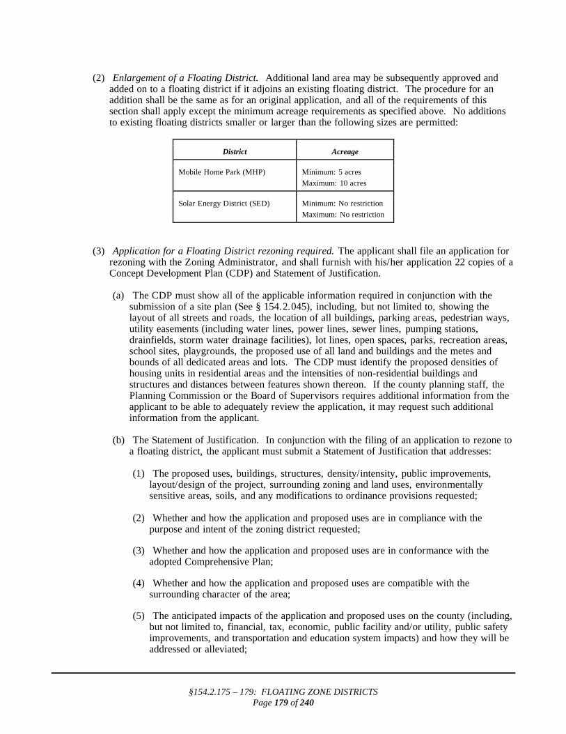
§154.2.175 – 179: FLOATING ZONE DISTRICTS
Page 179 of 240
(2) Enlargement of a Floating District. Additional land area may be subsequently approved and added on to a floating district if it adjoins an existing floating district. The procedure for an addition shall be the same as for an original application, and all of the requirements of this section shall apply except the minimum acreage requirements as specified above. No additions to existing floating districts smaller or larger than the following sizes are permitted:
District Acreage
Mobile Home Park (MHP) Minimum: 5 acres
Maximum: 10 acres
Solar Energy District (SED) Minimum: No restriction
Maximum: No restriction
(3) Application for a Floating District rezoning required. The applicant shall file an application for rezoning with the Zoning Administrator, and shall furnish with his/her application 22 copies of a Concept Development Plan (CDP) and Statement of Justification.
(a) The CDP must show all of the applicable information required in conjunction with the
submission of a site plan (See § 154.2.045), including, but not limited to, showing the layout of all streets and roads, the location of all buildings, parking areas, pedestrian ways, utility easements (including water lines, power lines, sewer lines, pumping stations, drainfields, storm water drainage facilities), lot lines, open spaces, parks, recreation areas, school sites, playgrounds, the proposed use of all land and buildings and the metes and bounds of all dedicated areas and lots. The CDP must identify the proposed densities of housing units in residential areas and the intensities of non-residential buildings and structures and distances between features shown thereon. If the county planning staff, the Planning Commission or the Board of Supervisors requires additional information from the applicant to be able to adequately review the application, it may request such additional information from the applicant.
(b) The Statement of Justification. In conjunction with the filing of an application to rezone to a floating district, the applicant must submit a Statement of Justification that addresses:
(1) The proposed uses, buildings, structures, density/intensity, public improvements,
layout/design of the project, surrounding zoning and land uses, environmentally sensitive areas, soils, and any modifications to ordinance provisions requested;
(2) Whether and how the application and proposed uses are in compliance with the purpose and intent of the zoning district requested;
(3) Whether and how the application and proposed uses are in conformance with the
adopted Comprehensive Plan;
(4) Whether and how the application and proposed uses are compatible with the surrounding character of the area;
(5) The anticipated impacts of the application and proposed uses on the county (including,
but not limited to, financial, tax, economic, public facility and/or utility, public safety improvements, and transportation and education system impacts) and how they will be addressed or alleviated;

§154.2.175 – 179: FLOATING ZONE DISTRICTS
Page 180 of 240
(6) How the proffers will help to offset the impacts of the application and proposed uses;
(7) The justification for any requested ordinance modifications;
(8) Whether and how the application and proposed uses will affect the county' s ground
water supply, and how the application plans to address any impacts of the proposed development;
(9) The anticipated impacts of the application and proposed uses on environmentally
sensitive land, natural areas, vegetation, water quality, air quality, and historic features;
(10) Whether there has been any change in circumstances or conditions in the area that
make the proposed application and uses appropriate;
(11) Whether the existing zoning is still appropriate, along with an explanation as to why or why not.
(K) Additional regulations applicable within a Floating District.
(1) Corner lots. Of the two sides of a corner lot, the front shall be deemed to be the shorter of the two sides fronting on streets. The side yard on the side facing the side street shall be 30 feet or more for both main and accessory buildings.
(2) Accessory structures. The aggregate floor area of an accessory building or structure shall not exceed 25% of the area of the lot or parcel.
(3) Minimum off-street parking. Minimum off-street parking requirements set forth in this chapter
shall apply.
(4) Signs. Requirements for signs shall be as set forth in § 154.2.190.
(5) Site plan approval. Requirements for site plan approval shall be as set forth in § 154.2.045.
§ 154.2.176 MOBILE HOME PARK (MHP).
(A) Principal permitted uses and structures. The following uses shall be permitted by right in the MHP District subject to other provisions of this chapter.
(1) Signs, as permitted in §§ 154.2.190 et seq. ;
(2) Mobile homes as defined in § 154.2.003;
(3) Accessory buildings;
(4) Playgrounds and parks;
(5) Community service or recreational buildings which are integral components of the MHP;
(6) Off-street parking as permitted in §§ 154.2.205 et seq. ;
(7) Public utilities to serve the residents of the mobile home park;
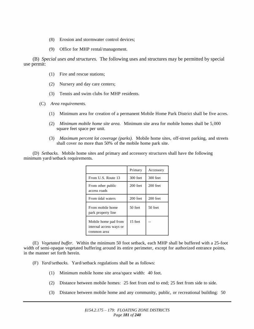
§154.2.175 – 179: FLOATING ZONE DISTRICTS
Page 181 of 240
(8) Erosion and stormwater control devices;
(9) Office for MHP rental/management.
(B) Special uses and structures. The following uses and structures may be permitted by special use permit:
(1) Fire and rescue stations; (2) Nursery and day care centers;
(3) Tennis and swim clubs for MHP residents.
(C) Area requirements.
(1) Minimum area for creation of a permanent Mobile Home Park District shall be five acres. (2) Minimum mobile home site area. Minimum site area for mobile homes shall be 5,000
square feet space per unit.
(3) Maximum percent lot coverage (parks). Mobile home sites, off-street parking, and streets shall cover no more than 50% of the mobile home park site.
(D) Setbacks. Mobile home sites and primary and accessory structures shall have the following minimum yard/setback requirements.
Primary Accessory
From U.S. Route 13 300 feet 300 feet
From other public
access roads
200 feet 200 feet
From tidal waters 200 feet 200 feet
From mobile home
park property line
50 feet 50 feet
Mobile home pad from
internal access ways or
common area
15 feet --
(E) Vegetated buffer. Within the minimum 50 foot setback, each MHP shall be buffered with a 25-foot width of semi-opaque vegetated buffering around its entire perimeter, except for authorized entrance points, in the manner set forth herein. (F) Yard/setbacks. Yard/setback regulations shall be as follows:
(1) Minimum mobile home site area/space width: 40 feet. (2) Distance between mobile homes: 25 feet from end to end; 25 feet from side to side.
(3) Distance between mobile home and any community, public, or recreational building: 50

§154.2.175 – 179: FLOATING ZONE DISTRICTS
Page 182 of 240
feet. (G) Heights. Buildings may be erected up to 22 feet in height, except that:
(1) Any public or semi-public building, monument, water tower, chimney, flue, flagpole, antennas or similar structures may be erected in accordance with § 154.2.145.
(2) No accessory building which is within ten feet of any mobile home park property line shall
be more than ten feet high. All accessory buildings shall be less than the main building in height.
(H) Corner lots.
(1) Of the two sides of a corner lot, the front shall be deemed to be the shortest side fronting on a street.
(2) The side yard on the side facing the side street shall be 25 feet for both main and accessory
buildings. (I) Accessory structures. Accessory buildings aggregate area shall not exceed 25% of the gross site area outside of mobile home site areas. (J) Open space and recreation area. Within the total required open space, there shall be at least 100 square feet per unit of developed play and recreation area. Each mobile home park shall provide not less than one playground and no playground shall be less than 2,500 square feet in area. (K) Access. Each mobile home space shall have frontage on a dedicated public street or public access easement or shall have access over common area to such a public easement, as determined by the Board of Supervisors. In cases where lots do not have frontage on dedicated public streets, the public access easement shall be a minimum of 30 feet wide. In cases where the easements dead-end, there shall be a cul-de-sac with a minimum turning radius of 50 feet. The 30-foot public access easement shall be improved with a minimum 24-foot-wide travelway. All such access travelways and walks shall be constructed in accordance with the county' s standards and specifications, and shall be located as determined by the Board of Supervisors. At such time as the 30-foot public access easements are designated by the appropriate county authority as fire lanes, the lanes shall be posted with approved "No Parking" signs by the developer/operator.
§ 154.2.177 BAYVIEW PLANNED UNIT DEVELOPMENT DISTRICT.
The one existing Planned Unit Development in the County, known as the Bayview Citizens for Social Justice, will be renamed ‘‘Bayview PUD’’, with all of its unique attributes as created by vote of the Board of Supervisors on August 11, 1999, pursuant to Zoning Map Petition 99-10.
§ 154.2.178 SOLAR ENERGY DISTRICT (SED).
(A) Intent of uses permitted in a SED. It is the intent of Northampton County that the Solar Energy District be used solely for generation of solar power to be connected directly to the electrical public utility grid. It is not expected to generate heavy traffic and/or noise during operation. All such uses shall be subject to approval by the Board of Supervisors through a rezoning application with a plan of development. Any uses planned as accessory uses to the principal uses shall be subject to approval by the Board of Supervisors as part of the rezoning. IF the solar power system is not built to completion within two years after the SED is created, becomes unused, abandoned or vacated for more than 12 consecutive months, the Board of

§154.2.175 – 179: FLOATING ZONE DISTRICTS
Page 183 of 240
Supervisors shall initiate a rezoning process to eliminate the SED at that location.
(1) Uses permitted in SED.
(a) The following uses shall permitted by right in SED Floating Zones, and subject to the SED approval by the Board of Supervisors:
1. Generation of solar electrical power using photovoltaic panels. 2. Facilities to maintain, operate, manage and transmit that power to the electrical public
utility grid.
(b) The uses allowed by the district in which the parcel(s) is (are) located prior to rezoning to SED may be continued in accordance with all applicable regulations set forth in this chapter or elsewhere in the Northampton County Code. Such uses are exempt from the performance standards within SED in division (A) (2) below.
(2) Performance standards within SED.
(a) The lowest surface of any panel shall be a minimum of four feet above the finished grade
on which the panel is located.
(b) No stormwater discharge that causes a discharge of pollutants to or degradation of county or state waters is permitted.
(c) The entire SED, including the area underneath the solar panels, must be vegetated. Panels
must be adequately spaced to ensure sufficient sunlight penetration to promote growth of vegetation. A plan must be submitted for maintenance of that vegetation, except for access roads and accessory structures.
(d) All wiring not on the solar arrays shall be underground except where necessary to connect
to the public utility.
(e) The gross usable area will exclude any wetland areas that are regulated by the Northampton County Wetlands Board or the U.S. Department of the Interior (administered by the U.S. Army Corps of Engineers). All forested areas removed during construction or operation shall be mitigated by the creation of an equal number of acres of equivalent forest.
(f) Space for any required public utility right-of-way must be allocated.
(g) The following requirements shall govern the landscaping surrounding an SED:
1. A vegetated buffer is required that consists of a landscaped strip at least 50 feet wide
measured from each boundary line of the SED around the entire perimeter of the SED. Any fencing must be installed on the interior of the buffer. A recommendation that the screening and/or buffer creation requirements be waived may be made by the Planning Commission when the applicant proposes to use existing wetlands or woodlands, as long as the wetlands or woodlands are permanently protected for use as a buffer.
2. SEDs shall be landscaped and maintained with a buffer of plant materials that are mature enough to effectively screen the view, to eight feet above ground level, of the solar panels from adjacent properties all year around. A landscape berm properly prepared to accept plants, up to four feet high, may be used to assist reaching the

§154.2.175 – 179: FLOATING ZONE DISTRICTS
Page 184 of 240
required screening height. The screening must be fully established within five years and effectively maintained for the life of the SED. Non-invasive plant species must be used. (See www.NPS.gov National Park Service - USFWS ‘‘Plant Invaders of the Mid Atlantic Natural Areas.)
3. Existing vegetation may be removed only as authorized during the site plan review
process to permit vehicular and utility access during construction of the facility and installation of transmission power lines.
(h) Noise generated by the facility shall be limited to 60 DBA as measured at the property line
except when a back-up generator is needed for maintenance. Construction on the site is exempt from this standard.
(i) Any installed lighting shall be in accordance with § 154.2.112(D), Outdoor Lighting
Standards, of this chapter.
(j) If solvents are required for cleaning of solar modules, they must be biodegradable.
(k) If a water supply is required, it must be from a source no deeper than the Columbia aquifer even if a deeper source already exists within the SED.
(l) All broken or waste solar modules shall be removed from the site within 60 days of being
taken out of service.
(m) Solar energy facilities, including the electrical and mechanical components, shall conform to relevant and applicable local, state and national codes.
(n) Required reporting.
1. The solar installation operator will notify the Board of Supervisors as soon as the
applicant is transmitting electricity from solar panels to the electrical public utility grid.
2. The solar installation operator shall submit a report to the Northampton County
Department of Planning and Zoning once a year, no later than July 1. The report shall state the current status of the installation.
3. Any change of ownership or management of the solar installation shall be reported to
the Board of Supervisors within 60 days of the change. (B) Special regulations within a SED.
(1) Setbacks. Basic setback requirements in a SED are shown in the table below.
Primary Uses Accessory Uses
From Lankford Highway (US 13) 100 ft. 150 ft.
From other public access roads 60 ft. 60 ft.
From tidal waters and incorporated towns 150 ft. 200 ft.
From SED exterior boundary line when not increased by the above
50 ft. 50 ft.

§154.2.175 – 179: FLOATING ZONE DISTRICTS
Page 185 of 240
(2) All setback areas must be vegetated. The vegetation must be maintained as effective soil
sediment traps. The required screening buffer described above in division (A) (2) (f) shall be created within and on the interior side of the setback when it exceeds 50 feet.
(3) SED abutting US 13. Access shall not be from US 13 if access is possible from a secondary road. If no secondary road is available, US 13 access is limited to one entrance per SED, constructed to current VDOT standards.
(4) Support and maintenance buildings are accessory uses in an SED and cannot be higher than 25
feet. The roofs may be designed to accommodate additional flush mounted solar panels. (C) Removal of abandoned solar generating equipment.
(1) A bond, whose amount shall be determined by the Director of Planning, shall be required to assure removal of an unused solar energy power generating system.
(2) Any solar energy power generating system that has not operated for a continuous period of 12 months shall be considered unused and abandoned. The owner of an unused system shall remove the entire system within six months of receipt of notice from Northampton County notifying the owner of the equipment removal requirement. Removal includes removing any underground structures or supports and electrical transmission wire. All materials must be legally removed from the site. The site shall be restored to its original condition after removal is complete.

§154.2.190 – 199: SIGNS
Page 186 of 240
§154.2.190 – 199: SIGNS
§ 154.2.190 PERMITS REQUIRED FOR SIGNS.
(A) No sign greater than 2 ½ square foot in area may be constructed, erected, moved, enlarged, illuminated or substantially altered except in accordance with the provisions of this Chapter and with a valid sign permit. (B) Applications for a sign permit shall be submitted to the Zoning Administrator and shall include detailed renderings, including colors, sizes, lighting and location for all signs. Sign requests for a multi-use or tenant development projects shall be submitted in conjunction with the first site plan submitted for approval within the project. (C) The following signs are exempt from regulation under this ordinance:
(1) Signs 2 ½ square feet or less in area;
(2) Signs erected by or on behalf of or pursuant to the authorization of a governmental body, including legal notices, identification and informational signs, traffic, directional, or regulatory signs;
(3) Official signs required by federal or state regulation; (4) Flags of the United States and other nations, the Commonwealth of Virginia, Northampton
County and other political subdivisions of the United States and of bona fide civic, charitable, fraternal and welfare organizations. All such flags shall be mounted in a permanent fashion with no more than two flags on a single pole. No more than three flag poles are permitted on any single lot or parcel. Flags shall be maintained in good repair and shall not constitute a hazard to vehicular or pedestrian traffic.
(5) Directional on premise signage which does not exceed four square feet in size and six feet in
height. (6) Signs displayed on a truck, bus, or other licensed vehicle while in use in the normal conduct
of business. (7) Historical markers identifying properties or structures which have been recognized
as historically significant on National, State, or local registries, or in policy documents adopted by the Board of Supervisors, such as the Comprehensive Plan. Historical markers shall be allowed a maximum height of eight feet, and shall not exceed four square feet in area.
§ 154.2.191 TEMPORARY SIGNS.
(A) The following temporary signs are permitted without a zoning permit. However, such signs shall conform to the requirements set forth below as well as all other applicable requirements of this ordinance.
(1) Real estate advertising signs.
(a) On premise signs.
1. On premise signs advertising the sale, lease, or rental of property shall be limited to one sign per agency per lot per street frontage or frontage on navigable waterway.

§154.2.190 – 199: SIGNS
Page 187 of 240
2. Signs shall not exceed four square feet in size and a maximum of four feet in
height except for agricultural, commercial and industrial zoning districts in which signs shall not exceed thirty-two square feet in size and a maximum of ten feet in height.
3. The height of all signs shall be measured from ground level to the top of the
sign structure.
(b) Off-premise signs.
1. Off-premise signs advertising the sale, lease, or rental of property shall be allowed in conjunction with a bona fide "open house" showing and shall not be erected for more than three days in any seven day period.
2. Signs advertising a multiple number of lots for sale in a development may be placed at the entrance as large as thirty-two square feet in area and ten feet in height.
(2) Construction site or development project identification signs.
(a) Such signs shall not be erected before the issuance of a land disturbing permit for the
property and shall be removed within ten days after the issuance of the final inspection or certificate of occupancy by the Building Official.
(b) One project identification sign shall be permitted per construction site or development project and limited to sixteen square feet in area and ten feet in height.
(c) In addition, in the case of multiple principals at the construction site or for the
development project (e.g., owner, developer, architect, engineer, contractor, or real estate or leasing agent) all identification information shall be contained on one additional sign, limited to sixteen square feet in area and ten feet in height.
(3) Political campaign and event signs.
(a) Such signs shall not be located within public rights-of-way or attached to public utility
structures and shall be limited to freestanding signs not more than sixteen square feet in area except in agricultural, commercial and industrial zoning districts which shall not exceed thirty-two square feet in area.
(b) Political campaign and event signs, including flags, indicating an event to be located on property where the event such as a grand opening, fair, carnival, festival, seasonal sale of local products, yard sale or other event is to take place may be erected no more than sixty days prior to the political election, primary, canvas, referendum or other event.
(4) All temporary signs shall be removed within seven days following the sale, election, primary,
project or other event to which they were related.
§ 154.2.192 GENERAL SIGN RESTRICTIONS AND PROHIBITIONS PERTAINING TO ALL
SIGNS.
(A) Signs that revolve or are animated or that utilize movement or apparent movement to attract the attention of the public are prohibited.

§154.2.190 – 199: SIGNS
Page 188 of 240
(B) Signs that are attached to or utilize utility poles adjacent to streets and roadways are prohibited. (C) No signs or supporting structures shall be located within or over any public right-of-way unless
authorized by the holder of the right-of-way. (D) No sign may be erected so that by its location, color, size, shape, nature or message it would tend to
obstruct the view of or be confused with official traffic signs or other signs erected by governmental agencies.
(E) No sign may be located within the sight triangle that interferes with the view necessary for motorists
to proceed safely through intersections or to enter onto or exit for public or private roads. (F) Portable signs and off-premise signs shall be prohibited unless otherwise specifically allowed by this
Chapter. Portable signs containing public service messages shall be allowed.
§ 154.2.193 PERMITTED SIGN STANDARDS.
(A) Façade identification signs on properties used for non-residential purposes.
(1) Each non-residential establishment, except for planned developments, home occupations, and shopping centers, regulated separately in this section, shall be allowed a total of one façade sign attached to a wall or building unit containing the establishment.
(2) Such signs shall be limited to not more than 10% of the area of the structure fronting or
facing a road or highway, or two hundred square feet, whichever is less, and shall meet the following standards:
(a) In the case of multiple occupancy buildings which are not shopping centers, each
occupant of a building shall be allowed a total of one façade sign attached to an exterior wall. Such sign shall be limited to ten percent of the area of the wall to which it is attached or two hundred square feet, whichever is less.
(b) Each establishment or, in the case of multiple occupancy buildings which are not
shopping centers, each building, is allowed one projecting sign which meets the following standards:
1. Each projecting sign shall not exceed ten percent of the area of the wall
fronting or facing a public street or highway, or forty square feet in area, whichever is less.
2. All projecting signs shall be mounted such that the bottom of the sign is at
least eight feet above grade.
(c) Canopy or awning signs shall be allowed in addition to the one façade sign or one projecting sign.
(d) Mural art painted building walls, reflecting the nature of the area, are exempted from
the above restrictions if they do not contain words. Specifically permitted, by example, are renderings of wildlife, shore scenes, historic town scenes or similar which shall be done in relatively accurate detail and color schemes.
(B) Freestanding identification signs on properties used for non-residential purposes.
(1) Each non-residential establishment, except for planned developments, home occupations, and shopping centers shall be allowed a total of one freestanding sign per lot or parcel not

§154.2.190 – 199: SIGNS
Page 189 of 240
exceeding sixty-four square feet and thirty feet in height. In addition each business located on U.S. 13 or Business U.S. 13 may have one informational sign for approaching traffic from each direction within 2 miles of the business advertised subject to Virginia Department of Transportation regulations, property owner’s permission, and not to exceed thirty-two square feet.
(2) Off-site town business directory sign. The purpose of such a sign is to inform travelers on
Route 13 of businesses within a town and direct them to the downtown center. These signs shall be allowed up to 40 square feet in area, not to exceed 15 feet in height, and accommodate the town name, changeable business name panels, the Eastern Shore brand logo, a directional arrow and the mileage to the downtown commercial area. A sign permit is required.
(3) Design standards for freestanding signs on properties used for non-residential purposes.
(a) All freestanding signs, except for home occupation signs, shall be monument-type
signs, double-post signs, or single-post signs, and shall comply with the following standards:
(b) Signs incorporated into a free-standing wall or completely solid structure which is set
upon footings shall be entitled to a thirty percent larger face area than otherwise provided for in this Article provided the following conditions are met:
1. The width of the base of the sign shall be equal to or greater than the width of
the sign face.
2. The height of the base of the sign shall be less than or equal to the height of the sign face unless architectural pillars are used.
3. The total height of the sign, including the base, shall be less than the width of
the base.
4. The sign shall be masonry, wood, high density urethane (HDU), composite panel or other suitable materials.
5. Shrubs, flowers, or other landscaping materials which do not obscure the sign
face shall be incorporated into the sign installation area.
(c) Double-post signs
1. Total sign structure height shall not exceed sixteen feet.
2. Sign shall be wood, HDU, composite panel or other suitable materials.
(d) Single-post signs
1. Total sign height shall not exceed sixteen feet.
2. Sign structure shall be a single, vertical mounting pole and shall be made of wood, HDU, composite panel or other suitable materials.
3. Sign face shall not be attached directly to the vertical mounting pole and shall
utilize a mounting arm attached perpendicular to the vertical mounting pole. (C) Signs on properties used for residential purposes.

§154.2.190 – 199: SIGNS
Page 190 of 240
(1) Signs on properties used for residential purposes are allowed one freestanding sign per parcel, limited to no more than four square feet and four feet in height.
(2) Signs on properties used for residential purposes shall not be illuminated.
(D) Sales of agricultural products shall be allowed one freestanding sign and one façade sign, no larger than four square feet in size and a maximum of six feet in height. One off-site sign no more than two miles from site in each direction is allowed to advise motorists in advance of sale location. (E) Shopping Centers
(1) Individual establishments within a shopping center shall each be allowed one façade identification sign which does not exceed ten percent of the area of the wall frontage dedicated to that establishment and not extend over more than eighty-five percent of the horizontal width of the building front.
(2) In addition to a façade identification sign, individual establishments within a shopping center
shall each be allowed one projecting sign which does not exceed ten percent of the area of the structure frontage dedicated to that establishment.
(3) Shopping centers shall be allowed one freestanding identification sign per road frontage, each
limited to no more than 150 square feet in size and thirty feet in height.
(4) Out parcels platted as part of a shopping center shall be allowed one façade identification sign per establishment and one freestanding sign per road frontage with no sign greater than sixty square feet.
(F) Directional signs shall not be counted as signs for the purpose of calculating the total number of signs in place. (G) Residential uses such as residential subdivisions, multi-family developments, and mobile home parks shall be allowed one freestanding identification sign per public entrance which shall be consistent with freestanding sign standards herein.
§ 154.2.194 COMPUTATION OF SIGN AREA.
The area of a sign face shall be computed by means of the smallest square, circle, rectangle, triangle or combination thereof that will encompass the extreme limits of the writing representation, emblem, or other display. The area shall not include any supporting framework, bracing or decorative wall that is clearly incidental to the display itself.
§ 154.2.195 SIGN ILLUMINATION AND SIGNS CONTAINING LIGHTS.
(A) Signs shall adhere to lighting standards pursuant to §154.2.112 General Lighting Standards. (B) Unless otherwise prohibited by this Chapter, signs shall be illuminated using white lighting and such illumination shall not be directed skyward. (C) Internally illuminated freestanding signs may not be illuminated during hours that the business or enterprise advertised by such sign is not open for business or in operation. This subsection shall not apply to the following types of signs:

§154.2.190 – 199: SIGNS
Page 191 of 240
(1) Signs that constitute an integral part of a vending machine, telephone booth, and signs that only indicate the time, date, or weather conditions, or similar device whose principal function is not to convey an advertising message.
(2) Signs that do not exceed two square feet in size and that convey the message that a business
enterprise is open or closed or that a place of lodging does or does not have a vacancy.
§ 154.2.196 MAINTENANCE OF SIGNS AND REQUIRED PERMITS.
(A) All signs and all components thereof, including, without limitation, supports, braces, and anchors, shall be kept in a state of good repair. Components of freestanding signs, (e.g., supporting structures, backs, etc.) not bearing a message shall be constructed of materials that blend with the natural environment or shall be painted a neutral color to blend with the natural environment.
(B) If the message portion of a sign is removed, leaving only the supporting "shell" of a sign or the supporting braces, anchors, or similar components, the owner of the sign or the owner of the property where the sign is located or other person having control over such sign shall, within two years of the removal of the message portion of the sign, either replace the entire message portion of the sign or remove the remaining components of the sign. This subsection shall not be construed to enable the replacement of a nonconforming sign except as provided in §154.2.197 Nonconforming Signs nor shall this subsection be construed to prevent the changing of the message of a sign. (C) A sign permit shall be revoked automatically if the business license for the premises lapses, is revoked, or is not renewed; or if the business activity on the premises is discontinued for a period of ninety days or more or is not renewed within thirty days of a notice from the Zoning Administrator to the last permittee, sent to the premises, that the sign permit will be revoked if not renewed.
§ 154.2.197 NONCONFORMING SIGNS.
(A) No nonconforming sign may be enlarged or altered in such a manner as to increase the degree of the nonconformity nor may illumination be added to any nonconforming sign. (B) A nonconforming sign may not be moved or replaced except to bring the sign into compliance with the requirements of this Chapter. (C) If a nonconforming sign is destroyed or damaged in any manner to the extent that the cost of restoration to its condition before such an occurrence exceeds fifty percent of the current replacement value at the time of damage, the sign shall not be replaced except in compliance with the provisions of this Chapter. Such sign may not thereafter be repaired, reconstructed, or replaced except in conformity with all the provisions of this Chapter. The remnants of the former sign structure shall be cleared from the property. (D) Subject to the other provisions of this section, nonconforming signs may be repaired and renovated so long as the cost of such work does not exceed, within any twelve month period, fifty percent of the value of such sign. (E) If a nonconforming billboard remains blank for a continuous period of two years, that billboard shall be deemed abandoned and shall, within thirty days after such abandonment, be altered to comply with this ordinance or be removed by the sign owner, owner of the property where the sign is located, or any other person having control over such sign. For purposes of this section, a sign is "blank" if:
(1) It advertises a business, service, commodity, accommodation, attraction, or other enterprise or activity that is no longer operating or being offered or conducted;
(2) The advertising message it displays becomes illegible in whole or substantial part; or

§154.2.190 – 199: SIGNS
Page 192 of 240
(3) The advertising copy has been removed.
§ 154.2.198 REMOVAL OR ABANDONMENT OF SIGNS.
(A) A sign shall be removed by the owner or lessee of the premises upon which the sign is located when the business which it advertises is no longer conducted on the premises. (B) The Zoning Administrator may order the removal of any sign erected or maintained in violation of this ordinance upon thirty days written notice to the owner of such signs, or the owner of the building, structure or premises on which such sign is located, to remove the sign or to bring such sign into compliance with this Chapter. Upon failure to comply with such notice, the Zoning Administrator shall take the appropriate action to obtain a court order to remove to the sign. (C) If a sign advertises a business or activity that is no longer operating or being offered or conducted, that sign shall be considered abandoned and shall, within two years after such abandonment, be removed. The cost for removal shall be the responsibility of the property owner. Such sign shall be removed by the owner of the property if notified by Northampton County to do so.

§154.2.205 – 213: OFF-STREET PARKING AND LOADING
Page 193 of 240
§154.2.205 – 213: OFF-STREET PARKING AND LOADING
§ 154.2.205 INTENT.
There shall be provided at the time of erection of any main building, or at the time any main building is enlarged, minimum off-street parking space with adequate provision for entrances and exits by standard-size automobiles, as follows in this subchapter.
§ 154.2.206 SPACE ON SAME LOT AND ADJACENT LOTS .
(A) General. All off-street parking spaces appurtenant to any non-residential use permitted in any district shall be provided on the same lot with the use to which it is appurtenant. All off-street parking spaces appurtenant to any residential use permitted in any residential district shall be provided on the same lot with the se of which it is appurtenant, except as qualified below. (B) Approval of alternate location. Off-street parking spaces appurtenant to any residential use permitted in any residential district shall be provided on the same lot with the use of which it is appurtenant. However, if the Zoning Administrator determines that the required parking on the lot is physically not possible or that public safety would be better served by off-site parking, the Zoning Administrator may approve off-site parking.
§ 154.2.207 COOPERATIVE PARKING.
(A) Approval by Zoning Administrator. Parking space required under the provisions of this chapter may be provided cooperatively for two or more uses in a development or for two or more individual uses, subject to arrangements that will assure the permanent availability of such space, if such arrangements are approved by the Zoning Administrator. (B) Reductions for combined uses. The amount of such combined parking space shall be equal to the sum of the amounts required for the separate uses unless the Zoning Administrator determines that a reduced number of parking spaces is adequate due to different hours of normal activity for the uses participating in the combination.
§ 154.2.208 SAFE AND CONVENIENT ACCESS REQUIRED .
All off-street parking space and off-street loading space shall be provided with safe and convenient access to a public street. All permitted uses requiring site plan approval shall have entrances constructed in accord with the specifications of the County Engineer and VDOT and shall be approved by the county' s Director of Planning and Zoning.
§ 154.2.209 PARKING AREA DESIGN.
(A) Type of construction. All off-street parking spaces, loading space, aisles, and driveways, except those provided for single-family dwellings, shall be constructed and maintained with a dustless surface and of such type of construction that the same will be available for safe and accessible use at all times. It shall have appropriate safety barriers where needed as determined by the Administrator, and all off-street parking spaces shall be delineated on the site.

§154.2.205 – 213: OFF-STREET PARKING AND LOADING
Page 194 of 240
(B) Illumination. See § 154.2.112 General Lighting Standards. (C) Design. All parking spaces will be so designed so that no part of any vehicle will extend over any property line, roadway, right-of-way, walkway, driveway, or aisle space. (D) Landscaping. See § 154.2.105 Landscape Plan Requirements and Standards.
§ 154.2.210 GENERAL REQUIREMENTS.
Off-street parking spaces and lots shall meet the following general requirements. (A) Same lot. Parking spaces for all uses shall be provided on the same lot with the use or structure to be served except as provided for in § 154.2.206. (B) Off-site parking. For parking addressed by § 154.2.206(B), alternative locations may be authorized by the Zoning Administrator subject to the following conditions and criteria:
(1) Maximum distances to off-site lots or spaces must be not more than 150 feet from two-family and multi-family attached dwelling units and not more than 500 feet from all other uses. Distances shall be measured by normal pedestrian routes.
(2) Approval will be subject to safeguards called for by the circumstances of the case, to design and improvement standards applying to off-street parking areas, and to the requirement that such parking space shall be associated with the permitted use of the structure, and not to be reduced or encroached upon in any manner.
(3) The required number of off-street parking spaces for any number of uses may be combined in one
lot, provided that each space is permanently available for the assigned use. The amount of space required may be reduced for a church, or for a meeting place of a civic, fraternal, or similar organization by reason of different hours of normal activity than those of other uses participating in the combination of required spaces.
(C) Large vehicles. Construction vehicles, trucks and trailers of a gross weight of more than 10,000 pounds gross vehicle weight (GVW), and all boats, campers, and recreational vehicles shall be parked behind a line drawn parallel to the font of the existing structure closest to the front property line or the front setback line, whichever is greater. (D) Reduction of existing parking. Off-street parking existing on October 21, 2009 and used in connection with the operation of an existing use or structure shall not be reduced to an amount less than hereinafter required for a similar new use or structure. (E) Determination of requirements when unspecified. Whenever the required number of parking or loading spaces is not specifically stated in this section, the Zoning Administrator shall make a determination of the number of spaces to be provided based upon his/her determination of the closest comparable use for which required spaces are stated. (F) Modifications of parking/loading requirements. The Zoning Administrator shall have the authority to reduce the minimum required number of parking and/or loading spaces by up to 20% if it is determined during the site plan review process that the required number of spaces is clearly excessive for a particular use proposed, based upon the following factors: maximum staffing, seating capacity, gross floor area, hours of operation, and the availability of cooperative parking. If an applicant proposes to install a number of parking and/or loading spaces exceeding the minimum requirement established, the Zoning Administrator also shall

§154.2.205 – 213: OFF-STREET PARKING AND LOADING
Page 195 of 240
have the authority to limit the number of spaces based upon the factors stated above.
§ 154.2.211 SITE REQUIREMENTS.
All off-street parking spaces, aisles, and driveways, except those provided for one- and two-family dwellings, shall be constructed and maintained in accordance with the following requirements. (A) Surfacing of parking lots. All such parking and drive areas shall be graveled or surfaced in some other manner to reduce erosion and to reduce the generation of mud and dust. (B) Drainage. Parking areas shall be adequately drained so as not to allow flowing or standing water that could impede the pathways or travelways of vehicles or pedestrians or otherwise pose safety hazards or to cause adverse effects on neighboring properties. (C) Guard devices. Parking lots shall have appropriate safety barriers where needed as determined by the Zoning Administrator that such barriers are necessary to ensure the safety of persons using the parking lot and/or the safety of the general public. (D) Markings. All off-street parking spaces with hard surfaces and in excess of ten or more parking spaces shall be marked/delineated on the site. (E) Lighting. Lighting used to illuminate parking areas shall be arranged so that light shines and/or is reflected away from adjacent properties and in a manner that does not affect traffic on adjacent roads. (F) Design. All parking spaces shall be designed so that no part of any vehicle extends over any property line, right-of-way, walkway, and driveway or aisle space. (G) Landscaping. All off-street parking lots and areas shall be landscaped as provided in § 154.2.105. (H) General standards. Any off-street parking space shall have minimum dimensions of 9 feet by 20 feet, except that parallel parking spaces shall be at least 9 feet by 22 feet. Each space shall be unobstructed, shall have access to a public street, and shall be arranged so that any vehicle may be moved without moving another, except in the case of parking for one- and two-family dwellings and in the case of parking for employees on the premises. In addition:
(1) Minimum aisle widths required for parking areas shall be according to the following table.
Parking Angle
(in degrees)
Aisle Width
(in feet)
0 - 44 NA
45 - 59 13.5
60 - 69 18.5
70 - 79 19.5
80 - 89 21
90 22
(2) Requirements for handicapped access. For each 25 off-street parking spaces, there shall be one

§154.2.205 – 213: OFF-STREET PARKING AND LOADING
Page 196 of 240
off-street parking space for handicapped persons. For any number of off-street parking spaces less than 25, one off-street parking space designated for handicapped persons shall be required. Parking spaces for handicapped persons shall be designed in accordance with standards specified in the Uniform Statewide Building Code.
§ 154.2.212 OFF-STREET LOADING.
(A) Requirements. Off-street loading facilities shall be provided on the premises of any use hereafter established or enlarged, and occupying more than 3,000 square feet of lot area which, during the course of any operating day receives or distributes goods or materials by trucks more than 20 feet in overall length. One loading space shall be provided if the land devoted to such establishment or use has an area of more than 3,000 but less than 20,000 square feet and one additional space shall be provided for each additional 20,000 square feet of land area or remaining fraction thereof exceeding 10,000 square feet. (B) Specifications. Loading spaces shall be 12 feet by 45 feet with minimum height clearance of 14 feet both for the space and for accessways and maneuvering areas related to it.
(1) All loading space and related access areas shall be graded, improved, and maintained in a manner permitting safe and accessible use under normal weather conditions and so as to avoid adverse effects on neighboring property as a result of dust, noise, or drainage.
(2) No required loading space shall be located in a required setback area when adjacent to a public street.
(3) All loading spaces shall be marked as a "Loading Space."
§ 154.2.213 MINIMUM IMPERVIOUS PARKING SPACES REQUIRED FOR PERMITTED
USES.
The following spaces shall be required. (A) Animal hospitals and commercial kennels. One space per 400 square feet of gross floor area plus one per each employee. (B) Automobile service stations. One space per each service bay/stall and one space for each employee working on the work shift with the maximum number of employees on duty. In addition, when accessory activities are conducted on the site, additional parking spaces shall be required. If the station also rents vehicles of any type (for example, automobiles, trucks, motorcycles, and/or trailers) the lot shall have enough additional area to accommodate the highest number of rental vehicles expected at any one time at the station. (C) Banks. One parking space for each 250 square feet of gross floor area. (D) Barber shops, beauty shops, health spas and centers. One space per 200 square feet of gross floor area plus one space per employee. (E) Bowling alleys. Three spaces per lane. (F) Car washes. One parking space for each employee, plus exterior spaces to accommodate three times the maximum interior capacity of the car wash. (G) Carry-out/fast food restaurants. Thirteen spaces per each 1,000 square feet or fraction thereof of

§154.2.205 – 213: OFF-STREET PARKING AND LOADING
Page 197 of 240
gross floor area. (H) Cartage and express facilities. One space per each three employees plus one space per each vehicle maintained. (I) Churches, auditoriums, or similar places of assembly. A minimum of one space for each four patrons allowed per occupancy limitations. (J) Commercial and private heliports. One space per each 1,000 square feet of operational area (landing, servicing, storage, and hangar space). (K) Commercial skating rink. One space for each 125 square feet or fraction thereof of skating rink area. (L) Contractors or construction shops, offices and yards. One space per each 1,000 square feet of operational area or fraction thereof, plus one space for each employee working on site for the work shift with the maximum number of employees. (M) Dance halls. One space per each 100 square feet of gross floor area. (N) Fast food establishments, with or without drive-through facilities. Eighteen spaces per each 1,000 square feet or fraction thereof of gross floor area. In addition, eight spaces are required for vehicles stacking to use any drive-in facility. (O) Food or chain stores. Five spaces per each 1,000 square feet of gross floor area or fraction thereof. (P) Funeral homes. One space per each 15 square feet area in assembly rooms or chapels or fraction thereof. (Q) Furniture stores. Two spaces for the first 1,000 square feet plus one additional space for each 400 square feet of floor area over 1,000 square feet of retail area or fraction thereof, plus one space for each employee working on the work shift with the maximum number of employees. (R) Greenhouses and nurseries. One space per each 100 square feet of retail sales area for the first 5,000 square feet and one space for each 200 square feet of retail sales area above 5,000 square feet of retail area, plus one space for each employee working on the work shift with the maximum number of employees. (S) Hospitals, nursing, convalescent homes. One space for each two beds, including cradles, children' s beds, plus one space for each employee working on the work shift with the maximum number of employees. (T) Industrial uses. Off-street parking spaces for every employee on the work shift with the maximum number of employees. Those uses permitted in the Industrial Districts shall have a maximum of two off-street parking spaces for each employee working on the work shift with the maximum number of employees. (U) Laundromats. One parking space for each two washing machines, plus one space for each employee working on the work shift with the maximum number of employees. (V) Medical and dental clinics. One space for each 100 square feet of floor area or fraction thereof, plus one space for each employee working on the work shift with the maximum number of employees. (W) Office buildings. One space for each 100 square feet of net office floor area or fraction thereof.

§154.2.205 – 213: OFF-STREET PARKING AND LOADING
Page 198 of 240
(X) Printing and publishing facilities. One space per each employee plus a minimum of two and a maximum of ten customer parking spaces. (Y) Production or processing of materials, goods, or products. One space per each employee, plus a minimum of two and a maximum of ten customer parking spaces. (Z) Sit-down restaurants. Thirteen spaces per each 1,000 square feet of gross floor area or fraction thereof. (AA) Testing, repairing, cleaning, servicing of materials, goods, and products. One space per each employee, plus a minimum of two and a maximum of ten customer parking spaces. (BB) Theater, drive-in. One space per each potential vehicle at the facility, plus one space for each employee working on the work shift with the maximum number of employees. (CC) Theater, indoors; theater, outdoors. One space per each two seats, plus one space for each employee working on the work shift with the maximum number of employees. (DD) Inn, historic inns, motels, and hotels. One space for each accommodation unit, plus one space for each employee working on the work shift with the maximum number of employees. (EE) Town houses, and other multi-family residential. Two spaces per unit minimum. (FF) Trailer sales and rental, boat showrooms and model home sales. One space per each 3,000 square feet of business area or fraction thereof. (GG) Warehousing and wholesaling operations. One space per each employee, plus a minimum of two and a maximum of ten customer parking spaces. (HH) Other non-retail establishment uses not listed in this section. Non-retail establishments not otherwise referenced in this section shall provide one space for each employee working on the work shift with the maximum number of employees, plus such additional parking spaces as determined by the Zoning Administrator based upon an analysis of the proposed use and the number of spaces required for comparable uses stated herein. (II) Other retail use establishments not listed in this section. Three spaces per each 1,000 square feet of retail sales area or fraction thereof, plus one space for each employee working on the work shift with the maximum number of employees. (JJ) Multiple uses on a lot. When more than one use is conducted on a lot, the lot shall satisfy the combined parking requirements for each of the uses.
(KK) Event venue. One parking space for each three attendees based on the maximum number of
attendees approved for the site.

§154.2.225 – 230: BOARD OF ZONING APPEALS
Page 199 of 240
§154.2.225 – 230: BOARD OF ZONING APPEALS
§ 154.2.225 COMPOSITION OF BOARD.
(A) A Board of Zoning Appeals consisting of five members who are residents of the county shall be appointed by the Circuit Court of Northampton County, Virginia. The term of office of the members of the Board of Zoning Appeals shall be for five years except that the original appointments shall have been made for such terms so that the term of one member shall expire each year. One member of the Board of Zoning Appeals may be a member of the Planning Commission; however, no other member shall hold any public office. Members of the Board of Zoning Appeals may receive such compensation as may be authorized by the Board of Supervisors. (B) (1) Appointments for vacancies occurring other than by expiration of term shall in all cases be for
the unexpired term. (2) A member whose term expires shall continue to serve until the successor is appointed and
qualified. (3) Members may be removed for cause as provided in VA Code § 15.2-2308.
§ 154.2.226 APPLICATION FOR VARIANCE.
(A) An application for a variance may be made by any property owner, tenant, governmental official, department head, board, or bureau. Such application shall be made to the Zoning Administrator in accordance with rules adopted by the Board. The application and accompanying maps, plans and other information shall be transmitted promptly to the Secretary of the Board of Zoning Appeals, who shall place the matter on the docket to be acted upon by the Board. (B) No such variance shall be authorized except after notice and public hearing as required by VA Code § 15.2-2204. The Zoning Administrator shall also transmit a copy of the application to the Planning Commission which may send a recommendation to the Board or appear as a party at the hearing.
§ 154.2.227 PROCEDURES.
The Board of Zoning Appeals shall follow the procedures as provided in VA Code § 15.2-2308. (A) Rules. The Board of Zoning Appeals shall adopt rules as it may deem necessary to carry out the duties imposed by this chapter, such rules being in accordance with the provisions of this chapter and other ordinances of the county and general laws of the Commonwealth of Virginia. (B) Officers. The Board of Zoning Appeals shall elect annually a Chairperson and Vice-Chairperson from its own membership. The Board may elect as its Secretary either one of its own members or a qualified individual who is not a member of the Board; provided however, that a Secretary who is not a member of the Board may not vote on matters before the Board. The Chairperson may administer oaths and compel the attendance of witnesses. The Vice-Chairperson shall act in the absence of the Chairperson. (C) Meetings. The meetings of the Board of Zoning Appeals shall be held at the call of the Chairperson and at such other time as a quorum of the Board of Zoning Appeals may determine. All meetings of the Board of Zoning Appeals shall be open to the public.
§154.2.225 – 230: BOARD OF ZONING APPEALS
Page 200 of 240
(D) Records. The Board of Zoning Appeals shall keep full and complete records of its proceedings, showing the vote or failure to vote of each member on each question and shall submit a report of its actions to the Board of Supervisors at least once a year. (E) Quorum for conducting business. A quorum for conducting business shall be not less than a majority of all the members of the Board.
§ 154.2.228 POWERS AND DUTIES .
The powers and duties of the Board of Zoning Appeals shall be the following, as provided by VA Code § 15.2-2309. (A) Administrative review. The Board of Zoning Appeals shall decide appeals from any decision, order, requirement, or determination of the Zoning Administrator or any other administrative official in the administration or enforcement of this chapter. (B) Variances.
(1) The Board of Zoning Appeals shall decide applications for variances from the terms of this chapter. Variances may be approvable when certain criteria are met, when such approval will not be contrary to the public interest, and when, owing to special conditions, a literal enforcement of the provisions will result in unnecessary hardship; provided that the intended purpose and spirit of this chapter shall be observed and substantial justice done. In authorizing a variance, the Board of Zoning Appeals may impose such conditions regarding the location, character and other features of the proposed structure or use as it may deem necessary in the public interest and may require a guarantee or bond to insure that conditions imposed are being and will continue to be complied with. No variance shall be granted until the Board of Zoning Appeals has held a public hearing and given public notice in accordance with VA Code § 15.2-2204. Consistent with and pursuant to VA Code § 15.2-2308, no variance shall be granted until the Board of Zoning Appeals finds and is satisfied that:
(a) The property owner acquired his/her property in good faith but by reason of the exceptional
narrowness, shallowness, size or shape of the specific piece of property at the effective date of this chapter; by reason of exceptional topographic conditions; or by reason of other extraordinary situations or conditions of such piece of property or of the use or development of property immediately adjacent thereto, the strict application of the terms of this chapter would effectively prohibit or unreasonably restrict the use of the property, or there exists a clearly demonstrable hardship, as distinguished from a special privilege or convenience sought by the applicant;
(b) That the strict application of this chapter would produce undue hardship;
(c) That such hardship is not shared generally by other properties in the same zoning district and the same vicinity;
(d) That the authorization of the variance will not be of substantial detriment to adjacent
property and that the character of the district will not be changed by the granting of the variance;
(e) That the condition of the situation of the property is not of so general or recurring a nature
as to make reasonably practicable the formulation of a general regulation to be adopted as

§154.2.225 – 230: BOARD OF ZONING APPEALS
Page 201 of 240
an amendment to this chapter. (C) Interpretation of district boundaries. The Board of Zoning Appeals may hear and decide applications for interpretation of the district boundaries where there is any uncertainty as to the location of the district boundary. The Board of Zoning Appeals shall interpret the map in such ways as to carry out the intent and purpose of this chapter for the particular district in question; however, it shall not have the power to change the locations of district boundaries as established by ordinance.
§ 154.2.229 APPEALS TO BOARD.
An appeal to the Board of Zoning Appeals may be taken by any person aggrieved or by any officer, department, board, or bureau of Northampton County affected by any decision of the Zoning Administrator in the administration or enforcement of this Chapter. Such appeal shall be taken within 30 days after the decision appealed from, and in case of an appeal from a notice of violation by the Zoning Administrator, or a written order from the Zoning Administrator, shall be taken within 30 days of receipt of such order or notice and shall follow this procedure. (A) Filing of application.
(1) All appeal applications shall specify all of the grounds for appeal and shall be filed with the Secretary of the Board of Zoning Appeals who shall refer the application to the Board of Zoning Appeals and to the Zoning Administrator.
(2) The Zoning Administrator shall transmit to the Board of Zoning Appeals all the paper constituting the record upon which the action appealed was taken.
(B) Fee. Each application for an appeal shall be accompanied by payment of a fee to be determined by the Board of Supervisors. (C) Stay of proceedings. An appeal shall stay all proceedings in furtherance of the action appealed unless the Zoning Administrator certifies to the Board of Zoning Appeals that by reason of facts stated in the certification a stay would in his/her opinion cause imminent peril of life or property, in which case proceedings shall not be stayed otherwise than by a restraining order granted by the Board of Zoning Appeals or by a Court of Record, after notice to the Zoning Administrator and for good cause shown. (D) Public hearing. The Board of Zoning Appeals shall fix a reasonable time for the hearing of appeals or other matters referred to said Board. After notice and public hearing as required by VA Code § 15.2-2204, the Board of Zoning Appeals shall decide the matter within 60 days from the date of such public hearing. (E) Decision of Board of Zoning Appeals. In exercising its powers, the Board of Zoning Appeals may reverse or affirm, wholly or in part, or may modify the decision, order, requirements, or determination that was the subject of the appeal.
§ 154.2.230 APPEALS FROM BOARD.
(A) Any person or persons, taxpayer, officer, department, board or bureau of Northampton County jointly or severalty aggrieved by any decision of the Board of Zoning Appeals may file with the Circuit Court of Northampton County a petition specifying the grounds on which aggrieved within 30 days as provided in VA Code § 15.2-2314.

§154.2.245 – 999: NONCONFORMING USES AND VESTED RIGHTS POLICY
Page 202 of 240
(B) Certiorari. Upon presentation of such petition, the court shall allow a writ of certiorari and shall prescribe therein the term within which a return thereto must be made and served upon the appellant' s attorney, which shall not be less than ten days and may be extended by the court. The allowance of the writ shall not stay proceedings upon the decision appealed from, but the court may on application, on notice of the Board of Zoning Appeals, and due cause shown, grant a restraining order.
§154.2.245 – 999: NONCONFORMING USES AND VESTED RIGHTS POLICY
§ 154.2.245 INTENT.
The intent of this section is to regulate and limit the development and continued existence of uses, structures, and lots established prior to the effective date of this chapter, as amended, which do not conform to the requirements of this chapter. Many nonconformities may continue, but the provisions of this section are designed to curtail substantial investment in nonconformities and to bring about their eventual improvement to a conforming status or elimination, in order to preserve the integrity of this chapter and the desired character of the county. Any lawful nonconforming use, structure, or lot which lawfully existed as of the effective date of this chapter and which remains nonconforming, and any use, structure, or lot which has become nonconforming as a result of the adoption of this chapter or any subsequent reclassification of zoning districts or other amendment to this chapter, may be continued or maintained only in accordance with the terms of this section. The limitations of this section shall not apply to structures or lots whose nonconforming features are the subject of a variance that has been granted by the Board of Zoning Appeals or a modification or condition that was approved by the Board of Supervisors. Such nonconformities are not intended to and may not be used as a grounds for changing their property' s zoning category or as grounds for changing other nearby zoning categories.
§ 154.2.246 NONCONFORMING USES, LOTS OR BUILDINGS.
(A) Uses. Lawful nonconforming uses may be continued but not be enlarged or extended. (B) Lots of record. At the time of enactment of this chapter, or any amendment thereto, if there is an unimproved legal lot or parcel of record which does not meet the minimum lot area requirement within a district, then said lot or parcel of record may still be used as a building lot, provided the use proposed is a permitted use under this chapter, and provided further that the requirements for minimum yards/setbacks and maximum height are met. Further, variances may be available in certain circumstances from the Board of Zoning Appeals in accordance with this subchapter. (C) Structures. Where a lawful nonconforming structure exists as of October 21, 2009, that could not be built in the district in which it is located under the terms of this chapter by reason of restrictions on area, lot coverage, height, yard dimensions or other requirements, such structure may continue to be used so long as it remains otherwise lawful, subject to the following provisions.
(1) Should a lawful nonconforming structure be moved for any reason for any distance it shall thereafter conform to the regulations for the zoning district in which it is located.
(2) (a) Should a nonconforming structure, portion of the nonconforming structure, or nonconforming portion of a structure be damaged or destroyed by any means other than a natural disaster or other act of God, the structure or portion thereof may be re-constructed or restored provided its degree of nonconformity is not increased beyond that which existed just prior to such damage, except to comply with the Virginia Uniform Statewide Building Code and in accordance with §154.141(A) (3).

§154.2.245 – 999: NONCONFORMING USES AND VESTED RIGHTS POLICY
Page 203 of 240
(b) Should a nonconforming residential or commercial structure be damaged or destroyed by a
natural disaster or other act of God, the structure may be repaired, rebuilt, or replaced to eliminate or reduce the nonconforming features to the extent possible, without the need to obtain a variance as provided in § 154.225 et seq. herein.
(c) If such structure is damaged greater than 50% and cannot be repaired, rebuilt, or replaced
except to restore it to its original nonconforming condition, the owner shall have the right to do so, provided that a building permit is obtained and all work is done in compliance with the provisions of the Uniform Statewide Building Code and flood plain regulations as set forth in Chapter 159 Floodplain Management , and provided that such repair, reconstruction, or replacement be accomplished within two years of the date of the natural disaster or other act of God.
(d) However, if the nonconforming structure is located in an area under a federal disaster declaration and the structure was damaged or destroyed as a direct result of the conditions that gave rise to the declaration, then the owner may have an additional two years to repair, rebuild, or replace the structure as otherwise provided in this section.
(e) For the purposes of this section, ACT OF GOD shall include any natural disaster or
phenomena including a hurricane, tornado, storm, flood, high water, wind-driven water, tidal wave, earthquake, or fire caused by lightning or wildfire.
(f) Owners of a structure damaged by an accidental fire, not including arson committed by the
property owner, shall have the same rights to repair, rebuild, or replace such structure as if it were damaged by an act of God.
(D) Manufactured/mobile homes.
(1) A lawful nonconforming manufactured home may be removed from a mobile or manufactured home park and replaced with another comparable manufactured home that meets the current HUD manufactured housing code. In such manufactured or mobile home park, a single-section home may be replaced with a single-section home and a multi-section home may be replaced with a multi-section home.
(2) A lawful nonconforming mobile or manufactured home not located in a mobile or manufactured home park may be replaced with a single-section or a multi-section manufactured home that meets the current HUD manufactured housing code.
§ 154.2.247 NONCONFORMITY IN GENERAL.
(A) If there is only a change in title or renewal of a lease of any nonconforming lot or structure access, the existing use may continue, subject to the rules herein. (B) If any nonconforming use or structure is discontinued for a period exceeding two years after enactment of the ordinance set forth in this chapter, it shall be deemed abandoned and lose its lawful nonconforming status, and any subsequent use shall conform to the requirements of this chapter. However, if a building is damaged or destroyed by a natural disaster or other act of God, the conditions of which give rise to a federal disaster declaration covering the area in which the building is located, then a total of four years from the date of said declaration shall be allowed for the building to be repaired, rebuilt, or replaced before it loses its lawful nonconforming status.

§154.2.245 – 999: NONCONFORMING USES AND VESTED RIGHTS POLICY
Page 204 of 240
(C) Whenever a nonconforming use or structure has been changed to a more limited nonconforming use, such more limited existing use may be changed to an even more limited use so long as it is allowed (by right or after special use permit approval) within that zoning district. (D) Temporary seasonal uses may constitute lawful nonconforming uses so long as they were originally legal when this ordinance was adopted and so long as they have continued seasonally and never been abandoned for a period of two years or more. As with other lawful nonconforming uses, temporary seasonal uses may not be expanded or enlarged without losing their lawful nonconforming status. (E) Whenever the boundaries of a zoning district are changed, any use of land or buildings which become nonconforming as a result of such change shall become subject to the provisions of this subchapter.
§ 154.2.248 REPAIRS AND MAINTENANCE.
On any building devoted in whole or in part to any lawful nonconforming use, ordinary repairs on or repair or replacement of non-structural features such as fixtures, wiring, or plumbing are allowed to such extent that the structure is kept in a usable condition. Nothing in this chapter shall be deemed to prevent the strengthening or restoring to a safe condition of any structure or part thereof declared necessary for safety upon order of the Northampton County Building Official.
§ 154.2.249 PROVISIONS FOR SPECIAL USES .
Any use of a structure which exists at the time of enactment of this chapter which is permitted in the district in which it is located as a special use shall not be deemed a nonconforming use or structure, but shall, without further action by the county, be considered a conforming use. However, such a use or structure shall be subject to the requirements of this chapter as a special use when expansion, enlargement, extension, alteration, or modification is proposed. Single-section or multi-section manufactured homes that comply with the current HUD manufactured housing code are exempt from the requirements of this section in accordance with § 154.2.246(D) (2) provided that the degree of nonconformity is not increased.
§ 154.2.250 VESTED RIGHTS POLICY.
Nothing in this chapter is intended to impair legally vested rights. Northampton County recognizes those vested rights recognized by VA Code § 15.2-2307, inter alia.
§ 154.2.998 VIOLATIONS.
(A) If the Zoning Administrator finds that any of the provisions of this chapter are being or have been violated, he/she shall have all authority authorized under VA Code, Title 15.2, Chapter 22, Article VII, including, but not limited to, those powers set forth in VA Code §§ 15.2-2286 and 15.2-2299, to ensure compliance with and the enforcement of this chapter. (B) The Zoning Administrator is authorized to take whatever legal measures are necessary to ensure compliance with and/or prevent further violation of the provisions of this chapter, including, but not limited to, the issuance of notices of violation and/or cease and desist orders, the filing in appropriate courts of enforcement actions for declaratory, injunctive, abatement, and/or other relief. (C) Consistent with these powers, the Zoning Administrator may, as one of many enforcement methods,

§154.2.245 – 999: NONCONFORMING USES AND VESTED RIGHTS POLICY
Page 205 of 240
notify in writing by certified mail or in person the landowner and/or person responsible for such violation, indicating the nature of the violation and ordering that the violation be corrected within a reasonable period of time, as determined by the Zoning Administrator, and may take any action authorized by law to insure compliance with or prevent further violation of the provisions of this chapter. The Zoning Administrator may grant an extension of the time if he/she deems such extension is justified under the specific circumstances of the case and that such extension will not cause substantial peril of life, health, or property. (D) In accordance with VA Code § 15.2-2311, any written notice of a zoning violation or written order of the Zoning Administrator shall state that the recipient may have a right to appeal the violation notice or order within 30 days and that the decision will be final and unappealable if not appealed within 30 days. (E) The Zoning Administrator also is authorized to refer the zoning violation matter for prosecution and penalties pursuant to VA Code § 15.2-2286(A) (5). Anyone found to have violated this chapter shall be guilty of a misdemeanor and, upon conviction thereof, be fined not less than $10 nor more than $1,000. If the violation is uncorrected at the time of the conviction, the court shall order the violator to abate or remedy the violation in compliance with the chapter, within a time period established by the court. Failure to remove or abate the violation within the time specified by the court shall constitute a separate misdemeanor offense punishable by a fine of not less than $10 nor more than $1,000 and any such failure during any succeeding ten-day period shall constitute a separate offence for each ten-day period punishable by a fine of not less than $100 nor more than $1,500.
§ 154.2.999 PENALTY.
(A) In accordance with VA Code § 15.2-2286(A)(5), any person, firm or corporation, whether as principal agent, employee or otherwise, violating or causing or permitting the violation of this chapter shall be guilty of a misdemeanor and, upon conviction thereof, may be fined not less than $10 nor more than $1,000. If the violation is uncorrected at the time of conviction, the court shall order the violator to abate or remedy the violation in compliance with this chapter within a time period established by the court. Failure to remove or abate a zoning violation within the specified time period shall constitute a separate misdemeanor offense punishable by a fine of not less than $10 nor more than $1,000, and such failure during any succeeding 30 day period shall constitute a separate misdemeanor offense for each 30 day period punishable by a fine of not less than $10 nor more than $1,000. (B) Civil Penalties. The Zoning Administrator may, in accordance with VA Code §15.2-2209, impose civil penalties against any person, firm or corporation, whether as principal agent, employee or otherwise, for violating or causing or permitting the violation of the following sections of this chapter: §§ 154.2.190 thru 199. The schedule of offenses does not include any zoning violation resulting in injury to any persons.
(1) The existence of these civil penalties shall not preclude the Zoning Administrator from taking action pursuant to Va. Code § 15.2-2286(A) (4) or the Board of Supervisors under VA Code §15.2-2208.
(2) The civil penalty for any one violation shall be $200 for the initial summons and $500 for each additional summons. Each day during which the violation is found to have existed shall constitute a separate offense. However, specified violations arising from the same operative set of facts shall not be charged more frequently than once in any 10-day period. The maximum penalty for specified violations arising for the same operative set of facts shall be $5,000. Violations designated above shall be in lieu of criminal sanctions. The schedule of offenses is uniform for each type of violation.
(3) The Zoning Administrator or his/her deputy may issue a civil summons for a violation on the schedule of offenses. Any person summoned or issued a ticket for a scheduled violation may

§154.2.245 – 999: NONCONFORMING USES AND VESTED RIGHTS POLICY
Page 206 of 240
make an appearance in person or in writing by mail to the department of finance or the treasure of the locality prior to the date fixed for trial in court. Any person so appearing may enter a waiver of trial, admit liability, and pay the civil penalty established for the offense charged. Such persons shall be informed of their right to stand trial and that a signature to an admission of liability will have the same force and effect as a judgment of court.
(4) If a person charged with a scheduled violation does not elect to enter a waiver of trial and admit liability, the violation shall be tried in the general district court in the same manner and with the same right of appeal as provided for by law. In any trial for a scheduled violation authorized by this section, it shall be the burden of the county to establish the liability of the violator by a preponderance of the evidence. An admission of liability or finding of liability shall not be a criminal conviction for any purpose.
(5) No provision herein shall be construed to allow the imposition of civil penalties:
(a) For activities related to land development; or (b) For violation of any provision of this chapter relating to the posting of signs on public
property or public rights-of-way.

APPENDICES
Page 207 of 240
APPENDICES
APPENDIX A: USE REGULATIONS
Category 1 - Agricultural Uses
Village Waterfront Village Town Edge
C A/RB
H/R WH/R
1 R NB 1 R NB WC ECC/R
1 R NB CG EB/C-1 EI WW
1 Agri-business office, on-site M/S R R --- R --- --- R --- --- --- --- R --- --- --- --- R
2 Agriculture research facility M/S R --- --- M/S --- --- M/S M/S M/S M/S M/S M/S --- M/S M/S M/S ---
3 Agritourism activities at an agricultural operation
M/S R M/S M/S R --- --- R --- --- R --- R --- --- --- --- ---
4 Forestry and forestry product harvesting R R R R R R R R R --- --- R R R R R R ---
5 Grain storage facility, commercial --- R --- --- S --- --- S --- --- --- --- --- --- --- --- --- R
6 Grain storage facility, private M/S R S S M/S --- --- S --- --- --- --- M/S --- --- --- --- R
7 Grain/soybean production R R R R R R R R R R --- --- R R R R R R
8 Greenhouse sales, retail with outdoor storage and accessory goods/services
--- R S --- S --- R S --- M/S --- --- S S R R R R
9 Greenhouse sales, wholesale with outdoor storage
--- R --- M/S R --- R R --- M/S --- --- R --- --- R R ---
10 Horse barn, private* (one per acre) --- R M/S --- R M/S --- M/S --- --- --- --- R M/S --- --- --- ---
11 Horse boarding/training, commercial* with accessory goods/services
--- M/S M/S --- S --- --- S --- --- --- --- S --- --- --- --- ---
12 Irrigation pond, excavated/impounded S R M/S --- M/S --- --- M/S --- --- --- --- M/S --- --- --- --- ---
13 Irrigation well (over 300,000 gallons per month)
--- M/S M/S --- M/S --- --- M/S --- --- --- --- M/S --- --- --- --- ---
14 Landscape contractor - design and maintenance
--- R R M/S R M/S M/S R M/S M/S --- --- R M/S M/S R R R
15 Livestock - domestic/for private use (traditional farm-based livestock husbandry)
R R M/S M/S R M/S M/S R M/S M/S --- M/S R M/S M/S --- --- ---
16 Livestock production - intensive --- R --- --- --- --- --- --- --- --- --- --- --- --- --- --- --- ---
17 Migrant labor camp --- M/S --- --- M/S --- --- M/S --- --- --- --- S --- --- --- --- ---
R - By Right S - Special Use Permit M/S - Minor Special Use Permit E- Exempt from Zoning Clearance * Appears in more than one category. Aquaculture Uses are included in Category 6, Marine-Related Uses

Page 208 of 240
APPENDIX A: USE REGULATIONS
Category 1 - Agricultural Uses Village Waterfront Village Town Edge
C A/RB
H/R WH/R
1 R NB 1 R NB WC ECC/R
1 R NB CG EB/C-1 EI WW
18 Orchard/vineyard with accessory goods/services
--- R R R R R R R R --- --- R R R R S S ---
19 Ornamental plant nursery with greenhouses (less than 20 acres) with accessory goods/services
--- R --- --- R R M/S R --- --- --- --- R R --- --- --- R
20 Ornamental plant nursery with greenhouses (greater than 20 acres) with accessory goods/services
--- R --- --- R --- --- R --- --- --- --- M/S --- --- --- --- M/S
21 Packing shed, commercial --- R M/S --- M/S --- --- M/S --- --- --- --- M/S --- --- --- --- R
22 Packing shed, private on farm M/S R R --- R --- --- R --- --- --- --- R --- --- --- --- R
23 Preparation, processing or sale of food products associated with an agricultural operation
R R R R R R R R R R R R R R R R R R
24 Sale of agricultural products from a farm market
R R R R R --- R R --- R R R R R R R R R
25 Sale of agricultural products from a farm stand
R R R R R R R R R R R R R R R R R R
26 Traditional animal husbandry --- R --- --- M/S --- S --- --- --- --- --- --- --- --- --- --- ---
27 Use of structure accessory to a farming operation
R R R R R R R R R R R R R R R R R R
28 Vegetable production R R R R R R R R R R --- R R R R R R R
29 Wildlife impoundment ponds, seasonal R R R R R --- --- R --- --- --- --- R --- R --- --- ---
30 Winery, production, with accessory goods/services
--- R R --- R --- M/S R --- M/S --- M/S R --- M/S M/S M/S R
R - By Right S - Special Use Permit M/S - Minor Special Use Permit E Exempt from Zoning Clearance * Appears in more than one category. Aquaculture Uses are included in Category 6, Marine-Related Uses

Page 209 of 240
APPENDIX A: USE REGULATIONS
Category 2 - Commercial Uses
Village Waterfront Village Town Edge
C A/RB
H/R WH/R
1 R NB 1 R NB WC ECC/R
1 R NB CG EB/C-1 EI WW
1 Adult daycare, 7 or more* --- --- S --- --- --- S --- --- S --- --- --- --- S R R ---
2 Adult daycare, up to 6* --- M/S M/S M/S M/S M/S R M/S M/S R --- M/S M/S M/S R R R ---
3 Aerobic studios, up to 2,500 sq. ft. with accessory goods/services
--- --- M/S --- --- S R --- S R --- S --- S R R R ---
4 Animal grooming with accessory goods/services
--- M/S M/S S M/S M/S R M/S M/S R --- S M/S M/S R R R ---
5 Antiques mall, enclosed, greater than 2,500 sq.ft.
--- --- --- --- --- --- --- --- --- --- --- --- --- --- --- R R R
6 Antiques shop, enclosed - up to 2,500 sq. ft.
--- M/S M/S --- M/S M/S R M/S M/S R --- S M/S M/S R R R ---
7 Appliance repair shop - no outside storage --- --- --- --- --- --- R --- --- R --- S R --- R R R R
8 Artist studio, up to 2,500 sq. ft. M/S M/S M/S M/S M/S M/S R M/S M/S R --- M/S M/S M/S R R R ---
9 Artist studio, over 2,500 sq. ft. , up to 5,000 sq. ft.
--- M/S M/S --- M/S --- R M/S --- M/S --- --- M/S --- R R R ---
10 Artisan studio, up to 2,500 sq. ft. --- M/S M/S M/S M/S M/S R M/S M/S R --- M/S M/S M/S R R R ---
11 Artisan studio, greater than 2,500 sq. ft. to 5,000 sq. ft.
--- M/S M/S --- M/S --- R M/S --- M/S --- --- M/S --- R R R R
12 Auction markets, enclosed --- --- --- --- --- --- S --- --- S --- --- --- --- S R R R
13 Auto body/auto painting shops --- --- --- --- --- --- S --- --- --- --- --- --- --- S S S R
14 Auto rental agency --- --- --- --- --- --- S --- --- --- --- --- --- --- S R R R
15 Auto repair garage --- --- M/S --- --- --- S --- --- --- --- --- --- --- S R R R
16 Auto sales, service and rentals up to 20,000 sq. ft.
--- --- --- --- --- --- S --- --- --- --- --- --- --- S R R R
R - By Right S - Special Use Permit M/S - Minor Special Use Permit E --- Exempt from Zoning Clearance * Appears in more than one category.

Page 210 of 240
APPENDIX A: USE REGULATIONS
Category 2 - Commercial Uses Village Waterfront Village Town Edge
C A/RB
H/R WH/R
1 R NB 1 R NB WC ECC/R
1 R NB CG EB/C-1 EI WW
17 Auto service stations --- --- --- --- --- --- S --- --- --- --- --- --- --- S S S R
18 Banks/financial institutions --- --- --- --- --- --- S --- --- S --- --- --- --- S R R ---
19 Barber shops with accessory goods/services --- --- R --- --- --- R --- --- R --- --- --- --- R R R ---
20 Beauty shops with accessory goods/services --- --- M/S --- --- --- R --- --- --- --- --- --- --- R R R ---
21 Bed and breakfast --- M/S M/S M/S M/S M/S R M/S M/S R --- M/S M/S M/S R R R ---
22 Beverage distribution, wholesale --- --- --- --- --- --- S --- --- --- --- --- --- --- S R R R
23 Bicycle rentals/sales with accessory goods/services
M/S R R R R R R R R R R R R R R R R R
24 Bowling alley --- --- --- --- --- --- S --- --- --- --- --- --- --- S R R R
25 Broadcasting studio, radio/tv --- --- --- --- --- --- S --- --- --- --- --- --- --- S R R R
26 Building material sales with outside storage --- --- --- --- --- --- S --- --- --- --- --- --- --- S R R R
27 Car wash --- --- --- --- --- --- S --- --- --- --- --- --- --- S R R R
28 Carpet and rug cleaning --- --- --- --- --- --- S --- --- --- --- --- --- --- --- S S R
29 Catering, off-premise service --- R M/S --- M/S M/S R M/S M/S R --- --- M/S M/S R R R R
30 Conference/retreat center, up to 10 guest rooms, with accessory goods/services
--- M/S S M/S M/S S S M/S S S --- --- M/S S S R R ---
31 Conference/retreat center, 11 - 25 guest rooms, with accessory goods/services
--- S --- --- S --- --- S --- S --- --- S --- S R R ---
32 Convenience store --- --- --- --- --- --- S --- --- S --- S S --- S S S R
33 Dance halls (up to 3,000 sq. ft. ) --- M/S M/S M/S --- M/S M/S --- M/S --- S M/S --- --- M/S R R R
R - By Right S - Special Use Permit M/S - Minor Special Use Permit E- Exempt from Zoning Clearance * Appears in more than one category.

Page 211 of 240
APPENDIX A: USE REGULATIONS
Category 2 - Commercial Uses Village Waterfront Village Town Edge
C A/RB
H/R WH/R
1 R NB 1 R NB WC ECC/R
1 R NB CG EB/C-1 EI WW
34 Dance halls (3,000 - 5,000 sq. ft.)* --- --- S --- --- --- S --- --- S --- --- --- --- S R R R
35 Dance/visual arts studios, instructional --- --- M/S --- --- --- R --- --- R --- --- --- --- R R R R
36 Day spa with accessory goods/services --- R M/S M/S R M/S R R M/S R --- --- R M/S R R R ---
37 Design studio, up to 2,500 sq. ft. --- M/S M/S --- M/S --- R M/S --- M/S --- --- M/S --- R R R ---
38 Design/production facility, up to 5,000 sq. ft.
--- S --- --- S --- R S --- S --- --- S --- R R R R
39 Domestic animal training with accessory goods/services
--- M/S M/S S M/S M/S R M/S M/S R --- --- M/S M/S R R R ---
40 Dry cleaning/laundry --- --- --- --- --- --- S --- --- --- --- --- --- --- S S S R
41 Electrical repair shop, no outside storage --- --- M/S --- --- --- R --- --- S --- --- --- --- R R R R
42 Event Venue --- S --- --- --- --- --- --- --- --- --- --- --- --- --- S S S
43 Flea market with permanent structure or without
--- --- --- --- --- --- S --- --- S --- --- --- --- S R R R
44 Flexible term rental units --- --- --- --- --- --- S --- --- M/S --- --- --- --- S R R ---
45 Funeral homes (with or without crematorium)
--- --- S --- --- --- S --- --- --- --- --- --- --- S R R ---
46 Furniture repair/refinishing and restoration; cabinet making/carpentry shop
--- M/S M/S --- M/S --- R --- --- R --- S M/S --- R R R R
47 Game center, coin-operated --- --- --- --- --- --- S --- --- S --- --- --- --- S R R ---
48 Guide/outfitter services*, waterfront service, with accessory goods/services
M/S M/S M/S M/S M/S M/S R M/S M/S R M/S --- M/S M/S R R R R
R - By Right S - Special Use Permit M/S - Minor Special Use Permit E ---Exempt from Zoning Clearance * Appears in more than one category.

Page 212 of 240
APPENDIX A: USE REGULATIONS
Category 2 - Commercial Uses Village Waterfront Village Town Edge
C A/RB
H/R WH/R
1 R NB 1 R NB WC ECC/R
1 R NB CG EB/C-1 EI WW
49 Health club/fitness center with accessory goods/services
--- --- --- --- --- --- R --- --- S --- --- --- --- R R R ---
50 Home occupation - Home business/office R R R R R R R R R R --- R R R R R R ---
51 Home occupation --- micro-business/office E E E E E E E E E E --- E E E E E E ---
52 Inn, historic - Pre 1950 structure with accessory goods/services
S M/S M/S M/S M/S M/S M/S M/S M/S M/S S M/S M/S M/S R R R ---
53 Kennels and boarding of animals with accessory goods/services
--- R S --- M/S --- S M/S --- --- --- --- M/S --- S R R R
54 Landscape contractor - design and maintenance
--- R R M/S R M/S M/S R M/S M/S --- --- R M/S M/S R R R
55 Laundromat --- --- S --- --- --- S --- --- --- --- --- --- --- S R R R
56 Lawn mower/small engine sales, service, w/opaque screened outdoor storage
--- --- M/S --- M/S --- R --- --- --- --- --- M/S --- R R R R
57 Memorial burial parks, commercial or non-profit operation (not part of a church yard)
--- S S --- S --- --- S --- --- --- --- S --- --- --- --- ---
58 Meteorological (MET) tower - S - - - - - - - - - - - - - - - -
59 Miniature golf --- --- --- --- --- --- S --- --- --- --- --- --- --- S R R ---
60 Mini-storage facilities --- --- --- --- --- --- --- --- --- --- --- --- --- --- --- R R R
61 Mobile home sales --- --- --- --- --- --- --- --- --- --- --- --- --- --- --- R R R
62 Moped rentals and sales --- --- M/S --- --- --- R --- --- R --- M/S M/S --- R R R ---
63 Motels and hotels, up to 10 rooms --- --- S --- --- --- S --- --- S --- --- --- --- S R R ---
64 Motels and hotels, 11 - 25 rooms --- --- --- --- --- --- --- --- --- --- --- --- --- --- S R R ---
R - By Right S - Special Use Permit M/S - Minor Special Use Permit E --- Exempt from Zoning Clearance * Appears in more than one category.
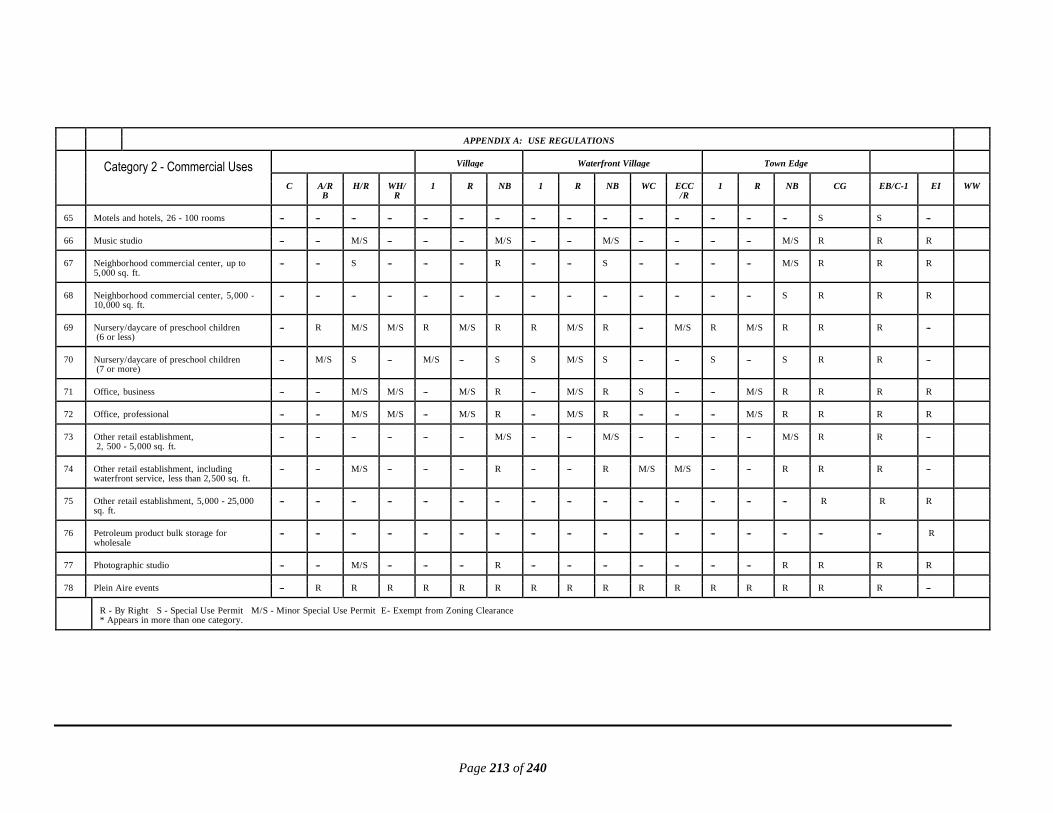
Page 213 of 240
APPENDIX A: USE REGULATIONS
Category 2 - Commercial Uses Village Waterfront Village Town Edge
C A/RB
H/R WH/R
1 R NB 1 R NB WC ECC/R
1 R NB CG EB/C-1 EI WW
65 Motels and hotels, 26 - 100 rooms --- --- --- --- --- --- --- --- --- --- --- --- --- --- --- S S ---
66 Music studio --- --- M/S --- --- --- M/S --- --- M/S --- --- --- --- M/S R R R
67 Neighborhood commercial center, up to 5,000 sq. ft.
--- --- S --- --- --- R --- --- S --- --- --- --- M/S R R R
68 Neighborhood commercial center, 5,000 - 10,000 sq. ft.
--- --- --- --- --- --- --- --- --- --- --- --- --- --- S R R R
69 Nursery/daycare of preschool children (6 or less)
--- R M/S M/S R M/S R R M/S R --- M/S R M/S R R R ---
70 Nursery/daycare of preschool children (7 or more)
--- M/S S --- M/S --- S S M/S S --- --- S --- S R R ---
71 Office, business --- --- M/S M/S --- M/S R --- M/S R S --- --- M/S R R R R
72 Office, professional --- --- M/S M/S --- M/S R --- M/S R --- --- --- M/S R R R R
73 Other retail establishment, 2, 500 - 5,000 sq. ft.
--- --- --- --- --- --- M/S --- --- M/S --- --- --- --- M/S R R ---
74 Other retail establishment, including waterfront service, less than 2,500 sq. ft.
--- --- M/S --- --- --- R --- --- R M/S M/S --- --- R R R ---
75 Other retail establishment, 5,000 - 25,000 sq. ft.
--- --- --- --- --- --- --- --- --- --- --- --- --- --- --- R R R
76 Petroleum product bulk storage for wholesale
--- --- --- --- --- --- --- --- --- --- --- --- --- --- --- --- --- R
77 Photographic studio --- --- M/S --- --- --- R --- --- --- --- --- --- --- R R R R
78 Plein Aire events --- R R R R R R R R R R R R R R R R ---
R - By Right S - Special Use Permit M/S - Minor Special Use Permit E- Exempt from Zoning Clearance * Appears in more than one category.
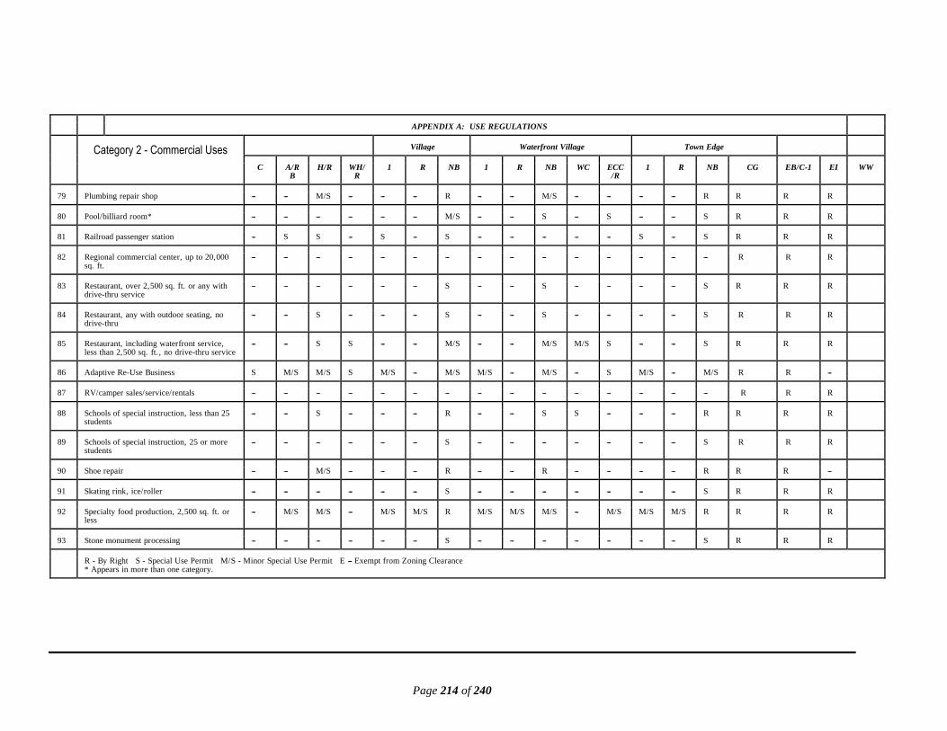
Page 214 of 240
APPENDIX A: USE REGULATIONS
Category 2 - Commercial Uses Village Waterfront Village Town Edge
C A/RB
H/R WH/R
1 R NB 1 R NB WC ECC/R
1 R NB CG EB/C-1 EI WW
79 Plumbing repair shop --- --- M/S --- --- --- R --- --- M/S --- --- --- --- R R R R
80 Pool/billiard room* --- --- --- --- --- --- M/S --- --- S --- S --- --- S R R R
81 Railroad passenger station --- S S --- S --- S --- --- --- --- --- S --- S R R R
82 Regional commercial center, up to 20,000 sq. ft.
--- --- --- --- --- --- --- --- --- --- --- --- --- --- --- R R R
83 Restaurant, over 2,500 sq. ft. or any with drive-thru service
--- --- --- --- --- --- S --- --- S --- --- --- --- S R R R
84 Restaurant, any with outdoor seating, no drive-thru
--- --- S --- --- --- S --- --- S --- --- --- --- S R R R
85 Restaurant, including waterfront service, less than 2,500 sq. ft. , no drive-thru service
--- --- S S --- --- M/S --- --- M/S M/S S --- --- S R R R
86 Adaptive Re-Use Business S M/S M/S S M/S --- M/S M/S --- M/S --- S M/S --- M/S R R ---
87 RV/camper sales/service/rentals --- --- --- --- --- --- --- --- --- --- --- --- --- --- --- R R R
88 Schools of special instruction, less than 25 students
--- --- S --- --- --- R --- --- S S --- --- --- R R R R
89 Schools of special instruction, 25 or more students
--- --- --- --- --- --- S --- --- --- --- --- --- --- S R R R
90 Shoe repair --- --- M/S --- --- --- R --- --- R --- --- --- --- R R R ---
91 Skating rink, ice/roller --- --- --- --- --- --- S --- --- --- --- --- --- --- S R R R
92 Specialty food production, 2,500 sq. ft. or less
--- M/S M/S --- M/S M/S R M/S M/S M/S --- M/S M/S M/S R R R R
93 Stone monument processing --- --- --- --- --- --- S --- --- --- --- --- --- --- S R R R
R - By Right S - Special Use Permit M/S - Minor Special Use Permit E --- Exempt from Zoning Clearance * Appears in more than one category.

Page 215 of 240
APPENDIX A: USE REGULATIONS
Category 2 - Commercial Uses Village Waterfront Village Town Edge
C A/RB
H/R WH/R
1 R NB 1 R NB WC ECC/R
1 R NB CG EB/C-1 E1 WW
94 Subdivision sales/rental office, on-site at an approved subdivision
--- R R --- R R --- R R --- --- --- R R Z R R ---
95 Taxidermy services --- M/S M/S --- M/S --- R M/S --- M/S --- --- M/S --- R R R R
96 Temporary seasonal sales --- Christmas trees, seafood, etc. (4 - 30 days) with accessory goods/services
--- R R R R R R R R R R R R R R R R R
97 Theater, indoor single screen/stage. less than 5,000 sq. ft.
--- --- S --- --- --- S --- --- --- --- --- --- --- S R R R
98 Tourism info office, kiosk or staffed M/S M/S --- --- M/S --- M/S M/S --- M/S M/S --- M/S --- M/S R R ---
99 Tourist cottage (not intended for permanent residence) up to 12
--- S S S S --- S S --- S --- R S --- M/S R R ---
100
Truck/freight terminal --- --- --- --- --- --- ------ --- --- --- --- --- --- --- --- S S R
101
Truck stop --- --- --- --- --- --- --- --- --- --- --- --- S --- --- S S R
102
Veterinary clinics with accessory goods/services
--- S S --- S --- S S --- S --- --- S --- S R R R
103
Veterinary services (no overnight boarding) with accessory goods/services
--- M/S M/S --- M/S --- R M/S --- R --- --- M/S --- R R R R
104
Warehousing, including moving and storage with accessory goods/services
--- --- --- --- --- --- --- --- --- --- --- --- --- --- --- R R R
105
Wood splitting and packing --- R --- --- M/S --- --- M/S --- --- --- --- M/S --- --- --- --- R
106
Yard/garage sales, 4 - 15 days --- R R R R R R R R --- --- R R R R R R ---
107
Yard/garage sales, temporary, 3 days or less
E E E E E E E E E E E E E E E E E ---
R - By Right S - Special Use Permit M/S - Minor Special Use Permit E - Exempt from Zoning Clearance * Appears in more than one category.

Page 216 of 240
APPENDIX A: USE REGULATIONS
Category 3 - Community Service
Uses
Village Waterfront Village Town Edge
C A/RB
H/R WH/R
1 R NB 1 R NB WC ECC/ R
1 R NB CG EB/C-1 E1 WW
1 Adult daycare, 7 or more* --- --- S --- --- --- S --- --- S --- --- --- --- S R R ---
2 Adult daycare, up to 6* --- M/S M/S M/S M/S M/S R M/S M/S R --- M/S M/S M/S R R R ---
3 Airstrip. private normal use (PNU) --- M/S --- --- --- --- --- --- --- --- --- --- --- --- --- --- --- ---
4 Airstrip, private occasional use (POU) --- R --- --- --- --- --- --- --- --- --- --- --- --- --- --- --- ---
5 Alternative waste water treatment system (accessory)
S M/S M/S M/S M/S M/S M/S M/S M/S M/S M/S M/S M/S M/S M/S M/S M/S M/S
6 Animal shelter, non-profit operation --- R S --- M/S --- S --- --- --- --- --- M/S --- S R R R
7 Churches/places of worship (with or without on-site cemetery) up to 10,000 sq. ft.
--- R R M/S R M/S M/S R M/S M/S --- S R M/S M/S R R ---
7A Churches/places of worship (with or without on-site cemetery) 10,001 - 20,000 sq. ft.
--- M/S S --- M/S S S M/S S S --- --- M/S S M/S M/S M/S ---
8 Colleges/universities --- S --- --- S --- S S --- --- --- --- --- --- S R R ---
9 Community center, up to 5,000 sq. ft. --- --- M/S S --- --- S --- --- S --- --- --- --- S R R R
10 Helipad, private --- S --- --- --- --- --- --- --- --- --- --- --- --- --- --- --- R
11 Hospitals --- S --- --- S --- S --- --- --- --- --- --- --- S R R R
12 Library --- --- M/S --- --- M/S R --- S R --- --- S S R R R ---
13 Mass/community subsurface drainfield, on-site
--- S S --- S S S --- --- --- --- S S S S S S S
14 Medical clinics (outpatient) --- S S --- --- --- S --- --- S --- --- --- --- S R R ---
15 Meeting facilities for fraternal, civic and similar organizations, up to 5,000 sq. ft.
--- S S S S --- M/S S --- S --- --- --- --- S R R ---
R - By Right S - Special Use Permit M/S - Minor Special Use Permit E --- Exempt from Zoning Clearance * Appears in more than one category.

Page 217 of 240
APPENDIX A: USE REGULATIONS
Category 3 - Community Service Uses
Village Waterfront Village Town Edge
C A/RB
H/R WH/R
1 R NB 1 R NB WC ECC/R
1 R NB CG/ EB/C-1 EI WW
16 Museums, public or commercial, with accessory goods/services
--- S S --- S S R S S R --- --- --- --- R R R R
17 Nursery/preschool (6 or less)* --- R M/S M/S R M/S R R M/S R --- M/S R M/S R R R ---
18 Nursery/preschool (7 or more)* --- S S --- S --- S S --- S --- --- --- --- S R R ---
19 Post offices --- S S --- S S R S S R --- --- --- --- R R R R
20 Public safety facilities - police, fire, rescue stations, including government offices
S S R S R S R R S R --- S --- --- R R R R
21 Public utility, Class A: See definition R R R R R R R R R R R R R --- R R R R
22 Public utility, Class B: See definition S S S S S S S S S S S S S S S S S S
23 Recreational, educational or social events by a non-profit organization, temporary
E E E E E E E E E E E E E E E E E ---
24 Recreational or social uses within a subdivision for use of residents only
--- E E E E E E E E E --- E E E E E E ---
25 Research radar installation with or without ancillary structures
_ S _ _ S _ _ S _ _ _ _ _ _ _ _ _ _
26 Residential care facilities (for medical/ mental patients), up to 5,000 sq. ft.
--- S S --- S --- S S --- S --- --- --- --- S R R ---
27 Sanitary landfill, public (local government operated)
--- S --- --- --- --- --- --- --- --- --- --- --- --- --- --- --- ---
28 Schools, primary or secondary, public or private
--- S S --- S --- S S --- --- --- --- --- --- S R R ---
29 Schools, vocational or technical, public or private
--- S S --- S --- S S --- --- S --- --- --- S R R R
30 Sewage treatment facilities --- S --- --- S S S S S S --- --- S S S S S R
31 Social club, private, up to 5,000 sq, ft --- S S S S S M/S S --- S --- --- --- --- S R R ---
R - By Right S - Special Use Permit M/S - Minor Special Use Permit E --- Exempt from Zoning Clearance * Appears in more than one category.

Page 218 of 240
APPENDIX A: USE REGULATIONS
Category 3 - Community Service Uses
Village Waterfront Village Town Edge
C A/RB
H/R WH/R
1 R NB 1 R NB WC ECC/R
1 R NB CG EB/C-1 EI WW
32 Solar energy facility, small system R R R R R R R R R R R R R R R R R R
33 Wireless Communication Facility (WCF)
A. WCF ≤ 50 feet R R R R R R R R R R R R R R R R R R
B. WCF > 50 feet and ≤ 100 feet
on a parcel ≥ 5 acres
M/S R M/S --- M/S --- --- --- --- M/S --- --- --- --- --- R R R
C. WCF > 100 feet and ≤ 199
feet on a parcel ≥ 5 acres
S S S --- S --- --- --- --- S --- --- --- --- --- M/S M/S R
D. WCF > 50 feet and ≤ 100 feet on a parcel < 5 acres
M/S M/S M/S --- M/S --- --- --- --- M/S --- --- --- --- --- R R R
E. WCF > 100 feet and ≤ 199 feet on a parcel < 5 acres
S S S --- S --- --- --- --- S --- --- --- --- --- M/S M/S R
34 Telephone exchange, unmanned --- S S S S S S S S S --- --- S S S R R R
35 Waste collection center, public (local government operated)
--- S S --- S S S S S S --- S --- S S R R R
36 Wind energy facility: wind energy test facility: wind turbine, large or utility-scale
--- S --- --- --- --- --- --- --- --- --- --- --- --- --- --- --- S
37 Wind turbine, small, less than or equal to 35 feet in total height in accordance with standards in § 154.2.114
R R R R R R R R R R R R R R R R R R
38 Wind turbine, small, greater than 35 feet and ≤120 feet total height in accordance with standards in § 154.2.114
M/S M/S M/S M/S M/S M/S M/S M/S M/S M/S M/S M/S M/S M/S M/S M/S M/S M/S
39 Wind turbine, small, greater than 120 feet and ≤199 feet total height in accordance with standards in § 154.2.114
S S S S S S S S S S S S S S S S S S
40 Windmills less than or equal 35 feet total height, in accordance with standards in § 154.2.114
R R R R R R R R R R R R R R R R R R
41 Windmills greater than 35 feet and ≤120 feet total height, in accordance with standards in § 154.2.114
M/S M/S M/S M/S M/S M/S M/S M/S M/S M/S M/S M/S M/S M/S M/S M/S M/S M/S
42 Windmills greater than 120 feet and ≤199 feet total height, in accordance with standards in § 154.2.114
S S S S S S S S S S S S S S S S S S
R - By Right S - Special Use Permit M/S - Minor Special Use Permit E- Exempt from Zoning Clearance * Appears in more than one category.

Page 219 of 240
APPENDIX A: USE REGULATIONS
Category 4 - Industrial Uses
Village Waterfront Village Town Edge
C A/RB
H/R WH/R
1 R NB 1 R NB WC ECC/ R
1 R NB CG EB/C-1 EI WW
1 Any industrial use which exceeds 50,000 gallons of water from the aquifer in any one day or 300,000 in any consecutive 30-day period
--- --- --- --- --- --- --- --- --- --- --- --- --- --- --- --- --- S
2 Asphalt or bituminous mixing plant --- --- --- --- --- --- --- --- --- --- --- --- --- --- --- --- --- S
3 Automobile/farm equipment/truck assembly --- --- --- --- --- --- --- --- --- --- --- --- --- --- --- --- --- R
4 Bakeries, wholesale (up to 5,000 sq. ft.) --- --- --- --- --- --- S --- --- --- --- --- --- --- S R R R
5 Barrel/box/bag manufacturing --- --- --- --- --- --- --- --- --- --- --- --- --- --- --- --- --- R
6 Bio-diesel refinery (no petroleum products added on-site)
--- --- --- --- --- --- --- --- --- --- --- --- --- --- --- --- --- S
7 Boat building and repair with or without marine railway*
--- S S S S --- S S --- S S --- S --- S S S S
8 Boat/yacht interiors - new and retrofit (fabrication and installation)
--- S S S S --- S S --- S S --- S --- S S S R
9 Borrow pit --- S --- --- S --- --- S --- --- --- --- S --- --- --- --- S
10 Brick/tile/terra cotta manufacturing --- --- --- --- --- --- --- --- --- --- --- --- --- --- --- --- --- S
11 Building component manufacturing/ assembly of modular homes
--- --- --- --- --- --- --- --- --- --- --- --- --- --- --- S S R
12 Bulk mailing services --- --- --- --- --- --- S --- --- --- --- --- --- --- S R R R
13 Cabinet-making facility, up to 10,000 sq. ft. --- --- --- --- --- --- --- --- --- --- --- --- --- --- --- S S R
14 Cinderblock manufacturing --- --- --- --- --- --- --- --- --- --- --- --- --- --- --- --- --- R
15 Clock and watch manufacture and distribution (up to 5,000 sq. ft.)
--- --- --- --- --- --- S --- --- --- --- --- --- --- S R R R
R - By Right S - Special Use Permit M/S - Minor Special Use Permit E --- Exempt from Zoning Clearance * Appears in more than one category.

Page 220 of 240
APPENDIX A: USE REGULATIONS
Category 4 - Industrial Uses Village Waterfront Village Town Edge
C A/RB
H/R WH/R
1 R NB 1 R NB WC ECC/R
1 R NB CG/ EB/C-1 EI WW
16 Clothing manufacturing (up to 5,000 sq. ft.) --- --- --- --- --- --- S --- --- S --- --- --- --- S R R R
17 Communications equipment manufacturing --- --- --- --- --- --- --- --- --- --- --- --- --- --- --- S S S
18 Concrete/concrete products manufacturing --- --- --- --- --- --- --- --- --- --- --- --- --- --- --- --- --- R
19 Contractor office/shop with material storage enclosed or outdoors with opaque screening up to 5,000 sq. ft.
--- S S --- S --- S S --- S --- --- S --- S R R R
20 Contractor office/shop with material storage outdoors, unscreened
--- S --- --- --- --- --- --- --- --- --- --- --- --- --- M/S M/S R
21 Cotton gins --- R --- --- --- --- --- --- --- --- --- --- --- --- --- --- --- R
22 Drafting equipment manufacture and distribution
--- --- --- --- --- --- --- --- --- --- --- --- --- --- --- R R R
23 Drop forge industry --- --- --- --- --- --- --- --- --- --- --- --- --- --- --- --- --- S
24 Drop-ship center, up to 50,000 sq. ft. --- --- --- --- --- --- --- --- --- --- --- --- --- --- --- --- --- S
25 Electronic appliance assembly --- --- --- --- --- --- --- --- --- --- --- --- --- --- --- --- --- R
26 Electronic components manufacturing (excluding transformers)
--- --- --- --- --- --- --- --- --- --- --- --- --- --- --- --- --- S
27 Ethanol production --- S --- --- --- --- --- --- --- --- --- --- --- --- --- --- --- S
28 Farm equipment sales, service and repair --- S S --- S --- S --- --- --- --- --- S --- S M/S M/S R
29 Fertilizer blending and distribution --- S --- --- --- --- --- --- --- --- --- --- --- --- --- --- --- S
30 Fertilizer/pesticide bulk storage for wholesale
--- S --- --- --- --- --- --- --- --- --- --- --- --- --- --- --- S
R - By Right S - Special Use Permit M/S - Minor Special Use Permit E --- Exempt from Zoning Clearance * Appears in more than one category.
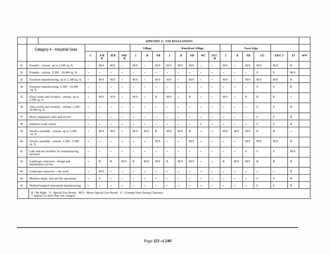
Page 221 of 240
APPENDIX A: USE REGULATIONS
Category 4 - Industrial Uses Village Waterfront Village Town Edge
C A/RB
H/R WH/R
1 R NB 1 R NB WC ECC/R
1 R NB CG EB/C-1 EI WW
31 Foundry - artisan, up to 2,500 sq. ft. --- M/S M/S --- M/S --- M/S M/S M/S M/S --- --- M/S --- M/S M/S M/S R
32 Foundry - artisan, 2,500 - 10,000 sq. ft. --- --- --- --- --- --- --- --- --- --- --- --- --- --- --- S S M/S
33 Furniture manufacturing, up to 2,500 sq. ft. --- M/S M/S --- M/S --- M/S M/S --- M/S --- --- M/S --- M/S M/S M/S R
34 Furniture manufacturing, 2,500 - 10,000 sq. ft.
--- --- --- --- --- --- --- --- --- --- --- --- --- --- --- S S R
35 Glass works and ceramics - artisan, up to 2,500 sq. ft.
--- M/S M/S --- M/S --- R M/S --- R --- --- M/S --- R R R ---
36 Glass works and ceramics - artisan, 2,500 - 10,000 sq. ft.
--- --- --- --- --- --- --- --- --- --- --- --- --- --- --- S S R
37 Heavy equipment sales and service --- --- --- --- --- --- --- --- --- --- --- --- --- --- --- S S R
38 Industrial trade school --- --- --- --- --- --- --- --- --- --- S --- --- --- --- S S R
39 Jewelry assembly - artisan, up to 2,500 sq. ft.
--- M/S M/S --- M/S M/S R M/S M/S R --- --- M/S M/S M/S R R ---
40 Jewelry assembly - artisan, 2,500 - 5,000 sq. ft.
--- --- --- --- --- --- M/S --- --- M/S --- --- --- --- M/S M/S M/S R
41 Labs and test facilities for manufacturing, enclosed
--- --- --- --- --- --- --- --- --- --- --- --- --- --- S S S M/S
42 Landscape contractor - design and maintenance on-site
--- R R M/S R M/S M/S R M/S M/S --- --- R M/S M/S R R R
43 Landscape contractor - site work --- M/S --- --- --- --- --- --- --- --- --- --- --- --- --- --- --- R
44 Machine shops, tool and die operations --- S --- --- --- --- --- --- --- --- --- --- --- --- --- S S R
45 Medical/surgical instrument manufacturing --- --- --- --- --- --- --- --- --- --- --- --- --- --- --- S S R
R - By Right S - Special Use Permit M/S - Minor Special Use Permit E --- Exempt from Zoning Clearance * Appears in more than one category.

Page 222 of 240
APPENDIX A: USE REGULATIONS
Category 4 - Industrial Uses Village Waterfront Village Town Edge
C A/RB
H/R WH/R
1 R NB 1 R NB WC ECC/R
1 R NB CG EB/C-1 EI WW
46 Metal fabrication and welding operations --- S S --- --- --- S --- --- S --- --- --- --- S S S S
47 Microbrewery (up to 5,000 sq. ft.) --- --- M/S --- --- --- M/S --- --- M/S --- --- --- --- M/S R R R
48 Microbrewery (5,000 - 10,000 sq. ft.) --- --- --- --- --- --- --- --- --- --- --- --- --- --- --- S S R
49 Modular unit manufacture and assembly --- --- --- --- --- --- --- --- --- --- --- --- --- --- --- --- --- R
50 Multi-unit storage facility, up to 50,000 sq. ft.
--- --- --- --- --- --- --- --- --- --- --- --- --- --- --- --- --- R
51 Musical instrument manufacture and distribution
--- --- --- --- --- --- --- --- --- --- --- --- --- --- --- S S R
52 Optical equipment manufacture --- --- --- --- --- --- --- --- --- --- --- --- --- --- --- S S R
53 Pallet manufacture and repair facilities --- --- --- --- --- --- --- --- --- --- --- --- --- --- --- --- --- R
54 Peanut dryer --- R --- --- --- --- --- --- --- --- --- --- --- --- --- --- --- R
55 Petroleum product bulk storage for wholesale*
--- --- --- --- --- --- --- --- --- --- --- --- --- --- --- --- --- S
56 Pharmaceutical manufacturing laboratories --- --- --- --- --- --- --- --- --- --- --- --- --- --- --- --- --- S
57 Plaster products manufactured from previously prepared raw materials
--- --- --- --- --- --- --- --- --- --- --- --- --- --- --- --- --- S
58 Pottery and figurine manufacture --- --- --- --- --- --- --- --- --- --- --- --- --- --- --- S S R
59 Prefabrication of wooden buildings/garden sheds, etc.
--- M/S S --- --- --- --- --- --- --- --- --- --- --- --- S S R
60 Printing, lithography establishments --- --- --- --- --- --- S --- --- --- --- --- --- --- S R R R
R - By Right S - Special Use Permit M/S - Minor Special Use Permit E --- Exempt from Zoning Clearance * Appears in more than one category.

Page 223 of 240
APPENDIX A: USE REGULATIONS
Category 4 - Industrial Uses Village Waterfront Village Town Edge
C A/RB
H/R WH/R
1 R NB 1 R NB WC ECC/R
1 R NB CG EB/C-1 EI WW
61 Processing of bulk agricultural products --- --- --- --- --- --- --- --- --- --- --- --- --- --- --- --- --- S
62 Processing of seafood products --- --- --- --- --- --- --- --- --- --- --- --- --- --- --- --- --- S
63 Railroad freight terminals --- --- --- --- --- --- --- --- --- --- --- --- --- --- --- S S R
64 Reclamation of soil or water, temporary - existing on-site only
R R R R R R R R R R R R R R R R R R
65 Recreational vehicle retrofitting and customizing
--- --- --- --- --- --- --- --- --- --- --- --- --- --- --- S S R
66 Recycling collection site up to 1 acre --- S --- --- S --- S S --- S --- --- S --- S S S S
67 Recycling receiving/transfer facilities for plastic, glass, cans, paper, household waste
--- S --- --- --- --- --- --- --- --- --- --- --- --- --- S S S
68 Recycling /processing of plastic, glass, aluminum or paper
--- --- --- --- --- --- --- --- --- --- --- --- --- --- --- --- --- S
69 Sawmill/kiln/planing facility --- S --- --- --- --- --- --- --- --- --- --- --- --- --- --- --- R
70 Soap manufacturing --- --- --- --- --- --- --- --- --- --- --- --- --- --- --- --- --- S
71 Soybean crush mills for oil and meal production
--- --- --- --- --- --- --- --- --- --- --- --- --- --- --- --- --- S
72 Storage of bulk agricultural products --- R S --- S --- --- S --- --- --- --- S --- --- --- --- R
73 Storage of seafood products --- R S M/S S --- --- S --- S S --- S --- --- --- --- R
74 Vehicle junkyard/graveyard with parts recycling/sales/screened
--- --- --- --- --- --- --- --- --- --- --- --- --- --- --- --- --- S
75 Warehouse, up to 50,000 sq. ft. --- --- --- --- --- --- --- --- --- --- --- --- --- --- --- --- --- R
76 Wood, cloth or fiber product manufacture --- --- --- --- --- --- --- --- --- --- --- --- --- --- --- --- --- S
R - By Right S - Special Use Permit M/S - Minor Special Use Permit e --- Exempt from Zoning Clearance * Appears in more than one category.

Page 224 of 240
APPENDIX A: USE REGULATIONS
Category 5 - Marine-Related Uses
Village Waterfront Village Town Edge
C A/RB
H/R WH/R
1 R NB 1 R NB WC ECC/R
1 R NB CG EB/C-1 EI WW
1 Aquaculture business office, on-site M/S R R R R --- R R --- R R M/S R --- --- --- --- ---
2 Aquaculture, fish production in existing ponds*
M/S R M/S M/S R M/S M/S R M/S M/S M/S M/S R M/S M/S M/S M/S M/S
3 Aquaculture, fish production tanks M/S R S --- S --- --- S --- --- M/S --- S --- --- M/S M/S R
4 Aquaculture research facility M/S R --- M/S M/S --- --- M/S M/S M/S M/S M/S M/S --- M/S M/S M/S R
5 Aquaculture, shellfish seed production M/S R M/S M/S M/S --- M/S M/S M/S M/S M/S M/S M/S M/S M/S M/S M/S R
6 Beaches, public naturally occurring R R R R R R R R S S --- S S S S S S ---
7 Boat building and repair with or without marine railway*
--- S S S S --- S S --- S S --- S --- S S S R
8 Boat ramp for recreational boats, private R R R R R R R R R R R R R R R R R ---
9 Boat ramp for recreational boats public /commercial* with accessory goods/services
S S S S S --- S S S S S S S S S S S ---
10 Boat rental with accessory goods/services M/S --- --- S --- --- S --- --- S M/S --- --- --- S R R R
11 Boat sales/service --- --- --- S --- --- S --- --- S M/S --- --- --- S R R R
12 Clam packing houses (with no processing) S R S M/S R --- M/S R --- R R --- R --- R R R R
13 Crab packing houses S M/S S M/S S --- S S --- M/S R --- S --- S R R R
14 Crab shedding, enclosed S R R R R M/S R R M/S R R M/S R M/S R R R R
15 Crab shedding, not enclosed S R M/S R R --- M/S R M/S R R M/S R M/S M/S M/S M/S R
R - By Right S - Special Use Permit M/S - Minor Special Use Permit E --- Exempt from Zoning Clearance * Appears in more than one category.

Page 225 of 240
APPENDIX A: USE REGULATIONS
Category 5 - Marine-Related Uses Village Waterfront Village Town Edge
C A/RB
H/R WH/R
1 R NB 1 R NB WC ECC/R
1 R NB CG EB/C-1 EI WW
16 Docks, private recreational R R R R R R R R R R R R R R R R R ---
17 Dredge spoil disposal site (from local waters)
S S --- --- --- --- --- S --- --- --- --- S --- --- --- --- S
18 Erosion and storm water control devices R R R R R R R R R R R R R R R R R R
19 Fish packing houses (with no processing) R R S M/S M/S --- M/S M/S --- M/S R --- M/S --- M/S R R R
20 Hunting blinds* R R --- R R --- --- R --- --- --- --- R --- --- --- --- ---
21 Landing site for finfish, shellfish, crabs - commercial
S M/S M/S M/S --- --- M/S M/S --- R R S S --- S R R R
22 Landing site for finfish, shellfish, crabs - private
R R M/S R R R R R R R R R R R R R R R
23 Marina, 50 slips or more, public or commercial*
--- --- --- --- --- --- --- --- --- --- --- --- --- --- --- --- --- ---
24 Marina, less than 50 slips, pubic or commercial*
--- --- --- --- --- --- --- --- --- S S S --- --- S S S S
25 Marine navigation aids R R R R R R R R R R R R R R R R R R
26 Non-motorized watercraft - instruction rental, sales
M/S M/S M/S M/S M/S M/S R M/S M/S R M/S M/S M/S M/S R R R R
27 Oyster shucking houses (with no processing)
S R M/S R R --- M/S R --- R R --- S --- R R R R
28 Pot production for crab or eel pots, commercial (up to 1 acre incl. storage)
--- M/S M/S M/S M/S --- R M/S --- R R --- M/S --- R R R R
29 Pot production for crab or eel pots, private R R R R R R R R R R R R R R R R R R
30 Research facilities for marine sciences S S S S S --- M/S S --- M/S S --- S --- S S S R
R - By Right S - Special Use Permit M/S - Minor Special Use Permit E --- Exempt from Zoning Clearance * Appears in more than one category.
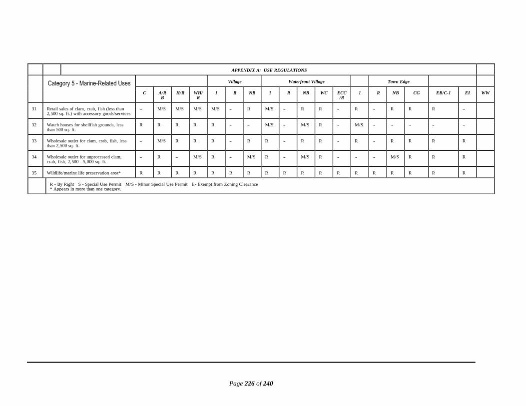
Page 226 of 240
APPENDIX A: USE REGULATIONS
Category 5 - Marine-Related Uses Village Waterfront Village Town Edge
C A/RB
H/R WH/R
1 R NB 1 R NB WC ECC/R
1 R NB CG EB/C-1 EI WW
31 Retail sales of clam, crab, fish (less than 2,500 sq. ft.) with accessory goods/services
--- M/S M/S M/S M/S --- R M/S --- R R --- R --- R R R ---
32 Watch houses for shellfish grounds, less than 500 sq. ft.
R R R R R --- --- M/S --- M/S R --- M/S --- --- --- --- ---
33 Wholesale outlet for clam, crab, fish, less than 2,500 sq. ft.
--- M/S R R R --- R R --- R R --- R --- R R R R
34 Wholesale outlet for unprocessed clam, crab, fish, 2,500 - 5,000 sq. ft.
--- R --- M/S R --- M/S R --- M/S R --- --- --- M/S R R R
35 Wildlife/marine life preservation area* R R R R R R R R R R R R R R R R R R
R - By Right S - Special Use Permit M/S - Minor Special Use Permit E- Exempt from Zoning Clearance * Appears in more than one category.

Page 227 of 240
APPENDIX A: USE REGULATIONS
Category 6 - Recreational Uses
Village Waterfront Village Town Edge
C A/RB
H/R WH/R
1 R NB 1 R NB WC ECC/R
1 R NB CG EB/C-1 EI WW
1 Archery range, outdoor, with accessory goods/services
--- M/S --- --- M/S --- --- M/S --- --- --- --- M/S --- --- --- --- R
2 Archery range, indoor (up to 5,000 sq. ft. ) with accessory goods/services
--- R --- --- M/S --- M/S M/S --- M/S --- --- M/S --- M/S R R R
3 Athletic fields --- S S --- S --- S S --- S --- S S --- S S S S
4 Athletic fields, with structures --- S --- --- S --- --- S --- --- --- --- S --- --- --- --- S
5 ATV trails - commercial --- S --- --- --- --- --- --- --- --- --- --- --- --- --- --- --- ---
6 Batting cage --- S --- --- --- --- --- --- --- --- --- --- --- --- --- S S R
7 Boat ramp for recreational boats, private* R R R R R R R R R R R R R R R R R ---
8 Boat ramp for recreational boats, public/ commercial*
S S S S --- S S S S S S S S S S S S ---
9 Boat storage and washing facilities --- --- S --- --- --- S --- --- S S --- --- --- S S S R
10 Bowling alley with accessory goods/services --- --- --- --- --- --- S --- --- --- --- --- --- --- S R R R
11 Camper/RV storage with washing facilities, screened
--- --- --- --- --- --- S --- --- --- --- --- --- --- S S S R
12 Campgrounds with accessory goods/services
--- S --- --- S --- --- S --- --- --- --- S --- --- --- --- ---
13 Corn mazes with accessory goods/services --- R R --- R --- --- R --- --- --- --- R --- --- --- --- ---
14 Country clubs, not including golf courses --- S S --- S --- S --- --- --- --- --- S --- S R R ---
15 Dance halls (up to 3,000 sq. ft).* --- M/S M/S M/S M/S --- M/S M/S --- M/S --- M/S M/S --- M/S R R M/S
R - By Right S - Special Use Permit M/S - Minor Special Use Permit E - Exempt from Zoning Clearance * Appears in more than one category.

Page 228 of 240
APPENDIX A: USE REGULATIONS
Category 6 - Recreational Uses Village Waterfront Village Town Edge
C A/RB
H/R WH/R
1 R NB 1 R NB WC ECC/R
1 R NB CG EB/C-1 EI WW
16 Dance halls (3,000 - 5,000 sq. ft.)* --- --- S --- --- --- S --- --- S --- --- --- --- S R R R
17 Day camp --- S S --- S S S S S S --- --- S S S S S ---
18 Docks, private recreational R R R R R R R R R R R R R R R R R R
19 Firing range, indoor --- S --- --- --- --- S --- --- --- --- --- --- --- S S S R
20 Firing range, outdoor - including skeet, trap, sporting clays, shotguns, etc.
--- M/S --- --- S --- --- S --- --- --- --- --- --- --- --- --- ---
21 Firing range, outdoor - rifles, including semi-automatic and handguns
--- S --- --- --- --- --- --- --- --- --- --- --- --- --- --- --- ---
22 Fishing pier, commercial or public, with accessory goods/services
S S S S S S S S S S S S S S S S S R
23 Game center, coin-operated --- --- --- --- --- --- S --- --- --- --- --- --- --- M/S R R ---
24 Go-kart tracks* --- S --- --- --- --- --- --- --- --- --- --- --- --- --- --- --- S
25 Golf course, public, private or commercial, with accessory goods/services
--- S --- --- S --- --- --- --- --- --- --- S --- --- --- --- ---
26 Golf driving range, daylight only, with accessory goods/services
--- M/S --- --- M/S --- --- --- --- --- --- --- M/S --- --- M/S M/S R
27 Golf - miniature* with accessory goods/ services
--- --- --- --- M/S --- M/S --- --- M/S --- --- --- --- M/S R R ---
28 Guide/outfitter services with accessory goods/services
M/S M/S M/S M/S M/S --- R M/S M/S R S --- M/S M/S R R R R
29 Hayrides, commercial --- R R --- R --- R R --- --- --- --- R --- --- --- --- ---
30 Health club/fitness center/day spa* with accessory goods/services
--- --- --- --- --- --- R --- --- S --- --- --- --- R R R ---
R - By Right S - Special Use Permit M/S - Minor Special Use Permit E --- Exempt from Zoning Clearance * Appears in more than one category.

Page 229 of 240
APPENDIX A: USE REGULATIONS
Category 6 - Recreational Uses Village Waterfront Village Town Edge
C A/RB
H/R WH/R
1 R NB 1 R NB WC ECC/R
1 R NB CG EB/C-1 E1 WW
31 Horse barn, private* (one per acre) --- R M/S M/S R --- M/S R M/S M/S --- --- R M/S M/S M/S M/S ---
32 Horse boarding/training, commercial* with accessory goods/services
--- R S --- S --- --- S --- --- --- --- S --- --- --- --- ---
33 Hunt clubs/lodges, commercial, no hunting grounds on-site
--- M/S S --- S --- S S --- S --- --- S --- S S S ---
34 Hunting blinds* R R --- R R --- --- R --- --- --- --- R --- --- --- --- ---
35 Marina, 50 slips or more, public or commercial*
--- --- --- --- --- --- --- --- --- --- --- --- --- --- --- --- --- ---
36 Marina, less than 50 slips, public or commercial*
--- --- --- --- --- --- --- --- --- S S S --- --- S S S S
37 Non-motorized recreational trail S S S S S --- S S S S S S S S S S S S
38 Non-motorized watercraft - instruction rental, sales*
M/S M/S M/S M/S M/S M/S M/S M/S M/S M/S M/S M/S M/S M/S R R R R
39 Paintball course, outdoor S R --- --- M/S --- --- --- M/S --- --- --- M/S --- R R R R
40 Parks - public --- S S S S --- S S S S S S S S S S S ---
41 Playgrounds for children --- M/S R M/S M/S --- R M/S M/S R --- M/S M/S R R S S ---
42 Pool hall/billiard room* --- --- --- --- --- --- S --- --- S --- S --- --- M/S R R ---
43 Skating rink, ice/roller* --- --- --- --- --- --- S --- --- --- --- --- --- --- --- R R R
44 Swimming pools, public or commercial --- S S --- S --- S --- --- S --- --- --- --- S R R R
R - By Right S - Special Use Permit M/S - Minor Special Use Permit E --- Exempt from Zoning Clearance * Appears in more than one category.

Page 230 of 240
APPENDIX A: USE REGULATIONS
Category 6 - Recreational Uses Village Waterfront Village Town Edge
C A/RB
H/R WH/R
1 R NB 1 R NB WC ECC/R
1 R NB CG EB/C-1 E1 WW
45 Temporary recreational event (3 days or less); e.g. , carnival, ballooning, bungee jumping, tractor pulls, etc.
R R R R R R R R R - R R R R R R R -
46 Tennis courts, private --- R R R R --- R R R R --- R R R R R R ---
47 Tennis courts, public or commercial --- S S --- S --- S --- --- S --- --- --- --- S R R R
48 Theater, indoor screen/stage up to 5,000 sq. ft.*
--- --- S --- --- --- S --- --- S --- --- --- --- S R R R
49 Wildlife or marine life preservation area* R R R R R --- R R R R R R R R R R R R
R - By Right S - Special Use Permit M/S - Minor Special Use Permit E --- Exempt from Zoning Clearance * Appears in more than one category.

Page 231 of 240
APPENDIX A: USE REGULATIONS
Category 7 SF - Single-Family
Residential Uses
Village Waterfront Village Town Edge
C A/RB
H/R WH/R
1 R NB 1 R NB WC ECC/R
1 R NB CG EB/C-1 EI WW
1 Principal SF detached dwelling unit
a. On-site construction R R R R R R M/S R R M/S --- R R R R --- ---
b. Manufactured, single-wide H.U.D. inspected
R R M/S M/S M/S M/S --- M/S M/S --- --- M/S M/S --- --- --- ---
c. Manufactured, double or triple-wide H.U.D. inspected
R R R R R R --- R R --- --- M/S R R --- --- ---
d. Manufactured, modular V.D.H.C.D. inspected
R R R R R R M/S R R M/S --- R R R M/S --- ---
2 Principal SF attached dwelling units - with each unit under fee simple ownership
a. Townhouse, row house or side by side --- --- --- --- --- S --- --- S --- --- --- --- S S --- ---
b. Duplex --- --- M/S --- --- M/S --- --- M/S --- --- --- --- M/S M/S --- ---
3 Principal SF detached rural farmstead dwelling unit
M/S M/S M/S M/S M/S --- --- M/S --- --- --- --- --- --- --- --- ---
4 Accessory SF detached dwelling unit
a. On-site construction S M/S M/S M/S M/S M/S M/S M/S M/S --- --- M/S M/S M/S M/S --- ---
b. Manufactured, single-wide H.U.D. inspected
S M/S M/S M/S M/S M/S M/S M/S M/S --- --- M/S M/S M/S M/S --- ---
c. Manufactured, double or triple-wide H.U.D. inspected
S M/S M/S M/S M/S M/S M/S M/S M/S --- --- M/S M/S M/S M/S --- ---
d. Manufactured, modular V.D.H.C.D. inspected
S M/S M/S M/S M/S M/S M/S M/S M/S --- --- M/S M/S M/S M/S --- ---
5 Accessory SF attached dwelling unit S M/S M/S M/S M/S M/S M/S M/S M/S M/S --- M/S M/S M/S M/S --- ---
R - By Right S - Special Use Permit M/S - Minor Special Use Permit E- Exempt from Zoning Clearance * Appears in more than one category.

Page 232 of 240
APPENDIX A: USE REGULATIONS
Category 7 SF -Single-Family Residential Uses
Village Waterfront Village Town Edge
C A/RB
H/R WH/R
1 R NB 1 R NB WC ECC/R
1 R NB CG EB/C-1 EI WW
6 Accessory uses and structures (excluding guesthouses)**
R R R R R R R R R R R R R R R R R R
7 Guesthouses (meeting primary setbacks and clearly subordinate to primary structure)
M/S M/S M/S M/S M/S M/S M/S M/S M/S M/S --- M/S M/S M/S M/S --- --- ---
8 Temporary SF detached dwelling unit - manufactured, single-wide HUD inspected
R R R R R R R R R R R R R R R R R R
9 Temporary emergency dwelling R R R R R R R R R R R R R R R R R R
10 Combination live-work unit w/allowable business/commercial use
--- M/S M/S M/S M/S --- R M/S --- R M/S --- M/S M/S M/S M/S M/S ---
11 Residential Facility R R R R R R M/S R R M/S --- R R R R --- --- ---
R - By Right S - Special Use Permit M/S - Minor Special Use Permit E --- Exempt from Zoning Clearance * Appears in more than one category. ** Must be in rear yard

Page 233 of 240
APPENDIX A: USE REGULATIONS
Category 7 MF -Multi-Family
Residential Uses
Village Waterfront Village Town Edge
C A/RB
H/R WH/R
1 R NB 1 R NB WC ECC/R
1 R NB CG EB/C-1 E1 WW
1 Principal MF attached dwelling units - apartment
--- --- S --- --- S --- --- S --- --- --- --- S S S S ---
2 Principal MF attached dwelling units - with each unit not under fee simple ownership
a. Townhouse, row house or side by side --- --- --- --- --- S --- --- S --- --- --- --- S S --- --- ---
b. Duplex --- M/S M/S --- M/S M/S --- --- M/S --- --- --- M/S M/S M/S --- --- ---
3 Accessory uses and structures** --- R R R R R R R R R R R R R R R R R
4 Temporary emergency dwelling --- R R R R R R R R R R R R R R R R R
5 Housing for migrant farm workers in association with a seasonal farming operation
--- M/S --- --- M/S --- --- M/S --- --- --- --- S --- --- --- --- ---
6 Worker housing - up to and including 12 occupants, employer furnished
--- S --- --- S --- --- --- --- --- --- --- --- --- --- --- --- ---
7 Housing for students, faculty and staff in association with a learning institute
--- S S S S S --- S S --- --- --- S S S S S ---
8 Mixed-use structure, residential/ commercial, up to 4 single-family dwelling units
--- --- S S --- --- S --- --- S --- --- --- --- S S S ---
9 Group homes
a. Respite care service facility --- S S S S S S S S S --- S S S S --- --- ---
b. Retirement home --- S S S S S S S S S --- S S S S --- --- ---
c. Supervised living residential service facility
--- --- S --- --- --- S --- --- S --- --- --- --- --- R R ---
10 Shared senior home --- M/S M/S M/S M/S M/S M/S --- M/S M/S --- --- M/S M/S --- --- --- ---
R - By Right S - Special Use Permit M/S - Minor Special Use Permit E- Exempt from Zoning Clearance * Appears in more than one category. ** Must be in rear yard

Page 234 of 240
APPENDIX B: DENSITIES, LOT SIZES AND DIMENSIONS
APPENDIX B: DENSITIES, LOT SIZES AND DIMENSIONS
ZONING DISTRICT
Village Waterfront Village Town Edge
C A/RB
H/R WH/R
V-1 V- R NB WV-1 WV- R WV-NB WV-WC ECC/R
TE-1 TE- R
TE-NB TE-CG EI EB/C-1 WW
Maximum density (# dwelling units per # acres)
1:50 1:201 2:1 2:1 1:20 2:12 2:12 1:20 2:1 2:1 None 2:1 1:5 1:23 1:23 None None None
Minimum lot size 1 acre
1 acre4
1/2 acre
1/2 acre
1 acre
1/2 acre
1/2 acre
1 acre
1/2 acre
1/2 acre None 1/2 acre
1 acre
1 acre
1/2 acre
None None None
Minimum lot width in feet at:
Measured at the building/front setback line
150 125 100 100 125 100 P/ none
125 100 P/ none
P/ none
90 125 100 None None None None
Measured at the shoreline 250 250 250 250 250 250 250 250 250 250 250 (water dependent uses only, 60)
250 None None None None 250 None
Minimum yard dimensions in feet:
Front Yard Setback
All structures measured from the property line on U.S. Rt. 13
100 100 100 n/a 100 100 100 n/a n/a n/a n/a n/a 100 100 100 100 100 100
All structures measured from the right-of-way of all other roads and railroads7
200 60 P/60 P/60 80 P/60 P/60 P/80 P/60 P/10 P/60 (water dependent uses only, 10)
P/20 60 60 60 100 1007 100
1 Density may be increased to 1:10 under open space density bonus option; 85% open space required; max. 2 With SUP, density may be increased to 4:1 for multi-family if one-site sewage and water supply systems are approved by the Health Department. 3 Through rezoning to TE/R or TE-NB, density may be increased to 5:1 if central water and sewer owned and operated by a municipality, county or public service authority are provided; setbacks may be modified. 4 Minimum lot size may be reduced to 30,000 sq. ft. under open space density bonus option. 5 In the case of zero lot line development or a shared lot line, a 20-ft. setback shall be observed on the other. 6 See § 154.140 et seq. for supplemental regulations. 7 P/x = Prevailing, if one exists, otherwise number indicated. See § 154.2.142, Front Setback/Yard Regulations. Front setback from railroad right-of-way in E1 District is 0 feet. Note: Supplemental setback regulations are stated in § 154.2.140 et seq. , Supplemental District Regulations. Note: All development requires Health Department approval.

Page 235 of 240
APPENDIX B: DENSITIES, LOT SIZES AND DIMENSIONS
ZONING DISTRICT
Village Waterfront Village Town Edge
C A/RB H/R WH/R V-1 V- R NB WV-1 WV- R WV-NB WV-WC ECC/R
TE-1 TE- R
TE-NB TE-CG EI EB/C-1 WW
Rear Yard Setback
Principal structures 100 25 25 25 50 25 20 50 25 20 20 (water dependent uses only, 0)
20 50 25 20 75 100 75
Accessory structures 20 10 5 5 10 5 5 10 5 5 5 (water dependent uses only, 0)
5 10 5 5 50 75 50
Side Yard Setback
Allowable principal attached structures measured from shared property lines
0 0 0 0 0 0 0 0 0 0 0 0 0 0 0 0 0 0
All other principal structures 50 15 15 15 25 10 15 25 10 15 20 (water dependent uses only, 10)
105 25 10 15 50 75 50
Accessory structures 10 10 5 5 10 5 5 10 5 5 20 (water dependent uses only, 10)
5 10 5 5 35 50 35
1 Density may be increased to 1:10 under open space density bonus option; 85% open space required; max. 2 With SUP, density may be increased to 4:1 for multi-family if one-site sewage and water supply systems are approved by the Health Department. 3 Through rezoning to TE/R or TE-NB, density may be increased to 5:1 if central water and sewer owned and operated by a municipality, county or public service authority are provided; setbacks may be modified. 4 Minimum lot size may be reduced to 30,000 sq. ft. under open space density bonus option. 5 In the case of zero lot line development or a shared lot line, a 20-ft. setback shall be observed on the other. 7 P/x = Prevailing, if one exists, otherwise number indicated. See § 154.2.142, Front Setback/Yard Regulations. Front setback from railroad right-of-way in E1 District is 0 feet. Note: Supplemental setback regulations are stated in § 154.2.140 et seq. , Supplemental District Regulations. Note: All development requires Health Department approval.
Page 236 of 240
APPENDIX B: DENSITIES, LOT SIZES AND DIMENSIONS
ZONING DISTRICT
Village Waterfront Village Town Edge
C A/RB H/R WH/R V-1 V- R NB WV-1 WV- R WV-NB WV-WC ECC/R
TE-1 TE- R TE-NB TE-CG EI EB/C-1 WW
Maximum height in feet:6
Principal structures 35 35 35 35 35 35 35 35 35 35 35 25 35 35 35 35 45 35
Accessory structures 25 25 25 25 25 20 20 25 20 20 25 16 25 16 20 25 30 25
1 Density may be increased to 1:10 under open space density bonus option; 85% open space required; max. 2 With SUP, density may be increased to 4:1 for multi-family if one-site sewage and water supply systems are approved by the Health Department. 3 Through rezoning to TE/R or TE-NB, density may be increased to 5:1 if central water and sewer owned and operated by a municipality, county or public service authority are provided; setbacks may be modified. 4 Minimum lot size may be reduced to 30,000 sq. ft. under open space density bonus option. 5 In the case of zero lot line development or a shared lot line, a 20-ft. setback shall be observed on the other. 6 See § 154.2.140 et seq. for supplemental regulations. 7 P/x = Prevailing, if one exists, otherwise number indicated. See § 154.2.142, Front Setback/Yard Regulations. Front setback from railroad right-of-way in E1 District is 0 feet. Note: Supplemental setback regulations are stated in § 154.2.140 et seq. , Supplemental District Regulations. Note: All development requires Health Department approval.

Page 237 of 240
APPENDIX C: MEASURING STANDARD SETBACKS AND RESOURCE PROTECTION AREA

Page 238 of 240
Page 239 of 240
Deviated in and/or out, then measurements will have to be taken at each point of deviation along its entire length to establish an accurate line for the landward edge of the buffer area.
Side View Measuring the 100-foot buffer with steep slopes is a difficult task. The following diagram shows how it should be accomplished.

Page 240 of 240
Department of Environmental Quality guidance document links. Chesapeake Bay Preservation Act Guidance at: http://www.deq.virginia.gov/Programs/Water/LawsRegulationsGuidance/Guidance/StormwaterManagementGuidance.aspx 1. Administrative Procedures for the Designation and Refinement of Chesapeake Bay Preservation Area Boundaries 2. Determinations of Water Bodies with Perennial Flow 3. Exceptions 4. Nonconforming Structures and Uses 5. Resource Protection Area: Buffer Area Encroachments 6. Resource Protection Area: Onsite Buffer Area Delineation 7. Resource Protection Areas: Nontidal Wetlands 8. Resource Protection Areas: Permitted Development Activities 9. Riparian Buffers Modification & Mitigation Guidance Manual 10. Silvicultural Operations and the Chesapeake Bay Preservation Act
Copyright © 2022 FDOKUMEN