Soils and palaeo-climate based evidence for irrigation requirements in Norse Greenland
Upload
independentCategory
view
0download
0
Norse Coastal Farms
Field Report of a Survey in the Southwest
“Vatnahverfi Peninsula”
Summer 2009
Christian Koch Madsen
With aid and contributions by
Jette Arneborg, Poul Baltzer Heide & Konrad Smiarowski
The National Museum of Denmark,
Department of Danish Middle Age and Renaissance, Copenhagen, Oct. 2009
1
Contents
Introduction p.2
Surveying 2009 – Aims and Methods p.3
”Log Book 2009” p.5
E63 p.10
E67 p.10
E92 p.11
E93 p.16
E94 p.23
E95 p.30
E95a p.35
E95b p.40
E118 p.43
E172 p.45
E178 p.49
E179 p.55
E181 p.58
E188 p.63
E190 p.64
E237 p.68
E274 p.69
E275 p.69
E314 p.70
E322 p.71
E322a p.75
E324 p.76
E325 p.78
E326 p.80
E327 p.82
E328 p.83
E329 p.85
E330 p.88
0109 p.91
0209 p.92
Results and Perspectives p.94
Bibliography p.95
Explanations & Information: Earlier work: Sources about the individual ruin group used prior, during or after the field work.
Ruin numbering: The source on which the ruin numbering was based (if none noted own numbering).
Map/plan signatures: Dark grey = building interpreted as dwelling, grey = outhouse, light grey = Inuit
feature, black = stone structure/stone wall/dike (in GoogleEarth imagery also natural stone/cliff), triangle =
cairn, diamond = fox trap.
GPS Coordinates: Are given in degrees, minutes, and seconds relating to WGS84 map datum.
Descriptions: Stone/turf signifies a majority stone in the construction and turf/stone vice versa. Unless
otherwise noted, all measurements describe outside dimensions.
GUIDE (Greenland Unique Identification Number): Ruin numbering system used by P.B. Heide.
Photos: Unless otherwise noted, all photos are by Konrad Smiarowski.
Original Field Notes: Are stored at the National Museum of Denmark, Department for Danish Middle Age
and renaissance.
All Original Field Photos: Are found with the participants of the field season 2009.

2
Introduction
Beginning in 2005 as a research project under the IPY, the Vatnahverfi Project initiated a series of
years of renewed field work in the Vatnahverfi region, South Greenland (Arneborg et al. 2009,
Møller&Madsen 2005, 2006, Møller et al. 2007). Continued under a new and broader research
agenda – Resources, Resiliency, and Cultural Identity in Norse Greenland ca.985 – 1450 – though
still coordinated from the Danish National Museum by Jette Arneborg, the field work in
Vatnahverfi has since kept expanding and branching out, yearly bringing into play new research
aims and new research collaborators.
The original aim of the Vatnahverfi Project was to provide a uniform documentation and survey of
the farms and shielings of the area known to the Medieval Norse as Vatnahverfi (the settled area
with many lakes and rivers), in order to facilitate modern analysis of the farms, their place in and
use of the landscape, on a regional scale. This field work was, with minor supplementary surveys,
finished in 2006. However, the brief time spent in the coastal area of the Vatnahverfi and the
interdisciplinary discussions inspired of these experiences, has led to the idea that in order to
understand the settlement system of the Norse, we need to embrace the entire system, not only the
farms in the inner fjords, which have been the focus of archaeological attention since the earliest
days of Norse research. The coastal region was, in fact and as will demonstrated in the following,
fairly densely settled and with farms of considerable size. The location of these farms in areas with
poorer grazing land, but better access to the bounties of the sea, might have been of high importance
in a medieval community that increasingly depended on marine resources, e.g. seals, for their
subsistence. In any case, the farms of the coastal zone has to long been overlooked in the discussion
of the medieval Norse. Thus, one aim and first part of the 2009 field season, running roughly from
the 24th
of June - 12th
of July (plus the 20th
-22nd
of July), was to survey 20 (though 30 were actually
visited) of the known ruins in the coastal region of the Vatnahverfi Peninsula, i.e. the area between
the fjords Igalikup Kangerlua (Igaliku Fjord) and Agdluitsup Kangerlua (Lichtenau Fjord).
Fig.1 Overview map (top) of Southern Greenland and close up (left)
of the Vatnahverfi Peninsula. Left: Red dots are ruin groups
surveyed 2005-2007, blue dots the ruin groups surveyed 2009.

3
Surveying 2009 – Aims and Methods
Fig.2 Konrad Smiarowski (left) and Poul Baltzer Heide (right)
onboard the zodiac. Photo: C.K. Madsen 2009.
Fig.3 C.K.Madsen GPS surveying at ruin group E325 in the Akulleq
Fjord.
The surveying team of 2009 consisted of Poul Baltzer Heide (University of Aarhus), Konrad
Smiarowski (City University of New York) and the author, Christian Koch Madsen (University of
Copenhagen). Together we had several projected and mutual overlapping research aims of the 2009
field season in South Greenland; 1) to survey with DGPS and document 20 of the known ruin
groups in the coastal region of the Vatnahverfi peninsula (C.K. Madsen) (fig.4), 2) to survey each
site for new ruins (here among
cairns – P.B.Heide: separate
report), 3) to survey areas with
no known ruin groups, 4) to core
for midden preservation (K.
Smiarowski – separate report),
5) to recover, where possible,
datable material from ruins
eroding away or otherwise
providing natural sections.
Research points 1, 2 and 5 were
the main responsibility of the
author and the methods and
results are presented and
discussed in this report.
Accomplishing all of these goals in a short time depended upon working fast and efficiently. In the
initial planning of the field season the following method was devised and, by large, maintained
during the actual work: Relying on the National Museum 90hp zodiac for our transportation, we
would decide upon a campsite situated with favorable geographical access to several ruin groups.
Setting up a temporary base camp (normally for a few days only) here, we would then sail with just
work equipment to the nearby ruin
groups (thus saving time on the
setting and striking of camp, plus
adding to the speed of sailing and
landing) before again moving to
another favorable base camp (see
fig.5). This proved a highly
successful and efficient method of
surveying.
When at the individual ruin group,
the tasks were distributed and
generally executed as following;
initially we would all start to
search for the ruins known from
the old register, but once a majority
of ruins were identified according

4
Fig.4 Overview of the 20 known ruin groups to be surveyed during the 2009 field season.
to their previously surveyed location and numbering, C.K. Madsen would immediately set up the
GPS and start surveying. This was done with a Leica SR20 GPS, which with baseline post-
processing normally provides an accuracy of about 30cm’s in position and 60cm’s in height. During
this GPS surveying P.B. Heide would search for the last ruins and K. Smiarowski would start
coring. With all the known ruins found, P.B. Heide would then start a survey for cairns and other
structures in the highlands surrounding the site, get overview shots, conduct his research and, when
finished, return. If time permitted, he continued the search for new ruins. When satisfied with the
results from coring, K. Smiarowski would start taking pictures of the individual ruins. C.K. Madsen
then did a subsequent description of ruin group and individual the ruins in the notebook.
Even though the field season was generally successful and we managed to visit and survey all the
sites planned (fig.4), some remarks should be made upon the method and work. First of all, from the
experience of the 2009 field season, one should, by the described method, normally hope to do 2
medium sized (6-10 ruins) and fairly close lying ruin groups a day (8-10 hours)(not counting
travelling and logistical issues, we had about 12 effective days in the field). However, this estimate
holds valid only if the ruin groups are readily located (i.e. if they are accurately marked on the map,
which is not always the case) and if the search for new ruins at each ruin group is restricted in time
and to a limited area around the known ruins. As can be estimated from the given numbers and the
ruins actually involved, we were constantly pressed for time and, in hindsight, generally did not
have enough time to look methodically for new ruins at the individual ruin group. Also, we did not
have time to survey any “blank areas on the map”. Finally the recovering of datable material was
abandoned, not for a lack of promising sites, but because it could not be accomplished with the
proper documentation (e.g. drawing of plans the ruins and the sections sampled).
5
“Log Book 2009”
The following is a brief account of the parts field season 2009, which involved surveying. A more
detailed diary (in Danish) of the whole season can be found privately with the author.
24-06-2009: Arrival in Narsaq and quartering at the local hostel. Dinner with the local museum
director, Rie Oldenburg, and her husband. Weather: Quiet w. light cloud cover.
25-06-2009: Visited the landnám farm, Ø17a, in Narsaq, afterwards Dyrnæs. Konrad and Christian
gave two one hour lectures at Kulturhuset in the evening. Weather: Quiet w. rain from around noon
and the rest of the day.
26-06-2009: Transfer from Narsaq to Narsarsuaq by local boat (Tom-Erik). Arrival at Narsarsuaq
and meeting with Poul 9.45. Transfer with equipment from Narsarsuaq to Igaliku 13.00. Here we
met with Hans Kapel and Jeppe Møhl and learned that the zodiac had arrived 14 days late and with
some defects. They were repairing the boat in Igaliku Kujalleq and left us with the small zodiac.
Quatering at the hostel in Igaliku. Wheather: a light breeze w. some clouds and rain from around
18.00.
27-06-2009: Packed the equipment brought to Igaliku and moved all surplus (VECO) equipment to
the stable in Igaliku Kujalleq. Went through the equipment for the excavation and brought it out of
the stable. Konrad and Christian biked in to visit Siiku and Arnaq, (sheep farmers at E69) and to
check up on the deal with the rented summerhouse at E172. Large zodiac was not fixed. Sailed back
to Igaliku and quartered at the hostel. Weather: Mild with light clouds and a breeze.
28-06-2009: Packed all the equipment need for the survey and sailed to Igaliku Kujalleq to check
on the boat, which had been fixed (but needed new spark plugs) and around 15.00 we sailed back to
Igaliku to get oil. From there, sailed on to Qaqortoq to get fuel and dinner. Camped at Kangilleq v.
Akunaat (Munkebugten). Approx. from Hvalsee and outwards there was a considerable and
increasing amount of drift ice, especially on the southern side of the fjord. Weather: Clear and
sunny with a mild to brisk fjord wind.
29-06-2009: Sailed from Kangilleq to Qaqortoq to take in the final supplies and necessities (but
could not get the right spark plugs, so we decided to go on with old ones). Left Igaliku around 16.00
steering for the southern fjords through the gap at Upernaviarsuaraq. In spite of lots of drift ice we
edged our way through, landed and camped at Itilleq on Kangeq around 19.00. Weather: Light
cloud cover w. a light fjordwind. Heavy fog on the outer coast (for what reason we sailed inside the
skerries).
30-06-2009: Sailed to E181 where we found and surveyed 12 of the 13 known ruins of the site, plus
4 formerly unregistered Thule-ruins and one grave. Weather: Until noon heavy clouds, hereafter w.
rain and from around 16.00 thick fog (which caused us to stay at the camp at Itelleq for the rest of
the day).
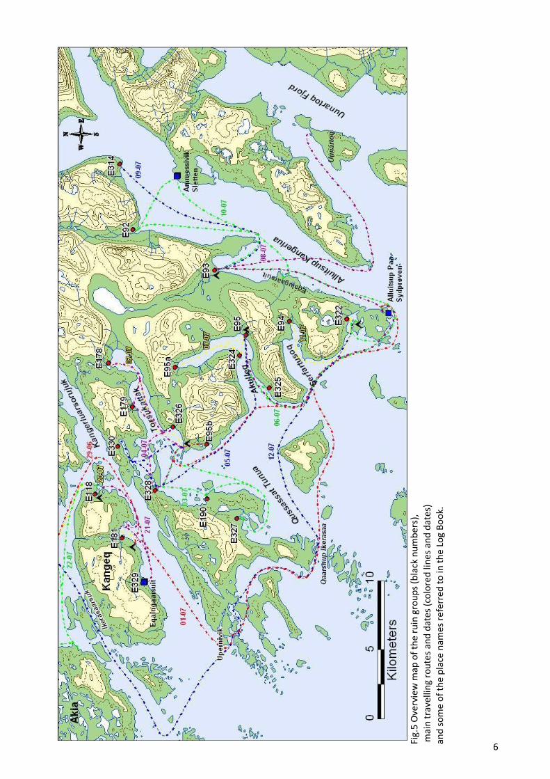
6
Fi
g.5
Ove
rvie
w m
ap o
f th
e ru
in g
rou
ps
(bla
ck n
um
ber
s),
mai
n t
rave
llin
g ro
ute
s an
d d
ates
(co
lore
d li
nes
an
d d
ates
) an
d s
om
e o
f th
e p
lace
nam
es r
efer
red
to
in t
he
Log
Bo
ok.

7
Fig.6 Sailing through the fog to the camp site near Itilleq on
Kangeq on the evening of the 29th of June. Photo: P.B. Heide
2009.
01-07-2009: Left the Itilleq camp and sailed south for Alluitsup Paa (Sydprøven). Still much drift
ice, in the narrow sounds often packed, and thick fog banks causing us to go slowly and along the
shore. Went inside the skerries at Upernivik, through Qaarsuup Ikerasaa and on to Alluitsup Paa,
where we bough gas. Sailed back north to the opening of the Torsukattak Fjord (south of Sannerut),
where we set up camp and then walked to E95b at Pamialluup Illukua, which we then surveyed in a
couple of hours. We were back in camp around 21.00. Weather: Thick fog banks and a cold
moderate breeze from the sea.
02-07-2009: Woke up to a beautiful,
promising day, but we had
miscalculated the tide and depth of the
small cove where we had anchored and
found the zodiac lying on dry land!
Only around noon was it possible to
move the zodiac and we then sailed for
E178 at the head of the Torsukattak
Fjord. Surveyed the ruin group and
sailed back for the camp, arriving there
around 20.30. Weather: Beautiful
sunshine w. a light to moderate breeze.
In the evening there was no wind.
03-07-2009: Sailed for E327, where we
spend an hour finding the ruin (but did
then reconnoiter the surrounding area),
which was wrongly placed on the map. Sailed from there to Qaarsuatsiaq (E190), which we
surveyed in around 5½ hours. Sailed to E328, which we also had a bit trouble finding, but
eventually did and surveyed it. Were back in camp around 21.00. Weather: Light clouds w. a rigidly
cold wind blowing from the sea all day.
04-07-2009: Sailed to E178 to pick up a spade we forgot there and then on to E179, where we
surveyed the ruins and reconnoitered the area. Sailed on to E326 and found and surveyed the two
ruins found here by Ove Bak. Went over the terrain rather quickly and cleaned a section in the ruin
being eroded away by the fjord. Sailed back to E328 where we forgot a map container and returned
to camp around 18.00. Weather: light clouds and a moderate, cool breeze.
05-07-2009: Took down the camp and sailed to E330 on the other side of the fjord, which was
surveyed and searched for new ruins in around 2 ½ hours. Sailed from there to the fjord Akulleq,
where we set up the next base camp at ruin group E95 (of which there is no information other than
that of F.Petersen in 1898) and immediately started the surveys. Coring in the midden produced
some bones and a 2x1m trench was opened to check the preservation. Weather: Sunny w. a
moderate fjord wind and some fog.
06-07-2009: Sailed for Alluitsup Paa to buy gas and food. Had a shower at the settlement
bathhouse. Sailed on to E325, which we had some trouble finding, because all we had was an
inaccurate sketch. Surveyed the ruin and went back to E95, where finished surveying and trenching
around 20.00. Weather: Beautiful sunshine w. a moderate to strong fjord wind.

8
07-07-2009: Sailed for E95a at the head of the Akulleq Fjord, another site without any written
registry since Arctander. Surveyed the ruin group in around 5 hours, harassed terribly by flies and
mosquitoes. Sailed on to E324 which we had to search for, not because of bad mapping, but because
we could not believe its location in the landscape! Surveyed the ruin group in around an hour and
sailed back to camp, where we arrived around 17.30. Wheather: Most of the day cloudy and humid,
with heavy rain from around 15.00.
08-07-2009: Left camp at E95 and sailed for Alluitsup Paa, where refueled and took in provisions.
Then moved on to E93 in Alluitsup Kangerlua, where we set up camp and then started surveying
the ruin. Kept surveying until around 17.00, where we were interrupted by very heavy rains and
around 18.00 we instead left for Uunartoq in the Uunartoq Fjord to bathe. Was back in camp around
21.30. Weather: No entry.
09-07-2009: Finished surveying E93 and then sailed for E314 around 14.00. Again we had to
search a while to find the ruin, which we then surveyed. Were back in camp around 20.00.
10-07-2009: Sailed for E92 and surveyed the ruin group and the surrounding area in around 4½
hours, fiercely harassed by mosquitoes and flies. Sailed for Ammassivik (Sletten) to buy gas. From
there sailed on to the sheep farmer at Eqalugaarsuit, where a ruin is marked on the map. However,
the farmer knew nothing of this ruin and neither could we find it where it was placed on the hiking
map. It might have been wrongly marked or removed by field work? Sailed back to camp and
decided to move out right away because of good sailing weather and threatening drift ice in the
cove. Sailed around Alluitsup Paa and anchored in Zacharias Harbor. Weather: Nice day with few
clouds and moderate fjord wind.
11-07-2009: Sailed for E94 at the head of the Serfartusoq Fjord and spend around 5 hours surveying
this ruin group and the surrounding landscape. Sailed back to Zacharias Havn and surveyed ruin
group E322 on the other side of the inlet and finally E322a just next to the camp. We worked
around 2½ hours on these two ruin groups. Weather: To begin with sunshine with a moderate fjord
wind, but from around 14.00 light rains.
12-07-2009: Sailed from Zacharias Havn for the Igaliku Fjord, meaning to sail west of the skerries
on the outer coast. However, thick fog prevented this and we instead sailed through the strait of
Ikerasaarsuk north of Kangeq. Arrived in Qaqortoq around 12.00, where we had lunch, took in
provisions and then sailed into the fjord to E172 (Tatsip Ataa). Weather: Beautiful sunshine and a
moderate fjord wind.
13-07-2009 – 15-07-2009: Excavation at E172.
16-07-2009: Sailed from E172 around 13.00 to Eqaluit (E78) to survey a ruin which we missed in
2006 and to pick up Poul, who had surveyed a route in between these two sites. Was caught here by
a storm and forced to stay the night at the local sheep farmers, Lasse Bjerre. Weather: At first sunny
with some hints of stormy weather, the calm and, finally the Sydost (gale).
17-07-2009: Secured Lasses boat and the zodiac at the mouth of the Eqaluit river and then hiked
over the mountains back to E172. Weather: Dry and stormy.

9
18-07-2009: Got up at 05.00 and hiked back to get the zodiac, which we then sailed back to E172.
Weather: Cloudless with a strong fjord wind.
19-07-2009: Excavation at E172.
20-07-2009: Poul and the author sailed for Qaqortoq around 11.00 with Hans Kapel, Niels-
Christian Clemmensen and one defect water pump. Having dropped off the two others, Poul and the
author spend a few hours taking care of different business (including the water pump) and then
sailed for the inlet just south of E118 on Kangeq, where we set up camp.
21-07-2009: Sailed for Eqalugaarsuit on Kangeq, where we surveyed ruin group E329 in around 4½
hours. On the way back we stopped by inlet with ruin group E181 to search again for the one ruin
we had not been able to find, but without success. Then sailed on to E118, which we searched for
for around 3 hours without success (though finding some Inuit ruins). Sailed back to camp where
we arrived around 17.30 and then spend another hour searching for ruin group E118. Weather:
Beautiful sunshine w. a moderate fjord wind.
22-07-2009: Took down the camp and sailed for Akia, where we had decided to visit, but not
survey three registered ruin groups, of which we could only with certainty find one Norse, E188 (of
which the is no registry, but it had been excavated not too long ago). Sailed back to Qaqortoq to get
the water pump from the repair shop and then on to E172. Weather: Beautiful sunshine w. a
moderate fjord wind.
23-07-2009 – 24-07-2009: Excavation at E172 (surveyed then newly found structures on the 24th.).
25-07-2009: Sailed for Igaliku Kujalleq w. Seth Brewington and from there hiked in to
Qorlortukasiip (E67), where we surveyed two ruins pointed out to us by the sheep farmer in 2008
and cored the midden south of the main dwelling. From there we hiked on to the newly found ruin
group 0109 on the north shore of the lake Taseq Ammalortoq, a site also pointed out by the sheep
farmer, where we spend about an hour surveying the small foreland where the ruin group was
located. Hiked back to Igaliku Kujalleq and then sailed back to E172, where we arrived around
19.00. Weather: Cloudy w. occasional light rain and a moderate fjord wind.
26-07-2009: The author alone sailed to Qanisartuut and from there hiked in to E167. Reconnoitered
the small foreland sticking out into the lake Saqqaara Tasia SE of ruin group E71a, but found
nothing. Arrived at E167 surveyed the enclosure (see below) and then walked back to E71, where
the midden of the south farm was cored for preservation without any luck. Hiked back to
Qanisartuut, reconnoitering on the way the little valley NE of E71a, but found nothing but a nice
cairn (which must be recent). Sailed back to E172, arriving around 19.00. Weather: Until around
13.00 beautiful sunshine, but from then on some clouds and a strong fjord wind.
27-07-2009 – 04-08-2009: Excavation at E172.
05-08-2009: After a visit in Igaliku, sailed the excavation team to E64 to do some fishing. In the
meantime, the author surveyed the coast line W of E63, looking for ruins mentioned by D. Bruun,
but finding none. Weather: Beautiful sunshine w. a light fjord wind.
06-08-2009 – 19-08-2009: Excavation at E172.

10
E67 – Qorlortukasiip 60V2-0IV-542
E63 – Iterlleq 60V2-0IV-615
Fig.7 E67 Ruin 2 and 3
Fig.8 R2 seen towards the NW. Photo: C.K. Madsen
2009.
GPS: N60°55'23,33"/ W045°17'29,14". Earlier work: Bruun 1895, Møller&Madsen 2005.
Site Description: Surveyed in 2005, D. Bruun had some ruins (his number 1&2) that we could not
find. So when presented with a chance to look for these, about an hour was spent look for ruin nr.2
along the coast west of the ruin group, but without success. Seeing the erosion of the coastline, it is
most probable that both ruins 1 and 2 have been removed by erosion.
GPS: N60°51'44,57"/ W045°14'58,00". Ealier work: Holm 1880, Møller&Madsen 2005.
Site Description: Surveyed in 2005. However,
during a visit at the present sheep farmer at
Qorlortukasiip, Andela, in 2008, he directed our
attention to two unknown ruins, which were then
subsequently surveyed in 2009.
Numbering after Møller&Madsen 2005.
R2: Just around 160m WNW of the main dwelling
(R1), one finds a couple of odd ruins. Placed on a
low, naked cliff knoll, R2 seems nothing more than
an indistinct heap of stones measuring approx
220x160cm (fig.7, 8). However, upon closer
examination at least the foundation of the structure
seem to be fairly well built. Based on the structures
visibility and location it might be a partially
collapsed cairn? The lichens on the structures
suggest a considerable age?
R3: Just east of R2 and the knoll, one can see
two indistinct lines made of rounded stones.
The lines lie about 6 meters apart, both in one
end angling c. 90º towards the other (fig.7). If
this is indeed a Norse ruin, these lines could be
the remains of a 20-30cm wide foundation for a
(turf?) building with outside dimensions of
c.6,5x2,5m. Judging from the appearance of the
stones in R1, these might have been removed
from R2?

11
E92 – Nipisat 60V2-0IV-553
Fig.9 Seaside view of the bay with E92 seen towards the NNW. The plateau
with the ruins is just behind and to the left of the large iceberg. Photo: P.B.
Heide 2009.
Fig.10 Ruin 9, 10 & 11 and the plateau with most of the ruins seen towards the SW. Note the dominating vegetation of low shrub on both sides of the river. Photo: C.K. Madsen 2009.
GPS: N 60°37'27.22"/ W 45°27'5.99". Ealier work: Bruun 1895.
Site Description: Sailing
in towards the Norse
farm of Nipisat (which
means lumpfish in Inuit,
which they used to catch
in the bay, Bruun
1895;418), the sur-
rounding landscape does
not, upon first sight, look
very inviting (fig.9); The
majority of the farms’
buildings are located on
a flat gravel plateau to
the east of the large river
draining out into the
fjord from a valley that
stretches some 5,5km
north of the site. To the east and northeast the mountain of Tinupaarneq rises very steeply to above
800m and to the west, the mountain of Nipisat Qaqqaat even more so to a height of 921m. The bay
in front has very shallow waters and during low tide the silt beach stretches out for several hundred
meters. Standing on the beach, one encounters a steep, gravelly slope, where the plateau has and is
eroding into the fjord. The plateaus on both sides of the river did, upon our visit, appear rather dry
and vegetated almost exclusively
by low shrub and very little grass
(found only in the wetter areas
just around the ruins, chiefly ruin
03)(fig.10). From the site itself,
no larger, fertile grazing areas
could indeed be seen (but may
perhaps be found further up in
the valley?). On the flattest part
of the plateau (that towards the
erosion wall), the surface display
marks of wind erosion, testifying
that strong winds must quite
often come down from the valley.
With its 15 individual ruins (of
which 6 were added in 2009)
(fig.11) and a reasonable
dwelling (see below), the farm of

12
Fig.11 Plan of E92, Nipisat. The black line with “black teeth” by R07 signifies the approx. erosion line of the
plateau.
Fig.12 Ruin 01 seen towards the SE. Photo: C.K.
Madsen 2009.
Nipisat appears to be a small to medium sized farm. Also the sparse vegetation of the surrounding
landscape does suggest that this could never have been a large farm (unless, of course, the
vegetation has changed significantly since Norse times). As we spent only 5 hours surveying the
site and only on the eastern side of the river it is possible, however, that some ruins can hide on the
western side. The natural section in the eroded ruin 07 (see below) was cleaned and revealed a thin
black (charcoal) layer at level with the lowest stones of the structure, which could possibly be used
to date the building (though we did not have time to retrieve samples in any proper manner). A
20min stretch up the valley was also surveyed, among other things looking for an enclosure (here
R15) mentioned by F. Petersen, but without finding it.
Numbering after Bruun 1895.
R01: Stone/turf wall, 1m wide and 10-15cm
high (i.e. barely visible on the surface), for a
rectangular building approx. 8,6x4m (fig.12).
This foundation encloses a depression, where a
partition in two rooms may be glimpsed.
Overgrown with juniper, willow and grass. The
ruin is most likely some form of outhouse.
R02: The very indistinct remains of a building
c.4,8x3,1, only partially preserved (part of the
south wall cannot be distinguished). The walls
are constituted by single rows of larger rounded
stones at best raised some 20cm above ground
level. Foundation for a turf building? The ruin
is vegetated by willow and crowberry.

13
Fig.13 Ruin 03 seen towards the E. Note the lush grass on the slope, which must be where F. Petersen found midden deposits. Photo: C.K. Madsen 2009.
Fig.14 The flat part of the plateau with ruin 05 (where the person is
standing), 07 and 08. Photo: C.K. Madsen 2009.
R03: Rectangular structure, c. 57x23m, which takes the form of a considerable elongated mound
running along a low ridge, vegetated by grass and with many protruding stones and depressions
(fig.13). The precise outline of the structure is very hard to discern because of its collapse and, for
instance, in the SE end of the ruin, it appears only as an uneven grassy area. Several wall lines and
probable rooms are visible on the surface of the mound. However, it is worth noting that F. Petersen
in 1894 did several test pits and it is impossible distinguishing these from possible rooms. F.
Petersen did establish the presence of collapse and possible midden west of the structure. Ruin 03 is
probably a grouped (though no gap can be seen, neither could it in 1894, nor any stalling stones)
turf/stone build dwelling
and byre/stable. It seems
too large to be solely a
byre. The ruin is vegetated
by grass
R04: Very collapsed and
overgrown (by crowberry,
willow and birch)
rectangular ruin, 4,3x3,1m,
which appears as little
more than a heap of
angular stones raising
slight above ground level.
On the western side traces
of a stone/turf build wall,
c100cm wide and 5-15
high, can be glimpsed.
Stone/turf built economy
building.
R05: Larger, c.12,30x11,50m, but
very indistinct turf/stone build
structure, possibly a dwelling, but
more probable a stable complex of
some sort. A few traces of
rooms/wall lines seem to be
visible on the surface, but
otherwise the ruin appears as
nothing more than a slight
elevation on the plateau with
many protruding stones. F.
Petersen excavated “a little” in the
ruin (perhaps the c.3x3m “room”
seen to the south), but found
nothing.
R06: This ruin described by D.
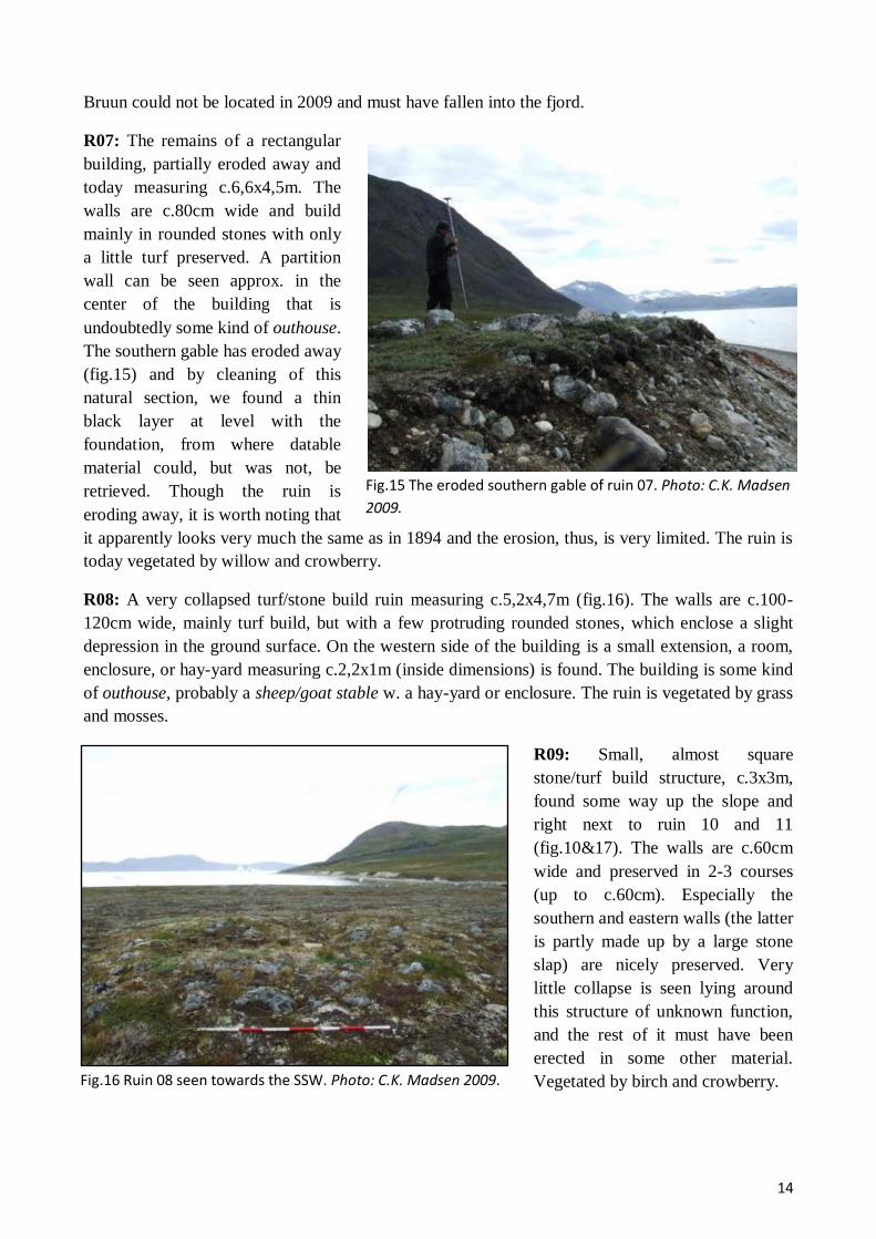
14
Fig.15 The eroded southern gable of ruin 07. Photo: C.K. Madsen
2009.
Fig.16 Ruin 08 seen towards the SSW. Photo: C.K. Madsen 2009.
Bruun could not be located in 2009 and must have fallen into the fjord.
R07: The remains of a rectangular
building, partially eroded away and
today measuring c.6,6x4,5m. The
walls are c.80cm wide and build
mainly in rounded stones with only
a little turf preserved. A partition
wall can be seen approx. in the
center of the building that is
undoubtedly some kind of outhouse.
The southern gable has eroded away
(fig.15) and by cleaning of this
natural section, we found a thin
black layer at level with the
foundation, from where datable
material could, but was not, be
retrieved. Though the ruin is
eroding away, it is worth noting that
it apparently looks very much the same as in 1894 and the erosion, thus, is very limited. The ruin is
today vegetated by willow and crowberry.
R08: A very collapsed turf/stone build ruin measuring c.5,2x4,7m (fig.16). The walls are c.100-
120cm wide, mainly turf build, but with a few protruding rounded stones, which enclose a slight
depression in the ground surface. On the western side of the building is a small extension, a room,
enclosure, or hay-yard measuring c.2,2x1m (inside dimensions) is found. The building is some kind
of outhouse, probably a sheep/goat stable w. a hay-yard or enclosure. The ruin is vegetated by grass
and mosses.
R09: Small, almost square
stone/turf build structure, c.3x3m,
found some way up the slope and
right next to ruin 10 and 11
(fig.10&17). The walls are c.60cm
wide and preserved in 2-3 courses
(up to c.60cm). Especially the
southern and eastern walls (the latter
is partly made up by a large stone
slap) are nicely preserved. Very
little collapse is seen lying around
this structure of unknown function,
and the rest of it must have been
erected in some other material.
Vegetated by birch and crowberry.

15
Fig.17 Detailed plan of R09-11.
Fig.18 Detail of the best preserved wall in ruin 10. Photo: C.K. Madsen 2009.
Fig.19. Ruin 12 seen towards the S. Photo: C.K. Madsen
2009.
R10: Close to ruin 09, one finds a very well
preserved building, c.8,1x5,5m, built in dry
stone masonry (fig.10,17-18). Especially the
eastern 2/3 of the ruin, probably an
enclosure, is beautifully preserved, with
well built walls c.100cm’s wide and
preserved in up to 10 courses (c.180cm),
while the western 1/3 is a pile of collapsed
stones (blurring any sign of an entrance).
Half of the northern wall is constituted by a
large boulder. A small enclosure,
c.2,2x1,9m, has been added on the southern
wall. Inside the ruin grows willow shrub and
crowberry.
R11: Possible ruin/feature appearing as an
approx oval, low, 60cm wide, bank
surrounding a shallow depression (fig.17).
Overgrown with crowberry and willow.
R12: Possible, but very badly preserved,
foundation for a rectangular building of
about 10,7x5,4m (fig.19). The ruin
appears as indistinct wall lines of mostly
angular stones laying about with no
apparent order. If these are foundations,
they must have been some 80-100cm
wide and are not standing to a height of
c.10-20cm. Particularly the eastern gable
and the southern wall look convincing.
Outhouse? Inside the ruin grows grass
and birch.
R13: Approx. rounded structure, diameter of
c.7,10m, comprised of large, rounded
boulders, between the can be an empty gap
of as much as a meter (fig.20). Only one of
the stones appear to be natural and this circle
of boulders may thus be the foundation for a
turf build enclosure. Inside the structure
grows crowberry and grass.

16
Fig.20 Ruin 13 seen towards the SSW. Photo: C.K. Madsen 2009.
E93 – Kangarluluk 60V2-0IV554
Fig.21 Seaside view of the cove of Kangardluluk. The mountain in the center is Kangerluluup
Qaqqaa. Photo: P.B. Heide 2009.
R14: Somewhat indistinct,
rectangular structure, ca.5x3,8m,
with walls constituted partly of
larger stones slaps placed upright.
Probable outhouse. The ruin is
completely overgrown by birch and
willow.
R15: This ruin was actually found
(but not numbered) by F. Petersen
in 1894 and described as being an
enclosure lying “a 20 minute walk
into the interior and a 100 paces
east of the river”. In his sketch of
the site it is drawn as a roughly
rectangular stone build (w. rounded
edges) enclosure, part of which is made up by a large boulder. This ruin, which is now numbered
R15, was sought after in 2009, but, unfortunately, not found. It does, however, point towards a use
of the valley north of the ruin group as grazing land and this area should be revisited and surveyed
in the future.
GPS: N 60°34'47.44"/ W 45°30'51.86". Earlier work: Bruun 1895.
Arriving at the Norse farm of Kangarluluk (the “small bay” in Inuit) from the sea side (fig.21), one
does not find the buildings as they would normally be located at a ruin group lying down to the
fjord: instead they are found a small kilometer into the valley and clustered on the lower part of the
slopes of the mountain of Kangerluluup Qaqqaa (890), which rises abruptly northeast of the farm.
This alternative location is probably best explained, as it was already by D. Bruun (1894;420), by
the fact that the areas closest to the fjord are very dry and stony, whereas the valley floor a bit

17
Fig.22 180° view of the fertile floodplain in front of E93 seen towards the SW. To the left is the cove, while the
concentration of stones on the low ridge to the front right is ruin 05. Photo: C.K. Madsen 2009.
Fig.23 Plan of ruin group E93. The waterways indicated on the plan are only lesser streams.
further inland, stretching some 3km NW-SE and 1,6km NE-SW, presents a massive plain of wet
and fertile grassland just in front of the farm (fig.22), the buildings themselves being placed on
slightly raised and well drained ridges divided by small streams (fig.23). Through the broad pass
between the mountains of Qaqqarsuaq and Qaqqaesuaraarsuk to the SW, there is easy access to the
Akulleq fjord and the farm of E95 and to the north there is easy access to the valley of lake
Kangerluluup Tasia. Also south along the coast there is easy passage on foot. The shore of the bay
presents an easy landing with a beach protected by a gravel bank.
With its favorable position in the landscape, both in regards to communication, transport and
production, the farm of Kangardluluk must have been one of the more, if not the most, important
farm in the general area. This interpretation is echoed by the large dwelling and byre and the great
number of structures (22), of which 6 were found in 2009. Still, and as is apparent from the plan of
the site (fig.23), these were found very near to the known ruins and in about only 6 hours of survey.
Thus many others ruins could lie around the edges of the valley. A smaller site with 3 ruins, E323,
is recorded on the southern side of the valley (Berglund 1980), but was not visited.
Numbering after Bruun 1895.

18
Fig.24 Detail of the wall of R01. Photo: C.K. Madsen 2009.
Fig.25 Ruin 02 seen towards the NW.
R01: This is a beautifully preserved,
stone built enclosure, roughly
rectangular in shape and with a clear
entrance on the SW wall. The walls,
which are heavy and double-faced
with larger stones/boulders in the
lower courses and smaller stones in
the upper part and the core, are
c.100-140cm wide and preserved in
up to 5 courses (c.130cm)(fig.24).
On the NE wall one finds a small
added enclosure, somewhat more
collapsed and build mostly in
smaller, rounded stones (a later
addition?). The walls enclose a total
area of c.114m2. Inside the enclosure
grows birch, willow and grass.
R02: Very distinct rectangular building, c.9,2x4,3m, with stone build walls (foundations?), the
gables measuring 120-140cm in width, the long walls c.100cm, and preserved in up to 4 courses
(c.100cm)(fig.25). Especially the two gables are well preserved and an entrance, c.60cm wide, can
be seen on the southwestern wall. Judging from the lacking collapse, the stone build walls can have
stood no higher than c.150cm and the rest of this outhouse, perhaps a sheep/goat stable, must have
been built in more perishable material. The ruin is overgrown with grass and crowberry.
R03: Rectangular
structures, c.9,5x4,2,
very much resembling
R02, but not quite as
well preserved (except
the northwestern gable)
and especially in the
southeastern part are
the walls difficult to
distinguish. Like R02,
probably a sheep/goat
stable or other outhouse. The ruin is only vegetated by a touch of moss.
R04: Stone/turf build outhouse of rectangular shape, c.6,7x4,2m. The walls/foundation are c.70-
80cm wide, preserved up to a height of c.40cm and consists chiefly of larger rounded stones, while
lesser rounded stones are found lying inside and outside the ruin (collapse). The ruin is fairly
distinct, except for two, possible stretches of wall or dike, possible a hay-yard or enclosure, which
have been added to the SE side of the building. It is overgrown with grass and moss.

19
Fig.26 The largest of the stone beams in the southern end of
dwelling 05. Photo: C.K. Madsen 2009.
Fig.27 Ruin 07 seen towards the SSW with the northern end of ruin
05 in the background. Photo: C.K. Madsen 2009.
R05: Large, elongated farm mound following a low, well-drained ridge, undoubtedly the dwelling,
which lies with an excellent view to both the fjord and the floodplain (fig.22). Even though the
ruins is very visible from the extreme number of collapsed stones, it is very hard to distinguish the
exact size of the building that is here measured to c.46m in length and 18m in width, although quite
unevenly shaped (note that the southern
end of the building is here, contrary to
the 1894 description, interpreted as a
separate building, see below). A
number of quite clear rooms and wall
lines can be seen among the stone
debris (without any actual courses
being preserved). Especially in the
southern end is the amount of collapsed
stones impressive and here one also
finds some massive stone beams, the
largest of which (fig.26) measure
c.320x60x30cm. In the northern end
one sees a few upright stone slaps that
might be stalling stones. Between the
ruin and the stream to the east of it is a
lush midden-area. Whether the ruin was excavated in 1894 is unclear, but there seems to be an old
1x1m test trench just where the midden joins the dwelling. The ruin is overgrown w. grass and
crowberry.
R06: Somewhat unevenly shaped stone/turf built ruin, measuring c.11x7,5. Many stones are visible
in the surface, but no actual courses are preserved in the walls that seem to be 70-80cm’s wide and
preserved to a height of c.20-30cm. This could be some kind of small stable/barn complex, since
several rooms can be traced. A possible test trench can be seen on the northern side of the ruin.
Vegetated by grass and moss.
R07: Foundation for a
rectangular, c8x3,9m, stone/turf
built outhouse (fig.27). The
ruin is fairly collapsed and the
walls/foundations show them-
selves as c.80cm wide and
c.20cm high banks of turf with
many protruding, rounded
stones, enclosing a slight
depression overgrown with
grass, moss and crowberry. The
rest of the walls have
undoubtedly been in turf, since
no fallen stones otherwise lie
about.
20
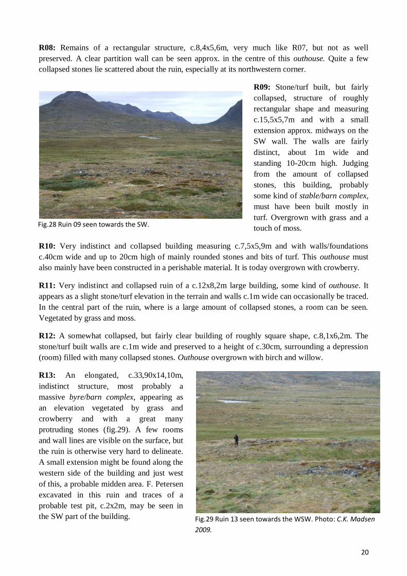
Fig.28 Ruin 09 seen towards the SW.
Fig.29 Ruin 13 seen towards the WSW. Photo: C.K. Madsen
2009.
R08: Remains of a rectangular structure, c.8,4x5,6m, very much like R07, but not as well
preserved. A clear partition wall can be seen approx. in the centre of this outhouse. Quite a few
collapsed stones lie scattered about the ruin, especially at its northwestern corner.
R09: Stone/turf built, but fairly
collapsed, structure of roughly
rectangular shape and measuring
c.15,5x5,7m and with a small
extension approx. midways on the
SW wall. The walls are fairly
distinct, about 1m wide and
standing 10-20cm high. Judging
from the amount of collapsed
stones, this building, probably
some kind of stable/barn complex,
must have been built mostly in
turf. Overgrown with grass and a
touch of moss.
R10: Very indistinct and collapsed building measuring c.7,5x5,9m and with walls/foundations
c.40cm wide and up to 20cm high of mainly rounded stones and bits of turf. This outhouse must
also mainly have been constructed in a perishable material. It is today overgrown with crowberry.
R11: Very indistinct and collapsed ruin of a c.12x8,2m large building, some kind of outhouse. It
appears as a slight stone/turf elevation in the terrain and walls c.1m wide can occasionally be traced.
In the central part of the ruin, where is a large amount of collapsed stones, a room can be seen.
Vegetated by grass and moss.
R12: A somewhat collapsed, but fairly clear building of roughly square shape, c.8,1x6,2m. The
stone/turf built walls are c.1m wide and preserved to a height of c.30cm, surrounding a depression
(room) filled with many collapsed stones. Outhouse overgrown with birch and willow.
R13: An elongated, c.33,90x14,10m,
indistinct structure, most probably a
massive byre/barn complex, appearing as
an elevation vegetated by grass and
crowberry and with a great many
protruding stones (fig.29). A few rooms
and wall lines are visible on the surface, but
the ruin is otherwise very hard to delineate.
A small extension might be found along the
western side of the building and just west
of this, a probable midden area. F. Petersen
excavated in this ruin and traces of a
probable test pit, c.2x2m, may be seen in
the SW part of the building.

21
Fig.30 The well preserved southern gable of ruin 14. Photo:
C.K. Madsen 2009.
Fig.31 Ruin 15 seen towards the SW. Photo. C.K. Madsen
2009.
R14: This is a somewhat collapsed
rectangular ruin measuring
c.10,6x6,2m. The stone build walls
build in mainly rounded stones are
fairly distinct, up to 100cm wide,
preserved up to a height of 4 courses,
c.110cm (the southeastern gable,
fig.30). Judging from the amount of
fallen stones, the dry stone walls could
never have stood much higher than this
and, unless the rest of the walls were in
turf/wood, the structure might be an
enclosure bounding c.48m2. This
interpretation is supported by a small
room/division in the southwestern
corner (for holding lambs/kids). Inside
the ruin grows crowberry and birch.
R15: Smaller and nicely preserved (except
for the southwestern gable) rectangular,
c.6,2x3,8m, outhouse (fig.31). The stone
build walls are c.1m wide and preserved in
up to 3 courses (c.80cm). Like in the case
of R14, the amount of collapsed stones
does not allow for stone walls of much
greater height and the rest of the building
must have, if so, been erected in other
material. Inside the structure grows birch
and crowberry.
R16: Very collapsed, stone/turf built
structure measuring c.9,2x7,6m. It is,
apparently, a complex of several small
rooms of which only a few are clearly distinguishable, because of the large amount of collapsed
stones inside the structure. In the northwestern end of the building one sees two stone build rooms,
perhaps a pen or a hay-yard? In the northeastern corner the remains of standing wall the courses
high (c.60cm) is visible. Probably a stable/barn complex. Inside the ruin is vegetated by crowberry
and birch.
R17: An indistinct, roughly rectangular stone/turf built ruin of some 18,3x7,5m, with a small
extension on the southern wall. It mostly appears as a concentration of collapsed stones (with a few
visible wall lines), although the northern wall and eastern gable are fairly clear (fig.32). R17 was by
Bruun interpreted as part of R05 and although this now seems highly improbable, the two buildings
might have been connected by a wall/dike, linking the eastern side of R17 with the southern end of
R05. The ruin is vegetated by crowberry and grass.

22
Fig.32. Ruin 17 (farthest away) and ruin 05 (closest) seen
towards the S. Note the “stone free” gap between the two
structures.
Fig.34 Ruin 21 seen towards the N. Photo: C.K. Madsen
2009.
Fig.33 Ruin 20 seen towards the NE. Photo: C.K. Madsen
2009.
R18: A small indistinct structure
measuring c,5x5m, sketched by Bruun,
but not interpreted surely as a ruin.
Though appearing as nothing more than
a heap of stones and fain trace of wall, it
does, nonetheless, seem to be a small
ruin. Vegetated by willow and birch
shrub.
R19: On the top of a small, gravelly
knoll some 300m east of the main
cluster of ruins, one finds a small
structure, c.2,7x1,7m, with 40cm wide
walls/foundations lying in a single
course. No collapse can be seen lying
about and the ruin is hardly vegetated.
Outhouse.
R20: The probable remains of the foundation for a small structure, now partially eroded away by
the stream (fig.33). It appears as nothing more than a stone carpet measuring c.3,2x3,2m.
Overgrown with willow.
R21: Nicely preserved and roughly square
enclosure measuring c.10,10x9,6m with
walls in dry stone masonry, c.60-70cm wide,
preserved in up to 4 courses (c.70cm) and
incorporating several natural boulders
(fig.34). On the north eastern wall is a
c.65cm wide entrance. Judging from the lack
of collapse stones, the wall must have had
several additional “courses” in turf, to have
been able to hold any sheep/goats. Inside the
ruin grows crowberry, moss and birch.
R22: Down by the shore of the way, one finds an
approx. square, c.5x5m, area carpeted with
smallish, rounded stones. This must be the feature
mentioned by F. Petersen and it could be the
foundation for a Norse ruin of unknown type
(boat house?). On the other hand, several Inuit
features are found close by and R22 may be also
be Inuit.

23
E94 – Serfartusok 60V2-0IV-557
Fig.36 Fig.22 180° view from just over the farm looking west out of the Serfartusok fjord. Photo: C.K. Madsen 2009.
Fig. 35 Seaside view looking east towards the head of the fjord. The farm E94 is situated just
under and to the right of the mountain knoll central in the picture.
GPS: N 60°31'24.99"/ W 45°34'30.60". Earlier work Bruun 1895, Vebæk 1951
Entering the small, approx. east-west oriented fjord of Serfartusok (i.e. “ the place with many black
guillemot” in Inuit, Bruun 1895;422), one encounters an impressive, but welcoming landscape: both
sides of the fjord are bordered by mountains rising some 500-600m, but the lower slopes down
towards the fjord are gentle and green, presenting fair grazing areas (fig.36), especially because
they must have belonged to the single known Norse farm of the fjord (though lesser structures can
easily hide on the lowers slopes further out the fjord). This farm, E94, is found on a very gently
sloping, fertile plateau (glacial outwash) at the head of the fjord, just in front of and protected by, a
c.250m high mountain knoll that here separates the wide pass east of the farm in two (fig.35). Same
pass affords easy access on foot E to Eqalugaarsuit (see below) and further NE to Kangerluluk
(E93). The plateau west of the farm and the river appears somewhat drier. The beaches of the inner
fjord are very shallow and at low tide, the silty ocean bed is exposed for several hundred meters.
For a light boat, however, such a beach offers a fair landing.

24
Fig.37 “3D” GoogleEarth plan of the ruins of E94, looking east. Note ruin 19, the lookout post and cairns,
some way up the slope of the mountain knoll. In fig.37 the location of the ruins has been corrected for GPS
displacement (see below).
In spite of the 19 individual ruins (fig.37), of which 13 were discovered in 2009, E94 is still to be
considered only a middle sized farm (though perhaps towards the larger end). This assumption is
based on the relatively average size of the main dwelling (R03) and because many of the ruins are
lesser structures and several of them of the “improvised” type that normally characterizes the
smaller coastal farms. The stable/byre complex (R01) is, however, sizeable and testifies to, at least,
an average number of animal husbandry. At the same time, the limited number of large livestock
buildings may signify that the farm of E94 focused not so much on this side of the subsistence
economy, but rather on seal hunting, to whose migration routes it had excellent access. Also, we
only spend c.4½ surveying the site and almost exclusively near the known ruins, in the area
between the two rivers and over the mountain knoll and, thus, several ruins are perhaps still to be
found on the northern plateau and on the slopes further out the fjord. In addition, a few Inuit
structures were noted near the shore just under R18, but not otherwise recorded due to lack of time.
Note: On GoogleEarth satellite images (fig.37), the homefield dikes are actually visible (see below)
and from their position it would seem that for some reason (probably poor satellite signal) the
original DGPS measurements of E94 seem to have been displaced some 60m to the east, though not
on the vertical level (in reference to UTM/WGS84 coordinates). As the survey deviations within the
ruin group internally seem to be only up to a meter, the location of all the ruins have been corrected
according to the satellite images (fig.37).
Numbering after Bruun 1895.

25
Fig.38 Ruin 01 seen towards the WSW.
Fig.39 Ruin 03 seen towards the SW.
R01: Ruin 01 is a large,
c.30x20m, turf/stone built
stable/byre complex lying just
at the end of a low, well-
drained ridge just north of the
dwelling (R03)(fig.38,44).
Several more or less distinct
rooms and wall lines (in some
places preserved in two
courses) can be seen in this
rather irregular building
(sometimes in-corporating
natural boulders) and especially
in the northeastern end is a
well-defined room (a stalling
stone can be seen in the western
end of the room – byre?) with turf/stone walls 100-120cm wide and preserved to a height of 40cm.
The complex probably includes byre, barn, hay-yard etc. in one building. The ruin is overgrown
with grass, moss and crowberry.
R02: Rectangular, 11,7x6m, stone/turf built structure, some kind of outhouse, fallen into
considerable collapse and appears as small elevation with many smaller, rounded stones (fig.44).
However, the eastern walls are reasonably clear, standing some 80-100cm wide and the outline of a
room can be glimpse here. Vegetated by crowberry.
R03: Approx. 27x23m
large, indistinct farm
mound, or dwelling
appearing as an elevation
with uneven, grassy surface
with many depressions,
protruding stones and a few
visible wall lines/rooms
(fig.39). Because of its
state of collapse, the ruin is
very hard to outline
precisely, especially down
the slope to the west, where
it merges with the midden
area.
R04: Very collapsed, and partially eroded, rectangular structure measuring c.9,2x4m. Built in
stone/turf, the walls are still fairly distinct, c.100cm wide and preserved to a height of 20-30cm, and
likewise two internal rooms are clearly visible. The southern gable is partially eroded by a slope
that has been eaten away by the stream, but comparing with the old plans of the ruin and looking at

26
Fig.40 Ruin 05 seen towards the W.
Fig.41 The eroded northwestern corner of ruin 05.
Fig.42 Ruin 06 seen towards the W.
the vegetation, this erosion has basically stopped. In the natural section produced by the erosion one
could easily retrieve datable material. The ruin is vegetated by grass and crowberry.
R05: Distinct turf/stone
built outhouse (based on
its position just outside
the homefield dike
probably a sheep/goat
shed)(fig.40). It measures
some 9,2x5,4m and has
walls 120-140cm wide
and preserved to a height
of c.50cm, though the
southern end is some-
what more indistinct.
Two central rooms are
clearly discernible. The northern corner of the building is eroded by sheep and allows for
observation of building technique (as well as future retrieval of datable material)(fig.41); the walls
seem to be double-faced with a foundation of massive rounded boulders and core and upper
structure of turf. The ruin is overgrown with grass and Alpine Lady’s Mantle.
R06: Very collapsed, approx. rectangular, c.12,75x8m, stone/turf building, now preserved mainly
as a concentration of smaller rounded stones (fig.42). Judging from the amount of collapse, it must
have been chiefly a turf building, perhaps some sort of stable/barn structure, because of the
buildings width (two rooms are visible in the eastern side) and because of a small rounded, but
indistinct addition on the western wall (perhaps a hay-yard?). The outer wall lines are fairly distinct,
as is especially the southern room where an upright stone slap (stalling stone?) can be seen. The
building is being eroded by the nearby stream, but as in the case of ruin 04, the erosion seems to be
very slow. Datable material could in the future be retrieved from the natural section. The ruin is
vegetated by grass and crowberry.

27
Fig.43 Home field dike, R07, seen towards the SW.
Fig.44 Detail situation plan of the ruins on the low ridge (see text).
R07: Relatively well preserved dike (homefield
dike) that consists of rounded boulders placed in
a line thus creating a c.60cm wide barrier (with
considerable gaps in between). The dike can be
followed north for c.25m, before it disappears
into a small boulder field, but reappears on the
other side as ruin R13 and these two stretches
must have been connected. The stream to the
south must form the S end of the dike.
R08: Small turf/stone built structure, some
outhouse, measuring only c.3,3x2,3m (fig.44.
The structure is to the NE partially dug into the
slope, but where the walls are clearly visible,
they are c.60cm wide and up 40cm high,
surrounding a slight depression that is the central
room. Vegetated by grass and crowberry.
R09: The northernmost building on the low ridge
with the concentration of outhouses is a tiny,
c2,8x2,7m, room between two natural boulders
connected by distinct 60-70cm wide and 40cm high turf/stone walls (fig.44). Outhouse or animal
shelter? The ruin is vegetated by grass and Alpine Lady’s Mantle.
R10: Like R09, R10, possibly
a small enclosure or animal
shelter, is of a somewhat
improvised type incorporating
several natural boulders/cliff
faces (fig.44). A small
turf/stone wall, c.80cm wide,
encloses an area of about 5m2,
between two natural boulders
and a cut into the slope. Inside
the wall grows grass and
Alpine Lady’s Mantle.
R11: Larger and approx.
rectangular, c.9x4,1m,
building lying on the ridge
with the other outhouses
(fig.44). Appears as an area
with many rounded stones that fairly distinct outline the turf/stone walls of the building, c.60-80cm
wide. Two rooms, one with an entrance, area clearly visible in this outhouse, maybe another
sheep/goats house with barn. Vegetated by grass and Alpine Lady’s Mantle.

28
Fig. 45 Ruin 12 seen towards the NE
Fig.46 Dike R13 seen towards the SW.
Fig.47 Detail situation plan of ruins 15-
17.
R12: This structure is very similar to
R10 in type and means of construction,
only slightly larger and enclosing some
10m2 (fig.44, 45). It is, however,
somewhat more indistinct and could be
collapse from R11. Inside the wall
grows grass and juniper.
R13: Homefield dike, which appears from the edge of
the boulder field in the south as a row of stones, but
towards the north it changes into a low bank, c.20cm
high and 80cm wide, with a few protruding stones
(fig46). During the survey the dike was followed for
some 70m, but in GoogleEarth satellite images R13 is
clearly visible and it is even possible to trace the dike all
the way up to just north of R01. It is completely
overgrown with grass and crownberry.
R14: Description like R13 (fig.44).
R15: Some 150m north of the homefield, one finds three
separate buildings build against the lowest fallen boulders of
the mountain knoll (fig.37). The first of these, R15, is a
rectangular, c.6,8x4,1, mainly stone built structure (mostly
rounded stones that have collapsed into the structure),
probably a sheep/goats shed with a minor and less
substantial pen or hay-yard added to its northern side
(fig.47). The structure is beautifully preserved with dry
stone walls 100-120cm wide, 60-70cm high and padded
with turf on the outside. An entrance only c.55cm wide can
be seen in the NE corner.
R16: The second structure at the edge of the mountain knoll
is a semicircular wall build against a natural steep slope and
thus creating an enclosure of c.22m2 (fig.47. The walls are
in turf/stone, c.120cm wide and preserved to a height of
c.40cm. In the southern end is a stone built room/enclosure
inside the structure and an entrance, c.40cm wide, can be
29
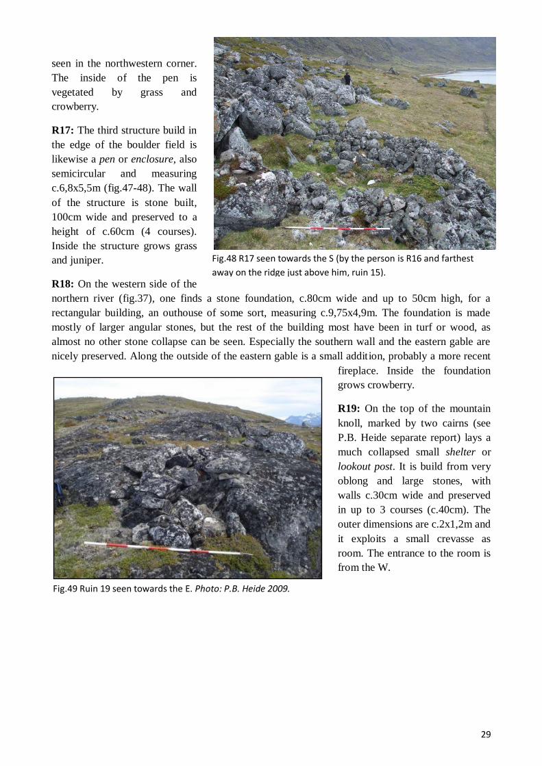
Fig.48 R17 seen towards the S (by the person is R16 and farthest
away on the ridge just above him, ruin 15).
Fig.49 Ruin 19 seen towards the E. Photo: P.B. Heide 2009.
seen in the northwestern corner.
The inside of the pen is
vegetated by grass and
crowberry.
R17: The third structure build in
the edge of the boulder field is
likewise a pen or enclosure, also
semicircular and measuring
c.6,8x5,5m (fig.47-48). The wall
of the structure is stone built,
100cm wide and preserved to a
height of c.60cm (4 courses).
Inside the structure grows grass
and juniper.
R18: On the western side of the
northern river (fig.37), one finds a stone foundation, c.80cm wide and up to 50cm high, for a
rectangular building, an outhouse of some sort, measuring c.9,75x4,9m. The foundation is made
mostly of larger angular stones, but the rest of the building most have been in turf or wood, as
almost no other stone collapse can be seen. Especially the southern wall and the eastern gable are
nicely preserved. Along the outside of the eastern gable is a small addition, probably a more recent
fireplace. Inside the foundation
grows crowberry.
R19: On the top of the mountain
knoll, marked by two cairns (see
P.B. Heide separate report) lays a
much collapsed small shelter or
lookout post. It is build from very
oblong and large stones, with
walls c.30cm wide and preserved
in up to 3 courses (c.40cm). The
outer dimensions are c.2x1,2m and
it exploits a small crevasse as
room. The entrance to the room is
from the W.

30
E95 – Akulleq 60V2-0IV-559
Fig.50 View out the fjord (west) from the beach just in front of the farm. Photo: C.K. Madsen
2009.
GPS: N 60°33'35.80"/ W 45°35'37.38". Earlier work Bruun 1895.
From the skerries and open water, one sails east into the Akulleq Fjord (“the middle one” in Inuit,
Bruun 1895;424) which heads this direction for the first approx. 5km. In this first half of its total
length, the fjord is ringed by 500-650m high mountains, the slopes on the southern side sloping
gently and fairly fertile from a shallow beach, the ones on the northern rising steeple and poorly
vegetated from deep waters. After the first 5km, the fjord turns abruptly NNW and continues on for
another 5km, but just at the 90° bend, on the eastern side of the fjord, one finds the farm E95. It lies
just on the seaward edge of flat and narrow plain of glacial outwash coming down from the broad
valley that lies between the mountains of Qaqqarsuaraarsuk and Qaqqarsuaq and provides an easy
land passage to the farm of E93 (a distance of only c.4,8km) (fig.51). The gravelly beaches just in
front of the farm provide easy landing for boats, although it is also the place where the massive
summer drift ice finally beaches and melts, thus occasionally forming a barrier (fig.50). Apart from
the normal coastal vegetation dominated by crowberry, birch- and willow shrub, considerable areas
of grassland can be found in the landscape around the farm and, especially, in the broad valley east
of the farm.
The locality of this farm does thus seem, if compared to other coastal farms, above average, except
that it lies very exposed to the cool fjord wind coming in from the west. This location does,
however, provide the farm with an excellent visibility both in and out of the fjord. The lack of a
fertile homefield area at the site could owe to erosion by the sea, because the foreland is so flat (just
a couple of meter A.S.L. and it is evident from the old plans and TH02 (see below) that even the
recent erosion is considerable. In any case, the rather substantial dwelling and number of outhouses,
31
Fig.51 A 180° of the landscape around E95 with the fertile valley east of the farm (left side) and the fjord to the west
(right side). Photo: C.K. Madsen 2009.
Fig.52 Situation plan of E95 on GoogleEarth imagery.
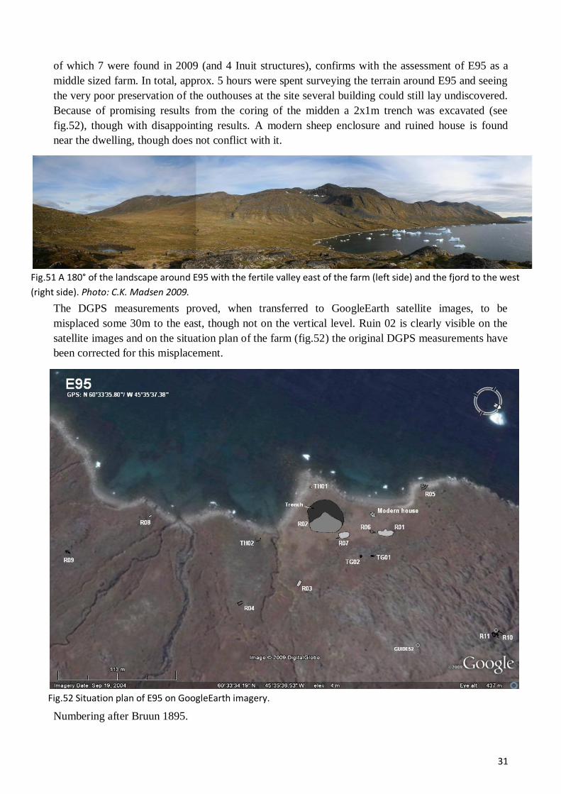
of which 7 were found in 2009 (and 4 Inuit structures), confirms with the assessment of E95 as a
middle sized farm. In total, approx. 5 hours were spent surveying the terrain around E95 and seeing
the very poor preservation of the outhouses at the site several building could still lay undiscovered.
Because of promising results from the coring of the midden a 2x1m trench was excavated (see
fig.52), though with disappointing results. A modern sheep enclosure and ruined house is found
near the dwelling, though does not conflict with it.
The DGPS measurements proved, when transferred to GoogleEarth satellite images, to be
misplaced some 30m to the east, though not on the vertical level. Ruin 02 is clearly visible on the
satellite images and on the situation plan of the farm (fig.52) the original DGPS measurements have
been corrected for this misplacement.
Numbering after Bruun 1895.

32
Fig.53 The isthmus with R02, R07 and TH01 seen towards the WNW. Ruin
02 is the greener, uneven terrain central in the picture and left of the
modern enclosure. Photo: C.K. Madsen 2009.
Fig.54 R05 seen towards the S (the isthmus in background).
Photo: C.K. Madsen 2009.
R01: Oblong turf/stone building with indistinct outer walls and measuring c.18,4x6,5m (fig.53).
The ruin appears as low elevation vegetated by grass and crowberry, many protruding angular and
rounded stones and many depressions (although no clear rooms or wall lines can be distinguished).
On the southwestern wall a semicircular extension can be seen in the form of a depression bordered
by a stone/turf build wall (partly natural boulder). This is maybe a hay-yard (?) to what is probably
a byre.
R02: Large turf/stone ruin,
certainly the dwelling of the
farm, measuring some
36,7x20,5m. Located at the
base of a small isthmus,
R02 appears as an actual,
grass-covered farm mound
rising about 1m above the
surrounding terrain. Several
marked depressions, un-
doubtedly rooms, wall lines
and protruding angular
stones are visible on the
surface. Especially to the
west the outline of the ruin
is hard to distinguish, as it
here merges with and have
overlapped the large midden area (see dark area in fig.52).
R03: Very indistinct and collapsed stone/turf building of rectangular shape, c.7x3,8m, which
mainly shows as 2 20-30cm deep depressions bounded by angular stones (foundation). Outhouse.
The ruin is vegetated by grass and crowberry.
R04: Stone foundation of a rectangular building, c.5,2x2,9m. The foundation, c.30cm wide and 10-
15cm high, of this outhouse consist of single lines of rounded stones, while the rest of the building
must have been in a perishable material. Only the two long walls and the southern gable are clear
definable and it is to access whether
the about lying stones are natural or
collapse. Vegetated by crowberry.
R05: Very collapsed and indistinct
stone/turf structure that is being eroded
away by the fjord (fig.54). It appears
as a shallow depression and several
low walls, c.30-50cm wide and up to
20cm high, of angular stones and bits
of turf. It could by a sheep/goat stable
with added hay-yard/enclosure or can
otherwise only be described as an

33
Fig.55 Ruin 06 seen towards the S. Photo: C.K. Madsen
2009.
Fig.56 Ruin 08 seen towards the W.
Photo: C.K. Madsen 2009.
Fig.57 Ruin 09 seen towards the SW. Photo: C.K. Madsen
2009.
outhouse of unknown function. It possible, in the future, to extract datable material from the natural
section eroding away. Overgrown with grass and crowberry.
R06: Possible tiny, almost square, stone
foundation for a building measuring
c.2,2x2m, small outhouse or maybe an
enclosure with separation for
lambs/kids?. The eastern wall of the
structure is constituted by a small, natural
boulder, whereas the rest of the possible
wall lines can be seen as rows of single
rounded stones. In southern extension of
this structure is an atypical shaped
feature, maybe the main enclosure
bounding some 11m2 with very indistinct,
c.30-40cm wide and up to 20cm high,
turf/stone walls surrounding a slight
depression. Overgrown with grass.
R07: Very indistinct turf/stone built building, roughly
rectangular (c.12,5x7,3m) just east of R02, which it
resembles very much both in appearance and vegetation,
though they are definitely separate (fig.53). It is probably
some kind of staple complex.
R08: Slightly misplaced on the situation plan (fig.56),
one finds R08 at the very tip of the second small isthmus
west of the one with R02. Rather atypical, it mostly
consists mainly of a small area, c.4x2m, covered by stone
slaps. This could be a Thule culture feature, but cannot
be excluded as the floor of some unknown Norse
building (boathouse?).
R09: Placed some 300m south of the main cluster of
buildings, one finds a small shelter, c. 2,6m2 (inside
dimensions), built in a hollow between
natural boulders (fig.57). In one place
the connection stone walls are
preserved in 2 courses (c.30cm), but it
otherwise very collapsed.

34
Fig.58. Detail situation plan of ruin 10 & 11 some
Fig.60 Ruin 11 seen towards the N. Photo: C.K.
Madsen 2009.
Fig.59 Ruin 10 seen towards the E. Photo: C.K. Madsen
2009.
R10: Up on the top of the low
cliffs some 200m northeast of the
farm is two close lying structures
(fig.58-59). Of these R10 is an
enclosure formed by building
stone walls across and along a
c.1-2 wide, shallow gorge. The
walls, thus forming a roughly
rectangular pen of c.6,7x3,3m,
are c.50cm wide, preserved in up
to 4 courses (c.70cm). The
entrance to the enclosure seems
to be between two large boulders
on the southern long wall.
R11: Small sheep/goats shed or
enclosure just a few meters S of
ruin10 (fig.58, 60). The walls of this structure are more collapsed and visible mainly as 1-3 stone
built courses on top natural boulders that have formed part of the structure (c.100cm high all in all).
The entrance to the c.3,9x2,4m large structures has been from the south, where one also finds a
heap of collapse. The building/pen seems to have been divided in the middle (though this was not
measured). On a flat cliff just above these two structures there is a well-preserved foxtrap.
TH01: Small, partly eroded turf structure, undoubtedly Thule culture, though otherwise indistinct.
TH02: Partly eroded, trapezoid Thule-culture summer dwelling. The fact that this has been partly
destroyed by the fjord shows that some erosion must have taken place in the last couple of hundred
years.
TG01: Large, well-build and apparently fairly old Thule culture grave.
TG02: Do.

35
E95a – Akulliip Qaqqaa 60V2-0IV-561
Fig.61 180° view of the homefield area and out of the Akulleq Fjord from just in front of the dwelling (R01). Photo:
P.B. Heide 2009.
Fig.62. GoogleEarth satellite image with indication of areas with
possible, unregistered ruins.
GPS: N 60°35'54.43"/ W 45°38'23.28".
At the very head of the aforementioned Akulleq fjord, low mountains (100-200m) crown a
horseshoe-shaped, southern facing valley. The slopes of the valley that rise gently from a gravel
beach are fairly green with considerable patches of grassland, but otherwise completely dominated
by crowberry, willow and birch shrub (fig.61). Approx. in the middle of this very sheltered valley
one finds E95a, a farm that has not been described since 1894 (where it is simple mentioned and not
described at all). From E95a there is easy passage S along the shore of Akulleq to E95 and through
the low, wide pass to the NW there is only about 4,3km to E326, which might even have been a
shieling belonging to E95a. The shallow beach in front of 95a provide easy landing for boats and, as
were noticed during the survey, is a spawning ground for Ammaset.
In total, c.5½ hours were spent surveying E95a and 14 ruins were identified, surveyed and
described (see below). From these E95a seems to have been a small to middle sized farm; the
dwelling is rather small in area, the presumed byre likewise and even though there are a
considerable number of ruins, several of these are enclosures and shelters, not outhouses proper.
However, it is very certain that several ruins are still hiding in the area, especially on the SW of the
streams and among the shrub; for instance a number of possible ruins could subsequently be seen on
GoogleEarth satellite images
(fig.62). Most interesting among
these is a possible dike running
perpendicular to the direction of the
streams. Also visible on satellite
images was ruin 10, which in fig.63
was used to correct a slight
misplacement of the measured
ruins. Speaking in favor of an
interpretation of E95a as a middle
sized farm is the quite extensive
and fertile homefield (c.9000m2) in
front of the farm (fig.61).

36
Fig.63 Situation plan of the all the ruins of E95a on GoogleEarth satellite imagery. The thin black line
outlines the presumed homefield.
Fig.64 View of the valley with E95a seen towards the SW. The ruins
are on the N side of the stream. Photo: P.B. Heide 2009.
R01: Of somewhat irregular
shape and very hard to outline
precisely, this ruins is a low
farm mound measuring
c.22x18. Visible on the surface
of the slight elevation are
many protruding stones, as
well as several possible rooms
and wall lines. Especially
towards the N, W and E the
ruin is hard to delimit, whereas
to south the lush field forms a
quite distinct boundary. The
ruin, undoubtedly the
dwelling, is vegetated by grass
and moss.
R02: Just 4-5m north of R01, but clearly separate from it, is a roughly rectangular pile of mostly
angular stones measuring, c.5,8x4,5m, surrounded by low turf walls. This is certainly the remains of
stone/turf structure, an outhouse of some sort, possible a stable. The ruin is overgrown with grass
and moss.

37
Fig.65. Ruin 03 seen towards the NW.
Fig.66 Ruin 04 seen towards the S.
Fig.67 Ruin 05 seen towards the NE.
R03: Just east of R02 one finds what
is probably the foundation for a
rectangular, c.7,5x4,3m, building, an
outhouse of some sort (fig.65). Apart
from a few stones and natural
boulders forming the shape of the
foundation (single row of larger
rounded stones lying up to some
50cm apart), no collapse can be seen
and the rest of the structure must
have been built in turf. A possible
entrance can be seen in the SW
corner. Vegetated by grass and
crowberry.
R04: Very indistinct and collapsed stone/turf ruin appearing as an uneven surface with many
protruding rounded stones (fig.66). It is the remains of some outhouse, roughly rectangular in shape,
c.7,6x6,1m, and incorporating several natural boulders. In the northern end of the structure is a
clearly visible room and along the western wall, one can make out a wall foundation c.50cm wide
and preserved up to a height of c.30cm. Also the southern gable is reasonable distinct. Vegetated by
grass and Alpine Lady’s Mantle.
R05: Collapsed and somewhat indistinct stone/turf built ruin, roughly rectangular in shape and
measuring c.5,15x4,3m. To rectangular depressions, possible rooms, seem to hint that it is a
sheep/goast shed with walls c.50-70cm thick, though almost level with the surrounding terrain. The
ruins is vegetated by grass, moss and Alpine Lady’s Mantle.
R06: Very distinct and well preserved turf/stone structure, an outhouse of some sort, possible
another sheep/goats shed (based on the extending dike), measuring c.8x5,3m, and with walls
c.100cm wide and preserved up to a height of c.40-50cm. The western gable is partly made up of a
natural boulder, while a possible entrance can be seen in the eastern. A possible wall extends from
the southern wall. The ruin is overgrown with grass and almost hidden by knee high willow shrub.

38
Fig.68 The eastern part of R08 seen towards the NW.
Fig. 69. Ruin 10 seen towards the S.
R07: Stone built enclosure of somewhat irregular shape and partly build up against natural cliff
sides and incorporating natural boulders. Otherwise, the walls mostly consist of upright stone slaps
forming a c-40-50cm wide and up 50cm high barrier. The pen encloses some 61m2 and this area is
vegetated grass and knee high birch and willow shrub.
R08: Very well preserved stone
build enclosure, roughly rectangular
(c.13,9x8,5m) lying in the edge of
the boulder field coming down from
the mountain and partly exploiting
some of these naturally positioned
boulders (fig.68). The walls are c.80-
110cm wide and preserved in up to 4
courses (c.180cm). The enclosure is
divided into two parts; a larger
eastern one (c.64m2) which has a
clear entrance in the SW corner and a
smaller western one (c.19m2) with no
apparent entrance. Inside the
enclosure grows birch, willow and
crowberry.
R09: Small shelter, c.2,5m2, lying halfway under a large boulder. A small wall is build in front of
the boulder.
R10: Beautifully
preserved enclosure of
somewhat uneven in
shape and bounding an
area of c.313m2
(fig.69). The walls are
in some parts stone
build, 50-100cm wide
and preserved up to a
height of c.100cm (3
courses), in other parts
made of large
boulders. There is a
clear entrance in the
western wall. Inside
the structure grows
willow, birch, grass
and crowberry.
R11: Well preserved stone built enclosure lying, just like R08, just in the edge of a boulderfield and
incorporating some of these natural boulders. It is roughly rectangular, c.6,3x5m with walls c.60cm

39
Fig.70 Ruin 13 seen towards the SE.
Fig.71 Ruin 14 seen towards the S.
wide and preserved in up to 3 courses (c.100cm). The entrance is on the SE wall. Inside the ruin
grows willow and crowberry.
R12: Quite collapsed stone/turf build ruin, some outhouse, lying west of the main cluster of
buildings on a low, well-drained ridge. It appears as a rectangular shaped area, c.4,9x2,7m, with
protruding angular stones and a central depression in the surface (room). Especially the northern is
reasonably distinct and allows for the observation that the walls are some 50cm wide and preserved
to a height of 10-20cm. The ruin is vegetated by grass, crowberry and juniper.
R13: On the same dry ridge as R12, one also finds R13, a well defined rectangular, ca.11x4m,
stone/turf built structure, most likely a small byre with hay barn. The walls are c.50-70cm wide and
preserved to a height of c.40cm. A clear partition wall preserved in 3 courses is visible centrally in
the ruin. SW of this wall is a clearly outlined room, NE of the wall rather a slightly concave
“carpet” rounded stones that must, nonetheless, represent a second room. The ruin is overgrown
with willow and grass.
R14: Totally collapsed and
very indistinct stone/turf
built ruin, approx.
rectangular (c.8,7x4,7), an
outhouse of some sort,
possibly a stable building.
It appears as a patch of
uneven terrain with many
protruding, mostly angular,
stones (fig.71). The ruin is
vegetated by grass, moss
and juniper.

40
E95b – Pamiallup Illukua 60V2-0IV-563
Fig.72 180° view of the landscape just north of E95b (which is just on the far side of the low ridge coming down to
the fjord on the horizon. Photo: C.K. Madsen 2009.
Fig.73 View of the Pamiallup Illukua bay seen from the ridge
just north of the farm. Photo: P.B. Heide 2009.
GPS: N 60°34'41.34" / W 60°34'41.34". Earlier work: Gulløv 2000.
On the eastern side of the deep watered straight of Qaersup Kangia, before one to the north enters
the shallow basin of Sannerut and the Torsukattak Fjord, the slopes of the mountain Kiinaaliitaa
(730m) in their northern part become relatively gentle and wide, allowing for patches of reasonable
grassland, stretches of wet marshland and many small lakes (fig.72). Here, at the bay of Pamiallup
Illukua, lies the small Norse farm E95b of which there exist no newer record other than a simple
note by Bruun (1894;424)(fig.74). The farm itself lie on a small patch of relatively flat grassland no
more than c.100m from the ocean, where there is a small and sheltered stony beach that provide
excellent landing. Just to the north, the farm is sheltered from the north wind by a low ridge and to
the east by Kiinaaliitaa. Several Inuit winter structures are found on top of and next to the Norse,
testifying that this spot is quite suitable for winter habitation and hunting.
In the course of c.3½ hours, 10 structures and possible structures were surveyed at Pamiallup
Illukua (hereof 5 presumably Norse, 5 Inuit). The Norse structures give an unmistakable impression
of the very smallest of farms and, unless it is a very early and short-lived site, most probably a
shieling. The landscape just around the farm has rather poor grassland, even compared to other
coastal areas. Although at least some land must have eroded away (one of the Thule-culture
communal houses, c. A.D. 1750-1850, is beginning to erode away), the location can thus hardly
have been chosen for its grazing land,
this even though the slopes just north
of the farm are a bit more fertile
(fig.72). The location of this farm,
which is further attested by the
presence of the Inuit structures, might
instead have chosen for an easy
access to seal hunting and/or fishing
grounds. Since it is probably not a
farm proper, it could have belonged
to either E95a, which has relatively
easy access to the place by land, or
E190 just on the other side of
Qaersup Kangia.

41
Fig.74 GoogleEarth view, slightly angled, of E95b and the bay of Pamiallup Illukua seen towards the S.
Fig.75 Ruin 02 seen towards the SW
R01: Approx. oval shaped (c.31,5x15m) and grass covered turf/stone farm mound (dwelling) with
indistinct boundaries. Visible on the surface of the ruin is many depressions and protruding stones.
West of the structure, where it is especially hard to delimit, collapse mixes with midden material.
Just about midways on the western side of the ruin, dug slightly into both this and the
midden/collapse area, is a trapezoid (?) Thule-ruin (TH01). Just behind this ruin is an old square pit,
c.130x130, possible a test trench?
R02: Possible, but uncertain rectangular stone
foundation, c.7x4,4m, within which is a
considerable amount of small and large (collapsed)
stones. It could alternative be a natural formation?
R03: Indistinct and somewhat irregular (almost
triangular), c.9,1x5,1m, turf/stone ruin lying on a
cliff very near the coast (fig.76). 3 very small, but
distinct rooms can be seen in the ruin, which has
walls c.40cm wide and preserved to a height of
30cm. Judging from the grass vegetation and
preservation, it is possibly a Thule-culture
structure, but in that case of unknown type.
Alternatively, it could be a Thule-culture reuse of
a Norse ruin.

42
Fig.77 Ruin 04 seen towards the SW.
Fig.76 Ruin 03 seen towards the SW.
Fig.78 Ruin 05 seen towards the WSW.
Fig.79 Bones in grave TG01.
R04: Stone build semicircular wall (foundation) build against a low clip (fig77). This ruin, perhaps
a small pen/shelter enclosing only some 5,30m2, has very collapsed walls measuring c.50cm in
width, but barely rises above ground level.
R05: Very uncertain ruin in the small boulder field
just under the low ridge (fig 78). Especially in the
western are the probable wall lines visible, though
incorporating natural boulders. The southern wall is
much more indistinct and one can just barely glimpse
a wall line. The ruin vegetated with grass, willow and
crowberry.
TH01: Circular Thule-culture hut placed in and
slightly dug into R01.
TH02: Stone build meat cashes, Thule-culture.
TH03: Stone built meat cash, Thule-culture (between
R03 and R04, but not depicted).
TH04: Very well preserved Thule-culture communal
house with internal cooking niche and a hint of the
bench.
TH05: Well preserved Thule-culture communal house.
In the main room is a square of larger stones, perhaps a
more recent addition. East of the ruin is a couple of
low, grass covered elevations, which might be part of
the ruin.
TG01: Well build Thule-culture grave with preserved
bones, c.3x2m (fig.79).

43
E118 – Sarfarmiut 60V2-0IV-572
Fig. 80 Looking S out the isthmus where E118 should be located according to the map. The Inuit ruins are found near the slope left in the picture. Photo: P.B. Heide 2009.
GPS: N 60°39'4.30" / W 45°47'51.41". Earlier work: Gulløv 2000.
During the preparation for the field season of 2009, no record of this ruin group could be found in
the archives of the National Museum of Denmark. Thus we set forth with only a dot on the map;
from this the ruin is supposed to lie on the northern side of a small inlet at the eastern end of the
island of Kangeq, where the coast forms a small isthmus. Visiting the isthmus, it actually did seem
just the type of place, where one could expect to find Norse presence; lying sheltered on the
southern side the mountain Sarfarmiut, the istmus has a fairly good natural harbor and the isthmus
has reasonable grass vegetation (fig.80).
We spend approx. 3 hours looking for the ruin group at the place where it was marked on map and
in the surrounding area (both sides of the isthmus and on the southern side of the inlet), but never
found any ruin of Norse
character. However, on the
southern side of the isthmus
(fig.80) one does find a
number of Inuit structures,
among these at least 3
communal houses and a
well-build meat cash/grave,
plus a number of other
features.
During work on the 2009
field report, an earlier
survey report of the site by
J. Berglund (1980) was
found (though in Green-
landic writing). He
mentions 7 Norse ruins at
the site. At least some of
these were inspected in
2009 and interpreted as Inuit. Others may have been overlooked or interpreted wrongly by either
party.

44
E167 - ”Abels Farm” 60V2-0IV-603
Fig.81 The rocky peninsula w. ruin 16 seen
towards the ESE (in the foreground ruin 7).
GPS: N 60°50'3,4152"/ W 045°20'41,1288"
Earlier work: Møller&Madsen 2006, Vebæk 1992.
During the 2006 survey of E167 a new ruin was
located, but unfortunately not surveyed. In 2009 the
ruin group was briefly revisited and the new ruin
surveyed.
Numbering after Vebæk 1992.
Ruin 16: Approx. 250m’s east of the dwellings is a
small lake and protruding into that lake is a small
rocky peninsula (fig.81). Cutting all the way across
the c.50m wide head of the peninsula and thus
creating a large enclosure, one finds a very well
preserved mainly turf build dike (only a few stones
are visible), about 1,5-3m wide at the base and 80-
100cm’s at the top, standing up to a height of
c.80cm’s (fig.82). Especially the two ends of the dike
a beautifully preserved, whereas the middle section is
somewhat more collapsed (an entranced might be
found here?) and the thickness of the wall harder to estimate, as the dike here seems to have been
“dug” into the sloping terrain. Hence, the western side of the wall is more “flat and sloping”, the
eastern side (holding in the animals) more steep. The fold encloses c.2000m2 and the dike is
vegetated by grass, willow and moss.
Fig.82 Overview of E167 and the newly surveyed R16.
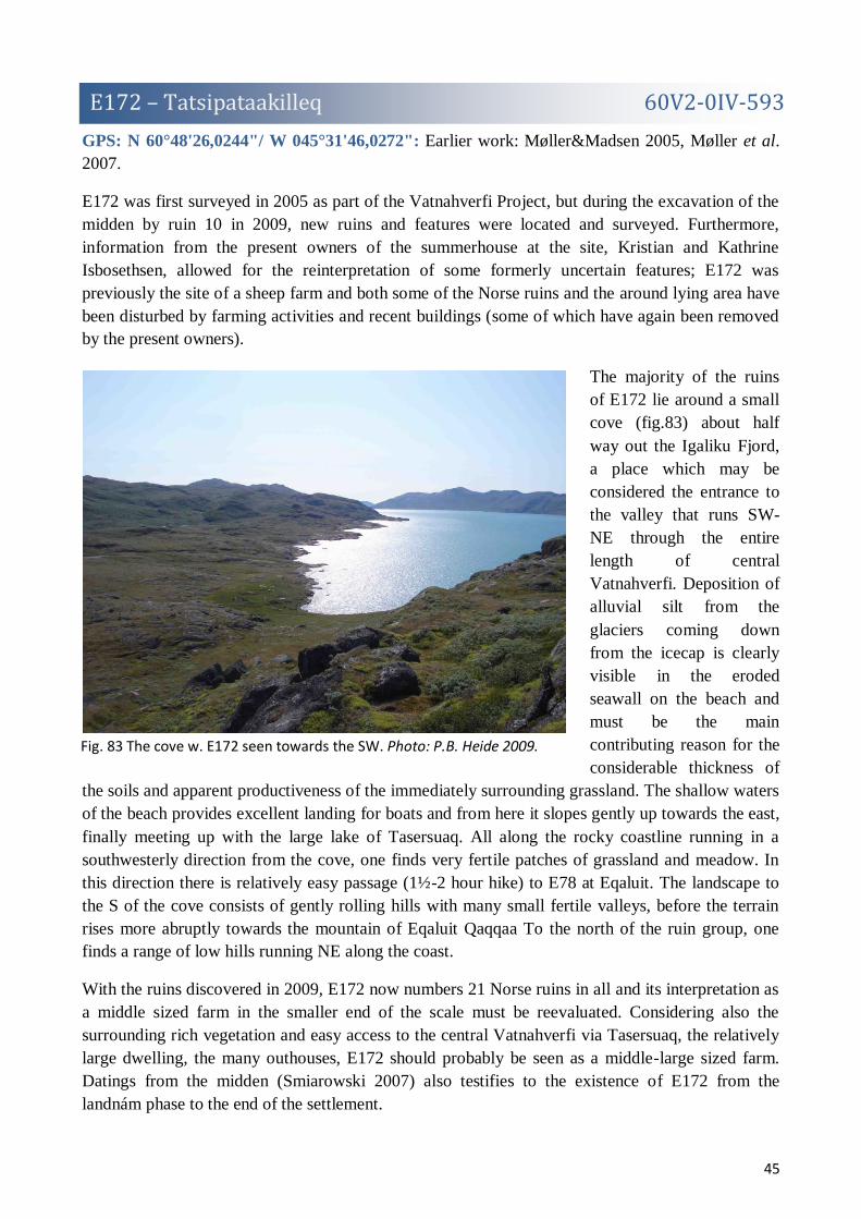
45
E172 – Tatsipataakilleq 60V2-0IV-593
Fig. 83 The cove w. E172 seen towards the SW. Photo: P.B. Heide 2009.
GPS: N 60°48'26,0244"/ W 045°31'46,0272": Earlier work: Møller&Madsen 2005, Møller et al.
2007.
E172 was first surveyed in 2005 as part of the Vatnahverfi Project, but during the excavation of the
midden by ruin 10 in 2009, new ruins and features were located and surveyed. Furthermore,
information from the present owners of the summerhouse at the site, Kristian and Kathrine
Isbosethsen, allowed for the reinterpretation of some formerly uncertain features; E172 was
previously the site of a sheep farm and both some of the Norse ruins and the around lying area have
been disturbed by farming activities and recent buildings (some of which have again been removed
by the present owners).
The majority of the ruins
of E172 lie around a small
cove (fig.83) about half
way out the Igaliku Fjord,
a place which may be
considered the entrance to
the valley that runs SW-
NE through the entire
length of central
Vatnahverfi. Deposition of
alluvial silt from the
glaciers coming down
from the icecap is clearly
visible in the eroded
seawall on the beach and
must be the main
contributing reason for the
considerable thickness of
the soils and apparent productiveness of the immediately surrounding grassland. The shallow waters
of the beach provides excellent landing for boats and from here it slopes gently up towards the east,
finally meeting up with the large lake of Tasersuaq. All along the rocky coastline running in a
southwesterly direction from the cove, one finds very fertile patches of grassland and meadow. In
this direction there is relatively easy passage (1½-2 hour hike) to E78 at Eqaluit. The landscape to
the S of the cove consists of gently rolling hills with many small fertile valleys, before the terrain
rises more abruptly towards the mountain of Eqaluit Qaqqaa To the north of the ruin group, one
finds a range of low hills running NE along the coast.
With the ruins discovered in 2009, E172 now numbers 21 Norse ruins in all and its interpretation as
a middle sized farm in the smaller end of the scale must be reevaluated. Considering also the
surrounding rich vegetation and easy access to the central Vatnahverfi via Tasersuaq, the relatively
large dwelling, the many outhouses, E172 should probably be seen as a middle-large sized farm.
Datings from the midden (Smiarowski 2007) also testifies to the existence of E172 from the
landnám phase to the end of the settlement.

46
Fig.84 Plan of the surveyed ruins of E172. Note that some ruins are found outside the shown plan.
Fig.85 R11 seen towards the N. Photo: C.K.Madsen 2009.
Approx. 12 hours was spent looking for new ruins in the area around E172 and it is reasonable to
assume that most structures visible on the surface have been identified. It is, however, very likely
that further smaller structures can be found along the shoreline down to Tasersuaq (boat house,
storage building etc.), partly because this area was not surveyed in depth, partly because of the high
vegetation of willow-birch shrub.
Numbering after Møller&Madsen 2005.
R2: This was in 2005 interpreted as a possible dwelling measuring c.16x13m. However, by
information from the present owners, much of what was interpreted as ruin is actually the first
garden established by the sheep farmer on the site. The outline of the garden is clearly visible to the
south, but a bit hard to establish in the north part, where it cuts into the ruin of what must a turf and
stone build outhouse, possibly
a stable building. The
dimensions of this building
are hard to ascertain due to the
disturbance from the garden,
but must have been something
like 16x7m.
R11: In 2005 this was
interpreted as a short stretch of
dike, but in 2009 reinterpreted
as the very faint traces of an
almost square (c.6x6m) ruin,
possibly an enclosure or a

47
Fig.86 Ruin 21 seen towards the N. Photo: C.K.Madsen 2009.
Fig.87 R22.
hay-yard (fig.85). The walls consist of more or less clear rows of larger and smaller stones
(especially the southern and eastern walls are clear, c.60cm’s wide and 10-15cm’s high). Judging
from the limited amount of collapse around the ruin (unless it has been removed during the building
of the modern sheep farm I), it cannot have been build in dry stone masonry, but traces of turf are
slight as well. The structures has been build on an almost naked cliff surface, which lies very
exposed to the fjord wind coming in from the SW.
R14: Feature interpreted as dike in 2005. This is, however, not Norse, but a low bank formed by the
clearing and leveling of a grass field (C) immediately to the west of the dike.
R20: Very collapsed and indistinct turf and stone build ruin, c.16x6m, which appears as an uneven,
grassy mound with some protruding stones. In the western end of the ruin is a concentration of
stones, some of which forming a reasonable clear wall with a marked corner. Outhouse, possibly
byre/stable building, with hay-barn (in the western end). Just NW of the ruin a heap of smaller
stones can be seen, maybe collapse.
R21: Indistinct rectangular
building, c.7x4m, lying on a
exposed cliff much like R20
(fig.86). The course of the walls
is clearly visible inside the ruin,
whereas the outside lines are
harder to discern. The eastern
gable is likewise reasonable clear.
As with R20, there does not seem
be enough collapsed stones lying
around R21 that it can have been
build entirely in dry stone
masonry, but neither is much turf
preserved (which might have to
do with the exposed location of the ruin). What is preserved, then, seem to be the disturbed stone
foundation of some kind of outhouse, possibly a building for drying material (based on the exposed
locality of the ruin to the fjord wind). The ruin is vegetated with grass and willow shrub.
R22: Placed almost on the edge of a small ridge just
east of the main cluster of ruins, R22 lies very
exposed to the fjord wind. It is a rectangular
building, c.5x2,80m, with fairly distinct stone and
turf build wall about 40cm’s thick and standing up
30cm high (fig.87). The northern long wall and
eastern gable are formed by natural and vertical cliff
faces, although wall has been added on top of these
as well. A possible entrance might be seen in the
southern wall. Economy building, possibly, skemma
(though not build in dry masonry technique).

48
Fig.88 Dike (G) with remains of house (I) in the
background seen towards the N. Photo: C.K.Madsen
2009.
A: These are all heaps of stone from the clearing of the grass fields around the modern sheep farm.
B: Feature in 2005 interpreted as Inuit grave, but is, according to the present owners, also a heap of
stones from the clearing of the grass fields.
C: Cleared and leveled grass field (modern).
D: According to the present owners of the summerhouse this was the first garden established by the
sheep farmer.
E: Modern garden.
F: Low dike. This low dike consists of a single
row (with openings in regular intervals) of
smallish stones running c.50m from the modern
garden D and all the way to the erosion bank by
the coast. It is most clear along the eastern 2/3,
while very indistinct in the western 1/3. A
section was cleaned in the erosion wall by the
coast, but no traces of a dike could be
established, perhaps because the dike here ends
in a large stone. Even though the dike runs
through the modern garden and does not follow
the line of the modern fences, it is most probably
recent, due to its likeness with dike G (see
below) and because the stones are only
protruding slightly into the soil. It might mark
an early fence line build by the sheep farmer?
G: Low dike (fig.88). This resembles dike F.
Because the dike angles and meets the line of
house I, it is most probably a recent feature,
maybe an early fence line?
H: Sheep farmers house (summerhouse).
I: Sheep farmers house and stable, now removed (fig.88).
J: Fixed point established during the 2007 excavation (Møller et al. 2007). These are small chiseled
hollows marked with red paint.
K: Fixed point, probably established by?. Small chiseled hollow marked with blue paint.
L: The midden trench excavated in 2007 and 2009. As no in situ remains of the dwelling (R10) was
actually found in trench (Smiarowski 2007), the actual outline of this ruin is obviously somewhat
exaggerated in the 2005 survey. Unfortunately, this ruin was not resurveyed.

49
E178 – Torsukattak Qingua 60V2-0IV-569
Fig.89 View sailing east into the Torsukattak Fjord. Photo: P.B. Heide 2009.
Fig.90 View from the southern shore of the narrow gap of the protected ”basin” of Torsukattak, looking towards the NE. The valley with farm is central left on the far side of the fjord (where the river comes down) and the broad valley leading to the hinterland is to the right. Photo: C.K. Madsen 2009.
GPS: N 60°38'30.03" / W 45°38'18.48. Earlier work: Albrethsen 1971, Vebæk 1948.
Sailing into the Torsukattak fjord (fig.89), one first has to pass through the skerries named Sannerut,
with many small islands and islets that are a refuge and nesting place for sea birds. East of Sannerut,
the fjord of Torsukattak opens with fairly fertile and gently sloping mountains on its southern side
and steeper and barer ones on its northern. About 5km east of Sannerut, an isthmus juts out from the
northern shore and creates a narrow and shallow passage with reefs that hide just under the surface
during high tide and are exposed during high. This reef is marked on the map, but another,
unmarked reef that hides 500-600m ENE of the narrowest point of the passage and sailing further in
should be done in the northern side of the fjord. Just at the narrow passage, on the southern shore, is
a small more recently abandoned structure, probably related to fishing.

50
Fig.91 View of the lake and peninsula with the farms looking towards the E. All but two
of the farms structures are located north of the river running from the lake to the fjord.
Photo: P.B. Heide 2009.
Having passed the narrow gap, the fjord widens again and thus forms a protected basin, where the
Norse farm E178 lie on the northern shore (fig.90-91). Here, one finds a southern faced,
semicircular and much protected valley circling a lake. The majority of the farms buildings lie on a
narrow peninsula between this lake and the fjord basin, east of the river flowing from the lake and
dividing the peninsula in two (fig.91). The land around the lake is fertile, especially to the east of it,
where two rivers coming off the mountain create a small, marshy delta, which must have provided,
at least, reasonable grazing/grass harvesting. However, the main grassing area of the farm must
have been to the SE of the farm, where the broad, the fertile valley between the mountains of
Quassugaarsuk and Akullip Qaqqaa descents to the coast by a gentle slope (fig.89). This valley is
also the obvious land passage into the hinterland and to the farm E93.
During the 2009 survey, 16 ruins were identified, documented and described at E178 during an
approx. 5½ hours stay at the site. The 16 ruins, the sizable dwelling and the access to fertile
grassland (though the area nearest to the farm and around the lake is otherwise somewhat gravelly
and dry) give the unmistakable impression of a medium to large sized farm. E178 is the only actual
Norse farm in the Torsukattak fjord and thus, it also must have had control over a quite an extensive
area. E179 (see below) and perhaps also E326 (see below), are both probable shielings belonging to
E178. The interpretation of E178 as a large farm could be substantiated by the localization of more
ruins, which are undoubtedly to be found around the lake, on the isthmus at the gap or by the broad
valley to the SE of the farm, as none of these areas were surveyed and are covered with dense shrub
vegetation. Also noteworthy is an Inuit presence at the site in shape of smaller features (not
surveyed) and a disturbance of the dwelling (R05).

51
Fig.92 Situation plan of the all the ruins of 178 on GoogleEarth satellite imagery. The ruins have here
been corrected for a slight misplacement in the original survey. The large “black spot” is a natural cliff.
Fig.93 Ruin 01 seen towards the NE. Note dike (R11) extending from the corner of the
enclosure and the cliff (left), forming part of the homefield dike. Photo: C.K. Madsen 2009.
Ruin numbering after Albrethsen 1971 and Vebæk 1971 (note, however, that there was a
considerable discrepancy between the earlier site sketches/descriptions and the ones made in 2009
and some ruins might have been confused with others). Some descriptions after Albrethsen 1971.
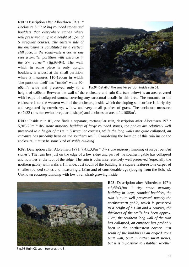
52
Fig.95 Ruin 03 seen towards the S.
Fig.94 Detail of the smaller partion inside ruin 01.
R01: Description after Albrethsen 1971: “
Enclosure built of big rounded stones and
boulders that everywhere stands where
well preserved in up to a height of 1,5m of
5 irregular courses. The eastern side of
the enclosure is constituted by a vertical
cliff face, in the southwestern corner one
sees a smaller partition with entrance in
the SW corner” (fig.93-94). The wall,
which in some place is only upright
boulders, is widest at the small partition,
where it measures 110-120cm in width.
The partition itself has “inside” walls 50-
60cm’s wide and preserved only to a
height of c.60cm. Between the wall of the enclosure and ruin 01a (see below) is an area covered
with heaps of collapsed stones, covering any structural details in this area. The entrance to the
enclosure is on the western wall of the enclosure, inside which the sloping soil surface is fairly dry
and vegetated by crowberry, willow and very small patches of grass. The enclosure measures
c.47x32 (it is somewhat irregular in shape) and encloses an area of c.1088m2.
R01a: Inside ruin 01, one finds a separate, rectangular ruin, description after Albrethsen 1971:
5,9x3,25m “ dry stone masonry building of large rounded stones, the gables are relatively well
preserved to a height of c.1m in 5 irregular courses, while the long walls are quite collapsed, an
entrance has probably been on the southern wall”. Considering the location of this ruin inside the
enclosure, it must be some kind of stable building.
R02: Description after Albrethsen 1971: 7,45x3,8m “ dry stone masonry building of large rounded
stones”. The ruin lies just on the edge of a low ridge and part of the southern gable has collapsed
and now lies at the foot of the ridge. The ruin is otherwise relatively well preserved (especially the
northern gable) with walls c.1m wide. Just south of the building is a square feature/stone carpet of
smaller rounded stones and measuring c.1x1m and of considerable age (judging from the lichens).
Unknown economy building with low birch shrub growing inside.
R03: Description after Albrethsen 1971:
c.8,65x3,9m “ dry stone masonry
building in large, rounded boulders, the
ruin is quite well preserved, namely the
northwestern gable, which is preserved
to a height of c.1½m and 4 courses, the
thickness of the walls has been approx.
1,2m; the southern long wall of the ruin
has collapsed, an entrance has probably
been in the northeastern corner. Just
south of the building is an angled stone
built wall, built in rather small stones,
but it is impossible to establish whether

53
Fig.96 Ruin 05 seen towards the NE. Note the upright placed stone beams.
Fig.97 Closeup of the upright placed stone beams and the large
one lying down described in the text.
it is an extension to ruin 03 or part of another ruin. The area is overgrown with dense willow shrub
and thus quite confusing” (fig.95). It might be added that the largest boulder of R03 measures as
much as 240x70x55cm. The building is probably a skemma or small stable.
R04: Description after Albrethsen 1971: c.7,75x4,10m “ dry stone masonry building in large,
rounded stones, the ruin is fairly collapsed and only the lower course is still in place; south of the
ruin there is a possible pen or extension; the ruin is overgrown with willow shrub”. Considering the
pen or hay-yard, this building is probably some kind of sheep/goats shed or small stable.
R05: Description after
Albrethsen 1971:
c.48x19m “ very collapsed
and indistinct dwelling
with faint traces of a large
number of small rooms;
an unusual amount of
small stones is seen in the
surface, especially in the
southwestern part one
finds many (some) large,
regular stone beams, here
among one with a length
of 3m (see below). In the
eastern part of the ruin
there seems to be a smaller stone built house, which can be a separate structure, which now,
because of the collapse of the dwelling, appears as merged with the latter. In the southwestern part
of the ruin 4 (5) stone beams have been erected more recently; the ruin is overgrown with grass and
willow” (fig.96-97). Regarding the
traces of rooms/wall lines on the
surface, it might be added that a
depression (hallway?) seems to run all
the way across the ruin, otherwise the
rooms are hard to delimit. The
mentioned stone beams are surely all
from the Norse building, although the
5 erected ones might be an umiaq
support (though the fifth is then
somewhat out of place)? The largest of
the stone beams measure 300x50x25.
A smaller midden area can be seen just
north of the ruin.
R06: Totally collapsed stone built
structure, in the SW corner of which
one does glimpse the outline of a rectangular building with walls c.50cm wide and now preserved
only to a height of c.10cm. Especially the western long wall is fairly distinct and the wall of the

54
Fig. 98 Ruin 09 seen towards the ESE.
structure here seems to extend to some natural boulders. Also, the structure may have been
connected to the dwelling (R05) by a dike, thus creating a hay-yard/enclosure between the two
buildings. R06 is some kind of outhouse now vegetated by grass.
R07: Roughly square, c.3,4x3,4, completely collapsed structure which shows as low stone/turf
walls, c.20-30cm wide and 10cm high, with rounded corners. In the southwestern corner is a small
pile of stones. Unknown structure vegetated by willow and crowberry. It is possible that S.E.
Albrethsen’s R16 is Vebæk’s R07, as they appear in approx. the same location (but with different
dimensions and shape).
R08: Small, rectangular, and very collapsed turf/stone structure, c.7,2x3,7m, lying close to the fjord
on the SW side of the river from the lake. The walls are low, only c.10cm high. Especially in the
eastern end the ruin seems uncertain and it might even be a natural formation? Outhouse or,
alternatively, some kind of Thule-culture structure. The ruin vegetated by grass and willow.
R09: This, c.7,9x3,2m, turf/stone ruin is
very similar to R08, both in appearance and
location, albeit R09 is even more collapsed,
only showing as lines of rounded stones
(fig.98). It seems to be portioned in the
middle. Outhouse or Thule-culture structure
now vegetated by grass and willow and
almost being eroded into the fjord.
R10: Possible dike cutting across the
peninsula at its narrowest SW of the river
from the lake, thus creating a water-bounded
area/enclosure or a homefield area.
However, the traces of a dike are extremely
faint and, if it is actually a dike, it consists of a line of interspaced boulders with no traces of turf.
R11: Description after Albrethsen 1971: “ Homefield dike which can be traced of a distance of…
(c.200m including the cliff) …towards the east the dike is made from large stone blocks and is here
very distinct, towards the west the dike is mostly of smaller stones and quite indistinct. Natural
boulders have in quite a long extend been exploited”. To this one might add the observation that the
cliff that forms part of the dike slopes gently to the north, while it has a vertical face c.1,5-2m heigh
to the south. This means that the dike, at least here and at least in the cases of sheep/goats, is meant
to keep the animals from moving out of the supposed homefield area (in perhaps into the marshy
grassland area?).
R12: Very badly preserved almost square for a building, c.3,5x2,8m, that today looks nothing more
than an outline of angular stones. Some of the stones are almost at surface level.
R13: Description after Albrethsen 1971: c.8,3x7,7m “ building in dry stone masonry that is almost
completely collapsed, but traces of an outline can be glimpsed”. The ruin, some outhouse, is
overgrown with crowberry and grass.
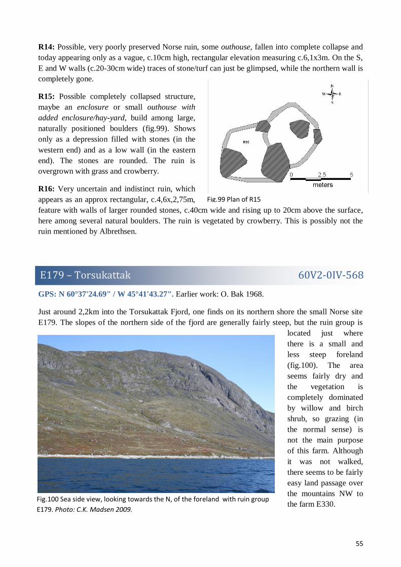
55
Fig.99 Plan of R15
E179 – Torsukattak 60V2-0IV-568
Fig.100 Sea side view, looking towards the N, of the foreland with ruin group
E179. Photo: C.K. Madsen 2009.
R14: Possible, very poorly preserved Norse ruin, some outhouse, fallen into complete collapse and
today appearing only as a vague, c.10cm high, rectangular elevation measuring c.6,1x3m. On the S,
E and W walls (c.20-30cm wide) traces of stone/turf can just be glimpsed, while the northern wall is
completely gone.
R15: Possible completely collapsed structure,
maybe an enclosure or small outhouse with
added enclosure/hay-yard, build among large,
naturally positioned boulders (fig.99). Shows
only as a depression filled with stones (in the
western end) and as a low wall (in the eastern
end). The stones are rounded. The ruin is
overgrown with grass and crowberry.
R16: Very uncertain and indistinct ruin, which
appears as an approx rectangular, c.4,6x,2,75m,
feature with walls of larger rounded stones, c.40cm wide and rising up to 20cm above the surface,
here among several natural boulders. The ruin is vegetated by crowberry. This is possibly not the
ruin mentioned by Albrethsen.
GPS: N 60°37'24.69" / W 45°41'43.27". Earlier work: O. Bak 1968.
Just around 2,2km into the Torsukattak Fjord, one finds on its northern shore the small Norse site
E179. The slopes of the northern side of the fjord are generally fairly steep, but the ruin group is
located just where
there is a small and
less steep foreland
(fig.100). The area
seems fairly dry and
the vegetation is
completely dominated
by willow and birch
shrub, so grazing (in
the normal sense) is
not the main purpose
of this farm. Although
it was not walked,
there seems to be fairly
easy land passage over
the mountains NW to
the farm E330.

56
Fig.101 Situation plan of the ruins of E179.
Fig.102 Ruin 01 seen towards the SW.
With only 3 ruins (fig.101), hereof 1 discovered in 2009, and a moderate sized dwelling, ruin group
E179 must be characterized as the smallest of sites, most probably a shieling under the farms E178
or E330. E179 has fairly easy access over land to both of these farms. The exact purpose of this site
is very hard to interpreted, but it might have to do with access to sealing, bird catching (on the
islands of the Sannerut skerries), fishing or all of them. The lack of outhouses seems to out rule any
function of the place as a farm proper. Although only approx. 1½ hour was spent surveying the site,
it is quite certain that most ruins have been discovered.
Numbering after O. Bak 1968.
R01: Rectangular, c.26x13,5m,
completely collapsed ruin.
Although not a farm mound
proper, this is undoubtedly a
small, turf/stone built dwelling,
today showing as an uneven
area with a large amount of
small stones and a few
depressions which are likely
rooms (fig.102). Approx.
middle in the ruin is an area
with few stones and R01 might
actually have been to separate
buildings, now merged in one
inseparable heap of collapse.
The state of collapse also makes it hard to delimit the ruin with any precision. It is interesting that
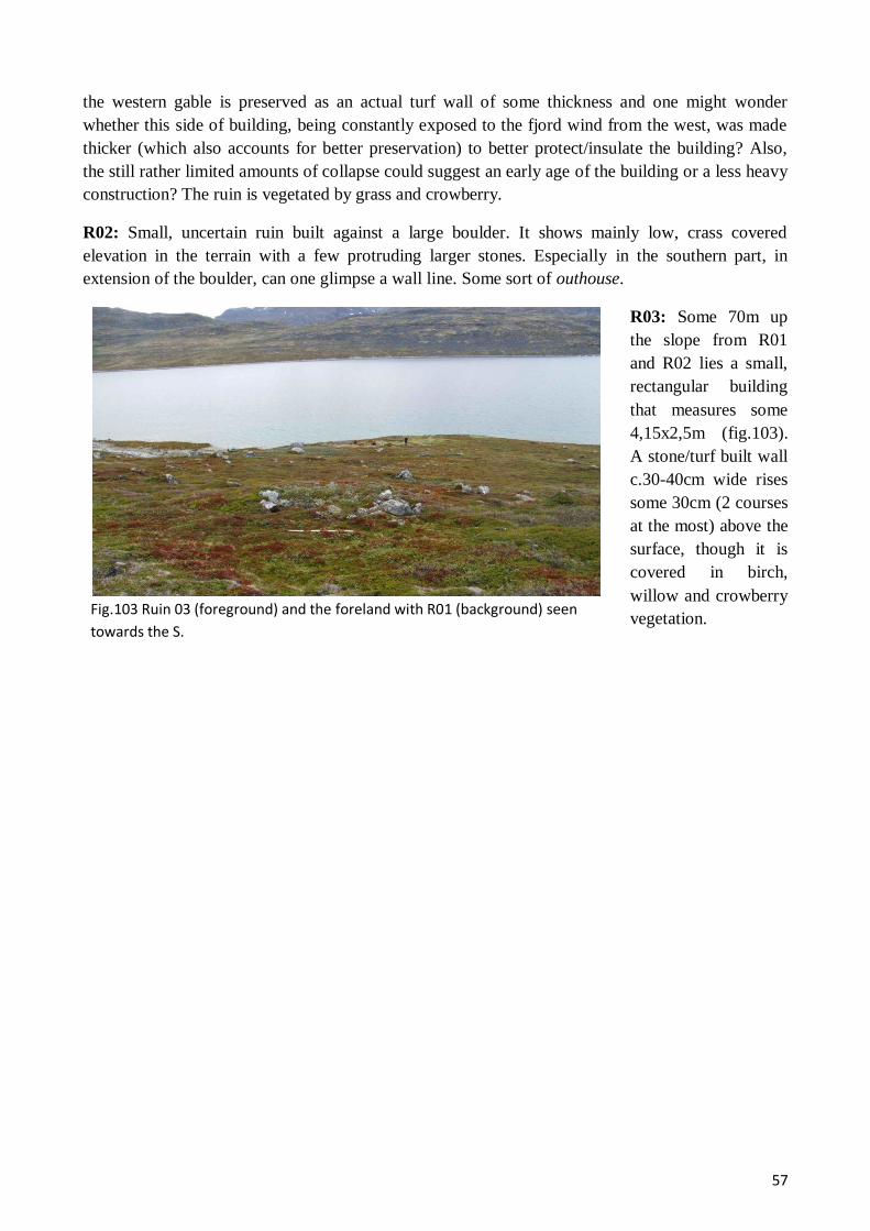
57
Fig.103 Ruin 03 (foreground) and the foreland with R01 (background) seen
towards the S.
the western gable is preserved as an actual turf wall of some thickness and one might wonder
whether this side of building, being constantly exposed to the fjord wind from the west, was made
thicker (which also accounts for better preservation) to better protect/insulate the building? Also,
the still rather limited amounts of collapse could suggest an early age of the building or a less heavy
construction? The ruin is vegetated by grass and crowberry.
R02: Small, uncertain ruin built against a large boulder. It shows mainly low, crass covered
elevation in the terrain with a few protruding larger stones. Especially in the southern part, in
extension of the boulder, can one glimpse a wall line. Some sort of outhouse.
R03: Some 70m up
the slope from R01
and R02 lies a small,
rectangular building
that measures some
4,15x2,5m (fig.103).
A stone/turf built wall
c.30-40cm wide rises
some 30cm (2 courses
at the most) above the
surface, though it is
covered in birch,
willow and crowberry
vegetation.
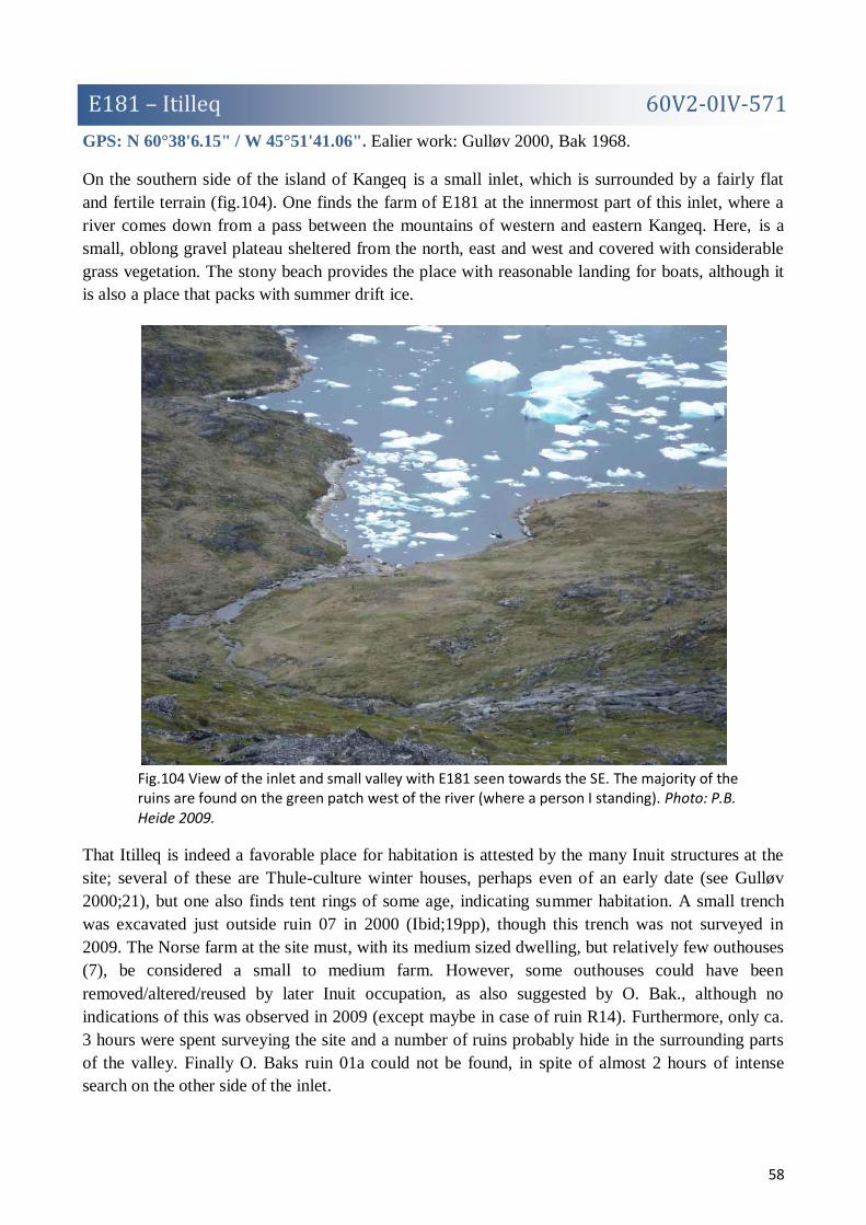
58
E181 – Itilleq 60V2-0IV-571
Fig.104 View of the inlet and small valley with E181 seen towards the SE. The majority of the ruins are found on the green patch west of the river (where a person I standing). Photo: P.B. Heide 2009.
GPS: N 60°38'6.15" / W 45°51'41.06". Ealier work: Gulløv 2000, Bak 1968.
On the southern side of the island of Kangeq is a small inlet, which is surrounded by a fairly flat
and fertile terrain (fig.104). One finds the farm of E181 at the innermost part of this inlet, where a
river comes down from a pass between the mountains of western and eastern Kangeq. Here, is a
small, oblong gravel plateau sheltered from the north, east and west and covered with considerable
grass vegetation. The stony beach provides the place with reasonable landing for boats, although it
is also a place that packs with summer drift ice.
That Itilleq is indeed a favorable place for habitation is attested by the many Inuit structures at the
site; several of these are Thule-culture winter houses, perhaps even of an early date (see Gulløv
2000;21), but one also finds tent rings of some age, indicating summer habitation. A small trench
was excavated just outside ruin 07 in 2000 (Ibid;19pp), though this trench was not surveyed in
2009. The Norse farm at the site must, with its medium sized dwelling, but relatively few outhouses
(7), be considered a small to medium farm. However, some outhouses could have been
removed/altered/reused by later Inuit occupation, as also suggested by O. Bak., although no
indications of this was observed in 2009 (except maybe in case of ruin R14). Furthermore, only ca.
3 hours were spent surveying the site and a number of ruins probably hide in the surrounding parts
of the valley. Finally O. Baks ruin 01a could not be found, in spite of almost 2 hours of intense
search on the other side of the inlet.

59
Fig.105 Situation plan of ruins of 181 on GoogleEarth satellite imagery.
Fig.106 Ruin 01 seen towards the ENE. Note the pointy stone slaps.
Ruin numbering is after O. Bak 1968 (and Gulløv 2000), though note that this numbering does not
differentiate between Norse and Inuit structures.
R01: Possible Norse ruin which appears as a slightly elevated area, roughly rectangular,
c.10,6x4,6m, with depressions and a few larger protruding stones. This ruin, an outhouse of some
sort, lies with excellent view out of the inlet. It is completely overgrown with grass and moss. On
the north side of the ruins is 3 upright, but sloping stone slaps, all pointy towards the upper end
(fig.106). These are not part of the Norse ruin and could be an Umiaq support or a sea-marker? The
lichens on the stone slaps suggest a considerable age.
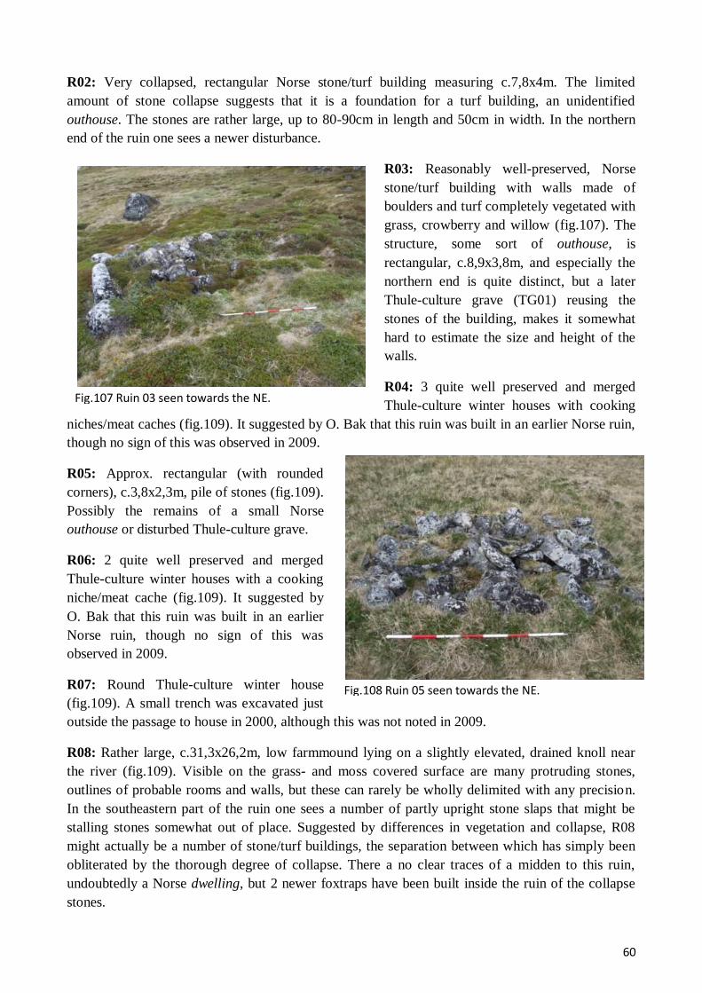
60
Fig.107 Ruin 03 seen towards the NE.
Fig.108 Ruin 05 seen towards the NE.
R02: Very collapsed, rectangular Norse stone/turf building measuring c.7,8x4m. The limited
amount of stone collapse suggests that it is a foundation for a turf building, an unidentified
outhouse. The stones are rather large, up to 80-90cm in length and 50cm in width. In the northern
end of the ruin one sees a newer disturbance.
R03: Reasonably well-preserved, Norse
stone/turf building with walls made of
boulders and turf completely vegetated with
grass, crowberry and willow (fig.107). The
structure, some sort of outhouse, is
rectangular, c.8,9x3,8m, and especially the
northern end is quite distinct, but a later
Thule-culture grave (TG01) reusing the
stones of the building, makes it somewhat
hard to estimate the size and height of the
walls.
R04: 3 quite well preserved and merged
Thule-culture winter houses with cooking
niches/meat caches (fig.109). It suggested by O. Bak that this ruin was built in an earlier Norse ruin,
though no sign of this was observed in 2009.
R05: Approx. rectangular (with rounded
corners), c.3,8x2,3m, pile of stones (fig.109).
Possibly the remains of a small Norse
outhouse or disturbed Thule-culture grave.
R06: 2 quite well preserved and merged
Thule-culture winter houses with a cooking
niche/meat cache (fig.109). It suggested by
O. Bak that this ruin was built in an earlier
Norse ruin, though no sign of this was
observed in 2009.
R07: Round Thule-culture winter house
(fig.109). A small trench was excavated just
outside the passage to house in 2000, although this was not noted in 2009.
R08: Rather large, c.31,3x26,2m, low farmmound lying on a slightly elevated, drained knoll near
the river (fig.109). Visible on the grass- and moss covered surface are many protruding stones,
outlines of probable rooms and walls, but these can rarely be wholly delimited with any precision.
In the southeastern part of the ruin one sees a number of partly upright stone slaps that might be
stalling stones somewhat out of place. Suggested by differences in vegetation and collapse, R08
might actually be a number of stone/turf buildings, the separation between which has simply been
obliterated by the thorough degree of collapse. There a no clear traces of a midden to this ruin,
undoubtedly a Norse dwelling, but 2 newer foxtraps have been built inside the ruin of the collapse
stones.

61
Fig.109 View, looking towards the SW, of the ruins just W the river. The person
is standing by R08, left of it, by the green patches, R04, R06 & R07.
Fig.110 Ruin 10 seen towars the N.
Fig.111 R11 seen towards the SSW.
R09: Very indistinct
and collapsed Norse
turf/stone ruin of
almost rounded shape
and a diameter of
c.8,75m. It shows as
a low depression
surrounded by a turf
bank c.1,5-2m wide.
In the center of the
ruin, some outhouse,
is a clear partition
wall preserved in on
course of stone. The
ruin is vegetated with
grass, ranunculus and
dandelion.
R10: Fairly well-preserved
rectangular, c.8,7x5,5m, Norse
economy building with
boulder/turf walls c.60-80cm
wide and preserved to a height
of c.40cm (the inside outline of
the walls is much clearer than
the outside) (fig.110). The
western gable of the ruin is
preserved in 4 courses (c.60cm)
and suggests a building,
probably a small stable or
sheep/goats shed, with an inner
wall of stone and an outer of turf. In the eastern end of the ruin the collapse stones have been reused
in a Thule-culture grave (TG03).
R11: Very collapsed Norse economy building
(or foundation for such), rectangular
(c.7,8x3,7m) and partly exploiting large
boulders, while the majority of the structure
must have been in a more perishable material
(fig.111). Approx. middle in the ruins is a
clear partition wall, unless it is actually a
gable and the eastern part of the ruin is simply
collapse.

62
Fig.112 R12 seen towards the WSW.
R12: Rectangular stone structure,
c.2,5x1,4m, with two internal
compartments and made mostly from
upright, rounded stone slaps so that it
reaches a height of c.40-50cm (fig.112).
The preservation of the feature and the
way of construction suggest that it is of
Thule-culture origin (?), however the
lichens on the stones suggest a
considerable age. Lightly vegetated by
grass and willow.
R13: Could not be located.
R14: Roughly rectangular of shape, c.10,80x5,3, but with a back wall constituted by a low cliff,
R14 appears as a depression in the terrain surrounded by a low stone/turf wall/bank. The stones are
rather larger, up to c.60x60x40. Judging from the appearance and amounts of turf in the structure, as
well as the trace of a narrow passage on its eastern side, this looks like a Thule-culture a winter
house with a meat cache/cooking niche on its northern side, but could perhaps be reusing a Norse
pen (judging from the stones and the unusual location of the structure)?.
R15: Rounded and somewhat indistinct Thule-culture winter house, which appears as a turf/stone
wall surrounding a central depression in the terrain. The back wall of the structure is constituted of a
natural cliff. The ruin is overgrown with crowberry, grass, fjeldsyre and willow.
R16: Stone pile of square shape between two natural boulders. It is probably a meat cache
belonging to R15.
R17: Some 700m directly east of the described buildings, one finds 3 Thule-culture structures
(R17-19), the first of which is a horseshoe shaped stone feature, probably a meat cache or a partly
demolished fox trap.
R18: Very well-preserved Thule-culture tentring. The vegetation suggest some age.
R19: Partially preserved trapezoid Thule-culture summer hut.
R20: Very well-preserved Thule-culture tentring. The vegetation suggest some age.
TG01: Thule-culture chamber grave built of flat stone slaps, c.2,5x3m. Inside badly preserved
bones are visible.
TG02: Thule-culture chamber grave reusing stones of Norse ruin (03).
TG03: Thule-culture chamber grave (no preserved bones) reusing stones of Norse ruin (10).

63
E188 – Akia 60V2-0IV-637
Fig.113 View of the ruins of E188 lying closest to the fjord. The withered patch of
grass is
the dwelling.
Fig. 114 Detail of wall in enclosure at
E188
GPS: N 60°41'6.07" / W 45°58'15.63".
Ruin group E188 on the island of Akia at the mouth of the Igaliku Fjord was not part of the ruin
groups planned to be surveyed during the 2009 field season, but when presented with the chance, a
brief visit to the site was welcomed, among other things to better plan future surveys. The ruin
group, which has several well-preserved ruins, lies by a little inlet on the south side of the peninsula
that runs east from the main part of Akia (fig.113). Behind the inlet is a south faced semicircular
valley around a lake, completely sheltered from the N, E and W.
Two things were
noted during the
brief stay at the
site, namely that 2
trenches had been
cut, not too long
ago judging from
their appearance,
centrally in the
dwelling (a 5x5m
trench) and in the
nearby midden
(2x1m trench).
There is, however,
no record in the
archives of the
National Museum
of any excavation
at the site.
Secondly, one of the ruins in the valley was an enclosure
build up against the side of a giant boulder (fig.114). The
stone wall was generally low, c.30-50cm, but just where it
met the boulder in one side, the wall stood about 1,4m
high. Judging from the amount of collapse stone, the stone
wall cannot have stood higher than 1m at most. Thus this is
very clear evidence that the stone wall was a foundation for
a superstructure of turf, which might have been a means of
construction in many other cases.
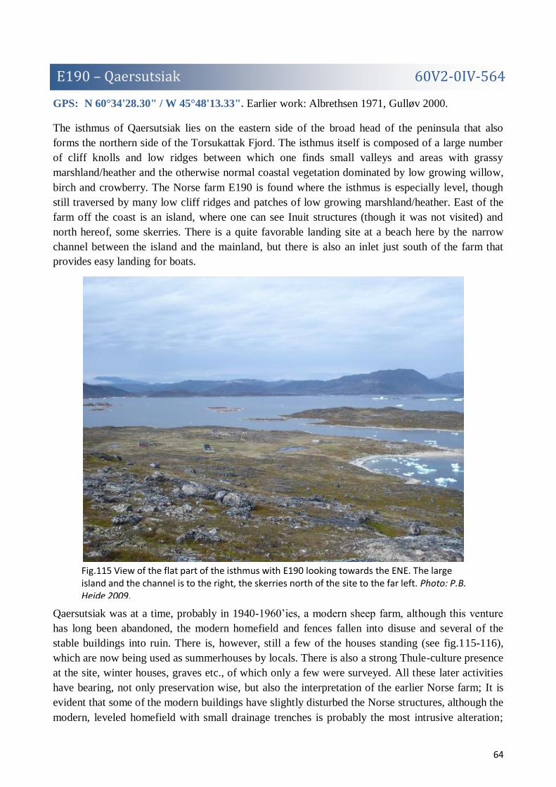
64
E190 – Qaersutsiak 60V2-0IV-564
Fig.115 View of the flat part of the isthmus with E190 looking towards the ENE. The large island and the channel is to the right, the skerries north of the site to the far left. Photo: P.B. Heide 2009.
GPS: N 60°34'28.30" / W 45°48'13.33". Earlier work: Albrethsen 1971, Gulløv 2000.
The isthmus of Qaersutsiak lies on the eastern side of the broad head of the peninsula that also
forms the northern side of the Torsukattak Fjord. The isthmus itself is composed of a large number
of cliff knolls and low ridges between which one finds small valleys and areas with grassy
marshland/heather and the otherwise normal coastal vegetation dominated by low growing willow,
birch and crowberry. The Norse farm E190 is found where the isthmus is especially level, though
still traversed by many low cliff ridges and patches of low growing marshland/heather. East of the
farm off the coast is an island, where one can see Inuit structures (though it was not visited) and
north hereof, some skerries. There is a quite favorable landing site at a beach here by the narrow
channel between the island and the mainland, but there is also an inlet just south of the farm that
provides easy landing for boats.
Qaersutsiak was at a time, probably in 1940-1960’ies, a modern sheep farm, although this venture
has long been abandoned, the modern homefield and fences fallen into disuse and several of the
stable buildings into ruin. There is, however, still a few of the houses standing (see fig.115-116),
which are now being used as summerhouses by locals. There is also a strong Thule-culture presence
at the site, winter houses, graves etc., of which only a few were surveyed. All these later activities
have bearing, not only preservation wise, but also the interpretation of the earlier Norse farm; It is
evident that some of the modern buildings have slightly disturbed the Norse structures, although the
modern, leveled homefield with small drainage trenches is probably the most intrusive alteration;

65
Fig.116 Situation plan of the larger structures found at Qaersutsiak on GoogleEarth satellite imagery. Ruin numbering is as usual, but; H = modern or ruined house, F = modern homefield, GA = modern garden, GR = modern fenced graveyard.
this runs close by the presumed dwelling (R01), but other than perhaps a few stones from clearing
the field (also in R02) and a broken fence, has respected the ruin. More interestingly, there is clear
evidence (abandoned nets, boats, and fishing implements) that the modern sheep farm, like so many
others of that time and with like location, subsisted only partially on farming and more on
fishing/hunting. The Thule-culture ruins are also evidence of the hunting/fishing potential of the
site. This makes perfect sense, seeing that the only impressive patch nearby of grassland is the
modern homefield and the surrounding landscape with even the shrub vegetation rarely rising above
knee level. The Norse farm of E190 with its 10 ruins, 4 of which were discovered in 2009, and a
rather unimpressive dwelling, does indeed seem like a farm in the smaller end of the scale. The
several turf built outhouses and enclosures does point towards the presence of some animal
husbandry, but the size of the outhouses may also be exaggerated due to the very exposed location
of the farm. On the other hand, E190 is the south westernmost farm of the entire peninsula and may
have had sole access to a poor, but very large grazing area? In any case, this farm is one of the
Norse places with best access to the rich animal life of the outer coast.
Approx. 5 hours were spend surveying the site and the surrounding landscape, but considering the
many phases of occupation and a rather extensive landscape, several ruins may be unnoticed,
especially in the area NW of the farm. 2 fragments of a soap stone vessel and a possible sandstone
lamp was found at the site. The site was also visited in 2000 by another team (Gulløv 2000).
Ruin numbering after Albrethsen 1971.

66
Fig.117 Ruin 01 seen towards the ESE (with the modern home field in the background).
R01: Description after Albrethsen 1971: c.26,7x16,2m “… very collapsed complex with traces of a
rather lot of small rooms, probably dwelling etc., many stones are visible on the surface;
overgrown with grass. Recently a fence has been built across the ruin, furthermore there is one pile
of stones from field clearing and some garbage, other than this the ruin has not been disturbed by
newer activities” (fig.117). To this it might be added that the fence today is collapsed. In the eastern
end there is a very distinct and roughly rectangular with rounded corners, c.8,8x6,10, feature of
stone, which might be the stone pile mentioned by Albrethsen. This might actually be a room in the
Norse structure, which is perhaps confirmed by the Thule-culture grave (TG01) inside the rectangle,
which seems to have reused the stones of the rectangle/room. On the northern side of the ruin is an
almost chapel-like extension with a clearly visible wall that continues some way into the ruin.
R02: Description after Albrethsen 1971: c.18,25x11,1m “…very indistinct stone/turf building with
traces of 2-3 rooms, stable complex?, many stones are visible on the surface; overgrown with grass
and moss. There is a pile of stones from field clearing on the southern edge of the ruin, other than
this the ruin has not been disturbed by recent activities”.
R03: Description after Albrethsen 1971: c.25,20x10,40m “… completely collapsed and indistinct
stone/turf building with traces of several rather small rooms, stable complex? Many stones are
visible on the surface, the ruin is found in a very stony area between rounded cliffs; overgrown with
moss”. In the southeastern corner of the ruin is an area with a larger concentration of stones that
might represent an addition, which is, however, impossible to establish due to the state of collapse.
R04: Description after Albrethsen 1971: c.16,8x10m “… well preserved enclosure of large angular
stone blocks, the eastern long wall is somewhat collapsed, the western comprised of a cliff face”
(fig.118). The walls of the enclosure is c.40-70cm wide, but only preserved in 1 course (c.80-
100cm). In the NW corner of the enclosure there is a newer stone built “channel”, perhaps for
catching hares? On the cliff over the enclosure and partially exploiting (and probably having
removed part of) the wall of it is a large, well built Thule-culture grave (TG02). Right next to it is
another, smaller, but equally well-built Thule grave (TG03). In the SW corner of the enclosure
outside the wall is a square, stone built feature, perhaps a disturbed Thule-grave or perhaps, judging

67
Fig.118 Ruin 04 seen towards the SSE. TG02 is clearly
visible on top of the cliff.
Fig.119 Ruin 05 seen towards the S. TH04 is visible in
the far central part of the ruin.
Fig.120 Ruin 07 seen towards the SE.
from the stones, a smaller Norse enclosure reused as a grave. Inside the enclosure grows grass and
moss.
R05: Description after Albrethsen 1971:
c.8,1x5m “… rather well preserved
enclosure of rather large angular stone
blocks, the western long wall is a natural
cliff face, in the SW corner is an Inuit
grave” (fig.119). The walls are c.30-
40cm wide, but part of it has been
removed in the construction of the Thule-
culture grace (TG04). In the NE corner
of the enclosure is a smaller room,
c.100x120cm. The walls are here only
preserved in 1 course (up to 50cm).
R06: A roughly rectangular, c.8,5x4m,
stone/turf built ruin constructed along and partly
incorporating a low cliff face. The ruin is fairly
indistinct, showing only as c.10cm high walls
and rounded stones (it may have been divided in
the middle). S of this probable stable or
sheep/goats shed, seem to be to added walls,
perhaps enclosures or hay-yards? The ruin is
covered by grass.
R07: Rectangular area, c.3,5x2,9m, with many
rounded stones, which might represent the
foundation for a Norse outhouse (fig.120). The
feature would have been considered natural, if not for its location on top of a low cliff knoll or for a
line of stones perhaps representing a wall? Some stones of this possible structure have probably
been removed in the construction of a modern foundation for a flagpole on 3m from the ruin. The
ruin is vegetated by grass and willow.
R08: Roughly oval, longest diameter c.16,3m,
but completely collapsed turf/stone ruin, which
appears as a low grass covered elevation with
many protruding smaller and angular stones. No
rooms proper in this outhose can be
distinguished, but a few wall lines are visible.
R09: Very uncertain ruin appearing as a roughly
rectangular area, c.8,1x6,2, with many larger

68
Fig.121 Ruin 10 seen towards the ENE.
E237 – Eqaluqaarsuit 60V2-0IV-556
angular stones. Two probable wall lines can be seen. The ruin is vegetated by grass and heather.
R10: Very collapsed, but still
quite distinct enclosure build
against a cliff face and among
natural boulders some 150m west
of the main cluster of buildings
(fig.121). The enclosure is
roughly rectangular of shape,
c.8,3x4,8m, with a smaller room
added to the SE corner. The walls
are c.60-80cm wide and
preserved to a height of c.40cm
(in a few places preserved to a
height of 2 courses). Inside the
enclosure grows heather and
crowberry.
TH01: Well preserved Thule-culture winter house with an outside cooking niche.
TH02: Very well-preserved Thule-culture winter house with an inside cooking niche and a nearby
meat cache.
TG01: Thule-culture stone built grave inside R01.
TG02: Large and well built Thule-culture stone grave partially reusing R04.
TG03: Well built Thule-culture stone grave next to TG02.
TG04: Thule-culture stone built grave inside and reusing the stones of R05.
GPS: N 60°31'37.71 / W 45°31'2.80". Earlier work: Berglund 1980.
By opportunity we visited the modern sheep farm at Eqaluqaarsuit in the Alluitsup Kangerlua, to
briefly inspect the ruin group of E237, which was not originally part of the planned survey work.
However, the sheep farmer knew nothing of any Norse ruins and a quick look around his fields did
not produce any. Eqaluqaarsuit does seem an obvious place for a Norse farm, with a sheltered,
natural harbor and reasonable fertile green pastures. Viewing the extensive field work at the farm, it
is not improbable that ruins can have been removed prior to the knowledge of the present sheep
farmer.

69
E274 – Akia 60V1-00I-501
Fig.122 View of the Inuit structures at E274.
E275 – Akia 60V2-0IV-660
GPS: N 60°40'33.38" / W 46° 0'20.33".
Some 2,2km WSW of ruin group E188, the ruin group E274 on the south side of the island of Akia
is marked on the map. Presented by the opportunity, we briefly visited the site to inspect the ruins.
Spending approx. 45min looking around at the site, we did not manage to find any ruins other than
Inuit. Of these, however, two are extremely interesting (fig.122); these were found on a gravelly
surface between two ridges and near the beach that showed clear signs of wind erosion. Both
(though one was more clear than the other) were oval shaped structures (summer huts) with walls of
a single line of stones and a line or two of stones central in the internal structure. These might
actually be mid-passage tent rings, and judging from the vegetation and appearance of the ruins, of
considerable age, possibly Paleo-Eskimo (Dorset) structures?.
GPS: N 60°39'44.75" / W 46° 0'31.21".
After having visited the coordinates of E274, we went on to briefly visit the site of E275 for the
same reasons. However, except for 3 ruins of somewhat unusual appearance, but probably Inuit, and
1 well built, possibly Norse, cairn, nothing distinctly of Norse character could be located.

70
E314 – Nuluk 60V2-0IV-551
Fig.123 The Nuluk isthmus and the location of E314 (and E92) on GoogleEarth satellite imagery.
Fig.124 Sea side view of the southern slopes of the mountain of Tinuparneq
seen towards the ENE. The Nuluk isthmus is visible on the far right. Photo:
C.K. Madsen 2009.
GPS: N 60°38' 6.70" / W 45°22'46,46". Earlier work: O. Bak 1967.
On the southern side of the low isthmus of Nuluk in the Alluitsup Kangerlua Fjord (fig.123), there
is a narrow, relatively flat and fertile plateau just by the beach, which houses a large number of
Thule-culture features (among them several winter houses). A bit up the plateau, completely hidden
in head high birch and willow vegetation is a single distinctly Norse ruin (O. Bak’s ruin 7).
Although O. Bak by his survey speculated that some of Inuit structures could be reuse of Norse
structures, we found no visible indication of this in 2009.
There can be little doubt that the single ruin of E314 is a shieling, probably belonging to E92. While
the location might seem somewhat strange, it actually makes perfect sense when seen in bird’s eye
view (fig.123) and sea
side view (fig.124); from
the GoogleEarth satellite
imagery, it is obvious
that Nuluk form a
reasonable fertile
isthmus. That this
isthmus is actually
distinctly delimited to
the N and W by the steep
slopes of the mountain
of Tinuparneq (830m) is,
however, even more

71
Fig.125 Plan of ruin 07.
E322 – Illunguaq 60V2-III-530
Fig.126 The strip of flat, fertile grassland with E322 seen towards
the ENE. Photo: P.B. Heide 2009.
obvious, when seen from the fjord (fig.124). The isthmus of Nuluk is thus what can be called a
naturally delimited grazing area, i.e. an area where one could graze a number of animals with
minimum supervision. Also interesting is a
possible dike just east of the farm E92 (not
surveyed in 2009), actually cutting off any passage
from Nuluk to the homefield area of this farm.
Numbering after O. Bak 1967.
R07: Very distinct turf/stone built rectangular, c.
11,6x6,1m, ruin that is completely overgrown with
head high willow/birch shrub (fig.125). Especially
the southern wall and eastern gable are well
preserved with walls 100-110cm wide, double-
faced with an outside of large stones and a core of
turf. In the southwestern corner is an entrance and
a there might have been a partition in the middle.
GPS: N 60°29'14.55" / W 45°34'22.25". Earlier work: O. Bak 1966.
Near the southern tip of the smaller peninsula that parts and runs directly south from the main
Vatnahverfi peninsula lies the small inlet of Zacharias Havn (Zacharias Harbor)(fig.135). This is a
perfect natural harbor with several good, shallow landing places and Norse and Inuit ruins are found
all around the inlet. E322 is found on the northern side of the inlet, where there is a small patch of
flat and fertile grassland under some low cliff knolls (fig.126), but otherwise the vegetation of the
general area is of the normally poor grazing quality of the coastal region.
With 6 (possibly 8, hereof 2 found
in 2009) Norse ruins, hereof one a
smallish dwelling, E322 gives the
distinct impression of being a
small farm, perhaps even a
shieling. However, the ruins of
E322a (see below) should possibly
be counted viewed as part of the
farm, raising the number of ruins
to 9. The vegetation of sur-
rounding area does exclude the
possibility of feeding any larger
herds of animal husbandry and the
farm can instead have been a base
for hunting/fishing.

72
Fig.127 Situation plan of the ruins at E322 (corrected for a slight misplacement in the original
survey).
Fig.128 Ruin 02 seen towards the SW.
Fig.129 Ruin 04 seen towards the SW.
Ruin numbering after O. Bak 1966.
R01: Inuit feature not registered in 2009.
R02: Feature interpreted as possible Norse by O. Bak, in 2009 interpreted as Inuit feature (fig.128).
R03: Not found in 2009.
R04: Possible Norse outhouse, rectangular of shape, c.7,2x2,9m, with faint walls, c.30-40cm wide,
of larger angular stones, within which one sees a few scattered collapse stones (though not enough
for it to have been completely in dry stone masonry)(fig.129). There is a possible trace of a partition
in the SW end of the structure, which is today overgrown with grass and crowberry.
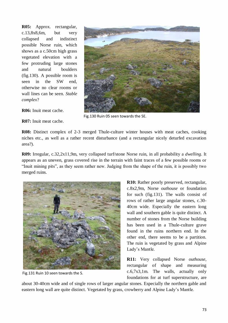
73
Fig.130 Ruin 05 seen towards the SE.
Fig.131 Ruin 10 seen towards the S.
R05: Approx. rectangular,
c.13,8x8,6m, but very
collapsed and indistinct
possible Norse ruin, which
shows as a c.50cm high grass
vegetated elevation with a
few protruding large stones
and natural boulders
(fig.130). A possible room is
seen in the SW end,
otherwise no clear rooms or
wall lines can be seen. Stable
complex?
R06: Inuit meat cache.
R07: Inuit meat cache.
R08: Distinct complex of 2-3 merged Thule-culture winter houses with meat caches, cooking
niches etc., as well as a rather recent disturbance (and a rectangular nicely deturfed excavation
area?).
R09: Irregular, c.32,2x11,9m, very collapsed turf/stone Norse ruin, in all probability a dwelling. It
appears as an uneven, grass covered rise in the terrain with faint traces of a few possible rooms or
“Inuit mining pits”, as they seem rather new. Judging from the shape of the ruin, it is possibly two
merged ruins.
R10: Rather poorly preserved, rectangular,
c.8x2,9m, Norse outhouse or foundation
for such (fig.131). The walls consist of
rows of rather large angular stones, c.30-
40cm wide. Especially the eastern long
wall and southern gable is quite distinct. A
number of stones from the Norse building
has been used in a Thule-culture grave
found in the ruins northern end. In the
other end, there seems to be a partition.
The ruin is vegetated by grass and Alpine
Lady’s Mantle.
R11: Very collapsed Norse outhouse,
rectangular of shape and measuring
c.6,7x3,1m. The walls, actually only
foundations for at turf superstructure, are
about 30-40cm wide and of single rows of larger angular stones. Especially the northern gable and
eastern long wall are quite distinct. Vegetated by grass, crowberry and Alpine Lady’s Mantle.

74
Fig. 132 Ruin 15 seen towards the NW.
Fig. 133 Ruin 16 seen towards the SSE.
R12: Rounded Thule-culture winter house with inside cooking niche and outside meat cache.
R13: Thule-culture winter house with secondary reuse. An outside cooking niche or meat cache is
visible.
R14: Approx. square stone chamber, c.2,4x2,1m, made of larger rounded stones. Disturbed Inuit
grave or Norse ruin of unknown function?
R15: New possible foundation for a
Norse outhouse measuring c.7x3,1m
and made of larger angular stones
(fig.132). A part of the northern long
wall seem to be missing. The ruins is
vegetated by grass and crowberry.
R16: Newly discovered possible
enclosure made by erecting walls
(exploiting natural boulders) across
both ends of a c.8,3m wide crevice,
thus creating an enclosed area of
c.57m2
(fig.133). The stone/turf walls
are, however, rather poorly preserved
and hard to distinguish from the
natural stone formations.
TG01: Thule-culture grave that at first
glimpse did look very much like a
very large foxtrap with chamber, but
upon closer inspection revealed poorly
preserved human bones, i.e. a grave.

75
E322a – Illunguaq
Fig.134 Situation plan of the ruins at E322a
(corrected for a slight misplacement in the
2009 survey).
Fig.135 GoogleEarth view of the southern end of the peninsula
with Zacharias Havn, E322 and E322a.
Fig.136 Ruin 03 seen towards the ENE.
GPS: N 60°28'50.64" / W 45°34'42.44". Earlier work: O. Bak. 1966.
On the southern side of Zacharias Havn, only some 800m from E322, one finds a cluster of 3 ruins,
ruin group E322a (it has here been given a independent E-number), either part of E322 or, perhaps,
an independent shieling (fig.134-135). Concerning this last interpretation it is worth noting that
because the southernmost part of this peninsula (i.e the area south of Zacharias Havn) is only
connected to the mainland by a c.130m wide land bridge, it most probably functioned as a naturally
delimited grazing area in its own right. Although the vegetation is still rather poor, there are actually
patches of grassland near the ruins.
R01: Small and very collapsed approx.
rectangular stone/turf outhouse or
foundation for such, measuring
c.4,2x2,8m. The walls, which are most distinct on their outside, are c.50cm wide and preserved to a
height of 15-20cm, while the inside of the ruin is filled with stone collapse. The ruin is vegetated by
crowberry and grass.
R02: Rectangular, c.4,3x3,1m, turf/stone built outhouse or foundation for such. The stones are
small and rounded. The ruin is vegetated by grass, crowberry and moss.
R03: Approx. circular enclosure made of smaller rounded
stones that now have completely collapsed. The walls today
appear to be c.1,5m wide and up to 40cm high, but the width
of the walls is rather exaggerated dues the state of collapse
of the ruin, which is, however, still very distinct. The outside
diameter is c.6,6m. Inside the enclosure grows crowberry.

76
E324 – Qornukasia Sarqarlleq 60V2-0IV-560
Fig. 137 Situation plan of the ruins of E324 on GoogleEarth satellite imagery.
GPS: N 60°33'33.80" / W 45°36'55.71". Earlier work: O. Bak 1968
E324 has the most unlikely location for a Norse farm; about half way into the Akulleq Fjord one
finds on the steep and infertile northern side a small, flat point, which is the only place in a long
stretch of the shore that offers any reasonable landing for boats. On this point lies a single Norse
ruin and about 70m further up the slope is a narrow terrace with the main cluster of 7 buildings
(fig.137).
These 8 ruins (1 new was found in 2009 during a c. 1½ hour stay), which are all much collapsed
and seem of rather insubstantial character, make up what can only be a small shieling. The very
unlikely location was already remarked upon by O. Bak and it does, indeed, raise the question
whether we have overlooked many such farms/shielings? The surrounding steep slopes do, in any
right, make for very poor grazing and the access to the site is hard, if even slightly dangerous.
Though there is actually water supply in the form of a spring halfway between the main cluster of
buildings and the fjord, it does seem a rather desolate place for a farm. E324 could have belonged to
either E95 or 95a, but must surely have this location to somehow exploit the northern side of the
Akulleq Fjord or, perhaps, for fishing and hunting?
Ruin numbering after O. Bak.
R01: Found on the small point below the farm is small very collapsed building which measures
c.5,5x3,5m, though the southeastern wall is partially eroded by the sea (datable could possibly be
retrieved from the natural section?)(fig.141). The walls (foundations?) are c.30cm wide and only
just visible at level with the vegetation. The building, perhaps a boathouse, has been disturbed by a
later Thule-culture presence (TH01) and a foxtrap has been built in the western end.

77
Fig.138 Ruin 03 seen towards the NNE.
Fig.139 Ruin 04 seen towards the SE.
R02: Could not be located.
R03: Somewhat irregular ruin, perhaps
an enclosure, in the edge of the
boulders fallen from the mountain
(fig.138). The walls are stone build and
to a large extent incorporate the natural
boulders and cliffs. Where best
preserved, the walls are c.50-60cm wide
and rise to a height of c.1m (5 courses).
Inside the structure grows grass and
crowberry.
R04: O. Bak interpreted R04 and R06
as separate buildings, but they are here
interpreted as the very collapsed remains of a turf/stone ruin, probably a small dwelling, measuring
c.13,30x11,6m (fig.139). The ruin shows as a slight, slanting and uneven rise in the terrain, where
protruding stones, 2 possible rooms and a few faint wall lines are visible. Towards the N the ruin is
bordered by natural boulders, but otherwise it is very hard to delimit.
R05: Small, turf/stone built
rectangular, c.4,8x3,5m, ruin
(some outhouse) which is slight
dug into the sloping terrace.
Otherwise it shows as a c.20-
30cm deep depression surrounded
by a c.1m wide turf wall with a
few protruding angular stones.
The ruin is overgrown with grass
and crowberry.
R06: See ruin 04.
R07: Possible very indistinct ruin
of almost square shape, c.4x4,3m,
which appears only as a lines of
slightly protruding stones (smaller rounded). A wall seem to be added to the eastern side of this
turf/stone built outhouse, which today is vegetated by grass and crowberry.
R08: Indistinct, roughly rectangular, c.5,4x5m, pile of stones, likely the remains of a dry stone
masonry building, between natural boulders. The ruin is vegetated by grass and crowberry.
R09: Fairly distinct turf/stone built, rwctangular, c.3,3x2,1m, outhouse, which shows a marked
depression c.40-50cm deep surrounded by larger rounded stones (the southern gable is a natural
boulder), which form the most visible part of the c.60cm wide walls, which only rise 10-20cm
above the surface. The ruin is vegetated by grass and crowberry.

78
Fig.140 Ruin 10 seen towards the NW.
Fig.141 Ruin 01 and TH01 seen towards the SE.
E325 – Qanisartut 60V2-0IV-558
Fig.142 Ruin 01 and the lower part of the slope seen from towards
the ENE.
R10: Very small ruin, c.2,3x1,6m, which consists of stone built walls and partly exploiting a natural
cliff face and partly dug into the slope (fig.140). The walls of this unidentified outhouse measure
c.40cm in width and is preserved up to a height of c.110cm (4 courses). The ruin is overgrown with
crowberry.
TH01: Partially destroyed trapezoid Thule-culture summer hut.
GPS: N 60°32'24.17"/ W 45°39'36.85". Earlier work: O. Bak. 1967.
On some 3,2km and in many respects a very similar farm to E324, the farm of E325 at Qanisartut is
located has a far more inviting location; it is found further out of and on the southern side of the
Akulleq Fjord, where lower part of the slopes of almost the entire stretch of Sulugssugut mountain
are relatively flat and fertile, transected by countless streams (fig.142).
On the flattest part of the slope
close to the shore lies the 6
registered ruins of E325, a
probably shieling under E95
(fig.143). Most of the ruins are
rather poorly preserved and barely
rise above the terrain, indicating
rather insubstantial buildings.
Although there are patches of
reasonable grassland, the nearness
and explosion to the open coast
must exclude the rearing much
livestock at the place and it might
instead have been chosen for
summer hunting/fishing.

79
Fig.143 Situation plan of the ruins of E325 on GoogleEarth satellite imagery.
Fig. 144 ruin 03 seen towards the S
Ruin numbering after O. Bak 1967
R01: Very collapsed turf/stone building, undoubtedly a dwelling, measuring some 20,9x15,8m and
showing as a very slight elevation in the terrain (not rising more than c.10cm) with slight
depressions and some protruding stones (especially in the northern end, where there is also a
concentration of stone slaps, in the southern a possible stalling stone)(fig.142). A few rooms can be
glimpsed. The ruin is overgrown with grass, heather and crowberry.
R02: Is almost identical to R01 in appearance, but smaller and approx. rectangular (c.13x7,3m),
although it is somewhat harder to delimit than R01, especially to the south where the terrain is
overgrown boulder field. Possible stable complex.
R03: Rectangular, c.4,9x2,8m,
stone foundation for a turf building,
some kind of outhouse (little turf is
preserved and neither any stone
collapse)(fig.144). The walls are
lines of single lying stones
interspaced with c.20-30cm, c.30cm
wide and rising up 40cm above the
terrain. The ruin is vegetated by
grass and crowberry.
R04: Rectangular, c.5x3,9m,
stone/turf structure (fig.3). The

80
Fig.146 Ruin 06 seen towards the ENE.
Fig. 145 Ruin 05 seen towards the S.
E326 – Kalliit Ilua 60V2-0IV-562
Fig.147 View, looking towards the ESE, of the valley with E326 (the ruins are located right of the
streams). Photo: P.B. Heide 2009.
walls in rounded stones are quite distinct, c.50cm wide and preserved in 2 courses to a height of
c.40cm. There is a possible entrance in the southern gable. The many stones and the rather exposed
location of the ruin to the wind could indicate its possible function as a skemma? Inside the ruin
grows crowberry.
R05: Enclosure with stone built walls just in the edge of and partially incorporating the boulder
field before the slope starts to steepen (fig.145). It measures c.7,7x3,2m, and the walls are c.60-
80cm wide in rounded stones and preserved up to a height of c.120cm (3 courses. Inside the
enclosure grows crowberry and a little grass.
R06: Small shelter exploiting the natural hollow under a large boulder just a few meters NE of R05
(fig.146). From under this two small, c.50cm wide, 40-100cm high, stone/turf walls extend, creating
a bounded and partially roofed area of c.4m2.
GPS: N 60°35'53.63"/ W 45°43'6.89". Earlier work: O. Bak 1967.
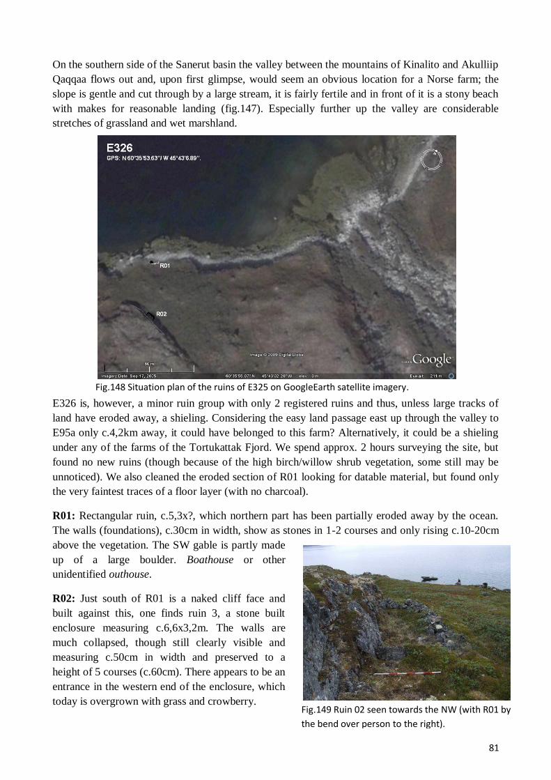
81
Fig.148 Situation plan of the ruins of E325 on GoogleEarth satellite imagery.
Fig.149 Ruin 02 seen towards the NW (with R01 by
the bend over person to the right).
On the southern side of the Sanerut basin the valley between the mountains of Kinalito and Akulliip
Qaqqaa flows out and, upon first glimpse, would seem an obvious location for a Norse farm; the
slope is gentle and cut through by a large stream, it is fairly fertile and in front of it is a stony beach
with makes for reasonable landing (fig.147). Especially further up the valley are considerable
stretches of grassland and wet marshland.
E326 is, however, a minor ruin group with only 2 registered ruins and thus, unless large tracks of
land have eroded away, a shieling. Considering the easy land passage east up through the valley to
E95a only c.4,2km away, it could have belonged to this farm? Alternatively, it could be a shieling
under any of the farms of the Tortukattak Fjord. We spend approx. 2 hours surveying the site, but
found no new ruins (though because of the high birch/willow shrub vegetation, some still may be
unnoticed). We also cleaned the eroded section of R01 looking for datable material, but found only
the very faintest traces of a floor layer (with no charcoal).
R01: Rectangular ruin, c.5,3x?, which northern part has been partially eroded away by the ocean.
The walls (foundations), c.30cm in width, show as stones in 1-2 courses and only rising c.10-20cm
above the vegetation. The SW gable is partly made
up of a large boulder. Boathouse or other
unidentified outhouse.
R02: Just south of R01 is a naked cliff face and
built against this, one finds ruin 3, a stone built
enclosure measuring c.6,6x3,2m. The walls are
much collapsed, though still clearly visible and
measuring c.50cm in width and preserved to a
height of 5 courses (c.60cm). There appears to be an
entrance in the western end of the enclosure, which
today is overgrown with grass and crowberry.

82
E327 – Kalliit Ilua 60V2-0IV-565
Fig.150 View, looking towards the SW, of the slope with E327 (which is
visible on the right. Photo: C.K. Madsen 2009.
Fig.151 View, looking towards the NE, of E327. Photo: C.K.
Madsen2009.
GPS: N 60°33'27.83"/ W 45°50'12.08". Earlier work: O. Bak 1969.
On the western side of the Qaersutsiaq isthmus is a very inlet surrounded by rather low cliffs and
knolls. The vegetation here is completely dominated by crowberry rarely rising above 20cm and
thus very unsuited for grazing animal husbandry, i.e. not a suitable location for a Norse farm. The
ruin group found just SW of the head of the inlet, E327, is in fact only a single ruin; a stone built
dike. Because this was wrongly placed on the map, we spent c.1½ hour looking for it, but
consequently surveying a considerable area around the very head of the inlet, albeit finding n0
Norse and only a few Inuit ruins.
The dike is found c.60m up
a rather steep slope on the
W side of the inlet. It lies
perpendicular to the
direction of the slope and at
the lowest point of it that
provides the easiest passage
(fig.150-151). It would thus
seem to lie in a suitable
place to form an effective
barrier. However, the slope
is no more steep and the
cliffs no more obstructing,
than one can fairly easily
pass both below and above
the dike, excluding its
function as an effective
barrier, e.g. for stopping sheep/goats wandering into another area. The function of this dike must
hence be more symbolic, perhaps demarcating the boundary between two areas of different function
or ownership? In any case, it must somehow be associated with the farm of E190, to which there is
easy passage to the NE through a wide, low valley.
Numbering after O. Bak 1969.
R01: C.8m long stone built dike partially
exploiting natural boulders. The dike is
some 50-60cm wide, preserved to a height
of 5 courses and has, judging from the
amount of stone collapse, probably stood
to a maximum height of 1,5m. To the NW
it is bounded by a steep cliff face, to the
SE by natural boulders. Below the latter is
another short stretch of dike c.1m long.

83
E328 – Sarfaa Avangnarlleq 60V2-0IV-566
Fig.152 Situation plan of the ruins surveyed at E328 on GoogleEarth satellite imagery.
Fig. 153 Ruin 01 seen towards the N (the entrance is in the
central front).
GPS: N 60°36'40.92"/ W 45°47'56.37". Earlier work: O. Bak 1967.
In the northern part of the Sanerut basin there is a row islands almost completely closing of the
northern part of this part of the fjord. The largest, c.2300x620m, and westernmost of these islands is
only separated from the mainland peninsula by a c.50m wide straight, which consequently has a
constant, strong current either in or out. The western side of the straight is formed by a low, rocky
isthmus jutting out from the northern ridge of the Naujarssuit mountain. Just behind the coastal
cliffs is a small circular valley with a central lake and reasonable vegetation.
E328 is a shieling site with only 3 ruins (2
new uncertain ones discovered in 2009)
and some Inuit structures (both Thule-
culture and modern). Although there is
fair grass vegetation around the lake in the
small valley, it is very limited in area and
cannot have fed much livestock. The
location of E328 must thus instead have to
do with fishing/hunting around the straight
(i.e. is no wider than a net can be placed
across it) between the island and the
mainland, something that is substantiated
by the presence also of Inuit structures.

84
Fig. 154 Ruin 02 seen towards the E.
Fig. 155 Ruin 03 seen towards the N.
Ruin numbering after O. Bak 1967
R01: Very well-preserved and distinct foundation for a rectangular, c.7x4m, Norse turf building of
unknown function (fig.153). The foundation is c.60-70cm wide and consist double rows of rounded
and angular stones, slight interspaced and rising some 20-30cm above ground level. There are no
traces of other collapse, neither stone, nor turf. There is a clear entrance in the southern gable. The
ruin is vegetated by heather and willow.
R02: Very uncertain Norse ruin,
c.5,3x2,7m, showing as slight
depression surrounded by stones
on three sides, while the northern
side cannot be delimited
(fig.154). Within this stone frame
there is vegetation of grass, while
the surrounding area is
overgrown with crowberry and
willow. Especially the eastern
gable seems distinct and rises
some 10-20cm above ground
level.
R03: Very uncertain and small,
c.3x2,3m, ruin, which appear
mainly as a pile of rounded
stones and lying just 10m W of R02
(fig.155). The ruin seem to have been of
almost square shape and towards the south
especially one glimpses the traces of a stone
foundation. Alternatively, the feature could
be an Inuit hunters-bed.
TH01: Almost square stone built feature,
probably Thule-culture, measuring
c.3,7x2,7m. The walls are c.40cm wide and
preserved in 3 irregular courses. There is an
opening towards the south. Hunters-bed?
Judging from the appearance of the wall of
some age.
TH02: Stone/turf built Thule-culture hut wall
(tent ring) w. traces of a bench.

85
Fig.156 Google satellite image with the surveyed ruins of E329. Note the “strip” of grassy land just S of
the boulder field . In the left hand corner is the houses on the outskirts of Eqalugaarsuit.
E329 – Eqalugaarsuit 60V2-0IV-570
GPS: N 60°37'29,8056" / W 045°54'32,6664". Earlier work: O. Bak 1968, 1971.
On the southern side of the island of Kangeq, just on the northern outskirts of the modern Inuit
settlement Eqalugaarsuit, one finds a cluster of 12 close lying ruins, the ruin group E329. In spite of
the number of ruins, E326 must still be considered a farm, if not a shieling, of the smallest kind,
something that is attested not only by the small dwelling (R1), but also by the many makeshift ruins
(see below). 4 of the ruins (1, 2, 5 & 6) are found on a narrow grassy terrain sloping gently down
towards the river, while the rest of the ruins are located in a boulder field just north of here. It worth
noting that the boulder field consists of a few rather large boulders and very many smaller, rounded
stones (fig.156) and that all of the ruins in the boulder field have been made by simply stacking up
the smaller rounded stones, taking only those from inside the structure and thereby creating a
“lowered” floor surrounded by wall/large boulders. The rounded shape of the stones used does,
however, make for very unstable walls, which easily slide down. Thus the widths of the dry stone
walls, as shown on plan, are rather exaggerated and hard to establish with certainty. Just north of the
boulder field the mountain rises rather steeply to a height of c.300-350m. Some 500m to the NW of
the buildings is a small crescent shaped valley with reasonable vegetation (this must have been the
main grazing land of the farm, as there today is only sparse vegetation). The modern settlement of
Eqalugaarsuit lies along a narrow peninsula jutting out from the island and thereby creating a
perfect, sheltered harbor. Some ruins must have been removed by the modern settlement, though
none were there in 1968.
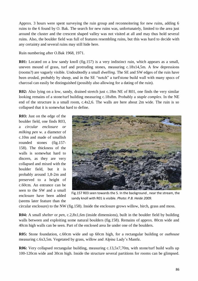
86
Fig.157 R03 seen towards the S. In the background , near the stream, the
sandy knoll with R01 is visible. Photo: P.B. Heide 2009.
Approx. 3 hours were spent surveying the ruin group and reconnoitering for new ruins, adding 6
ruins to the 6 found by O. Bak. The search for new ruins was, unfortunately, limited to the area just
around the cluster and the crescent shaped valley was not visited at all and may thus hold several
ruins. Also, the boulder field was full of features resembling ruins, but this was hard to decide with
any certainty and several ruins may still hide here.
Ruin numbering after O.Bak 1968, 1971.
R01: Located on a low sandy knoll (fig.157) is a very indistinct ruin, which appears as a small,
uneven mound of grass, turf and protruding stones, measuring c.18x14,5m. A few depressions
(rooms?) are vaguely visible. Undoubtedly a small dwelling. The SE and SW edges of the ruin have
been eroded, probably by sheep, and in the SE “notch” a turf/stone build wall with many specs of
charcoal can easily be distinguished (possibly also allowing for a dating of the ruin).
R02: Also lying on a low, sandy, drained stretch just c.18m NE of R01, one finds the very similar
looking remains of a stone/turf building measuring c.18x8m. Probably a staple complex. In the NE
end of the structure is a small room, c.4x2,6. The walls are here about 2m wide. The ruin is so
collapsed that it is somewhat hard to define.
R03: Just on the edge of the
boulder field, one finds R03,
a circular enclosure or
milking pen w. a diameter of
c.10m and made of smallish
rounded stones (fig.157-
158). The thickness of the
walls is somewhat hard to
discern, as they are very
collapsed and mixed with the
boulder field, but it is
probably around 1,8-2m and
preserved to a height of
c.60cm. An entrance can be
seen to the SW and a small
enclosure have been added
(seems later feature than the
circular enclosure) to the NW (fig.158). Inside the enclosure grows willow, birch, grass and moss.
R04: A small shelter or pen, c.2,8x1,6m (inside dimensions), built in the boulder field by building
walls between and exploiting some natural boulders (fig.158). Remains of approx. 80cm wide and
40cm high walls can be seen. Part of the enclosed area lie under one of the boulders.
R05: Stone foundation, c.60cm wide and up 60cm high, for a rectangular building or outhouse
measuring c.6x3,5m. Vegetated by grass, willow and Alpine Lady’s Mantle.
R06: Very collapsed rectangular building, measuring c.13,5x7,70m, with stone/turf build walls up
100-120cm wide and 30cm high. Inside the structure several partitions for rooms can be glimpsed.
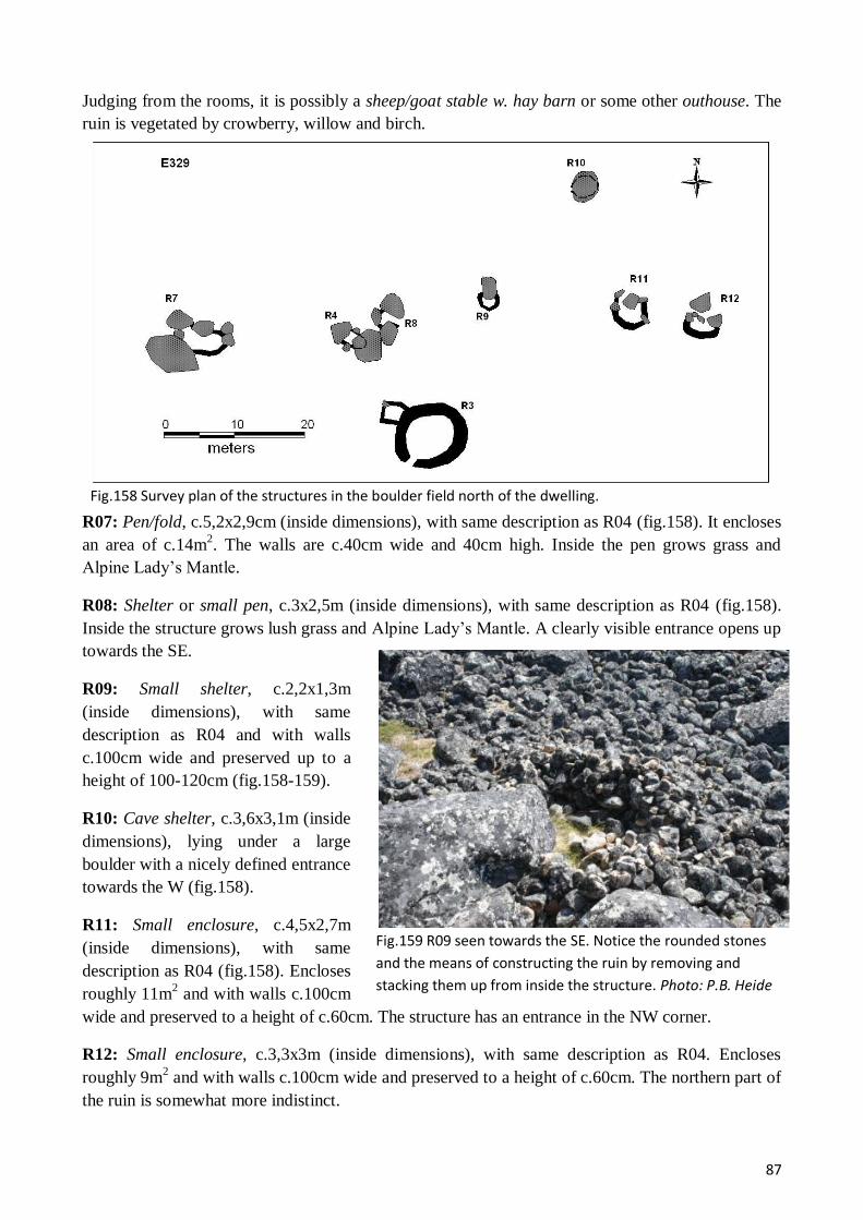
87
Fig.158 Survey plan of the structures in the boulder field north of the dwelling.
Fig.159 R09 seen towards the SE. Notice the rounded stones
and the means of constructing the ruin by removing and
stacking them up from inside the structure. Photo: P.B. Heide
2009.
Judging from the rooms, it is possibly a sheep/goat stable w. hay barn or some other outhouse. The
ruin is vegetated by crowberry, willow and birch.
R07: Pen/fold, c.5,2x2,9cm (inside dimensions), with same description as R04 (fig.158). It encloses
an area of c.14m2. The walls are c.40cm wide and 40cm high. Inside the pen grows grass and
Alpine Lady’s Mantle.
R08: Shelter or small pen, c.3x2,5m (inside dimensions), with same description as R04 (fig.158).
Inside the structure grows lush grass and Alpine Lady’s Mantle. A clearly visible entrance opens up
towards the SE.
R09: Small shelter, c.2,2x1,3m
(inside dimensions), with same
description as R04 and with walls
c.100cm wide and preserved up to a
height of 100-120cm (fig.158-159).
R10: Cave shelter, c.3,6x3,1m (inside
dimensions), lying under a large
boulder with a nicely defined entrance
towards the W (fig.158).
R11: Small enclosure, c.4,5x2,7m
(inside dimensions), with same
description as R04 (fig.158). Encloses
roughly 11m2 and with walls c.100cm
wide and preserved to a height of c.60cm. The structure has an entrance in the NW corner.
R12: Small enclosure, c.3,3x3m (inside dimensions), with same description as R04. Encloses
roughly 9m2 and with walls c.100cm wide and preserved to a height of c.60cm. The northern part of
the ruin is somewhat more indistinct.

88
E330 – Suilaussat 60V2-0IV-567
Fig.160 View towards the SW out the inlet with E330 (with is located on the slope to the right).
GPS: N 60°38'9.95"/ W 45°44'2.77". Earlier work: O. Bak 1968, 1971.
In the northeastern corner of the Sanerut basin, the mouth of an only c.70m wide inlet leads about
1,7km further in to the ENE and here, in a completely sheltered semicircular valley down to the
inlet, one finds the Norse farm E330. The lower slopes of the valley are rather gentle, with some
grass or wetland patches, but otherwise dominated by birch and willow shrub. Everywhere the coast
is shallow and provide easy landing with boats. From the farm there is less than 1km to the
Kangerluarsorujuk Fjord over the peninsula to the north (rising to height of c.200m).
With its 8 ruins (3 of which were discovered in 2009) and tiny dwelling, E330 is a very small farm,
if not a shieling (under E178?). We spent c.2½ hours surveying the ruins, but still some ruins
probably hide in the high willow/birch shrub.
Ruin numbering after O. Bak 1968, 1969
R01: Very collapsed and indistinct turf/stone ruin, undoubtedly the dwelling, measuring some
9,9x8,4m. The ruin appears as a slight elevation in the terrain with a few protruding angular stones
and the trace of 2 rooms and a wall line. Towards the S is a small midden area with collapse stones.
The ruin is vegetated by grass, crowberry and Alpine Lady’s Mantle.
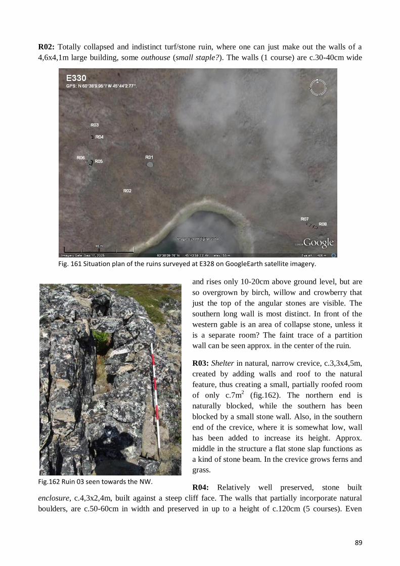
89
Fig. 161 Situation plan of the ruins surveyed at E328 on GoogleEarth satellite imagery.
Fig.162 Ruin 03 seen towards the NW.
R02: Totally collapsed and indistinct turf/stone ruin, where one can just make out the walls of a
4,6x4,1m large building, some outhouse (small staple?). The walls (1 course) are c.30-40cm wide
and rises only 10-20cm above ground level, but are
so overgrown by birch, willow and crowberry that
just the top of the angular stones are visible. The
southern long wall is most distinct. In front of the
western gable is an area of collapse stone, unless it
is a separate room? The faint trace of a partition
wall can be seen approx. in the center of the ruin.
R03: Shelter in natural, narrow crevice, c.3,3x4,5m,
created by adding walls and roof to the natural
feature, thus creating a small, partially roofed room
of only c.7m2 (fig.162). The northern end is
naturally blocked, while the southern has been
blocked by a small stone wall. Also, in the southern
end of the crevice, where it is somewhat low, wall
has been added to increase its height. Approx.
middle in the structure a flat stone slap functions as
a kind of stone beam. In the crevice grows ferns and
grass.
R04: Relatively well preserved, stone built
enclosure, c.4,3x2,4m, built against a steep cliff face. The walls that partially incorporate natural
boulders, are c.50-60cm in width and preserved in up to a height of c.120cm (5 courses). Even
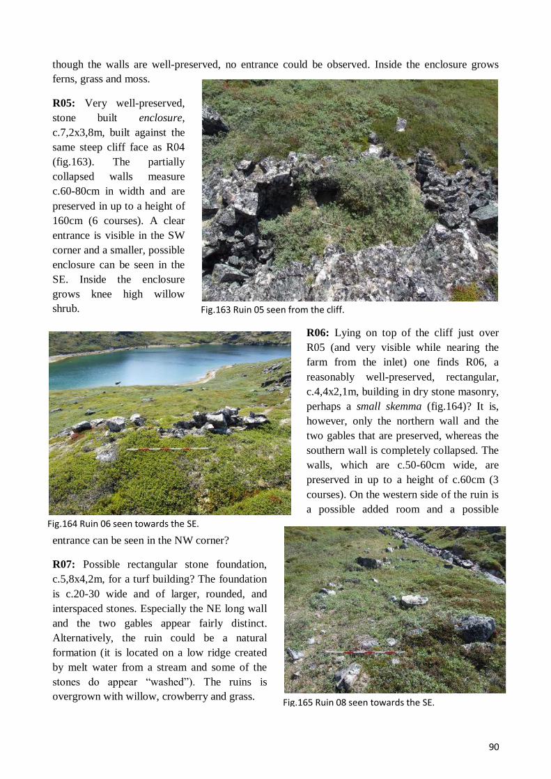
90
Fig.163 Ruin 05 seen from the cliff.
Fig.164 Ruin 06 seen towards the SE.
Fig.165 Ruin 08 seen towards the SE.
though the walls are well-preserved, no entrance could be observed. Inside the enclosure grows
ferns, grass and moss.
R05: Very well-preserved,
stone built enclosure,
c.7,2x3,8m, built against the
same steep cliff face as R04
(fig.163). The partially
collapsed walls measure
c.60-80cm in width and are
preserved in up to a height of
160cm (6 courses). A clear
entrance is visible in the SW
corner and a smaller, possible
enclosure can be seen in the
SE. Inside the enclosure
grows knee high willow
shrub.
R06: Lying on top of the cliff just over
R05 (and very visible while nearing the
farm from the inlet) one finds R06, a
reasonably well-preserved, rectangular,
c.4,4x2,1m, building in dry stone masonry,
perhaps a small skemma (fig.164)? It is,
however, only the northern wall and the
two gables that are preserved, whereas the
southern wall is completely collapsed. The
walls, which are c.50-60cm wide, are
preserved in up to a height of c.60cm (3
courses). On the western side of the ruin is
a possible added room and a possible
entrance can be seen in the NW corner?
R07: Possible rectangular stone foundation,
c.5,8x4,2m, for a turf building? The foundation
is c.20-30 wide and of larger, rounded, and
interspaced stones. Especially the NE long wall
and the two gables appear fairly distinct.
Alternatively, the ruin could be a natural
formation (it is located on a low ridge created
by melt water from a stream and some of the
stones do appear “washed”). The ruins is
overgrown with willow, crowberry and grass.

91
0109 – Taseq Ammalortoq New ruin group
Fig.166 Situation plan of the new ruin group 0109 on GoogleEarth satellite imagery.
R08: Just 3,5m east of R07 lies R08, which is of almost identical description, only slightly larger,
c.6,4x3,6m (fig.165). Because R07&08 are so similar in appearance and close lying, they might
actually have been one building, perhaps even a long houses with rounded long walls and
measuring c.15,9x4,3m? The space between the two ruins is full of smaller stones and look very
disturbed.
GPS: N 60°51'33.45"/ W 45°12'44.80"
The sheep farmer of E167 kindly informed us of possible Norse ruins on the northern shores of the
lake Taseq Ammalortoq NE Vatnahverfi and we then decided to visit the site; a small isthmus
completely covered with waist high birch/willow vegetation juts out from the northern shore and at
the base of this we confirmed two very close lying Norse ruins (c.215m A.S.L). These must be a
shieling of a type that might be much underrepresented in the material, because of their very modest
size and visibility. This part of NE Vatnahverfi lies at an altitude of only c.150-250m A.S.L. and is
actually the mouth of a wide NE-SW running valley. It is characterized by a vegetation of birch and
willow shrub, but also large and fairly fertile grassland pastures and wetlands areas along the
streams and rivers. It is, thus, an area very suited for shieling activities.
Because we had misunderstood the information from the sheep farmer, we actually spent over 1½
hour surveying the small isthmus and it can be excluded with high certainty that there should be any
more ruins on or close by it.

92
Fig.167 The isthmus with ruin group 0109 seen towards the SE. Photo: C.K.
Madsen 2009.
0209 – Tasersuaq New ruin group
Fig.168 View of the peninsula with 0209 seen towards the ENE. Photo: C.K.
Madsen 2009.
R01: Somewhat collapsed, but very distinct rectangular, c.19,5x5,1m, outhouse. The walls seem
purely turf, c.2m wide at the base and c.80cm at the top, preserved to a height of c.60cm. To rooms,
each with entrance from
the W, are clearly visible.
The ruin is vegetated by
grass and waist high birch
willow shrub.
R02: Only c.1m W of R01
is a building of almost
identical appearance, R02,
only slightly longer
(measuring c.13,5m in
length) and with three
separate rooms, two of
which have entrance from
the east and the third from
the west.
GPS: N 60°48'12.12"/ W 45°30'32.19".
In the southwestern corner of the large Tasersuaq Lake, only some c.1,5km from E172, it forms a
small inlet and at the head of this is a narrow peninsula (fig.168). This peninsula seems to have been
used as a water bounded
enclosure by con-
structing a turf (/stone?)
wall across the base of
it, thus creating an
enclosed area of
c.1677m2. Because the
peninsula has a fairly
fertile vegetation of
grass, moss, willow and
birch, it could have been
used for enclosing
animals over a
prolonged period, e.g.
during days of large
roundups.

93
Fig.169 Situation plan of the dike R01 and the peninsula
Fig.170 The central part of the dike R01 seen towards the S. Photo: C.K.
Madsen 2009.
R01: Turf build dike across
peninsula that can be
followed for c.25m (fig.169).
The dike is somewhat
collapsed, but still very
distinct, c.2,5-3m wide at the
base, c.60-100cm at the top,
and preserved in up to a
height of c.110-120cm. The
wall is best preserved in its
middle part (fig.170) and
somewhat more “flattened”
towards both ends. The
northern side (out towards
the peninsula) of the dike is
slightly steeper, while the
southern side is again more flattened. The NW end of the dike ends exactly where one can see and
old beach line, indicating that a considerable transformation of lake to marshland has occurred since
Norse times. The is a possibility that the dike could be a natural formation, i.e. a bank produced by
the movement of ice on the lake, but the peninsula in front of the dike, and thus more exposed to
such processes, is very uneven and show no trace of such a process.

94
Results and Perspectives
During the survey part of the 2009 Vatnahverfi field season, 30 ruin groups were visited, two of
which were new sites, and 176 Norse ruins DGPS surveyed (plus 25 plus Inuit), 82 (almost half) of
which were previously unrecorded, transforming the coastal sites into considerable farms. With
these new recordings, almost the entire Vatnahverfi peninsula has been uniformly and thoroughly
surveyed, allowing for detailed and accurate spatial analysis of settlement patterns and economy
strategies employed by the Norse Greenlanders.
The distribution of sites in the coastal region seem somewhat clearer than in the inner fjords,
primarily because this area does not seem so densely populated (and may not have been populated
for as long as the farms of the inner fjords), but also because the vegetation, when compared with
the inner fjords, is rather poor and sets other limits for the traditional Norse livestock transhumance:
they needed to exploit larger areas for grazing. It seems, then, that in the coastal region each of the
smaller fjords were home to just one main farm, always located at the most fertile location in the
fjord (though not necessarily with the most outhouses). Associated with this main farm was a
smaller farm, characterized by a minor dwelling, but a considerable number of outhouses (some of
which, though, are of rather make-shift appearance), such pairs as e.g. E95-95a, E178-E330, E93-
E92, E181-E329. Whether this second smaller farm was a full-shieling, i.e. a place where the
inhabitants of the main farm took up residence all summer, or a tenant farm, is hard to say. Finally,
there are to each main farm a small number of strategically placed shielings with quite few and
insubstantial buildings. These shielings might very well also be associated with hunting/fishing
activities.
This description is, evidently, in need of much elaboration and the obvious next step, which would
allow for detailed analysis, is dating of the coastal ruin groups. In this regard they present a unique
opportunity; in at least 9 cases, ruins are being eroded away, most by the sea and from the natural
profiles produced by this erosion, it would be fairly uncomplicated to extract datable material from
a reasonably secure archaeological context (floor layer, layer under wall etc.) without disturbing the
ruins in any severe manner. Such dating could produce several interesting results; 1) if the all the
dates fall within a narrow time span (in spite of different types of structures being dated), it would
give us information about how long and when the coastal region was settled/abandoned, 2) if
specific types of farms can be identified in the coastal area (as suggested above) and these might be
identified in the inner fjord areas also, dating from the coastal farms should hint also at a date of the
former, 3) provide a chance to date different types economy buildings, which are an otherwise
overlooked and confused type of structures. Other types of samples, e.g. for “dirt DNA”, could be
retrieved from the sections and, at the same time, the ruin properly documented before it is lost.
Having a complete and modernly re-surveyed area opens new opportunities for understanding the
Norse exploitation of different local environments; hunting/fishing became a mainstay of the Norse
diet and the easiest access to these sources are on the coast, while other products had to travel out
the fjord to the coastal farms with less productive grazing areas. Finishing the survey of the last ruin
groups of the Vatnahverfi peninsula, i.e. the island of Akia and few more, would with relatively
little cost and time complete this picture and gives us the clearest image of the settlement layout of
an entire, Norse fjord system.
95
Bibliography – Sources used
Sources used during field work or report:
Arneborg, J., Hebsgård, M., Lynnerup, N., Madsen, C.K., Paulsen, C.P. & Smiarowski, K, 2009:
- Resources, Mobility, and Cultural Identity in Norse Greenland, Vatnahverfi Project – Report from
the Field Work 2008. Danmarks Middelalder & Renæssance, Nationlmuseet, Feltrapport 26, 2007,
København.
Link: http://www.nabohome.org/publications/fieldreports/Vatnahverfi2008Rapport.pdf
Berglund, Joel, 1980:
- Antikvariske arbejder i Narssaq, Julianehåb og Nanortalik Kommuner, Grønland, 1980.
Nationalmuseet.
Bruun, D., 1895:
- Arkæologiske Undersøgelser I Julianehaabs Distrik. Meddelser om Grønland 16(3), København.
Holm, G., 1883:
- Beskrivelse af Ruiner i Julianehaabs Distrikt, der ere undersøgte i Aaret 1880. Meddelelser om
Grønland 6 (3).
Møller, N.A. (ed.), Johansen, L.L., Madsen, C.K., Felding, L., Heide, P.B., Smiarowski, K., 2007:
- Vatnahverfi 2007. Udgravning i norrøne kirkegårde og møddinger. Rapport om opmålinger og
udgravninger i Vatnahverfi, sommeren 2007. Danmarks Middelalder & Renæssance, Nationlmuseet,
Feltrapport 26, 2007, København.
Link:
http://www.natmus.dk/graphics/natmus2004/sila/Rapporter/26.Feltrapport%20%28Vatnahverfi%20
Rapport%202007%29%20komp.pdf
Møller, N.A. & Madsen, C.K.:
- 2005: Nordboerne i Vatnahverfi. Rapport om rekognoscering og opmåling af nordboruiner i
Vatnahverfi, sommeren 2005. SILA – Nationalmuseets Center for Grønlandsforskning, Feltrapport
24, 2006, København.
Link: http://www.natmus.dk/graphics/natmus2004/sila/Rapporter/24.Feltrapport.pdf
- 2006: Gård og sæter, hus og fold – Vatnahverfi 2006. Rapport om besigtigelser og opmålinger i
Vatnahverfi, sommeren 2006. SILA – Nationalmuseets Center for Grønlandsforskning, Feltrapport
25, 2007, København.
Link:
http://www.natmus.dk/graphics/natmus2004/sila/Rapporter/25.Feltrapport%20%28Vatnahverfi%202
006%29.pdf
Smiarowski, K., 2007:
- Greenland 2007 Field Season – Preliminary Report.
Link: http://www.nabohome.org/publications/fieldreports/Greenland2007FieldReportKS05-23-
09.pdf
Copyright © 2022 FDOKUMEN