NM 599 INTERCHANGE CORRIDOR STUDY - Santa Fe MPO
141
NM 599 INTERCHANGE CORRIDOR STUDY PROJECT NO. WIP-599-1(102) CONTROL NO. D5SF2 SEPTEMBER 2009 Prepared for: New Mexico Department of Transportation Northern Design Bureau P.O. Box 1149 Santa Fe, NM 87504-1149 Prepared by:
-
Upload
khangminh22 -
Category
Documents
-
view
0 -
download
0
Transcript of NM 599 INTERCHANGE CORRIDOR STUDY - Santa Fe MPO

NM 599 INTERCHANGE CORRIDOR STUDY PROJECT NO. WIP-599-1(102) CONTROL NO. D5SF2 SEPTEMBER 2009
Prepared for:
New Mexico Department of Transportation Northern Design Bureau P.O. Box 1149 Santa Fe, NM 87504-1149
Prepared by:


NM 599 Interchange Corridor Study Table of Contents
P:\070064\Trans\Study\Report\NM599 Phase A_091709.Doc i
TABLE OF CONTENTS I. EXECUTIVE SUMMARY ........................................................................................................................ 1 II. Introduction ........................................................................................................................................... 4 III. Project Background .............................................................................................................................. 7 IV. Purpose and Need ................................................................................................................................ 8
A. Project Need .................................................................................................................................. 8 1. Physical Deficiencies ............................................................................................................ 8 2. Travel Demand and Congestion ........................................................................................... 9 3. Safety.................................................................................................................................... 9 4. System Connectivity ............................................................................................................. 9 5. Access .................................................................................................................................. 9 6. Economic Development ...................................................................................................... 10 7. Legislation ........................................................................................................................... 10
B. Statement of Purpose and Need ................................................................................................. 10 V. Public Involvement and Agency Coordination ................................................................................. 12
A. Public Involvement ...................................................................................................................... 12 1. Summary of Comments Made at 1st Open House .............................................................. 12 2. Summary of Comments Made at 2nd Open House ............................................................. 13 3. Summary of Comments from Stakeholders Workshop ....................................................... 13 4. Web Site ............................................................................................................................. 18
B. Agency Coordination ................................................................................................................... 18 1. Santa Fe Technical Coordinating Committee ..................................................................... 18 2. Santa Fe Transportation Board .......................................................................................... 18
VI. Existing Transportation System ........................................................................................................ 18 A. Roadway System ........................................................................................................................ 18 B. Public Transportation System ..................................................................................................... 20 C. School Bus Routes ...................................................................................................................... 20 D. Trails Network ............................................................................................................................. 20
VII. Physical Condition of the Existing Facility ....................................................................................... 24 A. Typical Section ............................................................................................................................ 24 B. Geometry..................................................................................................................................... 26
1. Horizontal curvature ............................................................................................................ 26 2. Vertical curvature ................................................................................................................ 27 3. Intersections ....................................................................................................................... 28 4. Sight Distance ..................................................................................................................... 33 5. Access ................................................................................................................................ 33 6. Pavement ............................................................................................................................ 34 7. Drainage ............................................................................................................................. 34 8. Utilities ................................................................................................................................ 34 9. Bridges and Major Structures ............................................................................................. 35
VIII. Land Use Growth and Trends ............................................................................................................ 39 A. Jurisdiction .................................................................................................................................. 39 B. Neighborhoods ............................................................................................................................ 39 C. Land Use ..................................................................................................................................... 40 D. Approved and Proposed Plans .................................................................................................... 40
1. Santa Fe Metro Area Highway Corridor Plan ...................................................................... 40 2. Community College District ................................................................................................ 41 3. Tierra Contenta ................................................................................................................... 41 4. Northwest Quadrant Housing Development ....................................................................... 41 5. Tres Arroyos del Poniente Community ............................................................................... 41 6. Airport Redevelopment District ........................................................................................... 42

NM 599 Interchange Corridor Study Table of Contents
P:\070064\Trans\Study\Report\NM599 Phase A_091709.Doc ii
7. Komis Business Park .......................................................................................................... 42 8. Other Development Plans ................................................................................................... 42
E. Existing and Future Traffic Conditions ......................................................................................... 44 1. Existing Traffic Volume and Composition ........................................................................... 44 2. Existing Conditions Operational Analysis ........................................................................... 44 3. Traffic Signal Warrant Analysis ........................................................................................... 46 4. Weaving Analysis ............................................................................................................... 46
F. Safety Analysis ............................................................................................................................ 47 IX. Other studies and Transportation Plans ........................................................................................... 55
A. Metropolitan Transportation Plan (MTP) 2005 – 2030 ................................................................ 55 B. Transportation Improvement Program (TIP) FY 2006 – FY 2011 ................................................ 55 C. Santa Fe Extraterritorial Zoning Authority Ordinance No. 1999-4 ............................................... 56 D. I-25 / NM 599 New Mexico Rail Runner Station .......................................................................... 56 E. Other Road Plans ........................................................................................................................ 58 F. Trail Plans ................................................................................................................................... 58
X. Establish Existing Conditions and Constraints ............................................................................... 61 A. Physical Constraints .................................................................................................................... 61
1. Geology and Topography ................................................................................................... 61 2. General Geotechnical Considerations ................................................................................ 62 3. Foundation Systems ........................................................................................................... 62 4. Soils .................................................................................................................................... 63 5. Prime Farmland .................................................................................................................. 66 6. Water .................................................................................................................................. 66 7. Wetlands ............................................................................................................................. 68 8. Vegetation ........................................................................................................................... 68 9. Wildlife ................................................................................................................................ 69 10. Threatened and Endangered Species ................................................................................ 69 11. Sites of Contaminations and Hazardous Materials ............................................................. 70 12. Climate and Air Quality ....................................................................................................... 70 13. Noise................................................................................................................................... 70 14. Visual Resources ................................................................................................................ 71 15. Cultural Resources ............................................................................................................. 72 16. Section 4(f) Properties and Other Protected Lands ............................................................ 73 17. Social and Economic Conditions ........................................................................................ 73
XI. Preliminary Evaluation of Alternatives ............................................................................................. 76 A. No Build ....................................................................................................................................... 76 B. NM 14 .......................................................................................................................................... 76 C. I-25 Interchange .......................................................................................................................... 78 D. I-25 N. Frontage Road ................................................................................................................. 78
1. Responsiveness to Purpose and Need ............................................................................... 78 2. Engineering Factors ............................................................................................................ 78 3. Environmental Factors ........................................................................................................ 79 4. Public Acceptance – Responsiveness to Community Goals / Expectations ....................... 79 5. Right-of-Way ....................................................................................................................... 79 6. Estimated Construction Costs............................................................................................. 79
E. Jaguar Road ................................................................................................................................ 81 1. Responsiveness to Purpose and Need ............................................................................... 81 2. Engineering Factors ............................................................................................................ 81 3. Environmental Factors ........................................................................................................ 81 4. Public Acceptance - Responsiveness to Community Goals/Expectations .......................... 81 5. Right-of-Way ....................................................................................................................... 82 6. Estimated Construction Costs............................................................................................. 82
NM 599 Interchange Corridor Study Table of Contents
P:\070064\Trans\Study\Report\NM599 Phase A_091709.Doc iii
F. NM 599 W. Frontage Road from I-25 to Jaguar .......................................................................... 84 1. Responsiveness to Purpose and Need ............................................................................... 84 2. Engineering Factors ............................................................................................................ 84 3. Environmental Factors ........................................................................................................ 84 4. Public Acceptance - Responsiveness to Community Goals/Expectations .......................... 84 5. Right-of-Way ....................................................................................................................... 84 6. Estimated Construction Costs............................................................................................. 84
G. NM 599 E. Frontage Road from I-25 to Jaguar ........................................................................... 86 1. Responsiveness to Purpose and Need ............................................................................... 86 2. Engineering Factors ............................................................................................................ 86 3. Environmental Factors ........................................................................................................ 86 4. Public Acceptance - Responsiveness to Community Goals/Expectations .......................... 86 5. Right-of-Way ....................................................................................................................... 86 6. Estimated Construction Costs............................................................................................. 86
H. NM 599 W. Frontage Road from Jaguar to Airport Road ............................................................ 87 1. Responsiveness to Purpose and Need ............................................................................... 87 2. Engineering Factors ............................................................................................................ 87 3. Environmental Factors ........................................................................................................ 87 4. Public Acceptance - Responsiveness to Community Goals/Expectations .......................... 87 5. Right-of-Way ....................................................................................................................... 87 6. Estimated Construction Costs............................................................................................. 87
I. NM 599 E. Frontage Road from Jaguar to Airport Road ............................................................. 89 1. Responsiveness to Purpose and Need ............................................................................... 89 2. Engineering Factors ............................................................................................................ 89 3. Environmental Factors ........................................................................................................ 89 4. Public Acceptance - Responsiveness to Community Goals/Expectations .......................... 89 5. Right-of-Way ....................................................................................................................... 89 6. Estimated Construction Costs............................................................................................. 89
J. Airport Road ................................................................................................................................ 90 1. Responsiveness to Purpose and Need ............................................................................... 90 2. Engineering Factors ............................................................................................................ 90 3. Environmental Factors ........................................................................................................ 90 4. Public Acceptance - Responsiveness to Community Goals/Expectations .......................... 90 5. Right-of-Way ....................................................................................................................... 90 6. Estimated Construction Costs............................................................................................. 90
K. Extend NM 599 Frontage Road Across Santa Fe River .............................................................. 93 1. Responsiveness to Purpose and Need ............................................................................... 93 2. Engineering Factors ............................................................................................................ 93 3. Environmental Factors ........................................................................................................ 93 4. Public Acceptance - Responsiveness to Community Goals/Expectations .......................... 93 5. Right-of-Way ....................................................................................................................... 93 6. Estimated Construction Costs............................................................................................. 93
L. Caja del Rio ................................................................................................................................. 96 1. Responsiveness to Purpose and Need ............................................................................... 96 2. Engineering Factors ............................................................................................................ 96 3. Environmental Factors ........................................................................................................ 96 4. Public Acceptance - Responsiveness to Community Goals/Expectations .......................... 96 5. Right-of-Way ....................................................................................................................... 97 6. Estimated Construction Costs............................................................................................. 97
M. NM 599 S. Frontage Road from CR 62 to Caja del Rio ............................................................... 99 1. Responsiveness to Purpose and Need ............................................................................... 99 2. Engineering Factors ............................................................................................................ 99

NM 599 Interchange Corridor Study Table of Contents
P:\070064\Trans\Study\Report\NM599 Phase A_091709.Doc iv
3. Environmental Factors ........................................................................................................ 99 4. Public Acceptance - Responsiveness to Community Goals/Expectations .......................... 99 5. Right-of-Way ....................................................................................................................... 99 6. Estimated Construction Costs............................................................................................. 99
N. CR 62 ........................................................................................................................................ 101 1. Responsiveness to Purpose and Need ............................................................................. 101 2. Engineering Factors .......................................................................................................... 101 3. Environmental Factors ...................................................................................................... 101 4. Public Acceptance - Responsiveness to Community Goals/Expectations ........................ 101 5. Right-of-Way ..................................................................................................................... 101 6. Estimated Construction Costs........................................................................................... 101
O. CR 70 Connection ..................................................................................................................... 103 1. Responsiveness to Purpose and Need ............................................................................. 103 2. Engineering Factors .......................................................................................................... 103 3. Environmental Factors ...................................................................................................... 103 4. Public Acceptance - Responsiveness to Community Goals/Expectations ........................ 103 5. Right-of-Way ..................................................................................................................... 103 6. Estimated Construction Costs........................................................................................... 103
P. NM 599 S. Frontage Road between the CR 70 Connection and the Camino la Tierra / Paseo Nopal Interchange .......................................................................................................................................... 106 Q. Camino la Tierra / Paseo Nopal ................................................................................................ 106 R. Ephriam Road ........................................................................................................................... 106
1. Alternative 1 – Interchange ............................................................................................... 106 2. Alternative 2 - Ephriam Road Overpass of NM 599 to Buckman Road ............................ 109 3. Alternative 3 - Frontage Road north of NM 599 Ephriam Road to CR 85 (Camino de los Montoyas) .................................................................................................................................. 112
S. Camino de los Montoyas ........................................................................................................... 115 1. Alternative 1 – Construct an interchange 1/3 mile north of the existing intersection ......... 115 2. Alternative 2 – Interchange in Existing Location ............................................................... 118 3. Alternative 3 – Overpass plus Frontage Road to Ephriam Interchange Location ............. 121 4. Overpass in existing location ............................................................................................ 124
T. NM 599 N. Frontage Road from Camino de los Montoyas to Ridgetop Road ........................... 127 1. Responsiveness to Purpose and Need ............................................................................. 127 2. Engineering Factors .......................................................................................................... 127 3. Environmental Factors ...................................................................................................... 127 4. Public Acceptance - Responsiveness to Community Goals/Expectations ........................ 127 5. Right-of-Way ..................................................................................................................... 127 6. Estimated Construction Costs........................................................................................... 127
U. NM 599 S. Frontage Road from Camino de los Montoyas to Ridgetop Road ........................... 129 1. Responsiveness to Purpose and Need ............................................................................. 129 2. Engineering Factors .......................................................................................................... 129 3. Environmental Factors ...................................................................................................... 129 4. Public Acceptance - Responsiveness to Community Goals/Expectations ........................ 129 5. Right-of-Way ..................................................................................................................... 129 6. Estimated Construction Costs........................................................................................... 129
XII. Conclusions and Recommendations .............................................................................................. 130 XIII. References ......................................................................................................................................... 133

NM 599 Interchange Corridor Study Table of Contents
P:\070064\Trans\Study\Report\NM599 Phase A_091709.Doc v
List of Tables Table 1 – NM 599 Horizontal Curvature .............................................................................................................. 26 Table 2 – NM 599 Vertical Curvature .................................................................................................................. 27 Table 3 – NM 599 Initial Access Points............................................................................................................... 33 Table 4 – NM 599 Future Access points ............................................................................................................. 34 Table 5 – Existing Bridges .................................................................................................................................. 35 Table 6 - LOS Definitions .................................................................................................................................... 44 Table 7 – Existing Signalized Intersection Capacity Analysis Results ................................................................ 45 Table 8 – Existing Unsignalized Intersection Capacity Analysis Results ............................................................ 45 Table 9 – Weaving Segment LOS Definitions ..................................................................................................... 46 Table 10 –Existing Weaving Capacity Analysis Results ..................................................................................... 47 Table 11 - Accident Types and Totals ................................................................................................................ 47 Table 12 – Number of Accidents per Intersection ............................................................................................... 49 Table 13 – Accident and Fatality Rates 100 (MVM) ............................................................................................ 49 Table 14 – Intersection Accident Rates .............................................................................................................. 49 Table 15 – Selected Projects from TIP FY 2006 – FY 2011 ............................................................................... 56 Table 16 – Fault Lines in NM 599 Corridor or Vicinity ......................................................................................... 61 Table 17 – Soils .................................................................................................................................................. 64 Table 18 – Traffic Noise Abatement Criteria (NAC) ............................................................................................ 71 Table 19 – Demographic Summary .................................................................................................................... 74 Table 20 – Matrix for Alternatives Evaluation .................................................................................................... 130
List of Figures
Figure 1 – Location Map ....................................................................................................................................... 5 Figure 2 – Vicinity Map ......................................................................................................................................... 6 Figure 3 – NM 599 Intersection Locations .......................................................................................................... 19 Figure 4 – Existing 2008 Santa Fe Bikeways and Trails ..................................................................................... 21 Figure 5 - Trail northwest of Caja del Rio ............................................................................................................ 22 Figure 6 - Underpass near Caja del Rio .............................................................................................................. 23 Figure 7 - Daylight section in median between north-and southbound lanes ...................................................... 24 Figure 8 – Existing Typical Sections ................................................................................................................... 25 Figure 9 – Existing Counts and Intersection Geometry ....................................................................................... 30 Figure 10 - Existing Counts and Intersection Geometry Continued .................................................................... 31 Figure 11 – Proposed Santa Fe County New Road Connecting Airport to Caja del Rio ..................................... 32 Figure 12 – NM 599 Corridor Economic Development Plans.............................................................................. 43 Figure 13 – Year 2003 Accident Data ................................................................................................................. 50 Figure 14 – Year 2004 Accident Data ................................................................................................................. 51 Figure 15 – Year 2005 Accident Data ................................................................................................................. 52 Figure 16 – Year 2006 Accident Data ................................................................................................................. 53 Figure 17 – Year 2007 Accident Data ................................................................................................................. 54 Figure 18 – Proposed CR 62 Realignment by Santa Fe County......................................................................... 57 Figure 19a – Proposed Trails from City of Santa Fe Parks Open Space & Trails Plan....................................... 59 Figure 20 – Soil Types Located Along the Project Corridor ................................................................................ 65 Figure 21 – Flood Hazard Zones along the Project Corridor............................................................................... 67 Figure 22 – NM 14 Future Intersection Layout .................................................................................................... 77 Figure 23 – I-25 N. Frontage Road Overpass Alternative ................................................................................... 80 Figure 24 – Jaguar Interchange Alternate........................................................................................................... 83 Figure 25 – NM 599 Frontage Roads I-25 to Jaguar Road Alternate .................................................................. 85 Figure 26 – NM Frontage Roads Jaguar Road to Airport Road Alternate ........................................................... 88 Figure 27 – Airport Interchange Alternate ........................................................................................................... 92

NM 599 Interchange Corridor Study Table of Contents
P:\070064\Trans\Study\Report\NM599 Phase A_091709.Doc vi
Figure 28 – Extend NM 599 Frontage Road Across SF River Alternate ............................................................. 95 Figure 29 – Caja del Rio Interchange Alternate .................................................................................................. 98 Figure 30 – NM 599 S. Frontage Road from CR 62 to Caja del Rio Alternate .................................................. 100 Figure 31 – CR 62 Interchange Alternate ......................................................................................................... 102 Figure 32 – CR 70 Connection Interchange Alternate ...................................................................................... 105 Figure 33 – Ephriam Interchange Alternate ...................................................................................................... 108 Figure 34 – Ephriam Road Overpass Alternate ................................................................................................ 111 Figure 35 – Frontage Road Ephriam Road to CR 85 Alternate......................................................................... 114 Figure 36 – Camino de los Montoyas Interchange 1/3 mile North of Existing Location .................................... 117 Figure 37 – Camino de los Montoyas Interchange in Existing Location Alternative .......................................... 120 Figure 38 – Overpass at CR 85 with Frontage Road to Ephriam Interchange Alternative ................................ 123 Figure 39 – Camino de los Montoyas Overpass with CR 85 Interchange Alternative ....................................... 126 Figure 40 – NM 599 Frontage Road from Camino de los Montoyas to Ridgetop Road Alternate ..................... 128
Appendix
Appendix A – Bridge Inspection Reports Appendix B – Turning Movement Counts Appendix C – Existing Speed Study and Volume Count between Ridgetop Road and US 84/285 Appendix D – Existing Intersection Capacity Analysis Appendix E – Existing Signal Warrant Analysis Appendix F – Existing Weaving Analysis

NM 599 Interchange Corridor Study Executive Summary
P:\070064\Trans\Study\Report\NM599 Phase A_091709.doc 1
I. EXECUTIVE SUMMARY NM 599 serves as a North/South by-pass for vehicles traveling through Santa Fe and a WIPP route for
low level nuclear waste traveling to the Waste Isolation Pilot Project near Carlsbad. As a high-speed limited access bypass through Santa Fe NM 599 provides local Santa Fe traffic an additional North South travel corridor and alleviates traffic congestion along Cerrillos Road and St. Francis Drive.
NM 599 was designed as a controlled access facility with interchanges at all access points. Currently, it is a limited access facility with 12 allowable access points. There are five interim at-grade intersections along the corridor where right-of-way has been preserved for a future interchange. Two additional access points at Jaguar Road and Caja del Rio have not been constructed. Changes in regional traffic demand and issues related to the alignments of the intersections of other roads with NM 599 have necessitated the need for reanalysis of the corridor.
This study has been coordinated with two concurrent studies: the Interstate 25 Corridor Study (from NM 550 to Old Pecos Trail) and the St. Francis Drive Corridor Study (from I-25 to NM 599). Each of these facilities provides different levels of transportation service and addresses different needs, but the three corridors also accommodate similar and overlapping travel demands. St. Francis Drive and NM 599 both serve north-south through travel. St. Francis provides greater accessibility to property, while NM 599 provides higher mobility. The Interstate 25 corridor provides interstate access to NM 599 and St Francis Drive, but has the potential to interconnect with other major streets, which could influence the operation of both NM 599 and St. Francis Drive. Purpose and Need
The accident rates on NM 599 for the period from 2003 through 2007 were below the statewide average. Fatal accidents on the roadway were all single car accidents mostly occurring at horizontal curves. The fatality rate in 2006 was much higher than the statewide rate because four people died in one crash. The lack of gaps during the peak hours causes people to take risks to cross or access NM 599 which leads to a public concern about safety at the existing intersections.
NM 599 is used for local circulation in the area, however, the unsignalized intersections are difficult to use during the peak hours. The frontage roads are discontinuous causing traffic to back track in order to reach their destinations. In addition, the local area roadway network is lacking in links between NM 599 and central Santa Fe which is a problem that must be addressed by local government.
This area of Santa Fe has many approved and proposed plans for the development of both housing and business. This economic development is important to Santa Fe to provide the opportunity for Santa Fe’s population to live and work in the community. Improved access to NM 599 would support this development by improving the flow of traffic onto and across NM599 from the local area.
Access at the unsignalized intersections, CR 62, CR 70 Connection and Camino de los Montoyas, is very poor with the level of service on the cross streets failing during the peak hours. Improved access to or

NM 599 Interchange Corridor Study Executive Summary
P:\070064\Trans\Study\Report\NM599 Phase A_091709.doc 2
across NM 599 is needed for local multimodal transportation on the north side of Santa Fe including vehicles, future transit, pedestrians and bicycles.
NM 599 must continue to function as a relief route for the City of Santa Fe and as an alternative for hazardous waste transport from Los Alamos around the populated areas of Santa Fe. Improved access to or across NM 599 is needed for the all modes of travel as the area continues to develop. There is public perception that improvements are needed to address safety concerns, particularly at existing at-grade intersections.
The purpose of the project is to develop a prioritization plan that addresses the access issues and supports economic development, regional transportation and long range planning goals. Preliminary Evaluation of Alternatives Viable alternatives for improvement were developed at all of the access points in between Interstate 25 and US 84/285. The Interstate 25 Interchange was analyzed as part of the I-25 Corridor Study. The US 84/285 Interchange was analyzed as part of the St. Francis Corridor Study.
1. No Build – The No Build Alternative would mean not making any physical changes to NM 599. No right-of-way would be required and no costs would be associated with this alternative. The No Build does not meet the project need of providing improved access to or across NM 599 for the all modes of travel as the area continues to develop. In addition, the No Build does not continue the development of an access controlled facility as was originally planned.
2. I-25 N. Frontage Road - An overpass alternative was considered in order to meet the purpose and need of eventually making NM 599 from I-25 to US 84/285 an access controlled facility. This alternative is shown in Figure 23. Through traffic on the I-25 N. Frontage Road would use an overpass to cross NM 599. The existing intersection would be converted to a right-in, right-out so that frontage road traffic could access NM 599.
3. Jaguar Road – There are three alternatives at the Jaguar Road access point which could be used individually or combined. The first alternative, shown in Figure 24, is to construct an interchange. The second alternative is to construct frontage roads on either side of NM 599 from the I-25 N. Frontage Road to Jaguar Road is shown in Figure 25. The third alternative, shown in Figure 26, is to construct frontage roads on either side of NM 599 from Jaguar Road to Airport Road.
4. NM 599 Frontage Roads from I-25 to Airport Road – Frontage roads were considered on either side of NM 599 from I-25 to Jaguar Road and from Jaguar Road to Airport Road. As shown in Figures 25 and 26
5. Airport Road- At Airport Road the alternative is to construct an interchange as shown in Figure 27. 6. Caja del Rio – There are three alternatives at Caja del Rio. The first alternative is to construct an
interchange as shown in Figure 29. The second alternative is to extend the NM 599 N. Frontage Road across the Santa Fe River to provide a connection to the west as shown in Figure 28. The third

NM 599 Interchange Corridor Study Executive Summary
P:\070064\Trans\Study\Report\NM599 Phase A_091709.doc 3
alternative, shown in Figure 30, is to extend the NM 599 S. Frontage Road from CR 62 to the area to provide access on the south side.
7. CR 62 – At CR 62 the alternative is to construct an interchange as shown in Figure 31. 8. CR 70 Connection – At the CR 70 Connection the alternative is to construct an interchange as shown
in Figure 32. 9. Camino la Tierra – No problems have been identified at the interchange so no further evaluation will
be done as part of this study. 10. Ephriam Road – Three alternatives were considered at the Ephriam Road access point. The first
alternative is to construct an interchange as shown in Figure 33. The second alternative is to construct an overpass of NM 599 and connect it to Buckman Road as shown in Figure 34. The third alternative is to construct a frontage road on the north side of NM 599 and connect it to Camino de los Montoyas as shown in Figure 35.
11. Camino de los Montoyas – Four alternatives were considered at Camino de los Montoyas. The first alternative is to construct an interchange were right-of-way was obtained 1/3 mile east of the existing intersection as shown in Figure 36. The second alternative is to construct an interchange in the location of the existing intersection as shown in Figure 37. This alternative has been eliminated from the list of viable alternatives because it requires relocations of five homes and structures. The third alternative is to construct an overpass at the location of the existing interchange and to construct an interchange back to the Ephriam interchange as shown in Figure 38. The fourth alternative is to construct the interchange 1/3 mile east with an overpass at the existing intersection location as shown in Figure 39.
12. NM 599 Frontage Road Alternative from Camino de los Montoyas to Ridgetop Road – Frontage roads were evaluated on both sides of NM 599 between Camino de los Montoya and Ridgetop Road. These frontage roads could be constructed with or without the Camino de los Montoyas Interchange improvements.

NM 599 Interchange Corridor Study September 2009
P:\070064\Trans\Study\Report\NM599 Phase A_091709.doc 4
II. INTRODUCTION The NM 599 Corridor also referred to as the Santa Fe Bypass and the Veterans Memorial Highway, is
located on the south side of the City of Santa Fe beginning at NM 14 east of Interstate 25. The location map is shown in Figure 1. The corridor connects I-25 south of Santa Fe to US 84/285 North of Santa Fe as shown in Figure 2. The roadway facility serves as a North/South by-pass for vehicles traveling through Santa Fe and a WIPP route for low level nuclear waste traveling to the Waste Isolation Pilot Project near Carlsbad. As a high-speed limited access bypass through Santa Fe NM 599 provides local Santa Fe traffic an additional North South travel corridor and alleviates traffic congestion along Cerrillos Road and St. Francis Drive. However, there is public perception that improvements are needed to increase safety, particularly at intersections. Changes in regional traffic demand and issues related to the alignments of the intersections of other roads with NM 599 have also necessitated the need for additional analysis of the corridor.
There was a House Joint Memorial #6 from the Year 2000 2nd special session that requested the New Mexico Department of Transportation (NMDOT), “to install traffic signals to provide safe crossings, ingress and egress to the bypass intersections with county roads 62 and 70 and with Camino de los Montoyas and Ephriam Street.” The house memorial also requested the NMDOT, “to work with federal and local highway agencies and local communities to improve the safety of the bypass and ensure that future connections are safe and that input and comments from the affected communities are addressed.” At the January 2001 meeting the Santa Fe City / County Regional Planning Authority made a motion to seek legislative funding for an at-grade intersection at NM 599 and Caja del Rio. In February 2001, a public hearing of the MPO Board made a motion to extend the NM 599 North Frontage Road to Airport Road instead of including an at-grade intersection with NM 599. In 2002, the state legislature provided $175,000 for planning and preliminary design of an intersection at Caja del Rio and NM 599. The NMDOT initiated a location study of the intersection. The project was protested during the public meeting process because members of the public felt that another intersection on NM 599 should not be constructed until the existing intersections were improved. The project was dropped when it was not approved by the Santa Fe Metropolitan Planning Organization. This study has been coordinated with two concurrent studies: the Interstate 25 Corridor Study and the St. Francis Drive Corridor Study. I-25 (from NM 550 to Old Pecos Trail) is a high mobility interstate corridor with interchange connections accessing major arterial streets. St. Francis Drive (US 84/285) (from I-25 to NM 599) is one of the main north–south urban arterials in Santa Fe, providing vehicular and pedestrian access to businesses and institutions, as well as accommodating through travel for north and south destinations. Each of these facilities provides different levels of transportation service and addresses different needs, but the three corridors also accommodate similar and overlapping travel demands. St. Francis Drive and NM 599 both serve north-south through travel. St. Francis provides greater accessibility to property, while NM 599 provides higher mobility. The Interstate 25 corridor provides interstate access to NM 599 and St. Francis Drive, but has the potential to interconnect with other major streets, which could influence the operation of both NM 599 and St. Francis Drive.

A R
I Z
O
N
A
T E
X
A
S
M E X I C O
T E X A SC O L O R A D O
O K
.
102
126
456
406
402
102
185
28
12
70
70
13
285
82
128
82
83
70
37
54
180
285
20
6
104
84
39
56
4
4
54
70
180
62
285
31
62
84
285
26
176
18
180
45782
380
6084
60
60
380
54
42
84
54
104
129
65
509
96
76
64
64
64
82
60
14
41
41
36
53
605
522
38
518
469
39
536
337
55
47
209469
209
268
267
114
114
206
380
60
285
55
599
SILVER
CITY
EL PASO
CONSEQUENCES
TRUTH OR
ALAMOGORDO
CLOVIS
SOCORRO
CARRIZOZO
SANTA ROSA
TUCUMCARI
SANTA FE
ALAMOS
LOS
CLAYTON
ROSWELL
CARLSBAD
TAOS
ALBUQUERQUE
LAS VEGAS
LORDSBURG LAS
CRUCES
RATON
JAL
EUNICE
PORTALES
LOS
LUNAS
MOSQUERO
AZTEC
LOVINGTON
GALLUP
SHIPROCK
FARMINGTON
CHAMA
PUEBLO BONITO
CROWNPOINT
GRANTS
MORIARTY
ESTANCIA
CUBAESPANOLA
SPRINGER
MORA
BELEN
MOUNTAINAIR
RUIDOSO
ANTHONY
DEMING
HOBBS
ARTESIA
SAN JUAN
McKINLEY
RIO ARRIBA
CIBOLA
TAOS
MORA
COLFAX UNION
HARDING
SAN MIGUEL
SANTA
FE
GUADALUPE
CURRY
QUAY
DeBACA
CHAVES
ROOSEVELT
LEA
EDDY
LINCOLN
OTERO
SIERRA
DONA
ANA
SOCORRO
CATRON
GRANT
LUNA
HIDALGO
TORRANCE
SANDOVAL
BERNALILLO
VALENCIA
180
180
84285
64
87
87
64550
550491
8468
285
60
64
180
64
550491
550
70
371
602
371
78
152
80
90
11
64
84
40
10
1010
10
40
25
25
25
25
40
40
STUDY
LOCATION
FIGURE 1
LOCATION MAP
NM 599 INTERCHANGE STUDY
P:\070064\
12:4
5
17
-S
EP

FIG
UR
E 2
VIC
INIT
Y M
AP
N
075S
CA
LE
IN
FE
ET
150
300
NM
59
9 IN
TE
RC
HA
NG
E S
TU
DY
P:\070064\
12:45
17-SEP

NM 599 Interchange Corridor Study September 2009
P:\070064\Trans\Study\Report\NM599 Phase A_091709.doc 7
This study will prioritize future projects on NM 599 to optimize the function and safety of the facility and to provide accommodation for multi-modal opportunities. The NM 599 corridor study will include performing the following tasks:
• Evaluate the location of and prioritize the need for interchanges
• Perform a safety analysis of NM 599
• Evaluate the need for acceleration/deceleration lanes on frontage roads
• Perform a capacity and weave analysis throughout the corridor
• Identify pedestrian and equestrian needs
• Locate future 35-foot wide transit corridor
Recommendations identified in the Santa Fe Metropolitan Planning Organization (SFMPO) Metropolitan Transportation Plan (MTP) 2005-2030, adopted in June 2005 will be considered for this study. Information from prior available studies, as well as documents such as other area land use plans proposed or adopted by the State of New Mexico, the City of Santa Fe and Santa Fe County will be reviewed. III. PROJECT BACKGROUND
In 1984, the NMDOT undertook a location study to determine feasible alternatives for the relief route. An environmental assessment (EA) was initiated for the project in 1985 and completed in 1987, and a finding of no significant impact (FONSI) was subsequently issued by the FHWA on February 19, 1988. The project components authorized in this environmental documentation process included a four-lane access-controlled roadway, frontage roads, and up to 13 access points that would be either at-grade intersections or grade separated interchanges. One of the access points was deleted after the public hearing. Construction of NM 599 was divided into the following phases:
• Phase I: The southern section, from I-25 to the Santa Fe River crossing;
• Phase II: Included the Santa Fe River crossing to the Buckman Road area; and
• Phase III: Ran from the Buckman Road area to the junction with US 84/285.
Construction of Phase I was authorized by the 1988 FONSI. As funding became available for construction of the various other project components, the following environmental reevaluations were conducted to ensure that the analysis performed for the 1987 EA was valid and current.
• June 1994; authorized right-of-way acquisition for Phase III;
• January 1997; authorized installation of a temporary traffic signal and lighting at the US 84/285 and Camino La Tierra intersection;
• September 1997; authorized construction of Phase II;
• November 1997; authorized construction of most of Phase III, including the northern interchanges and four-lane mainline between them;

NM 599 Interchange Corridor Study September 2009
P:\070064\Trans\Study\Report\NM599 Phase A_091709.doc 8
• December 1997; authorized the rest of Phase III, including the four-lane mainline from Buckman Road to the Ridgetop Interchange and access at Ephriam and County Road 85;
• March 1999; authorized the four-lane mainline from the Santa Fe River crossing to Buckman Road (Calle Nopal), including a full interchange at Buckman Road;
• 2002-2003; proposed creating a signalized intersection at Caja del Rio Road to provide direct access to the Santa Fe Relief Route. The proposal was presented to the Regional Planning Authority in February, 2003. The project was never constructed.
• 2003; authorized a lighting project at the NM599/Camino de Los Montoyas Road intersection.
IV. PURPOSE AND NEED A. Project Need
Improvements to the NM 599 intersections that were planned but not constructed are being re-evaluated. NM 599 was planned to be a future access controlled facility with interchanges at all locations except at NM 14 at the beginning of the route. The original environmental assessment identified three needs for the construction of NM 599 which should be considered in the re-evaluation:
• A north south relief route for through traffic traveling from I-25 to the communities north of Santa Fe on US 84/285.
• A WIPP route, carrying hazardous waste from Los Alamos National Laboratory to the Waste Isolation Pilot Project near Carlsbad.
• Congestion relief for the Santa Fe local street network.
In addition to the original purpose and need, the current conditions were evaluated. The NMDOT Location Study Procedures Guidelines lists seven factors that can be the basis for the need of a transportation improvement. These factors are listed below along with their applicability to NM 599.
1. Physical Deficiencies No physical deficiencies have been identified for NM 599 with respect to the design speed of
65 miles per hour (mph) south of Airport Road and 60 mph from Airport Road through the Ridgetop Road Interchange. The horizontal and vertical curvature is adequate for the design speed. The bridges are all in good condition. The lane and shoulder widths meet the recommendations of A
Policy on Geometric Design of Highways and Streets by the American Association of State Highway and Transportation Officials for the design speed. One issue brought up by the public is that the four foot wide frontage road shoulders are inadequate for bicycles. The pavement will require maintenance based on its age but it is in good condition.
Physical deficiencies do not contribute to project need.

NM 599 Interchange Corridor Study September 2009
P:\070064\Trans\Study\Report\NM599 Phase A_091709.doc 9
2. Travel Demand and Congestion One of the original project needs for the construction of NM 599 was to relieve traffic
congestion on the Santa Fe street system. The maintenance of NM 599 as a relief route should be considered when assessing projects. The existing roadway operates at a level of service of B during the peak hours indicating that there is no congestion on NM 599. Travel demand will increase as the area surrounding NM 599 continues to develop. Travel demand and congestion do not contribute to the need for a new project on NM 599. 3. Safety
The accident rates on NM 599 for the period from 2003 through 2007 were below the statewide average. Fatal accidents on the roadway were all single car accidents mostly occurring at horizontal curves. The fatality rate in 2006 was much higher than the statewide rate because four people died in one crash.
The lack of gaps during the peak hours causes people to take risks to cross or access NM 599 which leads to a public concern about safety at the existing intersections. 4. System Connectivity
NM 599 serves as a north south relief route for through traffic traveling from I-25 to the communities north of Santa Fe on US 84/285. NM 599 also serves as a WIPP route, carrying low level nuclear waste from Los Alamos National Laboratory to the Waste Isolation Pilot Project near Carlsbad. NM 599 was designed as an access controlled facility with interchanges. There are five interim at-grade intersections along the corridor where right-of-way has been preserved for a future interchange. Two additional access points at Jaguar Road and Caja del Rio have not been constructed.
NM 599 is also used for local circulation in the area, however, the unsignalized intersections are difficult to use during the peak hours. The frontage roads are discontinuous causing traffic to back track in order to reach their destinations. In addition, the local area roadway network is lacking in links between NM 599 and central Santa Fe which is a problem that must be addressed by local government.
Maintaining NM 599 as a relief route is a primary need for the road and must be considered during any project analysis. 5. Access
NM 599 is a limited access facility with 12 allowable access points. Thirteen access points were originally included but one was deleted after the public hearing. Two allowable access points at Jaguar Road and Caja del Rio have not been constructed. Access at the unsignalized intersections, CR 62, CR 70 Connection and Camino de los Montoyas, is very poor with the level of service on the cross streets failing during the peak hours. Improved access to or across NM 599 is

NM 599 Interchange Corridor Study September 2009
P:\070064\Trans\Study\Report\NM599 Phase A_091709.doc 10
needed for local multimodal transportation on the north side of Santa Fe including vehicles, future transit, pedestrians and bicycles.
Continued development along the corridor will require improved access to NM 599. Addressing the access issues is a primary need for a project on NM 599.
6. Economic Development This area of Santa Fe has many approved and proposed plans for the development of both
housing and business. Tierra Contenta is an affordable housing development. This economic development is important to Santa Fe to provide the opportunity for Santa Fe’s population to live and work in the community. Improved access to NM 599 would support this development by improving the flow of traffic onto and across NM599 from the local area.
Addressing the transportation needs of economic development is a primary need for a project on NM 599. 7. Legislation
There have been several legislative actions in response to access issues on NM 599. House Joint Memorial #6 from the Year 2000 2nd special session requested that the New Mexico Department of Transportation (NMDOT), “install traffic signals to provide safe crossings, ingress and egress to the bypass intersections with county roads 62 and 70 and with Camino de los Montoyas and Ephriam Street.” The house memorial also requested the NMDOT, “to work with federal and local highway agencies and local communities to improve the safety of the bypass and ensure that future connections are safe and that input and comments from the affected communities are addressed.”
In 2002, with House Bill 88, the New Mexico State Legislature appropriated money for planning and preliminary design of the Caja del Rio Road intersection with NM 599 in response to requests from the community and the development of multiple state and municipal facilities on Caja del Rio Road. The NMDOT initiated a location study of the intersection. The project was protested during the public meeting process because members of the public felt that another intersection on NM 599 should not be constructed until the existing intersections were improved. The project was dropped because the Santa Fe Metropolitan Planning Organization decided not to add it to the Transportation Improvement Program. NMDOT made a commitment to perform a study and a project prioritization for the entire corridor.
B. Statement of Purpose and Need NM 599 must continue to function as a relief route for the City of Santa Fe and as an alternative for
hazardous waste transport from Los Alamos around the populated areas of Santa Fe. Improved access to or across NM 599 is needed for the all modes of travel as the area continues to develop. There is

NM 599 Interchange Corridor Study September 2009
P:\070064\Trans\Study\Report\NM599 Phase A_091709.doc 11
public perception that improvements are needed to address safety concerns, particularly at existing at-grade intersections.
The purpose of the project is to develop a prioritization plan that addresses the access issues and supports economic development, regional transportation and long range planning goals.
An overpass is needed at the I-25 N. Frontage Road intersection to improve safety in the corridor and to provide improved access to the planned development on both sides of the corridor. The purpose of the overpass alternative is to meet the need of eventually making NM 599 from I-25 to US 84/285 an access controlled facility.
Construction of the Jaguar Road Interchange is needed to provide direct access to or from Tierra Contenta from NM 599 and to remove traffic from Airport Road The purpose of the interchange is to provide improved access to Tierra Contenta, the Santa Fe Airport and to private development property on the west side of NM 599.
Construction of the Airport Road Interchange is needed to improve the safety of the corridor at the highest accident location The purpose of the interchange is to eliminate an at-grade access point to achieve the goal of an access controlled facility.
Construction of the Caja del Rio Interchange is needed to provide direct access to the public facilities on Caja del Rio. The purpose of the interchange is to provide improved access to Caja del Rio, to provide access to undeveloped property on the south side of NM 599, and to remove traffic from the CR 62 intersection.
Construction of the CR 62 interchange is needed to improve the safety of the corridor, to improve access to and across NM 599 at an existing failing intersection, and to serve the increase in traffic that will occur with the South Meadows Extension. The purpose of the interchange is to provide improved access to the Agua Fria Community, the fire station, the medical center, the community park and to proposed development in the area and to eliminate an at-grade access point to achieve the goal of an access controlled facility.
Construction of the CR 70 interchange is needed to improve access to and across NM 599 at an existing failing intersection and to serve the increase in traffic that will occur with the Siler Road Crossing. The purpose of the interchange is to provide improved access and to eliminate an at-grade access point to achieve the goal of an access controlled facility.
Improvements at the Ephriam intersection are needed to provide access to proposed development in the area. The purpose of the improvement is to eliminate an at-grade access point to achieve the goal of an access controlled facility.
Construction of improvements at the Camino de los Montoyas intersection is needed to improve access to and across NM 599 at an existing failing intersection. The purpose of the improvements is to

NM 599 Interchange Corridor Study September 2009
P:\070064\Trans\Study\Report\NM599 Phase A_091709.doc 12
provide better access to existing and proposed development in the area and to eliminate an at-grade access point to achieve the goal of an access controlled facility.
V. PUBLIC INVOLVEMENT AND AGENCY COORDINATION
A. Public Involvement A public open house was originally held in October 2006. After about six months the projects were
temporarily suspended due to the need to develop the traffic model. A second open house was held in January 2009 when the project was restarted. A stakeholder workshop was held in April 2009 to get public comment on project alternatives.
1. Summary of Comments Made at 1st Open House A public open house was held October 10, 2006 at the Chavez Center in Santa Fe. The open
house was held for all three of the Santa Fe Corridor Projects, NM 599, Interstate 25 and St. Francis. The comments received at the open house that pertain to the NM 599 corridor are summarized below:
• Need better links between NM 599 and downtown. • Safety of at-grade intersections. Need intersection at Caja del Rio or Frontage Rd connection
to Airport Rd. • Some type of Barrier (cables, etc.) between north & south bound lanes to prevent vehicle
crossovers. • CR 62 intersection is dangerous • NW Quadrant master plan needs connection to NM 599 to work, 700-900 units. • Tierra Contenta is responsible for at-grade intersection; wouldn’t work w/ 65 mph and no
signal. • New development which will access CR 62. Suerte del Sur – New 600 homes, Puesta del
Sol – up to 300 homes, Arch Diocese 7 units with 14 homes each. • Hager Rd – Minor Arterial (los Suenos Trail) Hager Board of Trustees is collecting funding
from developers to construct. • Fatalities have occurred at signalized intersections • No signals, Keep bypass as bypass • Continuous Frontage Road • Back connection to Tesuque Pueblo • Consider interchange at Puesta del Sol overpass • Jaguar connection needed for airport • Entrada Contenta traffic study-city (Walmart) may have useful traffic counts. • Why isn’t there an interchange at Caja del Rio? • Get rid of at-grade intersections and build interchanges. • Bicycles need better connection to Airport Rd. • Safer intersections before adding more traffic. Continue Frontage Rd to Airport Rd.

NM 599 Interchange Corridor Study September 2009
P:\070064\Trans\Study\Report\NM599 Phase A_091709.doc 13
• 599 is a challenging corridor that unfortunately was not adequately planned for its purpose—The WIPP route. It’s important this project has STRONG visionary leadership that requires this road to maintain its missions to be the WIPP route. Minimize road access=use frontage road to access 599; no access for neighborhood convenience=holding to mission of the hwy.
• Eliminate at-grade crossings • Make underpasses and over passes for people to cross, also for bikes, horses, walkers • Don’t get ahead of MPO process
2. Summary of Comments Made at 2nd Open House A public open house was held January 28, 2009 at the Chavez Center in Santa Fe. The open
house was held for all three of the Santa Fe Corridor Projects, NM 599, Interstate 25 and St. Francis. The comments received at the open house that pertain to the NM 599 corridor are summarized below:
• Camino de las Montoyas is a dangerous intersection with limited room in the median to accommodate a vehicle.
• Consider additional access for northwest quadrant development. • County Road 62 and NM 599 intersection is very dangerous. It provides access to local
sports facilities and is traveled by parents with children. • Opposition to any modification or additional access to Calle Mejia. (2 comments) • Combine River Trail under the NM 599 bridges with connections to County Road 62, Via
Abajo, and the northwest quadrant. • Decrease speed limit. • Opposed to Guadalupe interchange. • Improve river crossing to provide access to Airport Road. • Concerned over traffic volumes on County Road 62 and Caja del Rio. • Consider traffic signal at Camino de las Montoyas due to visibility concerns.
3. Summary of Comments from Stakeholders Workshop A stakeholder workshop for the NM 599 corridor was held April 16, 2009 at the Nancy
Rodriguez Community Center in Santa Fe. The purpose of the workshop was to present the project purpose and need and to brainstorm viable alternatives.
Following the presentation there were several questions which are summarized below. Responses were provided by Project Management Team members.
• Will the weaving situation at the northern terminus of the project be evaluated? Yes, the
weaving situation will be evaluated and considered.
• What land use and socioeconomic data is used in the analysis and can we see the data?
The land use and socioeconomic data is provided by the Santa Fe MPO. It is not that
straightforward but we can try to provide some way to make the land use assumptions
available for the public.

NM 599 Interchange Corridor Study September 2009
P:\070064\Trans\Study\Report\NM599 Phase A_091709.doc 14
• What will the final plan actually include? It will be a priority plan that includes recommended
improvements at various intersections. It will clearly identify a priority for those improvements
and is anticipated to include some interim solutions.
• Have you coordinated with the northwest quadrant and the current development proposals? Yes, we have coordinated with the City on the proposed development. Some development in
that area is included in the traffic model, however, further analysis will be completed to
ensure that the appropriate amount of residential and commercial development is being
considered in the traffic model.
• Which of the approved intersections are not constructed? Jaguar and Caja del Rio are the
two locations that do not currently have any type of intersection.
• What type of analysis will be done to evaluate the air quality impacts of the recommended improvements? The air quality impacts will be evaluated on a qualitative not a quantitative
basis. The analysis will be used as a comparative tool for the recommended improvements.
• Is the potential connection between Jaguar and the NM 599 in the model? Yes, it is in the
model and will be evaluated.
• Will the annexation project currently underway by the City and County be considered? The
results of potential annexation do not seem to have any impact on the NM 599 Interchange
Corridor Study.
• Will the sight distance at Camino de Los Montoyas be evaluated? This sight distance has
been evaluated and is currently acceptable. It will continue to be considered if
recommendations are made in that area.
• Will the Federal Highway Administration allow you to signalize the corridor given the initial intent as a relief route and WIPP route? The original intent of the roadway will be considered
and maintained as part of the evaluation of recommended improvements. There may be
some interim solutions recommended to address safety concerns.
• Can we see the accident data? Yes, it is available through the University of New Mexico.
• Will the affect of increased traffic be considered with regard to a potential increase in traffic? There is no model analysis done on this but the direct correlation is considered.
• There are blind spots at the Frontage Road access on County Road 70 and Via Abajo. This
will be considered.

NM 599 Interchange Corridor Study September 2009
P:\070064\Trans\Study\Report\NM599 Phase A_091709.doc 15
• There is concern that the installation of signals will make it even more difficult to receive interchange improvements along NM 599. This will be considered when evaluating interim
solutions such as signals.
• If signals are recommended as an interim solution, please identify an estimated time for construction of a full interchange. This will be taken into consideration.
• Can you explain the difference between limited access and access control? Limited access
is the current condition. Access control would be with access allowed only by interchanges.
• How were the frontage roads determined when NM 599 was constructed? If a piece of
property were to lose their access as a result of the construction of NM 599, then a frontage
road was installed to maintain some access for all properties.
• Has there been any consideration of public transportation along the corridor? Any public
transportation elements that are currently being prepared by the City, the County, or the
Santa Fe MPO will be considered and every effort will be made to not preclude those plans.
However, potential public transportation elements will not be used to evaluate roadway
improvements.
• What is the schedule? And, is it similar to the other projects (St. Francis Drive Corridor and the I-25 Study)? It is a planning process. The current schedule is to complete Phase A by
the beginning of June. Yes, it is relatively similar to the other projects.
Additional comments were received by the public in a variety of ways: verbal comments, written comments on flip charts, written comments on comment sheets, and email comments from those that could not attend. The following is a summary of all of the additional comments received:
Ridgetop Road / US 84/285:
• The weave necessary to enter NM599 from Ridgetop to get to US 84/285 NB in the morning is dangerous. As with the weave from 84/285 NB to NM599 SB to catch Ridgetop, the distance is short and traffic moves at a higher speed than the limit.
• Merge lane from NB NM 599 to SB US 84/285 needs to be extended. (2 comments)
• Check clearance under US 84/285 bridge. Is it substandard?
• Merge between Ridgetop Road and US 84/285 is a disaster.
Camino de las Montoyas:
• Relocation of Camino de las Montoyas intersection is a great idea for access to future NWQ.
• Consider frontage road between Ridgetop and Camino de las Montoyas.

NM 599 Interchange Corridor Study September 2009
P:\070064\Trans\Study\Report\NM599 Phase A_091709.doc 16
• Overpass at existing Camino de los Montoyas in addition to new interchange was promised in original planning meetings.
• Maintain overpass, underpass at Montoyas as a major arterial between city and county future growth and not an interchange due to lack of visibility on curve. Also note that on I-25 distance between Old Pecos Trail and St. Francis would be equal to distance between Ridgetop and La Tierra. No need for interchange at Montoyas.
• Put interchange in existing Camino de los Montoyas location.
Ephriam:
• Ephriam Interchange is a better location for alternate to Montoyas due to visibility.
• Verify site south of Buckman at Ephriam is a school owned site for commercial development.
Camino la Tierra:
• A dedicated intersection at Aldea to eliminate the left-turn back-up at Camino La Tierra
Via Abajo:
• Three way stop sign at Via Abajo and Alameda for Agua Fria Village Association.
County Road 62:
• Support intersection/interchange improvements at CR 62 (4 comments)
• Need to be able to cross NM 599 at CR 62, CR 70 and Via Abajo.
• Concern at CR62 and the amount of heavy truck traffic headed to Caja del Rio landfill and west on the frontage road to sand and gravel and other industrial uses.
• CR 62 intersection is unsafe to cross NM 599. Lots of people use this to get to Caja del Rio facilities.
• CR 62 is more important than CR 70 because of the public services on CR 62 south of NM 599 and the access to Caja del Rio.
• Reevaluate the accident data at CR 62.
• A spot speed study was done by SF City Police on CR 62.
Caja del Rio:
• Support intersection/interchange improvements at Caja del Rio (4 comments)
• The county is planning to expand Caja del Rio.
• Can partial southbound on and northbound off ramps be considered at Caja del Rio?
• Area north of NM 599 at Caja del Rio is a City of Santa Fe future secondary growth area.
• Concern with landfill truck traffic.

NM 599 Interchange Corridor Study September 2009
P:\070064\Trans\Study\Report\NM599 Phase A_091709.doc 17
Frontage Roads:
• Can frontage road be extended across river between Caja del Rio and Airport Road?
• There are a lot of accidents at the I-25 N. Frontage Road due to speed. There are accidents on the frontage road approach from the south when it is snowy.
Jaguar:
• Future access to Jaguar Interchange might be from next road north.
• Jaguar Interchange is needed for City of Santa Fe road network otherwise there is too much traffic on Airport Road and Cerrillos Road.
Overall Comments:
• Any new access to NM 599 should be built as an interchange.
• Consider the original intent of the roadway and construct the planned interchanges. (2 comments)
• Please construct interchanges. Signals will defeat “bypass” nature of NM 599.
• Acceleration lanes for right-turns.
• The Transportation Policy Board passed a resolution for a citizen advisory board for this project. Why was that overlooked?
Land Use / Traffic Model:
• Traffic from La Tierra will increase along CR 70 and West Alameda to get to the Siler Bridge.
• The Village Plaza development in the southeast quadrant of the CR 62 intersection will include a shopping center, park and multi-family residential. The plan is approved.
• Verify Tierra Contenta’s plans for commercial near the interchange area.
• Verify alternate option of airports current requests for expanded runways and therefore larger and more airplanes coming in and out and traffic to support growth.
• Is Paseo del Sol Extension in the traffic model?
• Future Proposed SF Roadway Connections are possibly not in model.
• Consider long range planning.
• Consider SF County Annexation.
• Concerned that the traffic analysis for the Northwest Quadrant development is not accurately represented in the study analysis.
Multi-Modal:
• Please consider bicycle facilities.
• Request Central bus lane from train stop on I-25 to St. Francis.

NM 599 Interchange Corridor Study September 2009
P:\070064\Trans\Study\Report\NM599 Phase A_091709.doc 18
• Provide pedestrian facilities between Rail Runner parking lot and northwest quadrant of interchange. This area could develop more commercially with the development of the Rail Runner stop.
4. Web Site A web site was used to keep the public informed. The web site was located on the NMDOT
web site at http://nmshtd.state.nm.us and is listed on the site index. The web site contained general corridor information, a list of the study team, the management structure, project status, and a comment form.
B. Agency Coordination 1. Santa Fe Technical Coordinating Committee
The alternatives from the NM 599 corridor study were presented to the Santa Fe Technical Coordinating Committee (TCC) on June 22, 2009.
The evaluation matrix for the corridor study was presented to the SF TCC on July 27, 2009. 2. Santa Fe Transportation Board
The NM 599 Corridor Study Phase A Report was presented to the Santa Fe Transportation Board August 13, 2009.
VI. EXISTING TRANSPORTATION SYSTEM A. Roadway System
NM 599 is a limited access highway approximately 14 miles in length from NM 14, 3000 feet east of Interstate 25, to US 84/285 (St. Francis Drive).
The existing intersections are shown in Figure 3. There are eleven existing intersections along the corridor including four interchanges, three signalized intersections and five unsignalized intersections as follows from south to north:
• NM 599 /NM 14 is a signalized intersection.
• The NM 599/ I-25 interchange is a diamond interchange. The intersections of the N. Frontage Road, the northbound ramps, the southbound ramps and the S. Frontage Road are all signalized. The signals were installed at the ramp and S. Frontage Road intersections in the summer of 2009.
• NM 599 / Airport Road / Paseo Real (CR 56) is a signalized intersection.
• NM 599 / CR 62 is an unsignalized intersection with stop signs on CR 62.
• NM 599 / CR 70 (Via Veteranos) is an unsignalized intersection with stop signs on CR 70.
• NM 599 / Paseo Nopal / Camino la Tierra is a diamond interchange.
• NM 599 / Ephriam St. is an unsignalized right-in, right-out intersection with a stop sign on Ephriam St. that can only be reached by NM 599 southbound.

CAMINO DE LOS M
ONTOYAS
CR 70
CR
62
CR
56
AIR
PO
RT
RO
AD
AG
UA
FR
IA
NM 599
INT
ER
ST
AT
E 2
5
N S
T. F
RA
NC
IS
DR
IV
E
US 8
4 / 2
85
PASEO NOPAL
CAMINO LA TIERRA
VIA ABAJO
NM
599
NM
599
WEST FRONTAGE
ROAD
EAST FRONTAGE
ROAD
N R
IDG
ET
OP
RO
AD
CA
MIN
O F
RA
NCIS
CA
INT
ER
ST
AT
E 2
5
NM
14
CAJA DEL RIO
FIG
UR
E 3
EX
IST
ING
NM
59
9
INT
ER
SE
CT
ION
S
NM
59
9 IN
TE
RC
HA
NG
E S
TU
DY
P:\070064\
12:46
17-SEP

NM 599 Interchange Corridor Study September 2009
P:\070064\Trans\Study\Report\NM599 Phase A_091709.doc 20
• NM 599 / Camino de los Montoyas (CR 85) is an unsignalized intersection with stop signs on Camino de los Montoyas.
• NM 599 / N. Ridgetop Road is a diamond interchange.
• NM 599 / US 84/285 is a trumpet interchange. Right of way has been acquired at all of these locations for future interchanges except for NM 14
and the I-25 N. Frontage Road plus the allowable future intersection / interchange location of Jaguar Road. The interchange right-of-way at Camino de los Montoyas is offset from the existing intersection location. Access is also allowable at the intersection of Caja del Rio but interchange right-of-way was not preserved in this location.
There are also two underpasses of NM 599 at Via Abajo between CR 62 and CR 70 and at Camino Francisca / Avenida Rincon between N. Ridgetop Road and US 84/285.
Frontage roads extend along the corridor in the following locations: N. Frontage Road from just north of the Santa Fe River to Paseo Nopal / Camino la Tierra. S. Frontage Road from just south of CR 62 to Via Abajo.
B. Public Transportation System There is no public transportation along NM 599 nor does any established bus route cross NM 599.
C. School Bus Routes There are three elementary school boundaries that cross NM 599; Agua Fria, Laragoite, and
Gonzales. One of the school bus routes for Agua Fria Elementary uses the Via Abajo underpass to cross NM 599 in the morning and the CR 62 intersection to cross in the afternoon when there is less traffic. Laragoite Elementary School does not have a bus route north of NM 599. Gonzales Elementary School has a bus route that uses NM 599 to get from US 84/285 to the Ridgetop Road Interchange. The middle and high schools would have similar routes. D. Trails Network
A goal of the Santa Fe Regional Trail Network is to provide a functional trail system for residents and visitors for recreation and to make alternative transportation more practical. The network includes several trails that will interface with NM 599 and may be able to link trails on either side of the highway either by utilizing the underpasses or at designated crossings at the intersections. The 2008 Santa Fe Bikeways and Trails Map show existing and proposed trails for Santa Fe, see Figure 4.

FIG
UR
E 4
2008 S
AN
TA
FE
BIK
EW
AY
S A
ND
TR
AIL
S
NM
59
9 IN
TE
RC
HA
NG
E S
TU
DY
P:\070064\
12:48
17-SEP

NM 599 Interchange Corridor Study September 2009
P:\070064\Trans\Study\Report\NM599 Phase A_091709.doc 22
Beginning from the south, the existing trails that have some interface with NM 599 are: New Mexico 14, a scenic byway known as The Turquoise Trail, although not included in the trail
network, is a favorite route for bicyclists seeking challenging training opportunities. It is currently a signalized intersection at NM 599.
Airport Road does not have a trail although there is a sidewalk on the both sides of the road east of NM 599. The planned Airport Redevelopment will most likely impact the pedestrian and bicycle use of this route.
Along Caja del Rio there is a partially graveled service road northwest of NM 599 that is commonly used as a trail as shown in the photograph below. It leads to the Municipal Recreation Complex and features trash receptacles and bollards near some of the openings in the fence. Southeast of NM 599, the trail partially exists (along Country Club Road) and is partially proposed (along San Felipe Road to Agua Fria). From Agua Fria northward, the trail exists again, crossing the Santa Fe River and NM 599 at Caja del Rio.
Figure 5 - Trail northwest of Caja del Rio
Santa Fe County Open Space properties provide multiple trails within their boundaries. These trails could be made more accessible by the construction of the regional trail network’s proposed trails. Many of the proposed trails link existing trails that currently do not interface with NM 599, but will do so when the proposed trails are built out completing the regional trail network. Additionally, residential developments often have internal trail systems, these existing trails and those in future developments such as those planned for the Northwest Quadrant, the Airport Redevelopment District and others should be connected to the regional trails.

NM 599 Interchange Corridor Study September 2009
P:\070064\Trans\Study\Report\NM599 Phase A_091709.doc 23
Farther east, Open Space near the residential developments of Sangre de Cristo Estates, Tierra del Oro and La Mariposa contains many existing trails that could be accessed from south of NM 599 particularly from Frank S. Ortiz Park.
Three underpasses were included in the construction of NM 599. There were several purposes for these elements; the first was to prevent the highway from becoming an obstacle to trail users, the second was for drainage and a third, perhaps unintended, purpose is a wildlife corridor.
The locations of the three underpasses are from the south: 585 feet south of Caja del Rio, approximately at STA 270+50 North of County Road 70, approximately at STA 680+00 About 1100 feet north of County Road 85, (Camino de los Montoyas), approximately at STA 615+00. The southernmost underpass, the first listed, was built to provide a link to the Municipal Recreation
Complex from Agua Fria. The second was to provide a link to Aldea, a residential subdivision. Both these lie in the County, outside the City limits. The third underpass, which is in the City, was intended to link Camino de los Montoyas and La Tierra Trails.
Although each underpass is slightly different, in general they consist of concrete box culvert U-channels with approximate dimensions of 16’ x 10’ x 262’. They are painted a lovely color of turquoise commonly found in New Mexico as it blends with the sky and contrasts nicely with the native vegetation. As the photographs in Figures 6 and 7 illustrates, the underpasses are usually filled with tumbleweeds so they are not currently helpful to trail users.
Figure 6 - Underpass near Caja del Rio

NM 599 Interchange Corridor Study September 2009
P:\070064\Trans\Study\Report\NM599 Phase A_091709.doc 24
The underpasses were designed to daylight in the median between the north and south bound lanes. This design feature provides a more pleasant experience for users due to the shortened length of the tunnel and the view daylight can be seen from the entrance.
Figure 7 - Daylight section in median between north-and southbound lanes
VII. PHYSICAL CONDITION OF THE EXISTING FACILITY
A. Typical Section The existing typical sections are shown in Figure 8. From NM 14 to the I-25 N. Frontage Road
there are two 12’-lanes in each direction, 4’ inside shoulders, 10’ outside shoulders and a 16’ wide raised median. The design speed and the posted speed in this area is 45 mph. From the I-25 W. Frontage Rd to the US 84/285 interchange NM 599 is a four-lane divided highway with two12’-lanes in each direction, 4’ inside shoulders, 10’ outside shoulders and a 32’ depressed median. The design speed is 60 mph. NM 599 is posted at 60 mph from the I-25 W. Frontage Rd to the south approach to Airport Road. The road is posted at 55 mph from Airport Road through the Ridgetop Road interchange. The design speed on the NM 599 frontage roads is 40 mph.

FIG
UR
E 8
TY
PIC
AL
SE
CT
ION
TY
PIC
AL
SE
CT
ION
SC
AL
E: 1
" =
20
’
NM
14 T
O I
-25 W
ES
T F
RO
NT
AG
E R
OA
D
NM
599 C
L
24
’
ME
DIA
N
4’
8’
8’
4’
DR
IVIN
G
LA
NE
DR
IVIN
G
LA
NE
10
’1
2’
12
’
SHOULDER
DR
IVIN
G
LA
NE
12
’
DR
IVIN
G
LA
NE
12
’1
0’SHOULDER
TY
PIC
AL
SE
CT
ION
NM
599 C
L
40
’
ME
DIA
N
4’
16
’1
6’
4’
DR
IVIN
G
LA
NE
DR
IVIN
G
LA
NE
10
’1
2’
12
’
SHOULDER
DR
IVIN
G
LA
NE
12
’
DR
IVIN
G
LA
NE
12
’1
0’SHOULDER
SHOULDER
SHOULDER
SHOULDER
SHOULDER
SC
AL
E: 1
" =
20
’
I-25 W
ES
T F
RO
NT
AG
E R
OA
D T
O
NM
59
9 IN
TE
RC
HA
NG
E S
TU
DY
P:\070064\
12:49
17-SEP

NM 599 Interchange Corridor Study September 2009
P:\070064\Trans\Study\Report\NM599 Phase A_091709.doc 26
B. Geometry 1. Horizontal curvature
NM 599 was designed with a maximum super elevation of 6%. The horizontal curvature can be found in the following table:
Table 1 – NM 599 Horizontal Curvature Milepost Degree of Curvature Radius Super elevation Design Speed
0.35 4º 1432.40 .06 60 1.38 2º 30’ 2291.83 .051 60 2.53 0º 30’ 11459.16 NC 60 3.26 1º 5729.58’ .03 65 3.96 3º 1909.86’ .055 60 5.47 1º 03’ 58” 5375.00’ .027 59 5.92 3º 1909.86’ .055 60 6.91 3º 1909.86’ .055 60 7.60 3º 1909.86’ .055 60 9.34 1º 5729.58’ .027 60 10.14 2º 2864.79’ .045 60 26+14 3º 1909.86 34+78 4º 1432.40 51+35 3º 1909.86 68+61 4º 1432.40 84+23 4º 1432.40 112+45 3º 1909.86 .055 123+86 4º 1432.40 .06 60 137+42 4º 1432.40 .06 60 161+81 4º 1432.40 .04
All of the horizontal curves meet the design speed of 60 mph except for the one at milepost 5.47 which is close at approximately 59 mph.

NM 599 Interchange Corridor Study September 2009
P:\070064\Trans\Study\Report\NM599 Phase A_091709.doc 27
2. Vertical curvature All of the vertical curves meet or exceed the design speed of 60 mph.
Table 2 – NM 599 Vertical Curvature
Milepost Length Slope In Slope Out Design Speed SSD 0.14 800 -0.45% -2.40% 80+ 739 0.50 600 -2.40% -0.80% 80+ 0.86 400 -0.80% -1.72% 80+ 1.17 631.8 -1.72% 0.78% 80+ 1.30 791.35 0.78% 4.00% 80+ 1.78 2400 4.00% -4.00% 70 2.25 1400 -4.00% 3.88% 65 2.74 1200 3.88% 0.32% 75 669 3.06 400 0.32% 2.20% 75 3.31 1000 2.20% -0.40% 80 715 3.57 400 -0.40% 0.30% 80+ 4.35 400 .3015% 1.8525% 80+ 4.96 400 1.8525% 2.32% 80+ 5.31 400 2.32% 1.1611% 75 5.85 225 1.1611 2.7748% 60 5.96 300 2.7748% 1.6119% 70 721 6.47 200 1.6119% 1.347% 80+ 1000 6.60 200 1.347% 1.4756% 80+ 6.77 250 1.4756% 0.8088% 75 1122 6.92 200 0.8088% 1.9733% 65 7.04 250 1.9733% 1.1873% 75 7.32 200 1.1873% 0.50% 70 1067 7.46 300 0.50% -0.5636% 70 775 7.57 450 -0.5636% 2.4510% 60 7.95 500 2.4510% 0.7333% 70 637 8.09 250 0.7333% 2.3158% 65 8.27 200 2.3158% 1.6178% 70 1052 8.44 200 1.6178% 2.2440% 80+ 8.63 250 2.2440% 1.3788% 70 893’ 8.95 200 1.3788% 2.0825% 80+ 9.03 400 2.0825% 0.8000% 75 718 9.10 200 0.8000% 1.5060% 80+ 9.20 350 1.5060% 3.9711% 60 9.37 200 3.9711% 4.8900% 75 9.50 950 4.8900% 1.3944% 70 601 9.67 200 1.3944% 2.4433% 70 10.01 350 2.4433% 4.5345% 65 10.22 1200 4.5345% -0.5000% 65 562
Information not available
12.83 800 4.1176% 1.2903% 613 13.13 1600 1.2903% -5.7857% 548 13.39 1000 -5.7857% 0.5556% 13.56 500 0.5556% 4.0000% 13.68 600 4.0000% 1.4000% 554

NM 599 Interchange Corridor Study September 2009
P:\070064\Trans\Study\Report\NM599 Phase A_091709.doc 28
3. Intersections The existing intersection geometry is shown along with the existing count data in Figures 9
and 10. Below is a brief description of the other features of the intersections. 1. NM 599 /NM 14 is a signalized intersection. East of the intersection NM 599 continues
as CR 48B a two lane collector. NM 14 is a four lane divided highway in this area with a speed limit of 55 mph except for the southbound approach to the intersection which is 45 mph.
2. The NM 599 / I-25 interchange is a diamond. Interstate 25 has two lanes in each direction. The intersections of the S. Frontage Road, the northbound ramps and the southbound ramps were reconfigured and signalized in the summer of 2009. The S. Frontage Road has one lane in each direction and is posted at 35 mph in this area.
3. NM 599 / I-25 N. Frontage Road is a signalized intersection. The N. Frontage Road has one lane in each direction. The I-25 N. Frontage Road intersection has approach lighting in all directions.
4. NM 599 / Airport Road / Paseo Real (CR 56) is a signalized intersection. Airport is a four lane urban street with raised medians east of NM 599. West of NM 599 within a ¼ mile it becomes a two lane rural highway. The NM 599 approaches to the intersection are posted at 45 mph. Airport Road is posted at 45 mph except for the eastbound approach to the intersection.
5. NM 599 / CR 62 is an unsignalized intersection with stop signs on CR 62. CR 62 only extends between the two frontage roads in this area. The CR 62 intersection has street lights on the NM 599 approaches and departures. The connection to CR 62 is ¼ mile east along the frontage roads. When the alignment of CR 62 was originally set Santa Fe County had planned to relocate CR 62 on the north side of NM 599 to the location of the intersection. This realignment, shown in Figure 11, is still shown on the MTP. The location of Agua Fria Cemetery south of NM 599 and east of the intersection of CR 62 and the S. Frontage Road would not have allowed right-of-way to be preserved for a future interchange in the location of the existing road. South of the S. Frontage Road CR 62 is a two lane collector street posted at 25 mph. North of the N. Frontage Road CR 62 is a paved road with speed bumps for a few hundred feet in an area that is being developed as residential. Beyond that CR 62 is a dirt road.
6. NM 599 / CR 70 (Via Veteranos) is an unsignalized intersection with stop signs on CR 70. The CR 70 intersection has street lights on the NM 599 approaches and departures. CR 70 has one lane in each direction. It only extends to the N. Frontage Road on the north side. CR 70 connects NM 599 to W. Alameda St. to the south.
NM 599 Interchange Corridor Study September 2009
P:\070064\Trans\Study\Report\NM599 Phase A_091709.doc 29
7. NM 599 / Paseo Nopal / Camino la Tierra is a diamond interchange. The interchange has lighting at the ramp gores. Paseo Nopal to the south is a two lane local street. Camino la Tierra to the north is a two lane collector leading to residential areas.
8. NM 599 / Ephriam St. is an unsignalized right-in, right-out intersection with a stop sign on Ephriam St. that can only be reached by NM 599 southbound. Ephriam St. extends 500 feet north of NM 599 and dead ends. There is no development yet in the area. Ephriam St. is shown on the MTP as connecting to Buckman Road on the south and to the Tano Neighborhood on the north.
9. NM 599 / Camino de los Montoyas (CR 85) is an unsignalized intersection with stop signs on Camino de los Montoyas. CR 85 has street lights on the NM 599 approach and departure. There is also a flashing intersection ahead warning sign on the southbound approach on NM 599. There is a right turn acceleration lane northbound. CR 85 is a two lane local road in both directions. The posted speed limit is 25 mph.
10. NM 599 / N. Ridgetop Road is a diamond interchange. Ridgetop Road is a two lane local road in both directions. Ridgetop Road has a posted speed limit of 25 mph. The ramps have a posted speed limit of 35 mph.
11. NM 599 / US 84/285 is a trumpet interchange. US 84/285 is a limited access divided highway. It has two lanes in each direction in this location plus a northbound climbing lane. The US 84/285 Interchange has street lights.

CAMINO DE LOS M
ONTOYAS
CR 70
CR
62
CR
56
AIR
PO
RT
RO
AD
AG
UA
FR
IA
NM 599
INT
ER
ST
AT
E 2
5
N S
T. F
RA
NC
IS
DR
IV
E
US 8
4 / 2
85
PASEO NOPAL
CAMINO LA TIERRA
VIA ABAJO
NM
599
NM
599
WEST FRONTAGE
ROAD
EAST FRONTAGE
ROAD
7N
RID
GE
TO
P
RO
AD
14
15
US 8
4 / 2
85
CA
MIN
O F
RA
NCIS
CA
405(632)
578(357)
589(377)
301(534)
N S
T.F
RA
NC
IS D
R
CA
MIN
O F
RA
NCIS
CA
CR
62 &
/N
M 5
99
B(F
)
11
.8(7
84
.5)
5
9(16)
23
(6
4)
19
(4
1)
11
(2
1)
33
(3
2)
11
9(6
4)
52(42)
925(504)
54(28) 47(74)
327(749)
14(13)
F(F
)F(F
)
A(B
)
B(A
)
CR
70 &
/N
M 5
99
F(A
)
52.8
(4.7
)
6
20
(5
)
24
(2
0)
11
(3
4)
19
(1
9)
22
(2
2)
57
(5
7)
38(5)
1006(532)
33(19) 32(59)
361(855)
5(18)
F(E
)F(E
)
A(B
)
B(A
)
NM
599 &
/C
am
ino d
e L
os M
ontoyas
A(A
)
1.4
(2
.0)
7
28(7)
1064(540)
27(2)
3(3)
463(956)
1(6)
5(8)
5(3)
3(3) 1(5)
3(10)
6(26)
A(B
)
B(A
)F(F
)
F(D
)
E(E
)
17
16
13
12
6
11
8
59
10
4
3
2
INT
ER
ST
AT
E 2
5
NM
14
1
CAJA DEL RIO
NM
599 &
/N
M 1
4
B(B
)
10
.8(1
2.2
)
1
12
3(8
1)
45
(5
9)
191(136)
32
(3
7)
43
(5
0)
30
(2
9)
186(153)
576(341)
3(3) 31(56)
227(500)
97(135)
C(C
)B(C
)
B(C
)
B(C
)
A(A
)
A(A
)
A(A
)
A(B
)
FIG
UR
E 9
EX
IST
ING
PE
AK
HO
UR
TR
AF
FIC
VO
LU
ME
S
Airp
ort/N
M 5
99
B(B
)
10
.9(1
0.9
)
4
46
(4
6)
35
(3
5)
37
(3
7)
10
(1
0)
51
(5
1)
27
(2
7)
10(10)
69(69)
61(61) 100(100)
171(171)
7(7)
A(A
)B(B
)
B(B
)B
(B
)
B(B
)
B(B
)
B(B
)
B(B
)
A(A
)
A(A
)
A(A
)
NM
59
9/N
W F
ro
ntag
e A(A
)
6.8
(6
.8)
2
NM
59
9 IN
TE
RC
HA
NG
E S
TU
DY
P:\070064\
12:49
17-SEP

NM
599 W
B R
am
ps &
/N
Ridgetop R
d
A(A
)
4.5
(4.4
)
14
0(0)
0(0)
0(0)
52
(3
7)
2(0)
77
(6
6)
7(24)
73(21)
0(0) 0(0)
68(78)
23(70)
B(A
)A(A
)
NM
59
9 E
B O
ff-R
am
p &
/N
Rid
geto
p R
d
A(A
)
4.2
(2
.8)
15
42
(1
6)
1(1)
15(1)
0(0)
0(0)
0(0)
0(0)
15(16)
64(20) 60(34)
66(74)
0(0)
B(A
)
A(A
)
Caja del R
io &
/N
F
rontage R
d
B(A
)
11.2
(7.3
)
10
15
4(9
3)
17
1(8
1)
80(127)
14(32) 37(11)
89(151)
C(B
)A(A
)
CR
62
&/N
Fro
ntag
e R
d
A(A
)
5.6
(3
.9)
8
99
(7
3)
17
(1
9)
54(42)
36(98) 22(25)
53(33)
B(B
)
A(A
)
N F
rontage R
d &
/V
ia A
bajo
A(A
)
5.4
(6
.1)
11
0(0)
31
(1
9)
74
(4
8)
32
(3
4)
17
(2
5)
0(0)
54(88)
0(0)
58(45) 0(0)
0(0)
0(0)
A(A
)
B(B
)A
(A)
CR
70
&/N
Fro
ntag
e R
d
A(A
)
3.8
(2
.7)
12
58
(1
9)
12
(1
9)
57(46)
17(33) 13(16)
56(45)
B(A
)
A(A
)
CAMINO DE LOS M
ONTOYAS
CR 70
CR
62
CR
56
AIR
PO
RT
RO
AD
AG
UA
FR
IA
NM 599
INT
ER
ST
AT
E 2
5
N S
T. F
RA
NC
IS
DR
IV
E
US 8
4 / 2
85
PASEO NOPAL
CAMINO LA TIERRA
VIA ABAJO
NM
599
NM
599
WEST FRONTAGE
ROAD
EAST FRONTAGE
ROAD
7N
RID
GE
TO
P
RO
AD
14
15
US 8
4 / 2
85
CA
MIN
O F
RA
NCIS
CA
405(632)
578(357)
589(377)
301(534)
N S
T.F
RA
NC
IS D
R
CA
MIN
O F
RA
NCIS
CA
17
16
13
12
6
11
8
59
10
4
3
2
INT
ER
ST
AT
E 2
5
NM
14
1
CAJA DEL RIO
FIG
UR
E 1
0
EX
IST
ING
PE
AK
HO
UR
TR
AF
FIC
VO
LU
ME
S
NM
59
9 IN
TE
RC
HA
NG
E S
TU
DY
P:\070064\
12:50
17-SEP

AIRPORT RD
0
SC
AL
E: 1
"=
80
0’
N
40
0800
16
00
AIR
PO
RT
EN
TR
AN
CE
RO
AD
PR
OP
OS
ED
CO
UN
TY
RO
AD
CO
RR
IDO
R C
ON
NE
CT
ING
AIR
PO
RT
RO
AD
TO
CA
JA
DE
L R
IO
CA
JA D
EL R
IO
NM
599
SANTA FE RIVER
FIG
UR
E 1
1
PR
OP
OS
ED
SA
NT
A F
E C
OU
NT
Y
NE
W R
OA
D C
ON
NE
CT
ING
AIR
PO
RT
RD
TO
CA
JA
DE
L R
IO
PO
SS
IBL
E R
EA
LIG
NM
EN
T
OF
AV
IAT
ION
DR
IVE
AV
IAT
ION
DR
NM
59
9 IN
TE
RC
HA
NG
E S
TU
DY
P:\070064\
12:51
17-SEP
3

NM 599 Interchange Corridor Study September 2009
P:\070064\Trans\Study\Report\NM599 Phase A_091709.doc 33
4. Sight Distance The sight distance to make a right turn with a design speed of 60 mph is 575 feet to the left.
In order to make a left turn a vehicle must cross two lanes of through traffic to get to the median refuge. The sight distance needed to the left is 710 feet. There is adequate sight distance throughout the corridor.
At the north approach of the CR 85 intersection there were comments from the public that they could not see to pull into that intersection. Because of the curve in the road drivers must look back over their shoulder to check for sight distance. The 2004 Edition of A Policy on Geometric
Design of Highways and Streets states that the “object height is based on a vehicle height of 4.35 ft, which represents the 15th percentile of vehicle heights in the current passenger car population less an allowance of 10 in. This allowance represents a near-maximum value for the portion of a passenger car height that needs to be visible for another driver to recognize it as the object.” Using the contour mapping for this study the sight distance for a vehicle sitting at the stop bar was plotted. The earthen slope encroaches on the sight distance but there is at least 1 ft of approaching vehicles visible within the sight distance triangle. 5. Access
The original environmental document issued in 1988 listed up to 13 access points that would be either at-grade intersections or grade separated interchanges. One of these access points was deleted after the public hearing and replaced with an underpass. The remaining access points which were approved by resolution of the Santa Fe City Council and the Santa Fe County Commission are listed below. Table 3 shows the initial access points to be constructed and the status of each intersection. Table 4 shows the future access points that were approved, three of which have been constructed.
Table 3 – NM 599 Initial Access Points
Access Point Milepost Existing Condition Right-of-way for future interchange
NM 14 0 Signalized Intersection No Interstate 25 0.55 Interchange Yes Airport Road 3.59 Signalized Intersection Yes County Road 62 6.40 Unsignalized Intersection Yes County Road 70 7.40 Deleted after public hearing No Buckman Road (Camino la Tierra / Paseo Nopal) 10.20 Interchange Yes
County Road 85 11.88 Unsignalized Intersection Yes US 84/285 13.79 Interchange Yes

NM 599 Interchange Corridor Study September 2009
P:\070064\Trans\Study\Report\NM599 Phase A_091709.doc 34
Table 4 – NM 599 Future Access points
Access Point Milepost Existing Condition Right-of-way for future interchange
Jaguar 2.69 None Yes Caja del Rio 5.04 None No CR 70 Connection (Via Veteranos) 8.27 Unsignalized Intersection Yes Ephriam 11.29 Tee intersection with SB lanes Yes Ridgetop Road 13.11 Interchange Yes
The original CR 70 access point would have provided access to the Puesta del Sol
subdivision. It was deleted after the public hearing based on comments from residents that they would prefer that the access be further away. 6. Pavement
Visual inspection of the corridor indicates much of the pavement is in good condition with isolated areas of longitudinal cracking and pavement repair. 7. Drainage
Drainage in the corridor generally drains to the Santa Fe River which crosses the NM 599 corridor just north of the Airport Road intersection. The existing drainage is handled through surface drainage and cross culvert structures. There is adequate drainage throughout the corridor. 8. Utilities
Between the I-25 SB ramps and the I-25 N. Frontage Road there is an overhead electric line crossing and an underground gas line crossing.
There is a sanitary crossing just north of the Jaguar Road intersection location. There is an overhead electric crossing on the north side of the old Airport Road. There is an overhead electric crossing on the north side of Airport Road. There is a sanitary
line in the eastbound lanes of Airport Road. There is an overhead electric crossing 1100 ft north of Airport Road. PNM Gas installed a gas line on the south side of NM 599 from Interstate 25 to the northwest
corner of Cottonwood Village in 2008. From Cottonwood Village the line crosses NM 599 and heads north.
The Buckman Direct Diversion Project is a joint project of the City of Santa Fe and Santa Fe County to divert water from the Rio Grande northwest of Santa Fe for municipal use. Water will be taken from the Rio Grande to a new water treatment plant near the Municipal Recreational Complex on Caja del Rio. Water lines ranging in size from 16 to 30 inches will go south on Caja del Rio to the N. Frontage Road of NM 599 and then south on NM 599 to bore under Interstate 25 and meet a County water line on the I-25 S. Frontage Road. Construction should begin in the fall of 2008. The system is scheduled to be operational by March 2011.

NM 599 Interchange Corridor Study September 2009
P:\070064\Trans\Study\Report\NM599 Phase A_091709.doc 35
9. Bridges and Major Structures The eleven existing bridges in the NM 599 corridor are shown in the following table:
Table 5 – Existing Bridges Bridge No. Location Sufficiency Rating Condition Rating
8637 SBL I-25 over NM 599 98 Good 8638 NBL I-25 over NM 599 94.4 Good 8642 SBL NM 599 over Santa Fe River 99.4 Good 8643 NBL NM 599 over Santa Fe River 95.4 Good 8915 SBL NM 599 over Via Abajo 99.1 Good 8916 NBL NM 599 over Via Abajo 99.1 Good 9091 NBL Calle Nopal / Camino la Tierra over NM 599 100 Good 9092 SBL Calle Nopal / Camino la Tierra over NM 599 100 Good 8949 Ridgetop Road over NM 599 100 Good 8950 SBL NM 599 over Camino Francisca 99.3 Good 8951 NBL NM 599 over Camino Francisca 99.3 Good
Complete bridge inspection reports for the bridges are available in Appendix A. Vehicular
bridges are rated and a Sufficiency Rating is assigned to each. The Sufficiency Rating is indicative of a bridge’s sufficiency to remain in service. The Sufficiency Rating is also used to define the level of federal funds available for a bridge. Federal funds are available for the rehabilitation of bridges with a Sufficiency Rating of 80 or less. Bridges with a Sufficiency Rating of 50 or less may qualify for replacement funds. Sufficiency Ratings are determined using the sufficiency rating formula. This formula is defined in the U.S. Department of Transportation’s report titled “Recording and Coding Guide for the Structure Inventory and Appraisal of the Nation’s Bridges”. The numeric value is a percentage in which 100 percent represents an entirely sufficient bridge and zero percent represents a totally insufficient bridge. The sufficiency rating formula utilizes the following four components to calculate the overall Sufficiency Rating for a bridge. The four components of the sufficiency rating listed in descending order of importance are:
• Structural Adequacy and Safety
• Serviceability and Functional Obsolescence
• Essentiality for Public Use
• Special Reductions
These four components are composed of multiple items that are used to calculate the overall Sufficiency Rating. Three items that characterize the overall existing physical condition of the bridge are the Condition Ratings of the superstructure, substructure and the deck. The Condition Rating is a numerical value ranging from zero to nine with a zero representing a failed condition and a nine representing an excellent condition. The Condition Ratings of the superstructure and

NM 599 Interchange Corridor Study September 2009
P:\070064\Trans\Study\Report\NM599 Phase A_091709.doc 36
substructure have a much greater influence on the overall Sufficiency Rating than the Condition Rating of the deck.
All of the existing bridges are in good condition with a sufficiency rating over 90. A brief description of the each bridge and the latest bridge inspection report are found in the following paragraphs.
a) Bridge No. 8637 and 8638 Two similar bridge structures carry I-25 interstate traffic over NM 599. The SBL bridge
structure is bridge no. 8637, and the NBL structure is bridge no. 8638. Both structures were built in 1990. The structures are three-span continuous rigid steel K frame bridges. The spans are a symmetrically placed 46’-0”, 126’-0”, and 46’-0”. The clear roadway width is 42’-0” with an overall bridge width of 44’-11”. The structures are placed normal (0 degree skew) to NM 599. Both the SBL structure and the NBL structure have 18’-9 ½” clear to roadway below. Piers are founded on steel pile bents. The abutments are placed on vertical HP 14x73 piles with a spacing of 12’-0” on center. Swept back wingwalls are found at each abutment.
A NMDOT bridge inspection was done July of 2008 by the Bridge Management Section. Structure No. 8637 has a sufficiency rating of 98 and structure No. 8638 has a sufficiency rating of 94.4. The deck, superstructure, and substructure of both bridges were all found to be in good condition. Both structures have an inventory and operating rating of HS19.8 and HS32.8, respectively. Neither bridge is in need of replacement or rehabilitation, based upon the sufficiency rating. b) Bridge No. 8642 and 8643
Two similar bridge structures carry NM 599 traffic over the Santa Fe River. The NBL bridge structure is bridge No. 8643, and the SBL structure is bridge no. 8642. Both structures were built in 1991. The structures are five-span continuous concrete slab bridges. The spans lengths are 28’-0”, 36’-0”, 36’-0”, 36’-0”, and 28’-0”. The clear roadway width is 42’-3” with an overall bridge width of 49’-11”. The structure is skewed 25˚ relative to the Santa Fe River. Because there is no roadway running under the bridge structure, no under clearance measurements were taken. Piers are founded on HP 12x53 steel piles spaced at 4’-2” on center. The abutments are also placed on HP 12x53 vertical steel piles with spacing of 6’-6” on center. Swept back wingwalls also founded on steel piles are found at each abutment.
A NMDOT bridge inspection was done October of 2007 by the Bridge Management Section. A sufficiency rating of 99.4 was given to bridge number 8642 and a rating of 95.4 was given to bridge number 8643. The deck, superstructure, and substructure were all found to be in good condition. Structure number 8642 has an inventory and operating rating of

NM 599 Interchange Corridor Study September 2009
P:\070064\Trans\Study\Report\NM599 Phase A_091709.doc 37
HS20 and HS33, respectively. The inventory and operating rating for bridge number 8643 is HS19.8 and HS32.8. Neither bridge is in need of replacement or rehabilitation, based upon the sufficiency rating. c) Bridge No. 8915 and 8916
Two similar bridge structures carry NM 599 traffic over Via Abajo. The NBL bridge structure is bridge no. 8916, and the SBL structure is bridge No. 8915. Both structures were built in 1991. The structures are single-span simple span Type 54 prestressed girder bridges. The span length is 89’-6”. The clear roadway width is 41’-0” with an overall bridge width of 45’-11. The structure is skewed 20˚ relative to Via Abajo. The NBL structure has 17’-2½” clear to roadway below and the SBL bridge has 19’-6” clear to Via Abajo. The abutments are placed on concrete-filled closed-end steel pipe piles spaced at 5’-0” on center.
A NMDOT bridge inspection was performed March of 2008 by the Bridge Management Section. A sufficiency rating of 99.1 was given to both structures. The deck, superstructure, and substructure were all found to be in good condition. Structure #8915 has an inventory and operating rating of HS19.8 and HS32.8, respectively. The inventory and operating rating for bridge no. 8916 is HS20.0 and HS33.0. Neither bridge is in need of replacement or rehabilitation, based upon the sufficiency rating. d) Bridge No. 9091 and 9092
Two similar bridge structures carry NM 599 traffic over Paseo Nopal / Camino la Tierra. The NBL structure is bridge number 9091, and the SBL structure is bridge number 9092. Both structures were built in 2001. The structures are prestressed girder bridges composed of a single simple span. The span length for both bridges is 84’-0”. The clear roadway width for bridge no. 9091 is 41’-3½” with an overall bridge width of 44’-11”. The clear roadway width for bridge no. 9092 is 41’-8½” with an overall bridge width of 44’-0”. The structures are skewed 1˚ relative to Paseo Nopal / Camino la Tierra. The NBL structure has 16’-0” clear to roadway below and the SBL bridge has 17’-11” clear to Paseo Nopal / Camino la Tierra. The abutments are placed on vertical HP 14x89 steel piles spaced at 7’-6” on center. Swept back wingwalls are found at each abutment.
A NMDOT bridge inspection was done February of 2008 by the Bridge Management Section. A sufficiency rating of 100 was given to both structures. For structure 9091, the deck and substructure were found to be in good condition. The superstructure was in very good condition. For structure 9092, the deck, superstructure, and substructure were all found to be in good condition. Both structures have an inventory and operating rating of HS19.8 and HS32.8, respectively.

NM 599 Interchange Corridor Study September 2009
P:\070064\Trans\Study\Report\NM599 Phase A_091709.doc 38
e) Bridge No. 8949 Bridge No. 8949 carries Ridgetop Road traffic over NM 599. The bridge structure was
built in 2001. The structure is a two-span continuous prestressed girder bridge. The bridge is constructed with Type 54 prestressed AASHTO concrete girders, a cast-in-place concrete deck, concrete abutment, and a concrete pier wall. The span lengths measure 85’-0” each. The clear roadway width is 40’-5” with an overall bridge width of 41’-0”. The structure is placed normal (0 degree skew) to NM 599. The structure has 17.0 feet clear to the NM 599 roadway below. The piers are founded on steel piles. The 7 center piles are placed vertically. The outer four piles on either side are placed at a slope; the inner two on either side at 1H:12V and the outer two at 2H:12V. All the piles are spaced at 2’-8” on center. The abutments are placed vertically on steel piles with a spacing of 7’-0” on center.
A NMDOT bridge inspection was done March of 2008 by the Bridge Management Section. A sufficiency rating of 100 was given to the structure. The deck, superstructure, and substructure were all found to be in good condition. The structure has an inventory and operating rating of HS20.0 and HS33.0, respectively. The bridge is not in need of replacement or rehabilitation, based upon the sufficiency rating. f) Bridge No. 8950
Bridge No. 8950 carries southbound NM 599 over Camino Francisca / Avenida Rincon. The structure was built in 2001. The structure is a prestressed girder bridge composed of two simple spans. The bridge was constructed with Type 54 prestressed AASHTO concrete girders, a cast-in-place concrete deck, concrete abutment, and a concrete pier wall. The span lengths are 72’-0” and 82’-9½”. The clear roadway width is 44’-0” with an overall bridge width of 45’-7”. The structure is skewed 6˚ relative to Camino Francisca. The structure has 15’-6” clear to roadway below. The piers are founded on HP 12x84 steel piles. The 7 center piles are placed vertically. The outer four piles on either side are placed at a slope; the inner two on either side at 1H:12V and the outer two at 2H:12V. The piles are spaced at 3’-0” on center. The abutments are placed on HP 12x84 vertical steel piles spaced at 6’-2”. Swept-back wingwalls, also founded on steel piles, are found at each abutment.
A NMDOT bridge inspection was performed March of 2008 by the Bridge Management Section. A sufficiency rating of 99.3 was given to the structure. The deck, superstructure, and substructure were all found to be in good condition. Both structures have an inventory and operating rating of HS20.0 and HS33.0, respectively. The bridge is not in need of replacement or rehabilitation, based upon the sufficiency rating.

NM 599 Interchange Corridor Study September 2009
P:\070064\Trans\Study\Report\NM599 Phase A_091709.doc 39
g) Bridge No. 8951 Bridge No. 8951 carries northbound NM 599 over Camino Francisca. The structure
was built in 2001. The structure is a prestressed girder bridge composed of two simple spans. The bridge was constructed with Type 54 prestressed AASHTO concrete girders, a cast-in-place concrete deck, concrete abutment, and a concrete pier wall. The span lengths are 72’-0” and 83’-0”. The clear roadway width is 43’-7” with an overall bridge width of 45’-7”. The structure is skewed 6˚ relative to Camino Francisca. The structure has 16’-3½” clear to roadway below. The piers are founded on HP 12x84 steel piles. The 7 center piles are placed vertically. The outer four piles on either side are placed at a slope; the inner two on either side at 1H:12V and the outer two at 2H:12V. The piles are spaced at 3’-0” on center. The abutments are placed on HP 12x84 vertical steel piles spaced at 6’-0”. Swept-back wingwalls, also founded on steel piles, are found at each abutment.
An NMDOT bridge inspection was performed March of 2008 by the Bridge Management Section. A sufficiency rating of 99.3 was given to the structure. The deck, superstructure, and substructure were all found to be in good condition. The structure has an inventory and operating rating of HS20.0 and HS33.0, respectively.
Neither bridge is in need of replacement or rehabilitation, based upon the sufficiency rating.
VIII. LAND USE GROWTH AND TRENDS A. Jurisdiction
The project corridor is under jurisdiction of both the City of Santa Fe and Santa Fe County. The portion of the NM 599 corridor located northeast of the Paseo Nopal / Camino la Tierra interchange continuing to US 84/285 is within the limits of the City of Santa Fe. The remainder of the corridor lies within Santa Fe County and is located within the Extraterritorial Zone established by Santa Fe County and the City of Santa Fe. A Joint Powers Agreement was signed by the two entities in 1981 resulting in an Extraterritorial Zoning (ETZ) Ordinance that was adopted to govern the areas immediately adjacent to the municipal boundaries. B. Neighborhoods
There are several organized neighborhoods adjacent to or immediately served by NM 599. The neighborhoods listed below are within 3000 feet of NM 599.
• Vista Primera is located in the southeast corner of the NM 599 and Airport Road intersection. • The Vista Verde Riverside Mobile Home Park is located north of Airport Road just east of NM
599. • Cottonwood Village is located south of NM 599 between Caja del Rio and CR 62. This
neighborhood has no connection to NM 599 or the frontage roads. • Agua Fria Village is located south of NM 599. The west side of the village is served by CR
62.

NM 599 Interchange Corridor Study September 2009
P:\070064\Trans\Study\Report\NM599 Phase A_091709.doc 40
• Pinon Hills is located north of NM 599 off of CR 62. • Puesta del Sol is located north of NM 599 along the N. Frontage Road. • The Coyote Ridge Neighborhood is located north of W. Alameda east of CR 70. • The Aldea Subdivsion is located north of NM 599 between CR 70 and the Paseo Nopal /
Camino la Tierra interchange. • The Anasazi Hills / Chaco Hills Subdivision is located north and south of NM 599 between CR
70 and the Paseo Nopal / Camino la Tierra interchange. • The La Luna Luz Subdivision is located south of NM 599 and west of Paseo Nopal. • Santa Fe Estates Subdivision is located north and south of NM 599 at Ridgetop Road. • Vista Encantada is located east of the NM 599 / US 84/285 interchange. The neighborhood
has no connection to either NM 599 or US 84/285 but they may be affected by improvements. • Two other large neighborhoods that may have an impact on the corridor study are: • Las Campanas is located north of NM 599 between Caja del Rio Road and Camino la Tierra.
The only access to NM 599 from the neighborhood is at Camino la Tierra. • The Tano Road neighborhood is located north of NM 599 and west of US 84/285. This
neighborhood can be accessed from US 84/285, and Ridgetop Road.
C. Land Use The land use surrounding NM 599 is mostly residential with the exception of some commercial or
industrial clustered near the intersections. The Santa Fe Municipal Airport is located just west of the NM 599 / Airport Road intersection. The
airport is accessed from Aviation Drive approximately 500 feet west of NM 599. The airport may be able to access a future interchange at Jaguar Road. The City of Santa Fe Future Land Use Map shows the land between the airport and NM 599 as a future business park.
The area east of NM 599 at the Jaguar Interchange location is shown as commercial, office and high density housing on the City of Santa Fe Future Land Use Map.
The area north of Airport Road and west of NM 599 is zoned as industrial. Caja del Rio, which intersects the N. Frontage Road, provides access to the Municipal Recreation
Complex, the Animal Shelter, Marty Sanchez Links de Santa Fe, and the County Landfill. CR 62 provides access to Agua Fria Cemetery, Agua Fria Community Park, the Nancy Rodriguez
Community Center, and La Familia Medical Center. CR 85 provides access to Unity Church of Santa Fe and a municipal water reservoir located ¾ mile
north of NM 599. D. Approved and Proposed Plans
Santa Fe has quite a few development plans along the NM 599 corridor. These plans, which are described below, are shown in Figure 12.
1. Santa Fe Metro Area Highway Corridor Plan This corridor plan from 1999 designates all of NM 599 a scenic corridor with the exception of
the Commercial Gateway District near the intersection of NM 14 and I-25 and the Redevelopment

NM 599 Interchange Corridor Study September 2009
P:\070064\Trans\Study\Report\NM599 Phase A_091709.doc 41
District near the intersection of Airport Road. The scenic corridor area is limited to residential land use with setbacks from NM 599 of 150 to 375 ft except where there are frontage roads. The set back is based on the noise contour using Year 2020 traffic projections. 2. Community College District
The Community College District (CCD) is located south of I-25 and the City of Santa Fe and is bordered on the west by NM 599. The area goes almost to St. Francis Drive on the east. The CCD encompasses approximately 17,100 acres of which approximately 14,700 acres were undeveloped in the year 2000. The Santa Fe Community College District Plan was created in the Year 2000. The plan envisions compact villages separated by open space. Each village center will have commercial and institutional core. At build out there are projected to be 8000 dwelling units in the CCD. 3. Tierra Contenta
Tierra Contenta is a 501(c)(3) corporation that provides builder-ready tracts of land designed for low and moderate priced housing for under-served families of Santa Fe, New Mexico. Tierra Contenta is located west of NM 599, south of Airport Road and east of South Meadows Road. There is access to Tierra Contenta from Herrera Road and Ocate Road to Cerrillos road on the east. There are four intersections on Airport Road serving the subdivision; Paseo del Sol west, Country Club Road, Paseo del Sol east, and S. Meadows Road. The future intersection or interchange location at Jaguar Road will serve this community.
In 2003, the last time the web site was updated, Tierra Contenta was approximately 1/3 built out with 1,312 households. There is room for a total of 3,800 homes in the development. 4. Northwest Quadrant Housing Development
The Northwest Quadrant Housing Development is located south of NM 599 between Camino de los Montoyas and Ridgetop Road. The proposed master plan for the Northwest Quadrant designates 280 acres for mixed use development. Access to the area could be from Camino de los Montoyas and Ridgetop Road off of NM 599. The Northwest Quadrant Development could include approximately 728 single family homes.
The Northwest Quadrant Master Plan financial pro forma and traffic study was denied approval by the City of Santa Fe Public Works Committee in June 2009. The Planning and Zoning Commission also denied requested variances in June 2009 citing access and cost concerns. The plan is next going to the City Council with a recommendation to deny approval. 5. Tres Arroyos del Poniente Community
The Tres Arroyos del Poniente Community is bordered on the south by NM 599, on the west by the Santa Fe Municipal Recreation Area and on the north and west by the Santa Fe Northwest Sector Planning Area. The area consists of approximately 4478 acres and includes the existing

NM 599 Interchange Corridor Study September 2009
P:\070064\Trans\Study\Report\NM599 Phase A_091709.doc 42
neighborhoods of Piñon Hills, Alameda Ranchettes, Puesta del Sol, Sierra Azul, and Aldea de Santa Fe. When the plan was approved in 2006 there were about 2900 acres of undeveloped land. The area is projected to have 1370 houses by the Year 2020. 6. Airport Redevelopment District
The Airport Redevelopment District is located around the intersection of NM 599 and Airport Road. The area is divided into two districts. The Gateway Corridor District consists of the four quadrants of the NM 599 and Airport Road intersection. It has approximately 175 acres of which 55% is undeveloped. The Santa Fe River Corridor District consists of 818 acres bounded by the City of Santa Fe sewage treatment plan, CR 56, the Santa Fe Municipal Airport, and NM 599. The land is currently used for gravel mining and cattle grazing. The State Land Office owns 42% of the land in this district.
The potential for development is low until water service is provided to the area. Water service could be provided once the Buckman Diversion is constructed. 7. Komis Business Park
The Komis Business Park is to be constructed northeast of the intersection of NM 599 and the I-25 N. Frontage Road. This development has been approved by SF County. The NMDOT Access Control Committee has approved access at the intersection. A roundabout will be constructed as part of the project outside of the existing right-of-way. The approximate location of this roundabout is shown in Figure 23. The roundabout right-of-way will be dedicated to NMDOT. 8. Other Development Plans
La Cienega Estates, a community of 1000 to 1200 homes, is being planned west of NM 599 between I-25 and Jaguar. The parcel has access issues. It will be difficult to access the I-25 N. Frontage Road given the existing development. They can access CR 54 on the southwest side but access would be along small residential streets. Their best access would be via the Jaguar Interchange.
A Traffic Impact Analysis has been done for the Ponderado Subdivision, a low density subdivision with 14 residential units. Hager Road (Los Suenos Trail) would need to be constructed to the south to connect to W. Alameda, north of NM 599 in order to provide access. The right-of-way easement has been granted for the road. Several developers in the area are combining to design and build Hager Road.

NM 599
INTER
STA
TE 2
5
CR
56
AIR
PO
RT
RO
AD
CA
JA D
EL R
IO
CR
62
VIA ABAJO
NM
599
US 8
4 / 2
85
PASEO
NOPAL
CAMINOFRANCISCA
NM 14
N RIDGETOPROAD
N S
T.
FRA
NCIS
DRIV
E
CAMINO DE LOSMONTOYAS
CAMIN
O
LA TIE
RRA
Co
mm
un
ity C
olle
ge D
istrict
Tie
rra C
onte
nta
Co
mm
erc
ial G
ate
way
Distric
t
North
west Q
uadra
nt
Tre
s Arro
yos d
el
Po
nie
nte
Ko
mis B
usin
ess P
ark
Airp
ort
Red
ev
elo
pm
en
t
Distric
t
La C
ien
eg
a
Esta
tes
CR 70 CONNECTION
EPHRIAM
FIG
UR
E 1
2
NM
59
9 C
OR
RID
OR
EC
ON
OM
IC D
EV
EL
OP
ME
NT
PL
AN
S
NM
59
9 IN
TE
RC
HA
NG
E S
TU
DY
P:\070064\
12:56
17-SEP

NM 599 Interchange Corridor Study September 2009
P:\070064\Trans\Study\Report\NM599 Phase A_091709.doc 44
E. Existing and Future Traffic Conditions 1. Existing Traffic Volume and Composition
Traffic counts for the NM 599 corridor intersections were collected through various sources, including previous traffic studies. Traffic counts for several of the intersections were taken from the traffic analysis completed for the Thornburg Project (Walker Engineering), which was completed in 2004. Additional count data was collected from Santa Fe Engineering and was completed in November 2005. The rest of the intersection counts were collected by All Traffic Data in September 2006. The pre-2006 intersection traffic volumes were not projected to the current year because accurate growth rates were not available; however they will still be referred to as existing counts. Intersection counts were completed by NMDOT District 5 in August 2009 at the I-25 N. Frontage Road and Airport Road. The existing peak hour traffic volumes are summarized in Figures 9 and 10. The traffic counts completed in April 2005 are included in Appendix B.
Speed study and volume data was collected on NM 599 between Ridgetop Road and US 84/285 in July 2009 for use with the weave analysis. This data is included in Appendix C. 2. Existing Conditions Operational Analysis
The 2000 Highway Capacity Manual (HCM) defines Level of Service (LOS) for signalized and un-signalized intersections as follows:
Table 6 - LOS Definitions Level of Service
Signalized (sec/veh) Definition Un-Signalized
(sec/veh) A <10 Most vehicles do not stop. <10 B >10 and <20 Some vehicles stop. >10 and <15 C >20 and <35 Significant numbers of vehicles stop. >15 and <25 D >35 and <55 Many vehicles stop. >25 and <35 E >55 and <80 Limit of acceptable delay. >35 and <50 F >80 Unacceptable delay. >50
LOS D is generally considered to be acceptable in urban areas and is the desirable base
condition for the analyses completed for this traffic study. Existing intersection traffic volumes were analyzed using intersection methodology from the
2000 Highway Capacity Manual (HCM). Synchro 6 was utilized to perform the analyses of the signalized and unsignalized intersections. Individual intersection output is included in Appendix D. The results are summarized in Table 7 (signalized) and Table 8 (unsignalized).

NM 599 Interchange Corridor Study September 2009
P:\070064\Trans\Study\Report\NM599 Phase A_091709.doc 45
Table 7 – Existing Signalized Intersection Capacity Analysis Results AM Peak PM Peak
Intersection Delay (sec.) v/c LOS Delay
(sec.) v/c LOS
NM 599 / NM 14 10.8 0.52 B 12.2 0.50 B NM 599 / I-25 W Frontage Rd 6.8 0.23 A 6.8 0.26 A NM 599 / CR 56 / Airport Rd 11.0 0.20 B 10.9 0.24 B
It can be seen from the analysis results shown in the table that all of the signalized
intersections operate at acceptable levels of service during the AM and PM Peak Hour periods, including all of the individual movements, based upon existing traffic volumes.
Table 8 – Existing Unsignalized Intersection Capacity Analysis Results AM Peak PM Peak
Intersection / Movement Delay v/c Queue (ft) LOS Delay v/c Queue
(ft) LOS
NM 599 / CR 62 EB Left/Thru
WB Left/Thru NB Left SB Left
114.8
59.5 8.5 12.1
0.82 0.85 0.05 0.10
112 167 4 8
F F A B
591.4
Err 11.0 9.4
2.00 3.61 0.07 0.10
328 Err 6 8
F F B A
NM 599 / CR 70 EB Left/Thru
WB Left/Thru NB Left SB Left
436.1 517.0 8.7 13.6
1.53 1.84 0.05 0.09
192 307 4 7
F F A B
43.1 47.6 10.8 9.3
0.38 0.57 0.01 0.07
41 76 1 6
E E B A
NM 599 / Camino de Los Montoyas EB Left
WB Left NB Left
NB Thru/Right SB Left/Thru/Right
8.9 13.0 91.9 55.9 35.6
0.04 0.01 0.18 0.17 0.15
3 1 15 15 12
A B F F E
11.1 9.3 51.8 33.9 36.8
0.01 0.00 0.19 0.10 0.33
1 0 17 8 34
B A F D E
NM 599 WB On/Off-Ramps / North Ridgetop Rd
WB Left/Thru/Right NB Left/Thru
10.7 0.7
0.21 0.01
19 1
B A
9.9 4.2
0.16 0.02
14 2
A A
NM 599 EB On/Off-Ramps / South Ridgetop Rd
EB Left/Thru/Right SB Left/Thru
10.6 3.8
.09 .05
7 4
B A
10.0 2.5
.03 .02
2 2
A A
NM 599 N Frontage Rd / Caja del Rio SB Left/Right EB Left/Thru
17.4 6.9
0.59 0.10
96 8
C A
13.7 6.6
0.34 0.12
38 10
B A
NM 599 N Frontage Rd / CR 62 WB Left/Right
NB Left
11.4 2.4
0.24 0.02
23 2
B A
10.5 3.5
0.14 0.02
12 2
B A
NM 599 N Frontage Rd / Via Abajo EB Thru/Right WB Left/Thru NB Left/Right
0.0 5.1 10.6
0.00 0.03 0.20
0 3 18
A A B
0.0 4.5 10.5
0.00 0.03 0.18
0 2 17
A A B
NM 599 N Frontage Rd / CR 70 WB Left/Right
NB Left
10.3 1.5
0.12 0.01
10 1
B A
9.5 2.1
0.06 0.01
4 1
A A

NM 599 Interchange Corridor Study September 2009
P:\070064\Trans\Study\Report\NM599 Phase A_091709.doc 46
It can be seen from the analysis results shown in the table that all of the unsignalized intersections for which information is available operate at acceptable levels of service during the AM and PM Peak Hour periods based upon existing traffic volumes. However, it should be noted that for the unsignalized intersections located along NM 599, including the intersections at CR 62, CR 70, and Camino de Los Montoyas, experience significant delays along the minor roadway approaches. There are not enough gaps along the NM 599 mainline to allow for these vehicles to cross and enter the flow of traffic along NM 599. However, because these volumes are relatively minor compared to the overall volumes entering the intersections, the unsignalized intersections operate at overall acceptable levels of service.
3. Traffic Signal Warrant Analysis A signal warrant analysis for the Peak Hour Signal Warrant was performed for several of the
high volume unsignalized intersections located within the project area to determine if the intersections warranted signalization. The following intersections warranted signalization based upon this warrant:
• NM 599 / CR 62 – Warranted • NM 599 / CR 70 – Warranted (AM Only) • NM 599 / Camino de Los Montoyas – Does Not Meet Warrant • NM 599 North Frontage Rd & Caja del Rio – Does Not Meet Warrant
It should be noted that even though several of the intersections meet the Peak Hour Signalization Warrant, it does not mean that the intersection should be signalized. The signalization warrant merely provides guidance as to when a traffic signal may be warranted. Documentation of the signal warrant analysis is included in Appendix E. 4. Weaving Analysis
The 2000 Highway Capacity Manual (HCM) defines Level of Service (LOS) for weaving segments in terms of density as follows:
Table 9 – Weaving Segment LOS Definitions Level of Service
Density (pc/mi/ln) Freeway Weaving Segment
A < 10.0 B > 10.0 – 20.0 C > 20.0 – 28.0 D > 28.0 – 35.0 E > 35.0 – 43.0 F > 43.0
LOS D is generally considered to be acceptable in urban areas and is the desirable base
condition for the analyses completed for this traffic study. A weaving analysis was completed for the northbound and southbound directions of NM 599
between the N Ridgetop Rd interchange and the junction with US 84/285. Northbound the ramp

NM 599 Interchange Corridor Study September 2009
P:\070064\Trans\Study\Report\NM599 Phase A_091709.doc 47
junctions are 1270 feet apart. In the northbound direction there is a standard weaving movement with a ramp entering and exiting on the right hand side. HICAP version 2 was used for the analysis. Southbound the ramp junctions are 1215’ apart. The US 84/285 southbound on-ramp joins with the US 84/285 northbound on-ramp to form a two lane road. It was assumed for the purpose of this analysis that 2/3 of the traffic exiting at Ridgetop Road is coming from Santa Fe. This traffic must weave across the lane formed by the US 84/285 southbound on-ramp to exit at Ridgetop on the right hand side. This analysis was done by hand using the equations in the 2000 version of the Highway Capacity Manual. This data was checked with the free flow speeds obtained from the July 2009 speed study. The greater the speed limit the less the density obtained from the calculations, so the better the level of service. The results of the weaving analysis are shown in Table 10 and are summarized in Appendix F.
Table 10 –Existing Weaving Capacity Analysis Results AM Peak PM Peak
Ramp Density (pc/mi/ln)
LOS Delay (pc/mi/ln)
LOS
NB NM 599 Ridgetop Rd to US 84/285 11.5 B 6.4 A
SB NM 599 US 84/285 to Ridgetop Rd 11.1 B 15.17 B
The results of the analysis indicate that the weaves work fine with the existing traffic volumes.
Additional analysis will be prepared in the Phase B study when the projected traffic volumes are available.
F. Safety Analysis The Accident Data presented in this Phase A Report is for the NM 599 roadway segment beginning
at mile post 1 and ending at milepost 14 during the 2003-2007 time period. The information presented was obtained from the NMDOT Traffic Safety Bureau. Table 11 summarizes the data by crash type and year while Table 12 summarizes the number of accidents at each intersection.
Table 11 - Accident Types and Totals
Accident Type 2003 2004 2005 2006 2007 Grand Total Angle 16 18 22 20 18 94 Animal 1 2 1 0 1 5
Fixed Object 8 22 16 13 19 78 Non-collision 4 4 4 0 0 12
Overturn 7 6 19 14 9 55 Rear End 11 11 13 8 4 47 Sideswipe 4 3 5 3 6 21
Unknown Type 1 4 3 10 4 22 Grand Total 52 70 83 68 61 334

NM 599 Interchange Corridor Study September 2009
P:\070064\Trans\Study\Report\NM599 Phase A_091709.doc 48
Table 12 – Number of Accidents per Location
Location 2003 2004 2005 2006 2007 Total
Acc
No. Prop Dam Inj Fat
No.Prop Dam Inj Fat
No.Prop Dam Inj Fat
No.Prop Dam Inj Fat
No.Prop Dam Inj Fat
No. NM 14 0 0 0 0 1 1 0 0 1 1 0 0 0 0 0 0 2 2 0 0 4 I-25 6 1 6 0 7 3 9 0 9 3 7 0 6 5 1 0 5 5 0 0 33 I-25 N. Frontage Road 4 1 4 0 6 5 4 0 14 7 8 0 4 3 2 0 5 3 3 0 33
Airport Road 11 6 6 0 9 8 1 0 10 4 7 0 12 4 10 0 4 2 2 0 46 CR 62 3 2 2 0 2 0 2 0 6 2 8 0 8 5 5 0 5 1 6 0 24 CR 70 2 1 2 0 0 0 0 0 2 0 3 0 3 0 4 0 8 3 6 0 15 Camino la Tierra/ Paseo Nopal 1 1 0 0 3 2 1 0 3 3 0 0 2 2 0 0 0 0 0 0 9
Camino de los Montoyas 1 0 1 0 0 0 0 0 1 1 0 0 1 0 1 0 3 3 0 0 6
Ridgetop Road 1 1 0 0 1 1 0 0 2 1 1 0 2 1 1 0 5 2 4 0 11 US 84 / 285 2 1 1 0 9 5 7 0 5 2 5 0 5 2 2 1 1 1 0 0 22 Other 20 11 12 1 33 20 16 1 31 21 12 0 24 13 22 5 18 15 8 2 126

NM 599 Interchange Corridor Study September 2009
P:\070064\Trans\Study\Report\NM599 Phase A_091709.doc 49
There was also a cluster of seven fixed object accidents and one overturn at the bridge over
Camino Francisca. These accidents occurred in both directions. None of the drivers were impaired. These accidents all happened prior to repairs on the bridge approach.
The accident rates for NM 599 are below the statewide averages as can be seen in the Table 13. There was one fatal accident in 2003 and one in 2004. Both of the fatal accidents were single car overturn accidents that occurred on horizontal curves. There were two fatal accidents each in 2006 and 2007. All of these crashes were also single car accidents. Most were overturns; one was not classified. The fatality rate in 2006 is much higher than the statewide rate because four people died in one crash.
Table 13 – Accident and Fatality Rates 100 (MVM) Year NM 599 Accident Rate Statewide Accident rate NM 599 Fatality Rate Statewide Fatality Rate 2003 75 211 1.45 1.92 2004 102 223 1.46 2.23 2005 114 205 0 2.04 2006 97 190 7.10 1.86 2007 83 Not Available 2.72 Not Available
Accident rates were also calculated for each intersection for the five year period as shown in Table 14. Traffic volumes were obtained from the NMDOT Consolidated Highway Database or from available traffic counts.
Table 14 – Intersection Accident Rates Intersection or Interchange Accident Rate % Property Damage Only % Injuries
NM 14 13.18 100 0 I-25 N. Frontage Road 103.65 36 64 Airport Road 118.08 44 56 CR 62 96.19 4 96 CR 70 60.19 0 100 Camino la Tierra / Paseo Nopal 43.75 89 11 Camino de los Montoyas 22.67 67 33 Ridgetop Road 38.66 46 54
The two locations with the highest accident rates are Airport Road and the I-25 N. Frontage Road. CR 62 and CR 70 are also of interest because although they had a lower number of accidents, the accidents were all injury accidents indicating that accidents at these locations are more likely to be severe.

CAMINO DE LOS M
ONTOYAS
CR 70
CR
62
CR
56
AIR
PO
RT
RO
AD
AG
UA
FR
IA
NM 599
INT
ER
ST
AT
E 2
5
N S
T. F
RA
NC
IS
DR
IV
E
US 8
4 / 2
85
N R
IDG
ET
OP
RO
AD
CA
MIN
O F
RA
NCIS
CA
PASEO NOPAL
CAMINO LA TIERRA
VIA ABAJO
NM
599
NM
599
WE
ST
FR
ON
TA
GE
RO
AD
MP
1
AC
CID
EN
TS
= 5
AIR
PO
RT
RO
AD
MP
3.6
AC
CID
EN
TS
= 9
NM
599-A
T B
EN
D
MP
4.0
AC
CID
EN
TS
= 1
CR
62
MP
6.4
AC
CID
EN
TS
= 2
CR
70
MP
8.3
AC
CID
EN
TS
= 3
CA
MIN
O L
A T
IER
RA
MP
10.2
AC
CID
EN
TS
= 2
CA
MIN
O D
E L
OS
MO
NT
OY
AS
MP
11
.9
AC
CID
EN
TS
= 2
NM
59
9-A
T R
AM
P
MP
12.8
AC
CID
EN
TS
= 4
N R
ID
GE
TO
P R
OA
D
MP
13.1
AC
CID
EN
TS
= 3
WEST FRONTAGE
ROAD
NM
14
NM
59
9-A
T B
EN
D
MP
1.5
TO
3.0
AC
CID
EN
TS
= 6
CA
JA
DE
L R
IO
MP
5.0
AC
CID
EN
TS
= 2
CAJA DEL RIO
59
9-A
T B
EN
D
MP
6.0
AC
CID
EN
TS
= 4
NM
599-A
T B
EN
D
MP
6.8
AC
CID
EN
TS
= 1
NM
59
9
MP
9.1
AC
CID
EN
TS
= 1
NM
59
9
MP
11.3
AC
CID
EN
TS
= 1
NM
599-A
T R
AM
P
MP
13.6
AC
CID
EN
TS
= 2
FIG
UR
E 1
3
SU
MM
AR
Y O
F
TR
AF
FIC
AC
CID
EN
T D
AT
A
FO
R N
M 5
99 - 2
003
EASTFRONTAGE
ROAD
NM
14
MP
0
AC
CID
EN
TS
= 2
I-25 R
AM
P M
ER
GE
MP
0.5
AC
CID
EN
TS
= 2
NM
59
9 IN
TE
RC
HA
NG
E S
TU
DY
P:\070064\
12:53
17-SEP

CAMINO DE LOS M
ONTOYAS
CR 70
CR
62
CR
56
AIR
PO
RT
RO
AD
AG
UA
FR
IA
NM 599
INT
ER
ST
AT
E 2
5
N S
T. F
RA
NC
IS
DR
IV
E
US 8
4 / 2
85
N R
IDG
ET
OP
RO
AD
CA
MIN
O F
RA
NCIS
CA
PASEO NOPAL
CAMINO LA TIERRA
VIA ABAJO
NM
599
NM
599
WE
ST
FR
ON
TA
GE
RO
AD
MP
1
AC
CID
EN
TS
= 7
AIR
PO
RT
RO
AD
MP
3.6
AC
CID
EN
TS
= 8
NM
599-A
T B
EN
D
MP
1.5
AC
CID
EN
TS
= 1
CR
62
MP
6.4
AC
CID
EN
TS
= 4
VIA
AB
AJO
MP
7.4
AC
CID
EN
TS
= 1
CR
70
MP
8.3
AC
CID
EN
TS
= 4
N R
ID
GE
TO
P R
OA
D
MP
13.1
AC
CID
EN
TS
= 1
WEST FRONTAGE
ROAD
NM
14
NM
59
9-A
T B
EN
D
MP
1.5
TO
3.0
AC
CID
EN
TS
= 6
CA
JA
DE
L R
IO
MP
5.0
AC
CID
EN
TS
= 4
CAJA DEL RIO
59
9-A
T B
EN
D
MP
6.0
AC
CID
EN
TS
= 2
NM
599-A
T B
EN
D
MP
X.0
AC
CID
EN
TS
= 1
NM
59
9
MP
11.3
AC
CID
EN
TS
= 1
NM
599-A
T R
AM
P
MP
13.6
AC
CID
EN
TS
= 9
FIG
UR
E 1
4
SU
MM
AR
Y O
F
TR
AF
FIC
AC
CID
EN
T D
AT
A
FO
R N
M 5
99 - 2
00
4
EASTFRONTAGE
ROAD
NM
59
9
MP
4.1
AC
CID
EN
TS
= 1
NM
14
MP
0
AC
CID
EN
TS
= 4
NM
59
9
MP
10.0
AC
CID
EN
TS
= 5
NM
59
9
MP
12.4
AC
CID
EN
TS
= 1
I-25 R
AM
P M
ER
GE
MP
0.5
AC
CID
EN
TS
= 3
NM
59
9 IN
TE
RC
HA
NG
E S
TU
DY
P:\070064\
12:57
17-SEP

CR 70
CR
62
CR
56
AIR
PO
RT
RO
AD
AG
UA
FR
IA
NM 599
INT
ER
ST
AT
E 2
5
N S
T. F
RA
NC
IS
DR
IV
E
US 8
4 / 2
85
N R
IDG
ET
OP
RO
AD
CA
MIN
O F
RA
NCIS
CA
PASEO NOPAL
CAMINO LA TIERRA
VIA ABAJO
NM
599
NM
599
WE
ST
FR
ON
TA
GE
RO
AD
MP
1
AC
CID
EN
TS
= 1
6
NM
599-A
T B
EN
D
MP
1.5
AC
CID
EN
TS
= 1
NM
599-A
T B
EN
D
MP
4.0
AC
CID
EN
TS
= 3
CR
62
MP
6.4
AC
CID
EN
TS
= 2
CR
70
MP
8.3
AC
CID
EN
TS
= 1
CA
MIN
O L
A T
IER
RA
MP
10.2
AC
CID
EN
TS
= 1
NM
59
9-A
T R
AM
P
MP
12.8
AC
CID
EN
TS
= 3
WEST FRONTAGE
ROAD
NM
14
NM
59
9-A
T B
EN
D
MP
1.5
TO
3.6
AC
CID
EN
TS
= 1
4
CAJA DEL RIO
59
9-A
T B
EN
D
MP
6.0
AC
CID
EN
TS
= 1
NM
59
9
MP
9.2
AC
CID
EN
TS
= 4
NM
59
9
MP
10.3
AC
CID
EN
TS
= 2
FIG
UR
E 1
5
SU
MM
AR
Y O
F
TR
AF
FIC
AC
CID
EN
T D
AT
A
FO
R N
M 5
99 - 2
005
EASTFRONTAGE
ROAD
NM
14
MP
0.1
AC
CID
EN
TS
= 1
NM
599-M
ER
GE
MP
0.7
AC
CID
EN
TS
= 4
NM
59
9
MP
6.3
AC
CID
EN
TS
= 4
NM
599-A
T B
EN
D
MP
8.0
/8.1
AC
CID
EN
TS
= 3
NM
599-A
T B
EN
D
MP
6.8
/7.0
AC
CID
EN
TS
= 2
NM
59
9
MP
11.0
AC
CID
EN
TS
= 2
CAMINO DE
LOS MONTOYAS
NM
59
9
MP
11.8
AC
CID
EN
TS
= 1
CA
MIN
O F
RA
NC
ISC
A
MP
13
.3 T
O 1
3.6
AC
CID
EN
TS
= 6
I-25 R
AM
P M
ER
GE
MP
0.5
AC
CID
EN
TS
= 4
NM
59
9 IN
TE
RC
HA
NG
E S
TU
DY
P:\070064\
12:58
17-SEP

CR 70
CR
62
CR
56
AIR
PO
RT
RO
AD
AG
UA
FR
IA
NM 599
INT
ER
ST
AT
E 2
5
N S
T. F
RA
NC
IS
DR
IV
E
US 8
4 / 2
85
N R
IDG
ET
OP
RO
AD
CA
MIN
O F
RA
NCIS
CA
PASEO NOPAL
CAMINO LA TIERRA
VIA ABAJO
NM
599
NM
599
WE
ST
FR
ON
TA
GE
RO
AD
MP
1
AC
CID
EN
TS
= 1
6
AIR
PO
RT
RO
AD
MP
3.6
AC
CID
EN
TS
= 8
NM
599-A
T B
EN
D
MP
1.5
AC
CID
EN
TS
= 1
NM
599-A
T B
EN
D
MP
4.0
AC
CID
EN
TS
= 3
CR
62
MP
6.4
AC
CID
EN
TS
= 2
VIA
AB
AJO
MP
7.4
AC
CID
EN
TS
= 1
CR
70
MP
8.3
AC
CID
EN
TS
= 1
CA
MIN
O L
A T
IER
RA
MP
10.2
AC
CID
EN
TS
= 1
NM
59
9-A
T R
AM
P
MP
12.8
AC
CID
EN
TS
= 3
N R
ID
GE
TO
P R
OA
D
MP
13.1
AC
CID
EN
TS
= 1
US
84 / 285
MP
13
.8
AC
CID
EN
TS
= 1
3
WEST FRONTAGE
ROAD
NM
14
NM
59
9-A
T B
EN
D
MP
1.5
TO
3.6
AC
CID
EN
TS
= 1
4
CA
JA
DE
L R
IO
MP
5.0
AC
CID
EN
TS
= 6
CAJA DEL RIO
59
9-A
T B
EN
D
MP
6.0
AC
CID
EN
TS
= 1
NM
59
9
MP
9.3
AC
CID
EN
TS
= 4
NM
59
9
MP
10.3
AC
CID
EN
TS
= 2
NM
599-A
T R
AM
P
MP
13.6
AC
CID
EN
TS
= 9
FIG
UR
E 1
6
SU
MM
AR
Y O
F
TR
AF
FIC
AC
CID
EN
T D
AT
A
FO
R N
M 5
99 - 2
006
EASTFRONTAGE
ROAD
NM
59
9
MP
4.3
AC
CID
EN
TS
= 1
NM
14
MP
0.1
AC
CID
EN
TS
= 1
NM
599-M
ER
GE
MP
0.7
AC
CID
EN
TS
= 4
NM
59
9
MP
6.3
AC
CID
EN
TS
= 4
NM
599-A
T B
EN
D
MP
8.0
/8.1
AC
CID
EN
TS
= 3
NM
599-A
T B
EN
D
MP
6.8
/7.0
AC
CID
EN
TS
= 2
NM
59
9
MP
11.0
AC
CID
EN
TS
= 2
CAMINO DE
LOS MONTOYAS
NM
59
9
MP
11.8
AC
CID
EN
TS
= 1
CA
MIN
O F
RA
NC
ISC
A
MP
13
.3 T
O 1
3.6
AC
CID
EN
TS
= 6
NM
59
9
MP
12.4
AC
CID
EN
TS
= 1
I-25 R
AM
P M
ER
GE
MP
0.5
AC
CID
EN
TS
= 4
NM
59
9 IN
TE
RC
HA
NG
E S
TU
DY
P:\070064\
12:58
17-SEP

CR 70
CR
62
CR
56
AIR
PO
RT
RO
AD
AG
UA
FR
IA
NM 599
INT
ER
ST
AT
E 2
5
N S
T. F
RA
NC
IS
DR
IV
E
US 8
4 / 2
85
N R
IDG
ET
OP
RO
AD
CA
MIN
O F
RA
NCIS
CA
PASEO NOPAL
CAMINO LA TIERRA
VIA ABAJO
NM
599
NM
599
WE
ST
FR
ON
TA
GE
RO
AD
MP
1
AC
CID
EN
TS
= 1
6
AIR
PO
RT
RO
AD
MP
3.6
AC
CID
EN
TS
= 8
NM
599-A
T B
EN
D
MP
1.5
AC
CID
EN
TS
= 1
NM
599-A
T B
EN
D
MP
4.0
AC
CID
EN
TS
= 3
CR
62
MP
6.4
AC
CID
EN
TS
= 2
VIA
AB
AJO
MP
7.4
AC
CID
EN
TS
= 1
CR
70
MP
8.3
AC
CID
EN
TS
= 1
CA
MIN
O L
A T
IER
RA
MP
10.2
AC
CID
EN
TS
= 1
NM
59
9-A
T R
AM
P
MP
12.8
AC
CID
EN
TS
= 3
N R
ID
GE
TO
P R
OA
D
MP
13.1
AC
CID
EN
TS
= 1
US
84 / 285
MP
13
.8
AC
CID
EN
TS
= 1
3
WEST FRONTAGE
ROAD
NM
14
NM
59
9-A
T B
EN
D
MP
1.5
TO
3.6
AC
CID
EN
TS
= 1
4
CA
JA
DE
L R
IO
MP
5.0
AC
CID
EN
TS
= 6
CAJA DEL RIO
59
9-A
T B
EN
D
MP
6.0
AC
CID
EN
TS
= 1
NM
59
9
MP
9.3
AC
CID
EN
TS
= 4
NM
59
9
MP
10.3
AC
CID
EN
TS
= 2
NM
599-A
T R
AM
P
MP
13.6
AC
CID
EN
TS
= 9
FIG
UR
E 1
7
SU
MM
AR
Y O
F
TR
AF
FIC
AC
CID
EN
T D
AT
A
FO
R N
M 5
99 - 2
007
EASTFRONTAGE
ROAD
NM
59
9
MP
4.3
AC
CID
EN
TS
= 1
NM
14
MP
0.1
AC
CID
EN
TS
= 1
NM
599-M
ER
GE
MP
0.7
AC
CID
EN
TS
= 4
NM
59
9
MP
6.3
AC
CID
EN
TS
= 4
NM
599-A
T B
EN
D
MP
8.0
/8.1
AC
CID
EN
TS
= 3
NM
599-A
T B
EN
D
MP
6.8
/7.0
AC
CID
EN
TS
= 2
NM
59
9
MP
11.0
AC
CID
EN
TS
= 2
CAMINO DE
LOS MONTOYAS
NM
59
9
MP
11.8
AC
CID
EN
TS
= 1
CA
MIN
O F
RA
NC
ISC
A
MP
13
.3 T
O 1
3.6
AC
CID
EN
TS
= 6
NM
59
9
MP
12.4
AC
CID
EN
TS
= 1
I-25 R
AM
P M
ER
GE
MP
0.5
AC
CID
EN
TS
= 4
NM
59
9 IN
TE
RC
HA
NG
E S
TU
DY
P:\070064\
12:59
17-SEP

NM 599 Interchange Corridor Study September 2009
P:\070064\Trans\Study\Report\NM599 Phase A_091709.doc 55
IX. OTHER STUDIES AND TRANSPORTATION PLANS A. Metropolitan Transportation Plan (MTP) 2005 – 2030
The Santa Fe MTP lists several Future Road Network Principles that should be considered in implementing improvements to the NM 599 Corridor. These principles are:
Avoid concentrating traffic on a small number of large arterials. Instead the network should be designed to fulfill the principles of “many small roads, neighborhood-friendly roads, and pedestrian oriented roads.”
All new roads shall be built as two-lane roads with third lanes added only as necessary to provide turning lanes at congested intersections.
To remedy congestion on existing roads, traffic-calming measures and the construction of additional small roads should be implemented before road widening, or creation of roads having four or more lanes, is considered.
New roads should not bisect existing neighborhoods or traditional communities. Roads shall be designed to safely accommodate pedestrian, bicycle and equestrian travel where
applicable. Ideally safe crossings should be located every ½ mile for pedestrian / bicycle and 1 mile for equestrian.
The MTP recommends that at full build out all access points along the highway be constructed as grade-separated interchanges or as overpass/underpass facilities that connect only to the frontage road. The MTP lists the three interchanges of CR 62, Jaguar and CR 85 as priorities due to development growth impacts and safety concerns.
Other road improvements in the MTP that will effect traffic on NM 599 are listed below. The South Meadows Extension and the Siler Road Extension are included in the traffic model.
South Meadows Extension from Airport Road to Rufina and from Agua Fria Road to CR 62 to access NM 599.
Siler Road Extension and bridge across river. This will allow more access to the CR 70 Connection.
A new road connecting Caja del Rio to CR 56 (Airport Road). This is an alternative to extending the NM 599 frontage road to Airport Road. The possible corridor for the road is shown in Figure 18.
Guadalupe Extension to Paseo de Vistas Extension. This extension will link the Northwest Quadrant Development to the downtown area and provide access and route options from the Ridgetop Road Interchange and Camino de los Montoyas intersection on NM 599. B. Transportation Improvement Program (TIP) FY 2006 – FY 2011
The five year fiscally constrained Transportation Improvement Program lists the following projects that will impact the NM 599 Corridor and their funding sources.

NM 599 Interchange Corridor Study September 2009
P:\070064\Trans\Study\Report\NM599 Phase A_091709.doc 56
Table 15 – Selected Projects from TIP FY 2006 – FY 2011 Road Termini Proposed Work Total Amount Funding Source S. Meadows Ext. Airport Rd to NM 599 Road Improvements $2,320,000 GRIP II Priority 2 Siler Rd Bridge and Extension
Agua Fria Rd to W. Alameda
Road & Bridge $4,000,000 GRIP II Priority 3
New Road Caja del Rio to Airport Rd Road & Bridge $1,000,000 GRIP II Priority 5
C. Santa Fe Extraterritorial Zoning Authority Ordinance No. 1999-4 This ordinance amended the existing road plan to include the following road improvement
recommendations for the NM 599 Corridor from the 1999 Arterial Roads Task Force Study: 1. Interchanges should be located only at the following locations north of the I-25 N. Frontage Road:
• Jaguar Road
• Airport Road
• CR 62
• Camino la Tierra
• Ridgetop Road
• US 84/285 2. Over or Underpasses are recommended at the following locations:
• Puesta del Sol (Via Abajo)
• CR 70
• Ephriam Road
• CR 85 (Camino de los Montoyas) It may be possible to eliminate the Ephriam or CR 85 overpass by constructing a frontage road.
3. Local road improvements: The Task Force strongly recommended that the Jaguar Road extension to NM 599 be built before
significant build out of Tierra Contenta occurs. The Task Force strongly recommended that CR 87 between Tano Road and NM 599 be built
before the US 84/285 construction. This was completed and renamed Ridgetop Road. D. I-25 / NM 599 New Mexico Rail Runner Station
I-25 / NM 599 interchange is currently being modified to accommodate a New Mexico Rail Runner Station. The Rail Runner station is proposed to be in the I-25 median. Passengers will use a pedestrian overpass to the south side of I-25 where a park and ride lot will be located. The station access road will be in the location of the existing NB Entrance Ramp. The cloverleaf ramp will be removed. The NB Entrance Ramp will be a regular diamond ramp forming an intersection with the SB to EB Exit Ramp.

CR
62
PO
SS
IBL
E
RE
AL
IGN
ME
NT
OF
CR
62 B
Y C
OU
NT
Y
CA
JA D
EL R
IO
MU
NIC
IPA
L
RE
CR
EA
TIO
N
CE
NT
ER
AN
IMA
L
SH
EL
TE
R
MA
RT
Y
SA
NC
HE
Z
LIN
KS
0
N
50
010
00
2000
SC
AL
E: 1
"=
10
00
’
CR
62
NM
599
FIG
UR
E 1
8
PR
OP
OS
ED
CR
62
RE
AL
IGN
ME
NT
BY
SA
NT
A F
E C
OU
NT
Y
NM
59
9 IN
TE
RC
HA
NG
E S
TU
DY
P:\070064\
13:00
17-SEP

NM 599 Interchange Corridor Study September 2009
P:\070064\Trans\Study\Report\NM599 Phase A_091709.doc 58
E. Other Road Plans The S. Meadows Extension is to be funded by the City of Santa Fe / Santa Fe County Regional
Planning Authority using gross receipts tax revenue over the next four years. S. Meadows will be extended from NM 599 to Agua Fria. This will funnel additional traffic to the intersection of NM 599 and CR 62.
Siler Road will be connected to Alameda which will add additional traffic the CR 70 Connection. This connection is included in the traffic model. The City of Santa Fe /Santa Fe County Regional Planning Authority is applying for GRIP II funding for this work.
Santa Fe County plans to realign CR 62 north of NM 599. This project is shown in the MTP but is not currently funded.
A roundabout at Henry Lynch / Agua Fria Intersection was funded in 2008. F. Trail Plans
According to a Parks, Open Space and Trails Map dated March 28, 2007, (see Figure 19a and 19b); there are seven proposed trails that will need to cross NM 599 at some point in the future. The proposed trails are briefly described below beginning in the south. Most of these proposed trails do not yet have well-developed plans so it is not known at this time whether they will be multi-use trails, bike lanes or bike routes. It would be prudent for trail planners to utilize the recommended crossings of NM 599 and to remain diligent regarding the improvements of NM 599 to ensure that adequate accommodations are made for trails and or bike lanes. The following are the planned trails:
Trail #1 - A trail is proposed to originate in the Community College District (CCD), south of I-25 and will be bordered by NM 599 on the west. The trail will run north of NM 599, cross I-25 and NM 14, the Santa Fe River and then run adjacent to NM 599 northward until Via Veteranos at which point it heads east-southeast.
Trail #2 - The next proposed trail is to complete the Caja del Rio Trail by constructing the missing sections between Country Club Road and Airport Road. When completed, the trail will provide access to the Municipal Recreation Complex. The existing pedestrian/equestrian underpass at STA 270 +50 should be utilized for crossing NM 599 safely.
Trail #3 - The trail along County Road 62, is also shown as Caja del Oro Grant Road on the Parks, Open Space and Trails Map. The trail corridor is proposed to run between Agua Fria to the Open Space property near the Municipal Recreation Center. The trail will need to cross the Santa Fe River and NM 599. The recommended interchange at County Road 62 should accommodate a Multi-use trail including equestrians.
Trail #4 - There appears to be a proposed trail originating at Via Veteranos south of NM 599, cross NM 599 and head north to the northernmost proposed trail which is to be aligned with a large arroyo north of Arroyo de los Frijoles.

#1
#2
#1
CO
MM
UN
ITY
CO
LL
EG
E D
IST
RIC
T T
RA
IL
#2
CA
JA
DE
L R
IO T
RA
IL
FIG
UR
E 1
9a
PR
OP
OS
ED
TR
AIL
S F
RO
M
CIT
Y O
F S
AN
TA
FE
PA
RK
S
OP
EN
SP
AC
E &
TR
AIL
S P
LA
N
NM
59
9 IN
TE
RC
HA
NG
E S
TU
DY
P:\070064\
13:01
17-SEP

#3
#7
#5
#4
#6
#3
CA
JA
DE
L O
RO
(CR
62
) TR
AIL
#4
VIA
VE
TE
RA
NO
S T
RA
IL
#5
AG
UA
TR
AD
ITIO
NA
L H
IST
OR
IC C
OM
MU
NIT
Y T
RA
IL
#6
BU
CK
MA
N R
OA
D/C
OM
INO
LA
TIE
RR
A T
RA
IL
#7
RID
GE
TO
P R
OA
D T
RA
IL
FIG
UR
E 1
9b
PR
OP
OS
ED
TR
AIL
S F
RO
M
CIT
Y O
F S
AN
TA
FE
PA
RK
S
OP
EN
SP
AC
E &
TR
AIL
S P
LA
N
NM
59
9 IN
TE
RC
HA
NG
E S
TU
DY
P:\070064\
13:01
17-SEP

NM 599 Interchange Corridor Study September 2009
P:\070064\Trans\Study\Report\NM599 Phase A_091709.doc 61
Trail #5 - A trail that appears to originate in the Agua Fria Traditional Historic Community adjacent to Richards Avenue heads north across the Santa Fe River, West Alameda Street and continue north crossing NM 599. The map indicates a crossing of NM 599 separate from the existing pedestrian/equestrian underpass. Utilizing the existing underpass is recommended and would require very little adjustment to the alignment of the proposed trail corridor.
Trail #6 - A trail is proposed to run along Buckman Road, beginning at Camino de los Montoyas to Paseo Nopal, crossing NM 599 and continuing along Camino la Tierra. There is a recommended interchange at Camino la Tierra that should be designed to accommodate a trail.
Trail #7 - The eastern most proposed trail originates around Avenida Rincon crossing NM 599 at Ridgetop Road heading north across Tano Road and then appears to be aligned along County Road 87 also known as San Juan Ranch Road. The interchange recommended for Ridgetop Road should be designed to accommodate a trail.
X. ESTABLISH EXISTING CONDITIONS AND CONSTRAINTS A. Physical Constraints
1. Geology and Topography A preliminary Geotechnical Planning Report was prepared for the project corridor in January
2007. The purpose of this geotechnical investigation was to provide geotechnical engineering recommendations relative to anticipated subsurface soil conditions, ground water levels and geologic conditions that could impact the proposed improvements.
The Santa Fe area is characterized by the colluvial slope located at the base of the Sangre de Cristo Mountains. The Santa Fe Group sediments in the vicinity of the NM 599 corridor are comprised of unconsolidated to loosely consolidated interbedded sand, silt, clay, gravel, conglomerate, and weakly cemented sandstone and mudstone.
NM 599 also crosses over several known and possible faults and passes nearby other faults that could trend across the corridor. The following table summarizes the locations of the faults concerned with the NM 599 corridor:
Table 16 – Fault Lines in NM 599 Corridor or Vicinity Milepost Station
6.86 362+00 7.14 377+00 7.20 380+00 7.67 405+00 7.84 414+00
1.4 miles south of 9.09 1.4 miles south of 480+00 1.75 miles north of 10.80 1.75 miles north of 570+00
For most of the basin the water table is 0 to 200 feet below the surface and appears to
intersect with the surface of the Rio Grande. Around the NM 599 corridor the water table is

NM 599 Interchange Corridor Study September 2009
P:\070064\Trans\Study\Report\NM599 Phase A_091709.doc 62
generally 150 to 200 feet below the surface; however, perched water tables may be present in the vicinity of arroyos.
Previous investigations conducted on the NM 599 corridor indicate that the subsurface solid generally consist of clayey sands and silty sands at NM 14 and gradually become less clayey with elevation. By Ridgetop Road and US 84/285 the solid generally consist of sands with varying amounts of silt. Field penetration test results generally indicated that solid were medium dense up to 20 feet below ground surface and dense to very dense at depths greater than 20 fee below ground surface. Piles for existing bridges were generally driven from 30 to 50 feet below ground surface. 2. General Geotechnical Considerations
Soils deposited by fluvial processes are potentially compressible soils which show a tendency for hydro-compaction when elevated in moisture content and will require particular attention in the design and construction of the proposed project. The soils, sometimes referred to as collapsible soils could settle when subjected to increases in moisture content under constant load. 3. Foundation Systems
In general, deep foundation systems will likely be required for new bridge structures with depths on the order of 50 to 80 feet below ground surface. The deep foundations could consist of either drilled shafts or driven piles. For drilled shafts, drilling to design depth should be possible with conventional single flight power augers on the majority of the sight. Areas consisting of cobbles and boulders may be encountered where specialized drilling equipment may be required. For driven piles, it is anticipated the piles can be driven to design depths using proper equipment and hammers. Caution must be used to avoid damage to residents and businesses along the corridor. The National Environmental Policy Act of 1969 (NEPA) requires a systematic, interdisciplinary
approach to planning and project implementation. It emphasizes that the environmental impacts of federally funded projects must be given serious consideration in the decision-making process. Environmental documentation consistent with NEPA and other applicable laws and regulations is required on all proposed Federal Highway Administration (FHWA) projects. This information gathering and analysis process allows informed decisions regarding project approval and helps to define the stipulations necessary to mitigate impacts.
The New Mexico Department of Transportation (NMDOT) has adopted policies and procedures that are consistent with NEPA and other federal and state environmental legislation. The NMDOT follows a process of comprehensive, interdisciplinary planning to ensure that community and environmental concerns are integrated with project development and design. This policy is reflected in the NMDOT’s Location Study Procedures, which is a three-phase process for analyzing transportation alternatives,

NM 599 Interchange Corridor Study September 2009
P:\070064\Trans\Study\Report\NM599 Phase A_091709.doc 63
selecting reasonable options, and evaluating the environmental effects of the preferred concepts. Public input, agency coordination, and environmental factors are important considerations in this analysis process, along with engineering and cost data. Evaluation of these factors serves to inform the study team, public, and elected officials of the consequences of the proposed action, and as such is part of the decision-making process.
The environmental investigations completed to date are in compliance with Phase A of the Location
Study Procedures. The following section provides data on existing social, economic, and natural resource conditions in the study area. The information was primarily obtained through records research and reconnaissance surveys. Pedestrian field surveys were not completed during this phase of the project development. The purpose of this information is to help define sensitive environmental issues that may affect the design, and determine the level of effort necessary for future environmental studies and the environmental document.
An Environmental Assessment for the construction of the Santa Fe Relief Route (NM 599) was approved for review and circulation on July 17, 1987 with a Finding of No Significant Impact (FONSI) issued by FHWA on February 19, 1988. Since the original 1987 EA, the following environmental documentation has been completed on the NM 599 corridor:
• June 1994: Re-Evaluation for right-of-way acquisition for Buckman Road to US 84/285. • January 1997: Re-Evaluation for traffic signalization at US 84/285 and Camino La Tierra
intersection. • September 1997: Re-Evaluation for frontage road construction. • November 1997 / December 1997: Re-Evaluation for construction of Buckman Road to US
84/285. • February 1999: Re-Evaluation for construction from Santa Fe River crossing to Buckman
Road, including Buckman Road access.
Information contained within the previously approved documents was considered in the environmental evaluation.
4. Soils Given the length of the project corridor, it intersects with many different soil types.
Identification of soil types is provided in Table 17, with locations shown in Figure 20. The major soil families include Panky, Zozobra, Jaconita, Khapo, Riverwash, Calabasas, Rivovista, Devargas, Urban land, Arents, Orthents, Predawn, Tanoan, Encantadao, Alire, Buckhorse, Altazano, Nazaria, and Levante. Characteristic soil orders in this region include Aridisols, Entisols, and Alfisols (Haplustalfs).

NM 599 Interchange Corridor Study September 2009
P:\070064\Trans\Study\Report\NM599 Phase A_091709.doc 64
Table 17 – Soils Soils Soil Characteristics
Panky loam 1 to 4 percent slopes Zozobra-Jaconita complex 5 to 25 percent slopes Khapo sandy loam 3 to 8 percent slopes Riverwash flooded Calabasas loam 1 to 3 percent slopes Riovista gravelly loamy sand 0 to 1 percent slopes Devargas-Urban land complex 1 to 3 percent slopes Arents-Urban land-Orthents complex 1 to 60 percent slopes Predawn loam 1 to 4 percent slopes Tanoan-Encantado complex 5 to 25 percent slopes Alire loam 2 to 6 percent slopes Buckhorse-Altazano complex 2 to 8 percent slopes, flooded Altazano loamy sand 0 to 2 percent slopes, flooded Nazario gravelly loam 2 to 8 percent slopes Urban land-Buckhorse-Altazano complex 0 to 1 percent slopes Levante-Riverwash complex, 1 to 3 percent slopes, flooded
Significant impacts are not expected from any of the proposed build alternative. Any
proposed build alternatives that disturb more than one acre of land will require a Storm Water Pollution Prevention Plan (SWPPP) under the National Pollutant Discharge Elimination System (NPDES) of the Clean Water Act (CWA) to prevent erosion during construction.

§̈¦25
£¤84
¬«588
¬«14
¬«466
¬«599
¬«284
¬«475
¬«300
Figure 20: Soil Types Located Along the Project Corridor
NM 599 Corridor StudySanta Fe County, New Mexico
0 1 20.5 Miles
40
2510
OLegend
Project AreaUS interstateUS highwaysNM highways
LegendMap Unit Name
Not rated or not availableAgua Fria-Paraje complexAlire loamAltazano loamy sandArents-Urban land-Orthents complexBuckhorse-Altazano complexCalabasas loam
Chupe-Riverwash complexDelvalle-Urban land complexDevargas-Urban land complexDondiego loamDondiego-Urban land complexGolondrina-Paraje complexJunebee gravelly sandy loamKhapo fine sandy loam
Khapo sandy loamLevante-Riverwash complexNazario gravelly loamPanky loamPitsPredawn loamRiovista gravelly loamy sandRiverwash
Tanoan-Encantado complexVitrina-Haozous complexZepol silt loamZia fine sandy loamZozobra-Jaconita complex

NM 599 Interchange Corridor Study September 2009
P:\070064\Trans\Study\Report\NM599 Phase A_091709.doc 66
5. Prime Farmland The U.S. Department of Agriculture, Natural Resource Conservation Service (NRCS), defines
prime farmland as those lands whose value is derived from their general advantage as cropland due to soil and water conditions. There is no prime farmland within the project area. The majority of the project area has already been heavily developed.
There will be no impact to prime farmland as a result of any of the proposed build alternatives. 6. Water
a) Floodplains Executive Order 11988, regarding floodplain management, requires that any potential
impacts to floodplain areas be assessed to reduce the risk of flood loss, minimize the impact of floods, and preserve the values served by floodplains. The project area has been mapped by the Federal Emergency Management Agency (FEMA) on Federal Insurance Rate Map (FIRM) Community-Panel Numbers 35049 C0404 D, 35049 C0403 D, 35049 C0392 D, 35049 C0391 D, 35049 C0393 D, 35049 C0389 D, and 35049 C0502 D. The project corridor crosses seven Flood Hazard Zones, which are classified as high risk (Figure 21).
Proposed build alternatives located at County Road 70, Ephriam Road and Camino de los Montoyas are located in, or adjacent to, a high risk flood hazard zone. Further coordination and project planning will be required for all proposed build alternatives to ensure that construction would be compatible with the floodplain areas. b) Surface Water
The Clean Water Act regulates dredge and fill activities that have the potential to impact waters of the United States, and designates authority to issue permits and regulatory guidance governing these activities to the United States Army Corp of Engineers (USACE). Roadway-related crossings of waters of the United States are regulated under Section 404 of the CWA. There are a total of nine potential drainages that cross NM 599 (USGS 7.5 minute topographic quadrangles) within the project corridor.
Further coordination with the United States Corp of Engineers (USACE) will need to be completed for all proposed build alternatives to evaluate potential impact and establish the type of USACE permitting process required. Proposed build alternatives located at County Road 70, Ephriam Road and Camino de los Montoyas may require an individual permit from the USACE, while other proposed build alternatives are expected to comply with USACE nationwide permit requirements.

§̈¦25
£¤84
¬«588
¬«14
¬«599
¬«284
¬«466
¬«475
Figure 21: Flood Hazard Zones along the Project Corridor
NM 599 Corridor StudySanta Fe County, New Mexico
0 0.5 10.25 Miles
40
2510
OLegend
Project AreaUS interstateUS highwaysNM highways
Flood Hazard - medium to lowFlood hazard Zone - high

NM 599 Interchange Corridor Study September 2009
P:\070064\Trans\Study\Report\NM599 Phase A_091709.doc 68
c) Groundwater Groundwater along the project corridor ranges from approximately 150 to 200 feet
below land surface (bls) (U.S. Geological Survey, 1995); however, perched water tables may be present in the vicinity of arroyos.
Impacts to groundwater are not anticipated from any of the proposed build alternatives. 7. Wetlands
Wetlands are lowland areas that are inundated or saturated with water for a sufficient length of time to allow a prevalence of hydrophytic vegetation. Jurisdictional wetlands, those protected from unauthorized dredge and fill activities under Section 404 of the CWA and Executive Order 11990, have three characteristics:
• hydrophytic vegetation, which requires inundation or soil saturation;
• hydric soils, which require sufficient flooding to develop anaerobic conditions;
• wetland hydrology, which is the availability of sufficient surface water or groundwater to create the wetland environment.
Since this project crosses several drainages and floodplains, there is potential that wetlands may exist. Further survey work, as well as coordination with the USACE, would need to be completed for all proposed build alternatives in order to make a final determination; however, the greatest potential for wetlands would be under the proposed build alternatives located at County Road 70, Ephriam Road, and Camino de los Montoyas. 8. Vegetation
The project area is located within the North Central New Mexico Valleys and Mesas of the Arizona/New Mexico Plateau Physiographic Province. Typical vegetative communities in this region include Pinyon-juniper woodland and juniper savanna with grasses of galleta, Indian ricegrass, blue grama, black grama, threeawns, and sand dropseed. These plant communities are common in the region.
Some vegetation removal is expected for all proposed build alternatives. However, given that the plant communities are common in the region and that there is existing development adjacent to the corridor in many locations, the potential impacts to the vegetation within the corridor are not expected to be significant with any of the proposed build alternatives.
a) Noxious Weeds Management to prevent the spread of noxious weeds is required under the federal
Executive Order (EO) 13112. The NM Department of Agriculture (NMDA) has developed a list of noxious weeds (NMDA, 1999) for control or eradication pursuant to the NM Noxious Weed Management Act of 1998. Such species are non-native to NM and are targeted to minimize negative impacts on the economy or environment. Four species of state-listed Class C weeds

NM 599 Interchange Corridor Study September 2009
P:\070064\Trans\Study\Report\NM599 Phase A_091709.doc 69
have been documented in the project vicinity: jointed goatgrass (Aegilops cylindrica), Russian olive (Elaeagnus angustifolia), salt cedar (Tamarix ramosissima), and Siberian elm (Ulmus pumila). Under state guidelines for Class C weeds, these species are managed at local agency discretion.
Field surveys would need to be completed to make a final determination on potential impacts to noxious weeds for all proposed build alternatives; however, a significant impact is not expected.
9. Wildlife A small colony of Gunnison’s prairie dogs was observed in the project vicinity during field
surveys completed in May 2005 and July 2006. The Gunnison’s prairie dog is classified as a sensitive species by the New Mexico Department of Game and Fish, but has no regulatory protection and is not generally protected by Santa Fe County. Section 14-8.12 of the City Code is intended to protect diminishing populations of Gunnison’s prairie dogs by ensuring their safe and humane relocation and protection of habitat areas. Compliance with these regulations is required for proposed public developments.
Further field surveys would need to be completed for all of the proposed build alternatives; however, potential impacts to wildlife species and wildlife habitats are not expected to be significant for any of the proposed build alternatives. This is primarily due to the availability of adequate habitat nearby for the wildlife species and their ability to relocate to that adjacent habitat.
a) Migratory Birds The Migratory Bird Treaty Act of 1918 (MBTA) protects against the “taking” of
migratory birds, their nests, and their eggs, except as permitted by United States Fish and Wildlife Service (USFWS). Construction projects that involve removing trees or shrubs, or disturbing on-ground or underground nests or nesting structures, must comply with the MBTA. Due to the existence of the prairie dog towns, there is potential for burrowing owls to be
affected by all of the proposed build alternatives. If a migratory bird survey is completed prior to construction to locate existing nests and all permitting requirements by the USFWS are complied with, then significant impacts are not expected from any of the proposed build alternatives. 10. Threatened and Endangered Species
Threatened and Endangered species lists provided by the USFWS, the New Mexico Forestry Conservation Division, and the Biota Information System of the New Mexico Department of Fish and Game (NMDGF) were reviewed, as were the listing of rare plants provided by the New Mexico Rare Plants Technical Council. The lists were examined to identify those species that would likely be present within the project corridor. During previous surveys of the project vicinity, no threatened

NM 599 Interchange Corridor Study September 2009
P:\070064\Trans\Study\Report\NM599 Phase A_091709.doc 70
or endangered species and no critical habitats were located. However; potential habitat may exist for Santa Fe cholla (Opuntia viridiflora), Santa Fe milkvetch (Astragalus feensis), western burrowing owl (Athene cunicularia hypugea), Gunnison’s prairie dog (Cynomys gunnisoni), loggerhead shrike (Lanius ludovicianus), and grey vireo (Vireo vicinior).
Field surveys would need to be completed to make a final determination on potential impacts to threatened and endangered species for all proposed build alternatives; however, a significant impact is not expected. 11. Sites of Contaminations and Hazardous Materials
Contamination of soil or water with hazardous materials is a serious concern for potential road right-of-way acquisition and construction due to the liability associated with cleanup, as well as health and safety considerations. There are no leaking underground storage tanks currently identified within the project corridor.
Further coordination with the NMDOT Environmental Geology Bureau will need to be completed to determine the level of effort required for additional hazardous materials investigations for all of the proposed build alternatives. However, based on the research to date, a significant impact resulting from hazardous materials is not expected from any of the proposed build alternatives. 12. Climate and Air Quality
Average annual precipitation in the project area is 13 inches. Average monthly temperatures range from a low of 29.1°F in January to and high of 69.6°F in July. The Clean Air Act (CAA) of 1970, as amended, establishes National Ambient Air Quality Standards (NAAQS) to protect public health from exposure to dangerous levels of six air pollutants. Santa Fe County is contained within Air Quality Control Region (AQCR) 157. To date, there have been no violations of the NAAQS in the area, which is in “attainment” with the CAA.
A principal source of carbon monoxide (CO) in the study area is the vehicular traffic on the street system. Under certain conditions, high traffic volumes result in localized impacts, or “CO hot spots”. These areas of potential air quality problems, when they occur, are typically found near major intersections.
Because air quality impacts are assessed according to the particulars of roadway design, potential impacts may be investigated in more detail as the project proceeds; however, no significant impact to air quality is expected as a result of any of the proposed build alternatives. 13. Noise
Traffic noise impacts occur when future traffic noise levels resulting from a project approach or exceed the federal noise abatement criteria (NAC) in Table 18 (67 decibels for residential land uses), or substantially exceed existing noise levels. Under federal (23 CFR 772) and state (CP 86,

NM 599 Interchange Corridor Study September 2009
P:\070064\Trans\Study\Report\NM599 Phase A_091709.doc 71
2002 and AD 236, 2002) policy, a noise study must analyze potential project-related noise impacts at existing and proposed land-use activities, and evaluate mitigation if impacts are expected to occur. Sensitive lands, as defined by Category B in Table 17, include residences and recreational facilities located along the corridor. Typically, commercial and institutional land uses are less sensitive to noise.
The City of Santa Fe also has regulations regarding traffic noise (Ordained as Code 1973, §31.2-10 by Ord. #1981-10, §10; SFCC 1981, §6-23-10; Ord. #1988-30, §8). These regulations stipulate that plans for construction of new streets or expansion of existing streets will not be approved where a proposed project will create noise levels for residential or noise sensitive areas above 64 dBA, unless the project includes noise mitigation measures determined to be technically and economically feasible and reasonable.
Reasonable and feasible mitigation measures for a project shall be determined and approved by the FHWA, the NMDOT, and the City Council, based upon information on costs, barrier effectiveness, and public acceptance of the proposed measures.
Table 18 – Traffic Noise Abatement Criteria (NAC)
Category dBA Leq(h)** Description of Activity
A 57 (Exterior)
Lands on which serene and quiet are of extraordinary significance and serve an important public need and where preservation of those qualities is essential if the area is to continue to serve its intended purposes.
B 67 (Exterior)
Picnic areas, recreation areas, playgrounds, active sports areas, parks, residences, motels, hotels, schools, churches, libraries, and hospitals.
C 72 (Exterior)
Developed lands, properties, or activities not included in Category A or B.
D ---- Undeveloped land.
E 52 (Interior)
Residences, motels, public meeting rooms, schools, churches, libraries, hospitals, or auditoriums.
** Traffic noise is quantified in decibels, which measure relative acoustic energy intensities. A- weighted decibels, or dBA, simulate human response to noise, and average hourly levels, Leq(h), address the time-varying characteristics of traffic noise.
Because noise impacts are assessed according to the particulars of roadway design,
potential impacts may be investigated in more detail as the project proceeds. Proposed build alternatives with established neighborhoods near or adjacent to the existing or proposed intersections, such as Airport Road, Caja del Rio, and Camino Los Montoyas could result in a greater impact from traffic noise; however, no significant impacts are expected as a result of any of the proposed build alternatives. 14. Visual Resources
NM 599 is an existing transportation corridor with intersections as well as interchanges and is consistent with current land use in the area.

NM 599 Interchange Corridor Study September 2009
P:\070064\Trans\Study\Report\NM599 Phase A_091709.doc 72
The addition of an interchange or an overpass, under any of the proposed build alternatives will modify the visual quality of the immediate area; however, since the transportation corridor currently exists a significant impact to visual resources is not expected. Any street lighting features included in any of the proposed build alternatives will comply with the NM Night Sky Protection Act of 1978, in coordination with the City of Santa Fe and Santa Fe County, under consideration of the City of Santa Fe Outdoor Lighting Ordinance (1998-17) as well as any regulations or requirements established by the ETZ ordinance. However, significant impacts to the visual resources of the area are not expected as a result of any of the proposed build alternatives. 15. Cultural Resources
Pursuant to the National Historic Preservation Act of 1966, as amended through 1992, and applicable regulations, all federally funded, or permitted, undertakings must consider the direct and indirect effects of a proposed project on archeological, cultural, and historic resources. Cultural resources are evaluated in consultation with the State Historic Preservation Officer (SHPO).
A review of the records of the New Mexico Cultural Resource Information System of the Archaeological Records Management Section (ARMS) was performed to identify existing archeological, cultural, and historic resources within the general project vicinity. According to the ARMS database, 79 cultural inventories have been conducted within 500 meters (m) of the project corridor and 24 cultural inventories intersect with the alignment. Of these, many are 10 years in age or older and are thus considered outdated. Areas with older inventories will require a reevaluation, per current SHPO and NMDOT standards. However, as ARMS is experiencing a multi-year delay in data entry, recent inventories may not be represented within the electronic database. Efforts will be made to coordinate with the SHPO, ARMS, and the NMDOT to gather any outstanding data.
In addition to the survey records, ARMS indicates that 209 previously recorded sites are located within 500 m of the project limits; 40 sites are situated within 50 m of the corridor. Area resources consist of both prehistoric and historic archaeological remains, along with historic buildings, districts, and structures located in the greater project vicinity. Of the sites within 50 m of the corridor, 33 have an undetermined status in regard to their eligibility to the National Register of Historic Places (NRHP), while four have been determined eligible for listing on the NRHP. Of the 37 sites that have been recommended eligible or of undetermined eligibility, the majority have the potential to occur within the project's area of potential effects (APE) or to partially overlap the APE.
Based on the records research completed to date, proposed build alternatives for Airport Road, Ridgetop Road, Ephriam Road, County Road 70, and County Road 62 indicate cultural resource sites within the respective APE. Field surveys and further coordination with the SHPO will
NM 599 Interchange Corridor Study September 2009
P:\070064\Trans\Study\Report\NM599 Phase A_091709.doc 73
be required for all proposed build alternatives in order to determine the level of impact as a result of the proposed project. 16. Section 4(f) Properties and Other Protected Lands
Section 4(f) of the 1966 Department of Transportation (DOT) Act restricts the use of public parks, recreational areas, wildlife refuges, and significant historic sites for transportation projects. In some locations, Santa Fe Open Space land is located adjacent to the project corridor. In addition, the intersection of County Route 62 provides direct and indirect access to Aqua Fria Community Park, Nancy Rodriguez Community Center, and the City of Santa Fe Municipal Recreation Golf Course.
Significant impacts to the above-listed recreation sites are not expected from any of the proposed build alternatives. However, there is potential for right-of-way acquisition of Santa Fe Open Space under the proposed build alternatives located at Ephriam Road, Camino de los Montoyas, and Ridgetop Road; therefore, further consideration of 4(f) impacts would be required under these build alternatives. A determination on the level of impact to significant historic sites is pending and will be based on a final cultural resources report and concurrence by the SHPO. 17. Social and Economic Conditions
Analysis of potential effects on social and economic conditions includes factors such as disproportionate impacts on particular population groups (“Environmental Justice”), loss of community cohesion, accessibility to community facilities or services, availability of multimodal transportation services, compatibility with planned land use, increased traffic noise, displacement of people or businesses, or other factors that affect employment and economic development. As they relate to the NM 599 Corridor Study, these topics are discussed below:
a) Environmental Justice The general project area (Santa Fe and Santa Fe County) has fewer minority
population groups than the state as a whole, with the exception of the Hispanic/Latino group. Because the corridor is largely developed and no relocations are anticipated, there is no indication that a disproportionate population of minority or low-income groups would be affected by roadway improvements.

NM 599 Interchange Corridor Study September 2009
P:\070064\Trans\Study\Report\NM599 Phase A_091709.doc 74
Table 19 – Demographic Summary Population Santa Fe County Santa Fe NM Population, 2000 129,292 62,203 1,819,046 Population, % change, 1990-2000
30.7 % 11.4% 20.1%
Minority Representation American Indians 3.1% 2.2% 9.5% African American 0.6% 0.7% 1.9% Asian 0.9% 1.3% 1.1% Hawaiian/Pacific Islander 0.1% 0.1% 0.1% White alone 73.5% 76.3% 44.7% Hispanic/Latino origin 49.0% 47.8% 42.1% Economic Data Median family income $42,207 $40,392 $34,487 Percent families below poverty level
9.4% 9.5% 24.4%
Source: U.S. Department of Commerce, U.S. Census Bureau, 2000 Census data * Hispanic or Latino is a separate category of the population because the Hispanic or Latino population has both cultural and racial identifications.
All proposed build alternatives are expected to comply with the federal Executive Order (EO) 12898 on Environmental Justice and Title VI of the Civil Rights Act. b) Community Cohesion
Because NM 599 is an existing facility, and the proposed improvements will likely follow the same alignment, the project is not expected to result in loss of community cohesion.
All of the proposed build alternatives have the potential to enhance community cohesion by providing more efficient access across NM 599. Based on input from the public, proposed build alternatives at Caja del Rio, County Road 62 and County Road 70 would provide the most benefit to community cohesion. c) Multimodal Transportation Service
The NMDOT, along with the FHWA, Santa Fe County, and the City of Santa Fe, is committed to the principle of a multi-modal transportation system, which includes developing accessible, connected, and sustainable multimodal opportunities for all citizens. Coordination with the Mid-Region Council of Governments, Santa Fe Regional Planning Authority, Santa Fe Metropolitan Planning Organization, and Santa Fe Trails is ongoing to ensure compatibility with any future multi-modal transportation plans within the corridor. This includes the Rail Runner, local transit, and trail connectivity. The proposed Rail Runner station located at NM 599 is expected to be operation in July of 2009.
Under the Re-Evaluation that was completed in 1999, the FHWA and the NMDOT made a commitment to construct additional trail crossings, as funds became available and

NM 599 Interchange Corridor Study September 2009
P:\070064\Trans\Study\Report\NM599 Phase A_091709.doc 75
easements were obtained. The locations identified in the 1999 Re-Evaluation are as follows: 1) Municipal Recreation Complex; 2) County Road 62; 3) County Road 70; 4) Puesta del Sol; 5) College of Santa Fe; 6) Buckman Road area; and 7) Arroyo de los Frijoles. To date, this commitment has been met at all locations except for County Road 62 and County Road 70.
Transit, bicycle, and pedestrian access will be considered with all proposed build alternatives and none of the proposed build alternatives are expected to preclude current multi-modal planning efforts within the project corridor. In addition, construction of proposed build alternatives at County Road 62 and County Road 70 would result in compliance of the 1999 Re-Evaluation environmental commitment. d) Land use
The project corridor is under jurisdiction of both the City of Santa Fe and Santa Fe County. The portion of the NM 599 corridor located northeast of the Paseo Nopal / Camino la Tierra interchange continuing to US 84/285 is within the limits of the City of Santa Fe. The remainder of the corridor lies within Santa Fe County and is located within the Extraterritorial Zone established by Santa Fe County and the City of Santa Fe. A Joint Powers Agreement was signed by the two entities in 1981 resulting in an Extraterritorial Zoning (ETZ) Ordinance that was adopted to govern the areas immediately adjacent to the municipal boundary.
All proposed build alternatives will consider and comply with the planning and zoning ordinance of the City of Santa Fe and Santa Fe County, as appropriate, as well as the ETZ Ordinance governing the project corridor. e) Acquisition of Property and Displacement of People or Businesses
Right-of-way has already been acquired for all proposed build alternatives that include full interchange options, with the exception of the proposed interchange at Caja del Rio. Additional right-of-way would be required for the frontage road and overpass options at Ephriam Road, frontage road options at Camino de los Montoyas, and the loop interchange at Ridgetop Road.
All proposed build alternatives will require additional coordination and design to determine full right-of-way impacts including construction and maintenance easements (CMEs), temporary construction permits (TCPs), and/or work permits. The proposed build alternative at Caja del Rio is expected to result in the greatest impact with regard to total acreage of land area acquisition that would be required. f) Economic Development and Employment Issues
Economic development is a process of change to increase the wealth of a region by raising incomes, increasing access to services, and reducing unemployment. Economic

NM 599 Interchange Corridor Study September 2009
P:\070064\Trans\Study\Report\NM599 Phase A_091709.doc 76
development efforts focus on the “economic base” of the community, that part of the local economy that brings in money from outside.
All potential build alternatives have the potential to benefit economic development within the local and regional community.
XI. PRELIMINARY EVALUATION OF ALTERNATIVES A. No Build
The No Build Alternative would mean not making any physical changes to NM 599. No right-of-way would be required and no costs would be associated with this alternative. The No Build does not meet the project need of providing improved access to or across NM 599 for all modes of travel as the area continues to develop. In addition, the No Build does not continue the development of an access controlled facility as was originally planned. For these reasons the No Build is eliminated from further consideration. B. NM 14
The NM 14 intersection is not included in the future interchange locations for NM 599. Improvements to the NM 14 / NM 599 intersection will be driven by the development of the Community College District. The traffic impact analysis (November, 2007) for San Cristobal Village, Phase One located south of NM 599 off of NM 14 indicates that substantial improvements will be needed at the intersection to support the growth. The San Cristobal Village plan has currently been dropped; however, the area is still targeted for growth. The following improvements are shown to be needed in the year 2026 to provide an acceptable level of service: a dedicated southbound right turn lane, dual eastbound right turn lanes, two westbound through lanes and three lanes in each direction and a triple northbound left on NM 14. This intersection layout can be seen in Figure 22.
Improvements at the intersection would not be responsive to the purpose and need of the project. Improvements at the intersection will be paid for by the developments that are driving the need for improvements as they occur. Therefore, the intersection will not be analyzed further as part of this study.

05
0SC
AL
E: 1
"=
100’
N
100
20
0
FIG
UR
E 2
2
NM
14
INT
ER
SE
CT
ION
TU
RQ
UO
ISE
TR
AIL
SU
BD
IVIS
ION
EX
IST
ING
R/W
NM 14
EX
IST
ING
R/W
AV
EN
IDA
DE
L S
UR
EX
IST
ING
R/W
EX
IST
ING
R/W
NM
599
NM
59
9 IN
TE
RC
HA
NG
E S
TU
DY
P:\070064\
13:02
17-SEP

NM 599 Interchange Corridor Study September 2009
P:\070064\Trans\Study\Report\NM599 Phase A_091709.doc 78
C. I-25 Interchange The I-25 Interchange was reconstructed in 2009 to a standard diamond interchange. The
northbound to westbound exit loop ramp was removed. The existing northbound entrance ramp was relocated closer to I-25 with a full intersection at NM 599 and the northbound ramps. The existing northbound on-ramp was reconfigured to serve as the entrance to a NM Rail Runner park & ride station being constructed in the location of the loop ramp.
The I-25 Corridor Study has shown that the free right system to system ramps from I-25 to northbound NM 599 and from southbound NM 599 to southbound I-25 are necessary for the operation of the I-25 interchange. Minor ramp improvements are being considered as part of the I-25 corridor study. Further improvements to this interchange will not be considered as part of this project. D. I-25 N. Frontage Road
The existing intersection has a traffic signal. Recently the NMDOT Access Control Committee approved the realignment of the northeast leg of this intersection with a roundabout to serve the Komis Business Park. The safety at the intersection was improved with the installation of flashers on the northwest leg. The existing intersection operates at a level of service of A. An interchange was not planned in this location as part of the original study and design.
An overpass is needed at the I-25 N. Frontage Road intersection to improve safety in the corridor and to provide improved access to the planned development on both sides of the corridor. The purpose of the overpass alternative is to meet the need of eventually making NM 599 from I-25 to US 84/285 an access controlled facility. This alternative is shown in Figure 23. Through traffic on the I-25 N. Frontage Road would use an overpass to cross NM 599. The existing intersection would be converted to a right-in, right-out so that frontage road traffic could access NM 599. These right turn movements could be designed to be high speed. One of the advantages of this alternative is that the frontage road could be extended along NM 599 to provide access to developments between I-25 and Airport Road.
1. Responsiveness to Purpose and Need This alternative would support the use of NM 599 as a relief route by continuing the original
plan of ultimately making NM 599 an access controlled facility with no at-grade intersections. This alternative will improve access to NM 599 for undeveloped areas by allowing a frontage road to connect to the overpass and the right-in, right-out intersection on the west side of NM 599. Safety will be increased by eliminating left turns onto NM 599 from the frontage road. 2. Engineering Factors
The overpass bridge would have to be wide enough to span the I-25 southbound ramp terminals as well as NM 599. An overpass works well vertically in this area since the I-25 N. Frontage Road is higher than NM 599. The realignment of the frontage road would fit within the existing right-of-way without requiring any walls. Due to the change in grades, a local access road would be needed to provide access to the existing driveways along the I-25 N. Frontage Road.

NM 599 Interchange Corridor Study September 2009
P:\070064\Trans\Study\Report\NM599 Phase A_091709.doc 79
The extension of a NM 599 frontage road on the west side would require structures over the Arroyo Hondo and the Arroyo de los Chamisos. This frontage road could be constructed in or outside of the existing right-of-way. Costs to extend the frontage road were not included with this alternate. It was assumed that the frontage road would be extended by developers on an as needed basis. 3. Environmental Factors
The right-of-way for this future interchange was not cleared under the 1987 EA; however, the engineering, social, economic, and environmental investigations conducted thus far on this build alternative have not disclosed any potentially significant impacts on the quality of the human or natural environment. The recommended level of effort for the construction of this alternative is an Environmental Assessment. 4. Public Acceptance – Responsiveness to Community Goals / Expectations
An overpass in this location supports the public goal of replacing signalized intersections with grade separations. This alternative would also provide the opportunity for more frontage roads which the public have requested for better circulation. 5. Right-of-Way
Approximately 1.3 acres of right-of-way would be needed west of NM 599 and north of the existing intersection for this alternative. The right-of-way for the roundabout and realignment of the frontage road on the east side will be dedicated when the roundabout is constructed by the Komis Business Park. It is assumed that the reconstruction of the frontage road needed for this alternative would fit within the dedicated right-of-way. 6. Estimated Construction Costs
The following assumptions were made in order to estimate the construction cost:
• The overpass typical section would be 2 – 12 foot lanes with 8 foot shoulders.
• The bridge would be two spans with a pier in the NM 599 median, prestressed concrete girders with a concrete deck. Costs assume MSE walls at the abutments to limit span. The following dimensions were used; bridge length of 194’, bridge width of 43’, superstructure depth of approximately 65”.
• Minimal lighting at intersections was assumed.
• Extension of a NM 599 frontage road to the north is not included. It is assumed that the frontage road would be constructed as part of development in the area.
• Right-of-way costs are not included in the estimate. The approximate cost of an interchange would be $5,000,000 including 8% Engineering and
Contingencies and 7.9375% New Mexico Gross Receipts Tax (NMGRT).

0
SC
AL
E: 1
"=
30
0’
N
150
30
06
00
FIG
UR
E 2
3
I-25 F
RO
NT
AG
E R
OA
D
OV
ER
PA
SS
AL
TE
RN
AT
IVE
NM
599
INTERSTATE 25
I-25 R
AM
PT
O R
EM
AIN
I-25 R
AM
PT
O R
EM
AIN
I-25
NB
EN
TR
AN
CE
RA
MP
BY
OT
HE
RS
I-25 N
OR
TH
FR
ON
TA
GE
RO
AD
R/W
TO
BE
DE
DIC
AT
ED
TO
NM
DO
T
RE
AL
IGN
ME
NT
OF
FR
ON
TA
GE
RO
AD
FU
TU
RE
RO
UN
DA
BO
UT
BY
OT
HE
RS
PR
OP
OS
ED
LO
CA
LA
CC
ES
S R
OA
DP
RO
PO
SE
D R
/W
1.3
AC
RE
S
PR
OP
OS
ED
FR
ON
TA
GE
RO
AD
EX
TE
NS
ION
EX
IST
ING
R/W
EX
IST
ING
R/W
PR
OP
OS
ED
OV
ER
PA
SS
RE
AL
IGN
ME
NT
OF
FR
ON
TA
GE
RO
AD
NM
59
9 IN
TE
RC
HA
NG
E S
TU
DY
P:\070064\
13:05
17-SEP

NM 599 Interchange Corridor Study September 2009
P:\070064\Trans\Study\Report\NM599 Phase A_091709.doc 81
E. Jaguar Road Construction of the Jaguar Road Interchange is needed to provide direct access to or from Tierra
Contenta from NM 599 and to remove traffic from Airport Road The purpose of the interchange is to provide improved access to Tierra Contenta, the Santa Fe Airport and to private development property on the west side of NM 599.
This alternative is shown in Figure 24. An interchange was planned at Jaguar Road in the original design. An interchange in the Jaguar Road location would provide access to the Santa Fe Airport and private development on the southwest side and to the Tierra Contenta Affordable Housing Development on the northeast side.
1. Responsiveness to Purpose and Need This alternative would support the use of NM 599 as a relief route by continuing the original
plan of ultimately making NM 599 an access controlled facility with no at-grade intersections. This alternative will improve access to NM 599 for undeveloped areas and for the continued development of Tierra Contenta. Construction of this interchange will presumably take existing Tierra Contenta traffic off of the Airport Road intersection so the operation of that intersection and other intersections on Airport Road will be improved. 2. Engineering Factors
The interchange is located in an area where there is a hill on either side of NM 599 so minimal earthwork would be needed to construct the interchange. Since NM 599 in climbing northward in this location, the southbound entrance ramp and the northbound exit ramp would need to have additional length to keep the ramp grades from becoming too steep. These same ramps would encroach on the flood plain of the Arroyo de los Chamisos which may require walls or erosion protection. 3. Environmental Factors
Under the 1987 EA, the right-of-way was cleared for a future interchange at this location. The engineering, social, economic, and environmental investigations conducted thus far on this build alternative have not disclosed any potentially significant impacts on the quality of the human or natural environment. The recommended level of effort for the construction of this alternative is a Re-Evaluation. 4. Public Acceptance - Responsiveness to Community Goals/Expectations
There is support for the Jaguar Interchange by the Santa Fe Airport, the Tierra Contenta Development and the owners of private property in the area of the interchange. Other members of the public feel that the existing at-grade intersections should be addressed before any additional connections are made to NM 599.

NM 599 Interchange Corridor Study September 2009
P:\070064\Trans\Study\Report\NM599 Phase A_091709.doc 82
5. Right-of-Way Right-of-way for a future interchange was obtained at the Jaguar Road location when NM 599
was constructed. No additional right-of-way would be required. 6. Estimated Construction Costs
The following assumptions were made in order to estimate the construction cost:
• The cross street typical section would be 2 – 12 foot lanes with 8 foot shoulders.
• The bridge would be two spans with a pier in the NM 599 median, prestressed concrete girders with a concrete deck. Costs assume MSE walls at the abutments to limit span. The following dimensions were used; bridge length of 170’, bridge width of 43’, superstructure depth of approximately 65”.
• Partial interchange lighting would be used.
• Sign structures would be on posts not cantilevers. The approximate cost of an interchange would be $7,000,000 including 8% Engineering and
Contingencies and 7.9375% New Mexico Gross Receipts Tax (NMGRT).

N
0
SC
AL
E: 1
"=
30
0’
15
03
00
600
FIG
UR
E 2
4
JA
GU
AR
RO
AD
INT
ER
CH
AN
GE
AL
TE
RN
AT
IVE
SE
WE
R
LIN
E
JA
GU
AR
RD
AIR
PO
RT
EN
TR
AN
CE
BY
OT
HE
RS
PR
OP
OS
ED
OV
ER
PA
SS
BR
IDG
E
PO
SS
IBL
E R
OA
DS
BY
OT
HE
RS
TO
JA
GU
AR
RD
EX
IST
ING
R/W
EX
IST
ING
R/W
NM
59
9 IN
TE
RC
HA
NG
E S
TU
DY
P:\070064\
13:06
17-SEP

NM 599 Interchange Corridor Study September 2009
P:\070064\Trans\Study\Report\NM599 Phase A_091709.doc 84
F. NM 599 W. Frontage Road from I-25 to Jaguar This alternative consists of a west frontage road from the I-25 N. Frontage Road Intersection to the
Jaguar Road location as shown in Figure 25. The frontage road could be adjacent to NM 599 or located further away on private property.
1. Responsiveness to Purpose and Need This frontage road provides additional circulation in the NM 599 Corridor without allowing
additional access points so it would support the use of NM 599 as a relief route by continuing the original plan of ultimately making NM 599 an access controlled facility. This alternative will improve access to NM 599 for undeveloped areas. 2. Engineering Factors
There is hilly terrain in the location of this frontage road which will require a lot of cut and fill particularly adjacent to the Jaguar Interchange location. Drainage structures under NM 599 will have to be extended. There are 2 concrete box culverts consisting of 7-10’X10’ boxes and miscellaneous smaller pipes. 3. Environmental Factors
The right-of-way for this frontage road was not cleared under the 1987 EA; however, the engineering, social, economic, and environmental investigations conducted thus far on this build alternative have not disclosed any potentially significant impacts on the quality of the human or natural environment. The recommended level of effort for the construction of this alternative is an Environmental Assessment. 4. Public Acceptance - Responsiveness to Community Goals/Expectations
This alternative was suggested by the public as a way to improve circulation and provide access adjacent to NM 599. Since the frontage road would mostly benefit private development it is not a high priority for public funding. 5. Right-of-Way
Approximately 1.3 acres of right of way would be required adjacent to the I-25 N. Frontage Road Intersection and 8 acres adjacent to the Jaguar Interchange location. 6. Estimated Construction Costs
The following assumptions were made in order to estimate the construction cost:
• The frontage road typical section would be 2 – 12 foot lanes with 6 foot shoulders.
• No street lighting would be included.
• Right-of-way costs are not included in the estimate The approximate cost of an interchange would be $6,250,000 including 8% Engineering and
Contingencies and 7.9375% New Mexico Gross Receipts Tax (NMGRT).

0
N
500
100
02000
NM
599
INTERSTATE 25
PR
OP
OS
ED
R/W
1.3
AC
RE
S
NM
14
FU
TU
RE
RO
UN
DA
BO
UT
AN
D R
EA
LIG
NM
EN
T O
F
FR
ON
TA
GE
RO
AD
BY
OT
HE
RS
PR
OP
OS
ED
ST
RU
CT
UR
E O
VE
R
AR
RO
YO
PR
OP
OS
ED
FR
ON
TA
GE
RO
AD
S
PR
OP
OS
ED
R/W
8 A
CR
ES
PR
OP
OS
ED
R/W
6 A
CR
ES
SC
AL
E: 1
"=
10
00
’
FIG
UR
E 2
5
NM
599 F
RO
NT
AG
E R
OA
DS
I-25 T
O J
AG
UA
R R
OA
D
PR
OP
OS
ED
R/W
1.4
AC
RE
S
EX
IST
ING
R/W
EX
IST
ING
R/W
PR
OP
OS
ED
ST
RU
CT
UR
E O
VE
R
AR
RO
YO
NM
59
9 IN
TE
RC
HA
NG
E S
TU
DY
P:\070064\
13:08
17-SEP
2

NM 599 Interchange Corridor Study September 2009
P:\070064\Trans\Study\Report\NM599 Phase A_091709.doc 86
G. NM 599 E. Frontage Road from I-25 to Jaguar This alternative consists of a east frontage road from the I-25 N. Frontage Road Intersection to the
Jaguar Road location as shown in Figure 25. 1. Responsiveness to Purpose and Need
This frontage road provides additional circulation in the NM 599 Corridor without allowing additional access points so it would support the use of NM 599 as a relief route by continuing the original plan of ultimately making NM 599 an access controlled facility. This alternative will improve access to NM 599 for undeveloped areas and for Tierra Contenta. 2. Engineering Factors
There is hilly terrain in the location of this frontage road which will require a lot of cut and fill particularly adjacent to the Jaguar Interchange location. Drainage structures under NM 599 will have to be extended. There are 2 concrete box culverts consisting of 7-10’X10’ boxes and miscellaneous smaller pipes. Erosion protection may be required adjacent to existing arroyos. 3. Environmental Factors
The right-of-way for this frontage road was not cleared under the 1987 EA; however, the engineering, social, economic, and environmental investigations conducted thus far on this build alternative have not disclosed any potentially significant impacts on the quality of the human or natural environment. The recommended level of effort for the construction of this alternative is an Environmental Assessment. 4. Public Acceptance - Responsiveness to Community Goals/Expectations
This alternative was suggested by the public as a way to improve circulation and provide access adjacent to NM 599. Since the frontage road would mostly benefit private development it is not a high priority for public funding. 5. Right-of-Way
Approximately 1.4 acres of right of way would be required adjacent to the I-25 N. Frontage Road Intersection and 6 acres adjacent to the Jaguar Interchange location. 6. Estimated Construction Costs
The following assumptions were made in order to estimate the construction cost:
• The frontage road typical section would be 2 – 12 foot lanes with 6 foot shoulders.
• No street lighting would be included.
• Right-of-way costs are not included in the estimate The approximate cost of an interchange would be $6,300,000 including 8% Engineering and
Contingencies and 7.9375% New Mexico Gross Receipts Tax (NMGRT).

NM 599 Interchange Corridor Study September 2009
P:\070064\Trans\Study\Report\NM599 Phase A_091709.doc 87
H. NM 599 W. Frontage Road from Jaguar to Airport Road This alternative consists of a west frontage road from the I-25 N. Frontage Road Intersection to the
Jaguar Road location as shown in Figure 26. 1. Responsiveness to Purpose and Need
This frontage road provides additional circulation in the NM 599 Corridor without allowing additional access points so it would support the use of NM 599 as a relief route by continuing the original plan of ultimately making NM 599 an access controlled facility. This alternative will improve access to NM 599 for undeveloped areas and the Santa Fe Airport. 2. Engineering Factors
There is hilly terrain in the location of this frontage road which will require a lot of cut and fill particularly adjacent to the Jaguar Interchange location. There is a large sewer line crossing of NM 599 that will have to be crossed with the frontage road. The sewer line is suspended in the area of this frontage road. It was assumed that the frontage road would cross under the sewer line. Drainage structures under NM 599 would have to be extended. Erosion protection may be required adjacent to existing arroyos. 3. Environmental Factors
The right-of-way for this frontage road was not cleared under the 1987 EA; however, the engineering, social, economic, and environmental investigations conducted thus far on this build alternative have not disclosed any potentially significant impacts on the quality of the human or natural environment. The recommended level of effort for the construction of this alternative is an Environmental Assessment. 4. Public Acceptance - Responsiveness to Community Goals/Expectations
This alternative was suggested by the public as a way to improve circulation and provide access adjacent to NM 599. Since the frontage road would mostly benefit private development it is not a high priority for public funding. 5. Right-of-Way
Approximately 6.9 acres of right of way would be required adjacent to the Jaguar Interchange location and .9 acres adjacent to the Airport Road. 6. Estimated Construction Costs
The following assumptions were made in order to estimate the construction cost:
• The frontage road typical section would be 2 – 12 foot lanes with 6 foot shoulders.
• No street lighting would be included.
• Right-of-way costs are not included in the estimate The approximate cost of an interchange would be $4,300,000 including 8% Engineering and
Contingencies and 7.9375% New Mexico Gross Receipts Tax (NMGRT).

NM
599
PR
OP
OS
ED
R/W
.9 A
CR
ES
0
SC
AL
E: 1
"=
1000
’
20
00
10
00
500
PR
OP
OS
ED
R/W
1.6
AC
RE
S
PR
OP
OS
ED
R/W
6.9
AC
RE
S
PR
OP
OS
ED
R/W
6.4
AC
RE
S
PR
OP
OS
ED
FR
ON
TA
GE
RO
AD
S JAG
UA
R R
D
AV
IAT
ION
DR
IVE
AIR
POR
T R
D
N
FIG
UR
E 2
6
NM
599 F
RO
NT
AG
E R
OA
DS
JA
GU
AR
RO
AD
TO
AIR
PO
RT
RO
AD
EX
IST
ING
R/W
EX
IST
ING
R/W
NM
59
9 IN
TE
RC
HA
NG
E S
TU
DY
P:\070064\
13:09
17-SEP
2
3

NM 599 Interchange Corridor Study September 2009
P:\070064\Trans\Study\Report\NM599 Phase A_091709.doc 89
I. NM 599 E. Frontage Road from Jaguar to Airport Road This alternative consists of a east frontage road from the I-25 N. Frontage Road Intersection to the
Jaguar Road location as shown in Figure 26. 1. Responsiveness to Purpose and Need
This frontage road provides additional circulation in the NM 599 Corridor without allowing additional access points so it would support the use of NM 599 as a relief route by continuing the original plan of ultimately making NM 599 an access controlled facility. This alternative will improve access to NM 599 for undeveloped areas and Tierra Contenta. 2. Engineering Factors
There is hilly terrain in the location of this frontage road which will require a lot of cut and fill particularly adjacent to the Jaguar Interchange location. There is a large sewer line crossing of NM 599 that will have to be crossed with the frontage road. Drainage structures under NM 599 would have to be extended. 3. Environmental Factors
The right-of-way for this frontage road was not cleared under the 1987 EA; however, the engineering, social, economic, and environmental investigations conducted thus far on this build alternative have not disclosed any potentially significant impacts on the quality of the human or natural environment. There would be one relocation of a business near Airport Road. The recommended level of effort for the construction of this alternative is an Environmental Assessment. 4. Public Acceptance - Responsiveness to Community Goals/Expectations
This alternative was suggested by the public as a way to improve circulation and provide access adjacent to NM 599. Since the frontage road would mostly benefit private development it is not a high priority for public funding. 5. Right-of-Way
Approximately 6.4 acres of right of way would be required adjacent to the Jaguar Interchange location and 1.6 acres adjacent to the Airport Road. 6. Estimated Construction Costs
The following assumptions were made in order to estimate the construction cost:
• The frontage road typical section would be 2 – 12 foot lanes with 6 foot shoulders.
• No street lighting would be included.
• Right-of-way costs are not included in the estimate The approximate cost of an interchange would be $3,400,000 including 8% Engineering and
Contingencies and 7.9375% New Mexico Gross Receipts Tax (NMGRT).

NM 599 Interchange Corridor Study September 2009
P:\070064\Trans\Study\Report\NM599 Phase A_091709.doc 90
J. Airport Road Construction of the Airport Road Interchange is needed to improve the safety of the corridor at the
highest accident location The purpose of the interchange is to eliminate an at-grade access point to achieve the goal of an access controlled facility.
This alternative is shown in Figure 27. An interchange was planned at Airport Road as part of the original design. Right-of-way is tight requiring a tight diamond or single point urban interchange.
1. Responsiveness to Purpose and Need This alternative would support the use of NM 599 as a relief route and a hazardous waste
transport route around the most populated areas of Santa Fe by continuing the original plan of ultimately making NM 599 an access controlled facility with no at-grade intersections. The Airport Road Intersection has the highest number of accidents along the corridor so replacing the intersection with an interchange would improve the safety of NM 599. 2. Engineering Factors
The right-of-way reserved for an interchange at Airport Road is tighter than in the other locations. A tight diamond interchange or a single point urban interchange are options for this interchange. It is assumed that NM 599 will go over Airport Road because of the close proximity of side streets on Airport Road. The entrance to the Santa Fe Airport is only 570 feet south of the center of NM 599. It is assumed that a storm drain system will be needed since Airport Road has curb and gutter. 3. Environmental Factors
Under the 1987 EA, the right-of-way was cleared for a future interchange at this location. The engineering, social, economic, and environmental investigations conducted thus far on this build alternative have not disclosed any potentially significant impacts on the quality of the human or natural environment. The recommended level of effort for the construction of this alternative is a Re-Evaluation. 4. Public Acceptance - Responsiveness to Community Goals/Expectations
The public would like to see the at-grade intersections eliminated so there is support for a future interchange at Airport Road. The existing intersection is not perceived to be as dangerous as the unsignalized intersections. 5. Right-of-Way
Right-of-way for a future interchange was obtained at Airport Road when NM 599 was constructed. No additional right-of-way would be required. 6. Estimated Construction Costs
The following assumptions were made in order to estimate the construction cost:
• A tight diamond interchange was assumed.
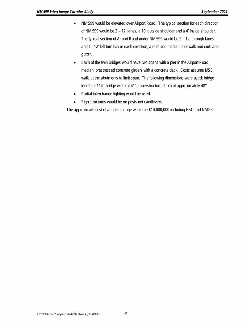
NM 599 Interchange Corridor Study September 2009
P:\070064\Trans\Study\Report\NM599 Phase A_091709.doc 91
• NM 599 would be elevated over Airport Road. The typical section for each direction of NM 599 would be 2 – 12’ lanes, a 10’ outside shoulder and a 4’ inside shoulder. The typical section of Airport Road under NM 599 would be 2 – 12’ through lanes and 1 - 12’ left turn bay in each direction, a 6’ raised median, sidewalk and curb and gutter.
• Each of the twin bridges would have two spans with a pier in the Airport Road median, prestressed concrete girders with a concrete deck. Costs assume MSE walls at the abutments to limit span. The following dimensions were used; bridge length of 114’, bridge width of 41’, superstructure depth of approximately 48”.
• Partial interchange lighting would be used.
• Sign structures would be on posts not cantilevers. The approximate cost of an interchange would be $10,000,000 including E&C and NMGRT.

N
0
SC
AL
E: 1
"=
300’
150
30
06
00
AIR
PO
RT
RD
FIG
UR
E 2
7
AIR
PO
RT
RO
AD
INT
ER
CH
AN
GE
AL
TE
RN
AT
IVE
AVIATOR DR
CR
56
PASEO DE RIVER ST
OL
D A
IRPO
RT
RD
BA
CA
LN
OLIVER RD
CR
OU
CH
CT
EX
IST
ING
R/W
EX
IST
ING
R/W
PR
OP
OS
ED
OV
ER
PA
SS
BR
IDG
E
NM
59
9 IN
TE
RC
HA
NG
E S
TU
DY
P:\070064\
13:10
17-SEP

NM 599 Interchange Corridor Study September 2009
P:\070064\Trans\Study\Report\NM599 Phase A_091709.doc 93
K. Extend NM 599 Frontage Road Across Santa Fe River The existing frontage road on the north side of NM 599 stops at the Santa Fe River. On the south
side of the river there is an existing local street called Paseo de River Street that leads through the Airport District Business Park. This local street is partly within NMDOT right-of-way. There is an existing ford of the Santa Fe River approximately 400 feet to the west of the frontage road. Traffic, including trucks, was observed to regularly use this ford to get to and from the frontage road. This alternative, shown in Figure 28, is to extend the frontage road across the Santa Fe River and improve Paseo de River Street to the same cross section as the frontage road north of the river.
1. Responsiveness to Purpose and Need This frontage road provides additional circulation in the NM 599 Corridor without allowing
additional access points so it would support the use of NM 599 as a relief route by continuing the original plan of ultimately making NM 599 an access controlled facility. This alternative will improve access to the development along Caja del Rio. 2. Engineering Factors
The terrain where this alternative is located is relatively flat. There are no drainage issues with this alternative.
Paseo de River Street would have to be improved to match the design standards of a frontage road. The design speed would have to be lower than the remainder of the frontage road. There would be one intersection within the Airport District Business Park that would be stop sign controlled. The intersection with Airport Road would require improvements to handle the additional traffic. 3. Environmental Factors
Extending the frontage road across the Santa Fe River was not cleared under the 1987 EA; however, the engineering, social, economic, and environmental investigations conducted thus far on this build alternative have not disclosed any potentially significant impacts on the quality of the human or natural environment. The recommended level of effort for the construction of this alternative is an Environmental Assessment. Coordination will be needed with the U.S. Army Corps of Engineers for impacts to the Santa Fe River. 4. Public Acceptance - Responsiveness to Community Goals/Expectations
There is public support for an alternate route for Caja del Rio traffic to go west and south without using the CR 62 interchange. 5. Right-of-Way
Approximately 1.5 acres of additional right-of-way would be required to extend the frontage road across the Santa Fe River. 6. Estimated Construction Costs
The following assumptions were made in order to estimate the construction cost:

NM 599 Interchange Corridor Study September 2009
P:\070064\Trans\Study\Report\NM599 Phase A_091709.doc 94
• The cross street typical section would be 2 – 12 foot lanes with 6 foot shoulders. 8’ shoulders were assumed for the bridge.
• The bridge would be five spans to match the existing NM 599 river crossing. The following dimensions were used; bridge length of 164’, bridge width of 43’.
• Right-of-way costs are not included in the estimate. The approximate cost of an interchange would be $4,500,000 including 8% Engineering and
Contingencies and 7.9375% New Mexico Gross Receipts Tax (NMGRT).

N
0
SC
AL
E: 1
"=
300’
150
300
600
AIR
PO
RT
RD
NM
599
IMP
RO
VE
EX
IST
ING
RO
AD
FIG
UR
E 2
8
EX
TE
ND
NM
599 F
RO
NT
AG
E
RO
AD
AC
RO
SS
SF
RIV
ER
PR
OP
OS
ED
SF
RIV
ER
BR
IDG
E
PASEO DE RIVER ST
BA
CA
LN
CR
OU
CH
CT
OLIVER RD
PR
OP
OS
ED
R/W
1.5
AC
RE
S
EX
IST
ING
R/W
EX
IST
ING
R/W
NM
599 F
RO
NT
AG
E R
D
NM
59
9 IN
TE
RC
HA
NG
E S
TU
DY
P:\070064\
13:11
17-SEP

NM 599 Interchange Corridor Study September 2009
P:\070064\Trans\Study\Report\NM599 Phase A_091709.doc 96
L. Caja del Rio An interchange at Caja del Rio was not planned in the original design but it was an allowable
access point in the original environmental document. The access points were approved by resolution of the Santa Fe City Council and the Santa Fe County Commission in 1988. A signalized intersection at Caja del Rio was not approved by the Santa Fe Metropolitan Planning Organization Board in 2003. The project was protested during the public meeting process because members of the public felt that another intersection on NM 599 should not be constructed until the existing intersections were improved. The project was dropped because the Santa Fe Metropolitan Planning Organization decided not to add it to the Transportation Improvement Program.
Access at Caja del Rio would serve the Municipal Recreation Complex, the Animal Shelter, Marty Sanchez Links de Santa Fe, the County Landfill, and the Department of U.S. Fish and Wildlife. Other developments are planned on Caja del Rio in the near future.
1. Responsiveness to Purpose and Need An interchange at Caja Del Rio would support the use of NM 599 as a relief route by
continuing the original plan of ultimately making NM 599 an access controlled facility with no at-grade intersections. This alternative will improve access to NM 599 for the development on Caja del Rio. Construction of this interchange take traffic off of the CR 62 intersection so the operation of that intersection will be improved but it would still operate at a level of service F in the peak hours. 2. Engineering Factors
The area of this proposed interchange is very flat. Fill would need to be brought in to construct the ramps and overpass. There are no drainage issues with an interchange in this location. The existing trail underpass of NM 599 would need to be extended to reach under the proposed ramps. 3. Environmental Factors
The right-of-way for this future interchange was not cleared under the 1987 EA; however, the engineering, social, economic, and environmental investigations conducted thus far on this build alternative have not disclosed any potentially significant impacts on the quality of the human or natural environment. The recommended level of effort for the construction of this alternative is an Environmental Assessment. 4. Public Acceptance - Responsiveness to Community Goals/Expectations
There is strong support for an interchange in this location from the landowners on both sides of NM 599 in this area, from the government facilities located on Caja del Rio and from the public that uses these facilities. When the State Land Office recently sold property in the northeast quadrant of the intersection for a development, right-of-way was preserved for a future interchange.

NM 599 Interchange Corridor Study September 2009
P:\070064\Trans\Study\Report\NM599 Phase A_091709.doc 97
Most of the residents along NM 599 that use the CR 62 and CR 70 Connection intersections feel that the existing intersections should be improved before any additional connections are made to NM 599. 5. Right-of-Way
The NM 599 right-of-way is approximately 300’ wide at Caja del Rio. Approximately 34 acres of additional right-of-way would be required to construct an interchange at this location. See Figure 29. 6. Estimated Construction Costs
The following assumptions were made in order to estimate the construction cost:
• The cross street typical section would be 2 – 12 foot lanes with 8 foot shoulders.
• The bridge would be two spans with a pier in the NM 599 median, prestressed concrete girders with a concrete deck. Costs assume MSE walls at the abutments to limit span. The following dimensions were used; bridge length of 170’, bridge width of 43’, superstructure depth of approximately 65”
• Partial interchange lighting would be used.
• Sign structures would be on posts not cantilevers.
• Right-of-way costs are not included in the estimate. The approximate cost of an interchange would be $7,000,000 including E&C and NMGRT.

N
CAJA DEL RIO
0
SC
AL
E: 1
"=
40
0’
20
0400
80
0
FIG
UR
E 2
9
CA
JA
DE
L R
IO
INT
ER
CH
AN
GE
AL
TE
RN
AT
IVE
SA
NT
A F
E R
IVE
R
FU
TU
RE
RO
AD
TO
BE
CO
NS
TR
UC
TE
D
BY
OT
HE
RS
EX
IST
ING
R/W
PR
OP
OS
ED
R/W
11
.8 A
CR
ES
EX
IST
ING
TR
AIL
UN
DE
RP
AS
S
PR
OP
OS
ED
R/W
10.5
AC
RE
S11.2
AC
RE
S
PR
OP
OS
ED
R/W
EX
IST
ING
R/W
COTTONWOOD DR
AQ
UA
FR
IA S
T
SANF
ELIP
E
RD
PR
OP
OS
ED
OV
ER
PA
SS
BR
IDG
E
NM
59
9 IN
TE
RC
HA
NG
E S
TU
DY
P:\070064\
13:13
17-SEP

NM 599 Interchange Corridor Study September 2009
P:\070064\Trans\Study\Report\NM599 Phase A_091709.doc 99
M. NM 599 S. Frontage Road from CR 62 to Caja del Rio This alternative is to construct a frontage road on the south side of NM 599 from the CR 62 Intersection
to Caja del Rio as shown in Figure 30. This alternative could be used as an alternative to construction the Caja del Rio Interchange to provide access to the south side of NM 599. There is a parcel on the south side of NM 599 that only has access to the Santa Fe River and not to any road.
1. Responsiveness to Purpose and Need This frontage road provides additional circulation in the NM 599 Corridor without allowing
additional access points so it would support the use of NM 599 as a relief route by continuing the original plan of ultimately making NM 599 an access controlled facility. This alternative will improve access to NM 599 for undeveloped areas south of the mainline. 2. Engineering Factors
The terrain where this alternative is located is relatively flat. It was assumed that the frontage road and the mainline would be separated by concrete wall barrier. Construction of the frontage road would impact the roadside ditches so storm drain would be needed. The existing noise wall protecting the Cottonwood Mobile Home Park would need to be reconstructed. 3. Environmental Factors
The right-of-way for this frontage road was not cleared under the 1987 EA; however, the engineering, social, economic, and environmental investigations conducted thus far on this build alternative have not disclosed any potentially significant impacts on the quality of the human or natural environment. The recommended level of effort for the construction of this alternative is an Environmental Assessment. 4. Public Acceptance - Responsiveness to Community Goals/Expectations
There is public support for increasing circulation in the area of the NM 599 corridor without increasing the access to NM 599. 5. Right-of-Way
Approximately 6.3 acres of right-of-way would be required to construct this frontage road. 6. Estimated Construction Costs
The following assumptions were made in order to estimate the construction cost:
• The frontage road typical section would be 2 – 12 foot lanes with 6 foot shoulders. • A concrete wall barrier would be installed between the NM 599 mainline and the
frontage road. • The noise wall would be reinstalled to the same height. The wall was assumed to
be 10’ high with a length of 2160 feet. • No street lighting would be included. • Right-of-way costs are not included in the estimate
The approximate cost of a frontage road would be $6,200,000 including 8% Engineering and Contingencies and 7.9375% New Mexico Gross Receipts Tax (NMGRT).
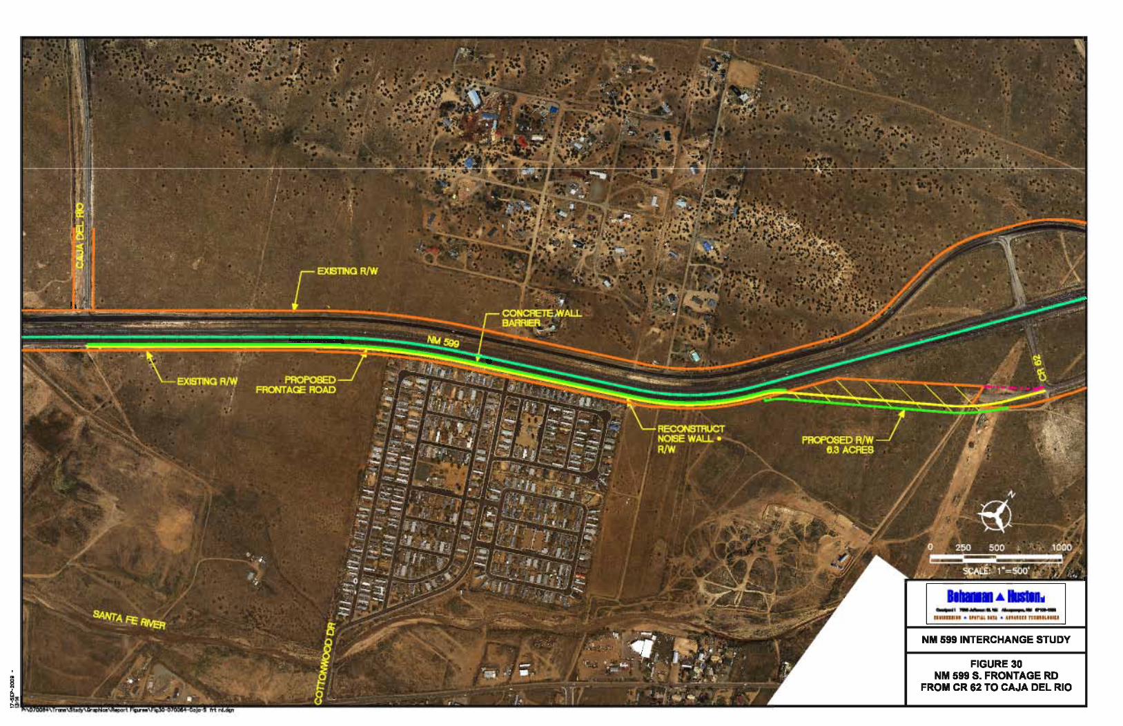
CAJA DEL RIO0
0
SC
AL
E: 1
"=
500’
500
10
00
25
0
CR 62
EX
IST
ING
R/W
EX
IST
ING
R/W
SA
NT
A F
E R
IVE
R
COTTONWOOD DR
PR
OP
OS
ED
FR
ON
TA
GE
RO
AD
RE
CO
NS
TR
UC
T
NO
ISE
WA
LL
@
R/W
NM
599
CO
NC
RE
TE
WA
LL
BA
RR
IER
PR
OP
OS
ED
R/W
6.3
AC
RE
S
FIG
UR
E 3
0
NM
59
9 S
. FR
ON
TA
GE
RD
FR
OM
CR
62
TO
CA
JA
DE
L R
IO
N
NM
59
9 IN
TE
RC
HA
NG
E S
TU
DY
P:\070064\
13:14
17-SEP

NM 599 Interchange Corridor Study September 2009
P:\070064\Trans\Study\Report\NM599 Phase A_091709.doc 101
N. CR 62 The CR 62 Interchange alternative is shown in Figure 31. An interchange at CR 62 would provide
improved access to a fire station, Agua Fria Community Park, the Nancy Rodriguez Community Center, the La Familia Medical Center. The interchange would also provide improved access to the government facilities along Caja del Rio.
1. Responsiveness to Purpose and Need An interchange at CR 62 would support the use of NM 599 as a relief route by continuing the
original plan of ultimately making NM 599 an access controlled facility with no at-grade intersections. This alternative would address the access concerns at the existing intersection which currently operates at a level of service of F. Safety would be improved if an interchange were constructed. 2. Engineering Factors
The proposed interchange bridge can be constructed offset from the existing intersection to maintain access during construction. There are no drainage issues in this location.
The traffic operation problems at the existing intersection would be eliminated if an interchange were constructed. 3. Environmental Factors
Under the 1987 EA, the right-of-way was cleared for a future interchange at this location. Construction of this alternative, including trail connectivity, would comply with the environmental commitment stated in the 1999 Re-Evaluation completed for the NM 599 corridor. In addition, the engineering, social, economic, and environmental investigations conducted thus far on this build alternative have not disclosed any potentially significant impacts on the quality of the human or natural environment. The recommended level of effort for the construction of this alternative is a Re-Evaluation. 4. Public Acceptance - Responsiveness to Community Goals/Expectations
The public is very supportive of an interchange at CR 62. The intersection is perceived to be unsafe in its existing configuration. 5. Right-of-Way
Right-of-way for a future interchange was obtained at CR 62 when NM 599 was constructed. 6. Estimated Construction Costs
The following assumptions were made in order to estimate the construction cost:
• The cross street typical section would be 2 – 12 foot lanes with 8 foot shoulders. • The bridge would be two spans with a pier in the NM 599 median, prestressed concrete
girders with a concrete deck. Costs assume MSE walls at the abutments to limit span. The following dimensions were used; bridge length of 170’, bridge width of 43’, superstructure depth of approximately 65”.
• Partial interchange lighting would be used. • Sign structures would be on posts not cantilevers.
The approximate cost of an interchange would be $6,000,000 including E&C and NMGRT.

N
0
SC
AL
E: 1
"=
400’
20
04
00
800
CR 62
FIG
UR
E 3
1
CO
UN
TY
RO
AD
62
INT
ER
CH
AN
GE
AL
TE
RN
AT
IVE
S. M
EA
DO
W E
XTEN
SIO
N
BY
OTH
ER
S
AQ
UIA
FR
IA P
AR
K R
D
AQ
UA
FR
IA
CO
MM
UN
ITY
PA
RK
FIR
E
ST
AT
ION
AQ
UA
FR
IA
CE
ME
TE
RY
FUTURE CR 62
REALIGNMENT
BY OTHERS
CR 62
AVENIDA ANGELES
N. CAMINO DON FIDEL
PR
OP
OS
ED
OV
ER
PA
SS
BR
IDG
E
EX
IST
ING
R/W
EX
IST
ING
R/W
NM
59
9 IN
TE
RC
HA
NG
E S
TU
DY
P:\070064\
13:15
17-SEP

NM 599 Interchange Corridor Study September 2009
P:\070064\Trans\Study\Report\NM599 Phase A_091709.doc 103
O. CR 70 Connection The CR 70 interchange alternative is shown in Figure 32. This alternative would provide improved
access to the neighborhoods north and south of NM 599. 1. Responsiveness to Purpose and Need
An interchange at the CR 70 Connection would support the use of NM 599 as a relief route by continuing the original plan of ultimately making NM 599 an access controlled facility with no at-grade intersections. This alternative would address the access concerns at the existing intersection which currently operates at a level of service of F. Safety would be improved if an interchange were constructed. 2. Engineering Factors
The proposed interchange bridge could be constructed offset from the existing intersection in order to maintain access during construction. The Arroyo de las Trampas is located on the south side of the interchange location. This will require erosion protection for the northbound exit ramp.
The traffic operation problems at the existing intersection would be eliminated if an interchange were constructed. 3. Environmental Factors
Under the 1987 EA, the right-of-way was cleared for a future interchange at this location. Construction of this alternative, including trail connectivity, would comply with the environmental commitment stated in the 1999 Re-Evaluation completed for the NM 599 corridor. In addition, the engineering, social, economic, and environmental investigations conducted thus far on this build alternative have not disclosed any potentially significant impacts on the quality of the human or natural environment. The recommended level of effort for the construction of this alternative is a Re-Evaluation. Coordination will be needed with the U.S. Army Corps of Engineers for impacts to the Arroyo de las Trampas. 4. Public Acceptance - Responsiveness to Community Goals/Expectations
The public is very supportive of an interchange at the CR 70 Connection. The existing intersection is perceived to be unsafe. 5. Right-of-Way
Right-of-way for a future interchange was obtained at the CR 70 Connection when NM 599 was constructed. 6. Estimated Construction Costs
The following assumptions were made in order to estimate the construction cost:
• The cross street typical section would be 2 – 12 foot lanes with 8 foot shoulders.
• The bridge would be two spans with a pier in the NM 599 median, prestressed concrete girders with a concrete deck. Costs assume MSE walls at the abutments to
NM 599 Interchange Corridor Study September 2009
P:\070064\Trans\Study\Report\NM599 Phase A_091709.doc 104
limit span. The following dimensions were used; bridge length of 170’, bridge width of 43’, superstructure depth of approximately 65”.
• Partial interchange lighting would be used.
• Sign structures would be on posts not cantilevers. The approximate cost of an interchange would be $9,000,000 including E&C and NMGRT.

CR 70 INTERCONNECTION
N
0
SC
AL
E: 1
"=
400
’
20
0400
80
0
FIG
UR
E 3
2
CR
70 C
ON
NE
CT
ION
INT
ER
CH
AN
GE
AL
TE
RN
AT
IVE
VIA
VETERA
NO
S
CA
MIN
O T
RA
NQ
UIL
LO
AM
ARA
NTE R
D
CH
ICO
MA
VIS
TA
SIERRA
AZU
L
CA
MIN
O E
SPEJO
W A
LA
MED
A S
T
CA
LL
E S
INSO
NT
E
AV
EN
IDA
FR
IJOL
ES
PR
OP
OS
ED
OV
ER
PA
SS
BR
IDG
EE
XIS
TIN
G R
/W
EX
IST
ING
R/W
NM
59
9 IN
TE
RC
HA
NG
E S
TU
DY
P:\070064\
13:17
17-SEP

NM 599 Interchange Corridor Study September 2009
P:\070064\Trans\Study\Report\NM599 Phase A_091709.doc 106
P. NM 599 S. Frontage Road between the CR 70 Connection and the Camino la Tierra / Paseo Nopal Interchange A south frontage road was investigated between the CR 70 Connection and the Camino la Tierra /
Paseo Nopal Interchange. There are no issues with an extension of the existing frontage road from Paseo Nopal except for right-of-way needs. At the CR 70 Connection there is an existing arroyo in close proximity to the location of the future ramps. The NMDOT requires that the nearest intersection to a ramp to a minimum of 300 feet away. This would put the intersection in the arroyo.
The CR 70 Connection interchange could potentially be designed as a tight diamond in order to pull this intersection away from the arroyo. The grades on the CR 70 Connection as an overpass would be adverse to what is required on the frontage road at a speed limit as low as 20 mph.
For these reasons a south frontage road in this area was determined not to be a viable option adjacent to the right-of-way. Q. Camino la Tierra / Paseo Nopal
There is an existing interchange at the intersection of NM 599 and Camino la Tierra / Paseo Nopal. No problems have been identified at the interchange so no further evaluation will be done as part of this study. R. Ephriam Road
An interchange was planned at Ephriam as part of the original NM 599 project. At that time there were housing developments planned for the north side of NM 599. Now all of the property is City of Santa Fe Open Space with the exception of one piece of undeveloped private property where six homes are planned. Because of this private parcel access is still needed to this area.
There are three alternatives for improvements to the Ephriam intersection to maintain the goal of NM 599 becoming a controlled access facility; construct an interchange, an overpass to Buckman Road or a frontage road from the Camino de los Montoyas Interchange.
1. Alternative 1 – Interchange This alternative is to construct an interchange in the location as shown in Figure 33. a) Responsiveness to Purpose and Need
Eliminating the Ephriam access to NM 599 would keep with the original purpose and need of NM 599 as a limited access relief route for north south through traffic traveling from I-25 to the communities north of Santa Fe on US 84/285, a WIPP route, carrying hazardous waste from Los Alamos National Laboratory to the Waste Isolation Pilot Project near Carlsbad and congestion relief for the Santa Fe local street network.
There currently are no access or safety issues at the existing intersection. b) Engineering Factors
Access would not need to be maintained during construction of the interchange so the overpass can be constructed in the location of the existing intersection. The Arroyo de los

NM 599 Interchange Corridor Study September 2009
P:\070064\Trans\Study\Report\NM599 Phase A_091709.doc 107
Frijoles is located on the south side of NM 599. Erosion protection and extension of the existing drainage structure would be needed for the northbound exit ramp and southbound entrance ramp. c) Environmental Factors
Under the 1987 EA, the right-of-way was cleared for a future interchange at this location. The engineering, social, economic, and environmental investigations conducted thus far on this build alternative have not disclosed any potentially significant impacts on the quality of the human or natural environment. The recommended level of effort for the construction of this alternative is a Re-Evaluation; however, as part of the environmental documentation, extensive coordination and documentation with the United States Corp of Engineers may be required for this build alternative for impacts to the Arroyo de los Frijoles. d) Public Acceptance - Responsiveness to Community Goals/Expectations
The public does not perceive the existing Ephriam intersection as a problem because there is no regular traffic using the intersection. e) Right-of-Way
Right-of-way for a future interchange was obtained at Ephriam when NM 599 was constructed. f) Estimated Construction Costs
The following assumptions were made in order to estimate the construction cost:
• The cross street typical section would be 2 – 12 foot lanes with 8 foot shoulders.
• The bridge would be two spans with a pier in the NM 599 median, prestressed concrete girders with a concrete deck. Costs assume MSE walls at the abutments to limit span. The following dimensions were used; bridge length of 170’, bridge width of 43’, superstructure depth of approximately 65”.
• Partial interchange lighting would be used.
• Sign structures would be on posts not cantilevers. The approximate cost of an interchange would be $7,000,000 including E&C and
NMGRT.

EPHRIAM RD
N
0
SC
AL
E: 1
"=
400
’
20
0400
80
0
FIG
UR
E 3
3
EP
HR
IAM
RO
AD
INT
ER
CH
AN
GE
AL
TE
RN
AT
IVE
BU
CK
MA
N R
D
CA
MIN
O D
E D
ES
TIN
O
TORTOLA TRAIL
TR
AIL
UN
DE
RP
AS
S
UN
ITY
CH
UR
CH
PR
OP
OS
ED
OV
ER
PA
SS
BR
IDG
E
EX
IST
ING
R/W
EX
IST
ING
R/W
NM
59
9 IN
TE
RC
HA
NG
E S
TU
DY
P:\070064\
13:18
17-SEP

NM 599 Interchange Corridor Study September 2009
P:\070064\Trans\Study\Report\NM599 Phase A_091709.doc 109
2. Alternative 2 - Ephriam Road Overpass of NM 599 to Buckman Road This alternative is to construct on overpass instead of an interchange and connect the cross
street to Buckman Road as shown in Figure 34. a) Responsiveness to Purpose and Need
Eliminating the Ephriam access to NM 599 would keep with the original purpose and need of NM 599 as a limited access relief route for north south through traffic traveling from I-25 to the communities north of Santa Fe on US 84/285, a WIPP route, carrying hazardous waste from Los Alamos National Laboratory to the Waste Isolation Pilot Project near Carlsbad and congestion relief for the Santa Fe local street network.
There currently are no access or safety issues at the existing intersection. b) Engineering Factors
Access would not need to be maintained during construction of the interchange so the overpass can be constructed in the location of the existing intersection. The Arroyo de los Frijoles is located on the south side of NM 599. Erosion protection a drainage structure would be needed for the connection of Ephriam to Buckman Road. c) Environmental Factors
All of the land area required for the overpass was not cleared under the 1987 EA; however, the engineering, social, economic, and environmental investigations conducted thus far have not disclosed any potentially significant impacts on the quality of the human or natural environment. The recommended level of effort for the construction of this alternative is a Re-Evaluation; however, as part of the environmental investigations, extensive coordination and documentation with the United States Corp of Engineers may be required for this build alternative. d) Public Acceptance - Responsiveness to Community Goals/Expectations
The public does not perceive the existing Ephriam intersection as a problem because there is no regular traffic using the intersection. e) Right-of-Way
Right-of-way for a future interchange was obtained at Ephriam when NM 599 was constructed. This right-of-way will accommodate an overpass of NM 599. Approximately 1.2 acres of right-of-way will be required to tie the overpass to Buckman Road. f) Estimated Construction Costs
The following assumptions were made in order to estimate the construction cost:
• The cross street typical section would be 2 – 12 foot lanes with 8 foot shoulders.
• The bridge would be two spans with a pier in the NM 599 median, prestressed concrete girders with a concrete deck. Costs assume MSE walls at the
NM 599 Interchange Corridor Study September 2009
P:\070064\Trans\Study\Report\NM599 Phase A_091709.doc 110
abutments to limit span. The following dimensions were used; bridge length of 170’, bridge width of 43’, superstructure depth of approximately 65”.
• No street lighting would be included.
• Right-of-way costs are not included in the estimate. The approximate cost of an interchange would be $4,000,000 including E&C and
NMGRT.

N
0
SC
AL
E: 1
"=
400
’
20
0400
80
0
FIG
UR
E 3
4
EP
HR
IAM
RO
AD
OV
ER
PA
SS
AL
TE
RN
AT
IVE
EPHRIAM RDT
RA
IL U
ND
ER
PA
SS
UN
ITY
CH
UR
CH
TORTOLA TRAIL
CA
MIN
O D
E D
ES
TIN
O
BU
CK
MA
N R
D
AR
RO
YO
DE
LO
S F
RIJ
OL
ES
CAMINO DE
PR
OP
OS
ED
R/W
1.2
AC
RE
S
EX
IST
ING
R/W
EX
IST
ING
R/W
EX
IST
ING
AC
CE
SS
CO
NT
RO
LP
RO
PO
SE
DO
VE
RP
AS
SB
RID
GE
LO
S MO
NT
OY
AS (C
R 85)
NM
59
9 IN
TE
RC
HA
NG
E S
TU
DY
P:\070064\
13:19
17-SEP

NM 599 Interchange Corridor Study September 2009
P:\070064\Trans\Study\Report\NM599 Phase A_091709.doc 112
3. Alternative 3 - Frontage Road north of NM 599 Ephriam Road to CR 85 (Camino de los Montoyas)
This alternative is to construct a frontage road on the north side of NM 599 from Ephriam Road to Camino de los Montoyas as shown in Figure 35. The frontage road would only need to provide access to the private property shown just northwest of Ephriam. The remainder of the area is City of Santa Fe Open Space. The City of Santa Fe does not desire this access for their open space. This frontage road would be constructed instead of the interchange alternative. The existing intersection would be closed.
a) Responsiveness to Purpose and Need Eliminating the Ephriam access to NM 599 would keep with the original purpose and
need of NM 599 as a limited access relief route for north south through traffic traveling from I-25 to the communities north of Santa Fe on US 84/285, a WIPP route, carrying hazardous waste from Los Alamos National Laboratory to the Waste Isolation Pilot Project near Carlsbad and congestion relief for the Santa Fe local street network.
There currently are no access or safety issues at the existing intersection. b) Engineering Factors
The frontage road construction would connect to Unity Way on the east end and the existing frontage road on the west end. Three existing drainage structures under NM 599 would need to be extended. c) Environmental Factors
The frontage road corridor was not cleared under the 1987 EA; however, the engineering, social, economic, and environmental investigations conducted thus far have not disclosed any potentially significant impacts on the quality of the human or natural environment. The recommended level of effort for the construction of this alternative is a Re-Evaluation with consideration of potential 4(f) impacts to Santa Fe Open Space land. d) Public Acceptance - Responsiveness to Community Goals/Expectations
The public does not perceive the existing Ephriam intersection as a problem because there is no regular traffic using the intersection. e) Right-of-Way
Approximately 1.3 acres of additional right-of-way would be required to construct a frontage road. f) Estimated Construction Costs
The following assumptions were made in order to estimate the construction cost:
• The frontage road typical section would be 2 – 12 foot lanes with 6 foot shoulders.

NM 599 Interchange Corridor Study September 2009
P:\070064\Trans\Study\Report\NM599 Phase A_091709.doc 113
• No street lighting would be included.
• Right-of-way costs are not included in the estimate The approximate cost of a frontage road would be $2,500,000 including E&C and
NMGRT.

EPHRIAM RD
N
0
SC
AL
E: 1
"=
400’
20
0400
80
0
BU
CK
MA
N R
D
CA
MIN
O D
E D
ES
TIN
O
TORTOLA TRAIL
LO
S M
ON
TO
YA
S
CA
MIN
O D
E
TR
AIL
UN
DE
RP
AS
SU
NIT
Y C
HU
RC
H
CR 85
CL
OS
E E
XIS
TIN
GIN
TE
RS
EC
TIO
N
FIG
UR
E 3
5
FR
ON
TA
GE
RO
AD
EP
HR
IAM
RO
AD
TO
CR
85
AP
PR
OX
IMA
TE
BO
UN
DA
RY
PR
IVA
TE
PR
OP
ER
TY
PR
OP
OS
ED
R/W
.7 A
CR
ES
EX
IST
ING
R/W
EX
IST
ING
R/W
NM
59
9 IN
TE
RC
HA
NG
E S
TU
DY
P:\070064\
13:20
17-SEP

NM 599 Interchange Corridor Study September 2009
P:\070064\Trans\Study\Report\NM599 Phase A_091709.doc 115
S. Camino de los Montoyas There are three alternatives for improvements at the Camino de los Montoyas Interchange location;
Alternative 1 - construct an interchange 1/3 mile north of the existing intersection where right-of-way has already been purchased, Alternative 2- construct an interchange in the existing location, Alternative 3 - construct an overpass in the existing location with a frontage road tying to the Ephriam interchange. If the interchange is constructed 1/3 mile to the north then there are two alternatives for providing service to Camino de los Montoyas south of the intersection; an overpass to the north side where the connecting road already exists or a frontage road on the south side to the new interchange location. It is assumed that this frontage road would be constructed by others as part of development in the area.
1. Alternative 1 – Construct an interchange 1/3 mile north of the existing intersection This alternative is illustrated in Figure 36. The cross street would tie into existing CR 85
(Camino de los Montoyas on the north side. The existing intersection would be closed. This interchange location provides access to the planned Northwest Quadrant Affordable Housing Development. Access to NM 599 from the south side of NM 599 would be eliminated until an east-west access road is constructed as part of the Northwest Quadrant Development.
The disadvantages of the location are that the location is on a curve which may lead mainline traffic to accidentally use the ramp.
a) Responsiveness to Purpose and Need Eliminating the Camino de los Montoyas access to NM 599 would keep with the original
purpose and need of NM 599 as a limited access relief route for north south through traffic traveling from I-25 to the communities north of Santa Fe on US 84/285, a WIPP route, carrying hazardous waste from Los Alamos National Laboratory to the Waste Isolation Pilot Project near Carlsbad and congestion relief for the Santa Fe local street network.
This alternative would address the access concerns at the existing intersection which currently operates at a level of service of F. Safety would be improved if an interchange were constructed. b) Engineering Factors
Construction of the interchange would not impact the existing intersection during construction so access can be maintained. The northbound ramps would require fill in the Arroyo de los Frijoles so drainage structures and erosion control would be needed. The existing hill reduces the amount of earthwork required for an overpass on the north side.
The interchange location is on a curve which could lead mainline traffic to accidentally use the northbound exit ramp. Careful design of the ramp would be needed to prevent this movement.

NM 599 Interchange Corridor Study September 2009
P:\070064\Trans\Study\Report\NM599 Phase A_091709.doc 116
c) Environmental Under the 1987 EA, the right-of-way was cleared for a future interchange at this location.
The engineering, social, economic, and environmental investigations conducted thus far have not disclosed any potentially significant impacts on the quality of the human or natural environment. The recommended level of effort for the construction of this alternative is a Re-Evaluation; however, as part of the environmental investigations, extensive coordination and documentation with the United States Corp of Engineers may be required for this build alternative. d) Public Acceptance - Responsiveness to Community Goals/Expectations
The public is very supportive of an interchange at Camino de los Montoyas. The intersection is perceived to be unsafe in its existing configuration. e) Right-of-Way
Right-of-way for a future interchange was obtained one third of a mile north of the existing intersection when NM 599 was constructed. No additional right-of-way would be required. f) Estimated Construction Costs
The following assumptions were made in order to estimate the construction cost:
• The cross street typical section would be 2 – 12 foot lanes with 8 foot shoulders.
• The bridge would be two spans with a pier in the NM 599 median, prestressed concrete girders with a concrete deck. Costs assume MSE walls at the abutments to limit span. The following dimensions were used; bridge length of 170’, bridge width of 43’, superstructure depth of approximately 65”.
• Partial interchange lighting would be used.
• Sign structures would be on posts not cantilevers. The approximate cost of an interchange would be $8,000,000 including E&C and
NMGRT.

N
0
SC
AL
E: 1
"=
40
0’
20
0400
80
0
FIG
UR
E 3
6
CA
MIN
O D
E L
OS
MO
NT
OY
AS
INT
ER
CH
AN
GE
1/3
MIL
E
NO
RT
H A
LT
ER
NA
TIV
E
UN
ITY
CH
UR
CH
CA
MIN
O D
ELO
S M
ON
TO
YA
S
CR 85
TR
AIL
UN
DE
RP
AS
S
N R
IDG
ETO
P R
D
CAM
INO FRANCISCA
PR
OP
OS
ED
OV
ER
PA
SS
BR
IDG
E
CL
OS
E E
XIS
TIN
GIN
TE
RS
EC
TIO
N
BY
OT
HE
RS
PR
OP
OS
ED
CO
NN
EC
TIO
N
EX
IST
ING
R/W
EX
IST
ING
R/W
NM
59
9 IN
TE
RC
HA
NG
E S
TU
DY
P:\070064\
13:21
17-SEP

NM 599 Interchange Corridor Study September 2009
P:\070064\Trans\Study\Report\NM599 Phase A_091709.doc 118
2. Alternative 2 – Interchange in Existing Location This alternative, which is shown in Figure 37, is to construct an interchange in the location of
the existing intersection. No frontage roads would be needed to maintain the existing access. a) Responsiveness to Purpose and Need
Eliminating the Camino de los Montoyas access to NM 599 would keep with the original purpose and need of NM 599 as a limited access relief route for north south through traffic traveling from I-25 to the communities north of Santa Fe on US 84/285, a WIPP route, carrying hazardous waste from Los Alamos National Laboratory to the Waste Isolation Pilot Project near Carlsbad and congestion relief for the Santa Fe local street network.
This alternative would address the access concerns at the existing intersection which currently operates at a level of service of F. Safety would be improved if an interchange were constructed. b) Engineering Factors
Access could not be maintained during construction unless the overpass is offset from the existing intersection. The close proximity of the Arroyo de los Frijoles on the south side would require drainage structures and erosion protection. This alternative would require more earthwork than the interchange location 1/3 mile to the north. The trail underpass west of the existing intersection will have to be extended under the ramps. c) Environmental
An interchange in this location was not cleared under the 1987 EA; however, the engineering, social, economic, and environmental investigations conducted thus far have not disclosed any potentially significant impacts on the quality of the human or natural environment. The recommended level of effort for the construction of this alternative is a Re-Evaluation; however, as part of the environmental investigations, extensive coordination and documentation with the United States Corp of Engineers as well as consideration of 4(f) impacts may be required for this build alternative. d) Public Acceptance - Responsiveness to Community Goals/Expectations
The public is very supportive of an interchange at Camino de los Montoyas. The intersection is perceived to be unsafe in its existing configuration. However, the public will probably not be supportive of an interchange that requires right-of-way relocations. e) Right-of-Way
Approximately 5.5 acres of right-of-way plus non-right-of-way takes would be required. In addition five relocations would be required. Access to the Unity Church in the northwest quadrant would have to be re-established through the non-right-of-way takes.

NM 599 Interchange Corridor Study September 2009
P:\070064\Trans\Study\Report\NM599 Phase A_091709.doc 119
f) Estimated Construction Costs The following assumptions were made in order to estimate the construction cost:
• The cross street typical section would be 2 – 12 foot lanes with 8 foot shoulders.
• The bridge would be two spans with a pier in the NM 599 median, prestressed concrete girders with a concrete deck. Costs assume MSE walls at the abutments to limit span. The following dimensions were used; bridge length of 170’, bridge width of 43’, superstructure depth of approximately 65”.
• Partial interchange lighting would be used.
• Sign structures would be on posts not cantilevers.
• Right-of-way and relocation costs are not included in the estimate. The approximate cost of an interchange would be $8,000,000 including E&C and
NMGRT.

N
0
SC
AL
E: 1
"=
40
0’
20
0400
800
FIG
UR
E 3
7
CA
MIN
O D
E L
OS
MO
NT
OY
AS
INT
ER
CH
AN
GE
IN E
XIS
TIN
G
LO
CA
TIO
N A
LT
ER
NA
TIV
E
LO
S M
ON
TO
YA
S
CAM
INO
DE
CR 85
CA
MIN
O D
E D
ES
TIN
O
TORTOLA TRAIL
TR
AIL
UN
DE
RP
AS
S
UN
ITY
CH
UR
CH
PR
OP
OS
ED
R/W
.8 A
CR
ES
PR
OP
OS
ED
R/W
.3 A
CR
ES
EX
IST
ING
AC
CE
SS
CO
NT
RO
L
EX
IST
ING
R/WP
RO
PO
SE
D R
/W
1.2
AC
RE
S
PR
OP
OS
ED
R/W
1 A
CR
ES
EX
IST
ING
R/W
PR
OP
OS
ED
OV
ER
PA
SS
BR
IDG
E
MIL
AG
RO
RD
NM
59
9 IN
TE
RC
HA
NG
E S
TU
DY
P:\070064\
13:23
17-SEP

NM 599 Interchange Corridor Study September 2009
P:\070064\Trans\Study\Report\NM599 Phase A_091709.doc 121
3. Alternative 3 – Overpass plus Frontage Road to Ephriam Interchange Location This alternative, which is shown in Figure 38, is to construct an overpass in the existing
intersection location and construct a frontage road from Camino de los Montoyas to the Ephriam Interchange location with a frontage road on the north side of NM 599. This alternative would provide access to the existing CR 85 (Camino de los Montoyas) traffic. Access to the Northwest Quadrant Development could only be provided by connecting to CR 85 and Ridgetop Road. The existing intersection would be closed.
a) Responsiveness to Purpose and Need Eliminating the Camino de los Montoyas access to NM 599 would keep with the original
purpose and need of NM 599 as a limited access relief route for north south through traffic traveling from I-25 to the communities north of Santa Fe on US 84/285, a WIPP route, carrying hazardous waste from Los Alamos National Laboratory to the Waste Isolation Pilot Project near Carlsbad and congestion relief for the Santa Fe local street network.
This alternative would address the access concerns at the existing intersection which currently operates at a level of service of F. Safety would be improved if an interchange were constructed. b) Engineering Factors
The alternative would require out of direction travel for CR 85 (Camino de los Montoyas) traffic to get on NM 599. The slope of the frontage road on the north side of NM 599 would be almost 7% in order to provide access to Unity church. The frontage road would have poor sight distance due to its close proximity to the overpass bridge. Almost 300 feet of the turnout on the south side of NM 599 would have to be reconstructed.
Access could not be maintained during construction unless the overpass is offset from the existing intersection. This alternative would have the fewest impacts to the Arroyo de los Frijoles. The drainage structure for the Arroyo de los Frijoles on the south side would have to be extended. The trail underpass west of the existing intersection would have to be extended under the frontage road. c) Environmental
The overpass and frontage road were not cleared under the 1987 EA; however, the engineering, social, economic, and environmental investigations conducted thus far have not disclosed any potentially significant impacts on the quality of the human or natural environment. The recommended level of effort for the construction of this alternative is a Re-Evaluation; however, as part of the environmental investigations, consideration of 4(f) impacts may be required for this build alternative

NM 599 Interchange Corridor Study September 2009
P:\070064\Trans\Study\Report\NM599 Phase A_091709.doc 122
d) Right-of-Way Approximately 1.5 acres of right-of-way would be required from the City of Santa Fe
Open Space and a private landowner on the north side. e) Public Acceptance - Responsiveness to Community Goals/Expectations
The public is very supportive of improvements at Camino de los Montoyas. The intersection is perceived to be unsafe in its existing configuration. f) Estimated Construction Costs
The following assumptions were made in order to estimate the construction cost:
• The cross street typical section would be 2 – 12 foot lanes with 8 foot shoulders.
• The frontage road typical section would be 2 – 12 foot lanes with 6 foot shoulders.
• The bridge would be two spans with a pier in the NM 599 median, prestressed concrete girders with a concrete deck. Costs assume MSE walls at the abutments to limit span. The following dimensions were used; bridge length of 170’, bridge width of 43’, superstructure depth of approximately 65”.
• Partial interchange lighting would be used.
• Sign structures would be on posts not cantilevers.
• Right-of-way costs are not included in the estimate. The approximate cost of an overpass and frontage road would be $5,500,000 including
E&C and NMGRT.

EPHRIAM RD
N
0
SC
AL
E: 1
"=
400’
20
0400
80
0
FIG
UR
E 3
8
OV
ER
PA
SS
AT
CR
85
W/
FR
T R
D T
O E
PH
RIA
M
INT
ER
CH
AN
GE
AL
T
BU
CK
MA
N R
D
CA
MIN
O D
E D
ES
TIN
O
TORTOLA TRAIL
LO
S M
ON
TO
YA
S
CA
MIN
O D
E
TR
AIL
UN
DE
RP
AS
S
UN
ITY
CH
UR
CH
AR
RO
YO
DE L
OS F
RIJO
LES
PR
OP
OS
ED
OV
ER
PA
SS
BR
IDG
E
EX
IST
ING
R/W
EX
IST
ING
R/W
CR
85
EX
IST
ING
AC
CE
SS
CO
NT
RO
L
PR
OP
OS
ED
OV
ER
PA
SS
BR
IDG
E
PR
OP
OS
ED
R/W
.2 A
CR
ES
PR
OP
OS
ED
R/W
.4 A
CR
ES
PR
OP
OS
ED
R/W
.2 A
CR
ES
PR
OP
OS
ED
R/W
1.3
AC
RE
S
NM
59
9 IN
TE
RC
HA
NG
E S
TU
DY
P:\070064\
13:24
17-SEP

NM 599 Interchange Corridor Study September 2009
P:\070064\Trans\Study\Report\NM599 Phase A_091709.doc 124
4. Overpass in existing location This overpass would be constructed in addition to the interchange 1/3 mile north in order to
provide access to CR 85 on the south side of NM 599 as shown in Figure 39. If an overpass is constructed, then an access road would not be needed on the south side. The existing intersection would be closed.
a) Responsiveness to Purpose and Need Eliminating the Camino de los Montoyas access to NM 599 would keep with the original
purpose and need of NM 599 as a limited access relief route for north south through traffic traveling from I-25 to the communities north of Santa Fe on US 84/285, a WIPP route, carrying hazardous waste from Los Alamos National Laboratory to the Waste Isolation Pilot Project near Carlsbad and congestion relief for the Santa Fe local street network.
This alternative would address the access concerns at the existing intersection which currently operates at a level of service of F. Safety would be improved if an interchange and overpass were constructed. b) Engineering Factors
The slope of the frontage road on the north side of NM 599 would be almost 7% in order to provide access to Unity church. The frontage road would have poor sight distance due to its close proximity to the overpass bridge. Almost 300 feet of the turnout on the south side of NM 599 would have to be reconstructed.
Access could not be maintained during construction unless the overpass is offset from the existing intersection. The drainage structure for the Arroyo de los Frijoles on the south side would have to be extended. c) Environmental
An overpass in this location was not cleared under the 1987 EA; however, the engineering, social, economic, and environmental investigations conducted thus far have not disclosed any potentially significant impacts on the quality of the human or natural environment. The recommended level of effort for the construction of this alternative is a Re-Evaluation. d) Right-of-Way
Approximately .2 acres of right-of-way would be required on the south side to construct the overpass. e) Public Acceptance - Responsiveness to Community Goals/Expectations The public is very supportive of improvements at Camino de los Montoyas. The intersection is
perceived to be unsafe in its existing configuration.

NM 599 Interchange Corridor Study September 2009
P:\070064\Trans\Study\Report\NM599 Phase A_091709.doc 125
f) Estimated Construction Costs The following assumptions were made in order to estimate the construction cost:
• The cross street typical section would be 2 – 12 foot lanes with 8 foot shoulders.
• The bridge would be two spans with a pier in the NM 599 median, prestressed concrete girders with a concrete deck. Costs assume MSE walls at the abutments to limit span. The following dimensions were used; bridge length of 170’, bridge width of 43’, superstructure depth of approximately 65”.
• Partial interchange lighting would be used.
• Sign structures would be on posts not cantilevers.
• Right-of-way costs are not included in the estimate. The approximate cost of an overpass would be $12,000,000 including E&C and NMGRT.

N
0
SC
AL
E: 1
"=
40
0’
20
0400
80
0
FIG
UR
E 3
9
CA
MIN
O D
E L
OS
MO
NT
OY
AS
OV
ER
PA
SS
W/ C
R 8
5
INT
ER
CH
AN
GE
AL
TE
RN
AT
IVE
UN
ITY
CH
UR
CH
CA
MIN
O D
ELO
S M
ON
TO
YA
S
CR
85
PR
OP
OS
ED
R/W
.2 A
CR
ES
EX
IST
ING
R/W
PR
OP
OS
ED
R/W
.2 A
CR
ES
PR
OP
OS
ED
R/W
.4 A
CR
ES
PR
OP
OS
ED
OV
ER
PA
SS
BR
IDG
E
TR
AIL
UN
DE
RP
AS
S
PR
OP
OS
ED
OV
ER
PA
SS
BR
IDG
E
AP
PR
OX
IMA
TE
EX
IST
ING
R/W
NM
59
9 IN
TE
RC
HA
NG
E S
TU
DY
P:\070064\
13:25
17-SEP

NM 599 Interchange Corridor Study September 2009
P:\070064\Trans\Study\Report\NM599 Phase A_091709.doc 127
T. NM 599 N. Frontage Road from Camino de los Montoyas to Ridgetop Road This alternative is to construct a frontage road on the north side of NM 599 from Camino de los
Montoyas to Ridgetop Road as shown in Figure 40. This frontage road could be constructed with or without the Camino de los Montoyas Interchange.
1. Responsiveness to Purpose and Need This frontage road provides additional circulation in the NM 599 Corridor without allowing
additional access points so it would support the use of NM 599 as a relief route by continuing the original plan of ultimately making NM 599 an access controlled facility. 2. Engineering Factors
This alternative uses an existing dirt road alignment. There would be no significant drainage structures under the frontage road. 3. Environmental Factors
A frontage road in this location was not cleared under the 1987 EA; however, the engineering, social, economic, and environmental investigations conducted thus far have not disclosed any potentially significant impacts on the quality of the human or natural environment. The recommended level of effort for the construction of this alternative is an environmental assessment. Consideration of 4(f) impacts may be required for this build alternative.
4. Public Acceptance - Responsiveness to Community Goals/Expectations The public has expressed an interest in improved circulation throughout the NM 599 corridor.
There may be objections to using City of Santa Fe Open Space for the frontage road although the existing terrain is disturbed. 5. Right-of-Way
Approximately 13.2 acres of right-of-way would be needed to construct this alternative. All of the right-of-way that is needed is currently City of Santa Fe Open Space except for the northwest corner of the Ridgetop Road Interchange. The land in this corner is currently undeveloped but there is an approved development plan. 6. Estimated Construction Costs
The following assumptions were made in order to estimate the construction cost:
• The frontage road typical section would be 2 – 12 foot lanes with 6 foot shoulders.
• No street lighting would be included.
• Right-of-way costs are not included in the estimate The approximate cost of a frontage road would be $2,600,000 including 8% Engineering and
Contingencies and 7.9375% New Mexico Gross Receipts Tax (NMGRT).
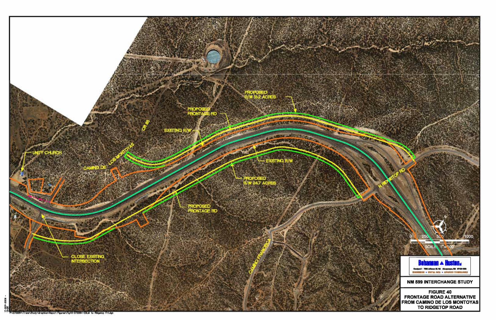
CA
MIN
O D
ELO
S M
ON
TO
YA
S
CAM
INO FRANCISCA
0
SC
AL
E: 1
"=
500
’
N
FIG
UR
E 4
0
FR
ON
TA
GE
RO
AD
AL
TE
RN
AT
IVE
FR
OM
CA
MIN
O D
E L
OS
MO
NT
OY
AS
TO
RID
GE
TO
P R
OA
D
UN
ITY
CH
UR
CH
CR 85
CL
OS
E E
XIS
TIN
G
IN
TE
RS
EC
TIO
N
PR
OP
OS
ED
FR
ON
TA
GE
RD
PR
OP
OS
ED
R/W
24.7
AC
RE
S
PR
OP
OS
ED
FR
ON
TA
GE
RD
PR
OP
OS
ED
R/W
13.2
AC
RE
S
N R
IDG
ETO
P R
D
EX
IST
ING
R/W
EX
IST
ING
R/W
25
0500
10
00
NM
59
9 IN
TE
RC
HA
NG
E S
TU
DY
P:\070064\
13:26
17-SEP

NM 599 Interchange Corridor Study September 2009
P:\070064\Trans\Study\Report\NM599 Phase A_091709.doc 129
U. NM 599 S. Frontage Road from Camino de los Montoyas to Ridgetop Road This alternative is to construct a frontage road on the south side of NM 599 from Camino de los
Montoyas to Ridgetop Road as shown in Figure 40. This frontage road could be constructed with or without the Camino de los Montoyas Interchange.
1. Responsiveness to Purpose and Need This frontage road provides additional circulation in the NM 599 Corridor without allowing
additional access points so it would support the use of NM 599 as a relief route by continuing the original plan of ultimately making NM 599 an access controlled facility. This frontage road would provide access to undeveloped land south of NM 599.
2. Engineering Factors The frontage road would have to be located approximately 200’ south of the NM 599 mainline
because of the location of the Arroyo de los Frijoles. Erosion protection may be needed in several areas adjacent to the arroyo. 3. Environmental Factors
A frontage road in this location was not cleared under the 1987 EA; however, the engineering, social, economic, and environmental investigations conducted thus far have not disclosed any potentially significant impacts on the quality of the human or natural environment. The recommended level of effort for the construction of this alternative is an environmental assessment. Coordination will be needed with the Corps of Engineers for impacts to the Arroyo de los Frijoles.
4. Public Acceptance - Responsiveness to Community Goals/Expectations The public has expressed an interest in improved circulation throughout the NM 599 corridor,
however, a frontage road in this area would provide access for the proposed Northwest Quadrant Development which is very unpopular with the surrounding neighborhoods. 5. Right-of-Way
Approximately 24.7 acres of right-of-way would be needed to construct a frontage road. 6. Estimated Construction Costs
The following assumptions were made in order to estimate the construction cost:
• The frontage road typical section would be 2 – 12 foot lanes with 6 foot shoulders.
• No street lighting would be included.
• Right-of-way costs are not included in the estimate The approximate cost of a frontage road would be $3,300,000 including 8% Engineering and
Contingencies and 7.9375% New Mexico Gross Receipts Tax (NMGRT).
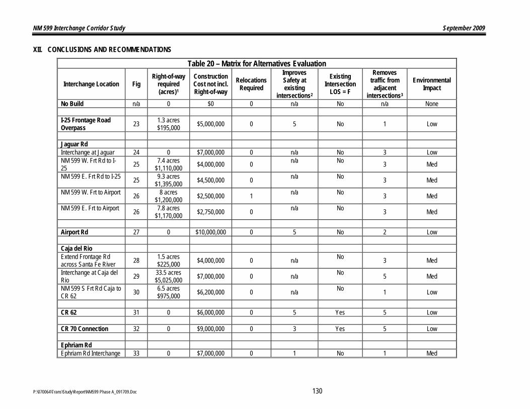
NM 599 Interchange Corridor Study September 2009
P:\070064\Trans\Study\Report\NM599 Phase A_091709.Doc 130
XII. CONCLUSIONS AND RECOMMENDATIONS
Table 20 – Matrix for Alternatives Evaluation
Interchange Location Fig Right-of-way
required (acres)1
Construction Cost not incl. Right-of-way
Relocations Required
Improves Safety at existing
intersections2
Existing Intersection
LOS = F
Removes traffic from
adjacent intersections3
Environmental Impact
No Build n/a 0 $0 0 n/a No n/a None I-25 Frontage Road Overpass 23 1.3 acres
$195,000 $5,000,000 0 5 No 1 Low
Jaguar Rd Interchange at Jaguar 24 0 $7,000,000 0 n/a No 3 Low NM 599 W. Frt Rd to I-25 25 7.4 acres
$1,110,000 $4,000,000 0 n/a No 3 Med
NM 599 E. Frt Rd to I-25 25 9.3 acres $1,395,000 $4,500,000 0 n/a No 3 Med
NM 599 W. Frt to Airport 26 8 acres $1,200,000 $2,500,000 1 n/a No 3 Med
NM 599 E. Frt to Airport 26 7.8 acres $1,170,000 $2,750,000 0 n/a No 3 Med
Airport Rd 27 0 $10,000,000 0 5 No 2 Low Caja del Rio Extend Frontage Rd across Santa Fe River 28 1.5 acres
$225,000 $4,000,000 0 n/a No 3 Med
Interchange at Caja del Rio 29 33.5 acres
$5,025,000 $7,000,000 0 n/a No 5 Med
NM 599 S Frt Rd Caja to CR 62 30 6.5 acres
$975,000 $6,200,000 0 n/a No 1 Low
CR 62 31 0 $6,000,000 0 5 Yes 5 Low CR 70 Connection 32 0 $9,000,000 0 3 Yes 5 Low Ephriam Rd Ephriam Rd Interchange 33 0 $7,000,000 0 1 No 1 Med

NM 599 Interchange Corridor Study September 2009
P:\070064\Trans\Study\Report\NM599 Phase A_091709.Doc 131
Ephriam Rd Overpass 34 1.2 acres $180,000 $4,000,000 0 1 No 1 Med
Interchange Location Fig Right-of-way
required (acres)1
Construction Cost not incl. Right-of-way
Relocations Required
Improves Safety at existing
intersections2
Existing Intersection
LOS = F
Removes traffic from
adjacent intersections3
Environmental Impact
N Frt Rd Ephriam to Camino de los Montoyas 35 .7 acres
$105,000 $2,500,000 0 1 No 5 Med
Camino de los Montoyas
Interchange 1/3 mile northeast 36 0 $8,000,000 0 1 Yes 1 Med
Interchange in existing intersection location 37 3.3 acres
$495,000 $8,000,000 5 1 Yes 1 Med
Overpass w/ Frt Rd to Ephriam 38 1.5 acres
$225,000 $5,500,000 0 1 Yes 1 Med
Overpass w/ Interchange 1/3 mile northeast
39 .8 acres $120,000 $12,000,000 0
1 Yes
1 Med
N Frt Rd CR 85 to Ridgetop 40 13.2 acres
$1,980,000 $2,500,000 0 1 Yes 3 Low
S Frt Rd CR 85 to Ridgetop 40 24.7 acres
$3,705,000 $3,500,000 0 1 Yes 3 Med
Ridgetop Rd 41 .7 acres
$105,000 $2,000,000 0 2 No 1 Low
1 Assumes $150,000 per acre 2 Scale of 1 to 5 with 1 being the least impact and 5 being the greatest impact 3 Scale of 1 to 5 with 1 being the least impact and 5 being the greatest impact

NM 599 Interchange Corridor Study September 2009
P:\070064\Trans\Study\Report\NM599 Phase A_091709.doc 132
The table above gives estimated costs for the construction of each alternative and an estimated right-of-way cost based on $150,000 per acre. The NM 599 E. Frontage Road from Jaguar to Airport Road would require the relocation of a business near Airport Road. The Camino de los Montoyas alternative to construct an interchange in the location of the existing intersection would require the relocation of 5 buildings, mostly homes.
Improvements to safety are evaluated for each alternative on a scale of 1 to 5 with 1 being the least and 5 being the greatest. Since the Caja del Rio and Jaguar intersections do not exist, improvements were not applicable. The safety column attempts to take into account both the accident rate and the number of injuries at a given location. Airport Road and the I-25 N. Frontage Road were given a 5 because they are the intersections with the highest accident rate. The CR 62 intersection was also given a 5 with the third highest accident rate and a high number of injuries. The CR 70 Connection has fewer accidents but all of the accidents involved injuries so it was assigned a 4.
The next column in the table assesses traffic levels of service in the corridor. The existing unsignalized intersections of CR 62, CR 70 Connection and Camino de los Montoyas all have a failing level of service during the peak hours. The signalized intersections have acceptable levels of service.
Some of the alternatives will improve traffic at multiple locations because the intersections are interconnected outside of NM 599. Therefore improvements at one intersection will improve the operation and safety at the adjacent intersections as shown in the next column. For example, improvements at the CR 62 intersection will affect both the Caja del Rio and CR 70 Connection locations.
The environmental impact column assesses the level of environmental effort that will be needed for construction. The engineering, social, economic, and environmental investigations conducted thus far have not disclosed any potentially significant impacts on the quality of the human or natural environment so none of the locations were given a high rating. Locations where new right-of-way is located that has not been cleared previously or where arroyos will be impacted were given a medium rating.
The alternatives listed in the evaluation matrix are all viable alternatives that should be carried forward to Phase B for a more detailed evaluation. Operational analysis and input from the public, the City of Santa Fe, Santa Fe County, and elected officials will be used to determine the preferred alternative where there are options.
A priority plan for public funding will be developed during Phase B for the preferred alternatives based on where the greatest needs exist for the corridor.

NM 599 Interchange Corridor Study September 2009
P:\070064\Trans\Study\Report\NM599 Phase A_091709.doc 133
XIII. REFERENCES Santa Fe Relief Route (NM 599) NMDOT Project NH-599-1(5)05, CN 3401, Environmental Assessment Reevaluation Summary of Additional Investigations and Public Involvement, February, 1999. Taschek Environmental Consulting. March 2003. Caja del Rio/Santa Fe Relief Route (Nm 599) Intersection Improvement: NMDOT Project No. ST-7549(307) CN 7646. Biological Survey. Albuquerque, New Mexico. Taschek Environmental Consulting. June 2004. Environmental Assessment. South Meadows Road Extension in Santa Fe County. NMDOT Project No. ST-7549(276). Albuquerque, New Mexico. Taschek Environmental Consulting and The Louis Berger Group. October 2006. Environmental Assessment. Siler Road Extension Transportation Study. Albuquerque, New Mexico.