New observations on the 1939 Erzincan Earthquake surface rupture on the Kelkit Valley segment of the...
13
Journal of Geodynamics 65 (2013) 259–271 Contents lists available at SciVerse ScienceDirect Journal of Geodynamics j ourna l ho me page: http://www.elsevier.com/locate/jog New observations on the 1939 Erzincan Earthquake surface rupture on the Kelkit Valley segment of the North Anatolian Fault Zone, Turkey Halil Gürsoy a,∗ , Orhan Tatar a , Zafer Akpınar b , Ali Polat c , Levent Mesci a , Do˘ gan Tunc ¸ er d a Cumhuriyet Üniversitesi Mühendislik Fakültesi Jeoloji Mühendisli˘ gi Bölümü, 58140 Sivas, Turkey b Cumhuriyet Üniversitesi Mühendislik Fakültesi Jeofizik Mühendisli˘ gi Bölümü, 58140 Sivas, Turkey c Sivas Valili˘ gi Afet ve Acil Durum ˙ Il Müdürlü˘ gü, Sivas, Turkey d Tokat Valili˘ gi Afet ve Acil Durum ˙ Il Müdürlü˘ gü, Tokat, Turkey a r t i c l e i n f o Article history: Received 14 October 2011 Received in revised form 30 May 2012 Accepted 1 June 2012 Available online 9 June 2012 Keywords: North Anatolian Fault Zone Strike-slip faulting 1939 Erzincan Earthquake a b s t r a c t The 1939 Erzincan Earthquake (M = 7.8), occurred on the North Anatolian Fault Zone (NAFZ), was one of the most active strike-slip faults in the world, and created a 360-km-long surface rupture. Traces of this surface rupture are still prominently observed. In the absence of detailed mapping to resolve the fault characteristics, detailed observations have been conducted at 20 different points on the 70-km- long Kelkit Valley Segment (KVS) of the NAFZ’s between Niksar and Koyulhisar. Field data defining fault character and slip amounts were found at eight points and show right-lateral slip varying between 1.8 and 4.25 m and the vertical slip varying between 0.5 and 2.0 m. The KVS developed in the most morphologically prominent and narrowest part of the NAFZ. Therefore, the chances of finding evidence of more than one historical earthquake in trenches opened to investigate palaeoseismological aspects are higher. Faults observed in foundation and channel excavations opened for energy purposes in the Res ¸ adiye region show this clearly and evidence for up to four seismic events including the 1939 Erzincan Earthquake have been discovered. Further studies are required to discover whether right-lateral deformation on at some locations on this segment is surface ruptures associated with the 1939 earthquake or later creep. Crown Copyright © 2012 Published by Elsevier Ltd. All rights reserved. 1. Introduction The North Anatolian Fault Zone (NAFZ), which forms the bound- ary between the Eurasian Plate in the north and blocks comprising central Anatolia to the south, is one of the most seismically active continental strike-slip fault zones in the world. The NAFZ is 1200 km long and extends from Karlıova in the east and to reach as far as the Greek mainland in the west (Fig. 1). The presence of a seis- mic belt starting from Saros Bay in Thrace and reaching Kızılırmak through Izmit Bay, Bolu and Gerede was first observed in 1930s although its characteristics were interpreted differently at that time (Herece and Akay, 2003). It was then considered to be an “adhe- sion zone” between the continent in the north and Gondwana in the south, and named the “Paphlagonian scar” by Nowack (1928). Salomon-Calvi (1936), interpreted Nowack’s “Paphlagonian scar” as the continuation of the Alpine Tonale Line to the east. Since then many Turkish and foreign workers have conducted research on the fault although full agreement on the nature of this fault system has not yet been reached (S ¸ engör et al., 2005). ∗ Corresponding author. Tel.: +90 346 2191010; fax: +90 346 2191170. E-mail address: [email protected] (H. Gürsoy). Historical earthquakes in the historical period are important sources of information for predicting future activity and much evidence for them has survived. Important publications on signif- icant historical earthquakes in Turkey and surrounding areas are available (Ergin et al., 1967; Soysal et al., 1981; Guidoboni et al., 1994; Ambraseys and Melville, 1995; Ambraseys and Jackson, 1998, 2000; Ambraseys and Finkel, 2006; Tan et al., 2008). These pub- lications reveal that the large-scale faults such as the NAFZ, the East Anatolian Fault Zone (EAFZ) and the Aegean Horst-Graben Sys- tem have been profoundly seismically active during historic times. Palaeoseismological research conducted during the last 35 years has recognized surface ruptures due to many large earthquakes and traces of these faults can be located through trench excavations. The location of the active faults is determined using morphotectonic and geomorphologic findings and important information on their frequency can be obtained by dating these faults. Important infor- mation has been gathered using palaeoseismological techniques in the western regions of the NAFZ during the 1980s ( ˙ Ikeda, 1988; Okumura et al., 1990, 1993, 1994; ˙ Ikeda et al., 1991; Yoshioka et al., 1991; Barka and Wesnousky, 1994; Okumura and Yoshioka, 1994; Okumura et al., 1994). In general, the NAFZ becomes wider from east to west (S ¸ engör et al., 2005). Whilst the zone is generally extremely narrow, hardly 0264-3707/$ – see front matter. Crown Copyright © 2012 Published by Elsevier Ltd. All rights reserved. http://dx.doi.org/10.1016/j.jog.2012.06.002
-
Upload
cumhuriyet -
Category
Documents
-
view
0 -
download
0
Transcript of New observations on the 1939 Erzincan Earthquake surface rupture on the Kelkit Valley segment of the...

NV
Ha
b
c
d
a
ARRAA
KNS1
1
aca1fmta(stSamfn
0h
Journal of Geodynamics 65 (2013) 259– 271
Contents lists available at SciVerse ScienceDirect
Journal of Geodynamics
j ourna l ho me page: ht tp : / /www.e lsev ier .com/ locate / jog
ew observations on the 1939 Erzincan Earthquake surface rupture on the Kelkitalley segment of the North Anatolian Fault Zone, Turkey
alil Gürsoya,∗, Orhan Tatara, Zafer Akpınarb, Ali Polatc, Levent Mescia, Dogan Tunc erd
Cumhuriyet Üniversitesi Mühendislik Fakültesi Jeoloji Mühendisligi Bölümü, 58140 Sivas, TurkeyCumhuriyet Üniversitesi Mühendislik Fakültesi Jeofizik Mühendisligi Bölümü, 58140 Sivas, TurkeySivas Valiligi Afet ve Acil Durum Il Müdürlügü, Sivas, TurkeyTokat Valiligi Afet ve Acil Durum Il Müdürlügü, Tokat, Turkey
r t i c l e i n f o
rticle history:eceived 14 October 2011eceived in revised form 30 May 2012ccepted 1 June 2012vailable online 9 June 2012
eywords:orth Anatolian Fault Zonetrike-slip faulting
a b s t r a c t
The 1939 Erzincan Earthquake (M = 7.8), occurred on the North Anatolian Fault Zone (NAFZ), was oneof the most active strike-slip faults in the world, and created a 360-km-long surface rupture. Traces ofthis surface rupture are still prominently observed. In the absence of detailed mapping to resolve thefault characteristics, detailed observations have been conducted at 20 different points on the 70-km-long Kelkit Valley Segment (KVS) of the NAFZ’s between Niksar and Koyulhisar. Field data defining faultcharacter and slip amounts were found at eight points and show right-lateral slip varying between 1.8and 4.25 m and the vertical slip varying between 0.5 and 2.0 m.
The KVS developed in the most morphologically prominent and narrowest part of the NAFZ. Therefore,
939 Erzincan Earthquake the chances of finding evidence of more than one historical earthquake in trenches opened to investigatepalaeoseismological aspects are higher. Faults observed in foundation and channel excavations openedfor energy purposes in the Res adiye region show this clearly and evidence for up to four seismic eventsincluding the 1939 Erzincan Earthquake have been discovered. Further studies are required to discoverwhether right-lateral deformation on at some locations on this segment is surface ruptures associatedwith the 1939 earthquake or later creep.
. Introduction
The North Anatolian Fault Zone (NAFZ), which forms the bound-ry between the Eurasian Plate in the north and blocks comprisingentral Anatolia to the south, is one of the most seismicallyctive continental strike-slip fault zones in the world. The NAFZ is200 km long and extends from Karlıova in the east and to reach asar as the Greek mainland in the west (Fig. 1). The presence of a seis-
ic belt starting from Saros Bay in Thrace and reaching Kızılırmakhrough Izmit Bay, Bolu and Gerede was first observed in 1930slthough its characteristics were interpreted differently at that timeHerece and Akay, 2003). It was then considered to be an “adhe-ion zone” between the continent in the north and Gondwana inhe south, and named the “Paphlagonian scar” by Nowack (1928).alomon-Calvi (1936), interpreted Nowack’s “Paphlagonian scar”s the continuation of the Alpine Tonale Line to the east. Since then
any Turkish and foreign workers have conducted research on theault although full agreement on the nature of this fault system hasot yet been reached (S engör et al., 2005).
∗ Corresponding author. Tel.: +90 346 2191010; fax: +90 346 2191170.E-mail address: [email protected] (H. Gürsoy).
264-3707/$ – see front matter. Crown Copyright © 2012 Published by Elsevier Ltd. All rittp://dx.doi.org/10.1016/j.jog.2012.06.002
Crown Copyright © 2012 Published by Elsevier Ltd. All rights reserved.
Historical earthquakes in the historical period are importantsources of information for predicting future activity and muchevidence for them has survived. Important publications on signif-icant historical earthquakes in Turkey and surrounding areas areavailable (Ergin et al., 1967; Soysal et al., 1981; Guidoboni et al.,1994; Ambraseys and Melville, 1995; Ambraseys and Jackson, 1998,2000; Ambraseys and Finkel, 2006; Tan et al., 2008). These pub-lications reveal that the large-scale faults such as the NAFZ, theEast Anatolian Fault Zone (EAFZ) and the Aegean Horst-Graben Sys-tem have been profoundly seismically active during historic times.Palaeoseismological research conducted during the last 35 yearshas recognized surface ruptures due to many large earthquakes andtraces of these faults can be located through trench excavations. Thelocation of the active faults is determined using morphotectonicand geomorphologic findings and important information on theirfrequency can be obtained by dating these faults. Important infor-mation has been gathered using palaeoseismological techniquesin the western regions of the NAFZ during the 1980s (Ikeda, 1988;Okumura et al., 1990, 1993, 1994; Ikeda et al., 1991; Yoshioka et al.,
1991; Barka and Wesnousky, 1994; Okumura and Yoshioka, 1994;Okumura et al., 1994).In general, the NAFZ becomes wider from east to west (S engöret al., 2005). Whilst the zone is generally extremely narrow, hardly
ghts reserved.
260 H. Gürsoy et al. / Journal of Geodynamics 65 (2013) 259– 271
l geol
wtbmrasC1Tcdlm
2E
w(eKs1Es
Fig. 1. Site location and regiona
ider than 10 km (Herece and Akay, 2003), between the Karlıovariple junction and the Niksar basin (Fig. 1) in eastern Turkey, itecomes a shear zone of a few hundred km wide around the Mar-ara region in northwest Turkey. The long-term geological slip
ates have been estimated between 10 mm/year and 20.5 mm/yearlong different segments of the NAFZ, based on different geological,eismological and paleomagnetic methods (Barka and Kadinsky-ade, 1988; Kasapoglu and Toksöz, 1983; Kiratzi and Papazachos,995; Kozacı et al., 2007; Pınar et al., 1996; Piper et al., 1997;atar et al., 1995; Taymaz et al., 1991). Tatar et al. (2012) cal-ulated an average slip rate of 20.1 ± 2.4 mm/year and a lockingepth of 12.5 ± 3.5 km for the eastern part of the North Anato-
ian Fault Zone including the present study area by using GPSeasurements.
. The surface rupture of the December 26, 1939 Erzincanarthquake
The contemporary importance of the NAFZ was first noticedith the occurrence of the December 26, 1939 Erzincan Earthquake
Ms = 7.8) and the existence of an active fault with an east-westlongation in northern Anatolia was first discovered by Pamir andetin (1941) and Parejas et al. (1942). Six major earthquakes sub-
equently migrated to the west to create surface ruptures between942 and 1967 in the North Anatolian Region following the 1939arthquake (Barka, 1996), and greatly contributed to a fuller under-tanding of the NAFZ. Ketin (1948) investigated further earthquakesogical map of the study region.
occurring over a ten-year period following the Erzincan Earthquakeand was the first researcher to identify this fault as an active right-lateral strike-slip fault. The 1939 Erzincan Earthquake created thelongest surface rupture during the instrumental period with a 360-km-long surface rupture on five different segments (Barka, 1996)and also caused the most loss of life (32,962 people) in Turkeyduring the 20th century.
The characteristics of the surface ruptures created by majorearthquakes identified by factors such as length, displacementamount and areal distribution of damage are most usefully thesubject of research immediately after the earthquake has struck.Just after the 1939 Erzincan Earthquake and in subsequent yearsobservations have been carried out by researchers at a numberof points on the NAFZ (Pamir and Ketin, 1941; Parejas et al.,1942; Blumenthal, 1943, 1945a,b; Tas man, 1944; Ketin, 1948, 1957,1969). It was found that 1–2-m-long vertical slips had developedon the Erzincan Earthquake surface rupture with 3.7 and 7.5-m-long right-lateral displacements (Ketin, 1969; Koc yigit, 1989).However, no detailed mapping studies of the surface rupture havebeen undertaken except in the region between Sus ehri-Erzincan(Koc yigit and Tokay, 1985; Koc yigit, 1989) and near the towns ofRes adiye (Seymen, 1975) and Koyulhisar (Toprak, 1989). Accord-ing to Barka (1996), until a few additional measures were taken in
the 50-km-part between Sus ehri-Gölova by Koc yigit (1989, 1990)the presence of only one displacement on the 360-km-long surfacerupture of the 1939 earthquake had been noted. F five differentsegments comprising Erzincan, Mihar-Tümekar, Ortaköy-Sus ehri,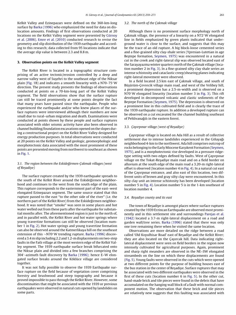
Geody
Ksllegit
3
pnpdcsctefscacieampi
3o
thTernhwtaybceeflt3gt
ffpdes
H. Gürsoy et al. / Journal of
elkit Valley and Ezinepazarı were defined on the 360-km-longurface by Barka (1996) who emphasized the need for data on dis-ocation amounts. Findings of first observations conducted at 20ocations on the Kelkit Valley segment were presented by Gürsoyt al. (2006). Emre et al. (2010) conducted research to revise theeometry and slip distribution of the 1939 earthquake and accord-ng to this research; data collected from 95 locations indicate thathe average slip value is between 2.3 and 8.8 m.
. Observation points on the Kelkit Valley segment
The Kelkit River is located in a topographic structure com-rising of an active tectonic/erosion controlled by a deep andarrow valley west of Sus ehri to the southeast edge of the Niksarlain (Fig. 1B) and indicates a smooth linearity with a N70–75◦Wirection. The present study presents the findings of observationsonducted at points on a 70-km-long part of the Kelkit Valleyegment. The field observations show that the surface rupturean still be traced prominently at some points despite the facthat many years have passed since the earthquake. People whoxperienced the earthquake and/or who knew places of the sur-ace ruptures were interviewed although their numbers are nowmall due to rural–urban migration and death. Examinations wereonducted at points shown by these people and surface rupturesssociated with older seismic activity have also been observed inhannel building/foundation excavations opened on the slopes dur-ng a constructional project on the Kelkit River Valley designed fornergy production purposes. In total observations were conductedt 20 points on the Kelkit Valley and geologic, geomorphologic andorphotectonic data associated with the most prominent of these
oints are presented moving from northwest to southeast as shownn Fig. 1.
.1. The region between the Eskidegirmen-C akmak villages (westf Res adiye)
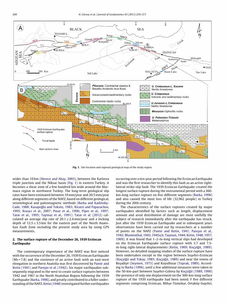
The surface rupture created by the 1939 earthquake spreads tohe south of the Kelkit River around the Eskidegirmen neighbor-ood and continues to the west from the south edge of the plain.his rupture corresponds to the easternmost part of the east–westlongated Ezinepazarı segment. The same source stated that thisupture passed to the east “to the other side of the river” (i.e. theorthern part of the Kelkit River) from the Eskidegirmen neighbor-ood. It was noted that “smoke” was seen in some places and hotater welled out from these parts after the earthquake for substan-
ial months after. The aforementioned region is just to the north of,nd in parallel with, the Kelkit River and hot water springs whereoung travertine formations can still be observed (location num-er 1 in Fig. 2). Hot water springs and young travertine formationan also be observed around the Katmerlikaya hill on the southeastxtension of this ∼N70◦W trending rupture. Barka (1996) discov-red a 3.4 m slip including 2.2 and 1.2-m displacements on two-stepaults in the Fatlı village at the most western edge of the Kelkit Val-ey segment. The 1939 earthquake surface break bifurcated ontohe Niksar plain and divided into a few branches comprising the04◦-azimuth fault discovery by Barka (1996); hence E–W elon-ated surface breaks around the Köklüce village are consideredogether.
It was not fully possible to observe the 1939 Earthquake sur-ace rupture on the field because of vegetation cover comprisingorestry and brushwood and steep topography and because it
roved impossible to pass through the Kelkit River. However, someiscontinuities that might be associated with the 1939 or previousarthquakes were observed in natural cuts opened by landslides onome parts.namics 65 (2013) 259– 271 261
3.2. The north of the C akmak village
Although there is no prominent surface morphology north ofC akmak village, the presence of a linearity on a N72◦W elongatedline in fields emphasized by green plants indicated that under-ground water is close to the surface, and suggests that this maybe the trace of an old rupture. A big block-loose cemented seriesand a fine-grained silty clay-shale series (Ypresian-Lutetian in ageBes tepe formation, Seymen, 1975) was encountered in a naturalcut in the creek and right-lateral slip was observed located east ofthe Sarayayazma winter quarters north of the C akmak village (loca-tion number 2 in Fig. 3). In a fine-grained silty clay shale series anintense schistosity and cataclastic creep/shearing planes indicatingright-lateral movement were observed.
In a field located 2.5 km east of C akmak village, and south ofBüs ürüm-C evrecik village main road, and west of the Velibey hill,a prominent depression has a 2.5-m-width and is observed on aN70◦W elongated linearity (location number 3 in Fig. 3). This riftdeveloped in decomposed volcanic and clastic sediments of theBes tepe Formation (Seymen, 1975). The depression is observed ona prominent line in this cultivated field and is clearly the trace ofthe 1939 earthquake rupture. In addition a developed rupture canbe observed on a cut excavated for the channel building southeastof Pehlivanagılı in the eastern forest.
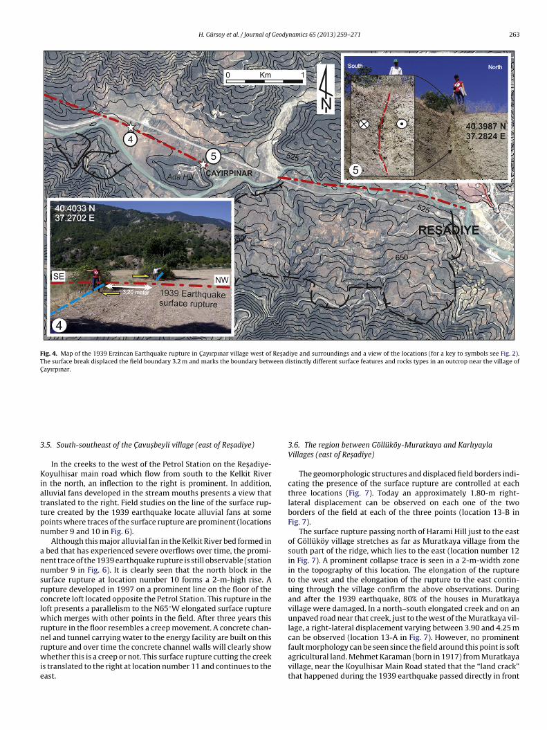
3.3. C ayırpınar village (west of Res adiye)
C ayırpınar village is located on Ada Hill as a result of collectivesettlement due to intense landslides experienced in the Gölayagıneighborhood 4-km to the northwest. Ada hill comprises outcrop ofrocks belonging to the Early Miocene Kars ıkent Formation (Seymen,1975), and is a morphotectonic rise developed in a pressure ridge-type setting with two edges defined by faults. West of C ayırpınarvillage on the Tokat-Res adiye main road and on a field border onalluvium at the south edge of the main road a 3.20-m right-lateraloffset is observed (location number 4 in Fig. 4). In a natural cut eastof the C ayırpınar entrance, and also east of this location, two dif-ferent units of brown and gray silty clay were encountered. In thissilty clay unit an intense schistosity has been developed (locationnumber 5 in Fig. 4). Location number 5 is in the 1-km southeast oflocation number 4.
3.4. Res adiye county and its east
The town of Res adiye is amongst places where surface rupturescreated by the 1939 Erzincan Earthquake are observed most promi-nently and in this settlement site and surroundings Parejas et al.(1942) located a 3.7-m right-lateral displacement on a road andgarden wall/tree series. Barka (1996) stated that there was onlyone tree remaining there when he visited the same location.
Observations are more detailed on the ridge between a roadcalled ‘Old Koyulhisar Road’ east of Res adiye and the Kelkit River;they are also located on the C ayırcak hill. Data indicating right-lateral displacement were seen on field borders in the region nowintensely cultivated for agricultural purposes. Again, prominentand sharp right meanders are observed in the NE–SW elongatedstreambeds on the line on which these displacements are found(Fig. 5). Young faults were observed in the cuts which were openedat two different points for the purpose of building houses east ofthe bus station in the center of Res adiye. Surface ruptures that maybe associated with two different earthquakes were observed in thefirst of these cuts (location number 6 in Fig. 5). In the other cut,
hand-made brick and tile pieces were found in the debris that haveaccumulated on the hanging wall block of a fault with normal com-ponent motion. The observation that these brick and tile piecesare relatively new suggests that this faulting was associated with
262 H. Gürsoy et al. / Journal of Geodynamics 65 (2013) 259– 271
F rn exto des ar
aeatKaoec2tfpc
Fw
ig. 2. Map of the 1939 earthquake rupture in the Kelkit Valley segment at the westeutcrops parallel to the trace of the 1939 earthquake break and active small landsli
n earthquake that happened more recently; probably the 1939arthquake. A few streambeds that have curved to the right arelso observed on a topography comprising a ridge and hills con-rolled by northwest–southeast elongated faults between the oldoyulhisar Road and the Kelkit River. In the two trenches excavatedt this location (location number 7 in Fig. 5) right-lateral slip wasbserved on field borders on the ridges, and the trace of the 1939arthquake rupture, as well as other ruptures that may be asso-iated with other historical earthquakes, were found (Zabcı et al.,011). At this point the 1939 earthquake surface rupture, as well ashe presence of many other faulting episodes, was revealed during
oundation excavation for a drainage basin for energy-productionurposes (location number 8 in Fig. 5). The faults in this majorut show a negative flower structure-type formation. Normal faultig. 3. Map of the 1939 Erzincan Earthquake rupture northeast and east of C akmak villaithin a stream bed displaced the rocks units and forms local landslides (Site 2). A 1.5 m w
ension of C akmak village, and the location of the hot water spring. Young travertinee also occurred.
components are prominent, especially in the NAFZ’s segments inRes adiye and its surroundings. It is expected that negative flowerstructures that created the core of the larger pull-apart basins,developed in the expanded meanders in the right-overstep faultsegments in the right-lateral strike-slip fault zones. As understoodfrom normal faults on the cut at location number 8, the 1939 earth-quake surface rupture mapped in the Kelkit Creek bed southwestof Res adiye indicates right-stepped strike-slip faulting in the shapeof an expanded meander. This plain has a rhomboidal geometry inthe Kelkit Creek bed and resembles a small and right-stepping pull-apart basin structure. The northwest–southeast elongated cleavage
crack in new travertines developed through precipitation fromthe hot waters of the Res adiye thermal spring and indicates anortheast–southwest elongated tensile stress (Fig. 5).ge and a view of the locations (for a key to symbols see Fig. 2). The surface breakide topographical depression parallel with 1939 surface break is distinct in a field.
H. Gürsoy et al. / Journal of Geodynamics 65 (2013) 259– 271 263
Fig. 4. Map of the 1939 Erzincan Earthquake rupture in C ayırpınar village west of Res adiye and surroundings and a view of the locations (for a key to symbols see Fig. 2).The surface break displaced the field boundary 3.2 m and marks the boundary between distinctly different surface features and rocks types in an outcrop near the village ofC ayırpınar.
3
Kiattpn
annsrclwrnrwie
.5. South-southeast of the C avus beyli village (east of Res adiye)
In the creeks to the west of the Petrol Station on the Res adiye-oyulhisar main road which flow from south to the Kelkit River
n the north, an inflection to the right is prominent. In addition,lluvial fans developed in the stream mouths presents a view thatranslated to the right. Field studies on the line of the surface rup-ure created by the 1939 earthquake locate alluvial fans at someoints where traces of the surface rupture are prominent (locationsumber 9 and 10 in Fig. 6).
Although this major alluvial fan in the Kelkit River bed formed in bed that has experienced severe overflows over time, the promi-ent trace of the 1939 earthquake rupture is still observable (stationumber 9 in Fig. 6). It is clearly seen that the north block in theurface rupture at location number 10 forms a 2-m-high rise. Aupture developed in 1997 on a prominent line on the floor of theoncrete loft located opposite the Petrol Station. This rupture in theoft presents a parallelism to the N65◦W elongated surface rupture
hich merges with other points in the field. After three years thisupture in the floor resembles a creep movement. A concrete chan-el and tunnel carrying water to the energy facility are built on this
upture and over time the concrete channel walls will clearly showhether this is a creep or not. This surface rupture cutting the creeks translated to the right at location number 11 and continues to theast.
3.6. The region between Göllüköy-Muratkaya and KarlıyaylaVillages (east of Res adiye)
The geomorphologic structures and displaced field borders indi-cating the presence of the surface rupture are controlled at eachthree locations (Fig. 7). Today an approximately 1.80-m right-lateral displacement can be observed on each one of the twoborders of the field at each of the three points (location 13-B inFig. 7).
The surface rupture passing north of Harami Hill just to the eastof Göllüköy village stretches as far as Muratkaya village from thesouth part of the ridge, which lies to the east (location number 12in Fig. 7). A prominent collapse trace is seen in a 2-m-width zonein the topography of this location. The elongation of the ruptureto the west and the elongation of the rupture to the east contin-uing through the village confirm the above observations. Duringand after the 1939 earthquake, 80% of the houses in Muratkayavillage were damaged. In a north–south elongated creek and on anunpaved road near that creek, just to the west of the Muratkaya vil-lage, a right-lateral displacement varying between 3.90 and 4.25 mcan be observed (location 13-A in Fig. 7). However, no prominent
fault morphology can be seen since the field around this point is softagricultural land. Mehmet Karaman (born in 1917) from Muratkayavillage, near the Koyulhisar Main Road stated that the “land crack”that happened during the 1939 earthquake passed directly in front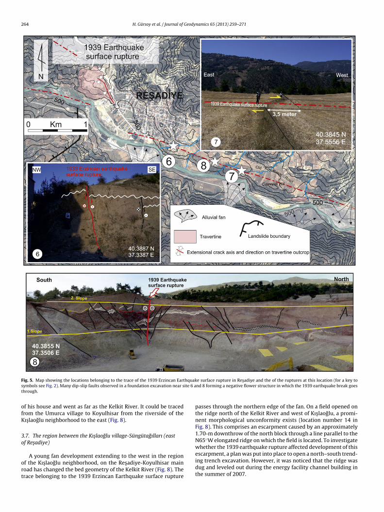
264 H. Gürsoy et al. / Journal of Geodynamics 65 (2013) 259– 271
F hquaks ite 6 at
ofK
3o
ort
ig. 5. Map showing the locations belonging to the trace of the 1939 Erzincan Eartymbols see Fig. 2). Many dip-slip faults observed in a foundation excavation near shrough.
f his house and went as far as the Kelkit River. It could be tracedrom the Umurca village to Koyulhisar from the riverside of theıs laoglu neighborhood to the east (Fig. 8).
.7. The region between the Kıs laoglu village-Süngütagılları (eastf Res adiye)
A young fan development extending to the west in the regionf the Kıs laoglu neighborhood, on the Res adiye-Koyulhisar mainoad has changed the bed geometry of the Kelkit River (Fig. 8). Therace belonging to the 1939 Erzincan Earthquake surface rupture
e surface rupture in Res adiye and the of the ruptures at this location (for a key tond 8 forming a negative flower structure in which the 1939 earthquake break goes
passes through the northern edge of the fan. On a field opened onthe ridge north of the Kelkit River and west of Kıs laoglu, a promi-nent morphological unconformity exists (location number 14 inFig. 8). This comprises an escarpment caused by an approximately1.70-m downthrow of the north block through a line parallel to theN65◦W elongated ridge on which the field is located. To investigatewhether the 1939 earthquake rupture affected development of this
escarpment, a plan was put into place to open a north–south trend-ing trench excavation. However, it was noticed that the ridge wasdug and leveled out during the energy facility channel building inthe summer of 2007.
H. Gürsoy et al. / Journal of Geodynamics 65 (2013) 259– 271 265
F Res adk drainab
epeSRtwpa
3
lleUDm
Uthef
ig. 6. Map of alluvial fans that developed south-southeast of C avus beyli Village (ey to symbols see Fig. 2). Extreme points of alluvial fans developed within stream
reak. The traces of this break is visible at locations 9 and 10.
In another cut on the edge of the Kelkit River, which is theast extension of this N65◦W elongated ridge, the inner structureresents a brecciated and decomposed view. These brecciated lev-ls are also observed in a cut opened on a pathway going to theüngütagılları eastwards through the northern edge of the Kelkitiver (location number 14 in Fig. 8). The small creek beds displacedo the right on the small alluvial fan around the Süngütagılları alongith the east–west elongated pressure ridge type hills are inter-reted as the reaction of surface ruptures of the 1939 earthquakend/or a previous earthquake (location number 15 in Fig. 8).
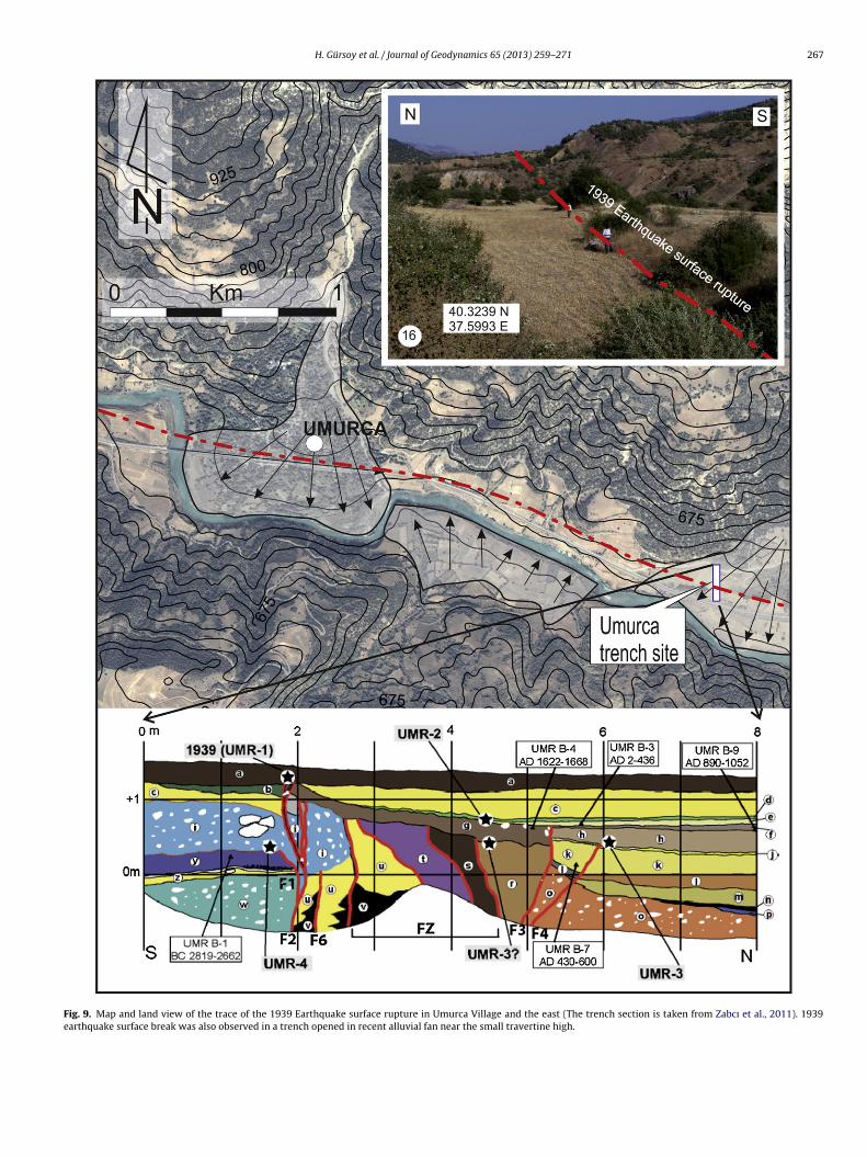
.8. The Umurca village (east of Res adiye) and surroundings
There was a 170 loss of lives in total in Umurca village, theast settlement linked to Res adiye (Tokat) in the Kelkit River Val-ey, with 133 due to demolition that happened during the 1939arthquake and 37 due to the epidemics following the earthquake.murca village is sited on an alluvial fan which developed onerebogaz Creek flowing out of (?) limestones that form a sharporphology from the north to the south (Fig. 9).The surface rupture of the earthquake around the village of
murca follows the northern edge of the main road passing through
he village today and continuing to the east. Morphological tracesave completely vanished today since the surface ruptures on thedge of the road in the village and on the main road have beenrequently repaired. However, a trench opened in the alluvial faniye) and the 1939 Earthquake surface rupture, and the view of the locations (for ages perpendicular to rapid flowing Kelkit river are cut by 1939 earthquake surface
1.5-km east of the Umurca close to the travertines on this alluvialfan show evidence for four seismic events and one of these wasthe 1939 earthquake (Zabcı et al., 2011) (Fig. 9). The 1939 earth-quake rupture found in the Umurca trench stretches to the eastand to the south of the Res adiye-Koyulhisar road and cuts throughthe Kelkit River extending to the southeast (location number 16in Fig. 9). A morphologic structure whose northern part seems tohave collapsed also has a ruined-looking north block in the 1939earthquake rupture found in the Umurca trench section (the sec-tion in Fig. 9). The rupture, which forms a more prominent rise inthe topography in this section, cuts into the landslip region to theeast and enters into a thicker alluvial fan. A prominent trace of therupture cannot be observed in this fan and the rupture continuessouth of the Res adiye-Koyulhisar road and extends into Gökderevillage (location number 17 in Fig. 10).
3.9. The region between the Gökdere and Sugözü villages (west ofKoyulhisar)
The 1939 earthquake rupture passes in front of the escarpmentjust southwest of the petrol station near Gökdere village main roadand runs through the ridge at the east entrance of the village. It
then extends eastwards in parallel with the Koyulhisar Main Road(Fig. 10). Despite the intense landslippage in the region, the sur-face rupture quite prominently passes from the south edge of thehills developed as a pressure ridge and pointing to a typical fault
266 H. Gürsoy et al. / Journal of Geodynamics 65 (2013) 259– 271
Fig. 7. Map of the 1939 surface rupture in Göllüköy and Muratkaya villages (east of Res adiye) and surroundings and a view of the locations (for a key to symbols see Fig. 2).Right lateral offsets between 1.80 and 4.25 m within stream beds and fields are observed at 13A and B locations). 2 m wide trace of 1939 earthquake surface break are observedon elongated hills parallel to the main trend of the NAFZ.
Fig. 8. The general course of the 1939 earthquake surface rupture between Kıs laoglu neighborhood and Süngütagılları (for a key to symbols see Fig. 2). A significant 1.70 mvertical slip in a surface break going through on the northern part of an elongated hill is observed. During canal excavation at this location, slope wash deposits of 2 differentcolors are cut by the surface break and the small creek within slope wash deposits at location 15 offset right laterally.
H. Gürsoy et al. / Journal of Geodynamics 65 (2013) 259– 271 267
Fig. 9. Map and land view of the trace of the 1939 Earthquake surface rupture in Umurca Village and the east (The trench section is taken from Zabcı et al., 2011). 1939earthquake surface break was also observed in a trench opened in recent alluvial fan near the small travertine high.
268 H. Gürsoy et al. / Journal of Geodynamics 65 (2013) 259– 271
F illage
e trenct ive lan
manApBo
3v
hKoscpcroOBtt
ig. 10. The general course of the 1939 earthquake surface rupture in Gökdere varthquake break showing significant morphology toward east from the Umurcaectonomorphological features such as elongated hills and fault front slope and act
orphology (locations number 18 and 19 in Fig. 10). Due to thective landslide east of Gökdere Village, a 4-km new road passes theorth side of Kelkit River from the east entrance of Yes ilyurt village.ccording to local people, surface ruptures of the 1939 earthquakeassed to the east from the southern slope of Karatas tepe near toaglıyurt (old name is Gürün) village and from the northern slopef the Kabak hill it is parallel with the main road.
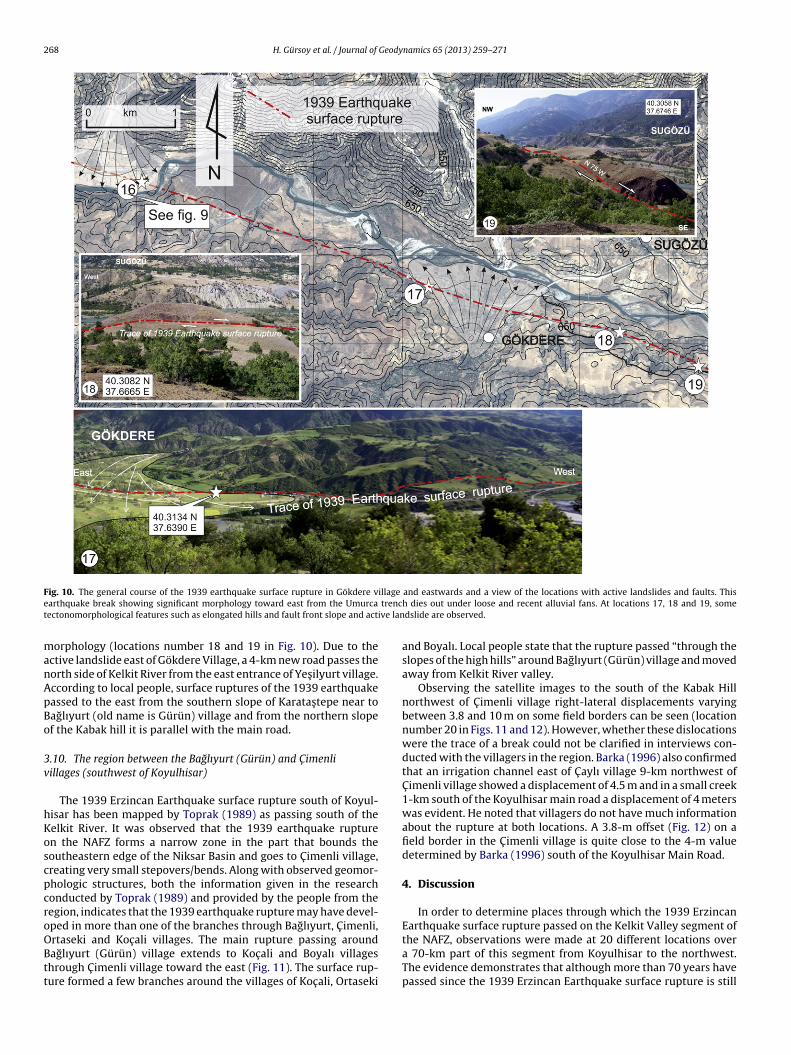
.10. The region between the Baglıyurt (Gürün) and C imenliillages (southwest of Koyulhisar)
The 1939 Erzincan Earthquake surface rupture south of Koyul-isar has been mapped by Toprak (1989) as passing south of theelkit River. It was observed that the 1939 earthquake rupturen the NAFZ forms a narrow zone in the part that bounds theoutheastern edge of the Niksar Basin and goes to C imenli village,reating very small stepovers/bends. Along with observed geomor-hologic structures, both the information given in the researchonducted by Toprak (1989) and provided by the people from theegion, indicates that the 1939 earthquake rupture may have devel-ped in more than one of the branches through Baglıyurt, C imenli,
rtaseki and Koc ali villages. The main rupture passing aroundaglıyurt (Gürün) village extends to Koc ali and Boyalı villageshrough C imenli village toward the east (Fig. 11). The surface rup-ure formed a few branches around the villages of Koc ali, Ortasekiand eastwards and a view of the locations with active landslides and faults. Thish dies out under loose and recent alluvial fans. At locations 17, 18 and 19, somedslide are observed.
and Boyalı. Local people state that the rupture passed “through theslopes of the high hills” around Baglıyurt (Gürün) village and movedaway from Kelkit River valley.
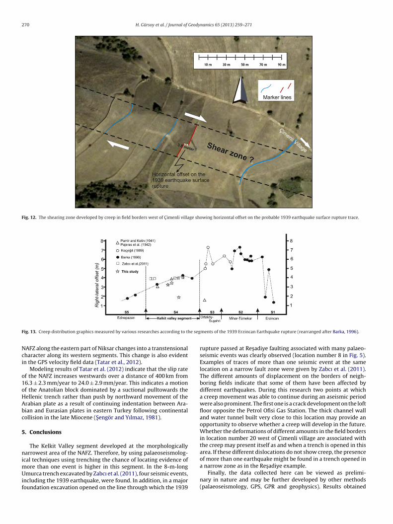
Observing the satellite images to the south of the Kabak Hillnorthwest of C imenli village right-lateral displacements varyingbetween 3.8 and 10 m on some field borders can be seen (locationnumber 20 in Figs. 11 and 12). However, whether these dislocationswere the trace of a break could not be clarified in interviews con-ducted with the villagers in the region. Barka (1996) also confirmedthat an irrigation channel east of C aylı village 9-km northwest ofC imenli village showed a displacement of 4.5 m and in a small creek1-km south of the Koyulhisar main road a displacement of 4 meterswas evident. He noted that villagers do not have much informationabout the rupture at both locations. A 3.8-m offset (Fig. 12) on afield border in the C imenli village is quite close to the 4-m valuedetermined by Barka (1996) south of the Koyulhisar Main Road.
4. Discussion
In order to determine places through which the 1939 ErzincanEarthquake surface rupture passed on the Kelkit Valley segment of
the NAFZ, observations were made at 20 different locations overa 70-km part of this segment from Koyulhisar to the northwest.The evidence demonstrates that although more than 70 years havepassed since the 1939 Erzincan Earthquake surface rupture is still
H. Gürsoy et al. / Journal of Geodynamics 65 (2013) 259– 271 269
villag
pm(
odotc
TH
Fig. 11. Map of the 1939 earthquake surface ruptures in Baglıyurt (Gürün)
rominent on some places. At eight different locations on this seg-ent displacements were sometimes measurable on the rupture
Table 1).Right-lateral displacements were obtained at five of these
bservation points and vertical offsets at three. The right-lateralisplacements vary between 1.8 and 4.25 m. The amount of lateral
ffset decreases regularly from the southeast edge of the segment tohe northwest edge in line with the results of previous researchesarried out on the same segment (Fig. 13). Vertical displacementable 1orizontal and vertical offset measurements along the Kelkit Valley segment of the NAFZ
Site no. Site name Offset features
4 C ayırpınar village Field boundary
6 Res adiye Unconformity
7 Res adiye Field boundary
10 West of Petrol Ofisi Gas station Topography
13-A Muratkaya mezraa Stream course and Road
13-B Göllüköy mezraa Field boundary
14 NW of Kıs laoglu village Topography
20 W of C imenli village Field boundary
e and villages to the east with a view of the location in the C imenli village.
values, on the other hand, are variable but measured to be twometers at most places.
The slip rates obtained by geological observations(20.5 ± 5.5–27 ± 7 mm/year, Hubert-Ferrari et al., 2002, 2009;Hartleb et al., 2003) are consistent with the geodetic slip rates(Tatar et al., 2012). The NAFZ becomes wider especially from the
western part of Kargı town center and branches off where youngnormal fault-controlled sedimentary basins are formed (S engöret al., 2005). This indicates that the transpressional character of the.
Horizontal offset (m) Vertical offset (m) (+) Upward block
3.2 ± 0.3 –– 0.5 ± 01 (North +)3.5 ± 0.3 –– 2.0 ± ? (North +)3.90–4.25 ± 0.3 –1.80 ± 0.40 –– 1.7 ± ? (South +)3.8 ± 0.6 –
270 H. Gürsoy et al. / Journal of Geodynamics 65 (2013) 259– 271
Fig. 12. The shearing zone developed by creep in field borders west of C imenli village showing horizontal offset on the probable 1939 earthquake surface rupture trace.
F he seg
Nci
o1oHAbc
5
nimUif
ig. 13. Creep distribution graphics measured by various researches according to t
AFZ along the eastern part of Niksar changes into a transtensionalharacter along its western segments. This change is also evidentn the GPS velocity field data (Tatar et al., 2012).
Modeling results of Tatar et al. (2012) indicate that the slip ratef the NAFZ increases westwards over a distance of 400 km from6.3 ± 2.3 mm/year to 24.0 ± 2.9 mm/year. This indicates a motionf the Anatolian block dominated by a suctional pulltowards theellenic trench rather than push by northward movement of therabian plate as a result of continuing indentation between Ara-ian and Eurasian plates in eastern Turkey following continentalollision in the late Miocene (S engör and Yılmaz, 1981).
. Conclusions
The Kelkit Valley segment developed at the morphologicallyarrowest area of the NAFZ. Therefore, by using palaeoseismolog-
cal techniques using trenching the chance of locating evidence of
ore than one event is higher in this segment. In the 8-m-longmurca trench excavated by Zabcı et al. (2011), four seismic events,ncluding the 1939 earthquake, were found. In addition, in a majoroundation excavation opened on the line through which the 1939
ments of the 1939 Erzincan Earthquake rupture (rearranged after Barka, 1996).
rupture passed at Res adiye faulting associated with many palaeo-seismic events was clearly observed (location number 8 in Fig. 5).Examples of traces of more than one seismic event at the samelocation on a narrow fault zone were given by Zabcı et al. (2011).The different amounts of displacement on the borders of neigh-boring fields indicate that some of them have been affected bydifferent earthquakes. During this research two points at whicha creep movement was able to continue during an aseismic periodwere also prominent. The first one is a crack development on the loftfloor opposite the Petrol Ofisi Gas Station. The thick channel walland water tunnel built very close to this location may provide anopportunity to observe whether a creep will develop in the future.Whether the deformations of different amounts in the field bordersin location number 20 west of C imenli village are associated withthe creep may present itself as and when a trench is opened in thisarea. If these different dislocations do not show creep, the presenceof more than one earthquake might be found in a trench opened in
a narrow zone as in the Res adiye example.Finally, the data collected here can be viewed as prelimi-nary in nature and may be further developed by other methods(palaeoseismology, GPS, GPR and geophysics). Results obtained

Geody
ft
A
wt
R
A
A
A
A
B
B
B
B
B
B
E
E
G
G
H
H
H
H
I
I
K
K
K
H. Gürsoy et al. / Journal of
rom further research will contribute to a better understanding ofhe NAFZ and help with prediction of future earthquake hazards.
cknowledgements
This work was supported by DPT Project No. 2006-120220Khich is greatly acknowledged. We also thank local authorities in
he region for their invaluable help during the course of this study.
eferences
mbraseys, N.N., Melville, C.P., 1995. Historical evidence of faulting in Eastern Ana-tolia and Northern Syria. Annali Di Geofisica XXXVIII, 337–343.
mbraseys, N.N., Jackson, J.A., 1998. Faulting associated with historical and recentearthquakes in the Eastern Mediterranean region. Geophysical Journal Interna-tional 133, 390–406.
mbraseys, N.N., Jackson, J.A., 2000. Seismicity of the Sea of Marmara (Turkey) since1500. Geophysical Journal International 141, F1–F6.
mbraseys, N.N., Finkel, C.F., 2006. Türkiye ve koms u bölgelerde sismik etkinlikler,Bir tarihsel inceleme, 1500–1800. In: TÜBITAK Akademik Dizi, C eviri M. UmurKoc ak, 252 Sayfa, Ankara.
arka, A., Kadinsky-Cade, K., 1988. Strike-slip fault geometry in Turkey and influenceon earthquake activity. Tectonics 7, 663–684.
arka, A., 1996. Slip distribution along the North Anatolian Fault associated with thelarge earthquakes of the period 1939 to 1967. Bulletin of Seismological Societyof America 86, 1238–1254.
arka, A., Wesnousky, S.G., 1994. Potential of a large earthquake in the Erzincanregion following the 1992 Erzincan earthquake, M = 6.9, Preliminary trenchstudy results. Open-File Report. U. S. Geological Survey, pp. 14–15.
lumenthal, M., 1943. Zur Geologie der Landstrecken der Erdbebeu von ende 1942in Nord-Anatolien und dortselbst ausgefurte macroseismiche Beobachtungen.Bulletin of Mineral Research and Exploration Institute, Turkey 8, 33–58.
lumenthal, M., 1945a. Lâdik deprem Hattı. Bulletin of Mineral Research and Explo-ration Institute, Turkey 1 (33), 153–174.
lumenthal, M., 1945b. Die Kelkit Dislocation und ihre tectonische rolle. Bulletin ofMineral Research and Exploration Institute, Turkey 2 (34), 372–386.
mre, Ö., Kondo, H., Özalp, S., Elmacı, H., Kürc er, A., 2010. Fault geometry and slipdistribution associated with the 1939 Erzincan Earthquake (M: 7.9). North Ana-tolian Fault, Geophysical Research Abstracts 12, EGU2010–EGU2551.
rgin, K., Güc lü, U., Uz, Z., 1967. A Catalog of Earthquakes for Turkey and Surround-ing Area (11 A.D. to 1964 A.D.). Technical Report, Istanbul Technical University,Faculty of Mines, Institute of Physics of the Earth, no. 24.
uidoboni, E., Comastri, A., Triana, G., 1994. Catalogue of Ancient Earthquakes in theMediterranean Area up to the10th Century. Istituto Nazionale di Geofisica, ISBN88-85213-06-5, p. 504.
ürsoy, H., Akpınar, Z., Tatar, O., Koc bulut, F., Sezen, T.F., Mesci, B.L., Polat, A., Kavak,K.S ., Tunc er, D., Yaman, S., 2006. 1939 Erzincan depremi yüzey kırıgı haritalamac alıs maları (Res adiye batısı–Koyulhisar arası): ilk gözlemlere ait bulgular. AktifTektonik Aras tırma Grubu 10. Toplantısı, Bildiri Özleri Kitabı, s.37, 2–4 Kasım2006, Izmir.
artleb, R.D., Dolan, J.F., Akyüz, H.S., Yerli, B., 2003. A 2000 year-long paleoseis-mologic record of earthquakes along the central North Anatolian Fault, fromtrenches at Alayurt, Turkey. Seismological Society of America Bulletin 93,1935–1954.
erece, E., Akay, E., 2003. Atlas of North Anatolian Fault (NAF), 1:100.000 Scale.Mineral Research and Exploration (MTA) Special Publication, Ankara, Turkey.
ubert-Ferrari, A., Armijo, R., King, G., Meyer, B., Barka, A.A., 2002. Morphology,displacement, and slip rates along the North Anatolian Fault, Turkey. Journal ofGeophysical Research 107 (B10), 9/1–9/33.
ubert-Ferrari, A., King, G., Van Der Woerd, J., Villa, I., Altunel, A., Armijo, R., 2009.Long term evolution of the North Anatolian Fault: new constraints from itstermination. In: Van Hinsbergen, D.J.J., Edwards, M.A., Govers, R. (Eds.), Colli-sion and Collapse at the Africa-Arabia-Eurasia Subduction Zone. The GeologicalSociety of London, Special Publications, pp. 133–154, 311.
˙keda, Y., 1988. In: Honkura, Y., Is ıkara, A.M. (Eds.), Geomorphological observationsof the North Anatolian fault, West of Mudurnu, Multidisiplinary research onfault activity in the western part of the North Anatolian fault zone. , pp. 6–14.
˙keda, Y., Suzuki, Y., Herece, E., S aroglu, F., Is ıkara, A.M., Honhura, Y., 1991. Geologicalevidence for the last two faulting events on the North Anatolian Fault Zone inthe Mudurnu valley, western Turkey. Tectonophysics 193, 335–345.
asapoglu, K.E., Toksöz, M.N., 1983. Tectonic consequences of the collision of theAr-
abian and Eurasian Plates: finite element models. Tectonophysics 100, 71–95.etin, I., 1948. Ober die tektonisch-mechanischen Folgerungen aus den grossen ana-tolischen Erdbeben des letzten Dezenniums. Geologische Rundschau 36, 77–83.
etin, I., 1957. Kuzey Anadolu deprem fayı (The North Anatolian earthquake fault).ITÜ Bülteni 15, 49–52 (in Turkish with English abstract).
namics 65 (2013) 259– 271 271
Ketin, I., 1969. Kuzey Anadolu Fayı Hakkında (About the North Anatolian fault). MTABülteni 72, 1–28 (in Turkish).
Kiratzi, A.A., Papazachos, C.B., 1995. Active crustal deformation of North and EastAnatolian fault zones. Tectonophysics 243, 1–24.
Koc yigit, A., Tokay, M., 1985. C atalc am (Zevker)-Erzincan arasındaki Kuzey AnadoluFay kus agının sismo-tektonik incelemesi, Fay kus agının tektonostratigrafisi,sistematigi ve neotektonik özellikleri, ODTÜ, Ankara Uygulamalı Aras tırmalarProjesi No. 82-04-08, 00-02, 101 sayfa.
Koc yigit, A., 1989. Sus ehri Basin; an active fault wedge basin. Tectonophysics 167,13–29.
Koc yigit, A., 1990. Tectonic setting of the Gölova basin; total offset of the NorthAnatolian fault zone, E. Pontide, Turkey. Annales Tectonicae IV, 155–170.
Kozacı, Ö., Dolan, J.F., Finkel, R., Hartleb, R., 2007. Late holocene slip rate for the NorthAnatolian Fault, Turkey, from cosmogenic 36Cl geochronology: implications forthe constancy of fault loading and strain release rates. Geology 35, 867–870.
Nowack, E., 1928. Die wichtigsten Ergebnisse meiner anatolischen Reisen. Zeitschriftder Deutschen Geologischen Gesellschaft 80, 304–312 (Monatsbericht, No.8–10).
Okumura, K., Yoshioka, T., Kuscu, I., Kayanne, H., Suzuki, Y., 1990. Activity of theNorth Anatolian Fault during these two millennia on the surface faults of 1944earthquake based on trenching and microtopographic studies. Eos, Transactions,American Geophysical Union 71, 1560.
Okumura, K., Yoshioka, T., Kuscu, I., Nakamura, T., Suzuki, Y., 1993. Recent sur-face faulting along the North Anatolian Fault, east of the Erzincan Basin,Turkey; a trenching survey. Eos, Transactions, American Geophysical Union 74,545.
Okumura, K., Yoshioka, T., Kuscu, I., Nakamura, T., Suzuki, Y., 1994. Recent surfacefaulting on the North Anatolian fault east of Erzincan Basin, Turkey – a trenchingsurvey. Summaries of Researchs Using AMS at Nagoya University 5, 32–48.
Okumura, K., Yoshioka, T., 1994. Surface faulting on the North Anatolian Fault inthese two millennia. In: Proceedings on Workshop on Paleoseismology, Mar-shall, CA, pp. 143–144.
Pamir, H.N., Ketin, I., 1941. Das Anatolische Erdbeben Ende 1939. Geologische Rund-schau 32, 278–287.
Parejas, E., Akyol, I.H., Altınlı, E., 1942. Le tremblement de terre d’Erzincan du 17Decembre 1939. Review of the Faculty of Science, University of Istanbul NVI,177–222.
Pınar, A., Honkura, Y., Kikucki, M., 1996. A rupture model for the 1967 Mudurnu val-ley, Turkey earthquake and its implications for seismotectonics in the westernpart of the NAFZ. Geophysical Research Letters 23 (1), 29–32.
Piper, J.D.A., Tatar, O., Gürsoy, H., 1997. Deformational behaviour of continentallithosphere deduced from block rotations across the North Anatolian Fault Zonein Turkey. Earth and Planetary Science Letters 150, 191–203.
Salomon-Calvi, W., 1936. Die Fortsetzung der Tonalelinie in Kleinasien. YüksekZiraat Enstitüsü C alıs malarından, 11–13, No. 9.
Seymen, I., 1975. Kelkit Vadisi Kesiminde Kuzey Anadolu Fay Zonunun TektonikÖzelligi: Dr. Eng., Istanbul Teknik Üniversitesi. Maden Fakültesi XIX, 192.
Soysal, H., Sipahioglu, S., Kolc ak, D., Altınok, Y., 1981. Historical Earthquake Cata-logue of Turkey and Surrounding Area (2100 BC – 1900 A.D.). Technical Report,TÜBITAK, No: TBAG-341.
S engör, A.M.C., Yılmaz, Y., 1981. Tethyan evolution of Turkey: a plate tectonicapproach. Tectonophysics 75, 181–241.
S engör, A.M.C., Tüysüz, O., Imren, C., Sakınc , M., Eyidogan, H., Görür, N., Le-Pichon,X., Rangin, C., 2005. The North Anatolian Fault; A new look. Annual Review ofEarth and Planetary Sciences 33, 37–112.
Tan, O., Tapırdamaz, M.C., Yörük, A., 2008. The Earthquake Catalogues for Turkey.Turkish Journal of Earth Sciences 17, 405–418.
Tas man, C.E., 1944. Gerede-Bolu depremi. Bulletin of Mineral Research and Explo-ration Institute, Turkey 1 (31), 134.
Tatar, O., Piper, J.D.A., Park, G.R., Gürsoy, H., 1995. Paleomagnetic study of blockrotations in the Niksar overlap region of the North Anatolian Fault Zone, centralTurkey. Tectonophysics 244, 251–266.
Tatar, O., Poyraz, F., Gürsoy, H., C akır, Z., Ergintav, S., Akpınar, Z., Koc bulut, F., Sezen,F., Türk, T., Hastaoglu, K.Ö., Polat, A., Mesci, B.L., Gürsoy, Ö., Ayazlı, I.E., C akmak,R., Belgen, A., Yavas oglu, H., 2012. Crustal deformation and kinematics of theEastern Part of the North Anatolian Fault Zone (Turkey) from GPS measurements.Tectonophysics 518–521, 55–62.
Taymaz, T., Jackson, J., McKenzie, D., 1991. Active Tectonic of North and centralAegean Sea. Geophysical Journal International 106, 433–490.
Toprak, V., 1989. Tectonic and stratigraphic characteristics of the Koyulhisar seg-ment of the North Anatolian Fault Zone (Sivas, Turkey). PhD thesis, Middle EastTechnical University, Ankara, 121 p.
Yoshioka, T., Okumura, K., Kus c u, I., 1991. Trench excavation of the North AnatolianFault, Turkey. Chishitsu News 1991, 60–66.
Zabcı, C., Akyüz, H.S., Karabacak, V., Sancar, T., Altunel, E., Gürsoy, H., Tatar, O.,2011. Palaeoearthquakes on the Kelkit Valley Segment of the North Ana-tolian Fault, Turkey: Implications for the Surface Rupture of the Historical17 August 1668 Anatolian Earthquake. Turkish Journal of Earth Sciences 20,411–427.