NEO-LITHICS_2002_2.pdf - ex oriente eV
24
-
Upload
khangminh22 -
Category
Documents
-
view
0 -
download
0
Transcript of NEO-LITHICS_2002_2.pdf - ex oriente eV


Editorial This has been a sad and difficult year for us all on both
personal and professional levels. Madness is breeding more madness, and there has been little on the horizon to suggest that the insanity will soon diminish. In view of the scale of human suffering that has already been unleashed, and the horrors of what might be released in the future, the contem- plation of our individual research problems is trivial. But perhaps it is simply these refuges from the dreadful that allows us to maintain our own sanity. We can hope that rational minds will prevail, but we ourselves must also work for peace. We wish for a new year that restores humanity and dignity to humanity all over the world.
G.O. Rollefson & H.G.K. Gebel
IMPORTANT: Neo-Lithics On Its Own Account
Dear colleagues, dear subscribers,
We would like to inform you that beginning in 2003 Neo-Lithics will appear with more pages and in a techni- cally much improved format. You will notice impro- vements of the general layout, quality and size of illustra- tions, print font size, and binding. Although we are not aiming to change the general character, intent, and poli- cies of the newsletter, we may emphasize that for future presentations (field reports and contributions) we support submissions that have a more journal-like character. On the other hand, we will continue to encourage our origi- nally intended discursive character of the newsletter in order to promote its role as a forum for the exchange of innovative and debated ideas. This involves encouraging colleagues to comment on recently published ideas, and we ourselves hope to raise topics that might require discussions from several sides of a debate.
Now some technical information on this shift: Since the production costs and postage for the "new" newsletter will be considerably higher, the postal rates in Germany were considerably risen by the beginning of the year, ex orierzte will not be able to maintain the subscription rate of 24 Euros (ca. $24) for 6 issues (since 1994). However, nothing will change for subcriptions currently in effect. The new cost will be 52 Euros (for 6 issues = 3 years minimum subscription) and will be charged only for the new orders or renewed subscriptions. As always, the status of your subscription will be found in the upper right part of the address label.
Beginning in 2003 Neo-Lithics will also be distributed free to members of ex oriente (annual member-ship from 2003 onwards: 40 Euros, 25% membership discount on ex oriente publications except Neo-Lithics; we will soon contact those who both are members and subscribers in order to settle this change). The editors of Neo-Lithics and ex oriente are would be happy to receive any suggestions or comments you may have concerning this improvement of Neo-Lithics, both in technical terms and its role as a forum of quick exchange of opinions.
ex oriente e.V., Berlin & editors of Neo-Lithics
the upper right part of the address field (envelop) you ill find the issue mentioned until which (included) you
a1 of subscription is necessary for the next
May lSth, 2003 (next deadline: Nov. l5th, 2003)
Please, note that the text of contributions should be send as an email attachment directly to Gary 0 . Rollefson ([email protected]; Dept. of Anthropology, Whit- man College, Walla Walla, WA, 99362 USA). Illustrations should be sent separately by snailmail to
.G.K. Gebel at the Berlin address (Free University of erlin, Hiittenweg 7, D-14195 Berlin; sending digitalized
ations is also possible (Email: hggebelC3zedat.f~- de) from now on. Please, sumit only high quality
A Large Obsidian Core from Tell 'Ain el-Kerkh, Northwest Syria
Osamu Maeda University of Tsukuba ([email protected])
At Tell 'Ain el-Kerkh a large unused obsidian preformed core was discovered during the construction of a recent agricultural drain. This preformed core is more than 14 cm. in maximum dimension, and such extraordinarily large obsidian artifacts have not been found so far in regions far from obsidian sources in the Anatolian mountains. This discovery is worth discussing here because this extra- ordinary obsidian preformed core may provide us with new evidence of obsidian exchange and lithic production in the northern Levant.
Since the beginning of the 1990s, the University of Tsukuba has been conducting archaeological investigations at Tell el-Kerkh in northwest Syria. The site is located in the Rouj Basin, which is adjacent to the north end of the Ghab Valley 70km southwest of the modern city of Aleppo. It consists of three artificial mounds, Tell el-Kerkh I, Tell el- Kerkh 2, and Tell 'Ain el-Kerkh. Small soundings were carried out at Tell el-Kerkh 2 in 1992 (Iwasaki et al. 1995: Tsuneki and Miyake 1996), and since 1997 large scale exca- vations have been undertaken at Tell 'Ain el-Kerkh under the direction of Prof. A. Tsuneki (University of Tsukuba, Japan) and Mr. J. Hydar (Latakia National Museum, Syria) (Arimura 1999; Tsuneki et al. 2000). At both sites Neolithic occupa- tions through the PPN to the PN have been investigated.
The obsidian preformed core discussed here was found in backdirt from a trench dug during agricultural drain pipe construction, which was conducted after we finished the research season in 2001. Unfortunately, the trench was dug by a backhoe across the northern edge of Tell 'Ain el-Kerkh, and some archaeological materials were exposed. Among these materials, most of which seem to belong to the Neo- lithic period, was a large obsidian preformed core which was collected by local people. Unfortunately, its chronological context is not exactly known because it was found from secondarily deposited backdirt. Judging from the materials recovered together, however, it seems plausible that this obsidian preformed core can be ascribed to the Late PPNB or the early phase of the Pottery Neolithic period.
Preformed core This preformed core is 14.1 x 3.3 x 10.5 cm in size and
715 g in weight (Fig.l). It is made of transparent black obsidian. In typological terms, it can be classified into a single platform prismatic core with a ridged back and an inclined platform. However, unlike usual single platform prismatic cores, the width of the working surface of this preformed core is quite narrow when compared with its length. Both sides are shaped by removing large thin flakes, but original surfaces of the core blank are left on the central part of both sides. Its back maintains a natural surface, which is heavily weathered and looks like a thin

cortical layer whitish brown in color. A central crested ridge is not present; instead, the back is flattened by series of flakes knapped horizontally, forming a ridge at a corner between the side and back. Interestingly, the working surface is formed not by a crested ridge but by a flat surface. The original surface of the blank was used for the working surface. It seems that primary blades were supposed to be detached from the corners between the working surface and sides. A few short blade scars are left on the working surface. These were possibly flaked to trim the working surface before blade detachment started or were probably caused by the failure of primary blade detachment. The platform is a single scar produced from the front of the core toward the back. The upper part of both sides of the preformed core was shaped after making the platform.
If the original shape of the blank of this preformed core is estimated based on the original surfaces left on its sides, back and front, it seems that t h ~ s preformed core was made on thick and large flake or flake-like blank. Taking advantage of the original shape of raw material, roughing out was possibly not necessary, or was done easily if needed, and then it could be shaped out to the preformed core. After production, this preformed core seems to have been abandoned or stored somewhere before blade detachment started.
Fig. 1. Obsidian prefonned core from Tell 'Ain el-Kerkh
Production method When compared with other obsidian artifacts recovered
during the excavations at Tell 'Ain el-Kerkh, there are some reasons to consider that this preformed core was probably shaped out on the site.
First, from the Late PPNB occupation revealed during excavations at Grid D6 at the northwest area of the tell, some large thin flakes have been recovered. They have an
irregular shape with multi-directional flake scars on their dorsal surface, showing the typological features of flakes that are often produced during shaping out. Their size roughly fits the size of scars left on the sides of this pre- formed core. Although these flakes are not directly asso- ciated with this preformed core, the presence of such flakes could be positive evidence for its on-site production.
Secondly, the typological features of this preformed core show local variation. Generally, it has common typological features with usual single platform prismatic cores: the cores that have an inclined platform and a working surface limited to a front occur widely in the north Levant. How- ever, if seen in detail, this preformed core from Tell 'Ain el- Kerkh shows local variations such as a narrow working surface, a flat back, and a blade detachment mode starting from the corners of the working surface. In fact, such typological features are often seen among obsidian bladelet cores found from the Late PPNB and early Pottery Neolithic layers at Tell 'Ain el-Kerkh. These bladelet cores must have been locally produced because the associated debitage of bladelet core production were also recovered. Furthermore, this typological feature is seen in common with flint cores at Tell 'Ain el-Kerkh, too. There are some flint blade cores which, having a narrow working surface and a flat back, are almost identical to this obsidian preformed core in their size and shape. Thus, it can be said that this preformed core was produced at Tell 'Ain el-Kerkh by using local core pro- duction technology in common with the small obsidian bladelet cores and flint blade cores. Therefore, at the moment it is plausible to think that this preformed core was produced on the site from a blank such as a large flake or a roughout brought from outside of the tell.
Blank acquisition If this preformed core was shaped out on the site, how did
people at Tell 'Ain el-Kerkh acquire the blank for it? L. Copeland has already suggested possible scenarios in Jazirah (Copeland 1995), and there can be several possibilities for obsidian acquisition by the people of Tell 'Ain el-Kerkh, too.
One possibility is that the people visited the obsidian sources to obtain the blank which was suitable to produce this type of preformed core. However, such a direct approach to obsidian sources was not likely the case because it is known that obsidian at Tell 'Ain el-Kerkh was derived from various kinds of sources, showing various color variations, not only from Cappadocia but also from east Anatolia. It does not seem to have been efficient for the people at Tell 'Ain el-Kerkh to visit every source far from their home (at least more than 300 km. as the crow flies to the nearest source in Cappadocia).
On the other hand, there is another possibility that a special group who engaged in obsidian exchange came to Tell 'Ain el-Kerkh with an obsidian blank, and then produced this preformed core at the site by using local technology. Although this possibility can not totally ruled out, this does not seem to be the case here because the common typological features between this preformed core and other local-made cores, especially flint cores, at Tell 'Ain el-Kerkh implies that both of them were possibly produced by the same local people.
If these two possibilities are to be rejected, the other possibility is exchange, through which the blank of this preformed core was brought to the site. If this is the case, it can be assumed that the blank, which is suitable to provide a single platform prismatic core, was exchanged among settlements between the obsidian sources and Tell 'Ain el- Kerkh, and shaped out to the local type of preformed core at Tell 'Ain el-Kerkh.
Summary This preformed core is positive evidence for large
obsidian blade production at Tell 'Ain el-Kerkh. However, it must be noted that such large blade core production was
rather exceptional at Tell 'Ain-el Kerkh. No other large cores or preformed cores have been found so far, in contrast to the fact that a lot of small obsidian bladelet cores have been found. If we consider the low ratio of lateral blades, crested blades, or other debitage associated with large blade production among the obsidian artifacts, we must say that most of the blades were not produced on the site but brought to it in a finished form. The presence of a few bidirectional blades or blades made of greenish obsidian, for which there is no evidence of on-site production, certainly shows that at least these blades were brought from outside.
Accordingly, we must think that the people of Tell 'Ain el-Kerkh obtained obsidian through exchange in various forms. Blades and bladelets were imported, although some bladelets were produced on the site. At the same time, it now appears that some of the large blades were also produced on the site. It means that obsidian exchange in the Neolithic Levant had various forms and was not unified in a specific way.
Bibl iography Arimura M. 1999 The Lithic Industry of the Final Pottery Neolithic: New Evi- dence from Tell 'Ain el-Kerkh, Northwest Syria. Neo-Lithics 3/99: 7-10 Copeland L. 1995 The Phantom Obsidian Traders of the Jazirah. Neo-Lithics
Iwasaki T., Nishino H., and Tsuneki A. 1995 The Prehistory of the Rouj Basin, Northwest Syria. A Pre- liminary Report. Anntolica 21: 143-1 87. Tsuneki A. and Miyake Y. 1996 The Earliest Pottery Sequence of the Levant; New Data from Tell el-Kerkh 2, Northern Syria. Pnliorienf 2211: 109-123. Tsuneki A. et nl. 2000 Fourth Preliminary Report of the Excavations at Tell el- Kerkh (1997), Northwestern Syria. Bulletin of the Ancient Orient Museum 21: 1-36.
14 C Dating of Pedogenic Carbonate Coatings on Wall Stones at Gobekli Tepe
(Southeastern Turkey) Konstantin Pustovoytov
University of Wohenheim ([email protected])
At present there are only two radiocarbon dates from Cobekli Tepe obtained on charcoal material from the fill ("Snake Pillar Building", area L9-75) (Kromer and Schmidt 1998). Further refinement of the absolute chronology of the site depends on additional assessments of the absolute age. In particular, since the charcoal 14C ages mentioned are like- ly to pre-date the fill itself and the earliest excavated buil- ding phase (Kromer and Schmidt 1998), minimal age esti- mates are of specific interest. In this report the first results of radiocarbon dating of pedogenic carbonate coatings on wall stones in GSbekli Tepe are presented.
*- OxCal Program v3.5 (http:liwww.rlaha.ox.ac.uWorau/O6~ind.htm)
Table 1. "'c dates from the assayed samples.
Pedogenic carbonate coatings (otherwise called cutans, pendants or rinds) on stones are widespread in soils of arid Fig. 1. Position of the pedogenic carbonate coating sampled for "C
and semi-arid regions. They form as a result of pedogenesis dating in the area L9-76. a) a fragment of the wall near the pillar 11 (left) in the enclosure C,
through progressive calcium carbonate accumulation on the stone with coating is marked by a rectangle. coarse clasts. With rare exception (Amundson et al. 1997), b) the stone marked in (a); secondary carbonate with well-shaped secondary carbonate covers the undersides of stones. Up to microstalactites" covers the underside of the stone. Scale in cm.
pillar 11, 115cm below surf.
now, the 14C method has repeatedly been used to date the cutans (Amundson et al. 1994 and references therein; Courty et al. 1994; Pendall et al. 1994; Wang et al. 1996; Monger et al. 1998; Pustovoytov 1998; 2002; Buck and Monger 1999; Cradzinsky et al. 2001). Although radiocarbon dating of the coatings involves potential problems (Amundson et
19561
al. 1994), increasing evidence suggests that the "C age of
7600 - 7310 7220 - 7200
secondary carbonate coatings on clasts in soils has chrono- logical meaning and can be explained on the basis of the diffusion-reaction model (Cerling 1984; Cerling et al. 1989; Amundson et al. 1994, Pendall et al. 1994; Wang et al. 1996; Monger et al. 1998; Buck and Monger 1999; Pusto- voytov 2002). Since the accumulation of pedogenic carbo- nate on stones mostly embraces the whole period of soil formation, 14C dates on the total coating carbonate show only an average age (Amundson et al. 1994 and references therein; Courty et al. 1994; Pendall et al. 1994; Wang et al. 1996; Monger et al. 1998; Pustovoytov 1998; 2002; Buck and Monger 1999, Cradzinsky et al. 2001). By contrast, radiocarbon dating of older laminae yields substantially higher ages which presumably approximate the true age of the carbonate accumulation and in many cases the soil itself (Amundson et al. 1994; Wang et al. 1996; Pustovoytov 1998, 2002). Theoretically, the possibility exists to deter- mine the 14C age of the oldest microlayer in a pedogenic carbonate coating, which would be a high resolution rnini- mum age of a soil or, at archaeological sites, a well-appro- ximated minimum age of cultural layers or artificial earth and stone constructions. Today experience in dating pedo- genic carbonate pendants at archaeological sites such as artificial earth or stone constructions by the radiocarbon method remains rather limited (Pustovoytov 2002).

In the case of Gobekli Tepe, it has been attempted to obtain a well-estimated minimum age of the filling event at the end of the oldest known phase of the site ("Layer 111" [Schmidt 20021). At Gobekli Tepe most pillars and wall stones are covered by secondary carbonate laminations. Their thickness varies considerably depending on the depth below the soil surface and reaches maximum values of about 5 mm (in specific cases as thick as 10 mm) in the upper parts of Bk horizons. At slope positions (areas L9-66, L9- 78, L9-79), the cutans at depths of the order of 0,5 m below the soil surface are at their thickest. On mound tops (areas L9-56, L9-80, L10-71) even stones at the soil surface are covered by thick carbonate pendants, whereas at slope base (areas L9-75, L9-76, L9-77, L9-87) the thickest cutans are located at 1-2 m depth owing to overlaying by colluvial deposits ("Layer I" [Schmidt 20021). Such a distribution of the Bk horizons along slopes can be explained by erosion at relatively late stages of the existence of the monument (Schmidt 2002).
Fig. 2. A cross section of a fragment of the pedogenic carbonate coating analysed (c - pedogenic carbonate coating, s - stone). The
arrow indicates the microlayer from which carbonate was drilled out for radiocarbon dating; the 14c age is given non-calibrated.
Scale in mm.
For radiocarbon dating, pedogenic carbonate coatings on two wall stones in enclosures B and C were collected. Both stones were located in the upper parts of the walls where the coatings are best pronounced and thickest (Fig. 1). The stones with secondary carbonate laminations were dissected with a diamond saw. At the cross sections of the coatings several generations of microlamina could be seen (Fig. 2). Carbonate from the oldest, about 0.3 mm thick microlayer, which consists probably of numerous much thinner sub- layers, was carefully bored out by a microdrill. During the sampling procedure, special attention was given to avoi- dance of possible contamination of the samples by primary limestone material from the clasts. The radiocarbon age of the samples was determined by AMS at the Department of Material Science of the University of Uppsala, Sweden.
The 14C ages obtained (13C corrected) are presented in Table 1.
These dates suggest that accumulation of secondary carbonate on wall stones began not later than in the late PPNA to MPPNB and are in an excellent agreement with ar- chaeological evidence: namely, that the fill of the enclo- sures is not younger than EPPNB (Schmidt 1999). Strictly speaking, the effects of "dead" carbon admixture and 14C contamination on the radiocarbon age of pedogenic carbo- nate coatings (Amundson et al. 1989; 1994; Pendall et al. 1994; Wang et al. 1996; Monger et al. 1998; Pustovoytov 2002) are for Gobekli Tepe unknown today. However, a perfect correspondence between both radiocarbon dates as well as between the dates and the age range based on archaeological information suggests that the role of these processes is most probably negligible.
The findings demonstrate the potential of radiocarbon dating of precision-sampled oldest microlamina of pedo- genic carbonate coatings on stones as a minimum age deter- mination technique. For its development further investi- gations are needed. In particular, some of the research priorities for the future at Gobekli Tepe should be: (1) to quantify possible spreads in the radiocarbon ages of the oldest cutan microlayers on diverse stones within the same building structures; (2) to attempt to evaluate the role of complicating factors governing the I4C concentration in the coatings; and (3) improvement of sampling procedure in a way that would allow to reduce the thickness of microlayer to be analysed.
Acknowledgements: I thank Klaus Schmidt for interesting discussions and hospitality in the field. This study was supported by the German Research Council, the German Federal Ministry of Education and Research (grant PTJ-GINl03MIXlTU) and the German Archaeological Institute.
Bibl iography Amundson R., Chadwick O., Sowers J. and Doner H. 1989 The Stable Isotope Chemistry of Pedogenic Carbonates at Kyle Canyon, Nevada. Soil Science Society of Americu Journal53: 201-210. Amundson R., Graham R, and Franco-Vizcaino E. 1997 Orientation of Carbonate Laminations in Gravelly Soils Along a WinterlSurnmer Precipitation Gradient in Baja California, Mexico. Soil Science 162 (12): 940-952. Amundson R., Wang Y., Chadwick O., Trumbore S., Mcfadden L., McDonald E., Wells S. and DeNiro M. 1994 Factors and Processes Governing the I%? Content of Carbonate in Desert Soils. Earth and Pllnetiiry Science Letters 125: 385-405. Buck B.J. and Monger H.C. 1999 Stable Isotopes and Soil-Geomorphology as Indicators of Holocene Climate Change, Northern Chihuahuan Desert. Jololclvzal cf Arid Environments 43: 357-373. Cerling T. 1984 The Stable Isotopic Composition of Soil Carbonate and Its Relationship to Climate. Earth and Planetary Science Letters 71 : 229- 240. Cerling, T., Quade J., Wang Y. and Bowman J.R. 1989 Carbon Isotopes in Soils and Paleosoils as Ecology and Paleoecology Indicators. Nature 341: 138-139. Courty M.-A,, Marlin C., Dever L., Tremblay P. and Vachier P. 1994 The Properties, Genesis and Environmental Significance of Calcitic Pendants from the High Arctic (Spitsbergen). Geodennn 61: 71-102. Gradzinski M., Jach R. and Stworzewicz E. 2001 Origin of Calcite-Cemented Holocene Slope Breccias from the Dluga Valley (The Western Tatra Mountains). Anrzclles Societatis Geologoniln Poloniae 7 1: 105-1 13. Kromer B. and Schmidt K. 1998 Two Radiocarbon Dates from Gobekli Tepe, Southeastern Turkey. Neo-Lithics 3/98: 8-9. Monger H.C., Cole D.R., Gish J.W. and Giordano T.H. 1998 Stable Carbon and Oxygen Isotopes in Quaternary Soil Carbonates as Indicators of Ecogeomorphic Changes in the Northern Chihuahuan Desert, USA. Geodermn 82: 137-172. Pendall E., Harden J., Trumbore S. and Chadwick 0. 1994 Isotopic Approach to Soil Carbonate Dynamics and Implications for Paleoclimatic interpretations. Quaternary Reseurch 42: 60-71. Pustovoytov K.E. 1998 Pedogenic Carbonate Cutans as a Record of the Holocene History of Relic Tundra-Steppes of the Upper Kolyma Valley (North-Eastern Asia). Catena 34: 185-195. 2002 Pedogenic Carbonate Cutans on Clasts in Soils as a Record of History of Grassland Ecosystems. Pulneogeography, Pnlneoclirna- tology, Pulaeoecology 177: 199-214. Schmidt K. 1999 Boars, Ducks, and Foxes - the Urfa-Project 99. Neo- Lithics 3199: 12-15. 2002 Gobekli Tepe, Southeastern Turkey. The Seventh Campaign, 2001. Neo-Lithics 1/02: 23-25. Wang Y., McDonald E., Amundson R., Mcfadden L. and Chadwick 0. 1996 An Isotopic Study of Soils in Chronological Sequences of Alluvial Deposits, Providence Mountains, California. Geological Society of Arnerica Bulletin 108: 379-391.

Bead-Making Tools from LPPNB al-Basit, Jordan Gary Rollefson
Whitman College (rollefgo @ whitman.edu)
Introduction Analysis of material recovered from the large LPPNB
settlement at al-Basit, near Petra in southern Jordan, demonstrated a focus on drill production, ostensibly for the manufacture of beads (Rollefson and Parker 2002). A similar concentration on drills has also been shown at 'Ayn Jam- mam, as recent analysis of tools excavated in 1995 and 1996 (e.g., Waheeb and Fino 1997) has shown (Rollefson n.d.; cf. Fino n.d.), and bead manufacture was also a major undertaking at Shaqarat Mazyad (Kaliszan et al. 2002: 18), the pastoral hunting camp at Bawwab al-Ghazal (Rollefson et al. 1999: 3) and at the Jilat sites in eastern Jordan (Critchley n.d.).
Fig. 1. Naviform bladelet core from al-Basit, made on a thin piece of tabular flint.
Drill blanks Preliminary investigations show that the preference for
drill blanks was for bladelets at al-Basit (Fig. 1) while burin spalls were the predominant choice at Bawwab al-Ghazal, and 'Ayn Jammam is situated between the two (Table 1). At the present time it is not possible to determine what factors might explain these differences, but possible reasons include the nature of what was being drilled at the three sites, the kinds of raw material available, and temporally- related technological traditions. Bawwab al-Ghazal appears to date principally to the end of the 7th millennium b.p., although there is certainly a strong presence of 6th millennium material there as well. On the other hand, the first impression of the chipped stone material from al-Basit indicates only LPPNB presence. 'Ayn Jammam was occupied mostly during the LPPNB period, although there is some suggestion that early 6th millennium habitation may also have occurred (including Pottery Neolithic strata; Fino n.d.: 22-26), and perhaps this contributes to the middle position of the drills from 'Ain Jammam between the two ends of this range of variation, for drills were increasingly made on burin spalls in the Pottery Neolithic periods (e.g.,
Finlayson and Betts 1990; Betts 1986; Rollefson et al. 1992; cf. Cropper et al. n.d.).
Table 1. Debitage blanks used for drills at three sites in Jordan.
The information for al-Basit drills is separated in Table 1 into the group of drills that derived from Fino's excavation of a domestic area (al-Basit "d"; cf. Fino 1998) and the drills collected in 2001 and 2002 from a backdirt pile associated with modern construction since that excavation (al-Basit "s"). The differences between the two collections clearly indicate the specialized nature of the area related to the backdirt. In this case, the almost equal ratios of blades and bladelets indicates that the "domestic" collection was associated with a broader range of drilled material, and that the specialized drill manufacturing area was directed for uses of a more restricted kind.
It has not been possible yet to examine the distribution of drills at 'Ayn Jammam, although this task is currently underway. Nevertheless, if the interpretation of the figures from "domestic" al-Basit is reliable (if vague), the use of blades as blanks for a relatively large percentage of the 'Ayn Jammam drills suggests areas of the site where an array of undertakings was practiced at the site, even if other areas (as yet undetected) might have been more specialized. It might be mentioned that Fino reports a total of 118 beads and pendants recovered from all phases at 'Ayn Jammam (Fino n.d.: Tables 10-22).
The situation is also not clear at Bawwab, for here the excavations are represented by probes of a limited extent, and most of the information comes from systematic surface collection. Even so, distributional studies have not been completed, but the number of beads that have been recovered (more than 300) indicates a major bead production industry at the site.
The Drills Attention has already been drawn to the delicacy of many
of the drills from al-Basit (Rollefson and Parker 2002: 23), bringing into question the range of uses that such fragile pieces could have served. Unfortunately the illustrated drills did not have the resolution to demonstrate the delicacy of the pieces, so a selection of the drills is shown on millimeter graph paper in Fig. 2, which also shows the irregular contours of some of the drill bits. Although stone beads with holes less a millimeter in diameter have been reported (e.g. Cooke 1998: 138-140), the tools in Fig. 2 have no visual evidence of use in a rotary manner. Once again, this suggests that these particular drills were manufactured en masse for use later, or that they were not used on resistant materials, or that they may have been used in ways not associated with rotary motion. On the other hand, many of the drills from al-Basit do show clear evidence of rotary damage,
Drill Rig But beyond whatever blanks were used as drills, there are
other tools that may have been necessary for the production of beads, including devices to hold the drilled material im- mobile while the hole was being bored. For many objects, this "device" may have simply been the hand or a couple of fingers. But some of the beads that have been found at Neolithic sites would undoubtedly have required some sort of clamp or other equipment, particularly small, thin beads. Three artifacts of soft limestone from al-Basit might be just such devices, which I tentatively call a "drill rig".

Three subspherical objects were found at al-Basit, and all came from Fino's excavations at the northern, uphill edge of the site not far from the backdirt pile. One is made of fine-grained sandstone, with measurements of 38 inm major diameter, 32 mm minor diameter and 29 mm in height. On one of the flatter surfaces is a small conically bored hole 5 mIn in diameter, and diametrically opposed, on the other face, is a larger conical hole 11 min in diameter at the surface. Neither of these holes continues more than half way through the depth of the object.
The second object is made of soft limestone and is almost perfectly circular, with a diameter of 23 mm. The height is 27 mm The piece was drilled biconically, and each of the opposed holes is 13 mm wide at the surface, tapering down to 2 mm in diameter at the intersection. It can't be ruled out that this is a small stone weight, although the small ope- ning in the center of the piece argues against this assessment.
Fig. 2. Drills made on bladelets shown against millimeter graph paper.
The third rig is also of soft limestone, with a maximu~n diameter of 55 mm, a minor diameter of 51 mm, and a height of 38 mm. It also bears opposed conically bored holes, each 11 mm in width, although they do not penetrate through the entire sphere. On one surface there are also 11 shallow circu- lar depressions arranged around the larger, deeper hole (Fig. 3). Each of these shallow holes is 4 mm in diameter and approximately 1-2 mm deep with a generally flat bottom.
While one of these pieces may have served as a weight (possibly as its last use), all three can be seen as being related to bead manufacture. The deep tapering holes in all three could have made use of the friction of the sides of the openings to hold beads in place while the drill was rotated. The rotation might have been back and forth (as with a bead drill), or in a ratchet manner, where force is applied down during the power stroke as the drill penetrates the bead; following the power stroke, pressure on the bead could be relieved, allowing the bead to rotate back to the ~os i t ion it was in before the-power stroke began. The deep tiper would permit one to drill beads of any diameter (up to the maxi- mum dimension of the hole) -and of relatkely extended lengths (spacer beads, for example). Fig. 3. a - Top of the limestone "drill rig". b - View of the
drill rig from the side. c -bottom of the dtill rig.

The eleven 4mm holes on the top of the third object (Fig. 3-a) might have served as templates for sizing beads, so that standardized diameters and thicknesses could be accurately gauged and controlled. Since the other two rigs don't have these features, it would seem that the sizing function was a feature developed by one individual but was not seen as a necessary aspect of bead production for the group of bead makers at al-Basit.
Closing Remarks By analogy with other settlements in the Levant, the
presence of large numbers of drills at al-Basit argues for a bead industry despite the glaringly small number of orna- ments that have been recovered. The fragility of the drills, as well as the mgosity of many of them, indicate that a large proportion might have been ineffective for making beads of hard raw materials. The sparse presence of stone and shell beads at al-Basit might be reflective of a major focus on the manufacture of beads of wood (as was demonstrated at Nahal Hemar; Werker 1988) or bird bone, for both of these kinds of material could have disappeared rapidly from the archaeological record.
Nevertheless, the density of bladelets, bladelet cores, and drills, many of which were evidently unused, clearly reflects an industrial focus that is relatively common in settlements in southern and eastern Jordan. Crtichley has identified a possible bead drill capstone at Wadi Jilat 25 (Critchley 2000: 23 and Fig. 20), and the "drill rigs" (if that is what they are) from al-Basit add more insight into this specialized industry. All these artifacts offer the possibility of examining standardization processes in more detail.
Acknowledgments: Funding for the field and laboratory research in Jordan was funded principally by a Senior Fellowship of the Council of American Overseas Research Centers (CAORC) and by a grant from the Louis B. Perry Scholarship of Whitman College, Walla Walla, WA. I would like to express my appreciation to Jack Davey and Josh Maricich, Whitman College students, for their dedicated assistance in the research. I also would like to express my enthusiastic gratitude to Dr. Pierre Bikai (director of the American Center of Oriental Research [ACOR] in Amman), Dr, Patricia Bikai, and the rest of the ACOR staff for their invaluable assistance during the fellowship period. I would also like to thank Dr. Patricia Critchley for her insights during a discussion of these pieces.
Bibl iography Betts A.V.G. n.d. Prehistory of the Basalt Desert. Unpublished doctoral dissertation (1 986), Institute of Archaeology. London, University College London. Cooke L. 1998 Stone and Bone Beads. In A.V.G. Betts (ed.), The Harm and the Hamad. Excavations and Surveys In Eastern Jordan, I: 138- 140. Sheffield, Sheffield Academic Press. Critchley P. n.d. Stone Bead Production a t Wadi Jilut 25, a Neolitlzic Site in Eastern Jordan: Technical, Economic, Social, and Synzbolic Aspects. Unpublished MA thesis, Institute of Archaeology (2000). London, University College London. Cropper D., Foley C.M. and Rollefson G.O. n.d. Umm Meshrat I and 11: Two New Late Neolithic Sites Along the Wadi ath-Thamad, Jordan. Festschrift (as yet untitled) for Prof. Udo Worschech, in press). Finlayson B. and Betts A. 1990 Functional Analysis of Chipped Stone Artefacts from the Late Neolithic Site of Gabal Na'ja, Eastern Jordan. Paliorient 1612: 13-20. Fino N. 1998 al-Basit Neolithic Site in Southern Jordan. Anttual of the Department of Antiquities of Jordan 42: 103-1 11. n.d. 'Ain Jarnntarn: An Archaeological Study. Unpublished MA thesis in Archaeology (1996), University of Jordan (in Arabic). Kaliszan L.R., Hermansen B.D., Jensen C.H., Skulbel T., Bille M., Bangsgaard P. Ihr A., Serensen M.L. and Markussen B. 2002 Shaqarat Mazyad - The Village on the Edge. Neo-Lirhics 1/02: 12-19. Rollefson G. n.d. Chipped Stone Tools from 'Ayn Jammam, near Ras en- Naqb, Southern Jordan. (Ms in preparation). Rollefson G. and Parker M.
2002 Craft Specialization at al-Basit, Wadi Musa, Southern Jordan. Neo-Lithics 1/02: 21-23. Rollefson G., Quintero L. and Wilke P. 1999 Bawwab at-Ghazal: Preliminary Report on the Testing Season 1998. Neo-Lithics 1/99: 2-4. Waheeb M. and Fino N. 1997 'Ayn el-Jarnmarn: a Neolithic Site Near Ras en-Naqb, Southern Jordan. In H.G.K. Gebel, Z. Kafafi and G. Rollefson (eds.), The Prehistory of Jordurl If. Perspectives of Research in 1997: 215- 219. Studies in Early Near Eastern Production, Subsitence, and Environment 4. Berlin: ex oriente. Werker, E. 1988 Botanical Identification of Worked Wood Remains. 'Ariqot 18: 73-75,
A Short Note on Radiocarbon Dates from Bawwab al-Ghazal
Gary Rollefson, Leslie Quintero, and Philip Wilke University of California-Riverside
(rollefgo@ whitman.edu)
In 1998 a four-week testing season of excavations was conducted at Bawwab al-Ghazal, a temporary hunting camp in the Azraq Wetlands Reserve in Azraq Shishan, eastern Jordan. The camp is approximately one hectare in size and was the location of repeated visits of hunters and pastoralists (Rollefson et al. 1999). Four areas were probed: an early Natufian camp with several in situ fireplaces ("Area EM); a hearth that appears to date to the Late PPNB ("Feature I"), an area straddling a stone alignment more than five meters long ("Area A"), and a stratigraphic trench ("Dl") in a hole excavated earlier by the Jordanian Natural Resources Authority.
The site is of great importance because among the faunal remains are ovicaprid horn cores that are likely outside the natural habitat for either sheep or goats and therefore bear on the question of when pastoral nomadism may have begun in eastern and northern Jordan.
A number of radiocarbon samples, all identified as Tarnaria sp., were collected from the excavations, and four dates from the stratigraphic trench are now available. They are presented in Table 1. All of the results are statistically identical, suggesting that the nearly one-meter deep succession of ashlsand cycles accumulated relatively quickly.
Table 1. Uncalibrated bp dates of radiocarbon samples from Trench D l at Bawwab al-Ghazal. Depths are centimeters below datum (surface).
None of these samples appear to be directly associated with ovicaprid remains, although faunal analysis has still not been completed. Several other samples from are currently being processed for Areas E and A.
Acknowledgments: We woirld like to thanks Dr. B. Weninger, Radio- carbon Laboratory at the Universitat zur Koln, for his dedicated help and producing these results, and to Dr. Reinder Neef, German Archaeological Institute, Berlin, for his work on the identification of the charcoal.
References Rollefson G., Quintero L. and Wilke P. 1999 Bawwab al-Ghazal: Preliminary Report on the 1998 Testing Season. Neo-Litlzics 1/99: 2-4

The 2002 Excavations at Gobekli Tepe (Southeastern Turkey) - Impressions from an
Enigmatic Site
Klaus Schmidt German Archaeological Institute, Berlin
Introduction Gobekli Tepe is a monumental and enigmatic PPN site on
top of a high limestone ridge northeast of the town of Banlyurfa in Upper Mesopotamia. In the Neolithic period no comparable sites are known so far. As of 2002 eight campaigns of excavations have been undertaken by the Museum of Sanliurfa and the German Archaeological Institute (Beile-Bohn et al. 1998; Hauptmann and Schmidt 2000; Schmidt 1995; 1997; 1998; 1999; 2000; 2001; 2002).
Fig. I . Enclosure B (between the protecting roofs) and C (in the upper section of the picture) seen from the air during
excavations 2002.
Approximately 1400 mZ have been exposed. But it is only about 1.5 % of the site, which has a size of about 9 hectares with a maximum of 15m of deposits from the top of the mound to the bedrock. The youngest excavated layer is MPPNB, and it is clear from the surface finds that no post- PPN occupation exists all over the mound. The campaign in 2002 was concentrated on the circular or oval enclosures of the so far oldest Layer 111, which is dated to the PPNAjEPPNB period (cf. Schmidt 2002: Fig.2, enclosure A and D; for dating problems see below).
The enclosures are made of concentric stone walls, connecting a circle of monolithic T-shaped pillars. The circles have a diameter from 10 to 30m. In the centre of each there is a pair of freestanding monolithic pillars, which are of similar shape but which tower above the pillars of the circle. The enclosures were completely buried in Neolithic times by a 3 to 5m big backfill (cf. Ozdogan and Ozdogan
Fig. 2. Vertical photo of trench L9-87, north at top, ceotral and northeastern section of the inner circle of enclosure C. The twin pillars (P35 and P37) in the centre of the enclosure were heavily
destroyed during the time of Layer I1 or I.
The precise dating of the time when the backfill took place is difficult due to the character of the filling material. It is not sterile soil; it includes a lot of EPPNB and PPNA artefacts, animal bones and other finds typical for settle- ment debris, but it is not clear at all where all the cubic metres of debris had been taken from from. A minimum of about 300 m3 (more likely 500m" can be estimated for the
1998), which preserves even the tallest pillars with a height Fig. 3. Vertical photo of trench L9-86, north at top, in the upper paa of more than Sm, completely in their original position. of the picture southeastern section of enclosure C with pillars P24,
P36 and P23 (from left to right), below a "Dromos"-llke structure.

filling of one enclosure. Perhaps the general character of the enclosures after the "burial" was more that of a large kurgan, a burial mound, than that of a building. It is possi- ble that the function in fact was that of a burial monument, but this question has to be solved in future campaigns. At least it is clear that the backfill took place in Neolithic times, as there is the superposition of Layer I1 (see below). But the question, how long the enclosures were open - one day, one month, some years or some hundred years? - cannot be answered precisely by archaeological dating at the moment. Such dating mainly will date the genesis of the material of the filling, or the erection of the buildings of the superposed layer 11, but not the process of the backfill. New pedological methods hopefully will help in that question (see contribution of K. Pustovoytov, this issue).
Fig. 5. Vertical Photo of trench L9-78, north at top, eastern section of enclosure D. The eastern pillar of the central twin pillars PI8 and
the surrounding pillars P19-22 and P30.
Enclosure C was excavated only in its southwestern section before 2002, when the central and eastern sections could be added (Figs. 1-3). The central twin pillars (P35 and P37) were heavily destroyed during the time of Layer I1 or I (Fig. 2). The enclosure was called "Wildschweinpfeilerge-
Fig. 4. Enclosure D seen from the air during excavations 2002.
Be that as is may, the very dangerous looking high and freestanding twin pillars in the centre of the enclosures threatened the excavators and spawned the idea that the buildings were not made for much public use, but required immediate covering by earth.
Results The preliminary list of the structures of Layer I11 is as
follows: Enclosure A is the so called "Schlangenpfeiler- gebaude" ("Snake Building"), as snakes are the most common motif of the reliefs found in that structure. Enclosure A includes the pillars P 1-5 and 17. The central twin pillars are P1 and P2. Excavations took place mainly in 1996-1997. The general layout of enclosure A is not yet clear and the expected terrazzo floor still has not been unearthed.
Enclosure B has also been called "Fuchspfeilergebaude" ("Fox Building") (Fig. 1). It has a round shape with the pillars P 6-10, P 14-16. Pillars 9 and 10 are the central twin pillars with reliefs of life size foxes facing each other. A terrazzo floor was uncovered in the central part. Excavations took place in 1998-2001. In 2002 the top of the northern wall of that enclosure with pillar P34 (so far undecorated) was found in trench L9-67.
Fig. 6. Trenches L9-79 and L9-80 from the south, architecture of Layer I1 (PPNB), partially destroyed by surface erosion; part of
terrace wall and staircase tn front. baude" ("Wild Boar Building ") in the 2002 campaign, as wild pigs are dominate the reliefs (P12, 23, 26, 28) and sculptures found in that structure, which includes the pillars P 11-13, 23-29, and 35-37. The level of the floor has not yet been excavated.

GobeMi Tepe 2002 Schernatischer Plan der Baubefunde
Schicht I1
Schicht I11
Pfeiler
Terrassenmauer
Fig. 7. Gobekli Tepe 2002. Schematic plan of architecture.

Fig. 8. Workmen in action in the air over the "Fuchspfeilergebaude".
Enclosure D was found in 2001, when the eastern section with pillars 18-22 was uncovered. In 2002 the southern section was unearthed with the new Pillars P30-33 and many new reliefs (Figs. 4-5). The enclosure clearly has an oval shape. Preliminarily it will be called "Kranichpfeiler- gebaude" ("Crane Building"), but there are many other animals depicted, including snakes, foxes, onagers, a bull and a gazelle. The central twin pillars are P18 and P31.
The area of the enclosures A-D was never reused for other building activities. The buildings of Layer I1 with rectangular rooms were erected around the empty space of the backfilled Layer I11 structures, but they don't cover them. The border between the area of Layer 11, which dates to the PPNB period, and the open space with the buried PPNA structures was well defined. A terrace wall surrounded the space of the PPNA-structures (fig. 6). Only in some marginal areas of the enclosures of Layer 111 was there a clear superposition of Layer I1 buildings on top of the backfill of Layer I11 enclosures.
The youngest Layer I does not representing an occupation phase of the site. It includes several horizons of non- artefactual deposits caused by erosion of the upper slopes and redeposition below. This process clearly was caused by the agricultural use of the site during the Roman and Middle Age periods and modern times. This layer has a thickness of up to 3m at the lower parts of the southern slope, where the main excavation area is located and where Enclosure A and D were discovered.
The deep backfill of Layer I11 structures, which mostly are covered by the massive debris of Layer I, constitute a serious problem for the excavations. Baulks and free- standing monolithic pillars of 4 to 5m height cause a lot of stability problems and demand quite unusual excavation methods, such as using big cranes to build bridges across trenches instead of baulks, and roofs to protect the exposed structures over the year (Figs. 7 and 8).
Discussion Despite the difficult and unusual situation in 2002, eleven
new pillars of Layer I11 were discovered in original position, fitting in well the already known layout of Enclosures B, C
Fig. 9. Pillar 30, reliefs of a double-T-pictograph, snakes and a quadruped, probably an equid
and D (cf. Schmidt 2002: Fig. 2). Many new sculptures and reliefs were discovered, depicting mostly animals, often in life size. Including the results of the former seasons the animal reliefs include now following species: lions, bulls, foxes, boars, onagers, gazelles, cranes, ducks, snakes and quadruped reptiles. But besides the animals there are other motifs.
On the twin pillars of Enclosure D human arms arc depicted, which resemble pillars of the Nevali Cori Type (Hauptmann 1993). But at Nevali Cori no additional motifs were found on the pillars. At Gijbekli Tepe animals and pictographs also occur. Pillar 18, partially excavated in 2001, additionally has a fox and three pictographs, the twin pillar 31 found in 2002 and again only partially excavated, has one pictograph.
Most important is the relief on pillar 33, belonging to the southern section of enclosure D, which was exposed in trench L9-67. On the eastern face of the pillar's shaft there are two large birds with long necks and long legs, which resemble closely the bird of pillar 2 found in 1997 below a bull and fox. These birds can be identified more as cranes than storks. But the two cranes of pillar 33 are not the only decoration. They are standing in front of a lake or a river, which is clearly shown by a series of horizontal ordered wavy lines which no doubt indicate water. Above the water and between the cranes there are double-T-shaped picto-
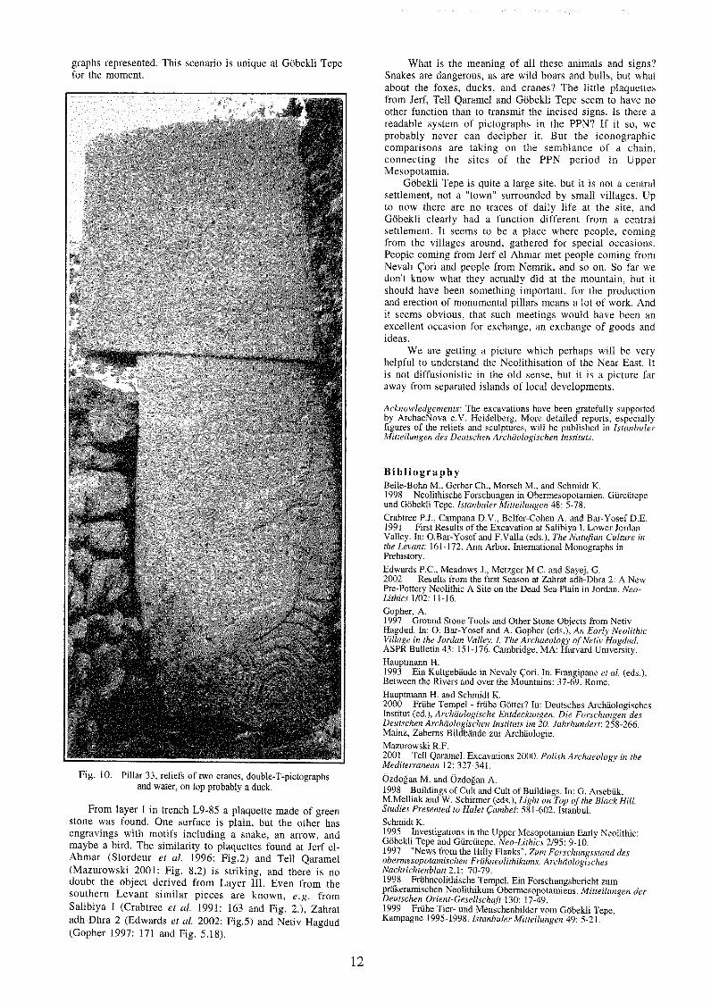
graphs represented. This scenario is unique at Gobekli Tepe for the moment.
Fig. 10. Pillar 33, reliefs of two cranes, double-T-pictographs and water, on top probably a duck.
From layer I in trench L9-85 a plaquette made of green stone was found. One surface is plain, but the other has engravings with motifs including -a snake, an arrow, and maybe a bird. The similarity to plaquettes found at Jerf el- Ahmar (Stordeur et al. 1996: Fig.2) and Tell Qaramel (Mazurowski 2001: Fig. 8,2) is striking, and there is no doubt the object derived from Layer 111. Even from the southern Levant similar pieces are known, e.g. from Salibiya I (Crabtree et al. 1991: 163 and Fig. 2 . ) , Zahrat adh-Dhra 2 (Edwards et al. 2002: Fig.5) and Netiv Hagdud (Gopher 1997: 171 and Fig. 5.18).
What is the meaning of all these animals and signs? Snakes are dangerous, as are wild boars and bulls, but what about the foxes, ducks, and cranes? The little plaquettes from Jerf, Tell Qaramel and Gobekli Tepe seem to have no other function than to transmit the incised signs. Is there a readable system of pictographs in the PPN? If it so, we probably never can decipher it. But the iconographic comparisons are taking on the semblance of a chain, connecting the sites of the PPN period in Upper Mesopotamia.
Gobekli Tepe is quite a large site, but it is not a central settlement, not a "town" surrounded by small villages. Up to now there are no traces of daily life at the site, and Gobekli clearly had a function different from a central settlement. It seems to be a place where people, coming from the villages around, gathered for special occasions. People corning from Jerf el Ahmar met people coming from Nevali Cori and people from Nemrik, and so on. So far we don't know what they actually did at the mountain, but it should have been something important, for the production and erection of monumental pillars means a lot of work. And it seems obvious, that such meetings would have been an excellent occasion for exchange, an exchange of goods and ideas.
We are getting a picture which perhaps will be very helpful to understand the Neolithisation of the Near East. It is not diffusionistic in the old sense, but it is a picture far away from separated islands of local developments.
Acknowledgements: The excavations have been gratefully supported by ArchaeNova e.V. Heidelberg. More detailed reports, especially figures of the reliefs and sculptures, will be published in Isturlb~iler Mitteilungen des Deutscherl Archiz'ologischen Itzslituts.
Bib l iography Beile-Bohn M., Gerber Ch., Morsch M., and Schmidt IS. 1998 Neolithische Forschungen in Ober~nesopotamie~t. Gurcutepe und Gobekli Tepe. Istanbufer Mitteilltrzgeta 48: 5-78. Crabtree P.J., Campana D.V., Belfer-Cohen A. and Bar-Yosef D.E. 1991 First Results of the Excavation at Salibiya I, Lower Jordan Valley. In: O.Bar-Yosef and F.Valla (eds.), Tlze Nut~rfiarz Culture irr the Levant: 161-172. Ann Arbor, International Monographs in Prehistory. Edwards P.C., Meadows J., Metzger M.C. and Sayej, G. 2002 Results from the first Season at Zahrat adh-Dhra 2: A New Pre-Pottery Neolithic A Site on the Dead Sea Plain in Jordan. Neo- Lithics 1/02: 1 1-16. Gopher, A. 1997 Ground Stone Tools and Other Stone Objects from Netiv Hagdud. In: 0 . Bar-Yosef and A. Gopher (eds.), An Early Neolithic Village itz the Jordatt Valley. I. The Archaeology of Netiv Hagdud. ASPR Bulletin 43: 151-176. Cambridge, MA: Harvard University. Hauptmann H. 1993 Ein Kultgebaude in Nevaly Cori. In: Frangipane et al. (eds.), Between the Rivers and over the Mountains: 37-69. Rome. Hauptmann H. and Schmidt K. 2000 Friihe Tempel - friihe Gotter? In: Deutsches Archaologisches Institut (ed.), Archaologische Entdeck~lngen. Die Forschungen des Deutschen Archdologischen Instituts im 20. Jahrhundert: 258-266. Mainz, Zabems Bildbitnde zur Archaologie. Mazurowsh R.F. 2001 Tell Qaramel. Excavations 2000. Polish Archaeology in the Mediterratzeatz 12: 327-341.
~ z d o g a n M. and Ozdogan A. 1998 Buildings of Cult and Cult of Buildings. In: G. Arsebuk, M.Mellink and W. Schirmer (eds.), Light on Top of the Black Hill. Studies Presented to Halet Cambel: 581-602. Istanbul. Schmidt K. 1995 Investigations in the Upper Mesopotamian Early Neolithic: Gobekli Tepe and Gurcutepe, Neo-Lithies 2195: 9-10. 1997 "News from the Hilly Flanks". Zum Forschungsstund des obermesopotamischen Fruhraeolitlzikums, Arclzaologiscttes Nachrz'chtenblaft 2.1: 70-79. 1998 Friihneolithische Tempel. Ein Forschungsbericht zum prjkeramischen Neolithikum Obermesopotamiens. Mitteilzlngen der Deutschen Orient-Gesellscfiaft 130: 17-49. 1999 Friihe Tier- und Menschenbilder vom Gobekli Tepe, Kampagne 1995-1998. Istanbuler Mitteilu~zge,z 49: 5-21.

2000 Erst kam der Tempel, dann die Stadt. Bericht zu den Grabungen am Giirciitepe und am GobeMi Tepe 1996-1999. lstnnbuler Mitteilungen 50: 5-40. 2001 Gobekli Tepe, Southeastern Turkey. A Preliminary Report on the 1995-1999 Excavations. PalLorient 2611: 45-54. 2002 Gobekli Tepe - Southeastern Turkey. The Seventh Campaign, 2001. Neo-Lithics 1/02: 23-25. Stordeur D., Jammous B., Helmer D. and Willcox G. 1996 Jed el-Ahmar: a New Mureybetian Site (PPNA) on the Middle Euphrates. Neo-Lithics 2/96: 1-2.
Excavations at al-Basatin, Wadi Ziqlab, Jordan
E. B. Banning, Kevin Gibbs, Michael Gregg, Seiji Kadowaki, and Steve Rhodes
University of Toronto ([email protected])
From 4 May to 9 June 2002, the Wadi Ziqlab Project of University of Toronto conducted excavations at al-Basatin (WZ 135/140), a Late Neolithic site that the project's survey discovered in 2000 (Maher and Banning 2001).
The 2000 survey had discovered prehistoric artifacts on two adjacent terraces at al-Basatin (Fig. 1). Site WZ 140 is closest to the wadi channel, about 0 m ASL on a low slope or swale below the higher terrace, WZ 135, which is around 25 m ASL. Both occupy the south bank of Wadi Ziqlab, opposite Tell Abu Fokhkhar and about 1 km west of Neolithic Tell Rakan (WZ 120; Banning and Najjar 2000). Thanks to numerous springs, the stream of Wadi Ziqlab is perennial near these sites.
Excavation began with a series of 1 m2 test units on the WZ 140 terrace but, when it became obvious that the artifacts at WZ 140 were in colluvium most likely derived from WZ 135, the focus of remaining fieldwork shifted to the larger, upper terrace.
The most significant results came from the most centrally placed excavation units in site WZ 135. Area M41 encoun- tered two large, basalt grinding stones and many Neolithic artifacts, including adzes and sickle elements, but it and neighbouring L42 and M40 appeared to be disturbed by ancient alluvial gullying that probably removed original Neolithic material and deposited other Neolithic artifacts from a short distance upslope along with alluvial gravels.
Area N41 encountered a rectangular, cobble-paved floor, with a circular feature at one corner (Fog. 2). The cobble floor is similar in many respects to cobble floors in two structures from Late Neolithic Tabaqat al-BQma (WZ 200), except that the enclosing walls appear to be missing, per- haps robbed out, apart from some very large stones.
Areas P41 and P40 uncovered several superimposed outdoor surfaces covered with more than 90 flat-lying artifacts, including denticulated sickle blades, a basalt quem, many Late Neolithic sherds, and caprid and bovid bone fragments. The artifacts were piece-plotted in three dimensions. An equally-dense surface covered with 101 Late Neolithic artifacts lay directly below the first surface, and these were also piece-plotted.
Later (probably Byzantine-era) field walls crossed Areas P41 and M40, and probably employed stones robbed out of Neolithic structures. The landowner says that he removed many large stones and outcropping walls by bulldozer when preparing his olive grove about 20 years ago. Aerial photographs of 1978 show traces of what appear to be walls and stone hut structures on the surface of the site, probably the features that the bulldozer removed.
At the lower terrace, site WZ 140, most of the Neolithic material came from two deep soundings in Areas J15 and K15. These are low on the slope and the Areas closest to the test probe G I 3 that produced a fair number of Neolithic artifacts during the survey of 2000. Most of the test units in WZ 140 produced Neolithic artifacts mixed with Epipa- leolithic or later artifacts in colluvium that probably derived
Fig. 1. V~ew of terraces WZ 140 (lower left) and WZ 135 (upper nght), looking toward East (photo by E. Banning).
from the upper terrace at WZ 135, or from an ancient extension of that terrace to the west, which erosion has now cut away.
Fig. 2. View of the cobbled floor in Area N41 (photo by S. Rhodes).
The chipped stone assemblage from WZ 135 is charac- terized by several diagnostic Late Neolithic tool types, while including some materials of earlier periods. The Late Neolithic tool types include sickle elements with denti- culated edges, ground axes/adzes/chisels, awls, and a bifa- cially flaked knife, in descending order of frequency.
Sickle elements have a rectangular shape formed by steep retouch at one lateral edge and the truncation of both ends of blades or, occasionally, flakes. The cutting edges of sickle elements have deep denticulations and often retain clear sickle sheen. The width of sickle elements varies considerably.
Ground axes, adzes, or chisels are made on flint, and their cutting edges are formed by grinding perpendicular to the long axis of the tool. The sides and proximal end of the axes show traces of pecking and battering, probably employed for the manufacture of the tool. Several small flake scars at the ground edge may have been the result of use, while extensive flaking of some axes might represent the rejuvenation or remodification of the cutting edge.
Other tools include awls made on flakes, one blade-awl, and two bifacial knives with lenticular sections and invasive retouch. One possible tranversal arrowhead is very tiny but clearly has retouch on both sides that converges at the proximal end. The distal end is a cutting edge with some flaking scars that might be the result of use.
Among the tools found at WZ 140 was a cortical scraper made on a large cortical flake of dark brown, fine-grained

flint. The entire dorsal surface is covered by limestone cortex, and the tool edge shows flat retouch. It is generally similar to cortical scrapers found at Tabaqat al-B6ma (WZ 200) (Banning et al. 1996:42).
Debitage on both terraces mainly consists of flakes of various form and size. The irregular flake morphology may have resulted from the use of amorphous cores, which are common in the assemblage. Few blades are present, but they are characterized by unidirectional scar pattern on the dorsal face and a fairly rough appearance. Several unidirectional blade cores show that minimal core preparation was employed for blade production.
Primary and secondary elements of debitage indicate several sources of flint raw materials, from water-worn flint cobbles to flint nodules that probably come from one of the outcrops of chalk and limestone about 500 m northwest of the site. The latter source provides flint nodules of dark brown to gray colour, which were one of the major flint materials of the assemblage, and a number of large, amorphous flakes are made on this flint. These flakes often show various types of retouch from small continuous retouch to rough denticulations, indicating that they were used for a variety of purposes, probably as expedient tools.
With the exceptions of later (mainly Roman-Byzantine) material in upper deposits, the pottery from WZ 135 was Late Neolithic and handmade, with some evidence for coil construction. The fabrics are usually soft, grey-brown, yellow or salmon-pink in colour, and with poorly sorted angular inclusions of chert, limestone, and other minerals. Many sherds show voids and clear evidence for fibrous temper, even though grit temper is more common. Some sherds appear not to have any intentional temper at all, but instead networks of fine internal cracks. Many others have dark or yellow cores and other evidence for poor firing. On some sherds, crazing or laminar spalling is evident. Although there are some better-made exceptions, in general, the pottery is rather crudely constructed and poorly fired, and is now so fragile that we cannot wash it. Many of the fabrics, especially the salmon-coloured one, seem very similar to those found at Tabaqat al- B6ma (WZ 200), although others probably do not occur at that site.
The assemblage is very fragmented, but forms appear to include small cups and bowls and small jars. A few larger, thicker pieces could be tabun fragments. Bases are mainly flat or disk bases, and several bases show pebble impressions on the bottom, similar to examples from Tel Dover and 'Ain Rahub, but not found at Tabaqat al- Bama. Handles include loop handles with oval sections and some knobs and slight ledge handles.
A fairly common surface treatment is combing. Generally this is a very rough combing, apparently to roughen the surface rather than to create a particular pattern. One sherd shows such roughening on both interior and exterior surfaces. A small but significant proportion of sherds show traces of red slip or paint. Rarer surface treatments include slipping and burnishing ("dark-faced burnished ware").
The 2002 excavations recovered one fragment of a pierced ceramic disk, probably made from a body sherd, with a biconically drilled hole. This is similar to several exam- ples that occurred at Tabaqat al- BCima.
The fauna at WZ 135 included Bos sp. (cow or aurochs), Sus scrofa (pig or wild boar), and Ovis sp.lCapra sp. (sheeplgoat). The bones of a large rodent (marmot or large ground squirrel) and of tortoise (probably Testudo graeca) also occurred. WZ 140 also yielded the remains of Bos sp., Sus sp., and Ovis sp.lCapr-a sp., in addition to the bones of Cervus sp. (deer) and Gazella sp. (gazelle).
Now that the excavations at WZ 135 have begun to pin down the location of preserved occupation traces on the terrace, including a well-preserved cobble floor and outdoor surfaces with dense Neolithic debris, we anticipate that future excavations there will uncover at least one Late Neolithic structure, while comparison of the assemblage
with that of Tabaqat al- BGma (Banning et al. 1994; 1996) and other near-contemporary sites will help us understand social and economic interaction in Wadi Ziqlab specifically and in the region of the northern Jordan Valley more generally.
Bibl iography Banning E. B., Rahimi D., and Siggers L. 1994 The Late Neolithic of the southern Levant: Hiatus, settlement shift or observer bias? The perspective from Wadi Ziqlab. PaEdorient 20(2): 151- 164. Banning E. B., Rahimi D., Siggers J., and Ta'Ani H. . 1996 1992 season of excavations in Wadi Ziqlab, Jordan. Annual of the Departnzent of Antiq~(itie.7 ofJorda1140: 29-49. Banning E. B, and Najjar M. 2000 Tell Rakan, Wadi Ziqlab. In Archaeology in Jordan, edited by V. Egan, P. Bikai, and K. Zarnora, American Journal qf Archaeology 104: 571. Maher L., and Banning E. B. 2001 Geoarchaeological survey in Wadi Ziqlab, Jordan (with L. Maher). Annual of the Department of Antiquities o f Jordan 45: 61-70.
Interim Report: Research at the PPNB Site of Ayn Abu Nukhayla, Southern Jordan
D.O. Henry', J.J. White, J.E. Beaver, S. Kadowaki, A. Nowell, C. Cordova, R.M. Dean, H. Ekstrom,
3. McCorriston, H. Hietala and L. Scott-Cummings
luniversity of Tulsa, Tulsa, OK USA ([email protected])
Introduction The three-year investigation of Ayn Abu Nukhayla,
situated in the modern hyper-arid setting of Wadi Rum of southern Jordan, has furnished an understanding of Middle PPNB arid land adaptation (Fig. 1; Henry et al. 1999; Henry et al. 2000). This appears to have involved a mixed econo- my of foraging, herding, and horticulture integrated within a pattern of transhumance. The seasonal partitioning of resources in this mountainous region of tightly packed, elevationally-zoned environments extends well back into the Pleistocene from middle Holocene and even historic
Fig. 1. Map of area showing site and local physiographic features.
Bedouin times (Henry 1994; 1995; Henry et al. 2002), but until now, the strategy followed during the Early Neolithic has not been known.

The intensive settlement of the site is evidenced by ca. 1,200m2 of exposed wall stones representing mostly curvi- linear, semi-subterranean structures arranged in a honey- comb plan (Figs. 2 - 4). The settlement, confined to a PPNB occupation, is centered on 8.5kbp (uncalibrated). It is bracketed within a relative brief interval of two to three centuries that appears to have been triggered by a moist pulse. A wide range of paleo-environmental data from the site's deposit and from sediments of a nearby qa' (mudflat) indicate a steppe setting and moisture levels (200-300mm annually) significantly elevated over the modem 0-50mm annual average. But even under this moister setting, condi- tions would nevertheless have provided too little direct rainfall to support cereal cultivation. Seemingly then, this information is at odds with artifactual (abundant milling stones, blades with silica polish) and ecofactual (pollen, phytoliths) evidence indicative of cereal cultivation.
Fig. 2. Map of site showing architectural plan and locations of excavation Blocks I and 11.
This apparent paradox can be resolved by a model in which cereal cultivation was supported by upland run-off rather than direct rainfall. Following the model, farming may have been possible on moist ground associated with the seasonal ponding of the qa' located near the site. Moreover, the cultivation of cereal, in turn, may have provided chaff subsidies to support early ovicaprid herding in this pasture poor area.
Research Results Since the last excavation season in May-June 2001, work
has focused on the generation, integration, interpretation, and reporting of a wide range of cultural, economic, and climatic-environmental data. Plans are also being made for continued work at the site in 2004-2005. Preliminary analysis has been completed for a wide range of data that are briefly described below.
Architecture, Occupation Floors and Phases Twelve structural loci (stone lined pit-houses) were
defined in two excavation blocks. Within the fills of the structures, occupational floors have been identified on the basis of the presence of formal features (stone pavements, compacted earthen floors), large basin querns, and peaks in densities of ground stone, chipped stone, and worked bone (Figs. 5 - 6). While some floors are obviously associated with formal features, others are linked only to high densities of certain artifact categories. These differences likely stem from differences in the intensities and perhaps activities associated with specific floors.
Three occupational phases have thus far been identified through an integration of stratigraphic successions, construction techniques, and wall relationships. In general, the stratigraphic sequence traces a pre-wall (Phase I) occupation that rests some 10-30 cm beneath the earliest wall construction in Block 1.1. Given that the wall con- struction involved the lining of pits that were dug into the surface of the hillock, at least some 40-60 cm of sand must have accumulated over the Phase I occupation before the earliest building efforts began. These were tied to the upright slab wall constructions and associated living floors of the Phase I1 occupations in Block 11. Although similar Phase I1 constructions were not identified within the Block I excavation, a few heavily eroded structures with upright stone walls are present at a lower elevation on the steep slope just a few meters north of Block 1.1. Phase I11 occupations, present throughout the loci of both excavation blocks, appear to have been associated with the major period of settlement at Ayn Abu Nukhayla. The Phase 111 settlement, accompanied by a shift to horizontal slab construction, is likely to have followed a period of site abandonment and partial deterioration as evidenced by the upright slab wall remnants of the Phase 11 occupations. It is noteworthy that all three phases appear to have been encompassed within a relatively brief interval of 2-3 centuries as evidenced by the tight chronometry of the site and the remarkable homogeneity of artifact varieties, especially point types.
Fig, 4. Plan of Block I1 showing the loci and features.
Chronometry Twelve 14C dates from different loci and levels across the
two excavation blocks were analyzed following the procedure developed by Hietala (1989:284-85) for
Fig. 3. Plan of Block I showing the loci and features.

determining the degree of contemporaneity and duration from multiple 14C dates. The analysis indicates a best common date of 8,509+64 with an estimated duration of occupation from 180-260 years. Moreover, the p-value of .07 for testing contemporaneity suggests that there is no significant difference between the dates. Additionally, two charcoal samples from a probe and sounding in the qa' yielded dates of 7,070 (238cm; Beta 134455) and 4,830+1851-180 (160-170 cm; A-12281), indicating a nearly constant rate of deposition (1 cm/ 29 years) for at least the last 7,000 radiocarbon years. Five additional samples from the sounding are presently being assayed. The recovery of charcoal from the qa' sediments promises a high resolution chronology for the depositional sequence.
Fig. 5. Image of occupation floor (Levels 7-8) in Locus 20; note the concentrations of artifacts and features.
Art i fac t s The principal artifactual data-sets include: chipped stone
(24,900 specimens), ground stone (324 specimens), worked bone (114) and ornamental shell (740). Preliminary analysis (D. Henry, S. Kadowaki, A. Nowell) of the chipped stone assemblage shows: retouched blades and projectile points to dominate the tool-kit, Amuq points to account for almost all of the point class (>91% of the identifiable points), an emphasis on naviform core technique, and on- site lithic production involving primary through end-of- stream reduction (Fig. 7). More detailed lithic studies involving microscopic analysis of uolish, striae, and other
Fig. 6. Image of occupation floor (Levels 8-9) in Locus 20; note the cobble pavement, grinding slabs and quern, and rock lined hearth.
edge-wear (M. Kay, U. of Arkansas) show very high use wear (>98% of unretouched blades and formal tools) of blades with piercing, slicing, and burin use as dominant activities. About 14% of blades show silica polish, and organic residues have been observed on a few specimens. Raw material analysis shows most (if not all) of the cherts were obtained from 50-60km away on the Ma'an Plateau. An
especially significant source was the pink-purple chert from the Amman Silicified Limestone formation. Comparison of visual attributes, including signatures of ultra-violet tluo- rescence, closely matches those described for specimens from the pink chert quarries in the Amman Silicified Limestone formation near 'Ain Ghazal (Quintero 1996). This is important for it confirms another source of the pink chert beyond that identified in northern Jordan.
ridge blades (J & K), naviform core (L).
The groundstone study (S. Kadowaki) identified tool types and manufacturing technology in addition to exami- ning the spatial distribution of food processing activities. The worked bone and ornamental shell (D. Bar-Yosef) studies have identified tool types and species, respectively. The treatment and species composition of the shell assemblage closely resemble that of other southern ~evantine-PPNB asskmblages from Sinai and the Negev,
Ecofacts The principal ecofactual data-sets include: the hone
assemblage (R. Dean) , pollen (L. Scott-Cummings, A. Emery-Barbier), phytoliths (L. Scott-Cummings, R. Albert), spherulites (L. Scott-Cummings, R. Albert), dia- toms (B. Winsborough), macrobotanics and charred wood (J. McCorriston and H. Ekstrom), the geochemistry of. sediment cores (H. Brauer), micro-morphological sediment columns (T. Alpert) and geomorphic evidence of the site and area (C. Cordova).
The faunal remains consist of 2,596 NISP of which 89% are ungulates. Of these that can be identified to at least the level of sub-family (782), 90.5% are represented by ovicaprids. For those few specimens that could be identified as to species within the ovicaprids, ibex (3), domestic or wild true goats (2), and domestic or wild sheep (16) were present. Although osteological evidence was not diagnostic of domesticated sheep or goat, the presence of sheeplgoat outside of their natural habitats, the very high rate of ovicaprid exploitation, and the presence of high densities of fecal spherulites (denoting dung) in the site's deposits indicate that sheeplgoat were being herded.
Microbotanic remains (pollen, phytoliths, diatoms) provided exceptionally rich assemblages from both the site deposits and the sediments of the nearby qa'. Although the

recovery of macrobotanic remains of seeds was disap- pointing, charred wood identification has yielded important results. When the microbotanic evidence is combined with the on-site and off-site geoarchaeological and geomorphic data, the paleo-climatic setting of the area can be rather precisely reconstructed. In the vicinity of Ayn Abu Nukhayla, the Wadi Rum appears to have been covered in steppe vegetation composed mostly of sage, but surface water, most likely from the nearby spring, supported isolated stands of willows and sedges.
Spatial Analysis We are in the process of analyzing artifact (chipped
stone, groundstone, worked bone, shell) and ecofact distributions (phytoliths, spherulites) within and between loci for spatial patterns in an effort to trace how the occupants of the structures organized their activities. Indirectly, this should provide insights on the community's social and household organization.
Bibl iography Henrv D. 1994' Prehistoric Cultural Ecology in Southern Jordan. Science 265: 336-341. 1995 Prehistoric Cultural Ecology and Evolution: Insights from Southern Jordan. New York: Plenum Publishing Corp. Henry D., Beaver J., White J., Brauer H. and Cordova C. 2000 Investigation of the Early Neolithic Site of 'Ain Abu Nekheileh (J701), 1999 Season. American Journal of Archaeology 104: 569-570. Henry D., Cordova C., Beaver J., White J. and Brauer, H. 1999 Investigation of the Neolithic Site of 'Ain Abu Nekheileh (J701), 1999 Season . Neo-Lithics 3: 3-5. Henry D., Kerry K., Brauer H., Beaver J. and White J. 2001 Survey of Prehistoric Sites, Wadi Araba, Southern Jordan. Bulletin American Schools of Oriental Research 323: 1-19. Hietala H. 1989 Contemporaneity and Occupational Duration of the Kubbaniyan Sites: An Analysis and Interpretation of the Radiocarbon Dates. In F. Wendorf, R. Schild, and A. Close (eds.), The Prehistory of Wadz Kubban~ya, vol. 2: 284-291. Dallas, Southern Methodist University Press. Quintero L. 1996 Hint Mining in the Pre-Pottery Neolithic: Preliminary Reoort on the Exoloitation of Flint at Neolithic 'Ain Ghazal in ~ ighland ~ordan: 1n S. Kozlowski and H. Gebel (eds.), Neolithic Chipped Stone Industries of the Fertile Crescent, and Their Contemporaries in Adjacent Regions: 233-242. Berlin, ex oriente.
The 2002 Excavation Season at Dhra' Jordan: Preliminary Results from the Jericho IX and Pre-Pottery Neolithic A Period Components
Ian Kuijtl and Bill Finlayson2 'University of Notre Dame ([email protected]) 2The Council for British Research in the Levant
Background Between June 2 and July 20, 2002, co-principal
investigators I. Kuijt and B. Finlayson led excavations at the Pre-Pottery and Pottery Neolithic settlement of Dhra', Jordan. This project is focused on understanding the transition from foraging to farming along the Dead Sea Basin and the Kerak Plateau. Excavations at Dhra' seek to document the social, economic, and technological developments of this period from the perspective of a single, thoroughly researched case study. Previous research by Raikes (1980) and Bennett (1980) in the late 1970s, Kuijt and Mahasneh in the mid-1990s (Kuijt 1994, 2001; Kuijt and Mahasneh 1998), and Finlayson and Kuijt (Finlayson and Kuijt 2002; Finlayson et al. n.d.; Goodale and Smith 2001; Goodale et al. 2002; Kuijt and Finlayson
2002), illustrate that there are two major periods of occupation represented at Dhra': the Pottery Neolithic and Pre-Pottery Neolithic A. In 2002 excavations concentrated on three major goals: further defining the physical extent of the Pottery Neolithic and PPNA occupation, recovering representative cultural materials from the Pottery Neolithic component of the settlement, and exposing a large horizontal area around the well-preserved PPNA mud and stone structures identified in 1994 and 2001. As with previous years the excavations in 2002 relied on the excavation of 1 x 1m units in stratigraphic layers, with all sediments screened through 2 mm mesh.
Field research in 2002 was initially directed to improving our understanding of the spatial organization of the PPNA occupation around the well-preserved mud and stone structures previously identified in Area 1. This involved opening four 5 x 5m excavation units to the north and west of the mud structure (Fig. 1). Based upon the limited amount of Pottery Neolithic remains uncovered in the two 5 x 5m excavation units in 2001, it was anticipated that only limited Pottery Neolithic remains would be encountered in the four units to be excavated in 2002. It was, therefore, somewhat surprising that we encountered extensive Pottery Neolithic remains in three of the four 5 x 5m units, including intact well-preserved features, buildings, and material culture. In brief, these remains date to the Jericho IX phase of the Pottery Neolithic period. While detailed analysis of the features and materials recovered from these excavations are currently being undertaken, this report outlines some of the important results of the 2002 excavation season with greater detail being provided elsewhere (see Finlayson et al. n.d.).
I) Jericho IX Neolithic Occupation at Dhra' One of major goals of the 2002 excavations was the
recovery of representative Pottery Neolithic material culture, architecture, and features from Dhra' to understand better the nature of the Pottery Neolithic occupation of area east of the Dead Sea. During excavations portions of several Pottery Neolithic buildings and features were identified. These include the remains of two structures; two large pit features filled with fire-cracked rock, ash, and broken pottery; a large reused stone bin feature; and the remains of three small plastered lined pits.
Plaster Features Excavations uncovered the remains of three small (30 cm
deep and c. 30 x 30 cm wide) plastered pit features (Fig. 1). These dished features were excavated into the underlying PPNA deposits and lined with white plaster. It appears that through use the white plaster was discolored to a light pinW red through the use of fire. These features were located in relatively small area, and in the case of Feature 18, Pottery Neolithic ceramics were recovered from the fill deposits of the feature.
Large Pit Features Remains of two large pit features wcre also recovered.
Feature 21 was 60 cm deep and c. 2.5 m wide. It was filled with fire-cracked rock, ash, and a remarkable amount of ceramic and lithic materials. The pit, with clearly defined edges, was cut into earlier PPNA deposits. Feature 23, located in the western half of two 5 x 5 m units, also appears to be from the Pottery Neolithic period.
B u i l d i n g s In addition to several wall lines that were visible on the
surface of the site, the remains of two Pottery Neolithic buildings were identified during excavation. The first of these, Feature 15, consisted of several stone walls made of angular stone. These walls were made by placing large stones along the outer edges of the wall and filling the inside with rubble. Intact walls had between two and three courses of stones up to 20 cm high and were 40 cm wide.

Rg. 1. Plan view of 2002 excavation areas at Dhra': Jericho IX architecture and fealures
PN Plaster Pit
Jericho IX architecture and ??? p a p - a FE 28 *- 0-0 PN Wdll
features, DhraG9 Jordan, 2002 Jericho IX building
0 3 meters
Intact PPNA buildings and features -
No preserved Jericho IX ??? P buildings or features
P
Fig. 2. Plan view of 2002 excavation areas at Dhra': PPNA architecture and features.
\ \ \ --.
\
Pre-Pottery Neolithic A B \ architecture andfeatures, '+%
DhraG9 Jordan, 2002 \
Wellpreserved Jericho IX buildings and / o r features-
PPNA levels not excavated in 20
I PPNA bin / I \ Intact PPNA deposits
PPNA bin / B
ooking feature \ \ \
\ \
\ \
79.53 l 0 l N \ 90E
lOlN \
Wellpreserved Jericho IX buildings and/or features-
P PNA levels not ereavated in 2002
90E 96N
0 3 meters

While only partially preserved, Feature 15 defined a right angle comer of a structure defined by the pit and bin features next to the structures.
Excavation of a 2 x 2 m unit focused on the construction of one of several Pottery Neolithic structures visible in the central areas of the site. These units were placed over a well- preserved wall to better understand the height of architec- ture and the nature of associated cultural materials. The walls of this structure were constructed of large well-placed stones creating an outer wall face with the core filled by rubble. Excavations in this area uncovered the remains of a small white plaster feature partially defined by three upright stones to the side. Beneath this feature were the remains of several Pottery Neolithic ceramic vessels of the Jericho IX period. Assuming that this is representative of other wall systems visible on the surface, the results from this area indicates that the Pottery Neolithic occupation deposits are more substantial along the northern area of the settlement of Dhra' than originally anticipated.
Stone / Plaster Bin Feature One of the other major Pottery Neolithic features
excavated during the 2002 season is a single large stone bin feature. Feature 5 was originally made by cutting into the earlier PPNA deposits and lining the cut with white plaster similar to that of the three small plaster pit features described above. It appears that after some period of use, the people living in this location decided to destroy the plaster structure by caving in the upper portions of the walls and filling the plaster pit with stones so that large stones lined the bottom and sides of the pit. While the possible func- t ion(~) of these two features remains unclear, it appears that these different types of features were used for different things. Broken pottery was recovered from inside of the upper lower stages of this feature.
Recovered Material Culture
Excavations in 2002 resulted in the recovery of numerous ceramic and lithic items from the earliest stages of the Pottery Neolithic. In some cases, such as the large pit filled with fire-cracked rock (Feature 21), these objects were recovered in primary context and associated only with other Pottery Neolithic materials. In other cases, especially in upper areas, Pre-Pottery Neolithic A period lithics were recovered with Pottery Neolithic lithics and ceramics. This is unquestionably related to the widespread practices in the Pottery Neolithic of digging large pits.
P o t t e r y The pottery recovered from the 2002 excavation season
demonstrates clear affinities to other Jericho IX period sites as outlined by Garfinkel (1999). Vessel forms include hole- mouth jars, large pithoi, platters, jugs, and craters. The ceramics are well made, fired at a relatively high temperature, and are often painted. Tempers appear to be limited to minerals, including stone and other ceramic materials. Decoration consists of buff-cream wash, burni- shing, and the use of red painting in geometric patterns. While analysis is still in progress, it is already clear that this is a relatively rich ceramic assemblage with portions of at least 50 vessels (based on rim sherds) identified in the 2002 season. Diagnostic sherds were recovered from a wide range of contexts, although in many cases the largest and best-preserved collections were recovered from the inside of large pit features. Only two incised ceramic fragments were recovered out of several hundred items.
L i t h i c s The 2002 season produced an extensive assemblage of
lithic tools and debitage from the Pottery Neolithic. Recovered tools include denticulated sickle blades, a wide range of Pottery Neolithic projectile points of different sizes, including Nizzanim, HarParsa, and Transverse
projectile point types, backed blades, and borers. Core reduction appears to have focused on flake and blade cores, with many cores being multi-platform. As with the pottery, these materials clearly date to the earliest stages of the Pottery Neolithic period, and more specifically, illustrate close affinity with Jericho IX materials.
11) Pre-Pottery Neolithic A Period Occupation at Dhra'
As noted elsewhere (Kuijt and Finlayson 2002), test excavations conducted in 2001 indicate that the PPNA occupation of Dhra' was more extensive than previously understood, and it is now believed to cover at least 100 x 65 m, or an area of approximately 6,500 m2. Excavation in 2002 of the top 10 cm of Area 5, a small 1 x 1 m unit 30 m to east of the known area of the site, uncovered more PPNA materials. While it is unclear how deep the deposits are in Area 5, the results of this sounding highlight once again that the PPNA occupation at Dhra' was quite extensive. During the 2002 excavation season a small sounding in Area 6 was placed farther to the east of Area 5. This 1 x 1 m probe produced a considerable amount of debitage, including several cores. Although no diagnostic tools were recovered, these lithic materials are very similar to those recovered from PPNA occupations. Due to the unanticipated richness of the Jericho IX materials encountered in Area 1, it was only possible to excavate extensive PPNA remains in two 5 x 5 m units during the 2002 season.
Feature 1: PPNA Mud Structure 4 The 2002 excavation season also concentrated on
increasing our understanding of Structure 4, the mud structure dating to the PPNA period. Focusing on the western half of the unit and structure, in the 2002 season excavations were continued along the outer edge of the structure as well as along one area of the inner wall to define the inside face of the building. As noted elsewhere (Finlayson et al. n.d.; Kuijt and Finlayson 2002), the size of the structure was originally defined by tracing a highly visible upper surface of mud that outlined the remains of the wall of the structure. At this time it appeared that the walls of this structure were preserved to a height of at least 60 cm, and the excavation of the western half of the structure revealed the presence of five up-right stones. Excavations in 2002 revealed that Structure 4 is actually made up of two buildings: a larger original mud building with associated uprights and a second smaller mud rebuild above the original structure.
The lower original structure was constructed by building a mud wall and placing several stones in the center of this building. The wall appears to have been quite thin. The stones were placed in lines, and with notches in the top of the stones. Two of the 35-50 cm high stones used as uprights were reused grinding stones, while the others may have been specially made. Large pieces of burned wood recovered in situ, as well as lumps of burned mud with wood and vegetation impressions, suggest that this structure had a raised floor of wood, covered with smaller plant matter and mud. This would indicate that the stones served as supports for horizontal timbers, which supported this floor. Field and laboratory observations, especially micromorphology analysis, indicate that the sediments recovered from inside the structure were linked to the collapse of the floor, roof and walls.
Two radiocarbon samples date the initial construction (or the last occupation phase before construction) at 9,913rt59 bp (ISGS-A0246), and the abandonment of the mud-brick structure to 9,835rt65 bp (ISGS-A0248). Thus, the building appears to have been constructed at some point around 11,300-1 1,200 BP and abandoned between 11,260-1 1,175 BP, with the building being used for no more than a hundred years. After this point it appears that villagers build a

second mud structure above the original building. This structure appears to have been slightly smaller than the original building, was placed over top of the first building, and had a thicker mud wall than the original building. While no floor is preserved with this structure, excavations unco- vered several large stones placed in the corner of the building. Additional research in the 2003 field season will be required to understand the taphonomic history of this structure better.
Feature 13: PPNA Upright Stone Bin and Food Processing Features
The 2002 excavation season also uncovered extensive remains of what appears to be a series of extramural food processing features. This includes a cooking feature outlined with large upright stones, some of which are reused grinding slabs, with an internal pit feature; two other features associated with large concentrations of fire-cracked rock; and discrete clusters of complete hand stones, pestles, and a grooved basalt shaft straightener. All of these features and objects were uncovered within a single 5 x 5 m excavation unit. In light of the spatial proximity of these materials and the fact that almost all of the ground stone objects were complete, it appears that this area was used for food processing and generalized domestic tasks.
Discussion and Conclusion Excavations at Dhra' have provided new insights into the
Pre-Pottery and Pottery Neolithic occupation along the Dead Sea. First, the 2002 archaeological excavations at Dhra' uncovered an extensive Pottery Neolithic Jericho IX occupation. While previous research recovered limited amounts of Pottery Neolithic materials, the 2002 season exposed well-preserved architecture, pottery materials, charcoal, and lithic tools. The Pottery Neolithic period of the Dead Sea region in general, and that of the Jericho IX occupation in particular, are poorly understood by researchers. Research at Dhra' continues to provide important new perspectives on the transition from the Pre- Pottery to Pottery Neolithic period.
Second, the excavations at Dhra' provide the opportunity to understand the nature of early Pre-Pottery Neolithic occupation in marginal environmental zones. With the archaeological research at a number of recently excavated settlements to the south of the Dead Sea, including the sites of 'Ain Darat, Wadi Faynan 16, and Zahrat edh-Dhra' 2 (c.f. Edwards et al. 2001; Finlayson et al. 2000; Gopher 1995; 1996; Mithen et al. 2000; Sayej 2001; 2002) the excava- tions at Dhra' challenge researchers to rethink our appreciation of regional settlement practices in the Early Neolithic. As part of this reappraisal, the absence of Natufian occupation at Dhra' allows researchers to characterize a major PPNA occupation without derived Natufian materials. Three excavation seasons (1994, 2001, and 2002) have produced no evidence for Natufian or Pre- Pottery Neolithic 3 period occupations at Dhra'. The absence of cultural materials from these other periods is important, for it will ensure no mixing from the preceding and following periods.
Third, excavations in 2001 and 2002 echoes previously published interpretations of PPNA lithic technology at Dhra' (see also Finlayson et al. n.d.; Goodale et al. 2002; Kuijt 2001; Kuijt and Mahasneh 1998) with the overwhelming majority of tools being el-Khiam points and borers, both produced from single-platform pyramidal cores, in combination with heavy wood working tools.
The 2001 archaeological excavations have also provided us with significant new information related to the occupation at Dhra'. Excavations in Area 6 highlight that the PPNA occupation at Dhra' was considerably larger than previously recognized. Furthermore, the PPNA occupation of Dhra' was complex, being characterized by the
construction of multiple stone and mud-brick structures, and a density of cultural materials that mirrors the situation at the major PPNA villages of Netiv Hagdud and Jericho. Analysis of the 2001 field season materials will provide a more detailed understanding of the presence, spatial distri- bution, and depositional context of recovered cultural materials. On-going analyses includes PPNA lithic technology (N. Goodale), Pottery Neolithic lithic techno- logy (S. Kadowaki), lithic use-wear analysis (S. Smith), stratigraphy (S. Dennis), paleobotanical remains (R. Neef), archaeozoology (C. Becker and J. Peters), micromor- phology (T. Aspin) and landscape context (L. Maher). This, combined with the continuing analysis of recovered lithic materials, illustrates that the PPNA settlement at Dhra' was one of a limited number of relatively large sedentary village settlements. Thus, the field research at Dhra' will provide a unique database which researchers can use to improve interpretations of the important social and economic transitions from foraging to farming in the southern Levant at the end of the Pleistocene.
Acknowledgements: The project directors wish to thank the Department of Antiquities of Jordan for their permission and assistance in this field work. This report was made possible by a truly remarkable group of international undergraduates and graduate students who undertook archaeological excavations at Dhra' with professionalism, good cheer, and dedication in the 2001 and 2002 field seasons. Our deep thanks to all of you. This research was supported by grants from the Council for British Research in the Levant, the British Academy, the Institute for Scholarship in the Liberal Arts at the University of Notre Dame, and the National Science Foundation. This is Dhra' Neolithic Excavation Project Publication # 13.
Bibliography
Bennett C.-M. 1980 Soundings at Dhra', Jordan, Levant 12: 30 - 39 Edwards P., Falconer S., Fall P., Berelov I., Davies C., Meadows J., Meegan C., Metzger M. and Sayej G. 2001 Archaeology and Environment of the Dead Sea Plain: Preliminary Results of the First Season of Investigations by the Joint La Trobe University / Arizona State University Project. Annual oftlze Department of Antiquities of Jordan 45:135-156.
Finlayson B. and Kuijt I. 2002 Dhra' Excavation Project. Newsletter qf the Council for British Research in the Levant. 1: 14-15. Finlayson B., Kuijt I., Arpin T., Chesson M., Dennis S., Goodale N., Kadowaki S., Maher L., Smith S., Schurc M. and McKay J. n.d. Dhra' Excavation Project, 2002 Interim Report. Levant (in press). Finlayson B., Mithen S., Carmthers D., Kennedy A., Pirie A,, and Tipping R. 2000 The Dana-Faynan-Ghuwayr Early Prehistory Project. Levant 32: 1-26. Goodale N. and Smith S. 2001 Pre-Pottery Neolithic A Projectile Points at Dhra', Jordan: Preliminary Thoughts on Fonn, Function, and Site Interpretation. Neo- Lithic 2(1): 2-6 Goodale N., Kuijt l., and Finlayson B. 2002 The Chipped Stone Assemblage of Dhra', Jordan: Preliminary Results on Technology, Typology, and Intra-Assemblage Variability. Paliorient. 28(1): 115-130. Kuijt I. 2001 Lithic Inter-assemblage Variability and Cultural-Historical Sequences: A Consideration of the Pre-Pottery Neolithic A Period Occupation of Dhra', Jordan. Paldorient, 27(1): 107- 126. Kuijt I. and Mahasneh H. 1998 Dhra': An Early Neolithic site in the Jordan Valley. Journal of Field Archaeology 25: 153- 161. Gopher A. 1995 'Ain Darat: A PPNA site in the Judean Desert. Neo-Lithics 1: 7-8. 1996 A Preliminary Report on the Hints from 'Ain Darat: A PPNA Site in the Judean Desert. In S.K. Kozlowski and H.G.K. Gebel (eds.), Neolithic Chipped Stone Indtistries of the Fertile Crescent, and Their Contemporaries in Adjacent Regions. SENEPSE 3: 443-452. Berlin, ex oriente.

Mithen S., Finlayson B., P i e A,, Carruthers D. and Kennedy A. 2000 New Evidence for Economic and Technological Diversity in the Pre-Pottery Neolithic A: Wadi Faynan 16. Current Anthropology 41(4): 655-663. Raikes T. D. 1980 Notes on Some Neolithic and Later Sites in the Wadi Araha and the Dead Sea Valley, Levant 12: 40-60. Sayej G. 2001 A New Pre-Pottery Neolithic-A Culture Region in Jordan: The Dead Sea Basin. In A. Walmsley (ed.), Australians Uncovering Ancient Jordan: Fifty Years of Middle Easrern Archaeology: 225-232. Sydney: University of Sydney. 2002 Lithic Inter- and Intra-assemblage Variability: A Case Study from the Pre-Pottery Neolithic A Site of Zahrat edh-Dhra' 2, Jordan. Paper presented at the 2002 Meeting of the American Society of Oriental Research, Toronto.
Domesticating Space: Notes on the Toronto Conference
Kevin Gibbs, Seiji Kadowaki, and Isaac Ullah University of Toronto ([email protected])
A two-day conference was held 19-20 November, 2002, at the University of Toronto in Toronto, Canada. Organized by Ted Banning and Michael Chazan of the University of Toronto, the conference made significant contributions to the topic of Domesticating Space: Landscape and Site Structure in the Prehistoric Near East. An international group of scholars presented on a range of research dealing with landscape and "space", including food-processing activities, settlement aggregation, burial monuments, architectural space syntax, ritual spaces, and symbolic storage. The bulk of the 23 papers focused on the Neolithic cultures of the Levant, although the Kebaran, Natufian, Chalcolithic, and Early Bronze Age were also represented. The geographic scope of the conference was widened by a single paper discussing settlement patterns in the Konya Basin in Anatolia.
The conference opened with an introduction and welcoming words from Michael Chazan. Following this, Henry Schwartz addressed the issue of changing rainfall patterns in the Neolithic period as indicated by stable oxygen isotopes in goat teeth. He proposed the disappearance of summer rains in the PPNB period and a resultant impact on agricultural societies. The first session led by Andrew Moore dealt with intra-site activity organization under the theme of Around the House: Indoor and Outdoor Use of Space. Anna Belfer-Cohen and Nigel Goring-Morris presented on the spatial structure of archi- tectural remains in the Natufian period. By showing some symbolic/ritual features located within domestic spaces, they suggested that the symbolic use of habitation areas was performed early on in the Natufian.
Seiji Kadowaki presented on the use of domestic spaces at the PPNB site of 'Ayn Abu Nukhayla. The spatial delimitation of household units was proposed for beehive- structured buildings at the site based on the spatial analysis of groundstone tools. In contrast to the preceding two papers, which focused on the use of indoor space, Zeidan Kafafi directed attention to outdoor activities showing several examples from 'Ain Ghazal. The discussion after these presentations raised the question of the symbolic/ ritual usage of domestic spaces. It may sound contradictory to the idea that "domestic" and "ritual" spaces are dicho- tomous and exclusive, but several comments in the dis- cussion suggested that the spatial location of domestic activities, such as food grinding, can be determined by the symbolic perception of spaces for performed tasks.
The spatial framework was broadened in the second session of the day with the theme of Taming the Landscape and Structuring the Region, which was led by Ezra Zubrow.
Bruce Schroeder explored the landscape of the Anti-Lebanon plateau and reviewed its environmental potential for early Holocene hunter-gatherer groups who inhabited the cave site of Nachcharini. The following two papers focused on the phenomenon of population aggregation at selected late PPNB settlements. Douglas Baird approached this topic through the review of diachronic change in the settlement patterns around the large community of Catal Hoyuk. Ian Kuijt discussed this issue in relation to the increased population growth on regional and individual site levels, and he also raised methodological problems in recon- structing the scale of past human communities. In contrast to these "mega-villages", several other PPNB settlements, such as Ba'ja and Gobekli Tepe, are charac-terized by their unique locations in landscape, which do not follow more pragmatic explanations. In reviewing such site settings, Nigel Goring-Morris and Anna Belfer-Cohen considered symbolic reasons for selecting site locations.
The social complexity of the PPNB period is also mani- fested in smaller settlements, such as Ghwair I. Alan Simmons reviewed the architectural remains and mortuary practices at this site, suggesting the possibility of social stratification. The scale of landscape modification became larger in later periods. Graham Philip explored such an example in the Early Bronze age and discussed its impli- cations to the human perceptions of landscape. In the subsequent discussion, the social complexity in the PPNB period was raised as a main issue. Specifically, attention was directed to the cause of population aggregation at mega- sites. Some comments suggested that this should be understood as one peculiar phenomenon among the diverse social economic settings in the PPNB Levant. Another issue raised in discussion pertains to the interpretation of burials in PPNB sites. Differential interment can be interpreted in ways other than social stratification, including violence or a fear of burial.
Fig. 1. Conference participants listen to discussion. Left to right, St. John Simpson. Jane Peterson, Mohatnmad Najjar,
zeidan Kafafi, Stefan Kozlowski.
The second day of the conference opened with a session titled Architectural Structure and Social Structure, chaired by Zeidan Kafafi. Ted Banning presented the first paper, in which he explored the changes in the structure of domestic space from the Epipalaeolithic to the Bronze Age using space syntax analysis. This type of analysis grants access to the underlying structure of spatial organization, inclu- ding changes in control of property, nature of households, and social organization. Hamoudi Khalaily followed with an update from his latest excavations at Eynan. In his presentation he explored aspects of the spatial organization of the final Natufian. Stefan Kozolowski broadened the picture of PPNA spatial organization with data from the M'lefaat and Nemrik sites in Northern Iraq. One important feature of these sites is the presence of extensive clay or crushed stone external surfaces.

Mohammad Najjar gave an update on the PPNB Ghwair I site in Southern Jordan where he recently completed rescue excavations in order to prevent further damage to the site by runoff water. This excavation shed further light on a set of stairs that he now believes was a main access pathway leading from the wadi to the village. Jane Peterson explored PPNB and PPNC architecture in Southern Jordan on a broad scale. She suggested that any interpretation of shared-wall compound architecture should involve both the economic and the social factors that were influencing household creation and maintenance. Yosef Garfinkel interpreted the courtyard pattern of domestic architecture at Sha'ar Hagolan as evidence for family households. He presented a model that describes pairs of rooms arranged around a central courtyard as an extended family compound. Susanne Kerner wrapped up the session with a paper about the transition from the Pre-Pottery Neolithic to the Late Neolithic. She argued that shifts in burial and domestic architecture stem from a change in the way people saw their social and physical surroundings.
The day ended with a session chaired by Ted Banning, titled Ritual and the Ideology of Space. Dani Nadel started it off with a discussion of symbolism at the Epipalaeolithic site of Ohalo 11. A discussion of the patterned placement of worked bone and lithic artifacts was followed by a description of a possible schematic depiction of a human figure outlined with stones. Leore Grosman followed this presentation with a description of burial practices at the Late Natufian cave site of Hilazon Tachtit. Evidence suggests a process of primary and secondary burials, which may indicate that the site was used for ritual purposes.
Trevor Watkins's paper proposed that the beginning of the Neolithic was a time of significant cognitive and cultural development where symbolism began to be externally recorded in architecture. This is based on the notion that architecture frames perception of the world, and that the people of the Neolithic recognized the potential to store symbolic information within architecture. Gary Rollefson began his paper with a brief survey of Neolithic Levantine architecture of religious or ritual nature. He followed this with a more in depth analysis of religious /ritual architecture at 'Ain Ghazal before ending with the suggestion that a set of terms to describe ritual space needs to be agreed upon in order to facilitate analysis of such spaces. Marc Verhoeven presented a seven-step model to reconstruct the functions of ancient architecture. He then presented a case study of the use of this model at the Late Neolithic Burnt Village at Tell Sabi Abyad in northern Syria. Isaac Gilead closed out the session with a talk about the weaknesses of the current terminology of community- based ritual and suggested that alternative terms be considered.
The two full days of paper presentations generated much stimulating discussion. Many important methodological and theoretical issues were raised such as the appropriate scale for analyzing prehistoric spaces and landscapes, and how population size should be inferred from fragmentary archaeological evidence. The numerous papers on ideology and symbolism demonstrated the complexity of archaeological interpretation. As Ezra Zubrow pointed out, individuals living in the prehistoric Near East may have interpreted the world in multiple ways, just as archaeo- logists have many different ways of interpreting material culture. An edited volume inspired by this conference will be prepared, and hopefully will encompass the same broad spectrum of ideas and issues raised by the paper presentations and the subsequent discussions.
These discussions were continued in an "open-house" poster session held in one of the archaeology laboratories at the University of Toronto. Many of the posters outlined aspects of the ongoing Wadi Ziqlab and Wadi Mataha projects, while others presented data on faunal exploitation in Lebanon, G I s analysis of Natufian sites, and archaeo- logical survey in Cyprus.
New Thesis
Note: The editors kindly ask authors and supervisors to submit information on finished thesis on the Late Epipalaeolithic - Neolithic of the Middle East.
Now to be ordered or downloaded from http://wwwlib.umi.com/dissertations :
The osteo-archaeological examination of the ancestor cult during the Pre-Pottery Neolithic B period in the Levant by Michelle A. Bonogofsky. PhD Dissertation, University of California, Berkeley, 278 pages; AAT 3019597 (for an abstract c$ Neo-Lithics 1/01)
Michael Gregg: Fabricatirzg Ideas: Cognitive Processes and the Creation oflmages in the Southern Levant at the end of the Pleistocene Period. University of Toronto, unpublished M.A. Thesis (2002) (Contents: an analysis of a dozen Natufian symbolic artifacts from Michael Chazan's and Joel Janetsky's excavations in Wadi Mataha IPetra).
Linda Braidwood 1909-2003

Rend T.J. Cappers & Sytze Bottema (eds.)
The Dawn of Farming in the Near East
Studies in Early Near Eastern Production, Subsistence, and Environment 6,1999 (2002).
Berlin, ex oriente. <ISBN 3-9804241-5-4> (16 contributions, I + 189 pages, 52 figures, 11 tables, paperback - 38 Euro plus postage)
Contents Editors' Foreword Rend T.J. Cappers, Sytze Bottema, Henk Woldring, Hans van der Plicht & Harm Jan Streurman: Modelling the emergence of farming: implications of the vegetation development in the Near East during the Pleistocene- Holocene transition
Donald 0. Henry: Models of agricultural origins andproxy measures ofprehistoric demographics Sytze Bottema: The use ofpalynology in tracing early agriculture Henk Woldring: The Early-Holocene vegetation of Central Anatolia and the impact of farming
Leore Grosman & Anna Belfer-Cohen: Zooming onto the Younger Dryas
Ofer Bar-Yosef & Anna Belfer-Cohen: Facing environmental crisis. Societal and cultural changes at the transition from the Younger Dryas to the Holocene in the Levant
David R. Harris: Development of the agro-pastoral economy in the Fertile Crescent during the Pre-Pottery Neolithic period Naomi F . Miller: Tracing the development of the agropastoral economy in Southeastern Anatolia and Northern Syria
Mark A. Blumler: Changing paradigms, wild cereal ecology, and agricultural origins
Mark Nesbitt: When and where did domesticated cereals first occur in southwest Asia? George Willcox: Geographical variation in major cereal components and evidence for independent domestication events in the Western Asia Sue Colledge: Identzfjling pre-domestication cultivation in the archaeobotanical record using multivariate analysis: presenting the case for quantiJication Mehmet Ozdogan: Redefining the Neolithic of Anatolia. A critical overview
Joy McCorriston: Evolutionary ecology and historical contingency in the transition to food production in Mediterranean Southwest Asia and California. A comparative perspective
Ilse KBhler-Rollefson & Gary Rollefson: Brooding about breeding: Social implications for the process of animal domestication Hijlke Buitenhuis: The transition from foraging to farming: the archaeozoological perspective in Anatolia
orders please sent to: ex oriente, c/o Free University, Hiittenweg 7, D- 14195 Berlin, Fax +49 30 83852106, [email protected]