University of Birmingham Strategic Resource Decisions to Enhance ...
Upload
khangminh22Category
view
2download
0
OPRD Natural Resource Assessment and Strategic Action Plan – Willamette Basin Page i
Natural Resource Assessment and Strategic Action Plan
for Restoration and Stewardship of OPRD-Managed Properties in the Willamette Basin
August 31, 2017

OPRD Natural Resource Assessment and Strategic Action Plan – Willamette Basin Page ii
Acknowledgements Project Manager: Andrea Berkley (OPRD Natural Resource Specialist, Valleys Region)
Planning Consultant: Jeff Krueger (JK Environments)
Project Ecologist: Bruce Newhouse (Salix Associates)
Technical Advisory Pool: OPRD Project Advisory Team: • Jeff Baker (Greenbelt Land Trust) • Noel Bacheller, Botanist • Dan Bell (Bonneville Environmental Foundation) • Tammy Baumann, Visitor Experience Coordinator, Valleys Region • Jim Cathcart (W. Multnomah Soil and Water Conservation Dist.) • Alice Beals, Property Specialist • Holly Crosson (Benton Soil and Water Conservation District) • Vanessa Blackstone, Wildlife Biologist • Rebecca Currin (Institute for Applied Ecology) • Kammie Bunes, Property Specialist • Daniel Dietz (McKenzie River Trust) • Matthew Davey, Park Manager, Silver Falls Management Unit • Jason Dumont (Mosaic Ecology) • Steve DeGoey, Park Ranger, Southern Willamette MU • Andrew Dutterer (Oregon Watershed Enhancement Board) • Jennifer Godfrey, Interpretive Ranger, Detroit Lake MU • Sarah Dyrdahl (Middle Fork Willamette Watershed Council) • Ross Kihs, South Central District Manager • John Goetz (Clean Water Services) • Steve Kruger, Park Ranger, Stub Stewart Management Unit • Nancy Gramlich (Oregon Department of Environmental Quality) • Celeste Lebo, Natural Resource Specialist, North Coast • Peter Guillozet (Metro) • Craig Leech, Forester • Vern Holm (Western Invasives Network) • Dennis Lucas, Willamette District Manager • Wendy Hudson (Retired, Oregon Watershed Enhancement Board) • Nick Morris, Forester • Bessie Joyce (Calapooia Watershed Council) • John Mullen, Park Manager, Champoeg Management Unit • Jimmy Kagan (OSU-PSU Institute for Natural Resources) • Scott Nebebe, Park Development Administrator • Tom Kaye (Institute for Applied Ecology) • Nancy Nelson, Region Archeologist, Valleys Region • Marci Krass (Willamette Riverkeeper) • Justin Parker, Park Manager, Fort Stevens Management Unit • Kristen Larson (Luckiamute Watershed Council) • Kevin Price, Community Engagement Coordinator • Matt Mellenthin (Integrated Resource Management) • Dan Quigley, Park Manager, Stub Stewart Management Unit • Wes Messinger (US Army Corps of Engineers) • Robert Rea, Park Manager, Detroit Lake Management Unit • Shelly Miller (City of Eugene Parks) • Trevor Rigmaiden, Park Manager, Southern Willamette MU • Andy Neill (Institute for Applied Ecology) • Guy Rodrigue, Park Manager, Tryon Creek and Milo McIver MUs • Chris Orsinger (Friends of Buford Park) • Mark Shaw, Park Ranger, Milo McIver Management Unit • Michael Pope (Greenbelt Land Trust) • Bonny Shepard, Park Ranger, Willamette Mission MU • Liz Redon (Oregon Watershed Enhancement Board) • Ryan Sparks, Operations Support Manager, Valleys Region • Melissa Rowe Soll (Ash Creek Forest Management) • Mark Stevenson, Portland District Manager • Ian Sinks (Columbia Land Trust) • Sean Stewart, Park Ranger, Southern Willamette MU • Kendra Smith (former Bonneville Environmental Foundation) • David Stipe, Planning and Design Section Manager • Jonathan Soll (Metro) • Kevin Strandberg, Park Manager, Willamette Mission MU • Laura Tesler (Oregon Department of Fish and Wildlife) • Trevor Taylor, Stewardship Section Manager • Pat Welle (Scappoose Bay Watershed Council) • Jean Thompson, Brand Manager, Communication and Research Div. • Travis Williams (Willamette Riverkeeper) • Eric Timmons, Central Operations Support Manager • Owen Wozniak (The Trust for Public Land) • Jason Wagoner, Park Ranger, Silver Falls MU
• Julie Whalen, Park Manager (retired), Southern Willamette MU • Jeannine White, Park Ranger, Detroit Lake Management Unit
• Dennis Wiley, Project Manager • Bob Woodruff, Park Ranger, Champoeg Management Unit
• Scott Youngblood, Park Ranger, Southern Willamette MU
Cover photo: Willamette Mission State Park (J. Krueger) Section divider photos: Molalla River State Park (A. Berkley), Hoacum Island Landing WRG (B. Newhouse), Ring-necked Duck (Cary Kerst), Luckiamute State Natural Area (J. Krueger), and Darrow Bar Access WRG (J. Krueger)
Special Thanks This effort would not have been possible without funding assistance provided by the Oregon Watershed Enhancement Board and the Meyer Memorial Trust Willamette River Initiative.

OPRD Natural Resource Assessment and Strategic Action Plan – Willamette Basin Page iii
Table of Contents Executive Summary .............................................................................................................................................................vii
Section 1: Purpose and Background ..................................................................................................................................... 1
1.1 Plan Purpose and Need ............................................................................................................................................... 1
1.1.1 Lack of a Prioritized Plan to Direct Resources ...................................................................................................... 2
1.1.2 Information Gaps on Property Needs and Opportunities .................................................................................... 2
1.1.3 Insufficient Stewardship Resources and Approaches ........................................................................................... 3
1.2 Planning Process and Structure .................................................................................................................................. 4
1.2.1 Project Advisory Team ......................................................................................................................................... 4
1.2.2 Technical Advisory Pool ....................................................................................................................................... 6
1.2.3 Plan Development ................................................................................................................................................ 6
1.3 OPRD Mission and Policy on Natural Resources ......................................................................................................... 7
Section 2: Ecological Setting and Natural Resource Management ..................................................................................... 11
2.1 Ecological Setting of Willamette Basin Planning Area ............................................................................................... 11
2.2 Size and Distribution of OPRD-Managed Properties in the Willamette Basin ........................................................... 14
2.3 OPRD Willamette Basin Management Units ............................................................................................................. 15
2.4 Current Natural Resource Management Approaches ............................................................................................... 19
Section 3: Inventory and Assessment ................................................................................................................................. 21
3.1 Assessment Purpose and Approach .......................................................................................................................... 21
3.2 Natural Resources Assessment Methodology ........................................................................................................... 22
3.2.1 Assessment Development and Application ........................................................................................................ 22
3.2.2 Rapid Field Assessments .................................................................................................................................... 22
3.3 Function & Value Assessment Categories ................................................................................................................. 23
I. Habitat Values .......................................................................................................................................................... 23
II. Water Quality and Floodplain Function .................................................................................................................. 24
III. Public Use and Enjoyment ..................................................................................................................................... 25
3.4 Documentation of Scoring and Site Conditions ........................................................................................................ 26
3.5 Results Summary of Key Assessment Findings .......................................................................................................... 29
Section 4: Vision, Goals, Objectives, and Strategies ........................................................................................................... 33
4.1 Development of Vision, Goals, Objectives and Strategies......................................................................................... 33
4.1.1 Agency Mission and Vision ................................................................................................................................. 34
4.1.2 Agency Rules, Policies, Initiatives, and Plans ..................................................................................................... 34
4.1.3 Project Advisory Team ....................................................................................................................................... 35
4.1.4 Best Professional Judgement ............................................................................................................................. 35
4.1.5 Oregon Conservation Strategy ........................................................................................................................... 36
4.1.6 Technical Advisory Pool ..................................................................................................................................... 36

OPRD Natural Resource Assessment and Strategic Action Plan – Willamette Basin Page iv
4.1.7 Willamette Basin Conservation Plans................................................................................................................. 36
4.1.8 Public Opinion Surveys ....................................................................................................................................... 37
4.2 Hierarchy and Overview............................................................................................................................................ 39
4.2.1 Implementation Priorities .................................................................................................................................. 39
4.2.2 Overview of Vision Elements and Goals ............................................................................................................. 40
4.3 Goals, Objectives, and Key Strategies and Actions ................................................................................................... 43
Stewardship Vision ..................................................................................................................................................... 43
Restoration Vision ....................................................................................................................................................... 55
Public Involvement Vision ........................................................................................................................................... 60
Section 5: Management Unit Priorities and Actions ........................................................................................................... 65
5.1 Stub Stewart Management Unit ............................................................................................................................... 66
5.2 Tryon Creek Management Unit ................................................................................................................................. 69
5.3 Milo McIver Management Unit ................................................................................................................................. 73
5.4 Champoeg Management Unit ................................................................................................................................... 76
5.5 Willamette Mission Management Unit ..................................................................................................................... 79
5.6 Silver Falls Management Unit ................................................................................................................................... 84
5.7 Detroit Lake Management Unit ................................................................................................................................ 86
5.8 Southern Willamette Management Unit .................................................................................................................. 88
Figures
Figure 1-1: Planning Process and Products Diagram ............................................................................................................. 7
Figure 2-1: Change in Extent of Willamette Valley Strategy Habitats ................................................................................. 13
Figure 2-2: Number of OPRD-Managed Willamette Basin Properties by Size Class ............................................................ 14
Figure 2-3: OPRD Management Districts and Units Map for the Willamette Basin ............................................................ 15
Figure 2-4: Total Acres by Management Unit in the Willamette Basin ............................................................................... 16
Figure 2-5: OPRD-Managed Sites Map ................................................................................................................................ 17
Figure 2-6: Approx. OPRD Stewardship Funding, Statewide vs. Willamette Basin .............................................................. 19
Figure 2-7: Approximate OPRD Stewardship Funds and Leveraged Funds ......................................................................... 19
Figure 2-8: Approximate Number of Active OPRD Willamette Basin Projects by Biennium and Habitat Type ................... 20
Figure 3-1: Habit Value Categories and Possible Points ...................................................................................................... 24
Figure 3-2: Water Quality and Floodplain Function Categories and Possible Points........................................................... 24
Figure 3-3: Public Use and Enjoyment Categories and Possible Points ............................................................................... 25
Figure 3-4: Natural Resource Function & Value Assessment Scoring Table ........................................................................ 27
Figure 3-5: Natural Resource Function & Value Assessment Scoring Graph ....................................................................... 28
Figure 4-1: Vision Elements and Goals ................................................................................................................................ 40
Figure 4-2: Ecological Health and Value Rankings............................................................................................................... 41

OPRD Natural Resource Assessment and Strategic Action Plan – Willamette Basin Page v
Figure 4-3: Priority Habitats, Species, and Ecosystem Services........................................................................................... 42
Figure 5-1: Stub Stewart Management Unit Context Map ................................................................................................. 66
Figure 5-2: Function & Value Assessment Score for the Stub Stewart Management Unit.................................................. 68
Figure 5-3: Priorities and Actions for the Stub Stewart Management Unit ........................................................................ 68
Figure 5-4: Tryon Creek Management Unit Context Map ................................................................................................... 69
Figure 5-5: Function & Value Assessment Score for the Tryon Creek Management Unit ................................................... 71
Figure 5-6: Priorities and Actions for the Tryon Creek Management Unit .......................................................................... 71
Figure 5-7: Milo McIver Management Unit Context Map ................................................................................................... 73
Figure 5-8: Function & Value Assessment Score for the Milo McIver Management Unit ................................................... 74
Figure 5-9: Priorities and Actions for the Milo McIver Management Unit .......................................................................... 75
Figure 5-10: Champoeg Management Unit Context Map ................................................................................................... 76
Figure 5-11: Function & Value Assessment Score for the Champoeg Management Unit ................................................... 77
Figure 5-12: Priorities and Actions for the Champoeg Management Unit .......................................................................... 78
Figure 5-13: Willamette Mission Management Unit Context Map ..................................................................................... 79
Figure 5-14: Function & Value Assessment Score for the Willamette Mission Management Unit ..................................... 81
Figure 5-15: Priorities and Actions for the Willamette Mission Management Unit ............................................................ 82
Figure 5-16: Silver Falls Management Unit Context Map ................................................................................................... 84
Figure 5-17: Function & Value Assessment Score for the Silver Falls Management Unit ................................................... 85
Figure 5-18: Priorities and Actions for the Silver Falls Management Unit .......................................................................... 85
Figure 5-19: Detroit Lake Management Unit Context Map................................................................................................. 86
Figure 5-20: Function & Value Assessment Score for the Detroit Lake Management Unit ................................................. 87
Figure 5-21: Priorities and Actions for the Detroit Lake Management Unit ........................................................................ 87
Figure 5-22: Southern Willamette Management Unit Context Map ................................................................................... 89
Figure 5-23: Function & Value Assessment Score for the Southern Willamette Management Unit ................................... 90
Figure 5-24: Priorities and Actions for the Southern Willamette Management Unit .......................................................... 91
Appendices Appendix A: Natural Resource Function & Value Assessment Report

OPRD Natural Resource Assessment and Strategic Action Plan – Willamette Basin Page vi
Page intentionally blank
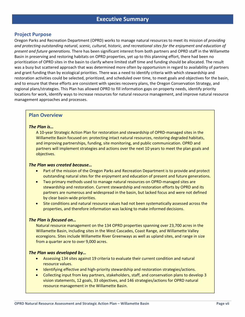
OPRD Natural Resource Assessment and Strategic Action Plan – Willamette Basin Page vii
Executive Summary Project Purpose Oregon Parks and Recreation Department (OPRD) works to manage natural resources to meet its mission of providing and protecting outstanding natural, scenic, cultural, historic, and recreational sites for the enjoyment and education of present and future generations. There has been significant interest from both partners and OPRD staff in the Willamette Basin in preserving and restoring habitats on OPRD properties, yet up to this planning effort, there had been no prioritization of OPRD sites in the basin to clarify where limited staff time and funding should be allocated. The result was a busy but scattered approach that was determined more often by opportunism in regard to availability of partners and grant funding than by ecological priorities. There was a need to identify criteria with which stewardship and restoration activities could be selected, prioritized, and scheduled over time, to meet goals and objectives for the basin, and to ensure that these efforts are consistent with species recovery plans, the Oregon Conservation Strategy, and regional plans/strategies. This Plan has allowed OPRD to fill information gaps on property needs, identify priority locations for work, identify ways to increase resources for natural resource management, and improve natural resource management approaches and processes.
Plan Overview The Plan is…
A 10-year Strategic Action Plan for restoration and stewardship of OPRD-managed sites in the Willamette Basin focused on: protecting intact natural resources, restoring degraded habitats, and improving partnerships, funding, site monitoring, and public communication. OPRD and partners will implement strategies and actions over the next 10 years to meet the plan goals and objectives.
The Plan was created because…
• Part of the mission of the Oregon Parks and Recreation Department is to provide and protect outstanding natural sites for the enjoyment and education of present and future generations.
• Two primary methods used to manage natural resources on OPRD-managed sites are stewardship and restoration. Current stewardship and restoration efforts by OPRD and its partners are numerous and widespread in the basin, but lacked focus and were not defined by clear basin-wide priorities.
• Site conditions and natural resource values had not been systematically assessed across the properties, and therefore information was lacking to make informed decisions.
The Plan is focused on…
Natural resource management on the 134 OPRD properties spanning over 23,700 acres in the Willamette Basin, including sites in the West Cascades, Coast Range, and Willamette Valley ecoregions. Sites include Willamette River Greenways as well as upland sites, and range in size from a quarter acre to over 9,000 acres.
The Plan was developed by…
• Assessing 134 sites against 19 criteria to evaluate their current condition and natural resource values.
• Identifying effective and high-priority stewardship and restoration strategies/actions. • Collecting input from key partners, stakeholders, staff, and conservation plans to develop 3
vision statements, 12 goals, 33 objectives, and 146 strategies/actions for OPRD natural resource management in the Willamette Basin.

OPRD Natural Resource Assessment and Strategic Action Plan – Willamette Basin Page viii
Site Inventory and Assessment As a component of this planning effort, all 134 individual OPRD-managed properties in the Willamette Basin were evaluated against a set of 19 criteria and scored to measure overall natural resource function and value, in the areas of habitat, water quality and floodplain function, and public use and enjoyment of nature. A few sites were omitted from the assessment. The results of this assessment have been used in development of strategies and priorities in this plan, and will be used by OPRD to help inform and prioritize future natural resource management decisions, including characterizing stewardship needs and restoration opportunities. The assessment categories were developed and weighted based specifically on conservation values as defined by OPRD policy and staff input, stakeholder input, and statewide conservation guidance. The Natural Resource Function & Value Assessment of OPRD Managed Lands in the Willamette Basin (OPRD, August 31, 2017) is included as Appendix A and is summarized in Section 3 of this Strategic Action Plan. Planning Process The strategic planning process was initiated in February 2016 using funds provided by the Oregon Watershed Enhancement Board, Meyer Memorial Trust Willamette River Initiative, and OPRD, with in-kind services provided by 39 OPRD staff (Project Advisory Team) and 37 Technical Advisory Pool members representing nearly twenty partner organizations (see acknowledgements). Planning consultant Jeff Krueger (JK Environments) facilitated the planning workshops, designed and applied the Function & Value Assessment methodology, and developed plan content. Ecologist Bruce Newhouse (Salix Associates) completed on-the-ground rapid assessments on 37 OPRD managed sites. The OPRD project manager and lead author of this Plan was Andrea Berkley, OPRD Valleys Region Natural Resource Specialist. Plan Organization and Content The Strategic Action Plan is organized into five sections:
• Section 1: Plan Purpose and Background Describes problems to be addressed by the Plan, the process used to develop the Plan, and OPRD’s mission and policies related to natural resource management.
• Section 2: Ecological Setting and Natural Resource Management Overview of the ecology and conservation targets of the Willamette Basin, the distribution and size of OPRD parks, management unit structure, and current approaches and funding used by OPRD for natural resource management.
• Section 3: Site Inventory and Assessment Describes the methodology used to assess and compare all OPRD parks in the Willamette Basin and provides assessment results.
• Section 4: Vision, Goals, Objectives, and Strategies Describes eight sources of information used in plan development, and contains the detailed vision, goals, objectives and strategies for each of the following topic areas:
o Stewardship o Restoration o Public Engagement
• Section 5: Management Unit Priorities and Actions Describes notable natural features in each of eight OPRD management units in the Willamette Basin, and details the relative priority and workplans for all OPRD sites.
Plan Implementation and Prioritization Sections 4 and 5 detail the plan actions/strategies, priorities and implementation details. Implementation of this Strategic Action Plan will be dependent upon available funding, emerging threats, and partnership opportunities. Key Strategies and Actions that are considered most urgent are indicated in the Plan and will be targeted for implementation within the upcoming biennium or otherwise as soon as feasible. Other strategies and actions will be implemented as feasible within the 10-year timeframe of this plan. Strategies and Actions may vary according to the specific needs and opportunities within each of the eight management units that OPRD sites are organized into in the Willamette Basin.
OPRD Natural Resource Assessment and Strategic Action Plan – Willamette Basin Page 1
Section 1: Purpose and Background
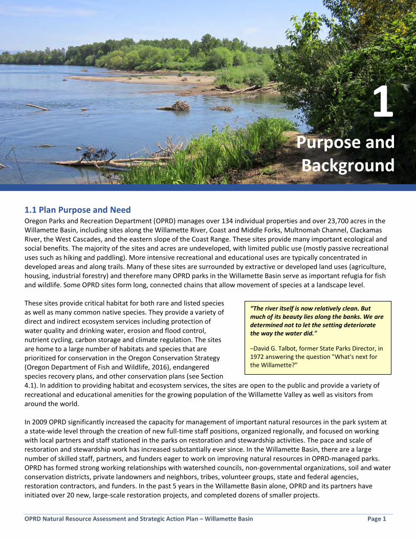
1.1 Plan Purpose and Need Oregon Parks and Recreation Department (OPRD) manages over 134 individual properties and over 23,700 acres in the Willamette Basin, including sites along the Willamette River, Coast and Middle Forks, Multnomah Channel, Clackamas River, the West Cascades, and the eastern slope of the Coast Range. These sites provide many important ecological and social benefits. The majority of the sites and acres are undeveloped, with limited public use (mostly passive recreational uses such as hiking and paddling). More intensive recreational and educational uses are typically concentrated in developed areas and along trails. Many of these sites are surrounded by extractive or developed land uses (agriculture, housing, industrial forestry) and therefore many OPRD parks in the Willamette Basin serve as important refugia for fish and wildlife. Some OPRD sites form long, connected chains that allow movement of species at a landscape level. These sites provide critical habitat for both rare and listed species as well as many common native species. They provide a variety of direct and indirect ecosystem services including protection of water quality and drinking water, erosion and flood control, nutrient cycling, carbon storage and climate regulation. The sites are home to a large number of habitats and species that are prioritized for conservation in the Oregon Conservation Strategy (Oregon Department of Fish and Wildlife, 2016), endangered species recovery plans, and other conservation plans (see Section 4.1). In addition to providing habitat and ecosystem services, the sites are open to the public and provide a variety of recreational and educational amenities for the growing population of the Willamette Valley as well as visitors from around the world. In 2009 OPRD significantly increased the capacity for management of important natural resources in the park system at a state-wide level through the creation of new full-time staff positions, organized regionally, and focused on working with local partners and staff stationed in the parks on restoration and stewardship activities. The pace and scale of restoration and stewardship work has increased substantially ever since. In the Willamette Basin, there are a large number of skilled staff, partners, and funders eager to work on improving natural resources in OPRD-managed parks. OPRD has formed strong working relationships with watershed councils, non-governmental organizations, soil and water conservation districts, private landowners and neighbors, tribes, volunteer groups, state and federal agencies, restoration contractors, and funders. In the past 5 years in the Willamette Basin alone, OPRD and its partners have initiated over 20 new, large-scale restoration projects, and completed dozens of smaller projects.
1 Purpose and Background
“The river itself is now relatively clean. But much of its beauty lies along the banks. We are determined not to let the setting deteriorate the way the water did."
–David G. Talbot, former State Parks Director, in 1972 answering the question "What's next for the Willamette?"

OPRD Natural Resource Assessment and Strategic Action Plan – Willamette Basin Page 2
As OPRD’s restoration and stewardship efforts in the Willamette Basin have developed, a number of challenges and areas for improvement have been identified that, if addressed, will improve natural resource management outcomes to protect and enhance many more acres. This Strategic Action Plan was initiated to address three main challenges OPRD faces in its efforts to steward natural resources in the Willamette Basin:
• Lack of a prioritized plan to direct resources; • Information gaps on property needs and opportunities; and • Insufficient stewardship resources and approaches.
Each of these problems is described below. During the year-long planning process undertaken to create this plan, other related topics rose in importance and, along with the following issues, are also addressed in this plan (see Section 4.1 for list of topics addressed).
1.1.1 Lack of a Prioritized Plan to Direct Resources There is significant interest from both partners and OPRD staff in preserving and restoring habitats within OPRD parks in the Willamette Basin, yet there had been no prioritization of OPRD sites to clarify where limited staff time and funding should be allocated. The result was a busy but scattered approach that was determined more often by opportunism in regard to availability of partners and grant funding than by ecological priorities and OPRD priorities. There was a need to identify criteria with which stewardship and restoration activities could be selected, prioritized, and scheduled over time, to meet goals and objectives for the basin, and to ensure that these efforts are consistent with OPRD policies, species recovery plans, the Oregon Conservation Strategy, and regional plans/strategies. One advantage of having a clear plan is to allow OPRD and its partners to plan further out in time and queue up projects in the basin in a prioritized and strategic fashion. To date, the selection of restoration and stewardship work that is supported by OPRD stewardship funding each biennium has been based primarily on: (1) continuation of existing projects, and (2) reaction to other site/project needs or opportunities that have emerged and garnered attention over the previous biennium. Only a subset of projects in need of funding are able to be funded each biennium using OPRD stewardship funds. As a result, OPRD cannot easily forecast future projects and funding needs and budget accordingly over a longer-term period, limiting OPRD’s ability to justify creation of new stewardship initiatives that would address these needs in a more efficient manner than the standard biennium-by-biennium approach. Section 5 and other portions of this plan address this challenge by specifying priorities and actions for each management unit in the basin. 1.1.2 Information Gaps on Property Needs and Opportunities Information gaps have existed for some sites in the Willamette Basin in terms of whether or not priority habitats and species are present, as well as overall site conditions. Many of the smaller Willamette Greenway sites, for example, have no access by land and are therefore difficult to actively monitor and manage. This presents an incomplete picture of the overall suite of habitats that may be available for enhancement via restoration, or that may be in need of basic stewardship intervention to preserve existing ecological values. Filling these information gaps through this planning process allows OPRD to evaluate its entire portfolio of sites in the basin against defined criteria, identify which sites are
Wood Ducks (photo by Cary Kerst)
OPRD Natural Resource Assessment and Strategic Action Plan – Willamette Basin Page 3
most in need of intervention, and prioritize those actions against one another. There exists a significant amount of scientifically derived technical information on the natural resources within the Willamette Basin that can inform OPRD’s choices of where to allocate its limited resources. The Natural Resource Function & Value Assessment (Appendix A) utilized a variety of sources of technical information to assess OPRD-managed sites. 1.1.3 Insufficient Stewardship Resources and Approaches OPRD faces challenges in the Willamette Basin similar to those that other land managers face in terms of properly stewarding all the acres it manages with limited funding and human resources. OPRD currently uses internal funding from the Salmon Plate program, proceeds from agricultural land leases, park operations funds, and a handful of other funding sources to pay for restoration and stewardship work on its properties. Park staff, hosts, partners, and volunteers also contribute time and resources toward these efforts. The level of funding available is not enough to address all needs, so it is leveraged with outside grant funding, and this is typically only possible for larger restoration efforts (for example, large planting projects or in-stream projects) that funders are willing to support. In the meantime, basic stewardship responsibilities (such as invasive species control or addressing erosion) receive minimal outside support, and are primarily the responsibility of park rangers, who are stretched thin dealing with visitors, facilities, and all manner of other park needs.
A further challenge is that an agreed-upon vision for what a “proper” or a “basic level” of stewardship in the context of OPRD’s Willamette Basin properties had not been defined, so it has been difficult to know what level of effort OPRD should be striving to achieve. As the backlog of stewardship needs has grown, potentially resulting in the loss of ecological values, it has become clear that OPRD’s current funding and strategies for property stewardship are deficient. There is an urgent need to identify new funding mechanisms that increase resources to devote to property stewardship, to prevent the loss of natural functions. There is a need to identify partnership approaches that increase human capacity to steward more acres. There is a need to ensure the most
effective, scientifically sound stewardship approaches appropriate for the basin are used. Finally, there is a need to scale-up the most successful stewardship strategies OPRD is already using, and identify new approaches that other large land managers have found successful that OPRD can pilot. As a public land manager, OPRD must be responsive to the public’s priorities and desires. When surveyed, visitors and residents in the Willamette Valley have expressed time and again a desire to enjoy passive recreational opportunities in natural areas, have access to waterways and nature and wildlife viewing, and placement of high value on natural resources in parks. In Oregon, hunting and fishing have remained fairly constant, but nature and wildlife observation, bird watching, and outdoor photography have seen substantial growth in overall participation in recent decades. A 2004 Willamette Greenway survey (see Section 4.1.8) conducted by Oregon State University asked respondents about their priorities for managing publicly owned lands along the Willamette River. The highest priority was assigned to “protecting and restoring Willamette River fish and wildlife habitat,” which 95% of respondents said was “very” or “somewhat” important. 90% of respondents indicated that “enhancing and restoring habitats on existing public lands” was “very” or “somewhat” important. This Plan will help OPRD to better meet the public’s demand for healthy, protected habitats on public lands in the Willamette Valley, and to address the stewardship challenges stated above.
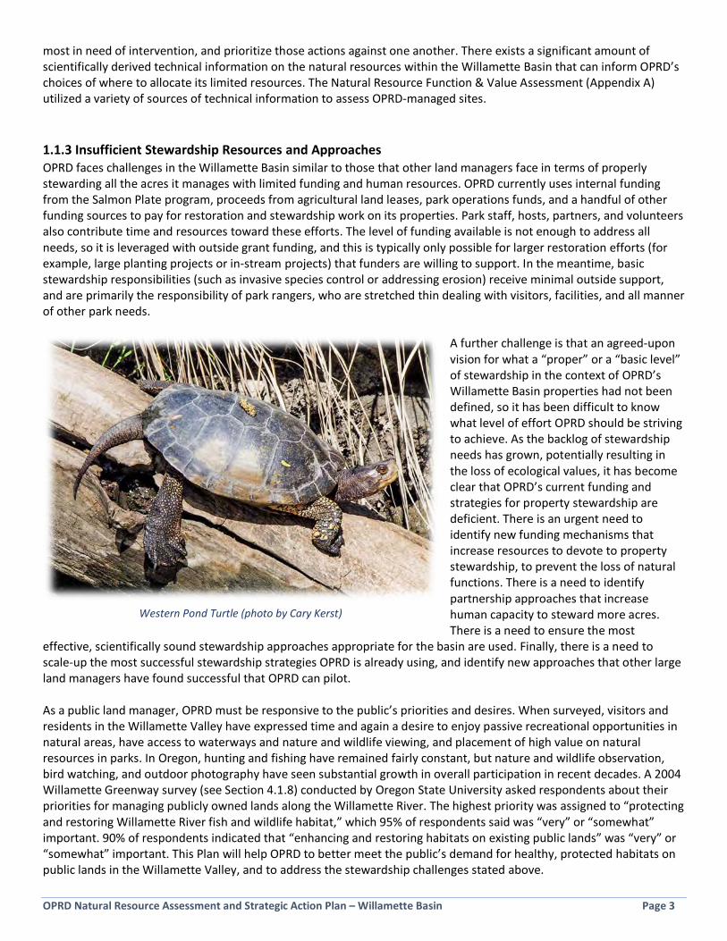
Western Pond Turtle (photo by Cary Kerst)
OPRD Natural Resource Assessment and Strategic Action Plan – Willamette Basin Page 4
Some of the key questions explored during the development of the Plan included the following (all of these questions pertain to OPRD’s Willamette Basin parks):
• What important natural resources are present on OPRD-managed sites? • What is the current condition of natural resources on OPRD-managed sites? • What resources, and which places, should be prioritized for OPRD’s focus? • How can OPRD increase funding and human resources, looking both externally and internally, that are devoted
to natural resource management? • What tools and resources do OPRD staff need to be better equipped to implement stewardship work? What are
the major issues and bottlenecks faced by staff? • How much focus should be placed on basic stewardship versus complex habitat restoration in natural resource
management? • What approaches are currently working well, and what new approaches can improve outcomes? • Who does the work, and how can coordination and collaboration across the agency be improved to achieve
better natural resource management? • How should park visitors and the broader public be included and engaged in this work? • How do important issues, including diversity and inclusion, climate change, scientific learning, and natural
disturbance, become part of OPRD’s natural resource management? • How is success measured?
1.2 Planning Process and Structure This strategic planning process was initiated in February 2016 using technical assistance funds provided by the Oregon Watershed Enhancement Board, the Meyer Memorial Trust Willamette River Initiative, and Oregon Parks and Recreation Department, with in-kind services provided by OPRD staff (Project Advisory Team) and the numerous Technical Advisory Pool members (see acknowledgements). Planning consultant Jeff Krueger (JK Environments) facilitated the planning workshops, designed and applied the Function & Value Assessment methodology, and developed plan content. Ecologist Bruce Newhouse (Salix Associates) completed on-the-ground rapid assessments on 37 OPRD managed sites. The OPRD project manager and lead author of this Plan was Andrea Berkley who is the OPRD Natural Resource Specialist for the Valleys Region (the Columbia Gorge and Willamette Basin). A group of 39 OPRD managers and staff served on the Project Advisory Team and participated in various aspects of plan development. Additionally, a voluntary group of 37 individuals representing nearly twenty partner organizations provided valuable input as members of the Technical Advisory Pool (TAP). 1.2.1 Project Advisory Team The Project Advisory Team (PAT) members participated in two half-day planning workshops and provided feedback at other points in the planning process on various components of the Strategic Action Plan and Function & Value Assessment as they were developed. PAT Workshop #1: The first workshop was held in two sessions on June 27 and 30, 2016. A total of 24 OPRD personnel from around the Willamette Basin participated in these two workshops, plus an additional seven provided input immediately after the workshop via an on-line survey. The workshop included a presentation of
PAT members discussing visioning prompt (photo by A. Berkley)
OPRD Natural Resource Assessment and Strategic Action Plan – Willamette Basin Page 5
background on the current OPRD Willamette Basin sites and natural resource project budgeting; an overview of the planning process and need for a plan; a group discussion and ranking of the proposed Function & Value Assessment criteria; and a visioning exercise (see Box, below). The visioning was done in small groups where participants were asked to describe their ideal 30-year vision for natural resource conditions in OPRD-managed sites.
PAT Visioning Prompt Please spend some time thinking about the following scenario: Imagine that you’ve left the Willamette Valley for a job out of state and have not been back for 30 years. You finally become sentimental and elect to move back to the Willamette Valley to enjoy your well-deserved retirement. You decide that the best way to celebrate your return is to spend the next several warm and sunny days (or weeks) visiting OPRD parks throughout the Willamette Basin. You knew that there had been a planning effort underway, focused on managing natural resources in parks, when you left the area and you wondered how it turned out. You are thrilled by what you see, and what OPRD has accomplished in these areas in terms of stewardship of the natural resources, successfully completed restoration efforts, and public enjoyment of nature. Please describe to your small group in a few sentences what you are seeing on your imagined trip and record key themes.
The vision concepts expressed by the PAT were recorded and later utilized to help shape the content of the Strategic Action Plan, particularly in developing the goals, objectives, and strategies listed in Section 4.3. PAT Workshop #2: A second PAT workshop was held on February 2, 2017 and was attended by approximately 20 OPRD personnel, with additional input received from a few others afterward via email and electronic surveys. The agenda included the presentation of preliminary Natural Resource Function & Value Assessment (see Appendix A and Section 3) results and a small group exercise to review proposed vision elements, goals, objectives, and strategies. Ideas and feedback from the small groups were presented and discussed by the larger PAT group. PAT members who were unable to attend the workshop were given an opportunity to provide feedback through email. As a follow-up to this meeting, all PAT members were asked to prioritize the goals and objectives via an on-line survey. In addition to the workshops, OPRD personnel who are very familiar with sites within their respective management units were engaged one-on-one to review the accuracy and breadth of information used in the Function & Value Assessment report for all 134 sites evaluated.
The PAT also provided input on the following questions during the planning process: • What are the main barriers to success for stewardship of natural resources in the basin? …for
restoration of habitats in the basin? • What should OPRD’s stewardship and/or restoration work in the Willamette Basin be focused
on? • Are there additional problems/issues/challenges/opportunities, or other things we can address
through this planning process, that are not currently included in the project scope? • Which OPRD-managed properties in the basin do you have a high, medium, or low level of
knowledge of restoration opportunities? …of invasive species issues? • What are the most important criteria to look at during the Function & Value Assessment? • Are there any objectives or strategies you especially like or dislike, and why, or are any
important ones missing? • Which of the draft goals would you rank as the highest priority?

OPRD Natural Resource Assessment and Strategic Action Plan – Willamette Basin Page 6
1.2.2 Technical Advisory Pool The Technical Advisory Pool (TAP) was comprised of representatives from nearly twenty partner organizations (see acknowledgements page) who agreed to devote time and energy to advise OPRD on key parts of the plan development. Members were asked to provide feedback on draft products and help OPRD identify organizational strengths and areas for improvement. A workshop for the TAP was held on August 11, 2016 and was attended by 27 members and included a morning work-session and an afternoon bicycle tour of Champoeg State Heritage Area during which a variety of natural resource management topics were discussed. An additional 12 TAP members, who were unable to attend the workshop, provided feedback via an on-line survey. The workshop included an overview presentation about the planning process, Natural Resource Function & Value Assessment methodology, and OPRD’s natural resource management activities and structure. Additionally, the TAP was asked to review and provide input on the draft Function & Value Assessment. In the months following the workshop, the TAP was asked to provide topic-specific feedback through email and on-line surveys. Feedback from the TAP has been incorporated into the content of this Plan.
The TAP provided input on the following questions during the planning process: • What is OPRD doing well in the area of natural resource stewardship and restoration in its
Willamette Basin parks? What could OPRD be doing better? • What are the most significant natural resource stewardship challenges facing Willamette Basin
land managers? • From your perspective of a partner organization and/or a fellow land manager, what focus do
you think OPRD should have in the overall conservation, restoration, and management of natural areas in the Willamette Basin?
• Think long-term (over the next 20-30 years) and describe your “Dream 30-year vision for OPRD”. • Consider the data available in the Function & Value Assessment (19 criteria for 134 properties).
How would you analyze this data to inform natural resource management decision-making?
1.2.3 Plan Development This Strategic Action Plan was developed over a 16-month period using a combination of internal and external input (Figure 1-1, red boxes) and results of a comprehensive Function & Value Assessment (Figure 1-1, gold boxes; also see Section 3). Utilizing this input, a set of vision elements, goals, objectives, and strategies were developed to guide natural resource area stewardship and restoration (Figure 1-1, blue boxes) for the OPRD Willamette Basin parks over a 10-year period (mid 2017-2027).
Sinuous Snaketail (photo by Cary Kerst)

OPRD Natural Resource Assessment and Strategic Action Plan – Willamette Basin Page 7
Figure 1-1: Planning Process and Products Diagram
1.3 OPRD Mission and Policy on Natural Resources Outstanding natural resources can be found in portions of individual OPRD parks or may encompass an entire park. Providing and protecting these natural resources is the foundation of the work proposed in this Strategic Action Plan. OPRD’s mission also identifies scenic, cultural, recreational and historic resource considerations as being central to the agency’s work. OPRD’s mission (see Box, right) distinguishes it from some organizations who manage land in that it is a human-centered mission. We see words like “provide” and “recreational” in the mission statement, and the purpose of the agency’s work is “for the enjoyment and education” of people. As a parks agency, OPRD must ensure natural resource management actions benefit biodiversity in all its forms, as well as provide an opportunity for people to learn about and experience these outstanding natural sites. People are therefore a theme in this Plan.
OPRD Mission To provide and protect outstanding natural, scenic, cultural, historic, and recreational sites for the enjoyment and education of present and future generations.
OPRD Natural Resource Assessment and Strategic Action Plan – Willamette Basin Page 8
There are six OPRD Policies relevant to natural resource management:
The Natural Resources and Environmental Management Policy directs OPRD to manage sites to preserve and protect Oregon’s natural landscapes while enhancing the natural ecological processes that sustain natural resources in balance with recreation. The policy states that resource management will emphasize:
• ecosystem-based approaches • promote ecosystems that favor biodiversity • reduce ecological fragmentation • promote native species
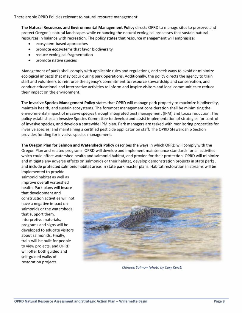
Management of parks shall comply with applicable rules and regulations, and seek ways to avoid or minimize ecological impacts that may occur during park operations. Additionally, the policy directs the agency to train staff and volunteers to reinforce the agency’s commitment to resource stewardship and conservation, and conduct educational and interpretive activities to inform and inspire visitors and local communities to reduce their impact on the environment. The Invasive Species Management Policy states that OPRD will manage park property to maximize biodiversity, maintain health, and sustain ecosystems. The foremost management consideration shall be minimizing the environmental impact of invasive species through integrated pest management (IPM) and toxics reduction. The policy establishes an Invasive Species Committee to develop and assist implementation of strategies for control of invasive species, and develop a statewide IPM plan. Park managers are tasked with monitoring properties for invasive species, and maintaining a certified pesticide applicator on staff. The OPRD Stewardship Section provides funding for invasive species management. The Oregon Plan for Salmon and Watersheds Policy describes the ways in which OPRD will comply with the Oregon Plan and related programs. OPRD will develop and implement maintenance standards for all activities which could affect watershed health and salmonid habitat, and provide for their protection. OPRD will minimize and mitigate any adverse effects on salmonids or their habitat, develop demonstration projects in state parks, and include protected salmonid habitat areas in state park master plans. Habitat restoration in streams will be implemented to provide salmonid habitat as well as improve overall watershed health. Park plans will insure that development and construction activities will not have a negative impact on salmonids or the watersheds that support them. Interpretive materials, programs and signs will be developed to educate visitors about salmonids. Finally, trails will be built for people to view projects, and OPRD will offer both guided and self-guided walks of restoration projects.
Chinook Salmon (photo by Cary Kerst)
OPRD Natural Resource Assessment and Strategic Action Plan – Willamette Basin Page 9
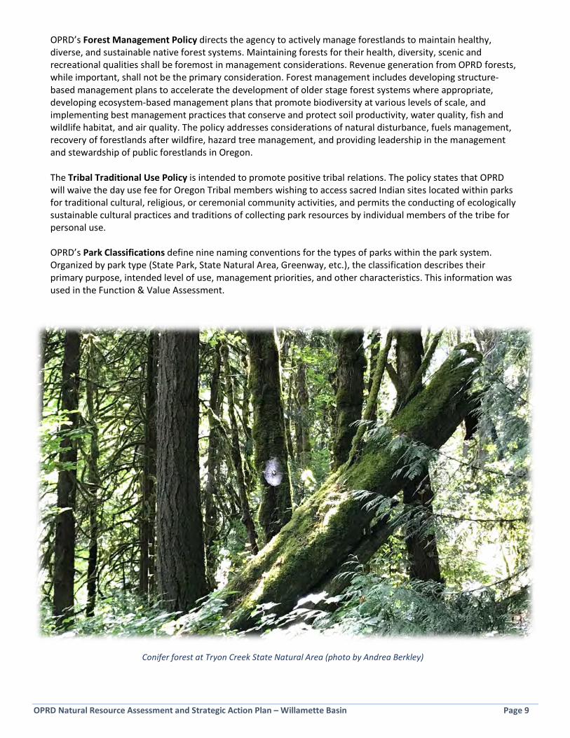
OPRD’s Forest Management Policy directs the agency to actively manage forestlands to maintain healthy, diverse, and sustainable native forest systems. Maintaining forests for their health, diversity, scenic and recreational qualities shall be foremost in management considerations. Revenue generation from OPRD forests, while important, shall not be the primary consideration. Forest management includes developing structure-based management plans to accelerate the development of older stage forest systems where appropriate, developing ecosystem-based management plans that promote biodiversity at various levels of scale, and implementing best management practices that conserve and protect soil productivity, water quality, fish and wildlife habitat, and air quality. The policy addresses considerations of natural disturbance, fuels management, recovery of forestlands after wildfire, hazard tree management, and providing leadership in the management and stewardship of public forestlands in Oregon. The Tribal Traditional Use Policy is intended to promote positive tribal relations. The policy states that OPRD will waive the day use fee for Oregon Tribal members wishing to access sacred Indian sites located within parks for traditional cultural, religious, or ceremonial community activities, and permits the conducting of ecologically sustainable cultural practices and traditions of collecting park resources by individual members of the tribe for personal use. OPRD’s Park Classifications define nine naming conventions for the types of parks within the park system. Organized by park type (State Park, State Natural Area, Greenway, etc.), the classification describes their primary purpose, intended level of use, management priorities, and other characteristics. This information was used in the Function & Value Assessment.
Conifer forest at Tryon Creek State Natural Area (photo by Andrea Berkley)

OPRD Natural Resource Assessment and Strategic Action Plan – Willamette Basin Page 10
Page Intentionally Blank
OPRD Natural Resource Assessment and Strategic Action Plan – Willamette Basin Page 11
Section 2: Ecological Setting and Natural Resource Management [3 pages]
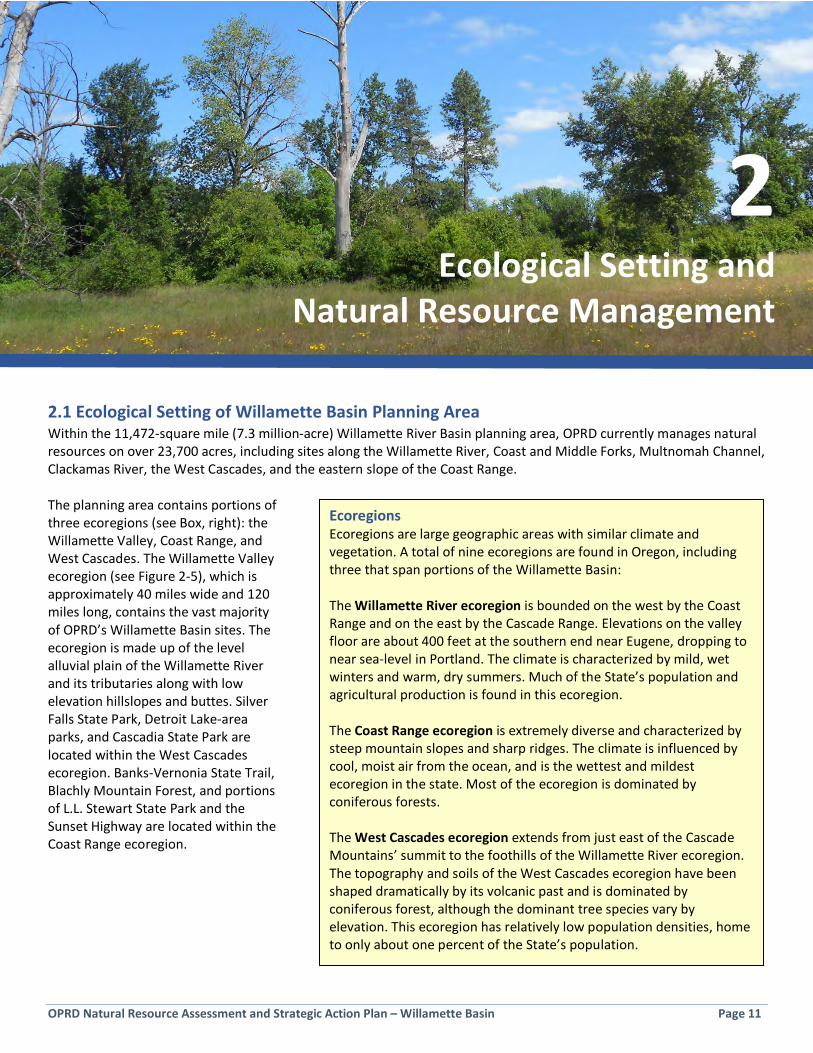
2.1 Ecological Setting of Willamette Basin Planning Area Within the 11,472-square mile (7.3 million-acre) Willamette River Basin planning area, OPRD currently manages natural resources on over 23,700 acres, including sites along the Willamette River, Coast and Middle Forks, Multnomah Channel, Clackamas River, the West Cascades, and the eastern slope of the Coast Range. The planning area contains portions of three ecoregions (see Box, right): the Willamette Valley, Coast Range, and West Cascades. The Willamette Valley ecoregion (see Figure 2-5), which is approximately 40 miles wide and 120 miles long, contains the vast majority of OPRD’s Willamette Basin sites. The ecoregion is made up of the level alluvial plain of the Willamette River and its tributaries along with low elevation hillslopes and buttes. Silver Falls State Park, Detroit Lake-area parks, and Cascadia State Park are located within the West Cascades ecoregion. Banks-Vernonia State Trail, Blachly Mountain Forest, and portions of L.L. Stewart State Park and the Sunset Highway are located within the Coast Range ecoregion.
2 Ecological Setting and
Natural Resource Management
Ecoregions Ecoregions are large geographic areas with similar climate and vegetation. A total of nine ecoregions are found in Oregon, including three that span portions of the Willamette Basin: The Willamette River ecoregion is bounded on the west by the Coast Range and on the east by the Cascade Range. Elevations on the valley floor are about 400 feet at the southern end near Eugene, dropping to near sea-level in Portland. The climate is characterized by mild, wet winters and warm, dry summers. Much of the State’s population and agricultural production is found in this ecoregion. The Coast Range ecoregion is extremely diverse and characterized by steep mountain slopes and sharp ridges. The climate is influenced by cool, moist air from the ocean, and is the wettest and mildest ecoregion in the state. Most of the ecoregion is dominated by coniferous forests. The West Cascades ecoregion extends from just east of the Cascade Mountains’ summit to the foothills of the Willamette River ecoregion. The topography and soils of the West Cascades ecoregion have been shaped dramatically by its volcanic past and is dominated by coniferous forest, although the dominant tree species vary by elevation. This ecoregion has relatively low population densities, home to only about one percent of the State’s population.

OPRD Natural Resource Assessment and Strategic Action Plan – Willamette Basin Page 12
Historical accounts indicate that prior to Euro-American settlement in the mid-1800s, much of the Willamette Valley was dominated by large expanses of grasslands, oak woodlands, and riparian forest (see Figure 2-1). The native Kalapuya people were known to have regularly set fires in the valley over many hundreds of years, likely to improve conditions for hunting, gathering, and travel. These regular fires maintained the valley’s former mosaic of open grasslands and oak habitats, upon which many native bird and wildlife species depend. Riparian forest was present in broad bands along the major rivers and flooded more frequently and widely than today’s river, which is heavily influenced by flood control dams. This floodplain along with extensive networks of wetlands made the Willamette Valley a major component of the Pacific flyway, the major north-south flyway for migratory birds in America. The expansive floodplain with braided channels, alcoves, and oxbows provided outstanding habitat for anadromous fish, such as salmon and lamprey, which were abundant along the river and its tributaries. The native people of the valley have long had a deep cultural connection to salmon and lamprey. Although conifer forest was present, it covered significantly less land area than today, found primarily in small patches on cooler north facing slopes. Since the 1850s, the Willamette Valley has been dramatically altered by agricultural, hydropower and urban development and the removal of regular fire and flooding events from the ecosystem. These changes have had a particularly significant effect on oak woodland, grassland, and wetland habitats (see Figure 2-1), all of which have declined dramatically in extent and quality. The ecology of much of Willamette River and its tributaries has also been changed, in large part due to the construction of flood-control dams beginning in the 1950s, which has greatly reduced the frequency and extent of natural flooding and disrupted the migration patterns of anadromous fish species. Decline in habitat extent, quality, and fragmentation is directly linked to reduction in plant, animal, and other species’ ability to persist. Habitat altering non-native invasive species have also become widespread across habitat types, competing with native species, and posing a significant challenge to land management efforts. Invasive species are considered one of the top five drivers of global biodiversity loss. Along with impacts from climate change, these stressors can exceed levels tolerable by native plants and animals. OPRD-managed properties in the Willamette Basin play an important role toward preserving and maintaining remnants of these once common native vegetation communities. These areas, along with lands conserved by OPRD partner organizations, provide a critical web of habitat that serves as refuge for many at-risk plant and animal species that were once common in the basin. Many of these species are now considered federally or state threatened or endangered, rare, or at-risk of extinction.
Willamette Valley ecoregion near Eugene (photo by RaptorViews)

OPRD Natural Resource Assessment and Strategic Action Plan – Willamette Basin Page 13
Figure 2-1: Change in Extent of Willamette Valley Strategy Habitats

OPRD Natural Resource Assessment and Strategic Action Plan – Willamette Basin Page 14
2.2 Size and Distribution of OPRD-Managed Properties in the Willamette Basin OPRD-managed properties in the Willamette Basin range in size from the smallest at 0.23 acres (Willamette River Greenway W52 in Albany) to the largest at 9,141 acres (Silver Falls State Park). The average size of all sites is 224 acres. The majority of the sites are located along the Willamette River Greenway, forming a linear string of public lands, but with many gaps in between. A total of 89 of the 134 OPRD-managed properties are designated as Willamette River Greenway sites. These range in size from 481 acres (Grand Island WRG) to 0.23 acres (Willamette River Greenway W52), with an average size of 59.2 acres. A number of State Parks also line the Willamette River (some of these were acquired as Willamette River Greenways) and these tend to be larger in size (for example, the 1,266-acre Willamette Mission State Park). Figure 2-2 shows the size distribution of OPRD’s Willamette Basin sites from smallest acreage to largest. 90% of the sites are between 1 and 500 acres, with almost 40% of the sites in the range of 10 to 50 acres. This data reflects that there is a challenging number of dispersed, small to medium sized properties which spreads out natural resource management efforts over a large number of sites dispersed over an extensive geographic area. There are ten large sites that can be treated as habitat anchors. These are Silver Falls State Park (9,141 acres), L.L. Stub Stewart State Park (1,851 acres), Willamette Mission State Park (1,266 acres), Luckiamute State Natural Area (997 acres), Elijah Bristow State Park (969 acres), Milo McIver State Park (964 acres), Champoeg State Heritage Area (675 acres), Tryon Creek State Natural Area (666 acres), Molalla River State Park (570 acres), and Bower’s Rock State Park (550 acres). These ten large sites happen to be distributed fairly evenly across the basin. These larger sites are important for natural resource values because they present greater opportunities for managing for multiple natural resource goals and restoration project types, and they also provide the large, contiguous expanses of habitat many native species require for survival.
Figure 2-2: Number of OPRD-Managed Willamette Basin Properties by Size Class
Note: This Plan addresses natural resource management on sites that OPRD has direct management oversight of and/or have significant natural resources. A handful of sites that OPRD owns, but that do not meet the criteria, were omitted from this Plan. These are listed in Appendix A.
5
18
12
48
2117
7
2 1
0-1 1-5 5-10 10-50 50-100 100-500 500-1000 1000-5000 5000+Acres
OPRD Natural Resource Assessment and Strategic Action Plan – Willamette Basin Page 15
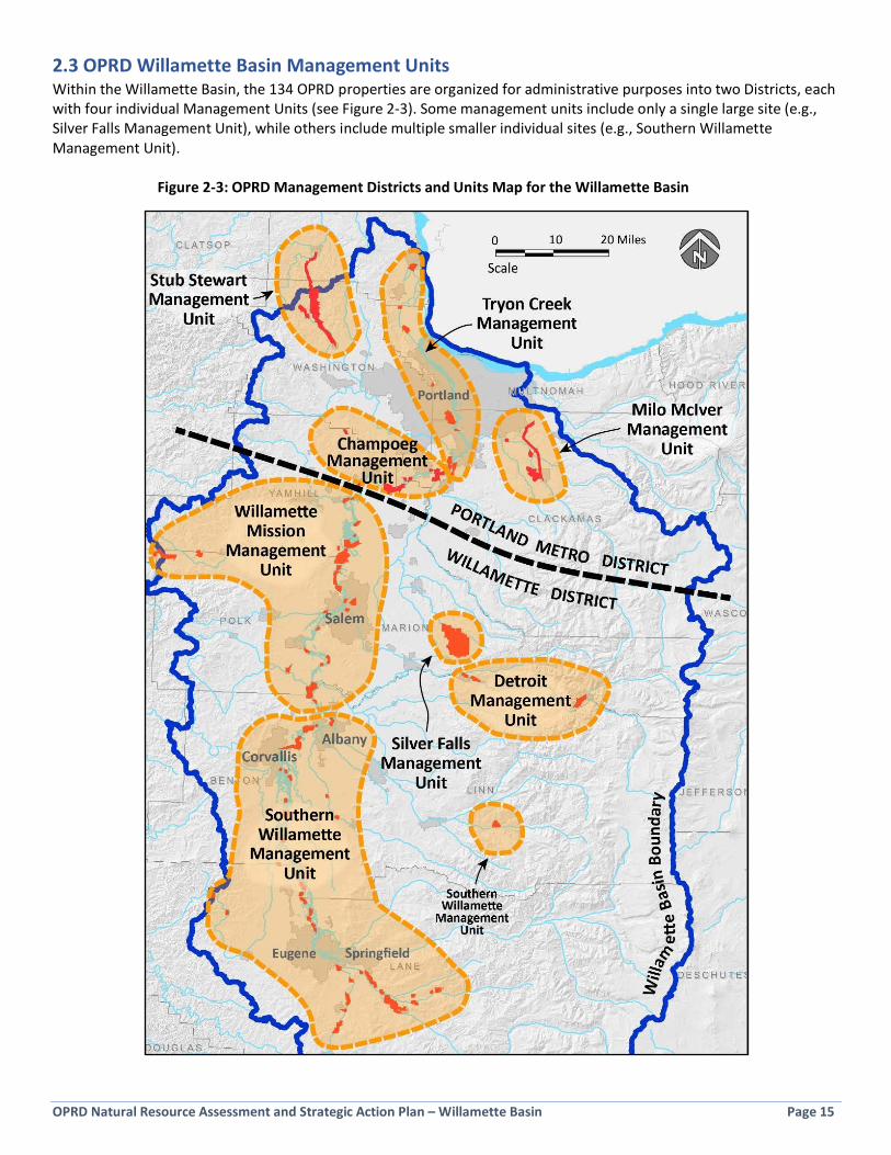
2.3 OPRD Willamette Basin Management Units Within the Willamette Basin, the 134 OPRD properties are organized for administrative purposes into two Districts, each with four individual Management Units (see Figure 2-3). Some management units include only a single large site (e.g., Silver Falls Management Unit), while others include multiple smaller individual sites (e.g., Southern Willamette Management Unit). Figure 2-3: OPRD Management Districts and Units Map for the Willamette Basin
OPRD Natural Resource Assessment and Strategic Action Plan – Willamette Basin Page 16
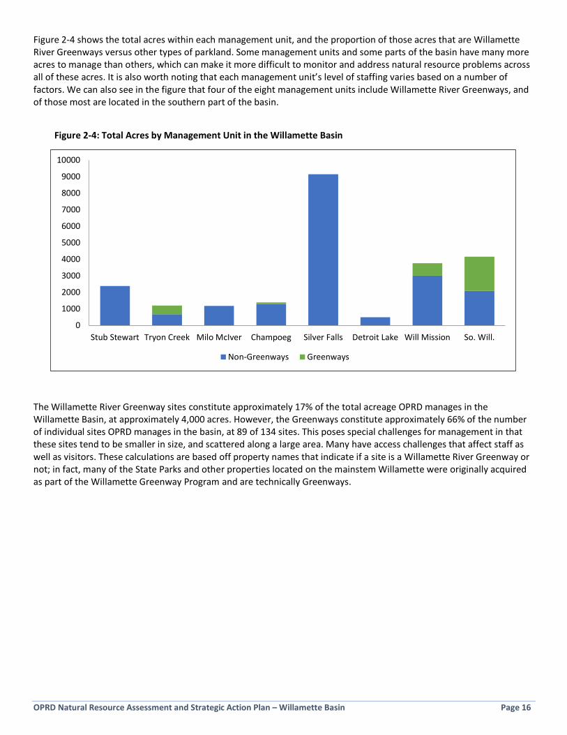
Figure 2-4 shows the total acres within each management unit, and the proportion of those acres that are Willamette River Greenways versus other types of parkland. Some management units and some parts of the basin have many more acres to manage than others, which can make it more difficult to monitor and address natural resource problems across all of these acres. It is also worth noting that each management unit’s level of staffing varies based on a number of factors. We can also see in the figure that four of the eight management units include Willamette River Greenways, and of those most are located in the southern part of the basin.
Figure 2-4: Total Acres by Management Unit in the Willamette Basin
The Willamette River Greenway sites constitute approximately 17% of the total acreage OPRD manages in the Willamette Basin, at approximately 4,000 acres. However, the Greenways constitute approximately 66% of the number of individual sites OPRD manages in the basin, at 89 of 134 sites. This poses special challenges for management in that these sites tend to be smaller in size, and scattered along a large area. Many have access challenges that affect staff as well as visitors. These calculations are based off property names that indicate if a site is a Willamette River Greenway or not; in fact, many of the State Parks and other properties located on the mainstem Willamette were originally acquired as part of the Willamette Greenway Program and are technically Greenways.
0
1000
2000
3000
4000
5000
6000
7000
8000
9000
10000
Stub Stewart Tryon Creek Milo McIver Champoeg Silver Falls Detroit Lake Will Mission So. Will.
Non-Greenways Greenways

Long
Tom
Calapooia
River
Santiam
North
South
Oak
Rive
r
Willam
ette
Creek
Santiam
McKenzie
Mud
dy
Cr.
River
Luckiamute
RickreallCreek
Pudd
ing
Amazon
Creek
South
Yamhill
ButteCreek
Rive
r
River
ColumbiaRiver
River
MiddleFork
Coas
tFo
rk
Fall
Creek
Tualatin
River
Clackamas
L.L. "Stub" Stewart
Milo McIver
Willame�e Mission
Elijah Bristow
& Dexter
Champoeg
Luckiamute
Tryon Creek
Molalla River
Bowers Rock
Grand Island
Scappoose Landing
Wapato Access&W04
Jasper
Truax Island
Spring Valley Access
Fort Yamhill
Pengra Access
Bonnie Lure
Half Moon Bend
Riverside Landing
Lowell
Yamhill Landing
Detroit Lake &Detroit Lake Parcels
& Detroit Lake Mongold
Beardsley Bar Landing
Blue Ruin Landing
& Blue Ruin Island
Lynx Hollow Access &
Giddings Cr.
Banks-Vernonia
Beacon Landing
Lincoln Access
Gravel Bar
Blachly Mountain
Forest
Washburne
Log Jam Landing & Log Jam Access
& Jasper Br.
Windsor Island
Landing
Seavy Landing
Camas Swale Landing &Bristow Landing
Glass Bar Access
Green Island Landing
Darrow Bar Access
SunsetHighway
Hoacum Island
Landing
Estacada-Boring
Simpson Lakes Access
Kiger Is. Landing
North San�am-
UpperMaples
OPRD-W92
Scandia Landing
Maud Williamson
Thompson's Mill
Holman
Harkens Lake North &Harkens Lake
South
French Prairie Access
Parre�e Mountain
Access
Rocky Bu�e
Sidney Access
River Je�y
LandingNorth
Roger's Bend
Jackson Bend
Landing
Black Dog
Whitely Landing
Spring Hill
OPRD-W22
Erra�c Rock
Cloverdale Access
Independence Bar Access
OPRD-W29
Hall's Ferry Access
Willame�e Stone
Oswego Creek Outlet
Access
Landing
PetreeLanding
Cougar Mt.Access
OPRD-W82
PisgahLanding
Alderwood
Browns Landing &
Willis Refuge & Marshall Is. Landing
Cascadia
TrippGreenway
OPRD-W52 W53 W54
SarahHelmick
AmericanBo�omLanding
McLaneIsland
Landing
Doaks FerryAccess
EldridgeBar Landing
Darrow Rock’sLanding
OPRD-W26
HessCreek
Landing
BaldPeak
DuckLake
&W03
Banks-Vernonia
Willamette
OPRD-W42
Christensen’sBoat Ramp
MarshallIs. Access
Lowell
Winberry
NorthShore
FreeMeadow
Lakeside 1 & 2& Cascara &
Fishermans Pt.
North San�am-
Lower
River Je�y
LandingSouth
Thompson's Mill - Sodom
Creek
Johnson
Molalla
River
Willame�e
Willamette
National
Forest
Mount
Hood
National
Forest
Tillamook
State
Forest
WASHINGTON
Willame�e
Ecoregion
AnkenyNWR
Basket SloughNWR
Finley SloughNWR
FernRidge
WildlifeArea
BufordPark
SauvieIsland
WildlifeArea
Sam Daws &Halsey &
Buckskin Mary
FernRidgeRes.
Silver Falls
Molalla Landing
Willame�eMeridianLanding
W12&W13
Coalca Landing
RockIsland
Landing
Pete’s Mnt. LandingPeach Cove Landing
W15, W16& W17
SALEM
SPRINGFIELDEUGENE
VENETA
CRESWELL
COBURG
JUNCTIONCITY
HARRISBURG
HALSEY
BROWNSVILLE
SWEETHOME
LEBANON
ALBANY
CORVALLIS
STAYTON
KEIZER
DALLAS
MONMOUTH
MCMINNVILLE
PORTLANDHILLSBORO
BEAVERTON
TIGARD
GRESHAM
FORESTGROVE
VANCOUVER
SILVERTON
ESTACADA
SANDY
OREGONCITY
NEWBERG
SAINTHELENS
SCAPPOOSE
VERNONIA
BANKS NORTHPLAINS
INDEPENDENCE
10 Miles0
Scale
5
= One Square Mile(640 acres)Map Prepared by JKE
August 2017
Oregon Parks and Recreation Department
OPRD-Managed Sites Map
LegendOPRD Managed Natural Resource AreasFederal OwnershipTribal OwnershipOther State OwnershipCity and County OwnershipLand Trust Ownership/Easements (CLT, GLT, MRT, TNC)Ci�es (Urban Growth Boundaries)Willame�e Valley Ecoregion BoundaryMajor Rivers and Streams
Figure 2-5

OPRD Natural Resource Assessment and Strategic Action Plan – Willamette Basin Page 18
Page intentionally blank

OPRD Natural Resource Assessment and Strategic Action Plan – Willamette Basin Page 19
2.4 Current Natural Resource Management Approaches Natural resource management in OPRD-managed sites, which includes habitat restoration as well as day-to-day stewardship work, is currently accomplished using a variety of strategies. Human resource capacity to implement work is provided by field staff, region and headquarters staff, OPRD partners (such as watershed councils), volunteers (including hosts), contractors, and inmate crews. Funding for the work originates in operations budgets, special grants from OPRD Stewardship funding, and grant dollars raised either by OPRD or partners. Typically, day-to-day stewardship work is accomplished by field staff, while larger projects and habitat restoration are funded by OPRD Stewardship funding or grants and rely more on contracted labor. OPRD personnel and a large cadre of dedicated partners working in the Willamette Basin parks have been successful in developing important natural resource enhancement and restoration projects over the past several biennia. The level of activity and number of larger projects in these parks has increased over time, and this trend is reflected in the proportion of OPRD Stewardship funding going to Willamette Basin park projects (versus other OPRD regions) each biennium (see Figure 2-6). In the 2007-2009 biennium, approximately 4% of the total awarded OPRD Stewardship funding went to projects in the Willamette Basin parks; in the 2015-2017 biennium, this figure was 24%. This increase can be attributed to a few factors: an increasing interest and level of activity by OPRD’s partners to do work in the parks; an increase in key match funding programs (such as the Willamette Special Investment Partnership); an increased focus by OPRD on natural resource management as reflected by creation of new natural resource specialist positions in 2009; and the fact that many Park Managers and Park Rangers are interested in doing restoration work in their parks in this region. As more OPRD Stewardship funding has been directed at Willamette Basin parks over the years, this investment has coincided with an increase in the ability of OPRD to work successfully with partners to
Figure 2-6: Approx. OPRD Stewardship Funding, Statewide vs. Willamette Basin
$0
$200,000
$400,000
$600,000
$800,000
$1,000,000
$1,200,000
$1,400,000
07-09 09-11 11-13 13-15 15-17Biennium
Total OPRD Stewardship $Available Statewide
Total OPRD $ Awarded toWillamette Basin
Figure 2-7: Approximate OPRD Stewardship Funds and Leveraged Funds
$0
$200,000
$400,000
$600,000
$800,000
$1,000,000
$1,200,000
$1,400,000
$1,600,000
07-09 09-11 11-13 13-15 15-17Biennium
Stewardship section fundingfor Willlamette Basin
Outside $ leveraged forWillamette Basin projects
OPRD Natural Resource Assessment and Strategic Action Plan – Willamette Basin Page 20
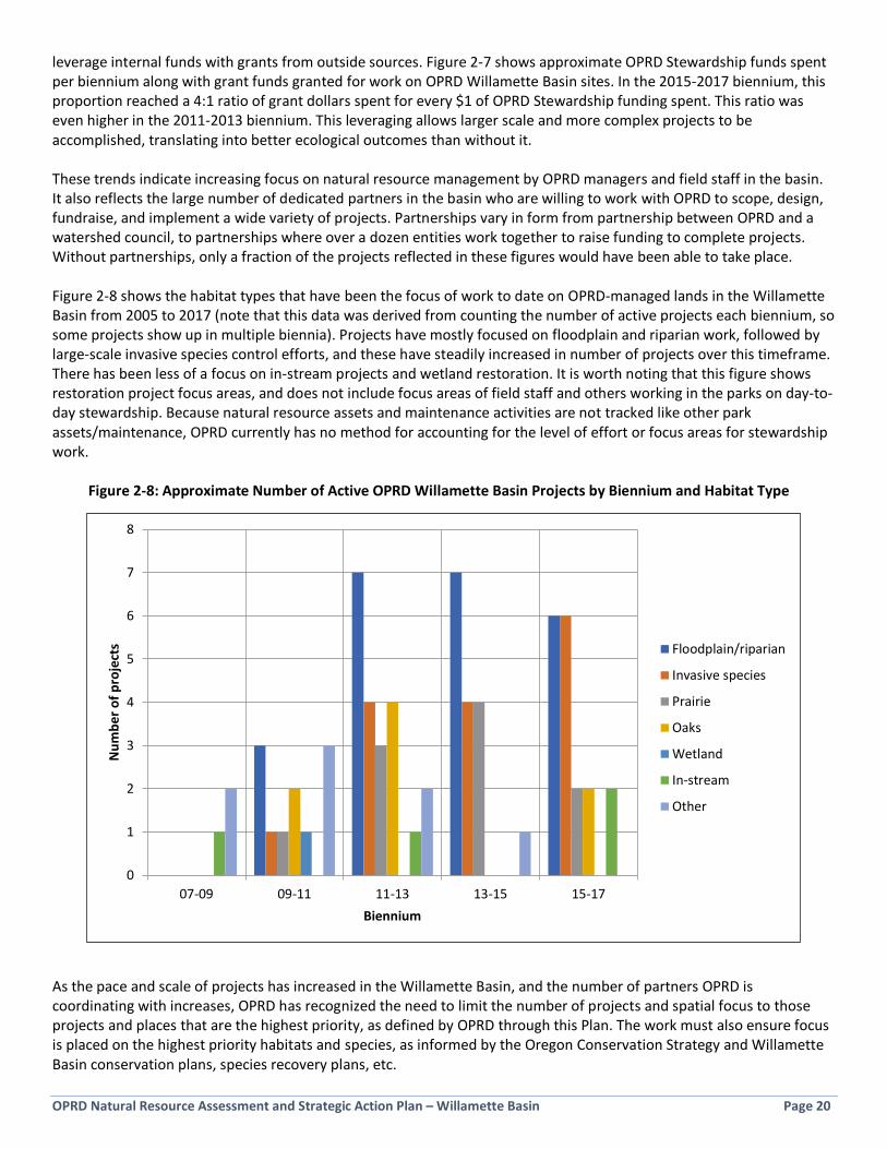
leverage internal funds with grants from outside sources. Figure 2-7 shows approximate OPRD Stewardship funds spent per biennium along with grant funds granted for work on OPRD Willamette Basin sites. In the 2015-2017 biennium, this proportion reached a 4:1 ratio of grant dollars spent for every $1 of OPRD Stewardship funding spent. This ratio was even higher in the 2011-2013 biennium. This leveraging allows larger scale and more complex projects to be accomplished, translating into better ecological outcomes than without it. These trends indicate increasing focus on natural resource management by OPRD managers and field staff in the basin. It also reflects the large number of dedicated partners in the basin who are willing to work with OPRD to scope, design, fundraise, and implement a wide variety of projects. Partnerships vary in form from partnership between OPRD and a watershed council, to partnerships where over a dozen entities work together to raise funding to complete projects. Without partnerships, only a fraction of the projects reflected in these figures would have been able to take place. Figure 2-8 shows the habitat types that have been the focus of work to date on OPRD-managed lands in the Willamette Basin from 2005 to 2017 (note that this data was derived from counting the number of active projects each biennium, so some projects show up in multiple biennia). Projects have mostly focused on floodplain and riparian work, followed by large-scale invasive species control efforts, and these have steadily increased in number of projects over this timeframe. There has been less of a focus on in-stream projects and wetland restoration. It is worth noting that this figure shows restoration project focus areas, and does not include focus areas of field staff and others working in the parks on day-to-day stewardship. Because natural resource assets and maintenance activities are not tracked like other park assets/maintenance, OPRD currently has no method for accounting for the level of effort or focus areas for stewardship work. Figure 2-8: Approximate Number of Active OPRD Willamette Basin Projects by Biennium and Habitat Type
As the pace and scale of projects has increased in the Willamette Basin, and the number of partners OPRD is coordinating with increases, OPRD has recognized the need to limit the number of projects and spatial focus to those projects and places that are the highest priority, as defined by OPRD through this Plan. The work must also ensure focus is placed on the highest priority habitats and species, as informed by the Oregon Conservation Strategy and Willamette Basin conservation plans, species recovery plans, etc.
0
1
2
3
4
5
6
7
8
07-09 09-11 11-13 13-15 15-17
Num
ber o
f pro
ject
s
Biennium
Floodplain/riparian
Invasive species
Prairie
Oaks
Wetland
In-stream
Other

OPRD Natural Resource Assessment and Strategic Action Plan – Willamette Basin Page 21
Section 3: Inventory and Assessment
3.1 Assessment Purpose and Approach A key product of the strategic action planning process was the development and application of a Natural Resource Function & Value Assessment. With 134 Willamette Basin properties covering over 23,700 acres, OPRD staff have found it challenging to make informed decisions about resource allocation and priorities. The results of this assessment have been used in development of strategies and priorities in this plan, and will be used by OPRD to help inform and prioritize future natural resource management decisions, including characterizing stewardship needs and restoration opportunities. The assessment categories were developed and weighted based specifically on conservation values as defined by OPRD policy and staff input, as well as stakeholder input and statewide conservation guidance. They are intended to answer the question: What makes the natural resources at this site valuable from an OPRD perspective? Assessment criteria include ecosystem services related to Habitat Value, Water Quality and Floodplain Function, and Public Use and Enjoyment. Sub-totals have been tallied separately for each topic so that the data can be analyzed and utilized for a variety of purposes (see Section 3.5). The 134 individual sites evaluated were lumped in some cases where properties were located close to one another, and on the same side of the river, resulting in 106 total site groupings evaluated. These groupings are indicated with a dash (for example, Elijah Bristow SP-Dexter SRS)
3 Inventory and
Assessment
Natural Resource Functions refer to environmental services; something that is found in nature (such as a mineral, water source, forest, or animal) and is valuable to humans (as in providing a source of flood storage, recreation, or scenic beauty). This methodology identifies specific natural resource functions that are important in the Willamette Basin and to OPRD.
Natural Resource Values are the benefits derived from the presence or functions of a natural system that accrue to humans, animals, plants, etc. This methodology places a value (score) on different natural resources or natural resource functions at a site, to quantify the relative value of different sites for comparison purposes. Assigning points allows a general measurement unit to be applied and, using a consistent methodology, reduces subjectivity.

OPRD Natural Resource Assessment and Strategic Action Plan – Willamette Basin Page 22
3.2 Natural Resources Assessment Methodology 3.2.1 Assessment Development and Application The assessment was developed by Jeff Krueger (JK Environments) specifically to evaluate the OPRD-managed parks within the Willamette Basin. The methodology was drafted and weighted based on OPRD policy and priorities along with guidance from key statewide plans such as the Oregon Conservation Strategy (ODFW, 2016). The draft was reviewed and refined by key OPRD staff and Bruce Newhouse (Salix Associates), who also conducted the rapid assessments described in Section 3.2.2. At the June 27 and 30, 2016 Project Advisory Team meetings, 24 participating OPRD park, region, and Salem-based staff and managers provided feedback on the proposed assessment categories, suggested missing categories, and provided direction on priorities through a dotting (multi-voting) exercise. The methodology was revised based on this input and then reviewed by a number of key stakeholders from a Technical Advisory Pool. The assessment methodology was initially applied to individual sites by Jeff Krueger and Andrea Berkley (OPRD) and then reviewed and adjusted by other key OPRD managers and staff who are most familiar with the parks to improve accuracy. The methodology was developed so that subjectivity in scoring was minimized through use of detailed point value definitions which are as clear and objective as possible. Much of the scoring is not absolute, but if applied consistently, it will provide relative values of the sites when compared to each other. For sites with highly variable conditions or quality, scores were averaged to reflect the average overall site conditions. The scoring and ranking of sites provides broad guidance on relative values, and does not necessary indicate that one site is better than another, particularly where scores are relatively close. It is also worth recognizing that scores were determined based on the best available information at the time of the assessment, with natural resource conditions better understood at some sites than others. The assessments may be repeated in the future as additional information about the sites becomes available or as conditions change. The assessments may also be useful to repeat at the conclusion of the 10-year period this plan covers to measure changes in scores over the plan period. The assessment relied on site information collected through the following methods:
• Interpretation of aerial photos and extensive existing geographic information system (GIS) data. • Review of existing site data previously collected by OPRD or other organizations. This includes review of
management plans, habitat inventories (e.g., from OPRD Master Plans), and basin-wide plans. • OPRD staff (Project Advisory Team) and partner/stakeholder (Technical Advisory Pool) knowledge of site
conditions. • Site specific ground-truthing, which was conducted for this plan on 37 sites where limited information on
conditions was available. 3.2.2 Rapid Field Assessments OPRD on-the-ground knowledge of the condition of the 106 grouped sites in the Willamette Basin has been variable, with in-depth staff knowledge available for some sites, and very limited knowledge for others. An OPRD staff survey was used to identify those sites with the most limited knowledge. To address this knowledge gap, Bruce Newhouse of Salix Associates was brought in to conduct on-site rapid field assessments, and along with assessments conducted by Valleys Region Natural Resource Specialist Andrea Berkley, 37 of those sites were investigated. The rapid assessments were
A number of the more remote sites visited during the rapid assessment process required access by boat (photo by B. Newhouse).

OPRD Natural Resource Assessment and Strategic Action Plan – Willamette Basin Page 23
conducted between July and September of 2016 and results documented on data sheets and sketch maps. Data collected included documentation of vegetation zones, wildlife observations, invasive plant species, human uses, and restoration and stewardship needs. A handful of these sites (for example, Hoacum Island WRG) will be revisited in the springtime to check for the presence of prairie remnants or other habitats that are best identified in the spring.
3.3 Function & Value Assessment Categories Sites were evaluated against nineteen criteria organized into three categories. The full detailed methodology used to evaluate 106 grouped sites (134 individual properties) against these 19 criteria is described in the Natural Resource Function and Value Assessment report in the Appendix. Note: In several cases, OPRD properties in close proximity were grouped into a single site for assessment purposes (for example, OPRD-W52 WRG, OPRD-W53 WRG, and OPRD-W54 WRG were lumped). I. Habitat Values Habitat values include aspects of a site that are needed by and/or are beneficial to native biota, or reflect the presence of rare or declining habitats and/or species. Sites with functional native systems have become very rare in the Willamette Basin, and are considered high value. Sites that contain rare species populations, or realistically could host them considering habitat components and species ranges, are considered higher value than those that do not or could not. Larger sites, and sites that are connected to other natural areas, tend to provide more viable habitat conditions for a wider range of species. Guidance from the Oregon Conservation Strategy (ODFW, 2016) and OPRD Project Advisory Team shaped many of these criteria, including considerations of the presence of Conservation Opportunity Areas, Strategy Habitats and Strategy Species defined therein. The presence of unique or specialized habitats earns a site bonus points. The following table lists the 11 criteria used to evaluate sites in the Habitat Value category, the possible points that could be assigned for each, and the method used to evaluate the site and assign scores.
Acorn Woodpecker (photo by Cary Kerst)

OPRD Natural Resource Assessment and Strategic Action Plan – Willamette Basin Page 24
Figure 3-1: Habit Value Categories and Possible Points
I. Habitat Values Possible Points Method* a. Size of natural resource area 0-10 GIS b. Proximity or connectivity to other conserved or public lands 0-5 GIS c. Site is contained within a defined OCS Conservation Opportunity Area (COA) 0-3 GIS d. Diversity of OCS “Strategy Habitats” present 0-6 GIS/RFA/Data e. Percentage of Site Containing OCS “Strategy Habitats” 0-6 GIS f. Quantity and quality of native vegetation 0-5 RFA/Data g. Human-caused disturbance factors 0-5 GIS/RFA h. Presence of habitat altering non-native invasive plant species 0-5 RFA/Data i. Presence of rare plant and/or wildlife species 0-10 RFA/Data j. OPRD property classifications 0-3 Data k. Bonus: Presence of specialized habitats or unique habitat features 0-4 RFA/Data
Total Points Possible: 62 - OCS = Oregon Conservation Strategy (ODFW, 2016) II. Water Quality and Floodplain Function OPRD managed sites in the Willamette Basin are often a component of the larger floodplain of a nearby river or stream and many sites provide important floodwater storage, infiltration, and filtering functions. For this assessment, the presence of floodplain area is based on the mapped 100-year floodplain. Sites that have larger amounts of mapped floodplain score higher, as they can provide larger areas of wetland and floodplain habitat and promote infiltration for improved water quality, which benefits the watershed as a whole. Bonus points are possible for special features such as confluences or cold-water points. The four criteria evaluated in this category, points for each, and methods used to assign scores are listed below. Figure 3-2: Water Quality and Floodplain Function Categories and Possible Points
II. Water Quality and Floodplain Function Possible Points Method* a. Floodplain function (portion within 100-year floodplain) 0-7 GIS b. Presence and permanence of water on site 0-4 GIS/RFA/Data c. Water quality function of riparian vegetation 0-6 GIS/RFA d. Bonus: Presence of additional attributes related to water quality or
floodplain function 0-3 RFA/Data
Total Points Possible: 20 -
Luckiamute State Natural Area (photo by J. Krueger)
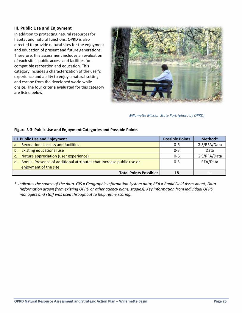
OPRD Natural Resource Assessment and Strategic Action Plan – Willamette Basin Page 25
III. Public Use and Enjoyment In addition to protecting natural resources for habitat and natural functions, OPRD is also directed to provide natural sites for the enjoyment and education of present and future generations. Therefore, this assessment includes an evaluation of each site’s public access and facilities for compatible recreation and education. This category includes a characterization of the user’s experience and ability to enjoy a natural setting and escape from the developed world while onsite. The four criteria evaluated for this category are listed below. Figure 3-3: Public Use and Enjoyment Categories and Possible Points
III. Public Use and Enjoyment Possible Points Method* a. Recreational access and facilities 0-6 GIS/RFA/Data b. Existing educational use 0-3 Data c. Nature appreciation (user experience) 0-6 GIS/RFA/Data d. Bonus: Presence of additional attributes that increase public use or
enjoyment of the site 0-3 RFA/Data
Total Points Possible: 18 - * Indicates the source of the data. GIS = Geographic Information System data; RFA = Rapid Field Assessment; Data
(information drawn from existing OPRD or other agency plans, studies). Key information from individual OPRD managers and staff was used throughout to help refine scoring.
Willamette Mission State Park (photo by OPRD)
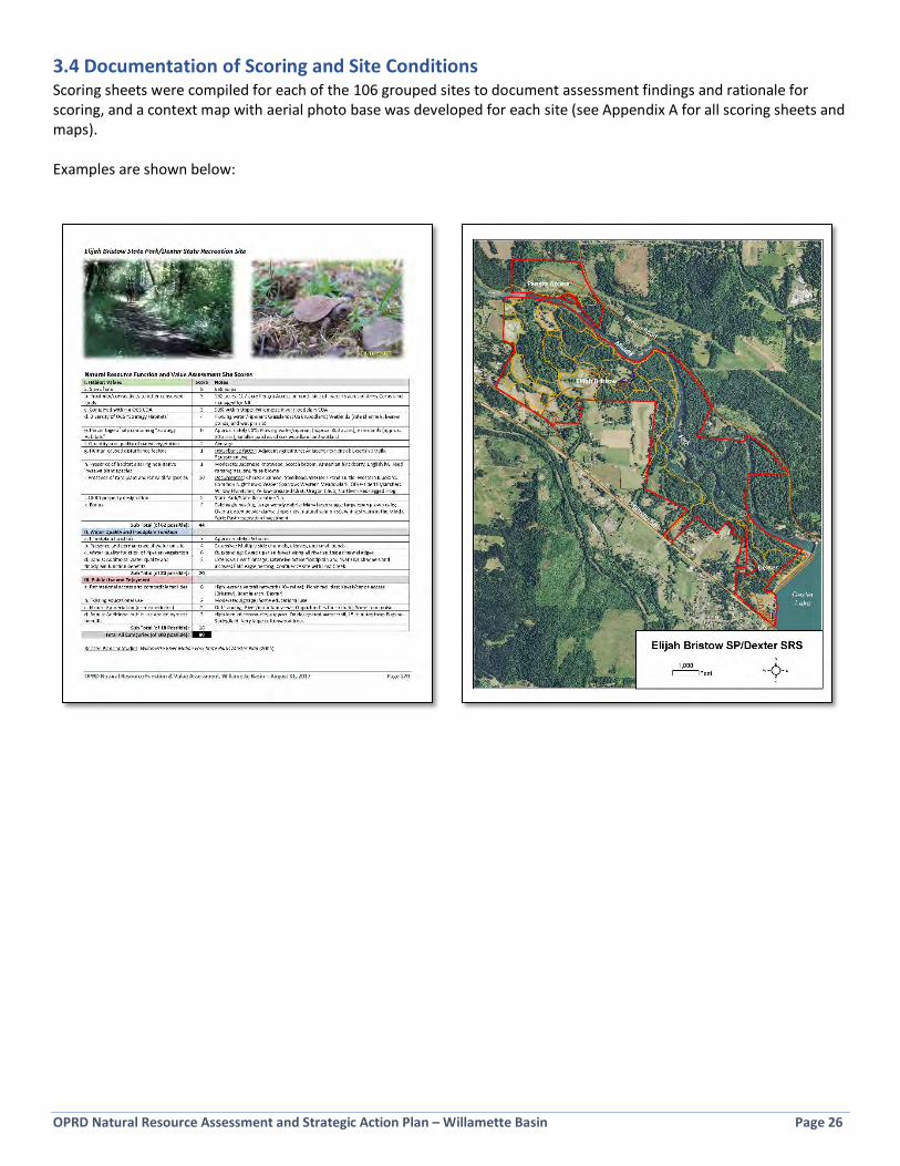
OPRD Natural Resource Assessment and Strategic Action Plan – Willamette Basin Page 26
3.4 Documentation of Scoring and Site Conditions Scoring sheets were compiled for each of the 106 grouped sites to document assessment findings and rationale for scoring, and a context map with aerial photo base was developed for each site (see Appendix A for all scoring sheets and maps). Examples are shown below:
Habitat Values
Floodplain Function Public U
se and Enjoyment
Management Unit
Site Nam
e
Acres
Rapid Assessment Conducted (2016)
OPRD Site Designation*
County
Ia. Size of Natural Resource Area
Ib. Proximity to Conserved Lands
Ic. Within OCS COA
Id. Diversity of OCS Habitats
Ie. Strategy Habitats Total Area
If. Native Vegetation
Ig. Human Cause Disturbance
Ih. Presence of Invasive Species
Ii. Rare Plant or wildlife species
Ij. OPRD Property Designation
Ii. Habitat Bonus
Habitat Value
IIa. Floodplain Function
IIb. Presence/Permanence of Water
IIc. Water Quality Function of Veg
Iid. WQ and Floodplain Bonus
Water Quality/Floodplain Function Value
IIIa. Recreational Access and Facilities
IIIb. Existing Educational Use
IIIc. User Experience
IIId. Public Use and Enjoyment Bonus
Public Use and Enjoyment Value
GRAND TOTAL
SFSilver Falls SP
9141.0SP
Marion
104
24
24
13
10.02
446.0
54
63
18.06
36
318.0
82.0W
MW
illamette M
ission SP1265.5
SPM
arion10
33
54
21
110.0
24
45.07
46
320.0
62
53
16.081.0
SWElijah Bristow
SP-Dexter SRS968.8
SPLane
83
34
62
11
10.02
444.0
74
63
20.06
25
316.0
80.0TC
Wapato Access-O
PRD W04 W
RGs
174.1W
RGM
ultnomah
64
35
62
13
10.03
447.0
74
42
17.05
34
315.0
79.0Ch
Molalla River SP
569.7SP
Clackamas
83
33
62
11
10.02
443.0
74
63
20.04
25
112.0
75.0W
MG
rand Island WRG
481.0W
RGYam
hill6
33
26
43
17.5
34
42.57
46
320.0
41
52
12.074.5
WM
Luckiamute SN
A996.7
xSN
APolk/Benton
83
34
42
00
10.03
441.0
74
43
18.05
25
315.0
74.0TC
Scappoose Landing WRG
299.6x
WRG
Columbia
65
34
62
33
5.53
444.5
74
53
19.02
15
210.0
73.5M
MM
ilo McIver SP
963.5SP
Clackamas
82
34
44
11
10.02
443.0
54
41
14.06
25
316.0
73.0Ch
Champoeg SHA
675.4SHA
Marion
82
34
42
11
10.02
441.0
74
21
14.06
34
316.0
71.0SS
L.L. "Stub" Stewart SP
1851.1x
SPW
ashington10
30
12
31
34.5
24
33.57
46
219.0
63
53
17.069.5
TCTryon Creek SN
A665.7
SNA
Multnom
ah/Clack8
30
32
21
38.0
34
37.03
36
315.0
53
33
14.066.0
WM
Spring Valley Access WRG
175.3x
WRG
Polk6
53
24
31
15.0
34
37.05
45
317.0
42
41
11.065.0
SWHarkens Lake Landing N
orth South WRG
s54.8
WRG
Benton4
33
36
43
34.0
31
37.05
44
316.0
30
61
10.063.0
WM
Beardsley Bar Landing WRG
100.1x
WRG
Marion
62
32
62
11
7.53
437.5
72
32
14.04
22
311.0
62.5SW
Cascadia SP270.1
SPLinn
60
03
44
13
5.02
432.0
54
42
15.05
26
215.0
62.0SW
Half Moon Bend Landing-HM
B Upstream
WRG
s145.3
WRG
Benton6
33
26
21
32.0
34
35.07
34
216.0
31
61
11.062.0
SWG
ravel Bar Landing WRG
73.7W
RGLane
45
32
62
33
3.53
034.5
54
63
18.02
06
19.0
61.5W
MDarrow
Bar Access WRG
38.3W
RGPolk
42
33
43
11
9.03
437.0
33
61
13.03
15
211.0
61.0TC
Peach Cove-Rock Island-Pete's Mountain Landing W
RGs
122.6W
RGClackam
as6
31
34
43
37.5
33
40.53
15
110.0
20
53
10.060.5
SWG
reen Island Landing WRG
54.4W
RGLane
40
31
64
53
4.53
134.5
54
63
18.01
06
18.0
60.5SW
Blue Ruin Island-Blue Ruin Landing WRG
s205.7
WRG
Linn/Lane6
23
26
13
33.0
32
34.07
44
217.0
30
42
9.060.0
WM
Yamhill Landing W
RG78.9
xW
RGYam
hill4
33
36
23
35.0
32
37.05
46
217.0
10
41
6.060.0
SWBeacon Landing W
RG65.1
WRG
Lane4
53
26
21
33.5
32
34.55
46
318.0
20
41
7.059.5
MM
Bonnie Lure SRA74.5
SRAClackam
as4
33
26
23
34.0
23
35.05
36
216.0
20
51
8.059.0
SWSam
Daws Landing-Halsey-Buckskin M
ary Landing WRG
s258.4
WRG
Linn/Benton6
33
36
23
13.0
33
36.07
42
316.0
30
31
7.059.0
SWLynx Hollow
Access WRG
79.8W
RGLane
44
03
62
13
5.53
233.5
54
52
16.04
13
19.0
58.5SW
Glass Bar Access W
RG83.7
WRG
Lane4
53
26
21
36.0
31
36.05
45
216.0
21
21
6.058.0
SWBow
ers Rock SP550.0
SPLinn
83
32
42
11
5.52
334.5
74
32
16.02
03
27.0
57.5W
MEldridge Bar Landing W
RG69.3
WRG
Marion
43
33
41
33
6.03
235.0
54
52
16.02
03
16.0
57.0SW
Bristow Landing-Cam
as Swale Landing W
RGs
155.2x
WRG
Lane6
00
26
23
14.5
32
29.57
45
218.0
30
51
9.056.5
WM
Lincoln Access WRG
49.7W
RGPolk
43
33
42
31
3.53
433.5
53
42
14.03
03
39.0
56.5SW
Riverside Landing WRG
95.2W
RGLinn
43
31
64
33
3.03
235.0
53
61
15.01
04
16.0
56.0SW
Pengra Access WRG
106.8W
RGLane
64
33
42
11
4.03
233.0
33
42
12.04
14
110.0
55.0W
MAm
erican Bottom Landing W
RG20.1
xW
RGPolk
23
33
43
31
5.03
131.0
52
62
15.02
14
29.0
55.0SS
Banks-Vernonia ST (parcels outside of Stub Stewart)
321.7x
STW
ash./Columbia
65
03
23
13
6.00
231.0
53
21
11.04
14
312.0
54.0SW
Truax Island Access WRG
185.2W
RGLinn
63
33
41
11
5.03
232.0
74
41
16.03
02
16.0
54.0De
North Santiam
SRA88.1
SRAM
arion4
03
24
43
13.5
22
28.55
24
112.0
52
51
13.053.5
SWM
arshall Is. Landing-Willis Refuge-Brow
n's Landing WRG
s25.7
WRG
Lane4
03
16
23
33.5
30
28.55
46
318.0
20
41
7.053.5
SWO
PRD-W82 W
RG10.8
xW
RGLane
22
31
62
53
4.53
031.5
34
62
15.02
04
17.0
53.5SW
Seavy Landing WRG
36.4W
RGLane
45
31
62
33
3.03
033.0
51
61
13.03
03
17.0
53.0W
MSarah Helm
ick SRS83.5
xSRS
Polk4
03
14
11
38.0
23
30.05
43
214.0
41
21
8.052.0
SWHoacum
Island Landing WRG
44.6x
WRG
Linn4
03
26
23
14.5
32
30.55
26
114.0
10
51
7.051.5
SWTripp W
RG14.2
WRG
Benton2
33
16
23
32.5
32
30.53
23
210.0
31
52
11.051.5
DeN
orth Santiam (dow
nstream parcels)
32.5SRA
Marion
42
31
62
13
4.02
129.0
52
63
16.01
04
16.0
51.0SW
Log Jam Access-Log Jam
Landing-Jasper Bridge Access WRG
s83.6
WRG
Lane4
23
26
11
34.5
30
29.55
24
112.0
41
22
9.050.5
WM
Jackson Bend Landing WRG
19.1x
WRG
Marion
22
31
42
33
4.53
330.5
33
63
15.01
03
15.0
50.5SW
Scandia Landing WRG
23.5x
WRG
Lane2
03
16
23
33.0
33
29.05
46
116.0
10
31
5.050.0
SWCougar M
ountain Access WRG
30.6W
RGLane
42
04
44
13
2.53
330.5
31
62
12.03
02
27.0
49.5W
MFort Yam
hill SHS106.5
xSHS
Polk6
30
44
10
35.5
04
30.53
32
08.0
33
32
11.049.5
WM
Black Dog Landing WRG
13.9x
WRG
Linn2
23
26
23
14.0
32
30.03
33
312.0
20
41
7.049.0
SWG
iddings Creek Landing WRG
37.2W
RGLane
42
03
62
13
2.53
026.5
54
62
17.01
03
15.0
48.5TC
Duck Lake-OPRD W
03 WRG
s34.0
WRG
Multnom
ah4
03
26
11
34.5
32
29.55
43
214.0
20
21
5.048.5
SWLow
ell SRS34.2
SRSLane
43
23
41
13
1.02
226.0
34
41
12.05
12
210.0
48.0SW
Pisgah Landing WRG
19.5W
RGLane
25
31
62
33
2.03
030.0
30
61
10.03
04
18.0
48.0W
MDarrow
Rock's Landing WRG
26.5W
RGPolk
43
33
41
13
4.03
130.0
33
32
11.01
04
27.0
48.0TC
Coalca Landing WRG
14.9W
RGClackam
as2
33
24
21
15.5
33
29.53
33
110.0
30
23
8.047.5
SWJasper SRS
72.7SRS
Lane4
13
24
11
34.0
21
26.05
32
111.0
51
22
10.047.0
SWAlderw
ood SW79.8
SWLane
40
32
65
13
1.00
328.0
44
41
13.02
01
25.0
46.0W
MW
indsor Island Landing WRG
65.2x
WRG
Marion
43
31
62
11
4.53
331.5
04
61
11.01
01
13.0
45.5SW
Thompson's M
ill SHS22.3
SHSLinn
20
32
21
03
6.00
221.0
54
22
13.05
32
111.0
45.0SW
Roger's Bend Landing WRG
20.8W
RGLane
25
31
32
11
3.53
024.5
54
42
15.01
03
15.0
44.5SW
OPRD-W
92 WRG
16.7x
WRG
Lane2
30
26
21
15.0
31
26.03
43
212.0
20
31
6.044.0
WM
Spring Hill WRG
6.7x
WRG
Benton2
13
16
31
33.0
33
29.03
23
210.0
20
21
5.044.0
ChParrette M
ountain Access WRG
32.2x
WRG
Yamhill
44
32
41
11
3.53
026.5
32
31
9.04
02
17.0
42.5W
MSidney Access W
RG54.4
xW
RGM
arion4
53
12
11
06.0
32
28.05
22
110.0
10
12
4.042.0
WM
Doaks Ferry Access WRG
8.5W
RGPolk
23
32
41
11
3.53
225.5
32
31
9.02
03
27.0
41.5SW
Kiger Island Landing WRG
33.5W
RGBenton
40
32
23
33
2.03
227.0
51
31
10.01
02
14.0
41.0W
MM
cLane Island Landing WRG
11.9x
WRG
Marion
22
31
62
13
4.03
128.0
31
22
8.01
01
35.0
41.0De
Detroit Lake SRA-Mongold-Tum
ble Creek96.0
SRAM
arion4
50
12
21
33.0
22
25.00
12
14.0
52
31
11.040.0
SWO
PRD-W52-O
PRD-W53-O
PRD-W54 W
RGs
6.5x
WRG
Benton2
33
16
21
32.0
30
26.03
24
110.0
10
21
4.040.0
SWM
arshall Island Access WRG
37.6W
RGLane
40
32
61
11
2.53
023.5
50
21
8.03
03
28.0
39.5SW
Whitely Landing W
RG9.0
WRG
Lane2
03
16
21
33.5
31
25.53
34
111.0
10
11
3.039.5
TC-ChO
PRD-W15-O
PRD-W16-O
PRD-W17 W
RGs
23.8W
RGClackam
as2
42
12
31
34.5
30
25.53
14
19.0
20
21
5.039.5
ChW
illamette M
eridian Landing WRG
16.2x
WRG
Clackamas
20
01
22
33
3.03
221.0
33
31
10.03
03
28.0
39.0SW
Fall Creek SRA Winberry
79.3SRA
Lane4
30
22
41
31.0
22
24.05
21
19.0
31
20
6.039.0
ChM
olalla Landing WRG
23.0x
WRG
Clackamas
24
21
23
13
2.53
124.5
13
22
8.02
02
15.0
37.5W
MIndependence Bar Access W
RG9.1
xW
RGM
arion2
03
26
11
33.0
31
25.03
12
06.0
20
31
6.037.0
WM
OPRD-W
29 WRG
1.7x
WRG
Yamhill
00
31
62
33
3.03
024.0
31
41
9.01
02
14.0
37.0Ch
French Prairie Access WRG
26.8x
WRG
Clackamas
40
31
21
11
3.03
019.0
33
41
11.03
02
16.0
36.0SW
Fall Creek SRA North Shore
20.0SRA
Lane2
30
24
21
32.5
23
24.50
21
25.0
30
21
6.035.5
SWFall Creek SRA Cascara-Lakeside 1 &
2-Fisherman's Pt
56.9SRA
Lane4
20
22
21
30.0
21
19.00
32
16.0
42
21
9.034.0
ChO
PRD-W22 W
RG4.9
xW
RGClackam
as0
01
14
21
33.0
30
18.03
14
19.0
20
21
5.032.0
MM
Cazadero ST129.0
STClackam
as6
32
12
10
10.0
02
18.01
32
06.0
40
31
8.032.0
SWRiver Jetty Landing W
RG (east)
20.6W
RGBenton
20
32
42
11
2.53
020.5
50
01
6.01
02
14.0
30.5SW
Cloverdale Access WRG
8.4W
RGLane
22
01
41
13
2.03
019.0
30
21
6.03
01
15.0
30.0SW
Thompson's M
ills former Sodom
Dam site
64.2SHS
Linn4
23
00
31
15.0
01
20.05
40
110.0
00
00
0.030.0
WM
Hall's Ferry Access WRG
2.3x
WRG
Marion
03
30
01
11
3.03
116.0
30
31
7.02
01
36.0
29.0SW
River Jetty Landing WRG
(west)
7.5W
RGBenton
20
32
41
11
3.03
020.0
30
01
4.01
02
14.0
28.0Ch
OPRD-W
26 WRG
2.7x
WRG
Yamhill
00
30
12
13
3.53
016.5
00
61
7.01
02
14.0
27.5SW
Petree Landing WRG
17.3W
RGLane
22
02
41
11
3.03
019.0
30
11
5.01
01
13.0
27.0TC
Osw
ego Creek Outlet Access W
RG0.6
xW
RGClackam
as0
23
00
11
33.0
30
16.00
02
24.0
20
13
6.026.0
ChHess Creek Landing W
RG1.1
xW
RGYam
hill0
03
00
31
32.0
30
15.01
03
15.0
20
31
6.026.0
SWChristensen's Boat Ram
p WRG
3.1W
RGLane
02
30
02
13
2.03
016.0
30
21
6.02
01
14.0
26.0W
MM
aud William
son SRS25.4
xSRS
Yamhill
40
02
41
13
2.52
120.5
00
00
0.03
11
05.0
25.5W
MO
PRD-W42 W
RG0.7
WRG
Polk0
13
00
21
33.5
31
17.51
11
25.0
10
11
3.025.5
TCO
PRD-W12-O
PRD-W13 W
RGs
5.8W
RGClackam
as2
33
11
00
13.0
30
17.03
02
16.0
00
11
2.025.0
WM
Erratic Rock SNS
4.4x
SNS
Yamhill
00
31
41
03
0.53
217.5
00
00
0.02
11
26.0
23.5SW
Blachly Mountain SF
80.3SF
Lane4
50
00
51
30.0
01
19.00
00
00.0
00
20
2.021.0
DeM
aples Rest Area11.5
RAM
arion2
20
12
11
12.0
00
12.00
05
05.0
10
10
2.019.0
SWFall Creek SRA Free M
eadow10.4
SRALane
20
00
02
13
0.02
111.0
00
21
3.03
02
05.0
19.0Ch
Bald Peak SSV28.8
SSVYam
hill4
00
11
21
30.0
00
12.00
00
00.0
30
21
6.018.0
SSSunset Highw
ay (Washington County parcels)
200.8x
FSSCW
ashington6
30
00
21
30.0
00
15.00
00
00.0
00
12
3.018.0
SWW
ashburne SW38.1
SWLane
41
01
12
13
0.00
013.0
02
00
2.01
00
12.0
17.0TC
Willam
ette Stone SHS1.6
SHSM
ultnomah
02
30
01
13
0.00
010.0
00
00
0.01
11
14.0
14.0W
MHolm
an SW10.5
xSW
Polk2
20
22
11
00.0
01
11.00
00
00.0
10
02
3.014.0
*OPRD
Designation Key:
SP = State ParkSRS = State Recreation Site
SW = State W
aysideST = State Trail
SNA = State N
atural AreaSN
S = State Natural Site
WRG
= Willam
ette River Greenw
aySSV = State Scenic Vista
SHS = State Heritage SiteFSSC = Forest State Scenic Corridor
SRA = State Recreation AreaSF = State Forest
Mean
Median
Habitat Values (62 points possible)28.1
29.0Floodplain Function (20 points possible)
11.312.0
Figure 3-4: Natural Resource Function &
Value Assessment Scoring Table
Total Scores Sorted from Highest to Low
estAugust 31, 2017
4645
4447
4342
.541
44.5
4341
33.5
37 37 37 37.5
3235
34.5
3740
.534
.5 3437
34.5 3536
33.5
3634
.5 3529
.533
.535
3331 3132
28.5
28.5
31.533
30 30.5
30.5
29 29.5 30.5
29 30.5
30.5 30
26.5
29.5
2630 30
29.5
2628
31.5
2124
.526
2926
.528
25.52728
2526
23.5 25
.525
.521
24 24.5 25
2419
24.5
1918 18
20.5
1920
1620
16.5
1916
1516
20.5
17.5 17 17.519
121112
1513
1011
1820
20 1720 20
1819
1414
19 1517
1614
1516
1813 10
1817
1718
1616
1616
16 1618 14
151215
1116
1218 15 13
14 1410
1612
15 1612
812
17 1412
1011
1011
1311
1315
1210
910
910 8
410
811
910
9 86
911 5
69
66
610
74 7 5
4 56 5 6
53
2
1816
1615
12 12 15 10 1616
1714
1110 11 15 11 9
11 10 8 9 6 7 8 7 9 6 7 6 9 9 610 9
12 613 7 7 7
8 7 11 6 9 5 5 7 11 7 5 510 8 7 8
10 5 311 5 6 5
7 4 7 4 511 4 8 3 5 8 6
5 6 46 6
95 8
4 5
64 4 3
6 6 4 5 3 26
22 5
6 32
4 3
0
10
20
30
40
50
60
70
80
90
Silver Falls SP
Willam
ette M
ission SP
Elijah Bristow
SP‐De
xter SRS
Wap
ato Ac
cess‐OPR
D W04
WRG
sMolalla River SP
Gran
d Island
WRG
Luckiamute SN
AScap
poose Land
ing WRG
Milo
McIver S
PCh
ampo
eg SHA
L.L. "S
tub" Stewart S
PTryo
n Cree
k SN
ASp
ring Va
lley Ac
cess W
RGHa
rken
s Lake Land
ing North Sou
th W
RGs
Beardsley Ba
r Lan
ding
WRG
Cascad
ia SP
Half Moo
n Be
nd Lan
ding
‐HMB Upstrea
m W
RGs
Gravel B
ar Lan
ding
WRG
Darrow
Bar Access W
RGPe
ach Co
ve‐Rock Island
‐Pete's M
ountain Land
ing WRG
sGr
een Island
Lan
ding
WRG
Blue
Ruin Island
‐Blue Ru
in Lan
ding
WRG
sYamhill Land
ing WRG
Beacon
Lan
ding
WRG
Bonn
ie Lure SR
ASam Daw
s Lan
ding
‐Halsey‐Bu
ckskin M
ary Land
ing WRG
sLynx Hollow Access W
RGGlass B
ar Access W
RGBo
wers R
ock SP
Eldridge
Bar Lan
ding
WRG
Bristow
Lan
ding
‐Cam
as Swale Land
ing WRG
sLincoln Ac
cess W
RGRiverside Land
ing WRG
Peng
ra Access W
RGAm
erican
Bottom Lan
ding
WRG
Bank
s‐Ve
rnon
ia ST (parcels ou
tside of Stub Stew
art)
Trua
x Island
Access W
RGNorth San
tiam SRA
Marshall Is. Lan
ding
‐Willis Re
fuge
‐Brown's L
anding
WRG
sOPR
D‐W82
WRG
Seavy Land
ing WRG
Sarah He
lmick SR
SHo
acum
Island
Lan
ding
WRG
Tripp WRG
North San
tiam (d
ownstrea
m parcels)
Log Jam Access‐Log Jam Lan
ding
‐Jasper Brid
ge Access W
RGs
Jackson Be
nd Lan
ding
WRG
Scan
dia Land
ing WRG
Coug
ar M
ountain Ac
cess W
RGFo
rt Yam
hill SH
SBlack Do
g Land
ing WRG
Gidd
ings Creek Lan
ding
WRG
Duck Lake‐OPR
D W03
WRG
sLowell SRS
Pisgah
Lan
ding
WRG
Darrow
Rock's L
anding
WRG
Coalca Lan
ding
WRG
Jasper SRS
Alde
rwoo
d SW
Windsor Island
Lan
ding
WRG
Thom
pson
's Mill SHS
Roger's Ben
d Land
ing WRG
OPR
D‐W92
WRG
Sprin
g Hill WRG
Parrette M
ountain Ac
cess W
RGSidn
ey Access W
RGDo
aks F
erry Access W
RGKiger Isla
nd Lan
ding
WRG
McLan
e Island
Lan
ding
WRG
Detroit L
ake SR
A‐Mon
gold‐Tum
ble Cree
kOPR
D‐W52
‐OPR
D‐W53
‐OPR
D‐W54
WRG
sMarshall Isla
nd Access W
RGWhitely Lan
ding
WRG
OPR
D‐W15
‐OPR
D‐W16
‐OPR
D‐W17
WRG
sWillam
ette M
eridian Land
ing WRG
Fall Cree
k SR
A Winbe
rry
Molalla Lan
ding
WRG
Inde
pend
ence Bar Access W
RGOPR
D‐W29
WRG
Fren
ch Prairie Ac
cess W
RGFall Cree
k SR
A North Sho
reFall Cree
k SR
A Ca
scara‐Lakesid
e 1 & 2‐Fish
erman
's Pt
OPR
D‐W22
WRG
Cazade
ro ST
River Jetty Lan
ding
WRG
(east)
Clov
erda
le Access W
RGTh
ompson
's Mills former Sod
om Dam
site
Hall's F
erry Access W
RGRiver Jetty Lan
ding
WRG
(west)
OPR
D‐W26
WRG
Petree
Lan
ding
WRG
Osw
ego Cree
k Outlet A
ccess W
RGHe
ss Creek Lan
ding
WRG
Christensen
's Bo
at Ram
p WRG
Mau
d Williamson SR
SOPR
D‐W42
WRG
OPR
D‐W12
‐OPR
D‐W13
WRG
sErratic
Rock SN
SBlachly Mou
ntain SF
Map
les R
est A
rea
Fall Cree
k SR
A Free
Mea
dow
Bald Pea
k SSV
Sunset Highw
ay (W
ashing
ton Co
unty parcels)
Washb
urne
SW
Willam
ette Stone
SHS
Holm
an SW
Score
Natural Resource Function and Value Assessment ‐ OPRD Willamette BasinResults for 3 Evaluation Categories
Public Use and Enjoyment Value
Water Quality‐Floodplain Function Value
Habitat Value
Figure 3-5: Natural Resource Function & Value Assessment Scoring Graph
Assessment Results from Highest to Lowest Total Score
OPRD Natural Resource Assessment and Strategic Action Plan – Willamette Basin Page 29
3.5 Results Summary of Key Assessment Findings Figure 3-4 displays all assessment data for all assessed sites, and can be used as a quick reference. This includes factual data (acreage, county, site classification), and scores for all 19 criteria. Sites are listed in order of their final rank, which is based on the Grand Total score (scores summed for the 3 categories of criteria - Habitat Values, Floodplain Function/Water Quality, and Public Use and Enjoyment). Figure 3-5 displays the results in a bar chart format. The scores and ranks can be used to answer different questions about the sites and for different types of prioritization. Examples are shown below, and information from the Assessment for each Management Unit is provided in Section 5. The mean and median assessment scores are:
Criteria Mean Median Habitat Values (62 points possible) 28 29 Floodplain Function (20 points possible) 11 12 Public Use and Enjoyment (18 points possible) 8 7 Grand Total (100 points possible) 47 48
What was the average score and scoring range of all 106 assessed sites?
• The average score was 47.0 out of 100.0 possible points. • Scores ranged from 14.0 to 82.0 points.
What was the average score by category?
• Habitat value: The average score was 28.1 out of 62.0 possible points. • Water quality and floodplain function: The average score was 11.3 out of 20.0 possible points. • Public use and enjoyment: The average score was 7.6 out of 18.0 possible points.
Which sites scored the highest overall?
Site Name Total Score (Score by Category)
Silver Falls State Park 82.0 (46, 18, 18) Willamette Mission State Park 81.0 (45, 20, 16) Elijah Bristow State Park-Dexter State Recreation Site 80.0 (44, 20, 16) Wapato Access-OPRD W04 WRGs 79.0 (47, 17, 15) Molalla River State Park 75.0 (43, 20, 12) Grand Island WRG 74.5 (42.5, 20, 12) Luckiamute State Natural Area 74.0 (41, 18, 15) Scappoose Landing WRG 73.5 (44.5, 19, 10) Milo McIver State Park 73.0 (43, 14, 16) Champoeg State Heritage Area 71.0 (41, 14, 16)
Analysis: • All ten of these sites scored above average in all three categories. • The top ten sites included a variety of park classifications (State Park, State Natural Area, State Recreation
Site, Willamette River Greenway, and State Heritage Site).
OPRD Natural Resource Assessment and Strategic Action Plan – Willamette Basin Page 30
• The average size of for these ten sites is 1,554 acres, ranging from 174 acres (Wapato Access -OPRD W04 WRGs) to 9,141 acres (Silver Falls State Park). This is well above the average of all sites of 224 acres.
Which sites scored the lowest overall?
Site Name Score (by category)
OPRD-W12 WRG-OPRD-W13 WRG 25.0 (17, 6, 2) Erratic Rock State Natural Site 23.5 (17, 0, 6) Blachly Mountain Forest 21.0 (19, 0, 2) Maples Rest Area 19.0 (12, 5, 2) Free Meadow - Fall Creek State Recreation Area 19.0 (11, 3, 5) Bald Peak State Scenic Viewpoint 18.0 (12, 0, 6) Sunset Highway - Washington County parcels 18.0 (15, 0, 3) Washburne State Wayside 17.0 (13, 2, 2) Willamette Stone State Heritage Site 14.0 (10, 0, 4) Holman State Wayside 14.0 (11, 0, 3)
Analysis: • All ten of these sites scored below average in all three categories. • Six of these sites have zero points under the water quality/floodplain category. These sites scored low in this
category because they are upland sites and do not contain floodplain, wetlands, rivers, streams, or ponds. • The average size of these ten sites is 39.2 acres ranging from 1.6 acres (Willamette Stone SHS) to 200.8 acres
(Sunset Highway). This is well below the average of all sites of 224 acres.
Which sites scored highest in the Habitat Value category (category I)?
Site Name Score (out of
62) Wapato Access WRG-OPRD W04 WRG 47.0 Silver Falls State Park 46.0 Willamette Mission State Park 45.0 Scappoose Landing WRG 44.5 Elijah Bristow State Park-Dexter SRS 44.0 Molalla River State Park 43.0 Milo McIver State Park 43.0 Grand Island WRG 42.5 Luckiamute State Natural Area 41.0 Champoeg State Heritage Area 41.0
Analysis: • These ten sites match the sites listed in “highest overall score category”, just listed in a slightly different
order. • Eight of ten of these sites received the maximum score under the “Presence of rare plant and/or wildlife
species” criterion.
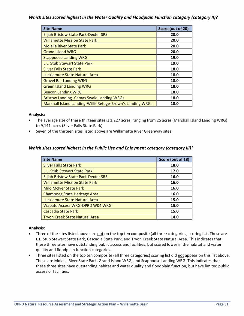
OPRD Natural Resource Assessment and Strategic Action Plan – Willamette Basin Page 31
Which sites scored highest in the Water Quality and Floodplain Function category (category II)?
Site Name Score (out of 20) Elijah Bristow State Park-Dexter SRS 20.0 Willamette Mission State Park 20.0 Molalla River State Park 20.0 Grand Island WRG 20.0 Scappoose Landing WRG 19.0 L.L. Stub Stewart State Park 19.0 Silver Falls State Park 18.0 Luckiamute State Natural Area 18.0 Gravel Bar Landing WRG 18.0 Green Island Landing WRG 18.0 Beacon Landing WRG 18.0 Bristow Landing -Camas Swale Landing WRGs 18.0 Marshall Island Landing-Willis Refuge-Brown's Landing WRGs 18.0
Analysis: • The average size of these thirteen sites is 1,227 acres, ranging from 25 acres (Marshall Island Landing WRG)
to 9,141 acres (Silver Falls State Park). • Seven of the thirteen sites listed above are Willamette River Greenway sites.
Which sites scored highest in the Public Use and Enjoyment category (category III)?
Site Name Score (out of 18) Silver Falls State Park 18.0 L.L. Stub Stewart State Park 17.0 Elijah Bristow State Park-Dexter SRS 16.0 Willamette Mission State Park 16.0 Milo McIver State Park 16.0 Champoeg State Heritage Area 16.0 Luckiamute State Natural Area 15.0 Wapato Access WRG-OPRD W04 WRG 15.0 Cascadia State Park 15.0 Tryon Creek State Natural Area 14.0
Analysis: • Three of the sites listed above are not on the top ten composite (all three categories) scoring list. These are
L.L. Stub Stewart State Park, Cascadia State Park, and Tryon Creek State Natural Area. This indicates that these three sites have outstanding public access and facilities, but scored lower in the habitat and water quality and floodplain function categories.
• Three sites listed on the top ten composite (all three categories) scoring list did not appear on this list above. These are Molalla River State Park, Grand Island WRG, and Scappoose Landing WRG. This indicates that these three sites have outstanding habitat and water quality and floodplain function, but have limited public access or facilities.

OPRD Natural Resource Assessment and Strategic Action Plan – Willamette Basin Page 32
Page Intentionally Blank

OPRD Natural Resource Assessment and Strategic Action Plan – Willamette Basin Page 33
Section 4: Vision, Goals, Objectives, and Strategies
4.1 Development of Vision, Goals, Objectives and Strategies Eight guiding information sources (see red boxes in Figure 1-1) were used to develop the Vision, Goals, Objectives and Key Strategies and Actions listed below in Section 4.3. Four of these information sources originate from within the agency and four from external sources, providing a well-rounded and diverse perspective on OPRD’s role in natural resource management in the Willamette Basin. This large body of guidance and information tended to center around a set of topic areas, each of which is addressed in this plan. Topics addressed in this plan • Access to properties for management • Agency culture and internal support for natural
resource management • Agricultural leases within parks • Climate change adaptation • Connectivity of conserved lands • Coordination with property neighbors • Encroachments • Funding and staff capacity for natural resource
management • Habitat preservation and restoration • Improving property stewardship • Invasive species
• OPRD’s role in Willamette Basin natural resource management
• Park planning • Partnering and collaboration • Preserving existing natural resources • Protect the Best approach • Prioritization of work due to limited resources • Public involvement and education • Rare species preservation • Recreation and public use in natural areas • Tribes and cultural traditions • Water quality and floodplains • Willamette River Greenways
Topics not addressed in this plan • Land acquisition • Park facility development
• Park rule enforcement • Recreational use of parks
4 Vision, Goals,
Objectives, and Strategies

OPRD Natural Resource Assessment and Strategic Action Plan – Willamette Basin Page 34
4.1.1 Agency Mission and Vision OPRD’s mission is to provide and protect outstanding natural, scenic, cultural, historic and recreational sites for the enjoyment and education of present and future generations. Providing and protecting these natural sites is the foundation of the work proposed in this Strategic Action Plan, and every one of the goals and objectives is traceable back to and supports the mission. In addition, as a parks agency, OPRD must ensure its natural resource management actions benefit biodiversity in all its forms as well as provide an opportunity for people to learn about and experience these outstanding natural sites. The mission also identifies scenic, cultural, recreational and historical resource considerations; this Plan addresses some of the ways in which natural resource management overlaps with these considerations. The agency vision is to take the long view to protect Oregon’s special places and provide the greatest experience while creating stable future funding. Concepts contained in this vision statement have been incorporated throughout the goals, objectives, and strategies of this Plan.
4.1.2 Agency Rules, Policies, Initiatives, and Plans A large body of guiding principles and requirements prescribe specific ways in which OPRD will manage land and waters under its jurisdiction. These include state laws and administrative rules, agency policies, agency initiatives, operating principles, and master plans for specific parks. A few of the laws and administrative rules that pertain to OPRD natural resource management, and were reviewed to inform this Plan, include:
• OAR 736-010 Parks and Recreation Department General Park Area Rules • OAR 660-015 Statewide Planning Goals
o Goal 5: Natural Resource, Scenic and Historic Areas, and Open Spaces o Goal 6: Air, Water and Land Resources Quality o Goal 8: Recreational Needs o Goal 15: Willamette River Greenway
• OAR 660-034 Forest Lands; Agricultural Land; State and Local Park Planning • ORS 390: State and Local Parks; Recreation Programs; Scenic Waterways; Recreation Trails
Requirements for the agency’s work and guidance on how that work is to be carried out are prescribed in several policies that relate to natural resource management. These policies were incorporated into relevant sections of this Plan; they are further described in Section 1.3. The policies are:
• Natural Resources and Environmental Management Policy • Invasive Species Management Policy • Oregon Plan for Salmon and Watersheds Policy • Forest Management Policy • Tribal Traditional Use Policy • Park Classifications
Yellow-faced Bumblebee (photo by Cary Kerst)
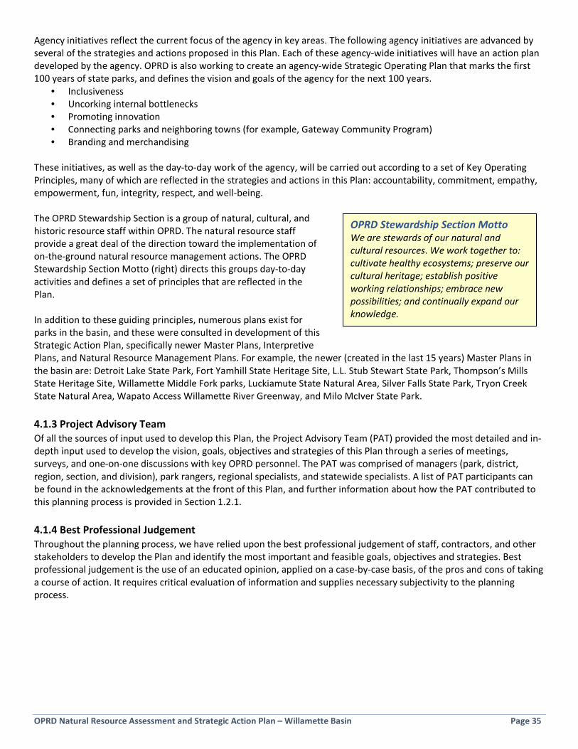
OPRD Natural Resource Assessment and Strategic Action Plan – Willamette Basin Page 35
Agency initiatives reflect the current focus of the agency in key areas. The following agency initiatives are advanced by several of the strategies and actions proposed in this Plan. Each of these agency-wide initiatives will have an action plan developed by the agency. OPRD is also working to create an agency-wide Strategic Operating Plan that marks the first 100 years of state parks, and defines the vision and goals of the agency for the next 100 years.
• Inclusiveness • Uncorking internal bottlenecks • Promoting innovation • Connecting parks and neighboring towns (for example, Gateway Community Program) • Branding and merchandising
These initiatives, as well as the day-to-day work of the agency, will be carried out according to a set of Key Operating Principles, many of which are reflected in the strategies and actions in this Plan: accountability, commitment, empathy, empowerment, fun, integrity, respect, and well-being. The OPRD Stewardship Section is a group of natural, cultural, and historic resource staff within OPRD. The natural resource staff provide a great deal of the direction toward the implementation of on-the-ground natural resource management actions. The OPRD Stewardship Section Motto (right) directs this groups day-to-day activities and defines a set of principles that are reflected in the Plan. In addition to these guiding principles, numerous plans exist for parks in the basin, and these were consulted in development of this Strategic Action Plan, specifically newer Master Plans, Interpretive Plans, and Natural Resource Management Plans. For example, the newer (created in the last 15 years) Master Plans in the basin are: Detroit Lake State Park, Fort Yamhill State Heritage Site, L.L. Stub Stewart State Park, Thompson’s Mills State Heritage Site, Willamette Middle Fork parks, Luckiamute State Natural Area, Silver Falls State Park, Tryon Creek State Natural Area, Wapato Access Willamette River Greenway, and Milo McIver State Park. 4.1.3 Project Advisory Team Of all the sources of input used to develop this Plan, the Project Advisory Team (PAT) provided the most detailed and in-depth input used to develop the vision, goals, objectives and strategies of this Plan through a series of meetings, surveys, and one-on-one discussions with key OPRD personnel. The PAT was comprised of managers (park, district, region, section, and division), park rangers, regional specialists, and statewide specialists. A list of PAT participants can be found in the acknowledgements at the front of this Plan, and further information about how the PAT contributed to this planning process is provided in Section 1.2.1. 4.1.4 Best Professional Judgement Throughout the planning process, we have relied upon the best professional judgement of staff, contractors, and other stakeholders to develop the Plan and identify the most important and feasible goals, objectives and strategies. Best professional judgement is the use of an educated opinion, applied on a case-by-case basis, of the pros and cons of taking a course of action. It requires critical evaluation of information and supplies necessary subjectivity to the planning process.
OPRD Stewardship Section Motto We are stewards of our natural and cultural resources. We work together to: cultivate healthy ecosystems; preserve our cultural heritage; establish positive working relationships; embrace new possibilities; and continually expand our knowledge.
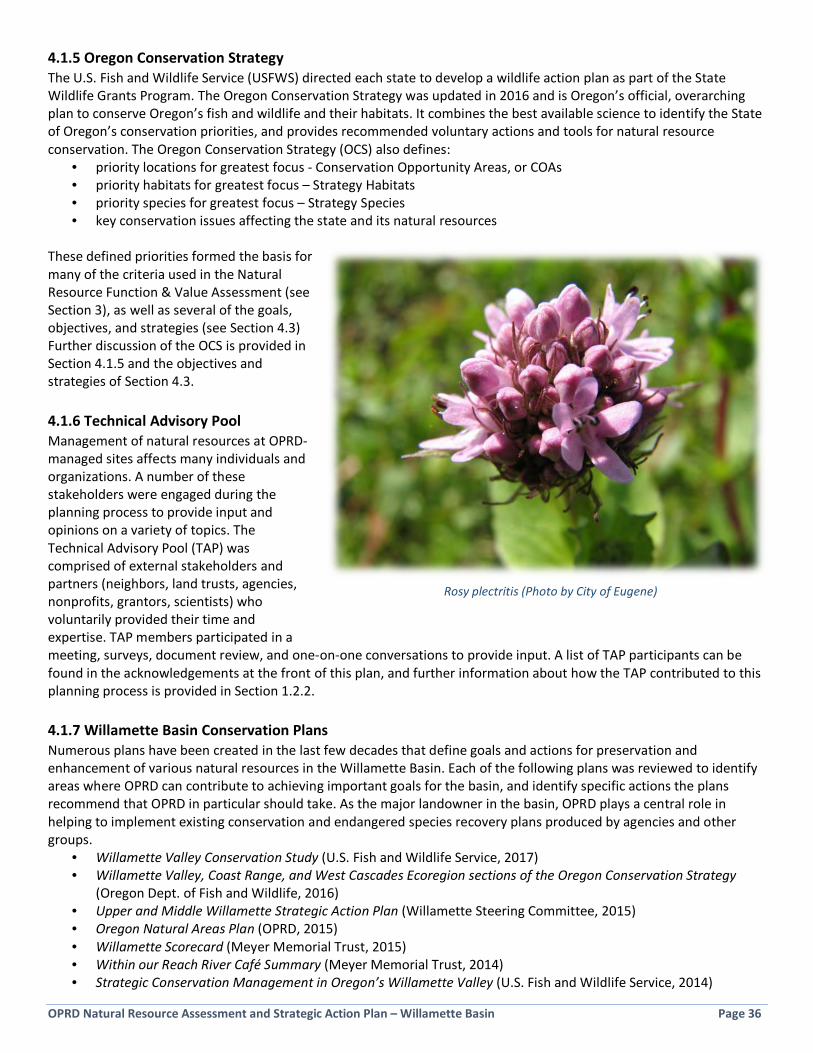
OPRD Natural Resource Assessment and Strategic Action Plan – Willamette Basin Page 36
4.1.5 Oregon Conservation Strategy The U.S. Fish and Wildlife Service (USFWS) directed each state to develop a wildlife action plan as part of the State Wildlife Grants Program. The Oregon Conservation Strategy was updated in 2016 and is Oregon’s official, overarching plan to conserve Oregon’s fish and wildlife and their habitats. It combines the best available science to identify the State of Oregon’s conservation priorities, and provides recommended voluntary actions and tools for natural resource conservation. The Oregon Conservation Strategy (OCS) also defines:
• priority locations for greatest focus - Conservation Opportunity Areas, or COAs • priority habitats for greatest focus – Strategy Habitats • priority species for greatest focus – Strategy Species • key conservation issues affecting the state and its natural resources
These defined priorities formed the basis for many of the criteria used in the Natural Resource Function & Value Assessment (see Section 3), as well as several of the goals, objectives, and strategies (see Section 4.3) Further discussion of the OCS is provided in Section 4.1.5 and the objectives and strategies of Section 4.3. 4.1.6 Technical Advisory Pool Management of natural resources at OPRD-managed sites affects many individuals and organizations. A number of these stakeholders were engaged during the planning process to provide input and opinions on a variety of topics. The Technical Advisory Pool (TAP) was comprised of external stakeholders and partners (neighbors, land trusts, agencies, nonprofits, grantors, scientists) who voluntarily provided their time and expertise. TAP members participated in a meeting, surveys, document review, and one-on-one conversations to provide input. A list of TAP participants can be found in the acknowledgements at the front of this plan, and further information about how the TAP contributed to this planning process is provided in Section 1.2.2. 4.1.7 Willamette Basin Conservation Plans Numerous plans have been created in the last few decades that define goals and actions for preservation and enhancement of various natural resources in the Willamette Basin. Each of the following plans was reviewed to identify areas where OPRD can contribute to achieving important goals for the basin, and identify specific actions the plans recommend that OPRD in particular should take. As the major landowner in the basin, OPRD plays a central role in helping to implement existing conservation and endangered species recovery plans produced by agencies and other groups.
• Willamette Valley Conservation Study (U.S. Fish and Wildlife Service, 2017) • Willamette Valley, Coast Range, and West Cascades Ecoregion sections of the Oregon Conservation Strategy
(Oregon Dept. of Fish and Wildlife, 2016) • Upper and Middle Willamette Strategic Action Plan (Willamette Steering Committee, 2015) • Oregon Natural Areas Plan (OPRD, 2015) • Willamette Scorecard (Meyer Memorial Trust, 2015) • Within our Reach River Café Summary (Meyer Memorial Trust, 2014) • Strategic Conservation Management in Oregon’s Willamette Valley (U.S. Fish and Wildlife Service, 2014)
Rosy plectritis (Photo by City of Eugene)

OPRD Natural Resource Assessment and Strategic Action Plan – Willamette Basin Page 37
• SLICES: an information framework for a biologically effective Willamette River floodplain (UO Institute for a Sustainable Environment, 2013)
• Lower Columbia River Recovery Plan for Salmon and Steelhead (National Oceanic and Atmospheric Administration, 2013)
• Regional Conservation Strategy for the Greater Portland-Vancouver Region (The Intertwine Alliance, 2012)
• Ecoregional Assessment and Willamette Valley Synthesis (The Nature Conservancy, 2012)
• Upper Willamette River Conservation and Recovery Plan for Chinook Salmon and Steelhead (Oregon Dept. of Fish and Wildlife/National Marine Fisheries Service, 2011)
• A Statewide Management Assessment of Invasive Species in Oregon (Oregon Invasive Species Council, 2010) • Willamette Biological Opinion (National Oceanic and Atmospheric Administration, 2008) • Recovery Plan for Prairie Species of Western Oregon and Southwestern Washington (U.S. Fish and Wildlife
Service, 2006) • Willamette Greenway Parklands Strategy (OPRD, 2005) • Willamette Basin Watershed Priorities Summary (Oregon Watershed Enhancement Board, 2005) • Pacific Coast Joint Venture (PCJV) Implementation Plan for the Willamette Valley (Roth et al., 2004) • Willamette Subbasin Plan (Northwest Power and Conservation Council, 2004) • Rivers to Ridges Vision and Strategies (Lane Council of Governments, 2003) • Willamette River Basin Planning Atlas: Trajectories of Environmental and Ecological Change (Pacific Northwest
Ecosystem Research Consortium, 2002) • Willamette Basin Alternative Futures Analysis (Environmental Protection Agency, 2002) • Restoring a River of Life: The Willamette Restoration Strategy (Willamette River Initiative, 2001) • Conservation Strategy for Landbirds in Lowlands and Valleys of Western Oregon and Washington (Altman, 2001) • Recovery Plan for the Oregon Chub (U.S. Fish and Wildlife Service, 1998) • Willamette River Basin Task Force Recommendations to the Governor (1997) • Oregon Plan for Salmon and Watersheds (State of Oregon, 1997)
4.1.8 Public Opinion Surveys Several public opinion surveys and studies have been completed that provide direction on what public attitudes, opinions, and priorities are in relation to public land management, management of the Willamette River, and OPRD land management. Information from the following surveys and studies have been incorporated into this plan.
• OPRD Valley’s Region Park Visitor Surveys (OPRD, 2016) • Oregon Statewide Recreation Trails Plan (OPRD, 2016-2025) • Oregon Residents’ Opinions and Values Related to the Oregon Dept. of Fish and Wildlife (ODFW, 2016) • Oregon Non-Motorized Boater Participation & Priorities (OPRD, 2015) • Statewide Comprehensive Outdoor Recreation Plan (OPRD, 2013-2017) • Managing Public Lands Along the Willamette River: Results of a Statewide Survey of Oregonians (OPRD, 2004) • Willamette River and Greenway Survey (OPRD, 2004)
Bald Eagle with chicks (photo by Cary Kerst)

OPRD Natural Resource Assessment and Strategic Action Plan – Willamette Basin Page 38
All of the above information was used to guide the development of the goals, objectives, and key strategies and actions listed in Section 4.3.
Direction from Public Surveys Two public surveys in 2004 provide some clarity on public attitudes and priorities about Willamette River land management. Willamette River and Greenway Survey (Oregon State University) • Respondents were asked to indicate the most important focus for managing public lands along the Willamette;
the majority of respondents (61.8%) indicated that all provided categories should be considered; nearly 28% reported that conservation of natural resources should be the most important focus; and just over 4% percent chose recreation opportunities as the most important.
• The most common recreational activities reported were scenic enjoyment, enjoying peace and quiet, walking for pleasure, and nature/wildlife observation.
• Respondents were asked to rate the importance of Willamette River features. Clean water was a dominant choice (83.2%) among those in the “extremely important” category, followed by scenic beauty (66.4%), natural resources (51.6%), and public river access (43.6%). The latter three categories were also the most often chosen as being “quite important”.
• Respondents were asked to rank the relative importance of funding improvements for public lands and facilities along the Willamette River. Funding programs to improve water quality, control new residential developments along or near the river, acquiring land for natural resource protection, and creating speed zones for recreational boats were rated as the highest priorities.
• Respondents were asked to rate their satisfaction with services and facilities at parks and recreation areas along the Willamette River. Respondents reported generally being either “Very Satisfied” or “Satisfied” with the majority of services and activities they were asked to rate. One notable exception was for swimming opportunities; over 42% of respondents voiced some degree of dissatisfaction with the number of swimming opportunities available.
Managing Public Lands Along the Willamette River (Oregon Survey Research Laboratory) • 94% of respondents rated “Protecting and restoring Willamette River fish and wildlife habitat” as “very
important” or “somewhat important”. • Respondents were asked which issues Willamette River land managers should commit their limited resources
toward. “Enhancing and restoring habitats on existing public lands” had 90% of respondents in support. “Acquiring land to protect important fish and wildlife habitats” had 83% in support.
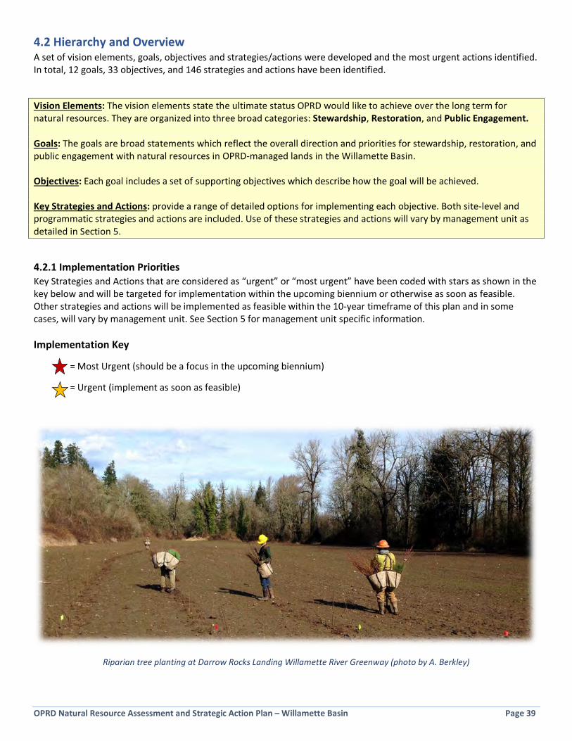
OPRD Natural Resource Assessment and Strategic Action Plan – Willamette Basin Page 39
4.2 Hierarchy and Overview A set of vision elements, goals, objectives and strategies/actions were developed and the most urgent actions identified. In total, 12 goals, 33 objectives, and 146 strategies and actions have been identified.
Vision Elements: The vision elements state the ultimate status OPRD would like to achieve over the long term for natural resources. They are organized into three broad categories: Stewardship, Restoration, and Public Engagement. Goals: The goals are broad statements which reflect the overall direction and priorities for stewardship, restoration, and public engagement with natural resources in OPRD-managed lands in the Willamette Basin. Objectives: Each goal includes a set of supporting objectives which describe how the goal will be achieved. Key Strategies and Actions: provide a range of detailed options for implementing each objective. Both site-level and programmatic strategies and actions are included. Use of these strategies and actions will vary by management unit as detailed in Section 5.
4.2.1 Implementation Priorities Key Strategies and Actions that are considered as “urgent” or “most urgent” have been coded with stars as shown in the key below and will be targeted for implementation within the upcoming biennium or otherwise as soon as feasible. Other strategies and actions will be implemented as feasible within the 10-year timeframe of this plan and in some cases, will vary by management unit. See Section 5 for management unit specific information. Implementation Key
= Most Urgent (should be a focus in the upcoming biennium)
= Urgent (implement as soon as feasible)
Riparian tree planting at Darrow Rocks Landing Willamette River Greenway (photo by A. Berkley)
OPRD Natural Resource Assessment and Strategic Action Plan – Willamette Basin Page 40
4.2.2 Overview of Vision Elements and Goals The figure below is a quick reference listing the three vision elements and twelve underlying goals associated with this Strategic Action Plan. Section 4.3 includes the full list of associated Objectives and Key Strategies and Actions. Figure 4-1: Vision Elements and Goals
Stewardship Vision: A robust stewardship program ensures that important natural resources are preserved and restoration investments are maintained.
Goal 1: Stewardship actions are focused on the highest priorities. Goal 2: Natural resource stewardship awareness, tools, and skills are improved. Goal 3: Funding to support stewardship activities is increased and diversified. Goal 4: Human resource capacity to implement stewardship actions is increased and diversified. Goal 5: Major property issues that affect natural resources are resolved. Goal 6: Threats to natural resources are prevented, or rapidly detected and addressed, to prevent
major impacts to natural resources. Goal 7: Protecting park resources is a primary consideration in all park operations.
Restoration Vision: An active restoration program built on partnerships facilitates continuous improvement of natural resources.
Goal 8: Restoration projects include a detailed scoping period and alternatives analysis. Goal 9: Priority natural resources are restored and managed using science-based approaches that
incorporate opportunities for learning and adaptive management. Goal 10: Restoration incorporates natural disturbance regimes and natural processes whenever
possible.
Public Engagement Vision: People enjoy and appreciate the Willamette Basin’s native species and habitats. Understanding and discovery is fostered through opportunities to become engaged participants in their care and management.
Goal 11: Visitor appreciation and stewardship of natural areas is improved. Goal 12: Diversity and inclusion are integrated into natural resource management activities.
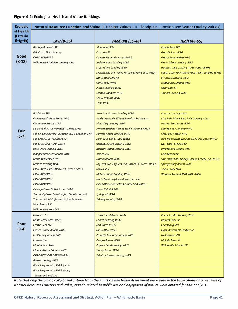
OPRD Natural Resource Assessment and Strategic Action Plan – Willamette Basin Page 41
Figure 4-2: Ecological Health and Value Rankings
Ecological Health (Criteria If+Ig+Ih)
Natural Resource Function and Value (I. Habitat Values + II. Floodplain Function and Water Quality Values)
Low (0-35) Medium (35-48) High (48-65)
Good (8-12)
Blachly Mountain SF Alderwood SW Bonnie Lure SRA
Fall Creek SRA Winberry Cascadia SP Grand Island WRG
OPRD-W29 WRG Cougar Mountain Access WRG Gravel Bar Landing WRG
Willamette Meridian Landing WRG Jackson Bend Landing WRG Green Island Landing WRG
Kiger Island Landing WRG Harkens Lake Landing North-South WRGs
Marshall Is. Lnd.-Willis Refuge-Brown's Lnd. WRGs Peach Cove-Rock Island-Pete's Mnt. Landing WRGs
North Santiam SRA Riverside Landing WRG
OPRD-W82 WRG Scappoose Landing WRG
Pisgah Landing WRG Silver Falls SP
Scandia Landing WRG Yamhill Landing WRG
Seavy Landing WRG
Tripp WRG
Fair (5-7)
Bald Peak SSV American Bottom Landing WRG Beacon Landing WRG
Christensen's Boat Ramp WRG Banks-Vernonia ST (outside of Stub Stewart) Blue Ruin Island-Blue Ruin Landing WRGs
Cloverdale Access WRG Black Dog Landing WRG Darrow Bar Access WRG
Detroit Lake SRA-Mongold-Tumble Creek Bristow Landing-Camas Swale Landing WRGs Eldridge Bar Landing WRG
Fall Cr. SRA Cascara-Lakeside 1&2-Fisherman's Pt Darrow Rock's Landing WRG Glass Bar Access WRG
Fall Creek SRA Free Meadow Duck Lake-OPRD W03 WRGs Half Moon Bend Landing-HMB Upstream WRGs
Fall Creek SRA North Shore Giddings Creek Landing WRG L.L. "Stub" Stewart SP
Hess Creek Landing WRG Hoacum Island Landing WRG Lynx Hollow Access WRG
Independence Bar Access WRG Jasper SRS Milo McIver SP
Maud Williamson SRS Lincoln Access WRG Sam Daws Lnd.-Halsey-Buckskin Mary Lnd. WRGs
Molalla Landing WRG Log Jam Acc.-Log Jam Lnd.-Jasper Br. Access WRGs Spring Valley Access WRG
OPRD-W15-OPRD-W16-OPRD-W17 WRGs Lowell SRS Tryon Creek SNA
OPRD-W22 WRG McLane Island Landing WRG Wapato Access-OPRD W04 WRGs
OPRD-W26 WRG North Santiam (downstream parcels)
OPRD-W42 WRG OPRD-W52-OPRD-W53-OPRD-W54 WRGs
Oswego Creek Outlet Access WRG Sarah Helmick SRS
Sunset Highway (Washington County parcels) Spring Hill WRG
Thompson's Mills former Sodom Dam site Whitely Landing WRG
Washburne SW
Willamette Stone SHS
Poor (0-4)
Cazadero ST Truax Island Access WRG Beardsley Bar Landing WRG
Doaks Ferry Access WRG Coalca Landing WRG Bowers Rock SP
Erratic Rock SNS Fort Yamhill SHS Champoeg SHA
French Prairie Access WRG OPRD-W92 WRG Elijah Bristow SP-Dexter SRS
Hall's Ferry Access WRG Parrette Mountain Access WRG Luckiamute SNA
Holman SW Pengra Access WRG Molalla River SP
Maples Rest Area Roger's Bend Landing WRG Willamette Mission SP
Marshall Island Access WRG Sidney Access WRG
OPRD-W12-OPRD-W13 WRGs Windsor Island Landing WRG
Petree Landing WRG
River Jetty Landing WRG (east)
River Jetty Landing WRG (west)
Thompson's Mill SHS
Note that only the biologically-based criteria from the Function and Value Assessment were used in the table above as a measure of Natural Resource Function and Value; criteria related to public use and enjoyment of nature were omitted for this analysis.
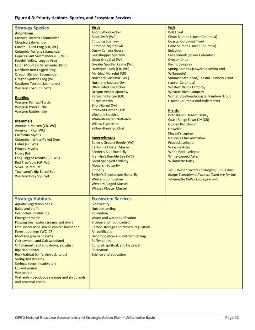
OPRD Natural Resource Assessment and Strategic Action Plan – Willamette Basin Page 42
Figure 4-3: Priority Habitats, Species, and Ecosystem Services
Strategy Species Amphibians Cascade Torrent Salamander Clouded Salamander Coastal Tailed Frog (CR, WC) Columbia Torrent Salamander Cope’s Giant Salamander (CR, WC) Foothill Yellow-Legged Frog Larch Mountain Salamander (WC) Northern Red-Legged Frog Oregon Slender Salamander Oregon Spotted Frog (WC) Southern Torrent Salamander Western Toad (CR, WC) Reptiles Western Painted Turtle Western Pond Turtle Western Rattlesnake Mammals American Marten (CR, WC) American Pika (WC) California Myotis Columbian White-Tailed Deer Fisher (Cr, WC) Fringed Myotis Hoary Bat Long-Legged Myotis (CR, WC) Red Tree Vole (CR, WC) Silver-Haired Bat Townsend’s Big-Eared Bat Western Grey Squirrel
Birds Acorn Woodpecker Black Swift (WC) Chipping Sparrow Common Nighthawk Dusky Canada Goose Grasshopper Sparrow Great Gray Owl (WC) Greater Sandhill Crane (WC) Harlequin Duck (CR, WC) Marbled Murrelet (CR) Northern Goshawk (WC) Northern Spotted Owl Olive-Sided Flycatcher Oregon Vesper Sparrow Peregrine Falcon (CR) Purple Martin Short-Eared Owl Streaked Horned Lark Western Bluebird White-Breasted Nuthatch Willow Flycatcher Yellow-Breasted Chat Invertebrates Beller’s Ground Beetle (WC) California Floater Mussel Fender’s Blue Butterfly Franklin’s Bumble Bee (WC) Great Spangled Fritillary Monarch Butterfly Stonefly Taylor’s Checkerspot Butterfly Western Bumblebee Western Ridged Mussel Winged Floater Mussel
Fish Bull Trout Chum Salmon (Lower Columbia) Coastal Cutthroat Trout Coho Salmon (Lower Columbia) Eulachon Fall Chinook (Lower Columbia) Oregon Chub Pacific Lamprey Spring Chinook (Lower Columbia And Willamette) Summer Steelhead/Coastal Rainbow Trout (Lower Columbia) Western Brook Lamprey Western River Lamprey Winter Steelhead/Coastal Rainbow Trout (Lower Columbia And Willamette) Plants Bradshaw’s Desert Parsley Coast Range Fawn Lily (CR) Golden Paintbrush Howellia Kincaid’s Lupine Nelson’s Checkermallow Peacock Larkspur Wayside Aster White Rock Larkspur White-topped Aster Willamette Daisy WC – West Cascades Ecoregion; CR – Coast Range Ecoregion; All others listed are for the Willamette Valley Ecoregion only
Strategy Habitats Aquatic vegetation beds Balds and bluffs Ceanothus shrublands Emergent marsh Flowing freshwater streams and rivers Late successional mixed conifer forest and Forest openings (WC, CR) Montane grassland (WC) Oak savanna and Oak woodland Off channel habitat (oxbows, sloughs) Riparian habitat Rock habitat (cliffs, rimrock, talus) Spring-fed streams Springs, seeps, headwaters Upland prairie Wet prairie Wetlands - deciduous swamps and shrublands, and seasonal ponds
Ecosystem Services Biodiversity Nutrient cycling Pollination Water and water purification Erosion and flood control Carbon storage and climate regulation Air purification Decomposition and nutrient cycling Buffer zones Cultural, spiritual, and historical Recreation Science and education

OPRD Natural Resource Assessment and Strategic Action Plan – Willamette Basin Page 43
4.3 Goals, Objectives, and Key Strategies and Actions
Stewardship Vision A robust stewardship program ensures that important natural resources are preserved and restoration investments are maintained. Stewardship For the purposes of this Plan, the term “stewardship” is comprised of regular and ongoing, smaller scale management and maintenance actions to address problems that threaten a site’s natural resources. Stewardship activities strive to address issues before they become a significant problem, an approach similar to preventative maintenance of facilities.
Goal 1: Stewardship actions are focused on the highest priorities. Objective 1.1: Sites with the greatest natural resource function and value are prioritized for stewardship actions using a Protect the Best (PTB) approach.
Key Strategies and Actions: a. The highest priority sites will have detailed stewardship guidance developed. These are sites shown in the right-
hand column in Figure 4-2, particularly sites in the upper right corner. Guidance may take the form of a detailed Natural Resource Management Plan, or a stewardship workplan. Stewardship actions will be focused on stabilizing or removing threats to natural resource functions and values to preserve and enhance existing values. Stewardship guidance will be developed and implementation begun on at least 12 high priority sites.
b. Medium priority sites will receive stewardship focus pending funding/human resource capacity. These are sites shown in the middle column in Figure 4-2, particularly sites toward the top of the table. Work at these sites will be focused on addressing major threats and improving natural resource conditions in order to move these sites into a healthier condition over time. Restoration may also be necessary (see Goals 8-10). Work will take place on at least four medium priority sites.
c. Low priority sites (left-hand column in Figure 4-2) will be evaluated for potential for improvement through restoration (see Goals 8-10) pending resources, or adoption by a partner or volunteer group, where appropriate. Work will take place at least two low priority sites.
d. In all cases, stewardship actions will seek to protect and enhance the following special resources:
• Oregon Conservation Strategy Habitats • Oregon Conservation Strategy Species • Ecosystem services
e. The Natural Resource Function & Value Assessment is repeated at the conclusion of the planning period (after 10 years) to measure the improvement of condition and values. Generally, work during the planning period will move sites in Figure 4-2 upward (improved condition) and to the right (improved natural resource function and value). At least 15 sites will move to an improved position in Figure 4-2.
Protect the Best Protect the Best (PTB) is a strategy that allocates resources to existing high quality habitats in order to identify and address small-scale problems, such as invasive weeds or erosion, before they spread or cause substantial damage. This method has been used successfully by many land managers. For example, Portland Parks and Recreation is using a PTB approach for managing natural resources in their parks. Over time, the sites with the highest natural resource function and value and that are in the best condition are stabilized by addressing threats. Resources can then be directed at improving the ecological health of the next tier of sites, moving them into a healthier condition over time. Results from the Natural Resource Function & Value Assessment have been used to identify priority sites for the greatest focus. These are shown in the upper right of Figure 4-2. The overarching purpose of stewardship and restoration work is to move sites upward in this table, particularly those sites in the high natural resource function and value category.

OPRD Natural Resource Assessment and Strategic Action Plan – Willamette Basin Page 44
Objective 1.2: The greatest threats to natural resources are addressed through science-based stewardship practices.
Key Strategies and Actions: a. The most urgent threats to natural resource that are
identified in the field, in stewardship plans, or in Natural Resource Management Plans, are addressed at the site-level or programmatically. Significant attention will be given toward addressing urgent threats on at least 20 sites.
b. Stewardship actions are designed to benefit Oregon Conservation Strategy habitats and species. Selection of which stewardship actions are used will also be informed by literature review, existing plans and policies, consultation with experts and OPRD partners, species recovery plans, watershed action plans, etc.
c. The most effective methods will be used for stewardship efforts, adhering to widely accepted best management practices. Stewardship effectiveness is evaluated each biennium, summarized in a biennial report, to inform future efforts, and approaches are adjusted as needed as part of an adaptive management approach.
d. Specific site maintenance requirements, invasive species control plans, and other stewardship needs are detailed and included in park master and comprehensive plans, or as appendices/related reports.
e. Stewardship needs are identified during any property acquisition in the basin during the plan period. Work with Property staff to explore how site stabilization (addressing threats at the time of acquisition) can be provided for through the acquisition process.
Goal 2: Natural resource stewardship awareness, tools, and skills are improved. Objective 2.1: Awareness and understanding of the importance of natural resource stewardship is improved.
Key Strategies and Actions: a. Renew efforts of the OPRD Invasive Species
Committee, per the committee’s policy and procedures.
b. In trainings, focus on the meaning, importance, terminology, and methods of stewardship and related forms of natural resource management. Incorporate this information into at least one formal training available to all staff.
c. Highlight stewardship work in internal agency communications, and noteworthy stewardship news in external agency communications. Highlight work at least twice a year.
d. Identify a method to track the wide variety of stewardship efforts performed by staff, partners and volunteers. Efforts are reported biennially in a report to measure level of effort over time.
Threats Examples of common threats to natural resources in the Willamette Basin include destruction or fragmentation of habitat; pollution and dumping; invasive species; climate change; changes in natural disturbances (fire, floods); disruptive human activities; visitation above site carrying capacity; erosion; altered fish passage; unsustainable levels of hunting and fishing; poaching of plants and animals; and others.
OPRD’s Invasive Species Committee is comprised of a rotating assemblage of managers, field staff, and natural
resource specialists who facilitate coordination and learning in the agency about invasive species management
per the Invasive Species Policy. (photo by A. Berkley)
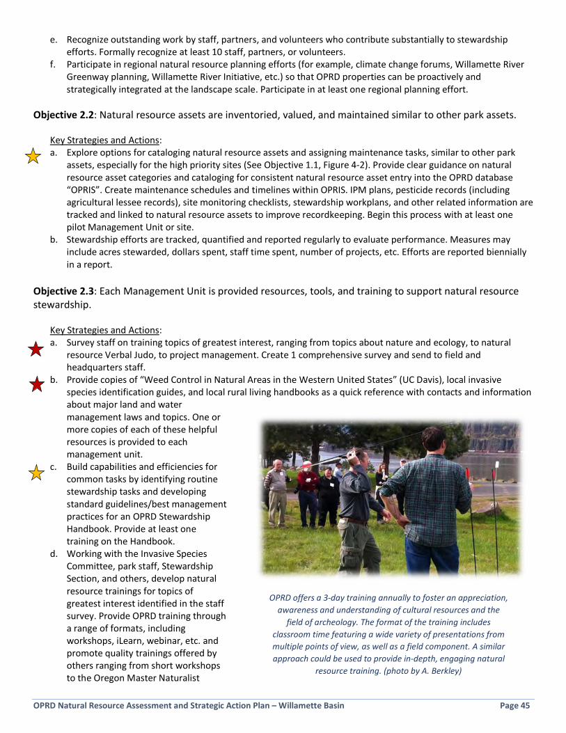
OPRD Natural Resource Assessment and Strategic Action Plan – Willamette Basin Page 45
e. Recognize outstanding work by staff, partners, and volunteers who contribute substantially to stewardship efforts. Formally recognize at least 10 staff, partners, or volunteers.
f. Participate in regional natural resource planning efforts (for example, climate change forums, Willamette River Greenway planning, Willamette River Initiative, etc.) so that OPRD properties can be proactively and strategically integrated at the landscape scale. Participate in at least one regional planning effort.
Objective 2.2: Natural resource assets are inventoried, valued, and maintained similar to other park assets.
Key Strategies and Actions: a. Explore options for cataloging natural resource assets and assigning maintenance tasks, similar to other park
assets, especially for the high priority sites (See Objective 1.1, Figure 4-2). Provide clear guidance on natural resource asset categories and cataloging for consistent natural resource asset entry into the OPRD database “OPRIS”. Create maintenance schedules and timelines within OPRIS. IPM plans, pesticide records (including agricultural lessee records), site monitoring checklists, stewardship workplans, and other related information are tracked and linked to natural resource assets to improve recordkeeping. Begin this process with at least one pilot Management Unit or site.
b. Stewardship efforts are tracked, quantified and reported regularly to evaluate performance. Measures may include acres stewarded, dollars spent, staff time spent, number of projects, etc. Efforts are reported biennially in a report.
Objective 2.3: Each Management Unit is provided resources, tools, and training to support natural resource stewardship.
Key Strategies and Actions: a. Survey staff on training topics of greatest interest, ranging from topics about nature and ecology, to natural
resource Verbal Judo, to project management. Create 1 comprehensive survey and send to field and headquarters staff.
b. Provide copies of “Weed Control in Natural Areas in the Western United States” (UC Davis), local invasive species identification guides, and local rural living handbooks as a quick reference with contacts and information about major land and water management laws and topics. One or more copies of each of these helpful resources is provided to each management unit.
c. Build capabilities and efficiencies for common tasks by identifying routine stewardship tasks and developing standard guidelines/best management practices for an OPRD Stewardship Handbook. Provide at least one training on the Handbook.
d. Working with the Invasive Species Committee, park staff, Stewardship Section, and others, develop natural resource trainings for topics of greatest interest identified in the staff survey. Provide OPRD training through a range of formats, including workshops, iLearn, webinar, etc. and promote quality trainings offered by others ranging from short workshops to the Oregon Master Naturalist
OPRD offers a 3-day training annually to foster an appreciation, awareness and understanding of cultural resources and the
field of archeology. The format of the training includes classroom time featuring a wide variety of presentations from multiple points of view, as well as a field component. A similar approach could be used to provide in-depth, engaging natural
resource training. (photo by A. Berkley)

OPRD Natural Resource Assessment and Strategic Action Plan – Willamette Basin Page 46
Program. Provide at least four trainings. e. Evaluate the potential development of a 3-day in-depth natural resource training, modelled after the successful
Archeology Awareness training. f. Continue to improve mapping and GIS-based tools available to all staff through OPRIS for improved usability. g. Also see funding strategies under Goal 3; funding is a critical resource needed to support natural resource
stewardship. Objective 2.4: Invasive species identification and control is a basic skill practiced by all field staff within each management unit.
Key Strategies and Actions: a. The OPRD Invasive Species Committee provides information, resources, and training to support this objective, as
well as maintains an up to date list of Certified Pesticide Applicators within OPRD. The Committee provides useful information to staff at least once per biennium.
b. Park staff are trained to identify the vectors of introduction and spread of invasive species in their parks. Cleaning of equipment and other methods to reduce vectors becomes standard practice in all management units.
c. Per policy, each management unit has at least one certified pesticide applicator (CPA) who is a resource for the unit for invasive species Early Detection-Rapid Response (EDRR) and stewardship work.
d. Certified Pesticide Applicators, Park Managers, and the region Natural Resource Specialist will work together to ensure a robust Integrated Pest Management (IPM) Plan is in place in the management unit. Park Managers and the region Natural Resource Specialist will meet once per biennium to review the IPM plan.
e. Aquatic invasive species detection and boat inspection training is provided to interested staff by Oregon State Marine Board and Oregon Department of Fish and Wildlife. ODFW/OSMB-provided signs developed to raise public awareness are placed at all motorized and non-motorized boat launches. Simple and effective training tools are provided to park entrance booth staff to assist them in identifying potential infested boats entering parks, including what to do if one is spotted.
f. The Oregon Forest Pest Detector training is provided to interested staff, particularly in parks with large tracts of forest.
In 2012 OPRD worked with ODFW and OSMB to inventory all OPRD motorized and non-motorized boat launches and
ensure aquatic invasive species (AIS) signs were posted. Since that time, Oregon’s AIS program has matured considerably, with new signs and training/outreach resources available, creating the need to re-inventory OPRD sites and improve
OPRD staff awareness and training in this area.
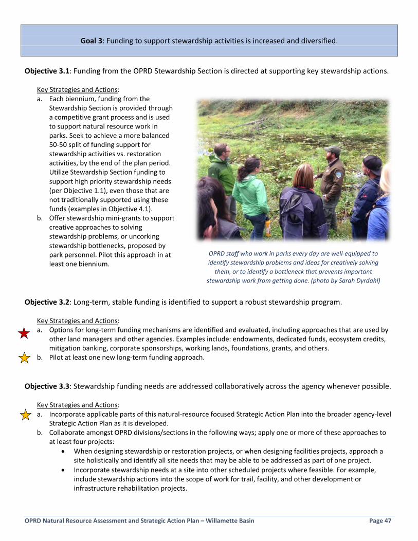
OPRD Natural Resource Assessment and Strategic Action Plan – Willamette Basin Page 47
Goal 3: Funding to support stewardship activities is increased and diversified.
Objective 3.1: Funding from the OPRD Stewardship Section is directed at supporting key stewardship actions.
Key Strategies and Actions: a. Each biennium, funding from the
Stewardship Section is provided through a competitive grant process and is used to support natural resource work in parks. Seek to achieve a more balanced 50-50 split of funding support for stewardship activities vs. restoration activities, by the end of the plan period. Utilize Stewardship Section funding to support high priority stewardship needs (per Objective 1.1), even those that are not traditionally supported using these funds (examples in Objective 4.1).
b. Offer stewardship mini-grants to support creative approaches to solving stewardship problems, or uncorking stewardship bottlenecks, proposed by park personnel. Pilot this approach in at least one biennium.
Objective 3.2: Long-term, stable funding is identified to support a robust stewardship program.
Key Strategies and Actions: a. Options for long-term funding mechanisms are identified and evaluated, including approaches that are used by
other land managers and other agencies. Examples include: endowments, dedicated funds, ecosystem credits, mitigation banking, corporate sponsorships, working lands, foundations, grants, and others.
b. Pilot at least one new long-term funding approach. Objective 3.3: Stewardship funding needs are addressed collaboratively across the agency whenever possible.
Key Strategies and Actions: a. Incorporate applicable parts of this natural-resource focused Strategic Action Plan into the broader agency-level
Strategic Action Plan as it is developed. b. Collaborate amongst OPRD divisions/sections in the following ways; apply one or more of these approaches to
at least four projects: • When designing stewardship or restoration projects, or when designing facilities projects, approach a
site holistically and identify all site needs that may be able to be addressed as part of one project. • Incorporate stewardship needs at a site into other scheduled projects where feasible. For example,
include stewardship actions into the scope of work for trail, facility, and other development or infrastructure rehabilitation projects.
OPRD staff who work in parks every day are well-equipped to identify stewardship problems and ideas for creatively solving
them, or to identify a bottleneck that prevents important stewardship work from getting done. (photo by Sarah Dyrdahl)

OPRD Natural Resource Assessment and Strategic Action Plan – Willamette Basin Page 48
• Pursue opportunities for pairing fund-raising efforts between natural resource projects and facilities/trails projects. Examples: Trails grant that includes nearby planting or invasive species control, or culvert replacement for trail crossing that improves fish passage. Collaboratively seek grants.
• Contributions of funds from non-Stewardship OPRD divisions/sections/budgets will make projects proposed for Stewardship Section funding more competitive.
• Cluster staff around projects to focus and share knowledge, skills, and abilities. Develop project teams with diverse staff and a project lead, or hold short calls with staff from different sections to seek early input on projects.
• Natural and cultural resource staff work together to identify sites with important cultural and natural resource values, where collaborative management of resources and joint funding may be possible.
Goal 4: Human resource capacity to implement stewardship actions is increased and diversified. Objective 4.1: The human resource capacity needed for meeting stewardship goals is quantified, and capacity is increased.
Key Strategies and Actions: a. A stewardship crew is formed to address the backlog of stewardship needs at high priority sites throughout the
region. The crew would work with the region Natural Resource Specialist and Park Managers, following the Protect the Best approach (Objective 1.1), and tracking workplans through OPRIS (Objective 2.2).
b. Apply Maintenance Management Plan methods, or other estimation method, to identify human resource capacity required to meet stewardship goals.
c. Evaluate options for assigning additional Willamette River Greenway rangers to help meet stewardship goals at priority Greenways.
d. Where appropriate, use available funding to hire seasonal workers to free up more highly trained staff to work on priority stewardship actions/projects. Use this approach for at least one project.
e. Identify and provide natural resource intern opportunities (similar to OPRD Forestry Intern) to help meet stewardship goals. Assign interns to complete at least two focused projects.
f. Participate in existing programs to assist OPRD in meeting stewardship goals (for example, UO Environmental Leadership Program, AmeriCorps, youth corps, inmate crews). Participate in at least three programs.
OPRD-managed sites that have the Willamette River Greenway name designation include 89 sites across 4,000 acres. Typically, management of
public use, natural resources, and all other property needs on Greenways fall to park rangers who also are tasked with managing large, busy State Parks.
OPRD is currently evaluating ways to ensure more consistency and balance in management of the Willamette River Greenway. (photo by Chris Havel)
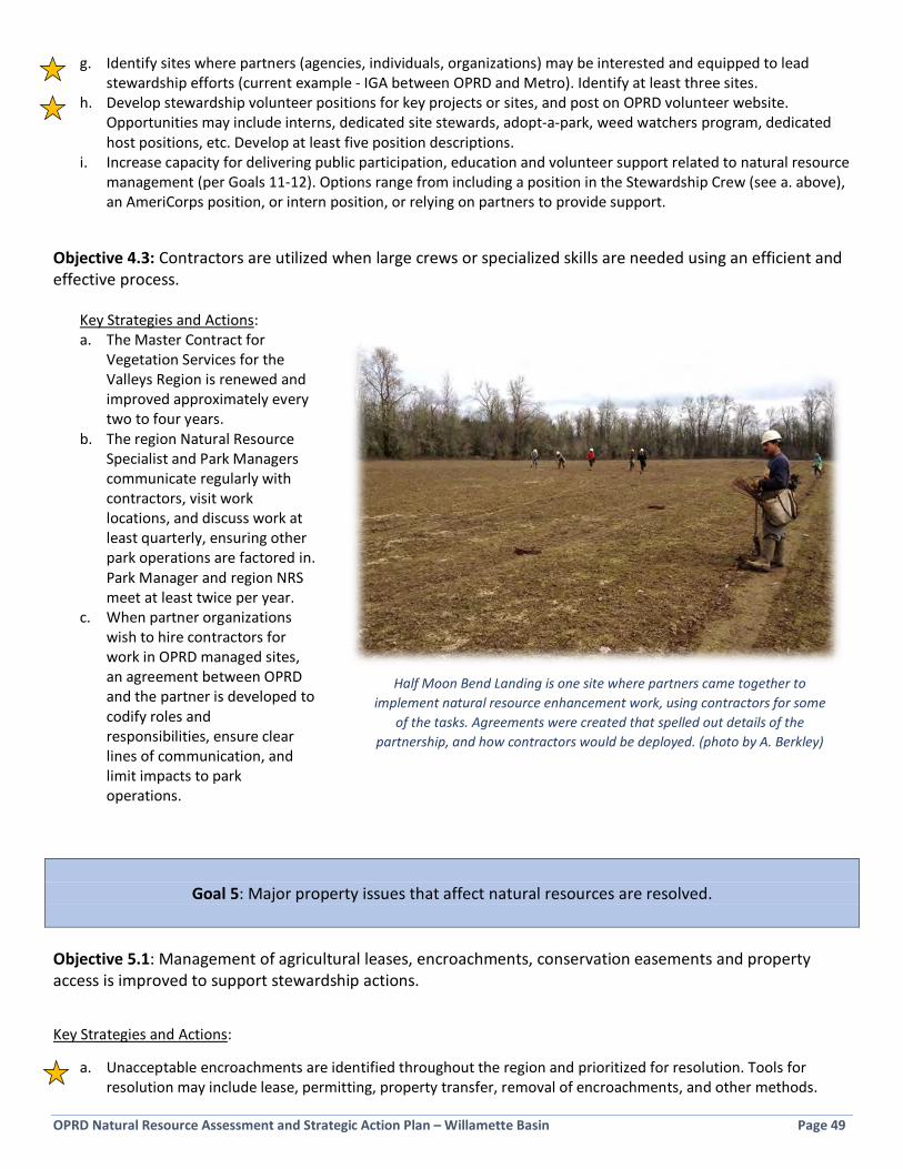
OPRD Natural Resource Assessment and Strategic Action Plan – Willamette Basin Page 49
g. Identify sites where partners (agencies, individuals, organizations) may be interested and equipped to lead stewardship efforts (current example - IGA between OPRD and Metro). Identify at least three sites.
h. Develop stewardship volunteer positions for key projects or sites, and post on OPRD volunteer website. Opportunities may include interns, dedicated site stewards, adopt-a-park, weed watchers program, dedicated host positions, etc. Develop at least five position descriptions.
i. Increase capacity for delivering public participation, education and volunteer support related to natural resource management (per Goals 11-12). Options range from including a position in the Stewardship Crew (see a. above), an AmeriCorps position, or intern position, or relying on partners to provide support.
Objective 4.3: Contractors are utilized when large crews or specialized skills are needed using an efficient and effective process.
Key Strategies and Actions: a. The Master Contract for
Vegetation Services for the Valleys Region is renewed and improved approximately every two to four years.
b. The region Natural Resource Specialist and Park Managers communicate regularly with contractors, visit work locations, and discuss work at least quarterly, ensuring other park operations are factored in. Park Manager and region NRS meet at least twice per year.
c. When partner organizations wish to hire contractors for work in OPRD managed sites, an agreement between OPRD and the partner is developed to codify roles and responsibilities, ensure clear lines of communication, and limit impacts to park operations.
Goal 5: Major property issues that affect natural resources are resolved.
Objective 5.1: Management of agricultural leases, encroachments, conservation easements and property access is improved to support stewardship actions.
Key Strategies and Actions:
a. Unacceptable encroachments are identified throughout the region and prioritized for resolution. Tools for resolution may include lease, permitting, property transfer, removal of encroachments, and other methods.
Half Moon Bend Landing is one site where partners came together to implement natural resource enhancement work, using contractors for some
of the tasks. Agreements were created that spelled out details of the partnership, and how contractors would be deployed. (photo by A. Berkley)

OPRD Natural Resource Assessment and Strategic Action Plan – Willamette Basin Page 50
b. Access by OPRD staff to difficult-to-access properties (particularly those with the highest priority natural resources) is improved, where possible, and well documented. Clarify deed, easement, and other property records for difficult-to-access properties to ensure access is correctly understood by all. Establish neighbor agreements for OPRD staff access where possible. Re-scan property access files into the OPRD database OPRIS (currently unreadable).
c. Existing agricultural leases are in compliance with lease provisions to ensure practices are safe and protective of the environment. Park Managers complete annual meetings with agricultural lessees to discuss Integrated Pest Management practices and lease requirements. Tools and training on evaluating proposed chemical use by agricultural lessees are provided to Park Managers.
d. All conservation easements are identified and required monitoring is clarified. e. Natural resource stewardship actions are integrated into leases where it makes strategic sense (for example, in
exchange for rent reduction). f. Where appropriate, leases in sensitive locations require use of organic or similar practices, or establishing native
plant communities.
Goal 6: Threats to natural resources are prevented, or rapidly detected and addressed, to prevent major impacts to natural resources.
Objective 6.1: Regular monitoring is conducted to detect and address problems before they cause damage to natural resources
Key Strategies and Actions: a. Create site monitoring protocols and
determine appropriate monitoring frequency for all properties, particularly high priority sites. Integrate monitoring protocol with OPRIS and other OPRD tools/technologies, such as ArcGIS Collector. Train staff on monitoring protocols. Other monitoring tools, such as wildlife cameras or aerial imagery, may also be used for site monitoring.
b. Explore forming a volunteer patrol program for early-detection and rapid response of invasives: a "Weed Watchers" program for parks. Existing curricula is available under the Weed Watchers umbrella. Interested Park hosts can be included.
c. Improve pest detection and prevention through existing programs.
• Promote use of the existing Invasive Species Hotline to OPRD staff, park visitors, in parks, on the web, and in other communications.
• Participate in Oregon
Regular site visits are an effective method for identifying stewardship issues so they can be addressed early. Many land trusts
and other land-management entities utilize standardized site monitoring protocols and frequencies to streamline the monitoring
work and document findings for follow-up. (photo by A. Berkley)

OPRD Natural Resource Assessment and Strategic Action Plan – Willamette Basin Page 51
Department of Agriculture Forest Pest detector program and Oregon Department of Fish and Wildlife/Oregon State Marine Board Aquatic Invasive Species detection programs.
• Ensure aquatic invasives signs provided by agencies are posted at all motorized and non-motorized boat launches.
• Evaluate incorporation of Oregon Invasive Species Council prevention campaign messages and materials into parks (Clean, Drain, Dry; Squeal on Pigs; etc.).
Objective 6.2: Preventable impacts to natural resources are addressed on high priority sites.
Key Strategies and Actions: a. At all high priority sites, the following information is
inventoried during site monitoring, park planning, adjacent property acquisition, or during stewardship prescription development, and addressed where feasible (on at least 12 sites):
• Sources of erosion and sedimentation into waterways
• Barriers to wildlife movement and connectivity (culverts, fences, etc.)
• Sources of wildlife mortality (open pipes, large windows, barbed wire, feral cats, etc.)
• Plant and animal poaching (working with law enforcement)
• Social trails, redundant trails, or trails near sensitive resources that are damaging resources
• Unauthorized camping • Property encroachments • Large amounts of pet waste or litter • Polluted runoff entering OPRD sites from
adjacent land • Pathways for the introduction and spread of
invasive species • Other types of impacts that may be preventable
Objective 6.3: Considerations of climate change are factored into natural resource management in the Willamette Basin parks.
Kay Strategies and Actions: a. OPRD-managed sites will continue to be managed as refuges for sensitive and rare native plants and animals.
• Work with partners to identify sites that are good candidates for introduction of rare species to maintain populations or meet recovery goals. Identify at least four introduction sites.
• Identify undisturbed refuge areas and preserve them. Identify refuge areas in at least four parks.
User trails (demand trails) in heavily used parks can compact or erode soil, destroy vegetation,
and lead to a degraded appearance. Some sites can be re-designed using plantings, obstructions, and trail delineation to reduce these impacts. This work has been implemented at Milo McIver State Park (pictured prior to work), Fall Creek Cascara, and Dexter State Recreation Site, among others.
(photo by A. Berkley)
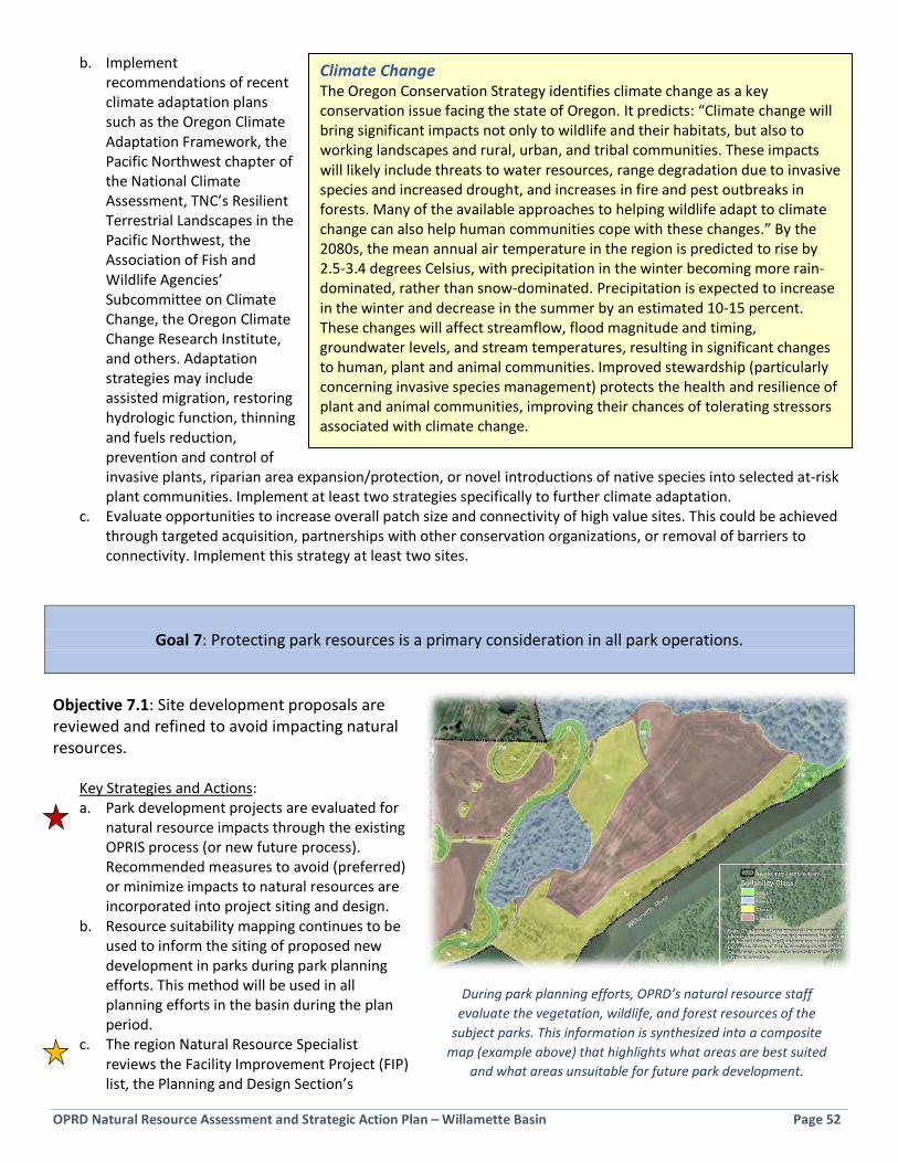
OPRD Natural Resource Assessment and Strategic Action Plan – Willamette Basin Page 52
b. Implement recommendations of recent climate adaptation plans such as the Oregon Climate Adaptation Framework, the Pacific Northwest chapter of the National Climate Assessment, TNC’s Resilient Terrestrial Landscapes in the Pacific Northwest, the Association of Fish and Wildlife Agencies’ Subcommittee on Climate Change, the Oregon Climate Change Research Institute, and others. Adaptation strategies may include assisted migration, restoring hydrologic function, thinning and fuels reduction, prevention and control of invasive plants, riparian area expansion/protection, or novel introductions of native species into selected at-risk plant communities. Implement at least two strategies specifically to further climate adaptation.
c. Evaluate opportunities to increase overall patch size and connectivity of high value sites. This could be achieved through targeted acquisition, partnerships with other conservation organizations, or removal of barriers to connectivity. Implement this strategy at least two sites.
Goal 7: Protecting park resources is a primary consideration in all park operations. Objective 7.1: Site development proposals are reviewed and refined to avoid impacting natural resources.
Key Strategies and Actions: a. Park development projects are evaluated for
natural resource impacts through the existing OPRIS process (or new future process). Recommended measures to avoid (preferred) or minimize impacts to natural resources are incorporated into project siting and design.
b. Resource suitability mapping continues to be used to inform the siting of proposed new development in parks during park planning efforts. This method will be used in all planning efforts in the basin during the plan period.
c. The region Natural Resource Specialist reviews the Facility Improvement Project (FIP) list, the Planning and Design Section’s
During park planning efforts, OPRD’s natural resource staff evaluate the vegetation, wildlife, and forest resources of the
subject parks. This information is synthesized into a composite map (example above) that highlights what areas are best suited
and what areas unsuitable for future park development.
Climate Change The Oregon Conservation Strategy identifies climate change as a key conservation issue facing the state of Oregon. It predicts: “Climate change will bring significant impacts not only to wildlife and their habitats, but also to working landscapes and rural, urban, and tribal communities. These impacts will likely include threats to water resources, range degradation due to invasive species and increased drought, and increases in fire and pest outbreaks in forests. Many of the available approaches to helping wildlife adapt to climate change can also help human communities cope with these changes.” By the 2080s, the mean annual air temperature in the region is predicted to rise by 2.5-3.4 degrees Celsius, with precipitation in the winter becoming more rain-dominated, rather than snow-dominated. Precipitation is expected to increase in the winter and decrease in the summer by an estimated 10-15 percent. These changes will affect streamflow, flood magnitude and timing, groundwater levels, and stream temperatures, resulting in significant changes to human, plant and animal communities. Improved stewardship (particularly concerning invasive species management) protects the health and resilience of plant and animal communities, improving their chances of tolerating stressors associated with climate change.
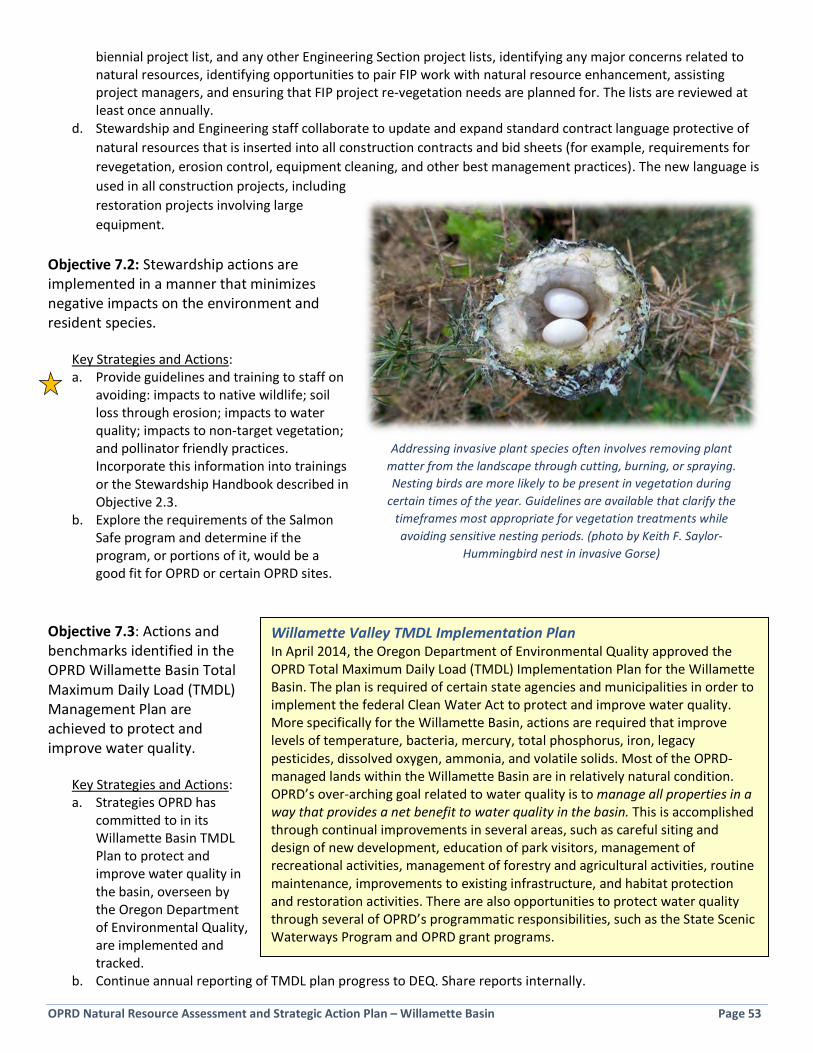
OPRD Natural Resource Assessment and Strategic Action Plan – Willamette Basin Page 53
biennial project list, and any other Engineering Section project lists, identifying any major concerns related to natural resources, identifying opportunities to pair FIP work with natural resource enhancement, assisting project managers, and ensuring that FIP project re-vegetation needs are planned for. The lists are reviewed at least once annually.
d. Stewardship and Engineering staff collaborate to update and expand standard contract language protective of natural resources that is inserted into all construction contracts and bid sheets (for example, requirements for revegetation, erosion control, equipment cleaning, and other best management practices). The new language is used in all construction projects, including restoration projects involving large equipment.
Objective 7.2: Stewardship actions are implemented in a manner that minimizes negative impacts on the environment and resident species.
Key Strategies and Actions: a. Provide guidelines and training to staff on
avoiding: impacts to native wildlife; soil loss through erosion; impacts to water quality; impacts to non-target vegetation; and pollinator friendly practices. Incorporate this information into trainings or the Stewardship Handbook described in Objective 2.3.
b. Explore the requirements of the Salmon Safe program and determine if the program, or portions of it, would be a good fit for OPRD or certain OPRD sites.
Objective 7.3: Actions and benchmarks identified in the OPRD Willamette Basin Total Maximum Daily Load (TMDL) Management Plan are achieved to protect and improve water quality.
Key Strategies and Actions: a. Strategies OPRD has
committed to in its Willamette Basin TMDL Plan to protect and improve water quality in the basin, overseen by the Oregon Department of Environmental Quality, are implemented and tracked.
b. Continue annual reporting of TMDL plan progress to DEQ. Share reports internally.
Addressing invasive plant species often involves removing plant matter from the landscape through cutting, burning, or spraying. Nesting birds are more likely to be present in vegetation during
certain times of the year. Guidelines are available that clarify the timeframes most appropriate for vegetation treatments while avoiding sensitive nesting periods. (photo by Keith F. Saylor-
Hummingbird nest in invasive Gorse)
Willamette Valley TMDL Implementation Plan In April 2014, the Oregon Department of Environmental Quality approved the OPRD Total Maximum Daily Load (TMDL) Implementation Plan for the Willamette Basin. The plan is required of certain state agencies and municipalities in order to implement the federal Clean Water Act to protect and improve water quality. More specifically for the Willamette Basin, actions are required that improve levels of temperature, bacteria, mercury, total phosphorus, iron, legacy pesticides, dissolved oxygen, ammonia, and volatile solids. Most of the OPRD-managed lands within the Willamette Basin are in relatively natural condition. OPRD’s over-arching goal related to water quality is to manage all properties in a way that provides a net benefit to water quality in the basin. This is accomplished through continual improvements in several areas, such as careful siting and design of new development, education of park visitors, management of recreational activities, management of forestry and agricultural activities, routine maintenance, improvements to existing infrastructure, and habitat protection and restoration activities. There are also opportunities to protect water quality through several of OPRD’s programmatic responsibilities, such as the State Scenic Waterways Program and OPRD grant programs.

OPRD Natural Resource Assessment and Strategic Action Plan – Willamette Basin Page 54
Objective 7.4: Pesticides are used responsibly and according to applicable laws and policies.
Key Strategies and Actions: a. Pesticides, including herbicides, are used only when determined to be the least harmful, effective management
tool to achieve pest control goals. Each use of pesticide is evaluated according to Integrated Pest Management principles, as guided by the Unit’s IPM plan and OPRD’s IPM policy.
b. IPM plans are complete and updated annually. OPRD’s Certified Pesticide Applicators receive regular training to stay current on best management practices. All herbicide label requirements and other laws are followed.
c. Agricultural leases and their operations are each evaluated to determine if pesticide use can be reduced. Agricultural lease operations are integrated into park IPM plans.
d. In some cases, particularly where agricultural operations are near developed or sensitive areas in a park, organic or similar agriculture should be considered, or establishment of native vegetation.
e. Where prudent, institute no spray buffer zones around sensitive areas and areas of high public use. Buffer zone restrictions may apply to work by staff, contractors, and agricultural lessees.
c. Wildlife pest management is conducted in consultation with the OPRD wildlife biologist.
Northern Shovelers (photo by Cary Kerst)
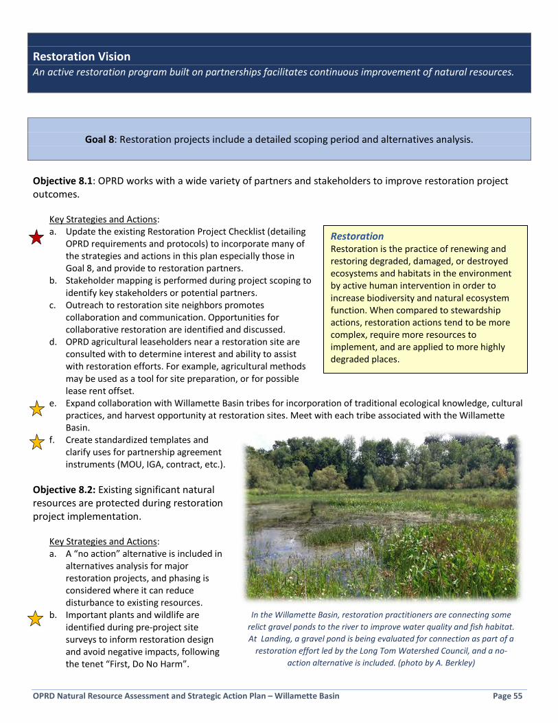
OPRD Natural Resource Assessment and Strategic Action Plan – Willamette Basin Page 55
Restoration Vision An active restoration program built on partnerships facilitates continuous improvement of natural resources.
Goal 8: Restoration projects include a detailed scoping period and alternatives analysis. Objective 8.1: OPRD works with a wide variety of partners and stakeholders to improve restoration project outcomes.
Key Strategies and Actions: a. Update the existing Restoration Project Checklist (detailing
OPRD requirements and protocols) to incorporate many of the strategies and actions in this plan especially those in Goal 8, and provide to restoration partners.
b. Stakeholder mapping is performed during project scoping to identify key stakeholders or potential partners.
c. Outreach to restoration site neighbors promotes collaboration and communication. Opportunities for collaborative restoration are identified and discussed.
d. OPRD agricultural leaseholders near a restoration site are consulted with to determine interest and ability to assist with restoration efforts. For example, agricultural methods may be used as a tool for site preparation, or for possible lease rent offset.
e. Expand collaboration with Willamette Basin tribes for incorporation of traditional ecological knowledge, cultural practices, and harvest opportunity at restoration sites. Meet with each tribe associated with the Willamette Basin.
f. Create standardized templates and clarify uses for partnership agreement instruments (MOU, IGA, contract, etc.).
Objective 8.2: Existing significant natural resources are protected during restoration project implementation.
Key Strategies and Actions: a. A “no action” alternative is included in
alternatives analysis for major restoration projects, and phasing is considered where it can reduce disturbance to existing resources.
b. Important plants and wildlife are identified during pre-project site surveys to inform restoration design and avoid negative impacts, following the tenet “First, Do No Harm”.
Restoration Restoration is the practice of renewing and restoring degraded, damaged, or destroyed ecosystems and habitats in the environment by active human intervention in order to increase biodiversity and natural ecosystem function. When compared to stewardship actions, restoration actions tend to be more complex, require more resources to implement, and are applied to more highly degraded places.
In the Willamette Basin, restoration practitioners are connecting some relict gravel ponds to the river to improve water quality and fish habitat. At Landing, a gravel pond is being evaluated for connection as part of a
restoration effort led by the Long Tom Watershed Council, and a no-action alternative is included. (photo by A. Berkley)

OPRD Natural Resource Assessment and Strategic Action Plan – Willamette Basin Page 56
c. Salmon safe, pollinator friendly, and bird and turtle nesting protection practices are incorporated into projects whenever possible.
d. Partnership agreements include specific measures for project implementation that are protective of existing natural resources.
Objective 8.3: Long-term maintenance is considered prior to restoration of a site.
Key Strategies and Actions: a. A long-term maintenance discussion is added to the Restoration Project Checklist, and includes the Park
Manager, region Natural Resource Specialist, and partners. Specific maintenance needs that are necessary for project success are identified and methods for long-term maintenance of restored sites are identified.
b. A checklist or questionnaire for long-term maintenance planning is developed to be used to create a long-term maintenance plan and project budget.
Goal 9: Priority natural resources are restored and managed using science-based approaches that incorporate
opportunities for learning and adaptive management. Objective 9.1: The latest science-based approaches are used to guide restoration project selection, design, monitoring and adaptive management.
Key Strategies and Actions: a. Selection of restoration targets and approaches is guided by the Oregon Conservation Strategy, OPRD natural
resource policies, park plans, species recovery plans, watershed action plans, as well as new and emerging science.
b. Large or complex restoration project proposals are vetted by the region Natural Resource Specialist, key partners, regional experts, and a brief literature review is conducted to inform the design and approach.
c. When funding and time allows, baseline and effectiveness monitoring will document changes over time for large restoration efforts. Partners, including academic institutions, will help lead and implement monitoring.
d. Restoration project outcomes are evaluated each biennium to inform future work and measure OPRD efforts across the region. This information is communicated in a biennial report.
e. Photo points are established and used throughout restoration projects to document changes over time and demonstrate success.
The Middle Fork Willamette Watershed Council is working with OPRD to evaluate alternatives for restoration of the floodplain
at Elijah Bristow State Park. A pool of technical experts is providing input and sharing approaches and lessons learned
from other floodplain projects. (photo by A. Berkley)

OPRD Natural Resource Assessment and Strategic Action Plan – Willamette Basin Page 57
Objective 9.2: The Oregon Conservation Strategy “Strategy Habitats” are prioritized for restoration action.
Key Strategies and Actions: a. The Oregon Conservation Strategy “Strategy Habitats” (see Figure 4-3) are located within OPRD properties, and
evaluated for condition, feasibility and need for restoration actions. Known/highly likely locations for Strategy Species will also be identified.
b. Identify opportunities to achieve significant ecological uplift in Strategy Habitats over large areas, or implement targeted management actions to address the needs of Strategy Species. For example, identify appropriate oak planting locations across the planning area and plant a significantly large number of oak trees over the plan period.
c. Where possible, restoration projects will be scoped to include restoring multiple strategy habitats as part of the same project, or at multiple sites in a similar geographic area, in an effort to gain the greatest ecological uplift over as many acres as possible.
d. A biennial report will provide the total acres (or other metric) of each Strategy Habitat enhanced or restored, and will enumerate actions taken to improve conditions for Strategy Species.
Objective 9.3: Forestlands are actively managed using a prioritized approach to maintain healthy, diverse, and sustainable native ecosystems and protect water quality.
Key Strategies and Actions: a. Native forests in need of management are identified and prioritized (as part of the Protect the Best and
restoration project prioritization processes described in Objective 1.1). b. Continue OPRD’s hazard tree program. c. Forest management plans are created for the highest priority sites, following the Forest Management Policy. d. Identify secondary projects that may be accomplished during forest management. Examples: addressing hazard
trees, oak release, culvert replacement, road decommissioning, invasives work, wildlife snag creation, use of some trees as in-stream habitat logs (onsite or at other OPRD sites). The regional Natural Resource Specialist, Park Manager, and Foresters will work together during project scoping to identify secondary projects that can be folded into forestry projects.
A relatively small portion of OPRD sites in the Willamette Basin contain significant tracts of oak woodland, an OCS Strategy Habitat. Increasing
the abundance of oak trees, thinning competing conifers, and where possible restoring understory plant communities, can benefit the large
number of native species that rely on oak habitat during their life cycles. This includes many native songbirds, insects, and mammals.
Potential locations for planting Oregon white oak in parks include areas that historically contained oaks and open grassy areas with space for oaks. In total, it may be possible to plant 10,000 new oak trees during
the 10-year planning period. (photo by A. Berkley)

OPRD Natural Resource Assessment and Strategic Action Plan – Willamette Basin Page 58
Objective 9.4: Restoration sites are made available for learning, scientific research, demonstration, and public participation.
Key Strategies and Actions: a. Designate 2-4 sites as “learning
laboratories” where scientific investigations that inform natural resource management and achieve management goals are encouraged. Implement pilot projects and small scale innovate approaches to restoration in these areas. Follow requirements of OPRD’s Scientific Collection and Research Permit process.
b. Demonstration projects are implemented that showcase exemplary resource management practices, share information, and interpret projects/sites to the public and OPRD staff. Implement and interpret at least two demonstration projects.
c. OPRD sites are used for staff training in restoration concepts and methods (for example, a restoration IMPACT training, Certified Pesticide Applicator training, or a natural resource project is folded into equipment training). At least 2 trainings include work in the field at OPRD sites.
d. Staff located in a park with a planned restoration project are oriented to the project, and become well-versed in the project’s purpose and benefits to promote better understanding, and relay of information to park visitors. Talking points are provided to park staff.
e. OPRD participates in workshops, conferences, and symposia to highlight natural resource management achievements and share knowledge. Participation occurs in at least two venues.
f. The older Willamette Basin restoration projects poster, which displayed all completed, in progress, and future restoration efforts on OPRD Willamette Basin sites, is updated and shared.
g. Larger restoration projects are described in a poster format that can be shared at events and circulated electronically. Posters are created for at least two large restoration projects.
h. A plan for public outreach, education, tours, signage, and events is created during restoration project scoping. i. Identify opportunities for park visitors and novice “citizen scientists” to contribute key information to inform
restoration work. Bird surveys, weed mapping, and amphibian surveys are a few examples. Identify at least two citizen science projects.
j. Restoration projects are entered into the online Conservation Registry. k. OPRD managed parks are made available through inter-agency coordination for forest pest detection efforts,
aquatic pest detection, and similar efforts by ODF, OSMB, ODA, etc.
Learning Laboratories Public lands provide a wealth of services to the community, including opportunities for recreation, ecosystem services, and learning. Learning is accomplished in a variety of ways including interpretation, volunteering, individual exploration and discovery, and scientific research. Through the Scientific Research Permit process, OPRD provides individuals and academic institutions a way to use parks to answer important scientific questions and implement scientific experiments in a field setting. Annually OPRD reviews and permits approximately 30-40 scientific research requests. A few parks in the Willamette Basin receive a large number of requests, and these tend to be sites with a variety of habitat types and large acreage, providing the space to explore a diversity of scientific questions. For example, Willamette Mission State Park has been used for scientific research for 10 projects in the last 4 years.
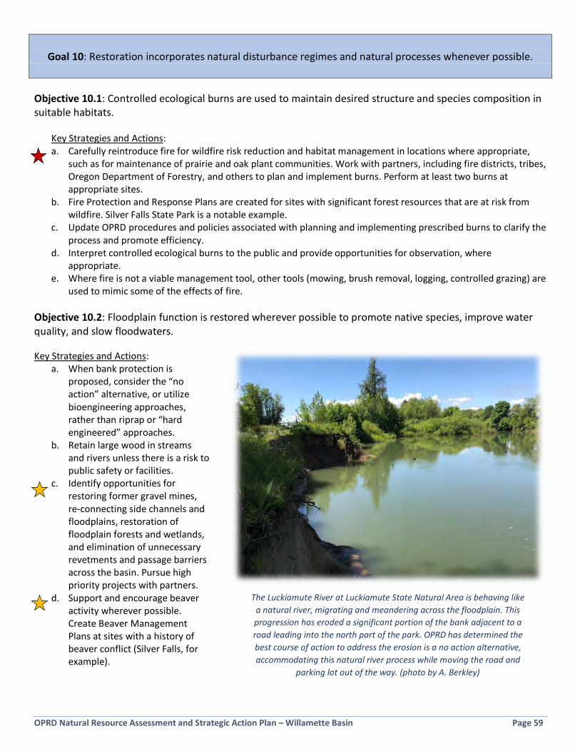
OPRD Natural Resource Assessment and Strategic Action Plan – Willamette Basin Page 59
Goal 10: Restoration incorporates natural disturbance regimes and natural processes whenever possible.
Objective 10.1: Controlled ecological burns are used to maintain desired structure and species composition in suitable habitats.
Key Strategies and Actions: a. Carefully reintroduce fire for wildfire risk reduction and habitat management in locations where appropriate,
such as for maintenance of prairie and oak plant communities. Work with partners, including fire districts, tribes, Oregon Department of Forestry, and others to plan and implement burns. Perform at least two burns at appropriate sites.
b. Fire Protection and Response Plans are created for sites with significant forest resources that are at risk from wildfire. Silver Falls State Park is a notable example.
c. Update OPRD procedures and policies associated with planning and implementing prescribed burns to clarify the process and promote efficiency.
d. Interpret controlled ecological burns to the public and provide opportunities for observation, where appropriate.
e. Where fire is not a viable management tool, other tools (mowing, brush removal, logging, controlled grazing) are used to mimic some of the effects of fire.
Objective 10.2: Floodplain function is restored wherever possible to promote native species, improve water quality, and slow floodwaters. Key Strategies and Actions:
a. When bank protection is proposed, consider the “no action” alternative, or utilize bioengineering approaches, rather than riprap or “hard engineered” approaches.
b. Retain large wood in streams and rivers unless there is a risk to public safety or facilities.
c. Identify opportunities for restoring former gravel mines, re-connecting side channels and floodplains, restoration of floodplain forests and wetlands, and elimination of unnecessary revetments and passage barriers across the basin. Pursue high priority projects with partners.
d. Support and encourage beaver activity wherever possible. Create Beaver Management Plans at sites with a history of beaver conflict (Silver Falls, for example).
The Luckiamute River at Luckiamute State Natural Area is behaving like a natural river, migrating and meandering across the floodplain. This progression has eroded a significant portion of the bank adjacent to a road leading into the north part of the park. OPRD has determined the best course of action to address the erosion is a no action alternative, accommodating this natural river process while moving the road and
parking lot out of the way. (photo by A. Berkley)
OPRD Natural Resource Assessment and Strategic Action Plan – Willamette Basin Page 60
Public Involvement Vision People enjoy and appreciate the Willamette Basin’s native species and habitats. Understanding and discovery is fostered through opportunities to become engaged participants in their care and management.
Goal 11: Visitor appreciation and stewardship of natural areas is improved.
Objective 11.1: Natural areas are showcased and made accessible to foster appreciation and stewardship.
Key Strategies and Actions: a. Events that showcase natural areas and natural resource projects are held regularly, such as the following.
Implement at least six of these events. Possible events include: • stewardship events (weed pulls, trail repair, etc.) • restoration events (tree planting, seeding, etc.) • self-guided walking tours • bioblitzes • guided walking tours • bike, boat, and kayaking trips • demonstrations/workshops • citizen science opportunities • slideshows/talks • talks on interesting topics provided by experts • film screenings/movies in parks on natural resource topics • events led by OPRD partners
b. Promote nature-themed tourist circuits through existing agency communications, including the Willamette Valley Birding Trail, Oregon Scenic Bikeways, Willamette Water Trail, etc.
c. Investigate multi-media, interactive nature education tools focused on younger audiences, such as phone apps. d. Share natural resource highlights and information frequently via the agency's social media outlets, temporary
signs, flyers, etc. Document and share through social media the stories of interesting people and organizations who help manage natural resources in parks, to make a human connection to natural resource management. Share information at least twice per year.
e. Interpretive signs (temporary or permanent) are designed and included for large restoration projects, or natural features/stories. Develop at least two new interpretive signs.
f. Work with OPRD Communications and Research Division to include branding and marketing natural areas as part of broader agency branding/marketing efforts. Also, evaluate existing messaging tools being used by other land managers, such as Play Clean Go, Clean Drain Dry, Willamette River Report Card toolkit, etc.
g. Improve interpretation and understanding of the Willamette River Greenway through one or more of the following:
• Develop an interpretive plan and branding for the Willamette River Greenway to redefine the Greenway and encourage stewardship.
• Host, support, and promote regular Willamette River Greenway-specific events. • Work with partners to make improvements to the Willamette Water Trail and promote its use, such as
through smart phone app development. • Add Willamette River Greenway-branded items to OPRD’s virtual store.
h. Where feasible, improve public access to rivers, streams, and lakes for swimming and boating to promote river stewardship and appreciation. Implement at least one access project.

OPRD Natural Resource Assessment and Strategic Action Plan – Willamette Basin Page 61
i. Develop wildlife viewing/natural resource online brochures for State Natural Areas and other identified parks. Develop at least one new brochure.
j. Wildlife viewing blinds are installed in selected areas to allow wildlife observation while minimizing disturbance. Install at least one new viewing blind.
k. Provide ways for visitors to report wildlife sightings, such as: an outdoor notebook station, whiteboard at a visitor center, or an app or web-based application. Provide this resource for at least five sites.
l. Install wildlife motion sensor cameras (trail cameras) in key areas to learn more about and capture compelling images of wildlife in parks.
m. Continue development of nature play spaces in parks, where appropriate.
Objective 11.2: Volunteer programs support natural resource stewardship and restoration goals.
Key Strategies and Actions: a. Stewardship and restoration needs are developed into volunteer job descriptions and posted to the OPRD
volunteer job board, under a new “natural resource” category. Develop at least five position descriptions. b. Increase OPRD capacity to implement stewardship and restoration work by:
• Identify parks with high stewardship needs and use existing partnering tools (Adopt-a-Park, for example) to help meet those needs. Consider modified approach of Adopt-a-Project.
• Develop dedicated Site Stewards, modelled from successful programs used by other land managers. • Form a volunteer patrol program for early-detection and rapid response to invasives, such as a Weed
Watchers program for OPRD sites using existing curriculum; invite Park Hosts to participate. • Coordinate with the Oregon Master Naturalist program for service projects at Willamette Basin sites.
c. Identify opportunities for park visitors and novice “citizen scientists” to contribute key information to inform restoration work. Bird surveys, weed mapping, and amphibian surveys are a few examples. Reach out to school groups, clubs and classes to fill important data gaps. Develop at least two of these projects.
Nature play spaces are an increasingly popular way to connect children with information, materials, and
experiences associated with nature, while providing a guiding framework and a safe venue for the experience.
(photo by A. Berkley)

OPRD Natural Resource Assessment and Strategic Action Plan – Willamette Basin Page 62
Goal 12: Diversity and inclusion are integrated into natural resource management activities.
Objective 12.1: Partners, contractors, and volunteers are recruited who reflect the diversity of Oregon.
Key Strategies and Actions: a. Reach out to organizations that represent people who are traditionally underrepresented in natural resource
volunteerism for possible volunteering/partnering such as the Coalition of Communities of Color, FACT Oregon, NAYA, YENS, Latino Outdoors, and others. Empower organizations to identify and lead projects.
b. Work with Park Managers to identify opportunities to recruit volunteers in the communities surrounding parks.
c. Implement recommendations of the OPRD Inclusion Committee that intersect with natural resource management, as they are developed.
d. Include diversity considerations, such as a commitment to diversity in hiring, during the evaluation and award process when evaluating proposals from contractors, consistent with state contracting law.
Objective 12.2: Workshops, tours, and volunteer opportunities are offered that meet the interests and needs of people who are typically underrepresented in natural resource management or outdoor events.
Key Strategies and Actions: a. Offer a tour of a restoration site tailored for persons with mobility issues (such as disabled youth, veteran's
group, or seniors), visual, or auditory impairments. b. Offer nature walks and volunteer events led by Spanish-speaking individuals. Molalla River and Willamette
Mission State Parks have the highest levels of Latino visitation in the region and may be good event locations. Identify opportunities to provide events for other non-English speakers.
c. Work with Park Managers to identify other opportunities to engage with new partners and individuals in the communities surrounding parks.
In 2016 OPRD released a Request for Proposals (RFP) for qualified firms for a variety of vegetation management services in the basin,
ranging from planting, to mowing woody invasive species, to treating aquatic invasives. One of the criteria used to evaluate proposals was
the degree to which the company works to ensure a diverse workforce. Five Master Contracts for Vegetation Management Services were
awarded as a result of this RFP. (photo by A. Berkley)
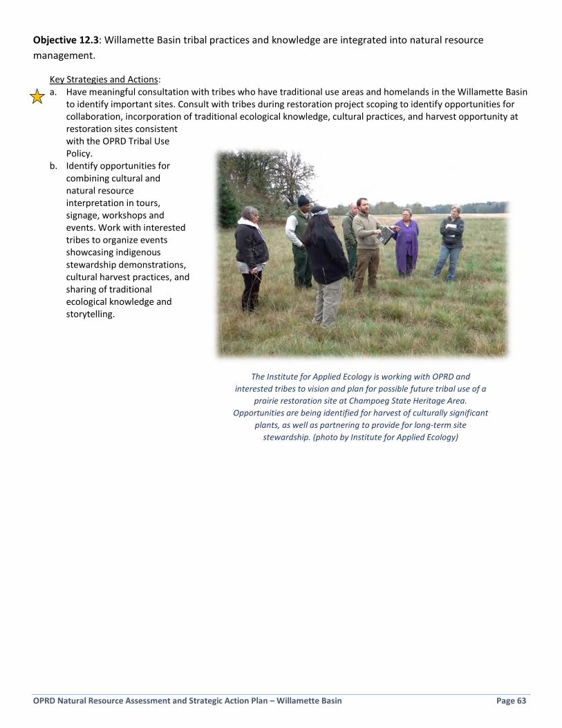
OPRD Natural Resource Assessment and Strategic Action Plan – Willamette Basin Page 63
Objective 12.3: Willamette Basin tribal practices and knowledge are integrated into natural resource management.
Key Strategies and Actions: a. Have meaningful consultation with tribes who have traditional use areas and homelands in the Willamette Basin
to identify important sites. Consult with tribes during restoration project scoping to identify opportunities for collaboration, incorporation of traditional ecological knowledge, cultural practices, and harvest opportunity at restoration sites consistent with the OPRD Tribal Use Policy.
b. Identify opportunities for combining cultural and natural resource interpretation in tours, signage, workshops and events. Work with interested tribes to organize events showcasing indigenous stewardship demonstrations, cultural harvest practices, and sharing of traditional ecological knowledge and storytelling.
The Institute for Applied Ecology is working with OPRD and interested tribes to vision and plan for possible future tribal use of a
prairie restoration site at Champoeg State Heritage Area. Opportunities are being identified for harvest of culturally significant
plants, as well as partnering to provide for long-term site stewardship. (photo by Institute for Applied Ecology)

OPRD Natural Resource Assessment and Strategic Action Plan – Willamette Basin Page 64
Page Intentionally Blank
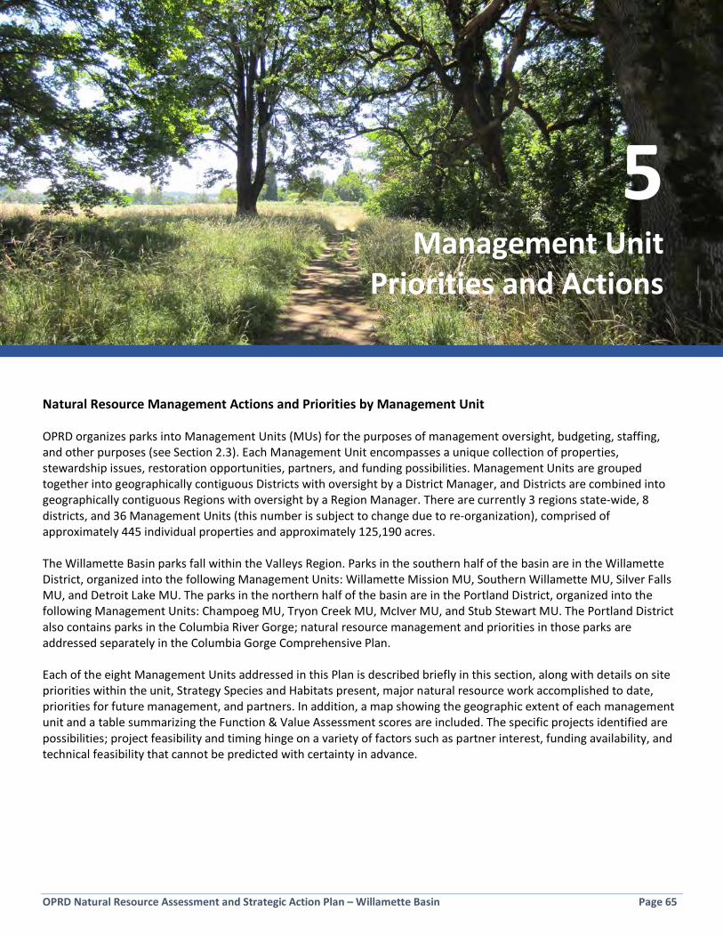
OPRD Natural Resource Assessment and Strategic Action Plan – Willamette Basin Page 65
Section 5: Management Unit Priorities and Actions Natural Resource Management Actions and Priorities by Management Unit OPRD organizes parks into Management Units (MUs) for the purposes of management oversight, budgeting, staffing, and other purposes (see Section 2.3). Each Management Unit encompasses a unique collection of properties, stewardship issues, restoration opportunities, partners, and funding possibilities. Management Units are grouped together into geographically contiguous Districts with oversight by a District Manager, and Districts are combined into geographically contiguous Regions with oversight by a Region Manager. There are currently 3 regions state-wide, 8 districts, and 36 Management Units (this number is subject to change due to re-organization), comprised of approximately 445 individual properties and approximately 125,190 acres. The Willamette Basin parks fall within the Valleys Region. Parks in the southern half of the basin are in the Willamette District, organized into the following Management Units: Willamette Mission MU, Southern Willamette MU, Silver Falls MU, and Detroit Lake MU. The parks in the northern half of the basin are in the Portland District, organized into the following Management Units: Champoeg MU, Tryon Creek MU, McIver MU, and Stub Stewart MU. The Portland District also contains parks in the Columbia River Gorge; natural resource management and priorities in those parks are addressed separately in the Columbia Gorge Comprehensive Plan. Each of the eight Management Units addressed in this Plan is described briefly in this section, along with details on site priorities within the unit, Strategy Species and Habitats present, major natural resource work accomplished to date, priorities for future management, and partners. In addition, a map showing the geographic extent of each management unit and a table summarizing the Function & Value Assessment scores are included. The specific projects identified are possibilities; project feasibility and timing hinge on a variety of factors such as partner interest, funding availability, and technical feasibility that cannot be predicted with certainty in advance.
5 Management Unit
Priorities and Actions

OPRD Natural Resource Assessment and Strategic Action Plan – Willamette Basin Page 66
5.1 Stub Stewart Management Unit The Stub Stewart Management Unit is comprised of three properties totaling 2,373.6 acres and is located in the transitional area between the Coast Range and Willamette Valley ecoregions (see Figure 5-1).
Figure 5-1: Stub Stewart Management Unit Context Map
Key Strategy Habitats and known Strategy Species within the Management Unit • Flowing water, riparian areas, and wetlands at Stub Stewart State Park and along the Banks-Vernonia State Trail • Steelhead and Coho Salmon, Willow Flycatcher, Western Meadowlark, Nelson’s Checkermallow, Western Pond
Turtle, Pileated Woodpecker, and Red-legged Frog. • Other notable species include Cutthroat Trout (likely), Band Tailed Pigeon, and portions of the unit are designated
sensitive wildlife habitat for Roosevelt Elk, Black Bear, and Black-tailed Deer.
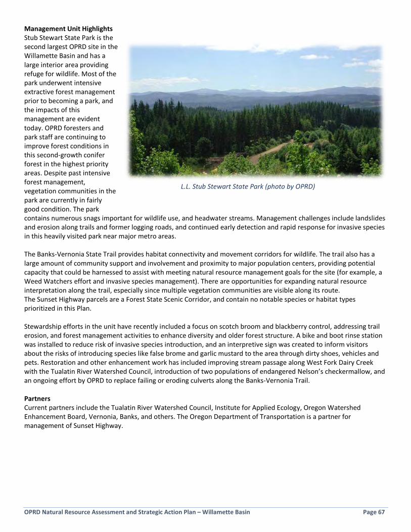
OPRD Natural Resource Assessment and Strategic Action Plan – Willamette Basin Page 67
Management Unit Highlights Stub Stewart State Park is the second largest OPRD site in the Willamette Basin and has a large interior area providing refuge for wildlife. Most of the park underwent intensive extractive forest management prior to becoming a park, and the impacts of this management are evident today. OPRD foresters and park staff are continuing to improve forest conditions in this second-growth conifer forest in the highest priority areas. Despite past intensive forest management, vegetation communities in the park are currently in fairly good condition. The park contains numerous snags important for wildlife use, and headwater streams. Management challenges include landslides and erosion along trails and former logging roads, and continued early detection and rapid response for invasive species in this heavily visited park near major metro areas. The Banks-Vernonia State Trail provides habitat connectivity and movement corridors for wildlife. The trail also has a large amount of community support and involvement and proximity to major population centers, providing potential capacity that could be harnessed to assist with meeting natural resource management goals for the site (for example, a Weed Watchers effort and invasive species management). There are opportunities for expanding natural resource interpretation along the trail, especially since multiple vegetation communities are visible along its route. The Sunset Highway parcels are a Forest State Scenic Corridor, and contain no notable species or habitat types prioritized in this Plan. Stewardship efforts in the unit have recently included a focus on scotch broom and blackberry control, addressing trail erosion, and forest management activities to enhance diversity and older forest structure. A bike and boot rinse station was installed to reduce risk of invasive species introduction, and an interpretive sign was created to inform visitors about the risks of introducing species like false brome and garlic mustard to the area through dirty shoes, vehicles and pets. Restoration and other enhancement work has included improving stream passage along West Fork Dairy Creek with the Tualatin River Watershed Council, introduction of two populations of endangered Nelson’s checkermallow, and an ongoing effort by OPRD to replace failing or eroding culverts along the Banks-Vernonia Trail. Partners Current partners include the Tualatin River Watershed Council, Institute for Applied Ecology, Oregon Watershed Enhancement Board, Vernonia, Banks, and others. The Oregon Department of Transportation is a partner for management of Sunset Highway.
L.L. Stub Stewart State Park (photo by OPRD)

OPRD Natural Resource Assessment and Strategic Action Plan – Willamette Basin Page 68
Figure 5-2: Function & Value Assessment Score for the Stub Stewart Management Unit
Figure 5-3: Priorities and Actions for the Stub Stewart Management Unit
Site Priority within
MU
Priority within Region
Stewardship Focus Restoration Opportunities Other Opportunities*
L. L. Stub Stewart State Park
High High • Early detection and rapid response to new invasives
• Trail and road maintenance to prevent erosion
• Steward Nelson’s checkermallow site
• Forest structure improvement through forestry activities
• Improve overall condition of plant communities though weed control, seeding, planting
• In-stream habitat enhancement through placement of large wood, weed control, and planting
• Create Stewardship Plan to guide stewardship efforts and improve site conditions
• Identify citizen science opportunities
• Install boot brushes at key trailheads
Banks Vernonia State Trail
Medium Medium • Early detection and rapid response to new invasives
• Continue culvert replacement efforts
• Steward Nelson’s checkermallow site
• Manage vegetation along ROW with neighbors
• Improve vegetation conditions through small projects
• Natural resource interpretation
• Provide mowing guidance to reduce weed seed spread along trail
Sunset Highway parcels
Low Low • Monitor on a regular basis • Preserve scenic values
*Other Strategies and Actions from Section 4.3, not listed in this table, may be applied in this Management Unit.
Habitat Values Floodplain Function Public Use and Enjoyment
Site Name
Acre
s
Ia. S
ize o
f Nat
ural
Res
ourc
e Ar
ea
Ib. P
roxi
mity
to C
onse
rved
Lan
ds
Ic. W
ithin
OCS
CO
A
Id. D
iver
sity
of O
CS H
abita
ts
Ie. S
trat
egy
Habi
tats
Tot
al A
rea
If. N
ativ
e Ve
geta
tion
Ig. H
uman
Cau
se D
istur
banc
e
Ih. P
rese
nce
of In
vasiv
e Sp
ecie
s
Ii. R
are
Plan
t or w
ildlif
e sp
ecie
s
Ij. O
PRD
Prop
erty
Des
igna
tion
Ii. H
abita
t Bon
us
Habi
tat V
alue
IIa. F
lood
plai
n Fu
nctio
n
IIb. P
rese
nce/
Perm
anen
ce o
f Wat
er
IIc. W
ater
Qua
lity
Func
tion
of V
eg
Iid. W
Q a
nd F
lood
plai
n Bo
nus
Wat
er Q
ualit
y/Fl
oodp
lain
Fun
ctio
n Va
lue
IIIa.
Rec
reat
iona
l Acc
ess a
nd F
acili
ties
IIIb.
Exi
stin
g Ed
ucat
iona
l Use
IIIc.
Use
r Exp
erie
nce
IIId.
Pub
lic U
se a
nd E
njoy
men
t Bon
us
Publ
ic U
se a
nd E
njoy
men
t Val
ue
GRA
ND
TOTA
L
Rank
(All
Cate
gorie
s)
Rank
(Hab
itat +
Flo
odpl
ain
Func
tion)
Banks-Vernonia ST (parcels outside of SS) 321.7 6 5 0 3 2 3 1 3 6.0 0 2 31.0 5 3 2 1 11.0 4 1 4 3 12.0 54.0 30 30L.L. "Stub" Stewart SP 1851.1 10 3 0 1 2 3 1 3 4.5 2 4 33.5 7 4 6 2 19.0 6 3 5 3 17.0 69.5 11 11Sunset Highway (Washington County parcels) 200.8 6 3 0 0 0 2 1 3 0.0 0 0 15.0 0 0 0 0 0.0 0 0 1 2 3.0 18.0 74 65
Average: 47.2
Ranking
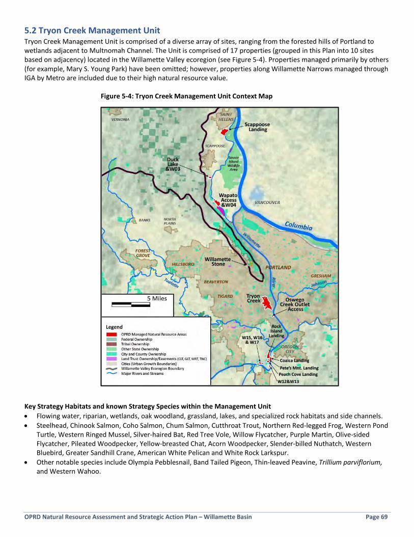
OPRD Natural Resource Assessment and Strategic Action Plan – Willamette Basin Page 69
5.2 Tryon Creek Management Unit Tryon Creek Management Unit is comprised of a diverse array of sites, ranging from the forested hills of Portland to wetlands adjacent to Multnomah Channel. The Unit is comprised of 17 properties (grouped in this Plan into 10 sites based on adjacency) located in the Willamette Valley ecoregion (see Figure 5-4). Properties managed primarily by others (for example, Mary S. Young Park) have been omitted; however, properties along Willamette Narrows managed through IGA by Metro are included due to their high natural resource value.
Figure 5-4: Tryon Creek Management Unit Context Map
Key Strategy Habitats and known Strategy Species within the Management Unit • Flowing water, riparian, wetlands, oak woodland, grassland, lakes, and specialized rock habitats and side channels. • Steelhead, Chinook Salmon, Coho Salmon, Chum Salmon, Cutthroat Trout, Northern Red-legged Frog, Western Pond
Turtle, Western Ringed Mussel, Silver-haired Bat, Red Tree Vole, Willow Flycatcher, Purple Martin, Olive-sided Flycatcher, Pileated Woodpecker, Yellow-breasted Chat, Acorn Woodpecker, Slender-billed Nuthatch, Western Bluebird, Greater Sandhill Crane, American White Pelican and White Rock Larkspur.
• Other notable species include Olympia Pebblesnail, Band Tailed Pigeon, Thin-leaved Peavine, Trillium parviflorium, and Western Wahoo.
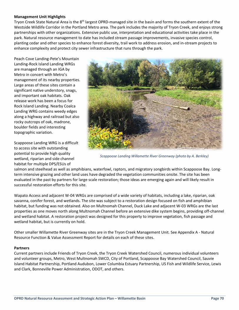
OPRD Natural Resource Assessment and Strategic Action Plan – Willamette Basin Page 70
Management Unit Highlights Tryon Creek State Natural Area is the 8th largest OPRD-managed site in the basin and forms the southern extent of the Westside Wildlife Corridor in the Portland Metro area. The park includes the majority of Tryon Creek, and enjoys strong partnerships with other organizations. Extensive public use, interpretation and educational activities take place in the park. Natural resource management to date has included stream passage improvements, invasive species control, planting cedar and other species to enhance forest diversity, trail work to address erosion, and in-stream projects to enhance complexity and protect city sewer infrastructure that runs through the park. Peach Cove Landing-Pete’s Mountain Landing-Rock Island Landing WRGs are managed through an IGA by Metro in concert with Metro’s management of its nearby properties. Large areas of these sites contain a significant native understory, snags, and important oak habitats. Oak release work has been a focus for Rock Island Landing. Nearby Coalca Landing WRG contains weedy edges along a highway and railroad but also rocky outcrops of oak, madrone, boulder fields and interesting topographic variation. Scappoose Landing WRG is a difficult to access site with outstanding potential to provide high quality wetland, riparian and side channel habitat for multiple DPS/ESUs of salmon and steelhead as well as amphibians, waterfowl, raptors, and migratory songbirds within Scappoose Bay. Long-term intensive grazing and other land uses have degraded the vegetation communities onsite. The site has been evaluated in the past by partners for large scale restoration; those ideas are emerging again and will likely result in successful restoration efforts for this site. Wapato Access and adjacent W-04 WRGs are comprised of a wide variety of habitats, including a lake, riparian, oak savanna, conifer forest, and wetlands. The site was subject to a restoration design focused on fish and amphibian habitat, but funding was not obtained. Also on Multnomah Channel, Duck Lake and adjacent W-03 WRGs are the last properties as one moves north along Multnomah Channel before an extensive dike system begins, providing off-channel and wetland habitat. A restoration project was designed for this property to improve vegetation, fish passage and wetland habitat, but is currently on hold. Other smaller Willamette River Greenway sites are in the Tryon Creek Management Unit. See Appendix A - Natural Resource Function & Value Assessment Report for details on each of these sites. Partners Current partners include Friends of Tryon Creek, the Tryon Creek Watershed Council, numerous individual volunteers and volunteer groups, Metro, West Multnomah SWCD, City of Portland, Scappoose Bay Watershed Council, Sauvie Island Habitat Partnership, Portland Audubon, Lower Columbia Estuary Partnership, US Fish and Wildlife Service, Lewis and Clark, Bonneville Power Administration, ODOT, and others.
Scappoose Landing Willamette River Greenway (photo by A. Berkley)
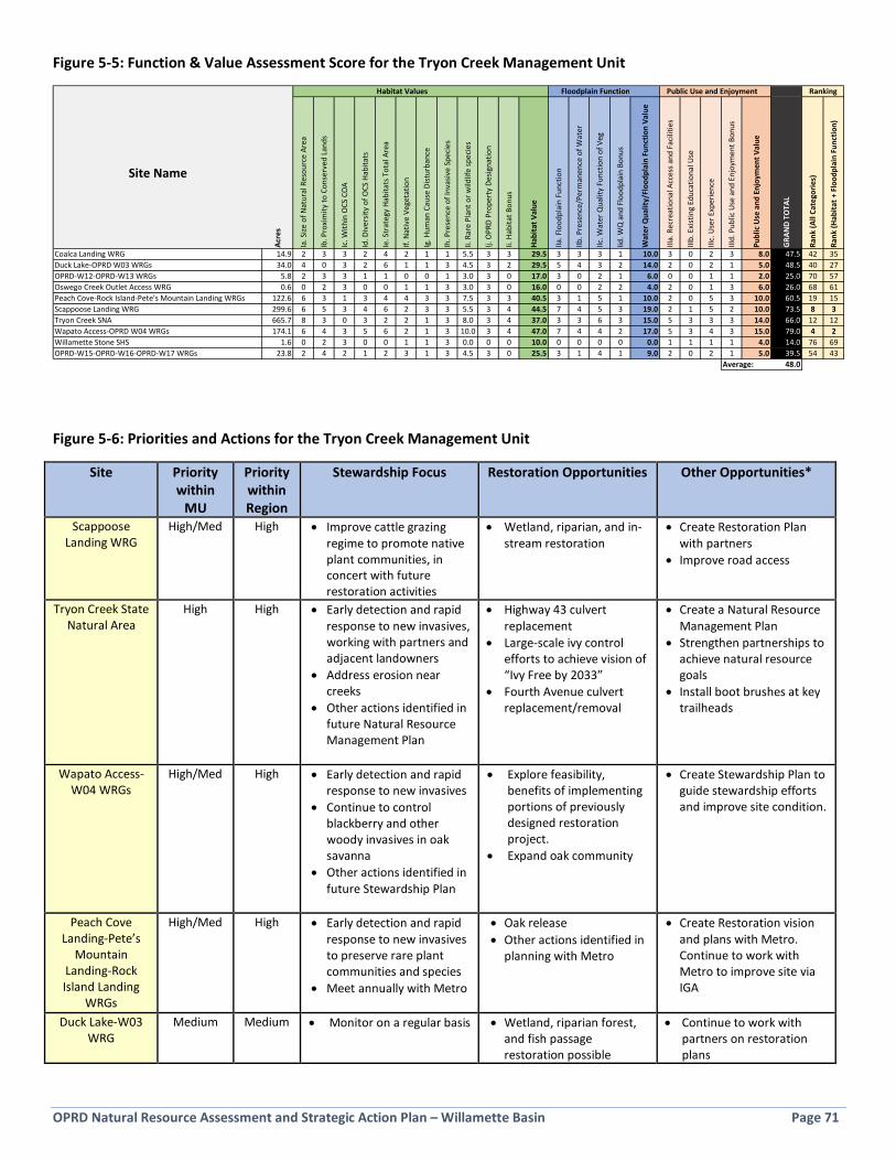
OPRD Natural Resource Assessment and Strategic Action Plan – Willamette Basin Page 71
Figure 5-5: Function & Value Assessment Score for the Tryon Creek Management Unit
Figure 5-6: Priorities and Actions for the Tryon Creek Management Unit
Site Priority within
MU
Priority within Region
Stewardship Focus Restoration Opportunities Other Opportunities*
Scappoose Landing WRG
High/Med High • Improve cattle grazing regime to promote native plant communities, in concert with future restoration activities
• Wetland, riparian, and in-stream restoration
• Create Restoration Plan with partners
• Improve road access
Tryon Creek State Natural Area
High High • Early detection and rapid response to new invasives, working with partners and adjacent landowners
• Address erosion near creeks
• Other actions identified in future Natural Resource Management Plan
• Highway 43 culvert replacement
• Large-scale ivy control efforts to achieve vision of “Ivy Free by 2033”
• Fourth Avenue culvert replacement/removal
• Create a Natural Resource Management Plan
• Strengthen partnerships to achieve natural resource goals
• Install boot brushes at key trailheads
Wapato Access-W04 WRGs
High/Med High • Early detection and rapid response to new invasives
• Continue to control blackberry and other woody invasives in oak savanna
• Other actions identified in future Stewardship Plan
• Explore feasibility, benefits of implementing portions of previously designed restoration project.
• Expand oak community
• Create Stewardship Plan to guide stewardship efforts and improve site condition.
Peach Cove Landing-Pete’s
Mountain Landing-Rock Island Landing
WRGs
High/Med High • Early detection and rapid response to new invasives to preserve rare plant communities and species
• Meet annually with Metro
• Oak release • Other actions identified in
planning with Metro
• Create Restoration vision and plans with Metro. Continue to work with Metro to improve site via IGA
Duck Lake-W03 WRG
Medium Medium • Monitor on a regular basis • Wetland, riparian forest, and fish passage restoration possible
• Continue to work with partners on restoration plans
Habitat Values Floodplain Function Public Use and Enjoyment
Site Name
Acre
s
Ia. S
ize o
f Nat
ural
Res
ourc
e Ar
ea
Ib. P
roxi
mity
to C
onse
rved
Lan
ds
Ic. W
ithin
OCS
CO
A
Id. D
iver
sity
of O
CS H
abita
ts
Ie. S
trat
egy
Habi
tats
Tot
al A
rea
If. N
ativ
e Ve
geta
tion
Ig. H
uman
Cau
se D
istur
banc
e
Ih. P
rese
nce
of In
vasiv
e Sp
ecie
s
Ii. R
are
Plan
t or w
ildlif
e sp
ecie
s
Ij. O
PRD
Prop
erty
Des
igna
tion
Ii. H
abita
t Bon
us
Habi
tat V
alue
IIa. F
lood
plai
n Fu
nctio
n
IIb. P
rese
nce/
Perm
anen
ce o
f Wat
er
IIc. W
ater
Qua
lity
Func
tion
of V
eg
Iid. W
Q a
nd F
lood
plai
n Bo
nus
Wat
er Q
ualit
y/Fl
oodp
lain
Fun
ctio
n Va
lue
IIIa.
Rec
reat
iona
l Acc
ess a
nd F
acili
ties
IIIb.
Exi
stin
g Ed
ucat
iona
l Use
IIIc.
Use
r Exp
erie
nce
IIId.
Pub
lic U
se a
nd E
njoy
men
t Bon
us
Publ
ic U
se a
nd E
njoy
men
t Val
ue
GRA
ND
TOTA
L
Rank
(All
Cate
gorie
s)
Rank
(Hab
itat +
Flo
odpl
ain
Func
tion)
Coalca Landing WRG 14.9 2 3 3 2 4 2 1 1 5.5 3 3 29.5 3 3 3 1 10.0 3 0 2 3 8.0 47.5 42 35Duck Lake-OPRD W03 WRGs 34.0 4 0 3 2 6 1 1 3 4.5 3 2 29.5 5 4 3 2 14.0 2 0 2 1 5.0 48.5 40 27OPRD-W12-OPRD-W13 WRGs 5.8 2 3 3 1 1 0 0 1 3.0 3 0 17.0 3 0 2 1 6.0 0 0 1 1 2.0 25.0 70 57Oswego Creek Outlet Access WRG 0.6 0 2 3 0 0 1 1 3 3.0 3 0 16.0 0 0 2 2 4.0 2 0 1 3 6.0 26.0 68 61Peach Cove-Rock Island-Pete's Mountain Landing WRGs 122.6 6 3 1 3 4 4 3 3 7.5 3 3 40.5 3 1 5 1 10.0 2 0 5 3 10.0 60.5 19 15Scappoose Landing WRG 299.6 6 5 3 4 6 2 3 3 5.5 3 4 44.5 7 4 5 3 19.0 2 1 5 2 10.0 73.5 8 3Tryon Creek SNA 665.7 8 3 0 3 2 2 1 3 8.0 3 4 37.0 3 3 6 3 15.0 5 3 3 3 14.0 66.0 12 12Wapato Access-OPRD W04 WRGs 174.1 6 4 3 5 6 2 1 3 10.0 3 4 47.0 7 4 4 2 17.0 5 3 4 3 15.0 79.0 4 2Willamette Stone SHS 1.6 0 2 3 0 0 1 1 3 0.0 0 0 10.0 0 0 0 0 0.0 1 1 1 1 4.0 14.0 76 69OPRD-W15-OPRD-W16-OPRD-W17 WRGs 23.8 2 4 2 1 2 3 1 3 4.5 3 0 25.5 3 1 4 1 9.0 2 0 2 1 5.0 39.5 54 43
Average: 48.0
Ranking
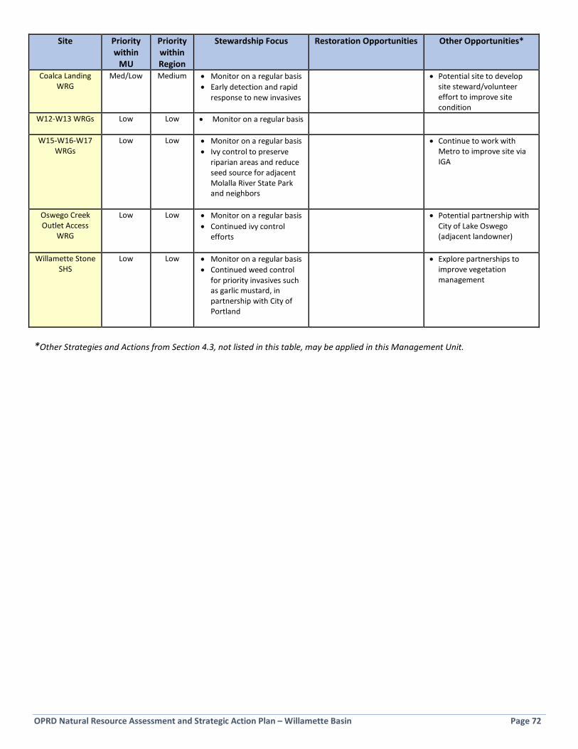
OPRD Natural Resource Assessment and Strategic Action Plan – Willamette Basin Page 72
Site Priority within
MU
Priority within Region
Stewardship Focus Restoration Opportunities Other Opportunities*
Coalca Landing WRG
Med/Low Medium • Monitor on a regular basis • Early detection and rapid
response to new invasives
• Potential site to develop site steward/volunteer effort to improve site condition
W12-W13 WRGs
Low Low • Monitor on a regular basis
W15-W16-W17 WRGs
Low Low • Monitor on a regular basis • Ivy control to preserve
riparian areas and reduce seed source for adjacent Molalla River State Park and neighbors
• Continue to work with Metro to improve site via IGA
Oswego Creek Outlet Access
WRG
Low Low • Monitor on a regular basis • Continued ivy control
efforts
• Potential partnership with City of Lake Oswego (adjacent landowner)
Willamette Stone SHS
Low Low • Monitor on a regular basis • Continued weed control
for priority invasives such as garlic mustard, in partnership with City of Portland
• Explore partnerships to improve vegetation management
*Other Strategies and Actions from Section 4.3, not listed in this table, may be applied in this Management Unit.

OPRD Natural Resource Assessment and Strategic Action Plan – Willamette Basin Page 73
5.3 Milo McIver Management Unit Parks in the Milo McIver Management Unit are located in the transition zone between the Willamette Valley ecoregion and the West Cascades ecoregion (see Figure 5-7). The three parks in the unit total 1,140 acres. A few small parcels in the unit have been omitted from this plan as they are managed by other entities.
Figure 5-7: Milo McIver Management Unit Context Map
Key Strategy Habitats and known Strategy Species within the Management Unit • Flowing water, riparian, wetland, grasslands, oak woodland, and specialized side channel habitat, springs and seeps,
and cliff/bluff habitat. • Steelhead, Chinook Salmon, Coho Salmon, Western Pond Turtle, Willow Flycatcher, Pileated Woodpecker, Purple
Martin, Olive-sided Flycatcher, Silver-haired Bat, Townsend’s Big-eared Bat, Western Bluebird, White-breasted Nuthatch
• Other notable species include Tall Bugbane
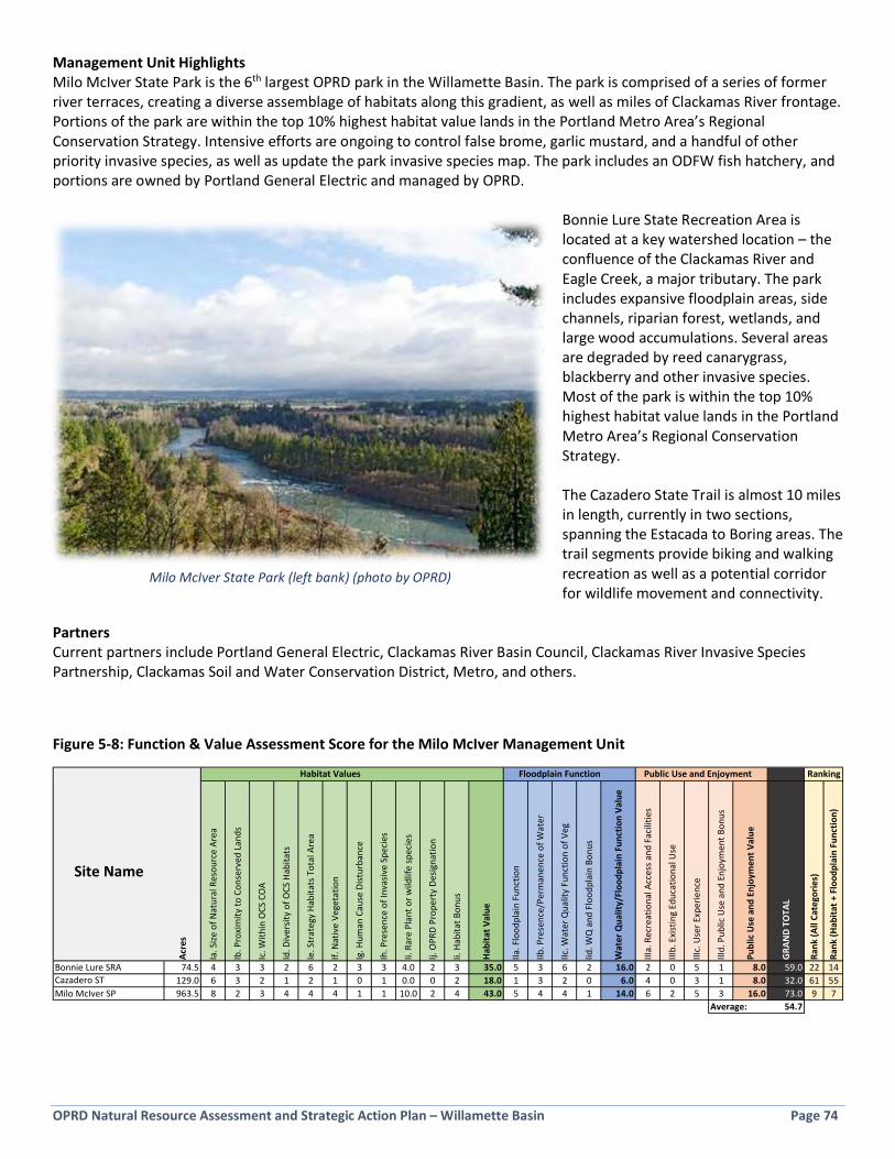
OPRD Natural Resource Assessment and Strategic Action Plan – Willamette Basin Page 74
Management Unit Highlights Milo McIver State Park is the 6th largest OPRD park in the Willamette Basin. The park is comprised of a series of former river terraces, creating a diverse assemblage of habitats along this gradient, as well as miles of Clackamas River frontage. Portions of the park are within the top 10% highest habitat value lands in the Portland Metro Area’s Regional Conservation Strategy. Intensive efforts are ongoing to control false brome, garlic mustard, and a handful of other priority invasive species, as well as update the park invasive species map. The park includes an ODFW fish hatchery, and portions are owned by Portland General Electric and managed by OPRD.
Bonnie Lure State Recreation Area is located at a key watershed location – the confluence of the Clackamas River and Eagle Creek, a major tributary. The park includes expansive floodplain areas, side channels, riparian forest, wetlands, and large wood accumulations. Several areas are degraded by reed canarygrass, blackberry and other invasive species. Most of the park is within the top 10% highest habitat value lands in the Portland Metro Area’s Regional Conservation Strategy. The Cazadero State Trail is almost 10 miles in length, currently in two sections, spanning the Estacada to Boring areas. The trail segments provide biking and walking recreation as well as a potential corridor for wildlife movement and connectivity.
Partners Current partners include Portland General Electric, Clackamas River Basin Council, Clackamas River Invasive Species Partnership, Clackamas Soil and Water Conservation District, Metro, and others.
Figure 5-8: Function & Value Assessment Score for the Milo McIver Management Unit
Habitat Values Floodplain Function Public Use and Enjoyment
Site Name
Acre
s
Ia. S
ize o
f Nat
ural
Res
ourc
e Ar
ea
Ib. P
roxi
mity
to C
onse
rved
Lan
ds
Ic. W
ithin
OCS
CO
A
Id. D
iver
sity
of O
CS H
abita
ts
Ie. S
trat
egy
Habi
tats
Tot
al A
rea
If. N
ativ
e Ve
geta
tion
Ig. H
uman
Cau
se D
istur
banc
e
Ih. P
rese
nce
of In
vasiv
e Sp
ecie
s
Ii. R
are
Plan
t or w
ildlif
e sp
ecie
s
Ij. O
PRD
Prop
erty
Des
igna
tion
Ii. H
abita
t Bon
us
Habi
tat V
alue
IIa. F
lood
plai
n Fu
nctio
n
IIb. P
rese
nce/
Perm
anen
ce o
f Wat
er
IIc. W
ater
Qua
lity
Func
tion
of V
eg
Iid. W
Q a
nd F
lood
plai
n Bo
nus
Wat
er Q
ualit
y/Fl
oodp
lain
Fun
ctio
n Va
lue
IIIa.
Rec
reat
iona
l Acc
ess a
nd F
acili
ties
IIIb.
Exi
stin
g Ed
ucat
iona
l Use
IIIc.
Use
r Exp
erie
nce
IIId.
Pub
lic U
se a
nd E
njoy
men
t Bon
us
Publ
ic U
se a
nd E
njoy
men
t Val
ue
GRA
ND
TOTA
L
Rank
(All
Cate
gorie
s)
Rank
(Hab
itat +
Flo
odpl
ain
Func
tion)
Bonnie Lure SRA 74.5 4 3 3 2 6 2 3 3 4.0 2 3 35.0 5 3 6 2 16.0 2 0 5 1 8.0 59.0 22 14Cazadero ST 129.0 6 3 2 1 2 1 0 1 0.0 0 2 18.0 1 3 2 0 6.0 4 0 3 1 8.0 32.0 61 55Milo McIver SP 963.5 8 2 3 4 4 4 1 1 10.0 2 4 43.0 5 4 4 1 14.0 6 2 5 3 16.0 73.0 9 7
Average: 54.7
Ranking
Milo McIver State Park (left bank) (photo by OPRD)
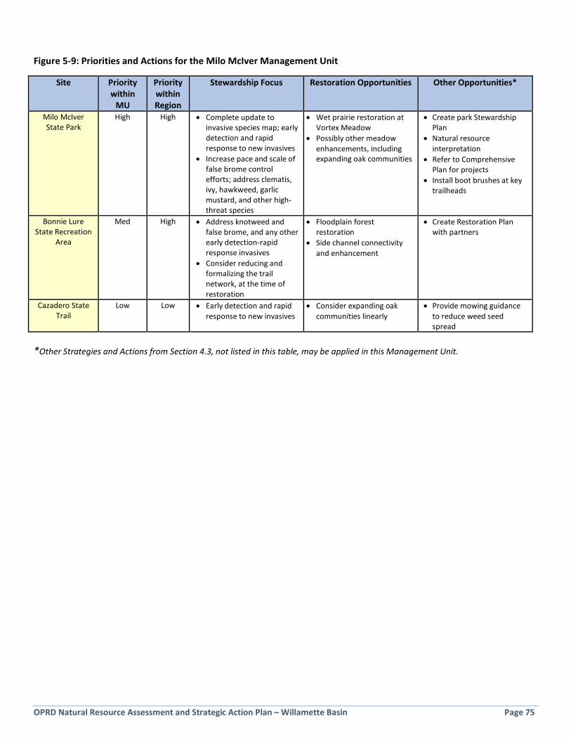
OPRD Natural Resource Assessment and Strategic Action Plan – Willamette Basin Page 75
Figure 5-9: Priorities and Actions for the Milo McIver Management Unit
Site Priority within
MU
Priority within Region
Stewardship Focus Restoration Opportunities Other Opportunities*
Milo McIver State Park
High High • Complete update to invasive species map; early detection and rapid response to new invasives
• Increase pace and scale of false brome control efforts; address clematis, ivy, hawkweed, garlic mustard, and other high-threat species
• Wet prairie restoration at Vortex Meadow
• Possibly other meadow enhancements, including expanding oak communities
• Create park Stewardship Plan
• Natural resource interpretation
• Refer to Comprehensive Plan for projects
• Install boot brushes at key trailheads
Bonnie Lure State Recreation
Area
Med High • Address knotweed and false brome, and any other early detection-rapid response invasives
• Consider reducing and formalizing the trail network, at the time of restoration
• Floodplain forest restoration
• Side channel connectivity and enhancement
• Create Restoration Plan with partners
Cazadero State Trail
Low Low • Early detection and rapid response to new invasives
• Consider expanding oak communities linearly
• Provide mowing guidance to reduce weed seed spread
*Other Strategies and Actions from Section 4.3, not listed in this table, may be applied in this Management Unit.
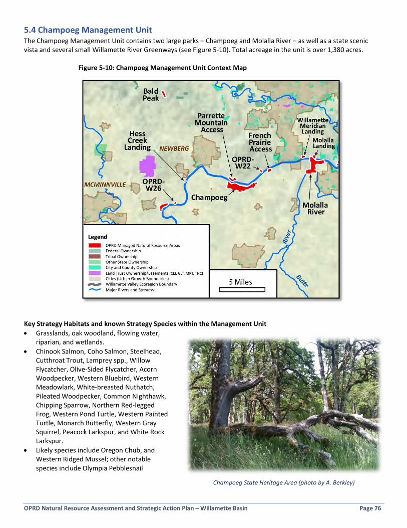
OPRD Natural Resource Assessment and Strategic Action Plan – Willamette Basin Page 76
5.4 Champoeg Management Unit The Champoeg Management Unit contains two large parks – Champoeg and Molalla River – as well as a state scenic vista and several small Willamette River Greenways (see Figure 5-10). Total acreage in the unit is over 1,380 acres.
Figure 5-10: Champoeg Management Unit Context Map
Key Strategy Habitats and known Strategy Species within the Management Unit • Grasslands, oak woodland, flowing water,
riparian, and wetlands. • Chinook Salmon, Coho Salmon, Steelhead,
Cutthroat Trout, Lamprey spp., Willow Flycatcher, Olive-Sided Flycatcher, Acorn Woodpecker, Western Bluebird, Western Meadowlark, White-breasted Nuthatch, Pileated Woodpecker, Common Nighthawk, Chipping Sparrow, Northern Red-legged Frog, Western Pond Turtle, Western Painted Turtle, Monarch Butterfly, Western Gray Squirrel, Peacock Larkspur, and White Rock Larkspur.
• Likely species include Oregon Chub, and Western Ridged Mussel; other notable species include Olympia Pebblesnail
Champoeg State Heritage Area (photo by A. Berkley)

OPRD Natural Resource Assessment and Strategic Action Plan – Willamette Basin Page 77
Management Unit Highlights Champoeg State Heritage Area is the 7th largest OPRD park in the Willamette Basin. The park contains a wide variety of habitats, including prairie, oak woodland, wetlands, creeks (Ryan, Mission, and Champoeg), riparian forest, extensive Willamette River frontage, and a volcanic butte with upland conifer forest. A large amount of the park is in agricultural production. Portions of the park are within the top 10% highest habitat value lands in the Portland Metro Area’s Regional Conservation Strategy. Ongoing ivy control is improving conditions on 100 acres on La Butte at the east end of the park. OPRD’s most successful prairie restoration project to date is taking place on 40 acres in the center of the park. Champoeg enjoys a high level of community support and involvement, interpretive programming, and is located near Newberg. A new park Master Plan may be developed in the next few years, and may include campground expansion; the park also has a partially completed draft Natural Resource Management Plan. Molalla River State Park is the 9th largest OPRD park in the Willamette Basin and is uniquely situated at the confluence of three major rivers: the Willamette, Molalla and Pudding Rivers. The park is within the top 10% highest habitat value lands in the Portland Metro Area’s Regional Conservation Strategy. Most of the park (over 400 acres) is comprised of expansive, frequently flooded forest, wetlands, side channels, and alcoves. The forest was once the home to the largest heron rookery in the basin, but has since degraded significantly in some areas due to expansion of Japanese and other knotweed species. Knotweed control and updating the park invasive species map are underway. Grasslands dominate the upland areas and, along with a series of ponds, are used by nesting turtles. The park includes a long expanse of Willamette River shoreline, including a problematic revetment. A group of partners in interested in restoring side channels and enhancing the floodplain at the park and early scoping is underway. Parrette Mountain Access WRG is located across the Willamette River from Champoeg and is comprised of riparian forest and grassland. The site suffers from a wide variety of invasive and ornamental non-native species along the lengthy Willamette River riparian zone and shoreline. Bald Peak is the highest point in the Chehalem Mountains and is a state scenic vista. Three of the other sites in this unit are Willamette River Greenways 15-30 acres in size: French Prairie Access WRG is a mix of upland grassland and forest with a degrading riparian zone and river access; Willamette Meridian Landing WRG is in good condition and includes a healthy stream corridor; Molalla Landing WRG is located across from Molalla River State Park and has had ground and tree ivy removed in the 2015-2017 biennium. Three other Greenways are less than 5 acres in size: W22 WRG, W26 WRG, and Hess Creek Landing WRG. Partners Current partners include Friends of Historic Champoeg, Institute for Applied Ecology, Confederated Tribes of the Grand Ronde, Molalla River Watch, and others.
Figure 5-11: Function & Value Assessment Score for the Champoeg Management Unit
Habitat Values Floodplain Function Public Use and Enjoyment
Site Name
Acre
s
Ia. S
ize o
f Nat
ural
Res
ourc
e Ar
ea
Ib. P
roxi
mity
to C
onse
rved
Lan
ds
Ic. W
ithin
OCS
CO
A
Id. D
iver
sity
of O
CS H
abita
ts
Ie. S
trat
egy
Habi
tats
Tot
al A
rea
If. N
ativ
e Ve
geta
tion
Ig. H
uman
Cau
se D
istur
banc
e
Ih. P
rese
nce
of In
vasiv
e Sp
ecie
s
Ii. R
are
Plan
t or w
ildlif
e sp
ecie
s
Ij. O
PRD
Prop
erty
Des
igna
tion
Ii. H
abita
t Bon
us
Habi
tat V
alue
IIa. F
lood
plai
n Fu
nctio
n
IIb. P
rese
nce/
Perm
anen
ce o
f Wat
er
IIc. W
ater
Qua
lity
Func
tion
of V
eg
Iid. W
Q a
nd F
lood
plai
n Bo
nus
Wat
er Q
ualit
y/Fl
oodp
lain
Fun
ctio
n Va
lue
IIIa.
Rec
reat
iona
l Acc
ess a
nd F
acili
ties
IIIb.
Exi
stin
g Ed
ucat
iona
l Use
IIIc.
Use
r Exp
erie
nce
IIId.
Pub
lic U
se a
nd E
njoy
men
t Bon
us
Publ
ic U
se a
nd E
njoy
men
t Val
ue
GRA
ND
TOTA
L
Rank
(All
Cate
gorie
s)
Rank
(Hab
itat +
Flo
odpl
ain
Func
tion)
Bald Peak SSV 28.8 4 0 0 1 1 2 1 3 0.0 0 0 12.0 0 0 0 0 0.0 3 0 2 1 6.0 18.0 74 67Champoeg SHA 675.4 8 2 3 4 4 2 1 1 10.0 2 4 41.0 7 4 2 1 14.0 6 3 4 3 16.0 71.0 10 8French Prairie Access WRG 26.8 4 0 3 1 2 1 1 1 3.0 3 0 19.0 3 3 4 1 11.0 3 0 2 1 6.0 36.0 58 49Hess Creek Landing WRG 1.1 0 0 3 0 0 3 1 3 2.0 3 0 15.0 1 0 3 1 5.0 2 0 3 1 6.0 26.0 68 61Molalla Landing WRG 23.0 2 4 2 1 2 3 1 3 2.5 3 1 24.5 1 3 2 2 8.0 2 0 2 1 5.0 37.5 56 46Molalla River SP 569.7 8 3 3 3 6 2 1 1 10.0 2 4 43.0 7 4 6 3 20.0 4 2 5 1 12.0 75.0 5 4OPRD-W22 WRG 4.9 0 0 1 1 4 2 1 3 3.0 3 0 18.0 3 1 4 1 9.0 2 0 2 1 5.0 32.0 61 52OPRD-W26 WRG 2.7 0 0 3 0 1 2 1 3 3.5 3 0 16.5 0 0 6 1 7.0 1 0 2 1 4.0 27.5 66 56Parrette Mountain Access WRG 32.2 4 4 3 2 4 1 1 1 3.5 3 0 26.5 3 2 3 1 9.0 4 0 2 1 7.0 42.5 49 42Willamette Meridian Landing WRG 16.2 2 0 0 1 2 2 3 3 3.0 3 2 21.0 3 3 3 1 10.0 3 0 3 2 8.0 39.0 55 48
Average: 40.5
Ranking

OPRD Natural Resource Assessment and Strategic Action Plan – Willamette Basin Page 78
Figure 5-12: Priorities and Actions for the Champoeg Management Unit
Site Priority within
MU
Priority within Region
Stewardship Focus Restoration Opportunities
Other Opportunities*
Champoeg State Heritage Area
High High • Early detection and rapid response to new invasives
• Reduce ivy dominance, particularly in riparian zone
• Ensure agricultural lease operations are protective of park resources
• Continue removal of ivy at La Butte • Implement other stewardship
actions identified in future Natural Resource Management Plan
• Continue prairie restoration into maintenance stage
• Evaluate wetland restoration opportunities
• Expand oak communities
• Finish Natural Resource Management Plan and begin implementing priority projects
Molalla River State Park
High High • Early detection and rapid response to new invasives
• Complete invasive species mapping • Consider seasonal closures for
turtle nest protection
• Continue knotweed control
• Establish oak community in grassland area
• Work with partners to create Restoration Plan and implement
• Address revetment area
Parrette Mountain Access
WRG
Med/Low Med • Improve overall vegetation community by removing invasive species in a phased approach
• Where possible, combine Parrette and Champoeg efforts
• Monitor on a regular basis, including periodic monitoring of shoreline by boat
• Establish oak community in grassland area
• Explore adopt-a-park/ volunteer effort to improve conditions, complementing efforts at Champoeg
Molalla Landing WRG
Med/Low Low • Monitor on a regular basis, including periodic monitoring of shoreline by boat
• Treat ivy if it begins to re-establish
Willamette Meridian Landing
WRG
Med/Low Low • Monitor on a regular basis, including periodic monitoring of shoreline by boat
• Remove limited ivy and blackberry to preserve good condition of vegetation community
French Prairie Access WRG
Low Low • Monitor on a regular basis, including periodic monitoring of shoreline by boat
• Address tree ivy at a minimum • Thin overstocked Douglas-fir
plantation
• Restore small grassland area now covered with blackberry
W22 WRG Low Low • Monitor on a regular basis, including periodic monitoring of shoreline by boat
• Address tree ivy at a minimum
W26 WRG Low Low • Monitor on a regular basis • Address tree ivy at a minimum
Hess Creek Landing WRG
Low Low • Monitor on a regular basis, including periodic monitoring of shoreline by boat
Bald Peak State Scenic Viewpoint
Low Low • Maintain scenic vista, as feasible • Create and implement
management strategy for grassland areas
• Construct formal view trail to reduce multiple social trails
• Explore adopt-a-park/ volunteer effort to improve conditions
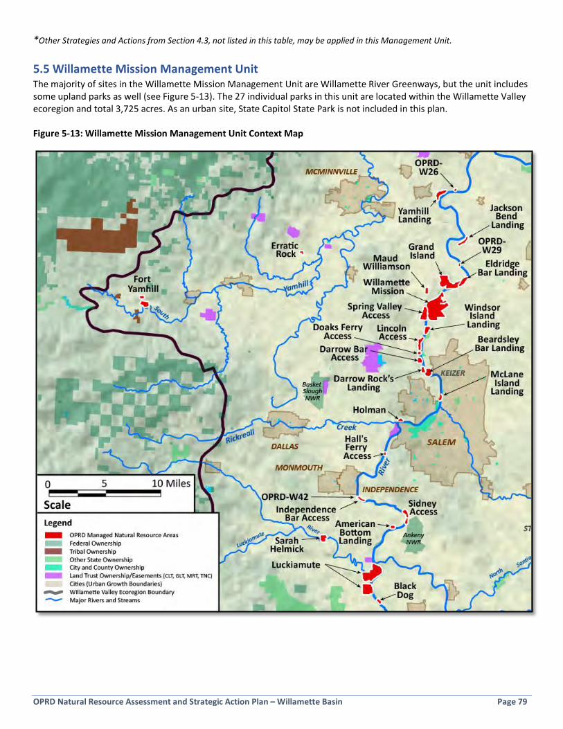
OPRD Natural Resource Assessment and Strategic Action Plan – Willamette Basin Page 79
*Other Strategies and Actions from Section 4.3, not listed in this table, may be applied in this Management Unit.
5.5 Willamette Mission Management Unit The majority of sites in the Willamette Mission Management Unit are Willamette River Greenways, but the unit includes some upland parks as well (see Figure 5-13). The 27 individual parks in this unit are located within the Willamette Valley ecoregion and total 3,725 acres. As an urban site, State Capitol State Park is not included in this plan. Figure 5-13: Willamette Mission Management Unit Context Map
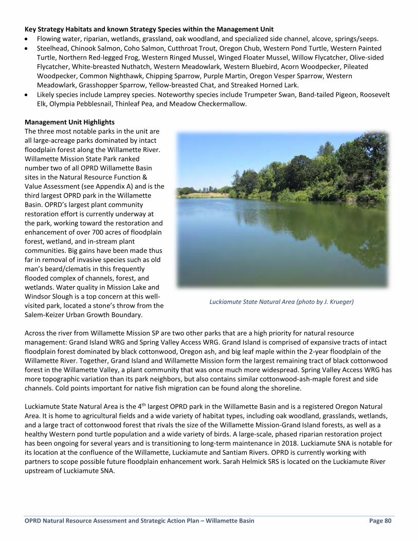
OPRD Natural Resource Assessment and Strategic Action Plan – Willamette Basin Page 80
Key Strategy Habitats and known Strategy Species within the Management Unit • Flowing water, riparian, wetlands, grassland, oak woodland, and specialized side channel, alcove, springs/seeps. • Steelhead, Chinook Salmon, Coho Salmon, Cutthroat Trout, Oregon Chub, Western Pond Turtle, Western Painted
Turtle, Northern Red-legged Frog, Western Ringed Mussel, Winged Floater Mussel, Willow Flycatcher, Olive-sided Flycatcher, White-breasted Nuthatch, Western Meadowlark, Western Bluebird, Acorn Woodpecker, Pileated Woodpecker, Common Nighthawk, Chipping Sparrow, Purple Martin, Oregon Vesper Sparrow, Western Meadowlark, Grasshopper Sparrow, Yellow-breasted Chat, and Streaked Horned Lark.
• Likely species include Lamprey species. Noteworthy species include Trumpeter Swan, Band-tailed Pigeon, Roosevelt Elk, Olympia Pebblesnail, Thinleaf Pea, and Meadow Checkermallow.
Management Unit Highlights The three most notable parks in the unit are all large-acreage parks dominated by intact floodplain forest along the Willamette River. Willamette Mission State Park ranked number two of all OPRD Willamette Basin sites in the Natural Resource Function & Value Assessment (see Appendix A) and is the third largest OPRD park in the Willamette Basin. OPRD’s largest plant community restoration effort is currently underway at the park, working toward the restoration and enhancement of over 700 acres of floodplain forest, wetland, and in-stream plant communities. Big gains have been made thus far in removal of invasive species such as old man’s beard/clematis in this frequently flooded complex of channels, forest, and wetlands. Water quality in Mission Lake and Windsor Slough is a top concern at this well-visited park, located a stone’s throw from the Salem-Keizer Urban Growth Boundary. Across the river from Willamette Mission SP are two other parks that are a high priority for natural resource management: Grand Island WRG and Spring Valley Access WRG. Grand Island is comprised of expansive tracts of intact floodplain forest dominated by black cottonwood, Oregon ash, and big leaf maple within the 2-year floodplain of the Willamette River. Together, Grand Island and Willamette Mission form the largest remaining tract of black cottonwood forest in the Willamette Valley, a plant community that was once much more widespread. Spring Valley Access WRG has more topographic variation than its park neighbors, but also contains similar cottonwood-ash-maple forest and side channels. Cold points important for native fish migration can be found along the shoreline. Luckiamute State Natural Area is the 4th largest OPRD park in the Willamette Basin and is a registered Oregon Natural Area. It is home to agricultural fields and a wide variety of habitat types, including oak woodland, grasslands, wetlands, and a large tract of cottonwood forest that rivals the size of the Willamette Mission-Grand Island forests, as well as a healthy Western pond turtle population and a wide variety of birds. A large-scale, phased riparian restoration project has been ongoing for several years and is transitioning to long-term maintenance in 2018. Luckiamute SNA is notable for its location at the confluence of the Willamette, Luckiamute and Santiam Rivers. OPRD is currently working with partners to scope possible future floodplain enhancement work. Sarah Helmick SRS is located on the Luckiamute River upstream of Luckiamute SNA.
Luckiamute State Natural Area (photo by J. Krueger)
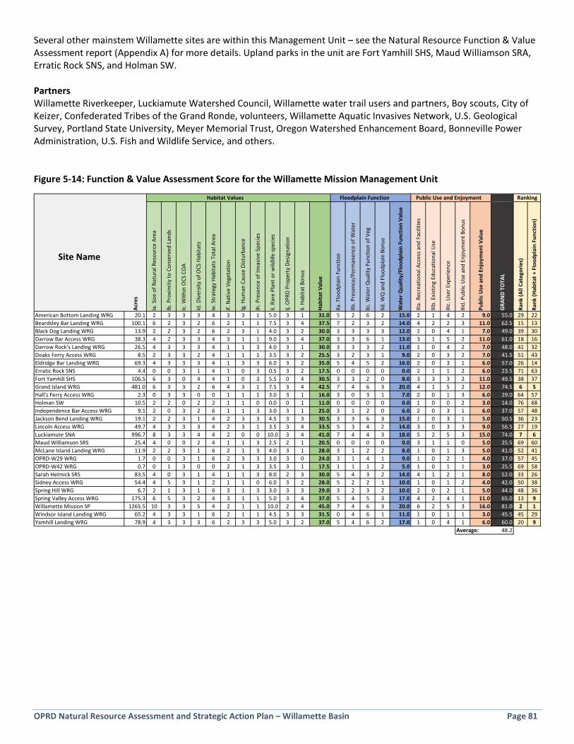
OPRD Natural Resource Assessment and Strategic Action Plan – Willamette Basin Page 81
Several other mainstem Willamette sites are within this Management Unit – see the Natural Resource Function & Value Assessment report (Appendix A) for more details. Upland parks in the unit are Fort Yamhill SHS, Maud Williamson SRA, Erratic Rock SNS, and Holman SW. Partners Willamette Riverkeeper, Luckiamute Watershed Council, Willamette water trail users and partners, Boy scouts, City of Keizer, Confederated Tribes of the Grand Ronde, volunteers, Willamette Aquatic Invasives Network, U.S. Geological Survey, Portland State University, Meyer Memorial Trust, Oregon Watershed Enhancement Board, Bonneville Power Administration, U.S. Fish and Wildlife Service, and others. Figure 5-14: Function & Value Assessment Score for the Willamette Mission Management Unit
Habitat Values Floodplain Function Public Use and Enjoyment
Site Name
Acre
s
Ia. S
ize o
f Nat
ural
Res
ourc
e Ar
ea
Ib. P
roxi
mity
to C
onse
rved
Lan
ds
Ic. W
ithin
OCS
CO
A
Id. D
iver
sity
of O
CS H
abita
ts
Ie. S
trat
egy
Habi
tats
Tot
al A
rea
If. N
ativ
e Ve
geta
tion
Ig. H
uman
Cau
se D
istur
banc
e
Ih. P
rese
nce
of In
vasiv
e Sp
ecie
s
Ii. R
are
Plan
t or w
ildlif
e sp
ecie
s
Ij. O
PRD
Prop
erty
Des
igna
tion
Ii. H
abita
t Bon
us
Habi
tat V
alue
IIa. F
lood
plai
n Fu
nctio
n
IIb. P
rese
nce/
Perm
anen
ce o
f Wat
er
IIc. W
ater
Qua
lity
Func
tion
of V
eg
Iid. W
Q a
nd F
lood
plai
n Bo
nus
Wat
er Q
ualit
y/Fl
oodp
lain
Fun
ctio
n Va
lue
IIIa.
Rec
reat
iona
l Acc
ess a
nd F
acili
ties
IIIb.
Exi
stin
g Ed
ucat
iona
l Use
IIIc.
Use
r Exp
erie
nce
IIId.
Pub
lic U
se a
nd E
njoy
men
t Bon
us
Publ
ic U
se a
nd E
njoy
men
t Val
ue
GRA
ND
TOTA
L
Rank
(All
Cate
gorie
s)
Rank
(Hab
itat +
Flo
odpl
ain
Func
tion)
American Bottom Landing WRG 20.1 2 3 3 3 4 3 3 1 5.0 3 1 31.0 5 2 6 2 15.0 2 1 4 2 9.0 55.0 29 22Beardsley Bar Landing WRG 100.1 6 2 3 2 6 2 1 1 7.5 3 4 37.5 7 2 3 2 14.0 4 2 2 3 11.0 62.5 15 13Black Dog Landing WRG 13.9 2 2 3 2 6 2 3 1 4.0 3 2 30.0 3 3 3 3 12.0 2 0 4 1 7.0 49.0 39 30Darrow Bar Access WRG 38.3 4 2 3 3 4 3 1 1 9.0 3 4 37.0 3 3 6 1 13.0 3 1 5 2 11.0 61.0 18 16Darrow Rock's Landing WRG 26.5 4 3 3 3 4 1 1 3 4.0 3 1 30.0 3 3 3 2 11.0 1 0 4 2 7.0 48.0 41 32Doaks Ferry Access WRG 8.5 2 3 3 2 4 1 1 1 3.5 3 2 25.5 3 2 3 1 9.0 2 0 3 2 7.0 41.5 51 43Eldridge Bar Landing WRG 69.3 4 3 3 3 4 1 3 3 6.0 3 2 35.0 5 4 5 2 16.0 2 0 3 1 6.0 57.0 26 14Erratic Rock SNS 4.4 0 0 3 1 4 1 0 3 0.5 3 2 17.5 0 0 0 0 0.0 2 1 1 2 6.0 23.5 71 63Fort Yamhill SHS 106.5 6 3 0 4 4 1 0 3 5.5 0 4 30.5 3 3 2 0 8.0 3 3 3 2 11.0 49.5 38 37Grand Island WRG 481.0 6 3 3 2 6 4 3 1 7.5 3 4 42.5 7 4 6 3 20.0 4 1 5 2 12.0 74.5 6 5Hall's Ferry Access WRG 2.3 0 3 3 0 0 1 1 1 3.0 3 1 16.0 3 0 3 1 7.0 2 0 1 3 6.0 29.0 64 57Holman SW 10.5 2 2 0 2 2 1 1 0 0.0 0 1 11.0 0 0 0 0 0.0 1 0 0 2 3.0 14.0 76 68Independence Bar Access WRG 9.1 2 0 3 2 6 1 1 3 3.0 3 1 25.0 3 1 2 0 6.0 2 0 3 1 6.0 37.0 57 48Jackson Bend Landing WRG 19.1 2 2 3 1 4 2 3 3 4.5 3 3 30.5 3 3 6 3 15.0 1 0 3 1 5.0 50.5 36 23Lincoln Access WRG 49.7 4 3 3 3 4 2 3 1 3.5 3 4 33.5 5 3 4 2 14.0 3 0 3 3 9.0 56.5 27 19Luckiamute SNA 996.7 8 3 3 4 4 2 0 0 10.0 3 4 41.0 7 4 4 3 18.0 5 2 5 3 15.0 74.0 7 6Maud Williamson SRS 25.4 4 0 0 2 4 1 1 3 2.5 2 1 20.5 0 0 0 0 0.0 3 1 1 0 5.0 25.5 69 60McLane Island Landing WRG 11.9 2 2 3 1 6 2 1 3 4.0 3 1 28.0 3 1 2 2 8.0 1 0 1 3 5.0 41.0 52 41OPRD-W29 WRG 1.7 0 0 3 1 6 2 3 3 3.0 3 0 24.0 3 1 4 1 9.0 1 0 2 1 4.0 37.0 57 45OPRD-W42 WRG 0.7 0 1 3 0 0 2 1 3 3.5 3 1 17.5 1 1 1 2 5.0 1 0 1 1 3.0 25.5 69 58Sarah Helmick SRS 83.5 4 0 3 1 4 1 1 3 8.0 2 3 30.0 5 4 3 2 14.0 4 1 2 1 8.0 52.0 33 26Sidney Access WRG 54.4 4 5 3 1 2 1 1 0 6.0 3 2 28.0 5 2 2 1 10.0 1 0 1 2 4.0 42.0 50 38Spring Hill WRG 6.7 2 1 3 1 6 3 1 3 3.0 3 3 29.0 3 2 3 2 10.0 2 0 2 1 5.0 44.0 48 36Spring Valley Access WRG 175.3 6 5 3 2 4 3 1 1 5.0 3 4 37.0 5 4 5 3 17.0 4 2 4 1 11.0 65.0 13 9Willamette Mission SP 1265.5 10 3 3 5 4 2 1 1 10.0 2 4 45.0 7 4 6 3 20.0 6 2 5 3 16.0 81.0 2 1Windsor Island Landing WRG 65.2 4 3 3 1 6 2 1 1 4.5 3 3 31.5 0 4 6 1 11.0 1 0 1 1 3.0 45.5 45 29Yamhill Landing WRG 78.9 4 3 3 3 6 2 3 3 5.0 3 2 37.0 5 4 6 2 17.0 1 0 4 1 6.0 60.0 20 9
Average: 48.2
Ranking
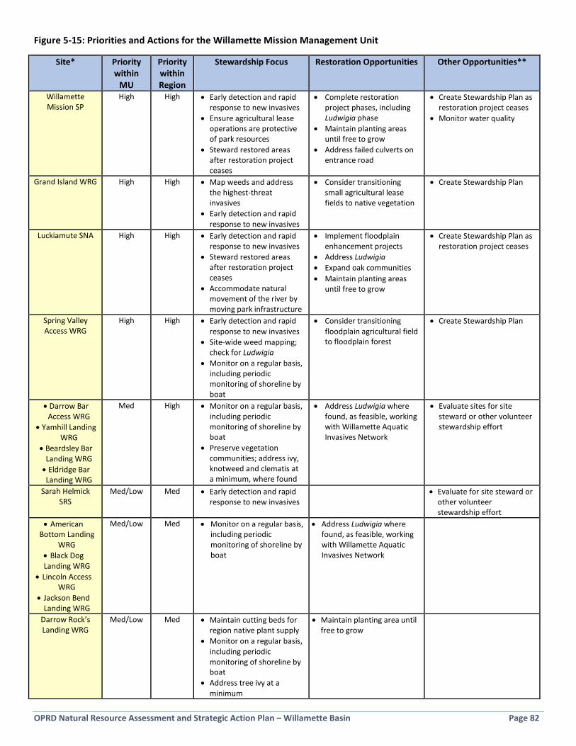
OPRD Natural Resource Assessment and Strategic Action Plan – Willamette Basin Page 82
Figure 5-15: Priorities and Actions for the Willamette Mission Management Unit
Site* Priority within
MU
Priority within Region
Stewardship Focus Restoration Opportunities Other Opportunities**
Willamette Mission SP
High High • Early detection and rapid response to new invasives
• Ensure agricultural lease operations are protective of park resources
• Steward restored areas after restoration project ceases
• Complete restoration project phases, including Ludwigia phase
• Maintain planting areas until free to grow
• Address failed culverts on entrance road
• Create Stewardship Plan as restoration project ceases
• Monitor water quality
Grand Island WRG High High • Map weeds and address the highest-threat invasives
• Early detection and rapid response to new invasives
• Consider transitioning small agricultural lease fields to native vegetation
• Create Stewardship Plan
Luckiamute SNA High High • Early detection and rapid response to new invasives
• Steward restored areas after restoration project ceases
• Accommodate natural movement of the river by moving park infrastructure
• Implement floodplain enhancement projects
• Address Ludwigia • Expand oak communities • Maintain planting areas
until free to grow
• Create Stewardship Plan as restoration project ceases
Spring Valley Access WRG
High High • Early detection and rapid response to new invasives
• Site-wide weed mapping; check for Ludwigia
• Monitor on a regular basis, including periodic monitoring of shoreline by boat
• Consider transitioning floodplain agricultural field to floodplain forest
• Create Stewardship Plan
• Darrow Bar Access WRG
• Yamhill Landing WRG
• Beardsley Bar Landing WRG • Eldridge Bar Landing WRG
Med High • Monitor on a regular basis, including periodic monitoring of shoreline by boat
• Preserve vegetation communities; address ivy, knotweed and clematis at a minimum, where found
• Address Ludwigia where found, as feasible, working with Willamette Aquatic Invasives Network
• Evaluate sites for site steward or other volunteer stewardship effort
Sarah Helmick SRS
Med/Low Med • Early detection and rapid response to new invasives
• Evaluate for site steward or other volunteer stewardship effort
• American Bottom Landing
WRG • Black Dog Landing WRG
• Lincoln Access WRG
• Jackson Bend Landing WRG
Med/Low Med • Monitor on a regular basis, including periodic monitoring of shoreline by boat
• Address Ludwigia where found, as feasible, working with Willamette Aquatic Invasives Network
Darrow Rock’s Landing WRG
Med/Low Med • Maintain cutting beds for region native plant supply
• Monitor on a regular basis, including periodic monitoring of shoreline by boat
• Address tree ivy at a minimum
• Maintain planting area until free to grow
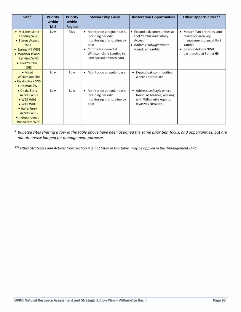
OPRD Natural Resource Assessment and Strategic Action Plan – Willamette Basin Page 83
Site* Priority within
MU
Priority within Region
Stewardship Focus Restoration Opportunities Other Opportunities**
• McLane Island Landing WRG
• Sidney Access WRG
• Spring Hill WRG • Windsor Island
Landing WRG • Fort Yamhill
SHS
Low Med • Monitor on a regular basis, including periodic monitoring of shoreline by boat
• Control knotweed at Windsor Island Landing to limit spread downstream
• Expand oak communities at Fort Yamhill and Sidney Access
• Address Ludwigia where found, as feasible
• Master Plan priorities, and residence area veg management plan, at Fort Yamhill
• Explore Ankeny NWR partnership at Spring Hill
• Maud Williamson SRA
• Erratic Rock SNS • Holman SW
Low Low • Monitor on a regular basis • Expand oak communities where appropriate
• Doaks Ferry Access WRG • W29 WRG • W42 WRG • Hall’s Ferry Access WRG
• Independence Bar Access WRG
Low Low • Monitor on a regular basis, including periodic monitoring of shoreline by boat
• Address Ludwigia where found, as feasible, working with Willamette Aquatic Invasives Network
* Bulleted sites sharing a row in the table above have been assigned the same priorities, focus, and opportunities, but are
not otherwise lumped for management purposes. ** Other Strategies and Actions from Section 4.3, not listed in this table, may be applied in this Management Unit.

OPRD Natural Resource Assessment and Strategic Action Plan – Willamette Basin Page 84
5.6 Silver Falls Management Unit Silver Falls State Park is the sole site within this management unit, located in the West Cascades ecoregion (see Figure 5-16). The largest OPRD site in the Willamette Basin at 9,141 acres, Silver Falls State Park is also the top ranked site in the Natural Resource Function & Value Assessment (see Appendix A).
Figure 5-16: Silver Falls Management Unit Context Map
Key Strategy Habitats and known Strategy Species within the Management Unit • Flowing water, riparian, late-successional mixed conifer forest, grasslands, and wetlands. • Northern Spotted Owl, Townsends Big-eared Bat, Red Tree Vole, American Marten, Cutthroat Trout, Acorn
Woodpecker, Western Bluebird, Common Nighthawk, Northern Goshawk, Peregrine Falcon, Western Meadowlark, White-breasted Nuthatch, Olive-sided Flycatcher, Purple Martin, Great Gray Owl, Willow Flycatcher, Oregon Slender Salamander, Clouded Salamander, Cascade Torrent Salamander, Coastal Tailed Frog, Northern Red Legged Frog, and Steelhead (Silver Creek to north boundary of park).
• Likely species include Cascade Frog and Western Toad.

OPRD Natural Resource Assessment and Strategic Action Plan – Willamette Basin Page 85
Management Unit Highlights The majority, over 8,000 acres, of the park is second-growth conifer forest in good to outstanding condition. Forest health is continually being improved at the park through phased forest management projects. A relatively small variety and small area of invasive species can be found at the park and are the subject of a rigorous Integrated Pest Management program. Emerging threats include false brome and shining geranium. Early detection of new invasives is critical due to the high volume of visitors who come from around the world and may serve as vectors for invasive species. The park boasts large expanses of interior habitat, headwater streams, many seeps and springs, waterfalls with associated boulder/rock habitats, and some old growth trees. The park is an Audubon designated Important Birding Area. Forest openings occur throughout the park, including unique Roemer’s fescue prairie pockets and wetlands; the largest “forest opening” is the large grassland complex at The Ranches. This area is slated undergo clearing along the edges to expand and combat conifer encroachment. Beaver are active in the park and will be the subject of an upcoming Beaver Management Plan to identify ways to reduce conflicts (for example, near the campground) and predict likely beaver activity zones. A wide array of interpretive events, signage and facilities welcome visitors. Partners Current partners include Friends of Silver Falls and others.
Figure 5-17: Function & Value Assessment Score for the Silver Falls Management Unit
Figure 5-18: Priorities and Actions for the Silver Falls Management Unit
Site Priority within
MU
Priority within Region
Stewardship Focus Restoration Opportunities Other Opportunities*
Silver Falls State Park
High High • Early detection and rapid response to new invasives
• Address false brome, shining geranium, and other high-threat, emerging invasives
• Regular monitoring by trail and of park boundaries
• Continued forest health improvement through forest management
• Install boot brushes at key trailheads
• Re-establish edges of The Ranches meadow through conifer removal
• Enhance meadow habitats throughout the park through targeted invasives control and planting/seeding
• Rehabilitate Christmas tree fields
• Create Beaver Management Plan; implement actions
• Implement Master Plan priority actions
• Continually update and implement park Integrated Pest Management Plan
• Explore options for volunteer weed watchers efforts to detect new invasives
*Other Strategies and Actions from Section 4.3, not listed in this table, may be applied in this Management Unit.
Habitat Values Floodplain Function Public Use and Enjoyment
Site Name
Acre
s
Ia. S
ize o
f Nat
ural
Res
ourc
e Ar
ea
Ib. P
roxi
mity
to C
onse
rved
Lan
ds
Ic. W
ithin
OCS
CO
A
Id. D
iver
sity
of O
CS H
abita
ts
Ie. S
trat
egy
Habi
tats
Tot
al A
rea
If. N
ativ
e Ve
geta
tion
Ig. H
uman
Cau
se D
istur
banc
e
Ih. P
rese
nce
of In
vasiv
e Sp
ecie
s
Ii. R
are
Plan
t or w
ildlif
e sp
ecie
s
Ij. O
PRD
Prop
erty
Des
igna
tion
Ii. H
abita
t Bon
us
Habi
tat V
alue
IIa. F
lood
plai
n Fu
nctio
n
IIb. P
rese
nce/
Perm
anen
ce o
f Wat
er
IIc. W
ater
Qua
lity
Func
tion
of V
eg
Iid. W
Q a
nd F
lood
plai
n Bo
nus
Wat
er Q
ualit
y/Fl
oodp
lain
Fun
ctio
n Va
lue
IIIa.
Rec
reat
iona
l Acc
ess a
nd F
acili
ties
IIIb.
Exi
stin
g Ed
ucat
iona
l Use
IIIc.
Use
r Exp
erie
nce
IIId.
Pub
lic U
se a
nd E
njoy
men
t Bon
us
Publ
ic U
se a
nd E
njoy
men
t Val
ue
GRA
ND
TOTA
L
Rank
(All
Cate
gorie
s)
Rank
(Hab
itat +
Flo
odpl
ain
Func
tion)
Silver Falls SP 9141.0 10 4 2 4 2 4 1 3 10.0 2 4 46.0 5 4 6 3 18.0 6 3 6 3 18.0 82.0 1 2Average 82.0
Ranking
Silver Falls State Park (photo by OPRD)

OPRD Natural Resource Assessment and Strategic Action Plan – Willamette Basin Page 86
5.7 Detroit Lake Management Unit The Detroit Lake Management Unit includes recreation areas, day use and a rest area along Highway 22 on Detroit Lake and the North Santiam River, totaling 228 acres (see Figure 5-19 below). Most of these acres are lands owned by the U.S. Forest Service and managed by OPRD and located in the West Cascades ecoregion.
Figure 5-19: Detroit Lake Management Unit Context Map
Key Strategy Habitats and known Strategy Species within the Management Unit • Flowing water, riparian and wetland. • Bull Trout, Cutthroat Trout,
Steelhead, Chinook Salmon, and Pacific Lamprey.
• Likely species include Willow Flycatcher, Oregon Slender Salamander, Western Toad.
Management Unit Highlights Detroit Lake State Recreation Area is dominated by second-growth conifer forest in good condition, with some soil compaction, demand trails, and understory vegetation impacts from the large numbers of visitors who come to the park for camping and boating. The lakeshore of Detroit Lake is Detroit Lake (photo by OPRD)

OPRD Natural Resource Assessment and Strategic Action Plan – Willamette Basin Page 87
influenced by water fluctuations from dam operations and contains low native plant cover. The park includes some small creeks. Previous work has included forest thinning in the campground and some planting. In this plan, Detroit Lake SRA is combined with the nearby Tumble Creek parcel, where the park shop and a section of Tumble Creek is located, and Mongold Day Use. Mongold contains a few tracts of contiguous conifer forest along the shoreline of the reservoir. North Santiam State Recreation Area contains large areas of conifer forest with a diverse native-dominated understory along a significant length of the North Santiam River. The river edge has good riparian tree cover, with some gaps, and an overflow channel feeds interior wetlands during high flows. Crews addressed false brome, ivy, and other weeds from 2013-2017 at the park. Downstream of main North Santiam SRA is a separate parcel containing additional forested river frontage and alcove habitat. The parcels are located near the confluence with the Little North Santiam River. Upstream of North Santiam SRA is Maples Rest Area, a small parcel owned by the Oregon Department of Transportation, with a large expanse of forested riparian shoreline along the North Santiam River. Partners Current partners include the U.S. Forest Service, Oregon Department of Transportation, North Santiam Watershed Council, Marion Soil and Water Conservation District, Marion County, volunteers, and others. Figure 5-20: Function & Value Assessment Score for the Detroit Lake Management Unit
Figure 5-21: Priorities and Actions for the Detroit Lake Management Unit
Site Priority within
MU
Priority within Region
Stewardship Focus Restoration Opportunities
Other Opportunities*
North Santiam State Recreation
Area
High Medium • Maintain and expand gains made by contract crew work on invasive species
• Early detection and rapid response to new invasives
• Find volunteers to help maintain invasive plant control
North Santiam downstream
Medium Medium • Identify IPM needs in riparian forest
Detroit Lake State Recreation Area-Mongold-Tumble Creek
parcel
Med/Low Low • Early detection and rapid response to new invasives in partnership with USFS
• Continued forest health improvement through forest management actions
• Visitor access/trail management and understory enhancements through planting, where needed
• Work with the USFS to implement invasive species management as needed
Maples Rest Area Low Low • Early detection and rapid response to new invasives; determine IPM needs in forested riparian zone
*Other Strategies and Actions from Section 4.3, not listed in this table, may be applied in this Management Unit.
Habitat Values Floodplain Function Public Use and Enjoyment
Site Name
Acre
s
Ia. S
ize o
f Nat
ural
Res
ourc
e Ar
ea
Ib. P
roxi
mity
to C
onse
rved
Lan
ds
Ic. W
ithin
OCS
CO
A
Id. D
iver
sity
of O
CS H
abita
ts
Ie. S
trat
egy
Habi
tats
Tot
al A
rea
If. N
ativ
e Ve
geta
tion
Ig. H
uman
Cau
se D
istur
banc
e
Ih. P
rese
nce
of In
vasiv
e Sp
ecie
s
Ii. R
are
Plan
t or w
ildlif
e sp
ecie
s
Ij. O
PRD
Prop
erty
Des
igna
tion
Ii. H
abita
t Bon
us
Habi
tat V
alue
IIa. F
lood
plai
n Fu
nctio
n
IIb. P
rese
nce/
Perm
anen
ce o
f Wat
er
IIc. W
ater
Qua
lity
Func
tion
of V
eg
Iid. W
Q a
nd F
lood
plai
n Bo
nus
Wat
er Q
ualit
y/Fl
oodp
lain
Fun
ctio
n Va
lue
IIIa.
Rec
reat
iona
l Acc
ess a
nd F
acili
ties
IIIb.
Exi
stin
g Ed
ucat
iona
l Use
IIIc.
Use
r Exp
erie
nce
IIId.
Pub
lic U
se a
nd E
njoy
men
t Bon
us
Publ
ic U
se a
nd E
njoy
men
t Val
ue
GRA
ND
TOTA
L
Rank
(All
Cate
gorie
s)
Rank
(Hab
itat +
Flo
odpl
ain
Func
tion)
Detroit Lake SRA-Mongold-Tumble Creek 96.0 4 5 0 1 2 2 1 3 3.0 2 2 25.0 0 1 2 1 4.0 5 2 3 1 11.0 40.0 53 51Maples Rest Area 11.5 2 2 0 1 2 1 1 1 2.0 0 0 12.0 0 0 5 0 5.0 1 0 1 0 2.0 19.0 73 64North Santiam (downstream parcels) 32.5 4 2 3 1 6 2 1 3 4.0 2 1 29.0 5 2 6 3 16.0 1 0 4 1 6.0 51.0 35 24North Santiam SRA 88.1 4 0 3 2 4 4 3 1 3.5 2 2 28.5 5 2 4 1 12.0 5 2 5 1 13.0 53.5 31 33
Average: 40.9
Ranking
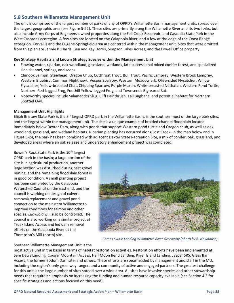
OPRD Natural Resource Assessment and Strategic Action Plan – Willamette Basin Page 88
5.8 Southern Willamette Management Unit The unit is comprised of the largest number of parks of any of OPRD’s Willamette Basin management units, spread over the largest geographic area (see Figure 5-22). These sites are primarily along the Willamette River and its two forks, but also include Army Corps of Engineers-owned properties along the Fall Creek Reservoir, and Cascadia State Park in the West Cascades ecoregion. A few sites are located on the Calapooia River, and a few at the edge of the Coast Range ecoregion. Corvallis and the Eugene-Springfield area are centered within the management unit. Sites that were omitted from this plan are Jennie B. Harris, Ben and Kay Dorris, Simpson Lakes Access, and the Lowell Office property. Key Strategy Habitats and known Strategy Species within the Management Unit • Flowing water, riparian, oak woodland, grassland, wetlands, late successional mixed conifer forest, and specialized
side channel, springs, and seeps. • Chinook Salmon, Steelhead, Oregon Chub, Cutthroat Trout, Bull Trout, Pacific Lamprey, Western Brook Lamprey,
Western Bluebird, Common Nighthawk, Vesper Sparrow, Western Meadowlark, Olive-sided Flycatcher, Willow Flycatcher, Yellow-breasted Chat, Chipping Sparrow, Purple Martin, White-breasted Nuthatch, Western Pond Turtle, Northern Red-legged Frog, Foothill Yellow-legged Frog, and Townsends Big-eared Bat.
• Noteworthy species include Salamander Slug, Cliff Paintbrush, Tall Bugbane, and potential habitat for Northern Spotted Owl.
Management Unit Highlights Elijah Bristow State Park is the 5th largest OPRD park in the Willamette Basin, is the southernmost of the large park sites, and the largest within the management unit. The site is a unique example of braided channel floodplain located immediately below Dexter Dam, along with ponds that support Western pond turtle and Oregon chub, as well as oak woodland, grassland, and wetland habitats. Riparian planting has occurred along Lost Creek. In the map below and in Figure 5-24, the park has been combined with adjacent Dexter State Recreation Site, a mix of conifer, oak, grassland, and developed areas where an oak release and understory enhancement project was completed. Bower’s Rock State Park is the 10th largest OPRD park in the basin; a large portion of the site is in agricultural production, another large section was disturbed during past gravel mining, and the remaining floodplain forest is in good condition. A small planting project has been completed by the Calapooia Watershed Council on the east end, and the council is working on design of culvert removal/replacement and gravel pond connection to the mainstem Willamette to improve conditions for salmon and other species. Ludwigia will also be controlled. The council is also working on a similar project at Truax Island Access and led dam removal efforts on the Calapooia River at the Thompson’s Mill (north) site. Southern Willamette Management Unit is the most active unit in the basin in terms of habitat restoration activities. Restoration efforts have been implemented at Sam Daws Landing, Cougar Mountain Access, Half Moon Bend Landing, Kiger Island Landing, Jasper SRS, Glass Bar Access, the former Sodom Dam site, and others. These efforts are spearheaded by management and staff in the MU, including the region’s only greenway ranger, and a community of active and engaged partners. The greatest challenge for this unit is the large number of sites spread over a wide area. All sites have invasive species and other stewardship needs that require an emphasis on increasing the funding and human resource capacity available (see Section 4.3 for specific strategies and actions focused on this need).
Camas Swale Landing Willamette River Greenway (photo by B. Newhouse)

OPRD Natural Resource Assessment and Strategic Action Plan – Willamette Basin Page 89
Partners Current partners include Friends of Buford Park & Mt. Pisgah, McKenzie River Trust, The Nature Conservancy, Greenbelt Land Trust, the Long Tom Watershed Council, Calapooia Watershed Council, Oregon Watershed Enhancement Board, Meyer Memorial Trust, Bonneville Power Administration, Coast Fork Willamette Watershed Council, Middle Fork Willamette Watershed Council, Benton Soil and Water Conservation District, Willamette Riverkeeper, ODFW, U.S. Army Corps of Engineers, Pleasant Hill School District, Lowell School District, and others.
Figure 5-22: Southern Willamette Management Unit Context Map
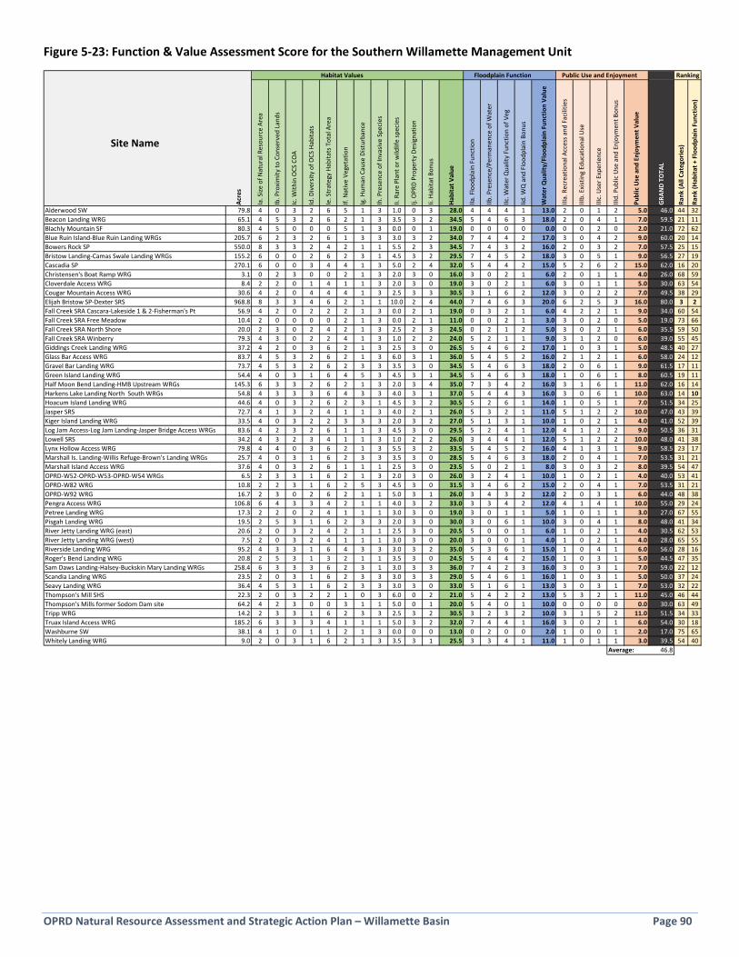
OPRD Natural Resource Assessment and Strategic Action Plan – Willamette Basin Page 90
Figure 5-23: Function & Value Assessment Score for the Southern Willamette Management Unit
Habitat Values Floodplain Function Public Use and Enjoyment
Site Name
Acre
s
Ia. S
ize o
f Nat
ural
Res
ourc
e Ar
ea
Ib. P
roxi
mity
to C
onse
rved
Lan
ds
Ic. W
ithin
OCS
CO
A
Id. D
iver
sity
of O
CS H
abita
ts
Ie. S
trat
egy
Habi
tats
Tot
al A
rea
If. N
ativ
e Ve
geta
tion
Ig. H
uman
Cau
se D
istur
banc
e
Ih. P
rese
nce
of In
vasiv
e Sp
ecie
s
Ii. R
are
Plan
t or w
ildlif
e sp
ecie
s
Ij. O
PRD
Prop
erty
Des
igna
tion
Ii. H
abita
t Bon
us
Habi
tat V
alue
IIa. F
lood
plai
n Fu
nctio
n
IIb. P
rese
nce/
Perm
anen
ce o
f Wat
er
IIc. W
ater
Qua
lity
Func
tion
of V
eg
Iid. W
Q a
nd F
lood
plai
n Bo
nus
Wat
er Q
ualit
y/Fl
oodp
lain
Fun
ctio
n Va
lue
IIIa.
Rec
reat
iona
l Acc
ess a
nd F
acili
ties
IIIb.
Exi
stin
g Ed
ucat
iona
l Use
IIIc.
Use
r Exp
erie
nce
IIId.
Pub
lic U
se a
nd E
njoy
men
t Bon
us
Publ
ic U
se a
nd E
njoy
men
t Val
ue
GRA
ND
TOTA
L
Rank
(All
Cate
gorie
s)
Rank
(Hab
itat +
Flo
odpl
ain
Func
tion)
Alderwood SW 79.8 4 0 3 2 6 5 1 3 1.0 0 3 28.0 4 4 4 1 13.0 2 0 1 2 5.0 46.0 44 32Beacon Landing WRG 65.1 4 5 3 2 6 2 1 3 3.5 3 2 34.5 5 4 6 3 18.0 2 0 4 1 7.0 59.5 21 11Blachly Mountain SF 80.3 4 5 0 0 0 5 1 3 0.0 0 1 19.0 0 0 0 0 0.0 0 0 2 0 2.0 21.0 72 62Blue Ruin Island-Blue Ruin Landing WRGs 205.7 6 2 3 2 6 1 3 3 3.0 3 2 34.0 7 4 4 2 17.0 3 0 4 2 9.0 60.0 20 14Bowers Rock SP 550.0 8 3 3 2 4 2 1 1 5.5 2 3 34.5 7 4 3 2 16.0 2 0 3 2 7.0 57.5 25 15Bristow Landing-Camas Swale Landing WRGs 155.2 6 0 0 2 6 2 3 1 4.5 3 2 29.5 7 4 5 2 18.0 3 0 5 1 9.0 56.5 27 19Cascadia SP 270.1 6 0 0 3 4 4 1 3 5.0 2 4 32.0 5 4 4 2 15.0 5 2 6 2 15.0 62.0 16 20Christensen's Boat Ramp WRG 3.1 0 2 3 0 0 2 1 3 2.0 3 0 16.0 3 0 2 1 6.0 2 0 1 1 4.0 26.0 68 59Cloverdale Access WRG 8.4 2 2 0 1 4 1 1 3 2.0 3 0 19.0 3 0 2 1 6.0 3 0 1 1 5.0 30.0 63 54Cougar Mountain Access WRG 30.6 4 2 0 4 4 4 1 3 2.5 3 3 30.5 3 1 6 2 12.0 3 0 2 2 7.0 49.5 38 29Elijah Bristow SP-Dexter SRS 968.8 8 3 3 4 6 2 1 1 10.0 2 4 44.0 7 4 6 3 20.0 6 2 5 3 16.0 80.0 3 2Fall Creek SRA Cascara-Lakeside 1 & 2-Fisherman's Pt 56.9 4 2 0 2 2 2 1 3 0.0 2 1 19.0 0 3 2 1 6.0 4 2 2 1 9.0 34.0 60 54Fall Creek SRA Free Meadow 10.4 2 0 0 0 0 2 1 3 0.0 2 1 11.0 0 0 2 1 3.0 3 0 2 0 5.0 19.0 73 66Fall Creek SRA North Shore 20.0 2 3 0 2 4 2 1 3 2.5 2 3 24.5 0 2 1 2 5.0 3 0 2 1 6.0 35.5 59 50Fall Creek SRA Winberry 79.3 4 3 0 2 2 4 1 3 1.0 2 2 24.0 5 2 1 1 9.0 3 1 2 0 6.0 39.0 55 45Giddings Creek Landing WRG 37.2 4 2 0 3 6 2 1 3 2.5 3 0 26.5 5 4 6 2 17.0 1 0 3 1 5.0 48.5 40 27Glass Bar Access WRG 83.7 4 5 3 2 6 2 1 3 6.0 3 1 36.0 5 4 5 2 16.0 2 1 2 1 6.0 58.0 24 12Gravel Bar Landing WRG 73.7 4 5 3 2 6 2 3 3 3.5 3 0 34.5 5 4 6 3 18.0 2 0 6 1 9.0 61.5 17 11Green Island Landing WRG 54.4 4 0 3 1 6 4 5 3 4.5 3 1 34.5 5 4 6 3 18.0 1 0 6 1 8.0 60.5 19 11Half Moon Bend Landing-HMB Upstream WRGs 145.3 6 3 3 2 6 2 1 3 2.0 3 4 35.0 7 3 4 2 16.0 3 1 6 1 11.0 62.0 16 14Harkens Lake Landing North South WRGs 54.8 4 3 3 3 6 4 3 3 4.0 3 1 37.0 5 4 4 3 16.0 3 0 6 1 10.0 63.0 14 10Hoacum Island Landing WRG 44.6 4 0 3 2 6 2 3 1 4.5 3 2 30.5 5 2 6 1 14.0 1 0 5 1 7.0 51.5 34 25Jasper SRS 72.7 4 1 3 2 4 1 1 3 4.0 2 1 26.0 5 3 2 1 11.0 5 1 2 2 10.0 47.0 43 39Kiger Island Landing WRG 33.5 4 0 3 2 2 3 3 3 2.0 3 2 27.0 5 1 3 1 10.0 1 0 2 1 4.0 41.0 52 39Log Jam Access-Log Jam Landing-Jasper Bridge Access WRGs 83.6 4 2 3 2 6 1 1 3 4.5 3 0 29.5 5 2 4 1 12.0 4 1 2 2 9.0 50.5 36 31Lowell SRS 34.2 4 3 2 3 4 1 1 3 1.0 2 2 26.0 3 4 4 1 12.0 5 1 2 2 10.0 48.0 41 38Lynx Hollow Access WRG 79.8 4 4 0 3 6 2 1 3 5.5 3 2 33.5 5 4 5 2 16.0 4 1 3 1 9.0 58.5 23 17Marshall Is. Landing-Willis Refuge-Brown's Landing WRGs 25.7 4 0 3 1 6 2 3 3 3.5 3 0 28.5 5 4 6 3 18.0 2 0 4 1 7.0 53.5 31 21Marshall Island Access WRG 37.6 4 0 3 2 6 1 1 1 2.5 3 0 23.5 5 0 2 1 8.0 3 0 3 2 8.0 39.5 54 47OPRD-W52-OPRD-W53-OPRD-W54 WRGs 6.5 2 3 3 1 6 2 1 3 2.0 3 0 26.0 3 2 4 1 10.0 1 0 2 1 4.0 40.0 53 41OPRD-W82 WRG 10.8 2 2 3 1 6 2 5 3 4.5 3 0 31.5 3 4 6 2 15.0 2 0 4 1 7.0 53.5 31 21OPRD-W92 WRG 16.7 2 3 0 2 6 2 1 1 5.0 3 1 26.0 3 4 3 2 12.0 2 0 3 1 6.0 44.0 48 38Pengra Access WRG 106.8 6 4 3 3 4 2 1 1 4.0 3 2 33.0 3 3 4 2 12.0 4 1 4 1 10.0 55.0 29 24Petree Landing WRG 17.3 2 2 0 2 4 1 1 1 3.0 3 0 19.0 3 0 1 1 5.0 1 0 1 1 3.0 27.0 67 55Pisgah Landing WRG 19.5 2 5 3 1 6 2 3 3 2.0 3 0 30.0 3 0 6 1 10.0 3 0 4 1 8.0 48.0 41 34River Jetty Landing WRG (east) 20.6 2 0 3 2 4 2 1 1 2.5 3 0 20.5 5 0 0 1 6.0 1 0 2 1 4.0 30.5 62 53River Jetty Landing WRG (west) 7.5 2 0 3 2 4 1 1 1 3.0 3 0 20.0 3 0 0 1 4.0 1 0 2 1 4.0 28.0 65 55Riverside Landing WRG 95.2 4 3 3 1 6 4 3 3 3.0 3 2 35.0 5 3 6 1 15.0 1 0 4 1 6.0 56.0 28 16Roger's Bend Landing WRG 20.8 2 5 3 1 3 2 1 1 3.5 3 0 24.5 5 4 4 2 15.0 1 0 3 1 5.0 44.5 47 35Sam Daws Landing-Halsey-Buckskin Mary Landing WRGs 258.4 6 3 3 3 6 2 3 1 3.0 3 3 36.0 7 4 2 3 16.0 3 0 3 1 7.0 59.0 22 12Scandia Landing WRG 23.5 2 0 3 1 6 2 3 3 3.0 3 3 29.0 5 4 6 1 16.0 1 0 3 1 5.0 50.0 37 24Seavy Landing WRG 36.4 4 5 3 1 6 2 3 3 3.0 3 0 33.0 5 1 6 1 13.0 3 0 3 1 7.0 53.0 32 22Thompson's Mill SHS 22.3 2 0 3 2 2 1 0 3 6.0 0 2 21.0 5 4 2 2 13.0 5 3 2 1 11.0 45.0 46 44Thompson's Mills former Sodom Dam site 64.2 4 2 3 0 0 3 1 1 5.0 0 1 20.0 5 4 0 1 10.0 0 0 0 0 0.0 30.0 63 49Tripp WRG 14.2 2 3 3 1 6 2 3 3 2.5 3 2 30.5 3 2 3 2 10.0 3 1 5 2 11.0 51.5 34 33Truax Island Access WRG 185.2 6 3 3 3 4 1 1 1 5.0 3 2 32.0 7 4 4 1 16.0 3 0 2 1 6.0 54.0 30 18Washburne SW 38.1 4 1 0 1 1 2 1 3 0.0 0 0 13.0 0 2 0 0 2.0 1 0 0 1 2.0 17.0 75 65Whitely Landing WRG 9.0 2 0 3 1 6 2 1 3 3.5 3 1 25.5 3 3 4 1 11.0 1 0 1 1 3.0 39.5 54 40
Average: 46.8
Ranking
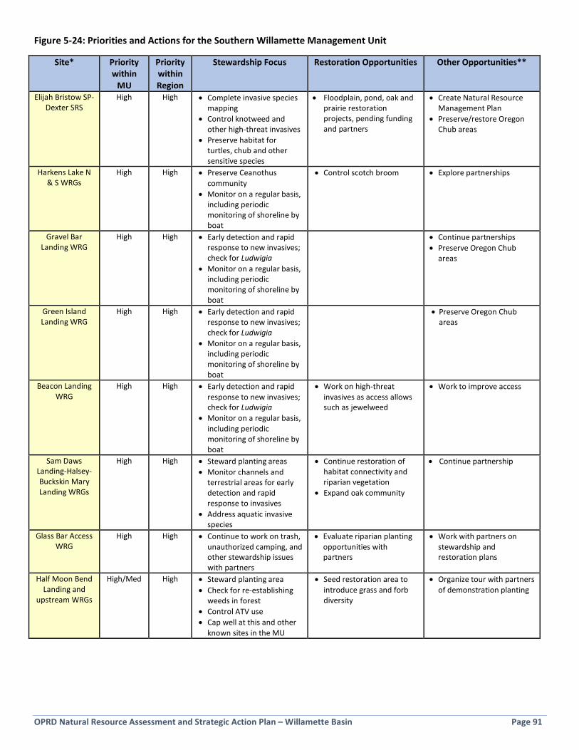
OPRD Natural Resource Assessment and Strategic Action Plan – Willamette Basin Page 91
Figure 5-24: Priorities and Actions for the Southern Willamette Management Unit
Site* Priority within
MU
Priority within Region
Stewardship Focus Restoration Opportunities Other Opportunities**
Elijah Bristow SP-Dexter SRS
High High • Complete invasive species mapping
• Control knotweed and other high-threat invasives
• Preserve habitat for turtles, chub and other sensitive species
• Floodplain, pond, oak and prairie restoration projects, pending funding and partners
• Create Natural Resource Management Plan
• Preserve/restore Oregon Chub areas
Harkens Lake N & S WRGs
High High • Preserve Ceanothus community
• Monitor on a regular basis, including periodic monitoring of shoreline by boat
• Control scotch broom • Explore partnerships
Gravel Bar Landing WRG
High High • Early detection and rapid response to new invasives; check for Ludwigia
• Monitor on a regular basis, including periodic monitoring of shoreline by boat
• Continue partnerships • Preserve Oregon Chub
areas
Green Island Landing WRG
High High • Early detection and rapid response to new invasives; check for Ludwigia
• Monitor on a regular basis, including periodic monitoring of shoreline by boat
• Preserve Oregon Chub areas
Beacon Landing WRG
High High • Early detection and rapid response to new invasives; check for Ludwigia
• Monitor on a regular basis, including periodic monitoring of shoreline by boat
• Work on high-threat invasives as access allows such as jewelweed
• Work to improve access
Sam Daws Landing-Halsey-Buckskin Mary Landing WRGs
High High • Steward planting areas • Monitor channels and
terrestrial areas for early detection and rapid response to invasives
• Address aquatic invasive species
• Continue restoration of habitat connectivity and riparian vegetation
• Expand oak community
• Continue partnership
Glass Bar Access WRG
High High • Continue to work on trash, unauthorized camping, and other stewardship issues with partners
• Evaluate riparian planting opportunities with partners
• Work with partners on stewardship and restoration plans
Half Moon Bend Landing and
upstream WRGs
High/Med High • Steward planting area • Check for re-establishing
weeds in forest • Control ATV use • Cap well at this and other
known sites in the MU
• Seed restoration area to introduce grass and forb diversity
• Organize tour with partners of demonstration planting
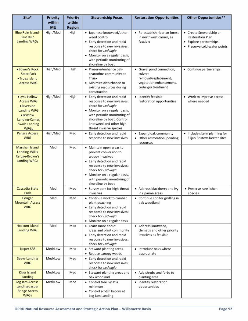
OPRD Natural Resource Assessment and Strategic Action Plan – Willamette Basin Page 92
Site* Priority within
MU
Priority within Region
Stewardship Focus Restoration Opportunities Other Opportunities**
Blue Ruin Island-Blue Ruin
Landing WRGs
High/Med High • Japanese knotweed/other weed control
• Early detection and rapid response to new invasives; check for Ludwigia
• Monitor on a regular basis, with periodic monitoring of shoreline by boat
• Re-establish riparian forest in northwest corner, as feasible
• Create Stewardship or Restoration Plan
• Explore partnerships • Preserve cold-water points
• Bower’s Rock State Park
• Truax Island Access WRG
High/Med High • Preserve/enhance oak-ceanothus community at Truax
• Minimize disturbance to existing resources during construction
• Gravel pond connection, culvert removal/replacement, vegetation enhancement, Ludwigia treatment
• Continue partnerships
• Lynx Hollow Access WRG • Riverside
Landing WRG • Bristow
Landing-Camas Swale Landing
WRGs
High/Med High • Early detection and rapid response to new invasives; check for Ludwigia
• Monitor on a regular basis, with periodic monitoring of shoreline by boat. Control knotweed and other high-threat invasive species
• Identify feasible restoration opportunities
• Work to improve access where needed
Pengra Access WRG
High/Med Med • Early detection and rapid response to new invasives
• Expand oak community • Other restoration, pending
resources
• Include site in planning for Elijah Bristow-Dexter sites
Marshall Island Landing-Willis
Refuge-Brown’s Landing WRGs
Med Med • Maintain open areas to prevent conversion to woody invasives
• Early detection and rapid response to new invasives; check for Ludwigia
• Monitor on a regular basis, with periodic monitoring of shoreline by boat
Cascadia State Park
Med Med • Survey park for high-threat invasives
• Address blackberry and ivy in riparian areas
• Preserve rare lichen species
Cougar Mountain Access
WRG
Med Med • Continue work to combat plant poaching
• Early detection and rapid response to new invasives; check for Ludwigia
• Monitor on a regular basis
• Continue conifer girdling in oak woodland
Hoacum Island Landing WRG
Med Med • Learn more about grassland plant community
• Early detection and rapid response to new invasives; check for Ludwigia
• Address knotweed, clematis and other priority invasives as feasible
Jasper SRS Med/Low Med • Steward planting areas • Reduce canopy weeds
• Introduce oaks where appropriate
Seavy Landing WRG
Med/Low Med • Early detection and rapid response to new invasives; check for Ludwigia
Kiger Island Landing
Med/Low Med • Steward planting areas and oak woodland
• Add shrubs and forbs to planting area
Log Jam Access-Landing-Jasper Bridge Access
WRGs
Med/Low Med • Control tree ivy at a minimum
• Control scotch broom at Log Jam Landing
• Identify restoration opportunities
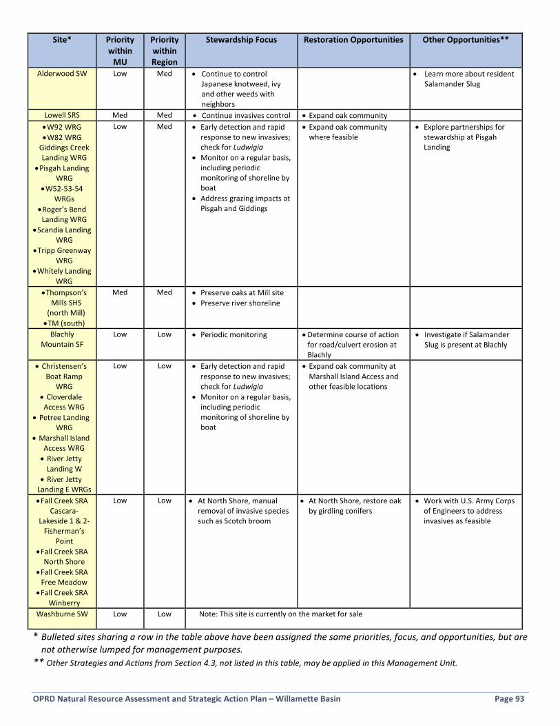
OPRD Natural Resource Assessment and Strategic Action Plan – Willamette Basin Page 93
Site* Priority within
MU
Priority within Region
Stewardship Focus Restoration Opportunities Other Opportunities**
Alderwood SW Low Med • Continue to control Japanese knotweed, ivy and other weeds with neighbors
• Learn more about resident Salamander Slug
Lowell SRS Med Med • Continue invasives control • Expand oak community • W92 WRG • W82 WRG
Giddings Creek Landing WRG
• Pisgah Landing WRG
• W52-53-54 WRGs
• Roger’s Bend Landing WRG
• Scandia Landing WRG
• Tripp Greenway WRG
• Whitely Landing WRG
Low Med • Early detection and rapid response to new invasives; check for Ludwigia
• Monitor on a regular basis, including periodic monitoring of shoreline by boat
• Address grazing impacts at Pisgah and Giddings
• Expand oak community where feasible
• Explore partnerships for stewardship at Pisgah Landing
• Thompson’s Mills SHS
(north Mill) • TM (south)
Med Med • Preserve oaks at Mill site • Preserve river shoreline
Blachly Mountain SF
Low Low • Periodic monitoring • Determine course of action for road/culvert erosion at Blachly
• Investigate if Salamander Slug is present at Blachly
• Christensen’s Boat Ramp
WRG • Cloverdale Access WRG
• Petree Landing WRG
• Marshall Island Access WRG • River Jetty
Landing W • River Jetty
Landing E WRGs
Low Low • Early detection and rapid response to new invasives; check for Ludwigia
• Monitor on a regular basis, including periodic monitoring of shoreline by boat
• Expand oak community at Marshall Island Access and other feasible locations
• Fall Creek SRA Cascara-
Lakeside 1 & 2-Fisherman’s
Point • Fall Creek SRA
North Shore • Fall Creek SRA
Free Meadow • Fall Creek SRA
Winberry
Low Low • At North Shore, manual removal of invasive species such as Scotch broom
• At North Shore, restore oak by girdling conifers
• Work with U.S. Army Corps of Engineers to address invasives as feasible
Washburne SW
Low Low Note: This site is currently on the market for sale
* Bulleted sites sharing a row in the table above have been assigned the same priorities, focus, and opportunities, but are not otherwise lumped for management purposes.
** Other Strategies and Actions from Section 4.3, not listed in this table, may be applied in this Management Unit.

OPRD Natural Resource Assessment and Strategic Action Plan – Willamette Basin Page 94
Page intentionally blank
OPRD Natural Resource Assessment and Strategic Action Plan – Willamette Basin Page 95
Appendix A: Natural Resource Function & Value Assessment Report
Appendix A is available at oregonstateparks.org (search Natural Resource Function & Value) or by contacting the OPRD Stewardship Section
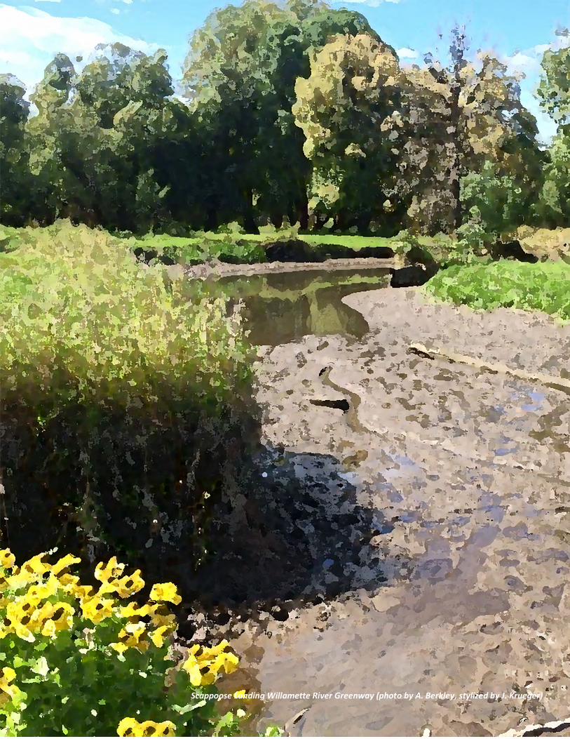
OPRD Natural Resource Assessment and Strategic Action Plan – Willamette Basin Page 96
Scappoose Landing Willamette River Greenway (photo by A. Berkley, stylized by J. Krueger)
Copyright © 2022 FDOKUMEN