NATIONAL REGISTER BULLETIN - Texas Historical ...
68
NATIONAL REGISTER BULLETIN Technical information on the the National Register of Historic Places: survey, evaluation, registration, and preservation of cultural resources U.S. Department of the Interior National Park Service Cultural Resources National Register, History and Education DEFINING BOUNDARIES FOR NATIONAL REGISTER PROPERTIES
-
Upload
khangminh22 -
Category
Documents
-
view
3 -
download
0
Transcript of NATIONAL REGISTER BULLETIN - Texas Historical ...

NATIONAL REGISTERBULLETIN
Technical information on the the National Register of Historic Places:survey, evaluation, registration, and preservation of cultural resources
U.S. Department of the InteriorNational Park ServiceCultural ResourcesNational Register, History and Education
DEFINING BOUNDARIES FORNATIONAL REGISTER PROPERTIES

The mission of the Department of the Interior is to protect and provideaccess to our Nation's natural and cultural heritage and honor our trustresponsibilities to tribes.
This material is partially based upon work conducted under a cooperativeagreement with the National Conference of State Historic Preservation Officersand the U.S. Department of the Interior.
Cover:
(Top Left) Detail of USGS map showing the National Register boundaries of theColumbia Historic District in Cedarburg, Wisconsin.
(Top Right) View of Architect Marcel Breuer's International Style home in Lincoln,Massachusetts. (Ruth Williams)
(Bottom Left) View of the Roxborough State Park Archeological District near Waterton,Colorado. (William Tate)
(Bottom Right) Detail of a 1987 land survey map defining the property boundaries ofGunston Hall in Buncombe County, North Carolina. (Blue Ridge Land Surveying, Inc.)
NATIONAL REGISTBULLETIN
DEFINING BOUNDARIES FORNATIONAL REGISTER PROPERTIES
BYDONNA J. SEIFERT
includingBarbara J. Little, Beth L. Savage, and John H. Sprinkle, Jr.
U.S. DEPARTMENT OF THE INTERIORNATIONAL PARK SERVICE
NATIONAL REGISTER OF HISTORIC PLACES1995, REVISED 1997

TABLE OF CONTENTS
PREFACE ii
CREDITS AND ACKNOWLEDGMENTS iii
I. DEFINING BOUNDARIES FOR NATIONAL REGISTER PROPERTIES 1
Why Boundaries are Important 1Getting Help 1Deciding What to Include 2Factors to Consider 2Selecting Boundaries 3Revising Boundaries 4
II. DOCUMENTING BOUNDARIES 5
Completing Section 10, Geographical Data 5The Verbal Boundary Description and Boundary Justification 5Universal Transverse Mercator (UTM) References 6Global Positioning System (GPS) 6
III. CASE STUDIES 7
Boundaries for Buildings 7Buildings in Urban Settings 7Buildings in Rural Settings 10
Boundaries for Historic Districts 12Contiguous Districts in Urban Settings 13Discontiguous Districts in Urban Settings 16Contiguous Districts in Rural Settings 17Discontiguous Districts in Rural Settings 23Parks as Districts 23
Boundaries for Particular Property Types 27Traditional Cultural Properties 27Mining Properties 27
Boundaries for Archeological Sites and Districts 30Archeological Sites 31Contiguous Archeological Districts 33Discontiguous Archeological Districts 34Shipwreck Sites 35
Boundaries for Historic Sites 36
Boundaries for Objects 40
Boundaries for Structures 41
IV. REFERENCES 45
V. NATIONAL REGISTER CRITERIA FOR EVALUATION 46
VI. NATIONAL REGISTER BULLETINS 47
APPENDIX: Definition of National Register Boundaries for Archeological Properties(formerly National Register Bulletin 12: Definition of National Register Boundaries for Archeological Properties) 48

PREFACE
The National Register of HistoricPlaces is the official Federal list ofdistricts, sites, buildings, structures,and objects significant in Americanhistory, architecture, archeology,engineering, and culture. NationalRegister properties have significancein the prehistory or history of theircommunity, State, or the nation. TheNational Register is maintained by theNational Park Service on behalf of theSecretary of the Interior.
National Register Bulletins provideguidance on how to identify, evaluate,
document, and register significantproperties. This bulletin is designedto help preparers properly select,define, and document boundaries forNational Register listings and deter-minations of eligibility. It includesbasic guidelines for selecting bound-aries to assist the preparer in complet-ing the National Register RegistrationForm. Examples of a variety ofproperty types are presented. Theseexamples illustrate several ways toaddress boundary issues.
This bulletin was prepared byDonna J. Seifert, archeologist, under acooperative agreement between theNational Conference of State HistoricPreservation Officers and the Na-tional Park Service.
Carol D. ShullKeeper,National Register of Historic PlacesNational Park ServiceU. S. Department of the Interior

CREDITS ANDACKNOWLEDGMENTS
This bulletin addresses issuesoriginally presented in NationalRegister Bulletin: Definition of Bound-aries for Historic Units of the NationalPark System and National RegisterBulletin: How to Establish Boundariesfor National Register Properties. Bothwere prepared before National RegisterBulletin: How to Complete the NationalRegister Registration Form was revised.This revised bulletin complements theguidelines on boundaries in How toComplete the National Register Registra-tion Form and provides a variety ofcase studies to assist nominationpreparers.
This bulletin benefited from thesuggestions offered by the staffmembers of the National Register ofHistoric Places, who shared theiropinions and expertise. Criticalguidance was provided by Carol D.Shull, Antoinette J. Lee, and JanTownsend; Beth Savage provided animportant case study, which wasincluded in the bulletin. John Byrneof the National Register staff, pre-pared lists of properties to consider inthe selection of the case studies, andTanya M. Velt of the National Confer-ence of State Historic PreservationOfficers provided research assistance.
Comments and contributions fromthe following individuals wereparticularly valuable: Paul Alley,Western Regional Office, NationalPark Service; David Banks, Inter-agency Resources Division, NationalPark Service; Robin K. Bodo, Dela-ware Historic Preservation Office;Carol Burkhart, Alaska RegionalOffice, National Park Service; WilliamR. Chapman, Historic PreservationProgram, University of Hawai'i atManoa; Rebecca Conard, TallgrassHistorians L.C.; Dan G. Diebler,Pennsylvania Historical and MuseumCommission; Jim Draeger, WisconsinDivision of Historic Preservation;Audry L. Entorf, General ServicesAdministration; Betsy Friedberg,Massachusetts Historical Commis-sion; Bruce Fullem, New York StateOffice of Parks, Recreation andHistoric Preservation; Elsa Gilbertson,Vermont Division for Historic Preser-vation; Susan L. Henry, InteragencyResources Division, National ParkService; Gerri Hobdy, LouisianaOffice of Cultural Development;Thomas F. King, Silver Spring,Maryland; John Knoerl, InteragencyResources Division, National ParkService; Paul Lusignan, Interagency
Resources Division, National ParkService; Kirk F. Mohney, MaineHistoric Preservation Commission;David L. Morgan, Kentucky HeritageCouncil; Bruce Noble, InteragencyResources Division, National ParkService; William W. Schenk, MidwestRegional Office, National ParkService; and Robert E. Stipe, ChapelHill, North Carolina.
This publication has been preparedpursuant to the National HistoricPreservation Act of 1966, as amended,which directs the Secretary of theInterior to develop and make avail-able information concerning historicproperties. Defining Boundaries forNational Register Properties wasdeveloped under the generaleditorship of Carol D. Shull, Keeper,National Register of Historic Places.Antoinette J. Lee, historian, wasresponsible for publications coordina-tion, and Tanya M. Velt providededitorial and technical support.Comments on this publication may bedirected to Keeper of the NationalRegister of Historic Places, NationalPark Service, 1849 C Street, NW,Washington, D.C. 20240.
in

I. DEFINING BOUNDARIESFOR NATIONAL REGISTERPROPERTIES
The preparer of a National Registernomination collects, evaluates, andpresents the information required todocument the property and justify itshistorical significance. Among thedecisions the preparer must make isthe selection of the property's bound-aries: in addition to establishing thesignificance and integrity of a prop-erty, the physical location and extentof the property are defined as part ofthe documentation. Boundary infor-mation is recorded in Section 10,Geographical Data, on the NationalRegister Registration Form. Thisbulletin is designed to assist thepreparer in selecting, defining, anddocumenting boundaries for NationalRegister properties. The bulletinaddresses the factors to consider andincludes examples that illustrateproperly defined boundaries for avariety of property types.
WHY BOUNDARIESARE IMPORTANT
Carefully defined boundaries areimportant for several reasons. Theboundaries encompass the resourcesthat contribute to the property'ssignificance. Boundaries may alsohave legal and management implica-tions. For example, only the areawithin the boundaries may be consid-ered part of the property for thepurposes of Federal preservation taxincentives and charitable contribu-tions. State and local laws that requireconsideration of historic resourcesmay also refer to boundaries in theapplication of implementing regula-tions or design controls. NationalRegister boundaries, therefore, havelegal implications that can affect theproperty's future. Under Federal law,
however, these considerations applyonly to government actions affectingthe property; National Register listingdoes not limit the private owner's useof the property. Private propertyowners can do anything they wishwith their property, provided noFederal license, permit, or funding isinvolved. ,
Under Section 106 of the NationalHistoric Preservation Act of 1966, asamended, Federal agencies must takeinto account the effect of their actionson historic properties (defined asproperties in, or eligible for, theNational Register of Historic Places)and give the Advisory Council onHistoric Preservation the opportunityto comment. To be in compliancewith the act, Federal agencies mustidentify and evaluate NationalRegister eligibility of propertieswithin the area of potential effect andevaluate the effect of the undertakingon eligible properties. The area ofpotential effect is defined as the areain which eligible properties may beaffected by the undertaking, includingdirect effects (such as destruction ofthe property) and indirect effects(such as visual, audible, and atmo-spheric changes which affect thecharacter and setting of the property).
The area of potential effect mayinclude historic properties that arewell beyond the limits of the under-taking. For example, a Federalundertaking outside of the definedboundaries of a rural traditionalcultural property or an urban historicdistrict can have visual, economic,traffic, and social effects on thesetting, feeling, and association of theeligible resources.
Large properties present specialproblems. For example, an undertak-ing in a narrow corridor, such as apipeline, may affect part of a large
archeological site, traditional culturalproperty, or rural historic district.Such properties may extend farbeyond the area of potential effect oraccess may be denied in areas beyondthe undertaking. It is always best toconsider the entire eligible property,but it may not be possible or practicalto define the full extent of the prop-erty. In such cases, reasonable,predicted, estimated, or partialboundaries encompassing resourceswithin the area of potential effect maybe the only way to set the limits ofcontributing resources when theentire property cannot be observed orevaluated from historic maps or otherdocuments (as in the case of subsur-face archeological resources). Con-sider all available information andselect boundaries on the basis of thebest information available. Whendefining boundaries of large resourcesextending beyond the area of poten-tial effect, it is advisable to consult theState historic preservation office.
GETTING HELPIn addition to the guidance in this
bulletin, assistance is also availablefrom State Historic PreservationOfficers, Federal Preservation Offic-ers, and the staff of the NationalRegister of Historic Places. Theseprofessionals can help preparers withgeneral questions and special prob-lems. For assistance with specificquestions or for information on howto contact the appropriate StateHistoric Preservation Officer orFederal Preservation Officer, contactthe National Register of HistoricPlaces, National Register, History andEducation, National Park Service,1849 C Street, NW, Washington, D.C.20240.
1

Several other National Registerpublications are also available toassist preparers. National RegisterBulletin: How to Complete the NationalRegister Registration Form provides thebasic instructions for boundaryselection and documentation. Thefollowing instructions, which areconsistent with those in How toComplete the National Register Registra-tion Form, provide additional assis-tance for the preparer. The followingdiscussion addresses many propertytypes by considering the specialboundary problems associated witheach type and providing case studiesto assist the preparer in dealing withsuch issues. Bulletins that deal withspecific property types may also beuseful (see the list of National Regis-ter Bulletins at the end of this publica-tion).
DECIDING WHATTO INCLUDE
Selection of boundaries is a judg-ment based on the nature of theproperty's significance, integrity, andphysical setting. Begin to considerboundaries during the research anddata-collection portion of the nomina-tion process. By addressing boundaryissues during the field and archivalresearch, the preparer can take intoaccount all the factors that should beconsidered in selecting boundaries.When significance has been evalu-ated, reassess the boundaries toensure appropriate correspondencebetween the factors that contribute tothe property's significance and thephysical extent of the property.
Select boundaries that define thelimits of the eligible resources. Suchresources usually include the immedi-ate surroundings and encompass theappropriate setting. However,exclude additional, peripheral areasthat do not directly contribute to theproperty's significance as buffer or asopen space to separate the propertyfrom surrounding areas. Areas thathave lost integrity because of changesin cultural features or setting shouldbe excluded when they are at theperiphery of the eligible resources.When such areas are small andsurrounded by eligible resources, theymay n6{ be excluded, but are includedas noncontributing resources of theproperty. That is, do not selectboundaries which exclude a smallnoncontributing island surrounded by
GUIDELINES FOR SELECTING BOUNDARIES:ALL PROPERTIES
(summarized from How to Complete the National Register Registration Form,p. 56)
• Select boundaries to encompass but not exceed the extent of the signifi-cant resources and land areas comprising the property.
• Include all historic features of the property, but do not include bufferzones or acreage not directly contributing to the significance of theproperty.
• Exclude peripheral areas that no longer retain integrity due to alter-ations in physical conditions or setting caused by human forces, suchas development, or natural forces, such as erosion.
• Include small areas that are disturbed or lack significance when theyare completely surrounded by eligible resources. "Donut holes" arenot allowed.
• Define a discontiguous property when large areas lacking eligibleresources separate portions of the eligible resource.
contributing resources; simplyidentify the noncontributing resourcesand include them within the bound-aries of the property.
Districts may include noncontribut-ing resources, such as altered build-ings or buildings constructed beforeor after the period of significance. Insituations where historically associ-ated resources were geographicallyseparated from each other during theperiod of significance or are separatedby intervening development and arenow separated by large areas lackingeligible resources, a discontiguousdistrict may be defined. The bound-aries of the discontiguous districtdefine two or more geographicallyseparate areas that include associatedeligible resources.
FACTORS TOCONSIDER
There are several factors to con-sider in selecting and defining theboundaries of a National Registerproperty. Compare the historic extentof the property with the existingeligible resources and considerintegrity, setting and landscapefeatures, use, and research value.
• Integrity: The majority of theproperty must retain integrity oflocation, design, setting, feeling,and association to be eligible. Theessential qualities that contribute toan eligible property's significance
must be preserved. Activities thatoften compromise integrity includenew construction or alterations to theresource or its setting. Naturalprocesses that alter or destroyportions of the resource or its setting,such as fire, flooding, erosion, ordisintegration of the historic fabric,may compromise integrity. Forexample, an abandoned farmhousethat has been exposed to the ele-ments through years of neglect mayhave lost its integrity as a building;however, it may retain integrity asan archeological site.
Setting and Landscape Features:Consider the setting and historicallyimportant landscape features.Natural features of the landscapemay be included when they arelocated within the district or wereused for purposes related to thehistorical significance of the prop-erty. Areas at the margins of theeligible resources may be includedonly when such areas were histori-cally an integral part of the property.For example, a district composed offarmsteads along a creek mayinclude the creek if it runs throughthe district, if the creek was impor-tant in the original siting of thefarmsteads, or if the creek was asource of water power or naturalresources exploited by the farm-steads. Consult National RegisterBulletin: Guidelines for Evaluating andDocumenting Rural Historic Land-scapes for additional guidance inselecting boundaries for ruralhistoric landscapes.

• Use: Consider the historic use ofthe property when selecting theboundary. The eligible resourcemay include open spaces, naturalland forms, designed landscapes,or natural resources that wereintegral to the property's historicuse. Modern use may be different,and some modern uses alter thesetting or affect built resources.The effect of such uses must beassessed in identifying resourcesthat retain integrity. For example,a Hopewell mound archeologicalsite now used as a golf course mayretain integrity where the form ofthe prehistoric earthworks has beenpreserved, but construction of sandtraps or other landscaping thataltered landforms would compro-mise integrity. A marsh thatprovides plant materials fortraditional basketmakers mayretain integrity where it remains inits natural wetland condition, butmay have lost integrity where ithas been drained and cultivated.
• Research Potential: For propertieseligible under Criterion D, defineboundaries that include all of theresources with integrity that havethe potential to yield importantinformation about the past. Suchinformation is defined in terms ofresearch questions to which theinformation pertains, and theproperty should include the com-ponents, features, buildings, orstructures that include the informa-tion. For example, an eligibleprehistoric longhouse site shouldinclude longhouse features as wellas associated pit features, middens,and hearths. Geographicallyseparate but historically associatedactivity areas may also be includedin the property even when they arenot adjacent to the main concentra-tion of eligible resources. Forexample, lithic procurement andprocessing loci that were histori-cally associated with a village sitebut geographically separated fromit may be included in a discon-tiguous district. Remember thatmany properties eligible underother criteria include contributingarcheological resources that mayyield important information aboutthe property. Consider the extentof associated archeological re-sources when selecting boundaries.
SELECTINGBOUNDARIES
Identify appropriate natural orcultural features that bound theeligible resource. Consider historicaland cartographic documentation andsubsurface testing results (for archeo-logical resources) in addition toexisting conditions. Some boundariescan be directly observed by examin-ing the property; others must beidentified on the basis of research.Take into account the modern legalboundaries, historic boundaries(identified in tax maps, deeds, orplats), natural features, culturalfeatures, and the distribution ofresources as determined by surveyand testing for subsurface resources.
Owner objections may affect thelisting of the entire property, but notthe identification of the boundaries. Ifthe sole private owner of a propertyor the majority of the private owners(for properties with multiple owners)objects to listing, the property (withboundaries based on an objectiveassessment of the full extent of thesignificant resources) may be deter-mined eligible for the NationalRegister but not listed.
Boundaries should include sur-rounding land that contributes to thesignificance of the resources byfunctioning as the setting. Thissetting is an integral part of theeligible property and should beidentified when boundaries areselected. For example, do not limitthe property to the footprint of thebuilding, but include its yard orgrounds; consider the extent of allpositive subsurface test units as wellas the landform that includes thearcheological site; and include theportion of the reef on which the vesselfoundered as well as the shipwreckitself.
• Distribution of Resources: Use theextent of above-ground resourcesand surrounding setting to definethe boundaries of the property. Forarcheological resources, considerthe extent of above-ground re-sources as well as the distributionof subsurface remains identifiedthrough testing when defining theboundaries of the property.
• Current Legal Boundaries: Use thelegal boundaries of a property asrecorded in the current tax map orplat accompanying the deed when
these boundaries encompass theeligible resource and are consistentwith its historical significance andremaining integrity.
• Historic Boundaries: Use theboundaries shown on historic platsor land-ownership maps (such asfire insurance or real estate maps)when the limits of the eligibleresource do not correspond withcurrent legal parcels.
• Natural Features: Use a naturalfeature, such as a shoreline, terraceedge, treeline, or erosional scar,which corresponds with the limit ofthe eligible resource.
• Cultural Features: Use a culturalfeature, such a stone wall,hedgerow, roadway, or curb line,that is associated with the signifi-cance of the property, or use anarea of modern development ordisturbance that represents thelimit of the eligible resource.
Selecting boundaries for someproperties may be more complicated,however. Consider and use as manyfeatures or sources as necessary todefine the limits of the eligible re-source. In many cases, a combinationof features may be most appropriate.For example, the National Registerboundaries of a property could bedefined by a road on the south, afence line on the west, the limits ofsubsurface resources on the north,and an area of development distur-bance on the east. Consider mapfeatures or reasonable limits whenobvious boundaries are not appropri-ate.
• Cartographic Features: Use large-scale topographic features, contourlines, or section lines on UnitedStates Geographical Survey mapsto define the boundaries of largesites or districts.
• Reasonable Limits: Use reasonablelimits in areas undefined by naturalor cultural features. For example,define the boundary of a propertyas 15 feet or 5 meters from the edgeof the known resources, or define astraight line connecting two otherboundary features. If a surveyedtopographic map is available, selecta contour line that encompassesthe eligible resources. Reasonablelimits may also be appropriate fora rural property when there is noobvious house lot or natural orcultural feature to use. Be sure thatan appropriate setting is included

within arbitrary boundaries,however, and explain how thelimits were selected.
REVISINGBOUNDARIES
Boundaries for listed propertiesneed to be revised when there arechanges in the condition of theresources or the setting. If resourcesor setting lose integrity and no longercontribute to the significance of theproperty, it is appropriate to revisethe boundaries. Revisions may alsobe appropriate for nominationsprepared in the early years of theNational Register program, whennominations had limited or vagueboundary documentation. Follow theguidance presented in this bulletinwhen revising boundary documenta-tion.

II. DOCUMENTINGBOUNDARIES
COMPLETINGSECTION 10,GEOGRAPHICALDATA
Section 10 of the National RegisterRegistration Form is the portion of theform where boundaries of the nomi-nated property are documented. Thedocumentation requirements arediscussed in National Register Bulletin:How to Complete the National Register
Registration Form; the informationpresented here is consistent with thatdiscussion. The information require-ment in Section 10 of the registrationform includes acreage of the property,Universal Transverse Mercator (UTM)references, a verbal boundary descrip-tion, and a boundary justification. Inaddition, nomination preparers shouldsubmit a USGS map that shows thelocation of the property and plottedUTM coordinates and at least onedetailed map or sketch map for dis-tricts and for properties containing asubstantial number of sites, structures,or buildings.
THE VERBALBOUNDARYDESCRIPTIONAND BOUNDARYJUSTIFICATION
The verbal boundary descriptiondescribes the physical extent of thenominated property. A verbalboundary description or a scale mapprecisely defining the property
SECTION 10, GEOGRAPHICAL DATA
(summarized from How to Complete the National Register Registration Form, pp. 54-55)
Acreage: Calculate the acreage of the property to the nearest whole acre; calculate fractions of acres to thenearest one-tenth acre. For small properties, record "less than one acre." For large properties (over 100 acres), usea United States Geological Survey (USGS) acreage estimator or digitizer to calculate acreage.
UTM Reference: Use Universal Transverse Mercator (UTM) grid references to identify the exact location of theproperty. For a small property, use a single UTM reference; for larger properties, use a series of UTM references(up to 26) to identify the boundaries. Even when natural or cultural features are used to define the boundaries, useUTM grid references to define a polygon which encloses the boundaries of the property and identifies the vicinityof the property.
Determine UTM references by using a UTM template and USGS quadrangle maps (see Appendix VIII inHow to Complete the National Register Registration Form and Using the UTM Grid System to Record Historic Sites forassistance in determining UTM references).
Verbal Boundary Description: Describe the boundaries verbally, using one of the following:
• a map may be substituted for a narritive verbal boundary description• legal parcel number• block and lot number• metes and bounds
• dimensions of a parcel of land, reckoning from a landmark, such as a natural or cultural featureBoundary Justification: Provide a concise explanation of the reasons for selecting the boundaries, based on the
property's historic significance and integrity. Discuss the methods used to determine the boundaries. Account forirregular boundaries and areas excluded because of loss of integrity. For archeological properties, discuss thetechniques used to identify the limits of the eligible resource, including survey procedures and the extent anddistribution of known sites.

boundaries must be given for allproperties regardless of their classifi-cation category or acreage. The verbalboundary description need not becomplicated or long, but it mustclearly describe (or show) the limits ofthe resources to ensure that a Federalagency, State historic preservationoffice, city planning office, planningagency, or property owner canidentify the limits of a NationalRegister property.
A map drawn to a scale of at least 1inch to 200 feet may be used in placeof a verbal description. When using amap in place of a verbal description,note under the verbal boundarydescription that the boundaries areindicated on the accompanying map.The map must be clear and accurate.Be sure the map clearly indicates theboundaries of the property in rela-tionship to standing structures orbuildings, natural features, or culturalfeatures. Include a drawn scale andnorth arrow on the map.
When the boundary is the same asa legally recorded boundary, refer tothat legal description of the propertyin the verbal boundary description.Citation of the legal description(beyond parcel number or block andlot number) and deed book referenceare optional. When natural or cul-tural features are used in definingboundaries, identify these features(such as street names, property lines,geographical features, or other lines ofconvenience) to designate the extentof the property. Begin at a fixedreference point and follow the perim-eter of the property, including dimen-sions and directions, in the verbalboundary description.
The verbal boundary descriptionmay refer to a large-scale map (such
as 1 inch to 200 feet) which shows theproperty boundaries. Large-scalemaps that show streets, rights-of-ways, property lines, and buildingfootprints are often available from thelocal planning agency or taxassessor's office. For large ruralproperties, a small-scale topographicmap, such as a USGS map, may beused. If such a map is not available,draw a sketch map to scale (prefer-ably 1 inch to 200 feet) and show thelocation of the resources relative tothe boundary and surroundingfeatures. Include a north arrow,drawn scale, and date on the map.
The verbal boundary description isfollowed by a justification of theselected boundaries. Explain how theboundaries were selected. Clarify anyissues that might raise questions, suchas excluding portions of the historicproperty because of lost integrity.
UNIVERSALTRANSVERSEMERCATOR (UTM)REFERENCES
Universal Transverse Mercator(UTM) references are required toindicate the location of the property.Generally, the UTM coordinates donot define the property boundaries,but provide precise locational infor-mation. Plot a single UTM referenceon a 7.5 minute series USGS map for asmall property; plot three or moreUTM references that define thevertices of a polygon encompassingthe area to be registered for propertiesover 10 acres. UTM references mayalso be used to define boundaries
(for example, large rural propertieslacking appropriate cultural ornatural features to define boundaries).When UTM references define bound-aries, the references must correspondexactly with the property's bound-aries. For additional guidance, seeNational Register Bulletin: How toComplete the National Register Registra-tion Form and National Register Bulle-tin: Using the UTM Grid System toRecord Historic Sites.
GLOBALPOSITIONINGSYSTEM (GPS)
The Global Positioning System(GPS) technology now can be used todefine boundaries for NationalRegister properties. GPS technologyrecords (digitizes) the location oflines, points, or polygons on theearth's surface using trilaterationfrom satellites orbiting the earth. Thelocational accuracy of the data variesbetween 2 and 5 meters (when usingdifferential correction). Thus, districtsand archeological sites can be digi-tized as polygons, and historic trainsor roads, as lines. The result is apotential National Register boundary.With GPS, the UTM references areautomatically calculated along withany other type of descriptive data,such as condition, materials, intru-sions, and integrity. Data from GPS isgenerally entered into a GeographicInformation System (GIS). Using GIS,boundary data can be combined withdata on cultural and natural features,such as roads, rivers, and land cover,to yield a composite map suitable forinclusion with the registration form.

III. CASE STUDIES
Many kinds of property types areeligible for inclusion in the NationalRegister, and different property typeshave different boundary issues to beconsidered. To illustrate a variety ofappropriate boundaries, examples aregiven for several property types. Foreach property type, the generalguidelines are presented. Appropri-ate examples are provided to illustratethe issues and solutions. The sum-mary information is abstracted fromregistration forms of properties listedin the National Register or documen-tation from properties determinedeligible for the National Register. Theverbal boundary descriptions andboundary justifications are quotationsof Section 10 of the registration forms.For some properties, such as archeo-logical sites, locational information isrestricted to protect the property.Examples drawn from such propertiesare edited to omit or alter locationalinformation.
BOUNDARIES FORBUILDINGS
Buildings are constructions createdprincipally to shelter any form ofhuman activity. The National Regis-ter use of the term "building" alsorefers to historically and functionallyrelated units, such as a courthouseand jail. Buildings include houses,barns, churches, schools, hotels,theaters, stores, factories, depots, andmills. Remember that many buildingshave associated contributing land-scape and archeological features.Consider these resources as well asthe architectural resources whenselecting boundaries and evaluatingsignificance of buildings.
The verbal boundary descriptionsand boundary justifications cited inthe following case studies provideexamples of boundaries for several
GUIDELINES FOR SELECTING BOUNDARIES: BUILDINGS
(summarized from How to Complete the National Register RegistrationForm, p. 56)
• Select boundaries that encompass the entire resource, including bothhistoric and modern additions. Include surrounding land histori-cally associated with the resource that retains integrity and contrib-utes to the property's historic significance.
• Use the legally recorded parcel number or lot lines for urban andsuburban properties that retain their historic boundaries andintegrity.
• For small rural properties, select boundaries that encompass signifi-cant resources, including outbuildings and the associated setting.
• For larger rural properties, select boundaries that include fields,forests, and open range land that is historically associated with theproperty and conveys the property's historic setting. The areasincluded must have integrity and contribute to the property'shistoric significance.
types of buildings in a variety ofsettings. In a few cases, the preparerhas elected to provide a large-scalemap (such as a tax map) that showsthe boundaries in lieu of a verbalboundary description.
Buildings in Urban Settings
La Casa Blanca, Coamo, PuertoRico, is a Spanish Creole vernacularhouse constructed in 1865. Character-istics of this style include a raised,wooden construction; main livingcore with rear service wing {martillo),forming an L-shaped plan with aninterior courtyard; full-length frontalbalcony or veranda; and hipped orside-gabled, usually high-pitched roofcovered with corrugated zinc. La
Casa Blanca includes these character-istics, except that the martillo opensinto the grounds at the southeastcorner of the lot and not into aninterior courtyard. The house islocated at 17 Jose I. Quinton Street,the corner of Quinton and Ruiz Belvisstreets. The boundaries of the Na-tional Register property follow thelegal lot boundaries. Verbal bound-ary description: The house isbounded in the north by Jose QuintonStreet; south, No. 18 FedericoSantiago Street; east, Ruiz BelvisStreet; and west, No. 19 Jose QuintonStreet. Boundary justification: Theboundary includes the entire city lotthat has been historically and iscurrently associated with the prop-erty.

United States Department of the InteriorNational Park Service
National Register of Historic PlacesContinuation Sheet
Section number Page _ Location Plan / Scale: 1:2000
Jr14
'fcrj .
lir
ftt.
inEP
La Casa Blanca, Coamo, Puerto Rico. City plan showing the National Registerboundaries (shaded lot).
J-ndian
I1>3>
r7
Dunbar SchoolFort Myers, Florida
Scale: 1 inch = 91 feet(approximate)
—i = boundary ofnominatedproperty
= photo # andcamera angle
Paul Lawrence Dunbar School,Fort Myers, Lee County, Florida, is atwo-story, T-shaped, Mission-stylebuilding built in 1927. The school wasbuilt as the first high school forAfrican American students in LeeCounty. The original building hasundergone few alterations and stillserves its original function as a publicschool. The present school complexincludes several buildings constructedin the 1950s, which are excluded fromthe nomination. The Paul LawrenceDunbar School is significant for itsassociation with African Americancommunity life and education in theFort Myers, Florida, area. Thisproperty illustrates boundariesincluding the historic core of a prop-erty but excluding peripheral, noncon-tributing buildings. Verbal boundarydescription: The boundary for theDunbar School is shown as the dottedline on the accompanying scale mapentitled "Site Plan, Dunbar School."Boundary justification: The bound-ary includes the building and immedi-ately adjacent grounds historicallyassociated with Dunbar School andexcludes that part of the original sitenow occupied by new construction.
Thomas I. Stoner House, DesMoines, Polk County, Iowa, is an early20th century Spanish Eclectic stylehouse. The Stoner house is significantas a rare example of its style, display-ing high artistic values and properlyexpressed design principles associatedwith the style, particularly the de-tailed stonework and balancedmassing with side wings. The houseis located on an irregular corner lot,overlooking Waveland Golf Course.The boundary for this property islimited to area that continues to beassociated with the house and ex-cludes areas historically separatedfrom the house. Verbal boundarydescription: The nominated propertyoccupies the eastern 31.4 feet of lot 53and all of lots 54, 55f and 56 inWaveland Hills in Des Moines and isroughly 168 x 181 feet in size. Bound-ary justification: The boundaryincludes the immediate grounds thathave historically been associated withthe property and that maintainhistoric integrity. At the time ofconstruction, the owner also ownedlots 52 and 57-60, property that waslater subdivided and therefore isexcluded from this nomination.
Paul Lawrence Dunbar School, Fort Myers, Florida. Plan showing the NationalRegister boundaries.

John D. Bush House, Exira,Audubon County, Iowa, is a two-story frame house built for John Bushby Danish immigrant carpenter JensUriah Hansen in the 1870s. When itwas built, the house was on theoutskirts of town and was part of alarger holding, which included Bush'sstock farm. The town expanded andnow encompasses the Bush propertywithin a residential area. Through theyears, the Bush holding has beensubdivided and the large lot on whichthe house is situated is all that re-mains intact of the original Bushholding. The property is significantas the best surviving example of theearly Danish immigrant dwellingsbuilt by Hansen, who was the firstDane to settle in Audubon Countyand was responsible for the construc-tion of several of the early buildings,homes, and outbuildings in the Exiraarea. The legal property boundarywas used to define the NationalRegister property boundary. Verbalboundary description: The nomi-nated property is bounded by thelegal description as recorded in theAudubon County Recorder's Office:Part of Lot 14, Subdivision of OriginalLot 9, Town of Exira, Section 4, T78N,R35W. Boundary justification: Theboundary of the nominated propertyis the remnant of the original parcelhistorically associated with theproperty.
Marshall Field Garden Apart-ments, Chicago, Cook County,Illinois, include ten buildings sur-rounding a spacious interior gardencourt, built in 1928-1929. The com-plex occupies two city blocks. Thebuildings are oriented towardSedgwick Street, the busiest of thestreets bordering the complex: twentystorefronts and offices face this street.The central interior courtyard runs thelength of the complex, with the smallinside courtyards of the eight H-shaped buildings opening on to thecentral courtyard. The two endbuildings extend the length of theblock. The complex is a notableexample of early privately funded,moderate-income housing in Chicago.The limits of the two city blocksoccupied by the apartments define theboundaries of the National Registerproperty. Verbal boundary descrip-tion: The area bounded by Sedgwick,Evergreen, Hudson, and Blackhawkstreets, starting at the northwestcorner of Blackhawk and Sedgwick,
1 6 8 . 6 RBtJl UJT LINE
\
KUGMMI
AVENUE
\
3 3 4 ' DRIVE STREET TOGMUCS ASCHM.T DRIVE
I
167.8' S6th SIHEET nORKE
Thomas I. Stoner House, Des Moines, Iowa. Plan showing the National Registerboundaries.
-H-
RESIDENCE OF STOCK. FARM
John D. Bush House, Exira, Iowa. Drawing of the house from the 1875 IllustratedHistorical Atlas of the State of Iowa: Eighth Congressional District (AndreaAtlas Company).

I -----,^L
ROAD CLASSIFICATION
Heavy-duty . „ _ _ . , „ Light-duty «™ =
Interstate Route '. U. S. Route State Route
CHICAGO LOOP, ILL.N4152.5—W8737 5/7.5
MARSHALL F(£LD GftRDCNJ I t.WTS
Marshall Field Garden Apartments, Chicago, Illinois. Detail of USGS quadranglemap showing the National Register boundaries.
extending south 938'9" to EvergreenStreet, extending west 263'9" toHudson Street, extending north 938' toBlackhawk Street and back east 263' tothe northwest corner of Blackhawkand Sedgwick. These dimensions aremeasured from the masonry edges ofthe buildings. Boundary justifica-tion: This acreage has historicallybeen associated with the MarshallField Garden Apartments.
Minto School, Minto, WalshCounty, North Dakota, was built in1895. The property includes theschool building with attached rearadditions and six noncontributingelements moved to the site in the past20 years and associated with theschool building's present use as theMinto Museum, operated by theWalsh County Historical Society. Themoved structures are arranged to thesouth and west (rear) of the schoolgrounds, where they do not affect theintegrity of the school's originalsetting. The National Register bound-aries include the 12 adjacent lotscomprising the north half of the cityblock occupied by the school and itsnewly associated buildings. Verbalboundary description: The north halfof block 11, Original Townsite, Minto,North Dakota, comprising lots 1-12.Boundary justification: The bound-ary includes the north half of block 11(lots 1-12), which has been historicallyand is currently associated with theproperty.
Buildings in Rural Settings
Theophilus Jones House,Newhaven County, Wallingford,Connecticut, is an 18th centuryfarmstead, which includes a house,barn, carriage house, carpentry shop,woodshed, pigeon house, icehouse,and well with washing terrace. Thehouse was constructed ca. 1740. Theproperty retains the character andfeeling of its period, because theproperty is bounded on the south byopen land and the arrangement of theoutbuildings blocks the view of morerecent residential construction to thenorth and east. The house faces JonesRoad, originally a farm road servingonly the house, which is now aresidential street. The immediateneighborhood is mostly residential,although there are farms and orchardsin the vicinity. The property issignificant for its association withWallingford's origins as an agricul-
10

tural community; its association withprominent 20th century resident andscholar of American decorative arts,Charles F. Montgomery; and itsembodiment of distinctive characteris-tics of Connecticut domestic architec-ture of the 1740s and 1750s. TheNational Register boundary corre-sponds to the legal block and lotdescription of the property. Verbalboundary description: The nomi-nated property includes the house,outbuildings, and associated lotknown as 40 Jones Road, shown asMap 085, Block 003, Lot 017 in theWallingford Assessor's records andrecorded in the land records inVolume 544, page 476. Boundaryjustification: The boundary includesthe farm house, outbuildings, andfarm yard that have historically beenpart of the Jones farm and thatmaintain historical integrity. Adjoin-ing parcels of the original farm havebeen excluded because they have beensubdivided and developed into aresidential neighborhood.
Chris Poldberg Farmstead, ShelbyCounty, Iowa, includes a house, barn,hog house, poultry house, machineshed, cob house, granary, and metalgrain bin. The farmstead was estab-lished in the early 20th century byDanish immigrants. The house issituated on the south side of thecluster of farmstead buildings andstructures, with the cob house situ-ated off the rear of the house withinthe yard. The west side of the clusterconsists of the poultry house, machineshed, and barn, with the grain bin,granary, and hog house forming thenorth side of the cluster. A dirt laneextends into the farmstead from thegravel road, bisecting the clusterbetween north and south halves.Historically, the entire area west,south, and east of the house had adense tree cover. The property'ssection, township, and range descrip-tion is used to locate the property;reasonable limits and cultural features(roads) are used to define the Na-tional Register boundaries. Verbalboundary description: The topo-graphic location of the nominatedproperty is as follows according to theUSGS quadrangle map, Prairie RoseLake, Iowa 1978: E 74, SE 74,SE 74, NE 74 of Section 27, T79N,R37W, Jackson Township, ShelbyCounty, Iowa. The specific propertyboundary is described as follows:Beginning at a point 10 feet north ofthe hog house and starting at the west
PlumbushHudson Highlands MRARoute 9D, PhilipstownPutnam County, New York
^ MAP 2 - Tax map showing property boundaries for Plumbush
U4AC /,) '"
2,94 AC. A \ \
Plumbush, Philipstown, New York. Tax map showing the National Registerboundaries.
edge of the gravel road proceed west300 feet, turn south for 300 feet, turneast for 300 feet to the west edge ofthe road, and turn north for 300 feet tothe point of beginning. Boundaryjustification: The boundary of thenominated property includes thatportion of the historic farm holdingsthat encompasses all of the buildingsand structures of the farmstead itself.
Plumbush, Putman County, NewYork, consists of two contributingbuildings, a mid-19th century farm-house and an associated wood house.The original carriage house has beenextensively remodeled for use as agarage and is, therefore, noncontrib-uting, as is a modern two-story house,which is separated from Plumbush bya wooded area. The surroundingneighborhood is rural, with fewresidences located nearby. Theproperty is bounded on the north,northeast, and south by the ColdSpring Cemetery; on the west byRoute 9D; on the south by Moffet
Road; and on the east by privateproperty. Much of the original 65-acre farm has been subdivided, andextensive infill has destroyed thehistorical integrity and setting of thelarger farm. The limits of the taxparcel that includes the eligibleresources define the boundaries of theNational Register property. Verbalboundary description: Plumbush islocated on the east side of Route 9Dbetween the intersections of Peekskilland Moffet roads. The nominatedproperty includes two adjacent taxparcels which comprise 9.3 acres asshown on accompanying tax map.Boundary justification: Historically,Plumbush was part of a 65-acre farmowned by Robert Parker Parrott.Over time, much of the property wassubdivided and sold off. Extensivemodern infill on the original farmacreage has destroyed the historicalintegrity and setting of the largerfarm. The 9.3-acre nominated prop-erty is all that remains of the originalfarm associated with the house.
11
_jkL-3i»
\:
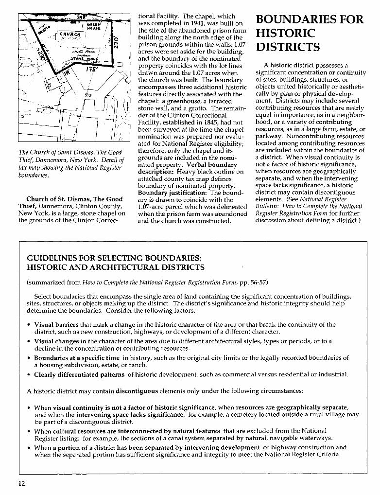
The Church of Saint Dismas, The GoodThief, Dannemora, New York. Detail oftax map showing the National Registerboundaries.
Church of St. Dismas, The GoodThief, Dannemora, Clinton County,New York, is a large, stone chapel onthe grounds of the Clinton Correc-
tional Facility. The chapel, whichwas completed in 1941, was built onthe site of the abandoned prison farmbuilding along the north edge of theprison grounds within the walls; 1.07acres were set aside for the building,and the boundary of the nominatedproperty coincides with the lot linesdrawn around the 1.07 acres whenthe church was built. The boundaryencompasses three additional historicfeatures directly associated with thechapel: a greenhouse, a terracedstone wall, and a grotto. The remain-der of the Clinton CorrectionalFacility, established in 1845, had notbeen surveyed at the time the chapelnomination was prepared nor evalu-ated for National Register eligibility;therefore, only the chapel and itsgrounds are included in the nomi-nated property. Verbal boundarydescription: Heavy black outline onattached county tax map definesboundary of nominated property.Boundary justification: The bound-ary is drawn to coincide with the1.07-acre parcel which was delineatedwhen the prison farm was abandonedand the church was constructed.
BOUNDARIES FORHISTORICDISTRICTS
A historic district possesses asignificant concentration or continuityof sites, buildings, structures, orobjects united historically or aestheti-cally by plan or physical develop-ment. Districts may include severalcontributing resources that are nearlyequal in importance, as in a neighbor-hood, or a variety of contributingresources, as in a large farm, estate, orparkway. Noncontributing resourceslocated among contributing resourcesare included within the boundaries ofa district. When visual continuity isnot a factor of historic significance,when resources are geographicallyseparate, and when the interveningspace lacks significance, a historicdistrict may contain discontiguouselements. (See National RegisterBulletin: How to Complete the NationalRegister Registration Form for furtherdiscussion about defining a district.)
GUIDELINES FOR SELECTING BOUNDARIES:HISTORIC AND ARCHITECTURAL DISTRICTS
(summarized from How to Complete the National Register Registration Form, pp. 56-57)
Select boundaries that encompass the single area of land containing the significant concentration of buildings,sites, structures, or objects making up the district. The district's significance and historic integrity should helpdetermine the boundaries. Consider the following factors:
• Visual barriers that mark a change in the historic character of the area or that break the continuity of thedistrict, such as new construction, highways, or development of a different character.
• Visual changes in the character of the area due to different architectural styles, types or periods, or to adecline in the concentration of contributing resources.
• Boundaries at a specific time in history, such as the original city limits or the legally recorded boundaries ofa housing subdivision, estate, or ranch.
• Clearly differentiated patterns of historic development, such as commercial versus residential or industrial.
A historic district may contain discontiguous elements only under the following circumstances:
• When visual continuity is not a factor of historic significance, when resources are geographically separate,and when the intervening space lacks significance: for example, a cemetery located outside a rural village maybe part of a discontiguous district.
• When cultural resources are interconnected by natural features that are excluded from the NationalRegister listing: for example, the sections of a canal system separated by natural, navigable waterways.
• When a portion of a district has been separated by intervening development or highway construction andwhen the separated portion has sufficient significance and integrity to meet the National Register Criteria.
12

National Register properties classifiedas districts include college campuses,business districts, commercial areas,residential areas, villages, estates,plantations, transportation networks,and landscaped parks. Historicdistricts often include contributingarcheological resources that should beconsidered when evaluating signifi-cance and selecting boundaries.Examples of such properties areincluded in the discussions of districtsin rural settings. Examples of archeo-logical districts are presented in thediscussion of archeological sites.
Boundaries of historic districts areoften difficult to describe verbally.Consider using a scale map instead ofa narrative verbal boundary descrip-tion to define the boundaries.
Contiguous Districts in UrbanSettings
Taylorsville Historic District,Taylorsville, Spencer County, Ken-tucky, encompasses 34 contributingbuildings and 2 contributing sites inthe center of the town. The districtincludes the contiguous, intact,historic resources at the center of thecommunity, which comprise theresidential, commercial, governmen-tal, and religious resources thatdocument the development ofTaylorsville from its early daysthrough the 1930s. These buildings,along with the streets, alleys, and lotson which they are located, provide anexcellent picture of the developmentof Taylorsville from 1818, the date ofthe earliest extant house, to 1938, theconstruction date of the most recenthistoric building in the district. Thedistrict is eligible under Criterion Abecause it reflects the effects of anumber of key events in the town'shistory, including designation in 1824as the seat of newly formed SpencerCounty and the destruction andrebuilding of its commercial area andcourthouse after fires in 1898,1899,and 1913. The district also reflectsgradual trends, such as changingpatterns in siting and housing typesand styles and the development of thecommunity into a commercial andsupply center for the surroundingagricultural county- The district isalso significant for its representationof community planning and develop-ment: the streets, lots, and buildingsin the district document Taylorsville'sgrowth from a tiny, early 19th centurysettlement to an antebellum govern-ment center and into a small early
20th century county seat. Legal lotdescriptions and a reasonable limitwere used to define the boundaries ofthe National Register district. Verbalboundary description: The district isclearly delineated on the accompany-ing sketch map. With one exception,it follows the rear property lines ofthe properties included in the district.At the Enoch Holsclaw House onGarrard Street (#1), the western 50feet of the property where a 1980shouse is located have been excluded.Boundary justification: Excludedfrom the district are other areas ofhistoric Taylorsville where smallpockets of historic buildings andindividual buildings have beenisolated from the district bynonhistoric construction. The historicdevelopment along Main Cross Streetnorth of Main Street was consideredfor inclusion in the district but deter-mined ineligible. Although the areacontains a number of historic andcontributing buildings including theTaylorsville Public Library, All SaintsChurch, and some historic houses, thelarge percentage of nonhistoric andother noncontributing buildings alongthe street makes it a poor representa-tion of the historic character of thetown. Two other collections ofhistoric buildings have also beenconsidered for National Registerlisting but considered ineligible.Along Reasor Street and MapleAvenue, in an area developed begin-ning in 1899 as "Reasor's Addition/'is a collection of small, modest housesdating from about 1900 through the1940s. A large number of thesehouses have been seriously altered bythe addition of new siding, majorchanges to front porches, and lateraladditions that alter the form of thehouse. They no longer constitute anintact historic district. At the east endof Main Street, east of Railroad Street,is another collection of 12 historichouses. Although many of thesehouses retain a significant number oftheir identifying features, it wasdetermined that they were too dispar-ate a group, with no theme to unitethem, to justify a district. Ten historicbuildings in Taylorsville have beendetermined to be individually eligiblefor the National Register and will benominated as part of the currentproject. The district encompasses thecontiguous intact historic propertiesalong Main Street and Garrard Streetthat help to document the district'sarea of significance—community
planning and development. Thedistrict boundaries are determined byconcentrations of nonhistoric proper-ties that surround the district on allsides. To the east are nonhistoric andnoncontributing commercial build-ings. To the south is the 1948 floodwall. To the west, a few remaininghistoric houses are interspersed withseveral nonhistoric governmentalbuildings, including a post office andSpencer County School office and anumber of late 1940s infill houses.To the north along Washington Streetand Main Cross Street, a number ofhistoric houses at the north ends ofthe streets are separated from thedistrict by a 1950s church and single-family houses and apartments, alldating from the late 1940s through the1980s.
Taylorsville Historic District,Taylorsville, Kentucky. Detail of SpencerCounty Property Identification Map T-2showing contributing and non-contributing resources, photo views, andNational Register boundaries.
13

Bay Shore Historic District,Miami, Dade County, Florida, in-cludes 201 single-family residencesand 70 outbuildings. The district,which is located about 3 V2 milesnorth of downtown Miami, representsa wide variety of early 20th centuryarchitectural styles, including Medi-terranean Revival, Art Deco, ColonialRevival, Mission, and MasonryVernacular. The 90-acre district isroughly bounded by N.E. 55th Streeton the south, Biscayne Boulevard onthe west, N.E. 60th Street on thenorth, and Biscayne Bay on the east.The Bay Shore Historic District issignificant at the local level underCriterion A as one of Miami's mostintact historic neighborhoods and thecity's best extant example of aplanned, Boom-era suburb thatcontinued to develop in the yearsprior to World War II. The district isalso significant under Criterion C forits wealth of Mediterranean Revival,Art Deco, and Masonry Vernacularstyle houses that reflect the diversityand evolution of architectural designin South Florida during the 1920s and1930s. The National Register bound-aries, defined on a map, are based onassessments of historic boundariesand modern setting. Verbal bound-ary description: The boundary of theBay Shore Historic District is shownas the heavy line on the accompany-ing map entitled "Bay Shore HistoricDistrict." Boundary justification:The boundaries of the Bay ShoreHistoric District have been drawn togenerally follow those of the originalBay Shore subdivisions, plattedbetween 1922 and 1924, and the BayShore Plaza subdivision, platted in1936. Excluded from the district arethose portions of the Bay Shoresubdivisions located west of BiscayneBoulevard, which is now a majorcommercial area. The proposedboundaries encompass those portionsof the present Bay Shore neighbor-hood that contain a predominance ofbuildings constructed between 1922and 1942. The plan and period ofsignificance clearly set the Bay ShoreHistoric District apart from its sur-roundings. The boundaries of thedistrict are based on boundaries at aspecific time in history, visualchanges, and visual barriers. N.E.60th Street was selected as the north-ern boundary because it is the north-ern limit of the earliest Bay Shoresubdivision. Furthermore, the areanorth of this street contains few
53 ST.
NATIONAL REGISTERDISTRICT BOUNDARIES
CONTRIBUTING RESOURCE
IBUTING RESOURCE
Bay Shore Historic District, Miami, Florida. Detail of map showing a portion of thedistrict's National Register boundary.
historic buildings and is of a differentcharacter, containing a number ofmulti-family buildings. On the east,Biscayne Bay and Morningside Parkform natural physical boundaries, aswell as significant historic boundaries.The bayfront lots help to define thecharacter of the district, and theirpresence was a major factor in thedistrict's development. MorningsidePark is not included because it wasnot opened until 1951, although thenorthern portion was acquired by thecity in 1935. The rear property linesbetween N.E. 55th Street and N.E.53rd Street were chosen as the south-ern boundary because they delineatethe southern limit of the Bay ShorePlaza subdivision. In addition, themajority of houses south of this linewere constructed after 1942. Finally,Biscayne Boulevard was selected asthe rough western boundary becausea majority of the development onBiscayne Boulevard is of a differentcharacter. Since the mid-1960s,Biscayne Boulevard has developedinto a major thoroughfare with officezoning, and many of the newerbuildings are large-scale office orresidential structures. Several historicstructures do remain, however, andthese have been converted into officeuse. That portion of the original BayShore subdivision west of BiscayneBoulevard was excluded because it nolonger contains a concentration ofhistoric buildings.
Clifton Townsite Historic District,Clifton, Greenlee County, Arizona,clearly defines an intact grouping ofbuildings of various types datingfrom the early years of Clifton'sdevelopment, 1871-1920. Theseresources lie within the bottom of thecanyon formed by the San FranciscoRiver at its intersection with ChaseCreek. This low-lying location, whilegiving the town a visual boundary,has subjected it to periodic flooding.This has had the greatest impact alongPark Avenue where many buildingshave been washed away in the past.Many aspects of Clifton are repre-sented by the various buildings andstructures: residential, commercial,industrial, transportation, religious,and governmental buildings areincluded as well as character-definingengineering works such as bridgesand flood-control features. Remain-ing buildings represent a variety oflate 19th and early 20th century styles.The physical setting in the canyonalong the San Francisco River as wellas the relative proximity and visualcontinuity of the structures unifies thedistrict. The general architecturalintegrity of the district is good,although many properties are aban-doned and have fallen into disrepair:32 of the 86 resources are noncontrib-uting. The district is significant underCriterion A for its association with theearly copper mining and smeltingoperations in that region and with the
14

town that grew to support thoseoperations. The district is additionallysignificant under Criterion C for itsintact examples of architecture typicalof Arizona's mining towns. Two siteswithin the district, the smelter ruinsand a commercial building ruin, aresignificant under Criterion D asabove-ground remnants which revealimportant information about signifi-cant aspects of the district. Thedistrict's period of significance beginswith the construction of the earliestremaining structure in 1874 and endswhen the copper smelter moved toMorenci in 1937. The NationalRegister boundaries are defined on amap; natural and cultural featureswere used to define the property.Verbal boundary description: Theboundary of Clifton Townsite HistoricDistrict is shown as the dashed line onthe accompanying map entitled"Clifton Townsite Historic District."Boundary justification: The bound-ary includes the properties within anarea in central Clifton that retainintegrity and are associated with thefunctioning of Clifton as a majorcopper smelting center. The boundaryexcludes, where possible, propertiesthat have lost integrity and/or haveno significance. Beginning at thenorthwest boundary of the district, thecliffs form a natural and well-definedlimit encompassing the visible rem-nants of the smelter and associatedstructures. Proceeding clockwise, thenorthern limit of the district is markedby the transition from industrial usesto a residential area that containsmodern and historic houses of poorintegrity. At the point at which thefloodwalls appear at the east bank ofthe San Francisco River, the boundaryincludes the riverbed and floodwall.The northeast boundary may bedivided into two parts: at the northend, geographic limits of the cliff sidedefine the boundary, no furtherstructures being visible uphill; to thesouth, the slope becomes less steepand additional structures, eithermodern or of poor integrity, appearuphill from Park Avenue. Propertiesone-lot-width uphill from ParkAvenue are included within thedistrict, because all properties, evennoncontributors/are an importantpart of the Park Avenue Steetscape.At the southernmost end of ParkAvenue, no structures exist at thenortheast side of the street and theboundary is drawn to exclude thisopen land. The boundary continues
Clifton Townsite Historic District, Clifton, Greenlee County, Arizona. Map showingthe National Register boundaries.
south, excluding open land, butincluding the east floodwall south toits end. The southern boundary isdefined by a line connecting thesouthernmost ends of the formallyconstructed floodwalls at both sidesof the San Francisco River (slag-rubble walls continue to the souththrough much of the town). Thislocation coincides with a constructionin the width of the canyon, a bend inthe river, and a break in continuity ofdevelopment from the remainder ofthe town to the south. The boundarycontinues northwest along the west-ern floodwall, excluding the site of theformer freight depot (now demol-ished). The boundary then is drawnto include the passenger depot,following the geographic boundary ofthe cliffside, which firmly delineatesthe boundary at this location. At the
point where the canyon of ChaseCreek and the San Francisco Rivermeet, the boundary is drawn at theedge of U.S. Route 666 to exclude anarea of intruded properties that stepup the cliffside, which is not as steepat this point. At the south side of theChase Creek commercial area, theproperty line or street curbline andthe cliffside largely coincide to definethe edge of development in Clifton.The westernmost termination of thedistrict at Chase Creek is drawn at theend of the area of dense commercialcharacter of Chase Creek and at thewesternmost extant of the stoneretaining wall at the cliffs north ofChase Creek. This location coincideswith a restriction in the width of thecanyon and a corresponding pause inthe continuity of development sitesfrom development further west.
15

Elm Hill, Wheeling, Ohio County,West Virginia, is a mid-19th centuryGreek Revival mansion on a secludedesplanade. The area, which washistorically farmland, is now part ofsuburban Wheeling. The grounds arelandscaped lawn with shade trees,evergreens, and shrubs. The associ-ated brick springhouse/smokehouse,barn/garage, and cemetery arecontributing resources. The legalproperty description was used todefine the National Register bound-aries of the property. Verbal bound-ary description: The nominatedproperty is inclusive of the 19.33-acretract identified as parcel #7, sur-rounded by acreage of the WheelingCountry Club, on Ohio Countyassessor's Map RD-14, RichlandDistrict, February 1960, Wheeling,West Virginia. Boundary justifica-tion: The property is inclusive ofbroad lawns and open areas that forma significant setting between BethanyPike and the rear property lines.Within this green space stand thehouse, smokehouse/springhouse,barn, and cemetery.
Discontiguous Districts in UrbanSettings
Plemons—Mrs. M. D. Oliver-Eakle Additions Historic District,Amarillo, Potter County, Texas,includes about 40 blocks of residentialdevelopment originally platted as thePlemons Addition (1890) and the Mrs.M. D. Oliver-Eakle Addition (1903).The district is characterized by aneclectic mix of modestly scaleddwellings representing architecturalstyles of the early 20th century. Thehistoric landscaping reinforces theneighborhood's cohesiveness. De-spite the intrusion of a major arterialhighway (which separates the districtinto two discontiguous parts), thehistoric district retains a high level ofits historic integrity, with 357 of 535resources classified as contributingelements. The district is one ofAmarillo's most intact early 20thcentury residential neighborhoods.The design, scale, and materials of thebuilding stock reflect the cyclicaldevelopment of Amarillo's economyfrom the turn of the century to thebeginning of World War II. Thepredominant Prairie School andCraftsman-influenced bungalowstyles reflect Amarillo's growth fromthe 1910s through the 1930s as re-gional discoveries of oil and natural
SK RD-IT
Elm Hill, Wheeling, West Virginia. Tax map showing the National Registerboundaries.
Plemons—Mrs. M. D. Oliver-Eakle Additions Historic District, Amarillo, Texas.Detail of USGS map showing the National Register district boundaries and UTMreferences.
16

gas augmented agriculturally basedwealth. The district is nominated tothe National Register under Criteria Aand C. The National Register bound-aries of this discontiguous districtfollow existing roadways that encom-pass the eligible resources. Verbalboundary description: As indicatedby the solid black lines on the accom-panying USGS map, the historicdistrict is comprised of twodiscontiguous elements divided byInterstate Highway 40. The northernportion of the historic district encom-passes 86 acres bounded by thefollowing parameters: Beginning atthe center point of the intersection ofE. 16th Avenue and S. Taylor Street,proceed south along the center line ofSouth Taylor Street continuing to itsintersection with the center line of theNorth Access Road of InterstateHighway 40; thence southwest andwest along the center line of the NorthAccess Road of Interstate Highway 40to its intersection with the center lineof the alley west of S. Madison Street;thence north through the alley alongits center line to its intersection withthe center line of W. 16th Avenue;thence east along the center line of16th Avenue until reaching the pointof beginning. The southern portion ofthe historic district encompasses 94acres bounded by the followingparameters: Beginning at the centerpoint of the intersection of S. TaylorStreet and E. 26th Avenue, proceedwest along the center line of 26thAvenue continuing to the point of itsintersection with the alley west of S.Van Buren Street; thence norththrough the alley along the center lineto its point intersection with W. 24thAvenue; thence east along the centerline of W. 24th Avenue to its point ofintersection with S. Van Buren Street;thence north along the center line of S.Van Buren Street to its intersectionwith the center line of the SouthAccess Road of Interstate Highway 40;thence east and southeast along thecenter line of the South Access Roadof Interstate Highway 40 to the pointof its intersection with S. TaylorStreet; thence south along the centerline of S. Taylor Street until reachingthe point of beginning. Boundaryjustification: Consisting of twodiscontiguous elements currentlydivided by the incursion of InterstateHighway 40, the Plemons—Mrs. M.D. Oliver-Eakle Additions HistoricDistrict encompasses a cohesivecollection of residential properties
dating to the early 20th century.District boundaries coincide withconcentrations of historic propertieswithin the original limits of thePlemons Addition and the Mrs. M. D.Oliver-Eakle Addition to the City ofAmarillo. The boundaries encompassthose portions of the neighborhoodthat retain a significant degree ofintegrity of historic setting and feelingstrengthened by the continuityprovided by historic streetscapes.Areas beyond these boundariesgenerally consist of properties whosecharacter differs from those within thehistoric district, including residencesthat exhibit loss of historic integrity orwere built following the historicdevelopment period of the neighbor-hood. Properties outside the historicdistrict also include functionallydifferent resources, such asnonhistoric commercial propertiesand large-scale institutional proper-ties. Changes in the historic residen-tial character of the neighborhoodestablish the boundaries on all sides.The northern boundary along 16thAvenue demarcates the transitionbetween the commercial and institu-tional character of Amarillo's centralbusiness district and the residentialneighborhoods in the southernreaches of the city. The easternboundary along Taylor Street coin-cides with the dissolution of historicresidential character prompted by theincursion of Interstate Highway 27.Numerous noncontributing commer-cial and residential properties com-promise the integrity of the area eastof this boundary. The southernboundary along 26th Avenue occursat the point of transition betweenresidential properties developedduring the early 20th century andthose developed in the 1940s, 1950s,and 1960s. On the west, the districtboundary coincides with the limits ofresidential development with the Mrs.M. D. Oliver-Eakle Addition, as thecampus of Amarillo College hems inthe neighborhood along this bound-ary. Interstate Highway 40, whichobliterated portions of the historicneighborhood between 18th and 19thAvenues, is excluded from the historicdistrict and divides it into dis-contiguous components. North ofInterstate Highway 40, the westernboundary falls along the alley west ofMadison, which separated historicresidential development from non-contributing commercial developmentalong Washington Street.
Contiguous Districts in RuralSettings
Woodlawn Historic and Archaeo-logical District, King George County,Virginia, is a 899-acre historicriverfront plantation along the northbank of the Rappahannock River andthe west bank of Gingoteague Creek.Woodlawn is among the oldestplantations in the county and retainsessentially the same boundaries it hadwhen the land was first consolidatedin the late 18th century. The propertyincludes 21 buildings, sites, andstructures: the planation house,dating from ca. 1790, and its early tomid-19th century ancillary buildings,with major additions and renovationsto the plantation house ca. 1841,1934,and 1982. There are 6 contributingbuildings, including the plantationhouse and two antebellum outbuild-ings and slave quarters and an early20th century barn and implementshed. The 10 contributing archeologi-cal and landscape sites include 5prehistoric sites, a historic domesticsite, a ditch network, the field system,the farm road network, and aspringhouse foundation site. Thereare 3 noncontributing buildings, 1noncontributing site, and 1 noncon-tributing structure. Periods of signifi-cance are represented by contributingprehistoric Native American re-sources and the historic resources ofthe 17th century and of the late 18thcentury through 1937. WoodlawnHistoric and Archaeological District iseligible under Criteria A, C, and D atthe state and local levels. The well-preserved plantation house is one of anumber of important and interrelatedhouses built along the RappahannockRiver between 1760 and the 1850s. Inaddition to its architectural signifi-cance, the district also represents thehistorical influence of agriculture andtransportation on the settlement andeconomy of the Northern Neck ofVirginia. Woodlawn is also signifi-cant for its association with theTurner family, whose history inVirginia dates to the mid-17th centuryand whose occupation of Woodlawnlasted into the 1920s. The Turnerswere members of an extended familyof prominent landowners who left animportant architectural legacy in thearea. The social and cultural values ofthe antebellum planter class arereflected in the architectural traditionsof Woodlawn. The patterns ofresidential, agricultural, and wood lot
17

land use persist today. Field patterns,vegetation, and drainage ditchesdating from the period of significancesurvive. Natural and cultural featuresand reasonable limits were used todefine the National Register bound-aries of this large rural property.Verbal boundary description: Theboundary of Woodlawn Historic andArchaeological District begins at thenorthern bank of the RappahannockRiver at UTM 18 309780 4226640; andcontinues north/northeast until itintersects the drainage ditch (Archeo-logical Site 44KG94) at UTM 18309910 4227160; and continues north/northeast along the western edge ofthe ditch until it intersects a tributaryof Gingoteague Creek at UTM 18310380 4228360; and continues north/northeast until it intersects a dirt roadat UTM 18 310560 4228890; andfollows the western edge of the dirtroad until it intersects State Route 625to UTM 18 310645 4229165; andcontinues west along the northernedge of State Route 625 to UTM 18310645 4229240; and continues north/northeast to UTM 18 310600 4229520;and continues east until it intersectsthe northern edge of State Route 625at UTM 18 310730 4229430; andcrosses State Route 625 and followsthe southern edge of State Route 625to UTM 18 310830 4229380; andcontinues south/southwest to UTM18 310675 4228845; and continues eastto UTM 18 311220 4228820; andcontinues north/northeast to thesouthern edge of State Route 625 atUTM 18 311300 4229240; and contin-ues west along the southern edge ofState Route 625 to UTM 18 3112404229240; and continues northeast,crossing State Route 625, to UTM 18311490 4229495; and continuessoutheast to UTM 18 311520 4229430,east to UTM 18 311560 4229450,southeast to UTM 18 311610 4229325,east to UTM 18 322735 4229270, andsoutheast, crossing State Route 625, tothe southern edge of State Route 625at UTM 18 311760 4229220; andcontinues east along the southernedge of State Route 625 until itintersects the Gingoteague Creek atUTM 18 311830 4229230; and contin-ues south along the center of theGingoteague Creek until it intersectsthe Rappahannock River at UTM 18312045 422660; and continues eastalong the northern bank of theRappahannock River to UTM 18309780 4226640. Verbal boundaryjustification: The boundary chosen
\
Woodlawn Historic and Archaeological District, King George County, Virginia.Detail of USGS map showing contributing resources and the National Registerboundaries.
for the Woodlawn Historic andArchaeological District correspondsto traditional and current propertylines. Significant contributinghistoric and archeological resourcesare contained within these bound-aries.
Dietz Farm, Greenbrier County,West Virginia, is a 96-acre property,occupying a high knoll with gentlysloping pastures and adjacent wood-lands at Meadow Bluff, overlookingthe historic Kanawha and JamesRiver Turnpike. During the CivilWar, the house served as temporaryConfederate and Union headquartersand hospital, and winter quarterswere constructed near the house. Thebrick farm house, two outbuildings,and a noncontributing barn make upthe farm complex. On two knollsseveral hundred meters due west ofthe house are the earthwork remainsof Confederate fortifications. In adepression between the knolls are theunmarked graves of an unknownnumber of Confederate soldiers whodied in the house during the time thatit served as a hospital. The burialarea is a contributing site. South ofthe turnpike is a third contributingConfederate earthwork. The Na-tional Register boundaries followcultural features, natural features,
and a contour line, defining theextent of the contributing resourcesand their setting. Verbal boundarydescription: Beginning at a pointwhere County Route 60/25 meetsState Route 28; thence approximately750 feet northeast along the west sideof Route 60/25; thence in a lineapproximately 1,600 feet due north-west along the southern side of Route60/25 to where said route begins tocross Meadow River; thence in aslightly meandering fashion follow-ing the east bank of Meadow Riverfor approximately 2,500 feet south-west to where the major contour linemeets the east side of Meadow River;thence following the principal 2,500-foot contour line (as lined in red onthe accompanying USGS topographicmap) in an eastward direction; thencesouth eastward; thence north forapproximately 2,000 feet until theline meets the east side of State Route28; thence in a line northwest forapproximately 500 feet along thewest side of State Route 28 to thepoint of beginning, encompassingapproximately 96 acres. Boundaryjustification: The boundary is drawnso as to include the principal areaimmediately around the DietzHouse/Headquarters that served asoutdoor bivouac for soldiers of bothsides during the time the property
18

was used for military purposes. Onthe north and west the boundaries aredrawn so as to include the majorConfederate trenches along the eastside of the Meadow River and thedefensive earthworks on the two
principal rises that were constructedin anticipation of Federal assaultdown Route 60 from the northwest.The boundaries also include the burialsites of Confederate soldiers who diedwhile the property was being used asa field hospital.
Dietz Farm, Greenbrier County, West Virginia. Topographic map showing theNational Register boundaries and UTM reference points.
Dune Shacks of Peaked Hill BarsHistoric District, Cape Cod,Barnstable County, Massachusetts, islocated within Cape Cod NationalSeashore, on Cape Cod peninsula.The dune shacks, which have beendetermined eligible for the NationalRegister as a historic district, arescattered along a three-mile stretch ofunvegetated dunes in view of theAtlantic Ocean. The shacks werehistorically used as summer retreatsby members of a colony of artists,writers, poets, actors, journalists,bohemians, and socialites from the1920s to 1960s. The dune shacks andthe natural landform of the dunesform a unique historic culturallandscape. The eligible propertyincludes 17 shacks and the surround-ing dune landscape. Because thenatural landscape served as settingand inspiration for the inhabitants,the appropriate boundary includesthe collective extent of the visiblelandscape for all the dune shacks inthe district. Geographic InformationSystem (GIS) analysis techniques wereused to analyze the viewshed for thepurpose of defining the districtboundaries. Natural features, culturalfeatures, and viewsheds were used todefine the National Register bound-aries of the property. Verbal bound-ary description: The boundary forthe Dune Shacks of Peaked Hill BarsHistoric District encompasses ap-proximately 1,500 acres and is de-scribed as follows: the shoreline tothe north, the crest of the second duneline away from the shore south of thesecond jeep trail delineated on theaccompanying USGS map, theviewshed line of the cluster of shacksF, A, I, and D on the west, and thecrest of the first dune ridge to the eastof shack B. These boundaries aredemarcated on the attached map ofthe area. Boundary justification:This boundary encompasses all of thedune shacks and the area incorporat-ing the entirety of the historicallysignificant cultural landscape andassociated important viewsheds asseen from the dune shacks. Thisboundary is supported by the writtendocumentation and by the attachedGIS viewshed analysis. The shiftingcharacteristics of the dune landscapeare recognized; for this reason thisboundary is a close approximation.In light of dune movement, theboundary may move in some loca-tions some degree, but the basicprinciples underlying its justification
19

shall remain constant. Allowing forthis movement, the boundary shallcontinue to include the dune shacksand the extent of the landscape to thecrest of the second dune ridge,wherever that may occur.
Tomahawk Lake Camp HistoricDistrict, Oneida County, Wisconsin,is a 20th century tuberculosis rehabili-tation camp. The 17 buildings andone structure are located on a sitesurrounded by forest reserve on LittleTomahawk Lake. The camp wasestablished in response to advances inthe treatment of tuberculosis and theperceived need to reforest the cut-over region of northern Wisconsin.At the camp, infected patients wereisolated from general hospital patientsand benefitted from the curativeeffects of open space for exercise andfresh air. Natural features, culturalfeatures, and reasonable limits wereused to define the National Registerboundaries. Verbal boundarydescription: Beginning at the inter-section with the south edge of Rain-bow Road and a north-northwest lineextending 200 feet south of RavenRoad, commence north-northwestalong that line 500 feet to the intersec-tion of a north-south line extending200 feet east of the garage and work-shops to Little Lake Tomahawk;commencing south along that line tothe intersection of the Little LakeTomahawk shoreline, then northwestalong the lake shore to the intersec-tion of a north-south line extending150 feet west of the garage, thencommencing north along that line tothe intersection of a west-east lineextending 150 feet north of the shedand commencing east along that lineto the intersection of a north-north-west line extending 200 feet north ofRaven Road and commencing alongthat line to the intersection of CountyHighway D, then running south alongthe west side of County Highway D tothe point of beginning. Boundaryjustification: The Tomahawk LakeCamp boundary was drawn toencompass all historic and nonhistoricresources in the complex. It alsoincludes the surrounding landscapefeatures that provide the northwoodssetting. This includes the woodedarea around the Raven Road entranceand the woods surrounding thebuildings. The northwoods environ-ment was a very important part of thecamp's outdoor, health-consciencephilosophy that was advertised to
Dune Shacks of Peaked Hill Bars Historic District, Barnstable County, Massachusetts.This GIS viewshed analysis map shows the National Register-eligible historic districtin black and the dune shacks as white dots within the district; roads, trails, and lakesare shown in white (Knoerl and Chittenden 1990:7).
Tomahawk Lake Camp Historic District, Lake Tomahawk, Oneida County, Wisconsin.Sketch map showing the National Register boundaries.
20

prospective patients. The site in-cludes 21 acres of the former 536-acresite. Acreage not included in thedistrict is heavily wooded and doesnot contribute to the historic signifi-cance of the complex.
Bloomvale Historic District,Dutchess County, New York, is asmall industrial site, established inthe mid-18th century. The district'seleven contributing resources includethe Bloom house and well, theBloomvale mill, a worker's house, themill's water system, the old highwayand bridge abutments, four millcomplex building sites, and thedistrict's archeological remains. Theagricultural function of the Bloomfarm declined; farm buildings aregone and the agricultural fields areovergrown. However, the industrialhistory of Bloomvale is well repre-sented, and the Bloom house and theindustrial complex remain suffi-ciently intact to preserve the settingof the mill site and the visual andfunctional interrelationships of itscomponents. Thus, the industrialhistory of the site is the focus of thedistrict's significance. The bound-aries of the district wTere selected toinclude the present-day parcels
containing the significant historicresources. National Register bound-aries correspond to tax parcel bound-aries. Verbal boundary description:See attached site map and boundarymap composed from local tax maps.Boundary justification: The bound-aries of the district were determinedby the present-day parcels containingthe significant historic componentsidentified on the site map. Today, thehouse and the mill are owned sepa-rately. The Bloom house and its lotwere divided from the mill site andtwo northern farm lots in the 1860s.Those farm lots were subsequentlysold off and have since been furthersubdivided. The agricultural functionof the Bloom farm declined over theyears to the point where the farmbuildings have disappeared and theagricultural fields reforested. Con-versely, the industrial history ofBloomvale is well represented and theBloom house and the industrialcomplex remain sufficiently intact topreserve the setting of the mill siteand the visual and functional interre-lationships of its components. Thus,it is the industrial history of the sitethat is the focus of the district'ssignificance.
Tax map showing nominated boundaries of district;
TOWN OF PLEASANT VALLEYDUTCHESS COUNTY, NEW YORK
6565-02 A\iTOWN OF WASHINGTONDUTCHESS COUNTY, NEW YORK
6565\ 1
Bloomvale Historic District, Dutchess County, New York. Tax map showing theNational Register district boundaries.
Martin M. Bates Farmstead,Richmond, Chittenden County,Vermont, is a 45-acre property includ-ing a 19th century Italianate farm-house and associated barn, ice house,and chicken house surrounded by hayfields and forested hills. The farm-stead contributes to understandingthe development of dairy farming inthe region; therefore, the intact openfarm fields around the farm buildingsare also important components of thefarmstead. Although the farm is nolonger in operation, the fields con-tinue to be hayed. Natural features,tax parcel boundaries, and reasonablelimits were used to define the Na-tional Register boundaries. Verbalboundary description: The BatesFarmstead includes land on both sidesof Richmond Town Highway #1. Theboundary above the road is formedby the southern edge of a brook thatdrains into the Huntington River andthe eastern line of tax parcel number11-51.1. The boundary below the roadfollows the southern line of tax parcelnumber 11-50 to a point approxi-mately 500 feet from the edge of theroad. From that point, the boundaryextends in a straight line parallelwith the road to the brook, which ittouches south of Hillview Road. Theboundary thence follows the brookdownstream to Hillview Road andcontinues along the edge of that roadto the town highway. Boundaryjustification: The boundary includesall buildings and the surroundingopen fields historically associatedwith the Bates Farmstead.
Martin M. Bates Farmstead, Richmond,Vermont. Plan map showing theNational Register boundaries, whichinclude buildings and associated fieldsand woods.
21

Rocky Butte Scenic Drive HistoricDistrict, Portland, MultnomahCounty, Oregon, includes the view-point on the crest of Rocky Butte, thescenic drive approaches to the view-point, and Joseph Wood Hill Park,also on the crest. Rocky Butte ScenicDrive is a serpentine automobileroadway that climbs with threeswitchbacks and a final girdling loopto the summit of Rocky Butte. Con-tributing features include the road-ways and accompanying historicstructures, the crest viewpoint struc-ture, and the historic aircraft beacon.The district's original association waswith recreational driving and scenicviews, although residential develop-ment has encroached on the lowerportions of the roadway; nevertheless,the viewpoint still offers a scenic vistaover the Columbia River plain in alldirections. The road right-of-way andtax parcel boundaries were used todefine the National Register bound-aries of the property. Verbal bound-ary description: The nominated areais located in Sections 21 and 28,Township IN, Range 2E, WillametteMeridian in Portland, MultnomahCounty, Oregon. It is a lineal, serpen-tine district consisting of the entire 50-foot-wide right of way of Rocky ButteRoad and approach sections of NE92nd Avenue from Halsey Street onthe south and NE Fremont Street from82nd Avenue on the west to includeall historic developed features of thescenic parkway and Joseph Wood HillPark at the crest of Rocky Butte,encompassing in all 21.48 acres, moreor less, in the corporate limits of thecity of Portland. The total number ofcontributing features (14) includes theroad system, its retaining walls, twotunnels, drainage structures, stonefenders, stone bollards, the park, astone outlook with lamp posts, a stonestaircase, a viewfinder, a commemo-rative monument, and the historicaircraft beacon. Boundary justifica-tion: The district is located in Town-ship 1 North, Range 2 East, Sections21 and 28. The district is bounded bythe 50-foot-wide right of way asmeasured from the center lines ofRocky Butte Road, and of 92ndAvenue from Halsey Street to RockyButte Road South, and along FremontStreet from 82nd Avenue to RockyButte Road North. Tax Lot 47 ofSection 28 is located within theconfines of Rocky Butte Road as itcircumnavigates the crest of the butte.The district comprises an approximate
total of 21.48 acres. This includes 2.38acres which is the Joseph Wood Hillportion of the district, Tax Lot 47.Because the district comprises ap-proach drives and a viewpoint locatedwithin the confines of approachdrives, it was felt that the road rightof ways would appropriately boundthe district. The approach drives passthrough residential areas at thebutte's foot and then wind throughnewer residential areas as they climbthe butte. Houses cluster alongportions of the roads on the butte.Other portions of the roads are still innatural woodland.
Weyerhaeuser South Bay LogDump Rural Historic Landscape,Thurston County, Washington,encompasses 260 acres of uplands and190 acres of tideland along theHenderson Inlet of southern PugetSound. Twin estuaries of Woodardand Chapman Bays on HendersonInlet intersect the property forming
north, south, and central peninsulasof land. The property reflects acontinuity of land uses and theevolution of functional relationshipsbetween wooded land and water inthe south Puget Sound region throughprehistoric and historic periods. Useof the property by successivegroups—Native Americans, Euro-American settlers, loggers, oystergrowers, and the Weyerhaeuser logtransport operation—reflects historicwaterfront activities on lower PugetSound over thousands of years. Theuse of the site for log dumping andbooming by Weyerhaeuser Corpora-tion since 1926 has forestalled en-croachment of modern subdivisiondevelopment typical of adjacent areas,thus preserving evidence of the land-use patterns of earlier eras. Evidenceof prehistoric and 20th century landuse is still evident, and naturallandscape features survive as well.The area was occupied by prehistoricNative Americans, who gathered
Tidelands
NATIONAL REGISTERRURAL HISTORIC DISTRICTBOUNDARY
1 McDonald House2. Outbuidng3. Foreman's House4. Boommen Office5. Per and Pfinga6. CaiwaG.8 and Dotpfcra7. Cranea. Pier OutbuBdjig
1WEYERHAEUSER SOUTH BAY LOG DUMP
RURAL HISTORIC LANDSCAPEWOODARD BAY NATURAL RESOURCES
CONSERVATION AREA (Olympla VicSKETCHMAP OF STRUCTURES
SOO 1000 BOO
Thurston Co. , VIA)
Weyerhaeuser South Bay Log Dump Rural Historic District, Thurston County,Washington. Plan map showing the National Register boundaries.
22

shellfish and plant foods and huntedthere. European-American settlersarrived in the mid-19th century, andlogging began in the 1880s. The areawas purchased by Weyerhaeuser in themid-1920s for log transshipment. Taxparcel boundaries were used to definethe National Register boundaries ofthis property. Verbal boundarydescription: Boundaries as describedin parcel numbers 11918100000,11918410000,11918430000,11917320000,11917320100,11917330100,11917220000,93006700000, 93006800000,93006900000, 93007000000,93007100000, 93007200000,93007300000, 93007400000,93007500000, 93007600000,93007700000, and 93007800000 on fileat the Thurston County Assessor'sOffice and illustrated in the attachedmap. Boundary justification: Thenominated property includes all land
, in the historic Weyerhaeuser owner-ship.
Discontiguous Districts in RuralSettings
(See also Discontiguous ArcheologicalDistricts)
Crockett Canyon/Coyote RanchArcheological District, Southwest,[location restricted], contains 16discontiguous sites associated withprehistoric cultures. The sites arelocated among the cliffs and canyons ofthe Ardra Plateau, approximately 20miles northeast of Fort Sickles. Thesites were nominated as a districtbecause they document an extensive,diverse, and well-preserved assem-blage of prehistoric artwork; theydefine distinct stylistic traditionsamong petroglyph and pictographgroups; and they identify long-termaboriginal habitation directly associ-ated with the rock art. The sites arerelated by artistic style, artifact group-ings, and geologic setting. Individualsite boundaries are based on the extentof surface features and artifacts.Verbal boundary description: TheCrockett Canyon/Coyote RanchArcheological District consists of 16significant areas of aboriginal rock art,shelters, and campsites. The accompa-nying topographic maps show thelocation and configuration of eachnominated site by using labeled pointsand UTM grid coordinates. CrockettCanyon sites are: [excerpted siteexample] 33GG111: This site contains
approximately 1.5 acres and is foundon the USGS 7.51 Crockett Canyontopographical sheet. From point 1(UTM coordinates QQQ/RRR), followthe 2,400-foot contour southward topoint 2 (UTM coordinates SSS/TTT), adistance of about 197 feet (60 m).Continue to the NE for approximately197 feet (60 m) to point 3 (UTMcoordinates UUU/VW), and then tothe NW about 262 feet (80 m) to point4 (UTM coordinates WWW/XXX).Proceed southward along the 2,400-foot contour approximately 197 feet(60 m) back to point 1. The Stateowns this site, which is located inSection 4, Township 2S, Range 4W.Boundary justification: All 16 sites inthe district are culturally linked bysimilar artifactual and pictographicdesign styles. The boundaries of thediscontiguous district correspond tothe boundaries of the 16 individualsegments (sites). Individual siteboundaries were determined bymapping the extent of surface-visiblecultural features and artifacts. All ofthe sites are fairly discrete locations ofcultural activity, with artifacts concen-trated near the petroglyph panels,shelters, and fire-cracked rock hearthsthat comprise the most significantfeatures at each locus. Areas of low-density scattered artifacts or features(less than approximately 1 artifact per50 square meters) were not includedwithin the site boundaries. The datathe sites present jointly is moreimportant and convincing than whenpresented in isolation. Taken to-gether, these data overlap and suc-ceed each other, documenting over7,000 years of occupation and thechange in subsistence from huntingand gathering to agriculture. Reflect-ing this economic change is a rich andvaried body of artistic expression thatspans the entire period of occupation.
Parks as Districts
Local, State, and national parksmay also include National Registerproperties. Boundaries for NationalRegister properties within parks arelimited to eligible resources; therefore,the National Register boundaries maydiffer from park boundaries. Specialprovisions apply to historic andcultural units of the National ParkSystem (as discussed below). Inselecting boundaries, consider theextent of the eligible resources andtheir setting. Do not include bufferzones or large areas that lack contrib-
uting resources.Each historic and cultural unit of
the National Park System is automati-cally listed in the National Register onthe date its authorization is signedinto law. During the interim periodbefore the National Park Service hasdefined the extent of the areas ofhistoric value, the National Registerboundaries are those defined in theNational Park Service authorizinglegislation, regardless of ownership.Congress may authorize for theNational Park System, with norequirement of notice, land areas notyet acquired as well as those never tobe acquired in fee, including those tobe controlled by easement acquisition.
For each historic or cultural unit,the National Park Service will evalu-ate the entire authorized (listed) area,prepare a nomination form, andprecisely define the boundaries toencompass the resources that havehistoric significance. If the proposedNational Register boundaries coincidesubstantially with the park bound-aries, the documentation is forwardedto the Keeper of the National Register,and a courtesy copy is sent to theState Historic Preservation Officer.When the Keeper signs the nomina-tion form, the boundaries of theproperty considered to be listed in theNational Register are thus defined bythe documentation.
If the proposed National Registerboundaries differ from the areaauthorized, the documentation issubmitted to the State HistoricPreservation Officer for commentwithin 45 days. In some cases, thearea documented and subsequentlylisted may be less than the areaauthorized to exclude nonhistoricbuffer zones. The listed area mayinclude privately owned areas, butonly to the extent that they have beenauthorized by Congress.
Rock Creek Park Historic District,Washington, D.C., is a 1,754.62-acreproperty in the northwest quadrant ofthe District of Columbia. The prop-erty is legally defined as Reservation339 and its boundaries are roughlydefined as Sixteenth Street on the east,Oregon Avenue and Branch Road onthe west, Klingle Road on the south,and the District of Columbia line andParkside Drive on the north. RockCreek Park is a natural reserve withina heavily urbanized area. The park issurrounded by commercial andresidential development, and it has
23

only two modern areas of concen-trated recreational and administrativeactivity. Otherwise, Rock Creek ParkHistoric District retains a high degreeof integrity that well reflects thedevelopment of this public landscapebetween 1791 and 1941. AndrewEllicott's 1791 survey recorded thetopography of the property andshows the location of the District ofColumbia boundary at the northwestcorner of the park. Verbal boundarydescription: The boundary of RockCreek Park Historic District is shownas the bold black line on the accompa-nying map entitled "Rock Creek ParkHistoric District, 1990." This tract ofland is legally defined as Reservation339. Boundary justification: Theboundaries of this district weredetermined by both legal and histori-cal considerations. Reservation 339was the land set aside by Congress asRock Creek Park in 1890 with ap-proximately 100 acres of relatedboundary rectifications and additions.The Piney Branch Parkway wasacquired by the government in 1907and was extended in the 1920s. It wasincluded in this district because it islegally a part of Reservation 339.Furthermore, there is also historicaljustification for the parkway's inclu-sion in Rock Creek Park HistoricDistrict because this land area wassurveyed and included in the 1918Olmsted comprehensive plan for RockCreek Park. The plan was prepared in1917-1918 by the famous Brookline,Massachusetts, landscape architecturefirm of Frederick Law Olmsted, Jr.,and his half-brother John C. Olmsted.Their plan for Rock Creek Park wasadopted in 1919 and has remained avital management document eversince. As an administrative unit, RockCreek Park presently contains manyother urban parks that are not con-tiguous to Reservation 339, includingthe Rock Creek and Potomac Park-way, the Normanstone Parkway, andthe Soapstone and Klingle valleys.These areas were acquired andintegrated into Washington's parksystem between 1913 and 1950 asaccess routes and a means of preserv-ing the watershed of the Rock Creekvalley. Although the Melvin HazenPark and Pinehurst Parkway arecontiguous to Rock Creek Park, theywere acquired and consolidated aspark land within the recent past anddo not share the Piney BranchParkway's early legal or historicalassociations to Reservation 339.
Rock Creek Park Historic District,Washington, D.C.. Plan map showingthe National Register boundaries.
Pecos National Historical Park,San Miguel County, New Mexico, isstrategically located at the mountaingateway between the Southern GreatPlains And the Rio Grande valley. Theboundaries of the 384.8-acre archeo-logical district are coterminous withPecos National Historical Park. Thehistory of the upper Pecos Rivervalley, as represented by the archeo-logical and historic sites within thearcheological district, demonstrates asuccession of attempts to exploit thenatural and cultural resources of theSouthwest. The 96 archeological siteswithin the property represent acomplex of pueblos inhabited byancestors of the Pecos Indians fromA.D. 800 to 1838 and a series ofSpanish Franciscan mission churchesand secular buildings constructedduring the 17th and 18th centuries.Adolph Bandelier mapped ruins atPecos in 1881, and archeologistsincluding Edgar Hewett, KennethChapman, A.V. Kidder, StanleyStubbs, and Bruce Ellis conductedinvestigations at various sites on theproperty during the first half of the20th century. Verbal boundarydescription: Pecos National HistoricalPark is surrounded by private ranchholdings, almost all of which areowned by the Fogelsons. The nom-inated district boundaries arecoterminous with the NationalHistorical Park boundaries. Boundaryjustification: Pecos National Histori-
-Rock Creek Park Historic District, Washington, D.C.. Southeast view of BoulderBridge (ca. 1901-1902). (William Bushong)
24

cal Park was established in 1965 andadded to in the 1980s by land dona-tions from the Fogelsons.
Maquoketa Caves State ParkHistoric District, Jackson County,Iowa, includes 111 acres of landacquired in three parcels between1921 and 1940. These parcels consti-tute the eastern portion of the park
and include all of the park structures,most of which were built between1932 and 1939. Between 1961 and1981,161 acres were added west ofthe historic park area as a naturepreserve; this acreage is not includedin the National Register historicdistrict. In the center of the park is asteep ravine with sheer limestonecliffs ranging from 10 to 75 feet high.
PtCOS M*TIW»U MONUMEMT
FORKED UGMTN1H0 RUIH
PECOS, NEW MEXICO
Pecos National Historical Park, SanMiguel County, New Mexico. Plan mapof the Forked Lightning Ruin, adaptedfrom A. V. Kidder's field maps from 1926,1927, and 1929.
Pecos National Historical Park, SanMiguel County, New Mexico. Ruins ofthe 17th century church. (Pecos NationalMonument)
Foot trails snake around the tops ofthe cliffs to overlooks, which offerviews of the valley and caves below.Other trails lead to cave entranceswhich are connected by undergroundpassages. Nine of the fifteen struc-tures in the park are associated withthe 1932-1939 development periodand are contributing resources. Thedistrict is significant as one of the firstparks established in Iowa, selectedbecause of the property's limestonecaves. The property in included intwo multiple property submissions,"The Conservation Movement inIowa, 1857-1942," and "CCC Proper-ties in Iowa State Parks, 1933-1942. "Because of the related periods ofsignificance, the 1940 boundaries areappropriate. Verbal boundarydescription: The historic portion ofMaquoketa Caves State Park com-prises three separate [adjoining]parcels which form an irregular tractof 111.08 acres located in Section 6, T-84N, R-1E. This acreage coversapproximately half of the park on theeast side. The tract is bounded on thewest by newer park lands and on thenorth, east, and south by privatelyowned farmland. Boundary justifica-tion: These boundaries represent theextent of park holdings as of 1942.
Hanging Rock State Park Bath-house, Stokes County, North Caro-lina, is the largest and most distinctivefacility constructed in North Carolinaby the Civilian Conservation Corps(CCC). The building is significant forits architecture (Criterion C) as themost prominent example of CCC-constructed rustic park facilities inNorth Carolina. Included in thenomination are the adjacent 12-acreHanging Rock Lake and its concretestone dam, which were built concur-rently with the bathhouse. Theseresources are also eligible for theirassociations with the CCC program inNorth Carolina. The building and itssetting embody the ideals of parkdesign that emphasized harmonywith the natural landscape throughsensitive siting and the use of nativebuilding materials and rustic architec-tural forms. The lake and shoreline,which are included as a contributingsite, constitute the historic setting,which is integral to the historiccharacter and function of the bath-house. A reasonable limit of 175 feetfrom the lakeshore was used to definethe National Register boundaries.
25

•J*
Maquoketa Cave State Park Historic District, Jackson County, Iowa. Plan mapshowing the park boundaries and the National Register district boundaries.
Lac qui Parle State Park WPA/Rustic Style Historic District, Lac qui Parle County,Minnesota. Plan map showing the National Register boundaries.
Hanging Rock State Park Bathhouse,Stokes County, North Carolina. Planmap showing the National Registerboundaries.
Verbal boundary description: Thenominated area includes the 12-acreHanging Rock Lake and 12 acres ofsurrounding land defined by a linerunning 175 feet from the high-wateredge of the lake on all sides. Bound-ary justification: The nominated areaincorporates the bathhouse and itsimmediate historic setting of lake andsurrounding woodland essential to itshistoric function and character,including the dam that forms the lake.
Lac qui Parle State Park WPA/Rustic Style Historic District, Lac quiParle County, Minnesota, includesthree buildings in the public-use areaof the park, located adjacent to the Lacqui Parle River. Architects for theseprojects were from the National ParkService and the Design Office withinthe Department of Conservation. Thedistrict is significant for its associationwith the social, political, and eco-nomic impact of the Great Depressionand the subsequent development ofthe Federal relief programs that wereresponsible for the construction of thecontributing buildings. The buildingsare outstanding examples of rusticstyle/split stone construction. Theboundaries were selected to include alimited setting around the threecontributing buildings. Verbalboundary description: The boundaryfor Lac qui Parle State Park WPA/Rustic Style Historic District is shown
26
as the heavy, cross-hatched line on theaccompanying map entitled "Lac quiParle State Recreation Area/' It isdefined by the land immediatelyencompassing three historic build-ings. Boundary justification: Theboundary includes the buildingsdeveloped by the WPA that have beenhistorically associated with the parkand that maintain historic integrity.
BOUNDARIES FORPARTICULARPROPERTY TYPESTraditional Cultural Properties
A traditional cultural property is abuilding, structure, site, object, ordistrict that is eligible for inclusion inthe National Register because of itsassociation with cultural practices orbeliefs of a living community that arerooted in that community's historyand are important in maintaining thecontinuing cultural identity of thecommunity. Defining boundaries fortraditional cultural properties can bechallenging. Carefully consider thetraditional uses of the property. Forexample, where a property is used forcontemplative purposes, viewshedsare important and must be consid-ered. In an urban district significantfor its association with a specificsocial group, consider the limits ofresidence or use by the group. Con-sider changes in time, as well. Forexample, archeological evidence maycontribute information on past useareas, which may differ from presentuse areas. Select boundaries thatencompass the area associated withthe traditional use or practice anddocument the factors that wereconsidered in the boundary justifica-tion. For further assistance, consultNational Register Bulletin : Guidelines,for Evaluating and Documenting Tradi-tional Cultural Properties, the appropri-ate State historic preservation office,any concerned Indian tribal preserva-tion program, and the traditionalgroup or community that ascribesvalues to the property.
Kuchamaa (Tecate Peak), Tecate,San Diego County, California, is asacred mountain to the KumeyaayIndians of southern California andnorthern Baja California, Mexico.Although there are modern intrusions
(a road and communications facilitieson the summit), the mountain isimportant to the Kumeyaaycommunity's belief system. The peakis a special place, marking the locationfor the acquisition of knowledge andpower by Kumeyaay shamans. Oraltradition records the use of Kuchamaaas the place where several importantshamans instructed their initiates andthe sacred place of vision quests andpurification ceremonies. Contempo-rary Native Americans continue touse Kuchamaa during the full moonand at equinoxes, when they pray forrenewal of Earth Mother and peace.Kuchamaa is significant underCriterion A for its association withNative American cultural history. Acontour line and a legal boundarywere used to define the NationalRegister boundaries of the property.Verbal boundary description:Kuchamaa is 3,885 feet above meansea level. The nominated area in-cludes all land from the 3,000-footcontour level up to and including thepeak. On the north it drops abruptlyto Highway 94. The western flankconsists of several dissected subpeaksand the eastern aspect is an uplandspine. The southern boundaryconforms to the international border[between the United States andMexico]. This is a total of 510 acres,320 to the west and 190 to the east.Boundary justification: Kuchamaawas and remains important to south-ern California Native Americans as astructural unit. If the mountainlacked its physical proportions andregional position, then it is quitepossible that the peak would not havebeen revered. The physical stature ofKuchamaa constitutes one reason thatit was used as a place of spirituallearning and worship. During a visitto Kuchamaa to evaluate a develop-ment proposal, Native Americansidentified a sphere of spiritual influ-ence extending for several miles fromthe mountain. This constitutes onezone of spirituality; approachable byboth Kwisiyai (shamans) and ordi-nary people. Actual Native Americanuse of Kuchamaa provides guidelinesfor establishing boundaries. Thisnomination includes that portion ofthe mountain located above anelevation of 3,000 feet above mean sealevel. According to current data, thisarea is considered sacrosanct. In theethnographic and prehistoric past, thesummit was used for arcane ritualsand approached only by shamans and
their initiates. Cultural taboosprohibited common folk from ascend-ing beyond a spring known as God'sTear. The location of God's TearSpring has not been verified, but bestestimates place it as the spring locatedjust above the 3,000-foot level. Fi-nally, according to Rosalie PintoRoberston [granddaughter of the lasttraditional chief of the Kumeyaay],the high mountain slopes hold burialsof cremated Kwisiyai. As with thespring, none of these has been veri-fied. Their presence above the 3,000-foot level requires the use of thecontour line as the boundary for theNational Register district. Thenominated portion of Kuchamaaincludes 510 acres, with the easternsegment, consisting of public lands,containing 190 acres. The western,state-owned parcel is demarcated bynorth-south section lines. This areacontains 320 acres. The southernboundary conforms to the interna-tional border. Private lands occupy alarge portion of the lower slopes ofthe mountain below the 3,000-footcontour line.
Mining Properties
Sterling Hill Mine, OgdensburgBorough, Sussex County, New Jersey,is located on a 33-acre tract thatincludes five mines (open-cut, open-pit, and underground types), ninecontributing buildings, one noncon-tributing building, and the ruins of astructure. Primary constructionperiods were 1830-1897 and 1916-1938. The property is located on thewest side of Plant Street and the southside of Passaic Avenue, about one-half mile from the municipal center ofthe Borough of Ogdensburg. Theproperty was divided among threeheirs in the early 19th century. Theparcels were not commonly owneduntil the end of the 19th century,when all three parcels were pur-chased by the New Jersey ZincCompany. Mining on the propertyceased in 1986, and the property wasconverted into a museum dedicated tothe history of the Sterling Hill Mine,mining history, and mineralogy of theSterling Hill ore body. The legaldescription of the lot that includes theeligible resources was used to definethe National Register boundaries.Verbal boundary description: Theboundary of the site consists of theentire parcel of land known as Block31, Lot 11.07 lying and being within
27

the Borough of Ogdensburg, SussexCounty, New Jersey. Boundaryjustification: The boundary includesthe entire municipal lot that has beenhistorically associated with miningactivities at Sterling Hill during theperiod 1830-1940.
Kettle River Sandstone CompanyQuarry, Sandstone Township, PineCounty, Minnesota, is located alongthe Kettle River on the east edge ofthe city of Sandstone in east-centralMinnesota. The property includes theabandoned quarry site, the pumpingstation, the artesian well controlbuilding, and derrick mast. Thequarry, which was active from 1885-1919, was designated a city park in1960. The quarry was the source ofhigh-quality sandstone which wasused in buildings throughout theUnited States. Cultural features,natural features, and reasonable limitswere used to define the boundaries ofthe National Register property.Verbal boundary description: Thenominated property is roughlybounded by Minnesota Highway 123to the south, on the north by a point600 feet north of the Great NorthernRailroad bridge, the Kettle River tothe east, and the former quarry wallsto the west, as shown on the accompa-nying map entitled "Kettle RiverSandstone Company Quarry, May1990." Boundary justification: Theboundary encompasses all of theabandoned quarry site includingthose buildings, structures, and ruinsthat have historically been part of theKettle River Sandstone Company andthat maintain historic integrity.Within the boundary is city-ownedRobinson Park and the recentlyconstructed park shelters and build-ings located toward the south end ofthe quarry.
- 1916 Mine Office Building- 1938 Mine Office Building- Clunge Home Building- Laboratory Building- Chlorlnitor Building>' Oil Puap BouM- Mine Superintendent'* OfficeI- Shed'- Mill Bulna AraaI- Co-preaaor Houe*- Drill Core Houee:- F i m l c MineI- Noble Minei- Fil l Quarry
Sterling Hill Mine (open-cut »re« ahowla dottad lines)Sterling Hill Hlne (underground) adit
Sterling Hill Mine, Ogdensburg, Sussex County, New Jersey. Plan map of theNational Register boundaries and resources.
The Sterling Hill property as it appeared in 1918. (Gary Grenier)
28

51 in
420 000
FEET
51 (1Q
s
-*1 D
(1 |
i f
•
9Golf Course
, T J ?•• ' "" i " •
i ) ' . | .
. . . .••.••«!!»--««)
CVIVP iW/frM.
•aII00 J
Cave
n Radio" Tow^r
|
LP£V f
QuarrW^N
:•, ; i ^- p r *~ feuarryl
# J -..-:, efeflcr # /d> ̂ Aria
Sy#" fwT /
_ - i• • •
If & • It i' "H***"' "•
92°5i '30" 2 350 000 FEET 51
• i * -
\ " • ' " / f
Sf t ?
Access « <f - '—*a»~ : - r^.
57 ,
|||II1
\il'g£J ^ L.
1,o7y !
\'V& L. .1i
River Sandstone Company Quarry, Sandstone, Minnesota. Detail of USGSquadrangle map showing the location and boundaries of the National Registerproperty.
Kettle River Sandstone Company Quarry,Sandstone, Minnesota. Plan map (ca.1990) showing the National Registerboundaries and resources.
Kettle River Sandstone Company Quarry, Sandstone, Minnesota. View of the quarryfacing south. (Michael Koop)
29

BOUNDARIES FORARCHEOLOGICALSITES ANDDISTRICTS
A site, according to the NationalRegister classification, is the locationof a significant event, prehistoric orhistoric occupation or activity, orbuilding or structure (whetherstanding, ruined, or vanished) wherethe location itself possesses historic,cultural, or archeological value. Themost common types of resourcesclassified as sites are archeologicalresources. Archeological districtsgenerally include several sites andtheir settings, as well as other types ofresources (such as structures andlandscape features). For examples ofdistricts that include buildings as wellas archeological sites, see the proper-ties cited in the sections on districts inrural settings.
Defining boundaries for archeo-logical sites raises special issuesbecause most or all of the eligibleresources may be underground. Forsites that have not been excavated,subsurface testing can provide data toidentify and evaluate the resourcesand define the boundaries. In situa-tions where the site type is wellknown (because similar sites in theregion have been excavated) andthere is clear surface evidence ofpreserved resources, testing may notbe necessary to determine significanceor select boundaries. Considernatural topographic or culturallandscape features that indicate thelimits of the resources. Legal or lotboundaries may be used for historicsites, both urban and rural, when suchboundaries are know to be consistentwith the historic boundaries. Notesurface evidence of disturbance thatmay have disrupted or destroyedresources.
When access is restricted or when adeeply buried site cannot be tested,select the boundaries on the basis of
predictions (based on topographicsetting and site type). Describe thelimitations of the data and supportthe predictions with a discussion,demonstrating the reliability of thepredictions in the context of knownlocal and regional site types.
For all archeological properties,include a large-scale map (preferably1 inch to 200 feet) to document theproperty boundaries, along with aUSGS map locating the property. Thelarge-scale map may be used in placeof a verbal boundary description.
It is difficult to provide a range ofexamples of boundaries from listedproperties because locational informa-tion is routinely restricted to protectthe resources from vandalism. Loca-tion and boundary information isrecorded in the documentation but isnot released to the public. Theboundary descriptions that follow aredrawn from documented sites, butmost descriptions are altered andedited to omit critical locationalinformation: direction, distance, andlandmark information in the original
GUIDELINES FOR SELECTING BOUNDARIES: ARCHEOLOGICAL SITES AND DISTRICTS
(summarized from How to Complete the National Register Registration Form, p. 57)
The selection of boundaries for archeological sites and districts depends primarily on the scale and horizontalextent of the significant features. A regional pattern or assemblage of remains, a location of repeated habitation, alocation of a single habitation, or some other distribution of archeological evidence all imply different spatial scales.Although it is not always possible to determine the boundaries of a site conclusively, a knowledge of local culturalhistory and related features, such as a site type, can help predict the extent of a site. Consider the property's settingand physical characteristics along with the results of archeological survey to determine the most suitable approach.
Obtain evidence through one or several of the following techniques:
• Subsurface testing, including test excavations, core and auger borings, and observation of cut banks.• Surface observation of site features and materials that have been uncovered by plowing or other disturbance or
that have remained on the surface since deposition.• Observation of topographic or other natural features that may or may not have been present during the period
of significance.• Observation of land alterations subsequent to site formation that may have affected the integrity of the site.• Study of historic or ethnographic documents, such as maps and journals.
If the techniques listed above cannot be applied, set the boundaries by conservatively estimating the extent andlocation of the significant features. Explain the basis for selecting the boundaries in the boundary justification.
If a portion of a known site cannot be tested, the boundaries may be drawn along the legal property lines of theportion that is accessible, provided that portion by itself has sufficient significance to meet the National RegisterCriteria and the full extent of the site is unknown.
Archeological districts may contain discontiguous elements under the following circumstances:
• When one or several outlying sites has a direct relationship to the significance of the main portion of the district,through common cultural affiliation or as related elements of a pattern of land use, and
• When the intervening space does not have known significant resources.Geographically separate sites not forming a discontiguous district may be nominated together as individual
properties within a multiple property submission.
30

documentation is not included. Sitesare identified by type and region, notby name and specific location. Forfurther assistance, see Appendix:Definition of National Register Bound-aries for Archeological Properties;National Register Bulletin: Guidelinesfor Evaluating and Registering HistoricalArcheological Sites and Districts; orcontact the appropriate State HistoricPreservation Officer, Federal Preser-vation Officer, or the National Regis-ter to speak with an archeologist.
Archeological Sites
Rockshelter Petroglyphs, UpperSouth [location restricted], includestwo petroglyphs components, one ona boulder at the mouth of the shelterand a second on a ledge. The designsare well preserved examples ofprehistoric rock art in the region. Noother archeological resources havebeen identified in the immediatevicinity of the rockshelter. Naturalfeatures were used to define theNational Register boundaries. Verbalboundary description: The nomi-nated property includes the entirerockshelter, the petroglyph boulder,and that portion of the sandstoneledge containing the chevron-likedesigns. The boundary for the site isindicated on the sketch map. Thecenter point shown on the sketch mapcorresponds to the UTM coordinateon the USGS quadrangle. Boundaryjustification: The rockshelter housesthe petroglyphs and is an integralelement of this rock art site. Theshelter probably served as a tempo-rary or extended habitation and focusof ritual activities associated with theexecution of the petroglyphs. As aconspicuous natural feature of cul-tural importance, the rockshelter mayalso have been ascribed mythologicalidentification in connection with therock art.
Historic Trading Company Ware-house and Clerk's House Site, PacificNorthwest [location restricted], arelocated on a natural river levee,parallelling the south bank of a majorriver. By the early 1840s, the tradingcompany established a grain ware-house on the site adjacent to the southbank of the river. The warehouse andan associated clerk's house wereerected to maintain the company'smonopoly on trade in the region bypurchasing agricultural produce fromresidents of the river valley. A flood
o
^ ^
V1
/
s
/
v
/
y
/
/
Rockshelter Petroglyphs, Upper South. Sketch map showing the National Registerboundaries.
in 1861 destroyed other developmentin the area and moved the warehouseabout 50 yards; it was never usedagain. The site is significant for itsrole in the early settlement and tradein the region. Archeological excava-tions indicated that cultural stratawere mixed as a result of 20th centuryrecreational use of the site. However,artifacts are plentiful above the 100-foot contour line, and horizontalintegrity remains to generally definebuilding locations and differentialfunctions of structures within the site.A contour line and a reasonable limitwere used to define the NationalRegister boundaries. Verbal bound-ary description: The nominatedproperty is located in the NW V4SW V4 Section 4, Township 2S, Range4W, in a state park. The boundariesof the property encompass 1.03 acresof the 100-foot contour levee of aflood plain that contains the site of thetrading company warehouse and itsassociated archeological features,including the clerk's house site. Thenorth, south, and west boundariesfollow the 100-foot contour line; theeast boundary is defined by areasonable line crossing the levee andintersecting a granite monument. Themonument and a park pavilion areincluded within the boundaries asnoncontributing resources. Boundary
justification: The bounds of the sitewere determined by surface observa-tion, informant testimony, and subsur-face excavation.
Prehistoric Quartzite QuarryArcheological Site, Middle Atlantic[location restricted], consists of severallarge outcroppings of quartzite andsandstone. Surface evidence suggeststhat the lithic source may have beenused by prehistoric Native Americansas early as the Middle Archaic period.Archeological sites in the region ofteninclude debitage thought to be fromthis quarry source. There has been nosubsurface testing at the site; evalua-tion is based on surface evidence andknowledge of associated sites in thevicinity. The site is significant for theinformation it may provide about theextraction of lithic resources in theregion. The National Register prop-erty boundaries are based on theextent of the natural feature quarriedby Native Americans. Verbal bound-ary description: Boundaries for thesite are determined by the naturaltopography of the area. The site islocated within the confines of the hillon which the outcropping of quartziteoccurs [as shown on the accompany-ing map]. The base of the hill is thesite boundary. Boundary justifica-tion: The boundary for the site is
31

tion: The boundary for the site isestablished by the limits of the naturaloutcropping of rock. The site wasutilized solely as an extractive orprocurement site; therefore, the limitsof the site are set by the limits of theavailability of the lithic resource.
Prehistoric Camp and HabitationArcheological Site, Western Moun-tains [location restricted], is a multi-component camp and habitation sitewith at least five occupations, rangingin time from 5050 B.C. to A.D. 750.Three of the occupations reflect short-term camp or special activity uses.Two long-term occupations arerepresented by pit house ruins andassociated materials, dated to theEarly Archaic period. The site is at anelevation of ca. 7,000 feet, about 1/2mile from the area's major river. Testand data recovery excavations re-vealed buried resources including pithouses, lithic tools, ceramics, andfaunal remains. Road constructionhas affected the site; however, excava-tions were conducted in associationwith recent construction, and theupgraded road was realigned to avoidthe pit houses. The distribution ofarcheological resources (surfaceartifacts) and natural features wereused to define the National Registerboundaries. Verbal boundarydescription: The southern, southeast-ern, and western boundaries aredetermined by a sharp reduction insurface artifact density; the northernboundary is at the topographic drop-off into the adjacent gulch, and theeastern boundary is along the eastside of a tributary arroyo to the gulch.Boundary justification: The bound-aries of the Prehistoric Camp andHabitation Archeological Site havebeen determined from a combinationof natural, topographic, and archeo-logical evidence. Western, southeast-ern, and southern limits have beendrawn on the basis of surface artifactdensity evidence, after careful surfacereconnaissance found a clear declinein the number of visible chipped stoneartifacts in this area. A portion of thewestern boundary at the adjacentranch house and outbuildings showssuch a decline in surface artifactdensity due to ground disturbancesfrom ranch building construction andoccupation, as well as limited groundvisibility in an adjacent pasture. Thesoutheastern and southern limits,where surface artifact density is alsoquite low, are in relatively rocky
RESTRICTED INFORMATION
Prehistoric Quartzite Quarry Archeological Site, Middle Atlantic. Sketch mapshowing the National Register boundaries, defined by geological and topographicfeatures.
terrain with good ground visibilitybut very little soil accumulation.Archeological survey and excavationdata have been used to determine theeastern site boundary, drawn on theeast side of a tributary arroyo of thegulch. Burned rock, charcoal-stainedsoil, and sparse artifacts exposed inthe east cut bank of the arroyo led toinvestigation of the Feature 14 locus,where artifact density at the presentground surface is otherwise very low.The arroyo becomes an entrenchedfeature only north of the road, thenjoins a large tributary wash justupstream of where the latter drainageflows into the gulch. The east bound-ary of the site is drawn along the eastside of the arroyo system to includethe Feature 10 locus, although no testexcavations have been done farthereast beyond Feature 10 to search forother buried remains on theinterfluvial flat where no surfaceartifacts are visible. The northernboundary is topographically defined
at the south bank of the gulch, beyondwhich any archeological remainswould have been long since erodedaway. The 30-acre site area depictedon the topographic map does notinclude a continuous scatter of surfaceartifacts, although at least a lightscatter of chipped stone, groundstone, and/or ceramic artifacts isvisible in most areas. Excavationshave been conducted in the southernthird of the site; the evidence fromthese excavations, in combinationwith subsurface exposures in nearbywashes, the arroyo, and several roadcuts, demonstrates that much of thePrehistoric Camp site resourcesremain buried.
John Houstoun MclntoshSugarhouse, Camden County,Georgia, built in the early 19thcentury as a cane-processing facility,consists of an extensive ruin withassociated archeological resources.The ruin was constructed of tabby, a
32
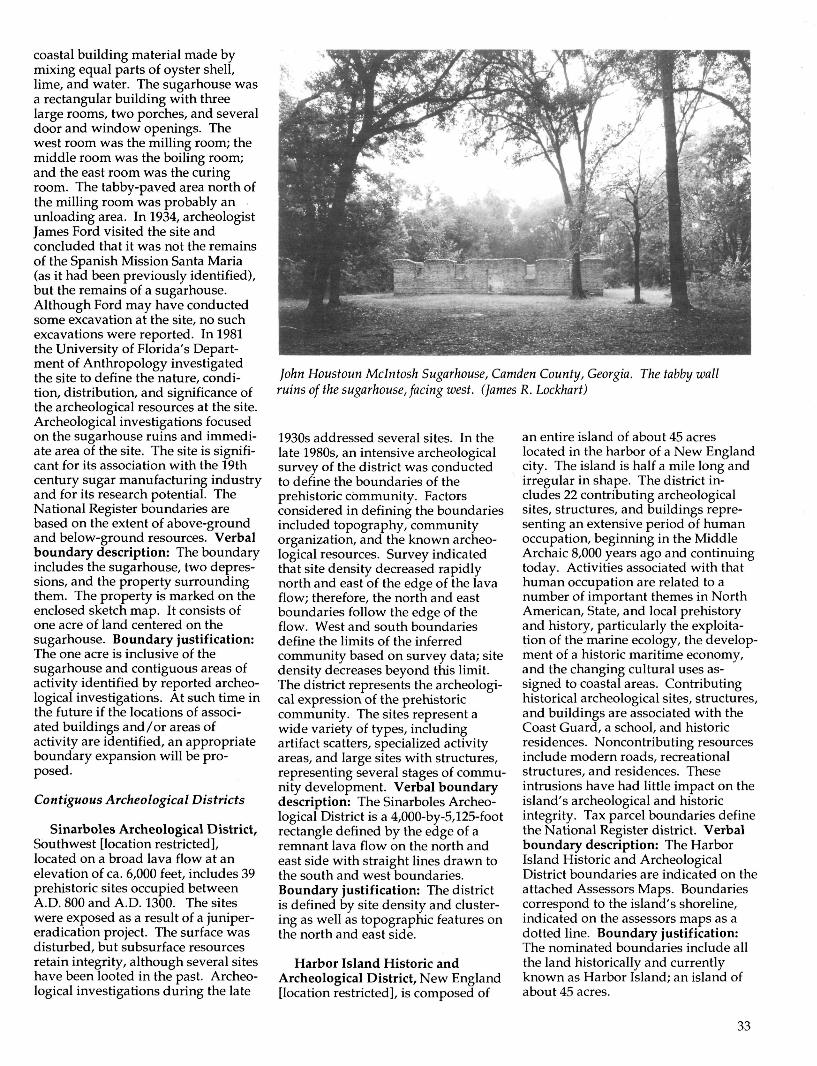
coastal building material made bymixing equal parts of oyster shell,lime, and water. The sugarhouse wasa rectangular building with threelarge rooms, two porches, and severaldoor and window openings. Thewest room was the milling room; themiddle room was the boiling room;and the east room was the curingroom. The tabby-paved area north ofthe milling room was probably anunloading area. In 1934, archeologistJames Ford visited the site andconcluded that it was not the remainsof the Spanish Mission Santa Maria(as it had been previously identified),but the remains of a sugarhouse.Although Ford may have conductedsome excavation at the site, no suchexcavations were reported. In 1981the University of Florida's Depart-ment of Anthropology investigatedthe site to define the nature, condi-tion, distribution, and significance ofthe archeological resources at the site.Archeological investigations focusedon the sugarhouse ruins and immedi-ate area of the site. The site is signifi-cant for its association with the 19thcentury sugar manufacturing industryand for its research potential. TheNational Register boundaries arebased on the extent of above-groundand below-ground resources. Verbalboundary description: The boundaryincludes the sugarhouse, two depres-sions, and the property surroundingthem. The property is marked on theenclosed sketch map. It consists ofone acre of land centered on thesugarhouse. Boundary justification:The one acre is inclusive of thesugarhouse and contiguous areas ofactivity identified by reported archeo-logical investigations. At such time inthe future if the locations of associ-ated buildings and/or areas ofactivity are identified, an appropriateboundary expansion will be pro-posed.
Contiguous Archeological Districts
Sinarboles Archeological District,Southwest [location restricted],located on a broad lava flow at anelevation of ca. 6,000 feet, includes 39prehistoric sites occupied betweenA.D. 800 and A.D. 1300. The siteswere exposed as a result of a juniper-eradication project. The surface wasdisturbed, but subsurface resourcesretain integrity, although several siteshave been looted in the past. Archeo-logical investigations during the late
John Houstoun Mclntosh Sugarhouse, Camden County, Georgia. The tabby wallruins of the sugarhouse, facing west. (James R. Lockhart)
1930s addressed several sites. In thelate 1980s, an intensive archeologicalsurvey of the district was conductedto define the boundaries of theprehistoric community. Factorsconsidered in defining the boundariesincluded topography, communityorganization, and the known archeo-logical resources. Survey indicatedthat site density decreased rapidlynorth and east of the edge of the lavaflow; therefore, the north and eastboundaries follow the edge of theflow. West and south boundariesdefine the limits of the inferredcommunity based on survey data; sitedensity decreases beyond this limit.The district represents the archeologi-cal expression of the prehistoriccommunity. The sites represent awide variety of types, includingartifact scatters, specialized activityareas, and large sites with structures,representing several stages of commu-nity development. Verbal boundarydescription: The Sinarboles Archeo-logical District is a 4,000-by-5,125-footrectangle defined by the edge of aremnant lava flow on the north andeast side with straight lines drawn tothe south and west boundaries.Boundary justification: The districtis defined by site density and cluster-ing as well as topographic features onthe north and east side.
Harbor Island Historic andArcheological District, New England[location restricted], is composed of
an entire island of about 45 acreslocated in the harbor of a New Englandcity. The island is half a mile long andirregular in shape. The district in-cludes 22 contributing archeologicalsites, structures, and buildings repre-senting an extensive period of humanoccupation, beginning in the MiddleArchaic 8,000 years ago and continuingtoday. Activities associated with thathuman occupation are related to anumber of important themes in NorthAmerican, State, and local prehistoryand history, particularly the exploita-tion of the marine ecology, the develop-ment of a historic maritime economy,and the changing cultural uses as-signed to coastal areas. Contributinghistorical archeological sites, structures,and buildings are associated with theCoast Guard, a school, and historicresidences. Noncontributing resourcesinclude modern roads, recreationalstructures, and residences. Theseintrusions have had little impact on theisland's archeological and historicintegrity. Tax parcel boundaries definethe National Register district. Verbalboundary description: The HarborIsland Historic and ArcheologicalDistrict boundaries are indicated on theattached Assessors Maps. Boundariescorrespond to the island's shoreline,indicated on the assessors maps as adotted line. Boundary justification:The nominated boundaries include allthe land historically and currentlyknown as Harbor Island; an island ofabout 45 acres.
33

Discontiguous ArcheologicalDistricts
Midwest Prehistoric Cave andRock Shelter Sites DiscontiguousArcheological District, CentralMidwest [location restricted], includes20 archeological sites in the water-shed of Mule, Goose, and Broadcreeks. Archeological sites in rockshelters and caves represent animportant part of the settlementpattern of prehistoric hunters andgatherers of the region. Shelteredsites were used as temporary camps,lithic-knapping sites and resource-processing stations, and base camps.Reoccupation and sedimentation hasleft a deep, stratified record of prehis-toric human activities. The 20 sites inthe district are a representativesample of the best preserved shelterdeposits in the three creek drainages.The district is significant underCriterion D for the sites' potential tocontribute important information onprehistoric life in the region. Shel-tered sites preserve the remains ofspecial uses as well as the activities ofdaily life. Verbal boundary descrip-tion: [The verbal boundary descrip-tion for this district consists of town-ship, range, section references as wellas UTM references for each of the 20sites. The sites are also marked onaccompanying maps of the threedrainages. Because this information isrestricted, it is not reproduced here].Boundary justification: This districtconsists of 20 cave and shelter archeo-logical sites located within the drain-age basins of Mule, Goose, and Broadcreeks. The archeological sites arespecific points within the threedrainage basins and are defined byUTM coordinates. In the future, othercave and shelter sites within thebasins may be determined significantand added to the district.
Plantation Cemeteries Archeologi-cal District, Deep South [locationrestricted], consists of two separatebut historically associated AfricanAmerican cemeteries dating from theearly 1800s to 1929. Both wereestablished as slave cemeteries onadjoining sugar plantations. The landwas purchased by the U.S. govern-ment in 1929 for construction of aflood-control project. There are nosurface indications of the cemeteriesdue to extensive modern landscapemodifications. Archeological investi-gations, however, demonstrated a
high degree of integrity. Investiga-tions included magnetometer survey,topographic survey, excavation of fivel-by-2-meter units, backhoe trench-ing, and augering. All culturalremains were left in place. Portions ofeach cemetery were affected duringexcavation of water-control ditches;however, damage was limited. Basedon identified grave sites and densitypredictions, each cemetery is esti-mated to include between 100 and 150graves. The district is significant forits association with African Americanplantation populations of the antebel-lum and postbellum periods and forits research potential. The boundariesof the two cemeteries are based oncultural features and reasonable limitsbeyond known resources, as deter-mined by survey and testing. Verbalboundary description: The nomi-nated district consists of twodiscontiguous historic cemeteries.The first cemetery is delineated by apolygon whose vertices are markedby UTM references A, B, C, and D[listed in registration form andmarked on accompanying USGSmap]. The second cemetery is delin-eated by the polygon whose verticesare marked by UTM references A, B,C, and D [listed in the registrationform and marked on the accompany-ing USGS map]. Boundary justifica-tion: The fieldwork determined atotal site size of ca. 3,000 squaremeters (under 1 acre) for the firstcemetery. The western, northern, andsouthern boundaries were extended10 meters beyond confirmed burials.This was considered necessary due tothe limited amount of fieldwork andthe irregular and elusive nature of thistype of archeological resource. Notopographic, vegetative, or othernatural markers remain to help definethe site boundaries. The discovery ofburials 10 and 11 in a backhoe trenchexcavated beyond the previouslyidentified limits of the site illustratedthe need to expand the site bound-aries beyond the confirmed burials.The eastern boundary is defined bythe haul road which abuts the site.Magnetometer survey did not indicateany burials under the road; however,this boundary is problematic sincefurther archeological investigationwas precluded in the road bed. Theboundaries described above provide areasonable estimate of the extent andlocation of burials at the site. Thefield work determined a total site sizeof 3,300 square meters (less than one
acre) for the second cemetery. The siteboundaries include a 10-meter exten-sion beyond confirmed burials on theeastern and southern margins of thesite and a 20-meter zone along thenorthern and western margins. Aswith the first cemetery, these extendedboundaries were required due to theinconclusive nature of the limitedfieldwork.
Woodland Mounds ArcheologicalDistrict, Upper Midwest [locationrestricted], is a group of prehistoricmounds located on the grounds of aschool. The district originally in-cluded 15 mounds; 12 survive, includ-ing conical, linear, and bird effigyforms. The mounds date to the LateWoodland Period (ca. A.D. 650-1300).The district is composed of threediscontiguous areas (A, B, and C), withmodern buildings and landscapingseparating the areas. Several moundgroups in the vicinity were mapped inthe late 19th and early 20th centuries,including the Woodland Moundsgroups, and in the 1930s, three of themounds were excavated. Remnants ofdamaged mounds have been identi-fied, but the seriously compromisedmounds have not been included in thedistrict. Since the early 20th century,efforts have been made to protect thesurviving mounds. Intact depositsprobably survive in several of themounds. The district is significant forits potential to yield information onthe Late Woodland period. Researchquestions are focused on informationthat can be obtained through non-invasive means, such as location andarrangement, geographical distribu-tion, and proximity to resources.Cultural features were used to definethe National Register boundaries.Verbal boundary description: Thesite is divided into three areas [bound-aries of which are shown on theaccompanying map]. Area A includesUTM reference C and is a small, less-than-1-acre parcel whose east bound-ary is Mound 1 and west boundary isMound 2. Area B includes UTMreference B and is an L-shaped 1-acreparcel. Area B is bounded on thenorth by Mound 11 and on the southby Oak Drive. UTM reference B is theeasternmost point of Area B and is thepoint where Mound 3 intersects withOak Drive. UTM point A is thewesternmost point of the district an islocated in Area C. It is the pointwhere Mound 12 intersects MapleDrive. Boundary justification: The
34

Woodland Mounds Archeological District, Upper Midwest. Detail of plan mapshowing the locations of two discontiguous areas in the district.
Lake Huron Shipwreck Site, Upper Midwest. Underwater view of the ship's wheel andsteering gear.
boundaries were drawn to includeonly the mounds and area betweenthem known to be relatively undis-turbed by modern construction.Areas A, B, and C are unconnectedand are deemed to be the site portionswhere the integrity of the moundgroup is most intact.
Shipwreck Sites
Lake Superior Shipwreck Site,Upper Great Lakes [location re-stricted], includes the remains of athree-masted schooner constructed in1869 and wrecked in 1896 against abreakwater. The vessel represents thetype constructed in the late 1860s and1870s for the shipment of iron ore.The vessel was in tow of a steamerwhen the two vessels encountered astorm. The steamer threw off theschooner's line. The schoonerdropped anchor, but continued todrift and hit the breakwater. Thevessel sank with the crew seekingrefuge in the rigging, from which theywere rescued the following morning.Rigging and masts may have beensalvaged, but machinery was left inplace. Although thousands of shipshave moved through the waterswhere the wreck lies, the resourceshave seen relatively little disturbance.The site is significant for its role inlocal maritime history, the structuralintegrity of the vessel, and the re-search potential of the site. TheNational Register boundaries weredefined by reasonable limits aroundthe vessel remains. Verbal boundarydescription: The area included in theshipwreck is a rectangle extending 200feet southeast and 65 feet on eitherside of a centerline extending south-east and beginning at a point that is150 feet from the monument locatedon the northwestern end of thebreakwater. Boundary justification:The Lake Superior Shipwreck Site isabout 70 percent intact. The boundaryfor the site is based on the debris fieldassociated with the wreck. This wasdetermined from information ob-tained by divers during mitigationactivities.
Lake Huron Shipwreck Site,Upper Great Lakes [location re-stricted], includes the remains of atwo-masted wooden schooner com-pleted in 1856. The vessel transportediron ore and pig iron between LakeHuron and Lake Erie ports. During astorm on Lake Huron in 1868, the
35

vessel collided with another schoonernear Piney Point. The other schoonermanaged to make it to port, but thisvessel was abandoned by its crew andsank. The shipwreck site was discov-ered and surveyed in the late 1980s.The wreck of the schooner rests in anupright position on a sandy bottom in150 feet of water. The vessel is nearlyintact, and major equipment is still inplace. The schooner site is significantfor the vessel's role in Great Lakesshipping, the naval architecture of thevessel, and the research potential ofthe site. The National Register bound-aries were defined by reasonablelimits around the vessel remains,selected to include the area likely tocontain rigging. Verbal boundarydescription: The Lake Huron Ship-wreck Site is located 2 statute mileswest and 1.5 miles north of PineyPoint at the intersection of Loran Ccoordinates XXX and YYY. The areaincluded in the site is a square 1,000feet on a side; the geographical centerbeing the charted vessel's position.Boundary justification: The LakeHuron Shipwreck is the site of arelatively intact vessel with structuraldamage primarily to the rigging only,based on diver assessments andvideotape evidence of the site. Littlenoticeable deterioration has beenevident on the vessel in terms ofsubsequent deposition on the site, icedamage, erosion, or other environ-mental factors with the exception ofanchor damage to the hull. Theboundary is based on the probabilityof locating major rigging elementslying near the hull as a result of thewreck drifting and sinking slowlyafter the collision. The wreck's depthhas prevented a thorough evaluationof the total extent of the site awayfrom the hull itself.
BOUNDARIES FORHISTORIC SITES
Locations of significant events oractivities where the location possesseshistoric or cultural value may beclassified as National Register sites.Cemeteries, battlefields, and naturaland cultural landscapes where historicevents took place are examples ofhistoric sites.
GUIDELINES FORSELECTING BOUNDARIES:HISTORIC SITES
(summarized from How toComplete the National RegisterRegistration Form, p. 56)
• Select boundaries that encom-pass the area where thehistoric events took place.Include only portions of thesite retaining historic integrityand documented to have beendirectly associated with theevent.
Denis Julien Inscription, GrandCounty, Utah, consists of historicinscriptions on a sandstone block in aside canyon of Green River, in themouth of Hell Roaring Canyon. Thereare two inscription panels. The firstbears the name D. Julien, the date 3max 1863, and a sunburst design and aone-masted boat. The second panelincludes five names of early surveyorsfrom the U.S. Reclamation Servicewith 20th century dates. Denis Julien,an American fur trapper of Frenchdescent, etched his name and datealong waterways in eastern Utah atleast eight time between 1831 and1844. In this location, he also in-scribed the one-masted boat, suggest-ing his mode of travel. The site issignificant for its association with furtrading and exploration, conservation
and reclamation, and mining. Rea-sonable limits were used to define theNational Register boundaries. Verbalboundary description: The site islocated within the NE l/i, NW 1/t,SW l/i, NW 1/i, Section 6 (unsurvey-ed), T26S, R18E. USGS 7.5 minuteseries, Mineral Canyon, Utah, quad-rangle, 1988. Boundaries of the actualparcel included in the nomination canbe described as a circle with a radiusof 30 feet centered on the inscriptionrock. Boundary justification: Thedescription provided above includesthe rock upon which the historicinscriptions are located and additionalamount of surrounding propertydeemed sufficient to convey somesense of the site's surroundings.
Tinta Massacre Site, Merizo,Guam, is the place where soldiers ofthe Japanese Imperial Army killedsixteen people of the village of Merizoin 1944. During the last days of theJapanese occupation, soldiersmarched a group of thirty men andwomen from the village to an areacalled Tinta at the foot of a hill west ofthe village. The soldiers herded thevillagers into a dugout cave, lobbedhand grenades through the opening,and attacked survivors with theirsabres. Fourteen people survived theattack. The massacre site is located atthe base of the hills on the easternedge of the Geus Valley. The site ismarked only by a wooden cross in theovergrown gully, which is whatremains of the dugout cave. Reason-
Denis Julien Inscription, Grand County, Utah. This ca. 1909 photograph shows theinscription and its environs. (Utah Historical Society)
36

Tinta Massacre Site, Merizo County, Guam. Detail of USGS map showing theNational Register boundaries.
able limits were used to define theboundaries of the National Registerproperty. Verbal boundary descrip-tion: Boundary lines are as indicatedon the accompanying USGS map.Boundary justification: The bound-ary of one-half acre is set to protectthe integrity and the setting of themassacre site.
Palmito Ranch Battlefield,Cameron County, Texas, is the site ofthe final land engagement of the CivilWar. Concentrated military actionoccurred here on May 12-13,1865,more than a month after Confederateforces under General Robert E. Leesurrendered at Appomattox Court-
house, Virginia. The battle, a series ofsharp skirmishes, took place across anapproximately five-mile area halfwaybetween Brownsville and BrazosIsland. Federal troops initiallypressed the Confederates as far westas Tulosa Ranch before Confederatereinforcements under the command ofCol. John S. (Rip) Ford arrived anddrove the Union army back to theirbase at Brazos Island. The battlefieldlies on a windswept plain at thesouthernmost tip of Texas on sparseland characterized by marsh andchaparral with a few scattered hil-locks. The land's virtually unchangedphysical features still convey thebattlefield's appearance during theCivil War. National Register bound-aries were organized according tonatural topographic features, culturalfeatures, archeological evidence, andreasonable limits based on historicalresearch. Verbal boundary descrip-tion: Refer to the accompanyingUSGS map for a precise depiction ofthe boundaries of Palmito RanchBattlefield. The battlefield is borderedon the north by the Boca Chica
SCALE(opprwlmrtr)
I / I
FEET -1000 0 3000 7000
HARDY HECK MOOflE Morch 1992
B«tt Mop US CvotovcC S«n i
PALMITO RANCH BATTLEFIELD
CAMERON COUNTY, TEXAS
PHOTO MAP KEY
GEOGRAPHIC FEATURES I
^ B Bodits of Water
oLand Areoi below Sto Level(marshes, 10900ns, eic.)
Land Areas of 10* Elevation or more
Highest Potnt of Lomai 8 Hills
•» ^ National Register Boundary
\ 7 Camera View
Palmito Ranch Battlefield, Cameron County, Texas. Map showing the National Register boundaries.
37

Highway and on the south by thecurrent course of the Rio GrandeRiver. On the east, the nominatedarea extends to a point immediatelyeast of Tarpon Bend and immediatelywest of Stell-Lind Banco No. 128. Thewestern border follows a line from theLoma del Muerto southward to theRio Grande. Beginning at a point onthe United States bank of the RioGrande immediately south of Lomadel Muerto, proceed due northapproximately one mile to the inter-section of the Boca Chica Highwayand Loma del Muerto. Then proceedeast along the Boca Chica Highway,approximately 4.5 miles, to a point onthe Rio Grande. Then proceed alongthe U.S. bank of the Rio Grandeapproximately 4.5 miles to the pointof origin. Boundary justification:Boundaries for Palmito Ranch Battle-field encompass the large expanse ofland where the most intense fightingof the conflict took place. Since thebattle consisted of a series of movingskirmishes, the battlefield itself coversa large area approximately five mileslong. The southern boundary followsthe current path of the Rio Grande,since the river formed one border forall fighting. Also, the river is theinternational boundary line betweenthe United States and Mexico. Thewestern boundary roughly follows aline extending from the Loma delMuerto southward to the Rio Grande.The line approximates the point atwhich Confederate reinforcementsarrived at the scene of the battle onthe afternoon of May 13,1865. Theboundary also approximates theposition of "San Martin Ranch,"referred to by officers of both armiesin written accounts of the battle. TheBoca Chica Highway forms thenorthern boundary of the battlefield.Although some scattered fightingmay have taken place north of thisline, most of the conflict was concen-trated much closer to the Rio Grande.The placement of the boundary at thehighway allows for the inclusion of abroad area north of the river, provid-ing an accurate demarcation of thelarge area in which the running battleoccurred. The battlefield's easternboundary roughly extends from thewesternmost tip of Verdolaga Lakesouthward to a point on the RioGrande just east of Tarpon Bend andjust west of Stell-Lind Banco No. 128,as shown on the accompanying map.This line marks the approximatelocation of a small levee referred to in
written, first hand accounts of thebattle as the scene of the final skir-mish, and the place where the Con-federate Army ceased its pursuit ofthe Union troops on the eve of May13,1865.
Middle Creek Battlefield, FloydCounty, Kentucky, is the location ofan important 1862 Civil War battle.The battle was an important earlyvictory for the Union army. Afterseveral Union defeats, victory inKentucky was strategically andpolitically important. At the end ofthe battle, troops under the commandof Colonel James Garfield held thebattlefield, putting the Union incontrol of eastern Kentucky. Thebattlefield is located along a series ofridges that surround the confluenceof the Right and Left forks of MiddleCreek. The eastern part of the battle-field is a cemetery located on a ridge(north of State Route 114). Thewestern boundary is a ridge above agorge near the mouth of the Left Forkof Middle Creek. The land occupiedby Union troops and the location ofthe engagement is characterized bysteep uplands, over 600 feet above thefloodplain of the creek. The ridges
are bisected by several drainages.Although there are a few modernintrusions (roads and a power line),the battlefield retains integrity to theextent that a soldier who participatedin the battle would recognize thebattlefield today. Cultural features(roads), natural features (ridges), andreasonable limits were used to definethe National Register boundaries.Verbal boundary description:Beginning at the point where StateRoute 114 right-of-way intersectswith old State Route 114/WestPrestonsburg Road's right-of-way, onthe north side of said roads (UTMreference A); proceed northwesterlywith Grave Yard Point, approxi-mately 750 meters to a point (UTMreference B); proceed southwesterlyapproximately 750 meters, across anunnamed hollow to a point (UTMreference C); proceed southeasterlyapproximately 200 meters to a point(UTM reference D); proceed south-westerly approximately 350 meters,down the ridge to State Route114'sright-of-way, (UTM reference E);proceed southeasterly across StateRoute 114's right-of-way, 450 metersto a point (UTM reference F); proceedeast across State Route 404 right-of-
Middle Creek Battlefield, Floyd County, Kentucky. Detail of USGS quadrangleshowing the National Register boundaries.
38

way, the Left Fork of Middle Creekand the CSX railroad right-of-way,approximately 650 meters to a point(UTM reference G); proceed northapproximately 650 meters to a point(UTM reference H); proceed north-easterly across the CSX railroad right-of-way, crossing State Route 114'sright-of-way approximately 500meters to a point (UTM reference I);following State Route 114's right-of-way approximately 100 meters to thepoint of origin. Boundary justifica-tion: The boundary includes theridges, stream, and the floodplain ofthat stream on and around which theBattle of Middle Creek took place. Arecent site visit produced noearthworks or artifacts that wouldhelp determine the exact site limits.The boundary is based upon historicmaps, manuscripts, and other docu-mentation both primary and second-ary.
The Sands Family Cemetery,Sands Point, Nassau County, NewYork includes twelve rows of 18thand 19th century gravestones, situ-ated on a wooded knoll. The cem-etery was established ca. 1711 whenJohn Sands set aside one acre of hisestate as a family burying ground.The 86 well-preserved sandstone andmarble gravestones include wingeddeath's heads, skull and crossbones,soul effigies, and plain tripartitesandstone tablets of the 18th centuryand Neoclassical motifs popularduring the 19th century. The progres-sion of motifs and epitaphs on thegravestones reflects the changes inreligious beliefs and social customsduring the period of interments. Thecemetery is surrounded by privateproperty. It is flanked on the east by amodern garage, private road andfield; to the west is a private paveddrive. The nominated propertyconsists of about one acre of landwhich is an inholding within a parcelwhose boundaries are delineated onthe boundaries map. Verbal bound-ary description: The boundary of theSands Family Cemetery is shown asthe solid black line on the accompany-ing map entitled "The Sands FamilyCemetery, Sands Point, NassauCounty, New York." Boundaryjustification: The Sands FamilyCemetery is situated on the west sideof Sands Point Road on a woodedknoll. The cemetery is surrounded byprivate property. It is flanked on theeast by a modern garage, private
THE SflKDS f W t m r CEMEQK¥SftNDS POINT, NftSSMT COUNTY, NO* YCRK
\•V"1
rz
|
\z
i ru
1 " ^
/
Boundary
Rwto KeyNcn-ocrtrilutingfeature
Scale 1"
S A /V D SPOINT #040
The Sands Family Cemetery, Nassau County, New York. Plan view showing theNational Register boundaries.
road, and open field; to the west is aprivate paved drive that leads to ahouse northwest of the burial ground.The cemetery property is irregular inshape: The west side is 108.46 feet;the north side bordered by a fence is56.52 feet long; east side is 73.09 feet,and it is 67.08 feet, on the south sideof the property, according to a 1989survey of the parcel. The nominatedproperty consists of less than one acreof land.
The Sands Family Cemetery, NassauCounty, New York. The gravestone ofRobert Sands, d. 1735. (G. Williams)
39

BOUNDARIES FOROBJECTS
Objects eligible for listing in theNational Register are constructionsthat are primarily artistic in nature orare relatively small in scale andsimply constructed. Although anobject may be movable, an object thatis a National Register property isassociated with a specific setting orenvironment. Properties such assculptures, monuments, boundarymarkers, statues, and fountains areclassified as objects. The boundariesfor objects may be limited to the landor water occupied by the resource;however, surroundings may beincluded when they contribute to theability of the property to convey itssignificance.
GUIDELINES FORSELECTING BOUNDARIES:OBJECTS
(summarized from How toComplete the National RegisterRegistration Form, p. 56)
• Select boundaries that encom-pass the entire resource.
• The boundaries for objectsmay be the land or wateroccupied by the resourcewithout any surroundings.
Ebenezer Monument, Mena, PolkCounty, Arkansas, constructed in1936 at the rear parking lot of the FirstBaptist Church, 811 Arthur Street, is asquare stone and concrete masonrymonument that narrows toward thetop and contains a vault designed tohold a time capsule. The monumentwas erected by the congregation aspart of the local effort to expel nearbyCommonwealth College, a schoolwith militant socialist and unionistleanings. The monument is signifi-cant as the symbol of the anti-Com-munist sentiment that swept the stateafter the decision by the administra-tion of Commonwealth College tofocus its curriculum exclusively onMarxism and Communism and toadvocate militant activism by itsstudents and faculty within thegrowing southern labor movement.The National Register boundaries arelimited to the ground on which the
monument sits. Verbal boundarydescription: Beginning at the north-ern corner of the monument's founda-tion (located ten feet south of thesouthern edge of Church Street andsixteen feet west of the eastern edge ofNinth Street), proceed southwesterlyto the monument's western corner;thence southeasterly to themonument's southern corner, thencenortheasterly to the monument'seastern corner, thence northwesterlyto the monument's northern cornerand the point of beginning. Bound-ary justification: This boundaryincludes all the property historicallyassociated with this resource.
Dinosaur Park, Rapid City,Pennington County, South Dakota, isa roadside attraction displaying fiveconcrete and iron pipe sculpteddinosaurs constructed between 1936and 1938. Skyline Drive bisects thepark. The western half includes thefive original dinosaur sculptures; theeastern half includes a concessionstand, parking lot, and two smalldinosaurs constructed after 1938.Designed by Emmit A. Sullivan withassistance from Dr. Barnum Brown ofthe Smithsonian Institution's Ameri-can Museum of Natural History, thefive original dinosaurs were con-structed by WPA workers. The parkrepresents the local residents' grow-ing awareness during the 1930s thatthe Black Hills had potential as amajor tourist attraction. It is one ofthe most elaborate examples ofroadside tourist sculpture in SouthDakota and an excellent example ofvernacular public art. Operatedprivately until 1968, Dinosaur Park isnow owned by Rapid City. The
National Register boundaries arebased on cultural features and reason-able limits. Verbal boundary de-scription: The nominated property isbounded by a set of imaginary linesthat intersect to form a polygonaround the original dinosaur sculp-tures. The eastern boundary line liesalong the west edge of Skyline Drive.The southern boundary line extends270 feet due west from the southern-most point of the retaining wall alongSkyline Drive (as shown on theaccompanying scaled map of thepark). The western boundary lineextends 315 feet due north from thewestern terminus of the southernboundary line. The northern bound-ary line extends from the northernterminus of the western boundary lineto the northernmost point of theretaining wall along Skyline Drive.The property is located in the North-west Quarter of the Southeast Quarterof the Northwest Quarter of Section 2,Township 1 North, Range 8 East(Black Hills Meridian), in PenningtonCounty, South Dakota. Boundaryjustification: The boundaries of thenominated property have been set toinclude the original Dinosaur Parksculptures and to specifically excludethe noncontributing concessionbuilding, parking lot, and latersculptures, and any public or privateroads. Two different, conflicting platsof the park boundaries are recorded atthe Pennington County Register ofDeeds Office; therefore, it was notpossible to use legal descriptions forthe boundaries of the nominatedproperty. Rather, the lines were setusing the west edge of Skyline Driveand the retaining wall along SkylineDrive for reference points.
Dinosaur Park, Rapid City, Pennington County, South Dakota. Map showing theboundaries of the National Register property.
40
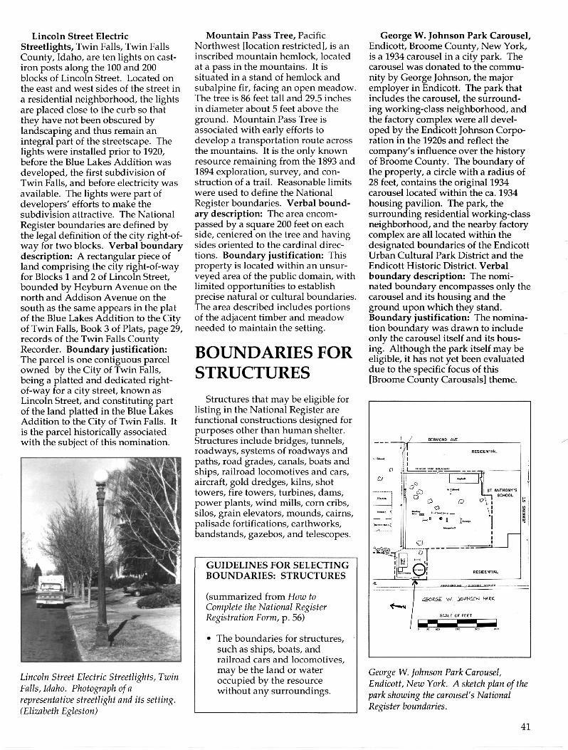
Lincoln Street ElectricStreetlights, Twin Falls, Twin FallsCounty, Idaho, are ten lights on cast-iron posts along the 100 and 200blocks of Lincoln Street. Located onthe east and west sides of the street ina residential neighborhood, the lightsare placed close to the curb so thatthey have not been obscured bylandscaping and thus remain anintegral part of the streetscape. Thelights were installed prior to 1920,before the Blue Lakes Addition wasdeveloped, the first subdivision ofTwin Falls, and before electricity wasavailable. The lights were part ofdevelopers' efforts to make thesubdivision attractive. The NationalRegister boundaries are defined bythe legal definition of the city right-of-way for two blocks. Verbal boundarydescription: A rectangular piece ofland comprising the city right-of-wayfor Blocks 1 and 2 of Lincoln Street,bounded by Heyburn Avenue on thenorth and Addison Avenue on thesouth as the same appears in the platof the Blue Lakes Addition to the Cityof Twin Falls, Book 3 of Plats, page 29,records of the Twin Falls CountyRecorder. Boundary justification:The parcel is one contiguous parcelowned by the City of Twin Falls,being a platted and dedicated right-of-way for a city street, known asLincoln Street, and constituting partof the land platted in the Blue LakesAddition to the City of Twin Falls. Itis the parcel historically associatedwith the subject of this nomination.
Lincoln Street Electric Streetlights, TwinFalls, Idaho. Photograph of arepresentative streetlight and its setting.(Elizabeth Egleston)
Mountain Pass Tree, PacificNorthwest [location restricted], is aninscribed mountain hemlock, locatedat a pass in the mountains. It issituated in a stand of hemlock andsubalpine fir, facing an open meadow.The tree is 86 feet tall and 29.5 inchesin diameter about 5 feet above theground. Mountain Pass Tree isassociated with early efforts todevelop a transportation route acrossthe mountains. It is the only knownresource remaining from the 1893 and1894 exploration, survey, and con-struction of a trail. Reasonable limitswere used to define the NationalRegister boundaries. Verbal bound-ary description: The area encom-passed by a square 200 feet on eachside, centered on the tree and havingsides oriented to the cardinal direc-tions. Boundary justification: Thisproperty is located within an unsur-veyed area of the public domain, withlimited opportunities to establishprecise natural or cultural boundaries.The area described includes portionsof the adjacent timber and meadowneeded to maintain the setting.
BOUNDARIES FORSTRUCTURES
Structures that may be eligible forlisting in the National Register arefunctional constructions designed forpurposes other than human shelter.Structures include bridges, tunnels,roadways, systems of roadways andpaths, road grades, canals, boats andships, railroad locomotives and cars,aircraft, gold dredges, kilns, shottowers, fire towers, turbines, dams,power plants, wind mills, corn cribs,silos, grain elevators, mounds, cairns,palisade fortifications, earthworks,bandstands, gazebos, and telescopes.
GUIDELINES FOR SELECTINGBOUNDARIES: STRUCTURES
(summarized from How toComplete the National RegisterRegistration Form, p. 56)
• The boundaries for structures,such as ships, boats, andrailroad cars and locomotives,may be the land or wateroccupied by the resourcewithout any surroundings.
George W. Johnson Park Carousel,Endicott, Broome County, New York,is a 1934 carousel in a city park. Thecarousel was donated to the commu-nity by George Johnson, the majoremployer in Endicott. The park thatincludes the carousel, the surround-ing working-class neighborhood, andthe factory complex were all devel-oped by the Endicott Johnson Corpo-ration in the 1920s and reflect thecompany's influence over the historyof Broome County. The boundary ofthe property, a circle with a radius of28 feet, contains the original 1934carousel located' within the ca. 1934housing pavilion. The park, thesurrounding residential working-classneighborhood, and the nearby factorycomplex are all located within thedesignated boundaries of the EndicottUrban Cultural Park District and theEndicott Historic District. Verbalboundary description: The nomi-nated boundary encompasses only thecarousel and its housing and theground upon which they stand.Boundary justification: The nomina-tion boundary was drawn to includeonly the carousel itself and its hous-ing. Although the park itself may beeligible, it has not yet been evaluateddue to the specific focus of this[Broome County Carousals] theme.
BERMONO AVE
ST ANTHONY'SSCHOOL
George W. Johnson Park Carousel,Endicott, New York. A sketch plan of thepark showing the carousel's NationalRegister boundaries.
41

George W. Johnson Park Carousel, Endicott, New York. The carousel and its setting.(G. Joseph Socki)
Newport Stone Arch Bridge,Newport, Herkimer County, NewYork, was built in 1853 to join theolder core of the village on the eastbank of West Canada Creek with anindustrial and residential area on thewest bank. The nominated propertyincludes an area of the West CanadaCreek and its bank approximately 250feet in length and 225 feet in width.In addition to the bridge itself, the siteincludes two contributing stoneretaining walls on the west bank ofthe creek. A concrete dam north ofthe bridge and a modern powergeneration facility east of the bridgeare excluded from the nominatedproperty. The Newport Stone ArchBridge is a good example of tradi-tional arched masonry bridge con-struction and represents a significant
Crawford Ditch, El Dorado County,California, was built in 1852 as thesecond segment of the Jones, Furman &Company ditch system to provide riverwater to miners of the Mother LodeGold Rush. The trough-shapedearthen trench averages 5 feet acrossbetween the edge of the up-hill bankand the inner face of the retainingberm. The Crawford Ditch is the lastfunctioning industrial structure in thePleasant Valley area of El DoradoCounty. Only the Clear Creek segmentof the Crawford Ditch is nominated;the remainder of the ditch has lost itshistoric integrity. The legal right-of-way of the ditch was used to define theNational Register boundaries. Verbalboundary description: A 7.5-mile-longditch with a 50-foot-wide workingright-of-way. It falls in that lengthfrom the Clear Creek intake weir (nearPleasant Valley) at the 2,285-footcontour to the feeder siphon at thenortheast side of the intersection ofHanks Exchange Road and Ranch Road(near the Hanks Exchange communityat the 2,245-foot contour). See theaccompanying USGS map, CaminoQuadrangle, California, 7.5 minuteseries (topographic), photorevised1973, the Crawford Ditch. Find theClear Creek segment per the UTMreferences noted above, as marked onthe map. Boundary Justification: Theboundaries encompass the one remain-ing section of the Crawford Ditch thatretains sufficient integrity to meetNational Register standards. Theboundaries encompass the ditch andthe right-of-way historically associatedwith it.
Crawford Ditch, El Dorado County, California. Detail of a USGS map showingnominated segment of the ditch.
the
42

mid-19th century engineering accom-plishment in the county. Natural andcultural features and reasonable limitswere used to define the NationalRegister boundaries. Verbal bound-ary description: The nominatedproperty is 250 feet in length, east towest, and 236 feet in width, north tosouth, encompassing the bridge at thecenter, and including the stoneretaining walls at the west bank of theWest Canada Creek. Proceedingclockwise, the boundary follows theeast bank of the creek to a point 125feet south of the bridge, where it turnswest to follow a line parallel with thebridge to the west bank of the creek.The boundary turns north at the westbank, where it follows stone retainingwalls to a point 75 feet north of thebridge before turning east. Thenorthern segment of the boundaryparallels the bridge to the point whereit intersects the eastern section of theboundary. Refer to the attached siteplan. Boundary justification: Theboundary has been established toisolate the bridge, its ancillary retain-ing walls, and its immediate settingfrom adjacent areas that are notdirectly associated with the history ofthe bridge.
Newport Stone Arch Bridge, Newport,New York. Sketch plan showing theproperty's National Register boundaries.
Hanford B Reactor, BentonCounty, Washington, is a plutonium-production reactor that was con-structed during World War II as partof the Manhattan Project. Construc-tion of the reactor began in 1943 andthe facility produced fissionablematerial for national defense until itsdeactivation in 1968. The B Reactor ishoused inside the 105-B reactorcontainment building in the B/C Areaof the Hanford Site. The containmentbuilding is surrounded by varioussupport structures that are notincluded in this nomination. TheHanford B Reactor is significant for itsassociation with nuclear power andthe Manhattan Project: this reactorproduced the plutonium used in thebomb dropped on Nagasaki. Acultural feature (the existing fence)was used to define the NationalRegister boundary. Verbal boundarydescription: The Hanford B Reactoris located in the 100B/C Area of theHanford Site, .05 mile south of theColumbia River and 3.5 miles east ofthe point where Washington High-way 240 crosses the Columbia River atVernita Bridge. The structure andadjoining land lie within a 650-foot-square plot, the center point of whichis at the above-referenced UTMcoordinate. Boundary justification:The boundary includes the structureand space around it as currentlydefined by fencing.
Lusk Water Tower, Lusk, NiobraraCounty, Wyoming, is a round watertank about 25 feet in diameter andabout 25 feet high, supported by awood column structure. The watertower is significant for its associationwith the Chicago and NorthwesternRail Line, a line of major importancein Wyoming's settlement. The watertower was originally located in thecenter of the town of Lusk, near thedepot; the water tower was moved toits present location, north of theChicago and Northwestern Rail Line,in 1919 when the depot was rebuilt inthe center of town. The water towerproperty, enclosed by a chain-linkfence, is less than l/i acre in size. Theproperty is bordered by a rail line tothe south, pasture to the west andeast, and a residential rural subdivi-sion to the north. The move has hadlittle effect on the historic integrity ofthe structure, as its new setting isassociated with the rail line andreflects the continued development ofthe railroad and its function. The
legal description of the parcel wasused to define the National Registerboundary. Verbal boundary descrip-tion: The 1982 Warranty Deed to theNiobrara County Historical Societystates that the Lusk Water Tower siteconsists of 0.2 acres. This tract of landis in the E V2 of Section 8, Township32 North, Range 63 West of the 6thP.M. USGS Lusk, Wyoming, Quad-rangle map, described as follows:From the 'A section corner on the eastsection line of Section 8, Township 32North, Range 63 West of the 6th P.M.along the l/t section line a distance of1,300 feet to point of beginning.Thence north 69 32' west, a distance of230 feet; thence south 53 02' east, adistance of 173 feet; thence south 6932' east, a distance of 94.5 feet; thencenorth 20 28' east, a distance of 50 feet;thence north 69 32' west, a distance of32.5 feet to the point of beginning.Containing 0.2 acres, more or less.Boundary justification: The bound-ary is based on the legally recordedboundary lines that encompass thesingle parcel of land that is occupiedby the water tower and its immediatesurroundings. This represents theparcel owned and protected by theNiobrara County Historical Society.
Lusk Water Tower, Lusk, Wyoming.(Richard Collier)
43

Saint Cloud and Red River ValleyStage Road—Kandota Section, ToddCounty, Minnesota, is the best pre-served section of the road built by theMinnesota Stage Company in 1859.The property is significant for itsassociation with the transportationhistory of Minnesota, as defined in theOverland Staging Industry in Minne-sota, 1849-1880, Multiple PropertySubmission. The property meets thefollowing registration requirements:conforming to the original route;being unimproved, passable, anddistinct from the surrounding land;being long enough to evoke a sense ofdestination or direction; and retainingthe wooded setting of the area'scondition during the period of signifi-cance. The land beyond the north-west end of the nominated property,which has been plowed, bears nosigns of the road and is thereforeexcluded from the nomination.Reasonable limits were used to definethe National Register boundaries.Verbal boundary description: Theproperty consists of a six-foot-widestrip of land centering on the linedelineated on the accompanying map(USGS 7.5 minute series, West Union,Minnesota, Quadrangle). The lineconnects the following UTM referencepoints: A 15 344350 5070710, B 15344120 5070890. Boundary justifica-tion: The property boundariesencompass the visible roadway asdetermined through field survey byRobert Hybben, 22 May 1990.
Saint Cloud and Red River Valley Stage Road-Kandota Section, Todd County,Minnesota. Detail of USGS quadrangle map showing location of the National Registerproperty.
fc- ' 'Saint Cloud and Red River Valley Stage Road-Kandota Section, Todd County,Minnesota. The stage road trace, facing northwest. (Robert Hybben)
44

IV. REFERENCES
Knoerl, John, and Betsy Chittenden.Boundary Analysis of the Dune Shacksof Peaked Hill Bars Historic District,Cape Cod, Massachusetts. CulturalResources Information ManagementSeries. Washington, D.C.: CulturalResources Geographic InformationSystems Applications Center,National Park Service, U.S. Depart-ment of the Interior, 1990.
McClelland, Linda Flint, J. TimothyKeller, Genevieve P. Keller, andRobert Z. Melnick. NationalRegister Bulletin: Guidelines forEvaluating and Documenting RuralHistoric Districts. Washington,D.C: National Register of HistoricPlaces, National Park Service, U.S.Department of the Interior, 1990.
National Register Bulletin: Definition ofNational Register Boundaries forArcheological Properties. Washing-ton, D.C: National Register ofHistoric Places, National ParkService, U.S. Department of theInterior, 1985.
National Register Bulletin: How toComplete the National RegisterRegistration Form. Washington,D.C: National Register of HistoricPlaces, National Park Service, U.S.Department of the Interior, 1991.
National Register Bulletin: How toComplete the National RegisterMultiple Property DocumentationForm. Washington, D.C: NationalRegister of Historic Places,National Park Service, U.S.Department of the Interior, 1991.
National Register Bulletin: Using theUTM Grid System to Record HistoricSites. Washington, D.C: NationalRegister of Historic Places, Na-tional Park Service, U.S. Depart-ment of the Interior, 1977.
Parker, Patricia L., and Thomas F.King. National Register Bulletin:Guidelines for Evaluating and Docu-menting Traditional Cultural Proper-ties. Washington, D.C: NationalRegister of Historic Places, Na-tional Park Service, U.S. Depart-ment of the Interior, 1990.
Townsend, Jan, John H. Sprinkle, Jr.,and John Knoerl. National RegisterBulletin: Guidelines for Evaluatingand Registering Historical Archeologi-cal Sites and Districts. Washington,D.C: National Register of HistoricPlaces, National Park Service, U.S.Department of the Interior, 1993.
45

V. NATIONAL REGISTERCRITERIA FOR EVALUATION
The National Register's standardsfor evaluating the significance ofproperties were developed to recog-nize the accomplishments of allpeople who have made a contributionto our country's history and heritage.The criteria are designed to guideState and local governments, Federalagencies, and others in evaluatingpotential entries in the NationalRegister.
The quality of significance inAmerican history, architecture,archeology, engineering, and cultureis present in districts, sites, buildings,structures, and objects that possessintegrity of location, design, setting,materials, workmanship, feeling, andassociation and:
A. that are associated with events thathave made a significant contributionto the broad patterns of our history; or
B. that are associated with the lives ofpersons significant in our past; or
C. that embody the distinctive charac-teristics of a type, period, or methodof construction, or that represent thework of a master, or that possess highartistic values, or that represent asignificant and distinguishable entitywhose components may lack indi-vidual distinction; or
D. that have yielded, or may be likelyto yield, information important inprehistory or history.
Criteria considerations: Ordinarilycemeteries, birthplaces, or graves ofhistorical figures, properties ownedby religious institutions or used forreligious purposes, structures thathave been moved from their originallocations, reconstructed historicbuildings, properties primarilycommemorative in nature, andproperties that have achieved signifi-cance within the past 50 years shallnot be considered eligible for theNational Register. However, suchproperties will qualify if they areintegral parts of districts that do meetthe criteria or if they fall within thefollowing categories:
a. a religious property derivingprimary significance from architec-ture or artistic distinction or histori-cal importance; or
b. a building or structure removedfrom its original location but whichis significant primarily for architec-tural value, or which is the surviv-ing structure most importantlyassociated with a historic person orevent; or
c. a birthplace or grave of a historicalfigure of outstanding importance ifthere is no other appropriate site orbuilding directly associated with hisor her productive life; or
d. a cemetery that derives its primarysignificance from graves of personsof transcendent importance, fromage, from distinctive design fea-tures, or from association withhistoric events; or
e. a reconstructed building whenaccurately executed in a suitableenvironment and presented in adignified manner as part of arestoration master plan, and whenno other building or structure withthe same association has survived;or
f. a property primarily commemora-tive in intent if design, age, tradi-tion, or symbolic value has investedit with its own historical signifi-cance; or
g. a property achieving significancewithin the past 50 years if it is ofexceptional importance.
46

VII. NATIONAL REGISTBULLETINS
The BasicsHow to Apply National Register Criteria for Evaluation *
Guidelines for Completing National Register of Historic Places FormPart A: How to Complete the National Register Form *Part B: How to Complete the National Register Multiple Property Documentation Form
Researching a Historic Property *
Property Types
Guidelines for Evaluating and Documenting Historic Aids to Navigation *
Guidelines for Identifying, Evaluating and Registering America's Historic Battlefields
Guidelines for Evaluating and Registering Historical Archeological Sites
Guidelines for Evaluating and Registering Cemeteries and Burial Places
How to Evaluate and Nominate Designed Historic Landscapes *
Guidelines for Identifying, Evaluating and Registering Historic Mining Sites
How to Apply National Register Criteria to Post Offices *
Guidelines for Evaluating and Documenting Properties Associated with Significant Persons
Guidelines for Evaluating and Documenting Properties That Have Achieved Significance Within the Last Fifty Years
Guidelines for Evaluating and Documenting Rural Historic Landscapes *
Guidelines for Evaluating and Documenting Traditional Cultural Properties *
Nominating Historic Vessels and Shipwrecks to the National Register of Historic Places
Technical AssistanceContribution of Moved Buildings to Historic Districts; Tax Treatments for Moved Buildings; and Use of Nomination
Documentation in the Part I Certification Process
Defining Boundaries for National Register Properties*
Guidelines for Local Surveys: A Basis for Preservation Planning *
How to Improve the Quality of Photographs for National Register Nominations
National Register Casebook: Examples of Documentation *
Using the UTM Grid System to Record Historic Sites
The above publications may be obtained by writing to the National Register of Historic Places, National Park Service,1849 C Street, NW, Washington, D.C. 20240. Publications marked with an asterisk (*) are also available in electronicform on the World Wide Web at www.cr.nps.gov/nr, or send your request by e-mail to nrref [email protected].
47

APPENDIX: DEFINITION OFNATIONAL REGISTERBOUNDARIES FORARCHEOLOGICALPROPERTIES
Edited by: Barbara J. Little, Beth L. Savage, and John H. Sprinkle, Jr.
TABLE OF CONTENTS
ACKNOWLEDGMENTS 49
I. INTRODUCTION 49
II. WHAT IS AN ARCHEOLOGICAL SITE? 50
III. DEFINING THE BOUNDARIES OF ARCHEOLOGICAL SITES 51
IV. CASE STUDIES 52
V. REFERENCES 62
48

ACKNOWLEDGMENTS
The first version of National RegisterBulletin: Definition of National RegisterBoundaries for Archeological Propertieswas edited by National RegisterHistorian Beth L. Savage and releasedin 1985. The compilation of thatbulletin was the result of the work ofnumerous individuals. Issues relatingto the delineation of boundaries forarcheological nominations wereidentified as a National RegisterBulletin topic in the early 1980s by acommittee of the National Conferenceof State Historic Preservation Officers,led by Valerie A. Talmage, formerState Historic Preservation Officer ofMassachusetts. Earlier work by BruceMacDougal and Herbert Brito onboundary delineation for NationalRegister properties served as aframework for the bulletin. YvonneStewart, Carol Dubie and John Knoerlplayed integral roles in the bulletin'scompletion. Helpful suggestionsprovided by the staff of the NationalRegister and Planning Branches,Interagency Resources Division, andthe insightful comments of manyState Historic Preservation Officescontributed to the final publication.
Answering an expressed need toprovide continuing guidance in thearea of delineating boundaries forarcheological properties, the NationalRegister reevaluated the usefulness ofthe original version of Bulletin 12 in1994. We thank the following fortheir comments: Carl Barna (BLM),Colorado Historical Society, JohnCornelison (NPS Southeast Archeol-ogy Center), Frank R. Finch (Depart-ment of the Army), Leland Gilson(Oregon SHPO), J. Bennett Graham(Tennessee Valley Authority), RichardR. Hoffman (FERC), Diane Holliday(State Historical Society of Wiscon-sin), Elizabeth Horvath (NPS South-east Archeology Center), JudyMcDonough (Massachusetts SHPO,Massachusetts Historical Commis-sion), Arleen Pabon (Puerto RicoSHPO), Gary Shaffer, (MarylandHistorical Trust), Herschel Shepard(University of Florida), Robert E.Stipe, Lois Thompson (DOE), WesternRegional Office, Valerie Talmage(former Massachusetts SHPO) andRichard Guy Wilson (University ofVirginia).
Several reviewers suggestedincorporating National Register Bulle-tin: Definition of National RegisterBoundaries for Archeological Properties
into a more broadly applicableboundary bulletin. In 1995, a revisedNational Register Bulletin: DefiningBoundaries for National Register Proper-ties was issued. This current reprint ofthat bulletin incorporates an updatedand streamlined version of NationalRegister Bulletin: Definition of NationalRegister Boundaries for ArcheologicalProperties as this appendix. John H.Sprinkle, Jr., (Woodward-ClydeFederal Services) wrote most of thenew material on site definition andidentified new examples. Barbara J.Little (Archeologist, National Registerof Historic Places) organized thebulletin into this appendix anddeleted redundant examples. Carol D.Shull supervised the revisions. MaryF. McCutchan edited the text andprepared it for publication. JanTownsend, Antoinette J. Lee, and BethSavage assisted with various aspectsof its preparation.
I. INTRODUCTION
This appendix defines recom-mended approaches, with illustra-tions where applicable, to delineatingboundaries for archeological proper-ties. Section II defines the concept ofan archeological site. How archeolo-gists define the boundaries of archeo-logical sites is outlined in Section III.Section IV presents case studies whichaddress the delineation of archeologi-cal site boundaries for a variety ofboth hypothetical and actual NationalRegister properties. The case studiesillustrate the necessary details—including background information,boundary description, approachesused, and boundary justification—with acceptable delineated bound-aries which typify situations com-monly encountered in preparingnominations.
In each of the examples, the prop-erty has already been determinedeligible for listing in the NationalRegister. The cases are chosen toillustrate decisions regarding bound-aries.
Reflecting the various types ofhistorical associations retained bycultural resources, many historicproperties are eligible for inclusion inthe National Register under morethan one of the four Criteria: A, B, C,or D. However, the National Registerrecognizes only one boundary foreach historic property. A site that iseligible under Criterion D for theimportant information contained in its
buried remains, may also be eligibleunder Criterion A for its significanceto modern Native American groups asa Traditional Cultural Property.Although the physical boundaries ofthe archeological site may be rela-tively small, the larger boundaries ofthe traditional place would be repre-sented in the National Register.Whatever the criteria for eligibility,historic properties should always bedelineated by their largest relevantboundary.
One continuing issue with historicproperties that happen to be archeo-logical sites is the destructive natureof archeological investigation. TheNational Register does not, as a rule,list archeological sites that have beenthe subject of complete excavation.The artifacts, field records, photo-graphs, and other data collectedthrough the process of excavation donot retain integrity of location orsetting and thus are not eligible forinclusion. Some sites that were thelocations of significant milestones inthe history of American archeologyare listed after excavation as historicsites.
However, very few archeologicalsites are completely excavated intoday's world where archeologicalstudies are usually conducted as partof cultural resource managementactivities. Archeological investigationis by definition a process of samplingthe buried record of past lives. Atmost sites, portions of the site remainunexcavated. In addition, in theframework of data recovery, or PhaseIII excavations, only a portion of thesite, that within the "limits of pro-posed construction" or "area ofpotential effects" is subject to inten-sive excavations. Often large portionsof archeological sites located outsidethe "mitigated" areas survive thedevelopment process. Care should begiven, at the completion of datarecovery excavations, to evaluate andnominate the significant survivingportions of the "unmitigated" area ofsuch archeological sites.
For example, in a recent case froma southeastern state, a large multicomponent archeological site, datingfrom the Late Archaic and Contactperiods, was subject to data recoveryexcavations in the area slated forconstruction of a reservoir dam in thelate 1980s. Subsequently in the mid1990s, another portion of the siteunderwent Phase III excavations asthe result of a second federal under-
49

taking. However, portions of the sitelocated between the two areas ofprevious data recovery excavationshave the potential to contain signifi-cant archeological information.Proposed for preservation in place,this surviving parcel is eligible for theNational Register although the site asa whole has endured two previousdata recovery operations.
Finally, the National Register haslong recognized the disproportionateunder-representation of archeologicalsites (approximately 7%) within itsapproximately 67,000 listed proper-ties. Clearly, many thousands ofhistoric buildings, structures, anddistricts contain unrecognized archeo-logical components that are equallyeligible for the National Register. TheNational Register has made amendingnominations to include the archeo-logical portions of currently listedhistoric properties, a relatively simpleand straightforward process. Nomina-tions may be quickly prepared oramended using the computer-residentnomination forms available from theNational Register. Specific proceduresfor amending nominations can befound in National Register Bulletin:How to Complete the National RegisterRegistration Form. Nominationamendments should be used toincrease or decrease the boundaries ofa property or district, as well asadding or subtracting criteria andareas of significance.
National Register nominationsshould not be considered staticdocuments. Indeed, as land uses at asite change, or as further informationis gathered, it may be desirable toupdate the nomination to reflectcurrent conditions. Over the years, aNational Register nomination mayrequire a certain amount of "informa-tion maintenance" in order to recon-sider the property's description,contributing elements, period ofsignificance, applicable criteria, and ofcourse, boundaries.
II. WHAT IS ANARCHEOLOGICAL SITE?
The main text of this bulletin (p.30)defines a site as "the location of asignificant event, prehistoric orhistoric occupation or activity, orbuilding or structure, (whetherstanding, ruined, or vanished) wherethe location itself possesses historic,cultural, or archeological value" andgoes on to note that "the most com-mon types of resources classified assites are archeological resources."
Most archeologists practicing theircraft today would agree that togetherwith the artifact and the feature, the"archeological site" is one of thefundamental concepts in our disci-pline. Yet, it is sometimes difficult tofind a simple, meaningful definitionof what an archeological site is, andwhat it is not.
Archeologists have always recog-nized the site as one of the founda-tions of all research on past cultures.In his 1956 work, A Short Introductionto Archaeology, the British archeologist,V. Gordon Childe described howalthough "antiquities" could becommonly found either on the surfaceof the ground or through excavation,"such objects in themselves are onlypotential archeological data." Arti-facts only become data "when classi-fied in light of their associations, ofthe contexts in which they have beenfound" within archeological sites.Thus, for Childe, a "site" was simplythe source of archeological informa-tion.
Field manuals for archeologistsprovide common definitions ofarcheological sites. A site is "a fairlycontinuous distribution of the remainsof a former single unit of settlement"(Dancey 1981:13).
An archeological site isusually the scene of pasthuman activity. It may bemarked by the scantyremnants of a brief en-campment, or by theabundant remains of asettled village. If a siteshows evidence of repeatedoccupation or use, it is stillconsidered a single site, butvarious levels or periods ofuse may be distinguishedwithin it (Hester, Heizer,and Graham 1975:13).
Each archeological site isa unique time capsule.Each has its own distinctcharacter and problems.Sites represent a body ofdata relevant to theirsetting and their culturalpatterning and must beinterpreted in relation toboth this local setting andto their function as a linkbetween cultures(Joukowsky 1980:35).
Outlining the mysteries of archeol-ogy in an effort to protect sites onprivate property, National ParkService archeologist Susan Henry(1993:6-7) relates several characteris-tics of sites:
The focus of the archeo-logical attentions is thesite—a place where humanactivity occurred. Anarcheological site hashorizontal and verticaldimensions. Few archeo-logical sites are simple andstraightforward. Most arecomplex, containingdiverse elements, orcomponents, each of whichmay represent a differentactivity. All site compo-nents bear a relationship toone another, and allcomponents, including thebuildings and landscapes,need to be studied in orderto understand the way oflife once carried out at [asite].
Archeologists occasionally havepointed out that the site concept isinadequate because the archeologicalrecord often is not clustered. Severalresearchers have supplemented thesite concept with that of "nonsitesites" (for example, Dunnell andDancey 1983; Lewarch and O'Brien1981). "Distributional archeology"(Ebert 1992) focuses on surfacematerial rather than sealed sites inorder to concentrate on human use ofthe whole landscape rather than ondiscrete, rare places. For the purposeof nominating an archeological siteto the National Register, there mustbe clearly defined and justifiedboundaries. See Cases 15 and 16 forexamples of delimiting site bound-aries where the artifact record iscontinuous.
50

In an attempt to add consistency tothe process of cultural resourcemanagement, many State HistoricPreservation Officers (SHPO) haveoffered specific statements on thecharacteristics of archeological sites.For SHPOs, the definition of archeo-logical site is often tied to the processof completing an archeological siteform, which forces the regulators tostandardize terms and provideguidance for just what is and what isnot a site. For example, Virginia'sguidelines for archeological surveyprovide one definition of a site:
In general terms, anarcheological site is definedas the physical remains ofany area of human activitygreater than 50 years of agefor which a boundary canbe established. Examplesof such resources wouldinclude the following:domestic/habitation sites,industrial sites,earthworks, mounds,quarries, canals, roads,shipwrecks, etc. Under thegeneral definition, a broadrange of site types wouldqualify as archeologicalsites without the identifica-tion of any artifacts (VDHR1996:1).
All archeological sites have someform of physical expression, eitherthrough the presence of artifacts orother evidence of modification of thenatural world through human agents.It is difficult to think of an archeologi-cal site that would have no survivingphysical remains. In fact, the Na-tional Register generally does not listarcheological sites that have beenfully excavated, that is, where nophysical remains of the site survive,because of the loss of integrity.
The theoretical construct of "site"plays a fundamental role in the waysarcheologists view past societies.Concepts regarding archeologicalsites can be expressed through fourphrases:1. Methodology Mechanics. Themethods used by archeologists to lookfor sites influences the sites that areidentified. This concept reinforces thetraditional scientific and archeologicalpremise that methods and theoryfundamentally influence the nature ofthe recovered information. Thus, aclear definition of how to define the
location and boundaries of sites mustbe an essential part of everyarcheologist's theoretical and method-ological tool kit.2. Artifact Axiom. An archeologicalsite must have some physical evi-dence of occupation, use, or transfor-mation. This evidence is usually inthe form of artifacts, but also includeshuman alterations to the landscape.Without some form of physicalpresence it is impossible to defineboundaries to archeological sites.3. Density Dilemma. Is the center ofthe site the place with the mostartifacts? The boundary of archeologi-cal sites should not be defined solelyon the basis of artifact density re-vealed in an archeological survey. Asthe remains of past human activities,archeological sites may contain areaswhere artifact density is relativelylow, separating two portions of thesame site. In addition, variouscultural and natural transformationshave fundamentally altered thecondition of readily apparent archeo-logical sites. Through time, vegeta-tion may obscure artifacts, plowedareas may blanket subsurface fea-tures, and soil movement by a varietyof processes may have buried sites.The definition of a site's boundarymust consider the land use history ofthe site as well as artifact density.4. Present vs. Past. How certain arethe limits of a prehistoric or historicperiod site? Obviously, the definitionof an archeological site's boundaries isa judgment made in the present. It ismolded by the archeologist's training,education, and view of the past. Careshould be given to consider how thesite may have been perceived in thepast. Historic boundaries, if they canbe defined or modeled, should begiven primacy over modern bound-aries.
III. DEFINING THE BOUNDARIESOF ARCHEOLOGICAL SITES
While defining boundaries usuallyrequires some limited excavation, it isalso often possible to use nondestruc-tive methods prior to archeologicalfieldwork to identify the location andextent of suspected subsurfacefeatures within archeological proper-ties. Over the years, archeologistshave adapted a variety of methodsfrom other disciplines to see beneaththe earth. Geophysical prospectingtechniques most commonly used byarcheologists include electrical
resistivity and conductivity (includingmetal detectors), ground-penetratingradar (GPR), and magnetic prospect-ing. Analysis of soil chemistry alsohas been used successfully to identifysites and activity areas within sites.Aerial photography is a well-knowntechnique used extensively to identifysites. Although some types of remotesensing can be executed by archeolo-gists trained in their use, it is commonto hire specialists because the tech-niques and technologies of remotesensing change rapidly.
Advantages to geophysical meth-ods are that they are nondestructive(or minimally destructive) and arerelatively fast. However, geophysics isan indirect science which detects"anomalies" which then usuallyrequire some level of sub-surfacetesting to verify as archeologicalresources.
Remote sensing is particularlyuseful in underwater archeologicalendeavors. In the case of one recentlylisted shipwreck along the easternseaboard, the site was identified usinga towed-array proton precisionmagnetometer as part of a state-sponsored survey. The 30- by 40-meter boundary of the site wasidentified by using metal detectorsurvey as well as test excavations.
Clearly, as new technologies andmethodologies are adapted to theneeds of archeological investigations,these techniques can be used to helpdefine boundaries of National Regis-ter properties.
Whether using new technologies orold, the level of effort to defineboundaries should be an explicit partof research designs for archeologicalsurveys designed to identify allpotentially National Register eligiblesites. In addition, the principles fordemarcating the limits of archeologi-cal sites should also be explicitlystated in the survey methodology.Once defined, this methodologyshould be consistently applied to eachpotential archeological site identifiedin a survey.
National Register boundariesdistinguish, from their surroundingenvironment, archeological sitesmeeting the National Register criteriafor evaluation either individually oras contributing elements in an archeo-logical district. Site boundaries oftenare reasonable distinctions that maynot always reflect the spatial conceptsimplicit in certain theoretical perspec-tives, notably those of "nonsite"
51

archeology. However, boundarydeterminations require clear recogni-tion of how physical features andtheir mutual relationships form a"site/' Usually this requires thearcheologist to decide the degree offall off in cultural material densitythat is no longer acceptable in orderfor an enclosed area to be consideredpart of the significant "site."
Boundaries for National Registerproperties are horizontal boundariesthat can be clearly marked in twodimensions. Vertical boundaries of asite probably will have been estab-lished or predicted through testing toevaluate the site for significance.
Absolute boundary definition isoften unachievable. Boundariesusually represent compromisesreconciling both theory and fieldconditions to facilitate communicationwith agencies and the public aboutsensitive geographic locations havingimportant concentrations of archeo-logical information.
There are several methods forobtaining boundary evidence forarcheological sites. These are summa-rized on page 30 in the main text ofthis bulletin. Examples of each areprovided in this appendix or in themain text of this bulletin. Each of thetechniques used must be adequatelydocumented in the text of the nomina-tion.
The first two, "subsurface testing"and "surface observation," providedirect documentation of archeologicalresources. Several examples in themain text use these methods. See thediscontiguous district of CrockettCanyon/Coyote Ranch ArcheologicalDistrict (p. 23) as well as most of theexamples under "Archeological Sitesand Districts" (pp.30-36). In thisappendix see Case 1 for an example ofdirect documentation through subsur-face testing and Case 2 for an exampleof surface observation.
The third method, "observation oftopographic and other natural fea-tures," often provides logical anddefendable boundaries for sites. Forexamples in the main text, see inparticular Rockshelter Petroglyphs(p.31), Prehistoric Quartzite QuarryArcheological Site (p.31), and HarborIsland Historic and ArcheologicalDistrict (p.33). In this appendix seeCase 3 for a further example.
The fourth technique, "observationof land alterations," includes thedocumentation of land disturbancethat may have destroyed portions of a
site, thereby indicating a boundary forthe remaining resource. See Case 4for an example. It may also involvedocumenting the lack of disturbanceto a property as evidence supportinga site's integrity. This latter case isillustrated in Cases 5 and 6.
The last technique listed on page 30is "study of historic or ethnographicdocuments." This technique ofteninvolves the use of maps and legalboundaries. Several examples in themain text illustrate the use of suchdocuments for determining bound-aries. See these contiguous districts inrural settings: The Woodlawn Historicand Archeological District (p.17),Bloomvale Historic District (p.21),Weyerhaueser South Bay Log DumpRural Historic Landscape (p.22). Theboundaries for Pecos ArcheologicalDistrict are coterminous with the legalboundaries of Pecos National Histori-cal Park (p.24). Cases 7, 8, and 9 inthis appendix provide further ex-amples.
In addition to these five techniquesis the "property type model," whichwas defined in earlier editions of thisappendix (as Definition of NationalBoundaries for Archeological Districts).The property type model is based onknown site types. For example, a latearchaic camp in a swampy area isdiscovered during a survey and isnominated for the important informa-tion potential of its well-preservedplant remains. However, testing wasnot done to determine the boundariesof the site. To describe and justify aboundary coterminous with the rise ofland overlooking the swamp, aproperty type model could be used.Such a model would compare thistype of site to other known sites in theregion, clearly presenting and sup-porting the expected boundary forthis type of site. Case 10 provides anexample of the property type model.
IV. CASE STUDIES
It is an archeological truism that"every site is different." The processof determining the boundaries of anindividual archeological site depends,to a certain degree, upon the indi-vidual characteristics of that site andits surroundings. The following casestudies add to those presented in themain text. It is important to note thatin most cases, more than one tech-nique is used to determine bound-aries.
Examples for each of the maintechniques discussed above areprovided first. Following those isCase 11, a district with boundariesbased on more than one area andperiod of significance; Case 12, a siteeligible under criteria A and D as botha traditional cultural place and anarcheological site; Case 13, a bound-ary reduction; and Cases 14 and 15,examples of delimiting boundariesamid continuous distribution ofartifacts.
Case 1. Shovel Test Pits delimiting aprehistoric site located within aforest. A multicomponent prehistoricsite was located within Federalproperty in a state in the upper South.The boundaries of the site weredefined through the excavation of 46shovel test pits and limited surfacecollection of artifacts along a road.Information potential and NationalRegister eligibility was confirmedthrough the excavation of 15 1 x 1meter test units. Although somedisturbance to the site resulted,previous construction of the roaddoes not appear to have significantlycompromised the integrity of thisproperty. In situ materials werefound as deep as 50 cm below thepresent ground surface. The distribu-tion of artifacts at this site conformsto a model of site definition in whichthe highest density of artifacts isjudged to be located at the center ofthe site, with fewer artifacts found inoutlying areas. The edge of the site isdefined by the boundary between thepresence of artifacts and the absenceof artifacts, as revealed in test pits.
Boundary Description: The site islocated along AAA Road with theextreme northeastern boundary beinglocated approximately 3,000 feet northof the confluence of BBB Branch andCCC Branch, at an elevation of 1500 ft.amsl. From this point the site areafollows the road to the west (whichcoincides with the contour of theridge top) for an additional 1,000 feet.The site is confined to the north andsouth by its topographic situation;cultural materials were confined tothe level or near level portions of theridge system. (See Figure 1.)
Boundary Justification: The siteboundaries were determined by thelimits of cultural materials as definedby subsurface shovel testing. Asurface collection along the roadrevealed a continuation of materialsoutside of the defined boundaries;
52

Figure 1. (Case 1). The site boundaries for this prehistoric archeological site from astate in the upper south were defined by the presence of artifacts recovered duringshovel test pit excavation. The map included with the National Register nominationclearly shows the limits of the site with a bold line, illustrates the location of excavationunits, and clearly locates the position of the site within a forested environment.
N
500 METERS
LIMITS OF PLOWED FIELD
SITE BOUNDARY WITHINPLOWED FIELD, AS DISCOVEREDBY TESTING
M u m RAILROAD
SITE BOUNDARY
Figure 2. (Case 2). Located primarily within a plowed field, the bounds of this sitewere determined through direct documentation. Although no testing occurred withinthe woods to the north of the fields, the presence of higher artifact densities in this areasuggested that the site continued beyond the plowed field.
however, it is likely that recent roadimprovement activities are respon-sible for the current location of thesematerials. For this reason, the bound-aries as defined by the shovel testingappear to be the most accuratedefinition of the site's size and extent.
Case 2. A Plowed Prehistoric SiteIdentified through Surface Collec-tion, Natural Topography, and LandDisturbance. The site lies on a rise ofland partly in a wooded lot (11.5acres) and partly in a plowed field(ca.5 acres) entirely within propertyowned by a state agency. The site wasdiscovered in 1981 when the Stateagency leased land for farming; theplowed field was surface-collectedand artifacts and features weremapped. The site was defined bydirect documentation (observation ofsurface features and surface collec-tion; natural topographic features;and land disturbance.)
Boundary Description: The site isbounded on the south by the knownextent of cultural materials, on thewest by railroad tracks and on thenorth and east by a contour linedefining a terrace overlooking awetland (See Figure 2.)
Boundary Justification: Thesouthern boundary of the site isestablished by the limit of culturalmaterials and features and roughlycorresponds to a lowering in grade.The highest artifact densities recov-ered during surface collection werenoted at the northern and westernedges of the plowed field. By ex-trapolation, it is likely that the siteextends into the wooded areas to thenorth and west. The western bound-ary is established by the railroad cutwhich corresponds roughly to theoriginal terrace edge. The northernand eastern boundaries are set by thecontour line marking an abrupt fall tothe wetland.
Case 3. A Prehistoric Site Defined byNatural Topographic Features: Thesite was discovered in 1965 and wasinvestigated archeologically betweenthen and 1977 by the State Universityand the State Archeological Society.Excavations and surveys revealed thatthe site was occupied from EarlyArchaic through Woodland times andthat a historic, eighteenth-century,English-colonial component is alsopresent.
53

Boundary Description: Theboundaries of the site correspond tothe edges of an erosional remnant, the140-foot contour line on the topo-graphic quad, a ridge. The site isbounded by the creek and swamp onthe northwest, and by low-lyingfloodplain on all other sides (SeeFigure 3.)
Boundary Justification: Theboundaries of the site correspond tothose of the landform on which it lies.Archeological investigations haverevealed artifacts only in those areasabove the 140-foot contour of thevalley floor in all sampled areas of theridge. The site's maximum lengthnortheast to southwest is 2,500 feet,and its maximum width is 800 feet.The low-lying nature of the swampsand floodplain surrounding thiserosional upland remnant presumablymade this ridge the only habitableportion of the area, implying stronglythat topography constituted a behav-ioral boundary here.
Case 4. Documented Land Distur-bance of a Riverine Site Defined byNatural Features and Modern LandUses: A Woodland period prehistoricarcheological site was identified byavocational archeologists and re-ported to the SHPO. The 50-acre sitecomprises surface finds along afloodplain adjacent to a meanderingriver course. No scientific excavationshave been conducted at the site.
Boundary Description: The site isbounded by natural topographicfeatures and manmade alterations tothe landscape. The 600-foot contourline defines the northern, western,and eastern boundaries of the site.The southern portion of the site isdefined by a railroad right-of-waywhich was constructed at the toe of asteep slope marking a topographicboundary as well as a manmade one(See Figure 4.)
Boundary Justification: The riverforms a naturally occurring boundaryto nearly three sides of the site. Thearea contained within the inside bendof the curve of the river had bearingon the living space which was avail-able to prehistoric people. Surfacecollections have yielded prehistoriccultural materials over most of thedry land area to within a few feet ofthe present shore and as far south asthe railroad easement. The marshyarea lying between the 600-footcontour and the river was not in-cluded because interpretations of the
Figure 3. (Case 3). The boundary of this site was primarily determined by topographicfeatures and contains the ridge area encompassed by the 140-foot contour line. Archaicand Woodland prehistoric components, in addition to an eighteenth-century historicoccupation, are constrained by a creek, swamps, and flood-plain settings.
RIVER
N
SITE BOUNDARY
1 KILOMETER
Figure 4. (Case 4.) The river and associated swamp form a natural boundary for thisprehistoric site on its west, north, and east sides. The southern boundary wastruncated by construction of a railroad seated at the base of a topographic rise.
environmental history of the siteindicate that the area has been sub-jected to river scouring duringvarious meander episodes, leading tolittle expectation of the existence ofcultural remains.
The railroad easement that definesthe southern boundary represents acorridor of highly disturbed landfrom which archeological resourcescannot be expected to have survived.
The right-of-way also serves to mark asharp break in slope, delineating thewell-drained alluvial terrace whichlies on the inside bend of the riverfrom the steep (greater than 15%),rocky, till covered northerly facingslope. The topographic characteristicsbeyond the easement would haverendered this area unattractive foroccupation.
54

Case 5. Documents and Lack ofLand Disturbance of a HistoricalArcheological Site in an UrbanSetting: An eighteenth-century housein a Colonial-era town has beennominated. The townhouse is locatedon a deep lot maintained as lawn andgardens. Historical research confirmsthat the current property lines wereestablished in the original plat of theblock in the 1700s and that substantialconstruction has never occurred.Archeological investigation of otherhouses in the urban area has revealedthe presence of associated buriedprivies and trash deposits.
Discussion: Historic documenta-tion of legal boundaries would be themost appropriate in this case wherethe documentation confirms thatcurrent property lines represent thehistoric property lines. In addition,the lack of interior block disturbanceis documented, leading to an expecta-tion of buried feature remains such asprivies. This expectation may beconfirmed by surface observation ofsite features and materials. Subsurfacetesting would not be necessary forboundary definition in this case.Modern legal boundaries should beused in concert with historic docu-mentation which confirms that thecurrent legal boundaries are histori-cally the legal boundaries of the site.
Case 6. Documents and Lack ofLand Disturbance for a MultipleProperty Nomination for CharcoalIron Furnaces: Numerous charcoaliron furnace complexes and associ-ated communities have been identi-fied. All known examples of this classof property are included. Althoughpredominantly subsurface in nature, afew aboveground resources arepresent. Archival research andintensive restoration of one of thefurnace complexes have established adescription of the types and functionsof the resources represented, theirtime range, their physical characteris-tics, and the probable classes ofimportant research data represented.Original plats for individual furnacecomplexes and communities as wellas historic photographs are available.Limited archeological surveys haveconfirmed the presence of historicallydocumented features at several of thefurnace sites and associated commu-nities. Typically, the iron furnacesand associated communities have notbeen developed following theirabandonment.
Boundary Description: For eachfurnace complex and associatedcommunity, the boundary is definedby the historical limits of the resourceas illustrated in historic plat maps andverified as undisturbed based on fieldinspection (See Figure 5.)
Boundary Justification: Given thatall members of this class of resourceshave been identified; that the originalplats are available to establish bound-aries; that archival research, restora-tion, and limited archeologicalresearch have established the typesand functions of the various resourcesrepresented; and that the furnace sitesare located in a region of the State thathas experienced little development, itis appropriate to use historic docu-ments (plats) to determine the bound-
aries of each property included in thenomination. Subsurface testing is notnecessary for boundary justification,because enough is known about thesite functions and features to accu-rately predict locations of activity lociand expected data classes. Limitedsurface reconnaissance on severalproperties and restoration of onefurnace and auxiliary building haveconfirmed the presence of expectedfeatures, based on historic documen-tation. Visible signature features,such as furnace stack remnants,earthen ramps, slag dumps, ore pits,and building foundations in conjunc-tion with plats, historic photographs,and standing buildings have beenuseful in locating specific features,i.e., stacks are located near streams
TYPICAL CHARCOAL IRONFURNACE LAYOUT(20-25 ACRES)
FURNACE STACK, BUILDINGREMNANTS AND SOME EQUIPMENTREMAIN
t
WORKERS' I I I IHOUSING p = f p = ^
COMPANYSTORE& OFFICE
• •• •
ROAD •
Figure 5. (Case 6). This figure shows a typical charcoal iron furnace dating from thenineteenth century. As part of a multiple property nomination, the boundary of eachcomplex was estimated based upon historical cartographic documentation andconfirmed using limited field investigations.
55

and sandstone banks, but are gener-ally not useful in establishing bound-aries. Later land alterations arevirtually nonexistent or have hadminimal impact on the properties inquestion. In sum, use of historicdocumentation (plats), in conjunctionwith visits to each of the sites toconfirm expectations regardingintegrity, is considered appropriate todefine boundaries for each of theproperties included in the multipleproperty nomination.
Case 7. Use of Legal Boundary for aSite Divided by Modern PropertyLines: A prehistoric site has beendiscovered as the result of a culturalresource survey in preparation for aconstruction project on part of parcelA. It is clear that the site extendsbeyond the construction project limitsonto parcel B. The developers in-volved and their archeological con-tractors have been unable to gain theadjacent private owner's consent tosurvey parcel B in the area of the sitefor the purpose of boundary defini-tion. Investigations of the site areawithin parcel A establish that the site,as it exists within parcel A, meetsNational Register criteria.
The SHPO or other nominationsponsor would be expected to makeevery effort to identify the totality ofthe property prior to nomination, sothat the nomination reflects the entireresource. However, if examination ofthe part of the site on parcel B hasbeen legally prohibited, and if there isno other basis for a well-justifiedestimation of the boundaries of theentire site, and, what is most impor-tant, if the portion of the site withinparcel A was clearly eligible on itsown, then the known portion of thesite could be nominated.
Discussion: Where direct docu-mentation of boundaries is notpossible, and natural and topographicconditions do not help demarcate asite, legal boundaries may be used todefine boundaries. In this case, the lotline shared by parcels A and B willform the defined eastern boundary.(See Figure 6.)
Case 8. Use of Documents for aPartially Inundated Historic Fortifi-cation: Archeological investigationswere conducted at an early nine-teenth-century coastal fortificationalong the eastern United States.Although the aboveground elementsof the fort were determined not to
meet National Register criteria due torenovations in the twentieth-century,the subsurface remains of the facilitycontained unique deposits represent-ing the military occupation of the site.Significantly, deep testing confirmedthat a portion of the "old tabia[sic]barracks and magazine" had beenburied by up to nine feet of sand.Other tabby foundations (tabby is acement-like construction material)were observed eroding out of theadjacent beach area. These discover-ies reinforced historical and carto-graphic research that suggestedportions of the early nineteenth-century fort remained buried withinperiodically inundated areas of thecoastline.
Discussion: The northern, western,and eastern boundaries of the prop-erty were defined as the current legalbounds of the military property. Thearea surrounding the fort that mayhave contained archeological remainshas been heavily disturbed throughsubsequent residential development.The southern boundary along thecoastline was interpreted fromhistorical maps as extending approxi-mately 150 feet into the adjacent river.These boundaries contain the docu-mented extent of the fortifications.
Case 9. The Use of Documents forthe Site of an Eighteenth-CenturySettlement: The irregularly shapedsite marks the remains of an eigh-teenth-century settlement situated ona high bluff on the west bank of ariver. This area is presently in plantedpines, mixed forest, and abandonedpecan orchards. The site was locatedon the basis of documentary and mapinformation as well as by archeologi-cal data obtained in sampling excava-tions carried out there in 1974 and1977 by the State University.
Boundary Description: The site isbounded on the west side by arailway line for a distance of about1500 feet. The north and southboundaries turn eastward from eitherend of this boundary line. Thenorthern boundary runs eastward 700feet, turns southward for 450 feet, andcontinues 2,700 feet eastward to thewestern edge of the river. Thesouthern boundary runs eastward1,300 feet, turns northward 450 feet,and continues eastward roughly 2,100feet to the western edge of the river.A line along the western edge of theriver forms the eastern boundary ofthe site.
Boundary Justification: Theboundaries of the settlement were
ARBITRARY^BOUNDARYFORNOMINATION
PARCEL A
EASTERNLIMITOFSITE
PARCEL B: PRIVATE PROPERTYNO ACCESS FOR SURVEY ORTESTING
Figure 6. (Case 7). In this example, the eastern boundary of this prehistoric site wasestimated, because access was denied to this portion of the property. The figureillustrates the polygons used to calculate the UTM coordinates for the nomination,while the actual boundaries are shown on the west side of the parcel.
56

defined by comparing the configura-tion of modern roads with thoseshown on early maps of the region.Based on this information, archeologi-cal sampling was conducted toascertain the location and spatiallimits of the past settlement. Theresults of these excavations wereemployed to extrapolate the overalldistributions of structural and special-ized activity artifacts. These distribu-tions revealed that the early settle-ment lay along both sides of anabandoned road running westwardfrom the river landing and alongeither side of a north-south roadintersecting it about 1,000 feet fromthe riverbank. These distributionsreflect the linear layout of the siteindicated in comparative documentsrelating to contemporary settlementsof similar function and corroboratethe scanty documentation for thesettlement of the site itself.
The western, northern, and south-ern boundaries of the site are definedby the gradual thinning out of arti-facts in the area. The western bound-ary is also demarcated by the railroad,the construction of which destroyedarcheological evidence in its immedi-ate vicinity. The northern and south-ern boundaries of the site near theriver are also defined by the presenceof two deep gullies and a slough; thesteep slopes of which mark the end ofthe occupied area. A road cut throughthe bluff indicates the actual landingsite on the river. Presently, thewestern edge of the river was chosenas the eastern boundary due to theabsence of underwater archeologicalinvestigation. Underwater compo-nents are commonly found in associa-tion with land sites situated alongrivers in the State and the presence ofsuch a component here is likely. If, asthe result of an underwater survey,underwater components are discov-ered, the eastern boundary may beexpanded.
Case 10. Property Type Model for aDeeply Buried Site: Prehistoriccultural material is discovered deeplyburied in a floodplain. The materialshave come from a depth of approxi-mately 20 feet. Sufficient culturalmaterial has been recovered throughsoil core testing to allow identificationof the site's cultural /temporal affilia-tion. This appears to be an importantmultiuse site, and eligibility under theNational Register criteria is firmlyestablished.
Discussion: Subsurface testing isthe preferred approach, but it isconsidered infeasible in this case fortechnological reasons. Natural topo-graphic features may be used todefine the site limits, however,completely different topography mayhave existed when the buried levelwas the ground surface. The effortrequired to test a site at such depthexceeds the technology commonlyavailable in a survey program.Therefore, the site was listed withreasonable boundaries. The basis ofthe property type model (i.e., analogyto a known site, etc.) should bethoroughly explained in the nomina-tion. The implications of using such amethod include the probable inclu-
sion of areas lacking significant siteremains, as well as the exclusion ofactual site areas. Where accurateboundaries cannot be confirmed, aproperty type model should be usedto outline a reasonable boundarybelieved big enough to include theentire site.
Case 11. A Large National RegisterDistrict: The 650-acre district is amulticomponent locality displaying atleast two discrete occupations. Theearlier occupation is represented by aseries of Pueblo II (ca. lOth-llthcentury, A.D.) residential sites andassociated special-use localities (fieldhouses, lithic quarries). The lateroccupation (early 20th century) is
PROPOSEDDISTRICTBOUNDARY
Figure 7. (Case 11). The border of this multicomponent district was established basedon the distribution of known archeological sites.
57
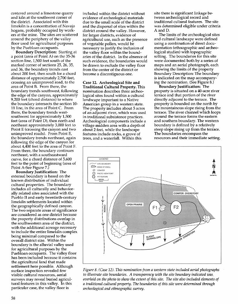
centered around a limestone quarryand kiln at the southwest corner ofthe district. Associated with thislimekiln is a concentration of Navajohogans, probably occupied by work-ers at the mine. The sites are scatteredaround the periphery of the valleyfloor used for agricultural purposesby the Puebloan occupants.
Boundary Description: Starting ata point (area of Point A) on the 35-36section line, 1,500 feet south of themarked corner of sections 25, 26, 35,and 36, the boundary trends eastabout 200 feet, then south for a chorddistance of approximately 2,700 feet,crossing an unimproved road, to thearea of Point B. From there, theboundary trends southwest, followingthe edge of the canyon, approximately9,200 feet (chord distance) to wherethe boundary intersects the section 10-11 line, in the area of Point C. Fromthere, the boundary trends west-southwest for approximately 1,500feet (area of Point D), then north andnortheast approximately 3,000 feet toPoint E (crossing the canyon and twounimproved roads). From Point E,the boundary trends northeast, againfollowing the edge of the canyon forabout 4,400 feet to the area of Point F.From there, the boundary continuesnortheast, with a southeastwardcurve, for a chord distance of 5,600feet to the point of beginning (area ofPoint A-See Figure 7.)
Boundary Justification: Theexternal boundary is based on theknown distribution of individualcultural properties. The boundaryincludes all culturally and behavior-ally related sites associated with thePueblo II and early twentieth-centurylimekiln settlements located withinthe geographically defined canyon.The two separate areas of significanceare considered as one district becausethe property distributions overlap inthe southwestern area of the district,with the additional acreage necessaryto include the entire limekiln complexbeing minimal compared to theoverall district size. Within theboundary is the alluvial valley usedfor agricultural purposes by thePuebloan occupants. The valley floorhas been included because it containsthe agricultural land that madesettlement here possible. Althoughsurface inspection revealed fewvisible cultural resources, aerialsurveys may reveal buried agricul-tural features in this valley. In thisparticular case, the valley floor is
included within the district withoutevidence of archeological materialsdue to the small scale of the districtand the dispersal of sites within thedistrict around the valley. However,for larger districts, evidence ofagricultural use, such as the presenceof vegetable pollen, would benecessary to justify the inclusion ofthe valley floor within the bound-aries of the district. In the absence ofsuch evidence, the boundaries wouldbe drawn to exclude the valley floorfrom the center of the district orbecome a discontiguous one.
Case 12. Archeological Site andTraditional Cultural Property. Thisnomination describes three archeo-logical sites found within a culturallandscape important to a NativeAmerican group in a western state.The property includes about 5 acresof an adjacent river, which was usedin traditional subsistence practices.Archeological components include avillage midden area with a depth ofabout 2 feet, while the landscapefeatures include rocks, a grove oftrees, and a waterfall. Within this
site there is significant linkage be-tween archeological record andtraditional cultural features. The sitewas determined eligible under criteriaA and D.
The limits of the archeological sitesand cultural landscape were definedusing a combination of direct docu-mentation (ethnographic and archeo-logical studies) with topographicsetting. The boundaries for this sitewere documented both by a series ofmaps and an aerial photograph, eachshowing the limits of the propertyBoundary Description: The boundaryis indicated on the map accompany-ing the nomination. (See Figure 8.)
Boundary Justification: Theproperty is situated on a 40-acre riverterrace and that portion of the riverdirectly adjacent to the terrace. Theproperty is bounded on the north bythe mountainous slope rising from theterrace. The river channel which loopsaround the terrace forms the easternand southern boundary. The westernboundary is defined by a relativelysteep slope rising up from the terrace.The boundaries encompass theresources and their immediate setting.
at®O
L
LEGEND
SITE BOUNDARY
EDGE OF KNOLL
CONIFER
PHOTO VIEW POINT
PIT FEATURE
CONIFER OVERSTORY
Figure 8. (Case 12). This nomination from a western state included aerial photographsto illustrate site boundaries. A transparency with the site boundary indicated was.overlaid on the photo to show the extent of this site. The site also included elements ofa traditional cultural property. The boundaries of this site were determined througharcheological and ethnographic survey.
58

Case 13. Boundary Reduction of aLarge National Register District.Listed on the National Register in theearly 1970s, a large district in anorthwestern state contained over 400archeological sites across more than400,000 acres. Sites within the districtrepresented all periods of humanoccupation in North America, fromPaleoindian through the early twenti-eth century. Only 10 percent of theentire district had been the subject ofarcheological investigations at anylevel. Site distribution in the districtappears to have been influenced by avariety of environmental factors,including topographic and hydrologi-cal setting. Most of the recorded sitesare wholly on the ground surface orare shallowly buried, while many ofthe sites are threatened by naturalforces (wind and water erosion) anddegradation by human activities.
Discussion: After 20 years ofarcheological studies, the district'sboundaries were reduced in the early1990s by 50 percent in order to moreaccurately reflect the distribution ofknown sites and areas with highprobability to contain additionalimportant sites. A very few of thepreviously identified sites wereexcluded from the revised bound-aries, now totaling over 200,000 acres.Excluded from the district were areaswith the highest elevations and slopesgreater than 20 percent that wereunlikely to contain any archeologicalsites. Revision of the boundaries alsoremoved unnecessary "buffer" areasfrom the district. Because of the largesize of the district and the amount ofnew archeological information, acompletely new nomination wasprepared rather than a simple amend-ment to the existing nomination.
Case 14. Continuous Artifact Distri-bution: Multiple Prehistoric SitesLocated on a Flood Plain: The floodplain of the river is a broad, flat plainwith little topographic relief. Theknown distribution of prehistoric siteslocated in the floodplain derivesprincipally from the mapping ofnumerous artifact collecting areas,representing the past 30 years ofsurface collection activities by numer-ous individuals. To date, there hasbeen no systematic subsurface testingsurvey of the floodplain, chiefly dueto the presence of deep alluviumdeposits which prohibit cost-effectivetesting. Many of the artifact collectingareas overlap and indicate an almost
continuous pattern of prehistoric landuse on the homogeneous floodplain(See Figure 9.)
Assignment of a polygonal bound-ary is appropriate in this case, since itencompasses the area of a known LateWoodland-Contact Period Settlementwithin a broad, featureless expansegenerally known for its almostcontinuous distribution of prehistoriccultural remains. The polygonal areamay be replaced by more precise siteboundaries as site formation pro-cesses and improvements in archeo-
logical methodology provide furtherdata regarding the floodplain'sprehistoric land use.
Boundary Description: Theboundaries of the site are defined by apolygon. The polygon is square,measuring 500 meters on a side,covering 25 hectares. The boundariesof the site are defined by UTMcoordinates which mark a polygon'scorners. The unit includes land inprivate ownership on a bend of broadfloodplain of the river in an areaknown for its very high density of
KNOWN ARTIFACTCOLLECTING AREA
•+-300 600
H METERS
Figure 9. (Case 14). Numerous circles on this figure illustrate the location of recordedarcheological sites located on this broad floodplain area. The National Register propertyis shown by the rectangle, which encompasses four known sites. A reasonableboundary was assigned to this property.
59

VALUES FOR LITHICS/qcm GREATER THAN THEMEDIAN BUT LESS THAN THE 75th PERCENTILE
VALUES FOR LITHICS/qcm GREATER THAN THE75th PERCENTILE
SPATIAL DISTRIBUTION OF LITHICS
I - PRESENCE OF THE FIRE CRACKED ROCK
SPATIAL DISTRIBUTION OF FCR
VALUES FOR GRAMS OF TOTAL SHELL/qcmGREATER THAN THE MEDIAN BUT LESS THANTHE 75th PERCENTILE
VALUES FOR GRAMS OF TOTAL SHELL/qcmGREATER THAN THE 75th PERCENTILE
SPATIAL DISTRIBUTION OF SHELL REMAINS
KEY
EXCAVATION UNITSHOVEL TEST PITABANDONED ROADFOOTPATHCONCENTRATION (=)SITE BOUNDRY —
5.0 100
METERS
Figure 10. (Case 15). The boundary of this archeological site was determined by the density of artifacts found through extensivetesting of the area. Although numerous concentrations of artifacts (lithics, shell remains, and fire-cracked rock) are shown across thehillside overlooking a marsh and cove, the National Register boundary for this site includes the largest area of artifact distribution.
60

sites, as evidenced by overlappingartifact areas.
Boundary Justification: Thenominated area (geographic) of thefloodplain includes the majority offour known collecting areas. Theartifacts and features within thepolygonal area demonstrate thepresence of Late Woodland andContact Period occupations, on whichthe statement of significance is based.Through a series of fortunate eventssurrounding a recent flooding episodeof the river, the archeological remainsof a large Late Woodland-ContactPeriod village were exposed in thisarea of the floodplain. The exposeddomestic features and artifact concen-trations were carefully recorded byamateur archeologists, but onlywithin the areas fortuitously strippedof alluvium by the flood. Subse-quently, the property owner inten-tionally refilled this area, thus recreat-ing a deep, featureless plain. Withoutintensive archeological testing belowthe 1-3 meters of alluvium and fillabove the prehistoric occupationzone, it is impossible to define the siteboundaries on the basis of presence orabsence of cultural materials. In fact,by comparison to the east bank of theriver, which has been more inten-sively surface collected, it appears
that the distribution of prehistoriccultural materials is almost continu-ous across miles of land.
Case 15. Continuous Artifact Distri-bution: Prehistoric Camp Site Over-looking an Estuary: The site is locatedon a prominent hill on the westernside of the mouth of a cove overlook-ing the southern half of a marsh.Concentrations were delimited allalong the base of the hill (the base isat approximately the same location asthe abandoned road shown as adashed line on Figure 10). Concentra-tions also occur on its eastern andnortheastern slopes, both of whichinclude sizable areas that are nearlylevel. The site is in mainly open fieldsat present with thick shrubs in wetareas, scattered evergreens, and broadleafed forest undergrowth vegetation.
Two kinds of test units—shoveltests and excavation units—were usedto define the site boundary andconcentrations within the site. Thedensity per .25 cubic meters of thenumber of lithics, grams of shell, andfire-cracked rock were calculated foreach unit and mapped. Densitycontour lines using the median and75th percentile values were drawn onlarge scale maps for each of the siteareas. These lines were used as
boundaries between site and non-siteareas and among concentrationswithin the site.
Boundary Description: The site isbounded by the marsh on the southand east, and by the density of artifactdistributions (boundary established atthe 75th percentile isopleth) on thenorth and the west.
Boundary Justification: Anessential step for analyzing archeo-logical remains on a regional basis isthe careful identification of compa-rable units. This example establishessuch units by using an explicit defini-tion of two concepts—the site and theconcentration. "Site" as used hererefers to a bounded area within whichartifact concentrations occur. Siteboundaries were set along contourlines of artifact density, interpolatedfrom shovel test and excavation unitdata. In this context, sites are areasthat contained concentration ofartifact deposits. These concentra-tions represent areas bounded bycontour lines representing a certaindensity within the site of one or morekinds of archeological materials e.g.,lithics, shell or fire-cracked rockremains. The size, structure, shape,and contents, as well as other charac-teristics of each concentration, canthen be investigated.
61

V. REFERENCES
Childe, V. Gordon 1956 A ShortIntroduction to Archaeology. CollierBooks, New York.
Dancey, William S. 1981 ArchaeologicalField Methods: An Introduction.Burgess Publishing Company,Minneapolis, Minnesota.
Delaware State Historic PreservationOffice 1992 Guidelines for Architec-tural and Archaeological Surveys inDelaware. Dover, Delaware.
Dunnell, R. and W. Dancey 1983 TheSiteless Survey: A Regional ScaleData Collection Strategy. InAdvances in Archaeological Methodand Theory, Vol. 5. Edited by M. B.Schiffer. pp. 267-287. AcademicPress, New York.
Ebert, James 1992 DistributionalArchaeology. University of NewMexico Press, Albuquerque.
Henry, Susan L. 1993 ProtectingArcheological Sites on Private Lands.National Park Service, Washington,DC.
Joukowsky, Martha 1980 A CompleteManual of Field Archaeology: Toolsand Techniques of Field Work forArchaeologists. Prentice-Hall, Inc.,Englewood Cliffs, New Jersey.
Lewarch, Dennis E. and Michael J.O'Brien 1981 The Expanding Roleof Surface Assemblages in Ar-chaeological Research. In Advancesin Archaeological Method and Theory,Volume 4. Edited by M. B. Schiffer.pp. 297-342. Academic Press, NewYork.
Seifert, Donna J. 1995 National RegisterBulletin: Defining Boundaries forNational Register Properties. Na-tional Register of Historic Places,Washington, D.C.
Shaffer, Gary D. and Elizabeth J. Cole1994 Standards and Guidelines forArcheological Investigations inMaryland. Maryland HistoricalTrust Technical Report Number 2.Annapolis, Maryland.
Townsend, Jan, John H. Sprinkle, Jr.,and John Knoerl. National RegisterBulletin: Guidelines for Evaluatingand Registering Historical Archeologi-cal Sites and Districts. Washington,D.C: National Register of HistoricPlaces, National Park Service, U.S.Department of the Interior, 1993.
Virginia Department of HistoricResources 1996 Guidelines forArchaeological Investigations inVirginia: Additional Guidance forImplementation of the FederalStandards Entitled, Archaeology andHistoric Preservation: Secretary ofInterior's Standards and Guidelines.Richmond, Virginia.
Wiley, Gordon R. and Philip PhillipsMethod and Theory in AmericanArchaeology. University of ChicagoPress, 1958.
62