Deaf Smith County, Texas - Texas Water Development Board
53
Please do not destroy or throw away this publication. If you have no further use for it, write to the State Board of Water Engineers, Austin* requesting return postage. TEXAS STATE BOARD OF WATER ENGINEERS C. S. Clark, Chairman A. H. Dunlap, Member J. W. Eritchett, Member Deaf Smith County, Texas Records of wells, drillers' logs, water analyses , and map showing location of wells by Joe W. Lang C. R. Follett and Analyses made and report mimeographed by WORKS PROGRESS ADMINISTRATION Project 10443 Prepared in cooperation with the United States Depart- ment of the Interior, Geological Survey and the Bureau of Industrial Chemistry of The University of Texas t Austin, Texas Nov. 20, 1938
-
Upload
khangminh22 -
Category
Documents
-
view
9 -
download
0
Transcript of Deaf Smith County, Texas - Texas Water Development Board

Please do not destroy or throw away this publication.If you have no further use for it, write to the StateBoard of Water Engineers, Austin* requesting returnpostage.
TEXAS
STATE BOARD OF WATER ENGINEERSC. S. Clark, ChairmanA. H. Dunlap, MemberJ. W. Eritchett, Member
Deaf Smith County, Texas
Records of wells, drillers' logs,water analyses,and map
showing location of wells
by
Joe W. Lang C. R. Follettand
Analyses made and report mimeographed byWORKS PROGRESS ADMINISTRATION
Project 10443
Prepared in cooperationwith the United States Depart-ment of the Interior, Geological Survey and the Bureauof Industrial Chemistry of The University of Texast
Austin, TexasNov. 20, 1938

DEAF SMITH COUNTY, TEXAS
Introductionw
Walter N. WhiteSenior Hydraulic Engineer
United States Department of the InteriorGeologicalSurvey
This publication contains records of wells and pumping plants in Deaf Smith Comi-ty, Texas, together with tables of well logs and well ivater analyses, and a map onwhich all the wolls listed are shown, each well being given a number on the map cor-responding to the number assigned to it in the well tables,
The records were obtained in the course of an investigation in the Texas HighPlains comprising a part of state-wide studies of' the ground-water resources of Texasby the State Board of -Tator Engineers in cooperation with the Geological Survey ofthe United States Department of the Interior. The field work was first started in1934, a reconnaissance being made in that year covering parts of western Kansas andOklahoma and eastern Colorado as well as the Texas Panhandle, That investigation wasunder the direction of C. V. Theis, Associate Geologist with the Geological Survey,raid was made with an allocation of funds from the Administration of Public Works. In1936 considerable data on irrigation from wells in different parts of the Texas HighPlains including a part of Deaf Smith County were obtained by H. P. Burleigh and W. H«Stanley of the Resettlement Administration. The present investigation was started inthe spring of 1937 with funds appropriated by the Texas Legislature and nearly equalamounts contributed by the Federal Government ♥
Most of the records listed were obtained from October, 1937, to July, 1938, byJoe W, Lang and C, R. Poliott, two of the engineers assigned to the present investi-gation. Some were contributed by the Resettlement Administration and a few were ob-tained in the reconnaissance investigation of 1934,
The analyses were made by chemists employed on Works AdministrationProject 6507-5112, under the direction of Dr# E. P. Schoch, Director of the Bureau ofIndustrial Chemistry of The University of Texas and E. 7, Lohr, Chemist of theQuality of Water Division of the Geological Survey, This release was typed by typistsemployed on that project.
The records serve as a guide to land owners and well drillers who need igforma-tion regarding wells and pumping plants, the depth to ground water in different partsof the county and tho quantity and quality of water yielded by wells, They afford abasis for the more intensive investigation that is now being carried on, the purposeof which is to determine tho distribution and extent of the available ground-watersupplies and tho safe yield of the underground reservoirs.
Thanks are due the owners of wells and pumping plants in Deaf Smith County whohave given their cordial cooperation and assistance. Several well drillers andrepresentatives of different pump conpanies also have contributed freely of theirinformation.

3
Records of wells and springs in Deaf Smith County, Texas(All wells are drilled unless otherwise noted in "Remarks" column.See "Logs of W. P. A. test wells" for all records of test wells.)
j ■ ■■—
| ■ 1 iNo. Distance Sec- Range, Owner Driller Date Depth Diam-
from tion township com- of eterHereford or block pie*- Well of
\ ted (ft.) well. | 1 _ I (in.)d/ 1*44 miles 30, T.7N., R.4E. Rock Island F. A. Luce 1911 344 18
northwest SWJSE& fi. R«'
240 miles j 36, T.7N., R.I ST Landergin —Old ! 33* 6
northwest NffifNEx Bros, Qb, j3* do. do. do.
"do.
—Old i 31
~6
4 do. do. ~doT" do^ -*- Old 2&D S~~
d/ 5 41-J; miles"~
iT~ tTOTTR.I £ do.~
Old ~31 6~_ northwest MWJNEJ- _„__ !6 do. do. do. do._ _
-__
_.old ! -^ 48~
~43|miles""" 6,~~ ~. dol
— _ Old 3T ifnorthareat|MJSEjr „„____ [
"
"jd/ 9 do. . Sa,'
do. do.— — 35" 4*J
10 j do. do. do~ do. ""-- ~ZT "35 4X£/' 11 43 miles 7) 'do. do.
'*- "sF if
northwest NWrJNEj?"
12 do.'
do. . do* do^ j —Old 28 if-
!
"d715" 41 miles I?! ."
doT do. |~" :^'Old
— ; ifnorthwest|SS^SE-r
'&/ 14139 miles'""" 33, T do. ■"""
dof ]" -^ 'Old"" 7 60
nort-west SlffSWj
"d/lW Wf miles 35, do" doT Old 20* 6~*northwest SWJSWJ: [ m
16 35 miles 31, T.6N., R.2S. "~do.—
Oldnorthwest NVifiSE± „
d/17 33 miles 34, \ L. T. Davis J. W« Adrian 1938 199 5_2 northwerst SWaSW^ , -" ""
18 do. do. do. do.~
19 3IJ"miles 3BT dcT. do.~~'
J. W."Tdrian" 1938 27^northwest SE^SBt ,
20J33 miles ! 26, T "do, j 'do.
" —Old 400
}northwest.l^WjSWJr. 1 h^-^—d/;21 30|miles j 30, T.6N., R.3E. J. G.' —
J --264 if
northwestJSBJ6EJ:- _^Fortenberry .
2233 milei" | ?.3, 'T.6N7HK2 E, J» W. Adrian I "Colonel" 1933 255—
northwest INEJjSE^ , Owens__^ f""23, ' ~""
do. j do. J, W. Adrian 1938 1 2801 =^~*iNffjgEj^. L ' 1 j i
a/ Measuring point was usually top.of casing, or top of pipe clamp.h/ C, cylinder; W$ windmill; T, turbine; Cf, centrifugal; G> gasoline; S, steam; Ng,
natural sass D» diesel; E, electric; E> hand; iiuinber indicates horsepower.g/ Figures for acreage irrigated are based on infomation from owners of wells.

4
Records obtained by Joe W, Lang and C. R. Follett(Chemical analyses of water from these wells are in the table of analyses.)
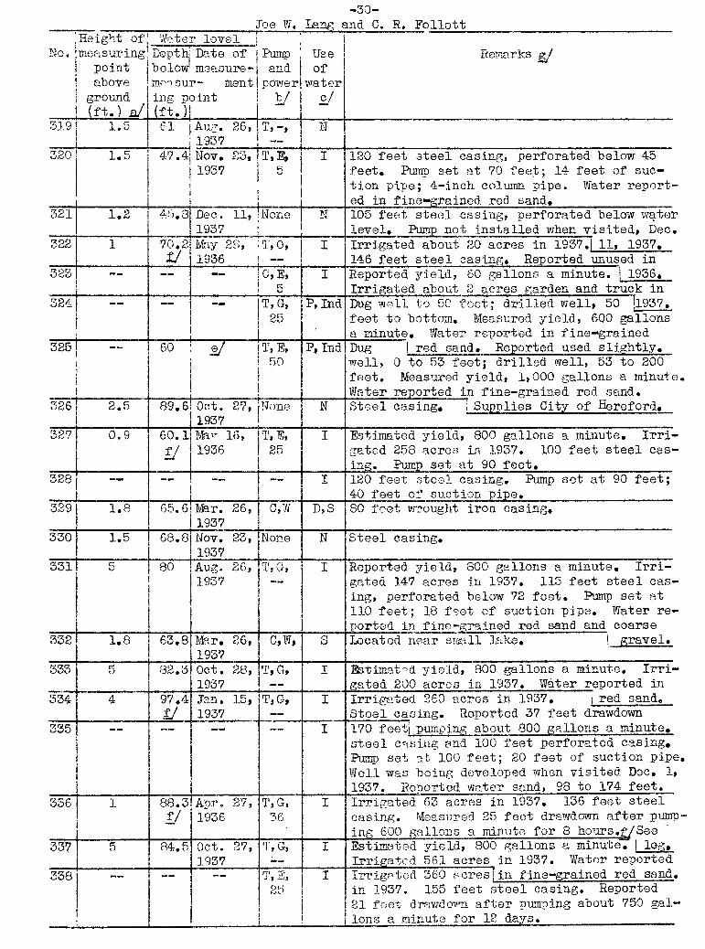
jHeight ofl Water levelNo,Imeasuring Depthj Date of Pump Use j Remarks g/
point below;measure- and ofabove measur- mentf power water
| ground ingpoint i b/ c/j (ft,) aJ (ft.) j IIf— — —
C,S Ind !Reported yield, 100 gallons a minute. Loca--I. m 1 Itad at Erkaario. 'See -k)g»
2} 2 1 21.5 June 7, None N Steel casing. Drilled before 1915,
; I 1938 ,__^
3 1.5 21.2 do. None N Do.
4— — —
iNone N Steel casing, Filled above water level.
5 3 28.5 June 7, j C,W D,S Water level measured while pumping Jgalloni 1938 a minute.
61— — —
None N Dug well._- __ — —
None N Dug well. Galvanized casing.
3 g 17". 2" "June 7, None N~~ '
1958"9~ 1 16.3
~do. C,W S Estimated yield, 3 gallons a minute.
j I ;10 1 % 17 do. None N Steel casing.
! '
11 1,5. 27.3 do. C,W S Water level measured while pumping about 2'" gallons a minute^12
"~1,3^ 27.8 do.
""None N
~Water level measured while well 10 feet to
. north was pumping.13
— —C,W 5 Estimated yield, 5 gallons a minute. Report-
ed obstructed at 9 feet»14 1 5,4 June 7, C,W S Water level measured while pumping about 4
1938 gallons a minute. Wire-wrapped 4§-inchi _«««_»,
— screen surrounded with rocks. Known as15" _- «
— **G,W S Estimated yield, j "Little Sand Point Well."- .-■■■;;--.-. m . -g- gallon a minute. Known as "Big Sand Point
16— — —
""None I N Reported filled. jWell."
17--
183 c/ C,W D,S Reported yield, 5 gallons a minute. Supplies„_«_ ««»«_«___ about 700 head of cattle. Water reported in
18" — """ — --* None N ""Drilled as test 1red sand, 190 to 199 feet.__^____
-_-_____| well. Dry hole.
19" — — —
None N Weak supply reported in "Red Beds" at 200feet,
20— — —
None N Drilled as test well. Dry hole*
21 1.5 259.7 iJune 2, C,W,G> S,I Water level measured while pumping 2-g- gallons. |1958 ___ 3^___, a minute. Irrigates garden. '
22" — |"— ~T ;:
on(-; | i "Red Beds*' reported, 140 to 8.00 feet* and atI j j 200 feet.
23— —
i—
.None i N Weak supply* reported from seeps in "Red Beds"1 j | : I .at 218 feet. . "
c/ D, domestic; S, stock; Ind, Industrial: P, public; I, irrigation;N, not used.§/ tfater
'
sample" collected for analysis,of Water level reported.
f/ Measured by engineers of Resettlement Administration.

5
Records of wells and springs in Deaf Smith County—
Continuediii i
"''-''I ;
So, Distance | Sec- I Range,' Owner i Driller Date Depth iOiam-from | tion I tewnship com- of eter
Hereford I I or block pie- well |of1 ted (ft.) tell! , I | , Ilk)
24 33 miles ! 23, T.6N.,R.2S. J. W. Adrian "— MeNew |1929 | 418| —northwest . MifSg^ [ _____ J_
25 33J miles do.^~ do. j do. J. W. Adrian 1938 24fTj *""-- '"
northwest j I26
~~~~do. j 23, ! do. j do*l "Doc" Reeves |1934 I 220 )'" ~~
INEJN]j&_ j 1 ] [_27**" do. ~~j do." -if
~~ ~~do. | do., "11. W. Adrian 1938 255 j " ~'~
28~"33 miles 24,~~~" do] jJ.N. Couch ~ Old ~256~
'""if
northwest NWJNfj j29 32§ miles 33"T~ T.7N., R.3E. | Fay Mclntire
— — 207~~ 4V~northwest SEJSEJ; I __ !
'
d/ 30 30 miles 16, :J. C. Maulk, ~jW. F. Fisher— "
1929 265"T~ 4t>northwest NEJBE^^ .hl>. A J _
31 28|-liiiesl 9,T ""do^"
jMary V. Palmer 1—
Old 170 ~"IJ___ northwest SSJM^t , j__^
I32 28 miles"] 53, G.C.& 5.F.8.E., N. 0. Phillips Joe Rydell
—316 4
northwest jIMJSiIj blk. Kll j33 29 miles j 497^ do.
~Templb Lumber
" ~ Old "—| —«
northwest SE^S¥t .Co. I34 28 miles j 29, do. W. G. Hindman
" —Old
"258 j' ij
northwest jNE-^MEy ; Id/ 35 27 miles f 2471 5% J. P. Collier
'" — I Old 310 j 4fnorthwest jNEJi^Ex . I I
d/ 36 29 miles T 5,~~
do7~ |limnsey —1918 280 4
"
northwest NWj&SW-g-_^
__; ___37 27J- miles1 3^ blk, B
'N. C. Khox f
—Old 252 j "if
northwest ■ I^EfI\TSJ: \38"26% miles 74, G.8.& C.N.G.R.R.,
'
J. Heiselimn—
Old 270northwestiNEgMj) blk. X 6 I ; l
d/ 39 24f miles"
63, do. M. &B. A. Hare—
Old 300+j 5"[ northwest Sf^Ej ]
40 25 miles 2, : blk. Eh"E h"R. P. Maxey — —
93 j ""ifnorthwest ,SWySWti | .Jd/ 41 22 miles "~~7o7j^Tb7& C.N.G.R.R., H, Powell
' | 1928 3CO+;1"
5"___ northwest SEfSErh blk. X 6 1 }__d/ 42 24 miles 33, do. 0. H. Loyd
— ~Old 209 j' 4
north NEJNEj- ______4__.__ | . !d/ 43 22f miles] 9,1 dol
" 'J. Schwartz— — -- I 4-f"!_.. 1north iNW^TE4- I !
44 20 miles 5, I blk. E'
H. P. Canode I —Old , 102 t F~
north |.SW^SE__;d/ 45 18 miles 2, blk. K7 R. E. ?fegoner
— 'Old 152 j ~
north SVljmh j i46 17 miles 18, do, W. S. Spears r- ~~old "leoT 4*"_____________ [imM-SE^J I
'
I__/ 47 18 miles 38, do. " First State—
"Old "4north .SBigE^j Bank of Vega I | |
a/48" 19g- miles 58,"
"do. B. Calwell j "Colonel"—
255; ~<_northwest NW^Mj;_______„_ Owans '
49 18 miles 56, g § Cappock &—
1930 SC3 j 4J-.northwest NE%fEr-) Coleman ! |

6Joe W. Lang and C. R. Follett
|Height of j Water level jNo. measuring Depth!Date of Pump j Use Remarks j_/
point below 'measure- and ofabove measur- ment power water
ground ing point b/ j_/(ft.) a/, (ft.)j j
24— -- —
None N"
Salty water reported in "Red Beds" at 240feet. Reported yield, 8 barrels a day*
"25" — — — "None N 'Drilled as test well. "Red Beds" at 220
1 feet, Dry hole*26
" — — —None
"N.
""Do.
27— — —
None N Weak supply reported in sand, 228 to 243feet. "Red Beds" at 243 feet,
28"
2.1 241,8 June 13,'None N ISteel casing.
; 1938'
,29
"1.5 "189.4 Apr. 5, None N Iron casing.
JL957"
j"
30" — "
230 c/ C,W,G, D,S Reported yield, 4 gallons a minute. Water' ' --- __ level questionable. ] _____
31 0.5 169.8 June 2, None N Reportednearly dry when measured.- 1958 ;32" 0 ""285.4 do. C,W N Steel casing. Water in red quicksand, 291
to 561 feet.33
" --_-
__jjone v Filled with dirt.
34"
1.5 258+ June 2, C,"gJ 8 Steel casing. Obstructed at 258 feet.1 1938 6
"
33— — —
C,W D,S,ISteel casing. Estimated yield, 3 gallons a'minute. Irrigates garden.
"36— — —
C,W D,S,I . Do.
5vH 0.5 231.8 June 15, None N Steel casing. Water level questionable.J___ 11938
__^_
~3Sj "
2 232 do. C,W I D,S"
Do.i |_Sv< ■
— -- —C,W D,S Steel casing. Estimated yield, 5 gallons a
[ _ "m"
m . minute. .40 1 0 76.1Nov. 25, None N Steel easing. No pumping well within several__ J 1937 ; miles. _41 j" 2
"~
237,5 June 14, C,W D?S,I Estimated yield, 3 gallons a minute,t 119581 1958 ,
4^l 0 191.8 June 15; Cj, TAr D,S Steel casing, top to bottom. Reported fillsj__ 1938 with sand readily since earthquake. Bsti-
43 { ■—
—C3 W D,S Estimated 1 mated yield, gallon a minute.
_»,t_"_ , ,yield, 4 gallons a minute.4A] :u,5
"182.4 June 14," C,Vf N Steel casing*.
I 1958 I [ ; "
45! ~~ 147 c/ 09M jD>.SjIEstimated yie.\ds 3 gallons a minute.JL__ „. j i \ :461 oaB0a8 173.3 July 5j5j lioiio J N Steel casing,____ j 1958 1 _ !47;
— — -- Cf wT~
Sstimated yieid;< 3 gallons a minute.I " " "_
J_,ilmtT_±
_n ■!
—|Jf _«(__-__■__-.—__. »MII>U IIII111 I I ) '— ■■ iiimm,
-1M
—,BTT| . ||| )| _[l 1.. .1..II .1I ] |
■II I
- _ 'I I
- -II
48!"
'■) 222,4 June 14, C, 7r7r1 D> S Steel casing. Reported yield, Jgallon aJ 1958 minute. Sands up readily.
4i- T" ;1,5 1193.4 Sept,15, C,W J D,S Steel casing.1 I 1937 I j I

7
Records of wells and springs in Deaf Smith County—
ContinuedI j
- r 1—
r—
I—
No* |Distance j Sec- j Range, Owner Driller .Date Depth.Diam-I from tion j township com- of eter(Hereford | or block " pie- well of
i ..... I j ted (ft.) -wellj , J j_ j i (in.,
50JT? miles 24, j blk. X 7 = Texas Loan & ; —Old 1 127" B}
|north M^SEJj {Mortgage-.Co, |"
51 16^ miles 17, j do. . | do.. .' } ZT~~— '
lilj ifjnorth JM^i| , | i■ 1 1d/ 52!15-| milesI ' 16, j "dol f~~" dol
—IOld
—5
north jNWiSB^| I ," I
(!53 15 miles 15, i do» ! T~ . dol [~ Old 156 44
north [M^fEJ:; | 1 i I l_l54«15^ miles 25, } do. | doj ! ~ —
181 5g■■north .SW-jSE-Jb; I | L_2
55115j- miles"
55, j do.'
Texas Land &?_— —
88+ ijjnortbarest N^^E^j - Developement Co.; I
■: 56 jl6 miles 35, | do." do.. ;— j ---
192 5i'northwost NEjpf jrj |
"d/57J14| miles 34, j do. J. N. Hodges' ~7T~" Old
inorthwest NEJ^EJri I__/' 581 do. 34, ! "
10~. !W. N. Hodges jA. B. Hayes 1937I 272~ IBJI !! !
59 13f miles 28^ doT j E. Hodges ! . doT !1937 265 15!northwost IWjSWj j
60 11 miles 9,'
doT I" J. H. Hutson ; Jim Mock 1925 150 (Tnorth SEJSEJH I j_ ; j~~
61j &0~.' ISTj do. . J. G. Lewis f —
Old 133 I 4t/-I IME^IEt; S !__ '^
62" 10 miles 10, j do. Federal Farm j— —
147northwest SEgSWjri ILoan Mortgage Co.I m
63)11miles 11, | do. |R. R. Wills j —Old 166
_[: northwest NW^SE>;i
'
j'
""64 16 miles 89, do."
! Federal Farm I .--"
Old— —
[northwest MjSE-j| Loan Mortgage Co. j65 17^- miles
"88, do. ¥" B. Denman \
— "Old
—4
■
tnorthwest iNBJMW^1
t | ,'!'.'..'d/ 66 18 miles 94, j do. M, B. Ranson, /{ .—
"Old ~ '
4-h-inorthwest NEzSEij 1 et al j
d/ 67 19 miles 'NE^TEt C. G. .j_3;. F. Williams]—
'Old 170 "— "
northwest . Witherspoon sur.i I -d./ 68 20 miles 4, | blk, C do. |""Colonel" .
~1918
"246 5~
northwest NEj-SBjrj ; I Owens69 do. 77, ] blk. X 7 ! R. J. "~*~T" —~" Old 280 | 5
NW^WJj I McLafting I ■■■■■■ ; Il/ 70121J- miles 2, ! blk. B ! -- "~1 "Colonel" 119.181 19.18 365
"4;,
northwest NEfeEj j | Owensm
71|23jmiles 1, blk. A \J. M. Shelton' — ~
Old . 248 ' 6"jnorthwest SW^SWJ __ j , . j , „
72|24 miles 8, T.5N., R.4E. i Ed. McCaskey— . . Old 300+ 4'
northwest SW^S?J-^i . . I ; ,d/ 73*24 miles 35, !T.5!T.5 N., R.3E.*" W. J. Williams j
—.
"Old 270. , i-/-
north?rest NE-JNE^| "> ...'" i " " :
74125 miles 33, | do. do*" —Old 271 l^(northwest INEfeEitl ' 1 '

8
, Joe W. Lang and C. R. Follett "
IHeight of j_ Water level jNo. [measuring jDepthjDate of j Pump Use Remarks g/
point jbelowlmeasure-! and j ofabove -measur- mentj powerjwater
ground 'ing point I " -J/'l 2/(ft.) a/ j (ft.)| I j j ; __
50"
1 jl2B+j 128+ I July 12>f C,W ; S J'o6J'06strucked"at 127 feet.i [1936 j |
51 2 J128.1J doT [None | W jSteel casing.I I . 1 11. -
52—
j— —
C,W ! D,S IEstimated yield, 5 gallons a minute. Loca-j | j I ted on "Cap Rock" about 50 feet above stream.
53" 0.8 1143.6 jJuly 5, |None 5 Steel casing.; 11958 1 |
54 0.8 [168.9! dol !None N """] Dol"
1 ! | | __55' —
88+ c/ (None N Obstructed at 88 feet.— .. ~- u--. |-_ Nono |jj j57
— —|
—C,W S [Estimated yield, 2 gallons a minute.
, | j Equipped with frost box.58" 0 ~198 jSept.ls, T,G, IReported yield, 700 to 750 gallons a minute,
119571 1957 80 IIrrigated 200 acres in 1937. 190 feet of115|-inch steel casing; 70 feet of 15-J-inch{perforated casing. Water in sand from 204
l' | 1 '
| jto 272 feet. Did not reach "Red Beds."59" 1.5 201.1iNov. 26, T,G, I Estimated yield, 500 gallons a minute. Irri-
J1937 80 j |gated 50 acres in 1937. 265 feet of 15§-| j ___ |inch steel casing, perforated at bottom.
60—
!100 c/ C,W I DiS ißeportedi Reported j Water in fine-grained red sand.j j Icost: well, $112.50; pump and poxver, $3'S5I0Qa
61~
1.5 1130.6 July 5, None N Steel casing.i .1958 j ;
m62" -- j120 c/ C,W j D,S 1 Water level questionable.* j
j J1958 ,64
" — ! — —C,W ! D,S (Reported weak supply.
.65
" ~ I" -- |— "
None N"
Obstructed at 10 feet.L^ U-_
66— ' ~ j --" C,W j S (Obstructed at 34 feet. Estimated yield, 4
[_ 1 ! gallons a minute. ■____67
— — — C,W | S Estimated yield, 4 gallons a minute., > j j. , -..m ,
68"" — "237 I c/ C,W ! D,S j Do.
69 =^ -- | « I C,W D^S !Steel casing.| 1 1 j |
70— — —
CfW j D,S 'Estimated yield, 4 gallons a minute fromj j quicksand. Reported supplies 200 head of
71" —
—j—
C,W D,S (Obstructed at 213 feet. Depth re- 1 eatt!a«>| ' iported.
~72] : 111 1¥73"l ¥73" IJuly 7, ' C,W S'Water level questionable.
j 119381 1938 1 _.73" — ~250 i c/ C,W D,S
"Steel casing. Estimated yield, 4 gallons a
j j jminute. \74
"*"
0.6 '246 fjuly 7, C,W J S ISteel casing. Used in winter. Water level'I J1958
' | Iquestionable. "

9
RecordsofwGlls and springs in Deaf Smith County—
Continued
No. Distance I Sec- | Range, Owner Driller Date Depth Diam-from tion | township com- of eter
Hereford or block pie- well ofted (ft.) well_ ; I | UnJ
d/ 75 26 miles' 23, »T»S~N., R.3E. W. J. Williams
—Old 270 %
~" northwest] SWjrTEr ___76!28^ miles 4^ do.
~~ I Hi P. Hurs— I Old 272+] 5~
northwest SW^lW^j '
{,
77 51 miles'
12, !T.5"n., R.2E. } E. J. Moore—
Old 242'
4§northwesllNW^3Wj ___j __ . _
,_.
d/ 78 3IJ miles' id", | do.~~~ |W. F. Hammons
—Old 270
"5
northwest SEjSEJb79 32 miles
"16,
~~~~do^ Elizabeth
-Old 161 4f-
/norttiwost SEJ^JEj I Bippus&/ 80 33-| miles' 17,
~~do. G. A. Welch
—Old 300 if
[northwest SWJSWJi j 1 j _/31 29 miles | 35, do. J. L. Fuq.ua " —
Old 97+ 5northwest .NW^SE_b __„ ! .__.
__82 30J- miles j 8, |t,4 N., R.2E. Kansas City r~"r~" —
Old 220 5northwest SEfSSJ: Life Ins. Co.
83 31 miles 3, do, do.-- "
Oldwest NWjSE^ [ |___
84 ■ do. do. do. do.— "
Old 43+ 5.
d/ 85 32^ miles 12, T.4N., R.I E. J C*' L. J. W. Adrian 1938 240 5~"west SE^SEx j Syndicate
86!37-|- miles .32, %5 N., R.l E, Land^in — —178 5
west |NEJMW-j Bros.' Co.87 doT I 16, j do. : do.
— —178
"4^-
__^sifew^l L_ ,
d/88 37 miles I iBT' . do. do.— " Old 300
"1|
north NE^JW^ | Id/lOli24% miles' 76, 1G.8.& C.N.G.R.R.,_J I.Rasco
— "Old 150
' —north JW^SWJ, " blk. X 5 [""""" j
102 24 miles 77,'"
do. jW. M. Stewart— ~ 129
"4-|
[north NE^lE^j j103 21fc milesj 79, j ~~~do^ j J. S. Hill |
-- --" 172' —
north ISE^IEJ- j Jd/1.04 20 miles 80,*~
do. | Ford Public—
165" —
north SEJ=SS?- [ School i
10B"^ 3b.. I 6lTi dol 'J. E. Hill
" '— IOld"
158'
4^I Iswjsw^, ..
d/106 24 miles 57, \ | do. j Kansas City— '
Old 136 5north Mljiffli j Life Ins. Co.
107 24J- miles 56, do" \~ J. E. Dyer~i— "" "
Old 143" i|
north SWJSEJ j108 23Jmiles!
" 44,^ doT" 0. H. Loyd I — 1 Old 142" "ij
north INEJSE±j j ,109 21 miles
'41, !"~~~~_ do^ ■: j li. W." Wilson
— —162
"i|
north MW^yj| j 1110 doT 1 40, | ~. |Great Southerni — "
Old 108|NW4MW^| Life Ins. Co.
d/Lll 24-J- miles!~
do. [~~T. J. Currie-- "
Old 128""~ij
north jSWJffWJ I
112 do. 22,' blk. 8 Ed. Sprue11— "
Old 88+j 4^t
{ OJBgjJlifgXj' _j __, i I

10
Joe W. Lang and C. R. FollettjHeight of| Water level
r J"
"~1No.ImeasuringfDepthiDate of Pump Use | Remarks gj
j point ibelow!measure-! and. of jI above \ measur~ mentl "oowerj water\
ground ling point b/ <_/ J, (ft.) a/} (ft,): i~
j ;75
— !250 c/ j C,W I S jEstimated yield, 5 gallons a minute.
761 ~ 1159.211 159.21 June 2, jNone j N [Pump set at 266 teetl Water level measured| j ■ 1938 | r |in column pipe. '.
77!~
|—
I — I C,W |D,S (Obstructedat 242 feet.j I | I |
78'
0.8 1264.9} June's", ! C,W I D,S jEstimated yield,~3 gallons a minute.| j !1958 j ! j
79 j 1 J259,7| do. jNone jI" {Steel casing. ;
| t L \ j i „___801 —- i260 c/
"C,W j D,S ]Estimated yield, J- gallon a minute.
~81j ~ j —; ~ '
C,W N [Obstructed at 37 feet.'
i 1__
,-,._ 1_ \— : : ;
82 1.2 1 205.6 i July 8, |None j N [Steel casing.
_^ I j1958 [ j ■
j'
.■ 85! j 21 ! — '
| C,W j N Located at old "Cow Camp"._J J | 1. [84i
— — —None N at 45 feet. Located 500 feet
| I I jwest of well 85.85r — -- —
O,W !D,S Reported supplies 2,000 head of sheep.| J j j jßstimated yield, 4 gallons a minute.
86 j 1.5 )169.1jApr. iTTwone N (iron casing.
[ 1957 j j87" 1.5
'167.8;JunT7, INone N jSteel casing.
j , U22Z 1 | j88 j —
!— --
C,W | S jDepth reported. Obstructed at 19 feet.j _^ j I [__„ Intimated yield, 4 gallons a minute.
101] — — —C,W j D»S,IjEstiinated yield, 4 gallons a minute. Irri-
j j j " | gates, small garden. _.102* 2~~
'146.6!June 5, | C,W | N 'Steel casing!
1 " J1958 j |105 1 ; 169.9; do. !None j N
104~
150 e7 I. .C,W | P Located 900 feet southwest of well 105.~~
1051 578 150.5 JDec7~s7~"i C,W i N Located 0.2 mile northwest of dry lake.| j [1957 | | |
106— j — —
i C,W i S iEstimated yield, 5 gallons a minute.I f I j I _______107 3 j143.4 June 21, j C,W j N jsteel casing.
.1958 \1081 175 |129.6* do^ |None ! W I Do.""
j ! I i
109 173 !152.71 June 5,~ C,W | N"
Do."
! j1958 | t
110 0.3 j 97.2! do7~ j C,¥ llf
111 1 i115,5 June 2.1,1 C,W j S jEstimated yield, 2 gallons a minute,| j 1 1958 j ; |
112!--
; 88+ I c/ !None~l W Obstructed at 88 feet._J I i~
! ! !

11
Records_ of wells and springs in Deaf Smith Comity—Continued, .„ M
_ , ,|~ .in, m ,i
-1-
i yM i i,_..,_,
i. i !, ,m,mm.. -I I , .111
No, Distance i Sec- j Range,' Owner | Driller Date Depth Diam-from tion j 'frowiisnlPi: com- of eter
Hereford or block pie- well ofted (ft.) well, |
JKin.)
113 12 j-miles 58, | blk. X 4 A. S. Higgins |-- McDade'
1937 162 15north NWjNWjrj - . j _____
114 27 miles 26, ; blkT~B " s7~T. Allred j—
Old---
4northeastiNEJNI^j j
d/115 25-| miles 18, | 507 PH. E. Floyd T —1915 170 | 4~
~" .northeast!NEJ^iJ ■ | _116 25 miles ! 18, | do. "dcv ~ ~
Old—
4northeast SE-jffSJrj
d/117 do^'
"^tTT ~~do, !C. L. Garrison—
Old 159 | 4^"| SE^SJhj 1 i
118 do. 8, I *do. J. G. Allred! j— '
OldNEjffEJrl | I— I
d/119 24 miles i 10, JB.S.& F. sur., I7~C~. Moore—
Oldnortheast jNWJSWtH blk, 7 I ! 1
"d/120'22 miles 29,~1 ~dcT 'G. L. Muse
"~Old
northeast |SE^ffE^i121
"do, 8, ] do. N. L. Barnes |
—Old 139 4
122 "do^ ["■■■15OT1 ."blk. 1 W. M. Grabbe !Reid Smith | 1937 200 13| NW^SIWtj i I I
123 18J miles 17, 8.5.& F. sur.," C. Hodges— —
Springnortheast SE.%iTBJ:j blk. 7
" fd/124 20fmiles 15, 1 do. (^~~G. L. Muse
—Old 4CT_~ northeast NEfN'Erl I S !
d/125 irF^mTles 1 28, | do. ~R. L. Campbell""*
northeast NE^SSj:] . „__ .d/126 do. ! 237 j ' do. do.
~~~I — '
OldMW^NEJ-| _________^ ,„_ .127 18 miles 36, do.
'Federal Life
~~ —81+
—northeastjSß^Sglj Ins. Co. , .
128 do. 36, ! do.~* mT H. Byrum "1 — —
30+ 5SWJSE^, __J_______
129 20§ miles' 2? blk. 8&~~1 c7"p. Fine \
---Old
north SWJ^rj j130 21 miles MEpEj J. M. Bur&&
""Deaf Smith j
— —140 ij
north | sur. County School |131 17 miles 28, ~T blk. X 4
~Eliaer Wemble
north ££B!^lS . "c_/L32 15-J miles" 26, i doJfc I W. ForWell "1 —
Old~~north .SEjpr^j j
d/L33 17 miles'
33, | do. First National' — '
Old 120 5north S-y^SWj! Bank of Hereford
134 19f miles 50, j do, J. E. Hill-- ~ 141 J 6~
__^___north iNW^MSg-j . ____„ _»__
d/L35 do. | 51, &0~.' *~
do. "--"
iMteiL__ _: I136 do. 51, do.
'
Kansas City -- —151+ ~~4~J
MJWjrj Life Ins. Co. | , ,137 17 miles 53, ; do". A. E. Benson
—!Old 142 4=^
north jSWtoj: j j I \Measuring point was usually top of casing, or top of pipe clamp.
b/ C, cylinder; W, w indmi1.1; T, turbine; Of, centrifugal; G, gasoline; S, steam; Ng,natural gas; D» diesel; E, electric; H, hand; number indicates horsepower.
g/ Figures for acreage irrigated are based on information from owners of wells.

12
Joe W. Lang and. C. R. Follett|Height of Water level |
No. (measuring DepthjDate of !Pump | Use Remarks jg_/point pelowjmeasure-| and of ;above measur- merit) power waterj
ground ing point ! b/ j c/[ (ft.) a/ I(ft.)1 (ft.) I I 1 r113 0.8 99.IJNov. 9, jNone ! N 'Drilled for irrigation well. Reported yield,
j1937 i j |5.00 gallons a minute from fine-grained red114
— 11--" | jNonej N obstrueted at 30 feet. ""} sand.j I i____ _
M3^4 JmiQ 21t | "c,W ! D,S ISteel casing. Estimated yield 3 gallons aj J1958 | } minute.
116— —
i—
|None N Filled to surface with dirt._ } j117 1 143.2!June"3, [ C,W j D,S
"Steel casing. Estimated yield, 3 gallons a
|1938 | [ minute.118
"" — ' — —INone N No casing., I I119
— j— —
j C,W D, S Estimated yield, 3 gallons a minute. Squip-| j ped with frost box.
ISO— — —
j C,W S Estimated yield, 3 gallons a minute.
121 173 116.1'June 3, C,W N Steel casing.
| [1938 j ' |122" 1 110.9 [Dec. 4, Cf,G,"I 111 feet of 13-inch steel casing; 89 feet of
[1937 85 13-inch perforated. Three-stage pump set at123
" — jFlows' —
None S"
Estimated) 140 feet; 8 5/8-inch suction pipe.__i yield, 20* gallons a minute.
124—
25 ej C,W S No casing. Depth reported. Obstructed at23 feet. Estimated yield, 5 gallons a minute.
125— — —
C,W D,S Estimated yield, 4 gallons a minute.
126— -- — |~C,W D,S,I Estimated yield, 1gallon a minute. Irri-
I ) gates vegetable garden.127
"0.5 74 INov. 28, C,W N Located 0.2 mile north of Balo Duro Draw.
| 1937 |128 0.8 24.9 I do. C,W S Located in Balo Duro Draw.
1 | 1 ■ ■, -
129— — —
C,W N Filled to surface with dirt.
130 5" 130 June 3,*
C,W P Steel casing.[ 1958 . |
'
131" —
j— — —
IEstimated yield, 750 gallons a minute. Irri-| __._______,. gated 140 acres in 1957.
152— —
i ~ ~"
C,W"
S"
Estimated yield, 4 gallons a minute.
133"
0.8 101.6 !July 6, C,W D,S Steel casing. Estimated yield, 4 gallons a; 1958 minute*
"
154"
1"
135.9 June 3, None N Steel casing*I 1958 ..
135— — — C,W D,S Estimated yield, 3 gallons a minute.
136—
151+ j_7 C,W N Obstructed at 151 feet.
137 07l |136.5 July 18, C,-W | N Steel casing..'1 ! 1938 j [ , I
c/ D, domestic; S, stock; Ind, industrial; P, public; I, irrigation; N, not used.&/ Water sample collected for analysis,c/ Water level reported.tj Measured by engineers of Resettlement Administration.

13_____ Records of wells and, springs in Deaf Smith County—"Continued __. . . . .. _, _ _ _ ,No. Distance Sec- j Range, Owner Driller Date Depth Diain-
from tion \ town.ship i com- of eterHereford ! or block Ipie- well of
ted (ft.) wellI ' | I I (in.)d/138|15 miles j 75, blk. K4 I B. C. Aylor
— —""ST] —
[north jSIJNEtj __ _L___ 11d/139ji6% miles' tfjLj. "
"do. j J. F. Morris I —
Old 130 ifInorth NEgMWjj i 1d/140'18% miles)~
89, T do 7 T~ Byron Gist 'W. D. Muncie 1937 270 14Inorth JNWJftrWJrj __ . , j _
141 13 miles | 39, j do. ■ do.' "
« !1938! 1938—
north |NW4SWX [ '
}142}16% miles' 94, j do. i ~jT~S. Orr
—Old 164
[north NEj^WJ;j I | „_____,d/143! 15f"mTiesT W, | do. bT~C". Aylor "'■.— ' —
137+ 5"north yJNW^j
i . j144 "15* miles! 96, 1 So."
'"" '■ do. »-
—169 if
north INWJNWj\ „__. | .14-5 11f miles- 99T^" do. J* R. Higgins
~~ --Old
' 148"* 5Inorth SW^mj j j |
d/146 10 milesjlOO, ■"~
do. ! Ward Public |~
«oid 145""
5north jSWzgfjrl School m \
147 14% milesj sBTT "
do. B. C. Aylor — ! —131 5
north iNBJNE^ _.
148 13f miles' 77, j ~. ~~j Dennis C. ffid Raef 119371 1937"
190 18north M^-r! Barnard_ _
i■ i__ 2eJ. [___ I
149 12 miles'
78T"T "do^
'J. R. *~Bishop & 1937 200 15f:
north N^i^Wf Crutchfield j Miitman
! ,150 10J- miles 79, | do. D. Thompson
1north SS^SEJ-j L ...151IImiles- '■ 62, } do^ ~~T" Charley Veigel ::^l7itt "1937 181 16
north SWjWi]II ■:":■■
152 12'|miles 64^ j OoT" Kansas"City~ "^ "old
—4~
|north .NWJffOTti. _. „__ j Life Ins. Co. I153] "Jo] do.
'""i A. S."mS"ins I L. McDade 1937 175 16
i ■"""".:
154 10 miles IT, ' do-4 ■ DrT~F. B. Bowe TTsilis 1937 144 li"north m^Sli
Ii ____.__________«-, Id/155 12 miles
~22**. j do. J. L. Woodford '— ■ &cßade 1937
"160 lij
north Wi^z5/156 I2^l^.e7~"'^7'~"~""*~~do7" H. a. I^~~
~-*
*north NE^E:!:^ I Conkwright . I
d/157 14% "miles.' 16, j" do". J J."f."Hickman " (Old —,■ 4|
inorth ISW#3W3:J 1 j |

14
. Joe W. Lang and. C. R. FollettjHeight of | Water level !'
No. measur ing|Depth jDate of !Pump Use Remarks g/point jbelowimeasure- and ofabove imeasur- ment power water
ground sing point j b/ c/j (ft.) a/1(ft.)! j ~
isB|—
! — ; I c,w I s"*^ :139 TTB '
117.41 July 6, ~t C,W~j D Steel casing. Estimated yield, 3 gallons a[ j J1938 j ,{ "■ minute.
140 0.8 168.5 (0ct. 31,|T,G, '"~"i Water in fine-grained red sand at 217 feet,11937 I 90 Reported pumped sand until casing collapsed.
141—
;— —
iT,G-, IDrilled as test for irrigationwell.jj I —
142 0.5 156.8 "juTi"67 j G,W J N~~
| 1958 .143 0.5 *161.2 Mir. 22, C,W I S ;Estimated yield, 5 gallons a minute._, ) 119371 1937 t | | __144"" 0.3 (158.6 May 27, None N "iron casing. Located 0.35 mile south of
| 1938 | ' Palo Duro Draw. ____145
'1,5 11421 142.9 July 5, j C7w | N Steel casing.
1 ,1938 , j __146 073 J117.4 Nov. 26,1 C,W j P !
: ._ j 11937 11 .147! 1 !l2l._Jjuly 5, | C,W ! N |Steel casing,
1 | 119381 1938 | "
| ! _148 3.2 [127.1 Sept.15, JT^G, IjEstimated yield, 800 gallons a minute, Irri-
1937—
gated 110 acres in 1937. 125 feet of 18-inchsteel casing and 65 feet of 18-inch perforat-
:_______ ,:'";''; ed casing. Located 0.4 mile north of lake,149 j 1.2 122.1|N0v, 24, jT,G, I Estimated yield, 1,200 gallons a minute.
1937 jBO Irrigated 320 acres in 1937. 173 feet of 15-|-inch steel casing; 70 feet of 13-inch perfo-rated casing. Pump set at 150 feet; 38 feet
150 0,6 96.7 May 27, C,¥ &"
Concrete curb. jof suction pipe,i 1958 _; ,
'
151 1.5 97.1 Dec. 3, |C,G, IEstimated yield, 800 gallons a minute. Irri-1937 jB5 gated 280 acres in 1957. 95 feet of 16-inch
isteel casing and 86 feet of 16-inch perforatedcasing. Pump set at 120 feet; 20 feet of sue-
i tion pipe. Water in fine-grained red sand152 ! — I --
" "Noiie N jFilled with mud to j from 100 to 120 feet,'
Idepth of 87 feet; no water in hole.155
~ —'100 c/
"T,G, IjEstimated yield, 800 gallons a minute. Irri-
50 | gated 75 acres in 1937. Three-stage pump setat 130 feet; 25 feet of suction pipe. Water
I in fine-grained'red sand at 105 feet.1541
~ *73,4 Nov. 9, JT^G, j I'Estimated yield, 800 gallons a minute, Irri-
1957 90 gated 270 acres in 1937. 70 feet of 14-inchcasing and 74 feet of 14-inch perforated cas-
_______^ j ing. Water in fine-grained red sand.155
"-.- — — ~T,G, IMeasured yield, 863 gallons a minute. Irri-
40 jgated 320 acres in 1937. Three-stage pumpI J_ 1 set at 120 feet; 25 feet of suction pipe.
156*" — — —C,W S Estimated yield, 4 gallons a minute.
i
157 "*- — ' — l C,W D,S Steel casing. Obstructed at 17 feet.I 1 1

15
Records of wells and springs in Deaf Smith County—
Continued
No. Distance Sec- Range,' Owner Driller Date Depth Diam-from tion township com- of eter
Hereford or block pie- well ofted (ft.) well
i (in.*,158 14 miles 16,
'blk. X 4 J. F. Hickman
— "Old 5
north SW|SWj|159 11 miles 20, I "do. . do. . —
McDade 1937 160northeast EWJgWj: .
160 12f miles' 1, blk. Kl4 do.—
Old 101 5'
northeast SWJSWj ____■
_161 14f miles 41, JB.S.& F. sur., R. &" Wiseman D. L. McDonald 1918
"150 26
northeast NWJto^j blk. 7 Bat. .162 14 miles 1, 1A.8.& % Sur., Raymond B*rrah
" 'do.
~1937
"230
"16
northeast NE^S| blk. 3
163"
do".~~
do. Paul Artho ~~ McDade"
1935 IS~
seJ^e-J
164 14^- miles % \ "~~do. S.—
"0M 144 4northeast NW^W^j ;
m .165 15 miles ; 21, 8.5.& F. sur., Lee Harrah Bishop &
""1937
"180
"16
northeast SW^E| blk. 7 Whitman" L „
_^ j
166 16|miles j 23, do. J. M. White J. Mauk 1937 200 lijnortheast NWfSWi
d/167 17% miles 18T"" do.. Daniels Public~ —
110 :^~northeast SE-jSE^ School
d/168 17 miles 19, do. Mrs. J". F.—
Ellis"
1937"
167"
14northeast M^ij Matthews
169" 15J- miles 20, "Hoi J". T. Jim Mauk 1937 ISO 16~. northeast SW^^f Gilbraath, Jr.
170 14 miles 6* A.Bv^'M. Bw., Herbert""
Bishop & 1937 150^ 15northeast MifJ&Wj blk. 3 Friemel Whitman
"d/feOl Bj| miles 92^" blk. X 3 , Hood" & Jones"& Evans 1937 212^ 16"_^ north SWJfIOT^ Williams
202 do. 52T| d0* :5- M-
Ban© Jim lfe\A 1936" 120 "15
202a7| miles | 52, ! ""do. W. Jenkins" Fish &
"1938 214
"15*"
■ north |SWJSP7j| Campbell203 7 miles 53," L~ do
-*—
~~ "* 49 5north cen.HJSlj ,
204 do. 48, I do. V. E*. Dodson I —iVicDade
"1937
'
120I JM^BjJ [. .. L j

16
Joe W. Lang and C, R. Follett'Height of i Water level "1
No. measuring DepthjDate, of Pump j Use Remarks g/point belowImeasure- and j ofabove jmeasur- ment power! water
ground ling point b/ I c/, (ft.) a/[(ft.)j i |158 j
—|—
-j —
None N Steel casing. Obstructed at 15 feet,i L i_ !
1591 5 ! 87.71Nov. 28,' fToTI I'^Estimated yield, 750 gallons a minute.[ j 119371 1937 j5O j Irrigated 355 acres in 1937. Water in finer
160 0,2 ] 75.5 [July 6, j C,W | N Steel casing, j grained red sand._! j 11958 j I " ____161 2.8 91,5'May 30, J T,G, I "i 1 Estimated yield, 750 gallons a minute. Trri-
I j J 1956 \ 70 | 1 gated 260 acres in 1937. 150 feet of 26-162 1 72.6>JNov. 27,; Of,— j IjReported ! inch perforated steel casing,
119371 1937 j ; yield, 1,000 gallons a minute. Irrigated 90j acres wheat in1937. 70 feet of 16-inch
steel casing and 160 feet of 16-inch perfora-| j j | ted casing. Gravel-wallsd" well. Water in
163; 3.5 I 85.5 June 18,j T,E, | IjEstimated yield, ~Tfine-grained red sand,f/ 11936 \
—| 1750 gallons a minute. Irrigated 270 acres
j I |in1937. Perforated steel casing. PumpJ I j jset at 115 feet; 20 feet of suction pipe,
164'— —
1— ~T C,W I N |Steel casing.
| | 1 j__^
■
165— |92| c/ ItTg, | IReported yield, 900 gallons a minute, Irri-
| 60 ! gated 290 acres in 1937. Steel casing. Pompj 1 I j set at 120 feet. Water in fine-grained red
166~
1.5 | 97.4JN0v. 26, j T,G, IEstimated yield, 800 gallons a minute.; sand.j1937 I 50 jlrrigatedj Irrigated 270 acres in 1937. 90 feet of~lif-
inch steel casing and 110 feet of 14-J-inchperforated casing. Pump set at 140 feet; 40' j feet of suction pipe. Water in fine-grained
167; 1'
88.7 Dec. 4, ! C,W \ P~~ j red sand,■ I 1937 1 ' j I
168"
1.5 93,1INov. 26,! T,G, I IEstimated yield, 750 gallons a minute,1937 85 (irrigated 207 acres in 1937. 147 feet of
I14-inch steel casing and 77 feet of 12-inchj ! ' '
I Iperforated casing. Pump set at 110 feet;169'
—90 : c/ I T,G> j IEstimated yield, j5O feet of suction pipe,
! 50 I ; 800 gallons a minute. Irrigated 310 acres in1937. 90 feet of 16-inch steel casing and 90
1 j feet of 16j-inch perforated casing. Pumpim j .[ I ' I Iset at 126 foet; 45 feet of suction pipe.
1701 -1 T^ I~ j T~,G> IjEstimated yield, 850 gallons a minute. Irri-
j I 40 j 1 gated 227 acres in 1937. 80 feet of 15-inchI Iperforated steel casing at bottom. Pomp set
j_.__. s. I Iat 120 feet; 25 feet of suction pipe.
201] 1,5 103.1-1Dec. 11, T,G, [ I{212 feet steel casing. Pump set at 140 feet.I 1957 1 — [Water reported in fine-grained red sand,
202) 5 74.8|N0v. 9, : T,G, IPlrrigated 490 acres in 1937. 120 feet steel1937 85 I casing. Measured 19,5 feet drawdown after
______._»___.j j 1pumping 800 gallons a minute for 120 hours.
202 a ~ ' — " —T,G, j I} 216 feet steel casing. 121 feet j See log,
j 85 I perforated casing. Pump set at 130 feet.203; 0.3 j 42.5 Apr. 4, None j N Iron casing,
j 1937 t I2041 iTB" I 59.4"Nov. 9,
'T,G, j 1 Irrigated 150 acres in 1937. Water reported
j I 1937 1 — [ \in fine-grained red sand,

17
Records of wells and springs in Deaf Smith County—
Continued1 !
No. |Distance j Sec- i Range, Owner Driller iDate Depth Diam-from ! tion j township, com- of eter
iHereford j or block pie- well ofj ted (ft.) well
1 1 I : I ■ ; Jin- )~TO5j 9f miles j 50, blk. X 3 Hill & L. Ellis 1937 154 14
north NW^tfj Ricketts. ' ", ____ , .206i8 miles 33,
~do, J. L. Click ®rewii rW&Wfr 1937 150 16
|northeast iNWJKS-j?- cry Co.i "1
207 9 miles 12, do. R, Schroeter Jim Mauk—
108"
26northeastJNWjSWji ■*
208] do. g%'"
do 7'
T. L. Click—
McDade 1936 140 I§J
!209|8^- miles 13, do. L. B. Drake
—Muncey 1937 194" 15
|northeast|M|SEj!
glo j g miles~
qI fol S. Y. Holman D. L. McDonald 1917 125^ 26~Inortheast HffjNSlFf
d/Sll 9^- miles "'""87! do. Lester Galley — Muncey 1935 174 14~|northeast.MjSTEti''■■■■■■,
211a10 miles" M^wf" D. W. Dillon Troy Vfomble ~ "1938 -^ :^"'
j northeast sur.t
__~212 j 12 miles 16T~1~"A. B. &M., Alfred May D. L. iVicDonald 1914" 140 26
northeast NEjNWi blk. 3i SI !
213 do. W, p blk. Kl4 Ernest May do."
1917 140~ 26SW^EJ: ,
214j 13 miles 10, ~~A. B. & M., T J. M. White Jim S/kiik 1937 148 16!northeast M^SE:| blk. 3
215 12J- miles : 14/ do".'
W. W. Wimberly ~ ~ =^ —"
northeast SW^&IIj216113 miles ! 147"^ ~~~do. H. H. Miller
—1936 160 15
northeast SWiSEird/217
~doT 21, do. W. E. Meal D. L. McDonald "old 12C> 26~
SE^WJ.218 13i miles 14, do.
"C. L. Scott
— "1938
" —16
northeast NS4NE^219 14 miles 11, doT j7 S. Mainz
—1937 162 14
northeast NEiM-J
£/220 llj- miles Wr doT 0. T. Wimberly "cT A. Wimberly 1937 180 15northeast SW^SWj
"d/221 13 miles 21>"
do. Dam School~~
"Old^ 95^ :^"Inortheast1 NE^jj | 1 |

18
Joe W. Lang and G, R* FollettjHeight of [_ Water level |
No.|measuring{Depth;Date of 'Pump Use Remarks g/point jbelowlmeasure-| and ofabove imeasur- ment \ powerIwater
ground -ing point b/ c/|. (ft,) a/j(ft.~)j ! j 1205 1.8 ;76 jNov. 9, ;T,G, IjEstimated yield, 800 gallons a minute, Irri-
| j1937j 1937 j9O jgated 280 acres in 1937. 154 feet steel| j | jcasing perforated below 70 feet. Water re-"
206—
\63 1 e/"~ jT,G, I{Estimated j ported in fingfigralaed sand«j — I |yield, 750 gallons a minute. Irrigated 60
j 1 j j acres in 1937. 105 feet perforated casing207
'0.4 | 54.1! June 16,j T,G, j Iilrrigatedi Irrigated 38§- acres in 1937. ■at bottom.
j f/ |1936—
[ jSteel casing. Pump set at 85 feet, Report-I I j 1 jed 30 feet drawdown pumping about 800 gallons
2QB~
«— 165 ''c/ j*T,G, J I{Estimated yield, 1,000 gallons a 1 a minute. ■
50 minute. Irrigated 640 acres in 1937. 30! : feat 11-inch perforated casing at bottom.
m | j | Pump set at 100 feet; 27 feet of suction pipe.209"" 0.8 ! 52.8jN0v. 12,jT,G, j IjEstimated yield, 750 gallons a minute.. Irri-
11937I 1937 I 90 I !gated 53 acres in 1937. Steel casing. Water1 j j ' j reported in fine-grained red sand.
210 5 | 72.9JMEiy 30, jT,O, \ Ij Irrigated 487"acres in 1937. 125 feet steel| tj 119361 1936 | 60 i casing. Pump set at 80' feet. Reported 24
j '1 ' j feet drawdown pumping 1,000 gallons a minute*2111 1.5
'66.8 \ N0v. 12,jT,G, j IIIrrigated 357 acres in 1937. Steel casing.
j1937j 1937 35 Reported 13 feet drawdown after pumping aboutI _J | \ j 584 gallons a minute for 29 hours.f/frater re**
211 a—
|— ; — |T,-, I ""1 ported in fine-drained red sand»Ijj- i2121 1 j 72.8jMay 30, j T,0, j I|Irrigated 224 acres in 1937. 140 feet steel
tf |1936 60 { leasing. Measured 36 feet drawdown after pump-ing 1,005 gallons a minute for 35 hours, f/I | ! | J Water reported in fine-grainedred sand.
2151 1*
72.61 do. T,O, I"
Estimated yield, 1,000 gallons a minute.j I f/ j 60 j Irrigated 229 acres in 1957« 140 feet steel
2141 1.5 ! 68.6; Jan. 15,1 T,G, IEstimated yield, 800 gallons a j casing.tf J 1957 |60 j minute. Irrigated 512 acres in 1937, 148
feet steel casing perforated below 65 feet.I j [ J jReportedmain supply, 100 to 148 feet.
215 j 1.5 75.7[Dec. 4, Jt,G, |I |Estimated yield, 800 gallons a minute. Irri-1937 j 50 j .gated about 200 acres in 1937. Water report-
216 2 71.9 Jan. 15,jT,G, j IEstimated yield,; ed in fine-grained red sand.f/ 1937 )40 750 gallons a minute. Ir'rigafed 220"acres in
| j j 1937. Pump set at 120 feet.217
~1 ! 94.1|Sept.17,|T,Ng, j I yield, 600 gallons a minute. Irri-
__^ i 11957—
| gated 250 acres in 1957.218J 1
'71.6 July 14, T,-, ! I!Steel casing.
1938 | — | j j
219 2 79.6 jN0v. 12,|t,G, I} Estimated yield, 800 gallons a minute. Irri-j1938j1938
— |gated 200 acres in1937. 150 feet steel cas-| ing. Pump set at 110 feet; 30 feet of suction
_j j j Ipipe. Water reported in fine-grained red sand220 1.5 85.4* Aug. 27,' T,Ng,
"I|Estimated yield, 700 j and honey-comb rock.
1937 ] — igallons a minute. Irrigated 200 acres in\ 1937. Pump set at 130 feet; 40 feet of sue-
I ,| j tion pipe. ?fa.ter reported in fine-grained221 oTi 84 Dec. 4, j C,W ! P " Supplies school, ?Jater level j red sand.
1 I 1937 I - 1 jmeasured while pumping.

19______ Records of wells and springs in Deaf Smith County"-Continued. j , r" f^ j INo. Distance | Sec- Range, Owner Driller JDate Depth Dian^from tion j township- com- of Ste??
Hereford 1 or block pie- well ofted (ft.) well. 1 I U= I*** )
d/222j13 miles | 21, A. B. & M., Santa Fe R. R.j ~ j-- 100+northeast! cen.filW-gr blk. 5 j [__
223 12-| miles f WT do^ 'W. J. Stewart J. L. Mauk (1937 161 "14J northeastISEj^Wi j
| , j ,224 10 miles ] 25, do. M. H. Burum Bishop & 11937 180 15
northeast NE^SEJ- [ Whitmanm
225! 12 miles j 27,"
do, C. A. Wimberly! C. A. Wimberly 1937 180m
northeast jNEJNEJ- j226 9 miles 1 7~, ! blk. X 3 |J. B. Stoker jD. L. McDonald |Old
—26
northeastIKWffii& | 1 I .227 114 miles! 27, A. B. &M., C. A. Wimberly —
1937 186'
16northeast NWjWf blk. 3
228 11 miles ! 23, I do" W. %. Neal . ~ Old~ —
northeast jswjSEJ: m ____l : J229 do. do." do.
'L. Neal
—1938
—230" 7j- miles
""67 blk. X 3 E. C. ReineauriD. L. McDonald Old 120 26~
northeast W^kj ; L_231 11miles i 23, A. B. & M., Lavinne
—1938
"171
"14
northeast,SE^Wij: h1k..3 Ricketts232 10-| miles1 "13,
"* I blk^E 14 T. 0. Miller " L. Ellis 11937 | 142 24east INE^E^
233" 10| miles| 24^ doT ~Carl Luke' doT 1937 153 14~
northeast jSEj^/7J
234 8 miles Nj wT~H7*Akers W. H. Akers— —
52 4~northeast siir.
" . "■
235| 7 miles j 5^ "blk. X 3 f, G. Slagle Jacob Johnson 11917 105
northeast SW+SEj
j_^
236" 6j miles 5^ do~.~ Western Natl. '[_ ~Old 51 6~
northeast 3WiOHJ 'Bank of Herefordj .
237 7 miles 5, do. do, YD. L. McDonald 1917"
105'
26northeast NW4M-J
238 8^- miles s¥|'
W. A. Hunt Ashbrook Est. do. Old~ ~
northeast sur._^
■ ;239 do. do, do. do. do. Old
240 8 miles M^m± M. H. Cahill D. F. Ashbrook do. "~old ~ —northeast
'
.gur._^
j . ;
241 5-| miles | 17., \ blk. X 3 J. K. Bbtes—
Old 100+ 2TT1 northeast! W^kk 1 . 1 1 |

20Joe W« Lang and C. R. Follett
Height of i Water level jNo, measuring jDepthjDate of j Pump Use Remarks __/
point jbelow jmeasure-| and ofabove jmeasur- mentj power water j
ground ling point j b/ | c/1 (ft.) a/ (ft.) l I222* 2 ; 79.7 iMar. 12,1 c,W !D,! D,Ind! L U22L L j ,
223! 4.4 jlO4j104.7]Sept.l7, j T,G, I« Irrigated 15 acres in 1937. 161 feet steelJ1937 j2B 1 [casing and 65 feet perforated casing. Pump
!set at 140 feet; 10 feet of suction pipe.i
j |"Red Beds" reported at 155 feet.224! 3.2 r~58.3 Aug. 27,1 T,~gT' I!Estimated yield, 750 gallons a minute. Irri-
[ 119571 1957 j 90' [ jgated 205 acres in 1937. 180 feet steel225 1 3£ 87 ! e7~~ HiTgTI IPump set at 130 feet. j casing..1- 1 - -
226 0.5 51.9'May 30, IT,O, Ijlrrigatedj Irrigated 344 acres in 1937. Measured 23_j f/ 1936 j6O | (feet drawdown after pumping 1,032 gallons a
227'
2 ! 95.8'Jan. 18, fT,G, ~Irrigated 553 acres in(minute for 21hours.f/
j1938 I 60 1937. 120 feet of 16-inch; 66 feet of 14-j j j inch steel casing; perforated below 80 feet.
228 0.3 }83 jDec. 4, jNone N Reported weak supply. Filled to | See log.j .1937 I 1 1851 85 feet.
229 i—
; — i— — i—
"Drillingwhen visited July 15, 1938._J j i j 1
230 2.8 43.3| June 11, T,G, I Partially irrigated 293 acres in 1937. 120tJ 119361 1936 feet steel casing. Reported weak supply.
231— --
i—
T,G, I171 feet steel casing, j Unused before 1957.Pump set at 110 feet; 45 feet of suction pipe.
2321 073 f 64.7:N0v. 10,jT,G, I Irrigated 15 acres in 1937. 105 feet of 24-1937
—inch and 35 feet of 14-inch steel casing.
j Pump set at 95 feet. Reported breaks suction233! —
70 c/ T,G, I Irrigated 143j at about 400 gallons a minute.j 36 acres in 1937. 153 feet steel casing, per-
forated below water level. Measured 12 feetdrawdown after pumping about 700 gallons a
234 1 50.8 jJune 24, C,W N Unused when visited, "Imiimte for 14 hours_«_I 1 1957 ___! June 24, 1957.
235 2 ! 54.6 May 30, !T,Ng, I'Dug well, oto 55 feet; drilled well 55 to
f/ 1956 40 105 feet. Estimated yield, 550 gallons aminute. Irrigated 72 acres in 1937. Water
< __«____reported in sandy caliche-like rock.
2361 0.3 46.7 June 24,'
C,W N Steel c&ising.__ [1937 ! ,
237 2 42.7JN0v. 15,' T,g7| I Irrigated 490 acres in 1937. 105 feet steel1934 I 90 casing. Measured 52 feet drawdown after
pumping 820 gallons a minute for f- hour, f/Pu.mp set at 114 feet; 20 feet of suction pipe.Reported deepened to "Red Beds" in 1938»- Water in ssnd and gravel 40 to 105 feet.
238— — —
None N Reported too weak for irrigationuse. Filledj with dirt. ._____„
239' ~ T^ I ~ None N Do,I i1 L. , ,
240 0.2 j 42.4 Nov. 12, None N Reported too waak for irrigation use.I 1937 L____
241~~
6^ j 47.3 Nov. 10,j None | N I Do.1 1957
t1

21
Records of wells and springs in Deaf Smith County—
Continuedi ! I I
No. Distance ! Sec- Range, Owner Driller Date Depth Diam-froin tion township com- of eter
Hereford or block . pie- well ofted (ft.) well
_, , I (in.)242! 4f miles 24, blk. X 3 Travis Darneron L. Ellis 1938 130 15
northeast M^N^243 8 miles 6, do. E. C. Raineaur J. Mauk
"1937
--northeast j__E___l___: ,
244J 7-J- miles 6,' doT doT dc~ . 1937 200 14
northeast M^Mj245 5f miles"" 25,
"do.*
'A. D. Smith D. L. McDonald 1917 100 "24
northeast WRjgMj ___ _____246 do. 36, do. Henry Brorman Bob Brazel 1936 140 15
247 7 miles 34J doT S. E. Zook—
Old 38" 5~~northeast NEJNI&
248 do. 34, do. Mrs. A. C.— — —
6NBjffOT^ Thompson
249' 8 miles 14, do. E. R. Biggs D. L. McDonald 1917 112 26northeast NW4NB-J
250 6 miles 16, "do*. J. K. dc^ Old 120—
. "
northeast SWJSIW^-251 6§ miles 47, do, Thompson & Jim Mauk
north tSW^W-^ Blakemore252 do. do. do. do. do. 1910 103 14
253 "doi'
"do. dc~ do] do. 1917 137
254 6 miles'
17, do^ J. £, Bs^tes~
"Old ~ ':^~
.northeast M^TWj-255 do. do. do. do.
—Old
256 5 miles 24, do. 7. Urbanezyk D. L. McDonald 1920 lib" -~northeast NWjfflW-jf
257 4§ miles 36, do. Joe Brorman— '
1936 140 14northeast Kf^_S9|
257a4f miles 45^ 00~. . W. A. Scales" L. 11lis 1938 150"
14'
|northeast1Wfij&Ej ,258J3 miles 77, do.
~"
Dr. G, W. D. L. McDonald 1917 125'
2S"north I SW#JEg- Heard
259!3f miles 44, do. E. B. Childre Reid Smith '1937 150 "1Gnortheast MW^Wj
260 3f miles 77, do. J. L. Johnson J. L. Johnson"
1918 10? "26'
north M^W^ , i . 1261 4 miles 65, . do. D. L. McDonald!D. L. McDonald 1911
"179
"26"
[ north MJSW^- , _L___ I , L__ja/ Measuring point was usually top of casing, or top of pipe clamp.b/ C, cylinder; W, windmill; T, turbine; Cf> centrifugal; G, gasoline; S, steam; Ng,
natural gas; D, diesel; S, electric; H, hand; number indicates horsepower.g/ Figures for acreage irrigated are based on information from owners of wells.

22
Joe W. Lang and C. R. ffollett|Height of j_Wa^er_leYel^_j |
No.|measuring;Depth:Date of i Pump Use Remarks gjpoint ibelow!measure-j and of jabove jmeasur- mentj power water!
ground jing point | b/ c/, (ft.) a/ 1(ft.) j j . .242
""4 50.6!Nov. 1, |T,G, I|Irrigated 14 acres in 1937. Reported ori-
|1937—
Iginally drilled to 113 feet and later deep-I j j S jened into "Red Beds". See log,
242'— —
♥ I —jNone N )Reported too weak for irrigationuse*
_J ! i.i244
— — ] —jT,G, I j Irrigated 50 acres in 1937* Estimated yield,
i j'
j— - 650 gallons a minute. Steel casing.
2451 0.5 \ 43.4;Nov. 15,IT,-, ~~N "HIOO feet steel casing. Water reported in| j1934 t
—■_■ 1 sand and gravel. Unused when visited in
246j 1 55.2]Nov. 10, jT,oT^ Ij Irrigated 260 acres in 1937. 140 j1937.I1937
—Ifeet steel casing. Measured 27 feet draw-
down after pumping 610 gallons a minute forj
" I ;29; 29 hours.f/Ori^i/ialj^c drilled to 110 feet,
247* 0.4 I 20.8JAug. 27, j C,W * N } Unused when visited, I Sjsq %g^ ___j J1937 ■' j 1 jAug. 27, 1957. ______
248 4.1 49 iJune 24, jNone "1 N j Water level questionable.j 1 1937 j | j
249~
«._. 49.1!Apr. 22, jT,O, { I{ Irrigated 480 acres in 1937. Measured 36f/ |1936 jllOj 110 feet drawdown after pumping 1,005 gallons a
I i minute for 30 hours. Pump set at 90 feet.250
""0.8 I 42.6} Jan. 16, jT,0," ~~1
'Estimated yield, 800 gallons a minute. Irri-
fj j 1957 j4O [ jgated 280 acres ir 1957. Pump set at 120251 0 '50 iMay 29, JNone N jUnused when visited, May 29, 1936. ] feet.
1 1 £/ j1956 t - |252 j — —
|—
|T,G, N jlO5j 105 feet steel casing; 60 feet perforatedj | j : 90 jcasing at bottom. Water reported in fine-
253j —54 | c/ T,E, I Irrigated 371 acres in j grained red sand,
1937. Measured 15 feet drawdown after pump-ing 935 gallons a minute for 34 hours,f/Ori-' j I ginal depth, 105 feet; deepened in 1917 to
254 OTI 47.7 Nov. 10,"None j N Reported too weak for irrigation; 137 feet.
1957 use. Filled with sand to near water level.255
— —j
— jNone N Reported too weak for irrigation use. FilledT above water level.
256~ —
47 e/' —
IEstimated yield, 500 gallons a minute. Irri-', gated 150 acres "in 1957.
257""
1.5 50.4 Nov. 10, T,G, IEstiniEtted yield, 800 gallons a minute. Irri«11937 -- gated 190 acres in 1937. 140 feet steel cas-
___^ j ing. Water reported in fine-grained red sand,257 a ~ ~50 j c/ JT,G, : I
'150 feet steel casing, 90 feet of 9-inch
j j —■ column pipe; 45 feet of suction.
258i1.5 55.5 jApr, 24*,~ T,G, I Irrigated30 acres in 1937. Steel casing.| f/ |1956 Reported 55 feet drawdown after pumping 800
259| 1.5 43.3-;Nov. 29, T,E, I"Irrigated ! gallons a minute for 24 hours.
;1937 30 50 acres in 1937. 150 feet steel casing,per-forated below water level. Water reported in. i_ fine-grained red sand from 120 to 150 feet,
260'
1,5 54.3JApr. 8, T,G, I Reported yield, 1,000 gallons a minute.j f/ ,1956 j
—Irrigated 52 acres in 1957. 107 feet steel
261] 0.5 52.1 Oct. 29, T,E, j I' Reported yield, 600 gallons a minute.j casing.| 1 I1957 t2O I j Irrigated 74 acres in 1937,179 feet steel eas-
c/ D, domestic; S, stock* Ind, industrial; P, public; I, irrigation; N, not used. i mg.d/ Water sample collected for analysis,
Water level reported.eff/ Measured by engineers of Resettlement Administration,

23
Records of wells and springs in Deaf Smith County*— Continuedj.. j
No. Distance Sec- ] Range* " Owner Driller Date Depth Diam-■from tion township* com- of eter
Hereford or block pie- well ofted (ft,) well
;( -OJUail
d/262 6j- miles 54, blk. X 3 Progressive — —65
north gß^B^; Schoola/263] do. [HiT^ do 7| DTWallace '
-*- 1937 110 ~t m^mj \ , 1 _
264 s^.miles 67, do. L. ELlis— "
1934"
53 j 24north SWjSlffJ
565 6 miles"
74, '■ """dol Reineaur Bros.
"J. Mauk
"1937 83C"j 16,north IMf±SEe _ 1 .
266 do. 67, "1 "do7L. Mils"
L. ELlis 1938--~T —
NW£SWT;H _267J 2§ miles 57, do. 0. E. Sherman Jim Mauk 1937 150 14
north SWjSWi
269 ~. 64, I doi N. E. Gass L. Ellis 1937 17CV 16~SW^SEt
270 2f miles 64^ do^ rTR. Jackson—
COd" 135* 24north SWfeSiTj
271 3 miles 64^ '
do. L. P.. Shaw D. L. McDonald" 1917 130~ 22~"north SW^lf^
272 5 miles S6,~~
dol Empire Mortg. do^i 1916 120" 2ITnorthwest SEJSW^- \ Co.
273|4^ miles I 65T| do. D. L. McDonald! do,"
1923"
120"
24|north WJMEz-i <___
;374 dol ! doT do. do. do.""
Old 120"
26
275 5J miles 95, doT C. Shinn~
"5H~
26~northwest _NW^Ej_ . p
276 7j miles 69, do. } J. L. Fuqua— ~ 72! 6
north SW4STife I 1 m277 do. 1 72, do. H. H. Myers
— ' —26
""12
SE^E^ j I278 8|miles 59, "
do. First Nat1."*i~ — "
Old j 90"
6i
north MlMk._-«---_-___.Bank _
279J 7 miles 94, "do^ T L. Ellis j" L. Ellis~
1938 149 14northwest M^J
280 6j- miles Wt doT" Clara Shin" Jim Ifeuk 1938—
_ northwest KW^M^ '
281 5-J miles 96,~^~ do. J P. H. Filbin"" — "
1937"
120 14nortb/^est M^ffli
282 doT" %T do.'
"C. S. Gunter Jim Mauk 1937 155" 16~
..i'
■ - -■ ■ ■
- — I i .. ,'

24
Joe W. Lane-; and C. R. FollettHeight ofI Water level \ \
No. measuringjDepth}Date of [Pump Use Remarks gjpoint j"below jmeasure-!jmeasure-! and ofabove jmoaisur- mentipower water
ground jing point j b/ of(ft.) a/|(ft.)j j
262| —50 c/ ! —
P. | j ____ _263 577 ] 57.lj.Ajig. 27, IT,-, jI jEstimated yield, 750 gallons a minute.
| 1957 I —jIrrigated 260 acres in 1937, Water reported
264 0.2 I49.1 do. JNone N [Reported drilled jin fine-grained red sand.| |for irrigation use. Unused when visited,
j j j j 1 [Aug. 27, 1957, Located 0.6 miles north of265 0.8 j 69.5 Sopt.ls, jT,E, "~I jEstimated yield, 800 gallons a j lake.
j J 1957 j-- [minute. Irrigated 160 acres in 1957. See266!
— p^ r""^T j—i f~ j log,; i |
|
267! 2 j 56,8 Oct. 30, }T,E, I I'irrigated 255 acres in 1937. 150 feet steel1937 j5O leasing, perforatedbelow 48 feet. Reported
28 feet drawdown after pumping about 800! > gallons a minute for several days.
269" 2 58.3 [Oct. 29, JT,E, j I|Irrigated 100 acres in 1957. 170 feet steelI J1937 130 leasing. Reported 20 feet drawdown after
|pumping 850 gallons a minute for 4 hours,j i j |Pump set at 120 feet. Water reported in fine-
270"
1,5 ! 64.2' do7~ |T,E, T {Reported yield> 550 gal- j grained red sand.1 50 ;. |lons a minute. Irrigated 86 acres in 1937,
| j j . | (Steel casing. Pump set at 100 feet; 30 feet271 j 1 I 58,8JMay 29, |T,O, I|Estimated yield, 800 gal- ;of suction pipe.
f/ 11936 50 j j lons a. minute. Irrigated 118 acres in 1937.I \ | [ 150 feet steel casing, perforated below water
2721 0.9 j 66.6 s do. 'T,O, I N 120 "feet steel casing, "1 level.1 j _£/ 1 J5O 1 j
'
273? 1.5 | 53.6 Nov. 8, |T,E, I Irrigated 325 acres in 1937. Steel casing.| ,1957 j 50 I Reported 58 feet drawdown after pumping about
274 1.5 | 54.2 Oct. 29, jT,E, j I""Estimated I 750 gallons a minute for 5 weeks.1957 | 30 j yield, 1,000 gallons a minute. 120 feet
1 I 1 j steel casing. Water reported in fine-grained2751 JO | 67.5 Dec. 29,|T,-» I N~~j
"J red sand,
I \ £j 1956 "I — I j276 j 0.5 : 36.5|5ept.15, JNone 1N j
I j J1957 j277! 1.-6 i 17.91 do. C,W j S jGalvanised casing. Estimated yield, 2to 5
I j 1 ■ gallons a minute.278j 0~6 ..-72.1J doT 'None ( N |^
"
I i279 O j 62.4'July 18," T,G, I Reportedyield, 950 gallanTlTminute; 149~~
|1958 40 feet steel casing and 70 feet perforated cas-j j I j ing. Pump set at 90 feet; 10 feet of suct ion.
280! « ( — !II ]%-i j f ~f pipe.
! j '
28T 1 ; 64.810ct.30, |T,E, | I Irrigated140 acres in 1937. 120 feet steel| |1937 j 30 casing, perforatedbelow 60 feet. Measured
j 31 feet drawdown after pumping 1,200 gallons|
| I a minute for 5 hours. Pump set at 100 feet;282' 175 j 65.21 doT T,E» 1 IEstimated yield, jlO feet of suction pipe.
40 | 1800 gallons a minute. 155 feet sfoel c-isjiig,! <perforated below 60 feet. Pump set at 110
| I . j I j ifeet; 15 feet of suction pipe.

25
Records of wells and springs in Deaf Smith County*-Continuedi I
No. Distance Sec- Range, Owner Driller Date Depth Diam-fron tior | township com- of eter
Hereford or block pie- well ofted (ft.) well
„ __ . (in.)283 3 miles 133, IdIk. M 7 T, T.
—Muncey ~1936 166 14
west M^FE-J Gilbreath
284 4j miles 857" blk. X 3 Charles H.~ D. L. McDonald 1936 142" --■northwest} WJiSWJrj 1 Keffer _
285 5 miles 75, J do^ I Mrs. J. M. Reid Smith 1937 130 16north NWj3ff£| Lewis
286 do", do."" ~&o~. do"^ ~ -- lOO"
~287"4^ miles 75, dol Clinton Green Machin- 1937 =^~~north SlVfeEj: Jackson cry Co.
288 2J- miles 63, do."
John W. Kropff D. L. McDonald 1913 160 24north MfpWi
289 4 miles "76^ do. W. W. Hill Jim Mauk 1937 300" 20~*north SHffJSWi
290 do. 76^ do. do. do.~~
1937 235^ 18~
291 Ifmiles 59^ doT S. L. Herman d! L. McDonald. 1917 117 26~northeast NW^¥j
292 3^ miles 76^ do. W. W. Hill~
80" 2fnorth SE^SE^I
293'2|miles ! 77; do. W. R. &latthews D. L. McDonald Old 130 "22north S?/JS2j
295 3-J miles pT doT Earl Dehart Reid Smith 1937 175^ IcTnorthwest SE^SWj
296 3 miles 98^' doT J. V. Robinson Bishop & 1937 17J5 16"
northwest SEfSE^ -Whitman
297 2 miles ~7B^ &0~. Harry Kibbe W. D. Muncey 1936 135" 15~"northwest SWjSWj
298 ljmiles 63^ ~. . jTwI J. Sfeuk 1937 lib" 14~north M^W.f Witherspoon
299 2 miles ~SBT*
do^""
B. C. Bynum ~ ~49" 6~
1 northeast SE^SEJ- j j | | |

26Joe W. Lang and C. R. ffollett
IHeight of Water level |No. 1measuring Depth;Date of Pump j Use j Remarks g/
{ point "below!measure- and ! ofabove measur- ment power water j
ground ing point b/ : c/ jI (ft.) a/ (ft.) | j
283~
1.3 65.1;N0v. 24, T,G, IiSteel casing 60 to 130 feet. Measured 22;1937; 1937 40 ;feet drawdown after pumping about 800 gallonsi ja minute for several days. Pump set at 85I j jfoet; 50 feet of suction pipe. See log,
284~
3 68.7|Oct. 50, jT,G, | IIEstimated yield, 800 gallons a minute.119371 1937 j — ' 1 Irrigated 240 acres in 1937. See log.
285"
1.3 57.8J Dec* 11,!C,G, IIEstimated yield, 850 gallons a minute. 1rri-f.1937 135 |gated 90 acres in 1937. 122 feet steel cas-I I Iing, 72 feet perforated casing. Pump set at
286— — — [None! N jDug well, j 120 feet.-. See log, »
1 | 101 0 to 45 feet; drilled well, 45 to 100 feet.287"" 3.8 49.1 Nov. 29, T,-, N jReported just j Filled above water level.
1957 2Z |completed when visited, Nov. 29, 1957.288"" 2 I 67.8 Oct. 29, IT,E, ~"l !Irrigated 316j- acres in 1937. 133 feet steel
1937 50 jcasing. Measured 30 feet drawdown after pump-|ing 692 gallons a minute for 22 hours.f/Pump
j |set at 100 feet; 26 feet of suction pipe.289* 2 72.2! do. jT,G, "~I [Reported yield, 1,400 gallons a minute. Irri-
80 ;n gated 550 acres in 1937. 300 feet steel cas-ing, perforatedbelow 50 feet. Water report-ed in fine-grainedred sand from 60 to 220
. I i feet; gray sand from 220 to 500 feet.290
'0.7 55.1j do. None N Irrigated260 acres in 1937. 196 feet of 18-
| inch; 40 feet of 14-inch casing. No pumpj installed when visited, Oct. 29, 1937, Water
t j reported in gray .sandj '220 to 33.5 feet.291 0.5
~55.1~
55.1 May 29, T,O, Ij Irrigated 66 acres in 1957. 117 feet steelf/ 1956 50 1 casing. Measured 22 feet drawdown after pump-
ing 692 gallons a minute for 30 hours.f/Pump: | set at 90 feet; 20 feet of suction pipe.
292 --50 c/ C,W I D,S
293*" —
67.8 May 29, T,S, I Irrigated 104 acres in 1937. Measured 39
f/ 1936 20 feet drawdown after pumping 610 gallons a ..minute for 32 hours.f/Pump set at 107 feet;23 feet of suction pipe. Measuring point
295"" 5 85.7 Nov. 29, C,E, I175 feet steel cas- {was bed plate of pump.1937 40 ing; 75 feet perforated casing at bottom.
Pump set at 120 feet, 45 feet of suction pipe.Water reported in fine-grained red sand.
. Main water supply reported at 150 feet.296"" 2 94.2 Sept.l7, T,G, I
"Estimated yield, 750 gallons a minute. 175
1937—
feet steel casing, perforated below 85 feet.Well completed few days before visited, Sept.17, 1937. Water reported in fine -^gained red
297"" 3.5 64.4 May 29, T,G, I Reported yield, 800 gallons a minute, | sand.tj 1936
— !Irrigated 215 acres ir> 1937. 75 feet per-forated casing at bottom. Water reported in
298 3,5 57.8 Oct. 28, T,G, Ij Sstimated yield, 800 | fine-grained red sand.'
1937 75 |gallons a minute. Irrigated 84 acres in 1937.136 feet steel casing, perforated below 50. ___^_ feet. Pomp set at 90 feet; 40 feet of suc-
299 0 42.3 June 24, None"
N j tion pipe. See log.[ 195?

27Records of wells and springs in Deaf Smith County
—Continued
I I I ~T~ ■ i | i"—
No. Distance j Sec- Range, Owner Driller Date Depth Diam-from | tion township com- of eter
Hereford j or block pie- well ofted (ft*) well
I __„_______ , I i(in.)
300 2 miles 43, bIK. -X 3"
Ayres Est.— —
60 4-|northeast! SW-jSWjr ______________
301 2f miles | 43, do."" M. E. Joss*" — —56
"5
northeast|SE^Ej "
302!4 miles 33, do. J. L. Fuqua—
Brazil 1936 120 lifnortheast!NE^SB^i___^
i I \ | j303 Ifmiles"] 63, do. Lee Hopson L. Ellis 1937 122 I 14~
north iSWjSl|i
504 3 miles 9§l dol J. A. Callahan T. Mauk 1936 170~
west NE^W~J
305" 3f miles 10C£ tu£ I H. M.~
Bishop & 1937 180 18west WM^mh Benefield Whitman
306 do.'
100, i "doT L. Z. Oldham I^3B —StjSWJ ,
307 2f miles ! 100", do. I Troy Womble IJones & Evans 1938 126 14west INExSE^
308 ljmiles 60, do."
Hereford State" —Old
east NEJfIEJ i j Bark309
'2f miles I 81, do. S. H. Slagle
"Bishop & [1937 163 14
west NWljBWj IVhitman
"~310 .2f miles j B_U | Xi do. ~ ~------ —g
[west jSEJSWt|311 2 miles 41,
"'~do. | hT H. BQa?.dman D. L, McDonald 1917
"100 26
east SSjSWj
312 2 miles I 82, do, T. L. Ferguson' —1936 200^
Inorthwest jSWj^TEj315!1j miles | 79, do.
"' — \~~ — ~1937 100
"8_____ northwest M^TOb _._, J ,
5141 |" 791r~"r~"
dc# T D. Y. Edvrards—
1915—
18NEJSW;!:
l j315 3jmiles"1 67^ [ blk. M7( C. P. Hussey
— — —15
ieast ISWJftfEfeb. _J \316 2 miles 89^ do. Carl Gilliland D. L. McDonald 1918 130
"22
southeast} SBjrSEj:317 ljmiles j 110, ~< do. M. L. Jolinson do. 1917" 80
"30
| south ISS±SEt | I .3181 1mile T 79, I blk. X 3 ~Cari Mounts j
--'Old 150 j _*i
|northwestiMfjSEjj \ j i i

28
Jog W. Lang and C. R. Follettj Height of j__Water 2£Z£JL- j j
No.! measuring Depth Date of } Pump j Use j Remarks j_/j point below measure- and of Ij above jmeasur- ment power waterjj ground ling point b/ j c/1 (ft.) a/j(ft.)j . ,
300J 0.5 I" 47~~ j June 24,INon*e | NJ [1957 j j | _
30lj 175 '46.6! doT I*C,W N I
_j I j ; 1 j __„.___302 4 I 53.8|N0v. 1, JT,G, j Ij Irrigated 120 acres in 1937. Steel casing.
1 1937 j—
I iMeasured 19 feet drawdown after pumping 870| 1 '
I 1 I jgallons a minute for 30 hours.f/TVirp set at303T 1.5 ] 57.7iOct. 28,|T,G, j I1Estimatedj80 I'eet., Sea log.
1937 \—
| Iyield, 500 to 600 gallons a minute. ~lrrigat~| { Ed 65 acres in 1937, 80 feet perforated
j | I j |steel casing at bottom. Pump set at 80 feet;304) 4 91.8 May 29, T,G, j I|Irrigated 410 acres 125 feet of suction pipo»
| f/ j1936j 1936 ! 40 lin 1937. Measured 31 feet drawdown after| jpumping 845 gallons a minute for 2-|- hours.f/] Pomp set at 140 feet; 20 feet of suction pipe.
I j I j | iReported deepened from 150 feet to 170 feet.30F] OT? j 79.9;Aug. 27, JT,G, '
Ijlrrigatedj Irrigated 312 acres in 1937. 130 i See log.j1937j 1937 | 28 ] feet steel casing perforated below 70 feet.
1Measured 24.5 feet drawdown after pumpingj j I j < I 782 gallons a minute for about 6 hours.
306j l"~ !72 |July 16,|T,G, j If".j I J1958, j..--; j \ __307
— | — I—
JT*^ j I1 126 feet steel casing. Pump set at 100 feet;i
I |__ j 30 j j2O feet of suction pipe.308 1.4 I 47.8 jMay 29, 'None | N iTocated 0.3mile north of Tierra Blanca____^__ | f/ |1955 j i j Creek.309!
"1.8
* 69.5JNov^ 23, JT,E, j I[Estimated yield, 800 gallons a minute. Irri-[l937 j3O j jgated 160 acres in 1937. 163 feet steel cas-
| |ing, perforated below 65 feet. Pump set ats j llO feet; 59 feet of suction pipe* Water re-
; ._ j ported in fine-grained red sand.310 0.2
~ ! 5573tAug.*~S6, l C^W~\ N "^Located o.7"~mile north of Tierra Blanca Creek.} 119371 1937 | 1 j
311 1 ] 54.8 jN0v. 15, jT,Ng, I;Irrigated 380 acres in 1937. 100 feet steel1934 |50 j casing. Measured 24 feet drawdown, after
!pumping 1,130 gallons a minute for 12 hours.f/I ' '
|lYfetter reported in sand and gravel, 55 to 100
312 4.8~|"8776 Nov. 29,IT,G, IjEstimated yield, 800 gallons a minute.; feet.,| j1957 \— ! iIrrigated540 acres in .1937.
'
313 0"
65.1Augl 26, |None j N ! Completed shortly before visited, Aug. 26,j | 1957 j j1937.j 1937. Drilled for irrigation^use.
314 0 64.9 do. C,G, I[irrigated 5 acre's in 1937. 6f-inch column| — ' jpipe.
m
315'
1 16018'Mf^y 15,' |T,G,"~ IS Estimated yield, 800 gallons a minute. Irri-Ifj 1956 |—
"
| jgated 95 acres in 1957.316 C) "; 57 !May 29, TEo, IiEstimated yield, 900 gallons a minute. Irri-
i f/ 11956 I 40 .gated 259 acres in_l937. 130 feet steel oas-317" 2.9 62.3 Nov. 15,;T,G," l I Irrigated
'
100 acres in 1937. 80 feet [ing.I 1954 |60 m
. steel casing. Water reported in sand, 60318? O '64 |Aug. 26, jT,G, ? I"Estimated yield, 700 gallons jto 80 feet.
_J I ,1957 j5O [ _{a minute. Irrigated40 acres in 1957.

29
Records of wells and springs in Deaf Smith County—
ContinuedI _—
-i "
| ; j j I
iNo. Distance Sec- j Range, Owner Driller Date Depth Diam-
from tion township com- of eterHereford i or block pie- well of
ted (ft,) well, (in.)319 1mile 79, blfc. E 3 Hooker Bst.
—Old 150
northwest SEJME^-320 If miles
'80, do. W. E. Williams Jones & Irans 1937
"120 10
southwest SSjSWj
321Ifmilos doT "do7~ H. 7. Hennon 00l "1937" 105"~
southwest __ .322 2f miles 112, blk.M7j Lloyd Edwards D. L. McDonald 1915 140 26
south SWjjßEj 1 \ j .323 fmile 62, blk. X 3 Mrs. 51 S.
northeast SE^SE^ Parker ;324 In 61, I dol City of --. Old
Hereford NW^Ej Hereford
d/325 dol doT" doT dol ~ "old 200 24~
326 5 miles 119, blk. M 7 B. Schwartz . -r "old 100+J 26south SW^Wt" I
327 1|miles 110, do."^
Woods & Sowell'DfL. McDonald 1914" 100"
26south- Sljjfewi
328 If miles"
do.""
do. Homer Brumley' —
Bishop 1938 120" 14"south \ ,
329Ujmiles" 134,' do. W. E. Upton Bob Bizel 11921 19261 80 if
southwest SW-SWJ: '
330 do. do. do. do. Jones & Ifrans 1937 150 15
3^T 4^ miles 107, ~loT M. C. Doss—
Muncey 1937 136 12*"*south SW^Wf
332" 3§ miles 134, dol E. Morgan S"
1936 78~" 7^southwest NE^SEt
333 5 miles 135, ] doT"" G. Miller L. Ellis"
1937"
150southwest MJ6W^
334 5-g- miles "^129,""" do. Reineaur Brosr5"
Jim B/huk-"
1936"
200 14southwest SW^SfoH j j
335 4|- miles 114, do.~
N. E. Gass I Hahey & Ware 1937 173"
13south SWjl'Vj
336 3f miles 867""" "doT" E. J. Boeskin Jim Mauk 1936 140 15southeast SWji^Ej
d/537 4 miles 113, "do. Reineaur Bros. W. D. Muncey 1937 175south SWJffi;£| i
338 do. 107, do. R. H. Sewell Jim Mauk 1936 160 16
30
Joe W. Lang and .C. R. FollettIHeight ofl.Jfe.ter level "T~ ;
No. measuring!Depth! Date of Pump \ Use 1 Remarks __/point jbelow,measure- and ] of jabove measur- ment power'water
j ground ing point ! b/ c/(ft.) a/ (ft.)| 1 __ _319 1.5 61 Aiis- 26, IT,-, N |
*~"
520 l 1.5 47.4? N0v. 23, 1T,_V I120 feet steel casing, perforatedbelow 45j 1937 5 feet. Pump set at 70 feet'; 14 feet of suc-
tion pipe; 4-inch column pipe. Water report-'
j j ______ ______ ed in fine-grained red sand. __321 1.2 45.8 Dec. 11, JNono N
"105 feet steel casing, perforated belowWater
1937 I t level. Pump not installed when visited, Dec,322 j 1 70.2 May 28, "*|T,O, I
"Irrigated about 20 acres in 1937.111, 1957.■£/ 1956 t —146 feet steel casing. Reported unused in
325" — — —
;C,E, IReported yield, 60 gallons a minute. 1 1956.j_ _5 Irrigatedabout 2 acres garden and truck in
3241 -- ~ -*- 't,G, P,Ind Dug well to 50 foot; drilled well, 50 |1957.35 feet to bottom. Measured yield, 600 gallons
| | _ a minute. Water reported in fine-grained325!
— j6O i c/ IT,E, }P,Ind jDug |red sand. Reported used slightly.I 50 well, 0 to 55 feet; drilled well, 55 to 200\ feet. Measured yield, 1,000 gallons a minute.
j 1 Water reported in fine-grained red sand.326
"2.5 ""89.61Oct. 27,"INone1None N Steel casing.
"|Supplies City of Hereford.
|1957 . " .327 0.9 60.1 May 16, !
T,E, IEstimated yield, 800 gallons a minute. Irri-tj 1936 25 gated 258 acres in 1937. 100 feet steel cas-
' ing. Pump set at 90 feet. ' '
328" — — — —
I 120 feet steel casing. Pomp set at 90 feet;i j 40 feet of suction pipe.
329"
1.8 65,6 Mar. 26, G,W D,S 80 feet wrought iron casing.1957 . I .
550~
I*s I 68.8'Nov. 25, None N Steel casing.
1 .1957 i j ;5511 5 }80 Aug. 26,"~T,G, IReported yield, 800 gallons a minute. Irri-
1957—
gated 147 acres in 1957. 115 feet steel cas-ing, perforated below 72 feet. Pump set at110 feet; 18 feet of suction pipe. Water re-
, ported in fine-grained red sand and coarse552
"1.8 63.8 Mar, 26, C,W, S Located near small lake. I gravel.
1957555
"5 82.5 Oct. 28, T,G, I
"Estimated yield, 800 gallons a minute. Irri-
1937 gated 200 acres in 1957. Water reported in354 4 97.4 Jan. 15, !T,.G, I Irrigated 260 acres in 1957. j red sand,
fj 1957 Steel casing. Reported37 feet drawdown355
— — — — 'I 170 feetj pumping about 800 gallons a minute.
steel casing and 100 feet perforated casing..Pump set at 100 feet; 20 feet of suction pipe.Well was being developed when visited Dec. 1,
I 1957. Reported water sand, 98 to 174 feet.556 1 88.5!Apr. 27,~T,G, I Irrigated 63 acres in 1937. 136 feet steel
f/ 1936 36 casing. Measured 25 feet drawdown after pump-' ing 600 gallons'a minute for 8 hours.f/See
337 5 84.5 Oct. 27, T,G,"IEstimated yield, 800 gallons a minute. [ log.
1957 Irrigated 561 acres in 1957. Water reported558
— — —T,S, I
"Irrigated 360 acres jin fine-grained red sand.
25 in 1937. 155 feet steel casing. Reported21 feet
'
drawdown after pumping about 750 gal-j ; "
|lons a minute for 12 days.

31
Records of wells and springs in Deaf Smith County— *Continued
No. jDistance Sec- Range*' Owner Driller Date Depth Diam-} from tion township- com- of eter|Hereford j or block I pie- well of
! ted (ft.) welll_ L__J___4^"_ : \U*Ad/339j 4-ftr miles 65, j blk. M 7 George iTTbT Bayes 11935 153
'16
!southeast SWt6W^ j J Robertsoni
"*'t ♥ :! Ii _
j mm |■ _
~340* 3f"miles 108, ~| "
do. Felix D. L. McDonald 1920 120 "26j south - jSWaSWJ:} Urbanczyk ___ .
' ]341' 3"miles I do. F do. 1
~~do. 1917 130 26
j south SW§oji- _ 4—J — __ i_____J I ■ 1342 3jmiles
'108, do. do, | C. Tucker 11937 126 16
south NSjSSfI |
343l^Hniles TO9T"1 do. ~jTTTMorrison Jim Mauk T936 150 l£~
south SWjSSi-
3HIfmiles |57" blk,. £.3 C. W. Woodruff"" "
I*9lo 130 c*"
|nqrtheast|swj^sj:| ,___!,_ J. ____+„„ ,315 ifmiles 60, \ do.
"
Dr. J. W.~ —
_®ast_"_— IJWJSB^ ■__ Hendrixm
346"
do» 60, do. L. H. Aikman— *"
Old*"' —|Si/^lft ■ _H__
347 ImiI<D j~ 607~~i~ ' Dr. ,7. W.
" " —1937
--" | —southeast SBjSWj; Hendrix 1
348 2 miles~"l 90^ W .blk* M 7 "S. 0. Wilson D. L. McDonald 1914 120 26south stlprfj
d/349 2f miles 90i j Io7~"~" " tTwT : doT "Old 120 26~""south sSWJ6Wir! ___^_
Alexander -350 5 miles j 93, \ do. H. C." Doak
"* — "1937 170
"14
south NW^fj
I L- ,351 3^miles 86, \ do. |~C. E. Sea
—(Old
--20
southeast NW^T^: !„_ |354!lj-mile8 42, blk. X 3 joTs. Barker j
—Old
east SWJgty-^ I ii .
355'
If miles "t"~^—p do#-
~] -a^"
jOBj08"
1936"
120 "24northeast NW^SW^j ]______ ; j
356 do.~
do, | do, ~jß, S. Bruiale'y D. L. McDonald 11914" —
357 dol 42, 7' *30l~
~~~~H.. L. *^oe~Lytle'
1937 120_3WJ3W^, Benefield ;
358 2f mTles 39,* "
~"doT Gallagher do,"
1935"
140 "24northeast J_|W_^___r ~~___~ ; - — —
359 3 miles 40, r "do. Underwood & 1). L. McDonald 1916
"146
"26
east SIJSWJ Albracht
360 4-J milas 69","" blkTlfT R. A. Gilliam "jbeTytle 1937 150 14~southeast SW^TE^i
, j I __i I , : - 1 ,—,— ,

32
Joe W. Lang and C. R. FollettIHeight of l,_Water level H j |
No. measuring|Depth!Date of IPump ; Use Remarks _/. point below!measure-j and 1 of
above measur- ment |power water!ground ing point U-b/: _/
, (ft.) a/ [(ft.) S | |359 0.8 j 81.7 1 May 28, ;T,G, I jlrrigatedj Irrigated 200 acres in 1937. 78 feet steel
j f/ 1936—
j jcasing, perforated at bottom. Measured draw-Idown 22 feet after pumping 584 gallons a min-ute for 20 hours.f/Pump set at 120 feet; 23
'. j , ], feet of suction pipe. Reported breaks suction
340l "0.8 | 73.6'Apr. 17, jNone N
'Irrigated 180 j after pumping about 8 hours
| Lf/ J1936 i ; [acres in 1937. 120 feet steel casing.341 0,9 j 76.7 j do. JT,G, Ijlrrigatedj Irrigated 218 acres in 1937. 130 feet steel
_/ j 50 leasing. Measured 34,6 feet drawdown after\ __ pumping 664 gallons a minute for 55:f- hours.tj342 1.3 | 86.2 DecTl, 'T,E,
~(Reported yield, 800 gallons a minute. Irri-
1937 j4O gated 160 acres in 1937. 121 feet steel cas-ing, perforatedbelow 80 feet. Pump set at
I 100 feet; 15 feet of suction pipe.343i ~ j
— —!-- I!Irrigated 206 acres in 1937. 150 feet steel
casing, perforated below water level. Pump■
' | set at 110 feet; 20 feet of suction pipe.344 j 3.5
'58.7 (Oct. W, JT,G, I(irrigated 160 acres in 1937. Pump' set at 70
1 i1937 '
j--
feet; 50 feet of suction pipe. __345 T7i j 54.1[Nov. " T,-,1I I
~~
. I j1957 -- | ___________M6i j~n~~i zr~ %a, N!'1 , s347 1,5 | 55.2 'N0v. 2, |T,G,
~
{. i i1937 j-~ 1 1 _
348" —
164.1May 28, JT,E, I Irrigated 321 acres in 1937. 120 feet steel|t/ 1956 125 casing. Measured 15 feet drawdown after
___!___ j ' pumping 830 gallons a minute for 51 hours, f/349 ! 1 ! 71.3 May 22, JT, E, I Irrigated 300 acres in 1937, Measured 12.5
tj 1956 "— feet drawdown after pumping 637 gallons a350 r 1.5 86 Nov. 13, T,Q, j T ! yield, 300 : minute for 10j- hourstf/
1937 j 90 gallons a minute. Irrigated335 acres in 1937,. 150 feet of 14-inch; 20 feet of 11-inch steel
___, j leasing at bottom. Pump set at 130 feet; 35351 4.2 26.4 Nov. 2, None N ]Located about 600- feet of suction pipe.
1957 |feet northwest of Frio Draw«354
— — —None N Reported caved in.
355^ 2.5 58.2 jOct. 28,"tTgT I Irrigated 80 acres in 1937. 12 feet steel1957 ,
-— leasing, Water reported in fine-grained red556
—«
— —TjHg, I"Tirrigated 287 acres in 1937. "1sand.
_ , |50 | 1357]
—j6O c/ . %&* I1Estimated yield, 750 to 800 gallons a minute.
' __ 90 __ Irrigated 95 acres in 1957. No casing.358! 0
"49.9 Nov. 1, T,G, I"""Estimated yield, 800 gallons a minute. Irri-
LipSlZ--^---- IT"- gated 150 acres in 1937, ?feter reported in359 0.5 60,;2 May 29, T,G,
"'S,I |Irri- j red grit and coarse-grained gravel.
f/ 1936 75 gated 564 acres in 1957. 146 feet steel cas-ing. Measured 30 feet drawdown after pumping1,005 gallons a minute for 34 hours.f/Report-
__^_^
' ed originallydrilled to 120 feet. Supplies560 5 91 jNovT 2, T,-, IEstimated
"1water for 1,700 head_ of sheep.
1937 ! —yield, 800 gallons a minute. Irrigated 25
j 1 .acres in 1957. 150 feet steel casing, per-_. v" .iforatsd below 85 feet.

33
,; .i. ,. Records of wells and springs in Deaf Smith County—
Continued _! ! j
No, Distance | Sec- Range, Owner Driller Date Depth jDiam-from I tion township com- of eter
Hereford or block pie- Iwell ofted (ft,) well__ ; _ 1 1 (in.)
361 4i| miles 69, blk, M 7 ''J, J. Pastzold D. L. McDonald 11917 | 130 26southeast SE|SWf
362 6 miles 6£» ddZ*
Wai. J. Battles" Jones & Evans 1938 150 14~".southeast NW^flffjr ___ , ,
363 5-|miles 63, do. W. A. Fisk L. Ellis 1937" 150 "15southeast M^SWj
364"" doT 63^*
do.""~ do".
~-McDade 1937 160 15~
365Fmiles "65T~ do. ~M. J. Arnold"'
""Bishop & 1§37 160 15~
southeast SW^3S-J Whitman
366" 4 miles HT"" blk. X 3 T. N. Bradley Jim Mauk 1935 180"~
east SW^Sf
367 3jmiles ■"2i, d"o^ : ~~Mrs. A. B.
~ —52 -* '
east WttHmk Schulzd/373 6 miles 46, blic. M 7 Wyche School
—Old 85
east KSSL I374 54;miles""" 46',
'
do. D. H. Green Machin- 11937 —southeast SW^SW^ Carmichael cry Co.
375* "6 miles 48, &o] oTlfezelwood Bishop & 1937 180 15~southeast NEjNji^ . Vfliitman
376 SJ miles ~48, do. C. W. Hays — 1937" 180 15southeast NWgSBj:
377 1 do. 43, do. R. Elliston Joe lytle 1937 I —15
SW^Wj
378 6 miles 5~, blk.""K 3 Mrs, M. IX--
1938 -* 16~east EUffjMiffj: Bradley
379 7|miles !Se|seJ W. M. Howard W. M. Hovmrd"1 —Old ! — —
east . sur. __>_
380 8 miles*
25, blk. M 7 J. H. Reinart Jones Sc Evans 1937"
163"
15southeast SS^M—
38T 9 miles 19j do, D. B. 'McCSregor"~~"~"ZZ 1937—
southeast SE___^ ___„382 9j- miles 19 do. "do.
"Jones & E^ans 1937
"200
" —southeast NEJNB^383 Similes" SWfeEt J. 3. Wyche " ITS. Wyche f ~*~ "^" bid 57~ ~east sur. Bst.
J/384 9 miles do. A. S. Gracy E. Jl.J1. Smith—
"^Old_-__><__i
___ east j sur. ; 1 j } ja/ Measuring point was usually top of casing, or top of pipe clamp.b/ C, cylinder; W, windmill; T»- turbine; Of, centrifugal; G, gasoline; 3, steam; Ng>natural gas; D» diesel; E, electric; H, hand; .number indicates horsepower.£/ Figures for acreage irrigated are based. On information from owners of wells*

34Joe W. Lang and C. Pv. Follett
:Height of ;_ Water level _; ]No* measuring!Depth jDate of iPump j Use i Remarks __/
point below !measure- and | ofabove measur- ment po?«rer| water|
ground ing point \ -if SJ \(ft,) a/Kft.j j " | " j361 1 j 95.3 B&y 28, T,"b, I IjIrrigated 317 acres in 1937. Measured 17
tf 1936 50 [feet drawdown after pumping 637 gallons aj j k
minute for 32 hours.f/Pump set at 125 feet;362
~ — — jT,G, "*I of 14-inch j3O feet of suction pipe.|
—I steel casing and 78 feet of 14-inch perfora-
363"" 2 j 90.8 Not, 3, |T,G, I'irrigated 530 acres in 1937^ 150 feet } ted.1937 |
—j steel casing, perforated below 85 feet.
Measured 31 feet drawdown after pumping 800| j gallons a minute for 3 hours. Pump &et at
364 2 91.5 1 do. jT,G, j I iSsti- j 120 feet; 20 feet of suction pipe.; mated yield, 750 gallons a minute. Irri-
gated 360 acres in 1937. 150 feet steel cas-|ing. Pump set at 130 feet. SO feet of sue-tion pipe. Water reported in fine-grained
365"* 4.2 84.4 Nov. 2, !T,G, I"irrigated 317 acres in 1937. j white sand.1937 jB5 | 160 feet steel casing, perforated below 75
feet. Measured 20 feet drawdown pumping, '■__ , about 750 gallons a minute. Pump set at 120.
366" 0.4 16.4 IMay 15, T,G, "~I 'Reported yield, 750 gallons a minute, j feet.f/ 1936
—[Irrigated 47 acres in 1937. 80 feet steelleasing. Pump set at 60 feet; 20 feet of
_J [suction pipe. Reported originaIly dri1led367
" ——
- I —C,W D,S,11Irrigates \ acre garden. No jto 100 feet.
j ' casing. '
373*"—
~70 I e/~ C,W'
P Estimated yield, 2to 4 gallons a minute.. j , H , j ,
374 0 78.2 Dec. 10, None N 52 feet steel casing at bottom. New well,1937 ipump not installed when visited Dec. 10,
j 1957. Water reported in fine-grainedred375
— "85 ej T,G, j I jlrrigatedjIrrigated 277 acres in 1937. 180 j sand.85 ;feet steel casing. Water reported in fine-
376 5 77.4 Nov. 3, T,G, I Irrigated 180 acres in j grained red sand.1957
— '11937. 180 feet steel casing. Water report-
377 0.6 76.8 Nov. g, None I N JNew well, no ;ed in fine-grained red sand.1937 pump installed when visited, Nov. 2, 1937.
| Water reported in fine-grained red sand.378 0 55 Mar. 29, None I N New well, no pump installed when visited,
.1958 \ ' [March 29, 1958. ■
579 oTs" !54.7 jJuly 15, C,W 'D,S11958 ;_ ■
380" — — —
T,G, N""Estimated yield, 650 gallons a minute. Irri-gated 110 acres in 1937. 163 feet steel
._ i_____^ : casing. Pump set at 130 feet. Reported
38T OTB^ j 81.8 INov. 15, IT,G, I jßeported weak \ drilled to "Red Beds".. 11957 I 50 isupply.'
382 0'
89.4 Aug. 24, None N Reported drilled into "Red Beds"* Insuffi-1957 cient supply for irrigation use. No casing.
383" 4 j 47.2 'july 15,'
C,W N !No casingT| 1958 { |
584-- I — —
C,W ! D,S jßstimated yield, 4 gallons a minute.I'l ! 1c_/ D, domestic; S, stock; lad, industrial; P, public; I, irrigation; N* not used.d/ Water sample collected for analysisc/ Water ie^ei reported*
f/ Measured by engineers of Resettlment Administration.

35
iRecords of wells and springs in Deaf Smith County
—Continued
i [~
■ "j
~~~ r i "No. Distance j Sec- | Range, Owner Driller $ Date Depth Diam-
from I tion | township i com- of eter. Hereford or "block pie- well of
ted (ft.) well|
___ | liSil385 9 miles ! 2, blk. M 7 jT. E. Shirley
—Old I 98_ east j^WJM^j. I
386 10 miles' ~
25,'
blk. Kl4 Wilson Syn.— —
Spring" —
. east SW^NWJb Trust Co." j m
537 11miles !- 26, i do. R. A. Frye— '
Old 163" 4east _ IMfeE-^ _____ .d/&88 Ilfmiles 324,
'bit. M 6 11. A. Halbert
— ' —193
"4
oast |m3mj_ ___401 36 miles 16, T#4-n7I R.I B. landergin V-
—59
"5~5
~
west SW^rSW^ " Bros. Co.d/402 34 miles 22,
"'"do.. 0. V. Ellison"T — — 165"" 48
west SE4SB^ _ ■ __ _ [403 36|miles" 20,~"p do. V. Ridley' —
Mott 1930"
60 ifs |SW^f^j . i, \_
" __"""404 do. j 30, j do. G. Glasseock
— '1908
"177
"6
SEiteß-j ■_______ . _405 36 milos j 7, JT.3 N., R.IE. Commerce Tr.
" — '— I 175 "~4~|west jSEffoEfe | Co. ..
5/406 33 miles j 10,""" do. Fred Colliet "— — | 123"
__^west 1 „_
407 32 miles ""STj do. B. W. Wilson— — I 11 48
west ;NS^MrM ; 1408 31-J- miles" do. do. do.
——Spring
west j i{
409" do. do". |~~ do. "do. -- —Spring
" —l___J» _______ I . I _J
410 8 miles 36, blk. X 8 , Federal Land .—
Old 741 6northwest SEJSEj-
> Bank J-411'%1f miles 13,"^?.3 N.~ R.I E. lE. wTWi.lson — —
Spring" —_ -Wst NEJjSIWJ:
[.I___"__. | I
d/4121 do. 15, T "\:r~
tiol"
.«" do.— " — "
22" —
i SEj^jri j I
d/413 '36 miles, 32, i""
Ho."r~l~J. cTGarrett [ — '
1938"
100"
5yrst .NEffiftM I
~15'37 miles" "~
6, T.2WT, R,1~E. j J". K. Hfoody '
.— —
224"'ij
westi SW-te¥t r
416 doJ"r~"~-~y~~~-—^2 ~~~^ "II _
Old 211I L i
417 136 miles | 19, iT.g N., H.I E. |S. B. Walker—
Old 113west |SEJTO£J._, i Eat.
418 30£ miles] 19i !T.2 $/, R.2S. ! ~do. r —~" Old 17 72
_west J ...P.enf j_ I „___ .41^ 29^ miles 17, j"^ do.
'.F.F. Ferry— " -- 128
"~~4|
west |NW^Eji ___j__ . i
4201 "do." ' hi, ]*
do."
J. N. Brown— ~ '
1938" 45" IS. Ufi§i£il ! . 1 | ____J421 do.
"do. \ do. do. --. 1938
"60 "--
j I I"p:22 do. do.1 TjJSjF I I -j
-— -1928
~55 ~^|
I ? I42^ 28 miles 9, : ""■;':ib*r"~' f^T&'H. Terry | ::I Old 124" if
west .SE^JEJj '
. I j I"424J27^- miles 27, 1T.3N., R.2% \ D. Walker—
|°l d 71—
jwest jSWJtSE-rj I [ I I

36
lJoe W..Lang and Q, R, ffollett
|Height of j Water level | 1No. measuring jDepth] Date of Bump Use I Remarks _g/
point below!measure- and ofabove measur- ment power waterj
ground ling point b/ c/ I(ft.) aJ (ft,)! [ , 1 _
385 0.1 74.7 j July 15, C,W S,I Irrigates small garden.
I1938 " | ,386
—Flows Nov. 12, None S Estimated yield, 15 gallons a minute from
_«_--___ 1937 seeps in sand,
387 1 41.2! July 15, C,W S Steel casing.1938' ' '
388" 2""
116,1 do, C,W D,s' Reported seldom used. Estimated yield, 3gallons a minute,
401 1 53.8 July 8, None N Reported weak supply,1958
i'
i 1 —402
—16.5 c/ C,W D,S Dug well. Estimated yield, Jgallon a minute,
403 3.7 42.5 Apr, 1, C,W D,S Iron casing. Reported strong supply.I 1937 j ;
404~
1,5 ~175.9J July 13, C,W D,S Iron casing,1938
405— — —
C,W N Steel easing. Reported weak supply.
406"
0.5 121.1 July 8, 'C,W D,S,I Steel casing. Estimated yield, 1§ gallons a ;1958 minute.
407" 1 7.6 July 9, C,W N Dug well. Wood curb. Dug to base of "Red__ 1938 Beds". ;408
—Flows' do. None S Reported three springs in vicinity supply '{__ 400 head of cattle. Dry when visited, July
409*"—
Flows""
do, ""None S Nearly dry when visited, July 1938. j 1938.i
; Site of Indian camp.410
"0,3 61.1 Sept*l7, None N
"Located 0.15 mile southeast and about 10 feet
1957 above water level of lake. __»________,
411—
Flows July 9, None S Water seeps from base of "Red Beds" about 50____________ 1958 feet below cap rock.412"" 0
'19.9 do, C,H D Estimated yield, 3 gallons a minute.
413— — — C,W D,S,IReported weak supply. Irrigates small garden,
415 112 221.2 July 13,"
C,W N Steel casing.1938
416" 0.9 209.1 do.'
C,W N Located in State of New Mexico, 40 feet westof SWJffWJt sec. 7, T.2N., R.IB.
417*" 0 103.1 do.""
C,W D,S Steel casing. Originally Capitol LandsSyndicate well.
'
418 0 12.9 do. C,W S Dug well. Estimated yield, 7 gallons a\ i
minute, ; .419
— — —None N Iron casing. Dry when visited, April 1937.
420 0 42.9 July 9, None W Reported weak supply.1958
421-- — —
None N Caved in. Reported several wells drilled on:_ , section; all had weak supply.
422 2,5 51.4 July 9,'
C,W D,S Steel casing. Estimated yield, § gallon a1958 minute.
423*" 1 117.9"" do. None N Steel casing.
424 375 60.6 July 13, cTw N~ 80l11958 I j 1 ;

37
Becggds of wells and springs in Deaf Smith County-~Continued
No, jDistance ; Sec- Range, "Ovraer Driller Date Depth |Diam-
from | tion township - com- of jeterHereford | or block pie- well of
ted (ft.) tell1 _ | j j(in.)
425!29 miles 1 21, T.3N., R.2E«— -- '
Old 115 4$west jSWJfirf ________! I
-'"426J31 miles J 18, I ■ do! j" C. L. I Uscan Oil Co. j 1938 3,735 !20
"_________ west I ceruM-jjH Syndicate j~427! 26 miles j 25, 1T.4 N.,R.2E. A. B. Edwards,
— < — ' ~ j _J> west JSEJSE^J Jr. | \ j
d/428 25 miles | 19, Tr.4 M., t.3 £ 'Kansas City
— —300+ if
I west |sE|S-_r Life Ins. Co. ___ j'
d/429'21| miles! 1&# do. "stockmen's I —Old
'300+1__ _west jNEJIHE^ Cattle Loan Cot] _
430 4|^ilesj 153,"" blk. M 7 i —j
— —65 5
southwest! SEzSS-jr j431! do^ 152,"V" 507 I Mrs. Lucille
— | ~ 77 4
}NB^EJ- , Schulz I J____432 3p; milea"" 152, Gto. L. J. Super
— —85
"5
southwest NEJSE^__„_____
433 6|miles 158, i do. W. J. McMinn—
Old'
119 j 4j-southwest]M^EJ:| >__ . 1
434 21miles '26,' |T.4~N,, R.3E. B. H. Jennings — —236+j
west SS4-SEj| j j
435 22 miles 35, j do. T. E. Seigler— '
Old —| ~west |SWJ^!W4:j , . ,
4361 dol Si 7! Sol do."" — —
155 4fSE^SEJS p
|'
d/437 23f "miles"1 5, !tTs N.7R.3 E. C. R. Smith |—
Old 272 i 4%~[west jSE-jS^jl ; j I 1 I
438 j do. 9, T do. a. 0. Davis j — "Old ~ j if
.NlATg^WJbj .^i^^.. i 1 i
d/459J20 miles 13, I do, JG. W. Medley j —Old
— - 4*-~2_ xvest j I , ,
440 23 miles 23, j do. C. L.— — '
141 5____________ west S¥gjSW:|-j Syndicate~~441l24 miles 32, *T~ do. R. J. Coleman
— —159+ 6
west SW^SW^j 1 I | i
442 23 miles'
33, do.— —
67"
6west JMJ&WJ:. J_ Jd/444'20-|miles] N.,R.3E. F. A. Robbins
' — —108
"4j
west jNE^iW^t | I | \445 g3§ miles 5, "■ do. J. L. Smith
— !1932"
175" —
west |NEfeaff-^i „___ [446 24 miles 5,
~do. do.
—■ 1932 I 165 | ~
west .W!±m± jd/ 447' Kol '
3, '■ doT f" do.
-- I 1932 260 4f3 -.wfismi.. . ;
4-48 dol I do.'
do. do.— '
1932"
175i i ,
449 do. 17, do. R. Smith—
j—
175 4fm^mj J | ,___^
450 23 miles 17,"
do. J. L. Pearson — —164 4§
west SE^EJ; _| J._ i451 24 miles 19, do.
"C. L.
— — —4f
west WEMIS^I Syndicate ! , | I"~1&2 ~do7
"20, I '
do." | J» |R# H# KillslBy 1925 16° i 42"4 2"SWJJM^j Messenger 1 | , j

38
Joe W, Lang and G. R. Follett|Height of [ Water level }
No" measuringjDepth|Date of Pump Use Remarks gjpoint below (measure- and of jabove measur- ment power water
ground jing point b/ c/(ft.) a/|(ft.)[ i425
— —I
—'None N
'Reported weak supply.
t 1426 -- ' — ! ~ INone N Oil test. See log#, | -| .. J4271
— —|None ♥ N jSteel casing. Obstructed at 23 feet.
428""
1 '289.8 'July 8, C,W 5 I Estimated yield, 2 gallons a minute,
. i 113381 1338 j_i j429
—500+ c/ | C,W 1 S Estimated yield, 5 gallons a minute.
430~ 6T9 52.5 Sept.16, j C,W S=Steel casing. Located 750 feet south of
1937 1 |lake.431
"2.9 69,-9 Mar. 26, jNone N
"Located 0.45 mile south of lake? and 0.6 mile
1957 . .northeast of lake.452" 1.5 74.1 June 23,'~C,W
'D»S Steel casing. Located 0.25 mile northeast
, 1938 . 1 of lake.433 1 110.9 Aug. 19, (None N iLocated at burned house,
. 1937 j j434
—236 c/ None N Reported abandoned because of casing trouble.
435— ** ~
j C,W N ■-
I . ___ .436 r
i—-- —
INone N Dry when visited, April 1937.
43? 278 255.5"" July 8, | C,W D,S ] Estimated yield, 4 gallons a minute0
I 1958 1 | |438 :^ (^ '-^ j C,W N Obstructed at 11 feet.
439— — —
C#W D,S Estimated yield, 5 gallons a minute,
440 576 129.4 Sept.l6, cTw N Steel casing.1937 . | | ;
441 0 149.4 'Apr. 2, I C,W D,S !No casing.1937 | ( ; .
442"
0 61.7 Mar. 31, None N ■ Galvanized casing,I 1957 . ■ ;
444*" 0.2 97.4 1July 9, C,W D,S J Estimated yield, 4 gallons a minute,. 1938 , j >_.445
— — —None N Drilled as test well. Dry hol§
446 :^ *- ~ ;None N Dol *"
447 178 153.3 July 9, cTw i§ Reported yield, 15 barrels a day,'
1938 ; I448
"" — — "*" None N Drilled as test well. Dry hole,
449"" — — —
C,W~ B,S Reported yield, 2 barrels a day.
450 173^ 143.5 July 97" cTI N Steel casing,j 11937 . .
451" --
|~~—
None N Obstructed at 10 feet.
452 172* 146.ltft.pr. 2, j C,W |D,S,IIron casing. Irrigates small garden,I 11957 j j

39
Records of wells and springs in Deaf Smith County-~Continued
No. Distance Sec- Range,. Owner Driller Date Depth Diam-from tion township com- of eter
Hereford or block pie- well ofted (ft.) well, __ _____ (in.)
453 lTmiies | 15, blk. B T. H. Jernigan -r Old 139 4{west 1 SEfeS^ |j _ _ _ 1"
454|11§ miles} 13,. dot> L. E. VicMinn. —Old
'138" 4_________ southwe31SW.^Ejfc . .
455;:9-| miles ;~* 15,'
Gray sur* R.. M. Omn~ "~ —
100 ifwest SEJSEt __ _ .J ; 1
456 15 miles "~~10, T~2. N.7R.4 ETpRv E."Jackson— —
162 5____________ west 'NffjjSift _____ __457
~do." SEp®i- Hicks" sur, I firs. A. B.
—Old 67 5__ j Best __
458 13 miles~ '
do." | w7lF7~Pon3er~< ■" .-. Old 55 4_ west _____
j_ >_—
—459 12-f"miles "csn.
~~do., ,
'
do*—
1937 200 16TATr> -^"?- t\T,rv_
**** I .j
77^60" 19 miles 18*,,- T~.3"N7r'R*4 Sw't.. E."Seiglsr
""~~ —"Old :r:: —
west EE^lM,-__-"-^->_^_^__-« -^__- "■"■'* .451 19^- miles foTTrTinf., R..4"lTj3r R. Jennings j
—: Old ~~275 4f_ west SWfeE^j _J__ I
_^"5/T62 14"miles'SelgsJJ ~
Donald- sur"! Piibli.c
— — — 5^northwest School '
463 16% miles !HE^W^ ; do. .~^"~ jTa. Fox
""" —' "
Old 102"
5northwest _ '
,_ "__"__ ___~_ _«________
464 12 miles' 41, ~j blk. "k 8 . Federal"Life
" -~ ' — —4%
aaorthwest jKW^SIt j Ins. _Co» 'j."
■-m465^10 miles 59**
" - do*" """e. V. & J.. X."'" ~ ~ "Old
— ~ij;northwest SW^SE4- ;..Williams- j"
466 TsTmile&\*
42; do. iNussbaum Bros."""" — "
1938 | 250—
northwestJlffl^it _.__ »__j_-_____ _j
467 lifmiles 59,"J~ "
do. l J. LiTNuniJ — 179" 4|46^tl2|**milesi" 62, "do. M/'l. Oliirer
-- -*01d 198
"
4^|northwest NEffE^i I . "'"
;-" .469 do. . Sl^Sf:
—-Doiasia sur. ET. Oliver *"-
' ""Old
" —4|
"^470"pLlf milesT "65, blk'.Trl "^ab.*
""' — iuE if'
northwestJBE;teE;|;__ ___ __. _____:
____, it t
d/47l10J miles} 38,~ "do." IC. V. Wiiliains. — Old'"
~" __ jUI^MJj i_._„ JT [ j4W BJ miles'- 23, do." jTe. Patton ' ~~. Old "".109"
—■ngrtlxwest SV/^SB^:' I -" ■ 1 ' '.
:
a/4738 miles I §5, ~do.. Vh. ¥7 Johnson T "--- Muncy
""1938
"190
"14
northwest jEWTpW^-
474 do7"~'i 36*1-'" do~ j FederSTland "~ZZ~~ ~"
Old ~~88"""^~"I KEfeS^l' _J_ Bank 1 t _,
475!7^- miles 25, :~-
d0.." 1 G~. }?. Johnson' —
Muncey 1938 195 141northwest SBjgW^_ I _i_ [ ___ 4_ .
~^Ft^|inies~"~6, do. .' Tg7 F. Legrand Jim Mauk'1934 175 12f
northwest NW^lfi
477 6f mileiT 15, ■ --'d»V "w7"¥THiIl |" do> 1937 345 20~"
jnorthwestISW^SWiH I ._ 1 ! ! ...

40
Joe W. Lang and C. R. Follett(Height of ;, Water level j j
N0.. -measuring;Depth jDate of jPump Use j Remarks g/point below!measure- and j ofabove measur- ment power! water
ground ing point _/ J c/I (ft.) a/} (ft.) | . |
453 1 1.8 1129.5 July 16, 57wj N |Steel casing,. j [1937 I454 > 175 122.31 do7~ pC,W ~1T~~" Do.i, j j , , , - - ___ ,455 078 r 74.8!Aug. 26, 'None N Do.
1937 „_______.456
'1 134T3|sept.l6, jNone | N~ Do.
, . {1957 j i i4571 0 I 61.2! *
do. Hone N "Located in A. B. Best tract.
458— — — "None N~" Obstructed at" 55 feetT Located in S. C.
(j Estes tract.
459~
1 107.2|July 16,»T,G, IReported yield, 1,200 gallons a minute, 200|1938 1 55 . feet of 16-inch perforated casing. Three-
stage pump set at 150 feet; 55 feet of suc-460
— — —C,W S Estimated yield, 4 gallons a "*1 tion pipe.___
mI ___ ______ minute.
'
461"
250 | c/ None N Obstructed at 77 feet.
462" -- --.~
j C,W D,S,"P" Steel casing. Located in W. P. Borton tract.i
463"
3 69.5 JulyTTlNone N Steel casing. Located in J. IT Fox tract.1938 _________ Water level measured in column pipe,
464— P^ TcTF" D,S Obstructed at 27 feet.
465~
70- None N Obstructed at 38 'feet.466
—160 "ej T,G, IReported yield, 750 to 800 gallons a minuteT
50 Pump set at 200 feet; 40 feet of suction pipe.467 1 "178* 'July 5, C,W £J jSteel casing. \ Water at 166 to 250 feet.
1958 Reported weak supply. Fills with sand.468 0.1 195 do. "None N Steel casing.
469— — —
None N Filled to surface with sand. Located in>_
W. C. Slagle tract.470 I#41 #4 112.7 July 7, None N Steel casing.
| 1958 , j471
— — —C,W S Estimated yield, 2 gallons a minute.
472 67i8 98.4 July 5, ~c7¥ S No casing. Estimated yield, 5 gallons a~~
t1938 _____
iminute.
473—
j9O" c/ T,G, I Estimated yield, 900 gallons a minute, 15545 feet of 14-inch perforated and 40 feet of 12-
inch perforated casing. Pump set at 120 feet;474 0.1 60.6 July 13, None N
"Located near lake. j5O feet of suction pipe.
1958 ,_______.. ___J475
—90 ej T,G-, I Reported yield, 900 gallons a minute. Water
45 at 90 feet.476 2 78.4 Oct. 30, T^G, I Irrigated
'
l,3ll acres in 1937. 175 feet of1937
— 12-|-inch perforated easing. Reported 26 feetdrawdown after pumping 790 gallons a minutefor 5 hours. Pump set at 120 feet.
477" —
83 c/ T,G, ISteel casing. Reported fine-grained red sand,I | jiiO .0 to 345 feet; "Red Beds" at 345 feet.

41
Records of wells and springs in Deaf Smith County— -Continued
No. Distance Sec- ! Kange,'
Owner Driller Date Depth Diam-from tion township- com- of eter
Hereford or block pie- well ofted (ft.) well__ :X ; , _ (in.)
d/478 3 miles 35, blk. K. 8"" Price & David Fish & 1938 255 16northwest SW^v^' Campbell
4-79 11miles ■:■ 66, ."""
"do.* ~ -~" Old
' 74~"~"west _ Ng^sffiL _ _
480" "
do. 74,* "
do*. ■"' o/"5. Gibson~ —
'
1926 884 5"
";;SE^S!^ _____ ___481 10 miles 54, ..'
~do.""
~~~J. L. Fuqua
—1938 42
__I-_£_ L-__, "l^i^iLd/482 8 miles"* S.C*" :
"¥0. *~T Price & David "Fish & 1938 265 16
J northwest NW^W^ __ Campbell483 7 miles j 27,
'
do.'
do." do. 1938 313" 16'northwest SWJSWi
~~484 IJlr&les 8, ""do7"~" Fred"Inioan" Jim~Timk 1936 140 iTwest SW:|SWj
486^ ? miles *""^37 do". M. L. BirkeF".). L. McDonald— — =^~
west gWJSffJr "' _ . ______«___ .487 7£ miles 33,-; ! d6* I B. L. Pool
— — " —_vregt N^IWJ: _
__^
488 8 miles 48, '
do. P. S. Ivfethews'
west ■
nSEJSyjy) 1d/489J8j:miles 48, |
*do." " "
do.'
{"* — 119381 1938 176 13
north SiW&W^I 1 ;d/490| do. 53,"""' ~"
SoT A. C, Pierce— —
110 5" __________ iS-Sfe-Ei- td/491|10f miles 72, j" do. EW. Stephens 1190511 19051 73j
"
d/492|8¥ mile's ""52, ""do. ~i ~"
R. M. Gunn Jones & Evans 11937'1 1937' 200 ! 16~■ west SE^EJ:| I"
493 7^ miles 49, j~
do. J. P. Slaton—
1923 86 j 6west SE^SSf _! r 1 I
49T| do.*
32,"~t" "do. T
'0. G. Hill
--"'" I— " — : --swjtsfe __"L_ l___^
49518£ miles"""^12,
"" """do. |
-"d.~T. Tyler
' "^ |1938 —west SWJffEg _ „„__„ ____.^ _. ____„
496 "if^iilsi" 12,"~
do. """~|*~^" j# bT Joiner'
13ishop & 1937 175 16west SE-gBEJ: I Whitman
497 (3f( 3f miles 10,"
do.-
M. C. Hbffmal —1938
— —.
yjest li______i_L. _._ „ J495;4 miles 10, d"o. Mrs. M. C.-- " —
85 6.west JNWJjM^ j Hoffman
'
499 5 miles 11, do. L. ¥cozyIwest tSW^E^i : j 1
500 74 miles j 317 i"
do." j A. J. Sirp Bishop & "■ 1937 150 14[west NW^TWt, i Whitman
501'8 miles I 507 I do. D. H. Allmon
" —11937 196 | 16~
1 west NW_OTib| I . 1502 8-|miles 50, do. M. S.
~Jones & Evans 1937 210 14
west Nl^wJ Tannahill
__-^__.__ __
|__-_
West Way' ~ ~~
Old1 {NEItoH 1 ,School i ill

42JoeW^Lang and C« R. Follett
1 Height of|Water level j i \No. measuring Depth)Date of Pinnp \ Use j Remarks oj
point "be low!measure- and j of sabove measur- ment powerIwater
ground ing point b/ c/ !(ft.) a/1(ft.) I478
— ~90 c/ T,G,~
'Estimated yield, SOO gallons a minute. 255. j j feet of 16-inch perforated casing.
479 1 63.3 July ?, None !~ N [So casing._ J1938 I | I480
" — —j
—None N jObstructed at 88 feet.
481--
I— I ~cTS""1 N I Caved at 42 feet.llj i i |
482—
80 c/ jjrf,G, | I;Estimated yield, 800 gallons a minute. 265ifeet of 16-inch perforated casing. Pump set
483] — '74 c/ h,Q:, ! I|Estimated yield, 1,000 gal- |at 150 feet,|lons a minute. 89 fset 16-inch and 225 feet_____ '
jof 16-inch perforated casing. Pump set at484
""4 68.8!N0v. 24, :TyG, j I|Irrigated 130 acres in 1937. |150 feet.
j1937j 1937 I — IMeasured 27 feet drawdown after pumping 665i
___ I jgallons a minute for 50 hours.f/Pump set at486
" —80 c/ tTo^ | I[Reported yield, 1,000 190 feet. See log.
,""" jgallons a minute.
487] --—j
— hT,G, if |i 1 iB5 .
488 j 0 72.31July 14, None ! N Casing and pump removed.I __ J1958 | I _ .
489— ~ ' —
T,G, I!Estimated yield, 800 gallons a minute. 9385 _ _ "
feet of 15-inch and 87 feet of 13-inch per-490
~ —90 c/ S»-W D,S ifc-.-surod yisld;,. 3j- gal- iforated casing,
_______^_____| lions a minute.
491 0.6 59.1 July 7, C,W D,S {Estimated yield, 2 gallons a minute.""| '
119581 1958 | I492 2
"93.2 jNov. 13, T,G, I"Estimated yield, 750 gallons a minute.
j_^__L__—
Irrigated 150 acres in 1957. .493
— — — G,*W ] D,S Iron casing._ ____-« -_^~ .i.
■"" :
495* ~' — ■ — ■ irr&r"^ i.
1 -.»t 1
496" '1.5 64.4 NovTX T,G, " | I Irrigated 44 acres in 1937. 175 feet of
1957 90 j steel casing) perforated below water level.__ — ~ 1 ZZ tr,G, '■ I jJ,-- j __1 —
498—
72 ef C,W D,S jMeasured yield, 2f gallons a minute._.
__,-__
—-_ _. j _. ~ - -__ ' ! t
500 1.5*71.2 Nov. T5, t7&> j IiWell in fine-grained reTlsand. '
[ '
119371 1937 --' j j ,501 173" I 85.2 da. T,G, Ij 196 feet of perforated steel casing. Ssti-— - 1 1 mated 18 feet drawdown after pumping 750 to502
'1 94.5 do. "tTK j "i fT26"~ j 600 gallons a minute for 24 hours.
40 | feet of 14-inch perforated casing at bottom.1_ Pvjmp set at 140 feet. Water in fine-grain-
50?— 194 I e7
" I"~C,W ! F^ "Water level estimated, "1 ed red sand._] i ~ I I I

43... Secor&Si off wells and springs-iir Bejtf -Ssidth County— -Continued
No. Distance | Sec- Range* Owner Driller Date Depth Diam-from tion township com- of eter
Hereford or block pie- well ofted (ft,) well
1 . 1. (in.)504 10^ miles 70, blk. E 8 D. H* Buchanan -~
— ? —west 1SW-kWJ: _____ !_
505 11|miles 71, "do, "P* Harrison --■
'1938. west , sw^rarjr . ; :
506 9 miles I 5, Gregg C. S. L. Alton Fraser—
I —94 4£
west iM-jmi ■ ,i
507 Smiles 8, do."
do*— "Old 48 *5
"
west NEJM^r . ■
508 7^ miles 9, do.. G. T. Fraser—
1937 170west NEzNSx . __.^
—509 5 miles 153,
""blk. M 7 ffylie Reid Smith 1938 160
southwest SV7^Mvfg Robertson __^,
510"
do* 15S, do. Mrs. M. L. ELlis 1937: 150"
14SWJtmj
_^__x_Woolridge m^
. ,511 7 miles 158, doT 7, N. Thompson
" — .""
Old 172—
_^___ southwest SEjgW-^ .512 6 pliles 157, do»
"%* lawrence
"Jones & Evans 1937
"185
"15
, southwest SW-^M— \ ___^______^_^
513 7J- milos 174, do. W. L. Parrott"~ --
Old 85 4fsouthwest SW^SW^
514 8 miles 173, f "do. B. A. Achley Bishop & 1937 178 15southwest SWtSW^: !7hita&or
515 9 miles -—^7^-
blk. B C. L. ?feIsor""
Jones & Evans 1937 155southwest SEjteE-^ , . , -.
516 8 miles ] S2, ftregg 0. S. L. rJ. 5, Evans do. 1937"
164 13|southwest SWj3Wf .
517 8^ miles l 23,' do^
' 'do* do^ 1937 194 15j-
west 3Wj3W-J
~~FIB 9 miles~~
247" "*do7 ' ~~"doT
' do.' "1937^ 182 13f
west SWfSEj .'
.
519 10 miles 2oV~"'
do^~~~
: do."
doT T937 148 15f1 west ,SWJSW^I J__ 1 , | La/ Measuring point was usually top ot? casing, or top of pips clamp.b/ C, cylinder; W, windmill; T, turbine; Gf, centrifugal; G, gasoline; S, steam; Ng,
natural gas; D, diesel; £, electric; H, hand; number indicates horsepower*-gj Figures for acreage irrigated are based on information from owners of wel!U3.

44
. Joe W. Lang and C. R. Follett|Height of Water level j
No, measuring Depth Date of"! Pump Use Remarks ___/point below measure- and ofabove measur- ment power water
ground ing point b/ 0/_ (ft «) a/,(ft.)j I504— pnr~l rr~ t,g, I ie__ 11 85 1 . _
505— — I
~jT,G, « I~"
50 1 _506 0.4 74.5 Aug. 26, None N Located 0,55 mile east and 0,8 mile E.ortfa of
. 1957 ____ two large draws. Labor 5. __507" 2 11.8'Sept.16* None N Steel casing. Located in horse-shoe bsnd of_ ___ ...igS^,. __ creek. Labor 8. ___508
""0.5 75.7' doT" Vl\G, I
"Irrigated 105 acres in 1937. Located 0,4
. „ ':?";., mile north of Tierra Blanca Creek, Labor 9.509
" — — — ".TtM I
"160 feet of perforated steel casing.."" Pump
30 set at 120 feet. __*510~ 1.2 78,3 Oct. 28, T,G, I Irrigated 100 acres in 1937. Reported 11
. 1937— "
feet drawdown after pumping 1,000 gallons a511 0.6 116.8 Sept.l6, T,E, I Pump set at 150 feet; !minute for 24 hoursc
1957 50 30 feet of suction pipe. __512 1,3 '
87.7 'N0v. 33,| — 'I105 feet of 15-inch plainand 80 feet "of 15-—— . 1937 inch perforated casing.
513 4.7 79,2 Nov. 1, None N Steel casing. Located 0.6 mile southwest ofm
1957 lake.514" 1.8
""106.4 Sept.16, T,G, I Estimated yield, 800 gallons a minute. Irri-
1937—
gated 280 acres in 1937. 178 feet of per-forated steel casing. Pump set at 140 feet.
___^Struck water at 105 feet. Coarse-grained
515" 2.2 104»l|0ctT~29, "¥one lEf No casing.' \ sand, 164 to 178 feet.11937 .
516" "5.5 90.1 do."
T,.G, I"Irrigated 100 acres in 1937. 80 feet of
85 13-g-inch plain and 84 feet of 13-|-~inch per-forated steel casing. Reported 14 feet draw-*
p i. down after pumping 900 gallons a minute for .
51?/"" 5 I 91.2 do. ""T,G, IEstimated yield, 800 gallons a j2O hours,; 85 minute. Irrigated about 60 acres in 1937.1 I 180 feet of 15^-inch plain and 114 feet of 15J-
518 5 91.21 do. T,G, I Estimated yield, linen perforated casing,35 800 gallons a minute. Irrigated 125 acres in
1937. 82 feet of 13^-inch plain and 100 feetj of 15-|-inch perforated casing. Water in fine-
519 1.5 86.4 |Aug. 26, j—INot developed when [grained rod sancU
__J 11957 j I [visited, Aug. 26, 1957,~
c/ D, domestic; S, stock; Ind, industrial; ?> public; I, irrigation,N» not used,■'
d/ Water.sample, collected for analysis,,'c/ Water level reported.ft Measured by engineers of Resettlement Administration.

45
Table of drillers' Logs, Deaf Smith County, Texas
: . : Thickness Depth I~~
Thickness Depth(feet) (feet^ ! _ (£eet) (feet)
Driller's logof well 1 j Drj.ller t5t 5 log of well 242Rock Island R. R., at Glenrio, 4.4 miles Travis Dameron tract, # miles north-northwest of Hereford. east of Hereford.Red sand- 15 j 15 Surface soil- ----- 2 2Red sand and clay 20 35 Pink clay - 13 15Hard red clay 25 60 White rock and caliche - 25 40Hard red and gray rock - 5 65 Light-red sand 6 46Hard red clay- 40 105 j Reddish-colored sand andHard gray sand rock - ~ 32 137 honey-combed rock - - 44 90Hard gray rock - 5 142 Clay and sandy materials- 5 95Hard red shale - - - 15 157 Clay- - - - - - 10 105Gravel- - 21 178 Sandy clay and gravel,Soft red shale 15 193 water ----.-- 8 113Red. and gray packed sand- 15 203 TCT..AI DEPTH - - - - _^J?°Red and gray stele 18 226Gray sand, water- - -
38 254 Driller 's log of well 246Hard gray sand 24 28S j Henry Brorman tract, sfe miles northeastShale and packed sand - 22 | 310 of Hereford.Hard packed sand- 32 342 Sandy surface soil 3 3TOTAL DEPTH- - - - j 344 Red sandy clay- - 27 30CASING RECORD: 286 feet of 12-inch j. White rock and clay- - 15 45casing; 274 feet of 6-inch wrought Honey-combed rock - - 22 67iron drop line; 34 feet of 12-inch Wator sand- - - - 14 81strainer._ _ J Water sand and clay- -
22 103Gravel and clay- - -
7 110Driller's logof well 202 *
. TOTAJ^n^TO- - __- _ - 140E. M. Eaile tract, Bft miles north ofHereford. ( Driller's logof well 265Surface soil -■■:-'..'.h 4 4 Reineaur Bros, tract, 6 miles northCaliche- - - . - 6 10 I of Hereford.Yellow clay- 30 40 Surface soil--- 6 j 6Light-yellow clay and j Caliche- -
9 i 15gravel, water - - - 22 62 I Light-colored yellow clay -35 50
Honey-comb rock - 23 85 j Light-colored clay andSoft sand- - -
15 100 gravel- - - - -. 13 63
Packed sand 15 115 j Chocolate-colored honey-Coarse-grained gray sand- 5 120 combed rock 17 80TOT-AL DEPTH - - -
i 120 j Sand- -"■■-"-.'--- 20 100| Red packced sand - -
50 150Driller's log of;well_227 " Sand, clay and gravel -
50 200C. A. Wimberly tract, lljrniles } Sand rock- - - .- 5 .205northeast of Hereford. } j Coarse-grained white sand 25 £30Surface so il-
-4 i 4 I TOT;A£ DSPTfI - - - - -
230Caliche- 4 8""~~ ' ~~ " """"
Packed sand 79 87Water sand 30 117 Driller's log of well 2Sg_Fine-grained red sand, J» T « Gilbreath tract, 3 miles west
water- ~ -3 120 of Hereford. .
Sandstone and honey-comb Surface soil -6 \ 6
rock, water- - - 65 186 Yellow and red clay- -
54 40TOTAL DEPTH- -
186 I Reddish fine-grained. . ; p,;Cked san(i_ go 60

46
Table of Drillers* Logs, Deaf Smith County— Continued—— — —~~Thi cknes3;Dei)th j j
':'.
'"' " ~~Thickness Depth
(feet)' Jfeetj j| lfeet^ (fee,t)
Driller's log of well __285— Continued Driller's log of well 298--ContinuedRed coarse-grained honey- . ■ "
comb sandstone, water- 20 ? 30Hardpan, sandy clay and Caliche
- - --" 5 I 65
yellow packed sand 12 \ 92 . Honey-combed sandstone- 75 | 140:,;■'
Honey-combed sandstone, j TOTAL DEPTH-- ' - .' :&s&?' !""
water- -' - - - 9 | 101— — — — '— —
y-^V;*:"
Red sand and white rods- 19 j ISO Driller's log d£ ys&ll 502Light-red honey combed J# L# FUqua tract, 4".miles northeast
sandstone- » 5 125 of Hereford.Yellow hardpan and packed } Surface soil
-- :!;" - 2 12
sa»3- -_-■■■- 10 I 135 j Re(3 safl^ clay ._ „ 26 28
Reddish-colored honey- j vTbite. rock- -2 30
eomjjed sandstone, j clay and rock- - - 12 42little water-
- - 5 140 j Honey_combGd TO ck.. _ g 45
Soft reddish-colored if'fhite honey-combed rock,sandstone- 10 150;.' wat-er- - - 15 60
Red sand and gravel- - 15 165 &ndy clay. _ _ _22 82
Reddish-colored clay and j Red sand} water_ _ _
15 97fine-grained sand--
-1 -166 j Sand cl
_ „. _12 109
TOTAL DEPTH-- - - ' 156 Olay and gravel
_ _ . v 120- TOTAL DEPTH- - - 120ffriller's log of well.2B^
— -—■ ■
Charles H. Keffer tract,% miles Driller's log of well 304northwest of Hereford. . ! j. S. Calla^TrircTr^l^^ ofSurface soil- -..- -.8 j 8 Hereford.Sandy clay - - - - 10 16 j Syrface soil
_ _ _ „ 4 | 4Rock"
------ 16 . I 34 Croam-colored clay - -14 j 18Boulders and sandy clay- 23 57 } v lftA rocjc
_ _7 25Sand and clay - - - 4 j 61 j Soft reddish-coloredSand and grwrel,water -14 75 | sandy „ . _65 90Sand and boulders-
-- 2^ 94 caliche, water- -10 100Clay and rock-- - - 5 j 99 Roddish-colored honey-
oand and honey-combed \ j combed sandstone - -20 120sandstone-
- - -43 . 142 | R sh-colored loose-DEPTH-
- - -'■ 142 ! *j-t>-* ■*-"*. j- «. j.—
"—^»-"- »»-«-■«— ._"«».." 1 P':iCK.faCL sanci— ~- "* *~ oU ioun 4i"n "1 i
,M, ! TOTAL DEPTH - - - - i 170Driller's log of well 285 ]
— ~ ~ — —■— —
Mrs. J. M. Lewis farm miles north J Driller's Ing of well 556mjf -4- i I E* J* Boe in tpac*. 3 3/4«lles«
p7 ," "To pi- « southeast of Hereford.■Ke-d sand" - 42 85 ; o
_ ._„_.,_., . o
_trtc Surface soil - - 414i^hit-o caliche - 20 i 105 _ , -
„ , . . o_
i-rx Sandy clay- 76 ! 80Red quicksand - - - 25 130 -L n* _ , _
oc.4T n-pprnrr j -, I Coar^e-grainfed sand
-5 ; 85
±^^^z^££J±L^^ — C- . _±£1_ I Honey-cobbed sandstone- 25 \ 110n ■... t i * „ ono I Quicksand- -
20 | 130Driller's log of well 298 I £ ■- ■. „ ___-r T«r T«r.7r r~Sii~r"~TT"
—.T-— 1 Sand rock- -" 3 13bJ. #. Atherspoon t«ot, ljml6! ! i Loose-Backed sand- -
7 140north of Hereford. ; _ _ _ jSurface soil-
- - - 5 " 5 j— — - :
— —,
—■
Caliche- - - 5 j 10 Driller T s log-of well 426fellow clay - - - -2a 35 - -ToT o
—5. ■■ , ,, ff
— -^ r^ ,,r . *> . , 1 ij; 0* ■ i,. Syndicate tract, 31 miles west offellow clay ana light- j J e^iorscolored gravel- - 25 60 11 X I"' 'd 4.
-n „«
1 Sandy shale, seep water- 30

47Table of Drillers\ logs, Deaf Smith County—Continued__
____-
p~£— 1 1—
: Thickness Depth(feet) (feet) 1 (feet) (feet)
Driller's leg, of well 426-~Continued Driller* 3 log of well 426— ContinuedGumbo - *"'* '■- 55 j 85 Hard sand.
- 5 1018Red beds - - 149 834 Red shale - 6 1024Green shale
- ~ ~ g j 236 Hard sand----- 7 1031
Light-brown shale 62 298 Red stole- - - -
3 1034Red beds - - 92 390 Brown sand- 19 . 1053Green shale, water 10 400 : . Soft sand
- 7 1060Red beds -"--.- 85 485 . Hard sand.
- -..-.- 3 1063Brown shale - -
45 530 Red beds, caving 37 1100Lime shells 5 535 Red shale and shells
-55 1155
Red beds- - -
5 540 Blue sandy shale - - 10 1165Light-brown shale - -- 35 575 Hard lime-
- - - 10 1175Sand, salt water 33 608 Sandy shale 25 1200Red bods - - - - 7 615 Hard-packed sand - - 24 1224SHhlvte slate - - - 15 630 Brown sand, shaleLime shells ----- 3 633 and shells
- - - 47 1271Brown shale - - 47 680 . Hard lime
- - - - 6 1277Red beds ------ 5 685 Blue sticky shale 3 1280Red and blue- caving Pink .shale- 15 1295
materials - - - - 30 715 Red gumbo and bentonite 25 1320Shells
- ~ - 4 719 Gypsum, bentonite andRed beds-
- - - 56 775 { red rock-- - -
35 1355Dark-brown shale - - -
30 805 Red shale and bentonite 23 1378Light-brown shale- - - 73 878 Hard-packed sand - - 14 1392Sand, hole full salt Soft-packed sand ~ 10 1402
water - - - 22 900 Sand-- - -.. -
58 j 1460Light-colored shale - - 18 918 Red sticky gumboBrown shale
- -""' - -"
8 926 and bentonite 10 1470Sand, soft water - - 14 940 Blue shale- - - -
2 1472Coarse-grained sand - -
5 945 Hard sandy lime- -
28 - 1500Sand - - -" -
5 950 Dolomite- - -5 1505
Soft-packed sand-- - 54 1004 Salt and gypsum- - -
60 1565Green shale- - - -
9 1013 TOTAL DIPTEI- „- ,- - ! 3735

48
Logs of test wells drilled by W. P. A. labor in Deaf Smith County, TexasSamples examined and classified by W. 0, Christiazi,.
Project Superintendent
Thickness Depth jj" ~~~"~
Thickness Depth___, . (feet) (feet) (feet) (feet)
We11,,268 ' Well 552— continuedUpland flat, D. R.-Gas's farm, SWfSEf sec, j Sand-
- - ' - --": 12 ! 24
64, blk. K3, 2'i" miles north of Hereford. Struck water at 14 feet. Water level,Dark-colored surface soil- 3 I 3 13*8 feet below top of ground, -J- hourSandy caliche- - — -
4 7 after hole completed* April 7, 1937.Dark-brown sandy clay- - 8 15Light-brown sandy clay -
2 17 ]''■"-' Well 353Fine-grained sand- - - " 5: ; 22 :Valley flat, H, K« Boardman tract, BfJDark-brown sandy clay.and- NEIJ sec. 41, blk. -Ko, 2^miles east of
caliche- "-*-■- - 10 32 j Hereford,Sandy caliche-
- - - -8 \ 40 Surface soil and caliche- 3 3
Mar., 16, .1957. . Caliche -.---- 2 5Gumbo- ----- l.j 6
Well .294/ Light-colored sand -. . - 8 1 14Upland flat, W. C Gun-ter farm, SWfS¥| Struck water at 6 feet. Water .level,sec. 98, .blk; K3, 3-3/4 miles west of 5.8 feet below top of ground, .*% hourHereford. after hole completed,. April.7, 1937.Surface soil- -' - -
3 3 jSandy caliche- - - -" 4 ; 7 ■ Well 485Brown sandy clay -" - -21' j 28 ;Bed of 'dn; lake, ..Sit BoB o McLean tract, SB^Sandy caliche and clay. -
9 37 Sl^-J- sec. 13, blk. KB, 5 miles west ofMar. 17, 1937. ".,-",,,.
- .'■.... Hereford.Dark-colored surface soil- 2 2
?(ell 352 I Light-brovm clay andValley fiat,-H. H. Boardman tract, M-| caliche -.-.-- 5 5NE-|- sec* 41, blk. K3, 2 miles east of Dark-brown clay sndHereford. - caliche - - ~ - 15 20Surface soil -■ .
- - -5 j 5 Light-colored stratified
Light-colored sandy fine-grained sand -■-
27 ! 47caliche- - - - - 6"I ; 11 Struck water at 21 feet. Water level,
Brown: sand- - - * "■ i 12 19.4 feet below top of ground, 340 hoursafter hole completed. - Mar. 22, 1957.

49
(Analyzed at The University of Texas under the direction of Dr. E. P, Sch^ch, Director of the Bureau ofIndustrialChemistry, and S. W. Lohr, Chemist, U. S.
Department of the Interior, Geological Survey; by D. F. Riddell, and H. T.Davidson, Chemist; and J. A.
Harmaza, Martin Wieland, and Jack Ramsey, Assistant Chemists. Nitrate determined byE. W. Lohr. Results are in parts per million. Well numbers correspond to numbers in table of well records.)~~~~ Depth | Date Total Cal- Magne-j Sodium and) Bi car- Sul- j
Chlo-j Ni- j Total |
Fluor-Well Ovmer of of dissolved cium sium Pot issi urn bonate phate ride trate hardness ideNo. well collection solids (Ca) (Mg) (Na / X)
(HCO3) (SO4) (Cl) (N0 3 ) as CaC0 3 (F)
I (ft. ) I
I (calc.)l ; ,
(calc.) , . ,
| (calc.) }
1 Rock Island R.R. 544 Mar. 51, 1958 879 61 48__ 199 476 208 128 b/ 549 0.8
5
Landergin Bros. Co. 51 June 7,1958 759 20 17 252 586 89 52 b/ 120 5.5
9 do. 35 do_. 975 52 14 527 654 195 85 b/ 159 -11 do. 55 do . -__ - 456 150 3215 do. z __ do. 558 50 " 14 175 482 64 26 b/ ~'154 -14 do_. 7 do_. 2 - - - 20 2 b/ -
15 do. J3"6" do/ ; 404 88 14 55 275 52 26 74 279 0,717 I. T. Davis 199 June 15, "1958 185 42 20 5 220 a/ 5 b/ 178 0.321 J. G.
Fortenberry 264 June 2,1958 571 22 16 102 517 55 18 b/ 120 1 . 450 W. F. Fisher 265 June 15, 1958 252 56 27__ 17 256 20 4 b/ 202 . 0.755 J. P. Collier 510 June 2,
1958 516 25 26 64 281 44 .14 b/"~ 166 2.456 E. Kinsey" 280 July 12, 1958 525 59 17 59 207 66 50 b/ 165 1.959 M. &G. A. Hare 500 June 14, 1938 505 35 28 39 "252 ' 61. 20 b/ 20241 H. Powell . 500 do. 257 20 17_ 59 256 24 7 b/ 120 j£?
42 0. H,
Lojd 209 June 15, 1938 290 32 14 61 232__ 40 19 b/ 159" 2.545 J. Schwartz July 12, 1938 291 - = 295 21 14 b/ ' - -45 R. E."Wagoner 152 July 5
,1958 275 60 19 18 250 29 15 b/ 227 1.647 First State Bank - July 12, 1938 294 42 32 24 256 37 21 b/ 256of Vega ,48 B. Calwell 255 June 14, 1938 552 49 27 54 252 75 20 ,b/ *2SI52 Texas Loan & - July 12, 1958 256 - 220 12 9b/ " " - "Mortgage Co.57 J. N. Hodges - do. 259 z - 268 14 12 b/ * - -58 W. N. Hodges 272 Sept. 15, 1957 517" 46 24_ 4: : 295 29 17 hf 2.15 -66 M. E. Ranson, et al - July 12, 1958 302 : - 281 16 18 b/ -67 S. F. Williams 170 do_ ; 258 _z z 256 12 10 b/ »68 d£; 246 do. 256 48 29 14 281 a/ 16 b/ 258" 2.470 - 365 ' do. 266 31 24 41 256 25 16 b/ 175 2.6
Partial analyses of water from wells in Deaf Smith County, Texas
a/ Sulphate less than 10 parts .per million.b_/Nitrate less than 20 parts. per million.

50
Partial analyses of water from wells in Deaf Smith County —ContinuedResults are in parts per million. ,_^_^______^ -_*—__p— '
j
Depth | Dat c Total j'Cal- | Magno-j Sodium and; Bi car- Sul- "i
Chlo-j Ni~ Total iduor-Welll Owner | of of dissolved Pi urn j simn [Potassium ibonate phate| ride j
trate hardness ide
N o.
I well [collection solids (Ca> j (&g> " I (Na / X)
(HC0 3) (S0 4) j (Cl) (NOgijas CaC0 3
(F)
[ \ (ft.) \
1 (calc.) i
1 J (calc.) !
1
;(calc.) j
75 T ?. J,7/illiams 270 July 7 ,
1938 356 54 19 42 244 22 17 b/ 162 2.075 oo> 270 do. 266
--- 238 50 18 ' b/78 W. F.Hammons 270 June 2,1938 281 52 19 .5; . ;
262 .32 14 b/ 157 -80 G. A. "Jelch 500 June 7 ,1958 255 30 12 55 ..' 244 28 Bb/ 122 0~
85 C. L. SSyndic-iet c 240 July S,1958 268 26 14 61 256 '22 ' 13 b/ 124 -
88 landergin Bros. Co. 500 June 7,1958 260 54 24" 51 226 28, 21 b/ 165101 I. Rasco * 150 June 5,
1958 506 56 58 J26 295 32 14 b/ 249 1.5104 Ford Public School 165 Dec. 3,1937 501 42 41 " 15 281 39 18 b/
~'~276 I__1 __106 Kansas City'llfe 136 June 21, 1338 325 54 37 19 329 32 V 53 b/ 2PBIns, Co. , ,
k111 J. 'J. Currie 128 do* 290 45 54 19 293 52 10 "~b7 251 -115 H, E. Floyd 170,
do. 26-.* 49 27 23 281. 56. Bb/,
251 -^^117 C. L, Garrison 159 June 3t3 t
1938, ,
247 ,26. 57 18 ' 262 .28 ' 9.
b/ 218119 L. C.Moore - do. 507 ' - .- ' -
,
268 28 1 21 ' W120 G. L. Muse
,
"do. 516 - . - . ,r.,r . . . .505 52 10 b/ - _ }
~124 4o^ 40 July 6,1958 267 62 27 2 256 12 18 b/ 267 ' ' s^B125 R. L> Campbell June 5,
1958 27? 70 22 ' ' ' 5 ~ 295 10 422 265 o>B126 do. __;; do. 297 -. -^ 281 52 14 b/152 Vh Forwell July 6,1958 565 - - 317 40 18 b/ - ~155 First National Bank 120 do. 502 52 27 25 238 28 40 b/ 242 2.4of Hereford155 J. n. Hill June 3,
1958 318 - - - 517 32 8 b/ - ~
138 B. C. Aylor - July 5,1958 457 - ~ 226 85 97 b/159 J, F. Morris 150 July 6,
1938 ,265 60 ' 29 262 28 10 T7 26§J -140 Byron Gist 270 Oct. 51, 1957 515 50 23 34 244 54 20 b/ 219 -145 B, 0. Aylor 157 July 5,1958 260 42 35^ 8 268 28 "~15 b/ _ 252146 _
V/a rd Public School 145 Nov. 26, 1957 264 57 13 25 250 " 25 .15 b/ 198 -155 J. L. Woodford 160 Dec. 28, 1957 508 59 .44 19. 529 56 Bb/ 277 -156 H. G.
Conkwright - July 6,1953 508 -. 275 ,40.."" 17" b/157 J. F.
Hickman - do. 247 ~ 268 12 6 b/167 Daniels Public 110 Dec. 4,1937 229 42 54 250 20 10 b/ 246 .School .168 Mrs.. J. F,
Matthews 167 Nov. 26, 1957 511 58 41 ~5, ' ?S9 36 11 b/ 516 -2QI Hood & Williams 212 Dec. 11, 1957 291 54 25 49 ' "287 29 '15b/ ' .1.79a/ Sulphate less than 10 parts per million.byNitrate Less than 20 parts per million*

51
Partial analyses of water from wells in Deaf Smith County —ContinuedResults are in parts per million.T" j
Depth I Date Total Cal- JMagne- Sodium and Bicar- Sul- Chlo~| Ni- j Total 1 Fluor-Well Owner of of dissolved cium sium Potassium bonate phate ride t rat c.hardnessNo. well collection solids (Ca) (Mg) (Na / X)
(HC0 3 )
(S0 4|4| (Cl) (N0 3 ) as CaC0 3
(F)(ft- )
(calc.) I
(calc.) j
j
(calc. )211 Lester Galley 174 Nov. 12, 1937 349 71 44 336 50 16 b/ 357217 W. E. Neal 120 Sept. 17, 1937 349 49 44 20 311 68 15 b/ 302 -220 C. T. Wimberly 180 Aug. 27, 1937 349 50 40 26 329 61 10 b/ 2^o221 Dawn Public School 95 Dec. 4,1937 540 58 46 5 244 43 65 b/ 554 -222 Santa Fe R. R. 100 Mar. 12, 1957 540 - - 293 58 11 b/262 Progressive School 65 Dec. 4
,1937 502 44 46 7_ 505 52 22 b/ 299265 D. Wallace 110 Aug. 27, 1957 305 41 44__ 17 281 54 18 b/ 282" -525 City of Hereford 200 Dec. 11, 1957 526 59 60 46 529 168 28 b/ 592 -557 Rieneaur Bros. 175 Oct. 27, 1957 248 47 29 7 250 32 10 b/ 258559 George Robertson ' 150 Dec. 11, 1937 552 71 27 21 542 ~32 13 b7~ 287 -549 J. W. Alexander 120 do_. 292 56 32 12 299 52 15 b/ 270 -573 Wyche School 85 do. 282 71 19 12 299 15 13 b/ 257 -584 E. F. Smith - July 15, 1958 290 - - 252 28 24 b/ "- -588 H. A. Halbert 195 do. 291 24 14 71 244 40 22 b/ " 119 -402 0. V.
Ellison 165 July 8,1938 291 58 : 25 43 250 28 50 b/ IS9406 Fred Coll jet 128 do. 615 78 36 92 177 129 181 b/ 542412 E. W. Wilson 22 July 9,
1938 978 87 59 216 458 250 158 41 579 2.2415 J, C. Garrett 100 d£_. 223 35 24 21 256 12 5 b/ ISS422 J. N. Brown " s£_ do. 601 65 38 106 305 135 104 b/ 515 1.5428 Kansas City Life 500 July 8,
1938 285 28 19 59 256 28 25 b/ K7Ins. Co.
i
' ______«,429 Stockmen's Cattle 300 July 7,1938 252 48 12 37 256 20 8 b/ 167 1.2Loan Co. '457 C. R. Smith 272 July 8,
1958 282 25 17 64 244 28 28 b/ 150459 G. T i.
Medley July 7,1938 275 - 256 28 10 b/ - '444 F. A« Robbins 108 July 9
,1938 220 45 26 8 262 a/ 6 b/ 216 1.~447 J. L. Smith 360 dO; 5,845 184 120 1,818 104 960 2,710 b/ 954 0.6~460 T. E. Seigler July 7,
1958 554 _^ I - 256 " 48 51 b/462 Wai cot t Public - do. 237 34 20 88 250 20 8 b/ 167School . '471 C, V, Williams - July 5,1938 304 256 52 21 b/ - - ~~
.47 5 G. F> Johnson 190 July 13, 1958 287 32 14_ _6£ 256 32 21 b/ 159478 Price & David 255 do^ 260 40 19_ 35 244 52 14 b/ 177482 do^; 265 do. 304 44 27 58 299 56 9 b/ 222 2.8a/ bulphate less than 10 parts per million.b/ Nitrate less than 20 parts per million.

52
Partial analyses of water from wells in Deaf Smith County —Continued . .
......Results are in parts per million. .Depth f Date Tot&I fCal- ] Magne- Sodium and Bicar- ! Sul- I Chlo-|Ni- I Total Fluor-Well Owner of of dissolved] cium sium Potassium bonate phate ride trate hardness ideNo. well collection solids I
(Ca) (Mg) (Na / X)
(HC0 3 )
(S0 4 )
(Cl) (N0 3 ) as CaC0 3 (F)| 1 (ft.)f (caXc,),j [ f(calc) j
|
t
j j
(calc.) 4489 P^ S. Mathews 176 July 14, 1938 264 38 42 8 517 14 4 b/ 268 2.2490 A. C,Pierce 110 Apr, 6,1937 = - ~ - 69 62 b/ -491 M. W> Stephens 73 July 7
,1938 556 49 45 24 590 12 9 b/ 508 5.4492 R« M, Gunn 200 Nov. 15, 1937 285 46 59 11 323 25 sb/ " 274505 West Way School - Dec, 5,
1937 310 ". 46 40 16 ' 281 47 20 b/ 280a/ Sulphate less than 10 parts per million.b/ Nitrate less than 20 parts per million.
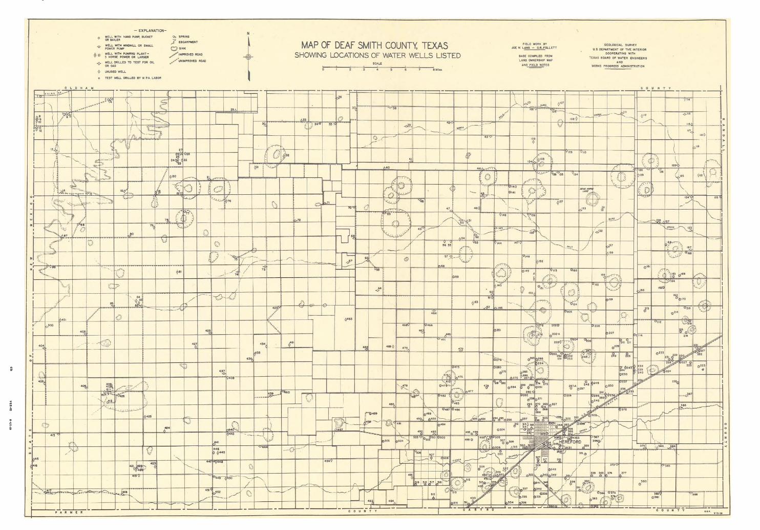
Map of Deaf Smith County, Texas,showing locations of water wells listed