End-to-end adaptation scheme for ubiquitous remote experimentation
Upload
khangminh22Category
view
0download
0
N25 Waterford to Glenmore Scheme Option Selection Report
Kilkenny County Council
25 March 2021

5190130-ATK-ZZ-ZZ-RE-RP-0008 25th March 2021 Atkins | 5190130-ATK-ZZ-ZZ-RE-RP-0008_Rev 12.docx Page 3 of 182
Contents
Chapter Page
Executive Summary 9
1. Introduction and Description 33
1.1. Introduction 33
1.2. Project Description 33
1.3. Overview of the Proposed Project 35
1.4. Existing Conditions 37
1.5. Purpose of the Option Selection Report 37
1.6. Project Operational Goals and Design Strategies 38
2. Project Need, Strategic Fit and Priority 43
2.1. Strategic Fit and Priority of Project within Sanctioning Authority Programme/Policy 43
2.2. Project Specific Need 61
3. Traffic Assessment and Option Cross Section 74
3.1. Description of Traffic Modelling Report 74
3.2. Incremental Analysis 79
4. Constraints Study 83
4.1. Approach and Methodology 83
4.2. Description of Natural Constraints 83
4.3. Description of Artificial Constraints 85
4.4. Description of External Parameters 88
4.5. Summary of Constraints 89
5. Consideration of Alternatives & Options 90
5.1. Overview 90
5.2. Pre-Constraints Study Alternatives 90
5.3. Road Based Options 98
6. Phase 2 Stage 1 – Preliminary Options Assessment 107
6.1. Identification of Route Options 107
6.2. Option Description 109
6.3. Engineering Assessment 111
6.4. Environmental Assessment 114
6.5. Economic Assessment 116
6.6. Summary of Phase 2 Stage 1 Preliminary Option Assessment 118
6.7. Recommendation on Number of Alternative Options for Stage 2 – Assessment 120
7. Stage 2 – Project Appraisal Matrix 121
7.1. Description of Phase 2 – Stage 2 Alternative Options 121

5190130-ATK-ZZ-ZZ-RE-RP-0008 25th March 2021 Atkins | 5190130-ATK-ZZ-ZZ-RE-RP-0008_Rev 12.docx Page 4 of 182
7.2. Findings from First Public Consultation 125
7.3. Multi Criteria Analysis 126
7.4. Summary of Economy Appraisal 127
7.5. Summary of Safety Appraisal 130
7.6. Summary of Environmental Appraisal 134
7.7. Summary of Accessibility & Social Inclusion Appraisal 151
7.8. Summary of Integration Appraisal 152
7.9. Summary of Physical Activity Appraisals 154
7.10. Scheme Objectives-based Appraisal 156
7.11. Phase 2 - Stage 2 Project Appraisal Matrix and Assessment. 157
7.12. Synopsis of Multi-Criteria Analysis Scoring 159
7.13. Conclusion 161
8. Phase 2 Stage 3 Preferred Route Corridor Project Appraisal Balance Sheet 163
8.1. Preferred Route Corridor Option Project Appraisal Balance Sheet (PABS) 163
8.2. Summary of Road Safety Audit Stage F (Part 2) 163
8.3. Recommendation 163
Appendices 164
Appendix A. Map of Trans European Network (TEN-T) 165
Appendix B. Cost Benefit Analysis Report & Traffic Modelling Report 168
Appendix C. Junction Strategy Assessment 169
Appendix D. Environmental Constraints Report 170
Appendix E. Feasible Options for the Phase 2 Stage 1 Assessment 171
Appendix F. Phase 2 – Stage 1 Assessment Matrix 172
Appendix G. Phase 2 Stage 2 Route Options 173
Appendix H. Public Consultation Report 174
Appendix I. Phase 2 – Environmental Route Options Report - Stage 2 – (Project Assessment Matrix) 175
Appendix J. Road Safety Audit - Stage F1 176
Appendix K. Road Safety Impact Assessment 177
Appendix L. Phase 2 – Option Selection Report - Stage 2 – Overall Project Assessment Matrix 178
Appendix M. Option Cost Estimates 179
Appendix N. Project Appraisal Balance Sheet (PABS) 180
Appendix O. Stage F (Part 2) Road Safety Audit 181
Tables
Table 2-1 - Summary of Two-Way AADT on the Existing N25 64
Table 2-2 - Total Number of Collisions on the Existing N25 from 2005 – 2020 66
Table 2-3 - Total Number of Casualties on the Existing N25 from 2005 – 2020 68

5190130-ATK-ZZ-ZZ-RE-RP-0008 25th March 2021 Atkins | 5190130-ATK-ZZ-ZZ-RE-RP-0008_Rev 12.docx Page 5 of 182
Table 2-4 - Breakdown of Network Safety Ranking Data 2016 - 2018 71
Table 3-1 - Traffic Surveys 76
Table 3-2 - 2045 Time Savings by Route Option & Time Period 77
Table 3-3 - 2045 N25 Journey Time Savings by Route Option & Time Period 78
Table 3-4 - 2045 AADT & Transference by Route Option 78
Table 3-5 – Dual Carriageway Types 80
Table 5-1 - Waterford to New Ross Timetable for Glenmore Stop 96
Table 6-1 – Phase 2 Stage 1 - Engineering Assessment Matrix Summary 113
Table 6-2 – Phase 2 Stage 1 - Environmental Assessment Matrix Summary 115
Table 6-3 – Phase 2 Stage 1 - Economic Assessment Matrix Summary 117
Table 6-4 - Summary Matrix for Phase 2 – Stage 1 Preliminary Options Assessment 120
Table 7-1 – Percentage of Responders with Land/Property adjacent to a Route and Types of Properties Impacted 125
Table 7-2 - Responses to Question 4 (Part 1) 125
Table 7-3 - List of Synopsised Additional Information Received for Question 5 126
Table 7-4 - MCA Score System 126
Table 7-5 - Option Comparison Estimate (OCE) 128
Table 7-6 - Cost Benefit Analysis (Economy) Results 129
Table 7-7 - Discounted Safety Benefits (2011 Values) 129
Table 7-8 - Economy Assessment Ranking 130
Table 7-9 - Road Safety Audit Stage F1 - Route Comparison Table 131
Table 7-10 - Assessment of RSIA Safety Issues 133
Table 7-11 - RSAI Ranking of Options 133
Table 7-12 - Safety Appraisal Summary 133
Table 7-13 - Overall Safety Ranking (MCA Scoring) 134
Table 7-14 - Overall Safety Ranking (Preferences) 134
Table 7-15 - Summary of Route Scoring - Air Quality 135
Table 7-16 - Summary of Route Scoring - Climate 136
Table 7-17 - Summary of Route Scoring - Noise 138
Table 7-18 - Summary of Route Scoring - Landscape and Visual 139
Table 7-19 - Summary of Scoring - Biodiversity 141
Table 7-20 - Route Comparison: Quantitative Waste Measures 141
Table 7-21 - Summary of Scoring - Waste 142
Table 7-22 - Summary of Route Scoring- Soils and Geology 142
Table 7-23 - Summary of Route Scoring - Hydrology 143
Table 7-24 - Summary of Route Scoring- Hydrogeology 143
Table 7-25 - Summary of Route Scoring- Architectural Heritage 144
Table 7-26 - Summary of Route Scoring- Archaeology and Cultural Heritage 145
Table 7-27 - Summary of Route Scoring - Non-Agricultural Properties 145
5190130-ATK-ZZ-ZZ-RE-RP-0008 25th March 2021 Atkins | 5190130-ATK-ZZ-ZZ-RE-RP-0008_Rev 12.docx Page 6 of 182
Table 7-28 - Summary of Route Scoring - Agriculture 146
Table 7-29 - Summary of Route Scoring - Planning / Human Beings 149
Table 7-30 - Summary of Route Scoring - Human Health 150
Table 7-31 - Environmental Assessment Matrix Summary 151
Table 7-32 - Overall Integration Preferences 154
Table 7-33 - Overall Physical Activity Preferences 155
Table 7-34 – Scheme Objective Based Appraisal 157
Table 7-35 - Phase 2 Stage 2 Assessment 160
Table 7-36 – Overall Project Appraisal Assessment 162
Figures
Figure 1-1 - Scheme Location 33
Figure 1-2 - N25 Waterford to Glenmore - Study Area 34
Figure 1-3 - TEN-T Core & Comprehensive Network & Location of Ports of National & Regional Significance as Identified in the National Ports Policy 36
Figure 2-1 – TEN-T Core and Comprehensive Networks in the Southeast 44
Figure 2-2 - Type 1 Service Area Locations on the Motorway Network 52
Figure 2-3 - Locations of Existing Service Stations on the N25 53
Figure 2-4 – RSES – Strategy Map 56
Figure 2-5 - Regional Planning Guideline - South East Region - Spatial Infrastructure Strategy 57
Figure 2-6 - Kilkenny County Development Plan - 2011 N25 Waterford to Glenmore Scheme Corridor 58
Figure 2-7 - Kilkenny City and County Draft Development Plan, 2021-2027 - Study Area for the proposed N25 Waterford to Glenmore Scheme 59
Figure 2-8 - CLÁR Areas and Population Centres in County Kilkenny 60
Figure 2-9 - Typical Existing N25 Wide Single Carriageway Cross Section 61
Figure 2-10 – Existing N25 with Varying Cross Section & Junction Treatment 62
Figure 2-11 - Side Road with Acute Angle & Steep Approach and Typical Local Road Cross Section 62
Figure 2-12 - Example of Single Direct Access Located along the Existing N25 62
Figure 2-13 – Varying Road Marking Layouts & HGV Traffic 63
Figure 2-14 - Journey Times on the N25 Waterford to Glenmore - Southbound & Northbound 64
Figure 2-15 - Speeds on the N25 Waterford to Glenmore - Southbound & Northbound 65
Figure 2-16 - RSA Collision Datal (2005 – 2016) along the N25 Waterford to Glenmore Scheme 67
Figure 2-17 - TII Collision Data 2017 - 2020 69
Figure 2-18 - TII Network Safety Ranking 2016-2018 71
Figure 2-19 - Extract from TII Draft Collision Risk Level 2018 - 2020 72
Figure 2-20 - EuroRAP Risk Map 73

5190130-ATK-ZZ-ZZ-RE-RP-0008 25th March 2021 Atkins | 5190130-ATK-ZZ-ZZ-RE-RP-0008_Rev 12.docx Page 7 of 182
Figure 3-1 - Traffic Model Study Area 75
Figure 5-1 – Preliminary Shared Surface Proposal Connecting the South-East Greenway to the Village of Glenmore 93
Figure 5-2 – Continuation of Preliminary Shared Surface Proposals Connecting the South-East Greenway to the Village of Glenmore 94
Figure 5-3 - Preliminary Layout of the Relocated Glenmore Hill Bus Stop with Set-Down Area and Parking Facilities for Vehicles and Cyclists. 96
Figure 5-4 - Locations of Properties along the N25 with limited Access to the Local Road Network. 103
Figure 5-5 - Location of One-Off Properties and Field Accesses Fronting onto the N25 104
Figure 6-1 - Feasibility Options for the Phase 2 - Stage 1 Assessment 108
Figure 7-1 - Phase 2 - Stage 2 Route Options 124
Figure 7-2 - Breakdown of Embodied Carbon for each Route Option. 136
Figure A-1 - Overall Map of Trans European Map for Ireland 166
Figure A-2 - N25 Comprehensive Route 167

5190130-ATK-ZZ-ZZ-RE-RP-0008 25th March 2021 Atkins | 5190130-ATK-ZZ-ZZ-RE-RP-0008_Rev 12.docx Page 8 of 182
N25 Waterford to Glenmore Scheme
Option Selection Report

5190130-ATK-ZZ-ZZ-RE-RP-0008 25th March 2021 Atkins | 5190130-ATK-ZZ-ZZ-RE-RP-0008_Rev 12.docx Page 33 of 182
1. Introduction and Description
1.1. Introduction
This Option Selection Report has been prepared on behalf of Kilkenny County Council and in accordance with the Transport Infrastructure Ireland (TII) Project Management Guidelines (PMG), (PE-PMG-02041), January 2019, the TII Project Manager’s Manual for Major National Road Projects, (PE-PMG-02042), February 2019 and the TII Project Appraisal Guidelines (PAG), (PE-PAG-02009 to 02039), October 2016.
Kilkenny County Council is working in consultation with TII to progress the N25 Waterford to Glenmore scheme. In June 2019, Atkins Ireland were appointed as technical advisors to assist in the development of the scheme and provide project management services on behalf of Kilkenny County Council.
The Phase 0 - Scope and Pre-Appraisal process confirmed that the project is aligned with current strategic programmes, plans and policies at National, Regional and Local levels. The Phase 1 – Concept and Feasibility process identified the need for the project and the key objectives to be delivered by the project. The project is currently at Phase 2 - Options Selection, where the main objective is to examine alternative options to identify and confirm the preferred option that best meets the objectives of the project.
This Option Selection Report presents in detail the different stages of the process, which inform the selection of the Preferred Scheme Option.
1.2. Project Description
The section of the N25 under consideration is located between two major bypass schemes, Waterford City Bypass completed in 2009 and New Ross Bypass completed in 2020. In Q2 2019, Kilkenny County Council appointed Atkins Ireland to advance the project through the planning and design process in accordance with Phases 1 - 4 of the TII Project Management Guidelines. Refer to the scheme location plan in Figure 1-1 below.
Figure 1-1 - Scheme Location
The proposed study area for the scheme is rural in nature and is located in the south east of county Kilkenny, close to the Waterford border between the townland of Luffany in the south and Jamestown in the north. The section of the N25 under consideration is a legacy single carriageway substandard stretch of the N25, which has been the subject of on-line upgrades and localised junction safety schemes with no future planned works

5190130-ATK-ZZ-ZZ-RE-RP-0008 25th March 2021 Atkins | 5190130-ATK-ZZ-ZZ-RE-RP-0008_Rev 12.docx Page 34 of 182
identified. The project will link the high-quality sections of the N25 New Ross Bypass (opened in January 2020) and the N25 Waterford City Bypass (opened in October 2009). The study area for the scheme was developed to allow for an area sufficient to consider constraints, option development and future road improvements as a means of identifying the most appropriate route corridor to meet the scheme objectives. Figure 1-2 N25 Waterford to Glenmore – Study Area illustrates the scheme location and the extent of the study area as defined in Phase 1.
Figure 1-2 - N25 Waterford to Glenmore - Study Area

5190130-ATK-ZZ-ZZ-RE-RP-0008 25th March 2021 Atkins | 5190130-ATK-ZZ-ZZ-RE-RP-0008_Rev 12.docx Page 35 of 182
1.3. Overview of the Proposed Project
1.3.1. Project Context
Kilkenny County Council (KCC), in association with Transport Infrastructure Ireland (TII), are proposing to develop a scheme to improve approximately 9.5 km of the existing N25 between Waterford and Glenmore. This proposed scheme is called the N25 Waterford to Glenmore Road Scheme. The scheme will link the N25 New Ross Bypass (opened in January 2020) and the N25 Waterford City Bypass (opened in October 2009) and is expected to consist of approximately 9.5km of dual carriageway providing continuity of cross section and alignment for approximately 35km.
The N25 Waterford to Glenmore Road Scheme is of particular importance as it forms part of the following policies:
• The Trans- European Transport Networks (TEN-T);
• Project Ireland 2040, incorporating The National Planning Framework (NPF), National Development Plan (2018-2027) (NDP) and the Regional Planning Guidelines for the South-East Region 2010 – 2022;
• Strategic Investment Framework for Land Transport (SIFLT);’
• Smarter Travel – A Sustainable Transport Future (2009-2020);’
• Road Safety Strategy (2013-2020);’
• Regional Planning Guidelines for the South-East Region (2010-2022);
• Kilkenny City & County Draft Development Plan 2021 - 2027.
On a European and national level, the N25 forms part of the TEN-T, which is a network of strategic transport corridors throughout the European Union (EU) that play a key role in the transportation of goods and passengers. The N25 TEN-T strategic route is a vital link in the national road network for the south of the country and is approximately 185km in length. The route connects the city of Cork in the west to the port of Rosslare in the east, with connections to New Ross, Waterford city and Waterford Port (Belview) between these locations. In addition, the N25 route links the towns and villages of Carrigtwohill, Midleton, Castlemartyr, Killeagh, Dungarvan, Kilmacthomas, Kilmeaden and Wexford.
The Republic of Ireland is a trading nation and as an island the movement of the vast majority of traded goods happens through our sea ports and strategic infrastructure. The Irish economy has achieved impressive growth/recovery since 2013 with a concentration of this growth in and around the Greater Dublin Area. The Brexit transition period ended on the 1st January 2021 and the potential challenges arising for the supply chains are significant. In this context, Dublin Port, which handles the majority of the nation’s freight traffic, may not be as well positioned to deal with the full range of services as heretofore provided. In that context the country’s other ports may have to carry a greater share of the workload. Since the 1st January 2021, Rosslare Port has seen an increase in freight volume in the region of 40 - 45% with a number of additional services added to date.
The N25 route provides access to three of the five ports of national significance as identified in the National Ports Policy, these are the ports of Cork, Rosslare, and Waterford and also to the Port of New Ross, which is identified as a port of regional importance. As part of the TEN-T network, three of these ports are identified as strategic ports, Cork as a Tier 1 port and Waterford and Rosslare as Tier 2 ports. In addition, the N25 provides access to the TEN-T core and comprehensive airports of Cork and Waterford.
The National Ports Policy states that Tier 1 ports are responsible for 15% to 20% of overall tonnage through Irish ports and Tier 2 ports responsible for 2.5%. Tier 1 ports have a clear potential to lead the development of future port capacity in the medium and long term, when and as required. Tier 2 ports have the clear demonstrable potential to handle higher volumes of unitised traffic and have the existing transport links to serve a wider, national marketplace beyond their immediate region.

5190130-ATK-ZZ-ZZ-RE-RP-0008 25th March 2021 Atkins | 5190130-ATK-ZZ-ZZ-RE-RP-0008_Rev 12.docx Page 36 of 182
Figure 1-3 - TEN-T Core & Comprehensive Network & Location of Ports of National & Regional Significance as Identified in the National Ports Policy
From a more regional and local perspective the N25 connects the employment hubs of Waterford City and New Ross and the village of Glenmore. The infrastructure supports local employment facilitating agricultural operations and local industries, most notably Glanbia Agribusiness, which is a key local employer and source of supplies for farmers and agri-contractors in the study area. Glanbia Agribusiness is located at Glenmore village and largely accessed by staff, suppliers and customers from the N25 via the L7510.
The N25 Waterford to Glenmore Scheme is an objective of Kilkenny County Council and Transport Infrastructure Ireland (TII) as it is a key road improvement, which will have a very positive effect on the south east region.
In the context of planning the key benefits of the scheme are as follows:
• Will support the sustainable development principles of the Government's Climate Action Plan - 2019;
• Will support the European Policy to provide TEN-T Comprehensive infrastructure and complete 35km of continuous high-quality road;
• Will support the future development and expansion of Cork, Waterford, Rosslare and New Ross ports by providing a high-quality route for freight traffic;
• Will stimulate the expansion of tourism in the areas served by the route;
• Will support the economic growth of the South-eastern region and its resources;
• Will provide a higher level of road safety on the route;
• Will address the needs of vulnerable road users by separating them from high speed traffic, including freight.
1.3.2. Project History
In 2007, planning and design work for the N25 Waterford to Glenmore Road Scheme was carried out by Tramore House Regional Design Office (THRDO) on behalf of Kilkenny County Council. The proposed scheme considered at the time was a Type 2 dual carriageway. Route corridor options for the N25 Waterford to Glenmore Scheme were developed and assessed by THRDO but this previous work was suspended in 2011 for economic reasons.
A Preferred Route Corridor was identified in 2011, and this is included in the current Kilkenny County Development Plan 2014 – 2020. To comply with current environmental legislation, design standards and to meet the requirements of the current Public Spending Code, new route corridor options have been developed and assessed by Atkins and a Preferred Route Corridor has been identified as a result of this appraisal process. The planning and design work previously completed by THRDO has been considered as part of this process.

5190130-ATK-ZZ-ZZ-RE-RP-0008 25th March 2021 Atkins | 5190130-ATK-ZZ-ZZ-RE-RP-0008_Rev 12.docx Page 37 of 182
1.4. Existing Conditions
The section of the N25 under consideration between Luffany roundabout and the newly constructed Glenmore roundabout is a national primary route corridor, which has evolved over the ages and thus fits within the existing landscape. The alignment is below current standards, with inherent safety issues and limited capacity for expanding transportation demands as it traverses the hilly terrain.
The village of Glenmore to the north represents the most built up area along the existing route within the study area. The N25 is a single carriageway road, rural in nature with the existing topography classified as hilly. The existing alignment reflects this, with a long section of climbing lane provided for southbound vehicles. The national route is a strategic traffic route in the southeast and caters for a significant percentage of HGV’s. The rural nature, coupled with the numerous field accesses, private property entrances, and local road junctions contribute to a large mix of national, local and slow-moving agricultural traffic, which results in unreliable journey times, particularly at peak periods.
Seventy-three direct accesses and junctions consisting of field accesses, private property entrances, and local road junctions have been identified along the 9.5km length of the existing N25. Many of these are closely spaced and often poorly arranged with dwell areas and visibility splays that do not comply with current design standards. Hence, the existing alignment falls short of current alignment standards. The existing carriageway is well marked and signed with speed limits and warning signs throughout.
The existing carriageway is single carriageway, generally 7.3m wide with 0.5 - 3m hard strip/hard shoulder and grass verge widths varying between 0.5m and 2.5m and the posted speed limit is 100km/h. There is a surface water drainage system present and run off from the road surface is collected via a combination of filter drain and closed channel systems, which discharge into the nearest ditch/stream and outfall to the Barrow and Glenmore Rivers.
The surface of the road is generally in good condition and the road markings reflect the poor alignment, with approximately 5km of solid white non-overtaking markings provided, interspersed with short lengths of dashed line marking provided, which restricts overtaking opportunities in both directions. A climbing lane is provided for southbound traffic over 3.2km, further restricting overtaking for northbound traffic. The variable road markings result in limited overtaking opportunities along the length of the N25 under consideration, in particular for northbound traffic.
There are many roadside hazards along the route, including but not limited to; poles, walls, trees, fence posts, substandard vehicle restraint systems, ditches, etc. and within the study area no pedestrian or cycle facilities are provided.
The combined effects of these features result in the occurrence of traffic incidents, poor driving quality experience, and an overall low level of safety for all road users. The delayed journey times have negative economic impacts reducing the route’s adequacy as a strategic link within the national road network.
The N25 is considered to be located in an environmentally sensitive area as the routes within the study area pass close to archaeological, ecological and environmentally sensitive areas with the River Barrow and River Nore SAC to the east and Lower River Suir SAC to the south of the study area.
There are several ecological, environmental and architectural constraints present, which have been considered as part of the decision process for potential routes. There are also several Demesnes, which are protected by law and therefore affect the potential routes for consideration. These constraints are scattered throughout the study and these are described in detail in Section 4 and the associated appendices.
1.5. Purpose of the Option Selection Report
The purpose of this Option Selection Report is to identify a Preferred Option for the improvement and upgrade of the existing N25 between Waterford and Glenmore. The option selection process commenced with the identification of a defined Study Area appropriate to the scale of the proposed scheme and the subsequent identification of significant constraints, their nature and extent, within the Study Area. The constraints that have been identified were divided into three principal categories as follows:
• Natural Constraints, which include natural landscapes and natural features.
• Artificial Constraints, which include the built environment.

5190130-ATK-ZZ-ZZ-RE-RP-0008 25th March 2021 Atkins | 5190130-ATK-ZZ-ZZ-RE-RP-0008_Rev 12.docx Page 38 of 182
• External Parameters, which include design standards, policy, procedural and legal issues.
The above constraints have been documented and mapped so that feasible route options could be designed to avoid such constraints, where possible. Once the constraints mapping was completed the identification of feasible route options was commenced.
These feasible route options have been assessed as part of the process in order to identify a Preferred Route Corridor at the end of Phase 2 in accordance with TII’s Project Management Guidelines (PMG) (PE-PMG-02041), January 2019, the TII Project Manager’s Manual for Major National Road Projects, (PE-PMG-02042), February 2019 and the TII Project Appraisal Guidelines (PAG), (PE-PAG-02009 to 02039), October 2016.
This Option Selection Report represents the main deliverable for Phase 2 of the PMGs. The purpose of the Option Selection Report is to present the project constraints and the assessments that have been undertaken in order to identify the Emerging Preferred Route Corridor for the project. Information is presented in this Report (and its accompanying appendices) to provide clarity on the decision-making process, which has resulted in the selection of a preferred route corridor. The main body of this report consists of a (where possible) non-technical summary of the detailed technical and scientific information collated as part of Phase 2. The detailed technical and scientific information is included in the accompanying appendices to this report.
The main elements of assessment in Phase 2 are:
• Stage 1 – Preliminary Options Assessment
• Stage 2 – Project Appraisal Matrix
• Stage 3 – Preferred Option
On completion of the Phase 2 process this preferred option will be progressed to Phase 3 - Design and Environmental Evaluation and subsequently Phase 4 - Statutory Processes in accordance with TII’s PMG (PE-PMG-02041), January 2019.
1.6. Project Operational Goals and Design Strategies
1.6.1. Overview
The N25 Waterford to Glenmore scheme will provide a continuous high-quality road, completing a significant length of the TEN-T Comprehensive road network by closing the gap that currently exists between the Waterford City Bypass and the New Ross Bypass. This link is a vital section of the N25 route for both passenger and freight traffic providing interconnection between transport infrastructure for cross border, National, Regional and Local traffic. The scheme will provide continuity of cross section and alignment, completing approximately 35km of dual carriageway to a standard that meets the requirements of TII Publications and the EU TEN-T regulations.
As part of the TEN-T comprehensive network, and as a means of providing a high-quality road, it is the intention of TII to give the Waterford City Bypass and the New Ross Bypass Protected Road status under Section 45 of
the Roads Act 1993. This states that a Protected Road Scheme may:
• provide for the prohibition, closure, stopping up, removal, alteration, diversion or restriction of any specified or all means of direct access to the protected road from specified land or from specified land used for a specified purpose or to such land from the protected road;
• may prohibit or restrict the use of the protected road or a particular part thereof by:
o specified types of traffic,
o specified classes of vehicles.
The protected road requirements are in line with the TEN-T requirements to limit direct accesses and based on this it is intended that the proposed N25 Waterford to Glenmore scheme will be developed accordingly as a protected road to future proof the network and comply with the relevant provisions of the EU guidelines.
The specific objectives of the proposed road development are assessed based on multi-criteria headings outlined by the Department of Transport in the document ‘Common Appraisal Framework for Transport Projects and Programmes (March 2019)’ and TII’s Project Appraisal Guidelines – PAG Unit 3.0 Project Brief and Unit 7.0 Multi Criteria Analysis.
5190130-ATK-ZZ-ZZ-RE-RP-0008 25th March 2021 Atkins | 5190130-ATK-ZZ-ZZ-RE-RP-0008_Rev 12.docx Page 39 of 182
The multi-criteria headings are as follows:
• Economy;
• Safety;
• Physical Activity;
• Environment;
• Accessibility & Social Inclusion;
• Integration.
1.6.2. Economy
As part of the TEN-T comprehensive network and as identified in the Regional Spatial & Economic Strategy and National Planning Framework – Project Ireland 2040, the N25 is considered one of the country’s strategic National Primary Routes linking the south of the country. The route connects the city of Cork in the west to the port of Rosslare in the east, with short links to both Waterford City and New Ross town. In addition, the N25 route links the towns and villages of Carrigtwohill, Midleton, Castlemartyr, Killeagh, Dungarvan, Kilmacthomas, Kilmeaden and Wexford.
The N25 route provides access to three of the five ports of national significance as identified in the National Ports Policy, these are the ports of Cork, Rosslare, and Waterford and also to the Port of New Ross, which is identified as a port of regional importance. As part of the TEN-T network, three of these ports are identified as strategic ports, Cork as a Tier 1 port and Waterford and Rosslare as Tier 2 ports. It also provides access to the core and comprehensives airports at Cork and Waterford. These links to strategic infrastructure further enhance international connectivity to Europe and beyond.
The N25 also connects to the motorway network at Waterford to the M9 and to the national road network at Wexford to the N11/M11 routes and Waterford to the N24, which provide access to the midlands, the east coast and beyond. At present, this section of the N25 is characterised by a single carriageway road with limited overtaking opportunities. The mix of traffic using the N25 includes agricultural traffic mixing with local and national traffic, with national traffic interrupted by local traffic manoeuvres associated with the multiple junctions and direct accesses. These factors result in variable travel speeds and reduced journey time reliability. The key economic objectives for this scheme include:
• To improve the capacity and efficiency of the road network in the southeast;
• To improve cross-border connectivity from the southeast to Europe via the N25 route and the ports by completing the TEN-T Comprehensive road network between the Waterford City bypass and the New Ross bypass;
• To maintain or reduce journey times and improve journey time reliability, which will in turn reduce transport costs and environmental impacts;
• To improve the economic out-look and encourage business growth in the areas served by the route by providing a reliable and efficient transport link;
• To support the future development and expansion of Cork, Waterford, Rosslare and New Ross ports by providing a high-quality route for freight traffic;
• To stimulate expansion of tourism in the areas served by the route by maintaining/reducing journey times, making these areas more accessible and attractive to visit.
• To deliver a value for money solution that ensures a lasting residual value.
1.6.3. Safety
Currently the existing section of the N25 has a significant number of priority-controlled junctions (16), direct accesses (57), road frontage with road side hazards. In addition, the existing alignment has significant lengths of sub-standard horizontal and vertical curvature with poor forward visibility that need to be addressed to meet the objective of providing a TEN-T high-quality road. This environment for road users contrasts with the adjoining

5190130-ATK-ZZ-ZZ-RE-RP-0008 25th March 2021 Atkins | 5190130-ATK-ZZ-ZZ-RE-RP-0008_Rev 12.docx Page 40 of 182
Waterford City and New Ross Bypasses which have limited, or no direct accesses, grade separated junctions and protected road side hazards.
The existing section of the N25 under consideration has several deficiencies in design and layout that greatly reduce the overall safety of the route. The existing asset is a single carriageway road with multiple junctions and direct accesses, and it caters for national high-speed traffic mixing with slower local traffic and vulnerable road users (VRUs). As a result, a number of collisions have occurred on the route. The key safety objectives of the scheme are as follows:
• To reduce the occurrences of road collisions on the N25 by minimising road side hazards and reducing the requirements for cross-over and right turn manoeuvres;
• To provide a consistent cross section and treatment of junctions and direct access in keeping with that of the adjoining Waterford City and New Ross Bypass schemes.
• To separate vulnerable road users from high speed, strategic traffic, including freight.
• To provide increased safer overtaking opportunities;
• To adequately cater for the projected increase in traffic volumes;
• To improve and increase the capacity of the N25 and provide minimum LOS D.
1.6.4. Physical Activity
In the context of Physical Activity, as described in PAG Unit 7.0 and Unit 13.0, this criterion should include the quantification of benefits in areas of absenteeism, ambience and health risk reduction derived from the provision or improvement of pedestrian/cycle provisions to promote different modes of transport. The study area is located in a rural setting and the key Physical Activity objectives for the scheme are:
• To maintain/improve the connectivity to the Southeast greenway pedestrian and cycle facility and the nearby village of Glenmore;
• To improve the ambience and safety of the existing N25 and to facilitate increased usage of the existing N25 by pedestrians and cyclists.
All options, to varying degrees achieve these objectives by providing improved connectivity to the proposed South-East Greenway, a scheme Kilkenny County Council are currently progressing along the existing disused railway line within the study area. The greenway is currently under construction and within the study area extends from Luffany roundabout to Glenmore roundabout with connections to the existing local road network along its route. It will provide a dedicated facility between New Ross town and Waterford city superior to any pedestrian/cycle facility that could be provided as part of the proposed N25. The Purple, Navy, Magenta and Lime Green options do not impact the alignment of the greenway and the Red and Teal options impact it by crossing the facility at two locations. All options maintain existing access to and from the existing road network and the greenway.
The off-line options will result in a significant reduction in traffic on the existing N25 by separating the national high-speed traffic from the local traffic. The existing N25 will be declassified to a regional road with reduced traffic volumes and traffic speeds. This will improve both the ambience and safety of the existing N25 and thus encourage increased usage by pedestrians and cyclists contributing to the reduction in absenteeism and health risks. The proposed intermediate junction in the Magenta, Navy and Lime Green options will reinstate the connectivity to the townlands east of Glenmore village and the existing N25 by providing a safe walking/cycle route for local residents to and from the village and school.
1.6.5. Environment
Given the numerous junctions/direct accesses and the associated vehicular manoeuvres combined with the rural nature of the study area, slow moving vehicles are a common occurrence along the route. In addition, a number of closely spaced junctions cause vehicles to reduce speed, queue and stop / start regularly. All of these factors culminate in reduced driving efficiency generating higher emissions, inefficient fuel usage and poorer air quality. The key environmental objectives of the scheme include:
• To provide a sustainable long-term solution in line with the 2019 Climate Action Plan;

5190130-ATK-ZZ-ZZ-RE-RP-0008 25th March 2021 Atkins | 5190130-ATK-ZZ-ZZ-RE-RP-0008_Rev 12.docx Page 41 of 182
• To ensure alignment with sustainable development principles and measures to minimise effects on the environment to support the Government's policy on climate action;
• To maintain or reduce journey times and encourage free flow traffic, with the aim of reducing greenhouse gas emissions and impacts on climate;
• To construct a scheme that is suitably integrated into the surroundings both visually and from a noise impact point of view;
• To manage surface run-off both during and after construction of the scheme so as not to negatively impact on local water resources.
The design of the scheme will be optimised, seeking to incorporate new and innovative design methods to improve its sustainability such as the use of reduced carbon materials. The road design will be developed iteratively with the environmental assessment to ensure that an optimum design is achieved in terms of environmental impacts and sustainability. This can be achieved by refining the alignment to further balance the earthworks and reduce quantities of both cut and fill, reducing the quantities of surplus material to be disposed off-site for example, by providing on-site landscape features, or by increasing embankment side slopes and by providing a sustainable drainage system which maximises protection to the SAC by reducing the risk of contaminants in surface water discharges.
1.6.6. Accessibility and Social Inclusion
The scheme will upgrade a vital link in the southeast of the country. It will allow current residents living along the section of the N25 under consideration better access to their residences and the national road network. It will also encourage social inclusion and interaction between communities as it will allow road users to move more easily in the Glenmore area and beyond.
The scheme will also improve road based public transport at both a regional and national level. The scheme will assist in achieving the objectives of the National Development Plan, Regional Spatial Economic Strategy and the County Development Plan to generally improve quality of life and accessibility to work, education and other activities. The objectives of the scheme in relation to accessibility and social inclusion are:
• To connect to other similar schemes enhancing the connectivity of the regional and national road network;
• To improve road based public transport by maintaining or reducing journey times and improving journey time reliability;
• To provide safer and more convenient access to public transport for residents in Glenmore Village and its immediate environs;
• To align with the accessibility and social cohesion objectives as outlined in the Kilkenny County Development Plan 2014- 2020 and the Kilkenny City and County Draft Development Plan 2021 - 2027.
1.6.7. Integration
It is vital that the proposed scheme integrates appropriately with both local and national policies such as; transport, land use, geographical, planning and other relevant government policies. The following are the scheme objectives for integration:
• To connect to other similar schemes, enhancing the connectivity of the regional and national road network;
• To improve access between the ports of Cork, Waterford, Rosslare and New Ross and the comprehensive and core road networks;
• To improve transport links within the EU and beyond;
• To be consistent with the Kilkenny County Development Plan 2014 – 2020 and the Kilkenny City and County Draft Development Plan 2021 - 2027 in terms of land use and planning objectives;
• To maintain/improve the connectivity to the Southeast Greenway pedestrian and cycle facility;

5190130-ATK-ZZ-ZZ-RE-RP-0008 25th March 2021 Atkins | 5190130-ATK-ZZ-ZZ-RE-RP-0008_Rev 12.docx Page 42 of 182
• To complement and support European, National, Regional and Local Government policies.
1.6.8. Performance Targets
The key performance targets of the scheme have been set based upon the identified deficiencies in the existing section of the N25 under consideration. The performance targets are as follows:
• To provide a consistent cross section and treatment of junctions and direct accesses in keeping with that of the adjoining Waterford City and New Ross bypasses;
• To provide a sustainable long-term solution in line with the 2019 Climate Action Plan;
• To maintain or reduce journey times and improve journey time reliability;
• To improve safety;
• To separate vulnerable road users from high speed, strategic traffic, including freight.
All options meet the objectives listed above for Economy, Safety, Environment, Physical Activity, Accessibility and Social Inclusion and Integration to varying degrees and this is discussed further in Chapter 7.
1.6.9. Design Standards
The design of the scheme shall be in accordance with the requirements in the TII Publications (Technical). In particular, junctions incorporated into the Scheme shall be designed in accordance with the requirements outlined in DN-GEO-03060 (April 2017) Geometric Design of Junctions (priority junctions, direct accesses, roundabouts, grade separated and compact grade separated junctions). Should provisions for vulnerable road users be included as part of the scheme, they shall be designed in accordance with DN-GEO-03047 (April 2017) Rural Cycleway Design (Offline).

5190130-ATK-ZZ-ZZ-RE-RP-0008 25th March 2021 Atkins | 5190130-ATK-ZZ-ZZ-RE-RP-0008_Rev 12.docx Page 43 of 182
2. Project Need, Strategic Fit and Priority
2.1. Strategic Fit and Priority of Project within Sanctioning Authority Programme/Policy
2.1.1. Policy Background
The N25 Waterford to Glenmore Scheme is consistent and compatible with the following European, National, Regional and Local policy documents:
European Policy:
• Trans-European Transport Network (TEN-T), Regulation (EU) No. 1315/2013.
o TEN-T Road Network
o TEN-T Ports
❖ Ports 2030 – Gateway for the Trans European Transport Network
o TEN-T Rest Areas
❖ Driving Time and Rest Periods Regulation (EU) No. 561/2006,
❖ Road Infrastructure Safety Management Directive 2008/96/EC
❖ Intelligent Transport Systems (ITS) Directive 2010/40/EC.
National Policy:
• Project Ireland 2040
o National Planning Framework
o National Development Plan 2018 - 2027;
• Strategic Framework for Investment in Land Transport;
• Smarter Travel: A Sustainable Transport Future 2009 - 2020;
• Road Safety Authority Road Safety Strategy 2013 – 2020.
• Spatial Planning & National Roads 2012 – Rest Areas
• Climate Action Plan – 2019
• National Roads Authority (NRA) Service Area Policy 2014 and
• National Policy Framework Alternative Fuels Infrastructure for Transport in Ireland 2017 to 2030
Regional Policy:
• Regional Spatial & Economic Strategy - Project Ireland 2040;
• Port of Waterford Master Plan 2020 – 2044;
• Regional Planning Guidelines for the South-East Region 2010 – 2022.
Local Policy
• Kilkenny County Development Plan 2014 – 2020;
• Kilkenny City and County Draft Development Plan 2021 – 2027;
• Kilkenny Local Economic and Community Plan 2016-2021 (LECP).

5190130-ATK-ZZ-ZZ-RE-RP-0008 25th March 2021 Atkins | 5190130-ATK-ZZ-ZZ-RE-RP-0008_Rev 12.docx Page 44 of 182
2.1.2. European, National, Regional & Local Policy Context
2.1.2.1. Trans-European Transport Network (TEN-T).
The EU Regulation No. 1315/2013 Trans-European Transport Network (TEN-T) is a European Commission policy provides legal guidance for the provision the implementation and development of a Europe-wide network of transport infrastructure to ensure effective connectivity to all EU nations.
The EU transport infrastructure policy establishes a two-tier TEN-T network comprising:
• Comprehensive network – this network feeds into the core network at regional and national level.
• Core network – the most strategic elements of the TEN-T network.
The TEN-T networks are a set of road, rail and water transport networks in Europe. EU Regulation No. 1315/2013 sets out the requirements for high quality roads that shall form part of the TEN-T road network, both Core (targeted for completion by 2030) and Comprehensive (targeted for completion by 2050), as stated under Article 17(3). Figure 2.1 shows the extent of the Core and Comprehensive Transport Networks for the roads, ports and airports in the Southeast area.
Figure 2-1 – TEN-T Core and Comprehensive Networks in the Southeast
The objective of TEN-T is to close gaps, remove bottlenecks and eliminate technical barriers that exist between the transport networks of EU Member States. The TEN-T Executive Agency states that TEN-T projects aim to:
• Establish and develop the key links and interconnections needed to eliminate existing bottlenecks to mobility,
• Fill in missing sections and complete the main routes — especially their cross-border sections,
• Cross natural barriers, and
• Improve interoperability on major routes.
The N25 Waterford to Glenmore Scheme will contribute to the upgrade of the Cork-Waterford-Rosslare Harbour Comprehensive Transport network.
Scheme Location

5190130-ATK-ZZ-ZZ-RE-RP-0008 25th March 2021 Atkins | 5190130-ATK-ZZ-ZZ-RE-RP-0008_Rev 12.docx Page 45 of 182
2.1.2.1.1. Trans-European Transport Network (TEN-T) – Road Network
Regulation (EU) No 1315/2013 sets out the requirements for high quality roads that shall form part of the TEN-T network, both Core and Comprehensive, and states under Article 17(3), the following:
“High-quality roads shall be specially designed and built for motor traffic, and shall be either motorways, express roads or conventional strategic roads.
a) A motorway is a road specially designed and built for motor traffic, which does not serve properties bordering on it and which:
i) is provided, except at special points or temporarily with separate carriageways for the two directions of traffic, separated from each other by a dividing strip not intended for traffic or, exceptionally, by other means;
ii) does not cross at grade with any road, railway or tramway track,
iii) bicycle path or footpath; and
iv) is specially sign-posted as a motorway.
b) An express road is a road designed for motor traffic, which is accessible primarily from interchanges or controlled junctions and which:
i) prohibits stopping and parking on the running carriageway; and
ii) does not cross at grade with any railway or tramway track.
c) A conventional strategic road is a road which is not a motorway or express road, but which is still a high-quality road.”
Article 17(4) of the Regulations lists the associated infrastructure which may be included with the above high-quality roads as follows:
“Equipment associated with roads may include, in particular, equipment for traffic management, information and route guidance, for the levying of user charges, for safety, for reducing negative environmental effects, for refuelling or recharging of vehicles with alternative propulsion, and for secure parking areas for commercial vehicles.”
The N25 Waterford to Glenmore Corridor forms part of the TEN-T comprehensive network connecting to the core network (M7/M8) at Cork and other comprehensive routes such as the N20/M20 and N22 at Cork, the M11/N11 at Wexford and the M9 at Waterford. See full map in Appendix A.
2.1.2.1.2. Trans-European Transport Network (TEN-T) – Ports
Regulation (EU) No 1315/2013 sets out the requirements for ports that form part of the TEN-T network and states under Article 21(1), the following:
1. Motorways of the sea, representing as they do the maritime dimension of the trans-European transport network, shall contribute towards the achievement of a European maritime transport space without barriers. They shall consist of short-sea routes, ports, associated maritime infrastructure and equipment, and facilities as well as simplified administrative formalities enabling short-sea shipping or sea-river services to operate between at least two ports, including hinterland connections. Motorways of the sea shall include:
a) maritime links between maritime ports of the comprehensive network or between a port of the comprehensive network and a third-country port where such links are of strategic importance to the Union;
b) port facilities, freight terminals, logistics platforms and freight villages located outside the port area but associated with the port operations, information and communication technologies (ICT) such as electronic logistics management systems, and safety and security and administrative and customs procedures in at least one Member State;
c) infrastructure for direct land and sea access.
Article 41(2) of the Regulations (EU) No 1315/2013 with regard to transport infrastructure requirements states that Member States shall ensure that

5190130-ATK-ZZ-ZZ-RE-RP-0008 25th March 2021 Atkins | 5190130-ATK-ZZ-ZZ-RE-RP-0008_Rev 12.docx Page 46 of 182
“Maritime ports of the core network ... shall be connected with the railway and road and, where possible, inland waterway transport infrastructure of the trans-European transport network by 31 December 2030, except where physical constraints prevent such connection.”
The European Commission has published an implementation plan “Ports 2030 - Gateways for the Trans European Network”. This states that in partnership with the Member States, the Commission will streamline transport projects funded under the Structural and Cohesion Funds with the TEN-T, promoting priority to projects for port access and hinterland connections.
The Ports 2030 - Gateways for the Trans European Transport Network, published in 2014 examines the drivers behind port development and what steps need to be taken to address the deficiencies in the port network. The report recognises that the success of a good port is a solid connection to its immediate surrounding inland area (its hinterland).
The report recognises that investment in port facilities is required now to remain competitive for the future and to make the best possible use of our port assets, which require efficient and quality port services. The report states that:
“If nothing is done an opportunity will be missed to increase options available to transport operators and shippers and create growth and jobs in coastal areas and across the Union as a whole.”
The policy in relation to ports therefore recognises the important role that the development of ports and their surrounding infrastructure has as a driver for economic growth and employment in the surrounding region.
The N25 Waterford to Glenmore Corridor forms part of the TEN-T comprehensive network connecting to the comprehensive transport network at the Tier 1 port of Cork and Tier 2 ports of Waterford and Rosslare. See full map in Appendix A.
2.1.2.1.3. Trans-European Transport Network (TEN-T) – Rest Areas
The TEN-T regulation defines the objective of increasing the benefits for road users by ensuring safe, secure and high-quality standards for road users and freight transport. The regulation includes the need to provide appropriate parking spaces for commercial users and, on the core network, the development of rest areas approximately every 100 km in line with the needs of road users, indicating the need to treat roads as a workplace.
Article 39(2)(c) of Regulation (EU) No 1315/2013 sets out the requirements for rest areas on the TEN-T Network to include:
"the development of rest areas on motorways approximately every 100 km in line with the needs of society, of the market and of the environment, in order inter alia to provide appropriate parking space for commercial road users with an appropriate level of safety and security;"
Independent of Regulation (EU) No 1315/2013, the following EU Regulations address the need to treat all roads as works places and make them safer for all road users and they are:
• EU Road Infrastructure Safety Management Directive 2008/96/EC sets out the requirement to carry out a road safety impact assessment for proposed schemes and as part of this to assess the need for rest areas as part of the scheme.
• Driving Time and Rest Periods Regulation (EU) No. 561/2006, which governs the need for Member States to improve working conditions for workers;
• Road Infrastructure Safety Management EU Directive 2008/96/EC stipulates that Road Safety Impact Assessments are to include the assessment of a sufficient number of safe rest/parking areas along a route; and
• Intelligent Transport Systems (ITS) EU Directive 2010/40/EC dictates the need for ITS to enhance transport across the EU. including the need to provide information and booking of safe and secure parking for commercial vehicles.
TII have adopted these requirements to assess the need for rest areas and further discussion on the TII policy is included in paragraph 2.1.2.8.

5190130-ATK-ZZ-ZZ-RE-RP-0008 25th March 2021 Atkins | 5190130-ATK-ZZ-ZZ-RE-RP-0008_Rev 12.docx Page 47 of 182
2.1.2.2. Project Ireland 2040 - National Planning Framework
The National Planning Framework (NPF) – Project Ireland 2040 was published by the Government in February 2018. It sets out a new strategic planning and development context for Ireland and all of its regions up to 2040, setting a high-level framework for the co-ordination of a range of National, Regional and Local authority policies and activities, planning and investment, both public and private.
In the NPF, Ireland’s five cities of Dublin, Cork, Limerick, Galway and Waterford will be targeted to accommodate 50% of overall national population growth with the other 50% growth coming from Ireland’s towns, villages and rural areas. The Southern Region includes the three city-regions of Cork, Limerick and Waterford and their associated ports and the international airports, towns and rural hinterlands.
Specifically, in the context of the proposed scheme, the NPF identifies enhanced regional connectivity through improved average journey times by road to Cork, Limerick and ports within the region as a key future growth enabler for Waterford.
The NPF is structured around a set of National Strategic Outcomes (NSOs) or goals. The N25 Waterford to Glenmore scheme aligns with these as follows:
• NSO 1 Compact Growth - This scheme will support the future consolidated growth of Waterford City and New Ross town, and balanced regional development in the south-east, without unduly influencing the demand for travel, local development patterns or car use within these urban centres, creating opportunities for employment growth within Waterford City and the potential to expand the population and develop housing within and close to the existing footprint of the built-up area in the city.
• NSO 2 Enhanced Regional Accessibility - The scheme will contribute to the aspiration of an average inter-urban speed of 90kph on the route and improve average journey times. The scheme will also provide improved connectivity between Waterford City, New Ross and Wexford urban centres in the Southern Region, 4 ports and 2 airports enhancing growth potential for Waterford City and New Ross as urban centres in line with the strategy of enabling the city to grow by at least 50% by 2040.
• NSO 3 Strengthened Rural Economies and Communities - The scheme will indirectly enable the comprehensive integration of public transport networks for Ireland’s cities to connect more people to more places. The scheme will provide improved access to the National road network and support the NDP objective to "provide a quality nationwide community-based public transport system in rural Ireland, which responds to local needs under the Rural Transport Network and similar initiatives”.
• NSO 4 Sustainable Mobility - The scheme will improve land transport connections to the major ports. The scheme may also be seen as an enabler for the provision of greater public transport, which supports sustainable mobility and enhancement of regional connectivity to urban centres and transport hubs. Sustainable transport modes (i.e. public transport, cycling and walking) will be improved by the reduction of traffic on the existing N25, safe access to the Southeast Greenway and the proposed relocation of bus stops on the N25 improving safety and attractiveness, contributing to more sustainable travel.
• NSO 5 Strong Economy Supported by Enterprise, Innovation and Skills - Future employment growth will require a major focus on boosting regional growth potential to secure sustainable quality employment. This necessitates the generation of growth that is sustainable, driven by exports and underpinned by innovation and competitiveness in all regions. Improved interconnectivity by way of provision of this scheme will support these objectives. The scheme will drive the Southeast region to be more attractive to national and international investment by promoting enterprise, innovation and skills.
• NSO 6 High Quality International Connectivity - All options will result in an improvement to the TEN-T comprehensive network and will meet the objectives by closing gaps, removing bottlenecks and eliminating technical barriers that exist between the transport networks of EU Member States. The scheme will meet these objectives by connecting the Waterford City Bypass and New Ross Bypass, adding to cross border international connectivity through enhanced access and connectivity to the ports of Waterford, New Ross, Rosslare and Cork, which are geographically close to EU trading

5190130-ATK-ZZ-ZZ-RE-RP-0008 25th March 2021 Atkins | 5190130-ATK-ZZ-ZZ-RE-RP-0008_Rev 12.docx Page 48 of 182
partners and will be important in Ireland's response to Brexit, in accordance with the objectives of the NPF.
• NSO 7 Enhanced Amenity and Heritage - Indirectly the scheme has the potential to provide better public access to the south east historic, built and natural environment by improving the existing transport network for public transport and other road users. The scheme has the potential to stimulate expansion in tourism in the areas served by the route. The NDP and NPF recognise the need for ease of access to these amenities and the scheme aims to improve access throughout the region.
• NSO 8 Transition to a low carbon and climate resilient society - High quality road infrastructure could be considered to be an enabler for the transition to autonomous vehicles, while the migration of the national fleet to more sustainable, low carbon options is enhanced by the provision of the scheme. Development of future innovative vehicle technologies can lower emissions and reduce oil, leading towards a more resilient transport infrastructure. The scheme will also provide opportunities for increased pedestrians and cyclists activity, including full integration with the Southeast Greenway project, which will further assist in the reduction of carbon emissions.
• NSO 9 Sustainable management of water, waste, and other environmental resources - The scheme aligns with sustainable development principles and measures to minimise effects on the environment to support the government’s Climate Action Plan. The scheme will minimise the impact by balancing the importation and exportation of materials, will include sustainable drainage system to minimise the risk of flooding and will reduce levels of NOx and PM10 pollutants and carbon emissions.
• NSO 10 Access to quality childcare, education and health services - The scheme will enhance accessibility to services, including education, employment, social services and health care centres for people living in rural areas.
The N25 Waterford to Glenmore scheme will support the goals and targets contained within the NPF in relation to the strategic objectives above. In summary, the proposed scheme will improve the national road network and enhance accessibility in the Southern Region, consistent with the provisions of the NPF. In addition, the NPF includes specific provisions to make Ireland’s development more climate friendly, including the following targets by 2030:
• At least 500,000 electric vehicles on the road by 2030 with additional charging infrastructure to cater for planned growth
• Delivery of the full BusConnects programme for all of Ireland’s cities
• No new non-zero emission vehicles to be sold in Ireland post 2030
• Transition to low emission public bus fleet
• A target of 55% renewable power
• Retrofit plans for up to 45,000 homes per annum
Through an improved national road network and enhanced accessibility, the proposed scheme will underpin the case for an increased use of electric vehicles and low emission public buses.
5190130-ATK-ZZ-ZZ-RE-RP-0008 25th March 2021 Atkins | 5190130-ATK-ZZ-ZZ-RE-RP-0008_Rev 12.docx Page 49 of 182
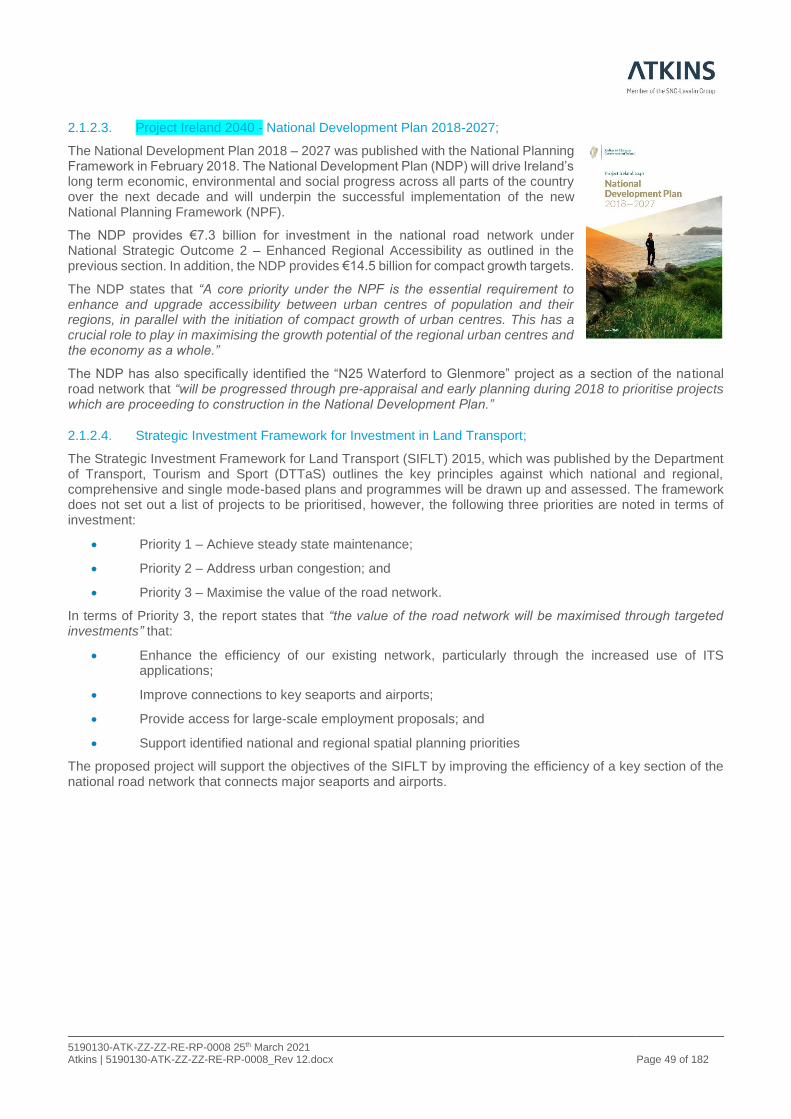
2.1.2.3. Project Ireland 2040 - National Development Plan 2018-2027;
The National Development Plan 2018 – 2027 was published with the National Planning Framework in February 2018. The National Development Plan (NDP) will drive Ireland’s long term economic, environmental and social progress across all parts of the country over the next decade and will underpin the successful implementation of the new National Planning Framework (NPF).
The NDP provides €7.3 billion for investment in the national road network under National Strategic Outcome 2 – Enhanced Regional Accessibility as outlined in the previous section. In addition, the NDP provides €14.5 billion for compact growth targets.
The NDP states that “A core priority under the NPF is the essential requirement to enhance and upgrade accessibility between urban centres of population and their regions, in parallel with the initiation of compact growth of urban centres. This has a crucial role to play in maximising the growth potential of the regional urban centres and the economy as a whole.”
The NDP has also specifically identified the “N25 Waterford to Glenmore” project as a section of the national road network that “will be progressed through pre-appraisal and early planning during 2018 to prioritise projects which are proceeding to construction in the National Development Plan.”
2.1.2.4. Strategic Investment Framework for Investment in Land Transport;
The Strategic Investment Framework for Land Transport (SIFLT) 2015, which was published by the Department of Transport, Tourism and Sport (DTTaS) outlines the key principles against which national and regional, comprehensive and single mode-based plans and programmes will be drawn up and assessed. The framework does not set out a list of projects to be prioritised, however, the following three priorities are noted in terms of investment:
• Priority 1 – Achieve steady state maintenance;
• Priority 2 – Address urban congestion; and
• Priority 3 – Maximise the value of the road network.
In terms of Priority 3, the report states that “the value of the road network will be maximised through targeted investments” that:
• Enhance the efficiency of our existing network, particularly through the increased use of ITS applications;
• Improve connections to key seaports and airports;
• Provide access for large-scale employment proposals; and
• Support identified national and regional spatial planning priorities
The proposed project will support the objectives of the SIFLT by improving the efficiency of a key section of the national road network that connects major seaports and airports.
5190130-ATK-ZZ-ZZ-RE-RP-0008 25th March 2021 Atkins | 5190130-ATK-ZZ-ZZ-RE-RP-0008_Rev 12.docx Page 50 of 182
2.1.2.5. Smarter Travel: A Sustainable Transport Future 2009 – 2020
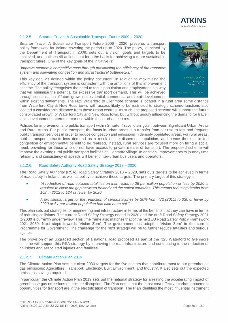
Smarter Travel, A Sustainable Transport Future 2009 - 2020, presents a transport policy framework for Ireland covering the period up to 2020. The policy, launched by the Department of Transport in 2009, sets out a vision, goals and targets to be achieved, and outlines 49 actions that form the basis for achieving a more sustainable transport future. One of the key goals of the initiative is:
“Improve economic competitiveness through maximising the efficiency of the transport system and alleviating congestion and infrastructural bottlenecks.”
This key goal as defined within the policy document, in relation to maximising the efficiency of the transport system is consistent with the ambitions of this improvement scheme. The policy recognises the need to focus population and employment in a way that will minimise the potential for excessive transport demand. This will be achieved through consolidation of future growth in residential, commercial and retail development within existing settlements. The N25 Waterford to Glenmore scheme is located in a rural area some distance from Waterford City & New Ross town, with access likely to be restricted to strategic scheme junctions also located a considerable distance from these urban centres. As such, the proposed scheme will support the future consolidated growth of Waterford City and New Ross town, but without unduly influencing the demand for travel, local development patterns or car use within these urban centres.
Policies for improvements to public transport within Smarter Travel distinguish between Significant Urban Areas and Rural Areas. For public transport, the focus in urban areas is a transfer from car use to fast and frequent public transport services in order to reduce congestion and emissions in densely populated areas. For rural areas, public transport attracts less demand as a result of the dispersed population, and hence there is limited congestion or environmental benefit to be realised. Instead, rural services are focused more on filling a social need, providing for those who do not have access to private means of transport. The proposed scheme will improve the existing rural public transport facilities at Glenmore village. In addition, improvements to journey time reliability and consistency of speeds will benefit inter-urban bus users and operators.
2.1.2.6. Road Safety Authority Road Safety Strategy 2013 – 2020
The Road Safety Authority (RSA) Road Safety Strategy 2013 – 2020, sets outs targets to be achieved in terms of road safety in Ireland, as well as policy to achieve these targets. The primary target of this strategy is:
• “A reduction of road collision fatalities on Irish roads to 25 per million population or less by 2020 is required to close the gap between Ireland and the safest countries. This means reducing deaths from 162 in 2012 to 124 or fewer by 2020.
• A provisional target for the reduction of serious injuries by 30% from 472 (2011) to 330 or fewer by 2020 or 61 per million population has also been set.”
This plan sets out strategies for engineering and infrastructure in terms of the benefits that they can have in terms of reducing collisions. The current Road Safety Strategy ended in 2020 and the draft Road Safety Strategy 2021 to 2030 is currently under review. This time frame also matches that of the next EU Road Safety Policy Framework 2021–2030: Next steps towards ‘Vision Zero’. The government has adopted ‘Vision Zero’ in the current Programme for Government. The challenge for the next strategy will be to further reduce fatalities and serious injuries.
The provision of an upgraded section of a national road proposed as part of the N25 Waterford to Glenmore scheme will support this RSA strategy by improving the road infrastructure and contributing to the reduction of collisions and associated injuries and fatalities.
2.1.2.7. Climate Action Plan 2019
The Climate Action Plan sets out clear 2030 targets for the five sectors that contribute most to our greenhouse gas emissions: Agriculture, Transport, Electricity, Built Environment, and Industry. It also sets out the expected emissions savings required.
In particular, the Climate Action Plan 2019 sets out the national strategy for arresting the accelerating impact of greenhouse gas emissions on climate disruption. The Plan notes that the most cost-effective carbon abatement opportunities for transport are in the electrification of transport. The Plan identifies the most influential instrument
5190130-ATK-ZZ-ZZ-RE-RP-0008 25th March 2021 Atkins | 5190130-ATK-ZZ-ZZ-RE-RP-0008_Rev 12.docx Page 51 of 182
to reduce carbon intensity of travel will be fiscal incentives around motoring and prioritises the expansion of walking, cycling and public transport to promote modal shift as a key policy to make future growth less transport intensive.
The following specific fiscal incentive targets are identified for the transport sector to meet the required reduction in emission levels by 2030:
• Reduce CO2 eq. emissions from the transport sector by 45–50% relative to 2030 pre-NDP projections
• Increase the number of EVs to 936,000, comprised of:
o 840,000 passenger EVs
o 95,000 electric vans and trucks
o 1,200 electric buses
• Build the EV charging network to support the growth of EVs at the rate required, and develop our fast-charging infrastructure to stay ahead of demand
• Require at least one recharging point in new non-residential buildings with more than 10 parking spaces
• Raise the blend proportion of biofuels in road transport to 10% in petrol and 12% in diesel
The delivery of these targets is recognised as requiring a significant ramp-up in EVs from current levels (circa 10,000), increased penetration of cleaner, alternative fuels, and an irreversible shift to low-emission mobility. These changes will need to be underpinned by policy tools such as vehicle and fuel taxation measures, and a strong carbon tax trajectory. The importance of modal shift is also emphasised by providing good public transport, cycling and walking infrastructure, so people are less reliant on their cars. The Plan commits to an additional 500,000 public transport and active travel journeys daily by 2035. This will be achieved by promoting compact growth and greater integration of policies for land use and transport planning, and by expanding sustainable travel measures, including a comprehensive cycling and walking network (including greenways).
In addition to fiscal incentives around motoring, the Government will adopt a strong suite of policies to influence:
• The transport intensity of growth
• The carbon intensity of travel.
The Government supports the adoption of a net zero target by 2050 at EU level. The Climate Acton Plan puts in place a decarbonisation pathway to 2030, which would be consistent with the adoption of a net zero target in Ireland by 2050. The Plan also commits to evaluating in detail the changes which would be necessary in Ireland to achieve this target.
The proposed scheme aims to provide an improved connection to four of the major ports at Cork, Rosslare, New Ross and Waterford and to the airports of Cork and Waterford. This in turn will deliver improved air quality and amenity to those rural communities along the existing N25 route. In addition, the project integrates with the high-quality sustainable travel measures for cyclists and walkers in conjunction with the South-East Greenway to promote modal shift to active travel.
A key element of the decarbonisation of the vehicular fleet is the transfer to electric vehicles and for the freight sector, the transition to alternative fuels. The road network will support the increasing fleet of electric and alternative fuelled vehicles, such as Compressed Natural Gas (CNG), through the provision of a high-quality road capable of facilitating an efficient use of batteries and alternative fuels as well as continuing to provide infrastructure connecting charging points and alternative fuel refuelling stations as and when they are developed along the network. It is therefore considered that the project will contribute to the delivery of the Climate Action Plan 2019 and the performance of the selected scheme option will be further evaluated in this regard.
2.1.2.8. National Roads Authority (NRA) Service Area Policy
The NRA, now operating as Transport Infrastructure Ireland, issued a policy document ‘NRA Service Area Policy’ dated 2014 which gives guidance on the positioning of service areas to meet the needs of road users through a combination of Type 1 Service Areas (full service areas) and Type 2 Service Areas (rest areas).

5190130-ATK-ZZ-ZZ-RE-RP-0008 25th March 2021 Atkins | 5190130-ATK-ZZ-ZZ-RE-RP-0008_Rev 12.docx Page 52 of 182
The policy proposes the general spacing and recommends the provision of Type 1 Service Areas at least every 100 km on the dual carriageway network. In practice, that requires the spacing to be less than 100 km in most cases. In addition, where the gap between Type 1 Service Areas is in excess of 85 km, a Type 2 Service area should be provided.
The TII Publication DN-GEO-03028 – The Location and Lay-out of Service Areas requires the provision of service areas to be considered when designing Motorway, Type 1 Dual Carriageways and roads categorised as Express Roads. Further guidance relating to the provision of service areas is provided in the document “Spatial Planning and National Roads – Guidelines for Planning Authorities”, published by the Department of Environment, Community and Local Government (2012).
The key aim of these documents is to ensure that long sections of the motorways, Type 1 Dual Carriageways and Express Roads provide service areas at strategic locations for road users who wish to rest during longer journeys and/or avail of fuel, toilet and food facilities.
The existing Type 1 Service Areas in operation are currently all on the motorway network and are shown in Figure 2-2 below, those nearest the N25 Waterford to Glenmore scheme are on the M9 and M11.
Figure 2-2 - Type 1 Service Area Locations on the Motorway Network
Over the last 100km of the N25 route there are currently five on-line service stations operational along the existing single carriageway sections of the N25 as shown in Figure 2-3. These stations are located to the west of the scheme at Lemybrien, 37 km west of Luffany roundabout, and four to the east of the scheme at Ballinaboola, 14km east of Glenmore roundabout, at Ballyhine, east of Wexford town, at Killnick, south of Wexford town and
Scheme Location

5190130-ATK-ZZ-ZZ-RE-RP-0008 25th March 2021 Atkins | 5190130-ATK-ZZ-ZZ-RE-RP-0008_Rev 12.docx Page 53 of 182
at Rosslare Harbour. Figure 2-3 shows the locations of all petrol stations in the area of the scheme with the five on-line service stations on the existing N25 circled in blue.
Figure 2-3 - Locations of Existing Service Stations on the N25
In the context of the N25 Waterford to Glenmore Scheme, the proximity of the existing online Type 1 service areas on the M9 and M11 is within the required 100km outlined above. In addition, the provision of service area facilities within 100km is supplemented by the existing on-line service stations either side of the N25 Waterford to Glenmore section of the N25.
2.1.2.9. National Ports Policy
In line with the TEN-T requirements for ports, the core objective of the National Ports Policy is to facilitate a competitive and effective market for maritime transport services. The long-term international trend in ports and shipping is toward increased consolidation of resources in order to achieve optimum efficiencies of scale. This has knock-on effects in terms of vessel size, the depths of water required at ports and the type and scale of port hinterland transport connections.
In recognition of this, the National Ports Policy introduces clear categorisation of the ports sector into
• Ports of National Significance (Tier 1)
• Ports of National Significance (Tier 2), and
• Ports of Regional Significance.
Ports of National Significance (Tier 1) are ports that are responsible for 15% to 20% of overall tonnage through Irish ports and have clear potential to lead the development of future port capacity in the medium and long term, when and as required. The three ports which fulfil these criteria are:
• Dublin Port;
• Port of Cork; and
• Shannon-Foynes Port.
Ports of National Significance (Tier 2) are ports that are responsible for at least 2.5% of overall tonnage through Irish port, have the clear demonstrable potential to handle higher volumes of unitised traffic, and have the existing transport links to serve a wider, national marketplace beyond their immediate region. The two ports which fulfil these criteria are:
• Port of Waterford; and
• Rosslare Europort.
Scheme Location
5190130-ATK-ZZ-ZZ-RE-RP-0008 25th March 2021 Atkins | 5190130-ATK-ZZ-ZZ-RE-RP-0008_Rev 12.docx Page 54 of 182
The remaining commercial ports are categorised as Ports of Regional Significance. This category includes the five smaller State-owned commercial port companies:
• Drogheda,
• Dún Laoghaire,
• Galway,
• New Ross
• Wicklow
• and all other ports that handle commercial freight.
These five State-owned port companies collectively handle approximately just 3% of total tonnage in the State. Central Government do not play a part in ports that fulfil a regional or local need. The longer-term development of these ports is best placed within their regional and local communities to allow them to develop in a manner that is mutually beneficial.
The National Ports Policy notes that efficient hinterland connections are critically important to any port’s ability to facilitate large volumes of traffic. It states that all TEN-T core ports must have a connection to both TEN-T core road and rail networks, while recognising that:
“The vast majority of Ireland’s freight movements to and from ports are via road. As acknowledged in the European Commission’s White Paper, Roadmap to a Single European Transport Area – Towards a Competitive and Resource-Efficient Transport System, it is likely that “freight movements over short and medium distances (below some 300km) will to a considerable extent remain on trucks” (Commission of the European Communities 2011c).”
The provision of the N25 Waterford to Glenmore scheme will support the Tier 1 status of the Port of Cork, the Tier 2 status of the Port of Waterford and Rosslare Europort and the regional status (Tier 3) of New Ross Port.
2.1.2.10. National Policy Framework Alternative Fuels Infrastructure for Transport in Ireland 2017 to 2030
The core objective of the National Policy Framework Alternative Fuels Infrastructure for Transport in Ireland 2017 to 2030 is to support the transitioning to a low carbon economy by 2050 and to achieve this the transport sector has a significant role to play. The policy is underpinned by the European Commission Clean Power for Transport: A European Strategy in 2013 a long-term policy framework to guide technological development and investment in the deployment of alternative fuels. Based on this 2013 strategy, the European Parliament and the Council adopted Directive 2014/94/ EU on the deployment of alternative fuels infrastructure in October 2014. The directive required member states to develop national policy frameworks (NPFs) for the market development of alternative fuels and related infrastructure. It also foresees the use of common technical specifications for recharging and refuelling stations. The directive, will help to:
• substitute fossil oil sources in energy supply to transport
• enhance the environmental performance of the transport sector by reducing emissions
• diversify the fuel mix in transport
• improve air quality
• enhance the interoperability of alternative fuelled vehicles across the EU
• achieve EU Climate and Energy Package targets (known as 20-20-20) by 2020 and a low carbon economy by 2050.
These goals remain the cornerstone of government transport policy and are fully aligned to the objectives of this National Policy Framework.

5190130-ATK-ZZ-ZZ-RE-RP-0008 25th March 2021 Atkins | 5190130-ATK-ZZ-ZZ-RE-RP-0008_Rev 12.docx Page 55 of 182
2.1.2.11. Regional Spatial & Economic Strategy (RSES) for the Southern Region
The RSES primarily aims to support the delivery of the programme for change set out in Project Ireland 2040, the National Planning Framework (NPF) and the National Development Plan 2018-27 (NDP). The RSES has also been informed by the commitments set out in the Climate Action and Low Carbon Development Act, 2015 and the Climate Action Plan, 2019. As the regional tier of the national planning process, it will ensure coordination between the City and County Development Plans (CCDP) and Local Enterprise and Community Plans (LECP) of the ten local authorities in the Region.
By 2040, the population of the southeast Region within which the proposed scheme is located is expected to grow by 380,000 people and reach almost two million Waterford’s status as the principal urban centre of the South-East with the objective for the City to become an important driver of national growth and a ‘Regional City of Scale’ with a defined Metropolitan Area is carried forward from the NPF to the RSES. The RSES includes a draft Metropolitan Area Strategic Plan (MASP) for Waterford.
MASP Objective 1c seeks
‘to secure co-ordinated investment and delivery of holistic infrastructure packages across State Departments and infrastructure delivery agencies as they apply to the Waterford Metropolitan Area and seek further investments to deliver on the Metropolitan Area Goals’.
In addition, MASP Policy Objective 2a states as follows:
‘Between the Waterford Metropolitan Area, the Port of Waterford (Belview) and the other metropolitan areas of Dublin, Limerick-Shannon and Waterford, strengthen connectivity to the Southern Region Ports, Atlantic Economic Corridor and strengthen connectivity on the TEN-T Corridor’.
Furthermore, MASP Policy Objective 2c states as follows:
‘Between the Waterford Metropolitan Area and the Key Towns and settlements in the Limerick – Waterford Transport and Economic network/ axis and the Extended Eastern Corridor (Dublin- Belfast Corridor extending to Rosslare Europort & Network linkage to New Ross /Waterford) which would include Gorey, Enniscorthy and Wexford as strategic locations on the Corridor. These initiatives which will be progressed through the County Development Plan process, to support the economic spread from the Waterford Metropolitan Area to stimulate employment led growth and regeneration across the wider region.’
Section 3.2 of the MASP includes an improved road/ rail network linking Waterford to Cork, Limerick, Dublin, Rosslare Europort and the East Coast as one of the key enablers for Waterford, to transform it into a Regional City of Scale, and which will significantly improve inter-regional connectivity.
Equally, section 4 of the MASP includes ‘enhanced regional connectivity through improved average journey times by road and rail to Dublin, Cork, Limerick and the region’s ports’ as a national enabler for Waterford.
Furthermore, MASP Policy Objective 7a and c in relation to improved regional connectivity, supports the investment programme in the national road network, including improvements to the Waterford-Cork Strategic Transport network to include upgrading of the N25.
The RSES states that Kilkenny City is the fourth largest settlement in the Region and is centrally located within the region with good road and rail links to Dublin and elsewhere. Kilkenny is classified as a key town with the N25 connecting to the Atlantic Economic Corridor and the Eastern Corridor. The RSES recognises that a responsive Regional Transport Strategy (RTS) is key to safeguarding the sustainable growth of the region. One of the key infrastructural requirements identified for Kilkenny is “Improved accessibility to the Port of Waterford and Rosslare Europort by road and rail to serve as a viable alternative to Dublin Port”.
The proposed scheme is located in the Southern Region of the RSES, which covers the counties of Carlow, Kilkenny, Wexford, Waterford, Carlow, Tipperary, Cork, Limerick, Clare and Kerry and it supports the objectives of the RSES in terms of improved connectivity between key economic centres, such as Waterford, Kilkenny, New Ross, Wexford and the Port of Rosslare. The Southern Region is shown in Figure 2-4.

5190130-ATK-ZZ-ZZ-RE-RP-0008 25th March 2021 Atkins | 5190130-ATK-ZZ-ZZ-RE-RP-0008_Rev 12.docx Page 56 of 182
Figure 2-4 – RSES – Strategy Map
2.1.2.12. Port of Waterford Port Master Plan 2020 - 2044
The Republic of Ireland is a trading nation and as an island the movement of the vast majority of traded goods happens through our sea ports.
The Irish economy has achieved impressive growth/recovery since 2013 with a concentration of this growth in and around the Greater Dublin Area. The impacts of Brexit still remain unresolved, but it is evident that the potential challenges arising for the economy and for supply chains are significant. Currently, Dublin Port handles the majority of the Nation’s freight traffic. The impact of a number of years of record growth, combined with a range of actions required to prepare for Brexit has meant that Dublin Port is experiencing some level of congestion and may not be as well positioned to deal with the full range of services as heretofore provided. In this context the country’s other ports may have to carry a greater share of the workload.
The Port of Waterford is located 8km to the east of the city of Waterford on the north bank of the River Suir at Belview. It comprises some 960m of quays, together with open and covered storage areas and warehouses all within the designated Waterford Port Zone (Belview).
The port is served by the N29 national primary route, which links directly to the M9/M7 motorways and the N25 and N24 national roads. The port also has full rail access with rail sidings leading directly into the container terminal at Waterford Port (Belview).
The Port of Waterford is currently operating well within its operational capacity. Bulk and break-bulk volumes in 2018 exceeded 1.7 million tonnes with container handling standing at 44k TEU. The expected demand for port throughputs has been projected out for 25 years using a low, medium and high growth scenario. The low growth scenario sees the current berth infrastructure sufficing until 2037, when an additional 200m of quay will be needed with no requirement for expansion of the container terminal. In the medium growth scenario, bulk quay investments will be required in 2029 (200m) and 2041 (200m), with again no container terminal investment required. In the high growth scenario, the bulk investments are similar to those under the medium picture but there is a need for a container terminal investment in 2035.
The Masterplan provides the framework to allow the Port of Waterford bring forward essential projects for planning and consent purposes as required. It also clearly conveys the scope of the Port’s potential to deliver for the broad range of stakeholders and forms a solid basis for the future formulation of ports and logistical policy at National level. The Masterplan seeks to set out a balanced and sustainable ‘menu’ of potential actions across a wide aspect of the Port’s activities. The plan is intended to be practical, achievable, modular in nature and respectful to the many stakeholders and interested parties that interact with the Port on so many levels.

5190130-ATK-ZZ-ZZ-RE-RP-0008 25th March 2021 Atkins | 5190130-ATK-ZZ-ZZ-RE-RP-0008_Rev 12.docx Page 57 of 182
2.1.2.13. Regional Planning Guidelines for the South-East Region 2010 – 2022
The South East Regional Authority is one of the regional authorities established in Ireland and is responsible for implementing the National Spatial Strategy at regional level. The South-East Region covers Carlow, Kilkenny, South Tipperary, Waterford City, Waterford County and Wexford. The Authority operates with the assistance and cooperation of the local authorities and with input from a wide range of public and private sector organisations and individuals. In July 2010, it made the Regional Planning Guidelines for the South-East Region for the period 2010 to 2022, to replace those made in 2004.
These guidelines take account of the key issues affecting the development of the region, such as population and settlement; economic and employment trends; industrial and commercial development; transportation; water supply and waste water facilities; energy and communications; education, healthcare, retail and community facilities; environmental protection etc.
In order to improve transport infrastructure and services, the South East Regional Planning Guidelines have identified locations where there should be continued investment in major road infrastructure i.e. “Further upgrading of the N25 route with a new crossing of the River Barrow at New Ross”. Specifically, the N25 Waterford to Glenmore project is included on a list of road schemes in Chapter 5, Table 5.1 of the South East Regional Planning Guidelines and it is stated that “The above schemes outline the proposals of the National Roads Authority and central government to improve and construct National Roads in the South-East Region within the lifetime of the Guidelines subject to finance being provided. The Regional Authority supports the development of the key economic corridors in the region, namely the Dublin–Waterford M9 route, the Dublin–Wexford N11/M11 route, the Waterford–Limerick N24 Corridor and the Rosslare–Cork N25 route.”
The proposed N25 Waterford to Glenmore project is consistent with the objectives and visions as set out in the South Eastern Regional Planning Guidelines. Under the South-East RPGs 2010, the N25 is identified in section 1.2.5.2 as forming part of the Atlantic Gateway corridor, where opportunities for growth should be exploited through the upgrading of these transport links. Strategic Goal C9 seeks to upgrade the N25 along the Atlantic Corridor linking Waterford with Cork and Rosslare and connecting them to the urban settlements of Dungarvan, Wexford, and New Ross within the region. Table 5.1 (NRA Road schemes) of the RPGs lists the N25 Waterford to Glenmore scheme and states that a feasibility study commenced in 2007, with the scheme currently at Route Selection Phase. It is stated on page 86 that the Regional Authority will support the development of the key economic corridors in the region, which includes the Rosslare–Cork N25 route.
Figure 2-5 - Regional Planning Guideline - South East Region - Spatial Infrastructure Strategy

5190130-ATK-ZZ-ZZ-RE-RP-0008 25th March 2021 Atkins | 5190130-ATK-ZZ-ZZ-RE-RP-0008_Rev 12.docx Page 58 of 182
2.1.2.14. Kilkenny County Development Plan, 2014-2020
The Kilkenny County Development Plan 2014 – 2020 is the current development Plan for County Kilkenny. It is stated in section 11.7.6 of the Kilkenny County Development Plan 2014 – 2020 that the Council with the support of the TII is progressing / developing a number of schemes within County Kilkenny and specifically mentions the “N25 Waterford - Glenmore” in section 11.7.6 of the Plan. In this respect, policy objective 11G of the Plan seeks to support the implementation of the TII road projects outlined in section 11.7.6 of the Plan. Figure 11.1 of the current development plan (reproduced in Figure 2-6 of this report) includes the 2011 emerging preferred route corridor.
Figure 2-6 - Kilkenny County Development Plan - 2011 N25 Waterford to Glenmore Scheme Corridor
In terms of alternate modes of transport, the plan also states that “The Council will promote walking, cycling, public transport and other more sustainable forms of transport as an alternative to the private car, together with the development of the necessary infrastructure and promotion of the initiatives contained within Smarter Travel, A Sustainable Transport Future 2009 – 2020.” In this regard the plan also states that “The track‐bed of the
Waterford‐New Ross railway line shall be preserved for future re‐opening and and/or cycling or walking use.” The proposed emerging preferred corridor does not impact the existing railway corridor or impede future improvements along the corridor, including the Southeast Greenway.
2.1.2.15. Kilkenny City and County Draft Development Plan, 2021-2027
Kilkenny County Council are in the process of reviewing and preparing the Kilkenny City and County Draft Development Plan 2021 – 2027. This draft plan and associated Environmental Reports were available for public
KCC Development Plan 2011
N25 Waterford to Glenmore Corridor
(Outlined in Red)

5190130-ATK-ZZ-ZZ-RE-RP-0008 25th March 2021 Atkins | 5190130-ATK-ZZ-ZZ-RE-RP-0008_Rev 12.docx Page 59 of 182
consultation from Consult.Kilkenny.ie from the 22nd of December 2020 with submissions due by the 12th March 2021.
Section 12.11 of the draft Plan addresses roads objectives. The “N25 Waterford - Glenmore” is specifically referenced in section 12.11.6 of the draft Plan. Section 12.11.7 of the draft Plan states:
‘The Council will support the implementation of the TII projects [as outlined above] and will preserve free from development proposed road realignment/improvement lines and associated corridors where such development would prejudice the implementation of Transport Infrastructure Ireland (TII) or County Council plans.” (See Figure 12.1)’.
Figure 12.1 (reproduced in Figure 2-7 of this report) identifies the current N25 Waterford to Glenmore Study Area:
Figure 2-7 - Kilkenny City and County Draft Development Plan, 2021-2027 - Study Area for the proposed N25 Waterford to Glenmore Scheme
KCC Development Plan 2021-2027
N25 Waterford to Glenmore Study Area
(Shaded in Orange)

5190130-ATK-ZZ-ZZ-RE-RP-0008 25th March 2021 Atkins | 5190130-ATK-ZZ-ZZ-RE-RP-0008_Rev 12.docx Page 60 of 182
2.1.2.16. Kilkenny Local Economic and Community Plan (LECP) – 2016 - 2021
The Local Community Development Committee and Kilkenny County Council have been entrusted with the responsibility of promoting local economic and community development in the County through this plan. Implementation of the Kilkenny LECP will conform to the following:
• The Regional Planning Guidelines and the Regional Spatial and Economic Strategy, and
• The provisions of the Kilkenny County and Kilkenny City Development Plans and Local Area Plans, including provisions requiring sustainable development, and protection and management of the environment; and
• The National Climate Change Adaptation Framework.
The emerging themes and goals of the Kilkenny LECP process align with National and European objectives and themes. In total, 13 high-level goals have been identified for County Kilkenny, each with specific sustainable objectives and a range of related actions. The key high-level objectives specific to the N25 Waterford to Glenmore Scheme are:
• Goal 1 - Support the Enterprise Economy
• Goal 5 - Develop the Rural Economy;
• Goal 6 – Improve Access and Communication Infrastructure;
• Goal 9 – Contribute to Regional Growth and International Potential
Whilst Kilkenny generally benefits from its strategic location and relatively easy access to centres of population, its rural settlements are placed under stress by the conflicting desirability of living in a rural location, and the reducing local employment opportunities. This rural reality creates an environmentally unsustainable situation, dimensions of which are addressed through the development of more resilient and self-sufficient local communities.
The plan recognises that the agriculture sector is an important sector to the local economy of County Kilkenny, with almost twice the proportion of the labour force gainfully employed in this sector compared to the national average.
The development of resilient local economies is a continued point of focus for the Council. This approach references the Commission for the Economic Development of Rural Areas (CEDRA) Report ‘Energising Ireland’s Rural Economy’ noting that rural communities have experienced the most negative impacts of the current economic crisis due to their heavy reliance on declining employment sectors.
Figure 2-8 - CLÁR Areas and Population Centres in County Kilkenny
2.1.3. Strategic Fit and Priority of Project
As shown throughout Section 2, the objectives of the scheme are consistent with, and support the relevant policies at European, National, Regional and Local levels. The proposed scheme will improve the national road network and enhance accessibility in the southeast Region.
All options integrate well with policies set at local, regional and national levels and fundamentally address the objectives to improve the TEN-T network and to provide a safer, sustainable, strategic transport network in County Kilkenny. Furthermore, it is an objective of the project to support the future development and expansion of Cork, Waterford, Rosslare and New Ross ports by providing a high-quality route for freight traffic and improved accessibility to employment in regional and national centres. In tandem with this, it is an objective that the proposed scheme is expected to stimulate the expansion of tourism by maintaining or reducing journey times

5190130-ATK-ZZ-ZZ-RE-RP-0008 25th March 2021 Atkins | 5190130-ATK-ZZ-ZZ-RE-RP-0008_Rev 12.docx Page 61 of 182
and improving journey time reliability, making these areas more accessible and attractive to visit. These objectives are supported by EU legislation, the NPF, national climate change policies, road safety polices, the RSES and the Kilkenny County Development Plan.
The importance of interconnectivity across the strategic transport network is recognised by this project and the N25 as a “Strategic Linking Corridor” / “Strategic National Corridor” is identified frequently in relevant policies as a priority transport link to be protected and suitably upgraded to preserve its strategic functionality.
2.2. Project Specific Need
2.2.1. Overview
This section of the report outlines and discusses the condition of the existing sections of the national road network under consideration and identifies the project specific needs such as any network deficiencies and problems. These deficiencies combined with the European, National, Regional and Local policy discussed in Section 2 constitute the ‘Need for the Scheme’. The following areas are assessed in terms of network deficiencies:
• Existing Road Network;
• Existing Traffic Levels;
• Existing Journey Times;
• Existing Level of Service; and
• Existing Road Safety Issues.
2.2.2. Existing Road Network
The section of the N25 under consideration is a rural single carriageway road with varying or inconsistent cross section widths in terms of carriageway, hard-shoulders / hard-strips and verges, refer to Figure 2-9 below. The existing vertical profile is largely compliant with one substandard crest curve but the horizontal alignment has a number of substandard radii and is made up of sections of back to back curves or successive curves all connected with short lengths.
Figure 2-9 - Typical Existing N25 Wide Single Carriageway Cross Section
There are sixteen local/national road priority junctions along the route and eight of these have a right turn pocket provided. In addition, there is considerable existing road frontage development spread along the route with approximately 57 no. private accesses. This level of access and development constrains the potential for online improvement of the existing national road to dual carriageway standard, refer to Figures 2-10 to 2-12 below.
The existing N25 verge is substandard in width and is lined with unprotected hazards, such as boundary walls, concrete post and rail fencing, trees, substandard vehicle restraint systems etc. along the entire route. Within the study area there are numerous local roads and these roads generally have cross-sections ranging from 3.5 metres – 7.0 metres in width with substandard alignments and visibility, limited or no verges and no hard shoulders. These roads vary in function from local connector roads down to access roads serving single or two to three individual properties.

5190130-ATK-ZZ-ZZ-RE-RP-0008 25th March 2021 Atkins | 5190130-ATK-ZZ-ZZ-RE-RP-0008_Rev 12.docx Page 62 of 182
Figure 2-10 – Existing N25 with Varying Cross Section & Junction Treatment
Figure 2-11 - Side Road with Acute Angle & Steep Approach and Typical Local Road Cross Section
Figure 2-12 - Example of Single Direct Access Located along the Existing N25
Based on current road markings and restrictions to forward visibility there are limited overtaking opportunities available along the existing route, particularly in the northbound direction. For vehicles travelling southbound a climbing lane has been provided from the Glenmore roundabout for a distance of 3.4km. Travelling north from Luffany roundabout, 76% of the route is marked with a solid line prohibiting overtaking. Over the length of the route the markings change from a solid and double line systems for 2.2km, followed by a 1.2km section of full overtaking, followed by a 1km section of double solid lines, followed by a 360m length of combined double dashed line for full overtaking and warning conditions, followed by 340m of double solid line, followed by 600m of single dashed full overtaking, followed by 3.6km of solid marking to Glenmore roundabout. Given the rural nature of the scheme with numerous junctions of local/national roads and individual access points (including agricultural) this leads to mixing of local slower moving traffic, freight and higher speed national road traffic. This leads to platooning of vehicles behind slow-moving traffic with the potential for driver frustration, refer to Figure 2-13 below. This safety issue is further exacerbated by the fact that the section of N25 under consideration is adjoined by high-quality dual carriageways either side with local traffic largely segregated from national traffic, grade separated junctions and no direct accesses. This change in environment for drivers can lead to increased safety issues.

5190130-ATK-ZZ-ZZ-RE-RP-0008 25th March 2021 Atkins | 5190130-ATK-ZZ-ZZ-RE-RP-0008_Rev 12.docx Page 63 of 182
Figure 2-13 – Varying Road Marking Layouts & HGV Traffic
Currently there are no provisions for pedestrians or cyclists along the section of the N25 under consideration and the existing environment for pedestrians and cyclists is not conducive given the narrow hard shoulders and the presence of high-speed traffic. As a consequence of this, low levels of pedestrian and cyclist activity were observed within the study area. The sections of the N25 either side of the proposed scheme are dual carriageways and do not provide for pedestrian or cyclists. Separately, Kilkenny County Council are currently carrying out a review of the pedestrian facilities within the village of Glenmore and how the village can connect to the proposed Southeast Greenway and, in particular, the Kilkenny section of the Southeast Greenway. This section of the Southeast Greenway runs from the North Quays in Waterford City to Mount Elliott in New Ross along the line of the old disused railway line in the eastern half of the study area. Planning was granted for the Kilkenny section of the Southeast Greenway in 2019 and construction commenced in August 2020. This facility will provide a high-quality dedicated pedestrian and cycle greenway the full length of the proposed route, connecting the employment hubs of New Ross and Waterford. The facility will have intermittent connections to the local road network and five proposed dedicated parking areas, facilitating both long distance cyclists and localised leisure activities.
It is noted that there is no existing rail line serving the study area, with the last passenger rail service ceasing in 1963 and there are no plans to revive or replace this service.
Long distance express bus services operate from Cork to Rosslare with an intermediate stop at Waterford City and these services do not stop within the study area. There is one bus stop, the Glenmore Hill Bus Stop, which is located on the existing N25. This bus stops services passengers within the study area travelling to New Ross, Wexford and Waterford with a limited number of pick-up/drop-off times during the day. It is noted that currently there is no direct bus connection from the study area to Enniscorthy. The bus stop is located close to the junction of the L7510 within a climbing lane section with a posted speed limit of 100km/h. The existing designated Bus Éireann facility is currently located in the verge on both sides of the N25 adjacent to the eastern junction to Glenmore village. Buses utilising these stops are required to pull-up within the eastbound lane and the westbound near side climbing lane to pick up and drop off passengers. Pedestrians availing of these services are also required to stand on the hard strip/verge whilst waiting for the bus to arrive and cross the existing N25 at the widest location where there are two westbound lanes (climbing lane layout), a right turning pocket/media hatching and an eastbound lane with no refuge for pedestrians provided.
The River Barrow & River Nore SAC cross the existing N25 for a distance of approximately 110m at the Glenmore river culvert adjacent to the New Ross Bypass scheme. Bar small sections of isolated surface water pipes and gullies there is little or no formal drainage or attenuation along the existing route, with run-off from the existing road surface effectively discharging directly into agricultural lands, ditches or open drains and out falling to the rivers and eventually the River Barrow.
It is noted that the adjacent existing Waterford City and New Ross Bypasses are dual carriageway roads with a Type 1 cross section at the tie-in points. It is considered that the existing N25 Waterford to Glenmore road is inconsistent in terms of continuity of road type and treatment of junctions and direct accesses compared to the adjacent engineered sections of the N25 in terms of carriageway standard, cross section, road character, availability of forgiving roadside and drivability.

5190130-ATK-ZZ-ZZ-RE-RP-0008 25th March 2021 Atkins | 5190130-ATK-ZZ-ZZ-RE-RP-0008_Rev 12.docx Page 64 of 182
2.2.3. Existing Traffic Levels
Traffic data on the N25 was collected from the existing TII Permanent Traffic Counter located between Glenmore Village and the Waterford Bypass roundabout i.e. TMU N25 120.0 W, Site ID 000000020253. A summary of the Average Annual Daily Traffic (AADT) and percentage Heavy Goods Vehicles (HGV) is provided on Table 2-1. The table indicates that traffic volumes have increased by 8.1% between 2015 and 2019.
*2021 *2020 2019 2018 2017 2016 2015
AADT 7252 10333 12340 12307 12220 11792 11414
% HGV 14.6% 10.5% 8.6% 8.9% 8.5% 8.2% 8.1%
Annual Coverage 14.2% 100% 93.8% 99.7% 99.7% 99.7% 99.7%
Table 2-1 - Summary of Two-Way AADT on the Existing N25
*AADT figures are impacted by the COVID-19 public health restrictions being in place from March 2020 through to 21st February 2021 when the 2021 figures were taken.
It should be noted that there are a number of factors that have influenced the AADT figures for 2020 and 2021. The AADT results taken from the TII Traffic counters were taken with varying levels of COVID-19 public health restrictions in place from March 2020 and these restrictions are ongoing into 2021, which has significantly impacted the AADT figures and as such do not reflect the ‘normal’ AADT.
In addition, the % for HGVs has increased, which is expected as HGVs are essential to maintain the supply chain and their numbers are not expected to decrease by the same proportion as other vehicles. It is expected that this situation will continue for some time as the COVID-19 health restrictions are expected to remain in place until at least mid 2021 and ‘normal’ traffic levels are not likely to resume until sometime after restrictions have been removed. In addition, on the 1st January 2021 the Brexit transition period ended resulting in disruption to the flow of goods between Europe and Ireland via the Great Britain landbridge. As a result, there has been a significant increase (40 - 45%) in freight utilising Rosslare Europort to travel directly between Ireland and Europe. It is unclear to what extent this situation will change in the future should previous supply chains via Great Britain be re-established or as new supply chains directly between Ireland and Europe are consolidated and expanded.
2.2.4. Existing Journey Times
Within the project extents journey time data was collected on the N25 for both the southbound and northbound directions using the Google maps distance matrix API. Figure 2-14 provides a summary of the average journey times in seconds, whilst Figure 2-15 provides a summary of the resultant average speeds on the N25.
Figure 2-14 - Journey Times on the N25 Waterford to Glenmore - Southbound & Northbound

5190130-ATK-ZZ-ZZ-RE-RP-0008 25th March 2021 Atkins | 5190130-ATK-ZZ-ZZ-RE-RP-0008_Rev 12.docx Page 65 of 182
For the southbound direction, the average journey time is 411 seconds (6 minutes 51 seconds) during the AM peak and 405 seconds (6 minutes 45 seconds) during the PM Peak, which equates to an average speed of 80kph and 82kph respectively. In the northbound direction the average journey time is 409 seconds (6 minutes 49 seconds) during the AM peak and 433 seconds (7 minutes 13 seconds) during the PM Peak, which equates to an average speed of 81kph and 76kph respectively.
Figure 2-15 - Speeds on the N25 Waterford to Glenmore - Southbound & Northbound
Overall the average daily speeds are 81kph in the northbound direction and 84kph in the southbound direction. It is noted that lower speeds are typically being recorded in the northbound direction with a noticeable reduction in the period from 4pm to 8pm.
2.2.5. Existing Level of Service
The level of service (LOS) being provided by a road is assessed using recognised international standards. LOS is a qualitative measure describing operational conditions within a traffic stream, and levels are categorised from LOS A, which indicates free flow conditions, to LOS F, which indicates a breakdown in flow. At Level of Service D conditions are considered to be moving from stable flow to unstable flow. Speeds begin to decline slightly with slight increase of flows and density begins to increase somewhat more quickly. Freedom to manoeuvre within the traffic stream is more noticeably limited, and the driver experiences reduced comfort levels.
The TII Road Link Design Standard provides guidance on the approximate capacity of different road types to provide a Level of Service D in terms of AADT. The N25 road within the study corridor is generally comparable to a Type 1 single carriageway (i.e. 2.5m hard shoulders and ghost island or roundabout junctions), though as noted previously, there are significant inconsistencies in the road cross-section widths in terms of carriageway, hard-shoulders and verges. For a standard Type 1 single carriageway, a capacity of 11,600 AADT is indicated for the provision of LOS D. It is also noted that for a standard Type 2 single carriageway, i.e. with 0.5m hard strips in place of 2.5m hard shoulders, a capacity of 8,600 AADT is indicated for the provision of LOS D. This provides an indication of the influence of the availability of full width hard shoulders on the operational capacity of single carriageways.
Table 2-1 above indicates that the existing N25 in 2019 (prior to COVID-19 restrictions being imposed from March 2020) had an AADT of over 12,000 with a steadily increasing trend prior to 2019. The AADT of 12,340 is over 6% in excess of the LOS D capacity of 11,600 AADT for a standard Type 1 single carriageway and over 40% in excess of the LOS D capacity of 8,600 AADT for a standard Type 2 single carriageway. The current AADT is at the lower limit for the provision of Type 3 dual carriageway road, indicating that the existing road is operating at below LOS D. This indicates that traffic flows and operations along this section of the N25 are currently below LOS D and are volatile and vulnerable to instability when subject to minor disruptions or incidents. It is also considered that this vulnerability will increase with prevailing traffic growth rates in the long term with further growth likely into the future based on Travel Demand Projections for the South-East region contained within Unit 5.3 – Travel Demand Projections of the PAG. These factors pose a very significant risk to the future operational performance of the existing road without intervention.

5190130-ATK-ZZ-ZZ-RE-RP-0008 25th March 2021 Atkins | 5190130-ATK-ZZ-ZZ-RE-RP-0008_Rev 12.docx Page 66 of 182
Traffic volumes along the existing N25 section are above the indicative capacity range for LOS D for a Type 1 or Type 2 single carriageway and it is noted that the proportion of HGV’s along this section are more elevated at 8.6% recorded in 2019 compared to other rural national single carriageways. By comparison, the TII traffic counter on the N11, Dublin to Rosslare route, just north of Rosslare is indicating 5% HGV proportion in 2019 and the TII traffic counter on the N69 east of the Port of Foynes is indicating a 7.5% HGV proportion in 2019. The N69 is a similar rural road on the west coast, connecting the city of Limerick at one end to the town of Tralee at the other with a connection to the port of Foynes (Tier 1).
This section of the N25 has an average of 8 junctions, lay-bys and direct accesses per km and is considered medium in terms of Layout Constraint as defined in DN-GEO-03031 paragraph 1.1.2. This states that 6 – 8 number of junctions per km length of road is medium when measuring the degree of constraint imparted by road cross-section, verge width and frequency of junctions and accesses. As previously noted, journey times and speeds along this section reflect the multiple interfaces with local traffic and the medium density of road junctions (16) and private accesses (57) and as the traffic volumes continue to increase, without intervention the existing LOS will decrease.
2.2.6. Existing Road Safety Issues
The Road Safety Authority (RSA) has published Personal Injury Collision (PIC) data including mapping for the period 2005-2016. The RSA PIC information relates to Fatal, Serious and Minor collisions and includes details on the number and type of casualties recorded.
As presented in the Road Safety Impact Assessment, current available data for a 12 year period from 2005-2016 and more recent data from TII for a 4 year period from 2017 to 2020 along the existing N25 study corridor indicates that there have been a total of 37 reported accidents between the period 2005 to 2020 on the N25 between Luffany roundabout and Glenmore roundabout. Refer to Table 2-2.
YEAR FATAL SERIOUS MINOR
RSA Collision Data
2005 1 1 1
2006 1
2007 2 2
2008 1
2009 1 2
2010 2
2011 2 2
2012 1
2013 2
2014 2
2015 1 1
2016 1 2 1
TII Collision Data
2017 2
2018 1
2019 2 1
2020 2
TOTAL 10 9 18
Table 2-2 - Total Number of Collisions on the Existing N25 from 2005 – 2020

5190130-ATK-ZZ-ZZ-RE-RP-0008 25th March 2021 Atkins | 5190130-ATK-ZZ-ZZ-RE-RP-0008_Rev 12.docx Page 67 of 182
Figure 2-16 - RSA Collision Datal (2005 – 2016) along the N25 Waterford to Glenmore Scheme

5190130-ATK-ZZ-ZZ-RE-RP-0008 25th March 2021 Atkins | 5190130-ATK-ZZ-ZZ-RE-RP-0008_Rev 12.docx Page 68 of 182
Table 2-3 - Total Number of Casualties on the Existing N25 from 2005 – 2020
No. Severity Year Vehicle Collision Type Location Casualties
Fatal Serious Minor
1 Serious 2005 Car Single vehicle only Curraghmore 1
2 Fatal 2005 Car Head-on conflict Ballynamona 1 1
3 Minor 2005 Car Other Glenmore 1
4 Minor 2006 Car Single vehicle only Luffany 1
5 Fatal 2007 Motorcycle Head-on right turn Ballynamona 1 1
6 Minor 2007 Car Single vehicle only Ballynamona 1
7 Fatal 2007 Car Single vehicle only Kilmakevoge 1
8 Minor 2007 Car Other Graiguenakill 2
9 Fatal 2008 Car Single vehicle only Luffany 1
10 Serious 2009 Car Single vehicle only Ballyrowragh 1
11 Minor 2009 Car Single vehicle only Ballyrahan 3
12 Minor 2009 Car Single vehicle only Kilmakevoge 1
13 Minor 2010 Car Rear end, straight Luffany 3
14 Minor 2010 Car Angle, right turn Ballyrowragh 2
15 Serious 2011 Car Head-on conflict Ballyrowragh 4
16 Minor 2011 undefined Rear end, straight Glenmore 1
17 Minor 2011 undefined Head-on right turn Glenmore 1
18 Serious 2011 Car Single vehicle only Glenmore 1
19 Minor 2012 Car Single vehicle only Gaulstown 1
20 Fatal 2013 undefined Other Luffany 1
21 Fatal 2013 undefined Other Ballyrahan 1
22 Minor 2014 Car Rear end, right turn Gaulstown 2
23 Minor 2014 Car Head-on conflict Kilmakevoge 1
24 Minor 2015 Car Unknown Curraghmore 2
25 Fatal 2015 Car Single vehicle only Ballyrahan 1
26 Serious 2016 Motorcycle Other Luffany 1
27 Fatal 2016 Car Head-on conflict Curraghmore 1 1
28 Serious 2016 Car Rear end, straight Ballyrowragh 1 1
29 Minor 2016 Car Rear end, straight Kilmakevoge 2
30 Minor 2017 Vehicle Angle, both straight 1*
31 Minor 2017 Vehicle Head-on 1*
32 Minor 2018 Other 1*
33 Fatal 2019 Pedestrian 1*
34 Fatal 2019 Vehicle Road Verge - Embankment
1*
35 Serious 2019 Vehicle Barrier - Steel 1*
38 Serious 2020 Other 1*
37 Serious 2020 Vehicle Tree 1*
Totals 10* 12* 31*

5190130-ATK-ZZ-ZZ-RE-RP-0008 25th March 2021 Atkins | 5190130-ATK-ZZ-ZZ-RE-RP-0008_Rev 12.docx Page 69 of 182
Figure 2-17 - TII Collision Data 2017 - 2020
It is noted that the RSA collision data in Table 2-3 indicates the number of collisions that involve fatal, serious or minor injuries with a description of the vehicle and collision type and the number of people who were killed or injured on these sections of road often involving multiple casualties.
It is noted that the TII collision data from 2017 - 2020 is preliminary and indicates the number of collisions that involve fatal, serious or minor injuries with a description of the vehicle and collision type but not the number of people who were killed or injured as a result of these collisions as this is currently unavailable. For the purposes of this assessment it is assumed that each collision recorded in the TII data 2017 – 2020 represents a single fatality, serious injury or minor injury, as applicable to the collision type.
There were a total number of 37 collisions and of them 10 were fatal, 9 were serious and 18 were minor injury collisions, resulting in a total of 53 casualties (10 Fatalities, 12 Serious injury and 31 minor injury). Based on the level of information available and as detailed in Table 2-3 Total Number of Casualties on the Existing N25 from 2005 – 2020.
5190130-ATK-ZZ-ZZ-RE-RP-0008 25th March 2021 Atkins | 5190130-ATK-ZZ-ZZ-RE-RP-0008_Rev 12.docx Page 70 of 182
Of the 37 collisions identified on this section of the N25, fourteen involved single vehicle loss of control, five were rear end collisions, seven involved head-on collisions, two were side-on/angle and one pedestrian/vehicle type collision. No incidences involved a vehicle colliding with a cyclist and eight collisions were classified as “other” or “unknown”.
In terms of the collision types, comparisons with the national figures taken from the Road Collision Factbook (RCF) 2012, are as follows:
• The single vehicle collisions represent 38% of all collisions occurring on this section of the N25, which is lower than the national trend of 42.8% taken from Table 15 of the Road Collision Factbook (RCF) 2012.
• The collisions involving two or more vehicles represent 38% of all collisions, which is significantly lower than the national trend of 52.4% from Table 15 of the RCF 2012.
• The rear end collision type represents 36% of collisions involving two or more vehicles, which is significantly higher than the national trend of 26% from Table 15 of the RCF 2012.
• The head-on collisions, which represent 50% of collisions involving two or more vehicles is significantly higher than the national trend of 27.3%.
• The side-on/angle, which represent 8%, is significantly lower than the national trend of 27.3%.
Based on the RSA Personal Injury Collision (PIC) data for the period 2005-2020 relating to Fatal, Serious and Minor collisions, the number and type of casualties recorded and detailed in Table 2-3 above and a comparative assessment with the national average shows that single vehicle collisions, collisions involving two or more vehicles and side-on/angle type collisions are lower than the national average but that there is a significant safety issue involving head-on and rear-end type collisions compared to the national average.
This data implies that the main safety issues could be related to inappropriate overtaking manoeuvres involving head-on collisions and inappropriate speeds related to rear-end type collisions. These safety issues could be exacerbated due to the presence of local traffic performing right turn manoeuvres on and off the mainline interacting with freight and high-speed national traffic. The other safety issue appears to be single vehicle collisions, which more than likely involve the existing hazards along the road given the unforgiving roadside of the existing N25.
2.2.7. TII Network Safety Ranking Data
The TII Network Safety Ranking for this section of the N25 is shown below in Figures 2-16 TII Network Safety Ranking 2016 - 2018 and in these two years the data indicates that there is a collision rate of below or twice below average for the majority of the existing N25 with a couple of sections ranked as above average. Table 2-4 gives a breakdown of the ranking along the route.

5190130-ATK-ZZ-ZZ-RE-RP-0008 25th March 2021 Atkins | 5190130-ATK-ZZ-ZZ-RE-RP-0008_Rev 12.docx Page 71 of 182
Figure 2-18 - TII Network Safety Ranking 2016-2018
Site ID
Start Chainage (km)
End Chainage (km)
Length (m)
Collision Rate
Threshold Exposure (veh.km)
N25KK_120.0 119.109 120 0.891 0.000 Twice Below Average Rate 10884
N25KK_121.0 120 121 1.000 7.474 Below Average Rate 12214
N25KK_122.0 121 122 1.000 14.948 Above Average Rate 12214
N25KK_123.0 122 123 1.000 7.474 Below Average Rate 12214
N25KK_124.0 123 124 1.000 0.000 Twice Below Average Rate 12214
N25KK_125.0 124 125 1.000 0.000 Twice Below Average Rate 12214
N25KK_126.0 125 126 1.000 7.474 Below Average Rate 12214
N25KK_127.0 126 127 1.000 0.000 Twice Below Average Rate 12214
N25KK_128.0 127 128 1.000 7.474 Below Average Rate 12214
N25KK_129.0 N25 128 129 0.000 Twice Below Average Rate 12214
Table 2-4 - Breakdown of Network Safety Ranking Data 2016 - 2018
Considering the data from the 2016-2018 Network Safety Ranking, of each of the sections which have a collision rate of greater than 0, one is above the Average Collision Rate (as described in GE-STY-01022), and four are

5190130-ATK-ZZ-ZZ-RE-RP-0008 25th March 2021 Atkins | 5190130-ATK-ZZ-ZZ-RE-RP-0008_Rev 12.docx Page 72 of 182
Below Average Collision Rate. These five sections (121.0, 122.0, 123.0,126.0 & 128.0), which are 1km in length each, cover the section of the N25 from Luffany to Ballyrahan and between Ballynamona and Graiguenakill.
Figure 2-17 shows an extract from the draft TII Collision Risk Levels for 2018 to 2020, which indicates a deterioration in the risk level between Ballinclare to Ballynaraha indicating a further deterioration since 2018.
Figure 2-19 - Extract from TII Draft Collision Risk Level 2018 - 2020
2.2.8. EuroRAP Risk Mapping
In 2005, the Republic of Ireland’s National Roads Authority and Roads Service Northern Ireland jointly applied the EuroRAP Risk Mapping methodology to motorways and major highways. Collision and traffic data for the five-year period 1998-2002 inclusive was collated and assessed.
In the Republic of Ireland, sections of road with a higher than average risk were identified throughout the network, with 10% rated as medium-high risk and 2% rated as high risk. Updated results were published in 2008, covering

5190130-ATK-ZZ-ZZ-RE-RP-0008 25th March 2021 Atkins | 5190130-ATK-ZZ-ZZ-RE-RP-0008_Rev 12.docx Page 73 of 182
the data period 2002 to 2006. This showed that all high-risk sections had been eliminated. The assessed section of the N25 was awarded a Low-Medium Risk rating as shown in Figure 2-6 below.
Figure 2-20 - EuroRAP Risk Map
It should be noted that the EuroRAP Risk Map was generated in 2008 prior to the completion of the sections of the N25 either side of the section under consideration and that they have both been improved and upgraded to dual carriageways since this map was produced.
2.2.9. Summary of Project Specific Need
As detailed in Section 2.1, the objectives of the project are consistent with, and support the relevant policies at European, National, Regional and Local levels. The Project Specific Need has identified the existing network deficiencies with the section of road operating at a LOS of less than D and inherent road safety issues. This is clearly demonstrated by the worsening collision risk level indicated between Ballinclare and Ballynaraha in the TII 2018 – 2020 network safety ranking. It is noted that in the last sixteen years the highest number of fatal (2) and serious (1) collisions were recorded on the N25 in 2019 and this deteriorating trend can be expected to continue as the AADT increases, especially as there are no planned improvement projects identified for the existing N25. Combined with this is the fact that this section of road is now adjoined at either end by high-quality dual carriageway, creating an inconsistent environment for the road user, further contributing to this deteriorating trend.
The key objective of the scheme is to improve the TEN-T network and strategic transport network in County Kilkenny and the south-east region. Furthermore, it is an objective of the project to provide a long-term sustainable solution to improve accessibility to employment in regional and national centres, including the towns of Waterford and New Ross and to maintain/reduce journey times and improve journey time reliability.
The project is required to address the sub-standard infrastructure provision and improve the road safety performance of the network. This objective is supported by EU legislation, the NPF, the RPG, the RSES and the Kilkenny City & County Draft Development Plan. Fundamentally, this project addresses these objectives and recognises the importance of interconnectivity across the strategic transport network and towns with the need to protect the N25 as a “Strategic Linking Corridor” / “Strategic National Corridor” suitably upgraded to preserve and continue its strategic functionality.

5190130-ATK-ZZ-ZZ-RE-RP-0008 25th March 2021 Atkins | 5190130-ATK-ZZ-ZZ-RE-RP-0008_Rev 12.docx Page 74 of 182
3. Traffic Assessment and Option Cross Section
3.1. Description of Traffic Modelling Report
3.1.1. Traffic Model Development
The 2016 Base Year National Transport Model (NTpM), which is developed and maintained by TII, was used for the development of the Base Year Local Area Model (LAM). The NTpM is a strategic multi-modal variable demand model used by the TII to assess the impact of infrastructure or policy changes at national, regional and local level. Within the NTpM there are four modules, which are as follows:
• National Traffic Model (NTM);
• National Rail Model (NRM);
• National Bus Model (NBM);
• Variable Demand Model (VDM).
The three assignment models (NTM, NRM & NBM) are used to assign the demand for travel represented by the demand matrices to the network, generating travel costs (e.g. time, distance, tolls, fares) for each mode. The Variable Demand Model is used to assess demand response to changes in the generalised cost or the network for any of the three assignment models.
The National Traffic Model (NTM) is a strategic (macroscopic) traffic model developed using the transportation modelling software VISUM and forms the road traffic element of the NTpM as outlined above. The model covers the entire national and regional road network and is used by TII as a tool in the appraisal of potential road schemes, land-use and policy changes. The NTM provides demand data for Light Vehicles (Car & Light Goods Vehicles) and Heavy Vehicles (Other Goods Vehicle 1, Other Goods Vehicle 2 and Buses/Coaches) for the following time periods:
• Average AM Peak Hour (average hour between 07:00 – 09:00);
• Average Inter Peak Hour (average hour between 12:00 – 14:00).
The NTM is high level strategic traffic model and though it is suitably refined to test impacts on a national scale it is not detailed enough to assess local impacts on the network. However, the model provides both the initial highway network cordon and demand matrices for the LAM. The ERM will also be used to identify the area of influence of the scheme and the associated study area for the LAM.
The LAM was calibrated and validated against the observed traffic data in accordance with criteria set out in PAG Unit 5.1. The route choice and trip distribution in the model was sense checked. For the purposes of this Study, a Local Area Model was developed for the following time periods:
• AM Peak Hour
• Average Inter-Peak Hour
• PM Peak Hour
3.1.2. Definition of the Study Area
The study area captures any potential competition with alternative routes or rerouting of traffic as a result of the proposed scheme. The study area for the traffic, economic and road safety analysis differs from the scheme study area as defined in the Option Selection Report. To identify the extent of the cordon for the LAM, a high-level assessment was undertaken using the National Traffic Model (NTM) by TII. The emerging preferred option identified in the previous 2011 Phase 2 assessment undertaken by THDRO for the scheme was coded into the future 2050 High Growth NTM to identify the ‘zone of influence’ of the scheme. The scheme has relatively minor reassignment impacts on the surrounding network. However, despite this, New Ross Bypass and New Ross

5190130-ATK-ZZ-ZZ-RE-RP-0008 25th March 2021 Atkins | 5190130-ATK-ZZ-ZZ-RE-RP-0008_Rev 12.docx Page 75 of 182
Town have been included in the LAM cordon to fully capture any interactions between the two schemes. The traffic model study area is shown below in Figure 3-1 below.
Figure 3-1 - Traffic Model Study Area
3.1.3. Data Collection
Two sets of surveys were undertaken as part of model development. An initial set of surveys in September 2019, prior to the opening of the New Ross Bypass, and a second set in March 2020, after the opening of the bypass. The initial surveys were to allow the commencement of the model development, with further data obtained to ensure the impact of the New Ross Bypass was accurately reflected in the base model.
The majority of sites surveyed in 2019 were resurveyed in 2020, with the exception of some less trafficked junctions with local access roads where the initial datasets provided sufficient data for calibration and validation of the models. The surveys consisted of Automatic Traffic Counts (ATC), Junction Turning Counts (JTC) and Journey Time Survey (JTS). The 2020 surveys also included Automatic Number Plate Recognition (ANPR) Origin-Destination Surveys. A summary of the surveys is provided in Table 3.1 below.

5190130-ATK-ZZ-ZZ-RE-RP-0008 25th March 2021 Atkins | 5190130-ATK-ZZ-ZZ-RE-RP-0008_Rev 12.docx Page 76 of 182
Survey Type Description
Traffic counts
Automatic Traffic Counts (ATC) surveys were carried out at 14 sites between 9th Sept and 15th Sept 2019 and at 14 sites between the 2nd and 8th March 2020.
Junction Turning Counts (JTC) surveys were carried out at 25 location on Tuesday 12th September 2019 between 07:00-19:00 and at 16 locations on Wednesday 4th March 2020 between 07:00-19:00.
Traffic data from 4 Transport Infrastructure Ireland (TII) Traffic Monitoring Units (TMU).
Journey time
Journey time survey data was collected via Bluetooth Surveys at 5 different locations during the 2019 surveys. A further comprehensive dataset of journey times was captured between 11 locations using ANPR on Wednesday 4th March 2020 between 07:00-19:00.
Origin-Destination Origin-Destination surveys were undertaken on Wednesday 4th March 2020 between 07:00-19:00 using ANPR between the same 11 locations surveyed for journey times. The survey points were located at ATC points to allow sample rates to be obtained.
Table 3-1 - Traffic Surveys
All surveys were complete prior to the impact of the Covid-19 restrictions. This is discussed further in section 2.2.2 of the Traffic Modelling Report, which is included in Appendix B of this report.
3.1.4. Forecast Year Models
Once the base year LAM was finalised, growth was applied to the final trip matrices in order to calculate demand for the opening, design and forecast year models. These are assumed to be:
• Opening Year: 2030
• Design Year (Opening + 15 Years): 2045
• Forecast Year (Opening + 30 Years): 2060.
Origin and Destination growth rates for both the internal and external model zones for light and heavy vehicles were provided by TII for the years 2016-2030, 2030-2040 and 2040-2050. These years correspond with the NTpM forecast years.
There were two zones in the model for which standard TII growth rates were not applied. These were two ‘special zones’ which covered Waterford & New Ross Ports. To estimate growth in traffic from Waterford Port, The Port of Waterford Masterplan 2020-2044 was analysed and details on expected annual growth in port traffic for the lifetime of the masterplan were included in the Future Year Matrices.
In 2019, the operation of New Ross Port was transferred to Wexford County Council. However, at the time of writing there was no equivalent Masterplan available with which to estimate future traffic growth at the Port. As this is a smaller port than Waterford, the same level of HGV growth has not been applied. Instead, the TII link based growth rates for both LV and HV have been applied to this zone.
It is intended that the forecast growth for both of these Ports will be reviewed again (in the context of Brexit impacts of Irish ports) as part of the Phase 3 appraisal.
The future year models have been finalised and the proposed scheme coded and tested using the model. Model outputs have been used to inform Phase 2 (Route selection) of the project and the Phase 2 cost benefit analysis. A Traffic Modelling Report (TMR) for Phase 2 as outlined in the Project Management Guidelines (PMGs), is included in Appendix B of this report.

5190130-ATK-ZZ-ZZ-RE-RP-0008 25th March 2021 Atkins | 5190130-ATK-ZZ-ZZ-RE-RP-0008_Rev 12.docx Page 77 of 182
3.1.5. Traffic Modelling Report / Outputs
The Traffic Modelling Report is included in Appendix B of this report as an appendix to the Cost Benefit Analysis Report. This report summarises the strategic modelling approach and assumptions made for the assessment of all Phase 2 Options considered and details of all outputs.
Fifteen feasible options were developed and assessed during the Phase 2 Stage 1 appraisal (refer to Section 6 for details). Of these fifteen options, six options have been brought forward to the Phase 2 Stage 2 appraisal (refer to Section 7 for details).
These six options have been assessed against the Do-Nothing Scenario using the Future Year Local Area Models. The following indicators have been used to assess the performance of each option:
• Network Performance Statistics;
• Journey Times; and
• Traffic Volumes.
The Network Performance Statistics indicate that all options, with the exception of the Purple Route, reduce the total travel time throughout the study area relative to the Do-Nothing Scenario. The Teal route delivers the greatest reduction in vehicle hours and vehicle kilometres and resultant increase in average speed. This is followed by the Red and Lime Green routes which perform similarly well. The Navy and Magenta routes are the 2nd and 3rd worst performing routes in terms of overall time savings. The Purple route performs the worst of all the route options in terms of the Network Statistics due to the longer route length. The performance of each route in terms of time savings is outlined in Table 3-2.
Table 3-2 - 2045 Time Savings by Route Option & Time Period
The journey time analysis shows that the Teal route performs best in terms of journey time saving along the route compared to the Do-Nothing with a 19% - 34.5% reduction in the northbound direction and a 19.7% - 33.8% reduction in the southbound direction across all time periods. The Lime Green and Red routes perform similarly well, with reduction in journey times of 16% - 32% approximately, with marginally quicker journey times modelled along the Lime Green Route. The Navy and Magenta routes also perform similarly with only very marginal differences in journey times along these routes. Overall, the reduction on the Navy and Magenta Routes is between 11% - 28% approximately. The Purple is the worst performing route comparatively and only provides journey time savings in the southbound direction during the AM peak and the northbound direction in the PM period. A summary of the percentage reduction in journey times along each route option compared to the Do-Nothing Scenario is presented in Table 3-3.

5190130-ATK-ZZ-ZZ-RE-RP-0008 25th March 2021 Atkins | 5190130-ATK-ZZ-ZZ-RE-RP-0008_Rev 12.docx Page 78 of 182
Table 3-3 - 2045 N25 Journey Time Savings by Route Option & Time Period
Forecast, Design Year, AADT flows are illustrated in the Figure below for the Do-minimum Scenario. As shown, the design year AADT along the N25 Waterford to Glenmore is forecast to be significantly over the 11,600 AADT capacity for Level of Service D, reaching 16,100 AADT by 2045. Additionally, the proportion of HGV traffic on this section of the N25 is forecast to increase from circa 8% in the base year to up to 13.4% in 2045.
Figure 3-2 – 2045 Do-Minimum AADT
In terms of Route Option AADT and transference of traffic from the existing N25, the highest AADTs are modelled along the Magenta Route, the partially (65%) online option. The highest AADT along an offline route option is 15,400, which is along the Lime Green route, followed by 15,300 along the Navy Route. Both the Red and Teal Route carry approximately 14,600 AADT in the design year. The Lime Green Route and Navy Route will experience higher levels of AADT as there is an intermediate junction and some traffic travelling to or from locations along the route utilise the new road. The Red and Teal have slightly lower levels of AADT as there is no intermediate junction assumed given these options are further removed from the existing carriageway. The Purple route has an AADT of 7,000 as traffic, particularly HGV and car traffic in the IP, fails to transfer due to the higher journey times. The AADT for each route option and the level of transference from the existing N25 are outlined in Table 3-4.
Table 3-4 - 2045 AADT & Transference by Route Option

5190130-ATK-ZZ-ZZ-RE-RP-0008 25th March 2021 Atkins | 5190130-ATK-ZZ-ZZ-RE-RP-0008_Rev 12.docx Page 79 of 182
3.2. Incremental Analysis
3.2.1. Review of Applicable Guidance for Cross Section Analysis
The feasible route options generated for this scheme have been developed in accordance with Transport Infrastructure Ireland’s Standards and Technical Publications. Transport Infrastructure Ireland (TII) Standards Publication DN-GEO-03031 (Rural Road Link Design) applies to Single and Dual Carriageway roads (including Motorways) in rural areas. This standard is used to determine the design speed, geometric parameters and carriageway type of proposed roads and improvements in rural areas. TII Standard Publication DN-GEO-03036 (Cross Sections and Headroom) gives details of cross-sections and headroom clearances to be used for all-purpose roads and motorways, both on open roads and at structures.
In accordance with the TII Project Appraisal Guidelines an incremental approach was adopted with the development of the Do-Minimum and Do-Something options. No committed or planned works have been identified for the section of the N25 under consideration indicating that the Do-Minimum is the same as the Do-Nothing in this regard. As part of the development of the Do-Something options a maintenance option (Magenta) was developed along with fifteen Do-Something options. In Phase 2, an incremental assessment of the options was carried out in relation to cross section and junction strategy.
For cross section assessment, DN-GEO-03031 states that the determination of carriageway type is based on AADT values (Table 6.1). Traffic flows for this scheme were determined at over 11,600 AADT on the mainline based on preliminary calculations at the beginning of Phase 1 and confirmed by Traffic Modelling undertaken in Phase 2 (refer to the Traffic Modelling Report, Appendix B). As noted in Section 3.2.2 below the cross section of Type 1 or Type 2 dual carriageway types would meet the AADT requirement based on traffic figures alone.
A Type 2 dual carriageway with a cross section of 20.5m (excluding cycle facilities) and an AADT of 20,000 would potentially provide a Level of Service (LoS) greater than Level D. A Type 1 dual carriageway with a cross section of 25.6m and an AADT of 42,000 would also provide a Level of Service (LoS) greater than Level D and meet the requirements for a TENT-T route. Both options will meet the requirements for a high-quality TENT-T route.
It should be noted that the Type 2 dual carriageway option was assessed without cycle facilities as a dedicated cycle/pedestrian facility (South-East Greenway) is being constructed along the line of the disused railway line which runs north south to the east of the existing N25. The following extracts from the TII Publications state:
Table 6.1 of DN-GEO-03031 denotes if cycle / pedestrian facilities are to be associated with each carriageway type, however, these facilities do not prescribe the carriageway type to be selected, as Section 6.3 states:
“The provision or non-provision of cycle/pedestrian facilities shall be based upon the requirements outlined in Table 6.1 and shall not dictate the cross-section type of the carriageway.”
DN-GEO-03036 Section 4.17.1 states:
“Cycle/Pedestrian Facilities shall be provided as part of all ….. Type 2 and Type 3 Dual Carriageway national road schemes
The facilities may take the form of:
• … a cycleway remote from the road designed in accordance with DN-GEO-03047. This may include the use of suitable disused railways, canal tow paths or forest trails where appropriate.
• Within the maintenance strip or verge of the national road in accordance with the design details outlined in this document [DN-GEO-03036].
• Using a suitable existing alternative route incorporating appropriate signage. This option shall require a Departure from Standards which shall outline the justification for the use of this option.”
3.2.1.1. Dual Carriageway Details
Table 3-5 below outlines the details associated with each of the three types of dual carriageways as set out in Table 4.2 of DN-GEO-03036. Cross-section drawings of Type 1, 2 and 3 Dual Carriageways are provided in TII’s Standard Construction Details CC-SCD-00004, CC-SCD-00005 and CC-SCD-00006.

5190130-ATK-ZZ-ZZ-RE-RP-0008 25th March 2021 Atkins | 5190130-ATK-ZZ-ZZ-RE-RP-0008_Rev 12.docx Page 80 of 182
Type Capacity Min. Widths
1 42,000 AADT 2 x 7m carriageways
2 x 2.5m h/shoulder
2 x 2.0m verges
2 x 1m h/strips (included in median width)
2.6m Median
TOTAL: 25.6m
2 20,000 AADT 2 x 7m carriageways
1 x 5.0m* verge with shared cycle/ped facilities (incl. 0.5m h/strip)**
1 x 2.5m verge (incl. 0.5m h/strip)
1.5m Median
TOTAL: 23m
3 14,000 AADT 1 x 7m carriageways (2 lanes)
1 x 3.5m carriageways (1lane)
1 x 5.0m verge with shared cycle/ped facilities (incl. 0.5m h/strip)**
1 x 3m verge (incl. 0.5m h/strip)
1.5m Median
TOTAL: 20m (2+1 Lanes)
Table 3-5 – Dual Carriageway Types
* 2.5m verge assumed if no cycle/pedestrian facilities provided within Type 2 cross section. ** Pedestrian / Cycle facility desirable minimum widths as per DN-GEO-03036 (assuming Shared Use Two Way Facility, with low volume flows), refer to typical section in DN-GEO-03036 Figure 3.3:
• Separation distance: 2.0m (to edge of lane (Type 2)
• Facility width: 3.0m
• Lateral clearance: 0.5m (to fence / safety barrier / etc.)
3.2.1.2. Cross Section Recommendation
The Future Year traffic forecasts outlined in the Traffic Modelling Report (Appendix B) show that between Luffany roundabout and Glenmore roundabout the Design Year traffic flows, at circa 16,000, are above the 14,000 AADT threshold for the Type 3 Dual Carriageway. Therefore, based on the AADT alone, a Type 2 dual carriageway would be recommended for all options.
However, it is noted that the cross section of the adjoining existing Waterford Bypass and the New Ross Bypass are both Type 1 Dual Carriageway albeit the New Ross bypass changes to a Type 2 dual carriageway 4km from Glenmore roundabout. The provision of a standard Type 2 dual carriageway would require cycle and pedestrian facilities and a key objective of this scheme is to connect two sections of the N25 TEN-T expressway catering for a high percentage of HGVs. It is therefore envisaged that if a Type 2 dual carriageway is selected, in order to separate cyclists / pedestrians from the strategic freight traffic as much as possible, cyclist / pedestrian facilities would not be proposed alongside the carriageway. For an on-line option, cyclists and pedestrians would be routed along the South-East greenway, currently under construction. For an off-line option, cyclists and pedestrians would be routed along the South-East greenway and the existing N25, which would provide a safer and more attractive environment given the transfer of strategic traffic, including freight and other heavy vehicles to the new route. In either option cyclists and pedestrians would be able to use the nearby South-East Greenway, running approximately parallel to the N25 through the study area.
A standard Type 1 dual carriageway would provide 2.5m hard shoulders either side of the carriageway, however, it is not considered desirable for cyclists and pedestrians to utilise the hard shoulders given safety concerns of VRUs being in close proximity to high speed, strategic traffic, including freight and other heavy goods vehicles. As with a Type 2 dual carriageway cyclists and pedestrians would use the existing N25 or the South-East Greenway, which would provide a safer and more attractive environment.

5190130-ATK-ZZ-ZZ-RE-RP-0008 25th March 2021 Atkins | 5190130-ATK-ZZ-ZZ-RE-RP-0008_Rev 12.docx Page 81 of 182
The hard shoulder provides a place to stop in an emergency and access for emergency vehicles. Another advantage is that during maintenance the shoulder can be used as road space during temporary traffic management operations and not reduce the capacity of the route excessively. Based on these considerations a Type 1 or Type 2 Dual Carriageway may be proposed for all options. A full comparative assessment will be carried out in Phase 3 under various demand sensitivity tests to finalise the selection. This will be supported by an incremental analysis on alternative cross-sections.
Whether a Type 1 or Type 2 dual carriageway is adopted, it is recommended that this scheme should be designated as a Protected Road Scheme (under Section 45 of the Roads Act 1993) to prohibit cyclists and other specific classes of traffic, as appropriate.
3.2.2. Consideration of Preliminary Junction Strategy The N25 national road is part of the TEN-T, which is a network of strategic transport corridors throughout the European Union (EU) that play a key role in the transportation of goods and passengers and are categorised as Motorways, Express Roads and Conventional Strategic roads. Based on the cross-sectional assessment above a Type 1 or Type 2 dual carriageway will be required for all options to adequately cater for the projected increase in traffic volumes and provide an operational LOS of D or better. As per Section 9.1 of DN-GEO-03031, Type 1 or Type 2 Dual Carriageways are considered an Express Road, which is accessible primarily from interchanges or controlled junctions. As per Section 9.2 of DN-GEO-03031 the Express Road shall be designed so as to minimise the number of junctions and only the followings junction types are permitted for use on Express Roads;
• Roundabouts;
• Grade Separated Junctions (including Compact Grade Separated Junctions);
• Left-in / Left-out Junctions.
The overriding strategy was to minimise the number of accesses and turning movements for the options and where required provide a compact grade separated junction where the off-line options go back on-line or to connect an on-line option to the local road network in order to minimise traffic conflict and thereby increase potential savings due to collisions and to maximise the efficiency of the route.
An incremental junction strategy was carried out for the six route options being considered as part of the Phase 2 Stage 2 Route option assessment. The full assessment is included in the Preliminary Junction Strategy Assessment included in Appendix C.
The existing N25 has a significant number of local road junctions along its length with no links of strategic importance with the tie-ins at New Ross and Waterford bypasses. The traffic volumes along the existing side roads are very low with the highest estimated AADT just 410. It is therefore proposed to limit the number of intermediate junctions as far as possible to improve the safety and efficiency and also to limit the cost of construction of the proposed route options.
An incremental analysis of different junction options and types has been undertaken to inform the Phase 2 Route Selection of the N25 Glenmore to Waterford Scheme. Based on the core objective to deliver a high-quality road to TEN-T standards with limited junctions and no direct accesses the analysis considered the economic benefits of the provision of different junction options. Various junction types were considered for the following locations:
• Northern Junction Options: At the northern end of the scheme which ties in with the New Ross Bypass. The Options assessed at this location consisted of a grade separated junction and an at grade roundabout (existing situation);
• Southern Junction Options: At the southern end of the scheme which ties in with the N29. The Options assessed at this location consisted of a grade separated junction and an at grade roundabout (existing situation); and
• Intermediate Junctions Options: These looked at possible junction locations and type along the N25 between the Northern and Southern options. Depending on the route option being analysed, intermediate junction options assessed included:
o no intermediate junction; or
o one intermediate junction where each option ties into the existing N25 south of Glenmore as the existing L7510 accesses will need to be closed to facilitate the online upgrade of the N25 north of these tie ins.
5190130-ATK-ZZ-ZZ-RE-RP-0008 25th March 2021 Atkins | 5190130-ATK-ZZ-ZZ-RE-RP-0008_Rev 12.docx Page 82 of 182
The intermediate junction has been assessed as both a compact grade separated junction and a roundabout. Compact grade separated junctions are suitable where the major road AADT is between 12,500 - 30,000 AADT and where there is very low flow on the minor road. As discussed in the Phase 2 Traffic Modelling Report the AADT of the Magenta, Lime Green and Navy routes varies between 15,300 & 16,000 in the design year of 2045, with very low flows expected on the side roads. In contrast, roundabouts are more suited to an even balance of flows on major and minor roads. Consequently, a compact grade separated junction was considered more suitable than a roundabout junction for the intermediate junction type.
3.2.2.1. Junction Strategy Recommendation
The assessment recommends that an intermediate compact grade separated junction is provided for the Navy, Lime Green and Magenta route options. This is based on the time savings and journey time benefits resulting from the inclusion of the intermediate junction, which have been shown to exceed the cost of the provision of the junction. No intermediate junction is recommended for the Purple, Teal and Red options as they have limited interactions with the existing N25 mainline and all current accesses and junctions will remain operational on the existing N25.
At the northern tie-in at Glenmore roundabout the orientation of the New Ross Bypass Scheme to the existing N25 and the Special Area of Conservation makes the provision of a free-flow mainline with standard grade separated junction difficult to facilitate due to the space requirements needed. A grade separated junction option has been modelled for each of the route options. This would require a viaduct over the Special Area of Conservation (SAC).
Whilst a grade separated junction between the N25 Glenmore to Waterford and N25 New Ross Bypass would deliver some journey time benefits, they do not offset the significant cost of providing a viaduct to enable the mainline connection over the SAC. Overall, the junction has an estimated BCR of 0.12, which is considered very poor value for money. There would also likely be significant environmental impacts as a result of the construction through the SAC.
At the southern tie-in at Luffany roundabout the orientation and acute angle of the Waterford Bypass Scheme to the line of the route options make the provision of a free-flow mainline with a grade separated junction difficult to facilitate. A grade separated junction option has been modelled for each of the route options.
The southern grade separated junction results in overall journey time disbenefits and thus a negative BCR. This is due to the traffic patterns at this junction. Currently approximately 50% of demand on the existing N25 travels to/from the N29. This traffic experiences delays with a grade separated junction due to the longer travel path to the upgraded route. This delay does not outweigh the benefits for mainline traffic travelling between the N25 and N25 Waterford Bypass. The more even balance of flows across this junction is more suited to a roundabout junction type.
Based on the low, or negative, preliminary BCRs for grade separated junctions replacing the existing roundabout junctions at the northern and southern tie-ins with the New Ross and Waterford Bypasses respectively it is recommended that the route options connect to the existing roundabouts and grade separated junctions not be provided.
The provision of an intermediate junction and the junction types will be further assessed in Phase 3 for the preferred Route Option as part of the Phase 3 Junction Strategy.
3.2.3. Consideration of Access Strategy
As described above the N25 national road is part of the TEN-T, which is a network of strategic transport corridors throughout the European Union (EU) that play a key role in the transportation of goods and passengers and are categorised as Motorways, Express Roads and Conventional Strategic roads. As per the requirements of DN-GEO-03031, Type 1 or Type 2 dual carriageways are considered Express Roads and shall be designed so as to limit direct accesses and minimise the number of junctions. Based on this core objective accesses onto an Express Road will be restricted, as a result, off-line options will allow existing accesses to utilise the existing local road network and the declassified N25 national road, an on-line option will require the construction of collector roads on both sides of the carriageway. A detailed access strategy assessment will be carried out in Phase 3 to finalise the junction strategy for the preferred option.

5190130-ATK-ZZ-ZZ-RE-RP-0008 25th March 2021 Atkins | 5190130-ATK-ZZ-ZZ-RE-RP-0008_Rev 12.docx Page 83 of 182
4. Constraints Study
4.1. Approach and Methodology
It is necessary to identify the nature and extent of constraints within the study area so that options under consideration can be designed taking cognisance of identified constraints.
A study area was defined for the purpose of undertaking an appraisal of the lands in proximity to the existing N25 and within which possible route options could be considered. The constraints study area has been selected to reflect the topography and existing physical barriers in the vicinity of the N25. Constraints have been identified through desk studies and supplementary site visits where required.
The constraints study has been prepared utilising guidance set out in Transport Infrastructure Ireland’s (TII) Project Manager’s Manual for Major National Road Projects (PE-PMG-02042, February 2019).
The constraints are divided into three principal categories, namely:
• Natural Constraints, which include naturally occurring landscapes and features, including underground features;
• Artificial Constraints, which include features forming part of the built environment including underground features such as disused landfills etc.;
• External Parameters, which include design standards, policy, procedural, financial and legal issues.
It is acknowledged that there are inter-relationships between and within the above categories and these are described in the following text where appropriate.
4.2. Description of Natural Constraints
The natural and physical constraints were assessed in terms of the environmental factors as per Section 171A(b)(i) of the Planning and Development Act (2000) as amended by the European Union (Planning and Development) (Environmental Impact Assessment) Regulations 2018. Detailed descriptions of natural constraints including bodies consulted as part of the assessment are located within the Environmental Constraints Report in Appendix D. This section provides a summary of the natural constraints identified within that report:
4.2.1. Ecology
4.2.1.1. Ecological Sites of International Importance
The River Barrow and River Nore Special Area of Conservation (SAC) is the only Natura 2000 site within the study area. There are in total three SAC’s within 15km of this study area and seven Special Protection Areas (SPA’s) within 30km of the study area. The River Barrow and River Nore SAC and the Lower River Suir SAC are connected hydrologically through a number of watercourses within the study area. Other international designations i.e. Special Protection Area (SPA) and Ramsar sites are not located within the study area.
4.2.1.2. Ecological Sites of National Importance
There are no Natural Heritage Areas (NHA) within the study area or within 5km of it. There are two proposed NHAs (pNHAs) located within the study area, Lough Cullin pNHA (000406) and the Barrow River Estuary pNHA (000698). Six no. pNHA’s are located within 5km, but outside the study area. There are no Nature Reserves or National Parks within 15km of the study area. The nearest such site is Ballyteigue Burrow Nature Reserve in Co. Wexford.
4.2.1.3. Other Ecological Sites
4.2.1.3.1. Wildlife Sanctuaries
Lough Cullin (Holy Lake) Wildlife Sanctuary (WS Code: WFS-32) is located to the west of the study area; with hydrological links to this site via the Nicholastown Stream / Smartcastle River. The next nearest Wildlife Sanctuary
5190130-ATK-ZZ-ZZ-RE-RP-0008 25th March 2021 Atkins | 5190130-ATK-ZZ-ZZ-RE-RP-0008_Rev 12.docx Page 84 of 182
is Coolfinn Marshes Wildlife Sanctuary (WS Code: WFS-50) on the River Suir located to the northwest of Waterford City. The lake has been counted as part of the Irish Wetland Bird Survey.
4.2.1.3.2. Wetland Habitats
Wetland Surveys Ireland host a webpage illustrating the location of wetland sites in Ireland. The following sites are located within the study area:
• River Barrow & River Nore SAC (Wexford);
• Lough Cullin pNHA;
• Ballyrowragh;
• Tinnavaucoosh / Nicholastown Wetland;
• Jamestown; and
• Catsrock Quarry Pond.
4.2.1.4. Other Habitat Information
The dominant habitat found within the study area is improved agricultural grassland. The hedgerows and treelines, which act as field boundaries around the field systems, serve as wildlife habitats and corridors connecting many of the sites of ecological interest within the wider area. There are no Tree Preservation Orders in the study area; the nearest is located at Ferrybank, Co. Kilkenny. There are no records of trees from the Tree Register of Ireland within the study area.
4.2.2. Geology, Hydrology and Hydrogeology
The study area includes a range of topographical features and as a result elevation is noted to vary from over 185m at spot heights towards the west of the study area to below 10m towards the north of the study area where Unnamed/Oaklands_010 surface water tributaries of the River Barrow intersect.
The constraints study area is predominantly underlain by Deep marine, Slate, schist and minor greywacke bedrock of Palaeozoic, Lower – Middle Ordovician age. Towards the south west an area of continental redbed facies; sandstone, conglomerate and siltstone of the Palaeozoic, Upper Devonian – Carboniferous age intersects the study area. Quaternary sediments; till derived from Lower Palaeozoic shales persist throughout the study area interspersed by bedrock outcrop / subcrops. A small area of till derived from Devonian sandstones is located towards the south west of the study area and slivers of alluvium trace along intersecting waterbodies within the study area.
There are a number of rivers and streams within the study area, including the Luffany Stream and the Nicholastown Stream, which both discharge ultimately into the River Suir south of the study area and a network of minor unnamed tributaries of the River Barrow, which intersect the north of the study area. The EPA Catchment explorer online identifies two primary catchments as falling within the study area, as follows:
• Nore Catchment: This catchment includes the area drained by the River Nore and all streams entering tidal water between its confluence with the River Barrow at Ringwood, and the Barrow railway bridge at Drumdowney, Co. Kilkenny, draining a total area of 2,595km2.
• Barrow Catchment: This catchment includes the area drained by the River Barrow upstream of the River Nore confluence and all streams entering tidal water between the Barrow railway bridge at Great Island and Ringwood, Co. Kilkenny, draining a total area of 3,025km2.
The bedrock aquifer within the study area is mostly classified as ‘LI’, a locally important bedrock aquifer and ‘Pl’, a poor aquifer (GSI, 2020), but there are also small sections which are classified as ‘Rf’, a regionally important aquifer – fissured bedrock. There are 25 registered wells within the study area. Surface and groundwater quality within the study area is generally classified as good.
A small localised point within the study area has been identified to be at potential risk of flooding within the Kilkenny County Development Plan (2014 – 2020). The flood risk (via. fluvial sources) is identified at Slieverue, near the Rathpatrick Industrial Estate, just south of the south of the N25. A small area to the north west of the study area and towards the north east of the study area have been identified as ‘liable to flood’. The Office of Public Works (OPW) national flood hazard mapping was consulted (OPW, 2020) and although there have been

5190130-ATK-ZZ-ZZ-RE-RP-0008 25th March 2021 Atkins | 5190130-ATK-ZZ-ZZ-RE-RP-0008_Rev 12.docx Page 85 of 182
several historic flooding events reported in the area surrounding the study area there are none within it or in immediate proximity to it. The closest instances of flooding are associated with the River Suir, south of the study area.
4.2.3. Landscape and Visual
The Landscape Character Assessment for County Kilkenny identifies landscape character areas within the county. There are four landscape character areas (of four types) within the study area. Two are upland types (C-South Western Uplands and E-South Eastern Hills). One transitional type, (C2-South Hills Transitional Area. One lowland type, (G-South Kilkenny Lowlands) and one River Corridor type (I-The Barrow Valley) borders the study area.
Visual receptors identified include; people living in local villages and rural areas, users of the local road, footpath and cycle network. The most sensitive visual receptors will include people living in residential dwellings.
The Kilkenny County Development Plan 2014-2020 identifies views to be preserved and protected. There are no protected views within the study area however there are some in close proximity. These include:
• V22 - Views southwest over the River Suir at Grannagh Castle to the Comeraghs; and
• V9- View to the south east over the River Barrow Valley. South of the New Ross on the Ls7512 between the junctions with road numbers LP3432 and the N25.
4.3. Description of Artificial Constraints
Detailed descriptions of artificial constraints, including bodies consulted as part of the assessment are located within the Environmental Constraints Report in Appendix D. This section provides a summary of the artificial constraints identified within that report:
4.3.1. Land Use and Planning
The village of Glenmore is adjacent to the existing N25 towards the northern end of the project extents. The proposed scheme is positioned between two major bypass schemes around Waterford City and the town of New Ross. The subject site is located within County Kilkenny and is therefore subject to the policies and objectives contained within the Kilkenny County Development Plan 2014-2020. Furthermore, minor sections of the identified study area are located within the settlement boundaries of Slieverue and Belview, and therefore, the proposed development should have regard to constraints posed by the Ferrybank Belview Local Area Plan (2017) and the Slieverue Local Area Plan (2006).
A detailed planning search was carried out within the identified study area, in order to identify all development applications within the study area which could possibly constrain the development of the proposed road scheme. It is noted that a significant number of the planning applications received within the study area since the last iteration of this scheme related to permission for individual dwellings with associated wastewater treatment facilities.
However, there have also been several more significant applications granted recently which could potentially constrain the proposed road scheme. These schemes are outlined as follows:
• Application Register Reference 18573: Planning permission was granted on 8th March 2019 for Development which will consist of an upgrade of GRT ISL-KK 100kv overhead line including: re-stringing conductor with higher capacity conductor, replacement of large proportion of existing structures, breaking out & reconstruction of concrete foundation & shear blocks of metal masts, painting of mast structures, replacement of insulators, crossarms, stays and/or fittings on existing structures &fitting/replacement of bird flight diverters. It is noted that the 46.4km of the overhead line in located within Kilkenny.
• Application Register Reference 1851: Extension of Duration permission was granted on 23rd March 2018 to extend the life of an application granted for the following: The development consists of the retention and continued use of the existing quarry development (c. 12.1 ha). Processing of material takes place by crushing and screening using mobile crushing and screening plants (2 no. mobile crushing plants and 3 no. mobile screening plants for which retention is also sought). Permission is sought for the retention of the existing wheel wash. Retention permission is also sought

5190130-ATK-ZZ-ZZ-RE-RP-0008 25th March 2021 Atkins | 5190130-ATK-ZZ-ZZ-RE-RP-0008_Rev 12.docx Page 86 of 182
for the existing compound which is used in conjunction with the quarry development. The application is now valid until 18th March 2023.
• An Bord Pleanála Reference PL10.246963 / Application Register Reference 15366: Planning permission was granted on by An Bord Pleanála for development within part of an existing quarry for a C&D recycling facility for the recycling of construction and demolition waste and for the importation and recovery of non-hazardous soils, subsoil and other similar material. Material will be crushed and screened using existing mobile quarry plant and machinery and non-hazardous soils will be used in the existing rehabilitation scheme for the quarry.
• An Bord Pleanála Reference PL10 .242559 / Application Register Reference 13353: Planning permission was granted by An Bord Pleanála on 26th May 2014 for the erection of 1. no.500 kw wind turbine (hub height 65.00m), and the construction of a 25.00 sq. m electrical sub-station, site access road, and all ancillary works.
It is noted that the study area is now available to view on the Kilkenny Planning Search Online Application. A system has been put in place whereby all applications for development within the study area are issued to the design team for comment during the statutory public consultation time period. Any future applications within the study area will be examined by the design team, in order to determine the likely impact on any new development in the selection of proposed routes. This allows the planning and development information to be updated and the opportunity to identify proposed developments with the potential to impact on the route selection process.
4.3.2. Engineering
Most of the existing structures within the study area are residential, agricultural and commercial properties. There are 2 no schools, Glenmore National School located along the L7510 and Ringville National School located on the L7470.
In addition to the primary traffic route, N25 (and N29 towards the southern extent of the study area), there are numerous local roads throughout the constraints study area which link the existing N25 and beyond. Maintaining such links, which are of local importance, should form a key consideration during the Route Selection phases.
4.3.3. Archaeology, Architectural and Cultural Heritage
There are fifty-nine recorded archaeological sites and monuments in the subject area that have a date range from prehistoric times to the post medieval era. These sites include fulachtaí fia, ringforts, bullaun stones, churches, graveyards and two castles. The distribution of ringforts is interesting, generally sited off slope on elevated ground with commanding views. It is likely that more such sites survive below ground eroded by centuries of agricultural activity. The extent of unrecorded sites that remain undetected just below the present ground surface is beyond the scope of this preliminary study but cannot be underestimated.
In addition to these sites, there are thirteen find spots that have produced archaeological artefacts recorded in the Topographical Files of the National Museum. These finds comprise tools of stone and bronze, ceramics for funerary and domestic use, human remains and an Elizabethan coin. The architectural and industrial heritage of the area is represented by five protected structures, nine NIAH sites and the remains of four designed landscapes/ demesnes. The structures in various states of preservation include vernacular houses, railway bridges, mills, and designed gardens.
Following a review of aerial images and cartographic sources, twenty-two previously unidentified cultural heritage sites were also noted. This catalogue contains circular features, clusters of nineteenth century dwellings, railway bridges and a quay. It is likely that further heritage constraints will be identified during further stages of the assessment.
4.3.4. Agronomy
The study area is predominately rural in nature and the principal land use is agriculture. The study area is generally flat to undulating topography with acid brown earth soils. The soils are predominately well drained.
The study area can be considered to be an area of agricultural production, consisting of lands of wide range use capable of most agricultural uses. The main farming enterprises located within the study area are predominately grass based including dairy, beef, sheep and some equine enterprises. There are also some intensive tillage enterprises located within the study area. Agriculture is intensive in nature throughout the study area.

5190130-ATK-ZZ-ZZ-RE-RP-0008 25th March 2021 Atkins | 5190130-ATK-ZZ-ZZ-RE-RP-0008_Rev 12.docx Page 87 of 182
4.3.5. Material Assets
The meaning of material assets has not always been clear. In the EIA Directive 2011/92/EU it included architectural heritage and archaeological heritage. However, within the updated EIA Directive 2014/92/EU those heritage aspects are included as components of cultural heritage. Material assets can now be taken to mean built services and infrastructure. Traffic is included because in effect traffic consumes road infrastructure.
In addition to the primary traffic route, N25 (and N29 toward the southern extent of the study area), there are numerous local roads throughout the constraints study area, which link the existing N25 and beyond. Maintaining such links, should form a key consideration during the Phase 2 Route Selection stages.
The following utilities have been identified within the study area:
• Gas;
• Electric;
• Water; and
• Telecommunications.
4.3.6. Air Quality and Climate
The existing environment of the study area is predominately rural in nature. The land use is predominately a mixture of agricultural lands, residential properties and a small number of commercial and industrial premises. Residential properties are typically in ribbon style development along the existing N25 with properties, churches and schools within small villages and clusters along the route (Luffany, Curraghmore, Ballyrahan, Gaulstown, Ballymona, Kilmakevoge, Glenmore and Graiguenakill).
The major source of air pollution within the study area is road traffic, predominantly that from the existing N25, the New Ross Bypass at the northern end of the study area and the N29 and N25 Waterford Bypass at the southern end of the study area. Air quality is variable and subject to significant spatial variation, with concentrations generally falling significantly with distance from major road sources. The higher levels of air pollution are experienced within 50m of the existing national roads in the study area with the remainder of the study area generally experiencing rural background concentrations of pollutants.
A review of IPPC / IED licences issued by the EPA for the region shows that there are no licenced facilities with emissions to the atmosphere within the study area for this project.
The most sensitive receptors with respect to air quality impacts on ecology are the River Barrow and River Nore SAC and the Barrow River Estuary pNHA, which are located in the north-eastern part of the study area. Part of the Lough Cullin pNHA encroaches the western boundary of the study area but is unlikely to be impacted by changes in air quality associated with the proposed road scheme given its peripheral location within the study area.
4.3.7. Noise and Vibration
The existing environment of the study area is predominately rural in nature. The land use is predominately a mixture of agricultural lands, residential properties and a small number of commercial and industrial premises. The existing noise environment is expected to be dominated by road traffic from the N25, with background noise levels also including local traffic along minor roads, farmyard activities and general environmental sources including bird song and rustling foliage. Residential properties are typically in ribbon style development along the existing N25 with properties, churches and schools within small villages and clusters along the route (Luffany, Curraghmore, Ballyrahan, Gaulstown, Ballymona, Kilmakevoge, Glenmore and Graiguenakill).
Whilst a range of noise sensitive building types are located within the constraint study area, their presence does not preclude a route corridor being developed in proximity to them during the Phase 2 Route Selection stages of the assessment.
4.3.8. Population
The constraints study area covers the existing N25 route and lands extending approximately 3km either side of this national road. Within the northern region of the constraints study area lies the small village of Glenmore. The southern boundary of the constraints study area intersects the existing N25 Waterford bypass. The western and
5190130-ATK-ZZ-ZZ-RE-RP-0008 25th March 2021 Atkins | 5190130-ATK-ZZ-ZZ-RE-RP-0008_Rev 12.docx Page 88 of 182
eastern portion of the constraints study area comprise agricultural land dominated by primarily local roads, with the River Barrow running parallel to the eastern boundary of the study area.
Land-use within the constraints study area is primarily agricultural, with residential and commercial properties scattered sparsely throughout the study area and within the village of Glenmore.
According to the Rural Housing Strategy of the Development Plan, the study area lies within an ‘Area Under Urban Influence’. Areas classified as Under Urban Influence are located close to the immediate environs or commuting catchment of cities and towns or to major transport corridors with ready access to urban areas.
While no existing walking, cycling and rights of way have been identified in the study area, a Greenway connecting the town of New Ross in the north to Waterford City in the south via a disused railway is expected to be completed in 2022. The railway, which closed in 2010 due to low passenger numbers, intersects the eastern section of the study area and runs in a predominantly north/south direction along lower lying topography. Work on the 24km South-East Greenway has started and is anticipated to benefit tourism in New Ross and Waterford City.
4.4. Description of External Parameters
Detailed descriptions of external parameters considered as part of the assessment are located within the Environmental Constraints Report in Appendix D. This section provides a summary of the external parameters identified within that report:
4.4.1. Funding and Scope
Kilkenny County Council will seek funding for the scheme from Transport Infrastructure Ireland once all approvals for the various phases identified in TII’s Project Management Guidelines, Project Appraisal Guidelines and Cost Management Manuals have been sought and approved.
4.4.2. Construction Phasing
One of the main criteria that may impact on the phasing of construction is the length of any feasible options in terms of on-line and off-line lengths. A scheme associated with a greater on-line length will result in significantly more traffic management and greater disruption to the public.
4.4.3. Required Level of Service
The required level of service of the proposed development has been determined by the results of the traffic modelling assessment identified in Chapter 3.
4.4.4. Technical Standards
The scheme will be designed to current design standards which are primarily TII Publications Design Standards and Technical Guidance documents. The various phases that the scheme will be developed through will be in accordance with TII’s Project Management Guidelines, TII’s Project Appraisal Guidelines, TII Cost Management Manual and all other relevant legislation relating to the planning and development of a national road scheme.
4.4.5. Access Control
The junction strategy proposed for the scheme will be consistent with the recommendations of TII Standards Publication DN-GEO-03031 (Rural Road Link Design) and DN-GEO-03060 (Geometric Design of Junctions).
4.4.6. Procedural and Legal Requirements
The scheme will be reviewed and developed in line with current procedural and legal requirements during all phases of the project lifecycle. All relevant Local, Regional, National and European legislation, guidelines, best practices and procedures will be reviewed and complied with where required.

5190130-ATK-ZZ-ZZ-RE-RP-0008 25th March 2021 Atkins | 5190130-ATK-ZZ-ZZ-RE-RP-0008_Rev 12.docx Page 89 of 182
4.5. Summary of Constraints
As noted in the foregoing a Constraints Study has been completed for the proposed N25 Waterford to Glenmore study area, in accordance with Transport Infrastructure Ireland’s (TII) Project Management Guidelines, (2019). It collates the available information on the constraints within the study areas. These constraints and their assessment were used to inform the decision-making process in terms of the development of initial options, the preliminary options assessment, the appraisal of feasible options and the selection of the preferred route corridor.
The findings of this Constraints Study have been incorporated into the constraints mapping contained in the Environmental Constraints Report, presented in Appendix D.

5190130-ATK-ZZ-ZZ-RE-RP-0008 25th March 2021 Atkins | 5190130-ATK-ZZ-ZZ-RE-RP-0008_Rev 12.docx Page 90 of 182
5. Consideration of Alternatives & Options
5.1. Overview
As defined in PAG Unit 4.0 Consideration of Alternatives and Options, an alternative refers to a specific transport mode (road, rail, bus, air etc.) or demand management proposal (fiscal, control, ITS measures etc.) which could address the need for an intervention. The following alternatives were assessed in Phase 0 Scope and Appraisal:
• Pre-Constraints Study Alternatives:
o Improved Broadband to facilitate home working and reduce commuter travel demand
o Vulnerable Road Users (VRU) _ Cycling & Walking
o Public Transport - Rail
o Public Transport – Bus
o Demand Management Proposals
• Road Based Options.
o Do-Nothing
o Do Something (including Management Options)
Once the nature of the problem for which a solution is sought (as set out in Chapter 2), and the key constraints (as set out in Chapter 4), have been established then it is possible to review potential options available to resolve the problem whilst also delivering the project objectives.
This chapter sets out the alternatives which have been considered as potential solutions and outlines the analysis which concluded whether or not these alternatives were worthy of further consideration.
5.2. Pre-Constraints Study Alternatives
5.2.1. Improved Broadband
One alternative solution investigated was improved broadband connections to enhance the opportunity for home working. This would have a subsequent effect of reducing the need to commute between home and work places, thereby reducing the volume of traffic using the existing road. The need to improve the broadband networks within the south-eastern region has been identified as one of several infrastructure developments that will need to take place in order to enable the objectives of the NPF and RSES to be implemented.
The RSES states that the provision of advanced communications infrastructure is vital to the south-east region and to the development of a knowledge economy. The Regional Authority has been involved in the roll-out of broadband infrastructure and support the provision of telecommunications infrastructure, including broadband under the following planning policy objectives (PPO):
• PPO 6.1 - The Regional Authority will support the provision of telecommunications infrastructure in the following respects;
• PPO 6.2 - The Regional Planning Guidelines will support the provision of the most effective broadband services to all communities in the region. In this context, each Planning Authority should co-operate in the rollout of the National Broadband Scheme, the Rural Broadband Reach Scheme and in the provision of antennae and telecommunications equipment at appropriate locations.
The Kilkenny Local Economic and Community Plan 2016-2021 (LECP) conforms to the objectives of the RPG and the RSES and supports projects to address infrastructure deficits. The LECP highlights that the “functionality of digital technologies provides an opportunity to counteract” the region’s reliance on the road network. However, the opportunity for increased homeworking, will be limited to a few industries (for example on-line services, consultancy services, IT support services) and would not apply to other labour-intensive industries.
For Kilkenny County, the 2016 census shows a higher than average percentage of workers as skilled manual, 16% compared to the national average 14%. A total of 8% of the workforce are categorised as professional and

5190130-ATK-ZZ-ZZ-RE-RP-0008 25th March 2021 Atkins | 5190130-ATK-ZZ-ZZ-RE-RP-0008_Rev 12.docx Page 91 of 182
30% un-skilled, semi-skilled and skilled. Therefore, improvement in broadband alone is unlikely to result in increased working from home for the majority of the local workforce or have any notable impact on traffic levels on the road network. As such, improvement in broadband was not identified as a suitable alternative to meet the project objectives and was therefore discounted during Phase 1.
5.2.2. Vulnerable Road Users (Active Mode) Alternatives
Trail Kilkenny in conjunction with Kilkenny LEADER Partnership and promoter Kilkenny County Council are currently progressing proposals for the new South-East Greenway along the disused railway between New Ross Town and Waterford City. The South-East greenway is currently under construction and due to open in 2022. The proposed development will provide a continuous and consistent two way cycling and walking route, which will link into a number of existing and proposed regional cycling and walking routes under various stages of planning and development within Waterford and New Ross. A dedicated cycling/pedestrian facility is not considered a requirement of the proposed N25 scheme as the South-East Greenway will provide a suitable dedicated option for VRUs.
The proposed scheme will maintain the connectivity to the South-East greenway via the local road network and provide a safe route for the residents of Glenmore, currently severed by the existing corridor, by re-establishing a link from the village, school and church on the western side of the N25 to the hinterland on the eastern side via the proposed intermediate junction. In addition, it is envisaged that the proposed scheme will promote the use of any remaining sections of the existing N25 for pedestrians and cyclists as a result of reduced traffic volumes and speeds along its length.
Potential active travel alternatives which could be considered in identifying a preferred solution for the project include the provision of a segregated pedestrian / cycleway along the N25 (either off-road parallel to the N25 or on a hard shoulder).
An infrastructure solution focused on active modes would only improve access to nearby urban centres over short distances. Given the longer distances involved in most of the trips that take place on the N25 it is considered that active travel will not provide a viable alternative to motorised forms of transport for the majority of users. Furthermore, the existing N25, between Luffany roundabout and Glenmore Roundabout, provides a route for pedestrians and cyclists via a hard shoulder (of varying widths). Therefore, improvements to the provision of active mode facilities are not likely to result in a meaningful increase in active travel and a corresponding reduction in car use. Additionally, an active travel alternative in isolation would fail to address several key project objectives including:
• Will not improve the capacity and efficiency of the road network in the southeast;
• Will not improve cross-border connectivity from the southeast to Europe via the N25 route and the ports by closing the gap in the TEN-T Comprehensive road network that currently exists between the Waterford City bypass and the New Ross bypass;
• Will not support the future development and expansion of Cork, Waterford, Rosslare and New Ross ports by providing a high-quality route for freight traffic;
• Will not reduce the occurrence of road collisions along the N25 by minimising road side hazards and reducing the requirements for cross-over and right turn manoeuvres;
• Will not provide a consistent cross section and treatment of junctions and direct access in keeping with that of the adjoining Waterford City and New Ross Bypass schemes.
• Will not address the needs of vulnerable road users by separating them from high speed, strategic traffic, including freight.
• Will not provide increased safer overtaking opportunities;
• Will not reduce journey times and improve journey time reliability, which will in turn reduce transport costs and environmental impacts;
• Will not adequately cater for projected increases in traffic volumes on the N25;
• Will not provide a sustainable long-term solution in line with the 2019 Climate Action Plan; and
• Will not compliment and support European, National, Regional and Local Government policies.

5190130-ATK-ZZ-ZZ-RE-RP-0008 25th March 2021 Atkins | 5190130-ATK-ZZ-ZZ-RE-RP-0008_Rev 12.docx Page 92 of 182
As such, the implementation of an active-travel based solution, in isolation, is not considered a viable alternative and the alternative was discounted during Phase 1.
The scheme includes proposals to provide a shared surface extending from Glenmore Village to the nearest connection point to the South-East Greenway as shown in Figures 5-1 and 5-2 below. In addition, Figure 5-1 shows the scheme proposal for a relocated bus stop to serve the Glenmore village stop with a set-down area and parking facility for both cars and cyclists (refer to 5.2.3.2 for further details). The relocated bus stop provides both the public and public transport operators a safe place to access/egress public transport. It also provides parking for cyclists to encourage more active travel and connectivity between cycling and public transport.

5190130-ATK-ZZ-ZZ-RE-RP-0008 24th March 2021 Atkins | 5190130-ATK-ZZ-ZZ-RE-RP-0008_Rev 12.docx Page 93 of 182
Figure 5-1 – Preliminary Shared Surface Proposal Connecting the South-East Greenway to the Village of Glenmore

5190130-ATK-ZZ-ZZ-RE-RP-0008 24th March 2021 Atkins | 5190130-ATK-ZZ-ZZ-RE-RP-0008_Rev 12.docx Page 94 of 182
Figure 5-2 – Continuation of Preliminary Shared Surface Proposals Connecting the South-East Greenway to the Village of Glenmore

5190130-ATK-ZZ-ZZ-RE-RP-0008 24th March 2021 Atkins | 5190130-ATK-ZZ-ZZ-RE-RP-0008_Rev 12.docx Page 95 of 182
5.2.3. Public Transport Alternatives
This section of the existing N25 under consideration generates limited local traffic with the majority of demand travelling the scheme from end to end and with most traffic travelling between New Ross, Wexford, Enniscorthy and Waterford. In addition, there is long distance traffic travelling between the larger settlements of Cork, Dungarvan, Waterford and Rosslare, as well as the HGV traffic between the ports of Cork and Rosslare.
As a strategic section of the network, the N25 facilitates the operations of long-distance public transport provided by Bus Eireann connecting the counties of Kerry and Cork to Waterford and Wexford and in particular to ports and airports in the southern half of the country.
A detailed analysis has been carried out using TII’s National Transport Model (NTpM) and the N25 Local Area Model (LAM) to establish the origin-destination travel patterns for car demand along the N25 within the study area. This analysis revealed a generally dispersed trip pattern, with 50% of demand originating from outside of established urban centres, indicating that the existing demand would be difficult to serve via Public Transport.
The remaining demand originates within urban areas with clusters of origin and destination trips located in Waterford, New Ross, Enniscorthy and Wexford.
5.2.3.1. Rail Alternative
The nearest operational rail network is the Waterford Dublin line. It is noted that the existing southeast railway line which runs north south through the study area has been decommissioned since 1963 for passengers and 1995 for freight traffic. It is currently being converted to a greenway (South-East Greenway) with construction started in August 2020 and completion expected in 2022. It should be noted that the use of the rail asset for the New Ross to Waterford Greenway is on abandoned CIE lands transferred to Kilkenny County Council with the following burdens in the transfer folios:
• The lands can only be used for the development of a Greenway – (no other development is permitted)
• The Greenway must be capable of being replaced with a railway line in the future. (Only the already agreed deviations of level at Aylwardstown are permitted)
As there is currently no rail line serving the above destinations, and no plans to open new services, a Rail Alternative is not considered to be feasible and therefore was discounted at Phase 1.
5.2.3.2. Bus Alternative
There is one local bus route which travels regularly on the N25 and services the surrounding area of Glenmore between Waterford and New Ross, this service is provided by a combination of the 370 and 372 buses. These buses service the Glenmore Hill bus stop on the route from Waterford to New Ross and is operated by Bus Éireann. This is the only stop on the existing N25 within the study area. The Glenmore Hill stop provides a public transport service to the people of Glenmore village and its hinterland.
The existing bus stop facility in operation is not ideal for passengers and other road users’ safety given that the buses have to stop within the lanes and pedestrians have to cross the wide carriageway all within a 100km/h posted speed limit. In addition, the westbound bus stop is located within the near side lane midway (approximately 2km) along the incline of the climbing lane layout further impacting the safety of vehicles as slow-moving trucks are forced to access the off-side lane to overtake a stationary bus.
Figure 5-3 shows the preliminary layout of the relocated Glenmore Hill bus stop with a set-down and turning facility for bus services and parking facilities for both vehicles and cyclists. The relocated bus stop provides both the public and public transport operators a safe place to access/egress public transport. It also provides parking for cyclists to encourage more active travel and connectivity between cycling and public transport.

5190130-ATK-ZZ-ZZ-RE-RP-0008 24th March 2021 Atkins | 5190130-ATK-ZZ-ZZ-RE-RP-0008_Rev 12.docx Page 96 of 182
Figure 5-3 - Preliminary Layout of the Relocated Glenmore Hill Bus Stop with Set-Down Area and Parking Facilities for Vehicles and Cyclists.
Long distance bus routes along this section of the N25 include the 40 (Tralee to Rosslare via Waterford, New Ross and Wexford) and the X4 (Dublin Airport to New Ross via Waterford) both operated by Bus Éireann. There are currently no specific existing plans for additional public transport services in terms of rail networks or public bus routes to serve the Study Area.
The timetables for the bus routes operating along this section of the N25 between Waterford & New Ross is shown in Table 5-1 below. As outlined, the frequency of services varies but the headway on average is over an hour along the route with very infrequent services stopping at Glenmore.
Northbound Southbound
Route Number
Waterford Glenmore New Ross Route Number
New Ross Glenmore Waterford
40 07.00 - 07.20 X4 05.30 - 06.00
40 09.00 - 09.20 370 08.00 08.10 08.20
370 10.00 10.10 10.20 X4 09.30 - 10.00
370 11.20 11.30 11.40 40 10.00 - 10.20
40 11.30 - 11.50 370 13.30 13.40 13.50
X4 12.45 - 13.15 40 14.05 - 14.25
40 13.15 - 13.35 370 15.35 15.45 16.05
370 15.20 15.30 15.40 40 15.45 - 16.05
40 16.30 - 16.50 X4 16.30 - 17.00
X4 16.45 - 17.15 370 17.30 17.40 17.55
370 17.30 17.40 17.50 40 18.00 - 18.20
372 17.40 17.50 18.00 372 19.20
370 18.00 18.10 18.20 40 20.00 - 20.20
40 19.30 - 19.50
X4 23.45 - 00.15
Table 5-1 - Waterford to New Ross Timetable for Glenmore Stop
As detailed in Table 5-1 New Ross, Wexford and Waterford are currently linked by direct bus services however there is no direct bus connection from the study area to Enniscorthy. To model and assess the potential of a, bus based, public transport alternative the frequency of the existing services along the route was assumed to be

5190130-ATK-ZZ-ZZ-RE-RP-0008 24th March 2021 Atkins | 5190130-ATK-ZZ-ZZ-RE-RP-0008_Rev 12.docx Page 97 of 182
increased and a new bus route modelled linking Waterford, New Ross and Enniscorthy. This bus based public transport alternative was then modelled and assessed using TII’s National Transport Model Variable Demand Model and in summary includes the following:
• Bus Based Alternative: Improved bus services along the N25 linking Waterford, New Ross with Enniscorthy and Wexford routing through the study area and operating at a combined 15-minute frequencies during the AM peak period 1 and at 30-minute frequency outside of the peak period.
The results of these modelling tests revealed that this alternative had only a marginal impact on the total vehicular demand for travel along this section of the N25. The overall mode shift (from car to bus) achieved by the bus-based enhancements resulted in a reduction in traffic flows of less than 1% on the N25 between Waterford and Glenmore. The results of this analysis are not surprising given the dispersed rural population, with many local people in the study area living outside towns or villages, and the high levels of car ownership.
Analysis of design year traffic forecasts, as outlined in Chapter 3 of this report, revealed that AADTs will be over 16,000 along this section of the N25 in 2045. This is significantly over the 11,600 AADT required for a Level of Service D and indicates that a viable public transport alternative would be required to result in over a 30% reduction in vehicular travel to result in a suitable Level of Service on this section of the N25.
Additionally, a bus based public transport alternative in isolation would fail to address several key project objectives including:
• Will not improve the capacity and efficiency of the road network in the southeast;
• Will not improve cross-border connectivity from the southeast to Europe via the N25 route and the ports by closing the gap in the TEN-T Comprehensive road network that currently exists between the Waterford City bypass and the New Ross bypass;
• Will not support the future development and expansion of Cork, Waterford, Rosslare and New Ross ports by providing a high-quality route for freight traffic;
• Will not reduce the occurrence of road collisions along the N25 by minimising road side hazards and reducing the requirements for cross-over and right turn manoeuvres;
• Will not provide a consistent cross section and treatment of junctions and direct access in keeping with that of the adjoining Waterford City and New Ross Bypass schemes.
• Will not address the needs of vulnerable road users by separating them from high speed, strategic traffic, including freight.
• Will not provide increased safer overtaking opportunities;
• Will not reduce journey times and improve journey time reliability, which will in turn reduce transport costs and environmental impacts;
• Will not adequately cater for projected increases in traffic volumes on the N25;
• Will not provide a sustainable long-term solution in line with the 2019 Climate Action Plan; and
• Will not compliment and support European, National, Regional and Local Government policies.
As such, the implementation of a bus based public transport solution, in isolation, is not considered a viable alternative and this alternative was discounted during Phase 1.
It should be noted that the project team in consultation with Bus Éireann, have discussed an upgrade to the existing substandard bus stop provisions currently provided at Glenmore Hill. As part of the proposed scheme it is proposed to relocate the bus stop and provide improved access to and from the village of Glenmore, which may encourage more sustainable modes of transport. In addition, the N25 as a strategic part of the network provides for private bus operators and taxi services. It is important to note that a road based solution (which has been deemed viable) will benefit more than just motorists and will also provide an improved level of service for bus based public transport users.
1 TII NTpM does not include a PM peak hour model.
5190130-ATK-ZZ-ZZ-RE-RP-0008 24th March 2021 Atkins | 5190130-ATK-ZZ-ZZ-RE-RP-0008_Rev 12.docx Page 98 of 182
5.2.4. Demand Management Option
Potential Demand / Traffic Management measures which could be considered in identifying an alternative solution for the project include speed reductions, fiscal measures (single point tolling, distance-based tolling on N25 corridor) or the implementation of Intelligent Transport Systems such as variable speed limits and incident detection.
Given the rural nature of the project location and in the context of the key objectives identified it is anticipated that Demand Management Proposals will have a limited impact and may not be appropriate. For example, the implementation of a reduced speed limit could reduce the number and severity of collisions but would increase journey times and reduce average speeds along the route. Similarly, the implementation of a toll could result in re-routing onto less suitable local roads resulting in longer journey times and potentially more collisions. Tolls would also be an additional cost to business and freight users.
A Demand Management Option would also fail to address other key project objectives including:
• Will not improve the capacity and efficiency of the road network in the southeast;
• Will not improve cross-border connectivity from the southeast to Europe via the N25 route and the ports by closing the gap in the TEN-T Comprehensive road network that currently exists between the Waterford City bypass and the New Ross bypass;
• Will not provide a consistent cross section and treatment of junctions and direct access in keeping with that of the adjoining Waterford City and New Ross Bypass schemes;
• Will not reduce journey times and improve journey time reliability, which will in turn reduce transport costs and environmental impacts;
• Will not reduce the occurrences of road collisions on the N25 by minimising road side hazards and reducing the requirements for cross-over and right turn manoeuvres;
• Will not adequately cater for projected increases in traffic volumes on the N25;
• Will not provide a sustainable long-term solution in line with the 2019 Climate Action Plan;
• Will not improve access between the ports of Cork, Waterford and Rosslare and the comprehensive and core road networks; and
• Will not compliment and support European, National, Regional and Local Government policies.
As such, the implementation of a Demand Management solution is not considered a viable alternative and this alternative was discounted during Phase 1.
5.3. Road Based Options
A specific policy (e.g. European directive) or transport strategy may dictate that the preferred alternative to address the need for a specific intervention should be a road-based solution and therefore fall under TII’s remit.
As part of the TEN-T comprehensive network and as identified in the Regional Spatial & Economic Strategy and National Planning Framework – Project Ireland 2040, a road-based option is considered viable based on the direction of specific policy (TEN-T. EU Regulation No. 1315/201 under Article 17(3) and it is referenced in regional and national transport strategies (NPF/RSES – Project Ireland 2040).
Although the consideration of options is determined largely by local conditions, there are a number of specific options which should be considered, and they are:
• Do-Nothing
• Do-Minimum (The Base Case)
• Do-Something
• Management Option

5190130-ATK-ZZ-ZZ-RE-RP-0008 24th March 2021 Atkins | 5190130-ATK-ZZ-ZZ-RE-RP-0008_Rev 12.docx Page 99 of 182
5.3.1. Do-Nothing
The ‘Do-Nothing’ alternative represents the base case i.e. maintaining the existing N25 in its current layout and condition without any proposed upgrade works, with the exception of routine maintenance.
In the “Do-Nothing” scenario, users of the N25 will be subjected to the sub-standard alignment with insufficient sightlines and restricted road cross-section and retains the mixture of local traffic with the long-distance high-speed traffic which contains a high percentage of HGVs (8-10%). In addition, the safety risk associated with junction related traffic manoeuvres both on to and off the N25 mainline remains. Currently vehicles have to navigate numerous junctions (16) and agricultural, commercial and private accesses (57) in relatively close proximity to each other.
The existing collision rate (as detailed in Section 2 above) will likely be exacerbated as traffic grows in future years, with a Do-Nothing scenario. This is reflected in the latest TII network safety ranking which indicates a deterioration with the highest severity collisions recorded to date in 2019 with two fatal collisions and one serious collision.
The existing verge is substandard in width and is lined with unprotected hazards such as boundary walls, concrete post and concrete fence rails, trees, substandard vehicle restraint systems etc. along the entire route.
The current road markings are an indication of the existing restrictions to forward visibility highlighting the limited overtaking opportunities available, thereby reducing the efficiency of the road network overall. For vehicles travelling southbound a climbing lane has been provided from the Glenmore roundabout for a distance of 3.4km. Travelling north from Luffany roundabout approximately 76% of the route is marked with a solid line prohibiting overtaking. Over the length of the route the markings change from a solid to double line to dashed and back again which leads to platooning of vehicles behind slow-moving traffic with the potential for driver frustration.
Low levels of pedestrian and cyclist activity were observed within the study area and currently there are no provisions for pedestrians or cyclists along the section of the N25 under consideration. The existing situation along the N25 will remain significantly hazardous for pedestrians and cyclists and this is likely to continue to deter the route’s usage in this regard. It should be noted that Kilkenny County Council, as a separate project are progressing the South-East greenway, which will provide a dedicated facility for cyclists and pedestrians once completed. However, given the existing frontage onto the existing N25 and in the instance where pedestrians are present, there remains a high risk of vehicle / pedestrian conflicts due to the poor forward visibility and narrow verge and carriageway widths.
The N25 is described as providing a strategic link in the overall national road network and the option of “Do-Nothing’ would not realise this strategic function of the N25. This is in direct conflict with the National, Regional and Local planning policies. A Do-Nothing Option would also fail to address other key project objectives including:
• Will not improve the capacity and efficiency of the road network in the southeast;
• Will not improve cross-border connectivity from the southeast to Europe via the N25 route and the ports by closing the gap in the TEN-T Comprehensive road network that currently exists between the Waterford City bypass and the New Ross bypass;
• Will not improve the economic out-look and encourage business growth in the areas served by the route by providing a reliable and efficient transport link;
• Will not support the future development and expansion of Cork, Waterford, Rosslare and New Ross ports by providing a high-quality route for freight traffic;
• Will not stimulate expansion of tourism in the areas served by the route by reducing journey times, making these areas more accessible and attractive to visit.
• Will not reduce the occurrences of road collisions on the N25 by minimising road side hazards and reducing the requirements for cross-over and right turn manoeuvres;
• Will not provide a consistent cross section and treatment of junctions and direct access in keeping with that of the adjoining Waterford City and New Ross Bypass schemes.
• Will not address the needs of vulnerable road users by separating them from high speed, strategic traffic, including freight;
• Will not provide increased safer overtaking opportunities;

5190130-ATK-ZZ-ZZ-RE-RP-0008 24th March 2021 Atkins | 5190130-ATK-ZZ-ZZ-RE-RP-0008_Rev 12.docx Page 100 of 182
• Will not adequately cater for the projected increase in traffic volumes;
• Will not maintain/improve the connectivity to the Southeast greenway pedestrian and cycle facility and the village of Glenmore and its immediate environs;
• Will not improve the ambience and safety of the existing N25 to encourage increased usage of the existing N25 by pedestrians and cyclists;
• Will not provide a sustainable long-term solution in line with the 2019 Climate Action Plan;
• Will not ensure alignment with sustainable development principles and measures to minimise effects on the environment to support the Government's policy on climate action;
• Will not reduce journey times and encourage free flow traffic, with the aim of reducing greenhouse gas emissions and impacts on climate;
• Will not connect to other schemes enhancing the connectivity of the regional and national road network;
• Will not improve road based public transport by improving journey times and journey time reliability;
• Will not improve access between the ports of Cork, Waterford, Rosslare and New Ross and the comprehensive and core road networks; and
• Will not compliment and support European, National, Regional and Local government policies.
As such, the alternative of a ‘Do-Nothing’ solution, was not considered a viable alternative and this alternative was discounted during Phase 1.
5.3.2. Do-Minimum (The Base Case)
The Do-Minimum Option provides the baseline for establishing the economic, integration, safety, environmental and accessibility impacts of all options. It also establishes much of the baseline information needed for the Project Brief and Environmental Impact Assessment, since it examines future year travel demand and its impact on a largely unimproved transportation system. This Do-Minimum Option is referred to as the Base Case within the Common Appraisal Framework.
The Do-Minimum Option includes those transportation facilities and services that are committed within the appraisal period. All elements of the Do- Minimum Option must be part of each proposed Do-Something Option, except where an option replaces services or facilities within the corridor. To provide a basis of comparison the Do-Minimum Option must include the following features:
• The maintenance of existing facilities and services in the study corridor and region;
• The completion and maintenance of committed projects or policies in the study corridor that have successfully completed their environmental review; and
• The continuation of existing transportation policies.
Note that the Do-Minimum is distinct from the Do-Nothing. The Do-Nothing assumes that there will be no other investment in the transport network (other than regular maintenance) during the appraisal period beyond that being considered as part of the scheme under appraisal. It is accepted, however, that in certain circumstances the Do-Minimum may actually be a Do-Nothing scenario.
For the N25 Waterford to Glenmore scheme there are no committed projects or policies in the study corridor that have successfully completed their environmental review and as such the Do-Minimum is considered the same as the Do-Nothing scenario. Like the ‘Do-Nothing’ the ‘Do-Minimum’ would not realise the strategic function of the N25. This is in direct conflict with the National, Regional and Local planning policies. A Do-Minimum Option would also fail to address other key project objectives including:
• Will not improve the capacity and efficiency of the road network in the southeast;
• Will not improve cross-border connectivity from the southeast to Europe via the N25 route and the ports by closing the gap in the TEN-T Comprehensive road network that currently exists between the Waterford City bypass and the New Ross bypass;

5190130-ATK-ZZ-ZZ-RE-RP-0008 24th March 2021 Atkins | 5190130-ATK-ZZ-ZZ-RE-RP-0008_Rev 12.docx Page 101 of 182
• Will not improve the economic out-look and encourage business growth in the areas served by the route by providing a reliable and efficient transport link;
• Will not support the future development and expansion of Cork, Waterford, Rosslare and New Ross ports by providing a high-quality route for freight traffic;
• Will not stimulate expansion of tourism in the areas served by the route by reducing journey times, making these areas more accessible and attractive to visit.
• Will not reduce the occurrences of road collisions on the N25 by minimising road side hazards and reducing the requirements for cross-over and right turn manoeuvres;
• Will not provide a consistent cross section and treatment of junctions and direct access in keeping with that of the adjoining Waterford City and New Ross Bypass schemes.
• Will not address the needs of vulnerable road users by separating them from high speed, strategic traffic, including freight;
• Will not provide increased safer overtaking opportunities;
• Will not adequately cater for the projected increase in traffic volumes;
• Will not maintain/improve the connectivity to the Southeast greenway pedestrian and cycle facility and the village of Glenmore and its immediate environs;
• Will not improve the ambience and safety of the existing N25 to encourage increased usage of the existing N25 by pedestrians and cyclists;
• Will not provide a sustainable long-term solution in line with the 2019 Climate Action Plan;
• Will not ensure alignment with sustainable development principles and measures to minimise effects on the environment to support the Government's policy on climate action;
• Will not reduce journey times and encourage free flow traffic, with the aim of reducing greenhouse gas emissions and impacts on climate;
• Will not connect to other schemes enhancing the connectivity of the regional and national road network;
• Will not improve road based public transport by improving journey times and journey time reliability;
• Will not improve access between the ports of Cork, Waterford, Rosslare and New Ross and the comprehensive and core road networks; and
Will not compliment and support European, National, Regional and Local government policies.
As such, the alternative of a ‘Do-Minimum’ solution, was not considered a viable alternative and is used solely as the Base Case for the purpose of assessments and comparison with viable alternatives.
5.3.3. Do-Something(s)
At the highest level, a corridor improvement can be delivered through a major investment to widen an existing road, or to develop a new alignment. Typically, a number of physical options are possible at this level of investment. A ‘Do-Something’ road-based solution has the potential to meet key project objectives and is therefore considered viable. The objectives it meets include;
• Will improve the capacity and efficiency of the road network in the southeast;
• Will improve cross-border connectivity from the southeast to Europe via the N25 route and the ports by closing the gap in the TEN-T Comprehensive road network that currently exists between the Waterford City bypass and the New Ross bypass;
• Will improve the economic out-look and encourage business growth in the areas served by the route by providing a reliable and efficient transport link;
• Will support the future development and expansion of Cork, Waterford, Rosslare and New Ross ports by providing a high-quality route for freight traffic;

5190130-ATK-ZZ-ZZ-RE-RP-0008 24th March 2021 Atkins | 5190130-ATK-ZZ-ZZ-RE-RP-0008_Rev 12.docx Page 102 of 182
• Will stimulate expansion of tourism in the areas served by the route by reducing journey times, making these areas more accessible and attractive to visit.
• Will reduce the occurrences of road collisions on the N25 by minimising road side hazards and reducing the requirements for cross-over and right turn manoeuvres;
• Will provide a consistent cross section and treatment of junctions and direct access in keeping with that of the adjoining Waterford City and New Ross Bypass schemes.
• Will address the needs of vulnerable road users by separating them from high speed, strategic traffic, including freight;
• Will provide increased safer overtaking opportunities;
• Will adequately cater for the projected increase in traffic volumes;
• Will maintain/improve the connectivity to the Southeast greenway pedestrian and cycle facility and the village of Glenmore and its immediate environs;
• Will improve the ambience and safety of the existing N25 to encourage increased usage of the existing N25 by pedestrians and cyclists;
• Will provide a sustainable long-term solution in line with the 2019 Climate Action Plan;
• Will ensure alignment with sustainable development principles and measures to minimise effects on the environment to support the Government's policy on climate action;
• Will reduce journey times and encourage free flow traffic, with the aim of reducing greenhouse gas emissions and impacts on climate;
• Will connect to other similar schemes enhancing the connectivity of the regional and national road network;
• Will improve road based public transport by improving journey times and journey time reliability;
• Will improve access between the ports of Cork, Waterford, Rosslare and New Ross and the comprehensive and core road networks; and
• Will compliment and support European, National, Regional and Local Government policies.
As part of the Phase 2 Option Selection process a number of Do-Something options have been developed for more detailed assessment. This is appropriate given the difference in cost, demand and impact of the range of options and these options have been assessed using a Multi Criteria Assessment as part of the Phase 2 assessment process.
5.3.4. Management Option
The Management Option is a Do-Something Option utilising the existing asset where feasible through on-line improvements, bottleneck removals and road safety works, traffic management measures or Intelligent Transport Systems are considered.
An incremental approach to the development of the ‘Do-Something’ Management Option was adopted, whereby smaller scale or lower standard investment was considered and then incremental increases in scale assessed.
Based on this approach the Management option was assessed whereby smaller scale and lower standard investment was considered. To date, Kilkenny County Council have carried out road improvements, junction upgrades and road marking renewal schemes to address the issues identified as part of routine maintenance and low standard investment. Following on from this no further intervention, by means of bottleneck removals and road safety works, traffic management measures or Intelligent Transport Systems, have been identified to improve the operation of the existing N25 single carriageway road. This low standard investment option will not meet the objectives of the scheme and as such has been discounted as an alternative.
An on-line improvement Management option where feasible utilising the existing asset was identified (subsequently developed as Route H - Magenta) and the potential to replace or upgrade the existing infrastructure

5190130-ATK-ZZ-ZZ-RE-RP-0008 24th March 2021 Atkins | 5190130-ATK-ZZ-ZZ-RE-RP-0008_Rev 12.docx Page 103 of 182
investigated. An incremental analysis of the investment required to achieve the scheme objectives was carried out and is summarised as follows:
5.3.4.1. AADT and Level of Service
To meet both the TEN-T requirement to provide a high-quality road and the capacity requirements of TII Standards Publication DN-GEO-03031 (Rural Road Link Design) Table 6.1 with a predicted Design Year 2045 traffic flow of 16,000 AADT a number of road types could be considered both providing a Level of Service (LoS) greater than Level D and meet the high-quality road requirements for a TEN-T route.
5.3.4.2. Road Type
The section of the N25 under consideration is a rural single carriageway road with varying cross-sectional widths in terms of carriageway, hard-shoulders / hard-strips and verges. The existing cross section is largely 13/14m in width increasing to 19m at a few locations. There are sixteen local/national road priority junctions along the route and considerable existing road frontage development spread along the route with approximately 57 no. field, business and private accesses. Within the study area there are numerous local roads and these roads vary in function from local connector roads down to access roads serving single or two to three individual properties.
To provide a Management Option to meet the objective of a long term sustainable high-quality road would require realignment and widening of the existing carriageway and collector roads on either side.
Figure 5-4 below shows a section of the N25 close to the Luffany roundabout with a cluster of properties on the western side of the N25 and a commercial property on the eastern side. To provide a collector road adjacent to the existing carriageway would impact the accesses and front gardens of these four properties. Alternatively, the collector road could be positioned to the back of the properties, but this would sever the direct access from the properties to the adjoining fields and directly impact any farming activities.
The properties on the eastern side are positioned between the existing N25 and the disused railway/South-East greenway in particular the large commercial property to the north. To provide a meaningful collector road would directly impact these properties and may require a structure over the railway line/South-East Greenway.
Figure 5-4 - Locations of Properties along the N25 with limited Access to the Local Road Network.

5190130-ATK-ZZ-ZZ-RE-RP-0008 24th March 2021 Atkins | 5190130-ATK-ZZ-ZZ-RE-RP-0008_Rev 12.docx Page 104 of 182
Figure 5.5 below shows the sparsely positioned properties extending from Grogan up to Ballynamona with the properties located adjacent to the existing carriageway. These properties have direct accesses onto the existing N25 combined with multiple field access. To eliminate these existing accesses, a collector road would be required on either side of the carriageway and if positioned adjacent to the road would impact the properties and if located to the rear would sever access to the adjoining lands, impacting farming activities. The above example of situations with direct access onto the N25 are present through-out the length of the route.
Figure 5-5 - Location of One-Off Properties and Field Accesses Fronting onto the N25

5190130-ATK-ZZ-ZZ-RE-RP-0008 24th March 2021 Atkins | 5190130-ATK-ZZ-ZZ-RE-RP-0008_Rev 12.docx Page 105 of 182
To achieve the overall compliant width along the on-line section (65%) of the scheme, this necessary widening will consist of approximately 10m for a Type 2 dual carriageway and approximately 15m for a Type 1 dual carriageway. For either road type considered, 4km of parallel access roads would be required on both sides of the carriageway to remove all of the existing direct accesses. However, if a number of direct accesses were retained the length of parallel access roads could be reduced to 1km on the western side of the N25 and 0.5km on the eastern side. The overall width of a collector road would typically comprise of a 6m wide carriageway with 0.5m verges either side totalling 7m minimum width.
Taking into account the on-line widening plus the collector roads required for the Management Option, the width required would be typically 24 – 29m, (depending on Type 1 or Type 2 cross section), compared to the widening required for an off-line option which would be 21.5 to 26m again depending on Type 1 or Type 2 cross section.
Given the hilly terrain, the designs, at a minimum, will require additional space for earthworks, drainage and boundary fencing. This applies to all options however, the on-line option will require all these elements of road design for the mainline and both the collector roads, which would further increase the land-take and impact on the adjoining properties compared to the off-line options.
Based on this assessment, the overall online widening of the road, including parallel roads would significantly impact a high number of properties and businesses due to their close proximity to the existing road as well as significantly increase the scheme costs.
5.3.4.3. Geometry
The existing vertical profile is largely compliant with one substandard crest curve, but the horizontal alignment has a number of substandard radii and is made up of sections of back to back curves or successive curves all connected with short lengths resulting in poor forward visibility for mainline traffic. In addition, the existing junction layouts and direct access layouts do not conform to standard with excessive dwell areas, acute angle approaches and poor visibility. The assessment concluded that approximately 65% of the existing alignment was suitable to be utilised to develop the on-line Management option with verge widening to improve forward visibility and the remaining 35% of the route would require off-line construction.
5.3.4.4. Junctions and Accesses
As outlined in section 3.2.2.1 a Type 1 or Type 2 dual carriageway cross section is required. As described in DN-GEO-03031, Type 1 or Type 2 Dual Carriageways are considered Express Roads, which are accessible primarily from interchanges or controlled junctions. An Express road under the TEN-T regulations also requires the removal of direct access and permits only controlled junction access. There is a moderate level of direct access from existing houses, farms and businesses along the road, 57 in total and these are spread along the 9.5km of carriageway on either side. To meet the Express Road requirements these direct accesses would need to be eliminated and connected to parallel access roads, which would in turn connect to the proposed N25 at controlled junctions or to the existing local road network.
There are 16 existing Local Road accesses on either side of the existing N25 and where they are to be maintained these would need to be upgraded to meet current design standards for geometry and visibility as per TII Publications in DN-GEO-03060 (April 2017) Geometric Design of Junctions (priority junctions, direct accesses, roundabouts, grade separated and compact grade separated junctions).
5.3.4.5. Earthworks
From an engineering perspective the existing ground is undulating and rises and falls steeply away from the existing carriageway in places. Significant earthworks would be required to construct the on-line widening and collector roads through this terrain, increasing the negative impacts on the adjoining properties. An on-line management option with collector roads would result in considerable disruption to a higher number of properties, including houses and businesses compared to an off-line option.
5.3.4.6. Land and Property Impacts
An on-line management option will require land to widen the cross section by 10 to 15m to achieve a Type 1 or Type 2 cross section impacting all of the existing properties and businesses that front onto the existing N25.
To achieve the core objectives to provide a consistent high-quality sustainable long-term solution catering for the increased capacity, additional lands in the region of 10 to 15m either side is required for collector roads, over and above the lands required to widen to a Type 1 or Type 2 dual carriageway. These collector roads would eliminate

5190130-ATK-ZZ-ZZ-RE-RP-0008 24th March 2021 Atkins | 5190130-ATK-ZZ-ZZ-RE-RP-0008_Rev 12.docx Page 106 of 182
the need for direct access onto the N25 and provide severed properties with alternative access to the N25 via the local road network.
5.3.4.7. Constructability
Given the rural nature of the road network within the study area an on-line option will pose difficulties and increased risk over and above an off-line option. The on-line option will require significant interaction with the existing traffic along the length of the scheme as traffic will have to be maintained while the widening is constructed, with no alternative diversion route available. This interaction of construction traffic with national high-speed and local traffic will increase the safety risk for both users and construction workers.
In addition, on-line construction has an implication on the programme given the added disruption caused by the implementation of different traffic management set-ups, the piece-meal construction and the hindered delivery of materials and access/egress from the site. These factors will all significantly increase the cost of an on-line management option.
5.3.4.8. Management Option Conclusion
Based on the assessment of the Management Option above, it was concluded that the optimum management option is either a Type 1 or Type 2 dual carriageway consisting of largely on-line widening, utilising up to 65% of the existing carriageway in combination with the use of approximately 1km of parallel collector roads on the west and 0.5km on the east to reduce the number of direct accesses onto the N25 but not eliminate all of them. This minimises the impact on existing properties by avoiding the full length (4km) of parallel collector roads that would be required to remove all direct accesses. Collector roads are therefore not proposed where these would result in significant adverse impacts on properties and increased construction costs. Approximately 35% of the route of the optimum management option will be off-line where on-line improvement is not feasible.
As an Express Road the TEN-T requirement dictates that controlled junctions are permitted and for assessment purposes it is assumed a maximum of 12 of the existing 16 junctions will be maintained and designed as left-in left-out at grade junctions. For high-quality roads the removal of direct access is preferable and where practicable existing accesses will be collected together at one shared access by means of 1.5km of collector roads. In challenging locations where a collector road is not practicable due to terrain or other constraints and although not desirable from a road safety or TENT-T perspective, isolated direct accesses could be retained as left-in/left-out arrangements. This Management Option has been assessed at Phase 2 Stage 1 and given its importance as an option has been brought through to the Phase 2 Stage 2 Assessment (the Magenta Option).
This optimum Management Option (Magenta Option) with limited collector roads is considered a feasible alternative as it meets the key objectives to provide a high-quality road, albeit to a lesser degree compared to the partial Management options (Navy and Lime Green) or fully off-line options (Purple, Teal and Red). The proposal will cater for future increased traffic capacity, improve safety through the removal of cross-over movements and provide safe overtaking opportunities associated with a dual carriageway. Based on this the management option (Magenta Option) utilising 65% on-line with limited collector roads and 35% off-line improvement, has been included in the Phase 2 Stage 2 assessment.
It is noted that two of the remaining five ‘Do-Something’ options, the Navy and Lime Green Options, utilise approximately 30% and 25% of the existing N25 alignment. These options do not require collector roads and can accommodate the reduction of junctions and the removal of all direct accesses and are considered partial management options.
5190130-ATK-ZZ-ZZ-RE-RP-0008 24th March 2021 Atkins | 5190130-ATK-ZZ-ZZ-RE-RP-0008_Rev 12.docx Page 107 of 182
6. Phase 2 Stage 1 – Preliminary Options Assessment
6.1. Identification of Route Options
Fifteen feasible options were developed having regard to the Constraints Study prepared for the N25 Waterford to Glenmore Scheme Study Area. The Constraints Study was based on a desktop study and the nature and extent of the natural, physical and external parameters within the Study Area were mapped on Ordnance Survey and ortho-photography maps. A Phase 2-Stage 1 Preliminary Options Assessment in accordance with the TII Project Management Guidelines was carried out for each of the feasible options under the assessment criteria headings of Engineering, Economy and Environment. The fifteen feasible options identified within the Study Area for the Phase 2 Stage 1 Preliminary Options Assessment are presented in Figure 6-1 and listed as follows.
• Do-Nothing/Do-Minimum
• Route A – (Purple
• Route B – (Grey)
• Route D – (Blue)
• Route F – (Brown)
• Route F – (Brown)
• Route G – (Dark Blue)
• Route H – (Magenta)
• Route I – (Red)
• Route J – (Cyan)
• Route K – (Orange)
• Route P – (Turquoise)
• Route Q – (Lime Green)
• Route 2 – (Cyan Dashed)
• Route 3 – (Dark Blue Dashed)
• Route 4 – (Pink Dashed)
• Route 6 – (Orange Dashed)
Between the tie-in points the alignment of the feasible route options varied, with each taking a different route through the Study Area, taking cognisance of constraints as noted previously, and applying the relevant geometric alignment standards (refer to Figure 6-1 for map of the Phase 2 Stage 1 Assessment Options).
In addition to the above feasible route options (i.e. the “Do-Something” options), the “Do-Nothing” / “Do-Minimum” options were also assessed.
A Phase 2 Stage 1 Preliminary Options Assessment in accordance with the TII Project Management Guidelines was carried out for each of the feasible options under the assessment criteria headings of Engineering, Economy and Environment. The findings of the preliminary options assessment are summarised in Table 6-4 in the form of a Matrix, where each route was attributed a High, Medium or Low preference rating.

5190130-ATK-ZZ-ZZ-RE-RP-0008 24th March 2021 Atkins | 5190130-ATK-ZZ-ZZ-RE-RP-0008_Rev 12.docx Page 108 of 182
Figure 6-1 - Feasibility Options for the Phase 2 - Stage 1 Assessment
5190130-ATK-ZZ-ZZ-RE-RP-0008 24th March 2021 Atkins | 5190130-ATK-ZZ-ZZ-RE-RP-0008_Rev 12.docx Page 109 of 182
6.2. Option Description
6.2.1. Do-Nothing / Do-Minimum
The ‘Do-Nothing’ alternative represents the base case i.e. maintaining the existing N25 in its current layout and condition without any proposed upgrade works, with the exception of routine maintenance.
For the N25 Waterford to Glenmore scheme there are no committed projects in the study corridor that have successfully completed their environmental review and as such the Do-Minimum is considered the same as the Do-Nothing scenario.
6.2.2. Do Something
6.2.2.1. Route A – (Purple)
The Purple route is approximately 11/12 km in length and is to the west of the study area and runs approximately 1.5 – 2km offset from the existing N25. The route starts in the south at Luffany Roundabout and veers northwest through the townlands of Treanaree where it turns due north through Nicolastown, Atatemore, Grogan Ardbeg, Ballinclare and Ballinlammy where it swings to the right through Haggard, Parkstown Lower, Flemingstown and Ballybroghy where it connects to the western side of the newly constructed Glenmore Roundabout.
6.2.2.2. Route B – (Grey)
The Grey route is approximately 10 / 11 km in length and is to the west of the study area and runs approximately 0.5 – 2 km offset from the existing N25. The route starts in the south with a proposed grade separated junction on the Waterford Bypass approximately 1.5 km west of the Luffany Roundabout. It travels north through Nicholastown, Grogan where it veers north east through Ballinclare, Ballynamone (close to the existing N25), Robinstown, Glenmore and Cappagh where it connects to the western side of the newly constructed Glenmore Roundabout.
6.2.2.3. Route D – (Blue)
The Blue route is approximately 10 / 10.5 km in length and is to the west of the study area and runs approximately 0 – 2 km offset from the existing N25. The route starts in the south at Luffany Roundabout and travels north west between the townlands of Nicholastown and Treanaree where it veers right towards Davidstown following closely to the existing N25 until it continues north to Robinstown where it continues north east through Glenmore and Cappagh and connects to the western side of the newly constructed Glenmore Roundabout.
6.2.2.4. Route F – (Brown)
The Brown route is approximately 10 / 10.5 km in length and is to the west of the study area and runs approximately 0.5 – 1.5 km offset from the existing N25. The route starts in the south at the Luffany Roundabout travelling in a north west direction. It travels through the townland of Treanaree where it veers right towards Davidstown following at an offset of approximately 0.5km from the existing N25 until it passes Ballynamona where it continues north to Ballynaraha and veers right before Mullennahone, passing through Glenmore and Cappagh where it connects to the western side of the newly constructed Glenmore Roundabout.
6.2.2.5. Route G – (Dark Blue)
The Dark Blue route is approximately 9 / 10 km in length and is slightly to the west of the study area and runs approximately 0.5 km offset from the existing N25. The route starts in the south at the Luffany Roundabout travelling in a north west direction. It veers right before the townland of Treanaree to Carriganurra where it then continues north towards Davidstown following at an offset of approximately 0.5km from the existing N25 until Kilmakevoge where it follows the alignment of the existing N25 through Glenmore and Graiguenakill where it connects to the southern side of the newly constructed Glenmore Roundabout.
6.2.2.6. Route H – (Magenta - Management Option)
The Magenta route is approximately 9 / 9.5 km in length runs north south through the middle of the study area and predominantly along the line of the existing N25. The route starts in the south at Luffany Roundabout and meanders along and either side of the existing N25 northwards through the townlands of Luffany, Curraghmore, Ballyrowragh, Davidstown, Ballyrahan, Gaulstown, Ballynamona, Robinstown, Kilmakevoge, Glenmore,

5190130-ATK-ZZ-ZZ-RE-RP-0008 24th March 2021 Atkins | 5190130-ATK-ZZ-ZZ-RE-RP-0008_Rev 12.docx Page 110 of 182
Graiguenakill and Ballyverneen where it ties into the southern side of the newly constructed Glenmore Roundabout.
6.2.2.7. Route I – (Red)
The Red route is approximately 9 km in length runs north to the eastern side of the study area and runs approximately 0.5 – 2km offset from the existing N25. The route starts in the south at Luffany Roundabout and is on the eastern side of the existing N25 as it heads northwards through the townlands of Luffany, Curraghmore, Ballinlaw, Ballyvarring, Redgap, Rochestown, Kearneybay, Glenmore Carrickcloney, Graiguenakill and Ballyverneen where it ties into the southern side of the newly constructed New Ross Roundabout.
6.2.2.8. Route J – (Cyan)
The Cyan route is approximately 9.5 / 10 km in length and runs north to the eastern side of the study area approximately 0.5 – 2km offset from the existing N25. The route starts in the south at Luffany Roundabout and is on the eastern side of the existing N25 as it heads northwards through the townlands of Luffany, Curraghmore, Ballinlaw, Ballyvarring, Redgap where it veers west and travels through Ballyhobuck and north towards Kilmakevoge where it follows the alignment of the existing N25 through Glenmore and Graiguenakill where it connects to the southern side of the newly constructed Glenmore Roundabout.
6.2.2.9. Route K – (Orange)
The Orange route is approximately 9 km in length and runs north to the eastern side of the study area approximately 0.5 – 2 km offset from the existing N25. The route starts in the south at Luffany Roundabout and is on the eastern side of the existing N25 as it heads northwards through the townlands of Luffany, Curraghmore, Ballinlaw, Ballyvarring, Redgap, Rathinure, between Aylwardstown and Carrickcloney and through Graiguenakill where it ties into the southern side of the newly constructed Glenmore Roundabout.
6.2.2.10. Route P – (Turquoise)
The Turquoise route is approximately 12 / 13 km in length and is to the west of the study area and runs approximately 2 – 2.5 km offset from the existing N25. The route starts in the south with a proposed grade separated junction on the Waterford Bypass approximately 2 km west of the Luffany Roundabout. It travels north through the townlands of Nicholastown, Atateemore curves east at Arbeg and back west around Balinlammy, through Haggard and travels north of Parkstown Lower, through Flemingstown and north of Ballybraghy where it connects to the western side of the newly constructed Glenmore Roundabout.
6.2.2.11. Route Q – (Lime Green)
The Lime Green route is approximately 9 km in length and runs through the middle of the study area on the and runs within approximately 0 – 0.5km offset from the existing N25. The route starts in the south at Luffany Roundabout and is on the eastern side of the existing N25 as it heads northwards through the townlands of Luffany, Curraghmore, where it crosses to the eastern side of the N25 into the townlands of Ballyrowragh, Scarthnamoe, Ballyrahan, Ballyhobuck, Kilmakevoge where it goes back on line with the existing N25 at Robinstown, Graiguenakill and Ballyverneen where it ties into the southern side of the newly constructed Glenmore Roundabout.
6.2.2.12. Route 2 – (Cyan Dashed)
The Cyan Dashed route is approximately 9 / 9.5 km in length and runs north south through the middle of the study area and runs close to and parallel to the line of the existing N25 on the western side. The route starts in the south at Luffany Roundabout and meanders along the western side of the existing N25 northwards through the townlands of Luffany, Curraghmore, Ballyrowragh, Davidstown, Ballyrahan, Gaulstown, Ballynamona, Robinstown, Kilmakevoge, where it goes back on line with the existing N25 at Glenmore, Graiguenakill and Ballyverneen where it ties into the southern side of the newly constructed Glenmore Roundabout.
6.2.2.13. Route 3 – (Dark Blue Dashed)
The Dark Blue Dashed route is approximately 8.5 / 9 km in length and runs north to the eastern side of the study area approximately 0.5 – 1.5km offset from the existing N25. The route starts in the south at Luffany Roundabout and is on the eastern side of the existing N25 as it heads northwards through the townlands of Luffany, Curraghmore, Ballyrowragh, Scartnamore. Rathinure, between Aylwardstown and Carrickcloney and through Graiguenakill where it ties into the southern side of the newly constructed Glenmore Roundabout.

5190130-ATK-ZZ-ZZ-RE-RP-0008 24th March 2021 Atkins | 5190130-ATK-ZZ-ZZ-RE-RP-0008_Rev 12.docx Page 111 of 182
6.2.2.14. Route 4 – (Pink Dashed)
The Pink Dashed route is approximately 9 / 9.5 km in length and runs north south through study area approximately 0.5km offset from the existing N25. The route starts in the south at Luffany Roundabout meandering either side of the N25, initially travelling north through the townlands of Carriganurra and Davidstown where it crosses the N25 and travels north through Gaulstown and Ballynamona, and north of here it goes back on line at Robinstown/Kilmakevoge and follows the existing N25 alignment travelling through Glenmore, Graiguenakill and connects to the southern side of the newly constructed Glenmore Roundabout.
6.2.2.15. Route 6 – (Orange Dashed)
The Orange Dashed route is approximately 12 km in length and runs north south through study area initially before travelling to the west of the study area approximately 1 – 2 km offset from the existing N25. The route starts in the south at Luffany Roundabout and travels north through the townland of Carriganurra where it veers west towards Atateemore, travelling north towards Grogan and Ballinlammy where it travels north east to Parkstown Lower where it ties into the western side of the newly constructed Glenmore Roundabout.
6.3. Engineering Assessment
The Engineering Assessment of each route has been carried out as a comparative exercise, in line with TII’s Project Manager’s Manual for Major National Road Projects (PE-PMG-02042) and Project Appraisal Guidelines for National Roads Unit 7.0 – Multi Criteria Analysis (PE-PAG-02031) under criteria including but not limited to the following:
• Traffic Assessment (Design Year AADT, journey times, collision reduction etc.);
• Technical Standards (TII Publications, Minimum Horizontal Radii, Maximum Vertical Gradients, No. of Relaxations, No. of Departures);
• Principal Junctions and Interchanges (assumed as number of roads crossed for Phase 2 Stage 1 assessment, to be further developed at Phase 2 Stage 2 when the junction strategy will be developed);
• Structures (No. of road bridges, No. of watercourse crossings);
• Geology (existence of known poor ground conditions and rock outcrops which may affect constructability);
• Earthworks (comparative earthworks volumes and balance);
• Drainage (carriageway drainage, crossing of watercourses, specific drainage requirements through high vulnerability areas);
• Construction (Comparative ease of construction and Traffic Management);
• Comparative Service Conflicts (electricity, telecommunications, gas, broadband, cable TV, water, wastewater etc.);
• Comparisons of impact on Land & Property (comparable land take and severance, impacts on properties).
Each impact was assessed using both a qualitative and quantitative method and was then scored on a seven-point scale as below:
• 7 – Major of Highly positive
• 6 – Moderately Positive
• 5 – Minor or slightly positive
• 4 – Not significant or neutral
• 3 – Minor or slightly negative
• 2 – Moderately Negative
• 1 – Major or highly negative
5190130-ATK-ZZ-ZZ-RE-RP-0008 24th March 2021 Atkins | 5190130-ATK-ZZ-ZZ-RE-RP-0008_Rev 12.docx Page 112 of 182
The ranking of the proposed route options gives an indication of how one options performs against the objectives showing their strengths and weaknesses. The high-level ranking of options is given by the sum of all the preference scores based on the scoring for each of the main criterion.
The preference scores for each of the main criterion is equal to the sum of the scores for each sub criterion, which are assessed individually based on the seven-point scaled outlined.
The maximum possible score achievable for any option within the preliminary engineering assessment is 84. However, it should be noted that it is not intended that the simple sum of each of the individual scores will be used in selecting a preferred option. The overall impact will depend on the strength of individual impacts and it is up to the assessor to weigh up the individual impacts and form a view as to the likely overall impact of the options.
The detailed preliminary route option matrix is in Appendix E. The summary scores for the Phase 2 Stage 1 Engineering Assessment for each of the fifteen preliminary route options are presented in the following Table 6-1 – Phase 2Stage 1 - Engineering Assessment Matrix Summary.

5190130-ATK-ZZ-ZZ-RE-RP-0008 24th March 2021 Atkins | 5190130-ATK-ZZ-ZZ-RE-RP-0008_Rev 12.docx Page 113 of 182
Route A (Purple)
Route B
(Grey)
Route D
(Blue)
Route F (Brown)
Route G (Dark Blue)
Route H (Magenta)
Route I
(Red)
Route J (Cyan)
Route K (Orange)
Route P (Turquoise)
Route Q (Lime
Green)
Route 2 (Cyan
Dashed)*
Route 3 (Dark Blue Dashed)*
Route 4 (Pink
Dashed)
Route 6 (Orange Dashed)
Traffic Assessment & Route Cross-
section.
2 3 4 4 5 6 7 5 6 1 7 6 7 6 2
Technical Standards
6 5 4 4 3 4 4 3 2 3 7 4 2 4 3
Principal Junctions Interchanges, Access Control
interaction with Existing Network
4 2 5 5 3 1 3 3 3 2 4 3 4 4 4
Structures 4 2 5 5 4 1 3 3 4 2 4 4 2 2 3
Geology 6 5 5 6 2 2 2 3 2 6 3 3 3 2 5
**Groundwater - - - - - - - - - - - - - - -
Earthworks 4 1 5 2 5 7 3 2 3 2 3 4 2 2 3
Road Safety Impact
Assessment
3 2 2 5 4 2 3 3 3 3 5 3 2 4 4
Drainage 6 5 4 3 2 2 6 3 4 7 3 2 6 1 4
Construction 5 4 7 6 5 1 5 4 4 4 5 4 4 4 4
Comparative Service Conflicts
2 1 2 2 2 1 1 1 2 1 2 2 1 2 2
Comparisons on Land & Property
Impact
6 4 3 3 2 1 6 2 6 6 2 1 7 2 5
Total 48 34 45 45 37 28 43 32 39 37 45 36 40 33 39
Table 6-1 – Phase 2 Stage 1 - Engineering Assessment Matrix Summary
* Note that the options listed in this Table as Cyan Dashed and Dark Blue Dashed have been renamed to Navy and Teal respectively for the Stage 2 Assessment
**Accounted for in Environmental
5190130-ATK-ZZ-ZZ-RE-RP-0008 24th March 2021 Atkins | 5190130-ATK-ZZ-ZZ-RE-RP-0008_Rev 12.docx Page 114 of 182
6.4. Environmental Assessment
The Environmental Assessment of each of the fifteen preliminary route options was carried out as a comparative exercise, in line with TII’s Project Manager’s Manual for Major National Road Projects (PE-PMG-02042) and Project Appraisal Guidelines for National Roads Unit 7.0 – Multi Criteria Analysis (PE-PAG-02031). Project Appraisal Guidelines, under specific criteria as follows:
• Human Beings (including compatibility with development policy);
• Flora and Fauna (comparative impact on designated sites / species and other areas of National, Regional or Local ecological value);
• Water Quality (comparative impact on watercourses, water supplies and aquatic ecology);
• Geology & Hydrogeology (comparative impact on vulnerable rocks and soils, aquifers and wells of national, regional or local importance);
• Air Quality (existing air quality environment and number of sensitive receptors);
• Climate (creation of Greenhouse Gas emissions);
• Noise (identification of sensitive receptors, characteristics of the prevailing noise climate and opportunities for noise mitigation);
• Landscape & Visual (comparative impact on landscape character, topography, vegetation, natural features, views and obstructions);
• Material Assets (comparative impact on utilities, properties, quarries, transport and infrastructure, etc);
• Agriculture (comparative impact on farm operations, farm types, livestock and other agri-businesses);
• Archaeology & Cultural Heritage (comparative impact on Recorded Monuments and Places, area of archaeological potential, Arch. Heritage, and any other areas of cultural significance as per TII Guidelines for the Assessment of Archaeological Heritage Impacts of National Road Schemes and TII Guidelines for the Assessment of Archaeological Heritage Impacts of National Road Schemes); and
• Human Health (comparative analysis on vulnerable receptors).
Each impact was assessed using both a qualitative and quantitative method and was then scored on a seven-point scale as below:
• 7 – Major of Highly positive
• 6 – Moderately Positive
• 5 – Minor or slightly positive
• 4 – Not significant or neutral
• 3 – Minor or slightly negative
• 2 – Moderately Negative
• 1 – Major or highly negative
The ranking of the proposed route options gives an indication of how one options performs against the objectives showing their strengths and weaknesses. The high-level ranking of options is given by the sum of all the preference scores based on the scoring for each of the main criterion.
The preference scores for each of the main criterion is equal to the sum of the scores for each sub criterion which are assessed individually based on the seven-point scaled outlined.
The maximum possible score achievable for any option within the preliminary environmental assessment is 84. However, it should be noted that it is not intended that the simple sum of each of the individual scores will be used in selecting a preferred option. The overall impact will depend on the strength of individual impacts and it is up to the assessor to weigh up the individual impacts and form a view as to the likely overall impact of the options.
The detailed preliminary route option matrix is in Appendix E. The summary scores for the Phase 2 Stage 1 Environmental Assessment for each of the fifteen preliminary route options is presented in the following Table 6-2 – Phase 2 Stage 1 - Environmental Assessment Matrix Summary.

5190130-ATK-ZZ-ZZ-RE-RP-0008 24th March 2021 Atkins | 5190130-ATK-ZZ-ZZ-RE-RP-0008_Rev 12.docx Page 115 of 182
Route A (Purple)
Route B
(Grey)
Route D
(Blue)
Route F (Brown)
Route G (Dark
Blue)
Route H (Magenta
)
Route I (Red)
Route J
(Cyan)
Route K (Orange)
Route P (Turquois
e)
Route Q (Lime
Green )
Route 2 (Cyan
Dashed)*
Route 3 (Dark Blue Dashed)*
Route 4 (Pink
Dashed)
Route 6 (Orange Dashed)
Human Beings including
compatibility with development
policy
2 1 6 1 6 4 1 2 2 2 5 4 3 4 4
Flora & Fauna 3 4 4 4 4 4 2 4 2 1 4 4 2 4 1
Water Quality 5 6 5 5 5 4 4 4 3 3 4 5 4 4 5
Geology & Hydrogeology
3 2 2 2 2 2 3 2 2 3 2 2 3 2 2
Air Quality 7 3 3 3 3 3 3 3 3 3 3 3 7 3 3
Climate 3 3 3 3 3 3 3 3 3 3 3 3 3 3 3
Noise 3 3 2 2 3 3 2 2 2 2 3 3 3 3 3
Landscape & Visual
1 1 1 1 3 3 1 1 1 2 1 2 1 2 1
Material Assets 4 4 4 4 3 3 3 3 3 4 3 3 3 3 4
Agriculture 1 2 2 2 2 3 2 2 2 2 2 2 2 2 2
Archaeology & Cultural Heritage
4 4 2 3 3 3 3 3 2 5 4 2 2 1 3
Human Health 3 3 2 2 2 3 2 2 2 2 3 3 3 3 3
Total 39 36 36 32 39 38 29 31 27 32 37 36 36 34 34
Table 6-2 – Phase 2 Stage 1 - Environmental Assessment Matrix Summary
* Note that the options listed in this Table as Cyan Dashed and Dark Blue Dashed have been renamed to Navy and Teal respectively for the Stage 2 Assessment.

5190130-ATK-ZZ-ZZ-RE-RP-0008 24th March 2021 Atkins | 5190130-ATK-ZZ-ZZ-RE-RP-0008_Rev 12.docx Page 116 of 182
6.5. Economic Assessment
The Economic Assessment of each route was carried out as a comparative exercise, in line with TII Project Appraisal Guidelines and the Cost Management Manual. For Phase 2 Stage 1, a Level 1 Cost Estimate was undertaken as per the Cost Management Manual.
Total scheme costs under the following headings were considered, to give a whole scheme cost, inclusive of all works and Specific Risk Contingencies (SRC);
• Main Construction Contract costs (based on 2020 rates, with an SRC of 20%);
• Land and Property costs (assuming all land of equal value for Level 1 Cost Estimate, with no properties directly impacted, with an SRC of 10%);
• Planning and Design (based on a percentage of Main Construction costs, with an SRC of 10%);
• Archaeology costs (based on a percentage of Main Construction costs, with an SRC of 20%);
• Advance Works and Other Contracts costs (e.g. site investigation works, topographical surveys, etc. This is based on a percentage of Main Construction costs, with an SRC of 10%);
• Main Contract Supervision costs (based on a percentage of Main Construction costs, with an SRC of 25%);
• Walking/Cycling/Asset Renewal costs (based on a percentage of Main Construction costs, with an SRC of 10%).
Each impact was assessed using both a qualitative and quantitative method and was then scored on a seven-point scale as below:
• 7 – Major of Highly positive
• 6 – Moderately Positive
• 5 – Minor or slightly positive
• 4 – Not significant or neutral
• 3 – Minor or slightly negative
• 2 – Moderately Negative
• 1 – Major or highly negative
The ranking of the proposed route options gives an indication of how one options performs against the objectives showing their strengths and weaknesses. The high-level ranking of options is given by the sum of all the preference scores based on the scoring for each of the main criterion.
The preference scores for each of the main criterion is equal to the sum of the scores for each sub criterion which are assessed individually based on the seven-point scaled outlined.
The maximum possible score achievable for any option within the preliminary environmental assessment is 28. However, it should be noted that it is not intended that the simple sum of each of the individual scores will be used in selecting a preferred option. The overall impact will depend on the strength of individual impacts and it is up to the assessor to weigh up the individual impacts and form a view as to the likely overall impact of the options.
The detailed preliminary route option matrix is located within Appendix E. The summary scores for the Phase 2 Stage 1 Economic Assessment for each of the fifteen preliminary route options is presented in the following Table 6-3 – Phase 2 Stage 1 - Economic Assessment Matrix Summary.

5190130-ATK-ZZ-ZZ-RE-RP-0008 24th March 2021 Atkins | 5190130-ATK-ZZ-ZZ-RE-RP-0008_Rev 12.docx Page 117 of 182
Route A (Purple)
Route B
(Grey)
Route D
(Blue)
Route F (Brown)
Route G (Dark
Blue)
Route H (Magenta
)
Route I (Red)
Route J
(Cyan)
Route K (Orange)
Route P (Turquois
e)
Route Q (Lime
Green )
Route 2 (Cyan
Dashed)*
Route 3 (Dark Blue Dashed)*
Route 4 (Pink
Dashed)
Route 6 (Orange Dashed)
Efficiency and Effectiveness
2 3 5 5 5 6 6 5 6 1 7 6 7 6 2
Transport Quality & Reliability
3 4 5 5 6 6 7 6 6 1 7 6 7 6 2
Wider Economic Impacts
4 4 4 4 4 4 4 4 4 4 4 4 4 4 4
Funding Impacts 4 4 4 4 4 4 4 4 4 4 4 4 4 4 4
Total 13 15 18 19 19 20 21 19 20 10 22 20 22 20 12
Table 6-3 – Phase 2 Stage 1 - Economic Assessment Matrix Summary

5190130-ATK-ZZ-ZZ-RE-RP-0008 24th March 2021 Atkins | 5190130-ATK-ZZ-ZZ-RE-RP-0008_Rev 12.docx Page 118 of 182
6.6. Summary of Phase 2 Stage 1 Preliminary Option Assessment
A tabulated summary of the Engineering, Economic and Environmental Assessment carried out for each of the fifteen Phase 2 Stage 1 preliminary route options is included in Appendix E of this report. It should be noted and as stated in the PE-PAG-02031 Unit 7.0 - MCA guidelines this is a high-level ranking of options and is intended only to provide a guide to the impact of options and as a record for future reference. It is not intended that the simple sum of each of the individual scores will be used in selecting a preferred option. The overall impact depends on the strength of the individual impacts and it is up to the assessor to weigh up the individual impacts and form a view as to the likely overall impact of the options.
6.6.1. Economic Assessment
The comparative Economic Assessment, in terms of ranked preferences is presented in Section 6.6.3. The economic assessment was based on a Level 1 Cost Estimate in accordance with the TII Cost Management Manual.
The Economic assessment attributed to the ‘Do-Nothing’ / ‘Do-Minimum’ Option is a High Preference as no economic investment apart from continual routine maintenance is required with this option.
The Economic assessment for each of the ‘Do-Something’ Options is detailed in the assessment matrix in Appendix E and a preference attributed to each based on the rankings applied shown in Table 6-4. It is noted that Lime Green and Teal options were the best performing under the Economy assessment, closely followed by Navy and Dashed Pink options, with Turquoise and Dashed Orange routes performing the worst.
6.6.2. Engineering and Environmental Assessment
The comparative Engineering and Environmental Assessment, in terms of ranked preferences is presented in Section 6.6.3. In general terms the route options performed as follows in terms of Engineering and Environment:
• The Do-Nothing / Do-Minimum Option has no planned works, just routine maintenance and as such perform poorly in terms of Engineering and Environmental criteria and the road will continue to deteriorate as traffic volumes increase year on year. This is primarily attributable to the existing sub-standard condition of the N25, the frequent number of private and agricultural direct accesses fronting onto the route and the rolling topography of the route that significantly reduces forward visibility and sight lines. The Do-Nothing / Do-Minimum option will not improve capacity and as a result travel speeds, journey times, level of service and network safety ranking will continue to deteriorate. In addition, the Do-Nothing / Do-Minimum Option will not meet the requirements as a high-quality road as part of the TEN-T comprehensive network nor improve the connectivity to the ports or Waterford City.
• Route A (Purple) performed well in terms of the Engineering and Environmental criteria and obtained the highest score for the Engineering assessment and joint highest for Environmental compared to every other route. This option performed poorly in terms of the Economy criteria ranked seventh out of nine compared to every other route.
• Route B (Grey) performed moderately and poorly in terms of the Environmental and Economy criteria and obtained the fourth best ranking out of nine for Environment and sixth best ranking out of nine for Economy compared to every other route. This option performed poorly for Engineering being ranked eight out of eleven rankings for Engineering compared to every other route.
• Route D (Blue) performed well in terms of Engineering criteria ranking joint second out of eleven rankings and moderate in terms of Engineering and Economy criteria ranking fourth and joint fifth respectively compared to every other route.
• Route F (Brown) performed well in terms of Engineering criteria ranking joint second out of eleven rankings, moderate in terms of Engineering and poor in terms of Economy criteria ranking joint fifth and sixth respectively compared to every other route.
• Route G (Dark Blue) performed well in terms of Environmental criteria ranking joint highest and moderate to poor in terms of Engineering and Economy criteria ranking joint sixth out of eleven rankings and fourth out of nine rankings respectively compared to every other route.

5190130-ATK-ZZ-ZZ-RE-RP-0008 24th March 2021 Atkins | 5190130-ATK-ZZ-ZZ-RE-RP-0008_Rev 12.docx Page 119 of 182
• Route H (Magenta) performed well in terms of Environmental criteria ranking joint second and moderate to poor in terms of Economy criteria ranking joint third out of nine rankings compared to every other route. This option performed poorly in terms of the Engineering criteria ranking eleventh out of eleven compared to every other route.
• Route I (Red) performed well in terms of Economy and Engineering criteria ranking joint second out of nine rankings for Economy and third out of eleven rankings for Engineering compared to every other route. This option performed poorly in terms of the Environmental criteria ranking eight out of eleven compared to every other route.
• Route J (Cyan) performed well in terms of Economy criteria ranking joint third out of nine rankings compared to every other route. This option performed poorly in terms of the Environmental and Engineering criteria ranking seventh out of nine for Environmental and tenth out of eleven rankings for Engineering compared to every other route.
• Route K (Orange) performed well in terms of Economy criteria ranking joint third out of nine rankings compared to every other route. This option performed moderately in terms of the Engineering criteria ranking fifth out of eleven rankings for Engineering and performed poorly in terms of the Environmental criteria ranking ninth out of nine compared to every other route.
• Route P (Turquoise) performed moderately in terms of the Engineering and Environmental criteria and obtained the joint sixth ranking out of eleven for Engineering and joint sixth best ranking out of nine for Environmental compared to every other route. This option performed poorly for Economy being ranked ninth out of nine compared to every other route.
• Route Q (Lime Green) performed well in terms of the Engineering, Environmental and Economy criteria and obtained the joint second ranking out of eleven for Engineering, joint third ranking out of nine for Environmental and joint first ranking out of nine for Economy compared to every other route.
• Route 2 (Cyan Dashed) performed well in terms of Environmental and Economy criteria ranking joint second out of nine rankings for Environmental and joint third out of nine rankings for Economy compared to every other route. This option performed poorly in terms of Engineering criteria ranking seventh out of eleven rankings for Engineering compared to every other route.
• Route 3 (Dark Blue Dashed) performed well in terms of Economy criteria ranking joint first out of nine rankings compared to every other route. This option performed moderately in terms of Engineering and Environmental criteria ranking fourth out of eleven rankings for Engineering and joint fourth out of nine for Environmental compared to every other route.
• Route 4 (Pink Dashed) performed well in terms of Economy criteria ranking joint third out of nine rankings compared to every other route and performed moderately in terms Environmental criteria ranking joint fifth out of nine for Environmental compared to every other route. This option performed poorly in terms of Engineering criteria ranking ninth out of eleven rankings for Engineering compared to every other route.
• Route 6 (Orange Dashed) performed moderately in terms Engineering and Environmental criteria ranking joint fifth out of eleven for Engineering and joint fifth out of nine for Environmental compared to every other route. This option performed poorly in terms of Economy criteria ranking eight out of nine rankings for Economy compared to every other route.

5190130-ATK-ZZ-ZZ-RE-RP-0008 24th March 2021 Atkins | 5190130-ATK-ZZ-ZZ-RE-RP-0008_Rev 12.docx Page 120 of 182
6.6.3. Summary Matrix for Phase 2 – Stage 1 Preliminary Options Assessment
Table 6-4 below identifies the assessment findings of the Phase 2 – Stage 1 Preliminary Options Assessment. Preferences are colour coded to show the High (green), Medium (amber) and Low (red) preferences listed for each preliminary route option under each of the three main criteria headings of Engineering, Environment and Economy.
Route Options Engineering Environment Economy Progress to Stage 2
Do-Nothing / Do Minimum
Low Preference Low Preference High Preference Yes (for comparison purposes only)
Purple (A) High Preference High Preference Low Preference Yes
Grey (B) Low Preference Med Preference Low Preference No
Blue (D) High Preference Med Preference Med Preference No
Brown (F) High Preference Low Preference Med Preference No
Dark Blue (G) Med Preference High Preference Med Preference No
Magenta (H) Low Preference High Preference High Preference Yes
Red (I) High Preference Low Preference High Preference Yes
Cyan (J) Low Preference Low Preference High Preference No
Orange (K) Med Preference Low Preference High Preference No
Turquoise (P) Med Preference Med Preference Low Preference No
Lime Green (Q) High Preference High Preference High Preference Yes
Cyan Dashed (2) Low Preference High Preference High Preference Yes
Dark Blue Dashed (3) Med Preference Med Preference High Preference Yes
Pink Dashed (4) Low Preference Med Preference High Preference No
Orange Dashed (6) Med Preference Med Preference Low Preference No
Table 6-4 - Summary Matrix for Phase 2 – Stage 1 Preliminary Options Assessment
6.7. Recommendation on Number of Alternative Options for Stage 2 – Assessment
The Engineering, Environmental and Economic assessment for the Phase 2 Stage 1 Preliminary Options recommended the following feasible options be brought forward to the next stage (Phase 2 Stage 2: Project Appraisal of Route Options):
• Route A (Purple)
• Route H (Magenta)
• Route I (Red)
• Route Q (Lime Green)
• Route 2 (Cyan Dashed)
• Route 3 (Dark Blue Dashed)

5190130-ATK-ZZ-ZZ-RE-RP-0008 24th March 2021 Atkins | 5190130-ATK-ZZ-ZZ-RE-RP-0008_Rev 12.docx Page 121 of 182
7. Stage 2 – Project Appraisal Matrix
7.1. Description of Phase 2 – Stage 2 Alternative Options
The Engineering, Economic and Environmental assessment for the Phase 2 Stage 1 Preliminary Options recommended the following ‘Do-Something’ options be brought forward to the next stage (Phase 2 Stage 2: Project Appraisal Matrix). These options are the Phase Stage 1 Route Options with the revised option name used for Phase 2 - Stage 2 assessment:
• Route A (Purple) Purple
• Route H (Magenta) Magenta
• Route I (Red) Red
• Route Q (Lime Green) Lime Green
• Route 2 (Cyan Dashed) Navy
• Route 3 (Dark Blue Dashed) Teal
A Phase 2 - Stage 2 Project Appraisal Matrix was carried out for each of the six route option corridors listed, with each corridor being 600m wide. The appraisal was undertaken in accordance with TII’s Project Management Guidelines by Atkins project team comprising engineering, economic and environmental consultants.
Note that Route 2 (Cyan Dashed) and Route 3 (Dark Blue Dashed) route options were renamed Navy and Teal respectively and the route letters and numbers omitted from all options. This was done to provide clarity in further analysis of the route options.
7.1.1. Purple
The Purple route is approximately 11.6 km in length and is to the west of the study area and runs approximately 1.5 – 2km offset from the existing N25. The route starts in the south at Luffany Roundabout and veers northwest through the townlands of Treanaree where it turns due north through Nicolastown, Atatemore, Grogan Ardbeg, Ballinclare and Ballinlammy, where it swings to the right through Haggard, Parkstown Lower, Flemingstown and Ballybroghy, where it connects to the western side of the newly constructed Glenmore Roundabout.
The possible alignment is relatively straight with four large horizontal radii and connects back to the existing at-grade roundabout junctions at Luffany and Glenmore. The existing terrain is hilly with 3km (26%) approximately of the alignment at 4% gradient or greater. The traffic model indicates no requirement for an intermediate junction. The corridor impacts local roads (8) and significant watercourses (3) with a number of underpasses / accommodation bridges required. The corridor intersects three existing overhead powerlines, overhead telecom lines, group watermain schemes and a gas transmission main.
7.1.2. Magenta
The Magenta route is the optimum management option as described in Chapter 5, is approximately 9.3 km in length and runs north south through the middle of the study area and predominantly (65%) along the line of the existing N25. The route starts in the south at Luffany Roundabout and meanders along and either side of the existing N25 northwards through the townlands of Luffany, Curraghmore, Ballyrowragh, Davidstown, Ballyrahan, Gaulstown, Ballynamona, Robinstown, Kilmakevoge, Glenmore, Graiguenakill and Ballyverneen, where it ties into the southern side of the newly constructed Glenmore Roundabout.
The alignment is moderately bendy with nine horizontal radii required along its length and connects to the existing at-grade roundabout junctions at Luffany and Glenmore. The proposed alignment is approximately 65% on-line construction and 35% off-line. The existing terrain is hilly, with only 0.5km (5%) approximately of the alignment at 4% gradient or greater. An intermediate junction is proposed, with the majority of the existing junctions (12) being retained as left-in/left-out junctions and a number of underpasses / accommodation bridges required. Some parallel access roads are required to combine existing accesses along the route corridor, a total of approximately 1km on the western side of the existing N25 and 0.5km on the eastern side. The corridor intersects three existing overhead powerlines, overhead telecom lines, group watermain schemes and a gas transmission main.

5190130-ATK-ZZ-ZZ-RE-RP-0008 24th March 2021 Atkins | 5190130-ATK-ZZ-ZZ-RE-RP-0008_Rev 12.docx Page 122 of 182
7.1.3. Red
The Red route is approximately 9 km in length runs north to the eastern side of the study area and runs approximately 0.5 – 2km offset from the existing N25. The route starts in the south at Luffany Roundabout and is on the eastern side of the existing N25 as it heads northwards through the townlands of Luffany, Curraghmore, Ballinlaw, Ballyvarring, Redgap, Rochestown, Kearneybay, Glenmore, Carrickcloney, Graiguenakill and Ballyverneen, where it ties into the southern side of the newly constructed New Ross Roundabout.
The alignment is moderately bendy with nine horizontal curves, including two large horizontal radii and connects back to the existing at-grade roundabout junctions at Luffany to the south and Glenmore to the north. The existing terrain is hilly and as a result 2km (22%) approximately of the possible alignment will be at 4% gradient or greater. The traffic model indicates that there will be no requirement for an intermediate junction. The alignment connects to the existing N25 just south of the Glenmore roundabout and a left in / left out junction will be required to accommodate the tie-in to the existing N25. The corridor impacts a number of local roads (10), the greenway (two railway standard crossings), significant watercourses (3) and a number of underpasses / accommodation bridges will be required. The corridor intersects two existing overhead powerlines, overhead telecom lines, group watermain schemes and a gas transmission main.
7.1.4. Lime Green
The Lime Green route is approximately 8.9 km in length and runs through the middle of the study area and runs within approximately 0 – 0.5km offset from the existing N25. The route starts in the south at Luffany Roundabout and is on the eastern side of the existing N25 as it heads northwards through the townlands of Luffany, Curraghmore, where it crosses to the eastern side of the N25 into the townlands of Ballyrowragh, Sacrthnamoe, Ballyrahan, Ballyhobuck, Kilmakevoge, where it goes back on line with the existing N25 at Robinstown, Graiguenakill and Ballyverneen, where it ties into the southern side of the newly constructed Glenmore Roundabout.
The alignment is relatively smooth with seven horizontal curves, including three large horizontal radii and connects back to the existing at-grade roundabout junction at Luffany and to the existing N25 just south of Glenmore village and from here the alignment is on-line for approximately 25% of its length up to the Glenmore roundabout. The existing terrain is significantly hilly and as a result 3km (33%) of the alignment will be at 4% gradient or greater. There is a requirement for an intermediate junction to accommodate the connecting of the proposed N25 to the existing N25. The corridor impacts a number of local roads (8), a significant watercourse and a number of underpasses / accommodation bridges will be required. The corridor intersects three existing overhead powerlines, overhead telecom lines, group watermain schemes and a gas transmission main.
7.1.5. Navy
Previously the Cyan Dashed route this is now called Navy and is approximately 9.5 km in length and runs north south through the middle of the study area and runs close to and parallel to the line of the existing N25 on the western side. The route starts in the south at Luffany Roundabout and meanders along the western side of the existing N25 northwards through the townlands of Luffany, Curraghmore, Ballyrowragh, Davidstown, Ballyrahan, Gaulstown, Ballynamona, Robinstown, Kilmakevoge, Glenmore, Graiguenakill and Ballyverneen, where it ties into the southern side of the newly constructed Glenmore Roundabout.
The alignment is bendy with eleven horizontal curves and connects back to the existing at-grade roundabout junctions at Luffany and to the existing N25 just south of Glenmore village and from here the alignment is on-line for approximately 30% of its length up to the Glenmore roundabout. The existing terrain is hilly and as a result 1km (11%) of the alignment will be at 4% gradient or greater. There is a requirement for an intermediate junction to accommodate the connecting of the proposed N25 to the existing N25. The corridor impacts a number of local roads (9), a significant watercourse and a number of underpasses / accommodation bridges will be required. The corridor intersects three existing overhead powerlines, overhead telecom lines and group watermain schemes.
7.1.6. Teal
Previously the Dark Blue Dashed route this is now called Teal and is approximately 8.7 km in length and runs north to the eastern side of the study area approximately 0.5 – 1.5km offset from the existing N25. The route starts in the south at Luffany Roundabout and is on the eastern side of the existing N25 as it heads northwards through the townlands of Luffany, Curraghmore, Ballyrowragh, Scarthnamore. Rathinure, between Aylwardstown

5190130-ATK-ZZ-ZZ-RE-RP-0008 24th March 2021 Atkins | 5190130-ATK-ZZ-ZZ-RE-RP-0008_Rev 12.docx Page 123 of 182
and Carrickcloney and through Graiguenakill, where it ties into the southern side of the newly constructed Glenmore Roundabout.
The alignment is bendy with ten horizontal curves and connects back to the existing at-grade roundabout junctions at Luffany and on-line just to the south of the Glenmore roundabout. The existing terrain is hilly and 2km (22%) of the alignment will be at 4% gradient or greater. The traffic model indicates that there will be no requirement for an intermediate junction. The alignment connects to the existing N25 just south of the Glenmore roundabout with a left in / left out junction connecting back to the existing N25. The corridor impacts a number of local roads (9), the greenway (two railway standard crossings) and significant watercourses (3), and a number of underpasses / accommodation bridges will be required. The corridor intersects two existing overhead powerlines, overhead telecom lines, group watermain schemes and a gas transmission main.
Figure 7-1 shows the six route corridor options brought forward for Phase 2-Stage 2 Project Appraisal.

5190130-ATK-ZZ-ZZ-RE-RP-0008 24th March 2021 Atkins | 5190130-ATK-ZZ-ZZ-RE-RP-0008_Rev 12.docx Page 124 of 182
Figure 7-1 - Phase 2 - Stage 2 Route Options

5190130-ATK-ZZ-ZZ-RE-RP-0008 24th March 2021 Atkins | 5190130-ATK-ZZ-ZZ-RE-RP-0008_Rev 12.docx Page 125 of 182
7.2. Findings from First Public Consultation
The purpose of the Public Consultation Event No. 1 was to invite the public to view and make their observations known in relation to the six route option corridors for consideration in the Phase 2 assessment, which will identify the emerging preferred route for consideration at the Phase 2 Stage 3 Project Appraisal. The public were also invited to submit their feedback by means of a feedback form, which could be submitted interactively on the project website www.n25waterford2glenmore.ie or issued by email or post to the Kilkenny County Council Road Design Office.
A brochure was produced showing the six route options on public display, these routes are identified as the Purple, Navy, Magenta, Lime Green, Teal and Red as indicated in Figure 7-1 and a copy of the brochure is included in the Public Consultation Report in Appendix H. These route options were the recommended route options resulting from the Phase 2 Stage 1 Preliminary Options Assessment process in accordance with TII Project Manager’s Manual for Major National Road Projects February 2019 (PE-PMG-02042) which were brought forward for appraisal to Phase 2- Stage 2 Project Appraisal in accordance with PE-PMG-02042.
In late February 2020, Ireland started recording cases of Covid-19 and on March 12th 2020, schools, colleges and childcare facilities shut and by 27th March 2020 the Government had instructed everyone to stay at home with only specific listed exemptions. Certain categories of people, such as over 70’s, were advised to ‘cocoon’, which required them to stay indoors and not to come into contact with anyone as these categories were at high risk if infected by the virus. The country was essentially put into lockdown and movement restricted for all non-essential workers.
Due to the Covid-19 restrictions implemented by the government prohibiting people congregating in groups and restricted travel further than 2km a decision was taken by Kilkenny County Council (KCC), in consultation with Transport Infrastructure Ireland (TII) to proceed with the consultation via on-line methods.
The public were notified of the upcoming scheme consultation and the feedback options via the project web site, Kilkenny County Council web site, brochures delivered within the study area, radio advertisements and local newspaper notifications.
A report outlining the public consultation process and public engagement is included in Appendix H. A total of 1130 new users were recorded on the project web site from May 1st to June 30th coinciding with the lead-up to and during the consultation and feedback period. The full analysis of the public consultation is included in Appendix H. The following Tables 7-1 and 7-2 give a breakdown of how the different options impacted the responders and whether the responders had a positive, negative or neutral opinion of the proposed scheme.
Yes
(% of Responders)
No
(% of Responders)
% Not indicated
Land/Property Adjacent to proposed route
91% 7% 2%
Residential 50%
12% Farming (no Residence) 8%
Commercial 2%
Residential and Farming 27%
Table 7-1 – Percentage of Responders with Land/Property adjacent to a Route and Types of Properties Impacted
Yes
(% of Responders)
No
(% of Responders)
Not Indicated
(% of Responders)
Do you think the project is necessary?
21% 52% 27%
Table 7-2 - Responses to Question 4 (Part 1)
5190130-ATK-ZZ-ZZ-RE-RP-0008 24th March 2021 Atkins | 5190130-ATK-ZZ-ZZ-RE-RP-0008_Rev 12.docx Page 126 of 182
Upon review of the submissions received, the main concerns expressed by the public are identified in the following Table 7-3, which provides a synopsis of the key topics commented on by responders during the public consultation process.
Main Comment Categories (108 of 157 responses included additional comments/attachments)
1 Concerned about impact on farming/farmland
2 Concerned about impact on residence
3 Impact on existing planning permission granted and outstanding planning permission
4 Waste of money given work already carried out on upgrading/improving the existing N25
5 Concerned about impact on commercial businesses
6 Concerned about impact on residents’ quality of life (noise/traffic/water supply/community spirit)
7 Impact on SACs (conservation areas), wildlife, existing greenway & historically & archaeologically significant areas
8 New route not required, upgrade/widen existing route, increase safety in dangerous areas.
9 Concerned about the impact on access to the N25
10 Excessive amounts of bridges/structures/earthworks associated with new routes.
11 Concerned about impact on local hunt/gun clubs
Table 7-3 - List of Synopsised Additional Information Received for Question 5
7.3. Multi Criteria Analysis
Section 1.3 of the Common Appraisal Framework for Transport Projects and Programmes identifies the appraisal thresholds set out in the Public Spending Code. In accordance with TII PAG Unit 2.0 (Project Appraisal Deliverables) the N25 Waterford to Glenmore Scheme is classified as a major project with costs greater than €20 million and therefore is subject to a Multi-Criteria Analysis (MCA).
For this scheme both a Cost Benefit Analysis, as discussed in Section 7.3, and a Multi Criteria Analysis for each of the route options have been completed. The Multi Criteria Analysis for this scheme has been carried out with reference to the Project Appraisal Guidelines for National Roads Unit 7.0-Multi Criteria Analysis (PE-PAG-02031). The performance matrix for the scheme includes both a quantitative and qualitative assessment where applicable. Each impact was attributed a score based on its level of impact using the seven-point scale referenced in Section 2.4 of PE-PAG-02031 and identified below in Table 7-4.
Score Impact Level
7 Major or highly positive
6 Moderately positive
5 Minor or slightly positive
4 Not significant or neutral
3 Minor or slightly negative
2 Moderately negative
1 Major or highly negative
Table 7-4 - MCA Score System
The Project Appraisal Matrix (in Appendix L) consists of an appraisal of each route option for the Phase 2 Stage 2 Option Selection process under the following main criteria:

5190130-ATK-ZZ-ZZ-RE-RP-0008 24th March 2021 Atkins | 5190130-ATK-ZZ-ZZ-RE-RP-0008_Rev 12.docx Page 127 of 182
• Economy
• Safety
• Environment
• Accessibility and Social Inclusion
• Integration
• Physical Activity
In accordance with Section 2.5 of PAG Unit 7.0 (PE-PAG-02031) a high-level review of options was undertaken, and these are presented in Appendix K. This was completed through an evaluation of the preference scores (based on the scoring for each of the main criterion) in order to provide a guide to the impact of options.
Section 2.5 of Unit 7.0 specifically states that “It is not intended that the sum of each of the individual scores will be used in selecting a preferred option. The overall impact will obviously depend on the strength of individual impacts and it is up to the assessor to weigh up the individual impacts and form a view as to the likely overall impact of the options”.
Accordingly, each route has been considered by each assessor, specifically in the context of the strength of individual impacts and ultimately the key objectives of the overall scheme, as outlined in the following sections.
7.4. Summary of Economy Appraisal
The Phase 2 Stage 2 Economy Appraisal was undertaken in accordance with relevant TII and industry standard best practice guidance. The Cost Benefit Analysis Report and the Traffic Modelling Report are included in Appendix B to this report. This section provides a summary of those reports.
7.4.1. Transport Quality and Reliability
As noted in Section 3 above, a Traffic Model has been developed for the scheme. The six Phase 2 Options have been assessed against the Do Minimum scenario using the Forecast Year Local Area Models. The following indicators have been used to assess the performance of the options:
• Network Performance Statistics;
• Journey Times; and
• AADT.
The Network Performance Statistics indicate that all options, with the exception of the Purple Route, reduce the total travel time marginally throughout the study area relative to the Do-Nothing Scenario. In this context and comparing the routes against each other, the Teal route delivers the greatest reduction in vehicle hours and vehicle kilometres and resultant increase in average speed. This is followed by the Red and Lime Green routes which perform similarly well. The Navy and Magenta routes are the 2nd and 3rd worst performing of the routes in terms of overall time savings. The Purple route performs the worst of all the route options in terms of the Network Statistics due to the longer route length. The performance of each route in terms of time savings is outlined in Table 7.1 of the Traffic Modelling Report, Appendix B.
The journey time analysis shows that the Teal route performs best in terms of journey time saving along the route compared to the Do-Nothing with a 19% - 34.5% reduction in the northbound direction and a 19.7% - 33.8% reduction in the southbound direction across all time periods. The Lime Green and Red routes perform similarly well with reduction in journey times of 16% - 32% approximately, with marginally quicker journey times modelled along the Lime Green Route. The Navy and Magenta routes also perform similarly with only very marginal differences in journey times along these routes. Overall, the reduction on the Navy and Magenta Routes is between 11% - 28% approximately. The Purple is the worst performing route comparatively and only provides journey time savings in the southbound direction during the AM peak and the northbound direction in the PM period. A summary of the percentage reduction in journey times along each route option compared to the Do-Nothing Scenario is presented in Table 7.2 of the Traffic Modelling Report, Appendix B.
In terms of AADT and transference of traffic from the existing N25, the highest AADTs are modelled along the Magenta Route, the 65% on-line management option. The highest AADT along an offline route option is 15,400 which is along the Lime Green route, followed by 15,300 along the Navy Route. Both the Red and Teal Route

5190130-ATK-ZZ-ZZ-RE-RP-0008 24th March 2021 Atkins | 5190130-ATK-ZZ-ZZ-RE-RP-0008_Rev 12.docx Page 128 of 182
carry approximately 14,600 AADT in the design year. The Lime Green and Navy Route experience higher levels of AADT as there is an intermediate junction with the N25 and some traffic travelling to or from locations along the route utilises the new road. The Red and Teal have a slightly lower level of AADT as there is no intermediate junction assumed as these routes are further removed from the existing carriageway. The Purple route has an AADT of 7,000 as traffic, particularly HGV and car traffic in the Inter Peak, fails to transfer due to the higher journey times. The AADT for each route option and the level of transference from the existing N25 is outlined in Table 7.3 of the Traffic Modelling Report, Appendix B.
7.4.2. Efficiency and Effectiveness
7.4.2.1. Option Comparison Estimate
As part of the Economic Appraisal, an Option Comparison Estimate (OCE) was prepared for each option in accordance with the TII Cost Management Manual. The OCE is based on a Level 2 Cost Estimate, which was prepared for each of the route options using the template provided in Volume 2 Appendix C of the TII Cost Management Manual. It must be noted that the cost estimate prepared for each route option is based on the geometric design developed for that route during the Phase 2-Stage 2 Route Selection Stage and therefore the cost estimate is a high-level estimate based on assumptions at this early stage of the design process. For all options no direct acquisition of properties has been identified. The cost estimate for the emerging preferred route will be reviewed and updated accordingly as the design progresses through Phase 3 - Design & Environmental Evaluation. The results of the Phase 2 - OCE are summarised below in Table 7-5 for each of the route options and the full OCE included in Appendix M.
Route Option BASE COSTS
(incl. VAT & Project Specific Risk Contingencies)
€ millions
Option Cost Estimate
(Total Inflation and TII Programme Risk)
€ millions
Purple € 120.913 €162.000
Navy € 87.586 €117.325
Magenta € 101.257 €135.637
Teal € 139.690 €187.120
Lime Green € 102.792 €137.693
Red € 150.344 €201.391
Table 7-5 - Option Comparison Estimate (OCE)
7.4.2.2. Cost Benefit Analysis (Economy)
At Stage 2 Option Selection, a CBA is undertaken at a scale that is appropriate for the phase of scheme appraisal. In accordance with the TII guidelines, the CBA has been carried out for the opening year (2030), design year (2045) and Horizon Year (2060) using forecasts provided by the TII strategic planning unit taken from the National Transport Model (NTpM). TUBA software was used for the assessment in accordance with the Project Appraisal Guidelines.
This CBA provides a comparative assessment of the options on an equal basis from which the preferred option can be selected and taken forward to Stage 3, Preferred Option. During Stage 3, the emerging preferred option will be subject to sensitivity testing, including low, medium and high growth forecasts and this is detailed in Chapter 8 of this report. The results of the CBA are shown in Table 7-6.

5190130-ATK-ZZ-ZZ-RE-RP-0008 24th March 2021 Atkins | 5190130-ATK-ZZ-ZZ-RE-RP-0008_Rev 12.docx Page 129 of 182
Projected Benefits (Thousand €)
Route Option
Purple Magenta Red Lime Green Navy Teal
Consumer User Benefits -4,462 16,607 23,836 26,083 19,047 27,526
Business User Benefits -2,689 16,783 22,855 24,745 17,959 26,734
Indirect Tax Revenues 954 -95 -1,191 -1,439 -159 -1,929
Greenhouse Gases -62 14 97 116 16 155
Safety Benefits 1,078 2,909 3,104 3,156 2,978 3,218
Residual Value -€1,737 €25,876 €33,316 €35,928 €28,196 €37,411
PVB -€6,918 €62,094 €82,017 €88,589 €68,037 €93,115
PVC €90,902 €75,332 €110,272 €76,370 €66,509 €102,858
NPV -€97.820 -€13,238 -€28,255 €12,219 €1,528 -€9,743
BCR -0.08 0.82 0.93 1.16 1.02 0.91
Ranking Least
Preferred Intermediate Intermediate Preferred Preferred Intermediate
Table 7-6 - Cost Benefit Analysis (Economy) Results
7.4.2.3. Cost Benefit Analysis (Safety Benefits)
The CBA program TUBA does not calculate collision costs. Past experience suggests that safety benefits can represent up to 20% of scheme benefits, therefore an assessment of potential safety benefits has been undertaken using the Irish version of COBALT (Cost and Benefit to Accidents – Light Touch), a computer program developed by the UK DfT to undertake the analysis of the impact on accidents as part of economic appraisal for a road scheme.
The results of the safety assessment are presented in the Cost Benefit Analysis Report in Appendix B. The results show the discounted safety benefits in 2011 prices, exclusive of residual value. Discounted safety benefits are shown in Table 7-7.
Route Option
Without scheme Costs (€m)
With scheme Costs (€m)
Discounted Safety Benefit (€m)
Purple
€68.89
67.68 1.08
Navy 65.91 2.98
Magenta 65.98 2.91
Teal 65.67 3.22
Lime Green 65.74 3.16
Red 65.79 3.10
* Costs are discounted to 2011 prices
Table 7-7 - Discounted Safety Benefits (2011 Values)
In terms of safety benefits, all route options produce very similar safety benefit results, due to similar levels of traffic transferred onto newer, safer roads with the exception of the Purple route. The Purple route has much lower safety benefits as some traffic, particularly during the interpeak does not transfer onto the new route due to the longer route length. The Teal route is forecast to have the largest safety benefits, in monetary terms, (€3.22m) closely followed by the Lime Green Route (€3.16m) and Red (3.10). This Economic assessment is detailed in the Cost Benefit Analysis Report in Appendix B.

5190130-ATK-ZZ-ZZ-RE-RP-0008 24th March 2021 Atkins | 5190130-ATK-ZZ-ZZ-RE-RP-0008_Rev 12.docx Page 130 of 182
7.4.3. Wider Economic Impacts
Wider economic benefits include any transport efficiency and effectiveness measures, which are not encompassed in the direct benefits of the proposed transport scheme. Direct benefits being time and fuel savings, together with the effect of collision reductions. The wider economic benefits can include:
• Increased competition in the market;
• Agglomeration effects;
• Inward investment impacts;
• Labour supply impacts; and
• Urban regeneration impacts.
All routes options provide an improved connection to the Port of Waterford and Waterford City, which may accrue wider economic benefits. However, as discussed in PAG Unit 6.9 these benefits are difficult to quantify and significant amounts of bespoke data analysis is needed to determine whether any wider economic benefits should be appraised. Given the relatively short length of the route options and the existing connection between the Luffany and Glenmore roundabouts being retained, it is not expected that any route would result in significant wider economic impacts. Based on this all routes are comparatively neutral as they have the same funding sources with an Intermediate Preference assigned to all the options. It is noted that even if there were wider economic benefits it is not envisaged that any route would perform significantly better given their similarity in terms of improved accessibility.
7.4.4. Funding Impacts
There is currently no non-exchequer funding (i.e. EU funding) assigned to the project. Therefore, all of the route corridor options score as 4 (Neutral). Based on this all routes are comparatively neutral with an Intermediate Preference assigned to all the options. It is noted that even if there were to be funding allocated to this scheme all options would be eligible making this criterion neutral in this assessment.
7.4.5. Overall Summary of the Economy Assessment Table 7-8 gives the overall summary of Economy assessment taken from the Cost Benefit Analysis Report (Appendix B).
Route Option Transport Quality & Reliability
Efficiency & Effectiveness
Wider Economic Impacts
Funding Impacts
Overall Ranking
Purple Intermediate Lest Preferred Intermediate Intermediate Lest Preferred
Navy Preferred Preferred Intermediate Intermediate Preferred
Magenta Preferred Intermediate Intermediate Intermediate Intermediate
Teal Preferred Intermediate Intermediate Intermediate Intermediate
Lime Green Preferred Preferred Intermediate Intermediate Preferred
Red Preferred Lest Preferred Intermediate Intermediate Lest Preferred
Table 7-8 - Economy Assessment Ranking
7.5. Summary of Safety Appraisal
The Phase 2 Stage 2 Safety Appraisal was undertaken by an experienced team of road design/road safety engineers, road safety auditors and transport planners. TII approved auditors completed the Stage F1 RSA (Appendix J), the road design/safety engineers undertook the Road Safety Impact Assessment (Appendix J), and the transport planners the Safety section of the MCA matrix (Appendix L), all in accordance with relevant TII and industry standard best practice guidance. This section provides a summary of those reports.

5190130-ATK-ZZ-ZZ-RE-RP-0008 24th March 2021 Atkins | 5190130-ATK-ZZ-ZZ-RE-RP-0008_Rev 12.docx Page 131 of 182
7.5.1. Road Safety Audit Stage F (Part 1)
A Stage F (Part 1) Road Safety Audit was carried out by the Road Safety Audit team in accordance with TII’s Publication GE-STY-01024 Road Safety Audit, and the findings presented below. It should be noted this is not a check on design standards. The complete report is contained within Appendix J.
The audit team assessed each option as a potential scheme and noted that the main safety considerations in assessing the routes at this preliminary stage included overall length, horizontal and vertical alignment, number, type and arrangement of junctions, general impact and interface with the existing network, and other potential residual risks. The report concluded that the routes are ranked as shown below in Table 7-9, with a corresponding preference assigned:
Option Length (m)
(Online)
VRU Impacts
No. of Junctions
Side Road Crossings
Accesses
Departures and Relaxations
(Mainline)
Purple 11586
(0) Preferred 0 8 0 7
Navy 9456
(2836) Neutral 2 4 0 12
Magenta 9312
(6052) Less
Preferred 15 0 50 19
Lime Green
8884 (2221)
Neutral 2 4 0 11
Teal 8691 (260)
Preferred 1 7 0 9
Red 8991 (179)
Preferred 1 10 0 6
Table 7-9 - Road Safety Audit Stage F1 - Route Comparison Table
Notwithstanding the above, the Road Safety Audit report noted in its conclusions: “All the proposed options represent a significant improvement to the existing N25 and a potentially significant improvement to safety on the route. The ranking provided is purely a relative grading of route options with respect to each other.”
7.5.2. Road Safety Impact Assessment
The Road Safety Impact Assessment (Appendix K) has been prepared in accordance with the requirements of TII Publication PE-PMG-02001 (Road Safety Impact Assessment (RSIA), Dec. 2017). The RSIA report pertains to safety issues relevant to the design of the options and are based on the design assumptions made at Phase 2 of the Project, as defined in the TII PMG.
The RSIA team are part of the design team and carried out a review of all the options to assess the safety implications from an engineering and design perspective as the options are being developed. Based on this the options were developed in line with the key road safety objectives of the proposed scheme which are:
• To reduce the occurrences of road collisions on the N25 by minimising road side hazards and reducing the requirements for cross-over and right turn manoeuvres;
• To provide a consistent cross section and treatment of junctions and direct access in keeping with that of the adjoining Waterford City and New Ross Bypass schemes.
• To separate vulnerable road users from high speed, strategic traffic, including freight.
• To provide increased safer overtaking opportunities;
• To adequately cater for the projected increase in traffic volumes;
• To improve and increase the capacity of the N25 and provide minimum LOS D.
The Road Safety Impact Assessment compares the scheme options; Do-Nothing / Do-Minimum and Do-Something options. The Do-Nothing / Do-Minimum scenario maintains the existing alignment and does not entail carrying out any works, other than routine maintenance.

5190130-ATK-ZZ-ZZ-RE-RP-0008 24th March 2021 Atkins | 5190130-ATK-ZZ-ZZ-RE-RP-0008_Rev 12.docx Page 132 of 182
The existing N25 is currently operating with a LOS of below D, where freedom to manoeuvre within the traffic stream is more noticeably limited, with reduced comfort levels experienced by drivers. From the collision analysis included in Section 2 of this report it is evident that the section of the N25 under consideration is experiencing higher than average collision statistics for rear end and head-on type collisions compared to the national average. These safety issues are symptomatic of the presence of local traffic performing right turn manoeuvres on and off the mainline interacting with high speed national traffic coupled with an unforgiving roadside.
In the ‘Do-Nothing/Do-Minimum’ scenario, as the traffic volumes increase, the functionality and safety of the network will deteriorate further, which is evident from the draft TII Collision Risk Level 2018 to 2020. In addition, since the New Ross bypass has been completed this section of the N25 is now adjoined at either end by two sections of high-quality dual carriageway which could further negatively impact the functionality and safety of this section of the existing N25. Based on this, the ‘Do-Nothing/Do-Minimum’ option does not meet the objectives of the scheme.
The ‘Do-Something’ scenario includes a number of off-line options (Purple, Teal and Red) and to varying degrees a number of partially on-line realignment options including the Magenta (Management Option) 65% approximately on-line, Navy approximately 30% on line and Lime Green option approximately 25% on-line. The Road Safety Impact Assessment reviewed each option in terms of road safety and the report is contained within Appendix K. Table 7-10 gives a synopsis of the assessment of each of the safety issues identified and the preference assigned to each. The following is an explanation of how each criterion in Table 7-10 relates to a safety issue.
• Effect on Driver Route Selection – The key factors influencing the Effect on Driver Route selection are length and % transfer of traffic onto the proposed route. Each of the six options were ranked based on their overall length combined with the calculated transfer of traffic and ranked accordingly. In the context of safety, the transfer of traffic is considered a benefit for the off-line options mainly as the existing N25 asset can be utilised for local traffic thereby separating national high-speed traffic from local traffic. The Magenta option has a 100% transfer in terms of traffic modelling as it is on-line but it does not meet this objective of separating national long distance high speed traffic from local traffic;
• Alignment – From a road safety assessment point of view it is considered that the smoother the alignment, the less requirement for super-elevation, steering and braking, which are factors that potentially pose an increased risk of loss of control type collisions. Based on this the Purple and Lime Green options, with the straightest and largest radii, were considered preferred. It should be noted that all options have been designed to TII Publications standards and where required departures will be applied for through the TII Departures Procedure;
• Collision Reduction – Collision reduction as a result of the proposed scheme was calculated using COBALT (Cost and Benefit to Accidents – Light Touch). The Teal and Red options have the highest collision reduction followed by the Lime Green, Navy and Magenta, with Purple having an increase in collisions due to its longer length and lower transfer of traffic.
• Design Related Issues – This criterion is broken down into the key elements of design that pose a potential hazard to users. There are, number of bridges, number of junctions and embankments. From a safety perspective, bridges and earthworks over a certain height introduce road side hazards and junctions introduce conflict points. Each option was assessed and ranked accordingly;
• Vulnerable Road User (VRUs) Provisions – A key objective is to separate VRUs from high-speed traffic including freight. In this regard the off-line options perform better (to varying degrees) as the transfer of traffic allows the environment of the existing N25 to improve, being reclassified to regional road status with a default speed limit of 80km/hr and with reduced traffic volumes and speeds. The Magenta (Management Option) does not meet this objective as VRUs and traffic will be required to continue to coexist.

5190130-ATK-ZZ-ZZ-RE-RP-0008 24th March 2021 Atkins | 5190130-ATK-ZZ-ZZ-RE-RP-0008_Rev 12.docx Page 133 of 182
Table 7-10 - Assessment of RSIA Safety Issues
The ranking provided in the following Table 7-11 represents the relative road safety impact assessment-based ranking of the route options with respect to each other.
Route Option No of High Preferences
No. of Medium Preferences
No. of Low Preferences.
Preference
Lime Green 4 3 0 Preferred
Navy 3 3 1 Preferred
Teal 2 2 3 Intermediate
Magenta 2 2 3 Intermediate
Red 1 4 2 Intermediate
Purple 2 1 4 Least Preferred
Table 7-11 - RSAI Ranking of Options
7.5.3. Phase 2 Stage 2 Safety Assessment
In addition, the traffic appraisal team assessed the route options in terms of the Economy criteria as part of the Multi Criteria Analysis outlined in TII PAG Unit 7.0, which are detailed in Appendix L and summarised below in Table 7-12.
Route Option Phase 2 – Stage 2 - Safety Criteria Overall Phase 2 – Stage 2
- Safety Criteria Ranking Collision Reduction Security
Purple Least Preferred Intermediate Least Preferred
Navy Preferred Intermediate Preferred
Magenta Intermediate Intermediate Intermediate
Lime Green Preferred Intermediate Preferred
Teal Preferred Intermediate Preferred
Red Preferred Intermediate Preferred
Table 7-12 - Safety Appraisal Summary
Effect on
Driver Route Selection Alignment
Design Related Issues
Impact of Earthworks
Potential VRU Provisions
Collision Reduction
No. of Bridges
No. of junctions
Purple 11.6km /43.8%
Low High
-3.9 Low
8 Low
0 High
Medium Low
Navy 9,5km/95.6%
High Low 6.2 High
4 Medium
1 Medium
Medium High
Magenta 9,3km / “100%
Medium Low
2.3 Medium
2 High
12 Low
High Low
Lime Green
8,9lm / 96.3% High
High 9.7
High 5
Medium 1
Medium Medium High
Teal 8,7km / 91.3%
High Low
14.2 High
9 Low
1 Medium
Low Medium
Red 9,0km / 91.3%
Medium Medium
11.1 High
12 Low
1 Medium
Low Medium

5190130-ATK-ZZ-ZZ-RE-RP-0008 24th March 2021 Atkins | 5190130-ATK-ZZ-ZZ-RE-RP-0008_Rev 12.docx Page 134 of 182
7.5.4. Overall Summery of the Safety Assessment
Table 7-13 gives the overall summary of Safety following the in-depth analysis of the strengths and weaknesses of each option as detailed in the Stage F (Part 1) Road Safety Audit, the Road Safety Impact Assessment and the Safety Assessment as outlined in the Phase 2 – Stage 2 Assessment Matrix. Table 7-14 shows the preferences assigned by the assessors and the overall safety ranking.
SAFETY Purple Magenta Navy Lime Green
Teal Red
Collision Reduction 1 5 6 6 7 7
Security 4 4 4 4 4 4
Road Safety Audit Stage F1 7 3 4 5 6 6
Road Safety Impact Assessment 1 3 6 7 4 3
SAFETY TOTAL 13 15 20 22 21 20
Table 7-13 - Overall Safety Ranking (MCA Scoring)
Route Option
RSA Stage F1 RSIA Overall Ranking Phase 2 – Stage 2 - Safety Criteria
Overall Safety Ranking
Purple Preferred Least Preferred Least Preferred Least Preferred
Navy Intermediate Preferred Preferred Preferred
Magenta Less Preferred Intermediate Intermediate Intermediate
Lime Green Intermediate Preferred Preferred Preferred
Teal Preferred Intermediate Preferred Preferred
Red Preferred Intermediate Preferred Preferred
Table 7-14 - Overall Safety Ranking (Preferences)
7.6. Summary of Environmental Appraisal
The Phase 2 Stage 2 Environmental Appraisal was undertaken by an experienced team of environmental specialists in all relevant disciplines. Each specialist undertook the environmental appraisal for their discipline in accordance with relevant TII and industry standard best practice guidance. A collaborative approach was adopted by the environmental team, particularly where environmental interactions warranted consideration (for example between cultural heritage and landscape and visual, and between ecology and hydrology). The detailed environmental route options report is in Appendix I. This section provides a summary of that report.
7.6.1. Air Quality
The Purple route is of intermediate preference as it results in a slightly positive impact on local air quality at the sensitive receptors along the existing alignment. There are no residential properties within 50m of the carriageway of the purple route, however, diverting the traffic away from the properties within 50m of the carriageway of the existing route results in the overall beneficial impact calculated.
The Navy route is considered moderately positive in terms of local air quality impacts. There is a total of 4 sensitive receptors within 50m of the navy route carriageway. These sensitive receptors are within the mostly online northern portion of the route option and therefore these properties will already experience a certain level of traffic related air pollutants from the existing N25. The more southerly portion of the navy route diverts traffic away from the existing N25 and therefore results in a positive impact on the existing properties on the remainder of the N25.
The Magenta route option is considered neutral in terms of air quality impacts. It is the most online option and therefore has the highest number of receptors (26) within 50m of the route carriageway, however, as these

5190130-ATK-ZZ-ZZ-RE-RP-0008 24th March 2021 Atkins | 5190130-ATK-ZZ-ZZ-RE-RP-0008_Rev 12.docx Page 135 of 182
receptors are already impacted by the existing traffic along the N25 the change in NOX and PM10 concentrations is lessened. The resultant NOX and PM10 scores are slightly positive but the overall change in emission compared with the other route options is minimal and overall results in a neutral score.
The Red route has a moderately positive impact on local air quality. There is a total of 3 sensitive receptors within 50m of the road carriageway of this route option, these newly impacted receptors will experience an increase in air pollutant concentrations compared with predicted baseline levels. However, the overall impact of the red route option is positive as a result of diverting the traffic away from the properties along the existing N25.
The Teal route has a highly positive impact on local air quality and is the preferred route option from an air quality perspective. There are no sensitive receptors within 50m of the road carriageway of this route option and therefore no negative air quality impacts are predicted. The Teal route will result in a positive impact by diverting traffic away from the sensitive receptors along the existing N25 thus, improving air quality in this area.
The Lime Green route has a moderately positive impact on local air quality. There is a total of 4 sensitive receptors within 50m of the road carriageway of this route option, these newly impacted receptors will experience an increase in air pollutant concentrations compared with predicted baseline levels. However, the overall impact of the lime green route option is positive as a result of diverting the traffic away from the properties along the existing N25.
All route options, including the existing N25 route directly cross a section of the River Barrow & River Nore SAC (site code 002162) at the northern point of the route towards Glenmore. As the existing route already crosses this section of the SAC and all route options are also proposed to cross the same section there is no preference to any route option in terms of air quality impacts on designated sites.
The route option with the greatest potential improvement in pollutant exposure is the preferred option from an air quality perspective. The results of the Index (Table 2.1, Appendix H) of Overall Change in Exposure have been used to rank the route options in order of their potential impact on air quality. The results show that the teal route is the preferred option in terms of air quality, however, the lime green, navy and red routes will result in moderately positive impacts and would also be suitable choices. All route options are preferred over the existing alignment as the majority of routes divert traffic away from the high numbers of receptors along the existing alignment and impact very few new additional receptors. The magenta route is the least preferred option from an air quality perspective in comparison to the other route options, excluding the existing alignment. This is due to the fact that the magenta route is a largely online option and therefore a higher number of sensitive receptors are impacted when compared with the other routes. The summary of scores for air quality is given in Table 7-15 below.
Route Scoring Description
Purple 5 Minor or slightly positive
Navy 6 Moderately positive
Magenta 4 Not significant or neutral
Red 6 Moderately positive
Teal 7 Major or highly positive
Lime Green 6 Moderately positive
Table 7-15 - Summary of Route Scoring - Air Quality
7.6.2. Climate
The TII guidance document “Guidelines for the Treatment of Air Quality During the Planning and Construction of National Road Schemes” does not provide an assessment method for route selection based on climate impacts. However, since this guidance was published there has been an increased focus on the impact of climate change and the anthropogenic contribution to it. TII have recently published a Carbon Tool (version 2.0) which allows carbon emissions associated with a road scheme to be calculated. TII recommend the use of this tool at all stages in the project, including route selection, environmental impact assessment and detailed design stages. The tool allows for inputs associated with the construction phase, operational phase and decommissioning phase to be calculated. Construction phase inputs include details on pre-construction activities such as land clearance,
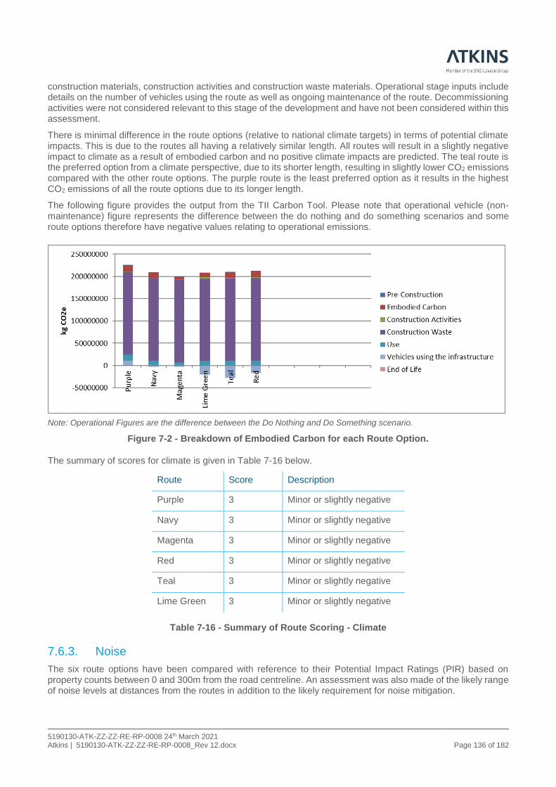
5190130-ATK-ZZ-ZZ-RE-RP-0008 24th March 2021 Atkins | 5190130-ATK-ZZ-ZZ-RE-RP-0008_Rev 12.docx Page 136 of 182
construction materials, construction activities and construction waste materials. Operational stage inputs include details on the number of vehicles using the route as well as ongoing maintenance of the route. Decommissioning activities were not considered relevant to this stage of the development and have not been considered within this assessment.
There is minimal difference in the route options (relative to national climate targets) in terms of potential climate impacts. This is due to the routes all having a relatively similar length. All routes will result in a slightly negative impact to climate as a result of embodied carbon and no positive climate impacts are predicted. The teal route is the preferred option from a climate perspective, due to its shorter length, resulting in slightly lower CO2 emissions compared with the other route options. The purple route is the least preferred option as it results in the highest CO2 emissions of all the route options due to its longer length.
The following figure provides the output from the TII Carbon Tool. Please note that operational vehicle (non-maintenance) figure represents the difference between the do nothing and do something scenarios and some route options therefore have negative values relating to operational emissions.
Note: Operational Figures are the difference between the Do Nothing and Do Something scenario.
Figure 7-2 - Breakdown of Embodied Carbon for each Route Option.
The summary of scores for climate is given in Table 7-16 below.
Route Score Description
Purple 3 Minor or slightly negative
Navy 3 Minor or slightly negative
Magenta 3 Minor or slightly negative
Red 3 Minor or slightly negative
Teal 3 Minor or slightly negative
Lime Green 3 Minor or slightly negative
Table 7-16 - Summary of Route Scoring - Climate
7.6.3. Noise
The six route options have been compared with reference to their Potential Impact Ratings (PIR) based on property counts between 0 and 300m from the road centreline. An assessment was also made of the likely range of noise levels at distances from the routes in addition to the likely requirement for noise mitigation.

5190130-ATK-ZZ-ZZ-RE-RP-0008 24th March 2021 Atkins | 5190130-ATK-ZZ-ZZ-RE-RP-0008_Rev 12.docx Page 137 of 182
The Purple route is the least preferred of the proposed routes as it results in the least amount of traffic diversion off the existing route. While it has the lowest PIR, it has the highest number of properties likely to experience a moderate to major negative change in noise levels compared to other routes, with no likely significant reduction in noise levels calculated at existing properties. Overall, the Purple route is determined to have a moderately negative impact.
The Navy route is considered of intermediate preference as is it determined to result in a minor negative impact, with a PIR of 247. The 60dB Lden traffic noise level is exceeded at 22no. Noise Sensitive Locations (NSLs) along this route and mitigation is likely required at 2no. properties. The route diverts traffic from the existing route and introduces road traffic noise (RTN) as the dominant noise source in rural areas to the west of the route. Nonetheless this route has the second smallest number of properties likely to experience a major negative change in noise levels, second only to the Magenta route. There is a comparable noise environment for properties to the east of the route, which were previously affected by N25 on their front facades, now relocated to the rear facades, at a greater distance. Earthworks provide screening at rear of properties along the route. This route option results in a lower number of properties likely to experience a moderate to major positive change (reduction) in traffic noise levels when compared against the Teal, Red or Lime Green routes and has a higher PIR compared to the Teal and Red routes.
The Magenta route is considered of intermediate preference as it is determined to result in a minor negative impact, with a PIR of 360. The 60dB Lden traffic noise level is exceeded at 59no. NSLs along this route and mitigation is likely required at 13no. properties. This route has the highest PIR compared to the other options due to its close alignment to the existing N25. The existing noise environment at properties along sections 7, 9 and 10 of the existing N25 will, however, be improved (reduced) due to the realignment of the existing route away from NSL’s. Similar to Navy route, the PIR is higher than Teal, Red and Lime Green routes. The number of properties likely to experience a moderate to major positive change (reduction) in traffic noise levels is, however, lower compared to the above-mentioned routes. This route is ranked higher in preference than the Navy route as it has no negative impacts unlike the Navy route which introduces RTN as dominant source to some rural areas along proposed route.
The Red route is considered of intermediate preference as it is determined to result in a minor negative impact. It is the furthest eastern route in the study area and passes through a rural environment with clusters of properties, giving it a higher PIR than the proposed Teal route, also to the east of the existing route. It has a PIR of 155. The 60dB Lden traffic noise level is exceeded at 29no. NSLs along this route and mitigation is required at 18no. properties, the highest value along all routes. Earthworks provide screening to NSLs to the northern section of the corridor. The number of properties likely to experience a major positive change in noise levels is, however, highest along this route compared to the other route options (172no.) with Teal route second highest at 141no. NSLs. This route is ranked below Navy due to the number of mitigation clusters required. The Teal route has lower PIR with less mitigation and comparable positive impacts calculated overall.
The Teal route is considered minor negative and is the preferred route. This is determined on the basis of that it has no properties within the 0-50m PIR band, has the lowest number of NSLs exceeding the design goal of 60dB Lden and it has the second highest number of properties likely to experience a major positive change in noise levels when compared to all other routes (Red highest) with at least 100 more NSLs experiencing a reduction in traffic noise levels compared to other routes. Mitigation is required for 6no. NSLs towards southern end of route. This route has a lower PIR than Lime Green route. Earthworks provide beneficial screening at northern section of the route near cluster of properties.
The Lime Green route is considered of intermediate preference as it has a minor negative impact. The corridor passes through a rural noise environment with a higher PIR than all other proposed routes with the exception of the Magenta route. This route has a comparable number of properties likely to experience a moderate to major positive change in traffic noise to the Navy route due to extensive diversion of traffic off the existing N25. Increase in traffic noise will be experienced in this rural environment but due to earthworks screening many clusters of properties experience a likely lower moderate to major increase in noise levels compared to the Teal route. The Teal route, however, has significantly more NSLs that experience a moderate to major reduction in traffic noise levels along the existing N25. Lime Green route has slightly more properties requiring mitigation in comparison to Teal and Navy routes. The summary of scores for noise is given in Table 7-17 below.

5190130-ATK-ZZ-ZZ-RE-RP-0008 24th March 2021 Atkins | 5190130-ATK-ZZ-ZZ-RE-RP-0008_Rev 12.docx Page 138 of 182
Route Score Description
Purple 2 Moderately negative
Navy 3 Minor or slightly negative
Magenta 3 Minor or slightly negative
Red 3 Minor or slightly negative
Teal 3 Minor or slightly negative
Lime Green 3 Minor or slightly negative
Table 7-17 - Summary of Route Scoring - Noise
7.6.4. Landscape and Visual
Landscape impact may be defined as changes in the physical landscape, which may give rise to changes in its character and how it is experienced. Visual impact comprises the change in the composition of available views from dwellings and public areas resulting from the proposals.
The assessment of landscape impact is based on the division of character areas derived from the county landscape character assessment. The effect of each route option on the individual landscape character area is considered in the context of local landscape sensitivity to derive an overall impact score for the proposals in accordance with the Transport Analysis Guidance ( (Transport Analysis Guidance) Unit A3, Environmental Impact Appraisal;) criteria.
The purple route option lies within three landscape character areas; Landscape Character Area E: South Eastern Uplands, Landscape Character Area C: South Western Uplands and Landscape Character Area C2: South Hills Transition Area, South. The overall Landscape Impact Significance (all landscape character areas combined) is Large adverse (negative) effect.
The navy route option lies within one landscape character area; Landscape Character Area E: South Eastern Uplands. The overall Landscape Impact Significance is Slight adverse (negative) effect.
The magenta route option lies within one landscape character area; Landscape Character Area E: South Eastern Uplands. The overall Landscape Impact Significance is Slight adverse (negative) effect.
This red route option lies within one landscape character area; Landscape Character Area E: South Eastern Uplands. The overall Landscape Impact Significance is Large adverse (negative) effect.
The teal route option lies within one landscape character area; Landscape Character Area E: South Eastern Uplands. The overall Landscape Impact Significance is Large adverse (negative) effect.
The lime green route option lies within one landscape character area; Landscape Character Area E: South Eastern Uplands. The overall Landscape Impact Significance is Moderate adverse (negative) effect.
Visual effects have been identified by the number of receptors (dwellings and community buildings) judged to have significant adverse effects according to each route option is summarised as follows.
• Purple – 22;
• Navy -3;
• Magenta – 27;
• Red – 29;
• Teal – 10; and
• Lime Green – 32.
The following Table 7-18 summarises the overall landscape and visual scoring for the various route options according to the seven-point scale. The overall scoring is based on combining the significance of effect scores

5190130-ATK-ZZ-ZZ-RE-RP-0008 24th March 2021 Atkins | 5190130-ATK-ZZ-ZZ-RE-RP-0008_Rev 12.docx Page 139 of 182
for landscape (elements/ landscape character) and visual receptors (dwellings and community buildings) and professional judgment.
Route Option Score Description
Purple 1 Major Negative
Navy 3 Minor or slightly negative
Magenta 3 Minor or slightly negative
Red 1 Major negative
Teal 1 Major negative
Lime Green 1 Major negative
Table 7-18 - Summary of Route Scoring - Landscape and Visual
7.6.5. Biodiversity – Flora and Fauna
The Purple route is the longest route at 11.6 km and is the most westerly of all proposed routes. As with all other routes, drainage is likely either to the River Barrow & River Nore Special Area of Conservation (SAC) (002162) to the east (via the Glenmore River); or the Lower River Suir SAC (002137) to the south (via the Nicholastown/Lough Cullin/Smartcastle Stream). The route would cross the Glenmore River or its tributaries at up to 3 no. locations. The Purple route differs in its interaction with the River Barrow & River Nore SAC to all other routes - as it swings to the north of Glenmore. It would cross a tributary of the Glenmore River in a small river valley in the townland of Ballybraghy. The SAC is also located within the route corridor to the west in Mullennahone as well as where the route intercepts the existing N25 to the northeast of Glenmore (at the roundabout built as part of the New Ross Bypass scheme). There are no direct impacts to Special Protection Areas (SPAs) or to Natural Heritage Areas (NHAs).
The Purple route is the closest route to Lough Cullin proposed NHA (pNHA) located to the west. Depending upon final design, the Purple route could drain to Lough Cullin pNHA via the Nicholastown Stream. Lough Cullin is a site of importance to birds. Preliminary bird survey work suggests that there are no field-feeding sites present along the Purple route that could result in indirect impacts upon bird populations of Lough Cullin. The Barrow River Estuary pNHA largely overlaps with the River Barrow & River Nore SAC.
The Purple route would impact upon 6 no. Ecologically Sensitive Areas (ESAs): 1 is of County Importance; 3 of High Local importance; and 2 are of Low Local importance. ESA 1, Ballybrahy, is of County importance and includes an area of wet woodland (WN6); the potential for equivalence with the Annex I habitat - alluvial woodland 91A0 - is a consideration. ESA 4 and 19 are of higher local importance and comprise habitats including riparian woodland, wet woodland and wet grassland, of potential local importance to bird and mammal species. The Purple route, being the longest, has the greatest potential for negative impacts on linear features such as hedgerows. Based on expert judgement of a contracted bat-specialist, the Purple route poses the worst risk to bats and their potential roosting and feeding sites.
The Navy route is one of a number of routes which run more centrally through the study area with a length of 9.5km. It approaches Glenmore from the southeast and merges back onto the alignment of the existing N25 as it approaches Glenmore. Drainage is likely either to the River Barrow & River Nore SAC (002162) to the east (via the Glenmore River); or the Lower River Suir SAC (002137) to the south (via the Luffany Stream). There are no direct impacts to SPAs or to Natural Heritage Areas - the nearest such site is Lough Cullin pNHA located to the west and largely outside the study area. The proposed corridor would not drain to Lough Cullin pNHA. The Barrow River Estuary pNHA largely overlaps with the River Barrow & River Nore SAC.
The Navy route would not impact upon any ESAs of County Importance. It could potentially impact on 4 ESAs of High Local importance and 6 ESAs of Low Local importance. ESAs 10, 11, 12, 15 and 17 are likely to be directly impacted by this route given their spatial distribution within the corridor; direct interaction with the remaining ESAs is likely to be avoided. ESAs 11 and 17 are of higher local importance and comprise areas of scrub, broadleaved woodland, wet woodland and wet grassland which may also be of local importance to mammal species. The Navy route is 9.5km, with less potential for negative impacts on linear features such as hedgerows than the Purple route. Existing habitats provided by landscape planting along the N25 would, however, be lost. Based on expert judgement of a contracted bat-specialist, the Navy route poses the joined-second worst risk to bats and their potential roosting sites, with the Magenta route.

5190130-ATK-ZZ-ZZ-RE-RP-0008 24th March 2021 Atkins | 5190130-ATK-ZZ-ZZ-RE-RP-0008_Rev 12.docx Page 140 of 182
The Magenta route is one of a number of routes which run more centrally through the study area with a length of 9.3km. As with the Navy route, it approaches Glenmore from the southeast and merges back onto the alignment of the existing N25. Drainage is likely either to the River Barrow & River Nore SAC (002162) to the east (via the Glenmore River); or the Lower River Suir SAC (002137) to the south (the Luffany Stream). There are no direct impacts to SPAs or to Natural Heritage Areas - the nearest such site is Lough Cullin pNHA located to the west and largely outside the study area. The proposed corridor would not drain to Lough Cullin pNHA. The Barrow River Estuary pNHA largely overlaps with the River Barrow & River Nore SAC.
The Magenta route would not impact upon any ESAs of County Importance. It could potentially impact on 5 ESAs of High Local importance and 6 ESAs of Low Local importance. The only ESA where direct impacts would be unavoidable is ESA 11, which is of higher local importance and comprises scrub, broadleaved woodland, wet woodland and wet grassland which could be of local importance to mammal and field-feeding bird species. The Magenta Route impacts 3 of the same sites of high local importance to the Navy route; as well as 5 of the same sites of local importance. The Magenta route is 9.3km, with less potential for negative impacts on linear features such as hedgerows than the Purple route; similar to the Navy route. Existing habitats provided by landscape planting along the N25 would, however, be lost. Based on expert judgement of a contracted bat-specialist, the Magenta route poses the joined-second worst risk to bats and their potential roosting sites, with the Navy route.
The Red route is the most easterly of the proposed routes; located closest to the valley of the River Barrow. It is 9.0km long. Drainage is likely either to the River Barrow & River Nore SAC (002162) to the east (via the Glenmore River); or the Lower River Suir SAC (002137) to the south (via the Luffany Stream). The corridor intersects the SAC at two points. The Red route merges onto the alignment of the existing N25 as it approaches the northern terminus from the south through Graiguenakill. At this point the route may utilise structures already built as part of the New Ross Bypass, avoiding additional impact to the SAC at the northern intersection. There are no direct impacts to SPAs or to Natural Heritage Areas - the nearest such site is Lough Cullin pNHA located to the west and largely outside the study area. The proposed corridor would not drain to Lough Cullin pNHA. Any impact to the Barrow River Estuary pNHA will be dependent upon the final design and the level of interaction with wetland habitats along the river at Graiguenakill following detailed design.
The Red route would not impact upon any ESAs of County Importance. It would impact on 2 ESAs of High Local importance and 4 ESAs of Low Local importance. ESA 3 comprises a tributary of the Glenmore River, and associated bankside scrub, over which a water crossing would be required. This ESA may be of local importance to mammal and aquatic species, while also being hydrologically connected to the SAC. The Red route is 9.0km, with less potential for negative impacts on linear features such as hedgerows than longer routes, such as Purple. Based on expert judgement of a contracted bat-specialist, the Red route poses least risk to bats and their potential roosting sites. The Red route is located closest to the Barrow Estuary which supports important populations of roosting and feeding birds. Further surveys of the route would be required to determine if there is habitat that would be impacted that may be of importance to field-feeding birds associated with the Barrow Estuary.
The Teal route is one of a number of routes which run more centrally through the study area with a length of 8.7km. Drainage is likely either to the River Barrow & River Nore SAC (002162) to the east (via the Glenmore River); or the Lower River Suir SAC (002137) to the south (via the Luffany Stream). The Teal route approaches Glenmore from the southeast (between the Navy / Magenta / Lime Green and the Red Route) crossing a tributary of the Glenmore River before re-joining the existing N25. There are no direct impacts to SPAs or to Natural Heritage Areas - the nearest such site is Lough Cullin pNHA located to the west and largely outside the study area. The proposed corridor would not drain to Lough Cullin pNHA. Any impact to the Barrow River Estuary pNHA will be dependent upon further design and the level of interaction with wetland habitats along the river at Graiguenakill. The Teal route would not impact upon any ESAs of County Importance. It would impact on 2 ESAs of High Local importance (same two as the Red option) and 4 ESAs of Low Local importance (same four as the Red option); though the Teal route is likely to intersect more of these than the Red route. ESA 3 comprises a tributary of the Glenmore River, and associated bankside scrub, over which a water crossing would be required. This ESA may be of local importance to mammal and aquatic species, while also being hydrologically connected to the SAC. ESA 16 comprises broadleaved and wet woodland, wet grassland and scrub, which may be of local importance to mammals and field-feeding birds. The Teal route is 8.7km, with less potential for negative impacts on linear features such as hedgerows than longer routes, such as Purple. As noted, the Teal route merges back onto the alignment of the existing N25 as it approaches the northern terminus. Thus, existing habitats provided by landscape planting along the N25 would be lost. Based on expert judgement of a contracted bat-specialist, the Teal route poses the second least risk to bats and their potential roosting sites.
The Lime Green route runs centrally through the study area with a length of 8.9km. Again, drainage is likely either to the River Barrow & River Nore SAC (002162) to the east (via the Glenmore River); or the Lower River Suir SAC (002137) to the south (via the Luffany Stream). As with the Navy and Magenta routes, the Lime Green route

5190130-ATK-ZZ-ZZ-RE-RP-0008 24th March 2021 Atkins | 5190130-ATK-ZZ-ZZ-RE-RP-0008_Rev 12.docx Page 141 of 182
approaches Glenmore from the southeast, merging with the alignment of the existing N25. There are no direct impacts to SPAs or Natural Heritage Areas - the nearest such site is Lough Cullin pNHA located to the west and largely outside the study area. The proposed corridor would not drain to Lough Cullin pNHA. Any impact to the Barrow River Estuary pNHA will be dependent upon further design and the level of interaction with wetland habitats along the river at Graiguenakill.
The Lime Green route would not impact upon any ESAs of County Importance. It would impact on 5 ESAs of High Local importance and 2 ESAs of Low Local importance, all of which are shared with the Magenta Route. The Lime Green route is 8.9km, with less potential for negative impacts on linear features such as hedgerows than longer routes, such as Purple. As noted, the Lime Green route merges back onto the alignment of the existing N25 as it approaches the northern terminus. Thus, existing habitats provided by landscape planting along the N25 would be lost. Based on expert judgement of a contracted bat-specialist, the Lime Green route ranked in the middle in terms of risk to bats and their potential roosting sites. The summary of scores for biodiversity is given in Table 7-19 below.
Route Option Score Description
Purple 1 Major Negative
Navy 1 Major Negative
Magenta 1 Major Negative
Red 1 Major Negative
Teal 1 Major Negative
Lime Green 1 Major Negative
Table 7-19 - Summary of Scoring - Biodiversity
7.6.6. Waste
There will be a requirement for significant volumes of unsuitable material to be disposed of off-site, for some route options more than others. Estimated material quantities are summarised in the following Table 7-20.
Route Option
Estimated Excavation & Disposal of Surplus
Suitable and Unacceptable
Material (U1) (m3)
Estimated Excavation & Disposal of Hazardous
Unacceptable Material (U2)
(m3)
Total Material
(m3)
Purple 312,029 16,423 328,452
Navy 140,604 7,400 148,004
Magenta 95,077 5,004 100,081
Red 488,362 25,703 514,065
Teal 712,095 37,479 749,574
Lime Green 227,502 11,974 239,476
Table 7-20 - Route Comparison: Quantitative Waste Measures
A review of the quantities of material to be disposed of off-site has identified the Magenta and Navy Routes as the Preferred and highest scoring. The Lime Green and Purple have been identified as intermediate with the Red and Teal options as the Least Preferred. The summary of scores for waste is given in Table 7-21 below.

5190130-ATK-ZZ-ZZ-RE-RP-0008 24th March 2021 Atkins | 5190130-ATK-ZZ-ZZ-RE-RP-0008_Rev 12.docx Page 142 of 182
Route Option Score Description
Purple 2 Moderately negative
Navy 3 Minor or slightly negative
Magenta 3 Minor or slightly negative
Red 1 Major negative
Teal 1 Major negative
Lime Green 2 Moderately negative
Table 7-21 - Summary of Scoring - Waste
7.6.7. Soils and Geology
All six routes have been evaluated for the key soils / geological attributes, specifically condition of existing soils and potential sources of contamination (all other parameters are broadly comparable). Based on this impact assessment the overall ranking or preference for each route has been determined, with respect to Soils and Geology.
The majority of each route is underlain by glacial till, with localised occurrences of sands and gravels, alluvium, made ground and lacustrine deposits. Bedrock underlying all route options comprises of green, red-purple, buff slate, siltstone of the Oaklands Formation, green and grey slate with thin siltstone from the Ballylane Formation, red, brown conglomerate & sandstone of Carrigmaclea Formation and Dolerite and Rhyolitic volcanics, grey & brown slates of Campile formation. No evidence of any karst features was identified during the desk-based review or preliminary ground investigation. No Geological Heritage Areas are identified within the study area of each of the route options.
All route options will involve excavation or cut into existing alluvium and lacustrine deposits, the lateral and extent of which has not been defined.
The Red, Teal and Purple Routes have been identified as the lowest impacting routes with the Lime Green and Navy options performing better than Magenta. The Magenta route is the lowest scoring as datasets identified the route as having a medium proportion of its route “high” landslip susceptibility classification. The summary of scores for soils and geology is given in Table 7-22 below.
Route Option Score Description
Purple 3 Minor or slightly negative
Navy 2 Moderately negative
Magenta 1 Major or highly negative
Red 3 Minor or slightly positive
Teal 3 Minor or slightly negative
Lime Green 2 Moderately negative
Table 7-22 - Summary of Route Scoring- Soils and Geology
7.6.8. Hydrology and Hydrogeology
No significant adverse (i.e. major negative), or profound adverse (i.e. severe negative) hydrological or hydrogeological impacts have been identified associated with any of the routes assessed. While all six routes are broadly comparable in terms of impact levels in terms of hydrology, the Purple Route does not directly impact the surface water quality of Lower River Suir SAC (indirect impact only) but could potentially have a temporary direct impact to surface water quality at River Barrow and River Nore SAC (albeit any impacts would be minor). The Navy Route, Lime Green Route, Teal Route, Magenta Route and Red Route are identified as ‘intermediate’ and ranked 2nd, 3rd, 4th, 5th and 6th in order of preference in terms of hydrology. This is primarily based on the fact that all 5 routes could potentially impact surface water quality at River Barrow and River Nore SAC, Lower River

5190130-ATK-ZZ-ZZ-RE-RP-0008 24th March 2021 Atkins | 5190130-ATK-ZZ-ZZ-RE-RP-0008_Rev 12.docx Page 143 of 182
Suir SAC, Barrow River Estuary pNHA, and the Waterford Harbour Shellfish Area to varying degrees. The summary of scores for hydrology is given in Table 7-23 below.
Route Option Score Description
Purple 4 Not significant or neutral
Navy 3 Minor or slightly negative
Magenta 3 Minor or slightly negative
Red 3 Minor or slightly negative
Teal 3 Minor or slightly negative
Lime Green 3 Minor or slightly negative
Table 7-23 - Summary of Route Scoring - Hydrology
The Red Route and the Teal Route are identified as ‘preferred’ routes with least potential impacts with respect to hydrogeology (i.e. groundwater). These routes have been ranked 1st in order of preference. While both routes are broadly comparable in terms of impact levels, this ranking is primarily due to the estimated c.3.2km and 3.5km of the total length of cut required in areas of Extreme/High/Rock at or near Surface or Karst groundwater vulnerability along these routes respectively (albeit any impacts would be on a local scale).
The Navy Route, the Magenta Route and the Lime Green Route are all identified as ‘intermediate’ routes with respect to hydrogeology while the Navy Route and the Magenta Route are ranked 2nd, The Lime green Route is ranked 3rd. All 3no. routes are broadly comparable in terms of impact levels, with potential impacts to River Barrow and River Nore SAC and Lower River Suir SAC arising from groundwater pathways. Therefore, this ranking is primarily due to the estimated c.4.3km, 4.5km and 5.9km of the total length of cut required in areas of Extreme/High/ Rock at or near Surface or Karst groundwater vulnerability along these routes respectively (albeit any impacts would be on a local scale).
The remaining route option (the Purple Route) is identified as ‘least preferred’ route with respect to hydrogeology. This has been ranked 4th, based on the fact that this could potentially impact the River Barrow and River Nore SAC and Lower River Suir SAC via groundwater pathways (as with all route options), along with potential impact to the groundwater quality of Regionally Important Bedrock Aquifer. In addition, this poses a potential risk of localised impacts to existing groundwater quality of Regionally Important Bedrock Aquifer along sections of cut. An estimated 4.3km of the total length of cut required in areas of Extreme/High Rock at or near Surface or Karst groundwater vulnerability along this route. The summary of scores for hydrogeology is given in Table 7-24 below.
Route Option Score Description
Purple 2 Moderately negative
Navy 3 Minor or slightly negative
Magenta 3 Minor or slightly negative
Red 4 Not significant or neutral
Teal 4 Not significant or neutral
Lime Green 3 Minor or slightly negative
Table 7-24 - Summary of Route Scoring- Hydrogeology
7.6.9. Cultural Heritage
Based on a standardised criterion the six proposed routes were assessed on both their respective direct and indirect potential effects on the local cultural heritage resource. In determining these effects consideration was given to both the quantitative aggregation of sites along each route and the qualitive effect the development would have on recorded monuments and structures, features identified on historic mapping and areas of archaeological potential derived from various sources including aerial and lidar imagery.
The analysis concluded that in terms of effects on Cultural Heritage the most preferred option is the Purple Route. This route, although the longest option, has a potentially slight to moderate adverse impact on the setting of two

5190130-ATK-ZZ-ZZ-RE-RP-0008 24th March 2021 Atkins | 5190130-ATK-ZZ-ZZ-RE-RP-0008_Rev 12.docx Page 144 of 182
archaeological monuments, a univallate ringfort in Nicholastown and another at Grogan. The route passes several vernacular features identified on historic mapping but will not impact any protected structures. The route may have a direct impact on two possible archaeological sites and a potential direct impact on the designed landscape associated with Frazer’s Hall demesne.
The second most preferred options are jointly the Magenta, Red and Teal Routes. All three are relatively coequal in terms of effects. The Magenta route runs through the centre of the study area and is the option that most closely follows the existing N25 alignment. Along the Magenta route there is one archaeological monument which may experience a direct impact of slight to moderate significance. In addition, this route will have a large adverse impact on the setting of O’Donovan’s Mill, a moderate adverse impact on the setting of the standing stone at Robinstown and a moderate adverse impact on the setting of the cross at Carriganurra. The Red Route, the most easterly option, would have a very large adverse impact on the setting of Aylwardstown house, listed as both a protected structure and monument, moderate direct impacts on a largely now no longer extant clachán at Luffany, Bearstown Bridge and a possible enclosure at Rochestown and moderate direct impact on the designed landscape associated with Aylwardstown House. The Teal Route would run east behind this historic property through the demesne lands and would have a moderate adverse impact on its setting as well as a potentially moderate direct impact on the designed landscape associated with the demesne. Further south it would have a large adverse impact on the setting of ecclesiastical remains at Kilcolumb, a complex comprising a church, graveyard, bullaun stone, holy well and an associated ringfort. The teal route would also potentially have a direct significant impact and a moderate impact on the setting of a possible ringfort at Ballyrowragh. The teal route would also have a potentially moderate direct impact on a largely no longer extant clachán at Luffany.
The least preferred options were both the Lime Green and Navy Routes assessed as having highly negative effects on various features. The Lime Green Route, the least preferred route, would have a profound direct impact on the Cross on Carriganurra Hill as well as a significant direct impact on a ringfort at Ballyrahan and a moderate direct impact on a possible archaeological feature (a mound) at Luffany. This route would also have a very large adverse impact to the setting of O’Donovan’s Mill, a Protected Structure and a moderate adverse impact on the settings of two archaeological sites. The Navy Route would have large adverse impacts on the setting of two of a series of three, inter-visible, recorded monuments set on a ridgeline in Davidstown. This area contains several potentially significant features identified from a review of Lidar imagery and confirmed by a geophysical survey that have variously been interpreted as two enclosure ditches and settlement activity in the form of linear and pit responses. These sites would be directly impacted upon. The Navy Route would also impact the settings of six additional known or suspected archaeological sites.
In summary the Purple route is the most preferred option, with the Magenta, Red and Teal Routes given intermediate ranking of preference, the least preferred options are the Lime Green and Navy routes.
It is recommended that the proposed scheme avoids direct impacts, where feasible, on the archaeological, architectural, and cultural heritage site and features noted in this report. Where this is not possible a programme of archaeological mitigation measures will be untaken. Detailed mitigation will be addressed following identification of a preferred route. It should be noted that there is potential across all route options to encounter previously unknown subsurface archaeological sites or features. It should also be noted that the preferred route is the longest route. The summary of scores for architectural heritage is given in Table 7-25 and for archaeology and cultural heritage in Table 7-26 below.
Route Option Score Description
Purple 4 Not significant or neutral
Navy 3 Minor or slightly negative
Magenta 3 Minor or slightly negative
Red 3 Minor or slightly negative
Teal 2 Moderately negative
Lime Green 1 Major or highly negative
Table 7-25 - Summary of Route Scoring- Architectural Heritage

5190130-ATK-ZZ-ZZ-RE-RP-0008 24th March 2021 Atkins | 5190130-ATK-ZZ-ZZ-RE-RP-0008_Rev 12.docx Page 145 of 182
Route Option Score Description
Purple 2 Moderately negative
Navy 1 Major or highly negative
Magenta 2 Moderately negative
Red 2 Moderately negative
Teal 2 Moderately negative
Lime Green 1 Major or highly negative
Table 7-26 - Summary of Route Scoring- Archaeology and Cultural Heritage
7.6.10. Non-Agricultural Properties
All affected properties and types of land classed as commercial, recreational, open space, minerals and public facilities (hospitals, schools, and religious institutions) which are not of an agricultural nature are considered under the heading of Non-Agricultural Properties.
The appraisal of the potential impacts to non-agricultural properties, has been prepared through a desk-based review of all available information, including available Ordnance Survey mapping and aerial photography. The following presents the number of non-agricultural properties within 300m of route option centreline:
• Purple - 51 Non-agricultural properties including Residential and Businesses;
• Navy - 147 Non-agricultural properties including Residential, School, Church, Community Facility, Sports Pitch, Garda Station and Businesses;
• Magenta - 145 Non-agricultural properties including Residential, School, Church, Community Facility, Garda Station and Businesses;
• Red - 60 Non-agricultural properties including Residential and Businesses;
• Teal - 41 Non-agricultural properties including Residential, Cemetery and Businesses; and
• Lime Green - 139 Non-agricultural properties including Residential, School, Church, Community Facility, Garda Station and Businesses.
Each of the six routes avoid centres of population. The respective route study areas consist of mainly agricultural land of improved pasture, with main receptors being scattered dwellings. As such, each of the route study areas have relatively low levels of population. The summary of scores for non-agricultural properties is given in Table 7-27 below.
Route Option Score Description
Purple 2 Moderately Negative
Navy 1 Major or highly negative
Magenta 1 Major or highly negative
Red 2 Moderately Negative
Teal 3 Minor or slightly negative
Lime Green 1 Major or highly negative
Table 7-27 - Summary of Route Scoring - Non-Agricultural Properties
7.6.11. Agriculture
Both qualitative and quantitative assessments of the impacts to key agricultural enterprises were carried out. The agricultural enterprises considered most sensitive to a proposed scheme development consists mainly of dairy and equine enterprises. The route options assessment considered the impact each route option has on agriculture. Land use, soil type, and key agricultural enterprises were considered in the qualitative assessment.

5190130-ATK-ZZ-ZZ-RE-RP-0008 24th March 2021 Atkins | 5190130-ATK-ZZ-ZZ-RE-RP-0008_Rev 12.docx Page 146 of 182
Land use (% of holdings), land take (approx. ha), route length (km), land severance (% of holdings) and the number of farmyards/facilities in close proximity to route options were considered in the quantitative assessment.
The Purple option is 11.6km and impacts on 58 farm holdings some of which are classified as sensitive farm holdings such as dairy farms. Of the 58 farm holdings, 76% are classified as grazing, 14% are classified as dairy farms, 3% are classified as forestry and 7% are classified as tillage. 26% of holdings are classified as resulting in Major Severance, 27% of holdings are classified as Moderate Severance, while 47% of holdings are classified as Minor or Not Significant Severance.
The Navy option is 9.5km and impacts on 46 farm holdings. Of the 46 farm holdings, 85% are classified as grazing, 6% are classified as dairy farms and 9% are classified as tillage. There are no forestry holdings impacted by the route. 22% of holdings are classified as resulting in Major Severance, 28% of holdings are classified as Moderate Severance, while 50% of holdings are classified as Minor or Not Significant Severance.
The Magenta option is 9.3km and impacts on 48 farm holdings some of which are classified as sensitive farm holdings such as dairy farms. Of the 48 farm holdings, 92% are classified as grazing and 8% are classified as dairy farms. There are no forestry or tillage holdings impacted by the route. The online nature of the route results in lower severance to land holdings. No holdings are classified Major Severance, 6% of holdings are classified as Moderate Severance, while 94% of holdings are classified as Minor or Not Significant Severance.
The Red option is 9.0km and impacts on 44 farm holdings. Of the 44 farm holdings, 75% are classified as grazing, 16% are classified as dairy farms, 7% are classified as tillage and 2% are classified as equine. 25% of holdings are classified as resulting in Major Severance, 14% of holdings are classified as Moderate Severance, while 61% of holdings are classified as Minor or Not Significant Severance.
The Teal option is 8.7km and impacts on 37 farm holdings. Of the 37 farm holdings, 76% are classified as grazing, 5% are classified as dairy farms, 8% are classified as forestry and 11% are classified as tillage. 24% of holdings are classified as resulting in Major Severance, 25% of holdings are classified as Moderate Severance, while 51% of holdings are classified as Minor or Not Significant Severance.
The Lime Green option is 8.9km and impacts on 39 farm holdings some of which are classified as sensitive farm holdings such as dairy farms. Of the 39 farm holdings, 79% are classified as grazing, 8% are classified as dairy farms, 3% are classified as forestry and 10% are classified as tillage. 13% of holdings are classified as resulting in Major Severance, 31% of holdings are classified as Moderate Severance, while 56% of holdings are classified as Minor or Not Significant Severance. The summary of scores for agriculture is given in Table 7-28 below.
Route Option Score Description
Purple 1 Major or highly negative
Navy 2 Moderately negative
Magenta 2 Moderately negative
Red 1 Major or highly negative
Teal 2 Moderately negative
Lime Green 2 Moderately negative
Table 7-28 - Summary of Route Scoring - Agriculture
7.6.12. Planning / Human Beings
This Purple route is outside the area designated to be kept free from development for the provision of the re-aligned N25 as per Figure 11.1 of the Kilkenny County Development Plan 2014 - 2020. However, there is no specific policy/objective outlined in the Plan which states that routes will need to be within this defined corridor.
Of note, is that there are 2 no. monuments included within the Record of Monuments and Places along the subject route. It is noted that the Plan seeks the protection of such RMPs (Section 8.3 and Objective 8I refer). The proposed route also traverses the River Barrow and River Nore SAC.
In terms of human impact, it is noted that the subject route traverses 2 no. sites where there is live planning permission for dwellings under application register reference 18/689 and 16/861, which do not expire until 9th July 2024 and 23rd March 2022 respectively. Furthermore, the proposed route traverses an access road serving

5190130-ATK-ZZ-ZZ-RE-RP-0008 24th March 2021 Atkins | 5190130-ATK-ZZ-ZZ-RE-RP-0008_Rev 12.docx Page 147 of 182
1 no. agricultural holding and a dwelling. There are 8 no. dwellings within 100m of the route centre line which is significantly lower than the majority of the other route options, which will likely have a lesser impact on humans.
Notwithstanding the potential significant negative impact on an existing agricultural holding, an existing dwelling and a permitted dwelling, which represents a significant negative impact in terms of human beings, it is noted that having regard to the potential adverse impact of the route on the Qualifying Interests of the SAC, which cannot be ruled out at this stage, that the proposed route is considered to be highly negative from a planning perspective. However, the potential impact on the SAC are assessed in detail within the biodiversity assessment. On this basis, this route is considered in light of the potential impact on existing and permitted dwellings and having regard to the comparatively low no. of dwellings impacted, this route is considered to be slightly negative in terms of impact on human beings.
This Navy route is largely within the area designated to be kept from development for the provision of the realigned N25 as per Figure 11.1 of the Kilkenny County Development Plan 2014 - 2020.
The proposed route also traverses 6 no. monuments which are included in the Record of Monuments and Places. It is noted that the Plan seeks the protection of such RMPs (Section 8.3 and Objective 8I refer).
There are 4 no. dwellings located within 50m of the route centreline, and a further 13 no. dwellings located within 100m of the proposed route centre line. In comparison to other routes, there is a relatively low number of dwellings in close proximity to this proposed route option. In this context, the impact on human beings from this route option would be minorly negative.
It is noted that the proposed route traverses land to which there is a live planning permission in place (application register reference 18573) for the upgrading of overhead cables, which may be negatively impacted by the proposed development. The proposed route also traverses the River Barrow and River Nore SAC.
Having regard to the potential adverse impact of the route on the Qualifying Interests of the SAC, which cannot be ruled out at this stage, and on 2 no. RMPs, this route is considered to be highly negative from a planning perspective. However, the built and natural heritage designations along the route are assessed in detail within the biodiversity and heritage assessments. On this basis, this route is considered in light of the potential impact on existing and permitted dwellings and having regard to the comparatively low no. of dwellings impacted, this route is considered to be slightly negative in terms of impact on human beings.
This Magenta route is largely within the area designated to be kept from development for the provision of the realigned N25 as per Figure 11.1 of the Kilkenny County Development Plan 2014-2020.
The proposed route corridor intersects with 10 no. monuments which are included in the Record of Monuments and Places. It is noted that the Plan seeks the protection of such RMPs (Section 8.3 and Objective 8I refer).
In terms of dwellings in the vicinity, it is stated that there are 26 no. dwellings within 50m of the route centre line, with a further 31 no. dwellings within c. 100m of the route centreline. This is a high volume of dwellings relative to other potential route options. However, this route is close to the existing N25 alignment, so any impacts would, in general, be similar to the current situation. Nevertheless, it is considered there could be a relatively minor impact on human beings relative to the other route options. It is noted that the proposed route traverses land to which there is a live planning permission in place (application register reference 18573) for the upgrading of overhead cables and a dwelling house (app. reg. ref. 18/191) which may be negatively impacted by the proposed development. The proposed route also traverses the River Barrow and River Nore SAC.
Having regard to the potential adverse impact of the route on the Qualifying Interests of the SAC which cannot be ruled out at this stage, and on 2 no. RMPs, this route is considered to be highly negative from a planning perspective. However, the built and natural heritage designations along the route are assessed in detail within the biodiversity and heritage assessments. On this basis, this route is considered in light of the potential impact on existing and permitted dwellings and having regard to the comparatively high no. of dwellings impacted, this route is considered to be highly negative in terms of impact on human beings.
This Red route is located outside the area designated to be kept free from development for the provision of the realigned N25 as per Figure 11.1 of the Kilkenny County Development Plan 2014-2020. However, there is no specific policy/objective outlined in the Plan which states that routes will need to be within this defined corridor.
The proposed route corridor also traverses the site of 4 no, monuments which are included within the Record of Monuments and Places. It is noted that the Plan seeks the protection of such RMPs (Section 8.3 and Objective 8I refer).

5190130-ATK-ZZ-ZZ-RE-RP-0008 24th March 2021 Atkins | 5190130-ATK-ZZ-ZZ-RE-RP-0008_Rev 12.docx Page 148 of 182
Of note in relation to this route is that it traverses the access road to Beacon Hill Equine centre, a disused railway line (South-east Greenway) and the River Barrow and River Nore SAC. In addition, there are 3 no. dwellings located within 50m of the route centreline, with a further 20 within 100m of the route centreline. This is a high volume of dwellings relative to other potential route options, which potentially will have a higher impact negative impact on human beings.
It is noted that the proposed route traverses land to which there is a live planning permission in place (app. reg. ref. 18573) for the upgrading of overhead cables, as well as a dwelling house (app. reg. ref. 18577) which may be negatively impacted by the proposed development.
Having regard to the potential negative impact on the Beacon Hill Equine Centre, the presence of a high number of dwellings within 100m of the route, the impact on the disused railway line (South-east Greenway), the potential impact on an RMP and the Qualifying Interests of the SAC which cannot be ruled out at this stage, this route is considered to be highly negative from a planning perspective. However, the built and natural heritage designations along the route are assessed in detail within the biodiversity and heritage assessments. On this basis, this route is considered in light of the potential impact on existing and permitted dwellings and having regard to the moderately higher number of no. of dwellings impacted, this route is considered to be moderately negative in terms of impact on human beings. This proposed route is located outside the area designated to be kept free from development for the provision of the realigned N25 as per Figure 11.1 of the Kilkenny County Development Plan 2014-2020. However, there is no specific policy/objective outlined in the Plan which states that routes will need to be within this defined corridor.
The Teal route corridor passes through the Zone of Notification of 4 no. monuments included in the Record of Monuments and Places. It is noted that the Plan seeks the protection of such RMPs (Section 8.3 and Objective 8I refer). It is noted that the proposed route traverses land on which there is a live planning permission in place (application register reference 18573). This permission relates to the upgrading of overhead cables, which may be negatively impacted by the proposed development. This route has the least number of dwellings in close proximity to the route centre line. There are no dwellings within 50m of the route centre line, with 12 no. dwellings located within 100m of the route centreline. This is a significantly low number relative to the other route options and therefore is considered to be slightly negative in terms of impacts to human beings. The route crosses a disused railway line (South-east Greenway). The proposed route also traverses the River Barrow and River Nore SAC. Notwithstanding the fact this route impacts the least number of dwellings within 100m of its centre line, it traverses an RMP and the SAC. Unless it can be demonstrated that there will be no adverse impact on the Qualifying Interests (QIs) of the SAC, this route is considered to be highly negative from a planning perspective. However, the natural and built heritage designations along the route are assessed in detail within the biodiversity and heritage assessments. On this basis, this route is considered in light of the potential impact on existing and permitted dwellings and having regard to the comparatively low no. of dwellings impacted, this route is considered to be slightly negative in terms of impact on human beings.
The Lime Green route is located outside the area designated to be kept free from development for the provision of the realigned N25 as per Figure 11.1 of the Kilkenny County Development Plan 2014-2020. However, there is no specific policy/objective outlined in the Plan which states that routes will need to be within this defined corridor. It is noted that there are 4 no. dwellings located within 50m of the centreline of the proposed route, with a further 25 no. dwellings located within 100m of the centre line. This is relatively high number relative to the other route options and is therefore considered to be moderately negative in terms of human impacts. However, the route traverses 2 no. sites with live planning permission in place for dwelling houses (App. Reg. Ref. 18191 and 17553), as well as an application for upgrading of overhead cables (App. Reg. Ref. 18573) which may be negatively impacted. The proposed route also traverses the River Barrow and River Nore SAC. The route also traverses 4 No. archaeological monuments included in the Record of Monuments and Places. Notwithstanding the fact this route does not traverse an RMP, and that there are only 4no. dwellings within 50m of the centreline of the proposed route, it traverses the SAC. Unless it can be demonstrated that there will be no adverse impact on the Qualifying Interests (QIs) of the SAC, this route is considered to be highly negative from a planning perspective. The built and natural heritage designations along the route are assessed in detail within the biodiversity and heritage assessments. On this basis, this route is considered in light of the potential impact on existing and permitted dwellings and having regard to the moderately higher number of no. of dwellings impacted, this route is considered to be moderately negative in terms of impact on human beings.
The summary of scores for planning / human beings is given in Table 7-29 below.
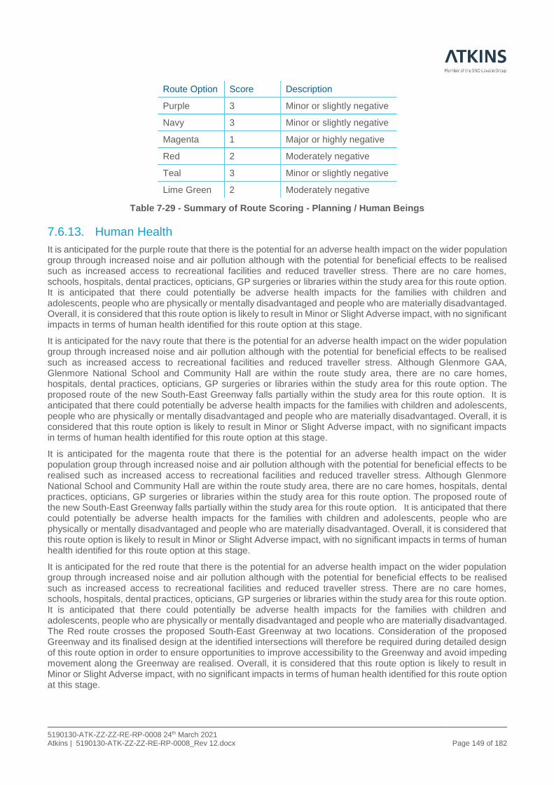
5190130-ATK-ZZ-ZZ-RE-RP-0008 24th March 2021 Atkins | 5190130-ATK-ZZ-ZZ-RE-RP-0008_Rev 12.docx Page 149 of 182
Route Option Score Description
Purple 3 Minor or slightly negative
Navy 3 Minor or slightly negative
Magenta 1 Major or highly negative
Red 2 Moderately negative
Teal 3 Minor or slightly negative
Lime Green 2 Moderately negative
Table 7-29 - Summary of Route Scoring - Planning / Human Beings
7.6.13. Human Health
It is anticipated for the purple route that there is the potential for an adverse health impact on the wider population group through increased noise and air pollution although with the potential for beneficial effects to be realised such as increased access to recreational facilities and reduced traveller stress. There are no care homes, schools, hospitals, dental practices, opticians, GP surgeries or libraries within the study area for this route option. It is anticipated that there could potentially be adverse health impacts for the families with children and adolescents, people who are physically or mentally disadvantaged and people who are materially disadvantaged. Overall, it is considered that this route option is likely to result in Minor or Slight Adverse impact, with no significant impacts in terms of human health identified for this route option at this stage.
It is anticipated for the navy route that there is the potential for an adverse health impact on the wider population group through increased noise and air pollution although with the potential for beneficial effects to be realised such as increased access to recreational facilities and reduced traveller stress. Although Glenmore GAA, Glenmore National School and Community Hall are within the route study area, there are no care homes, hospitals, dental practices, opticians, GP surgeries or libraries within the study area for this route option. The proposed route of the new South-East Greenway falls partially within the study area for this route option. It is anticipated that there could potentially be adverse health impacts for the families with children and adolescents, people who are physically or mentally disadvantaged and people who are materially disadvantaged. Overall, it is considered that this route option is likely to result in Minor or Slight Adverse impact, with no significant impacts in terms of human health identified for this route option at this stage.
It is anticipated for the magenta route that there is the potential for an adverse health impact on the wider population group through increased noise and air pollution although with the potential for beneficial effects to be realised such as increased access to recreational facilities and reduced traveller stress. Although Glenmore National School and Community Hall are within the route study area, there are no care homes, hospitals, dental practices, opticians, GP surgeries or libraries within the study area for this route option. The proposed route of the new South-East Greenway falls partially within the study area for this route option. It is anticipated that there could potentially be adverse health impacts for the families with children and adolescents, people who are physically or mentally disadvantaged and people who are materially disadvantaged. Overall, it is considered that this route option is likely to result in Minor or Slight Adverse impact, with no significant impacts in terms of human health identified for this route option at this stage.
It is anticipated for the red route that there is the potential for an adverse health impact on the wider population group through increased noise and air pollution although with the potential for beneficial effects to be realised such as increased access to recreational facilities and reduced traveller stress. There are no care homes, schools, hospitals, dental practices, opticians, GP surgeries or libraries within the study area for this route option. It is anticipated that there could potentially be adverse health impacts for the families with children and adolescents, people who are physically or mentally disadvantaged and people who are materially disadvantaged. The Red route crosses the proposed South-East Greenway at two locations. Consideration of the proposed Greenway and its finalised design at the identified intersections will therefore be required during detailed design of this route option in order to ensure opportunities to improve accessibility to the Greenway and avoid impeding movement along the Greenway are realised. Overall, it is considered that this route option is likely to result in Minor or Slight Adverse impact, with no significant impacts in terms of human health identified for this route option at this stage.

5190130-ATK-ZZ-ZZ-RE-RP-0008 24th March 2021 Atkins | 5190130-ATK-ZZ-ZZ-RE-RP-0008_Rev 12.docx Page 150 of 182
It is anticipated for the teal route that there is the potential for an adverse health impact on the wider population group through increased noise and air pollution although with the potential for beneficial effects to be realised such as increased access to recreational facilities and reduced traveller stress. Although the community facility of Rathinure Old Graveyard is within the route study area, there are no care homes, schools, hospitals, dental practices, opticians, GP surgeries or libraries within the study area for this route option. It is anticipated that there could potentially be adverse health impacts for the families with children and adolescents, people who are physically or mentally disadvantaged and people who are materially disadvantaged. The Teal route crosses the proposed South-East Greenway at two locations. Consideration of the proposed Greenway and its finalised design at the identified intersections will therefore be required during detailed design of this route option in order to ensure opportunities to improve accessibility to the Greenway and avoid impeding movement along the Greenway are realised. Overall, it is considered that this route option is likely to result in Minor or Slight Adverse impact, with no significant impacts in terms of human health identified for this route option at this stage.
It is anticipated for the lime green route that there is the potential for an adverse health impact on the wider population group through increased noise and air pollution although with the potential for beneficial effects to be realised such as increased access to recreational facilities and reduced traveller stress. Although Glenmore National School and Community Hall are within the route study area, there are no care homes, hospitals, dental practices, opticians, GP surgeries or libraries within the study area for this route option. The proposed route of the new South-East Greenway falls partially within the study area for this route option. It is anticipated that there could potentially be adverse health impacts for the families with children and adolescents, people who are physically or mentally disadvantaged and people who are materially disadvantaged. Overall, it is considered that this route option is likely to result in Minor or Slight Adverse impact, with no significant impacts in terms of human health identified for this route option. The summary of scores for human health is given in Table 7-30 below.
Route Option Score Description
Purple 3 Minor or slightly adverse
Navy 3 Minor or slightly adverse
Magenta 3 Minor or slightly adverse
Red 3 Minor or slightly adverse
Teal 3 Minor or slightly adverse
Lime Green 3 Minor or slightly adverse
Table 7-30 - Summary of Route Scoring - Human Health

5190130-ATK-ZZ-ZZ-RE-RP-0008 24th March 2021 Atkins | 5190130-ATK-ZZ-ZZ-RE-RP-0008_Rev 12.docx Page 151 of 182
7.6.14. Environmental Appraisal Matrix Summary
The following Table 7.31 Phase Stage 2 - Environmental Assessment Matrix Summary provides the summary scores of the environmental matrix utilised within this assessment. The full matrix is located in Appendix I.
Environmental Sub-criteria Purple Navy Magenta Red Teal Lime Green
Air Quality 5 6 4 6 7 6
Climate 3 3 3 3 3 3
Noise 2 3 3 3 3 3
Landscape and Visual (including light) 1 3 3 1 1 1
Biodiversity- Flora and Fauna 1 1 1 1 1 1
Waste 2 3 3 1 1 2
Soils and Geology 3 2 1 3 3 2
Hydrology 4 3 3 3 3 3
Hydrogeology 2 3 3 4 4 3
Architectural Heritage 4 3 3 3 2 1
Archaeological and Cultural Heritage 2 1 2 2 2 1
Non-agricultural properties 2 1 1 2 3 1
Agriculture 1 2 2 1 2 2
Human Beings 3 3 1 2 3 2
Human Health 3 3 3 3 3 3
Total 38 40 36 38 41 34
Table 7-31 - Environmental Assessment Matrix Summary
* Note that the options listed in this Table as Navy and Teal have been renamed from Cyan Dashed and Dark Blue Dashed
respectively for the Phase 2 Stage 2 Assessment
7.7. Summary of Accessibility & Social Inclusion Appraisal
The Accessibility and Social Inclusion appraisal has been carried out in accordance with the Project Appraisal Guidelines and has considered the impact of each route corridor option on accessibility to education, employment, essential services and amenities. Accessibility and Social Inclusion is measured in terms of Deprived Geographical Areas and Vulnerable Groups.
7.7.1. Deprived Geographical Areas
In terms of impact on disadvantaged geographic areas the most recent information on The Phobal HP Deprivation Index 2016 was referenced and the results show that townlands to the south and west of the study area are marginally above average and townlands to the north and east are marginally below average. Considering all route corridor options start and end at the same location and are similar in length, varying from 8.7km (Teal option) to 11.6km (Purple option) the impact is considered neutral.
7.7.2. Vulnerable Groups
Accessibility and Social Inclusion also measures accessibility for communities, particularly for vulnerable groups which include, women, children, young people, older people, people with disabilities, ethnic minorities and lower-income socio-economic groups to key facilities, jobs and social opportunities. In terms of government policy all

5190130-ATK-ZZ-ZZ-RE-RP-0008 24th March 2021 Atkins | 5190130-ATK-ZZ-ZZ-RE-RP-0008_Rev 12.docx Page 152 of 182
of the proposed options would deliver the same level of accessibility to the study area and the wider national road network. All of the options are in the same geographic region and will not impact any vulnerable groups.
In the context of Accessibility and Social Inclusion all options are considered to be of similar preference in this regard, which is neutral. The full matrix is located within Appendix L.
7.8. Summary of Integration Appraisal
The appraisal of integration has assessed the impact of each route corridor option in terms of achieving the objectives of National, Regional, and Local planning policy, together with EU Regulation and integration with previous infrastructure investments. Integration is appraised under four sub-criteria, in accordance with Unit 7.0 of the Project Appraisal Guidelines, as outlined:
• Transport Integration;
• Land use Integration;
• Geographical Integration; and
• Other Government Policy Integration.
7.8.1. Transport Integration
Transport integration examines the promotion of the integration of transport infrastructure and services by focusing on gaps in the existing network and improving opportunities for interchange between transport modes.
The proposed routes address the gap in the quality of the existing infrastructure at this location connecting the existing infrastructure, the Waterford City Bypass and New Ross Bypass, adding value to the existing network and providing significant interchange between transport modes by connecting Cork at one end to the port of Rosslare at the other end. All options will link four of the country’s major ports, Cork, Waterford, New Ross and Rosslare and two airports, Cork and Waterford. In addition, the N25 route links the towns and villages of Carrigtwohill, Midleton, Castlemartyr, Killeagh, Dungarvan, Kilmacthomas, Kilmeaden and Wexford. The proposed options will improve connectivity between existing transport modes with improved journey time reliability bringing benefits to those using private transport as a means of interconnecting with public transport facilities.
The proposed upgrade should make public transport by bus (the only alternative mode available) more desirable and improve connectivity to the major cities, other urban centres and transport hubs. The existing bus stops are currently within a 100km speed limit zone and adjacent to the carriageway with a sub-standard hard strip for waiting and exiting passengers. The off-line options will remove a high percentage of the traffic from the existing N25 and the bus stop facilities could be improved. For all options the bus facility could be relocated to just off the Glenmore roundabout on the L7501 where a bus set-down and turning facility with parking for cyclists and drop-off and pick-up could be provided with upgraded pedestrian links to the village of Glenmore and the South-East greenway.
Sustainable transport modes (i.e. cycling and walking) will be improved significantly for the off-line options through the declassification of the existing N25 with a reduced speed limit and traffic volumes creating a safer asset for sustainable transport modes. All options will retain the connectivity for cyclists and pedestrians to the proposed South-East Greenway, which is a high-quality dedicated shared facility, via the local road network.
In the context of Transport Integration, all options, to varying degrees, provide an integration of transport infrastructure and services. The Navy and Lime Green options are considered preferred as they achieve the highest BCR values of 1.02 and 1.16, the second and third highest transfer of traffic 95.6% and 96.3% and the fourth and third best journey time savings of one minute sixteen seconds and one minute thirty-nine seconds respectively adding value to the network and supporting sustainable transport modes. In addition, the Navy, Magenta (Management Option) and Lime Green options have a proposed grade separated junction facilitating connectivity to the surrounding local area specifically to the village of Glenmore compared to the Purple, Teal and Red options which do not. The Purple option is ranked as least preferred as it is the longest route (11.56km), has the least transference of traffic (43%), average journey time saving of seven seconds and a negative BCR (-0.08) adding no value to the transport infrastructure.

5190130-ATK-ZZ-ZZ-RE-RP-0008 24th March 2021 Atkins | 5190130-ATK-ZZ-ZZ-RE-RP-0008_Rev 12.docx Page 153 of 182
7.8.2. Land Use Integration
Land Use Integration focuses on the compatibility between adopted land use objectives and the proposed scheme.
The N25 forms part of the comprehensive TEN-T (Trans European Transport) network and as such is required to be of a motorway, expressway or conventional strategic road standard. The objective of the TEN-T network is to close gaps, remove bottlenecks and eliminate technical barriers that exist between the transport networks of EU Member States.
The purple, magenta, red, teal and lime green routes are outside the area designated (within the Kilkenny County Development Plan 2014-2020 to be kept free from development for the provision of the re-aligned N25. However, there is no specific policy/objective outlined in the Plan which states that routes will need to be within this defined corridor. The Kilkenny City and County Draft Development Plan 2021-2027 includes the study area for the N25 Waterford to Glenmore Scheme.
The Navy option is largely within the area designated to be kept free from development for the provision of the realigned N25 as per the Kilkenny County Development Plan 2014-2020. The Magenta (Management Option) and Lime Green options are partially within this designated area. All options provide a strategic corridor through predominantly rural areas, with relatively short links to existing local roads.
In the context of Land Use Integration, all options are considered to be of similar preference in this regard, which is slightly positive.
7.8.3. Geographical Integration
Geographical Integration focuses on improving connectivity within Ireland, Europe and to other parts of the world and specifically supports the objectives of the TEN-T. Geographical Integration improve integration of rural and local services; connectivity with Northern Ireland; and access to links with Europe and the rest of the world.
The N25 forms a vital link in the national road network connecting Cork at one end to the port of Rosslare at the other end, with a link to Waterford Port (Belview) and Waterford City. It provides access to four of the country’s major ports, Cork, Waterford, New Ross and Rosslare. It also provides access to two airports, Cork and Waterford. In addition, the N25 route links the towns and villages of Carrigtwohill, Midleton, Castlemartyr, Killeagh, Dungarvan, Kilmacthomas, Kilmeaden and Wexford.
The National Development Plan has identified a number of objectives with respect to regions to achieve more ‘balanced development’ of the country, National Strategic Outcome 2 – Enhanced Regional Accessibility with the N25 Waterford to Glenmore scheme listed as one of the schemes to be progressed through pre-appraisal and early planning.
All options perform equally in satisfying the goals of the NDP and in addition, the N25 forms part of the comprehensive TEN-T (Trans European Transport) network meaning it has National and European significance. The objective of TEN-T is to close gaps, remove bottlenecks and eliminate technical barriers that exist between the transport networks of EU Member States. The N25 provides this by connecting the Waterford City Bypass and New Ross bypass completing a 35km section of high-quality road, adding to and improving cross border international connectivity.
In the context of Geographical Integration all options are considered to be of similar preference in this regard, which is highly positive.
7.8.4. Other Government Policy Integration
Other Government Policy Integration criterion focuses on the promotion of regional balance in terms of transport planning and development, to achieve the goals of the National Planning Framework.
A key objective of the National Planning Framework is rural development and the actions identified to achieve this objective include, identifying connectivity gaps, investment in maintaining regional and local roads and strategic road improvement projects in rural areas to ensure access to critical services such as education, healthcare and employment.
The option selection process has confirmed that the project is consistent with and supports all relevant policies at European, National, Regional and Local levels and can be developed to adhere to the principles of proper planning and sustainable development in accordance with the Planning & Development Act 2000 as amended.

5190130-ATK-ZZ-ZZ-RE-RP-0008 24th March 2021 Atkins | 5190130-ATK-ZZ-ZZ-RE-RP-0008_Rev 12.docx Page 154 of 182
Compliance with the principles of proper planning and sustainable development will continue to be tested as the preferred scheme option is further developed through Phases 3 & 4 for the submission of a development application for the relevant statutory planning processes.
The Project Appraisal Guidelines Unit 7.0 advises that transport projects should be scored positively for regional balance if investment is:
• Within or to urban centres from peripheral regions;
• On links between urban centres;
• On routes which improve access to international ports and airports.
All options meet these policy/guideline objectives to varying degrees by improving connectivity from County Kilkenny to the rest of country, to the TEN-T network and to the major ports and airports.
In the context of Other Government Policy Integration, all Options are considered to be of similar preference with regards to the above, which is highly positive.
7.8.5. Overall Ranking of Integration
The overall integration assessment for each route options has resulted in varying preferences, these are summarised in Table 7-32.
Route Option
Transport Integration
Land Use Integration
Geographical Integration
Other Government
Policy Integration
Overall Safety Ranking
Purple Least Preferred Intermediate Preferred Preferred Least Preferred
Navy Preferred Intermediate Preferred Preferred Preferred
Magenta Least Preferred Intermediate Preferred Preferred Least Preferred
Lime Green Preferred Intermediate Preferred Preferred Preferred
Teal Intermediate Intermediate Preferred Preferred Intermediate
Red Intermediate Intermediate Preferred Preferred Intermediate
Table 7-32 - Overall Integration Preferences
7.9. Summary of Physical Activity Appraisals
This appraisal focuses on the physical activity impacts of vulnerable road users such as pedestrians and cyclists. It is appraised under three broad headings: Ambience, Absenteeism and Reduced Health Risk. The full matrix is located in Appendix L.
7.9.1. Ambience
In terms of Ambience the possibility for an increase in physical activity could potentially be improved as the proposed off-line options will improve the ambience of the existing N25 as a result of reduced traffic speeds and traffic volumes. The Navy, Magenta and Lime Green options will improve connectivity in and around the townland of Glenmore by means of an overbridge from the western to the eastern hinterland. This junction will provide a safe walking/cycling route to and from the village and schools. Another consideration is the provision of a shared cycle/pedestrian facility extending from the village to the Glenmore roundabout and linking to the South-East Greenway.
Kilkenny County Council are currently constructing the South-East Greenway as a separate project and the section between Waterford and New Ross runs parallel to the proposed N25 scheme and will provide a dedicated facility for physical activity between the urban centres of Waterford City and New Ross town.
The scheme proposals will provide an improved and safer user experience encouraging greater use of sustainable modes of transport with the associated health and environmental benefits.

5190130-ATK-ZZ-ZZ-RE-RP-0008 24th March 2021 Atkins | 5190130-ATK-ZZ-ZZ-RE-RP-0008_Rev 12.docx Page 155 of 182
The Magenta (Management Option) route is the least preferred route, as it is largely an on-line improvement and will not facilitate the separation of high-speed and freight traffic from VRUs. The Purple, Teal and Red options are ranked intermediate, as they will improve the ambience of the existing N25 due to varying degrees of traffic transfer but will not improve VRU facilities in and around the village of Glenmore and the hinterland. The Navy and Lime Green options are ranked as preferred, as they provide the greatest improvement to the ambience of the existing N25 with a significant transfer of traffic and provide connectivity to the village of Glenmore and the hinterland by means of the intermediate junction.
7.9.2. Absenteeism
Absenteeism in terms of impact on health of workforce is deemed to be unimpacted due to the size and rural nature of the scheme and the low density of the surrounding population. All options are considered to be neutral in this regard.
7.9.3. Reduced Health Risks
The health benefits associated with the proposed routes may be generated as follows:
• Increased levels of physical exercise as the general public utilise the improvements in pedestrian and cyclist facilities associated with the new scheme by providing connectivity to the townland of Glenmore, the hinterland and to the South-East Greenway and it is envisaged the proposed scheme will promote the use of the existing N25 as a result of reduced traffic volumes and speeds along its length;
• Improvements in the general ambience of the settlement environments along the existing N25, arising as a direct result of reduced through-traffic by the usage of the proposed improvements.
All Options are considered to be neutral with regards to health benefits.
7.9.4. Overall Ranking of Physical Activity
The overall Physical Activity assessment for each route options has resulted in varying preferences, these are summarised in Table 7-33.
Route Option
Ambience Absenteeism Reduced Health Risks
Overall Safety Ranking
Purple Least Preferred Intermediate Intermediate Least Preferred
Navy Preferred Intermediate Intermediate Preferred
Magenta Least Preferred Intermediate Intermediate Least Preferred
Lime Green Preferred Intermediate Intermediate Preferred
Teal Intermediate Intermediate Intermediate Intermediate
Red Intermediate Intermediate Intermediate Intermediate
Table 7-33 - Overall Physical Activity Preferences

5190130-ATK-ZZ-ZZ-RE-RP-0008 24th March 2021 Atkins | 5190130-ATK-ZZ-ZZ-RE-RP-0008_Rev 12.docx Page 156 of 182
7.10. Scheme Objectives-based Appraisal The key objectives for this scheme have been identified as follows as per Section 1.6 of this document:
• Economy: To promote and enhance the sustainable economic growth of rural regions by improving the strategic road capacity, efficiency and safety. To improve local, regional, national and international connectivity in the region. To reduce the costs of travel on the N25 at an investment cost that offers value for money and ensures a lasting residual value. As detailed in Section 7.4 above the six options achieve these objectives to varying degrees but only two of the options, Navy and Lime Green, deliver value for money with a BCR greater than 1.
• Safety: To reduce the potential for collisions within the Study Area by minimising road side hazards, removing junction turning movements and separating VRUS from high speed traffic and freight, through the provision of a high-quality road with consistent cross section and treatment of junctions in accordance with current design standards. Reducing collisions results in economic benefits in terms of savings associated with collision costs. As detailed in 7.5 above the Lime Green and Navy options perform best in meeting these objectives and the Purple option is the worst performing.
• Environment: To provide a sustainable long-term solution in line with sustainable development principles and measures to minimise effects on the environment to support the Government's policy on climate action. To provide a scheme that seeks to avoid and to minimise impacts to identified sensitive receptors within the Study Area. To reduce journey times and encourage free flow traffic, with the aim of reducing greenhouse gas emissions and impacts on climate. To construct a scheme that is suitably integrated into the surroundings both visually and from a noise impact point of view.
To manage surface run-off both during and after construction of the scheme so as not to negatively impact on local water resources.
As detailed in Section 7.6 above the Teal and Navy options perform best in meeting these objectives and the Lime Green and Magenta (Management Option) are the worst performing.
• Accessibility and Social Inclusion: To connect to other similar schemes enhancing the connectivity of the regional and national road network. To align with the accessibility and social cohesion objectives as outlined in the Kilkenny County Development Plan 2014- 2020 and draft Kilkenny City and City and Council Development Plan 2021 - 2027. To improve road based public transport by maintaining journey times and journey time reliability; To provide safer and more convenient access to public transport for residents in Glenmore Village and its immediate environs.
As detailed in Section 7.7 above all options are considered similar in terms of meeting these objectives.
• Integration: To connect to other similar schemes, enhancing the connectivity of the regional and national road network and improve transport links within the EU and beyond. To be consistent with the Kilkenny County Development Plan 2014 – 2020 and the draft Kilkenny City and County Development Plan 2021 - 2027 in terms of land use and planning objectives. To maintain/improve the connectivity to the Southeast Greenway pedestrian and cycle facility. To compliment and support European, National, Regional and Local government policies.
As detailed in Section 7.8 above the Navy and Lime Green options perform best in meeting these objectives and the Purple and Magenta (Management Option) are the worst performing.
• Physical Activity: To maintain/improve the connectivity to the Southeast greenway (pedestrian and cycle facility) and the nearby village of Glenmore. To improve the ambience and safety of the existing N25 and to encourage increased usage of the existing N25 by pedestrians and cyclists.
As detailed in Section 7.9 above the Navy and Lime Green options perform best in meeting these objectives and the Purple and Magenta (Management Option) are the worst performing. An assessment on how each of the identified route options meets the stated scheme objectives has been carried out to see whether it aligns with the objectives (or not), this is summarised in Table 7-34.

5190130-ATK-ZZ-ZZ-RE-RP-0008 24th March 2021 Atkins | 5190130-ATK-ZZ-ZZ-RE-RP-0008_Rev 12.docx Page 157 of 182
Option Criteria Economy Safety Environment Accessibility Integration Physical Activity
Purple
Aligns with Objectives?
Yes Yes Yes Yes Yes Yes
Preference Least
Preferred Least
Preferred Intermediate Similar
Least Preferred
Least Preferred
Magenta
Aligns with Objectives?
Yes Yes Yes Yes Yes Yes
Preference Intermediate Intermediate Least
Preferred Similar
Least Preferred
Least Preferred
Red
Aligns with Objectives?
Yes Yes Yes Yes Yes Yes
Preference Least
Preferred Preferred Intermediate Similar Intermediate Intermediate
Lime Green
Aligns with Objectives?
Yes Yes Yes Yes Yes Yes
Preference Preferred Preferred Least
Preferred Similar Preferred Preferred
Navy
Aligns with Objectives?
Yes Yes Yes Yes Yes Yes
Preference Preferred Preferred Preferred Similar Preferred Preferred
Teal
Aligns with Objectives?
Yes Yes Yes Yes Yes Yes
Preference Intermediate Preferred Preferred Similar Intermediate Intermediate
Table 7-34 – Scheme Objective Based Appraisal
As can be seen from the above all route options align with the key objectives to varying degrees with the Navy option performing the best and the Purple option the worst.
7.11. Phase 2 - Stage 2 Project Appraisal Matrix and Assessment.
The following paragraphs give a synopsis of how each of the six options perform under each of the criteria included in the Phase 2-Stage 2 Project Appraisal.
The preferences assigned below are as a result of the high-level review of options by the individual assessor for each criterion. The review consisting of an evaluation of the preference scores in the Multi Criteria Analysis Matrix as a means to provide a guide to the impact of options and finalised through an assessment of the strengths of individual impacts to form a view as to the likely overall impact of each option. These views are outlined in Section 7.4 to Section 7.10 above for each of the six criteria and the overall scoring for each criterion detailed below and tabulated in Table 7-35.
7.11.1. Economic Summary
A summary of the Economy appraisal is detailed in Section 7.4 above and of the four criteria Transport Quality and Reliability (journey times and speeds) and Efficiency and Effectiveness (Benefit Cost Ratio (BCR)) separate the options with Wider Economic and Funding Impacts considered similar.
7.11.1.1. Transport Quality and Reliability
From the findings of the appraisal, except for the purple route, all of the options will result in an improvement of journey times, with average speeds increasing from 77/84kph (existing southbound and northbound) to 100kph (forecast), which will have a positive impact on public transport providers, hauliers and road users in general. The scheme with the highest present value benefits (PVB) is the Teal Route with benefits in the order of €93m compared to the scheme with the lowest journey time benefits i.e. the Purple Route which provides benefits circa -€6.9m.

5190130-ATK-ZZ-ZZ-RE-RP-0008 24th March 2021 Atkins | 5190130-ATK-ZZ-ZZ-RE-RP-0008_Rev 12.docx Page 158 of 182
7.11.1.2. Efficiency and Effectiveness
The Option Cost Estimates for each of the route options identified shows that all routes are not comparable, with the cost estimates ranging from a value of €117.325m for the Navy Route to €201.391m for the Red Route representing a difference in overall costs in the order of 72%. The two key differences between the routes is their economic standing in terms of Efficiency and Effectiveness and Transport Quality & Reliability.
The results of the Benefit to Cost Ratio (BCR) for each of the route options ranges from -0.08 for the Purple Route to 1.16 for the Lime Green Route. There are two routes with a BCR value above 1, Lime Green with a value of 1.16 and Navy with a value of 1.02. The remaining route options have a BCR value of less than 1 and they are, Red with a BCR of 0.74, Magenta (Management Option) with a BCR value of 0.82 and Teal with a BCR value of 0.91.
7.11.1.3. Overall Summary
In terms of economic benefits there are four routes with a BCR of less than 1 with the Purple Route being the least preferred as it represents the lowest safety benefits, the least journey time benefits and the lowest BCR value when compared to the remaining five routes. The Red, Magenta and Teal Routes all have a BCR of less than one but are ranked as intermediate compared to Purple, and the remaining Lime Green and Navy Routes have a BCR value of greater than 1 and are considered comparable in terms of BCR values and journey time savings and hence have been given a preferred preference rating.
7.11.2. Safety Summary
A summary of the Safety appraisal is detailed in Section 7.5 above and in terms of safety, it is recognised that all options assessed are expected to achieve current design standards and therefore would be inherently safer by design, when compared to the existing “Do-Nothing” scenario. However, other matters in terms of effective elimination of direct accesses along the route, number of junctions, geometry, overtaking opportunities and the safety of other non-motorised / vulnerable road users are also considered. The results of the Road Safety Audit (Stage F Part 1) in Appendix J and the RSIA in Appendix K are reflective of this fact. In addition to this the monetary benefits associated with collision reduction were assessed through the medium of a COBALT Safety Analysis Assessment and included in the RSIA and Phase 2 Stage 2 Project Assessment Matrix under the criterion Safety (Appendix L). All three of these sources were used in the final assessment of safety for all route options.
The Purple and the Magenta (Management Option) are the least preferred routes in terms of Safety. The Purple route is the longest, has the least transfer of traffic and a negative collision reduction. The Magenta option has the highest number of direct accesses and junctions and the lowest positive collision reduction. The Teal, Red Navy and Lime Green options are ranked as preferred in terms of Safety.
Notwithstanding the above, the Road Safety Audit report noted in its conclusions: “All the proposed options represent a significant improvement to the existing N25 and a potentially significant improvement to safety on the route. The ranking provided is purely a relative grading of route options with respect to each other.”
7.11.3. Environment Summary
A summary of the Environmental appraisal is detailed in Section 7.6 above and in the overall environmental assessment has relatively similar scores across all route options. The Teal option has achieved the best score in terms of the sub-criteria and scoring system used and is followed closely by the Navy option and both these are ranked as preferred. The Red and Purple options are ranked intermediate and the Magenta (management Option) and Lime Green options ranked as least preferred.
7.11.4. Accessibility and Social Inclusion Summary
A summary of the Accessibility and Social Inclusion appraisal is detailed in Section 7.7 above and has determined that all route options brought potential positive impacts in terms of the appraisal under the criteria of Deprived Geographical Areas and Vulnerable Groups.
All options have been deemed comparable and therefore these routes have been ranked as similar for this criterion.

5190130-ATK-ZZ-ZZ-RE-RP-0008 24th March 2021 Atkins | 5190130-ATK-ZZ-ZZ-RE-RP-0008_Rev 12.docx Page 159 of 182
7.11.5. Integration
A summary of the Integration appraisal is detailed in Section 7.8 above and has determined that all route options brought positive impacts, in terms of Transport, Land Use, Geographical and Government Policy Integration. In comparative terms all route options were similar, for Land Use, Geographical Integration and Other Government Policies.
The Lime Green and Navy options were ranked highly positive in terms of Transport integration compared to the other options and have been ranked as preferred for this criterion. The two options are deemed comparable and ranked preferred as they both address a gap in the infrastructure and add value to the network, connect to the local road network and support sustainable transport modes. The Purple and Magenta (Management Option) are ranked as least preferred.
7.11.6. Physical Activity Summary
A summary of the Physical Activity appraisal is detailed in Section 7.9 above and has determined that all route options brought neutral to positive impacts, and all Options are considered to be comparable for Absenteeism and Reduced Health Risk.
The Lime Green and Navy Routes have been deemed to have the highest impact for Ambience and ranked preferred as they provide an additional benefit of improving the connectivity to the townland of Glenmore and therefore these routes have been ranked as the preferred options for this criterion. The Purple and Magenta (Management Option) are ranked as least preferred.
7.12. Synopsis of Multi-Criteria Analysis Scoring
Table 7.35 – Phase 2 Stage 2 Assessment tabulates the assigned scores for each criterion in accordance with Section 2.5 of PAG Unit 7.0 (PE-PAG-02031). The detailed matrix information this was taken from is presented in Appendix K. This MCA matrix was completed through an evaluation of the preference scores in order to provide a guide to the impact of options.
Section 2.5 of Unit 7.0 specifically states that “It is not intended that the sum of each of the individual scores will be used in selecting a preferred option. The overall impact will obviously depend on the strength of individual impacts and it is up to the assessor to weigh up the individual impacts and form a view as to the likely overall impact of the options”. These individual impacts have been assessed and documented in this Option Selection Report and the appraisal team’s conclusion outlined in section 7.13.

5190130-ATK-ZZ-ZZ-RE-RP-0008 24th March 2021 Atkins | 5190130-ATK-ZZ-ZZ-RE-RP-0008_Rev 12.docx Page 160 of 182
ROUTE OPTIONS Purple Navy Magenta Red Teal Lime Green
ENVIRONMENTAL SUB-CRITERIA
Air Quality 5 6 4 6 7 6
Climate 3 3 3 3 3 3
Noise 2 3 3 3 3 3
Landscape and Visual (including light) 1 3 3 1 1 1
Biodiversity- Flora and Fauna 1 1 1 1 1 1
Waste 2 3 3 1 1 2
Soils and Geology 3 2 1 3 3 2
Hydrology 4 3 3 3 3 3
Hydrogeology 2 3 3 4 4 3
Architectural Heritage 4 3 3 3 2 1
Archaeological and Cultural Heritage 2 1 2 2 2 1
Non-agricultural properties 2 1 1 2 3 1
Agriculture 1 2 2 1 2 2
Human Beings 3 3 1 2 3 2
Human Health 3 3 3 3 3 3
ENVIRONMENTAL SUB TOTAL 38 40 36 38 41 34
SAFETY SUB-CRITERIA
Collision Reduction 1 6 5 7 7 6
Security 4 4 4 4 4 4
Road Safety Audit Stage F1 7 4 3 6 6 5
Road Safety Impact Assessment 1 6 3 3 4 7
SAFETY SUB TOTAL 13 20 15 20 21 22
PHYSICAL ACTIVITY
Ambience 2 6 2 5 5 6
Absenteeism 4 4 4 4 4 4
Reduced Health 4 4 4 4 4 4
PHYSICAL ACTIVITY SUB TOTAL 10 14 10 13 13 14
ACCESSIBILITY & INCLUSION
Deprived Geographical Areas 4 4 4 4 4 4
Vulnerable Groups 4 4 4 4 4 4
ACCESSIBILITY & INCLUSION SUB TOTAL 8 8 8 8 8 8
INTEGRATION
Transport Integration 1 7 3 5 5 7
Land Use 5 5 5 5 5 5
Geographical Integration 7 7 7 7 7 7
Other 7 7 7 7 7 7
INTEGRATION SUB TOTAL 20 26 22 24 24 26
ECONOMY
Efficiency and Effectiveness 1 5 3 2 3 5
Transport Quality & Reliability 4 5 5 6 6 6
Wider economic impacts 4 4 4 4 4 4
Funding Impacts 4 4 4 4 4 4
ECONOMY SUB TOTAL 13 18 16 16 17 19
OVERALL TOTAL 102 126 107 119 124 123
Table 7-35 - Phase 2 Stage 2 Assessment

5190130-ATK-ZZ-ZZ-RE-RP-0008 24th March 2021 Atkins | 5190130-ATK-ZZ-ZZ-RE-RP-0008_Rev 12.docx Page 161 of 182
7.13. Conclusion
Based on the multi-criteria analysis, including the RSA Safety F2 and the RSIA assessments detailed in Table 7-35 – Phase 2 Stage 2 Assessment and taking into account the key objectives set for the scheme, it is recommended that the Navy Route Corridor is progressed through to Phase 3 of the statutory planning stages for the N25 Waterford to Glenmore Scheme.
Table 7-35 shows the overall scoring for all six routes with the Navy option scoring the highest points. While these points are a guide, the following bullet points document how the assessors have decided upon the Navy Route Corridor based on the assessment of its strengths and weaknesses of the individual impacts in determining the Emerging Preferred Route Corridor:
• Environment
The Navy option is awarded a preferred preference for Environment along with the Teal option. Both options were deemed equal for the following sub criteria Climate, Biodiversity – Flora & Fauna and Human Health. The Navy Option is preferable to the Teal for the following sub-criteria, Landscape and Visual, Waste and Architectural Heritage, and equal for Noise, Hydrology, Agriculture and Human Beings. Navy is less preferred when compared to Teal for Air Quality, Soils and Geology, Hydrogeology, Archaeology & Cultural Heritage and Non-agricultural Properties. It should be noted that neither option scored better than a “Not significant or neutral Impact” for these criteria except for Air Quality where the Navy option scored a “Moderately positive impact” compared to a “Highly positive impact” for the Teal option.
• Safety
The Navy Option is awarded a preferred preference for Safety along with the Lime Green, Teal, and Red options. This is based on a number of different sources and sub criteria. The Navy option along with Lime Green is a preferred option based on the RSIA assessment and under the Phase 2 – Stage 2 Safety and intermediate under the RSA Stage F1 audit.
It should be noted that the Navy option is a medium length route, has the second highest transfer of traffic, a moderate collision reduction and is considered comparable to the Lime Green option for possible departures, number of junctions and VRU provisions. The Teal, Red and Lime Green options have a slightly better collision reduction (14.2, 11.1 and 9.7) compared to the Navy option’s collision reduction of 6.2. However, the Navy option is comparable to Lime Green, Teal and Red options for Fatal and Serious collision savings, 2.3, 2.3 and 2.2 for fatal collisions compared to Navy’s 2.2 and 4.8, 4.9, 4.8 for serious collisions compared to Navy’s 4.7. This is demonstrated in the discounted safety benefits where all route options produce similar results (approx. €3.07M each) due to similar levels of transfer onto the newer safer road, with the exception of the Purple route.
• Physical Activity
The Navy Option is awarded a preferred preference for Physical Activity along with Lime Green as it has a significant transfer of traffic and being off-line allows the existing N25 to be used for leisure or physical activities and both options reinstate the connectivity to the townland of Glenmore. All options are considered comparable for absenteeism and health risk reduction given the rural nature of the surrounding environment and the limited impact on the workforce.
• Accessibility and Inclusion
For this criterion all options were considered neutral in respect to Deprived Geographical Areas and Vulnerable Groups and awarded the same preference. The options pass between a mix of marginally high and marginally low areas of deprivation as per the HP Pobal Index 2016 but it is considered unlikely any of the options will impact the calculation of these indices. Given the rural nature of the study area the impact of the options on vulnerable groups is considered neutral for all options as there will be little change for accessing employment, key facilities and social opportunities.
• Integration
The Navy Option is awarded a preferred preference for Integration along with Lime Green. All options were considered moderately positive for Land Use Integration, Geographical Integration, and Other Government Policy Integration. All options connect at the same junctions and provide connection to the existing local road network, but the options that add value to the existing network and best support sustainable transport modes are the Navy and Lime Green with the highest transfer of traffic and BCR values providing an efficient link to the existing network.

5190130-ATK-ZZ-ZZ-RE-RP-0008 24th March 2021 Atkins | 5190130-ATK-ZZ-ZZ-RE-RP-0008_Rev 12.docx Page 162 of 182
• Economy
The Navy Option is awarded a preferred preference for Economy along with Lime Green. All options were assessed under the four sub criteria for Economy and were considered comparable for the wider economic benefits and neutral for funding sources. For Efficiency and Effectiveness, the Navy option is the second best performing route after Lime Green. It has the lowest option cost estimate (OCE), delivers a PVB of €68m compared to the Lime Green option PVB of €88.6m, has the second highest BCR at 1.02 compared to Lime Green which has a BCR of 1.16 and journey time savings of 1 minute 16 seconds compared to Lime Green with a journey time saving of 1 minute 39 seconds.
It should be noted that the difference in the OCE for Navy (€117.32m) compared to Lime Green (€137.69m) is €20.37m and the difference in PVB for Navy (€68.04m) compared to Lime Green (€88.59) is €20.55m. However, the impact on public accounts over a 30year appraisal period is €11.6m, which is substantially less than the difference in OCE. Given the significant difference in OCE, although the Lime Green has a slightly higher BCR, the Navy and Lime Green options are considered preferred for economy.
Further sensitivity tests were carried out on the Navy option as the Emerging Preferred Route Corridor for the Shadow Price of Labour (SPL) and the Incremental Analysis and are detailed in the Cost Benefit Analysis report in Appendix B.
A SPL of 1.0 was adopted for the appraisal of the route options to reflect the full employment levels within the Irish Labour market. As unemployment has risen sharply due to the impact of Covid-19 and the longer-term impacts are uncertain, a sensitivity test using a SPL of 0.8 has been undertaken on the Navy Route Option. The result of that test is that the BCR for the route increases to 1.08.
For the Incremental Analysis a Type 1 Dual Carriageway cross section was decided upon for each of the route options. However, an additional sensitivity test has been undertaken on the Emerging Preferred Route to understand the impact of changing the cross section to a Type 2. The benefits delivered by the Type 2 Cross Section are the same as Type 1 in terms of journey times benefits, but the lower costs of a Type 2 Dual Carriageway results in a higher BCR of 1.11 for the Navy Route.
Table 7-35 illustrates the preferences allocated to each option under the MCA criteria.
Economy Safety Environment Accessibility Integration Physical Activity
Purple Least
Preferred Least
Preferred Intermediate Similar
Least Preferred
Least Preferred
Magenta Intermediate Intermediate Least
Preferred Similar
Least Preferred
Least Preferred
Red Least
Preferred Preferred Intermediate Similar Intermediate Intermediate
Lime Green
Preferred Preferred Least
Preferred Similar Preferred Preferred
Navy Preferred Preferred Preferred Similar Preferred Preferred
Teal Intermediate Preferred Preferred Similar Intermediate Intermediate
Table 7-36 – Overall Project Appraisal Assessment
The assessment has concluded that there is more than one preferred option under the different criteria. The Lime Green and Navy options have been awarded the most preferred preferences, a total of five for Navy and four for Lime Green. Considering the strengths and weaknesses of these two options they are both considered preferable for Physical Activity, Integration, Economy and Safety but there is a significant difference between the Lime Green and Navy options under the criteria Environment with Navy being the preferred and Lime Green the least preferred of all six options.
It is concluded that the Navy option is preferable over and above the other options and therefore the Navy option is recommended as the Emerging Preferred Route Corridor.

5190130-ATK-ZZ-ZZ-RE-RP-0008 24th March 2021 Atkins | 5190130-ATK-ZZ-ZZ-RE-RP-0008_Rev 12.docx Page 163 of 182
8. Phase 2 Stage 3 Preferred Route Corridor Project Appraisal Balance Sheet
8.1. Preferred Route Corridor Option Project Appraisal Balance Sheet (PABS)
The Project Appraisal Balance Sheet (PABS) is a summary appraisal of the emerging preferred route corridor’s impact based on the outputs of various assessments carried out during the Phase 2 Stage 2 Project Appraisal. The Project Appraisal Balance Sheet for the Navy Route Corridor Option is presented in Appendix N.
8.2. Summary of Road Safety Audit Stage F (Part 2)
A Stage F (Part 2) Roads Safety Audit was carried out by the TII approved Road Safety Audit Team in accordance with TII’s Publication GE-STY-01024 – Road Safety Audit and is included in Appendix O.
The Stage F Part 2 RSA report followed on from the Stage F (Part 1) RSA report and considers the Emerging Preferred Route Corridor only, detailing recommendations for problems identified. In total seven problems were raised in the Stage F Part 2 report and these related to the following:
• Proximity of roundabout arms at Luffany roundabout;
• Provision of bus stops along mainline;
• At the compact junction, straights leading to low radius curves;
• Loss of control at compact junctions;
• Existing N25 at termination point circa Ch 2300m;
• Termination points at existing local side roads;
• Acute angle of junction for access track Ch 8700m.
The design team reviewed all seven problems identified and have accepted all problems and the associated recommendations for the Emerging Preferred Route Corridor and this is documented in the feedback form within the Stage F Part 2 report.
8.3. Recommendation
Upon consideration of the above assessment and taking into account the key objectives set for the scheme, it is recommended that the Navy option is selected as the Emerging Preferred Route Corridor for the N25 Waterford to Glenmore Scheme and is progressed through Phase 3 – Design and Environmental Evaluation and Phase 4 – Statutory Process stages.
This recommendation is based on how the Navy Route Corridor has performed compared to the other options under the following criteria:
• Environment - Preferred preference, as detailed in 7.13 above;
• Safety – Preferred preference, as detailed in 7.13 above;
• Physical Activity – Preferred preference as detailed in 7.13 above;
• Accessibility and Inclusion – All options are considered equal as detailed in 7.13 above;
• Integration - Preferred preference as detailed in 7.13 above;
• Economy - Preferred preference as detailed in 7.13 above.

5190130-ATK-ZZ-ZZ-RE-RP-0008 24th March 2021 Atkins | 5190130-ATK-ZZ-ZZ-RE-RP-0008_Rev 12.docx Page 164 of 182
Appendices

5190130-ATK-ZZ-ZZ-RE-RP-0008 24th March 2021 Atkins | 5190130-ATK-ZZ-ZZ-RE-RP-0008_Rev 12.docx Page 182 of 182
Richard Neuling
WS Atkins Ireland Limited
Unit 2B 2200 Cork Airport Business Park Cork T12 R279
Tel: +353 21 429 0300
© WS Atkins Ireland Limited except where stated otherwise
Copyright © 2022 FDOKUMEN