my project
22
Earthquakes Effects Tsunamis Relation Between Earthquakes and Tsunamis (The concept, Mechanism, Impact) Abstract : The tsunamis that occurred in the Indian Ocean on September 26,2004 raised global awareness of the vulnerability of coastal population to tsunamis hazards. Natural hazards such as earthquakes, tsunamis occur globally without any discrimination. Earthquakes and tsunamis are closely related. All tsunamis are caused by massive deep-level water displacement, which is most common during subduction and megathrust earthquakes under the ocean floor. A tsunami cannot result from a land- based earthquake unless it causes a landslide into a nearby body of water . Introduction : After the earthquake and tsunami disasters which occurred in Southeast Asia in 2004 and Japan in 2011, the relationship between earthquakes and tsunamis has become both a subject of great popular concern and new scientific research. In coastal regions, tsunamis caused by earthquakes can cause far more damage than the earthquake itself, inundating miles of coastline and destroying entire cities. This makes predicting and planning for tsunamis an urgent public priority for coastal cities, especially in zones that are prone to earthquakes, like the Pacific coast.
Transcript of my project
Earthquakes Effects Tsunamis
Relation Between Earthquakes andTsunamis
(The concept, Mechanism, Impact)
Abstract :
The tsunamis that occurred in the Indian Ocean on September 26,2004 raised global awareness of the vulnerability of coastal population to tsunamis hazards. Natural hazards such as earthquakes, tsunamis occur globally without any discrimination.
Earthquakes and tsunamis are closely related. All tsunamis are caused by massive deep-level water displacement, which ismost common during subduction and megathrust earthquakes under the ocean floor. A tsunami cannot result from a land-based earthquake unless it causes a landslide into a nearby
body of water.
Introduction: After the earthquake and tsunami disasters which occurred in Southeast Asia in 2004 and Japan in 2011, the relationship between earthquakes and tsunamis has become both a subject ofgreat popular concern and new scientific research. In coastalregions, tsunamis caused by earthquakes can cause far more damage than the earthquake itself, inundating miles of coastline and destroying entire cities. This makes predictingand planning for tsunamis an urgent public priority for coastal cities, especially in zones that are prone to earthquakes, like the Pacific coast.
The relationship between the parameters that define earthquake rupture and local tsunamis is complex. For distanttsunamis that have traveled far from the origin of the earthquake, the magnitude of the earthquake is a good measureof the size of the tsunami. For local tsunamis, however, moreknowledge than the magnitude is needed to calculate the eventual runup of the tsunami.
In general, the relationship between earthquakes and tsunamisis actually quite easily understood. An earthquake is a tremor, ranging from barely perceptible to extremely violent,which occasionally occurs along the boundaries of tectonic plates: the massive subterranean rock plates which form the surface of the Earth. The plates drift along the surface of the planet at an extraordinarily slow speed. At the boundary where one plate meets another, sometimes they catch against one another. Pressure builds until the rock gives way, causing an earthquake. The Pacific coasts of North America and Asia, where several such boundaries occur, are particularly prone to earthquakes.
When this quake occurs underwater, the sudden deformation of the ocean floor can suddenly displace an enormous quantity ofwater. The sea floor may shift sharply upward, pushing water in all directions, or sink downward, drawing water inward. Ineither case, according to the Earth sciences program at the University of Washington, waves are created as water moves under the influence of gravity back toward equilibrium. If water was pushed up by the sea floor during an earthquake, this means large waves will travel outward as a result of thewater suddenly being displaced at the site of the earthquake.These large waves are known as tsunamis. According to Dan McKenzie and James Jackson of Cambridge University, there is a high risk of large tsunamis whenever an underwater earthquake shifts the ocean floor more than 30 feet along a fault line.
Tsunamis are usually measured by the height above normal level of the waves when they reach the shore. Traveling through the deep ocean, the waves move extremely quickly and are seldom dangerous to ships on the surface. As they move toward the shore, however, the ocean grows shallower and the tsunami begins to climb above the surface of the surrounding
water. Dangerous tsunamis can come ashore at a height of a dozen feet or more above normal water levels. The waves whichstruck Indonesia in 2004 and Japan in 2011 were reported to be as much as several dozen feet high in some of the hardest-hit areas.
Tsunamis can be caused by any sudden displacement of water atsea, and earthquakes under the ocean floor do not necessarilyresult in large tsunamis. The largest tsunamis, however, are usually caused by so-called megathrust earthquakes occurring in subduction zones - regions were one tectonic plate is sliding beneath another one, rather than side by side.
It is widely believed that the greatest earthquake-related danger to the Pacific northwest, in both the United States and Canada, is posed by a tsunami caused by a large offshore megathrust earthquake
So in this research paper I will explain the relation betweenEarthquakes and tsunamis and how do earthquakes generate tsunamis with some examples of cases that occurred by earthquakes and tsunamis
definition the concept of earthquakes:
An earthquake is the shaking of the earth that occurs after pieces of the crust of the Earth suddenly shift. The term earthquake describes the sudden slip on a fault and includes
the ground shaking and radiating seismic energy that is caused by the slip. Volcanic activity, or other geologic processes, may cause stress changes in the earth that can also result in an earthquake. Earthquakes can occur anywhere in the world although some areas of the globe are more likely to experience an earthquake than others. Earthquakes occur in all types of weather, in all climate zones, in all seasons of the year, and at any time of day making it impossible to predict with any certainty when an earthquake is likely to occur. The best seismologists (scientists who study earthquakes) can do is to look at the historical record of earthquake activity for any geographicalarea and use this data to calculate the probability of an earthquake occurring in the future. Earthquake prediction isstill in the future.
definition the concept of tsunamis:
A tsunami is a series of sea waves that can be caused by earthquakes or landslides at or beneath the sea floor. The displacement of the sea floor that occurs during certain large submarine earthquakes and landslides causes displacement of large volumes of the sea water above it producing large, fast moving waves. When a coast line experiences a tsunami it can be due to an earthquake near thecoast or due to a quake occurring in a distant part of the ocean. Coastal areas may experience little or no damage froman earthquake but can be devastated by the resulting tsunami.
A tsunami is a series of destructive waves, sometimes tens ofmeters high, caused by the displacement of a large volume of water, usually an ocean. With gigantic energy and fast movement, the waves are catastrophic to the affected coastal
areas.
Tsunamis are usually triggered by earthquakes, volcanic eruptions and underwater explosions, landslides and other
mass movements. Underseas earthquakes have generated nearly
all the major tsunamis in history.
How do earthquakes generate tsunamis?
Earthquakes and tsunamis are two different natural disasters,and, although it's a one-way effect, one can cause the other.An earthquake occurs when energy is released in the Earth's crust, causing seismic waves. A tsunami happens when a big part of a body of water is displaced, creating enormous
waves.Tsunamis can be generated when the sea floor abruptly deformsand vertically displaces the overlying water. Tectonic earthquakes are a particular kind of earthquake that are associated with the earth's crustal deformation; when these earthquakes occur beneath the sea, the water above the deformed area is displaced from its equilibrium position. Waves are formed as the displaced water mass, which acts under the influence of gravity, attempts to regain its equilibrium. When large areas of the sea floor elevate or subside, a tsunami can be created
Large vertical movements of the earth's crust can occur at plate boundaries. Plates interact along these boundaries called faults. Around the margins of the Pacific Ocean, for example, denser oceanic plates slip under continental plates
in a process known as subduction. Subduction earthquakes are
particularly effective in generating tsunamis.
How It's Work?
When an earthquake shifts part of the ground beneath the ocean, a large volume of water is displaced. The sudden displacement releases vast amounts of energy into the ocean. In general, the greater the physical displacement of the sea floor, the greater the amount of energy which is released
into the water.All this energy is converted into wave energy, which is carried across the ocean. Unlike typical surface waves and even storm surges, this wave energy is carried by the motion of the entire water column from the top of the ocean to its bottom. The vast amount of water involved also causes the tsunami to have an unusually long wavelength, with a width ofseveral miles. As soon as the ocean floor becomes shallow, all that volume of water is forced upward. If enough energy has been released by the initial displacement of the sea
floor, a tsunami will result.However, the vast majority of undersea earthquakes do not produce tsunamis. Even strong earthquakes may not produce tsunamis if they occur too far underground. Statistics from the China Earthquake Administration show that, from over 15,000 recent undersea earthquakes, only 100 produced
tsunamis.
How safe the coastal line from tsunamis?
The direction of the sea floor fault will determine the direction of the tsunami wave. This is critically important for knowing which areas are in danger. During the 2004 Indian Ocean tsunami, parts of Sumatra and East Africa were hit by the tsunami. However, Bangladesh was well to the northof the fault and out of the path of the tsunami, while Singapore was sheltered by Sumatra and was completely
untouched.
Magnitude and intensity: Statistics from the China Earthquake Administration show thatof the past 15,000 undersea tectonic earthquakes, only about 100 generated tsunamis. Some experts hold that only earthquakes of above 6.5 magnitude and with a focal depth of
less than 25 km underground can cause tsunamis.Sometimes even strong earthquakes, such as the 8.5-magnitude qukae that occurred near Sumatra in 2005, do not trigger tsunamis because the quake intensity can be largely
compromised by the great focal depth, experts say.In addition to the earthquake magnitude, global climate change may also have a bearing on the occurrence of tsunamis.A tsunami usually requires an earthquake of at least Richter magnitude 6.5 or higher, although tsunami warnings will sometimes be issued for a smaller offshore earthquake where the local geological conditions increase the hazard. Both the2004 Indian Ocean tsunami and the 2011 Tohaku tsunami were
caused by subduction earthquakes which were Richter magnitude9 or higher
Tsunamis without earthquakes?
A tsunami may be caused by an earthquake which was too deep or too far away to be felt by anything other than seismographs. These powerful waves can travel for thousands of miles without losing much energy. Most regions are at greatest risk from tsunamis which are generated locally only because very little warning is possible in these cases.
However, not all tsunamis are caused by earthquakes. Tsunamiscan be caused by mountain-sized landslides or the calving of glaciers into the ocean, sea or lake-sized body of water. They can also be caused by volcanoes or even meteor strikes. All these causes share two important factors: the water must be displaced suddenly, and the resulting wave energy must be forced upward by an upward-sloping sea floor or a narrowing channel. If the wave energy is forced in any other direction,it will eventually dissipate without causing a tsunami.
geographic region are at risk for tsunamis: (nuclear power and tsunami)
In the study published in the ‘Natural Hazards’ journal, the researchers drew a map of the world’s geographic zones that are more at risk of large tsunamis. Based on this data, 23 nuclear power plants with 74 reactors have been identified inhigh risk areas. One of them includes Fukushima I. Out of them, 13 plants with 29 reactors are active; another four, that now have 20 reactors, are being expanded to house nine more; and there are seven new plants under construction with
16 reactors.“ We are dealing with the first vision of the global
distribution of civil nuclear power plants situated on the coast and exposed to tsunamis,” as explained to SINC by José Manuel Rodríguez-Llanes, coauthor of the study and researcher
at the Centre for Research on the Epidemiology of Disasters (CRED) of the Catholic University of Leuven in Belgium. The authors used historical, archaeological, geological and
instrumental records as a base for determining tsunami risk.Despite the fact that the risk of these natural disastersthreatens practically the entire western coast of theAmerican continent, the Spanish/Portuguese Atlantic Coast andthe coast of North Africa, the Eastern Mediterranean andareas of Oceania, especially in South and Southeast Asia areat greater risk due to the presence of atomic power stations.
a nuclear power in China
Some 27 out of 64 nuclear reactors that are currently under construction in the world are found in China. This is an example of the massive nuclear investment of the Asian giant.“The most important fact is that 19 (two of which are in Taiwan) out of the 27 reactors are being built in areas
identified as dangerous,” state the authors of the study.In the case of Japan, which in March 2011 suffered theconsequences of the worse tsunami in its history, there areseven plants with 19 reactors at risk, one of which iscurrently under construction. South Korea is now expandingtwo plants at risk with five reactors. India (two reactors)and Pakistan (one reactor) could also feel the consequencesof a tsunami in the plants.
The ghost of Fukushima
“ The location of nuclear installations does not only have implications for their host countries but also for the areas which could be affected by radioactive leaks," as outlined toSINC by Joaquín Rodríguez-Vidal, lead author of the study andresearcher at the Geodynamics and Paleontology Department of
the University of Huelva.
According to the study, we should learn our lessons from the Fukushima accident. For the authors, prevention and previous scientific studies are the best tools for avoiding such disasters. “But since the tsunami in 2004 the Indian Ocean region is still to take effective political measures,” warn
the researchers.The Fukushima crisis took place in a highly developed countrywith one of the highest standards in scientific knowledge andtechnological infrastructure. “If it had occurred in acountry less equipped for dealing with the consequences ofcatastrophe, the impact would have been a lot more seriousfor the world at large,” claim the experts.
How Safe Is Nuclear Power? We all can only feel deep sympathy and compassion for the
victims of the terrible catastrophe that befell Japan on 11 March 2011. One of the world’s largest earthquakes ever of magnitude 9, a 10-meter tsunami that flattened many coastal areas, freezing weather for the survivors sleeping in the open, shortages of food and water, and a series of explosionsand fires at the six nuclear power plants in Fukushima, with the danger of a meltdown that would release huge amounts of
radioactivity.Some advocates of nuclear power have long argued that a majoraccident is about as likely as being hit by a meteorite. In 1975, the nuclear industry asked Professor Norman Rasmussen to produce a report that would reassure the public about the safety of nuclear energy. The report concluded that the probability of a complete core meltdown is about 1 in 20,000
per reactor per year.Reality has shown this to be a gross underestimation. Thethree best known serious nuclear power accidents are those ofThree Mile Island in 1979, Chernobyl 1986, and now Fukushima.
But there have been many more accidents and partial coremeltdowns releasing radioactivity.
Are there any alternatives to nuclear energy? Indeed there are safe ways to produce renewable energy with wind, solar power, wave and ocean-thermal energy, which do not contributeto the greenhouse effect, unlike the burning of fossil fuels.
Why do we have nuclear power despite all of its dangers for current and future generations? There is a simple reason. Nuclear power plants are highly profitable for a few, at the expense of other people’s safety. Electricity from a nuclear power station can be cut off if people do not pay their bills, but energy from the sun collected on house roofs cannot be cut off. It makes people independent.
Some Cases that are occurred the reason of tsunamis :
Case 1: ( Western Indian Ocean Earthquake and Tsunami Hazard Potential
Greater Than Previously Thought)according to a new report published in the journal Geophysical Research Letters
Earthquakes similar in magnitude to the 2004 Sumatra earthquake could occur in an area beneath the Arabian Sea at the Makran subduction zone, according to recent research
published in Geophysical Research Letters The research was carried out by scientists from the University of Southampton based at the National Oceanography Centre Southampton (NOCS),and the Pacific Geoscience Centre, Natural Resources Canada.
The study suggests that the risk from undersea earthquakes and associated tsunami in this area of the Western Indian Ocean -- which could threaten the coastlines of Pakistan, Iran, Oman, India and potentially further afield -- has been previously underestimated. The results highlight the need forfurther investigation of pre-historic earthquakes and should be fed into hazard assessment and planning for the region
Subduction zones are areas where two of Earth's tectonic plates collide and one is pushed beneath the other. When an earthquake occurs here, the seabed moves horizontally and vertically as the pressure is released, displacing large
volumes of water that can result in a tsunami.Possibility of a tsunami in the Western Indian Ocean *
The Makran subduction zone has shown little earthquake activity since a magnitude 8.1 earthquake in 1945 and magnitude 7.3 in 1947. Because of its relatively low seismicity and limited recorded historic earthquakes it has often been considered incapable of generating major earthquakes
Plate boundary faults at subduction zones are expected to be prone to rupture generating earthquakes at temperatures of between 150 and 450 °C. The scientists used this relationshipto map out the area of the potential fault rupture zone beneath the Makran by calculating the temperatures where the plates meet. Larger fault rupture zones result in larger
magnitude earthquakes.
"Thermal modelling suggests that the potential earthquake rupture zone extends a long way northward, to a width of up to 350 kilometres which is unusually wide relative to most other subduction zones," says Gemma Smith, lead author and PhD student at University of Southampton School of Ocean and
Earth Science, which is based at NOCS.
The team also found that the thickness of the sediment on thesubducting plate could be a contributing factor to the
magnitude of an earthquake and tsunami there.If the sediments between the plates are too weak then they might not be strong enough to allow the strain between the two plates to build up," says Smith. "But here we see much thicker sediments than usual, which means the deeper sediments will be more compressed and warmer. The heat and pressure make the sediments stronger. This results in the shallowest part of the subduction zone fault being
potentially capable of slipping during an earthquake."These combined factors mean the Makran subduction zone is
potentially capable of producing major earthquakes, up to magnitude 8.7-9.2. Past assumptions may have significantly underestimated the earthquake and tsunami hazard in this
region.
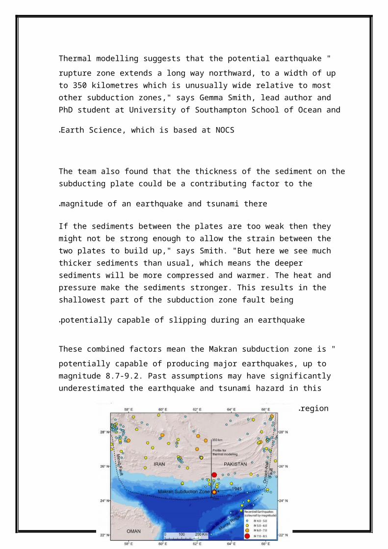
**The photo above shows the location of the Makran subductionzone of Pakistan and Iran and locations of recorded earthquakes including the 1945 magnitude 8.1 earthquake (red dot to the north indicates the 1947 magnitude 7.3 earthquake). The profile for the thermal modelling of this study is the north-south trending black line, with distance given along the profile from the shallowest part of the subduction zone in the south (0 kilometres) to the most northern potential earthquake rupture extent (350 kilometres).
In My opinion : The risk of earthquake and tsunamis devastating the coastlines along the western Indian Ocean is greater than previously thought
Coastlines of Pakistan, Iran, Oman, India and potentially further afield could be at an increased risk, the researchersreport, suggesting than an earthquake similar in magnitude tothe 9.3-magnitude shocker in Sumatra, Indonesia in 2004 could
occur beneath the Arabian Sea and the Makran subduction zone.
Case 2 :
-Earthquake-Generated Tsunamis for the Italian Coast of the Adriatic Sea
Tsunamigenic Source Zones in the Adriatic Sea…
The Adriatic Sea is an elongated basin stretching NW-SE inthe central Mediterranean Sea. It has been struck several times by tsunamis (e.g., AMBRASEYS, 1962; CAPUTO and FAITA, 1984; PAPAZACHOS and DIMITRIU, 1991; SOLOVIEV et al., 2000; MARAMAI et al., 2007; TINTI et al., 2007; see also PAULATTO et al., 2007 for a complete review), most often along the coasts of the Gargano promontory (DE MARTINI et al., 2003; TINTI et al., 2004).The northwestern portion of the Adriatic basin is also the most vulnerable becauseof its large low-topography coastal area extending for over 150 km. This area also hosts the city of Venice, that is particularly vulnerable to sea-level rise. From the regional tectonics standpoint, the Adriatic Sea falls in the middle ofthe Adria plate that is being pushed by Africa northward against stable Europe. Overall, the Adria is affected by active compression and overridden by thrust belts on all sides.The Adriatic Sea is mostly surrounded by active fold-and-thrust belts and strike-slipfaults. Frequent earthquakes occur along these well-known fault zones, most ofwhich run close to the coastlines or in the open sea and are thus potential sources for tsunamis. The largest earthquakes (M > 7) occurred near the eastern margin of the central Adriatic Sea, along the Montenegro portion of the Dinaride-Albanide chain, and at the southern end of the basin near theIonian Islands along the Kefallonia-Lefkada rightlateral shear zone. Most of the remaining structures exhibit a potential for earthquakes of magnitude 6 B M B 7, thereby holding a significant tsunamigenic potential.
** some historical accounts of tsunamis that occurred around the Adriatic basin :
according to GUIDOBONI and TINTI (1988), the tsunami that followed the 1627 Gargano earthquake caused sea withdrawal ofabout 3 km at the mouth of the Fortore River (northern side of Gargano) and an estimated runup of 2–3 m in the town of Manfredonia (southern side of Gargano).
according to contemporary newspapers, an anomalous high tide was observed in the Ancona harbor after the 1930 Senigallia earthquake. An American steamship broke its moorings and struck the docks. A tsunami intensity of 4 is attributed to this event in the Italian Tsunami Catalogue (BOSCHI et al., 2000; MARAMAI et al., 2007; TINTI et al., 2007)
according to SOLOVIEV et al. (2000), no tsunami followed the 1953 Kefallonia earthquake, even if a previous publication, based on press reports, indicated the flooding of the port ofVathi (Lefkada Island). In any case, flooding of the port wasascribed to a local landslide and was hence not a direct effect of seafloor displacement.
a minor disturbance was recorded at the tide gauge of Split following the 1962 Makarska earthquake (HERAK et al., 2001)
although PAPAZACHOS and PAPAZACHOU (1997) report that after the 1979 Montenegro earthquake a ship sank and several houseson the waterfront were eradicated, at Boka Kotorska (Montenegro) the tide gauges recorded a sea wave of just 6 cm. Other disturbances were noted at the tide gauges of Dubrovnik and Bari (BEDOSTI and CAPUTO, 1986; SOLOVIEV et al., 2000).
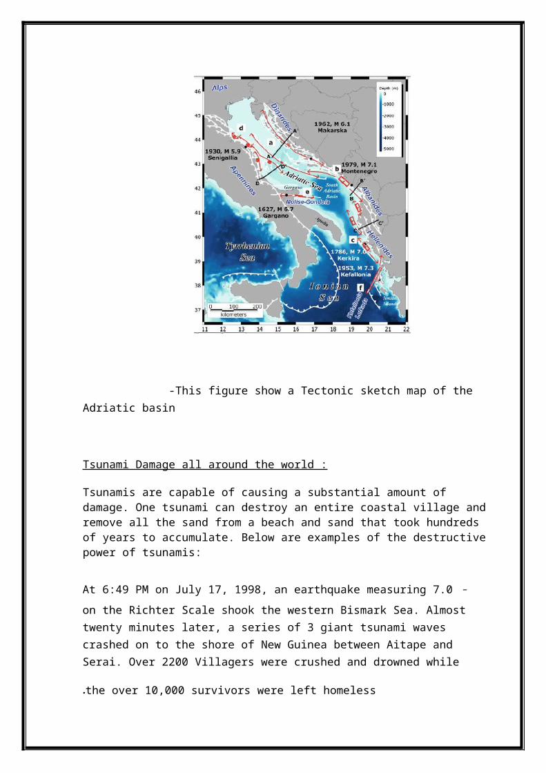
-This figure show a Tectonic sketch map of the Adriatic basin
Tsunami Damage all around the world :
Tsunamis are capable of causing a substantial amount of damage. One tsunami can destroy an entire coastal village andremove all the sand from a beach and sand that took hundreds of years to accumulate. Below are examples of the destructivepower of tsunamis:
-At 6:49 PM on July 17, 1998, an earthquake measuring 7.0 on the Richter Scale shook the western Bismark Sea. Almosttwenty minutes later, a series of 3 giant tsunami waves crashed on to the shore of New Guinea between Aitape and Serai. Over 2200 Villagers were crushed and drowned while
the over 10,000 survivors were left homeless.
- On june 26,1941, one of the strongest earthquakes ever recorded in Malaysia with magnitude 7.7 is known to have generated a tsunami that killed 5000 people along the east coast of india
-On May 22, 1960, at 19:11 GMT, an earthquake occurred off the coast of South Central Chile. A Pacific-wide tsunami wastriggered by the earthquake, which had a surface-wave magnitude of 8.6, an epicenter of 39.5° S, 74.5° W, and a focal depth of 33 km. The number of fatalities associated with both the tsunami and the earthquake has been estimated to be between 490 to 2,290. Damage cost estimates were over a half billion dollars. After the tsunami had passed the Hawaiian Islands damage costs were estimated at $24 million and 61 people had died. Hilo, on the main island of Hawaii, was the hardest hit city in the islands. The tsunami arrivedat Hilo 14.8 hrs after the it originated off the coast of South Central Chile. The - at Hilo was measured at 10.7 m
-On November 29, 1975, an earthquake with an intensity of 7.2 shook the town of Kalapana, Hawaii. Within a few minutes, a 47-foot tall tsunami crushed the town, resulting in property damage of over 4.1 million dollars
and claiming the lives of two innocent people.
- on September 2 , 1992 , Nicaragua earthquake with magnitude7.2 generated tsunamis that caused extensive damage on the Pacific coast of Nicaragua and caused at least 170 causalities
-on 26 , December,2004 , the massive earthquake and subsequent tsunamis devastated much of the coast of south andsoutheast asian countries , the death toll reached over 300,000 with another 500,000 injured and many more homeless.
-On 28 March 2005, 3 months after the 2004 Indian Ocean tsunami, another great earthquake (M 8.6) occurred near Nias Island off west Sumatra, Indonesia, just to the southeast of the source area of the 2004 Sumatra–Andaman earthquake.
-On 29 September 2009, a great earthquake (M 8.1) occurred near the Samoa Islands and generated a major tsunami. The maximum tsunami runup was more than 20 m (OKAL et al., 2010) and caused nearly 2,000 casualties in American Samoa, WesternSamoa, and Tonga.
-In West Papua, Indonesia, two successive large earthquakes (M 7.7 and 7.4) occurred on 3 January 2009; they were 3 h apart and both caused noticeabletsunamis. A tsunami warning was issued for the coasts of Indonesia and Japan
-The 13 October 1963 Kuril earthquake (M 8.5) was one of the largest plate-boundary earthquakes along the Kuril–Kamchatka subduction zone in theNorthwest Pacific. A similar great plate-boundary earthquake (M 8.3) occurred on 15 November 2006, and an outer-rise earthquake (M 8.1) occurred on 13January 2007 just to the north of the 1963 earthquake source region.
-The 27 March 1964 Alaska earthquake (M 9.2) triggered a series of subaerial and submarine failures around nearby fjords, which produced a number of locally destructive slide-generated tsunamis.
And many of the cases and similar disasters occurred invarious countries around the world.
Conclusion
The twentieth century has witnessed an increased interest in the scientific study of earthquakes. Earthquake research occurs worldwide and is especially active in the areas affected by earthquakes, including Japan, the United States, Europe, Russia, Canada, Mexico, China, Central and South
America, New Zealand, and Australia, among others .earthquakes and tsunamis Has caused many of damage, such as loss of people, and many of pepole losing their homes, also physical and psychological damage, environmentel damage , It is very necessary to raise awareness around the world about how to work with thisnatural disaster occurs and how to behave with them to
reduce as much as possible of losses.
References
1. "Civil nuclear power at risk of tsunamis" , Natural hazards articles , Joaquin Rodriguez-Vidal, Jose M.Rodriguez-Llanes, Debarati Guha-sapir , volume 63 , Issue 2 , pp 1273-1278 , sep 2012 .
2. "Thermal structure and megathrust seismogenic potential of the Makran subduction zone" , Geophysical Research Letters, Gemma L. Smith, Lisa C. McNeill, Kelin Wang, Jiangheng He, Timothy J. Henstock , first article , apr 2013.
3. ‘‘Tsunamis in the World Ocean: Past, Present, and Future. ", KENJI SATAKE, ALEXANDER RABINOVICH, UTKU KA NOG LU, and STEFANO TINTI, Volume I, Issue 186, pp 963 –968, 2011.
4. "Thermal constraints on the frictional conditions of the nucleation and rupture area of the 1992 Nicaragua tsunami earthquake", Heesemann. Martin, Grevemeyer. Ingo, Villinger. Heinrich, Geophysical Journal International, Volume 179, Issue 3, pp. 1265-1278
5. "Scenarios of Earthquake-Generated Tsunamis for the Italian Coast Of the Adriatic Sea", MARA MONICA TIBERTI, STEFANO LORITO, ROBERTO BASILI, VANJA KASTELIC, ALESSIO PIATANESI, and GIANLUCA VALENSISE, Tsunami Science: Four Years After the 2004 Indian Ocean Tsunami, Part 1, volume 165 , pp 2117–2142 , 2009.
6. "Indian Ocean tsunamis: environmental and socio-economicimpacts in Langkawi, Malaysia ", Bird, M., Cowie, S., Eong Ong, J., Hawkes, A., Horton, B.P., Tan Shau Hwai, A., Macgregor, C., Tiong Sa, T., Yasin, Z, The Geographical Journal , volume 173, Issue 2 , pp 103-117,june 2007.
Content
1) Abstract2) Introduction3) definition the concept of earthquakes4) definition the concept of tsunamis5) How do earthquakes generate tsunamis
- How it is work?6) How safe the coastal line from tsunamis7) Magnitude and intensity8) Tsunamis without earthquakes9) geographic region are at risk for tsunamis:
(nuclear power and tsunami).- a nuclear power in China- The ghost of Fukushima- How Safe Is Nuclear Power?
10) Some Cases that are occurred the reason of tsunamis
- Case 1 .- Case 2 .
11) Tsunami Damage all around the world12) Conclusion13) References