M/S. GUJARAT MARITIME BOARD
271
D R A FT T E R R E S T R I A L E N V I R O N M E N T A L I M PA C T A S S E S S M E N T t r s z Æ Æ P R E P A R E D B Y M s S V E N V I R O L A B S C O N S U L T A N T S V i s a k h a p at n a m P h o n e F ax E m a i l s ve n v i r o_l a b s @ yah ooc oi n R e c og ni z e db y M oE F a n dQ C I –A c c r e di t e d S N o
-
Upload
khangminh22 -
Category
Documents
-
view
0 -
download
0
Transcript of M/S. GUJARAT MARITIME BOARD

DRAFT TERRESTRIAL ENVIRONMENTAL
IMPACT ASSESSMENT
Dec’ 2018
M/S. GUJARAT MARITIME BOARD (Incorporation of service jetties and allied facilities at
Rozi Pier Port, Jamnagar, Gujarat)
PREPARED BY
M/s. SV ENVIRO LABS & CONSULTANTS
Visakhapatnam
Phone: 0891-2755528, Fax: 0891-2755529
Email: [email protected]
Recognized by MoEF, and QCI –Accredited, S.No.145

DRAFT TERRESTRIAL ENVIRONMENTAL
IMPACT ASSESSMENT
For
Incorporation of service jetties and allied facilities
At
Rozi Pier Port, Jamnagar, Gujarat
(October, 2018)
PREPARED BY
M/s. SV ENVIRO LABS & CONSULTANTS
Visakhapatnam
Phone: 0891-2755528, Fax: 0891-2755529
Email: [email protected]
Recognized by MoEF, and QCI –Accredited, S.No.145

DECLARATION BY PROJECT PROPONENT
Gujarat Maritime Board (GMB) has conducted the “EIA study on
Incorporation of service jetties and allied facilities at Rozi Pier Port,
Jamnagar, Gujarat”.
The EIA report preparation has been undertaken in compliance with the ToR
issued by MoEF&CC. Information and content provided in the report is factually
correct for the purpose and objective for such study undertaken.
We hereby declare the ownership of contents (information and data) of EIA/EMP
report.
For on behalf of Gujarat Maritime Board
Signature:
Name: Mr. Atul A. Sharma
Designation: Deputy General Manager - Environment

DECLARATION BY EIA CONSULTANT
EIA study on “Incorporation of service jetties and allied facilities at Rozi Pier
Port, Jamnagar, Gujarat”.
This EIA report has been prepared by SV Enviro Labs & Consultants, in line with EIA
Notification, dated 14th September 2006, seeking prior Environmental Clearance from the
Ministry of Environment, Forests and Climate Change, New Delhi.
This work has been undertaken in accordance with ISO 9001:2008 Quality Management
System with all reasonable skill, care and diligence within the terms of the contract with the
client, incorporating our General and Terms & Conditions of Business and taking account of the
resources devoted to it by agreement with the client.
We disclaim any responsibility to the client and others in respect on any matters outside the
scope of the above.
Further, this report is confidential to the client and the use of this report by unauthorized third
parties without written authorization from SV Enviro Labs & Consultants shall be at their own
risk.
For and on behalf of SV Enviro Labs & Consultants
Approved by : M. Murali Krishna
Sign :
Designation : Managing Partner

DECLARATION BY EIA CONSULTANT
Declaration by Experts contributing to the EIA for “Incorporation of service jetties and
allied facilities at Rozi Pier Port, Jamnagar, Gujarat”.I hereby, certify that I was part of the
EIA team in the following capacity that developed the above EIA.
EIA Coordinator: In-House
Name: Shaik Kasim
Signature:
Date:
Period of Involvement: December’ 2017 to February’ 2018
Contact Information: M/s. SV ENVIRO LABS & CONSULTANTS
Enviro House, B-1, B-Block, IDA,
Auto Nagar, Visakhapatnam-12
Phone: 0891-2755528, Fax: 0891-2755529
Email: [email protected]

Functional Area Experts:
S.No Functional
Areas
Name of the Expert Category as per NABET
Involvement
(Period and task**)
Signature and Date
1 AP * M. Murali Krishna
V. Hema Latha
(TM)
K. Anitha (TM)
A Air Pollution monitoring, prevention & control
2 WP * M. Murali Krishna
V. Hema Latha
(TM)
A Water Pollution monitoring, prevention & control
3 SHW * Shaik Kasim
K. Anitha
A Solid waste management
4 SE * Dr. B. Vijay
Bhaskara Rao
A Socioeconomic studies
5 EB * Dr. M. Tarakeswara
Naidu
A Ecology and Bio-diversity
6 HG * Dr. G.V.A
Ramakrishna
A Hydrology
7 GEO * Dr. G.V.A
Ramakrishna
A
Geology

8 SC * D. Sunder Rao
Dr. M. Tarakeswara Naidu (TM)
A Soil conservation
9 AQ * M. Murali Krishna
A Air quality modelling
10 NV * M. Murali Krishna A Noise and vibration
11 LU * Jada Srinivasa Rao A Land use studies
12 RH * Shaik Kasim
V. Hema Latha
(TM)
A Risk and hazard study

Declaration by the Head of the Accredited Consultant Organisation / Authorized person
I, M. Murali Krishna, hereby, confirm that the above mentioned experts prepared the EIA report
as per the projects inputs prepared by GMB for the proposed “Incorporation of service jetties
and allied facilities at Rozi Pier Port, Jamnagar, Gujarat”.
I also confirm that the consultant organization shall be fully accountable for any misleading
information mentioned in this statement.
Signature:
Name: M. Murali Krishna
Name of EIA Consultant Organization: M/s. SV ENVIRO LABS & CONSULTANTS
Enviro House, B-1, B-Block, IDA,
Auto Nagar, Visakhapatnam-12
Phone: 0891-2755528, Fax: 0891-2755529
Email: [email protected]

[DRAFT TERRESTRIAL ENVIRONMENTAL IMPACT ASSESSMENT] GUJARAT MARITIME BOARD
1
Executive Summary
INTRODUCTION
Gujarat Maritime Board (GMB) is the first maritime board of India, established in the year 1982
as a statutory organization of Government of Gujarat (GoG), under the Gujarat Maritime Act
1981. It was established for facilitating the port development, privatization, manage, control and
administer the intermediate and minor ports in Gujarat in the way of specialized cargo handling
approach.
GMB has explored many unexplored routes for the development of ports in India, with a vision
“to enhance and hardness ports and international trade as vehicles for economic development”.
The Rozi Pier- a port of Group of Ports is classified as Minor Port situated in Jamnagar. The
port has capability to explore both commercial and geographical advantages. Bedi Group of
Ports offers an ideal location for handling agricultural products, coal, and bauxite. Among the
fertilizer products, fertilizer and its raw materials are generated imported through this port. The
Rozi Pier is a part of Group which is situated in Jamnagar itself which is about 275 km from
Ahmedabad in Gujarat.
M/s. Gujarat Maritime Board has appointed SV Enviro Labs & Consultants, Visakhapatnam for
preparation of EIA Report for proposed project in order to seek Environmental Clearance. SV
Enviro Labs & Consultants is a QCI-NABET accredited EIA consultancy organization for
“Ports, Harbours”. Obtained ToR Vide F.No: 10-44/2017-IA.III Dt: 07.09.2017.
Existing infrastructure
Total 800m long water front available for lighterage working at Rozi Pier Port. Out of that total
500m water front was developed by constructing wharf/Jetty with adequate back up area.
Following berthing facilities were developed by GMB in early 90’s.
Status berthing facilities Length Draft available Cargo handling capacity in MMTA
CC Block wharf (Western Part)
100.0m 2.5m 1.5
Gap (Abandoned work for CC Block wharf)
300.0m 2.5m 1.5 (can be handled if there would have been wharf)

[DRAFT TERRESTRIAL ENVIRONMENTAL IMPACT ASSESSMENT] GUJARAT MARITIME BOARD
2
RCC Piled Jetty (Eastern Part)
400.0m 2.5m 2
Total 800.0m 2.5m 5
Project Proposal
Gujarat Maritime Board proposes for incorporation of service jetties and allied facilities at Rozi
Pier Port, Jamnagar, Gujarat. The proposed facilities are:
(i) To the existing 400m piled jetty and 100m wharf will be expanded by having
additional 300m wharf by reclamation and CC Block wall.
(ii) Construction of boat jetty of 105m length and 7m (which includes 50m marine
police jetty, 30m forest jetty, 25m GMB jetty) and backup area of 56.3sq.m with
78m of retaining wall and approach bond of 230m length and 7m wide.
(iii) Development of 1000m x 30m backup area.
Project Location
The proposed wharf terminal is located at Rozi Port, Tal: Jamnagar, Dist: Jamnagar, Gujarat
along the Saurashtra coastal region facing Arabian Sea in the west coast India. The latitude and
longitude of the site is 22°34´1.68"N and 70°2´23.94"E respectively.
Total anticipated cargo for whole 800.0m water front is considered about 6 million ton per
annum. Hence, for 400.0m pile jetty, 3 MMTA is considered and rest 400.0m wharf wall, 3
MMTA is considered.
Backup area behind berthing facilities is developed by reclamation for cargo stacking and to
create other relevant facilities like mechanized handling, storage area etc.
The process development of Rozi Pier started before 1989. As a part the process, 400.0m wharf
to handle about 3 million metric ton cargo per annum was planned on the traffic demand of
experienced at that time based on the technical guidance of Central Water & Power Research
Station, Pune. The wharf facility as planned for lighterage operation with natural depths of
about -2.5 at Chart Datum. Out of these 400.0m wharf length, contractor abandoned the work
due to contractual dispute with GMB and only 100.0m wharf (now operated by M/s Ruchi
Infrastructure in western side) was able to be completed and remaining 300.0m waterfront was
left unattended by the contractor at that time in line with existing pile jetty having length of

[DRAFT TERRESTRIAL ENVIRONMENTAL IMPACT ASSESSMENT] GUJARAT MARITIME BOARD
3
400.0m in eastern side. Thus, the proposed landing facility admeasuring 300.0m in water front
length at Rozi Pier which will be created by filling the gap between existing wharf having
100.0m waterfront (Ruchi Infrastructure) and existing pile jetty of 400.0m length. Net filing of
this gap will be 300.0m x 170.0m breath by reclamation in back up and construction of CC
Block wall as waterfront will constitute to 300.0m wharf facility will increase about 1 million
TPA capacities. In fact, this is a proposal to reconstruct a abandoned work of wharf of 300.0m
shall increase cargo handling facility of the terminal of total 400.0m long wharf for 3 MMTA.
Map showing the location of Rozi Pier Port facility
Structure of EIA Report
The Environmental Impact Assessment Documentation has been prepared in terms of EIA
notification of the MoEF dated 14-9-2006, as amended on 1st Dec 2009, 4th April 2011 and
approved ToR for seeking Environmental Clearance for M/s Gujarat Maritime Board, for

[DRAFT TERRESTRIAL ENVIRONMENTAL IMPACT ASSESSMENT] GUJARAT MARITIME BOARD
4
incorporation of service jetties and allied facilities at Rozi Pier Port, Jamnagar, Gujarat falling
under Category –A.
Description of Environment
The coastal environment of the Rozi Pier port area forms an integral part of the Gulf. Hence, the
knowledge of the general hydrography and ecology of the Gulf is necessary for comparing the
site-specific environmental conditions with that of the parent body. The Gulf which occupies an
area of 7300km2 has maximum depth that varies from 20m at the proposed project to 60m in the
central areas of the outer Gulf.
Based on the ToR approval, the baseline environmental settings have been studied by
undertaking one season terrestrial monitoring and one season marine monitoring within the study
area of 10km radius from project site boundary. The study area represents the details of the
environment in the 10km radius from the boundary of the proposed project site. The study area
has been divided into two; core zone and buffer zone. The area that covers the 5km radial
distance around the project site is considered as the core zone and the area that covers the 5km to
10km from the boundary of project site is considered as the Buffer zone. For collecting primary
data collection. 10km study area has been considered and the secondary data has been collected
for 10 km study area.
The primary baseline environmental conditions were mentioned during the period of December’
2017 to February’ 2018. The environmental conditions were analysed by collecting the sample
data for air & meteorology, noise, water, soil, terrestrial ecology, flora & fauna, marine
physiology, marine biology and socio-economic environment. The terrestrial monitoring and
marine monitoring has been carried out in the study area during winter season.
Terrestrial Environment
As per our seeking towards areas of critical concern for environmental control such as flood
plains and wetlands, energy resource development and production areas, wildlife habitat,
recreational lands and areas such as major residential and industrial development sites, we
require the analysis of Land Use Land Cover for the proposed project.The following prominent
land use classes &pattern have been observed:

[DRAFT TERRESTRIAL ENVIRONMENTAL IMPACT ASSESSMENT] GUJARAT MARITIME BOARD
5
LULC Statistics Sl No LULC_Class Area (Ha) Area (%)
1 WaterBodies 1736.52 6% 2 Settlment 1424.28 5% 3 Sea 10200.92 32% 4 RoadNetwork 1598.84 5% 5 Open Scrub 1483.68 5% 6 Agricultural Fallow Land 1290.34 4% 7 Mangrove Swamp 6012.68 19% 8 Mud 2616.22 8% 9 Dry Land 2213.11 7%
10 Saltpan 2112.68 7% 11 Fallow Land 812.68 3%
31501.94 100.00
The pH of the soil is an important property; vegetation cannot grow in low and high pH value
soils. The normal range of pHin the soils are 6.0 to 8.5. The pH values in the study area are
varying from 7.40 to 8.04 indicating that the soils are falling slightly alkaline soil.
Nitrogen encourages the vegetative development of plants by imparting a healthy green color to
the leaves. The available Nitrogen as N in the study area is varying from 52.4 to 65.4 kg/ha. This
is less for crops when compared with soil standards.
Phosphorus influences the vigour of plants and improves the quality of crops. In the study area
available, Phosphorus was found in varying quantities of 16.2 to 28.1 kg/ha. This is an less level
when compared to soil standards.
Potassium enhances the ability of the plants to resist diseases, insect attacks, cold and other
adverse conditions. The available potassium in the study area varies between 48.5 to 52.4 mg/kg.
This is less level for crops.
To evaluate the baseline ambient air quality status, one season data was generated at ten
locations in and around the port including residential & rural area for a period of three months
from December’ 2017 and February’ 2018. During the monitoring period the concentration of air
pollutants namely PM10, PM2.5, SO2, NOx,CO in ambient were measured.The highlights of the
results are as below:

[DRAFT TERRESTRIAL ENVIRONMENTAL IMPACT ASSESSMENT] GUJARAT MARITIME BOARD
6
Summary of Analysis of Ambient Air Quality in the Study Area
Parameter PM10(µg/m3) PM2.5(µg/m3) SO2(µg/m3) NOx(µg/m3)
Monitoring Station
No.
of s
ampl
es
Max
imum
Min
imum
Mea
n
98th
per
cent
ile
No.
of s
ampl
es
Max
imum
Min
imum
Mea
n
98th
per
cent
ile
No.
of s
ampl
es
Max
imum
Min
imum
Mea
n
98th
per
cent
ile
No.
of s
ampl
es
Max
imum
Min
imum
Mea
n
98th
per
cent
ile
A1 26 81.5 66.8 73.0 81.1 26 43.2 32.6 38.3 42.9 26 18.5 15.1 16.9 18.5 26 17.4 14.6 15.9 17.2
A2 26 68.2 55.1 62.3 67.7 26 33.6 24.6 28.5 32.8 26 16.9 14.1 15.6 16.9 26 15.6 13.1 14.7 15.6
A3 26 63.4 52.1 58.2 62.8 26 27.6 22.4 24.7 27.3 26 16.2 13.2 14.4 15.9 26 15.3 12.3 13.8 15.1
A4 26 64.2 54.8 59.8 63.5 26 29.4 23.9 27.3 29.3 26 15.9 13.6 14.7 15.9 26 15.2 13.4 14.4 15.2
A5 26 66.5 57.2 62.4 66.2 26 29.3 24.2 27.1 29.3 26 15.4 13.5 14.4 15.4 26 14.6 12.5 13.7 14.6
A6 26 65.8 58.7 62.2 65.8 26 31.4 24.1 27.7 31.1 26 16.2 13.1 14.7 16.1 26 15.8 12.5 14.0 15.6
A7 26 67.2 55.9 60.7 66.0 26 34.2 20.9 27.9 32.9 26 15.8 13.2 14.4 15.7 26 14.9 12.6 13.8 14.9
A8 26 68.2 56.8 63.4 68.2 26 31.5 24.1 27.5 31.2 26 16.4 12.9 14.6 16.3 26 15.9 13.5 14.6 15.9
A9 26 81.5 66.8 73.0 81.1 26 43.2 32.6 38.3 42.9 26 18.5 15.1 16.9 18.5 26 17.4 14.6 15.9 17.2
A10 26 68.2 55.1 62.3 67.7 26 33.6 24.6 28.5 32.8 26 16.9 14.1 15.6 16.9 26 15.6 13.1 14.7 15.6
NAAQS 100(µg/m3) 60(µg/m3) 80(µg/m3) 80(µg/m3)
Note : Carbon monoxide were monitored at all locations and were found < 0.5mg/m3

[DRAFT TERRESTRIAL ENVIRONMENTAL IMPACT ASSESSMENT] GUJARAT MARITIME BOARD
7
Ambient noise levels were measured at eight locations in and around the plant site. Noise levels
varied from 50.2 LeqdB(A) to 70.3 LeqdB(A) during day time and 39.9 to 65.9 Leq dB(A)
during night time.
All the results observed where within the specified CPCB Standards. The variation in the noise
level may be attributed to the movement of vehicles on the surrounding local roads adjacent to
the port.A little increase in the noise level during construction phase has been envisaged.
During the study period, the pH of the groundwater was found varying between 7.20 and
8.20.The total dissolved solids (TDS) were found to be varying between 1485 mg/l and 2486
mg/l.The Chloride levels were ranging from 461 – 862 mg/l, hardness was found to be varying
from 300 mg/l to1230 mg/l, fluoride values were found to be within a range of 0.01 mg/l to 0.07
mg/l.
According to Champion and Seth's, vegetation in study area falls under Tropical dry forest. This
type of forests occurs in a much localized manner in small pockets. The most dominant trees in
this region are Prosopis juliflora,Acacia nilotica, Acacia Senegal and other trees are Balanites
aegyptiaca, Azadirachta indica, Ficus sp, Bordi (Zizyphus mauritiana) etc.
During the floristic survey of study area, a total of 136 plant species wererecorded consisting of
18 trees, 69 herbs and 9 shrubs and 14 climbers, 24 Grasses. The list of different plant species
(trees, shrubs, herbs, climbers and Grasses) recorded during field survey is enlisted. The most
common species found instudy area are Azadirachta indica, Ficus bengalensis, Ficus religiosa,
Eucalyptus sp. and Tamarindus indica. Dominant family of plants recorded in study area are
Poaceae, Fabaceae, Mimosaceae, Caesalpiniaceae Amaranthaceae, and Convolvulaceae.The list
of different plant species (trees, shrubs, herbs, climbers and Grasses) recorded during field
survey is enlisted.
There are no major wild mammals in the study area of 10 km radius buffer zone where as 9
mammals’ species were recorded from the study area. Among the 9 mammals, 2 species are
schedule II, 1 species is schedule III, 4 species are schedule IV and 2 species is schedule V
category.
Avi-fauna identified in the study area includes Asian koel, Black winged stilt, Black drongo,
black ibis, common coot, cormorants etc.
A primary perception survey was conducted to predict the intended and unintended
consequences in the study area. A method of survey was administered for this study. In this

[DRAFT TERRESTRIAL ENVIRONMENTAL IMPACT ASSESSMENT] GUJARAT MARITIME BOARD
8
connection, samples of 100 participants are participated from the villages of bed, Naghedi
Matva, Chnadraga, Bavariay have been collected by covering various (See table -) age groups,
communities, gender, educational qualification, nature of work, economical status and other
major variable. in this connection, respondents were asked for their awareness/opinion about the
project and also of their opinion about the impacts of the project which is an important aspect of
socioeconomic environment viz. job opportunities, education, health care, housing,
transportation facility and economic status. Apart from the demographical and other primary
information, the survey questionnaire was focused on 41 items with 6 major dimensions such as:
1) Economical; 2) Public Infrastructure and services; 3) Social/cultural; 4) Environmental; 5)
Health and well-being 6) Psychological/personal.
Anticipated Environmental Impacts and mitigation measures
During operation phase, fugitive dust emissions from dry bulk cargo storage yards, vehicular
emissions are the major sources of pollutants that influence the ambient air quality. To determine
the pollution load in the atmosphere, ISCST3 was used with an assumption of 95% pollution
controlled using dust suppression system. The peak predicted increment load of PM2.5 was 42.9
µg/m3, PM10 was 81.5µg/m3. The higher concentration of PM10 was contributed by the loading
and unloading of cargo that happen in and around the saltpans areas which are 2 km away from
the proposed project.
Impact on noise environment due to port operation is assessed as per ISO 9613 and the results
were found insignificant outside the port limits.
No extraction of ground water and waste water generated from the bathing and washing of the
construction workforce will be properly treated before disposal. Skid mounted sewage treatment
plant of adequate capacity will be used for treatment of waste water. Treated water shall be used
for sprinkling purpose, if it meets the prescribed land disposal requirements.
The proposed facilities shall be installed within the premises of Rozi pier port. There is no
additional point and non-point source of emission or discharge of pollutants except DG and fire
pumps hence, no adverse impact on the biological environment is envisaged due to the proposed
project activities and operation.

[DRAFT TERRESTRIAL ENVIRONMENTAL IMPACT ASSESSMENT] GUJARAT MARITIME BOARD
9
Environmental Monitoring Program
An Environmental Management Plan (EMP) is an implementation plan consisting of mitigation
measures, Environmental monitoring program and institutional measures which are required to
be adopted during the construction and operation phases to minimize adverse environmental and
social impacts.
To maintain the environment in good condition, periodic environmental monitoring program has
been suggested for various activity involved during construction and operation phase. A
monitoring schedule with respect to Ambient Air Quality, Waste water quality, Noise Quality
prepared as per SPCB/CPCB/MoEF & CC guidelines.
Environmental Management Plan
Environmental Management Plan (EMP) is planning and implementation of various pollution
abatement measures for any proposed project. The EMP lists out all these measures for planning
phase, construction phase and operational phase of the port.
The proposed project shall be designed taking into account all the legislations/rules and as per
the directives of Environmental clearance documents.
The control of Environmental pollution during construction phase even though for a shorter
period is of vital importance. The required mitigation measures with complete details have been
considered in order to develop effective mitigation measures.
The Environmental Management Plan during the operational phase of the port shall therefore be
directed towards the following:
Air Emissions Management
Control of Noise
Waste water management
Waste Management
Dredged materials management
Hazardous material and oil management
Biodiversity management
Green belt development
Energy conservation measures
Environment Management Cell

[DRAFT TERRESTRIAL ENVIRONMENTAL IMPACT ASSESSMENT] GUJARAT MARITIME BOARD
10
PROJECT BENEFITS
The proposed project “Incorporation of service jetties and allied facilities” is expected to bring
economic, social and environmental benefits to the town and surrounding areas during the
construction and operational phases. This project is proposed to increase the cargo handling
capacity of the port in order to meet the increasing demand of raw materials in the nearby
industrial areas. This would result in generation of revenue for the government in terms of taxes
from the proposed project and resultant industrial development from the proposed project.
The proposed project proposes to create direct opportunities for both skilled and unskilled jobs
during the construction and operations phase. The backward and forward linkages will also lead
to indirect employment generation to support the project. The project will require procurement
and vendor networks for products and services, transport etc and hence there should be
additional revenue generation for local vendors and suppliers in Jamnagar.
This is expected to create short to medium-term employment opportunities for a considerable
number of personnel. Approximately 200 persons would be required of unskilled, semi-skilled
and skilled nature during construction phase. Although skilled workforce coming from outside
the immediate area will undertake some proportion of the work, the project will try to offer
employment to people of Jamnagar.
The proposed Rozi Pier Port developed by Gujarat Maritime Board which will take up some
community welfare activities under Corporate Social Responsibility (CSR) and also improve the
social infrastructures like education and health care system etc.
Project Cost:
The total cost of the project – Rs. 71.15 Crores and time of completion is 24 months after
obtaining Environmental Clearance and Coastal Regulatory Zone clearance from MoEF&CC and
obtaining Consent to Eastablishment (CTE) from GPCB.

[DRAFT TERRESTRIAL ENVIRONMENTAL IMPACT ASSESSMENT] GUJARAT MARITIME BOARD
11
INDEX
S.No TITLE PAGE No. 1 Executive Summary 1
Chapter -1:- Introduction 1.0 Introduction 19 1.1 Port History 19 1.2 Location of the project 19 1.3 Facilities available at Rozi Pier Port 21 1.4 The initiatives 21 1.5 Proposed project development 21 1.6 Applicability of CRZ 25
1.7 Site connectivity 25 1.8 Legal cases 26 1.9 Need for the EIA study 26
1.9.1 Study area for EIA 26
1.9.2 Methodology for EIA study 26
1.10 Limitations 27
1.11 Chapters and structures of this report 27
Chapter -2 :-Project Description 2.0 Project Description 29 2.1 General Description of Port 29
2.1.1 Existing infrastructure 29 2.2 Type of project 30 2.3 Proposed location 31 2.4 Backup area available for infrastructure Development 32 2.5 Berthing operation conditions 33 2.6 Design of the 300m long wharf 33 2.7 Construction material 33
2.8 Navigation Configuration 34 2.9 Cargo Potential 34
2.10 Port facilities planned 35 2.11 Port connectivity and road networking 35 2.12 Government of India policy for Coastal shipping 36 2.13 HTL/LTL Demarcation 36
2.14 Availability of water its source, energy /power requirement and source
36
2.14.1 Water requirement 36 2.14.2 Energy/Power requirement 37 2.15 Quantity of wastes to be generated and scheme for their 37

[DRAFT TERRESTRIAL ENVIRONMENTAL IMPACT ASSESSMENT] GUJARAT MARITIME BOARD
12
management/disposal
2.15.1 Solid waste generation & its disposal 37 2.15.2 Liquid effluent 37 2.16 Employment generation 37 2.17 Need for the project to the country 37
2.17.1 Demand-supply gap 37 Chapter -3: Analysis Of Alternatives
3.1 General 38 3.2 Alternate Sites 38
Chapter -4:-Description Of The Environment 4.0 Introduction 39 4.1 Study Area 40 4.2 Methodology of Eia Study 40 4.3 Micro-meteorological data 42
4.3.1 Site specific met data 44 4.4 Air environment 46
4.4.1 Existing ambient air quality 50 4.5 Water environment 52
4.5.1 Surface and ground water quality assessment 52 4.5.2 Selection of sampling locations 52 4.5.3 Sampling techniques 54 4.5.4 Groundwater quality 56
4.6 Soil environment 59 4.6.1 Selection of sampling locations 60 4.6.2 Sampling and analytical techniques 60 4.6.3 Summary of soil analysis data 63 4.7 Noise environment 64
4.7.1 Identification of sampling locations 64 4.7.2 Methodology 64 4.7.3 Description Of Locations 66 4.7.4 Summary Of Noise Levels 66 4.7.5 Observations 68 4.8 Geomorphology 69 4.9 Seismicity And Associated Hazards 70
4.10 Hydrogeology 71 4.10.1 Depth To Water Level 72 4.10.2 Long Term Water Level Trend 73 4.11 Biological Environment 74
4.11.1 Introduction 74 4.11.2 Objectives 75 4.11.3 Ecologically Sensitive Zone 75
4.11.3.1 The Gulf Of Kutch Marine National Park And Sanctuary 75 4.11.4 Study Area 76

[DRAFT TERRESTRIAL ENVIRONMENTAL IMPACT ASSESSMENT] GUJARAT MARITIME BOARD
13
4.14.5 Terrestrial Ecology 78 4.14.6 Methodology 78
4.14.6.1 Floral Survey 78 4.14.6.2 Faunal Survey 80 4.14.7 Observations 82
4.14.7.1 Floral Characteristics 82 4.14.7.2 Faunal Diversity 87
4.14.7.2.1 Mammals 87 4.14.7.2.2 Domestic Animals 88 4.14.7.2.3 Birds 88
4.14.7.2.4 Herpetofauna 93 4.15 Land Use/Land Cover 97
4.15.1 Introduction 97 4.15.2 Study Area 97 4.15.3 Social Infrastructure 98 4.15.4 Surrounding Features 98
4.15.5 Data Acquisition 98 4.15.5.1 Topographical Data 98
4.15.5.2 Satellite Data 98
4.15.6 Methodology 98
4.15.7 Flow Chart Of Methodology 101
4.15.8 Land Use Map Analysis 101
4.15.9 Spatial Data From SOI Topographical Sheets 102
4.15.10 Map For Project Location On Toposheet 102
4.15.11 National Park/Wild Life Sanctuary/Reserve Forest Within 10 Km
Radius Of The Project
106
4.15.12 Map For The Land Use Land Cover In The Study Area 106
4.15.13 Map For The Digital Elevation Model And Contour In The Study
Area
109
4.15.14 Impacts& Mitigation Measures 109 4.16 Socio Economic Environment 112
4.16.1 Overview 112 4.16.2 Demographicstructure 112 4.16.3 Literacy & Education 114 4.16.4 Health 115
4.16.5 Livelihood 116 4.16.6 Community Perception 117 4.16.7 Infrastructure Facilities In The Study Area 118

[DRAFT TERRESTRIAL ENVIRONMENTAL IMPACT ASSESSMENT] GUJARAT MARITIME BOARD
14
4.16.8 Education 118 4.16.9 Water Facility 118
4.16.10 Communication And Transportation 118 4.16.11 Power Supply 118 4.16.12 Medical/Primary Health Care 118 4.16.13 Economic attributes 119 4.16.14 Health Status 119 4.16.15 Cultural And Aesthetic attributes 119 4.16.16 Community Perception And Impact Of Various Domains 120 4.16.17 Economical Impact 120 4.16.18 Social & Cultural Impacts 120 4.16.19 Health & Wellbeing Impacts 121 4.16.20 Public Infrastructure & Services 121
4.16.21 Psychological And Personal Impact 121 4.16.22 Other Impact Factors Of Socio-Economic environment 122
4.16.22.1 Construction phase 122 4.16.22.2 Operational phase 122 4.16.23 Need Assessment: 122
Chapter -5:- Impacts &Mitigation Measures
5.1 Introduction 126 5.2 Impact on air environment 126
5.2.1 Construction phase 126 5.2.2 Operation Phase 127 5.2.3 Mitigation Measures 127 5.3 Impact on noise environment 128
5.3.1 Construction phase 128 5.3.2 Operation Phase 129 5.3.3 Mitigation Measures 129 5.4 Impact on water environment 129
5.4.1 Construction phase 129 5.4.2 Operation Phase 130 5.4.3 Mitigation Measures 130 5.5 Impact on land environment 130
5.5.1 Mitigation Measures 131 5.6 Impact due to solid/Non-Hazardous domestic waste generation 131
5.6.1 Mitigation Measures 131
Chapter -6:-Environmental Management Plan 6.1 Introduction 132 6.2 Environment Management System 132
6.2.1 Management Commitment 133 6.2.2 Environmental Impacts Identification and EMP Formulation 134 6.2.3 Organization Structure, their Roles and Responsibilities 134

[DRAFT TERRESTRIAL ENVIRONMENTAL IMPACT ASSESSMENT] GUJARAT MARITIME BOARD
15
6.2.4 Roles and Responsibilities during Construction and Operation 135 6.2.5 Inspection and Monitoring 136 6.2.6 Environmental Management Audits and EMP Reviews 136 6.2.7 Reporting and Documentation 137 6.2.8 Environmental Statement 138 6.3 EMP during Construction Phase 138 6.4 Air Emissions Management 139
6.4.1 Construction Phase 139 6.4.2 Operation Phase 139 6.4.3 Dust 140 6.5 Control Of Noise 141
6.5.1 Construction Phase 142 6.5.2 Operation Phase 142 6.6 Waste Management 142
6.6.1 Construction Phase 142 6.6.2 Operation Phase 142 6.6.3 Health & Safety Management System 143 6.8 Waste Management Plan 143
6.8.1 Port Sewage and Storm water management 143
6.8.2 Waste Management during Construction and Operation Phase 144
6.9 Green Belt Development Plan 145
6.9.1 Selection of species for plantation 145
6.10 Environmental Management Cost 147
Chapter -7:- Environmental Monitoring Programme 7.1 Environmental Monitoring: 148 7.2 Environmental Monitoring and Evaluation Program 148 7.3 Monitoring Schedule for Environmental Parameters 149
Chapter -8:-Project Benefits
8.1 Introduction 153 8.2 Overall benefits 153
8.2.1 Government Revenues 153 8.2.2 Economic Benefits 153 8.3 Benefits During Construction And Operation Phase 153
8.3.1 Employment & Other Benefits 153 8.3.2 Community Services 154 8.4 Social Benefits of the Project 154
8.4.1 Corporate Social Responsibility (CSR) of Rozi Pier Port 154
Chapter -9:- Summary & Conclusions 9.1 Summary & Conclusions 155

[DRAFT TERRESTRIAL ENVIRONMENTAL IMPACT ASSESSMENT] GUJARAT MARITIME BOARD
16
Chapter -10:-Disclosure Of Consultant Engaged 10.1 About SV Enviro Labs & Consultants (SVELC) 156 10.2 Services Offered By SV Enviro Labs & Consultants 156
TABLES
S.No Name of the Table PAGE No. Chapter -2:- Project Description
2.1 Berthing facilities were developed by GMB in early 90’s 29
2.2 Details about Project Site 31 2.3 Construction material required for reclamation of the backup
area
33
2.4 Details of cargo handled at Rozi Pier Port 34
Chapter -3:- Description of Environment 4.1 Summary of Methodology for Primary Baseline Data Collection 41
4.2 Secondary baseline data 42 4.3 Summary of Meteorological Data at near IMD observatory-
Jamnagar 42
4.4 Meteorological data of project site 43
4.5 Techniques and Detectable limits for Ambient Air Quality
monitoring
47
4.6 Location of Ambient Air Quality Monitoring Stations 48
4.7 Summary of analysis of Ambient Air Quality in the study area 49
4.8 Details of water sampling locations in the study area 53
4.9 Standard Operating Procedures (SOP) for water sampling 54
4.10 Analytical techniques for water analysis 55
4.11 Ground Water Quality of the Study Area 57
4.12 Analytical techniques for Soil analysis 60 4.13 Standard soil classification 61
4.14 Details of soil samplings 62
4.15 Summary results of soil samples 62 4.16 Details of noise samplings 65
4.17 Noise levels in the study area 66
4.18 Estimating quantitative structure and composition of plant 79

[DRAFT TERRESTRIAL ENVIRONMENTAL IMPACT ASSESSMENT] GUJARAT MARITIME BOARD
17
communities
4.19 Sampling techniques used for faunal study 81 4.20 List of flora recorded in the study area 82 4.21 List of mammals reported in the study area of buffer zone 87
4.22 Domestic animals in the study area 88 4.23 List of birds observed in the study area 89
4.24 Checklist of Herpeto fauna encountered in the study area 94
4.25 List of butterflies in the study area 95
4.26 Project Surrounding Features 98 4.27 Land use land cover statistics of buffer zone 108
Chapter -6:- Environmental Management Plan
6.1 Species Identified for Plantation 146 6.2 EMP Budget 147
Chapter -7:- Environmental Monitoring Programme
7.1 The monitoring schedule for construction and operation phases 149
ANNEXURE
Annexure-1: HTL-LTL Mapping
Annexure-2: Andhra University Letter
Annexure-3: CWPRS Report

[DRAFT TERRESTRIAL ENVIRONMENTAL IMPACT ASSESSMENT] GUJARAT MARITIME BOARD
18
FIGURES
S.No Name of the Figure PAGE No. Chapter -1:- Introduction
1.1 Location map of Rozi Pier Port 20 1.2 Google map showing Rozi Pier Port 20 1.3 The site photographs of existing Rozi Pier 22
Chapter -2:- Project Description 2.1 Rozi Pier Port site layout 30
Chapter -4:- Description of Environment 4.1 Google image of 5km and 10km radius of the proposed project 40 4.2 Wind rose for the period of December’ 17 to February ‘18 45 4.3 Location map of Ambient Air Quality monitoring 47 4.4 (A-D). Graphical representation of n PM10, PM2.5, SO2 and
NOx 51
4.5 Google map showing water sampling locations 53 4.6 Soil types of Jamanagar district 59 4.7 Locations for monitoring noise levels 65 4.8 A&B. Noise levels in the study area 68 4.9 Geological resources of the Jamnagar district 69
4.10 Seismic map of India 70 4.11 Map showing depth to water level 73 4.12 Photographs of study area 78 4.13 Field survey and data collection in the proposed project areas 81 4.14 Aquatic birds of resident and local migratory category 93 4.15 Butterflies encountered in the study area 96 4.16 Satellite image with site location in 10 km radius 100 4.17 10 km radius of topomap 103 4.18 Showing roads, railways, built-up area in 10 km radius area 104 4.19 Showing water bodies in the 10 km radius area 105 4.20 Showing land use in the 10 km radius area 107 4.21 Graphical presentation of Land use Land Cover statistics 108 4.22 Showing contours in the 10 km radius area 110 4.23 Showing Digital elevation model in the 10 km radius are 111 4.24 Main worker employment Pattern of working population in the
study area, District Jamnagar, Gujarat 114
Chapter -6:- Environmental Management Plan 6.1 Organizational Chart for Implementation of EMP during
Operation Phase 135

[DRAFT TERRESTRIAL ENVIRONMENTAL IMPACT ASSESSMENT] GUJARAT MARITIME BOARD
19
1. INTRODUCTION
Gujarat Maritime Board (GMB) is the first maritime board of India, established in the year 1982
as a statutory organization of Government of Gujarat (GoG), under the Gujarat Maritime Act
1981. It was established for facilitating the port development, privatization, manage, control and
administer the intermediate and minor ports in Gujarat in the way of specialized cargo handling
approach.
GMB has explored many unexplored routes for the development of ports in India, with a vision
“to enhance and hardness ports and international trade as vehicles for economic development”.
1.1. Port History
The Bedi group of Ports, Jamnagar is operated under the Port Officer, Gujarat maritime Board,
Jamnagar. The group of ports includes Salaya, Sikka, Bedi Old Port, New Port, Rozi Pier
Project, Sachana and Jodia. Among these ports Salaya and Jodia has landing facilities and
Sachana has ship recycling yards. Some of these ports have been in operation since more than
pre-independence time.
The Rozi Pier- a port of Group of Ports is classified as Minor Port situated in Jamnagar. The port
has capability to explore both commercial and geographical advantages. Bedi Group of Ports
offers an ideal location for handling agricultural products, coal, and bauxite. Among the fertilizer
products, fertilizer and its raw materials are generated imported through this port. The Rozi Pier
is a part of Group which is situated in Jamnagar itself which is about 275 km from Ahmedabad
in Gujarat.
1.2. Location of the project
The proposed wharf terminal is located at Rozi Port, Tal: Jamnagar, Dist: Jamnagar, Gujarat
along the Saurashtra coastal region facing Arabian Sea in the west coast India. The latitude and
longitude of the site is 22°34´1.68"N and 70°2´23.94"E respectively.
The location map showing the Rozi Pier Port facility is presented in below Figure 1.1 and the
Google Map showing the existing Rozi Pier port facility is presented in Figure 1.2.

[DRAFT TERRESTRIAL ENVIRONMENTAL IMPACT ASSESSMENT] GUJARAT MARITIME BOARD
20
Fig. 1.1. Location map of Rozi Pier Port
Fig 1.2. Google map showing Rozi Pier Port

[DRAFT TERRESTRIAL ENVIRONMENTAL IMPACT ASSESSMENT] GUJARAT MARITIME BOARD
21
1.3. Facilities available at Rozi Pier Port
Total 800m long water front available for lighterage working at Rozi Pier Port. Out of that total
500m water front was developed by constructing wharf/Jetty with adequate back up area.
Following berthing facilities were developed by GMB in early 90’s.
Status berthing facilities Length
Draft
available
Cargo handling capacity in
MMTA
CC Block wharf (Western
Part) 100.0m 2.5m
More than 8 MMTA (for handling
agricultural and food products,
fertilizer, coal, bauxite and other
minerals etc.)
Gap (Abondened work for
CC Block wharf) 300.0m 2.5m
RCC Piled Jetty (Eastern
Part) 400.0m 2.5m
Total 800.0m 2.5m
1.4. The initiatives
Gujarat Maritime Board had planned and developed port terminal comprises of 800m long
berthing structure with backup area to facilitate cargo handling at Rozi Pier site of Bedi port in
the early 90. Out of 800m long waterfront, only 500m long berthing structure could be
constructed and rest 300m long waterfront was made abandoned by the contractor.
Due to contractual and other issues, the abandoned work remained incomplete and reclamation in
this 300m gap could not be done in time. As can be seen from the layout the reclaimed area on
front side of the gap, which is venerable to open sea and strong current. Moreover, the area is
subjected to continuous phenomena, the smaller particles of reclamations escape from the voids
of the peripheral bund, which adversely affect the reclaimed area and likely to give a way to
settlement elsewhere, which could be the critical situation from safely point of view of the
reclaimed area. It is also a technical requirement to close the gap suitability and fill the area at
present the existing berthing facilities.
1.5. Proposed project development
Proposed CC block wall and reclamation at Rozi Pier in Bedi group of ports, Jamnagar

[DRAFT TERRESTRIAL ENVIRONMENTAL IMPACT ASSESSMENT] GUJARAT MARITIME BOARD
22
i) Existing 400m piled jetty and 100m wharf will be expanded by having additional
300m wharf by reclamation and CC Block wall.
ii) Construction of 105m length X 7m wide jetty (which includes 50m marine police
jetty, 30m forest jetty, 25m GMB jetty), backup area (56.3m2) along with 78m
retaining wall and approach bund of 230 m length X 7m wide
iii) Construction of 1000m X 30m backup area for smooth handling of cargo in
environmentally safe and sound manner.
Existing Cargo handling capacity: 6 MTPA
Proposed cargo handling capacity: 2 MTPA
Total Cargo handling capacity: 8 MTPA
The site photographs of existing Rozi Pier Port facility and proposed project site is presented
in below Figure 1.3.
Existing road connectivity to Rozi Pier Port to Jamnagar

[DRAFT TERRESTRIAL ENVIRONMENTAL IMPACT ASSESSMENT] GUJARAT MARITIME BOARD
23
Existing port harbour area used for anchoring barges and fishing boats
Proposed to filling the gap between existing wharf having 100.0m waterfront and existing
pile jetty of 400.0m length

[DRAFT TERRESTRIAL ENVIRONMENTAL IMPACT ASSESSMENT] GUJARAT MARITIME BOARD
24
Existing jetties in the Rozi Pier Port
Existing conveyor system for cargo handling in the Rozi Pier Port
Temporary cargo storage at berthing area covered with tarpaulin sheets

[DRAFT TERRESTRIAL ENVIRONMENTAL IMPACT ASSESSMENT] GUJARAT MARITIME BOARD
25
1.6. Applicability of CRZ
The proposed projects also attract CRZ Notification on Coastal Regulation Zone (CRZ) 2011,
which provides Coastal Regulation Zone (CRZ) and regulating activities i.e. imposing
restrictions on industries, operations and processes in the CRZ area. CRZ is defined as all coastal
stretches of seas, bays, estuaries, creeks, rivers and back waters which are influenced by tidal
action (in the land ward side) up to 500 m from the High Tide Line (HTL) and the land between
the High Tide Line and Low Tide Line (LTL). The HTL means the line on the land up to, which
the highest water line reaches during spring tide. As per CRZ notification it is necessary to
obtain CRZ clearance from Ministry of Environment and Forest, New Delhi, prior to any
developmental activity in CRZ area. Rozi Pier Port had been appointed Anna University (MoEF
authorized agency for HTL/LTL demarcation) for the preparation of CRZ map as per the
requirement of CRZ notification, 2011 for obtaining CRZ clearance.
The Results and deliverables as per the CRZ Mapping is as follows:
1. HTL (Creek) with a buffer of 100m and Mangroves with a buffer of 50m.
2. Small portion of Mangroves have been noticed in the southern part of the proposed site.
3. The proposed Marine police, Forest and GMB Jetties as well as proposed back up area and
proposed retaining wall falls in CRZ IVA. The part of the proposed bund is in CRZ IVA and
remaining is in CRZ IB.
4. The proposed retaining wall and CC Block wall are in CRZ IVA. However, the proposed belt
construction is in CRZ IB.
1.7. Site connectivity
Jamnagar is well connected by rail to other districts of the state such as Rajkot, Surat,
Porbandhar, Ahmedabad and Vadodara.
The district also well linked to major Indian cities like Mumbai, Delhi, Varanasi, Uttaranchal and
Jamnagar.
There is a 355 km long coastline in the district with 9 ports. Bedi, Okha and Sikka are
intermediate ports while Salaya, Jodiya, Pindhara, Bet (Dwaraka) are minor ports.
Bedi port is connected by broad gauge railway line with the rest of India. The nearest railway
station is Jamnagar, 7 km away from the Bedi port. A railway siding is available at 2km from the

[DRAFT TERRESTRIAL ENVIRONMENTAL IMPACT ASSESSMENT] GUJARAT MARITIME BOARD
26
port. It is connected to National Highway from Rajkot. Nearest airport is Jamnagar, which is 17
km away from port.
1.8. Legal cases
There are no litigations pending against the project and/or land in which the project is proposed
to be set up.
1.9. Need for the EIA study
The proposed waterfront facility within the existing Rozi Pier Port is falling under the
permissible activities in the CRZ area that attracts section (i)(a) & (f) of CRZ Notification 2011
as, “clearance shall be given for any activity within the CRZ only if it requires waterfront and
foreshore facilities’ and ‘construction and operation for ports and harbors, jetties, wharves,
quays, slipways, ship construction yards, breakwaters, groynes, erosion control measures’.
1.9.1. Study area for EIA
In line with the Standard Terms of Reference (ToR) and additional ToRs prescribed by the
MoEF&CC vide ToR F.no: 10-44/2017-IA-III Dt: 07.09.2017, the study area for this EIA study
is a zone comprising a 10km radius around the proposed project.
1.9.2. Methodology for EIA study
The study area of 10 m radius from the proposed project site was considered for the EIA study,
using the coordinates. For all major environmental components, primary data was generated and
compared with available historical/published information for assessment of various
environmental components to develop Environmental Management Plan (EMP).
Land use pattern was mapped within 10 km radius from the proposed site using GIS II remote
sensing maps. Baseline monitoring program was undertaken during Dec’17 to Feb’18 to
establish the background air quality, ground water quality, soil quality, noise levels, marine
water and sediment quality in the study area. Site specific meteorological data was collected
during study period from the weather station installed at project site. Terrestrial and marine
ecology survey was carried out within the study area during the study period.

[DRAFT TERRESTRIAL ENVIRONMENTAL IMPACT ASSESSMENT] GUJARAT MARITIME BOARD
27
Impact assessment of various environmental components have been carried out using standard
EIA tools and techniques with appropriate input of primary and secondary baseline data to
determine the significance of the impact. Various activities those are envisaged during
construction and operation phase of the proposed project were evaluated for its significance.
Based on the impacts, proper Environmental Management Plan (EMP) has been prepared, to
reduce the significance of the impact if any.
1.10. Limitations
This EIA report has been prepared based on the MoEF guidelines and Terms of Reference (ToR)
issued by MoEF vide Lr. F.No: 10-44/2017-IA-III Dt: 07.09.2017.
1.11. Chapters and structures of this report
The present technical prefeasibility study report is organized into following chapters by
addressing all the project as well as environmental aspects as per the guidelines of EIA
Notification 2006, CRZ Notification 2011 by Ministry of Environment, Forest & Climate
Change (MoEF&CC).
Chapter 1- This chapter describes the background and need for the study as per ToR along with
the brief description of nature, size and location of the project as well as its importance to the
region and country.
Chapter 2- This chapter describes the detailed information on the size, location of the project
including project layout, technology and process involved, proposed schedule for approval and
implementation.
Chapter 3- This chapter describes the analysis of alternatives
Chapter 4- This chapter describes the existing baseline environmental conditions of the
terrestrial components inclusive of land use and land cover along with the base maps of all the
components, socio-economic condition of the study area.
Chapter 5- This chapter explains the anticipated positive and negative environmental impacts
due to the project location, construction and operation. The significance of the impacts will be
analysed in order to provide the mitigation measures so as to reduce the impacts of the
environment.

[DRAFT TERRESTRIAL ENVIRONMENTAL IMPACT ASSESSMENT] GUJARAT MARITIME BOARD
28
Chapter 6- This chapter explains Environmental Management Plan for the environmental
components during both construction and operation phases of the project.
Chapter 7- This chapter provides the Environmental Program to monitor various environmental
parameters including air quality, noise levels, seawater quality, sediment, groundwater quality,
sediment movement etc. during the construction and operation phases.
Chapter 8- This chapter presents summary and conclusions.

[DRAFT TERRESTRIAL ENVIRONMENTAL IMPACT ASSESSMENT] GUJARAT MARITIME BOARD
29
2. PROJECT DESCRIPTION
2.1. General Description of Port
Rozi Pier Port facility situated at the latitude and longitude of the site is 22°34´1.68"N and
70°2´23.94"E respectively, at Jamnagar Tehsil, Jamnagar District, Gujarat along the Saurashtra
coastal region facing Arabian Sea in the west coast India. The Bedi Group Port, Jamnagar is
operated under the Port Officer, Gujarat Maritime Board Jamnagar. The group of ports consists
of several landing facilities right from Salaya, Sikka, Bedi Old Port, New Port, Rozi Pier Project,
Sachana and uptoJodia. The groups of ports under Bedi Port have been in operation since more
than pre-independence time. The Rozi Pier is a port of Bedi port is classified as Minor Port. The
port has capability to explore both commercial and geographical advantages. Bedi Group of
Ports offers an ideal location for handling agricultural product, coal and bauxite. Among the
fertilizer products, fertilizer and its raw material are generated imported through this port. The
Rozi Pier is a part of Group which is situated in Jamnagar itself which is about 275 km from
Ahmedabad in Gujarat.
2.1.1. Existing infrastructure
Total 800m long water front available for lighterage working at Rozi Pier Port. Out of that total
500m water front was developed by constructing wharf/Jetty with adequate back up area.
Following berthing facilities were developed by GMB in early 90’s (Table 2.1.).
Table 2.1. Berthing facilities were developed by GMB in early 90’s
Status berthing facilities Length
Draft
available
Cargo handling capacity in
MMTA
CC Block wharf (Western
Part) 100.0m 2.5m
1.5
Gap (Abondened work for
CC Block wharf) 300.0m 2.5m
1.5 (can be handled if there would
have been wharf)
RCC Piled Jetty (Eastern
Part) 400.0m 2.5m 2
Total 800.0m 2.5m 5

[DRAFT TERRESTRIAL ENVIRONMENTAL IMPACT ASSESSMENT] GUJARAT MARITIME BOARD
30
Total presently 5000.0m long berthing facilities are available at Rozi Pier site. Out of that
1000.0m berth was constructed by using CC blocks as gravity type structure and remaining
400.0m was constructed by providing cast in situ bore pile structure. So existing capacity for
Cargo handling of the Rozi Pier can be considered as 3.5 MMTA in absence of 300.0m CC
Block as proposed to be constructed now which are shown in Figure 2.1.
Fig 2.1 Rozi Pier Port site layout
2.2. Type of project
The scope of the project is to include the following proposed activities:
a. To the existing 400m piled jetty and 100m wharf will be expanded by having additional 300m
wharf by reclamation and CC Block wall.

[DRAFT TERRESTRIAL ENVIRONMENTAL IMPACT ASSESSMENT] GUJARAT MARITIME BOARD
31
b. Construction of Boat Jetty of 105m length and 7m (which includes 50m marine police jetty,
30m forest jetty, 25m GMB jetty) and backup area of 56.3 km2 with 78m of retaining wall and
approach bund of 230m length and 7m wide.
c. Development of 1000m x 30m backup area.
2.3. Proposed location
The proposed project is within the existing Rozi Pier Port
The co-ordinates of the project location is as follows:
Latitude : 22°34´1.68"N
Longitude : 70°2´23.94"E
Table 2.2 Details about Project Site
Name of the Project Rozi Pier Port
Capacity Proposed facilities
Proposed CC block wall and reclamation at Rozi Pier in Bedi group
of ports, Jamnagar
iv) Existing 400m piled jetty and 100m wharf will be expanded
by having additional 300m wharf by reclamation and CC
Block wall.
v) Construction of 105m length X 7m wide jetty (which includes
50m marine police jetty, 30m forest jetty, 25m GMB jetty),
backup area (56.3m2) along with 78m retaining wall and
approach bund of 230 m length X 7m wide
vi) Construction of 1000m X 30m backup area for smooth
handling of cargo in environmentally safe and sound manner.
Existing Cargo handling capacity: 6 MTPA
Proposed cargo handling capacity: 2 MTPA
Total Cargo handling capacity : 8 MTPA
Location of the project
District & State Jamnagar, Gujarat
Tehsil Jamnagar
[DRAFT TERRESTRIAL ENVIRONMENTAL IMPACT ASSESSMENT] GUJARAT MARITIME BOARD
32
Village Rozi Pier
Climatic conditions
Maximum Temperatures 430C
Minimum Temperatures 120C
Maximum rain fall 1000 mm
Predominant wind direction SE
General location details
Nearest city Jamnagar
District headquarters Jamnagar
Nearest railway station Jamnagar Railway Station - 8.0Km
Nearest Airport Jamnagar Airport - 11.45 km
Archaeological/Historically
important site
None within 10km radius
Nearest Reserved Forest Nil
Nearest sensitive areas National Marine National Park & Sanctuary, Jamnagar within 1 Km
Nearest Water Bodies Arabian sea
2.4. Backup area available for infrastructure Development
Location Size
Behind CC Wharf 100m x 200m
Behind RCC Jetty 400m x 200m
Total anticipated cargo for whole 800.0m water front is considered about 6 million ton per
annum. Hence, for 400.0m pile jetty, 3 MMTA is considered and rest 400.0m wharf wall, 3
MMTA is considered.
Backup area behind berthing facilities is developed by reclamation for cargo stacking and to
create other relevant facilities like mechanized handling, storage area etc.
The process development of Rozi Pier started before 1989. As a part the process, 400.0m wharf
to handle about 3 million metric ton cargo per annum was planned on the traffic demand of
experienced at that time based on the technical guidance of Central Water & Power Research
Station, Pune. The wharf facility as planned for lighterage operation with natural depths of about
-2.5 at Chart Datum. Out of these 400.0m wharf length, contractor abandoned the work due to

[DRAFT TERRESTRIAL ENVIRONMENTAL IMPACT ASSESSMENT] GUJARAT MARITIME BOARD
33
contractual dispute with GMB and only 100.0m wharf (now operated by M/s Ruchi
Infrastructure in western side) was able to be completed and remaining 300.0m waterfront was
left unattended by the contractor at that time in line with existing pile jetty having length of
400.0m in eastern side. Thus, the proposed landing facility admeasuring 300.0m in water front
length at Rozi Pier which will be created by filling the gap between existing wharf having
100.0m waterfront (Ruchi Infrastructure) and existing pile jetty of 400.0m length. Net filing of
this gap will be 300.0m x 170.0m breath by reclamation in back up and construction of CC
Block wall as waterfront will constitute to 300.0m wharf facility will increase about 1 million
TPA capacities. In fact, this is a proposal to reconstruct a abandoned work of wharf of 300.0m
shall increase cargo handling facility of the terminal of total 400.0m long wharf for 3 MMTA.
2.5. Berthing operation conditions
The bed level along the proposed wharf is about -2m, hence, the barges are plied during high tide
only which are limiting conditions. The extreme conditions loads scenario includes full
wave/wind designated forces with no ship present and with loaded ship.
2.6. Design of the 300m long wharf
Following dimensions of the wharf are given
Length: 300.0m
Width: 8m at foundation base
Structure: PCC Block wharf wall
Maximum Bollard Capacity: 2T
Bollard Spacing: 10 c/c
2.7. Construction material
The following material need to reclamation of the backup area in Rozi Pier Port (Table 2.3)
Table 2.3. Construction material required for reclamation of the backup area
S.No. Items Quantity Source
1 "C" Class Rubble stone 160000 MT KharaBeraja Village
2 Course Rubble Black (5 to 50 kg) 100000 MT KharaBeraja Village
3 Quarry Riprap 6600 Cum KharaBeraja Village

[DRAFT TERRESTRIAL ENVIRONMENTAL IMPACT ASSESSMENT] GUJARAT MARITIME BOARD
34
4 Filling material 570000 Cum Dichada Village
5 Cement 15000 MT Approved dealer
6 Aggregates 20000 Cum Approved dealer
7 Sand 17000 Cum Approve river source
8 Water 1000 KL Private well outside CRZ area
2.8. Navigation Configuration
Anchorage is about 5 km away from the proposed facility. The proposed construction will be
solid concrete block with rubble back filling. The facility will be capable of loading and
unloading @ 2000 to 2500 DWT dry Cargo through barges. The depth of water at chart datum
along the proposed wharf is 2.5m during all state of tide.
The tidal range if this region is as follows:
Mean higher of spring water 5.94m
Mean higher of neap water 5.39m
Mean lower of spring water 1.89m
Mean lower of neap water 1.04m
Mean sea level 3.60m
The above values are with reference to the Chart Datum of the place in Gulf of Kachchh. The IN
Chart No 2027 is applicable for this area.
2.9. Cargo Potential
If the landing facility at Rozi Pier Port is made operative, annually, total about 3 more million
tons of bauxite may be handled from this facility. GMB and State Government may get revenue
about Rs 10.0 Crores from the cargo handling. Mainly Bauxite, food grains and fertilizers are
handled at Rozi Pier Port. The details of cargo handled at Rozi Pier Port are given in Table 2.4.
Table 2.4. Details of cargo handled at Rozi Pier Port
S.No. Year Cargo in MMTPA
1 2004-05 1.52
2 2005-06 2.90
3 2006-07 2.49
4 2007-08 2.89

[DRAFT TERRESTRIAL ENVIRONMENTAL IMPACT ASSESSMENT] GUJARAT MARITIME BOARD
35
The above traffic figure shows the current traffic handling status which is far below the total
traffic handling capacity of the terminal which is about 5 MMTPA for whole 800m but existing
waterfront available is 500.0m (100.0m Ruchi Infrastructure Wharf and 400.0m pile jetty)
leading to 3.5 MMTPA available hence looking to the existing status of handling of cargo as
seen in the above table, it can be said that Cargo handling status is lower than existing capacity
of whole terminal.
So long as 300.0m wharf construction is concerned, it is therefore proposed to increase capacity
of the terminal by 1 to 1.5 MMTPA.
2.10. Port facilities planned
There may be enough numbers of self-propelled and dumb barges having 2000 T capacity
available for carrying out lighterage operation. For unloading the cargo from the barges, grab un-
loaders, the bulk materials are discharged in the barges. Since the location of the Rozi Pier Port
is no human habitation even within the 5 km radius, hence cargo dusting would be temporary
problems are not being complained by any locals however, in case of bauxite and sometime coal
imports, enough water sprinkling is carried out.
2.11. Port connectivity and road networking
Detail road Measurements Details
Approach road from New Port Junction 1200m two lane Black top surface
Approach bund 1800m two lane Black Top Surface
Behind backup area 400m single lane Flexible pavement (Paver
block
Rozi Pier Port situated 3km from Valsura-New port approach road. Total 3400m long road
network developed to sustain the present and future port traffic. Total 3000m long having black
top surface two lane road with proper lighting arrangement is available. 400.0m long road in
7.50m in width with flexible pavement was developed to connect berthing points. The present
approach road joining the proposed 300.0m CC Block will have enough capacity to
accommodate the trucks traffic as the road is designed and planned for total 800.0m waterfront
facilities.
[DRAFT TERRESTRIAL ENVIRONMENTAL IMPACT ASSESSMENT] GUJARAT MARITIME BOARD
36
2.12. Government of India policy for Coastal shipping
At present, Government of India through their Shipping Ministry is promoting Sagar Mala
project in which Coastal Shipping is encouraged. The development & operational activities are in
line with Government of India’s strategic planning, therefore if the landing place is made
operative, which may contribute to handle larger quantity of cargo shipping.
2.13. HTL/LTL Demarcation
Rozi Pier Port had been appointed Anna University (MoEF authorized agency for HTL/LTL
demarcation) for the preparation of CRZ map as per the requirement of CRZ notification, 2011
for obtaining CRZ clearance. The Results and deliverables as per the CRZ Mapping is as
follows:
5. HTL (Creek) with a buffer of 100m and Mangroves with a buffer of 50m.
6. Small portion of Mangroves have been noticed in the southern part of the proposed site.
7. The proposed Marine police, Forest and GMB Jetties as well as proposed back up area and
proposed retaining wall falls in CRZ IVA. The part of the proposed bund is in CRZ IVA and
remaining is in CRZ IB.
8. The proposed retaining wall and CC Block wall are in CRZ IVA. However, the proposed belt
construction is in CRZ IB.
2.14. Availability of water its source, energy /power requirement and source
2.14.1. Water requirement
Water requirement for the proposed project construction will be 23.5 KLD for domestic use and
200 KLD for industrial purpose during operational phase is required. During construction phase
20 KLD of water will be required. This requirement will be met through private water tankers
available in and around Jamnagar city.
S.No. Water consumption Break-up Quantity
1 Domestic 23.5 KLD
2 Industrial purpose 200.0 KLD
3 Construction purpose 20.0 KLD
Total water consumption (Construction & operation phase) 243.5 KLD

[DRAFT TERRESTRIAL ENVIRONMENTAL IMPACT ASSESSMENT] GUJARAT MARITIME BOARD
37
2.14.2. Energy/Power requirement
Port being an operational area, power requirement is met through the supply from Jamnagar city,
GEB Grid-400-500KW.
2.15. Quantity of wastes to be generated and scheme for their management/disposal
2.15.1. Solid waste generation & its disposal
Solid waste from office, operational area etc will be disposed as per the rules. Whereas, waste
engine oil, lubricants will be disposed through authorized recyclers.
2.15.2. Liquid effluent
No liquid effluent will be generated from the proposed project. Domestic waste water generated
will be treated before disposal.
2.16. Employment generation
The proposed project will generate direct employment and indirect employment for in tune of
more than 500 people.
2.17. Need for the project to the country
The proposed projects are the development of infrastructure facilities needed for export/import of
goods which are essential for economic development of the region in environmentally safe and
sound manners as well as requirement of providing service jetties to other departments of
government like forest, marine for various activities.
2.17.1. Demand-supply gap
There is a demand of development of infrastructure facilities for export of various goods like
minerals/finished goods by various existing industries situated in and around Jamnagar region.

[DRAFT TERRESTRIAL ENVIRONMENTAL IMPACT ASSESSMENT] GUJARAT MARITIME BOARD
38
3. ANALYSIS OF ALTERNATIVES
3.1 General
M/s Gujarat Maritime Board proposes to existing 400m piled jetty and 100m wharf will be
expanded by having additional 300m wharf by reclamation and CC Block wall, Construction of
Back up area of 1000m length and 105m length jetty with back up area and remaining wall at
Rozi Pier Village, Jamnagar Tehsil & District. The ultimate cargo handling capacity will be @
16.8 MMTPA. The present site for the projects is selected based on the following considerations:
a. Availability of suitable and adequate land
b. Distance from reliable sources of land
c. Road and railway access
d. Availability of infrastructural facilities
e. Environmental aspects
3.2 Alternate Sites
Proposed projects will be within existing Rozi Pier Port, owned by Gujarat Maritime Board and
the area is already in use for port operations and suitable for all the proposed projects, hence no
alternate sites have been selected.

[DRAFT TERRESTRIAL ENVIRONMENTAL IMPACT ASSESSMENT] GUJARAT MARITIME BOARD
39
4. DESCRIPTION OF THE ENVIRONMENT
Introduction
This chapter describes the existing environmental and socio-economic baseline for the proposed
project and its surrounding area. Baseline data establishes the present status of the environment
identifies the sensitive receptors in the study area and provides the basis for assessment of the
impacts due to the project, and enabling the development of a robust and comprehensive
environmental management and monitoring plan.
Primary baseline data was collected between December’ 2017 and February’ 2018, which has
been considered as the ‘study period’ for the baseline. Primary baseline data has been
supplemented with requisite secondary data wherever necessary. In line with the Terms of
Reference (ToR) requirement prescribed by the Expert Appraisal Committee (EAC), a zone
comprising a 10 km radius around the proposed project site is considered as the ‘study area’ for
the EIA and a 15 km radius has been considered for land use aspects and ecology study.
The baseline quality of various components of the environment, viz. air, noise, water, land,
biology, meteorological and socio-economic factors are assessed within the impact zone of 10
km radius around the proposed site. Secondary data has also been incorporated from authentic
sources viz. Govt./Non-Governmental Agencies, Universities, Indian Meteorological Department
(IMD), Ground Water Board etc. Various environmental components were monitored and
samples analysed. The Google image showing 10 km radius map from project site is shown in
Fig.4.1
The main purpose & objective of the study area is:
To delineate the prevailing environmental condition of project/study area as per awarded ToR
issued by MoEF & CC for EIA study.
To understand the project need and environmental characteristics of the area.
To assess the existing environmental quality
To identify environmentally significant factors or sensitive geographical locations.
To generate and/or collect the information of physical-chemical properties of the environment
of the project area, which includes data indicating quality & prevailing status of air, water
resources, soil fertility, noise, flora & fauna, ecological habitats etc.

[DRAFT TERRESTRIAL ENVIRONMENTAL IMPACT ASSESSMENT] GUJARAT MARITIME BOARD
40
To study and generate/prepare the Land Use/Land Cover map, Topographic map, Cartographic
Map of 10 km radial area from the site.
To generate and/or collect details regarding climatic condition of project area.
4.1 Study Area
Study area covers 10 km radius around proposed project site located at Rozi Pier Port,Jamnagar,
Gujarat State.
Fig: 4.1 Google image of 5km and 10km radius of the proposed project
4.2 METHODOLOGY OF EIA STUDY
Approach & Methodology of Baseline Study
The methodology for conducting the baseline environmental survey has been obtained from the
guidelines provided in the “EIA Guidance Manual for Ports & Harbours” issued by the Ministry
of Environment and Forests (MoEF).

[DRAFT TERRESTRIAL ENVIRONMENTAL IMPACT ASSESSMENT] GUJARAT MARITIME BOARD
41
Primary Data Collection: Monitoring Plan and Quality Assurance Procedures
The study period and methodology for primary data collection is followed as per the CPCB
guidelines in line with TOR prescribed by MoEF&CC. Summary of monitoring plan with
sampling testing methodology followed is summarised in Table: 4.1
Table 4.1 Summary of Methodology for Primary Baseline Data Collection
S. No. Environmental
Attributes
No. of Locations
/ Area
Duration and frequency of sampling and other
remarks
1 Ambient Air Quality 8 Meteorology data was collected on an hourly
basis for 3 months.
2 Ambient Noise Levels For 24 hours each in a month; for 1 season
3 Groundwater Quality 3 Once per a month
4 Marine Water Quality 2 Once per a month
5 Soil Quality Once per a month
6 Traffic For one day at two locations
7 Marine ecology Study area Once during the study period
8 Terrestrial ecology Study area Once during the study period
9 Socio-economic Studies Study area Primary consultations were carried out in villages
within 10 km radius during study period. List of
villages surveyed within 10 km radius is enclosed.
Secondary baseline data collection involved identifying and collecting existing published
materials and documents (Table 4.2).

[DRAFT TERRESTRIAL ENVIRONMENTAL IMPACT ASSESSMENT] GUJARAT MARITIME BOARD
42
Table 4.2: Secondary baseline data
S.No Environmental Attribute Source of Data Collection
1 Meteorological Data India Meteorological Department
2 Bathymetry Tides – Hydrographic chart of Geodetic and
Research Branch, Survey of India
3 Geology, Geomorphology and
hydrogeology
District Ground water Report,
JamnagarDistrict
4 Physical Features Survey of India
Latitude 22°33’N and Long 70°02’E
5 Socio-economic Census of India and primary survey
6 Land use Through Satellite Imageries
4.3 Micro-Meteorological data
Climate is defined as weather conditions prevailing in an area in general or over a long period.
The year is generally divided into four seasons. The winter season from December to February is
followed by the summer season from March to May. The monsoon season is from June to
September and the post-monsoon season constitutes the months of October and November.
The summary of yearly meteorological data for a period of 29 years recorded at the nearest
observatory of IMD at Dwaraka, has been taken from the National Data Centre of Indian
Meteorological Department at Ahmedabad. The entire data has been summarized in Table 4.3.
Table 4.3 Summary of Meteorological Data at near IMD Observatory-Jamnagar
Month
Temperature (°C)
Relative Humidity(%)
Cloud cover (Oktas)
Mean wind speed (km/hr)
Pre-dominant wind direction
Rainfall (mm)
Max. Min. Mor. Eve. Max. Min.
January 32.5 13.2 66 67 1.1 1 9.5 N 0.1

[DRAFT TERRESTRIAL ENVIRONMENTAL IMPACT ASSESSMENT] GUJARAT MARITIME BOARD
43
February 33.1 14 64 66 0.9 0.8 10.1 NW 0.1
March 35.2 17.1 66 64 1.2 0.9 11.1 NW 0.1
April 35.8 21.2 73 67 1.9 1.2 12.1 W 0.2
May 35.7 24.1 75 70 3.2 2.1 14.1 W 9.4
June 35.3 23.4 83 77 5.7 5.4 16.3 SW 400.3
July 32.8 23.1 88 84 6.8 6.8 20.2 SW 665.8
August 31.6 23.2 88 83 6.9 6.7 20.4 SW 464.2
September 32.6 22.5 86 77 5.2 4.8 12.3 W 254.2
October 35.5 20.2 75 70 2.4 2.2 8.5 NW 35.3
November 35.1 17.3 66 69 1.6 1.7 8.1 E 18.9
December 33.8 14.5 66 70 1.4 1.5 8.3 E 2.8
Seasonal average value
Period
Temperature (°C)
Relative Humidity(%)
Cloud cover Mean wind speed (km/hr)
Pre-dominant wind direction
Rainfall (mm)
Avg
Max.
Avg Min.
Avg Mor.
Avg Eve.
Avg Max.
Avg Min.
Summer 35.6 26.2 71 67 2.1 1.4 12.4 W 9.7
Winter 33.1 13.9 65 68 1.1 1.1 9.3 E 3
Monsoon 33 23 87 80 6.1 5.9 17.3 SW 1784.5
Post monsoon
35.3 18.7 70.5 69.5 2 2 8.3 NW/E 54.2
(Source: Climatological tables of Observatories in India (1961-1990), IMD)

[DRAFT TERRESTRIAL ENVIRONMENTAL IMPACT ASSESSMENT] GUJARAT MARITIME BOARD
44
Wind Speed and Direction:
Being a coastal area the wind speed is high and found mostly between 2 – 35 mph for all the
months. The wind speed during summer season was mostly between 3 – 22 mph while during
rainy season, it was between 2 –35 mph and in winter months’ wind speed ranges between 2 –
35 mph. The predominant wind direction during winter season is from northeast and northwest
direction.
Relative Humidity:
Most humid conditions are found in the monsoons, followed by summer, post-monsoons, and
winter in that order. Mornings are more humid than evenings; highest relative humidity is
recorded as 87% in August mornings followed by 79% in June and August month. During
summer season, relative humidity remains between 16 – 88 %.
Temperature:
December and January constitutes winter months with daily mean minimum temperature around
16 oC and daily mean maximum temperature around 39oC. May and June is the hottest month
with daily mean maximum temperature around 39oC and daily mean minimum temperature
around 16oC.
Rainfall:
The distribution of rainfall in the region, which includes the study area, is regular. Annual total
rainfall in the region is 1010.7 mm. Over 80% of the total annual rainfall is received during the
monsoon period between June to September.
Calm Period:
The calm period constitutes an important factor in the dispersion of air pollution. The calm
period is more during night-time compared to daytime. The maximum calm period occurs during
September to February.
4.3.1 Site specific Met Data:
An automatic met station was established at site to collect the site-specific data. The predominant
wind direction was from northeast and northwest direction.

[DRAFT TERRESTRIAL ENVIRONMENTAL IMPACT ASSESSMENT] GUJARAT MARITIME BOARD
45
Table 4.4 Meteorological data of project site
Month/ time Temperature(deg C) Relative humidity (%) Wind speed
Rangem/s Max Min Max Min
December ‘ 17 30 16 75% 24% 11.65
January’ 18 30 20 74% 24% 9.10
February’ 18 33 21 77% 25% 9.21
Fig. 4.2 Wind rose for the period of December’ 17 to February ‘18

[DRAFT TERRESTRIAL ENVIRONMENTAL IMPACT ASSESSMENT] GUJARAT MARITIME BOARD
46
4.4 AIR ENVIRONMENT:
Selection of AAQ Sampling Locations
To assess the baseline ambient air quality a scientifically designed ambient air quality
monitoring network was established. Air quality monitoring study was carried out during pre-
monsoon season (i.e.December’ 2017 and February’ 2018) within 10km radius of the project
site. The ambient air quality monitoring stations were selected after a brief study based on the
following considerations
Meteorological conditions
Topography of the study area
Predominant wind direction
Emission sources
Receptors sensitivity
Influence of the existing sources if any, are to be kept at minimum
The air quality in the study area has been analysed by collecting samples at 8 locations within
the study area. The map showing the AAQ monitoring locations is shown in Fig 4.3 and
details of the locations are given in Table 4.5.
Methodology of Sampling and Analysis
Air samples collected were tested for the following parameters
PM10
PM2.5
Sulphur Dioxide (SO2)
Oxides of Nitrogen (NOx)
The sampling and analysis of ambient air quality parameters was carried out as per the procedures
detailed in relevant parts of IS:5182 (Indian Standards for Ambient Air Quality Test Methods). The
methods used for determining the above mentioned parameters and furnished hereunder in the
Table 4.5.
Frequency of Sampling: 24hsamples for PM10, PM2.5, SO2 and NOx were collected from each
station, at a frequency of twice a week for the post-monsoon season.
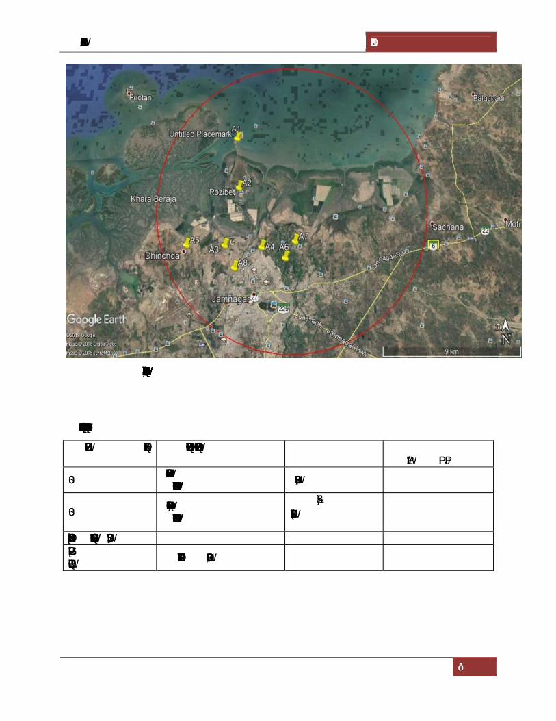
[DRAFT TERRESTRIAL ENVIRONMENTAL IMPACT ASSESSMENT] GUJARAT MARITIME BOARD
47
Fig- 4.3. Location map of Ambient Air Quality monitoring
Table-4.5. Techniques and Detectable limits for Ambient Air Quality monitoring
Parameter Technique Technical Protocol Minimum Detectable Limit (g/m3)
PM10 Respirable Dust Sampler
(Gravimetric method) IS-5182 (Part-IV) 5.0
PM2.5 Fine Particulate Sampler
(Gravimetric method)
40 CFR USEPAGravimetric 5.0
Sulphur dioxide Modified West and Gaeke IS-5182 (Part-II) 4.0 Oxides of Nitrogen
Jacob &Hochheiser IS-5182 (Part-VI) 4.0

[DRAFT TERRESTRIAL ENVIRONMENTAL IMPACT ASSESSMENT] GUJARAT MARITIME BOARD
48
Table 4.6. Location of Ambient Air Quality Monitoring Stations
Location Station Code
Direction
Latitude and Longitude
Distance Environmental
Setting Project ite A1 -- 22°33'50.26"N
70° 2'24.53"E -- Port Area
Roji bet A2 S 22°31'50.82"N 70° 2'35.82"E
3.85KM Residential
Badeswar A3 SSW 22°29'43.43"N 70° 2'7.61"E
8.22KM Residential
Jalaram nagar A4 SSE 22°29'39.87"N 70° 3'38.82"E
8.56KM Residential
Dhinchda A5 SW 22°29'44.04"N 70° 0'32.48"E
8.88KM Residential
Junanagna A6 SSE 22°29'17.57"N 70° 4'37.30"E
9.40KM Residential
Navanagna A7 SE 22°29'52.00"N 70° 5'1.74"E
9.03KM Residential
Jawahar nagar A8 S 22°28'57.33"N 70° 2'33.69"E
9.34KM Residential

[DRAFT TERRESTRIAL ENVIRONMENTAL IMPACT ASSESSMENT] GUJARAT MARITIME BOARD
49
Table 4.7. Summary of analysis of Ambient Air Quality in the study area
Parameter PM10(µg/m3) PM2.5(µg/m3) SO2(µg/m3) NOx(µg/m3)
Monitoring Station
No.
of s
ampl
es
Max
imum
Min
imum
Mea
n
98th
per
cent
ile
No.
of s
ampl
es
Max
imum
Min
imum
Mea
n
98th
per
cent
ile
No.
of s
ampl
es
Max
imum
Min
imum
Mea
n
98th
per
cent
ile
No.
of s
ampl
es
Max
imum
Min
imum
Mea
n
98th
per
cent
ile
A1 26 81.5 66.8 73.0 81.1 26 43.2 32.6 38.3 42.9 26 18.5 15.1 16.9 18.5 26 17.4 14.6 15.9 17.2
A2 26 68.2 55.1 62.3 67.7 26 33.6 24.6 28.5 32.8 26 16.9 14.1 15.6 16.9 26 15.6 13.1 14.7 15.6
A3 26 63.4 52.1 58.2 62.8 26 27.6 22.4 24.7 27.3 26 16.2 13.2 14.4 15.9 26 15.3 12.3 13.8 15.1
A4 26 64.2 54.8 59.8 63.5 26 29.4 23.9 27.3 29.3 26 15.9 13.6 14.7 15.9 26 15.2 13.4 14.4 15.2
A5 26 66.5 57.2 62.4 66.2 26 29.3 24.2 27.1 29.3 26 15.4 13.5 14.4 15.4 26 14.6 12.5 13.7 14.6
A6 26 65.8 58.7 62.2 65.8 26 31.4 24.1 27.7 31.1 26 16.2 13.1 14.7 16.1 26 15.8 12.5 14.0 15.6
A7 26 67.2 55.9 60.7 66.0 26 34.2 20.9 27.9 32.9 26 15.8 13.2 14.4 15.7 26 14.9 12.6 13.8 14.9
A8 26 68.2 56.8 63.4 68.2 26 31.5 24.1 27.5 31.2 26 16.4 12.9 14.6 16.3 26 15.9 13.5 14.6 15.9
NAAQS 100(µg/m3) 60(µg/m3) 80(µg/m3) 80(µg/m3)
Note: Carbon monoxide were monitored at all locations and were found < 0.5mg/m3
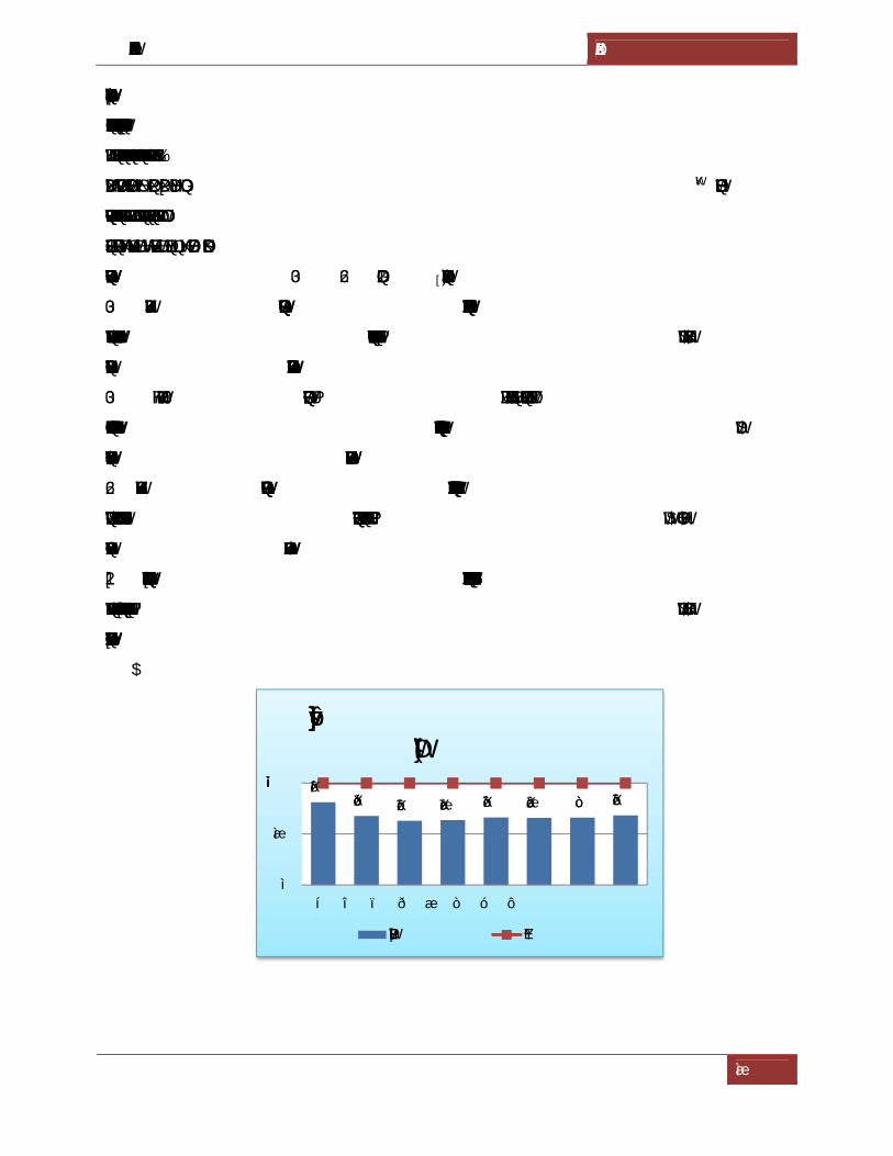
[DRAFT TERRESTRIAL ENVIRONMENTAL IMPACT ASSESSMENT] GUJARAT MARITIME BOARD
50
4.4.1. Existing Ambient Air Quality
On the perusal of above summary of analysis of ambient air quality in the study are it is evident
that all monitored values in various locations are well within the specified limits of CPCB.
Various statistical parameters like minimum, maximum, average and 98th percentile
concentrations have been computed from the data generated during sampling period at all
sampling locations. The results are test reports are given in the Table 4.7. Graphical
representation of the PM10, PM2.5, SO2 and NOxare given in the Figure 4.4(A-D).
PM10: The highest PM10 concentration 81.5 µg/m3 was observed in the ambient air was recorded
at station A1 while the lowest PM10 concentration was found to be 52.1 µg/m3 at A3. All the
monitored values of PM10 are well below the specified limit of 100 µg/m3 .
PM2.5: The highest PM2.5 concentration 43.2 µg/m3 was observed in the ambient air was
recorded at station A1 while the lowest PM2.5 concentration was found to be 20.9 µg/m3 at A7.
All the monitored values of PM2.5 are well below the specified limit of 60 µg/m3.
SO2: The highest SO2 concentration 18.5 µg/m3 was observed in the ambient air was recorded at
station A1 while the lowest SO2 concentration was found to be 12.9µg/m3 at A8. All the
monitored values of SO2 are well below the specified limit of 80 µg/m3 .
NOx: The highest NOx concentration 17.4 µg/m3 was observed in the ambient air was recorded
at station A1 while the lowest NOx concentration was found to be 12.3 µg/m3 at A3. All the
monitored values of NOx are well below the specified limit of 80 µg/m3 .
A.
81.167.7 62.8 63.5 66.2 65.8 66 68.2
0
50
100
A1 A2 A3 A4 A5 A6 A7 A8
98 percentile concentration of PM10
PM10 (ug/m3) NAAQS

[DRAFT TERRESTRIAL ENVIRONMENTAL IMPACT ASSESSMENT] GUJARAT MARITIME BOARD
51
B.
C.
D.
Fig 4.4 (A-D). Graphical representation of n PM10, PM2.5, SO2 and NOx
42.932.8 27.3 29.3 29.3 31.1 32.9 31.2
0
20
40
60
A1 A2 A3 A4 A5 A6 A7 A8
98 percentile concentration of PM2.5
PM2.5(ug/m3) NAAQS
18.5 16.9 15.9 15.9 15.4 16.1 15.7 16.3
0
20
40
60
80
A1 A2 A3 A4 A5 A6 A7 A8
98 percentile concentration of SO2
SO2(ug/m3) NAAQS
17.2 15.6 15.3 15.2 14.6 15.6 14.9 15.9
0
20
40
60
80
A1 A2 A3 A4 A5 A6 A7 A8
98 percentile concentration of NOx
NOx(ug/m3) NAAQS

[DRAFT TERRESTRIAL ENVIRONMENTAL IMPACT ASSESSMENT] GUJARAT MARITIME BOARD
52
4.5. WATER ENVIRONMENT
Water of high quality is essential to human life, and water of acceptable quality is essential for
agricultural, industrial, domestic and commercial uses: in addition, most recreation is water
based; therefore. Major activities having potential effects on surface water are certain to be
appreciable concern to the consumers.
Studies on water environment aspects of ecosystem is important for Environmental Impact
Assessment to identify sensitive issues and take appropriate action by maintaining ‘ecological
homeostasis’ in the early stages of development of the project. The objective of this report is to
define the present environment in which the proposed action is to occur, to evaluate all possible
eventualities, to ensure that all negative impacts are minimized, and to demonstrate that proposed
project has been appropriately announced to all interested parties so that their concerns can be
considered.
The water resources, both surface and groundwater play an important role in the development of
the area. Likewise, the water resources of the area have been studied to establish the current
status of water quality in the area. The parameters of prime importance were selected under
physical, chemical inorganic, chemical organic and heavy metal groups. Water samples from
ground and surface water sources were collected in cans, pre-treated and transported to
laboratory for analysis while taken care for transportation of these samples.
4.5.1. Surface and ground water quality assessment
In order to assess water quality impacts of surface and ground water samples are collected in and
around the proposed project. The samples analyzed for various physical and chemical parameters
to know the contamination levels as per the IS Standards.
1. Ground water quality --- IS 10500-1992
2. Surface/canal/sea water quality --- IS 2296
4.5.2. Selection of Sampling Locations
Sampling locations were selected on basis of;
a) Drainage pattern
b) Location of residential areas respecting different activities
c) Likely areas those can represent baseline conditions
Samples for bacteriological analysis were collected in sterilized glass bottles. Selected physico-
chemical and bacteriological parameters have been analysed for projecting the existing water
quality status in the study area.

[DRAFT TERRESTRIAL ENVIRONMENTAL IMPACT ASSESSMENT] GUJARAT MARITIME BOARD
53
The samples were analysed in accordance with “Standard Methods for Examination of Water
and Wastewater Analysis” published by APHA. Both surface and ground water samples
collected monthly once during total 3 months of study period. All the locations of water
monitoring are shown in fig 4.5 and are detailed in Table 4.8.
Fig. 4.5. Google map showing water sampling locations
Table 4.8. Details of water sampling locations in the study area
Code Station Direction to project site
Latitude Longitude
Distance from Project Site (km)
Source
GW1 Bedi Village S 22°29'52.49"N 70° 02'40.66"E
7.17 Ground water
GW2 Dhanan SE 22°29'25.38" 70° 9'5.82"E
13.97 Ground water
GW3 Dihenda SW 22°29'44.80"N 70° 0'35.47"E
8.36 Ground water
MW1 Plant site - 22°33'45.66"N 70° 2'23.99"E
- Marine water
MW2 Bedi port S 22°29'30.27"N 70° 2'53.22"E
8.23 Marine water

[DRAFT TERRESTRIAL ENVIRONMENTAL IMPACT ASSESSMENT] GUJARAT MARITIME BOARD
54
4.5.3. Sampling techniques
Samples for chemical analysis were collected in polyethylene carboys. Samples collected for metal
content were acidified with 1 ml HNO3. Samples for bacteriological analysis were collected in
sterilized glass bottles. Selected physico-chemical and bacteriological parameters have been
analysed for projecting the existing water quality status in the study area. Parameters like
temperature, Dissolved Oxygen (DO) and pH were analysed at the time of sample collection.
The methodology for sample collection and preservation techniques was followed as per the
Standard Operating Procedures (SOP) mentioned in Table 4.9. The methods used for analysis of
water samples are provided in Table 4.10.
Table 4.9. Standard Operating Procedures (SOP) for water sampling
Parameter Sample Collection Sample Size Storage/ Preservation
pH Grab sampling
Plastic /glass container
50 ml On site analysis
Electrical
Conductivity
Grab sampling
Plastic /glass container
50 ml On site parameter
Total suspended solids Grab sampling
Plastic /glass container
100 ml Refrigeration,
can be stored for 7 days
Total Dissolved
Solids
Grab sampling
Plastic /glass container
100 ml Refrigeration,
can be stored for 7 days
BOD Grab sampling
Plastic /glass container
500 ml Refrigeration, 48 hrs
Hardness Grab sampling
Plastic /glass container
100 ml Add HNO3 to pH<2,
refrigeration; 6 months
Chlorides Grab sampling
Plastic /glass container
50 ml Not required; 28 days
Sulphates Grab sampling
Plastic /glass container
100 ml Refrigeration; 28 days
Nitrates Plastic containers 100 ml Refrigeration; 48 hrs
Fluorides Plastic containers only 100 ml Not required; 28 days
Alkalinity Plastic/ glass containers 100 ml Refrigeration; 14 days
Ammonia Plastic/ glass containers 100 ml Add H2SO4 to pH>2,

[DRAFT TERRESTRIAL ENVIRONMENTAL IMPACT ASSESSMENT] GUJARAT MARITIME BOARD
55
Parameter Sample Collection Sample Size Storage/ Preservation
refrigeration, 28 days
Heavy Metals (As,
Cd, Mn, Cu, Fe, Zn,
Pb etc.)
Plastic/ Glass rinse with
1+1 HNO3
500 ml Filter, add HNO3 to
pH>2; Grab sample; 6
months
Table 4.10. Analytical techniques for water analysis
Parameter Method
pH APHA-4500-H+
Colour APHA-2120 C
Odour IS: 3025, Part-4
Temperature APHA-2550 B
Dissolved Oxygen APHA-4500 O
BOD APHA-5210 B
Electrical conductivity APHA-2510 B
Turbidity APHA-2130 B
Chlorides APHA-4500 Cl-
Fluorides APHA-4500 F-
Total dissolved solids APHA-2540 C
Total suspended solids APHA-2540 D
Total hardness APHA-2340 C
Sulphates APHA-4500 SO4-2
Arsenic APHA-3120 B/ APHA-3114 B/ APHA-3500 As
Calcium APHA-3120 B/ APHA-3500 Ca
Magnesium APHA-3120 B/ APHA-3500 Mg
Sodium APHA-3120 B/ APHA-3500 Na
Potassium APHA-3120 B/ APHA-3500 K
Manganese APHA-3120 B/ APHA-3500 Mn
Mercury APHA-3112 B/ APHA-3500 Hg
Lead APHA-3120 B/ APHA-3500 Pb
Copper APHA-3120 B/ APHA-3500 Cu

[DRAFT TERRESTRIAL ENVIRONMENTAL IMPACT ASSESSMENT] GUJARAT MARITIME BOARD
56
Parameter Method
Cadmium APHA-3120 B/ APHA-3500 Cd
Iron APHA-3120 B/ APHA-3500 Fe
Zinc APHA-3120 B/ APHA-3500 Zn
Boron APHA-4500 B
Coliform organisms APHA-9215 D
Alkalinity APHA-2320 B
COD APHA-5220 D
Phenolic Compounds APHA-510 C
Source: Standard Methods for the Examination of Water and Wastewater, Published By
APHA, AWWA, WEF 19th Edition, 1995
4.5.4. Groundwater quality
The pH limit fixed for drinking water samples as per IS: 10500 is 6.5 to 8.5 beyond this range the
water will affect the mucus membrane and or water supply system. During the study period, the
pH of the groundwater was found varying between 7.20 and 8.20. The pH values for all the
samples collected in the study area during study period were found to be within the acceptable
limits. The summary of the ground water quality is given in Table 4.11.
The desirable limit for total dissolved solids as per IS:10500 is 500 milligrams per liter (mg/l)
whereas the permissible limits in absence of alternate source is 2000 mg/l, beyond this
palatability decreases and may cause gastro-intestinal irritation. In groundwater samples collected
from the study area, the total dissolved solids (TDS) were found to be varying between 1485 mg/l
and 2486 mg/l. The TDS of all the samples were within the permissible limit of 2000 mg/l except
at project site (GW3) exceeds the permissible limit.
The desirable limit for Chloride is 250 mg/l as per IS: 10500whereas the permissible limit of the
same is 1,000 mg/l beyond this limit taste, corrosion and patability are affected. The Chloride
levels in the groundwater samples collected in the study area were ranging from 461 – 862 mg/l.
The desirable limit as per IS:10500 for hardness is 300 mg/l whereas the permissible limit for the
same is 600 mg/l. Beyond this limit encrustation in water supply structure and adverse effects on
domestic use will be observed. In the groundwater samples collected from the study area, the
hardness was found to be varying from 300 mg/l to1230 mg/l.

[DRAFT TERRESTRIAL ENVIRONMENTAL IMPACT ASSESSMENT] GUJARAT MARITIME BOARD
57
Fluoride is the other important parameter, which has the desirable limit of 1 mg/l and permissible
limit of 1.5 mg/l. However, the optimum content of fluoride in the drinking water is 0.6 to 1.5
mg/l. If the fluoride content is less than 0.6 mg/l it causes dental caries. If it is above 1.5 mg/l it
causes staining of tooth enamel, higher concentration in range of 3-10 mg/l causes fluorosis. In
the groundwater samples of study area, the fluoride values were found to be within a range of
0.01 mg/l to 0.07 mg/l.
All the heavy metals in all samples were found to be below the permissible limits.
An overview of the results obtained reveals that three parameters of TDS, Hardness, were found
above the permissible limits at GW3 samples of IS: 10500 drinking water standards.
Table 4.11. Ground Water Quality of the Study Area
S.No. PARAMETER UNIT GW1 GW2 GW3 IS:10500-Standards
Acceptable Permissible
1. Color Hazen < 2 < 2 < 2 5 15
2. Temperature of Water 0C 26.5 26.0 26.5 - -
3. pH - 8.20 7.20 7.39 6.5-8.5 6.5-8.5
4. Turbidity NTU 0.3 4.1 1.4 1 5
5. Total Suspended Solids mg/l < 10.0 < 10.0 < 10.0 - -
6. Total Dissolved Solids mg/l 1795 1485 2486 500 2000
7. Total alkalinity (as CaCO3) mg/l 480 424 412 200 600
8. Total Hardness (as CaCO3) mg/l 300 520 1230 300 600
9. Chlorides as Cl mg/l 724 461 862 250 1000
10. Calcium as Ca mg/l 16.0 80.0 252 75 200
11. Magnesium as Mg mg/l 63.1 77.7 145 30 100
12. Fluoride as F mg/l 0.01 0.03 0.07 1.0 1.5
13. Nitrates as NO3 mg/l 38.2 35.4 42.7 45 45
14. Sulphates as SO4 mg/l 278 306 381 200 400
15. Arsenic as As mg/l <0.001 <0.001 <0.001 0.01 0.05
16. Cadmium as Cd mg/l <0.002 <0.002 <0.002 0.003 0.003
17. Copper as Cu mg/l <0.05 <0.05 <0.05 0.05 1.5
18. Lead as Pb mg/l <0.001 <0.001 <0.001 0.01 0.01
19. Iron as Fe mg/l 0.21 0.28 0.21 0.3 0.3
20. Manganese as Mn mg/l <0.05 <0.05 <0.05 0.1 0.3
21. Zinc as Zn mg/l 2.8 0.48 0.41 5.0 15.0
22. Dissolved phosphates mg/l <0.01 <0.01 <0.01 - -
23. Phenolic Compounds as C6H5OH mg/l <0.001 <0.001 <0.001 0.001 0.002

[DRAFT TERRESTRIAL ENVIRONMENTAL IMPACT ASSESSMENT] GUJARAT MARITIME BOARD
58
24. Residual Chlorine mg/l <0.005 <0.005 <0.005 - -
25. E. Coli MPN/100 ml ND ND ND ND ND
26.. Total Coliforms MPN/100 ml ND ND ND ND ND

[DRAFT TERRESTRIAL ENVIRONMENTAL IMPACT ASSESSMENT] GUJARAT MARITIME BOARD
59
4.6. SOIL ENVIRONMENT
Natural resources are important means of subsistence for the communities in the rural area. The
detail about economics resources of important sectors are given here in brief.
As the geographical formation of Saurashtra is of volcanic origin, the soils are generally derived
from the trap rock. The soil found in Jamnagar district can be broadly classified as alluvial,
black, light brown and alkaline. The black or medium black soil and the light brown soil any be
termed as the main soils, while the other two, namely, the alluvial and the alkaline as subsoil of
the district is confined to some smaller patches. While the medium black soil is rich in minerals
and organic matter and, therefore are more fertile. The light brown soil is less fertile and needs
plenty of water and manure for getting good harvest.
The black or medium black soil is found in Dhorl, Kalavad, Jamjodhpur and Bhanvad taluks and
eastern portion of Jamnagar taluka. It is generally seen that soil is 9 to 36 inches in depth. Light
brown soil is also called dharod is found in all taluks but mainly in the western part of the
district, viz., Khambalia, Kalayanpur and Lalpur taluks and western portion of Jamnagar taluka.
Soil types of Jamanagar district is presented in the figure no. 4.6.
Fig 4.6. Soil types of Jamanagar district

[DRAFT TERRESTRIAL ENVIRONMENTAL IMPACT ASSESSMENT] GUJARAT MARITIME BOARD
60
4.6.1. Selection of sampling Locations
For studying soil profile of the region, sampling locations were selected to assess the existing
overall soil conditions around the project site. The study of the soil profile establishes the
baseline characteristics and this will help in future for identifying the incremental concentrations
if any, due to the proposed project. The sampling locations have been identified with following
objectives.
a) To determine the baseline soil characteristics of the study area
b) To determine the impact of the project activities on soil characteristics
4.6.2. Sampling and Analytical Techniques
Five sampling locations were selected to assess the existing soil conditions representing various
land use conditions and geological features. At each location, soil samples were collected from
three different depths viz. 30 cm, 60 cm and 90 cm below the surface and are homogenized. This
is in line with IS: 2720 & Methods of Soil Analysis, Part-1, 2nd edition, 1986 of (American
Society for Agronomy and Soil Science). The homogenized samples were analyzed for physical
and chemical characteristics. The soil samples were collected and analyzed once in each
season.The samples have been analyzed as per the established scientific methods for physico-
chemical parameters (Table 4.12). Standard soil classification based on ICAR is given in Table
4.13.
Table 4.12. Analytical techniques for Soil analysis
Parameter Method (ASTM number)
Textural classification Chart developed by Public Roads Administration
pH pH meter (D 1293-84)
Electrical conductivity Conductivity meter (D 1125-82)
Nitrogen Kjeldahl distillation (D 3590-84)
Phosphorus Molybdenum blue, calorimetric (D 515-82)
Potassium Flame photometric (D 1428-82)
Sodium Flame photometric (D 1428-82)
Calcium IS:2720
Magnesium IS:2720
Chlorides Argentometric (D 512-81 Rev 85)

[DRAFT TERRESTRIAL ENVIRONMENTAL IMPACT ASSESSMENT] GUJARAT MARITIME BOARD
61
Table 4.13. Standard soil classification
S. No Soil test Classification 1. pH <4.5 Extremely acidic
4.51- 5.50 Very strongly acidic 5.51-6.00 moderately acidic 6.01-6.50 slightly acidic 6.51-7.30 Neutral 7.31-7.80 slightly alkaline 7.81-8.50 moderately alkaline 8.51-9.0 strongly alkaline >9.00 very strongly alkaline
2. Electrical Conductivity (ppm) (1ppm = 640 µmhos)
Up to 1.00 Average 1.01-2.00 harmful to germination 2.01-3.00 harmful to crops (sensitive to salts)
3. Organic Carbon Up to 0.2: very less 0.21-0.4: less 0.41-0.5 medium, 0.51-0.8: on an average sufficient 0.81-1.00: sufficient >1.0 more than sufficient
4. Nitrogen (Kg/ha) Up to 50 very less 51-100 less 101-150 good 151-300 Better >300 sufficient
5. Phosphorus (Kg/ha) Up to 15 very less 16-30 less 31-50 medium 51-65 on an average sufficient 66-80 sufficient >80 more than sufficient
6. Potassium (Kg/ha) 0 -120 very less 120-180 less 181-240 medium 241-300 average 301-360 better >360 more than sufficient
To assess the quality of soil in the study area, 4 samples were collected to analyze the
physicochemical characteristics. The various physical and chemical characteristics that were
analyzed as per Indian Standards are heavy metals, nutrients and ionic contents. The geo-

[DRAFT TERRESTRIAL ENVIRONMENTAL IMPACT ASSESSMENT] GUJARAT MARITIME BOARD
62
coordinates are represented in Table 4.14. The summary of soil analysis results is presented in
Table 4.15.
Table 4.14. Details of soil samplings
Code Location/ Villages
Latitude and Longitude
Distance from Project Site(km)
Direction
S1 Roji bet 22°31'50.82"N 70° 2'35.82"E
3.85km S
S2 Badeswar 22°29'43.43"N
70° 2'7.61"E 8.22km SSW
S3 Jalaram nagar 22°29'39.87"N 70° 3'38.82"E
8.56km SSE
S4 Dhinchda 22°29'44.04"N
70° 0'32.48"E 8.88km SW
Table 4.15. Summary results of soil samples
S.No Parameter Unit S1 S2 S3 S4 1. pH (1:5) Aq Extract -- 7.42 7.54 7.72 7.40
2. Conductivity
(1:5 Aq Extract)
mhos
/cm 584 608 617 621
3. Texture
(a) Sand
(b) Silt
(c) Clay
%
73.5
15.1
11.4
71.9
18.9
10.2
78.3
13.6
8.1
67.2
12.1
20.7
4. Bulk Density gm/cm3 1.25 1.40 1.19 1.22
5. Moisture Content % 11.2 10.5 10.8 9.2
6. Available Nitrogen as N kg/ha 56.8 62.3 59.1 65.4
7. Available Phosphorous as P kg/ha 22.4 24.6 20.5 28.1
8. Available Potassium as K kg/ha 56.4 61.9 58.3 72.4
9. Exchangeable Sodium as Na mg/kg 92.5 98.1 114 85.6
10. Exchangeable Calcium as Ca mg/kg 133 122 146 139
11. Exchangeable Magnesium as
Mg
mg/kg 165 168 177 196
12. Water Soluble Chlorides as
Cl
mg/kg 361 375 319 286

[DRAFT TERRESTRIAL ENVIRONMENTAL IMPACT ASSESSMENT] GUJARAT MARITIME BOARD
63
13. Water Soluble Sulphates as
SO4
mg/kg 68 72 84 75
14. Organic matter % 0.17 0.14 0.11 0.18
15. Organic Carbon % 0.1 0.09 0.08 0.13
4.6.3. Summary of soil analysis data
The analytical results of the soil samples collected during the study period are summarized
below.
The pH of the soil is an important property; vegetation cannot grow in low and high pH value
soils. The normal range of pHin the soils is 6.0 to 8.5. The pH values in the study area are
varying from 7.40 to 8.04 indicating that the soils are falling slightly alkaline soil.
Based on the electrical conductivity, the soils are classified into four groups (Normal, Critical for
germination, Critical for growth of the sensitive crops, Injurious to most crops). The electrical
conductivity in the study area is varying from 558 to 621 micro-Siemens per centimeter (µS/cm).
This is average for germination
The other important parameters for characterization of soil for irrigation are the primary nutrients
– Nitrogen, Phosphorus and Potassium (N, P, K) and the secondary nutrients—Calcium,
Magnesium and Sulphur(Ca, Mg, S). The primary and secondary nutrient elements are known as
major elements. This classification is based on their relative abundance, and not on their relative
importance.
Nitrogen encourages the vegetative development of plants by imparting a healthy green color to
the leaves. The available Nitrogen as N in the study area is varying from 52.4 to 65.4 kg/ha. This
is less for crops when compared with soil standards.
Phosphorus influences the vigour of plants and improves the quality of crops. In the study area
available, Phosphorus was found in varying quantities of 16.2 to 28.1 kg/ha. This is an less level
when compared to soil standards.
Potassium enhances the ability of the plants to resist diseases, insect attacks, cold and other
adverse conditions. The available potassium in the study area varies between 48.5 to 52.4 mg/kg.
This is less level for crops.
Organic Carbon in the study area ranges from 0.06 to 0.13%. This is very less level for crops.
Based on the above results, the soils in the region are average fertile enough for cultivation of
crops.

[DRAFT TERRESTRIAL ENVIRONMENTAL IMPACT ASSESSMENT] GUJARAT MARITIME BOARD
64
4.7. NOISE ENVIRONMENT
The noise problem is said to exist when the sound level in the air causes interference in human
activities such as disturbance in sleep, work and speech communication leading to annoyance.
Perception of noise by individuals varies depending on number of factors such as natural
sensitivity/hearing ability, level of exposure, time of noise at community level can have different
effects varying from aesthetic impairment such as annoyance, frequent hypertension to as high as
loss of hearing. The health impact of noise on individual depends on several factors, viz, physical
dose (intensity of sound pressure level and duration of exposure), frequency spectrum,
intermittency etc., as well as human factors like age, health condition, occupational exposure etc.
Assessment of noise impacts and the significance of any impacts as a result of development are
dependent upon the number of factors such as the ambient or background noise levels in the
vicinity of the site, the type of development and its operating characters. Therefore noise
monitoring was carried out to identify and quantify so far as reasonably possible the ambient
condition to assess the increase in noise levels and causes of variability of noise levels as a result
of ongoing project activities.
4.7.1. Identification of sampling locations
Noise at different generating sources has identified based on the activities in the village area,
ambient noise due to industries and traffic and the noise at sensitive areas. A detailed survey on
noise environment was carried in and around the project site to study the levels of noise, as the
high dB (A) levels may cause adverse effect on human beings and associated environment,
including structures, domestic animals and natural ecological systems. The locations were
identified keeping in view the land use pattern and environmental setting. Spot noise levels were
measured using a precision noise level meter at eight locations within study zone.
4.7.2. Methodology
The monitoring was carried out at each location for a period of 24hrs, once during the study
period. The locations were identified keeping in view the land use pattern and environmental
setting. The day levels of noise have been monitored during 6 am to 10 pm and the night levels
during 10 pm to 6 am. The Ld, Ln and Ldn were calculated based on the hourly Leq values. Spot
noise levels were measured using a precision noise level meter at residential areas, industrial
areas and commercial centres etc., in all eight locations which were covered with in study
zone(Table 4.16). The noise levels include vehicular movement and local activities.Noise levels

[DRAFT TERRESTRIAL ENVIRONMENTAL IMPACT ASSESSMENT] GUJARAT MARITIME BOARD
65
were recorded for every 15minutes in a clock hour for a continuous 24-hour period at all
locations.
Table 4.16. Details of noise samplings
S.No Location Station Code
Direction
Latitude Longitude
Distance
Environmental Setting
1. Project ite
N1 -- 22°33'50.26"N
70° 2'24.53"E --
Industrial Area
2. Roji bet
N2 S 22°31'50.82"N
70° 2'35.82"E 3.85KM
Residential Area
3. Badeswar
N3 SSW 22°29'43.43"N
70° 2'7.61"E 8.22KM
Residential Area
4. Jalaram nagar N4
SSE 22°29'39.87"N 70° 3'38.82"E
8.56KM Residential Area
5. Dhinchda
N5 SW 22°29'44.04"N
70° 0'32.48"E 8.88KM
Residential Area
6. Junanagna
N6 SSE 22°29'17.57"N
70° 4'37.30"E
9.40KM Residential Area
7. Navanagna
N7 SE 22°29'52.00"N
70° 5'1.74"E 9.03KM
Residential Area
8. Jawahar nagar N8
S 22°28'57.33"N 70° 2'33.69"E
9.34KM Residential Area
Fig 4.7. Locations for monitoring noise levels

[DRAFT TERRESTRIAL ENVIRONMENTAL IMPACT ASSESSMENT] GUJARAT MARITIME BOARD
66
4.7.3. Description of locations
N1 – the location has been selected to assess noise levels in the proposed project site.
N2, N3, N4, N5, N6, N7 and N8 – the locations have been selected to assess noise levels
near to the project in residential areas with light Vehicular Movement.
4.7.4. Summary of noise levels
The noise levels were recorded at different locations (08 nos) within study area during study
period. All the noise levels are given in Table 4.17. The noise levels (Leq) were within the CPCB
standards for industrial areas (day time 75 and night time 70 dB(A)).
Table 4.17. Noise levels in the study area
Location code Environmental
setting CPCB norms Leq (dBA)
Lday Lnight Day Night
N1 Project ite 75 70 70.3 65.9
N2 Roji bet 55 45 52.8 43.2
N3 Badeswar 55 45 51.0 41.2
N4 Jalaram nagar 55 45 50.4 41.8
N5 Dhinchda 55 45 50.7 39.9
N6 Junanagna 55 45 50.8 40.3
N7 Navanagna 55 45 51.0 40.2
N8 Jawahar nagar 55 45 50.2 40.4
a) At Project Site:
The day time noise levels were observed to be within the prescribed limit of 75dB(A). The day
time noise levels ranged from 66.9 to 72.6dB(A).
The night time noise levels were observed to be within the prescribed limit of 70dB(A). The
night values ranged from 64.1 to 67.5dB(A)
b) N2 – industrial area:
The day time noise levels were observed to be within the prescribed limit of 55 dB(A). The day
time noise levels ranged from 49.6 to 53.6dB(A).

[DRAFT TERRESTRIAL ENVIRONMENTAL IMPACT ASSESSMENT] GUJARAT MARITIME BOARD
67
The night time noise levels were observed to be within the prescribed limit of 45 dB(A). The
night values ranged from 42.5 to 44.0dB(A)
c) N3 – Residential area:
The day time noise levels were observed to be within the prescribed limit of 55 dB(A). The day
time noise levels ranged from 45.9 to 53.6 dB(A).
The night time noise levels were observed to be within the prescribed limit of 45 dB(A). The
night values ranged from 38.5 to 43.6 dB(A)
d) N4 – Industrial Area:
The day time noise levels ranged from 44.1 to 52.6dB(A), were observed to be within the
prescribed limit of 75 dB(A)
The night time noise levels were observed to be within the prescribed limit of 70 dB(A). The
night values ranged from 38.4 to 44.9 dB(A)
e) N5 – Industrial Area:
The day time noise levels were observed to be within the prescribed limit of 75 dB(A). The day
time noise levels ranged from 44.5 to 52.9 dB(A).
The night time noise levels were observed to be within the prescribed limit of 70 dB(A). The
night values ranged from 36.8 to 41.9 dB(A)
f) N6 – Residential Area:
The day time noise levels were observed to be within the prescribed limit of 55 dB(A). The day
time noise levels ranged from 43.2 to 53.8dB(A).
The night time noise levels were observed to be within the prescribed limit of 45 dB(A). The
night values ranged from 36.8 to 43.5 dB(A)
g) N7 – Residential Area:
The day time noise levels were observed to be within the prescribed limit of 55 dB(A). The day
time noise levels ranged from 42.8 to 53.6 dB(A).
The night time noise levels were observed to be within the prescribed limit of 45 dB(A). The
night values ranged from 36.4 to 43.9dB(A)
h) N8 – Residential Area:
The day time noise levels were observed to be within the prescribed limit of 55 dB(A). The day
time noise levels ranged from 43.3 to 52.7. dB(A).
The night time noise levels were observed to be within the prescribed limit of 45 dB(A). The
night values ranged from 36.2 to 44.0 dB(A)
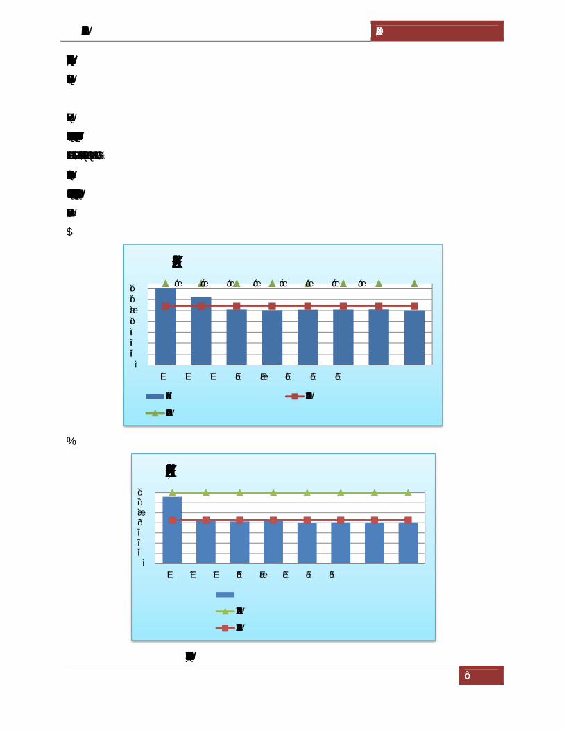
[DRAFT TERRESTRIAL ENVIRONMENTAL IMPACT ASSESSMENT] GUJARAT MARITIME BOARD
68
From the above results it was concluded the Day and Night equivalents were within the limits of
Ambient Noise standards.
4.7.5Observations
Ambient noise levels were measured at eight locations in and around the plant site. Noise levels
varied from 50.2 LeqdB(A) to 70.3 LeqdB(A) during day time and 39.9 to 65.9 Leq dB(A)
during night time. Graphical representations of noise values are shown in figure 4.9A&B.
An over view of the above results indicates the noise levels in the study area are well within the
prescribed limits of CPCB.
4.9A.
4.9B.
Fig 4.8 A&B. Noise levels in the study area
75 75 75 75 75 75 75 75
010203040506070
N1 N2 N3 N4 N5 N6 N7 N8
DAY EQUIVALENT NOISE LEVELS
DAY EQUIVALENT CPCB LIMIT, RESIDENTIAL AREA
CPCB LIMIT, INDUSTRIAL AREA
010203040506070
N1 N2 N3 N4 N5 N6 N7 N8
NIGHT EQUIVALENT NOISE LEVELS
CPCB LIMIT, INDUSTRIAL AREA
CPCB LIMIT, RESIDENTIAL AREA

[DRAFT TERRESTRIAL ENVIRONMENTAL IMPACT ASSESSMENT] GUJARAT MARITIME BOARD
69
4.8. GEOMORPHOLOGY
Physiographically the district can be divided into the following units: Hilly areas
and Coastal & alluvial Plains.
Jamnagar, Jodiya, Khambaliya and Kalyanpur talukas are characterised by plain
topography, whereas Jam Jodphur, Lalpur and Bhanwad talukas are characterised by
hilly terrains. Cliffs are found in the Dwarka taluka with height upto 30m. Barda, Alech,
Gop etc are famous hill ranges in the district. Mount Venu is the highest summit of
Barda hills that attains a height of 617.1 metres. Okha Rann is a low-lying marshy area.
Low coastal dunes and sand banks run along the north and west coasts. Jamnagar,
Jodiya and Kalyanpur are plain areas. Geologically the study area mainly comprises of tertiary
rocks, Cretaceous rocks, Deccan trap and quaternary sediments. The geology of the Jamnagar
district is represented in the Figure 4.9.
Source: Commissionerate of Geology and Mining, Government of Gujarat
Fig 4.9. Geological resources of the Jamnagar district

[DRAFT TERRESTRIAL ENVIRONMENTAL IMPACT ASSESSMENT] GUJARAT MARITIME BOARD
70
4.9. SEISMICITY AND ASSOCIATED HAZARDS
The Gujarat region is one of the most seismic prone intra-continental regions of the world. The
Jamnagar region falls in zone V. Based on tectonic features and records of past earthquakes, a
seismic zoning map of India has been prepared by a committee of experts under the auspices of
Bureau of Indian Standard (BIS Code: IS: 1893: Part I 2002). In this seismic zoning map, the
project area lies in Zone V i.e very high risk zone area liable to shaking intensity IX and above.
Fig: 4.10. Seismic map of India

[DRAFT TERRESTRIAL ENVIRONMENTAL IMPACT ASSESSMENT] GUJARAT MARITIME BOARD
71
4.10. HYDROGEOLOGY
Hydrogeologically the district area can be broadly grouped under hard rock’s comprising
“Deccan traps” and soft rocks comprising “Tertiaries and Alluvium”. Nearly 80% of the area is
underlain by Deccan Traps, 19% by the Teriaries and the rest by Alluvium. Hydrogeological
conditions in various lithounits are described below:
a) Deccan Traps (Hard rock)
These are essentially basaltic flows having general horizontal to near horizontal disposition over
large area. The basaltic flows do not have any primary porosity in the lower massive portion, but
the top vesicular portion has some porosity because of the vesicles formed due to escaping gases.
Both massive and vesicular portions have no primary permeability, as the vesicules are seldom
interconnected. The secondary porosity and permeability developed due to fracturing and
jointing provides passage for infiltration, storage and movement of groundwater. The weathered
zone extends to about 20m bgl in the surface flows. Weathered flow contacts extend to greater
depths. The permeability of these zones are further intensified by fracturing and jointing. These
interflow zones and fractured and jointed zones have given rise to stratified aquifer system,
which is responsible for occurrence of water even at greater depths. Weathering of basalts, which
extends down to 20m and the fractured basalts beneath the weathered mantle have given rise to
water table aquifers down to 40 m bgl. The depth of water level in the area ranges from 3.30 m
bgl to 25.40 bgl during the pre-monsoon period while during the post monsoon the water level
ranges from 0.06 to 17.50 m bgl. The yields of the wells tapping weathered basalts are in the
range of 20-100m3/day. Those in which interflow zones have been tapped 100-400m3/day. The
bore wells drilled in the district have yields ranging from 100 to 500m3/day.
b) Gaj Beds
Groundwater in these series occurs both under confined and water table conditions. The upper
granular bed of the series consisting of limestone and grits forms a good aquifer for shallow
groundwater. Dug wells and dug-cum bore wells within the depth range of 20-25 mbgl are
constructed. The depth of water level in the Gaj aquifer ranges from 5 to 15 m bgl during pre-
monsoon period. The yield of the wells varies from 4 to 312 m3/day and an average yield of
66m3/day.

[DRAFT TERRESTRIAL ENVIRONMENTAL IMPACT ASSESSMENT] GUJARAT MARITIME BOARD
72
c) Dwarka Beds
Groundwater mainly occurs under water table condition; because of the clayey nature of the
formations and the narrow stretch of sandy limestone exposed to recharge the rocks of this
formation are poor aquifers. The depth of the water level in the Dwarka beds ranges from 2 to 10
m bgl during pre-monsoon period. Dug wells and dug-cum bore wells within the depth range of
20-35 mbgl are constructed. The yield of the wells varies from 8 to 270 m3/day and an average
yield of 80m3/day.
d) Milliolite Series
Groundwater occurs under phreatic conditions. These milliolite limestone acts as a good
reservoir for shallow groundwater. The depth of water level in milliolite limestones is generally
about 5m bgl. Open wells are about 10m in depth. The yield of these wells ranges from 100-
200m3/day.
e) Alluvium
Groundwater occurs under unconfined conditions. The thickness of the alluvium is not more than
20m. Because of its clayey nature, percolation of rainwater is very poor resulting in poor yields.
The depth of water level ranges from 2 to 10m bgl (Premonsoon). The yield of these wells hardly
exceeds 100m3/day.
4.10.1Depth to Water Level
The depth to water level in the district ranges from 1.74 to 38.41mbgl during the pre-monsoon
period with 75% of the stations showing water level less than 10m (Figure.2). Salaya village has
recorded the shallowest water level whereas the deepest water level was recorded at Lalpur
village. During the post monsoon period the depth to water level ranged from 2.05mbgl at
Amran village to 56.25 mbgl at Lalpur village with about 60% of the station showing water level
less than 10m (Figure 4.11).

[DRAFT TERRESTRIAL ENVIRONMENTAL IMPACT ASSESSMENT] GUJARAT MARITIME BOARD
73
Source: Central Ground Water Board
Fig. 4.11. Map showing depth to water level
4.10.2Long Term Water Level Trend
Analysis of the long-term groundwater level trend for 10 years (2003-2012) of the district reveals
that rise in groundwater level predominant throughout the district. Long term rise in water level
during the pre-monsoon period ranged from 0.0016 to 1.47m/yr while the fall ranged from
0.0009 to 0.62 m/yr. The highest rise was recorded at Bhatia village while the highest fall was
recorded at Moti Matli Village. The long term water level fluctuation for the Post monsoon
period also reveals that rise in water level ranged from 0.011 to 0.73m/yr while fall recorded in
the district ranged from 0.017 to 1.42m/yr. Modpar village recorded the highest rise during the
post monsoon period whereas Lalpur village recorded the highest fall.

[DRAFT TERRESTRIAL ENVIRONMENTAL IMPACT ASSESSMENT] GUJARAT MARITIME BOARD
74
4.11.BIOLOGICAL ENVIRONMENT
4.11.1 Introduction
Ecology is the scientific study of the relations that living organisms have with respect to each
other and their natural environment. Producer, consumer and decomposer govern whole cycle of
ecology. Plant and animal both are interdependent to each other. Producer is necessary for each
consumer. Plant plays their role in ecology as producer. Plant, animals and microorganism
together with the environment in which they live make an independent unit called
ecosystem.Mainly two types of vegetation cover are on the earth surface. One is self-growing
and another is cultivated. Plants are renewable resource and useful to living organism in many
ways. It is therefore the role of man in manipulating and changing vegetation population.
Ecological assessment is an activity that results in documenting the ecological status of an area,
species inhabiting the area, their ecological and conservational requirements etc. It is a
fundamental and important component of Ecological Impact Assessment (EIA) and essentially
generates baseline data and information on an area. Environmental / Ecological Impact
Assessment are a process to be conducted prior to executing a large-scale project. All such
projects are likely to have impacts on the environment; more or less coextensive to factors such
as the magnitude of the project, the activities involved, resources utilized, and wastes, emissions
and effluents. Ecological Impact Assessment is a method of identifying, quantifying and
evaluating the potential impact of defined action on ecosystems or their components. During the
process of the assessment scientific information about the ecological makeup of the natural
system in and around the project location has to be collected. A scientific documentation of the
baseline data is vital to develop a general perception about the project and its impacts. This is
necessary to help developing a long term and strategy for management of the area specially the
habitats by identifying the means to mitigate the possible impacts of the activities proposed to be
undertaken in the area. This would in turn help to bring back the local environmental setup and
ecological goods and services more or less close to its original state, and facilitate decision-
making on the project basically on evaluating the trade-offs between the loss of environmental
quality, environmental services and the goods and services offered by the project. The Biological
Environment studies conducted by Andhra University and the letter attached as Annexure-2.
[DRAFT TERRESTRIAL ENVIRONMENTAL IMPACT ASSESSMENT] GUJARAT MARITIME BOARD
75
4.11.2 Objectives
Assess and document the flora in the project location and status its environmental
conditions
Assess and document the fauna in the project location and its environs
Examine the probable impacts arising from the execution of the project on biological and
ecological environs, and
Develop an Environmental Management Plan (EMP) for mitigation of proposed projects
impacts
4.11.3 Ecologically Sensitive Zone
4.11.3.1 The Gulf of Kutch Marine National Park and Sanctuary
The Gulf of Kutch Marine National Park and Sanctuary (MNPS) was established by a set of
State notifications during the period 1980 to 1982 in an area of 457.92 sq km along the coast of
Saurashtra in the southern Gulf of Kutch (22° 15' to 23° 40' N to 68° 20' to 70° 40' E).
Designated first as a Sanctuary in 1980, certain areas covering the islands and inter-tidal zones
were declared as National Park areas during the same year. A final Notification of the Protected
Areas (PA)was issued in 1982. The Gulf of Kutch MNPS has been classified as part of the West
Coast Biotic Province by the Wildlife Institute of India (WII), Dehradun.
The notified area includes 148.92 sq km of 42 islands in the Gulf and 309 sq km of intertidal
zone along its coast. Out of the notified areas, an area of 162.89 sq km is designated as National
Park area while the remaining is scanty land. The National Park area covers 37 islands while
sanctuary area covers five islands as well as the inter-tidal zone from Navlakhi to Okha.
According to the Notification, the revenue borders of Dwarka (Okha), Kalyanpur, Khambalia,
Lalpur, Jamnagar, Dhrol and Jodiya taluks of Jamnagar District mark the southern boundary of
the marine protected area (MPA).
Three categories of areas are included within the MNPS: 11.82 sq km of reserves forests, 347.90
sq km of unclassified forests and 98.2 sq km of Indian territorial waters. Since the PAs were
constituted under the jurisdiction of the State’s Forest Department.
The MNPS supports considerable species diversity. One study reported a total of 1127 species of
flora and fauna in the MPA. These include molluscs, oysters, turtles and marine mammals which
are dolphins, whales, and the rare and endangered sea cow, Dugong dugon. A recent study

[DRAFT TERRESTRIAL ENVIRONMENTAL IMPACT ASSESSMENT] GUJARAT MARITIME BOARD
76
recorded 144 different fish varieties in the MNPS areas and also 27 species of commercially
important Crustaceans.
The MNPS was initially established for the conservation and protection of a rich and diverse
ecosystem, particularly the inter-tidal and sub-tidal coral reefs and mangrove habitats of the
Gulf. Since 1991, coral reefs and mangroves have additionally been accorded the highest degree
of protection under the 1991 Coastal Regulatory Zone (CRZ) Notofication. Coral reefs and
mangroves have great ecological significance; both increase shore stability, offer protection
against tidal surges, and are the breeding grounds of a host of fishes, crustaceans, algae and other
forms of marine life. Indeed, the decline in corals and mangroves is correlated with a general
decline in the diversity and quantum of marine life.
4.11.4. Study area
The Rozi Pier Port situated in the marine national park on the west cost of India, Gujarat. The
buffer has unique ecosystems like coral reefs and mangroves as it southern coast and mangroves
at selected locations along the northern coast, and has tidal amplitude ranging from 3-8m. The
developmental activities like construction of ports and human interventions like mining corals,
destruction of mangroves to expand the salt pan activities etc., have extensively damaged the
corals and mangroves in the region. Due to its proximity to the Arabian Gulf, the proposed area
attracts establishment of facilities like ports, Single Point Mooring (SPM) stations for handling
large amount of crude oil. The region was notified as a Marine National Park and Sanctuary in
1982. The buffer area occupied by saltpans, Navy quarters and some parts of Jamnagar town and
invasive species of Prosopis juliflora.
Mangrove forests are extensive along the coastal belt of Jamnagar District occupying an area of
141 km2 as dense forests; dominant species being Avicennia with almost pure stands at place.
Mangroves are dominated by Avicenniamarina and are of fringing type in regularly inundated
zones along the water ways. The stray plants of Rhizophora mucronata also occur among
Avicennia stands. Salvadora persica commonly occur in the supralittoral regions towards the
high tide area. Sesuvium portulacastrum is common at the high tide line along the creeks. Beds
of Salicornia brachiata commonly habit the areas inland of regularly inundated zones or above
the mean high tide line. The Salicornia stands are denser towards waterways and become sparse
in saline banks. Suaeda maritima is sparsely distributed in the saline bank regions.
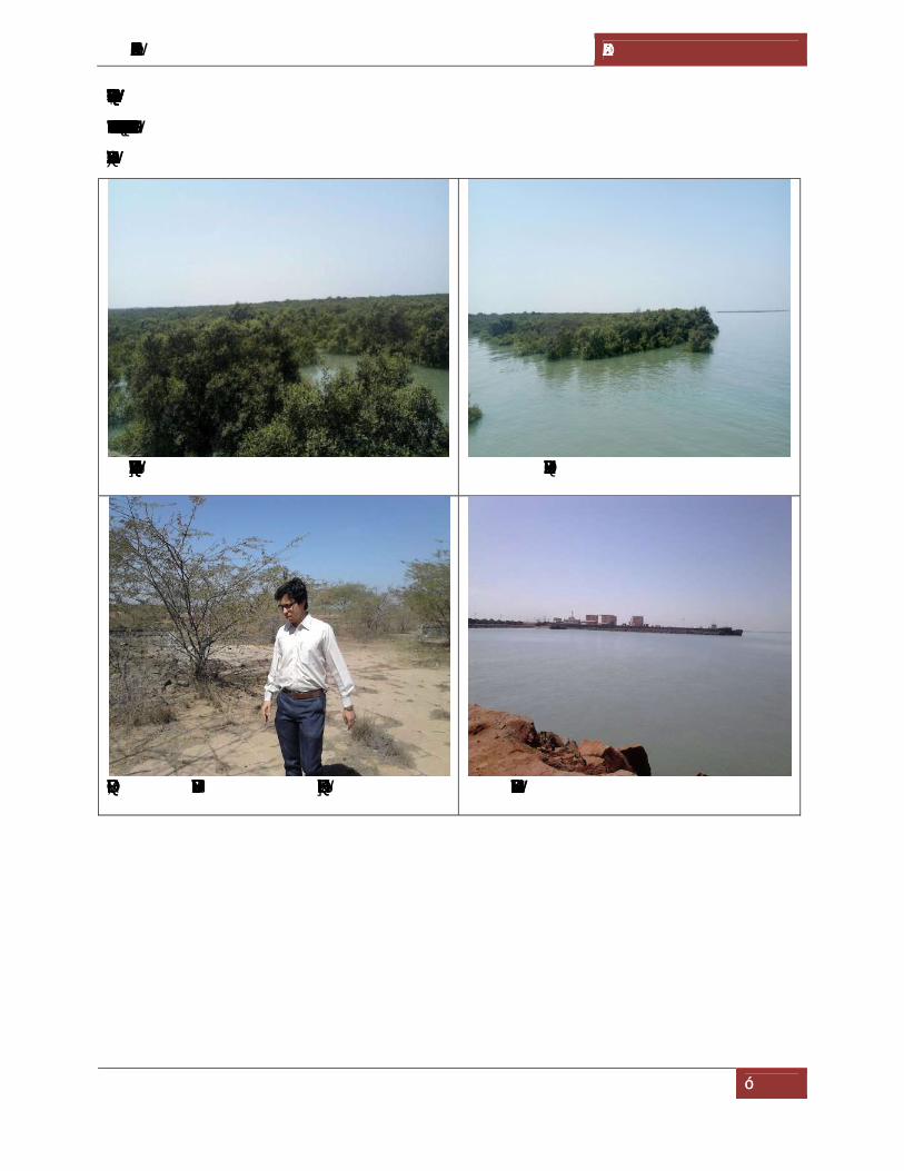
[DRAFT TERRESTRIAL ENVIRONMENTAL IMPACT ASSESSMENT] GUJARAT MARITIME BOARD
77
The proposed project doesn’t contain any mangrove vegetation. Overall assessment indicates that
the site proposed for the development falls under the category of offshore area. The study area
photographs were in the Figure 4.12.
View of the mangroves in the Buffer zone Overview of mangroves
Invasion of Prosopis juliflora in the Buffer zone Core area of the proposed project

[DRAFT TERRESTRIAL ENVIRONMENTAL IMPACT ASSESSMENT] GUJARAT MARITIME BOARD
78
Mudflat in the Buffer zone Saltpans in the Buffer zone
Fig 4.12. Photographs of study area
4.14.5. TERRESTRIAL ECOLOGY
This assessment identifies and evaluatesthe potential effects of the proposed project on terrestrial
ecology. Ecosystem consists of living and non-living components that interact through the
exchange of energy, nutrients, and waste. Ecosystems are dynamic and can be identified at
multiple, overlapping scales, ranging from types of site-specific plant communities to broad-
scale eco-regions. This assessment focuses on groups of site-specific plant communities (forest
and non-forest), which are typically characterized by unique plant species composition,
vegetation structure and landscape position which differ in the type, quality, and quantity of
functions they provide.
4.14.6. Methodology
4.14.6.1. Floral survey
The latitude and longitude of the site is 22°34´1.68"N and 70°2´23.94"E respectively. Extensive
field surveys were conducted from January 2018 to March 2018, adopting standard methods to
identify and document the ecological/biological components. However, in view of the study area
falling under the jurisdiction of the Marine National Park, Gujarat forest department. At first, a
pilot survey was carried out in and around the 10 km radius of the proposed project to develop a
feel of the area and to identify intensive sampling sites. Thus we selected four representative
areas for intensive studies.
To study the flora of the study area in general and to estimate the tree density in particular,
quadrats of 25 × 25 m size laid adopting more or less the strategy of cluster sampling. In total 24

[DRAFT TERRESTRIAL ENVIRONMENTAL IMPACT ASSESSMENT] GUJARAT MARITIME BOARD
79
such quadrats were laid to represent mangrove vegetation during the present study. The Girth at
breast height (GBH) of trees (having GBH >20cm) occurring in the 25 × 25 m plot were
recorded (Fig 3.1) All species encountered during the surveys, whether in or out of the quadrats,
were also recorded. Information on flora available in previous works was also included with
appropriate citations. Taxonomic identification of the species encountered in the field was done
consulting the Flora of British India and Flora of the Gujarat States. Specimens of unidentified
plants were preserved in 10% formaldehyde and brought to the Department of Botany, Andhra
University for further identification by experts. The nomenclature followed in the present study
was based on the Flora of Gujarat State. Endemic status of certain species was checked with the
help of relevant literatures. Species threatened category was checked with the help of IUCN Red
list category version 3.1.
The vegetation data were analyzed to obtain the quantitative structure and composition of plant
communities. Synthetic characters of the forest vegetation such as species richness and diversity
of species in the stands were estimated (Table 4.18). The vegetation data tabulated as frequency,
density, abundance, relative frequency, relative density, relative abundance, relative dominance,
IVI and composition of plant communities.
Table 4.18 Estimating quantitative structure and composition of plant communities.
Parameters Formula adopted
% Frequency (Number of quadrats in which a species occurred/ Total number of quadrats studied) × 100
Abundance Total number of individuals of the species/Number of quadrats in which the species occurred
Density Total number of individuals of a given species/ Total number of quadrats examined
Relative density Number of individuals/Number of individuals of all species
Relative frequency Number of quadrats occurring/Total number of quadrats
Basal area (GBH) 2/4π
Relative Basal area (Total basal area of individuals/Total basal area of all species)× 100
IVI Relative density + Relative dominance + Relative frequency

[DRAFT TERRESTRIAL ENVIRONMENTAL IMPACT ASSESSMENT] GUJARAT MARITIME BOARD
80
4.14.6.2. Faunal survey
The survey of fauna in the study area was conducted following widely used and standard
methods (Table 4.18). Visual encounter survey method (search) was adopted for amphibians and
reptiles whereas opportunistic observation and random walk method were followed for birds.
The survey of mammals was done by through indirect evidence i.e. tracks and signs, and visual
encounters. Species were identified by direct evidences such as pugmarks, calls, signs and scats.
Information pertaining to the existence of migratory corridors and breeding habitats of fauna
were recorded based on the information provided by forest department personnel. The
conservation status of each faunal species recorded from the project areas were ascertained as per
schedules of Indian wildlife (protection) Act, 1972 and IUCN -Red Data Book categories (RDB).
Laying of quadrat in the field Collection of data on mangroves
Data collection in the filed Flamingos in the Saltpans

[DRAFT TERRESTRIAL ENVIRONMENTAL IMPACT ASSESSMENT] GUJARAT MARITIME BOARD
81
Regeneration of mangroves in the mudflats Domestic animals
Fig 4.13. Field survey and data collection in the proposed project areas
Table 4.19. Sampling techniques used for faunal study
Taxa Sampling techniques Butterflies Random walk, Opportunistic observations Amphibians Visual encounter survey (Search) Reptiles Visual encounter survey (Search) Birds Random walk, Opportunistic observations Mammals Tracks, pugmarks and faecal remains
In view of the need for conservation of environmental quality and biodiversity, study of
biological environment is one of the most important components for environmental impact
assessment. Ecological system shows inter relationship between biotic and abiotic components
including dependences, competition and mutualism. Biotic components comprise of both plants
and animal communities.
Generally biological communities are the indicator of climatic conditions. Biological
communities are dependent on environmental condition and resource of its distribution and
survival. If there any change in the environmental variable like temperature, humidity, rainfall,
soil characteristics, topography etc., responsible for maintaining the homeostasis of the
environment.
The species of flora and fauna in the environment are organized into natural communities with
mutual dependencies and show various responses and sensitivities to anthropogenic influences.
The changes in biotic community are studied in the pattern of distribution, abundance and
diversity.

[DRAFT TERRESTRIAL ENVIRONMENTAL IMPACT ASSESSMENT] GUJARAT MARITIME BOARD
82
4.14.7. Observations
4.14.7.1. Floral characteristics
According to Champion and Seth's, vegetation in study area falls under Tropical dry forest. This
type of forests occurs in a much localized manner in small pockets. The most dominant trees in
this region are Prosopis juliflora,Acacia nilotica, Acacia Senegal and other trees are Balanites
aegyptiaca, Azadirachta indica, Ficus sp, Bordi (Zizyphus mauritiana) etc.
During the floristic survey of study area, a total of 136 plant species wererecorded consisting of
18 trees, 69 herbs and 9 shrubs and 14 climbers, 24 Grasses. The list of different plant species
(trees, shrubs, herbs, climbers and Grasses) recorded during field survey is enlisted in Table
3.The most common species found instudy area are Azadirachta indica, Ficus bengalensis, Ficus
religiosa, Eucalyptus sp. and Tamarindus indica. Dominant family of plants recorded in study
area are Poaceae, Fabaceae, Mimosaceae, Caesalpiniaceae Amaranthaceae, and
Convolvulaceae.The list of different plant species (trees, shrubs, herbs, climbers and Grasses)
recorded during field survey is enlisted in Table 4.20.
Table 4.20. List of flora recorded in the study area
S.No. Scientific name Common name Family Habit
1 Abutilon ramosum Khapato Malvaceae Herb
2 Acacia jaquemontii Harmo Baval Mimosaceae Tree
3 Acacia nilotica Bavar Mimosaceae Tree
4 Acacia senegal Kherio Mimosaceae Tree
5 Achyranthes aspera Agado, Kandhero Amaranthaceae Herb
6 Aeluropus lagopoides Kharo ga Poaceae Grass
7 Aerva perisca Bour Amaranthaceae Herb
8 Aloe barbadensis Kunvar Agavaceae Herb
9 Amaranthus viridis Rajgaro Amaranthaceae Herb
10 Apluda mutica Bhungario ga Poaceae Grass
11 Aristida adscensionis Lampdo Poaceae Grass
12 Aristida funiculata Laso lambh Poaceae Grass

[DRAFT TERRESTRIAL ENVIRONMENTAL IMPACT ASSESSMENT] GUJARAT MARITIME BOARD
83
13 Aristolochia biacteolata Kida mari Aristolochiaceae Climber
14 Avicennia marina Cheria Avicenniaceae Tree
15 Azadirachta indica Neem Meliaceae Tree
16 Balanites eagyptiaca Hingor Balanitaceae Tree
17 Barleria acanthoides Kandhari Acanthaceae Shrub
18 Barleria prionitis Pilo khantaserio Acanthaceae Shrub
19 Blumea lacera Chachadmar Asteraceae Herb
20 Boerhavia diffusa Rafadi Nyctaginaceae Herb
21 Bothriochloa ischemum Zenzvo Gha Poaceae Grass
22 Calotropis procera Akado Asclepiadaceae Shrub
23 Capparis decidua Kerado Capparidaceae Shrub
24 Cassia absus Chimed Caesalpiniaceae Herb
25 Cassia auriculata Avar Caesalpiniaceae Herb
26 Cassia tora Kuvadio Caesalpiniaceae Herb
27 Cenchrus biflorus Dhaman Gha Poaceae Grass
28 Cenchrus ciliaris Poaceae Grass
29 Cenchrus setiginus Poaceae Grass
30 Chloris barbata Rushad Gha Poaceae Grass
31 Clerodendrum phlomoides Arani Verbenaceae Shrub
32 Coccinis grandis Tindora Cucurbitaceae Climber
33 Corchorus depressus Munderi Tiliacaea Herb
34 Commelina diffusa Commelinaceae Herb
35 Commicarpus verticillatus Dhokariyar Nyctaginaceae Herb
36 Convolvulus auricomus Rushad nervi val Convolvulaceae Herb
37 Convolvulus microphyllus Mankhani Convolvulaceae Climber
38 Cordia gharaf Liyar Boraginaceae Tree
39 Cressa cretica Bukan Convolvulaceae Herb

[DRAFT TERRESTRIAL ENVIRONMENTAL IMPACT ASSESSMENT] GUJARAT MARITIME BOARD
84
40 Crotalaria bhuriya Khadasan Fabaceae Herb
41 Ctenolepis cerasiformis Dod val Cucurbitaceae Climber
42 Cucumis callosus Nindhatru Cucurbitaceae Climber
43 Cucumis prophetarum Indriyal Cucurbitaceae Climber
44 Cymbopogon jwarancusa Poaceae Grass
45 Cymbopogon martinii Rosha Gha Poaceae Grass
46 Cynodon dactylon Chhabbar Gha Poaceae Grass
47 Cyperus rotandus Kaluro Cyperaceae Sedge
48 Dactyliandra welwitschii Aankh Futamna Cucurbitaceae Climber
49 Dactyloctenium aegyptium Kagatango Gha Poaceae Grass
50 Dalechampia scandens Khaj Val Euphorbiaceae Climber
51 Datura metal Dhaturo Solanaceae Shrub
52 Desmostachya bipinnata Darab Poaceae Grass
53 Dicoma tomentosa Ashi Kandheri Asteraceae Herb
54 Dipcadi erythraeum Jangli Dungri Asparagaceae Herb
55 Dipteracanthus patulus Acanthaceae Herb
56 Echinops echinatus Utkanto Asteraceae Herb
57 Eclipta prostrata Jal Bhangro Asteraceae Herb
58 Elusine compressa Gandhiro Gha Poaceae Grass
59 Elusine indica Adbau Mandanu Poaceae Grass
60 Elionurus royleanus Poaceae Grass
61 Eragrastis tenella Kalavo Poaceae Grass
62 Eragrostis ciliaris Chichani Gha Poaceae Grass
63 Euphorbia hirta Vadi Dudheli Euphorbiaceae Herb
64 Evolvulus alsinoides Sani Buti Convolvulaceae Herb
65 Fagonia bruguieri Dhramu Zygophyllaceae Herb
66 Ficus benghalensis Vad Jo Zad Moraceae Tree

[DRAFT TERRESTRIAL ENVIRONMENTAL IMPACT ASSESSMENT] GUJARAT MARITIME BOARD
85
67 Ficus religiosa Piparo Moraceae Tree
68 Goniogyna hirta Undarkani Fabaceae Herb
69 Heliotropium curassavicum Boraginaceae Herb
70 Heliotropium marifolium Dungario Agio Boraginaceae Herb
71 Heliotropium supinum Ghedi Kharsan Boraginaceae Herb
72 Hibiscus ovalifolius Chanak Bhindo Malvaceae Herb
73 Hyphaene dichotoma Ravan Tad Arecaceae Tree
74 Indigofera cordifolia Gadar gari Fabaceae Herb
75 Indigofera linifolia Sani gari Fabaceae Herb
76 Indigofera oblongofolia Zeel Fabaceae Herb
77 Ipomoea pestigridis Fotiyar Convolvulaceae Climber
78 Justicia procumbens Kari Andhedi Acanthaceae Herb
79 Launaea procumbens Vadi Guraval Asteraceae Herb
80 Launaea resedifolia Dhariyai Guraval Asteraceae Herb
81 Lawsonia inermis Mandhi Lythraceae Shrub
82 Lepidagathis trinervis Tran kantho Acanthaceae Herb
83 Leptadenia pyrotechnica Khip Asclepiadaceae Herb
84 Leucas aspera Gumu Lamiaceae Herb
85 Luffa acutangula Adbau gisodi Cucurbitaceae Climber
86 Lycium barbarum Garothi Solanaceae Herb
87 Manilkara hexandra Rayan Sapotaceae Shrub
88 Merremia tridentata Jamar Val Convolvulaceae Herb
89 Mimosa hamata Zinjani Mimosaceae Herb
90 Mollugo pentaphylla Molluginaceae Herb
91 Mukia maderaspatensis Aankhfutamni Cucurbitaceae Climber
92 Oligochaeta ramosa Nilkandhari Asteraceae Herb
93 Parkinsonia aculeata Vilayti Bavar Caesalpiniaceae Herb

[DRAFT TERRESTRIAL ENVIRONMENTAL IMPACT ASSESSMENT] GUJARAT MARITIME BOARD
86
94 Pavonia arabica Rato Balbuwaro Malvaceae Herb
95 Pentatropis spiralis Dhidhiyal Apocynaceae Climber
96 Pergularia daemia Dudhar Val Asclepiadaceae Climber
97 Periploca aphylla Rati Khip Apocynaceae Herb
98 Peristrophe bicalyculata Lasi Adhedi Acanthaceae Herb
99 Phragmites karka Anchi Poaceae Grass
100 Phyllanthus fraternus Amari Euphorbiaceae Herb
101 Physalis mininma Fad Solanaceae Herb
102 Pithecellobium dulce Goras amali Mimosaceae Tree
103 Polygala erioptera Patsan Polygalaceae Herb
104 Polygonum plebium Ratnjyot Polygonaceae Herb
105 Prosopis cineraria Kando Mimosaceae Tree
106 Prosopis juliflora Gando Baval Mimosaceae Tree
107 Pulicaria wightiana Son fuladi Asteraceae Herb
108 Punica granatum Dadam Lythraceae Tree
109 Pupalia lappacea Ridha Bhurat Amaranthaceae Herb
110 Rhynchosia minima Magiri Fabaceae Herb
111 Rivea hypocrateriformis Fang val Convolvulaceae Climber
112 Salvadora persica Khari Zar Salvadoraceae Shrub
113 Sapindus laurifolius Arithe Jo Zad Sapindaceae Tree
114 Sesuvium portulacastrum Khariyu Aizoaceae Herb
115 Setaria glauca Sani Zipti Poaceae Grass
116 Sida cordata Nidhi dathuval Malvaceae Herb
117 Sida ovata Malvaceae Herb
118 Solanum incanum Ubhi Ringni Solanaceae Herb
119 Solanum surattense Pat Ringani Solanaceae Herb
120 Sonchus oleraceus Zambho gudpathri Asteraceae Herb

[DRAFT TERRESTRIAL ENVIRONMENTAL IMPACT ASSESSMENT] GUJARAT MARITIME BOARD
87
121 Sporobolus fertilis Khari Gha Poaceae Grass
122 Sporobolus helvolus Khevai Poaceae Grass
123 Suaeda nudiflora Morus Amaranthaceae Herb
124 Tamarindus indica Emali Caesalpiniaceae Tree
125 Taverniera cuneifolia Jathi madh Fabaceae Herb
126 Tephrosia candida Sarpankho Fabaceae Herb
127 Tephrosia purpurea Sarpankho Fabaceae Herb
128 Tridax procumbens Vilayati Bhangro Asteraceae Herb
129 Triumfetta rhomboidea Zepati Tiliacaea Herb
130 Triumfetta rotundifolia Bhurto Tiliacaea Herb
131 Typha angustata Gha Bajariu Typhaceae Sedge
132 Vallisneria spiralis Sevar Hydrocharitaceae Sedge
133 Vernonia cinerea Sadodi Asteraceae Herb
134 Ziziphus mauritiana Boedi Jo Zad Rhamnaceae Tree
135 Ziziphus nummularia Bordi Rhamnaceae Tree
136 Zornia gibbosa Sonvel Fabaceae Herb
4.14.7.2. Faunal diversity
4.14.7.2.1 Mammals
There are no major wild mammals in the study area of 10 km radius buffer zone where as 9
mammals’ species were recorded from the study area. Among the 9 mammals, 2 species are
schedule II, 1 species is schedule III, 4 species are schedule IV and 2 species is schedule V
category. The list of mammals and their conservation status is given in Table 4.21.
Table 4.21. List of mammals reported in the study area of buffer zone
S.No. Scientific name Common name IUCN-Category IWP Act 1972*
1 Boselaphus tragocamelus Nilgai or Blue bull Least concern Schedule III
2 Canis aureus Jackal Least concern Schedule II
3 Felis chaus Jungle Cat Least concern Schedule II

[DRAFT TERRESTRIAL ENVIRONMENTAL IMPACT ASSESSMENT] GUJARAT MARITIME BOARD
88
4 Funambulus pennantii Five-stripped Palm Squirrel
Least concern Schedule IV
5 Herpestes edwardsii Grey Mongoose Least concern Schedule IV
6 Hystrix indica Indian Porcupine Least concern Schedule IV
7 Lepus nigricollis Indian Hare Least concern Schedule IV
8 Rousettus leschenaulti Bat Least concern Schedule V
9 Tatera indica Indian Gerbil Least concern Schedule V
Source: Gujarat State Forest Department & Forest Officials, Jamnagar district
*IWP Act 1972: Indian Wildlife (Protection) Act, 1972
4.14.7.2.2. Domestic animals
The domestic animals observed in the study area were Cow, Buffalo, Goat, Dog, and Cat were
dominant domesticated animals. List of domestic animal are given in the Table 4.22
Table 4.22. Domestic animals in the study area
S.No. English/Hindi name Scientific name 1 Buffalo/Bhains Bulbalus bulbalis 2 Cat/Billi Felis catus 3 Chicken/Muraga Gallus gallus domesticus 4 Cow/Gai Bos primigenius 5 Dog/Kutta Canis lupus familiaris 6 Goat/Bakri Capra aegagrus
4.14.7.2.3. Birds
For the documentation of the faunal biodiversity of the study area with respect to birds, reptiles,
amphibians, and butterfly species, a baseline survey had been conducted.
Birds:The sighting ofbirdspecieswasverylassduringthestudyperiod.Themostcommonlyspotted
birdspeciesofthisareawere;CattleEgret,IntermediateEgret,Red−wattledLapwing,RockPigeon,
EurasianCollared−Dove,Chestnut−headed Bee−eater,BankMynaandCommonMyna.Waterbirdsare
verycommonascreekandseashorelineisthemajorpartfallsunderstudyarea. All the bird species listed
as Schedule IV as per IWPA, 1972. Checklist of Schedule species are given in the Table
4.23.
The saltpans, islands and intertidal coastal system with mangroves of proposed project area offer
plenty of facilities for feeding, breeding and shelter to a variety of birds. The mangroves were
often seen crowned with Grey herons, Pond herons, Painted storks, Large and small egrets,

[DRAFT TERRESTRIAL ENVIRONMENTAL IMPACT ASSESSMENT] GUJARAT MARITIME BOARD
89
Darters, Cormorants etc. During receding tide, hectic activity of various Gulls, Avocets,
Whimbrel, Curlew, Terns, Egrets, Grebes, and Plovers etc is common.
A study carried out during January 2018 to March 2018 revealed moderate avifaunal diversity in
the study area. Bird species photographs are given in Figure 3.2. Exotic species like Greater
Flamingo (Phoenica pterus ruber), Lesser Flamingo (Phoenica minor) and Eurasian Spoon Bill
(Platalea leucorodia) were commonly recorded, thus emphasizing the importance of the study
site. Greater Flamingo, Lesser Flamingo and Spoon Bills commonly occurred in salt pans. Both
Flamingos are beautiful birds, locally called ‘Hanj’, ‘Surkhab’ or ‘Lakhana Janaiyya’, with their
whitish to bright pink plumage offer a fascinating sight to an eco-tourist.
Table 4.23. List of birds observed in the study area
Scientific Name Local Name Common Name Schedule
Acc¡p¡ter bad¡us Shakro Shikra Schedule IV
Acr¡dotheres ¡ng¡n¡anus Ghoda kabar Bank Myna Schedule IV
Act¡t¡s hypoleucos Nani tutwari Sandpiper Schedule IV
Alauda arvens¡s Khari chakli Sky Lark Schedule IV
Amaurorn¡s phoen¡curus Safed chatari White−breasted Water hen Schedule IV
Anthus campestr¡s Pidi dhanchidi Pipit Schedule IV
Anthus sp¡noletta Panini Dhanchidi Water Pipit Schedule IV
Apus aJJ¡n¡s Moto Ababil Little Swift Schedule IV
Apus apus Ababil Common Swift Schedule IV
Aqu¡la clanga Kaljango Spotted Eagle Vulnerable
Aqu¡la hel¡acal Shahi Garud Imperial Eagle Vulnerable
Arcleola gray¡¡ Khokhadbaglo Heron Schedule IV
Ar¡h¡nga melanogaster Jalbhil Darter Schedule IV
Athene noctua Nani ghuwad Little Owl Schedule IV
Bubulcus ¡b¡s Dhorbaglo Cattle Egret Schedule IV
Capr¡mulgus as¡ast¡uc Sonara Nightjar Schedule IV
[DRAFT TERRESTRIAL ENVIRONMENTAL IMPACT ASSESSMENT] GUJARAT MARITIME BOARD
90
Carduel¡s carduel¡s Tapusiyu Goldfinch Schedule IV
Centropus s¡nens¡s Hoco Coucal LC
C¡con¡a c¡con¡a Badho White Stork Schedule IV
C¡rcus aerug¡nosus Panpatai Harrier Marsh LC
C¡rcus macrourus Panpatai Pallid Harrier NT
C¡rcus pygargus Panpatai Harrier Montagu's LC
Columba l¡v¡a Kabutar Rock Pigeon LC
Corac¡as benghalens¡s Deshi Neelkanth Indian Roller LC
Courser coromandel¡cus Rangodhlo Courser LC
Covus splendens Kagdo Crow Schedule IV
Cursor¡us coromandel¡cus Rangodhlo Courser LC
Cyan¡stes caeruleus Chikyu Blue Tit Schedule IV
Dendrocygna b¡color Nani bawk Duck Schedule IV
D¡crurus macrocercus Kado kosi Black drongo Schedule IV
Egretta garzetta Baglo Little Egret Schedule IV
Egretta gu!ar¡s Karobaglo Black Egret LC
Elanus caeruleus KapasiƒLaudharo Black−winged Kite Schedule IV
Eph¡pp¡orhynchusas¡at¡cus Dhonk Black necked Stork Schedule IV
J¡cedula pa¡va Chatki ma khimar Flycatcher Schedule IV
Jul¡ca atra Dasadi Common Coot Schedule IV
Gall¡nula chloropus Jalmurgi Moorhen LC
Grus grus Kunj Crane Schedule IV
Grus v¡rgo Kunj Demoiselle Crane LC
Halcyon coromanda Kalkalio White breasted Schedule IV
Halcyon smyrnens¡s Moto Kalkalio White−throated Kingfisher
Schedule IV
lan¡us excub¡tor Dhori lefaddi Great Grey Shrike Schedule IV

[DRAFT TERRESTRIAL ENVIRONMENTAL IMPACT ASSESSMENT] GUJARAT MARITIME BOARD
91
laws brunn¡cephalus Gull Gull brown headed LC
l¡mosa l¡mosa Motagadero Black Tailed godwit NT
Megala¡ma haemacephala Kansaro Coppersmith Schedule IV
Merops leschenault¡ Tarklo Chestnut−headed Bee-eater LC
Mesophoyx ¡ntermed¡a Vachetdholo baqlo Intermediate Egret Schedule IV
Motac¡lla c¡nerea Diwaliyo Grey Wagtail Schedule IV
Motac¡lla Jlava Pilo Divaliyo Yellow Wagtail Schedule IV
Musc¡capa str¡ata Nanu Chikyu Spotted Flycatcher Schedule IV
Mycter¡a leucocephala Dhonk Painted Stork Schedule IV
Nectar¡n¡a as¡at¡ca Jǎmbali Sunbird Purple Sunbird Schedule IV
Nectar¡n¡a m¡n¡ma Motu Duriyu Crimson−backed Sunbird
Schedule IV
Parus major Tikdi Great Tit Schedule IV
Passer domest¡cus ChakIi Sparrow LC
Pelecanus cr¡spus Pen Pelican Schedule IV
Pelecanus onocrota¡us Gulabi Pen Pelican Schedule IV
Pellomeum palustr¡s Babbler Marsh Babbler Schedule IV
Phalacrocorax Jusc¡coll¡s Vichetkajio Cormorant Indian Schedule IV
Phalacrocorax n¡ger Nanokajio Little Cormorant Schedule IV
Phalacrocorax Jusc¡coll¡s Pani Kagdo Cormorant Schedule IV
Ph¡lomachus pugnax Tilio Ruff LC
Phoen¡copterus m¡nor Nano Surkabh Flamingo Schedule IV
P¡cus v¡r¡d¡s Lakkadkhod Green Woodpecker Schedule IV
Platalea leucorod¡a Chamchichanch Eurasian Spoonbill Schedule IV
Platalea ajaja Gulabi chamchichanch
Spoonbill Schedule IV
Ploceus ph¡l¡pp¡nus Sugari Baya weaver Schedule IV

[DRAFT TERRESTRIAL ENVIRONMENTAL IMPACT ASSESSMENT] GUJARAT MARITIME BOARD
92
Ps¡ttacula kramer¡ Popat Rose−ringed Parakeet Schedule IV
Pteroc¡es exustus Batumdi Sandgrouse Schedule IV
Pycnonotus caJer Bulbul Bulbul Schedule IV
Rostratula benghalens¡s Kuriyari Greater Painted−snipe Schedule IV
Sterna alb¡Jmns Nana vabagli Little Tern LC
Streptopel¡a decaocto Holdi Eurasian Collared− Dove Schedule IV
Streptopel¡a or¡enta¡¡ Holdi Rufous Turtle Dove Schedule IV
Surn¡culus lugubr¡s Kaliyakoshi Drongo Cuckoo Schedule IV
Tachybaptus ruJ¡coll¡s Dubki Little Grebe Schedule IV
Thalassarchemelanophris Ebi Seagull Schedule IV
Throsk¡orn¡s melanocephalus
Dhorikankansar Black headed ibis Schedule IV
Turdo¡des caudatus Lelu Common Babbler Schedule IV
Vanellus ¡nd¡cus Titodi Lapwing Schedule IV

[DRAFT TERRESTRIAL ENVIRONMENTAL IMPACT ASSESSMENT] GUJARAT MARITIME BOARD
93
Fig 4.14. Aquatic birds of resident and local migratory category
4.14.7.2.4.Herpetofauna
Based on field observations and the available secondary data information (local inhabitants and
Forest Department of Jamnagar district), a total of 14 herpetofauna species were recorded from
the study areas of core and buffer zones. Checklist of herpetofauna and their conservation status
are given in Table 4.24.

[DRAFT TERRESTRIAL ENVIRONMENTAL IMPACT ASSESSMENT] GUJARAT MARITIME BOARD
94
Table 4.24. Checklist of Herpeto fauna encountered in the study area
S.No. Scientific name Common name IUCN-Category IWP Act 1972*
1 Bufo melanostictus Common Indian Toad
2 Calotes versicolor Indian Garden Lizard
3 Cyrtodactylus kachhensis
Lizard
4 Echis carinatus Indian Saw-Scaled Viper
Schedule IV
5 Eryx johni Indian Sand Boa
6 Euphlyctis cyanophlyctis Skittering frog Least Concern Schedule IV
7 Hemidactylus leschenaulti
Gecko
8 Mabuya macularia Grass Shink
9 Naja oxiana Black Cobra Data deficient Schedule II
10 Ophiosops jerdonii Jerdon's Snake-Eye
11 Ptyas mucosus Rat Snake
12 Rana cyanophlyctis Skipping frog Least Concern
13 Sitana ponticeriana Fan-Throated Lizard Least Concern
14 Sphalerosophis diadema Royal Snake
*IWP Act 1972: Indian Wildlife (Protection) Act, 1972
Butterflies
A total of 24 butterfly species were recorded during the presentstudy (Table 4.25). Speciessuch
as Chocolate Pansy, Common Jezebel, Plain Tiger, Common Crow, and CommonGrass Yellow
were seen frequently in and around the proposed project site. Whereas the species CrimsonRose
in abundance and Blue Mormon are thecommon species found occurring in the present study
area.The distributions of these species restricted to thePeninsular India and Srilanka (Kunte,
2000). Butterfly photographs are shown in Figure 4.15.

[DRAFT TERRESTRIAL ENVIRONMENTAL IMPACT ASSESSMENT] GUJARAT MARITIME BOARD
95
Table 4.25. List of butterflies in the study area.
S.No. Zoological name Common name
1 Junonia orytha Blue Pansy
2 Tirumala limniace Blue Tiger
3 Junonia iphita Chocolate Pansy
4 Euthalia garuda Common Baron
5 Jamides celeno Common Cerulean
6 Catopsilia pomona Common emigrant
7 Eurema hecabe Common Grass yellow
8 Euploea core Common Indian Crow
9 Delias eucharis Common Jezebel
10 Phalanta phalanta Common Leopard
11 Papilio polytes Common Mormon
12 Neptis hylas Common sailor
13 Parantica algae Glassy Tiger
14 Euchrysops cnejus Gram Blue
15 Hypolimnas bolina Great Egg Fly
16 Junonia atlites Grey Pansy
17 Spialia galba Indian Skipper
18 Junonia lemonias Lemon Pansy
19 Junonia almana Peacock Pansy
20 Anaphaeis aurota Pioneer
21 Danaus chrysippus Plain Tiger
22 Abisara echerius Plum Judy
23 Danaus genutia Striped Tiger
24 Junonia hierta Yellow Pansy

[DRAFT TERRESTRIAL ENVIRONMENTAL IMPACT ASSESSMENT] GUJARAT MARITIME BOARD
96
Danaus chrysippus Euchrysops cnejus
Euthalia garuda Jamides celeno
Junonia orithya
Neptis hylas
Phalanta phalantha Tirumala limniace
Fig 4.15. Butterflies encountered in the study area

[DRAFT TERRESTRIAL ENVIRONMENTAL IMPACT ASSESSMENT] GUJARAT MARITIME BOARD
97
4.15.LAND USE/LAND COVER
4.15.1 Introduction
As per our seeking towards areas of critical concern for environmental control such as flood
plains and wetlands, energy resource development and production areas, wildlife habitat,
recreational lands and areas such as major residential and industrial development sites, we
require the analysis of Land Use Land Cover for establishing / Expansion of an Industry. The
survey and studies of past several years conclude that the Remote Sensor data is acquiring a vital
area in the field of land use and land cover mapping. The knowledge of Land Use/ Land Cover is
important for many planning and management activities as it is considered as an essential
element for modeling and understanding the earth system. The term Land Use relates to the
human activity or economic function associated with a specific piece of Land, while the term
Land Cover relates to the type of feature present on the surface of the earth (Lillesand and
Kiefer, 2000).
Land use maps are presently being developed from local to National to Global Scales. The
satellite Remote Sensing technology has found its acceptance worldwide for rapid resource
assessment and monitoring, particularly in the developing world. National Aeronautical and
Space Administration (NASA) of USA has made most significant contribution with Satellite
based Remote Sensing Techniques. Since 1972, after the Landsat-1 has launched, remote sensing
technology and its application has undergone a tremendous change in terms of sensing
development, aerial flights with improved sensors, satellite design development and operations
including data reception, processing and interpretation and utilization of satellite images. All
these advancements have widened the applicability of Remotely Sensed data in various areas,
like forest cover, vegetation type mapping, and their changes in regional scale. If satellite data is
judiciously used along with the sufficient ground data, it is possible to carry out detailed forest
inventories, monitoring of land use and vegetation cover at various scales.
4.15.2 Study Area
This proposed expansion project site is located at Rozi Pier Port (Gujarat Maritime Board). The
latitude and longitudes as observed in the site by GPS are 22°34´1.68"N / 70°2´23.94"E. The
Location is given in Figure 3.12 and satellite image of the site enclosed.

[DRAFT TERRESTRIAL ENVIRONMENTAL IMPACT ASSESSMENT] GUJARAT MARITIME BOARD
98
4.15.3 Social infrastructure
Bedi Port Road network, Transportation facilities, water supply, Power supply, Fire station,
Hospitals, Telecommunication facility, Schools, Community centres, etc., are available at Rozi
bet located at a distance of 3.8 km South from site location and also available in nearby villages.
4.15.4 Surrounding features
Surrounding features of the project around 10 Km radius are summarized in below Table4.26.
Table 4.26. Project Surrounding Features
S. No. Area Distance (Km) 1 Bedi bangar Creek 0.1 2 Hadda Creek 0,8 3 Shanka Creek 8.6
4 Lakhota lake 13.7
4.15.5.Data acquisition
4.15.5.1. Topographical data
Topographical maps of Survey of India (SOI) were obtained for land use study as well to
develop contour and drainages pattern of area.
The soil in the project site and in the study area is mostly clayey, medium black. Dominantly the
soil is very deep, well drained and fine to medium textured. In Study area, soil having high water
and moisture retention capacity due to clay contain, clay belong to montmorilonite mineralogy.
Sl. No. Toposheet No. Type Format
1 F42J14 Scanned TIFF 2 F42K2 Scanned TIFF 3 F42J15 Scanned TIFF
4.15.5.2.Satellite Data
The satellite IRS P-6 LISSIV (Resourcesat 2) images (Date: 20-04-2017,27-05-2017) were
obtained from National Remote Sensing Centre (NRSC) Hyderabad.
4.15.6.Methodology
The overall methodology adopted and followed to achieve the objectives of the present study
involves the following steps:

[DRAFT TERRESTRIAL ENVIRONMENTAL IMPACT ASSESSMENT] GUJARAT MARITIME BOARD
99
Collection of source data of SOI toposheets. These are the main inputs for the preparation
of essential layers.
Satellite data of IRS P6 LISSIV sensor is geometrically corrected and enhanced using
principal component method and Nearest Neighborhood resampling technique.
Preparation of basic themes like layout map, transport & settlement map and contour map
from the source data. Then updating of layout map, transport map and drainage map from
the satellite image by visual interpretation.
Essential maps (related to natural resources) like Land use / Land cover map are prepared
by visual interpretation of the satellite imagery. Visual interpretation is carried out based
on the image characteristics like tone, size, shape, pattern, texture, location, association,
background etc. in conjunction with existing maps/ literature.
Preliminary quality check and necessary corrections are carried out for all the maps
prepared.
All the maps prepared are converted into soft copy by digitization of contours and
drainages. In that process editing, labeling, mosaicing, quality checking, data integration
etc are done, finally Land use areas are measured in Square Kilometers.

[DRAFT TERRESTRIAL ENVIRONMENTAL IMPACT ASSESSMENT] GUJARAT MARITIME BOARD
100
Fig.4.16. Satellite image with site location in 10 km radius

[DRAFT TERRESTRIAL ENVIRONMENTAL IMPACT ASSESSMENT] GUJARAT MARITIME BOARD
101
4.15.7. Flow chart of methodology
4.15.8.Land use Map Analysis
Land use Map Analysis done based on the image color, texture, Tone etc. Following steps are
used to analyze the Land use pattern of project site:
Collection of scanned toposheets and Georeference the scanned image using the available
coordinates.
Collection of IRS LISS IV images and made fused and blended the images for color
combinations using Image Interpreter-Utilities and Layer stack option available in
ERDAS.
Identification AOI and made a buffer of 10km radius.

[DRAFT TERRESTRIAL ENVIRONMENTAL IMPACT ASSESSMENT] GUJARAT MARITIME BOARD
102
Enhance the Fused and blended LISSIV image using the Spatial, Radiometric and
Temporal options in ERDAS.
Rectified the LISSIV image using Georeferencing technique, Toposheet to get UTM
coordinate system.
Subset the LISS images and Toposheet using 10Kms buffer AOI.
Automatic classifications done for LISSIV images using maximum iterations and number
of options in unsupervised classification options.
Created the signature file by selecting the more samples of different features with AOI on
Unsupervised classification image.
Visual interpretation and supervised classification mixed with recoding practice.
Gone through the QC / QA and finalized the data.
4.15.9.Spatial Data from SOI Topographical Sheets
Creating a GIS spatial database is a complex operation, and is the heart of the entire work; it
involves data capture, verification and structuring processes. Because raw geographical data are
available in many different analogue and digital form such as toposheets, aerial photographs,
satellite imageries and tables. Out of all these sources, the source of toposheets is of much
concern to natural resource scientist and an environmentalist.
In the present study, the essential maps generated from SOI topographical maps. Using the
topographical maps, the drainage map and contour Map were also developed. The maps are
prepared to a certain scale and with attributes complying with the requirement of TOR. The
location of entities on the earth’s surface is then specified by means of an agreed co-ordinate
system. For most GIS, the common frame of co-ordinate system used for the study is UTM co-
ordinates system. All the maps are first Geo-referenced. The same procedure is also applied on
remote sensing data before it is used to prepare the essential maps.
4.15.10.Map for Project location on Toposheet.
The map with topographic information is to show the clear position of the project location with
nearby villages and roads drainage patterns, Industries and landmark features in Fig 4.17.
Map for the industries, surface water bodies in the study area.
The map Figure 4.18& 4.19 clearly indicates the site location, Creeks, Ponds; drains are
connected to main streams and small drains. Small linear water bodies are found around the site.

[DRAFT TERRESTRIAL ENVIRONMENTAL IMPACT ASSESSMENT] GUJARAT MARITIME BOARD
103
Fig 4.17. 10 km radius of topomap

[DRAFT TERRESTRIAL ENVIRONMENTAL IMPACT ASSESSMENT] GUJARAT MARITIME BOARD
104
Fig 4.18. Showing roads, railways, built-up area in 10 km radius area

[DRAFT TERRESTRIAL ENVIRONMENTAL IMPACT ASSESSMENT] GUJARAT MARITIME BOARD
105
Fig 4.19. Showing water bodies in the 10 km radius area

[DRAFT TERRESTRIAL ENVIRONMENTAL IMPACT ASSESSMENT] GUJARAT MARITIME BOARD
106
The map clearly indicates the location. Creeks are connected to main streams and small drains.
Water bodies like Bedi bangar Creek, Hadda Creek, Shanka Creek, Lakhota Lake are found
around the site.
There are many small, medium and large scale industries are found within Industrial Estate
within 10km radius from the site location.
There are many built-up areas are found within 10km radius those are Rozibet,
Bedeswar,Senanagar,Jamnagar etc.
There is a clear road network connecting built-up areas and industries. Hence, no new roads are
to be planned at this moment.
As the terrain conditions are flat, minimal undulations and good drainage network around the site
location, there is no chance of flooding. Hence risk factors are less.
4.15.11.National Park/Wild life sanctuary/Reserve Forest within 10 km radius of the
project.
No Forest found around 10km radius from the project site.
4.15.12.Map for the Land Use Land Cover in the study area
Land use map Figure 4.20 showing the classifications of the land with different colours. While
classifying many remote sensing techniques like supervisory – unsupervisory classification
methodologies applied and also sampling techniques used for better results.
During classification in ERDAS & ArcGIS software’s found some doubtful locations which are
marked separately and verified those areas during ground truth validations.
Below are some of the details during ground truth validations.
Land uses classes are interpreted from the satellite image and same is been cross checked with
ground, in order to meet the accurate feature classes firstly verified highways and found no major
changes. Secondly verified the settlements around 10km buffer from the project site and found
no changes on the ground. Verified the water bodies and found no major changes. Verified
plantation and scrub land found that there is no much change. Verified Agricultural Fallow land
and fallow land found bit change on the ground due to seasonal variations i.e fallow land is
changed from 3.1 to 3.01% and Agricultural Fallow land was changed from 3.9% to 4.01%
(Table 4.27).
Above changes have been updated in the final Land use map, Land use statistics and report.

[DRAFT TERRESTRIAL ENVIRONMENTAL IMPACT ASSESSMENT] GUJARAT MARITIME BOARD
107
Fig 4.20. Showing land use in the 10 km radius area

[DRAFT TERRESTRIAL ENVIRONMENTAL IMPACT ASSESSMENT] GUJARAT MARITIME BOARD
108
Table 4.27. Land use land cover statistics of buffer zone
LULC Statistics Sl No LULC_Class Area (Ha) Area (%)
1 WaterBodies 1736.52 6% 2 Settlment 1424.28 5% 3 Sea 10200.92 32% 4 RoadNetwork 1598.84 5% 5 Open Scrub 1483.68 5% 6 Agricultural Fallow Land 1290.34 4% 7 Mangrove Swamp 6012.68 19% 8 Mud 2616.22 8% 9 Dry Land 2213.11 7%
10 Saltpan 2112.68 7% 11 Fallow Land 812.68 3%
31501.94 100.00
Fig 4.21. Graphical presentation of Land use Land Cover statistics
From the details above, it is clearly that the area is mostly covered with Sea, Mangrove swamp,
Saltpan, Agricultural Fallow land around 32 %, 19%, 7%,4% around respectively of the total
area. The Fallow land is with 3.01%, which is taken up for cultivation but is temporarily allowed
to rest, un-cropped for one or more season, but not less than one year. Thus, total cultivable land
is 7.01% (Fig 4.21).
[DRAFT TERRESTRIAL ENVIRONMENTAL IMPACT ASSESSMENT] GUJARAT MARITIME BOARD
109
Around the Agricultural fallow land the Settlement (Built-up Land) is located and occupies
around 5 % with Industries are covering 3% and Roads 5% of the total study area. It is an area of
human habitation developed due to non-agricultural use and that has a cover of buildings,
transport and communication, utilities in association with water, vegetation and vacant lands.
The Open scrub, Dry land is 5%, 7% respectively in the total study area. The proposed project is
on the sea coast land and does not have any significant impact on the surrounding villages and
habitation.
The water bodies cover 6.01% Creeks of the total area. The water bodies cover drainage and
Creeks cover. These areas have a very prominent signature and can be seen as almost Dark blue
and light blue in the satellite image.
4.15.13.Map for the Digital Elevation Model and contour in the study area
Contour elevations showing in the maps are between 0 meters to 20 meters within 10km buffer
area. Elevation at proposed site location is 0 Meters. Ground terrain broadly says is flat and
undulations are less. Figure 4.22 showing the contour map.
Digital Elevation Model (DEM) map shown inFigure 4.23. Map is showing terrain levels with
different colours representation for easy understanding of the ground terrain.
4.15.14.Impacts& Mitigation Measures:
The proposed plant in Coast area consist of Built-up area, greenery, BT/CC roads area, Parking
area and Open / lawn area etc., which is under possession of project proponent. Hence, there are
no R&R issues involved in the proposed expansion project as it is industrial area.
There is no ecologically sensitive area within 10km of radial distance from proposed project
boundary. No wildlife sanctuaries, National parks, Tiger or elephant reserves exist in 10km
radius. Also no migration route of avifauna presents in 10 km radius.
No land cutting or filling activity is involved during construction / operation of the plant as the
site is mostly plain land and hence the land degradation is not envisaged
As mentioned, no site levelling and grading activities are involved in the project site. However,
the following measures will be adopted for management of local land use:
As soon as construction is completed, the surplus soil if any will be utilized to fill up the low
lying areas, the rubbish is to be cleared and all un-built surfaces be reinstated.

[DRAFT TERRESTRIAL ENVIRONMENTAL IMPACT ASSESSMENT] GUJARAT MARITIME BOARD
110
Fig 4.22. Showing contours in the 10 km radius area

[DRAFT TERRESTRIAL ENVIRONMENTAL IMPACT ASSESSMENT] GUJARAT MARITIME BOARD
111
Fig 4.23. Showing Digital elevation model in the 10 km radius are

[DRAFT TERRESTRIAL ENVIRONMENTAL IMPACT ASSESSMENT] GUJARAT MARITIME BOARD
112
4.16. SOCIO ECONOMIC ENVIRONMENT
4.16.1. Overview
The socio economic study includes the processes of analysing, monitoring and managing the
intended and unintended social consequences, both positive and negative aspects. The socio-
economic baseline on demographic patterns, economic and livelihood profile and infrastructure
facilities, community perception and mitigation measures in the study area. Based on the data is
compiled in this section, the impact assessment will predict and evaluate any potential impacts of
the proposed project on the local community, livelihoods and other social systems.
The study area presented in the socio-economic baseline comprises of the following:
Proposed project location – within the limits of Rozi Pier Port, Jamnagar, Gujarat, India
Profile of settlements within a radius of 10 km around the proposed project location.
To identify the impact of socioeconomic factors and mitigating measure within the study
areas.
Public awareness and their concern about theproject.
The socio-economic baseline has been prepared on the basis of a review of available secondary
sources of information as well as primary consultations in the locality of the project area. I
addition to this, a sample survey of 100 people has also been undertaken to assess their and
awareness and perceptions about the proposed project.
4.16.2. DemographicStructure
The total population of Jamnagar district is 2160119 and it constitutes 3.57 percent of total
population of Gujarat State. Jamnagar taluka is most populated having 8,51,948 persons. Urban
population of the Jamnagar district is 44.95 %. Except Jodiya and Lalpur talukas, all the talukas
of district are urbanized and Jamnagar taluka has highest urbanization (76.20%). The population
density (152) is almost half that of the state average (308) signifying the area to be far flung.
Jamnagar district have higher sex ratio 939 as compared to state (919) and is likely to fall in the
future as per trend seen in the last decade. The child sex ratio is also higher (904) than the state
average of 890. The rural-urban distribution of population shows that the district has a slightly
higher percentage (44.95%) of households staying in urban locations when compared with state
average (42.6%). The urban population growth during the last decade had been 1.1% which is
lower than Gujarat Urbanization (5.2 %). In Jamnagar district, scheduled caste population is

[DRAFT TERRESTRIAL ENVIRONMENTAL IMPACT ASSESSMENT] GUJARAT MARITIME BOARD
113
higher than the state average (7.09 %), whereas the S.T Population is meagre (1.12%) than the
state average of 14.75%.
In rural areas of Jamnagar of the total 230295 households, 16.24% households get tap water from
treated source, 66.74% households get from covered source and 17.02 % get from un-covered
sources. In urban locations of the district, for drinking water there are various sources. About
63.82 households get tap water supplied from treated sources, 29.95 % get water from covered
sources and the rest 6.24 % from uncovered sources. In rural areas about 34.83 % households
having latrine facilities within the premises. The scenario in the urban location however shows
better situation. About 83.82% households have latrine facilities within their premises. In
Jamnagar district 86.44% of the total households in rural areas have electrical connection within
their house. The urban location shows that 96.62% of the households have direct connection of
electricity.
Fig. : Total population with Male, Female
in the study area, District Jamnagar, Gujarat
Fig. : Sex ratio in the study area,
District Jamnagar, Gujarat
Fig.: Literacy Rate of the study area,
District Jamnagar, Gujarat
Fig.: Employment Pattern of
working population in the study
area, District Jamnagar, Gujarat

[DRAFT TERRESTRIAL ENVIRONMENTAL IMPACT ASSESSMENT] GUJARAT MARITIME BOARD
114
Fig. 4.24 : Main worker employment Pattern of working population in the study area,
District Jamnagar, Gujarat
4.16.3. Literacy & Education
The overall literacy in Jamnagar stood at 73.65 percent, while the male literacy and female
literacy stood at 81.50 and 65.33 respectively in 2011. Moreover, the overall gap between male
and female literacy has been 16.18 in 2011 in Jamnagar. While the gap between male and female
literacy in rural area has been 18.77 in 2011, whereas the gap between male and female literacy
in urban area has been 12.90 in 2011. In, Jamnagar the total number of schools has increased
during last decade. In primary education, most of the schools (82.45%) are administered by local
bodies.
Student enrolments in Jamnagar depicts fluctuating trend at primary level and at upper primary
level during last few years. The Net Enrolment Ratio (NER) at primary level for Boys & Girls in
Jamnagar has increased. The NER for Boys increased from 88.62 (2003-04) to 98.31 (2013-14),
while NER for Girls has improved from 85.49 (2003-04) to 97.09 (2013-14).
The dropout Rate in Class 1-5 decreased from 6.56 in 2009-10 to 2.12 in 2013-14. There has
been an impressive upturn in the retention rate from 70.60% (2002-03) to 84.60%(2011-12).
The Student Teacher Ratio in the district is 26:1 (2013-14) which is within the standard set as per
the national goals i.e. 33:1. The schools in Jamnagar district show improvement in terms of
bettering the ratio of Female teachers at the primary level. In 2004-05, Female to Male teacher
ratio was 0.92:1 which increased to 1.04:1 in 2011-12. This likely to improve the retention of
girls at the lower level and also diminish drop outs.

[DRAFT TERRESTRIAL ENVIRONMENTAL IMPACT ASSESSMENT] GUJARAT MARITIME BOARD
115
During past one decade, huge amount of resources has been spent by the Government to better
the Student Classroom Ratio by increasing the number of classrooms in each of the existing
schools. As a result, this ratio decreased to 22:1 (2013-14) from 29:1 (2009-10) at primary level.
The number of Schools runs by private institutions and individuals has seen a two hold increase
during the last one decade. There has also been a corresponding increase in the enrolment in
these schools (+75 %). As a result of Sarva Shiksha Abhiyan (SSA), all (100%) the secondary
schools are equipped with the physical amenities like electricity, drinking water, sanitation and
playground.
To reduce the cost of expenditure on parents and to attract students to the schools, Government is
providing incentives in the form of Text Book, Uniform, and Stationery etc. to students.
4.16.4. Health
As per Census 2011, Sex ratio of the Jamnagar district (939) has declined marginally as
compared to Census 2001, but it is far better that the Sex ratio of the State (919). Child Sex ratio
of Jamnagar (904) has shown a sign of improvement as compare to previous decade (898). The
pace of decadal growth rate of population has also shown a slowed down which is a good sign
for the district that ever increasing population is now showing some sign of deceleration. The
natural rate of growth of population (NRGP) is lower than the State average which implies that
the district is expected to experience relatively rapid demographic transition along with economic
development as compare to the Stateaverage.
Jamnagar district is well equipped with Health Infrastructure but availability of Health Personal
is not adequate. Most of the CHC in the district is absent of specialist doctors. Situation is almost
same for Hospitals also. BOR of the District hospital & mental hospital are 56 per cent and 63
per cent respectively, which implies they are notoverburdened.
During the year 2012-13, about 88 per cent of pregnant women of rural areas of the district have
received 3 check-ups while for urban areas the figure is only around 80 per cent. In terms of
Institutional Delivery, the district has achieved considerable success. During 2012-13, district
reported institutional delivery at rural areas about 91 per cent and for urban areas it is around 95
per cent. Almost all talukas have reported institutional delivery around 90 percent during 2011-
12. Child immunization performance for the district is also remarkable. During 2012-13, around
99 per cent of children have been immunized fully. With respect to new born care also, the

[DRAFT TERRESTRIAL ENVIRONMENTAL IMPACT ASSESSMENT] GUJARAT MARITIME BOARD
116
district performance is better than the overall State performance. Similarly, in terms of
malnourished children the district performance is appreciable. Jamnagar is having only 12 per
cent underweight children (0M-6Y) as against 19 per cent for State and only 1 per cent severely
underweight children till March2014.
4.16.5. Livelihood
The livelihood is very much dependent on natural and economic endowments and institutional
arrangements. Agriculture holds significant position in the economy of Jamnagar District.
Almost 48.56% of working population is engaged in agriculture sector out of which 64.23% are
cultivators and 35.77% are agricultural labourers. The total reported area of Jamnagar is about 10
Lakh hectares, of which 3.20% is forest, 10.96% is under non-agricultural use and 5.38% is
grazingland. % of Cropping Intensity in the district increased from 113.52 in 2005-06 to 124.05
in 2010-11. The agricultural land in the district is distributed across 211629 farmers and
institutions (2010- 11). The average land holding of the district in the year 2010-11 is around
3.79 ha and the range is between 0.61 to 24.05 ha.
Productivity is an important determinant of return to the farmers which has bearing on their
livelihood. The district shows a dominance of cash crops (oil seed and lint) over the food crops
(cereal and pulse). The reason is that, the preference for the high value crop (cotton, groundnut)
got introduced through the extension services of public and private players.
Government canals and Wells are the main sources of irrigation within the district. The total net
irrigated area of the district is about a fourth of the total land put to agriculture. The area under
irrigation increases from 24.36% in 2005-06 to 42.88% in 2007-08. Work Participation Rate
(WPR) in the district has marginally increased from 38.56% in 2001 to 39.23% in 2011. In one
decade, Male WPR has increased nearly about 4% whereas female WPR has decreased by 2%.
Agricultural labourers have increased from 14.40% to 17.37% in last decade.
Fisheries and marine resources constitute another important source of livelihood in the coastal
talukas. The sea coast is the main source of fisheries in Jamnagar. The fishing population is
found in Jamnagar, Khambhalia, Okhamandal, Jodia and Kalyanpur talukas only. During 2006-
07, 2181 mechanized and 407 non – mechanized boats were active for fishing. They landed
approximately 67,146 Metric Tons of marine fish production in2011-12.
Jamnagar district caters over 70% of the country’s requirement for brass parts supply. Salt

[DRAFT TERRESTRIAL ENVIRONMENTAL IMPACT ASSESSMENT] GUJARAT MARITIME BOARD
117
industry is well developed with around 17 salt work unit operational in the district. 34,000 people
get employment in Micro, Small and Medium enterprises(MSME).
4.16.6. Community perception
A primary perception survey was conducted to predict the intended and unintended
consequences in the study area. A method of survey was administered for this study. In this
connection, samples of 100 participants are participated from the villages of bed,Naghedi Matva,
Chnadraga, Bavariay have been collected by covering various (See table -) age groups,
communities, gender, educational qualification, nature of work, economical status and other
major variable. in this connection, respondents were asked for their awareness/opinion about the
project and also of their opinion about the impacts of the project which is an important aspect of
socioeconomic environment viz. job opportunities, education, health care, housing,
transportation facility and economic status. Apart from the demographical and other primary
information, the survey questionnaire was focused on 41 items with 6 major dimensions such as:
1) Economical; 2) Public Infrastructure and services; 3) Social/cultural; 4) Environmental; 5)
Health and well-being 6) Psychological/personal.
Name No_HH
TOT_P
TOT_M
TOT_F
P_06
P_SC
P_ST
P_LIT
P_ILL
M_ILL
F_ILL
TOT_WORK_P
NON_WORK_P
Khimrana 977 5444
2774 2670
696
51 0 3447
1997
837 1160
2243 3201
Naghedi 740 3758
1986 1772
585
278
0 1973
1785
746 1039
1603 2155
Bed 1547 8229
4222 4007
1163
172
115
4765
3464
1472
1992
2954 5275
Mungani 609 3163
1634 1529
408
341
0 2080
1083
444 639 1008 2155
Sapar 477 2364
1176 1188
351
495
90 1505
859 330 529 918 1446
Amra 802 4597
2356 2241
533
172
0 2848
1749
689 1060
2484 2113

[DRAFT TERRESTRIAL ENVIRONMENTAL IMPACT ASSESSMENT] GUJARAT MARITIME BOARD
118
Kansumara
444 2546
1306 1240
366
284
0 1485
1061
451 610 909 1637
Hapa 287 1538
803 735 169
28 0 964 574 226 348 657 881
source: www.census.org
4.16.7. Infrastructure facilities in the study area
The infrastructure resources like education, medical facility, communication, road approach,
drinking water, power and transport are presented in Table. The infrastructure resources details
have been abstracted from Household Amenities and Assets of Gujarat state, Jamnagar District.
4.16.8. Education: As per 2011, a village directory record shows that all villages have primary
and secondary school facilities. The institutes and colleges are located in Jamnagar city and are
connected by well-constructed roads. It gives good opportunity to students to take various
courses, as they can travel for education purpose to Jamnagar city in a shorter time.
4.16.9. Water facility: Water supply in the region is adequate to meet daily needs. Water is
available through well connected pipelines, well, hand pumps, rivers and other allied sources.
4.16.10. Communication and Transportation: Communication facility is outstanding in this
region. The entire study area is well connected with, railway and road and navigable waterway.
Different types of roads exist in the study area like mud road, asphalted roads and concreteroad.
4.16.11. Power Supply: Electric power is one of the basic and key infrastructures in the growing
economy. It occupies a distinct role in the development of industryand agriculture. It is also a key
factor in the socio-economic transformation in rural areas. All villages having electricity and is
available for all-purposes.
4.16.12. Medical/Primary Health Care: Most of the villages have Medical facility in the form
of Community Health Centre (CHC) and Community Medical Centre (CMC), as shown in Plates
3.6.3 and 3.6.4.

[DRAFT TERRESTRIAL ENVIRONMENTAL IMPACT ASSESSMENT] GUJARAT MARITIME BOARD
119
4.16.13. EconomicAttributes
Economic attributes mainly depend upon its economically active group i.e., the working
population involved in the productive work. Work may be defined as participation in any
economically productive activity. Such participation may be physical or mental in nature. It also
includes unpaid work on farm or in family enterprise.
The majority of workers belongs to the category of main other workers 13721, 2358 main
cultivators, 1469 main agriculture whereas, main household are found to be149
There are 17707 (29.85%) main worker, 1152 (1.94%) marginal worker and non-worker
39649 (66.84%).
4.16.14.Health Status
Government health institutions are divided into four categories district level, rural hospital,
primary health center and subcenters. A district hospital typically has a major health care facility
in the region, with large numbers of beds for intensive care and long-term care; and specialized
facilities for surgery, plastic surgery, childbirth and laboratory facilities which are available to
the public.
PHCs remain the first contact between village community and medical officer. Medical officer is
supported by 14 paramedical and other staffs. It acts as a referral unit for 6 sub centers. It has 4-6
beds for patients.
The sub-center is the most peripheral health unit and first contact point between the primary
health center system and the community. Each sub-center has one female health worker, one
female assistant and one health assistant to supervise the six-sub center.
During discussion with the district Medical officer of Jamnagar, it was found that the general
prevailing diseases in the project region are malaria, diarrhea, dysentery and viral fever. The
health problems as reported could be attributed due to improper sanitation, mosquito nuisance
and water logging in the villages.
4.16.15. Cultural and AestheticAttributes
The Jamnagar district has a range of tourist attractions such as beaches, cliffs, parks on the
hilltop facing the sea, long drives along the beach road, a zoological park, a submarine museum,
hill stations, limestone caves and mountain ranges, all within 100 km from the city.

[DRAFT TERRESTRIAL ENVIRONMENTAL IMPACT ASSESSMENT] GUJARAT MARITIME BOARD
120
4.16.16. Community perception and impact of various domains
People are not aware about this project. Remaining (19%) people said that there are aware about
this project from friend and family members.
4.16.17. Economical Impact
This area focuses on respondents’ perception on economical impact. In this connection, the items
of increasing of land, labour cost, overall income and other related questions were incorporated.
The major construction activities for the proposed project will include mainly wall construction
& other associated outlets and mechanical erection. These construction materials to be used will
involve raw materials which are non‐hazardous in nature such as steel, cement, gravel, rock,
earth etc. Other requirements of the construction will be a usage of i) construction equipment ii)
transportation vehicles iii) skilled and unskilled labour. This proposal would mean development
of this area on lines with progressive policy of Govt. ofGujarat, The proponent has planned to
recruit numbers of skilled, semi‐skilled and unskilled manpower during the construction phase
and indirect employment through contracts for civil construction, mechanical erection,
electrification, piping works and associatedamenities During the construction phase, the
proposed project is expected to employ about 100 people of various skills which would mean
income to about 100people. During project implementation, demand for goods and services
required for project will either directly or indirectly contribute the growth of other sectors such
as cement, Steel, heavy and light engineering industries, automobile sectors, construction
equipment manufacturing industries, transport sector and otherservices
However, the proposed jetty is located at onshore. Hence, it may have an impact on fisheries
communities, those who are depended on fishing related activates. Another side, Ship traffic may
disturb pleasure boat cruising and fishery boat operations.
4.16.18. Social & Cultural impacts
This domain focused on social and cultural aspect like, effect of migration, culture, social norms,
and other major aspect. It was observed that social aspects the people who are living in study
area need not be relocated their place because the proposed project is located on sea shore and
this proposed project is already existed and one of the oldest ports in Jamnagr. As a part a
development of the project, its going for expansion. However, during construction process,

[DRAFT TERRESTRIAL ENVIRONMENTAL IMPACT ASSESSMENT] GUJARAT MARITIME BOARD
121
outside the people need to be in-migrating on temporary and permanent bases. Even though,
there will not be impact on social and cultural norms. Most of the responded said there would be
no impact on their cultural and tradition, no break ups in cohesion and differences in social and
cultural norms due to this project because most of the communities in the Jamnagar are directly
and indirectly depended on port related profession.
4.16.19. Health & wellbeing impacts
This dimension focused into the impact of health and wellbeing due to proposed project. In this
connection, the questions related to health are raised like; any chronic diseases, effect on next
generation, medical dependence with this project. Majority of the people responded that there
would not be any health impact due to this project. From negative points of view, it was
generally observed the following impacts: In case of leakage of Oil and oily wastes discharged
from ships may reach nearby beaches and spoil recreational activities, which cause serious
damage to fisheries and tourism.
4.16.20. Public infrastructure & services
This dimension covered the public infrastructure and services related items, in this connection,
the proposed project has more faculties with public infrastructure and services, hence, People in
the study area have high expectations from the potential of improvement in new roads, public
infrastructure in the immediate vicinity of the project area. Jamnagar has many infrastructures
like black top roads, railway, medical facilities, schools, colleges and banks. Due to enhancement
of works in this site, it gives more development in related to infrastructure.
4.16.21. Psychological and personal Impact
Personal and psychological impact is related to perception towards this project. i.e., attitude on
project, benefits for you and your village and fear of losing your goal with this project and other
major personal and psychological aspects. It was noticed that most (72%) of the respondents
believed that this project enhances their quality of life due to social and economical growth.
They said that increasing of land and labour cost, employment generation and other civic
amenities will generate positive attitude for individual and community people.

[DRAFT TERRESTRIAL ENVIRONMENTAL IMPACT ASSESSMENT] GUJARAT MARITIME BOARD
122
4.16.22. Other Impact Factors of Socio-Economic Environment
4.16.22.1. Construction Phase
During the construction phase, the movement of construction equipment, machineries may pose
the risk of accidents and injuries. As per the existing practices, a road safety awareness campaign
will be put in place to better inform the communities about safer road habits. The traffic
management at site will be undertaken by the security personnel as per the established practices.
While most of the labour will be local, interaction of local labour with outside labour force
during the construction may lead to transference of communicable diseases, if left uncontrolled
and unchecked. During the construction period, the labor force will be accommodated in the
labour camps already established in RIL, hence no there will be no strain on the civic amenities
like drinking water, sanitation, road transport and other facilities.
4.16.22.2. Operational Phase
The proposed berth will lead to indirect socio-economic development of the region as this project
is linked to the ongoing refinery expansion project.
Some economic opportunities may, however, develop in the form of supplying materials and
services for the proposed activity in the region.
4.16.23. Need assessment:
The Primary consultations survey has ascertained certain key expectations that are also
indicative of the local community’s attitude towards industrial development in the study area.
The fig 4.24 shows the different needs and expectation of the respondents in hierarchy with
this proposed project
The people from the participant group have more expectations on job and business
opportunities.
Most of the younger and educated people shared their view on conducting skill
development programs for the local communities,
Few of them said that encourage skilled and poor community people, this will help and
enhance their life and economic livelihood.
A few other participants also have more interest on development of parks and green belt in
and around the proposed park.
Most of the old age (above 50 years) and poor people looking for free medical and health
related support.

[DRAFT TERRESTRIAL ENVIRONMENTAL IMPACT ASSESSMENT] GUJARAT MARITIME BOARD
123
Most of the fishermen communities have an expectation on free or subsidy on profession
related apparatus.
The proposed project would create certain impacts with beneficial as well as adverse effects on the socio
economic environment. Hence, it is necessary to identify the extent of these impacts for further planning
of control measures leading to mitigation of the adverse impacts. The impacts due to proposed project on
parameters of human interest socio-economic have been assessed as below:
Impact Area Pre mitigation significance
Mitigation Post mitigation significance
Relocation of Local Community
Low/NIL No R&R required for this project
Low
General Characteristics and trends in population of region
Low No potential change on population of region due to this project & hence no mitigation envisaged.
Low
Migration trends in study area
Low/NIL No impact on migration trends as local labour utilized during construction and very few people of non-locals with necessary expertise during Construction & Operation stage
Low
Population characteristics in study area, including distributions by age, sex, ethnic groups, educational level and family size
Low No Impact on population Low
Distributions, and hence no mitigation envisaged.

[DRAFT TERRESTRIAL ENVIRONMENTAL IMPACT ASSESSMENT] GUJARAT MARITIME BOARD
124
Distinct settlement of ethnic groups or deprived economic/ minority groups
Low No disruption in settlement patterns of people envisaged
Low
Economic history for the region
Low Positive impact due to increase of income levels of the region due to this project
High
Employment pattern in study area, including occupational distribution and location and availability of work force
Low Temporary or regular employment is expected to work during construction period and laying activity.
High
Income levels and tends for study area
Low Positive Impact - Increase the income levels
High
Housing characteristics in study area, including in types of housing and occupancy levels
Low No Change Envisaged Low
Health and social services in study area, including health, workforce, law enforcement, fire protection, water supply, wastewater treatment facilities, solid waste collection and disposal and utilities
Medium Periodic Health Check-up of Construction Workers & necessary medication if required
Low

[DRAFT TERRESTRIAL ENVIRONMENTAL IMPACT ASSESSMENT] GUJARAT MARITIME BOARD
125
Periodic Check on Potable Water supplied and good housekeeping practices.
Public and private educational resources in study area
Medium No Change Envisaged High
Community cohesion, including organized community groups
Low No Potential impact on community cohesions
Low
Areas of unique significance such as cemeteries of religious camps
Low No Disruption of unique areas
Low
Archaeological Heritage Sites effected
Low No Archaeological Heritage Sites are disturbed or lost or effected inany way and hence no preservation plan required,
Low

[DRAFT TERRESTRIAL ENVIRONMENTAL IMPACT ASSESSMENT] GUJARAT MARITIME BOARD
126
5. IMPACTS AND MITIGATION MEASURES
5.1 INTRODUCTION
Prediction of impacts is an important component in environmental impact assessment process.
Several techniques and methodologies are in vogue for predicting the impacts due to proposed
development of environment. Such predictions are superimposed over the baseline (pre-project)
environmental quality to derive the ultimate (post-project) scenario of environmental conditions.
The quantitative predictions of impacts lead to delineate suitable environmental management
plan need for implementation during the construction, commissioning and operational phases of
the project in order to mitigate the adverse impacts on environmental quality.
This chapters describes the all the impacts and mitigation measures for construction of CC Block
wall, reclamation at Rozi Pier and Railway line and sidings.
In the present study, the most probable impact on various components of the surrounding
environment viz., air, water, land, biological and socio-economic due to the proposed
development has been predicted.
Potential environmental and socio-economic impacts of planned activities include:
Disturbance to habitat during the life-cycle of the project
Emissions to the atmosphere and contamination of seawater and seabed by liquid discharge
during planned as well as potential emergency situations
Local socio-economic impacts and disturbance of port users during the construction and
operation phases.
The terrestrial impacts due to proposed marine facilities of Rozi Pier Port at Jamnagar may be
divided in two phases i.e. (a) Construction phase (b) Operation phase
5.2 Impacts on air environment
5.2.1 Construction phase
During construction of the service jetties, RCC piled of jetty and backfilling will involve the use
of anchored piling barges. The barges/rigs will use diesel generator sets to provide power for the
pile hammer and boring equipment. The generators would produce exhaust emissions during the
construction period, which could cause temporary and localized adverse impacts on local air
quality around these barges. The expected emissions will depend on total diesel combustion,
which can vary between 100 to 500 litres per hour.

[DRAFT TERRESTRIAL ENVIRONMENTAL IMPACT ASSESSMENT] GUJARAT MARITIME BOARD
127
The proposed project will have no major considerable stress/ pressure on the environment to give
rise to any significant adverse impacts on environment. The only major impacts on air during
backfillingandconstruction phaseare predicted to be caused due to airborne dust arising from the
construction activities as well as gaseous pollutants from vehicles used for transportation of
construction materials & emission from equipment used during construction phase. The dust
particles in the form of particulate matter will strongly depend on various activities like
movement of vehicles, their speed, back filling etc during the construction phase.
Exhaust emissions due to vehicular movement on land transport of construction material may
marginally increase the air pollution load along the road side. This impact is temporary and
localized.
The probable sources of the dust are the activities of excavation, filling, levelling etc. However,
it is noticed that, the area of the proposed project is situated close to the Marine National Park;
hence the moisture in the soil will not allow the particles to travel to longer distance from the
sources.
Beside the texture of soil is mostly sandy, hence the size and density of particles also prevent
them from longer travelling. However maximum care will be taken to prevent the particles to be
airborne by using water sprinkler system & covering the excavated materials. Hence there will
be no significant impacts due to the dust particles.
5.2.2Operation Phase:
The major activity during operation phase is as below:
1. Collection of goods which are to be exported
2. Loading and unloading of goods
3. Storing and distribution of imported goods
Air pollution during operation phase will be caused due to vehicular emissions. As there is no
chemical process or manufacturing activity, hence there will not be any process emission. As the
proposed project is only export and import of cargo, increase in vehicular movement and
emissions from DG set may affect ambient air quality.
5.2.3 Mitigation Measures:
Inspection for condition of contractor’s barges and equipment before start of work and
ensuring a maintenance schedule is followed for the equipment used.

[DRAFT TERRESTRIAL ENVIRONMENTAL IMPACT ASSESSMENT] GUJARAT MARITIME BOARD
128
Ensuring frequent water sprinkling on roads and backfilling area to reduce dust vehicular
movement on land.
Minimization of movement of project vehicles at night and especially during peak hour traffic
(9-11am, 2-3 pm and 5-6pm).
Covering vehicles with tarpaulin during transportation of construction material
Ensuring that contractors are maintaining engines and that machinery deployed during
construction are complying with emission standards.
The diesel generator (DG) sets will be provided with adequate stack height as per applicable
regulations and will use low sulphur diesel in DG sets
Regular maintenance of diesel generators engines
Regular ambient air quality monitoring as per conditions stipulated in the CFE
5.3 Impact on noise environment
5.3.1 Construction phase
As major construction activities will be carried out in the construction yard i.e. located on land,
the noise levels during construction phase will increase due to the activities like operation of
construction equipment’s fabrication and transportation of material and machinery. However
these activities are not likely to generate high noise levels, as they will take up in a
phased/scheduled manner, depending on the activities being taken up. On the whole, the impact
of generated noise on the environment will not be significant, reversible and local in nature.
The hydraulic hammers used during the piling activity have the potential to cause impact on the
noise environment. Impact hammers drive the pile by inducing downward velocity in a metal
ram. On impact with a ‘cushion’ between the pile and the ram, this creates a greater effect than
the hammers weight alone and moves the pile an increment into the ground. The impact causes
atmospheric noise. Further, construction activity will be carried out during daytime to prevent
increase in noise level during night time.
Prediction of Impacts:
Transportation of construction materials
Construction activities including fabrication, welding, pre-casting
Piling operations during construction
The day and night noise levels near the pile-driving site reduce to within prescribed limits as per
“Noise Rules 2000” at distance of 50m and 100m from the source. There is a potential for

[DRAFT TERRESTRIAL ENVIRONMENTAL IMPACT ASSESSMENT] GUJARAT MARITIME BOARD
129
underwater noise from piling of the jetty to impact marine fauna. As there are no marine
mammals identified in the Rozi Pier Port area, it is expected that the noise impact would be of
low significance as the piling activity would be localised and temporary in nature and sensitive
receptors are not located in the vicinity of the noise generating area.
5.3.2 Operational phase
The major expected source to increase the noise level at the jetty area where arrival of cargo and
vehicular movement to transport export and import goods, conveyor system and operation of DG
set for emergency power supply. However, this increase in noise level will be lower compared to
the construction phase. Proper lubrication, muffling shall be done to reduce the noise, DG set
with acoustic enclosure shall be provided.
The workers working in the high noise area shall be provided with ear protected equipment. The
propagation of noise way would be prevented by creating barrier in form of greenbelt
development all around the project area boundary.
5.3.3 Mitigation Measures:
Starting of Piling operations softly to allow any marine fauna to leave the area before high
noise levels are generated and
The project will monitor the noise levels at the receptors and construction site on monthly so
that if noise levels above the acceptable limits are encountered then adequate measures shall be
implemented.
Providing diesel generator with acoustic enclosures
Use of ear plugs by personnel working onsite in high noise generating areas
Use of grease free bearings for all on board equipment
5.4 Impact on Water Environment
5.4.1 Construction phase
The Jamnagar Municipal Corporation is responsible for providing of water during construction
and operation phase. It is estimated that approx. 243.5 KLD will be required once all facilities
are functional. Hence there would not be any impact on local water sources and its competitive
users.
During construction phase, there would be generation of some sewage due to personnel involved
in the construction work. With the implementation of mitigation measures, the potential for

[DRAFT TERRESTRIAL ENVIRONMENTAL IMPACT ASSESSMENT] GUJARAT MARITIME BOARD
130
contamination of surface and ground water resources resulting from sewage disposal is expected
to be insignificant.
The runoff from the site containing construction materials, debris and construction waste and
excavated earthen materials may have adverse impacts on the water environment especially on
nearby marine water resources. Proper mitigation measures shall be implemented to avoid such
runoff as well as spillage of construction materials so that the materials in runoff cannot enter
into the water bodies.
However, due to small scale of construction involved, and the short duration of activities, the
impact is considered of low significance.
5.4.2 Operation Phase:
During operation phase, the waste water will be treated in a sewage treatment plant. The treated
wastewater will be used for flushing, cooling water makeup and landscaping purposes. Disposal
of industrial effluent and sewage without proper treatment into water bodies can pollute and
degraded the water quality by making it unfit for usage and survival of aquatic life. Hence no
waste water should be discharged outside the project premises. This will prevent any direct
disposal of waste water in this stream.
5.4.3 Mitigation measures:
Septic tanks with soak pits are proposed for the disposal of sewage
Waste water generated from the bathing and washing of the construction workforce
will be properly treated before disposal. Skid mounted sewage treatment plant of adequate
capacity will be used for treatment of waste water. Treated water shall be used for sprinkling
purpose, if it meets the prescribed land disposal requirements.
5.5 Impact on Land Environment:
Land use patterns of the surrounding area would not change as it already used for port activity
with some back-up area. The proposed project is in the water front of marine water course of
Gulf of Kutch. The proposed project does not require any additional land. The proposed project
will develop completely on offshore. Hence there would not be any adverse impacts on land
cover is envisaged.

[DRAFT TERRESTRIAL ENVIRONMENTAL IMPACT ASSESSMENT] GUJARAT MARITIME BOARD
131
Waste generated during construction can contaminate soil if not handled properly. Also, spillage
of oil can lead to soil contamination in absence of proper management.
The main impact on land environment is the generation of waste and its management.
5.5.1 Mitigation measures:
Adopt good waste management practices with frequent disposal to avoid overflowing
bins.
Train labourers involved in good waste management and chemical management
practices; and
Ensure proper handling and disposal of limited quantity of hazardous wastes generated
as in compliance with the Hazardous waste (Management, Handling and Transboundary
Movement) Rules, 2016.
5.6 Impact due to solid/Non-Hazardous domestic waste generation:
There would be approximately 100 persons employed in the port operations regularly (maximum
number of permanent and contract workers at any given time). Expected waste generation
quantity from proposed project is approximately 75kg/day (@0.75kg/capita/day) of non-
hazardous domestic waste (food waste, general solid waste and plastic waste) that will need
collection and disposal. With the implementation of standard waste handling practices in line
with MARPOL requirements, potential impacts resulting from the generation of non-hazardous
waste is expected to be of low significance.
5.6.1 Mitigation Measures:
It is anticipated that food waste and cooking oil, plastic waste and general solid waste
(packaging, glass, paper, card etc) will be collected and delivered ashore for disposal on a
regular basis.
Adequate number of collection bins shall be provided.
Plastic bottles, glass bottles and plastic bags would be stored in the separate bins and
will be sold to recyclers.

[DRAFT TERRESTRIAL ENVIRONMENTAL IMPACT ASSESSMENT] GUJARAT MARITIME BOARD
132
6. ENVIRONMENTAL MANAGEMENT PLAN
6.1 Introduction
An Environmental Management Plan (EMP) is an implementation plan consisting of mitigation
measures, a monitoring program and institutional measures which are required to be adopted
during the construction and operation phases to minimize adverse environmental and social
impacts. The anticipated impacts due to the project have been identified in the Chapter 5 of this
report (Anticipated Environmental Impact and Mitigation Measures). The purpose of the EMP is
to delineate the monitoring and mitigation measures throughout the life cycle of the project to
minimize adverse impacts by adequate allocation of resources and designating responsibilities
for the implementation of these measures.
Impacts from the identified activities shall be mitigated through the adoption of proper
mitigation measures and in line with the industry standard practice and guidelines and in
compliance with regulatory requirements of the Central & State Authorities.
The EMP is a dynamic document which would be reviewed periodically and amended for its
further improvements. EMP implementation will be conducted by both the project proponent
(ROZI PIER PORT) and contractors and logistics providers during the construction and
operation phases.
6.2 Environment Management System
The proposed project shall develop and implement an Environment Management System (EMS)
which will include:
Management commitment towards environmental and social issues in the form of defined
HSSE &SP (Health Safety Security and Environment and Social Performance) policy, which
will be used as a framework for planning and action;
Identification of the environmental and social impacts and developing management plans and
monitoring programs and action plans commensurate with the scale of the project for EMP
implementation;
An organizational structure for the environment, health, safety and the social impact
management, with clear descriptions of responsibilities and accountabilities to implement the
management program, including the action plan and communication of these responsibilities. It

[DRAFT TERRESTRIAL ENVIRONMENTAL IMPACT ASSESSMENT] GUJARAT MARITIME BOARD
133
will also include the training and awareness program and allocation of sufficient human and
financial resources to achieve effective and continuous environmental and social performance;
Drawing up defined and quantifiable monitoring indicators to track and report on the status of
implementation of EMPs through regular inspections and monitoring;
Conducting environmental and social management audits and environmental management
reviews at periodical interval; and
Reporting and documentation.
6.2.1 Management Commitment
To achieve continuous performance improvement, Rozi Pier Port manages health, safety,
security, environment and social performance in a systematic way. To manage the impacts of its
operations and projects on the environment and society, Rozi Pier Port have a comprehensive set
of business principles and rigorous standards covering health, safety, security, environment
(HSSE) and social performance (SP).
ROZI PIER PORT- HSSE & SP Control Framework
The HSSE & SP Control Framework provides a clear description of the accountabilities and
responsibilities within the organization and established the requirements to be met in the
performance of their operations. The HSSE & SP Control Framework depicted below is
composed of the commitment and policy documents, which are a set of mandatory standards and
corresponding manuals and specifications. It also includes a number of guidance documents
including assurance protocols and guides.
Rozi Pier Porthas established Environment Management Cell (EMC) to ensure safe and
environment friendly practices during operations. The EMC department has its corporate
mandate to achieve these objectives and establish Rozi Pier Port organization as safety and
health conscious, environment friendly, and conscious of its social obligations and commitments.
The proposed project shall be within the existing Rozi Pier Port area and the existing
environment management system shall be extended to proposed project facilities too.

[DRAFT TERRESTRIAL ENVIRONMENTAL IMPACT ASSESSMENT] GUJARAT MARITIME BOARD
134
6.2.2 Environmental Impacts Identification and EMP Formulation
This EIA report has identified the environmental impacts for all aspects of the project from
construction, through to decommissioning. Mitigation measures have been developed along with
action plans. In order to facilitate the implementation of EMP:
Emergency response training shall be provided to all personnel to promote awareness;
The following records shall be maintained:
a) Inspection and maintenance reports;
b) Monitoring data; and
c) Monitoring reports.
Contractor management will include:
a) Inclusion of relevant clauses in the contract document to ensure that contractors adhere to the
HSSE and SP policy and the suggested mitigation measures; and
b) Monitoring of the activities performed by contractor to ensure that all agreed mitigation
measures are followed.
6.2.3 Organization Structure, their Roles and Responsibilities
The EMC together with the project management shall be responsible for implementation of the
EMP, monitoring of environmental parameters, reporting of environmental performance and
staff competency related issues. This department will also be responsible for regular
environmental quality monitoring, compliance to all the conditions imposed by the central and
state regulatory authorities, proper operation of pollution control equipment and liaison with
regulatory bodies like SPCB/MoEF&CC/CPCB.
The EMC Department will be responsible for the following:
Implementation of the proposed EMP and to monitor the actions;
Monitoring of environmental and social parameters as per the Environmental Monitoring
Program;
Submission of half yearly compliance reports and other statutory documents to MoEF&CC;
Meeting the regulatory requirements stipulated with consent orders (Air, water and hazardous
waste) of SPCB;
Conducting yearly environmental audit and submit environmental statement to SPCB;
Creating awareness about pollution hazards among all personnel of the facility;

[DRAFT TERRESTRIAL ENVIRONMENTAL IMPACT ASSESSMENT] GUJARAT MARITIME BOARD
135
Internal reporting as per guidelines and keeping senior management informed on the
environmental compliance; and
Systematic and routine housekeeping.
Organizational chart for implementation of EMP during construction and operation phases is
provided in Figure 6.1 below. Proposed organizational structure is indicative in nature and might
undergo some modifications during project implementation stage.
Figure 6.1: Organizational Chart for Implementation of EMP during Operation Phase
6.2.4 Roles and Responsibilities during Construction and Operation
The construction and operation contractors shall appoint suitably qualified HSE officers to
ensure effective implementation of the commitments contained in the EIA report.
During the construction phase, the EMC along with the Construction Manager would be
ultimately responsible for EMP implementation. The Project Engineer of Rozi Pier Port shall be
responsible for supervising and monitoring the performance of the jetty civil contractor. The

[DRAFT TERRESTRIAL ENVIRONMENTAL IMPACT ASSESSMENT] GUJARAT MARITIME BOARD
136
Construction Manager would supervise the HSE performance of the jetty topsides civil
contractor, and onshore civil contractor.
Implementation of the provisions of the EMP shall be achieved by means of periodic site visits,
surprise audits and by reviewing the environment and safety reports of the contractors. Actions
will be taken against non-conformances.
During operation, the ultimate responsibility for EMP implementation and for supervision of the
contractor work in different components of the project shall lie with Rozi Pier Port. The
organizational structure for operations is as shown in Figure 6.1above.
6.2.5 Inspection and Monitoring
The monitoring framework for the project has developed to include both internal and external
monitoring components and is presented in the Environmental Monitoring Programme section.
The internal monitoring process would be governed by a monitoring and audit programme that
will cover the monitoring compliance to various permits in addition to the proposed EMP.
Regular site inspections with follow up corrective action plans and expeditious closure would be
key features of the internal monitoring programme besides periodical auditing. The inspections
and audits conducted will be documented and any inspection non-conformances and audit
findings will be corrected promptly.
6.2.6 Environmental Management Audits and EMP Reviews
To identify whether the activities are complying with the environment policies and objectives,
environmental management audits shall be conducted at regular intervals. Audit findings would
focus on the following:
Effectiveness of EMS;
Identification and record of any problems inherent in the system;
Any failure in compliance and its corrective and preventive action;
Recommendations for remedial action;
Inspection and maintenance reports; and
Maintenance of the environmental training records, etc.
These findings would be maintained as records and senior management would review the audit
report and take necessary actions for the Environmental Management at least once in six months.

[DRAFT TERRESTRIAL ENVIRONMENTAL IMPACT ASSESSMENT] GUJARAT MARITIME BOARD
137
Grievance Process
It will cover grievances concerning the conduct of any aspect of the EMP including non-
fulfilment of commitments, employment and procurement, community health and safety and any
labour management aspects.
It will also be available for raising complaints about any other aspect of the development
including concerns from neighbours or other external parties about disturbance during
construction, aspects of the design, traffic issues, jobs or impact on local services or amenity.
The grievance process will be administered in coordination with the persons responsible for
community development in consultation with the local authorities where relevant. The grievance
mechanism will be simple and will seek to resolve issues informally as far as possible, with an
option for legal redress.
6.2.7 Reporting and Documentation
The project team will develop and implement a reporting programme for all stages of the project
cycle. The responsible personnel will fully comply with the reporting program in terms of both
timely submissions of reports and as per acceptable level of detail.
The following records will be documented and maintained by Rozi Pier Port:
EIA Report which includes legal framework;
Construction and operating procedures and method statements along with all the layout
diagrams;
Constructional and operational monitoring reports;
Internal and external audit reports;
Inspection reports;
Incident / accident register covering the details of corrective actions taken;
Grievance register covering details of HSE and social complaints and follow-up actions
Emergency Management Plan;
Product identification and composition register;
Records of review meetings; and
Training calendar, training material and records of training.

[DRAFT TERRESTRIAL ENVIRONMENTAL IMPACT ASSESSMENT] GUJARAT MARITIME BOARD
138
6.2.8 Environmental Statement
As a mandatory requirement under the Environment Protection Rules (1986) as amended through
the Notification issued by the Ministry of Environment and Forests in April 1993, an
Environmental Statement shall be prepared annually. This shall include the consumption of total
resources (raw material and water per tonne of product), quantity and concentration of pollutants
(air and water) discharged, quantity of hazardous and solid waste generation, pollution abatement
measures, conservation of natural resources and cost of production vis-a-vis the investment on
pollution abatement. This shall be carried out, either internally or through some external agency,
impartially and effectively by a person properly trained for it and having broad knowledge of the
environmental process and expertise in relevant.
The intent of this statement is to:
Identify the process/production areas where resources can be used more efficiently through a
benchmarking with a similar industry (thereby reducing the consumption per unit of product);
and
Determine the areas where waste generation can be minimized at source and through end of
pipe treatment (thereby reducing the wastes generated and discharged per unit of product).
6.3 EMP during Construction Phase:
The EMP for the integrated facilities within Rozi Pier Port area includes the following:
Air Emissions Management
Control of Noise
Waste water management
Waste Management
Dredged materials management
Hazardous material and oil management
Biodiversity management
Green belt development
Energy conservation measures
Environment Management Cell

[DRAFT TERRESTRIAL ENVIRONMENTAL IMPACT ASSESSMENT] GUJARAT MARITIME BOARD
139
6.4 AIR EMISSIONS MANAGEMENT:
6.4.1 Construction Phase:
The following measures to reduce fugitive and gaseous pollutant emissions during the
construction phase should be implemented.
Water sprinklers will be used to control the fugitive dusts.
Prudent and good construction practices will be used to minimize the spread of sediments,
which are stirred during pile driving and other construction.
Diesel driven construction machinery and equipment’s should be fitted with appropriate
silencers, will not be left idle for prolonged periods of time, and be subjected to regular
scheduled maintenance to minimize the exhaust emission.
Vehicle engines should not be left running when not in use
Improperly functioning equipment and vehicles should be removed from the project site or
should be repaired before returning to service.
Trucks carrying C&D waste will be covered with tarpulin and will be disposed in low lying
areas within port.
6.4.2 Operation Phase:
Volatile Organic Compounds (VOC) may also be emitted from fuel storage and transfer. Storage
and handling of dry bulk cargo, as well as from onshore construction activities and vehicle traffic
on unpaved roads, may also contribute to particulate matter emissions.
Recommended air emissions management strategies include:
Combustion sources
Develop air quality management procedures applicable to ship operators such as
1. Maintaining emissions of NOx and SOx within the limits
2. Using low-sulfur fuels in port
3. Keeping transfer equipment’s such as cranes, trucks in good working condition.
4. Encouraging reduction in engine idling during on and off loading activities.
5. Volatile Organic compounds
VOC emissions from fuel storage and transfer activities should be minimized by means of
equipment selection, adoption of management practices such as limiting or eliminating

[DRAFT TERRESTRIAL ENVIRONMENTAL IMPACT ASSESSMENT] GUJARAT MARITIME BOARD
140
loading/unloading during poor air quality episodes or implementing tank and piping leak
detection and repair programs.
6.4.3 Dust
Dry bulk materials storage and handling facilities should be designed to minimize or control
dust emissions, including:
Installing dust suppression mechanisms (water spray or covered storage areas)
Using vacuum collectors at dust-generating activities.
Minimizing free fall of materials
Ensuring hatches are covered when material handling is not being conducted.
Covering transport vehicles
Regularly sweeping docks and handling areas, truck/rail storage areas and paved roadway
surfaces
To control the fugitive dust Gujarat Maritime Board is procuring fogging cannon and mobile
road sweepers in this financial year.
Mobile fog cannons
This system consists of Water Tank, Generator Set, and Sprayers with a turbine arrangement
inside. The entire arrangement is mounted on a truck enabling mobility of the machine all over
the Port wherever required. The advantage of having this system is that the fog is produced by
mixing of water with high velocity wind produced by turbine and fog is thrown in the air. This
Fog will be throwing around 60 meters with a pinching angle of -10º to 45º and capable of
spraying horizontally around 180º to 320º. Since the water droplet size is 30-320 microns and
because of fogging effect, the entire dust will be brought down to the ground level and gets
suppressed.
These machines because of their mobility can be moved to any place which is more
vulnerable to dust in a particular day and water in the form of mist is sprayed at the dust
emanating area at a height of about 10 metres from surface, which is the source of that emanation
to all surround areas, due to wind farm / Breeze. The Fog cannons spray a huge mist of water at
this source of Dust, resulting in the mist and dust particles getting coagulated and due to self-
weight settles down and will be in their state for the next 10 minutes.

[DRAFT TERRESTRIAL ENVIRONMENTAL IMPACT ASSESSMENT] GUJARAT MARITIME BOARD
141
Mobile road sweeper machines
The proposed Ravo Road Sweeping Machine is versatile and consists of a Front Roller Boom,
Heavy Duty Wire Mesh, Water Pressure Pumps, Container Dump, Wander Hose, Pressurised
Cabin, heavy Duty packages, Water installations, independent Linde Wheel Motors, Corton Steel
Containers, etc. The principle of working of a Road Sweeping Machine is that the 2 Nos
Brushers at the front located underneath the driver’s cabin are capable of rotating in two different
directions so that the deposited dust and waste materials will be pushed to the centre. The entire
dust will be pulled and collected in the tank located in the rear side of the machine through a
Vacuum system. Since there is a provision of spraying water during operations there will not be
spreading of dust around the cleaning area.
Some of the salient features of this machine are:
Adjustable suction nozzle flap for intake of large pieces of garbage
Load carrying capacity of 5400 kg
Ravo Machine has the feature of sweeping 2000mm to 3100mm width and vacuuming the
debris into the container
The Ravo Machine has a high pressure water pump with spray gun and a flexible hose reel.
This enables to use high pressure water jet for even cleaning the side walls or inside of the cabin
or remove the hard debris or oil stains, etc.
Both the Fog cannon machine and Road Sweeper Machines would be operated in tandem with a
frequency difference of 10 minutes so that the Dust suppressed is immediately collected and
disposed. They would also be operated separately at different locations depending on the
intensity and necessity.
6.5 Control of noise:
The noise control is to ensure that noise from the proposed project activities does not exceed
acceptable parameters and that the noise levels are not injurious to health and do not create a
nuisance.

[DRAFT TERRESTRIAL ENVIRONMENTAL IMPACT ASSESSMENT] GUJARAT MARITIME BOARD
142
6.5.1 Construction Phase:
Transportation activities will not be allowed to avoid high noise level in locally during night
time.
All vehicles will be equipped with the horn of low noise level which is recommended by
authority to avoid noise impacts.
Machineries/equipment causing high noise level should not be operated during night time.
Construction machinery should be in good working condition and engines turned off when not in
use.
6.5.2 Operation Phase:
Noise reduction options include the following:
Selecting equipment with lower sound power levels.
Installing suitable mufflers on engine exhausts and compressor components
Installing acoustic enclosures for generators
Installing vibration isolation for mechanical equipment.
Reducing project traffic routing community areas wherever possible.
Provision of Personal Protective Equipment and their proper usage for eardrum protection of
the workers as well as visitors.
Periodic monitoring of sound level at suggested places.
Periodical maintenance of all equipment and transport vehicles.
6.6 WASTE MANAGEMENT:
6.6.1 Construction Phase:
Non- hazardous solid waste generated at construction and decommissioning sites includes excess
fill materials from grading and excavation activities, scrap wood and metals and small concrete
spills.
6.6.2 Operation Phase:
Hazardous solid waste includes contaminated soils, which could potentially be encountered on-
site due to previous land use activities or small amounts of machinery maintenance materials,

[DRAFT TERRESTRIAL ENVIRONMENTAL IMPACT ASSESSMENT] GUJARAT MARITIME BOARD
143
such as oily rags, used oil filters and used oil as well as spill cleanup materials from oil and fuel
spills.
Waste generating from the proposed project includes inert solid waste from cargo packaging and
from administrative offices, as well as hazardous or potentially hazardous waste associated with
vehicle maintenance operations.
Waste material from vessels includes plastic, paper, glass, metals and food wastes. Hazardous
waste such as waste oil, batteries, paints, solvents, pesticides will be generated.
6.6.3 Health & Safety Management System
This section outlines a Health and Safety Management System, which will outline mitigation
measures and best management practices. The Project will carry out a complete assessment,
evaluate, monitor, identify and control all potential hazards and risks that will arise during the
construction, operation and decommissioning phases of the proposed project.
Prior to project commissioning, all personnel will be required to undertake an extensive
trainingprogram to ensure safe operating practices. The training program and subsequent regular
refresher programs will involve issues covering operations, hazards, safety and emergency
procedures and environmental management. Fire water management plan will be developed for
the proposed project which would be integrated with the Port’s fire water management plan.
6.8 Waste Management Plan
A Waste Management Plan will be developed for providing waste reception and handling
facilities to the proposed project during both construction and operational phases for proper
waste management. This plan has been drawn to facilitate provisions of reception arrangements
in the port, in accordance with the MARPOL 73/78 Regulations and also as
SPCB/CPCB/MoEF&CC guidelines with respect to hazardous wastes and through local district
administration with respect to solid wastes.
6.8.1 Port Sewage and Storm water management:
Recommendations specific to storm water and waste water management facilities include:
Avoiding installation of storm drainage catch basins that discharge directly into surface waters,
using containment basins in areas with a high risk of accidental releases of oil or hazardous

[DRAFT TERRESTRIAL ENVIRONMENTAL IMPACT ASSESSMENT] GUJARAT MARITIME BOARD
144
materials (e.g. fuelling or fuel transfer locations) and oil/grit or oil/water separators in all runoff
collection areas. Oil/water separators and trapping catch basins should be maintained regularly to
keep them operational.
Installing filter mechanisms (e.g draining swabs, filter berms, drainage inlet protection, sediment
traps and sediment basins) to prevent sediment and particulates from reaching the surface water.
6.8.2 Waste Management during Construction and Operation Phase
Waste Management during Construction Stage
The solid waste generated during the development of the proposed project will consist of paper,
cotton rags, plastic, tins etc. This will be collected in dustbins, which will be cleared daily before
the start of working hours through the port authorized waste collector. Solid waste will be
weighed and the type of waste noted prior to disposal. It will then be disposed of at an authorized
waste disposal site.
Maintenance activities will generate scrap metal and hazardous waste including pipeline pigging
waste, spent oil and paint, wastes/residues containing oil, spent batteries, filters, and empty
chemical containers. The small quantities of hazardous waste generated will be handled and
disposed as per the Hazardous Waste (Management, Handling and Trans-Boundary Movement)
Rules, 2008 (HWM Rules) as amended till date. The spent lube oil and spent batteries and filters
will be handed over to authorized recyclers.
The solid waste and hazardous waste generated from seaward side from the construction barges,
construction site, dredgers etc. will be collected twice in a week at shore on jetty using an
authorized garbage vehicle and through a SPCB approved collection vehicle respectively. The
type of waste, source and quantity will be noted prior to disposal and then the vehicle will be
sent to weigh bridge for weighing before it is disposed of at an authorized waste disposal
site.
Used oil generated from diesel generators/ engines will be disposed to SPCB authorized waste
oil recyclers. Hazardous waste handling and management procedures shall be followed.
Waste Management during Operation Stage
The solid waste generated from the landward side during metering and distribution station
operation will be paper, cotton rags, plastic, tins etc. These will be collected on daily basis in

[DRAFT TERRESTRIAL ENVIRONMENTAL IMPACT ASSESSMENT] GUJARAT MARITIME BOARD
145
dustbins and these bins will be cleared daily through the port authorized waste collector. It will
then be disposed of at an authorized waste disposal site.
The hazardous waste generated landward side will be collected and the source of collection will
be noted, which could be lead acid batteries from operating vehicles and used oil from these
vehicles. These hazardous batteries are usually disposed using a buy-back option where the
waste batteries are exchanged for new.
Used oil generated will be disposed to SPCB authorized waste oil recyclers.
Hazardous waste handling and management rules shall be followed. The 06 Copy Manifest for
handling and disposal of such type of waste will be used and records maintained. The TREM
Card system will also be required by the transporter carrying the hazardous waste.
6.9 Green Belt Development Plan
Rozi Pier Port has endeavoured in maintaining eco-balance by way of tree plantation in and
around port area. Extensive plantation is carried out every year. The survival rate of plants is
very low due to saline soil and adverse weather conditions. Ongoing efforts are taken to increase
the area under plantation. Additionally, green belt development is undertaken at, roadside and
near residential and office buildings at Jamnagar and surrounding villages.
As per CPCB guidelines, green belt will be developed on 33% of the total project area.
6.9.1 Selection of species for plantation
Development of plantation is one of the most sensitive issues and shall be done with due care.
Selection of proper locally grown species in addition to checking of their growth rate, quality,
thickness of canopy cover, etc. shall be duly done as it helps in abatement of fugitive noise,
reduce the pollution level, thus making the place worth dwelling for the diversified species flora.
The plant species suitable for green belt development need to be selected based on the flowing
criteria.
Native plant species will be preferred
Fast growing plants will be planted
Plants having thick canopy cover will be used
Preferably perennial and evergreen species will be selected
Plants having large leaf area index will be considered
[DRAFT TERRESTRIAL ENVIRONMENTAL IMPACT ASSESSMENT] GUJARAT MARITIME BOARD
146
Road sides will be planted with local vegetation
While making choice of plant species for cultivation in green belts, weightage has to be given to
the natural factor of bio-climate. It is also presumed that the selected plants will be grown as per
normal horticultural or forestry practices.
Trees are important sinks for air pollutants. Trees absorb noise and by enhancing the green
cover, improve the ecology and aesthetics and affect the local micrometeorology. Trees also
have major long-term impacts on soil quality and the ground water table. By using suitable plant
species, green belts can be developed in strategic zones to provide protection from emitted and
noise.
Table 6.1: Species Identified for Plantation
Si.No. Botanical name Family 1 Albizia odoratissima Mimosaceae 2 Azadirachta indica Meliaceae 3 Bombax ceiba Bombacaceae 4 Buahinia purpurea Caesalpiniaceae 5 Dalbergia sissoo Fabaceae 6 Feronia elephantum Rutaceae 7 Ficus benghalensis Moraceae 8 Ficus religiosa Moraceae 9 Hardwickia binata Fabaceae 10 Holoptelia integrifolia Ulmaceae 11 Lagerstromoea reginae Lythraceae 12 Mangifera indica Anacariaceae 13 Polyalthia longifolia Annonaceae 14 Pongamia pinnata Fabaceae 15 Sapindus emarginatus Sapindaceae 16 Syzygium cumini Myrtaceae 17 Tamarindus indica Fabaceae 18 Tectona grandis Verbenaceae 19 Terminalia bellerica Combretaceae 20 Terminalia catappa Combretaceae

[DRAFT TERRESTRIAL ENVIRONMENTAL IMPACT ASSESSMENT] GUJARAT MARITIME BOARD
147
6.10 Environmental Management Cost Proposed budget allocation for EMP is provided in table below:
Table 6.2: EMP Budget
S.No. Item Capital Cost INR in lakhs
Recurring Cost INR in lakhs per annum
1. Pollution Monitoring (Air, Water, Noise, soil, sediments)
75 22.5
2. Hazardous materials and oil management 250 8 3. Green belt development 38 13 4. Marine biodiversity 50 10 Total 413.0 53.5 For recurring cost for 5 years = 53.5 x 5 = 267.5 lakhs The port authorities will be responsible for regular audit and review of environment and safety
arrangement of the proposed project. This will include both on-site auditing and review of
performance reports.
The finalization of the EMP will be based on the completion of Compliance Audit Table, which
will record dates of compliance by the project partners with recommendations and commitments
and a reference to appropriate documentation from the relevant approving authority. The
compliance table is meant to be a live document and will be updated periodically throughout the
life of the project.

[DRAFT TERRESTRIAL ENVIRONMENTAL IMPACT ASSESSMENT] GUJARAT MARITIME BOARD
148
7. ENVIRONMENTAL MONITORING PROGRAMME
7.1 Environmental Monitoring:
To establish the implementation and ensure effective outcomes of the mitigation measures
suggested in the preceding chapter on impact assessment (Chapter 5) the project will monitor
various environmental parameters including air quality, noise levels, seawater quality, sediment,
groundwater quality, sediment movement etc. during the construction and operation phases of
the proposed project at the Rozi Pier Port. The monitoring will be carried out by a laboratory that
has been approved by the MoEF&CC which has established capacity to undertake onshore and
offshore environmental monitoring surveys.
7.2 Environmental Monitoring and Evaluation Program:
Environmental monitoring will help in assessing the changes in environmental conditions as a
result of the effective implementation of mitigation measures. It will measure the changes in
environmental aspects and recommend further preventive actions if needed. The broad objectives
of the environmental monitoring programme are to:
Evaluate the performance of mitigation measures proposed in the Environmental
Management Plan (EMP);
Suggest ongoing improvements in the EMP and to define additional monitoring indicators
if required; and
Meet the requirements of the existing environmental regulatory framework (the statutory
returns which are required to be submitted under various environmental regulations like
Annual Environmental Statement under Environment Protection Act, 1986 and Annual
returns of Hazardous waste under the Hazardous Waste (Management, Handling and
Trans-Boundary Movement) rules, 2008).
On environmental parameters, the internal monitoring tasks that are proposed to be undertaken
by the HSE team will include the following:
During the construction phase, conducting regular inspections and supervision of the
contractors to follow up and report on implementation of mitigation measures as suggested
in the EMP. These inspections shall monitor ambient air quality (dust generation), ambient
and occupational noise levels, soil contamination, waste management and management of
construction materials etc.

[DRAFT TERRESTRIAL ENVIRONMENTAL IMPACT ASSESSMENT] GUJARAT MARITIME BOARD
149
During the operational phase, conducting regular HSE inspections and maintain inspection
records, along with corrective actions taken and monitoring of the overall EMP
implementation; and
Preparation of half-yearly progress and compliance reports for Rozi Pier Port.
For social parameters, internal monitoring tasks shall be undertaken by the CSR team (supported
by Human resources and Administration).
Rozi Pier Port (GMB) shall hire an external agency (MOEF&CC approved laboratory) to
conduct monitoring and produce monthly, quarterly and annual reports for submission to the
GSPCB and MOEF&CC as per the requirements of the Environmental clearance. The project
will submit an environmental monitoring report to MOEF&CC every six months, summarizing
the status of compliance to the conditions of Environmental clearance during construction and
operation phase. The purpose of external monitoring is to assess overall compliance with the
EMP (including social components) and any additional measures required to address new and
engineering issues.
7.3 Monitoring Schedule for Environmental Parameters:
Table: 7.1 The monitoring schedule for construction and operation phases
Type of
Monitoring
Parameters for
monitoring
Frequency of
Monitoring
Compliance to
Applicable standard
Construction Phase
Ambient air quality PM10, PM2.5, SO2,
NOx, CO, HC
Weekly National Ambient Air
Quality Standards
(NAAQS)
Noise Ambient noise levels for
24 hour
Monthly Noise standards notified by the MoEF&CC vide gazette notification dated 14 February 2000
Marine Water
Quality
Turbidity, DO Weekly during
construction
--
Domestic waste Records of waste Monthly As per Municipal solid

[DRAFT TERRESTRIAL ENVIRONMENTAL IMPACT ASSESSMENT] GUJARAT MARITIME BOARD
150
generation generation, handling and
disposal methods.
Waste (Management
and Handling) Rules,
2016
Hazardous waste Records of hazardous
waste generation,
handling and disposal
methods
Weekly/monthly As per Hazardous
waste (Management,
Handling and Trans-
boundary movement)
Rules, 2008 amended
till date.
Soil contamination Visual inspection of
storage areas
Fortnightly --
Occupational
Health and safety
Use of protective
clothing and PPEs as
well as safety measures
as required.
Daily As per Building and
Construction workers
Act, 1996 and Rules.
Ecology Status of green belt
development for
parameters like number
of tree planted, survival
rate, height and status of
saplings etc.
Monthly survey
and inspections
until trees reach
the pole stage and
quarterly survey
Check compliance as
per EC conditions and
green belt development
plan.
Labour
Management
Compliance to working
conditions, compliance to
wages, working hours,
benefits etc
Employees and
contract workers
at site
Applicable Indian
Labour laws (BOCW
Act, 1996)
Community Health
and Safety
Disruption in access,
Number of accidents
outside the immediate
project area, number of
grievances pertaining to
nuisance from dust,
Monthly for
construction
phase
--

[DRAFT TERRESTRIAL ENVIRONMENTAL IMPACT ASSESSMENT] GUJARAT MARITIME BOARD
151
noise, traffic etc.
Operation Phase
Ambient air quality
monitoring
PM10, PM2.5, SO2,
NOx, CO, HC
Twice a week at
each monitoring
location
To be finalized in
consultation with
SPCB
Stack emission PM, SO2, NOx and CO Monthly Emissions limits as per
EPA, 1986 and its
amendments and CFO
conditions
Ambient noise Noise levels Monthly Noise standards
notified by the MOEF
vide gazette
notification dt:
14.02.2000
Occupational
exposure in work
environment
Occupational noise,
hearing levels would be
tested as part of annual
health checkups for
employees and contractor
workers
Once in a month,
annually
Permissible limits of
exposure of
occupational noise
Ground water
quality
pH, BOD, COD Monthly --
Marine water
quality
pH, temperature,
Salinity, BOD, COD,
Residual Chlorine
Monthly Compliance as per EC
and CFO condition
Sea bed sediment Total organic carbon,
Total nitrogen, Total
phosphorus, Calcium
carbonate, Hexavalent
chromium, Arsenic,
mercury and lead
Once in three
months
--

[DRAFT TERRESTRIAL ENVIRONMENTAL IMPACT ASSESSMENT] GUJARAT MARITIME BOARD
152
Soil quality Physical and chemical
parameters, including
organic content and
heavy metals
Six monthly --
Ecology Greenbelt development
status. Quarterly
monitoring of marine
flora and fauna within
port limits
Quarterly Check compliance as
per specific EC, CFE
& CFO conditions and
green belt development
plan
Occupational
health and safety
Fire fighting system
Usage of protective
clothing & PPEs
Regular checks
for firefighting
systems on
monthly basis.
Daily
--

[DRAFT TERRESTRIAL ENVIRONMENTAL IMPACT ASSESSMENT] GUJARAT MARITIME BOARD
153
8. PROJECT BENEFITS
8.1 INTRODUCTION
The proposed project “Incorporation of service jetties and allied facilities” is expected to bring
economic, social and environmental benefits to the town and surrounding areas during the
construction and operational phases.
8.2 OVERALL BENEFITS
8.2.1 Government Revenues:
The creation of service jetties will positively influence and infrastructure development which
will imply additional investment opportunities in the Jamnagar region. This would result in
generation of revenue for the government in terms of taxes from the proposed project and
resultant industrial development from the proposed project.
8.2.2 Economic Benefits:
The proposed project proposes to create direct opportunities for both skilled and unskilled jobs
during the construction and operations phase. The backward and forward linkages will also lead
to indirect employment generation to support the project. The project will require procurement
and vendor networks for products and services, transport etc and hence there should be
additional revenue generation for local vendors and suppliers in Jamnagar.
8.3 BENEFITS DURING CONSTRUCTION AND OPERATION PHASE
8.3.1 EMPLOYMENT & OTHER BENEFITS
The construction phase of the proposed project will span over a period of 3 years. This is
expected to create short to medium-term employment opportunities for a considerable number of
personnel. Approximately 200 persons would be required of unskilled, semi-skilled and skilled
nature during construction phase. Although skilled workforce coming from outside the
immediate area will undertake some proportion of the work, the project will try to offer
employment to people of Jamnagar.
During the operation phase, it is estimated that there will be direct employment opportunities for
approximately 100 personnel as well a contractual employment for operations and maintenance
and other support service requirements.

[DRAFT TERRESTRIAL ENVIRONMENTAL IMPACT ASSESSMENT] GUJARAT MARITIME BOARD
154
8.3.2 Community Services:
The project will try and employ local people to the extent possible which will minimize the strain
on local infrastructure. Additional workers coming from outside, if any would be accommodated
in Jamnagar or the surrounding areas (during construction) and within the project premises
during operations. Hence, any additional strain on existing community services (education,
health etc) is not expected.
The project is expected to improve the availability of community services like sanitation, road
development, drinking water etc through development activities that are channelized under
corporate social responsibility.
8.4 Social Benefits of the Project:
With improvement and development of proposed project, more economic opportunities
would be created for local community.
Increase in business activity which consequently would bring better access to social and
physical infrastructure.
Rozi Pier Port shall take up some community welfare activities under Corporate Social
Responsibility (CSR) and also improve the social infrastructures like education and health care
system etc.
8.4.1 Corporate Social Responsibility (CSR) of Rozi Pier Port:
As per the CSR guideline 2.5% of the project cost will be spent in different period of the years
for improvement of social infrastructure in the surrounding locality of the project site.
The main objective behind the CSR plan of Rozi Pier Port is as follows:
To stimulate infrastructure growth of the state, especially developing the area into an
economical zone.
To develop the port area and surrounding areas with top-class residential, water &
power supply facilities.
To enrich people’s life in the area /periphery in every possible way.
[DRAFT TERRESTRIAL ENVIRONMENTAL IMPACT ASSESSMENT] GUJARAT MARITIME BOARD
155
9. SUMMARY & CONCLUSIONS
The present proposal is for the Incorporation of service jetties and allied facilities constructed for
storage at Jamnagar, Gujarat.
The EIA study has determined that the construction and operational activities of the proposed
project will have some overall low and medium impacts on the local environment. However,
with the implementation of proposed pollution control and environment management measures,
it is envisaged that these anticipated impacts will be largely mitigated.
As creation of water front facilities is expected to bring economic and social benefits to the
surrounding area and further across the entire region.
The location is closest port to the hinterland, good road and rail connectivity to the hinterland,
storage of Edible oil and fertilizers, tidal window assistance for catering to larger size vessels
without channel deepening, availability of large liquid bulk storage capacity.
The proposed project will create direct opportunities for both skilled and unskilled jobs during
the construction and operations phase. This project is expected to lead to indirect employment
generation and spending on products and services, transport etc to benefit local community,
vendors and suppliers particularly in Jamnagar.
Thus, in view of considerable benefits from the project, it is expected that the proposed project
will be advantageous to the region.

[DRAFT TERRESTRIAL ENVIRONMENTAL IMPACT ASSESSMENT] GUJARAT MARITIME BOARD
156
10. DISCLOSURE OF CONSULTANT ENGAGED
This chapter provides the overview of the consultants engaged in EIA studies.
10.1 ABOUT SV ENVIRO LABS & CONSULTANTS (SVELC):
Pioneered its way in the mid 90’s in Yanam, the Evergreen Union Territory of Puducherry, to
cater quality service in the area of environmental pollution. The laboratory serves have been set
up in an extent of 7500 sft in the city of destiny Visakhapatnam. To provide Analytical expertise
in the field of Environmental Engineering. Our technical expertise is one among the best in the
country, providing economical & sound environmental and safety solutions.
SVELC is an ISO 9001:2008 company and is accredited by:
ISO 9001:2008
ISO 14001: 2004
Ministry of Environment, Forests & Climate Change (MoEF&CC), Govt. of India, New
Delhi
National Accreditation Board for Education & Training (NABET) registered
Environmental consultants by Quality Council of India (QCI).
National Accreditation Board for Testing and Calibration Laboratories (NABL) in the
field of testing
OSHAS 18001: 2007
10.2 SERVICES OFFERED BY SV ENVIRO
Environmental:
Environmental Impact Assessments
Environmental Management Plan
Environmental Audits preparation
Solid and hazardous waste management
Risk assessment and disaster management plans
Occupational health and safety studies
Socio-economic studies
Marine impact assessment
Rehabilitation and resettlement studies

[DRAFT TERRESTRIAL ENVIRONMENTAL IMPACT ASSESSMENT] GUJARAT MARITIME BOARD
157
Analysis:
Environmental monitoring for air, water, soil, noise, ecology, hazardous waste, etc
Industrial emission source monitoring
Offshore sampling and analysis of marine water and sediments
Analysis of water, wastewater, soil, solid waste, hazardous waste, lube oils, etc
Noise quality monitoring
Work zone source emission analysis
The firm has been engaged in the work of Environmental Impact Assessment studies for
category –A & B projects, preparation of Environmental management plans (EMP) for the last
10 years for the purpose of obtaining clearance from Ministry of Environment, Forests &
Climate Change.

ANNEXURE-I
TERMS OF REFERENCE

(i)
F. No. 10-44/2017-IA-III Government of India
Ministry of Environment, Forest and Climate Change (IA.III Section)
Indira Paryavaran Bhawan, Jor Bagh Road, New Delhi - 3
Date: 7th September, 2017 To,
Deputy General Manager (Env) M/s Gujarat Maritime Board, "Sagar Bhavan", Sector 10/A, Opp: Air force Station, Sachivalaya, Gandhinagar-382010 (Gujarat).
Subject: Incorporation of service jetties and allied facilities at Rozi Pier Port, Jamnagar, Gujarat by M/s Gujarat Maritime Board - Terms of Reference - reg.
Sir, This has reference to your proposal No. IA/GJ/MIS/62204/2017 dated 30th
January, 2017, submitted the above proposal to this Ministry for seeking Terms of Reference (ToR) in terms of the provisions of the Environment Impact Assessment (EIA) Notification, 2006 under the Environment (Protection) Act, 1986.
2. The proposal for grant of Terms of Reference (ToR) to the project `Incorporation of service jetties and allied facilities at Rozi Pier Port', Jamnagar, Gujarat promoted by M/s Gujarat Maritime Board was considered by the Expert Appraisal Committee (Infra-2) in its 21st meeting held on 21-24 August, 2017.
3. The details of the project, as per the documents submitted by the project proponent, and also as informed during the above said meeting, are under:-
The Bedi Group Port, Jamnagar is operated under the Port Officer, Gujarat Maritime Board Jamnagar. The group of ports consists of several landing facilities right from Salaya, Sikka, Bedi Old Port, New Port, Rozi Pier Project, Sachana and up to Jodia. The Groups of ports under Bedi Port has been in operation since more than pre-independence time. The Rozi Pier is a part of Bedi port is classified as Minor Port. The port has capability to explore both commercial and geographical advantages. Bedi Group of Ports offer an ideal location for handling agricultural product, coal and bauxite. Among the fertilizer products, fertilizer and its raw materials are generated imported through this port. The Rozi pier is a part of Group which is situated in Jamnagar itself which is about 275 km from Ahmedabad in Gujarat.
(ii) M/ s Gujarat Maritime Board proposes to Existing 400 m piled jetty and 100 m wharf will be expanded by having additional 300 m wharf by reclamation and CC Block wall, Construction of 105 m length jetty (which includes 50 m marine police jetty, 30m forest jetty, 25m GMB jetty), backup area (56.3 m2) along with 78m retaining wall and approach bund of 230 m length X 7 m wide. The proposal also includes development of 1000m length x 30 m width backup jetty. The ultimate cargo handling capacity will be @ 8 MMTPA after the proposed activity.
Proposal No. IA/GJ/MIS/62204/2017 Page 1 of 5
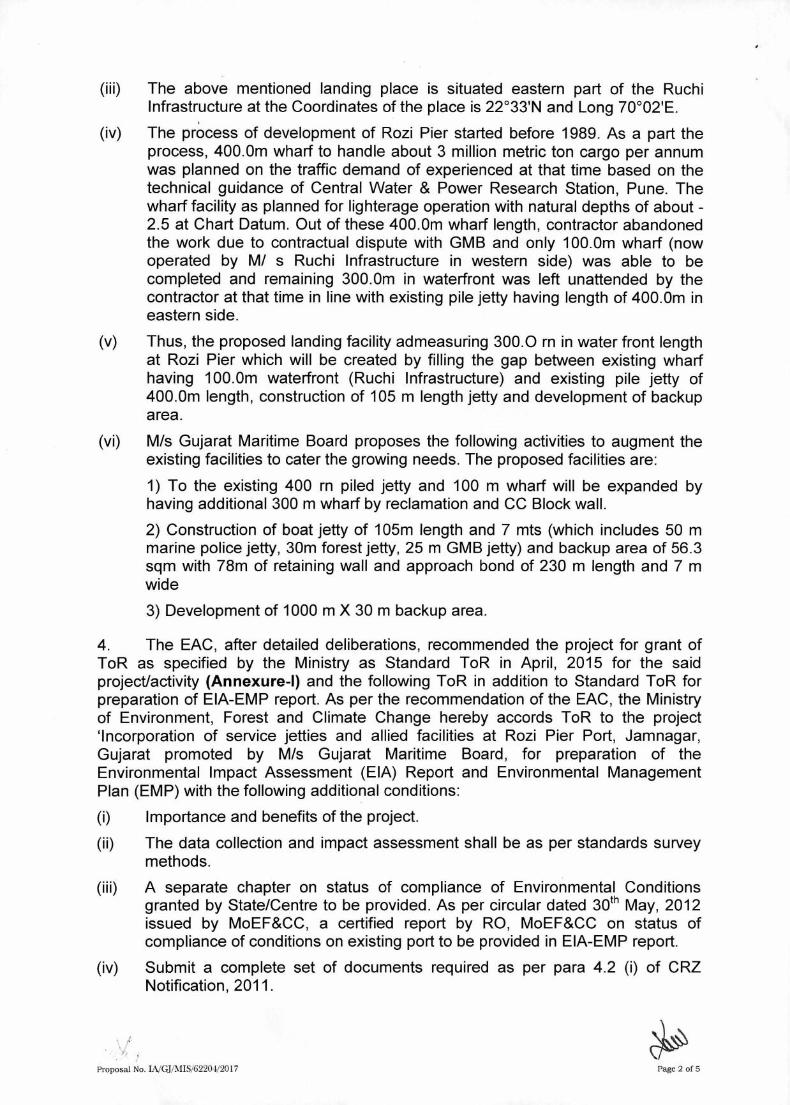
(iii) The above mentioned landing place is situated eastern part of the Ruchi Infrastructure at the Coordinates of the place is 22°33'N and Long 70°02'E.
(iv) The process of development of Rozi Pier started before 1989. As a part the process, 400.0m wharf to handle about 3 million metric ton cargo per annum was planned on the traffic demand of experienced at that time based on the technical guidance of Central Water & Power Research Station, Pune. The wharf facility as planned for lighterage operation with natural depths of about -2.5 at Chart Datum. Out of these 400.0m wharf length, contractor abandoned the work due to contractual dispute with GMB and only 100.0m wharf (now operated by M/ s Ruchi Infrastructure in western side) was able to be completed and remaining 300.0m in waterfront was left unattended by the contractor at that time in line with existing pile jetty having length of 400.0m in eastern side.
(v) Thus, the proposed landing facility admeasuring 300.0 rn in water front length at Rozi Pier which will be created by filling the gap between existing wharf having 100.0m waterfront (Ruchi Infrastructure) and existing pile jetty of 400.0m length, construction of 105 m length jetty and development of backup area.
(vi) M/s Gujarat Maritime Board proposes the following activities to augment the existing facilities to cater the growing needs. The proposed facilities are:
1) To the existing 400 rn piled jetty and 100 m wharf will be expanded by having additional 300 m wharf by reclamation and CC Block wall.
2) Construction of boat jetty of 105m length and 7 mts (which includes 50 m marine police jetty, 30m forest jetty, 25 m GMB jetty) and backup area of 56.3 sqm with 78m of retaining wall and approach bond of 230 m length and 7 m wide
3) Development of 1000 m X 30 m backup area.
4. The EAC, after detailed deliberations, recommended the project for grant of ToR as specified by the Ministry as Standard ToR in April, 2015 for the said project/activity (Annexure-I) and the following ToR in addition to Standard ToR for preparation of EIA-EMP report. As per the recommendation of the EAC, the Ministry of Environment, Forest and Climate Change hereby accords ToR to the project 'Incorporation of service jetties and allied facilities at Rozi Pier Port, Jamnagar, Gujarat promoted by M/s Gujarat Maritime Board, for preparation of the Environmental Impact Assessment (EIA) Report and Environmental Management Plan (EMP) with the following additional conditions:
(i) Importance and benefits of the project.
(ii) The data collection and impact assessment shall be as per standards survey methods.
(iii) A separate chapter on status of compliance of Environmental Conditions granted by State/Centre to be provided. As per circular dated 30th May, 2012 issued by MoEF&CC, a certified report by RO, MoEF&CC on status of compliance of conditions on existing port to be provided in EIA-EMP report.
(iv) Submit a complete set of documents required as per para 4.2 (i) of CRZ Notification, 2011.
Proposal No. 1A/GFMIS/62204/2017
Page 2 of 5

(v) Submit a copy of layout superimposed on the HTL/LTL map demarcated by an authorized agency on 1:4000 scale.
(vi) Recommendation of the SCZMA.
(vii) Prior clearance from NBWL shall be obtained in respect of protected area.
(viii) Various Ports facilities with capacities for proposed project.
(ix) List of cargo to be handled along with mode of transportation.
(x) Layout plan of existing and proposed Port.
(xi) A detailed analysis of the physico-chemical and biotic components in the highly turbid waters round the project site (as exhibited in the Google map shown during the presentation), compare it with the physico- chemical and biotic components in the adjacent clearer (blue) waters both in terms of baseline and impact assessment and draw up a management plan.
(xii) Study the impact of dredging on the shore line.
(xiii) A detailed impact analysis of rock dredging.
(xiv) Action plan for disposal of dredged soil and rocks.
(xv) Dispersion modeling for the dumping of the dredge materials shall be carried out. The study report shall be incorporated.
(xvi) Details of air pollution control measures to be taken as well as cost to be incurred.
(xvii) Total water consumption and its source. Wastewater management plan.
(xviii) Details of Environmental Monitoring Plan.
(xix) The impacts of rock excavation and dredging separately.
(xx) A para-wise compliance to the consent conditions as may have been prescribed by the State Pollution Control Board.
(xxi) The EIA would follow the orders of the respective courts and include a chapter in the EIA on the Court cases including those at the Supreme Court and the NGT.
(xxii) The Marine biodiversity impact assessment report and management plan through the National Institute of Oceanography (NIOS) or any other institute of repute on marine, brackish water and fresh water ecology and biodiversity. The report shall study the impact of the project activities on the intertidal biotopes, corals and coral communities, molluscs, sea grasses, sea weeds, subtidal habitats, fishes, other marine and aquatic micro, macro and mega flora and fauna including benthos, plankton, turtles, birds etc. as also the productivity. The data collection and impact assessment shall be as per standards survey methods.
(xxiii) Disaster Management Plan for the above terminal.
(xxiv) Layout plan of existing and proposed Greenbelt.
(xxv) Status of court case pending against the project.
(xxvi) A tabular chart with index for point wise compliance of above TORS.
(xxvii) Public hearing to be conducted and issues raised and commitments made by the project proponent on the same should be included in EIA/EMP Report in
Proposal No. IA/GRMIS/6220 W2017
Page 3 of 5

the form of tabular chart with financial budget for complying with the commitments made.
It was recommended that ToR' along with Public Hearing prescribed by the Expert Appraisal Committee (Infrastructure- 2) should be considered for preparation of EIA / EMP report for the above mentioned project in addition to all the relevant information as per the 'Generic Structure of EIA' given in Appendix Ill and IIIA in the EIA Notification, 2006. The draft EIA/EMP report shall be submitted to the State Pollution Control Board for public hearing. The issues emerged and response to the issues shall be incorporated in the EIA report.
General Guidelines
(I) The EIA document shall be printed on both sides, as for as possible.
(ii) All documents should be properly indexed, page numbered.
(iii) Period/date of data collection should be clearly indicated.
(iv) Authenticated English translation of all material provided in Regional languages.
(v) The letter/application for EC should quote the MoEF&CC File No. and also attach a copy of the letter prescribing the ToR.
(vi) The copy of the letter received from the Ministry on the ToR prescribed for the project should be attached as an annexure to the final EIA-EMP Report.
(vii) The final EIA-EMP report submitted to the Ministry must incorporate the issues mentioned in ToR and that raised in Public Hearing. The index of the final EIA-EMP report, must indicate the specific chapter and page no. of the EIA-EMP Report where the specific ToR prescribed by the Ministry and the issue raised in the Public Hearing have been incorporated. Questionnaire related to the project (posted on MoEF&CC website) with all sections duly filled in shall also be submitted at the time of applying for EC.
(viii) Grant of ToR does not mean grant of EC.
(ix) The status of accreditation of the EIA consultant with NABET/QCI shall be specifically mentioned. The consultant shall certify that his accreditation is for the sector for which this EIA is prepared.
(x) On the front page of EIA/EMP reports, the name of the consultant/consultancy firm along with their complete details including their accreditation, if any shall be indicated. The consultant while submitting the EIA/EMP report shall give an undertaking to the effect that the prescribed ToRs (ToR proposed by the project proponent and additional ToR given by the MoEF&CC) have been complied with and the data submitted is factually correct (Refer MoEF&CC Office memorandum dated 4th August, 2009).
(xi) While submitting the EIA/EMP reports, the name of the experts associated with/involved in the preparation of these reports and the laboratories through which the samples have been got analysed should be stated in the report. It shall clearly be indicated whether these laboratories are approved under the Environment (Protection) Act, 1986 and the rules made there under (Please refer MoEF&CC Office Memorandum dated 4th August, 2009). The project leader of the EIA study shall also be mentioned.
Proposal No. INGRMIS/62204/2017
Page 4 of 5

(xii) All the ToR points as presented before the Expert Appraisal Committee (EAC) shall be covered.
5. The above ToR should be considered for the project 'Construction of two offshore container berths and development of container terminal on BOT basis in Mumbai Harbour by Mumbai Port Trust, in addition to all the relevant information as per the 'Generic Structure of Elk given in Appendix III and II1A in the EIA Notification, 2006.
6. A detailed draft EIA/EMP report should be prepared in terms of the above additional ToR and should be submitted to the State Pollution Control Board for conducting Public Hearing. Public Hearing to be conducted for the project in accordance with the provisions of the EIA Notification, 2006 and the issues raised by the public should be addressed in the Environmental Management Plan. The Public Hearing should be conducted based on the ToR letter issued by the Ministry and not on the basis of Minutes of the Meeting available on the web-site.
7. The project proponent shall submit the detailed final EIA/EMP prepared as per ToR to the Ministry for considering the proposal for environmental clearance within 3 years as per the MoEF&CC O.M. No.J-11013/41/2006-IA-11(1) (P) dated 08.10.2014.
8. The consultants involved in preparation of EIA/EMP report after accreditation with Quality Council of India/National Accreditation Board of Education and Training (QCl/NABET) would need to include a certificate in this regard in the EIA/EMP reports prepared by them and data provided by other Organization(s)/ Laboratories including their status of approvals etc. vide Notification of the MoEF&CC dated 19.07.2013.
9. The prescribed ToR would be valid for a period of three years for submission of the EIA/EMP Reports.
(Kushal Vashist) Director
Copy to:
The Member Secretary, Gujarat Pollution Control Board, Paryavaran Bhavan, Sector-10A, Gandhinagar-382010, Gujarat, Phone: 079-2323 2152, Fax: (079) 2323 2156, 2322 2784, 2323 2161, Email: [email protected].
Proposal No. IA/GPMIS/6220-1/2017 Page 5 of 5

Annexure - I
7(e): STANDARD TERMS OF REFERENCE FOR CONDUCTING ENVIRONMENT IMPACT ASSESSMENT STUDY FOR PORTS, HARBOURS AND INFORMATION TO BE INCLUDED IN EIA/EMP REPORT
i. Reasons for selecting the site with details of alternate sites examined/rejected/ selected on merit with comparative statement and reason/basis for selection. The examination should justify site suitability in terms of environmental angle, resources sustainability associated with selected site as compared to rejected sites. The analysis should include parameters considered along with weightage criteria for short-listing selected site.
ii. Details of the land use break-up for the proposed project. Details of land use around 10 km radius of the project site. Examine and submit detail of land use around 10 km radius of the project site and map of the project area and 10 km area from boundary of the proposed/existing project area, delineating project areas notified under the wild life (Protection) Act, 1972/critically polluted areas as identified by the CPCB from time to time/notified eco-sensitive areas/interstate boundaries and international boundaries. Analysis should be made based on latest satellite imagery for land use with raw images.
iii. Submit the present land use and permission required for any conversion such as forest, agriculture etc. land acquisition status, rehabilitation of communities/ villages and present status of such activities.
iv. Examine and submit the water bodies including the seasonal ones within the corridor of impacts along with their status, volumetric capacity, quality likely impacts on them due to the project.
v. Submit a copy of the contour plan with slopes, drainage pattern of the site and surrounding area.
vi. Submit the details of terrain, level with respect to MSL, filling required, source of filling materials and transportation details etc.
vii. Examine road/rail connectivity to the project site and impact on the existing traffic network due to the proposed project/activities. A detailed traffic and transportation study should be made for existing and projected passenger and cargo traffic.
viii. Submit details regarding R&R involved in the project. ix. Submit a copy of layout superimposed on the HTL/LTL map demarcated by an
authorized agency on 1:4000 scale along with the recommendation of the SCZMA. x. Submit the status of shore line change at the project site
xi. Details of the layout plan including details of channel, breakwaters, dredging, disposal and reclamation.
xii. Details of handling of each cargo, storage, transport along with spillage control, dust preventive measures. In case of coal, mineral cargo, details of storage and closed conveyance, dust suppression and prevention filters.
xiii. Submit the details of fishing activity and likely impacts on the fishing activity due to the project. Specific study on effects of construction activity and pile driving on marine life.
xiv. Details of oil spill contingency plan.

xv. Details of bathymetry study. xvi. Details of ship tranquillity study.
xvii. Examine the details of water requirement, impact on competitive user, treatment details, use of treated waste water. Prepare a water balance chart.
xviii. Details of rainwater harvesting and utilization of rain water. xix. Examine details of Solid waste generation treatment and its disposal. xx. Details of desalination plant and the study for outfall and intake.
xxi. Examine baseline environmental quality along with projected incremental load due to the proposed project/activities.
xxii. The air quality monitoring should be carried out according to the notification issued on 16th November, 2009.
xxiii. Examine separately the details for construction and operation phases both for Environmental Management Plan and Environmental Monitoring Plan with cost and parameters.
xxiv. Submit details of a comprehensive Risk Assessment and Disaster Management Plan including emergency evacuation during natural and man-made disasters
xxv. Submit details of the trees to be cut including their species and whether it also involves any protected or endangered species. Measures taken to reduce the number of the trees to be removed should be explained in detail. Submit the details of compensatory plantation. Explore the possibilities of relocating the existing trees.
xxvi. Examine the details of afforestation measures indicating land and financial outlay. Landscape plan, green belts and open spaces may be described. A thick green belt should be planned all around the nearest settlement to mitigate noise and vibrations. The identification of species/ plants should be made based on the botanical studies.
xxvii. The Public Hearing should be conducted for the project in accordance with provisions of Environmental Impact Assessment Notification, 2006 and the issues raised by the public should be addressed in the Environmental Management Plan. The Public Hearing should be conducted based on the ToR letter issued by the Ministry and not on the basis of Minutes of the Meeting available on the web-site.
xxviii. A detailed draft EIA/EMP report should be prepared in accordance with the above additional TOR and should be submitted to the Ministry in accordance with the Notification.
xxix. Details of litigation pending against the project, if any, with direction /order passed by any Court of Law against the Project should be given.
xxx. The cost of the Project (capital cost and recurring cost) as well as the cost towards implementation of EMP should be clearly spelt out.
xxxi. Any further clarification on carrying out the above studies including anticipated impacts due to the project and mitigative measure, project proponent can refer to the model ToR available on Ministry website "http://moef.nic.in/Manual/Port and harbour".

ANNEXURE-II
SITE LAYOUT PLAN OF EXISTING AND PROPOSED

X
X
X
X
X
X
X
X
X
X
X
X
X
X
X
X
X
X
X
X
X
X
X
X
X
X
X
X
X
X
X
X
X
X
X
X
X
X
X
X
X
X
X
X
X
X
X
X
X
X
X
X
X
X
X
X
X
X
X
X
X
X
X
X
X
X
X
X
X
X
X
X
X
X
X
X
X
X
X
X
X
X
X
X
X
X
X
X
X
X
X
X
X
X
X
X
X
X
X
X
X
X
X
X
X
X
X
X
X
X
X
X
X
X
X
X
X
X
X
X
X
X
X
X
X
X
X
X
X
X
X
X
X
X
X
X
X
X
X
X
X
X
X
X
X
X
X
X
X
X
X
X
X
X
X
X
X
X
X
X
X
X
X
X
X
X
X
X
X
X
X
X
X
X
X
X
X
X
X
X
X
X
X
X
X
X
X
X
X
X
X
X
X
X
X
X
X
X
X
X
X
X
X
X
X
X
X
X
X
X
X
X
X
X
X
X
X
X
C
W
C
L
R
C
C
J
E
T
T
Y
GPS1
C
W
C
L
S
M
I
L
J
M
B
A
X
I
J
E
T
T
Y
R
U
C
H
I
I
N
F
R
A
S
T
R
U
C
T
U
R
E
A
R
E
A
3
5
4
3
2
.
8
7
S
Q
M
.
A
R
E
A
7
8
4
0
.
3
0
S
Q
M
.
A
R
E
A
1
4
1
9
6
.
6
9
S
Q
M
.
A
R
E
A
3
2
7
2
0
.
5
2
S
Q
M
.
W
H
A
R
F
J
.
M
.
B
A
X
I
R
C
C
J
E
T
T
Y
G
R
E
E
N
B
E
L
T
G
R
E
E
N
B
E
L
T
G
R
E
E
N
B
E
L
T
TBM VALUE AT
GPS2
ABONDED EDIBLE
OIL TANK
G
A
T
E
G
A
T
E
G
A
T
E
G
A
T
E
G
A
T
E
G
A
T
E
Ø
1
7
.
0
0
Ø
1
4
.
0
0
Ø20.00
Ø20.00
Ø20.00
Ø20.00
STRUCTURE
5.52 x 3.85
A
B
O
N
D
E
D
E
D
I
B
L
E
O
I
L
T
A
N
K
W
A
Y
B
R
I
D
G
E
7
.
7
0
x
3
.
3
9
W
A
Y
B
R
I
D
G
E
O
F
F
I
C
E
3
.
8
3
x
3
.
4
0
W
A
Y
B
R
I
D
G
E
1
8
.
5
4
x
3
.
4
8
W
A
Y
B
R
I
D
G
E
O
F
F
I
C
E
2
1
.
2
5
x
8
.
8
6
R
U
C
H
I
I
N
F
R
A
S
T
R
U
C
T
U
R
E
R
U
C
H
I
I
N
F
R
A
S
T
R
U
C
T
U
R
E
G
R
E
E
N
B
E
L
T
2
2
.
8
3
x
2
.
9
7
O
F
F
I
C
E
3
.
8
0
x
3
.
5
4
S
H
E
D
2
0
.
3
3
x
6
.
1
0
R
O
O
M
9
.
5
5
x
6
.
3
7
O
F
F
I
C
E
1
2
.
0
0
x
5
.
5
0
T
O
I
L
E
T
1
3
.
0
0
x
4
.
3
0
STRUCTURE
13.13 x 6.14
STRUCTURE
18.00 x 3.00
WAREHOUSE
86.35 x 48.07
SECURITY OFFICE
3.13 x 3.04
GATE PASS OFFICE
8.60 x 6.50
O
F
F
I
C
E
7
0
.
6
0
x
9
.
2
5
WAY BRIDGE
18.25 x 3.57
WAY BRIDGE OFFICE
17.97 x 1.82
SECURITY OFFICE
3.67 x 3.63
TOILET
8.34 x 5.88
WORKSHOP
6.47 x 4.65
RCC PLATFORM
100.45 x 100.07
WATER TANK
Ø6.24
DG ROOM
12.13 x 4.20
L
I
G
H
T
H
O
U
S
E
Ø
1
0
.
6
8
SEA
SEA
SEA
SEASEA
SEA
SEA
SEA
SEA
SEA
SEA
SEA
SEA
SEA
SEA
SEA
SEA
JETTY TOP +8.00 mtr.
1
0
0
.
0
0
5
0
.
0
0
2
5
0
.
0
0
S
M
I
L
R
C
C
J
E
T
T
Y
1
2
.
0
0
1
2
.
0
0
4
7
.
4
9
9
.
0
0
7
9
.
0
9
9
.
0
0
7
8
.
8
8
9
.
0
0
1
6
7
.
8
7
2
5
.
5
0
2
5
.
5
0
2
5
.
5
0
6
0
.
8
4
A
B
O
N
T
M
E
N
T
M
A
I
N
3
0
0
.
0
0
G
A
P
E
4
2
9
.
9
5
9
6
.
0
0
5
0
.
0
0
2
5
0
.
0
0
1
1
4
.
5
9
K
A
C
H
H
A
R
A
S
T
A
K
A
C
H
H
A
R
A
S
T
A
1
0
0
.
0
0
K
A
C
H
H
A
R
A
S
T
A
M
A
IN
G
A
T
E
4
.
4
7
4
.
4
1
5
.
3
9
8
.
7
5
3
2
.9
5
2
6
.
4
6
1
9
.
3
4
5
.
7
3
6
.
3
1
6
.
0
2
2
8
.
5
5
5
.0
5
1
1
.
7
3
5
7
.
1
3
2
.
9
6
3
6
1
.
0
9
1
.
8
1
7
9
.
2
2
1
9
6
.
6
4
1
1
0
.
4
1
9
.9
6
60.51
34.85
7
.5
4
1
2
.3
1
9
.
8
1
4
1
.
3
1
2
1
.
9
0
5
.2
3
5
.
6
6
8
.
4
2
9
.4
1
5.85
4
.
4
7
2
.
4
0
1
3
0
.
7
0
9
3
.
6
1
4
.
4
7
55.52
2
.
4
4
4
.8
7
7
.
8
3
3
8
.
2
5
8
3
.
4
8
2
4
.
5
3
2
.4
6
4
.
2
7
3
.0
7
1
9
.
2
3
2
.
4
1
7.91
4
8
.
6
9
10.56
4
8
.
2
7
1
2
.9
8
4
3
.
0
8
8
.7
5
30.4
8
4
3
.
7
2
3
0
.
1
5
1
9
2
.
2
7
3
.
7
1
5
.
5
8
8
.
4
7
1
7
.
8
1
P
E
V
A
R
B
L
O
C
K
R
O
A
D
P
E
V
A
R
B
L
O
C
K
R
O
A
D
A
S
P
H
A
L
T
R
O
A
D
A
S
P
H
A
L
T
R
O
A
D
A
S
P
H
A
L
T
R
O
A
D
1
0
1
.
1
4
9
9
.
7
0
1
0
0
.
0
7
1
0
0
.
4
5
1
6
.
7
8
1
4
.
6
0
1
4
.
9
2
1
4
8
.
0
7
7
9
.
4
1
1
2
.
9
8
4
4
.
3
8
G
A
T
E
G
A
T
E
5
8
.
9
3
9
.
1
2
1
0
7
.
0
2
9
.
1
8
2
6
8
.
6
0
9
.
1
6
1
2
8
.
4
3
9.10
1
3
.2
81
2
.
6
7
2
7
.
5
5
3
2
.
1
0
Approved By:-
-TBM VALUE AT JETTY TOP +8.00 mtr.
Scale: 1:1000
DHARMESH INTWALA
Checked by
B S BARIA
25 DEC 2012
Surveyed by
Date of Survey
Drawing ROZI PIER PORT
TOPOGRAPHY SURVEY OF ROZI PIER PORT
-SPOT LEVEL REDUCED TO JETTY TOP TBM
SHEET 01
NOTES
GRID
GEODETIC PARAMETERS
UTM
ZONE
DATUM WGS - 84
42
UNIT METER
UTM GPS CO-ORDINATS
GPS1 N 2496425.639
E 607406.499
GPS2 N 2496363.547
E 607353.674
GEOTECHNIC RESEARCH
MOBILE : 98241 02436 E-MAIL : [email protected]
6,7,8, SHOPPING OPP. POLYTECHNIC COLLEGE, OLD N.H. NO. 8, BHARUCH.
SOIL & MATERIAL TESTING LABORATORY
AN ISO 9001 : 2008 CERTIFIED COMPANY
GUJARAT MERITIME BOARD
CLIENT:
PROJECT:
GUJARAT MERITIME BOARD
CONTRACTOR:
GHANDHINAGAR,GUJARAT
-
-
-
-
AS PER WORK ORDER AREA :
SURVEYED AREA:
ACTULE SURVEYED AREA :
17.50 HECTARE
13.40 HECTARE
GRID SCALE
25 50025
12575 100
NAMESYMBOL
All dimensions are in meters.
All levels are in meters.
All levels are recoreded at every 25.00 m intervals
All contour line are plotted at 0.25 m intervals
All levels are plotted at every 25.00 m intervals
4.
5.
7
.
0
0
0
COMPOUND WALL
6
.
2
6
1
GPS POINTS
DRAINS
JETTY AREA
INTERNAL ROAD
ELECTRIC SUB STATION
WEIGH BRIDGE OFFICE
WEIGH BRIDGE
ABONDED EDIBLE OIL TANKS
TOILET
GATE
GATE
TBM
PLATFORM AREA
TRAFFIC & CUSTOM OFFICE
BUILDINGS & OTHER STRUCTURE
STRUCTURE
FENCING
X X
ROCK BAND
PORT BOUNDARY
SEQURITY OFFICE
LIGHT HOUSE
UNDER GROUND WATER TANK
GREEN BELT
SEA
PROTCTION BUND
LIGHT HOUSE AREA
C W C L JETTY
SMIL JETTY
J M BAXI JETTY
RUCHI INFRASTRUCTURE AREA
5
.
8
1
7
0
.1
7
35.22
2
8
.
5
5
1
9
.
4
4
2
4
.
2
2
18.52
22.4
5
1
2
0
.
1
7
9
6
.
6
4
1
6
2
.
0
4
5
3
.
4
2
1
5
8
.
8
0
5
1
.
4
9
1
6
6
.
9
5
S
E
C
U
R
I
T
Y
E
L
E
C
T
R
I
C
A
L
R
O
O
M
9
.
4
6
x
6
.
5
5
E
L
E
C
T
R
I
C
A
L
W
O
R
K
S
H
O
PS
H
E
D
1
6
.
3
8
x
6
.
4
2
W
O
R
K
S
H
O
P
S
E
C
U
R
I
T
Y
&
CUSTOM
UNDER GROUND
N 2495650
E 6
07
32
5
N 2495875
N 2495850
N 2495825
N 2495800
N 2495775
N 2495750
N 2495725
N 2495700
N 2495925
N 2496475
N 2495950
E 6
07
52
5
E 6
07
50
0
E 6
07
47
5
E 6
07
45
0
E 6
07
42
5
E 6
07
40
0
E 6
07
37
5
E 6
07
35
0
N 2495675
N 2496175
N 2496450
N 2496425
N 2496400
N 2496375
N 2496350
N 2496325
N 2496300
N 2496275
N 2496250
N 2495900
N 2496200
N 2496150
N 2496125
N 2496100
N 2496075
N 2496050
N 2496025
N 2496000
N 2495975
N 2496225
E 6
06
87
5
E 6
07
02
5
E 6
06
97
5
E 6
07
05
0
E 6
06
95
0
E 6
07
07
5
E 6
06
92
5
E 6
07
10
0
E 6
07
12
5
E 6
06
90
0
E 6
07
00
0
E 6
07
15
0
E 6
07
17
5
E 6
06
85
0
E 6
07
20
0
E 6
06
77
5
E 6
07
22
5
E 6
06
82
5
E 6
06
80
0
E 6
07
30
0
E 6
07
27
5
E 6
07
25
0
8
.
0
5
5
7
.
9
7
2
8
.
1
1
9
7
.
9
8
1
7
.
9
4
1
7
.
9
1
1
7
.
9
7
7
7
.
8
0
4
7
.
9
0
4
7
.
9
3
4
7
.
8
9
4
7
.
8
0
9
7
.
7
4
6
7
.
7
8
5
7
.
8
1
4
7
.
8
6
3
7
.
5
8
1
7
.
7
5
0
7
.
9
2
0
7
.
9
5
9
7
.
6
7
2
7
.
6
5
7
7
.
6
7
3
7
.
7
0
5
7
.
8
2
2
7
.
8
2
0
8
.
1
3
2
7
.
6
1
4
7
.
9
0
8
7
.
8
4
3
7
.
5
4
5
7
.
5
8
9
7
.
6
2
2
7
.
6
8
6
7
.
6
3
9
7
.
5
2
3
7
.
9
3
8
7
.
9
2
5
7
.
9
8
5
7
.
8
5
9
7
.
8
1
0
7
.
7
6
4
7
.
6
1
1
7
.
6
6
8
7
.
7
0
7
7
.
6
2
4
7
.
6
3
1
7
.
6
1
3
7
.
3
4
4
7
.
9
0
7
7
.
7
7
4
7
.
8
6
3
7
.
7
9
0
7
.
6
5
5
7
.
5
7
7
7
.
8
4
2
7
.
8
5
1
7
.
7
2
9
7
.
7
4
5
7
.
7
4
5
7
.
6
9
0
7
.
8
0
9
7
.
9
5
0
7
.
9
0
1
7
.
8
5
2
7
.
7
3
0
7
.
5
0
2
7
.
6
6
1
7
.
2
7
5
8
.
0
0
5
7
.
4
6
7
7
.
4
5
3
7
.
8
0
8
7
.
8
8
8
7
.
8
3
3
8
.
0
3
2
8
.
3
5
2
7
.
4
7
6
8
.
0
1
8
7
.
8
5
7
7
.
7
8
3
8
.
0
0
7
8
.
0
2
0
7
.
9
3
6
8
.
0
7
5
8
.
2
2
8
8
.
0
8
2
8
.
1
1
1
7
.
5
0
2
7
.
9
4
1
7
.
9
4
5
7
.
8
7
9
7
.
8
8
9
8
.
1
0
8
8
.
0
8
0
8
.
0
2
0
8
.
1
7
9
8
.
2
4
1
8
.
1
7
3
7
.
8
4
3
7
.
8
8
4
7
.
8
1
6
7
.
8
4
6
7
.
9
4
1
8
.
0
9
0
7
.
8
4
6
7
.
8
2
3
7
.
9
6
8
7
.
9
8
8
8
.
0
5
6
7
.
6
9
8
7
.
9
3
2
7
.
7
3
7
7
.
5
7
4
7
.
6
0
5
7
.
5
4
7
7
.
4
9
3
7
.
7
1
9
7
.
7
8
1
7
.
1
4
7
7
.
8
7
5
7
.
8
7
1
7
.
1
9
3
7
.
2
1
7
7
.
3
4
2
7
.
5
3
8
7
.
1
6
0
7
.
6
6
7
7
.
3
1
1
7
.
3
7
5
8
.
0
0
9
8
.
1
3
9
7
.
3
7
0
7
.
8
9
4
7
.
6
2
9
7
.
2
9
2
6
.
6
3
1
7
.
3
2
4
7
.
3
3
4
7
.
2
0
0
7
.
9
2
3
7
.
8
7
9
8
.
2
1
7
7
.
3
8
8
6
.
9
8
0
6
.
9
1
0
6
.
8
8
6
7
.
0
2
9
7
.
1
8
5
7
.
0
9
5
7
.
2
8
9
7
.
2
1
9
7
.
9
8
6
7
.
1
4
6
6
.
9
9
6
6
.
9
7
6
6
.
8
6
6
7
.
2
0
9
7
.
3
1
9
7
.
3
6
5
7
.
2
1
5
6
.
8
0
4
7
.
6
3
7
7
.
1
2
0
7
.
2
9
9
7
.
5
0
0
7
.
7
2
3
7
.
6
8
2
7
.
6
7
4
7
.
4
6
7
7
.
2
8
7
7
.
2
1
7
7
.
4
9
8
7
.
5
4
7
7
.
3
5
2
7
.
5
4
6
7
.
0
6
7
7
.
1
5
7
7
.
3
0
4
7
.
4
1
4
7
.
2
2
9
7
.
5
8
5
7
.
5
5
2
7
.
7
5
8
7
.
4
2
9
7
.
2
8
5
6
.
5
5
7
7
.
2
5
2
7
.
1
0
5
6
.
8
8
6
6
.
2
7
0
6
.
8
0
5
7
.
4
6
3
7
.
0
9
8
7
.
3
2
6
7
.
0
6
1
7
.
1
6
1
6
.
4
7
9
6
.
1
8
0
6
.
6
6
4
6
.
5
9
3
7
.
6
5
1
7
.
3
2
0
7
.
4
9
7
7
.
5
3
9
7
.
1
3
2
6
.
7
1
0
7
.
1
7
1
7
.
0
3
4
JAMNAGAR
ROZI PIER PORT
5
0
.
0
0
3
0
.
0
0
2
5
.
0
0
7
.
0
0
5
6
.
3
0
3
1
.
2
4
M
A
R
I
N
E
P
O
L
I
C
E
J
E
T
T
Y
5
0
.
0
M
.
L
O
N
G
(
7
.
0
M
.
W
I
D
E
)
F
O
R
E
S
T
J
E
T
T
Y
3
0
.
0
M
.
L
O
N
G
(
7
.
0
M
.
W
I
D
E
)
G
M
B
J
E
T
T
Y
2
5
.
0
M
.
L
O
N
G
(
7
.
0
M
.
W
I
D
E
)
AP
PR
OA
CH
B
UN
D 230 M
TR
. (7.00 M
TR
. W
ID
E)
M
A
R
I
N
E
P
O
L
I
C
E
J
E
T
T
Y
5
0
.
0
M
.
L
O
N
G
(
7
.
0
M
.
W
I
D
E
)
B
A
C
K
U
P
A
R
E
A
R
E
T
A
I
N
G
W
A
L
L
3
0
.
0
0
3
0
x
1
0
0
0
L
O
N
G
A
D
D
I
T
I
O
N
A
L
B
E
L
T
C
O
N
S
T
R
U
C
T
I
O
N
F
O
R
R
O
A
D
&
R
A
I
L
W
A
Y
3
0
x
1
0
0
0
L
O
N
G
A
D
D
I
T
I
O
N
A
L
B
E
L
T
C
O
N
S
T
R
U
C
T
I
O
N
F
O
R
R
O
A
D
&
R
A
I
L
W
A
Y
3
0
x
1
0
0
0
L
O
N
G
A
D
D
I
T
I
O
N
A
L
B
E
L
T
C
O
N
S
T
R
U
C
T
I
O
N
F
O
R
R
O
A
D
&
R
A
I
L
W
A
Y
1
0
0
0
.
0
0
M
t
r
.
SPOT LEVEL
6
.
2
6
1
CONTOUR & RL
GRID CO-ORDINATE
N 2366485
N 2366480
N 2366490
N 2366495
E 2
06
15
5
E 2
06
15
0
E 2
06
16
5
E 2
06
16
0
ES ORIGINAL
TREE
LELECTRIC POLL
ANCHOR PLACE
LEMP POST
SCALE.
LEGEND.
NOTES.
1.
2.
3.
AutoCAD SHX Text
N

ANNEXURE-III
GPCB CTE AND CTO’S


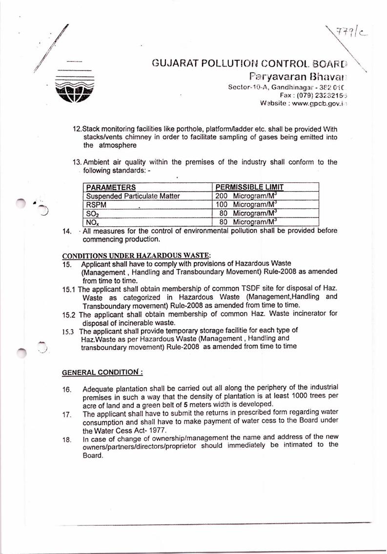


M/s. GUJARAT MARITIME BOARD (ROZI PORT)
COMPLIANCE FOR CONSENT FOR ESTABLISHMENT
ORDER No.PC/CCA-JMN-449/9546 Dt: 15.05.2009
S.No CONDITIONS COMPLIANCE SPECIFIC CONDITIONS 1 The validity period of the order will be five years for
the date of issue.
Noted and followed.
2 Applicant shall not start any construction activities
without getting Environment Clearance certificate
from SEIAA/Ministry of Environment and Forest
under EIA notification dated 14/09/2006
We have already obtained Environmental
Clearance with vide order No: 10-28/2007-
IA-III Dated 13 January 2009. As the
validity of the order expired we have
applied for EC Re validation.
3 Applicant shall comply with all conditions stipulated
by SEIAA/Ministry of Environment and Forest in the
order of Environment Clearance as and when issued.
We will follow all the rules and regulations
stipulated by the SEIAA/Ministry of
Environment and Forest in the order of
Environment Clearance as and when
issued.
4 Applicant shall obtain CRZ clearance from
competent authority under CRZ Rules.
No ground water shall be used for the project coming
under
• dark zone without permission of competent
authority
• Unit shall provide metering facility at the outlet
of the ETP/unit
We have applied and obtained CRZ
clearance from MoEF & CC vide order
no:10-28/2007-IA-III Dated 13 January
2009.
We will not use ground water if the project
is in dark zone. We will provide flow
meters at the outlet of the ETP / unit.
CONDITIONS UNDER WATER ACT 1974
5 There shall be no generation/discharge of the
industrial effluent during the construction as well
We will not discharge any effluent outside
the industry premises during the

operational phase construction as well operational phase.
6 The quantity of the domestic waste water (sewage)
shall not exceed 12 to 15kl/day.
We will not exceed the stipulated quantity
of domestic waste water.
7 Sewage shall be disposed of through portable
sanitary unit develop and maintained by the unit
We will follow as per the rules directed.
CONDITIONS UNDER AIR ACT 1981
8 The following shall be used as fuel
Sr.No Fuel Quantity
1. HSD 10KL/D
We will use HSD of 10 KLD as fuel.
9 The applicant shall install & operate air pollution
control system in order to achieve norms prescribed
below
We will install & operate air pollution
control system to achieve norms
prescribed.
10 The flue gas emission through stack shall conform to
the following standards
Stac
k
No
Stack
attache
d to
Stac
k
heig
ht in
mete
r
APC
M
Paramet
er
Permissi
ble Limit
1 D.G.S
ET
NO-1
8mtr ----- PM
SO2
NOX
150
mg/NM3
100 ppm
50 ppm
2 D.G.S
ET
NO-1
8mtr ----- PM
SO2
NOX
150
mg/NM3
100 ppm
50 ppm
We will comply to the stack emissions as
stipulated.
11 There shall be no process emission stack in the unit We will not install any process emission
stack in this unit.
12 Stack monitoring facilities like porthole;
platform/ladder etc. shall be provided With
stacks/vents chimney in order to facilitate sampling
We will provide porthole; platform/ladder
etc.with stacks/vents chimney in order to
facilitate sampling of gases being emitted

of gases being emitted into the atmosphere into the atmosphere
13 Ambient air quality within the premises of the
industry shall conform to the following standards: -
PARAMETERS PERMISSIBLE
LIMIT
Suspended Particulate
Matter
200 Microgram/M3
RSPM 100 Microgram/M3
SO2 80 Microgram/M3
NOX 80 Microgram/M3
We will conform to the standards
prescribed.
14 All measures for the control of environmental
pollution shall be provided before commencing
production.
We will provide all the measures related to
environmental pollution before
commencement of production.
CONDITIONS UNDER HAZARDOUS WASTE:
15 Applicant shall have to comply with provisions of
Hazardous Waste (Management, Handling and
Transboundary Movement} Rule-2008 as amended
from time to time.
We will comply with provisions of
Hazardous Waste (Management, Handling
and Trans boundary Movement} Rule-
2008 as amended from time to time.
15.1 The applicant shall obtain membership of common
TSDF site for disposal of Haz. Waste as categorized
in Hazardous Waste (Management, Handling and
Transboundary movement) Rule-2008 as amended
from time to time.
We will obtain membership of common
TSDF site for disposal of Haz. Waste as
categorized in Hazardous Waste
(Management, Handling and
Transboundary movement) Rule-2008 as
amended from time to time.
15.2 The applicant shall obtain membership of common
Haz. Waste incinerator for disposal of incinerable
waste.
We will obtain membership of common
Haz. Waste incinerator for disposal of
incinerable waste.
15.3 The applicant shall provide temporary storage
facilitie for each type of Haz. Waste as per
Hazardous Waste (Management , Handling and
transboundary movement) Rule-2008 as amended
We will provide temporary storage
facilitie for each type of Haz. Waste as per
Hazardous Waste (Management , Handling
and transboundary movement) Rule-2008

from time to time as amended from time to time
GENERAL CONDITION :
16 Adequate plantation shall be carried out all along the
periphery of the industrial premises in such a way
that the density of plantation is at least 1000 trees per
acre of land and a green belt of 5 meters width is
developed.
We will plant trees along the boundary or
periphery of the industrial premises as per
the rules and regulation of the Board.
17 The applicant shall have to submit the returns in
prescribed form regarding water consumption and
shall have to make payment of water cess to the
Board under the Water Cess Act- 1977
We will submit the returns regarding
water consumption and will make payment
of water cess to the Board under the Water
Cess Act-1977 as applicable.
18 In case of change of ownership/management the
name and address of the new
owners/partners/directors/proprietor should
immediately be intimated to the Board.
We will intimate the change of
ownership/management the name and
address of the new
owners/partners/directors/proprietor to the
Board.
19 The applicant shall however, not without the prior
consent of the Board bring into use any new or
altered outlet for the discharge of effluent or gaseous
emission or sewage waste from the proposed
industrial plant. The applicant is required to make
applications to this Board for this purpose in the
prescribed forms under the provisions of the Water
Act-1974, the Air Act-1981 and the Environment
{Protection) Act-1986.
We will not use any new or altered outlet
for the discharge of effluent without prior
consent from the Board.
20 The applicant also comply with the General
conditions as per Annexure-1 attached herewith
(No.1 to 38) (whichever applicable).
We will comply.
21 The concentration of Noise in ambient air within the
premises of industrial unit shall not exceed following
levels:
Between 6 A.M. and 10 P.M.: 75 dB(A)
Between 10 P.M. and 6 A M. : 70 dB(A)
We take necessary precautions that the
concentration of Noise in ambient air
within the premises of industrial unit
exceeds the stipulated quantity.

22 Applicant is required to comply with manufacturing,
Storage and Import of Hazardous Chemicals Rules-
1989 framed under the Environment (Protection)
Act-1986.
We will comply to manufacturing, Storage
and Import of Hazardous Chemicals Rules-
1989 framed under the Environment
(Protection) Act-1986.
23 If it is established by any competent authority that the
damage is caused due to their industrial activities to
any person or his property .in that case they are
obliged to pay the Compensation as determined by
the competent authority.
We will pay compensation if any damage
is caused due to industrial activities to any
person or his property

-;,.,
~~".GPCB
GUJARAT POLLUTION CONTROL BOARDPARYAVARAN BHAVAN
Sector 10-A Gandhinagar 382010Phone (079) 23226295Fax (079) 23232156Website www.gpcb.govin
ByR.P.A.D.In exercise of the power conferred under section-25 of the Water (Prevention and Control of
Pollution) Act-1974, under section-21 of the Air (Prevention and Control of Pollution)-1981 andAuthorization under rule 3(c) & 5(5) of the Hazardous Waste (Management and IIandling) Rules' 1989 &as amended up to year 2003 framed under the Environment (Protection) Act-1986.
And whereas Board has received consolidated consent application Inward No.70198 dated01.08.2013 for the Consolidated Consent and Authorization (CC&A) of this Board under theprovisions/rules of the aforesaid Acts Consents & Authorization arc hereby granted as under:CONSENTS:(Under the provisions /rules ofthe aforesaid environmental acts)
To;GUJARAT MARITIME BOARD(ROZI PORT),ROZI PIER, BEDI GROUP OF PORTS,
~ZI PORT AREA,JAMNAGARD1ST. JAMNAGAR.
1. Consent Order NO.AWH-58171 Date of issue: 07/11/2013.
2. The consents shall be valid up to 30/07/2018 for use of outlet for the discharge of trade effluent& emission due to operation of port for handling of General bulk cargo of following items.
SR.NO.I23
PRODUCTS/ MATERIALSBAUXITE/CEMENTCOALFERTlLlZERIFOOD GRAINS AND OTHER
HANDLING PER MONTH500000MT500000MT400000MT
3.3.13.2
3.3
3.4
3.5
3.6
3.73.8
Specific Conditions::Applicant shall comply Guidelines for Handling of Coal at port enclosed as Annexure A.Instead of converting all ports to coal handling ports, GMB has to work out policy ofdedicated coal handling ports to avoid complaints and litigation.In case of coal cargo handling quantity of cargo handled should remain same as per existingcargo handling ..Applicant shall carry our adequate plantation all along the periphery of the port & inside &outside of the port along with road.Applicant shall strictly observe that no coal should be stored or stacked in open anywhere outsidethe port arca in city area.Applicant shall improve the existing road condition and shall ensure proper surfacing of internalroads to avoid the spillage of bulk cargo on road.Applicant shall ensure proper surfacing of stacking platform.AP.2!icant shall ensure maximum sprinkling of water at each & every stage of transporting coal
uJt!l'~~t6uja,.frtat6,.ef!'ff GujaratISO - 9001 - 2008 & ISO - 14001 - 2004 Certified Organisation

3.9 Applicant shall ensure that all trucks before leaving the port shall covered with tarpaulin as weBas assured that trucks are not over loaded.
3.10 Applicant shall ensure regular sweeping of coal from internal & main road & space 0 freecirculation.
3.11 Applicant shall operate the continues ambient Air Quality Monitoring station & shall submitresults of SPM, RSPM. NOx, S02 month wise to GPeB.
3.12 Applicant shall ensure that stacking of coal is not higher than compound wall.3.13 Applicant shall provide adequate firefighting measure to avoid any fire. Also assure that there
shall be no explosive or chemical reaction in bulk cargo. For this an onside emergency planshould be prepared & compiled by applicant & port users.
3.14 You shall not carry out any activity which may attracts the applicability of E.I.A.Notification 2006.
4. CONDITIONS UNDER THE WATER ACT:4.1. The quantity of trade effluent from the factory shall be "Nil".4.2 The quantity of Sewage effluent [rom the factory shall not exceed 10.0 KLPD4.3 Domestic effluent shall be disposed ofYthrough septic tank/soak pit system.
5. CONDITIONS UNDER THE AIR ACT5.1 There shall be no use offue\.5.2 There shall be no flue gas emission as \vell as process emission from the activity carried out at the
port.5.3 The acoustic enclosure of acoustic treatment of the room shall be designed for minimum 25
dB(A) insertion loss or for meeting the ambient noise standers, whichever is on the higher side (ifthe actual ambient noise is on the higher side, it may not be possible to check the perfol1l1ance ofthe acoustic enclosure /acoustic treatment. Under such circumstances the performance may bechecked for noise reduction up to actual ambient noise level, preferably, in the night time). Themeasurement for Insertion loss may be done at different points at 0.5 m from the acousticenclosure/room and then averaged.
5.4 The concentration of the following parameters in the ambient air within the premises of theindustry shall not exceed the limits specified hereunder.
PARAMETER PERMISSffiLE LIMIT (Microgram! M3
Annual 24 Hrs. AverageParticulate matter-IO PM10 60 100Particulate matter-2.5 IPM2.5 40 60SO, 50 80NOx 40 80
5.5 The industry shall take adequate measures for control of noise levels from its own sources withinthe premises so as to maintain ambient air quality standards in respect of noise to less than75dB(a) during day time and70 dB (A) during night time. Daytime is reckoned in between6a.m. audIO p.m. and night time is reckoned between 10 p.m. and 6 a.m.
6. Authorizationfor the Management& Handling of HazardousWastes Form-2 (See rule 3 (c)& 5 (5) Form for grant of authorization for occnpier or operator handling hazardous wasteunder Hazardous waste (MJI & TM) Ruels,2008 Form for grant of authorization for occupieror operator handling hazardous waste.

GUJARAT POLLUTION CONTROL BOARDPARYAVARAN BHAVAN
Sector 10-A, Gandhinagar 382010Phone (079) 23226295Fax (079) 23232156
Number of authorization: AWH-58t71 Date of issue; 07/111W8?site www.gpcb.gov.inMis. GUJARAT MARITIME BOARD(ROZI PORT) is hereby granted an authorization tooperate facility tor foIIowing hazardous wastes on the premises situated at ROZI PfER. DEDIGROUP OF PORTS, ROZI PORT AREA, JAMNAGAR,DIST. JAMNAGAR.
Sr. Waste Quantity Schedule--I FacilityINo. (MTNr.) ProcessNo.I
I. Used Spent Oil 1.00 1-5.1 COJlectiOD,Storage,
ITransportation,Disposal by seJling to registerednrellrocessor / Recvclers
6.2 The authorization is granted to operate a facility for collection, storage within factory premisestransportation and ultimate disposal of Hazardous wastes by selling to the Registered Rc-processors/Recyclers having valid CCA of this Board/or disposal at TSDF.
6.3 The authorization shall be valid up to 30/07/2018.6.4 The authorization is subject to the conditions stated below and such other conditions as may be
specified in the rules from time to time under the Environment (Protection) Act-J986.7. TERMS AND CONDITIONS OF HAZ(M,H&TM)RULES-2008
a) The applicant shall comply with the provisions of the Environment (Protection) Act - ] 986and the rules made there under.
b) The authorization shall be produced for inspection at the request of an officer authorized b.ythe Gujarat Pollution Control Board.
c) The persons authorized shalJ not rent, lend, sell, and transfer of otherwise transport thehazardous wastes without obtaining prior permission of the Gujarat PoJlution Control Board.
d) Any unauthorized change in personnel, equipment or working conditions as mentioned in theauthorization order by the persons authorized shall constitute a breach of this authorization.
e) h is the duty of the authorized person to take prior pennission of the Gujarat PollutionControl Board to dose down the facility.
f) An application for the renewal of an authorization shall be made as laid down in rule ~7.7.1 ln addition to above tenus and conditions lndustry shall also comply foJJowing directives issued
by the Supreme Court ofIndia dated. 14.10.2003.a) Industry shall have to display the relevant infonnation with regard to hazardous waste as
indicated in the Court's order in W.P. NO.657 of J 995 dated 14th October 2003b) Industry shall have to display on-line data outside the main factory gate with regard to quantity
and nature of hazardous chemicals being handled in the plant. including wastewater and airemissions and solid hazardous wastes generated within the facto)}' premises.
8. GENERAL CONDITIONS:8.1 Any change in personnel, equipment or working conditions as mentioned in the consents
fonn/order should immediately be intimated to this Board.8.2 Whenever due to accident or other unforeseen act or ever, such emissions occur or is
apprehended to occur in excess of standards laid down such information shall be forthwithreported to Board, concerned Police Station, Office of Directorate ofHeaJth Service, Depanmentof Explosives, lnspectorate of Factories and local body. Tncase of failure of pollution controlequipments, the production process connected to it shall be stopped. Remedial actions/measuresshall be implemented immediately to bring entire situation normal.
8.3 The Environmental Management UnitfCeH shall be setup to ensure implementation on andmonitoring of environmental safeguards and other conditions ·stipulaied by statutor)' authorities.The",,"!Jl!lJl>llllli /oI'!!WJ1'NtflV"'i~pP!hr6'u""t"(ll(l:xecu/;ve of theorg~MifW\haV""d"'at a ~ct1 pt!5fnf1O'/"j"n~ernaJJZlng~nvlronm~ntal. issues. These
ISO - 9D01 - 2D08 & ISO - 14001 - 2004 Certified Organisation

ceUs/units also coordinate the exercise of environmental audit and preparation of environmentalstatements.
8.4 The Environmental audit shall be carried out yearly and the environmental statements pertainingto the previous year shall be submitting to this State Board latest by 30th September cvery year.
8.5 The Board reserves the right to review and/or rcvoke the consent and/or make variations in theconditions, which the Board deems, fit in accordance with Section 27 of the Act.
8.6 In case of change of ownership/management the name and address of the newo\vners/partners/directors/proprietor should immediately be intimated to the Board.
8.7 Industry shall have to display the relevant infonnatioll with regard to hazardous waste as indicatedin the HOll. Supreme order in w.p. no. 657 of 1995 dated 14th October 2003.
8.8 Industry shall provide PPEs to all the worker involved in coal handling and are exposed to workarea.
8.9 Industry shall provide water sprinkling system in such a way that entire coal is covered.8.10 Industry shall provide continual mechanized sweeping system in coal handling area of the port.8.11 industry shall provide closed conveyors in coal handling and coal handling system shall have to
be mechanized at every step starting from unloading from barrage to final dispatch to cnd user.
NO: PC/CCA/JMN-449/lD-329901 1653 'i ~ISSUED TO:GUJARA T MARITIME BOARD(ROZI PORT),ROZI PIER, BEDI GROUP OF PORTS,ROZI PORT AREA,.IAMNAGAR
DIST. JAMNAGAR.
ror and on behalf ofGujarat Pollution Contr~~l~oar~
~ .... , (" Ii(V.R.GIIA GEi
Sr. Environmental EngineerDATE:\S~ 11.20/.'>
M/s. GUJARAT MARITIME BOARD (ROZI PORT)
COMPLIANCES FOR CONSENT ORDER
No. AWH-58171 Dt: 07.11.2013
S.No Conditions Compliance
3 Specific Conditions
3.1 Applicant shall comply Guidelines for Handling of
Coal at port enclosed as Annexure A.
We will comply to the Guidelines for Handling
of Coal at port enclosed as Annexure A.
3.2 Instead of converting all ports to coal handling ports,
GMB has to work out policy of dedicated coal
handling ports to avoid complaints and litigation.
We will work out policy of dedicated coal
handling ports to avoid litigations.
3.3 In case of coal cargo handling quantity of cargo
handled should remain same as per existing cargo
handling.
We will handle same quantity of cargo handling
as per existing cargo handling.
3.4 Applicant shall carry our adequate plantation all along
the periphery of the port & inside & outside of the port
along with road.
We have provided extensive greenbelt along the
periphery of the port & inside & outside of the
port along with road.
3.5 Applicant shall strictly observe that no coal should be
stored or stacked in open anywhere outside the port
area in city areas.
We will store coal only in closed shed or rooms.
3.6 Applicant shall improve the existing road condition
and shall ensure proper surfacing of internal roads to
avoid the spillage of bulk cargo on road.
We will improve and ensure the road condition
and proper surfacing of internal roads to avoid
the spillage of bulk cargo on road.
3.7 Applicant shall ensure proper surfacing of stacking
platform.
We will ensure proper surfacing of stacking
platform.
3.8 Applicant shall ensure maximum sprinkling of water at
each & every stage of transporting coal up the loading
truck to avoid generation of coal dust.
We will sprinkle water at each & every stage of
transporting coal up the loading truck to avoid
generation of coal dust.
3.9 Applicant shall ensure that all trucks before leaving the
port shall covered with tarpaulin as well as assured that
trucks are not over loaded.
We will cover all trucks with tarpaulin before
leaving the port. Trucks will not be over loaded.
3.10 Applicant shall ensure regular sweeping of coal from
internal & main road & space or free circulation.
We will maintain good housekeeping in and
around the port.

3.11 Applicant shall operate the continues ambient Air
Quality Monitoring station & shall submit results of
SPM, RSPM, NOx, SO2 month wise to GPCB.
We will operate continues ambient Air Quality
Monitoring station. Reports wikk we submitted
to the GPCB.
3.12 Applicant shall ensure that stacking of coal is not
higher than compound wall.
We will ensure that the coal stacking is not
higher than compound wall.
3.13 Applicant shall provide adequate fire fighting measure
to avoid any fire. Also assure that there shall be no
explosive or chemical reaction in bulk cargo. For this
an onside emergency plan should be prepared &
compiled by applicant & port users.
We have provided adequate fire fighting measure
to avoid fires. We will ensure that there is no
explosive or chemical reaction in bulk cargo. On
site emergency plan is prepared
3.14 You shall not carry out any activity which may attracts
the applicability of E.I.A. Notification 2006.
We are not carrying any activity which attracts
the applicability of EIA Notification 2006.
4. CONDITIONS UNDER THE WATER ACT:
4.1 The quantity of trade effluent from the factory shall be
“Nil”.
We are not discharging any trade effluent from
the factory.
4.2 The quantity of sewage effluent from the factory shall
not exceed 10.0 KLPD.
We are not exceeding 10.0 KLPD. of sewage
effluent.
4.3 Domestic effluent shall be disposed off through septic
tank/ soak pit system.
We are disposing domestic effluent through
septic tank/ soak pit system.
5 CONDITIONS UNDER THE AIR ACT:
5.1 There shall be no use of fuel. We are not using fuel.
5.2 There shall be no flue gas emission as well as process
emission from the activity carried out at the port.
There will be no flue gas emission as well as
process emission from the activity carried out at
the port.
5.3 The acoustic enclosure of acoustic treatment of the
room shall be designed for minimum 25 dB(A)
insertion loss or for meeting the ambient noise
standers, whichever is on the higher side (if the actual
ambient noise is on the higher side, it may not be
possible to check the performance of the acoustic
enclosure/acoustic treatment. Under such
circumstances the performance may be checked for
noise reduction up to actual ambient noise level,
We have provided acoustic enclosure as directed
by the Board.

preferably, in the night time). The measurement for
insertion loss may be done at different points at 0.5 m
from the acoustic enclosure/room and then averaged.
5.4 The concentration of the following parameters in the
ambient air within the premises of the industry shall
not exceed the limits specified hereunder.
PARAMETER PERMISSIBLE LIMIT
(Microgram/M3)
Annual 24 Hrs. Average
Particulate
Matter – 10
(PM10)
60 100
Particulate
Matter – 2.5
(PM2.5)
40 60
SO2 50 80
NOX 40 80
The concentration of the parameters in the
ambient air are not exceeding the specified
limits.
5.5 The industry shall take adequate measures for control
of noise levels from its own sources within the
premises so as to maintain ambient air quality
standards in respect of noise to less than 75 dB(a)
during day time and 70 dB(A) during night time. Day
time is reckoned in between 6 a.m. and 10 p.m. and
night time is reckoned between and 10 p.m. and 6 a.m.
We are taking necessary measures for control of
noise levels from its own sources within the
premises so as to maintain ambient air quality
standards in respect of noise to less than 75
dB(a) during day time and 70 dB(A) during
night time.
6. Authorization for the Management & Handling of
Hazardous Wastes Form-2 (See rule 3 (c) & 5(5) Form
for grant of authorization for occupier or operator
handling hazardous waste under Hazardous waste
(M,H & TM) Rules, 2008 Form for grant of
authorization for occupier or operator handling
hazardous waste.
We have obtained all necessary clearances from
the competent authority.

6.1 Name of authorization: AWH-58171 Date of issue:
07/11/2013.
M/s. GUJARAT MARITIME BOARD (ROZI PORT)
is hereby granted an authorization to operate facility
for following hazardous wastes on the premise situated
at ROZI PIER, BEDI GROUP OF PORTS, ROZI
PORT AREA, JAMNAGAR, DIST. JAMNAGAR.
S.
No
Waste Quantit
y
(MT/Yr
)
Schedule-
1 Process
No.
Facility
1. Used
Spent
Oil
1.00 1- 5.1 Collection,
Storage,
Transportation,
Disposal by
selling to
registered
pre-processor/
Recyclers
Noted.
6.2 The authorization is granted to operate a facility for
collection, storage within factory premises
transportation and ultimate disposal of Hazardous
wastes by selling to the Registered
Reprocessors/Recyclers having valid CCA of this
Board/or disposal at TSDF.
Noted and followed.
6.3 The authorization shall be valid up to 30/0712018. Noted.
6.4 The authorization is subjected to the conditions stated
below and such other conditions as may be specified in
the rules from time to time under the Environment
(Protection) Act-1986.
We will obey.
7. TERMS AND CONDITIONS OF HAZ (M,H&TM) RULES-2008
a) The applicant shall comply with the provisions of
the Environment (Protection) Act – 1986 and the
We will comply.

rules made there under.
b) The authorization shall be produced for inspection
at the request of an officer authorized by the
Gujarat pollution Control Board.
c) The persons authorized shall not rent, lend, sell
and transfer of otherwise transport the hazardous
wastes without obtaining prior permission of the
Gujarat pollution Control Board.
d) Any unauthorized change in personnel, equipment
or working conditions as mentioned in the
authorization order by the persons authorized
shall constitute a breach of this authorization.
e) It is the duty of the authorised person to take prior
permission of the Gujarat pollution Control Board
to close down the facility.
f) An application for the renewal of an authorization
shall be made as laid down in rule-7.
7.1 In addition to above terms and conditions industry
shall also comply following directives issued by the
Supreme court of India dated. 14.10.2003.
We will follow.
a) Industry shall have to display the relevant
information with regard to hazardous waste as
indicated in the Court’s order in W.P. No.657 of
1995 dated 14th October 2003.
b) Industry shall have to display on-line data outside
the main factory gate with regard to quantity and
nature of hazardous chemicals being handled in
the plant, including waste water and air emissions
and solid hazardous wastes generated within the
factory premises.
We have displayed information with regard to
hazardous waste as indicated in the Court’s
order in W.P. No.657 of 1995 dated 14th October
2003.
We have also displayed on-line data outside the
main factory gate with regard to quantity and
nature of hazardous chemicals being handled in
the plant, including waste water and air
emissions and solid hazardous wastes generated
within the factory premises.
8 GENERAL CONDITIONS:
8.1 Any change in personnel, equipment or working
conditions as mentioned in the consents form/order
We will intimate to the board if any change
personnel, equipment or working conditions as

should immediately be intimated to this Board. mentioned in the consents form/order.
8.2 Whenever due to accident or other unforeseen act or
ever, such emissions occur or is apprehended to occur
in excess of standards laid down such information
shall be forthwith reported to Board, concerned Police
Station, Office of Directorate of Health Service,
Department of Explosives, Inspectorate of Factories
and local body. In case of failure of pollution control
equipments, the production process connected to it
shall be stopped. Remedial actions/measures shall be
implemented immediately to brig entire situation
normal.
We will report to Board, concerned Police
Station, Office of Directorate of Health Service,
Department of Explosives, Inspectorate of
Factories and local body if any accident or other
unforeseen act has occurred.
8.3 The Environmental Management Unit/Cell shall be
setup to ensure implementation on and monitoring of
environmental safeguards and other conditions
stipulated by statutory authorities. The Environmental
Management Cell/Unit shall directly report to the
Chief Executive of the organization and shall work as
local point for internalizing environmental issues.
These cells/units also coordinate the exercise of
environmental audit and preparation of environmental
statements.
We are having an Environmental Management
cell for implementation on and monitoring of
environmental safeguards and other conditions
stipulated by statutory authorities.
8.4 The Environmental audit shall be carried out yearly
and the environmental statements pertaining to the
previous year shall be submitting to this State Board
latest by 30th September every year.
We are carrying out Environmental audit every
year. We are submitting environmental
statements pertaining to the previous year by 30th
September every year.
8.5 The Board reserves the right to review and/or revoke
the consent and/or make variations in the conditions,
which the Board deems, fit in accordance with Section
27 of the Act.
We will obey.
8.6 In case of change of owner/management the name and
address of the new owners / partners / directors /
proprietor should immediately be intimated to the
We will intimated to the board if any change of
owner/management the name and address of the
new owners / partners / directors / proprietor

Board.
8.7 Industry shall have to display the relevant information
with regard to hazardous waste as indicated in the
Hon. Supreme Order in w.p.no 657 of 1995 dated 14th
October 2003.
We have displayed relevant information with
regard to hazardous waste as indicated in the
Hon. Supreme Order in w.p.no 657 of 1995
dated 14th October 2003.
8.8 Industry shall provide PPES to all the worker involved
in coal handling and are exposed to work area.
We have provided PPES to all the worker
involved in coal handling and are exposed to
work area.
8.9 Industry shall provide water sprinkling system in such
a way that entire coal is covered.
We have provided water sprinkling system in
such a way that entire coal is covered.
8.10 Industry shall provide continual mechanized sweeping
system in coal handling area of the port.
We have provided continual mechanized
sweeping system in coal handling area of the
port.
8.11 Industry shall provide closed conveyors in coal
handling and coal handling system shall have to be
mechanized at every step starting from unloading from
barrage to final dispatch to end user.
We have provided closed conveyors in coal
handling and coal handling system.

ANNEXURE-IV
DISASTER MANAGEMENT PLAN

1 | P a g e
STATEDISASTERMANAGEMENTPLANFOR
NONMAJORPORTSOFGUJARAT(PORTS&TRANSPORTDEPARTMENT,GOVERMENTOFGUJARAT)
2017
PORTS&TRANSPORTDEPARTMENTDISASTERMANAGEMENTPLAN
(PORTWING)GUJARATMARITIMEBOARD
INDEX
Sr.
No.
DESCRIPTION PAGENO
1 LegalFramework 2
2 Details ofDMPatGMBPorts 4
3 Standard Operating Procedureduring disaster 8
4 Communication Information 20
5 Details ofGMBports 22

2 | P a g e
RULESTOBEFOLLOWED BYGUJARAT PORTS
LEGALFRAMEWORK
DISASTERMANAGEMENTACT-2005
FACTORIESACT
DOCKWORKERS(SH&W)REGULATIONS ACT1986
ENVIRONMENT(PROTECTION)ACT1986
(Manufacture, Storage and Import of Hazardous Chemical(Amendment) Rules(MSIHC)RULES 1986)
CHEMICAL ACCIDENTS (EMERGENCY PLANNING PREPAREDNESS &RESPONSE)RULES1986
GMBACT1982
UNCLOS – UNITED NATIONS CONVENTION ON THE LAW OF THE SEA,1982
IMOANTI-PIRACYPROGRAMME (MOSTLYSOFTLAW)
SUA - CONVENTION FOR THE SUPPRESSION OF UNLAWFUL ACTSAGAINST THE SAFE TOF MARITIME NAVIGATION (ROMECONVENTION),1988
ISPS - INTERNATIONALSHIPAND PORT FACILITY SECURITY CODE +SOLASAMENDMENTS,2002
(SOLAS–INTERNATIONALCONVENTIONFORTHESAFETYOFLIFEATSEA,’74)
INDIAN PORTS FOLLOW IMO CONVENTIONS ISPS CODE(INTERNATIONAL SHIP AND PORTABILITY SECURITY CODE) ANDSOLAS CH XI-2. ALL MAJOR PORTS ARE ISPS COMPLIANT AND AREUNDERCENTRALGOVERNMENT.
ISPSCODE

3 | P a g e

4 | P a g e
DISASTERMANAGEMENT ISAPARTOFDEVELOPMENT
WHICHENSURESSAFE-SECUREDEVELOPMENT
GMBruns"EMERGENCYRESPONSECENTRECONTROLROOM"24hoursat
followingportsfrom1Mayto30thNovemberofeveryyear
1 Gandhinagar2 Magdalla 3 (Dahej)Bharuch 4 Bhavnagar 5 Alang 6 Jafrabad 7 Veraval 8 Porbandar 9 Bedi(Jamnagar) 10 Navalakhi (Morbi) 11 Okha 12 Mandvi
ABOVEALL PORTSARECONNECTEDBYFOLLOWING COMMUNICATION
EQUIPMENT'S
1 HFCommunication
2 BSNLlandline phone
3 FAX
4 Internet

5 | P a g e
BACKUP POWERSUPPLY
SrNo.
NameofthePort
Backupavailable
1 Bhavnagar 0175KVAcapacityDGsetforentirecomplex01additional portable Gensetforcontrolroom
2 Alang 01portable (2.5 KVA)Gensetforcontrolroom40KVADGsetforofficebuilding
3 Jafrabad 01inverterisprovided forentirenew officebuilding including controlroom
4 Veraval 01portable Genset isprovided forcontrolroom
5 Porbandar 0115KVADGsetisprovided forcontrolroom
6 Okha 01DGsetforentireport01additional portable Gensetforcontrolroom
7 Jamnagar 0182KVAcapacityDGsetisprovided forentireofficecomplexincludingcontrolroom
8 Navlakhi DGsetisavailableatnavlakhiPortAndone35KVADGsetisavailableatMorbioffice
9 Mandvi 01portable Genset isprovided forcontrolroom
10 Surat 260KVADGsetatfirestation, 15KVADGsetatw/s,01inverterincontrolroom(Powerisinterconnected)
11 Bharuch 01portable Gensetforcontrolroom

6 | P a g e
PORTSUNDERGOVERNMENTOFGUJARAT STATE
GROUPWISE
SR.NO
GROUPOFPORTS SUBPORTS DESIGNATIONOFHEADOFPORTS
1 MANDAVI MUNDRAKOTESHWARJAKHAU
PORTOFFICERMANDAVI
3 NAVALAKHI NAVALAKHI PORTOFFICER NAVALKHI
4 JAMANAGAR BEDIPINDHARASALAYASIKKAJODIYA
PORTOFFICERJAMANAGAR
5 OKHA OKHARUPENBEYT
PORTOFFICER OKHA
6 PORBANDAR PORBANDAR PORTOFFICERPORBANDAR
7 VERAVAL VERAVALNAVABANDARKOTADAMADHAVADMANGAROLMUL DWARKA
PORTOFFICERVERAVAL
8 JAFRABAD JAFRABADVICTORPIPAVAVMAHUVARAJAPARA
PORTOFFICERJAFRABAD
9 BHAVNAGAR BHAVNAGAR
GHOGHA
TALAJA
PORTOFFICER
BHAVNAGAR
10 MAGDALLA UMERGAON
MAROLI
VALSAD
PORTOFFICER
MAGDALLA

7 | P a g e
BILLIMORA
ONJAL
KOLAK
UMERSADI
VANSIBORSI
11 ALANG ALANG PORTOFFICER ALANG

8 | P a g e
StandardOperatingProcedures
Followingaremain disaster tobefaced bycoastofGujarat
(Sequence considering occurrenceofincident)
1 FIRE
2 CYCLONE/TSUNAMI
3 EARTHQUAKE
4 OILSPILL
5 SECURITY
FIRE
There aretwoplacesriskoffire
Shore (shore based infrastructure)
Sea(ship-fleets)
Inthecaseofoffshore fireincident
1 Information receivedfromtheincidentplaceinform tonearest fire
department ofGMB-Government
2 Evacuationofpersonals/workers fromtheplace.
3 Local-nearest fireextinguisher
4 Incaseofany injurycallto108emergency service.
FireFighting systematAlangRecycling Yard
Alangisfire/accidentproneindustryandthenatureofworkinginshiprecyclinginvolvesfire hazards all thetime.Thisisthe reasonthefire station,Alang,to beready24hours todealwithanycalamity.

9 | P a g e
Firefighting arrangement in the yard is being looked after by GMB. The fire
fighting force headed by fire officer is well equipped:
EQUIPMENT
Waterbrowser 16kl–2Nos
Multipurpose Firetender 4Nos
Highpressure minitender 1Nos
Watertanker2Nos
Ambulance van1No
OPERATIONALSTAFF
StationOfficer-1
PumpOperator cumDriver-02
FireJamadar -02
Fireman-13
Allied facilities:
o Water storagesump-02of3lacltrscap.Each atalangandsosiya.The
sump atsosiyaisnon-use.
o Groundwatersource-poweredbyelectricalsubmersiblepump,having
capacityofapprox. 200 lpm.
o Diesel water feed pump- 7.5 hp (non-working) provided at water
storage sump.
Meansofcommunication-
BSNLlandline connection atfirestation
BSNL broadband connection at fire station for the purpose of
AIS.
FIREFIGHTINGSYSTEMATMAGDALLA PORT:
1.FirePump 1Nos. Capacity1800 LPM
2.FireTender 1Nos.Capacity3200 LPM
3. FireFighting networkSystem:

10 | P a g e
Centrifugal Pump1Nos.Capacity171Cum/hrs. M.S.PipeLines 830.33 mtr.150mmdia. Double headed 13Nos.
FireHydrant M.S.StandPost. 13Nos. HoseBox 13Nos. Branch Pipe 13Nos. HoseReel15m. 26Nos.
CYCLONE
StormCategories: International established stormcategoriesareasfollows:
Category–1(WindSpeed64-83knots)Storm surges 4to5 feetabovenormal. Flooded low-lying coastal roads, minor pier damage, some smallcraftsinexposed anchorage tornfrommoorings.
Category–2(WindSpeed84-96knots)Stormsurges6to8feet.Coastal
and low-lyingroads leading inland flooded two to fourhours before the
cyclone eye passes over. Piers damaged small crafts in unprotected
anchorage tornfrommoorings.
Category – 3 (Wind Speed 97-113 knots) Storm surges 9 to 12 feet.
Smaller structures destroyed by coastal flooding, larger structures
destroyedbybatteringwavesandfloating debris.Lowlyingroadsleading
inland flooded threetofivehours before theeyepasses over.
Category – 4 (WindSpeed 114-135 knots) Storm surges 13 to 18 feet.
Flooding of flat terrain up to 10 feet above sea level as far as six mile
inland. Major flooding and wave battering damage to lower floors of
structure nearshore. Lowlyingroadsleadinginlandfloodedthreetofive
hours before theeyepasses over.Majorbeacherosion.

11 | P a g e
Category – 5 (Wind Speed above 136- knots) Storm surges more than
18 feet. Major damage to lower floors of all structure less than 15 feet
abovesealevelwithin500yardsofshore.
StagesofDevelopment ofaCyclone:-
(a)LowPressure Area Lessthen <17knots.
(b)Depression 17–27knots
(c)Deep Depression 28-33kts
(c)CyclonicStorm 34-47knots.
(d)SeverCycloneStorm 48-63kts
(e)VerySeverCycloneStorm 64-119 kts
(f)Super CycloneStorm 120ktsandabove
WebSiteswatched formonitoring ofcyclone
1 www.imd.gov.in
2 www.imdahm.gov.in
3 http://www.solar.ifa.hawaii.edu/Tropical/tropical.html
4 http://cimss.ssec.wisc.edu/tropic2/
CYCLONEWARNINGRECEIVEDFROMINDIANMETEOROLOGICAL DEPARTMENT
DIRECTLY BYALLPORT OFFICERS&HEADOFICEERCCONTROLROOMACTIONTOBETAKENBYPORTOFFICERS
Incaseofcyclone
HOIST SIGNAL
SIREN-ALARM
STOP
WORKING
INFORM ALL
WORKERS/PORT
USERS
ACTIVATE
RESCUE
SECURE FLOTILLA
SAVE CARGO
COMMUNICATION
ALL VEHICLES IN OPERATION
STANDBY POWER SUPPLY
CANCEL LEAVE
READINESS INVENTORY

12 | P a g e
SOPFORCYCLONE
1 HOISTINGOFSIGNALATPORTS2 INFORMALL PORT USERS 3 STOPPINGCARGOHANDLING 4 MAKESAFESTOREDCARGO 5 MAKESAFEALLGMBFLOTILLA UNIT 6 EVACUATEPORTUSERS/GMB STAFF 7 ACTIVATERESCUEOPERATIONTEAM 8 MONITORINGSHIPMOVEMENT

13 | P a g e
Acti. Pre Cyclone Exe.

14 | P a g e
Information ofwarningSignals forcyclone
PORTSTORMWARNINGSIGNAL
N0.
DAYSIGNAL
NIGHTSIGNAL
MEANING
1
DISTANTCAUTIONARY (Thereisaregionofsquallyweatherinwhichastormmaybeforming.)
2
DISTANTWARNING(Astormhasformed.)
3
LOCAL CAUTIONARY (Theportisthreatened bysquallyweather.)
4
LOCALWARNING(Theportisthreatened byastormbutitdoesnotappearthatthedangerisasyetsufficiently greattojustifyextrememeasuresofprecaution.)
5
DANGER(Theportwillexperiencesevereweatherfromacycloneexpected tomovekeeping theporttotheleftofitstrack.)
6
DANGER(Theportwillexperiencesevereweatherfromacycloneexpected tomovekeeping theporttotherightofitstrack.)
7
DANGER(Theportwillexperiencesevereweatherfromacycloneexpected tomoveoverorclosetotheport.)
8
GREATDANGER(Theportwillexperience severeweather fromaseverecycloneexpected tomovekeepingtheporttotheleftofitstrack.)

15 | P a g e
9
GREATDANGER(Theportwillexperience severeweather fromaseverecycloneexpected tomovekeepingtheporttotherightofitstrack.)
10
GREATDANGER(Theportwillexperience severeweather fromaseverecycloneexpected tomoveoverorclosetotheport.)
11
FAILUREOFCOMMUNICATIONS (CommunicationswiththeMeteorological Warningcenter havebrokendownandthelocalofficerconsidersthatthere isdangerofbadweather. )
Standard Operating ProceduresforEARTHQUAKE
1. INFORMATION RECEIVEDFROM IMDORGOVERNMENTTOCNO,
GMB
2. AVAILABLE COMMUNICATION ISUSEDFORIMMEDIATE
CONVERSATION(EXCHANGEOFINFORMATION)
Standard Operating ProceduresforFLOOD
Mainly therearetwoportsarehaving threatofFLOOD DISASTER
A. MAGDALLA (SURAT)
B. DAHEJ(BHARUCH)
1 MONITORINGDAMWATERLEVEL
2 MONITORINGRAINFALL DATAATCATCHMENTAREA
3 MONITORINGSHIPPING MOVEMENTATPORTNEARMOUTH OF
RIVER
4 ARRANGINGRESCUEOPERATION
5 ARRANGMENT OFBOATS
6 ARRANGMENT OFLSA
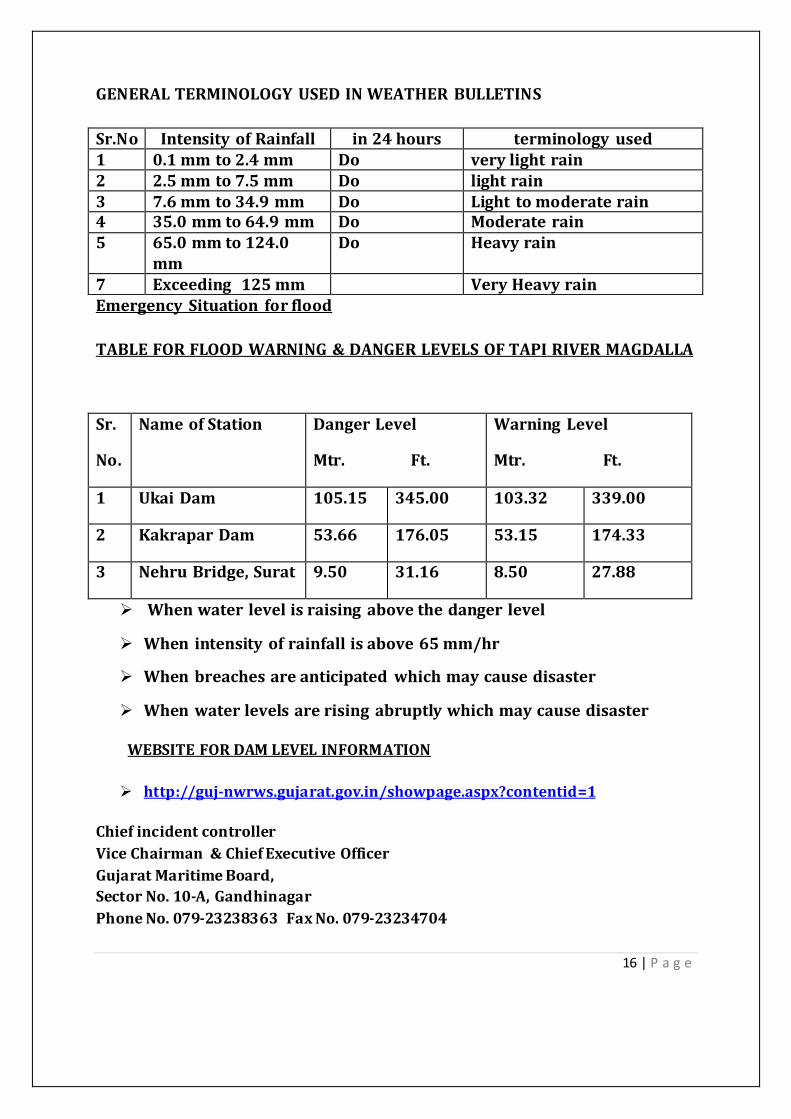
16 | P a g e
GENERALTERMINOLOGY USEDINWEATHER BULLETINS
Sr.No Intensity ofRainfall in24hours terminology used1 0.1mmto2.4mm Do verylightrain2 2.5mmto7.5mm Do lightrain3 7.6mmto34.9mm Do Light tomoderaterain4 35.0mmto64.9mm Do Moderaterain5 65.0mmto124.0
mmDo Heavyrain
7 Exceeding 125mm VeryHeavyrainEmergency Situation forflood
TABLEFORFLOODWARNING&DANGERLEVELSOFTAPIRIVERMAGDALLA
Whenwaterlevelisraising abovethedangerlevel
When intensity ofrainfallisabove65mm/hr
When breachesareanticipated whichmaycausedisaster
When waterlevelsarerising abruptlywhichmaycausedisaster
WEBSITEFORDAMLEVELINFORMATION
http://guj-nwrws.gujarat.gov.in/showpage.aspx?contentid=1
Chiefincidentcontroller
ViceChairman&ChiefExecutiveOfficer
GujaratMaritimeBoard,
SectorNo.10-A,Gandhinagar
PhoneNo.079-23238363 FaxNo.079-23234704
Sr.
No.
NameofStation DangerLevel
Mtr. Ft.
Warning Level
Mtr. Ft.
1 UkaiDam 105.15 345.00 103.32 339.00
2 KakraparDam 53.66 176.05 53.15 174.33
3 NehruBridge,Surat 9.50 31.16 8.50 27.88

17 | P a g e
SecurityatGujaratPorts
Gujarat has taken strong steps in order to strengthen the coastal and internal
security of the nation. Effective coastal patrolling would require dotting of the
coast linewithseriesofcoastalpolicestationsequippedwithbetterandmodern
facilities, adequate office and residential facilities and motivated and trained
manpower toprovide effectivepolicingand intelligence setup.
CoastalBorderSecurity
Tracking &Warning System:
To track and monitor the movement of Indian Fisherman, GoG have
decidedtoestablishsatellitebased system‘TrackingandWarningsystem’
onabout12000fishingboatsatthecostofRs.95crores,sothatfisherman
couldbetracked and warned whilecrossingtheIBML andcouldbegiven
warning messages during any natural calamity like Tsunami,cycloneetc.
Moreover, fisherman canalsosend distress signals.
VesselTraffic&Monitoring System:
Government of Gujarat, KPT and Government of India have already
implemented VTMS inGulfofKutchfromtheFebruary 2012.
Government of Gujarat has already implemented VTMS in the Gulf of
Khambhat by Aatash Nor Control Ltd. on BOOT basis and is already
operational sinceAugust 15,2010.
The ports in theGulf of Khambhat are benefiting from enhancedsecurity
measuresthroughVTMS,suchasprotectionofvesselscarryinghazardous
cargo, providing vessel traffic information and navigation advice,
monitoringofshippinglanesandseparationschemetoenforcecompliance
of safe navigation regulations, assistance to coast guard & other
authorities, detectionofoilspilland improveoverallportefficiency.
The VTMS is expected to put Gujarat coast in line with international
practice,asVTMSisprevalent inlocationssuchasEurope, SuezGulf,etc.

18 | P a g e
Deployment ofPatrolling Boats:
PatrollingisbeingcarriedoutonportsofGMB
ISPSCompliance:
For the compliance of ISPS code, various measures are been taken in
improving maritimesecurityandsafetywiththehelpoftechnology andIT.
Thelongtermgoalshavebeendeterminedforthesecurityofcoastlineand
ports,includespatrollingboatsforcoastalsecurity,metaldictators,radars,
illumination facilities,CCTVs/Camera.
Marine Policestations:
Under the coastal security scheme initiated by GoI, Out of total 73
proposedmarinepolicestation(allmaritimestates),10areoperationalin
Gujarat at GMB ports – Porbandar,Pipavav, Somnath,Bhavnagar, Hazira,
Jakhau, Mundra, Vadinar andOkha.
Government of Gujarat has allotted land for developing Marine Police
stations atatokenmoney ofRs.1persq.m.
LandBorderSecurity
Gujarat houses many industrial complexes which can be termed as
NationalAssets.
Tostrengthenandtoprovide supportforthe securityneeds ofthesevital
national assets, the Government of Gujarat has taken key initiatives to
have integrated and holistic approach in capacity building and
strengthening oflawenforcement agencies.
Other initiatives in uplifting the security of the nation:Modernizationof
police forces,strengthening of crime control machinery, strengtheningof
counter terrorism capabilities, border management, strengthening of
Intelligencesetup anddisastermanagement.
Followingactivities havebeenearmarkedbytheGovernmentofGujaratto
ensureincreased bordersecurity andfilltheloopholes:
Specialised Training Instituteforborder andcoastalsecurity.
Risingofbattalion ofMarineWinginStateReservePolice.

19 | P a g e
Constructing CoastalPoliceStations.
Modern Systems forCommunications andSurveillance.
Construction ofroadstretchofGadhuli-Hajipir-Khavda-Santalpur.
Development/Improvement ofroads along Kutch,Banaskantha andPatan
districts
OilSpill
As per the requirements of National Oil Spill –Disaster Contingency Plan, every
port has to have in place its own oil spill response mechanism to combat an oil
spill of Tier-1 magnitude. In this context, GMB requested National Institute of
Oceanography,Goa, to carry out Risk Assessment Study of Marine oil spills for
existing& proposed extensionof Port facilities at Okha,Bedi, Navlakhi,Mandvi,
Porbandar,Veraval,Jafrabad,Alang,Bhavnagar,DahejandatMagdallalocatedin
the Gulf of Kuchchh, Gulf of Khambhat and along the Saurashtra coast. GMB
proposes to arrange theoil spill response equipment at each of these locations
afterapprovaloflocaloilspillcontingencyplanfromCoastGuardasperNational
OilSpill–DisasterContingency Plan2015 directives.

20 | P a g e
THEDETAILSOFCOMMUNICATIONINFORMATIONOFGUJARATMARITIMEBOARD
EMERGENCYRESPONSECENTRECONTROLROOM(DT.03/06/2017)
Sr.No
NAME STDCODE
TELEPHONENUMBER
FAXNUMBER Mobile No
1 ShriAjayBhadoo,IASViceChairman &ChiefExecutiveOfficerGujaratMaritime BoardGandhinagar
079 23238363
23234703 -
2 Capt.AshvinSolankiNautical SurveyorGujaratMaritime BoardGandhinagar
079 23234716
23234716
9979669659
3 HEADOFFICECONTROLROOMGANDHINAGAR
079 23224758
23236499
-
4 HEADOFFICEGENERALPHONEGANDHINAGAR
079 23238346-48-51
23234703-4-5 -
5 Ashvin GadhviI/cControlRoomGujaratMaritime BoardGandhinagar
079 23224758
23236499
9727771984
6 PORT&TRANSPORT,SACHIVALAYA,GANDHINAGAR
079 23250508 23250589
7 MAGDALLA (HAZIRA)VTMS
0261 6586788 2977007 9909903748
8 MAGDALLA PORTOFFICER((Capt.R.K.Raman)
0261 2430533 2435645 9925153038
9 BHARUCH PORTOFFICER(Capt.KuldeepSingh)
02642 241772 243140 9998057507
10 BHAVNAGAR PortOfficer(Capt.Sudhir Chhadha)
0278 2210558 2211026 9925153073

21 | P a g e
11 ALANG.PORT OFFICER (Capt.Sudhir Chhadha )
02842 235621 235955 9925153073
12 JAFRABAD PORTOFFICER (Capt.Sudhir Chhadha )
02794 245443
245165 9925153073
13 VERAVAL,PORT OFFICER(Capt.Banshiva Ladva)
02876 221139 221073220001
9638112186
14 PORBANDAR ,PORTOFFICER(Capt.Banshiva Ladva)
0286 2242404 22440132253664
9638112186
15 JAMNAGAR, PORTOFFICER(Capt.ArvindkumarMishra)
0288 2712307 2712815 9099694747
16 OKHAPORTOFFICER(Capt.Rakesh Mishra)
02892 262109 262002 9601254062
17 NAVALAKHI(MORBI)PORTOFFICER (Capt.A.B.Solanki)
02829 227304 234465 9979669659
18 MANDVI ,PORTOFFICER(ShriRCPatel)
02834 222633/223033
230033 9925153083
20 STATECONTROLROOM 079 23251900-11
23251916
21 I.M.D.AHMEDABAD
079
22865012-22867206
2286720622865449
22 Director,IMDAhmedahad
079 2286516522867657
22865449
23 (1)CEO,GSDMA2)Director,GSDMA
079
079
23259302
23259303
23259275
23259275
24 Commissioner ofFisheries 079 23253742
23253730

22 | P a g e
25 Controlroom(Fisheries) 079 2325373023253740
23253730
PROFILE OFGUJARATPORTSUNDERSTATEGOVERNEMNT
Gujarat Maritime Board
Ports–PresentandFutureScenario
A. GujaratPortSector
Gujarat is strategically
locatedwithIndia’slongest
coastline of 1600 km and is the
nearest maritime outlet to Middle
East, Africa and Europe. The state
has42portswhichinclude1major
port and 41 non-major ports. The
state has the highest number of
operational ports and commercial
cargoports.Thestateranksfirstin
cargo throughput amongst all
Indian states.
Gujarat’snon-major portshandled 346 milliontonsoftrafficduring2016-
17;highest incomparison toanyothermaritime stateinthecountry
Overallstatus ofGujarat Ports
1 Gujaratstateishaving 42 ports– includes1majorport and41non-major
ports.
2 PrivatePorts=5
3 Captivejetties=31
4 Privatejetties=10
Location of Gujarat Ports

23 | P a g e
5 Thecoastlineconsistsrefinerybasedcaptivejetty,LNGterminal,Chemical
ports, biggest ship recycling yard private container port, and upcoming
shipbuildingyardetc.
6 Hinterland area North West is depending onGujarat for their petroleum
products.
TheDisasterManagementPlanispreparedfortheSafe&Securedbusinessofall
organization. Gujarat state with 1600 km coast is trying to capitalize on the
strategic advantages of the Gujarat Coastline and develop it as a foremost hub
withdiverseport leddevelopment.
To boost development of Gujarat and provide assessment to North West
hinterland itisessential toprovidesecurityagainst natural&manmade disaster.
Themitigationofanydisaster =Secured life+Infrastructure
A major component of International trade traffic is oil/gas (ENERGY SECTOR),
bulk chemicals (pharmaceutical, industrial) and construction materials is
through Gujarat Coast because of its superior infrastructure in termsof harbor,
ports, jetties and oil/gas pipeline. There are nineteen active ports and jetties,
severalrefineriesandoilinstallationandlargenumberofchemicalindustries.At
thesametime,Gujarat coastisinthemostsevere seismicZone(Zone-V) ofIndia.
B. Existing Maritime Infrastructure
GMBoperatedPorts
Groupofports Commodity Handled
Jamnagar group ofports
Bulk cargo - Fertilizer, Rock Phosphate, Coal , Corn, Soya Meal,Crude/POL Soyabean Oil , Refined Vegetable Oil, Rock Salt, PigIron,Cement, Clinker.
Magdalla (Surat)groupofports
Iron Ore, Scrap. Lime Stone, Sheets, Chemicals and Petroleumproducts
Porbandar Coal,LPG,WetDates, Salt,Cement/Clinker,Clay,Bauxite,Onion,RawCotton,Soda AshandMarine Products.
Navlakhi Coal,Coke
Bhavnagar group ofports
Rock Phosphate, Coal and Coke, Fertilizer, Iron Scrap andSulphur, Wood,Timber,Oil Cakes,Salt, Scrap, Onions, Clay andrape seeds

24 | P a g e
Groupofports Commodity Handled
OkhagroupofportsCoke, Coal , Wheat, Sulphur, Fertilizer, Calcium Bauxite, Onion,Clinker,RawBauxite, Chemicals, SodaAsh
Veraval group ofports
FishingactivitiesandsmallquantityofSodaAsh,FoodGrainandCoal
Mandvi group ofports
Fertilizers, Clinker, Building materials, Clay, Bentonite, CottonSeeds, Salt, Oil Seeds, General Cargo, Powder, Fresh Fruits,Onions, Mica, Animal feed, Potatoes, Dry grass, Roofing tiles,Wheatbran, Fenugreek, HydrochloricAcid,DeepType
Jaffrabad group ofports
Coal, Coke, Clinker, Salt, Fertilizer, Iron ore, Machinery, Steelplates&Pipes
Bharuch group ofports
Fertilizer,RockPhosphate,Coal,Coke,Salt,CausticSoda,Copperslag, Ethylene, LAB, Naphta, Sulphuric acid, Copper, CPS, EDC,EthylHexanol, LNG,Methanol, Propylene
Privateports
CompanyName CargoTypeGujarat PipavavPortLtd. Bulkcargo,Container cargo
Mundra Port&SEZLtd. BulkCargo,Container Cargo
Gujarat Chemical PortTerminal Company Ltd.(GCPTCL)
Liquidcargo
PetronetLNGLtd LNGHaziraPortPvtLtd. LNG
CaptiveJetties
JettiesName CargoType&CharacteristicsReliance Industries Ltd.Hazira
Deep water,allweather direct-berthing multicargoport
Essar Group, 2 no.s ofjettyatHazira
All-weathertidal lighterage Port
L&T,Hazira Deep water,allweather direct-berthing multicargoportEssar Group, 1 no.s ofjettyatHazira
Directberthing
Reliance Industries Ltd.Sikka
All-weather tidal lighterage Port. All-weather petroleumterminal
Gujarat State Fertilizersand Chemicals Ltd. atSikka
Jetty handles only liquid cargo and overheadpipelines forammonia andphosphoric acid

25 | P a g e
JettiesName CargoType&CharacteristicsShree Digvijay CementCo.Ltd.,Sikka
All-weathertidal lighterage Port
Dahej Harbour andInfrastructure Ltd.,Dahej
Commodities handed are copper concentrate, coal, rockphosphate, liquidammonia, phosphoric acid
Reliance Industries Ltd.2no.s SBM, Sikka
ImportofCrude
Gujarat Ambuja CementLtd., Muldwarka (Old &Newjetty)
Import of raw material and export of finished product ofcementandclinker
UltraTech Cement Ltd.,Kovaya
coal,gypsum, iron-ore
Sanghi Industries Ltd.,Jakhau
Cement and Clinker. All-weather direct berthing captivejettydedicated toocean-going vessels
Reliance Industries Ltd.3,4,5 no.sSBM, Sikka
1no.sofSBMforImportofCrude/2no.sofSBMforexportofliquidproduct
Gujarat Ambuja CementLtd.,Magdalla
Import of raw material and export of finished product ofcementandclinker
BORLSBMatSikka ImportofCrudeIPCLRelianceatDahej All-weathertidal lighterage Port,Liquid cargoReliance Lo-Lo & Ro-RojettyatSikka
Projectcargo
RelianceProductjettyatSikka
Exportoffinished product
Reliance at Hazira,Ethylene
All-weathertidal lighterage Port
RelianceatHazira,EDC All-weathertidal lighterage PortRelianceatHazira,2Gasjetty
All-weathertidal lighterage Port
EssarFourtankerberth,Essar LPG & Essar Steelfirstexpansion
All-weathertidal lighterage Port
J.Passociate, Kutch All-weathertidal lighterage Port
PrivateJetties
JettiesName CargoType&CharacteristicsJ.M. Baxi and Co. RoziPier,Bedi
The jetty is fully equipped with conveyors, hoppers andbagging plants ideally suited for loading and unloadingbulkcargoes

26 | P a g e
JettiesName CargoType&CharacteristicsRuchi InfrastructureLtd.RoziPier,Bedi
Cargo handled - export and import consignment offertilizer,GNextraction,maize, wetdates, rapeseed meal
Shreeji Shipping,Navlakhiprivate
All-weather tidal lighterage Port. Commodity handled iscoal
Saurashtra Cement Ltd.,Porbandar
Import of raw material and export of finished product ofcementandclinker
United Shippers Ltd.,Navlakhi
All-weathertidal lighterage Port
Shakti Clearing AgencyPvt. Ltd. Naya Bunder,Rozi
All-weathertidal lighterage Port
Goodearth MaritimeLtd., Jakhau
Onanaverage,10,000tonnes/dayofcargocanbehandled.Cargohandled isSaltandotherconsumer items.
Shantilal Multi Portinfrastructure Ltd. atBedi
All-weathertidal lighterage Port
WelspunatDahej All-weathertidal lighterage PortJaydeep Associates ,Navlakhi
Coal
Kribhco,Magdalla Fertilizer
SafetyArrangements atPorts
GMB ports where foreign cargo is being handled are provided with safetyarrangementsunder“InternationalShipandPortSecurity(ISPS)Code”asa partof implementation of ISPS Code regular patrolling is being done in sea andcoastal area at the important ports viz. Bedi, Porbander, Okha, through “HighSpeed Petrol Boat” engaged on contract basis. Safety arrangement at all theimportant state ports is assigned to “Gujarat Industrial Security Force” - anundertaking ofGujarat State.
The sate coastline is adjacent to international boundary and therefore issensitive. Government has decided to establish “Marine Police Stations” at theprescribed locations along the coastline for intensive patrolling and safetymeasures. In this regard, Marine Police Stations are to be established on thecoastalareaofNavaBandar(NearVeraval),Porbander,Bhavnagar,NavlakhiandOkhaintheGMBland.Land forthesamehasalready been handed over.
Magdalla Port

27 | P a g e
LOCATION:
Latitude : 21o08’20“N
Longitude : 72o44’08” E
Magdallaisalighterageport.TheportissituatedonthewesterncoastofIndiain
SouthernGujarat,onthesouthernbankofriverTaptiabout16kmsupstreamthe
river.
Road&Rail Network:
Thestatehighway is2kmsawayfromtheMagdalla Port
TheNH8is15kmawayfromtheMagdalla Port.
The nearest Railway BG line is 15 kms away from the Magdalla
Port(Sachin Yard)
TheSurat railwaystationis16kmsawayfromMagdalla Port.
Anchorage:
TheDeep WaterAnchorage is15NauticalMilessouthwest fromMagdalla Port.
Marine Features:
MHWS - 8.40 m
MHWN - 7.40 m
MLWS - 1.70 m
MLWN - 0.70 m
MSL- 4.50 m
FACILITIES/EQUIPMENT:
V.T.P.M.S.
TheonlyMinorPortinthecountrytohavedeveloped itsown VesselTraffic
andPortManagement Systemforsafenavigation inthelongNavigational
channel ofRiverTapi.

28 | P a g e
VTPMSstationisroundtheclockmanned byqualified MasterMariners and
providedwith:-
RadarSystem A.I.S.WeatherStationV.H.F.
H.F.Sets. Telephone/Fax
Computers andElectronicCharts.
VTMSSystem:
Recently Gujarat Maritime Board has established VTMSsystemat Gulf of
Khambhat for monitor Ships/Vessels in VTS area which covered thearea
from Jafarabad to Khambhat. This VTMS system is operated by
knowledgeable person to supervise the activity of ships/vessels at Head
office, Gandhinagar as wellasHazira (Surat).An operatorof VTMSsystem
can communicate with all the ships which are plying in VTS area. The
operator can also communicate with all theports like Jafarabad, Pipavav,
Mahuva, Bhavnagar, Dahej, Hajira and Magdalla through this VHF
Network.
VTMS system is also equipped with meteorological and hydrological
sensors. In other words, it can provide live and real-time weather data.
The knowledge of current weather condition is very important when we
dealwithemergency situation.
VTMS systemisalsoequipped withthepastrecordandreporting system.
It can give Ship movement report, Cargo movement report, Port-wise
reportand Jettyowner's-wise report uptothecurrent dateandtime.
VTMS system in Gulf of Kutch is also operational recently and M/SMCC,
Kandla monitors the Ships/Vessels in VTS area of Gulf of Kutch. VTMS

29 | P a g e
system in Gulf of Kutch covered Mandvi, Mundra, Navlakhi, Kandla,
Jamnagar, SikkaandOkha Port.
FIREFIGHTINGSYSTEMATMAGDALLA PORT:
FirePump 1Nos.Capacity1800 LPM
FireTender 1Nos.Capacity3200 LPM
Firefighting network System:
a.Centrifugal Pump 1Nos.Capacity171Cum/hrs.
b.M.S.PipeLines 830.33 mtr.150mmdia.
c.Double headed 13Nos.
FireHydrant
d.M.S.StandPost. 13Nos.
e.HoseBox 13Nos.
d.Branch Pipe 13Nos.
e.HoseReel15m. 26Nos.
FloatingUnits:
G.B.Tug (TwinScrew) 470BHP
WorkBarge (Dumb) 100MT
Open Plots:6nos.withanareaof29644 sqm.
CraneTata-320 CrawlerMountedCrane -18.5MTcapacityandboom
length 40feets.
Weighbridge: One private weighbridge within port premises near entrance
gate.
HarbourStructures:
GMBjetties
GMBRCCJettyNo.1(GMB JettyatMagdalla Port)

30 | P a g e
GMBRCCJettyNo.2(Jettyleased toNCCLatMagdalla Port)
Captivejetties
KRIBHCO
EssarSteelLimited
EssarSponge IronJetty
RelianceIndustriesLimited
Larson &Toubro Ltd.
Gujarat AmbujaCementLtd.
Single BuoyMooringofRelianceIndustries Ltd.
PrivateShipyards
ABGShipyard Ltd.
L&TShipyard
PrivatePorts
HaziraPortPvt.Ltd.
8.0Communication networkavailable ateachstation-operator:
8.1 V.H.F. Channel maintained by Captive Jetties/Gujarat Maritime Board for
communications:
(a)GujaratMaritimeBoard, Magdalla Port,Surat Channel –16
(b)V.T.M.S., GMB,Magdalla Port Channel –16, 09
(c)M/s.RelianceIndustries Ltd,Hazira Channel –67
(d)M/s.EssarSteelLtd.,Hazira Channel –71
(e)M/s.Gujarat AmbujaCementCo.Ltd.,Channel –15
Magdalla
(f)M/s.CairnEnergy IndiaPty.Ltd.,Suvali Channel –16
(g)M/s.GlobalMarine Services,Surat Channel –16
(h)M/s.A.B.G. Shipyard Ltd.,Magdalla Channel –71
(i)M/s.Larsen &Toubro Ltd.(ECC)/ HaziraChannel –16
Contactinformation
PortOfficer
Gujarat MaritimeBoard

31 | P a g e
NearTakeoff hotel
Makaipool
Surat
PhoneNo.0261-2474825
FaxNo0261-2475645
DahejPort
Location:-
Latitude:21040’ N
Longitude: 720 32’ E
Dahej isafair-weather lighterage port,situatedatthejunctionofGuljaria
andbancreekinGujarat, ontheWestCoastofIndia.
Road&Rail Network:-
Dahej isconnectedtoBharuch(distance45Kms)andVadodara(108Kms)
by four lane road. The nearest railway station is at Bharuch by broad
gauge line.
Communication withSteamers:-
AtHighSea: ViaMumbai Shore Radio.
Anchorage:-
Anchorage is5Kms. AwayfromDahejOldPort.
Marine Features
MHWS - 8.79m
MHWN - 7.01m
MLWS - 1.39m
MLWN - 3.17m
MSL - 5.09m

32 | P a g e
Facilities/Equipment:-
Tugs, launches,barges & cranes,which is generally available from the
private parties at Old Dahej Port. The captive jetties are fitted with
cargohandling equipment.
Transit Sheds/Godowns:-
Transit Godown- 1No. 1116 Sqm
Transit sheds -4No. 1690 Sqm
Platformforstorage - 5No. 10000 Sqm
-2No. 21300 Sqm(kutcha)
Oldport
TheoldGMB jettyof100 mlength whichiscurrentlynotused forshipping.
Supplies
Water is supplied to ships by private water barges.The port is suppliedwith
electricityfromthe66KVAstationofGEB, Dahej.
MonsoonPeriod
15Mayto14September.
Captive &Private JettiesatDahej(Portbased)
DahejHarbour Infrastructure Limited. (BirlaCopper)
Gujarat ChemicalPortTerminal Company Limited.(GCPTCL)
PetronetLNG
RelianceIndustriesLimited (IPCL)
PetronetAdani
ABGShipyard Limited
Ro-RoTerminalandPortDevelopment.

33 | P a g e
The area is already developed by industries like Petronet LNG, IPCL,
GCPTCL, DHIL, Welspun. All these industries are port-based industries.
There isplanning forSEZdevelopment also.
Contactdetail:-
Portofficer,
Gujarat MaritimeBoard,
NearHotelPlaza,
StationRoad,
Bharuch, -392001
Tel:02642-241772/220377
Fax:-02642-243140
Bhavnagar Port
LOCATION:
Latitude : 21°45’N
Longitude: 72°14’E
Bhavnagarport isanall-weatherdirectberthingportforsmallervessels.Ithasa
draught of up to 4m and is located in the Gulf of Cambay on the West Coast of
India. TheportishavingaLockgatefortidaladvantage.
Road&Rail Network
The port iswellconnectedwiththeStateHighwayand BGrailwayline.Thecity
ofBhavnagarisabout 10kmsfromthenewport.Dailyairservicesareavailable
between Bhavnagar andMumbai. Nearest international airportisAhmadabad.
Communication withSteamers

34 | P a g e
Stationoperatedby thePort Authority on call sign VUJ 9during following time
(GMT)
0200 -0700 hrs.
0800 -1300 hrs.
1400 -1800 hrs.
The stationto becalledon500kcsandworkin 418kcs.Theequipmentis with
100wRFPower.
Charts
Admiralty :1035 PiramIsland toBhavnagar
Indian NavalHydrographic :2039.
Note : The Gulf of Cambay is covered under Deca Navigator System-Bombay
Chain(7-8).
Anchorage
Vessels upto12mdraught arerecommended atDWAanchorage.
Position:5.1’ x250(T)fromGogha toLighthouse.
Theholdingground,stiffmudandsandisgood,whileatanchoratDWA,duecare
mustbeexercised, especiallyduring spring tide.
Pilotage
Pilotageiscompulsory.Duenoticeforrequisitionofpilotmustbegiven48hours
in advance, owing to tidal conditions and the vessel should arrive at the Pilot
Stationapproximately twohours before highwater.
Ifthevessel isunabletoarriveatthePilotStation,two hoursbeforehighwater,
she shouldcruise around and await for instructions from thePort Authority on
VHF Radio.The VHF has been installed at Port and Port Wireless Stationon an
experimental basis. Callisonchannel -16during theday.
Marine Features
MHWS- 12.04 m
MHWS- 10.18 m
MLWS - 8.31 m
MLWS - 3.52 m
35 | P a g e
MSL - 3.04 m
Facilities /Equipments :
Porthas03tugsforpilotage/shippingoperation.01No.Patrolboatforpatrolling
ofBhavnagar-Alangsection underISPScode.Electrificationintheportareahas
beencompleted. Five high-mast towers have been installed at the port and for
emergency power supply; 75 KVA DG set is also available.
Theporthasadrydockforrepairoftugs,launchesandbarges.Theporthastwo
workshops-general workshop and running workshop. Flotilla units can be
repaired at both these workshops. The general workshop is used to carry out
repairs on flotilla units and mechanical instruments. The running workshop
takes care of the day-to-day repairs and maintenance requirements. Both
workshops have differentsizesoflathemachines, drillingmachinesandshaping
machines.Electricandgasweldingfacilities,acuttingmachine,foundryshop,etc.
are also available at the workshops.
Allthegodownsattheporthavebeenrepairedandareavailableforuse.Internal
roads of the port are being paved. Recently, the port has also been connected
with a broadgauge railway line for which GMB has requested the Railways to
continue the line as per the cargo guarantee action plan to be submittedby the
trade and the chambers of commerce.
DryDock : 1no.
Tugs : 2nos.
Barges : 1eachof250tonnes
WaterBarges : 1noof600 tonnes
Supplies
Fresh Water:Alongsidebywater pipeline. Instream bybarge.
HarbourStructures

36 | P a g e
The concrete jetty is 270m in length and 12.8 m in width. There is no swell or
currentofanykind.Hightideatconcretejettyis22minutesearlierthanthetime
givenintidetableforBhavnagar.
VesselsthataretoberthalongsidetheconcretejettymustpassthroughtheLock
Gate.Vesselsupto19.8mwidthand143.8minlengthcanpassthroughthegate,
butpermissible draught isonly4m.
TheNorthquayontheNorthofthebasinis141mlongandhasadequatebackup
andstorage area.
Commodities Handled
IMPORT:
RockPhosphate, CoalandCoke,Fertilizer,IronScrapandSulphur, Wood,Timber.
EXPORT:
OilCakes,Salt,Scrap,Onions, Clayandrapeseeds.
MonsoonPeriod
May15toSeptember 14.
Contactdetail:
ThePortOfficer,
Gujarat MaritimeBoard,
NewPort,Bhavnagar -364005.
Tel:0278-2210221/2210558 &Fax:0278-2211026
ALANGSHIPRECYCLINGYARD
1. Started intheyear1982-83 with5shipsand0.24lakh LDT.Intheyear
2011-12, highest 415shipsand3.85 MLDThandled.2. Blessed withhightidalrange,Longbeachwithgentle slopeandfirm
ground facilitatingbeaching ofships justatthethreshold oftheplot.
3. 153plotsdeveloped on10km.longcoast.
4. Serves thesocietybyoffering employment opportunity topeople (direct:
@15,000 andIndirect:@5lakhpeople) withnetpositivesenvironmental
impacts.
TotalPlotAreaofYard-3,98,803 sqm.

37 | P a g e
5 About 50 KM from District head quarter –Bhavnagar on Bhavnagar-
VeravalNationalHighway(8E)2 Reference toAdmiraltyChart:208/1486 approx.long:2123 latt.:72113PortLimit:CoveredunderextendedportlimitofTalajaPortasperGovt.
ofGujarat Ports&Fisheries Dept NotificationDated08/09/1995 4 RoadConnection:Linked toBhavnagar-Veraval CoastelHighway byatwo
laneallweatherasphalt roadviaTrapaj (about 10KM)and alsovia.Sanodar –Kukad(about 23KM)
5 Nearest AirPort : Bhavnagar (about 55KM)6 Communication : LinkedSTD02842
CellularPhoneVHF / HF in case when control roomisinoperation.
7 Tidal information : MHWS 7.80 M. MHWN 6.30 M. MLWN 3.00 M. MLWS 1.60 M. MSL 4.70 M.
8 Plots :153 Nos.(Outofthis131Operational)
9 Infrastructural facilities & services : Service road (10 KMS) Weight
bridges, Red Cross Hospital, Police station, Post Office, Bank, TelephoneExchange, firefighting services, water supply, Street lights, communitysanitation, Mobile Hospital & Ambulance (GSBA), Light House (Govt. ofIndia),Training & Welfare institute for labour ,Weather station at GMBComplex, Helipad at Training Complex, Alang –maintained by R. & B.Department.
10 ContactDetailsPortOfficer,Gujarat maritimeBoard
Po-Alang,TalukaTalaja

38 | P a g e
Dist.Bhavnagar
Phone No.02842-235621
FaxNo.235955
JafrabadPort
LOCATION
Latitude :20o 51’56”N
Longitude :71o21’50” E
Alang is the largest ship recycling yard in the Jafrabad is an all-weather direct
berthingportforsmallocean-goingvessels.ItissituatedintheGulfofCambayon
thesouth-westcoastofSaurashtra,insidethe JafrabadCreekontheWestCoast
ofIndia.
RoadandRailnetwork
Jafrabad is connected by NH 8E at 20 kms . The broad gauge railway line is
availableatRajulawhichis22kmsawayfromtheport.NearestairportisatDiu,
whichis75kms,awayfromJafrabad.
Communication withSteamers
ThereisaVHFsetinstalledinthePorthaving20to25milerange.Channelno.16
isopenduring officehours(1030 hrs. to1830hrs.) onworking days.
Charts
Admiralty :1979
Indian Naval
Hydrographic : 2034
Anchorage
Agoodanchorageinfineweathermaybeobtainedatadistanceof 2.5kmsfrom
shore, atadraftof14m.
Pilotage

39 | P a g e
Not necessary as small vessels berth directly at thenew clinker jetty. However,
localguides areprovidedonrequest.
Marine Features
MHWS - 2.88 m
MHWN - 2.20 m
MLWS - 1.50 m
MLWN - 0.90 m
Navigational Aids
There arethree navigationtowers situatedatthePort .Twotowersaresituated
at Piplikantha on northern bank for smooth berthing on the clinker jetty. The
fronttowerhasafixedredlight,whilethereartowerhasafixedwhitelight.One
tower,with a fixedred light, is situated onthewesternbank at the breakwater
end.
PortInfrastructure andFacilities:
Berthing facilities:
i) NewClinkerJettyforsmallcoastalsteamers, withaworkinglength of211m.
and4m.draft. Smallcoastalsteamers berthatthenewclinkerjettyforexport
ofClinkerandjettyforexport ofCoaland CokeonaccountofM/sNarmada
CementCo.Ltd., Jafrabad
(Subsidiary ofM/sUltraTechCement Co.Ltd.)
ii) RCCJettyforsailingvesselstraffic,withalength of45mandadraftof1m.
iii)Onefish-loading wharf forfishing activities,withalength of400mwith
suitable draught.
iv)Three landing slopes, withalength of30mand0.30 mdraft forpassenger
andsmallboats.
Cargohandling equipment:
M/sNarmada Cement Co.Ltd.,hasbeen takenoverbyM/sUltraTechCement
Co.LtdtoloadClinker through use oftheirownconveyorbeltsystem
whichhasaspeed of600MTperhour. Theydischarge coalbytheirown
cranes andtheaverage discharge isabout9,000 to10,000 MTperday.
Warehousing andstorage facilities:
There aresevengodowns available, withanarea of1,310 sq.mtrs.Theyhave
astorage capacityof2,500MT.Sufficient openspaceisavailable.

40 | P a g e
Privatebunkering andshipstores areavailable.
Supplies
Privatewatertankers areavailableforwatersupply.
HarborStructures
RCC Jetty for loading Clinkers (near Clinker Jetty): length - 211 m
permissible draft-4mLoading isdone mechanicallybyconveyorbelt.
RCCJettyforloadingsaltandmiscellaneous cargo: length-45m
Slopeforcargovessel:length -30m
Fish-landing wharf: length-450m
Commodities Handled
Import:
Coal,Coke
Export:
Clinker,Salt
MonsoonPeriod
May15toSeptember 14.
ContactDetail :
ThePortOfficer,
Gujarat MaritimeBoard,
Jafrabad -365540.
Tel:(O)02794-245165
Telefax: 02794-245165
E-mail:[email protected]
VeravalPort
LOCATION:
Latitude : 20° 54'N

41 | P a g e
Longitude :70° 22'E
Veraval isafairweatherlighterageport.Itissituatedinthesouth-westcoastof
Saurashtra ontheWestCoastofIndia.
RoadandRailNetwork
VeravalportisconnectedwithAhmedabadbyroadandbroadgaugerailwayline.
Connected toNationalhighway 8E.
Communication withSteamers
AtHighSea :ViaBombayShip Shore Radio,Telephonic Service.
AtAnchorage :By VHF/Through Messenger Ch.16 for call. For working,
Ch.11,12,14.
Charts
Admiralty : 1321 &1470
Indian NavalHydrographic : 2054
Anchorage
Anchorage is about 1.5 kms offshore.At anchorage, three vessels can work at a
timeandasmallcoasteratberthwith3mdraft.
Pilotage
Pilotageisnotcompulsory, asapproaches areclosefromtheopensea.
Marine Features
MHWS - 2.10 m
MHWN- 1.80 m
MLWS - 1.10 m
MLWN - 0.56 m
MSL - 1.30 m
Navigational Aids
VeravalLighthouse :Latitude :20° 54'6"N

42 | P a g e
Longitude :70° 21'5"E
Bhidia Beacon Latitude:20° 53'8"N
Longitude :70° 22'9"E
Facilities /Equipment:
Grab Dredger ofBhavnagar.
ColesCrane: ranging from12.5 to16toncapacity,(Mobile) -3nos.
Supplies
Fresh water/ship storescanbesupplied byprivateparties.
HarbourStructures
Western Breakwater - 334m
Eastern Breakwater - 440m
Berthing Quay5nos. - 500m
Fish-Landing Wharf
Finger Jetties-5nos. -100 mLength (Each).
Commodities Handled
Mainlyfishing activitiesperformed and foodgrain isalsohandled.
MonsoonPeriod
May15toSeptember 14.
Contactdetail:
ThePortOfficer,
Gujarat MaritimeBoard,
VeravalPort,Veraval-362265
Tel:(02876)220001/221139
Fax: (02876) 243138/221073
E-mail:[email protected]
Porbandar Port
LOCATION:

43 | P a g e
Latitude : 2138’N
Longitude : 6937’E
Porbandar isanall-weatherport,withdirectberthing facilities.Itissituatedon
theWestCoastofSaurashtra facingtheArabianSea.
Road&Rail Network
Porbandar isconnected totherestofthecountrybybroad gauge railway. Itis
connected toRajkotbyroadand fromtherebyNationalHighway.
Communication withSteamers
VHFChannel : 16
Watch-keeping hours : 0800 to2000hrs. IST
Charts
Admiralty : 1321
Indian NavalHydrographic : 204and205
Anchorage
Anchorage isabout 2kmsoffshore, south-West ofbreak water,withgood holding
ground andadepthof10to12metersatanchorage, twosteamers canoperate at
atime.Anchorage closedduring monsoon period due toheavyswellandwind.
Itisadvised thatvessel toremain5N.M.SWofbrakwater.Afterberthing
programmed fixedvessel toapproach asperagent /portauthorityadvises.
Pilotage:
Pilotageiscompulsory.
Avesselawaiting pilotshouldanchorsouth-west ofthebreakwater end, about1
nauticalmileaway, where amplewaterandgoodholdingground isavailable.
Onlydaylightnavigation isavailable.
Navigational Aids

44 | P a g e
Frontandreartransitmarksforberthing atdeep water berths.
Facilities /Equipment :
Tugs - 2nos.
Launches - 2nos.
Godown Facilities-2,41,173 Sq.Mtrs.
HarbourStructures.
Wharfforsteamers: length 385meters (235 mtrGMBwharfand150mtrprivatejetties)withpermissible draught upto9.8meters.
Aquaywall:2,128 meters inlength forlighters. Finger jettyalong thebreakwater oflength100metersforlighterage. Blockmasonry wharfwall:91meters inlength. Bulkcargowharf: 225metersinlength. CoastGuard jettyof175 meters inlength. Saurashtra Cementjettyof150meters inlength.
Commodities Handled.
IMPORT :
Coal,LPGandWetdates
EXPORT:
Salt,Cement/Clinker, ClayBauxite,Onion, Rawcotton,SodaAsh.
MonsoonPeriod.
May15toSeptember 15.Nolighterage workiscarriedoutduring monsoon
period.
PRIVATEINITIATIVES:
Eastern breakwater facilities. M/s.Saurashtra Cement Ltd.,has constructeda150mtr.Long jetty
adjoiningGMBwharf. Operation commenced fromNovember2000.
Contactdetail :
ThePortOfficer,
Gujarat MaritimeBoard,

45 | P a g e
Wagheshwari Plot,
Nr.Jadeja Hospital,
Porbandar –360575
Tel:0286-2242408/2242404
Fax:0286-2244013/2253664
e-mail:[email protected]
BediGroupofPorts
LOCATION:
Longitude :70°-02’ E
Latitude:22°-33’ N
BediPortisanall-weathertidallighterage facility locatedonthesoutherncoast
oftheGulf ofKutch.395nauticalmilesnorth-westof Mumbai,35nauticalmiles
south of Kandla and 50 nautical miles east of Okha Port. It is classified as an
intermediate port.
RoadandRailNetwork
BediisconnectedbybroadgaugerailwaylineswiththerestofIndia.Thenearest
broad gauge railway station is Jamnagar, which is 7 kms away from Bedi. A
railway siding is available at 2kms. from Bedi Port. It is connected to National
HighwayfromRajkot.
Thebroadgauge lineistobeextended uptoRoziPier.
Communication withSteamers
A round-the-clock Control Room has been established with VHF facility. The
callingchannelis16andtheotherworkingchannelsare11,12and14forshipto
shore communication. There is a post office 2km away from the port and the
telegraph,officeisinJamnagarcity.Telephone/faxfacilitiesare providedatthe
port.
The,VHF set isfunctionalonfrequency6221.6Khzduringdayand4143.60Khz
during night.
Charts:
Admiralty : 43and1779

46 | P a g e
Indian NavalHydrographic :2027
Anchorage
Theanchorageis6NMawayfromBediport,about4NMfromNewBediportand
2.5 NM from New Rozi Pier site. It can accommodate 17 ships at a time in the
designated anchorage area.
Approachtoanchorageisthroughachannelwhichis9.5kms.Itdriesupatmost
oftheplacesduringlowwaters.LightersmovefromthePorttoanchorageduring
high tide hours. The sailing time for lighters is about 2 hours from Port to
anchorage.
TotalDraught
The maximum draught at Bedi anchorage is 16meters, but vessels of up to 30
meters canalsoanchorwithintheport limits.
Pilotage:
Pilotage is not compulsory. However,services are rendered by pilots whenever
required.
Marine Features
H.H.W.O.S.T. 06.19 m
H.W.O.S.T. 05.49 m
H.W.O.N.T. 04.27 m
L.W.O.N.T. 01.22 m
L.W.O.S.T. 00.59 m
Duetotidalrestrictions, theworkinghours pertideforbarges areasunder:
(1) Bedi port :2to3hrs
(2) Newport :3hrs
(3) RoziPier :Round theclock
Navigational Aids
PirotonLightHouse,withRacon
KalvanLightHouse
tormsignal isavailabledayandnight atthenewportwhen required
Facilities andEquipments

47 | P a g e
Bedi Port has a well-organised store to supply materials required for
mechanical works,trafficworks,civilworksetc.
TransitShed/Godown-
9500 sqmofTransitsheds/Godowns (covered) atBediportand4870 sqmatNewPortareavailable.
coveredstorage godowns ofabout 9,570 sqmareaatBedi Port&27nos. ofgodowns about14,290 sqmareaareavailableatNewPort.
AtBedi Port16stackingplatforms areavailable.
Tugs:-
Tugs uptoandabove404bhp :2
Tugs below360bhp : 2 Tugof1,600bhp : 1 Speed boat(Under ISPS) : 1
DryDock
Forrepairsofport launches,tugs,bargesetc.BediPorthassmalldrydockwhich
can accommodate 4port crafts at a timeup to 2m draft. In addition for urgent
repairs the Port has grid iron facilities and well equipped marine workshop for
mechanical repairs including vehiclesfacility.
Dredging works:-
Maintenance dredging requirement is attended by the available dredgers with
capacity of 85 cum per hrs. Currently, the port has one Excavator (Hitachi)
Pontoonmounteddredger and twohopper barges.
Electrical power:-
HTand LTpower asper requirement isavailableatRoziandBedi port.
The port area is fully illuminatedby sufficient streetlightsand high mast tower
lights.Allgodowns arealsoelectrified.
Cranes
The import cargo is handled mechanically with the port’s mobile crane and
private excavator cranes of New Rozi port-with 4 mobile cranes each of 12.5
tonnes capacityprovidedatthewharf forready use.

48 | P a g e
HarbourStructures
Total2250 mlongwharf forberthing isavailable atBediPort.
380mlongwharf forberthing isavailableatnewport.
Shakticlearing hasbuiltandoperating 90mwharfatNewport.
At Rozi pier port site total 400 m longRCC jetty and100m longgravity
walltypewharfwithrequired backupareaisavailable.
Outoftotal400mRCC jettyatRozipier,100misallottedtoM/s.J.M.Baxi
& Co., 50 m allotted to M/s.Shantilal Multiport Infrastrucutre and 250 m
allottedtoM/SCWCL, Mumbai.100mwharfwall isallottedtoM/s.Ruchi
Infrastructure.
12.Details ofDisaster Mitigation Equipment
SUB-PORTS OFBEDIGROUPOFPORTS
1. Sikka
2. Salaya
3. Jodia
4. Pindhara
5. Sachana Shipbreaking Yard
SIKKAPORT
A captive jetty for GSFC liquid cargo is in operation. There is facility of
discharging Import Cargo Liquid Ammonia and Phosphoric Acid through
pipeline. It is meant for berthing/de-berthing of ships by day tide only and it is
compulsory to have port pilot for piloting theship to inward andoutward. The
GSFC Jetty is at present accommodating vessel up to 8 mtrs. draught and 165
mtrs.LOAandvesselsoflargerlengthanddraughtcanalsobeaccommodatedon
acase-to-casebasis.TheJettypositionis22deg.–27’19NandLong.69deg.–47
534E.
AtSikka,M/s.ReliancePetroleumLtd.hasconstructedanOilRefinery.Theyhave
developedportfacilitiesbyconstructingRo-Ro&Lo-LoJettiesforthepurposeof
handling various project cargo required for the same. They have also created

49 | P a g e
facilitiesforCrudeOiltheyhaveputtotal5-SPM.Theyalsoconstructed4-Tanker
Berthshaving directberthing facilitiesfortheircaptiveuse.
Shree Digvijay Cement Co. is handled cement/clinker/coal vessels from their
owncaptiveberthatSikka.
The salt vessels of Singach salt works are handled through their captive wharf
locatedatSingach.
Commodities Handled atSikkaPort
Import
Phosphoric acid,ammonia, coal, machinery,propylene, naphtha,LPG,crude oil,
fueloil,bitumen, CUmix,waxyresidue.
Export
Cement, clinker, machinery, propylene, naphtha, paraxylene, HSD, petrol,
orthoxylene, LPG,benzyne, salf,vacuumgas oil.
SALAYA PORT
Salaya is sub port of Bedi Group of Ports. There is traffic of almost of sailing
vesselsonly.Theshipbuildingindustriesforsailingvesselarethemajoractivity
atSalayaport.
JODIAPORT
Jodia is a sub port of Bedi Group of ports.Previously, it was famous for foreign
tradeofcountrycrafts.
Theproposal forshipbuilding industry areunder consideration.
SACHANAYARD
Sachanaisashiprecyclingyard,total15nos.ofplotsaredevelopedbyGMBwith
required basicfacilities.
Contactdetail:
ThePortOfficer
GUJARATMARITIMEBOARD
50 | P a g e
BediGroupofPorts
SaruSectionRoad,
Jamnagar –361009
Tel:(0288) 2711806/2711805/2755207/2712307,
Fax:(0288) 27112815
E-mail:[email protected]
Navlakhi Port
The Navlakhi Port was constructed early by state of Morbi and various
infrastructuresweredevelopedduring4thdecadeof19thcentury.Navlakhiisall
weather lighter age intermediate port on the North West coast of Gujarat and
situated at junction of Sui and Vershamedi creek in Gulf of Kutch. The port is
about50kmfromMorbiand is100kmfromRajkot.
LOCATION:
Latitude : 22° 58'25"N
Longitude : 70° 27'24"E
Navlakhi is anall-weather lighterage working port locatedat inner position of
GulfofKutchonthewestcoastofIndia.
RoadandRailNetwork
Theportiswellconnectedwithstatehighway.TheNationalhighway8Ais55km
from the port at Maliya. The port is connectedwith Railway (BG). The nearest
airportisRajkot.
Communication withSteamers
AtHighSea ViaKandla CoastalWirelessStation-Roundtheclockoperation.
AtAnchorage through messenger andVHFwithPortOfficer
Charts
Admiralty :43

51 | P a g e
Indian NavalHydrographic :2017
Anchorage
TheOuteranchorageissituatedat25nauticalmilefromport nearTuna bouyat
Lat: 22 48.2’ N Long:70 10.6’E for draft up to 12m and at Lat 22 50.3’ N and
Long7010.6’Efor draftmorethan 12m.Theinneranchorageis @ 5.5 nautical
miles from the port situated at Lat.22 55.43’N Long 70 22. 86’ E andavailable
draftismorethan 12m.
Pilotage
Pilotage is not compulsory at thePort up to a draft of 9m. for a draft of more
than9m.pilotguideisnecessary,fromTunaBuoyuptotheanchorage,forwhich
advance intimationof24hoursisnecessary.
Marine Features
MHWS -7.20 m
MHWN - 6.20 m
MLWS- 0.80 m
MLWN - 2.10 m
MSL - 4.20 m
Navigational Aids
PilotStation: Tuna Buoy
Navigational aid available at outer Tuna Buoy —17.5 nautical miles from
Navlakhi. The Navlakhi Port limit starts only from Buoy No. 5, installed in
Hansthal Creek(Buoys arepresently missing).
Facilities /Equipment:
Tugsandlaunches: PilotLaunch M.L.Gitanjali:- 2x290=580 BHP(Canbefloatedonlyinhighwater)
PilotLaunch M.L.Ratnakar:- 2x202=404 BHP(Notinstateofreadiness)
Privatebargesarearrangedbyportuserthatenableshandlingof 10,000
to15,000 metrictonnes ofcargoperday.
Storage Facilities
Open plotsaround: 160000 sqm.
Coveredgodowns areavailable.

52 | P a g e
Storage(Covered):
Totalcoveredstorage area 4920 sqm.
OpenPlotsasperNewPlanning
Versamedi Side96,600 sqm. SuiSide63400 sqm.
Totalarea forstaking :160000 sqm
Electrification
LightMasttower18mhigh - 25Nos.
LightPole5mhigh - 5Nos.
Weighment Fecility
BGRailwayslowmotionweigh Bridge
100MTCapacityweighment weigh Bridge
VTMS-Facilities.( VesselTrafficManagement System)
24x7availableinPortforthetrafficMovement
As VTMS is manned 24x 7, therefore VTMS is the primary control room for all
reportingpurposes and maintaining log’s etc .VTMSManager is responsible for
daily reporting required data to GMB Gandhinagar control room and
coordination withotheragencies likeIMDetc.
During any cyclone/depressiondeveloping and moving towards nearby area
oranyothernaturalcalamity/disaster,thaninadditionsecondarycontrolroom
needs tobemanned atMorviPortOffice24x7hours.
Responsibility willbeofAssistant PortOfficerandXEN(C).
ContactDetailsofVTMSNavlakhi–

53 | P a g e
Landline Number–02829-294636
Emailaddress- [email protected]
VTMS Manager – Captain Kapoor Mobile Number -7874050276 /
7600193408
VTMSSupervisor –
1. Prakash Patel Mobile No.9712368510
2. Dakshina Moorthy Mobile No.9427954048
3. SCKSharma Mobile No.9431416003
4. Animesh Biwas Mobile No.9173861954
Watersupply
Toprovidepotablewatertoportanduserswatersupplyfacilitiesisprovidedby
GMB.
HarborStructures
R.C.C.Jettyof163mlong&25mwidthhaving depth ofwater
availableas4.5mandcapacityofjettytoreceivedupto3000DWT
capacityvessels.
Deep waterlighterprivatewharfof76.5 m.
Deep waterlighterageprivatepiled-jettyof102m.atVershmedi Side
Deep waterlighterage privatewharfof92monSuiside.
Privatesilodeveloped forcement productonSuiside.
Commodities Handled
IMPORT:
Coal&Coke,
EXPORT:
Salt.
MonsoonPeriod
May15toSeptember 14.

54 | P a g e
Private Initiatives
Piled jetty of 102m on Sui creek in length was developed by M/s United
Shippers Ltd.
A lighter wharf of 76.5 m.on Sui Creek has been allotted to M/s Jaydeep
AssociatesLtd. andisoperational.
A lighterage private wharf of 92 m on Sui side was developed by M/s
Shreeji Shiping.
Siloconstruction isunder progress forcementproductbyM/sSanghi
CementLtd.
Contactdetail:
1. ThePortOfficer, GujaratMaritimeBoard, NavlakhiPort,
NavlakhiNiKacheri,Chargodown area, Morbi.
Tel:02822-220 435/227304 Fax:02822-232 470/234465
2. Contact Details of VTMS Navlakhi – VTMS Navlakhi Land line No.02829-294636 Capt. Kapoor (M):-7600193408 / 7874050276 Email:- [email protected]
3. Secondary Control Room is Port Office Navlakhi, contact details is as follows- Secondary Control Room contact details – GMB Morbi Control Room Landline No;-02822-227304 Shri R N Chaudary (M) 909953205 Shri P A Patel (M) 9909962907 Email:[email protected]

55 | P a g e
OkhaPort
LOCATION:
Latitude :22° 28'N
Longitude : 60° 05'E
Okha is an all-weather port with direct berthing facilities. It is situated on the
north-west coast of Saurashtra Peninsula, at the mouth of the Gulf of Kutch on
thewestcoastofIndia.
Road&Rail Network
Okha is connected to the rest of India by broad gauge railway system. It is
connected by road to Jamnagar/Porbandar and then by National Highway.
Nearest airportisJamnagar, whichis175kmsaway.
Communication withSteamers
AtAnchorage :ByVHFWorkingFrequency, Channel 10,1,14,16(Calling only).
Charts
Indian NavalHydrographic : 2013 and2031.
Anchorage
Anchorage is 2.4 kms. off shore. Two dry cargopiers: Sayaji Pier (180mtr)and
thedrycargoberth(146mtr)areoperational.Vesselupto8mtrsdraughtcanbe
berthatthisport.
Pilotage
Pilotageiscompulsory.
Marine Features

56 | P a g e
MHWS - 3.50 m
MLWN - 0.40 m
MHWN - 3.00 m
MSL - 2.00 m
MLWS - 1.20 m
Navigational Aids
Twobuoysabout360mfromshore inchannel.
Facilities /Equipment:
1.Tug-2no. 1,600BHP.
2.Barges -Privatebarges areavailable(noportbarges)
3.Launch -1no.passenger launch 470BHP
4.Cranes -1nos. of12.5 tonnes.
5.Warehousing &Storage facilities-16Godowns &Twoopensheds.
6.StackingAreais50,000 sqm.
Supplies
1)Fresh Water: Limitedsupply byprivatebarges.
2)FuelOil :Available.
HarbourStructures
1)SayajiPier:
Totallength 180m
Width 20m
Approach 114 m
Berthing capacity 2- vessels at a time, one onthe easternand the other
onthewestern side
Draft 8m
2)DCBpier :
Totallength 145m
Width 14m
Approach 216 m
Berthing capacity 2-vesselsatatime,oneontheeasternandtheotheron
thewestern side

57 | P a g e
Draft 4m
3)NewLighter Wharf:
Length 100m
Commodities Handled
IMPORT:
Coke,Coal,Wheat, Sulphur, Fertilizer
EXPORT:
CalciumBauxite, Onion, Clinker,RawBauxite, Chemicals,
Soda Ash
MonsoonPeriod
May15toSeptember 14.
Contactdetail:
ThePortOfficer,
Gujarat MaritimeBoard,
OkhaPort,
Okha-361350
Tel:02892-262001-02/262109,
Fax:02892-262002
Mandvi Port
LOCATION:
Latitude : 22° 49'N
Longitude: 69° 21'E
Mandvi is a fair weather lighterage Port. It is situatedonthe right bankof the
riverRukmavati intheGulfofKutchontheWestCoastofIndia.
Road&Rail Network

58 | P a g e
Mandviportis60km. awayfrom BhujRailwayStationandwellconnected with
thecoastalhighway.
Communication withSteamers
AtHighSea : ViaKandlaCoastalWirelessStation.
Operates : Round-the-clock. AtAnchorage :Through VHF
Charts
Admiralty:43and39
Indian NavalHydrographic :203
Anchorage
Itisafairweather,lighterageintermediateanchorageport.Thereisnoprovision
for berthing ships alongside jetty due to its tidal condition. The Anchor point is
about 2 nauticalmiles (l n m = 1.852 k. m.) southwardof Albert Edward break
water.Depth ofwateravailableatAnchorage isabout10mtrs.
Marine Features
HHW -4.80 m
MHWW -4.06 m
MLHW -3.65 m
MHLW -1.66 m
MSL -2.59 m
MLLW -1.00 m
Commodities Handled
IMPORT:
Fertilizers,Building materials,General Cargo
EXPORT:
Clay,Bentonite, CottonSeeds, Salt,OilSeeds, General Cargo
HarbourStructures
Awharfwallof245mtrs.inlengthisavailable,wheresailingvesselsandlighters
load and discharge. Sailing vessel and lighters can work directly during high
tides.
Supplies

59 | P a g e
Watersupplyisavailable.
MonsoonPeriod
May15toSeptember 14
Contactdetail:
ThePortOfficer,
Gujarat MaritimeBoard
MandviPort
Mandvi-Kutch-370465
Tel:(02834) 223033/222633, Fax: (02834) 230033
MUNDRA PORT(OLD)
Location:
Latitude : 22° 45'48”N
Longitude : 69° 42'24”E
Mundra is a fair weather lighterage Port situated in Bocha Creek in the Gulf of
KutchontheWestCoastofIndia.
Road&Rail Network
Mundra isconnected toGandhidham byroadandthenbyNationalHighway. A
broadgauge railwaylineisavailable fromGandhidham toAdaniPort(Mundra).
Nearest airportsareKandla andBhujwhichis70kmsawayfromtheport.
Communication withSteamers
AtHighSea :ViaKandla CoastalWireless Station
CallSign :VVKRange—800Kms
Operates :Round-the-clock
AtAnchorage: PortVHF
Charts
Admiralty : 43
Indian NavalHydrographic :203

60 | P a g e
Anchorage
Anchorageis2.0nauticalmilesfromtheport.Cargofromlargeshipishandledat
anchorage. The small ships and wooden sailing vessels are normally brought
alongside thejettyandtraffic ishandled manuallyorwiththehelpofcranes etc.
Marine Features
HHW —6.15 m
MHHW —5.54 m
MLHW —4.96 m
MHLW —1.98 m
MLLW —1.22 m
MSL —3.42 m
Navigational Aids:
The Navinar Light House is about one km. away from the port. Its geographical
locationisreferredas Latitude 22–44’–4”Nand Longitude 69–42’–8”E.At
Mundra port Red intermittent light is available for Navigation. The anchorage
point isabout 2.00 NMfromtheport.
Facilities /Equipment:
Tug is provided from M andvi Port as and when requir ed o n
request from shippers.
Godown facilitiesofabout 1490 sq. mtrs are available.
Jetties &wharfs forlighters and barges —2mtrs. depth
Saltloading jettyfor(small) coastal vessels.
Godown facilitiesofabout 2400 sq. mtrs are available.
Port is fully electrified and traf fic can be handled duri ng ni ght
hoursal so. Fresh waterisalsoavailablefo rwork ers as wellas for
ships.
Commodities Handled
IMPORT:
Salt, Bento nite, Po wder , Fr esh Fr uits, Onio ns, Mica , Ani mal feed,
Potatoes , Drygrass ,Roofi ngtiles, Wheat br an,F enugreek, Hydroc hloric
Acid,Deep Type and Wash Basin, Groundnuts etc.

61 | P a g e
EXPORT:
Timber logs,waste Rubber Tyres,waste Paper,waste oil, Scrap, DAP Fertilizer,
wasteBattery, WetDates, DryDates.
MonsoonPeriod
May15toSeptember 14.
HarbourStructure
M/s. Ashapura Minechem Ltd. has constructed private RCC Jetty of 60 meter
length atMundra Port.Thiswharfhas commenced cargooperations.
CONTACTDETAIL:
Headquarters : Local:
ThePortOfficer, TrafficInspector
GUJARAT MARITIME BOARD,
GUJARAT MARITIME BOARD
Mandvi-370465 Mundra Port,Mundra (Kutch)
Tel:02834-223033 Tel:02838-222136
Fax:02834-230033
JakhauPort
LOCATION:
Latitude : 23° 14'N
Longitude: 68° 35'E
Jakhau is a fair-weather lighterage port situated in Godia Creek, in the Gulf of
KutchonthewestcoastofIndia.
Road&Rail Network
Jakhau is about 120 km from Bhuj, and the nearest railway station is Naliya,
which is 28km from Jakhau Port.The port is situatedabout 12km away from
Jakhau village.Theport isconnectedwithJakhau villagebyroad.
JakhauportiswellconnectedwithStateHighwayN.H.8Ais27kmfromtheport.
Nearest airportisBhujatadistance of120km.

62 | P a g e
Communication withSteamers
AtHighSea :ViaKandlaCoastalWirelessStation.
CallSign : VVK.Range —800Kms.
Operates : Round-the-clock.
Anchorage :Through Messenger.
Charts
Admiralty : 826
Indian NavalHydrographic : 2005
Anchorage
The anchor point for this port is about 7.5 nautical miles south west of the
entrancetoGodiaCreek.Thecargoishandledinsteameratanchorpoint.Fishing
boatsandsmallcrafts/vessels cancomealongsidejettyduring hightide.
Marine Features
HHW- 4.90 m
MHHW- 2.90 m
MLHW - 2.65 m
Commodities Handled
EXPORT:
SaltandClinker.
HarbourStructures
Total 1260m wharf and relevant infrastructure is developed for exclusively
fisheryharborandmajorfishingactivitiesareperformed.Thetotalbackuparea
isabout 3,10,000 sq.mtrs
100m long old existing jetty was restored by M/s Goodearth for their salt
product.
MonsoonPeriod
May15toSeptember 14.
Contactdetail:
Headquarter:

63 | P a g e
ThePortOfficer,Gujarat MaritimeBoard, Mandvi-370465
Tel:(02834) 223033, Fax:(02834) 230033 Local:TrafficInspector,
Gujarat MaritimeBoard, Jakhau Port,Jakhau –kutch–370421.
Tel:(02831) 28723

ANNEXURE-V
GREENBELT LAYOUT


ANNEXURE - VI
CERTIFICATES OF
NABET & NABL