MPPSC 2020 TEST 7 MODEL HINTS - MPPSCADDA
48
MPPSC 2020 – MAINS TEST SERIES 2020 - TEST 7 MPPSC 2020 - MAINS TEST SERIES 2020 (Enroll@8999) Call: 9953733830 WhatsApp: 7982862964 Mail: [email protected] www.mppscadda.com MPPSC 2020 MAINS TEST SERIES TEST 7 GS PAPER 1 (FULL MOCK) History and Culture + Geography MODEL HINTS -------------------------------------------------------------------------------------------------------------------------------------------------------------- PART A 3 MARKERS 1. This question consists of very short answer type question. Each question is to be answered in 1 line (10 Words). There is no internal choice. Each question carries 3 marks (a) Ajanta Caves Model Hints The Ajanta Caves are approximately 30 rock-cut Buddhist cave monuments which date from the 2nd century BCE to about 480 CE. The caves are situated in Aurangabad district of Maharashtra. They are cut into the volcanic lava of the Deccan in the forest ravines of the Sahyadri Hills. The Ajanta caves are now included in the list of the World Heritage Sites by the UNESCO. The 29 caves were excavated beginning around 200 BC, but they were abandoned in AD 650 in favour of Ellora. Five of the caves were temples and 24 were monasteries, thought to have been occupied by some 200 monks and artisans. The Ajanta Caves were gradually forgotten until MPPSCADDA
-
Upload
khangminh22 -
Category
Documents
-
view
0 -
download
0
Transcript of MPPSC 2020 TEST 7 MODEL HINTS - MPPSCADDA

MPPSC 2020 – MAINS TEST SERIES 2020 - TEST 7
MPPSC 2020 - MAINS TEST SERIES 2020 (Enroll@8999)
Call: 9953733830 WhatsApp: 7982862964 Mail: [email protected]
www.mppscadda.com
MPPSC 2020 MAINS TEST SERIES
TEST 7 GS PAPER 1 (FULL MOCK)
History and Culture + Geography
MODEL HINTS ---------------------------------------------------------------------------------------------------------------------------------------------------- ----------
PART A 3 MARKERS
1. This question consists of very short answer type question. Each question is to be
answered in 1 line (10 Words). There is no internal choice. Each question
carries 3 marks
(a) Ajanta Caves
Model Hints
The Ajanta Caves are approximately 30 rock-cut Buddhist cave
monuments which date from the 2nd century BCE to about 480 CE.
The caves are situated in Aurangabad district of Maharashtra.
They are cut into the volcanic lava of the Deccan in the forest ravines of
the Sahyadri Hills.
The Ajanta caves are now included in the list of the World Heritage Sites
by the UNESCO.
The 29 caves were excavated beginning around 200 BC, but they were
abandoned in AD 650 in favour of Ellora. Five of the caves were temples
and 24 were monasteries, thought to have been occupied by some 200
monks and artisans. The Ajanta Caves were gradually forgotten until
MPPSCADDA
MPPSC 2020 – MAINS TEST SERIES 2020 - TEST 7
MPPSC 2020 - MAINS TEST SERIES 2020 (Enroll@8999)
Call: 9953733830 WhatsApp: 7982862964 Mail: [email protected]
www.mppscadda.com
their 'rediscovery' by a British tiger-hunting party in 1819.
The finest examples of Buddhist art during the Gupta period are the paintings of Ajanta caves.
Depicting the life of Buddha and the Jataka stories, these paintings with lustrous colors have
not faded even after fourteen centuries.
(b) Asvaghosh
Model Hints
Ashvaghosha was a philosopher and poet who is considered
India's greatest poet before Kalidasa (5th century)
He is also revered as the father of Sanskrit drama; he
popularized the style of Sanskrit poetry known as kavya.
Under the patronage of Kanishka, Ashvaghosha spoke at length on Mahayana (Greater Vehicle) Buddhist
doctrine at the fourth Buddhist council, which he helped organize. He was a brilliant orator.
Ashvaghosa wrote Buddha Charita (a biography of Buddha) and Saundarananda.
(c) Samaveda
Model Hints
It is a collection of hymns used by priests during the Soma Sacrifices.
It consists of 1549 Stanzas, taken almost entirely from Rig Veda.
The hymns of the Sama Veda were recited by Udgatri.
This Veda is important for Indian music as it contains Dhrupada
(d) First Battle of Panipat
Model Hints
The First Battle of Panipat was fought between the forces of Babur and Ibrahim Lodhi. The Battle was
fought on April 21, 1526.
Ibrahim Lodhi was the son of Sikander Lodhi. He was the last king of the Lodhi dynasty and the last
Sultan of Delhi.
Daulat Khan Lodhi, the governor of Punjab, invited Babur to over throw Ibrahim.
Babur accepted the offer and inflicted a crushing defeat on Ibraham in the First Battle of Panipat in
1526 AD.
Ibrahim was killed in the battle and with him ended the Delhi Sultanate
(e) Aryabhatta
Model Hints
Aryabhatta was the first of the major mathematician-astronomers from the classical age of
Indian mathematics and Indian astronomy.
His Works: Aryabhattiyam and Suryasidhanta.
His Major Achievements
MPPSCADDA
MPPSC 2020 – MAINS TEST SERIES 2020 - TEST 7
MPPSC 2020 - MAINS TEST SERIES 2020 (Enroll@8999)
Call: 9953733830 WhatsApp: 7982862964 Mail: [email protected]
www.mppscadda.com
o First to use the decimal system
o Formulated the rule for finding out the area of triangle
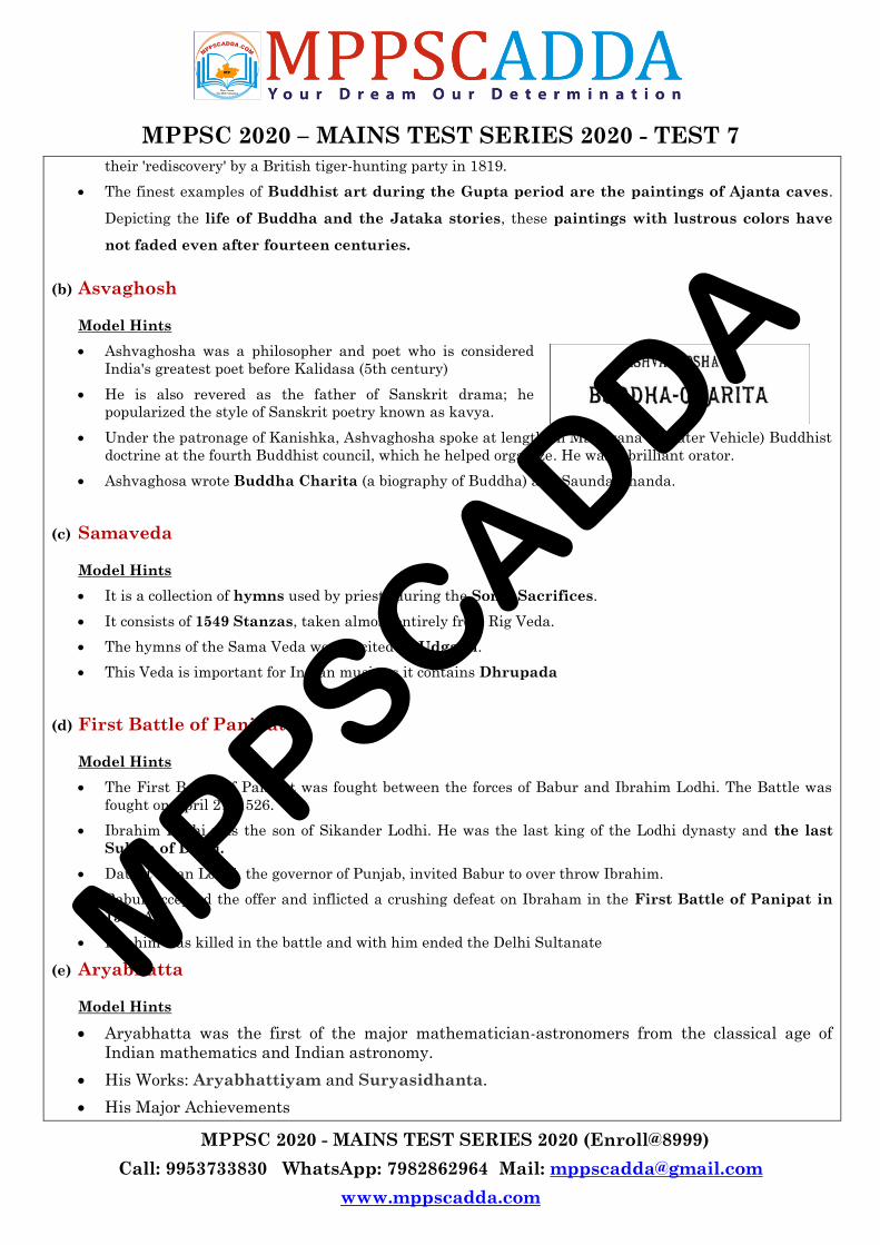
o Calculated the value of pie
o Laid down the foundation of algebra in his book
o Aryabhatta found the causes of lunar and solar eclipse.
o He also calculated the circumference of the Earth which is still almost correct.
o He was the first to reveal that the sun is stationary and the earth revolves around the
sun.
(f) Dayanand Saraswati
Model Hints
Dayanand Saraswati was a Hindu religious leader, renowned Vedic scholar and founder of the Arya
Samaj.
His ideologies also resonated with the spirit of India‘s
freedom struggle.
Movements: Arya Samaj, Shuddhi Movement, Back to the
Vedas (Slogan)
Books: Satyarth Prakash, Sanskarvidhi, Yajurved Bhasya
He emphasized the study of Vedas while highlighting the
faults of Hinduism.
He brought about a complete overhaul of the education system by introducing Anglo-Vedic schools to offer
Indian students an updated curriculum teaching both the knowledge of the Vedas along with
contemporary English education.
MPPSCADDA
MPPSC 2020 – MAINS TEST SERIES 2020 - TEST 7
MPPSC 2020 - MAINS TEST SERIES 2020 (Enroll@8999)
Call: 9953733830 WhatsApp: 7982862964 Mail: [email protected]
www.mppscadda.com
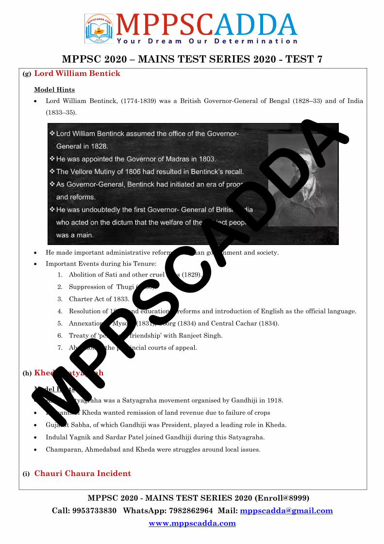
(g) Lord William Bentick
Model Hints
Lord William Bentinck, (1774-1839) was a British Governor-General of Bengal (1828–33) and of India
(1833–35).
He made important administrative reforms in Indian government and society.
Important Events during his Tenure:
1. Abolition of Sati and other cruel rites (1829).
2. Suppression of Thugi (1830).
3. Charter Act of 1833.
4. Resolution of 1835, and educational reforms and introduction of English as the official language.
5. Annexation of Mysore (1831), Coorg (1834) and Central Cachar (1834).
6. Treaty of ‗perpetual friendship‘ with Ranjeet Singh.
7. Abolition of the provincial courts of appeal.
(h) Kheda Satyagrah
Model Hints
Kheda Satyagraha was a Satyagraha movement organised by Gandhiji in 1918.
Peasants of Kheda wanted remission of land revenue due to failure of crops
Gujarat Sabha, of which Gandhiji was President, played a leading role in Kheda.
Indulal Yagnik and Sardar Patel joined Gandhiji during this Satyagraha.
Champaran, Ahmedabad and Kheda were struggles around local issues.
(i) Chauri Chaura Incident
MPPSCADDA
MPPSC 2020 – MAINS TEST SERIES 2020 - TEST 7
MPPSC 2020 - MAINS TEST SERIES 2020 (Enroll@8999)
Call: 9953733830 WhatsApp: 7982862964 Mail: [email protected]
www.mppscadda.com
Model Hints
Chauri Chaura Incident took place on 5th feb,1922.
A large group of protesters of the Non-Cooperation Movement clashed with police, who opened fire.
They set fire to a police station, killing all of its occupants.
The incident led to the deaths of three civilians and 22 policemen.
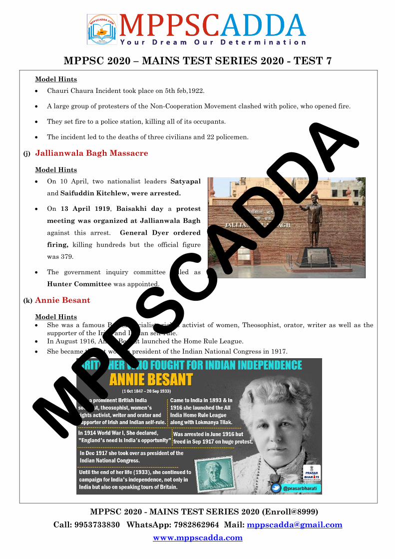
(j) Jallianwala Bagh Massacre
Model Hints
On 10 April, two nationalist leaders Satyapal
and Saifuddin Kitchlew, were arrested.
On 13 April 1919, Baisakhi day a protest
meeting was organized at Jallianwala Bagh
against this arrest. General Dyer ordered
firing, killing hundreds but the official figure
was 379.
The government inquiry committee called as
Hunter Committee was appointed.
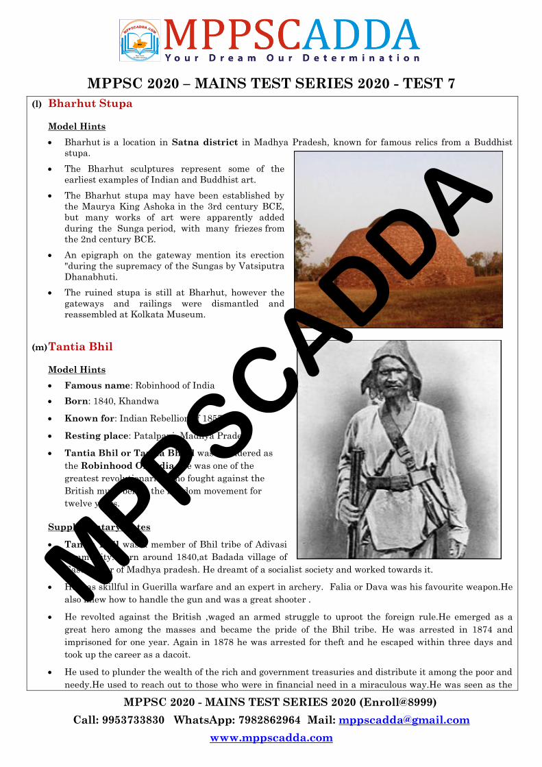
(k) Annie Besant
Model Hints
She was a famous British socialist, rights activist of women, Theosophist, orator, writer as well as the
supporter of the Irish and Indian self-rule.
In August 1916, Annie Besant launched the Home Rule League.
She became the 1st woman president of the Indian National Congress in 1917.
MPPSCADDA
MPPSC 2020 – MAINS TEST SERIES 2020 - TEST 7
MPPSC 2020 - MAINS TEST SERIES 2020 (Enroll@8999)
Call: 9953733830 WhatsApp: 7982862964 Mail: [email protected]
www.mppscadda.com
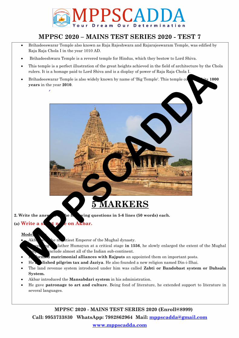
(l) Bharhut Stupa
Model Hints
Bharhut is a location in Satna district in Madhya Pradesh, known for famous relics from a Buddhist
stupa.
The Bharhut sculptures represent some of the
earliest examples of Indian and Buddhist art.
The Bharhut stupa may have been established by
the Maurya King Ashoka in the 3rd century BCE,
but many works of art were apparently added
during the Sunga period, with many friezes from
the 2nd century BCE.
An epigraph on the gateway mention its erection
"during the supremacy of the Sungas by Vatsiputra
Dhanabhuti.
The ruined stupa is still at Bharhut, however the
gateways and railings were dismantled and
reassembled at Kolkata Museum.
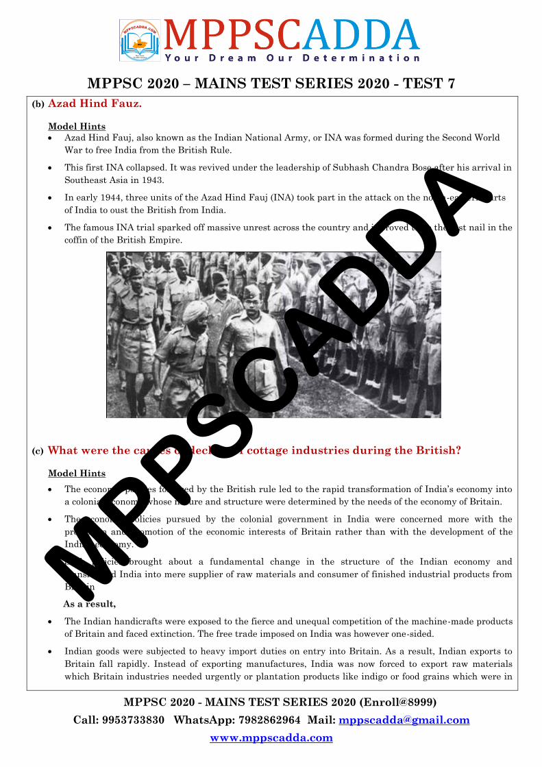
(m) Tantia Bhil
Model Hints
Famous name: Robinhood of India
Born: 1840, Khandwa
Known for: Indian Rebellion of 1857
Resting place: Patalpani, Madhya Pradesh
Tantia Bhil or Tantia Bheel was considered as
the Robinhood Of India. He was one of the
greatest revolutionaries who fought against the
British much before the freedom movement for
twelve years.
Supplementary Notes
Tantia Bhil was a member of Bhil tribe of Adivasi
community. Born around 1840,at Badada village of
East Nimar of Madhya pradesh. He dreamt of a socialist society and worked towards it.
He was skillful in Guerilla warfare and an expert in archery. Falia or Dava was his favourite weapon.He
also knew how to handle the gun and was a great shooter .
He revolted against the British ,waged an armed struggle to uproot the foreign rule.He emerged as a
great hero among the masses and became the pride of the Bhil tribe. He was arrested in 1874 and
imprisoned for one year. Again in 1878 he was arrested for theft and he escaped within three days and
took up the career as a dacoit.
He used to plunder the wealth of the rich and government treasuries and distribute it among the poor and
needy.He used to reach out to those who were in financial need in a miraculous way.He was seen as the
MPPSCADDA

MPPSC 2020 – MAINS TEST SERIES 2020 - TEST 7
MPPSC 2020 - MAINS TEST SERIES 2020 (Enroll@8999)
Call: 9953733830 WhatsApp: 7982862964 Mail: [email protected]
www.mppscadda.com
Messiah of the poor and was popularly called as ―Mama‖ by all age group.
Finally the British arrested him at Indore because of the treachery of his sister‘s husband Ganpat who
snitched on Tantia for few rupees from the government. His news of arrest was published in New York
Times and he was described as "The Robin Hood of India‖.
He was chained heavily and taken to Jabalpur where the sessions court gave him death sentence on 19
October 1889. After hanging him, the colonial government took his body in a train and threw it off at
Patalpani. On the persumed spot a samadhi was constructed in his honour.
Even today every time a train passes by the samadhi of Tantya Bhil the train driver pulls the whistle in
honour of the hero of the people.
(n) Rani Durgawati
Model Hints
Rani Durgawati was born on 5th October 1524 A.D. in the family of famous Chandel emperor Keerat Rai.
She was born at the fort of Kalanjar (Banda, U.P.).
At the age of 18 in 1542 CE, she was married to Dalpatshah, the eldest son of king Sangramshah of Gond
Dynasty. Chandel and Gond dynasties got closer as a consequence of this marriage and that was the
reason Keerat Rai got the help of Gonds and his son-in-law Dalpatshah at the time of invasion of
Shershah Suri in which Shershah Suri died.
She gave birth to a son in 1545 A.D. who was named Vir Narayan. Dalpatshah died in about 1550 A.D.
Durgavati took the reins of the Gond kingdom in her hands.
Two ministers Adhar Kayastha and Man Thakur helped the Rani in looking after the administration
successfully and effectively. Rani moved her capital to Chauragarh in place of Singaurgarh.
Rani Durgavati was a personality with varied facets. She was valiant, beautiful and brave and also a
great leader with administrative skills. Her self-respect forced her to fight till death rather than
surrender herself to her enemy.
She, like her ancestral dynasty, built so many lakes in her state and did a lot for the welfare of her people.
She respected the scholars and extended her patronage to them. She welcomed the Vitthalnath of Vallabh
community and took Diksha from him. She was secular and appointed many eminent Muslims on
important posts.
The place where she sacrificed herself has always been a source of inspiration for freedom fighters.
In the year 1983, the Government of Madhya Pradesh renamed the University of Jabalpur as Rani
Durgavati Vishwavidyalaya in her memory.
Government of India paid its tribute to the valiant Rani by issuing a postal-stamp commemorating her
martyrdom, on 24th June 1988.
(o) Brihadeeswara Temple
Model Hints
Tag : Cultural UNESCO World Heritage Site
Built in : 1003-1010 AD
Location: Thanjavur, Tamil Nadu
MPPSCADDA
MPPSC 2020 – MAINS TEST SERIES 2020 - TEST 7
MPPSC 2020 - MAINS TEST SERIES 2020 (Enroll@8999)
Call: 9953733830 WhatsApp: 7982862964 Mail: [email protected]
www.mppscadda.com
Brihadeeswarar Temple also known as Raja Rajeshwara and Rajarajeswaram Temple, was edified by
Raja Raja Chola I in the year 1010 AD.
Brihadeeshwara Temple is a revered temple for Hindus, which they bestow to Lord Shiva.
This temple is a perfect illustration of the great heights achieved in the field of architecture by the Chola
rulers. It is a homage paid to Lord Shiva and is a display of power of Raja Raja Chola I.
Brihadeeswarar Temple is also widely known by name of 'Big Temple'. This temple completed its 1000
years in the year 2010.
5 MARKERS 2. Write the answers of the following questions in 5-6 lines (50 words) each.
(a) Write a short note on Akbar.
Model Hints
Akbar was the mightiest Emperor of the Mughal dynasty.
Succeeding his father Humayun at a critical stage in 1556, he slowly enlarged the extent of the Mughal
Empire to include almost all of the Indian sub-continent.
He formed matrimonial alliances with Rajputs an appointed them on important posts.
He abolished pilgrim tax and Jaziya. He also founded a new religion named Din-i-Ilhai.
The land revenue system introduced under him was called Zabti or Bandobast system or Dahsala
System.
Akbar introduced the Mansabdari system in his administration.
He gave patronage to art and culture. Being fond of literature, he extended support to literature in
several languages.
MPPSCADDA
MPPSC 2020 – MAINS TEST SERIES 2020 - TEST 7
MPPSC 2020 - MAINS TEST SERIES 2020 (Enroll@8999)
Call: 9953733830 WhatsApp: 7982862964 Mail: [email protected]
www.mppscadda.com
(b) Azad Hind Fauz.
Model Hints
Azad Hind Fauj, also known as the Indian National Army, or INA was formed during the Second World
War to free India from the British Rule.
This first INA collapsed. It was revived under the leadership of Subhash Chandra Bose after his arrival in
Southeast Asia in 1943.
In early 1944, three units of the Azad Hind Fauj (INA) took part in the attack on the north-eastern parts
of India to oust the British from India.
The famous INA trial sparked off massive unrest across the country and it proved to be the last nail in the
coffin of the British Empire.
(c) What were the causes of decline of cottage industries during the British?
Model Hints
The economic policies followed by the British rule led to the rapid transformation of India‘s economy into
a colonial economy whose nature and structure were determined by the needs of the economy of Britain.
The economic policies pursued by the colonial government in India were concerned more with the
protection and promotion of the economic interests of Britain rather than with the development of the
Indian economy.
Such policies brought about a fundamental change in the structure of the Indian economy and
transformed India into mere supplier of raw materials and consumer of finished industrial products from
Britain
As a result,
The Indian handicrafts were exposed to the fierce and unequal competition of the machine-made products
of Britain and faced extinction. The free trade imposed on India was however one-sided.
Indian goods were subjected to heavy import duties on entry into Britain. As a result, Indian exports to
Britain fall rapidly. Instead of exporting manufactures, India was now forced to export raw materials
which Britain industries needed urgently or plantation products like indigo or food grains which were in
MPPSCADDA
MPPSC 2020 – MAINS TEST SERIES 2020 - TEST 7
MPPSC 2020 - MAINS TEST SERIES 2020 (Enroll@8999)
Call: 9953733830 WhatsApp: 7982862964 Mail: [email protected]
www.mppscadda.com
short supply in Britain.
The British Industrial policy in the 19th century ruined the Indian handicrafts. Their self-motivated
interests destroyed the handicrafts and the cottage Industries of India which were the primary sources of
its foreign trade and wealth. This was particularly true for the cotton textile industry which served as the
main vehicle of the Industrial Revolution in Britain
Due to the process of colonialization, agriculture, trade, and industry of India were ruined badly and India
became a poor country as at had never been. Similarly, the ruin of rural artisan and cottage industries
proceeded more rapidly once the railways were built in the hinterlands of India
Right from the foundation of British rule in India, the British Government showed a marked antipathy
and neglect towards Indian industries. It resulted in the demise of India‘s world fame cottage and small
scale industries as these could not stand in the competition of British industries
(d) Give a brief account of Santhal Rebellion.
Model Hints
The Santhal Revolt took place in 1855-56. Santhals are a tribal group concentrated in the state of
Jharkhand.
The revolt can be attributed to the introduction of the Permanent Land Settlement of 1793.
The aforesaid settlement pattern by the British snatched lands that the Santhals had been cultivating for
centuries from them.
The zamindars, moneylenders, Europeans and the British government officials raised the land
tax and exploited farmers. They were so oppressed that they resolved to rebel against the landlords and
the government.
The Santhals engaged in guerrilla warfare. They dismantled the railway and postal communications.
The Santhal revolt was very effective for a while, but it could not succeed against the absolute power of
the government and was suppressed.
(e) Discuss the reasons for the popularity of Buddhism.
Model Hints
Buddhism religion spread far and wide like wild fire as it provided relief to the society overburdened with
Bramahnical rites and rituals.
Following were the major reasons for the popularity of Buddhism:
1. Buddha‘s simple life, compassion and life of renunciation attracted a large number of people.
2. Buddhism was democratic and liberal.
3. It was free from the evils of Brahmanism.
4. Use of Pali, the language of common people by Buddha in his preachings.
5. The missionary activities of the Buddhist Sanghas.
6. Patronage by rulers like Prasenjit, Bimbisara, Ajatasatru, Asoka, Kaniska and Harshavardhan.
7. Role of Universities such as Nalanda, Puspagiri, Vikramasila, Ratnagiri, Odantapuri and
Somapuri and Buddhist Councils.
MPPSCADDA
MPPSC 2020 – MAINS TEST SERIES 2020 - TEST 7
MPPSC 2020 - MAINS TEST SERIES 2020 (Enroll@8999)
Call: 9953733830 WhatsApp: 7982862964 Mail: [email protected]
www.mppscadda.com
Buddhism religion spread far and wide like wild fire as it provided relief to the society overburdened with
Bramahnical rites and rituals.
Following were the major reasons for the popularity of Buddhism:
8. Buddha‘s simple life, compassion and life of renunciation attracted a large number of people.
9. Buddhism was democratic and liberal.
10. It was free from the evils of Brahmanism.
11. Use of Pali, the language of common people by Buddha in his preachings.
12. The missionary activities of the Buddhist Sanghas.
13. Patronage by rulers like Prasenjit, Bimbisara, Ajatasatru, Asoka, Kaniska and Harshavardhan.
14. Role of Universities such as Nalanda, Puspagiri, Vikramasila, Ratnagiri, Odantapuri and
Somapuri and Buddhist Councils.
(f) Write a short note on Devadasi System.
Model Hints
A Devadasi is the name given to a girl ‗dedicated‘ to a deity in a temple for worship and service of the
deity for the rest of her life.
Devadasi system is a religious practice whereby parents marry a daughter to a deity or a temple usually
occurs before the girl reaches puberty.
This was prominent in southern and parts of western India.
The dedication of the girl takes place in a ceremony similar to marriage and is called ‗pottukattu‘.
Originally, the girls learned and practiced the arts like Bharathanatyam, Odissi or other classical dance
forms, apart from taking care of the temple and engaging in rituals.
They traditionally enjoyed a high status in society as music and dance were integral parts of worship in
temples.
They generally married wealthy patrons and engaged their time pursuing and bettering their artistic
skills, instead of becoming a housewife. The job of the housewife belonged to the other wife of the patrons.
The Devadasis‘ children were also taught music and dance.
(g) Role of foreigners in shaping the socio religious movements during British Rule.
Model Hints
Indian society underwent many changes after the British came to India. In the 19th century, certain
social practices like female infanticide, child marriage, sati, polygamy, a rigid caste system and religious
dogmas became more prevalent because of the Socio religious situation of that time.
When the British came to India, they brought new ideas such as liberty, equality, freedom and human
rights from the Renaissance, the Reformation Movement and the various revolutions that took place in
Europe. These ideas appealed to some sections of our society and led to several Socio religious reform
movements in different parts of the country.
At the forefront of these movements were visionary Indians such as Raja Ram Mohan Roy, Sir Syed
Ahmed Khan, Aruna Asaf Ali and Pandita Ramabai. These movements looked for social unity and strived
towards liberty, equality and fraternity.
MPPSCADDA
MPPSC 2020 – MAINS TEST SERIES 2020 - TEST 7
MPPSC 2020 - MAINS TEST SERIES 2020 (Enroll@8999)
Call: 9953733830 WhatsApp: 7982862964 Mail: [email protected]
www.mppscadda.com
Many legal measures were introduced to improve the status of women. For example, the practice of sati
was banned in 1829 by Lord Bentinck, the then Governor General.
Widow Remarriage was permitted by a law passed in 1856. A law passed in 1872, sanctioned inter-caste
and inter-communal marriages. Sharda Act was passed in 1929 preventing child marriage. The act
provided that it was illegal to marry a girl below 14 and a boy below 18 years. All the movements severely
criticized the caste system and especially the practice of untouchability.
Direct involvement of Foreginers in socio religious reform movements
HP Blavatsky: She started Theosophical movement (Literally means all inclusive) in New York with Col
HS Olcott (American) in 1875. They arrived in India in 1879 and established the headquarters of the
society at Adyar near Madras in 1882. Theosophist popularised the study of oriental classics, especially
Upanishads and Bhagwat Gita.
Annie Besant : She joined the Theosophical Society in England in 1889 and came to India in 1893. She
became President of the society after death of Olcolt in 1907. She translated the Bhagwad Gita in English.
She laid the foundation of the Central Hindu College at Banaras in 1898 that later became nucleus for the
formation of Banaras Hindu University in 1916.
Henry Louis Vivian Derozio (1809-1831) : He started Young Bengal Movement in Calcutta. The movement
attacked old traditional and decadent customs. It advocated women's rights and educated the public on
socio-economic and political issues
The persistent efforts of the reformers had immense impact on the society. The religious reform movements
instilled in the minds of Indians greater self-respect, self confidence and pride in their country. These reform
movements helped many Indians to come to terms with the modern world.
(h) Discuss Civil Disobedience Movement in brief.
Model Hints
The Civil Disobedience Movement was one of the most significant movements launched by Mahatma
Gandhi in the course of India‘s freedom struggle.
There were three main causes of the civil disobedience movement:
a) Formation of the Simon Commision
b) Demand for Dominion Status
c) Protests against the arrest of social revolutionaries
It was launched in March 1930 with Gandhi‘s Dandi March to break Salt law.
Apart from defiance of salt laws, the other forms of non-violent forms of protests.
Movement was suspended in March, 1931 after Gandhi-Irwin Pact. However, the failure of 2nd Round
Table Conference led to resumption of the movement.
It met ruthless repression by the government and Mahatma Gandhi withdrew it finally in April, 1934.
(i) Throw light on literary contributions of Tulsidas.
Model Hints
Tulsidas wrote several popular works in Sanskrit and Awadhi. He is best known as the author of the
epic Ramcharitmanas.
MPPSCADDA
MPPSC 2020 – MAINS TEST SERIES 2020 - TEST 7
MPPSC 2020 - MAINS TEST SERIES 2020 (Enroll@8999)
Call: 9953733830 WhatsApp: 7982862964 Mail: [email protected]
www.mppscadda.com
Twelve works are widely considered by biographers to be written by Tulsidas, six major works and six
minor works.
Based on the language of the works, they have been classified into two groups as follows-
1. Awadhi works – Ramcharitmanas, RamlalaNahachhu, BarvaiRamayan, Parvati Mangal, Janaki
Mangal and RamagyaPrashna.
2. Braja works – Krishna Gitavali, Gitavali, Sahitya Ratna, Dohavali, Vairagya Sandipani and
Vinaya Patrika.
Besides these twelve works, four more works are popularly believed to be composed by Tulsidas which
include Hanuman Chalisa, Hanuman Ashtak, Hanuman Bahuk and Tulsi Satsai.
(j) Describe Jungle Satyagraha in brief.
Model Hints
In 1930 Mahatma Gandhi organized the Dandi March to start the salt satyagraha. At this time the tribals
of seoni- under the leadership of Durga Shankar Mehta organized a march of 9-10 Km to cut grass from
the government sandalwood garden to resister their anger against the British rule. This is known as the
Jungle Satyagraha.
The term Satyagraha was coined by M.K. Gandhi in South Africa; to describe the passive resistance.
However, it does not support the use of armament in any form.
In other words, the term Satyagraha represents the resistance in the non-violent form. Therefore, the
meaning of the term Jungle Satyagraha is applied to the Satyagrahas that held to protect the jungles or
the forests of India.
11 MARKERS
3. Answer the following questions in about 200 words each.
(a) Discuss the effect of British Economic Policies on Indian Economy.
Model Hints
The economic policies followed by the British led to the rapid transformation of India‘s economy into a
colonial economy whose nature and structure were determined by the needs of the British economy.
There was hardly any aspect of the Indian economy that was not changed for better or for worse during
the entire period of British rule down to 1947.
Disruption of Traditional Economy: The economic policies followed by the British led to the rapid
transformation of Indian‘s economy into a colonial economy whose nature and structure were determined
by the needs of the British economy that totally disrupted the traditional structure of the Indian economy.
Ruin of Artisans and Craftsmen: There was a sudden and quick collapse of the urban handicrafts,
which had for centuries made India‘s name a byword in the markets of the entire civilized world. Indian
goods made with primitive techniques could not compete with goods produced on a mass scale by powerful
steam-operated machines. The development of railways enabled British manufactures to reach and uproot
the traditional industries in the remotest villages of the country. The gradual destruction of rural crafts
MPPSCADDA
MPPSC 2020 – MAINS TEST SERIES 2020 - TEST 7
MPPSC 2020 - MAINS TEST SERIES 2020 (Enroll@8999)
Call: 9953733830 WhatsApp: 7982862964 Mail: [email protected]
www.mppscadda.com
broke up the union between agricultural and domestic industry in the countryside and thus contributed to
the destruction of the self-sufficient village economy.
Stagnation and Deterioration of Agriculture: Following were the major reasons for stagnation and
deterioration of agriculture:
o Overcrowding of agriculture;
o Excessive land revenue demand;
o Growth of landlordism;
o Increasing indebtedness; and
o The growing impoverishment of the cultivators.
o Indigo manufacture was introduced in India at the end of the 18th century and flourished in
Bengal and Bihar. Indigo planters gained notoriety for their oppression over the peasants who
were compelled by them to cultivate indigo. This oppression was vividly portrayed by the famous
Bengali writer Dinbandhu Mitra in his play ―Neel Darpan‖ in 1860.
Poverty and Famines:
o The poverty of the people found its culmination in a series of famines which ravaged all parts of
India in the second half of the 19th century. The famine of 1896-97 affected over 9.5 crore people
of whom nearly 45 lakhs died. The famine of 1899-1900 followed quickly and caused widespread
distress.
o The first of these famines occurred in Western U.P. in 1860-61 and cost over 2 lakh lives.
o In 1865-66, a famine engulfed Orissa, Bengal, Bihar, and Madras and took a toll of nearly 20 lakh
lives; Orissa alone lost 10 lakh people.
o Perhaps the worst famine in Indian history till then occurred in 1876-78 in Madras, Mysore,
Hyderabad, Maharashtra, Western U. P., and Punjab
(b) What methods were adopted by Ashoka to Spread Buddhism. Discuss.
Model Hints
Ashoka practiced what he preached. Ashoka appointed officers called Dharma Mahamatras, Yuktas and
Rajjukas to spread Dharma among the people. He also appointed StreeAdhyakshaMahamatra to take
care of women and bring religious awareness among them.
Ashoka personally visited the Buddhist holy places such as Lumbini Garden, Kapilvastu, Gaya, Saranath
and Kushinagar and arranged discourses on religion.
He spread the doctrines of Buddha by engraving them on rocks, pillars and on the walls of the caves
throughout the vast empire. He constructed pillar at lumbini in nepal where Gautam buddha was born.
He also helped in construction of vihars like that of Nalanda &Taxilla.
He organized the third Buddhist Council at Pataliputra in 250 BCE to settle the internal differences
among the monks.
Ashoka built a large number of monasteries all over the empire and spent large sums of money in
endowing them.
Also Buddhist missionaries were sent throughout India to Sri Lanka and South-East Asia and to as far
west as Cyrene, Egypt, Syria, and Macedonia..For example he sent his son Mahendra and
MPPSCADDA

MPPSC 2020 – MAINS TEST SERIES 2020 - TEST 7
MPPSC 2020 - MAINS TEST SERIES 2020 (Enroll@8999)
Call: 9953733830 WhatsApp: 7982862964 Mail: [email protected]
www.mppscadda.com
daughter Sanghamitra to Sri Lanka with a Bodhi sapling as a symbol of peace.
Simple local languages(like pali) & scripts(like kharosthi) were used for easy understanding of
people. The idea was that through these mediums people in other parts of asia would understand & hence
support Buddhist culture like ahimsa, non-vegetarianism, charity, simple life etc.
Ashoka believed in Buddhist principles and he undertook many welfare activities. He dug wells, built rest
houses, planted fruit bearing trees along road sides, constructed hospitals for men and animal and
established schools. Ashoka made arrangement to feed the poor and physically unfit people. He was like a
father to his subjects. His motto was ―Service and sacrifice‖
Many Buddhist symbols were carved out on various edicts and schools of Art like Mauryan School of Art
flourished under his reign.
(c) Write a note on the decline of Indus Valley Civilization.
Model Hints
With time, there was shrinkage in the Harappan Civilization. For instance, Mohenjodaro, one of the
major cities of this civilization, earlier flourished on about eighty-five hectares of land but later on got
confined to just three hectares. Due to some reason, the population from the Harappa started moving to
the nearby and outer cities and places like Punjab, Upper Doab, Haryana, etc.
Decline set in around 1900 BC and after 1700 BC, little remained in Harappan civilization. However, it
did not come to an abrupt end within particular decade or century.
Theory 1: Until recently, it was believed that Indus Cities were destroyed by the Aryans who entered
India from Iran and Afghanistan through northwestern passes such as the Bolan and the Khyber. The
evidences of this theory were two pronged.. Most ardent propounder of this theory was Sir Wheeler
Geological Factors : Another theory considers a combination of natural and socio-economic factors. It is
believed that the Indus Valley region experienced several tectonic disturbances which caused
earthquakes. These upheavals not only disturbed their life but also changed courses of rivers or dried
them up. The modern satellite imagery confirms dramatic shifts in the river courses, which might have
caused great flood cutting the food producing areas from urban centres. This is evident from the
quantities of silt layers in the upper levels of Mohenjo Daro indicating heavy floods.
Rainfall Pattern Shift: Another natural reason might be changes in patterns of rainfall. During the
mature Harappan age in 2500 BC, there was a great rise in the amount of rainfall, but by the beginning of
the second millennium BC it had dropped dramatically thus affecting food production adversely. With the
rivers shifting their courses, the rainfall declining and sufficient food failing to arrive from the
countryside, there was a slow but inevitable collapse of the Indus system. Its final outcome was
catastrophic for the Mature Harappan phase.This decline theory of environment degradation was given by
John Marshall.
(d) Describe the Gupta administration in detail.
Model Hints
The period for Gupta age is in between 320-540 AD.
In this time actually in India rapid development took place in different fields like in the field of art,
architecture literature, philosophy, trade, science, and agriculture.
Therefore, this age is called the golden age of Indian history.
MPPSCADDA
MPPSC 2020 – MAINS TEST SERIES 2020 - TEST 7
MPPSC 2020 - MAINS TEST SERIES 2020 (Enroll@8999)
Call: 9953733830 WhatsApp: 7982862964 Mail: [email protected]
www.mppscadda.com
Rulers of Gupta Empire
Sri Gupta is the founder of Gupta dynasty.
Chandragupta was the first powerful ruler. In 320 AD he ascended the throne. He had the matrimonial
alliance with Lichchhavi princess. So, in the history of Gupta Empire, this was the main turning point.
Samudragupta is the son of Chandragupta. Next, he became the commanding ruler. The Allahabad pillar
has his glory and conquest described. This includes his court poet and Harisena.
Chandragupta Vikramaditya came who is the reason behind the spread out and strengthen of Gupta
Empire. In his rule, he visited India and occupied Saka territories. This way, the expansion of rule over
the Indian subcontinent continued.
Administration and Military System of Gupta Empire
The king basically ruled the central government. In contrast to the Maurya rulers, the Gupta kings
adopted pompous titles such asparameshvara, maharajadhiraja, and paramabhattaraka which signify
that they ruled over many lesser kings in their empire.The throne did not always go to the eldest son,
creating uncertainties of which the chiefs and high officials took advantage.
The Guptas organized a system of provincial and local administration. The empire was divided into
divisions called bhukth, and each bhukti was placed under the charge of an uparika. The bhuktis were
divided into districts (vishayas), which were placed under the charge of a vishayapati.The lower level
administration had a group of villages. Gramadhyksha headed each of the villages.
The Gupta bureaucracy was not as elaborate as that of the Mauryas. The most important officers in the
Gupta empire were the kumaramatyas. They were appointed by the king in the home provinces and
possibly paid in cash
The Mahasenapatis played an important role. They lead the contingents of Calvary and elephants. They
advised the kings about several matters.The numerical strength of the Gupta army is not known.
Evidently the king maintained a standing army, which was supplemented by the forces occasionally
supplied by his feudatories. Horse chariots receded into the background, and cavalry came to the fore.
Horse archery became an important element in military tactics.
During the Gupta period land taxes increased in number, and those on trade and commerce decreased.
Probably the king collected taxes varying from one-fourth to one-sixth of the produce.
The judicial system was far more developed under the Guptas than in earlier times. Several law-books
were compiled during this period, and for the first time civil and criminal laws were clearly demarcated.
Theft and adultery fell under criminal law, disputes regarding various types of property under civil law.
The participation of leading artisans, merchants, elders, and others in the rural and urban administration
also lessened the need to maintain a large retinue of officers. The Guptas neither needed nor had the
elaborate administrative machinery of Maurya times, and in some ways their political system appears to have
been feudal.
(e) Discuss in detail the regional history of Bhopal State.
Model Hints
MPPSCADDA

MPPSC 2020 – MAINS TEST SERIES 2020 - TEST 7
MPPSC 2020 - MAINS TEST SERIES 2020 (Enroll@8999)
Call: 9953733830 WhatsApp: 7982862964 Mail: [email protected]
www.mppscadda.com
BHOPAL STATE
Bhopal State was an independent state of the eighteenth century India.
Dost Muhammad Khan : The state was founded by Dost Muhammad Khan, an Afghan soldier in the
Mughal army. He took advantage of the disintegrating Mughal empire and annexed several territories.
For instance, he usurped the Rajput principality of Mangalgarh and the Gond kingdom of Rani
Kamlapati, after the death of their female rulers. He established his capital at Jagdishpur, 10 km from
Bhopal and later renamed it as Islamnagar. During the early 1720s, Khan fortified the city of Bhopal and
assumed the title of Nawab.
In 1723, Bhopal came under the suzerainty of the Nizam of Hyderabad.
In 1737, Marathas defeated the Mughals and the Nawab of Bhopal in the Battle of Bhopal, and started
collecting tribute from the state.
In 1818, Bhopal became a British princely state after the defeat of the Marathas in the Third Anglo-
Maratha war. From 1818 to 1947 it was a princely state in a subsidiary alliance with British India, and
It was an independent state from 1947 to 1949.
The state was finally merged into the Union of India in 1949 as Bhopal.
THE RULE OF THE BEGUMS
Between 1819 and 1926, Bhopal state was ruled by four women-Begums—unique in the royalty of those
days.
In 1819, the history of Bhopal state took an interesting turn, when 18-year-old Qudsia Begum (also
known as Gohar Begum) took over the reins after the assassination of her husband.
Qudsia Begum was the first woman ruler, who was succeeded by her only daughter Sikandar Begum, who
in turn was succeeded by her only daughter, Shah Jahan Begum.
Sultan Kaikhusrau Jahan Bcgum was the last woman ruler, who after 25 years of rule, abdicated in favor
of her son, Hamidullah Khan.
AFTER INDIAN INDEPENDENCE
After India achieved Independence on 15 August 1947, Bhopal was one of the last states to sign the
Instrument of Accession.
The last Nawah expressed his wish to retain Bhopal as a separate unit. Agitations against the Nawab
broke out in December 1948 leading to the arrest of prominent leaders including Shankar Dayal Sharma.
Later, under public pressure, the political detainees were released and the Nawab signed the agreement
for merger.
The Bhopal princely state was taken over by the Union Government of India on 1 June 1949.
The new Bhopal State was declared a "Part C" state, governed by a chief commissioner appointed by the
President of India.
MPPSCADDA
MPPSC 2020 – MAINS TEST SERIES 2020 - TEST 7
MPPSC 2020 - MAINS TEST SERIES 2020 (Enroll@8999)
Call: 9953733830 WhatsApp: 7982862964 Mail: [email protected]
www.mppscadda.com
PART B 3 MARKERS
1. This question consists of very short answer type question. Each question is to be
answered in 1 line (10 Words). There is no internal choice. Each question
carries 3 marks
(a) Bhil Tribe in MP
Model Hints
• It is the Largest Tribe of M.P and India both.
• Mainly concentrated in Dhar, Jhabua, Ratlam and Nimar districts.
• Mythologically, Meaning of Bhil is Bow (Bhil is derived from primitive word bil means Danush).
Supplementary Notes
24 Major Tribes in M.P. The no. reach up to 90 along with their subtribes.
• The population of tribes in M.P. is 1.53 crore, which is highest in India.
• Among tribes, Bhils have the highest no. of population (46.18 Lakh) in M.P., followed by Gond (43.57
Lakh).
3 largest Tribes of India
1. Bhil, (46.18 lacs)
2. Gond (43.57 lakh)
3. Kol (11.67 lakh)
3 largest Tribes of MP
1. Bhil
2. Gond
3. Baiga
Bhil Subtribes
• Bhil, Bhilala, Pataliya, Rathiyas, Begas. Among which status of Bhilala are considered as best.
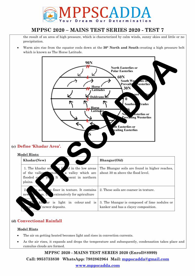
(b) Horse Latitudes
Model Hints
The horse latitudes are regions located at about 30 degrees north and south of the equator. These
latitudes are characterized by calm winds and little precipitation.
It is common in this region of the subtropics for winds to diverge and either flow toward the poles (known
as the prevailing westerlies) or toward the equator (known as the trade winds). These diverging winds are
MPPSCADDA
MPPSC 2020 – MAINS TEST SERIES 2020 - TEST 7
MPPSC 2020 - MAINS TEST SERIES 2020 (Enroll@8999)
Call: 9953733830 WhatsApp: 7982862964 Mail: [email protected]
www.mppscadda.com
the result of an area of high pressure, which is characterized by calm winds, sunny skies and little or no
precipitation.
Warm airs rise from the equator cools down at the 30° North and South creating a high pressure belt
which is known as The Horse Latitude.
(c) Define ‘Khadar Area’.
Model Hints:
Khadar(New) Bhangar(Old)
1. The khadar soils are found in the low areas
of the valley, bottom of a valley which are
flooded every year. It is present in northern
plains.
The Bhangar soils are found in higher reaches,
about 30 m above the flood level.
2. These soils are finer in texture. It contains
new alluvium. Used extensively for agriculture
2. These soils are coarser in texture.
3. The khadar is light in colour and is
composed of newer deposits.
3. The bhangar is composed of lime nodules or
kanker and has a clayey composition.
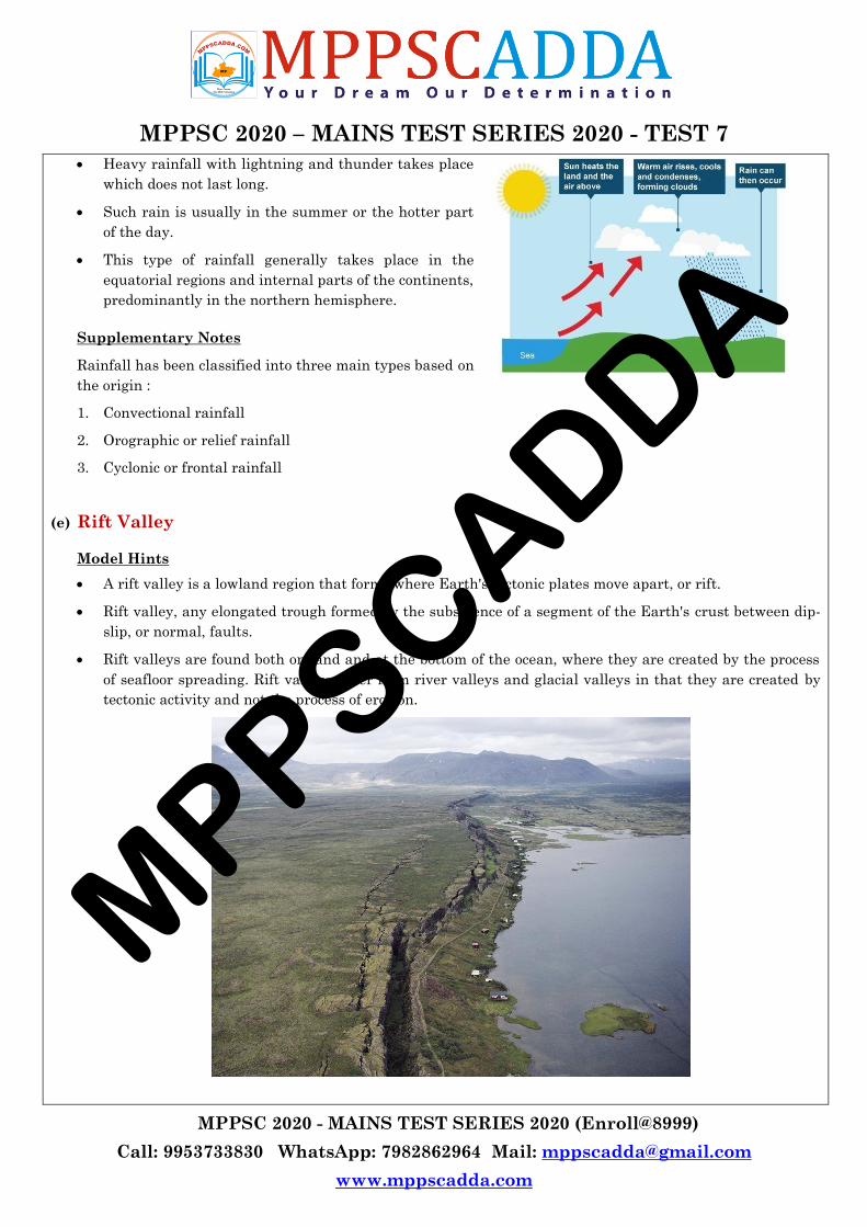
(d) Convectional Rainfall
Model Hints
The air on getting heated becomes light and rises in convection currents.
As the air rises, it expands and drops the temperature and subsequently, condensation takes place and
cumulus clouds are formed.
MPPSCADDA
MPPSC 2020 – MAINS TEST SERIES 2020 - TEST 7
MPPSC 2020 - MAINS TEST SERIES 2020 (Enroll@8999)
Call: 9953733830 WhatsApp: 7982862964 Mail: [email protected]
www.mppscadda.com
Heavy rainfall with lightning and thunder takes place
which does not last long.
Such rain is usually in the summer or the hotter part
of the day.
This type of rainfall generally takes place in the
equatorial regions and internal parts of the continents,
predominantly in the northern hemisphere.
Supplementary Notes
Rainfall has been classified into three main types based on
the origin :
1. Convectional rainfall
2. Orographic or relief rainfall
3. Cyclonic or frontal rainfall
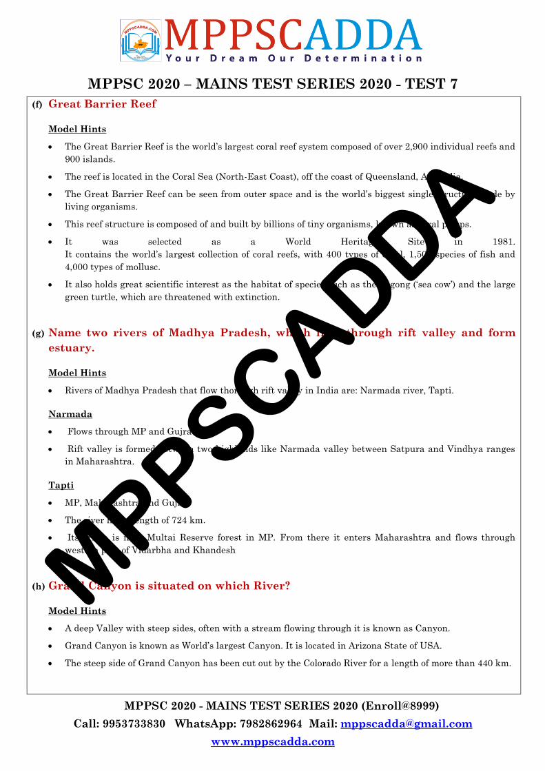
(e) Rift Valley
Model Hints
A rift valley is a lowland region that forms where Earth's tectonic plates move apart, or rift.
Rift valley, any elongated trough formed by the subsidence of a segment of the Earth's crust between dip-
slip, or normal, faults.
Rift valleys are found both on land and at the bottom of the ocean, where they are created by the process
of seafloor spreading. Rift valleys differ from river valleys and glacial valleys in that they are created by
tectonic activity and not the process of erosion.
MPPSCADDA
MPPSC 2020 – MAINS TEST SERIES 2020 - TEST 7
MPPSC 2020 - MAINS TEST SERIES 2020 (Enroll@8999)
Call: 9953733830 WhatsApp: 7982862964 Mail: [email protected]
www.mppscadda.com
(f) Great Barrier Reef
Model Hints
The Great Barrier Reef is the world‘s largest coral reef system composed of over 2,900 individual reefs and
900 islands.
The reef is located in the Coral Sea (North-East Coast), off the coast of Queensland, Australia.
The Great Barrier Reef can be seen from outer space and is the world‘s biggest single structure made by
living organisms.
This reef structure is composed of and built by billions of tiny organisms, known as coral polyps.
It was selected as a World Heritage Site in 1981.
It contains the world‘s largest collection of coral reefs, with 400 types of coral, 1,500 species of fish and
4,000 types of mollusc.
It also holds great scientific interest as the habitat of species such as the dugong (‗sea cow‘) and the large
green turtle, which are threatened with extinction.
(g) Name two rivers of Madhya Pradesh, which flow through rift valley and form
estuary.
Model Hints
Rivers of Madhya Pradesh that flow thorough rift valley in India are: Narmada river, Tapti.
Narmada
Flows through MP and Gujrat
Rift valley is formed between two highlands like Narmada valley between Satpura and Vindhya ranges
in Maharashtra.
Tapti
MP, Maharashtra and Gujrat
The river has a length of 724 km.
Its origin is near Multai Reserve forest in MP. From there it enters Maharashtra and flows through
western part of Vidarbha and Khandesh
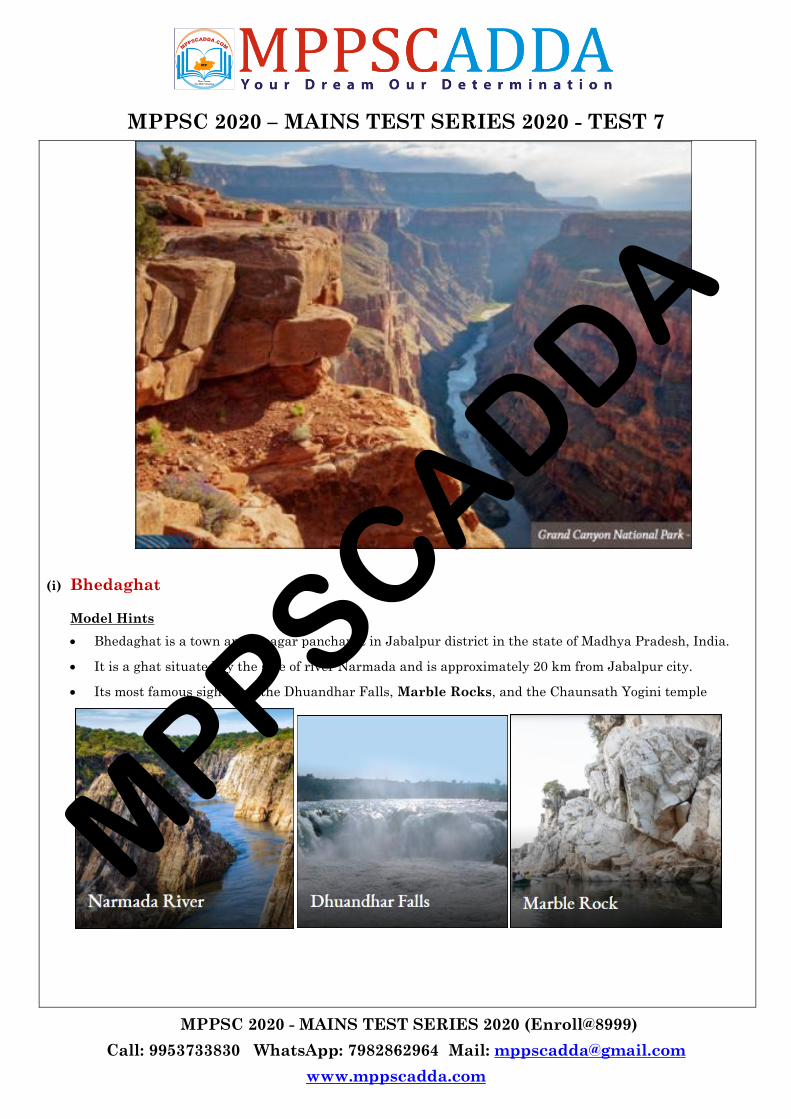
(h) Grand Canyon is situated on which River?
Model Hints
A deep Valley with steep sides, often with a stream flowing through it is known as Canyon.
Grand Canyon is known as World‘s largest Canyon. It is located in Arizona State of USA.
The steep side of Grand Canyon has been cut out by the Colorado River for a length of more than 440 km.
MPPSCADDA
MPPSC 2020 – MAINS TEST SERIES 2020 - TEST 7
MPPSC 2020 - MAINS TEST SERIES 2020 (Enroll@8999)
Call: 9953733830 WhatsApp: 7982862964 Mail: [email protected]
www.mppscadda.com
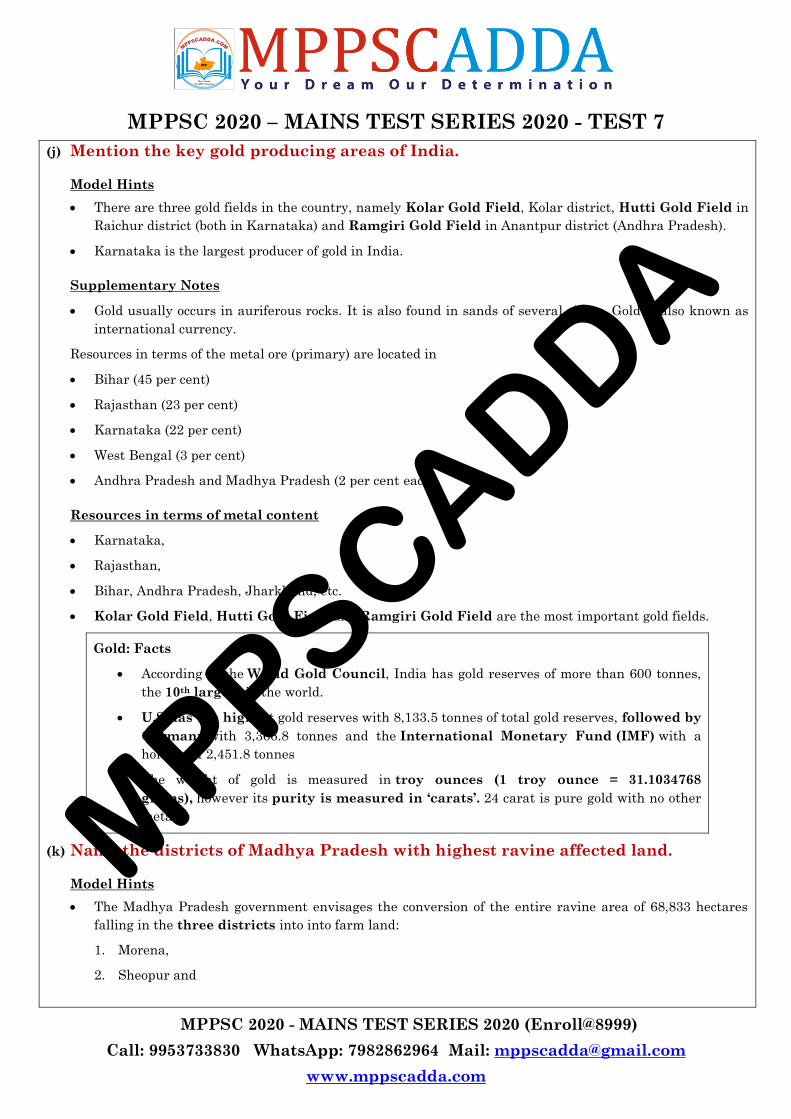
(i) Bhedaghat
Model Hints
Bhedaghat is a town and a nagar panchayat in Jabalpur district in the state of Madhya Pradesh, India.
It is a ghat situated by the side of river Narmada and is approximately 20 km from Jabalpur city.
Its most famous sights are the Dhuandhar Falls, Marble Rocks, and the Chaunsath Yogini temple
MPPSCADDA
MPPSC 2020 – MAINS TEST SERIES 2020 - TEST 7
MPPSC 2020 - MAINS TEST SERIES 2020 (Enroll@8999)
Call: 9953733830 WhatsApp: 7982862964 Mail: [email protected]
www.mppscadda.com
(j) Mention the key gold producing areas of India.
Model Hints
There are three gold fields in the country, namely Kolar Gold Field, Kolar district, Hutti Gold Field in
Raichur district (both in Karnataka) and Ramgiri Gold Field in Anantpur district (Andhra Pradesh).
Karnataka is the largest producer of gold in India.
Supplementary Notes
Gold usually occurs in auriferous rocks. It is also found in sands of several rivers. Gold is also known as
international currency.
Resources in terms of the metal ore (primary) are located in
Bihar (45 per cent)
Rajasthan (23 per cent)
Karnataka (22 per cent)
West Bengal (3 per cent)
Andhra Pradesh and Madhya Pradesh (2 per cent each)
Resources in terms of metal content
Karnataka,
Rajasthan,
Bihar, Andhra Pradesh, Jharkhand, etc.
Kolar Gold Field, Hutti Gold Field and Ramgiri Gold Field are the most important gold fields.
Gold: Facts
According to the World Gold Council, India has gold reserves of more than 600 tonnes,
the 10th largest in the world.
U.S has the highest gold reserves with 8,133.5 tonnes of total gold reserves, followed by
Germany with 3,366.8 tonnes and the International Monetary Fund (IMF) with a
holding of 2,451.8 tonnes
The weight of gold is measured in troy ounces (1 troy ounce = 31.1034768
grams), however its purity is measured in ‘carats’. 24 carat is pure gold with no other
metals.
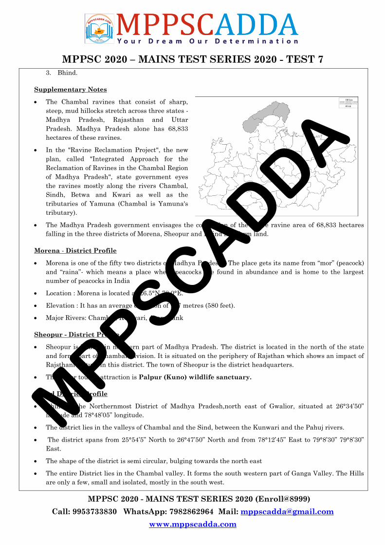
(k) Name the districts of Madhya Pradesh with highest ravine affected land.
Model Hints
The Madhya Pradesh government envisages the conversion of the entire ravine area of 68,833 hectares
falling in the three districts into into farm land:
1. Morena,
2. Sheopur and
MPPSCADDA
MPPSC 2020 – MAINS TEST SERIES 2020 - TEST 7
MPPSC 2020 - MAINS TEST SERIES 2020 (Enroll@8999)
Call: 9953733830 WhatsApp: 7982862964 Mail: [email protected]
www.mppscadda.com
3. Bhind.
Supplementary Notes
The Chambal ravines that consist of sharp,
steep, mud hillocks stretch across three states -
Madhya Pradesh, Rajasthan and Uttar
Pradesh. Madhya Pradesh alone has 68,833
hectares of these ravines.
In the "Ravine Reclamation Project", the new
plan, called "Integrated Approach for the
Reclamation of Ravines in the Chambal Region
of Madhya Pradesh", state government eyes
the ravines mostly along the rivers Chambal,
Sindh, Betwa and Kwari as well as the
tributaries of Yamuna (Chambal is Yamuna's
tributary).
The Madhya Pradesh government envisages the conversion of the entire ravine area of 68,833 hectares
falling in the three districts of Morena, Sheopur and Bhind into farm land.
Morena - District Profile
Morena is one of the fifty two districts of Madhya Pradesh . The place gets its name from ―mor‖ (peacock)
and ―raina‖- which means a place where peacocks are found in abundance and is home to the largest
number of peacocks in India
Location : Morena is located at 26.5°N 78.0°E.
Elevation : It has an average elevation of 177 metres (580 feet).
Major Rivers: Chambal, Kunwari, Asan, Sank
Sheopur - District Profile
Sheopur is located in northern part of Madhya Pradesh. The district is located in the north of the state
and forms part of Chambal Division. It is situated on the periphery of Rajsthan which shows an impact of
Rajsthani culture in this district. The town of Sheopur is the district headquarters.
The major tourist attraction is Palpur (Kuno) wildlife sanctuary.
Bhind District Profile
Bhind is the Northernmost District of Madhya Pradesh,north east of Gwalior, situated at 26°34‘50‖
latitude and 78°48‘05‖ longitude.
The district lies in the valleys of Chambal and the Sind, between the Kunwari and the Pahuj rivers.
The district spans from 25°54‘5‖ North to 26°47‘50‖ North and from 78°12‘45‖ East to 79°8‘30‖ 79°8‘30‖
East.
The shape of the district is semi circular, bulging towards the north east
The entire District lies in the Chambal valley. It forms the south western part of Ganga Valley. The Hills
are only a few, small and isolated, mostly in the south west.
MPPSCADDA
MPPSC 2020 – MAINS TEST SERIES 2020 - TEST 7
MPPSC 2020 - MAINS TEST SERIES 2020 (Enroll@8999)
Call: 9953733830 WhatsApp: 7982862964 Mail: [email protected]
www.mppscadda.com
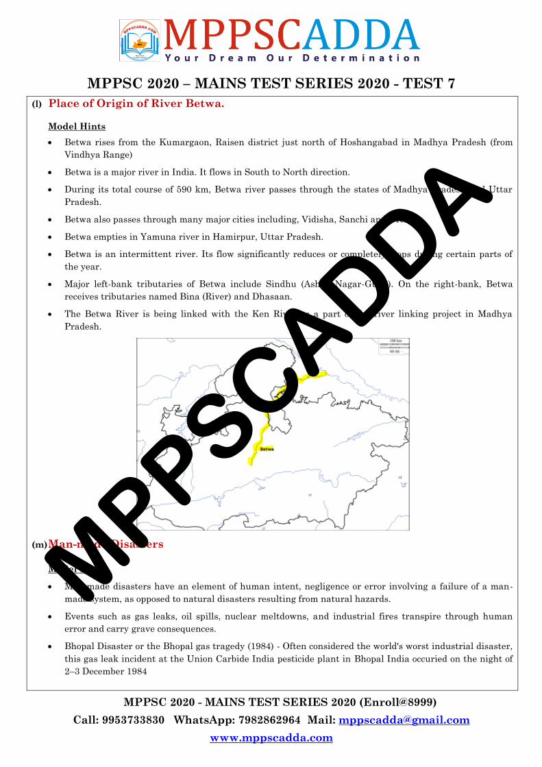
(l) Place of Origin of River Betwa.
Model Hints
Betwa rises from the Kumargaon, Raisen district just north of Hoshangabad in Madhya Pradesh (from
Vindhya Range)
Betwa is a major river in India. It flows in South to North direction.
During its total course of 590 km, Betwa river passes through the states of Madhya Pradesh and Uttar
Pradesh.
Betwa also passes through many major cities including, Vidisha, Sanchi and Orchha.
Betwa empties in Yamuna river in Hamirpur, Uttar Pradesh.
Betwa is an intermittent river. Its flow significantly reduces or completely stops during certain parts of
the year.
Major left-bank tributaries of Betwa include Sindhu (Ashok Nagar-Guna). On the right-bank, Betwa
receives tributaries named Bina (River) and Dhasaan.
The Betwa River is being linked with the Ken River as a part of the river linking project in Madhya
Pradesh.
(m) Man-made Disasters
Model Hints
Man-made disasters have an element of human intent, negligence or error involving a failure of a man-
made system, as opposed to natural disasters resulting from natural hazards.
Events such as gas leaks, oil spills, nuclear meltdowns, and industrial fires transpire through human
error and carry grave consequences.
Bhopal Disaster or the Bhopal gas tragedy (1984) - Often considered the world's worst industrial disaster,
this gas leak incident at the Union Carbide India pesticide plant in Bhopal India occuried on the night of
2–3 December 1984
MPPSCADDA
MPPSC 2020 – MAINS TEST SERIES 2020 - TEST 7
MPPSC 2020 - MAINS TEST SERIES 2020 (Enroll@8999)
Call: 9953733830 WhatsApp: 7982862964 Mail: [email protected]
www.mppscadda.com
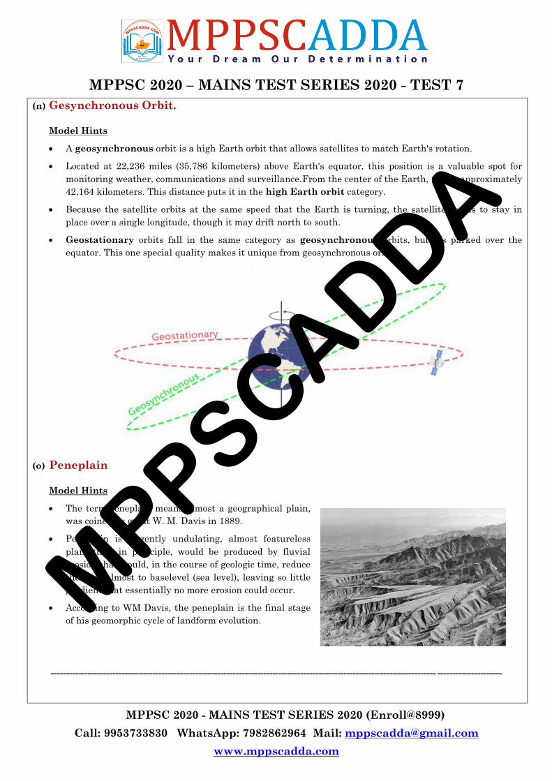
(n) Gesynchronous Orbit.
Model Hints
A geosynchronous orbit is a high Earth orbit that allows satellites to match Earth's rotation.
Located at 22,236 miles (35,786 kilometers) above Earth's equator, this position is a valuable spot for
monitoring weather, communications and surveillance.From the center of the Earth, this is approximately
42,164 kilometers. This distance puts it in the high Earth orbit category.
Because the satellite orbits at the same speed that the Earth is turning, the satellite seems to stay in
place over a single longitude, though it may drift north to south.
Geostationary orbits fall in the same category as geosynchronous orbits, but it‘s parked over the
equator. This one special quality makes it unique from geosynchronous orbits.
(o) Peneplain
Model Hints
The term peneplain means almost a geographical plain,
was coined by great W. M. Davis in 1889.
Peneplain is a gently undulating, almost featureless
plain that, in principle, would be produced by fluvial
erosion that would, in the course of geologic time, reduce
the land almost to baselevel (sea level), leaving so little
gradient that essentially no more erosion could occur.
According to WM Davis, the peneplain is the final stage
of his geomorphic cycle of landform evolution.
----------------------------------------------------------------------------------------------------------------------------- ---------------------
MPPSCADDA
MPPSC 2020 – MAINS TEST SERIES 2020 - TEST 7
MPPSC 2020 - MAINS TEST SERIES 2020 (Enroll@8999)
Call: 9953733830 WhatsApp: 7982862964 Mail: [email protected]
www.mppscadda.com
5 MARKERS 2. Write the answers of the following questions in 5-6 lines (50 words) each.
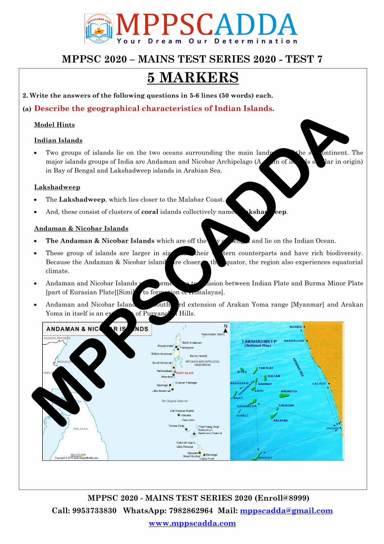
(a) Describe the geographical characteristics of Indian Islands.
Model Hints
Indian Islands
Two groups of islands lie on the two oceans surrounding the main landmass of the subcontinent. The
major islands groups of India are Andaman and Nicobar Archipelago (A chain of islands similar in origin)
in Bay of Bengal and Lakshadweep islands in Arabian Sea.
Lakshadweep
The Lakshadweep, which lies closer to the Malabar Coast.
And, these consist of clusters of coral islands collectively named Lakshadweep.
Andaman & Nicobar Islands
The Andaman & Nicobar Islands which are off the Bay of Bengal and lie on the Indian Ocean.
These group of islands are larger in size than their western counterparts and have rich biodiversity.
Because the Andaman & Nicobar islands are closer to the equator, the region also experiences equatorial
climate.
Andaman and Nicobar Islands were formed due to collision between Indian Plate and Burma Minor Plate
[part of Eurasian Plate][Similar to formation of Himalayas].
Andaman and Nicobar Islands are southward extension of Arakan Yoma range [Myanmar] and Arakan
Yoma in itself is an extension of Purvanchal Hills.
MPPSCADDA
MPPSC 2020 – MAINS TEST SERIES 2020 - TEST 7
MPPSC 2020 - MAINS TEST SERIES 2020 (Enroll@8999)
Call: 9953733830 WhatsApp: 7982862964 Mail: [email protected]
www.mppscadda.com
Supplementary Notes
Lakshadweep Islands
In the Arabian Sea, there are three types of islands.
o Amindivi Islands (consisting of six main islands of Amini, Keltan, Chetlat, Kadmat, Bitra and
Perumul Par). [don‘t have to remember all these names]
o Laccadive Islands (consisting of five major islands of Androth, Kalpeni, Kavaratti, Pitti and
Suheli Par) and
o Minicoy Island.
At present these islands are collectively known as Lakshadweep.
The Lakshadweep Islands are a group of 25 small islands. They are widely scattered about 200-500 km
south-west of the Kerala coast.
Amendivi Islands are the northern most while the Minicoy island is the southernmost.
All are tiny islands of coral origin {Atoll} and are surrounded by fringing reefs.
The largest and the most advanced is Lakshadweep Islands the Minicoy island with an area of 4.53 sq
km. Most of the islands have low elevation and do not rise more than five metre above sea level
(Extremely Vulnerable to sea level change).
These islands are a part Reunion Hotspot volcanism.
Andaman and Nicobar Islands
This archipelago is composed of 265 big and small islands [203 Andaman islands + 62 Nicobar Islands]
The Andaman and Nicobar islands extend from 6° 45′ N to 13° 45′ N and from 92° 10′ E to 94° 15′ E for a
distance about 590 km.
The Andaman islands are divided into three main islands i.e. North, Middle and South.
Duncan passage separates Little Andaman from South Andaman.
The Great Andaman group of islands in the north is separated by the Ten Degree Channel from the
Nicobar group in the south.
Port Blair, the capital of Andaman Nicobar Islands lies in the South Andaman.
Among the Nicobar islands, the Great Nicobar is the largest. It is the southernmost island and is very
close to Sumatra island of Indonesia. The Car Nicobar is the northernmost.
Most of these islands are made of tertiary sandstone, limestone and shale resting on basic and ultrabasic
volcanoes [Similar to Himalayas].
The Barren and Narcondam Islands, north of Port Blair, are volcanic islands [these are the only active
volcanoes in India][There are no active volcanoes in main land India].
Some of the islands are fringed with coral reefs. Many of them are covered with thick forests. Most of the
islands are mountainous.
Saddle peak (737 m) in North Andaman is the highest peak.
MPPSCADDA
MPPSC 2020 – MAINS TEST SERIES 2020 - TEST 7
MPPSC 2020 - MAINS TEST SERIES 2020 (Enroll@8999)
Call: 9953733830 WhatsApp: 7982862964 Mail: [email protected]
www.mppscadda.com
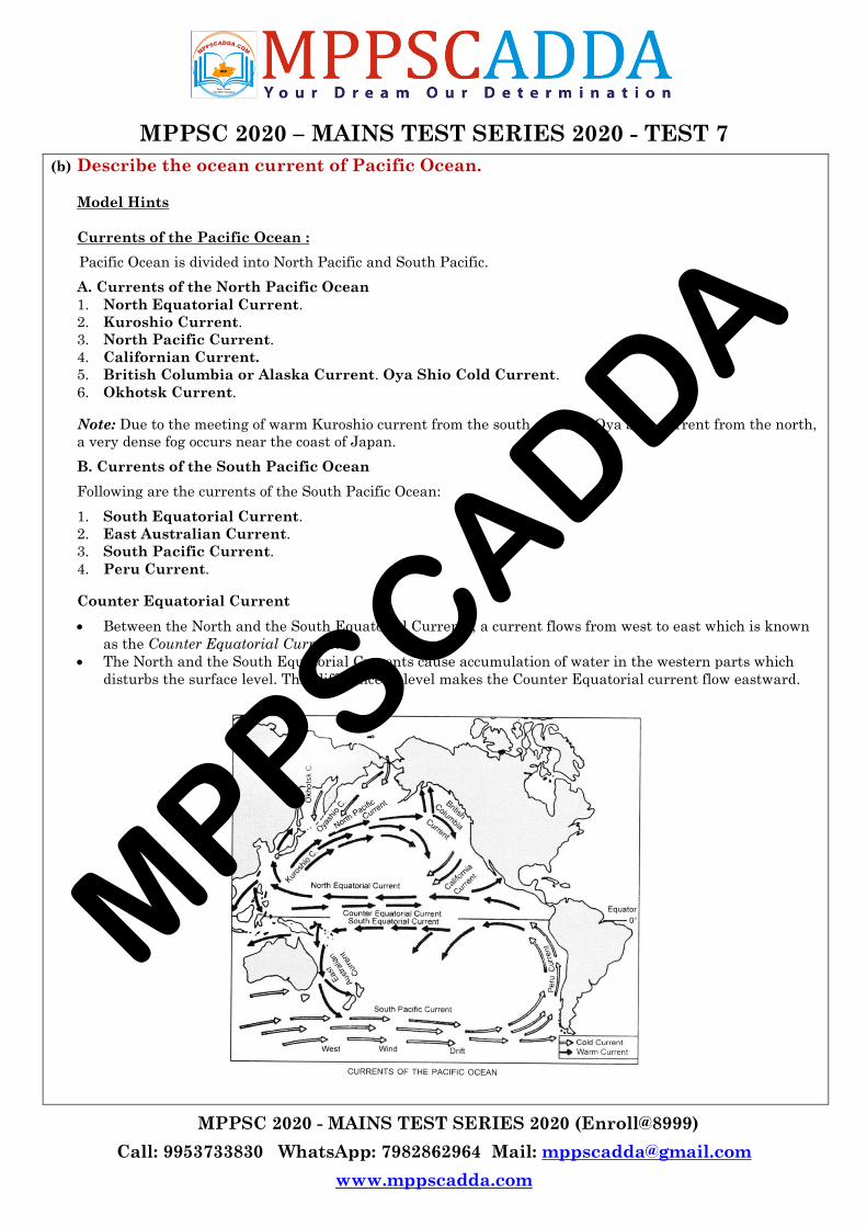
(b) Describe the ocean current of Pacific Ocean.
Model Hints
Currents of the Pacific Ocean :
Pacific Ocean is divided into North Pacific and South Pacific.
A. Currents of the North Pacific Ocean
1. North Equatorial Current.
2. Kuroshio Current.
3. North Pacific Current.
4. Californian Current.
5. British Columbia or Alaska Current. Oya Shio Cold Current.
6. Okhotsk Current.
Note: Due to the meeting of warm Kuroshio current from the south and cold Oya Shio current from the north,
a very dense fog occurs near the coast of Japan.
B. Currents of the South Pacific Ocean
Following are the currents of the South Pacific Ocean:
1. South Equatorial Current.
2. East Australian Current.
3. South Pacific Current.
4. Peru Current.
Counter Equatorial Current
Between the North and the South Equatorial Currents, a current flows from west to east which is known
as the Counter Equatorial Current.
The North and the South Equatorial Currents cause accumulation of water in the western parts which
disturbs the surface level. This difference in level makes the Counter Equatorial current flow eastward.
MPPSCADDA
MPPSC 2020 – MAINS TEST SERIES 2020 - TEST 7
MPPSC 2020 - MAINS TEST SERIES 2020 (Enroll@8999)
Call: 9953733830 WhatsApp: 7982862964 Mail: [email protected]
www.mppscadda.com
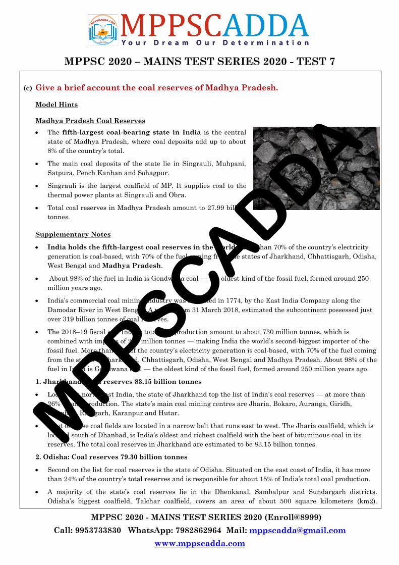
(c) Give a brief account the coal reserves of Madhya Pradesh.
Model Hints
Madhya Pradesh Coal Reserves
The fifth-largest coal-bearing state in India is the central
state of Madhya Pradesh, where coal deposits add up to about
8% of the country‘s total.
The main coal deposits of the state lie in Singrauli, Muhpani,
Satpura, Pench Kanhan and Sohagpur.
Singrauli is the largest coalfield of MP. It supplies coal to the
thermal power plants at Singrauli and Obra.
Total coal reserves in Madhya Pradesh amount to 27.99 billion
tonnes.
Supplementary Notes
India holds the fifth-largest coal reserves in the world. More than 70% of the country‘s electricity
generation is coal-based, with 70% of the fuel coming from the states of Jharkhand, Chhattisgarh, Odisha,
West Bengal and Madhya Pradesh.
About 98% of the fuel in India is Gondwana coal — the oldest kind of the fossil fuel, formed around 250
million years ago.
India‘s commercial coal mining industry was launched in 1774, by the East India Company along the
Damodar River in West Bengal. A report from 31 March 2018, estimated the subcontinent possessed just
over 319 billion tonnes of coal reserves.
The 2018–19 fiscal saw India‘s total coal production amount to about 730 million tonnes, which is
combined with imports of 240 million tonnes — making India the world‘s second-biggest importer of the
fossil fuel. More than 70% of the country‘s electricity generation is coal-based, with 70% of the fuel coming
from the states of Jharkhand, Chhattisgarh, Odisha, West Bengal and Madhya Pradesh. About 98% of the
fuel in India is Gondwana coal — the oldest kind of the fossil fuel, formed around 250 million years ago.
1. Jharkhand: Coal reserves 83.15 billion tonnes
Located in north-east India, the state of Jharkhand top the list of India‘s coal reserves — at more than
26% — and production. The state‘s main coal mining centres are Jharia, Bokaro, Auranga, Giridh,
Dhanbad, Ramgarh, Karanpur and Hutar.
Most of these coal fields are located in a narrow belt that runs east to west. The Jharia coalfield, which is
located south of Dhanbad, is India‘s oldest and richest coalfield with the best of bituminous coal in its
reserves. The total coal reserves in Jharkhand are estimated to be 83.15 billion tonnes.
2. Odisha: Coal reserves 79.30 billion tonnes
Second on the list for coal reserves is the state of Odisha. Situated on the east coast of India, it has more
than 24% of the country‘s total reserves and is responsible for about 15% of India‘s total coal production.
A majority of the state‘s coal reserves lie in the Dhenkanal, Sambalpur and Sundargarh districts.
Odisha‘s biggest coalfield, Talchar coalfield, covers an area of about 500 square kilometers (km2).
MPPSCADDA
MPPSC 2020 – MAINS TEST SERIES 2020 - TEST 7
MPPSC 2020 - MAINS TEST SERIES 2020 (Enroll@8999)
Call: 9953733830 WhatsApp: 7982862964 Mail: [email protected]
www.mppscadda.com
Estimated coal deposits in Odisha amount to about 79.30 billion tonnes.
3. Chhattisgarh: Coal reserves 57 billion tonnes
The central Indian state of Chhattisgarh holds about 17% of the country‘s coal deposits and is the third-
largest in terms of coal reserves.
Although the biggest coalfield in Chhattisgarh is the Hasdeo-Arand coalfield, with an area of 1878km2,
1502km2 comprise forest area. The next-largest Korba coalfield lies over an area of 530km2 in the Hasdeo
river valley.
Other major coalfields in Chhattisgarh include Chirmiri, Johilla and Jhimli. The state‘s coal reserves add
up to a total of more than 57 billion tonnes.
4. West Bengal: Coal reserves 31.67 billion tonnes.
Fourth in the list comes the eastern state of West Bengal, home to about 11% of India‘s total coal reserves.
West Bengal‘s most important reserve and mining field is the Raniganj coalfield, which covers over
185km2 in the Bardhman and Birbhum districts.
The deposits here contain 50-65% carbon, making the quality of coal some of the best in the country. The
districts covering West Bengal‘s coal deposits are Darjeeling, Bardhman, Jalpaiguri, Bankura and
Puruliya.
Total coal reserves add up to 31.67 billion tonnes.
5. Madhya Pradesh: Already explained
(d) Explain the physiography of Baghelkhand region.
Model Hints
Location
Baghelkhand lies in the Eastern part of Madhya Pradesh or we can say it lies in the East of the river Son
and in the South of Son river valley.
On map its location is 23°40' N to 24°35'N latitude and 80°5' E to 82°47' E longitude.
The plateau of Baghelkhand is the first of the great eastern plateaus. Located in the central part of
Peninsular ‘Foreland‘ i.e. between the alluvial stretches of the great plains and the Deccan, it naturally
presents a transitional zone incorporating the Vindhyachal and Satpura.
The altitude being ranged from 150 m to 1200 m, proves the monopoly of uneven high ranging scarps.
Between these scarps are arranged in steps the plateaus of Satna, Rewa .and Mirzapure in a descending
orders. The Baghelkhand plateau is 500 m high above the sea level.
Districts
The Bhaghelkhand plateau covers various districts of Madhya Pradesh and they are mentioned below:
o Sidhi
o Shahdol
o Anuppur
o Umaria
o Singroli
o Rewa
o Satna
Rivers
Various rivers use to flow from this region and the name of these rivers are mentioned below:
MPPSCADDA
MPPSC 2020 – MAINS TEST SERIES 2020 - TEST 7
MPPSC 2020 - MAINS TEST SERIES 2020 (Enroll@8999)
Call: 9953733830 WhatsApp: 7982862964 Mail: [email protected]
www.mppscadda.com
o Son
o Hasdo
o Johila
o Vanas
o Rihand
Forest
This plateau is 50% covered by forest. The forest which is found here is Tropical deciduous forest. The
main products of these forests are:
Sal
Sagon
Bamboos
Tendu patta
Minerals -
Baghelkhand is a part of Chhota Nagpur plateau, due to this reason various types of minerals are here.
The main minerals are mentioned below:
o Coal in Shahdol
o Lime stone in Shahdol
o Corundum in Sidhi etc.
Soil
Various types of soils are found in this area and they are: black, red, yellow etc.
The rocks and mountain ranges in this area are very ancient and even of Jurassic period.
The Gondwana range of this region is reckoned amongst the oldest formation of world.
(e) Describe the Bhopal Gas Tragedy 1984.
Model Hints
Bhopal Gas Tragedy
On the night of 2nd -3rd December, 1984 Methyl Isocyanate (MIC) a deadly gas leaked over the city of
Bhopal from the plant of Union Carbide India Limited(UCIL) at Bhopal, Madhya Pradesh which
manufactured pesticides.
It led to several thousand deaths and more than 500,000 people being exposed to MIC and other
hazardous chemicals and causing a disaster which is referred as one of the worst industrial disaster.
The plant was controlled by UCIL which is a subsidiary of the US based company UCC (Union Carbide
Corporation), which provided negligible help to deal with the tragedy.
Impact
The disaster resulted in people suffering from ailments such as anaemia, tuberculosis but nobody could
find the complete health effects caused by MIC and how to treat it.
The children born to mothers who were exposed to the gas were also the victims of the MIC. The neo natal
mortality rate rose manifold
MPPSCADDA

MPPSC 2020 – MAINS TEST SERIES 2020 - TEST 7
MPPSC 2020 - MAINS TEST SERIES 2020 (Enroll@8999)
Call: 9953733830 WhatsApp: 7982862964 Mail: [email protected]
www.mppscadda.com
(f) Disaster Mitigation
Model Hints
Disaster mitigation measures are those
that eliminate or reduce the impacts and
risks of hazards through proactive measures
taken before an emergency
or disaster occurs. Even if the hazard cannot
be removed, vulnerability can be decreased
and in case of an impact, the capacity to
withstand, to respond and to recover will be
stronger.
The mitigation strategy is made up of three
main required components: mitigation
goals, mitigation actions, and an
action plan for implementation. These
provide the framework to identify, prioritize and implement actions to reduce risk to hazards.
Principle objectives of Disaster Mitigation
Save lives
Reduce economic disruption
Decrease vulnerability/increase capacity
Decrease chance/level of conflict
(g) Economic Significance of KIRKUK.
Model Hints
Kirkuk is a city in Iraq, serving as the capital of the Kirkuk Governorate, located 238 kilometres (148
miles) north of Baghdad.
Pipelines from Kirkuk run through Turkey to Ceyhan on the Mediterranean Sea and were one of the two
main routes for the export of Iraqi oil
In 1927, Iraqi and American drillers working for the foreign-owned and British-led Iraq Petroleum
Company (IPC) struck a huge oil gusher in Kirkul. and started exporting oil in 1934.
The presence of the oil industry had an effect on Kirkuk's demographics. The exploitation of Kirkuk's oil,
which began around 1930, attracted both Arabs and Kurds to the city in search of work
Pipelines from Kirkuk run through Turkey to Ceyhan on the Mediterranean Sea and were one of the two
main routes for the export of Iraqi oil under the Oil-for-Food Programme following the Gulf War of 1991.
But poor reservoir-management practices during the Saddam Hussein years permanently damaged
Kirkuk's oil field
MPPSCADDA
MPPSC 2020 – MAINS TEST SERIES 2020 - TEST 7
MPPSC 2020 - MAINS TEST SERIES 2020 (Enroll@8999)
Call: 9953733830 WhatsApp: 7982862964 Mail: [email protected]
www.mppscadda.com
(h) Discuss Cement Industry of Madhya Pradesh.
Model Hints
Key industry sectors in Madhya Pradesh are cement, textiles, mining and edible oils. The state is one of
the largest producers of cement in the country.
Madhya Pradesh ranks 3rd in production of cement in India
Cement production in Madhya Pradesh reached 20.02 million metric tonnes during 2008-09,
accounting for 12 per cent of the national production.
Production at more than 100% capacity utilization in last four years
Satna – main cement producing region in MP with many major cement plants located there
Total installed capacity of production of cement in MP is 19.37 MT (as on March 2009)
The State consumes approximately 40% of its total production
Availability of coal in the State gives a good option to cement manufacturing companies to set up captive
power plant so as to save their power cost in production of Cement
Limestone deposits of 8 mn tonnes in Damoh-Panna area and 20 mn tonnes in Bela-Pagra of Rewa
considered highly prospective regions for Cement manufacturing.
There are nine major cement plants in the state. Rewa, Satna, Damoh, Katni, Sidhi & Neemuch.
o ACC, CementLtd., Kymore,District –Katni.
o Vikram cement, Khor, Neemuch
o J. P. Rewa Plant, Naubasta, Rewa (Cement)
o J. P. Bela Plant, Maddepur, Rewa (Cement)
o Diamond cement factory Pvt. Ltd., Nursinghgarh, Teh.- Patheria, Distt.Damoh (MP).
o Diamond cement factory Pvt. Ltd., Imlai, Teh.- Damoh, Distt.Damoh
o Satna cement works (unit of MP Birla corporation Ltd)
o Prism Cement and Maihar Cement,Satna
o J.P. Sidhi Cement Plant (Unit of Jaiprakash Asociates)
o Asbestos Cement Sheet factory in Katni
Industrial Advantage Madhya Pradesh
Leading producer of cement, textiles and edible oils
First state to develop a greenfield Special Economic Zone
Track record of attracting private investment in transport infrastructure
Potential for developing automobile and pharmaceutical industries
Relatively low cost of labour and infrastructure
Rapid improvement in social development indices
MPPSCADDA

MPPSC 2020 – MAINS TEST SERIES 2020 - TEST 7
MPPSC 2020 - MAINS TEST SERIES 2020 (Enroll@8999)
Call: 9953733830 WhatsApp: 7982862964 Mail: [email protected]
www.mppscadda.com
(i) Types of Satellites used for Remote Sensing.
Model Hints
The Indian Remote Sensing satellite system has one of the largest constellations of remote sensing
satellites in operation in the world today.
IRS series of satellites provide data in a variety of spatial, spectral and temporal resolutions.
The National Remote Sensing Centre (NRSC) is the focal point for distribution of remote sensing satellite
data products in India and its neighboring countries.
NRSC has an earth station at Shadnagar, about 55 Km from Hyderabad, to receive data from almost all
contemporary remote sensing satellites.
IRS satellites
Based on the Application , Remote Sensing Satellites are divided into:
EARTH OBSERVATION SATELLITE
RESOURCESAT – 1
RESOURCESAT – 1, the tenth satellite in IRS series, was launched onboard PSLV – C5 in 2003.
It was placed in 820 km high polar Sun Synchronous Orbit.
The images and data are being used for advanced applications like vegetation dynamics, crop yield
estimates, disaster management support.
CARTOSAT – 1
CARTOSAT – 1 was launched into a 617 km polar sun synchronous orbit in 2005 on board PSLV – C6
from Satish Dhawan Space Centre (SDSC), SHAR, Sriharikota.
The data from Cartosat-1 is used for the preparation of cartographic maps, cadastral mapping updation,
land use and GIS applications
CLIMATE & ENVIRONMENT Satelllite
OCEANSAT – 2
The main objectives of OCEANSAT – 2 are to study surface winds and ocean surface strata, observation of
chlorophyll concentrations, monitoring of phytoplankton blooms, study of atmospheric aerosols and
suspended sediments in the water.
SARAL
SARAL or Satellite with ARgos and ALtiKa is a cooperative altimetry technology mission of ISRO and
CNES (Space Agency of France), was successfully launched on 25 February 2013.
The overall objectives are to assess development of operational oceanography, understanding of climate
and developing forecasting capabilities.
MPPSCADDA
MPPSC 2020 – MAINS TEST SERIES 2020 - TEST 7
MPPSC 2020 - MAINS TEST SERIES 2020 (Enroll@8999)
Call: 9953733830 WhatsApp: 7982862964 Mail: [email protected]
www.mppscadda.com
Megha-Tropiques
Megha-Tropiques is an Indo-French Joint Satellite Mission for studying the water cycle and energy
exchanges in the tropics.
The main objective of this mission is to understand the life cycle of convective systems that influence the
tropical weather and climate and their role in associated energy and moisture budget of the atmosphere in
tropical regions.
DISASTER MANGEMENT Satellite
RISAT – 2
RISAT – 2 is a Radar Imaging Satellite using an active SAR (Synthetic Aperture Radar) imager with all
weather capability to take images of the earth.
This Satellite will enhance ISRO‘s capability for Disaster Management applications.
India‘s first satellite with SAR and has a day-night, all-weather monitoring capability.
(j) Write a note on economic significance of Mediterranean type of Climate.
Model Hints
Distribution
Entirely confined to the western portion of continental masses, between 30° and 45° north and south of
the equator.
The basic cause of this type of climate is the shifting of the wind belts.
Mediterranean Sea has the greatest extent of this type of ‗winter rain climate‘, and gives rise to the name
Mediterranean Climate.
Agriculture in the Mediterranean Climate
Orchard farming: The Mediterranean lands are also known as the world‘s orchard lands.
A wide range of citrus fruits such as oranges, lemons, limes, citrons and grapefruit are grown.
Crop cultivation: Wheat is the leading food crop. Barley is the next most popular cereal.
Wine production
Viticulture is by tradition a Mediterranean occupation.
Regions bordering the Mediterranean Sea account for three-quarters of the world‘s production of wine.
Some 85 per cent of grapes produced, go into wine.
The long, sunny summer allows the grapes to ripen.
Economy
Net exporter of citric fruits and net importer of dairy products.
Clear skies in summer and good landscapes encourage tourism
MPPSCADDA
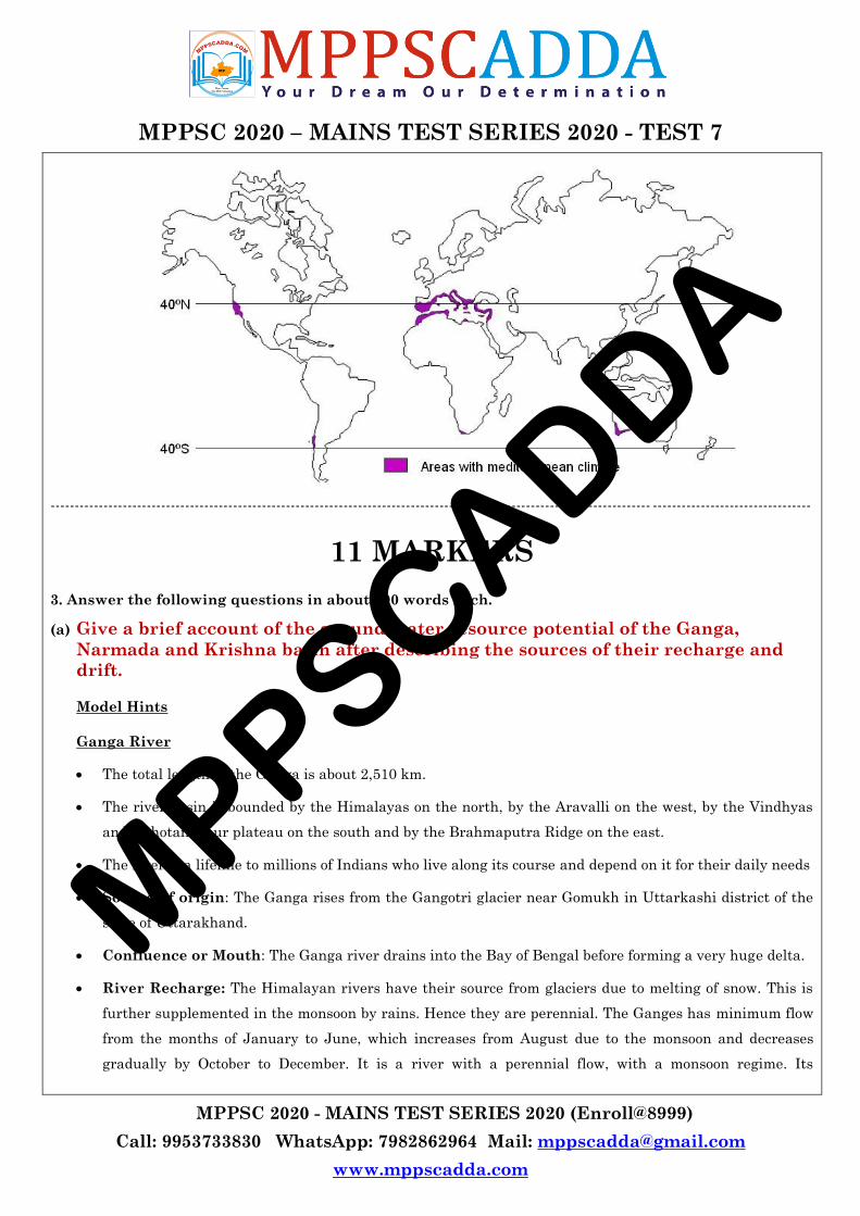
MPPSC 2020 – MAINS TEST SERIES 2020 - TEST 7
MPPSC 2020 - MAINS TEST SERIES 2020 (Enroll@8999)
Call: 9953733830 WhatsApp: 7982862964 Mail: [email protected]
www.mppscadda.com
----------------------------------------------------------------------------------------------------------------------------- ---------------------------------
11 MARKERS
3. Answer the following questions in about 200 words each.
(a) Give a brief account of the ground-water resource potential of the Ganga,
Narmada and Krishna basin after describing the sources of their recharge and
drift.
Model Hints
Ganga River
The total length of the Ganga is about 2,510 km.
The river basin is bounded by the Himalayas on the north, by the Aravalli on the west, by the Vindhyas
and Chhotanagpur plateau on the south and by the Brahmaputra Ridge on the east.
The river is a lifeline to millions of Indians who live along its course and depend on it for their daily needs
Source of origin: The Ganga rises from the Gangotri glacier near Gomukh in Uttarkashi district of the
state of Uttarakhand.
Confluence or Mouth: The Ganga river drains into the Bay of Bengal before forming a very huge delta.
River Recharge: The Himalayan rivers have their source from glaciers due to melting of snow. This is
further supplemented in the monsoon by rains. Hence they are perennial. The Ganges has minimum flow
from the months of January to June, which increases from August due to the monsoon and decreases
gradually by October to December. It is a river with a perennial flow, with a monsoon regime. Its
MPPSCADDA
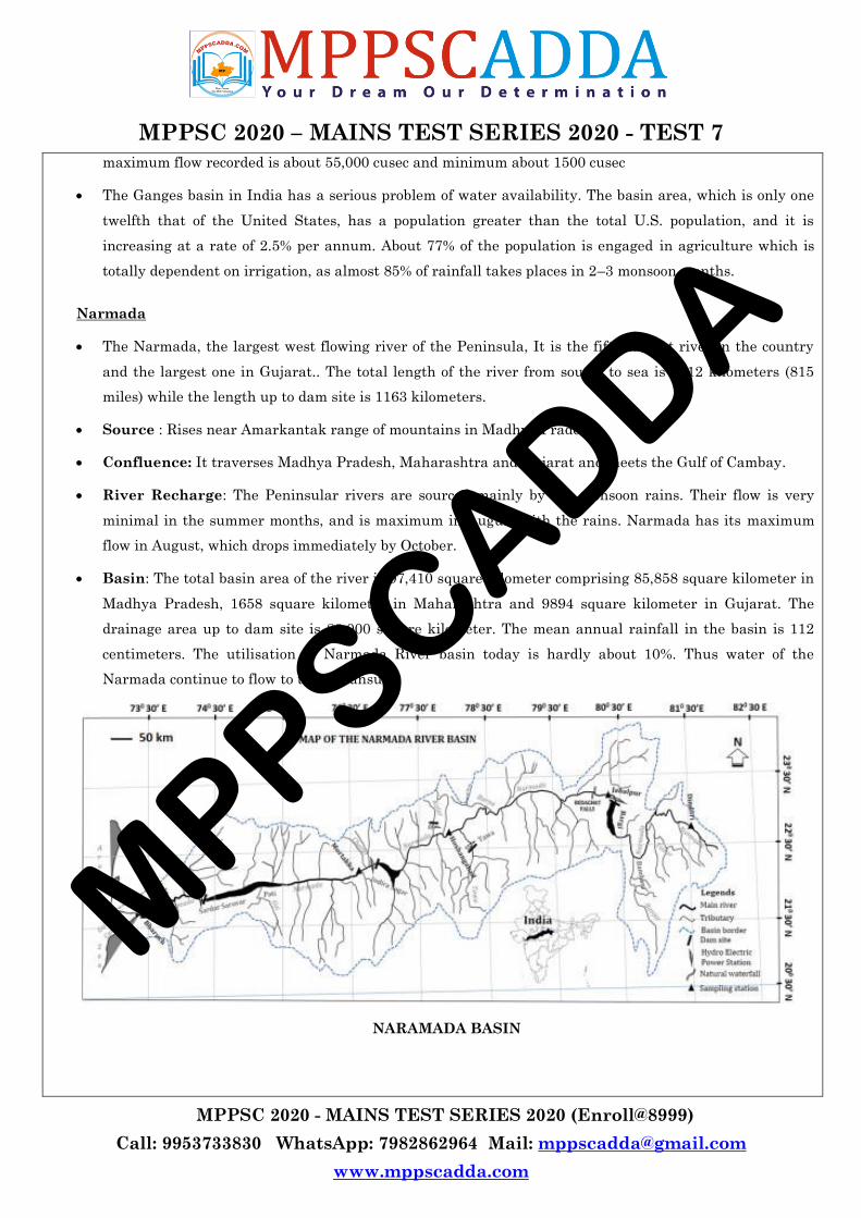
MPPSC 2020 – MAINS TEST SERIES 2020 - TEST 7
MPPSC 2020 - MAINS TEST SERIES 2020 (Enroll@8999)
Call: 9953733830 WhatsApp: 7982862964 Mail: [email protected]
www.mppscadda.com
maximum flow recorded is about 55,000 cusec and minimum about 1500 cusec
The Ganges basin in India has a serious problem of water availability. The basin area, which is only one
twelfth that of the United States, has a population greater than the total U.S. population, and it is
increasing at a rate of 2.5% per annum. About 77% of the population is engaged in agriculture which is
totally dependent on irrigation, as almost 85% of rainfall takes places in 2–3 monsoon months.
Narmada
The Narmada, the largest west flowing river of the Peninsula, It is the fifth largest river in the country
and the largest one in Gujarat.. The total length of the river from source to sea is 1312 kilometers (815
miles) while the length up to dam site is 1163 kilometers.
Source : Rises near Amarkantak range of mountains in Madhya Pradesh.
Confluence: It traverses Madhya Pradesh, Maharashtra and Gujarat and meets the Gulf of Cambay.
River Recharge: The Peninsular rivers are sourced mainly by the monsoon rains. Their flow is very
minimal in the summer months, and is maximum in August with the rains. Narmada has its maximum
flow in August, which drops immediately by October.
Basin: The total basin area of the river is 97,410 square kilometer comprising 85,858 square kilometer in
Madhya Pradesh, 1658 square kilometer in Maharashtra and 9894 square kilometer in Gujarat. The
drainage area up to dam site is 88,000 square kilometer. The mean annual rainfall in the basin is 112
centimeters. The utilisation of Narmada River basin today is hardly about 10%. Thus water of the
Narmada continue to flow to the sea unsued.
NARAMADA BASIN
MPPSCADDA
MPPSC 2020 – MAINS TEST SERIES 2020 - TEST 7
MPPSC 2020 - MAINS TEST SERIES 2020 (Enroll@8999)
Call: 9953733830 WhatsApp: 7982862964 Mail: [email protected]
www.mppscadda.com
Krishna
The Krishna River is the fourth-biggest river in terms of water inflows and river basin area in India, after
the Ganga, Godavari and Brahmaputra.
Source: The Krishna river originates in the Western Ghats near Mahabaleshwar at an elevation of about
1,300 metres (4,300 ft), in the state of Maharashtra in central India. It is one of the longest rivers in
India. The Krishna river is around 1,400 kilometres (870 mi) in length (282 kilometres (175 mi) in
Maharashtra). It is one of the most suitable arable basin as 75.6 % area of the Krishna basin is under
cultivation because of availability of water.
Confluence or Mouth: The Kaveri river drains into the Bay of Bengal before forming a huge delta.
River Recharge: The Peninsular rivers are sourced mainly by the monsoon rains. The Krishna flows at a
low level until May. It attains maximum water flow twice—one in May-June and the other in July-
August. October is the month of high floods in the Krishna River. Floods in the river coincide with the
Southwest monsoon — from middle of June till the end of September and the Northeast monsoon — from
October to November.
Groundwater Resource potential
Groundwater is the most preferred source of water in various user sectors in India on account of its near
universal availability, dependability and low capital cost. The increasing dependence on ground water as
a reliable source of water has resulted in indiscriminate extraction in various parts of the country without
due regard to the recharging capacities of aquifers and other environmental factors.
As per the latest assessment, the annual replenishable ground water resource of country has been
estimated as 433 billion cubic meter (bcm), out of which 399 bcm is considered to be available for
development for various uses. The irrigation sector remains the major consumer of ground water,
accounting for 92% of its annual withdrawal.
The level of groundwater utilisation is relatively high in the river basins lying in north-western region
and parts of south India. The groundwater utilisation is very high in the states of Punjab, Haryana,
Rajasthan, and Tamil Nadu. However, there are States like Chhattisgarh, Odisha, Kerala, etc., which
utilise only a small proportion of their groundwater potentials. States like Gujarat, Uttar Pradesh, Bihar,
Tripura and Maharashtra are utilising their ground water resources at a moderate rate.
MPPSCADDA
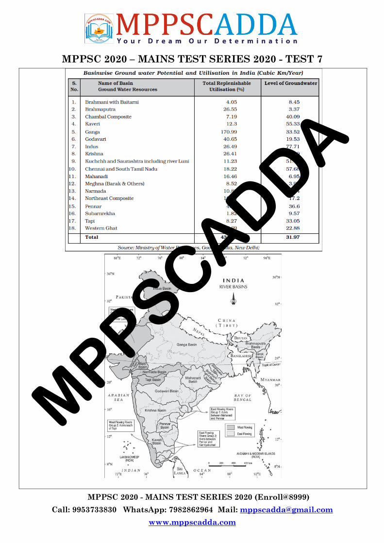
MPPSC 2020 – MAINS TEST SERIES 2020 - TEST 7
MPPSC 2020 - MAINS TEST SERIES 2020 (Enroll@8999)
Call: 9953733830 WhatsApp: 7982862964 Mail: [email protected]
www.mppscadda.com
MPPSCADDA
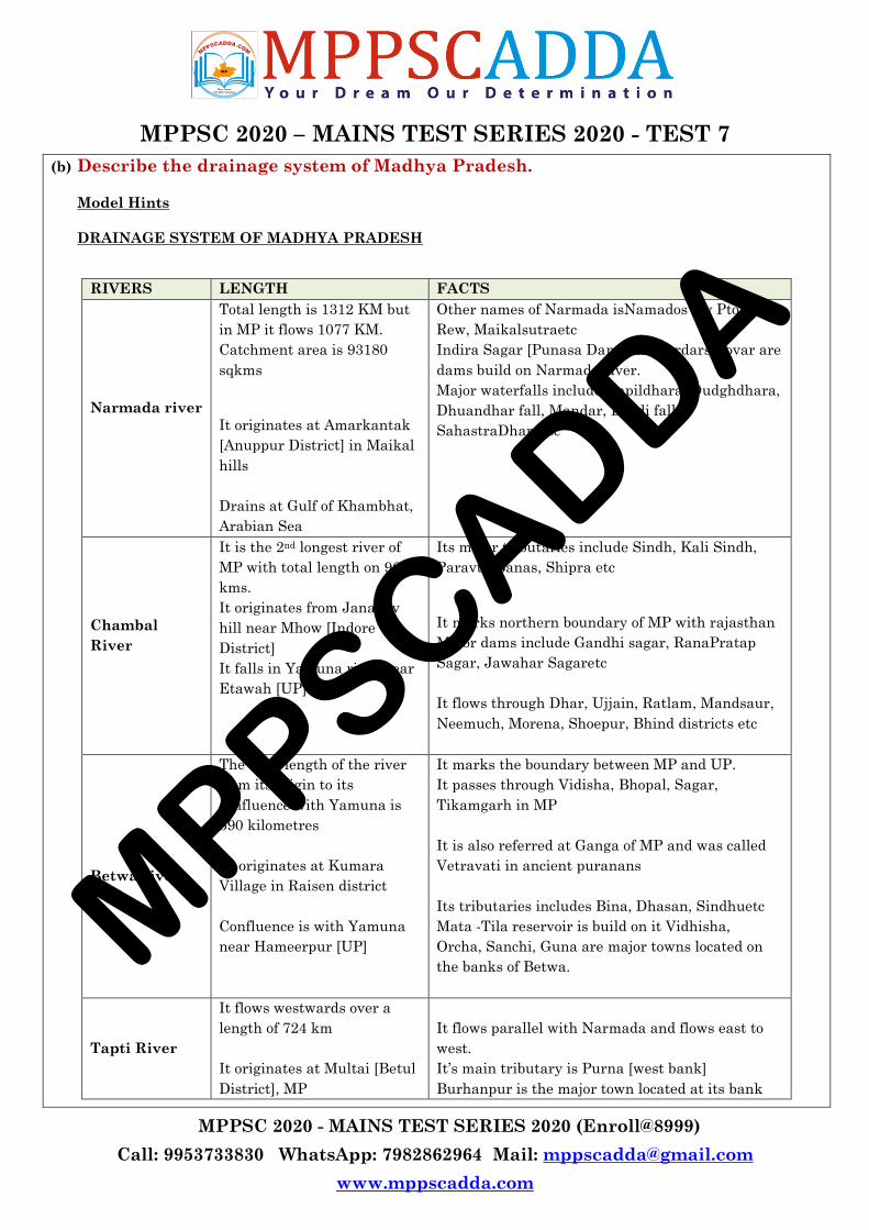
MPPSC 2020 – MAINS TEST SERIES 2020 - TEST 7
MPPSC 2020 - MAINS TEST SERIES 2020 (Enroll@8999)
Call: 9953733830 WhatsApp: 7982862964 Mail: [email protected]
www.mppscadda.com
(b) Describe the drainage system of Madhya Pradesh.
Model Hints
DRAINAGE SYSTEM OF MADHYA PRADESH
RIVERS LENGTH FACTS
Narmada river
Total length is 1312 KM but
in MP it flows 1077 KM.
Catchment area is 93180
sqkms
It originates at Amarkantak
[Anuppur District] in Maikal
hills
Drains at Gulf of Khambhat,
Arabian Sea
Other names of Narmada isNamados [by Ptolemy],
Rew, Maikalsutraetc
Indira Sagar [Punasa Dam] and Sardarsarovar are
dams build on Narmada river.
Major waterfalls include Kapildhara, Dudghdhara,
Dhuandhar fall, Mandar, Dardi fall
SahastraDharaetc
Chambal
River
It is the 2nd longest river of
MP with total length on 965
kms.
It originates from Janapav
hill near Mhow [Indore
District]
It falls in Yamuna river near
Etawah [UP]
Its major tributaries include Sindh, Kali Sindh,
Paravti, Banas, Shipra etc
It marks northern boundary of MP with rajasthan
Major dams include Gandhi sagar, RanaPratap
Sagar, Jawahar Sagaretc
It flows through Dhar, Ujjain, Ratlam, Mandsaur,
Neemuch, Morena, Shoepur, Bhind districts etc
Betwa river
The total length of the river
from its origin to its
confluence with Yamuna is
590 kilometres
It originates at Kumara
Village in Raisen district
Confluence is with Yamuna
near Hameerpur [UP]
It marks the boundary between MP and UP.
It passes through Vidisha, Bhopal, Sagar,
Tikamgarh in MP
It is also referred at Ganga of MP and was called
Vetravati in ancient puranans
Its tributaries includes Bina, Dhasan, Sindhuetc
Mata -Tila reservoir is build on it Vidhisha,
Orcha, Sanchi, Guna are major towns located on
the banks of Betwa.
Tapti River
It flows westwards over a
length of 724 km
It originates at Multai [Betul
District], MP
It flows parallel with Narmada and flows east to
west.
It‘s main tributary is Purna [west bank]
Burhanpur is the major town located at its bank
MPPSCADDA

MPPSC 2020 – MAINS TEST SERIES 2020 - TEST 7
MPPSC 2020 - MAINS TEST SERIES 2020 (Enroll@8999)
Call: 9953733830 WhatsApp: 7982862964 Mail: [email protected]
www.mppscadda.com
It falls at Gulf of Khambat
[Arabian Sea] in Gujarat
Son River
The Son river which is 784
kilometres long, is one of the
longest Indian rivers
It originates in Amarkantak
[Anupur district] near
Narmada river origin
It confluence with Ganga
river near Danapur in Bihar
In MP it flows through Anupur, Umeria, Shahdol,
Sidhi, Rewa, Singrauli districts
Bansagar dam is build at Devlod [Shahdol District]
Johila is its main tributary
Tawa River
The Tawa is the Narmada's
longest tributary, at 172 km.
It originates from Kalibhit
hills in Mahadeo mountain
[Pachmarhi]
It joins the Narmada at the
village of BandraBhan
in Hoshangabad District.
Longest dam of MP is located on Tawa at
Hoshangabad
MP‘s only hill station Pachmarhi is located on
Tawa river
(c) Give the distribution of wheat and rice producing areas in the State of Madhya
Pradesh.
Model Hints
Madhya Pradesh, with its large area, enjoys diverse climatic and soil conditions suitable for a broad range
of agricultural products.
Agriculture sector in Madhya Pradesh forms the backbone of its economy.
It contributes almost one-fourth of the Gross State Domestic Product (GSDP) and is the main source of
employment for over 65 percent of the population and constitutes about 60- 75 percent of the rural
income.
The state is a large producer of soybean and wheat. Sharbati variety of famous wheat is grown in
Sehore, Vidisha and Ashok Nagar districts, and in some parts of Bhopal and Hoshangabad.
Madhya Pradesh leads in the production of gram, linseed, green pea, garlic and coriander. The state is
also a major producer of linseed, mustard, sunflower and safflower.
Agro-climatic diversity and topographical variations enable the state to grow a wide range of cereals,
pulses, oilseeds and cash crops, besides being home to myriad varieties of plant species, both in forest
areas and outside.
MPPSCADDA
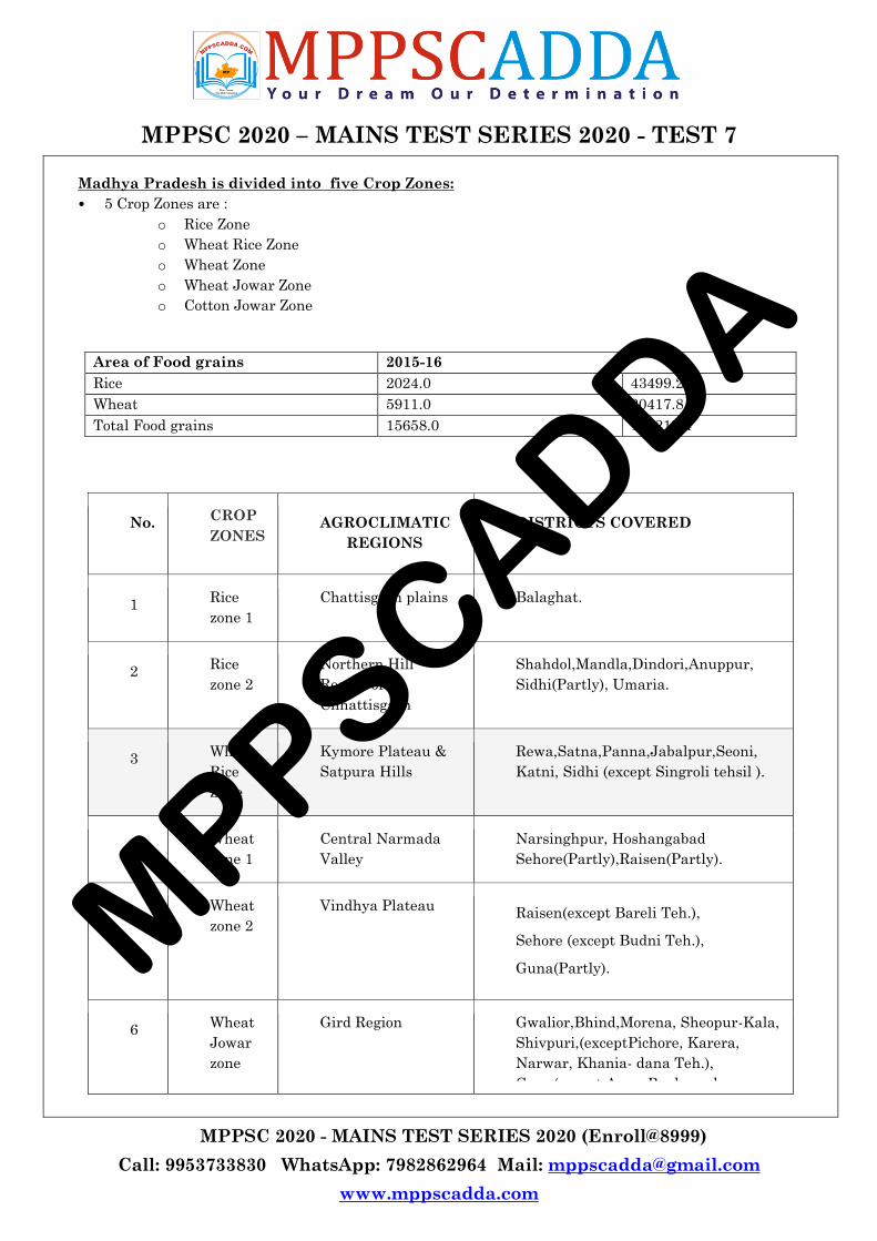
MPPSC 2020 – MAINS TEST SERIES 2020 - TEST 7
MPPSC 2020 - MAINS TEST SERIES 2020 (Enroll@8999)
Call: 9953733830 WhatsApp: 7982862964 Mail: [email protected]
www.mppscadda.com
Madhya Pradesh is divided into five Crop Zones:
• 5 Crop Zones are :
o Rice Zone
o Wheat Rice Zone
o Wheat Zone
o Wheat Jowar Zone
o Cotton Jowar Zone
Area of Food grains 2015-16
Rice 2024.0 43499.2
Wheat 5911.0 30417.8
Total Food grains 15658.0 123217.4
No. CROP
ZONES AGROCLIMATIC
REGIONS
DISTRICTS COVERED
1 Rice
zone 1
Chattisgarh plains Balaghat.
2 Rice
zone 2
Northern Hill
Region of
Chhattisgarh
Shahdol,Mandla,Dindori,Anuppur,
Sidhi(Partly), Umaria.
3 Wheat
Rice
Zone
Kymore Plateau &
Satpura Hills
Rewa,Satna,Panna,Jabalpur,Seoni,
Katni, Sidhi (except Singroli tehsil ).
4 Wheat
zone 1
Central Narmada
Valley
Narsinghpur, Hoshangabad
Sehore(Partly),Raisen(Partly).
5 Wheat
zone 2
Vindhya Plateau Raisen(except Bareli Teh.),
Sehore (except Budni Teh.),
Guna(Partly).
6 Wheat
Jowar
zone
Gird Region Gwalior,Bhind,Morena, Sheopur-Kala,
Shivpuri,(exceptPichore, Karera,
Narwar, Khania- dana Teh.),
Guna(except Aron, Raghogarh,
MPPSCADDA

MPPSC 2020 – MAINS TEST SERIES 2020 - TEST 7
MPPSC 2020 - MAINS TEST SERIES 2020 (Enroll@8999)
Call: 9953733830 WhatsApp: 7982862964 Mail: [email protected]
www.mppscadda.com
Chachoda Tehsil)
Ashoknagar .
7 Wheat
Jowar
zone
Bundelkhand Chhattarpur,Datia,Tikamgarh, &
Shivpuri(Partly)
8 Wheat
Jowar
Zone 2
Satpura Plateau Betul & Chhindwara
(d) Evaluate the National Population Policy 2000.
Model Hints
India has the second largest Population in the world after China. To provide a policy framework with
respect to population, the National Population Policy was introduced in 2000. NPP 2000 was made to
make sustainable population as per its economic growth by 2045.
Significant feature of National Population Policy 2000
Reduce infant mortality rate to below 30/100 live births
Free and compulsury education upto 14 years
Universal immumnization of childrens
delayed marriage of girls
Preventing spred of AIDS and other Communicable diseases
100 percent registration of birth, death ,marriage and pregnancy
Promote the importance of small family
Reduce maternity mortality rate to below 100/100000 live birth
Meet the basic needs of reproduction (contraception),supplies and infrastructure, child health services
Promote 80% institutional deliveries and 100% deliveries by traines person.
Critical Evaluation
India‘s national population policies have failed to achieve their objectives as we remain world‘s second largest
populated country. The population of India in 1951 was 35 crore, but by 2011, it had increased to 121 crore.
There have been few shortcomings.
Firstly, the NPP have a narrow perspective, give much importance to contraception and sterilization. The
basic prerequisite of meaningfully controlling population include poverty alleviation, improving the
standards of living and the spread of education.
Secondly, on national scale the policy was not publicized and failed to generate mass support in favour of
population control.
MPPSCADDA

MPPSC 2020 – MAINS TEST SERIES 2020 - TEST 7
MPPSC 2020 - MAINS TEST SERIES 2020 (Enroll@8999)
Call: 9953733830 WhatsApp: 7982862964 Mail: [email protected]
www.mppscadda.com
Thirdly, we have insufficient infrastructure owing to the lack of trained staff, lack of adequate aptitude
among the staff and limited use or misuse of the equipment for population control resulted in failure of
the policy.
Lastly, the use of coercion during the Emergency (1976-77) caused a serious resentment among the masses.
This made the very NPP itself very unpopular
(e) Give the measures taken for relief and rehabilitation in disaster management.
Model Hints
Disasters like Earthquakes, cyclones, tsunamis, floods, landslides and forest fires can cause catastrophic
damage to life and property.
The work undertaken by the government in providing disaster relief focuses on quick response to such
unfortunate natural occurrences, and the provision of essential relief such as safe drinking water, medical
aid, health camps, and supply of daily essentials to the affected communities.
In certain instances, once the immediate needs are taken care of, the government machinery engages with
the community to set up pathways for long-term rehabilitation — including the focus on livelihoods and
infrastructure for education and health services.
Provisions according to the Disaster Management Act 2005
An Act to provide for the effective management of disasters
Enacted by Parliament
Received assent of the President of India on 23rd December 2005
Notified on 26.12.05
Came into effect from 1st August, 2007
Applicable to the whole of India
Standards of Relief according to the Act
Minimum requirements to be provided in the relief camps in relation to shelter, food, drinking water
medical cover and sanitation
Special provision for widows and orphans
Ex-gratia assistance on account of loss of life
Assistance for damage to house and restoration of livelihood
Relief provision
The National Authority may in case of disasters of severe magnitude recommend relief in repayment of
loans or grant of fresh loans to the persons affected by disaster on such terms as may be appropriated.
4 Levels of management
National, State, Disctrict and Local level
District Authority
MPPSCADDA

MPPSC 2020 – MAINS TEST SERIES 2020 - TEST 7
MPPSC 2020 - MAINS TEST SERIES 2020 (Enroll@8999)
Call: 9953733830 WhatsApp: 7982862964 Mail: [email protected]
www.mppscadda.com
Its the power of District Authority to Stock pile, relief and rescue materials.
Local Authorities
Carry out relief, rehabilitation and reconstruction activities in the affected area in accordance with the
state plan and district plan.
Local authority may take such other measures as may be necessary for disaster management.
Financial Aspect – Central Govt.
National Disaster Response Fund (NDRF)
National Disaster Mitigation Fund (NDMF)
Response fund will be made available to the National Executive Committee to be applied towards meeting
the expenses for emergency response, relief and rehabilitation.
MPPSCADDA

MPPSC 2020 – MAINS TEST SERIES 2020 - TEST 7
MPPSC 2020 - MAINS TEST SERIES 2020 (Enroll@8999)
Call: 9953733830 WhatsApp: 7982862964 Mail: [email protected]
www.mppscadda.com
NOTES
MPPSCADDA

MPPSC 2020 – MAINS TEST SERIES 2020 - TEST 7
MPPSC 2020 - MAINS TEST SERIES 2020 (Enroll@8999)
Call: 9953733830 WhatsApp: 7982862964 Mail: [email protected]
www.mppscadda.com
MPPSCADDA