Montserrat Pallares-Barbera (1), Anna Badia (2), Jordi Duch (3)
22
1 Montserrat Pallares-Barbera (1), Anna Badia (2), Jordi Duch (3) (1) Harvard University. Center for Geographic Analysis. IQSS. [email protected] . Universitat Autònoma de Barcelona. Geography Dept. (2) Universitat Autònoma de Barcelona. Geography Dept. [email protected] (3) Universitat Autònoma de Barcelona. Geography Dept. [email protected] CERDÀ AND BARCELONA. OPTIMAL LOCATION OF SERVICES AND URBAN PLANNING Abstract. In this paper we analyze a case study, Cerdà’s Urban Expansion of Barcelona (1860). We reexamine Cerdà’s positioning of marketplaces and hospitals using location theory as well as GIS for data capturing and analysis. In addition, using topographic map-series we study the developments of the Expansion up to now. We study the allocation of services in the urban grid as a way of distributing wellbeing among individuals. The actual evolution of the city through history differed from Cerdà’s proposal, partly due to unexpected increases in population density, built environment and larger building occupation size. Nevertheless, Cerdà’s lay-out of streets and avenues has prevailed. Moreover, later plans of urban expansion and restructuration of the city have been in line with Cerdà’s ideas. Urban planning is an important factor in the determination of quality of life and wellbeing. This paper is concerned with a design of urban environment that seeks better spatial efficiency and social wellbeing. Keywords. Urban planning, location theory, optimization, wellbeing, GIS, Spatial Decisions Support System.
-
Upload
khangminh22 -
Category
Documents
-
view
0 -
download
0
Transcript of Montserrat Pallares-Barbera (1), Anna Badia (2), Jordi Duch (3)

1
Montserrat Pallares-Barbera (1), Anna Badia (2), Jordi Duch (3)
(1) Harvard University. Center for Geographic Analysis. IQSS. [email protected]. Universitat Autònoma de Barcelona. Geography Dept.
(2) Universitat Autònoma de Barcelona. Geography Dept. [email protected] (3) Universitat Autònoma de Barcelona. Geography Dept. [email protected]
CERDÀ AND BARCELONA. OPTIMAL LOCATION OF SERVICES AND URBAN PLANNING
Abstract. In this paper we analyze a case study, Cerdà’s Urban Expansion of Barcelona (1860). We reexamine Cerdà’s positioning of marketplaces and hospitals using location theory as well as GIS for data capturing and analysis. In addition, using topographic map-series we study the developments of the Expansion up to now. We study the allocation of services in the urban grid as a way of distributing wellbeing among individuals. The actual evolution of the city through history differed from Cerdà’s proposal, partly due to unexpected increases in population density, built environment and larger building occupation size. Nevertheless, Cerdà’s lay-out of streets and avenues has prevailed. Moreover, later plans of urban expansion and restructuration of the city have been in line with Cerdà’s ideas. Urban planning is an important factor in the determination of quality of life and wellbeing. This paper is concerned with a design of urban environment that seeks better spatial efficiency and social wellbeing. Keywords. Urban planning, location theory, optimization, wellbeing, GIS, Spatial Decisions Support System.

2
INTRODUCTION The objective of this paper is to study Cerdà’s Plan of Urban Expansion of Barcelona (1860). We reexamine Cerdà’s positioning of marketplaces and hospitals using location theory as well as GIS for data capturing and analysis. In addition, using topographic map-series (1926-1975) we study the developments of the Expansion up to now. We study the allocation of services in the urban grid as a way of distributing wellbeing among individuals. The actual evolution of the city through history differed from Cerdà’s proposal, partly due to unexpected increases in population density, larger percentages of land-use and larger building occupation. Nevertheless, Cerdà’s lay-out of streets and avenues has prevailed. Moreover, later plans of urban expansion and restructuration of the city have been in line with Cerdà’s ideas. Urban planning is an important factor in the determination of quality of life and wellbeing. This paper is concerned with a design of urban environment that seeks better spatial efficiency and social wellbeing. Normative urban planning has been used to plan large urban extensions. The city proposed by Cerdà was a response to the needs of Barcelona’s in-wall population. After the plan was approved, the evolution of the city was modified and adjusted to fulfill specific economic profits more than to respond to social needs. In 2010, the motto for the Shang-Hai World Exhibition was “Better city, better life”. Policy makers and institutions focused their concerns on the urban population because more people live in cities than in any other territory in the world. In 2050 the population in cities will have grown to reach about 70% of the total world population (United Nations 2010). The challenge for current cities tests their capacity to provide a good quality of life to their population. Cities have two sides. Urban agglomerations are important in that they create economic spaces, where knowledge and wealth are generated; and businesses are attracted and kept (Glaeser 2011; De Blij 2009). Otherwise, in order to create good city elements disagglomeration economies have to be resolved. An appropriate urban fabric can transform the livability of a place. The level of wellbeing of the population depends on the capacity of service-provision, which is uneven across space. Education and health provision are related with population income differences. Urban planning can provide mechanisms of resource distribution and higher spatial justice (Soja, 2010; Smith 1977). In this paper we explore the planning of the location of services, such as marketplaces and hospitals indicated by Cerdà. His proposal involved a revolutionary goal to increase social wellbeing and to improve the precarious living conditions of the population. The optimality and rationality underlining the location of urban-service in Cerdà´s proposal has yet to be analyzed. This research will attempt to ascertain some determining factors involved in leveling social wellbeing and quality of life. BACKGROUND AND LITERATURE REVIEW Normative Urban Planning
3
We refer to urban planning as those activities which impact and transform the built environment. Planning is frequently initiated by public institutions; but frequently civil society expresses its preferences (Douglass and Friedman1998) by being organized in “groups other than formal governments, such as non-governmental and community-based organizations, and sometimes business” (Watson 2002, p. 28). Political and social processes of some kind frequently accompany urban planning or urbanism. Normative urban planning is based on recognizing dramatic inequalities between population groups and tries to solve them. Different approaches deal with the poor conditions of the population which generate health problems, under-education, and cultural difference shocks (Watson, 2002). In general, normative urban planning establishes standards or the best structures; these might contribute to policy actions which solve urban problems involving extreme forms of inequality, division and social breakdown in the cities. Normative theories of planning are used by planners as resources to shape cities. But their potential usefulness is not unanimously recognized because planning processes and spatial outcomes differ. Normative planning goals aim to increase public space to improve the living standards of community groups. Sometimes it is used pedagogically: “social and cultural norms leading to the (re)formation of civil society through an expansion of the right to the city while creating the conditions for the reproduction of citizens.” (Berney 2011 p. 23). Spatial Justice, Social Wellbeing and Quality of Life Cities and the form that settlements take are important within many disciplines. Cities are possible alternatives for social organization and institutionalization (Le Gale’s 2002). In a shrinking political landscape, cities are possible alternative structures to states and regions where groups and institutions can be organized. Cities are changing rapidly and a good way to advance is to know their past to construct their future. In this regard, evaluating the normative urban actions that changed people’s way of life could be a contribution to constructing better urban environments. A broad variety of models concerning urban environment and quality of life have been generated. This range from highly theoretical to empirical-explorative models stemming from different disciplines (Kamp, Leidelmejer, Marsmanand, Hollander, 2003). Urban policies developing quality of life focus on the relationship between people and their everyday urban environments (Pacione 2003). Urban environment problems are multidimensional, stemming from private and public agents, economic circumstances, and environmental conditions. Attempts to address these problems are also multifaceted, operating at a variety of urban scales and across all dimensions of life quality. The different disciplines approach urban problem solving by exploring different components of quality of life; and identify strategies to solve specific problems in socio-spatial contexts. Spatial disciplines specialize in how land use patterns, density, property values, and political fragmentation affect the cost of services (Carruthers and Ulfarsson 2003). Increasing society wellbeing in cities might commence with a social and territorial diagnosis, followed by adjusting urban policies to the population’s needs. Wellbeing varies with location and a map indicates who of the population enjoys it, and where

4
(Coates, Johnston and Knox 1977; Smith 1973). For instance, if clean air is considered to be important for health, a map showing exposure to air pollution would be decisive in deciding where to live. Exposure to air pollution decreases as the distance from the city center increases. Residential quality is directly related to the way in which people live. Geographies of income per capita, traffic congestion, crime, access to public parks, or public spending on education are useful elements for analyzing the dimensions of wellbeing. Therefore, decision-making processes about where to locate services are crucial in any society. Wellbeing is not a simple concept. Many factors affect it and where it occurs. Geographically, welfare differences often exhibit considerable order and regularities. It varies between neighborhoods, usually related with income levels, and between developed and developing nations. Individual location decisions depend on wellbeing factors such as: type of neighborhood, safety, friendliness and sociability of neighbors and whether an individual’s children have good friends living close by. Therefore, individual welfare is also affected by decisions made by other residents (Cox, 1979); and to other factors, such as what type of housing has been built and the characteristics of services that are located in that neighborhood. Location theory (Lloyd and Dickens 1972; Conkling and Yeates 1976), efficient distribution of service-to-people (Osleeb and Ratick 1990; Moreno 1995) also provides explanations on industrial, migration, retail, and residential location (Levy 2004; Davis and Weinstein 2002; Krugman 1998; Tiebout 1956). Advantages and disadvantages, efficiency, type of activity, and characteristics of the population are included in the decision process about location. Planning an efficient service distribution which facilitates access to jobs, education, and health services would be factors to increase “spatial justice” (Soja 2010). An efficient policy planning strategy for services would provide equity in accessibility and reduce over-crowding contributing to increased spatial justice. A CASE STUDY. THE CERDÀ PLAN OF URBAN EXPANSION OF BARCELONA AND ITS EVOLUTION The Cerdà Plan for the Expansion of Barcelona has captured the interest of architects, urban planners, geographers and historians for decades. Nevertheless, little research has been carried out on the study of the optimality and rationality underlining the location decisions regarding urban services within the Cerdà Plan (Pallares-Barbera 2005; Pallares-Barbera 1986). Cerdà’s diagnosis began by studying the living conditions of the population in the social structure of the old Barcelona. His proposal for urban expansion was based on improving the population’s living conditions. Therefore, he planned a rational distribution of basic services to the population. Schools, marketplaces and hospitals were proposed in order to satisfy the educational, everyday life and health needs of this population. Barcelona’s urban landscape has been historically shaped by its geographic location, its political battles, and its civil society. The city is situated in a lowland plain on the Mediterranean coast, surrounded by two hills, Montjuïc and Tibidabo, and two rivers, Besòs and Llobregat. The current internal structure of the city is divided into three sections. First, the old medieval area (“Ciutat Vella” (Old City)) composed of winding streets and ancient buildings. Second, the Expansion (L’Eixample) is a residential and

5
services district, that consists of nineteenth- and twentieth-century extensions of the city under Cerdà’s Plan of 1861. Third, the old villages scattered throughout the plain, that became part of the city in the twenty century, plus the districts developed during the 1960s and 1970s, and the redevelopment from the mid-1980s to 2011 (Figure 1b). During the eighteenth and nineteenth centuries Barcelona developed into the home of an active bourgeois civil society and industrial center; otherwise, living conditions in the city were dreadful: high density (856 inhabitants per ha –Paris had less that 400), high housing density for working class (10 sq m per person), a bad water supply and poor sewer system. In 1834, 1854, 1864, and 1870 epidemics broke out, and 3% of the population died each time. The average life expectancy was 38.2 and 19.7 years of age, in the rich and poor classes, respectively (years 1837-1847) (Aibar and Bijker 1997; Cerdà 1854, published in 1991). The city became the center for labor movements and social unrest. In 1854, the Old City had the same dimensions as in the fourteenth century and contained 200 streets measuring less than 3 m wide, and 400 less than 6 m wide. Expansion was prevented by a medieval wall, built and maintained for political reasons. Unlike Berlin's wall, the walls of Barcelona surrounded the whole city and were a sort of stone border between Barcelona and the rest of the world (Aibar and Bijker 1997). Between 1854 and 1868 the contested walls were demolished; opening up the possibility of urban expansion toward the hinterland. In 1859, to plan urban growth, the council organized a contest for a project that linked the city’s medieval core to the surrounding villages. The council chose the plan of the council’s chief architect, Antoni Rovira. However, the Spanish government ordered the municipality to implement Idelfonso Cerdà’s Plan.1 Cerdà (1815-1876), the son of a wealthy rural family from a tiny town in the north of Barcelona, went to study engineering in Madrid (Estapé 1968-1971).2 He largely traveled around Europe and discovered technological innovations applied to industry and to means of communication. These ideas influenced his urbanistic thought. Upon his return to Barcelona, his general beliefs were to understand how “social order” had to be embedded in an urban development, where movement and communicability, as well as technology had to be the basis for a new city (Figure 1). Cerdà’s exhaustive diagnosis of urban dynamics and the statistics of the living conditions of the working class3 (“Teoría General de la Urbanización” Volum I-II) were the pillars for his Barcelona Expansion. Cerdà’s “Foundation” of a New City Cerdà’s “social philosophy” (Cerdà 1869, p. 6, 1844) focused on his “urbanization idea.” In order to conceptualize urbanism he researched the origins of urban forms and wrote the findings in two volumes (1849, p. 9). He developed a theory about the scientific and modern organization of urban form (Solà-Morales 1991 p. 28). His model included the effects of the époque’s new technology on urban form; railroad, street lighting, telegraph, and sewerage. In 1854, he did not use the word "expansion" for his plan; he talked instead of the "foundation" of a new city. Regularity was a main feature, with an unlimited geometrical grid of perpendicular intersections in the streets; his main objective in implementing the grid-form was to avoid privileged zones for social classes and to achieve “optimal hygienic density” (Solà-Morales 1991 p. 26).

6
His leitmotif was to achieve the optimal living standards of 6 cubic meters per person and room, and 40 sq meters per person in housing (or as he wrote 40 sq m per person within towns):
“Nowadays, one would need 6 cubic meters of atmospheric air per person and per hour in order to breathe correctly…” (“Si se considera ahora que para hacer debidamente las funciones de la respiración, se necesitan, (…), 6 metros cúbicos de aire atmosférico por persona y por hora.” (Cerdà 1859 (transcribed) 1991 p. 64). “Scientific studies establish a minimum of 40 sq meters per person within towns.”(“la ciencia fija el minimum de 40 metros superficiales por persona dentro de las poblaciones.”) (Cerdà 1859 (transcribed) 1991 p. 64).
He produced different documents about “scientific” urbanization; which included the statistics of the working class, the Map of 1861 and the First-Draft Document of Barcelona’s Expansion (“Memoria del Ante-Proyecto del Ensanche de Barcelona”). For Cerdà, the possibility of a substantial improvement of the conditions of urban life would involve a solution of two questions: firstly, how the building of new road and sanitary infrastructures and new collective equipment could be financed; secondly, how housing prices could be adjusted to different wages (Soria Puig 1991 p. 20). Three of his main concepts were used to determine the side length of the blocks (113.3 m): the number of surface square meters per person, the number of inhabitants per house, and the width of streets, (Cerdà 1861 (transcribed 1991)).
Where, x is the length of the side of the block, p is the number of surface square meters per person, v is the number of inhabitants per house, b is the width of the street, d is the height of the facade, and f is the depth of the building site. Without an explanatory interpretation, Cerdà took the values of the variables to be 2b = 20 m, f= 20 m, d = 20 m, v = 43, and p = 40, obtaining 113.3 m, the current length of the block side (Cerdà 1861 (transcribed 1991)).

7
(a) Source: MAP 1991, p. 458. (b) Source: Busquets et al. 1992. Figure 1. (a) Cerdà’s Map of Urban Expansion of Barcelona 1861. (b) Current Barcelona The Plan proposed to incorporate an additional 1,969 hectares to a medieval core of only 192 hectares by implementing hierarchically organized streets between the Old City and the peripheral villages. The planning design consisted of a grid of 1,000 blocks, 113.3 meters by 113.3 meters in length and width, with streets measuring 20 meters wide. Like a compact–garden city model, he planned for two parallel buildings on each block, from 10 meters to 20 meters deep, (building occupation: 40% of total block), with gardens and green spaces in between in every block; laced with pedestrian paths in the middle, that linked the inner open spaces together, independently of the street network. Furthermore, the corners of each block were cut at 45 degree angles, and 20 meters length, to create small squares between the octagonal blocks (Figure 2).
(a) Area: 12,500 sq m (b) Pattern of blocks and streets
Source: MAP 1991, p. 458. Source: Barcelona City Council 2011. Figure 2. (a) Block with housing built on two of the sides. (b) Corners, squares and octagonal forms

8
Figure 3. Map’s legend. Parks, marketplaces, schools and hospitals
The map’s legend contained 33 schools, 3 hospitals located on the edge of the city, for hygienic conditions, 8 parks, 10 markets and 12 administrative buildings (Figure 3). Adopting and progressing in his plan, with amendments and modifications, Barcelona became a modern city and a model for other cities (Cerdà 1861, in 1991 revision). Inspired by the diagnosis of the territory, Cerdà redefined urban strategies and adjusted them to the scale of the metropolis. His timeless idea was the foundation for many projects that followed during the twenty and twenty first century Barcelona.4 The development of Cerdà’s Plan The implementation of Cerdà’s plan required construction on a grandiose scale. Barcelona had an economic driving force composed of an industrial bourgeoisie that was not particularly interested in real estate development (Casellas 2009). But, after the plan was approved, council ordinances immediately modified the plan. Real estate investment became attractive to developers who, with land speculation and the freedom to introduce modifications, could triple their investments in a four-year period. The first modification allowed a 100 percent increase in the construction area, converting the parallel-buildings design into a fully-built block with open space in the inside. The council’s policy allowed automatic rezoning of rural land into urban land. In the first 20 years after the approval of the plan, just 100 hectares were built. It took a quarter of a century for this area to be doubled. By 1872, 90 percent of the newly constructed housing did not comply with Cerdà’s guidelines (Casellas 2009). Over time, new council ordinances would further modify the plan and increase construction densities (Figure 3 (b)):
“The average width of the streets was reduced from 35 to 20-30 m; the explicit concern with special housing facilities for workers, as a means of achieving a more egalitarian city, was completely abandoned; the depth of buildings was extended to 20 m in all cases; and the former regular distribution of parks (82.35 hectares) and public facilities was not made obligatory.” (Busquets Grau 1992). “Already in 1890, buildings occupied 70 percent of the block surface on average-instead of the original 50 percent. The situation was worsened by successive building bylaws, and in 1958 the building volume of the block, that according to Cerda's bylaws should not exceed 67,200 m3, reached 294,771.63 m3.” (Aibar and Bijker 1997).

9
The evolution of the Plan was different from what Cerdà expected. Cerdà calculated how many hectares the in-wall population needed to settle in the new premises of the Extension. Seven municipalities5 surrounded the Barcelona valley. The Expansion had to take place in the plain between the Old City and these municipalities (Figure 4). Between 1855 and 1860, the total population of these eight urban concentrations was 249,209 inhabitants (IDESCAT); where the highest percentage agglomerates were within the Old City. Apart from tiny urban concentrations6 the Barcelona valley was an agricultural space full of orchards and vines connected by rural paths to the Old City, where the marketplace and the sea port were located.
Figure 4. The Old City of Barcelona, the neighboring towns and the Expansion Proposal, 1860 Source: “Plano de Barcelona i sus alrededores” (Cerdà, 1860).
By 1926, the topographic map (Mapa Topográfico Nacional de España, MTNE) shows the urban space scattered across the plain and some of Cerdà’s block morphology built and streets delineated (Figure 5). The blurry drawing of orthogonal blocks and buildings produced in the hand-engraved stone Topographic Map opens up a first stage of modern Barcelona development (Figure 6).

10
Figure 5. Barcelona built environment in 1926
Source: Worked from MTNE 1926 scale 1:50.000.
Figure 6. Forms of the built environment in 1926
Source: MTNE 1926.
Urban development grew rapidly during this first quarter of the twenty century. Within the projected Expansion 910 blocks were already fully or partially built (628.2 ha) (Figure 5). Outside the Expansion, the neighboring municipalities7 expanded largely, with 2070 urban blocks built in 722.2 ha. The differences between both developments
Urban Forms Building Types
Orthogonal block fully built
Orthogonal block partially built
Industrial block
Irregular block
Other buildings
Streets Designed by Cerdà
Barcelona Limits
Orthogonal Block
Orthogonal Block Partially Built
Urban Areas Outside Cerdà’s Expansion
Non Orthogonal Block Inside Cerdà’s Expansion
Formatat: Tipus de lletra:Negreta, anglès (EUA)
Formatat: Tipus de lletra:Negreta, anglès (EUA)

11
are evident in the different land area occupied by the blocks. These two urban processes have interesting implications related to which social classes occupied each type of building and what were the housing prices, which are beyond the scope of this paper. The population grew during the first decades of the twenty century; being 721,869 inhabitants in 1920 and 1,005,565 inhabitants in 1930 (IDESCAT). The early buildings of the Expansion were concentrated in the most emblematic newly-built streets such as Passeig de Gràcia, Passeig de Sant Joan and Urgell; where the bourgeoisie hired prestigious architects (Gaudí, Domènec i Montaner, Puig i Cadafalch) to build their elegant homes.
Figure 7. Barcelona built environment in 1951
Source: Worked from MTNE 1951 scale 1:50.000.
In 1951, 1,201 blocks in 814.4 hectares of Cerdà’s expansion had already been developed, and Barcelona as a whole had 1,280,179 inhabitants (IDESCAT 1950) (Figure 7). From 1950-1960, the Expansion suffered a drastic deterioration. The council did not have a maintenance or restoration policy, and many Modernist structures were demolished. Furthermore, new additional floors built with cheap materials were added on top of nineteenth-century buildings, with absolute disregard for the structural design of the buildings. The inner courtyards that Cerdà designed as open spaces were further converted into storage rooms and garages. Over time, the total built area of a block changed from the 13,520 square meters allowed under the first ordinances approved in
Streets Designed by Cerdà
Barcelona Limits
Orthogonal Block
Orthogonal Block Partially Built
Urban Areas Outside Cerdà’s Expansion
Non Orthogonal Block Inside Cerdà’s Expansion

12
the 1880s, to the 101,497 square meters allowed by Mayor Porcioles in the 1960s (Casellas 2009).
Figure 8. Barcelona built environment in 1977 Source: Worked from Mapa Militar de España 1977 scale 1:50.000.
In 1977, 1,464 blocks in 932 hectares of Cerdà’s expansion8 had already been developed, and Barcelona as a whole had 1,754,714 inhabitants (Census Data) (Figure 8). Economic development attracted population from other parts of Spain and the Barcelona’s metropolitan area was developed. METHODOLOGY Spatial optimization models, using GIS as a means of solving location problems (Church 1999, 2002, Cromley and Hanink 1999, Malczewski 1999) allow an efficient distribution of urban space, studying the compatibility of adjacent uses, and planning the location of different but complementary urban land uses adjacent to one another (Ligmann-Zielinska, Church and Jankowski 2007). One of the functions is to locate complementary and compatible functions together such as schools and housing, or shops and banks; but, on the contrary, industry emitting pollution and housing would be considered incompatible uses; and their adjacent location would thus be restricted.
Streets Designed by Cerdà
Barcelona Limits
Orthogonal Block
Urban Areas Outside Cerdà’s Expansion
Non Orthogonal Block Inside Cerdà’s Expansion
13
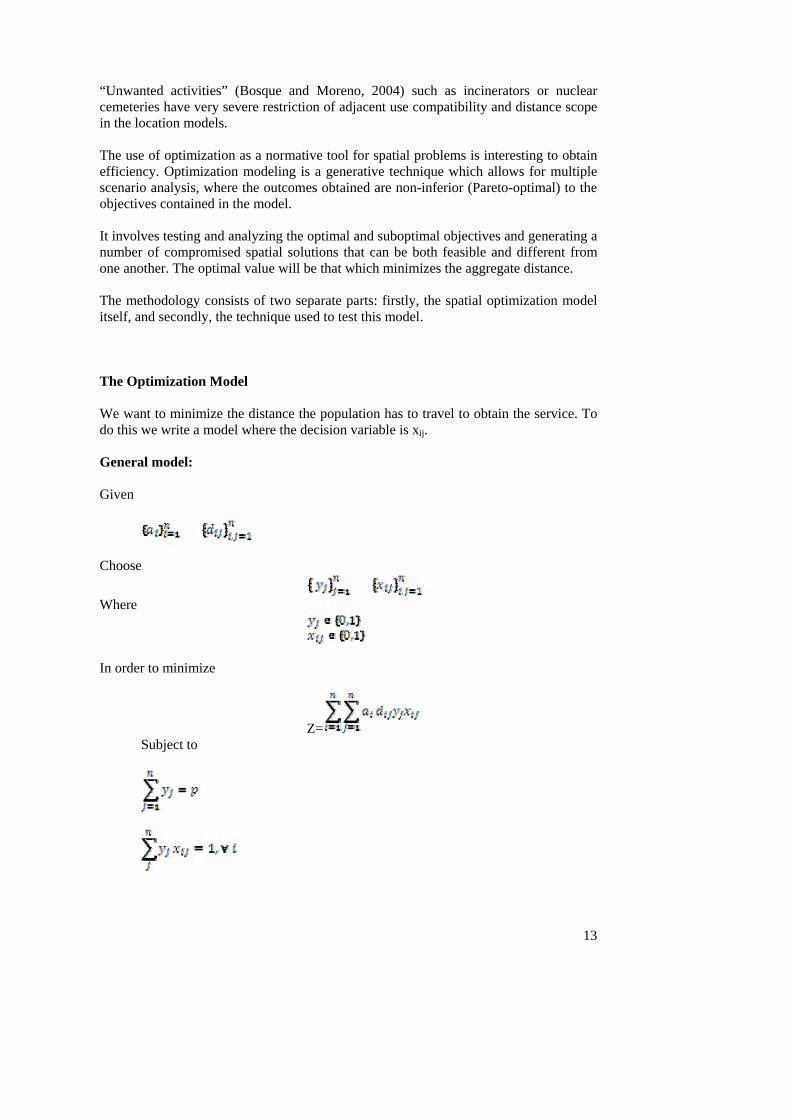
“Unwanted activities” (Bosque and Moreno, 2004) such as incinerators or nuclear cemeteries have very severe restriction of adjacent use compatibility and distance scope in the location models. The use of optimization as a normative tool for spatial problems is interesting to obtain efficiency. Optimization modeling is a generative technique which allows for multiple scenario analysis, where the outcomes obtained are non-inferior (Pareto-optimal) to the objectives contained in the model. It involves testing and analyzing the optimal and suboptimal objectives and generating a number of compromised spatial solutions that can be both feasible and different from one another. The optimal value will be that which minimizes the aggregate distance. The methodology consists of two separate parts: firstly, the spatial optimization model itself, and secondly, the technique used to test this model. The Optimization Model We want to minimize the distance the population has to travel to obtain the service. To do this we write a model where the decision variable is xij. General model: Given
Choose
Where In order to minimize
Z= Subject to

14
Where, ai = quantity of population in node i, i = origin of population, j = destination of population, n = number of nodes, dij = the shortest distance between node i and node j,
the possible location of services, p = number of services, xij = 1 if population of node i is assigned to j, 0 otherwise,
1 if service is located to j, 0 otherwise. We are imposing some assumptions which can be relaxed in future stages of the analysis. (1) There is no heterogeneity regarding income levels; we have a utilitarian social welfare function, in which the objective function puts the same weight on all individuals. Hence, income differences are ignored. (2) There is no congestion in service capacity. (3) There is homogeneity in product and quality. The implementation of this model will be carried out in this paper using different scenarios in which a set of locations are given and are different in each scenario. The population in each node point j is null; hence, in each new scenario population is assigned to the old point’s j, where it did not have population before. We will obtain different results which are suboptimal locations. The optimal location will be that which has the minimum distance to services aggregation. GIS Process One of the most important parts of the use of GIS is the spatial and alphanumerical information with which we implement the model. In this particular case, the main difficulty lies in the fact that we are working from an image which is a proposal for the organization of Barcelona’s structure. It is a drawing of the Expansion by Cerdà, which must be geo-referenced so that it can be incorporated into the SIG. Since it is a proposal, current coordinates must be identified on Cerdà’s map in order to be able to geo-reference it. Cerdà identified a reference coordinate, the Torre de Rellotge (the Clock Tower). With this point, and the two central axes of Barcelona, the Meridiana and Parallel Avenues, a total of 25 points could be identified. The sequence that evolved in the georeferencing process using GIS ArcMap was the following (Figure 9): (1) move and rotate Cerdà’s map so that it can be placed on the axes of the current streets, (2) place the central point of the Clock Tower of Cerdà’s map on the same geo-referenced point of the axes of the current streets, (3) identify up to 25 control points to carry out the geo-referencing process, (4) carry out the geo-referencing process. The final RMS error was 1.79.

15
Figure 9. Georeferencing process using GIS ArcMap
SPATIAL ANALYSIS OF CERDÀ’S LOCATION PATTERN: HOSPITALS AND MARKETPLACES As the second part of our model, we will start to analyze the service areas according to their location on Cerdà’s Proposal using ArcGIS extension Spatial Analyst. We have several facility location sets: parks, hospitals, schools, state facilities, marketplaces, “social facilities” (Figure 10).

16
Figure 10. Spatial analysis: Cerdà’s location pattern
In this paper we analyze service areas around a facility location: hospitals and markets. Considering a given set of 3 hospital locations, we construct iso-cost-time lines: considering the populations located at a maximum of 10’ walk, to 20’, to 30’ and greater or equal to 30’. The distance to travel has been calculated on the basis of people walking at 4 km per hour (Figure 11).
Figure 11. Spatial analysis: hospital service areas When we obtain our first result the original question remains unanswered: Is this the best hospital location, considering the minimization of aggregate travel cost? This result is a suboptimal solution but to find out the optimal solution, other scenarios have to be examined. For nineteenth century health provision ideas, Cerdà imposed a constraint locating all hospitals outside of the city limits. Therefore, when calculating other scenarios we can either keep this constraint or relax it and use it in other types of analysis. The service area to the marketplaces location imposed by Cerdà is the next analysis we carried out (Figure 12).

17
Figure 12. Spatial analysis: marketplace service areas Different areas are defined around the 10 marketplaces on Cerdà’s Map on the basis of the distance from the market, being of 6 minutes, less than 12 minutes and greater than 12 and less than 24. The walking distance is calculated assuming the speed of 4 km per hour. Again, is this the optimal location in order to minimize time-distance of the population going to the marketplace? It is probably a suboptimal solution in which further analysis would have to be carried out in order to answer this question. CONCLUDING REMARKS Current Barcelona is the result of historic institutional policy-making, social movements, and cultural manifestations, and in a general morphological way the massive urbanism intervention made to enlarge the city in the 1860s. Cerdà constructed a theory of how people should live, based on his social statistics of the working class and evaluating the needs for the entire population and for economic activity in a modern “futuristic” city. The seed of his “science” has been evaluated, partially in this paper. A lot more has to be done. His proposal changed the way in which people thought about the city space, and introduced the idea of changing people’s behavior by modifying public space. Part of his work was “utopic”, referring to a theoretical city, where it would be difficult to implement all the new and revolutionary elements which he thought had to be in a city. But we had worked under the hypothesis that “utopia” goes beyond reality but could contain the optimal objectives that have to be attained in order to increase the population’s wellbeing. Optimal objectives are like a framework; they contain standards and goals, reality escapes the optimal and usually suboptimal aims are not even achieved; but the “utopic” standards are sown and the plant can grow inwards or outwards and very tall. Other utopian urban models, such as Oscar Niemeyer’s Brasilia offered alternative solutions and a structure with which cities can be compared and with which they can experiment. Cerdà’s most important innovation was to create a new urban culture and to build a bridge between the urban roles and functions of a metropolis and a healthy population. Cerdà established the links of the city, which connect humanity and its structures. He put forward normative policy mechanisms for the urban era and inspired the city with embedded urban technologies and mechanisms of self-defense and self-protection. His model of innovations and new functions was a framework for the city’s ability to generate the information needed to solve inner city problems. One of the objectives of this paper was to test Cerdà’s optimization idea of services with modern location theory models and GIS data capturing and analysis. The

18
first results show a distribution of service areas around markets and hospitals. Specifically, we have shown that most of Barcelona’s Expansion has a hospital within 30 minutes walking distance travel time: and is within a maximum of 20 minutes walking travel time to a marketplace. Many developments can be carried out in future research. Most of these fall under the following proposals: considering facility location as an endogenous variable of the model, taking into account the capacity of services, introducing different population densities, introducing a different typology of services, individual decisions affecting wellbeing, heterogeneous population, different levels of income, efficiency (minimizing aggregate demand) and further discussing the spatial efficiency and wellbeing associated with service distribution. Since the 1960s Barcelona has expanded to become a metropolitan continuum where transport infrastructure contributed to its metropolitan area growth. After 152 years, Barcelona’s services and population are very different from Cerdà’s proposal. The idea evolved and today complexity makes any comparison very difficult. The population inside the Expansion pattern and in the old-then-incorporated neighboring towns configures a large city, where normative urban planning provided by the original model has been the container of many complex processes which have resulted in the contemporary Barcelona. About the authors. Montserrat Pallares-Barbera is a Research Fellow at the Center for Geographic Analysis. Institute for Quantitative Social Sciences. Harvard University. Cambridge, MA 02138, USA. She was awarded a Ph.D. in geography by Boston University and she is Associate Professor of Geography at the Geography Department at Universitat Autònoma de Barcelona, Bellaterra, Barcelona 08190, Spain. URL: http://scholar.harvard.edu/montserrat-pallares-barbera/publications Anna Badia received her PhD in Geography at the Universitat Autònoma de Barcelona in 2001. Her main research is based on land use and land cover change, especially all changes related to urban sprawl and forest fires. She has taught at Universitat Autònoma de Barcelona since 1994 at both undergraduate and postgraduate level. Her main subject is GIS and its application to environmental planning. She is the author of many articles and scientific papers, some of them in journals such as International Journal of Wildland Fire, Land Use policy, Applied Geography, Scripta Nova or Boletín de la Asociación de Geógrafos Españoles. Jordi Duch received his BA in Geography at the Universitat Autònoma de Barcelona (UAB) in 1992. He has a Master of Geographic Information Technologies and Remote Sensing, obtained in UAB in 1998. He has also a Master Degree in Regional and Population Studies, Department of Geography at the UAB, in 2010. He participated as an expert in the treatment of cartographic information in several university research projects and other related planning studies in Catalonia. References

19
Aibar, E. and Bijker, W. E. (1997). Constructing a city: The Cerda Plan for the Extension of Barcelona. Science, Technology, & Human Values, Vol. 22, No. 1 (Winter, 1997), pp. 3-30.
Berney, R. (2011). Pedagogical Urbanism: Creating Citizen Space in Bogota, Colombia. Planning Theory, Feb; vol. 10: pp. 16-34.
Bosque, J. and Moreno, A. (Eds) (2004). Sistemas de información geográfica y localización óptima de instalaciones y equipamientos. Madrid: RA-MA.
Busquets Grau, J. et al. (1992). Treballs sobre Cerdà i el seu eixample a Barcelona. Reading on Cerdà and the extension plan of Barcelona. Barcelona: Ajuntament de Barcelona. Ministerio de Obras Publicas y Territorio.
Casellas, A. (2009). Barcelona’s urban landscape. The historical making of a tourist product. Journal of Urban History, vol. 35 no. 6. pp. 815-83.
Carruters, J. I. and Ulfarsson, G. F. (2003). Urban sprawl and the cost of public services. Environment and Planning B: Planning and Design 30(4), pp. 503-522.
Cerdà, I. (transcribed in 1991 (1861, 1860, 1859, 1858, 1854, 1849)). Memoria del anteproyecto del ensanche de Barcelona. In MAP. INAP. Ajuntament de Barcelona (1991). Teoría de la construcción de las ciudades aplicada al proyecto de reforma y ensanche de Barcelona por D. Ildefonso Cerdà Ingeniero de caminos canales y puertos. Barcelona abril de 1859. En Ildefonso Cerdá. Teoría de la construcción de las ciudades. Cerdà y Barcelona. Vol.I. Madrid: Ministerio para las Administraciones Públicas. Secretaría General Técnica. Instituto Nacional de Administración Pública. Ajuntament de Barcelona, p. 52-105.
Cerdà, I. (1869). Teoría General de la Urbanización. Reforma y aplicación de sus principios y doctrinas a la reforma y Ensanche de Barcelona. In Estapé, F. (1968) (Ed), Teoría General de la Urbanización. Reforma y aplicación de sus principios y doctrinas a la reforma y Ensanche de Barcelona. Madrid: Instituto de Estudios Fiscales. (Tomo I).
Church, R.L. (2002). Geographical information system and location science. Computers & Operations Research.
Church, R. L. (1999). Location modelling and GIS. New York: Wiley and Sons. Church, R. L. and Jankowski, P. (2008). Spatial optimization as a generative technique
for sustainable multiobjective land-use allocation. International Journal of Geographical Information Science. Volume 22, num. 6, pp. 601 – 622.
Coates, B.E., Johnston, R.J. and Knox, P.L. (1977). Geography and inequality. Oxford: Oxford University Press.
Conkling, E.C. and Yeates, M. H. (1976). Man's economic environment. London: McGraw-Hill.
Cox, K. L. (1979). Location and public problems: A political geography of the contemporary world. Chicago: Maaroufa Press.
Cromley, R.G. and Hanink, D.M. (1999). Coupling land use allocation models with raster GIS. Journal of Geographical Systems, 1, pp. 137-153.
Davis, D. R.; Weinstein, D. E. (2002). Bones, Bombs and Break Points: The Geography of Economic Activity. American Economic Review, 92(5), pp. 1269-1289.
De Blij, H. (2009). The power of place. Geography, destiny and globalization’s rough landscape. New York: Oxford University Press.
Douglass, M. and Friedmann, J. (Eds) (1998). Cities for citizens: Planning and the rise of civil society in a global age. New York: John Wiley, 302 pp.

20
Estapé, F. (Ed). (1968-1971). Teoría general de la urbanización y aplicación de sus principios y doctrinas a la reforma del ensanche de Barcelona. Madrid: Instituto de Estudios Fiscales. 3 Volumes.
Glaeser, E. (2011). Triumph of the City: How Our Greatest Invention Makes Us Richer, Smarter, Greener, Healthier, and Happier. The Penguin Press. 338 pp.
IDESCAT. http://www.idescat.cat/en/ Kamp, Kees, Leidelmeijer, Marsmanand, Hollander (2003). Urban environment quality
and human wellbeing: towards a conceptual framework and demarcation of concepts; a literature study. Landscape and Urban Planning, vol. 65, Issues 1-2, 15, pp. 5-18.
Krugman, P. (1998). Space: The Final Frontier. Journal of Economic Perspectives, 12(2), pp. 161-174.
Le Gale’s, P. (2002) European cities: social conflicts and governance. Oxford: Oxford University Press, 328 pp. ISBN 0-1992-4357-3.
Levy, F. 11.202 Gateway: Planning Economics, Fall 2004. (Massachusetts Institute of Technology: MIT OpenCourseWare), http://ocw.mit.edu (Accessed 11 Jun, 2010). License: Creative Commons BY-NC-SA.
Ligmann-Zielinska, A.; Jankowski, P. (2007). Agent-based models as laboratories for spatially explicit planning policies. Environment and Planning B: Planning and Design, 34, pp. 316-335.
Lloyd, P.E. and Dicken, P. (1976). Location in Space. New York: Harper & Row. Malczewski, J. (1999). GIS and Multicriteria Decision Analysis. New York: John Wiley
and Sons. Mapa Militar de España, 1:50 000; Madrid: Servicio Geográfico del Ejèrcito;
Topographic documents fractionated in sheets. Numbers: 420, 421: Madrid, 1977.
Mapa Topográfico Nacional de España, 1:50 000; Madrid: Instituto Geogràfico Nacional; Topographic documents fractionated in sheets. Numbers: 420,421: Barcelona, 2nd. ed., 1951.
Mapa Topográfico Nacional de España, 1:50 000; Madrid: Instituto Geogràfico Nacional; Topographic documents fractionated in sheets. Numbers: 420,421: Madrid, 1srt. ed., 1926.
Ministerio para las Administraciones Públicas. Instituto Nacional de Administración Pública (MAP). Ajuntament de Barcelona (1991). Teoría de la construcción de las ciudades aplicada al proyecto de reforma y ensanche de Barcelona por D. Ildefonso Cerdà Ingeniero de caminos canales y puertos. Barcelona abril de 1859. En Ildefonso Cerdá. Teoría de la construcción de las ciudades. Cerdà y Barcelona. Vol.I. Madrid: Ministerio para las Administraciones Públicas. Secretaría General Técnica. Instituto Nacional de Administración Pública. Ajuntament de Barcelona.
Ministerio para las Administraciones Públicas. Instituto Nacional de Administración Pública (MAP). Ayuntamiento de Madrid (1991). Teoría de la viabilidad urbana. Reforma de la de Madrid. Estudios hechos por el ingeniero D. Ildefonso Cerdà autorizado al efecto por Rl. órden de 16 de Febrero de 1860. Cerdá y Madrid Vol.II. Madrid: Ministerio para las Administraciones Públicas. Secretaría General Técnica. Instituto Nacional de Administración Pública. Ayuntamiento de Madrid.
Moreno, A. (1995). Planificación y gestión de servicios a la población desde la perspectiva territorial: algunas propuestas metodológicas1. Boletín de la Asociación de Geógrafos Españoles, 20, pp. 115-134.

21
Osleeb, J. and Ratick, S. (1990) A Dynamic Location-Allocation Model for Evaluating the Spatial Impacts for Just-in-Time Planning. Geographical Analysis, volume 22, number 10–69, January.
Pacione, M. (2003). Urban environmental quality and human well being – a scial geographical perspective. Landscape and Urban Planning, vol 65, Issues 1-2, 15 pp. 19-30.
Pallares-Barbera, M. (2005). La percepció d’optimalitat en el Pla Cerdà. El model p-median en el disseny ortogonal L1 de l’Eixample de Barcelona. Treballs de la Societat Catalana de Geografia, 60, 2005 (223-253).
Pallares-Barbera, M. (1986). The p-Median model and the location of schools in the Cerdà Plan of expansion of Barcelona. Master Thesis. Boston University. Department of Geography. Smith, D. M. (1977). Human geography. A welfare approach. New York: St. Martin’s
Press. Smith, D. M. (1973). The geography of social well-being in the United States: An
introduction to territorial social indicators. New York: McGraw-Hill. Soja, E. (2010). Seeking spatial justice. Globalization and Community. Minnesota:
University of Minnesota Press. 256 pp. Solà-Morales Rubió, M. (1991). Cerdà urbanista. In MAP (1991). Ajuntament de
Barcelona (1991). Soria y Puig, A. (1991). La obra de Cerdà a vista de pájaro; in Ministerio para las
Administraciones Públicas. Instituto Nacional de Administración Pública. Ajuntament de Barcelona (1991). Teoría de la construcción de las ciudades aplicada al proyecto de reforma y ensanche de Barcelona por D. Ildefonso Cerdà Ingeniero de caminos canales y puertos. Barcelona abril de 1859. In Ildefonso Cerdá. Teoría de la construcción de las ciudades. Cerdà y Barcelona. Vol.I. Madrid: Ministerio para las Administraciones Públicas. Secretaría General Técnica. Instituto Nacional de Administración Pública. Ajuntament de Barcelona. P. 17-22.
Tiebout, Ch. (1956). A pure theory of local expenditures. Journal of Political Economy, 64, pp. 416-424.
Watson, V. (2002). The usefulness of normative planning theories in the context of sub-Saharan Africa. Planning Theory March vol. 1 no. 1 27-52 doi: 10.1177/147309520200100103.
United Nations (2010). http://www.un.org/es/ NOTES 1 Between 1857 and 1860 three urbanistic projects to enlarge Barcelona were presented: by Cerdà (1860), by Miquel Garriga Roca (1857-1858) and by Antoni Rovira i Trias (1959). The proposal presented by Rovira i Trias was chosen by the Barcelona City Government; while the proposal presented by Cerdà i Sunyer was chosen by the government of Madrid and signed by Queen Isabel II in 1860. A lot of controversy and opposition surrounded the approval and development of Cerdà’s Proposal. Political and social claims comprising low sustainable argumentation contradicted the Plan. Changes in the City Hall, from a progressive to a conservative government defended Rovira’s Plan. Economic agents, mainly land owners, were afraid of the results of the Plan’s development, and feared that the proclaimed low density

22
in Cerdà’s Plan was a powerful claim for developers and land-owners to impose their voice. Cerdà’s Proposal went ahead with some retaliations and concessions (García Melero 2002). 2 In addition to engineering, he developed military and political careers, both in Madrid and Barcelona. In 1851, he was elected progressive deputy for Barcelona’s San Pedro district. In 1954 he was appointed “síndico” by the progressive city hall; and the regional deputy chief (“governador civil”) appointed Ildefonso Cerdà as a municipal architect to start thinking about how to develop Barcelona. 3 An accurate database of health, salary, family members, conditions and living standards of the urban class. 4 “in 1933 the GATCPAC group designed a plan that would later be known as El Pla Macià, referring to the first president of the Catalan government during that period. The plan recuperated Cerdà’s design, adapting it to the new economic and demographic situation.” (Casellas 2010). The 1992 Vila Olímpica Project followed Cerdà’s grid. 5 Sants, Sarrià, Sant Gervasi, Gràcia, Horta, Sant Andreu del Palomar and Sant Martí de Provençals. 6 Camp de l’Arpa, Clot, La Llacuna, Icària. 7 The neighboring towns were part of Barcelona since 1897. http://ca.encydia.com/es/1897 8 This area corresponds to the built area, which differs from the total 1,969 ha projected by Cerdà; which included streets and parks.