Modern sedimentation and sediment dispersal pattern on the continental shelf off the Mekong River...
19
Modern sedimentation and sediment dispersal pattern on the continental shelf off the Mekong River delta, South China Sea Witold Szczuciński a, ⁎, Robert Jagodziński a , Till J.J. Hanebuth b , Karl Stattegger c , Andreas Wetzel d , Marta Mitręga a , Daniel Unverricht c , Phung Van Phach e a Institute of Geology, Adam Mickiewicz University in Poznań, Maków Polnych 16, 61-606 Poznań, Poland b MARUM — Center for Marine Environmental Sciences, University of Bremen, Leobener Strasse, 28359 Bremen, Germany c Institute of Geosciences, University of Kiel, Otto-Hahn-Platz 1, 24118 Kiel, Germany d Institute of Geology and Paleontology, Basel University, Bernoullistrasse 32, 4056 Basel, Switzerland e Institute of Marine Geology and Geophysics, Vietnam Academy of Science and Technology, 18 Hoang Quoc Viet Street, Cau Giay District, Hanoi, Viet Nam abstract article info Article history: Received 7 July 2013 Received in revised form 22 August 2013 Accepted 29 August 2013 Available online 5 September 2013 Keywords: marine sediments sediment accumulation rate sediment geochemistry clay minerals Mekong South China Sea The Mekong River is one of the major suppliers of sediments to the ocean, resulting in the formation of one of the largest river deltas. A major portion of the supplied sediments is accumulated in the subaqueous delta front, which progrades directly off the river mouths and also forms at a distance of more than 200 km westward, next to the Camau Peninsula. This study presents evidence of the existence of a Mekong-fed prodelta further off- shore and provides a first quantitative assessment of the modern fluvial-derived sediment dispersal pattern to the subaqueous prodelta, the outer continental shelf and the deep region of the South China Sea. The study is based on 96 surface shelf sediment samples and five short sediment cores, which were analyzed for grain-size composition, carbonate and total organic carbon contents, sedimentary structures (X-ray radiographs), clay min- eralogy and bulk geochemistry as well as 210 Pb and 137 Cs-based sediment accumulation rates. The major sedi- ment types in water depths of 18 m to 112 m include muddy sand, sand, gravelly muddy sand, sandy mud, gravelly sand and mud. The mud is composed mostly of silt fraction, while gravel is primarily composed of shell hash. The sedimentary structures include lamination, cross-stratification, truncation surfaces and burrows of various types. The carbonate content in the sediments varies from 3% close to the Mekong River mouths to 81% further on the shelf. Total organic carbon is from 0.02% in sand to 0.94% in mud. The highest average elemen- tal concentrations are of Si, Ca, Al, Fe, Mg and K. The spatial variability is similar for Al, K and Ti, as well as for Ca and Sr, suggesting the common presence in phyllosilicates and calcium carbonate minerals, respectively. The most common clay mineral is illite followed by smectite, kaolinite and chlorite. The spatial distribution of clay minerals suggests that they are primarily derived from the Mekong River, except in the northeastern region. The sediment accumulation rates in the mud-rich portion of the study area are in the range of 0.1 to 1.5 cm yr -1 . According to these results, the shelf environment is divided into three zones. Westward and southward from the Camau Peninsula, the subaqueous prodelta (water depth b 32 m) appears as a mud-dominated, organic-rich, high-accumulation (up to 1.5 cm yr -1 ) zone. South of the river mouths, a wide zone is dominated by terrigenous sands, which most likely represent the sink for river-supplied bedload sediments. The third and most offshore located zone of moderate-accumulation (0.3–0.4 cm yr -1 ) is dominated by muddy sands that are rich in biogenic carbonate. Evidence of redeposition, event deposition and changing sedimentary conditions is found in each of these zones reflecting the combined effects of tides, the changing monsoonal current and wind regimes and episodic trop- ical storms. The sediment budget calculation reveals that the subaqueous delta front stores approximately 50% of the fine-grained sediments supplied by the Mekong River. Roughly one-fourth of the sediments are retained in the subaerial region of the delta (including the Tonle Sap Lake), and approximately 25% accumulates on the shelf around the Camau Peninsula, primarily in the form of prodelta deposits. These results do not suggest a significant export of fine-grained sediments into the deep region of the South China Sea. © 2013 Elsevier B.V. All rights reserved. 1. Introduction Global sediment fluxes from the continents to the adjacent coastal seas and deep oceans originate primarily from river discharge (Milliman and Meade, 1983; Milliman and Syvitski, 1992; Hay, 1998). Southeastern and eastern Asia is the area with the largest fluvial Global and Planetary Change 110 (2013) 195–213 ⁎ Corresponding author at: Institute of Geology, Adam Mickiewicz University in Poznań, Maków Polnych 16, 61-606 Poznań, Poland. Tel.: +48 618296025; fax: +48 618296001. E-mail address: [email protected] (W. Szczuciński). 0921-8181/$ – see front matter © 2013 Elsevier B.V. All rights reserved. http://dx.doi.org/10.1016/j.gloplacha.2013.08.019 Contents lists available at ScienceDirect Global and Planetary Change journal homepage: www.elsevier.com/locate/gloplacha
Transcript of Modern sedimentation and sediment dispersal pattern on the continental shelf off the Mekong River...

Global and Planetary Change 110 (2013) 195–213
Contents lists available at ScienceDirect
Global and Planetary Change
j ourna l homepage: www.e lsev ie r .com/ locate /g lop lacha
Modern sedimentation and sediment dispersal pattern on the continental shelf off theMekong River delta, South China Sea
Witold Szczuciński a,⁎, Robert Jagodziński a, Till J.J. Hanebuth b, Karl Stattegger c, Andreas Wetzel d,Marta Mitręga a, Daniel Unverricht c, Phung Van Phach e
a Institute of Geology, Adam Mickiewicz University in Poznań, Maków Polnych 16, 61-606 Poznań, Polandb MARUM — Center for Marine Environmental Sciences, University of Bremen, Leobener Strasse, 28359 Bremen, Germanyc Institute of Geosciences, University of Kiel, Otto-Hahn-Platz 1, 24118 Kiel, Germanyd Institute of Geology and Paleontology, Basel University, Bernoullistrasse 32, 4056 Basel, Switzerlande Institute of Marine Geology and Geophysics, Vietnam Academy of Science and Technology, 18 Hoang Quoc Viet Street, Cau Giay District, Hanoi, Viet Nam
⁎ Corresponding author at: Institute of Geology, AdamMMaków Polnych 16, 61-606 Poznań, Poland. Tel.: +48 61
E-mail address: [email protected] (W. Szczuciński).
0921-8181/$ – see front matter © 2013 Elsevier B.V. All rihttp://dx.doi.org/10.1016/j.gloplacha.2013.08.019
a b s t r a c t
a r t i c l e i n f oArticle history:Received 7 July 2013Received in revised form 22 August 2013Accepted 29 August 2013Available online 5 September 2013
Keywords:marine sedimentssediment accumulation ratesediment geochemistryclay mineralsMekongSouth China Sea
TheMekong River is one of themajor suppliers of sediments to the ocean, resulting in the formation of one of thelargest river deltas. A major portion of the supplied sediments is accumulated in the subaqueous delta front,which progrades directly off the river mouths and also forms at a distance of more than 200 km westward,next to the Camau Peninsula. This study presents evidence of the existence of a Mekong-fed prodelta further off-shore and provides a first quantitative assessment of the modern fluvial-derived sediment dispersal pattern tothe subaqueous prodelta, the outer continental shelf and the deep region of the South China Sea. The study isbased on 96 surface shelf sediment samples and five short sediment cores, which were analyzed for grain-sizecomposition, carbonate and total organic carbon contents, sedimentary structures (X-ray radiographs), claymin-eralogy and bulk geochemistry as well as 210Pb and 137Cs-based sediment accumulation rates. The major sedi-ment types in water depths of 18 m to 112 m include muddy sand, sand, gravelly muddy sand, sandy mud,gravelly sand and mud. The mud is composed mostly of silt fraction, while gravel is primarily composed ofshell hash. The sedimentary structures include lamination, cross-stratification, truncation surfaces and burrowsof various types. The carbonate content in the sediments varies from 3% close to the Mekong River mouths to81% further on the shelf. Total organic carbon is from 0.02% in sand to 0.94% inmud. The highest average elemen-tal concentrations are of Si, Ca, Al, Fe, Mg and K. The spatial variability is similar for Al, K and Ti, as well as for Caand Sr, suggesting the common presence in phyllosilicates and calcium carbonate minerals, respectively. Themost common clay mineral is illite followed by smectite, kaolinite and chlorite. The spatial distribution of clayminerals suggests that they are primarily derived from the Mekong River, except in the northeastern region. Thesediment accumulation rates in the mud-rich portion of the study area are in the range of 0.1 to 1.5 cm yr−1.According to these results, the shelf environment is divided into three zones. Westward and southward from theCamau Peninsula, the subaqueous prodelta (water depth b 32 m) appears as a mud-dominated, organic-rich,high-accumulation (up to 1.5 cm yr−1) zone. South of the river mouths, a wide zone is dominated by terrigenoussands, which most likely represent the sink for river-supplied bedload sediments. The third and most offshorelocated zone of moderate-accumulation (0.3–0.4 cm yr−1) is dominated by muddy sands that are rich in biogeniccarbonate. Evidence of redeposition, event deposition and changing sedimentary conditions is found in eachof thesezones reflecting the combined effects of tides, the changingmonsoonal current andwind regimes and episodic trop-ical storms. The sediment budget calculation reveals that the subaqueous delta front stores approximately 50% ofthe fine-grained sediments supplied by the Mekong River. Roughly one-fourth of the sediments are retained inthe subaerial region of the delta (including the Tonle Sap Lake), and approximately 25% accumulates on the shelfaround the Camau Peninsula, primarily in the form of prodelta deposits. These results do not suggest a significantexport of fine-grained sediments into the deep region of the South China Sea.
© 2013 Elsevier B.V. All rights reserved.
ickiewiczUniversity in Poznań,8296025; fax: +48 618296001.
ghts reserved.
1. Introduction
Global sediment fluxes from the continents to the adjacent coastalseas and deep oceans originate primarily from river discharge(Milliman and Meade, 1983; Milliman and Syvitski, 1992; Hay, 1998).Southeastern and eastern Asia is the area with the largest fluvial

196 W. Szczuciński et al. / Global and Planetary Change 110 (2013) 195–213
sediment supply to theworld's ocean. The Ganges, Brahmaputra, HuangHe, Yangtze, Irrawaddy and Mekong Rivers are among the top ten interms of worldwide sediment discharge, accounting for ~30% of theglobal fluvial sediment flux to the sea (Milliman and Syvitski, 1992).This enormous riverine sediment delivery has a strong influence onmany important global and regional processes, including global biogeo-chemical transformations, water-quality changes and coastal erosion(e.g., Conley, 1997; Syvitski andMilliman, 2007). However, quantitativemeasurements of sediment discharge have been carried out on less than10% of the rivers worldwide (Syvitski et al., 2005). Therefore, most ofthe fluvial sediment load estimates are available frommodeling studiesalone and with limited accuracy (e.g., Syvitski et al., 2005; Cohen et al.,2013). Less is known of the fate of fluvial sediments that reach the seabecause they may be stored in coastal, deltaic or estuarine systemsand/or be dispersed through various processes over the continentalshelf and slope (e.g., Wetzel, 1993; Goodbred and Kuehl, 1999;Sommerfield et al., 2007; Walsh and Nittrouer, 2009; Hanebuth et al.,2011). Quantitative assessment of the dispersal pattern of fluvial-derived sediments is not a trivial task but is crucially required becausethe future fate of the densely populated mega-deltas depends largelyon their overall sediment budget (Syvitski et al., 2009). Furthermore,the shallow continental shelf areas are increasingly used for variouspurposes (e.g., transportation, aquaculture, mining, fishery and tour-ism) that depend on or have an effect on the seabed sediment composi-tion and accumulation pattern.
The Mekong is one of the world's major rivers: it is the 12th-longestriver in the world and drains an area of 795,000 km2 from the TibetanPlateau down to the coast of the South China Sea. The delivery of sedi-ments during the past 8000 years (Nguyen et al., 2000; Tamura et al.,2009; Nguyen et al., 2010; Hanebuth et al., 2012) resulted in the forma-tion of the third largest delta plain worldwide (62,500 km2; Colemanand Roberts, 1989). As the delta prograded its character changed froma tide-dominated to a tide-and-wave-dominated system (Ta et al.,2002a,b). This delta is divided into a 150-km wide subaerial plain anda subaqueous portion. The later is composed of two major delta frontsalong the delta's coast but located greater than 200 km apart fromeach other as preliminary noted by Ta et al. (2005) and recently docu-mented by Xue et al. (2010, in press) and Unverricht et al. (2013–thisissue). One delta front is located next to the modern Mekong Rivermouths and progrades seaward. The other front forms near the CamauPeninsula at the most southwestern spit of the Mekong Delta (Fig. 1).Liu et al. (2009) and Xue et al. (2010) suggested that this subaqueousdelta might store major amounts of Mekong River discharge. However,precise volume estimates have not been assessed thus far. Moreover,the dispersal pattern and the amounts of sediments transported furtheroffshore to the subaqueous prodelta, the open continental shelf and thedeep region of the South China Sea are still unknown. In the literature,speculations on the final fate of the Mekong River sediments are some-what controversial. It has been suggested that the Mekong River de-livers a considerable amount of sediment to the deep South China Sea(e.g., Liu et al., 2004; Fu et al., 2011), whereas the delta-based studiessuggested that most of the sediment is transported in the opposite(i.e., westward) direction toward the Gulf of Thailand (Nguyen et al.,2000; Xue et al., 2010; Unverricht et al., 2013–this issue). The latterfinding is supported by relict deposits or a notably thin Holocenedrape that suggests zero to rather low fluvial input to wide areas ofthe southern Vietnamese continental shelf (Emery, 1968; Hanebuthand Stattegger, 2004; Jagodziński, 2005; Schimanski and Stattegger,2005). Knowledge of themodern fate of theMekong-derived sedimentsis also important for the estimation of the expected near-future changesin the discharge related to extensive damming projects (e.g., Kummuet al., 2010; Wang et al., 2011).
The current study focuses on an area located approximately 20 kmto 120 km (i.e., just seaward of the subaqueous delta front) off theshorelines of the Mekong River delta and extending 450 km west and200 km east off the Mekong River mouths (Fig. 1). Previous studies on
sediments in this area were largely limited to a few sampling pointsand addressed the sediment dynamics, sedimentary properties, miner-alogy or geochemistry (e.g., Emery and Nino, 1963; Chen, 1978; Anikievet al., 1986, 2001, 2004; Kubicki, 2008; Unverricht et al., in press), focus-ing primarily on the area located next to the Mekong River mouths(Fig. 1). However, offshore of the subaqueous delta front, the sedimentdistribution pattern is not well known, and no assessments of modernsediment accumulation rates are available.
Therefore, the current study extends the existing studies of conti-nental shelf sediments adjacent to the Mekong River delta. A total of96 sediment samples were collected at 18 m to 50 m of the modernwater depth and were supplemented by additional samples from thedeeper shelf (down to 112 m; Fig. 1). The major objectives of thisstudy are: (1) to present a comprehensive surface-sediment data setbased on sedimentary properties, claymineralogy and bulk geochemis-try for the study area; (2) to determine the dispersal pattern of MekongRiver sediments on the adjacent continental shelf and to evaluatewhich processes dominate the modern sedimentation; and (3) to pro-vide a modern (past century) sediment budget estimate for the succes-sive depositional environments of the lower Mekong River systemincluding the delta plain, subaqueous delta and adjacent continentalshelf.
2. Regional setting
The study area is located from 104.2° to 109.5°E and 8.1° to 11.1°N(Fig. 1). This area covers the transition between the narrow shelf offcentral Vietnam in the northwest and the wide Sunda Shelf and Gulfof Thailand in the southern and western directions (Fig. 1). During thelast glacial maximum, this shelf widely emerged because the sea levelwas lowered by approximately 123 m (Hanebuth et al., 2009). Theopen shelf off the Mekong River is covered by sandy relict and palimp-sest deposits (Anikiev et al., 2001; Jagodziński, 2005; Schimanski andStattegger, 2005; Kubicki, 2008).
The major sediment supply comes from the Mekong River, whichsplits at the apex of its large delta plain into two main distributaries,the Bassac (HauRiver) and theMekong (Tien River),which subsequent-ly divide into the two branches of the Bassac and six branches of theMekong before entering the South China Sea. The subaerial deltaprogrades primarily in the western direction (Nguyen et al., 2000),where the prominent Camau Peninsula has developed (Fig. 1). In frontof the main Mekong River mouths and around the Camau Peninsula,a subaqueous delta front extends greater than 20 km offshore andis composed of up to 20-m-thick sediments of topset–foreset–bottomset architecture (Gagliano and McIntire, 1968; Xue et al., 2010;Unverricht et al., 2013–this issue). Sediments of the subaqueous deltafront consist of well-sorted fine sands in the Mekong River mouthsareawith a southwestward fining gradient. Around the Camau Peninsu-la and in the Gulf of Thailand, these subaqueous delta deposits are com-posed of well-sorted fine silts (Unverricht et al., 2013–this issue; Xueet al., in press).
The general sediment distribution pattern offshore of the subaque-ous delta front was documented based on a few samples by Emeryand Nino (1963), Nguyen (1996), Hieu (1998), and Wetzel et al.(2010) and limited mineralogical data from Chen (1978). The onlyarea that is relativelywell studied using sedimentological and geochem-ical approaches is located next to the Mekong River mouths. In thatarea, sands and relict deposits were primarily documented (Astakhovet al., 1989; Anikiev et al., 2004; Cenci and Martin, 2004) and subaque-ous sand dunes are common further east (Kubicki, 2008; Bui et al.,2009).
The study area is affected by the Southeast Asian Monsoon, whichdrives the seasonality of the river discharge. The water discharge ofthe Mekong River is estimated as 470 km3 yr−1 (Milliman and Meade,1983) but varies significantly with the particular monsoon season. Atotal of 85% of the annual water discharge occurs during the rainy

Fig. 1. Study area; A) and B) represent the location of the study area in global and regional contexts, respectively; C) Location of sampling stations. The delta front of the subaqueous delta ismarked after Xue et al. (2010) and Unverricht et al. (2013–this issue).
197W. Szczuciński et al. / Global and Planetary Change 110 (2013) 195–213
season, between May and October (Le et al., 2007). The suspended loadof the Mekong River fluctuates seasonally as well. On average, the loadamounts to approximately 160 × 109 kg yr−1, as measured about800 km upstream from the river mouth (Milliman and Syvitski,1992), but such estimates vary significantly relative to measurementtechniques, inter-annual fluctuations and recent dam constructions(Wang et al., 2011). The suspended sediment in the lower reachesof the Mekong River is mostly composed of fine silt with about 15%clay (Wolanski et al., 1996). The suspended sediment distributionacross the shelf was recently studied over one inter-monsoonal seasonby Unverricht et al. (in press). This study proved that the highest sedi-ment concentrations are found next to the river mouths and aroundthe Camau Peninsula (Fig. 1), where sediments are continuouslyresuspended by tide-induced currents, even during the calm seasonand neap tides.
In the winter monsoon season from November to early March, thewinds blow mainly from the northeastern and east directions, andsouthwestern winds prevail during the summer monsoon (Unverricht
et al., in press). The wave climate differs significantly between the sea-sons and within local areas. In the river mouth area, waves higherthan 1 m may occur at the coastline year-round (Tamura et al., 2010).
The shelf current system is also controlled by themonsoonal system.The coastal currents follow a southwestern direction during the wintermonsoon but a northeastern direction during the summer season.According to numerical models, the current velocities inside the shel-tered Gulf of Thailand are much lower than those in the open SouthChina Sea during both monsoon seasons (Wendong et al., 1998;Hordoir et al., 2006; Xue et al., 2012). The study area is also affectedby tropical storms in November and December. During the past50 years, more than 30 severe storms with typical passage duration of3 to 5 days have hit the southern Vietnamese coast, resulting in rapidcoastal erosion (Nguyen, 2012). The maximum wind speed duringsuch storm events is between 40 km h−1 and 180 km h−1 (UNISYS,2013).
The Mekong River delta is affected by tides of a mixed diurnal andsemi-diurnal character (Fang et al., 1999; Zu et al., 2008; Nguyen,
198 W. Szczuciński et al. / Global and Planetary Change 110 (2013) 195–213
2012). Along the delta coast exposed toward the South China Sea, ameso-tidal regime prevails with spring tide amplitudes decreasingwestward from up to 3.8 m in the east to approximately 2 m near thespit of the Camau Peninsula (Nguyen, 2012). In the Gulf of Thailand, amicro-tidal diurnal system occurs with tidal ranges between 0.5 and1.0 m.
3. Materials and methods
3.1. Sampling
The sample material was collected during the VG-5 and VG-9cruises with the R/V Nghien Cuu Bien in May 2004 and April 2005and the R/V Sonne cruise SO 187/Leg 3 in April–May 2006 (Wiesneret al., 2006). In total, 96 surface sediment samples and 5 short sedi-ment cores from water depths of 18 m to 112 m were investigated(Fig. 1, Appendix 1 in the Supplementary online material). The mate-rial was sampled from the uppermost 5 cm. Samples 1 through 47were collected with a grab sampler and the other samples weretaken with a giant box corer with a surface area of 50 cm2. All ofthe surface samples were analyzed for grain size and carbonate con-tent, 92 samples for total carbon and total organic carbon content,73 for clay minerals and 47 for bulk geochemistry. The sediments re-trieved with box corer were sub-sampled for X-ray radiographic im-aging (the uppermost 25 cm of the core, if available), and sub-coresof 10 cm in diameter were taken at five sites for sediment accumula-tion rate assessment and were analyzed for downcore variations ingrain size and carbonate content.
3.2. Sedimentary properties
All sampleswere described and photographed directly on board. Thesurface relief and sedimentary structure of the deposits recovered withthe giant box corer were documented as well. The surface samples(N = 96) and samples from each of the five short cores (N = 25)were wet-sieved at 0.063 mm, and the sand and gravel fractions wereseparated by dry sieving into six grain-size fractions using mesh sizesof 2, 1, 0.5, 0.25 and 0.125 mm. The clay-fraction content was assessedvia grain-size separation by centrifuge settling together with prepara-tion for clay-mineral analysis. The sediments were classified accordingto their grain-size distribution using Folk's (1954) simplified scheme.
Digital X-ray radiographs were obtained from 0.5 × 10 × 25 cmslabs taken directly from the front side of an opened giant box core(Fig. 2C), and X-ray radiographs (negatives) were acquired at thePrüner Gang Medical Center (Kiel, Germany). The X-ray radiographswere used to detect internal sedimentary structures or unconformitiesoften not visible in the fresh cores.
3.3. Clay minerals
In this study, the term “clay minerals” refers to the four majorphyllosilicate minerals of smectite, illite, kaolinite and chlorite that ap-pear in the clay grain-size fraction (b2 μm). Compositional differenceswithin each of these groupswere not further considered. Themethodo-logical approach followed was that applied by Jagodziński (2005) forsurface sediments of the nearby Vietnam and Sunda shelves. The clayfraction of the 73 samples (Appendix 1 in the Supplementary onlinematerial) was separated by centrifuge settling and oriented by wet-smearing on glass slides. The X-ray diffraction (XRD) analyses wererun on a ARL X'tra (theta–theta goniometer; Cu Kα radiation; Peltiercooled Si(Li) solid-state detector) from Thermo Electron (Institute ofGeology, Adam Mickiewicz University in Poznań, Poland). Three XRDruns were performed for each sample, one for the air-dried sample,a second after treatment with glycol and a third after heating at550 °C. The contents of each mineral group were calculated via semi-quantitative analysis of the obtained diffractograms, following the
method of Biscaye (1965) and using the MacDiff 4.2.5 software set upby Petschik (2000). The relative clay mineral abundances are given asa percent of their sum. According to Biscaye (1965), the accuracy ofthis method is ±5–10%, and the presented relativemineral abundancesare rounded to full numbers.
3.4. Sediment geochemistry
The bulk sediment samples were dried and manually grounded forthe analyses of carbonate content, total organic carbon content (TOC),and the elemental concentrations of 12 elements. The bulk carbonatecontent was determined for all surface samples (N = 96) and shortcores (N = 43) using the carbonate bomb technique of Müller andGastner (1971) with a reproducibility of ±1%.
The contents of TOC were measured for 92 samples using a Leco CS-300 element analyzer (Bremen University, Germany). The sampleswere treated with 12.5% HCl to remove inorganic carbon prior to themeasurement of TOC. The analytical precision of the analysis is ±3%.
The bulk concentrations of 12 elements (Al, Br, Ca, Fe, K,Mg,Mn, P, S,Si, Sr and Ti) were determined for 47 samples (Fig. 1) via energy-dispersive polarization X-ray fluorescence (EDP-XRF) spectrometryusing a Spectro Xepos instrument at Bremen University (Germany).The instrument was controlled using Spectro X-Lab Pro software, ver-sion 2.4, with the so-called TurboQuant method. A measuring time of100 s per target and sample was used for analysis. Analytical qualitywas assessed by daily analyses of a pressed pellet of MAG-1 standardreference material (Govindaraju, 1994).
3.5. Sediment accumulation rates
Sediment accumulation rates (SARs) for the past one hundred years(approximately) were assessed through 210Pb and 137Cs analyses. Theactivities of both isotopes were measured by gamma spectroscopyusing a Canberra GX2520 high-purity coaxial germanium detectorwith a remote detector chamber option (RDC-6 in.) housed in theInstitute of Geology of the Adam Mickiewicz University in Poznań(Poland). The efficiencies for the measured geometries were deter-mined using LabSOCS (Laboratory Sourceless Calibration Software)code which applies all corrections for sample geometry, matrix, andcontainer type. Samples were taken from five sediment cores in 5-cmthick intervals. The samples were dried, grounded and packed intosealed containers for further measurements, which took place severalweeks later. Measurement of 20 g of dry sediment lasted for 24 h. Theobtained activities were decay-corrected to the date of sampling, andthe results are reported within a two-sigma standard deviation uncer-tainty range.
The SARswere calculated from the decrease of excess 210Pb activitieswith sediment depth following the equation proposed by McKee et al.(1983):
SAR ¼ λ� z� ln A0=Azð Þ−1
where λ (= 0.0311 yr−1) is the decay constant, z is the depth in thecore (cm), A0 is the specific activity of the excess 210Pb at the surface,and Az is the specific activity of the excess 210Pb at depth z. The excess210Pb activities were determined by subtracting the average supportedactivity measured on samples taken from below the region of radioac-tive decay from the total activity. In cores # 71 and#86, the deepest sed-iments contained relatively young sediments (with 137Cs). In thesecores, the supported 210Pb value was assumed to be 30 Bq kg−1,which is an average of the supported activities measured in the nearbycores presented in this paper and by Unverricht et al. (2013–this issue).The 210Pb-derived SAR assessment was validated using the first occur-rence of 137Cs as a marker of the early 1950s (Robbins and Edgington,1975; Leslie and Hancock, 2008). The obtained activity profiles wereinterpreted under close consideration of the X-ray radiography and
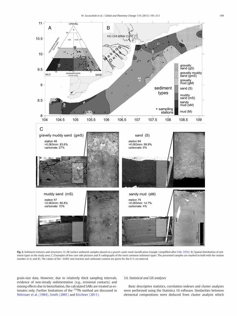
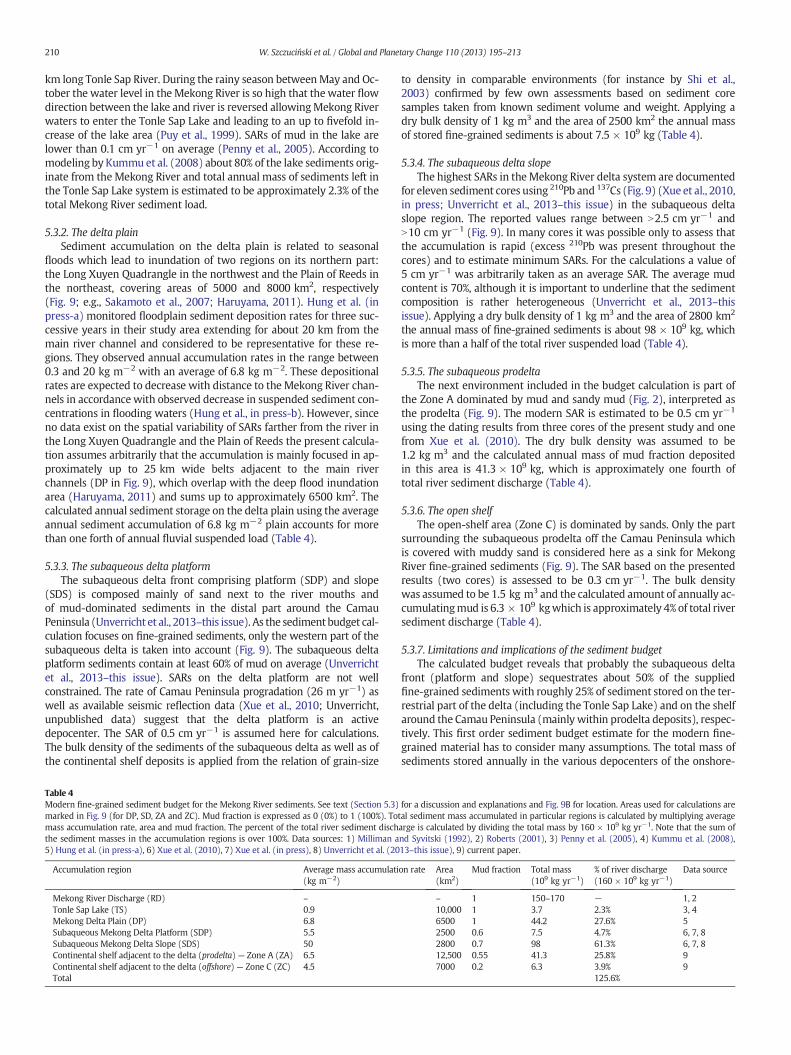
Fig. 2. Sediment textures and structures; A) All surface sediment samples placed on a gravel–sand–mud classification triangle (simplified after Folk, 1954); B) Spatial distribution of sed-iment types in the study area; C) Examples of box core side pictures and X-radiographs of the most common sediment types. The presented samples are marked in bold with the stationnumber in A) and B). The values of the N0.063 mm fraction and carbonate content are given for the 0–5 cm interval.
199W. Szczuciński et al. / Global and Planetary Change 110 (2013) 195–213
grain-size data. However, due to relatively thick sampling intervals,evidence of non-steady sedimentation (e.g., erosional contacts) andmixing effects due to bioturbation, the calculated SARs are treated as es-timates only. Further limitations of the 210Pb method are discussed inNittrouer et al. (1984), Smith (2001) and Kirchner (2011).
3.6. Statistical and GIS analyses
Basic descriptive statistics, correlation indexes and cluster analyseswere performed using the Statistica 10 software. Similarities betweenelemental compositions were deduced from cluster analysis which
200 W. Szczuciński et al. / Global and Planetary Change 110 (2013) 195–213
was carried out based on the Euclidean similarity using standardizeddata set. ArcGIS software was used to calculate areas of the regions con-sidered in sediment budget calculations.
4. Results
4.1. Sediment types
The surface sediments in the study area are classified into seven tex-tural groups based on the mud, sand and gravel fraction contents(Fig. 2A). The sediments are generally poorly or very poorly sorted.The major sediment types include muddy sand (31 samples), sand(25) and gravelly muddy sand (18). The subordinate deposits aresandymud and gravelly sand present in 10 and 9 samples, respectively.Gravelly mud occurs in two samples and mud alone occurs in a singlesample. The mud content of the surface sediments varies between0.3% and 98.3% (Table 1) and is composed mostly of silt. The clay frac-tion (b0.002 mm) is generally less than 10% except for samples 8, 76,77 and 81 with a clay content of up to 15% and sample 79 (mud) witha clay content of 27%.
Gravelly sand (gS) dominates in the region southeast off theMekongRiver mouths where it often occurs as patches often in muddy sand orsand (Fig. 2B). This sediment type is found at stations located in waterdepths between 25.5 m and 44 m. The sand content ranges from 85%to 92% and the gravel fraction (primarily composed of shell hash) rangesfrom 5% to 10%. These sediments are very poorly sorted.
Gravelly muddy sand (gmS) covers most of the eastern portion ofthe study area but is also found in the westernmost and southernmostsamples at water depths of 22 m to 109 m (Fig. 2B). This type of sedi-ment is also found in spots at single sites in areas covered otherwiseby sandy mud and muddy sand. This sediment is generally extremelypoorly sorted with sand content of 51.6% to 75% supplemented bymud and up to 27% gravel. Shell debris (which is commonly reworked,crushed and sorted) contributes themajor proportion of the gravel frac-tion as well as a minor amount of sand-sized material. In many cases,the gravel fraction is enriched in layers or burrow infills. The internalsediment structures are variable (Figs. 2C; 3, cores 71, 78 and 92) andinclude intensively bioturbated and massive beds, poorly preservedlayering of extremely poorly sorted material and reworked shell debris(e.g., sample 92), and laminated silty sand intercalated with coarseshell-debris rich layers with an erosional base. However, in mostcases, both the muddy sand and calcareous intervals are burrowed toa varying degree and the boundaries are churned by bioturbation (e.g.,
Table 1Descriptive statistics of the surface sediment grain size (mud content) and chemical andmineralogical (clay minerals) composition.
Unit Number ofsamples
Mean Median Minimum Maximum
Mud content % 96 20.7 14.0 0.3 98.3Carbonates % 96 17.2 13.0 3.0 81.0TOC % 92 0.2 0.2 0.0 0.9Al g kg−1 47 43.8 35.7 5.4 97.2Br mg kg−1 47 32.9 27.8 16.9 95.4Ca g kg−1 47 73.7 63.1 7.8 193.9Fe g kg−1 47 24.9 21.2 9.2 71.4K g kg−1 47 11.6 11.2 4.8 21.1Mg g kg−1 47 15.1 15.8 5.7 22.0Mn mg kg−1 47 515.3 456.0 247.4 1193.1P mg kg−1 47 434.2 446.3 134.7 768.5S mg kg−1 47 2111.6 2028.2 858.5 7310.7Si g kg−1 47 228.2 222.9 142.2 361.6Sr mg kg−1 47 384.1 314.3 72.4 1044.9Ti g kg−1 47 2.6 2.3 0.7 5.8Chlorite % 73 15.2 15.4 6 25Illite % 73 46.8 46.1 34 63Kaolinite % 73 18.2 19.7 2 27Smectite % 73 19.8 20.7 4 36
71). Themud fraction is concentrated in burrow infills (e.g., 92) or con-stitutes discontinuous layers. Erosional contacts are common and aremarked by truncated bioturbation burrows.
Sand (S) sediments dominate the central study area southward andsoutheastward off the Mekong River mouths (Fig. 2B). Moreover, thistype also appears in some southernmost samples in thewestern portionof the area. Sand occurs inwater depths ranging from 21 m to 39 m andis the only sediment type that is usually moderately sorted. The domi-nant grain-size fractions are fine and medium sands (Appendix 1 inthe Supplementary online material). Structurally, the sands offshoreof the Mekong River mouths are represented by two major types:cross-bedded, fine and medium sands, and laminated to massive well-sorted fine sands. The first type is found in samples 60 and 64(Fig. 2C), for instance, and is characterized by a rippled sediment surfaceas observed from the giant box corer as well as common horizontal andcross lamination, frequent erosional contacts, minor amounts ofcrushed shells and a few burrows. The second type contains up to 85%of fine-grained sand and is nearly homogenous (for instance in 44, 60and 64) or distinctly laminated (e.g., 70). The homogenous sedimentsare characterized by the common presence of well-preserved turritellidsnails,mostly enriched on the sediment surface or close to it. In the lam-inated sand, certain burrows are filled with coarse sand and shells. Thesand cover in the shallow area (21–27 m) next to theMekong River dis-tributary outlets (e.g., samples 60, 69, 61 and 70) reveals a westwardtrend of decreasing grain size, improved sorting and increasing abun-dance of burrows.
Muddy sand (mS) is the most common sediment type found at awide range of water depths from 18 m down to 112 m. The sand con-tents range from 55% to 89%. Two main regions covered by this sedi-ment type are located to the east and to the west of the central sand-covered area (Fig. 2B). The western portion of the muddy-sand areasurrounds a sandy mud and mud-covered shallow shelf next to theCamau Peninsula. Muddy sand is also present over the outer shelf atthe eastern edge of the study area. The sediments are extremely poorlysorted and contain commonly shell fragments. In certain cases, intactshells, mainly of snails (turritellids), appear in large abundance nearthe sediment surface (e.g., sample 71). The primary sedimentary struc-tures (Figs. 2C, 3 — core 87) are overprinted by bioturbation. In certaincores, remnants of layering consisting of sand with shells interbeddedwith mud lenses or layers are preserved and associated with local ero-sional truncations (sample 67). Due to selective bioturbational mixingin several box cores the remnants of mud and sand layers form“pockets”. Selected burrows are infilled with mud, although no mudlayers are preserved. In several box cores, bioturbation causes the struc-ture to appear nearly homogeneous (e.g., samples 50, 59 and 95).
Gravelly mud (gM) occurs only in two samples (76 and 77) close tothe subaqueous delta front next to the Camau Peninsula at a waterdepth near 30 m. In principle, these deposits are composed of mudwith partly preserved lamination. However, in certain burrows, sand-and gravel-sized broken shells occur, which contribute up to 15% ofthe total sediment mass. These burrows are usually truncated and cov-ered by laminatedmud, suggesting that non-preserved sand and gravelbed have originally existed.
The most common sediment type covering the seafloor next to thesubaqueous delta around the Camau Peninsula at water depths of26 m to 32 m is sandy mud (sM). These sediments are also presentjust eastward off theMekong Rivermouths at 18 m to 22 mand at a sin-gle site at a 60-m water depth in the eastern portion of the study area(Fig. 2B). The sediments are characterized by relatively high water con-tent and generally strong bioturbation but partly preserved layering orlamination. Among the bioturbation structures, burrows ascribed toichnogenera Helicodromites, Thalassinoides and Planolites are common(Fig. 3 — core 86). The sand fraction is mostly restricted to individualsand layers (up to 4 cm thick), to burrows below such sand intervals,or to individual burrows (Fig. 2C), which were likely filled with sandfrom migrating, only temporarily present, today not preserved sand

Fig. 3. Sedimentary properties (X-ray radiography,N0.063 mm fraction content, carbonate content) and 210Pb and 137Cs activity profiles for sediment cores 71, 78, 86, 87 and 92 taken fromgiant box corers. X-ray radiographs show the uppermost 25 cm of the giant box core sediments (samples taken from the side of the box corer). The vertical error bars represent samplingintervals for the samples, and the horizontal error bars indicate 2-sigma measurement uncertainties.
201W. Szczuciński et al. / Global and Planetary Change 110 (2013) 195–213
202 W. Szczuciński et al. / Global and Planetary Change 110 (2013) 195–213
veneers. The sand is composed primarily of shell fragments, but largeshells are generally rare.
Mud (M) sediments are found only in one sample (79), at a 30-mwater depth next to the area covered by sandy mud near the westernportion of the subaqueous delta front. This sediment type is similar tothe sandy mud facies in the area; it is laminated and has relativelyhigh water content. Moreover, sand layers with associated sand filledburrows are observed deeper (N5 cm) in this box core sample.
4.2. Sediment accumulation rates
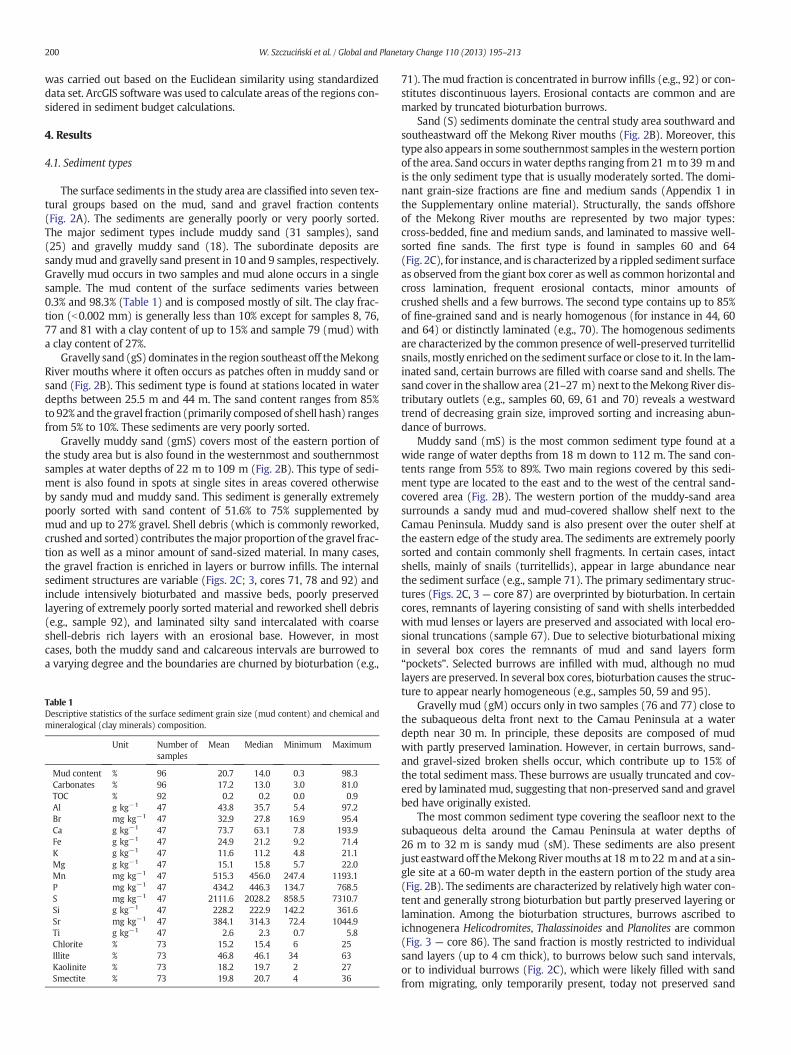
The excess 210Pb activity profiles (Fig. 3) reveal a generally decreas-ing trend with sediment depth and allow for estimation of sedimentaccumulation rates (SARs). However, as discussed below, due to varia-tions in the slope of the profiles, relatively thick sampling intervalsand a complex depositional history (erosion, bioturbation as revealedin X-ray radiographs), the obtained values must be treated as approxi-mate. Nonetheless, these values are in good agreementwith the SAR as-sessments from the maximum penetration depth of 137Cs (Fig. 3).
The 52-cm-long core 71 is composedmostly of sandymud (althoughthe surface sample from that site is found to represent gmS). The depos-it is bioturbated in the upper ~15 cm and laminated below down to atleast 25 cm. Excess 210Pb is present throughout the core, and the aver-age calculated SAR is 1.52 cm yr−1. However, as revealed by the profileand sedimentary structures, the sediment accumulation has variedwithtime. The rapid decrease in excess 210Pb activity in the top samples im-plies a lower accumulation rate, as also suggested by the highest excess210Pb activity in the surface sample among the studied cores and thebioturbational structures present. The lower activities near a 10-cmcore depth and possibly also in the lowermost region of the core maybe related to the higher sand content. The majority of the core showsnearly uniform activities and together with evidence of minor biotur-bated laminated sediments (Fig. 3) may reflect notably high accumula-tion rates (higher than the average calculated value). Additionally, 137Csis present throughout the entire core, although the measured activitiesare generally low (less than 2 Bq kg−1) and no sharp activity peakwas detected. However, the presence of 137Cs throughout the core sug-gests that the sediments were deposited after the 1950s, and thereforethe SAR is N0.89 cm yr−1, which supports the estimates based on 210Pb.
Core 78 is composed of gravelly muddy sand at the surface andsandy mud lower in the core. The uppermost 5 cm is rich in carbonatesand and gravel and is bioturbated, whereas the lower portion of thecore is laminated with only few burrows. Excess 210Pb is present onlyin the upper 15 cm, and the calculated SAR is 0.14 cm yr−1. However,relatively low excess 210Pb activity in the top sample (the lowestamong themeasured cores) suggests that themodern sediment surfacemay represent a recent erosional surface. The accumulation rate in thelower section (below 15 cm) with laminated sediments was likelyhigher than the calculated value. The activity of 137Cs is measured onlyin the top 10 cm, and its activities are quite low (b1 Bq kg−1). The cal-culated SAR of 0.14 cm yr−1 matches that of the 210Pb measurement.
The 33-cm long core 86 is composed of initially stratified sandymudwith common bioturbation structures. Excess 210Pb is present through-out the core (Fig. 3), and the average calculated SAR is 1.51 cm yr−1.137Cs is also present throughout the core with low activities andsuggests that the SAR is N0.59 cm yr−1, supporting the 210Pb-derivedestimate.
Core 87 is 41 cm long and composed of sandymud andmuddy sand.This core contains remnants of stratification but is dominated bybioturbational structures (Fig. 3). The SAR assessed from 210Pb profileis approximately 0.33 cm yr−1. The 137Cs penetration depth is 10 cm,indicating an SAR of approximately 0.14 cm yr−1, which is less thanthat calculated from 210Pb. However, the 137Cs activities are notablylow (b0.5 Bq kg−1), possibly partially due to the high carbonate-sandcontent (33–68%), which could also cause dilution of the radioisotope
in the deeper samples. Thus, the estimated 137Cs-derived SAR shouldbe treated as a minimum value.
Core 92 is composed of bioturbated gravelly muddy sand with cer-tain remnants of layering. Excess 210Pb decreases with depth (Fig. 3),and the calculated SAR is 0.45 cm yr−1. The 137Cs value is below theminimum detection activity and is likely due to the high carbonate-sand content (74–82%).
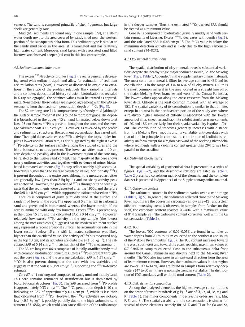
4.3. Clay mineral distributions
The spatial distribution of clay minerals reveals substantial varia-tions despite the nearby single major sediment source, i.e., the MekongRiver (Fig. 3, Table 1, Appendix 1 in the Supplementary onlinematerial).The most common mineral is illite; its average content is 46% and itscontribution is in the range of 33% to 63% of all clay minerals. Illite isthe most common mineral in the area located in a straight line off ofthe major Mekong River branches and west of the Camau Peninsula.The lowest values appear along the coast eastward from the MekongRiver delta. Chlorite is the least common mineral, with an average of15%. The spatial variability of its contribution is similar to that of illite,except in an area in the northeastern portion of the study area wherea relatively higher amount of chlorite is associated with the lowestamount of illite. Smectites and kaolinite exhibit similar average contentsof 19% and 18%, respectively, but their spatial variability is quite differ-ent. The contribution of smectites generally increases with distancefrom the Mekong River mouths and its variability anti-correlates withthat of illite in principle. In contrast, the contribution of kaolinite is rel-atively uniform except for a region eastward of the Mekong River deltawhere sediments with a kaolinite content greater than 20% form a beltparallel to the coastline.
4.4. Sediment geochemistry
The spatial variability of geochemical data is presented in a series offigures (Figs. 5–7), and the descriptive statistics are listed in Table 1.Table 2 presents a correlation matrix of the elements, and the completedata set is presented inAppendix 1 of the Supplementary onlinematerial.
4.4.1. Carbonate contentThe carbonate content in the sediments varies over a wide range
(Table 1, Fig. 5). In general, the sediments collected close to theMekongRiver mouths are the poorest in carbonate (as low as 3–4%), and a clearoffshore-increasing trend is observed. In samples from further on theshelf, the carbonate content reaches 20–40%, with a maximum valueof 81% (sample 89). The carbonate content correlates well with the Caconcentration (Table 2).
4.4.2. TOCThe lowest TOC contents of 0.02–0.05% are found in samples at
water depths from 20 m to 35 m collected to the southeast and southof theMekong River mouths (Fig. 3). The TOC content increases towardthewest, southwest and toward the coast, reachingmaximum values of0.7–0.94% in samples collected close to the subaqueous delta frontaround the Camau Peninsula and directly next to the Mekong Rivermouths. The TOC also increases in an eastward direction from the areaof its minimum content. However, the maximum values in that regionare lower (0.33–0.42%) and are found in samples from relatively deepwaters (47 to 60 m); there is no single trend in variability. The distribu-tion of TOC correlates well with the mud content (Table 2).
4.4.3. Bulk elemental compositionAmong the analyzed elements, the highest average concentrations
on the order of tens to hundreds of g kg−1 are of Si, Ca, Al, Fe, Mg andK (Table 1). The minor components in decreasing order are Ti, S, Mn,P, Sr and Br. The spatial variability in the concentrations is similar forseveral of these elements, namely for Al, K and Ti or for Ca and Sr,
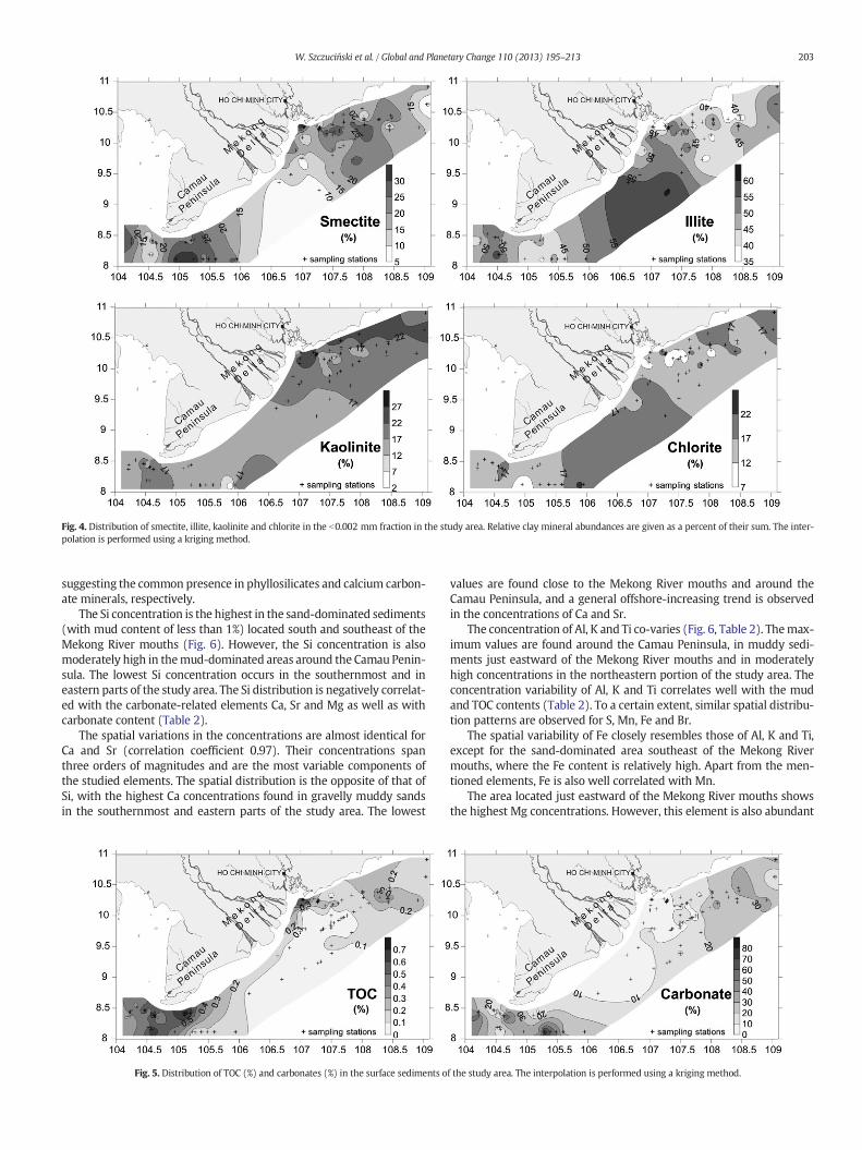
Fig. 4. Distribution of smectite, illite, kaolinite and chlorite in the b0.002 mm fraction in the study area. Relative clay mineral abundances are given as a percent of their sum. The inter-polation is performed using a kriging method.
203W. Szczuciński et al. / Global and Planetary Change 110 (2013) 195–213
suggesting the common presence in phyllosilicates and calcium carbon-ate minerals, respectively.
The Si concentration is the highest in the sand-dominated sediments(with mud content of less than 1%) located south and southeast of theMekong River mouths (Fig. 6). However, the Si concentration is alsomoderately high in themud-dominated areas around the Camau Penin-sula. The lowest Si concentration occurs in the southernmost and ineastern parts of the study area. The Si distribution is negatively correlat-ed with the carbonate-related elements Ca, Sr and Mg as well as withcarbonate content (Table 2).
The spatial variations in the concentrations are almost identical forCa and Sr (correlation coefficient 0.97). Their concentrations spanthree orders of magnitudes and are the most variable components ofthe studied elements. The spatial distribution is the opposite of that ofSi, with the highest Ca concentrations found in gravelly muddy sandsin the southernmost and eastern parts of the study area. The lowest
Fig. 5. Distribution of TOC (%) and carbonates (%) in the surface sediments o
values are found close to the Mekong River mouths and around theCamau Peninsula, and a general offshore-increasing trend is observedin the concentrations of Ca and Sr.
The concentration of Al, K and Ti co-varies (Fig. 6, Table 2). Themax-imum values are found around the Camau Peninsula, in muddy sedi-ments just eastward of the Mekong River mouths and in moderatelyhigh concentrations in the northeastern portion of the study area. Theconcentration variability of Al, K and Ti correlates well with the mudand TOC contents (Table 2). To a certain extent, similar spatial distribu-tion patterns are observed for S, Mn, Fe and Br.
The spatial variability of Fe closely resembles those of Al, K and Ti,except for the sand-dominated area southeast of the Mekong Rivermouths, where the Fe content is relatively high. Apart from the men-tioned elements, Fe is also well correlated with Mn.
The area located just eastward of the Mekong River mouths showsthe highest Mg concentrations. However, this element is also abundant
f the study area. The interpolation is performed using a kriging method.
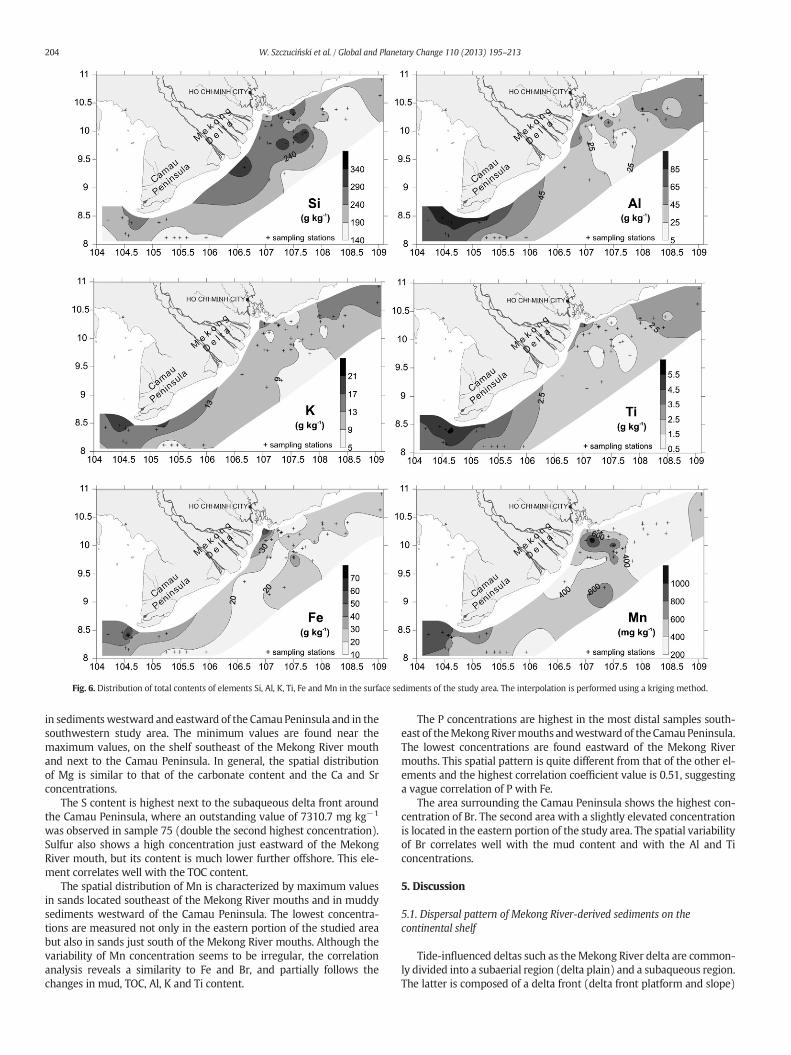
Fig. 6. Distribution of total contents of elements Si, Al, K, Ti, Fe and Mn in the surface sediments of the study area. The interpolation is performed using a kriging method.
204 W. Szczuciński et al. / Global and Planetary Change 110 (2013) 195–213
in sedimentswestward and eastward of the Camau Peninsula and in thesouthwestern study area. The minimum values are found near themaximum values, on the shelf southeast of the Mekong River mouthand next to the Camau Peninsula. In general, the spatial distributionof Mg is similar to that of the carbonate content and the Ca and Srconcentrations.
The S content is highest next to the subaqueous delta front aroundthe Camau Peninsula, where an outstanding value of 7310.7 mg kg−1
was observed in sample 75 (double the second highest concentration).Sulfur also shows a high concentration just eastward of the MekongRiver mouth, but its content is much lower further offshore. This ele-ment correlates well with the TOC content.
The spatial distribution of Mn is characterized by maximum valuesin sands located southeast of the Mekong River mouths and in muddysediments westward of the Camau Peninsula. The lowest concentra-tions are measured not only in the eastern portion of the studied areabut also in sands just south of the Mekong River mouths. Although thevariability of Mn concentration seems to be irregular, the correlationanalysis reveals a similarity to Fe and Br, and partially follows thechanges in mud, TOC, Al, K and Ti content.
The P concentrations are highest in the most distal samples south-east of theMekongRivermouths andwestward of theCamau Peninsula.The lowest concentrations are found eastward of the Mekong Rivermouths. This spatial pattern is quite different from that of the other el-ements and the highest correlation coefficient value is 0.51, suggestinga vague correlation of P with Fe.
The area surrounding the Camau Peninsula shows the highest con-centration of Br. The second area with a slightly elevated concentrationis located in the eastern portion of the study area. The spatial variabilityof Br correlates well with the mud content and with the Al and Ticoncentrations.
5. Discussion
5.1. Dispersal pattern of Mekong River-derived sediments on thecontinental shelf
Tide-influenced deltas such as theMekong River delta are common-ly divided into a subaerial region (delta plain) and a subaqueous region.The latter is composed of a delta front (delta front platform and slope)
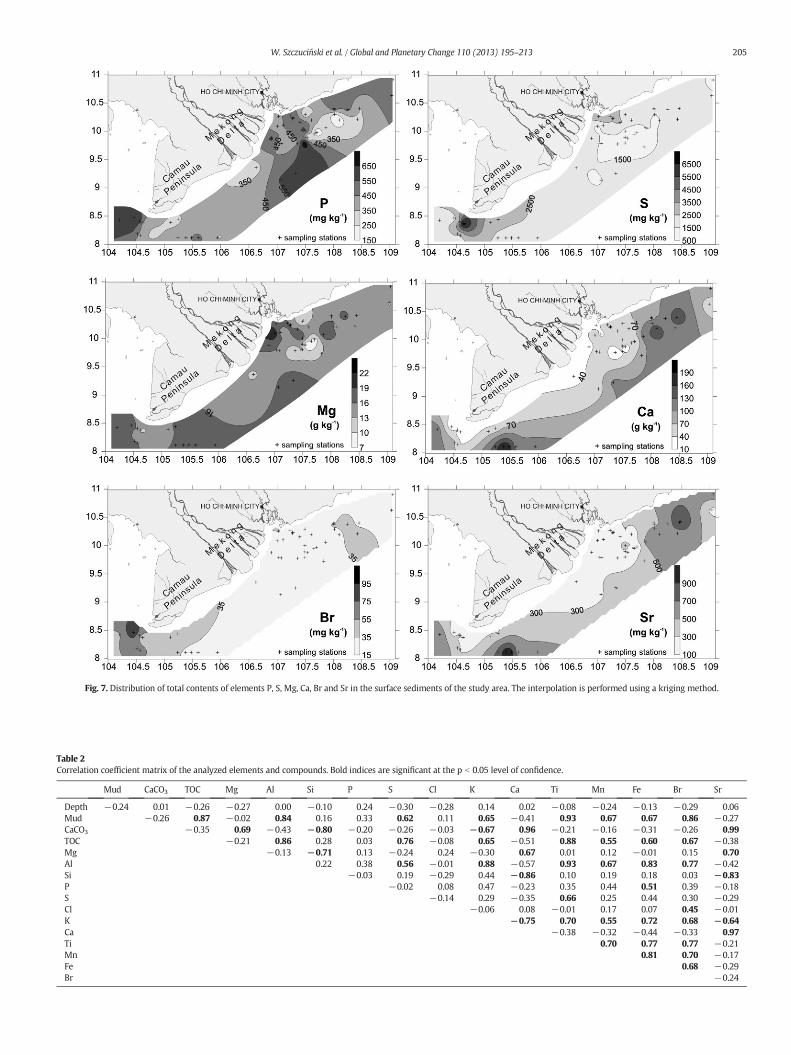
Fig. 7. Distribution of total contents of elements P, S, Mg, Ca, Br and Sr in the surface sediments of the study area. The interpolation is performed using a kriging method.
Table 2Correlation coefficient matrix of the analyzed elements and compounds. Bold indices are significant at the p b 0.05 level of confidence.
Mud CaCO3 TOC Mg Al Si P S Cl K Ca Ti Mn Fe Br Sr
Depth −0.24 0.01 −0.26 −0.27 0.00 −0.10 0.24 −0.30 −0.28 0.14 0.02 −0.08 −0.24 −0.13 −0.29 0.06Mud −0.26 0.87 −0.02 0.84 0.16 0.33 0.62 0.11 0.65 −0.41 0.93 0.67 0.67 0.86 −0.27CaCO3 −0.35 0.69 −0.43 −0.80 −0.20 −0.26 −0.03 −0.67 0.96 −0.21 −0.16 −0.31 −0.26 0.99TOC −0.21 0.86 0.28 0.03 0.76 −0.08 0.65 −0.51 0.88 0.55 0.60 0.67 −0.38Mg −0.13 −0.71 0.13 −0.24 0.24 −0.30 0.67 0.01 0.12 −0.01 0.15 0.70Al 0.22 0.38 0.56 −0.01 0.88 −0.57 0.93 0.67 0.83 0.77 −0.42Si −0.03 0.19 −0.29 0.44 −0.86 0.10 0.19 0.18 0.03 −0.83P −0.02 0.08 0.47 −0.23 0.35 0.44 0.51 0.39 −0.18S −0.14 0.29 −0.35 0.66 0.25 0.44 0.30 −0.29Cl −0.06 0.08 −0.01 0.17 0.07 0.45 −0.01K −0.75 0.70 0.55 0.72 0.68 −0.64Ca −0.38 −0.32 −0.44 −0.33 0.97Ti 0.70 0.77 0.77 −0.21Mn 0.81 0.70 −0.17Fe 0.68 −0.29Br −0.24
205W. Szczuciński et al. / Global and Planetary Change 110 (2013) 195–213
206 W. Szczuciński et al. / Global and Planetary Change 110 (2013) 195–213
attached to the coast and a prodelta located further offshore (e.g.,Goodbred and Saito, 2012). Recent advances in studies on the MekongRiver delta system revealed that the subaqueous delta front progradesin two directions, directly offshore of the river mouths and in the west-ern direction around the Camau Peninsula (Fig. 1). It was found that thedelta front is up to 20 kmwide and is bound offshore by a rapid changein slope inclination. This rapid transition is also documented by achange in the prevailing sediment type, fromwell-sorted sands or poor-ly sorted silts on the delta front to medium and coarse sands with shellfragments further offshore of the delta front slope (Anikiev et al., 2004;Xue et al., 2010; Unverricht et al., 2013–this issue). However, a modernprodelta was not yet identified.
Prodeltas of large tide-influenced rivers, as reviewed by Hori andSaito (2007) and Goodbred and Saito (2012), are typically 20–50 kmwide and are often composed of bioturbated muds intercalated withshell beds. The previous study by Anikiev et al. (2004), which focusedon an area south of the Mekong River mouths (Fig. 1), showed thatmud deposits are located only in a narrow belt next to the coast in awater depth near 10 m. However, most of the shelf adjacent to thedelta is covered by sands of various compositions, and certain of themare interpreted as relict deposits. The eastern portion of the shelf waspartly studied by Kubicki (2008) who found frequent fields of sanddunes instead of typical prodelta sediments. In contrast to these previousstudies, the current study clearly reveals a large area of mud-dominatedsediments (M, gM and sM) located in the west of the delta mouthsaround the subaqueous delta front next to the Camau Peninsula (Fig. 2).These deposits are characterized by high SARs (0.1–1.5 cm yr−1), com-mon bioturbation structures and the presence of intercalated shell beds.This mud-rich area extends for at least ~30 km in the southwest andwest and most likely represents the subaqueous prodelta of the MekongRiver delta.
Moreover, a high proportion of mud was also found in those shelfsediments (mS and gmS), which cover wide areas of the shelf in thesouthernmost offshore region as well as in the northeast (Fig. 2). To de-termine if these materials are derived from the modern Mekong River,their claymineralogy and bulk geochemistrywere studied. Claymineralassemblages inmarine sediments are often used as a tracerwith respectto their source and the weathering conditions on the surrounding con-tinents (e.g., Gingele et al., 2001; Liu et al., 2003; Steinke et al., 2008).However, the applications of clay minerals involve several limitationsof which the major one is that most of the reported results are of asemi-quantitative nature and are largely affected by differences inpreparation procedures and the interpretative approach of the resultingX-ray diffractograms (Thiry, 2000). Because of these issues, it is oftendifficult to compare quantitative results from different studies, andonly relative trends should be considered.
Illite is the dominant clay mineral in the current study as well asin the previous studies from the Mekong River delta and from thesouthwestern South China Sea shelf region (Aoki, 1976; Chen, 1978;Jagodziński, 2005; Liu et al., 2007; Xue et al., in press). Illite is consid-ered as a primary mineral that reflects the increased rock weatheringunder cold and arid climatic conditions. In the studied case, illitecould be derived from physical erosion of metamorphic and graniticrocks mostly located at high elevation in eastern Tibet (Liu et al.,2007).
The presented spatial distribution of clay minerals (Fig. 4) shows amajor trend with the increasing distance from the Mekong Rivermouths reflected by a decrease in illite and chlorite on account of smec-tite. A similar trend of westward increasing content of smectite was re-ported by Xue et al. (in press) in short sediment cores taken from thesubaqueous delta sediments. According to this group, this trend impliesa reduced fine sediment input from the Mekong River on account ofcertain other unspecified sediment source. However, considering thelarge volume of fine-grained sediments accumulating at rates of atleast several cmper year, it is unlikely that the sediments fromother un-known sourceswould contribute significantly in the areas of the highest
accumulation rate. The trend of an increasing content of smectite in theoffshore direction is documented on several continental shelves adja-cent to large rivers, i.e., the Niger (Porrenga, 1966, 1967) and Amazon(Patchineelam and de Figueiredo, 2000), and is also described for conti-nental margin settings (Thiry, 2000). These trends were explained bydifferential settling of smectite versus other clay minerals. Althoughthe processes and governing factors behind this observation are stillunder discussion (Thiry, 2000), smectites are generally believed to floc-culate preferentially in more saline waters, and thus they settle downfarther offshore than other clay minerals. It is likely that the same pro-cess applies for the current case as well.
The northeastern portion of the studied area is characterized by thehighest contents of kaolinite and chlorite and the lowest contents ofillite, whereas the illite and chlorite contents correlate well with eachother in most other portions of the studied shelf (Fig. 4). These relativechanges suggest that clay size fraction sediments in the northern por-tion of the shelf may be at least partly contributed from another source,i.e., from the small mountainous rivers entering the sea just to the eastand northeast of the Mekong River delta (e.g., Saigon River). The totalcontribution from these minor but numerous river sources is likely rel-atively small because the clay fraction in these sediments sums to only afewpercent. In addition, shallow seismic studies indicated that nomajormodern sediment accumulation body is present in this area (Kubicki,2008; Tjallingii et al., 2010).
The bulk geochemistry analysis reveals distinct spatial variations ofthe particular elements, which were found to correlate primarily withsuch major sediment properties as grain size and carbonate content.To reveal the spatial variations between the geochemical compositionsof particular samples, a statistical cluster analysis was performed(Fig. 8) and the results show three distinct groups of samples thatrefer to geographically separated regions in Zones referred to as A to C(Fig. 9; Table 3).
Zone A covers the shallowest portion of the study area with waterdepths no deeper than 32 m. This zone is primarily composed of sam-ples from sites around the Camau Peninsula and next to the MekongRivermouths. The dominant sediment types are sandymud and gravel-lymuddy sand (M, gM,mS, S, sM and gmS). The SARs are relatively high,reaching up to 1.5 cm yr−1. The major properties of sediments fromZone A are a high mud content (over 50%, on average) and the highestcontent of TOC. Moreover, these sediments are characterized by thehighest concentrations of Al, Ti, Fe, S and Br. The content of carbonatesis higher than in Zone B but much lower than in Zone C.
Zone B represents transitional settings in terms of water depth(32 m on average) comparedwith the other two zones and is dominat-ed by sandy deposits (S,mS and gS)with an average sand content great-er than 90% and a low carbonate content. The highest concentrations ofSi are noted in this zone as well as the lowest contents of carbonate,TOC, Al, Ti, Sr and Br.
The samples located the furthest offshore are those from a group inZone C characterized by poorly sorted muddy sands (mS and gmS).These deposits are rich in carbonate shells and the highest contents ofcarbonate, Ca and Sr are accompanied by the lowest contents in Si andP. The samples from the western portion of this zone show the highestcontents of carbonate, whereas those from the eastern portion are char-acterized by higher Si and Fe contents.
Themud-dominated, organic-rich, high-accumulation ZoneA repre-sents the Mekong River prodelta. Zone B, located southward from theriver mouths and dominated by terrigenous sands, covers the area inwhich bedload-transported material from the Mekong River is highlyimportant. The most distantly located offshore Zone C is dominated bymuddy sand with a strong contribution of biogenic carbonates. Becausethe clay mineral contents are similar in all zones, it is likely that Zone Creceives a minor contribution of fine-grained sediments, possibly fromthe Mekong River in its western part. In the eastern section, the finestsediments may originate from the Mekong and in the northeasternpart as well as from selected other sources.

Fig. 8. Results of cluster analyses of surface sediments based on their chemical compositions. A smallWard's distance indicates that the assemblages are similar. Regions A, B and C refer tothe sample clusters discussed in the text.
207W. Szczuciński et al. / Global and Planetary Change 110 (2013) 195–213
5.2. Modern sedimentary processes
The presented data on sedimentary properties and accumulationrates also provide insight into the depositional processes that dominatein the muddy prodelta (Zone A), on the inner shelf covered by terrige-nous sands (Zone B), and offshore shelf zone dominated by muddy car-bonate sands (Zone C).
5.2.1. The prodelta (Zone A)The mud-dominated sediments (M, gM and sM) of the prodelta lo-
cated southwest from the Camau Peninsula (Fig. 9) are characterizedby high accumulation rates of a few mm to ~1.5 cm per year. Theserates fall within the range of values reported for prodeltas of otherlarge rivers such as the Ganges–Brahmaputra, Changjiang or Amazon(e.g., McKee et al., 1983; Kuehl et al., 1985; Michels et al., 1998). In ad-dition, erosional contacts are common in the succession of these de-posits, which suggest that the short-term (e.g., seasonal) depositionrate often may be much higher than the 210Pb-derived 100-year time-scale averages reported, e.g., for the Changjiang prodelta by McKeeet al. (1983).
The changing depositional conditions are reflected in the sedimenttypes and structures. The prodelta deposits consist of laminated mud,bioturbated mud, and carbonate-dominated sand and gravel intercala-tions and/or burrow infills. The laminated deposits and coarse-grainedsediments were likely formed during rapid depositional events, where-as in general the bioturbatedmud-dominated sediments reflect periodsof lower accumulation rate (see Section 4.2).
The rapid depositional events are most likely related to redepositionfrom the subaqueous delta front, which is strongly affected bywaves andtides. Unverricht et al. (in press) reported that even during inter-monsoon seasons and neap-tide conditions when the tidal currents,wind waves and wind-generated currents are weakest, resuspension ofthe delta front sediments is common. During spring-tide conditionsand a fully developed monsoonal wind and current regime, theresuspension is expected to be much more intense. Several possiblemodes of sediment redeposition exist, including winnowing due tohigh waves during typhoons, tidal currents or seaward flow of fluid
mud at the sediment/water interface (e.g., Wright and Friedrichs, 2006;Nittrouer et al., 2007). The presence of mud and sand/gravel layers sug-gests event transport under conditions of suspended sediment-rich orsuspended sediment-poor conditions and in various transport directions.Themud is likely transported primarily in the offshore direction from thesubaqueous delta front, whereas the carbonate-rich coarse-grained sed-iments result from an onshore-directed transport from the outer shelf(Zone C), e.g., during tropical storms.
In certain cases, the only evidence of temporary emplaced coarse-grained layers is the preserved sediment infill in burrows; their pres-ence suggests that the prodelta area is occasionally affected by condi-tions leading to the erosion of coarse-grained sediments.
5.2.2. The sandy inner shelf (Zone B)The inner shelf located eastward of the muddy subaqueous prodelta
and offshore of the subaqueous delta front is dominated by moderatelysorted sands just south of the Mekong River mouths and poorly sortedmuddy sands with an amount of carbonate sand and gravel admixturesin the eastern part of the study area. SAR assessments for these areas arenot available. However, the moderately sorted sands are likely suppliedvia Mekong River bedload transport, and therefore, the SARs must berelatively high because they contain hardly any in-situ produced car-bonate shells, which would be expected in the case of lower accumula-tion rates. The relatively good sortingmay result from either the supplyof already well-sorted fluvial sands or from an active sorting process onthe inner shelf. The latter is evident from the rippled sediment surface,internal cross-bedding and notably few burrows, implying repeatedreworking. In contrast, the poorly sorted muddy sands are richer inshell debris and the primary internal structures are often overprintedby burrows. These characteristics point to relatively low accumulationrates. Because these sediments are similar to those on the outer shelf(Zone C), where the obtained accumulation rates are up to 0.4 cm yr−1,onemay speculate that average rates of a fewmmper yearmight be pos-sible in this region.
The notably small contribution of mud fraction on the inner shelf infront of the Mekong River mouths and further southward where relictdeposits were found (Anikiev et al., 2004) suggests that the suspended

Fig. 9. Compilation of the obtained results on the sediment dispersal pattern offshore of theMekong Delta and SARs and areas used for estimation of the Mekong River-derived fine-grainedsediment budget; A) Sedimentary zones (A, B and C) obtainedwith cluster analysis (Fig. 8) andmarked on the study area (see Fig. 1 for explanations). SARs are compiled from 210Pb and 137Csdating on the subaqueous delta (Xue et al., 2010, in press; Unverricht et al., 2013–this issue) and from offshore areas (current study). RA— indicates “rapid accumulation” or “non-steady ac-cumulation” (with excess 210Pb present throughout the sediment cores) inworks by Xue et al. (2010, in press). Areas coveredwith subaqueous sand dunes (Kubicki, 2008) and relict deposits(Anikiev et al., 2004) aremarked for comparison; B) Areas selected for thefine-grainedMekong-derived sediment budget: DP— delta plain, SDP—mud-dominated portion of the subaqueousdelta platform (after Unverricht et al., 2013–this issue), SDS—mud-dominated portion of the subaqueous delta slope (after Unverricht et al., 2013–this issue), ZA—mud rich parts of zone A(prodelta) and ZC — zone C. The maximum extent of river flooded area is based on major floods in 1998 and 2000 as reported by Haruyama (2011) and Sakamoto et al. (2007).
208 W. Szczuciński et al. / Global and Planetary Change 110 (2013) 195–213
Table 3Comparison of characteristics and surface sediment compositions in the Zones A, B and Cas defined by the cluster analysis (Figs. 8 and 9). Numerical values are presented asmeans,and minimum and maximum values are provided in brackets. Sediment types: gmS —
gravelly muddy sand, sM — sandy Mud, S — sand, mS — muddy sand.
Unit Zone A Zone B Zone C
Water depth m 28.1(23–32)
32.3(18–109)
44.4(32–112)
Sediment accumulation rates cm yr−1 0.1–1.5 Low 0–0.4Dominating sediment types – gmS, sM S, mS mS, gmSN0.063 mm fraction % 46.2
(1.7–95.8)91.1(40.1–99.7)
79.4(41.6–98.4)
Smectite % 19.3(5–36)
19.6(6–33)
20(4–34)
Illite % 48.8(42–63)
46.8(36–60)
46(34–60)
Carbonates % 18.9(3–64)
10.6(3–36)
28.9(4–81)
TOC % 0.5(0.06–0.94)
0.14(0.02–0.71)
0.2(0.06–0.46)
Al g kg−1 82.6(68–97)
30.1(5–62)
41(25–58)
Si g kg−1 223.1(195–265)
259.3(173–362)
178(173–223)
Ti g kg−1 4.6(4–5.7)
1.8(0.7–3.4)
2.5(1.6–3.2)
Fe g kg−1 43.5(33–71)
20.4(9–47)
20.7(15–31)
Ca g kg−1 49.2(8–119)
53.6(14–108)
122.8(46–194)
P mg kg−1 466(337–620)
446(134–768)
406(186–595)
S mg kg−1 3298(2138–7310)
1757(858–3283)
1961(1484–2422)
Br mg kg−1 56.4(36–95)
23.8(17–35)
33(27–47)
Sr mg kg−1 318.6(115–677)
259.8(72–634)
630.4(505–1044)
209W. Szczuciński et al. / Global and Planetary Change 110 (2013) 195–213
load must be effectively transported mainly in the southwest directiontoward the prodelta. An additional westward transport of sands isevidenced from a grain-size fining trend in the sediments and fromimproved sand sorting in this direction in the shallow area next to theMekongRivermouths.Moreover, in the eastern portion of the sand cov-ered area Kubicki (2008) documented frequent presence of asymmetri-cal sand dunes. Their orientation corresponds to the direction of thewestward current induced by the regional winter-monsoon winds (toSW and S). The large size of the dunes (length up to N600 m and heightup to N10 m) together with theoretical calculations suggest that thenear-bottom current velocity must be at least 1 m s−1 during thewinter-monsoon season (Kubicki, 2008).
During the summer monsoon, when winds are directed toward theNE, certain fine-grainedMekong-derived sediments are likely depositedin the area composed of muddy sand. The clay mineral composition ofmost of the samples is similar to that of muds deposited in the prodeltanext to the Camau Peninsula. However, the mud is usually only pre-served in lenses and seldom as layers, and often, the only record of tem-porary mud deposition is preserved in the form of muddy infill ofburrows. These remnants of mud deposition show that a suspended-sediment transport toward the east (documented also by in-situ mea-surements (Anikiev et al., 1986)) leads to temporary mud deposition.However, this mud may become remobilized and transported in thewestward direction during the next winter monsoon season by thesame currents, which generates the subaqueous sand-dune migration.
In sand-dominated areas, intact snail shells (turritellids) appear inlarge abundance on or just beneath the sediment surface. Their pres-ence represents the only in-situ shell remnants that are locally commonand are not significantly reworked. Mud deposition is often low to ab-sent at those sites with high turritellids abundance. These turritellids
are known to occur in areas in which primary production is enhancedby river-dissolved loads.
5.2.3. The muddy carbonate sands on the outer shelf (Zone C)The outer shelf sediments are dominated by a coarse-grained car-
bonate fraction. The SARs in the western portion of the study area areon the order of 0.3–0.4 cm yr−1. The clay-mineral composition suggeststhat the fine-grained fraction originates from the Mekong River. Thecoarse-grained fraction is composed mainly of reworked shells. Theirpresence suggests that bedload transport is sufficiently strong in thisarea to cause reworking of this material, which is in accordance withthe formation of subaqueous sand dunes in the eastern portion of theouter shelf (Kubicki, 2008). The sediments are bioturbated, and primarystructures are not preserved except for occasional erosional contacts,which likely formed during tropical storm events, which pass this re-gion at least once every few years (UNISYS, 2013).
5.3. Modern sediment budget of fine-grained sediments delivered by theMekong River
The present study of the adjacent shelf sedimentary system in con-cert with a number of recent studies quantifying sediment accumula-tion in various parts of the system (i.e., Tonle Sap Lake, Mekong DeltaPlain, subaqueous delta; Kummu et al., 2008; Xue et al., 2010, in press;Hung et al., in press-a; Unverricht et al., 2013–this issue) allows for cal-culating a first-order modern (past 100 years) sediment budget for thefine-grained sediments supplied by the Mekong River (Table 4). Riverstransport sediments as suspended load and bedload. Commonly, thesuspended load is measured with some accuracy, while the estimateof the bedload transport is difficult and virtually unknown for thelarge rivers (Milliman and Syvitski, 1992). Thus, although the bedloadtransport of coarser material to the ocean must be assumed to play animportant role, the present calculation focuses on the fine-grained ma-terial (mud) only, which dominates suspended load in the Mekong.According toWolanski et al. (1996), the suspended sediments are com-posed of clayey silt (mean 2.5 to 3.9 μm) in the lower Mekong distribu-taries. It is in agreement with data from Phnom Penh — some 340 kmupstream from the river mouth (Gagliano and McIntire, 1968) andwith grain size (median 10 to 15 μm) of sediments collected in sedi-ment traps during Mekong River floods (Hung et al., in press-a).
Data on the suspended sediment discharge of the Mekong River arenot available for the river mouth region and thus, the existing assess-ments are mainly based on the data from Pakse (~800 km upstream).Milliman and Syvitski (1992) and Roberts (2001) estimated thetotal annual sediment load of the lower Mekong River to be160 × 109 kg yr−1 or 150–170 × 109 kg yr−1, respectively. However,the discharge fluctuates by several tens of 109 kg yr−1 on an inter-annual scale (Lu and Siew, 2006) and the estimates are also affectedby the measuring technique, which is based on monthly sampling ofsuspended load just below water surface (Kummu and Varis, 2007)and recent changes due to dam constructions (Kummu et al., 2010;Wang et al., 2011). Moreover, the sediment load may increase even by10% between the measuring station and the river mouth due to supplyfrom the lower Mekong River catchment (Kummu et al., 2010). Forthe calculation and comparisonwith existing values of sediment storagefor various parts of the Mekong River dispersal system the commonlycited value of 160 × 109 kg yr−1 (Milliman and Syvitski, 1992) isused. This sediment load is distributed over the succession of deposi-tional areas and for each of them a separated budget calculation is pro-vided in the following.
5.3.1. The Tonle Sap LakeBetween Pakse and the Mekong River delta, the river leaves about
3.7 × 10⁹ kg yr−1 of sediment in the Tonle Sap Lake in southernCambodia (Fig. 1B), which thus acts as a sediment trap (Kummu et al.,2008). This lake is connected to the Mekong River through the 120-
210 W. Szczuciński et al. / Global and Planetary Change 110 (2013) 195–213
km long Tonle Sap River. During the rainy season betweenMay and Oc-tober the water level in the Mekong River is so high that the water flowdirection between the lake and river is reversed allowingMekong Riverwaters to enter the Tonle Sap Lake and leading to an up to fivefold in-crease of the lake area (Puy et al., 1999). SARs of mud in the lake arelower than 0.1 cm yr−1 on average (Penny et al., 2005). According tomodeling by Kummu et al. (2008) about 80% of the lake sediments orig-inate from the Mekong River and total annual mass of sediments left inthe Tonle Sap Lake system is estimated to be approximately 2.3% of thetotal Mekong River sediment load.
5.3.2. The delta plainSediment accumulation on the delta plain is related to seasonal
floods which lead to inundation of two regions on its northern part:the Long Xuyen Quadrangle in the northwest and the Plain of Reeds inthe northeast, covering areas of 5000 and 8000 km2, respectively(Fig. 9; e.g., Sakamoto et al., 2007; Haruyama, 2011). Hung et al. (inpress-a) monitored floodplain sediment deposition rates for three suc-cessive years in their study area extending for about 20 km from themain river channel and considered to be representative for these re-gions. They observed annual accumulation rates in the range between0.3 and 20 kg m−2 with an average of 6.8 kg m−2. These depositionalrates are expected to decrease with distance to the Mekong River chan-nels in accordance with observed decrease in suspended sediment con-centrations in flooding waters (Hung et al., in press-b). However, sinceno data exist on the spatial variability of SARs farther from the river inthe Long Xuyen Quadrangle and the Plain of Reeds the present calcula-tion assumes arbitrarily that the accumulation is mainly focused in ap-proximately up to 25 km wide belts adjacent to the main riverchannels (DP in Fig. 9), which overlap with the deep flood inundationarea (Haruyama, 2011) and sums up to approximately 6500 km2. Thecalculated annual sediment storage on the delta plain using the averageannual sediment accumulation of 6.8 kg m−2 plain accounts for morethan one forth of annual fluvial suspended load (Table 4).
5.3.3. The subaqueous delta platformThe subaqueous delta front comprising platform (SDP) and slope
(SDS) is composed mainly of sand next to the river mouths andof mud-dominated sediments in the distal part around the CamauPeninsula (Unverricht et al., 2013–this issue). As the sediment budget cal-culation focuses on fine-grained sediments, only the western part of thesubaqueous delta is taken into account (Fig. 9). The subaqueous deltaplatform sediments contain at least 60% of mud on average (Unverrichtet al., 2013–this issue). SARs on the delta platform are not wellconstrained. The rate of Camau Peninsula progradation (26 m yr−1) aswell as available seismic reflection data (Xue et al., 2010; Unverricht,unpublished data) suggest that the delta platform is an activedepocenter. The SAR of 0.5 cm yr−1 is assumed here for calculations.The bulk density of the sediments of the subaqueous delta as well as ofthe continental shelf deposits is applied from the relation of grain-size
Table 4Modern fine-grained sediment budget for the Mekong River sediments. See text (Section 5.3)marked in Fig. 9 (for DP, SD, ZA and ZC). Mud fraction is expressed as 0 (0%) to 1 (100%). Tomass accumulation rate, area and mud fraction. The percent of the total river sediment dischthe sediment masses in the accumulation regions is over 100%. Data sources: 1) Milliman a5) Hung et al. (in press-a), 6) Xue et al. (2010), 7) Xue et al. (in press), 8) Unverricht et al. (20
Accumulation region Average mass accumulati(kg m−2)
Mekong River Discharge (RD) –
Tonle Sap Lake (TS) 0.9Mekong Delta Plain (DP) 6.8Subaqueous Mekong Delta Platform (SDP) 5.5Subaqueous Mekong Delta Slope (SDS) 50Continental shelf adjacent to the delta (prodelta) — Zone A (ZA) 6.5Continental shelf adjacent to the delta (offshore) — Zone C (ZC) 4.5Total
to density in comparable environments (for instance by Shi et al.,2003) confirmed by few own assessments based on sediment coresamples taken from known sediment volume and weight. Applying adry bulk density of 1 kg m3 and the area of 2500 km2 the annual massof stored fine-grained sediments is about 7.5 × 10⁹ kg (Table 4).
5.3.4. The subaqueous delta slopeThe highest SARs in theMekong River delta system are documented
for eleven sediment cores using 210Pb and 137Cs (Fig. 9) (Xue et al., 2010,in press; Unverricht et al., 2013–this issue) in the subaqueous deltaslope region. The reported values range between N2.5 cm yr−1 andN10 cm yr−1 (Fig. 9). In many cores it was possible only to assess thatthe accumulation is rapid (excess 210Pb was present throughout thecores) and to estimate minimum SARs. For the calculations a value of5 cm yr−1 was arbitrarily taken as an average SAR. The average mudcontent is 70%, although it is important to underline that the sedimentcomposition is rather heterogeneous (Unverricht et al., 2013–thisissue). Applying a dry bulk density of 1 kg m3 and the area of 2800 km2
the annual mass of fine-grained sediments is about 98 × 109 kg, whichis more than a half of the total river suspended load (Table 4).
5.3.5. The subaqueous prodeltaThe next environment included in the budget calculation is part of
the Zone A dominated by mud and sandy mud (Fig. 2), interpreted asthe prodelta (Fig. 9). The modern SAR is estimated to be 0.5 cm yr−1
using the dating results from three cores of the present study and onefrom Xue et al. (2010). The dry bulk density was assumed to be1.2 kg m3 and the calculated annual mass of mud fraction depositedin this area is 41.3 × 10⁹ kg, which is approximately one fourth oftotal river sediment discharge (Table 4).
5.3.6. The open shelfThe open-shelf area (Zone C) is dominated by sands. Only the part
surrounding the subaqueous prodelta off the Camau Peninsula whichis covered with muddy sand is considered here as a sink for MekongRiver fine-grained sediments (Fig. 9). The SAR based on the presentedresults (two cores) is assessed to be 0.3 cm yr−1. The bulk densitywas assumed to be 1.5 kg m3 and the calculated amount of annually ac-cumulatingmud is 6.3 × 10⁹ kgwhich is approximately 4% of total riversediment discharge (Table 4).
5.3.7. Limitations and implications of the sediment budgetThe calculated budget reveals that probably the subaqueous delta
front (platform and slope) sequestrates about 50% of the suppliedfine-grained sediments with roughly 25% of sediment stored on the ter-restrial part of the delta (including the Tonle Sap Lake) and on the shelfaround the Camau Peninsula (mainly within prodelta deposits), respec-tively. This first order sediment budget estimate for the modern fine-grained material has to consider many assumptions. The total mass ofsediments stored annually in the various depocenters of the onshore-
for a discussion and explanations and Fig. 9B for location. Areas used for calculations aretal sediment mass accumulated in particular regions is calculated by multiplying averagearge is calculated by dividing the total mass by 160 × 109 kg yr−1. Note that the sum ofnd Syvitski (1992), 2) Roberts (2001), 3) Penny et al. (2005), 4) Kummu et al. (2008),13–this issue), 9) current paper.
on rate Area(km2)
Mud fraction Total mass(109 kg yr−1)
% of river discharge(160 × 109 kg yr−1)
Data source
– 1 150–170 − 1, 210,000 1 3.7 2.3% 3, 46500 1 44.2 27.6% 52500 0.6 7.5 4.7% 6, 7, 82800 0.7 98 61.3% 6, 7, 812,500 0.55 41.3 25.8% 97000 0.2 6.3 3.9% 9
125.6%

211W. Szczuciński et al. / Global and Planetary Change 110 (2013) 195–213
offshore deltaic system (~200 × 109 kg yr−1) is by approximately 25%greater than the average annual sediment discharge from the river(Table 4). The largest uncertainty in this budget calculation is relatedto the area of deposition on the delta plain and in the prodelta andwith SARs on subaqueous delta. For instance, assuming the averageSAR on the subaqueous delta slope to be more or less by 1 cm yr−1,what is not unlikely, would result in the change of the calculated sedi-ment storage bymore than 10% of the annual river sediment discharge.The existing data, however, does not allow assessing the uncertainty.Moreover, the calculations of the sediment budget did not includesome areas, where potentially some minor amounts of Mekong-Riverderived fine-grained sediments may be stored (delta front in front ofthe river mouths, shelf area of Zone B).
A previous Late Holocene sediment budget estimate for theMekongRiver delta by Ta et al. (2002b) and Xue et al. (2010) based on deltaicsediment thickness and progradation rate during the past 3000 yrcame up with a conclusion that ~80% of the sediments delivered bytheMekong River is stored in prograding delta. However, these estima-tions do include storage on lower delta plain, subaqueous delta andprodelta, as all of these sedimentary facieswere documented in the sed-iment cores used for the assessment of the sediment thickness (Ta et al.,2002a,b). These estimates did not include the sediment accumulationon flood plains in the northern part of the delta and on Plain of Reedsassessed to be approximately 1 to 6.7 m ka−1 (Tamura et al., 2009)and 0.1 to 0.3 m ka−1 (Hanebuth et al., 2012), respectively.
Both,modern and Late Holocene sediment budget calculations showthat likely almost all of the fine-grained sediments transported by theMekong River system are sequestrated either in the deltaic system itselfor on the adjacent continental shelf, mainly westward from themodernMekong River mouths. Consequently, the sediment export toward thedeep South China Sea is probably negligible and other sources of terrig-enous sediments should be also considered while interpreting deep seasedimentary record for Late Holocene but probably also for all the sealevel highstand intervals. For instance, minor short rivers draining themountains of central Vietnam deliver annually up to 40 × 109 kg yr−1
of sediments to the ocean (Thanh et al., 2004) and large part of this ma-terial is probably transferred across the narrow Vietnamese continentalshelf into the open ocean as discussed by Schimanski and Stattegger(2005) and Szczuciński et al. (2009).
6. Conclusions
The current study shows that well-developedmud-rich prodelta ex-tendswestward next to the subaqueous delta front of the Camau Penin-sula and is detached from the delta front off of the Mekong Rivermouths. The combination of sedimentological, mineralogical and geo-chemical investigations allowed us to distinguish three major zonesdominated by muddy deposits (prodelta), terrigenous sands (innershelf) and carbonate sands and gravels (outer shelf). The clay-mineralcomposition suggests that the fine-grained portion of these sedimentsis primarily derived from the Mekong River, except in the northeasternregion where local sources seem to contribute as well. Sediments ineach of these zones are subject to redeposition processes likely relatedto episodic tropical storm events and are affected in shallower partsby tides, monsoonal wind waves and coastal currents. A simple sedi-ment budget calculation reveals that the subaqueous delta front storesabout 50% of fine-grained sediments supplied by the Mekong River.Roughly 25% of the sediments are retained in the subaerial part of thedelta and another 25% accumulate on the shelf around the Camau Pen-insula mainly in the form of prodelta deposits. These results contradictassumptions of a significant export of fine-grained sediments into thedeep South China Sea basin.
Although the current study provides basic contributions to the un-derstanding of the Mekong River offshore sediment dispersal system,several questions remain open for future studies. For instance, thethree defined zones (A, B, C) exhibit open boundaries, and the extent
to which the Mekong River subaqueous prodelta is extending to thefar west is particularly intriguing. The sedimentary structures and210Pb activity profiles reveal complex sedimentary processes withevent deposition and frequent erosion and redeposition. However, abetter understanding of the driving processes behind this process, andparticularly of the local hydrodynamics that include in-situ measure-ments, is required to assess the importance of particular processes. Fi-nally, the sediment budget for the Mekong River depositional systempresented here is a first-order approximation and does not include thebed-load transport component, which is certainly an important part ofthe total river discharge.
Acknowledgments
Funds for this study were provided by the Polish National Commit-tee on Scientific Research (KBN) grant no. 6 PO4D 051 30, the GermanFederal Ministry of Education and Research (BMBF) grant nos.03G0140A and B and DFG project Land–Ocean–Atmosphere Interactionsin the Coastal Zone of Vietnam (grant no. STA401/10). Andreas Wetzelwas supported by the Swiss National Science Foundation (grant nos.200021-112128 and 200020_140217/1). We would like to thankRadosław Jagodziński and Michał Kubiak for their help in analyticalwork and to all cruise participants for onboard collaboration. We alsothank the two anonymous reviewers for their constructive comments.
Appendix A. Supplementary data
Supplementary data associated with this article can be found in theonline version, at http://dx.doi.org/10.1016/j.gloplacha.2013.08.019.These data include Google maps of the most important areas describedin this article.
References
Anikiev, V.V., Zaytsev, O.V., Hieu, T.T., Savil'yeva, I.I., Starodubtsev, Y.G., Shumilin, Y.N.,1986. Variation in the space–time distribution of suspended matter in the coastalzone of the Mekong River. Okeanologiya 26, 259–266.
Anikiev, V.V., Botsul, A.I., Dudarev, O.V., Kolesov, G.M., Sapozhnikov, D.Yu., Shumilin, E.N.,2001. Distribution, fractionation and fluxes of the rare-earth elements in thesuspended matter-bottom sediment system in the Mekong and Saigon river estuar-ies, South China Sea. Geochem. Int. 39, 897–907.
Anikiev, V.V., Shumilin, E.N., Dudarev, O.V., Botsul, A.I., Zakharova, P.V., Kolesov, G.M.,Sapozhnikov, D.Y., Smith, R., 2004. Spatial variability in distribution of lithologicalcharacteristics and chemical elements in the bottom sediments of the South ChinaSea near Mekong and Saigon River deltas. Geochem. Int. 42, 1154–1171.
Aoki, S., 1976. Claymineral distribution in sediments of the Gulf of Thailand and the SouthChina Sea. J. Oceanogr. Soc. Jpn. 32, 169–174.
Astakhov, A.S., Markov, Yu.L., Ching, T.H., 1989. Influence of Mekong River on late Quater-nary sedimentation in South China sea. [in Russian] Litol. Pol. Iskop. 3, 112–127.
Biscaye, P.E., 1965. Mineralogy and sedimentation of recent deep-sea clay in the AtlanticOcean and adjacent seas and oceans. Geol. Soc. Am. Bull. 76, 803–832.
Bui, V.D., Schimanski, A., Stattegger, K., Phung, V.P., Nguyen, T.T., Nguyen, T.H., Nguyen,T.T., Phi, T.T., 2009. Sandwaves on the Southeast Vietnam Shelf recorded by high res-olution seismic profiles: formation and mechanism. Front. Earth Sci. China 3, 9–20.
Cenci, R.M., Martin, J.M., 2004. Concentration and fate of trace metals in Mekong RiverDelta. Sci. Total. Environ. 332, 167–182.
Chen, P.Y., 1978. Minerals in bottom sediments of the South China Sea. Geol. Soc. Am. Bull.89, 211–222.
Cohen, S., Kettner, A.J., Syvitski, J.P.M., Fekete, B.M., 2013. WBMsed, a distributed global-scale riverine sediment flux model: model description and validation. Comput.Geosci. 53, 80–93.
Coleman, J.M., Roberts, H.H., 1989. Deltaic coastal wetlands. Geol. Mijnb. 68, 1–24.Conley, D.J., 1997. Riverine contribution of biogenic silica to the oceanic silica budget.
Limnol. Oceanogr. 42, 774–777.Emery, K.O., 1968. Relict sediments on continental shelves of world. Am. Assoc. Pet. Geol.
Bull. 74, 541–554.Emery, K.O., Nino, H., 1963. Sediments of the Gulf of Thailand and adjacent continental
shelf. Geol. Soc. Am. Bull. 74, 541–554.Fang, G., Kwok, Y.-K., Yu, K., Zhu, Y., 1999. Numerical simulation of principal tidal constit-
uents in the South China Sea, Gulf of Tonkin and Gulf of Thailand. Cont. Shelf Res. 19,845–869.
Folk, R.L., 1954. The distinction between grain size and mineral composition in sedimen-tary rock nomenclature. J. Geol. 62, 344–359.
Fu, S., Zhu, Z., Ouyang, T., Qiu, Y., Wei, Z., 2011. Geochemical changes of the terrigenoussediments in the southern South China Sea and their paleoenvironmental implica-tions during the last 31 ky. J. Oceanogr. 67, 337–346.
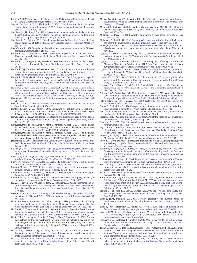
212 W. Szczuciński et al. / Global and Planetary Change 110 (2013) 195–213
Gagliano, S.M., McIntire,W.G., 1968. Reports on theMekong River Delta. Technical Report,57. Coastal Studies Institute, Louisiana State University, p. 144.
Gingele, F.X., Deckker, P.D., Hillenbrand, C.D., 2001. Clay mineral distribution in surfacesediments between Indonesia and NW Australia: source and transport by currentoceans. Mar. Geol. 179, 135–146.
Goodbred Jr., S.L., Kuehl, S.A., 1999. Holocene and modern sediment budgets for theGanges–Brahmaputra river system: evidence for highstand dispersal to flood-plain,shelf, and deep-sea depocenters. Geology 27, 559–562.
Goodbred Jr., S.L., Saito, Y., 2012. Tide-dominated deltas. In: Davis, R.A., Dalrymple, R.W.(Eds.), Principles of Tidal Sedimentology. Springer Science + Business Media B.V,pp. 129–149.
Govindaraju, K., 1994. Compilation of working values and sample description for 383 geo-standards. Geostand. Newslett. 18, 1–158.
Hanebuth, T.J.J., Stattegger, K., 2004. Depositional sequences on a late Pleistocene–Holocene tropical siliciclastic shelf (Sunda Shelf, southeast Asia). J. Asian Earth Sci.23, 113–126.
Hanebuth, T., Stattegger, K., Bojanowski, A., 2009. Termination of the Last Glacial Maxi-mum sea-level lowstand: the Sunda-Shelf data revisited. Glob. Planet. Change 66,76–84.
Hanebuth, T.J.J., Voris, H.K., Yokoyama, Y., Saito, Y., Okuno, J., 2011. Formation and fate ofsedimentary depocentres on Southeast Asia's Sunda Shelf over the past sea-levelcycle and biogeographic implications. Earth Sci. Rev. 104, 92–110.
Hanebuth, T.J.J., Proske, U., Saito, Y., Nguyen, V.L., Tac, T.K.O., 2012. Early growth stage of alarge delta — transformation from estuarine-platform to deltaic-progradational con-ditions (the northeastern Mekong River Delta, Vietnam). Sediment. Geol. 261–262,108–119.
Haruyama, S., 2011. Land use and fluvial geomorphology of the lower Mekong delta inVietnamese territories— lesson from local knowledge of the landuse for future regionalplanning based on geomorphologic features. In: Haruyama, S. (Ed.), Human andNatural Environmental Impact for the Mekong River, TERRAPUB, Tokyo, pp. 167–195.
Hay, W.W., 1998. Detrital sediment fluxes from continents to oceans. Chem. Geol. 145,287–323.
Hieu, T.T., 1998. The bottom sediments in the south-west marine region of Vietnam.Contrib. Mar. Geol. Geophys. 4, 156–163.
Hordoir, R., Nguyen, K.D., Polcher, J., 2006. Simulating tropical river plumes, a set of pa-rametrizations based on macroscale data: a test case in the Mekong Delta region.J. Geophys. Res. 111, C09036. http://dx.doi.org/10.1029/2005JC003392.
Hori, K., Saito, Y., 2007. Classification, architecture, and evolution of large-river deltas. In:Gupta, A. (Ed.), Large Rivers: Geomorphology and Management. John Wiley & SonsLtd., pp. 75–96.
Hung, N.N., Delgado, J.M., Günter, A., Merz, B., Bárdossy, A., Apel, H., 2013. Sedimentationin the floodplains of the Mekong Delta, Vietnam. Part II: deposition and erosion.Hydrol. Processes. http://dx.doi.org/10.1002/hyp.9855 (in press).
Hung, N.N., Delgado, J.M., Günter, A., Merz, B., Bárdossy, A., Apel, H., 2013. Sedimentationin the floodplains of the Mekong Delta, Vietnam. Part I: suspended sediment dynam-ics. Hydrol. Processes. http://dx.doi.org/10.1002/hyp.9856 (in press).
Jagodziński, R., 2005. Petrography and Geochemistry of Surface Sediments from Sundaand Vietnamese Shelves (South China Sea). Adam Mickiewicz University Press,Poznań (144 pp.).
Kirchner, G., 2011. 210Pb as a tool for establishing sediment chronologies: examples of po-tentials and limitations of conventional dating models. J. Environ. Radioact. 102,490–494.
Kubicki, A., 2008. Large and very large subaqueous dunes on the continental shelf offsouthern Vietnam, South China Sea. Geo-Mar. Lett. 28, 229–238.
Kuehl, S.A., Nittrouer, C.A., DeMaster, D.J., Curtin, T.B., 1985. An overview of sedimentationon the Amazon continental shelf. Geo-Mar. Lett. 4, 207–210.
Kummu, M., Varis, O., 2007. Sediment-related impacts due to upstream reservoir trap-ping, the Lower Mekong River. Geomorphology 85, 275–293.
Kummu, M., Penny, D., Sarkkula, J., Koponen, J., 2008. Sediment—curse or blessing forTonle Sap Lake? Ambio 37, 158–163.
Kummu, M., Lu, X.X., Wang, J.J., Varis, O., 2010. Basin-wide sediment trapping efficiency ofemerging reservoirs along the Mekong. Geomorphology 119, 181–197.
Le, T.V.H., Nguyen, H.N.,Wolanski, E., Tran, T.C., Haruyama, S., 2007. The combined impacton the flooding in Vietnam's Mekong River delta of local man-made structures, sealevel rise, and dams upstream in the river catchment. Estuar. Coast. Shelf Sci. 71,110–116.
Leslie, C., Hancock, G.J., 2008. Estimating the date corresponding to the horizon of the firstdetection of 137Cs and 239 + 240Pu in sediment cores. J. Environ. Radioact. 99,483–490.
Liu, Z., Trentesaux, A., Clemens, S.C., Colin, C., Wang, P., Huang, B., Boulay, S., 2003. Claymineral assemblages in the northern South China Sea: implications for the EastAsian monsoon evolution over the past 2 million years. Mar. Geol. 201, 133–146.
Liu, Z., Colin, C., Trentesaux, A., Blamart, D., Bassinot, F., Siani, G., Sicre,M.A., 2004. Erosionalhistory of the eastern Tibetan Plateau since 190 kyr ago: clay mineralogical and geo-chemical investigations from the southwestern South China Sea.Mar. Geol. 209, 1–18.
Liu, Z., Colin, C., Huang, W., Phon Le, K., Tong, S., Chen, Z., Trentesaux, A., 2007. Climaticand tectonic controls on weathering in south China and Indochina Peninsula: claymineralogical and geochemical investigations from the Pearl, Red, and Mekongdrainage basins. Geochem. Geophys. Geosyst. 8, Q05005. http://dx.doi.org/10.1029/2006GC001490.
Liu, J.P., Xue, Z., Ross, K., Wang, H.J., Yang, Z.S., Li, A.C., Gao, S., 2009. Fate of sediments de-livered to the sea by Asian large rivers: long-distance transport and formation of re-mote alongshore clinothems. Sediment. Rec. 7, 4–9.
Lu, X.X., Siew, R.Y., 2006. Water discharge and sediment flux changes over the past de-cades in the Lower Mekong River: possible impacts of the Chinese dams. Hydrol.Earth Syst. Sci. Discuss. 10, 181–195.
McKee, B.A., Nittrouer, C.A., DeMaster, D.J., 1983. Concepts of sediment deposition andaccumulation applied to the continental shelf near the mouth of the Yangtze River.Geology 11, 631–633.
Michels, K.H., Kudrass, H.R., Hubscher, C., Suckow, A., Wiedicke, M., 1998. The submarinedelta of the Ganges–Brahmaputra: cyclone-dominated sedimentation patterns. Mar.Geol. 149, 133–154.
Milliman, J.D., Meade, R., 1983. World-wide delivery of river sediment to the oceans.J. Geol. 91, 1–21.
Milliman, J.D., Syvitski, J.P., 1992. Geomorphic\tectonic control of sediment discharge tothe ocean: the importance of small mountainous rivers. J. Geol. 100, 525–544.
Müller, G., Gastner, M., 1971. The carbonate bomb, a simple device for the determinationof carbonate content in the sediments, soils and othermaterials. N. Jahrb. Mineral. 10,466–469.
Nguyen, V.T., 1996. Characteristics of Quaternary sediments of the continental shelf in apart of southern Vietnam. (in Vietnamese with English abstract) Contrib. Mar. Geol.Geophys. 2, 200–219.
Nguyen, C.T., 2012. Processes and Factors Controlling and Affecting the Retreat ofMangrove Shorelines in South Vietnam. (PhD thesis) Kiel University, Kiel, Germany130 (http://eldiss.uni-kiel.de/macau/receive/dissertation_diss_00011050).
Nguyen, V.L., Ta, T.K.O., Tateishi, M., 2000. Late Holocene depositional environments andcoastal evolution of theMekong River Delta, Southern Vietnam. Journal of Asian EarthSciences 18, 427–439.
Nguyen, V.L., Ta, T.K.O., Saito, Y., 2010. Early Holocene initiation of theMekong River delta,Vietnam, and the response to Holocene sea-level changes detected from DT1 coreanalyses. Sediment. Geol. 230, 146–155.
Nittrouer, C.A., DeMaster, D.J., McKee, B.A., Cutshall, N.H., Larson, I.L., 1984. The effect ofsediment mixing on 210Pb accumulation rates for the Washington continental shelf.Mar. Geol. 54, 201–221.
Nittrouer, C.A., Austin, J.A., Field, M.E., Kravitz, J.H., Syvitski, J.P.M., Wiberg, P.L. (Eds.),2007. Continental Margin Sedimentation: From Sediment Transport to SequenceStratigraphy (Special Publication 37 of the IAS). Blackwell Publishing (560 p.).
Patchineelam, S.M., de Figueiredo, A.G., 2000. Preferential settling of smectite on theAmazon continental shelf. Geo-Mar. Lett. 20, 37–42.
Penny, D., Cook, G., Im, S.S., 2005. Long-term rates of sediment accumulation in the TonleSap, Cambodia: a threat to ecosystem health? J. Paleolimnol. 33, 95–103.
Petschik, R., 2000. MacDiff 4.2.5 Manual. [Online]. Available from: http://www.geologie.uni-frankfurt.de/Staff/Homepages/Petschick/RainerE.html.
Porrenga, D.H., 1966. Clay minerals in recent sediments off the Niger Delta. 14th NationalConference on, Clays and Clay Minerals, pp. 221–233.
Porrenga, D.H., 1967. Glauconite and chamosite as depth indicators in the marine envi-ronment. Mar. Geol. 5, 495–501.
Puy, L., Sovan, L., Touch, S.T., Mao, S.O., Chhouk, B., 1999. Diversity and spatial distributionof freshwater fish in Great Lake and Tonle Sap river (Cambodia, Southeast Asia).Aquat. Living Resour. 12, 379–386.
Robbins, J.A., Edgington, D.N., 1975. Determination of recent sedimentation rates in LakeMichigan using Pb-210 and Cs-137. Geochim. Cosmochim. Acta 39, 285–304.
Roberts, T., 2001. Downstream Ecological Implications of China's Lancang Hydropowerand Mekong Navigation Project. International Rivers Network (available at http://www.irn.org/programs/lancang/).
Sakamoto, T., Nguyen, N.V., Kotera, A., Ohno, H., Ishitsuka, N., Yokozawa, M., 2007.Detecting temporal changes in the extent of annual flooding within the Cambodiaand the Vietnamese Mekong Delta from MODIS time-series imagery. Remote. Sens.Environ. 109, 295–313.
Schimanski, A., Stattegger, K., 2005. Deglacial and Holocene evolution of the VietnamShelf: stratigraphy, sediments and sea-level change. Mar. Geol. 214, 365–387.
Shi, C., Zhang, D.D., You, L., 2003. Sediment budget of the Yellow River delta, China: theimportance of dry bulk density and implications to understanding of sediment dis-persal. Mar. Geol. 199, 13–25.
Smith, J.N., 2001. Why should we believe 210Pb sediment geochronologies? J. Environ.Radioact. 55, 121–123.
Sommerfield, C.K., Ogston, A.S., Mullenbach, B.L., Drake, D.E., Alexander, C.R., Nittrouer,C.A., Borgeld, J.C., Wheatcroft, R.A., Leithold, E.L., 2007. Oceanic dispersal and accumu-lation of river sediment. In: Nittrouer, C.A., Austin, J.A., Field, M.E., et al. (Eds.), Conti-nental Margin Sedimentation. International Association of Sedimentologists, SpecialPublication, 37, pp. 157–212.
Steinke, S., Hanebuth, T.J.J., Vogt, C., Stattegger, K., 2008. Sea level variations in clay min-eral composition in the southwestern South China Sea over the past 17,000 yr. Mar.Geol. 250, 199–210.
Syvitski, J.P.M., Milliman, J.D., 2007. Geology, geography, and humans battle fordominance over the delivery of fluvial sediment to the coastal ocean. J. Geol. 115,1–19.
Syvitski, J.P.M., Vörösmarty, C.J., Kettner, A.J., Green, P., 2005. Impact of humans on theflux of terrestrial sediment to the global coastal ocean. Science 308, 376–380.
Syvitski, J.P.M., Kettner, A.J., Overeem, I., Hutton, E.W.H., Hannon, M.T., Brakenridge, G.R.,Day, J., Vörösmarty, C., Saito, Y., Giosan, L., Nicholls, R.J., 2009. Sinking deltas due tohuman activities. Nat. Geosci. 2, 681–686.
Szczuciński, W., Stattegger, K., Scholten, J., 2009. Modern sediments and sediment accu-mulation rates in a monsoonal narrow shelf setting — central Vietnam, South ChinaSea. Geo-Mar. Lett. 29, 47–59.
Ta, T.K.O., Nguyen, V.L., Tateishi, M., Kobayashi, I., Saito, Y., Nakamura, T., 2002a. Sedimentfacies and Late Holocene progradation of the Mekong River Delta in Bentre Province,southern Vietnam: an example of evolution from tide-dominated to a tide- andwave-dominated delta. Sediment. Geol. 152, 313–325.
Ta, T.K.O., Nguyen, V.L., Tateishi, M., Kobayashi, I., Tanabe, S., Saito, Y., 2002b. Holocenedelta evolution and sediment discharge of the Mekong River, southern Vietnam.Quat. Sci. Rev. 21, 1807–1819.

213W. Szczuciński et al. / Global and Planetary Change 110 (2013) 195–213
Ta, T.K.O., Nguyen, V.L., Tateishi, M., Kobayashi, I., Saito, Y., 2005. Holocene delta evolutionand depositional models of the Mekong river delta, southern Vietnam. In: Giosan, L.,Bhattacharya, J.P. (Eds.), River Deltas — Concepts, Models, and Examples. SEPM Spec.Publ. no. 83, pp. 453–466.
Tamura, T., Saito, Y., Sieng, S., Ben, B., Kong, M., Sim, I., Choup, S., Akiba, F., 2009. Initiationof the Mekong River delta at 8 ka: evidence from the sedimentary succession in theCambodian lowland. Quat. Sci. Rev. 28, 327–344.
Tamura, T., Horaguchi, K., Saito, Y., Nguyen, V.L., Tateishi, M., Ta, T.K.O., Nanayama, F.,Watanabe, K., 2010. Monsoon-influenced variations in morphology and sediment ofa mesotidal beach on the Mekong River Delta coast. Geomorphology 116, 11–23.
Thanh, T.D., Saito, Y., Huy, D.V., Nguyen, V.L., Ta, T.K.O., Tateishi, M., 2004. Regimes of humanand climate impacts on coastal changes in Vietnam. Reg. Environ. Change 4, 49–62.
Thiry, M., 2000. Paleoclimatic interpretations of clay minerals in marine deposits: an out-look from the continental origin. Earth Sci. Rev. 49, 201–221.
Tjallingii, R., Stattegger, K., Wetzel, A., Van Pach, P., 2010. Infilling and flooding of theMekong River incised-valley system during deglacial sea-level rise. Quat. Sci. Rev.29, 1432–1444.
UNISYS, 2013. http://weather.unisys.com/hurricane/w_pacific/index.php.Unverricht, D., Nguyen, T.C., Heinrich, C., Szczuciński, W., Lahajnar, N., Stattegger, K., 2013.
Suspended sediment dynamics during the inter-monsoon season in the subaqueousMekong Delta and adjacent shelf, southern Vietnam. J. Asian Earth Sci. http://dx.doi.org/10.1016/j.jseaes.2012.10.008 (in press).
Unverricht, D., Szczuciński, W., Stattegger, K., Jagodziński, R., Le, X.T., Kwong, L.L.W., 2013.Modern sedimentation and morphology of the subaqueous Mekong Delta, SouthernVietnam. Glob. Planet. Change. 110, 223–235 (this issue).
Walsh, J.P., Nittrouer, C.A., 2009. Understanding fine-grained river-sediment dispersal oncontinental margins. Mar. Geol. 263, 34–45.
Wang, H., Saito, Y., Zhang, Y., Bi, N., Sun, X., Yang, Z., 2011. Recent changes of sedimentflux to the western Pacific Ocean from major rivers in East and Southeast Asia.Earth Sci. Rev. 108, 80–100.
Wendong, F., Zhongxin, G., Yuting, H., 1998. Observational study of the circulation in thesouthern South China Sea. Chin. Sci. Bull. 43, 898–905.
Wetzel, A., 1993. The transfer of river load to deep-sea fans: a quantitative approach. Am.Assoc. Pet. Geol. Bull. 77, 1679–1692.
Wetzel, A., Tjallingii, R., Stattegger, K., 2010. Gyrolithes in Holocene estuarine incised val-ley fill deposits, offshore southern Vietnam. Palaios 25, 239–246.
Wiesner, M.G., Stattegger, K., Voß, M., Schwarzer, K., Pohlmann, T., Amann, T., Dombar, D.,de Silva, L., Dippner, J., Do, H.C., Doan, N.H., Kiem, D.T., Freing, A., Grosse, J.,Heidemann, U., Hein, H., Heyckendorf, K., Jagodzinski, R., Kagelmacher, A., Lahajnar,N., Le, X.T., Liskow, I., Moisander, P., Montoya, J., Nguyen, B.M., Nguyen, D.C.,Nguyen, H.H., Nguyen, K.V., Nguyen, N.L., Nguyen, T.T., Nguyen, V.T., Peinert, R.,Peleo-Alampay, A., Hung, V.P., Schimanski, A., Steen, E., Stochel, T., Subramaniam,A., Szczucinski, W., Tran, V.C., Unverricht, D., Vo, V.L., Welsch, A., Wetzel, A., 2006.Cruise report RV Sonne 187 Vietnam. Land–Ocean–Atmosphere Interactions in theCoastal Zone of Vietnam. Berichte — Reports Institute für Geowissenschaften, 23.Universität Kiel (99 pp.).
Wolanski, E., Huan, N.N., Dao, L.T., Nhan, N.H., Thuy, N.N., 1996. Fine-sediment dynamicsin the Mekong River estuary, Vietnam. Estuar. Coast. Shelf Sci. 43, 565–582.
Wright, L.D., Friedrichs, C.T., 2006. Gravity-driven sediment transport on continentalshelves: a status report. Cont. Shelf Res. 26, 2092–2107.
Xue, Z., Liu, J.P., DeMaster, D., Nguyen, L.V., Ta, T.K.O., 2010. Late Holocene evolution of theMekong subaqueous delta, southern Vietnam. Mar. Geol. 269, 46–60.
Xue, Z., He, R., Liu, J.P., Warner, J.C., 2012. Modeling transport and deposition of theMekong river sediment. Cont. Shelf Res. 37, 66–78.
Xue, Z., Liu, J.P., DeMaster, D., Leithold, E.L., Wan, S., Ge, Q., Nguyen, L.V., Ta, T.K.O., 2013.Sedimentary processes on the Mekong subaqueous delta: clay mineral and geochem-ical analysis. J. Asian Earth Sci. http://dx.doi.org/10.1016/j.jseaes.2012.07.012 (inpress).
Zu, T., Gan, J., Erofeeva, S.Y., 2008. Numerical study of the tide and tidal dynamics in theSouth China Sea. Deep-Sea Res. I 55, 137–154.