Modelling water and salt balances in a deep, groundwater-throughflow lake—Lake Purrumbete,...
29
This article was downloaded by: [La Trobe University] On: 16 October 2014, At: 17:13 Publisher: Taylor & Francis Informa Ltd Registered in England and Wales Registered Number: 1072954 Registered office: Mortimer House, 37-41 Mortimer Street, London W1T 3JH, UK Hydrological Sciences Journal Publication details, including instructions for authors and subscription information: http://www.tandfonline.com/loi/thsj20 Modelling water and salt balances in a deep, groundwater-throughflow lake—Lake Purrumbete, southeastern Australia Yohannes Yihdego ab , John Webb a & Paul Leahy c a Environmental Geoscience, La Trobe University, Melbourne, Australia b Snowy Mountains Engineering Corporation (SMEC), Sydney, Australia c EPA Victoria, Applied Sciences Group, Macleod, Victoria Australia Accepted author version posted online: 16 Oct 2014. To cite this article: Yohannes Yihdego, John Webb & Paul Leahy (2014): Modelling water and salt balances in a deep, groundwater-throughflow lake—Lake Purrumbete, southeastern Australia, Hydrological Sciences Journal, DOI: 10.1080/02626667.2014.975132 To link to this article: http://dx.doi.org/10.1080/02626667.2014.975132 Disclaimer: This is a version of an unedited manuscript that has been accepted for publication. As a service to authors and researchers we are providing this version of the accepted manuscript (AM). Copyediting, typesetting, and review of the resulting proof will be undertaken on this manuscript before final publication of the Version of Record (VoR). During production and pre-press, errors may be discovered which could affect the content, and all legal disclaimers that apply to the journal relate to this version also. PLEASE SCROLL DOWN FOR ARTICLE Taylor & Francis makes every effort to ensure the accuracy of all the information (the “Content”) contained in the publications on our platform. However, Taylor & Francis, our agents, and our licensors make no representations or warranties whatsoever as to the accuracy, completeness, or suitability for any purpose of the Content. Any opinions and views expressed in this publication are the opinions and views of the authors, and are not the views of or endorsed by Taylor & Francis. The accuracy of the Content should not be relied upon and should be independently verified with primary sources of information. Taylor and Francis shall not be liable for any losses, actions, claims, proceedings, demands, costs, expenses, damages, and other liabilities whatsoever or howsoever caused arising directly or indirectly in connection with, in relation to or arising out of the use of the Content. This article may be used for research, teaching, and private study purposes. Any substantial or systematic reproduction, redistribution, reselling, loan, sub-licensing, systematic supply, or distribution in any form to anyone is expressly forbidden. Terms & Conditions of access and use can be found at http:// www.tandfonline.com/page/terms-and-conditions
Transcript of Modelling water and salt balances in a deep, groundwater-throughflow lake—Lake Purrumbete,...

This article was downloaded by: [La Trobe University]On: 16 October 2014, At: 17:13Publisher: Taylor & FrancisInforma Ltd Registered in England and Wales Registered Number: 1072954 Registered office: MortimerHouse, 37-41 Mortimer Street, London W1T 3JH, UK
Hydrological Sciences JournalPublication details, including instructions for authors and subscription information:http://www.tandfonline.com/loi/thsj20
Modelling water and salt balances in a deep,groundwater-throughflow lake—Lake Purrumbete,southeastern AustraliaYohannes Yihdegoab, John Webba & Paul Leahyc
a Environmental Geoscience, La Trobe University, Melbourne, Australiab Snowy Mountains Engineering Corporation (SMEC), Sydney, Australiac EPA Victoria, Applied Sciences Group, Macleod, Victoria AustraliaAccepted author version posted online: 16 Oct 2014.
To cite this article: Yohannes Yihdego, John Webb & Paul Leahy (2014): Modelling water and salt balances in adeep, groundwater-throughflow lake—Lake Purrumbete, southeastern Australia, Hydrological Sciences Journal, DOI:10.1080/02626667.2014.975132
To link to this article: http://dx.doi.org/10.1080/02626667.2014.975132
Disclaimer: This is a version of an unedited manuscript that has been accepted for publication. As a serviceto authors and researchers we are providing this version of the accepted manuscript (AM). Copyediting,typesetting, and review of the resulting proof will be undertaken on this manuscript before final publicationof the Version of Record (VoR). During production and pre-press, errors may be discovered which couldaffect the content, and all legal disclaimers that apply to the journal relate to this version also.
PLEASE SCROLL DOWN FOR ARTICLE
Taylor & Francis makes every effort to ensure the accuracy of all the information (the “Content”) containedin the publications on our platform. However, Taylor & Francis, our agents, and our licensors make norepresentations or warranties whatsoever as to the accuracy, completeness, or suitability for any purpose ofthe Content. Any opinions and views expressed in this publication are the opinions and views of the authors,and are not the views of or endorsed by Taylor & Francis. The accuracy of the Content should not be reliedupon and should be independently verified with primary sources of information. Taylor and Francis shallnot be liable for any losses, actions, claims, proceedings, demands, costs, expenses, damages, and otherliabilities whatsoever or howsoever caused arising directly or indirectly in connection with, in relation to orarising out of the use of the Content.
This article may be used for research, teaching, and private study purposes. Any substantial or systematicreproduction, redistribution, reselling, loan, sub-licensing, systematic supply, or distribution in anyform to anyone is expressly forbidden. Terms & Conditions of access and use can be found at http://www.tandfonline.com/page/terms-and-conditions

Accep
ted M
anus
cript
1
Publisher: Taylor & Francis & IAHS Press
Journal: Hydrological Sciences Journal
DOI: 10.1080/02626667.2014.975132
Modelling water and salt balances in a deep, groundwater-throughflow lake - Lake Purrumbete, southeastern Australia Yohannes Yihdego1,2*, John Webb1, Paul Leahy3
1Environmental Geoscience, La Trobe University, Melbourne, Victoria 3086, Australia 2Snowy Mountains Engineering Corporation (SMEC), Sydney, New South Wales 2060, Australia 3EPA Victoria, Applied Sciences Group, Macleod, Victoria 3085, Australia *Corresponding author. E-mail: [email protected] Tel: +61-04-13539214 Fax: +61 3 9479 1272
Abstract
Lake Purrumbete is a deep volcanic freshwater lake, cylindrical in shape, located within an extensive basalt
plain in southeastern Australia. A modified difference water budget method for lakes, that estimates net
groundwater flux through the difference between the level of the lake and the watertable, along with the specific
yield and area of the aquifer, successfully modelled the lake level fluctuations. The major influences are
evaporation and direct precipitation; however groundwater fluxes are significant (~17%). The salt balance
modelling shows that the salinity in Lake Purrumbete is largely controlled by groundwater and surface water
fluxes. Lake Purrumbete has a greater interaction with the surrounding groundwater system than other nearby
volcanic lakes due to its significant depth and the presence of highly permeable basalts along the upgradient
shoreline. Its low salinity reflects the substantial salt export in the groundwater and surface outflow, as well as
the lake’s relatively small evaporation due to the low surface area/volume ratio. The fluctuations in lake level
and salinity for Lake Purrumbete are much less than for other lakes in the region, even during the 1997-2010
drought, due partly to the large, relatively constant groundwater flux. Low salinity, deep water and estimated
depth of stratification from this study which leads to a distinct limnology, implies that the creatures need to
adapt to a different habitat to survive in vicinity of Lake Purrumbete. Thus Lake Purrumbete will be an
important aquatic ecosystem refugium if climate change causes frequent seasonal drying of other lakes in the
plain and it is important to develop management strategies to maintain its water resources and quality.
Dow
nloa
ded
by [
La
Tro
be U
nive
rsity
] at
17:
13 1
6 O
ctob
er 2
014

Accep
ted M
anus
cript
2
Key words water balance; salt balance; surface-groundwater interaction; deep/fresh lake; Australia
Introduction
Conceptual models of groundwater flow into lakes, based primarily on numerical simulations and near-shore
measurements, have been carried out mostly for lakes with high surface area/volume ratios, low gradient beds
and sandy shorelines (e.g. Barwell and Lee 1981, Cherkauer and Zager 1989, Genereux and Bandopadhyay
2001, Lee and Barry 1980, Munter and Anderson 1981, Nakayama and Watanabe 2008, Sacks et al. 1992,
Townley and Davidson 1988, Winter 1976, Winter 1978, Winter 1981, Yao et al. 2009). These models predict
that groundwater inflow and outflow is usually only a small proportion of the overall lake water budget, and that
most occurs through the shallow near shore zone, due mainly to the relatively high hydraulic conductivity of the
sandier littoral sediments compared to the muddier sediments covering the majority of the lake bed. However,
deeper lakes with low surface area/volume ratios may have higher permeability, steeply inclined, rocky margins,
resulting in a greater contribution of groundwater flow to the water budget, but there have been few studies (e.g.
Harvey et al. 2000, Kirillin et al. 2013) that have attempted to quantify this, because of the difficulties in
obtaining the data necessary to compute a groundwater flux.
Furthermore, water balance modelling of lakes generally estimates the groundwater flux either from the
difference between recorded lake levels and those simulated using the precipitation–evaporation balance at the
surface (difference method; e.g. Kirillin et al. 2013), or from Darcy’s law, using near-shore hydraulic gradient
and hydraulic conductivity (flow-net method; e.g. LaBaugh et al. 1997). If groundwater fluxes are small, or the
hydraulic gradient and hydraulic conductivity cannot be accurately measured, these methods can give poor
results (Lee 1996; Winter 1978; Yihdego and Becht 2013).
Generalised water balance modelling of lakes on the volcanic plain, including the integration of satellite
imagery with monitoring data, found that for over 30 lakes in the region of western Victoria, southeastern
Australia, climatic factors (precipitation and evaporation) are the dominant influences on lake level, area and
salinity, with concomitant impacts on groundwater-lake interactions (Dewi et al. 2009, Kirono et al. 2012, Jones
et al. 2001, Tibby and Tiller 2007, Tweed et al. 2009). The groundwater component of the lake water balances
(in those studies which considered groundwater) was quantified by the difference method, but Barton et al.
(2007) and Cox et al. (2007) used stable isotopes and Cl/Br ratios to determine groundwater input for 28 lakes,
and found that that eight of them were groundwater through-flow lakes of these, Lake Purrumbete is unusual
Dow
nloa
ded
by [
La
Tro
be U
nive
rsity
] at
17:
13 1
6 O
ctob
er 2
014

Accep
ted M
anus
cript
3
because of its depth (~45 m) and low salinity (median ~460 mg/L Total Dissolved Solids); it has a distinctive
limnology and is a popular trout fishing spot and a wildlife sanctuary (Timms 1976).
The present study constructs a detailed hydrogeological model for Lake Purrumbete, in order to quantify the
groundwater component of the water budget in a lake of this type. In this study, previously developed model
(Yihdego and Webb 2012) has been applied to a lake which has different characteristics from the previous
applications. The modified difference water budget method (Yihdego and Webb 2012) improves the
groundwater flux estimate by using the difference between the level of the lake and groundwater, along with the
specific yield and area of the aquifer to overcome the problems inherent in previous approaches to calculating
groundwater flux to lakes,
The results can be used to develop management strategies for Lake Purrumbete, which is the deepest natural
freshwater lake in western Victoria and therefore important for water sustainability and aquatic ecosystem
preservation, as other lakes in this area are projected to be seasonally dry by the end of the 21st century (Leahy
et al. 2010). The paper will assist the development of better management strategies for the lake, in line with the
need to consider the full impact of climate and anthropogenic change on the regional water resources and
ecosystem health.
Regional setting
Lake Purrumbete is located in western Victoria, southeastern Australia (Figure 1). This region has a
temperate climate with hot summers and mild winters. Evaporation exceeds precipitation except from June to
September. Average annual rainfall at Cobden, ~13 km southwest of Lake Purrumbete, is 839 mm, and average
annual evaporation exceeds 1000 mm.
Lake Purrumbete is located near the southeastern margin of an extensive, gently undulating plain occupying
much of western Victoria, which is composed of Plio-Pleistocene basaltic lava flows (Newer Volcanics; Figure
2 and Figure 3) erupted from ~400 scattered scoria cones and lava shields (Joyce et al. 2003). The basalts are
10-130 m thick and form a major unconfined to semi-confined regional aquifer system. The older flows (1-6
Ma) are generally covered by thick, clay-rich soils up to 10 m thick, and the original vegetation covering them
has been extensively cleared for agriculture. The more recent basalts (300,000 to 8,000 years old) are dominated
by rocky outcrop with little soil development ("stony rises"), and are often covered with native eucalypt
woodland; they frequently form local aquifers within extensive lava aprons spreading radially around individual
Dow
nloa
ded
by [
La
Tro
be U
nive
rsity
] at
17:
13 1
6 O
ctob
er 2
014

Accep
ted M
anus
cript
4
volcanoes. Concentrated along the southern edge of the volcanic plains are ~40 maars, volcanic craters each
surrounded by a ring of volcanic ash deposits, and formed by explosive eruptions that probably occurred in the
Late Pleistocene (Paine et al. 2004).
The basalts overlie the Upper Miocene to Pliocene Loxton Formation (formerly called Dorodong Sand and
Moorabool Viaduct Formation in this area), which comprises marine and fluvial quartz-rich sands and clayey-
sands usually <10 m thick (Holdgate and Gallagher 2003, Paine et al. 2004). Beneath the Loxton Sand are the
Upper Eocene to Oligocene Port Campbell Limestone and underlying Gellibrand Marl (Figure 3). The limestone
is composed of dominantly sand-sized bioclastic grains with a high intergranular porosity (~40%) and
permeability (150-400 m2/day); it forms a major regional aquifer underlain by the aquiclude of the Gellibrand
Marl (Shugg 1998).
The surface of the volcanic plain has a poorly developed surface drainage network, with over 1500 widely
dispersed wetlands and lakes, many of which are connected to the water table and drain internally. In general
they are shallow (0.5–6 m deep) and small (<1 km2), and range from freshwater (<0.5 mS/cm) to saline brines
(>400 mS/cm). The largest is Lake Corangamite (241 km2), an extensive complex of shallow salt lakes, and the
deepest are three crater lakes, Gnotuk, Purrumbete and Bullenmerri (15–66 m deep; De Deckker and Williams
1988).
Lake Purrumbete
Lake Purrumbete is a circular maar lake 2.5 km in diameter and 5.52 km2 in area, with a cylindrical shape
and a maximum depth of 45.7 m; it is one of the deepest lakes on the Australian mainland. It was formed by an
explosive single-point eruption (Ollier 1968, Rosengren 1994), and is surrounded by a low ring of volcanic ash,
highest on the eastern side (Figure 3). The eruption probably occurred in the Late Pleistocene, based on its
relatively young appearance and dates of ~20 ka for Tower Hill maar to the west (Joyce et al. 2003). Natural and
artificial drainage channels flow into the northern and eastern sides of Lake Purrumbete, giving it a catchment
area of ~ 30 km2. The other maar lakes in the region have relatively high crater rims and therefore smaller
catchments and greater wind protection (Timms 1976).
To the southeast of Lake Purrumbete is the volcanic dome of Mount Porndon (Figure 2(a)), surrounded by
‘stony rise’ basalt lava flows dated as 0.26-0.3 Ma (Edwards et al. 2006), with thin rocky soils and partly
covered by native woodland. These lava flows have sharp boundaries where they often rise several meters. They
Dow
nloa
ded
by [
La
Tro
be U
nive
rsity
] at
17:
13 1
6 O
ctob
er 2
014

Accep
ted M
anus
cript
5
run out on to the floor of Lake Corangamite to the north, and extend around the eastern and southern sides of
Lake Purrumbete, where they are buried by volcanic ash around the crater rim (Ollier 1968, Rosengren 1994).
The ‘stony rise’ lavas overlie older flows; the total thickness of the basalts is generally 20–25 m thick in this
area (Edwards et al. 1996). Beneath them is a marine clayey sand usually < 10 m thick (Pliocene Loxton
Formation). There is generally a good hydraulic connection between basalts and underlying sand (Cox et al.
2007), based on identical bore hydrographs in nested peizometers screened across the two aquifers and similar
hydraulic conductivity values (Dahlhaus et al. 2002).
Beneath the Loxton Formation is the Upper Miocene Port Campbell Limestone, which in turn overlies the
Gellibrand Marl, a regional aquiclude. A cross-section constructed using available geological and geophysical
(radiometric, magnetic and gravity) data indicates that Lake Purrumbete intersects the Port Campbell Limestone
(Figure 3). However, the degree of hydraulic connection with this unit is probably small, because the average
groundwater salinity in the limestone (1000 mg/L; SKM 2007) is substantially greater than the lake salinity
(median ~460 mg/L). It is therefore assumed that only groundwater in the basalts and the Loxton Formation
interacts with the lake.
Potentiometric surface contours (Figure 2(a)) indicate that groundwater flows into Lake Purrumbete from the
stony rises to the southeast and away from the lake to the northeast (towards Lake Corangamite) and southwest
(towards Curdies River).
Monthly lake level and salinity data are available for Lake Purrumbete from 1978 and 1982 respectively
(lake level measurements are lacking from 1994 to 1997); this represents one of the longest records of
continuous water-quality monitoring in Victoria. A graph of cumulative deviation of rainfall from the mean for
Cobden shows a strong correlation with lake levels; peaks in the lake level generally correspond to periods of
above average rainfall. In years of below average rainfall, the lake level declines, as occurred in 1983 and during
the recent drought from 1997 to 2010. There is considerable variability in the lake salinity records; the
anomalously high values are most likely errors in measurement. Tibby and Tiller (2007) demonstrated that the
salinity of Lake Purrumbete increased in response to reduced effective moisture.
The lake is isothermal at 11-120C during winter, but is thermally stratified from October until June, when
warming by the sun overcomes wind-driven mixing (Timms 1976, Tibby and Tiller 2007). The thermocline
reaches a maximum depth of 18-22 m in March-April, and EPA Victoria (2008) recorded a difference in salinity
between the surface layer (0.1 m depth) and bottom water (40 m depth) of up to 500 mg/L during the summer
Dow
nloa
ded
by [
La
Tro
be U
nive
rsity
] at
17:
13 1
6 O
ctob
er 2
014

Accep
ted M
anus
cript
6
thermal stratification. Compared to nearby maar lakes, Lake Purrumbete is warmer and the thermal stratification
is deeper, reflecting its relatively large surface area.
High lake levels formerly caused flooding of low swampy areas to the south and southeast of Lake
Purrumbete; to prevent this, an outlet ~3 m wide was dug through a low rock ridge on the southwestern shore,
flowing into Curdies River (Figure 2), and the swamps were artificially drained by channels running into Lake
Purrumbete. The outlet has been deepened several times, from an original level of 134.99 m Australian Height
Datum (AHD) to 134.79 m AHD in 1981 and 134.6 m AHD in 1992.
Water Balance Modelling
Within spreadsheet water balance models, the unknown components, usually the groundwater flux, can be
estimated by comparing recorded and simulated lake levels (the difference approach; e.g. Tweed et al. 2009,
Kirillin et al. 2013), but if groundwater fluxes are small, this method can be very inaccurate (Anderson and
Cheng 1993, Anderson and Munter 1981, Hunt and Kobelski 1996, Lee 1996, Winter 1978, Yang et al. 2014).
Determination of groundwater fluxes can also be made from Darcy’s law, using the hydraulic gradient from a
network of nearby wells and estimates of hydraulic conductivity (the flow net approach; LaBaugh et al. 1997).
However, the flow net approach is limited by the accuracy of the values for the hydraulic conductivity of the
sediments and the hydraulic gradient; the latter can be difficult to measure if it is very low (Cook et al. 2008).
The difference method (Becht and Harper 2002) estimates the net groundwater flux by using the difference
between the level of the lake and groundwater, along with the specific yield of the aquifer (from pumping test
results from wells surrounding the lakes) and the area of the aquifer (obtained from hydrogeological maps). The
present study employs the modified difference water budget method (Yihdego and Webb 2012), that improves
the groundwater flux estimate using only Darcy’s law by linking the lake to the groundwater and incorporating
the seasonal variation of the groundwater fluxes, thereby including seasonal changes to the hydrogeological and
meteorological conditions within the lake catchment.
The water balance components in this model are lake surface precipitation/evaporation, surface
inflow/outflow, abstraction and groundwater fluxes. Each of these components will now be discussed in detail.
Lake surface precipitation/evaporation
Dow
nloa
ded
by [
La
Tro
be U
nive
rsity
] at
17:
13 1
6 O
ctob
er 2
014

Accep
ted M
anus
cript
7
The model used monthly precipitation data from the weather station at Cobden, the nearest weather station with
a long-term, continuous record extending to the present, and monthly pan evaporation data measured at
Hamilton Research Centre, 120 km to the northwest of Lake Purrumbete, from 1965 to 2001. The pan
evaporation data from 2001 to the present was added from measurements at White Swan Reservoir near
Ballarat, 100 km north-northeast of Lake Purrumbete; data at Hamilton Research Centre and White Swan
Reservoir are very strongly correlated. A local pan coefficient was used to adjust the evaporation data. An
optimal calibration coefficient of 0.95 was used to adjust the seasonal pan evaporation data from Hamilton
Research Centre for the best fit of the model. This takes into account the spatial variation in position, elevation
and storage effect between Hamilton Research Centre and Lake Purrumbete. Given that the current study is
dealing with a deep lake, the varying seasonal heat capacity in the lake should be modelled as it affects seasonal
lake evaporation, and there is a range of literature dealing with this issue (e.g. Hoy and Stephens 1979,
McJannet et al. 2008, Morton 1986, Wang et al. 2001).
Surface water inflow/outflow
Lake Purrumbete is located in the headwaters of Curdies River (Figure 2(a)). The monthly flow in Curdies
River was modelled from the gauging station data using the tanh cumulative surplus rainfall approach (modified
after Boughton 1966, Grayson et al. 1996, Yihdego and Webb 2013), which predicts runoff in the Curdies River
for any given monthly precipitation/evaporation (Figure 4). Using area scaling, this can be converted to a
surface inflow to Lake Purrumbete; the catchment areas for Lake Purrumbete and Curdies River at Timboon are
30 km2 and 824 km2 respectively. There could be errors in this estimation, because the swamps/wetlands that
were artificially drained into Lake Purrumbete might have a different runoff ratio to the rest of the catchment
(Nash and Sutcliffe 1970). Moreover, with Curdies River being downstream of the lake, there might be a large
groundwater component to its runoff when compared to the upland areas around the lake.
Surface water outflow was modelled using the level of the outflow channel, which varied from 134.99 m
AHD before 1981, to 134.79 m AHD from 1982 to 1992 and 134.6 m AHD after 1992.
Abstraction
The maximum licensed abstraction from Lake Purrumbete for irrigation is 510 x 103 m3/year; some of the
irrigation licenses do not allow pumping if the lake level is below 135.01 m AHD on 1st November (SRW
Dow
nloa
ded
by [
La
Tro
be U
nive
rsity
] at
17:
13 1
6 O
ctob
er 2
014

Accep
ted M
anus
cript
8
2009). Stock and domestic abstraction from the lake does not require a licence, and the amount of water used for
these purposes is unknown; an average value of 2 x 10³ m3/yr for each user is often assumed by water
management authorities in Victoria.
For the modelling, a constant abstraction of 532 x 103m3/yr was used if the water level was above 135.01 m
AHD, to allow for irrigation, stock and domestic use.
Groundwater inflow/outflow
For relatively small lakes like Lake Purrumbete, groundwater fluxes are inherently more important in the
water budget because of the higher ratio of lake perimeter (the site of most groundwater inflow/outflow) to
surface area (Fellows and Brezonik 1980). Furthermore, the influence of groundwater inflows becomes
increasingly important in relatively low rainfall areas like western Victoria (Jankowski and Jacobson 1989).
The calculation of the groundwater flux for the Lake Purrumbete is therefore a very important part of the
water budget. In the present model, the initial estimations of groundwater inflow/outflow were carried out using
Darcy’s Law.
Groundwater discharge/recharge to/from Lake Purrumbete, which has a cylindrical shape, occurs both
through the lake bed and the steep rocky wall around the sides of lake. A value of 9 x 10⁻⁴ m/day (typical of
clays) was chosen for the permeability of the clayey lake floor sediments; this low permeability means that,
even though the area of the lake floor is greater than that of the lake margin, the groundwater flux through the
lake floor is very small and can be neglected.
Lake Purrumbete is hydraulically connected through the side of the lake to the basalt lavas and underlying
sand of the Loxton Formation; the two formations are grouped as a single hydrogeological unit for the purposes
of this model (as discussed previously). Any interaction with the underlying Port Campbell Limestone is likely
to be small (Figure 3). Permeability in the basalt is very variable; an average hydraulic conductivity value of 8
m/day was used based on pumping tests in the area (Cox et al. 2007), and this estimate is in agreement with the
average value for the Loxton Formation in this region (4.3 m/day; Coram 1996).
The upflow and downflow horizontal hydraulic gradients, calculated from the potentiometric surface map,
are on average 0.002.
Groundwater enters the lake along its southeast perimeter (~1.8 km) and leaves from southwestern-
northeastern perimeter (~6.2 km). The cross-sectional area was calculated by multiplying the lake perimeter by
the estimated thickness of the basalt and Loxton Formation aquifers intersected by the lake (~ 40 m; Figure 3).
Dow
nloa
ded
by [
La
Tro
be U
nive
rsity
] at
17:
13 1
6 O
ctob
er 2
014

Accep
ted M
anus
cript
9
However, due to aquifer heterogeneity and a lack of regularly monitored groundwater observation bores in
the immediate surroundings of Lake Purrumbete, these calculations were difficult and probably contain large
errors, mainly due to uncertainty in values of hydraulic gradient and conductivity, meaning that the groundwater
flow system is not well defined. This is important because lake levels rise and decline more quickly than
groundwater levels due to direct input from precipitation and open water evaporation, so that hydraulic gradients
from groundwater to lake will change seasonally, causing variations in the groundwater flux to the lake. For
Lake Purrumbete, groundwater hydrograph and lake level data indicate the hydraulic gradients varied in value
but not direction throughout the study period.
As a result, the initial Darcy’s Law estimations were supplemented using a bucket model, in which the net
groundwater flux between the aquifer and the lake can also be calculated from the change in groundwater
storage in the aquifer, using the storage coefficient (specific yield) of the aquifer, the area of aquifer
hydraulically connected to the lake, i.e. the area of the aquifer in which the groundwater level fluctuates due to
interaction with the lake, and the change in the groundwater level within the aquifer due to groundwater flow
to/from the lake (Yihdego and Webb 2012).
The total groundwater inflow/outflow is then calculated by combining the initial estimate of groundwater
inflow/outflow using Darcy’s Law with the net seasonal groundwater flux from the bucket model (Yihdego and
Webb 2012).
The change in lake storage was calculated for any month from the precipitation, evaporation, surface inflow,
abstraction, groundwater inflow and outflow during that month, and surface outflow during the preceding
month. So that all the water budget terms are expressed in volumetric units, the precipitation and evaporation are
multiplied by the average lake surface area during that month, calculated from the area-volume relationship for
Lake Purrumbete.
The lake volume is updated for every month with the volume from the previous month and the lake volume
change, and compared to the actual lake volume for that month, calculated from the measured water depth using
the depth-area-volume relationship for Lake Purrumbete from the available bathymetry data (Timms 1973). The
relationship between lake area and depth was also established by measuring the lake area on 12 Landsat images
taken between 1972 and 2004 and plotting this against the measured lake depth in the month when the images
were taken. The two relationships are closely comparable.
Model calibration and sensitivity analysis
Dow
nloa
ded
by [
La
Tro
be U
nive
rsity
] at
17:
13 1
6 O
ctob
er 2
014

Accep
ted M
anus
cript
10
The water balance model was calibrated (for the period from 1978 to 2006), to minimize the sum of the
squared differences between observed and simulated lake levels, by optimizing (using solver algorithm) the
parameters used to estimate the net groundwater inflow/outflow (specific yield, area of aquifer hydraulically
connected to the lake), along with the local pan coefficient, without changing the static and dynamic inputs. The
modified difference method developed by Yihdego and Webb (2012), used in this study to a different lake than
the previous applications, provides flexibility to fit the data in terms of the number of parameters that can be
optimized.
The calculated value of the change in the level of the potentiometric surface is comparable with observed
borehole data, and the optimized specific yield (0.13) is similar to previous specific yield estimates for the basalt
aquifer of 0.01-0.2 (Cox et al. 2007, Dahlhaus et al. 2002, GHD 2004). The optimised aquifer area in hydraulic
contact with Lake Purrumbete (50 km2) is greater than the surface catchment area of the lake (30 km2),
indicating that the lake interacts with the groundwater beyond the surrounding drainage divide, probably due to
its significant depth (45 m).
A sensitivity analysis performed using a set of model runs showed that the model is more sensitive to the
input variables of evaporation and precipitation than surface inflow. Thus although could be errors in surface
inflow estimation due to the way it was calculated (described previously), these will not affect the water budget
modelling significantly.
Adjusting the surface outflow showed that the best possible fit was attained when the outlet level was 22%
above the actual outflow level. This is probably because the constriction of the outflow, which is only ~3 m
wide, means that the rate of surface outflow is low, and the lake height can rise well above the base of the outlet
level during times of high rates of inflow.
Water budget results
The water balance (Table 1) shows that the major overall influence on lake levels is evaporation (average
~38% of the total water budget), followed by direct precipitation (average ~25%). Surface water and
groundwater fluxes are 19% and 16% respectively. Abstraction accounts for ~ 1.4%.
In general, the lake levels predicted by the water budget show good agreement with the measured lake level
data, with an r2 value of 0.84 (Figure 6); the sum of the squared differences did not exceed 0.09 m2 (Figure 7)
Dow
nloa
ded
by [
La
Tro
be U
nive
rsity
] at
17:
13 1
6 O
ctob
er 2
014
Accep
ted M
anus
cript
11
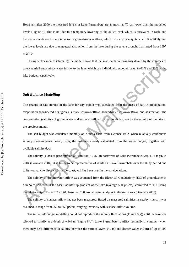
However, after 2000 the measured levels at Lake Purrumbete are as much as 70 cm lower than the modelled
levels (Figure 5). This is not due to a temporary lowering of the outlet level, which is excavated in rock, and
there is no evidence for any increase in groundwater outflow, which is in any case quite small. It is likely that
the lower levels are due to ungauged abstraction from the lake during the severe drought that lasted from 1997
to 2010.
During wetter months (Table 1), the model shows that the lake levels are primarily driven by the volumes of
direct rainfall and surface water inflow to the lake, which can individually account for up to 63% and 51% of the
lake budget respectively.
Salt Balance Modelling
The change in salt storage in the lake for any month was calculated from the mass of salt in precipitation,
evaporation (considered negligible), surface inflow/outflow, groundwater inflow/outflow, and abstraction. The
concentration (salinity) of groundwater and surface outflow in any month is given by the salinity of the lake in
the previous month.
The salt budget was calculated monthly on a mass basis from October 1982, when relatively continuous
salinity measurements began, using the volumes already calculated from the water budget, together with
available salinity data.
The salinity (TDS) of precipitation at Hamilton, ~125 km northwest of Lake Purrumbete, was 41.6 mg/L in
2004 (Bormann 2004); it is likely to be representative of rainfall at Lake Purrumbete over the study period due
to its comparable distance from the coast, and has been used in these calculations.
The salinity of groundwater inflow was estimated from the Electrical Conductivity (EC) of groundwater in
boreholes screened in the basalt aquifer up-gradient of the lake (average 500 µS/cm), converted to TDS using
the relationship: TDS = EC x 0.61, based on 230 groundwater analyses in the study area (Bennetts 2005).
The salinity of surface inflow has not been measured. Based on measured salinities in nearby rivers, it was
assumed to range from 250 to 750 µS/cm, varying inversely with surface inflow volume.
The initial salt budget modelling could not reproduce the salinity fluctuations (Figure 8(a)) until the lake was
allowed to stratify at a depth of ~ 0.6 m (Figure 8(b)). Lake Purrumbete stratifies thermally in summer, when
there may be a difference in salinity between the surface layer (0.1 m) and deeper water (40 m) of up to 500
Dow
nloa
ded
by [
La
Tro
be U
nive
rsity
] at
17:
13 1
6 O
ctob
er 2
014

Accep
ted M
anus
cript
12
mg/L (EPA Victoria 2008). This corresponds with the peaks in the modelled salinity, which occur in summer
(Figure 8(b)). In winter there is minimal, if any, salinity stratification.
Salt budget results
The salt balance model indicates that the salinity in Lake Purrumbete is largely controlled by groundwater
and surface water fluxes (average 43% and 41% respectively). Direct precipitation contributes 12% on average,
and abstraction ~ 4%.
Errors in the model are probably partly due to errors carried over from the water budget, but the salt budget
sensitivity analysis shows that the model is particularly sensitive to changes in the salt concentration of
groundwater outflow and surface inflow. Furthermore, the relatively high observed TDS values (600 to 750
mg/L) in 1986, 1989, and 1990 (Figure 9) may be erroneous.
Tibby and Tiller (2007) analysed the relationship between Lake Purrumbete water quality and climate for the
period 1984-2000, and demonstrated that the salinity increased in response to reduced effective moisture,
confirming the results of the present modelling.
Discussion
Lake Purrumbete was classified by Barton et al. (2007) as a marginally surface-water-dominated,
groundwater through-flow lake, based on hydrochemical and isotopic analysis (deuterium excess and
bicarbonate/chloride ratio). However, the water budget from the current study shows that direct rainfall and
surface water inflow (together) substantially exceed groundwater inflow (~34% and ~16% of the water budget
respectively). The discrepancy may be due to hydrochemical and isotopic differences between rainfall and
surface water inflow, which are lumped together in Barton et al.’s (2007) study, and the impact of the thermal
stratification of Lake Purrumbete over summer, which means that the evaporated surface layer will have a
different stable isotope and ionic composition to the bulk of the lake water.
The modelling results show that although the fluctuations in level for Lake Purrumbete are primarily driven
by surface water inflows and direct rainfall during wetter months and evaporation during drier periods, these
variables are damped to 83% of the water budget because of the substantial lake–groundwater exchange. The
other lakes scattered across the volcanic plain in western Victoria have a much smaller groundwater flux,
Dow
nloa
ded
by [
La
Tro
be U
nive
rsity
] at
17:
13 1
6 O
ctob
er 2
014

Accep
ted M
anus
cript
13
typically <5% of the water budget (Coram 1996, Dewi et al. 2009, Jones et al. 2001, Kirono et al. 2012, Tweed
et al. 2009).
Lake Purrumbete has a greater interaction with the surrounding groundwater system for two reasons: firstly
its significant depth, with high permeability, steeply inclined, rocky margins, and secondly the presence of
‘stony rise’ basalts along the upgradient shoreline. The thin soils on these basalt flows result in rapid recharge,
so that the least saline groundwaters on the basalt plain in western Victoria are present in ‘stony rise’ lavas
(Raiber et al. 2009). Furthermore, these relatively young basalts are highly permeable, and often have springs
around their margins (Joyce et al. 2003).
Lake Purrumbete is also unusual among the lakes on the volcanic plain in western Victoria because of its
low salinity. Lakes with substantial groundwater and surface water flux like Lake Purrumbete (~35% of the total
water budget) are relatively fresh because there is significant salt export in the outflow, and because the amount
of time the lake water is subject to evaporation is limited. In addition, Lake Purrumbete’s relatively low surface
area/volume ratio means that the effect of evaporation is less pronounced than for shallower lakes (although it
still contributes ~38% of the total water budget). The more saline lakes on the basalt plain are shallow, with no
surface outflow and limited groundwater outflow, so that most of the salt input in precipitation and
surface/groundwater inflow is not exported, and remains in the lake to be concentrated by evaporation.
Nevertheless, the water and salt budget for Lake Purrumbete demonstrates that the major cause of salinity here,
as for the other lakes in western Victoria, is evaporation. Solutes are derived from rainfall, both directly and
indirectly through groundwater and surface water input (Bennetts et al. 2006).
The fluctuations in lake level and surface area for Lake Purrumbete are much less than those for most other
lakes in the region, both on an absolute and relative basis. During the 1997-2010 drought, many of the other
lakes decreased in surface area by between 60% and 36%, and there was a 25% increase in the number of lakes
with evaporite deposits (Tweed et al. 2009). Lake Purrumbete showed only a minor reduction in level and
increase in salinity during the drought; this was due both to its low surface area/volume ratio and large
groundwater flux. Because the groundwater flow is relatively constant compared to the frequently episodic
nature of rainfall events and surface water flows in this area (typical of southeastern Australia; McMahon et al.
1987), it smooths out lake level fluctuations due to the latter factors. As a result, lakes with a higher percentage
of groundwater inflow/outflow like Lake Purrumbete are less affected by short-term climate fluctuations.
The results can be used to develop management strategies for Lake Purrumbete in order to maintain surface
water resources and quality under the likely decrease in effective precipitation predicted by climate change
Dow
nloa
ded
by [
La
Tro
be U
nive
rsity
] at
17:
13 1
6 O
ctob
er 2
014

Accep
ted M
anus
cript
14
scenarios for this region. Because Lake Purrumbete was relatively unaffected by the 1997-2010 drought, when
many other lakes in this area became more saline and/or dried out, it served as an important refugium for aquatic
ecosystem preservation, and this will also be the case if climate change causes seasonal drying of lakes to be a
frequent occurrence by the end of the 21st century (Leahy et al. 2010). Nevertheless, Lake Purrumbete is
susceptible to fluctuations in nutrient concentrations due to the impact of surface warming on algal dynamics
(Tibby and Tiller 2007), and its limnology is more sensitive to climatic variability than the catchment vegetation
(Tibby et al. 2012). Similarly, groundwater-levels in the region are sensitive to climatic variability (Dahlhaus et
al. 2010, Yihdego and Webb 2011).
Lake Purrumbete is popular for trout fishing and also needs to be managed to maintain its amenity for this
recreation. If the lake level drops permanently below the outlet, as predicted for continuing dry conditions like
the recent drought, this will not significantly affect the lake salinity or volume, so it will still be suitable as a
trout habitat. However, the drop in level will require that the ramps allowing boat entry to the lake will have to
be extended.
Furthermore, the water budget modelling suggests that ungauged abstraction from the lake during the
drought starting in 1997 caused lake levels to drop as much as 70 cm after 2000 (Figure 5). The amount of water
pumped from the lake for irrigation, stock and domestic uses needs to be closely monitored, to ensure that it
does not increase and adversely impact the lake.
Therefore, although the lake level fluctuations at Lake Purrumbete are predominantly explained by climate
variation, they demonstrate anthropogenic influences on the hydrology. As a result, a regional plan to manage
the quality and amenity of lakes in western Victoria under the influence of not only a drying climate but also
increasing to human disturbance must develop different scenarios for lakes with different characteristics, and
even deep lakes like Lake Purrumbete are vulnerable in certain respects.
Conclusions
A modified difference water budget method for lakes, previously developed by Yihdego and Webb (2012)
that closely links the lake to the groundwater was able to successfully model the level fluctuations in Lake
Purrumbete, a deep, cylindrical lake located within an extensive basalt plain in western Victoria, which has
different characteristics from previous applications. The modified method used in this study incorporates
seasonal variation and also provides flexibility through the number of parameters and processes modelled and
hence served as an instrumental tool to bridge the gap in the context of understanding the hydrological
Dow
nloa
ded
by [
La
Tro
be U
nive
rsity
] at
17:
13 1
6 O
ctob
er 2
014

Accep
ted M
anus
cript
15
components that may or may not related to the problems of increasing salinity in many western Victoria’s lakes,
considered as a valuable contribution to factual information about the hydrology of the region.
The modelling showed that the major influences are evaporation and direct precipitation; however
groundwater fluxes are significant (~16%). Lake Purrumbete is unusual among the lakes on the volcanic plain in
western Victoria because of this substantial groundwater flux, which is due to its significant depth and the
presence of highly permeable basalts along the upgradient shoreline; these basalts are rapidly recharged because
of their thin stony soils. This confirms that deeper lakes with low surface area/volume ratios may have a greater
contribution of groundwater flow to the water budget.
Lake Purrumbete’s low salinity reflects the relatively high groundwater and surface water flux (~35% of the
total water budget), so that there is significant salt export in the outflow, and the lake’s relatively low surface
area/volume ratio means that the effect of evaporation is less pronounced than for other, shallower more saline
lakes on the basalt plain.
The fluctuations in lake level and salinity for Lake Purrumbete are much less than for other lakes in the
region, even during the 1997-2010 drought, due to its cylindrical shape and the large relatively constant
groundwater flux, which damps the episodic influence of rainfall and surface inflow. Lakes with a higher
percentage of groundwater inflow/outflow like Lake Purrumbete are therefore less affected by climate
fluctuations.
Lake Purrumbete will be an important refugium for aquatic ecosystem in western Victoria if climate change
causes frequent seasonal drying of other lakes in the plain, so it is important to develop management strategies
to maintain its water resources and quality. Although the water budget modelling demonstrates that lake level
fluctuations are predominantly due to climate variation, anthropogenic influences are also evident, and in
particular pumping for farm and domestic uses needs to be closely monitored to ensure that it does not adversely
impact the lake. Thus management strategies need to consider the full impact of both climate and anthropogenic
change.
Acknowledgments
This study is a portion of the author’s doctoral research conducted while at La Trobe University, Australia.
Support was provided by the Environmental Protection Authority (EPA) Victoria, and the Glenelg–Hopkins
Catchment Management Authority. We thank two anonymous reviewers and Frances Watkins (Editorial
Manager) for helpful comments and suggestions.
Dow
nloa
ded
by [
La
Tro
be U
nive
rsity
] at
17:
13 1
6 O
ctob
er 2
014

Accep
ted M
anus
cript
16
References
Anderson, M. P. & Cheng, X. 1993. Long and short term transience in a ground water/lake system in
Wisconsin, U.S.A. Journal of Hydrology, 145, 1-18.
Anderson, M. P. & Munter, J. A. 1981. Seasonal reversals of ground water flow around lakes and relevance to
stagnation points and lake budgets. Water Resources Research, 17, 1139-1150.
Ayenew, T. & Gebreegziabher, Y. 2006. Application of a spreadsheet hydrological model for computing the
long-term water balance of Lake Awassa, Ethiopia. Hydrological Sciences Journal, 51, 418-431.
Barton, A. B., Herczeg, A. L., Dahlhaus, P. G. & Cox, J. W. 2007. Quantifying groundwater dependence of
wetlands in a volcanic plain, south-eastern Australia. Groundwater and Ecosystems. Proceedings of
the XXXV IAH Congress, 17-21 September, Lisbon, Portugal.
Barwell, V.K. & Lee, D. R. 1981. Determination of horizontal to vertical hydraulic conductivity ratios from
seepage measurements on lakebeds. Water Resources Research, 17, 565-570.
Becht, R. & Harper, D. 2002. Towards an understanding of human impact upon the hydrology of Lake
Naivasha, Kenya. Hydrobiologia, 488 (1/3), 1-12.
Bennetts, D. A. 2005. Hydrology, hydrogeology and hydrogeochemistry of groundwater flow systems within
the Hamilton basalt plains, and their role in dryland salinity. PhD Thesis, La Trobe University, pp
244.
Bennetts, D. A., Webb, J. A., Stone, D. J. M. & Hill, D. M. 2006. Understanding the salinisation process for
groundwater in an area of south-eastern Australia, using hydrochemical and isotopic evidence.
Journal of Hydrology, 323, 178-192.
Bormann, M. E. 2004. Temporal and spatial trends in rainwater chemistry across central and western Victoria.
BSc Honours Thesis, Environmental Geosciences, La Trobe University.
Boughton, W. C. 1966. A mathematical model for relating runoff to rainfall with daily data. Civil Eng. Trans.,
I.E. Aust. CE8 (1), 83-97.
Cherkauer, D. S. & Zager, J. P. 1989. Groundwater interaction with a kettlehole lake: relation of observations to
digital simulations. Journal of Hydrology, 109, 167-184.
Cook, P. G., Wood, T. W., Simmons, C.T., Fass, T. & Brunner, P. 2008. Groundwater inflow to a shallow,
poorly mixed wetland estimated from a mass balance of radon. Journal of Hydrology, 354, 213-226.
Dow
nloa
ded
by [
La
Tro
be U
nive
rsity
] at
17:
13 1
6 O
ctob
er 2
014
Accep
ted M
anus
cript
17
Coram, J. E. 1996. Groundwater-surface water interactions around shallow lakes of the western district plains,
Victoria. MSc Thesis, Department of Earth Sciences, Melbourne University, pp 179.
Cox, J., Dahlhaus, P., Herczeg, A., Crosbie, R., Davies, P. & Dighton, J. 2007. Defining groundwater flow
systems on the Volcanic Plains to accurately assess the risks of salinity and impacts of changed land
use. Final report to the Corangamite Catchment Management Authority area, CSIRO Land and
Water, Urrbrae, South Australia.
Dahlhaus, P. G., Evans, T. J., Nathan, E. L., Cox, J. W. & Simmons, C. T. 2010. Groundwater-level response
to land-use change and the implications for salinity management in the West Moorabool River
catchment, Victoria, Australia. Hydrogeology Journal, 18, 1611-1623.
Dahlhaus, P. G., Heislers, D. S. & Dyson, P. R. 2002. Groundwater Flow Systems. Consulting report Glenelg-
Hopkins Catchment Management Authority 02/02, Hamilton, Victoria, Australia.
De Deckker, P. & Williams, W. D. 1988. Physico-chemical limnology of eleven, mostly saline permanent lakes
in western Victoria, Australia. Hydrobiologia, 163, 275-286.
Dewi, G. C. K., Jones, R. N., Kent, D. & Leahy, P. 2009. Modelling lake levels under climate change
conditions: three closed lakes in Western Victoria. Proceedings 18th
World IMACS / MODSIM
Congress, Cairns, Australia 13-17 July 2009: 6 pp. accessed from http://mssanz.org.au/modsim09 on
the 8/1/2010.
Edwards, J., Leonard, J.G., Pettifer, G. R. & McDonald, P. A. 1996. Colac 1: 250000 map geological report.
Geological Survey of Victoria Report 98.
EPA Victoria, 2008. Lake Purrumbete Hydrodynamic and Thermodynamic Modelling 2004 to 2006 for Centre
of Environmental Sciences. Report no. EPA-1-10/08.
Fellows, C. R. & Brezonik, P. L 1980 Seepage flow into Florida lakes. Water Resources Bulletin, 16, 635-641.
Genereux, D. & Bandopadhyay, I. 2001. Numerical investigation of lake bed seepage patterns: effects of porous
medium and lake properties. Journal of Hydrology, 241, 286-303.
GHD, 2004. Cardigan bore field hydrogeological assessment: 100 pp. Linked to
(http://www.ballarat.vic.gov.au/library/scripts/objectifyMedia.aspx?file=pdf/13/17.pdf&str_
title=Lake%20Wendouree%20Water%20Supply%20Investigation%20%20Full%20Report.pdf) .
Grayson, R. B., Argent, R. M., Nathan, R. J., McMahon, T. A. & Mein, R. G. 1996. Hydrological recipes:
estimation techniques in Australian hydrology. Melbourne, Cooperative Research Centre for
Catchment Hydrology, pp 125.
Dow
nloa
ded
by [
La
Tro
be U
nive
rsity
] at
17:
13 1
6 O
ctob
er 2
014

Accep
ted M
anus
cript
18
Harvey, F. E., Rudolph, D. L. & Frape, S. K. 2000. Estimating groundwater flux into large lakes: Application in
the Hamilton harbor, Western Lake Ontario. Groundwater, 38, 550-565.
Holdgate, G. R. & Gallagher, S. J. 2003. Chapter 10 - Tertiary. In Birch W (ed), Geology of Victoria.
Geological Society of Australia Special Publication, 23, 289-335.
Hoy, R. D., Stephens, S. K. 1979. Field study of lake evaporation - analysis of data from phase 2 storages and
summary of phase 1 and phase 2. Australian Water Resources Council Technical Report paper No.
41.
Hunt, R. J. & Krohelski, J. T. 1996. The application of analytic element model to investigate ground water-lake
interactions at pretty Lake Wisconsin. Lake Reservoir Management, 12(4), 487-495.
Hussainy, G. H. 1969. Ecological studies on some microbiota of lakes in Western Victoria. PhD Thesis, Monash
University.
Jankowski, J. & Jacobson, G. 1989. Hydrochemical evolution of regional ground waters to playa brines in
central Australia. Journal of Hydrology, 108, 123-174.
Jones, R. N., McMahon, T. A. & Bowler, J. M. 2001. Modeling historical lake levels and recent climate change
at three closed lakes, Western Victoria, Australia (c.1840-1990). Journal of Hydrology, 246, 159-180.
Joyce, E. B., Webb, J. A., Dahlhaus, P. G., Grimes, K. G., Hill, S. M., Kotsonis, A. & Martin, J. L. 2003.
Chapter 18 - Geomorphology. In W. Birch, (ed), Geology of Victoria. Geological Society of Australia
Special Publication, 23, 533-561.
Kirillin, G., Phillip, W., Engelhardt, C. & Nützmann, G. 2013. Net groundwater inflow in an enclosed lake:
from synoptic variations to climatic projections. Hydrological Processes 27(3), 347-359.
Kirono, D. G. C., Kent, D. M., Jones, R. N. & Leahy, P. J. 2012. Assessing climate change impacts and risks on
three salt lakes in western Victoria, Australia. Human and Ecological Risk Assessment, 18, 152-167.
LaBaugh, J. W., Winter, T. C, Rosenberry, D. O., Schuster, P. F, Reddy, M. M. & Aiken, G. R. 1997.
Hydrological and chemical estimates of the water balance of a closed-basin lake in north-central
Minnesota. Water Resources Research, 33(12), 2799-2812.
Leahy, P. J., Robinson, D., Patten, R. & Kramer, A. 2010. Lakes in the Western District of Victoria and Climate
Change. EPA Science Report. http://www.epa.vic.gov/publications/.
Lee, D. R. & Barry, P. J. 1980. An evaluation of methods for measuring the groundwater contribution to
Perched lake. Restoration of Lakes and Inland Waters, Rep. USEPA 440/581-010, 480-484.
Washington, D.C.: United States Environmental Protection Agency.
Dow
nloa
ded
by [
La
Tro
be U
nive
rsity
] at
17:
13 1
6 O
ctob
er 2
014

Accep
ted M
anus
cript
19
Lee, T. M. 1996. Hydrogeological controls on the groundwater interactions with an acidic lake in karst terrain,
Lake Barco, Florida. Water Resources Research, 32, 831-844.
McJannet, D. L., Webster, I. T., Stenson, M. P. & Sherman, B. S. 2008. Estimating open water evaporation for
the Murray-Darling Basin. A report to the Australian Government from the CSIRO Murray-Darling
Basin Sustainable Yields Project.
McMahon, T. A., Finalyson, B. L., Haines, A. & Srikanthan, R. 1987. Runoff variability: a global perspective.
The influence of climate change and climatic variability on the hydrologic regime and water
resources. IAHS Publication, 168, 3-11.
Morton, F. I. 1986. Practical estimates of lake evaporation. Journal of Climate and Applied Meteorology, 25,
371-387.
Munter, J. A. & Anderson, M. P. 1981. The use of groundwater flow models for estimating lake seepage rates.
Groundwater 19, 608-616.
Nakayama, T. & Watanabe, M. 2008. Simulation of groundwater dynamics in North China Plain by coupled
hydrology and agricultural models. Hydrological Processes, 22, 1150-1172.
Nash, J. E. & Sutcliffe, J. V. 1970. River flow forecasting through conceptual models Part 1 - A discussion of
principles. Journal of Hydrology, 10, 282-290.
Ollier, C. D. 1968. Maars: their characteristics, varieties and definition. Bulletin Volcanologique, 31, 45-73.
Paine, M. Bennetts, D. A., Webb, J. A. & Morand, V. 2004. Nature and extent of Pliocene strandlines in
southwestern Victoria and their application to late Neogene tectonics. Australian Journal of Earth
Sciences, 51:407-422.
Raiber, M., Webb, J. A. & Bennetts, D. 2009. Strontium isotopes as tracers to delineate aquifer interactions and
groundwater salinisation in the basalt plains of southeastern Australia. Journal of Hydrology, 367,
188-199.
Rosengren, N. J. 1994. Eruption points of the Newer Volcanics province of Victoria: an inventory and
evaluation of significance. National Trust of Australia (Vic.) and Geological Society of Australia,
Victoria Division, Melbourne, pp 387.
Sacks, L. A., Herman, J. S., Konikow, L. F. & Vela, A. L. 1992. Seasonal dynamics of groundwater-lake
interactions at Donana National Park Spain. Journal of Hydrology, 136, 123-154.
Shugg, A. 1988. Whey disposal, Allansford, western Victoria. Proceedings IAH International Groundwater
Conference, Melbourne, pp 563-568.
Dow
nloa
ded
by [
La
Tro
be U
nive
rsity
] at
17:
13 1
6 O
ctob
er 2
014

Accep
ted M
anus
cript
20
SKM, 2007. Preliminary groundwater resource appraisal for the Hawkesdale Management Area.
SRW, 2009. Southern Rural Water Authority. http://www.srw.com.au/.
Tibby, J., Penny, D., Leahy, P. & Kershaw, A. P. 2012. Vegetation and Water Quality Responses to Holocene
Climate Variability in Lake Purrumbete, Western Victoria. In S. G., Haberle & David, B. (eds),
Peopled Landscapes: Archaeological and Biogeographic Approaches to Landscapes, pp 359-373,
Canberra: ANU E Press. Section Biogeography and Palaeoecology. Section Archaeology and
Perceptions of Landscape. http://epress.anu.edu.au/wp-content/uploads/2012/01/ch17.pdf. Accessed
on 23 September 2014.
Tibby, J. & Tiller, D. 2007. Climate-water quality relationships in three Western Victorian (Australia) lakes
1983-2000. Hydrobiologia, 591, 219-234.
Timms, B. V. 1973. A Comparative Study of the Limnology of Three Maar Lakes in Western Victoria,
Australia. PhD Thesis, Monash University.
Timms, B. V. 1976. A Comparative Study of the Limnology of three Maar Lakes in Western Victoria, Australia.
Australian Journal of Marin and Freshwater Research, 27, 35-60.
Timms, B. V. 2005. Salt lakes in Australia: present problems and prognosis for the future. Hydrobiologia, 552,
1-15.
Townley, L. R. & Davidson, M. R. 1988. Definition of a capture zone for shallow water table lakes. Journal of
Hydrology, 104, 53-76.
Tweed, S., Leblanc, M. & Cartwright, I. 2009. Groundwater-surface water interaction and the impact of a multi-
year drought on lake conditions in South-East Australia. Journal of Hydrology, 379, 41-53.
Wang, Q. J., Chiew, F. H. S., McConachy, F. L. N., James, R., de Hoedt, G. C. & Wright, W. J. 2001. Climatic
Atlas of Australia Evapotranspiration. Bureau of Meteorology, Commonwealth of Australia.
Williams, W. D. 1995. Lake Corangamite, Australia, a permanent saline lake: conservation and management
issues. Lakes and Reservoirs: Research and Management, 1, 55-64.
Winter, T. C. 1976. Numerical simulation analysis of the interaction of lakes and groundwater. U.S. Geological
Survey Professional Paper 1001.
Winter, T.C. 1978. Numerical simulation analysis of steady state, three dimensional ground water flow near
lakes. Water Resources Research, 14, 245-254.
Winter, T. C. 1981. Effects of water table configuration on seepage through lakebeds. Limnology and
Oceanography, 26, 925-934.
Dow
nloa
ded
by [
La
Tro
be U
nive
rsity
] at
17:
13 1
6 O
ctob
er 2
014

Accep
ted M
anus
cript
21
Yang, Z., Zhou, Y., Wenninger, J. & Uhlenbrook, S. 2014. A multi-method approach to quantify
groundwater/surface-water interactions in the semi-arid Hailiutu River basin, northwest China.
Hydrogeology Journal, 22, 527-541.
Yao, H., Scott, L., Guay, C. & Dillon, P. 2009. Hydrological impacts of climate change predicted for an inland
lake catchment in Ontario by using monthly water balance analyses. Hydrological Processes, 23,
2368-2382.
Yihdego, Y. & Becht, R. 2013. Simulation of lake–aquifer interaction at Lake Naivasha, Kenya using a
three-dimensional flow model with the high conductivity technique and a DEM with
bathymetry. Journal of Hydrology, 503, 111-122.
Yihdego, Y. & Webb, J. A. 2011. Modelling of bore hydrograph to determine the impact of climate and land use
change in western Victoria, Australia. Hydrogeology Journal, 19(4), 877-887.
Yihdego, Y. & Webb, J. 2012. Modelling of seasonal and long-term trends in lake salinity in South-western
Victoria, Australia. Journal of Environmental Management, 112, 149-159.
Yihdego, Y. & Webb, J. A. 2013. An empirical water budget model as a tool to identify the impact of land-use
change in stream flow in southeastern Australia. Water Resources Management Journal, 27(14),
4941-4958.
Dow
nloa
ded
by [
La
Tro
be U
nive
rsity
] at
17:
13 1
6 O
ctob
er 2
014

Accep
ted M
anus
cript
22
Figure 1. Location of Lake Purrumbete. Topographic DEM downloaded from Shuttle Radar Topographic Mission website; x–y resolution 15–30 m, elevation accuracy <5 m
Dow
nloa
ded
by [
La
Tro
be U
nive
rsity
] at
17:
13 1
6 O
ctob
er 2
014
Accep
ted M
anus
cript
23
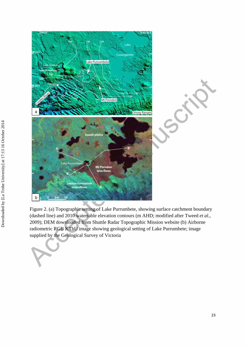
Figure 2. (a) Topographic setting of Lake Purrumbete, showing surface catchment boundary (dashed line) and 2010 watertable elevation contours (m AHD; modified after Tweed et al., 2009); DEM downloaded from Shuttle Radar Topographic Mission website (b) Airborne radiometric RGB KThU image showing geological setting of Lake Purrumbete; image supplied by the Geological Survey of Victoria
Dow
nloa
ded
by [
La
Tro
be U
nive
rsity
] at
17:
13 1
6 O
ctob
er 2
014

Accep
ted M
anus
cript
24
Figure 3. Geological cross-sections showing aquifers that interact with Lake Purrumbete; for locations see Figure 2b
Dow
nloa
ded
by [
La
Tro
be U
nive
rsity
] at
17:
13 1
6 O
ctob
er 2
014

Accep
ted M
anus
cript
25
Figure 4. Stream flow modelling for the Curdies River
Figure 5. Comparison of measured and modelled water levels for Lake Purrumbete. Maximum and minimum outlet heights are shown as a solid line
Dow
nloa
ded
by [
La
Tro
be U
nive
rsity
] at
17:
13 1
6 O
ctob
er 2
014

Accep
ted M
anus
cript
26
Figure 6. Correlation between observed and calculated lake elevation
Figure 7. Temporal distribution of square difference between observed and calculated lake levels
Dow
nloa
ded
by [
La
Tro
be U
nive
rsity
] at
17:
13 1
6 O
ctob
er 2
014

Accep
ted M
anus
cript
27
Figure 8. Comparison of measured and modelled salinity for Lake Purrumbete; (a) without stratification, (b) with stratification
Dow
nloa
ded
by [
La
Tro
be U
nive
rsity
] at
17:
13 1
6 O
ctob
er 2
014

Accep
ted M
anus
cript
28
Table 1 Long-term mean monthly volumetric components of Lake Purrumbete water budget (103 m3).
Surface inflow
Surface outflow
Evaporation
Precipitation
Groundwater inflow
Groundwater outflow
Abstraction
Jan 16 189 1034 234 221 12 18
Feb 4 119 946 198 222 11 14
Mar 2 76 759 244 222 11 9
Apr 2 54 456 342 223 11 6
May 8 50 260 377 223 11 6
Jun 51 58 185 478 223 11 8
Jul 159 89 213 477 223 11 12
Aug 295 135 299 525 222 11 17
Sep 416 192 403 505 222 12 43
Oct 340 245 557 440 221 13 62
Nov 183 260 699 318 221 13 80
Dec 72 233 909 312 221 13 41
Annual 1549 1700 6720 4451 2665 140 316
Dow
nloa
ded
by [
La
Tro
be U
nive
rsity
] at
17:
13 1
6 O
ctob
er 2
014