Modelling of the Aral and Caspian seas drying out influence to climate and environmental changes
19
Acta geographica Slovenica, 54-1, 2014, 143–161 MODELING OF THE ARAL AND CASPIAN SEAS DRYING OUT INFLUENCE TO CLIMATE AND ENVIRONMENTAL CHANGES Slobodan B. Markovi}, Albert Ruman, Milivoj B. Gavrilov, Thomas Stevens, Matija Zorn, Bla` Komac, Drago Perko The Caspian sea (Credit: NASA).
-
Upload
independent -
Category
Documents
-
view
0 -
download
0
Transcript of Modelling of the Aral and Caspian seas drying out influence to climate and environmental changes

Acta geographica Slovenica, 54-1, 2014, 143–161
MODELING OF THE ARALAND CASPIAN SEAS DRYING OUTINFLUENCE TO CLIMATE ANDENVIRONMENTAL CHANGES
Slobodan B. Markovi}, Albert Ruman, Milivoj B. Gavrilov,Thomas Stevens, Matija Zorn, Bla` Komac, Drago Perko
The Caspian sea (Credit: NASA).

Modelling of the Aral and Caspian seas drying out influence to climate and environmental changes
Modelling of the Aral and Caspian seas drying out influenceto climate and environmental changes
DOI: http://dx.doi.org/10.3986/AGS54304UDC: 911.2:551.588(5-191.2)COBISS: 1.01
ABSTRACT: The complete drying out of the Aral and Caspian seas, as isolated continental water bodies,and their potential impact on the climate and environment is examined with numerical simulations.Simulations use the atmospheric general circulation model (ECHAM5) as well as the hydrological discharge(HD) model of the Max-Planck-Institut für Meteorologie. The dry out is represented by replacing the watersurfaces in both of the seas with land surfaces. New land surface elevation is lower, but not lover than 50mfrom the present mean sea level. Other parameters in the model remain unchanged. The initial meteoro-logical data is real; starting with January 1, 1989 and lasting until December 31, 1991. The final results wereanalyzed only for the second, as the first year of simulation was used for the model spinning up.The drying out of both seas leads to an increase in land surface and average monthly air temperature dur-ing the summer, and a decrease of land surface and average monthly air temperature during the winter,above the Caspian Sea. The greatest difference in temperature between dry and not dry cases have the samevalues, about 7–8 °C in both seasons, while daily extremes of temperature are much more pronounced.In the wider local/regional area, close to both seas, drying out leads to a difference in average annualtemperatures by about 1 °C. On a global scale, the average annual temperature remains unchanged andthe configuration of the isotherms remain unchanged, except for over some of the continents. In winter,Central Asia becomes cooler, while over Australia, southern Africa, and South America, it becomes slight-ly less warm. Furthermore, a new heat island occurs in western Sahara during summer.
KEY WORDS: Caspian Sea, Aral Sea, drying out, numerical simulation, air temperature, climate change
The article was submitted for publication on April 3, 2013.
ADDRESSES:Slobodan B. Markovi}, Ph.D.Chair of Physical Geography, Department of Geography, Tourism and Hotel ManagementFaculty of Sciences, University of Novi SadTrg Dositeja Obradovi}a 3, RS – 21000 Novi Sad, SerbiaE-mail: slobodan.markovic�dgt.uns.ac.rs
Albert Ruman, M. Sc.Republic Hydrometeorological ServiceKneza Vi{eslava 66, RS – 11000 Beograd, SerbiaE-mail: albert.ruman�hidmet.gov.rs
Milivoj B. Gavrilov, Ph.D.Chair of Physical Geography, Department of Geography, Tourism and Hotel ManagementFaculty of Sciences, University of Novi SadTrg Dositeja Obradovi}a 3, RS – 21000 Novi Sad, SerbiaE-mail: milivoj.gavrilov�yahoo.com
Thomas Stevens, Ph.D.Centre for Quaternary Research, Department of GeographyRoyal Holloway, University of LondonEgham, Surrey TW200EX, UKE-mail: Thomas.Stevens�rhul.ac.uk
144

Matija Zorn, Ph.D.Anton Melik Geographical InstituteResearch Centre of the Slovenian Academy of Sciences and ArtsGosposka ulica 13, SI – 1000 Ljubljana, SloveniaE-mail: matija.zorn�zrc-sazu.si
Bla` Komac, Ph.D.Anton Melik Geographical InstituteResearch Centre of the Slovenian Academy of Sciences and ArtsGosposka ulica 13, SI – 1000 Ljubljana, SloveniaE-mail: blaz.komac�zrc-sazu.si
Drago Perko, Ph.D.Anton Melik Geographical InstituteResearch Centre of the Slovenian Academy of Sciences and ArtsGosposka ulica 13, SI – 1000 Ljubljana, SloveniaE-mail: drago�zrc-sazu.si
Acta geographica Slovenica, 54-1, 2014
145

Modelling of the Aral and Caspian seas drying out influence to climate and environmental changes
1 IntroductionSince the beginning of Earth's history, climate has varied (Goosse et al. 2013). Its climate system is affectedby many factors that can be classified into three major groups:• astronomical factors, such as solar or Earth orbital variability;• natural landscape factors, such as spatial distribution of land and sea, configuration and type of landsurface, vegetation cover and
• anthropogenic factors, such as atmospheric composition and land use.The latter influences climate only in recent centuries (e.g. Dahan 2010).The study of current/recent climate change is focused on two main themes:
• the net overall climate change and• constraining the relative influences of natural versus anthropogenic influences (Hansen and Sato 2012).
This paper examines the potential impact of the drying out of the Aral and Caspian seas on local, region-al, and global climate and environment. In the case of the Aral Sea's recent progressive drying out processis mostly triggered only by anthropogenic factors. Current human influence on the hydrological regimesin catchments of the Aral Sea results in its reduced surface and volume (Peneva et al. 2004; Toman 2013),leading to its immanent final disappearance. In the case of Caspian Sea the human influence has not beenso severe, although the sea level drop caused by big contractions on Volga River are reported since the 1950s(Vri{er 1953). Thus the disappearance of the Caspian Sea can be significantly accelerated in the case ofmajor inflow decrease of water from the main tributaries, the Volga and Ural rivers. On the other hand,also natural influence on the hydrological regimes in the catchment of the Caspian Sea has been observed.The Caspian Sea is subject to large variations in the amount of water and water surface, as it was duringthe Late Pleistocene and postglacial periods (Kislov et al. 2012). Without going into the details of all ofthese processes, our study introduces a presumption that the drying out of the Aral and Caspian seas hashappened in the last decades. The influence of drying out on air temperature will be considered. Besidethe impact on the climate, the drying out of the inland seas would impact the environment and ultimatelythe human society.
It is a widely accepted view that the roots of today's civilization are linked to ancient human societiesthat existed in the valleys of major rivers, such as the Nile in Africa, the Tigris and Euphrates rivers inthe Middle East, the Indus in South Asia, and the Yangtze and Yellow rivers in China. Many civilizationstook advantage of natural flooding of rivers for agricultural development, and later developed irrigationand flooding control to further enhance farming conditions (Diamond 2005). Water management shouldbe planned, including digging of channels to organize work in the fields, keeping accurate records, tak-ing care of security, implementing control, synchronizing decisions and transmitting orders. Economywas subordinated to the very complex interface between human organization and management. Over time,these teams ensured the emergence and development of civilizations in the river valleys. Civilizations basedon good water management survived the longest of all in the past, and are sometimes referred to as »hydrauliccivilizations« (Gavrilov 2005). Multi millennial experience in water management has mainly brought bless-ings. Until recently, people did not notice the consequences of bad management.
1.1 Aral Sea
The Aral Sea is lying between Kazakhstan in the north and Uzbekistan in the south. It is a completely enclosedbasin with a large inland catchment area. Most of the surrounding land is desert and almost all water enter-ing the basin comes from two major rivers: Amu Darya and Sir Darya (Peneva et al. 2004; Toman 2013).The name of the Aral Sea roughly translates from old Turkish as »Sea of Islands«, referring to the morethan 1,534 islands that once dotted its waters. Previously it was the fourth largest lake in the world withan area of 68,000 km2 (Figure 1). The Aral Sea has been steadily shrinking since the 1960s after the AmuDarya and Sir Darya Rivers were diverted by Soviet irrigation projects. By 2007, it had declined to 10%of its original size, splitting into four lakes: the North Aral Sea, the eastern and western basins of the oncefar larger South Aral Sea, and one smaller lake between the North and South Aral Sea (Micklin andAladin 2008). By 2009, the southeastern lake had disappeared and the southwestern lake retreated intoa smaller water bodies at the far west of the former southern sea (Singh et al. 2012; Figure 2).
146

Acta geographica Slovenica, 54-1, 2014
147
The shrinking of the Aral Sea has been called one of the planet's worst environmental disasters.The region's once prosperous fishing industry has been essentially destroyed, bringing unemploymentand economic hardship. The Aral Sea region is also heavily polluted, with resulting serious public healthproblems. The retreat of the sea has reportedly also caused local climate change, with summers becom-ing hotter and drier, and the winters becoming colder and longer (Micklin 2007).
1.2 Caspian SeaThe Caspian Sea is situated in a semi-arid area between southern Russia, Kazakhstan, Turkmenistan, Iranand Azerbaijan (36°–47°N, 47°–54°E) and currently lies 27m below sea level. It is the world's largest inlandbody of water without a connection to the world oceans, with a surface area of 390,000 km2 and volumeof 66,100km3 (Figure 3). It is a reservoir of brackish waters, highly sensitive to climate changes. It has largecatchment area of approximately 3.5 million km2 (Arpe and Leroy 2007; Arpe et al. 2012). The salinity ofthe Caspian Sea varies from the north to the south from 1.0 to 13.5‰. This difference is most markedin the north due to the freshwater supplied by the Volga River. In other areas, average water salinity is 12.5‰(Dumont 1998). The Caspian Sea is divided into three basins but differing in depth and volume: the south(water depth up to < 1020m), middle (< 900m) and north (<15m) basins, which represent two-thirds,one-third and 1% of the total volume of water, respectively. The Caspian Sea was formed in the Pliocene,about 3 million years ago, after its separation from the Black and Pannonian seas. From that time, due tospecific geomorphological conditions, it has experienced numerous transgressions and regressions withwater level fluctuations of several tens of meters (Varuschenko et al. 1987), causing important changes inits shoreline, particulary in the north (Tudryn et al. 2013). The current environmental changes experi-enced in the area, especially the negative water budget in the northern and eastern shallow parts of CaspianSea, indicate serious consequences.
2 The modelThe atmospheric general circulation model ECHAM5 (Roeckner et al. 2003) was used for simulationspresented in this study. This fifth-generation atmospheric general circulation model developed atthe Max-Planck-Institut für Meteorologie (MPIM) in Germany is the most recent version in a series ofECHAM model versions evolving originally from the spectral weather prediction model of the EuropeanCentre for Medium Range Weather Forecasts (ECMWF), (Simmons et al. 1989).
The ECHAM5 is well designed for climatological studies (Roeckner et al. 2004), because there are manygood solutions in numerics and physics of the model. It is important to note that a hydrological dischargemodel (Hagemann and Dümenil 1996; 1998; Hagemann et al. 2006), developed at MPIM, is included inthe ECHAM5 model. Also, ECHAM5 has been used for research similar to these (e.g. Kislov et al. 2012).
The horizontal resolution (spectral transaction) of the ECHAM5 model is T42 (128×64 grid pointor 221×221km on latitude 45°), the model had 19 vertical layers and a time step of 1800 s. Other para-meters of model were standardized and/or adapted to the capacities of computer used.
3 Geographical areasThe model used two types of global geographical areas. The first is the original geographical area, as usedin the basic version model ECHAM5. This area is marked with G1. Part of G1 around the Aral and Caspianseas labelled as area A1, (32.1°–60.0°N, 39.3°–67.5° E) is shown in Figure 5.
The area A1 shows a distinct geographic configuration of land and sea on the surface and state bor-ders before the collapse of the Soviet Union (the green lines) all around the Aral and Caspian seas. Also,A1 shows the values of the lake mask (LM) in equidistant grid points. Lake mask is a special value inECHAM5, which is the ratio of areas of land and water per a box in the grid points, but only on the main-land (Hagemann 2002). LM takes values between 0 and 1, as markers for land 100% and for water 100%,all on the land, respectively. It should be noted that there is no value LM over the oceans and seas.
Second type of global geographical area is the modified geographical area, marked as G2. Part of G2around the Aral and Caspian seas, previously marked as A1, is shown in Figure 6.

Modelling of the Aral and Caspian seas drying out influence to climate and environmental changes
148
Figure 1: The Aral Sea in the year 1964 (Credit: NASA Earth Observatory).
U.S. AIR FORCE KH-5 9066A RECONNAISSANCE SATELLITE

Acta geographica Slovenica, 54-1, 2014
149
Figure 2: The Aral Sea in the year 2009 (the black line shows the extend of the Aral Sea in the year 1960; Credit: NASA Earth Observatory).
NASA

Modelling of the Aral and Caspian seas drying out influence to climate and environmental changes
150
Figure 3: The Caspian Sea is the world's largest inland body of water (Credit: NASA Earth Observatory).
NASA
G2 is identical to G1, but has the new values of the lake mask (LM) in a rectangular frame, markedas A2, (34.8°–48.8°N, 45.0°–64.7° E) that is embedded in A1. The area A2 was developed for the purposesof numerical simulation of the drying out of the Aral and Caspian seas. The drying out is achieved byputting 0 in all grid points in A2, making both seas disappear. Besides these, other changes in the modelhave not been carried out.
4 DataIn all cases the same initial set of global data from 1 January 1989 was used (ERA40 Reanalyse Data 01/01/1989).For this data an initialization procedure (e.g. Wiin-Nielsen 1978) was applied that adjusted the data toeach other and on the normal/actual geographical area (G1). Therefore, the initial data had to be adjust-ed to the changing (modified) geographical area (G2).
5 SimulationsOnly one numerical simulation was run for each of the two types of geographical areas: G1 and G2. It isclear that when geographical area G1 is used, both the Aral and Caspian seas are in the model. In con-trast when geographical area G2 is used, both seas were omitted from the model. Both simulations werecarried out for two years until 31 December 1991. The first year of simulation was used for the model
Acta geographica Slovenica, 54-1, 2014
151
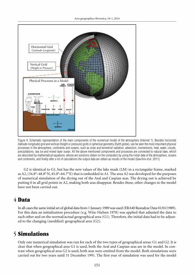
Figure 4: Schematic representation of the main components of the numerical model of the atmosphere (Internet 1). Besides horizontal(latitude-longitude) grid and vertical (height or pressure) grids in spherical geometry (Earth globe), can be seen the most important physicalprocesses in the atmosphere, continents and oceans, such as solar and terrestrial radiation, advection, momentums, heat, water, clouds,precipitations, sea ice and mixed layer ocean. All the above mentioned components and processes are connected to natural laws, whichare described by mathematical equations, whose are solutions obtain on the computers by using the initial data of the atmosphere, oceansand continents, and finally after a lot of calculations the output data are obtain as results of the model (Gavrilov et al. 2011).
Horizontal Grid(Latitude-Longitude)
Vertical Grid(Height or Pressure)
Physical Processes in a Model

Modelling of the Aral and Caspian seas drying out influence to climate and environmental changes
152
spinning up, while data from the second year was used for analysis. It is considered that this simulationof the entire climatological season is sufficient for adjustment to new conditions.
6 Results and analysisAll output data models are produced for both simulations with original (G1), and modified (G2) geographicalareas. For this purpose, only air temperature is considered as the main climatic parameter. The temperaturewill be displayed in two cases; as a local/regional and as a global and continental indicator of climate change.
6.1 Local and regional impact
To investigate local/regional changes in the vicinity of both the Aral and Caspian seas, two parameterswere used. One parameter is the average monthly temperature for January and August at two levels (atthe surface and 100m above it) along the meridian of longitude 50.625E.
Grid model data at resolution T42Original Lake Mask [fractional]
0.00
0.00
0.01
0.00
0.00
0.00
0.00
0.00
0.00
39.38E
51.62N
48.84N
46.05N
43.25N
40.46N
37.67N
34.88N
32.09N
0.00
0.00
0.00
0.00
0.00
0.00
0.02
0.00
0.00
42.19E
0.00
0.00
0.04
0.03
0.00
0.00
0.06
0.04
0.01
0.00
0.00
0.00
0.15
0.07
0.35
0.55
0.00
0.00
0.00
0.00
0.00
0.00
0.00
0.00
0.00
0.00
0.00
56.25E 59.06E 61.88E 64.69E 67.50E
0.01
0.00
0.00
0.39
0.24
0.00
0.00
0.00
0.00
0.04
0.02
0.02
0.20
0.04
0.02
0.00
0.00
0.02
0.02
0.02
0.00
0.00
0.00
0.00
0.01
0.00
0.00
0.04
0.00
0.00
0.00
0.00
0.02
0.01
0.00
0.00
0
0
0
0
0
0
0
0
0
0.00
0.03
0.04
0.00
0.00
0.02
0.07
0.01
0.01
45.00E
0.07
0.03
0.01
0.33
0.58
0.04
0.06
0.00
0.02
47.81E
0.05
0.00
0.01
0.67
0.79
0.93
0.73
0.00
0.00
50.62E 53.44E
Figure 5: Area A1 as part of normal global geographical area (G1) in model ECHAM5 around the Aral and Caspian seas, showing the originallake mask (LM).

The average monthly temperature for January and August at both levels can be seen in Figures 7–10,respectively. Green indicates the temperature distribution in the original geographic area (G1), and redis the temperature in the modified geographic area (G2).
As shown in Figures 7 and 8, draining the Aral and Caspian seas leads to a decrease in January tem-perature at both levels along the longitudinal direction (50.625E). The greatest difference in temperatureis about 7–8 °C around the centre line, and north and south of the centre line the difference in temper-ature monotonically decreases to about 1–2 °C in both cases. The lines are approximately matched at bothlevels. As can be seen, draining of the lakes reduces average monthly temperature during winter for about8 °C, while the daily extremes of temperature drop may be much higher.
As shown in Figures 9 and 10, draining of the Aral and Caspian seas leads to an increase in temperatureduring August at both altitude levels along the longitudinal direction (50.625E). The greatest difference insurface temperature is about 7–8 °C in the regions from 37.67 to 43.25°N. The greatest differences in tem-perature are similar in height, with the exception of 40.46°N, where the difference is less than 2 °C. Atthe southern and northern ends of the longitudinal direction (50.625E), temperature differences disappear.Lines are approximately matched at both levels. Draining both of the lakes increases average monthly tem-perature during the summer for about 8°C, while the daily extremes of temperature rise may be much greater.
Acta geographica Slovenica, 54-1, 2014
153
0.00
0.00
0.01
0.00
0.00
0.00
0.00
0.00
0.00
39.38E
51.62N
48.84N
46.05N
43.25N
40.46N
37.67N
34.88N
32.09N
0.00
0.00
0.00
0.00
0.00
0.00
0.02
0.00
0.00
42.19E
0.00
0.00
0.04
0.03
0.00
0.00
0.06
0.04
0.01
0.00
0.00
0.00
0.00
0.00
0.00
0.00
0.00
0.00
0.00
0.00
0.00
0.00
0.00
0.00
0.00
0.00
0.00
56.25E 59.06E 61.88E 64.69E 67.50E
0.01
0.00
0.00
0.00
0.00
0.00
0.00
0.00
0.00
0.04
0.02
0.00
0.00
0.00
0.00
0.00
0.00
0.02
0.02
0.02
0.00
0.00
0.00
0.00
0.00
0.00
0.00
0.04
0.00
0.00
0.00
0.00
0.02
0.01
0.00
0.00
0
0
0
0
0
0
0
0
0
0.00
0.03
0.00
0.00
0.00
0.00
0.00
0.00
0.01
45.00E
0.07
0.03
0.00
0.00
0.00
0.00
0.00
0.00
0.02
47.81E
0.05
0.00
0.00
0.00
0.00
0.00
0.00
0.00
0.00
50.62E 53.44E
Grid model data at resolution T42
New lake mask [fractional]
Figure 6: Area A1 as part of modified global geographical area (G2) around the Aral and Caspian seas, showing the new lake mask (LM)in the rectangular frame labelled as A2.

Modelling of the Aral and Caspian seas drying out influence to climate and environmental changes
154
Another parameter of change is the average surface annual temperature in A2, as a local indicator, andin A1, as a regional indicator for both simulations. The values of these temperatures can be seen in Table 1.
Table 1: Average annual surface temperature in areas A1 and A2 for simulations G1 and G2.
G1 G2
A2 14.73 °C 13.82 °CA1 11.67 °C 10.51 °C
As shown in Table 1, draining the Aral and Caspian seas leads to an overall decrease in average annu-al surface temperature in both areas. Since the difference in temperature is slightly greater in area A1, itis considered that draining both lakes have a greater impact on the local rather than regional climate.
6.2 Potential global impact
In the second case, as global and continental indicator of climate change, we used two parameters. Oneparameter of change was the average annual global surface temperature. This temperature was the same,
–12
–14
–10
–8
–6
–4
–2
0
2
4
6
8
34.88N 37.67N 40.46N 43.25N 46.04N 48.83N 51.62N 54.42N32.09N
1 Mean monthly Surface Temperature [C]; JAN1990Normal lake mask LON=50.625E; LAT=from 32N to 55N
Mean monthly Surface Temperature [C]; JAN1990Drainage lake mask LON=50.625E; LAT=from 32N to 55N
2
Figure 7: Surface average monthly temperature for January.

15.1 °C, for both simulations. As such, according to the model, draining the Aral and Caspian seas hadno effect on the average annual global surface temperature. However, another set of parameters of changeare the global distribution of average monthly surface temperatures for particular months, in this caseJanuary and August. These temperatures are shown on maps in Figures 11–14.
As shown in Figures 11 and 12, draining the Aral and Caspian seas lead to significant differences intemperature distribution over Asia during January. In the case of G1, the zero isotherm meanders throughthe middle of area A1, while in the case of G2 the zero isotherm has a zonal slope and extends to the south,almost to 30°N. Also, in the case of G1, the –20 °C isotherm is located in NE Asia to NW–SE direction,while in the case of G2 this isotherm penetrates the centre of the continent. It can be concluded thatthe removal of both seas lead to cooling of Asia during winter. By contrast, the configuration of isothermsin other parts of the world remains nearly unchanged. It may be noted that the warmest areas in Australia,southern Africa and South America are less pronounced in G2 than in G1.
As shown in Figures 13 and 14, draining the Aral and Caspian seas does not significantly change the con-figuration of August isotherms, but it does change the distribution of the hottest areas in Asia and Africa.In the case of the G2 simulation, on the locations of the Aral and Caspian seas is becoming warmer. Also,in addition to the three areas of extreme high temperatures in Asia (two in the Arabian Peninsula andthird in Kashmir), there are additional areas of extreme temperatures in the western Sahara. Another sig-nificant trend is the cooling of the Tibetan plateau to a greater extent than the surrounding regions.
Acta geographica Slovenica, 54-1, 2014
155
–12
–10
–14
–8
–4
–6
–2
0
2
4
6
8
10
12
14
34.88N 37.67N 40.46N 43.25N 46.04N 48.83N 51.62N 54.42N32.09N
1 Mean monthly Air Temperature [C] at level 100 [m] ; JAN1990Normal lake mask LON=50.625E; LAT=from 32N to 55N
Mean monthly Air Temperature [C] at level 100 [m] ; JAN1990Drainage lakes LON=50.625E; LAT=from 32N to 55N
2
Figure 8: 100 m above average monthly temperature for January.

Modelling of the Aral and Caspian seas drying out influence to climate and environmental changes
7 Discussion and conclusionWe evaluated climate and environmental changes in the case of a complete drying out of the two largeinland seas of the Aral and Caspian seas, located in arid and semiarid continental areas. This kind of sce-narios are quite plausible, as the Aral Sea is already almost completely dried up, while shallow parts ofthe Caspian Sea are being transformed into terrestrial ecosystems. As such, it is important to model the effectson both local and regional/global conditions.
The modelling results using the ECHAM5 model are quite dramatic. Comparing the temperaturechanges it was found that the drying out of both the Aral and Caspian seas leads to an increase in sum-mer and decrease in winter average monthly temperature by the similar amount, from about 7–8 °C, whilethe daily extremes of temperature may be even more pronounced. In the wider regional zone, close toboth seas, the average annual temperature is reduced by about 1 °C. However, at the global scale, averageannual temperature remains unchanged, while the general configuration of the isotherms remainsunchanged, except for some shifts over the continents.
Presented approach can also be applied to paleoclimatic research. Spatial and temporal changes of theParatethys Basins can be regarded as a key factor responsible for Cenozoic climate changes (Ramstein etal. 1997).The results of this study demonstrate that the drying out of isolated sea basins such as the described onescan cause significant regional climatic and environmental changes. Similar was shown for the drying out
156
Mean monthly Surface Temperature [C]; AUG 1990Normal lake mask LON=50.625E; LAT=from 32N to 55N
Mean monthly Surface Temperature [C]; AUG 1990Drainage lake mask LON=50.625E; LAT=from 32N to 55N
2
14
16
18
20
22
24
26
28
30
32
34
36
34.88N 37.67N 40.46N 43.25N 46.04N 48.83N 51.62N 54.42N32.09N
1
Figure 9: Surface average monthly temperature for August.

of Mediterranean Basin (Murphy et al. 2009), or drying out of Paratethys Basins, e.g. the present PannonianBasin (Hamon et al. 2013).
8 AcknowledgmentsThis research paper is financed by Project 176020 of the Serbian Ministry of Education, Science andTechnological Development and Project 114-451-2670 of Secretariat of Science and Technological Developmentof Vojvodina province government. The authors are grateful for the support of Slobodan Ni~kovi} andValentina Janc.
9 ReferencesArpe, K., Leroy, S. A.G. 2007: The Caspian Sea Level forced by the atmospheric circulation, as observed
and modelled. Quaternary international 173–174. DOI: http://dx.doi.org/10.1016/j.quaint.2007.03.008Arpe, K., Leroy, S. A.G., Lahijani, H., Khan, V. 2012: Impact of the European Russia drought in 2010 on
the Caspian Sea level. Hydrology and earth system science 16. DOI: http://dx.doi.org/10.5194/hess-16-19-2012
Acta geographica Slovenica, 54-1, 2014
157
Mean monthly Air Temperature [C] at level 100 [m] ; AUG 1990Normal lake mask LON=50.625E; LAT=from 32N to 55N
Mean monthly Air Temperature [C]Drainage lakes LON=50.625E; LAT=from 32N to 55N
at level 100 [m] ; AUG 19902
1
12
14
16
18
20
22
24
26
28
30
32
34
36
38
40
42
44
46
48
34.88N 37.67N 40.46N 43.25N 46.04N 48.83N 51.62N 54.42N32.09N
Figure 10: 100 m above average monthly temperature for August.

Modelling of the Aral and Caspian seas drying out influence to climate and environmental changes
158
Figure 12: Global distribution of surface average January temperatures in G2.
Figure 11: Global distribution of surface average January temperatures in G1.
Forecast mean surface temperature 8C: JAN 1990Normal lake mask
180 90W
60N
30N
30S
0 90E 180
60N
30N
EQEQ
30S
60S60S
180 90W 0 90E 180
–50 –40 –30 –20 –10 0 10 20 30 40 50
Forecast mean surface temperature 8C: JAN 1990Drainage of the Caspian and the Aral lake
180 90W
60N
30N
30S
0 90E 180
60N
30N
EQEQ
30S
60S60S
180 90W 0 90E 180
–50 –40 –30 –20 –10 0 10 20 30 40 50

Acta geographica Slovenica, 54-1, 2014
159
Figure 14: Global distribution of surface average August air temperatures in G2.
Figure 13: Global distribution of surface average August air temperatures in G1.
Forecast mean surface temperature 8C: AUG 1990Normal lake mask
180 90W
60N
30N
30S
0 90E 180
60N
30N
EQEQ
30S
60S60S
180 90W 0 90E 180
–50 –40 –30 –20 –10 0 10 20 30 40 50
180 90W
60N
30N
30S
0 90E 180
60N
30N
EQEQ
30S
60S60S
180 90W 0 90E 180
–50 –40 –30 –20 –10 0 10 20 30 40 50
Forecast mean surface temperature 8C: AUG 1990Drainage of the Caspian and the Aral lake

Modelling of the Aral and Caspian seas drying out influence to climate and environmental changes
Dahan A. 2010: Putting the Earth System in a numerical box? The evolution from climate modeling towardglobal change. Studies in history and philosophy of science B: studies in history and philosophy ofmodern physics 41-3. DOI: http://dx.doi.org/10.1016/j.shpsb.2010.08.002
Diamond, J.M. 2005: Collapse: how societies choose to fail or succeed. New York.ERA40 reanalyse data 01/01/1989. Atmosphere database. European centre for medium range weather fore-
casts (ECMWF). Reading.Gavrilov, M.B. 2005: Poplave i dr`ava. Vr{a~ke vesti, 23. 5. 2005. Vr{ac.Gavrilov, M.B., Jovanovi}, G.R., Janji}, Z. 2011: Sensitivity of a long-range numerical weather forecast
model to small changes of model parameters. Advances in science and research 6. DOI: http://dx.doi.org/10.5194/asr-6-13-2011
Goosse, H., Barriat, P. Y., Lefebvre, W., Loutre, M. F., Zunz, V. 2013: Introduction to climate dynamics andclimate modeling. Internet: http://www.climate.be/textbook (19. 2. 2013).
Hansen, J. E., Sato, M. 2012: Paleoclimate implications for human-made climate change. Climate Change:Inferences from paleoclimate and regional aspects. DOI: http://dx.doi.org/10.1007/978-3-7091-0973-1_2
Hagemann, S., Dümenil, L. 1996: Development of a parameterization of lateral discharge for the globalscale. MPI Report 219. Hamburg.
Hagemann, S., Dümenil, L. 1998: A parameterization of the lateral waterflow for the global scale. Climatedynamics 14-1. DOI: http://dx.doi.org/10.1007/s003820050205
Hagemann, S., Arpe, K., Roeckner, E. 2006: Evaluation of the hydrological cycle in the ECHAM5 model.Journal of climate 19. DOI: http://dx.doi.org/10.1175/JCLI3831.1
Hagemann, S. 2002: An improved land surface parameter dataset for global and regional climate mod-els. MPI Report 336. Hamburg.
Hamon, N., Sepulchere, P., Lefebvre, V., Ramstain, G. 2013: The role of eastern Tethys seaway closure inthe Middle Miocene climatic transition (ca. 14Ma). Climate of the past 9. DOI: http://dx.doi.org/10.5194/cp-9-2687-2013
Internet 1: http://celebrating200years.noaa.gov/breakthroughs/climate_model/AtmosphericModelSchematic.png(19. 2. 2013).
Kislov, A., Panin, A., Toropov, P. 2012. Paleostages of the Caspian Sea as a regional benchmark tests forthe evaluation of climate model simulations. Climate of the past discussions 8. DOI: http://dx.doi.org/10.5194/cpd-8-5053-2012
Micklin, P. 2007. The Aral Sea disaster. annual review of earth and planetary sciences 35. DOI: http://dx.doi.org/10.1146/annurev.earth.35.031306.140120
Micklin, P., Aladin, N.V. 2008: Reclaiming the Aral Sea. Scientific American 298-4. Internet: http://www.sciam.com/article.cfm?id=reclaiming-the-aral-sea&sc=rss (19. 2. 2013).
Murphy, L.N., Kirk-Davidoff, D.B., Mahowald, N., Otto-Bliesner, B. L. 2009: A numerical study of the cli-mate response to lowered Mediterranean Sea level during the Messinian Salinity Crisis. Palaeogeography,palaeoclimatology, palaeoecology 279. DOI: http://dx.doi.org/10.1016/j.palaeo.2009.04.016
Peneva, E.L., Stanev, E.V., Stanychi, S.V., Salokhiddinov, A., Stulina, G. 2004. The recent evolution of the AralSea level and water properties: analysis of satellite, gauge and hydrometeorological data. Journal of marinesystems 47, 1-4. DOI: http://dx.doi.org/10.1016/j.jmarsys.2003.12.005
Ramstain, G., Fluteau, F., Besse, J., Joussaume, S. 1997: Effect of orogeny, plate motion and land-sea dis-tribution on Eurasian climate change over the past 30 million years. Nature 386. DOI: http://dx.doi.org/10.1038/386788a0
Roeckner, E., Bäuml, G., Bonaventura, L., Brokopf, R., Esch, M., Giorgetta, M., Hagemann, S., Kirchner,I., Kornblueh, L., Manzini, E., Rhodin, A., Schlese, U., Schulzweida, U., Tompkins, A. 2003: The atmos-pheric general circulation model ECHAM5 – model description 1. Report 349. Hamburg.
Roeckner, E., Brokopf, R., Esch, M., Giorgetta, M., Hagemann, S., Kornblueh, L., Manzini, E., Schlese, U.,Schulzweida, U. 2004: The atmospheric general circulation model ECHAM5, sensitivity of simulatedclimate to horizontal and vertical resolution 2 II. Report 354. Hamburg.
Simmons, A. J., Burridge, D.M., Jarraud, M., Girard, C., Wergen, W. 1989: The ECMWF medium-rangeprediction models development of the numerical formulations and the impact of increased resolu-tion. Meteorology and atmospheric physics 40, 1-3. DOI: http://dx.doi.org/10.1007/BF01027467
Singh, A., Seitz, F., Schwatke, C. 2012: Inter-annual water storage changes in the Aral Sea from multi-mis-sion satellite altimetry, optical remote sensing, and GRACE satellite gravimetry. Remote sensing ofenvironment 123. DOI: http://dx.doi.org/10.1016/j.rse.2012.01.001
160

Toman, M. J. 2013: Aralsko jezero – simbolj okoljske katastrofe. Proteus 75, 9–10.Tudryn, A., Chalié, F., Lavrushin, Yu.A., Antipov, M.P., Spiridonova, E.A., Lavrushin, V., Tucholka, P., Leroy,
S.A.G. 2013: Late Quaternary Caspian Sea environment: Late Khazarian and Early Khvalynian trans-gressions from the lower reaches of the Volga River. Quaternary international 292. DOI: http://dx.doi.org/10.1016/j.quaint.2012.10.032
Varuschenko, S. I., Varuschenko, A.N., Klige, R.K. 1987: Changes in the regime of the Caspian Sea andnon-terminal water bodies in paleotime. Moscow.
Wiin-Nielsen A. 1978: On balance requirements as initial conditions. European centre for medium rangeweather forecasts (ECMWF) report 9. Berkshire.
Vri{er, I. 1953: Padanje gladina Kaspijskega morja. Proteus 15-9.
Acta geographica Slovenica, 54-1, 2014
161