Mobile pastoralist groups and the Palmyrene in the late Early to Middle Bronze Age (c. 2400-1700...
468
Mobile pastoralist groups and the Palmyrene in the late Early to Middle Bronze Age (c. 2400-1700 BCE): An archaeological synthesis based on a multidisciplinary approach focusing on satellite imagery studies, environmental data, and textual sources Dissertation presented for the degree of philosophiae doctor (PhD) at the Department of Archaeology, History, Cultural Studies, and Religion (AHKR) University of Bergen (UiB) Torbjørn Preus Schou 2014
Transcript of Mobile pastoralist groups and the Palmyrene in the late Early to Middle Bronze Age (c. 2400-1700...

Mobile pastoralist groups and the
Palmyrene in the late Early to Middle
Bronze Age (c. 2400-1700 BCE):
An archaeological synthesis based on a multidisciplinary
approach focusing on satellite imagery studies,
environmental data, and textual sources
Dissertation presented for the degree of philosophiae doctor (PhD) at the
Department of Archaeology, History, Cultural Studies, and Religion (AHKR)
University of Bergen (UiB)
Torbjørn Preus Schou
2014

i
Table of contents
Table of contents………………………………………………………………………………i
List of figures……………………………………………………………………………….viii
List of tables………………………………………………………………………………….xi
List of ancient texts………………………………………………………………………….xii
Acknowledgements………………………………………………………………………..xiii
1 Introduction ........................................................................................................................ 1
1.1 The Palmyrena project ................................................................................................. 2
1.2 Objectives for this dissertation .................................................................................... 3
1.2.1 Aims of research ................................................................................................... 4
1.2.2 The synthesis approach ........................................................................................ 6
1.3 Clarifications ............................................................................................................... 6
1.4 Outline of dissertation ................................................................................................. 7
1.5 Summary and conclusions ........................................................................................... 9
2 Climatic and environmental contexts ............................................................................... 10
2.1 Geographical aspects ................................................................................................. 11
2.1.1 Geology and topography .................................................................................... 11
2.1.2 Hydrology ........................................................................................................... 14
2.2 The climates of Syria ................................................................................................. 18
2.2.1 Seasonal patterns ................................................................................................ 18
2.2.1.1 Summer ..................................................................................................................... 19
2.2.1.2 Winter ........................................................................................................................ 19
2.2.1.3 Seasons of transition ................................................................................................. 21
2.2.2 Precipitation regimes .......................................................................................... 22
2.2.3 Climatic regions ................................................................................................. 25
2.2.3.1 Mediterranean climates ............................................................................................ 25
ii
2.2.3.2 Dry steppe climates ................................................................................................... 26
2.2.3.3 Montane climates ...................................................................................................... 26
2.3 The current state of Syrian biomes ............................................................................ 27
2.3.1 Considerations on soils and erosion ................................................................... 27
2.3.2 Syrian forests and woodlands ............................................................................. 28
2.3.3 Vegetation in the river valleys ........................................................................... 28
2.3.4 Steppe, dry steppe, and desert landscapes .......................................................... 29
2.4 Sources for climatic conditions in the past ................................................................ 30
2.4.1 Considerations regarding proxy data use ........................................................... 32
2.4.2 Soreq Cave ......................................................................................................... 33
2.4.3 The Dead Sea ..................................................................................................... 35
2.4.4 Lake Van ............................................................................................................ 37
2.4.5 Teçer Lake .......................................................................................................... 39
2.4.6 Deep sea cores .................................................................................................... 40
2.4.7 Other sources for paleoclimatic records ............................................................. 42
2.4.8 Global mechanisms and Near Eastern climate change ....................................... 45
2.5 The 4.2 ka BP event ................................................................................................... 49
2.5.1 The abruptness of the event ................................................................................ 49
2.5.2 The profile of the event ...................................................................................... 50
2.5.3 Causes for the event ........................................................................................... 53
2.5.4 The aftermath of the event ................................................................................. 54
2.6 Bronze Age environments and the anthropogenic impact ......................................... 56
2.6.1 Human impact on vegetation .............................................................................. 56
2.6.2 Data from archaeological sites ........................................................................... 58
2.7 The reconstruction of Palmyrene environments ........................................................ 62
2.7.1 Palmyrene terebinth/almond woodland steppe .................................................. 65
2.7.2 Palmyrene dry steppe – moist to medium dry and very dry types ..................... 67

iii
2.7.3 The desert biome ................................................................................................ 69
2.7.4 Riverine biomes .................................................................................................. 69
2.7.5 Xeric woodlands on the Palmyrene periphery ................................................... 70
2.7.6 Regional fauna .................................................................................................... 71
2.7.7 Considerations of the biome potentials in a Bronze Age context ...................... 72
2.8 Summary and conclusions ......................................................................................... 74
3 Textual sources and geopolitical developments ............................................................... 76
3.1 Chronological considerations .................................................................................... 77
3.1.1 Near Eastern chronologies and uncertainties ..................................................... 77
3.1.2 Periodisation in Near Eastern archaeology ........................................................ 83
3.2 Textual sources as a contextual resource ................................................................... 85
3.2.1 The use of Bronze Age cuneiform tablets .......................................................... 85
3.2.2 The Mari archives ............................................................................................... 88
3.2.3 The Ebla archives ............................................................................................... 89
3.2.4 Other Near Eastern archives ............................................................................... 90
3.2.5 Textual attestations of the Palmyrene ................................................................ 92
3.2.6 Languages and populations ................................................................................ 94
3.3 Geopolitical developments during the EBA IV ......................................................... 97
3.3.1 Early EBA IVa: Syria during the age of Ebla and Mari (c. 2400-2300 BCE) ... 97
3.3.2 Late EBA IVa and early EBA IVb: The Akkadian conquests and the Gutean
interregnum (c. 2350-2100 BCE) ..................................................................................... 99
3.3.3 Late EBA IVb: The Ur III state (c. 2100-2000 BCE) ...................................... 101
3.4 Geopolitical developments during the MBA ........................................................... 104
3.4.1 MBA I: Mesopotamian developments and Syrian implications (c. 2000-1800
BCE)…….. ..................................................................................................................... 104
3.4.2 Late MBA I and early MBA II: The Amorrite dynasties and Syrian MBA
developments until the end of Mari (c. 1850-1760 BCE) .............................................. 107
iv
3.4.2.1 Syria during the early 19th century BCE ................................................................... 107
3.4.2.2 The competing reigns of Šamši-Addu and Yahdun-Lim ........................................... 108
3.4.2.3 The Syrian geopolitical scene until the fall of Mari ................................................. 110
3.5 Summary and conclusions ....................................................................................... 113
4 The Palmyrena survey and EBA-MBA archaeology in central Syria ............................ 115
4.1 Defining Palmyrene prehistoric archaeology .......................................................... 116
4.1.1 The Bronze Age technocomplex: Defining Palmyrene archaeological
structures……… ............................................................................................................ 116
4.1.2 Survey area and methods .................................................................................. 118
4.1.3 Tumulus typology ............................................................................................ 120
4.1.4 Communicational aspects, condition, and distributional contexts ................... 125
4.1.5 Comments on chronology ................................................................................ 128
4.2 Typological and contextual analyses of Palmyrene tumuli ..................................... 130
4.2.1 The 2011 fieldwork season – statistics ............................................................. 130
4.2.2 The 2009 fieldwork season and 2008 prospection – statistics ......................... 131
4.2.3 Tumuli and topographical context .................................................................... 136
4.2.3.1 The Jebel Abyad region ........................................................................................... 139
4.2.3.2 The Jebel Merah region ........................................................................................... 141
4.3 Satellite imagery studies of the Palmyrene .............................................................. 144
4.3.1 The rationale behind satellite studies ............................................................... 144
4.3.2 The results of satellite imagery studies ............................................................ 146
4.3.2.1 Aspects of methodical execution ............................................................................ 146
4.3.2.2 Tumuli and their contextual aspects ....................................................................... 148
4.3.2.3 Kites and stone enclosures ...................................................................................... 151
4.4 Google Earth satellite imagery studies of the Palmyrene ........................................ 152
4.4.1 Outline of methodic execution ......................................................................... 154
4.4.2 Considerations on general issues and problems ............................................... 155
4.5 Results from the Google Earth studies .................................................................... 160
v
4.5.1 General results from the survey of the Palmyrene ........................................... 160
4.5.2 General comments on the Palmyrene as a region............................................. 161
4.5.3 The Google Earth survey and distribution of Palmyrene tumuli...................... 164
4.5.4 The Google Earth survey and distribution of Palmyrene stone enclosures ...... 175
4.5.4.1 Distributional patterns of Palmyrene stone enclosures .......................................... 177
4.5.4.2 Interpretations and comparison with similar structures ........................................ 179
4.5.5 The Google Earth survey and distribution of Palmyrene kites ........................ 187
4.5.5.1 Distributional patterns of Palmyrene kites ............................................................. 188
4.5.5.2 Interpretations of kites and their local and regional functionality ......................... 191
4.5.5.3 Kites and chronological considerations ................................................................... 199
4.6 Chronology and the dating of Palmyrene tumuli ..................................................... 203
4.6.1 The tumuli and surface collection of pottery ................................................... 203
4.6.2 Dating by optically stimulated luminescence (OSL) ....................................... 208
4.6.2.1 Outline of OSL theory and sample collection .......................................................... 208
4.6.2.2 Results from the OSL approach ............................................................................... 212
4.7 Other archaeological research into central Syrian EBA and MBA ......................... 214
4.7.1 The French surveys in the extended Rawda region .......................................... 217
4.7.2 The Finnish SYGIS project in Jebel Bishri ...................................................... 218
4.7.3 The Syro-Japanese project in Jebel Bishri ....................................................... 220
4.7.4 The Syro-Italian project in the southwestern Palmyrene ................................. 228
4.8 Summary and conclusions ....................................................................................... 230
5 Near Eastern mobile pastoralism .................................................................................... 232
5.1 General patterns of mobility, pastoralism, and tribes .............................................. 233
5.1.1 Earlier views on tribes and mobile pastoralism ............................................... 233
5.1.1.1 The Bedouin misconception .................................................................................... 234
5.1.1.2 Reassessing earlier theories on the concept of tribe .............................................. 235
5.1.2 Key definitions of pastoralism, mobility, and tribe .......................................... 238
5.1.2.1 Considerations on terminology regarding mobility and pastoralism ...................... 238
5.1.2.2 Considerations on the concept of tribal organisation ............................................. 247

vi
5.1.3 Environment, subsistence patterns and relationships ....................................... 249
5.1.3.1 The domesticated herds of Near Eastern pastoralists ............................................ 249
5.1.3.2 Seasonality and Near Eastern tribal pasturages of recent times ............................ 250
5.1.3.3 Coping mechanisms of mobile pastoralists ............................................................. 257
5.1.3.4 Socioeconomic relationships of mobile pastoralist groups ..................................... 259
5.2 Bronze Age mobile pastoralist patterns ................................................................... 261
5.2.1 Mobile pastoralists in the EBA and MBA: The textual sources ...................... 261
5.2.1.1 Ancient designations of mobile groups ................................................................... 262
5.2.1.2 Ancient designations regarding pastoralist lifestyles .............................................. 266
5.2.1.3 Ancient geopolitical organisation and tribal structures .......................................... 271
5.2.1.4 Non-pastoralist practices by mobile groups attested in ancient texts ................... 277
5.2.2 The pastoral economy of the EBA-MBA: The archaeological record ............. 282
5.2.2.1 Pastoral production in Near Eastern archaeology and ancient texts ...................... 283
5.2.2.2 EBA-MBA developments within Near Eastern pastoralism ..................................... 285
5.3 Near Eastern tribal identities during the EBA and MBA ........................................ 289
5.3.1 The Amorrite conundrum ................................................................................. 289
5.3.1.1 The Amorrites - ancient perceptions and recent theories ...................................... 290
5.3.1.2 The concept of mirror toponomy ............................................................................ 299
5.3.1.3 Amorrites and tribal identities ................................................................................ 303
5.3.2 The tribal world of the Mari archive ................................................................ 310
5.3.2.1 The Sim’alites .......................................................................................................... 311
5.3.2.2 The Yaminites .......................................................................................................... 312
5.3.2.3 The Numha and the Yamutbal ................................................................................. 316
5.3.3 Sutu and the Suteans ........................................................................................ 319
5.4 Tumuli, tribal ancestors, and territories ................................................................... 323
5.4.1 Ancient and recent mortuary traditions ............................................................ 323
5.4.2 The humusum and similar monuments ............................................................ 326
5.4.3 Palmyrene tumuli and their ancient contexts ................................................... 329
5.5 Summary and conclusions ....................................................................................... 334
6 Palmyrena and mobile pastoralists in the EBA IV and MBA ........................................ 336
vii
7 Reference list .................................................................................................................. 346
7.1 Bibliography ............................................................................................................ 346
7.2 Web pages ................................................................................................................ 372
8 Appendices .......................................................................................................................... I
8.1 Appendix 1: Palmyrena project ground survey tumuli ................................................. I
8.2 Appendix 2: Palmyrena project survey area ................................................................. I
8.3 Appendix 3: Topographical division for Google Earth survey .................................... I
8.4 Appendix 4: Area maps and Palmyrene structures ....................................................... I

viii
List of figures
Figure 1.1: Herd on pasture in Wadi Takara ............................................................................ 2
Figure 2.1: Physical map of the Near East .............................................................................. 11
Figure 2.2: Physical map of the Palmyrene. ........................................................................... 13
Figure 2.3: Floodwater in Palmyra streets from Palmyrene rainfall. ...................................... 16
Figure 2.4: Blooming grasses in the Palmyra ruins ................................................................ 21
Figure 2.5: Flooding in Palmyra following rainfall. ............................................................... 23
Figure 2.6: Modern Syrian isohyets ........................................................................................ 25
Figure 2.7: Ecological hot-spot in Jebel Abyad. ..................................................................... 29
Figure 2.8: Sources for proxy data records ............................................................................. 31
Figure 2.9: The Soreq Cave record ......................................................................................... 34
Figure 2.10: Deep sea records. ................................................................................................ 41
Figure 2.11: Eastern Mediterranean lake records ................................................................... 42
Figure 2.12: Dry and wet phases at Ebla and Qatna. .............................................................. 44
Figure 2.13: Global mechanisms of climatic variations .......................................................... 46
Figure 2.14: Actual and postulated Holocene Dead Sea lake levels ....................................... 52
Figure 2.15: Combined effects of the ITCZ and the NAO...................................................... 48
Figure 2.16: Paleoenvironmental studies in the Near East ..................................................... 59
Figure 2.17: Satellite image of the Umbashi region ............................................................... 61
Figure 2.18: The vegetation potential of Syrian environments. .............................................. 65
Figure 2.19: A lone terebinth in Jebel Abyad. ........................................................................ 66
Figure 2.20: Spring grasses covering the Palmyrene steppe. .................................................. 68
Figure 3.1: Ancient regions of the Near East. ......................................................................... 77
Figure 3.2: EBA and MBA archives in the Near East. ........................................................... 88
Figure 3.3: EBA and MBA languages and populations .......................................................... 95
Figure 3.4: The main actors of the EBA IV polities ............................................................... 99
Figure 3.5: The Ur III state and the Near East ...................................................................... 102
Figure 3.6: The main actors of the MBA polities ................................................................. 107
Figure 3.7: The main polities of MBA II and their regional influence ................................. 112
Figure 4.1: Tumulus of the cairn type. .................................................................................. 122
Figure 4.2: Tumulus of the monumental type ....................................................................... 123
Figure 4.3: Tumuli of the mound type .................................................................................. 124
ix
Figure 4.4: Tumuli of the turret type ..................................................................................... 125
Figure 4.5: Heavily disturbed and totally destroyed tumuli .................................................. 127
Figure 4.6: Examples of external structural features............................................................. 129
Figure 4.7: Satellite view of ground-surveyed tumuli in Jebel Abyad.................................. 137
Figure 4.8: Satellite view of ground-surveyed tumuli in Jebel Merah .................................. 138
Figure 4.9: Computer-generated perspective of tumuli in the landscape .............................. 139
Figure 4.10: Distribution of mounds and turrets in the Jebel Abyad region ......................... 140
Figure 4.11: Distribution of monumentals and complexes in the Jebel Abyad region ......... 141
Figure 4.12: Distribution of mounds and turrets in the Jebel Merah region ......................... 142
Figure 4.13: Distribution of monumentals and complexes in the Jebel Merah region ......... 143
Figure 4.14: Ground-surveyed archaeological structures in satellite imagery ...................... 146
Figure 4.15: Detail of satellite image from northeastern Jebel Merah .................................. 148
Figure 4.16: The mountain pass Taniyet ez Zerr and its tumuli ........................................... 150
Figure 4.17: Satellite image of structures in northeastern Jebel Merah ................................ 152
Figure 4.18: The Palmyrene divided into topographical landscapes .................................... 155
Figure 4.19: Modern Bedouin activities in the satellite imagery. ......................................... 156
Figure 4.20: Natural features in the satellite imagery ........................................................... 157
Figure 4.21: Woodland steppe vegetation in the satellite imagery. ...................................... 159
Figure 4.22: Tumulus distribution in the Levant and central Syria. ..................................... 161
Figure 4.23: Distribution of all structure types in the Palmyrene. ........................................ 163
Figure 4.24: Examples of Palmyrene tumuli in Google Earth satellite imagery................... 165
Figure 4.25: Satellite view of tumuli in Jebel Merah and surrounding areas ....................... 167
Figure 4.26: Tumuli distribution and routes in the Wadi Sahil area ..................................... 168
Figure 4.27: Satellite view of tumuli in Jebel Abyad and surrounding areas. ...................... 169
Figure 4.28: Northern end of Wadi Mazrur and tumulus contexts ....................................... 170
Figure 4.29: Tumulus densities in the Palmyrene landscapes. .............................................. 173
Figure 4.30: Full distribution map of Palmyrene tumuli ....................................................... 175
Figure 4.31: Distribution map of Palmyrene stone enclosures. ............................................ 176
Figure 4.32: Detail of stone enclosure landscape contexts ................................................... 178
Figure 4.33: Macrolevel landscape context of stone enclosures ........................................... 179
Figure 4.34: Various manifestations of Palmyrene stone enclosures.................................... 180
Figure 4.35: Stone enclosures and other structures in Wadi Sahil ........................................ 182
Figure 4.36: Water-filled stone enclosure in Jebel Labidah.................................................. 185

x
Figure 4.37: Photo of stone enclosures in the foothills of Jebel Merah.. .............................. 186
Figure 4.38: Distribution map of Palmyrene kites. ............................................................... 188
Figure 4.39: Google Earth view of a group of Jebel Dahek kites. ........................................ 189
Figure 4.40: Google Earth view of ground-surveyed kite in Jebel Merah ............................ 191
Figure 4.41: Google Earth view of structures in Poidebard (1934) ...................................... 193
Figure 4.42: Photo of a kite in Poidebard (1934). ................................................................. 194
Figure 4.43: Diagrams of Palmyrene kite directions............................................................. 195
Figure 4.44: Google Earth view of two Jebel Dahek kites. .................................................. 196
Figure 4.45: Google Earth view of relations between kites and tumuli ................................ 201
Figure 4.46: Distribution of EBA IV pottery from the ground survey. ................................ 204
Figure 4.47: Distribution of Roman/Byzantine pottery from the ground survey. ................. 204
Figure 4.48: Distribution of flint flakes and tools from the ground survey .......................... 205
Figure 4.49: Photo of tumulus cluster complex in the Jebel Merah foothills ....................... 206
Figure 4.50: Recent Bedouin burials overlying ancient Palmyrene structures. .................... 207
Figure 4.51: Google Earth view of relations between kites and tumuli ................................ 208
Figure 4.52: Distribution map of tumuli chosen for OSL sampling ..................................... 210
Figure 4.53: The OSL sampling method ............................................................................... 212
Figure 4.54: Before and after sampling for OSL dating ....................................................... 212
Figure 4.55: Areas of EBA and MBA research in central Syria. .......................................... 215
Figure 4.56: Petal- or hearth-shaped auxilliary structures. ................................................... 220
Figure 4.57: Monumental tumulus showing internal wall features ....................................... 226
Figure 4.58: Relations between serial tumuli and their sizes ................................................ 226
Figure 4.59: Palmyrene finds potentially associated with mobile groups............................. 228
Figure 5.1: Combinations of Near Eastern pastoralism and cultivation ............................... 241
Figure 5.2: Model of four basic types of mobility ................................................................ 244
Figure 5.3: Pasture ranges and tribal territories of recent Syrian groups.. ............................ 251
Figure 5.4: Palmyra during hamsin/samum conditions ......................................................... 253
Figure 5.5: The seasonal schedule of Near Eastern tribal groups ......................................... 255
Figure 5.6: Near Eastern multi-resource procurement strategies .......................................... 256
Figure 5.7: Near Eastern recent and ancient tribal organisation ........................................... 275
Figure 5.8: Multi-resource strategies and the seasonal cycle ................................................ 281
Figure 5.9: Distribution map of kranzhügel sites western Jezire .......................................... 288
Figure 5.10: Near Eastern attestations of mardu in EBA sources ......................................... 297

xi
Figure 5.11: The mirror toponomy phenomenon of the Near Eastern MBA. ....................... 300
Figure 5.12: Map of tribal affiliations and territories during the Mari period. ..................... 316
Figure 5.13: Tribal dualities in the Mari world ..................................................................... 317
Figure 5.14: The upper, middle, and lower route crossing the Palmyrene ........................... 321
Figure 5.15: Refurbishments potentially representing post-mortuary rituals ....................... 330
Figure 5.16: Tumulus and its relation to a route across Jebel Abyad. .................................. 332
List of tables
Table 3.1: Dates according to various chronologies ............................................................... 78
Table 4.1: Tumulus types in the Palmyrena surveys. ............................................................ 130
Table 4.2: Tumulus contexts in the Palmyrena surveys ........................................................ 132
Table 4.3: Tumulus types and conditions in the Palmyrena surveys .................................... 134
Table 5.1: Ancient terminology relating to pastoralist practices ........................................... 268
Table 5.2: EBA and MBA attestations of Amorrites or mardu ............................................. 292
Table 5.3: Amorrite identity in EBA and MBA sources. ...................................................... 305
xii
List of ancient texts and their contents
3.1: Tadmoreans in Kaneš 92
3.2: Sutean raid on ambassadors 92
3.3: Tadmorean couriers 93
3.4: Samsi-Addu advising on routes 93
3.5: Yasmah-Addu replying on routes 93
3.6: Followers of the great kings 111
5.1: The notion of hibrum 264
5.2: The notion of nighum 268
5.3: Sim’alite hana in Yamutbal lands 269
5.4: The notion of merhum 269
5.5: Peaceful mobile pastoralists 270
5.6: The dangers of dry season mobility 270
5.7: Rain during the wet season 271
5.8: Hana and merchant mobility 271
5.9: The property of hana 276
5.10: Sutean raid and retaliation 277
5.11: Suteans planning a raid 278
5.12: Sutean raid in the Palmyrene 278
5.13: Turukku warfare and its spoils 278
5.14: Turukku spoils of war 279
5.15: Textiles as payment 285
5.16: Hostile Amorrites 295
5.17: The notion of kur mardu 298
5.18: Changing tribal identities 304
5.19: The tribes and kings of the Yamina confederacy 313
5.20: Indication of Sutean alum 320
5.21: Uprapean raid on Sutean flocks 322
5.22: The humusum of La’um 326
5.23: The humusum as geographical reference point 326
5.24: Other humusum functions 327
5.25: Humusum, ramum, and tribal territories 327
xiii
Acknowledgements
First things first – the Palmyrena project members. I am indebted to Professor Jørgen
Christian Meyer for initiating the project, taking me on board, believing in my project,
showing me around his beloved Syria and the Palmyrene, and in general for being a great guy.
Also, my sincere thanks to Prof. Meyer and Dr. Nils Anfinset for their indispensible help as
mentors, supervisors, and colleagues. They have helped me through many a struggling
situation and have been key to the completion and submission of this dissertation. Finally, I
have to thank Dr. Eivind Heldaas Seland for his inspiring collegiality, social nature, and
academic know-how.
I want to thank my parents, Bjørn and Solveig, and my sister, Ragnhild, for their
unquestionable support throughout the years it took me to carry out the research and write this
study, helping me in all manners possible, and always welcoming me home to Kristiansand. I
would also like to thank all my friends and relations for their interest in my work and
participation in social activities when I needed a break, and all my colleagues in academic
institutions with which I have conversed, debated, and socialised.
My sincere appreciation and gratitude to all my Syrian friends who has assisted myself and
the project in professional and social capacities and will always be remembered for their
boundless hospitality – Adeeb (Abu Badia), Naim and the Turki family, Abdulbasit and
Waleed in the Palmyra museum, Fuaz, my friends Hassan, Ahmed, and Abdu, and all other
relations in Palmyra. In addition, my heartfelt thanks to friends from other parts of Syria –
Raed from Deir ez-Zor and Mohammed from Latakia. I am so grateful for my time in Syria
and the exclusively and utterly positive encounters I had with its fantastic people. The whole
situation at the time of writing is deeply tragic on all levels.
My penultimate gratitude goes to Professor Graham Philip and Professor Daniele Morandi
Bonacossi for valuable advise and input given at crucial times during the initial phases of this
production, which was a great help in guiding me toward the methods and results I have
obtained here. In continuance of this, I have to recognise all the scholars and research projects
carrying out research into Syrian Bronze Age topics on whose shoulders I stand and without
which I would never have been able to contextualise the material.
Finally, my heartfelt gratitude to Google. Keep information open and accessible.
1
1 Introduction
When the Austrian traveller Aloïs Musil traversed the Palmyrene from Tadmor to Isriyeh and
Resafa in 1912, he used these words to describe the area stretching northward from the the
ruined Roman city through the dry steppe highlands:
“At 8.43 we reached the top of the height of at-Tenâja, which is a southwestern spur of the
Târ an-Nwejser. On nearly every hilltop were seen heaps of stones or the remains of
watchtowers. (…) The nearer we approached, the more distinctly could be seen the groups of
trees in the western part of the al-Abjaz mountains. These are especially numerous on both
sides of the Wadi Dekara” (Musil 1928:147).
The first striking aspect of this description is its reference to the tree-clad slopes on both sides
of Wadi Takara, i.e. the foothills of Jebel Abyad (al-Abjaz) and hills of Jebel Homr ez Jazal
(cf. appendix 3, p. I-II, areas 7, 9, and 10). These areas are today utterly devoid of any
vegetation taller than herbs and grasses, suggesting that Musil merely a hundred years ago
must have traversed a very different landscape than the one met by anyone travelling through
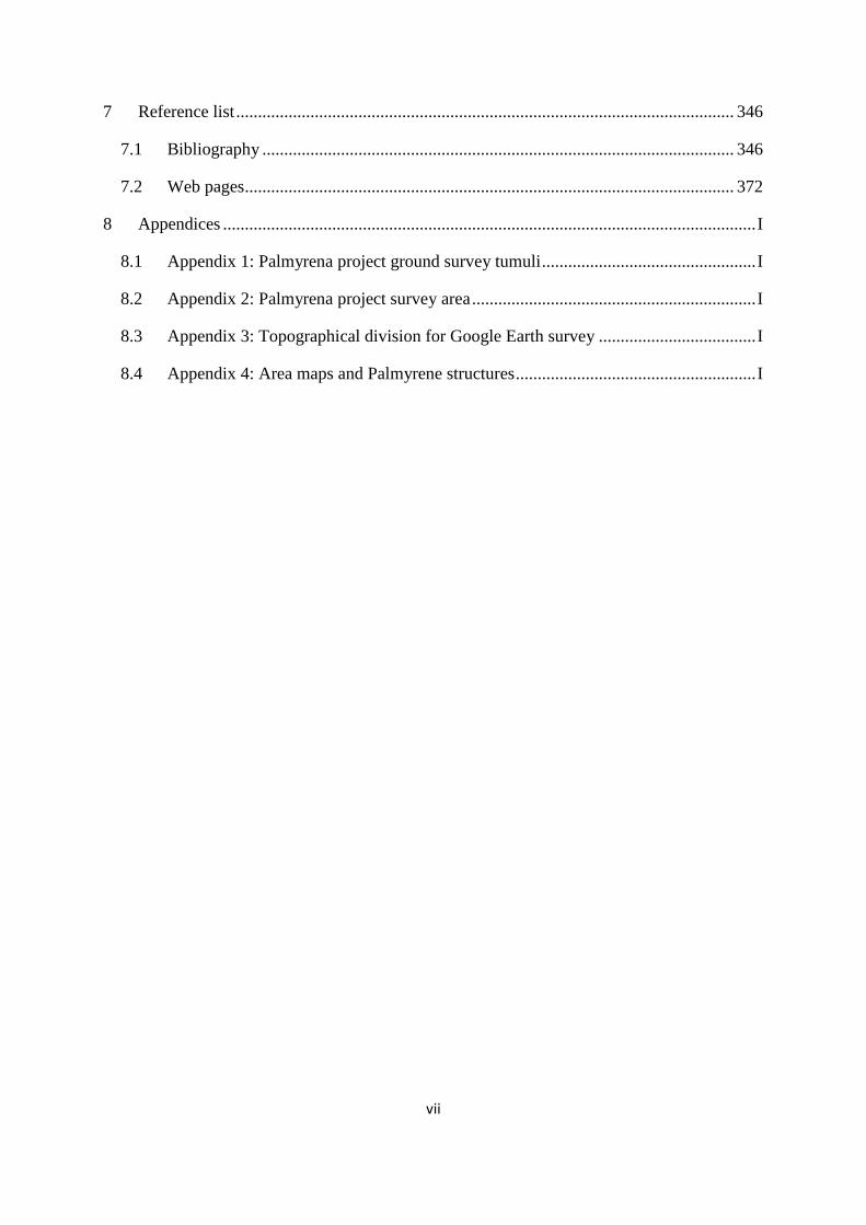
the Palmyrene today (cf. Figure 1.1).
The other intruiging piece of information discerned is his interpretation of the ancient remains
he noticed along the mountain ridges and hilltops. Like Poidebard (1934) did only six years
after Musil published his travel accounts, he related all those he came across in the Palmyrene
landscape to the ancient city of Palmyra – the bride of the desert [sic]1 – and thus to Roman
presence in the region during Classical times. In such a context both Musil and Poidebard
interpreted the heaps of stones as ruined watchtowers (cf. Figure 4.41). One cannot blame
them, as these structures can appear tower-like, with walls of dressed stones, and are often
located in places with views far and wide across the steppe. In addition, they did not have the
luxury of a century of archaeological research to lean on. However, there is no doubt now that
the structures witnessed by these early-20th century CE explorers in fact were burial
monuments, in many cases constructed thousands of years prior to the Roman occupation of
Syria by people inhabiting the Palmyrene during the Bronze Age.
1 While this poetic designation of the ruined city is both alluring and evocative, it would not be correct to call the
regional environment a desert. The lowland Palmyrene is a dry steppe and the highlands could until the 20th
century CE be called a terebinth woodland steppe (cf. 2.3 and 2.7)
2
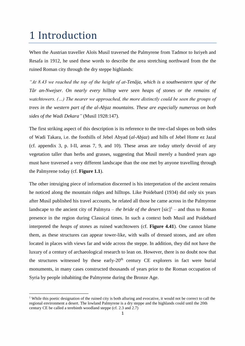
Figure 1.1: View toward the western side of Wadi Takara during the spring of 2011, where the especially
numerous trees noted by Musil (1928) have all been destroyed some time in the passing 99 years. His
watchtowers on the hilltops now seem much more likely to have been monuments for the dead constructed
millennia before the Romans ruled the Near East by people practicing a lifestyle similar to that seen here –
seasonal mobile ovicaprine pastoralism.
1.1 The Palmyrena project
The full title of the joint Syrian-Norwegian archaeological research project was «Palmyrena:
City, Hinterland and Caravan trade between the Occident and the Orient» (cf. Meyer 2009;
2011; Anfinset 2009; 2013; also cf. www.org.uib.no/palmyrena). Initially a four-year venture
(2009-2012) funded by the Norwegian Research Council, it ended officially in June of 2013,
after which publications were and are expected to follow regularly. The geographic focus for
the project was the city of Palmyra – in modern times called Tadmor – where an oasis has
provided basis for settlement in the central Syrian dry steppe for millennia, most notably
during the Roman period, when it grew to one of the most important cities of the Empire.
However, the main locus for active research and data collection was the northern hinterland of
Palmyra – the Palmyrene or Palmyrena (cf. appendix 2, pp. I-II), toponyms which in this
dissertation will be used interchangably. Chronologically, the project was divided into two
main parts:

3
Historic periods, which stretched from Hellenistic times to the Islamic periods, but
with a main focus settlement, structures, and networks during the Roman and
Byzantine eras. This was studied on two levels, one regional – i.e. Palmyra and its
hinterland – and one superregional – i.e. the role of Palmyra in networks connecting
the Orient and the Occident.
Prehistoric periods – of which this dissertation is a part – which more or less
concerned on the millennia prior to Hellenistic times, but with a clear focus on the
Neolithic and the Bronze Age.
One objective for the prehistoric part of the Palmyrena project was to document subsistence
strategies in the Palmyrene dry steppe through the ages, from the integrated perspectives of
diachronic climatic developments, environmental contexts, and socioeconomic organisation.
To achieve this, the team ground surveyed large tracts of the Jebel Abyad and Jebel Merah
mountain chains and the landscapes immediately surrounding these. The exploration and
prospection of 2008 had identified a number of archaeological structures distributed
throughout the landscape, including unmistakable burial monuments of various shapes and
sizes in vast numbers, as well as the occasional structure known as «desert kites» (e.g. Helms
& Betts 1987), all of which had lain undocumented by archaeologists working from Palmyra
throughout the 20th century CE and – regarding the tumuli – only just recently been noted by
projects surveying other parts of Syria (cf. 4.7). Thus, the fieldwork of 2009 and 2011 aimed
to explore the region and survey as many sites as possible, noting structure types, shapes,
sizes, conditions, associated small finds, archaeological contexts (i.e. association with other
structures), and their landscape contexts (also cf. 4.1.2). While the assemblage of surveyed
sites included a small number of kites and stone enclosures, as well as several open-air sites
and rockshelters, tumuli or burial cairns comprise by far the majority of archaeological
structures documented in the Palmyrene highlands by the prehistoric team. In addition to the
objective of integrating archaeology with landscape, the overarching uncertainties concerned
the who, the when, and the why. Who erected these tumuli? When were they construced?
What was their purpose in these societies and in the landscape?
1.2 Objectives for this dissertation
The initial prospection report from the Palmyrena project (cf. Meyer 2008, p. 124) noted that
local clusters of tumuli in the Jebel Merah area could represent territorial markers by the
population who constructed them, although their purpose was far from clear. The project

4
mentioned a relatively far-reaching communicative aspect of the larger tumuli on the
Palmyrene ridges, which to some degree seemed to mark the route crossing the region from
Palmyra and northward. Finally, a distinctive lack of such structures for other landscapes was
also recognised. An open question was raised – how did the region look during the Bronze
Age?
1.2.1 Aims of research
These concepts summarise in short the main questions I intend to explore and try to answer
with this dissertation. The Palmyrene problem is that the region has played a very limited role
in archaeological research into Bronze Age topics, and by far most of the 20th century CE
studies have focused on the large settlements or cities and the cultivated zones as their focus.
Fortunately, this has changed in the last 15 years, with steppe landscapes and their population
increasingly being put under investigation. In addition, new approaches – particularly large-
scale remote sensing – have greatly expanded the field of archaeological method and data
collection (e.g. Bradbury 2011, p. 164). The primary question here concerns land use and the
physical manifestation of archaeological structures in the Palmyrene. The notable patterns in
tumulus distribution as well as in structure form and relations initially documented seem to
suggest a phenomeon associated with mobile pastoralist groups exploiting the region during
the Bronze Age. While this should be considered the main hypothesis put forward for this
dissertation, as an assumption it is not necessarily straightforward and should be investigated
further by various means.
Based on an expanded survey of the Palmyrene using satellite imagery from both
commercially available images and the recently (since 2010) available high-resolution
imagery of large parts of the region in Google Earth, I aim to augment the picture of tumulus
distribution patterns by vastly increasing the data set available through remote-sensing
methods and analyse the results on a micro- and macrolevel perspective. In addition, the two
other structure types recorded in the Palmyrene – stone enclosures and kites – are also easily
surveyed using this method, and as all three of them are included in what Zarins (1992, p. 50)
called the pastoral nomadic technocomplex of the Near Eastern Chalcolithic and Early Bronze
Age (cf. 4.1.1), I will also integrate these in the analysis of Palmyrene land use and its link to
the archaeological remains recorded across the steppe.

5
The connection between these structures and mobile pastoralism is also hypothetical for the
tumuli documented by the Palmyrena project, but as Zarins suggested 20 years ago, and has
been increasingly supported in later years (e.g. Castel 2008, p. 306), although also within a
context of multi-resource strategies (Bradbury 2011, p. 438). I intend to explore this aspect of
the Palmyrene, within the hypothesis that many of the monuments represent a direct
expression of territoriality by mobile groups practicing seasonal exploitation of the region,
mainly through the pasturing of ovicaprine herds, but also including an aspect of multi-
resource subsistence with a certain amount of hunting and small-scale horticulture – all of
which arguably is represented by Palmyrene structures. One important source of information
here will be the ancient texts concerning these matters, and above all the Mari archives.
Finally, there are some climatic and environmental questions I intend to consider. First, is the
discrepancy between Musil’s description and the current state of the Palmyrene indeed an
actual development of the century that separates the two perspectives? Second, what
characterised the landscapes and ecologies of Syria during the Bronze Age, and particularly
its steppe biomes? Third, the data sources concerning climatic developments through the
Bronze Age show considerable diachronic deterioration in climatic conditions in the Near
East, with particularly dramatic events during the EBA IV. What was the nature of such
climate change through the period and what did that entail for Near Eastern populations?
Evidently, the Palmyrene is the geographical focus of this dissertation, but in many contexts
the spatial horizon will be widened to include the entire Near East, which i.e. is here defined
as the region from the Levant to the Zagros, and from the southern foothills of Anatolia to the
Al-Hamad (cf. fig. 2.1). My chronological horizon will be c. 2400-1700 BCE, which
comprises the archaeological periods EBA IV and MBA (cf. 3.1.2 for further elaboration).
There are several reasons for this. First, the available evidence from dated structures suggests
that the later 3rd millennium and early 2nd millennium BCE is a period of expansion into sub-
optimal landscapes, such as the Palmyrene dry steppe (cf. Bradbury 2011, p. 300), which also
seems to be accompanied by increased mobility and changes in pastoral production possibly
as a result of environmental stress (e.g. Wossink 2009, pp. 146-147). This latter aspect is
often linked to dramatic events in the climatic developments toward the end of the 3rd
millennium BCE, which I would argue supports the use of a temporal horizon which includes
both conditions just prior to and following these circumstances. The final argument for my
chronological boundaries is that it allows me to use invaluable textual material from Bronze

6
Age archives which provide great access to detailed information concerning the societies
inhabiting the Near East and their relationship with each other and the landscape.
1.2.2 The synthesis approach
The lack of large-scale research relating to the Bronze Age Palmyrene requires me to take a
wide approach to the problems I intend to investigate. I will have to collect information from
a number of disciplines, many in which I consider myself a relative novise, in order to paint a
coherent picture of the archaeological, historical, topographical, environmental, and
socioeconomic contexts which surround these questions. For instance, if I take geography out
of this equation, I tend to think that the remaining elements would suffer. On the other hand, I
belive that the inclusion of a wide array of disciplines to the study of archaeology also will
create a synergetic effect, i.e. that this research as an integrated totality exceeds the sum of
each aspect put together. Therefore I am determined to carry out the exploration of Palmyrena
in the Bronze Age as a synthesis, which will include various amounts of climatology, ecology,
epigraphy, Assyriology, ethnography, geography, and other fields of research. However, these
disciplines all play a supplementary role, as this still is an archaeological investigation, with
the data primarily consisting of archaeological structures and the analyses always being
conducted with these in mind.
1.3 Clarifications
Due to the synthesis approach, this dissertation will contain several expressions of technical,
structural, and linguistic nature, which I think would be prudent to clarify in advance. Firstly,
a large number of ancient texts will be presented or referred to in certain contexts. The ones
found in the text itself are listed and briefly described in the preface, immediately following
the list of content, figures, and tables. In cases where one or more crossreferences to texts are
provided they will include «text» followed by a bold reference formatted by chapter and
number – e.g. text 5.1. This is to separate them from ancient texts found in other works, which
will use the format in the relevant study – e.g. texts 26 283 or FM 2 62 in Heimpel (2003, pp.
285, 519) (cf. 5.2.1.4). Another technical aspect regarding the use of texts is that my own
clarifying comments to the content will be put in in brackets, to separate them from the
author’s content.

7
Not being particularly well-versed in neither Akkadian nor Amorrite, I will take a very
simplistic approach to the use of ancient terms (e.g. cf. Fleming 2004, pp. 4-5). I will stick to
the nominative singular of nouns (e.g. sugagum), also in contexts where the plural (sugagu)
would be more appropriate. However, in general it will be implicitly understood from the
context whether it refers to singular or plural, if at all relevant. The same will mostly be the
case for proper names, especially regarding tribal names, where I will tend to use e.g. Rabbum
instead of Rabbu. Also, whenever an ancient term is used in the text, it would be written in
cursive to distinguish it from regular English, and its meaning can be found in the text
surrounding its first use (also cf. Table 5.1).
Variations in local Arabic toponyms may also occur, particularly in cases including kh vs. h.
While the rivers Habur (vs. Khabur) and Balih (vs. Balikh) or the village Suhne (vs. Sukhne)
are as large, well-known names, consistently written with h, minor local names, such as small
wadis have been rendered as found in maps, mainly due to my own uncertainty regarding
their spelling in this respect, such as e.g. Wadi el Kheurbet Khairem (vs. Wadi el Heurbet
Hairem). The same is consistently the case with a vs. ā in both modern and ancient names.
However, all relevant toponyms or homonyms from Bronze Age sources have been written
with the Š/š occurring ubiquitously in all contexts, which is pronounced [sh], e.g. as in Šamši-
Addu – which incidently will be spelled using the Amorrite version -Addu instead of
Akkadian -Adad (mainly cf. 3.4.2).
Finally, I will use the format BCE/CE (before common era/common era) in all contexts
involving calendrical years as a more neutral form of the BC/AD designation. However, when
discussing climatic data and the natural sciences, I will apply BP (before present), denoting
“years ago”.
1.4 Outline of dissertation
This dissertation will be divided by chapters into topics, although it would be almost
impossible to discuss each of these themes in isolation, and thus links to other chapters and
related figures will consistently be included throughout the text for easy crossreference.
Chapter 2 will provide an overview of landscapes and natural processes in the geographic
region that is Syria. This will have a descriptive purpose, where many aspects of the

8
Palmyrene steppe will be presented and form an environmental basis for subsequent
discussions. Elements regarding climate, seasons, and hydrological matters are in my view
key to understand ancient land use in this region. But as shown above, these environments
have changed during the last century, developments which I will discuss in this chapter.
Thereafter, I will consider how the Near Eastern climate could have changed diachronically
during the Bronze Age and what that could have entailed for affected populations. Finally, I
will try to reconstruct the ancient natural environments of Syria, as it must have been quite a
different landscape to the one I have experienced myself.
Chapter 3 will consider historical aspects of Syro-Mesopotamia, as I intend to include a
number of archival texts to shed light on ancient practices and developments. Here I will
consider issues regarding chronology and provide arguments for my own simplistic
periodisation. Then I intend to discuss the use of ancient texts as a resource, present the main
archives, and briefly deal with the very few attestations of Palmyra in Bronze Age sources.
After a brief look at ancient populations of the Near East and their languages, I will finally
provide an overview of geopolitical developments for the period in question, c. 2400-1700
BCE.
Chapter 4 will be the part dealing with the primary data from the ground survey carried out by
the Palmyrena project, including defining typologies and analyses of structural, topographic,
and communicative aspects. It is also where the method of satellite imagery survey is
introduced in full, with considerations of method of execution and issues complicating these
studies. A large portion of this chapter will focus on the results and interpretations from the
study of Google Earth imagery of the Palmyrene, which has greatly increased the amount of
data available for analyses and provided many new perspectives. Finally, aspects of dating
and a thorough overview and analysis of comparative research will conclude chapter 4.
Chapter 5 will focus entirely on mobile pastoralism as a subsistence strategy in recent and
ancient past, as well as on tribes as kinship groups of social organisation. Both these concepts
will be discussed through the use of both comparative and anecdotal evidence, the latter of
which has lately been significantly augmented by new translations, as well as recent
reevaluations and reinterpretations. I will look at older theories which do not seem to hold
water anymore, and try to integrate new theories with archaeological data and ancient texts.
Finally, edging toward the conclusion of this dissertation, I will integrate concepts presented

9
and explained in chapter 5 with the burial monuments presented in detail in chapter 4 and
found throughout most of the Palmyrene.
Chapter 6 will be a summary of the topics dealt with in the course of the dissertation and
integrate them with each other in order to provide an explanation for the problems outlined
here (cf. 1.2.1) and interpret the archaeology of Palmyrena in the contexts of landscape, social
and economic organisation, and subsistence strategies in a diachronic perspective from the
EBA to the MBA.
Appendices will follow the reference list and include a detailed list of the analysis of ground-
surveyed tumuli (appendix 1), maps including the Palmyrena project concession area and
acquired satellite imagery (appendix 2), topographical division of the Palmyrene and detailed
results of the Google Earth survey (appendix 3), and detailed distribution maps of the tumuli
recorded for each of the Palmyrene landscapes (appendix 4).
1.5 Summary and conclusions
This chapter has presented the basis for initiating the investigation which will follow, namely
the surveys and research by the Palmyrena project, as well as the aims I indent to achieve with
this dissertation. These can briefly be summarised as follows: 1) expanding the data set for
analyses of Palmyrene matters, 2) explore how the area was used during the Bronze Age, 3)
investigate links between archaeological remains in this region and mobile pastoralist groups,
and 4) look at Palmyrene climatic and environmental conditions and developments – all
presented within a synthesis approach. I have also briefly clarified certain technical aspects
for the dissertation, and summarised the content of each chapter and the appendices.

10
2 Climatic and environmental contexts
The Near East comprises a number of integrated environments and human societies have been
able to inhabit or make use of nearly all parts of this varied region. However, some areas
could be characterised as varying between the habitable and the inhospitable on a seasonal
level (cf. 2.2.1 and 2.2.2) and may be vulnerable faced with climatic or environmental
changes. Key to survival for populations using such biomes for their subsistence seems to be
dependent on adaptation and flexibility (cf. 5.1.3 and 5.2.1). Thus, a study of societies
associated with such environments demands attention to climatic considerations to provide a
proper context for the archaeological material they leave behind and the textual sources
attesting their various practices. This focus becomes especially relevant when trying to
understand diachronic developments or societal responses to changing surroundings. This
chapter aims to address the climatic and environmental basis of such questions in two parts.
In the first part, I will present a geographical description of the region, with a focus on
regional geology and hydrology in general and the Palmyrene in particular (cf. 2.1), followed
by a look at the current climatic conditions and mechanisms that lie behind them in this part
of the Near East (cf. 2.2). Based on these data, I will show how the specific conditions affect
regional biomes and local environmental variations in Syria, mainly its central parts (cf. 2.3).
A recurring theme in this respect seems to be the extensive and deteriorating effects caused
particularly by modern human exploitation of the environment and its consequences, but in
some cases also by interactions in the past.
The second part will focus on climatic and environmental conditions during the Early to
Middle Bronze Age in the Near East, with a particular emphasis on the Palmyrene and the
period c. 2400-1700 BCE. The aim is to track diachronic developments in this respect and
address the potential for significant climatic and environmental differences compared to the
modern regime. This will include an assessment of proxy data sources relating to climatic
variations and results of their analyses (cf. 2.4 and 2.5), which thereafter will be combined
with the discussions of the first part to form an environmental picture of Bronze Age
Palmyrene for contextual purposes (cf. 2.6 and 2.7). Additionally, the assessment will create a
foundation which later discussions on mobile pastoralism in light of climatic developments
during the EBA and MBA can be superimposed.

11
2.1 Geographical aspects
2.1.1 Geology and topography
The western parts of Syria form the very edge of the vast African continental plate, while the
remaining majority, including the Palmyrene, belongs to the Arabian plate (Moore et al. 2000,
p. 43, also cf. Lewin & Woodward 2009, p. 294, fig. 10.6.a; Searle 1994, p. 1333, fig. 1). The
seam between these two shelves makes the former areas of the country tectonically unstable,
while the latter are generally characterised as stable. The steppes of the central Palmyrene and
the Jezire (Figure 2.1) have therefore much greater rigidity and resistance to crustal
movements (Wirth 1971, p. 43). The main tectonic direction of contact between these plates
emerges repeatedly in a southwestern-northeastern pattern, evident in the mountain ranges
stretching in such a fashion from Damascus to the Euphrates and beyond, or indeed the
directional course of the Habur (Wirth 1971, p. 46; also cf. Figure 2.1 and Figure 2.2).
Figure 2.1: Map of the Near East and the physical features in the region playing a part in this study. Note how
the steppe mountain ranges tend to be aligned in a southwestern-northeastern direction, and that certain
waterways – namely Wadi Ajij and Wadi Thartar – in fact do not naturally empty out in one of the larger rivers.
An estimation of the ancient shoreline or extent of marshland at the head of the Persian Gulf is indicated on all
such maps, following descriptions in Postgate 1994, pp. 20-21. Similarly, the approximate limit for dry farming
irrigation (average 200 mm precipitation) has been marked.
12
The orographic conditions in Syria, i.e. the physical effect mountains and mountain ranges
have on atmospheric patterns (cf. Cech 2005, pp. 43-44), significantly impacts its weather and
climate, and has probably had such an effect also in a long-term perspective (Moore et al.
2000, p. 45). Western Syria is characterised by deep valleys and high mountain ranges,
occasionally interspersed by gaps, like the Homs Gap, influencing local climates and
environments around and behind them (cf. 2.2.1). East of this zone are the Syrian steppes and
plains located, where more modest mountain ranges and hills stretch from the southwestern
areas around Damascus and northeastward toward and across the Euphrates (Wirth 1971, p.
41). The tallest peaks along this line are found in the southwest, e.g. Qalamun which can
reach an altitude of 1914 m, with the profile gradually lowering eastward through the
Palmyrene and ending in Jebel Bishri, with a modest height of c. 867 m (Wirth 1971, p. 52,
55; Moore et al. 2000, p. 43). The Palmyrene range2, which is the main geographical focus of
this study, constitutes a large part of this zone (Figure 2.2). Continuing across the Euphrates
there are isolated mountain ranges in the Syro-Iraqi landscape, most importantly Jebel Abd el-
Aziz, peaking at c. 920 m, and Jebel Sinjar, peaking at c. 1480 m (Wirth 1971, p. 41; cf.
Figure 2.1). These highlands thus separate the Syrian plains in two parts following the main
tectonic direction (see above). The plains and plateaus of northern Syria and the Jezire steppe
region lies northwest of this line, while southeast of the line, crossing modern state borders
into Iraq, Jordan, and Saudi-Arabia, the landscape is generally dominated by dry steppe (Al-
Hamad) and desert (shamiyah) (Wirth 1971, p. 42). Particularly the western Jezire has in later
years been subject to both extensive surveys and intensive studies relating to questions around
EBA and MBA populations in this region. This research has commonly focused on notions
associated with mobile pastoralism, as well as the consequences these societies suffered or
adaptive responses they adopted in light of the deteriorating climatic conditions developing in
the last quarter of the 3rd millennium BCE (cf. 2.5) (e.g. Lyonnet 2001; Wossink 2009; 2010).
2 These mountains are also sometimes collectively known as the Bilas block, Palmyrene massif, or Palmyrids,
and should not be confused with the Palmyra range between Damascus and Palmyra (cf. Brew et al. 2001, p.
575, fig. 2, p. 584, fig. 9).

13
Figure 2.2: Physical map of the Palmyrene with its main features and toponyms. Again, the directional pattern
of tectonics is quite evident. Note the large sebha south of the Palmyra oasis, where much of the Palmyrene
precipitation ultimately ends up (cf. Figure 2.3 and Figure 2.5). Details of this landscape is extensively
documented in appendices 1-4 and referred to repeatedly in this study, particularly throughout chapter 4. The
Palmyrena project focused its efforts in the field in and around Jebel Abyad and Jebel Merah (cf. 4.2.3.1 and
4.2.3.2 – cf. Figure 4.55 and appendix 2 for concession area).
The Palmyrene mountains (e.g. Jebel Bilas, the Abu Rujmein massif, and Jebel Bishri) are
sedimentary in character and mainly built up of limestone, sandstone, chalk, and marl (cf.
Brew et al. 2001, p. 584, fig. 9). They can be attributed to Pleistocene uplift, as can the
mountains of the Jezire (Jebel Abd el-Aziz and Jebel Sinjar) and the ranges between
Damascus and Palmyra (Qalamun and the Palmyra range) (Wirth 1971, p. 44). The Levantine
coastal ranges usually have a gentle western slope and a very sheer eastern drop, which can be
as much as 1500-1800 m in the case of e.g. Hermon. While the mountains southwest of
Palmyra also reach respectable elevations (see above), their height in relation to the
surrounding steppe is much more modest, with the latter only lying between 400-800 m below
the loftiest peaks. This pattern continues further east with the Jezire ranges, which generally
rise between 400 and 900 m above their foothills (Wirth 1971, pp. 51-54).
The Palmyrene topography is dominated by mountain ranges stretching out east from the
Homs region – Jebel Shumariye, Jebel Bilas, and the Abu Rujmein massif – and the ones

14
centrally located in the survey area of the Palmyrena project – Jebel Shaar, Jebel Abyad, and
Jebel Merah. Some of the latter, such as Jebel Abyad and Jebel Merah have steep profiles
with several peaks reaching a height of 1300-1350 m, and incised by deep, canyon-like
valleys, while others are better characterised as high, but gentle and broad plateaus, like e.g.
Jebel Shaar (Wirth 1971, p. 54). The Palmyrene and the dry steppes and deserts further inland
are not particularly affected by tectonic disturbance compared to other Syrian regions further
north and west, but the region was somewhat tilted during the Neogene, and this has formed
escarpments stretching over long distances (Wirth 1971, p. 46), which also can be discerned
vaguely in Figure 2.2. Fine sediment deposits found in flat depressions on the central Syrian
steppe as well as around both Damascus and Homs can be attributed to large Pleistocene
lakes, while the foothills are generally covered by a mantle of climatically-induced erosional
debris from the same geological period, not having been cleared away by the last Ice Age as
in many other parts of the northern hemisphere (Wirth 1971, pp. 47, 63). Indeed, by far the
most powerful dynamic force shaping the Syrian landscape through the ages has been water
action, even in areas of minimal precipitation, and this is an erosional process still very much
in force today. The steppe and dry steppe show a complex pattern of natural valleys, gullies,
wadis, and plains of alluvial origin. Water rushing through such topographical features follo-
wing a rain shower can significantly alter the landscape on a local level and lead to massive
vertical and horizontal erosion and gravel deposits (Wirth 1971, p. 66). As will be shown later
in this study (cf. 4.5.4.2 and 4.7.1), the rushing boon of water in the Palmyrene and other arid
regions also seems to have been acknowledged and to some degree tamed for exploitation by
populations inhabiting such biomes through extensive use of hydrological implementations of
various types (e.g. cf. Castel 2008, p. 305; Braemer et al. 1996, pp. 122-123). I will now focus
on the basic principles behind these processes in the region – the hydrology.
2.1.2 Hydrology
The Syrian steppes are incised by a multitude of small and large perennial and intermittent
water courses, the result of a process that has been ongoing throughout the Quaternary. The
two largest rivers, the Euphrates and the Orontes, probably stabilised their courses in the early
Pleistocene – about two million years ago (Wirth 1971, p. 62). Along the course of the
Euphrates valley, which itself can be several kilometres wide, terraces are found that can be
from 80 m and up to 250 m in relative height to the river. It is joined on its left (northeastern)
bank by its main tributaries, the Balih and the Habur, two other perennial rivers that have cut
15
river valleys through the Jezire. Drainless, shallow karstic depressions where intermittent
lakes (habras) often are formed after occasional flooding caused by rain showers are also
found across the steppes and plains of Syria, particularly in central parts. Between the eastern
catchment of the Orontes and that of the Euphrates today, there are many areas with potential
for the emergence of drainless pools following wetter periods. At their lowest points end lakes
of saline character are formed, but they usually lie dry for most of the year (Wirth 1971, p.
63). Such lakes are called sebhas (e.g. Issar & Zohar 2007, p. 18), and one of the larger Syrian
examples of a sebha is found just south of Palmyra (cf. fig. 2.2), mainly created by
precipitation falling in the Palmyrene and draining toward it through Palmyra (Figure 2.3 and
Figure 2.5). Another important topographic feature common in the steppe is the fayda (albeit
a locally applied term, cf. Geyer & Calvet 2001, p. 57), which can be described as an area
associated with wadi confluences or widening of valley bottoms where soil accumulates and
is naturally irrigated by water runoff. South of Deir ez-Zor on the other hand, such runoff
drains from the Al-Hamad dry steppe toward the Euphrates in broad, low wadis (Wirth 1971,
p. 57; Moore et al. 2000, pp. 43-44 – also cf. Figure 2.1). These wadis originally formed
during a time when the region saw much higher precipitation than today, probably prior to the
Pleistocene. However, it can be assumed that Near Eastern rivers also during the Pleistocene
had significantly higher water levels than they have today. This is also the explanation for the
extensively-branched wadi-systems in what today is a barren desert, particularly in
southeastern Syria and the northern areas of the Arabian peninsula. Higher inflow and volume
of water also created the large inland lakes mentioned above (cf. 2.1.1), in addition to the
accumulated effect of lower evaporation rates (Wirth 1971, pp. 62-63; also cf. Moore et al.
2000, p. 44, with references). Although some basins – such as the Aleppo area with the
Quweiq river – have perennial inflow, most are periodic or episodic (Wirth 1971, p. 63). The
causes behind these unstable hydrological conditions are mainly linked to seasonal patterns
and especially due to precipitation regimes, aspects which will be presented in detail below
(cf. 2.2).

16
Figure 2.3: Rainwater from the Palmyrene highlands on its way through Palmyra, virtually forming a river of
about 30-40 cm depth along the wide street between the Palmyra museum and the Tadmor town blocks.
Unfortunately for some, particularly the internet cafés in the basements along the street and the restaurant at the
end, the runoff does not stop until it fans out in the sebha south of the city.
The rivers and springs are the main sources of water in Syria. The structure of western and
central Syrian geology is generally aquiferous, making it ideal for karstic springs. It soaks up
precipitation like a sponge and channels the water out to the surface again at certain spots in
the form of springs (Wirth 1971, p. 108; Cech 2005, pp. 92-93; cf. Lewin & Woodward 2009,
p. 297, fig. 10.8 for a graphic illustration of karstic systems). The largest of these can
constitute the main supply for major Syrian rivers, such as Ras el ‘Ain which feeds the Habur
and Ain Zerqa feeding the Orontes, and can consequently have a substantial volum of water
flow3. Smaller springs are also scattered around the dry steppe, providing potential and indeed
basis for settlements like Palmyra or Suhne. However, due to the limited amounts of regional
precipitation (cf. 2.2.2), these springs have a correspondingly low water output, are subject to
seasonal rhythms, and often contain water of poor (sulphuric) quality (Wirth 1971, p. 109;
3 For instance, Ras el ‘Ain is the 7th largest natural spring in the world, with an output of up to 40 m3 each second
(cf. Lewin & Woodward 2009, p. 298, table 10.1).

17
Lewin & Woodward 2009, pp. 295, 298). Still, for populations utilising arid landscapes like
the Palmyrene, knowledge of or control over such water sources can be critical for e.g.
purposes of travel and particularly the tending of livestock (cf. 5.1.3 and texts 5.3 and 5.6).
Springs could on the other hand also create adverse conditions in some instances, e.g. those
along the western side of the Orontes valley which made this area especially susceptible to
swamping and subsequent consequences, like malaria and other diseases, prior to the
introduction of industrial pumps (Wirth 1971, p. 109).
Euphrates is by far the largest Syrian river on any scale (average 5000 m3 each second),
accounting for just short of 90 % of the water that perennial rivers drain annually. However,
its water flow is highly susceptible to precipitation swings in its catchment area, ranging from
a minimum of 250 m3 during severe droughts to a maximum of 8500 m3 under catastrophic
floods. Habur and Balih, its perennial tributaries, have in comparison only an average output
of 50 and 6 m3 respectively, with correspondingly low values of maxima and minima. The
Orontes has an average flow of 30 m3 each second, but as it receives most of its water from
springs, the water level is much more consistent compared to the river systems further east.
However, due to precipitation or lack thereof, it can still seasonally increase to up to 400 m3
or decrease to 10 m3 for short periods of time. Although the Euphrates today has been
modified by the construction of several dams – the most important Syrian example being the
large Tabqa-dam upstream from Ar-Raqqah, built in the years 1968-73, and consequently
forming Lake Assad – it flowed largely unexploited through Turkey, Syria, and Iraq until
mid-20th century. Irrigation of the river terraces was an extreme undertaking until the arrival
of industrial pumps, meaning that only the floodplain has traditionally be used for agriculture,
with from certain possibilities for expansion or intensification by the use of leats or canals
(Wirth 1971, pp. 109-110). However, the rise in the Euphrates water level comes in fact too
late in the season to be of much use for irrigating a number of crops without massive canals
(e.g. Moore et al. 2000, p. 45, with references). Other than these four examples, the Syrian
waterways are restricted only to very small or seasonal rivers.
Finally, the use of groundwater by pre-industrial societies in the region was probably only of
negligible extent. Apart from special spots in western Syria and in the river terraces, such
sources are neither characterised by abundant quantities nor good quality. Especially
problematic are high salt concentrations, but also the great depths necessary to reach in order
to tap these wells (Wirth 1971, pp. 114-115). While perennial lakes do not occur naturally in

18
Syria, there are several examples of artificial lakes created by dams in recent history, as well
as of certain older lakes, like Lake Qatina, south of Homs, and the lake known to have been
near Bronze Age Qatna (Wirth 1971, p. 115; Bonacossi 2007, p. 72). Clearly, precipitation
stands out as the key factor in the Syrian hydrological system. I will now turn to this topic, its
underlying mechanisms, and its effects on the landscape.
2.2 The climates of Syria
The Syrian geomorphology has a major orographic impact on its various environments.
Especially the tall Levantine mountain ranges dictate which regions receive ample rainfall and
which ones barely get any due to their rain shadow, as the regional meteorology is particularly
influenced by Mediterranean patterns, which thus determine the Syrian climate (Moore et al.
2000, p. 45 – cf. 2.2.1). This becomes evident when comparing the Homs plain, which due to
the Homs gap receives annually 400-600 mm rain, to Damascus, which lies in the shadow of
the Lebanon range and only gets 200-300 mm, even though the Syrian capital lies closer to
the coast (cf. Figure 2.6). However, climatic conditions are parts of much more complex
processes than that. Seasonal variations, the topography, and soil matrixes integrate with each
other to form a mosaic of environments, all affecting the natural potential for human
habitation – which, as will be shown below (cf. 2.3), also has severely affected the resilience
of the Syrian landscapes. In addition to local factors, the eastern Mediterranean cyclonic
activity is also influenced by remotely driven processes, like the North Atlantic oscillation
(NAO) storm tracks and the intertropical convergence zone (ITCZ) (cf. e.g. Brayshaw et al.
2011, p. 25), both of which will be explained in detail below (cf. 2.4.8).
2.2.1 Seasonal patterns
Syria is generally considered to be part of the Mediterranean climatic regime4, which
consequently means it experiences two main seasons – summer and winter – during the year,
with arguably mere transitional months in between. These two differ significantly in both
temperature and amount of precipitation, but within Syria itself their characteristics can also
vary from region to region (Wirth 1971, p. 68). Any study of populations moving across the
4 Cf. Harding et al. (2009, pp. 69-79), who present a short overview of the Mediterranean climate system, its
events and its underlying mechanisms.

19
landscape according to the seasonal cycle, such as Near Eastern mobile pastoralists, would
therefore require a thorough assessment of its timing and horizon of variation (also cf. 5.1.3).
2.2.1.1 Summer
Summers (approximately June to September) are characterised by a continental climate,
particularly in the interior (Moore et al. 2000, p. 44), with minimal cloud cover, which results
in little or no precipitation and substantial temperature differences between days and nights
due to heat emission (ranging from 35-40° C down to 15-20° C). However, the variation from
day to day is also much less marked and temperatures are quite consistently uniform
throughout Syria as a whole (Wirth 1971, pp. 76-77; Traboulsi 1991, p. 49). Seasonal weather
patterns follow the pressure gradient principle which states that air moves to equalise pressure
differences (Cech 2005, p. 45). Specifically for Syrian summers, this is mainly determined by
the Indian monsoon system creating a low pressure zone over Arabia due to high surface
temperatures. This sucks in continental air from Central Asia, known as etesian winds, while
a subsidiary depression over Cyprus turns these winds westward so they enter Syria from the
southeast, thus explaining the dry, hot character of its summers (cf. Harding et al 2009, p. 73;
Moore et al. 2000, p. 45, with references; Wirth 1971, p. 77). Consequently, during this part
of the year, any arduous form of mobility outside areas of ample shade and adequate water
supplies would have to be considered very hazardous for all participants indeed (e.g. cf. text
5.6).
2.2.1.2 Winter
Winter is arguably the most important, but also the most unstable and unpredictable season of
the Syrian year, and is characterised by cloud structures and precipitation to varying degrees.
It usually lasts from November to March, but the core months are January and February
(Wirth 1971, p. 83). Weather patterns are determined by a massive Asian high pressure zone,
sometimes with a subsidiary high pressure over Anatolia, drawing in wind and precipitation
from cyclonic depressions in the eastern Mediterranean, particularly from the Genoa and
Cyprus low-pressure systems (Moore et al. 2000, p. 45, with references; Bryson & Bryson
1997, p. 149; Harding et al. 2009, p. 75, table 3.1; Roberts et al. 2011a, p. 6). However,
sometimes cyclones can even travel all the way from their ultimate source, the NAO system
(Wirth 1971, p. 83; Harding et al. 2009, pp. 70-71, 73; Roberts et al. 2011a, p. 6). Due to its
orography and the fact that winter weather consistently enters Syria from the west, the

20
variation in temperature and precipitation distribution crystallises the country into nearly
distinct climatic regions during winter, quite the opposite of the relative uniformity of its
summers (Wirth 1971, p. 76). The lower mountain range of Jebel Ansariye with its 1300-1500
m high peaks constitutes less of a rain shadow than the great ranges of Lebanon, Anti-
Lebanon, and Hermon further south, ranging from 2000 up to 2800 m above sea level.
Combined with the Homs gap this allows moisture and precipitation to reach much further
inland into northern Syria and indeed parts of the Palmyrene than is the case for the dry steppe
further south (Wirth 1971, p. 71 – cf. Figure 2.6). Temperatures are also regionally much
more varied during winter, although with less difference between night and day, with frost
and snow posing a potential hazard even as late as March, especially in inner Syria (Wirth
1971, p. 82). Particularly cold air can occasionally blow down from the Anatolian plateau,
resulting in severe conditions, with examples in historic times of temperatures down to -20° C
(1949/50) and -27° C (1911), which consequently partially covered both the Orontes and
Euphrates with ice (cf. Wirth 1971, p. 85). Although these are the most extreme instances,
frost is a potential risk to vegetation, crops, and flocks every year. For instance, during the
winter of 1959, the nomadic and semi-nomadic population of Syria lost nearly all their lambs
to the cold, while a combination of drought and frost in the years 1931-33 caused a loss of up
to 80 % of the livestock pasturing in the Jezire (Wirth 1971, p. 96, with references).

21
Figure 2.4: A view of Palmyra in spring, after the winter rains have passed and the grasses and herbs have
started their annual sprouting from until then dormant seeds (compare with e.g. Figure 2.5, a photography taken
during a rainstorm). The still water-filled sebha south of the town can also be discerned behind the oasis. This
evocative photo – albeit undated, but probably from the 1970s or 1980s – is taken from the hill behind the
Diocletian Camp and kindly made available for this dissertation by the German team in Palmyra led by Andreas
Schmidt-Colinet.
2.2.1.3 Seasons of transition
Autumn and spring are transitional seasons. Autumns (approximately late September and
October) may see overcast skies and rain-bearing clouds, but the rain often evaporates before
it reaches the ground (called virga, cf. Cech 2005, p. 25). There is usually a two or three week
lag in the appearance of autumn from the coastal regions to the hinterland (Wirth 1971, p. 79).
April and the first half of May is considered to be the Syrian spring, with a considerable
reduction in the number of rainy days. However, rising temperatures can often result in
thunderstorms and accompanying dust storms in the interior (Wirth 1971, p. 87). During both
autumn and spring the occurrence of samum or hamsin, i.e. southwesterly storms from the

22
Sahara is not uncommon. These events are characterised by sudden increases in temperature
as well as obscuring conditions due to massive amounts of sand and dust in the air, and can be
dangerous for both people and animals taken unawares (Wirth 1971, p. 85; Moore et al. 2000,
p. 46; Harding et al. 2009, p. 77-78, table 3.2 – also cf. Figure 5.4). In short, these are the
overlying mechanisms and patterns of the Syrian seasonal cycle. They are important for a
basic understanding of how climate and precipitation interplay with the landscape to form the
various environments and biomes across Syria, aspects which will follow below. Additionally
and more directly associated with the main questions this study aims to address, it is essential
to understand such seasonal patterns to consider the impact they have had on traditional Near
Eastern societies, and on mobile groups in particular (cf. 5.1.3 and 5.2.1).
2.2.2 Precipitation regimes
The reason winter could be regarded as the most important season for Syria, is because
precipitation is the vital factor for its environments. Precipitation distribution defines the
climatic regions, and the amount of rain fluctuates to a much larger degree than e.g. the
temperature, thus giving winter its unstable and uncertain character. Hydrological
considerations are also largely based on precipitation patterns, and thus land use and potential
follows as well (Wirth 1971, p. 88). The minimum average amount of rain needed to grow
barley, a relatively hardy crop, without irrigation (i.e. dry-farming) is c. 200 mm annually, as
long as the soil has sufficient depth. For wheat this limit increases to 250 mm, while tree
crops need much more – an average long-term precipitation of about 400 mm (Wirth 1971, p.
91). In addition, temperature, evaporation rates, and soil matrix can also affect the biome
potential for cultivation.
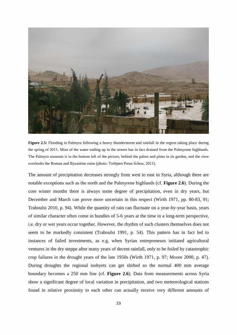
23
Figure 2.5: Flooding in Palmyra following a heavy thunderstorm and rainfall in the region taking place during
the spring of 2011. Most of the water ending up in the streets has in fact drained from the Palmyrene highlands.
The Palmyra museum is in the bottom left of the picture, behind the palms and pines in its garden, and the view
overlooks the Roman and Byzantine ruins (photo: Torbjørn Preus Schou, 2011).
The amount of precipitation decreases strongly from west to east in Syria, although there are
notable exceptions such as the north and the Palmyrene highlands (cf. Figure 2.6). During the
core winter months there is always some degree of precipitation, even in dry years, but
December and March can prove more uncertain in this respect (Wirth 1971, pp. 80-83, 91;
Traboulsi 2010, p. 94). While the quantity of rain can fluctuate on a year-by-year basis, years
of similar character often come in bundles of 5-6 years at the time in a long-term perspective,
i.e. dry or wet years occur together. However, the rhythm of such clusters themselves does not
seem to be markedly consistent (Traboulsi 1991, p. 54). This pattern has in fact led to
instances of failed investments, as e.g. when Syrian entrepreneurs initiated agricultural
ventures in the dry steppe after many years of decent rainfall, only to be foiled by catastrophic
crop failures in the drought years of the late 1950s (Wirth 1971, p. 97; Moore 2000, p. 47).
During droughts the regional isohyets can get shifted so the normal 400 mm average
boundary becomes a 250 mm line (cf. Figure 2.6). Data from measurements across Syria
show a significant degree of local variation in precipitation, and two meteorological stations
found in relative proximity to each other can actually receive very different amounts of
24
rainfall (Wirth 1971, p. 91). Such variable conditions can be especially unfavourable for
agriculture (Traboulsi 1991, p. 51). However, by and large it seems to be the case that a dry
year in Aleppo also corresponds to a dry year in Deir ez-Zor, thus most of Syria is affected by
similar weather patterns (cf. Moore et al. 2000, p. 48, fig. 3.5). On the other hand, Traboulsi
(2010, p. 94) investigated average rainfall from stations across Syria, and concluded that apart
from in the most severe instances, droughts actually do not necessarily affect the whole
country at the same time, but are generally localised to specific regions, while in an earlier
study (cf. Traboulsi 1991, p. 54) she argued that so-called wet years are in fact rather
characterised by more days of rain than more rain per shower. There is seemingly some
ambiguity to this aspect, but one explanation may be that some areas or landscapes are more
sensitive to fluctuations in the weather, resulting in a more severe response compared to other
areas to the same general annual pattern, and thus seem to be more negatively affected.
Perhaps there also is a certain climatic effect of the seasonal lag experienced from west to east
(cf. 2.2.1), although this is just speculation. However, the occurrence of wet vs. dry years does
have a marked effect on the steppes and desert biomes of Syria (cf. 2.3), as in wet years the
dry steppe can extend into otherwise desert areas of normal years, but vice versa during
droughts (Traboulsi 1991, p. 49).

25
Figure 2.6: Broad strokes of the modern Syrian long-term average isohyets based on Wirth (1971, karte 3),
Moore et al. (2000, p. 46, fig. 3.3), and Fiorentino et al. (2008, p. 52, fig. 1). Of course, these patterns are subject
to year variations, where e.g. a drought year can make the 400 mm limit into a 250 mm limit.
2.2.3 Climatic regions
Syria can be divided into four overarching climatic regions, with each usually divided into
subtypes (cf. Wirth 1971, pp. 100-106, fig. 22). The main factors defining them are again
amounts of precipitation integrated with regional geomorphology, which form the basis of a
number of distinct biomes.
2.2.3.1 Mediterranean climates
The most fertile parts of Syria are characterised by a Mediterranean climate, either a coastal
or a drier type. Common for these are abundant rainfall and low chance of frost, making the
risk of crop failures insignificant, also in drought years. Even the dry Mediterranean climate
receives enough precipitation to grow crops of wheat and various arboricultural plants –
unless exceptional droughts occur. The coastal Mediterranean climate normally never
experiences temperatures below the freezing point, although frost can pose a miniscule risk in
drier parts located over 400 m above the sea (Wirth 1971, p. 102). Closely related to these two
26
types is the Mediterranean steppe climate, differentiated into a western and a northeastern
Syrian subdivision. They are in many ways similar to each other and share some continental
features the true Mediterranean climates lack, such as warm winds from Anatolia during
summer and a slightly lower precipitation average (Wirth 1971, p. 103).
2.2.3.2 Dry steppe climates
Arguably, the most relevant climatic region for this study is the dry steppe climate, which
encompasses the dry steppe and desert subclimates. The entire Palmyrene and the Jezire are
both securely defined within the former subtype, while southern parts of the Al-Hamad and
e.g. the plateau along the right (southwestern) bank of the Euphrates downstream from Mari is
considered to be desert climate. The dry steppe climate is characterised by limited
precipitation (c. 120-220 mm annually), and has actually been called a temperate desert
caused by orographic and meteorological conditions (cf. Traboulsi 1991, pp. 48, 54). Crops
can only grow in wet years, or in areas where the soil structure, topography, or hydrology
increase the local potential for cultivation (Wirth 1971, p. 105). However, the rain showers of
the winter season provide excellent pastures for mobile pastoralists (cf. Figure 2.20), whose
societies dominate landscapes defined under the dry steppe climatic regime during that part of
the year (cf. 5.1.3). The desert on the other hand receives on average less than 120 mm rain
annually, making it virtually uninhabitable for societies practicing traditional modes of
subsistence, and is often avoided even by fully nomadic populations herding camels (Wirth
1971, p. 105).
2.2.3.3 Montane climates
Finally, Syria also has some alpine mountains, i.e. the Levantine ranges running north-south
along the Mediterranean coast (cf. Figure 2.1). The climatic subdivisions within this region
are the oceanic (the ranges facing the Mediterranean) and the continental (the ones facing
eastward) types. The latter type can be likened to the Palmyrene ranges, in that they both have
comparable average temperatures and receive much less precipitation than the oceanic alpine
mountains (Wirth 1971, pp. 105-106). The Palmyrene should still be defined as within the dry
steppe climate and the alpine climates are thus not of particular importance for this study.
This rough division of Syria into climatic zones provides a framework for investigating the
current or recent patterns of vegetation and animal life in the region. However, this is not
27
straightforward, as the Syrian environments experienced today in fact seem to be a
consequence of dramatic alterations of the landscape, exacerbated by subsequent soil erosion.
2.3 The current state of Syrian biomes
2.3.1 Considerations on soils and erosion
Regardless of climate and geology, the ecological basis for natural vegetation and fauna in
Syria has deteriorated massively since antiquity. The Dead Cities of northwestern Syria can
attest to this, as in Roman-Byzantine times the area had at least a 70-100 cm thick layer of
soil, but now is merely a barren and eroded landscape (Wirth 1971, p. 115). Although the
climate during the Byzantine period may have been more favourable than it is today (cf.
Geyer & Rousset 2001, pp. 112-113), climate change cannot be argued to constitute the main
cause of this substantial alteration. Rather, it seems to have been all but destroyed by centuries
of human intervention and exploitation, a rate that increased exponentially in industrial times
with the introduction of modern devices in the past 100 years (Wirth 1971, p. 98).
Soils, which largely influence land use potential, are variable across the country. They can be
classified into three distinct types – Mediterranean, steppe, and desert soils (cf. Moore 2000,
pp. 47-49, with references). The Palmyrene generally adheres to the desert type, incorporating
wind-polished flints and deposits weathered by perpetual wind erosion (Moore et al. 2000, p.
49). Regional variations often follow precipitation patterns, as more moisture both weathers
rock into finer soil and create conditions in which humus more easily forms (Wirth 1971, pp.
114-115). Also, deeper soil can contain more water from rainfall than can soils with low
absorption. Only in the Habur triangle does both climate and soil come together in the most
favourable way (Wirth 1971, p. 116), a region which in fact also seems to have been
extensively settled during much of the EBA and MBA (Wossink 2009, pp. 144-145 - cf. 3.3
and 3.4). However, these factors are of minor consequence for the natural environment
compared to the human impact on the landscape. The vegetation in all climatic zones seems to
have been razed in some form or another, and fauna has likewise disappeared across the
region – either caused indirectly, as a result of the environmental degradation, or directly,
through excessive hunting, or both. I will summarise in short the main consequences for each
zone to form a basis on which the potential ancient biomes can be compared.

28
2.3.2 Syrian forests and woodlands
The destruction of the original forests and woods of Syria is the most striking example of its
degraded landscapes. In both ancient and more recent historical sources, the western part of
the country is described as covered by a dense, near impenetrable timber forest, which thinned
out toward the east. While some areas may have been depleted in antiquity (e.g Jebel Zawiye
between Ebla and the Orontes), others survived in relatively good condition until the 19th
century CE, such as Kurd Dagh. Certain isolated and meager remnants still exist, but they
seem to be doomed without new tree growth. The main problem is a lack of undergrowth,
which is essential for the microclimate on the forest floor and lowers the threshold for soil
erosion (Wirth 1971, p. 120; Wainwright 2009, p. 183 – also cf. 2.3.4). A healthy
microclimate also protects plant species more sensitive to drought and heat, which cannot root
properly if the undergrowth disappears (Wirth 1971, p. 127, with references). Originally,
these forests would have contained tree species like oak (Quercus), pine (Pinus), cedar
(Cedrus), maple (Acer), and olive (Olea) depending on the area, but commercial, industrial,
agricultural, and domestic utilisation and exploitation has made them mostly barren and
karstic landscapes. Particularly proximity to heavily populated areas would have constituted a
major factor in this respect5 (Wirth 1971, pp. 128-129). However, travel accounts from the
19th century CE still told of large tracts of dense oak and maple forests in many areas, so
modern developments must have taken a massive toll (Wirth 1971, p. 124; also cf. 2.7).
2.3.3 Vegetation in the river valleys
All the major river valleys in Syria are now tilled and cultivated with most of the original
riverine forests along their banks having disappeared (cf. Wirth 1971, pp. 134-135). However,
certain areas along the Orontes and Euphrates can still retain small groves or patches of forest,
especially on flooded islands or around oxbow lakes. In the Orontes valley these can harbour
sycamore fig trees (Ficus sycomorus), poplars (Populus), willows (Salix), and alders (Alnus),
while in the Euphrates valley they can contain specific types of the Euphrates poplar (Populus
euphratica) and willows (Salix acmophylla), with a potentially thriving undergrowth of
tamarisk (Tamarix tigrensis). Finally, wetlands and swamps with rushes, reeds, sedges, and
water lilies were also until recently a common and integrated part of the riverine biomes of
5 This seems to be a probable explanation for the early deforestation of Jebel Zawiye, i.e. proximity to Ebla,
Idlib, Hama, the Orontes valley, and generally a relatively well-populated part of Syria throughout the ages.

29
Syria, although now nearly all have been drained and converted into arable land - and thereby
been removed from the landscape (Wirth 1971, p. 135).
Figure 2.7: Example of an ecological hot-spot found in the Jebel Abyad mountain range, i.e. an outlet of water
stored in the aquifer geology of the Palmyrene, providing favourable conditions for vegetation and animals,
albeit highly localised.
2.3.4 Steppe, dry steppe, and desert landscapes
In many ways, the degradation of the forests parallels the development in the Syrian
steppelands, dry steppes, and deserts. The original vegetation was not as dense as in areas of
true forests or woodland (cf. categories in Figure 2.18), but was nevertheless significantly
richer and more extensive than it is today – both for arboreal forms and for grasses and
shrubs. On the whole, many of the steppe biomes would have been like parklands, with trees
scattered across the landscape to various degrees, with denser groves thriving in more
favourable locations, such as dells or valleys. The dry steppe was likewise home to tall
grasses and somewhat thinner tree cover than the moister steppelands, at least in less than
optimal zones (Wirth 1971, pp. 120-121, with references). However, these parklands have all
but disappeared, succumbing to human needs for firewood, building material, and other
domestic and industrial uses, while herds of domestic animals have subsequently grazed and

30
browsed away the increasingly vulnerable undergrowth, severely exacerbating soil erosion
and surface water runoff (e.g. Kouchoukos 1998, pp. 356-358; also cf. Cech 2005, p. 30).
These processes have not just resulted in a more barren landscape, but also a very different
composition of species than the original steppes and dry steppes would have been comprised
of. Even the driest parts of southeastern Syria have been considerably altered in character, and
are now described as a “man-made desert” (Wirth 1971, pp. 120-121 – also cf. 2.6.2 and
Figure 2.17). Originally it would have been covered by grasses, herbs, shrubs, and even some
woody plants and a few trees in ecological hot-spots (Figure 2.7). Again, human exploitation
and animal fodder selection have totally changed the composition of species, where e.g. non-
edible plants have increasingly supplanted other types (Wirth 1971, pp. 120-121, 131).
Key species of vegetation in the original Palmyrene landscape (cf. 2.7.1, 2.7.2, and 2.7.3)
would have included trees of pistachio (P. atlantica, P. terebinthus), juniper (J. excelsa),
buckthorn (R. palestinus), as well as species of almond (P. prunus, P. amygdalus), pear trees
(Pyrus), and hawthorns (Crataegus), while types of grass would have been comprised of
Stipa, Agropyron, and Festuca species (Wirth 1971, p. 130, with references). Thus, the region
would in the past probably have looked quite similar to undisturbed parts of the Abu Rujmein
reservation just east of the Palmyrena project concession area (cf. Figure 4.21 and Figure
4.55, area D), or like the northern and western slopes of Jebel Abd el-Aziz, where terebinth
and almond trees are still scattered on the hillsides (Wirth 1971, p. 131; Kouchoukos 1998,
pp. 356-361; also cf. Moore et al. 2000, p. 61, fig. 3.10). However, by and large the Syrian
steppelands and dry steppes have gone the way of its forests and woods, and in doing so the
landscape has been altered to a large degree. The archaeological structures recorded in vast
numbers in the Palmyrene (cf. 4.5 and Figure 4.23) are therefore most likely very much
detached from the environmental contexts in which they were originally constructed, masking
the ecological and economic potential for populations inhabiting or using the region. I will
now turn to the second part of this chapter – i.e. ancient landscapes – in an effort to
reconstruct these contexts, starting with climatic developments in the later Holocene.
2.4 Sources for climatic conditions in the past
The landscapes of Syria probably looked rather different in the past than it does today, but it
is also clear that the climate itself has fluctuated significantly throughout the Holocene

31
(Moore et al. 2000, p. 45). Furthermore, there is an increasing amount of data on the
development of the regional climate particularly relating to the EBA and MBA, providing
empiricism for a reconstruction of relevant environments and biomes, and a contextual
backdrop for the topics dealt with in this study. While analyses are available and usually
presented in their respective studies on a Holocene scale, I will mainly extract data for the
period c. 2400-1700 BCE, although in some instances also project the interval somewhat
further back to show how climatic oscillations characterised the 3rd millennium BCE and their
nature just prior to the period in focus here. Issar and Zohar (2007, p. 37) argued that an
interdisciplinary and holistic approach would be necessary for understanding the interplay
between human societies and their environmental context in a diachronic perspective, a notion
which I also support. It seems clear to me that climate, environments, and societies often are
closely integrated with each other, or at least that environment and society interact under an
overarching influence of the climatic regime.
Figure 2.8: Sources for proxy data records in the extended Near Eastern region presented and analysed here.
They are unfortunately mainly located on the perimeter of the region, but do in general provide a consistent
picture of climatic developments through the Holocene.

32
2.4.1 Considerations regarding proxy data use
Any climate reconstruction involving archaeology must be careful not to fall into the trap of
circular argumentation. It is easy to hypothesise that changes in the environment have been
caused by societal responses interpreted from archaeological data, but such deduction is not
necessarily viable. Fortunately, recent years has seen a surge of integration of archaeological
research with Holocene climatic developments in Near Eastern contexts (e.g. Issar & Zohar
2007; Wossink 2009; Roberts et al. 2011a; 2011b). Armed with evidence based on analyses of
paleosediment accumulations that has been on-going for some decades at sites like Soreq
Cave, Lake Van, Tecer Lake, the Dead Sea, and the Gulf of Oman (Figure 2.8) archaeologists
have been provided with a clearer picture of climatic variations and subsequent environmental
consequences in the region in antiquity. However, no such data or have analyses as of yet
been carried out specifically for the Palmyrene, and the reconstruction here would thus have
to rely on data from other parts of the Near East. With some degree of caution the climatic
developments – particularly when coinciding in several studies – could be projected with
broad strokes to the region as a whole, since it today forms part of the same meteorological
system (cf. 2.2). Lake-levels, lake isotopes, cave speleothems, and deep sea cores are all
proxy sources, which can be compared with response data like changes in vegetation
compositions and evident hydrological or geomorphological effects of change (Roberts et al
2011a, pp. 3-4 – also cf. 2.6.2). The lakes along the Near Eastern rim are particularly sensitive
to environmental changes, reflected by variations in their water levels, salinity, and isotope
compositions (Roberts et al 2011b, p. 148 – cf. 2.4.3, 2.4.4, and 2.4.5). I will below present
some of the proxy sources forming basis for climatic reconstructions, although far from
exhaustive, due as mentioned to the massive increase in intensity of paleoclimatic studies
during the last decade.
Proxy data sources are considered to be accurate sources regarding research on past climatic
conditions as they are results of formation processes such as sedimentation and can include
chemical data such as element isotopes, although results would always be subject to the
interpretation of the researcher during the analytical process. However, proxies provide
primary information in contrast to response data (cf. 2.6 and 2.7), which are secondary
sources and reflect the consequences of a given climatic context. At this point in this
investigation the focus is widened to include the entire EBA period as well as the MBA (i.e.
3000-1700 BCE), because in my view a keyhole perspective would not be a fruitful approach
33
in a study of such long-term processes as the interplay between climate, environment, and
human societies in a diachronic perspective. Rather, to understand the influence of climatic
developments on Near Eastern societies from EBA IV to MBA, it seems more prudent to take
a step back and look at the larger picture. For instance, it is possible that favourable
conditions in mid-3rd millennium BCE created a basis for socioeconomic structures which in
turn had an inherent potential for instability if those conditions deteriorated (cf. 2.5). I will
below present the main proxy sources separately – both in terms of data and results – as well
as a small number of auxiliary sources (cf. 2.4.7) to further reinforce the picture. Finally, I
intend to look briefly at the mechanisms influencing climatic oscillations in the Near East. In
this section of the chapter I will employ the chronological term ka to denote thousand years.
2.4.2 Soreq Cave
Soreq Cave has provided the most important climate record in the Near East, as it is
influenced by both European, African, and Asian climate systems, located about 30 km west
of Jerusalem, Israel, at the interjection of these (Bar-Matthews et al. 1997; Wossink 2009, p.
17 - cf. Figure 2.8). Its Near Eastern context also makes Soreq Cave important for Quaternary
studies, as the growth of deposits has not been hindered or eradicated by glacial and
interglacial intervals (Bar-Matthews & Ayalon 2011, p. 163). It is a karstic cave in which
speleothems – mainly stalactites and stalagmites – are formed by rainwater percolating into
the cave. Isotope ratios of uranium and strontium, as well as variations in δ13C and δ18O
values in these deposits, have been analysed since the discovery of the cave in the 1970s and
dated by 230U/234Th dating. The method has provided absolute dates and a continuous record
for the last 250 ka in the region (Bar-Matthews et al. 1997; Bar-Matthews & Ayalon 2011).
Recent research has in fact been able to investigate the climatic developments down to a
resolution of between 0.8-7.0 years on one stalagmite dated 7.0-5.4 ka BP, and a resolution of
c. 20 years on a stalactite dated 5.4-4.0 ka BP (Bar-Matthews & Ayalon 2011, p. 164). The
δ18O values in Soreq Cave are linked to either moist (low values) or dry (high values) periods
(Bar-Matthews et al. 1997, p. 161). Variations in δ13C values originate from CO2 derived from
local plants and picked up by the rainwater passing through the ground. Such plants can be
divided into types C3, preferring moister conditions, and C4, thriving in more arid conditions,
and their sensitivity to environmental conditions make them ideal as paleoclimatic indicators
(Goodfriend 1999, p. 503). High δ13C values indicate a predominant presence of type C4
plants, while low values are indicative of type C3 plants, thus by inference indicating dry or
34
moist conditions respectively (cf. Goodfriend 1999, p. 503; Wossink 2009, p. 17). While this
latter method should more precisely be considered as a response variable than direct proxy
data, it is included here due to its site association. Both processes have been used to track
diachronic changes in temperature and/or rainfall affecting Soreq Cave and reconstruct a
climatic representation of the area. However, it is important to keep in mind that there is a
certain potential for error in the fact that barring direct observation it is possible that the
natural processes involved may have operated slightly differently, in addition to the role
human interference in the local surroundings may have played (Wossink 2009, p. 17; cf.
Goodfriend 1999, p. 510).
Figure 2.9: The Soreq Cave record for the period between 7.0 and 4.0 ka BP expressed as a graphic function of
δ18O (left) and δ13C (right). While the chronological resolution after 5.4 ka BP and thus the EBA is slightly lower
than that of previous periods, both these proxy sources show a clear downward trend through the 3 rd millennium
BCE, but with notable localised zeniths (c. 4.8 ka and c. 4.5 ka BP) and nadirs (c. 4.7 ka and c. 4.2 ka BP) - the
latter ending in a low not experienced since the mid-late Chalcolithic (after Bar-Matthews & Ayalon 2011, p.
166, fig. 2).
Results from Soreq Cave (cf. Bar-Matthews et al 1997; Bar-Matthews & Ayalon 2011 – cf.
Figure 2.9) inferred from these isotope values attest to a fluctuating pattern of highs and lows
on a long-term scale (from c. 7.0 ka BP). The zeniths and nadirs probably reflect shorter-lived
events (c. 20-100 years each), but importantly they can generally be identified in the analyses
and plots of both values. From c. 5.0 ka BP this pattern of oscillations follows an increasingly
downward trend, clearly ascertainable in the graphs (cf. Bar-Matthews & Ayalon 2011, pp.
166-167, fig. 2a, fig. 2b, fig. 4a – Figure 2.9). Bar-Matthews and Ayalon (2011, p. 166)
identified particular high isotope value (δ18O/δ13C respectively) events corresponding to dry
periods at 5250-5170 (-4.8 ‰/-10.1 ‰) and 4200-4050 years BP (-5.2 ‰/-9.8 ‰), and a low

35
value event corresponding to a moist period at 4800-4700 years BP (-6.1 ‰/-12.6 ‰) – i.e.
attesting to severe changes from mid-3rd to late 3rd millennium BCE. Similar developments
were also suggested by Wossink (2009, p. 17), and in his analysis of the 3rd millennium BCE
climate trend at Soreq Cave, he emphasised the extreme fluctuations of the millennium and
identified a wet period c. 2600-2200 BCE followed by a strong arid trend c. 2200-1800 BCE.
Considering these data with the regard to the actual effect such values would have entailed in
the modern climatic regime, Bar-Matthews and Ayalon (2011, p. 167) suggested that a
decrease in δ18O of 1.0 ‰ is equivalent to an increase in annual precipitation by about 250
mm, and with other factors like sea-level and temperature being approximately similar –
which climatic evidence indicate they were – this equivalence can more or less be applied to
mid-Holocene conditions. Orland et al. (2009, p. 29) actually put this equivalence at c. 280
mm per 1.0 ‰ variation. In short, according to recent climatic research, the difference
between the moist phase starting at c. 4.8 ka BP (-6.1 ‰) and the arid phase starting c. 4.2 ka
BP (-5.2 ‰) would have been 0.9 ‰, and correspond to drop in annual rainfall at Soreq Cave
of c. 250-280 mm, which indeed would be rather severe. Presently, the annual precipitation at
Soreq Cave is between 500 and 600 mm (Orland et al 2009, p. 29), where c. 500 mm
corresponds to a δ18O value of c. -5.2 ‰ – the same value as that found at c. 4.2 ka BP (Bar-
Matthews & Ayalon 2011, p. 167). Due to the δ13C values being in the lower region (-9.8 ‰
to -12.6 ‰), the local vegetation was seemingly dominated by C3 plants throughout the
period, suggesting that the fluctuating isotope values are related to climatic oscillations and
not human activity, strengthening the argument that this site and its associated methods is a
robust climate proxy and a good representation of actual conditions in the area (Bar-Matthews
& Ayalon 2011, p. 168).
2.4.3 The Dead Sea
The Dead Sea, situated on the border between Israel and Jordan (cf. Figure 2.8), is a terminal
lake fed mainly by the Jordan River, as well as by certain wadis. It also receives a small
amount of precipitation, but this is minimal as its catchment today only receives c. 50-100
mm rain per year. Due to its terminal nature, the Dead Sea contains brine which is nearly
saturated with salt and gypsum (Frumkin et al. 2001, p. 1179; Migowski et al. 2006, p. 422).
Following a drop in water levels during the 1960s as a consequence of massive water
diversion for agriculture and other uses, records of Holocene sediments were exposed in fan-
deltas of the lake (Enzel et al. 2003, p. 264). These Dead Sea proxy records relate either to

36
fluctuations in water levels or to salt deposition and sediment composition, both of which can
directly be correlated with the amount of rainfall in its catchment area and evaporation levels
due to temperature and humidity (Frumkin et al 2001, p. 1182, fig. 2; Wossink 2009, p. 18).
Chronology for water level deposits has usually been provided by 14C dating of organic
matter, such as driftwood, deposited after floating on the surface (Frumkin et al 2001, p. 1181;
Issar & Zohar 2007, p. 25). Varve counting under microscopic examination of sediment cores
has also been used as an alternative method for chronological control, as well as providing a
supplementary approach to paleoclimatic reconstruction through mineralogical analyses
(Migowski et al. 2006, p. 424). The precipitation included in the Dead Sea hydrological
system is mostly determined by eastern Mediterranean maritime cyclonic activity (Enzel et al
2003, pp. 267-268 – also cf. 2.2.1). Enzel et al. (2003, p. 272) evaluated the geological,
meteorological, and hydrological data and concluded that the sensitivity of this system makes
it likely to have experienced similar effects in the past to that it experiences under modern
atmospheric conditions. The main drawback with climatic records extrapolated from lake
level fluctuations is that it only attest environmental extremes, while intermediate levels
ultimately get obliterated by the rising and falling water (Issar & Zohar 2007, p. 26).
The Dead Sea proxy records have been analysed in a number of recent studies, e.g. Enzel et
al. (2003), Migowski et al. (2006) and Frumkin (2009). Enzel et al. (2003, p. 264) argued that
the water levels after c. 4.0 ka BP have overall been lower than earlier in the Holocene.
According to their study (cf. Enzel et al. 2003, p. 265, fig. 2B), it has fluctuated repeatedly
between -390 and -420 m since then. Although the data resolution for the period prior to c.
2000 BCE is much lower than for subsequent periods, there is a definite and massive drop
occurring in the last 400 years of the 3rd millennium BCE. Enzel et al. (2003, p. 268) noted
that it in fact constitutes the largest continuous reduction in water levels found in their
analyses, being a drop of about 45 m starting at 4.3-4.2 ka BP and reaching a minimum
around 3.4 ka BP. Based on their results from core analyses, Migowski et al. (2006, p. 426) on
the other hand suggested that the period c. 5.4-3.5 ka BP was actually characterised by rising
water levels, and thus moist conditions in the region, which they supported by δ13C values
measured in land snail shells from the northern Negev desert (cf. Goodfriend 1999). However,
they did note a shorter interlude of more arid climate, beginning at c. 4.2 ka BP and lasting
around 300 years, followed by a return to moister conditions. The late-Holocene climatic
deterioration leading to the modern low Dead Sea levels started in mid-2nd millennium BCE

37
according to their conclusions (Migowski et al. 2006, p. 426). Thus, while these studies
disagree somewhat on overarching climatic developments in the Near East relating to Dead
Sea water levels in the 2nd millennium BCE, the both generally correspond to each other in
terms of the late 3rd millennium BCE and its severe dry event. Chronology can unfortunately
be rather problematic when it comes to 14C dating of organic matter from Dead Sea cores, as
dates could be off by centuries due to exposure and contamination from later water levels.
Similarly, the dating of driftwood using the same method also carries certain drawbacks, e.g.
a time lag between the living tree and the deposition of its wood which potentially could lead
to errors of 100-200 years (Frumkin 2009, p. 320). However, dendrochronology has been
proven as a reasonably accurate dating method. This was carried out on an exceptionally well-
preserved Tamarix subfossil from Mount Sedom on the south shore of the Dead Sea, and the
results attested that it lived between c. 2265 and 1930 BCE, thus spanning the conventional
EBA-MBA transition (Frumkin 2009, pp. 321-322). Measurements of δ13C values indicated
that it experienced a downward drying trend throughout its existence, with notably an intense
arid event c. 2020 BCE and a longer drought beginning about 1980 BCE that finally killed the
Tamarix some decades later. This development was supported by measurements of δ15N
values which was comparable to modern ones – i.e. a hyper-arid environment – with the story
emerging again being one of progressive deterioration of the climate throughout the life-span
of the Tamarix, starting at conditions wetter than today, but ending at even drier conditions
(Frumkin 2009, p. 324). If the correlation between precipitation and δ13C values in the past is
similar to the current one, Mount Sedom experienced climatic deterioration in the period c.
1980-1880 BCE, going from about twice the modern amount of average annual rainfall down
to approximately the modern regime (Frumkin 2009, p. 325-326). There seem to be certain
chronological ambiguities in the results presented above, but a pattern of climatic
deterioration in late 3rd millennium BCE is attested in all studies. It may have started slightly
earlier or later than c. 4.2 ka BP, and may have continued into the conventional MBA – even
possibly returning to slightly moister conditions again for a short time – but the significant
difference between the mid-3rd millennium BCE climate and later ones seems also discernable
in the Dead Sea record.
2.4.4 Lake Van
Lake Van in southeastern Turkey (cf. Figure 2.8) is an important proxy data source for
climate reconstructions. It is also a terminal lake, fed by rivers originating in three different

38
climatic regimes, and analyses of sediment cores dated by varve counting have provided
valuable information spanning the Holocene (Wick et al. 2003, pp. 666-667). The sediments
have been a source of a number of paleoclimatic records associated with various
environmental aspects, such as ratios of 18O/16O and Mg/Ca (salt deposits), and pollen (Wick
et al. 2003, pp. 673-674 – also cf. Issar & Zohar 2007, p. 24; Wossink 2009, p. 18). The ratio
of Mg/Ca can attest to changes in the salinity of a body of water through time (also cf. 2.4.3),
where high ratios indicate high salinity and thus low degree of dilution and low water levels,
and vice versa (Wick et al. 2003, p. 667). The oxygen isotope proxy data is used in the same
way as for the Soreq Cave research (cf. 2.4.2), although there is one further cautionary aspect
to take into account for the Lake Van deposits. Rivers feeding the lake could get their water
input both from catchment precipitation and from karstic springs (cf. 2.1.2), the latter of
which in fact could have stored this water for some time before outputting into the
hydrological system again – perhaps as much as 200-300 years. During such retardation some
salt content may already have been deposited in the aquifer geology, and thus not entering the
chemical composition of the lake sediments (Issar & Zohar 2007, pp. 24, 137). In other
words, contrary to proxy data from Soreq Cave and the Dead Sea, the data inferred from Lake
Van sediment analyses is not necessarily contemporaneous with actual climatic shifts (Issar &
Zohar 2007, p. 137).
In short, the analyses of salt ratios and oxygen isotope values from Lake Van, together with
those of charcoal and pollen suggest that the region experienced favourable climatic
conditions between 6.0 and 4.0 ka BP, with a minimum δ18O value at c. 4.5 ka BP suggesting
a Holocene optimal peak in mid-3rd millennium BCE, followed by values indicating
intensively more arid conditions c. 4.5-4.0 ka BP, with a brief reversal at c. 4.1 ka BP. Thus,
the climate shifts toward a more continental type, with a decrease in humidity and generally a
drier climatic regime. Although human activity becomes visible in the paleobotanical record
around 3.8 ka BP, the area does not seem to be subjected to any intense exploitation. Local
deterioration of vegetation, particularly its oak woodlands, is therefore most likely a response
to the increasing desiccation of the region, which is thought to have stabilised along modern
climatic conditions about 2.0 ka BP (cf. Wick et al. 2003, pp. 673-674; Wossink 2009, p. 18,
with references – cf. Figure 2.11). While the potential lag in salt deposits mentioned above
could have tweaked the chronology somewhat, the internal and external correspondence of
these results probably make the Lake Van sediment analyses valid for the 3rd millennium BCE

39
– and once more attest to a mid-millennium optimal peak and late-millennium climatic
deterioration.
2.4.5 Teçer Lake
Another Anatolian proxy data source studied very recently is Teçer Lake, located in central
Turkey (cf. Figure 2.8). It has slightly different attributes compared to Lake Van and other
terminal lakes, as it does have an outflow, but only when the water level surpasses a depth of
3-4 m, although when lower it turns into a saline lake surrounded by brackish swamps
(Kuzucuoğlu et al. 2011, p. 174). Kuzucuoğlu et al. (2011, pp. 176-179) interpreted data
relating to climatic developments during the last 6.0 ka from analyses of mineral and
geochemical compositions of Teçer Lake sediment cores in light of its locational and
geological characteristics. Chronology was provided by 13 AMS 14C dates from
stratigraphically controlled pollen grains, down to a resolution of c. 50-80 years. Sediment
deposits with a high clay content were interpreted as being remnants from a time of moist
periods with high water levels, while on the opposite side of the spectrum were gypsum peaks
following aragonite peaks, indicating regional desiccation and arid periods (cf. Kuzucuoğlu et
al. 2011, pp. 176-177, Table 1).
Kuzucuoğlu et al. (2011) also evaluated the sedimentation within each individual climatic
phase separately. Their phase III (c. 4950-4300 BP, corresponding to c. 3000-2350 BCE) and
the first part of phase IV (c. 3850-2800 BP, corresponding to c. 1900-850 BCE) would
roughly correspond to the temporal focus here (cf. Kuzucuoğlu et al. 2011, p. 181, fig. 6).
High sedimentation rates in these two phases at Teçer Lake, particularly in phase IV made it
possible to identify distinct subphases within the sediments (Kuzucuoğlu et al. 2011, p. 177).
The first half of the 3rd millennium BCE (phase III-a) seems to have experienced a sudden
decrease in rainfall and subsequent lake-level drop (Kuzucuoğlu et al. 2011, p. 181).
Kuzucuoğlu et al. (2011, p. 184) argued that while this at first seems like a different picture to
that shown by other eastern Mediterranean records – which generally suggest that this period
was relatively moist – they could also point to a parallel in the Soreq Cave record, where a dry
event signal occurs at c. 4.7-4.55 ka BP. However, following this event at Soreq Cave is a
moist mid-millennium reversal of desiccation, and the disappearance of aragonite and
decrease of gypsum in phase III-b (c. 2530-2350 BCE), as well as a lake-level rise, suggest
likewise a return to wetter conditions at Teçer Lake at this time. Phase III ended in a 450-year

40
long hiatus (c. 2350-1900 BCE) attested by a sudden rise in gypsum-rich sand and lake-level
drop (Kuzucuoğlu et al. 2011, p. 181). The hiatus is continuous, as opposed to the Soreq Cave
record, which rather shows this phase as three dry spikes (4.3-4.15 ka, 4.05-4.0 ka, and 3.9-
3.85 ka BP), suggesting that Mediterranean humid air did reach the Levant at times, but not
Anatolia (Kuzucuoğlu et al. 2011, pp. 184-185). Finally, Teçer Lake phase IV is characterised
by high, but fluctuating values of aragonite and sand, implying climatic instability within a
drying trend interspersed by short moist episodes, with these oscillations increasing in
intensity during the phase as a whole. The first subphase, dated to c. 1900-1680 BCE and thus
the one relevant here, shows lower lake-levels and run-off erosion depositing gypsum-rich
sand, probably triggered by spring melting and summer evaporation stress (Kuzucuoğlu et al.
2011, pp. 181-83, 185). This indicates a possible shift to a slightly different seasonal climatic
regime than that of the 3rd millennium BCE. Kuzucuoğlu et al. (2011, p. 186) proposed that
particular local geographical conditions resulting in differences regarding timing or intensity
could provide an explanation for certain variations in the Teçer Lake record compared to
climate proxies from other Near Eastern sites.
2.4.6 Deep sea cores
Cores drilled in the sea bed have also provided sources of proxy records for paleoclimatic
developments (cf. Figure 2.8). One of these sites is linked to aeolian transport of mineral dust
which gets deposited in the Gulf of Oman by the annual southwesterly winds (shamal)
originating in Mesopotamia (cf. Cullen et al. 2000, p. 380). This dust has a characteristic
mineral composition and can thus be identified in a sedimentation sequence. Analyses of
isotope ratios and concentrations of dolomite vs. calcite carried out by Cullen et al. (2000) on
a core from the Gulf of Oman, have provided a 25 ka sequence of climatic conditions
chronologically controlled through AMS 14C dating of foraminifera in the stratigraphy.
Increases in carbonate mineral concentrations were interpreted as deteriorating climatic
conditions and aridity in the region of origin, shown to have indeed been Mesopotamia
through analysis of Nd and Sr isotope compositions in the deposits – other possible sources
were Zagros and the Indus valley (Cullen et al. 2000, pp. 380-381). Their results were
characterised by only small variations in carbonate minerals in the period between 6.0 ka and
2.0 ka BP, but with two notable anomalies – the first at c. 5.2-5.0 ka BP and then at c. 4.1-3.6
ka BP (cf. Cullen et al. 2000, p. 381, fig. 4). Although the first anomaly and the last half of the
second anomaly (i.e. about 3.9-3.6 ka BP) only attest to a relatively minor spike in

41
concentrations, the arid event at c. 4.1-3.9 ka BP would have to be considered a substantial
increase of these deposits, and it starts at 4025±150 BP dated by 14C (Cullen et al. 2000, p.
381).
Figure 2.10: Deep sea records from the Gulf of Oman, the Arabian Sea, and the Shaban Deep which Arz et al.
(2006) compared with African and Dead Sea lake level data and speleothems from southern Oman and Soreq
Cave. The consistency between them with regard to the attestation of a late-3rd millennium BCE dry spike –
marked with grey in this figure – is striking (after Arz et al. 2006, p. 439, fig. 6).
Another Near Eastern proxy site for deep sea core analyses is the Shaban Deep in the Red
Sea, where accumulated brine layers annually deposited by the circulation between the
surface and deep waters were studied by Arz et al. (2006) in light of paleoclimatic change.
They measured oxygen isotope ratios on planktonic foraminifera and dated their associated
sediments by AMS 14C dating. Based upon the demonstrated mechanism that the mixing of
water columns is related to the properties of the surface water – which is subject to climatic
changes – affecting deep sea formation processes like variations in brine deposition, they
reconstructed a climate record for the past 6.0 ka, but significantly for this study, focused on
developments in the late 3rd millennium BCE (cf. Arz et al. 2006, pp. 435-437, Fig. 4).
Similar to the Gulf of Oman results, the Red Sea data is characterised by small fluctuations in

42
the isotope values in foraminifera in the period up to 4.2 ka BP, as well as virtually no
variation in sea-surface temperatures (SST). However, between 4.2 and 4.0 ka BP a strong
anomaly occurs in both records (Figure 2.10), which is particularly evident in δ18O values
and the number and size of foraminifera specimens, both indicating a change to more
unfavourable environmental conditions. This does not seem to be linked to changes in SST, as
this stays more or less constant throughout the time-span of the core. The deep sea core
research thus falls into line with the other ones presented here, in that it identifies a strong
climatic deterioration close to the EBA-MBA transition.
Figure 2.11: Oxygen isotope values from six lakes in the eastern Mediterranean summarised and presented by
Roberts et al. (2011b) and compared with the proxy record from Soreq Cave. They also marked distinct dry and
wet phases identified in these data sources. The late 3rd millennium BCE climatic deterioration is clearly
standing out in the middle and also highlights the general drying trend of that millennium (after Roberts et al.
2011b, p. 150, Fig. 2).
2.4.7 Other sources for paleoclimatic records
Finally, certain other paleoclimatic records analysed in the same manner as e.g. Lake Van or
Tecer Lake could fruitfully be mentioned with regard to a study of the EBA and MBA Near
East (cf. Figure 2.8). The methods used in these include analyses of oxygen and other
isotopic values, mineral compositions, pollen, or comparative multiproxy data. At Lake
Zeribar vegetation and sedimentation analyses yielded signs of intensified erosion possibly

43
disturbing the aquatic vegetation in the period c. 5.5-4.0 ka BP, overlapping with a decrease in
oak and an increase in Salix c. 4.5-3.8 ka BP, the latter indicating particularly pronounced
reduction in water levels. There were also data indicating a development of a marshy fringe
surrounding the lake c. 4.0 ka BP, which by c. 3.5 ka BP has a composition of species similar
to the present-day (Wasylikowa et al. 2006, pp. 482, 491). At Göbekli Tepe, δ18O and δ13C
isotope values from pedogenic carbonate stones in buildings for the period roughly 6-4 ka BP
was interpreted as caused by humid climate, while values from the subsequent period was
indicative of arid conditions (Pustovoytov et al. 2007, p. 325). Roberts et al. (cf. 2011b, pp.
149-151, Fig. 3) summarised stable isotope and pollen records from lakes across the Near
East, e.g. Lake Mirabad (also cf. Stevens et al. 2006) and Eski Acıgöl, and compared the data
with the Soreq Cave proxy record, to study implications for climate, vegetation, and culture
change. Their main conclusion was that a stepwise transition from a humid early Holocene to
arid late Holocene took place, characterised by an oscillating, downward trend of alternating
wet and dry phases, and identified three main arid phases dating to c. 3300-3000 BCE, c.
2500-1900 BCE, and c. 1200-850 BCE interspersed with moister periods, particularly
between the latter two (Figure 2.11). The arid periods themselves they characterised as
comprising several drought episodes, interspersed by wetter years – thus almost as miniature
parallels to developments on the grander scale. As the general pattern is similar for all the
Near Eastern lake records, the researchers suggest that differences between them probably are
rather due to chronological imprecisions than actual variation. As a case study, Roberts et al.
(2011b, pp. 153-154, Fig. 4) noted that studies of carbon isotopes in plants at Tell Mishrife
and Tell Mardikh (cf. 2.6.2) identified three arid phases at c. 3100-2900 BCE, 2200-2050
BCE and 1800-1650 BCE, with at least two interspersed wet phases at 2500-2350 BCE and
1600-1500 BCE, and a relatively wet phase c. 2050-1800 BCE (Figure 2.12 – also cf.
Fiorentino et al. 2012, pp. 25-26). The humidity during this latter period was far below the
levels prior to c. 2300 BCE, but it was still considered wet in comparison to its preceding and
subsequent phases. Finally, and to complete the circuit of the Near Eastern climatic records as
it were, I will briefly mention the work of Parker et al. (2006), who carried out a geochemical
analysis of intra-dune lake sediments at the site Awafi in the UAE, dated by OSL (also cf.
4.6.2) and AMS 14C. Their results suggest that a lengthy arid period in the 4th millennium with
major dry peaks at c. 5.9 and 5.2 ka BP was followed by a return to moist conditions and the
development of a shallow lake at the site between 5.2 and 4.2 ka BP. This created potential
for human habitation, and mobile groups returned to the area after an occupational hiatus of c.

44
1000 years, constructing large numbers of burial cairns there (Parker et al. 2006, p. 472).
However, from c. 4.2 ka BP the deposit analyses attest to a severe desiccation and influx of
aeolian sand, followed by a short-lived wet phase sometime in the 2nd millennium BCE,
which yet again ends in an onset of intense arid conditions, more or less similar to conditions
the region experiences today (Parker et al. 2006, p. 473).
Figure 2.12: Phases of wet (white) and dry (grey) conditions at the archaeological sites of Tell Mishrife and Tell
Mardikh seen in relation to the Soreq Cave data and the changes in Dead Sea water levels (after Fiorentino et al.
2012, p. 26, fig. 5). Certain correlations are discernable, although the oscillations seem more frequent in the data
from the archaeological sites.
Thus, most climatic records across the region, from the Levant to Anatolia and Zagros to the
Arabian peninsula, seem to paint the same picture. Each millennium, from the 4th to the 2nd
BCE, was characterised by severe dry events, and thus significantly one affecting the Near
East in EBA IV. Climatic developments in the 3rd millennium BCE itself was one long
downward trend from wet conditions in the early, via an arid spike c. 4.8-4.7 ka BP, returning

45
to a moist middle part, ending in a severe drought from c. 4.2 ka BP. The period c. 4.5-3.5 ka
BP has in fact been considered a transitional phase between an early-Holocene optimum to
the present dry conditions of the late Holocene (cf. Roberts et al. 2011b, p. 151, Fig. 3). It
seems reasonable to think that Near Eastern societies would have experienced this
deterioration as a real event and attempted to alleviate its effects. However, before turning to
such matters (e.g. cf. 2855.2.2.2), I will look closer at the atmospheric mechanisms of such
climatic change (cf. 2.4.8) and its details (cf. 2.5).
2.4.8 Global mechanisms and Near Eastern climate change
There is enough evidence from Near Eastern proxy data to suggest that the regional climate
shifted and oscillated throughout the Holocene, and particularly in the 4th and 3rd millennium
BCE. The geographical position of Syria and its topographical and ecological features make it
very sensitive to climatic variations (cf. 2.1 and 2.3). Not only regional meteorological
systems, such as Mediterranean storms (cf. 2.2.1), but also global climatic factors, like
African westerlies and the monsoons of the Indian Ocean, all influence Near Eastern
conditions (Fiorentino et al. 2008, pp. 51-52). However, the interplay between all these
meteorological phenomena is a highly intricate atmospheric system, incorporating the two of
most important weather systems on the planet. The El Niño-Southern Oscillation (ENSO) and
the NAO, although not well understood (Wanner et al. 2008, p. 1808), have both a complex
and major impact on all global climates and environments. Between them lies the ITCZ (Issar
& Zohar 2007, p. 12; cf. Fleitmann et al. 2007 and Wanner et al. 2008, pp. 1816-1819 for a
summary on the ITCZ and Holocene climatic change), a seasonally migrating low-pressure
zone near the equator where polar and equatorial air converge due to temperature gradients
and the Coreolis effect. The same atmospheric processes create two belts of high pressure on
the 30° latitude on either side of the equator. At this point air sinks down toward the Earth,
where some flows toward the poles, but most goes back to the ITCZ (cf. Cech 2005, p. 37).
Due to its effect on the monsoon winds, the annual migration of the ITCZ asserts a major
influence on the Indian Ocean climate and its surroundings, and it reaches its northernmost
latitudes during the Near Eastern summer (Fleitmann et al 2007, p. 172).
The NAO system has been suggested to constitute the main force behind climatic swings in
the eastern Mediterranean and the regional cyclogenesis. Rainfall variability and anomalies in
the region today have been associated with large-scale, high-amplitude variability of the

46
North Atlantic climate (Eshel & Farrell 2000, p. 3230). Cullen and deMenocal (2000, pp. 861-
862) suggested that the NAO was correlated with precipitation in the catchment areas of the
Euphrates and the Tigris, but Enzel et al. (2003, p. 271) re-evaluated the data and concluded
that contrary to this, it is only very weakly or even not at all correlated with rainfall in neither
the Levant nor the Euphrates headwaters. Their analyses indicated that the NAO does not
directly impact the Levant and can only explain less than 5 % of the precipitation variation in
the Near East, although it asserts larger influence (> 25 %) on the Eastern Mediterranean
proper, which may have a certain effect. Thus, as its association with Near Eastern rainfall is
debatable, the relation between the NAO index and Holocene climatic events seems uncertain
(Frumkin 2009, p. 320). On the other hand, air circulation patterns could have had a different
character in the past, resulting in different atmospheric patterns than those we see today (van
Zeist & Bottema 1991, p. 16), and the interplay with other atmospheric processes could have
had complex effects (Figure 2.13 – also cf. Figure 2.14).
Figure 2.13: Mechanisms of natural climate variations and some of the large-scale climatic consequences seen
in a global perspective. Additionally, the figure shows the Holocene migration of the ITCZ (after Wanner et al.
2008, p. 1817).
The Indian Ocean monsoon system indirectly affects the eastern Mediterranean, as
northeasterly air flow circulate around the South Asian Low Pressure centre, but a position of
the monsoon circulations further north earlier in the Holocene as well as regional variations in
SST could have resulted in a higher impact on Near Eastern conditions at that time (Roberts et

47
al. 2011a, p. 6). Several studies on paleoclimates indicate that the latitudinal position of the
ITCZ has in fact shifted during the Holocene, leading to different patterns of its annual
migration and significant changes in regional hydrological regimes (cf. Fleitmann et al 2007,
p. 170, with references). A southward shift of this system appears to have occurred rather
abruptly around 6 ka BP. Prior to this, the monsoon directly affected much further into the
interior of the Sahara and Arabian deserts, although perhaps not as far as the Mediterranean
sea (Roberts et al. 2011a, p. 9, with references). The strong mid-Holocene desiccation of
northern Africa was therefore probably caused by such a southward migration of the ITCZ
and consequently a weaker African monsoon (Magny et al. 2009, p. 831). Fleitmann et al.
(2007) studied oxygen isotopes in stalagmites on the Indian Ocean island of Socotra,
supported by data from Oman and Yemen, and showed that the values of δ18O had decreased
since 4.4 ka B.P. from -3.0 ‰ to the current -4.2 ‰, reflecting a higher monsoon precipitation
along the rim of the Indian Ocean (Fleitmann et al. 2007, p. 176). According to their research,
the cause of this change was a southward shift of the summer ITCZ and consequently also the
associated monsoon rain. This could explain the abrupt aridity seen in the paleoclimatic
records, e.g. when the shift moved across a threshold, changing how the Near East would be
affected by the monsoon (Fleitmann et al. 2007, pp. 180, 184 – cf. Figure 2.14). The
mechanism behind this permanent migration through the Holocene was probably orbital
changes in seasonal insolation associated with Milankovitch forcing. This is supported by the
fact that insolation in the late Holocene became more seasonal in the Southern Hemisphere,
while at the same time turning less seasonal in the Northern Hemisphere (Haug et al. 2001, p.
1307). Vannière et al. (2011, p. 54) argued that orbitally forced changes in summer insolation
affecting the Northern Hemisphere during the Holocene probably also led to climatical and
ecological changes in the Mediterranean region, which thus came in addition to the latitudinal
changes in the ITCZ. However, the ITCZ only acts indirectly on the Mediterranean, and has
not extended as far north as to impact it directly (Vannière et al. 2011, p. 56 – cf. Figure
2.14). Finally, such orbital changes could also have affected the regional SST, where lower
temperature and consequently lower evaporation rates from the Mediterranean potentially
influenced the regional cyclogenesis (Roberts et al. 2011a, p. 9), so important for the Near
Eastern climate and environment (cf. 2.2.1).

48
Figure 2.14: Stylised representation of how shifts in the ITCZ mechanism interplay with the NAO and affect
climatic conditions of western Eurasia. With an ITCZ associated with a summer boundary further north, the
NAO would also shift, and thus change the character of regional precipitation patterns, possibly resulting in a
wetter Near Eastern climate. However, a southward Holocene migration may have had the opposite effect (after
Vannière et al. 2011, p. 57, fig. 2).
As a preliminary conclusion, it seems likely that a southward shift in the northern limit for the
annual ITCZ migration was a factor in the late 3rd millennium BCE climatic deterioration in
the Near East, although due to the complexity of these processes it is very hard to say
anything definite on the matter. However, it is striking that the research carried out by
Fleitmann et al. (2007) provides a starting point at c. 4.4 ka BP for an increase in Indian
Ocean precipitation. This roughly coincides with the most pronounced 3rd-millennium BCE
arid spike in Near Eastern paleoclimatic records, better known as the 4.2 ka BP event.
49
2.5 The 4.2 ka BP event
It is evident that most paleoclimatic sources show a strong dry signal occurring toward the
end of the 3rd millennium BCE, sometimes seen as part of a general and lengthier climatic
deterioration spanning the late EBA and early MBA. While its attestation seems more or less
unequivocal, the exact nature of the event has been debated. Was it an abruptly occurring
drought or more gradual as part of a drying trend, and was it oscillatory in profile or one long
drought which thereafter returned to the previous climatic state (Wossink 2010, p. 182). This
subchapter aims to look closer at the 4.2 ka BP event as a phenomenon, as it roughly played
out across the main period of the present study. In this respect, I should note that here it is not
seen as an short-lived – e.g. half-century to century long – event, but rather the onset of a half-
millennium climatic phase, and possibly the starting point of the dry late-Holocene conditions
in the Near East (cf. 2.4.7).
2.5.1 The abruptness of the event
Some proxy sources clearly show the 4.2 ka BP event to manifest itself initially as a sudden
climatic drop. However, its precise timing is a source of dispute, due to the various methods
applied at the various sites resulting in a somewhat fuzzy picture. At Teçer Lake, a 450-year
hiatus starts c. 4.35 ka BP, which is slightly earlier than in other sources. The Dead Sea data
attests to an abrupt drop in water level at 4.3 ka BP, although this record has been known to
carry certain inherent uncertainties associated with its chronology, due to potential later
contamination of deposits or the nature of the process which leads to the deposition of datable
wood (cf. 2.4.3). The proxy record from Soreq Cave shows a similar picture, albeit more
detailed and chronologically certain, with the event being initiated by a major arid spike c.
4.3-4.2 ka BP (cf. Figure 2.9), while the deep sea cores further south exhibit massive dry
spikes at 4.2-4.2 ka BP indeed (cf. Figure 2.10). However, Marro and Kuzucuoğlu (2007, pp.
586-587) on the other hand characterised the event rather as the peak of a long-term
aridification trend starting back in the 4th millennium BCE, which increased in magnitude
after c. 4.5 ka BP. They argued that in the drier parts of the Near East, this trend started to
show in already during the first half of the 3rd millennium BCE, but affecting larger areas after
the midpoint of the millennium. They stressed that some signals may seem very dramatic, but
these were also interspersed with moister phases. Such a gradual degradation of the climate
could in fact allow for e.g. societal adaptation, and not necessarily in practice be experienced
as dramatic as a graphic illustration can allude to. Wanner et al. (2008, p. 1818), although

50
working on a grander chronological scale and using time series simulations, also toned down
the rapidity and dramatic nature of the 4.2 ka event while still identifying its global
significance and possible association with the ENSO (cf. 2.5.3 and Figure 2.13). Arz et al.
(2006, pp. 438-440) reviewed various paleoclimatic records and argued that observed climate
changes around 4.2 ka BP in many cases were not characterised by abrupt events, but rather
occurred as part of long-term trends. However, they acknowledged that some records do show
a spiked profile at this exact point in the Holocene. Although climatic conditions evidently did
fluctuate to some degree during the 3rd millennium BCE, the peak levels of aridity around
2200 BCE still stands out as an extremity when seen in a larger diachronic climatic context in
the Near East (Issar & Zohar 2007, p. 135). For instance, in the Soreq Cave record (cf. Figure
2.9) it constitutes the driest point in time since the mid-late 4th millennium BCE. It is possible
that various areas experienced the event differently, depending on factors of geography,
topography, biology, or even geology (cf. 2.1.2), leading to results that might be slightly
asynchronous or oriented differently (cf. Kuzucuoğlu 2007, pp. 22, 26), or causing the
appearance of either abrupt spikes or more gradual dips or downward trends. The proxy data
from Soreq Cave, Lake Van, and Teçer Lake (2.4.2, 2.4.4, and 2.4.5) do suggest favourable
conditions c. 4.5-4.3 ka BP, and isotope values from Tell Mishrife and Tell Mardikh (cf.
Figure 2.12) show relatively moist conditions diving straight down into an arid spike at c.
4.3-4.2 ka BP.
Thus, based on the present evidence, I would argue that the event seems to have occurred
rather abrupt in its immediate context, particularly as a phase of apparently high degrees of
precipitation took place in the preceding two centuries – and thus at least within collective
memory of populations living in the Near East. The records seem to generally agree upon an
onset of the so-called 4.2 ka BP event sometime between 2300 and 2200 BCE. However, it
was probably also part of a longer downward trend beginning earlier in the millennium, taking
the shape of a series of increasingly intense oscillations, and ending in a major climatic
Holocene nadir stretching across the extended EBA-MBA transition.
2.5.2 The profile of the event
The profile of the event – i.e. how climatic conditions developed across that approximate half-
millennium period (c. 2350-1750 BCE) – is another issue. It does somewhat hinge on which
proxy source under study and is especially dependent on the available resolution of its
51
chronology. Soreq Cave is perhaps the best proxy source, as it is associated with particularly
high resolution, while Lake Van could also be characterised as a high-resolution site from its
dating through varve counting (cf. Kuzucuoğlu 2007, p. 28). Evidently, detailed chronology is
crucial to distinguish dry from moist phases within such a short period, relatively speaking.
However, different proxy profiles may also be caused by actual differences, thus making it
rather difficult to be categorical about climatic developments from the late EBA to the MBA.
Data from the Soreq Cave apparently show three successive arid spikes between 4.3-3.85 ka
BP, namely at 4.3-4.15 ka, 4.05-4.0 ka, and 3.9-3.85 ka BP (cf. Figure 2.9 and Figure 2.12),
while e.g. Tecer Lake only attest to a 450-year drought hiatus starting c. 4.3 ka BP and ending
c. 3.9 ka BP, initiated by shorter humid subphases interspersed with more intense arid phases
within a 2nd millennium BCE drying trend. Rather than differences in resolution, the
explanation may be that humid air from the Mediterranean reaching the Levant and Soreq
Cave was depleted during these moister intervals before it could reach central Anatolia and
Teçer Lake (Kuzucuoğlu et al. 2011, pp. 184-185). On the other hand, a moist phase is
seemingly occurred at Lake Van around c. 1900 BCE and slightly later at Lake Mirabad, with
arid spikes on both sides (cf. Figure 2.11), and Wossink (2009, p. 18) also identified a brief
reversal of the drought taking place at the former site around 2100 BCE in his research. While
Enzel et al. (2003) profiled the Dead Sea level drop starting between c. 2300 and 2200 BCE
and continuing nearly a thousand years until the end of the LBA at c. 3.4 ka BP, the curve
presented by Migowski et al. (2006, p. 425 – Figure 2.15) attested in fact an abrupt and
massive drop c. 4.3-4.2 ka BP, followed by a significant rise in the water level – even
surpassing the level just prior to the event – at c. 4.0-3.9 ka BP (also cf. Wossink 2009, p. 18).
This ended in a drop to a mid-Holocene low at c. 3.6-3.5 ka BP. However, the resolution here
does not allow a very detailed profile, and there are several graph points to which
uncertainties are associated (cf. Figure 2.15). Issar and Zohar (2007, pp. 136-137) presented
in their synthesis of research presented the 4.2 ka event as starting c. 2200 BCE with a 100-
year arid spike, followed by a slightly moister phase, until c. 2000 BCE when another drought
set in, lasting until c. 1800 BCE, reaching a nadir during its last 100 years. Following this, the
Near East experienced a turn to much better climatic conditions, facilitating an MBA cultural
and material renaissance. Finally, the Tell Mishrife and Tell Mardikh response proxy (cf.
Figure 2.12) shows a picture similar to Soreq Cave of three arid phases interspersed by two
moister ones (cf. 2.4.7), albeit within minor chronological variations.
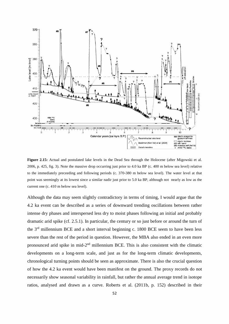
52
Figure 2.15: Actual and postulated lake levels in the Dead Sea through the Holocene (after Migowski et al.
2006, p. 425, fig. 3). Note the massive drop occurring just prior to 4.0 ka BP (c. 400 m below sea level) relative
to the immediately preceeding and following periods (c. 370-380 m below sea level). The water level at that
point was seemingly at its lowest since a similar nadir just prior to 5.0 ka BP, although not nearly as low as the
current one (c. 410 m below sea level).
Although the data may seem slightly contradictory in terms of timing, I would argue that the
4.2 ka event can be described as a series of downward trending oscillations between rather
intense dry phases and interspersed less dry to moist phases following an initial and probably
dramatic arid spike (cf. 2.5.1). In particular, the century or so just before or around the turn of
the 3rd millennium BCE and a short interval beginning c. 1800 BCE seem to have been less
severe than the rest of the period in question. However, the MBA also ended in an even more
pronounced arid spike in mid-2nd millennium BCE. This is also consistent with the climatic
developments on a long-term scale, and just as for the long-term climatic developments,
chronological turning points should be seen as approximate. There is also the crucial question
of how the 4.2 ka event would have been manifest on the ground. The proxy records do not
necessarily show seasonal variability in rainfall, but rather the annual average trend in isotope
ratios, analysed and drawn as a curve. Roberts et al. (2011b, p. 152) described in their

53
synthesis a regional climatic shift following c. 2250 BCE, where the semi-arid interior of the
Near East became characterised by less precipitation, but also climatic instability. In contrast
to more a predictable rainfall regime up to the 4.2 ka event, this took the shape of more
randomly distributed showers or shortened periods in which these occurred, potentially
affecting societies practicing dry-farming strategies in a major way, as well as probably also
having an impact on mobile groups. More erratic rainfall tends to occur as intense and
catastrophic showers, causing fluctuations in river discharge, lowered water tables, and
exacerbated soil erosion, which would even have changed the flow of the Euphrates and the
Tigris toward the turn of the 3rd millennium (also cf. Kuzucuoğlu 2007, p. 27).
2.5.3 Causes for the event
There is no generally accepted causal mechanism for a climate perturbation associated with
the 4.2 ka BP event, although as its extent stretches from central and eastern Africa to
Anatolia, it seems likely to be connected to the large climate systems, possibly even the global
ones (Issar & Zohar 2007, p. 133; Roberts et al. 2011b, p. 152 – cf. 2.4.8). According to
Bond et al. (1997, pp. 1257-1258), the North Atlantic has experienced a number of Holocene
cooling events, e.g. 9.4, 8.1, 5.9, and 2.8 ka BP, in addition to the one at 4.2 ka BP. This is
suggested by associated increases in species of planktonic foraminifera adapted to cold
conditions. The 4.2 ka BP event was termed the Holocene Event 3 by Mercuri et al. (2011, p.
193) and linked to a cooling of SST in the Atlantic Ocean by 1-2°C (also cf. Bond et al. 1997,
p. 1261). In association with this it seems that cooler and wetter conditions in western and
central Europe between c. 4.5/4.4 and 3.9/3.8 ka BP were correlated with changes in the SST
and the salinity of North Atlantic sub-polar regions (Magny et al. 2009, p. 831 – cf. Figure
2.14). Thus, there seems to have been a connection between the NAO, its SST, and the
climatic event occurring toward the end of the 3rd millennium BCE. Although Wanner et al.
(2008, p. 1818) disagreed with regard to the abruptness of the event, they did concede that
increased aridity from the mid-Holocene onward (i.e. the last 6000 years) should probably be
attributed to a reduction in solar irradiance due to orbital forcing and a southward shift of the
ITCZ (cf. 2.4.8) accompanied by weakening of the Indian Ocean monsoon system. These
factors, i.e. suppression of the monsoon system and cooler SST, were also argued by Roberts
et al. (2011b, p. 150) as the ultimate cause behind the 4.2 ka BP event. However, the
seemingly abrupt arid spike visible in the Near Eastern climate records of this time indicates
that also additional factors could have affected the region. Reduced summer insolation and

54
subsequent differences in seasonal insolation caused by long-term progressive influence of
orbital factors through the Holocene, could actually have led to a climatic-systemic crossing
of a threshold occurring around 4.2 ka BP (Magny et al. 2009, p. 831). In regions where the
environment would be sensitive to changes in climate and precipitation, such as the
Palmyrene and Near Eastern interior, the effects on ancient societies may have been
considerable.
2.5.4 The aftermath of the event
The aftermath of the 4.2 ka event, i.e. climatic conditions and the diachronic transition
following the five or six centuries outlined above, also seems to be associated with some
degree of ambiguity. Certain records from the early 2nd millennium, mainly the deep sea
cores, indicate a return to moister conditions, but most suggest that the subsequent arid
conditions were part of a more permanent climatic regime, closer to the type we see in the
Near East today (Wossink 2010, p. 183). The final phase of the event could be considered to
be represented by approximately MBA II (also cf. 2.5.2), at which time e.g. Roberts et al.
(2011b, p. 152) concluded that the climate returned to wetter conditions. However, they also
argued that humidity was far lower compared to the pre-event levels, i.e. prior to c. 2300
BCE. This point was also emphasised by Issar and Zohar (2007, pp. 136-137) in their
synthesis, where they suggested a return to better climatic conditions around the start of MBA
II (c. 1800-1600 BCE). Migowski et al. (2006, p. 426) also argued from the Dead Sea water
level perspective (cf. 2.4.3) that the period after c. 3.9 ka BP experienced conditions similar to
those preceding the 4.2 ka event, although the climate subsequently deteriorated once again c.
3.5 ka BP (cf. Figure 2.15). The Mount Sedom Tamarix analyses indicated twice the modern
rainfall c. 1980 BCE, followed by deterioration to modern conditions c. 1880 BCE (Frumkin
2009, pp. 325-326). However, as this tree died long before the final MBA II moist phase, this
evidence does not preclude any subsequent return to moist conditions, but seems more likely
to attest the aforementioned climatic amelioration interpreted to have taken place around 2000
BCE. On the other hand, Fiorentino et al. (2012, pp. 25-26 – also cf. Figure 2.12) identified
the period 1800-1650 BCE as an arid phase in their analyses of the carbon isotopes in plants
from Tell Mishrife and Tell Mardikh, only acknowledging the moist interval at c. 2000 BCE
as one of importance. However, they did note that decreases and increases in precipitation
occurred during MBA II, which finally ended in a major drought peak at c. 1600 BCE. The
Lake Van record (cf. 2.4.4) seems to show that modern conditions in fact did not set in until

55
around 2.0 ka BP, but the onset of the deterioration toward this point started around 4.2 ka BP
(Wick et al. 2003), thus suggesting a continuously deteriorating trend there. At Teçer Lake
conditions seem to have improved after the hiatus (i.e. from c. 1900 BCE – cf. 2.4.5), but the
climatic regime and associated patterns of precipitation shifted to a more intense and unstable
one compared to the period prior to 4.2 ka BP (cf. Kuzucuoğlu et al. 2011, pp. 182-183, 185).
This may possibly have been one of the main climatic consequences of the 4.2 ka BP event,
with further implications for the regional populations and their land use patterns. However,
there seems to be general agreement that the Near East was characterised by continuing
deterioration within an oscillating trend after c. 1600 BCE, so the moister phase during the
MBA II was an unstable interval, seemingly not lasting more than around one or two
centuries. Thus, it seems clear that the climatic basis for various regional environments in the
Near East changed quite a lot from the early and mid-3rd millennium BCE to the late 3rd to
early 2nd millennium BCE and onward. Ecological responses to this would probably be
manifest in paleoenvironmental material extracted from archaeological sites in the region, but
also the timing and potential effects of ancient human impact on the landscape would be
possible to discern from such sites. The next subchapter will focus on these aspects, followed
by an attempt at reconstructing environments and ecologies relevant for a study of the Bronze
Age Palmyrene.
56
2.6 Bronze Age environments and the anthropogenic impact
In addition to factors of climate and topography, exploitation of the natural environment by
resident societies could also have affected the regional or local landscapes to various degrees.
While it is quite clear that the currently degraded state of many Near Eastern ecologies (cf.
2.3) is due mostly to human exploitation in various ways, whether or not the threshold for no
return was crossed in the 19th-20th century CE has been debated. Paleoenvironmental studies
and data from archaeological sites constitute the main sources for answers to this question,
and such research also adds to the picture of regional biomes and can be used to track
diachronic vegetational changes in the landscape around the sites.
2.6.1 Human impact on vegetation
It seems likely to assume that human societies have impacted upon the Near Eastern
environments through the ages in an ebb-and-flow pattern until the advent of motorised
transportation. Thus, the main questions in the consideration of environmental contexts for a
reconstruction of past landscapes are when can humans be identified in the vegetational
picture and how did the development of cultural vs. natural landscapes unfold. Blondel (2006,
pp. 713-714) argued from a Mediterranean perspective that human agency actually could keep
landscapes diverse rather than ruining them. However, this position have invoked arguments
labelling its opponents as extreme ecologists who view prehistoric environments as some sort
of “Lost Eden” (also termed ruined landscape theory), which has subsequently degraded into
badlands and deserts by deforestation and overgrazing. The reality probably lies somewhere
in between, but the debate has brought up two concepts which are relevant in this discussion –
resilience and resistance. Resistance can be defined as the amount of change caused by a
disturbance, while resilience is the amount of time a system would require to recover from
such an event. Even intensive grazing does not necessarily lead to a degraded environment, as
combinations of wild and domesticated grazers and browsers could provide stability and
diversity, and potentially maximizing ecosystem productivity and species diversity (cf.
Blondel 2006, pp. 723, with references). On the other hand, ecologies in certain regions may
possibly have been sufficiently degraded already in Classical times to not have the resilience
to bounce back to a relatively natural state6 when the human pressure ebbed and subsided – if
6 Albeit obviously with an inclusion of imported species of vegetation which may have formed part of the
cultural flora of the region.

57
it actually did subside at all in the following Islamic and Ottoman periods. Available evidence
from Turkey suggests that e.g. its biomes have a potential for 70 % forest cover, but a mere 14
% of the country is covered by woodland today (van Zeist & Bottema 1991, p. 23). Certain
parts of the region were cleared in the 1st millennium BCE and intense human activity there
until it subsided in the 1st century CE seems indeed to have had certain environmental
consequences. It took about 400 years for some types of vegetation to regenerate, while e.g.
deciduous oak woodlands did not in fact recover at all from the Iron Age exploitation and
clearance (van Zeist & Bottema 1991, p. 141). Nevertheless, anecdotal evidence from travel
accounts (cf. 4.5.2) strongly suggests that fauna and flora in the Near East was much richer in
both quantity and quality at the turn of the 20th century CE than it is today (cf. 2.3).
However, as the temporal focus here is on the period a millennium prior to the Iron Age, the
extent of industrial degradation of vegetation and environment remains less relevant, although
the comparative element may hold relevance. Clearly, certain parts of the Bronze Age
landscape had relatively high densities of human habitation, and could potentially have
impacted on surrounding biomes to a degree similar to societies of the Iron Age. Some
paleoenvironmental records from Anatolia suggest that humans started making a visible
imprint on the environment already in the Bronze Age, but the evidence for such clearance
varies from the EBA to the LBA depending on the resilience of the local ecology (Roberts et
al. 2011b, pp. 157-158). Climatic oscillations (cf. 2.4 and 2.5) would probably have amplified
the consequences of clearance in arid periods, and spatial factors such as arid vs. humid
environments would also have constituted a significant weight on the balance of ecological
pressure. While tree coverage in the Near East as a whole probably reached its maximum
around 6.0 ka BP, most pollen records from Bronze Age sites show that human habitation has
visibly affected the nearby environment, and by the middle of the 1st millennium BCE the
region would have been transformed into a series of cultural landscapes both due to
exploitation and climatic deterioration (Roberts et al. 2011b, pp. 157-158). However, aspects
such as density, society type, and economy are central when evaluating how humans may
have altered ancient landscapes (Blondel 2006, p. 715). The abundance of charcoal from Iron
Age sites does indicate that forests were covering many parts of the Near East, even beyond
the LBA. Thus, despite a situation of moderate exploitation, conditions probably never
crossed the boundary of environmental degradation and erosion known from recent times,
when the threshold of ecological resilience was overstepped and followed by a disastrous

58
decrease in regional biodiversity (Blondel 2006, pp. 726-727). Although biomes in the
immediate proximity to major population centres probably would have been dominated by
fields, parkland, and thinly wooded ecologies already in the EBA and MBA, large tracts of
steppes and upland areas – such as the Jezire and the Palmyrene – would have been more
inaccessible and inhabited by mobile populations. Such groups would also only have utilised
these landscapes mainly on a seasonal basis (cf. 5.1.3 and 5.2.1.2), thus providing ecologies of
low resilience with an opportunity for regeneration.
2.6.2 Data from archaeological sites
Paleoenvironmental material like pollen remains is a valuable proxy source through isotope
composition analyses, but can also provide direct spatiotemporal evidence for vegetation
species found in the environs of an archaeological site in a diachronic perspective. This must
be considered as response data and could be a result of both climatic conditions and human
interaction with the environment – or even be a consequence of sampling choice, e.g. as the
firewood of preference for the site’s inhabitants (Roberts et al. 2011a, pp. 3-4). Thus, such a
source must be carefully considered, taking into account the various possible scenarios for its
presence in the archaeological assemblage. Local environments and human populations
probably had a synergistic relationship and both landscapes and sites were subject to climatic
and anthropogenic site formation processes (Roberts et al. 2011a, p. 5). Fortunately, one of
the largest sites of the Syrian Bronze Age, Tell Mishrife (ancient Qatna), is situated in relative
terms just outside of what I call the Palmyrene region (Figure 2.16). This, as well as Tell
Mardikh (ancient Ebla), have been subject to extensive and scrutinised excavations, which
also have included an environmental perspective, including pollen analyses, as part of their
integrated research (cf. Fiorentino & Caracuta 2007; Fiorentino et al. 2008; Fiorentino et al.
2012). Consequently, there are response data available for parts of central Syria, even though
many of the proxy data sources lie quite a distance away from the area of focus here (cf.
Figure 2.8), and vegetation compositions inferred from some of these sites will here add to
the picture of the arid landscapes of Syria during the Bronze Age, together with climate
records.
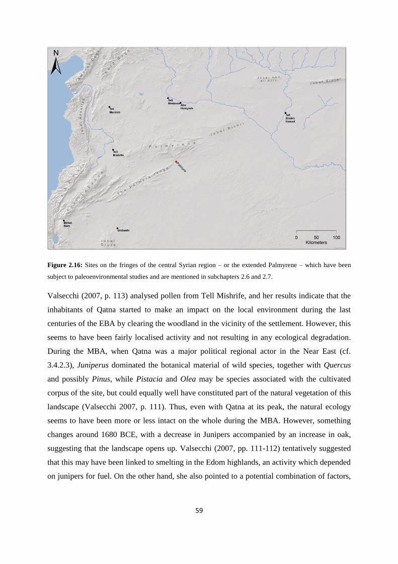
59
Figure 2.16: Sites on the fringes of the central Syrian region – or the extended Palmyrene – which have been
subject to paleoenvironmental studies and are mentioned in subchapters 2.6 and 2.7.
Valsecchi (2007, p. 113) analysed pollen from Tell Mishrife, and her results indicate that the
inhabitants of Qatna started to make an impact on the local environment during the last
centuries of the EBA by clearing the woodland in the vicinity of the settlement. However, this
seems to have been fairly localised activity and not resulting in any ecological degradation.
During the MBA, when Qatna was a major political regional actor in the Near East (cf.
3.4.2.3), Juniperus dominated the botanical material of wild species, together with Quercus
and possibly Pinus, while Pistacia and Olea may be species associated with the cultivated
corpus of the site, but could equally well have constituted part of the natural vegetation of this
landscape (Valsecchi 2007, p. 111). Thus, even with Qatna at its peak, the natural ecology
seems to have been more or less intact on the whole during the MBA. However, something
changes around 1680 BCE, with a decrease in Junipers accompanied by an increase in oak,
suggesting that the landscape opens up. Valsecchi (2007, pp. 111-112) tentatively suggested
that this may have been linked to smelting in the Edom highlands, an activity which depended
on junipers for fuel. On the other hand, she also pointed to a potential combination of factors,
60
which included a regional climatic shift toward drier conditions and a decrease in
precipitation, attested by the Soreq Cave record among others (cf. 2.5.4).
A number of other sites (cf. Figure 2.16) which include paleoenvironmental material can be
put forward as examples of the relation between natural vegetation and human exploitation in
the Near East in the late 3rd and early 2nd millennium BCE, and add to the subsequent
reconstruction of past landscapes in and around the Palmyrene (cf. 2.7). The first to be
mentioned is Birket Ram, a Levantine crater lake which has provided botanical information
dating to the EBA (cf. Roberts & Reed 2009, pp. 271-272). Pollen analyses from this site
suggest that human occupation in the area was episodic, i.e. an ebb and flow of forest
clearance for agriculture followed by abandonment and regeneration of this forest. Olive trees
were cultivated within the catchment of the lake during the EBA, but these disappeared in the
period 2300-2000 BCE, thus around the 4.2 ka BP event, and the catchment area was then
recolonised by deciduous oak forest. Although this site does not have a direct spatial
association with the Palmyrene, it shows that at least certain Near Eastern woodlands could
stay resilient against Bronze Age agricultural practices. The destructive potential in
cultivation becomes evident at Birket Ram during Roman times, when human impact on the
local environment reached its maximum, crossed the inherent threshold of resilience, and left
the surrounding ecologies in a mere semi-natural state.
Another relatively distant area, but more comparable to the drier parts of the Palmyrene
environments, is the region of Jebel al Arab in southern Syria. Today this is a barren desert
filled with scattered volcanic rocks (Figure 2.17), but charcoal analyses carried out on
samples from the site of Umbashi strongly suggest that during the EBA and MBA, the
landscape looked quite different (cf. Willcox 1999, pp. 712-715). It is located c. 15 km east of
the modern 100 mm isohyet line in an area called the Black Desert, but paleoenvironmental
research has shown that during the EBA it was home to a type of woodland steppe, including
tree and grass species now only associated with the isolated remnants of such vegetation
hidden away in sheltered parts of the Near East. In archaeological assemblages of this date
numerous examples of Quercus (deciduous), Pistacia, Tamarix, and Amygdalus have been
recovered, as well as other species constituting part of the woodland steppe biome (cf. 2.7.1).
Although different, the MBA seems also to have harboured a much lusher environment at
Umbashi than today, albeit with lesser amounts of Quercus, Tamarix, Pistacia, and
Amygdalus, but a lot more Chenopodiaceae. However, interestingly the amount of olive trees

61
(Olea) increased sevenfold by the early part of the 2nd millennium BCE. The reasons for these
developments were probably complex, and may have incorporated aspects of vegetational
degradation in the immediate surroundings – indicated by the massive increase in olive
cultivation – but as with other parts of the Near East, climate change has been convincingly
evoked as a major factor for the changing landscape from the EBA to the MBA. Other
potential culprits could have been economic changes resulting higher mobility and increased
grazing, or merely variations in wood use preference affecting the on-site paleobotanical
corpus. Of course, all of these explanations may have been in play at the same time, with
interrelating cause-and-effect patterns, but the main point inferred from Umbashi is that the
Bronze Age landscapes often looked vastly different that the ones we experience today, even
in such an arid region.
Figure 2.17: Satellite image of the region surrounding the site of Umbashi in southern Syria. Although the area
seems utterly barren and devoid of larger species of vegetation today, archaeological assemblages suggest an
ecology more akin to the terebinth/almond woodland steppe during both the EBA and the MBA. The large black
geological structure is the now extinct volcanic field of Tulul es-Safa.
The final examples of archaeological sites which will be discussed in the context of EBA-
MBA environments in a diachronic perspective are situated in the Euphrates and the Habur
river valleys. Deckers and Pessin (2010, pp. 222-224) studied a number of sites in north-
central and northeastern Syria and analysed 51.000 charcoal samples from associated
archaeological assemblages. The most relevant ones for the present study were Tell Meskene
62
(ancient Emar) in the Euphrates bend and the site of Tell Sheikh Hamad on the lower Habur
(cf. Figure 2.16). Their main aim was to study the relative spread of Pistacia-Amygdalus
vegetation vs. Quercus in through the Bronze Age to use as a climate proxy, with the former
species indicative of arid periods and the latter expanding in moister climates. They also
looked at Populus-Salix vs. Tamarix ratios from the sites, which can give an impression of the
human impact in such riverine environments. Their results indicated that the period c. 2200-
2000 BCE was characterised by steppe woodland with less pronounced parkland appearance
than earlier in the 3rd millennium BCE, while data from Tell Meskene suggested that the
climate in this period was drier than during the following centuries, i.e. the MBA. On a longer
scale, a development characterised by an increase in Pistacia relative to Quercus was attested
in the material, evidence for a general drying trend into the LBA, which in fact seemed to
experience even more arid conditions than today. This development was by the authors linked
to the 4.2 ka BP event (cf. 2.5).
Based on these examples from archaeological sites a preliminary conclusion could be argued
to support a picture of relatively natural landscapes across large parts of the Near East,
presumably at least outside the Mesopotamian alluvium, during the EBA and MBA, but the
presence of large settlements would have had a potential for some impact on their immediate
surrounding ecologies. Although I feel disinclined to advocate from an extreme ecologist
perspective (cf. 2.6.1), the balance of evidence still seems tipped in favour of vastly different
steppe environments compared to the ones experienced today, particularly with regard to trees
and the amount of vegetation in general. Some areas do attest to a visible amount of
environmental deterioration during the 1st millennium BCE, with further effects in the
Classical period. Nevertheless, in a discussion concerning the EBA-MBA Palmyrene, as well
as for most of the Jezire, it seems defensible to assume that natural steppe vegetation was
covering large swathes of it. The final part of this chapter will present in general terms what
these natural ecologies would have entailed for the various landscapes relevant here.
2.7 The reconstruction of Palmyrene environments
While present-day environments cannot simply be projected onto the past, and reconstructions
need to be based on a variety of sources, proper knowledge of the compositions of natural
vegetation is still indispensable in this respect (van Zeist & Bottema 1991, p. 16). In their

63
study of the Epipaleolithic and Neolithic site Abu Hureyrah, Moore et al. (2000, pp. 49-50,
with references) reconstructed the ecological potential of the various Syrian biomes, and
projected a picture of how the landscape would have been under the current climatic
conditions, but without any human intervention. Such an approach could provide a
perspective of past environments which is lacking from the degraded modern landscape (cf.
2.3). It is clearly necessary to be cautious, as the recent data does not necessarily reflect the
ecological complexity of a more distant past, e.g. due to the potential of migratory species
replacing certain original populations (Moore et al. 2000, p. 51). However, this aspect would
also be more relevant on a detailed and species-specific level, and not in a broad overview.
Even though climatic variations and human exploitation probably did affect parts of the Near
East already by the Bronze Age, Syrian environments were of much richer quantity and
quality than it is today, and the region was still covered in much more extensive woodlands
even by the end of the LBA (cf. Deckers & Pessin 2010, p. 225).
Although the Abu Hureyrah research focused upon much earlier periods than the EBA-MBA
focus here, their ecological perspective corresponds quite well. The site itself is also located
in relative proximity to the Palmyrene and their temporal focus would in fact not be too much
of a hindrance for this discussion, due to the fact that their environmental reconstructions
were based on the modern climatic regime. They defined seven different biomes, which in
some ways parallel the ones found in Wirth (1971) (cf. 2.3.2, 2.3.3, and 2.3.4), and some of
which were divided one step further (e.g. 5a and 5b). The Palmyrene incorporates several of
these ecological zones, but mainly the terebinth/almond woodland steppe (biome 4), moist
and medium-dry steppe (biome 5a), and very dry steppe (biome 5b). The western borders of
the Palmyrene, as well as northern parts of the Jezire could also have supported parkland
vegetation of oak and rosacaea (biome 3b), while the southeast on the opposite end of the
scale in would only have had potential for desert vegetation (biome 6). Finally, gallery forest
of riverine vegetation (biome 7) would have lined the main river valleys of Syria and the
Euphrates in particular (cf. Moore et al. 2000, p. 50, fig. 3.7 – also cf. Figure 2.18). I will
conclude this chapter with a short presentation of these potential biomes, mainly based on the
work of Moore et al. (2000), as a core contextualisation of the Palmyrene environment, as
well as considering them in light of the other aspects discussed here, especially in relation to
diachronic climatic variations and the significance for human habitation and exploitation.

64

65
Figure 2.18 (previous page): The vegetation potential of Syrian environments under the modern climatic
regime with Bronze Age settlements and geographic regions marked. The legend is inlaid and should be viewed
as indicative of the main ecologies in their respective areas, with some degree of variation within each. Map
reproduced after Moore et al. 2000, p. 50, fig. 3.7.
2.7.1 Palmyrene terebinth/almond woodland steppe
Most of the Palmyrene highlands would originally have consisted of terebinth/almond
woodland steppe ecology, and this zone therefore constitutes the primary environmental
context for the EBA-MBA mobile groups of this region and their potential archaeological
remains (cf. chapters 5 and 4, respectively). The region receives too little precipitation to
support oak groves today, but more drought-resistant species could thrive there. In addition,
geological and hydrological factors affect the potential of this biome, and consequently
regions with less favourable conditions, like the southern slopes of Jebel Abd el-Aziz (cf.
Figure 2.1), would need slightly higher annual precipitation for such vegetation. Yet other
landscapes have more advantageous combinations of factors, and can thus support this
ecology on less than 200 mm annual rainfall. Interestingly, the Palmyrene was emphasised as
precisely such a favourable area for the terebinth/almond woodland steppe by Moore et al.
(2000, p. 60), as well as the regional potential for this biome forming a broad zone, except
under particularly unfavourable topographical or hydrological conditions.
Most of this biome contains plants of an Irano-Turanian vegetation type, although with a
distinct phytogeographical Syrian entity, dominated by species of Pistacio and Amygdalus.
Particularly the terebinth trees P. atlantica and P. khinjuk would have been characteristic
(Moore et al. 2000, p. 62), and these species are in fact indicators of steppe vegetation and
relatively arid conditions in analyses of archaeological assemblages (cf. 2.6.2). Terebinths are
still found on isolated ridges and mountain slopes of central Syria, but large tracts of them
were described to grow in the Palmyrene highlands, e.g. specifically along Jebel Abyad and
Jebel Merah, by Musil (1928, pp. 147, 149) in his travel accounts from the early 20th century
CE (also cf. Zohary 1973, p. 168). Other anecdotal evidence from the 17th-19th century CE
Palmyrene describe thick and shady turpentine trees covering both sides of Abu Rujmein, as
well as one noting this range covered by a considerable forest. An account provided by the
grandfather of Khaled Assad at the Palmyra museum supports such a picture, as he described
woodland in Jebel Abyad and adjacent ranges in places being too dense to traverse with a
camel (cf. Moore et al. 2000, p. 62, with references). Jebel Abyad has been extensively

66
surveyed by the Palmyrena project (cf. 4.2.3.1), and it is not an overstatement to say that it is
completely devoid of trees, apart from at the most a handful of isolated terebinths (Figure
2.19 – also cf. Figure 4.28). More recently, Zohary (1973, p. 586) mentioned seeing steppe
woodland in Jebel Mqeibara, a range lining the north side of Tulul al Bayda (cf. Figure 4.26,
no. 6) on the route between Suhne and Taïbe, including the species P. khinjuk, Prunus
microcarpa, and Rhamnus palaestinus (see below), a type of biome similar to vegetation
found in the Zagros, but without oak. However, once more, satellite images of these
mountains show them to be wholly barren. Further east, Jebel Sinjar still supported oak
groves of the type Q. brantii in the 1960s in addition to the abovementioned species (Zohary
1973, p. 586), but this region also receives slightly higher rainfall than the Palmyrene (cf.
Figure 2.6).
Figure 2.19: An isolated terebinth found sheltering under a cliff high up on a Jebel Abyad mountain slope
during the fieldwork of 2011. This was one of a mere handful of such trees found to inhabit this range that
season (for the other cf. Figure 4.28), and may have survived due to its relatively inaccessible location.
Other large species of vegetation in this biome would originally have included almond trees
and shrubs (Amygdalus communis and many other subspecies), hawthorns (e.g. Crataegus
flava – the yellow-fruited hawthorn), and wild pear trees (Pyrus spp.). Smaller shrub types

67
would e.g. have included buckthorns (Rhamnus palaestinus), dwarf cherries (Prunus
fruticosa), and capers (Capparis spp.). Numerous species of grasses and herbs would have
thrived, most notably various genera of chenopods (Chenopodioideae), wormwood
(Artemisia), and tall, perennial feather grass species (Stipa). However, it seems probable that
the microclimates provided by trees could have harboured an even richer composition of
undergrowth in this environment, including swathes of wild wheat and rye, particularly in
ecological hot-spots (cf. Figure 2.7). Moister parts of the terebinth/almond woodlands could
even have harboured extensive and dense stands of einkorn (Triticum urartu) and especially
wild barley (Hordeum spontaneum), while other exploitable plants would have included
lentils and geophytes (cf. Moore et al. 2000, pp. 62-63). This landscape could under modern
climatic conditions have dominated the Palmyrene highlands (cf. Figure 2.2), from Jebel
Bilas through Abu Rujmein and Jebel Dahek, as well as the entire Jebel Bishri. Lower-lying
parts within and between these mountain ranges would in places perhaps have had ecologies
closer to those of the dry steppe biomes (cf. 2.7.2), as would the steppe that stretching toward
the Euphrates north of the Palmyrene ranges (cf. Figure 2.18). For the Near East in general,
the terebinth/almond woodlands would have characterised most of the northern Jezire from
the Jabbul plain to the Tigris.
2.7.2 Palmyrene dry steppe – moist to medium dry and very dry types
The dry steppe would mainly have been populated by grasses, herbacious plants and,
chenopods, and stretched out in a largely unbroken pattern between the woodland steppe and
desert biomes (2.7.3). However, this is clearly a simplification which does not do justice to
such a vast region, and variations within the zone would have occurred with vegetation
depending on local ecological qualities. This zone can in general terms be divided into two
types – moist to medium dry steppe and very dry steppe (cf. Moore et al. 2000, p. 50, fig. 3.7).
Vegetation in the dry steppe would have included many species of wormwoods and
chenopods (cf. 2.7.1), but the potential of this biome also suggests that grass species of
various heights would have been ubiquitous. Without heavy grazing, even the drier parts of
this zone would have included grass swards (Moore et al. 2000, pp. 63-64). Tall grasses, both
perennial and annual, of genera like Poa and Stipa would have covered this biome, extending
as a grass sea across the region, although in reality kept partly in check as pastures (Figure
2.20). Even in recent times, areas supporting such ecology in which grazing has been limited

68
or forbidden, can in fact be covered in chest-high Stipa species, rendering the two other
characteristic genera (Artemisia and Chenopodioideae) invisible. One description of the route
between Aleppo and Baghdad dating to the 17th century CE also suggests this was the case in
more remote areas of the Near East, even though pastoralism and seasonal grazing at this time
constituted a substantial part of the regional economy (cf. Moore et al. 2000, pp. 64-65, with
references). Another account from the 19th century CE observed clover growing as high as up
to the knees of the horses along the route between Aleppo and Taïbe, an area of regular
grazing (cf. Moore et al. 2000, p. 66, with references). Even with rainfall as low as 100 mm
annually would have been sufficient for an abundance of Stipa species, as the Abu Hureyrah
project found to be the case for isolated and remote islands of vegetation. Such environments
would also have been rich in Artemisia species and numerous types of chenopods, as well as
certain herbs, like sage (Salvia cryptantha) and thyme (Thymus squarrosus), and many other
small plants (cf. Moore et al. 2000, pp. 65-68). The very dry steppe, like parts of the Al-
Hamad (cf. Figure 2.1), would have had a cover of chenopods and species of Poa and Stipa,
albeit not growing as lushly as in the moister zones and gradually declining toward the desert
zones.
Figure 2.20: Picture from the Palmyrene, with various grasses growing lushly after winter rains. While this may
be more or less how the dry steppe biome could seem in spring, the photo is somewhat misleading, as it in fact
69
was taken in an area which probably once supported a terebinth/almond woodland biome. However, this
landscape had been reduced to an environment more similar to a dry steppe type (photo: Jørgen Christian
Meyer).
The moist and medium dry but largely treeless steppes of the Near East would have been
situated between the zones of terebinth/almond woodland and the very dry steppe. More
specifically, it would have dominated the southern half of the Western Jezire (i.e. between
Habur and Balih – cf. Figure 2.1) and the northern Palmyrene up to the Euphrates. The region
due east of Damascus could also have supported the moister type of steppe, but the Al-Hamad
would in general be characterised as very dry steppe, as would the southern half of Eastern
Jezire across to the Tigris (cf. Figure 2.18). However, even this vegetation would have been
vastly richer in quantity and quality than that now found along the south side of the modern
road between Tadmor and Deir ez-Zor, and probably more so than the current vegetation
cover in much of the Palmyrene itself. These biomes (i.e. 2.7.1 and 2.7.2) would have
constituted the main environments the Palmyrene and most of the Jezire. I will also briefly
describe three other types of ecologies found around these regions, as they may have come
into play in central Syria depending on climatic developments, as well as forming a
comparative perspective in relation to the degraded biomes described above (cf. 2.3).
2.7.3 The desert biome
The desert ecology would have included the region south of the Euphrates around the point
where the river enters Iraq, i.e. just south of Mari (cf. Figure 2.18). It can be defined as
different compared to the steppe biomes, in that it does not have a continuous root system and
consequently does not allow soil cover. The desert supports few or none Artemisia or grass
types, only shrubby chenopods, and the vegetation found there is mainly growing in patches
of isolated populations established where local topographical or hydrological conditions could
allow a thin soil cover (Moore et al. 2000, p. 69). Arguably, many parts of central Syria today
could thus be appropriate to group in with desert biomes, although they until recently were
firmly characterised as steppes.
2.7.4 Riverine biomes
The large river valleys of Syria – the Euphrates, the Orontes, the Habur, and the Balih –
border the Palmyrene on three sides. These landscapes have been reconstructed based upon
better preserved stretches of riverine forest in Turkey (cf. Moore et al. 2000, pp. 69-73). The

70
Euphrates valley would in places have been dominated by up to 30 m tall oriental planes
(Platanus orientalis), which had dense canopies and thus would have provided lots of shade
for the undergrowth. Closer to the rivers, these would have given way to poplars (e.g. Populus
euphratica), ash trees (Fraxinus rotundifolius), and occasional elms (Ulmus spp.), all of
which certainly grew along the Euphrates and may have been found along stretches of the
other rivers as well. Imprenetable thickets of tamarisk (Tamarix gallica) and willows (Salix
spp.) would have bordered the river banks. Reeds, water lilies, and other aquatic plants would
have thrived in the rivers themselves, as would shrubs and grasses on dry land, growing in
between trees and in transitional areas between the biomes. Several of the taxa above have
been used in environmental studies as main indicators for riverine forests (e.g. Deckers &
Pessin 2010, p. 217). Of the species mentioned here, only the tamarisk is still found in
extensive populations along the rivers, as it can endure saline environments that would kill
most other plants (Cech 2005, p. 122).
2.7.5 Xeric woodlands on the Palmyrene periphery
Although there is some debate regarding the borders of the steppe vs. that of the moister xeric
woodlands in the Near East (e.g. Zohary 1973; van Zeist & Bottema 1991; Moore et al. 2000),
the latter zone seems to require c. 300 mm annual precipitation, but also the right soil
structure and geology (Moore et al. 2000, pp. 53-54). The main difference of this zone from
the woodland steppe in vegetational terms is the presence of extensive oak populations
(Quercus spp.), although species found in the steppe would also have been growing there, e.g.
Crataegus, Pyrus, and Pistacia spp., as would juniper shrubs and smaller trees, while the
density of the vegetation would constitute a further difference between these biomes. West
and northwest of the Palmyrene, on the plains around Homs and Aleppo, the landscape would
have been characterised by such park-like woodland, i.e. an extensive and relatively dense
scatter of oaks and other trees interspersed with grassland. Taxa such as Q. boissieri, and the
drought-tolerant Q. brantii (also cf. 2.7.1), would have thrived in such an open woodland, in
addition to the terebinth/almond genera mentioned above. Perennial and annual grass genera
(Bromus, Avena, Hordeum, Secale, and Agropyrom) and cereals (e.g. einkorn, rye, and oats)
would have constituted parts of the ecological diversity within the grassland component. The
steppe species Stipa and Artemisia would also have been naturally incorporated into this
biome, although as smaller populations (Moore et al. 2000, pp. 54-56).
71
2.7.6 Regional fauna
The last part of this contextual presentation of the Bronze Age environments of Syria
concerns the fauna, which was very much more diverse than the current one (cf. Wirth 1971,
pp. 128, 134-135; Moore et al. 2000, pp. 85-91; Deckers & Pessin 2010, p. 224). The steppes
and woodland steppe biomes of the Palmyrene highlands would have been populated by
various species of mammal, most notably three taxa of southwest Asian gazelles (Gazella
gazella, G. dorcas, and G. subgutturosa) and the onager (Equus hemionus), animals gathering
and migrating in large flocks which may have been subject to mass hunts by mobile groups
utilizing the many kites now found littered across the region (cf. 4.5.5 for a discussion on
these practices). Other steppe species would have included wolves (Canis lupus), jackals
(Canis aureus), hyenas (Hyaena hyaena), foxes (Vulpes vulpes), and hares (Lepus capensis).
Although all these are still present in the Syrian fauna, their numbers have been greatly
diminished in the last century (cf. 4.5.5). Predatory animals which would have been inhabited
the Bronze Age wilderness, but now are either almost or indeed fully extinct, were Syrian
brown bears (Ursus arctos syriacus), panthers (Panthera pardus), lynx (Lynx lynx), and Asian
lions (Panthera leo persica). One text from ancient Mari show that the latter could present a
real threat, as two lions had made their lair in the hedge near the city gate and they were
threatening workers on their way to work the fields outside the city. One of the lions were
eventually killed and the other chased off by members of a mobile group, who were
presumably more used to such hazards (cf. Heimpel 2003, pp. 217-218, text 26 106). But
lions survived in the Euphrates valley until the late 1800s as they also feature in several travel
accounts from the 17th-19th centuries CE (e.g. Blunt 1879a, pp. 77-79; cf. Moore et al. 2000,
p. 90), while panthers and lynx may have roamed the region even until the interwar years
(Wirth 1971, p. 128). In the dry steppe and the desert environments, animals like oryx (Oryx
leucoryx), hartebeest (Alcephalus buselaphus), and ostriches (Struthio camelus syriacus) were
found until the late 19th and early 20th century CE, and the latter are frequently mentioned in
texts from the Mari archives (cf. 5.2.1.4). Riverine forests and the biomes on their fringes
harboured large numbers of wild boars (Sus scrofa) at least up until the First World War (cf.
Blunt 1879a, p. 78), and some river valleys in the Near East also had fallow deer (Dama
mesopotamica) and beavers (Castor fiber) (Moore et al. 2000, pp. 86-90). Finally, during the
Bronze Age, even extinct mammals like the Syrian elephant (Elephas maximus asurus) and
notably the auroch (Bos primigenius) were found, the former in riverine forests at least along
72
the Orontes and the latter in numbers on the steppes of the Jezire and presumably also the
Palmyrene, attested by several Mari texts mentioning hunts and encounters with aurochsen
(cf. 5.2.1.4). Thus, it is conclusively clear that the landscape and environment that is evident
in Syria today would have been very different compared to the flora and fauna experienced
during the 3rd and 2nd millennium BCE by both mobile pastoralists and their more sedentary
neighbours.
2.7.7 Considerations of the biome potentials in a Bronze Age context
The biomes described here (2.7) represent as mentioned the potential of the various parts of
the Near East under modern climatic conditions, but fully without any exploitation by human
societies, such as seasonal pastoralism or cultivation. It is clear that some areas at the very
least would have had environments altered and transformed into cultural landscapes. While
this process may have started even before the Bronze Age and continued to shift the
boundaries between natural and cultural landscapes throughout the history of human
occupation in the region, the degree to which this may have pushed the environment across a
threshold of resilience already in the EBA or MBA is difficult to encompass. Optimal
ecological conditions such as those characterised above would probably not have been found
in densely settled parts of the Near East, e.g. on the alluvium, in the Habur triangle, or along
the Orontes (cf. Figure 2.1). Villages, towns, and cities would have had an inherent potential
for environmental degradation, and some may even have crossed the line between moderate
land uses and enacted a more unsustainable exploitation on the landscapes, particularly near
regional centres. However, it seems reasonable to assume that this impact would quickly
diminish with distance and that many of the biomes experienced only a limited form of
exploitation which with time regenerated back into a more or less natural state. An important
factor when considering interactions between human populations and the environment is the
aspect of seasonality. Mari texts attest to the dangers posed to travellers in the dry steppe
during some months of the year – especially with regard to water supplies (cf. texts 3.4, 3.5,
and 5.6). But this does not suggest that the steppe already at that point was a degraded biome
like today, a notion also supported by the many travel accounts published in the last two
centuries. Seasonality is of course also essential in any discussion concerning Near Eastern
mobile pastoralists, also those forming parts of Bronze Age societies (cf. Traboulsi 1991, p.
47), a topic which will be dealt with later (cf. 5.1.3 and 5.2.1). In this respect it should be
emphasised that while flocks of sheep and goats can make their mark on the vegetation in an

73
area by stripping shrubs for leaves or ripping out grass with its roots (e.g. cf. Pignatti 1983, p.
157, fig. 6), Near Eastern mobile pastoralists seem to have been part of a structure of winter
pastures and summer pastures for millennia, thus providing the environment time and
opportunity for regeneration. Traditional pastoralism probably also incorporated an in-built
balance mechanism as far as interaction with the environment would be concerned due to
limitations in technology and transport, and if any threshold of resilience was crossed, it could
severely affect both humans and animals (cf. 5.1.3.3). The larger trees in the terebinth/almond
woodland would in most cases have been out of reach for domesticated animals, as the camel
does not seem to have been domesticated in Syria until after the MBA – although goats could
have browsed on the trees to some degree. However, while some may have succumbed to
domestic needs for fuel, outside prehistoric industrial use, like smelting, the population would
have had to be dense indeed to denude the Palmyrene of trees, a consequence mainly of
exploitation under industrial or modern technological and demographic conditions. Thus, in
conclusion on this point I would suggest that much of the Syrian steppe would have had
profiles like those presented in 2.7.1 and 2.7.2, as would many of the other landscapes shown
in Figure 2.18, probably excepting those situated in the most densely populated and
extensively cultivated areas.
However, as has been shown earlier in this chapter (cf. 2.4 and 2.5), the current climate does
not necessarily represent conditions in the past. These clearly fluctuated through the 3rd and
2nd millennium BCE as well, probably causing certain environmental variations with regard to
the picture conveyed in Figure 2.18. A number of ecological possibilities could have come
into play for the period between c. 2400 and c. 1700 BCE, as the climate went from much
wetter than the current one, through the 4.2 ka BP event and conditions similar to that of
today, and then improving somewhat for a short period in the final two centuries (i.e. MBA
II). But this latter phase has also been shown to have been characterised by increased climatic
instability, which may also have affected sensitive environments if manifested as more erratic
and more violent rainfall. Thus, during the moister period just prior to the 4.2 ka BP event (c.
2500-2300 BCE), comparative data from Soreq Cave (cf. 2.4.2) suggests that the amount of
average annual precipitation could have been 100-150 mm higher than at the event nadir,
indicated by a drop of c. 0.3-0.6 ‰ in oxygen isotope values, and even higher prior to the
mid-3rd millennium BCE. Such favourable conditions could potentially have transformed
parts of the terebinth/almond woodlands into a landscape more akin to the drier xeric biome,
74
or extended the woodlands into the moister steppe of the Palmyrene and the Jezire. However,
as the 4.2 ka BP event unfolded, the climatic deterioration could have resulted in desert
encroachment upon the dry steppe and some reduction in the woodlands in favour of the
grassland steppe, although whether climatic conditions at the nadir were similar to the current
regime, more arid, or only on the way toward modern conditions is not fully clear. The Soreq
Cave data, albeit only one source, suggests that even at the lowest point, conditions broadly
corresponded to the current ones, and could mean that the Palmyrene landscape was more or
less as shown in Figure 2.18. In the final century of the EBA (c. 2100-2000 BCE) and in the
last two of the MBA (c. 1800-1600 BCE) conditions in the Near East seem to have improved
somewhat, with more precipitation than today, possibly having some environmental
consequences. However, the novel regime of climatic instabilities may also have prevented
recovery of certain biomes, and kept ecologies dominated by more drought-resistant species
like terebinth trees, rather than experiencing an expansion of oak populations. Presumably
larger trees would also have needed more than these relatively short intervals to firmly
establish themselves in otherwise quite dry environments. But it seems highly probable that
the conditions and ecological potential found across the region prior to the 4.2 ka BP event
did not return, and that the late-Holocene Near Eastern aridity we see today had was
underway by the end of the period under study here.
2.8 Summary and conclusions
This chapter has focused on natural conditions influencing the environments of Syria, which
can be quite diversified, mainly according to topography and geography. There are
essentially two main seasons in this region. The summer months are generally hot and dry,
while during winter months most parts of Syria receive precipitation, although the amount can
vary significantly both regionally and on a year-by-year basis. The more arid regions, like the
Palmyrene or much of the Jezire, are dependent on hydrological conditions and particularly
the amount of rainfall these biomes receive for a thriving ecology, and the nature of their
vegetation cover is therefore highly seasonal. Originally, larger plant species would still
mostly have survived the dry season, with the winter and spring rainfall each year providing
conditions for a blooming steppe vegetation. However, it has been argued here that the
environment experienced in the central Syrian steppe landscape today is massively degraded
due to overexploitation throughout the 20th century CE, resulting in loss of microclimates and
75
subsequent erosion, the latter of which is exacerbated for every heavy rain shower in the area.
In addition, not much is left of the original Palmyrene steppe fauna, presumably due to loss of
habitat and the general deterioration of the biome. Such a development of ecological ruin
could in general be extended to include Syria as whole. The picture seems to have been
different during the EBA and MBA, although most studies show a climatic and environmental
development from rather moist conditions in the early part of the period in question here (c.
2400 BCE) toward more arid ones in the latter part (c. 1700 BCE). However, the climatic
progression was not linear, but took rather the shape of a downward trend of oscillations
identified across the Near East – thus probably also affecting the Palmyrene – with a major
climatic incident occuring c. 4.2 ka BP, at which point an arid spike in the data is evident in
most of the proxy sources. While the climate improved later on in this period, and the region
in fact seems to have experienced intervals of relatively advantageous conditions, this
particular development signalled the onset of the late-Holocene aridity characteristic of the
Near East today. But environmental research also suggests that the Near Eastern ecologies
were much richer in quantity and quality during this period, and was arguably not vaguely
comparable to the current situation, with a significant amount of tree cover in the steppe
highlands and much lusher lowland steppes, in addition to a much better preserved fauna.
Thus, the archaeological remains found today across central Syria (cf. 4.1.1) must have been
associated with quite a different landscape, and the regional potential for seasonal use of the
Palmyrene during the wet season was probably much higher (cf. 5.1.3 and 5.2). However,
before turning to these aspects, I will discuss matters regarding the use of ancient texts, as
well as presenting a short geopolitical narrative for the EBA IV and the MBA.

76
3 Textual sources and geopolitical developments
Archaeologists work in a context where their own discipline can be augmented by a number
of other scientific approaches, but if the temporal focus is set several millennia in the past,
more often than not these auxiliary sources of information are confined to the natural sciences
– for instance, as in the previous chapter in this dissertation. However, for those studying
topics concerning the Near Eastern Bronze Age, a vast amount of information has been – and
continues to be – unlocked through historical and epigraphic research. Societies in the region
have left us written records ever since the 4th millennium BCE, but the number of texts
multiplies greatly in the EBA and onward. Although many critical considerations must be
adhered to when reading these documents, some can enhance our understanding of ancient
social, economic, or political relations and conditions immeasurably. Such a source of
information would be very unwise to reject, even in a mainly archaeological study.
Additionally, as this is a synthesis, it is clearly necessary to discuss ancient texts referring to
the period in question (c. 2400-1700 BCE), and it will in fact be shown (cf. 5.3 and 5.4)
including such a source in the argumentation here could be used to support the interpretations
of archaeological structures found in the Palmyrene.
This chapter aims to address aspects surrounding the use of historical and epigraphic sources
and present their overarching implications for the period. First, certain issues regarding
chronology will be discussed (cf. 3.1), as this has been a recurring problem facing historical
reconstructions from the Near Eastern Bronze Age for decades, and I will argue my case for
the periodisation in this study. Thereafter, I will consider the sources themselves – the
cuneiform tablets and the archives they make up – and briefly note some aspects in light of
these sources concerning languages, populations, and the Palmyrene itself in an EBA and
MBA historical context (cf. 3.2). Finally, I will conclude the chapter with an overview of
historical and geopolitical developments in Syria and Mesopotamia for the period c. 2400-
1700 BCE, divided into the EBA (cf. 3.3) and the MBA (cf. 3.4). This part will form the
historical backdrop for topics to come, particularly aspects discussed in chapter 5, and its
purpose is thus essentially contextual – although as this dissertation is a synthesis, I will also
argue for its relevance in isolation.

77
Figure 3.1: Regions of the Near East as they often were known during the Bronze Age - obviously apart from
Syria and Mesopotamia. The Habur triangle was a conglomerate of petty states called Ida-Maraš, while the
Harran area consisted of a few allied Yaminite (cf. 5.3.2.2) states known as Zalmaqum. The Mari heartland as it
appeared during the MBA II (cf. 3.4.2.2) was commonly called Ah Purattim (“banks of the Euphrates”), and the
region south of this was called Suhum. Jebel Bishri was known as Bašar in the 3rd millennium BCE and the more
familiar Bišri during the 2nd millennium BCE, while Jebel Sinjar was known as Saggar (cf. Durand 1991, pp. 85-
85, 87).
3.1 Chronological considerations
3.1.1 Near Eastern chronologies and uncertainties
Near Eastern Bronze Age chronology, while seemingly straightforward, does contain issues of
dispute, particularly with regard to accurate dating of historical events. Originally, these
derived from chronological charts developed by Brinkman (1977, pp. 335-348), which
themselves were based on several sources and assumptions, e.g. king lists, astronomical data,
and calendric systems. His resulting regime has, due to the emergence of other alternatives,
been known as Middle Chronology (MC) or conventional chronology, and is considered as
standard by a majority of scholars working with Bronze Age Near East. However, the
widespread, albeit often provisional, adoption of MC has been characterised by some as a
result of moderation or indifference (Reade 2001, p. 1) or as a “convenient compromise”
(Warburton 2007, p. 9), and its basis for MC has also been subject to critical review. While

78
the chronology from c. 1450 BCE is more or less securely fixed via interlocking king lists, for
various reasons the picture is more uncertain for the preceding millennium (e.g. Gasche et al.
1998, p. 5; Reade 2001, p. 1). This has led to separate developments of three initial
alternatives – High (or Long) (HC), Low (or Short) (LC), and most recently Ultra-Low (or
Ultra-Short) Chronology (ULC) (cf. e.g. Warburton 2007, p. 9). The difference in date
between these frameworks could be as great as 152 years, with the often used Fall of Babylon
reference date set at 1651 BCE (HC), 1595 BCE (MC), 1531 BCE (SC), or 1499 BCE (ULC)
(e.g. Gasche et al. 1998, pp. 6; 83 – cf. Table 3.1). Although archaeological studies often
need not concern themselves with variations spanning some decades, the rather wide horizon
presented by these chronologies does in my view necessitate closer consideration, especially
in a synthetic approach such as this, with its incorporation of radiometrically dated climatic
developments and relatively wide use of textual sources.
Near Eastern
Chronologies HC MC LC ULC
Ur III dynasty 2161-2054 BCE 2112-2004 BCE 2048-1940 BCE 2018-1911 BCE
Hammurabi 1848-1806 BCE 1792-1750 BCE 1728-1686 BCE 1696-1654 BCE
Fall of Mari 1816 BCE 1760 BCE 1696 BCE 1664 BCE
Fall of
Babylon 1651 BCE 1595 BCE 1531 BCE 1499 BCE
Table 3.1: Examples of dates according to the various chronological regimes, calculated from the various dates
of the Fall of Babylon reference point. However, the Ur III dynasty LC horizon in this table is slightly lowered
from 56 to 50 years higher relative to conventional MC, following the suggestions put forward by Huber et al.
(1982, p. 4).
An initial problem stems from periods with which there are few textual sources associated,
particularly the so-called Gutean interregnum which followed the reign of the last Akkadian
king, Šar-kali-šarri (cf. 3.3.2). The duration of this period is in fact unknown, but usually
calculated to have lasted between 40 and 100 years (Sallaberger 2007, p. 420), with seemingly
higher degree of acceptance for the lower end of this scale (Reade 2001, p. 11). Available
radiocarbon dates cannot be used to solve the issue, as results from Mari and Tell Mozan
favour the later dates, while results from Tell Brak and Tell Beydar favour the earlier ones
(Sallaberger 2007, p. 421), but argued within standard deviations, the whole horizon can
probably be supported.

79
Another problem is associated with the Venus Tablet (of Ammisaduqa), which contains
astronomical information on the position of Venus in relation to the horizon and the new
moon during the reign of Ammisaduqa of Babylon and provided the basis for the three initial
chronologies (i.e. HC, MC, and LC), although it is only known from 7th century BCE texts
and later copies (Gasche et al. 1998, p. 6). The text has still been considered as a viable source
due to the mathematical precision of the astronomical calendar, where the date of year 1 of
Ammisaduqa can be fitted to cycles of 56 or 64 years, initially resulting in a scenario where
HC was statistically argued to be the most likely framework (cf. Huber et al. 1982, p. 4;
Huber 1987, pp. 6, 16). However, Gasche et al. (1998, p. 72) criticised this approach as
inaccurate, as local conditions can influence the observation of Venus. They argued that the
only reliable information possible to derive from this tablet is that his year 1 would fall within
cycles of 8 years. Two lunar eclipses described in the Ur III source Enuma Anu Enlil have
added to this argument, resulting in more or less rejection of the HC arguments due to lacking
astronomical basis (Gurzadyan 2000). The HC chronology has likewise been viewed as
improbable from an archaeological point of view (Warburton 2007, p. 9). In fact, Gasche et
al. (1998) approached the issue by looking at the archaeological evidence rather than the
textual, and compared typological developments in pottery. They concluded that the Fall of
Babylon date actually should be placed around 1500 BCE. Corroborating through studies of
astronomical information, the Assyrian King List (AKL), and the integration of variations in
reigns and certain ancient calendric issues, they arrived at the date 1499 BCE for this event –
the reference point of a framework now commonly known as the ULC. Although they neither
rejected the MC nor the LC, they nevertheless suggested that the evidence pointed to a
chronology lower than the conventional MC (Gasche et al. 1998, p. 76).
Reade (2001) studied the AKL with the aim of coming up with a Fall of Babylon date
independent of the Venus tablet or the Ur III eclipses, although at the outset he emphasised
that the result should not be considered conclusive due to the concept of Distanzangaben –
that is, time-spans mentioned in other texts between Šamši-Addu and later kings (Reade 2001,
p. 3). His arguments were based on time elapsed between the erection of the Aššur temple and
later reconstructions of the building during the LBA, and incorporated a number of generally
accepted assumptions and calculations necessitated by gaps and uncertainties in the AKL
(Reade 2001, pp. 3-7). He concluded from this research that 1680 BCE would be the “least
unlikely option” for the death of Šamši-Addu (Reade 2001, p. 8). The Fall of Babylon date

80
according to this regime would be 1499 BCE, and he pointed out the striking parallel to the
conclusions in Gasche et al. (1998), with both seemingly arriving at this date via independent
data sources (Reade 2001, pp. 9-10). Yet another astronomical event applied in the search for
absolute historical chronology is a textual reference from the MBA mentioning a solar eclipse
associated with the birth of Šamši-Addu (cf. 3.4.2.2), but of the potential eclipses occurring in
the area in the relevant period, none can provide a conclusive solution to the problem. They
can fit all scenarios apart from HC, and attempts to anchor one framework without any
additional information is considered too uncertain (Gurzadyan 2003, p. 5). While this event
has still been used to support one framework or the other (e.g. ULC in Warburton 2007, p.
12), as well as proposed variations to the current MC by lowering it 8 or 16 years, accordance
with 8-year cycles (Sallaberger 2007, p. 419; De Jong 2013, p. 159), Schwartz (2008, p. 452)
cautioned against its use due to the propagandistic intentions of the associated text. However,
it is regularly argued that in fact very few scholars possess sufficient knowledge with regard
to both cuneiform texts and astronomical data to be able to fully understand and discuss the
integration of these aspects (Reade 2001, p. 9).
Several attempts to resolve the issue have taken place through international and
interdisciplinary colloquiums and workshops (e.g. Åström 1987; Matthiae 2007), but there is
still no conclusive evidence in favour of one chronology over the other (Schwartz 2008, p.
452). However, there seems at least to be wide scholarly consensus among archaeologists that
MC or lower are the most probable scenarios. Radiometric and dendrochronological dating
methods have been applied in an effort to provide higher probabilities for one alternative or
the other. At Acemhöyük in Anatolia, dendrochronological samples from wall footings of a
room in the Sarıkaya Palace associated with seals of Šamši-Addu has yielded a date of
1752+76/-22 BCE for the felling of the trees (Kuniholm et al. 1996, pp. 780-782). This would
seemingly be the death blow to the HC framework as this date falls after Šamši-Addu’s death
according to HC, although with standard deviations it still falls well within his reign
according to MC. Contextual questions regarding this date have been raised, most notably the
uncertainty of a direct temporal relation between these seals and the beams (Gasche et al.
1998, pp. 10-11; Collon 2007), in addition to dendrochronological considerations regarding
felling date and building timber, as well as the possibility of timbers having been used for
repairs (Reade 2001, p. 10). Contrary to the possibilities of dendrochronology, radiocarbon
dates would normally not provide the fine-meshed results necessary to resolve the question of

81
absolute chronology. However, radiocarbon dates associated with the destruction of Ebla have
been argued to favour, with almost no exception, the MC and not the ULC regarding the fall
of Babylon and Aleppo, although the argument was followed by an emphasis on caution
against any bold conclusions on the issue (cf. Matthiae 2007, pp. 23-24).
Manning et al. (2001) and the Aegean Dendrochronology project used a high-precision
method to refine 14C dates from major Bronze and Iron Age archaeological sites in Anatolia.
Their results would narrow the standard deviation of dates down to a mere +4/-7 years and
could thus have major implications for the use of tree ring chronology in the region.
According to the authors, the Sarıkaya Palace at Acemhöyük (see above) would now be dated
to 1774 +4/-7 BCE, while the Waršama Palace at Kültepe (Kaneš) would be dated to 1832
+4/-7 BCE, securing the terminus post quem of the seals of Šamši-Addu, as well as providing
a link between this ruler and the dated Waršama Palace layer. However, the only framework
which fit with these dates is the MC, although a slightly lowered MC could also provide a
match. HC would be ruled out, while the LC and ULC are considered unlikely and very
unlikely respectively due to contextual reasons with regard to preceding phases (Manning et
al. 2001, p. 2534). The results and implications have not gone unheeded, and particularly
Keenan (e.g. 2002; 2006) criticised their validity on a number of points: a) the Mediterranean
supposedly released more CO2 into the atmosphere prior to mid-2nd millennium BCE, b)
certain statistical issues in the study lead to questionable analyses, c) the tree ring sequences
were obtained from several species of trees, which all could have included varying tree ring
growth processes, and d) the Anatolian dendrochronology is floating, meaning it contains
gaps (cf. Keenan 2002, pp. 231-232). He finally argued that dendrochronologists are so few
and far between that:
“The result is a system in which investigators can claim any plausible results and are
accountable to no one. Archaeologists should not submit to this system. There might be
temptation to accept a tree-ring date without supporting measurements, particularly when the
date agrees with the archaeologists’ hypotheses. To accept such a date, however, implies
acquiescence to a system that does not have sufficient checks to insure its integrity” (Keenan
2006, p. 16).

82
There is definitively an inherent risk in accepting and integrating data and research results
from other scientific disciplines often applied by archaeologists in their studies as non-
specialists, but the character of our discipline commonly necessitate interdisciplinary
approaches. Thus, at least when it comes to submitted and accepted papers in bona fide
scientific journals, one has to assume that the research has been carried out in a scrutinised
manner (also cf. 3.2.1). Manning et al. (2010) did not address all these supposed short-
comings, but they rejected the evidence for depletion of 14C levels in the region.
Finally, I will briefly consider how archaeological studies have focused on adding to the issue
of absolute chronology in the Bronze Age Near East. Like the case can be made for 14C
dating, typologies cannot normally provide definitive answers, but it may be possible to eke
out some tentative conclusions. Gasche et al. (1998) used pottery typology to arrive at their
ULC framework, and recent typological studies of Syrian pottery compared to typologies
from the Levant and Mesopotamia also concluded that a lower chronology than MC would in
fact fit better with that particular archaeological material (Bietak 2007, p. 122; Pruss 2007).
Presently, a MC framework would imply that certain ceramic techniques took 100-200 years
to spread from Mesopotamia to Syria, although it is rightly emphasised by the author that it
would be hazardous to conclude anything definitive from the study of a single decorative
feature on one cultural element, in this case pottery (Pruss 2007, pp. 485-486). Indeed, there
could be many factors behind the spread of cultural features.
Evidently, the mere inconclusiveness of the arguments provides me with a conundrum. Some
data support the conventional MC, some data would necessitate minor tweaks, while others
support a chronological framework dated a full century lower. The independent conclusions
of Gasche et al. (1998) and Reade (2001), supported by patterns in pottery typologies make
the ULC a seemingly viable option, and in principal I do partly agree Reade (2001, p. 2) when
he argued that “[MC] having won uncritical acceptance, it is doing more harm than good”.
There is always a point in reconsidering an issue as uncertain as the Near Eastern absolute
chronology of the EBA and MBA when studies of a wide horizon of archaeological and
historical topics rely heavily on the temporal aspect. However, I find the arguments for HC
unconvincing and the arguments for the specific LC few and far between and will therefore
leave these aside in this provisional conclusion. In light of all the inherent tentativeness of the
debate, it is difficult to leave MC behind and adopt and operate with a whole new set of dates.
83
Particularly the research presented by Manning et al. (2001; 2010) – although criticised by
Keenan (2002; 2006) – provides convincing arguments for the MC in some form. A recent
reappraisal and fine-tuning by De Jong (2013) based on a combination of the Waršama
dendrochronology results, ancient calendrical issues, and the astronomical events (see above)
concluded that what he termed Low Middle Chronology, i.e. MC only eight years lowered,
most probably was the correct framework for the MBA – meaning that conventional MC in
fact has been an excellent chronological fundament on which to base Near Eastern research
during the last 50 years (cf. De Jong 2013, pp. 160-161). Thus, although seem to be some
ambiguities associated with the MC vs. the ULC, and certain shortcomings for researchers
having to integrate overarching and possibly incompatible elements from the Levant to
Mesopotamia (cf. Warburton 2007, p. 10), it still works in a study mostly concerned with
Syria proper from late EBA to MBA. While the most recent investigation suggests lowering it
by eight years, in this predominantly archaeological dissertation, such a minor alteration
would merely be inconvenient and potentially confusing. Therefore, keeping in mind that it is
a compromise and a convenience, but also associated with rather firm arguments, I will carry
on this study following conventional MC, where the Ur III dynasty ended c. 2000 BCE, Mari
was destroyed 1760 BCE, and the Fall of Babylon occurred at 1595 BCE – and all dates here
will be used according to this original framework.
3.1.2 Periodisation in Near Eastern archaeology
The Near Eastern Bronze Age is associated with a number of relative, cultural, and regional
terminological variations referring to archaeological periods. In the case of Syria, the many
synchronisations with Anatolia, Upper and Lower Mesopotamia, and the Levant necessitate a
knowledge and integration of cultural concepts such as the Akkadian period, the Old Assyrian
period, as well as the more temporally based Bronze Age periods. Following the MC (cf.
3.1.1), I will here briefly present the most important synchronisms and my own choice of
relative chronology and periodisation.
During the 20th century, archaeologists often applied terms which signified reigning polities
or perceived archaeological traces of such polities, even where these had no perceivable
political impact (Akkermans & Schwartz 2003, p. 13). Additionally, defining the typical
characteristics of cultural elements associated with a political unit has proved extremely
difficult (Wossink 2009, p. 27). In Mesopotamia, research on the late 3rd millennium BCE can

84
include periods like the Akkadian – from the so-called empire of the same name (cf. 3.3.2) –
and Ur III (cf. 3.3.3), while early 2nd millennium BCE topics often apply terminology such as
the Isin/Larsa and the Old Babylonian periods (cf. 3.4.1 and 3.4.2). Referring to such
historical periods, Charpin has argued that these denominations are imprecise, since the
Babylonian dynasty emerged in the beginning of the 19th century BCE, while the Isin/Larsa
hegemony of southern Mesopotamia in fact ended in 1763 BCE. Instead he suggested the
MBA as a whole should be called the Amorrite period, due to its integration of the important
Amorrite element in the politics, culture, and society of the early 2nd millennium BCE Syria
and Mesopotamia. In addition, this denomination was actually used by the ancients
themselves when referring to this period. Incidentally, their version of what we call the Ur III
period was “the period of Šulgi” (Charpin 2004, p. 48). Research into Syrian archaeological
themes within the same temporal horizon operates variably with cultural horizons and
associated chronological terms like Early Jezirah or Old Jezirah to the Old Assyrian period, as
well as the use of Early and Old Syrian (cf. e.g. Akkermans & Schwartz 2003, pp. 236, fig.
8.2, 291-292, fig. 9.2; Pfälzner 2007, p. 37, fig. 10; Wossink 2009, p. 28, table 2.4).
While is necessary in certain contexts to assign names to cultural assemblages occurring on a
regional scale, it seems to me to be rather confusing to apply this terminology in a purely
temporal and diachronic perspective, as well as being less useful in the presentation of
geopolitical developments following below (cf. 3.3 and 3.4). The need for synchronisation
between these different regional sequences and the development of an integrated relative and
absolute chronology in the Near East has prompted the establishment of the interdisciplinary
and international ARCANE project, which specifically works toward this goal
(http://www.arcane.uni-tuebingen.de/presentation.html). For this reason, and particularly for
simplistic purposes, I will in this study consistently use the generic interregional terms Early
Bronze Age (EBA) and Middle Bronze Age (MBA) as shown in e.g. Pfälzner (2007, p. 37,
fig. 10), and apply this to discussions all concerning parts of the Near East. The often used
term the EBA-MBA transition according to the MC is set at 2000 BCE, as in the framework of
Akkermans & Schwartz (2003) and Matthiae (1980), while 2400 BCE marks the transition
from EBA III to EBA IV. Internal divisions of the EBA into the subphases IVa (c. 2400-
2300/2250 BCE) and IVb (c. 2300/2250-2000 BCE), as well as the MBA into I (c. 2000-1800
BCE) and II (c. 1800-1700/1650 BCE, but in fact here ending with the fall of Mari), as shown
by Matthiae (1980, p. 52, fig. 9) are in this study primarily divisions of convenience and for

85
use in the geopolitical narrative below, but also follow some general politico-historical breaks
inferred from the textual material as well as the material culture (cf. Pfälzner 2007, p. 37, fig.
10; Akkermans & Schwartz 2003, pp. 243-244; 291). As the focus in this thesis is Syria, it
also fit better with the overall context to apply these terms rather than the chronologies used
with regard to Mesopotamia, due to their more direct association with Syrian archaeology (cf.
Matthiae 1980, p. 53). However, before turning to the EBA-MBA historical events and
developments in the Near East, I will consider certain aspects concerning languages,
populations, and texts, due to the extensive integration of and dependence on precisely such
sources in several parts of this synthesis – particularly with regard to the subchapters 3.3 and
3.4, as well as 5.2.1, 5.3, and 5.4.2.
3.2 Textual sources as a contextual resource
3.2.1 The use of Bronze Age cuneiform tablets
Few of the tablets from which the wealth of information on the Bronze Age has been
extracted are in undamaged condition. Many are broken in half along the short axis, and due
to the nature and syntax of Bronze Age letters, this either conceals the writer and recipient or
the main content of the text (Heimpel 2003, p. 6). Other breaks present different problems. By
far the majority of scholars focusing on Near Eastern Bronze Age themes and including
textual material in their research rely on the painstaking process of reading, transliterating,
and editing the content of these tablets, mostly carried out by Assyriologists and epigraphists.
For archaeologists, such sources provide a privileged insight into an otherwise impossibly
hidden world, and it would be imprudent to reject them as data, despite the problematic issue
of not being able to independently confirm these translations. The degree to which
documentary evidence is being integrated into archaeological research depends on the
objectives and outlook of the individual scholar, but few would deny the usefulness or even
necessity of a multidisciplinary combination of evidence at some level, and the fact that such
an approach is the most promising for yielding results (Zimansky 2005, pp. 318-319; van de
Mieroop 1999, p. 5). Using texts written in a language unknown to the archaeologist as a
resource is merely one aspect where research has to rely on the work of other types of
scholars. Climatology, radiometric dating, and other natural sciences also carry an inherent
dependency on trusting the work carried out in other scientific disciplines, without much

86
possibility for a scrutinised reexamination. Properly published papers in journals of high
scientific standing should be the litmus test which tells us whether or not the result of a
scientific work is methodologically applicable for further research. Competition within the
scientific community should also ensure that the discussion of results would follow in the
proper channels. This is my main argument for using research carried out by various scholars
in a number of scientific disciplines, within which I would be a mere layman, to support the
arguments in this primarily archaeological study.
Cuneiform tablets were formed by writing in moist clay and then dried and hardened in the
sun. Although this method suggests that tablets had better chance for preservation than other
textual materials, they were regularly recycled for writing by remoistening the clay, or could
even be used as building material, as was the case in Mari, where archives from the time of
Yahdun-Lim had been built into the walls of the palace (Charpin 2004, p. 52 – cf. 3.2.2). The
history of the Bronze Age Near East comes from texts which can be divided into two groups
(cf. Charpin 2004, pp. 55-62 – also cf. van de Mieroop 1999, pp. 13-34 for elaboration on the
nature of such sources):
royal inscriptions (royal lists, year-names, memorial inscriptions, and hymns)
archival documents (legal texts, administrative documents, and letters)
The latter were written for bureaucratic use, and are of economic, administrative, or
communicative nature – for instance contracts, inventories, and so forth. This has the
advantage of them being rather descriptive of the contemporary situation, but can sometimes
also hamper our understanding as much which at the time was common knowledge or taken
for granted has been left out of these texts. Information was probably also often conveyed
orally between the recipient and sender at the time of delivery by tablet carriers (Charpin
2004, p. 64).
Cuneiform tablets as archaeology also carry issues. Many have come to light via illicit
excavations, which of course make their contextual association highly contentious. The
information they convey can maybe shed light on the Bronze Age world, but legal and moral
aspects as well as the contextual ones severely complicate the matter (Zimansky 2005, pp.
315-316). Another perspective which must be considered is the temporal one, with long
stretches of time and large parts of the population not being associated with texts at all
(Zimansky 2005, p. 311). During these so-called Dark Ages very little seems to have been

87
written down on tablets, perhaps due to a reduction in the proportion of sedentary populations
and consequently a bureaucratic need for written archives – i.e. organisational differences
between the socially complex nature of urban structures versus the more face-to-face and
personal character of societies organised in smaller tribal groups (Zimansky 2005, pp. 317-
318 – cf. 5.2.1.3 for further discussion on this topic). However, there could also have been a
political factor in play, e.g. with an increase in general regional unrest and mobility during
such periods (cf. 3.4.1). A wealth of information has emerged from the large palace archives
of the Near Eastern EBA and MBA (Figure 3.2), but many of these only span a few decades
(Charpin 2004, p. 66). While this may imply that there is an inherent danger of projecting
information which only relates to a limited spatiotemporal context onto large expanses of time
or space, most of these small windows across the region seem to paint the same general
demographic and economic picture (cf. Porter 2012, p. 30 – for further discussion cf. 5.2), and
the Mari archives (cf. 3.2.2) do not necessarily represent a distinctively unique context. For
instance, between the Ebla archives in the 24th century BCE and the Mari archives in the 19-
18th century BCE, precious little information comes from Syria itself. Texts from
Mesopotamia therefore become our only source for building a tentative political history of the
western Near East, through implications, assumptions, and syntheses. Using a multi-faceted
approach, it might be possible to construct a contextual picture for Syria and even the
Palmyrene.
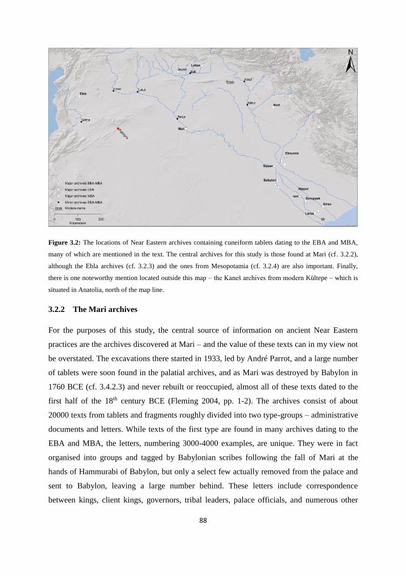
88
Figure 3.2: The locations of Near Eastern archives containing cuneiform tablets dating to the EBA and MBA,
many of which are mentioned in the text. The central archives for this study is those found at Mari (cf. 3.2.2),
although the Ebla archives (cf. 3.2.3) and the ones from Mesopotamia (cf. 3.2.4) are also important. Finally,
there is one noteworthy mention located outside this map – the Kaneš archives from modern Kültepe – which is
situated in Anatolia, north of the map line.
3.2.2 The Mari archives
For the purposes of this study, the central source of information on ancient Near Eastern
practices are the archives discovered at Mari – and the value of these texts can in my view not
be overstated. The excavations there started in 1933, led by André Parrot, and a large number
of tablets were soon found in the palatial archives, and as Mari was destroyed by Babylon in
1760 BCE (cf. 3.4.2.3) and never rebuilt or reoccupied, almost all of these texts dated to the
first half of the 18th century BCE (Fleming 2004, pp. 1-2). The archives consist of about
20000 texts from tablets and fragments roughly divided into two type-groups – administrative
documents and letters. While texts of the first type are found in many archives dating to the
EBA and MBA, the letters, numbering 3000-4000 examples, are unique. They were in fact
organised into groups and tagged by Babylonian scribes following the fall of Mari at the
hands of Hammurabi of Babylon, but only a select few actually removed from the palace and
sent to Babylon, leaving a large number behind. These letters include correspondence
between kings, client kings, governors, tribal leaders, palace officials, and numerous other
89
actors found all over the Near East, and provide vast information on diverse aspects of ancient
society, although most date to the rule of its last king, Zimri-Lim (Heimpel 2003, pp. 4-6;
Fleming 2004, p. 2 – cf. 3.4.2.3). The translation and publication of the archives have been
ongoing since their discovery by the French Mari School, from the initial work by Thureau-
Dangin and subsequently decades of work under Dossin until the 1980s, when first Birot and
then Durand and Charpin took over. The latter scholars have greatly increased the process of
translation and publication, providing new perspectives and interpretations, some of which
have completely altered our view of ancient Near Eastern society (cf. 5.2.1.1). Until recently,
nearly all this research was published in French, mainly through the series Archives Royales
de Mari (ARM) and Florilegium Marianum (FM), as well as in certain other works (cf.
Fleming 2004, pp. 3-4), and syntheses and topics such as those covered by Charpin (2004)
and Durand (2004) have proved particularly valuable for the present study. However, after
2000 an increasing number of translations and interpretations of the Mari texts in English
have been made available, most importantly the research carried out by Heimpel (2003) and
Fleming (2004), but also a number of other notable scholars, and many of the aspects to
follow here (e.g. 5.2 and 5.3) depend heavily on these – as they themselves do on the Mari
archives.
3.2.3 The Ebla archives
Due to the predefined temporal horizon here (cf. 1.2.1), the Ebla archives could be said to be
situated on the chronological fringe of the scope of this study, but their historical significance
for the perception of EBA Syria is highly valuable. About 17000 cuneiform tablets and
fragments were found in various rooms of the excavated palace, providing both the first direct
historical insight into early Syrian events, as well as evidence for a Semitic-speaking
population in Syria prior to the emergence of Akkadian and Amorrite in the textual material
(Matthiae 1980, p. 161; Akkermans & Schwartz 2003, pp. 235, 239). The documents were
mainly administrative records, meant to serve a centralised state bureaucracy and show an
economic foundation heavily built on sheep, wool, and textiles, but the archives also
contained a few literary and lexical texts (Matthiae 1980, p. 155; Akkermans & Schwartz
2003, p. 239). The administrative and economic nature of the archives makes it possible to
infer some of the political and economic hierarchies and developments of EBA Syria, as well
as providing a corpus of regional toponyms from this period, which are believed to generally
date to the 24th century BCE and span about three generations, or c. 40-50 years (Klengel
90
1992, p. 22; Akkermans & Schwartz 2003, pp. 243-244). While this source cannot be
compared in importance to the Mari archives for the purposes of this study, a recent
interpretation of their content by Porter (2012) has yielded intriguing results in terms of
comparative analysis between the EBA and MBA Near Eastern society, which will be
discussed later (cf. 5.2.1, 5.3.1, and 5.4.1). However, the value of the Ebla archives as a
window for interpreting political and economic conditions in an otherwise historically murky
Syria during the EBA IV is highly significant (cf. 3.3.1 and 5.2.2).
3.2.4 Other Near Eastern archives
Finally, I will briefly mention some of the other archives (cf. Figure 3.2 for a wider view)
which have brought to light aspects of the EBA and MBA Near East to be employed in this
study. Apart from the Ebla archives, texts from the 3rd millennium BCE are known mainly
from the southern Mesopotamian cities. While many of these – for instance the so-called
Royal Correspondence of Ur (cf. 5.3.1.1 for further discussion) – are MBA copies of royal
inscriptions, often from monuments in temples, and above all from Nippur, a large number of
administrative and economic texts from Mesopotamian sites are also known, e.g. from Umma,
Lagaš, and other cities on the Alluvium (Kuhrt 1995, p. 47). The Ur III period (cf. 3.3.3) is
well-known for its massive corpus of administrative documents as well as a massive
production of literary texts from scribal schools. The high degree of state control over
production – and particularly the textile production (cf. 5.2.2.1) – and wide-ranging network
of taxation required a vast bureaucracy. Unfortunately, many of the tablets from this period
come from clandestine excavation and trade, meaning that the archives have not only been
scattered far and wide, but as huge amounts of them were illicitly unearthed at places like
Sippar and Drehem in the late 19th century CE, many are not associated with any
accompanying contextual details (Postgate 1994, p. 59). The Drehem archives have proved to
be an especially rich source for information on economic conditions and networks during the
EBA. It has been identified as ancient Puzriš-Dagan near Nippur, which was a massive
taxation and redistribution centre for the Ur III dynasty during the last century of the 3rd
millennium BCE characterised by meticulous record-keeping of all in- and outgoings – more
often than most of livestock (cf. Kuhrt 1995, pp. 59-61; also cf. Klengel 1992, p. 32). There
are also a few Syrian examples of cuneiform archives from the EBA IV, most notably from
Tell Beydar, ancient Nabada, where a corpus of 140 tablets contemporary with the Ebla
archives provides the first written evidence from the Jezire. These are administrative texts
91
referring to the pastoralist economy of the ancient town and are suggestive of a client
relationship under Tell Brak, ancient Nagar, situated nearby (Akkermans & Schwartz 2003, p.
259 - cf. 3.3.1 and 3.3.2). Tell Brak itself has also yielded administrative records from EBA
IV, and more specifically from its time under the later Akkadian rulers (cf. 3.3.2), which shed
light on economic aspects of palace redistribution and other bureaucratic affairs (Akkermans
& Schwartz 2003, p. 280).
Large parts of the Near East have little or no textual sources informing us on conditions
during the first century of the 2nd millennium BCE, although there are some administrative
documents from this period known from the Alluvium. One important source for the
understanding of economy and society in northern Mesopotamia and Anatolia has been the
Kaneš archives from modern Kültepe (cf. Larsen 1976, pp. 50-55). Initially known only from
tablets illicitly unearthed by local inhabitants and sold, subsequent excavations by Czech, but
mainly Turkish archaeologists discovered over thousands of tablets originating from private
archives in the residential area of the ancient town belonging to Assyrian merchants. The
main corpus consists of contracts, proceedings, and other legal texts, but a substantial amount
are letters sent between these merchants and their families and business partners in Aššur,
providing a different view to that of the many administrative documents. To date over 20000
texts have been found at Kültepe, and nearly all of them come from a layer which is dated to
1910-1830 BCE, thus providing a window of information into the period between the Ur III
dynasty and the Mari archives. Following a hiatus a smaller collection has been found in a
layer which spans the reign of Šamši-Addu over Aššur, dated to 1810-1740 BCE (van de
Mieroop 2007, p. 95). Of course, the Mari archives is our main source of information from
this period, but smaller archives from Tell Leilan, Chagar Bazar, and Tell Rimah can also be
used to support the interpretation of MBA economy, geopolitics, and society inferred from the
Mari texts (Kuhrt 1995, p. 74; Wossink 2009, p. 125). Tell Leilan was the capital of Šamši-
Addu and has yielded a number of tablet containing letters and treaties from the later MBA
(Akkermans & Schwartz 2003, p. 312).
This subchapter has of course only briefly touched upon the vast and confusingly complex
corpus of textual sources from the late EBA and MBA Near East, as the topic is far too large
for the scope of this study. I have merely mentioned some of the textual sources I will rely on
in the geopolitical presentation below (cf. 3.3 and 3.4), as well as in my analysis of mobile
pastoralism in ancient Near Eastern society and economy (cf. 5.2, 5.3, and 5.4), and most of
92
this is viewed from the shoulders of the scholars who has read, translated, interpreted, and
synthesised the texts from all these archives during the last century of archaeological and
historical research. But before I turn to the historical summary for the period c. 2400-1700
BCE, I will in short focus on the very few attestations of the Palmyrene from these archives
and then present some aspects on ancient Near Eastern languages and populations.
3.2.5 Textual attestations of the Palmyrene
The very few texts mentioning the Palmyrene directly can be summarised within the space of
a paragraph. The Kaneš archives contain a reference to inhabitants of Tadmor, the Semitic
denomination for Palmyra, called as witnesses:
Text 3.1: (…) in front of Merali, in front of Puzur-Ištar, from Tadmor. (…) Seal of Merali, son of Aššur-Šallim,
seal of Puzur-Ištar, from Tadmor (cf. Scharrer 2002, pp. 301-302 – my translation from German).
Whether this text implies that both Merali and Puzur-Ištar are from Tadmor, or only the latter
is not clear, as the second sentence in fact identifies Merali by his patronymic. Since central
Anatolia is relatively far from the Palmyrene, one might be cautious and consider the fact that
the reference could deal with another, unknown place by the same name. However, we know
from the Mari archives that Tadmor indeed was the name of a settlement situated in that
central Syrian oasis during the MBA, as it is today. One other attestation of Palmyra is also
known from Kaneš, but it is a mere entry in a list recording a small amount of silver supplied
from Tadmor (cf. Scharrer 2002, p. 304). Famously, there is a text from the Mari archives
which describes the settlement, together with Našala (modern Qaryatein), having been
assaulted by a band of Suteans (Scharrer 2002, p. 307 – cf. text 5.12), which is discussed
further under 5.2.1.4 and 5.3.3. Finally, two texts mention the oasis or its inhabitants being
associated with messenger deliveries and the communication route between Qatna and the
Euphrates valley (Scharrer 2002, pp. 312-314):
Text 3.2: When they came on their trip on the eastern shore (of the Euphrates), the Babylonians camped by our
ambassadors and the Qataneans [i.e. people from Qatna]. They did not (…). The Babylonians stayed for
themselves with their sheep. In the night, Suteans attacked the Babylonians. They killed a high-ranking
Babylonian (named) Lidnuša and injured another. With their noise leapt our men upon (…). They killed five
enemies. Our ambassadors, the Qataneans, and the letters are unharmed. To Tadmor (accompanied) by an escort
(…) (cf. Scharrer 2002, p. 312 – my translation from German and my clarifications in brackets – cf. 5.3.3).

93
Text 3.3: (…)(Two) Tadmoreans bring a letter from Išhi-Addu of Qatna to the king. Presently, I will send them
to my Lord. My Lord must question them and then send them to the king (cf. Scharrer 2002, p. 314 – my
translation from German).
These comprise the only direct mentions of Palmyra from the period in question, although
there are a few references attested in LBA texts. The Palmyrene as a region can be said to be
referred to indirectly on some occasions, of which the most famous are the instructions (text
3.4) from Šamši-Addu to his son in Mari, Yasmah-Addu, with regard to marching an army of
20000 men to Qatna via one of the three routes from Mari. In addition, recently a draft reply
(text 3.5) from Yasmah-Addu was noted by Charpin (2010):
Text 3.4: [Excerpted part]. La’um and Mutu-Bisir are used to receive many letters, consult with them, and take
your decisions depending on your discussions with them. Mutu-Bisir (besides) has much experience with these
routes. Get yourself informed about these routes. Send several persons that they may enquire in your place about
the water supply and decide depending on the detailed report they bring back (…).
[Excerpted part] Prior to departure, if you do not know where to rely on concerning the access to water on these
routes, the decision (to leave) should not be taken. Given that there are Uprapeans [cf. 5.3.2.2 and 5.3.3] that
have experience of these routes, send the people that have experience of these routes so that they know in your
place where to rely on concerning the supply of water on these routes.
Send me a detailed report. Which is the right route for the march of the army? Is the upper route best? Is the
middle route best? Is the lower route best? Is it best to go straight on from where you are? The army, will it
depart from Abattum? Will it depart from Halabit? Or will it depart straight on from where you are? [Excerpted
part]. (cf. Postgate 1994, p. 251; Charpin 2010, p. 240 – my clarifications in brackets and less relevant parts of
the text excerpted here).
Text 3.5: Previously, my Lord wrote to me concerning the decision to be taken regarding the wells on the route
to Qatna. I assembled (…) the men that are knowledgeable about the wells and I sent to my master the men
knowledgeable about the wells, (i.e.) the Uprapeans [cf. 5.3.2.2 and 5.3.3]. But up to now my master has not sent
me any confirmation. At present, I have asked Mut-Bisir about the route to Qatna He spoke thus: ‘I (…) Neither
the route that is in front of [i.e. going straight from] Mari, nor the route that is in front of Dur-Yasmah-Addu are
convenient (…). The army may take the route of Abattum (…) (cf. Charpin 2010, p. 241 – my clarifications in
brackets).
Both these texts are clearly referring to the Palmyrene dry steppe and seemingly taking place
during a period of low water availability in this biome, although as such a large army
undoubtedly would require exceptionally secure supply points, it is in fact possible that even
the humid season was the seasonal context. In any case, certain implications inferred from
them will be developed further under 5.3.2 and 5.3.3. If one includes Jebel Bishri as a part of

94
the Palmyrene, meaning the dry steppe and highland between the Euphrates and the Orontes,
a few more can probably be added (cf. Pappi 2006; Charpin 2010). Presumably, the closer
spatial relation to the Euphrates valley and events unfolding there precluded that the Bishri
region had a larger role in Mesopotamian developments and thus the documentary evidence,
than the more isolated highlands north of Palmyra. Therefore it is possible, albeit speculation,
that attestations of Jebel Bishri in Mesopotamian sources could in fact generally refer to the
dry steppe region west and south of the Euphrates valley between Emar and Mari, but without
further specification deemed necessary by the ancient scribes. It is indeed unfortunate that no
cuneiform archives dating to the MBA have been discovered and published from the recent
Syro-Italian excavations (also cf. 4.7.4) at Tell Mishrife (ancient Qatna), as both Palmyra and
the Palmyrene are situated more proximate to this site than the case is for Mari, and the oasis
has even been suggested as forming part of the Qatna kingdom (cf. Joannés 1997, pp. 411-
412). Any information gleamed from such sources would surely have provided a substantial
increase in our knowledge on this region in the late 3rd and early 2nd millennium BCE.
3.2.6 Languages and populations
Although nearly all our Near Eastern archival sources dating to the EBA IV and MBA – apart
from the Neo-Sumerian Ur III texts (e.g. Kuhrt 1995, p. 59) – were written in the Akkadian
language, the region harboured a number of populations which have been considered to
represent different ethnicities with their own languages or dialects (cf. Heimpel 2003, pp. 13-
28 – also cf. Figure 3.3 and 5.3.1). In addition, the physical distribution patterns of these
Near Eastern populations and their cultural or linguistic influence on various societies and
parts of the region clearly changed and developed through across these centuries. The
Akkadian and Sumerian languages coexisted during the EBA, but use of Sumerian declined
and ceased to be a living language after the Ur III administration, although it did survive for
centuries in religious and scholarly texts. The Ebla archives also show that Eblaitic, which is
the oldest known written Semitic language, was present in Syria in in the mid-late 3rd
millennium BCE, and that it possibly constituted the main tongue of the Syrian plains region
(Matthiae 1980, pp. 162-163; Akkermans & Schwartz 2003, p. 239). Hurrian (sometimes
known as Subarean) is mostly known from names, but also from a few texts, and it was
associated with people living along the northern rim of Mesopotamia (Charpin 2004, p. 52).
Fleming (2004, p. 128) has argued that while there is some evidence for a Semitic-speaking
Habur triangle in the mid-3rd millennium BCE, the same area was mainly Hurrian-speaking in
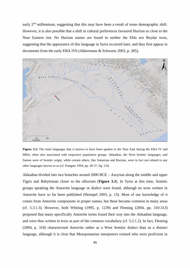
95
early 2nd millennium, suggesting that this may have been a result of some demographic shift.
However, it is also possible that a shift in cultural preferences favoured Hurrian so close to the
Near Eastern rim. No Hurrian names are found in neither the Ebla nor Beydar texts,
suggesting that the appearance of this language in Syria occurred later, and they first appear in
documents from the early EBA IVb (Akkermans & Schwartz 2003, p. 285).
Figure 3.3: The main languages that is known to have been spoken in the Near East during the EBA IV and
MBA, often also associated with respective population groups. Akkadian, the West Semitic languages, and
Sutean were of Semitic origin, while certain others, like Sumerian and Hurrian, were in fact not related to any
other languages known to us (cf. Postgate 1994, pp. 36-37, fig. 2:9).
Akkadian divided into two branches around 2000 BCE – Assyrian along the middle and upper
Tigris and Babylonian closer to the alluvium (Figure 3.3). In Syria at this time, Semitic
groups speaking the Amorrite language or dialect were found, although no texts written in
Amorrite have so far been published (Heimpel 2003, p. 13). Most of our knowledge of it
comes from Amorrite components in proper names, but these became common in many areas
(cf. 5.3.1.3). However, both Whiting (1995, p. 1239) and Fleming (2004, pp. 310-313)
proposed that many specifically Amorrite terms found their way into the Akkadian language,
and were thus written in texts as part of the common vocabulary (cf. 5.2.1.2). In fact, Fleming
(2004, p. 318) characterised Amorrite rather as a West Semitic dialect than as a distinct
language, although it is clear that Mesopotamian interpreters existed who were proficient in
96
Amorrite, suggesting that it was either a separate spoken language or at least a West Semitic
unintelligible dialect, as distinct from Akkadian as modern standard Arabic is from colloquial
Arabic (cf. Heimpel 2003, pp. 13-14; Fleming 2004, pp. 40-41, 318; Porter 2012, p. 268).
From the MBA period we know of other regional languages which can be discerned from
texts and names. Elamite was the language of present lowland Iran, while Gutean was spoken
by groups more or less inhabiting the mountains and foothills of Zagros and only known from
a few names. Hurrian, Elamite and Gutean were like Sumerian seemingly not Semitic
languages, nor related to each other. Finally, apart from peripheral fringe groups only
mentioned in passing, like the Turukkeans and the Lullu far to the northeast of which we
know very little (cf. Durand 2004, p. 133), the Near East harboured groups of a people which
in the MBA texts are called Suteans. These were mainly found along the right bank of the
Euphrates stretching from Jebel Bishri and southward to the delta, as well as sometimes being
associated with the Palmyrene and the arid interior of this stretch (cf. 5.3.3 for an in-depth
discussion on the Suteans). Sutean is linguistically intriguing in several ways. In a list of
spoken languages from the LBA it can be found listed together with the ones mentioned
above, thus suggesting it was distinct from Amorrite and Akkadian. Names of Suteans are
known in many texts from Mari, and while they are mostly in Amorrite form, some appear to
be Semitic, although neither Amorrite nor Akkadian (Heimpel 2003, p. 13). Heimpel (2003,
pp. 26-28) suggested – mainly based on etymology, but also geography – that they in fact
were early attestations of Aramaeans, which feature heavily in the Near East during the LBA
and the Iron Age. His arguments are quite plausible, in that e.g. the clan Bar-Halanum has an
immediate Aramaic meaning as “son of Halanum”, and that attestations of Aramaeans
(Ahlamu) during LBA regularly refer to Suhum or the Palmyrene (cf. Heimpel 2003, pp. 27-
28), which will be argued later (cf. 5.3.3) were two of the main parts of the Near East
associated with this group during the MBA (cf. Figure 3.1 and Figure 3.3 – also cf. Figure
5.12). Suteans were probably not the only external Semitic tribal group, as others like the
Yussan, Yapturum, and Ya’ilanum, seem to have had Semitic etymology (cf. Joannès 1996, p.
354; Fleming 2004, pp. 122-123; Charpin 2004, p. 167). However, unlike some of the lesser
known or peripheral groups, Akkadian, Amorrite, and Sutean were all associated with
populations inhabiting Syro-Mesopotamia proper. Of course, many areas and cities also
featured mixed populations (Heimpel 2003, pp. 13-14 – also cf. 5.3.1.3).

97
3.3 Geopolitical developments during the EBA IV
The remainder of this chapter will present aspects of the geopolitical context of the Near East
and its development for the period c. 2400-1700 BCE, which comprises the periods EBA IV
and MBA (cf. 3.1.2). While the geographical focus for this dissertation mainly is Syria, for
several centuries across this temporal horizon the only available sources stem from
Mesopotamia, and thus the perspective must necessarily shift to a view from the Alluvium. In
fact, textual material from Syria dating to the interval c. 2300-1900 BCE is more or less
absent. However, several studies (e.g. Sallaberger 2007) have attempted to use Mesopotamian
archives to analyse contemporary conditions in Syria through implications – and in my view
convincingly so. I will here base myself mostly on their research, as well as more generally
accepted narratives for the Near East. For toponyms and geographical overview in this
subchapter cf. Figure 3.1 and Figure 3.4.
3.3.1 Early EBA IVa: Syria during the age of Ebla and Mari (c. 2400-2300 BCE)
The first glimpse of the geopolitical situation in Syria comes from the Ebla archives (cf.
3.2.3). Although the time-span of the archive is rather short, some information on the
preceding period can also be discerned. The multitude of toponyms mentioned in the archive
suggests that the Syrian plain was densely populated at the time. However, due to the very
limited nature of the source material, basically consisting of the Ebla texts, the picture is
rather fragmented. The two main political actors seem to have been Ebla itself and Mari,
which both vied for influence over cities and settlements situated in the area between them
along the Euphrates (Klengel 1992, pp. 27-29). Nagar (cf. Figure 3.4 – also cf. 3.2.4) was
seemingly of a similar size and enacted political influence in the Habur triangle, shown by its
probable authority over Nabada and its alliance with Ebla against Mari (Sallaberger 2007, p.
422). This struggle for power fluctuated during the 25th-24th century BCE, with Mari initially
having to pay tribute to Ebla, and then vice versa. However, after a lengthy period of rivalry
under guise of alliance, Mari was defeated – albeit not destroyed – near Terqa by Ebla aided
in part by Nagar, which Mari had failed to conquer and still had to keep at bay (cf. Archi &
Biga 2003, pp. 9-10, 13; Matthiae 1980, pp. 174-175; Akkermans & Schwartz 2003, p. 239).
The extent of central power in this period is difficult to ascertain, but the frequent mention of
various lords (known as en) governing settlements across the region with titles similar to the
rulers of Ebla, for instance in Ugarit and Gubla, indicates that several political entities
competed in Syria. Each seems to have included a network of political control or influence
98
which comprised a number of settlements and towns of lesser political and economic
importance, structured as a hierarchy with varying degrees of subordination and dependency
(Klengel 1992, p. 28 – also cf. 5.2.1.3). The ruling elite was not necessarily traditional
autocrats, and could have shared power and cooperated with e.g. councils of elders, i.e. acting
more as heads of decision-making groups than as proper monarchs (Klengel 1992, pp. 27-28;
Akkermans & Schwartz 2003, p. 239). Ebla, and presumably also other large Near Eastern
polities, thrived on the production and trade of woolen commodities (cf. 5.2.2.1), as well as
the potential for economic exploitation of geographical positions in an extensive trading
network, such as between the Levant or Anatolia and Mesopotamia. The Ebla archives attest
to an intense communication of merchants and messengers between settlements – to Emar,
Abarsal, and even east to Aššur on the Tigris (cf. Figure 3.4). This eastward economic and
presumably political orientation of Ebla could have provided the seed for its conflict with
Mari (Klengel 1992, pp. 26-29). The archives come to an abrupt end in the late 24th century
BCE (Akkermans & Schwartz 2003, p. 244 – although also cf. Mazzoni & Felli 2007, p. 206
for termination c. 2400 BCE), marking the end of EBA IVa in Syria (Matthiae 1980; Matthiae
2007, p. 5, note 1), and the city experienced violent destruction. The antagonist has not yet
been definitely pinned down, but it seems to have been either the result of its conflict with
Mari, which had not been destroyed when defeated (Archi & Biga 2003, pp. 34-35), or one of
the Akkadian rulers (Akkermans & Schwartz 2003, p. 244 – cf. 3.3.2). Of the latter, both the
dynastic founder, Šarrukin, and his grandson, Naram-Sin, boasted of having campaigned in
Syria and in this context mentioned Ebla, although the latter claimed to have been the first to
subdue Ebla (Klengel 1992, pp. 33-35). Archaeologically, Šarrukin could be the main
candidate for the initial destruction layer, but the debate has not been conclusively settled.
Sallaberger (2007, p. 422) supported the conclusions made by Archi & Biga (2003, pp. 34-35)
in that in fact Mari destroyed Ebla three years after its defeat near Terqa, only to be destroyed
utterly by Šarrukin soon after. He also suggested that a contemporary destruction layer at
Nagar may be evidence of Mari campaigning in the Habur triangle just prior its fall
(Sallaberger 2007, p. 422). However, it is clear is that both Ebla and Mari were later rebuilt
and continued to function as important regional centres until the end of the 3rd millennium
BCE (Akkermans & Schwartz 2003, p. 244; Matthiae 2007, p. 6). Unfortunately, the lack of
textual sources from Syria itself clouds the political situation there with regard to EBA IVb.
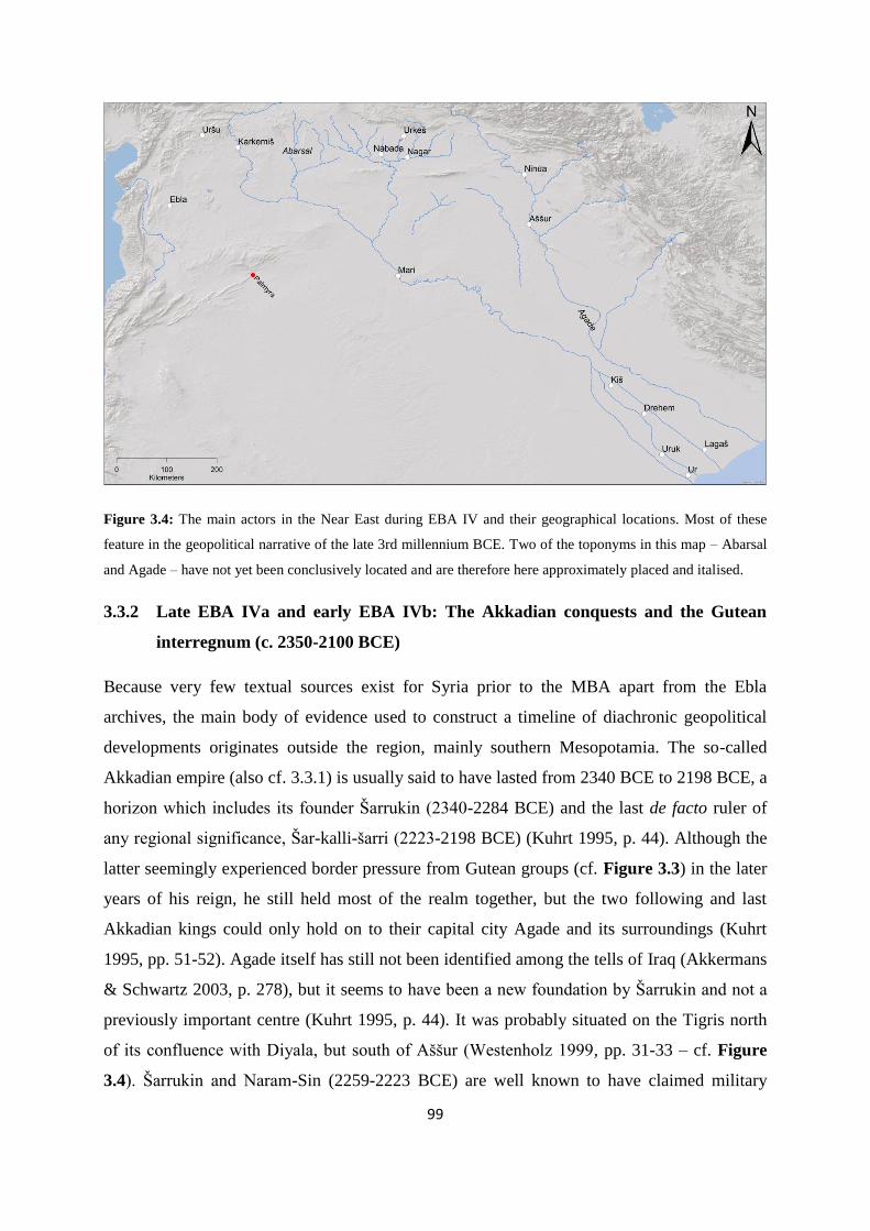
99
Figure 3.4: The main actors in the Near East during EBA IV and their geographical locations. Most of these
feature in the geopolitical narrative of the late 3rd millennium BCE. Two of the toponyms in this map – Abarsal
and Agade – have not yet been conclusively located and are therefore here approximately placed and italised.
3.3.2 Late EBA IVa and early EBA IVb: The Akkadian conquests and the Gutean
interregnum (c. 2350-2100 BCE)
Because very few textual sources exist for Syria prior to the MBA apart from the Ebla
archives, the main body of evidence used to construct a timeline of diachronic geopolitical
developments originates outside the region, mainly southern Mesopotamia. The so-called
Akkadian empire (also cf. 3.3.1) is usually said to have lasted from 2340 BCE to 2198 BCE, a
horizon which includes its founder Šarrukin (2340-2284 BCE) and the last de facto ruler of
any regional significance, Šar-kalli-šarri (2223-2198 BCE) (Kuhrt 1995, p. 44). Although the
latter seemingly experienced border pressure from Gutean groups (cf. Figure 3.3) in the later
years of his reign, he still held most of the realm together, but the two following and last
Akkadian kings could only hold on to their capital city Agade and its surroundings (Kuhrt
1995, pp. 51-52). Agade itself has still not been identified among the tells of Iraq (Akkermans
& Schwartz 2003, p. 278), but it seems to have been a new foundation by Šarrukin and not a
previously important centre (Kuhrt 1995, p. 44). It was probably situated on the Tigris north
of its confluence with Diyala, but south of Aššur (Westenholz 1999, pp. 31-33 – cf. Figure
3.4). Šarrukin and Naram-Sin (2259-2223 BCE) are well known to have claimed military

100
conquests in Syria, while the two intermittent rulers, Rimuš and Maništušu, concentrated
more on consolidating the exploits of their predecessor in northern Iraq and the eastern Habur
triangle (Kuhrt 1995, p. 50; Akkermans & Schwartz 2003, p. 278). An Akkadian year formula
including the subjugation of Mari and the likely presence of an Akkadian administration
centre at Nagar (Akkermans & Schwartz 2003, pp. 278-79), do suggest that at least under
Naram-Sin certain parts of Syria – at least the regions of Mari and Nagar, both of which
probably controlled substantial regions (cf. 3.3.1) – were directly or indirectly under
Akkadian control. However, in the case of Šarrukin, his military campaigns could have just as
well been mere opportunistic raiding in lands weakened by conflict, like that between Mari
and Ebla, and should probably rather be associated with obedience than defeat (Westenholz
1999, p. 38, note 113; Wossink 2009, p. 30). Naram-Sin installed various family members as
governors in subjugated cities, and his daughter had an important cultic position at Mari
(Kuhrt 1995, p. 50), but as Mari and other EBA cities in Syria are more or less absent in
administrative texts from his reign, this region may have had a lesser or more passive role
with regard to the Akkadian rulers than it did during the time of the Ur III state (cf. 3.3.3)
(Sallaberger 2007, pp. 430-31). The subjugation of Mari happened possibly during the reign
of Naram-Sin and was the seed for the so-called shakkanaku reign of the city, a title
associated with governors instated by these conquerors (Akkermans & Schwartz 2003, p. 281;
Archi & Biga 2003, pp. 29, 34). When Akkadian power contracted in the 22nd century BCE,
Mari regained independence, but its rulers retained the original shakkanaku title for several
centuries. Although the shakkanaku dynasty was previously believed to have ended in the late
20th century BCE followed by a substantial hiatus (cf. Durand 1985, pp. 169-171), a recent
reassessment of the shakkanaku list suggests that it stretched on throughout the period from
2266 BCE until 1820 BCE, and ending as Yagîd-Lim or his son Yahdun-Lim took the throne
of Mari (Otto 2007, pp. 421-422, fig. 12-13; also cf. Durand 2004, p. 153 – cf. 3.4.2.2).
Textual sources relating to Syrian affairs during the time of Akkadian rulers are very scarce,
although Šar-kalli-šarri claimed to have fought against Amorrite enemies at Jebel Bishri
(Sallaberger 2007, p. 431), and Naram-Sin also famously fought a decisive battle there against
a coalition led by his rival Amar-Girid of Uruk, after which he noted the capture of several
Amorrite chiefs (e.g. Wossink 2009, p. 121). The end of Šar-kalli-šarri’s reign ensued the
period called the Gutean interregnum (cf. 3.1.1), which in literary sources was characterised
by “invading barbarians from the eastern mountains” (Kuhrt 1995, p. 56), i.e. from the

101
Zagros region. However, such rhetoric stands in sharp contrast to the fact that groups of
Guteans, as well as those called Amorrites, served as contingents in Akkadian armies (Kuhrt
1995, p. 55), suggesting that the actual situation and many inter-group relationships were
more complex than some of the ancient, more propagandised texts seem to imply (cf. 5.3.1 for
further discussion on this topic), a pattern also repeated in later periods. As expected during
such periods of turmoil and change, very few historical sources are known, and this is also the
case for the Gutean interregnum. There seems to have been much competition between central
actors in a politically fragmented Mesopotamia, with e.g. Gudea of Lagaš having brought in
resources from far and wide for building projects (Sallaberger 2007, p. 431 – cf. 5.3.1.1 and
text 5.17), but the circumstances are mostly known from royal inscriptions. The veil lifts
again in Mesopotamia with the emergence of the Ur III state at the end of the 22nd century
BCE and its founder, Ur-Nammu (Kuhrt 1995, p. 58). However, the historical narrative of
Syria and its geopolitical scene at this time must still be based on Mesopotamian sources.
3.3.3 Late EBA IVb: The Ur III state (c. 2100-2000 BCE)
Ur-Nammu’s rise to power is somewhat uncertain, but his reign is usually placed 2110-2093
BCE, during which most of the fragmented Alluvium was incorporated into one state (for
regnal years cf. Sallaberger 2007, p. 420, table 1). The state was divided into provinces, with
provincial centres and their governors. While local elites probably filled these offices, military
commanders were in some cases recruited from fringe groups, like the Akkadian rulers had
done. The Ur III state directed its military campaigns toward the southeast, east, and
northeast, which led to the integration of e.g. Aššur and Elam (cf. Figure 3.5). The
administration of the Ur III state was characterised by extreme centralisation and complex,
all-encompassing bureaucracy (cf. 3.2.4). The documents attest to an extensive agricultural
system, large production centres for wool and linen, and diplomatic relations with political
actors of significance in Syria and the Habur triangle (Kuhrt 1995, pp. 60-61; Sallaberger
2007, pp. 433-434). Some of these controlled substantial areas, and e.g. the power of Mari at
this time probably stretched up toward a seemingly independent Tuttul on the Euphrates-Balih
confluence, as well as up to and including middle Habur – i.e. the same area as that under its
direct rule during the Mari archives (cf. 3.4.2.2 and Figure 3.7). Both Mari and Ninua (later
Niniveh) frequently communicated with the Ur III state, an expected state of affairs due to
their proximity (Sallaberger 2007, pp. 438-39). Relations were friendly, with both a princess

102
of Mari being married to Šulgi, the successor of Ur-Namma, and a princess of Ninua being
married to the later king Šu-Sin (Kuhrt 1995, p. 63; Sallaberger 2007, p. 433).
Figure 3.5: The heartland of the Ur III state on the Alluvium and the encompassing region, including several
cities and polities discussed in 3.3.3. Some of these – like Šimanum – are approximately placed. Map
reproduced after Kuhrt (1995, p. 57, map 3) and Porter (2012, p. 297, fig. 32).
Sallaberger (2007) attempted to get a glimpse of the geopolitical situation in Syria during this
period by carrying out a study of the Ur III texts, focusing on the animals belonging to the
king being distributed as royal gifts. He considered the available documentation as
“(…) a rough, but fair representation of the actual diplomatic relations” (Sallaberger 2007,
p. 434).
Since temporal data can be obtained regarding these texts, they can in fact show whether
communication was frequent or related to single visits, as e.g. in the case was for Gubla
(Sallaberger 2007, p. 434). His collected data lists the date ranges for all texts and the number
of attested gifts sent to individuals and places (cf. Sallaberger 2007, p. 435, table 5, and listing
pp. 435-38). Most locations occur less than ten times in the corpus, and several of them can
only be approximately placed in the Near East as a whole, but four places stand out – Mari,
Ebla, Šimanum, and Uršu (cf. Figure 3.4). While the large number of Mari attestations can be
both attributed to proximity and marital connections (Kuhrt 1995, p. 63; Sallaberger 2007, p.

103
438), both Uršu and Ebla could potentially be associated with political and/or economic
importance. Šimanum, situated somewhere on the Upper Tigris (cf. Sallaberger 2007, p. 430,
fig. 2 and Kuhrt 1995, p. 57, map 3), was linked to Ur by royal marriage, but so was Ninua,
even though the latter only appears a few times in the list. Thus, it could seem that economic
and/or political importance was a likely attribute for many attestations of a site in this
particular study. He also divided places of fewer attestations into two groups – cities of
second-rank importance, such as Ninua and Tuttul, and those situated particularly far from the
Ur core area in geographical terms, such as Gubla and Mukiš (Sallaberger 2007, p. 439). The
low number of sites from the Habur triangle he argued indicated a shift in centre of power
from this region to the foothills of Tur Abdin through EBA IVb. Another point he made was
that the Jezire and western Habur triangle – which included many towns in the early part of
this period – seem toward the end of the 3rd millennium BCE practically devoid of settled
societies, a picture also emerging in the archaeological material from e.g. Tell Chuera, Tell
Beydar, and Tell Leilan (Sallaberger 2007, pp. 440-441 – cf. 5.2.2). In other words, during the
late EBA IVb the Syrian situation seems to one of political fragmentation, although it is quite
possible that most of the main actors had retained relative autonomy with regard to
Mesopotamia powers throughout the EBA. For instance, Ebla continued to serve as an
economic centre and was rebuilt soon after its initial destruction (Akkermans & Schwartz
2003, p. 244). Mari was probably also a fairly large regional power on the middle Euphrates
with influence up the Habur, while cities like Karkemiš and Emar do not show up at all in the
textual sources from the Ur III archives (Sallaberger 2007, p. 439). It is possible that these lay
within the political orbit of influence of either Ebla or Uršu, although this is speculation.
However, there seems to have been a lower degree of urbanism outside the main river valleys
and in the lower Habur triangle, possibly indicating a shift to a mobile lifestyle among many
previously settled populations (cf. 5.2.2.2).
The final rulers of the Ur III state, Šu-Sin (c. 2035-2027 BCE) and Ibbi-Sin (c. 2027-2003
BCE), experienced pressures from both internal and external groups. Although military action
was mostly directed eastward, Šu-Sin also campaigned northward against the inhabitants of
Šimanum, resulting in control over a vassal state in this area (Sallaberger 2007, p. 442). In
relation to this conflict, a text mentions Amorrite groups called Tidnum and Yamadium
fighting on the side of Šimanum (Sallaberger 2007, p. 442 – cf. 5.3.1.1 and text 5.16). During
the final years of the Ur III state the administration only seems to have upheld

104
communications with Mari, Ebla, Šimanum, and the Yamadium. The latter of these may have
referred to a tribe, with four attestations of an Amorrite of Yamadium, and they are always
appearing with messengers from Ebla or Mari (Sallaberger 2007, pp. 437-438, 444).
Amorrites, while clearly integrated into the Ur III state, became the classic external enemy in
its literary sources. However, there are several problems associated with a simplistic
interpretation of such perceptions as well as with the obviously complex realities of ancient
Mesopotamian society (cf. Sallaberger 2007, pp. 444-445). In fact, it is possible that in the
late EBA IVb the term “Amorrite” actually referred to someone of current or recent mobile
past or lineage, a natural way of defining a person which was not to be associated with a city
or town (Sallaberger 2007, p. 445 – for an in-depth discussion on this topic, cf. 5.2.1.1 and
5.3.1), similar to the MBA term hana, which depending on the situation could signify “our
mobile pastoralists” (cf. 5.2.1.1). During the reign of Ibbi-Sin, problems could have turned to
crisis as the Royal Correspondence of Ur describes how certain Amorrite groups penetrated
the state itself, seemingly disrupting communication and captures fortresses in southern
Mesopotamia. However, the historical accuracy of this source has been questioned (cf.
5.3.1.1) and the agency of these groups in the fall of the Ur III state seems exaggerated. More
likely is a scenario where the lumbering bureaucracy and imperial structure started crumbling
in the final decades of the 3rd millennium BCE and certain proximate groups both within and
outside its borders took advantage of and exacerbated a critical situation. In any case, the final
blow to the Ur III state came from its former subject states in the east, Elam and Šimaški
(Kuhrt 1995, pp. 70-71).
3.4 Geopolitical developments during the MBA
3.4.1 MBA I: Mesopotamian developments and Syrian implications (c. 2000-1800
BCE)
The 2nd millennium BCE starts with Syrian affairs continuing to be shrouded in textual
darkness, but in southern Mesopotamia the dismantling of the Ur III state created once more a
rather fragmented geopolitical situation with new opportunities for ambitious and powerful
actors. Initially, a former Ur III general, Išbi-Erra, established a dynasty centered at the city of
Isin, and had by c. 1950 BCE gained control over several cities on the Alluvium, with the
subsequent king, Išme-Dagan (1955-1937 BCE), calling himself king of Sumer and Akkad

105
(Charpin 2004, pp. 72-73). At the same time, an Amorrite dynasty probably associated with
the Yamutbal tribe (cf. 5.3.2.3) emerged in Larsa, which during the reign of Gungunum
(1932-1906 BCE) clashed with Isin, resulting in fluctuating spheres of influence between
these two states (Charpin 2004, p. 80). The Isin-Larsa enmity soon led to a break-up of Isin
political influence and decentralisation through the rise of numerous other local dynasties.
Some of these, like Kisurra (modern Abu Hatab), had kings which included Amorrite
affiliations in their titles, such as head of the Rabbum (Charpin 2004, p. 84 – cf. 5.3.2.2). By
the early 19th century BCE southern Mesopotamia had fragmented yet further and consisted of
numerous small states centered on a city, e.g. Babylon, Isin, Uruk, and Kiš, while the Larsa
state was slightly more extensive in size and political influence (van de Mieroop 2007, pp. 90-
92, and map 5.1; Charpin 2004, p. 86 – cf. Figure 3.6). Although it seems that every city of
some importance in the region of Akkad (cf. Figure 3.1) had established an independent
dynasty during the first half of the 19th century BCE (Charpin 2004, p. 88), most did only last
a few decades, and all was eventually conquered by the emerging dynasty of Babylon
established by Sumu-Abum in 1894 BCE, which conveniently also was the same year as the
enthronement of Sumu-El of Larsa (cf. Charpin 2004, pp. 86-90). Such a pattern of
fragmentation and subsequent consolidation seems to have prevailed also further north at
Aššur and Ešnunna (van de Mieroop 2007, pp. 90-92, and map 5.1; Charpin 2004, pp. 106-
107). Charpin considered the new dynasty of Babylon as being a result of a merger between
two Amorrite tribes of the Yamina confederation, the Amnanum and the Yahrurum (cf.
5.3.2.2), with the first two kings belonging to either of these groups (Charpin 2004, p. 94).
Likewise, the city of Kazallu constituted the main centre of the Amorrite Mutiabal clan
(Charpin 2004, p. 97; also cf. Heimpel 2003, p. 17 – cf. 5.3.2.2 for their tribal affiliation and
Figure 5.12).
As the 19th century BCE unfolded, the Larsa state continued to grow in size and importance
based on a new dynasty, with its kings Warad-Sin and the famous Rim-Sin (1822-1763 BCE),
who ruled nearly 60 years, including the time of the Mari archives. Initially, the state bordered
onto Babylon, Uruk, and Isin, but after destroying Uruk 1800 BCE and capturing Isin in 1793
BCE, the only remaining rival was Babylon to the north (van de Mieroop 2007, p. 92).
Babylon itself also gradually expanded during the reign of Sumu-La-El (1880-1845 BCE),
integrating the formerly independent cities of Kazallu, Damrum, Kish, Sippar, and several
others, and eventually incorporated Akkad from Sippar to Marad. This resulted in overlapping

106
spheres of influence with Larsa and thus confrontations (Charpin 2004, p. 95). Similarly, in
the Diyala valley, political fragmentation during the first half of the 19th century BCE led to
the emergence of numerous small kingdoms, each with a capital and a population of both
sedentary and mobile components. An inscription from Tell Haddad (ancient Mê-Turan) on
the middle Diyala mentioning a Yarim-Lim titulated chief of Amorrites, and likewise the same
title on the seal of a certain Itûr-Šarrum of Diniktum, imply also here the existence of
dynasties for whom an association with Amorrite groups was very important (Charpin 2004,
pp. 96-97). However, in time all these principalities were absorbed by the expanding state of
Ešnunna (modern Tell Asmar) in the same region during the long reign of Ipiq-Adad II (1862-
1818 BCE) (Charpin 2004, p. 100), who carried on after the unification of lower Diyala to
expand northward on the Tigris and westward to Rapiqum on the Euphrates (Charpin 2004,
pp. 139-140). Babylon expanded further during the reigns of Apil-Sin (1830-1813 BCE) and
to a lesser degree southward under Sin-Muballit (1812-1793 BCE), father of one of the most
famous figures of the Bronze Age – Hammurabi (1792-1750 BCE) (Charpin 2004, pp. 123,
131). Thus, the politically highly fragmented southern Mesopotamia of the early 19th century
BCE was by the end of the century appropriated and consolidated into three major powers –
Ešnunna, Babylon, and Larsa – without room for further expansion after the conquest of Isin
in 1793 BCE (cf. Figure 3.7).

107
Figure 3.6: Near Eastern towns and cities figuring in the geopolitical narrative of the MBA. Apart from the main
centres shown in Figure 3.7, most of the cities and towns marked here went from being relatively autonomous
dynasties during the early MBA (cf. 3.4.1) to be subdued and incorporated into larger polities during the MBA II
(cf. 3.4.2.3). Settlements of uncertain locations are placed approximatedly and marked with a triangle.
3.4.2 Late MBA I and early MBA II: The Amorrite dynasties and Syrian MBA
developments until the end of Mari (c. 1850-1760 BCE)
3.4.2.1 Syria during the early 19th century BCE
Our evidence concerning Syrian affairs in the early parts of this period comes mainly from the
Kaneš archives (cf. 3.2.4), and their implications for the geopolitical situation in Syria. On the
other hand, the Mari archives (cf. 3.2.2) provide an enormous amount of information on the
latter parts, meaning that the developments during MBA II can be presented much clearer. In
addition, as much of the later discussion will be based on the Mari texts, it seems prudent for
contextual purposes to go somewhat more in detail in this respect.
During the two first centuries of the 2nd millennium BCE, Mari was an actor of some size on
the middle Euphrates, ruled by the shakkanaku dynasty (cf. 3.3.2), while the well-known
MBA II powers of Qatna (modern Tell Mishrife) and Yamhad (modern Haleb/Aleppo)
probably also expanded their political and economic influence to surpass Ebla in this period
(cf. Figure 3.6). Ebla could still be considered fairly large town during the MBA, but its

108
importance had diminished greatly compared to its position in the Near East during the EBA
IV, probably due to the emergence of these other two major geopolitical actors (Matthiae
2007, pp. 3-4). Because Ebla lay between them, its economic importance was presumably
eclipsed by their expansion, although most of the details surrounding these developments are
uncertain (Matthiae 2007, p. 7). The politically fragmented situation in Mesopotamia seems
also to be reflected in Syria during the MBA I, with small to medium-sized states, local
dynasties, and competition for power and influence (van de Mieroop 2007, p. 94). The Kaneš
texts, although mostly economic in nature, indicate that the caravans of tin and textiles from
Aššur had to pass through territories belonging to independent rulers across the Habur triangle
and the Jezire before arriving in Anatolia, with which individual trade agreements had to be
reached for a safe thoroughfare and access to local merchant districts (van de Mieroop 2007,
p. 98). Conflict between these petty states seems to have been frequent, while commercial
interests and taxing opportunities usually meant that merchants were left in peace (van de
Mieroop 2007, p. 99 – also cf. text 5.8). Charpin argued that the Euphrates valley was
certainly characterised by political fragmentation 20th to early 19th century BCE, with
independent dynasties in towns like Suprum and Puzurran, and a town like Mišlan (cf. Figure
5.12, no. 8) – later a mere district of Mari – viewed at the time as important economically as
its overlord a century later (Charpin 2004, p. 143).
3.4.2.2 The competing reigns of Šamši-Addu and Yahdun-Lim
The MBA I-II transition in Syria is dominated by its two powerful actors in the eastern part of
the region – Šamši-Addu and his so-called kingdom of Upper Mesopotamia and Yahdun-Lim
of Mari. Prior to their emergence, the MBA political narrative of the region is virtually
unknown (Charpin 2004, pp. 142-143). Šamši-Addu began his rule around 1833 BCE,
although the whereabouts of his original dynastic base is uncertain. While several centres
have been suggested, e.g. Terqa and his later capital Šubat-Enlil/Šekhna, most are now more
or less rejected in this respect. Ekallatum has a more relevant claim, but the AKL (cf. 3.1.1)
indicates that the city in fact was conquered by him. However, Agade (cf. Figure 3.4) has
been proposed as a good alternative, supported by several aspects linked to his reign. He
called himself king of Agade, he undertook a pilgrimage there in his old age, his father Ila-
Kabkabu and brother Aminum were both active in the Diyala region, and finally there was a
Belet-Agade cult at Mari introduced when his son Yasmah-Addu took the throne, which
disappeared again during the reign of Zimri-Lim. All of this could indicate that Šamši-Addu
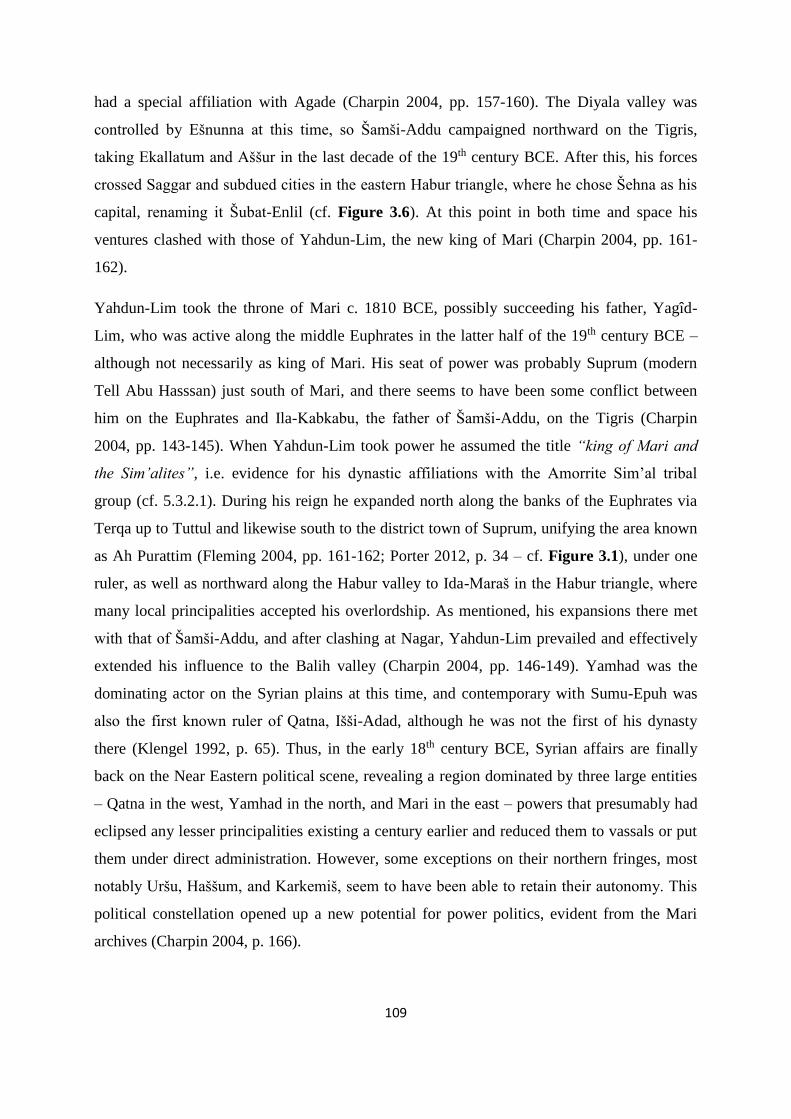
109
had a special affiliation with Agade (Charpin 2004, pp. 157-160). The Diyala valley was
controlled by Ešnunna at this time, so Šamši-Addu campaigned northward on the Tigris,
taking Ekallatum and Aššur in the last decade of the 19th century BCE. After this, his forces
crossed Saggar and subdued cities in the eastern Habur triangle, where he chose Šehna as his
capital, renaming it Šubat-Enlil (cf. Figure 3.6). At this point in both time and space his
ventures clashed with those of Yahdun-Lim, the new king of Mari (Charpin 2004, pp. 161-
162).
Yahdun-Lim took the throne of Mari c. 1810 BCE, possibly succeeding his father, Yagîd-
Lim, who was active along the middle Euphrates in the latter half of the 19th century BCE –
although not necessarily as king of Mari. His seat of power was probably Suprum (modern
Tell Abu Hasssan) just south of Mari, and there seems to have been some conflict between
him on the Euphrates and Ila-Kabkabu, the father of Šamši-Addu, on the Tigris (Charpin
2004, pp. 143-145). When Yahdun-Lim took power he assumed the title “king of Mari and
the Sim’alites”, i.e. evidence for his dynastic affiliations with the Amorrite Sim’al tribal
group (cf. 5.3.2.1). During his reign he expanded north along the banks of the Euphrates via
Terqa up to Tuttul and likewise south to the district town of Suprum, unifying the area known
as Ah Purattim (Fleming 2004, pp. 161-162; Porter 2012, p. 34 – cf. Figure 3.1), under one
ruler, as well as northward along the Habur valley to Ida-Maraš in the Habur triangle, where
many local principalities accepted his overlordship. As mentioned, his expansions there met
with that of Šamši-Addu, and after clashing at Nagar, Yahdun-Lim prevailed and effectively
extended his influence to the Balih valley (Charpin 2004, pp. 146-149). Yamhad was the
dominating actor on the Syrian plains at this time, and contemporary with Sumu-Epuh was
also the first known ruler of Qatna, Išši-Adad, although he was not the first of his dynasty
there (Klengel 1992, p. 65). Thus, in the early 18th century BCE, Syrian affairs are finally
back on the Near Eastern political scene, revealing a region dominated by three large entities
– Qatna in the west, Yamhad in the north, and Mari in the east – powers that presumably had
eclipsed any lesser principalities existing a century earlier and reduced them to vassals or put
them under direct administration. However, some exceptions on their northern fringes, most
notably Uršu, Haššum, and Karkemiš, seem to have been able to retain their autonomy. This
political constellation opened up a new potential for power politics, evident from the Mari
archives (Charpin 2004, p. 166).

110
Yahdun-Lim was assassinated and Mari vanquished by Šamši-Addu c. 1794 BCE, where after
some years of neglect, he installed his son, Yasmah-Addu, on the throne c. 1785 BCE. At the
same time also established his elder son, Išme-Dagan, in Ekallatum, thus more or less
effectively expanded direct control over a large triangular area encompassing the Habur
triangle, much of the Jezire, the Euphrates from Tuttul to Mari, and the Tigris down to the
border of Ešnunna (Charpin 2004, pp. 167-171). Šamši-Addu could then rightly titulate
himself as “the one who unites the country between the Tigris and the Euphrates” (Charpin
2004, p. 163). This is the area often called the kingdom of Upper Mesopotamia. Yamhad, who
was looking to expand eastward across the Euphrates became his next main competitor in the
region, and as the shrewd politician he was, he allied with its southern foe, Qatna, sealing the
arrangement with a royal marriage (Klengel 1992, p. 65; Charpin 2004, pp. 173-175). There
are certain indications that Hammurabi of Babylon actually was inferior to Šamši-Addu at this
time (Charpin 2004, p. 165), presumably also a move in the spirit of realpolitik, with another
substantial actor, Ešnunna, being situated between them (cf. Figure 3.6 and Figure 3.7).
Because of this alliance system and the geographical positions of its participants we can get
some glimpses of activities and practices in the Palmyrene (cf. Klengel 1992, pp. 66-67). The
border between Qatna and Yamhad was located just north of modern Hama and probably also
stretched some distance eastward into the steppe, where razzias against the villages and
pastures of each other seem to have been carried out frequently (Klengel 1992, p. 66; Charpin
2004, p. 166 – cf. Figure 3.7). Šamši-Addu sent reinforcements to Qatna via one of the
Palmyrene routes on several occasions to curb razzias carried out by mobile pastoralist groups
affiliated with Yamhad or due to internal upheavals (Charpin 2004, pp. 179-182; Klengel
1992, pp. 66-67 – cf. 3.2.5, text 3.4 and text 3.5, as well as Figure 5.14). The enmity between
Qatna and Yamhad during MBA II has in fact been suggested to have been rooted in specific
tribal affiliations and the perpetual conflict between the Sim’al and Yamina tribal
confederacies (Klengel 1992, p. 66 – cf. 5.3.2 and Figure 5.13).
3.4.2.3 The Syrian geopolitical scene until the fall of Mari
Šamši-Addu died in the first half of the 1770s BCE, although the exact date is unknown
(Charpin 2004, p. 198). How integral he had been to the vitality and power of the kingdom of
Upper Mesopotamia becomes clear when one take into account the development following his
death. Išme-Dagan had to rely on promises and bribes to uphold his alliances, while
previously the mere authority of Šamši-Addu had been enough (Charpin 2004, p. 197). But
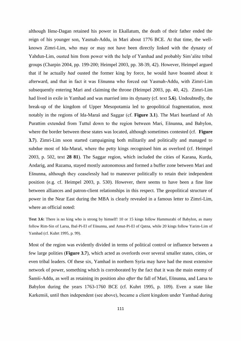
111
although Išme-Dagan retained his power in Ekallatum, the death of their father ended the
reign of his younger son, Yasmah-Addu, in Mari about 1776 BCE. At that time, the well-
known Zimri-Lim, who may or may not have been directly linked with the dynasty of
Yahdun-Lim, ousted him from power with the help of Yamhad and probably Sim’alite tribal
groups (Charpin 2004, pp. 199-200; Heimpel 2003, pp. 38-39, 42). However, Heimpel argued
that if he actually had ousted the former king by force, he would have boasted about it
afterward, and that in fact it was Ešnunna who forced out Yasmah-Addu, with Zimri-Lim
subsequently entering Mari and claiming the throne (Heimpel 2003, pp. 40, 42). Zimri-Lim
had lived in exile in Yamhad and was married into its dynasty (cf. text 5.6). Undoubtedly, the
break-up of the kingdom of Upper Mesopotamia led to geopolitical fragmentation, most
notably in the regions of Ida-Maraš and Saggar (cf. Figure 3.1). The Mari heartland of Ah
Purattim extended from Tuttul down to the region between Mari, Ešnunna, and Babylon,
where the border between these states was located, although sometimes contested (cf. Figure
3.7). Zimri-Lim soon started campaigning both militarily and politically and managed to
subdue most of Ida-Maraš, where the petty kings recognised him as overlord (cf. Heimpel
2003, p. 502, text 28 81). The Saggar region, which included the cities of Karana, Kurda,
Andarig, and Razama, stayed mostly autonomous and formed a buffer zone between Mari and
Ešnunna, although they ceaselessly had to maneuver politically to retain their independent
position (e.g. cf. Heimpel 2003, p. 530). However, there seems to have been a fine line
between alliances and patron-client relationships in this respect. The geopolitical structure of
power in the Near East during the MBA is clearly revealed in a famous letter to Zimri-Lim,
where an official noted:
Text 3.6: There is no king who is strong by himself! 10 or 15 kings follow Hammurabi of Babylon, as many
follow Rim-Sin of Larsa, Ibal-Pi-El of Ešnunna, and Amut-Pi-El of Qatna, while 20 kings follow Yarim-Lim of
Yamhad (cf. Kuhrt 1995, p. 99).
Most of the region was evidently divided in terms of political control or influence between a
few large polities (Figure 3.7), which acted as overlords over several smaller states, cities, or
even tribal leaders. Of these six, Yamhad in northern Syria may have had the most extensive
network of power, something which is corroborated by the fact that it was the main enemy of
Šamši-Addu, as well as retaining its position also after the fall of Mari, Ešnunna, and Larsa to
Babylon during the years 1763-1760 BCE (cf. Kuhrt 1995, p. 109). Even a state like
Karkemiš, until then independent (see above), became a client kingdom under Yamhad during

112
the 1760s (Klengel 1992, p. 59). Such a geopolitical structure is also discerned in another
letter to Zimri-Lim, where the “four mighty kings” following the death of Šamši-Addu were
listed to be Hammurabi of Babylon, Rim-Sin of Larsa, Amut-Pi-El of Qatna, and Yarim-Lim
of Yamhad (Klengel 1992, p. 57). It was not until the Hittite invasions in the MBA-LBA
transitional period that both Yamhad and Babylon fell. The network of patron-client
relationships between major actors and petty rulers was indeed the fundament of – and
integral to – the political structure in the Near East during the MBA, and probably also during
EBA IV (also cf. 5.2.1.3). After the fall of Mari, much of the historical narrative gets
shrouded in yet another period of textual dearth (Durand 2004, p. 194) – and this point in time
also defines the end of the predetermined temporal horizon for this dissertation.
Figure 3.7: The six main political actors of the MBA II in the Near East, the approximate extent of their
geopolitical influence, and the location of their respective centres during the time of the Mari archives. In
addition, non-incorporated entities, like Zalmaqum, are marked. Even though the latter enjoyed relative
autonomy, these nevertheless had affiliations along tribal lines toward some of the larger ones, just like the Ida-
Maraš was either affiliated or dependent on the Mari dynasty (cf. 5.3.2.1). However, as the structural basis of
power during the EBA-MBA mainly was personal authority and/or influence over populations and not spatially
founded, it would be inaccurate to illustrate the largest actors according to geographical extent (also cf. 5.2.1.3).
Instead, their main range of influence along the river valleys and across the more densely populated areas of the
Near East is approximatedly marked.

113
3.5 Summary and conclusions
The geopolitical development of the Near East seems to have been characterised by a cyclical
pattern of centralisation and fragmentation. Fragmentations were usually followed by the
emergence of a local dynasty or cessation from an overlord or king by an erstwhile governor
or vassal. In time, most of these were again swept up by a new expanding power, generally in
competition with a small number of other similar actors. However, due to the vast physical
geography of the region and the structure of power in the EBA and MBA political system,
which mainly was based on personal authority, tribal affiliation, and a network of patron-
client relationships, most large polities did not survive more than one or two centuries. The
geopolitical structure based on large continuous states and dynasties first emerged in the Near
East during the LBA (Charpin 2004, p. 201 – for more on this topic cf. 5.2.1.3). Thus, the
long reigns of Ipiq-Adad II of Ešnunna, Šamši-Addu in the kingdom of Upper Mesopotamia,
or Rim-Sin of Larsa could have been essential to the success and regional power of these
states. Unfortunately, the specific developments in Syria between EBA IVa and MBA II are
generally rather obscure, without the option for a detailed analysis, but the few glimpses
obtained seem to suggest a geopolitical development roughly similar or possibly parallel to
that of southern Mesopotamia. Mari was probably larger than many other cities in the region
for much of the time and expanded to comprise the Ah Purattim state regularly, while Ebla
enjoyed the same primate position on the Syrian plains, although being eclipsed by Qatna and
Yamhad during MBA I. The geopolitical network of influence and power probably fluctuated
in pattern parallel to that of the Alluvium, with regional fragmentation being replaced by
emerging consolidation under a few powerful actors, often in time followed by yet another
period of political fragmentation. The underlying structure of personal authority and tribal
affiliations without the necessary means for direct control outside a limited area around the
centra could have been the reason for such a cyclical pattern.
However, it must be emphasised that with regard to Syria itself, much of the geopolitical
narrative needs to be characterised as tentative, or at best suggestive. Without textual material
for most of the period in question, only hints and inferences from outside sources shed light
on its the diachronic developments. While the narrative presented here is of contextual value
for this synthetic approach, it is also an important backdrop for themes to come, mainly under
5.2 and 5.3. But before this, I will turn to the main corpus of data collected for this study - the
new non-synthetic information, so to speak – namely the archaeological ground survey carried

114
out by the Palmyrena project and the subsequent extensive satellite survey of the Palmyrene,
although I also will draw upon certain other surveys and the limited amount of excavations
carried out by other archaeologists working in this region during the last two decades.

115
4 The Palmyrena survey and EBA-MBA archaeology in central Syria
Archaeological research on central Syrian matters regarding the Bronze Age is a relatively
recent undertaking. Most investigations into EBA and MBA societies in the region have
focused on other areas and topics, e.g. the settlement sites in the major river valleys, on the
Syrian plain, and in the Habur triangle. Monuments and material remains associated with
mobile pastoralists in a steppe environment have been conspicuously absent from the
archaeological corpus, apart from suggestions linking such groups to the kranzhügel sites of
the western Jezire (cf. 5.2.2.2) and the odd connection between sites in the steppe – usually
the oft-mentioned Jebelet el-Beda – and mobile pastoralists inhabiting the Jebel Abd el-Aziz
region (cf. Wossink 2009, pp. 112-113, with references). However, outside of Syria there has
been a somewhat longer tradition for research on arid landscape structures which seemingly
could be attributed to mobile groups, such as in Jordan, Sinai, and the Negev desert (e.g.
Haiman 1982; Helms & Betts 1987; Zarins 1992). But the steppe – and particularly the
Palmyrene and Jebel Bishri – is in fact brimming with archaeological monuments to which
associations specifically with mobile groups have been suggested in recent years, and research
carried out in the past decade or so has shown that many of them should in fact be
chronologically placed in the 3rd and early 2nd millennium BCE, and particularly in the EBA
IV to early MBA.
This chapter aims to present the data collected by the Palmyrena survey in the highlands north
of Palmyra, as well as the subsequent satellite imagery survey conducted for the purposes of
this dissertation, and analyse these structures according to their archaeological contexts and in
relation to the Palmyrene landscape. Most of the material is assembled in appendices 1-4,
mainly in order to make it available for reference, but also to prevent the minute details from
obscuring or confusing the interpretations and discussions presented in the text. First, I will
describe the assemblage of archaeological structures found in Near Eastern arid landscapes,
and then present the tumuli surveyed on the ground Palmyrena in general and define certain of
their structural and contextual aspects (cf. 4.1). Following this, I will analyse them according
to these definitions and to patterns in the landscape (cf. 4.2). Then I will turn to the topic of
remotely-sensed surveying, which has been a boon to this study, escpecially since any
archaeological work in Syria has been suspended since May of 2011. The first and shorter

116
part will present results from the study of acquired high-resolution satellite imagery of the
area surveyed by the Palmyrena project (cf. 4.3), although the main survey was carried out on
Google Earth imagery, around which some considerations on method and potential issues will
be outlined (cf. 4.4). The results from this investigation is divided according to structure types
and assembled (cf. 4.5), each followed by a lengthier discussion on the interpretation and
function. The penultimate subchapter (cf. 4.6) concerns chronological aspects of the
Palmyrene structures, and also outlines the method and results of the OSL dating carried out
by the Palmyrena project. Finally, I will turn to other archaeological projects with similar
thematic and geographical scope (cf. 4.7) to consider comparative aspects of structure,
context, and chronology – all for the purpose of understanding and interpreting the Palmyrene
monuments.
4.1 Defining Palmyrene prehistoric archaeology
4.1.1 The Bronze Age technocomplex: Defining Palmyrene archaeological structures
Bradbury (2011) carried out an extensive study of stone monuments associated with burials in
the Levant as part of a research project in the basaltic region north of Homs, hereafter called
the Homs NSA (cf. Philip & Bradbury 2010; Philip et al. 2011; Bradbury 2011 – cf. Figure
4.55, areas A and B). She tried to answer questions about functionality in a diachronic context
and the possibilities and potential for typology, as the monuments vary greatly in size and
shape and their relation to the wider landscape. She argued that there are indications of initial
erection of such monuments during the 4th-3rd millennium BCE, although she also pointed out
that problems had emerged when the project had attempted to attribute size and shape to
chronology (Bradbury 2011, p. 41). The Palmyrena project has documented hundreds of
burial monuments in the central Syrian highlands (cf. 4.2), with thousands more having been
mapped via satellite imagery (cf. 4.3 and 4.5), albeit one should strictly characterise the latter
as hypothetical or probable tumuli. In addition, excluding clearly datable Roman, Byzantine,
or Islamic structures and complexes, other archaeological structures also found and
documented include a few kites, a large number of what has provisionally been termed
corrals (cf. Meyer 2008), as well as some structures of unknown function and date (cf.
Anfinset 2009; 2013; Meyer 2009; 2011). Subsequently, several hundreds more such
monuments have been surveyed via commercially available satellite images and Google Earth
117
(cf. 4.3, 4.4, and 4.5). This troika of archaeological remains is actually constituting what
Zarins (1992, p. 50) characterised as the Chalcolithic and Early Bronze Age pastoral nomadic
technocomplex of the vast Near Eastern arid zone. The first type he termed stone circles,
which he defined to include a large variety in type and construction, such as simple or
complex structures, from large isolated stone rings to smaller ones containing a number of
interlocking stone enclosures. Both of these extremes he added can be furnished with internal
subdivisions and/or attached external rows of stone. The second type was tumuli, which can
take a number of forms, as will also be shown below. They can exist in isolation, as
cemeteries or as parts of stone circle complexes. He emphasised their location along
ridgelines, but also associated them with proximity to material for construction. The third part
of the technocomplex was kites, which in the days of Zarins counted a lot fewer examples
than is the case today (Kennedy 2012 – cf. 4.5.5.1 and Figure 4.38), and had at the time
mainly been recorded in Saudi-Arabia and Jordan. However, he mentioned that Poidebard
(1934) had documented several kites in the region northeast of Damascus as well as along the
Strata Diocletiana between Palmyra and Suhne, thinking they were Roman fortifications
which subsequently were being used by Bedouins in the area (also cf. Kennedy 2012, pp. 147-
148). Lastly, and slightly on the side of the abovementioned structures, Zarins also included
the possibility of stone-built and stone-filled platforms in his pastoral nomadic
technocomplex. Although the terminology on kites will be kept in this chapter, due to its well-
known and often applied usage in archaeological research, the features sometimes called
corrals will here be termed stone enclosures, to separate its function from husbandry and the
connotation to animal pens which is inherent in corral as a designation, as well as avoiding
connotations associated with the often ritually laden term stone circles, notwithstanding the
fact that only a minority of them actually take the shape of a true circle.
While there are some variations within the group of burial monuments, nearly all of them are
what Bradbury called cairns/tumuli (Bradbury 2011, p. 677, appendix 3.2), although their
contexts differ quite dramatically. Of course, due to her rather wide thematic and geographical
focus, consisting of all types of stone funerary monuments in 150 km2 of the Homs NSA,
nearly 21000 km2 in the Vanishing Landscape Region stretching into the Palmyrene (cf.
Bradbury 2011, p. 44, fig. 1.1), as well as integrating the Hawran, Jawlan, and Negev for
comparative purposes (Bradbury 2011, p. 42), her typology is expected to have varied greatly.
She also described certain irregular stone structures, which seem to be similar to the
118
Palmyrene stone enclosures (Bradbury 2011, pp. 267-269; fig. 4.29 below). Initially, this
makes many of the definitions and characteristics in her thesis useful for the current study, but
as her data draw on the Levant and western Syria with no burial structures from central parts
of Syria included at all (cf. Bradbury 2011, p. 133, fig. 3.12), there is arguably a need to
independently consider definitions and characterisations for the Palmyrene tumuli themselves.
Bradbury also argued that multifaceted variations in morphology and landscape contexts
would be a preferred approach to the rigid typological classifications of previous research
(Bradbury 2011, p. 118). Because the Palmyrena project suffers from lack of secure dating
evidence for burial structures in the dry steppe, apart from a few tentative indications, mostly
from contexts of a secondary character (e.g. pottery scatter around a cairn, cf. 4.6.1),
typological variation with the perspective suggested by Bradbury could at least carry some
potential for yielding answers. Additionally, the project had from the start the aim of applying
a different tactic to the chronology of these structures – optically stimulated luminescence
(OSL) – which will be explained further below (cf. 4.6.2). The initial hypothesis (cf. 1.2.1) is
that the great number of cairn structures in the Palmyrene highlands was erected mainly by
Bronze Age mobile pastoralists who due to climatic changes, inter-group relations, and/or the
general sociopolitical developments in the Near East felt the need to mark their presence,
identity, and possibly territory in the landscape. With the main issue being chronology, I will
here define the variations within the tumulus typology, and later try to integrate these with
chronology based on pottery, comparisons, and possibly radiometric dating. I do partly agree
with Bradbury (2011, p. 120) that morphology could be not just associated with ethnicity or
regional geography, but in fact also be attributed to chronology or even the result of thousands
of years of landscape use and habitation. I consciously use the term tumuli here as a
designation for the burial monuments of the survey area, meaning a heap of material (earth
and/or rocks) constituting an archaeological structure, rather than using cairn, which below
will be applied to denote more specifically a pile of rocks and blocks (cf. 4.1.3). As part of
Zarins’ mobile pastoralist technocomplex, I will also subsequently consider various aspects
regarding stone enclosures and kites in the Palmyrene.
4.1.2 Survey area and methods
The concession area provided by the Director General of Antiquities and Museums of Syria
(DGAM) for the Palmyrena project stretched from the wide plain Sahl Feif el Mazraa, which
lies just south of the mountain ranges Jebel Abyad and Jebel Homr ez Jazal and north-
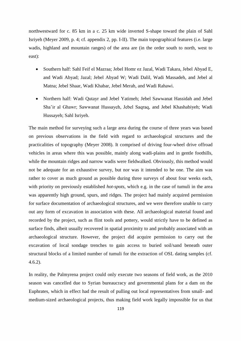
119
northwestward for c. 85 km in a c. 25 km wide inverted S-shape toward the plain of Sahl
Isriyeh (Meyer 2009, p. 4; cf. appendix 2, pp. I-II). The main topographical features (i.e. large
wadis, highland and mountain ranges) of the area are (in the order south to north, west to
east):
Southern half: Sahl Feif el Mazraa; Jebel Homr ez Jazal, Wadi Takara, Jebel Abyad E,
and Wadi Abyad; Jazal; Jebel Abyad W; Wadi Dalil, Wadi Massadeh, and Jebel al
Matna; Jebel Shaar, Wadi Khabar, Jebel Merah, and Wadi Rahawi.
Northern half: Wadi Qutayr and Jebel Yatimeh; Jebel Sawwanat Hassidah and Jebel
Sha’ir al Ghawr; Sawwanat Hussayeh, Jebel Saqraq, and Jebel Khashabiyeh; Wadi
Hussayeh; Sahl Isriyeh.
The main method for surveying such a large area during the course of three years was based
on previous observations in the field with regard to archaeological structures and the
practicalities of topography (Meyer 2008). It comprised of driving four-wheel drive offroad
vehicles in areas where this was possible, mainly along wadi-plains and in gentle foothills,
while the mountain ridges and narrow wadis were fieldwalked. Obviously, this method would
not be adequate for an exhaustive survey, but nor was it intended to be one. The aim was
rather to cover as much ground as possible during three surveys of about four weeks each,
with priority on previously established hot-spots, which e.g. in the case of tumuli in the area
was apparently high ground, spurs, and ridges. The project had mainly acquired permission
for surface documentation of archaeological structures, and we were therefore unable to carry
out any form of excavation in association with these. All archaeological material found and
recorded by the project, such as flint tools and pottery, would strictly have to be defined as
surface finds, albeit usually recovered in spatial proximity to and probably associated with an
archaeological structure. However, the project did acquire permission to carry out the
excavation of local sondage trenches to gain access to buried soil/sand beneath outer
structural blocks of a limited number of tumuli for the extraction of OSL dating samples (cf.
4.6.2).
In reality, the Palmyrena project could only execute two seasons of field work, as the 2010
season was cancelled due to Syrian bureaucracy and governmental plans for a dam on the
Euphrates, which in effect had the result of pulling out local representatives from small- and
medium-sized archaeological projects, thus making field work legally impossible for us that

120
year. However, in 2009 and 2011, field work was generally carried out in full, although the
operations in the Palmyrene toward the end of April 2011 had to be abandoned due to the
onset of heavy rain, creating hazardous conditions in the steppe, while some subsequent
analyses during the same season was cut short by the increasing intensity of demonstrations
and political conflict experienced in Syria as a consequence of the Arab Spring. The result of
this was that only certain parts of the southern regions of the concession area were surveyed
extensively. The main areas subjected to investigations were Wadi Takara, Jebel Abyad,
Jazal, parts of Jebel Homr ez Jazal, parts of Wadi Dalil and Wadi Massadeh, and
southwestern half of Jebel Merah (cf. appendices 2, 3, and 4). Additionally, the north tip of
Jebel Merah had been briefly surveyed during a prospection in 2008 (cf. Meyer 2008).
The method applied in the field consisted of locating archaeological structures, which for the
present work were mostly presumed burial monuments, and at the site record all visible
tumuli and any associated refurbishments by filling out a site form which included GPS
coordinates, height above sea level, condition, and character of structure, as well as site
location in the landscape and nearby topographical features. Photographies were taken of the
monument in all four compass directions, if possible, with a meter-long measurement rod
visible for scale, the size of the structure measured in plan on the north/south and east/west
lines, and maximum height estimated in certain cases. In addition, a field walk was usually
carried out on and around the tumuli to record any surface scatter. The meticulousness of the
survey enabled a detailed post-analysis of all the recorded structures, which totaled 404 burial
monuments, as well as a small number of structures of uncertain character. One kite was also
found, surveyed, and recorded in southern Jebel Merah in 2011, while a number of stone
enclosures were also discovered as part of the search for tumuli, although not actually
prioritised for documentation during the 2009 and 2011 campaigns (cf. Anfinset 2009; 2013).
However, the 2008 prospection did record a small number of stone enclosures at Al-Matna,
which in some cases were associated with tumuli located at the northern entrance of Wadi al
Masek (cf. Meyer 2008, pp. 44-55).
4.1.3 Tumulus typology
Initially, it must be pointed out that Philip and Bradbury (2010, pp. 141-142) have indeed
questioned the common use of the term tumuli regarding structures like those presented
below, although they specifically discussed cairn-type monuments in the Homs NSA. They

121
argued that the term connotes a funerary function which for many instances is not clearly
demonstrated through excavation or other archaeological investigation. Arguably, their
concerns are valid, particularly for agricultural regions in their area further west, as the heaps
of rock could be clearance cairns or possibly serving a function as beacon or landmark, or
have other, unknown purposes (cf. 5.4.1 and 5.4.2). However, the archaeological structures
surveyed in the Palmyrene seem to have served as landmarks integrated with the landscape
and as burial monuments. This has also been argued by Bonacossi and Iamoni (2012, p. 31),
based on their general pattern of topographical location. Many of the disturbed and looted
examples of Palmyrene tumuli frequently exhibit a cist or chamber, which heavily implies a
tomb or a funerary function of some sort, and the many forms of refurbishments which often
are associated with these structures also indicate that they were monuments of ritual
importance. Additionally, the general aridity and topography of the region combined with the
location of these structures most likely excludes an agricultural phenomenon, while the
interrelation of many of them suggests a funerary function, as has indeed also been
determined by other archaeological researchers working in this specific region and
environment (cf. Bonacossi & Iamoni 2012; Fujii & Adachi 2010; Nishiaki 2010; Numoto &
Kume 2010; Lönnqvist 2010 – also cf. 4.7). The collective term for burial monuments made
up of a pile of rocks/blocks and/or earth will here be tumuli (sing. tumulus) (e.g. Bonacossi &
Iamoni 2012, p. 45, note 59), to exclusively indicate shape and probable function. Another
term often used in this context is cairn (e.g. Nishiaki 2010; Fujii & Adachi 2010) or
cairn/tumulus (e.g. Lönnqvist 2010), but because the analysis below will incorporate this term
to define a tumulus consisting of mostly rocks/blocks and very little soil/earth, I will avoid
using cairn as denoting Palmyrene burial monuments in general, while the cairn/tumulus
designation will be dropped for practical reasons. However, in some of the map legends in
this chapter, one could encounter the word cairn, although the meaning is generally supposed
to be tumulus7.
7 This mainly concerns Figure 4.16, Figure 4.17, Figure 4.52, and appendix 2.
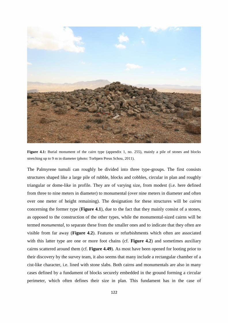
122
Figure 4.1: Burial monument of the cairn type (appendix 1, no. 255), mainly a pile of stones and blocks
stretching up to 9 m in diameter (photo: Torbjørn Preus Schou, 2011).
The Palmyrene tumuli can roughly be divided into three type-groups. The first consists
structures shaped like a large pile of rubble, blocks and cobbles, circular in plan and roughly
triangular or dome-like in profile. They are of varying size, from modest (i.e. here defined
from three to nine meters in diameter) to monumental (over nine meters in diameter and often
over one meter of height remaining). The designation for these structures will be cairns
concerning the former type (Figure 4.1), due to the fact that they mainly consist of a stones,
as opposed to the construction of the other types, while the monumental-sized cairns will be
termed monumental, to separate these from the smaller ones and to indicate that they often are
visible from far away (Figure 4.2). Features or refurbishments which often are associated
with this latter type are one or more foot chains (cf. Figure 4.2) and sometimes auxiliary
cairns scattered around them (cf. Figure 4.49). As most have been opened for looting prior to
their discovery by the survey team, it also seems that many include a rectangular chamber of a
cist-like character, i.e. lined with stone slabs. Both cairns and monumentals are also in many
cases defined by a fundament of blocks securely embedded in the ground forming a circular
perimeter, which often defines their size in plan. This fundament has in the case of

123
monumentals sometimes a second or even third course of blocks laid on top of it, giving them
a turret-like structural appearance, although usually of a much larger size than the turret-type
tumuli presented below, and it also often occurs as an internal structural feature inside a pile
of medium- to large-sized rocks rather than an external wall-like structure. On the other hand,
the very definition of the cairn-type includes great variation, and denotes in effect all tumuli
not categorised here as mounds, turrets, or monumentals.
Figure 4.2: Tumulus of the monumental type (appendix 1, no. 266), including a substantial foot chain. This type
is basically defined as a cairn, only it is larger than 9 m in diameter and sometimes well over 1 m tall.
Monumentals are often located on peaks along the highest mountain ridges, although not exclusively (cf. Figure
4.11 – left) (photo: Torbjørn Preus Schou, 2011).
The second type-group includes low tumuli-mounds, mostly consisting of cobbles mixed with
earth. Again, their shape in plan is circular, while the profile is of a low, gentle, dome-like
character and they will here be termed mounds, due to their mix of cobbles and earth,
although they can also feature some rocks (Figure 4.3). They vary quite a lot in size, but are
usually not over 10 m in diameter. Even though these can surpass 9 m in plan, they are too
low to justify a classification as monumental. The most striking other aspects with this group
is that they generally occur in clusters and are not necessarily looted, possibly due to their

124
more unassuming shape and size. Quite a few of them also feature a small pile of stones in
their centre, which often look more like a genuine feature than a later addition or the result of
looting. This pile also acts like some sort of marker and make them stand out better in the
local topography than the ones without such piles, even today.
Figure 4.3: Two burial monuments of the mound type within the same cemetery (appendix 1, nos. 366 and 361
– left to right), located in the Jebel Merah mountain pass of Taniyet ez Zerr (cf. Figure 4.16). They are low and
unassuming, and consist of earth and smaller rocks (photos: Torbjørn Preus Schou, 2011).
The third main type-group is what here will be termed turrets. They are quite different from
the other two, in that they are built up of dressed, mainly rectangular blocks in a circular dry-
stone wall construction of three to four or more courses, resulting in what looks like a
compact turret (Figure 4.4). Within the walls of these is a pile of small- to medium-sized
rocks, which comprises the fill of the structure, so to speak. This heap usually projects
somewhat above the wall line creating a dome-like shape, inferred from the one or two
undisturbed examples documented by the Palmyrena project. Looted tumuli of this type often
exhibit a medium-sized central chamber (c. 100 x 100 cm) with two straight and two curving
internal dry-stone wall sides. Generally, turrets stand in isolation, with tens or hundreds of
meters to the next tumulus of similar construction, and lack outer refurbishments. Some
turrets, although mostly smaller than nine meters in diameter, can in cases of less disturbed
condition exceed one meter in height, giving them an even more pronounced turret-like
character.
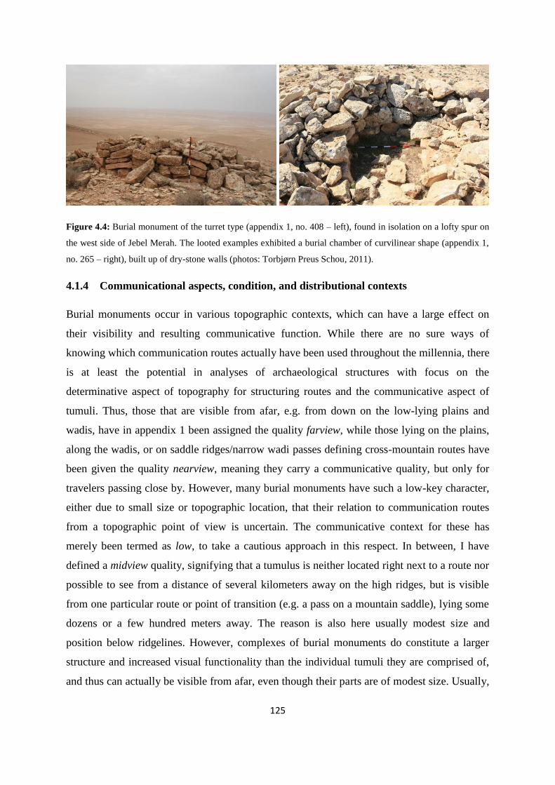
125
Figure 4.4: Burial monument of the turret type (appendix 1, no. 408 – left), found in isolation on a lofty spur on
the west side of Jebel Merah. The looted examples exhibited a burial chamber of curvilinear shape (appendix 1,
no. 265 – right), built up of dry-stone walls (photos: Torbjørn Preus Schou, 2011).
4.1.4 Communicational aspects, condition, and distributional contexts
Burial monuments occur in various topographic contexts, which can have a large effect on
their visibility and resulting communicative function. While there are no sure ways of
knowing which communication routes actually have been used throughout the millennia, there
is at least the potential in analyses of archaeological structures with focus on the
determinative aspect of topography for structuring routes and the communicative aspect of
tumuli. Thus, those that are visible from afar, e.g. from down on the low-lying plains and
wadis, have in appendix 1 been assigned the quality farview, while those lying on the plains,
along the wadis, or on saddle ridges/narrow wadi passes defining cross-mountain routes have
been given the quality nearview, meaning they carry a communicative quality, but only for
travelers passing close by. However, many burial monuments have such a low-key character,
either due to small size or topographic location, that their relation to communication routes
from a topographic point of view is uncertain. The communicative context for these has
merely been termed as low, to take a cautious approach in this respect. In between, I have
defined a midview quality, signifying that a tumulus is neither located right next to a route nor
possible to see from a distance of several kilometers away on the high ridges, but is visible
from one particular route or point of transition (e.g. a pass on a mountain saddle), lying some
dozens or a few hundred meters away. The reason is also here usually modest size and
position below ridgelines. However, complexes of burial monuments do constitute a larger
structure and increased visual functionality than the individual tumuli they are comprised of,
and thus can actually be visible from afar, even though their parts are of modest size. Usually,
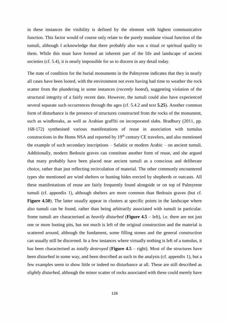
126
in these instances the visibility is defined by the element with highest communicative
function. This factor would of course only relate to the purely mundane visual function of the
tumuli, although I acknowledge that there probably also was a ritual or spiritual quality to
them. While this must have formed an inherent part of the life and landscape of ancient
societies (cf. 5.4), it is nearly impossible for us to discern in any detail today.
The state of condition for the burial monuments in the Palmyrene indicates that they in nearly
all cases have been looted, with the environment not even having had time to weather the rock
scatter from the plundering in some instances (recently looted), suggesting violation of the
structural integrity of a fairly recent date. However, the tumuli could also have experienced
several separate such occurrences through the ages (cf. 5.4.2 and text 5.25). Another common
form of disturbance is the presence of structures constructed from the rocks of the monument,
such as windbreaks, as well as Arabian graffiti on incorporated slabs. Bradbury (2011, pp.
168-172) synthesised various manifestations of reuse in association with tumulus
constructions in the Homs NSA and reported by 19th century CE travelers, and also mentioned
the example of such secondary inscriptions – Safaitic or modern Arabic – on ancient tumuli.
Additionally, modern Bedouin graves can constitute another form of reuse, and she argued
that many probably have been placed near ancient tumuli as a conscious and deliberate
choice, rather than just reflecting recirculation of material. The other commonly encountered
types she mentioned are wind shelters or hunting hides erected by shepherds or outcasts. All
these manifestations of reuse are fairly frequently found alongside or on top of Palmyrene
tumuli (cf. appendix 1), although shelters are more common than Bedouin graves (but cf.
Figure 4.50). The latter usually appear in clusters at specific points in the landscape where
also tumuli can be found, rather than being arbitrarily associated with tumuli in particular.
Some tumuli are characterised as heavily disturbed (Figure 4.5 – left), i.e. there are not just
one or more looting pits, but not much is left of the original construction and the material is
scattered around, although the fundament, some filling stones and the general construction
can usually still be discerned. In a few instances where virtually nothing is left of a tumulus, it
has been characterised as totally destroyed (Figure 4.5 – right). Most of the structures have
been disturbed in some way, and been described as such in the analysis (cf. appendix 1), but a
few examples seem to show little or indeed no disturbance at all. These are still described as
slightly disturbed, although the minor scatter of rocks associated with these could merely have
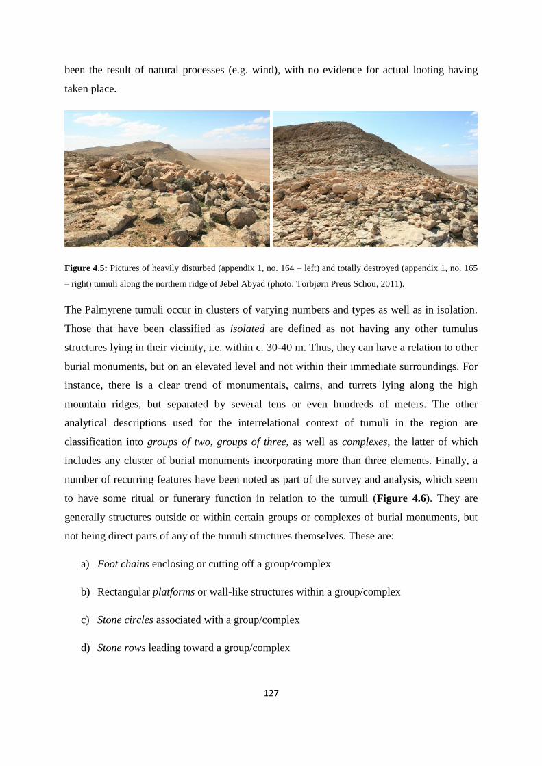
127
been the result of natural processes (e.g. wind), with no evidence for actual looting having
taken place.
Figure 4.5: Pictures of heavily disturbed (appendix 1, no. 164 – left) and totally destroyed (appendix 1, no. 165
– right) tumuli along the northern ridge of Jebel Abyad (photo: Torbjørn Preus Schou, 2011).
The Palmyrene tumuli occur in clusters of varying numbers and types as well as in isolation.
Those that have been classified as isolated are defined as not having any other tumulus
structures lying in their vicinity, i.e. within c. 30-40 m. Thus, they can have a relation to other
burial monuments, but on an elevated level and not within their immediate surroundings. For
instance, there is a clear trend of monumentals, cairns, and turrets lying along the high
mountain ridges, but separated by several tens or even hundreds of meters. The other
analytical descriptions used for the interrelational context of tumuli in the region are
classification into groups of two, groups of three, as well as complexes, the latter of which
includes any cluster of burial monuments incorporating more than three elements. Finally, a
number of recurring features have been noted as part of the survey and analysis, which seem
to have some ritual or funerary function in relation to the tumuli (Figure 4.6). They are
generally structures outside or within certain groups or complexes of burial monuments, but
not being direct parts of any of the tumuli structures themselves. These are:
a) Foot chains enclosing or cutting off a group/complex
b) Rectangular platforms or wall-like structures within a group/complex
c) Stone circles associated with a group/complex
d) Stone rows leading toward a group/complex
128
These features do not occur very often, but in some of the cases their expression is certainly
striking enough to merit mention in the analysis (cf. Figure 4.6 – left), as well as the
structural recurrence in itself suggests them being more than one-off events. Appendix 1
presents the complete list of tumuli structures with descriptions on size, type, refurbishments,
reuse, and condition, everything with references to structure numbers in Meyer (2008),
Anfinset (2009), and Anfinset (2013).
By applying Google Earth (cf. 4.4) it has also been possible to correct for obvious
measurement errors, particularly regarding elevation. There are some instances where both
pictures and topography in Google Earth clearly do not match the elevation numbers in the
reports (cf. Anfinset 2009; 2013), e.g. when closely situated tumuli seemingly differ in
elevation by eight to ten meters, and this data must therefore have come to pass due to
situational uncertainty in the GPS. I have corrected these numbers as a consequence of the
abovementioned factors and my own subjective evaluation of the site. However, the
difference between the reports and my evaluation rarely exceeds ten meters in elevation,
usually being between five to eight meters, and is mostly for descriptive purposes here, rather
than actual analytical ones.
4.1.5 Comments on chronology
The post-fieldwork study of the tumuli has been carried out in a very thorough fashion, with
notes on any reuse or rearrangements of the monuments (see above), which in most cases
clearly have occurred in more recent times. However, while the Bronze Age date of these
monuments is hypothetical in most cases, occasionally some evidence of reuse in Roman
times has been observed, showing at least a pre-Classical origin of these tumuli. Additionally,
pottery sherds collected by field walking around some of the structures (cf. 4.6.1 and Figure
4.46) also suggest a tentative connection with them and thus a date of approximately EBA IV,
although it must be pointed out that all the finds collected by the prehistoric team of the
Palmyrena survey are stray finds and of a secondary nature, which possibly originated from
burial contexts within the structures and ended up outside these tumuli as a result of looting at
some point in time. Some material collected in this manner is clearly of a Roman or Byzantine
date, and other Islamic or even Ottoman. While at least the Classical forms of pottery could
conceivably have originated from the burial chamber, the monuments and complexes could
also have been focus for other, less disruptive activities through the ages, e.g. acting as mere

129
resting areas for shepherds or soldiers being drawn toward them as landmarks in the
landscape. This emphasises that the context and provenance of the pottery scatter is very
uncertain, and hence the date of the structures being derived from such material would have to
be considered tentative or at best provisional. The pattern of mainly Roman or Byzantine
pottery combined with EBA IV material is also reflected in the region as a whole, and
suggests that these two periods constituted distinct times of expansion and increased activity
on the fringe and interior of the arid steppe, compared to other archaeological periods in
central Syria, a picture which also has been argued to be the case for the basaltic region
further west (cf. Philip & Bradbury 2010, pp. 158-159; Bradbury 2011, p. 244), although
MBA should probably also be included in this picture (cf. 4.7.3). The dismissal of Islamic and
Ottoman material having derived from the burial chamber is due to the presumed major
changes in disposal of the dead occurring as a consequence of the introduction of Islam in the
region. Certain results from relative dating of the tumuli can also be acquired from spatial and
structural associations within a complex. It is for instance probable that large, central tumuli
with a clear topographical and contextual focus are of a higher age than smaller ones
surrounding them, due to the generally accepted view that mobile pastoralist groups focus on
ancestor worship and lineage in their funerary arrangements, linking burial monuments up to
family or tribal lines by virtue of close spatial association with the monument of a real or
perceived ancestor (e.g. Meyer 2010, p. 161; Numoto & Yume 2010, pp. 55-57 – also cf. 5.4).
Figure 4.6: Pictures showing examples of two types of external refurbishments associated with Palmyrene burial
monuments. Left: Extensive burial complex (appendix 1, nos. 30- 31) in Wadi Takara with stone rows, foot
chains and other features (cf. Anfinset 2009, pp. 67-68) (photo: Nils Anfinset, 2009). Right: Rectangular
platform associated with two tumuli in Jebel Merah (appendix 1, nos. 316-17) (photo: Torbjørn Preus Schou,
2011).

130
4.2 Typological and contextual analyses of Palmyrene tumuli
4.2.1 The 2011 fieldwork season – statistics
The tumuli recorded during April of 2011 in the Palmyrene (Anfinset 2013) are located in the
western part of Jebel Abyad (i.e. west of Wadi al Masek – cf. appendix 4, p. V) (n=32) and in
the southern two-thirds of Jebel Merah (n=169) (cf. appendix 4, p. III), in addition to a small
number found on a hillock in Wadi Dalil (n=6) and on a free-standing hill there (n=4), some
lying on the watershed escarpment (n=8) between Wadi Abyad and Wadi Massadeh (cf.
appendix 4, p. IV), and one found on a hillock in Wadi Khabar (cf. appendix 4, p. III). The
ones surveyed in Jebel Abyad are located along the northern ridge, apart from four which lay
on the elevated mesas in the southern part of the range, overlooking the oasis of Jazal. The
tumuli in Jebel Merah are found along the foothill ridges and spurs, on the mountain ridges up
toward the mountain pass of Taniyet ez Zerr, and north of this on western spurs of the range
projecting into the wide wadi-plain of Wadi Khabar.
Type vs. year 2011
Number (percentage)
2009
Number (percentage)
Total
Number (percentage)
Cairn 110 (50.0 %) 88 (58.3 %) 198 (53.4 %)
Monumental 15 (6.8 %) 25 (16.6 %) 40 (10.8 %)
Mound 34 (15.5 %) 10 (6.6 %) 44 (11.9 %)
Turret 15 (6.8 %) 4 (2.6 %) 19 (5.1 %)
Cairn/mound 27 (12.3 %) 7 (4.6 %) 34 (9.2 %)
Cairn/turret 17 (7.7 %) 14 (9.3 %) 31 (8.4 %)
Tumulus 2 (0.9 %) 3 (2.0 %) 5 (1.3 %)
Total 220 (100 %) 151 (100 %) 371 (100 %)
Table 4.1: Numbers according to the various tumulus types defined in 4.1.3 recorded during the ground survey
of 2011 and 2009 by the Palmyrena team focusing mainly on prehistory. There seems to be some variation
between the surveys, which could be attributable to the difference in geographical focus, although other
explanations are also possible to envision.
The four types of archaeological burial structures defined under 4.1.3 constitute in all 174 of
the total 236 tumuli recorded during the 2011 season (cf. Table 4.1). However, some of the
tumuli are more difficult to clearly put in either categories and therefore here given the
131
classifications cairn/mound (n=27/12.3 %) or cairn/turret (n=17/7.7 %). This is mainly due to
erring on the side of caution, and many of them should probably be categorised as either
mounds or turrets. Two of the remaining are only termed tumulus, due to a lack of photo and
description (i.e. merely consisting of location coordinates), while 16 are uncertain as burial
structures and hence categorised as cairns?. Of these, 13 are so closely associated with
Roman sites/buildings that they probably rather are remnants of such structures (e.g. tumuli
274-84 located on a peak of Jebel Merah). For this reason they are here excluded from the
statistics as such.
There seem to be certain contextual patterns with regard to tumuli types. With a couple of
exceptions, turrets are as mentioned generally standing alone (i.e. over 40 m to the next
tumulus), and often on sloping foothill or mountain ridge spurs. More specifically, they never
occur in groups with other turrets, but can be found with one or more of the other types.
However, if the cairn/turret group is included, they occur together in two instances in the 2011
material (appendix 1, nos. 168/170 and nos. 410/411), where one of them (168/170) include a
true turret c. 25 m from a possible one. Mounds are mostly associated with collections of
other tumuli, either other mounds or cairns, and are located either in foothill/plain transitional
areas, wadis, or near saddles in the mountain ridges, right next to topographically determined
communication routes. Several monumentals lie isolated along the highest mountain ridges
and can be seen from afar, both due to location and size, while others constitute the central
tumulus in a group or complex of burial structures in the foothill regions. The contexts of
cairns include all of the topographical locations above, due to their wide definition.
Incidentally, excluding the 16 structures uncertain as tumuli (the cairns?), 110 tumuli are
characterised as lying isolated (50.0 %), 54 in groups of two (24.5 %), 27 in groups of three
(12.3 %), and the remaining 29 (13.2 %) in complexes with more than three tumuli (i.e.
groups of five, six, seven, and eleven) (cf. Table 4.2). The proportion of cairns (half of all
tumuli) is not unexpected, again given that their definition is merely one of being a circular
pile of rocks, with both pile and rocks varying greatly in sizes from one cairn to another, or
even the characterisation as being not either of the other type-groups.
4.2.2 The 2009 fieldwork season and 2008 prospection – statistics
The fieldwork season for 2009 (Anfinset 2009; Meyer 2009), focused mainly on Jebel Abyad
(n=33) (cf. appendix 4, p. V), as well as the area south of that mountain range, including Wadi
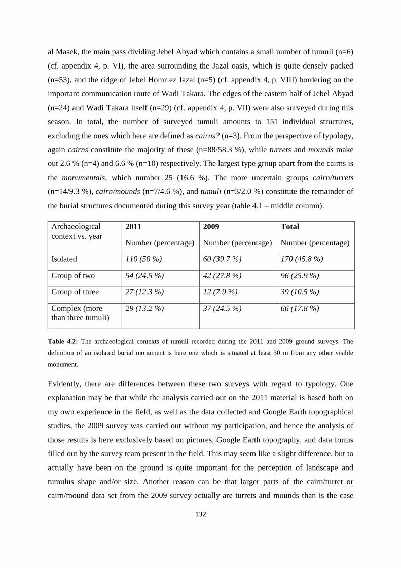
132
al Masek, the main pass dividing Jebel Abyad which contains a small number of tumuli (n=6)
(cf. appendix 4, p. VI), the area surrounding the Jazal oasis, which is quite densely packed
(n=53), and the ridge of Jebel Homr ez Jazal (n=5) (cf. appendix 4, p. VIII) bordering on the
important communication route of Wadi Takara. The edges of the eastern half of Jebel Abyad
(n=24) and Wadi Takara itself (n=29) (cf. appendix 4, p. VII) were also surveyed during this
season. In total, the number of surveyed tumuli amounts to 151 individual structures,
excluding the ones which here are defined as cairns? (n=3). From the perspective of typology,
again cairns constitute the majority of these (n=88/58.3 %), while turrets and mounds make
out 2.6 % (n=4) and 6.6 % (n=10) respectively. The largest type group apart from the cairns is
the monumentals, which number 25 (16.6 %). The more uncertain groups cairn/turrets
(n=14/9.3 %), cairn/mounds (n=7/4.6 %), and tumuli (n=3/2.0 %) constitute the remainder of
the burial structures documented during this survey year (table 4.1 – middle column).
Archaeological
context vs. year 2011
Number (percentage)
2009
Number (percentage)
Total
Number (percentage)
Isolated 110 (50 %) 60 (39.7 %) 170 (45.8 %)
Group of two 54 (24.5 %) 42 (27.8 %) 96 (25.9 %)
Group of three 27 (12.3 %) 12 (7.9 %) 39 (10.5 %)
Complex (more
than three tumuli)
29 (13.2 %) 37 (24.5 %) 66 (17.8 %)
Table 4.2: The archaeological contexts of tumuli recorded during the 2011 and 2009 ground surveys. The
definition of an isolated burial monument is here one which is situated at least 30 m from any other visible
monument.
Evidently, there are differences between these two surveys with regard to typology. One
explanation may be that while the analysis carried out on the 2011 material is based both on
my own experience in the field, as well as the data collected and Google Earth topographical
studies, the 2009 survey was carried out without my participation, and hence the analysis of
those results is here exclusively based on pictures, Google Earth topography, and data forms
filled out by the survey team present in the field. This may seem like a slight difference, but to
actually have been on the ground is quite important for the perception of landscape and
tumulus shape and/or size. Another reason can be that larger parts of the cairn/turret or
cairn/mound data set from the 2009 survey actually are turrets and mounds than is the case

133
from the 2011 material. However, the proportion of mounds to the total would still be
somewhat lower for the 2009 material, while the proportion of monumental tumuli is
definitely higher that year. If including all the ambiguous tumuli (i.e. cairn/turrets and
cairn/mounds) in their respective clearly defined groups (i.e. turrets and mounds), the
proportion of the mounds would be 27.8 % for 2011 and only 11.2 % for 2009, while the
percentages of turrets would amount to 14.5 % for 2011 and 11.9 % for 2009, although the
actual proportion may of course also lie anywhere between these percentages and the ones for
clear mounds and turrets. Finally, an explanation may also be that there are combinations of
geographical and topographical differences between the various tumulus type-groups which
are detected in these otherwise dry statistics. For instance, there is a markedly larger group of
turrets located in the mountain range of Jebel Merah (14 turrets and 15 cairn/turrets), than is
the case for Jebel Abyad (one turret and eight cairn/turrets) and Jazal (four turrets and eight
cairn/turrets), and that the Palmyrena project started working in Jebel Merah in 2011 may
have had an effect on the data concerning this type. Supporting this argument is the fact that
there are at least two turrets in the 2008 material8 from the northernmost foothills of Jebel
Merah, suggesting that this tumulus type is more frequently occurring in that mountain range
than in the areas further south. The many monumentals in the 2009 data can possibly be
explained as wider scatter of construction material due to location in low-lying and more
accessible areas for looting and disturbance, which in the field has been interpreted as larger
size, while the monumentals of 2011 represent more accurately the true proportion of the
total, since many more of these are located along the highest ridges of the region and thus are
less accessible (see below). However, this explanation must be considered more speculative
than the one concerning turret proportions.
The interrelational contexts of the 2009 tumuli are slightly different than that of the 2011
material (cf. Table 4.2). The isolated structures amount to 60 examples, which is 39.7 % of
the total. Groups of two and groups of three constitute 27.8 % (n=42) and 7.9 % (12)
respectively, while the remaining 37 (24.5 %) are associated in complexes, with three groups
of four, one of five and six, and two groups of seven tumuli. The analyzed data for the 2009
and 2011 material is thus more in line with each other in this respect. Although there are
8 The 2008 prospection data generally does not lend itself to analysis due to lack of documentation and is
therefore not statistically included in this analysis (see below), although a few provisional points are possible to
discern, e.g. the presence of at least two turrets among mostly tumuli.
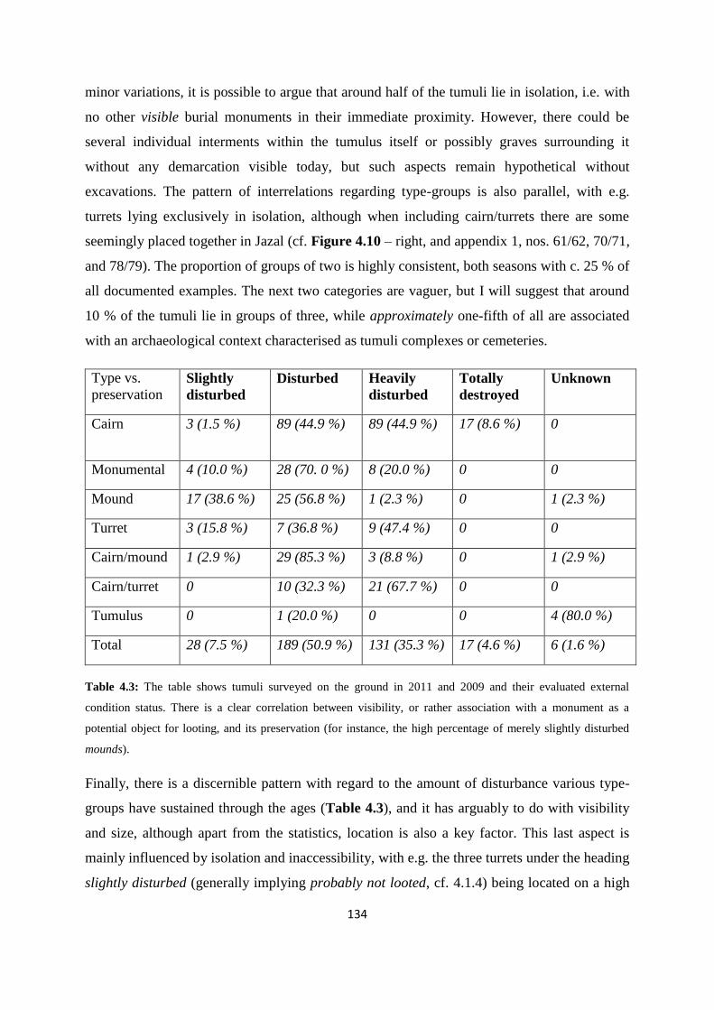
134
minor variations, it is possible to argue that around half of the tumuli lie in isolation, i.e. with
no other visible burial monuments in their immediate proximity. However, there could be
several individual interments within the tumulus itself or possibly graves surrounding it
without any demarcation visible today, but such aspects remain hypothetical without
excavations. The pattern of interrelations regarding type-groups is also parallel, with e.g.
turrets lying exclusively in isolation, although when including cairn/turrets there are some
seemingly placed together in Jazal (cf. Figure 4.10 – right, and appendix 1, nos. 61/62, 70/71,
and 78/79). The proportion of groups of two is highly consistent, both seasons with c. 25 % of
all documented examples. The next two categories are vaguer, but I will suggest that around
10 % of the tumuli lie in groups of three, while approximately one-fifth of all are associated
with an archaeological context characterised as tumuli complexes or cemeteries.
Type vs.
preservation
Slightly
disturbed
Disturbed Heavily
disturbed
Totally
destroyed
Unknown
Cairn 3 (1.5 %) 89 (44.9 %) 89 (44.9 %) 17 (8.6 %)
0
Monumental 4 (10.0 %) 28 (70. 0 %) 8 (20.0 %) 0 0
Mound 17 (38.6 %) 25 (56.8 %) 1 (2.3 %) 0 1 (2.3 %)
Turret 3 (15.8 %) 7 (36.8 %) 9 (47.4 %) 0 0
Cairn/mound 1 (2.9 %) 29 (85.3 %) 3 (8.8 %) 0 1 (2.9 %)
Cairn/turret 0 10 (32.3 %) 21 (67.7 %) 0 0
Tumulus 0 1 (20.0 %) 0 0 4 (80.0 %)
Total 28 (7.5 %) 189 (50.9 %) 131 (35.3 %) 17 (4.6 %) 6 (1.6 %)
Table 4.3: The table shows tumuli surveyed on the ground in 2011 and 2009 and their evaluated external
condition status. There is a clear correlation between visibility, or rather association with a monument as a
potential object for looting, and its preservation (for instance, the high percentage of merely slightly disturbed
mounds).
Finally, there is a discernible pattern with regard to the amount of disturbance various type-
groups have sustained through the ages (Table 4.3), and it has arguably to do with visibility
and size, although apart from the statistics, location is also a key factor. This last aspect is
mainly influenced by isolation and inaccessibility, with e.g. the three turrets under the heading
slightly disturbed (generally implying probably not looted, cf. 4.1.4) being located on a high

135
spur jutting out from the main ridge of Jebel Merah and hidden away from all apparent routes,
probably making them seldom subject to visitation (cf. Figure 4.4 – left). The same is the
case for some of the monumentals along the loftiest peaks of the same mountain range, which
were even given up by the survey team due to a tight time-frame in 2011. It is also possible
that several of the tumuli classified as disturbed are to a large extent unplundered, with their
construction material having been rearranged into windbreaks or other minor alterations, but
not been violently overturned. This may for instance apply to several large monumentals, a
group which seems to have escaped the worst destruction in many cases, probably due to lofty
locations, but also to the much larger amount of work needed to get down into a potential
burial chamber – e.g. outside easy reach of a lone shepherd. Turrets and cairns on the other
hand have fared much worse, with size and construction probably being the foremost reason.
Turrets are easy to overturn, where merely tipping one side wall will make the whole fill
scatter downslope, while cairns, although varying in shape and size, carry an inherent, but
unfortunate combination of being easy to spot, being obvious in probable structural raison
d’être, relatively lightly constructed, and of modest size. Mounds have fared best of all the
tumuli types with regard to looting and/or disturbance. They are generally not situated far
from routes or even in high elevations, thus the main reason for their good condition must be
their unassuming character, i.e. not associated with being burial monuments. Only a minute
proportion of these have been subjected to heavy disturbance, and nearly two-fifths of them
seem relatively untouched. The cairn/mounds have in larger degree been subjected to
disturbance. However, this is to be expected, as several in this category are low, but have a
small pile of rocks in their centre, probably marking them as burial structures, or they have a
rockier fill than conventional mounds, causing their uncertainty in categorisation.
Additionally, the shape of these two type-groups is also an advantageous trait when it comes
to natural processes affecting the construction. Finally and fortunately, not many Palmyrene
tumuli are characterised as totally destroyed, although they do exist (cf. Figure 4.5 – right).
The prospection of the region carried out in 2008 (cf. Meyer 2008), resulted in the recording
of a small number of tumuli in the northern entrance to Wadi al Masek (n=9) and a cluster
lying in the northernmost foothills of Jebel Merah (n=24). However, the lack of systematic
documentation via data forms and photography makes these tumuli unsuitable for the
systematic typological classification carried out on the 2009 and 2011 material, with most of

136
them only possible to categorise as tumuli (cf. note 8), notwithstanding the low number of
cairns from this prospection.
4.2.3 Tumuli and topographical context
Analyses of the tumuli surveyed on the ground in the Jebel Abyad and Jebel Merah regions do
in fact provide results regarding the topographical context and communicative aspects in the
Palmyrene landscape. There is a clear association between burial monuments and
communication lines in the southern part of the surveyed region. This part includes the
mountain range of Jebel Abyad, the hills of Jebel Homr ej Jazal, the valleys of Wadi Dalil,
Wadi Massadeh and Wadi Takara, and the oasis of Jazal with its surrounding hillocks
(collectively termed the Jebel Abyad region). Topographic features in this area which stand
out as being associated with tumuli clusters surveyed on the ground are (cf. Figure 4.7):
a) Mountain and foothill ridges in general, but particularly those running parallel with
wadis and occasionally falling steeply down into them (e.g. the northern wall of Jebel
Abyad – see also fig. 4.8).
b) The banks of certain wadis and slightly higher ground around them (e.g. along Wadi
Takara).
c) Entrances to passes crossing mountain ranges via narrow wadis (e.g. both ends of
Wadi al Masek).
d) Crossroads and special natural features, such as wells or springs (e.g. the eastern and
central parts of Jazal).

137
Figure 4.7: Satellite view of Jebel Abyad and surrounding areas with tumuli surveyed during the campaigns of
2009 and 2011, as well as the prospection of 2008 in the northern opening of Wadi al Masek. In addition to the
hillocks around the oasis of Jazal and important route of the medium-sized Wadi al Takara, the communication
routes across Jebel Abyad are: 1) Wadi el Jazal N, 2) Wadi el Arfa, 3) Wadi al Masek, 4) Wadi Shaaite, 5) Wadi
Khsheibe N, 6) Wadi Khsheibe S, 7) Wadi el Kheurbet Khairem, 8) Wadi el Khalla, 9) Wadi el Mqeitaa. The
association between these topographically determined communication lines (i.e. mountain passes) and burial
monuments seems quite clear, as well as the clustering of these structures at certain nexuses and at Jazal. Where
wadi names area not marked on the map, they are taken directly from their associated mountain range (e.g. Wadi
el Mqeitaa).
138
Figure 4.8: Satellite view of Jebel Merah and surrounding areas with tumuli surveyed during the 2011
campaign. The large wadi-valleys of Wadi Khabar and Wadi Rahawi on the west and east side of the mountain
range respectively, have presumably constituted the main routes northward, while Jebel Merah itself is only
possible to cross at Taniyet ez Zerr (route no. 1 – cf. Figure 4.16). The other designations on the map are: 2)
West-east across southern foothills via the main interior valley (cf. Meyer 2011, pp. 54-61, site 215 and 222), 3)
Route between interior valley and Wadi Abyad, 4) Main route between Wadi Abyad and Wadi Massadeh, 5)
Watershed between the two areas in nos. 4, 6-10) Ridges connecting the plain with the southern foothills. The
main ridgelines of Jebel Merah are marked as a purple line.
Thus, while individual tumuli may seem to lie isolated, these four cases are often associated
with grouped burial monuments. Their landscape context suggests a focus on topographically
determined communication routes, although the density of tumuli in the oasis of Jazal is
particularly striking, and could indicate that this area had a special communicative,
centripetal, or ritual status on a larger scale, e.g. being situated at the regional crossroads of
both a north-south route toward the Euphrates and an east-west route toward the Homs plain.
However, the fieldwork survey only could cover limited areas of a large and generally very
rugged region, and the full picture could therefore provide a different perspective. This will be
explored further below (cf. 4.3 and 4.5). The Jebel Merah region (Figure 4.8), although being
of quite a different topographical character and geographical position, shows similar patterns
of clustering. Here, tumuli are also focused on routes, but as there is only one route across the

139
main ridge (cf. Figure 4.16 and note 9), most of the clustering occur on the foothill saddles
and low ridges, as well as marking the routes crossing the watershed and toward the main
interior valley.
Figure 4.9: Computer-generated topographical view of the northern wall of Jebel Abyad as seen from Wadi
Massadeh. While the red dots are obviously artificial, this image expresses the locations and communicative
aspects of the tumuli quite well, and many of these are seen just as clearly on the ground from a long distance
away. The saddle along this ridge seen in the centre of the image is in fact the entrance to a minor wadi crossing
the range (cf. Figure 4.27, no. 16 – Wadi Mazrur).
4.2.3.1 The Jebel Abyad region
There are also indications of some typological variation with regard to topographical contexts
in Jebel Abyad. Although the group designated as cairns includes too many variations to
suggest any noticeable patterns, both the mounds and turrets seem to show tentative results.
Apart from the oasis at Jazal, which contains numerous examples of all types of tumuli,
turrets (including cairns/turrets) are mainly found along the mountain ridges of Jebel Abyad
and only those ridges bordering onto other and topographically different segments of the
regional landscape, e.g. large wadi-plains, as opposed to the interior of the mountain range
(cf. Figure 4.10 – right). In that context they also occur in rather low numbers, generally

140
stand in isolation (although cf. 4.2.2), and are associated with topographically determined
communication routes on a mid- to farview basis (cf. 4.1.4). At Jazal the picture is very
different on all accounts, with several turrets standing in the central part of the plain, quite
near the probable main route and relatively clustered. Mounds on the other hand show quite a
different distribution pattern, as this type is only found along the banks and hillocks of wadis.
Their topographical contexts vary from small-sized wadis slicing through a mountain range to
important wadi-routes, like Wadi Takara, or even large regional wadi-plains, such as Wadi
Dalil. They are mainly found in clusters, either with other mounds or sometimes also with
cairns and monumentals, but due to their very unassuming character, they can only be spotted
(in their current manifestation) when passing very close by them, which is probably also the
reason why they are associated with topographically determined communication routes on a
nearview basis (cf. 4.1.4). Indeed, none at all were found along the mountain ridges of Jebel
Abyad or Jebel Homr ej Jazal, even though several other types of burial monuments were
recorded there. The Jazal oasis features once again with several clusters of mounds, as does
the crossroad between the three routes of Wadi Takara, Wadi al Masek, and Jazal (Figure
4.10 – left).
Figure 4.10: Distribution map of mounds (blue) and cairns/mounds (red) on the left side, and on the right side
turrets (blue) and cairns/turrets (red) in the Jebel Abyad region. Both types are present and numerous in Jazal,
which is densely packed with all types of tumuli. Apart from this, turrets are only present along the high ridges
of Jebel Abyad, while mounds are only present along the banks and hillocks within Wadi Takara, Wadi al
Masek, Wadi Dalil, in addition to one cairn/mound lying along the bank of a small, interior wadi of Jebel Abyad
(Wadi Matna el Gharbiye – cf. Figure 4.27, no. 17).
The picture is not straightforward with regard to monumental tumuli in the Jebel Abyad
region, of which several occur in Jazal and along the highest ridges of Jebel Abyad itself –
and due to their large size are certainly visible from afar – but they are also quite numerous in

141
northern Wadi Takara and in the crossroad with Wadi al Masek and Jazal (Figure 4.11 – left).
This may again suggest a high importance of Wadi Takara as a route toward the Palmyra
oasis from Jazal and regions further away. If the auxiliary refurbishments, such as enclosing
foot chains or platforms found to be part of certain tumulus groups, are plotted on a
distribution map (Figure 4.11 – right), the picture is rather similar to that of monumental
cairns and seems to emphasise the same topographical features. However, to test whether the
aspects regarding type-groups and topography is actually conforming to a contextual pattern,
the analysis will continue to the other main area of fieldwork in the Palmyrene – the foothills
and mountains range of Jebel Merah.
Figure 4.11: Distribution map of monumental cairns in blue (left) and complexes associated with auxiliary
refurbishments in green (right) in the Jebel Abyad region. Both structural aspects seem to suggest a focus on the
Jazal oasis, the Wadi Takara/Jazal/Wadi al Masek crossroad, and the imposing northern wall of Jebel Abyad
directed toward the large wadi-plains of Wadi Dalil and Wadi Massadeh.
4.2.3.2 The Jebel Merah region
The other region subjected to ground survey by the prehistoric team of the Palmyrena project
is Jebel Merah, and more specifically its southern half. Although the picture at first glance can
seem less clear with regard to the defined type-groups, patterns emerge when analysed on a
local level (Figure 4.12 and Figure 4.13). First of all, mounds continue to be associated with
the lower-lying parts and wadis of the area, as well as carrying a particular nearview
connection with communication lines, i.e. lying right next to key points along routes. Mounds
in the foothills (Figure 4.12 – left) are mainly located on local wadi banks or foothill saddles,
where also today local travel is focused. However, some are also situated on the gently
sloping ridges in the transitional zone linking the wadi-plains of Wadi Massadeh and Wadi
Khabar with the higher-lying foothills. Only two mound clusters (appendix 1, nos. 296-298

142
and nos. 289-290) can indeed be said to lie in the upper reaches of the foothills, and even
these actually lie in local mountain saddles. The example which illustrates most
conspicuously the close association between mounds and communication routes is the cluster
of mounds at Taniyet ez Zerr (Figure 4.12), a very distinct mountain pass along the main
ridge of Jebel Merah (cf. Figure 4.8, no. 1, and also Figure 4.16). Here at least four mounds
are located near the modern and presumably also ancient point for crossing the mountains,
although as will be shown below the cemetery also includes cairns and turrets, suggesting an
important topographical feature. However, this is not unexpected, as the next place along
Jebel Merah where a crossing is at all practically possible lies at least 11 km further north, at
the next mountain saddle9. Thus, the mountain range of Jebel Merah constitutes a major
regional obstacle for travel between east and west, unless one aims for the crossing point at
Taniyet ez Zerr.
Figure 4.12: Distribution map of mounds (blue) and cairns/mounds (red) on the left side, and on the right side
turrets (blue) and cairns/turrets (red) in the Jebel Merah region of the Palmyrene. The numbers on the figure are
explained under Figure 4.8.
The distribution of the turret type-group in Jebel Merah (Figure 4.12 – right) also show a
pattern similar to the one in Jebel Abyad, although it needs to be studied at a local level and
the placing of these structures seems adjusted to the variation in topographical profile of the
mountain ranges. While the profile of Jebel Abyad is mainly one consisting of a high and
steep northern wall oriented east-west with ridges stretching out southward in a sloping
9 This next potential saddle route further north lies specifically at 34°57’08 N and 38°09’42 E, and is an
unnamed feature in both the French and Russian maps available, thus possibly not even recognized as a crossing
point, in which case the next point north of Taniyet ez Zerr (Taniyet = Arabic for narrow pass) where it would
be practical to cross Jebel Merah is its northern foothills – thus the pass of Taniyet ez Zerr may be the only
viable route across.

143
fashion toward the oasis of Jazal, the profile of Jebel Merah on the other hand is one of a very
high (c. 1250-1340 m.a.s.l.) and long north-south oriented ridgeline with foothills in the
northern and southern extremities and otherwise a series of lofty spur-ridges jutting out from
the main range. Although these spurs are elevated relatively high above the wadi-plains on
either side, they meet the main range 50-150 meters below the steep ridge, which thus also
there acts like a barrier (cf. 4.2.3 and note 9).
Figure 4.13: Map of monumental cairns in blue (left) and complexes associated with auxiliary refurbishments in
lime green (right) in the Jebel Merah region. The numbers on the figure are explained under Figure 4.8.
Unfortunately, due to the shortened time in the field, only a small part of the highest ridge line
was covered by the ground survey. North of Taniyet ez Zerr, only a single excursion by
Michael Meyer (cf. Meyer 2011) documented a large turret on the main ridge, although it was
clear from the ground that a number of large monumental tumuli are located along the lofty
peaks of Jebel Merah. The effort needed to climb the ridge combined with menacing bad
weather thwarted further documentation of these structures. The distribution here of
monumental tumuli in Jebel Merah (Figure 4.13 – left) probably suffers from this, and there
are not as many of them documented in this area. A pattern of monumentals along the main
ridge can be discerned on the map, which, like the northern wall of Jebel Abyad, seems to
indicate a focus on farview with regard to communication lines. The foothills and lower-lying
areas on the other hand contain few monumental burial structures, and are actually mostly
devoid of these. Those that indeed are located there all focus on the regional routes, i.e. those
going from Wadi Abyad into the Jebel Merah interior valley or up over the watershed (cf.
Figure 4.13).
Complexes with external refurbishments in Jebel Merah seem to have a distribution pattern
closer to that of mounds, with emphasis on routes into or up on the foothills and ultimately

144
mountain range (cf. Figure 4.13 – right). It is difficult to say from these two regions whether
they themselves have an association with communication lines or if they instead have had a
ritual function specifically with regard to the other burial structures and thus should be seen as
part of each funerary complex itself. Arguing from the distribution in Jebel Abyad, they could
have followed routes, but when the analysis from Jebel Merah is drawn in, the latter
explanation seems far more reasonable, and the apparent distribution along the routes is merely
a result of them being integrated into local clusters. Thus, the tumuli themselves were arguably
directed toward communication lines, while the auxiliary refurbishments most likely served an
internal function, possibly of ritual character, within the cemetery, as they are generally
associated with clusters rather than isolated structures. However, the relation between tumuli
within a complex was probably also based on some internal structural concept, such as lineage
or real or supposed ancestry (cf. Fujii & Adachi 2010, p. 66).
Thus, the ground surveys of 2009 and 2011 have enabled the Palmyrena project to discern
patterns in the distribution of burial monuments, but in order to investigate the true extent of
such structures, as well as completing the amputated recording of Jebel Merah, it was necessary
to change perspective and turn to other methods. For this purpose, the project purchased
commercially available satellite images which subsequently have been subjected to scrupulous
studies. I will now turn the attention to the methodical aspects and execution of this approach,
as well as the results.
4.3 Satellite imagery studies of the Palmyrene
4.3.1 The rationale behind satellite studies
The political events unfolding in Syria ultimately prevented us from carrying out more than
two seasons of archaeological survey in the Palmyrene dry steppe, and with the internal
conflict intensifying into a civil war by the end 2011 and a two-year humanitarian catastrophe
with no light on the horizon by 2014, there seems to be little chance of returning to Syria for
at least several years. However, the just over 400 tumuli surveyed on the ground by the
Palmyrena project do not populate the Palmyrene highlands in isolation, and to be able to
obtain comparable material for the region, the project purchased commercially available
satellite images of the remaining unsurveyed parts of Jebel Merah, as we had seen from afar
that this mountain range is littered with burial monuments along its ridges, spurs, and
145
foothills. In addition, images for Jebel Abyad were also acquired, enabling an evaluation of
the actual extent of the ground survey. The use of satellite imagery was mainly initiated in
Near Eastern archaeology during the first half of the 2000s (e.g. Ur 2003; Wilkinson et al.
2006) and has now become a growing trend and indeed an important tool in this particular
part of the discipline (e.g. Menze et al 2007; Beck et al. 2007; Wilkinson et al 2010; Philip &
Bradbury 2010; Bradbury 2011; Philip et al. 2011). As Thomas et al. (2008, p. 22) have put it,
most archaeologists are able to conduct field work, rather than being restricted to surveying
from their office – but this has indeed been the situation for the Palmyrena project ever since
May of 2011. In fact, Bradbury (2011, pp. 164-165) emphasised that while large areas of
central Syria seem devoid of burial monuments (cf. Figure 4.22), this is a picture which could
quickly change due to archaeological exploration using satellite imagery and aerial
photography from these areas. She suggested that the lack of such structures may be related to
patterns of research, rather than the distribution of actual archeological features. Fortunately,
the fieldwork carried out in advance by the Palmyrena project on the ground has enabled
exactly this approach, namely a direct investigation of the visual manifestation certain
archaeological structures have on the satellite imagery (Figure 4.14), and thus opened up the
possibility of continuing the survey with focus on tumulus distribution expanded to a more
extensive scale in the mountain ranges of Jebel Abyad and Jebel Merah. This enabled a link-
up and unification of the tumuli recorded during the 2008 prospection with the northern limit
for the 2011 survey. The comparison of satellite appearance of known burial structures with
clear, but unsurveyed features visible on the satellite images makes it likely that the latter
features also are in fact tumuli. In this manner it is possible to survey with quite high degree
of certainty the areas of Jebel Abyad and Jebel Merah which due to time limitations and
ruggedness of landscape were down-prioritised on the ground. However, while this approach
has greatly augmented the picture and increased the data set, it cannot be characterised as
totally exhaustive, as will be argued below (cf. 4.3.2.2).

146
Figure 4.14: Four examples of archaeological structures on satellite imagery which also have been found and
recorded on the ground. Clearly, some structures show up very well (top) and thus similar features can be plotted
with reasonable certainty as burial monuments when spotted on a satellite image – particularly if they are located
in the same environment as known examples of the same type (e.g. ridges, wadi entrances etc. – cf. 4.2.3).
Others are less clear (bottom, each marked by number on their top right side), and will probably even get
overlooked as archaeological structures when their surroundings are surveyed in ArcGIS. In these instances,
topography and proximity to less ambiguous archaeological structures could help, although if they are plotted,
they must obviously be viewed and characterised as less certain structure types.
4.3.2 The results of satellite imagery studies
4.3.2.1 Aspects of methodical execution
The method for investigating of satellite images was carried out by georeferencing the
purchased map-files as rasters in the program ArcGIS, and systematically (i.e. by transecting
the areas in manageable rectangular sections) recording all Palmyrene features which showed
a potential burial monument. Because the certainty of these features being archaeological
structures obviously constituted a sliding scale, I divided them into two categories of plots –
unregistered and possible tumuli. The unregistered ones were defined as features which have
a high probability of being tumuli, mainly based on visual manifestation in the imagery, but
147
also including considerations of topographical and archaeological context. However, it is of
course impossible to be absolutely certain about the character and true nature of any
archaeological structures recorded via remote sensing without subsequently investigating
these features on the ground (called ground truthing, cf. Thomas et al. 2008, p. 27). With
regard to their investigation of satellite imagery as an emerging resource in Near Eastern
archaeological research, Wilkinson et al. (2006, p. 749) concluded quite succinctly:
“(…) satellite imagery can inform ground survey but cannot replace it”.
Erring on the side of caution, I have estimated that the probability of the unregistered
monuments actually being archaeological structures of a funerary type is from 90 to 99 % –
i.e. at least nine out of ten of the unregistered ones plotted using this method are in fact
tumuli. The chance is probably in reality higher, as I have consciously included only the most
convincing features in this category. The second type of features, albeit more uncertain and
therefore termed possible tumuli, still incorporates a probability range which I estimate to lie
between 70 and 90 % – once more erring on the side of caution – which thus also suggests a
high degree of certainty for them being burial monuments. In other words, in the worst case
scenario, 30 % of these possible monuments can be explained as geology, modern remains, or
other features (cf. Figure 4.19 and Figure 4.20). This plot has on the other hand been much
more dependent on the situational, topographical, and archaeological context for each
structure, even though all possible features were individually considered. For instance, if a
spot on the map looked like a tumulus, the local surroundings were analysed to raise or lower
its chance of actually being one. Such an approach and the arguments behind it may initially
seem somewhat haphazard and circular, but the method has been focused and cautious
throughout its execution, and I would advocate its merit. Figure 4.15 shows a typical satellite
view of a foothill ridge and adjacent wadi valleys in Jebel Merah, where both unregistered
and possible tumuli can be seen, each marked by the category to which it has been evaluated
to belong. Some of the unregistered ones more or less clearly feature foot chains, certainly
securing them into their assigned classification. Although not as common, the satellite studies
also enabled an extensive survey of kites and stone enclosures in the regions covered by the
purchased imagery (cf. Figure 4.17). These were merely plotted or not, with no distinction in
probability, as they in general leave much less ambiguous imprints on the images.
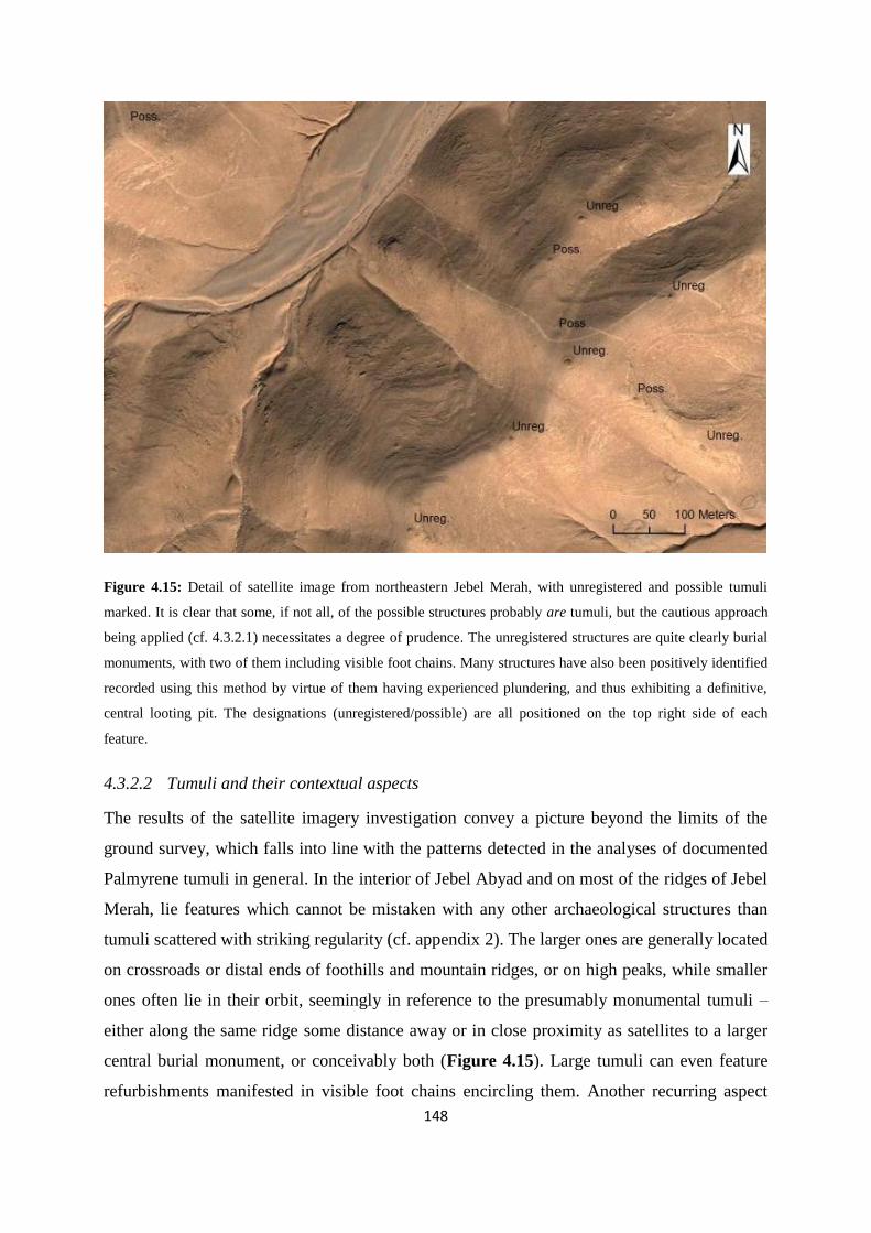
148
Figure 4.15: Detail of satellite image from northeastern Jebel Merah, with unregistered and possible tumuli
marked. It is clear that some, if not all, of the possible structures probably are tumuli, but the cautious approach
being applied (cf. 4.3.2.1) necessitates a degree of prudence. The unregistered structures are quite clearly burial
monuments, with two of them including visible foot chains. Many structures have also been positively identified
recorded using this method by virtue of them having experienced plundering, and thus exhibiting a definitive,
central looting pit. The designations (unregistered/possible) are all positioned on the top right side of each
feature.
4.3.2.2 Tumuli and their contextual aspects
The results of the satellite imagery investigation convey a picture beyond the limits of the
ground survey, which falls into line with the patterns detected in the analyses of documented
Palmyrene tumuli in general. In the interior of Jebel Abyad and on most of the ridges of Jebel
Merah, lie features which cannot be mistaken with any other archaeological structures than
tumuli scattered with striking regularity (cf. appendix 2). The larger ones are generally located
on crossroads or distal ends of foothills and mountain ridges, or on high peaks, while smaller
ones often lie in their orbit, seemingly in reference to the presumably monumental tumuli –
either along the same ridge some distance away or in close proximity as satellites to a larger
central burial monument, or conceivably both (Figure 4.15). Large tumuli can even feature
refurbishments manifested in visible foot chains encircling them. Another recurring aspect

149
also found to be the case in the ground survey is a conceptual focus on entrances to certain
minor wadis and the ridges hemming in their corresponding passes, which due to their
topographical location suggests routinised communication lines (e.g. Taniyet ez Zerr, Figure
4.16 – also cf. 4.2.3.2). However, the large regional wadi-plains, such as Wadi Khabar or
Wadi Rahawi (cf. Figure 4.18, nos. 2 and 18), have possibly also been landmarked in a
similar manner, although on an elevated level, as dense concentrations of burial monuments
are found located on either of the distal foothills of Jebel Merah (cf. appendix 2, pp. III-IV).
This aspect was discerned in the analyses above (4.2.3) and is confirmed here by the satellite
imagery studies. This approach more or less confirms the general pattern of tumulus
distribution suggested by the ground survey, and nearly doubled the data set from 404 tumuli
to 771 burial monuments of near certainty. This is in fact fewer than the potential number,
because the areas surveyed via satellite imagery include Jebel Abyad (including Al Matna and
Wadi Takara) and all of Jebel Merah (cf. appendix 2, pp. III and V), but on the other hand
exclude the extensive plains of Wadi Khabar, Wadi Massadeh and Wadi Dalil, and more
importantly the oasis of Jazal (cf. Figure 4.18, nos. 2, 4 and 8). While the first three of these
latter areas probably are much less densely packed with tumuli than the mountain ranges,
based on the experience on the ground, the same observations also strongly suggest dense
concentrations in Jazal. When isolating the numbers for Jebel Abyad and Jebel Merah
exclusively, in fact 343 were surveyed on the ground10 vs. 367 recorded and placed in the
unregistered category, thus more than doubling the data set. In addition, 586 examples of
possible tumuli were plotted in the same areas, bringing the potential total to over 1350 burial
monuments – even excluding presumably densely packed zones like Jazal. For instance, the
number of tumuli within the Jebel Abyad W region (cf. Figure 4.18, no. 5) rise from 70
examples prior to the satellite investigation to 136 when including the unregistered category,
and 271 examples if including the possible tumuli when incorporating the satellite results
(appendix 2, pp. III-VI). This shows just how many more tumuli can be found when
subjecting commercially available satellite imagery to studies, and confirms that Bradbury
(2011) was right in advocating this approach for central Syria (cf. 4.3.1). Another factor
which would probably raise the number of tumuli even higher if satellite studies of this region
would be possible to combine with ground surveys, is the fact that some burial monuments
are just too ephemeral to spot on the imagery, particularly well shown by the two lower
10 In this case, as opposed to the total of 404 tumuli for all surveyed areas.

150
pictures in Figure 4.14. The tumuli marked there as nos. 297-300 would most likely not have
been plotted as neither unregistered nor possible burial monuments when the transection scan
passed over their area. Only nos. 291-294 and no. 296 in that particular image are clear
enough to merit plotting in ArcGIS, thus in effect losing four out of nine tumuli on that ridge.
This shows that one should not presume, as pointed out, that satellite-based remote surveying
is an exhaustive exercise, as well as emphasizing the importance of ground truthing.
However, it also means that even though some of the plotted possible tumuli may in fact be
associated with other anthropogenic or natural explanations, the actual number of tumuli in an
area can potentially be close to the correct amount.
Figure 4.16: Map of the mountain pass Taniyet ez Zerr showing both unregistered and possible tumuli from the
study of satellite imagery, as well as the local distribution of ground-surveyed ones. Following the natural
communication line of an interior valley and subsequent minor wadi-valleys into the large Wadi Rahawi, the
route is lined with burial monuments. However, the smaller wadi goes through a section of the area with very
steep sides, possibly making the southern route along the rolling foothill ridge a more practical option,
something which also is suggested by the large group of probable tumuli which are located along and
particularly on the distal end of this foothill ridge. On the other hand, both of these potential routes more or less
meet at this point, where they continue into the large Wadi Rahawi. Thus, both ends of the presumable only
route across the Jebel Merah main ridge (cf. 4.2.3.2) incorporate extensive tumulus cemeteries.

151
4.3.2.3 Kites and stone enclosures
The main aim for the studies of satellite imagery of the Jebel Abyad and Jebel Merah regions
was to complete the distribution picture of Palmyrene burial monuments to the furthest
possible extent by augmenting it with the areas which for one reason or another had not been
covered by the ground survey. However, the imagery also made it possible to record the two
other frequently recurring structures in the Palmyrene dry steppe – stone enclosures and kites
(cf. 4.5.4 and 4.5.5) – which the method of satellite surveying is particularly well suited to
find (Figure 4.17). Although the ground survey only documented one kite in detail lying in
the southern Jebel Merah foothills, and spotted another in the northern foothills, an additional
six examples have been found in the satellite imagery in the latter area and one kite has been
recorded in isolation in Wadi Takara. However, both tantalizingly and somewhat disturbingly,
the ground-surveyed kite in the southern Jebel Merah foothills would probably have been
overlooked in a regular transection scan, because the walls of both the antennae and the trap
itself are very diffuse and hard to see in the satellite images, either due to low construction
height, low preservation status, or lighting – or a combination of all these factors. This
emphasises again the point made earlier (cf. 4.3.1), that the exhaustiveness of this method is
relative, and that other structures of this type can have been overlooked, although I doubt
more than one or two, if any. Stone enclosures have a high degree of visibility in the
Palmyrene satellite images, and hundreds have been recorded in and around the two main
mountain ranges in the surveyed concession area. Additionally, the method makes it possible
to ascertain patterns in the topographical context of these structures. Generally, stone
enclosures in this region, both single and interlocking, are actually located on slightly or
severely sloping ground linking the foothill ridges with the wadi bottoms, suggesting that a
focus on function in at least the steeper cases was not necessarily animal pens, but rather
something different. The pattern also overwhelmingly suggests an association with small- to
medium-sized wadis (cf. Figure 4.17 and the corresponding close-up in Figure 4.15), where
for instance water catchment from the hills and ridges around them probably would have been
higher than in the larger wadis with their gently undulating and flat topography where the run-
off is already collected and relatively slowly flowing in intermittent streams. Thus, arguably
many stone enclosures in the Palmyrene seem to have been potentially constructed for
collection and build-up of soil and moisture. Meyer (2008, p. 129) argued that some of them
can have served as small gardens for vegetables or some other form of limited horticulture.
He also emphasised that although this seems likely to be the case for some examples, others

152
can have served different functions, e.g. as pens. I will return to the issue of function and
distribution of both these types of the Bronze Age mobile pastoralist technocomplex in more
detail later (cf. 4.5.4).
Figure 4.17: Satellite image from northeastern Jebel Merah (cf. Figure 4.15 for a close-up of lower centre part)
showing various examples of the pastoral nomadic technocomplex, here as interpreted structures. Most of the
stone enclosures shown are of a simple type, but their general association with the slopes between ridges and
wadi bottoms is quite clear. The image has also captured two types of kites in the top left corner (type 4A and 2A
in Echallier & Braemer 1995, p. 45), and one eroded example near bottom left where only the antennae are
visible. Midway along the top edge is one of the 2008 tumuli plotted (red), while the remaining dots signify
unregistered (blue) and possible (grey) burial monuments (cf. 4.3.2.1).
4.4 Google Earth satellite imagery studies of the Palmyrene
As mentioned at the start of this chapter (cf. 4.1.1), Zarins (1992, p. 50) defined three types of
archaeological structures which arguably constitute the pastoral nomadic technocomplex of
the Chalcolithic and Early Bronze Age Near East. All these structure types have been
recorded in detail or otherwise noted by the Palmyrena project, either through ground survey

153
in the regions of Jebel Abyad and Jebel Merah, albeit some in larger amounts than others, or
via subsequent satellite studies using commercially available imagery, which augmented these
numbers significantly (4.3.2.2 and 4.3.2.3). However, during the last couple of years another
method for recording sites in the arid and/or remote regions of the world has emerged and
gained importance for archaeologists – survey via Google Earth (e.g. Thomas et al. 2008;
Pärssinen et al. 2009; Kennedy & Bishop 2011; Kennedy 2012). The approach was argued by
Ur (2006) to be highly promising for archaeological research, but cannot be said to have
reached its full potential until the second decade of this millennium, and even then only in
association with certain areas of the globe due to variation in coverage. Luckily, the potential
for this approach has been very good in Syria and particularly so for the highlands and dry
steppe north and east of Palmyra, i.e. the heart of the Palmyrene, where large areas of high-
resolution satellite imagery have been made available since 2010. The Google Earth survey
has greatly added to the material already presented within the technocomplex in the region.
The study of tumuli, kites, and stone enclosures has been carried out on an area of 3800 km2
in the Palmyrene regions bordering onto the concession area, as well as parts of the latter area
where the project lacked purchased satellite images, and has in the process increased the
number of probable burial monuments twentyfold to nearly 8500 examples (cf. 4.5.3), the
number of kites by a hundredfold, in all 426 examples (cf. 4.5.5), as well as recording a vast
distribution of over 2200 stone enclosures11 (cf. 4.5.4). The investigation has been exhaustive
in that it incorporates continuous coverage for the whole area and includes all parts of the
landscape. It can therefore be seen as representatively indicative for associations between
archaeological structures and topographical contexts in the Palmyrene. Finally, it must be
pointed out that a small part in the northwestern Palmyrene has not been fully investigated
due to lack of time. Two lesser mountain ranges (cf. Figure 4.18, areas a/b) have only been
plotted with tumuli, while the wadi-plains surrounding these have been left out altogether
with regard to systematic transection. However, preliminary investigations convey a pattern
following the lines particular to such landscapes, i.e. structures of all types relatively few and
far between. For the northern part of Jebel Merah, an area also left out of the Google Earth
survey, cf. mainly appendix 2, pp. III-IV.
11 These are the total numbers of archaeological structures recorded at the end of 2012 for all methods combined.

154
4.4.1 Outline of methodic execution
The approach chosen for this study was methodically dividing the Palmyrene into 61 separate
areas between Palmyra and Suhne, as well as including the steppe further north- and
northeastward toward Jebel Bishri, each representing more or less distinct topographical parts
of the landscape – mostly by crystallisation into mountain ranges and large wadi valleys or
plains, but where this was not practical, both highlands and lowlands were incorporated into
one separate part (e.g. Figure 4.18, areas 26 and 35). The reason behind this division was that
both the ground survey and satellite imagery suggested a high degree of topographical
determinative in the distribution of tumuli and indeed for the distribution of the whole horizon
of the technocomplex. The actual survey method was similar to the one used for the
commercial satellite imagery (cf. 4.3.2.1), although the software applied (Google Earth) does
not contain the same range of analytical tools and possibilities as ArcGIS, which resulted in a
simpler execution. Instead of using the window bars to keep systematic track of scanned
areas, a temporary manual partitioning of the areas was used to create a grid system for
systematic surveying to minimise subjective browsing (cf. Kennedy & Bishop 2011, p. 1292).
Additionally, the Google Earth images are of a slightly poorer quality than the commercial
images, meaning that less certainty could be placed in the features detected. Thus, based on
the same arguments as those for the satellite survey, the entire Google Earth data set
concerning tumuli are estimated to have a 70-99 % probability of actually being
archaeological burial monuments, with no internal division of this group being defined. The
other two structures recorded during this process were kites and stone enclosures. The kites
are nearly all of certain status as being that particular type of archaeological construction,
apart from cases where the trap itself was eroded away or destroyed by development, and only
the antennae revealed where it once had been. The same was the case for the vast number and
variety of stone enclosures recorded all over the Palmyrene. All these finds have been
collected in appendix 4, pp. I-XVII and shown in Figure 4.23, which are linked to and must
be viewed in association with Figure 4.18.
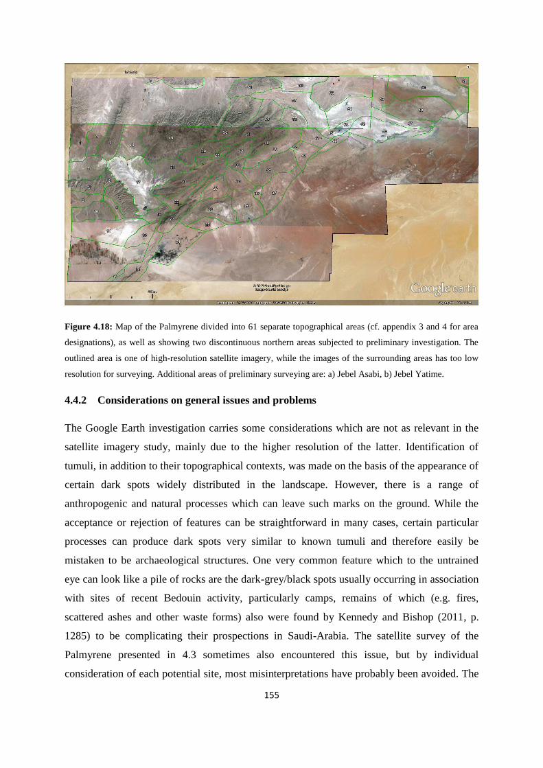
155
Figure 4.18: Map of the Palmyrene divided into 61 separate topographical areas (cf. appendix 3 and 4 for area
designations), as well as showing two discontinuous northern areas subjected to preliminary investigation. The
outlined area is one of high-resolution satellite imagery, while the images of the surrounding areas has too low
resolution for surveying. Additional areas of preliminary surveying are: a) Jebel Asabi, b) Jebel Yatime.
4.4.2 Considerations on general issues and problems
The Google Earth investigation carries some considerations which are not as relevant in the
satellite imagery study, mainly due to the higher resolution of the latter. Identification of
tumuli, in addition to their topographical contexts, was made on the basis of the appearance of
certain dark spots widely distributed in the landscape. However, there is a range of
anthropogenic and natural processes which can leave such marks on the ground. While the
acceptance or rejection of features can be straightforward in many cases, certain particular
processes can produce dark spots very similar to known tumuli and therefore easily be
mistaken to be archaeological structures. One very common feature which to the untrained
eye can look like a pile of rocks are the dark-grey/black spots usually occurring in association
with sites of recent Bedouin activity, particularly camps, remains of which (e.g. fires,
scattered ashes and other waste forms) also were found by Kennedy and Bishop (2011, p.
1285) to be complicating their prospections in Saudi-Arabia. The satellite survey of the
Palmyrene presented in 4.3 sometimes also encountered this issue, but by individual
consideration of each potential site, most misinterpretations have probably been avoided. The

156
main giveaway for a feature originating from modern Bedouin activities rather than being an
archaeological monument is proximity to their camps. These are easily spotted because they
leave several rectangular spots, either brighter than the ground or dark grey to black in colour,
where their tents have been pitched, with other marks around these of various shapes and
sizes regularly found, but again mainly exposed as modern by their colour, which is similar to
identical to the dark versions of the tent shadows nearby (cf. Figure 4.19 for some of these
traces). Camp sites are also often littered with tracks from motorised vehicles – admittedly a
ubiquitous aspect in the steppe apart from on and along the steeper and loftier slopes and
ridges – but occurring in much higher frequency around Bedouin camps. Generally, it takes
the whole mix of these features to firmly establish that ambiguous marks are made by modern
human refuse, and on that basis rejecting a site as being of ancient origin.
Figure 4.19: Close-up image of a part of Wadi Khabar (cf. Figure 4.18, no. 2) in which manifestations of
Bedouin activities are shown (cf. Figure 4.20 for further explanation).

157
Figure 4.20: Close-up image of an area in Jebel Hawit er Rass N ( cf. Figure 4.18, no. 60). Figure 4.19 and
Figure 4.20 show various features which could be mistaken for tumuli, but really are results of other processes
or activities. However, tumuli are in fact also present in these images, as well as probable tumuli. Figure 4.19
shows remains of modern Bedouin activities, as well as exhibiting certain natural features of ambiguity, while
Figure 4.20 shows specifically traces of natural processes leaving such features, e.g. geology and vegetation.
There are also several features of the natural kind which in appearance can look like tumuli
(cf. Figure 4.20). Geological processes can result in piles of rocks, which may seem like they
have been constructed by humans. In these instances, context and form are the main aspects to
consider, but sometimes even context can be misleading. For instance, craggy, rocky outcrops
are common along the ridges and peaks in the Palmyrene mountain ranges, following similar
patterns as tumuli have been shown to do. Additionally, such outcrops can also obscure real
tumuli by creating shadows covering key parts of the local terrain. When commercial satellite
images are available for the relevant area, these may solve the issue by providing an
alternative with variability in lighting between these and the Google Earth images. However,
the inbuilt software simulation providing lighting conditions for various times of the day
cannot help in this matter. Another natural feature which often creates problems for satellite
surveying is the presence of vegetation (Kennedy & Bishop 2011, p. 1285). Obviously,
continuous cover of trees would present a major obstacle, but the arid and semi-arid regions

158
of the Near East are so barren in this respect that the potential for this method is high
(Hoshino et al. 2010, p. 17), while e.g. LIDAR scanning is necessary for similar surveys in
the forested areas of northern Europe. However, even a slight vegetation cover, like that found
in the Jebel Abu Rujmein massive (cf. Figure 4.21) and some parts of Jebel Labidah, may
lead to doubt and second-guessing. Shade from trees can conceal a tumulus lying next to it in
the same way geology can, but also the generally darker soil of areas with more vegetation
and the green hue from the slightly lusher and less degraded parts of the steppe (cf. 2.3)
makes the contrast between the ground and potential rock piles much vaguer. Thus, the
destruction of the fragile steppe parkland has for archaeological method been a very slight
blessing in a disguise of ecological malaise. The last main natural process which can confuse
a satellite survey using Google Earth relates to the small to tiny wadis which dot the
Palmyrene in their thousands. While there are no features which can be mistaken for burial
structures in the wadi bottoms themselves, two particular ones at the head of such intermittent
streams can occasionally look like tumuli – dark spots of vegetation which often grow in this
slightly moister local environment and small screes which are most likely associated with
either the steepness of the slope or with a tiny spring connected to the aquifer. The true nature
of both these features usually reveal itself by the clear imprint of the continuation of the wadi,
but in areas of very steep slopes plunging down from a ridge, the only way to see that the
mark is not a tumulus along a ridge is to actually apply the inbuilt 3D tool in Google Earth
and move down into ground view. Wadis should there start on sloping ground aligning with
the direction of the course, while burial monuments generally lie right on the ridge, which
plunges down on one or both sides. Finally, there is the possibility that some local areas can
be obscured by light cloud cover, but this has not been an issue in the 3800 km2 covered by
the 61 areas subjected to investigations in the Palmyrene. It was only encountered in the
preliminary survey of the northwestern part (cf. Figure 4.18, areas a/b), and there only
slightly limiting and extremely localised. The weather in fact yet another advantage of
surveying in arid regions, in addition to the general landscape and lack of vegetation
(although cf. Figure 4.21).

159
Figure 4.21: Image of area in Jebel Hawit er Rass where terebinth trees are protected and survive to a certain
extent. Two aspects are clear from this picture: First, the general presence of these trees has also provided vastly
better environment for lower types of vegetation as well as the regional microclimate, shown by the green slopes
and ridges (cf. 2.3). Second, this environment makes the survey of archaeological structures much more
complicated, veiling any structures in the shadow of trees or just by reducing the contrast between the ground
and overlying features. Additionally, because collections of rocks gather more soil, shrubs and small trees are
more likely to grow there, potentially masking any tumulus-like structures below.
However, there are also certain aspects which can heighten the possibility of a feature on the
Google Earth images of the Palmyrene in fact being a burial monument, in addition to
associations with distinctive topographical circumstances (i.e. those described under 4.1.4, pt.
a-d) and archaeological context. Visible foot chains was a feature mentioned under 4.3.2.2 to
more or less raise the chance to near-certainty, a concept also applicable for the Google Earth
approach, although the majority of tumuli surveyed actually lack this refurbishment. In
addition, one or more looting pits and disturbances can frequently be discerned in the middle
of a burial monument, which heightens the probability of correct categorisation, but pits can
also be the result of well-digging or modern sondages for mineral or petroleum prospection.
However, the wells (bir/biar) are usually located in very close association with wadis and
natural springs, while modern geological prospection nearly always manifests itself by
occurring as perfectly linear or very regular patterns, regardless of the inherent difficulty of

160
traversing the terrain. The omnipresent tracks created by motorised vehicles, while destructive
and disruptive in the landscape, usually also try to avoid large obstacles such as cairns, turrets,
and monumentals, and can in such cases appear on the image taking a swerving course around
a darker spot, indicating an impediment of some height or ruggedness, which if not geology,
often can be explained as a tumulus. However, mounds are probably too low to be detected in
this manner. Of course, several or all of the above could and should be applied to figure out
whether a potential tumulus is an archaeological feature or a result of natural or modern
processes.
4.5 Results from the Google Earth studies
4.5.1 General results from the survey of the Palmyrene
Now that the execution of the Google Earth survey has been explained in detail, and most of
the conceivable obstacles and issues which can and in effect also were encountered regularly
have been presented and considered, I will now continue with the results from this research.
The distribution of the three structures types under investigation – tumuli, stone enclosures,
and kites – will be presented below with analyses of apparent patterns on a local and regional
scale, as well as spatial, functional, and chronological implications deduced from this work.
The map (Figure 4.22), taken from Bradbury (2011) and modified with demarcation of the
area of high-resolution images of which the top half was surveyed, shows the importance of a
study of burial monuments in this region, an issue she herself also emphasised. However,
initially it is fitting to mention some general aspects of the Palmyrene in particular and its
archaeological structures when the region is perceived from space. In the rest of this
subchapter all toponyms referring to a part of the landscape area divisions shown in Figure
4.18 and Figure 4.29 are followed by a number in parenthesis, which indicates their location
on these maps.
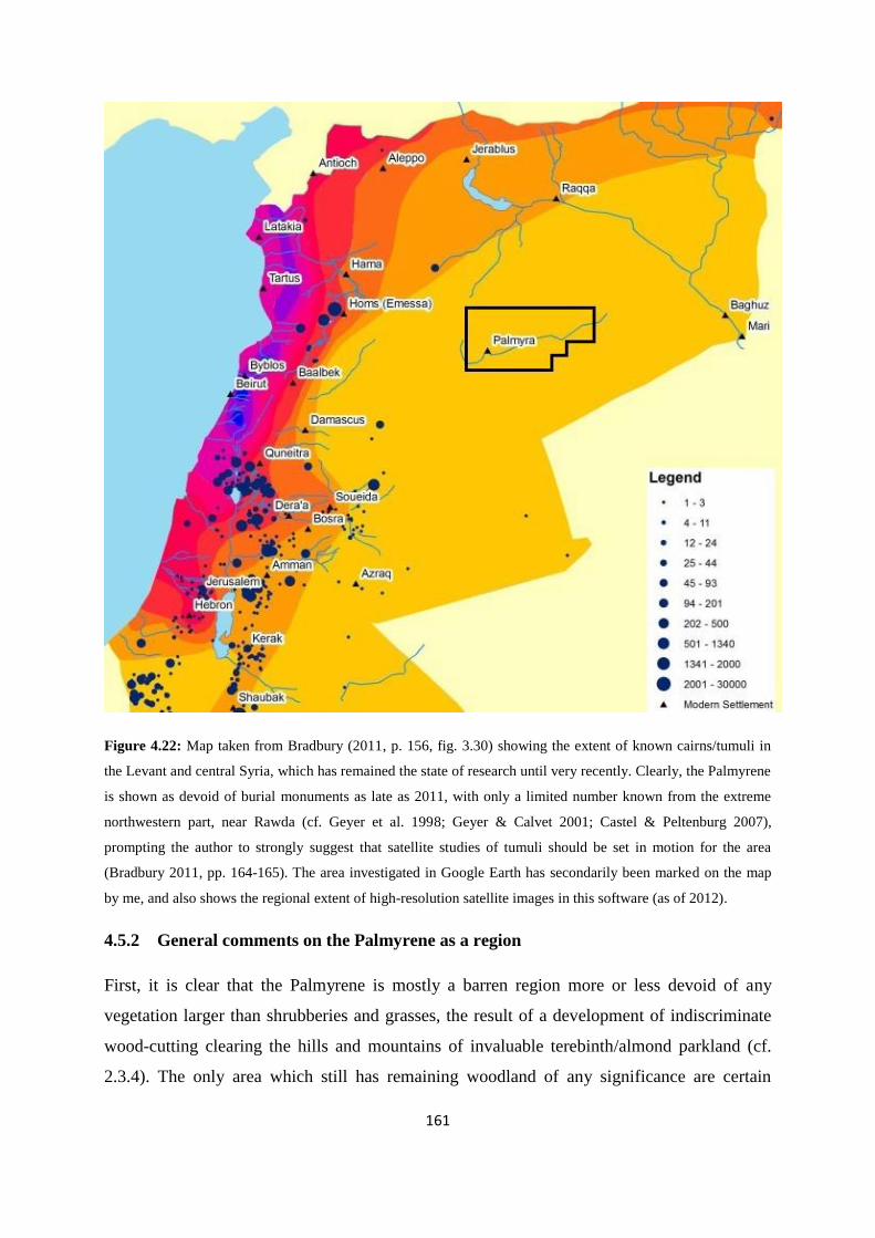
161
Figure 4.22: Map taken from Bradbury (2011, p. 156, fig. 3.30) showing the extent of known cairns/tumuli in
the Levant and central Syria, which has remained the state of research until very recently. Clearly, the Palmyrene
is shown as devoid of burial monuments as late as 2011, with only a limited number known from the extreme
northwestern part, near Rawda (cf. Geyer et al. 1998; Geyer & Calvet 2001; Castel & Peltenburg 2007),
prompting the author to strongly suggest that satellite studies of tumuli should be set in motion for the area
(Bradbury 2011, pp. 164-165). The area investigated in Google Earth has secondarily been marked on the map
by me, and also shows the regional extent of high-resolution satellite images in this software (as of 2012).
4.5.2 General comments on the Palmyrene as a region
First, it is clear that the Palmyrene is mostly a barren region more or less devoid of any
vegetation larger than shrubberies and grasses, the result of a development of indiscriminate
wood-cutting clearing the hills and mountains of invaluable terebinth/almond parkland (cf.
2.3.4). The only area which still has remaining woodland of any significance are certain
162
central parts of the Jebel Abu Rujmein massive (cf. Figure 4.21), as well as scattered trees
sheltered along interior wadis of some other mountain ranges. Jebel Abu Rujmein has been
protected to some extent as a tree sanctuary and has therefore not been subjected to modern
exploitation of the same intensity as other parts of the Palmyrene, and can thus be indicative
of how the region originally may have looked prior to the removal of parkland and subsequent
degradation of environment and increased erosion. The following description was provided by
Musil as he travelled past the ruins of Khirbet Dbeiss in westernmost Jebel Abu Rujmein
toward the wadi-plains north of the range:
“Terebinth trees grow everywhere, making the country look like a vast natural park” (Musil
1928, p. 149).
This still seems to be relatively applicable in certain very choice spots within the protected
area. Another ubiquitous feature encountered in the Palmyrene are the numerous Bedouin
camps, both inhabited and recently abandoned ones, which are widely distributed in the lower
and more gently undulating parts of the region, as well as sometimes being situated on
slightly wider banks of medium-sized interior mountain wadis They are clearly visible in the
landscape, revealed by the features mentioned above (cf. 4.4.2). Without venturing any further
into analogies between ancient and modern mobile populations, these imprints may indicate a
potential settlement pattern of sheep and goat herders in the Palmyrene, as this would most
likely have been structured and determined by topography and environment independent of
time, although as iterated regarding the latter aspect, the regional conditions have undoubtedly
changed substantially with modernisation (also cf. 4.5.4). However, the presence of a
relatively large town at the oasis of Palmyra is another factor which perhaps not was
structurally available and integrated into the regional socioeconomic network of the EBA and
MBA (although cf. Bonacossi & Iamoni 2012, p. 34, note 11 – also cf. 3.2.5).

163
Figure 4.23: Map divided into the 61 areas (cf. Figure 4.18 and appendix 4) covered by the investigation of
tumuli, stone enclosures and kites in the Palmyrene, showing the total extent of the distribution of all structure
types. It shows in all 7528 tumuli, 2353 stone enclosures and 426 kites recorded in Google Earth, the total
number of 424 tumuli documented during the ground survey (including the complete 2008 prospection and the
cairns? category), and 187 tumuli in Jebel Asabi (a) and Jebel Yatime (b). The total number of tumuli here is
thus 8139 examples (excluding 312 tumuli recorded via satellite imagery studies in northern Jebel Merah – cf.
appendix 3, p. IV).
The transection scanning of the Palmyrene also confirmed the pattern suggested by ground
and satellite survey with regard to topographical contexts that are determinative for the
distribution of various archaeological structures. However, interestingly, there seem to be
very limited distributions of the three structure types in the immediate area around Palmyra
(Figure 4.23). This is markedly different compared with the smaller settlement of Suhne,
where all three types are present in close proximity to the town, although they are still subject
to local topographical contexts, and thus relatively few in number there. Apart from a distinct
cluster of kites in northern Jebel Haiyane (cf. appendix 4, p. XI), no structures to speak of can
be found within a 5 km radius surrounding both the Classical and modern town, and this
emptiness stretches over 10 km in the direction of the eastern quadrant. It is clearly possible
that the expansion of Classical Palmyra and modern Tadmor and activities relating to this may
have eradicated structures such as tumuli or enclosures in the immediate vicinity of the city,
although the probable location of a Bronze Age settlement here based on MBA sources (cf.

164
Scharrer 2002, pp. 301-312 – cf. 3.2.5 and text 5.12), and the discovery of EBA IV and MBA
pottery deep in the tell under the Bel sanctuary (Al-Maqdissi 2000; 2009) opens up
possibilities for other, unknown reasons behind the lack of structures in the surrounding
foothills. It may for instance have been the case that the pattern is indicating that the domain
of the settlement was spatially and conceptually separated from the domain of the Palmyrene
steppe which is consequently reflected in the distribution of structures associated with a
mobile pastoralist population, but this is only speculation.
Finally, large parts in the middle of the regional wadi-plains – mainly Wadi Abyad (17), Al
Diwa (11), and the northeastern areas including Wadi Neqeib (46), Wadi Maiyalate (52), and
Wadi Abu Nallah (54) – are more or less devoid of discernible archaeological structures of
any type. This characteristic seems closely associated with the blindingly white colour
reflected from these areas which has originated from high levels of erosion and wadi outwash,
and is probably not a coincidence. A process of exponentially increased erosion may have
followed the recent disintegration of the regional vegetation initiated by the destruction of the
parkland, and in that case obliterating any structures which were located there, but it seems
just as likely that these areas always have been characterised by high erosion and thus the
actual distribution pattern of archaeological structures is detected. Incidentally, Wadi Abyad
is in fact Arabic for “white wadi”, indicating that the landscape area has long been this way.
There are also almost no tumuli, stone enclosures, or kites along the rim of the studied area, as
well as in the landscape Duhur Nuqur el Habiye (20) bordering on Wadi Abyad (cf. fig. 4.22
and Figure 4.18 – areas 1, 11, 12, 17, 20, 24, 25, 37, and 50, and southeastern parts of 35 and
36, as well as appendix 4), which is somewhat puzzling, considering the densely packed
mountainous areas surrounding it, and its name implies terrain of some elevation (Arabic
duhur, sg. dahr – En. ridges). These are the general aspects of the results and I will now
present the picture regarding the particular structure types.
4.5.3 The Google Earth survey and distribution of Palmyrene tumuli
The total number of Palmyrene tumuli surveyed in Google Earth stopped at 7528 examples
for the 61 landscape areas (cf. Figure 4.18 and appendices 3-4). This excludes the northern
third of Jebel Abu Rujmein, the northern wadi-plains, and the northern half of Jebel Shaar,
which as mentioned have not been surveyed due to lack of time. The number also excludes
the northern half of Jebel Merah, and the lesser mountain ranges Jebel Asabi (a) and Jebel

165
Yatime (b), which contain an additional 312, 162, and 25 tumuli respectively, as well as the
tumuli surveyed on the ground, which numbered 404. Thus, the total number of actual and
potential burial monuments in the Palmyrene at the current point of research is almost 8500
examples, excluding the northwestern, unsurveyed part. The method for spotting tumuli in
Google Earth has been evaluated (cf. 4.4) and deemed to be very sound, as can be argued
from the views of Figure 4.24, where the very clear imprint these structures can make in
barren and arid areas are shown. However, the picture is somewhat more complicated in
greener parts of the mountains.
Figure 4.24: Google Earth view of archaeological structures documented in the Palmyrene. The top images are
showing a part of Jebel Qleilate (38) lying c. 38 km northeast of central Tadmor, while the bottom ones are taken
from a part of Jebel Labidah (61) lying c. 27 km northwest of Suhne. Although the probability for such structures
using this method is being estimated at 70-99 % for the group as a whole (cf. 4.4.1), the features marked on the
pictures with blue (right) are clearly tumuli of some sort. Several groups also show up as clusters with enclosing
foot chains, and a small number of simple stone enclosures can also be seen (yellow). The tumuli shown from
Jebel Labidah, notwithstanding being very good examples of burial monuments, even feature associated
refurbishments like stone rows leading up to the tumuli, which are clearly visible, in addition to foot chains.
From such a significant number there are also clear distributional patterns to discern. First, the
lack of tumuli in lower elevations and the open wadi-plains is even more pronounced than

166
was suggested above by such archaeological structures as a group. These circumstances were
also found to be the case by Bradbury (2011, p. 40) in the Homs NSA region (cf. Figure 4.55,
areas A and B), where this type was described as largely absent from wadi bottoms. There
does not seem to be more than a very few burial monuments of high probability in the large
regional wadi-plain landscape areas, such as Wadi Khabar (2), Wadi Massadeh and Wadi
Dalil (4), or Wadi Abyad (17), with only a small number of less certain tumuli. This is also
the case for the large wadis in the eastern part of the study area. However, there are two clear
exceptions to this pattern – Wadi Rahawi (18) between Jebel Merah (3) and Jebel Abu
Rujmein (19), and Wadi Sahil N (57) stretching north-northwestward from Suhne (45) toward
Jebel Labidah (61) and Tulul al Bayda (56). These two landscapes both contain a much higher
number of probable tumuli than the other Palmyrene wadi-plains, an aspect easier to
appreciate by analyzing the number of tumuli/km2, which for Wadi Rahawi and Wadi Sahil N
are in excess of 1.5. Contrarily, the other areas of similar type have in general quite a lot
lower value than 1.0 (cf. appendix 3 and Figure 4.29). The tumulus distribution pattern in
Wadi Rahawi is dominated by a clustering centered on the well of Bir es Sleim and just north
of this, the hillocks of Rejem el Kheurbe or Khirba12 (Figure 4.25). In precisely this area two
aspects come together which could influence the placement of burial monuments. The area is
a well, indicated by the name (bir), but probably more importantly, this is where four
potential communication routes meet – the crossing of Jebel Merah at Taniyet ez Zerr, the
main route crossing its southern foothills (Figure 4.25, nos. 1 and 2, also cf. 4.2.3.2, 4.3.2,
and Figure 4.16), the regular north-south route along the east side of the Jebel Merah range,
and the valley crossing Jebel Abu Rujmein called Alhejzer by Musil (1928, p. 149) past
Khirbet Dbeiss also mentioned above (cf. 4.5.2). Thus, this spot can be characterised as a
combination of being an important crossroad and a well (cf. 4.2.3, pt. d).
12 This designation, i.e. Rejem (pl.) and Rujm (sg.), can interestingly indicate an area of tumuli, as can several
other topographically distinct areas in this part of the Palmyrene. It actually means stone piles or stone heaps, in
many cases denoting tumuli or cairns. For instance, Rejem el Kheurbe/Khirba thus means stone piles of the
ruin/abandoned settlement (there is some variation in the meaning of the last noun). Another such name is just
east of Wadi Rahawi, in the southern part of Jebel Abu Rujmein (19), just where this borders on Duhur Nuqur el
Habiye (20), where a hilly region filled with tumuli is called Rejem Saabun, which can be interpreted as
highland of stone piles, i.e. tumuli.

167
Figure 4.25: Satellite view of Jebel Merah and surrounding areas showing tumuli found both by fieldwork on
the ground (red) and using Google Earth images (blue). There is a clear cluster of burial monuments around the
well of Bir es Sleim (a) in Wadi Khabar or just north of it, the escarpment of Rejem el Kheurbe, but otherwise
the large wadis or plains are very scantily populated by tumuli. This area was mentioned by Musil (1928, p. 149)
as having surrounding hills being littered with ruins as well as them being tree-clad. The routes meeting at this
point (a) are: 1) Taniyet ez Zerr, 2) the Jebel Merah trans-foothills route, b) the Alhejzer valley entrance as well
as the general north-south route along Wadi Rahawi.
The reason for Wadi Sahil having a relatively high density of tumuli is more uncertain, partly
because I am less familiar with the area, known routes, and its local natural features which
can have influenced location. However, since the northern end of this wadi-plain meets up
with mountain ranges containing very high densities of structures – the northern Jebel Abu
Rujmein massive and in particular Jebel Labidah (61) – and stretches from a presumably
important oasis, Suhne13, with its springs and wells, a high communicative importance can be
hypothesised for this landscape area. The northern end of this wadi is also where the
important regional cross-chain route of Wadi Qutqut exits from the Jebel Abu Rujmein
13 Musil (1928, p. 83) mentioned also here: “(...) the spring of al-Wâz’ijje by the foot of a small hillock near a
pile of débris from an old watchtower” – i.e. again a reference to one of the burial cairns, this time at Suhne, and
possibly near Sheikh Wassil, as the toponyms are rather similar.

168
massive into Wadi Sahil and the northern plain, linking it with Duhur Nuqur el Habiye (20)
and ultimately Wadi Abyad (17). This wadi route (Figure 4.26, no. 3) contains itself a high
number of tumuli, although the pass is spatially divided in this analysis between, and
incorporated into, the areas of Jebel Hawit er Rass N (60) and Jebel Taniyet es Safra (59) (cf.
the border between these areas in appendix 4, pp. XXV and XXXVIII-XXXIX). Finally, and
perhaps most importantly, it forms the southernmost part of the route between Suhne, Taibe,
Resafa, and the Euphrates valley (Figure 4.26, no. 6).
Figure 4.26: Tumuli distribution and topographically determined routes (stylistically presented) in the Wadi
Sahil area. Suhne is in the bottom corner on the right, while Jebel Labidah and the Jebel Abu Rujmein massive
are found in the top and bottom parts of the left side of the image, respectively. The routes as topographically
determined by wadis are: 1) Wadi Sahil, 2) Wadi Rwahet Beyda, 3) Wadi Qutqut, 4) Wadi Abu Hayyah/Al
Qudaym (route westward), 5) Wadi Nuwayr (route toward northwest), 6) Tulul al Bayda (route toward
northeast). There is clear clustering along these lines in contrast to other large Palmyrene wadi-plains.
The other significant area which cannot be characterised as a mountain range, but still shows
a high density of burial monuments is Jazal, as indicated by the ground survey (cf. 4.2.3).
However, this landscape (area 8) is perhaps not as flat as the larger wadis, with several gently
rolling hills and hillocks interspersed by smaller wadis, and can therefore with some
justification be described as hilly. While the ground survey recorded a rather high number of
tumuli in a limited area here, the Google Earth study has augmented the picture drastically,

169
resulting in Jazal emerging as an area with the second-highest density of burial monuments in
all of the Palmyrene, containing over nine per km2 (cf. appendix 3, no. 8). On the other hand,
nearly all of these are located in the elevated zones of the landscape, and very few are found
in low-lying areas. Again, as has been mentioned above, the presence of an oasis, as well as
this landscape area being a crossroad and meeting point of several communication routes,
seems to be the underlying basis for such a high number of tumuli14. For instance, when
Figure 4.7 – ground-surveyed structures in the Jebel Abyad area – is compared with Figure
4.27, which shows the total extent of tumuli in this area, the association between burial
monuments and communication routes looks highly relevant, whereas several of the interior
parts of nearby Jebel Abyad, which are situated some distance from and beyond the visible
perspective if seen from the cross-chain routes, are clearly lacking in tumuli.
Figure 4.27: Satellite view of Jebel Abyad and surrounding areas including tumuli found both in the field (red)
and via Google Earth survey (blue). In addition to the wadi routes marked on Figure 4.7, the map also shows:
10) Wadi Yetimeh, 11) Wadi ez Zaab, 12) Wadi Jeimane, 13) Wadi el Jazal S, 14) Wadi Alali Ghreibun S, 15)
14 Musil (1928:134) used these words for Jazal: “(...) the spring ‘Ajn Ğezel, past which runs the shortest road
from Tudmor to Umm Hmejme and ‘Užeribât”. The latter two toponyms are probably those now called Umm
Qbaybah and ‘Uqayribat along the road between Palmyra and Salamiyeh.This description thus confirms the
presence of both a spring and an important communication route here, at least during the Ottoman period.

170
Wadi Alali Ghreibun N, 16) Wadi Mazrur, 17) Wadi Matna el Gharbiye. The association between burial
structures and communication routes based on topography is thus even more pronounced with a larger data set.
Note also the near-total lack of structures in Wadi Abyad.
Such a perspective is shown in Figure 4.28 (left), where the northern part of Wadi Mazrur
(Figure 4.27, no. 16 – also cf. Figure 4.9) is shown on a photography and the tumuli are seen
lying along the ridgeline, not visible from any other area than this cross-chain wadi route and
its surrounding mountain ridges. Figure 4.28 (right) shows from where the picture has been
taken and the extent of the motif, while a close-up of the same cone of perspective is vaguely
visible just above the Jebel Abyad W mark in Figure 4.27.
Figure 4.28: Picture of the northern end of Wadi Mazrur, an interior cross-chain wadi and ridgeline in Jebel
Abyad (left), just short of where the pass crosses the northern wall of this mountain range and enters the wadi-
plain of Wadi Dalil. A Google Earth view of the landscape captured by the lens (translucent green) is also shown
(right). It is clear how the tumuli – which are the two points jutting upward from the ridge in the middle of the
photo, and the three blue points on the satellite photo – along the ridge are positioned to be visible from this
route, as well as hemming it in. Incidentally, one lone example of the mere handful of terebinth trees still
lingering on in this range (marked with a black rectangle) is also visible on the mountain slope (photo: Torbjørn
Preus Schou, 2011).
However, apart from these two wadi-plains, the vast majority of the tumuli follow the same
distribution pattern as that suggested by the ground and satellite surveys, i.e. clear association
with a particular part of the topography directed toward communication corridors. This has
resulted in a number of patterns regarding burial monuments documented by the Google Earth
survey which is paralleled in the ground survey record – for all numbers, cf. appendix 4:
Many tumuli are situated along the midpoint of high mountain ridges where these drop
steeply down into wadis, a manner very similar to the pattern found along the northern
wall of Jebel Abyad (5-7, cf. Figure 4.9) and on the main ridge of Jebel Merah (3).
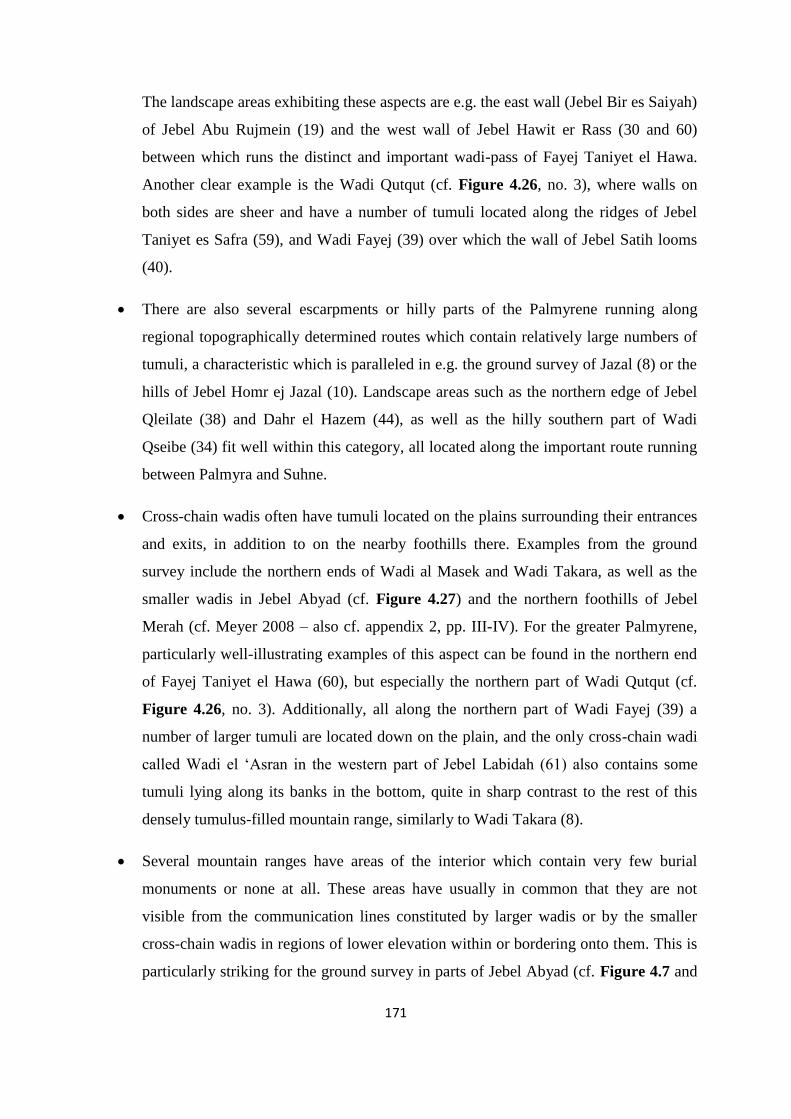
171
The landscape areas exhibiting these aspects are e.g. the east wall (Jebel Bir es Saiyah)
of Jebel Abu Rujmein (19) and the west wall of Jebel Hawit er Rass (30 and 60)
between which runs the distinct and important wadi-pass of Fayej Taniyet el Hawa.
Another clear example is the Wadi Qutqut (cf. Figure 4.26, no. 3), where walls on
both sides are sheer and have a number of tumuli located along the ridges of Jebel
Taniyet es Safra (59), and Wadi Fayej (39) over which the wall of Jebel Satih looms
(40).
There are also several escarpments or hilly parts of the Palmyrene running along
regional topographically determined routes which contain relatively large numbers of
tumuli, a characteristic which is paralleled in e.g. the ground survey of Jazal (8) or the
hills of Jebel Homr ej Jazal (10). Landscape areas such as the northern edge of Jebel
Qleilate (38) and Dahr el Hazem (44), as well as the hilly southern part of Wadi
Qseibe (34) fit well within this category, all located along the important route running
between Palmyra and Suhne.
Cross-chain wadis often have tumuli located on the plains surrounding their entrances
and exits, in addition to on the nearby foothills there. Examples from the ground
survey include the northern ends of Wadi al Masek and Wadi Takara, as well as the
smaller wadis in Jebel Abyad (cf. Figure 4.27) and the northern foothills of Jebel
Merah (cf. Meyer 2008 – also cf. appendix 2, pp. III-IV). For the greater Palmyrene,
particularly well-illustrating examples of this aspect can be found in the northern end
of Fayej Taniyet el Hawa (60), but especially the northern part of Wadi Qutqut (cf.
Figure 4.26, no. 3). Additionally, all along the northern part of Wadi Fayej (39) a
number of larger tumuli are located down on the plain, and the only cross-chain wadi
called Wadi el ‘Asran in the western part of Jebel Labidah (61) also contains some
tumuli lying along its banks in the bottom, quite in sharp contrast to the rest of this
densely tumulus-filled mountain range, similarly to Wadi Takara (8).
Several mountain ranges have areas of the interior which contain very few burial
monuments or none at all. These areas have usually in common that they are not
visible from the communication lines constituted by larger wadis or by the smaller
cross-chain wadis in regions of lower elevation within or bordering onto them. This is
particularly striking for the ground survey in parts of Jebel Abyad (cf. Figure 4.7 and
172
Figure 4.27), paralleled in a number of the mountain ranges covered by the Google
Earth survey. For instance, Jebel Marbat el Hassane (16), Jebel Dahek (48-49 and 55),
Jebel Hawit er Rass (30 and 60) and Jebel Abu el Hawr (31) all contain internal areas
which are seemingly lacking in tumuli (cf. appendix 4). Although it is possible that the
distinctive hue caused by either vegetation or geology in the latter two ranges may
have created instances of second-guessing and doubt with regard to plotting a feature
as a monument, the focused scan and methodical experience15 make it probable that
these internal ridges actually contain very few and scattered tumuli.
The eastern and the western parts of the investigated section of the Palmyrene, i.e. of
the areas of high-resolution imagery, have far fewer tumuli than the central regions.
Jebel Shaar (1) and Jebel Dahek (48-49 and 55) are both very scantily populated
compared with the more centrally located mountain ranges, and in some cases have
lower densities of tumuli even compared with some of the wadi-plains (cf. Figure
4.29). Thus, for the Palmyrene as a whole, tumuli are generally distributed along the
mountains in a wide belt stretching from Palmyra north- and northeastward in the
direction of Raqqa. There are somewhat fewer monuments in the easternmost region,
north and northeast of Suhne, while tumuli are almost totally lacking in the
northwestern corner, i.e. in Jebel Shaar.
15 The late point in the Google Earth survey at which these landscapes have been investigated meant that my
experience as surveyor of Google Earth images of the Palmyrene was significantly higher than it was at the
outset using this particular method.
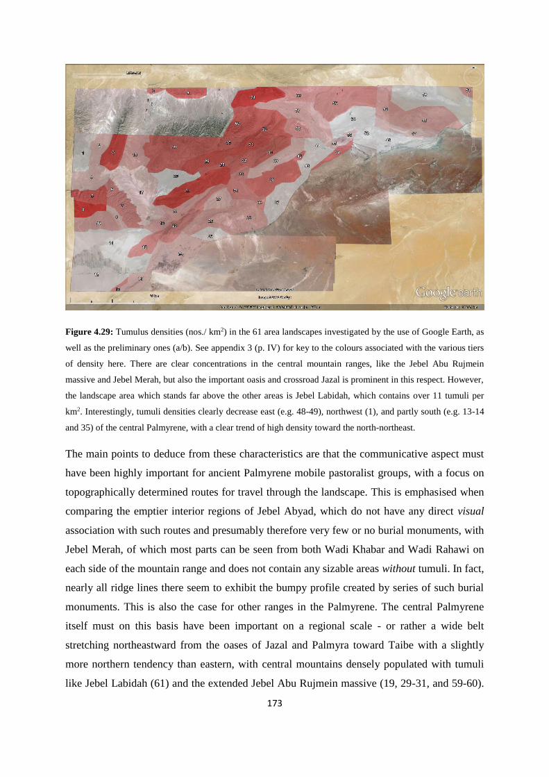
173
Figure 4.29: Tumulus densities (nos./ km2) in the 61 area landscapes investigated by the use of Google Earth, as
well as the preliminary ones (a/b). See appendix 3 (p. IV) for key to the colours associated with the various tiers
of density here. There are clear concentrations in the central mountain ranges, like the Jebel Abu Rujmein
massive and Jebel Merah, but also the important oasis and crossroad Jazal is prominent in this respect. However,
the landscape area which stands far above the other areas is Jebel Labidah, which contains over 11 tumuli per
km2. Interestingly, tumuli densities clearly decrease east (e.g. 48-49), northwest (1), and partly south (e.g. 13-14
and 35) of the central Palmyrene, with a clear trend of high density toward the north-northeast.
The main points to deduce from these characteristics are that the communicative aspect must
have been highly important for ancient Palmyrene mobile pastoralist groups, with a focus on
topographically determined routes for travel through the landscape. This is emphasised when
comparing the emptier interior regions of Jebel Abyad, which do not have any direct visual
association with such routes and presumably therefore very few or no burial monuments, with
Jebel Merah, of which most parts can be seen from both Wadi Khabar and Wadi Rahawi on
each side of the mountain range and does not contain any sizable areas without tumuli. In fact,
nearly all ridge lines there seem to exhibit the bumpy profile created by series of such burial
monuments. This is also the case for other ranges in the Palmyrene. The central Palmyrene
itself must on this basis have been important on a regional scale - or rather a wide belt
stretching northeastward from the oases of Jazal and Palmyra toward Taibe with a slightly
more northern tendency than eastern, with central mountains densely populated with tumuli
like Jebel Labidah (61) and the extended Jebel Abu Rujmein massive (19, 29-31, and 59-60).

174
This is emphasised by the distributional trailing-off with regard to tumuli for the east-
northeastern parts of the region (46-51), i.e. toward Jebel Bishri, and particularly striking is
the abrupt drop for the northwestern part, i.e. Jebel Shaar (1). There are indications that
special places were important and thus merited clusters of tumuli, either due to resource
access or perhaps some ritual significance now lost, or both. An argument for complex
causality regarding the placing of these clusters is that some of the natural features (e.g.
springs or wells) in the landscape with which few or no tumuli are associated seem similar in
nature to those that do contain clusters of tumuli, hence suggesting that there are further
aspects influencing these patterns, potentially of a communicative and/or ritual kind. Finally,
the Google Earth survey was able to detect significant differences in size and form of burial
monuments of the tumulus type. The total extent of grouped tumuli is probably not recorded
fully in most cases, as many of the smallest and least conspicuous ones are not visible on the
images (cf. 4.3.2.2 and Figure 4.14), but several clusters have nevertheless been documented.
Large tumuli, presumably monumental ones (although obviously not measured), often show a
clear and substantial foot chain, sometimes with some form of auxiliary stone line feature, and
quite often with satellite tumuli around them (cf. Figure 4.24). Although these are usually
located on peaks or other striking topographical features, this is not always the case, with
some being located in the wadi-plains near nexuses of or along probable regional routes (e.g.
Wadi Fayej or Wadi Sahil). There also seems to be certain differences in tumulus context and
sizes when it comes to the various landscape areas or location within the Palmyrene as a
whole. In the interior and western parts of Jebel Dahek el Gharbi (55), the tumuli are mostly
of modest size and more often than further west situated near small- to medium-sized wadis,
either very isolated or in small clusters. This is as mentioned above an area which is generally
scantily populated, although with somewhat higher density than the empty Jebel Shaar (cf.
Figure 4.29 and Figure 4.30). Interestingly, this landscape contains a single line of somewhat
larger cairns along a modern track where also modern Bedouins have placed both their
present and relatively recent camps, even though the surrounding hills are devoid of tumuli.
Can this line represent a route or an area which is particularly useful for pastoralists in the
local terrain? Without possibilities of ground survey it would have to remain intriguing. On
the other extreme, although regionally in close proximity is Jebel Labidah (61) which features
a peculiar pattern of tumuli contexts. Here are found recurring instances of one large and
presumably monumental cairn, often with a substantial foot chain, and associated with it,
regularly situated on this foot chain a smaller, but still fairly large tumulus. This combination
175
of pairings is also found in other mountain ranges, but not nearly as frequent as in Jebel
Labidah. Additionally, a stone row leading up to these cairn complexes is also fairly common
there, although perhaps not as frequent as the foot chains. Several such sets of tumuli can be
found on a ridge or plateau, creating an extensive and peculiar tumulus field (cf. Figure 4.24,
bottom). Of course, both isolated tumuli and groups of three or more are also found in Jebel
Labidah. The full picture emerging from Google Earth survey of tumulus distribution in the
Palmyrene highlands is shown in Figure 4.30, while a more detailed picture is available for
each of the landscape areas in appendix 4.
Figure 4.30: Full distribution map of tumuli in the Palmyrene within the 61 landscape areas marked in Figure
4.18 (blue), including those surveyed on the ground (red), as well as the areas a/b.
4.5.4 The Google Earth survey and distribution of Palmyrene stone enclosures
Stone enclosures are widespread throughout the Palmyrene, but the topographical context
seems to be almost opposite of the general distribution of tumuli. They are also more
enigmatic in function than the burial monuments, and similar archaeological structures in
similar Near Eastern contexts have therefore been explained as structural manifestations of a
number of activities in arid or so-called sub-optimal (cf. Bradbury and Philip 2010; Bradbury
2011) landscapes. Although stone enclosures were incorporated by Zarins (1992) into his
Bronze Age nomadic technocomplex (cf. 4.1.1), relatively little research has actually been

176
carried out regarding these archaeological structures – at least compared with kites and tumuli
– and their function is debated. However, they do seem to be quite a common phenomenon in
arid regions of the Near East (e.g. Avner et al. 2003; Braemer et al. 2004), as well as in at
least parts of Africa, something easily deduceable via a quick prospection of the
corresponding Google Earth imagery. As mentioned, the designation of this structure type has
been chosen to be stone enclosures to make sure that no functional connotation is
inadvertently attributed to them, merely providing a structural description (cf. 4.1.1). The total
number of stone enclosures recorded in the Google Earth survey of the Palmyrene amount to
2353 examples (Figure 4.30), excluding the northern part of Jebel Merah, which according to
the satellite imagery study adds a further 102 stone enclosures. Jebel Asabi (a) and Jebel
Yatime (b), while surveyed for tumuli, has not been covered with regard to the recording of
stone enclosures, and although a small amount of documentation was carried out both in 2008
and 2009 (cf. Meyer 2008; Meyer 2009), this structure type was not prioritised in the ground
surveys, particularly by the prehistoric team of the Palmyrena project. Of course, as the case
is for the whole Google Earth survey, the northwestern part of the Palmyrene was not covered
– only the 61 landscape areas in Figure 4.18.
Figure 4.31: Distribution map of stone enclosures in the Palmyrene. There are clear differences from the pattern
exhibited by tumuli. Whereas the latter are mainly situated along ridges and on peaks of hills and mountains, the

177
stone enclosures have a strong association with small- to medium-sized wadis and the slopes above them. Note
e.g. the very low density of stone enclosures in the Jebel Abu Rujmein massive.
4.5.4.1 Distributional patterns of Palmyrene stone enclosures
Once more, the large number of structures makes it possible to detect patterns in the data set.
There are distinct variations in the regional densities of stone enclosures, as is clearly
discernible in Figure 4.31. The central region of the Palmyrene high-resolution satellite
window seems much more densely packed than is the case for the other parts, keeping in mind
that no surveying was carried out below a diagonal line across the image, i.e. the southeastern
steppe (e.g. cf. Figure 4.23 and Figure 4.55). While there are stone enclosures in both the
eastern and western parts, thus in the Jebel Abyad and Jebel Merah regions and the extended
Jebel Dahek massive (49-50 and 55), there are not nearly as many as in central parts. It is also
surprising that there seem to be so few of them in the Jebel Abu Rujmein massive (in
particular the areas 19-20 and 30-31), which otherwise generally is an area of high activity
regarding tumulus construction – although Duhur Nuqur el Habiye (20) remains a landscape
area of minimal activity (cf. Figure 4.29). In fact, the distribution seems generally to be very
limited west of Wadi Qutqut (Figure 4.31 – cf. Figure 4.26, no. 3). The region south of Jebel
Mohammed ibn Ali is also very scantily populated with stone enclosures, apart from a small
cluster associated with Jebel Hayane. Similarly to the tumulus distribution, a wide radius
around Palmyra is devoid of any structures, as is the southeastern rim of the surveyed part of
the Palmyrene. This is perhaps more surprising than the case is for tumuli, as the topography
here is very similar to that otherwise associated with stone enclosures (see below). On the
other hand, the southern and eastern central regions are packed with these structures, both in
the interior of certain mountain ranges, e.g. Jebel Safra (21) or Jebel Qleilate (38), as well as
in the large regional wadis, like Wadi Fayej (39) and Wadi Sahil (41 and 57). The full picture
(fig. 4.29) suggests a focus along a wide belt between Palmyra and Suhne centered on the first
of these two wadis and spilling over into the valleys of the adjacent and parallel mountain
range. Beyond Suhne, the dense spread of stone enclosures veers off northward into Wadi
Sahil, although still widely found in the surrounding foothills. However, the number is rather
limited along its eastern edge, overshadowed by the vertical western cliff of Jebel Dahek.
Finally, the distribution pattern enters its densest assemblages in northern Wadi Sahil N (57)
and Jebel Labidah (61), which once again stands strikingly out as a landscape heavily
concentrated with archaeological structures.

178
Figure 4.32: The frequency of stone enclosures is relatively low in the western and central parts of the Jebel
Abu Rujmein massive (cf. Figure 4.31), although it picks up near the outlet of Wadi Qutqut, where this meets
northern Wadi Sahil and the general northern wadi-plains (cf. Figure 4.26, nos. 3 and 1). The association with
the mountain sides, slopes, and small wadis is evident in this image, and thus it seems likely that many of these
structures could have a functional link to water run-off.
What becomes clear when examining the local topographical context of this structure type is
that, although there are variations in placement, they mostly conform to a pattern which seems
closely associated with the local wadis. The stone enclosures are, contrary to tumuli, largely
confined to the low-lying parts of the Palmyrene as a whole, and in particular associated with
the small- to medium-sized wadis which are found in their thousands on a regional basis.
However, they are not situated at the lowest point of these topographical features, where the
channel and main body of water would be running intermittently. Instead, the Palmyrene
stone enclosures are mainly located on sloping ground of varying degree, either along the
banks of the wadis or higher up in steep-sloping hillsides, skirting the margins of the foothills,
i.e. lying right along the borderline between hill and plain (Figure 4.32). However, a small
number of them can also be found on low, rolling hillocks in the larger wadi-plains, e.g. in
Wadi Sahil N (57), southwestern Wadi Fayej (39), or Dahr el Moussoum (27) (Figure 4.33).
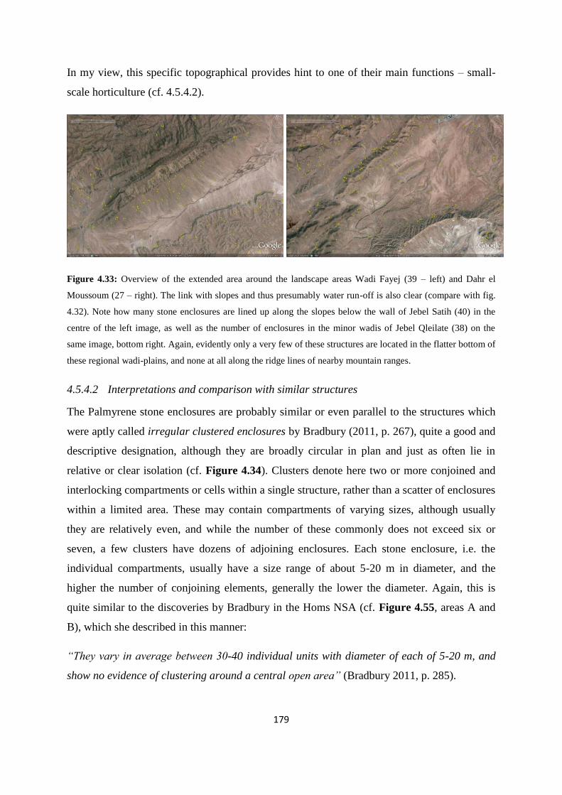
179
In my view, this specific topographical provides hint to one of their main functions – small-
scale horticulture (cf. 4.5.4.2).
Figure 4.33: Overview of the extended area around the landscape areas Wadi Fayej (39 – left) and Dahr el
Moussoum (27 – right). The link with slopes and thus presumably water run-off is also clear (compare with fig.
4.32). Note how many stone enclosures are lined up along the slopes below the wall of Jebel Satih (40) in the
centre of the left image, as well as the number of enclosures in the minor wadis of Jebel Qleilate (38) on the
same image, bottom right. Again, evidently only a very few of these structures are located in the flatter bottom of
these regional wadi-plains, and none at all along the ridge lines of nearby mountain ranges.
4.5.4.2 Interpretations and comparison with similar structures
The Palmyrene stone enclosures are probably similar or even parallel to the structures which
were aptly called irregular clustered enclosures by Bradbury (2011, p. 267), quite a good and
descriptive designation, although they are broadly circular in plan and just as often lie in
relative or clear isolation (cf. Figure 4.34). Clusters denote here two or more conjoined and
interlocking compartments or cells within a single structure, rather than a scatter of enclosures
within a limited area. These may contain compartments of varying sizes, although usually
they are relatively even, and while the number of these commonly does not exceed six or
seven, a few clusters have dozens of adjoining enclosures. Each stone enclosure, i.e. the
individual compartments, usually have a size range of about 5-20 m in diameter, and the
higher the number of conjoining elements, generally the lower the diameter. Again, this is
quite similar to the discoveries by Bradbury in the Homs NSA (cf. Figure 4.55, areas A and
B), which she described in this manner:
“They vary in average between 30-40 individual units with diameter of each of 5-20 m, and
show no evidence of clustering around a central open area” (Bradbury 2011, p. 285).

180
However, the large number of individual compartments in her material is rather the exception
in the Palmyrene, and mainly found in the large eastern wadi-plains, particularly the white
Wadi Neqeib (46). Castel et al. (2008) also recorded stone enclosures in the region around
Rawda, c. 40 km northwest of the area surveyed here in Google Earth (cf. Figure 4.55, area
C), which they merely called enclos, although they pointed out that these also occur in
multiples of two and three and are irregularly shaped. Based on their descriptions I would
suggest that these structures are of the same general type as the stone enclosures in this
chapter. The map of the microregion around Rawda (cf. Castel et al. 2008, p. 37, fig. 15 – also
cf. Figure 4.55) also indicated that many of their enclos are located just above the faydas –
thus presumably where the ground is sloping – as well as in smaller wadis. However, some of
the enclosures in their data set also seem to be located on the ridges16.
Figure 4.34: Various manifestations of stone enclosures in the Palmyrene, specifically located in the
northeastern part of Jebel Hawit er Rass (60). They are all clearly situated on the sloped ground, and some in
rather steep areas all the way up under the mesa plateaus. Their irregular shapes as well as the varying degrees of
clustering within a very limited area are evident.
16 It must be pointed out that the figure in Castel et al. (2008) is not a proper topographical map with contours,
and the arguments here are therefore based on my interpretation. Unfortunately, the resolution in Google Earth
for the area surrounding Rawda is too low to allow any satellite surveying as of March 2014.

181
There seems to be little doubt that the structures are of a similar nature, but the functional
explanation for this archaeological feature varies. Due to their frequent occurrence in arid
regions, they are commonly attributed to pastoralism and pastoralist activities, as such groups
are more often associated with sub-optimal landscapes. Initially, the first function which
springs to mind is therefore an association with husbandry, i.e. corrals or animal pens for
various operations relating to that form of subsistence and economy, often supported by
analogies and parallels taken from relatively recent herder populations (e.g. Castel et al. 2008,
p. 44). Clearly, this can at the outset seem like the most probable function, but when the
topographical context mentioned above is taken into consideration, many of the stone
enclosures are rather oddly placed in the landscape to work efficiently as animal pens. Figure
4.34 shows a collection of enclosures in Jebel Hawit er Rass (60), of which some are surely
positioned too steeply and impractically to keep herds, e.g. right up under the mesa plateaus.
Additionally, quite a lot of the stone enclosures have no apparent entrances, many are quite
small (c. 5 m diameter), and the larger clusters (i.e. of a dozen or more compartments) can
sometimes seem peculiarly constructed for such purposes. However, there are also
undoubtedly examples of Palmyrene stone enclosures which can have clearly worked fine as
corrals, lying on more or less level ground along wadi banks or on low rolling hillocks in the
larger wadi-plains (Figure 4.35 – also cf. Figure 4.37), suggesting that the actual explanation
could be rather complex and the structures themselves multifunctional and multifaceted.
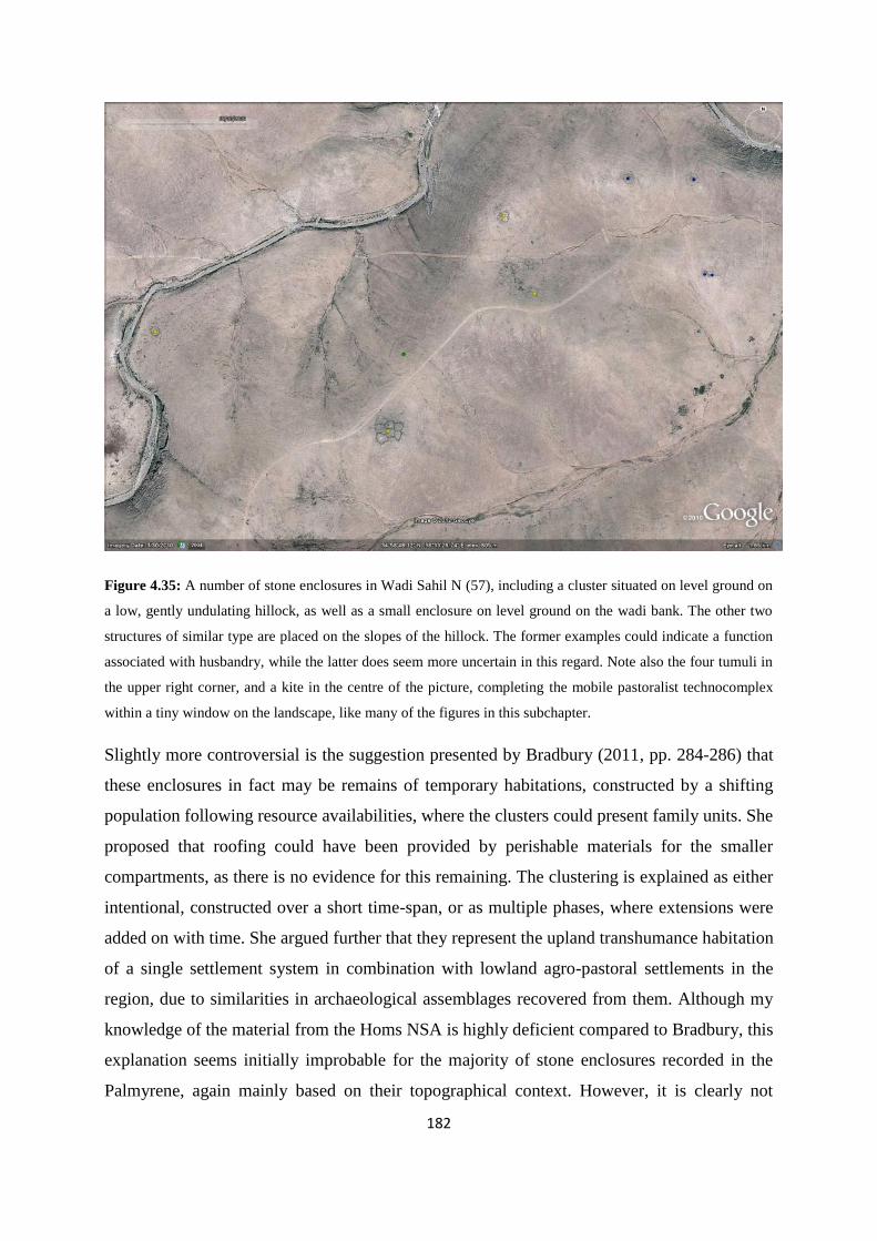
182
Figure 4.35: A number of stone enclosures in Wadi Sahil N (57), including a cluster situated on level ground on
a low, gently undulating hillock, as well as a small enclosure on level ground on the wadi bank. The other two
structures of similar type are placed on the slopes of the hillock. The former examples could indicate a function
associated with husbandry, while the latter does seem more uncertain in this regard. Note also the four tumuli in
the upper right corner, and a kite in the centre of the picture, completing the mobile pastoralist technocomplex
within a tiny window on the landscape, like many of the figures in this subchapter.
Slightly more controversial is the suggestion presented by Bradbury (2011, pp. 284-286) that
these enclosures in fact may be remains of temporary habitations, constructed by a shifting
population following resource availabilities, where the clusters could present family units. She
proposed that roofing could have been provided by perishable materials for the smaller
compartments, as there is no evidence for this remaining. The clustering is explained as either
intentional, constructed over a short time-span, or as multiple phases, where extensions were
added on with time. She argued further that they represent the upland transhumance habitation
of a single settlement system in combination with lowland agro-pastoral settlements in the
region, due to similarities in archaeological assemblages recovered from them. Although my
knowledge of the material from the Homs NSA is highly deficient compared to Bradbury, this
explanation seems initially improbable for the majority of stone enclosures recorded in the
Palmyrene, again mainly based on their topographical context. However, it is clearly not

183
inconceivable that some of the structures may be remains of temporary habitation, and that
multifaceted functionality should be the general perspective. Bradbury did base this
explanation on the research carried out at the site of Umbashi in the Hawran region of
southern Syria by Braemer et al. (2004) (also cf. Figure 2.16 and Figure 2.17). They
recorded around 200 structures similar in construction to such irregular stone enclosures, with
clustering of cells from five to thirteen units. The organisation showed no particular pattern
relating to hierarchy or central space, and they were situated mainly around the margins of the
site. There were indications of doorways or windows, and roofing constructed by slabs and
supporting pillars, but these doors were tiny, and there seemed to be a general pattern of
limited access, even some without apparent entrance. These types of structures were dated by
pottery from sondages to EBA IV, as well as showing evidence for later reuse (Braemer et al.
2004, pp. 124-127; also cf. Bradbury 2011, p. 349), as has been shown repeatedly to be a
recurring feature for the structures incorporated into the mobile pastoralist technocomplex.
The notion that access was limited and the cells could easily be sealed off can indicate that the
structures were used for storage by a mobile population in periods of absence (Bradbury 2011,
p. 350). Bradbury (2011, p. 286) argued that a use of some enclosures for animal shelters is
also highly probable, as in her distribution pattern of these enclosures proximity to small
seasonal pools or lakes, as well as an association with so-called damp ground (Bradbury
2011, pp. 267-269, fig. 6.26), suggests watering for herds. However, she also pointed out that
the irregular clustered enclosures in the Homs NSA are usually situated some distance from
the wadis that can be associated with agriculture, probably to keep animals away from crops
(Bradbury 2011, p. 287), apparently a rather different pattern than the one in the Palmyrene.
Interestingly, Braemer et al. (2004) also recorded in detail a structure type they called
encampments, specifically relating them to pastoral-nomadic herders. The general layout of
this structure looks like many of the ones in the Palmyrene as well as seemingly similar to
those presented by Bradbury (2011), with some circular to elliptical enclosed cells and some
isolated curved wall-lines (cf. Braemer et al. 2004, p. 263, fig. 499). These enclosures are
described as irregular cells of three to five meters, both fully enclosed and some with
openings. The composition of isolated curves, open cells and enclosed spaces for several
Palmyrene examples have by and large been seen as merely a result of preservation, but the
structures from Umbashi show that while it is not possible to confirm the condition or
preservation status, clearly such a composition can be the actual structure and not a result of
degradation over time. However, the volcanic landscape around Umbashi (cf. Figure 2.17)

184
shows much better preservation than the Palmyrene in general, probably both due to local
construction material and lower population densities through time (Helms & Betts 1987, pp.
41-42). One stone enclosure there also had wedge-stones and stone bases which presumably
should be associated with a tent-like superstructure supported by poles, and one of the open
cells had a hearth, thus evidence for occupation vs. the structure being animal pens or
gardens. However, this stone enclosure was situated on more or less even ground, as opposed
to many of the Palmyrene examples. On the other hand, it was located on a rocky ridge next
to a fayda collecting rainwater from a relatively large area and silting up right next to the
enclosure. This system is still working today and suggests that there existed similar conditions
at the time of the occupation, but the structural arrangement of this construction the
researchers emphasise is in no way similar to that employed for modern or historic nomadic
camps. This was supported by the archaeological surface assemblage, which consisted of
undatable lithic material and pottery dated to the EBA IV (cf. Braemer et al. 2004, p. 263).
Again, this seems to underline the importance of an approach focusing on multifaceted
functionality for these structures, with both clear comparative archaeological suggestions for
husbandry and occupation, as well as associations with water run-off and silt deposition.
Quite opposite to this explanation – that is, a non-agricultural one – is the notion that circular
stone enclosures could be the remains of threshing floors, as has been proposed by Avner et
al. (2003, pp. 455-456) with reference to similar structures found in Israel. The hypothesis is
that cereals have been threshed inside the enclosures, where the low walls prevent the
constant wind usually prevailing in the steppe from catching the straws, but the same wind is
subsequently employed to separate the chaff from the grains by throwing them both in the air,
where the light weight of the former part is blown away, while the heavier cereal grains to fall
down to the ground. Cereal cultivation is known from later times to have been carried out in
the small- to medium-sized wadis in the Palmyrene with a variant of this practice incorporated
(Meyer, personal communication), which can go some way of explaining why many stone
enclosures are located along the banks of these. Once more, this function cannot be ruled out
and could be included in a multifaceted aspect of the stone enclosures.

185
Figure 4.36: Image from the northern part of Jebel Labidah (61) showing a kite, two tumuli and several stone
enclosures recorded in Google Earth, where one of the latter structures is situated on sloping ground, and
actually having collected a pool of turquoise water (cf. left side). Most of the other enclosures are lying in
relative isolation on the lesser wadi banks, but one cluster on the bank of the wadi conflux (right side) looks
somewhat like a smaller version of the example presented by Braemer et al. (2004, p. 263).
In fact, some form of horticulture could explain the modus operandi behind many of the stone
enclosures in the Palmyrene, particularly when taking into account their topographical
context. Figure 4.36 shows how a stone enclosure in Jebel Labidah (61) lying on sloping
ground has collected water from rainfall seeping down from a small mesa plateau toward a
wadi. Not only can such a construction temporarily halt and gather water on its way down a
slope toward a wadi, but it could also collect soil, which could be used to grow small gardens
of crops (cf. Meyer 2009, p. 129). A similar explanation was also provided as an alternative
by Castel et al. (2008, p. 39), parallel with their function as corrals, and thus potentially as
multifunctional structures. In sub-optimal regions, structural investment in the landscape in
terms of labour, technological developments, or external sociopolitical factors could improve
its resource potential considerably and lead to realisation of human exploitation and
habitation, and is indeed integral to the definition of such zones (cf. Bradbury 2011, p. 44).

186
Figure 4.37: Two larger stone enclosures found in the foothills of Jebel Merah. The function of these particular
examples is uncertain, but they represent both examples of structure lying on flat (left) and sloping (right)
ground, and thus can indicate multifaceted functionality, e.g. as both pens and gardens respectively (Photo:
Torbjørn Preus Schou, 2011).
The chronological context of such stone enclosures is difficult to ascertain. However, it seems
quite clear that the structure type and many of the examples have been in use since the EBA,
and possibly the Chalcolithic. On the other hand, many are clearly built after the erection of
tumuli in the Palmyrene, something which can be deduced by the frequent reuse of
construction material listed in appendix 1 (as Encl.), and many are overlying and therefore
postdating Roman/Byzantine structures (e.g. Meyer 2011, p. 70). Perhaps this is not
surprising, considering the potential multifunctional aspect of this structure type, as well as
the probable continuity in general landscape use until modern times. Castel et al. (2008, p. 39)
observed that their difference in preservation status suggests that they were not constructed at
the same time, supporting the presumed chronological variation. They have collected sub-
surface dust samples from the inside and outside of a number of these stone enclosures, which
suggested some sort of pastoral function. Comparisons of the combination of siliceous algae
in the sediments with those of the EBA IV site of Rawda indicated furthermore a synchronous
use of one of the enclosures with the settlement, although they pointed out that others in this
area could be of a very different date (Castel et al. 2008, p. 44). The archaeologists working in
the Homs NSA collected material datable to the Chalcolithic or EBA in most of their
enclosures, although they also found later material characterised as low-level background
noise, thus leading them to argue that these primarily date to the 4th-3rd millennia BCE
(Bradbury and Philip 2010, p. 145; Bradbury 2011, p. 274). The few examples of stone
enclosures recorded during the Palmyrena ground survey which contained archaeological
surface scatter yielded only Roman/Byzantine or later material, although it should be

187
emphasised that all those investigated were located in close proximity to Roman/Byzantine
sites, around which pottery sherds of such a date are ubiquitous. Thus, a provisional
conclusion would have to be that stone enclosures in the Palmyrene are similarly constructed,
within a narrow horizon of variation, but are multifaceted and probably have a wide
chronological distribution, filling a number of potential functions based on comparative
research and topographical contexts. This may also suggest some form of continuity of
exploitation and probably habitation in the region. Of course, there is the possibility that there
is a ritual function associated with the Palmyrene stone enclosures, which would be very
difficult to ascertain. However, in my view it is anachronistic to separate Bronze Age
landscapes and societies into clear ritual/sacred vs. functional/secular spheres, as this division
is probably artificial, not being part of the ancient mind-set, and generally a consequence of
modern thought and philosophy.
4.5.5 The Google Earth survey and distribution of Palmyrene kites
All in all, 426 kites have been documented via Google Earth in the Palmyrene, including a
small number located southwest of Palmyra in Jebel Haiyane, which all have until very
recently remained unrecorded by archaeologists as the area was unsurveyed (cf. Helms &
Betts 1987, p. 46). However, during 2012 Kennedy recorded 121 kites in the same region by
applying the same methods as those used here, albeit carried out independently (cf. Kennedy
2012). Most of these structures probably overlap with those presented here, but his study
focused more on the arid steppe east of Palmyra than the present work, where he documented
a small group which probably is novel. This means that at the very least over 300 examples
can be characterised as new discoveries in the Google Earth survey presented here. In
addition, a further seven kites have been found lying in the northern foothills of Jebel Merah,
two of which were already known from the 2008 prospection, and the remaining kites have
been recorded in the satellite imagery study (cf. 4.3.2.3). Only one kite, located in the
southern Jebel Merah foothills, was surveyed on the ground during the 2011 campaign (fig.
4.39), and was subsequently shown by satellite studies to be only one of three such structures
located in the entire surveyed part of the concession area, i.e. the Jebel Abyad region and the
southern half of the Jebel Merah region. Evidently, there is a selective pattern in the
distribution of kites in the Palmyrene (Figure 4.38).

188
Figure 4.38: Distribution map of kites surveyed in the Palmyrene via Google Earth and in the commercially
available satellite imagery. In addition, the group of seven kites located in northern Jebel Merah is also shown.
Evidently, there is a geographical determinant associated with this type of structures, as the eastern, but
particularly western quarters of the region contain close to none.
4.5.5.1 Distributional patterns of Palmyrene kites
For the surveyed region as a whole, three areas stand clearly out as focus of kite construction
and activity (Figure 4.38). The first one is the mountain range stretching northeastward from
Palmyra, and include the landscape areas containing the extended northern end of Jebel
Haiyane (16) and northeastern third of Jebel Safra (21), but mainly Jebel Mohamed ibn Ali
(23) which alone contains 89 examples – a fifth of the total number. This is by far the most
densely packed area, with several kites criss-crossing each other, and thus arguably not having
been in use at the same time. The chronological difference need not be more than different
seasons in a single year, but due to the practical use of kites as described by travellers (see
below), it seems likely that a certain amount of time passed between them – otherwise they
would probably hamper the animal drives (cf. Figure 4.39, nos. 3-4 – cf. Figure 4.44 for a
close-up view). Another concentration of kites is located in the parallel range to the first one,
along the south side of the wadi-valley toward Suhne, and includes structures in the elevated
parts of Kheurbet el Qbeibe (35), the Wadi Qseibe/Dahr el Mosri border zone (34/36) and
southwestern part of Jebel Qleilate (38). The last main group lies in Jebel Labidah (61), once

189
more standing out as an area of high activity, and across the gap in the wadi-plain south of
this range and into the foothills of Jebel Hawit er Rass (60). Jebel Labidah has 53 identified
kites, which is the second largest proportion of the total, apart from Jebel Mohamed ibn Ali
mentioned above (cf. appendix 3 and 4). The remainder of Palmyrene kites is scattered
between these three areas, although the majority are found in the plains around and northwest
of Suhne, in addition to two smaller clusters in the central and eastern Jebel Dahek (48-49 and
55), some of which are seen in Figure 4.39. In fact, the Wadi Sahil valley system (areas 44-45
and 56-58), which presumably is the topographically determined route leading northward
through Taibe and El Kowm to the northern plains contains a fair number of the Palmyrene
kites. This has probably to do with gazelle migrations and topographically funnelling terrain,
an aspect which will be explored further below.
Figure 4.39: Google Earth view of a cluster of kites in central Jebel Dahek (55), as well as the tumuli and stone
enclosures surrounding them, all of which follow the general distributive pattern explained above. The kites all
conform more or less to the general plan of this structure type, albeit slightly different. For instance, no. 6 is of
the sock type recently defined by Kennedy (2012), while no. 2 has been eroded away or removed, with only its
fences remaining. Interestingly, the majority has entrance opening toward the southeastern quadrant of the
compass, suggesting that most animal drives probably occurred in a general northwesterly direction. Nos. 3 and

190
4 also show the criss-crossing aspect, both evidently not in use at the same time – and probably not same season,
as no. 4 would hinder no. 3.
It is not merely the positive results that are interesting, but also the negative ones, so to speak.
Whereas the central part of the Palmyrene is littered with kites, other areas are lacking to the
point of being devoid of this structure type. Of course, the northern areas west of Jebel
Labidah and the arid regions south of a Palmyra-Suhne line must be taken out of the equation,
as they have not been surveyed in this respect. However, the large northwestern region
defined by a conceptual diagonal line lying north of Jebel Haiyane (14) and the concentration
in and around Mohamed ibn Ali (23) described above, stretching north all the way through
Wadi Qutqut, are as good as empty of kites. In fact, in this extensive part of the Palmyrene,
only ten kites have been recorded by the ground survey, satellite survey and Google Earth
survey – one in Jebel Shaar (1), two in southern Jebel Merah (3) as mentioned (cf. fig. 4.38),
one in Jebel Abyad E (7), two in Jebel Marbat el Hassane (16), two in Jebel Tar en Nuwaysir
(15), one in Jebel Abu Rujmein (19) and one in Jebel Rass Aaqabet (28). Additionally,
preliminary scans of the wadi-plains west of Jebel Labidah (61) and the gap just south of this
range linking the plains with Wadi Sahil N (57) also suggest that very few kites, or even none
at all, were constructed there – i.e. a complete drop-off of such structures from the densely
packed landscapes just east of the gap. This is striking, and indicates that there is a deliberate
system to this practice, presumably subject to allocation and availability of resources. The ten
northwestern kites could actually be labelled expected distributive anomalies in such a large
data set, while the ones in central-eastern Palmyrene are conforming to the rule. On the other
hand, they do not seem to vary any differently in morphology compared with the rest.

191
Figure 4.40: The only kite investigated on the ground is located in the southern foothills of Jebel Merah, with
fences leading southward from a minor wadi and up a slope, and the enclosure lies just on the other side of a
ridge. The two tumuli nos. 343 and 345 lay on its western fence line, thus seemingly postdating it, although
theoretically they could have existed at the same time.
4.5.5.2 Interpretations of kites and their local and regional functionality
The similarities in general morphology are probably a consequence of common function,
rather than being due to chronology (cf. Helms & Betts 1987, p. 49). There was some debate
in the late 1990s about whether or not the kites should be attributed to domestication of wild
ungulates in the Near East, and they in this regard were installations for gathering
domesticated or semi-domesticated animals, or if they were used for catching wild animals,
predominantly gazelles, but potentially also onager, oryx and ostriches – i.e. historically
attested regional fauna living and moving in herds (cf. Mendelssohn 1974; Echallier &
Braemer 1995; Rosen & Perevolotsky 1998; Moore et al. 2000, p. 443 – cf. 2.7.6).
Travellers’ accounts from the 17th until the early 20th century CE mention structures which
clearly are kites as being used by villagers (fellahin) during the Ottoman period to capture
gazelles (e.g. Musil 1928, pp. 3-4; Burckhardt 1967, pp. 220-221). The other species living in
herds were probably already rare by the 18th century CE, and not economically viable to

192
capture through the use of kites, but a mural in Jordan from 8th century CE is said to show a
kite being used to catch onager (Moore et al. 2000, p. 445). Musil described an area east-
southeast of modern Dumayr in these words:
“On all the hills we noticed heaps of stones (rğûm), apparently the debris of old
watchtowers17. Conspicuous in the lowland were numerous enclosures, fenced around by
rough stone walls. Many of these measured several hundred meters in circumference, and the
walls were up to two meters in height” (Musil 1928, p. 3).
He mentioned that the structures were called mesâjîd, and how the walls extend hundreds of
meters beyond the enclosure, widening out as well as becoming lower and lower. If a herd
came near the low walls, they cautiously drove the gazelles into the widest opening, and then
startled them from behind, after which they would panic and bolt in the direction of the
enclosure. When caught, the entrance was closed and the animals killed off by throwing rocks
and missiles, or by falling into pits which lay outside deliberately lowered parts of the
enclosure wall, in this manner killing 50-60 gazelles in half a day (Musil 1928, pp. 3-4). The
Arabian name of these structures is very similar, and probably identical to that informed by
Burckhardt (1967, pp. 220-221) to be masiade, according to his information principally found
region of Qaryatein, Hassie, and Homs, and thus possibly kites presently or previously found
in the Palmyra and Qalamoun ranges (cf. Kennedy 2012, p. 148, fig. 6) and areas slightly
further west-northwest (cf. Echallier & Braemer 1995, p. 42, fig. 9), now covered by modern
development and agriculture. Indeed, the Arabic root these words are based upon has
associations with hunting (Helms & Betts 1987, p. 62), as does presumably Abu Masyadah
near Dhuweila from where kites are known (cf. Helms & Betts 1987, p. 50), as well as the
landscape area Wadi Massadeh (4) located near the watershed between the Jebel Merah
foothills and the mountain of Al Matna in the Palmyrene – although the latter does not contain
any visible kites. Thus, despite the other hypotheses put forward (e.g. Echallier & Braemer
1995) it seems to be quite clear that these structures were mainly functioning as traps for wild
animals (e.g. Moore et al. 2000; Holzer et al 2010; Kennedy 2012). However, Poidebard
favoured a military explanation to the kites as defensive structures against eastern cavalery
(Holzer et al. 2010, p. 807), despite actually being told by a local Bedouin that they were for
17 Once again, this is probably a reference to tumuli in the area – an area now extensively developed, and thus
showing no trace of these nor the kites on the Google Earth images. Also cf. Figure 4.41 for watchtowers vs.
tumuli. His term rğûm is doubtless a way of writing rejem or rujm (cf. note 12).

193
hunting and killing gazelles (Moore et al. 2000, p. 442), but not surprisingly, as his
interpretation was based on the general perspective at the time regarding these constructions
(cf. Helms & Betts 1987, p. 46). However, his map of so-called Roman constructions along
the Palmyra-Suhne road provides us with the useful confirmation that the watchtowers and
fortifications described by himself, and probably also those ruins of watchtowers mentioned
by Musil (1928) and other early travellers in fact are what archaeologists today categorise as
tumuli and kites, clearly shown in Figure 4.41, where a close-up map from Poidebard (1934)
is compared with the probably exact same spot in Google Earth. Although the kite itself has
been destroyed by modern development, both the fortlet and the tumuli remain conspicious.
Figure 4.41: Google Earth view showing some of the so-called Roman constructions emphasised by Poidebard
(1934). The inlaid drawing is his presentation of the escarpment gap shown in the centre of the picture. The
Roman post seems genuine enough, but his watchtowers are evidently tumuli. The ouvrage de défense indigene
is clearly a kite (cf. Figure 4.42), although it seems to have been destroyed at some point during the 85 years
that have passed.

194
Figure 4.42: Photo of a kite taken from Poidebard (1934), presumably the one shown on the inlay in Figure
4.41, based on its morphology and topography, and therefore one that has now disappeared.
The most interesting result from the analysis conducted on the Palmyrene kite material,
relates to the direction of their entrances. There is a striking pattern in the data set, which
incidentally seems to conform to investigation carried out by other researchers, for the
majority of them to open up southeastward. Echallier and Braemer (1995, p. 53) noted that the
direction to which the entrance of the guiding fences open up is not arbitrary, but grouped into
two main clusters – the largest one toward east-southeast, and a somewhat smaller group
toward west-northwest. Their investigation concerned a small group (n=21) of kites in central
Syria and a larger one in southern Syria (n=153). The south Syrian kites varied somewhat,
with some areas associated with a southeasterly orientation (near Safa) and others with a
northesternly one (Wadi Sham and Wadi Gharaz). However, the researchers could not come
up with an explanation for this, finding it difficult to envisage uniformity in e.g. seasonal
wind patterns or animal migration cycles which could conform to these orientation patterns.
The latter of these explanations now seems to be prevailing in Near Eastern archaeology as
the explanation for the kite systems (see below). Interestingly, the central Syrian group in
their material also alternated, but featured a majority of northwesterly oriented entrances. This
group was situated in the hills and plains west of Qaryatein, and hence some distance away
from the Palmyrene, and as it is my view, supported by the work of other researchers working
in the region (cf. Bonacossi & Iamoni 2012, pp. 36-37), that kites and wild animal migration

195
patterns are closely associated, these structures probably relate to a different migration route
than the Palmyrene kites in this study – i.e. a different gazelle population (cf. Akkermans &
Schwartz 2003, p. 37; Bonacossi & Iamoni. 2012, pp. 38-39). Kennedy (2012, p. 153)
discovered also that nearly all the funnels connected with sock kites he recorded had an
opening toward the east-southeast and southeast, but as mentioned his material no doubt
overlaps with that presented here. Bonacossi and Iamoni (2012, pp. 41-42), who investigated
a group of kites in Jebel Haiyane and Jebel al-Khan in the Palmyra range southwest of
Palmyra itself, found that entrances there were directed mainly toward the south (37 %), east
and southeast (29 %), but also northward (28 %). Joining up the two former groups to form a
southeastern quadrant of the compass gave a portion of two-thirds of the total number of kites
opening toward the steppe plain, so to speak, and the remaining third mostly toward the north.
Figure 4.43: Diagrams of the directions associated with the 426 recorded Palmyrene kites. The left hand figure,
although loosely based on a graphical abstraction of the compass, shows the directions of which the kite
entrances open up as parts of the total number, the latter represented by the whole figure. The right hand figure
shows these proportions of equal sizes and percentages indicating their part of the total, while each part merely
represents the various compass directions. The main point here is that over two-thirds of the kites have entrances
toward the southeasterly quadrant, while at the most only 25 % open toward the northwesterly one.
This pattern is also very common for the Palmyrene kites. Figure 4.43 shows the direction of
entrances for all the 426 examples, both as parts of the total (left) and as equal sectors
indicating directions on the compass (right). The majority of fence entrances are directed
toward the southeast (35 %), with the two next on the list being south (18 %) and east (15 %).
E15 %
SE35 %
S18 %
SW4 %
W7 %
NW13 %
N3 % NE
4 %
Direction of trap entrance
15 %
35 %
18 %4 %
7 %
13 %
3 %4 %
Direction sectors

196
Incidentally, for the two latter directions there is by far a prevailing tendency for the entrance
to be opening south-southeastward or east-southeastward respectively, rather than purely
toward the south, south-southwest or east-northeast, thus very much suggesting that the
southeastern quadrant of the conceptual compass is where the focus lay when these were
constructed. There is also a smaller group with the entrance toward the northwest (13 %),
while the other directions are of almost negligble proportions, and sometimes probably even
attributable to adaptations to the immediate topography associated with each kite. Thus, just
like the Syrian-Italian team found to be the case for the Palmyra/Qalamoun ranges southwest
of Palmyra, over two-thirds of the kites were constructed with animal herds approaching from
the southeasterly direction in mind, i.e. the arid Al-Hamad steppe plain stretching southward
from Palmyra toward Jordan (cf. Figure 2.1 and Musil 1928, p. 2, map). However, unlike the
case was in their research (cf. Bonacossi & Iamoni 2012, p. 41), an even smaller portion,
merely just over an eighth of the total have entrances directed northwestward, although the
percentage increases to c. 20 % if the entire northern quadrant is incorporated (cf. Figure 4.43
- right).
Figure 4.44: Google Earth view showing two kites in central Jebel Dahek with entrances toward the southeast.
These are actually close-ups of nos. 3-4 (left) and no. 6 (right) on Figure 4.39, the latter being of the sock type.
However, no. 4 on the left figure seems to open northward.
The persian gazelle (Gazella subgutturosa) is a migratory species of herd animal which
tentatively fits rather well with kites focusing on a specific direction, as it is found in different
places in the steppe at various times of the year, although there have in earlier times probably
also been other species which could have been hunted with kites. Akkermans and Schwartz
(2003, p. 35) suggested, based on early 20th century CE observations near Damascus and
Amman, that gazelle herds reached their maximum size in autumn near the end of the dry
197
season, and migrated from north to south during this time of the year, and returned
subsequently north in the course of the wet season. There are supposedly two main routes
which have commonly been used by the gazelles, one on the western edge of the steppe past
Damascus and Qaryatein, and one in the east, through Al-Hamad, past Suhne and continuing
through the Palmyrene between the Jebel Abu Rujmein massive and Jebel Bishri, toward the
middle Euphrates area and the northern plains (cf. Akkermans & Schwartz 2003, pp. 35-37,
fig. 2.13) – i.e. through the Wadi Sahil (56-58) and Jebel Dahek (48-49 and 55) areas
mentioned above. Clearly the large concentrations plotted by the Google Earth survey in this
very region must be seen in association with the migratory pattern of these gazelle herds. This
can also explain why there are so few kites found in the landscape areas behind the virutal
wall of kites stretching from Jebel Haiyane (14), through Jebel Mohamed ibn Ali (23) and
northern Jebel Safra (28) and up to the northern plain, including Jebel Labidah (61), via Jebel
Taniyet es Safra (59) (cf. Figure 4.38, appendix 3, and appendix 4). Herds would have been
funneled by the topography created by the sheer cliffs on the western edge of Jebel Dahek to
migrate through Wadi Sahil (57) and Tulul al Bayda (56) toward Taibe, where they could
easily be captured by the use of kites. Those migrating further east of Suhne would have
moved through central Jebel Dahek (48-49 and 55), where the smaller, eastern group of kites
mentioned above could have served as the local hunting installations. However, the main part
of this migration was not experienced by the central-western parts of the Palmyrene – i.e. the
Jebel Abyad region, the Jebel Merah region, and the Jebel Abu Rujmein massive – and
presumably therefore contain very few examples of this structure type.
There are many indications that hunts in this region were concentrated in the weeks of April
and May (Akkermans & Schwartz 2003, p. 36). Bonacossi and Iamoni (2012, p. 42) argued
based on the entrance directions that they were mainly conducted during the humid season as
the gazelles migrated northward through the arid steppe toward northern Syria. However, in
their material some hunting would presumably also have been carried out as the gazelles
returned southward in the autumn, since over a quarter of their kites have entrances directed
northward. Drummond saw in 1754 great numbers in early July near Sfira at the northern end
of Sabkhat al Jabbul, southeast of Aleppo, suggesting that the herds reached the northern plain
sometime in June (Moore et al. 2000, p. 446, with references), while Lady Anne Blunt
travelling in the 19th century told of many thousands of gazelles packed together migrating
northward in early summer (Blunt 1879a, pp. 344-345). Secondary evidence also place large
198
annual gazelle herds in the Palmyrene from April toward July. The Sleyb18, described by 17th
to 19th century CE travellers as being expert gazelle hunters and living among the Bedouins,
but not being part of the Bedouin society, have been noted to migrate north-south following
the movement of the herds (cf. Blunt 1879b, pp. 110, 193-194; Burckhardt 1967, pp. 14-15).
They are by these accounts invariably found in the Palmyrene in spring and summer,
suggesting that the gazelles were present in the region at this time of the year (Moore et al.
2000, p. 447). The zoologist Aharoni travelling in the region in 1915 observed the migration
of gazelles, where he recorded an estimate of over ten thousand animals returning from north
to south, in separate herds of thousands. He mentioned that the Bedouins hunt them during
this migration, applying kites and trapping 500-600 gazelles at one time (Mendelssohn 1974,
p. 726). However, it is unclear where Aharoni witnessed this, as Mendelssohn (1974, p. 726)
says that the toponym Rachiemeh lie in East Jordan, while Moore et al. (2000, p. 446),
informed by Z. Meshel, argued that the name is connected with Wadi Rcheme near El Kowm
north of Taibe, where there is a concentration of kites19. In any case the activity probably took
place in the autumn, when the herds were returning south. Tooth wear at Abu Hureyra in the
steppe south of Lake Assad, suggests that gazelles were not caught in the later summer or the
early autumn migration southward, because the herds probably were more dispersed, making
mass drives impossible to carry out, but rather as they congregated when closing in on the
mountain gaps between the Palmyrene and Jebel Bishri, coalescing into large herds due to the
topographic funneling (Moore et al. 2000, p. 446). This fits very well with herds of thousands
coming together in the region of Taibe, just before entering the Palmyrene. However, given
the predominance of southeasterly oriented kites, the herds were possibly even larger during
the northward migration, although they give birth in the spring time (Bonacossi & Iamoni
2012, p. 43). Hunting with kites would not significantly affect the numbers, and would not
result in extinctions as the method would turn uneconomic and presumably abandoned when
herds became too small. The modern rifle is responsible for such consequenses for all the
regional fauna (Mendelssohn 1974, p. 728; Moore et al. 2000, p. 449), emphasised by the
modern situation where only about fifteen gazelles survive in the wild in the Jazal area, from
relatively large herds in the Palmyrene up until the 1950s, although ostriches became extinct
18 They have also been called Solubah/Selebee/El Szoleyb/Sleb (Moore et al. 2000, p. 447), and possibly been
identified in Middle- and Neo-Assyrian sources as Šelappayu (Postgate 1987, pp. 268-269).
19 Unfortunately, this part of the Palmyrene lies beyond the current (as of 2014) area with high-resolution Google
Earth images.

199
in the 1930s (Bonacossi & Iamoni 2012, p. 43, note 46). Conclusively, it would seem that late
winter through spring would have been the main season of which activity was at its highest in
the Palmyrene, as the winter torrents waned, giving way to a relatively lush arid steppe, for
both human populations and wild animals (cf. Wirth 1971, pp. 120-121). If, as has been
suggested above, the stone enclosures at least partly had a horticultural function as well as the
other potential functions, these garden plots would probably have been well sprouting in
spring and into summer. Also today, the modern Bedouins following the now rather degraded
grazing opportunities are present in the Palmyrene in spring time, i.e. from April until June, as
we experienced their hospitality during e.g. our survey in 2011.
4.5.5.3 Kites and chronological considerations
Chronologically, the kites should probably be grouped in with stone enclosures, as structures
associated with continuity over millennia due to their functionality. Clearly, they were at least
used up until the First World War (cf. 4.5.5.2), and were probably in use continuously from
the earliest travel accounts in the 17th century CE until the 20th century, judging from their
mention in a chronological scatter of stories during this period. This suggests also that they
probably are even older. Aharoni asked in 1915 local Bedouins about the kites, possibly in the
Taibe area, when these structures were erected, and received the same answer every time:
“In old times. The fathers of the fathers of our fathers already found them” (Mendelssohn
1974, p. 726, with references).
As mentioned, the general morphology is similar for all the kites due to functionality, but
there are specific features and forms that vary somewhat, mainly the shape of the enclosure
trap. Echallier and Braemer (1995) created a typological classification based on this and on
earlier work by Helms and Betts (1987), with five general shapes (star, triangular, circular,
trapezoidal, and axe-shaped) and variations within these definitions. However, they found it
difficult to establish chronology based on this typology, with aerial photographs usually not
being able to decide due to the scale of documents, admitting that kite relationships could
provide some information (Echallier & Braemer 1995, pp. 55-56). Kennedy (2012) expanded
the typology by providing another called the sock type, but did not provide any new material
on chronology of the kites. All the Palmyrene ones recorded in this study have been
categorised according to these classifications (cf. appendix 3, pp. V-XIV). There does not
seem to be any obvious functional advantage to any of the shapes, and they can therefore
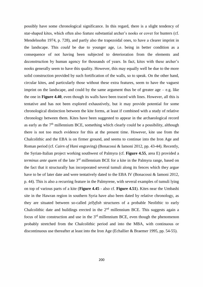
200
possibly have some chronological significance. In this regard, there is a slight tendency of
star-shaped kites, which often also feature substantial archer’s nooks or cover for hunters (cf.
Mendelssohn 1974, p. 728), and partly also the trapezoidal ones, to have a clearer imprint in
the landscape. This could be due to younger age, i.e. being in better condition as a
consequence of not having been subjected to deterioration from the elements and
deconstruction by human agency for thousands of years. In fact, kites with these archer’s
nooks generally seem to have this quality. However, this may equally well be due to the more
solid construction provided by such fortification of the walls, so to speak. On the other hand,
circular kites, and particularly those without these extra features, seem to have the vaguest
imprint on the landscape, and could by the same argument thus be of greater age – e.g. like
the one in Figure 4.40, even though its walls have been traced with lines. However, all this is
tentative and has not been explored exhaustively, but it may provide potential for some
chronological distinction between the kite forms, at least if combined with a study of relative
chronology between them. Kites have been suggested to appear in the archaeological record
as early as the 7th millennium BCE, something which clearly could be a possibility, although
there is not too much evidence for this at the present time. However, kite use from the
Chalcolithic and the EBA is on firmer ground, and seems to continue into the Iron Age and
Roman period (cf. Cairn of Hani engraving) (Bonacossi & Iamoni 2012, pp. 43-44). Recently,
the Syrian-Italian project working southwest of Palmyra (cf. Figure 4.55, area E) provided a
terminus ante quem of the late 3rd millennium BCE for a kite in the Palmyra range, based on
the fact that it structurally has incorporated several tumuli along its fences which they argue
have to be of later date and were tentatively dated to the EBA IV (Bonacossi & Iamoni 2012,
p. 44). This is also a recurring feature in the Palmyrene, with several examples of tumuli lying
on top of various parts of a kite (Figure 4.45 - also cf. Figure 4.51). Kites near the Umbashi
site in the Hawran region in southern Syria have also been dated by relative chronology, as
they are situated between so-called jellyfish structures of a probable Neolithic to early
Chalcolithic date and buildings erected in the 2nd millennium BCE. This suggests again a
focus of kite construction and use in the 3rd millennium BCE, even though the phenomenon
probably stretched from the Chalcolithic period and into the MBA, with continuous or
discontinuous use thereafter at least into the Iron Age (Echallier & Braemer 1995, pp. 54-55).
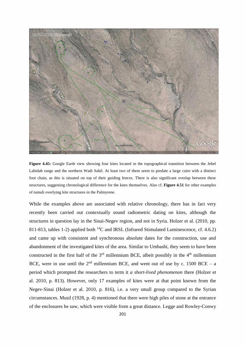
201
Figure 4.45: Google Earth view showing four kites located in the topographical transition between the Jebel
Labidah range and the northern Wadi Sahil. At least two of them seem to predate a large cairn with a distinct
foot chain, as this is situated on top of their guiding fences. There is also significant overlap between these
structures, suggesting chronological difference for the kites themselves. Also cf. Figure 4.51 for other examples
of tumuli overlying kite structures in the Palmyrene.
While the examples above are associated with relative chronology, there has in fact very
recently been carried out contextually sound radiometric dating on kites, although the
structures in question lay in the Sinai-Negev region, and not in Syria. Holzer et al. (2010, pp.
811-813, tables 1-2) applied both 14C and IRSL (Infrared Stimulated Luminescence, cf. 4.6.2)
and came up with consistent and synchronous absolute dates for the construction, use and
abandonment of the investigated kites of the area. Similar to Umbashi, they seem to have been
constructed in the first half of the 3rd millennium BCE, albeit possibly in the 4th millennium
BCE, were in use until the 2nd millennium BCE, and went out of use by c. 1500 BCE – a
period which prompted the researchers to term it a short-lived phenomenon there (Holzer et
al. 2010, p. 813). However, only 17 examples of kites were at that point known from the
Negev-Sinai (Holzer et al. 2010, p. 816), i.e. a very small group compared to the Syrian
circumstances. Musil (1928, p. 4) mentioned that there were high piles of stone at the entrance
of the enclosures he saw, which were visible from a great distance. Legge and Rowley-Conwy
202
(2000, p. 444) argued that it is likely these served as markers for the chasers toward which to
drive the game, although this is not information that was shared by Musil. Tumuli situated in
such a position could have been part of the kite, rather than being a burial monument, but this
seems unlikely at least for the surveyed Palmyrene examples, particularly with regard to the
form these structures have, with e.g. clear foot chains suggesting a funerary purpose (cf.
Figure 4.45 and Figure 4.51. Finally, the clear imprint of the kites in northern Jebel Haiyane
could suggest that these are of a more recent date, as the expansion of Roman Palmyra
probably would have destroyed structures lying so close to a large city. Additionally, as most
of them lie just north of the city and actually have entrances opening up toward it, a gazelle
chase not far from the city centre would be the only functional way of applying them – while
conceivable, a seemingly unlikely scenario, considering the rather skittish disposition of these
animals. Thus, these kites are tentatively from Ottoman times, when the town was of
negligble size, or possibly surviving structures of pre-Hellenistic times, i.e. of a Chalcolithic
or Bronze Age date (but cf. 4.5.1).
Conclusively, the EBA seems to have been the main period of construction and use for both
kites and stone enclosures in Syria, albeit in this study this is mainly based on comparative
material from various other archaeological research carried out in central-western and
southern parts of the country, as well as in the Levant. However, these structures have clearly
also been in use in later periods, at least from time to time, even into the 20th century CE with
regard to some of the kites. Additionally, there are certain indications of even earlier origins,
with convincing arguments for dates at least back into the Chalcolithic and through the MBA.
Chronology for the Palmyrene tumuli have by and large not been touched upon here, apart
from in certain cases of relative dating in associateion with other structures. In those cases
they have been shown to be of later dates in relation to some kites, providing a terminus post
quem, but for some stone enclosures shown to be earlier, thus establishing a relative terminus
ante quem. However, in the few instances where an absolute date is possible to ascertain for
Syrian arid landscapes tumuli, the period that emerge is EBA IV to MBA (cf. 4.7.3 – also cf.
4.1.5). I will now concentrate further on the chronology of the Palmyrene tumuli, as well as
focus on the available comparative research.

203
4.6 Chronology and the dating of Palmyrene tumuli
4.6.1 The tumuli and surface collection of pottery
A relatively small number of pottery sherds were recovered in association with the tumuli
during both the 2009 and 2011 ground survey seasons. However, this material should be
considered as mainly tentative regarding absolute chronology, and all of it derives from
secondary scatter on the ground surrounding the tumuli as well as occasionally from inside
the structure or in the fill, but always from a clearly disturbed context. Thus, the pottery could
have originated as grave goods and been discarded through the act of looting at some point in
time, or it could merely have come from other forms of activities at the site, potentially a long
time after the tumuli themselves were erected (cf. 4.1.5). Some material, both ceramic sherds
and other small objects, like tobacco pipes, can be dated to the Islamic and Ottoman periods,
but the majority of the pottery is of a probable Roman or Byzantine date (Figure 4.47).
Assemblages from these two periods, sometimes indistinguishable, are by far the most
common in the area, but this is not really surprising, given the number of Roman estates,
villages, forts, fortlets and shrines which the Palmyrena project and other archaeologists have
found lying in the landscape between Palmyra and Isriyeh (cf. Meyer 2008; 2009; 2011; also
cf. Schlumberger 1951). Bonacossi and Iamoni (2012, p. 48) noted for instance that a few
Roman potsherds from upper parts of a looted tumulus were intrusive, a situation which
probably is paralleled in many of the Palmyrene tumuli sites, although it cannot be established
with certainty. However, a few sherds of pottery provisionally dated to EBA IV have been
recorded in the vicinity of several tumuli (Figure 4.46), while a somewhat larger amount of
flint tools and flakes have also been found around them (Figure 4.48). The flint material
could have originated in the graves, but as most of the material consists of flakes, it can just as
likely be a result of activities connected to hunting or tool production in the proximity of the
tumuli at some point in time. One Byblos point (cf. Figure 4.48, the southernmost point in the
northern of the two clusters) was recovered near no. 199 (cf. appendix 1), but this site is on
the other hand an excellent vantage point for a hunter looking down the Wadi Abyad or Wadi
Massadeh – incidentally a name which itself suggests an association with hunting (cf.
4.5.5.2). In fact, the EBA IV pottery is essentially the most likely of these pre-Classical
material types to be linked with the funerary function of these monuments, as alternatives for
their presence is more difficult to envision, although their original context within the graves is
still merely hypothetical.

204
Figure 4.46: Map of tumuli sites where EBA IV pottery sherds have been recovered during the ground surveys.
Figure 4.47: Map of tumuli sites where Roman or Byzantine pottery sherds have been recovered during the
ground surveys. Clearly, the number of sites is quite a lot higher than is the case for the EBA IV pottery.

205
Figure 4.48: Map of tumuli sites where flint flake and tool scatter have been recovered during the ground
surveys. Some of the sites in Figure 4.46, Figure 4.47, and Figure 4.48 may overlap, i.e. have material from
more than one period. The relatively large amounts of Roman/Byzantine finds is not very surprising, considering
the massive presence of archaeological remains dating to this period in the area in general. However, the number
of finds and amount of material recovered is unfortunately too slight to provide any patterns of significance.
Additionally, it is at the present time being stored in the basement of the Palmyra museum in a war-torn Syria,
and thus unavailable to this research.
The Palmyrene burial monuments have to a much larger extent potential for relative dating as
many are associated with other archaeological structures in close proximity. Some of the
tumuli lie in clusters where, as mentioned, the smaller of the structures are often situated on
the periphery, but still seemingly in relation to a central, larger tumulus, which therefore
presumably is of an earlier date (Figure 4.49). However, this method of relative dating is still
only hypothetical, but as will be shown below (cf. 4.7.3) it has been shown to have some
merit in the comparative material. On the other hand, the presence of a tumulus cluster or
complex (cf. Table 4.2) does not necessarily preclude an obvious central monument with
peripheral satellites around. Some of them include only tumuli of seemingly same character –
i.e. size, type, and communicative quality.

206
Figure 4.49: Cluster of tumuli (cf. appendix 1, nos. 208-218) on a spur in the lowest foothills of southern Jebel
Merah, looking out over northernmost Wadi Abyad and the watershed into Wadi Massadeh. Of these, there were
one or two central tumuli which seemed to form focus around which other cairns or auxiliary structures of
varying shapes and size had been constructed. However, the central ones were only somewhat larger than the
surrounding cairns, and not monumental as such. On the other hand, the complex itself stood clearly out in the
landscape.
Other examples are found integrated in or on the periphery of Roman sites, e.g. lying next to
or near evident buildings, creating a contextual mismatch in complex. For instance, no. 273
(cf. appendix 1) – situated on the very pinnacle of Jebel Merah – lies right next to site 374 (cf.
Meyer 2011, pp. 105-107), but the Roman building or buildings incorporated into the latter
site had clearly disturbed a tumulus cluster or complex which once lay on this mountain top.
This suggests that the tumuli here are at least of a pre-Roman date, although only one
currently remains while the others have been obliterated. Similarly, site 215 including site 222
(cf. Meyer 2011 - also cf. Figure 4.8, no. 3) seems to have been some form of Roman estate
situated in a sheltered valley in the interior of Jebel Merah. However, this valley has clearly
been a localised centre of activity both before and after Roman times. Several tumuli lie on
the hillocks in the immediate vicinity, and it seems unlikely that these had been allowed to be
constructed so close to the buildings while the estate was in use. In addition, overlying the
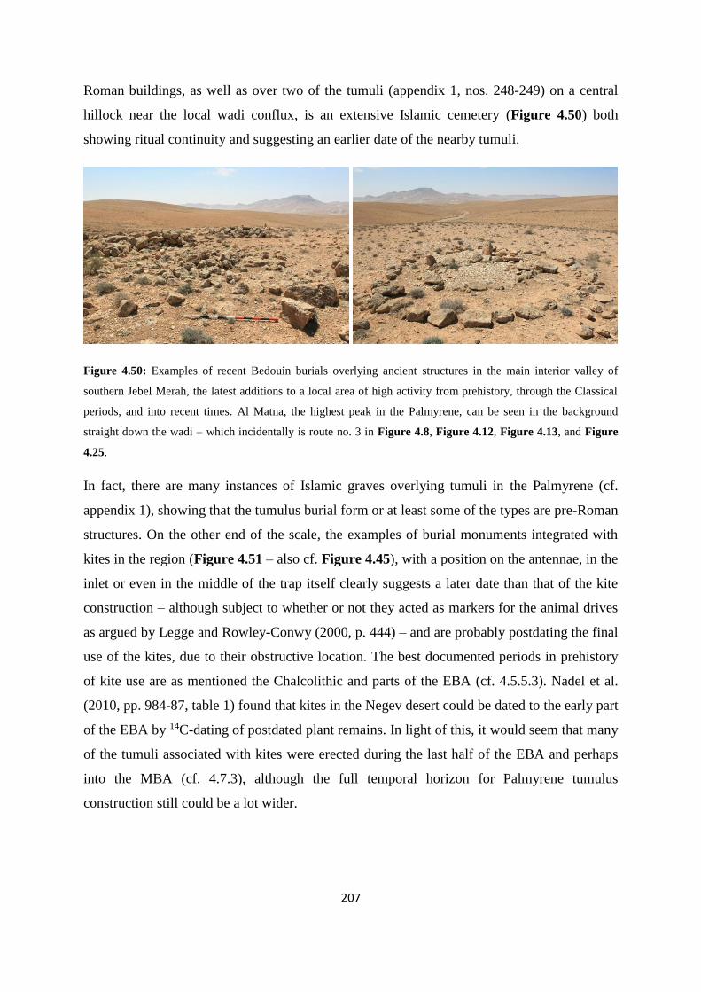
207
Roman buildings, as well as over two of the tumuli (appendix 1, nos. 248-249) on a central
hillock near the local wadi conflux, is an extensive Islamic cemetery (Figure 4.50) both
showing ritual continuity and suggesting an earlier date of the nearby tumuli.
Figure 4.50: Examples of recent Bedouin burials overlying ancient structures in the main interior valley of
southern Jebel Merah, the latest additions to a local area of high activity from prehistory, through the Classical
periods, and into recent times. Al Matna, the highest peak in the Palmyrene, can be seen in the background
straight down the wadi – which incidentally is route no. 3 in Figure 4.8, Figure 4.12, Figure 4.13, and Figure
4.25.
In fact, there are many instances of Islamic graves overlying tumuli in the Palmyrene (cf.
appendix 1), showing that the tumulus burial form or at least some of the types are pre-Roman
structures. On the other end of the scale, the examples of burial monuments integrated with
kites in the region (Figure 4.51 – also cf. Figure 4.45), with a position on the antennae, in the
inlet or even in the middle of the trap itself clearly suggests a later date than that of the kite
construction – although subject to whether or not they acted as markers for the animal drives
as argued by Legge and Rowley-Conwy (2000, p. 444) – and are probably postdating the final
use of the kites, due to their obstructive location. The best documented periods in prehistory
of kite use are as mentioned the Chalcolithic and parts of the EBA (cf. 4.5.5.3). Nadel et al.
(2010, pp. 984-87, table 1) found that kites in the Negev desert could be dated to the early part
of the EBA by 14C-dating of postdated plant remains. In light of this, it would seem that many
of the tumuli associated with kites were erected during the last half of the EBA and perhaps
into the MBA (cf. 4.7.3), although the full temporal horizon for Palmyrene tumulus
construction still could be a lot wider.

208
Figure 4.51: Two examples of tumuli integrated with kites. Left: Kite in Jebel Safra (21) with a large tumulus
featuring foot chain placed on its eastern antenna. The foot chain takes up nearly half the fenced inlet at that
point (c. 12 of 24 m width). Right: Kite in Jebel Mohamed ibn Ali (23) with a tumulus right in the middle of the
entrance funnel, taking up at least a third of the available space. In both these examples the kite is interpreted as
predating the burial monuments, as the positioning of these tumuli would hinder the functionality of the kite
greatly. In addition, barring any ritual significance, it seems likely that the hunters building the kites would have
avoided these monumental tumuli, given the wide range of spatial alternatives.
Tumuli integrated with stone enclosures provide similar relative dating, but on the opposite
side of the diachronic picture. In all the cases where such circumstances have been
investigated on the ground, the stone enclosures have been built secondarily from construction
material taken from nearby or adjacent tumuli, which obviously have been disturbed to some
degree by this activity. However, the many possible usages of stone enclosures as structures –
e.g. some simple ones could easily function as pens – make their association with tumuli and
the relative chronology less useful in a general analysis, except on a case-by-case basis. Some
are intrusive or obstructive and obviously of more recent nature, while others are respecting
the context of the mobile pastoralist technocomplex to a much greater degree (e.g. cf. Figure
4.35). Apparently, an alternative approach would be necessary to clarify the chronology of
Palmyrene burial monuments, which also was one of the main objectives for the 2011
campaign undertaken by the Palmyrena project – an attempt to date certain tumuli
radiometrically through the use of OSL.
4.6.2 Dating by optically stimulated luminescence (OSL)
4.6.2.1 Outline of OSL theory and sample collection
Evidently, the pottery and flint scatter around the tumuli, while possibly and sometimes
tentatively being associated with the erection of the structures or interment of bodies, are of a
secondary nature, and arguably could be linked to activities either pre- or postdating them.
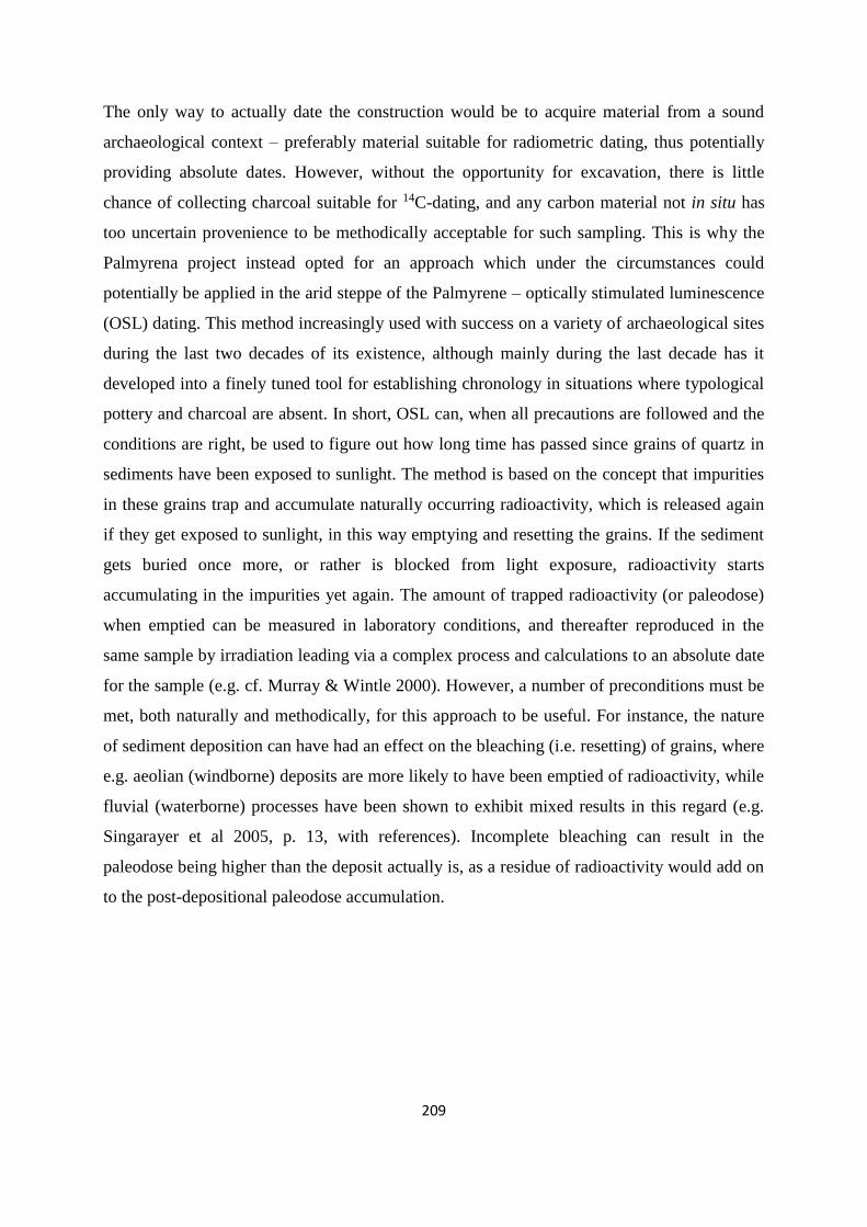
209
The only way to actually date the construction would be to acquire material from a sound
archaeological context – preferably material suitable for radiometric dating, thus potentially
providing absolute dates. However, without the opportunity for excavation, there is little
chance of collecting charcoal suitable for 14C-dating, and any carbon material not in situ has
too uncertain provenience to be methodically acceptable for such sampling. This is why the
Palmyrena project instead opted for an approach which under the circumstances could
potentially be applied in the arid steppe of the Palmyrene – optically stimulated luminescence
(OSL) dating. This method increasingly used with success on a variety of archaeological sites
during the last two decades of its existence, although mainly during the last decade has it
developed into a finely tuned tool for establishing chronology in situations where typological
pottery and charcoal are absent. In short, OSL can, when all precautions are followed and the
conditions are right, be used to figure out how long time has passed since grains of quartz in
sediments have been exposed to sunlight. The method is based on the concept that impurities
in these grains trap and accumulate naturally occurring radioactivity, which is released again
if they get exposed to sunlight, in this way emptying and resetting the grains. If the sediment
gets buried once more, or rather is blocked from light exposure, radioactivity starts
accumulating in the impurities yet again. The amount of trapped radioactivity (or paleodose)
when emptied can be measured in laboratory conditions, and thereafter reproduced in the
same sample by irradiation leading via a complex process and calculations to an absolute date
for the sample (e.g. cf. Murray & Wintle 2000). However, a number of preconditions must be
met, both naturally and methodically, for this approach to be useful. For instance, the nature
of sediment deposition can have had an effect on the bleaching (i.e. resetting) of grains, where
e.g. aeolian (windborne) deposits are more likely to have been emptied of radioactivity, while
fluvial (waterborne) processes have been shown to exhibit mixed results in this regard (e.g.
Singarayer et al 2005, p. 13, with references). Incomplete bleaching can result in the
paleodose being higher than the deposit actually is, as a residue of radioactivity would add on
to the post-depositional paleodose accumulation.

210
Figure 4.52: Map showing the tumuli chosen for OSL sampling in Jebel Abyad and the surrounding area. They
were all recorded during the 2009 survey, while sampling was carried out in 2011. In the Wadi Takara/Jazal
area, the chosen tumuli were nos. 13, 21, 31, 33, 42, and 55 with a sample from its associated platform (cf.
Figure 4.54) and along the northern wall of Jebel Abyad a sample was collected from no. 122.
Many of the structures in the Palmyrene can be viewed as suitable for OSL sampling,
particularly some of the monumentals and cairns (cf. 4.1.3). The underlying theory is that the
perimeter blocks in situ, which often define these tumulus types or associated refurbishments
such as platforms, have been placed on top of sand sediments, either right on the ground or in
a shallow pit, in which case the grains are believed to have been sufficiently bleached by the
sun, and in this way covering a deposit and resulting in accumulation of an accurate paleodose
(e.g. cf. Baran et al 2003, p. 1265 – cf. Figure 4.53). As noted earlier, Holzer et al (2010, p.
810) applied this exact method to date kites in the Negev, and collected samples from both
under stones placed in the ground during construction and from trapped sediments between
construction stones, which accumulated after construction and possibly due to abandonment
of the structure. They collected samples taking necessary precautions to prevent light
exposure and applied orange-red light for laboratory procedures for the same reason.
However, they chose to use the slightly different infrared stimulated luminescence (IRSL) on
feldspar, due to poor luminescence properties inherent in the local quartz. The procedure was

211
met with success, as they could show internal consistency between both IRSL dates and 14C
dates, thus proving that the former method was reliable for such circumstances (Holzer et al
2010, p. 813). The fact that they managed to provide such consistency show that issues like
the one that faced Helms and Betts (1987, pp. 47-49) is now overcome:
“By their very nature ‘kites’ are virtually undatable since they are built directly on bedrock in
most cases, and since they have repeatedly been altered”.
The samples chosen for dating by the Palmyrena project (Figure 4.52) have gone through
essentially the same process. They were extracted from just beneath the perimeter blocks
defining the tumuli (cf. Figure 4.53 and Figure 4.54), and should therefore theoretically date
the time passed since the perimeter was embedded in the ground and the sand underneath has
been blocked from sunlight. To ensure that the samples stayed unexposed to any light which
potentially could bleach and thus contaminate the quartz grains (Bailey et al. 1997, p. 123)
they were extracted using only long-wavelength red-filter light for visibility, which should not
have enough energy to bleach the grains. Apart from this, complete darkness was kept during
the whole procedure under a thick and heavy piece of cloth c. 6 m by 6 m in size, specially
acquired for the purpose (Figure 4.53 – right). The execution of the method was carried out
by strictly following these steps:
1. A pit with a depth of c. 10-15 cm dug about 20 cm in front of the perimeter block.
This initial step was for practical reasons carried out in daylight, mainly because of the
extremely hot and exhausting conditions prevailing under the sun once inside this
chamber.
2. The cloth was then put over the excavator, covering him in darkness, who continued
by cleaning the profile of the initial pit all the way in to the block facing.
3. Under red light, a hard plastic tube was hammered with a rubber mallet into the profile
as close to the bottom of the block and as deeply and horizontally as possible.
4. The tube was gently eased out and removed from the profile, with each end of it filled
up with plastic finds bags. Finally, it was sealed off on both sides with thick layers of
duct tape and marked.
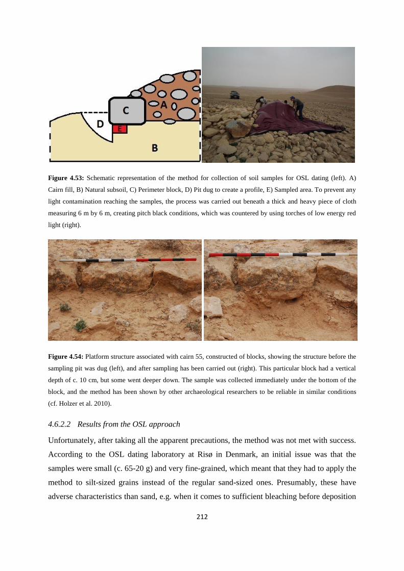
212
Figure 4.53: Schematic representation of the method for collection of soil samples for OSL dating (left). A)
Cairn fill, B) Natural subsoil, C) Perimeter block, D) Pit dug to create a profile, E) Sampled area. To prevent any
light contamination reaching the samples, the process was carried out beneath a thick and heavy piece of cloth
measuring 6 m by 6 m, creating pitch black conditions, which was countered by using torches of low energy red
light (right).
Figure 4.54: Platform structure associated with cairn 55, constructed of blocks, showing the structure before the
sampling pit was dug (left), and after sampling has been carried out (right). This particular block had a vertical
depth of c. 10 cm, but some went deeper down. The sample was collected immediately under the bottom of the
block, and the method has been shown by other archaeological researchers to be reliable in similar conditions
(cf. Holzer et al. 2010).
4.6.2.2 Results from the OSL approach
Unfortunately, after taking all the apparent precautions, the method was not met with success.
According to the OSL dating laboratory at Risø in Denmark, an initial issue was that the
samples were small (c. 65-20 g) and very fine-grained, which meant that they had to apply the
method to silt-sized grains instead of the regular sand-sized ones. Presumably, these have
adverse characteristics than sand, e.g. when it comes to sufficient bleaching before deposition

213
(Murray, personal communication, 24. November 2011). Further issues arose regarding
dosage of radioactivity within the grains, which initially seemed very scattered. This can be a
result of sampling errors as well as internal characteristics of the sediments themselves, but
this is hard to establish. However, subsequent measurements showed that the scatter was
confirmed, with the consequence that the samples were undatable (Murray, personal
communication, 14. November 2012). The researchers at Risø concluded with the suggestion
that tighter sampling control and larger samples would be necessary. All things considered, I
would argue that the Palmyrena project could not have been more prudent in our execution of
the sampling process. There were considerable obstacles and impracticalities to overcome just
to arrive at the point we did, both due to the available equipment and logistics, and while we
cannot say if the error lies in sampling or in the quality of the samples themselves, I believe it
must have been the latter. The four-point process outlined above does refer to optimal
conditions, which certainly did not occur every time. The variation in depth of the perimeter
blocks and omnipresent pebbles and small rocks in the soil, albeit invisible to the sampler,
generally complicated matters further. There is no initial reason for the underlying theory and
procedure itself to be flawed, as Holzer et al. (2010) showed successful results, and the
sampling was carried out scrupulously. Perhaps we have merely been unlucky with the local
geological and sedimentological circumstances, although it seems peculiar that no useful
information at all was possible to extract from a dozen samples from just as many sites spread
out over c. 15 km2. However, it must unfortunately be said here that at the time of writing, the
available information issued from the Risø laboratory to which the samples were sent has
consistently been lacking to the point of negligence. Regrettably, the final suggestion from the
laboratory – that is, to acquire further and larger samples – is obviously impossible for any
Syrian sites at the present time.
The remaining question is what should be done differently in the future to ensure positive
results under similar conditions? The Palmyrena project opted for the single-aliquot approach,
but could have asked for the samples to be dated by the much more costly single-grain OSL.
Baran et al. (2003, p. 1270) have argued that while OSL is the only method which can date
material firmly associated with a stone structure, the single-grain method provides significant
additional information to the single-aliquot approach. Single-grain method has also been
applied by Jacobs et al. (2006, p. 262) for rejection of grains not behaving appropriately, to
investigate whether or not the sediments have experienced heterogeneous bleaching, or to
214
establish any inclusion of weathered sandstone fragments (cf. Roberts et al 1999, p. 392), all
of which are processes that can skew the results from an aliquot of several grains. However,
as the reason for the samples not yielding any positive data is unclear and there are no
possibilities for acquiring additional samples, this is merely a theoretical exercise and I cannot
really determine whether or not a single-grain approach would have helped matters.
Thus, it seems that any secure absolute dating of the Palmyrene tumuli continues to elude us
and their Bronze Age origins are still mostly hypothetical, particularly with inconclusive
results from the radiometric approach. If these can be acquired by applying an alternative
technique, they will present a major breakthrough in the chronology of the Palmyrene and
central Syria. Based upon the experience obtained by the Palmyrena project, the most likely
process that would yield such results has to focus upon a highly controlled sampling
procedure from carefully selected construction features, character of sediments – preferably
sand-sized grains – and amount of material included in the samples, and the single-grain OSL
dating approach, although this requires considerable economic resources and more
importantly, time, and opportunities. The prize could of course be reliable absolute dates for
the erection of burial monuments and other structures within a chronologically relatively
uncertain technocomplex. As this is still lacking, I will have to turn to comparative material
yet again for the chronology of Palmyrene funerary monuments.
4.7 Other archaeological research into central Syrian EBA and MBA
Zarins (1992, p. 42) argued that a major break in the technocomplex occurred toward the end
of MBA I, following a period of decline and change since some time in the EBA IV (thus c.
2200-1850 BCE). Up to this period the arid regions of the Near East were characterised by a
dramatic increase in archaeological structures as a result of great expansion into these areas.
However, until very recently as mentioned little archaeological work with a focus on
Chalcolithic and Bronze Age archaeology has been carried out in the central Syrian region.
Although the Palmyrene proper until the late 2000s really remained a blank spot in modern
archaeology focusing on these periods – aptly illustrated by Figure 4.22 – adjacent regions of
central Syria have been subjected to a certain amount of limited investigation regarding
contexts from late 4th to early 2nd millennium BCE (Figure 4.55). This started in the 1990s,
although increased significantly in intensity toward the late 2000s, when the Palmyrena

215
project also was initiated. However, any research themes of that particular spatiotemporal
context should still be viewed as pioneering work, and particularly within a context of mobile
pastoralist populations. I will in this subchapter for comparative purposes present on-going
work similar to this one focusing on the same aspects in time and space.
Figure 4.55 (next page): Map of areas in the Palmyrene, Jebel Bishri, and adjacent regions subjected to surveys
and research dating to the EBA and MBA mentioned in 4.7, as well as the areas directly surveyed by the
Palmyrena project and this study. The main areas are: A) Northern Homs NSA, B) Southern Homs NSA, C) the
French northern steppe surveys, D) the Palmyrena project concession area, E) the Syro-Italian Palmyra region
field work, F) the Finnish SYGIS survey, G) the Syro-Japanese Bishri field work, H) the Syro-Japanese
Euphrates field work. Areas of detailed research are referred to in the map legend. Based on Philip et al. (2011,
p. 45, fig.1), Geyer and Calvet (2001, p. 59, fig. 2, 63, fig. 4b), Bonacossi and Iamoni (2012, p. 32, fig. 1),
Lönnqvist et al. (2010, p. 388) and the SYGIS webpage (http://www.helsinki.fi/hum/arla/sygis/tar.html).

216
217
4.7.1 The French surveys in the extended Rawda region
In the northwestern region bordering on the north Syrian plains from Sahl Isriyeh toward
Jebel al Has and the Jabbul, a French team carried out surveys from the late 1990s and a
decade onward. They focused on a wide chronological horizon stretching from the Bronze
Age to the Byzantine period, and located over 90 sites dated to EBA IV, on which I here will
concentrate (e.g. Geyer et al. 1998 – for survey area cf. Geyer & Calvet 2001, p. 61, fig. 3,
reproduced here in Figure 4.55, area C). Some of their research and results have also been
incorporated into 4.5.4.2. Much attention was paid to investigate the limits of sedentary
occupation and in particular the microregion surrounding the now well-known contemporary
site of Rawda (cf. Castel 2008; Castel & Peltenburg 2007 – cf. Figure 4.55). A number of
kites and tombs were documented, but the latter group incorporated mostly shaft tombs or cist
tombs, with a smaller number of what they termed circle tombs, from the description possibly
structures similar to some of the smaller cairns recorded by the Palmyrena project, as well as
only one looted tumulus (Castel 2008, pp. 304-305). The conclusion they provided was that
the area should be viewed within an agro-pastoralist economic context associated locally with
the town of Rawda, but regionally possibly linked with the political sphere of Ebla (Castel &
Peltenburg 2007, p. 613; Castel 2008, pp. 306-307). The context was based on the apparent
intensive exploitation of what is essentially a sub-optimal landscape, building walls across
wadis and faydas and using natural widening of the wadi floors to seasonally accumulate
water and creating locally favourable conditions for agriculture, to heighten the potential for
resource availability (Castel & Peltenburg 2007, p. 603; Castel 2008, p. 305). However, they
also argued that the main activity probably was of a pastoral kind, suggested by
archaeological structures like stone circles, some of which probably can be likened to stone
enclosures (cf. 4.5.4) and produced pottery of a late EBA IV date (Castel 2008, p. 306, note
20), as well as kites (cf. 4.5.5), all with entrances toward the west – thus contrasting with the
mainly southeastern focus of the kites surveyed in this study (cf. 4.5.5.2 and Figure 4.43).
These kites often featured nearby man-made ponds, which was attributed to the watering of
domestic herds (cf. Castel & Peltenburg 2007, p. 609, fig. 9). Thus, this last aspect the
researchers argued increased the likelihood of kites having a pastoral function rather than
being associated with hunting. Although they could not confirm the use of these structures
being confined to the EBA IV, they argued that at least some of them were being used during

218
that period due to their proximity to Rawda and the rarity of sites from other periods in this
particular microregion, as well as based on a limited amount of pottery scatter (Castel 2008,
pp. 305-307). The last occupation phase of Rawda has been dated to the very end of the EBA
IV – i.e. about 2100-2000 BCE (also cf. 5.2.2.2) – although whether the abandonment was
caused by climatic deterioration, environmental consequences of overexploitation, or
sociopolitical reasons remains uncertain (Castel 2007, pp. 171-174; Castel 2008, p. 306).
4.7.2 The Finnish SYGIS project in Jebel Bishri
The eastern parts of central Syria have also been subjected to investigation in recent years,
both by the Finnish SYGIS project and a Syro-Japanese project in the steppe region of middle
Euphrates (cf. 4.7.3). The SYGIS project (cf. Lönnqvist 2008; 2010; Lönnqvist et al. 2010)
focused on Bronze Age mobile pastoralist groups in the mountains of Jebel Bishri (Figure
4.55, area F and the Nadra site), thus topically quite close to the aims of the Palmyrena project
and indeed this study, although their research was more specifically linked to ethnicity. They
aimed to trace ethnic boundaries, and particularly tried to identify the so-called Amorrite
tribes frequently mentioned in sources of the late 3rd and early 2nd millennium BCE in the
Near East (cf. 3.2.6, 3.3.3, and 5.3.1), by locating and recording structures which they argued
can be linked to mobile pastoralist activity in the region – mainly tumuli and stone enclosures
(Lönnqvist 2010, pp. 165-166). Their specific association between such archaeological
structures and an ethnic group from Bronze Age sources may be debatable, and the ethnic
designation of this particular group has in fact recently been challenged (cf. Porter 2012 – also
cf. 5.3.1.3), but they did document several structures which are directly comparable with
those in the Palmyrene based on structural form and context. In general, the descriptions of
tumuli size and construction material in their survey area share many similarities with
Palmyrene ones (cf. 4.1.3). They also emphasised topographical context of ridges or hillocks
for communicative significance, although did not mention the wadi entrance or crossroad
aspects found to be the case further west (cf. 4.2.3). Block-lined perimeter foundations is a
frequent and shared feature between the tumuli of Jebel Bishri and the Palmyrene, as well as
occasional foot chains surrounding the larger burial monuments, which in their terminology
are called ring-tumuli (Lönnqvist 2010, p. 166, and fig. 2-4 – also cf. Figure 4.2). In total
they recorded about 50 tumuli at 27 sites covering an area of just 0.25 km2, and EBA IV
pottery was found associated with one of these, although they also found Neolithic flint
material at the sites. Another of their areas contained a ring-tumulus they tentatively dated to
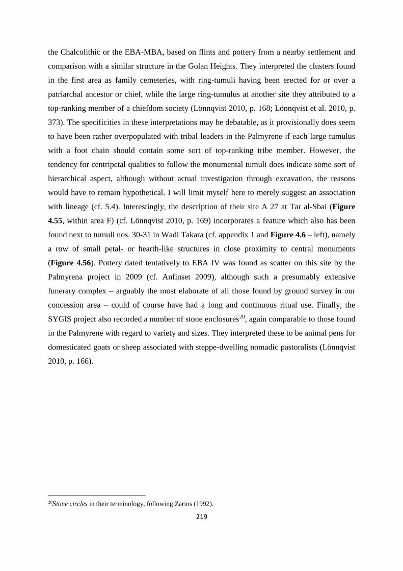
219
the Chalcolithic or the EBA-MBA, based on flints and pottery from a nearby settlement and
comparison with a similar structure in the Golan Heights. They interpreted the clusters found
in the first area as family cemeteries, with ring-tumuli having been erected for or over a
patriarchal ancestor or chief, while the large ring-tumulus at another site they attributed to a
top-ranking member of a chiefdom society (Lönnqvist 2010, p. 168; Lönnqvist et al. 2010, p.
373). The specificities in these interpretations may be debatable, as it provisionally does seem
to have been rather overpopulated with tribal leaders in the Palmyrene if each large tumulus
with a foot chain should contain some sort of top-ranking tribe member. However, the
tendency for centripetal qualities to follow the monumental tumuli does indicate some sort of
hierarchical aspect, although without actual investigation through excavation, the reasons
would have to remain hypothetical. I will limit myself here to merely suggest an association
with lineage (cf. 5.4). Interestingly, the description of their site A 27 at Tar al-Sbai (Figure
4.55, within area F) (cf. Lönnqvist 2010, p. 169) incorporates a feature which also has been
found next to tumuli nos. 30-31 in Wadi Takara (cf. appendix 1 and Figure 4.6 – left), namely
a row of small petal- or hearth-like structures in close proximity to central monuments
(Figure 4.56). Pottery dated tentatively to EBA IV was found as scatter on this site by the
Palmyrena project in 2009 (cf. Anfinset 2009), although such a presumably extensive
funerary complex – arguably the most elaborate of all those found by ground survey in our
concession area – could of course have had a long and continuous ritual use. Finally, the
SYGIS project also recorded a number of stone enclosures20, again comparable to those found
in the Palmyrene with regard to variety and sizes. They interpreted these to be animal pens for
domesticated goats or sheep associated with steppe-dwelling nomadic pastoralists (Lönnqvist
2010, p. 166).
20Stone circles in their terminology, following Zarins (1992).

220
Figure 4.56: Petal- or hearth-shaped structures found lying in a row of at least five or six in association with the
funerary complex incorporating tumuli nos. 30-31 (appendix 1). Such structures were seemingly also found by
the Finnish SYGIS project in Jebel Bishri, if their description is accurate and interpreted correctly here,
suggesting specific structural similarity over large areas within essentially the same biome.
4.7.3 The Syro-Japanese project in Jebel Bishri
Research carried out by the Syro-Japanese team in Jebel Bishri has undoubtedly led to the
most significant advances in our understanding of archaeology in the eastern central Syrian
arid landscapes. They undertook both excavations at the settlement site Tell Ghanem al-Ali,
located c. 50 km downstream from modern Raqqa, as well as surveys in the Jebel Bishri
highlands, including key excavations at cemetery sites on the Euphrates terrace (Wadi Daba),
on the steppe terrace just south of the settlement (Wadi Shabout), and most importantly for
this study in the steppe interior of the highlands (Tor Rahum and Wadi Hedaja) (cf. Numoto
& Kume 2010; Nishiaki 2010; Nakamura 2010; Fujii & Adachi 2010 – cf. Figure 4.55, areas
G and H, including associated site designations). Their focus was on social and chronological
associations between the settlement at Tell Ghanem al-Ali and these cemeteries, and they
actually acquired absolute dates for some of the sites. Occupation at Tell Ghanem al-Ali was
found by radiocarbon dating to stretch through the entire EBA, with the earliest date at c.
3000 BCE and last occupation layers dated to 2400-2050 BCE, and thus showed consistency
with the surface scatter of pottery and excavated material, in both instances dated to EBA III
and IV (Nakamura 2010, p. 127, fig. 6 and table 3). The cemetery at Wadi Shabout was
described as lying on the northern edge of Jebel Bishri, being part of an area which contains
thousands of plundered graves (Numoto & Kume 2010, p. 50). The researchers divided the
various types of burial monuments located at the sites of Wadi Shabout and Wadi Daba into
four distinct types based on morphology and topographical context. Underlying a tell near the
plateau edge, two burial cairns dated by associated material to the late 3rd millennium BCE

221
were discovered. These had apparently been destroyed in the Hellenistic or Roman period.
Slightly further inland, but still overlooking the settlement at Tell Ghanem al-Ali, was a
number of subterranean stone chamber or cist graves, while somewhat further inland from
these a mix of stone chamber and shaft graves were recorded. Lastly, the team recorded
several shaft graves in Wadi Daba closer to the settlement and the Euphrates (cf. Numoto &
Kume 2010, pp. 51-52). All these burial monuments have been chronologically placed in the
EBA III-IVa (Nishiaki 2010, p. 44), but with an internal sequence following the description
above from first to last respectively, and interpreted to be a manifestation of ancestor worship
structure starting with mobile pastoralist beginnings and developing toward a sedentary or
sedentary/mobile mixed population in the area, centered on Tell Ghanem al-Ali (Numoto &
Kume 2010, pp. 7-58; Nishiaki 2010, p. 44). Based on comparative work on the Abu Hamad
cemetery, which is also situated on the plateau just above the river valley and thought to
contain thousands of graves, Nishiaki (2010, p. 45) suggested that this zone may be a
transitional burial zone between settled and mobile members of the same community, albeit
on an unknown tribal level. Abu Hamad is presumed to contain thousands of graves in various
necropolises within about three km2, where 20 of them were excavated and 300 more have
been documented (Meyer 2010, p. 156). The burial monuments were also here (cf. Meyer
2010, pp. 157-158) divided into four types – shaft graves, stone cists with slab, and earth
graves and cists with stone cover, the latter two of which i.e. are tumuli according to the
definitions here (cf. 4.1.3) – seemingly similar to the four types defined by the Syro-Japanese
team. There are several variations within the horizon of the latter two types, although the
burial chambers are described in these words:
“(…) side-walls are not made of stone and they do not reach as deep down [as stone cists
with slab]” (Meyer 2010, p. 158 – my clarifications in brackets).
They were also said to appear in groups of two and three and used for single burials, all of
which are very similar in description to many of the tumuli recorded in the Palmyrene. One
area, Abu Hamad necropolis J, contained stone cists or single graves each covered by a
tumulus, morphologically homogenous, and not containing any shaft graves, circumstances
recurring in seven of the other necropolises (Meyer 2010, pp. 159-160), again a very
comparable situation to some tumulus clusters in Jebel Merah (e.g. Taniyet ez Zerr, but also
several others). This internal relation was interpreted to represent family structures, while
more heterogeneously mixed areas (e.g. necropolis E), with a few large shaft graves or where
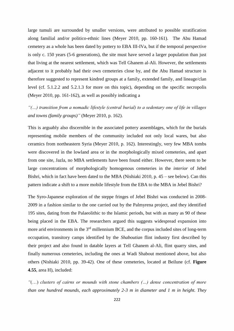
222
large tumuli are surrounded by smaller versions, were attributed to possible stratification
along familial and/or politico-ethnic lines (Meyer 2010, pp. 160-161). The Abu Hamad
cemetery as a whole has been dated by pottery to EBA III-IVa, but if the temporal perspective
is only c. 150 years (5-6 generations), the site must have served a larger population than just
that living at the nearest settlement, which was Tell Ghanem al-Ali. However, the settlements
adjacent to it probably had their own cemeteries close by, and the Abu Hamad structure is
therefore suggested to represent kindred groups at a family, extended family, and lineage/clan
level (cf. 5.1.2.2 and 5.2.1.3 for more on this topic), depending on the specific necropolis
(Meyer 2010, pp. 161-162), as well as possibly indicating a
“(…) transition from a nomadic lifestyle (central burial) to a sedentary one of life in villages
and towns (family groups)” (Meyer 2010, p. 162).
This is arguably also discernible in the associated pottery assemblages, which for the burials
representing mobile members of the community included not only local wares, but also
ceramics from northeastern Syria (Meyer 2010, p. 162). Interestingly, very few MBA tombs
were discovered in the lowland area or in the morphologically mixed cemeteries, and apart
from one site, Jazla, no MBA settlements have been found either. However, there seem to be
large concentrations of morphologically homogenous cemeteries in the interior of Jebel
Bishri, which in fact have been dated to the MBA (Nishiaki 2010, p. 45 – see below). Can this
pattern indicate a shift to a more mobile lifestyle from the EBA to the MBA in Jebel Bishri?
The Syro-Japanese exploration of the steppe fringes of Jebel Bishri was conducted in 2008-
2009 in a fashion similar to the one carried out by the Palmyrena project, and they identified
195 sites, dating from the Palaeolithic to the Islamic periods, but with as many as 90 of these
being placed in the EBA. The researchers argued this suggests widespread expansion into
more arid environments in the 3rd millennium BCE, and the corpus included sites of long-term
occupation, transitory camps identified by the Shaboutian flint industry first described by
their project and also found in datable layers at Tell Ghanem al-Ali, flint quarry sites, and
finally numerous cemeteries, including the ones at Wadi Shabout mentioned above, but also
others (Nishiaki 2010, pp. 39-42). One of these cemeteries, located at Beilune (cf. Figure
4.55, area H), included:
“(…) clusters of cairns or mounds with stone chambers (…) dense concentration of more
than one hundred mounds, each approximately 2-3 m in diameter and 1 m in height. They

223
were built of gypsum rocks and contained stone chambers. Some cairns formed larger
mounds (…) containing several stone chambers that were linearly placed” (Nishiaki 2010, p.
43).
They were dated to the EBA by the scatter of Euphrates Banded Ware from plundered tombs,
but some of the cairns were seemingly untouched and thus of unknown date (Nishiaki 2010,
p. 43). Again, the similarities in context and form with many of the structures in the Jebel
Abyad and Jebel Merah areas are striking, but the method of dating via pottery scatter from
looted tumuli must initially be viewed with caution (cf. Bradbury 2011, p. 242). Finally, the
Syro-Japanese project also surveyed an area of c. 150 km2 in central parts of western Jebel
Bishri (Figure 4.55, area G), i.e. an area similar in topographical and environmental context
to the survey area of the Palmyrena project, although with mountains of lower altitude (500-
700 m) and more plateau-like profile (Fujii & Adachi 2010, pp. 61-63; cf. Wirth 1971, pp. 54-
55). Essentially, they recorded very similar burial monuments and contexts, with 398 cairns
grouped into 35 cairn fields, and the topographical focus of these mainly being on mesas or
along ridgelines, with very few on the fluvial wadi-plains. They characterised this as an area
being densely concentrated with tumuli, which suggested activities of a large ethno-culturally
homogenous group, probably having a spatial focus of funerary activities associated with
features of long-distance visibility (Fujii & Adachi 2010, p. 63). However, their
characterisation of a cairn field included tumuli described as:
“(…) aligned at an interval of ca. 100-300 m, thereby forming a loose continuum ca. 1-2 km
in total length” (Fujii & Adachi 2010, pp. 63-64).
This is not what has been applied in the present analysis to characterise a group (cf. 4.1.4), but
the argument behind this characterisation of a cairn field is understandable, as the tumuli often
do have a visual and contextual association with each other on a larger scale than merely
within a localised cemetery (cf. Figure 4.9). On the other hand, this would in fact mean that
entire mountain ranges in the Palmyrene should constitute one large cairn field, because very
few monuments lie isolated more than 100-300 m from another monument. I will therefore
continue to keep the relationship between the burial monuments at a localised level here, i.e.
within maximum 30-40 m, when describing a site as a cemetery, group, or complex of tumuli.
Additionally, the chronological relations between the Palmyrene tumuli are still uncertain,
although the hypothesis focuses on a Bronze Age time-frame. However, the research carried
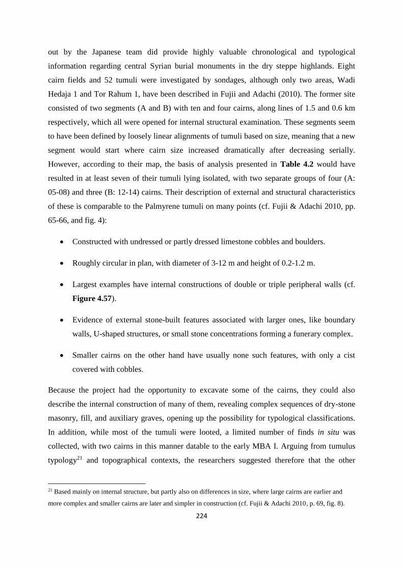
224
out by the Japanese team did provide highly valuable chronological and typological
information regarding central Syrian burial monuments in the dry steppe highlands. Eight
cairn fields and 52 tumuli were investigated by sondages, although only two areas, Wadi
Hedaja 1 and Tor Rahum 1, have been described in Fujii and Adachi (2010). The former site
consisted of two segments (A and B) with ten and four cairns, along lines of 1.5 and 0.6 km
respectively, which all were opened for internal structural examination. These segments seem
to have been defined by loosely linear alignments of tumuli based on size, meaning that a new
segment would start where cairn size increased dramatically after decreasing serially.
However, according to their map, the basis of analysis presented in Table 4.2 would have
resulted in at least seven of their tumuli lying isolated, with two separate groups of four (A:
05-08) and three (B: 12-14) cairns. Their description of external and structural characteristics
of these is comparable to the Palmyrene tumuli on many points (cf. Fujii & Adachi 2010, pp.
65-66, and fig. 4):
Constructed with undressed or partly dressed limestone cobbles and boulders.
Roughly circular in plan, with diameter of 3-12 m and height of 0.2-1.2 m.
Largest examples have internal constructions of double or triple peripheral walls (cf.
Figure 4.57).
Evidence of external stone-built features associated with larger ones, like boundary
walls, U-shaped structures, or small stone concentrations forming a funerary complex.
Smaller cairns on the other hand have usually none such features, with only a cist
covered with cobbles.
Because the project had the opportunity to excavate some of the cairns, they could also
describe the internal construction of many of them, revealing complex sequences of dry-stone
masonry, fill, and auxiliary graves, opening up the possibility for typological classifications.
In addition, while most of the tumuli were looted, a limited number of finds in situ was
collected, with two cairns in this manner datable to the early MBA I. Arguing from tumulus
typology21 and topographical contexts, the researchers suggested therefore that the other
21 Based mainly on internal structure, but partly also on differences in size, where large cairns are earlier and
more complex and smaller cairns are later and simpler in construction (cf. Fujii & Adachi 2010, p. 69, fig. 8).
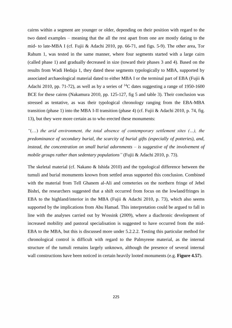
225
cairns within a segment are younger or older, depending on their position with regard to the
two dated examples – meaning that the all the rest apart from one are mostly dating to the
mid- to late-MBA I (cf. Fujii & Adachi 2010, pp. 66-71, and figs. 5-9). The other area, Tor
Rahum 1, was tested in the same manner, where four segments started with a large cairn
(called phase 1) and gradually decreased in size (toward their phases 3 and 4). Based on the
results from Wadi Hedaja 1, they dated these segments typologically to MBA, supported by
associated archaeological material dated to either MBA I or the terminal part of EBA (Fujii &
Adachi 2010, pp. 71-72), as well as by a series of 14C dates suggesting a range of 1950-1600
BCE for these cairns (Nakamura 2010, pp. 125-127, fig 5 and table 3). Their conclusion was
stressed as tentative, as was their typological chronology ranging from the EBA-MBA
transition (phase 1) into the MBA I-II transition (phase 4) (cf. Fujii & Adachi 2010, p. 74, fig.
13), but they were more certain as to who erected these monuments:
“(…) the arid environment, the total absence of contemporary settlement sites (…), the
predominance of secondary burial, the scarcity of burial gifts (especially of potteries), and,
instead, the concentration on small burial adornments – is suggestive of the involvement of
mobile groups rather than sedentary populations” (Fujii & Adachi 2010, p. 73).
The skeletal material (cf. Nakano & Ishida 2010) and the typological difference between the
tumuli and burial monuments known from settled areas supported this conclusion. Combined
with the material from Tell Ghanem al-Ali and cemeteries on the northern fringe of Jebel
Bishri, the researchers suggested that a shift occurred from focus on the lowland/fringes in
EBA to the highland/interior in the MBA (Fujii & Adachi 2010, p. 73), which also seems
supported by the implications from Abu Hamad. This interpretation could be argued to fall in
line with the analyses carried out by Wossink (2009), where a diachronic development of
increased mobility and pastoral specialisation is suggested to have occurred from the mid-
EBA to the MBA, but this is discussed more under 5.2.2.2. Testing this particular method for
chronological control is difficult with regard to the Palmyrene material, as the internal
structure of the tumuli remains largely unknown, although the presence of several internal
wall constructions have been noticed in certain heavily looted monuments (e.g. Figure 4.57).
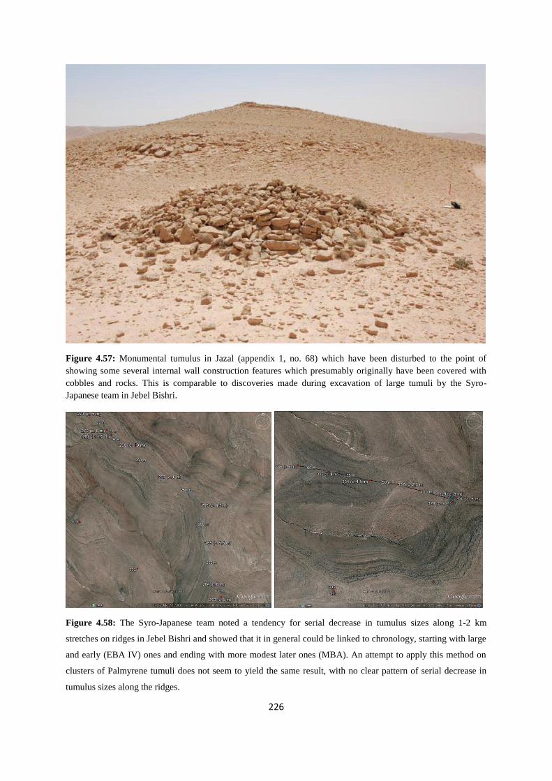
226
Figure 4.57: Monumental tumulus in Jazal (appendix 1, no. 68) which have been disturbed to the point of
showing some several internal wall construction features which presumably originally have been covered with
cobbles and rocks. This is comparable to discoveries made during excavation of large tumuli by the Syro-
Japanese team in Jebel Bishri.
Figure 4.58: The Syro-Japanese team noted a tendency for serial decrease in tumulus sizes along 1-2 km
stretches on ridges in Jebel Bishri and showed that it in general could be linked to chronology, starting with large
and early (EBA IV) ones and ending with more modest later ones (MBA). An attempt to apply this method on
clusters of Palmyrene tumuli does not seem to yield the same result, with no clear pattern of serial decrease in
tumulus sizes along the ridges.

227
However, the method of serially segmented cairn fields of intra-tumuli relations based on
decreasing size along a ridgeline does not seem to apply in the Palmyrene, with e.g. two well-
surveyed ridges in Jebel Merah (nos. 263-271 and 328-330/334-337) evidently not following
such a pattern (cf. Figure 4.58). These clusters consist of nine and seven tumuli respectively,
separated by 30-260 m of empty stretches, but with diameters varying up and down from 2.5
to 10 m without any serial decrease, with the majority of them being sized c. 4-6 m. Although
these are only two examples, they represent the general picture of tumulus relations vs. sizes
in the Palmyrene, suggesting that this region on the surface does not seem to follow a pattern
like that reported in Tor Rahum 1 or Wadi Hadaja 1 by the Syro-Japanese team – or indeed
any clear pattern at all. However, again it must be stressed that much of the argument on
tumulus sequences by Fujii and Adachi (2010) was based on internal structural
technotypology, making a strict chronological argument based on size variations within
relatively associated tumuli in the Palmyrena survey unreliable, particularly with so many
tumuli being sized within a narrow horizon centered on a diameter of 5 m (cf. Figure 4.58).
The Syro-Japanese team also argued that the occurrence of large cairns at certain intervals
suggests a presence of several sub-segments (Fujii et al 2010a, p. 104), which seems
particularly difficult to test without excavations.
Their annual site reports supported the impression that there are many similarities between the
Jebel Bishri material and the Palmyrene material, but due to their more extensive recording,
these reports also provide valuable information on a number of related aspects (cf. Fujii et al.
2009a; 2009b; Ohnuma & Al-Khabour 2008, p. 143, photo 9; Fujii 2009; Fujii et al. 2010a;
2010b; Nakano 2010; Nishiaki et al. 2011). The tumuli had a diameter range of three to ten
meters in general, with most being around four to six meters, while surviving height stretched
from 0.1 to 1.3 m, but lie mostly in the range of 0.3-0.5 m – all dimensions very comparable
to patterns in the Palmyrena survey. The recovered grave goods usually consisted of
assemblages that included flint artefacts or flakes, beads of carnelian, faience, perforated
snails or cowrie shells, and bronze fragments or small objects like rings, daggers and pins.
Some tumuli also exhibited at least three types of pottery, with sherds dating to the EBA-
MBA transition, and many showed more or less fragmented human remains, clear evidence –
if needed – that the tumuli were erected with funerary function in mind. Then again, some of
the cairns, like many in the Palmyrena survey, were devoid of any finds or skeletal material.
However, the grave goods of portable ornamental objects and little if any pottery is consistent

228
with what one would expect in assemblages of material remains associated with mobile
pastoralists, possibly displaying individual or group identity through such objects, and the
skeletal material support the notion that the tumuli housed remains of individuals whose life
consisted of a high proportion of walking, i.e. a mobile lifestyle. While the Palmyrena project
has failed to find any human remains in association with the burial monuments, the scarce
amount of material from tumulus sites in general, as well as the nature of it – i.e. a smattering
of pottery, some objects of personal ornamentation, and one collection of bronze fragments
(Figure 4.59) – does indeed suggest comparable assemblages to those recovered in Jebel
Bishri by the Syro-Japanese project and supports the notion that many of the Palmyrene
tumuli were erected by EBA and MBA mobile pastoralists.
Figure 4.59: Stone bead (left) found in association with tumulus no. 131 and bronze fragments (right) found in
association with tumulus no. 155 in the Palmyrene, more specifically the northern parts of Jebel Abyad (cf.
appendix 1). Although chronologically undiagnostic, these finds can be characterised as small personal
ornaments similar to the material described by the Syro-Japanese project, indicating that many Palmyrene tumuli
can be considered funerary (or otherwise, cf. 5.4.2) monuments erected by a mobile population.
4.7.4 The Syro-Italian project in the southwestern Palmyrene
Bonacossi and Iamoni (2012) described the results of surveys carried out by the Syro-Italian
project in the region west and southwest of Palmyra, where they identified two cultural
horizons defined by two archaeological structures – kites and tumuli (Bonacossi & Iamoni
2012, p. 35). Except for stone enclosures, which they did not describe, the team thus
presented two of the three characteristic types defined by Zarins’ pastoral nomadic
technocomplex (cf. 4.1.1). Similarly to the Rawda survey, their study area bordered more or
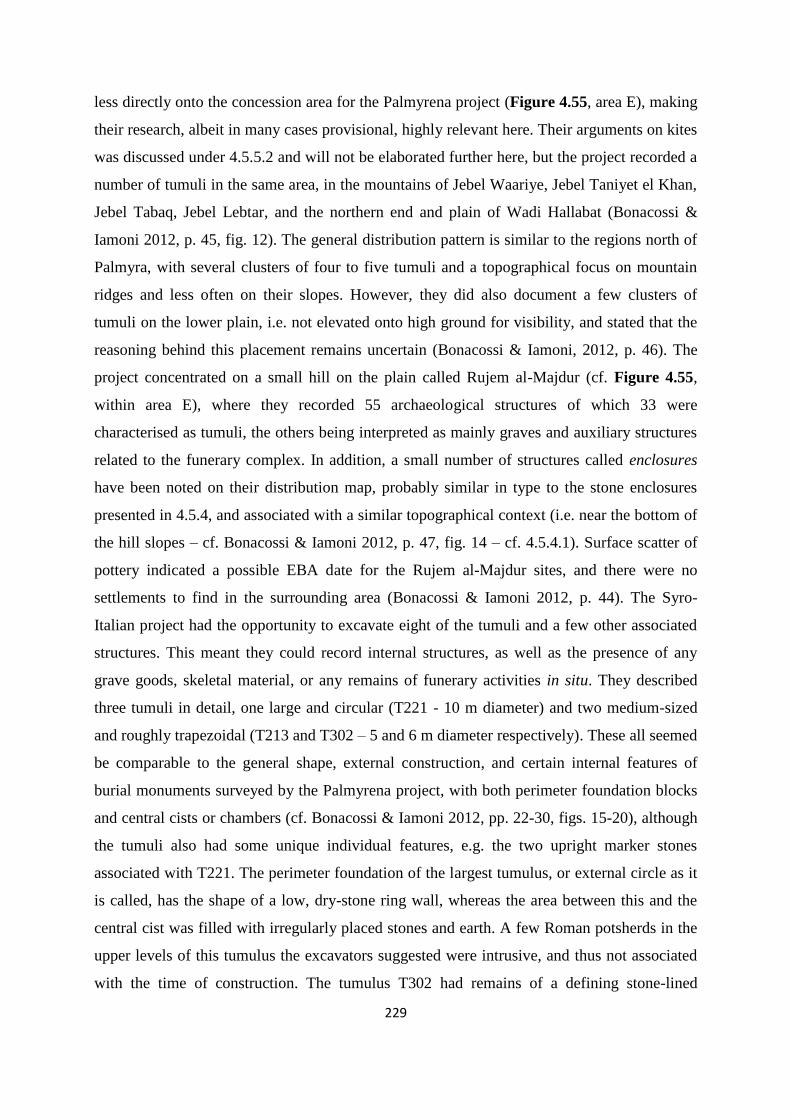
229
less directly onto the concession area for the Palmyrena project (Figure 4.55, area E), making
their research, albeit in many cases provisional, highly relevant here. Their arguments on kites
was discussed under 4.5.5.2 and will not be elaborated further here, but the project recorded a
number of tumuli in the same area, in the mountains of Jebel Waariye, Jebel Taniyet el Khan,
Jebel Tabaq, Jebel Lebtar, and the northern end and plain of Wadi Hallabat (Bonacossi &
Iamoni 2012, p. 45, fig. 12). The general distribution pattern is similar to the regions north of
Palmyra, with several clusters of four to five tumuli and a topographical focus on mountain
ridges and less often on their slopes. However, they did also document a few clusters of
tumuli on the lower plain, i.e. not elevated onto high ground for visibility, and stated that the
reasoning behind this placement remains uncertain (Bonacossi & Iamoni, 2012, p. 46). The
project concentrated on a small hill on the plain called Rujem al-Majdur (cf. Figure 4.55,
within area E), where they recorded 55 archaeological structures of which 33 were
characterised as tumuli, the others being interpreted as mainly graves and auxiliary structures
related to the funerary complex. In addition, a small number of structures called enclosures
have been noted on their distribution map, probably similar in type to the stone enclosures
presented in 4.5.4, and associated with a similar topographical context (i.e. near the bottom of
the hill slopes – cf. Bonacossi & Iamoni 2012, p. 47, fig. 14 – cf. 4.5.4.1). Surface scatter of
pottery indicated a possible EBA date for the Rujem al-Majdur sites, and there were no
settlements to find in the surrounding area (Bonacossi & Iamoni 2012, p. 44). The Syro-
Italian project had the opportunity to excavate eight of the tumuli and a few other associated
structures. This meant they could record internal structures, as well as the presence of any
grave goods, skeletal material, or any remains of funerary activities in situ. They described
three tumuli in detail, one large and circular (T221 - 10 m diameter) and two medium-sized
and roughly trapezoidal (T213 and T302 – 5 and 6 m diameter respectively). These all seemed
be comparable to the general shape, external construction, and certain internal features of
burial monuments surveyed by the Palmyrena project, with both perimeter foundation blocks
and central cists or chambers (cf. Bonacossi & Iamoni 2012, pp. 22-30, figs. 15-20), although
the tumuli also had some unique individual features, e.g. the two upright marker stones
associated with T221. The perimeter foundation of the largest tumulus, or external circle as it
is called, has the shape of a low, dry-stone ring wall, whereas the area between this and the
central cist was filled with irregularly placed stones and earth. A few Roman potsherds in the
upper levels of this tumulus the excavators suggested were intrusive, and thus not associated
with the time of construction. The tumulus T302 had remains of a defining stone-lined

230
perimeter and rubble fill between this and the cist, while the smallest one, T213, did not have
a perimeter foundation except in the lower parts of the structure. While T221 and T213 had
been looted, possibly in antiquity, there was no apparent intrusion into T302, where the cist
contained an ash layer with bone fragments. Two of these burial monuments also had
auxiliary features like an associated semi-circular structure (T221) and a satellite grave
(T213). The investigations carried out by the Syro-Italian project thus added more data to the
corpus of information regarding central Syrian burial practices and provided yet again some
indication of provisional dating. However, the main approach to chronological control seems
to be based on the possibilities for excavation, with surveys only able to provide limited forms
of dating. On the other hand, their work still seems to support a general pattern of EBA-MBA
chronology for tumuli in the dry steppe highlands, although they stressed that there are
problems with the lack of precision and an inherent fragility in the archaeological material
from such sites, which hopefully can be solved through the acquisition of absolute dates
(Bonacossi & Iamoni 2012, p. 52).
4.8 Summary and conclusions
The archaeological remains of the Palmyrene forming part of the mobile pastoralist
technocomplex – that is tumuli, stone enclosures, and kites (cf. 4.1.1) – are extensively
distributed across the region, but with notable differences and characteristics in landscape
contexts. This has been shown by on-the-ground survey, and further substantiated and
supported by investigations of satellite imagery on regional scale, which covered nearly 4000
km2 and increased the data set of each structure type manyfold, to include over 8000 tumuli,
nearly 2500 stone enclosures, and over 300 kites. The full analysis of all these archaeological
monuments seems to affirm that tumuli overwhelmingly are directed toward communication
lines locally, with placements topographically determined routes and along lofty mountain
ridges suggesting an emphasis on perspective. Many tumuli, like the monumental cairns, were
clearly meant to be seen from far away by people moving through the landscape, while some,
like those here defined as mounds, were more directly associated with particular routes. A
number of auxilliary features – such as platforms or stone rows – have been documented to be
associated with both isolated tumuli and with clusters. These have been defined and analysed
here to a degree, and although they are seemingly found throughout the surveyed area, it has
not been possible to detect a particular distribution pattern among them. Finally, the regional

231
distribution of tumuli show a significant drop-off in densities toward the northwest and the
east-northeast and high concentrations in most of the central Palmyrene (cf. Figure 4.29). In
general, apart from local focus on movement through the landscape, the highlands and wadi-
valleys in between them are more ubiquitously and consistently distributed with tumuli in
various archaeological contexts, suggesting a focus on the region as a whole (cf. Figure
4.30), rather than on overregional communication lines between the river valleys.
The other structures identified in the satellite surveys are associated with other patterns, but
seem to show some consistency within the structure types themselves. Stone enclosures (cf.
4.5.4) are also ubiquitous, but situated in entirely different parts of the topography. They are
found as isolated structures or clusters, and many seem to have an association with water run-
off. However, their functional interpretation is not clear-cut, and a range of suggestions –
human habitation, animal pens, or small-scale gardens – could, and in my mind should, be
considered on a case-by-case basis. Even though they probably have been used for a variety
of purposes for millennia, comparative evidence show that some have obviously also been
constructed and used during the EBA IV. This is also the case with the many Palmyrene kites
(cf. 4.5.5), which I suggest were mainly constructed for large-scale drives of wild animals,
and used from at least the Chalcolithic until recent times. They vary significantly in shape and
size, but contrary to the other two structure types, they are much more limited geographically
(cf. Figure 4.38), and are clearly directed toward the seasonal migration of gazelle
populations – specifically the one going from Al-Hamad to the Syrian plains.
Chronological control of the Palmyrene tumuli has proved difficult to obtain, with attempted
OSL dating failing to produce results, and most of the pottery finds assembled during the
survey being of tentative value, although some material seems be datable to EBA IV.
However, a number of other projects working in the region (cf. 4.7) have indeed shown that
very similar structures situated in archaeologically, topographically, and geographically
comparable contexts are generally datable to the EBA IV and the MBA. In addition, in cases
where it is possible to determine, they seem to be associated with a mobile population. Thus,
it seems likely that many – if not most – of these monuments can be considered to have been
constructed by mobile groups using or inhabiting the Palmyrene in the later 3rd and early 2nd
millennium BCE. With this, I will now turn to the final aspect of this dissertation – mobile
pastoralists in the Bronze Age Near East.

232
5 Near Eastern mobile pastoralism
A large corpus of literature has been published on the topic of Bronze Age societies and the
relationship between mobile and sedentary groups and their tribal affiliations, with links
extending back into the EBA in the Near East (e.g. Kupper 1957; 1959; Luke 1965; Matthews
1978; Porter 2000; 2012; and numerous other scholars). This material has usually been based
mainly on the Mari texts (cf. 3.2.2), as well as numerous smaller archives (cf. 3.2.4), and our
understanding has widened tremendously in the last decades, especially thanks to the
extensive contributions emerging from the work carried out by the French Mari school under
the direction of Charpin and Durand (Porter 2012, p. 26). Other noteworthy recent, but
important studies in this area which, according to Porter (2012, p. 27, note 33), have yet to
make the impact they should, are Heimpel (2003) and Fleming (2004). These scholars have
provided new approaches to the study of mobile pastoralism and tribal groups during the
Bronze Age, which have more or less revolutionised the contextual picture, and much of the
content in this chapter is directly based upon their research and interpretations. It is far
beyond the scope of this dissertation to complement or criticise these scholars on the specifics
of sociological, ethnographical, linguistic, or historical terminology. I will rather merely apply
their studies and arguments synthetically to the archaeological structures recorded in the
Palmyrene, put these into a socio-historical context, and try to find an explanation for this
particular expression of physical manifestation.
The chapter will start with a look at the mobile pastoralist world in the Near East in recent
times (cf. 5.1), first with a presentation of earlier views on both the subsistence practice and
on their structures of social organisation. Thereafter, I will present relevant definitions applied
throughout this dissertation and discuss patterns specifically regarding Near Eastern mobile
pastoralists in recent times – their subsistence base, their seasonal schedule, and how they
relate to other groups. With recent practices as a backdrop, I will look at what both Bronze
Age texts and archaeological research can tell us about ancient mobile pastoralist practices
and organisation (cf. 5.2). Here the Mari archives in particular are essential for my
interpretation, but the comparative element found in studies of recent mobile groups will also
form a crucial part of the discussion. One of the key aspects for understanding EBA and MBA
societies and structures seems to be the concept of tribal identity and kinship among the
various groups of the Near East at the time, to which I will devote a substantial amount of

233
consideration (cf. 5.3). Based on recent research (e.g. Wossink 2009; Porter 2012), I believe a
number of misconceptions have been integrated with our perspective of tribal identity. I will
therefore present current theories on this aspect, particularly by looking at the group called
Amorrites (cf. 5.3.1), but also by considering how a reevaluation and reinterpretation of the
Mari texts in light of tribal identity can provide a whole new perspective of the region and the
interaction of its various groups (cf. 5.3.2 and 5.3.3). Through this, it is in my view possible to
argue in favour of an integration of Palmyrene archaeological remains with a structural model
which includes concepts of tribal territory and seasonal mobility (cf. 5.4), which in fact is
supported by recent translations of ancient texts (cf. Durand 2005).
5.1 General patterns of mobility, pastoralism, and tribes
5.1.1 Earlier views on tribes and mobile pastoralism
Ancient Near Eastern mobile pastoralism has seen its share of scholarly dispute, both from
earlier research and with regard to certain issues within the current debate, ranging from
ethnographic notions like tribes and kinship, or nomads and pastoralism, to more contentious,
and often outdated concepts, such as evolutionary determinism or the perceived conflict
inherent in the term the desert and the sown (Bell 1908; e.g. cf. Wossink 2009, p. 128). Of
course, the accumulation of information and resulting increase in complexity of the
perspective makes a development from previously more simplistic views toward more
composite ones unavoidable, but provides also in my opinion a clearer image of ancient
societies – and this will of course continue as research and scholarly discussion moves
forward in a structured, interdisciplinary, and inclusionary manner.
At the outset, it must be pointed out that any deterministic notions involving ancient mobile
pastoralist populations to necessarily in time settle as agriculturalists or at least agro-
pastoralists are in my view defunct. Earlier studies (e.g. Kupper 1957) often advocated such a
stepwise development of Near Eastern mobile societies in the Bronze Age, and to some
degree, this was still invoked in more current research, like Anbar (1991) and Streck (2000),
although Streck himself later disassociated himself from this notion (cf. Streck 2002, p. 170).
However, such deterministic post-nomadic sedentarisation was already in the works of Luke
(1965, p. 19) and Matthews (1978, p. 21) more or less rejected in favour of a more nuanced
perspective. It seems also to be the general consensus today among archaeologists working
234
with themes on the Bronze Age Near East. Rather, such societies should be approached as
very fluid, opportunistic, and adaptable to changing situations – environmental, economic,
political etc. – enabling mobile pastoralist groups to shift to a more sedentary lifestyle if that
is deemed advantageous, and sedentary populations could likewise become more mobile
when necessary, as well as numerous other potential coping strategies found in ethnographic
studies (cf. Fleming 2004, p. 224; Wossink 2009, pp. 34-35 – cf. 5.1.3.3). In other words,
sociocultural change is repetitive and cyclical, with alternating phases (Fleming 2004, p. 224,
after Salzman 1980, pp. 1, 4, 7 – also cf. 3.5). My own view is particularly influenced by
scholars like Fleming (2004) and Porter (2000; 2012), and boils down to the post-processual
approach where overgeneralised and stringent patterns of socioeconomic development often
are seen as unsuitable for what is essentially a very wide and fluid horizon of human
adaptations, which in addition should be contextualised within a cultural embedding.
5.1.1.1 The Bedouin misconception
Thus, there are a few aspects regarding pastoralism and mobility that I will clear out of the
way in this subchapter, some of which have been generally accepted by most archaeologists
working with this topic, but I still wish to point out here. The first point is the fact that mobile
groups during the Bronze Age did not practice a lifestyle of pure nomadism (cf. 5.1.2). From
the 19th century CE and continuing into early anthropological studies, analogies between such
ancient societies and modern Bedouins were often the norm (cf. Luke 1965, p. 12). However,
the practices and lifestyle of Bedouin groups are fully dependent on the domestication of the
camel, with its high-carrying capacity, far-reaching range, and specialist potential in
extremely arid environments (Bulliet 1990, p. 23; Rosen & Saidel 2010, pp. 72-73), and thus
to view Bronze Age mobile pastoralists as similar to Bedouins would clearly be an
anachronism (Khazanov 2009, p. 122). Incidentally, the term Bedouin, which often in French
literature denotes nomads or mobile pastoralists in general (e.g. Durand 2004; Charpin 2004;
also cf. Fleming 2004, p. 252, note 67), is here exclusively applied to mean Near Eastern
mobile groups known from Classical and recent to modern times, usually associated with
camel pastoralism. Other forms of mobile pastoralism – i.e. sheep- and goat-herding,
including donkeys – require entirely different approaches based on a semi-mobile lifestyle
following seasonal changes, which means that camels generally cannot be pastured with
ovicaprines (Khazanov 1994, p. 55). The domestication of the camel, although still somewhat
a matter of scholarly debate, is by most archaeologists thought to have occurred in the LBA

235
and did probably not become widespread in the Near East until the Iron Age (e.g. Khazanov
1994, p. 100; 2009, p. 122; Rosen 2008, pp. 124-125; Rosen & Saidel 2010, pp. 75-76; also
cf. Artzy 2007, pp. 134-135). In any case, it certainly did not constitute part of neither
sedentary nor mobile husbandry at Mari. Therefore, EBA and MBA mobile pastoralist
societies were most likely not far-ranging desert nomads, but rather seasonally mobile sheep-
and goatherders taking advantage of the pasturage emerging in the steppe as a result of winter
precipitation providing favourable conditions, and subsequently retreating to secure water
sources in the river valleys during the hot and dry summer season (Joannès 1996, p. 327 –
also cf. 5.1.3.2 and 5.2.1.2). This realisation also affects the now antiquated picture of waves
of invading nomads originating in the Syro-Arabian Desert (e.g. cf. Zarins 1990, p. 33 on this
aspect of research history), since riders on camelback during the EBA-MBA clearly would be
an anachronism, and rather appear around a millennium later (Luke 1965, p. 12; Khazanov
2009, p. 122; Szuchman 2009, p. 2). In fact, during the Bronze Age, mobile groups did not
use mounted warriors at all and lacked military superiority to sedentary populations, as later
Bedouins possessed (Bar-Yosef & Khazanov 1992, p. 5; Khazanov 2009, p. 124). Kupper
(1957) exchanged the wave-theory with a continuous pressure or river of mobile groups from
the arid steppes or Arabian Desert. This hinged on the perceived view of perpetual conflict
between mobile and sedentary groups, in which the former replaced the latter, became
sedentarised, and the process subsequently repeated itself with yet another mobile group from
a constant mass of nomads found in the arid regions, indeed often located to be the Palmyrene
or Jebel Bishri. However, the model was challenged not long after its emergence on three
points, namely on the already mentioned evolutionary determinism of nomadism preceeding
sedentism, on nomadic-sedentary conflict as a false historical constant, and also that nomadic
impact on the sedentary zone would be the prime mechanism of sociopolitical change in the
Near East (Luke 1965, pp. 16-19). Additionally, and importantly, Luke (1965, p. 22)
cautioned against the assumption that observed modern processes of sedentarisation, which
often come as a result of a specific political situation, could be retrojected back into the
Bronze Age.
5.1.1.2 Reassessing earlier theories on the concept of tribe
These are also key points in the second aspect, which has already been mentioned and
concerns the earlier view of deterministic evolution of unavoidable sedentarisation of mobile
pastoralists in a diachronic perspective. Likewise, the deterministic evolution of tribes into an
236
apex of states is not seen as a fruitful approach in studies of the ancient Near East anymore,
nor is the view of them as being intrinsically separate from Bronze Age states. Rowton (1973;
1974) in his series of influential articles on Bronze Age Near Eastern nomadic groups coined
the enduring terms enclosed nomadism and dimorphic society to describe their relations to
cities and states. The first term he applied to the societal structure in which full-time mobile
tribal groups – so-called integrated tribes – acted as autonomous polities within a state, as
opposed to e.g. camel herding Bedouins who in more recent times have acted outside it as
virtually independent (Rowton 1974, pp. 2-3). The second term suggested a dualistic society
of nomadic and sedentary populations interacting, but remaining separate, or as presented by
the author himself:
“(…) between tribe and state. The hallmark of dimorphic structure is an autonomous
chiefdom centered on a town in tribal territory. From this base a local dynasty exerts a
varying blend of rule and influence over the nomadic and sedentary tribes in the countryside.
The population of the chiefdom includes both a nontribal and a tribal element” (Rowton
1973, p. 202).
This view was seen as progressive in the 1970s and the following two decades, but the current
consensus now is that the Bronze Age picture was even more complex, backed up by recent
studies and analyses of the Mari archives (e.g. Fleming 2004; Charpin 2004). Thus, the lasting
and influential analyses put forward by Rowton on the social and political situation of the so-
called Amorrite period in the Near East (cf. 3.4.2), based particularly on the Mari archives,
have recently been challenged on key issues. Fleming (2004, pp. 70-71) questioned the core
of Rowton’s analysis, stating that it was based on the misconception mentioned in the
introduction of this chapter (the hana, cf. 5.2.1.1) and a problematic cross-cultural
comparison. The assumption that tribes and the state, more specifically the MBA royal
administration, were distinctly separate entities is a flawed one, at least in the case of Mari.
He argued that its last king, Zimri-Lim, governed the Mari state as a fully integrated Sim’alite
tribal kingdom (cf. 5.3.2.1), with his kinsmen being the primary base of power. Thus, the
mobile groups were merely components of a tribe, the binu Sim’al, which he ruled as king,
and sedentary Sim’alites and their settlements were likewise a part of the same tribe. The
dimorphic society is therefore unsuitable as a model for the analysis of Bronze Age
sociopolitical structures. Szuchman (2009, pp. 1-2) condoned this view, arguing that
Rowton’s model did not anticipate the great degree of interaction between sedentary urban

237
and mobile pastoral sectors of society, as well as the integration of tribe and state. He also
rejected the opposition between states and mobile groups and the invading nomads as myths,
as did Porter (2004, p. 70; 2012, pp. 5-6) with regard to the city and the pastoralist as
antithetical entities, arguing that they in fact had much in common operationally and
organisationally, often sharing similar ends. Modern and ancient experience is the difference,
i.e. we have reconstructed an understanding of what life would have been like if we had
existed in the past.
“‘Tribe’ and ‘state’ are both inappropriate frameworks, at least as we currently comprehend
these words, to use in understanding the sociopolitical organization of the period from 4000
to 1500 BCE” (Porter 2012, p. 6).
Porter (2000, pp. 422-423) actually suggested that the well-known Rowton term enclosed
nomadism should rather be turned on its head based on his own description of the geopolitical
structure during the EBA-MBA Near East, and rather be characterised as enclosed urbanism –
settlements enclosed and surrounded by mobile pastoralist groups ranging around on the
steppes in search of pasturage.
Lastly, I will clarify the use of the term tribe in this chapter, as it has a long history of use and
abuse in social sciences through its association with theories of cultural evolution found in
e.g. Sahlins (1961; 1968) and Service (1971), and as mentioned in the previous paragraph an
organisation which often has been described as being in opposition to the state. However,
tribes should be understood as cultural, economic, and political systems on a highly flexible,
adaptive, and variable scale (Szuchman 2009, p. 4). While the use of the term tribe as an early
evolutionary stage in the development of human societies or a less sophisticated type of
society than the state (Porter 2012, p. 11) is here rejected as a characterising description, and
follows the thorough theoretical discussion presented by Porter (2000, pp. 53-86), I still
condone the arguments put forward by Fleming (2004, pp. 26-27). His definitions and use of
tribe and tribal confederacy is signifying a population or group characterised by a particular
ethnicon – e.g. Sim’al (cf. 5.3.2.1), Rabbum (cf. 5.3.2.2), or Sutu (cf. 5.3.3) – and practicing a
social organisation based on descent and/or kinship, but should be employed without any
preconceived notion of human societal evolution. Heterarchical, communal, and corporate
are other important characteristics commonly associated with tribes as social systems in Near
Eastern archaeology, mainly to describe the degree of power sharing across the group, rather
238
than power residing with an individual or small group (e.g. Porter 2000; 2004; 2012; cf.
Szuchman 2009, p. 4). This seems in my view to be a relatively fitting description of the
societies we can discern in mainly the Mari archives, as evidenced in the seminal study
carried out by Fleming (2004), but also other textual sources from the EBA and MBA.
5.1.2 Key definitions of pastoralism, mobility, and tribe
Having clarified the position on certain earlier perceived aspects, I will turn to the specifics in
the current debate on these topics. Thus, this subchapter aims to clarify some terms relevant
for the discussion on ancient mobile pastoralists – mainly the three terms pastoralism,
mobility/nomadism, and tribe. These are common features in recent works (e.g. Cribb 1991;
Porter 2000; 2012; Fleming 2004; Wossink 2009) and several major scholar working on this
theme seem to have their own view on the finer points of definitions, usually on the basis of
earlier work – e.g. Cribb (1991) and Fleming (2004) following Khazanov, a (justifiably)
frequently referenced author on the issue (see below) – but also with some of their own newly
developed models and terminologies (e.g. Porter 2000). I will here also put forward the main
points regarding terminology presented by these researchers, so the consequent discussion on
Bronze Age mobile pastoralists can be placed within a proper framework, as well as clear up
some earlier misconceptions and generalisations regarding such societies. As will be seen, the
main difference between the approaches is the weight which is given to either the mode of
production or the extent of mobility, and there is often a conflation of both these aspects.
5.1.2.1 Considerations on terminology regarding mobility and pastoralism
The first two terms, pastoralism and mobility/nomadism, are in archeological and
anthropological literature often conflated into the same terminological framework. Already in
the early 1970s, Salzman (1972, p. 67) argued that these two must be kept separate, with the
former being a form of food production based on animal husbandry, and the latter being
merely a form of movement. He pointed out that pastoralism can be associated with the whole
horizon of mobility, and some mobile strategies may have nothing to do with pastoralism.
However, Khazanov (cf. 1984, pp. 16-24) integrated both, defining his four main points of
pastoral nomadism as: 1) Pastoralism being the predominant economic activity; 2) a practice
of perennial herd maintenance on a system of free-range grazing; 3) periodic mobility
(opposed to migration) between or within specific grazing territories to facilitate the needs of
the herds and the way of life; 4) participation in the mobile lifestyle of all or the majority of
239
the population, i.e. not involving specialist herdsmen; and 5) production aimed at subsistence
requirements, and not toward markets. He upheld these points 25 years later (cf. Khazanov
2009, pp. 119-120), adding that pastoral nomads could practice a small amount of occasional
or opportunistic cultivation, but more significantly that 6) their social organisation is based on
kinship, and for the Near East in particular on real or fictive segmentary systems and
genealogies; and 7) they share certain cultural characteristics associated with their mobile way
of life. However, he seems to have used nomadism and pastoral nomadism as interchangeable
terms, thus in essence defining nomadism as a mode of food-production or an economic
activity (Khazanov 1994, p. 16; also cf. Bar-Yosef & Khazanov 1992, p. 2). On this basis,
Khazanov distinguished a number of specific forms within his definition of pastoral
nomadism, definitions which as mentioned have formed the core for discussions of
pastoralism in recent years. Common for all these types is the degree of which agriculture
takes a part in the economy, interspersed with variations on mobility, usually according to
season or environment. His variations range from no reliance on agriculture at all as pastoral
nomadism proper, via supplementary or secondary agriculture in semi-nomadic pastoralism,
to agriculture as the predominant economic activity in semi-sedentary pastoralism (also called
agro-pastoralism – cf. Khazanov 2009, p. 119), but with temporally and spatially shorter
seasonal pastoral migrations in relation to the two previous categories, and finally sedentary
animal husbandry, which he argued in general is only practiced as a minor supplement to
agriculture. In addition, Khazanov identified herdsman husbandry, which employs all-year
specialist herders looking after the animals on pasture away from the settlements, and
transhumance as a geographically and historically specific form, where livestock are driven
by parts of the society to other ecological zones at certain times of the year, essentially being
a vertically practiced form of herdsman husbandry (i.e. from the lowlands to mountain
pastures). He explicitly noted also that its broad use with regard to pastoralism including
seasonal use of other ecological niches in general is not wholly justifiable (Khazanov 1994,
pp. 23-24).
Khazanov’s work was groundbreaking in its thoroughness in the early 1980s, but a few years
prior to this, Matthews (1978, pp. 18-21) had applied a similar framework to his study of
nomads in the Mari period based upon among others the works of Barth (1961), Bates (1971),
and Salzman (1972). He described transhumance, semi-nomads, and full nomads as three
forms of migratory pastoral activities, all of which descriptively more or less parallel the

240
corresponding categories presented by Khazanov. He emphasised that semi-nomads and full
nomads are in essence societies practicing sheep/goat and camel husbandry respectively (cf.
5.1.1.1), and the former type is the one which he would use to characterise mobile pastoralists
of the Mari period. However, importantly he pointed out that members of the same tribe could
practice transhumance, semi-nomadism, and sedentary agriculture, and as mentioned that
there is no determinism in stepwise tribal progression from full nomadism to sedentary
agriculture.
While Khazanov’s work was mainly associated with anthropological and historical issues,
Cribb (1991) focused on nomadic societies in archaeology specifically, although largely
relying on middle-range theory between anthropology and material remains. He focused on
giving weight to the ratio of pastoral vs. agricultural production practiced by societies, and not
the extent of mobility (Cribb 1991, p. 15). Following this, he argued that most Near Eastern
societies defined as nomadic should be placed in the category of semi-nomadic pastoralism.
Cribb also presented an illustrative model structured along continuum formed by two axes –
agriculture/pastoralism (also termed mode of subsistence) and sedentism/nomadism (i.e.
degree of mobility) – constituting a horizon onto which all mobile pastoralist societies should
be possible to position for analytical purposes (cf. Cribb 1991, pp. 16-17, and Figure 5.1).

241
Figure 5.1: Model presented by Cribb (1991, p. 17) showing the wide horizon along which various current or
recent Near Eastern groups operate with regard to agriculture/pastoralism (x-axis) and sedentarisation/mobility
(y-axis). A tribe or group can be found for nearly every combination of these factors, and there seem to be no
strictly dichotomised patterns of practiced lifestyles.
However, he did suggest that transhumance should be confined to a form of livestock
management that follows seasonal variations in pasture, both on a vertical and horizontal
scale, and can involve elements of nomadism if the population move with the herds, although
he also stated that this is on a different scale to that of proper nomadism, presumably meaning
that transhumance should be considered a less extensive form of mobile animal husbandry. In
this he departs somewhat from Khazanov, including a variation of involvement by people,
from specialised herders to seasonal migration or even the proper nomadic practice involving
whole communities. Cribb crucially pointed out that semi-nomadism as a term has often been
abused and is usually based on a misconception confusing the separate dimensions of
pastoralism and nomadism (Cribb 1991, p. 19), a separation evident in his model. The terms
nomadism and semi-nomadism refer to communal mobility, while pastoralism, transhumance,
and herding are principally subsistence activities (also cf. Wossink 2009, p. 101). His specific
definition of nomadism was:
242
“(…) regular migration of a community together with much of its productive base within a
single ecological niche. This may occur between different environmental zones or within a
single zone” (Cribb 1991, p. 20).
Both Streck (2002, p. 157) and Wossink (2009, p. 101) adhered to the definitions and salient
points proposed by Cribb (1991), although Streck argued against the use of migration with
regard to Near Eastern semi-nomadic pastoralism, as to him such a term implies a “complete
displacement of group or complete change of location” (Streck 2002, p. 158), and thus not
applicable to the routinised, seasonal mobility that has generally been practiced in the region.
Fleming (2004, pp. 34-35) discussed briefly the Khazanov framework and followed it to a
certain degree, stating that the Near Eastern (vs. more extensive Middle Eastern)
manifestations of pastoralism are mainly variants of semi-nomadic pastoralism and herdsman
husbandry, but on the two points he raised questions – the use of the term nomad and the
assumption of scale in Khazanov’s list (pt. 5), i.e. that production supposedly is not aimed
toward markets. He also did not include transhumance in his discussion on Near Eastern
pastoralism, thus following the arguments of Khazanov on that form being a geographical and
historical specificity.
Variations on Cribb’s and Khazanov’s frameworks have emerged subsequently, although they
have mainly followed the same terminological pattern, only differentiating themselves slightly
and mainly being founded in anthropological studies. Abdi (2003, p. 398) distinguished
between mobile, transhumant, and nomadic pastoralism as modes of pastoral subsistence –
i.e. means of production based on animals – and followed mostly in the wake of Cribb. In his
view, societies could practice both pastoral and agricultural means of production, and pastoral
modes of subsistence can coexist with agricultural modes of subsistence in the same area. To
him, mobile pastoralism involves movement beyond agricultural villages, but only in a
distance of a few days walk, associated with his term distant village-based herding, where
most of the population continues to lead a sedentary village life (Abdi 2003, p. 401).
Transhumant pastoralism he described as a specialised form, involving seasonal movement
between summer highland pastures and winter lowland pastures by often outsider specialists
using campsites (Abdi 2003, pp. 398, 402), while the nomadic types – semi-nomadic and full-
fledged nomadism – rely on high mobility and changing dwellings throughout most or all of
the year, either along vertical or horizontal routes. Thus, here the focus turned to mobility
once more. Seminomadic pastoralism usually follows two variants, with either 1) the whole

243
group being occupied with both agriculture and pastoralism, or 2) some of the group are
entirely or primarily occupied with pastoralism, while the rest practice agriculture, often along
gender lines (i.e. men being out with the herds and women remaining in one place). His full-
fledged type paralleled Khazanov’s proper pastoral nomadism or alternatively the full nomads
of Matthews, in that they excluded agricultural practice (Abdi 2003, pp. 398, 403-404).
In “The Archaeology of Mobility: Old World and New World Nomadism”, Wendrich and
Barnard (2008) opened the volume by synthesizing its contributions and attempting to put
general terms relating to mobile groups from a variety of contexts and empirical, methodical,
and theoretical studies into a framework for archaeological purposes, as well as to enable
scholars to describe and communicate in a concise, albeit generalised, manner (Wendrich &
Barnard 2008, p. 8). In the category of mobility strategies, they identified four types based on
resource procurement (Figure 5.2, a-d), which they subsequently combined with pastoral (as
opposed to mobile hunter-gatherer) modes of subsistence. These modes were based on the
main framework of Khazanov, where pastoral nomadism is associated with Figure 5.2a,
while both semi-nomadic and semi-sedentary (or agro-)pastoralism can follow both the
models Figure 5.2b and Figure 5.2c. Wendrick and Barnard also described tethered
nomadism, which is characterised by dependence on particular resources, other groups or
landscape features, and therefore follows a mobility pattern similar to Figure 5.2d. Seasonal
migrations with flocks depending on weather or resource availability they conceded could be
associated with a number of terms, but the general one they called transhumance, vertically or
horizontally according to topography, and associated with Figure 5.2b. Finally, they included
the well-known concept from Rowton (1974) of enclosed nomadism, as well as peripheral
nomadism – i.e. groups on the fringes of settled societies - as related to relations with other
groups, and generally not to their mobility pattern (Wendrich & Barnard 2008, pp. 7-8).

244
Figure 5.2: Model of four basic types of mobility, after Wendrich & Barnard (2008, p. 5, fig. 1.2): 1) Entire
group travels from resource to resource; 2) segments of different groups travel to and from specific resource
areas; 3) segments of the group gather resources from a base camp: 4) the entire group travels, following a
distinct and fixed pattern.
However, not all scholars agree with the Khazanov framework. It has already been mentioned
that Cribb (1991, p. 19) advocated a separation of the dimensions of pastoralism and
mobility/nomadism. Porter (2000, pp. 16-17) has also rather strongly supported this approach,
both to remove the element of mobility as well as to put nomadism itself to rest as a term. She
argued that the latter has both in scholarly and popular literature been and still is associated
with a number of aspects and attributes characterizing societies or groups practicing it, that
might be prejudicial or even detrimental – e.g. antipathy to sedentary life, lack of complex
social organisation, or even barbarism. It is very typical of her work (e.g. Porter 2000; 2002;
2007; 2012) to be acutely conscious of applying terms like movement and mobility, as
opposed to migration and nomadism of earlier (and other contemporary) literature. The term
mobile pastoralism is in her view defining a society by subsistence pursuits and how these are

245
practiced, and thus not the organisation it is based upon, a generalisation which incidentally
would be nigh impossible to establish considering the large variety of such societies. She
pointed out that pastoralism in and of itself is an agricultural system in which people are
practicing animal husbandry on primarily an economic, as well as often a social and cultural
basis. Movement is not necessitated, although seasonal movements are frequently featuring
among most pastoralists, especially in the Near East. Thus to alleviate for the removal of the
mobility element from definitions of pastoralism, Porter (2000, pp. 28-30) suggested an
alternative four-point definition based exclusively on mode of food-production. Her pure
pastoralism corresponds to Khazanov’s pastoral nomadism, with absent or extremely low
amounts of agricultural production. Supplemented pastoralism involves subsistence based on
livestock, but augmented by some agriculture. Supplemented cultivation describes a variety of
farming practices where cultivation is the main form of production, but also includes some
animal husbandry, such as in Khazanov’s sedentary animal husbandry and presumably
agropastoralism. Finally, she defined pure cultivation as an abstract state in Near Eastern
contexts, where animal management is absent or economically insignificant. Even though
Porter rejected generalised models of pastoralist societal organisation, she argued that one
feature was typical of pastoralist societies – some form of communal access to territory and
rights to its resources. Sedentary cultivators on the other hand she argued are more likely to be
characterised by access or rights on an individuated basis (Porter 2000, pp. 30-31).
Combining her framework of subsistence modes with the concept of people vs. land
relationships, she suggested that pure and supplemented pastoralism are practices mainly
associated with undifferentiated or demarcated territoriality, while the two other modes,
supplemented and pure cultivation, take place within or express the concept of appropriated
land (Porter 2000, pp. 40-41). Such structures of land or resource allocation are well-known
ethnographically, as e.g. Barth (1961, p. 54) noted that none of the pastures belonging to the
Basseri tribe were ownerless, but the ownership manifested itself as usufruct rights and not
property rights to a tradition-based territory. Access to these rights was acquired through
membership in an oulad, more or less the third-level tier in the hierarchy of their tribal
organisation, following tribe and section (cf. Figure 5.7) – perhaps in structural terms
comparable with the use of clan below (cf. 5.2.1.3 and 5.3.2.2). This is not merely of
theoretical importance, but can possibly be applied fruitfully to archaeological studies where
territory is discussed, and probably for the investigation of Bronze Age societies, groups, and
246
funerary structures in the Palmyrene (cf. 5.3 and 5.4). These are the main lines of scholarly
thought regarding variations within pastoralism and mobility.
In my view, the debate seems to follow disagreement on the finer points, although I do
acknowledge a need for a common framework along the lines of what Wendrich and Barnard
(2008) attempted. Unfortunately, the models suggested by Porter (2000; 2012) were not
integrated there. The fluidity and variation of pastoralist societies make any categorical
definitions rather futile. However, two general factors should be used to describe such groups
– the degree of mobility and main mode of food production – and it might be prudent to
clarify my approach for the sake of the subsequent discussion. I will, as many recent
archaeologists working on the topic, keep using the term mobile groups over nomads, to
emphasise the relativity of mobility and the interdependence and integration with sedentary
components within the same tribal group (cf. 5.1.2.2), as opposed to their separation or any
false or anachronistic dichotomy. The mobility element of a designation may be qualified by a
lesser or greater degree, although as has been underlined above and will be argued later (cf.
5.1.3.2 and 5.2.1.2), perennial mobility in the dry steppe will not be considered part of the
lifestyle of groups practicing ovicaprine herding in the EBA and MBA. However, I do not
find the term migration particularly problematic, a term Streck (2002) questioned, if it is
qualified by seasonal, which here will denote the annually routinised movements of people
and their flocks in order to follow pasturage, as it were. I will abstain from using the term
transhumance for ancient Near Eastern societies, following the argument put forward by
Khazanov (1994), as well as the general inconsistency of its usage in the literature. In the case
of specialised herders looking after flocks of e.g. the states, kings, or palaces, I find the term
herdsmen husbandry perfectly adequate, although here it is not defined by necessarily
perennial separation from the sedentary communities (cf. Khazanov 1994, p. 22), as well as
that the practice was potentially being outsourced to mobile groups for the wet season
anyway. I do adhere to the basis of Porter’s terminology, in that all Near Eastern Bronze Age
societies to varying degrees practiced supplemented pastoralism or supplemented cultivation,
although not either extreme of these. Thus, mobile pastoralists will be considered as groups
practicing mainly pastoralism, but also carrying out other subsistence activities, and their
season of mobility is here thought to have occurred during winter and spring on the arid
steppes of the Near East, incorporating Cribb’s definition of nomadism cited above and
following patterns like those described by Wendrich and Barnard (2008, p. 5 – cf. Figure
247
5.2). This is not mobile in the sense Abdi (2003) defined, but as Porter (2012) used the term.
However, and this is crucial, all the modes of production and degrees of mobility qualified in
this paragraph I believe could very well have been in operation within the same tribal group
(see below), albeit not usually within the same household, somewhat along the lines of what
Matthews (1978) suggested for the societies described in the Mari archives, although without
his explicit terminology.
5.1.2.2 Considerations on the concept of tribal organisation
Porter (2000; 2012) deliberated extensively around concepts relating to tribes and kinship
groups (also cf. 5.1.1.2), based on a thorough discussion of the changing meaning and usage
of the terms tribe and tribal and their frequent association with pastoralist societies (cf. Porter
2000, pp. 53-80; 2012, pp. 44-54). I will contend myself here with referring to her discussion
with regard to history of research and move straight to some of her main points. Two factors
are commonly used to define what characterises tribal identity – territorial distribution and
kinship via descent from a common ancestor, of which the latter may be fictive or real,
ideological or actual (Porter 2000, p. 7). This latter concept was argued by Service to result in
an egalitarian structuring of tribal societies, as all members are supposed to share this
mythological ancestry (cf. Porter 2000, p. 64, with references). Like the evolutionary
determinism of Sahlins, this notion was not shared by Porter. Neither did she find the
characterisations presented by Fried (1975) very fruitful, labeling them too imprecise for
usage (Porter 2000, pp. 69, 74). Giddens (1984, p. xxviii) viewed tribal societies as primitive,
in fact interchanging the terms primitive and tribal, also something Porter (2000, pp. 78-79,
83-84) did not adhere to. Smith (1986, pp. 22-32; 1991, p. 21) argued that an ethnic
community as an entity is characterised by a collective name, mythic common ancestry,
shared historical memories, one or more cultural elements distinguishing it from surrounding
groups, an association with a specific homeland, and a sense of solidarity across large parts of
the population. To Porter (2000, p. 81), this corresponded rather closely to the general
understanding of tribe as a term when used by anthropologists, although she pointed out that
there are examples of tribes incorporating several ethnicities and vice versa. Thus, ethnic
group and tribe as terms do not have to be synonymous (also cf. Barth 1961, p. 85). In order
to arrive at a more fruitful point for investigating tribal societies in archaeology, she argued
that the boundedness in many definitions, as well as evolutionism or a cultural or
technological approach, should be left out to avoid connecting tribes with primitiveness
248
(Porter 2000, pp. 83, 90). Pastoralism is itself very often correlated with a tribal structure in
anthropological and arhcaeological literature, a notion characterised by two contradictory
approaches. Tapper (1990, pp. 54-56) believed it is due to perception, i.e. relationships
between pastoralists and the state, and such groups and western scholarship, rather than
reflecting reality. Cribb (1991, p. 54) on the other hand argued that pastoralism, nomadism,
and tribalism form a package which counters the inherent instability in the subsistence system
by offering a complex and flexible territorial system. However, according to Porter (2000, p.
91; 2012, pp. 44, 59), neither a political/cultural approach like Tapper’s, nor a territorial one
like Cribb’s, should be used to find a causal link between pastoralism and tribal organisation –
the latter is in fact a social organisation, based on idioms and practices of kinship and descent.
She pointed out that as the tribe also exists among sedentary people with defined territorial
borders, any deterministic correlation with mobile pastoralism must be invalid. As has been
mentioned (cf. 5.1.1.2), the dichotomy of tribe and state as a heuristic device should be
invalidated, again with there being no evolutionary relationship them. Tribe and state should
in fact not be analyzed as similar categories, and an individual can obviously belong to both at
the same time. Porter (2012, p. 61) actually introduced the term ancestral group for studies of
ancient societies, approaching what people mean when they say tribe, but without using any
of the language associated with that concept, brought on by decades of abuse or misuse of the
terms tribe and clan. It encompasses groups on a level of extended families/households, all
the way up to common descent from an original ancestor, and thus tribes, ethnic groups, and
even to some extent nation-states have been defined by the same elements. Important to note
is the notion that such groups may still be dispersed to diverse locations and/or across
multiple polities, and they could practice various subsistence strategies. While I find Porter’s
term quite good, as it is both descriptive and relatively neutral with regard to unwanted
scholarly baggage, so to speak, I will mainly continue to use the framework surrounding tribe,
including clans, families, and households, following the arguments of Fleming (2004)
mentioned above, as well as to simplify when discussing the socio-organisational conditions
inferred from the Mari texts by the major scholars of the topic (cf. 5.2.1.3). It will therefore
here be used as an abstract structural model with tribal confederacies at the apex,
incorporating tribes, clans, families, and households in a hierarchically decreasing position
respectively, but generally increasing in number (i.e. households being the most numerous,
but also situated at the bottom of the model), similar to the model presented by Streck (2002,

249
p. 180, fig. 5) and descriptions of structural contexts of the Basseri described by Barth (1961,
chapters II-IV), summarised in Figure 5.7 (see below).
5.1.3 Environment, subsistence patterns and relationships
5.1.3.1 The domesticated herds of Near Eastern pastoralists
Pastoralism is often characterised as inherently unstable with regard to resource procurement,
and therefore alleviated by the practice of a mobile lifestyle. There are three variables which
balance and influence this subsistence mode – resource availability (vegetation and water), the
number of livestock, and the size of the mobile population – all of which are oscillating
variables (Khazanov 2009, p. 120). The form of mobile pastoralism practiced in the Near East
in general is based on sheep and/or goats, two species which can – and often do – pasture
together in the same ecological zone (Khazanov 1994, p. 27). In such instances, sheep graze
on the seasonally available green vegetation, while goats are more versatile and get fodder by
browsing on drier shrubbery and high-hanging leaves (Hole 2009, p. 264). Animal husbandry
in the region today also include cattle and camels, but the latter is not relevant as a species
when discussing pastoral societies in the EBA and MBA (cf. 5.1.1.1), while the former
species, although clearly present and herded in significant numbers by Near Eastern societies
in these periods (e.g. cf. Durand 2010, p. 261, note 30), has not commonly been pastured in
the arid steppe zone, at least not in modern times. Even though the short-horned breed of
Syrian cattle is relatively adapted to the arid environment of the Near East, some scholars
have argued that cattle (Galvin 1987, p. 126) and even donkeys (Streck 2002, p. 171) often
are restricted to the cultivated zone – also known along the Euphrates as the zor (e.g. cf. Pappi
2006, p. 242) – due to their higher consumption of water and fodder, compared to ovicaprines.
On the other hand, cattle pastoralists in southern Jordan have been known to range up to 30
km in order to find grazing (cf. Prag 1985, p. 82), and in one text from the MBA, a governor
of Qattunan on the middle Habur (cf. Figure 3.7) asks permission to send his oxen and
donkeys out on the steppe with herders for pasture, or else they will lack for fodder (cf.
Heimpel 2003, p. 449, text 27 112). It seems fairly likely that donkeys were used for a variety
of purposes in this period, also in drier regions such as the Jezire (e.g. Larsen 1976), but the
actual riding of donkeys was in fact reserved for persons of high status or moral, to the point
of being an idiom for reliable witnesses or messengers (as rider of donkeys, cf. Heimpel 2003,
pp. 295-296, text 26 312, 593). More generally, when used in the steppe, they acted as beasts
of burden for merchant or military caravans (e.g. cf. Heimpel 2003, p. 297, text 26 314, p.
250
303, text 26 324). While it is still possible that a pastoral subsistence on the steppes included a
limited amount of cattle husbandry in the EBA and MBA due to different climatic and
environmental conditions – at least the latter regarding vegetation distribution and coverage
(cf. 2.7.1, 2.7.2, and Figure 2.18) – the vast majority of textual sources focus on the herding
of sheep and goats, supported by a large corpus of archaeological evidence from a number of
sites in the region (cf. 5.1.4). Additionally, as has been discussed (cf. 2.5), climatic
oscillations seem to have characterised the centuries on either side of 2000 BCE, with a
severe arid spike occuring in mid-EBA IV. Therefore a discussion about mobile pastoralism
in the Near East of this period should in all likelihood mainly concentrate on ovicaprines.
5.1.3.2 Seasonality and Near Eastern tribal pasturages of recent times
Sheep and goats are much better suited for pasturing in arid environment than other
domesticates, but they still need to be watered every four to five days in cold weather, and
during warm conditions they require water daily (Khazanov 2009, p. 123). Thus, while mobile
pastoralists practicing sheep herding may annually move up to 100 km with their flocks, and
even further when following horizontal patterns or under special circumstances (Prag 1985, p.
82), their grazing radius cannot exceed 30 km distance from a water source, be it river,
intermittent stream, sebha, well, or cistern, a radius which during warm weather can easily
halve (cf. Khazanov 2009, p. 123, with references – also cf. 2.1.2). While pastoralists have
more flexible water needs than cultivators (Fleming 2004, p. 34) and therefore can turn to
mobile strategies, water is still the overarching determining factor for them (Streck 2002, p.
158). An intimate knowledge of their allocated – by tradition, administration, or otherwise –
territory for pasturing their flocks is therefore imperative for mobile pastoralist groups.
Another determining factor which influences the practices and strategies of mobile
pastoralists is seasonality, i.e. the way the natural world they inhabit changes with the seasons
(cf. 2.2.1 and 2.2.2), and consequently impacts their potential for resource procurement in
different regions and biomes (cf. 2.2.3). This is the main rationale behind the practice of
mobility, although Barth (1961, p. 6) also observed how the migratory cycle in fact was
necessary for the welfare of the herd itself. In particular, the breeding of sheep follows the
seasons in a stringent pattern, and is to a large extent controlled by the herders to occur
between July and September for Near Eastern flocks in recent history, so the lambs arrive
between January and March (Cribb 1991, p. 29). Timing and schedule are critical – for
instance considering the consequences noted under 2.2.1.2 of the severe conditions befalling

251
Syrian herds in 1959 – as lambing requires abundant green, herbaceous pasture (cf. Figure
2.20), which is most likely to be available in late winter and early spring (cf. 2.2.1.2 and
2.2.1.3). Goats are less dependent on the annual spring pasture, being browsers and better
adapted to hot and arid conditions (Levy 1983, p. 19), and breeding of goats is also less likely
to be under human control for the same reasons (Cribb 1991, p. 29). Near Eastern pastoralists
traditionally therefore move from camps and/or settlements in the zor to the steppe plateaus
and mountainous regions in wet seasons (Hole 2009, p. 264). At least during the 19th and
early 20th century CE, these mobile patterns were aimed at tribally defined general areas in the
steppes of the Near East (Figure 5.3), described in detail by von Oppenheim (1939), but also
mentioned by Musil (1928, pp. 151-152) and Blunt (1879a, pp. 364-365, 378-384) during
their travels. As will be discussed below (cf. 5.3.2 and 5.3.3), there are indications of similar
forms of mobile patterns along tribal lines even in the MBA.
Figure 5.3: Map of pasture ranges and tribal territories of recent and modern tribes in Syria, clearly showing
their designated areas in a geographical and topographical context (after Wirth 1971, pp. 268-269, map 11). Note
that while most areas are more or less clearly allocated to one single tribe, the Palmyrene contain several
overlapping territories of pasturage (i.e. belonging to the Hadidin, the Mawali, and to a lesser degree the Umur).
Wirth (1971, pp. 268-269, map 11; also cf. Postgate 1994, p. 5, fig. 1:3 for a simpler version)
presented a complex map of such traditional pasturages used by various Near Eastern tribes
on an annual basis (Figure 5.3), and others have also picked up on this aspect of mobile

252
pastoralism and tribal territory, even to the point of carrying out comparative studies between
modern mobility patterns and possible parallel MBA mobile pastoralist patterns (Streck 2002,
p. 160). Of course, the map presented by Wirth also includes camel pastoralism to a large
degree, as well as encompasses the entire Near East, and should be viewed accordingly, but
some aspects could be fruitful to examine – even in a study of EBA and MBA mobile groups,
particularly with the advantage of the extensive information found in the Mari archives. In
general, Wirth (1971, pp. 256-257) described how the Syrian sheep-herding tribes varied in
range between 50 and 200 km per year, and mainly kept their movements within the modern
state borders. During the dry summer months (cf. 2.2.1.1) they pasture their animals in fallow
and stubble fields in the zone receiving in excess of 200 mm precipitation or in areas with
sufficient and stable water resources, while the winter months (cf. 2.2.1.2) are spent in the dry
steppe and arid regions of central-eastern Syria, i.e. the Jezire steppe and mountain ranges, the
Palmyrene, and other parts of the plateaus surrounding the river valleys. Incidentally, due to
their hardier species of livestock, camel herders generally pasture their flocks further south in
Al-Hamad and the northern Arabian desert in the winter months and in fact use the Syrian
arid steppe biome as summer pasture (Wirth 1971, pp. 255-56). However, this practice is here
deemed irrelevant for the EBA-MBA Palmyrene (cf. 5.1.1.1), which probably means that the
environmental pressure on certain parts of the vegetation there, and possibly the Jezire,
presumably therefore was lower than the case might have been in later periods. According to
Wirth (1971, pp. 257-258), mobile groups practicing sheep and goat pastoralism in Syria
begin their winter movements around November and remain in their grazing territories until
May, when the dry season sets in, often signaled by the sinister hamsin or samum winds
(Figure 5.4 – also cf. 2.2.1.3), and they have to return to permanent water sources (e.g.
McClellan 2004, p. 67).

253
Figure 5.4: Picture taken near the Palmyra museum of prevailing conditions during an early hamsin or samum
wind. These can signal the onset of the dry season, and increase in frequency as the central Syrian springtime
moves toward summer. The photo above was taken in mid-April 2011 (photo: Torbjørn Preus Schou, 2011).
The main Syrian tribes of recent times in this category (cf. Wirth 1971, pp. 257-258) are the
Hadidin and Mawali, having their sedentary communities between Damascus and Aleppo, and
their traditional pasturages in the arid steppe of the Palmyrene (cf. Figure 5.3). A group of
tribes which until recently also followed such a pattern, but were mostly settled during the
French mandate period were the Tai, the Agedat (see below), the Baggara (see below), the
Jebur, and the Jerabin. They live in villages along the Euphrates and Habur valleys, and still
claim ancestral grazing grounds based on strong tradition for pasturing their flocks, the
territories of which are also shown in Figure 5.3. In fact, there are examples of groups having
been driven from their sedentary lands and abandoned their settlements due to conflicts with
other tribes still boldly returning to their ancestral pasturages with their flocks in spring,
retaining their territorial rights of land and resource use, such as the Kurdish Kikkiehs (Prag
1985, p. 83). However, the degree of sedentarisation or shifts in mobility patterns for these
tribes under the French mandate as well as generally during the 20th century in itself as a
result of politics (e.g. Prag 1985, p. 83), while possibly a causal factor also in antiquity, make
them unsuitable for direct analogies with ancient pastoralists, in addition to the general

254
dangers of such comparisons. These tribes now practice a more partial form of mobile
pastoralism, closer to herdsman husbandry, in that only some members of the families take
part in seasonal mobility, thus not involving the whole community (Wirth 1971, p. 258 – cf.
5.1.2.1), but the topographical and organisational aspect of their movements may still be of
interest here, if only to show the potential of integrating modes of production and degree of
mobility with the environmental context.
Von Oppenheim (1939, pp. 217) writing three decades earlier described how the Agedat
consisted of two tribal components, one fully sedentary, and one practicing mobile
pastoralism about half the year, and living in settlements the other half. They traditionally had
flocks grazing south of the Euphrates between Abu Kemal and ‘Ana, as well as in Jebel
Bishri, a pattern which at least had been going on since the 18th century CE (Luke 1965, p. 28
– cf. Figure 5.3). Similarly, von Oppenheim (1939, pp. 39-40) characterised the Baggara as
consisting of two components, leading partly mobile and partly sedentary lives, with pastures
in Jebel Abd el-Aziz and in the Habur valley (cf. Figure 5.3). They conducted raids against
adjacent tribes and Yezedis living in Jebel Sinjar in the early 20th century CE (Prag 1985, p.
83, with references). Another example with immediate relevance for the geographical context
here, is the fact that pastoralists winter grazing their livestock in certain parts of the
Palmyrene steppe during the last century returned to the Orontes valley for the summer season
(McClellan 2004, p. 67). In fact, several recent mobile pastoralist groups have been said to
practice modest cultivation in traditional mudbrick villages, as well as circulating on the
steppes with their herds and living in tents in the rainy season (Lyonnet 2004, p. 27), and
Bedouins in Jebel Bishri are known to cultivate small plots as part of their seasonal habitation
in the dry steppe (Anfinset 2010, p. 90). Barth (1956, pp. 1083-1085) observed how Gujars in
Pakistan also cultivated marginal fields as part of their seasonal pasture, and even seeded
fields around their seasonal summer and winter camps for harvest the following year,
although he also noted that the other, more specialised Gujar nomads never engaged in such
agricultural pursuits. His study of the Basseri also suggested that a certain amount of grain
cultivation regularly was part of their seasonal schedule, as the tribal groups planted when
they arrived at the summer camp and harvested before they moved on (Barth 1961, p. 9).
Streck (2002, pp. 159-160, 169) specifically tried to compare general geographical directions
of EBA-MBA tribal mobility patterns inferred from the Mari texts to ethnographical work,
e.g. that carried out by von Oppenheim. According to him, the Agedat were said to take the

255
whole tribe with their sheep and goats onto the steppe plateau via traditional wells to their
pasture territory in November, and stayed there until the grazing grounds were depleted in
spring. Sheep were sheared in the period from late April to mid-May (Figure 5.5), whereafter
the tribal groups returned to their summer residences in the Euphrates valley. The Baggara
followed a similar pattern, albeit with a slightly earlier return to the river valley by parts of the
mobile group to tend fields. The cultivation practices of both these tribal groups followed a
seasonal pattern of sowing wheat and barley in the autumn, and harvesting in early (barley) to
mid-summer (wheat) (Figure 5.5), which also was carried out by the semi-sedentary and
sedentary components of the tribe. Their fields were irrigated by flooding contained fields
first just after sowing, and then from early April until harvest. After harvesting, the fields
could be cultivated with vegetables and sesame during the summer season (Figure 5.5).
Figure 5.5: The seasonal schedule of many Near Eastern tribal groups, incorporating several forms of land use
and maximising agricultural production (i.e. both cultivation and pastoralism). P = field preparation; S = sowing;
I = irrigation; H = harvesting; MP = mobile pasturing (after Streck 2002, p. 171, abb. 2)
Such a schedule is also roughly found in texts from the MBA, where a governor of Qattunan
on middle Habur mentioned the sesame season starting after the grain harvest (cf. Heimpel
2003, p. 425, text 27 38). Late spring also coincided with severe, localised locust plagues
from the steppe starting some days into the month of Malkanum, which is approximately May
and the beginning of the dry season (cf. Heimpel 2003, p. 425, texts 27 26-34; cf. Sasson
1985, p. 442 for the months at Mari). It is during this period that the pastoral flocks could feed
on stubble, a common practice which carried with it the advantageous effect of nutritional
manure for the fields (Barth 1961, p. 4; Khazanov 1994, p. 34; Streck 2002, p. 185).
However, there are also examples of mobile pastoralists planting small fields in winter
pastures, as small crops can produce well in confined areas (e.g. Hole 2009, p. 263). Thus,
opportunistic cultivation strategies using specific installations along the route as part of the
territorial pasture circulation could have provided a supplement to subsistence activities, and
is as mentioned above not an unknown aspect among recent mobile pastoralists. This has been
argued as one possible explanation for at least some of the stone enclosures found in
enormous quantities in the Palmyrene (cf. 4.5.4.2). Although this prospect may seem
Month Sept. Okt. Nov. Des. Jan. Feb. Mar. Apr. May Jun. Jul. Aug.
Barley P S I I H
Sesam S H
Flocks MP

256
implausible today in light of the environmental context, one has to keep in mind that the
modern picture is a highly degraded one, and thus probably not representative with regard to a
study of the Bronze Age. Additionally, certain topographical features make non-irrigated
cultivation possible even in areas of lower than 200 mm precipitation. Faydas (cf. 2.1.2) and
the widening of valley bottoms in particular accumulate deep and naturally-irrigated soil
through water runoff, creating potential for agriculture near wadi confluences and around
minor depressions in the arid steppe landscape (Salzman 1972, p. 65; Geyer & Calvet 2001, p.
57). While mobile pastoralists do not ordinarily initiate extensive programs of cultivation
along their pastoral routes, they could still practice horticulture in advantageous situations as
part of the annual mobility cycle by sowing crops that either is quick-producing or that require
little or no care (Matthews 1978, p. 85). This has been observed by e.g. Spooner (1972, p.
128), who described how torrent floods and soil build-up in wadi bends in marginal
environments would create potential cultivable fields which could be shored up or protected
by dry stone walls, connected to a form of irrigation leat from higher up in the wadi, and
planted with date palms, other fruit-bearing trees, vegetables, or even wheat. Indeed,
opportunism and flexibility is often argued to be a characteristic feature of mobile groups,
notwithstanding the general seasonal practices of pastoralism and cultivation, an aspect which
is commonly termed multi-resource strategies (e.g. Szuchman 2008, p. 403 – Figure 5.6, also
cf. Figure 5.8).
Figure 5.6: The myriad of economic activities commonly found to be part of the mobile pastoralist lifestyle in
the Near East, also called multi-resource procurement strategies (after Streck 2002, p. 172, abb. 3).

257
5.1.3.3 Coping mechanisms of mobile pastoralists
In addition to the pastoral pursuit of tending their flocks, mobile pastoralists also lend their
time and resources to hunt, gather plants and other wild crops, as well as occasionally actively
carring out cultivation along their seasonal migration route (Spooner 1972, p. 124; Salzman ,
p. 66; Matthews 1978, p. 18). Other non-food-producing economic activities sometimes
practiced by pastoral groups during the mobile part of their season are trading, smuggling,
raiding, and the crafting of various objects (Szuchman 2009, p. 2). The key terms are
flexibility and opportunism. It should be pointed out that the annual and seasonal pastoral
movements carried out within tribal territories usually do not conform to a rigid framework,
but are rather based on aspects such as resource availability, seasonal schedules, and allocated
rights (e.g. Barth 1961, pp. 4-5; Matthews 1978, pp. 23-24). Mobile pastoralists must be free
to travel as unrestrained as possible so they can focus on the food and water requirements for
their flocks, which basically is dependent on the decisions of their herders due to the
unpredictability of the environment. While groups may become identified with a general
region, their prime concern is to move from one area of grazing to another within that region,
i.e. their territory (Matthews 1978, pp. 23-24). No mobile pastoralists have patterns of
absolute stability or instability, and established routes are not necessarily repeated annually,
while unstable routes may coincide from one year to the next (Khazanov 1994, p. 38). Winter
rains and the subsequent run-off can vary from year to year and place to place, affecting the
availability and lushness of pasturages, potentially negatively or positively exacerbated by the
amount of grazing during the previous year (Salzman 1972, p. 64). It is in fact due to the
irregularity of regional precipitation that pastoral movements in the Near East are less stable
than elsewhere (Khazanov 1994, p. 56), although there is usually regularity on one account,
namely that the patterns are each year determined by the same set of seasonal factors
(Spooner 1972, p. 124). However, presumably because pastoralism has been called a zero-
sum game, meaning one herder’s gain is another’s loss due to the finite amount of grazing
every year (cf. Cribb 1991, p. 38), annual pastoral movements generally take place within by
tradition or otherwise allocated tribal territories, albeit as mentioned potentially varying
within this from year to year. A common pattern is one of a large number of small camping
groups from the same tribe, each deciding for and moving their own flocks around the
territory, sometimes crossing paths, coinciding or travelling in opposite directions (Salzman
1972, p. 64). The Basseri in southwestern Iran were described to pasture flocks in bands of
two to five herding units – tents, defined as the basic independent household of man, wife,
258
and children – who united mainly for practical purposes of herding, when extreme dispersal
was advantageous. However, the Basseri camps could be significantly larger (10-40 tents) in
other parts of the pastoral year. This arrangement was seen as a partnership among equals
irrelevant of kinship, with units free to establish other relations within their shared tribal
section (Barth 1961, pp. 1, 21-22, 25-26). Another good reason for this pattern is e.g. the
knowledge of water sources of less than obvious character, such as wells and cisterns (cf. text
3.4 and 3.5). The sociopolitical potency of tradition and territorial rights is clear from e.g. the
example mentioned above of the large Shammar tribe expelling the smaller Kikkieh tribe
from their territory, and the latter still continuing to come back for their winter pasture.
Generally, among most mobile pastoralists, membership of a given tribal group bestows
certain privileges, one of which being relatively equivalent access to the natural resources
necessary for a pastoral mode of subsistence – mainly water and pasture – found in the
territory belonging to that tribe (Porter 2004, p. 70; cf. Barth 1961, p. 55). This is particularly
the case in areas of very low rainfall, where social rules regulate the practice and enable a
fluid attachment to territory (cf. Porter 2000, p. 142, with references). However, this does not
necessarily mean that the social and political organisation associated with mobile pastoralists
is either egalitarian or lacks centralised power structures, although they frequently seem to
practice some form of power-sharing as a decision-taking mechanism (Porter 2004, p. 70; cf.
Barth 1961, p. 54). This is not particularly strange, since access to territorial pasturages by all
mobile members leaves them all in the same boat, so to speak. The finite amount of resource
availability (e.g. grass and shrubs, but potentially also water containers like cisterns) and the
selective pressure on distribution of plant species can make overexploitation a real threat to
the welfare of their flocks and the group itself. Pasture is never in pristine condition, as
continuous grazing often results in a vegetation pattern unfavourable for pastoralism, with low
diversity and high distribution of toxic species (Cribb 1991, pp. 27-28). The mobile
community will have to carry the cost of overgrazing and depletion of pastures, which in
areas of low rainfall, such as the arid steppe, can result in very slow recovery (Porter 2000, p.
24). When this occurs on a larger scale, it may be alleviated by two mechanisms: 1) increased
degree of mobility, or 2) sedentarisation by parts of the mobile group (cf. Porter 2012, pp. 18;
22-23; cf. Barth 1961, pp. 108-109). Wossink (2010, p. 188) suggested a similar cause of
action for ancient societies combating environmental stress, but seen from the side of
sedentary cultivators, alleviated by either changing settlement pattern by nucleation into

259
larger settlements, or reduction of the total sedentary population, i.e. turning to mobile
strategies. In addition to environmental causes, political insecurity has also been known to
lead to increased mobility. Other mechanisms which in recent times have been known to
affect these processes are weak centralisation or stable geopolitical or societal conditions,
where the former often leads to increased mobility, while under the latter conditions
sedentarisation is more likely to occur (Cribb 1991, pp. 61-64).
5.1.3.4 Socioeconomic relationships of mobile pastoralist groups
This leads finally to the relationship mobile pastoralists often have with other subsistence
groups and between each other. Four decades ago, views such as these ones were sometimes
put forward:
“Nomads and peasants hate and despise each other, and yet we know that nomads become
peasants, and peasants become nomads” (Spooner 1972, p. 126).
“The pastoralist’s relation to settled agriculturalists is like a happy marriage: the nomad
can’t stand the farmer, but can’t live without him” (Sahlins 1968, p. 35).
These quotes appear to be quite drastic statements, although there probably have been
situations where one group of peasants some time in recent history has despised a
neighbouring mobile group, and vice versa. However, as was suggested above (cf. 5.1.1.2)
and will continue to be upheld in this chapter, the main boundary associated with low-level –
i.e. not geopolitical – conflict and competition specifically in the Near Eastern Bronze Age
world lay along tribal lines, and the general nomad/peasant mistrust known from later times
should probably be rejected as an anachronism for the period in question. Coping mechanisms
(cf. 5.1.3.3), such as turning to mobile strategies or settling down and practicing cultivation to
a larger degree, probably occurred within the structural lines of family, clan, and/or tribe, and
were therefore not likely to be subject to such hatred. Porter (2012, p. 13) argued that ancient
Near Eastern pastoralists should be viewed as being part of the same social, political, and
familial entity as neighbouring farmers, and merely splitting apart from time to time as the
mobile season set in, or even as a series of single entities diachronically diverging and
merging in a myriad of combinations. Indeed, she proposed that:

260
“Pastoralists and farmers were more than symbiotically connected in the ancient Near East,
for they were in fact integral components of the same social entities and political systems”
(Porter 2012, p. 24).
This was probably the case particularly in the Bronze Age, as there seems to have been both a
mobile part and a sedentary part of all tribes (cf. 5.2.1.3 and 5.3.2). Additionally, their
separation was essentially seasonal. Any dichotomy consisting of mobile pastoralists on one
side and sedentary farmer on the other is thus most likely a mere theoretical construct or in
some cases a political one arising from specific historical circumstances (Porter 2012, p. 3), as
the pastoral mode of subsistence can coexist quite peacefully with an agricultural mode (Cribb
1991, p. 18). In fact, such a pattern of socioeconomic organisation was argued by Cribb
(1991, pp. 25-26; also cf. Luke 1965, p. 26) to reflect a high degree of specialisation and
interdependence within a single political and territorial unit, with pastoral and agricultural
modes within the unit often being integrated on a number of levels, even on a basic one such
as the household. The interdependence may even increase during hard times, like during
droughts (Porter 2012, p. 22). Both ethnography and written sources seem to suggest that
mobile pastoralist societies generally do not subsist wholly on their own products and need
access to the sedentary world for grain or other agricultural products, which form an
important part of their diet, and according to some scholars, also their material culture and a
large part of their ideology (Luke 1964, p. 75; Khazanov 1994, p. 95; Khazanov 2009, p. 120;
Bar-Yosef & Khazanov 1992, p. 5). Bread can actually often form the bulk of the diet of
recent and modern pastoralists (Spooner 1972, p. 123). Agricultural and other goods are
usually acquired in villages, towns, or cities by selling their surplus of plant and animal
production, both from pastoral activities and from hunting and gathering, a practice which
indeed is explicitly documented in textual sources from Mari (Streck 2002, p. 173 – also cf.
Figure 5.6 and Figure 5.8). The other main alternative open to mobile pastoralist groups for
obtaining necessary products would be the traditional feat of strength and prestige – raiding. If
their flocks are reduced due to disease, famine, drought, or predation, mobile groups
frequently raid other pastoralists or sedentary settlements to recoup losses and build personal
status (Matthews 1978, p. 104), as well as acquire other goods. However, at least in the MBA
this activity has seemingly nothing to do with mobile/sedentary competition or conflict, but
was directed toward other tribal groups (cf. 5.2.1.4, text 5.10, and text 5.21). There is even
often a custom in effect among societies practicing raiding as a procurement mechanism,
261
whereby attempts on closely related tribes are prohibited and severe restrictions on the taking
of human lives are in effect (Luke 1965, pp. 25-26). In addition, mobile pastoralists would
still require an outlet for their own production, suggesting that indiscriminate attacks on
sedentary settlements to acquire goods in general would be quite disadvantageous for them
(Porter 2012, p. 20). While ethnographical studies suggest that there are lower levels of
conflict between mobile pastoralists than between villagers (Cribb 1991, p. 45), there are
certainly also examples of conflict in inter-pastoral relations as well, although in this context
and subsequent discussion conflict or competition does not necessarily imply outright
hostility (Porter 2000, p. 14).
These are the main lines of subsistence patterns of recent mobile pastoralists in the Near East,
seen in light of their mode of production, their lifestyle, and their relation to the
environmental context they inhabit. It is clear that a wide horizon of approaches exists
between various groups, but certain generalisations have been possible to discern. In previous
subchapters, I have alluded to certain references which inform us on the situation in the
Bronze Age, mainly the MBA, and will now turn the attention more directly to this topic –
general patterns of EBA-MBA mobile pastoralism – before turning to specific patterns (5.3.1,
5.3.2, and 5.3.3). However, inevitably certain topics will also require an integration of specific
and general aspects.
5.2 Bronze Age mobile pastoralist patterns
5.2.1 Mobile pastoralists in the EBA and MBA: The textual sources
Due to the low intensity of archaeological research on ancient mobile pastoralist groups prior
to the 1990s, and the many methological problems associated with this (cf. e.g. Anfinset 2010,
pp. 88-92), it could have been really difficult to integrate the previous subchapters with
knowledge surrounding EBA and MBA mobile populations and their practices. Fortunately,
the small window containing an immense wealth of information that are the Mari archives (cf.
3.2.2 and 3.4.2) have provided scholars working within this field with a golden opportunity.
Additionally, small historical glimpses discerned from other sites in the Near East dating to
the 3rd and early 2nd millennium BCE do not seem to present a picture of a very divergent
character to that from Mari. In fact, when seen in light of the Mari texts and interpreted within
that context, it is possible to argue that the situation and social, demographical, and

262
economical conditions surrounding 18th century BCE Mari are likely to be similar to those in
the preceeding period, i.e. EBA IV. Porter suggested taking such a position when she argued
that the detailed picture emerging from the Mari texts may
“(…) when fully contextualised, be illustrative of similar relationships in evidence across the
land of the four riverbanks [i.e. the banks of the Euphrates and the Tigris, or indeed the Near
East between Orontes and the Zagros mountains] from the fourth to mid-second millennium
BCE, in periods for which there are far less detailed information available” (Porter 2012, p.
30 – my clarifications in brackets).
It might seem convenient, but I also adhere to this view. There is no reason to believe that
socioeconomic patterns should have shifted significantly from the late EBA to the early
MBA, although the climatically wetter phases of early to mid-3rd millennium BCE may have
had an effect on the potential for certain strategies and practices of Near Eastern populations.
However, the widespread and regional “collapse” of societies sometimes associated with the
EBA-MBA transition (e.g. cf. Akkermans & Schwartz 2003, pp. 282-284) may have been of a
less dramatic character than previously believed (e.g. Meijer 2007, pp. 41-42 – also cf. 5.3.1),
and archaeological periodisations are of course heuristical constructs. I will mainly continue
to apply the Mari texts when integrating ancient Palmyrene mobile groups with general
contexts regarding mobile pastoralism as described above, acknowledging that history-
specific details regarding the geopolitical situation doubtlessly varied (cf. 3.4.2). Most of the
content here derive from the work of Fleming (2004) and the English translation of a large
corpus of Mari texts by Heimpel (2003), both of course owing much of their research to the
extensive work carried out by Charpin and Durand, as well as the most recent study by Porter
(2012).
5.2.1.1 Ancient designations of mobile groups
The Mari archives show pastoralist groups being very much part of and bound up in the
polities and politics of the 18th century BCE, and should be seen as neither independent nor
state-controlled in the late EBA and early MBA (Porter 2012, p. 240). One of the truly great
realisations in Mari studies, at least with regard to this dissertation, is the fact that the group
called the Hana or Haneans (Akk. ha-nu-ú or hanum, hereafter simplified as hana to
distinguish it from proper names of tribes), frequently attested in the texts and previously
thought to be a tribe like the Yamina or Sim’al (cf. 5.3.2), is now actually agreed upon to

263
mainly signify mobile pastoralists in general (Heimpel 2003, p. 582; Fleming 2004, p. 46).
The term also appears in the AKL (cf. 3.1.1) as one of the eponymous ancestor kings dwelling
in tents (cf. 5.3.1), although probably included in the time of Šamši-Addu (Heimpel 2003, p.
35). Gelb (1961, p. 37) believed that the term had evolved from a specific tribal designation
into a generic term for mobile pastoralists from a specific ethnic term, while Charpin and
Durand (1986) initially thought it designated a supratribal unit, that is above the level of
Yamina and Sim’al, but later revised this to the current consensus, i.e. no association with
ethnicity or tribal identity (cf. Luke 1965, p. 152; Heimpel 2003, p. 34). Heimpel argued that
both of the original connotations should be upheld, and suggested three meanings of the term:
1) Signifying an ancestral tribal unit from which the four main tribes of the MBA Near East
(Yamina, Sim’al, Numha, and Yamutbal – cf. 5.3.2) considered themselves to be descended,
possibly used in ancient texts in the same way as modern scholars use Amorrite (cf. 5.3.1); 2)
mobile pastoralists of any tribal identity; 3) specifically for Mari, the mobile component of the
Sim’al tribe. Hana as a word has been described as deriving from hanu, meaning “one who
lives in a tent”, although it has also been argued to merely mean “to camp” in general, without
any additional association with tents (cf. Heimpel 2003, pp. 35-36; Fleming 2004, pp. 46-47).
Luke (1965, p. 142) mentioned that the term hanum in the Mari texts also could mean “to
cause to graze” or “to fatten (sheep)”. In any case, the arguments do seem to come nicely
together to suggest that hana in most cases referred to mobile pastoralists in texts from MBA
Near East, although when seen from the perspective of the writer, hana often referred
specifically to the mobile component within the Mari sphere of influence. However, it is clear
that the term was used by the many groups associated with other tribes situated explicitly
outside the Mari kingdom for their own mobile populations, e.g. Yamina hana and possibly
also an example of Yamutbal hana (Heimpel 2003, p. 35; Fleming 2004, pp. 48, 150).
Another term encountered in the texts within the same sphere, i.e. signifying a distinct group
of people, is hibrum22. It was employed by scribes to designate non-Sim’al mobile pastoralists
22Although they may stem from the same root word, this should not be confused with the Akkadian term habiru
(also written as Amorrite ‘apiru) (cf. Sharrer 2002, p. 298), which was used throughout the Near East – mainly
found in LBA texts, but also appearing in the Mari archives (Luke 1965, p. 272; Matthews 1978, pp. 159-162;
Fleming 1998, p. 74). In the later period habiru was used to describe an element of the population living as
runaways or exiles for various reasons, or even as brigands, living on the lawless margins of society (e.g. Kuhrt
1995, p. 230). Alternatively, it could designate people in a transitory state between territory and tribe, not
belonging to the officially accepted groups, but with an aim to join the clan or family nexus of the village
(Buccellati 1990, p. 235; 2008, pp. 150-151). In earlier usage – e.g. at MBA Mari – habiru had a more neutral

264
when seen from the Mari perspective, in a similar manner to the use of hana for their own
mobile component (Fleming 2004, pp. 31, 49, 99). Matthews (1978, p. 65) argued that hibrum
was signifying the mobile families of a tribal group, and Whiting (1995, p. 1239) described
hibrum as “transhumant people” in his short list of Amorrite words in the Akkadian language
(cf. Table 5.1). It has been suggested to have derived from the verb habarum meaning “to
leave one’s house”, and contrasted with the term sabum, which signified a settled population
(cf. Fleming 2004, p. 97). Thus, the term was associated with departure from home, but
collectively, as mobile pastoralist groups in relation to their sedentary tribal kinsmen. Two
texts show their association with the steppe:
Text 5.1: Another thing. Uranum and the elders of Dabiš came, saying “By extraction, we are among the
Yahrurû, but never (as) yarradum; also, in the back country [i.e. the steppe], we have neither hibrum nor kadum
[uncertain term, possibly some type of mobile group leader, cf. Table 5.1]” (…) (Fleming 2004, p. 63).
The other is a report from the time of Yasmah-Addu, where a queen is escorted to Qatna with
the aid of men from villages and “hibrum of the steppe” (Fleming 2004, p. 98). Thus, in
general, when the texts from Mari refer to mobile groups of Sim’al tribal identity, the term
hana is used, while the mobile groups associated with tribes like Yamina, Yamutbal, or Sutu
are by the Mari authorities referred to as hibrum, but likewise linked to subsistence practices
in the steppe.
Two other ethnonyms which are often encountered in texts from the EBA and LBA
respectively, but which actually may have been used by scribes in those specific periods and
in certain areas of the Near East to signify mobile pastoralists in general, are Amorrites (Akk.
amurru, Sum. Mardu – cf. 5.3.1) and Suteans (Akk. sutu – cf. 5.3.3). The Amorrite identity
was during MBA an almost pan-Near Eastern framework of kinship and culture, but when
found in texts from EBA IV written in southern Mesopotamia it has been suggested that the
meaning could have been closer to how hana was used as a term at Mari some centuries later,
i.e. without designation of ethnicity, political affiliation, occupation, or origins, merely
meaning “our mobile groups” generically (Porter 2012, pp. 305, 320 – cf. 5.3.1.3). Similarly,
texts from LBA occasionally mention the sutu (cf. Kuhrt 1995, p. 320), which there in some
ways seem to carry an association comparable to that of mardu in late EBA and hana/hibrum
in the MBA. Although fairly tentative, it seems at least possible that this term, which in the
connotation, merely indicating a man who had “left home”, although the reasons could have also been of a
sinister nature (Fleming 1998, p. 74; but cf. also Wossink 2013, p. 265).

265
Mari period was signifying a distinct tribe – the Suteans (cf. 5.3.3) – went through a semantic
change as the centuries moved on, and became a generic term for mobile populations in the
steppe in the LBA, an explanation along similar lines to the original one by Gelb (1961)
regarding the hana. Heltzer (1981, pp. 84-85) did suggest such development, but in a Hittite
military context, where the term sutu was initially associated with a tribal identity, which after
some time shifted to merely signify mobile troops in general23. Unfortunately, the limited
amount of evidence from these periods compared to the time of the Mari archives makes it
difficult to conclude one way or the other, but such semantic development is a tantalizing
idea. However, on the north Syrian plain itself during the EBA, the term for mobile
pastoralists may have been a different one. The Ebla archives (cf. 3.2.3) contain the word
kammu, which according to Porter (2012, p. 234) had a meaning associated with family, but
actually referred to some form of institutional group situated in rural areas in various parts of
the Ebla polity. These were associated with mobility and given certain tasks, like transporting
goods, inspecting and maintaining water systems, performing military functions, and provided
with grain rations when near the city. They were always the kammu of someone or
somewhere, and both specific people and other political entities had kammu associated with
them, a situation very similar to that of the hana six centuries later (Porter 2012, p. 239; for
the various tasks given the hana in Mari texts, cf. Heimpel 2003, pp. 582-583). To summarise,
mobile pastoralist groups are attested in textual sources of the Near East at least from the
EBA IV and onward, and probably even longer (cf. 5.3.1). If the terms associated with them –
kammu, amurru, hana, hibrum, and possibly sutu - are interpreted in a context similar to the
Mari archives, taking time, place, and perspective into consideration, they were actually never
situated outside the sedentary world as alien or hostile groups, but rather linked to respective
sedentary settlements in a context of tribal kinship. This is made even more likely by their
apparent way of life and subsistence practice – seasonal mobility for pasturage. As Luke
(1965, p. 173, note 42) argued half a century ago, the view of ancient Near Eastern mobile
pastoralist groups wandering aimlessly in the steppe looking for pasture is untenable. Just like
23 Although Heltzer may have had some basis for this particular hypothesis, many of his other interpretations
surrounding the group known in the Mari texts as Suteans are based on a misconception of the tribe Rabbum
being of Sutean stock, which is generally rejected in acknowledgement of this tribe’s clear affiliation with the
Yamina confederacy (cf. e.g. Heimpel 2003, p. 15; Fleming 2004, p. 45; Durand 2004, p. 158, as well as many
others).
266
recent or modern groups, tribes in the early 2nd millennium BCE also had their traditionally
defined territorial pasturages, some of which may roughly be discerned (cf. 5.3.2 and 5.3.3).
5.2.1.2 Ancient designations regarding pastoralist lifestyles
A number of words are known from the Mari texts which are explicitly associated with
mobile pastoralism, from descriptions of their practices to specific officials functioning as
middlemen between mobile groups and the royal administration. Words that can be directly
associated with pastoralist practices, in addition to those mentioned above, are shown in
Table 5.1. It has in fact been argued that many of them were Amorrite in origin, gradually
forming part of the Akkadian vocabulary (cf. 3.2.6). There are also many words associated
with sheep-breeding, suggesting a truly specialised pastoral economy during the MBA, from
rakkabu (breeding sheep), salmu (black sheep), and buqunu (plucked sheep), to very
particular qualities like isi(i)n ilu (sheep to be eaten at the festival of the gods). At least 182
such separate words for various designations of sheep are known, in addition to 10 for ewes,
46 for goats, 21 for lambs, as well as 52 for oxen, 6 for sows, 13 for calves, and 28 for
donkeys (Matthews 1978, p. 49). Evidently, sheep rearing constituted a major part of the
Bronze Age Near Eastern economy and clearly made out the bulk of the total production
based on domesticated animals.
Amorrite/West
Semitic term
Translation and/or description References
(separated by
semicolons when
description varies)
guzalum Herder, presumably a person or
occupation, as opposed to a group,
possibly as part of a herdsman husbandry
practice (cf. 5.1.2)
Heimpel 2003, p. 584
hasiratum Enclosure for sheep;
Sheepfold;
Camp
Whiting 1995, p. 1239;
Luke 1965, p. 77;
Matthews 1978, p. 52
267
hayatum/hallatum Encampment, including both people and
livestock;
Herd on pasturage
Fleming 2004, p. 310;
Whiting 1995, p. 1239
kadum Possibly some form of leader within a
Yaminite mobile group (hibrum)
Fleming 2004, p. 311
merhum Chief of pasture, high-ranking middleman
between the hana and the royal
administration
Fleming 2004, p. 312
Heimpel 2003, p. 590
miksum Customs tax levied at Mari, e.g. for
passing through with flocks or goods or for
selling these in the city, usually paid in
sheep by mobile groups
Streck 2002, p. 174
nawum Steppe or backcountry, but also the flocks
or pastoral community of the steppe, the
pastoral domain;
Mobile encampment of people and herds;
Collective noun for the people, animals
and camp associated with mobile
pastoralism;
The flocks of the hana
Fleming 2004, p. 312;
Whiting 1995, p. 1239;
Matthews 1978, p. 59;
Durand 2004, p. 153
nighum Traditional tribal territories covered by the
mobile pastoralists on the move, i.e. the
pastoral range;
Direct meaning: “Territory in which to
search for pasture”
Fleming 2004, p. 312
Whiting 1995, p. 1239;
Durand 2004,
p. 118-120
re’um Shepherd, presumably a figure tending a
flock of sheep, mobile or not
Heimpel 2003, p. 595
268
rubsatum Sheds;
Pens
Luke 1965, p. 77;
Matthews 1978, p. 52
sugagum Leader of settlements or smaller mobile
units within a large horizon of variation;
Mayor of town, village, or mobile group;
Position of authority over tribal groups,
admininstered by the government
Fleming 2004, p. 313;
Heimpel 2003, p. 587;
Luke 1965, p. 166
Table 5.1: Terms from the MBA associated with practices of mobility and/or pastoralism to varying degrees.
Textual sources show that the steppe pastures blooming after the winter rains did not belong
to whoever arrived there first, but were part of a traditionally structured framework based on
tribal territories, in a manner very similar to the pattern of recent times (cf. 5.1.3.2). One text
sent by a merhum to the king of Mari in particular shows this to be the case (cf. Figure 3.7 for
toponyms):
Text 5.2: While the land of Yamhad [the extended region around Aleppo], the land of Qatna [the region
surrounding modern Homs], and the land of Amurrum [probably an area in western Syria between these two
great powers, and stretching from the coast and possibly into the westernmost part of the Palmyrene] are the
nighum of the Yaminites – and in each of those lands the Yaminites have their full of barley and pasture their
flocks – from the dawn of time, the nighum of the hana [i.e. Sim’alite mobile pastoralist groups] has been the
Ida-Maraš [generally the Habur triangle] (cf. Durand 2004, p. 121; Fleming 2004, p. 29 – my clarifications in
brackets).
The term used to legitimise these claims was ištu darkatim, which meant “since forever”, a
common way in such a context of putting weight to them by asserting a notion of antiquity
(Durand 2004, p. 122). Text 5.2 relates to the pasture ranges, or nighum, of the large tribal
confederacy of Yamina and that of the Sim’al, although the other main tribal groups
mentioned in the Mari archives undoubtedly had their own seasonal pasture territories as well
(cf. 5.3.2, 5.3.3, and Figure 5.12). However, conflicts could arise in bordering territories. The
Yamutbal and Sim’al seem to have shared some pasturages and water sources in the area
around ancient Qattunan, i.e. the steppe in the region of middle Habur, southwest of Jebel
Sinjar, a town governed directly by Mari, although the Sim’al hana also had to pass through
here on their route toward their traditional pastures in the Habur triangle:
269
Text 5.3: [The flocks of the Yamubal] are withheld for three days and have not been given pasture. The
shepherds came and said: “Of the wells (buratum) we ourselves control (or tenure), we can only take a third of
the pasture, while the merhum will control two-thirds of the pasture for the [Sim’alite] hana.” My Lord [Zimri-
Lim] needs to give strict orders to Ibal-pi-El [the merhum]: He [the merhum] must send his lieutenant to make
sure the sheep of Qarni-Lim [the king of the Yamutbal] can pasture and are not withheld (cf. Durand 2004, pp.
151-152; Fleming 2004, p. 78 – partly my translation from French, and my clarifications in brackets based on
those by Durand – also cf. Heimpel 2003, pp. 427-428, text 27 48).
Fleming (2004, p. 83) suggested that the Jebel Sinjar region was indeed part of the Sim’al
nighum territory, in addition to Ida-Maraš, something that may have been the case (also cf.
Heimpel 2003, pp. 30-32; Durand 2004, pp. 123, 130, 136), but it is not clear whether the
Sim’alite mobile groups in text 5.3 intended to stay or were passing through. Also uncertain is
whether the Yamutbal shepherds were professionals herding flocks of the king of Andarig
(Qarni-Lim) or merely a mobile pastoralist group invoking their role as his subjects.
However, it does show that certain situations could arise where pastures had to be shared and
in those instances the merhum had the last word as the king’s official. The fact that the
Yamutbal in text 5.3 point out that they control or tenure the wells of that steppe region, east
of Habur and south of Jebel Sinjar, does suggest to me that it indeed constituted part of their
nighum. It also shows the collective aspect of the pastureland, as the Sim’alite hana were in
the end provided with water and pasture, although it in some ways was considered a gesture
of good will from the Yamutbal caretakers of the territory, a gesture that should not be
abused. The merhum’s decision of giving the lion’s share to the Sim’alite hana may have
been seen as a breach of tradition and conduct from an authority figure that was supposed to
see to the welfare of the mobile populations within the sphere of the Mari kingdom, and
clearly seemed unfair to the Yamutbal. The extent of his authority to include other tribes is
shown by another text which states:
Text 5.4: (…) Previously, he [the merhum Bannum] lived in the steppe, and he maintained the status of the
Sim’al, the Numha, and the Yamutbal (…) (Fleming 2004, p. 82).
On the other hand, the person which this text refers to, Bannum, was actually in office as
merhum mainly during the reign of Šamši-Addu and died shortly after Zimri-Lim took the
throne of Mari (Fleming 2004, p. 82). Šamši-Addu controlled or had influence over a much
larger part of the Near Eastern population than his successor at Mari (cf. 3.4.2.2 vs. 3.4.2.3),
and thus the Yamutbal and Numha tribes and their mobile pastoralist groups were probably
situated outside the sphere of the Mari state seen in isolation at the time of Zimri-Lim and the

270
conflict referred to in text 5.3. However, generally conditions seem to have been peaceful (cf.
text 5.5), and we often only catch contextual glimpses when conflicts arose and the king or his
officials needed to adjudicate.
Text 5.5: Since last year, since the Akkadians (Ešnunna?) came up to attack, the Sim’alite hana have been
grazing their flocks in the midst of the land of the Yamutbal. No offense or breach of conduct has ever arisen
(…) (Fleming 2004, p. 89).
Streck (2002, p. 166) argued that the term “since last year” fits well with a pattern where
winter pasturing started around the end of November and the start of the Mesopotamian year
fell around March, and thus does not actually mean that the hana in text 5.5 had stayed in the
steppe through all four seasons. In fact, another text suggests that staying could be dangerous
merely for travel, let alone herding sheep around the landscape, as:
Text 5.6: (…) that route [from Yamhad/Aleppo to Mari] is all desert. It is hard, not good for travel these days.
These days are hard. I am afraid somebody, or else something, will suffer harm because of thirst, and afterward
my lord will be angered. Who goes that route, does not go during this month. They go that route in spring or else
autumn. He [Ašqudum, the traveler] must not go that route in this month. This month will be completed in 5
days. The coming month, (which is the month) of Igikur [approximately September], in 10 days or else 5, the
days will cool, and the Euphrates will fill with water. (…) (Heimpel 2003, pp. 183-184, text 26 14 and note 1 –
my clarifications in brackets, cf. 2.2.1 for seasonal variations).
Although this particular travelling party included ladies of the court (characterised by the
writer as “delicate”), it is clear that the summer season was indeed considered a very risky
part of the year for lengthy travel for all involved. Thus, I would argue that also mobile
groups in general needed to keep close to secure water sources during those months. In a
comparable manner to the recorded interdependent practice of stubble field grazing and
manure fertilizing between pastoralists and cultivators of recent times (cf. 5.1.3.2), part of the
Hammurabi code of law actually dealt specifically with this matter, stating that penalties
would be imposed if this occurred without the proper agreements in place. The practice has
also been argued to be the only way for EBA and MBA cultivators to get fertilisation for their
fields (Luke 1965, pp. 30-31). Following the definition by Cribb (1991) above, many of these
groups seem to have been proper mobile pastoralists, meaning that they included whole
families moving around with their flocks, although other texts also suggest that sometimes or
for some groups the wives stayed behind in the settlements or camps in the river valleys
(Streck 2002, p. 168; Wossink 2009, p. 116), again very similar to certain recent practices
(e.g. Barth 1956, p. 1085). Unfortunately, the texts are usually not dated according to season

271
or month (Streck 2002, p. 158), but from the content it is possible to infer some information
on the matter. For instance, one text sent from Qattunan on the middle Habur, mentions that:
Text 5.7: (…) The (n)th day of the month of Kiskissum (the eleventh month of the year) was in progress, and
from dinnertime until the 14th day of the month of Kiskissum was in progress, rain fell continuously. For the
kingdom of my lord and the hana, it means bounty. (…) (Heimpel 2003, p. 412; text 27 2).
Text 5.7 thus suggests that during the month of Kiskissum (approximately January/February),
the penultimate month of a Mesopotamian year, with the last month being Eburum
(approximately February/March), hana groups were pasturing their sheep in the steppe in this
region (cf. Sasson 1985, p. 442; Heimpel 2003, p. 56). Freedom of movement was of course
essential to their way of life, and the tradition and practice of grazing flocks on pasture which
could be located far beyond their area of summer residences – e.g. such as the Sim’al nighum
in the Habur triangle – meant that agreements with local sedentary populations and petty
kings there needed to be in place (Joannès 1996, p. 327). This is attested in several texts, e.g.
as the hana are said to have no enemies in the Ida-Maraš after a treaty had been concluded, or
that Zimri-Lim was urged to give “presents to the fathers [i.e. petty kings] of Ida-Maraš” like
his predecessor had done to secure safe pasture there (Heimpel 2003, p. 31 – my clarifications
in brackets). And it was not just the nighum itself which had to be ensured access to. Text 5.8
is oft-cited to show that the mobile pastoralist groups of various tribal affiliations had no
choice but to move with their flocks, due to their subsistence practice being dependent on the
arid steppe as a resource:
Text 5.8: My Lord knows that I govern the hana, and like the merchant who travels between (zones of) war and
(of) peace, the hana travel on foot (between zones of) war and (of) peace (e.g. Fleming 2004, p. 151).
Additionally, as mentioned (cf. 5.1.3.2), the migratory cycle of mobile pastoralists could in
fact be vital for the health of the herd. The Sim’al hana were recognised as legitimate visitors
to the Habur triangle and parts of Jebel Sinjar as being subjects under the autorithy of the king
of Mari (Fleming 2004, p. 151). In fact, such affiliation was a major factor for the political
organisation and geopolitical structure of the Near East during the EBA and MBA (also cf.
3.4.2.3).
5.2.1.3 Ancient geopolitical organisation and tribal structures
The geopolitical power structure of the Near East in the EBA and MBA was not based on
territorial states as we know from later times, because the means to militarily or structurally

272
control vast areas really did not exist in this period. Streck (2002, p. 184) argued in fact that
effective control of the steppe and mountainous regions of the Near East did not come into
place until the emergence of rifle technology, although I would suggest that logistical
developments doubtlessly provided e.g. the first-millennium BCE Assyrians and the Romans
with certain structural and/or institutional improvements (cf. Joannès 1996, p. 326). This is
one factor in Porter’s (2000; 2012) enclosed urbanism model. The MBA Near East was
divided into matum, a term that sometimes is translated “lands”, but in fact was designating
populations with political capacities, e.g. for negotiating their own peace and war. The matum
consisted therefore of people who represented decision-making entities, although the term
could also be applied on quite a complex sociopolitical structure (cf. Fleming 2004, pp. 117-
130). But usually the matum institution was associated with polities or groups governed by
proper rulers, šarrum (Fleming 2004, p. 105). Two other terms, halsum and alum are also
important to note, with the respective meanings “district” (subsidiary areas under the king,
ruled by appointed governors) and “settlement”, “town”, or “city”, i.e. any sedentary
habitation ranging from a tiny village to a royal city (Fleming 2004, pp. 105-106). Fleming
(2004, p. 106) proposed that polities which are often called “archaic states” in archaeological
and historical studies dealing with the EBA and MBA were not defined in terms of cities or
lands as we understand it, but in terms of matum – the territorial population. The term could
denote the realm of a king or the people subjected to his rule, but could also exist apart from
kings, as a population with its own political will. Thus, the geopolitical Near East during the
EBA and MBA consisted of: 1) A myriad of alum, integrated with each other in a complex
settlement hierarchy with the large cities at the apex; 2) a number of matum, large and small,
sometimes with a king at the apex (e.g. Mari), sometimes as a coalition of petty kings (e.g.
Ida-Maraš), and sometimes as population spread across several areas, even straddling
territorial heartlands, united by some form of governance (e.g. the Yaminite tribes); and 3)
halsum, districts subordinated to the matum and governed from central settlements by an
official. As I understand it, this is how the geopolitical structure of power operated in this
period – in lieu of direct territorial control and with populations dependent on a fluid
relationship to territory, a king or other powerful figure had to influence the people, or rather
key actors within the many political entities, the matum, as well as settlements and routes of
communication (cf. Fleming 2004, p. 30). The realm of e.g. Zimri-Lim of Mari was
centralised and considerable (cf. Figure 3.7), but the territory consisted of settlement nodes
and connecting routes rather than as “blocks of two-dimensional space with strictly drawn

273
borders” (Fleming 2004, pp. 110-111). Surrounding these were vast tracts of steppe plateaus
and mountain ranges where mobile groups seasonally moved around, which is again why
Porter’s enclosed urbanism is such a fitting term. These were the hana or hibrum, moving
about in their nighum with their nawum (cf. Table 5.1), and often opposed conceptually in the
ancient texts to the sabum (i.e. settled population) and their alum (e.g. Fleming 2004, pp. 51,
62-63, 97).
However, it is important to still keep in mind that as far as the textual material can be
interpreted, all tribes (cf. 5.3.2) were associated with a matum, usually including a centre of
power, and all tribes incorporated both a sedentary component living in alum along the river
valleys and/or plains and a mobile component living seasonally as hana or hibrum on the
steppe herding flocks of ovicaprines. Earlier scholars sometimes suggested that for instance
the Suteans (cf. 5.3.3) were more mobile than other tribes, but it seems now more likely that
their villages and fields lay further south along the Euphrates, beyond the zone of influence of
the Mari state (Luke 1965, p. 123; Streck 2002, p. 170), and thus our main source of direct
information on the subject. There is clear evidence for numerous sedentary villages and towns
affiliated with and divided along the lines of the other main tribal groups, both along the
Euphrates and Habur valleys, the northern plains, the Orontes valley, and around Jebel Sinjar
(e.g. Luke 1965, pp. 157-160; Fleming 2004, pp. 95, 121-124; Durand 2004; Millet-Alba
2004 – cf. Figure 5.12). Many texts also allude to the structure of tribal organisation in the
MBA, although there are some aspects which have not been fully unraveled yet and around
which there is some debate. However, the main lines seem to be figured out, and the most
important terms to note in this respect are gayum and li’mum. Once more I will mostly have to
turn to Fleming (2004) and Durand (2004) for the most informed studies, giving weight to
their extensive experience and knowledge within the history of research on this subject.
Additionally, Streck (2002) provided quiet a concise and comparative synthesis of the MBA
seen in light of modern tribally organised kinship systems, employing terms within a
hypothetical and hierarchical framework from tribal confederation, down through tribes,
clans, families, and households (cf. Figure 5.7). This framework should not be considered as
strictly defined, but rather serve as a general model of the tribal organisation in function
during the Near Eastern EBA and MBA, partly based on the Mari texts, partly on tribal
structures in operation known from anthropological research on recent tribal structures (e.g.
Barth 1961, pp. 50-54).

274
One scholarly disagreement surrounds whether or not the term li’mum corresponds more or
less to “tribe”, while gayum was the term for “clan”, i.e. the former being situated higher on
the hierarchical ladder and being the apex subunit within a tribal confederacy. This was the
opinion of e.g. Durand (2004, p. 158), as he divided the Yamina tribal confederacy into five
tribes, li’mum, under which he grouped clans, gayum, and below that, extended families or
perhaps households, termed bitum. However, Fleming (2004, pp. 57-58) argued against such a
generalised tribal framework, suggesting rather that each tribal confederacy, the main ones
being the Yamina and the Sim’al, incorporated their own particular terminology designating
tribal organisation. He agreed with the five li’mum of the Yamina, but thought that gayum was
the first-order component the Sim’al – i.e. the difference between the terms being merely
variations in expression – and advocated against translating this term as “clan” or “tribe”,
favouring the more neutrally sounding “division” (Fleming 2004, pp. 43, 47, 57). Such an
organisational system of structural classifications is indeed also known from Barth’s (1961)
study of the Basseri (cf. Figure 5.7). According to Fleming (2004, p. 58), wide definitions
were common features of Mari terminology, with many not being restricted to an exact rank
within a hierarchy, but merely assumed subordination to some other unit within the structure.
The contextual specifics of this topic will be treated further below, under the respective
paragraphs for the Near Eastern tribal units in the MBA (cf. 5.3.2 and 5.3.3). It suffices here
to mention that some debate does exist on the matter, but altogether the tribal structures of
kinship are acknowledged along their general lines by a majority of the relevant scholars, and
these terms were employed by these societies to identify kinship relations (Fleming 2004, p.
58).

275
Figure 5.7: Model of recent and ancient organisation of Near Eastern pastoralist tribal groups, based on Streck
(2002, p. 180, abb. 5) and Barth (1961, pp. 11, 22, 50-54). Although I do not necessarily advocate a direct
analogy or continuous link across four millennia, the similarities are many – and at times striking.
Generally, the term li’mum was used to define tribal groups bound to a leading patriarch,
sometimes constituting elements of a confederacy. In fact, in the LBA the term continued to
be employed with the meaning “people” or “tribe” (Fleming 2004, p. 61). The leading or
ruling patriarchs were as far as we can discern called kings, šarrum, and we know that e.g. in
the case of the Yamina confederacy (cf. 5.3.2.2), each had a matum and a central town,
constituting separate political entities (Fleming 2004, p. 93). Smaller units, such as clans,

276
settlements, or groups of hana or hibrum were led by figures called sugagum (cf. Table 5.1),
but organisationally the concept could vary in meaning. One sugagum could be the leader of
two settlements incorporating one gayum, one gayum could have several sugagum to lead
separate subunits within it, or there could be a one-to-one basis where a sugagum was
identified by his associated town and/or gayum (Fleming 2004, pp. 44-45, 55). The important
difference here seems to have been that while li’mum had rulers, gayum had figures more
appropriately called leaders. Thus, when related to the difference in opinion of this latter term
mentioned above, the Yamina had several rulers, one for each of the tribes making up the
confederacy, while the Sim’al with their central capital at Mari were ruled by one king, albeit
through a number of officials acting as sugagum or merhum over a number of gayum (cf.
Fleming 2004, p. 43 – cf. 5.3.2.1). Unfortunately, the texts provide very limited information
on this topic with regard to the other main tribal groups or confederacies of the MBA Near
East, but it seems reasonable to assume that similar structural frameworks for tribal
organisation were in play for these as well. One example highlighting both this system in
practice and how hana property was measured in livestock is text 5.9 in which a hana had
deserted a Sim’al contingent of troops under the ultimate rule of Zimri-Lim:
Text 5.9: (…) Now then, Lawasum, the Yumahammu [his gayum], has taken leave. His sugagum is Dadi-Lim,
and his property consists of 200 sheep and five donkeys. My lord should confiscate this (Fleming 2004, p. 50 –
my clarifications in brackets).
Another text clarifies other aspects rather fortunately, in that it shows the dualistic nature of
subsistence even within an extended family, or at least at a subunit below the level of clans. It
provides us with definitive evidence for that particular hierarchical position within the social
and organisational structure of ancient tribes, in addition to the term for it mentioned above,
bitum, probably translatable as “household” or “family”, depending on the situation. In this
text, mobile members (actually denoted as hibrum of the nawum, cf. Table 5.1) of the
“children of Awin” are provided with an amount of agricultural land, and all participants in
this legal document, both the eight receiving sons “of the steppe” and the five selling sons
“dwelling at Appan” (an alum) are said to belong to the “house of Awin”, part of the larger
tribal unit of Rabbum, which is well-known as having been part of the Yamina tribal
confederacy (cf. Luke 1965, pp. 67-68; Fleming 2004, pp. 31, 95-96 – cf. 5.3.2.2 and note
23). They constituted therefore a descent-based group, actually or otherwise descending from
the ancestor, forefather, and/or patriarch Awin, which incorporated both steppe-based and
277
town-based family members, although Fleming (2004, p. 95) thought the relatively large
number of “sons” suggested the group represented more than a mere household (also cf. Barth
1961, p. 11). This was probably also suggested by Luke (1965, p. 68), as he believed each
participant to be leaders of some stature, although whether each led his own household or
perhaps extended family is uncertain. I have in Figure 5.7 ranked this tier as families, just
above household, following the suggestions of these latter scholars. Such kinship structures
were in this spatial and temporal context patrilineal, a near-ubiquitous feature of Near Eastern
tribal structures (Barth 1961, pp. 29-30). Tribes and clans probably segmented to numerous
households or extended families seasonally as the basic unit, while when faced with questions
of warfare, protection, or territorial claims, the larger units came into operation – either on the
level of clan, tribe, or ultimately confederation (Luke 1965, p. 63).
5.2.1.4 Non-pastoralist practices by mobile groups attested in ancient texts
The act of raiding is extensively documented throughout the textual corpus from Mari,
although in earlier studies these actions were often misunderstood as hostile conflict or acts of
war, rather than acknowledging the traditional social and economic mechanism it served for
mobile pastoralist groups as part of their seasonal movements, or as part of competition in
tribal contexts (Luke 1965, p. 269). However, already Luke (1965, p. 267) suggested that the
Akkadian term šahatum which denoted raid or pillage, was not considered to be part of
warfare, but rather mainly represented an act of aggression with the objective to steal
livestock from another tribal group to enlarge or replenish their own flocks, e.g. due to famine
or other loss (Luke 1965, p. 129). Seen from the perspective of Mari, raiders seem frequently
to have been of Sutean stock (cf. texts 5.10-5.12), but such events did not necessarily occur
annually and were clearly reciprocated by hana or those affected when possible (cf. 5.3.3, text
5.21). When a Sutean group did raid the districts near Mari, it was reported, which is probably
why we usually only hear of them in such contexts (Luke 1965, p. 130). Both Yaminite
hibrum and Mari’s own Sim’alite hana (e.g. Luke 1965, p. 268) were also sometimes
described as raiding or preparing for raid on other groups for livestock.
Text 5.10: (…) Suteans made an attack in Madinatum [part of the steppe under Mari control, but outside a
halsum]. I [Buqaqum, the sugagum of Sapiratum in Suhum, cf. Figure 5.12, no. 10] went to the rescue and
brought back sheep. The son of Ahi-Ebal and the son of Sumu-Labu [presumably known Suteans] extricated
themselves and got away. And I brought back two Sutean women and three donkeys. On my march, I made an
incursion among Sutean sheep and kept my ears open for an opportunity to score a hit [i.e. an opportunity for a

278
counter-raid]. (…) The Sutean Guladu fled and came to me. He is staying before me. (…) (Heimpel 2003, p.
385, text 26 483 – my clarifications in brackets).
Text 5.11: And at the time of the harvest, after their allies have joined with them, and when “the hand is
loosened upon them” [uncertain meaning], they [the Suteans] will come down to the bank of the Euphrates, and
when they have watered their flocks in the streams, they will launch a great raid (Luke 1965, p. 117 – my
clarifications in brackets).
Text 5.12: (…) Gazizanum, Abi-sare, and Hammi-talu, the Suteans, as well as 2000 Suteans gathered to hold
council. They went to raid the flocks pasturing the steppe in the land of Qatna. At the same time, another group
of 60 Suteans went to raid Tadmor [Palmyra] and Našala [Qaryatein]. They returned empty-handed and the
people of Tadmor have even killed one. (…) (cf. Joannès 1997, p. 408; Durand 2009, p. 507, text 745 [V 23] –
my translation from French and my clarifications in brackets).
Mobile groups thus carried out raids as part of their seasonal migration with the herds, and
text 5.11 took place in early summer (at the time of harvest), a time when they probably were
on their way back from their nighum to the safety of the Euphrates valley. In conjunction with
this, Sutean hibrum tried to seize an opportunity to replenish losses of the season as they
passed through the territory of Mari, probably against either Yaminte or Sim’alite groups in
the area. However, they had to make sure that their own flocks were taken care of before
launching the raid (Luke 1965, p. 117). Text 5.12, which is an important but relatively
isolated source on conditions in the Palmyrene, shows how mobile groups could raid in both
large and small scale, as well as how extraordinary it was that lives were lost through the
implementation of such actions. Evidently, restrictions on taking of human lives were
generally upheld in regular raiding, as known also from anthropological studies (cf. 5.1.3.4).
The texts also indicate the complex relationship between tribal groups. Every group raided
sheep from another if the opportunity arose, but certain characters or smaller groups were
seemingly considered responsible, and text 5.10 suggests that not necessarily all Suteans in
general were in such cases deemed to be antagonists. Livestock also constituted spoils of
actual war in a major way:
Text 5.13: (…) Turukkeans [people found across the Tigris, north of Lower Zab] raided the land of Ekallatum
on the other side of the river and went all the way to Kurdiššatum. They took the sheep of Išme-Dagan [the ruler
of Ekallatum, son of Šamši-Addu], all of them. There was nothing left for miles. They carried off the inhabitants
of four of his towns [alum, size unknown], and beat 500 troops of his. (…) (Heimpel 2003, p. 362, text 26 425 –
my clarifications in brackets).
279
Text 5.14: (…) 500 Turukkeans made a raid below Ekallatum and Aššur and reached Razama. They captured
100 persons and 50 cattle. And nobody stood up to them. (…) (Heimpel 2003, p. 362, text 26 519).
These examples probably represented raiding associated with genuine warfare, as the
Turukkeans are said to carry off inhabitants, probably for slavery, as well as large numbers of
livestock, ravage the countryside, and fight large pitched battles with the troops of Ekallatum.
It was an effective way of carrying out economic strikes within the context of war, such as
when Hammurabi of Babylon launched raids against the sheep flocks of his enemy Elam in
southwestern Iran (Luke 1965, p. 268).
Finally, I will discuss some of the evidence which suggests that mobile pastoralists practiced
multifaceted resource procurement strategies also in the Bronze Age, again mainly inferred
from descriptions in the Mari texts (cf. Figure 5.8). Liverani, in his comment to McCorriston
(1997, p. 537), argued that the seasonal mobility found in the Near East was perfectly suited
to the winter-cereal growing cycle, while Porter (2007, p. 98) went further and suggested that
with extensification in agricultural production, cereals were sown across the pasture territory
as part of the seasonal migration, providing opportunities for additional fodder on the return.
Hole (2009, p. 267) argued that it was indeed likely that mobile pastoralists in the Habur
triangle planted fields along the now dry streams coursing the steppe and built camps in
particularly favourable drainages where water could be secured for crop and domestic use.
However, there does not seem to be irrevocable evidence for such practices in the textual
sources. Despite this, I also find it highly likely that an opportunistic spirit within a context of
multi-resource strategy makes this logical leap quite a short one. Among many other practical
uses, I suggested above (cf. 4.5.4.2) that the thousands of stone enclosures found scattered
across the Palmyrene could in fact have served precisely such a purpose. Bradbury (2011, pp.
474-475) also focused on the wide array of possible strategies in her area, in addition to
Negev, Hauran, and Jaulan for comparative purposes, and argued that such practice had high
potential as a mechanism against stress and risk reduction faced with e.g. environmental
deterioration. The Mari texts often show the horizon on which the hana operated, being the
experts on steppe survival and a mobile lifestyle. Streck (2002, p. 173) presented two simple
models which neatly illustrate the multisided aspects of mobile pastoralism, as well as how
the seasonal context and schedule influence these strategies (cf. Figure 5.6 and Figure 5.8).
Most of these activities are attested in the Mari archives, and many of the texts mentioning
them can be found in Heimpel’s (2003) English translations. Hunting on the steppe is
280
documented by several texts, but mainly when the hana hunt or chase dangerous animals (cf.
2.7.6), like aurochsen, caught with pits for horns and skin (texts 26 286, 26 331, and 27 51-
52), or lions lurking in the rural areas of Mari (text 26 106). However, there are also
attestations of hana carrying out onager hunts for skins and fishing certain carps or eels (text
27 51), as well as catching two types of locusts on the steppe (erhizzu and ergilatum),
specifically found in various parts of the Jezire, or collecting ostrich eggs (e.g. texts 27 9 and
FM 2 62), which seem to have been highly prized on the royal table. In addition, roe deer, red
deer, and particularly gazelles are shown to have been hunted (cf. Streck 2002, p. 172, text in
ARM 14, 86: 9-10; also cf. Sasson 2004, p. 207, note 76 for more on the topic of fauna and
hunting), the latter probably an annual and scheduled event in the region due to their
migrating nature, although probably too commonplace to merit specific mention. Incidentally,
Sasson (2004, p. 207, note 76) believed that the large number of gazelles prepared (n=231)
meant they probably were raised semi-domestically. However, taking into consideration the
large number of kites in the Palmyrene (cf. 4.5.5.1), as well as the accounts of Musil (1928)
and other early travelers (cf. 4.5.5.2), this number seems to me perfectly feasible to obtain in a
relatively short time through kite-hunting of wild gazelles. Plant resources are widely attested
to be gathered by hana on the steppe, often certain delicious truffles emerging after the winter
rains, whereas other, but similar types of fungi (toadstools) were labelled inedible (texts 27
46, 27 54, and FM 2 62). Other species of vegetation mentioned to be collected in the
mountain ranges of the steppe plateaus in large quantities are madder (Rubia tinctorum,
presumably as dye for the textile industry – cf. 5.2.2.1) and terebinth nuts, which were
procured by beating the tree stems with rods (texts 27 52 and 27 53). Members of the
hana/hibrum were also sought after as guides for caravans or troops traversing the arid steppe
or as military contingents, and attested to have captured and sold slaves (cf. Joannès 1997, pp.
410-411; Streck 2002, p. 174), although this last practice was probably a ubiquitous one as
part of Near Eastern conflict and war in the EBA-MBA (see above). However, their main
occupation involved ovicaprine husbandry, shown above to be well-attested in ancient texts,
but also visible in the archaeological material.

281
Figure 5.8: Seasonal cycle of mobile pastoralism in light of multi-resource strategies attested in the Mari texts.
This model can be compared with Figure 5.5 and Figure 5.6. Note the economic dualism of the Near Eastern
tribes argued in 5.1.2.2 and 5.2.1.3, where both a sedentary and a mobile component are integral.
282
5.2.2 The pastoral economy of the EBA-MBA: The archaeological record
Clearly, sheep played the dominant part of the economy during the Near Eastern Bronze Age,
which is why both private and royal flocks were so important to target in competition,
conflict, or outright war between large and small actors and groups in the region (cf. 3.3 and
3.4). In fact, production based on sheep and by extension wool and textiles, was the backbone
of the economy and foundation of private and public wealth in the Syro-Mesopotamian states
(e.g. Fleming 2004, p. 115, with reference to Porter 2000 – cf. e.g. text 5.9). The development
of the wool industry is generally also seen in close association with the expansion of mobile
pastoralism. The origin of mobile pastoralism is not an issue in this dissertation, as it is quite
evident that mobile pastoralism in the Near East was well underway and economically
integrated to the point of specialisation by the latter half of the 3rd millennium BCE (cf.
5.2.2.2). However, certain developments leading up to this time can be fruitful to summarise
shortly here to show the basis upon which pastoralism was integrated into the economic
structure of the time, as well as the context of its geopolitical and environmental conditions.
Prior to the Chalcolithic period, ovicaprines were mainly exploited for meat and hides, and
pastoralism as subsistence strategy on renewable products only emerged on a large scale after
the secondary products revolution (cf. Sherratt 1981). Because wild sheep do not have long
wool nor produce milk surplus beyond the needs of their offspring, the selection process for
large-scale wool production would have taken time (Akkermans & Schwartz 2003, p. 74),
notwithstanding any necessary changes and developments in the economic framework and the
trade networks. This shift is generally thought to have occurred in the 4th millennium BCE,
i.e. the Chalcolithic or Uruk periods of Syro-Mesopotamia (Sherratt 1981; Akkermans &
Schwartz 2003, p. 206). Archaeozoological material suggests wool-bearing sheep were being
exploited at this time, with a great increase in the amount of sheep and goat remains evident
in the faunal material and backed up by Uruk texts, although wild resources also remained
important (cf. Akkermans & Schwartz 2003, pp. 205-207; Bradbury 2011, p. 470). One major
consequence of this development was that the principal material for textiles and cloth, flax
(for linen), was replaced by wool, and the latter raw material could be produced outside the
cultivated zone, thus freeing up precious agricultural land for additional food production
(McCorriston 1997, pp. 517, 523). The initial Chalcolithic developments were then followed
by a significant expansion of mobile pastoralism into the steppe lands during the EBA,
probably as a response to economic demands (cf. Fleming 2004, p. 36).
283
5.2.2.1 Pastoral production in Near Eastern archaeology and ancient texts
Wossink (2009, pp. 104-111) synthesised the archaeological evidence for pastoral production
in the EBA and MBA in the region, which supported the picture showing such a development.
Most faunal assemblages along the Euphrates and Habur valleys contain a large
predominance of ovicaprines relative to other species. Along the Turkish part of the Euphrates
the percentages are 40-70 %, while in the Tishrin-Tabqa Dam area they are as high as 50-90
% of the total. In upper Habur sites, sheep and goat represent 40-80 % in each assemblage,
while the middle Habur shows quite a wide range, with 30-90 % depending on the site. These
portions seem to increase from north to south along the main river valleys, as well as increase
from being a majority to dominate assemblages in a diachronic development from the early to
the late 3rd millennium BCE (cf. Wossink 2009, p. 106, fig. 6.2), with an additional
considerable increase from the late EBA and into MBA. Archaeological material from Jezire
sites like Tell Chuera (cf. Figure 5.9) show even higher overall percentages (70-90 %), with
wild species nearly absent. The northern plains on the other hand, represented by Umm el-
Marra (probably ancient Tuba), have slightly lower percentages (40-60 %) of sheep and goat
in the assemblages, but interestingly include a certain amount of onager and gazelle bones. In
the MBA, the numbers seem to reverse at this particular site, with onager remains increasing
dramatically relative to ovicaprines. Skinning in a standardised form seems to have been the
main way of processing these animals. Thus, onager exploitation was probably associated
with procurement of leather products as a mass-produced commodity in the MBA, but it
probably also played a ritual role in concluding treaties, where the slaying of equids was an
important practice (Nichols & Weber 2006, pp. 43-53). Generally, there is not much
archaeological data on faunal material from the early 2nd millennium BCE, but the available
evidence suggests an even heavier reliance on sheep and goats, with both a specialised mobile
and a small-scale village component of pastoralism present (Wossink 2009, pp. 110, 114). For
instance, late MBA remains from Tell Ashara (ancient Terqa, cf. Figure 3.6), firmly situated
in the cultivated zone, contain 37 % sheep and 40 % goats, with only 11 % cattle and a
miniscule 0.003 % portion of pig bones (Galvin 1987, p. 124; Wossink 2009, p. 110). Thus,
while there are variations from site to site, the general trend through the 3rd and into the 2nd
millennium BCE is clear – ovicaprines became more and more important in the Syro-
Mesopotamian region indicated by pronounced increases of such animals in assemblages from
this period, mainly at the expense of wild animal exploitation.
284
As textual sources from Near Eastern sites enter the scene, they back up this picture further.
One source often mentioned is the Drehem archives (cf. Figure 3.2), dating to the last century
of the 3rd millennium BCE (cf. 3.2.4). In one year, their scribes recorded an estimated 28,000
cattle and as much as 350,000 sheep at only one site within the Ur III state (Galvin 1987, p.
124). This was centralised control of large-scale pastoral production, where secondary
products as well as the animals themselves were processed throughout the year. However,
there is evidence of clear seasonal variations, with high numbers coming in during autumn
and winter (175 per day), and low numbers during spring and summer (10 per day) (Wossink
2009, p. 109). This can indicate seasonal presence of herders in the region, although how it
fits in with the pattern of winter/summer pasture further north is uncertain. Porter (2012, pp.
242-245) argued that the mere number of sheep mentioned in Ur III texts would necessitate
grazing of flocks beyond the Ur III heartlands, potentially with a wide dispersal in a
framework of mobile pastoralism ranging from upstream areas along the Tigris and
Euphrates, into the Zagros mountains, down the Gulf coast, and possibly even across the
Syrian dry steppe and Palmyrene to the Levant. This practice was therefore far beyond the
oversight of the central administration. The Ebla texts (cf. 3.2.3) attest to widespread and
large-scale pastoral production also in Syria during the EBA IV. The manufacture and
distribution of thousands of various textile products is well documented, and the
administration there recorded the whole process regarding its royal flocks – plucking, sorting
of wool, weighing, spinning, weaving, and dyeing. In fact, the designation used in Eblaite for
the buildings used to store wool also had a second meaning as “Treasury”, indicating the
enormous economic importance of pastoral and textile production (Andersson et al. 2010, p.
160). Based on a single text, it has been estimated that one of the Ebla kings owned over
11,000 cattle and more than 118,000 sheep as his livestock property. He was also recorded to
have given away 93,000 sheep to three of his sons, as well as 2400 cattle, which might
indicate even larger numbers at his disposal. This is another example of a situation in which
the royal flocks probably could not have been sustained with pasture in the vicinity of the city.
Large numbers of sheep are known to have been portioned out and pastured on the steppe by
village herders, and even cattle were located there. One strategy also known to have been
employed to ensure access to grazing and water for such massive herds outside the direct
domain of Ebla was pasture treaties with other polities (Porter 2012, pp. 247-248). This is
very similar to the practices between rulers or states described in the Mari archives to ensure
peace and pasture for the hana during the MBA (cf. 5.2.1.2). Texts from Tell Beydar (cf.

285
3.2.4) show that the central institution there seems to have administered c. 7400 ovicaprines,
divided into 30 flocks, which were bred for wool production (“for plucking”). This would
amount to an average of 210 animals per sheep herd, and 300 animals for goat herds (Wossink
2009, p. 107), not too dissimilar to the findings of Barth (1961, p. 22), where a flock of c. 400
animals per shepherd could handily be taken care of among the Basseri. However, both public
and private herds were present there, some which were grain-fed and others that were sent out
to graze beyond the vicinity of the city (Porter 2012, p. 247; Wossink 2009, p. 107). It is
certainly possible – and I would say probable – that flocks in private hands were ubiquitous
across the region, although we mostly hear of the royal flocks in texts from the palace
archives for administrative reasons (cf. Porter 2007, p. 105). Near Eastern texts also show the
existence of a number of sheep and goat variants, with at least three types known from EBA
iconography. Of these, two are known to be wool-bearing sheep, but the fat-tailed type of
these two are known to specifically have been bred for wool, and it appears quite late in mid-
3rd millennium BCE (McCorriston 1997, p. 521; Wossink 2009, p. 104, note 73). From EBA
IV texts in which Amorrite groups occur (cf. 3.3.3), we see that these were particularly
associated with fat-tailed sheep, the latter being objects of gift-giving, plunder, or taxation,
although cattle and donkeys are also infrequently occurring in such contexts. Their hardiness
was a characteristic feature of these sheep, with the fat tail providing insurance in times of
drought and food shortages and therefore well adapted to a mobile practice of grazing in the
steppe (Sallaberger 2007, p. 448).
5.2.2.2 EBA-MBA developments within Near Eastern pastoralism
Wool and textiles were evidently the main ingredients of the EBA and MBA Near Eastern
economic structure, and seem to have constituted the bulk of both luxury and everyday items
within an exchange system of gift-giving and commoditisation institutionalised on several
levels (cf. McCorriston 1997, pp. 518-520). This is probably also why the expansion in
pastoral practices seems to have been so significant. Texts recording textiles as gifts or
payment for deeds are numerous in the Mari archives, as for instance in this text showing
Hammurabi of Babylon paying troops in cloth:
Text 5.15: (…) The day I sent this tablet of mine to my Lord, 1 thousand Mutiabalean [probably a Rabbum clan,
cf. Durand 2004, p. 158 – cf. 5.3.2.2] troops arrived in Babylon from the land of Kasalluk and pitched camp at
the Tilmunpalm orchard. Hammurabi came out to them and made them happy with words. (…) Their generals

286
received a grand gift; their staff commanders received ewe-wool shirts, [the troops?] that were not clothed in a
garment, were indeed clothed. (…) (Heimpel 2003, p. 321, text 26 366 – my clarifications in brackets).
Thus, wool – mainly as textiles, but not always – formed an essential part of the economy,
which also included a wide array of ritual performances of sacred and secular nature across
the Near East, e.g. in commemorative mortuary practices (Porter 2012, p. 247). The
importance of textiles in the Anatolian trade based in Aššur in the early MBA is well-known
from the Kaneš archives (cf. 3.2.4), but as more artefacts from Syria and Mesopotamia is
actually found in Anatolian 3rd millennium BCE contexts than those dating to the early 2nd
millennium, Lassen (2010, p. 166) suggested that the trade was probably just as extensive in
the EBA. Porter (2007, p. 98) argued that pastoralism replaced intensified agriculture in the
late 3rd millennium BCE as a method of providing surplus, with cultivation returning to a
subsistence role in the economy as it was no longer necessary for surplus production. Wossink
(2009, p. 112) suggested in fact that the correlation between urbanism and emergence of
specialised pastoralism could indicate a causal mechanism between these aspects, reflecting a
monetisation and professionalisation of parts of the pastoral and agricultural economies. The
kranzhügel phenomenon of the mid-EBA (Figure 5.9) is usually seen in this context (e.g.
Lyonnet 1998; 2001; 2004; 2009; Akkermans & Schwartz 2003, pp. 256-259; Hole 2009, pp.
266-267; Wossink 2009, p. 108). These settlements were found mainly in the western Jezire,
particularly around Jebel Abd el-Aziz, with some possible examples found outside this region
– i.e. they are located in marginal areas for regular cultivation. Although few of them have
been excavated extensively, mainly Tell Beydar and Tell Chuera (cf. Wossink 2009, p. 108),
the agricultural potential in their environs suggests that their estimated quite significant
populations would have had to rely heavily on pastoral production to be sustainable
(Kouchoukos 1998, pp. 391-393). The initial establishment of kranzhügeln seems to have
occurred in the early part of the EBA (c. 2900 BCE) in northern Jezire, with large-scale
activity generally dating to the mid-3rd millennium BCE, while a latter phase of new
establishments (e.g. Rawda and Umm el-Marra) arose in central Syria in the early EBA IV (c.
2400 BCE), and lasted until the end of the millennium (Akkermans & Schwartz 2003, p. 256;
Lyonnet 2009, p. 181, and note 5). This second phenomenon (particularly Rawda) is not
considered to be proper kranzhügeln, but share certain similarities, being circular settlements
in arid regions and probably associated with semi-mobile populations largely practicing
pastoralism, but within a context of landscape management enabling some degree of
cultivation in faydas and other topographically advantageous features (also cf. 4.5.4.2 and
287
Figure 4.36), as well as hunting and plant harvesting providing wild resources from the
steppe (cf. Lyonnet 2009, pp. 188-191). Of course, also the true kranzhügeln may have taken
advantage of such strategies locally. The latter phenomena coincided with a general expansion
into arid regions associated with intensification and integration of a fully specialised pastoral
economy producing wool for the textile industry, which through the rural-urban exchange
networks had its main consumption outlets among the large urban core areas of the river
valleys and the Syrian plains, e.g. Mari and Ebla (McCorriston 1997, p. 534; Wossink 2009,
p. 114; Bradbury 2011, p. 479), but perhaps also constituting part of further-reaching
networks, e.g. toward Anatolia. Hole (2009, pp. 266-267) argued that they were indeed
designed and built for large-scale steppe exploitation in connection with the commodification
and institutionalisation of the textile trade. They have often been characterised as ritual
centres, rallying points, and strongholds for mobile populations during the EBA. Both starting
points of these steppe establishments (c. 2900 BCE and c. 2400 BCE) took place in periods of
climatically favourable conditions, although the climate varied during their time as well, with
particularly the late 3rd millennium BCE arid spike (cf. 2.5) being of relevance. This particular
climatic event could even have been one of the causes ending the phenomenon of large-scale
steppe settlements, resulting in seasonal mobility on a higher degree as described above in the
late EBA IV and the MBA. Bradbury (2011, p. 479) suggested in fact that sites in her study
area, the Homs NSA (cf. Figure 4.55, areas A and B), were abandoned in the later part of the
3rd millennium BCE, perhaps by populations pursuing opportunities further east.
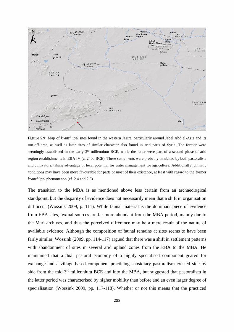
288
Figure 5.9: Map of kranzhügel sites found in the western Jezire, particularly around Jebel Abd el-Aziz and its
run-off area, as well as later sites of similar character also found in arid parts of Syria. The former were
seemingly established in the early 3rd millennium BCE, while the latter were part of a second phase of arid
region establishments in EBA IV (c. 2400 BCE). These settlements were probably inhabited by both pastoralists
and cultivators, taking advantage of local potential for water management for agriculture. Additionally, climatic
conditions may have been more favourable for parts or most of their existence, at least with regard to the former
kranzhügel phenomenon (cf. 2.4 and 2.5).
The transition to the MBA is as mentioned above less certain from an archaeological
standpoint, but the disparity of evidence does not necessarily mean that a shift in organisation
did occur (Wossink 2009, p. 111). While faunal material is the dominant piece of evidence
from EBA sites, textual sources are far more abundant from the MBA period, mainly due to
the Mari archives, and thus the perceived difference may be a mere result of the nature of
available evidence. Although the composition of faunal remains at sites seems to have been
fairly similar, Wossink (2009, pp. 114-117) argued that there was a shift in settlement patterns
with abandonment of sites in several arid upland zones from the EBA to the MBA. He
maintained that a dual pastoral economy of a highly specialised component geared for
exchange and a village-based component practicing subsidiary pastoralism existed side by
side from the mid-3rd millennium BCE and into the MBA, but suggested that pastoralism in
the latter period was characterised by higher mobility than before and an even larger degree of
specialisation (Wossink 2009, pp. 117-118). Whether or not this means that the practiced

289
pastoralism itself was significantly different is not certain. Porter (2012, pp. 238-241) argued
that the view of EBA pastoralism as mainly state-controlled, without room for mobile tribes
existing alongside with royal flocks, and thus inherently different from the later picture of the
Mari archives, was a misreading of the textual evidence. She backed this up with tablets from
Ebla suggesting the existence of kammu in and around this polity (cf. 5.2.1.1 and 5.3.1.1). I
tend to agree with the view presented by both of these scholars. During the period from EBA
IV to MBA, the Near East and particularly Syro-Mesopotamia included specialised
pastoralists practicing a mobile lifestyle along similar lines as more recent forms of ovicaprine
pastoralism, with seasonal grazing in traditional territories, at least as the climate deteriorated
around the 4.2 ka BP arid spike and onward. From then on, pastoralist populations of the
region responded by increasing mobility as a risk-management strategy, while the mainly
cultivating component of the tribes relocated to more secure conditions of the river valleys
and northern plains of the region in a process of settlement nucleation (cf. Wossink 2010).
Conclusively, there seems to be quite good correlation between the lifestyle documented
among recent or modern mobile pastoralist populations in the Near East (e.g. Barth 1961;
Wirth 1971; Streck 2002) – and partly the Middle East (Barth 1956) – practicing sheep and/or
goat herding, and the trends suggested by archaeological and textual material on this topic
from the EBA IV (particularly the later part) and the MBA. However, like many before me, I
will caution against attempts at direct comparison through analogies, and suggest that each
aspect should be studied comparatively in a non-presumptuous manner. I would argue that
this has been carried out in a satisfactorily manner here, with many of the facets described
under the general outline of mobility, pastoralism, and tribes (cf. 5.1.2 and 5.1.3) arguably
seeming to have been in place among the amurru, hibrum or hana during the Bronze Age (cf.
5.2.1 and 5.2.2). I will now turn to the tribal groups known to have operated in the late EBA
and MBA and specific aspects of their temporal and spatial contexts, seen in light of the
discussion above.
5.3 Near Eastern tribal identities during the EBA and MBA
5.3.1 The Amorrite conundrum
Studies of EBA and MBA mobile pastoralism including textual sources will usually have to
consider the Amorrites, who they were, and their impact on Near Eastern societies in these

290
periods. They have long been shrouded in uncertainty, at times bordering on scholarly myth,
not least assisted by an apparent mention in the Hebrew Bible (as “Amorites”, cf. Whiting
1995, p. 1231; Fleming 2004, p. 14)24. However, it is important to disassociate the Amorrites
from that particular tale and investigate their role in the Near Eastern Bronze Age in a more
rational manner by looking at how they influenced the narrative written by the EBA scribes of
southern Mesopotamia and how their identity spread across the region to become near-
ubiquitous in the Syro-Mesopotamian heartland. The Amorrites are often viewed as the
“archetypal nomads” and “paradigmatic outsiders” to the southern Mesopotamian world, but
not much is certain of how their diffusion came about and from whence it may have started
(Porter 2012, p. 251). Early research (cf. 5.1.1.1) focused on invading mobile groups coming
from the Syrian dry steppe and settling in the river valleys (e.g. Kupper 1957; cf. Zarins
1990), either in waves or as a continuous pressure, subsequently adjusted to infiltrating
pastoralists migrating into the cultivated zone in smaller numbers and in time being employed
as mercenaries or officials (Whiting 1995, p. 1234). In any case, by the 19th century BCE
dynasties of actual or adopted Amorrite origin and identity were established in most major
cities and states across the Near East (Porter 2012, p. 251; Wossink 2009, p. 125), with the
question of how it came about still not being satisfactorily answered. However, intriguing new
perspectives have been put forward recently (Wossink 2009; Porter 2012) which may go some
way of explaining the apparent developments across the EBA-MBA transition.
5.3.1.1 The Amorrites - ancient perceptions and recent theories
One reason why the history of the Amorrites still is in the murky depths of uncertainty is the
relative sparseness of texts from the 3rd millennium BCE (Streck 2002, p. 191), and the fact
that it is rather difficult to disentangle all the evidence. Another problem is that those texts we
know of vary quite a lot in their descriptions of and attitudes toward these people. Generally,
while the nature of the earliest attestations – i.e. mainly scattered mid- to late 3rd millennium
BCE texts consisting of personal names and toponyms (cf. Wossink 2009, p. 120, table 7.1) –
are difficult to assess, there is a clear discrepancy between literary sources and administrative
documents, at least in the Ur III texts (Wossink 2009, p. 137). Examples of the former type
usually portray them as antagonists and enemies, toward which the Ur III state must stay
24 Their biblical attestation probably relates to people associated with the collapse of the LBA state Amurru,
which was situated on the Levantine coast of Syria and thus much closer in time and space to events in the
Palestine and the Israelite kingdoms (cf. Whiting 1995, pp. 1237-38).

291
vigilant, and have been conflated with literary compositions, mainly due to connotations
found in The Marriage of Mardu (cf. Porter 2012, p. 293). This story is in fact about the god
Mardu (Sumerian – parallel to Amurru in the Akkadian pantheon), but has in epigraphical
research often been invoked as the stereotypical Mesopotamian image of the Amorrites and
usually not taking its original context into account (Wossink 2009, pp. 122, 124). The rather
derogatory words about Mardu in this text have been explained as partly a parable to advise
against marrying outside the group25, albeit in the story the effort was unsuccessful – and this
should be seen as its main purpose, with the representation of Mardu itself being neither
hostile nor negative (Porter 2012, pp. 293-294). However, it is understandable to see how this
link emerged, with the name of the deity and the people being essentially the same. On the
other hand, mardu or amurru – essentially synonyms – is quite a layered term, which could
designate a deity, a people or ethnic group, a language or dialect, an area mentioned in the
Ebla archives, and/or west as a compass direction, leading mardu to possibly denote merely
“certain individuals or people of western origin”, i.e. probably from Syria – all depending on
the spatiotemporal context (Whiting 1995, pp. 1231-1232; Fleming 2004, p. 39; Wossink
2009, p. 119; Porter 2012, pp. 305, 310). Finally, it is important to keep in mind that ancient
scribes were not ethnographers, and as the term “Amorrite” was not a self-given one, it is
likely to be biased when coming from urban Mesopotamian observers and probably rather
inaccurate compared to Amorrites’ own identities (Whiting 1995, p. 1232; Fleming 2004, p.
39), probably conflating a number of separate, possibly mobile, tribal groups into one large
“western” population. The amount of texts from the 3rd millennium BCE, while relatively few
compared to the Mari period, are still too many for the present study to fruitfully evaluate
individually, and I will therefore lean on the syntheses recently put forward by e.g. Wossink
(2009) and Porter (2012), which provide general diachronic perspectives on these texts as a
group and the implications of their content in context. However, I will also be including other
scholars’ recent research for extended or alternative views in certain instances.
25 This practice against marrying outside the tribal group was also observed among the Basseri by Barth (1961,
p. 35), while an attestation in ancient times is provided by ARM 28, text 36, in which a marriage between a
Yamutbalean and a Sim’alite is characterized as being according to tribal tradition and decency: “The Sim’alite
hana and the Yamutbal are common blood. One can contract a relationship by marriage with the other”.
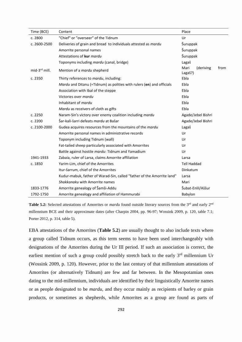
292
Time (BCE) Content Place
c. 2800 "Chief" or "overseer" of the Tidnum Ur
c. 2600-2500 Deliveries of grain and bread to individuals attested as mardu Šuruppak
Amorrite personal names Šuruppak
Attestations of kur mardu Šuruppak
Toponyms including mardu (canal, bridge) Lagaš
mid-3rd mill. Mention of a mardu shepherd Mari (deriving from Lagaš?)
c. 2350 Thirty references to mardu, including: Ebla
Mardu and Ditanu (=Tidnum) as polities with rulers (en) and officials Ebla
Association with Ibal of the steppe Ebla
Victories over mardu Ebla
Inhabitant of mardu Ebla
Mardu as receivers of cloth as gifts Ebla
c. 2250 Naram-Sin's victory over enemy coalition including mardu Agade/Jebel Bishri
c. 2200 Šar-kali-šarri defeats mardu at Bašar Agade/Jebel Bishri
c. 2100-2000 Gudea acquires resources from the mountains of the mardu Lagaš
Amorrite personal names in administrative records Ur
Toponym including Tidnum (wall) Ur
Fat-tailed sheep particularly associated with Amorrites Ur
Battle against hostile mardu: Tidnum and Yamadium Ur
1941-1933 Zabaia, ruler of Larsa, claims Amorrite affiliation Larsa
c. 1850 Yarim-Lim, chief of the Amorrites Tell Haddad
Itur-šarrum, chief of the Amorrites Dinkatum
Kudur-mabuk, father of Warad-Sin, called "father of the Amorrite land" Larsa
Shakkanaku with Amorrite names Mari
1833-1776 Amorrite genealogy of Šamši-Addu Šubat-Enlil/Aššur
1792-1750 Amorrite genealogy and affiliation of Hammurabi Babylon
Table 5.2: Selected attestations of Amorrites or mardu found outside literary sources from the 3rd and early 2nd
millennium BCE and their approximate dates (after Charpin 2004, pp. 96-97; Wossink 2009, p. 120, table 7.1;
Porter 2012, p. 314, table 5).
EBA attestations of the Amorrites (Table 5.2) are usually thought to also include texts where
a group called Tidnum occurs, as this term seems to have been used interchangeably with
designations of the Amorrites during the Ur III period. If such an association is correct, the
earliest mention of such a group could possibly stretch back to the early 3rd millennium Ur
(Wossink 2009, p. 120). However, prior to the last century of that millennium attestations of
Amorrites (or alternatively Tidnum) are few and far between. In the Mesopotamian ones
dating to the mid-millennium, individuals are identified by their linguistically Amorrite names
or as people designated to be mardu, and they occur mainly as recipients of barley or grain
products, or sometimes as shepherds, while Amorrites as a group are found as parts of

293
toponyms, such as “the bridge of the mardu” and “the canal of the mardu” (Wossink 2009,
pp. 120-121; also cf. Porter 2012, p. 314, table 5). However, what these latter examples
signify is uncertain. The possibility of certain names from Tell Beydar texts (c. 2350 BCE –
cf. 3.2.4) being Amorrite has also been put forward (Streck 2002, pp. 190-191). Among the
most interesting attestations are those from the Ebla archives (c. 2350 BCE – cf. 3.2.3), firstly
because they firmly originate in Syria proper and not Mesopotamia, and secondly – in the
context of this dissertation – due to their relative proximity to the Palmyrene. References to
Amorrites – written as mardu – in these texts amount to over thirty, which is a relatively high
number compared to Akkadian or Ur III administrative sources (cf. 3.3.2 and 3.3.3), but a
notable aspect here is the use of the determinative ki, a signifier comparable to the MBA use
of matum known from Mari (cf. 5.2.1.3). Thus, the term marduki at Ebla indicates that it was
a geographical area or polity, although not necessarily one spatially fixed (Porter 2012, pp.
309-310). Some scholars have argued that contextually it must have referred to a fixed place
or region, with suggestions anywhere from the Mediterranean to Jebel Bishri (cf. Porter 2012,
p. 310), but Porter thought the circumstances may have been otherwise. Marduki are in Ebla
texts found listed together with Ditanu and Ibal “of the steppe”, and these polities or groups
are clearly shown to have leaders or kings (en) and elders. The former of these two is thought
to be equivalent to the abovementioned Tidnum, well-known from Ur III texts, while the
qualifier associated with Ibal suggests a link with pastoralism and mobility. The mardu, Ibal,
and Ditanu seem to have been independent of the Ebla polity, but their geographical focus is
uncertain. It is tempting to associate them with the Palmyrene or Jebel Bishri, based on later
information regarding the Amorrites (although see below and Figure 5.10), but Ebla has been
shown to have nursed a far-reaching contact network, suggesting that a cautious approach to
this question should be upheld (also cf. Porter 2012, p. 311, note 90). Their probable
association with a mobile lifestyle contributes further to such a perspective. In fact, Porter
argued that the mardu, Ibal, and Ditanu found in the Ebla texts could be a window on EBA
social structures parallel to the tribal organisation evident in the Mari archive of the MBA (cf.
5.3.2), with a mobile and a sedentary component associated with each – suggested by their
leaders/kings and elders – as well as Ebla itself incorporating a mobile pastoralist component
of its own, the kammu (Porter 2012, pp. 310-311 – cf. 5.2.1.1). She likened such EBA terms
to the hana, Numha, and Yamina of the MBA, and suggested that attestations of two Ibals

294
“‘of the steppe’ and that ‘of the canal’ may well parallel the bifurcated geography typical of
mobile pastoralists in the second millennium” (Porter 2012, p. 312).
It is not fully clear at this point whether this statement should be explicitly understood that she
meant the mardu of Ebla should be seen as an equivalent to hana found in the Mari archive,
i.e. “our” (Eblaite) mobile pastoralists, of which otherwise seemingly the term kammu was
used, or perhaps as hibrum – general mobile group (cf. 5.2.1.1). However, later Porter (2012,
pp. 319-320) distinctly argued this point by suggesting how mardu when found in that
specific context, did not signify ethnicity, occupation, or political affiliation, but in fact
carried the same meaning as hana in 2nd millennium BCE Mari. The fact that it occurs in
conjunction with Ibal and Ditanu in the Ebla texts indicates that a conceptual association
existed between them, which she believed to be their association with mobile pastoralism.
Hence, just like administrative texts from Mari can put hana as well as individuals from the
tribes Numha and Yamina together in one context, similar lists from Ebla could mention
mardu, Ditanu, and Ibal “of the steppe”, the latter of which is separated from another part of
this tribal group, the Ibal “of the canal”. Porter’s exact difference between the use of kammu
and mardu at Ebla is still somewhat unclear to me, but one point seems to be that only mardu
(and therefore also amurru) should be seen as applicable across the region – Emar, Tuttul, or
Lagash – with the meaning “our mobile component”. This is a very intriguing thought, and
could, like the revelation regarding hana a decade ago, transform our understanding of the
EBA Near East, but also parts of the MBA.
References to Amorrites in texts supposedly associated with the Akkadian dynasty and the Ur
III period are seemingly fraught with attestations of their troublesome and menacing
behaviour. The late 23rd century BCE Akkadian rulers Naram-Sin and his successor, Šar-kali-
šarri, both mentioned victories over the mardu at Bašar (cf. 3.3.2), an archaic version of the
name Jebel Bishri (cf. Figure 3.1), and in many sources termed kur mardu – the mountain or
realm of the Amorrites (cf. Wossink 2009, p. 121; Porter 2012, pp. 320-321). However, the
first of these rulers actually fought against a rebellious coalition of southern kings from Ur,
Uruk, Umma, and Lagash, and not against Amorrites, which are mentioned merely through
two minor captains captured after the fray. The boast by Šar-kali-šarri is according to Porter
(2012, p. 321) simply a claim of Naram-Sin’s achievements, although other scholars have
taken it at face value, i.e. a victory for the Akkadian king over a group of Amorrites (e.g.
Sallaberger 2007, p. 445; Wossink 2009, p. 121). In the Royal Correspondence of Ur, which
295
are letters between kings and officials, mardu and particularly Tidnum are occasionally found
as antagonists. They were mentioned in connection with a “wall facing the highlands” and
“wall of the land” (see below), and in one text, the suggestion of mardu as a generic term may
seem to be implicitly supported:
Text 5.16: Hostile Amorrites – Tidnum and Yamadium – came forth (to do battle): their kings confronted him
[the Ur III king Šu-Sin, cf. 3.3.3] in battle, (but) by the strength of Enlil and Ninlil he was victorious in battle (cf.
Wossink 2009, p. 123).
Taking text 5.16 as it stands, it suggests that:
Tidnum and Yamadium were considered two variants of Amorrites, like e.g. the
Numha and Yamina in Mari times, and thus probably represented tribes or tribal
confederacies during the EBA. They had leaders, such as attested for MBA tribal
groups, and carried out independent actions within the political sphere. This coincides
well with the previously mentioned evidence inferred from the Ebla material.
The qualifier “hostile” means that other, more peaceful groups of Amorrites also
existed in the Ur III world, or even that the hostility of these two groups was
situational and possibly temporal.
Both of these points fit well with Porter’s suggestion that mardu carried the meaning “mobile
pastoralists” or “our mobile pastoralists” depending on the context. It must be pointed out that
the historicity of the Ur III literary sources has been questioned. They are only known from
MBA tablets, thus several centuries later than the events described within, and any secondary
or invented additions are difficult to distinguish from the more accurate details, although
some personal names seem to have been genuine (Wossink 2009, pp. 122-123). It is in such
literary sources that the portrayal of the Amorrites as enemies is most pronounced, so their
actual behaviour, the actual events, and the actual perception of them during this time may
have been a different one. Porter (2012, pp. 278-279) has pointed out that these texts
sometimes include a number of anachronisms, and that the lack of pattern within them
suggests the references do not reflect the historical reality and that their historical value is
minimal (also cf. Porter 2012, p. 288 on the nature of these letters). However, this does not
necessarily mean that the sociopolitical organisation of the EBA Near East into tribal groups,
such as the one we see during the MBA, is inaccurate. The underlying organisational structure
discerned from these texts may therefore still be of analytical value. Incidentally, following
296
the tentative conclusion that the Tidnum in fact represented a specific tribe or tribal
confederation – or in the words of Porter (2012, p. 322) “ancestral group” – operating in Syria
and Mesopotamia during the EBA, references to the fortification line Muriq-Tidnim (also
known as “wall which repels the Tidnum”), which at least partly seems to have been
associated with the Diyala region and Jebel Hamrin in Iraq (cf. Wossink 2009, pp. 123-124;
Porter 2012, p. 322), should not be viewed as a defence against hostile mobile pastoralists (or
“nomads”, if you will) in general, but rather as a measure directed against a specific tribe.
Porter (2012, p. 324) suggested that their apparent animosity toward the Ur III state may in
fact have been linked to this polity’s rigid control, bureaucratisation, and reorganisation of
animal production, which of course mobile pastoralists very much depend on. The “wall”
itself could have been an attempt to control their access to ancestral grazing territories or their
movements in general. This seems to me to provide a good explanation, as later Ur III texts
mention merely hostile mardu, and although some of these texts are thought to be of literary
character as well as of a significantly later date, Porter (cf. 2012, p. 314, table 5) herself
defined e.g. year names and text 5.16 as being “outside literary sources”, thus possibly
incorporating certain historical accuracies. A number of texts from the meticulous
administrative record of the Ur III state are also known, as well as some from the following
Isin-Larsa period, i.e. the first century of the 2nd millennium BCE (cf. 3.4.1). These were
studied with a focus on Amorrites by Buccellati (1966), identified either by the qualifier
mardu or the occurrence of presumed Amorrite names, and his results were summarised by
Wossink (2009, p. 122). As mentioned (cf. 5.2.2.1), Amorrite groups were during the Ur III
period associated with pastoralism and particularly their fat-tailed sheep. One realisation from
his analysis was that Amorrites clearly partook peacefully in these societies, delivering and
receiving products, carrying out diverse functions, and occupying various positions in e.g. the
Ur III state, Eshnunna, and Lagash – not an unexpected picture, if the late EBA references to
Amorrites as mardu, merely designated people associated with mobile pastoralism, in a
present or recent context. In a fashion parallel to the MBA, groups or individuals which were
not possible to identify by referring to their home city, were therefore rather designated by
their provenance – mardu (cf. also Sallaberger 2007, p. 445). However, this does not
necessarily rule out that the term also was used to denote “westerners” in Mesopotamia, i.e.
people from Syria, depending on the context, just as Hana may have referred to a particular
tribal group in the Habur triangle centered on Šehna/Šubat-Enlil (Fleming 2004, pp. 89-91 –
cf. Figure 3.7) and the name of an eponymous ancestor or tribe (see below), although the

297
term was mostly used with reference to mobile pastoralist groups (cf. 5.2.1.1). Evidently,
terms incorporated a number of layers in the ancient Near East, probably obvious to the
speaker and listener, but very difficult for modern scholars to interpret.
Figure 5.10: Attestations of mardu in EBA sources across the Near East and approximate locations of areas
called kur mardu (mountain of the Amorrites). Evidently groups or individuals designated as mardu were found
and recognised both on the Syrian plains, along the Euphrates valley, and on the Alluvium.
Arguments presented by Porter (2012) and hinted to by Sallaberger (2007) also provide
another meaning to the term kur mardu (Figure 5.10). While both the attestations of Naram-
Sin and Šar-kali-šarri locate events specifically in Jebel Bishri, the meaning of kur mardu
may have been a different one to what scholars have perceived until recently. Rather than
distinctly placing the so-called “Amorrite homeland” in this specific area, the term could
merely suggest that the region was traditional grazing lands for mobile pastoralists, and not
belonging to a particular entity called “the Amorrites” (cf. Porter 2012, p. 321). Likewise, the
same usage has been registered in regions seemingly relatively far from Jebel Bishri, a
practice which in previous research presented quite a conundrum. How could kur mardu be
located in Jebel Hamrin, east of the Tigris, in the Ur III texts when the “homeland of the
Amorrites” so clearly was associated with Jebel Bishri in others? The solution – and like the
hana conclusion of research into the MBA, quite an elegant one – may be that it in fact
represented a generalised term for pastoral territories, located in various parts of the Near

298
East, depending on the context and perspective of the writer and the mobile group it referred
to. Thus, as the Gudea statue B is translated:
Text 5.17: From Umanum, in the mountain range of Menu’a, and from Pusala, in the mountain range of the
Amorrites [kur mardu], he [Gudea] brought down big stone slabs. (…) From Tidanum, in the mountain range of
the Amorrites [kur mardu], he brought alabaster blocks (cf. Wossink 2009, p. 121; also cf. Sallaberger 2007, p.
431).
The Lagaš king Gudea (cf. 3.3.2) probably conveyed in text 5.17 that he imported building
materials for his projects from several areas of the Near East, two of which were located in
the highlands of the steppe (cf. Figure 5.10) and associated with various tribal territories of
mobile pastoralist groups. The Pusala and Tidnum attestations may have been geographical
toponyms, but may possibly also have designated the nighum of these groups, although this
specific term is only known from the MBA. While some scholars have been tempted to link
the name Pusala with Bašar, Sallaberger (2007, p. 431, note 79) found this connection
unlikely, as Jebel Bishri lies much further away from Lagaš than would be necessary for
acquiring such materials. However, if kur mardu actually did function as a generic term for
steppe areas or highlands, there is no need in our studies to position the names Tidnum,
Pusala, and Bašar in spatial proximity to each other. It could rather refer to the winter grazing
zones associated with mobile pastoralists across the Near East, although Bašar itself did quite
clearly specifically refer to Jebel Bishri (cf. Figure 3.1).
Just after the turn of the millennium there are precious few sources describing developments
in the Near East (cf. 3.4.1), but when the veil lifts, Amorrites were seemingly in control of
dynasties across the region (cf. 3.4.2), and the Sumerian mardu determinative had nearly gone
out of use in the textual material. Rulers with Amorrite names had by this time been
dynastically installed in most major cities or states, including Mari, Babylon, Ešhnunna, Isin,
Larsa, Qatna, and Yamhad. In addition, these rulers were also generally some way down the
dynastic line and often proudly claimed Amorrite affiliation or ancestry (Wossink 2009, p.
125). For instance, Hammurabi had followed a number of predecessors with Amorrite links
on the throne of Babylon, and the same was the case in Isin and Larsa at the time, while the
Sim’alite Lim dynasty – Yagid-Lim, Yahdun-Lim, and Zimri-Lim (cf. 3.4.2.2 and 3.4.2.3) –
claimed the Mari throne after a number of late shakkanaku rulers with Amorrite names (cf.
e.g. Porter 2012, p. 29, table 2; Wossink 2009, p. 125). Names of tribal groups also appear in
royal titles or in claimed or constructed genealogies as legendary ancestors of kings. These

299
ancestors often carry names very similar to known tribal names. This is not unsurprising,
taking into account the common practice regarding tribal identity of kinship via descent from
forefathers of legend (Porter 2012, p. 269 – also cf. 5.1.2.2). There are two well-known
examples of such lists – the AKL (cf. 3.1.1) and the Genealogy of the Hammurabi Dynasty
(GHD) – both of which claimed Amorrite origins, and shared a number of names, including
seventeen initial “ancestors” which are labelled “kings who lived in tents”, thought in fact to
be references to tribes. The AKL is associated with the ancestry of Šamši-Addu (cf. 3.4.2.2),
while the GHD obviously is linked to Hammurabi and Babylon. Some of the shared
attestations of the lists are names such as Heana/Hanu and Ditanu/Didanu, which parallel the
hana extensively occurring in the Mari texts, and the Ditanu known from Ebla, thought to
equate with the later tribal group Tidnum. Additionally, certain early names in the GHD – e.g.
Amnanum, Yahrurum, and Numha – are well-known tribes during the Mari period (cf.
Finkelstein 1966, pp. 95-96, 98-101; Larsen 1976, pp. 34-35; cf. also Fleming 2004, pp. 159-
160; Wossink 2009, p. 125; 2013, p. 264 – cf. 5.3.2.2 and 5.3.2.3).
5.3.1.2 The concept of mirror toponomy
Until recently, scholars working with both Near Eastern epigraphy and archaeology believed
the developments during the latter part of EBA IV and the picture of total Amorrite dynastic
dominance in the MBA was the result of an actual physical migration and take-over by
Amorrite groups throughout the region as part of the EBA-MBA transition (e.g. Charpin
2004, p. 67; Buccellati 2008). One recurring argument for the physical passage of Amorrite
groups at this time is a particular phenomenon seemingly associated with it, called mirror
toponomy (cf. Charpin 2003). Essentially, it refers to the occurrence of numerous parallel
place names (homonyms) found across the region, but more strikingly, two or more areas
separated from each other by significant geographical distances with a number of nearly
identical toponyms – i.e. “sets” of homonyms found as far from each other as the Jebel Sinjar
area and the Larsa polity in southern Mesopotamia (cf. Figure 5.11), both where two groups
of six identical place names were found. Such groupings seem to have a tendency to be
oriented around axes of symmetry, such as mountain ranges or rivers. Both sides of the Tigris
have for instance a set of five homonymic settlements (cf. Figure 5.11), while both north and
south of Jebel Sinjar were found two each of Sidqum, Saphum, and Apu(m). The latter
toponym is also known as far away as the Damascus region, but with the meaning being “reed
beds”, the repeated occurrence may be due to coincidences brought on by the natural
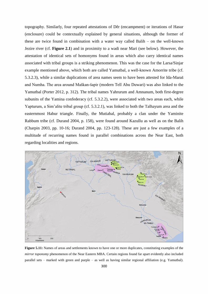
300
topography. Similarly, four repeated attestations of Dêr (encampment) or iterations of Hasur
(enclosure) could be contextually explained by general situations, although the former of
these are twice found in combination with a water way called Balih – on the well-known
Jezire river (cf. Figure 2.1) and in proximity to a wadi near Mari (see below). However, the
attestation of identical sets of homonyms found in areas which also carry identical names
associated with tribal groups is a striking phenomenon. This was the case for the Larsa/Sinjar
example mentioned above, which both are called Yamutbal, a well-known Amorrite tribe (cf.
5.3.2.3), while a similar duplications of area names seem to have been attested for Ida-Maraš
and Numha. The area around Maškan-šapir (modern Tell Abu Duwari) was also linked to the
Yamutbal (Porter 2012, p. 312). The tribal names Yahrurum and Amnanum, both first-degree
subunits of the Yamina confederacy (cf. 5.3.2.2), were associated with two areas each, while
Yapturum, a Sim’alite tribal group (cf. 5.3.2.1), was linked to both the Talhayum area and the
easternmost Habur triangle. Finally, the Mutiabal, probably a clan under the Yaminite
Rabbum tribe (cf. Durand 2004, p. 158), were found around Kazullu as well as on the Balih
(Charpin 2003, pp. 10-16; Durand 2004, pp. 123-128). These are just a few examples of a
multitude of recurring names found in parallel combinations across the Near East, both
regarding localities and regions.
Figure 5.11: Names of areas and settlements known to have one or more duplicates, constituting examples of the
mirror toponomy phenomenon of the Near Eastern MBA. Certain regions found far apart evidently also included
parallel sets – marked with green and purple – as well as having similar regional affiliation (e.g. Yamutbal).

301
Generally, the settlement toponyms in this map have only been placed in an approximate fashion within their
regions for purposes of context, and are not to be seen as precisely located (cf. text for references).
Explanations for this phenomenon vary, although they all mainly focus on an element of
mobility. In his synthesis on the current state of knowledge regarding mirror toponomy,
Charpin (2003, pp. 15-18), listed the known examples from the Mari archive, as well as ruling
out a few names as “false” mirror toponyms – i.e. names that seem to be identical with other
toponyms, but through linguistic examination in reality have been found not to be mirrored.
He presented four interpretations on several levels for the occurrences of identical place
names in the Near East:
a) Coincidence, i.e. descriptive toponyms like the iterations mentioned above. However,
Charpin argued that since mirror toponyms were not known prior to the early 2nd
millennium BCE, they do seem to be contemporary with what he termed “the Amorite
dissemination across the Near East” and should probably therefore be linked to that
event.
b) The result of deportations carried out mainly by Šamši-Addu, of which he remarked
there are obvious examples, albeit very few, and thus cannot explain the phenomenon
itself.
c) Grouped constellations associated with identical area names (cf. Figure 5.11),
seemingly establishing links between two different regions possibly in relation to
synchronous double-territorial belonging for a tribal group.
d) Place names may, as alluded to under the first point, be associated with a migration of
Amorrite groups across the region in the late 3rd and early 2nd millennium BCE,
renaming points in the landscape according to their traditions and original homelands.
Charpin emphasised the examples in the third point, as many of the mirrored area
names are in fact also known tribal names in the Mari archive.
While the first three interpretations only seem to work in a limited number of cases, the
“Amorrite migration” explanation is the one Charpin believed to be the main mechanism for
mirror toponomy. To further support this, he pointed to the immediate area around Mari, and
the combination of Dêr and Balih, which could not be coincidental. Rather he thought it was
associated with the Sim’alite arrival at Mari in late MBA I (cf. 3.4.2) as part of a migration,
constituting tribal links to their original point of departure in the Jezire near the Balih river.
Dêritum was an important deity for the Lim-dynasty, and Dêr at Mari is known to have been
302
the focus for annual religious ceremonies (cf. Charpin 2003, p. 17). He put mirror toponomy
in context with late 3rd millennium BCE abandonment of a number of sites, presumably as
many segments of the population turned to mobile strategies faced with climatic deterioration.
As some of these groups resettled in other areas, new sites were named, while the original
ones were still remembered and acknowledged (Charpin 2003, pp. 18-19).
Wossink (2009, p. 133) argued against this interpretation, favouring rather that the duplication
of toponyms was a mechanism for reinforcing shared social identity over longer distances, an
explanation which Porter (2009) originally presented (see below). Additionally, rather than an
actual sudden increase in new place names, he argued that it in fact is a perceived increase
which is experienced by modern scholars mainly due to the explosion of information received
and inferred from the Mari archive (cf. 3.2.2 and Table 5.3). The historical geography from
this corpus, as well as a few other small collections of contemporary texts, is exceptionally
well-known, and the geographical reach of the content is vastly larger than that of earlier
periods. This argument was backed up by recently emerging evidence of the mirror toponomy
phenomenon possibly occuring prior to the 2nd millennium BCE, thus weakening the large-
scale migration interpretation. Porter (2009) focused on the tribal aspect, again with the
Yamutbal example emphasised as particularly striking. She believed that mirror toponomy
was a result of kinship mechanisms, e.g. for maintaining access to resources such as grazing
territory, as the southern Yamutbal was not located in prime areas for pastoral exploitation
and perhaps needed, or even claimed, the Sinjar region as nighum. The origins could have
been a migration, with one part staying behind and another moving, but could also have been
part of a traditional seasonal migration for pasture, as these groups incorporated both a
sedentary and mobile component. The mirror toponyms could in such circumstances function
as geographical representations of shared kinship and descent, and act for separated groups of
the same tribal affiliation to overcome temporal and spatial distance through ideology (Porter
2009, pp. 204-205). She followed up this argument by pointing to the specifically Sim’alite
association with Dêr and Balih, known from Mari texts as a central notion in rituals focused
on descent, reciprocal rights, and tribal obligations, ceremonially binding together members
of that particular tribe across the region (Porter 2009, p. 207). In her most recent work, Porter
(2012, pp. 312-313) contextualised the mirror toponomy phenomenon into the many dualities
of the Near Eastern Bronze Age society which have been emphasised in recent years – town
and country, mobility and sedentism – suggesting that it should be analysed with such
303
relationships in mind. She did not necessarily support explanations featuring directional
migration, as proposed by Charpin (2003), nor thought any secure starting point or “Amorrite
origins” for such a development had been located. Instead she proposed that e.g. both
Yamutbal regions may have been two ends of the same territorial range, which by the Mari
period had been separated into two independent areas, but with kinship keeping this tribe
together across time and space by geographical representations in the form of mirror
toponomy (Porter 2012, p. 318).
In my view this was probably not just a specific feature of the Sim’al or Yamutbal, but rather
part of a general structure based on tribal organisation for coping with group affiliation in a
world where smaller groups may have been separated from the main population of various
reasons, but mainly through seasonal practices of mobile pastoralism. Grazing being a limited
resource in a world filled with pastoralist groups, the ability to claim tribal territory would
have been necessary to cement in a number of ways, and one of these could have resulted in
the phenomenon scholars call mirror toponomy. Both the sedentary core areas in the river
valleys and the grazing areas for the mobile season could in this way have been seen as two
sides of the same ancestral territorial right. Thus, to me Porter’s view appeals the most,
although Charpin’s third point definitely also has merit as a dominant factor. Exactly when
this phenomenon arose, and whether it remained roughly the same from the EBA to the Mari
times, is more uncertain. However, I do concur with Wossink that while we should
acknowledge the unique window provided by the Mari archive, we should definitively
entertain the notion that what it shows us does not represent a spatiotemporally unique context
in an EBA-MBA reality.
5.3.1.3 Amorrites and tribal identities
How can we then explain the explosion of Amorrite names and affiliations across the region
by the time of the Mari archive, if not by migration and population replacement? By looking
at ethnicity as a fluid form of identity, Wossink (2009, pp. 129-136) suggested an alternative
perspective which may go some way of explaining these developments, as well as
conundrums associated with them. His approach was based on Barth’s (1969, pp. 9-10, 13-14)
highly influential work, in which ethnicity is perceived as an active identity maintained by
those who ascribe to it, particularly for purposes of interaction with other groups. It is called
the instrumentalist view and constitutes the dominant paradigm in such studies (cf. Wossink
2009, p. 129). Barth argued that when faced with demographic pressure:

304
“Migration and conquest play an intermittent role in redistributing populations and changing
their relations. But the most interesting and often critical role is played by another set of
processes that effect changes of the identity of individuals and groups. (…) Boundaries may
persist despite what may figuratively be called the ‘osmosis’ of personnel through them”
(Barth 1969, p. 21).
Demographic pressure can be caused by a number of processes, one of which is climatic
and/or environmental deterioration, particularly in a region vulnerable to such variations, like
the Near Eastern arid zones. Studies of names in MBA societies have revealed a significant
minority of instances where families consisted of parents with Amorrite names, but the
children are given Akkadian ones, or vice versa. There were also examples of Amorrite
combinations with Hurrian or Sumerian, although the majority consisted of families where
both parents and their children carried Amorrite names (also cf. 3.2.6 and Figure 3.3). It is
possible to discern certain geographical tendencies, with the area from Mari to Emar having
highest percentages of Amorrite names (78 %), the western regions including Haleb, Qatna,
and Karkemiš having nearly the same portion (75 %), while certain sites in the Habur triangle
toward the Tigris only showed 11-36 % Amorrite names (cf. Wossink 2009, pp. 128-129).
Apart from the evidence of strong regional presence of groups or individuals affiliated with
Amorrite identity and geographical variations incorporating other ethnicities, these data also
support the notion that ethnicity could have been a fluid concept also in the EBA and MBA
periods (Wossink 2009, p. 133). Text 5.1 (cf. 5.2.1.1), in which the inhabitants of Dabiš
mentioned their original affiliation and hibrum, is an example of precisely such a process in
practice during the MBA. The text continued with these words:
Text 5.18: (…) We are native to the Yahruru. Let us now come into the midst of the Sim’alites as part of the
Nihadu tribe [or clan, cf. 5.3.2.1], so that we may slay a treaty donkey (cf. Fleming 2004, p. 63 – my
clarifications in brackets).
It is clear that the population of this Yaminite alum, who formerly identified themselves with
the Yahruru tribe, carried out a conceptual osmotic transfer under official auspices to become
part of the Sim’alite Nihadu clan (cf. Fleming 2004, p. 49; Wossink 2009, p. 133). Ethnicity
as identity has thus been shown to be flexible and adaptable, both evident in anthropological
studies (e.g. Barth 1969) and in texts from the Mari period, without any population
displacement necessarily being part of the transformation. Wossink linked this development
to the importance of pastoralism in the MBA world, which represented the core of Amorrite

305
identity, and suggested its adoption must have been associated with certain advantages. One
incentive may have been access to an extensive social network incorporating populations
practicing both mobile and sedentary strategies, which all these dynasties incorporated as part
of their matum, as well as was stretching across two or more environmental boundaries (cf.
Wossink 2009, pp. 135-137). He argued that increased specialisation in the pastoral economy
from mid-3rd millennium BCE may have had some association with the increase in Amorrite
affiliations near the EBA-MBA transition, possibly intensified as a mechanism for alleviating
stress due to environmental changes across the Near East in the final quarter of the
millennium (Wossink 2009, p. 146; 2013, p. 261). Wossink concluded:
“Through this identity, Amorites could create an extensive exchange network that was
organised along constructed or perceived kinship lines and based on ethnic solidarity and
more generalised reciprocity than would be possible among ethnically differentiated groups.
The Amorite identity and its associated values and the social network it embodied represented
a behavioural alternative that could be implemented under certain circumstances (…).
Eventually, this adaptive advantage not only allowed Amorite groups to be more successful
than their competitors, but would also generate an ethnic shift toward becoming Amorite,
eventually resulting in the patchwork of Amorite kingdoms that can be observed for the early
second millennium BC” (Wossink 2009, pp. 146-147).
self-identification ascribed identity shared traits
pre-Ur III - +/ - -
Ur III - + -
early 2nd millennium BCE +/ - +/ - +/ -
Table 5.3: Available evidence for Amorrite identity from in the Near Eastern EBA-MBA periods, where +
indicates strong evidence, + / - indicates some evidence, and - indicates very little or no evidence (after Wossink
2009, p. 131, table 7.2). Only in the MBA, mainly due to the Mari archives, do we have an extensive picture.
Both these theories – Porter’s mardu as a generic term during the EBA, and Wossink’s
“Amorritism” as a flexible and adoptable identity in the MBA – are very intriguing in an
EBA-MBA Near Eastern context, and quite different from the until recently general, and
sometimes literal, understanding of contemporary textual sources. However, in my view they
do seem to fit well with the picture these texts convey, especially because they can be applied
to the material without the emergence of any major paradoxical conundrums. While Charpin
and Durand, the editors of the Mari archive publications, during the 2000s continued to
invoke some form of momentous migration event to explain the Amorrite emergence around

306
the turn of the millennium (Durand 2004; Charpin 2004), they also seemed to emphasise the
reality of a perceived regional identity starting in the MBA and apply more complex models
when explaining the unfolding of these regional developments than did earlier invasionist
theories (cf. 5.1.1.1). Another scholar which delved into the question of Amorrites, but still
continued to conclude along the lines of such early interpretations, was Buccellati (e.g. 1988;
2008). His starting point was that it is
“(…) part of the generally accepted scenario that the Amorites were a very distinct group (…)
from the populations of the river valleys (…) rooted in their historically having hailed from
an equally distinct geographical region, the steppe if not the desert. In other words, they were
nomads at the origin, and they went through a progressive series of developmental stages that
led eventually to their complete sedentarization” (Buccellati 2008, p. 141).
This may have been the scholarly consensus when he originally (cf. Buccellati 2008, p. 141,
note 1) developed his model of “domestication of the steppe”, which entailed a
“nomadisation” of sedentary cultivators in overpopulated river valleys along the middle
Euphrates and lower Habur in early EBA, followed by a systemic organisation and movement
toward total autonomy from their origins in the zor in mid-3rd millennium BCE. According to
the model, these finally the returned to their “original homelands” in the urban zone as
invading Amorrites, having developed their own distinct culture and identity, and conquered
the river valleys and alluvium around 2000 BCE (cf. Buccellati 2008, pp. 142-143).
However, this is based on a presumption that seems unlikely following some of the arguments
presented above (cf. 5.1.3.2 and 5.2.1.2). It would require that mobile pastoralists could have
stayed in the steppe indefinitely, which Buccellati argued would have been possible through
the development and utilisation of a network of wells aimed at a shallow water table, as well
as claiming that pasture would have been sufficient even during summer (Buccellati 1988, p.
45; 2008, pp. 142-143), a notion with which I disagree. Both recent and ancient sources
suggest that mobile ovicaprine pastoralists in Syria had to return seasonally to the river
valleys or areas receiving more precipitation in the annual cycle due to the desiccation of the
arid zones. However, I will accept that during parts of the 3rd millennium BCE, favourable
climatic and environmental conditions may have allowed perennial habitation in the steppe,
although probably not continuously throughout the centuries as conditions clearly fluctuated
(cf. 2.4 and 2.5). Secondly, it would mean that they could practice their mobile lifestyle
without the dependence on products from the sedentary zone, which most studies of

307
ovicaprine pastoralism argue not to be the case. Admittedly, Buccellati argued that his model
in fact related to the origin of tribes, where kinship rooted in the river valleys as an alternative
to their attachment to city-states was the bonding factor and not territorial contiguity. He
proposed that the “nomadisation” was not permanent, as the mobile groups would retain
strong ties to their roots in sedentary areas (Buccellati 2008, pp. 143, 150). Both of these latter
aspects seem reasonable, and also form part of my view of the socioeconomic organisation
formed around tribal structures. However, it also seems to somewhat contradict the wholesale
adoption of steppe life and millennium-long diachronic development of disattachment from
the zor and movement toward political and especially military independence. Additionally,
the subsequent “invasion”, which Buccellati upheld as part of his explanation, would have
necessitated some form of military superiority established during the EBA among mobile
groups in the steppe, even though they probably were outnumbered and had not discovered
the factor that later became the trump card of mobile groups – mounted warfare (cf. 5.1.1.1).
A final point in Buccellati’s theory to which I definitely do not adhere, is his view of a steppe
“proven singularily sterile” regarding material culture linked to mobile groups of the period
(Buccellati 2008, p. 154). Clearly, thousands of tumuli, of which those with chronological
data point to a date in the EBA-MBA, attest to the opposite. Although, Buccellati qualified his
argument by focusing on sites which he specifically termed “Amorrite”, I believe this is
beside the point. It will always be nigh-on impossible to unequivocally attach structures or
other material culture to a specific ethnic group, although some have tried (e.g. Lönnqvist
2008 – cf. 4.7.2), but to not acknowledge the vast amounts of material remains located in the
area on which your theory concentrate (cf. 4.5.3, 4.5.4, and 4.5.5), seems almost rash.
Particularly since Buccellati (2008, p. 155) emphasised the effort by Porter (2000; 2002) to
link mortuary monuments to tribal territory and social identity, but still managed to survey
large parts of the Palmyrene and Jebel Bishri in the 1960s without finding any of the
thousands of tumuli in the area worth recording or even noticing himself (cf. Buccellati &
Buccellati 1967), even in hindsight. Their focus during this survey seems to exclusively have
been on sedentary sites or tells in the steppe. Streck (2002, pp. 189-190) also found
Buccellati’s model too far-reaching, due to the sparseness of evidence for such a
development, as well as the dependence of mobile pastoralists on products from the cultivated
zone, although the majority of his counterarguments were related to linguistic aspects.

308
In accordance with both Wossink and Streck, I would also argue that the sparseness of
contextual evidence surrounding mobile pastoralists and their role in the Near Eastern social,
economic, political, and environmental landscape prior to the Mari period should caution
against both far-reaching and dramatic conclusions. There may indeed have been some
population movements involving mobile pastoralist groups during the EBA IV, in fact it
seems fairly likely that it were, in as much as that is what pastoralists do – they move about in
both short- and long-term perspectives (Porter 2012, p. 319). Acceptance of Porter’s
interpretation that mardu during the EBA in fact carried similar meaning as hana in the Mari
archive, i.e. “our mobile groups” would solve some of the problematic contradictions
associated with this term – e.g. the occurrence of several areas designated kur mardu (cf.
5.3.1.1 and Figure 5.10). It was not usual to identify people in the record by homeland or
language, but through what they did, thus Porter concluded that common EBA usage of
mardu referred to people who defined themselves as mobile pastoralists. Earlier research
could not combine an urbanised Mesopotamian world integrated with pastoralists, and thus
had the latter labelled as outsiders, often hostile. However, in Porter’s hypothesis there is
social and economic immersion, where parts of the family may live in an alum, while others
may be roaming as pastoralists, both being part of the same polity, whichever that is, and/or
the same ancestral group, i.e. tribe (Porter 2012, pp. 318-322). As the narrative moved into
MBA (cf. 3.4.1 and 3.4.2), this particular Amorrite identity, how individuals or groups
thought of themselves in interaction with others, became more conventional and inclusion into
the Amorrite network could have been an adaptive strategy due to significant social or
political advantages coming with such a shift, as Wossink (2009) convincingly argued. While
some dynasties, which of course may have been founded by merely one group or even
individuals, could have been Amorrite in origin and actually been harking back to eponymous
tribal ancestors of such stock, it seems too disruptive to envision an upheaval across the
region around 2000 BCE, ousting people from their homeland through a hostile takeover.
Although certain instances of demographic shifts may have occurred over time (cf. 3.2.6),
cultural variations centuries apart do not necessitate any large-scale movement of people,
notwithstanding the very limited nature of EBA textual evidence in many parts of the Near
East. Political changes occurred regularly (cf. 3.3 and 3.4), which they also did during the
MBA, but Amorrite values and ideology emerged in this period to dominate the social and
political arena in large parts of Syria and Mesopotamia.

309
To me it seems more likely that the Near East carried on along the same line it had at least for
centuries, with small and large tribal groups including sedentary cultivators and mobile
pastoralists, interacting with each other and the landscape in the same way as is evident from
the Mari archives (cf. 5.3.2 and 5.3.3). This notion is supported by the merhum who wrote to
Zimri-Lim in text 5.2, claiming that grazing lands of the Yaminites had always (“since
forever”) been the Syrian plains, while the corresponding area for the Sim’alites had always
been Habur triangle (cf. 5.2.1.2 – cf. Figure 5.12). Perhaps e.g. the mirror toponomy
phenomenon actually is a window on an operational or recently bygone territorial structure
with regard to traditional tribal pastures, i.e. cyclical annual migration, rather than reflections
of large-scale unidirectional and violent migrations? It is in my view certainly a possibility
that two areas with several identical toponyms may have constituted two ranges – one semi-
sedentary summer area and one for mobile winter pasturing – belonging to one tribe, for
instance the Yamutbal or Numha (cf. Figure 5.12). Again, we have to realise the limitation of
our body of evidence, and the fact that large parts of the EBA-MBA world are lost to us – at
least unless another corpus similar to the Mari archive is discovered. Instead, I think the
sometimes mundane patterns evidenced from Mari should influence our perspective of the
Near East also prior to c. 1800 BCE. As Streck (2002, p. 192) has argued, there is no direct
evidence for fundamental changes in Amorrite lifestyle or habitation from the 3rd to the 2nd
millennium BCE. It should rather be seen as a specific strategy adapted for the ecological and
climatic conditions of the steppe and the river valleys.
While the amount of evidence on these issues may be intermittent, ambiguous, or severely
biased for the much of the EBA and the beginning of the MBA, we have access to a great deal
more information regarding mobile pastoralism (cf. 5.2.1.2), and tribal organisation and the
geopolitical structures (cf. 5.2.1.3) of the region during the first half of the 18th century BCE
from Mari, to which I now return. There were four main tribes or tribal confederations of
clear Amorrite affiliation, which again seem to have been grouped in two pairs for reasons of
rough geography and presumably consequently also competition. These tribal pairs (cf.
Figure 5.13) were the western-oriented Sim’alites and Yaminites (5.3.2.1 and 5.3.2.2), mainly
located in Syria and along the Euphrates and Habur river valleys, and the eastern-oriented
Yamutbal and Numha (5.3.2.3), which were located around Jebel Sinjar and down along the
Tigris river valley. Of these, the Mari dynasty associated itself with the Sim’al, while
Hammurabi and Šamši-Addu both had affiliations with the Numha tribe, although neither
310
ancestry nor demography was clear-cut – Yaminite groups did exist in south Mesopotamia
and Yaminite (actual or adopted) tribes were part e.g. of Hammurabi’s ancestry (cf. 5.3.1.1) .
However, as our source of information was Mari, we rely principally on the perspective of its
scribes and authorities, which mainly gave priority to relations between Yaminites and
Sim’alites and their world. Finally, there were the other tribal populations, mostly peripheral
fringe groups only mentioned in passing, like the Turukkeans and the Lullu far to the
northeast and of which we know very little (e.g. Durand 2004, p. 133). But one intriguing
outsider group appears fairly frequently in the Mari texts – the Suteans (or Sutu) – and will
thus also be discussed below (cf. 5.3.3).
5.3.2 The tribal world of the Mari archive
Earlier in this chapter I have referred to the tribal groups of Yamina and Sim’al26 several
times, and exemplified a number of concepts regarding mobile populations and tribal
structures by inferring from Mari texts regarding their practices. These two groups feature
heavily in the Mari archive because they constituted the vast majority of the population under
the kingship of Zimri-Lim in the 18th century BCE, although the various Yaminite tribes also
recognised their own šarrum and matum (cf. 5.2.1.3 and Table 5.1). They were considered a
duality in the Amorrite tribal organisation (cf. Figure 5.13) and have been described as
structured along the Euphrates as an axis with regard to their traditional pasturages (Joannès
1996, p. 335). From a Mari perspective, this is a fairly accurate assumption, although we
cannot be certain that the archives present an exhaustive picture, even though in questions
relating to Yaminites and Sim’alites during the MBA, it is richly furnished. Other tribal
groups, like the Numha, Yamutbal, and Sutu, are more haphazardly attested in these texts, but
one has to keep in mind that it is purely the Mari perspective, in both geographical and
administrational terms, that is provided to us – with all its advantages and disadvantages.
While I juggle with terms like sedentary habitation, matum, nighum, and kingdoms, I still
maintain that the geopolitical structure in the period was mainly based on settlements as
hierarchical nodes with routes between them and rangelands for pasture around them (cf.
5.2.1.3), with populations and leaders being the basis of control, not territorially bound states.
26 Also called (binu or DUMU meš) Sim’al and (binu or DUMU meš) Yamina, meaning “sons of the left
(hand)” and “sons of the right (hand)” respectively (e.g. Luke 1965; Fleming 2004, pp. 9-10), or sometimes
somewhat inappropriately Bensim’alites and Benjaminites, particularly among French scholars (e.g. Joannès
1997; Charpin 2004; Durand 2004 – cf. Fleming 2004, p. 14 for arguments against such usage).
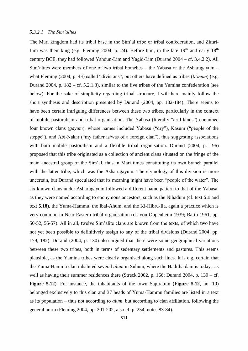
311
5.3.2.1 The Sim’alites
The Mari kingdom had its tribal base in the Sim’al tribe or tribal confederation, and Zimri-
Lim was their king (e.g. Fleming 2004, p. 24). Before him, in the late 19th and early 18th
century BCE, they had followed Yahdun-Lim and Yagid-Lim (Durand 2004 – cf. 3.4.2.2). All
Sim’alites were members of one of two tribal branches – the Yabasa or the Asharugayum –
what Fleming (2004, p. 43) called “divisions”, but others have defined as tribes (li’mum) (e.g.
Durand 2004, p. 182 – cf. 5.2.1.3), similar to the five tribes of the Yamina confederation (see
below). For the sake of simplicity regarding tribal structure, I will here mainly follow the
short synthesis and description presented by Durand (2004, pp. 182-184). There seems to
have been certain intriguing differences between these two tribes, particularly in the context
of mobile pastoralism and tribal organisation. The Yabasa (literally “arid lands”) contained
four known clans (gayum), whose names included Yabasu (“dry”), Kasum (“people of the
steppe”), and Abi-Nakar (“my father is/was of a foreign clan”), thus suggesting associations
with both mobile pastoralism and a flexible tribal organisation. Durand (2004, p. 196)
proposed that this tribe originated as a collection of ancient clans situated on the fringe of the
main ancestral group of the Sim’al, thus in Mari times constituting its own branch parallel
with the latter tribe, which was the Asharugayum. The etymology of this division is more
uncertain, but Durand speculated that its meaning might have been “people of the water”. The
six known clans under Asharugayum followed a different name pattern to that of the Yabasa,
as they were named according to eponymous ancestors, such as the Nihadum (cf. text 5.1 and
text 5.18), the Yuma-Hammu, the Ibal-Ahum, and the Ki-Hibru-Ila, again a practice which is
very common in Near Eastern tribal organisation (cf. von Oppenheim 1939; Barth 1961, pp.
50-52, 56-57). All in all, twelve Sim’alite clans are known from the texts, of which two have
not yet been possible to definitively assign to any of the tribal divisions (Durand 2004, pp.
179, 182). Durand (2004, p. 130) also argued that there were some geographical variations
between these two tribes, both in terms of sedentary settlements and pastures. This seems
plausible, as the Yamina tribes were clearly organised along such lines. It is e.g. certain that
the Yuma-Hammu clan inhabited several alum in Suhum, where the Haditha dam is today, as
well as having their summer residences there (Streck 2002, p. 166; Durand 2004, p. 130 – cf.
Figure 5.12). For instance, the inhabitants of the town Sapiratum (Figure 5.12, no. 10)
belonged exclusively to this clan and 37 heads of Yuma-Hammu families are listed in a text
as its population – thus not according to alum, but according to clan affiliation, following the
general norm (Fleming 2004, pp. 201-202, also cf. p. 254, notes 83-84).

312
People belonging to the Sim’al tribe constituted presumably the large majority of the Mari
kingdom, as Yaminites only made out about a quarter of its 40,000 strong population,
excepting the areas of Qattunan and Suhum (Millet Alba 2004, p. 231). Sim’alite alum were
spread along the valley from southern Suhum to the the area around the Habur confluence,
and at least up to the middle Habur valley, while the summer habitation area of Sim’alite
mobile groups probably followed the same distribution pattern (Streck 2002, pp. 164-165).
Certain towns in the Ida-Maraš also seem to have harboured Sim’alite affiliation, such as
Zalluhan (Yabasu – Figure 5.12, no. 18) and Šuna (Fleming 2004, pp. 90, 152 – Figure 5.12,
no. 16), and it is possible that more distant Sim’alite alum also existed, like Dêr on the Balih
(cf. Durand 2004, p. 236). However, according to the current state of evidence, the Sim’alite
sedentary population was mainly confined to the Mari kingdom. On the other hand, the Sim’al
mobile groups were very firmly associated with the banks of the Habur up to and including
the extended Habur triangle, to where they seasonally migrated with their flocks of sheep and
goats (i.e. entire nawum) each winter for territorial pasture. They seem to have had two main
nighum in this region, probably associated with specific clans or perhaps the two branches,
which were administered by one merhum each, reporting to the Sim’alite king. These areas
were located in central Ida-Maraš, certainly associated with a long-standing claim, and the
area around Jebel Sinjar, possibly extending to its southern foothills (cf. Heimpel 2003, pp.
31-33; Fleming 2004, p. 83; Durand 2004, p. 123). While Durand (2004, p. 118) proposed
that this distribution may have been a recent development, following his view of the
“Amorrite migrations” (cf. 5.3.1.2), Streck (2002, p. 188) argued that it was part of a much
older settlement system of summer and winter residences, a view which I condone myself.
5.3.2.2 The Yaminites
There is also sufficient information in the Mari archives for scholars to be able to deduce the
villages, summer habitations, and many of the tribal pastures of the Yamina. This tribal group
was clearly organised as a confederacy containing five distinct tribes, which seems to be
exhaustive regarding its members, confirmed by a list of the li’mum with their contextually
current and separately governing kings (Fleming 2004, pp. 43, 67 – although cf. Durand 2004,
p. 158). They could ally themselves against an external enemy, like three of them did vs.
Yahdun-Lim, or be in conflict with each other, although not usually violently (cf. Fleming
2004, pp. 59, 62). The five Yaminite tribes (cf. Durand 2004, pp. 158, 173-174; Fleming
2004, pp. 45, 52; Heimpel 2003, pp. 15-17 – also cf. text 5.19) were Amnanum, Rabbum,
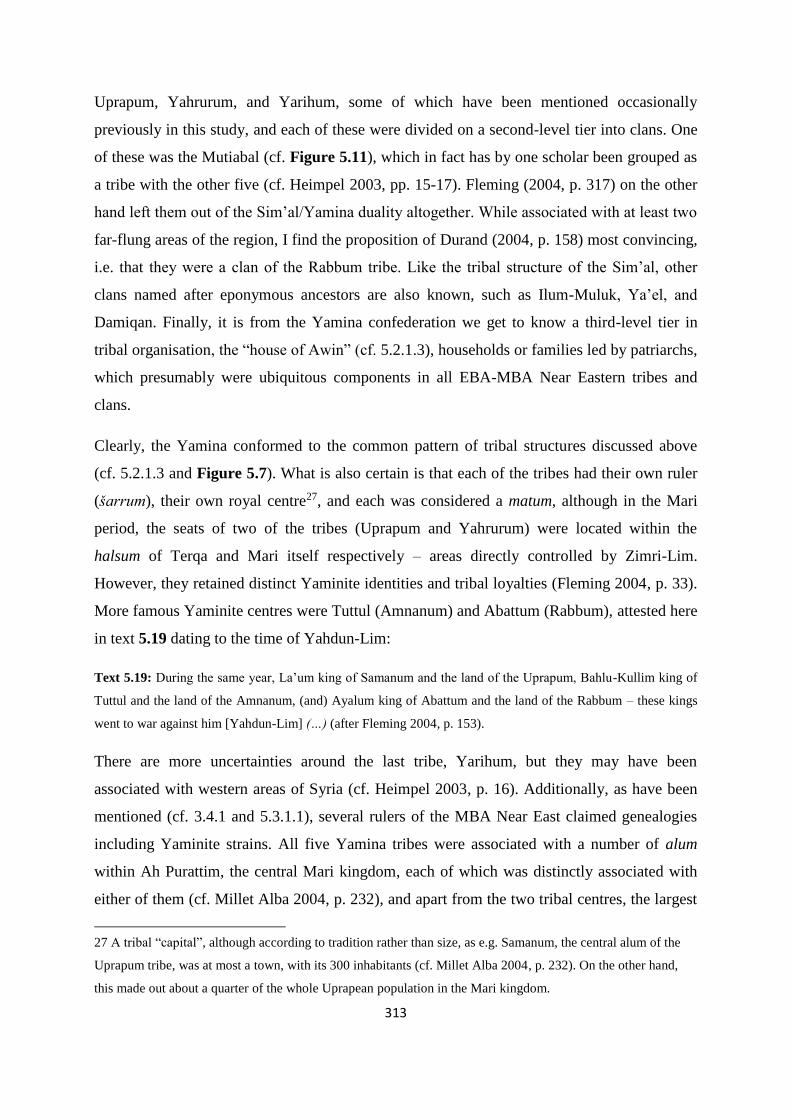
313
Uprapum, Yahrurum, and Yarihum, some of which have been mentioned occasionally
previously in this study, and each of these were divided on a second-level tier into clans. One
of these was the Mutiabal (cf. Figure 5.11), which in fact has by one scholar been grouped as
a tribe with the other five (cf. Heimpel 2003, pp. 15-17). Fleming (2004, p. 317) on the other
hand left them out of the Sim’al/Yamina duality altogether. While associated with at least two
far-flung areas of the region, I find the proposition of Durand (2004, p. 158) most convincing,
i.e. that they were a clan of the Rabbum tribe. Like the tribal structure of the Sim’al, other
clans named after eponymous ancestors are also known, such as Ilum-Muluk, Ya’el, and
Damiqan. Finally, it is from the Yamina confederation we get to know a third-level tier in
tribal organisation, the “house of Awin” (cf. 5.2.1.3), households or families led by patriarchs,
which presumably were ubiquitous components in all EBA-MBA Near Eastern tribes and
clans.
Clearly, the Yamina conformed to the common pattern of tribal structures discussed above
(cf. 5.2.1.3 and Figure 5.7). What is also certain is that each of the tribes had their own ruler
(šarrum), their own royal centre27, and each was considered a matum, although in the Mari
period, the seats of two of the tribes (Uprapum and Yahrurum) were located within the
halsum of Terqa and Mari itself respectively – areas directly controlled by Zimri-Lim.
However, they retained distinct Yaminite identities and tribal loyalties (Fleming 2004, p. 33).
More famous Yaminite centres were Tuttul (Amnanum) and Abattum (Rabbum), attested here
in text 5.19 dating to the time of Yahdun-Lim:
Text 5.19: During the same year, La’um king of Samanum and the land of the Uprapum, Bahlu-Kullim king of
Tuttul and the land of the Amnanum, (and) Ayalum king of Abattum and the land of the Rabbum – these kings
went to war against him [Yahdun-Lim] (…) (after Fleming 2004, p. 153).
There are more uncertainties around the last tribe, Yarihum, but they may have been
associated with western areas of Syria (cf. Heimpel 2003, p. 16). Additionally, as have been
mentioned (cf. 3.4.1 and 5.3.1.1), several rulers of the MBA Near East claimed genealogies
including Yaminite strains. All five Yamina tribes were associated with a number of alum
within Ah Purattim, the central Mari kingdom, each of which was distinctly associated with
either of them (cf. Millet Alba 2004, p. 232), and apart from the two tribal centres, the largest
27 A tribal “capital”, although according to tradition rather than size, as e.g. Samanum, the central alum of the
Uprapum tribe, was at most a town, with its 300 inhabitants (cf. Millet Alba 2004, p. 232). On the other hand,
this made out about a quarter of the whole Uprapean population in the Mari kingdom.
314
of them were governed by a sugagum responsible to the Mari king (Fleming 2004, p. 52).
However, most of the Yamina population was located outside this kingdom and thus much of
our perspective, but some information has been possible to discern, e.g. a lasting Yaminite
affiliation among the Zalmaqum kings around Harran (cf. Figure 3.1), and an association
with the twin cities of Sippar, which included Amnanum and Yahrurum as part of their
toponyms (Figure 5.12, no. 12). Western Syria, western Jezire, and the plains of Yamhad also
seem to have harboured significant Yaminite populations (e.g. Streck 2002, pp. 163-164;
Fleming 2004, pp. 28-29; Durand 2004, pp. 158, 173-174).
Like the other tribal groups, the Yamina confederation incorporated a significant mobile
component (the hibrum, cf. 5.2.1.1), each with its traditional nighum for winter pasture. Many
of these are known from Mari texts, one of which (the Uprapean, cf. Charpin 2010, p. 240)
definitely bordered onto Jebel Bishri and the Palmyrene (Figure 5.12), if not actually
stretching into these areas. Already Luke (1965, pp. 73, 248) noted Yaminite nighum along
Balih toward Zalmaqum, with which kings they therefore depended on good relations and
probably also were tribally affiliated with, as well as in parts of the Syrian steppe, while
Matthews (1978, p. 56) argued Yaminite groups pastured their flocks extensively in Jebel
Bishri. However, Yaminite livestock pasturing in central parts of these highlands was later
described to be a one-off event, and not part of the traditionally reconised pattern (cf. Streck
2002, p. 63). Durand (2004, pp. 167-169) listed the five tribes, their known kings, and their
attested pasture territories, which is reflected in Figure 5.12. Most of them did at some point
pasture in western Syria, although I suspect the appearance of Uprapeans near Qatna could
have been due to their nighum arcing from the Balih confluence with the Euphrates, along the
northern parts of the Palmyrene, to this region. Yahrurum seem to have pastured in western
Jezire, while the Yarihum could have pastured in the region of Damascus. Otherwise, mobile
Yamina groups seem to have grazed their flocks anywhere between the Balih valley and the
coast outside the hot season, a pattern rooted in and cemented by tradition (cf. Durand 2004,
pp. 167-169; Fleming 2004, p. 94 – also cf. text 5.2). There are indications of several merhum
operating as middlemen between these groups and respective authorities in these areas as well
(Fleming 2004, p. 84), although as it did not concern the Mari palace, our knowledge on the
topic is limited. It is in this context the letter sent by Šamši-Addu to his viceroy son at Mari,
Yasmah-Addu, should be viewed (cf. text 3.4), in which he urged him to get guides to counsel
and help his army regarding the whereabouts of water points (buratum, also cf. text 5.3).
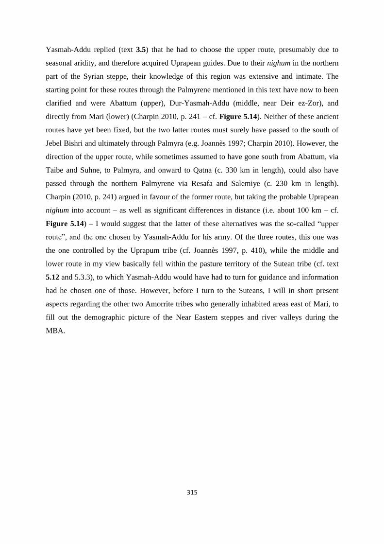
315
Yasmah-Addu replied (text 3.5) that he had to choose the upper route, presumably due to
seasonal aridity, and therefore acquired Uprapean guides. Due to their nighum in the northern
part of the Syrian steppe, their knowledge of this region was extensive and intimate. The
starting point for these routes through the Palmyrene mentioned in this text have now to been
clarified and were Abattum (upper), Dur-Yasmah-Addu (middle, near Deir ez-Zor), and
directly from Mari (lower) (Charpin 2010, p. 241 – cf. Figure 5.14). Neither of these ancient
routes have yet been fixed, but the two latter routes must surely have passed to the south of
Jebel Bishri and ultimately through Palmyra (e.g. Joannès 1997; Charpin 2010). However, the
direction of the upper route, while sometimes assumed to have gone south from Abattum, via
Taibe and Suhne, to Palmyra, and onward to Qatna (c. 330 km in length), could also have
passed through the northern Palmyrene via Resafa and Salemiye (c. 230 km in length).
Charpin (2010, p. 241) argued in favour of the former route, but taking the probable Uprapean
nighum into account – as well as significant differences in distance (i.e. about 100 km – cf.
Figure 5.14) – I would suggest that the latter of these alternatives was the so-called “upper
route”, and the one chosen by Yasmah-Addu for his army. Of the three routes, this one was
the one controlled by the Uprapum tribe (cf. Joannès 1997, p. 410), while the middle and
lower route in my view basically fell within the pasture territory of the Sutean tribe (cf. text
5.12 and 5.3.3), to which Yasmah-Addu would have had to turn for guidance and information
had he chosen one of those. However, before I turn to the Suteans, I will in short present
aspects regarding the other two Amorrite tribes who generally inhabited areas east of Mari, to
fill out the demographic picture of the Near Eastern steppes and river valleys during the
MBA.

316
Figure 5.12: Map of selected known tribal affiliations of the Mari period, as well as indications of tribal
territories for seasonal pastoralism. Sedentary tribal areas are shown in bold, while attested nighum are in italic.
The alum numbered in the map are: 1) Emar, 2) Abattum (Rabbum), 3) Tuttul (Amnanum), 4) Zalmaqum (area),
5) Dabiš (cf. text 5.1 and 5.18), 6) Dumtan, 7) Samanum (Uprapum), 8) Mišlan, 9) Harradum, 10) Sapiratum
(Yuma-Hammu), 11) Harbe, 12) Sippar (Amnanum/Yahrurum), 13) Maškan-Šapir, 14) Uruk, 15) Talhayum
(Yapturum), 16) Šuna, 17) Urkeš (Hurri), 18) Zalluhan (Yabasu), 19) Šehna/Šubat-Enlil (Hana), 20) Razama
(Yussan), 21) Ninua (Turukku), 22) Šušarra (Turukku) , 23) Ekallatum, 24) Qattara, 25) Karana, 26) Kurda, 27)
Andarig, 28) Razama (Yamutbal). Colour key: Yamina (red), Sim’al (blue), Yamutbal (white), Numha (black),
other tribes (triangles).
5.3.2.3 The Numha and the Yamutbal
The tribes of Numha and Yamutbal are not known in great detail (Durand 2004, p. 133), as
they both were situated outside the direct control of Mari with their own kings, probably at
least two each (e.g. Yamutbalean kings in both Andarig and in Larsa – cf. Figure 5.12). The
two matum south and southeast of Sinjar did have some dealings with Zimri-Lim, most
notably the Yamutbal, as their core areas partly overlapped with the nighum of Sim’alite
groups. Numha and Yamutbal as tribal names probably stemmed from eponymous ancestors
or unknown toponyms, although their clans are not known. However, both clearly
incorporated a sedentary and a mobile component as parts of their tribal organisation (Joannès
1996, p. 354; Streck 2002, p. 166). The northern sedentary areas of Numha and Yamutbal are
fairly well known. South of Jebel Sinjar, the Yamutbal centre was Andarig (probably modern
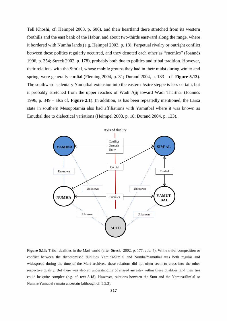
317
Tell Khoshi, cf. Heimpel 2003, p. 606), and their heartland there stretched from its western
foothills and the east bank of the Habur, and about two-thirds eastward along the range, where
it bordered with Numha lands (e.g. Heimpel 2003, p. 18). Perpetual rivalry or outright conflict
between these polities regularly occurred, and they denoted each other as “enemies” (Joannès
1996, p. 354; Streck 2002, p. 178), probably both due to politics and tribal tradition. However,
their relations with the Sim’al, whose mobile groups they had in their midst during winter and
spring, were generally cordial (Fleming 2004, p. 31; Durand 2004, p. 133 – cf. Figure 5.13).
The southward sedentary Yamutbal extension into the eastern Jezire steppe is less certain, but
it probably stretched from the upper reaches of Wadi Ajij toward Wadi Tharthar (Joannès
1996, p. 349 – also cf. Figure 2.1). In addition, as has been repeatedly mentioned, the Larsa
state in southern Mesopotamia also had affiliations with Yamutbal where it was known as
Emutbal due to dialectical variations (Heimpel 2003, p. 18; Durand 2004, p. 133).
Figure 5.13: Tribal dualities in the Mari world (after Streck 2002, p. 177, abb. 4). While tribal competition or
conflict between the dichotomised dualities Yamina/Sim’al and Numha/Yamutbal was both regular and
widespread during the time of the Mari archives, these relations did not often seem to cross into the other
respective duality. But there was also an understanding of shared ancestry within these dualities, and their ties
could be quite complex (e.g. cf. text 5.18). However, relations between the Sutu and the Yamina/Sim’al or
Numha/Yamubal remain uncertain (although cf. 5.3.3).
Cordial
YAMINA SIM’AL
YAMUT-
BAL NUMHA
SUTU
Conflict
Osmosis
Unity
Unknown
Unknown Unknown
Unknown Unknown
Enemies
Cordial
Axis of duality

318
We do not know much about the grazing territories of the Yamutbal, but if the pattern of
Sim’al and Yamina is to be indicative of similar structures further east, it seems likely they
also had their ancestral area for pasturing founded on claims in tradition and perhaps
perceived divine allocation. The mobile pastoralists of southern Yamutbal (Larsa) could have
had access to the same territories and rights as parts of the tribe or tribal confederacy, and
their shared descent and kinship being reproduced and reinforced by replicating a
geographical landscape through the mirror toponomy phenomenon (cf. 5.3.1.2 and Figure
5.11). Tentatively, Yamutbal seem to have had nighum somewhere in eastern Jezire, as
mobile groups of both Yamutbal and Numha have been attested on the eastern banks of Habur
and Euphrates during winter (“since last year”, cf. Streck 2002, p. 166 – also cf. text 5.5). The
latter tribe, while equally obscure in this regard, could hypothetically had access to pastures
east of the Tigris, following the same suggestion with regard to mirror toponomy. Although
the traditional pasture areas for Numha at best remain hypothetical, the areas of their
sedentary alum are more substantially documented. Sometimes divided by scholars into
western and eastern Numha (cf. Joannès 1996, p. 350), their respective central settlements
were Kurda (probably modern Balad Sinjar) and Karana (probably modern Tell Afar), the
latter of which had been relocated from Qattara (modern Tell Rimah) in the Mari period
(Figure 5.12, nos. 24-26). Thus, interestingly, all the three central settlements of the south
Sinjar tribes or matum, if correctly located, lay within a mere one or two days travel of each
other (Joannès 1996, p. 350; Durand 2004, p. 134), despite the apparent enmity between
Yamutbal and Numha (Figure 5.13). The Numha lands stretched from Yamutbal east- and
southeastward to upper Wadi Tharthar, and across and down the Tigris valley, with e.g.
Ekallatum being populated by Numhaites, and Babylon at least having some affiliation with
this tribe (Joannès 1996, p. 349; Heimpel 2003, p. 21; Durand 2004, p. 133 – also cf. 5.3.1.1).
As the Babylonian dynasty has been shown to include both Numha and Yamina ancestry,
Durand (2004, p. 134) argued that Numha belonged to the Yamina tribal confederacy. I agree
that there seem to have been certain links between these groups, but have contended myself
by placing them on the same side of the tribal duality in Figure 5.13. Similarly, the
expressions used in MBA texts when Yamutbal and Sim’al relations are discussed seem to
suggest a close bond “since days gone by” between these as well (Fleming 2004, pp. 31, 90 –
also cf. note 25), justifying their position across such an axis of duality. However, integrated
with this picture, but tribally situated outside it, were the Suteans.

319
5.3.3 Sutu and the Suteans
The Suteans were not the only tribe situated outside the Amorrite dualities of Sim’al/Yamina
and Yamutbal/Numha in the MBA, as a number of other tribal groups are attested in the
textual record (cf. 3.2.6). However, most, if not all of these were located along the fringes of
the Near Eastern steppes. We know from Mari texts of Turukku, found east of upper Tigris,
and associated with e.g. Ninua (Niniveh), as well as the Lullu located in the same region (cf.
Heimpel 2003, pp. 20-21; Durand 2004, p. 133). Neither were they the only other Semitic
tribal group (cf. 3.2.6). However, as far as I can discern, apart from the four main Amorrite
tribes, they were the only relatively large population inhabiting extensive parts of the central
Near East with which the Mari authorities had regular dealings. The reason for this was that
Suteans every season moved through core areas of the Mari kingdom with their nawum on
their way to their traditional nighum, generally believed to have been the Palmyrene dry
steppe.
Although the Sutu feature much less frequently in the Mari archive than e.g. the Yamina and
were not part of its matum (Durand 2009, p. 505 – cf. Luke 1965, pp. 107-111 for a list of
Sutean attestations outside the Mari archives), certain aspects of their tribal organisation are
nevertheless known. Their structure did incorporate hibrum (cf. 5.2.1.1), which presumably
means the Suteans also had sedentary villages, although not in Ah Purattim. Like the more
well-studied and better known MBA Near Eastern tribal groups, they were also divided into
clans, of which at least five are known to date – Yahmamu, Allamutu, Mihalizayu, Bar-
Halanum, and Bula/ila – with the first two of these described at Mari as “distant Suteans” (cf.
Joannès 1997, p. 408). Whether or not they had kings is uncertain, as Suteans entering the
Mari texts are in general mobile pastoralists on pasture, but they certainly had clan leaders
like other tribes. Most appear briefly, like Abisare, Gazizanum, or Rabium, but the Sutean
known as Hammitalu features repeatedly and was evidently active during the reigns of both
Yasmah-Addu and Zimri-Lim (cf. 3.4.2.2 and 3.4.2.3). Hammitalu, Abisare, and Gazizanum
were in fact orchestrating and leading the famous raid against pastures near Qatna attested in
text 5.12, but Hammitalu also led one of the Sutean hibrum accompanying the king of Kurda
on his return from Babylon along the Euphrates, provided guides for an embassy from Dilmun
(modern Bahrain), and generally enjoyed cordial relations with Mari authorities (Joànnes
1997, pp. 408-409). This is not surprising, as Sutean mobile groups were dependent on Mari
for access to their pastures, just like the Sim’alite mobile pastoralists had to negotiate safe

320
pastures with the leaders of Ida-Maraš (cf. 5.2.1.2). Incidentally, there is some uncertainty
whether the Sutu were of Amorrite stock like the other tribes discussed here or part of a
different Semitic branch, and they have in fact been suggested as being of Aramaean stock
(cf. 3.2.6). Albeit intriguing, this is somewhat outside the main focus of this dissertation and
would have to be adressed by another study,
The tribal name Sutu is often translated in Akkadian as “the South” or “southerners” (Durand
2010, p. 261), which led Streck (2002, p. 165) to suggest it referred to their geographical
locations when seen from the Yamina/Sim’al point of view – areas of sedentary settlements
and summer habitations on lower Euphrates and possibly the plateau oases west of the river
(cf. Heimpel 2003, p. 27), and their winter pasture territory in the Palmyrene, i.e. south of the
Euphrates. However, demonstrable evidence for sedentary habitation in the form of towns or
villages is still lacking and such settlements are often presumed. Luke (1965, pp. 121-123)
proposed this hypothesis early on, but his arguments are still supportable today (cf. Streck
2002, pp. 164-165, 170). When e.g. Rim-Sin of Larsa defeated a coalition of enemies, they
were listed as “Uruk, Isin, Babylon, Sutium, and Rapiqum”, from south to north as was the
custom, thus positioning Sutean lands more or less in the area around Sippar (Luke 1965, p.
122; Streck 2002, p. 165 – cf. Figure 5.12, no. 12, also cf. Figure 3.6 for the other toponyms
in this list). Durand (2009, p. 506) mentioned that in fact one text provides the name of a
“distant Sutean” settlement, called Eš or Yaš, suggesting that Sutean actually was a West
Semitic language as well as the tribe also inhabiting alum like the other Near Eastern tribes.
Another town may have been Udanum near Larsa, shown by this text:
Text 5.20: Suteans, about fifty of them, come out of Udanum, three miles (up to) Larsa, and attack the backside
[rural areas] of the cultivated zone of the Babylonians and capture three people and carry off grain and return to
Udanum (cf. Heimpel 2003, p. 467, 27 161 – my clarifications in brackets).
Their presence near Sippar is finally suggested by recurring attacks they carried out on towns
and settlements in Suhum, like Yabliya and Harbe (Figure 5.12, no. 11), attested by both
texts from Mari and Sippar (cf. Durand 2009, p. 506; Heimpel 2003, p. 26). The presence of
cattle herds among Suteans in the lower river valley is also indicative of sedentary
components in villages alongside their mobile pastoralists (Durand 2010, p. 261, note 30;
Streck 2002, p. 172).

321
Figure 5.14: The three routes Šamši-Addu advised his son, Yasmah-Addu, to consider for marching an army
across the Palmyrene. It has been shown that the starting points for the lower, middle, and upper alternatives
were approximately Mari, Dur-Yasmah-Addu, and Abattum, respectively. The routes themselves have not been
fixed, with particularly the specific path of upper route – the one which in fact seems to have been chosen –
being uncertain. Charpin (2004) suggested it went via Taibe and Suhne to Palmyra, but in my view treks along
the northern parts of the Palmyrene seem more likely. They are c. 100 km shorter than the Taibe-Suhne
alternative, and potentially crossed the Uprapean nighum indicated in the text (cf. text 3.4 and 3.5), rather than
the Sutean one which probably lay further south and east.
There are more textual references to Sutean pastures. As repeatedly alluded to in this
dissertation, it is generally accepted that their territory encompassed at least large parts of
Jebel Bishri (e.g. Charpin 2010, p. 243; Prag 1985, p. 87, fig. 2), and in my view probably
also central Palmyrene and the plateaus along the Euphrates banks, although Joannès (1997,
p. 409) believed Jebel Bishri constituted their ultimate northwestern limits of pasturing.
However, as Suteans are attested to water their flocks and cross the Euphrates between Dur-
Yahdun-Lim (same alum as Dur-Yasmah-Addu) and Halabit, as well as near Terqa (Durand
2009, p. 510; 2010, p. 261 – cf. Figure 5.14), they probably pastured their ovicaprines on
both plateaus along the river on their migration from their summer habitations and alum in
Akkad and Sumer as well. Again, Luke (1965, pp. 123-124, 128) was early in suggesting
these steppe areas as their winter pastures, providing the Sutean hibrum with unsurpassed
knowledge of routes, wells, and dangers in the region – and generating income for the Mari
palace through transit taxation, miksum (cf. Table 5.1), as they migrated through its

322
heartlands and halsum. Variations in tribal allocation of pastural ranges within the Sutu tribe
are not yet known, although it seems at least the Mihalizayu clan did frequent Jebel Bishri (cf.
Pappi 2006, p. 247). The fact that different Sutean leaders were contacted to guide travellers
along different routes (cf. Joannès 1997, p. 410), as well as the MBA Mari concept of “distant
Suteans”, do suggest a system of separate nighum based on clans and various areas of
geographical expertise. According to Streck (2002, p. 165), the southernmost limit for their
winter pasture must have been Al-Hamad, as this climatically and ecologically would have
been too arid for ovicaprine pastoralism. In northern parts of the Palmyrene ranges they would
also have had to compete or come to terms with Yaminite Uprapean hibrum, as this was
seemingly the southern part of their nighum (cf. Figure 5.12). In this instance, I would argue
that conflict sometimes occurred, and this is the context in which we should interpret the
hostile interactions occurring involving Suteans – tribal competition manifested through
raiding.
Text 5.21: (…) (Mobile Yaminites) who went to raid Sutean sheep, (…), raided Sutean sheep at the “Cold well”
and Qabaqab. (…) downstream of Mount Bahalta-Gurâtim, they went down to the Euphrates. They [the Suteans]
had not yet sheared the sheep. (…) They [the Yaminites] looted the sheep like wolves, quick to steal and leave.
This is Ihîl-pi-El, son of Ginnum the Uprapean, the leader of the expedition, lighter of the fire. They took
approximately ten thousand sheep. The Suteans came in pursuit to the rescue, but (…) (Durand 2010, p. 261,
note 30 – my translation from French and my clarifications in brackets).
Text 5.21 suggests two very interesting points. Firstly, that the Suteans returned from Jebel
Bishri or Palmyrene to the Euphrates valley at the point of the year when their sheep were
supposed to be sheared (although they had not yet sheared them), i.e. late April to mid-May
(cf. 5.1.3.2 and Figure 5.5) – clear evidence for their migration back in late Spring and their
presence in the Syrian steppe in the winter months. Secondly, that their Yaminite adversaries
in this instance were the Uprapeans, supporting the hypothesis that they were regularly in
competition, which presumably was due to bordering territories, as suggested in Figure 5.12.
Following the same line of argumentation, it is possible that the same aspects were in play
during the events described by text 5.12, either due to Uprapean mobile pastoralists at that
time pasturing in the area east of Qatna – possibly the southwesternmost limits of their
nighum – or that Qatna itself was affiliated with the Yamina tribal confederacy, and possibly
with Uprapum. The attack on Palmyra and Našala may have had a similar raison d’être,
particularly as it happened as part of the same line of events. Both events, as well as the
retaliatory occurrence in text 5.21, while not necessarily directly connected, were part of

323
traditional practice associated with mobile pastoralism in a tribal setting (5.1.3.4 and 5.2.1.4),
mainly carried out during the winter season when the whole nawum were moving about in
their nighum – the latter of which regarding the Suteans were in my view constituted by
central regions of the Palmyrene and the Jebel Bishri in the MBA, as well as probably further
south along the Euphrates. However, notions along the lines that the Sutu were “more
nomadic” than other tribes (e.g. Anbar 1991, p. 174) or perpetually hostile (e.g. Durand 2004,
p. 196), are outdated and should be put to rest (cf. 5.2.1.3). They seem to have been part of the
same tribal, political, social, and demographic structure as the other tribal groups found across
the Near East during the later EBA and the MBA.
With this perspective at the outset, I will finally turn to the exercise of integrating Near
Eastern tribal concepts and mobile pastoralism with archaeological material, and attempt to
combine these into a model for interpreting the distribution of funerary structures found in the
Palmyrene and extended Syrian steppe.
5.4 Tumuli, tribal ancestors, and territories
Clearly, tribal territories and the cycle of seasonal migration are integrated on a number of
levels for mobile groups in both recent and ancient past in the Near East. I have mainly kept
this aspect separate from the many structures found in these areas and their significance in a
tribal context. However, I will in this final subchapter turn to data and analyses which suggest
tumuli (cf. 4.5.3) and perhaps other archaeological structures (cf. 4.5.4 and 4.5.5) in fact may
have formed an important part of the concept of tribal territories. Key to this notion is
ancestor worship and reverence for their perceived power as mediators in the interplay
between divine and human existence (e.g. Porter 2012, pp. 217-218).
5.4.1 Ancient and recent mortuary traditions
There is evidence from ethnographic studies that mobile groups frequently pay respect to
known shrines or graves, although in an Islamic Near Eastern context this can probably not be
likened to the practice presumed for tribes practicing mobile strategies in the EBA and MBA.
Still, it is interesting to note the importance among recent mobile groups of visiting
monuments erected in remembrance of past family members as part of a pastoral migratory
cycle. One example mentioned by Bradbury (2011, p. 174) described how a Qashqai father

324
erected an inscribed grave stone in memory of his deceased son in the pasture territory of his
tribe, to which the dead boy’s parents paid a visit every spring and autumn during their mobile
season. Barth (1961, pp. 137-138) observed how the Basseri in southwestern Iran
conceptualised time according to the annual migratory cycle, and during their movements
passed by waypoints to which they had a connection en route. One example of this could be
shrines of holy men, that were shown due respect, even without any associated names or
myths. Although not directly comparable to ancestral tumuli, it is easy to envisage a similar
practice in a context of seasonal migrations. This analogy could have been our only source of
information on mobile pastoralist rituals linked to burial monuments, but luckily once more
the Mari archives provide a more or less direct source on such practices in the MBA.
Additionally, certain practices known from Ebla during the EBA could also be seen in a
context of landscape, mobility, and territory.
From studies of the Ebla archives (cf. 3.2.3) it has in later years become clear that the Eblaite
state incorporated a regular ritual, performed twice a year, where local rulers up to 300 years
past were worshipped as ancestors. This may not seem to have an immediate analogy to
seasonally migrating groups, but some details are intriguing. There were rituals for specific
ancestor kings – although never immediate predecessors to the current one – performed at
specific days of the month at the actual or perceived burial places for these ancestors, which
included movements from the urban area to named sites in the rural parts of the polity. Such
ceremonial “tours” could include festivals and funerary rituals such as offerings at important
ancestral sites, and frequently and repeatedly took place away from the city itself to mark out
and lay claim to the territory of Ebla (Archi 2012, pp. 6-14; also cf. Porter 2002, p. 5; 2012,
pp. 214-215). In some ways, although replacing the Eblaite institution of the king with the
tribal group, a parallel practice may have been important for structuring and cementing
territorial claims of various mobile groups every year as part of the migratory cycle. This
forms a central part of my interpretation concerning the myriad of Palmyrene burial
monuments. It is supported by the kispum rituals practiced at Mari during the MBA, which
instead of focusing on royal lineages like in EBA Ebla, rather revered the collective aspect of
ancestors through communal feasting for the living and the dead members of the tribal group,
thus purveying and affirming the shared ideal of tribal unity. Ancestor worship and ancestor-
related practices could in this way constitute the apex of real or fictive lineages through which
all members of a tribe or clan could conceive themselves as connected – clearly important in a

325
context of fluid and flexible tribal structures (Porter 2002, pp. 1, 5). I have discussed above
(5.2.1 and e.g. text 5.18) how kinship in fact could be created among tribal societies for
various reasons, and the dead could likewise be incorporated through assumption of
responsibility for funerary and post-funerary mortuary traditions (Porter 2012, p. 42).
However, while dead ancestors were receiving offerings, they were usually not worshipped as
deities, but rather seen as acting intermediaries or liminalities between people, gods, and
ghosts (Porter 2007/8, p. 202). The locus for such rituals, the place of highest potency and
nexus between the planes of existence, was the tumulus – argued by Hodder (1994, p. 80) to
often represent the house of the ancestors – where such entities were not seen as gone, but in
fact present, at least symbolically, and maybe active and possible to invoke for a cause (Porter
2007/8, p. 201; 2009, p. 208). The exact nature of ancient rituals is difficult to know in detail,
but ancestors may have been remembered as strong personalities, just leaders, or warriors of
great and valorous feats commemorated as heroes in repeated rituals including offerings,
libations, and communal feasting with story-telling (Helwing 2012, p. 55). For mobile groups,
such ceremonies could have taken place within a context of seasonal migration, or even
constituted integral parts of the migratory schedule, where locations in the landscape was
associated with various ancestors, closer family members, or deities. Porter argued:
“Ancestor traditions as a complex dynamic of ideological representations of the social group
in relation to place expressed in the physical containment of ancestors in a particular type of
mortuary structure – monumental and visible burial mounds” (Porter 2002, p. 1).
It is necessary to realise that these various manifestations and dimensions of being in the
cosmology and minds of the ancients were probably both integrated and unseparable
existences, and many divine and earthly notions came together in the tumulus through
interment of dead individuals and their subsequent inclusion in commemorative and seasonal
rituals (Porter 2007/8, p. 201). Of course, such perspectives also provided the dead with a
perceived power of agency, for themselves or on behalf of the living, and likewise potential
for participation (Helwing 2012, p. 48). While these aspects initially may seem rather
hypothetical regarding the EBA-MBA societies of the Near East focused upon in this
dissertation, the Mari archives have provided a link connecting ancestor worship and MBA
perceptions of the spiritual world specifically with the construction of tumuli or stone cairns.
The best attested of these is the concept and structure called humusum (cf. Durand 2005).
326
5.4.2 The humusum and similar monuments
Strictly speaking, the Amorrite term humusum did not necessarily refer to a funerary
monument (see below), although the physical structure seems to have manifested itself as a
cairn of rocks and possibly wood or a pile of boulders – essentially similar types of
constructions when seen and surveyed in the field by archaeologists four thousand years later.
Its main purpose for the ancient populations in question was both mentally and physically as a
monument of commemoration, a memorial landmark integrated into and being part of the
regional landscape. The importance of these structures playing such a role has been argued to
constitute a trait of continuity from the EBA to the MBA, even though the term humusum is
primarily known from the Mari archives (Durand 2005, p. 110; Felli 2012, p. 98). Although
these cairns were seemingly imbued with spiritual power and carried inherent sanctity, they
also served a mundane purpose as reference points in both a physical and narrative sense, as
these two text extracts show:
Text 5.22: Tell my Lord, thus (speaks) Hammi-Ishtamar thy servant. Mut-Panasi, whom the hana met at the
funeral monument (humusum) of La’um, which is downstream of Halabit [modern Halabiye, cf. Figure 5.14].
(...) (Durand 2005, p. 101 – my translation from French and my clarification in brackets).
Text 5.23: Tell my Lord, thus (speaks) Yaqqim-Addu, thy servant. On the day I sent this tablet to my Lord,
Kusan, messenger of Karkemiš, Šamaš-Redi, and a friend of his, my Lord’s (people), who were travelling to my
Lord from Karkemiš, were attacked by four Uprapeans at the funeral monument (humusum) of Ayalum, who
killed Šamaš-Redi and his friend (...) (Charpin 2010, p. 244; also cf. Durand 2005, p. 96).
Both these events mention the humusum of well-known dead individuals, so the king
receiving the messages – in this context Zimri-Lim of Mari – would know where the incidents
happened (cf. Charpin 2010, p. 244). These figures are known to us as kings of Yamina tribes
who rebelled against Yahdun-Lim during the initial years of the 18th century BCE, but were
captured and subsequently executed, and their Yaminite forces defeated (cf. 3.4.2.2 and text
5.19). However, the humusum was a structure that could be erected for several reasons. For
instance, the humusum commemorating these Yamina leaders could have been actual burial
cairns or representative cenotaphs (Durand 2005, pp. 102-103). Another motivation known
from textual sources to have constituted a raison d’être for the construction of a humusum is
the commemoration of political agreements between mobile groups (cf. Durand 2005, pp.
115, 125-126). The nature of these agreements is attested to have varied from e.g. the
resolution of a dispute surrounding migration rights through tribal nighum or territories, to

327
symbolizing a return to peaceful relations following a period of conflict, and could probably
also have been associated with a number of other arrangements. Finally, humusum are attested
to have been erected by authorities and linked to specific deities, for instance like the one
called “El’s blessing” located downstream of Terqa, probably used in state cults and under
royal responsibility (Durand 2005, p. 135).
Text 5.24: The humusum which is downstream of Hišamta [near Terqa], [called] El’s blessing, belonging to the
Lord, restore it anew, and then, in this very spot, place your ramum [see below and cf. text 5.25] (Durand 2005,
p. 137 – my translation from French and my clarifications in brackets).
Evidently, these structure were subject to deterioration from the prevailing elements of the
steppe environment and could require regular attendance for their upkeep. The humusum also
seemed to carry an inherent sanctity, with transgressions being perceived as serious offenses
against the deceased or ancestor it housed or represented (Durand 2005, p. 109), as well as
any groups who related to or had affiliations with it, shown by this letter by the Rabbean
leader, Dadi-Hadun:
Text 5.25: About the humusum of which I have talked to you – it is a funeral monument (ramum). It has been
five years since this humusum was erected, and I have passed by ten times from upstream or from downstream
since then. Never did I touch this humusum. During my present journey, when I left for you, I had reached
Muban [in the area of modern Deir ez-Zor, cf. Heimpel 2003, p. 618] when I was told: “The humusum of
Ayalum has been destroyed.” I did not want to believe it until I sent two servants and they saw this humusum.
Then I grew very angry and held my hand over [i.e. some form of retaliatory action] the humusum of Lahun-
Dagan. They certainly destroyed the one that was erected on a territory that was not their own, whereas I did not
destroy the one that was erected on my territory (…) (cf. Durand 2005, pp. 97, 99; Charpin 2010, p. 244 – my
clarifications in brackets).
Text 5.25 brings direct light on a number of aspects which are interesting to contextualise and
integrate with the tribal world described above (cf. 5.3.2.2). First, it suggests that burial
monuments were during the MBA called ramum, although this also constituted a conceptual
subgroup under the more generalised term humusum – both used interchangeably and
generally understood by the ancients through the respective context of the structure. It also
suggests that the humusum mentioned in text 5.23, was an actual tumulus built for funerary
purposes, as both extracts refer to the same monument (cf. Durand 2005, pp. 96, 135).
Additionally, it probably means that the humusum of La’um in text 5.22 was indeed a ramum,
and that the last Yaminite leader captured by Yahdun-Lim during that same rebellion, Bahlu-
Kullim – king of Tuttul and the Amnanum tribe (cf. text 5.19) – also lay buried under a

328
humusum erected by his kin and tribesmen. As there evidently were aspects of territory and
tribal zones of control associated with these structures (cf. Durand 2005, pp. 103-105;
Bonacossi & Iamoni 2012, pp. 244-245), this latter one was probably located near Tuttul, the
central alum of the Amnanum and Bahlu-Kullim, just as the burial monument of Ayalum
probably had been erected near Abattum (cf. Figure 5.12, nos. 2 and 3). This would also fit
well with the itinerary of the Karkemiš messengers in text 5.23. The humusum of La’um on
the other hand lay downstream of modern Halabiye28, in northern Ah Purattim, where the
central alum of the Uprapeans, Samanum, was found – all conforming to the pattern of tribal
matum (cf. 5.2.1.3) . However, the monument of the Uprapean leader Lahun-Dagan had been
permitted to be constructed on the territory of the Rabbum tribe, i.e. in the Abattum area
(Figure 5.12, no. 2), presumably because the death had occurred during the seasonal
migration en route to or from the Uprapean nighum in that region (Durand 2005, pp. 97, 99;
Charpin 2010, p. 245 – cf. Figure 5.12). Thus, to erect a burial monument, it may seem that
one had to have the territorial rights through kinship or else permission from the
corresponding figure of authority – either the Rabbean leader (as inferred from text 5.25) or
the king of Mari (as in text 5.24).
Finally, the textual sources suggest that there were a number of such cairn-like monuments
found throughout the rural Near Eastern landscape during the MBA and presumably also the
EBA, the designations of which could have been synonymous with the broader term
humusum, or denoted a similar structure, but erected for a more specific function or
motivational context (cf. Durand 2005, pp. 139, 173; Marti 2005, pp. 191, 200). Narum seems
to have been more or less an Akkadian equivalence to the Amorrite term humusum, sikkanum
denoted a cairn strictly for worship, while birutum was a mound erected in a military context,
with the etymology of the latter suggesting that is was a thing which was to be seen –
probably one of the most important features of these cairn-like structures. This function is
indeed still is partly in effect (cf. 4.1.3, 4.1.4, and 4.2.3), and would probably have been much
more manifest in the Bronze Age landscapes without the four millennia of deterioration they
have suffered from human agency and harsh weather.
28 Incidentally, on the western plateau overlooking the widening of the Euphrates valley south of Halabiye – i.e.
where the river exits the narrow canyon (al-khanuqa) – is an area of dense concentrations of tumuli, clearly
visible on the corresponding Google Earth imagery, but not reproduced in this dissertation.

329
5.4.3 Palmyrene tumuli and their ancient contexts
Tumuli as burial monuments can be said to both denote space through their visibility and
mark the continuity of a group over time in relation to a landscape or place, an effect which is
not possible to achieve with below-ground burials – they manifest to whom an area belongs
and, by representing a genealogical link, why it belongs to them (Porter 2002, p. 25).
Monumental burials could be turned into commemorative sites through rituals. Ancestors that
were housed within the tombs were probably not perceived as memories, but rather existed as
powerful beings beyond the human realm, able to act beneficently or malignantly through
invocation on behalf of those maintaining the proper rituals and tending their resting place
(Porter 2012, pp. 192, 230). Texts from Emar dating to the mid-2nd millennium BCE show
how ancestors were named, honoured, and invoked, but not worshipped as deities.
Additionally, they were not only active as agents when invoked, but could also passively
watch over rights, obligations, and resources in the form of communal and individual property
(Porter 2002, pp. 2-3). This is in my view the primary function of the vast fields of tumuli
found in the Palmyrene. Above-ground monuments mark territorial and ancestral claims to
lands and resources used in specific parts of the year – essential to mobile pastoralist groups
for their subsistence and lifestyle. In fact, farview tumuli (cf. 4.1.4) as archaeological
structures have been argued to be particularly symptomatic of territorial claims in antiquity.
Fear of the wrath of the dead could operate as a mechanism for defining territorial and social
boundaries and inhibiting transgressions, a privilege upheld through the obligation of
mortuary rituals (Porter 2009, p. 208; Helwing 2012, p. 55 – also cf. Porter 2002, pp. 1, 3).
Helwing pointed out that
“Visibility of monuments and installations for continuous performance of rituals both serve
for reiterative construction of mental memorial map where the places of the ancestors are
firmly anchored” (Helwing 2012, p. 55).
Seen in light of the Palmyrene archaeology, both these notions can be argued to have been in
play – tumulus monuments of various sizes, albeit generally within a relatively narrow
structural horizon, visible from many perspectives and clearly meant to be seen by groups
traversing the region, as well as auxiliary features associated with many of them (cf. 4.1.4 and
e.g. Figure 4.2, Figure 4.6, and Figure 4.24). In addition, certain buried funerary features,
documented to form part of tumuli by both the Syro-Japanese and the Syro-Italian

330
archaeological projects (cf. 4.7.3 and 4.7.4), also seem likely to have existed in association
with other tumuli recorded by the Palmyrena project. Finally, the conceptual integration of
burial monuments, ancestors, and landscape would – as argued by Helwing (see above) –
form a mental memorial map reiterated annually as part of the mobile season. Just like Porter
(e.g. 2007/8, p. 208) argued to be the case at Tell Banat, tombs were probably the focus of on-
going rituals over a long period, even without any subsequent interments. However, as has
been shown tentatively by radiometric and relative dating (cf. 4.6.1 and 4.7), the later EBA
and the MBA seem to have been the main periods of construction for such monuments.
Helwing (2012, pp. 53-54) interpreted a number of new patterns in Near Eastern mortuary
features from EBA IV compared to earlier parts of the 3rd millennium, most notably of which
were summarised as:
Certain credibility in attributing them to mobile groups.
Trend toward multiple burials, possibly due to increased awareness of group
belonging such as kin-groups based on descent.
Focus on visibility and accessibility, suggesting continuous and frequent use for
mortuary rituals in association with ancestor veneration.
Spatial continuity for manifestation of territorial claims to specific landscapes or
localities by respective groups using these spaces for burials – demonstration of
ownership through filiation.
All these are aspects which are relevant and regularly associated with the tumuli and
structural complexes recorded by the ground surveys of the Palmyrene (cf. 4.1.4 and 4.2.3).
Figure 5.15: Two examples of tumuli associated with refurbishments which could be associated with mortuary
rituals of unknown nature (also cf. Figure 4.6). Left: Cluster of tumuli (appendix 1, nos. 229-235) which also
incorporated several other structural features into its complex, among them this rectangular enclosure or platform

331
with some form of standing stone or stone construction along one side (photo augmented with clarifying lines by
myself). Right: Tumulus in the lowest foothills of Jebel Merah (appendix 1, no. 236) which is surrounded by a
complex pattern of stone-lined rows.
Durand (2005, p. 127) has argued that the memorial cairn as a fundamental reality in the Near
East has previously been archaeologically frowned upon, possibly due to its lower visibility
compared with stelae or embossed rocks. Taking a wider view, other parts of the Near East
has seen a longer history of research into arid landscape structures and tumuli, particularly the
southern part of the Levant, including Sinai, Jordan, and the Negev Desert. Haiman (1992)
summarised evidence from the Negev highlands, where two different categories of cairn fields
had been recorded through surveys in the period 1979-1989, some of which also had been
excavated. Some of the 800 examples documented were associated with settlements and dated
to the Levantine EBA and the MB I – i.e. more or less EBA and MBA I when synchronised
with Syrian periodisation (cf. 3.1.2). However, by far the majority of them were described as
cairn fields at high altitudes, visible from far away (cf. Haiman 1992, pp. 25-27). There are a
number of characterisations and details regarding these latter archaeological complexes from
the Negev which are interesting when seen in relation to circumstances in the Palmyrene.
They are documented to be quite one-dimensional in form, mostly constructed as a ring of
upright stones with the insides filled with rocks, of c. 0.5-1.0 m in height and 3-9 m in
diameter, and often contain a modest-sized burial cist (Haiman 1992, pp. 30-31), a description
which could fit some of the Palmyrene turrets and larger cairns/monumentals (cf. 4.1.3).
Initially dated to the MB I by association with nearby settlement sites, a reevaluation
supported by recent evidence led Haiman to place the Negev cairn field phenomenon firmly
in the EBA. The same was argued to be the case with similar structures in the Sinai, which
previously had been dated to the Chalcolithic, although further precision was not possible to
obtain. An intruiging aspect was the lack of human remains in these cairns, with only 7.5 %
seemingly being used for burials, indicating a more ritual element to these complexes rather
than just a funerary purpose (Haiman 1992, pp. 33, 37). Supporting this interpretation was the
frequent presence of auxilliary structures proposed as ritual installations, like elongated walls
of parallel stone rows or platforms, both filled with dust and small stones. These latter
structures were often located on hilltops, had been constructed with frame of larger,
occasionally hewn, stones, were too shallow to have contained a grave, and could be dated to
the MB I – possibly representing a structural continuation from the wall structures, which
were placed in the EBA (Haiman 1992, pp. 31, 38-39). These descriptions could very well

332
have referred to many of the refurbishments associated with tumuli and tumulus clusters in
the Palmyrene (cf. 4.1.4, Figure 4.6, and Figure 5.15). Finally, it was pointed out that such
cairn fields seemed to date to the EBA or later 3rd millennium BCE in other parts of the Near
East, including other parts of Israel, the Lebanon Valley, and Jordan (Haiman 1992, p. 42). As
discussed in 4.7, as a result of the 20 years that have passed since this reevaluation of the
Negev cairn fields, the Palmyrene and other parts of the Syrian dry steppe can to some degree
now be added to this corpus.
Figure 5.16: Tumulus (appendix 1, no. 165), here marked by Dr. Nils Anfinset, situated right next to the path
crossing a significant low point in the northern wall of Jebel Abyad into Wadi Mazrur going toward Jazal.
Although not visible from far away, it is clearly positioned to be noticed by anyone travelling along this route,
which is the northern end of no. 16 (eastern arm) shown in Figure 4.27.
Taking into account the analyses of Helwing (2012), the earlier work by Haiman (1992), and
the information gleamed from the Mari archives (cf. 5.4.2), certain conclusions could be
presented with regard to the Palmyrene tumuli. Their association with mobile groups seems
likely, both implied by the environment and suggested by excavations carried out on
essentially the same types of structures in other parts of the region, as well as the known
presence of such groups there during the MBA. Group awareness and multiple burials is
indicated by the tendency of tumulus clustering, often around a central cairn (e.g. cf. Figure
333
4.49), both according to the more strict definition of complexes used in this study (cf. 4.1.4)
or even more so if following the definition of cairn fields employed by the Syro-Japanese
project. Kinship or group affiliation associated with cairn-like structures as markers of burials
or otherwise is also clearly attested in ancient texts, manifested in the physical structure
known as humusum, which incorporated a number of subcategories, e.g. ramum.
Visibility and accessibility can in general be argued to constitute the most striking
characteristics for Palmyrene tumuli, although this depends on the perspective. Not all of
them can be seen from kilometres away, but those that are more unassuming are still found in
close relation to local routes or topographical features associated with important
communication lines (e.g. Figure 5.16 – also cf. Figure 4.9, Figure 4.16, or Figure 4.26).
They were also acting as markers in the ancient landscapes, and could be used as geographical
reference points. Several complexes have been shown to incorporate other types of structures,
not classifiable as burial monuments, such as a number of platforms, stone rows, wall-lines
connecting tumuli, foot chains, stone circles or half-circles, and smaller stone rings (Figure
5.15 and cf. Figure 4.6). These may have had a role in mortuary rituals, although this must be
considered speculation. However, there are indications of such practice both in the archives of
Ebla and Mari, where ancestor veneration within a structure of kinship and filiation is
attested, and could probably be extended beyond the Eblaite elite to also be employed by
other groups. Finally, the satellite imagery survey of the region has documented a vast and
continuous distribution of tumuli across the region, although not undifferentiated, with some
landscapes clearly being more central in this respect than others (cf. Figure 4.30), supporting
the suggestion that demarcation of territory is an essential aspect of this physical expression,
presumably based on the belief among both filiated and non-affiliated people that ancestors as
agents of power and intermediaries between human societies and the spiritual world could act
as guardians of ancestral claims to e.g. territories of pasture. All in all, the change in funerary
patterns from early 3rd millennium BCE to the later part and the topographical and social
contexts discussed above seem to be reflected in the archaeological assemblages found in the
Palmyrene.
334
5.5 Summary and conclusions
A central part of the original hypothesis for this dissertation (cf. 1.2.1) was that mobile
pastoralists were responsible for many of the structures recorded across the Palmyrene. This
chapter has dealt with all manners of issues associated with such groups in the Near East, both
in recent times and during the late 3rd and early 2nd millennium BCE, in order to produce a
coherent picture of their role in ancient societies, their relationships with other groups, the
specific nature of their lifestyle, and their connection with archaeological remains. Initially, I
presented earlier views on mobile pastoralists and how they have been dealt with in
archaeological research until recently (cf. 5.1.1). Particularly their conflation with recent
Bedouin populations has provided basis for many misconceptions. In addition, I have
discussed various concepts regarding mobility, pastoralism, and tribal organisation among
recent populations to present various scholarly views on such matters and clarify my own
position (cf. 5.1.2). Thereafter, I focused on mobile ovicaprine pastoralism as a Near Eastern
subsistence, and showed how the seasons are key to understanding the relationship of mobile
pastoralists with the land and other groups. Traditionally they schedule their year with the
steppe being accessed for pasturage every year starting with the onset of winter rains and
ending as the dry season approaches, at which time they retreat to secure water sources on the
plains and in the river valleys. Their seasonal migration takes place within a structure of
territories allocated by tradition and custom, which are communally accessible through
membership of tribes. During these movements many mobile groups also practice multi-
resource procurement strategies as opportunities arise. One of the most important aspects to
realise is the fact that a tribe generally consists of both a mobile and a sedentary component,
which often are bound by kinship, share a bifurcated territory of cultivated areas and pasture
ranges, and act together when facing adversaries (cf. 5.1.3).
The Mari archives can attest to very similar practices in MBA societies (cf. 5.2). Mobile
pastoralists as ovicaprine herders accessed the dry steppe with their flocks for winter grazing,
but were also part of a tribal structure in which a sedentary component stayed behind in the
tribal territory of cultivated land, villages, or towns. The mobile groups were known as hana
or hibrum, terms probably reflected during the 3rd millennium BCE in the kammu of the Ebla
archives and the better-known mardu – i.e. the Amorrites. While the latter designation could
carry a number of meanings depending on the perspective, recent research has convincingly
shown that in many contexts mardu were referring to people of mobile pastoralist lifestyles,

335
who represented a cultural identity which seems to have been adopted across the region in the
MBA (cf. 5.3.1). Near Eastern tribes during the MBA seem to have shared a number of
structural and social traits. Each was associated with a tribal capital and a settled region, while
their mobile component had pasture territories, nighum, which were defined and justified by
tradition and found in various parts of the Near East (cf. Figure 5.12). They seem to have
shared bonds of kinship and most had an idea of common ancestry stretching back to the
EBA. Much of the Palmyrene and Jebel Bishri seems to have been the pasture territory of the
Sutean tribe (cf. 5.3.3), although its northern lowlands were possibly also partly the Uprapean
nighum of the Yamina confederacy, which occasionally led to conflict and raiding between
these two groups. Finally, I tried in this chapter to integrate the Palmyrene tumuli with certain
ancient concepts and practices, specifically the manner in which territory is attested to have
been demarcated and maintained by moving through the landscapes as part of a ritual tradition
(cf. 5.4.1) and the concept of humusum – a cairn structure constructed for a variety of
purposes, including as actual burial monuments (ramum), cenotaphs, or as markers relating to
deities or the commemoration of an agreement (cf. 5.4.2). These are clearly attested in the
Mari archives as manifestations of tribal authority and incorporated a functional aspect related
to the demarcation of territory. All in all, the evidence seems to support an association
between EBA and MBA mobile pastoralist practices and many of the archaeological
structures recorded in the Palmyrene. I will now finally turn to a summary and integration of
all the aspects dealt with throughout this dissertation in order to produce a coherent synthesis.

336
6 Palmyrena and mobile pastoralists in the EBA IV and MBA
The research for this dissertation was sparked by questions emerging as a result of the
Palmyrena project survey and focused on exploring three of these in detail. The first one
concerned climate and environment and aimed to shed light on any climatic developments
experienced by the region and its populations during the EBA and MBA, as well as
reconstructing a picture of the dry steppe biomes themselves prior to their obvious and recent
ruin. The second question concerned the archaeological remains in the Palmyrene, which
were seemingly ubiquitous and followed certain distributional patterns, although the reasons
and functions associated with them were hypothesised and would require further
investigation. In addition, chronological control was relatively lacking for most of the
structures, particularly the tumuli, and needed to be unravelled by direct, relative, and
comparative dating. The third main question was related to the second. Who constructed all
these tumuli? The initial hypothesis that they were the physical manifestation of mobile
pastoralists groups in the Bronze Age had its basis in archaeological research from other
regions and the environmental context of the region, but had to be studied from a Palmyrene
perspective and elaborated through interdisciplinary means. It was deemed appropriate to
consider all these topics as a synthesis, to be able to integrate the various themes with each
other and produce a more complete picture of Palmyrena.
Climatic data discerned from proxy sources and palaeoenvironmental studies does suggest a
general deteriorating trend in conditions throughout the 3rd millennium BCE, but with marked
and sometimes rather substantial oscillations between favourable and unfavourable conditions
(cf. 2.4, 2.5, and 2.7). The final century of the EBA IV and the time of the Mari archives, that
is MBA II, seem to have experienced slightly improved conditions compared to the periods
before and after these intervals, which probably means they had slightly higher precipitation
levels than the modern regime, although exact numbers are not available. However, a
dramatic drop in humidity around 2300-2200 BCE must have had an impact on Near Eastern
societies, probably even felt across the lifetime of one or two generations. The effect seems to
greater when taking into account the favourable conditions just prior to this incident, which
represented one of the best climatic intervals of the entire 3rd millennium BCE. It has been
argued convincingly that Near Eastern populations experiencing environmental stress could

337
relieve the pressure through two mechanisms – increased nucleation or increased mobility
across the society (cf. 5.1.3.3). Bradbury (2011, p. 479) suggested that sites in the Homs NSA
may have been abandoned in the EBA IV by populations following opportunities in the
steppes further east, and Wossink (2009, p. 117-118 – also cf. Wossink 2010) argued that
socioeconomic developments took place from the mid-EBA and into the MBA which
incorporated higher degrees of specialisation characterised by a division into nucleation
among cultivating groups and increased mobility among pastoralists. This is supported by
abandonment of settlements taking place in the late 3rd millennium (cf. 5.1.3.2). Such a
pattern does seem to fit well with a model of tumulus construction mainly centered on the
EBA IV and the MBA in the Palmyrene, where territorial claims and group affilliation were
the operating mechanisms on a functional level. The Palmyrene could have been affected
somewhat by periods of desiccation, e.g. as the Soreq Cave proxy suggests a real decrease in
precipitation of 100-150 mm there for the 4.2 ka BP event (cf. 2.5 and 2.7.7), but compared to
its current condition, its biomes seem to have comprised much more robust ecologies in both
vegetation and fauna. In addition, the climate went from wetter than today toward conditions
similar to the one experienced by the Near East in recent times, including shorter intervals of
moister climate. However, perceptions are relative, and as the new climatic regime also may
have incorporated an element of irregularity in rainfall, systemic uncertainty among mobile
pastoralist groups depending on the region for pasturage could have constituted a larger part
of the EBA IV and MBA worldview, than e.g. during favourable times in the mid-3rd
millennium BCE. On the other hand, the modern ecologies of central Syria suffered
significantly from the introduction of motorised transportation, which during the previous
century provided increased access to remote regions. This is quite clearly indicated by
environmental studies and the large discrepancies in landscape descriptions from early 20th
century CE until the present time. Even during the 1930s, this effect was noted by
Schlumberger (1951, p. 4), who described Jebel Abyad as recently denuded of trees, although
he also noted that Jebel Shaar and Jebel Merah still had areas of forest remaining – vegetation
which now is completely gone. One key factor in this development was evidently
overexploitation of tree species, mainly terebinths, which were essential for microclimates
and prevented large-scale erosion during the wet season. The process seems to have been
exponential and now the deterioration of the steppe ecologies and other parts of the Syrian
environment (cf. 2.3) seem to have progressed to far for regeneration to happen. Similarly, up
to the late 19th century CE the fauna of Syria was still quite intact, but a combination of the

338
spread of modern guns and a loss of habitat has left many regional populations extinct and
crippled several other animal species. Thus, the modern environmental picture of the
Palmyrene compared with that of the EBA and the MBA is probably very different.
The central land use of the extensive Palmyrene woodland and dry steppes has for most
periods probably been as pasturage, at least under climatic conditions similar to those today,
but that does not mean a total absence of cultivation in these biomes. As has been shown by
archaeological research in other dry regions, a certain amount of structural investment in the
landscape could provide potential for crop agriculture. Rawda or the kranzhügeln (cf. 5.2.2)
seem to be the large-scale examples of such a strategy, but were established initially during
parts of the 3rd millennium BCE associated with advantageous climates, and may have been
adversely affected by subsequent deterioration. As I have argued in this study (cf. 4.5.4),
some of the stone enclosures found throughout the Palmyrene and in other parts of the Near
East, could have been constructed for similar purposes, but as part of a seasonal schedule.
Although such structures probably have had a very long period of use beyond the bounds of
the Bronze Age, as well as most likely also represent other functions of steppe exploitation,
the horticultural aspect is frequently ignored, but should be considered more actively in
modern studies – particularly within a context of mobile pastoralism, which in earlier research
could get too one-faceted on the subsistence side. Both recent and ancient mobile pastoralists
have been shown to incorporate multi-resource procurement strategies when opportunities
beckoned, and small-scale cultivation was one of these. Another strategy was hunting, which
is represented by the other main structure type in the archaeological assemblage of the
Palmyrene – the kites (cf. 4.5.5). The kites are also associated with multi-period usage, and
could date from at least the Chalcolithic until the Ottoman period. In certain cases, they seem
to be earlier than some of the tumuli, but as structures their function would be more or less
intact with minimal care involved. In my view, it seems therefore likely that kites were central
implements of the steppe landscapes and also used for hunting by mobile pastoralist groups in
the Palmyrene during the EBA and MBA, supported by such dates from other parts of the
Near East. The hundreds of kites recorded by Google Earth studies of the region has also
provided evidence for a distinct pattern in distribution and shape. The majority of them form
large clusters found along the border between the southern Palmyrene dry steppe and the
highlands and show a focus on funnelling features in the topography, e.g. the valleys between
Suhne and Taibe. The fact that over two-thirds of the kites have entrances oriented toward the
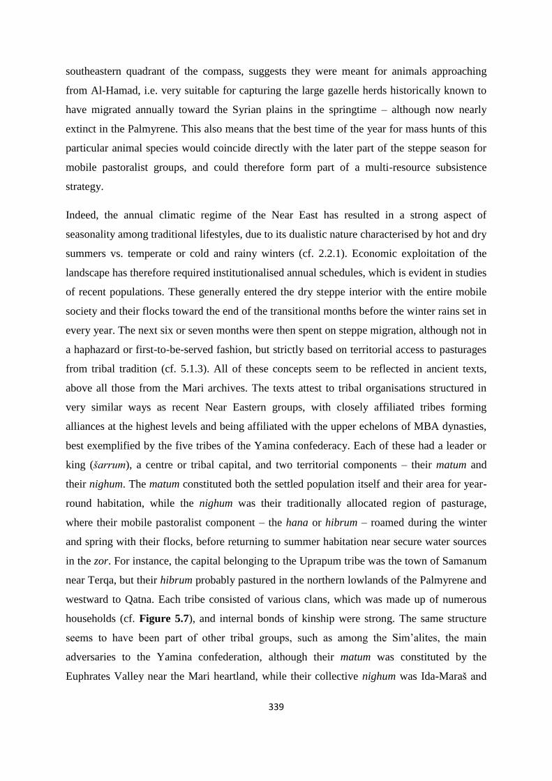
339
southeastern quadrant of the compass, suggests they were meant for animals approaching
from Al-Hamad, i.e. very suitable for capturing the large gazelle herds historically known to
have migrated annually toward the Syrian plains in the springtime – although now nearly
extinct in the Palmyrene. This also means that the best time of the year for mass hunts of this
particular animal species would coincide directly with the later part of the steppe season for
mobile pastoralist groups, and could therefore form part of a multi-resource subsistence
strategy.
Indeed, the annual climatic regime of the Near East has resulted in a strong aspect of
seasonality among traditional lifestyles, due to its dualistic nature characterised by hot and dry
summers vs. temperate or cold and rainy winters (cf. 2.2.1). Economic exploitation of the
landscape has therefore required institutionalised annual schedules, which is evident in studies
of recent populations. These generally entered the dry steppe interior with the entire mobile
society and their flocks toward the end of the transitional months before the winter rains set in
every year. The next six or seven months were then spent on steppe migration, although not in
a haphazard or first-to-be-served fashion, but strictly based on territorial access to pasturages
from tribal tradition (cf. 5.1.3). All of these concepts seem to be reflected in ancient texts,
above all those from the Mari archives. The texts attest to tribal organisations structured in
very similar ways as recent Near Eastern groups, with closely affiliated tribes forming
alliances at the highest levels and being affiliated with the upper echelons of MBA dynasties,
best exemplified by the five tribes of the Yamina confederacy. Each of these had a leader or
king (šarrum), a centre or tribal capital, and two territorial components – their matum and
their nighum. The matum constituted both the settled population itself and their area for year-
round habitation, while the nighum was their traditionally allocated region of pasturage,
where their mobile pastoralist component – the hana or hibrum – roamed during the winter
and spring with their flocks, before returning to summer habitation near secure water sources
in the zor. For instance, the capital belonging to the Uprapum tribe was the town of Samanum
near Terqa, but their hibrum probably pastured in the northern lowlands of the Palmyrene and
westward to Qatna. Each tribe consisted of various clans, which was made up of numerous
households (cf. Figure 5.7), and internal bonds of kinship were strong. The same structure
seems to have been part of other tribal groups, such as among the Sim’alites, the main
adversaries to the Yamina confederation, although their matum was constituted by the
Euphrates Valley near the Mari heartland, while their collective nighum was Ida-Maraš and

340
parts of Jebel Sinjar. This pattern seems to be iterated for all the well-known tribal groups of
the Near East during the early 2nd millennium BCE. In this context, it is necessary to mention
the Sutu (cf. 5.3.3), which probably had their sedentary component living along the Euphrates
somewhere between Suhum and the Persian Gulf during the MBA, perhaps inhabiting parts of
the southwestern plateau. However, some of their mobile pastoralists evidently travelled
through the Mari heartland toward their nighum in Jebel Bishri and the Palmyrene highlands.
Like the other tribal groups, they also had their leaders and clans and led similar lifestyles, but
as they mainly lived outside the sphere of the Mari administration, the texts do not deal with
them in much detail. However, they did pay miksum taxes when passing through Mari lands,
as well as carrying out raids against their adversaries as part of their seasonal migration –
some of which clearly were directed against the Uprapum, with which they presumably also
partly shared Palmyrene pastures and who evidently retaliated with their own raids. The
Parlmyrene highlands have also traditionally been shared by two large tribes in recent times –
the Hadidin and the Mawali – so this practice is not unheard of.
Could this pattern also be retrojected back into the EBA? Matters are not as firmly
documented, but the practice and produce associated with pastoralism constituted evidently a
large part of the Near Eastern socioeconomic structure. Archaeological evidence indicates an
increase in pastoral production from the EBA to the MBA, but also that it was a substantial
part of the EBA economy (cf. 5.2.2). This is supported by the archives of Ebla and the
bureaucracy of Ur III, both of which attest to pastoralism on a major scale in both state
capacity and privately. In addition to food products, ovicaprine flocks provided wool for
plucking, sorting, spinning, weaving, and dyeing. The end commodities above all in this – for
lack of a better word – industry, were textiles in all shapes and colours, consumed by
everyone from the lowliest peasant to the royal courts, and constituting a large part of the
trading networks across the Near East, perhaps even in a dominating role. However, the
tendency for radiometrically dated central Syrian tumuli to be placed in the EBA IV and
chronologically stretching into the MBA (e.g. 4.7.3) should be taken as evidence for a
continuance of the phenomenon for Palmyrene mobile pastoralist groups, and not two wholly
separate culture complexes. Thus, in my view, the variety of humusum structures known from
the early 2nd millennium BCE texts (cf. 5.4) were probably more or less the same structures as
the tumuli constructed in the late 3rd millennium, with similar functional aspects and the same
raison d’être. Their seemingly late EBA appearance as archaeological monuments could

341
perhaps be attributed to an expansion from all areas of the Near East into the dry steppe
landscapes due to climatic deterioration resulting in increased environmental stress – i.e. a
need for groups met with increased competition to assert territorial claims or cement real or
adopted bonds of kinship to steppe-affiliated ancestors or lineages – but scarcity of evidence
make such a conclusion merely tentative.
Mobile pastoralist groups were ubiquitous in the Near East during the EBA IV, although
probably under other names than we know from the Mari archives, and steeped in layered
meaning to the point of complete confusion for a modern scholar. However, recent research
and reinterpretations (e.g. Wossink 2009; Porter 2012) have seemingly been able to peel a few
of these away, to reveal a new picture of ancient Near Eastern society (cf. 5.3.1). The Ebla
archives probably referred to their own mobile groups by using the term kammu, which more
or less incorporated many of the concepts attributed to hana/hibrum during the MBA. In
addition, the presence of tribal organisations incorporating both sedentary and mobile
components in a manner similar to the tribes of the Mari archives is also indicated by these
texts, e.g. the Ibal of the steppe and Ibal of the canal. Then there is the question of the
Amorrites, which has haunted Bronze Age research for decades, but should be considered
contextually and acknowledged as a layered and relative designation. I have focused mainly
on the EBA term mardu being associated with mobile pastoralism, sometimes denoting
external tribal groups of western origin when seen from a southern Mesopotamian
perspective. Examples of such tribes could be the Tidnum (or their alternative designation in
the Ebla archives, the Ditanu) or the Yamadium, which from a scribal perspective in the Ur III
administration occasionally were deemed hostile, depending on the spatiotemporal context.
Finally, the term kur mardu – the mountain of the Amorrites – did not necessarily refer to a
specific toponym, but may instead have designated highlands of pasture, tribal territories used
by mobile pastoralists during their seasonal migrations, perhaps more or less synonymous to
the concept later called nighum. One of these was famously Jebel Bishri, which constituted a
tribal nighum in the 2nd millennium BCE, and another was Jebel Hamrin. In my view, these
realisations – if understood and contextualised properly according to perspectives – paint a
much more coherent picture of EBA socioeconomic structures in the Near East, with far fewer
paradoxes than in those inherent in earlier models of hostile Amorrites invading the urban
civilisations from their inexhaustible homeland in the Syrian steppe.
342
All these topics lead me to the final unanswered question in the initial hypothesis – the
archaeological remains in the Palmyrene dry steppe. The kites and stone enclosures have been
dealt with above, but it is the tumuli which must be said to comprise the main archaeological
structure type of this dissertation. Porter (2000) argued that the relationship between people
and land among pastoralists usually is associated with the practice of demarcated territoriality.
Similarly, Barth (1961) showed that access to pastures among recent mobile groups were
grounded in tradition and following kinship lines, i.e. communally allocated resource rights
based on membership of a tribe or clan. In my view, the tumuli represent the physical
manifestations of such rights, marking space through visibility and distribution, and
incorporating a temporal aspect by providing real or imagined links to ancestors. In the minds
of the ancients, the ancestors were real beings of power, conceptually and supernaturally
created or molded from individuals and groups of the past who acquired or upheld these
rights. Their protection, benevolence, and watchful eyes could be invoked and maintained
through iterations of post-mortuary rituals, in which monuments and complexes were
transformed into commemorative sites. These practices may very well have been an important
part of the seasonal migratory cycle in the steppe landscapes which housed the tumuli and
thereby the tribal ancestors, and in which the pastures lay guarded from trespassers by the
presence of these spirits. During the times of the Mari archives, the groups who laid claim to
the Palmyrene and Jebel Bishri as tribal territory were as mentioned probably the Suteans and
the Yaminite Uprapeans, although the exact limits of their respective nighum are uncertain
(cf. Figure 5.12). Some sort of a northwest-southeast divide between them seems to me the
most likely scenario. Whether or not their ancestors had retained such rights during the EBA
is pure speculation, but I suggest that the same type of organisational structure was in effect.
In any case, the adaptive and malleable nature of identity, kinship, and affiliation among Near
Eastern tribal groups of recent and ancient past makes this an academic exercise, because it
was the perceived association with tumuli as ancestral sites which constituted the main
operating mechanism in relation to claims and rights, not necessarily the actual ones –
although the latter situation could also very well have been in place.
I propose that it is kinship structures like these which are represented in the Palmyrene by
tumulus clusters (e.g. cf. Figure 4.49), in which tumuli relate to each other in space, and
sometimes also by means of physical structures – e.g. connected by stone rows or
incorporating secondary interments. Post-mortuary rituals such as ancestor veneration could

343
be represented by auxilliary features as parts of complexes or found in close association with
a tumulus, such as platforms, stone rows, and certain other structures. External refurbishments
are in fact not unique to the Palmyrena survey, and strikingly similar structures are known
from Jebel Bishri to the Negev. Then there is the aspect of tumulus distribution on a
microlevel and macrolevel perspective, both of which clearly suggest visibility and access as
central functions of these structures. The tumuli (cf. 4.1.4 and 4.2) have been shown again and
again to have a connection with communication lines across the Palmyrene – on a farview
level, with monumental cairns standing out like silhouettes on the mountain ridges, and on a
nearview level, with clusters of mounds and smaller cairns strategically placed on
topographical chokepoints with regard to cross-steppe travel. Of course, there is a wide
horizon between these two examples, some of which are less obvious when taking their
placement into account. The same can be said for the typology defined here (cf. 4.1.3), which
does show certain patterns, but not enough to convincingly provide many conclusions – apart
from the apparent ubiquitous link to visibility directed toward people traversing the landscape.
On a macroscale perspective, there are much clearer patterns, with an obvious focus on the
highlands, but a certain degree of lowland spread into major wadi-plains topographically
acting as links between regional landscape areas – like the Suhne-Taibe valley (Wadi Sahil,
cf. Figure 4.26) – or in areas of aggregational or centripetal nature – e.g. the Jazal oasis,
which indeed also constitutes a node in the network of Palmyrene communication routes (cf.
Figure 4.27). In fact, in many ways distribution patterns on a macrolevel perspective can be
argued to reflect the ones seen on a microscopic scale. The difference between structural
expressions of Palmyrene tumuli – e.g. between monumentals, turrets, and mounds – could be
associated with variation in chronology or perhaps even population, e.g. as in two different
tribes exploiting more or less the same territory. I am leaning toward a temporal explanation,
due to the vast amount of structures and relative variation in form, although certain features
seem to be recurring in seemingly different tumuli, for instance dry-stone walls as perimeter
boundaries with their interior filled with rocks, both seen in the construction of turrets and
larger cairns. Perhaps this is merely a result of structural development, as was suggested for
walls and platforms in the Negev? Unfortunately, secure dating of central Syrian tumuli are
too few and far between to provide any definitive answers on the typological aspect, but
where dates are available it is always the EBA IV and the MBA that emerge, if nothing else
indicating that the late 3rd and early 2nd millennium BCE were periods of large-scale tumulus
construction. Summarised and conclusively, I would suggest based on the data collected and

344
the arguments presented in this dissertation that the Palmyrene tumuli represent physical
remains of mobile pastoralist populations which during the EBA IV and the MBA used the
dry steppe landscape as pasture for their ovicaprine flocks on a seasonal basis, but who also
could practice multi-resource procurement strategies through large-scale hunting with kites
and small-scale horticulture in small enclosed gardens. These groups acted within a Near
Eastern social structure of tribal organisation and affiliation, in which territorial demarcation
and ancestor traditions played a key part, and the vast distribution of archaeological remains
in the Palmyrene may have been a result of economic and social expansion into the arid
steppe regions of the Near East due to increased mobility alleviating environmental stress
from climatic deterioration.
Further research should undoubtedly focus more on chronological control, which mainly
would require excavation of different types of tumuli, and of several tumuli within single
complexes to assess the relationships between various associated structures. I still believe that
excepting the presence of organic material for 14C dating, OSL would be fruitful to employ in
order to produce secure dates for all types of Palmyrene archaeological monuments – or
indeed arid landscape structures in general. This would clearly require very strict
methodology in planning and execution of sampling, but as shown by other studies, it is in
fact a viable dating method of Near Eastern archaeological monuments. A particularly
advantageous approach would be a combination with other methods of radiometric dating.
Unfortunately, OSL dating was not met with success by the Palmyrena project. Of course, all
of this is merely theoretical at this point, as the political situation especially in Syria, but also
across the Near East in general, is so grave as to prevent any form of on-site archaeological
research being carried out in the region in the foreseeable future. Thus, the Palmyrena project
probably represented one of the very last attempts of studying Syrian archaeology in the field
presumably for years to come. However, satellite imagery studies as a method could provide
potential for further research within a number of topics, such as macrolevel distributional
investigations of larger archaeological structures as well as certain degrees of detailed studies
in form, intra-site relations, and topographical contexts of these remains. While the imagery in
Google Earth is limited to the areas they have chosen to cover, other providers – such as Bing
– could supplement in other parts. In fact, at the time of writing many areas in the northern
Palmyrene seem to be covered by this software, where Google Earth only provides low-
resolution images. A combination of the two may be a solution to further expanding the

345
survey of central Syrian structures, unless one can purchase rather expensive, but
commercially available products. The method has also enormous potential for other parts of
the globe, perhaps in less studied regions, where long-standing volatile situations or very
remote and rugged landscapes has hindered macrolevel investigation or archaeological
fieldwork – e.g. the Sahara or Somalia – as it has recently been applied to studies of
archaeological monuments in Oman (Deadman 2012) and Saudi-Arabia (Kennedy & Bishop
2011). Finally, like the hana situation a decade ago, more translations and further analysis of
Bronze Age texts by the Mari school and other Assyriologists will undoubtedly increase our
understanding of these societies, although the flow of new tablets probably is hampered by a
lack of excavations. In any case, I believe the best approach to any archaeological study and
the optimal manner in which to achieve significant scientific results is through integrated and
interdisciplinary research.
346
7 Reference list
7.1 Bibliography
Abdi, K. (2003). The early development of pastoralism in the Central Zagros Mountains.
Journal of World Prehistory 17/4, 395–448.
Akkermans, P. M. M. G. & Schwartz, G. M. (2003). The Archaeology of Syria. From
Complex Hunter-Gatherers to Early Urban Societies (ca. 16,000-300 BC). Cambridge World
Archaeology. Cambridge.
Al-Maqdissi, M. (2000). Note sur les sondages réalisés par Robert du Mesnil du Buisson dans
la cour du sanctuaire de Bêl à Palmyre. Syria 77, pp. 137-154.
Al-Maqdissi, M. (2009). Notes d'archéologie levantine XV. Le Bronze Ancien à Palmyre. Al-
Rafidan: Journal of Western Asiatic Studies, vol. XXX, pp. 23-33.
Anbar, M. (1991). Les tribus amurrites de Mari. Orbis Biblicus et Orientalis 108. Freiburg.
Anfinset, N. (2009). Palmyrena. Palmyra and the surrounding territory. Joint Syrian-
Norwegian project. Surface survey north of Palmyra. April and May 2009. Preliminary
report. Prehistoric periods. University of Bergen.
Anfinset, N. (2010). Metal, Nomads and Culture Contact. The Middle East and North Africa.
Approaches to Anthropological Archaeology. London.
Anfinset, N. (2013). Palmyrena. Palmyra and the surrounding territory. Joint Syrian-
Norwegian project. Surface survey north of Palmyra. April and May 2011. Preliminary
report. Prehistoric periods. University of Bergen.
Arz, H. W., Lamy, F., & Pätzold, J. (2006). A pronounces dry event recorded around 4.2 ka in
brine sediments from the northern Red Sea. Quaternary Research 66/3, pp. 432-441.
Artzy, M. (2007). Incense, camels and collared rim jars: Desert trade routes and maritime
outlets in the second millennium. Oxford Journal of Archaeology 13/2, pp. 121-147.
Archi, A. (2012). Cult of the Ancestors and Funerary Practices at Ebla. In P. Pfälzner, H.
Niehr, E. Pernicka & A. Wissing (eds.): (Re-)Constructing Funerary rituals in the Ancient

347
Near East. Proceedings of the First International Symposium of the Tübingen Post-Graduate
School “Symbols of the Dead” in May 2009. Qatna Studien Supplementa 1. Wiesbaden, pp.
5-31.
Archi, A. & Biga, M. G. (2003). A victory over Mari and the fall of Ebla. Journal of
Cuneiform Studies 55, pp. 1-44.
ARM 14. M. Birot (1974). Lettres de Yaqqim-Addu. Archives Royales de Mari 14. Paris.
ARM 28. J.-R. Kupper (1998). Lettres royales du temps de Zimri-Lim. Archives Royales de
Mari 28. Paris.
Avner, U., Anderson, P. C., Mai, B. T., Chabot, J. & Cummings, L. S. (2003). Ancient
threshing floors, threshing tools and plant remains in ‘Uvda Valley, southern Negev desert,
Israel. A preliminary report. In P. C. Anderson, L. S. Cummings, T. K. Schippers & B.
Simonel (eds.): Le traitement des récoltes. Un regard sur la diversité du Néolithique au
present. XXIIIe rencontres internationales d’archéologie et d’histoire d’Antibes. Antibes, pp.
455-475.
Åström, P. (ed.) (1987). High, Middle or Low? Acts of an International Colloquium on
Absolute Chronology held at the University of Gothenburg, 20–22 August 1987. Gothenburg.
Bailey, R. M., Smith, B. W. & Rhodes, E. J. (1997). Partial bleaching and the decay form
characteristics of quartz OSL. Radiation Measurements 27/2, pp. 123-136.
Baran, J., Murray, A. S. & Häggström, L. (2003). Estimating the age of stone structures using
OSL: the potential of entrapped sediment. Quaternary Science Review 22/10-13, pp. 1265-
1271.
Bar-Matthews, M. & Ayalon, A. (2011). Mid-Holocene climate variations revealed by high-
resolution speleothem records from Soreq Cave, Israel and their correlation with cultural
changes. The Holocene 21/1, pp. 163-171.
Bar-Matthews, M., Ayalon, A., & Kaufman, A. (1997). Late Quaternary Paleoclimate in the
Eastern Mediterranean Region from Stable Isotope Analysis of Speleothems at Soreq Cave,
Israel. Quaternary Research 47/2, pp. 155-168.

348
Bar-Yosef, O. & Khazanov, A. (1992). Introduction. In O. Bar-Yosef & A. Khazanov (eds.):
Pastoralism in the Levant. Archaeological Materials in Anthropological Perspectives.
Monographs in World Archaeology 10. Madison, pp. 1-9.
Barth, F. (1956). Ecologic Relationships of Ethnic Groups in Swat, North Pakistan. American
Anthropologist, New Series 58/6, pp. 1079-1089.
Barth, F. (1961). Nomads of South Persia. The Basseri Tribe of the Khamseh Confederacy.
Boston.
Barth, F. (1969). Introduction. In F. Barth (ed.): Ethnic groups and boundaries. The social
organization of culture difference. Bergen/Oslo/Tromsø, pp. 9-38.
Bates, D. G. (1971). The Role of the State in Peasant-Nomad Mutualism. Anthropological
Quarterly 44/3. Comparative Studies of Nomadism and Pastoralism (Special Issue), pp. 109-
131.
Beck, A., Philip, G., Abdulkarim, M. & Donoghue, D. (2007). Evaluation of Corona and
Ikonos high resolution satellite imagery for archaeological prospection in western Syria.
Antiquity 81/311, pp. 161-175.
Bell, G. L. (1908). Syria. The Desert and the Sown (New and cheaper ed.). London.
Bietak, M. (2007). Towards a Middle Bronze Age Chronology. In P. Matthiae, L. Nigro, L.
Peyronel & F. Pinnock (eds.): Proceedings of the International Colloquium ‘From Relative
Chronology to Absolute Chronology: The Second Millennium BC in Syria-Palestine’ (Rome
29th November - 1st December 2001). Roma, pp. 121-146.
Blondel, J. (2006). The ‘design’ of Mediterranean landscapes: a millennial story of humans
and ecological systems during the historic period. Human Ecology 34/5, pp. 713–729.
Blunt, A. (1879a). Bedouin tribes of the Euphrates. Volume I. London.
Blunt, A. (1879b). Bedouin tribes of the Euphrates. Volume II. London.
Bonacossi, D. M. (2007). Qatna and its Hinterland during the Bronze and Iron Ages. A
Preliminary Reconstruction of Urbanism and Settlement in the Mishrifeh Region. In D. M.
Bonacossi (ed.): Urban and natural landscapes of an ancient Syrian capital. Settlement and
environment at Tell Mishrifeh/Qatna and in central-western Syria. Proceedings of the

349
International Conference held in Udine, 9-11 December 2004. Studi archeologici su Qatna
01. Udine, pp. 65-92.
Bonacossi, D. M. & Iamoni, M. (2012). The early history of the western Palmyra desert
region. The change in the settlement patterns and the adaptation of subsistence strategies to
encroaching aridity: A first assessment of the desert-kite and tumulus cultural horizons. Syria
89, pp. 31-58.
Bond, G., Showers, W., Cheseby, M., Lotti, R., Almasi, P., deMenocal, P., Priore, P., Cullen,
H., Hajdas, I. & Bonani, G. (1997). A Pervasive Millennial-Scale Cycle in North Atlantic
Holocene and Glacial Climates. Science 278/5341, pp. 1257-1266.
Bradbury, J. N. (2011). Landscapes of Burial? The Homs Basalt, Syria in the 4th-3rd millennia
BC. Ph.D. dissertation. Durham University, UK. EThOS Persistent ID: uk.bl.ethos.531247
Braemer, F., Echallier, J.-C. & Taraqji, A. (1996). Khirbet el Umbashi (Syrie). Rapport
préliminaire sur les campagnes 1993 et 1994. Syria 73, pp. 117-127.
Braemer, F., Échallier, J.-C. & Taraqji, A. (2004). Khirbet al Umbashi. Villages et
campements de pasteurs dans le “desert noir” (Syrie) à l’âge du Bronze. Travaux de la
mission conjointe franco-syrienne 1991-1996. Beirut.
Brayshaw, D. J., Rambeau, C. M. C. & Smith, S. (2011), Changes in the Mediterranean
climate during the Holocene: Insights from global and regional climate modeling. The
Holocene 21/1, pp. 15-31.
Brew, G., Barazangi, M., Al-Maleh, A. K. & Sawaf, T. (2001). Tectonic and Geologic
Evolution of Syria. GeoArabia 6/4, pp. 573-616.
Brinkman, J.A. (1977). Appendix: Mesopotamian Chronology of the Historical Period. In
A.L. Oppenheim: Ancient Mesopotamia. Portrait of a Dead Civilization. Chicago, pp. 335–
348
Bryson, R. A. & Bryson, R. U. (1997). Macrophysical Climatic Modeling of Africa's Late
Quaternary Climate: Site-Specific, High-Resolution Applications for Archaeology. The
African Archaeological Review 14/3, pp. 143-160.
350
Buccellati, G. (1966). The Amorites of the Ur III period. Pubblicazioni del Seminario di
Semistica, Richerche 1. Naples.
Buccellati, G. & Buccellati M. K. (1967). Annual Meeting of the Archaeological Institute of
America. Archaeological Survey of the Palmyrene and the Jebel Bishri. Archaeology 20/4, pp.
305-306.
Buccellati, G. (1988). The Kingdom and Period of Khana. Bulletin of the American Schools of
Oriental Research 270, pp. 43-61.
Buccellati, G. (2008). The origin of the tribe and of ‘industrial’ agropastoralism in Syro-
Mesopotamia. In H. Barnard & W. Wendrich (eds.): The archaeology of mobility. Old World
and New World nomadism. Cotsen Advanced Seminar Series 4. Los Angeles, pp. 141-159.
Bulliet, R. W. (1990). The Camel and the Wheel. New York.
Burckhardt, J. L. (1967). Notes on the Bedouins and Wahabys, vol. 1 (Johnson Reprint). New
York.
Castel, C. (2007). L’abandon d’Al-Rawda (Syrie) à la fin du troisième millénaire: Premières
tentatives d’explication. In C. Kuzucuoğlu & C. Marro (eds.): Sociétés humaines et
changement climatique à la fin du troisième millénaire: Une crise a-t-elle eu lieu en Haute
Mésopotamie? Actes du Colloque de Lyon, 5-8 décembre 2005. Varia Anatolica XIX.
Istanbul, pp. 159-178.
Castel, C. (2008). Al-Rawda, a town in the steppe (Central Syria, Early Bronze Age IV). In H.
Kühne, R. M. Czichon & F. J. Kreppner (eds.): Proceedings of the 4th International Congress
of the Archaeology of the Ancient Near East (ICAANE), Volume 2: Social and Cultural
Transformation: The Archaeology of Transitional Periods and Dark Ages. Excavation
Reports. Wiesbaden, pp. 301-312.
Castel, C. & Peltenburg, E. (2007). Urbanism on the margins: third millennium BC Al-Rawda
in the arid zone of Syria. Antiquity 81/313, pp. 606-616.
Cech, T. V. (2005). Principles of water resources. History, development, management, and
policy. 2nd edition. Hoboken, New Jersey.

351
Charpin, D. (2003). La “toponymie en mirroir” dans le Proche-Orient amorrite. Revue
d’Assyriologie et d’Archéologie orientale 97, pp. 3-34.
Charpin, D. (2004). Histoire Politique du Proche-Orient amorrite. In D. Charpin, D. O. Edzard
& M. Stol (eds.): Mesopotamien: Die altbabylonische Zeit. Freiburg and Göttingen, pp. 25-
480.
Charpin, D. (2010). The desert routes around the Djebel Bishri and the Sutean nomads
according to the Mari archives. Al-Rafidan: Journal of Western Asiatic Studies. Special issue.
Formation of tribal communities: Integrated research in the Middle Euphrates, Syria.
Hiroshima, pp. 239-245.
Charpin, D. & Durand, J.-M. (1986). “Fils de Sim’al”: les origines tribales des rois de Mari.
Revue d’Assyriologie et d’Archéologie orientale 80, pp. 141-183.
Collon, D. (2007). Relations between Syria and Mesopotamia in the Second Millennium BC –
The Evidence of the Seals. In P. Matthiae, L. Nigro, L. Peyronel & F. Pinnock (eds.):
Proceedings of the International Colloquium ‘From Relative Chronology to Absolute
Chronology: The Second Millennium BC in Syria-Palestine’ (Rome 29th November - 1st
December 2001). Roma, pp. 147-158.
Cribb, R. (1991). Nomads in archaeology. New Studies in Archaeology. Cambridge.
Cullen, H. M. & deMenocal, P. B. (2000). North Atlantic influence on Tigris-Euphrates
streamflow. International Journal of Climatology 20/8, pp. 853-863.
Cullen, H. M., deMenocal, P. B., Hemming, S., Hemming, G., Brown, F. H., Guilderson, T.
& Sirocko, F. (2000). Climate change and the collapse of the Akkadian empire: Evidence
from the deep sea. Geology 28/4, pp. 379-382.
De Jong, T. (2013). Astronomical fine-tuning of the chronology of the Hammurabi age.
Jaarbericht van het Vooraziatisch-Egyptisch Genootschap “Ex Oriente Lux” 44, pp. 147-168.
Deadman, W. M. (2012). Defining the Early Bronze Age landscape: a remote sensing-based
analysis of Hafit tomb distribution in Wadi Andam, Sultanate of Oman. Arabian Archaeology
and Epigraphy 23, pp. 26-34.
352
Deckers, K. & Pessin, H. (2010). Vegetation development in the Middle Euphrates and Upper
Jazirah (Syria/Turkey) during the Bronze Age. Quaternary Research 74/2, pp. 216-226.
Durand, J.-M. (1985). La situation historique des šakkanakku: Nouvelle approche. Mari:
Annales de Recherches Interdisciplinaires 4. Paris, pp. 147–72.
Durand, J.-M. (1991). L’emploi des toponymes dans l’onomastique d’époque amorrite: (I)
Les noms en MUT-. Studi Epigrafici e Linguistici 8, pp. 81–97.
Durand, J.-M. (2004). Peuplement et sociétés à l’époque amorrite. (I) Les clans bensim’alites.
In C. Nicolle (ed.): Nomades et sédentaires dans le Proche Orient ancient. Compte rendu de
la XLVIe Rencontre Assyriologique Internationale (Paris, 10-13. Juillet 2000). Amurru 3.
Paris, pp. 111-197.
Durand, J.-M. (2005). Le culte des pierres et les monuments commémoratifs en Syrie
amorrite. Florilegium marianum VIII. Paris.
Durand, J.-M. (2009). Les documents épistolaires du palais de Mari. Tome II. Littératures
anciennes du Proche-Orient. Paris.
Durand, J.-M. (2010). The banks of the Euphrates along the Bishri. Al-Rafidan: Journal of
Western Asiatic Studies. Special issue. Formation of tribal communities: Integrated research
in the Middle Euphrates, Syria. Hiroshima, pp. 253-262.
Enzel, Y., Bookman (Ken Tor), R., Sharon, D., Gvirtzman, H., Dayan, U., Ziv, B. & Stein, M.
(2003). Late Holocene climates of the Near East deduced from Dead Sea level variations and
modern regional winter rainfall. Quaternary Research 60/3, pp. 263-273.
Eshel, G. & Farrell, B. F. (2000). Mechanisms of Eastern Mediterranean Rainfall Variability.
Journal of the Atmospheric Sciences 57/19, pp. 3219-3232.
Echallier, J. C. & Braemer, F. (1995). Nature et fonctions des “desert kites”: Données et
hypotheses nouvelles. Paléorient 21/1, pp. 35-63.
Felli, C. (2012). Funerary Practices from the End of the Early to the Middle Bronze Age in
Northwestern Syria: the Middle Euphrates Valley. In P. Pfälzner, H. Niehr, E. Pernicka & A.
Wissing (eds.): (Re-)Constructing Funerary rituals in the Ancient Near East. Proceedings of

353
the First International Symposium of the Tübingen Post-Graduate School “Symbols of the
Dead” in May 2009. Qatna Studien Supplementa 1. Wiesbaden, pp. 79-110.
Finkelstein, J. J. (1966). The Genealogy of the Hammurapi Dynasty. Journal of Cuneiform
Studies 20/3-4, pp. 95-118.
Fiorentino, G. & Caracuta, V. (2007). Palaeoclimatic Signals Inferred from Carbon Stable
Isotope Analysis of Qatna/Tell Mishrifeh Archaeological Plant Remains. In D. M. Bonacossi
(ed.): Urban and natural landscapes of an ancient Syrian capital. Settlement and environment
at Tell Mishrifeh/Qatna and in central-western Syria. Proceedings of the International
Conference held in Udine, 9-11 December 2004. Studi archeologici su Qatna 01. Udine, pp.
153-159.
Fiorentino, G., Caracuta, V., Calcagnile, L., D’Elia, M., Matthiae, P., Mavelli, F. & Quarta,
G. (2008). Third millennium B.C. climate change in Syria highlighted by Carbon stable
isotope analysis of 14C-AMS dated plant remains from Ebla. Palaeogeography,
Palaeoclimatology, Palaeoecology 266/1-2, pp. 51-58.
Fiorentino, G., Caracuta, V., Quarta, G., Calcagnile, L. & Bonacossi, D. M. (2012).
Palaeoprecipitation Trends and Cultural Changes in Syrian Protohistoric Communities: the
Contribution of δ13C in Ancient and Modern Vegetation. In J. Kneisel, W. Kirleis, M. Dal
Corso, N. Taylor & V. Tiedke (eds.): Collapse or Continuity? Environment and Development
of Bronze Age Human Landscapes. Universitätsforschungen zur prähistorischen Archäologie,
Band 205. Bonn, pp. 19-33.
Fleitmann, D., Burns, S. J., Mangini, A., Mudelsee, M., Kramers, J., Villa, I., Neff, U., Al-
Subbary, A. A., Buettner, A., Hippler, D. & Matter A. (2007). Holocene ITCZ and Indian
monsoon dynamics recorded in stalagmites from Oman and Yemen (Socotra). Quaternary
Science Reviews 26/1-2, pp. 170-188.
Fleming, D. E. (2004). Democracy’s Ancient Ancestors. Mari and Early Collective
Governance. Cambridge.
Fried, M. (1975). The Notion of Tribe. Menlo Park, California.
354
Frumkin, A. (2009). Stable isotopes of a subfossil Tamarix tre from the Dead Sea region,
Israel, and their implications for the Intermediate Bronze Age environmental crisis.
Quaternary Research 71/3, pp. 319-328.
Frumkin, A., Kadan, G., Enzel, Y. & Eyal, Y. (2001). Radiocarbon chronology of the
Holocene Dead Sea: Attempting a regional correlation. Radiocarbon 43/3, pp. 1179–1189.
Fujii, S. (2009). Preliminary reports of the Syrial-Japan archaeological joint research in the
region of Ar-Raqqa, Syria, 2008. 1. A brief sounding at Rujum Hedaja 1. Al-Rafidan: Journal
of Western Asiatic Studies, vol. XXX, Preliminary reports of the Syria-Japan archaeological
joint research in the region of Ar-Raqqa, Syria, 2008, pp. 139-142.
Fujii, S. & Adachi, T. (2010). Archaeological investigations of Bronze Age cairn fields on the
northwestern flank of Mt. Bishri. Al-Rafidan: Journal of Western Asiatic Studies. Special
issue. Formation of tribal communities: Integrated research in the Middle Euphrates, Syria.
Hiroshima, pp. 61-77.
Fujii, S., Adachi, T. & Suzuki, K. (2009a). The Second Field Season at Rujum Hedaja 1. Al-
Rafidan: Journal of Western Asiatic Studies, vol. XXX, Preliminary reports of the Syria-Japan
archaeological joint research in the region of Ar-Raqqa, Syria, 2008, pp. 180-187.
Fujii, S., Adachi, T. & Suzuki, K. (2009b). The Soundings of the Hedaja Cairn Fields, the
Northwestern Flank of Jabal Bishri. Al-Rafidan: Journal of Western Asiatic Studies, vol. XXX,
Preliminary reports of the Syria-Japan archaeological joint research in the region of Ar-
Raqqa, Syria, 2008, pp. 216-223.
Fujii, S., Adachi, T., Endo, H., Nagaya, K. & Suzuki, K. (2010a). Archaeological
Investigation at the Tor Rahum Cairn Field 1 on the Northwestern Flank of Mt. Bishri. Al-
Rafidan: Journal of Western Asiatic Studies, vol. XXXI, Preliminary reports of the Syria-
Japan archaeological joint research in the region of Ar-Raqqa, Syria, 2009, pp. 101-107.
Fujii, S., Adachi, T., Nagaya, K., Suzuki, K. & Inoue, K. (2010b). An Archaeological Survey
and Sounding of Bronze Age Cairn Fields in the Northwestern Flank of Jabal Bishri. Al-
Rafidan: Journal of Western Asiatic Studies, vol. XXXI, Preliminary reports of the Syria-
Japan archaeological joint research in the region of Ar-Raqqa, Syria, 2009, pp. 163-168.

355
Galvin, K. F. (1987). Forms of finance and forms of production: the evolution of specialized
livestock production in the ancient Near East. In E. M. Brumfiel & T. K. Earle (eds.):
Specialization, exchange, and complex societies. New Directions in Archaeology. Cambridge,
pp. 119-129.
Gasche, H., Armstrong, J. A., & Gurzadyan, V. G. (1998). Dating the fall of Babylon. A
reappraisal of second-millennium chronology (A joint Ghent-Chicago-Harvard project).
Mesopotamian History and Environment Memoirs 4, Ghent.
Gelb, I. J. (1961). The Early History of the West Semitic Peoples. Journal of Cuneiform
Studies 15/1, pp. 27-47.
Geyer, B. & Calvet, Y. (2001). Les steppes arides de la Syria du Nord au Bronze ancient ou
“la première conquête de l’est». In B. Geyer (ed.): Conquête de la steppe et appropriation des
terres sur les marges arides du Croissant fertile. Travaux de la Maison de l’Orient
méditerranéen 36. Lyon, pp. 55-67.
Geyer, B. & Rousset, M.-O. (2001). Les steppes arides de la Syrie du nord à l'époque
Byzantine ou "La ruée vers l'est". In B. Geyer (ed.): Conquête de la steppe et appropriation
des terres sur les marges arides du Croissant fertile. Travaux de la Maison de l'Orient
Méditerranéen 36. Lyon, pp. 111-122.
Geyer, B., Besançon, J., Calvet, Y. & Debaine, F. (1998). “Les marges arides de la Syrie du
Nord: prospection géo-archéologique”. Bulletin de l’Association des Géographes Français
72/2, pp. 213-223.
Giddens (1984:xxviii). The constitution of society. Cambridge.
Goodfriend, G. A. (1999). Terrestrial stable isotope records of Late Quaternary paleoclimates
in the eastern Mediterranean region. Quaternary Science Reviews 18/4-5, pp. 501-513.
Gurzadyan, V. G. (2000). On the Astronomical Records and Babylonian Chronology.
Akkadica 119-120, pp. 175-184.
Gurzadyan, V. G. (2003). The Venus Tablet and Refraction. Akkadica 124, pp. 13-17.
Haiman, M. (1992). Cairn Burials and Cairn Fields in the Negev. Bulletin of the American
Schools of Oriental Research 287, pp. 25-45.

356
Harding, A. E., Palutikof, J., & Holt, T. (2009). The climate system. In J. C. Woodward (ed.):
The Physical Geography of the Mediterranean. Oxford, pp. 69-88.
Haug, G. H., Hughen, K. A., Sigman, D. M., Peterson, L. C. & Röhl, U. (2001). Southward
Migration of the Intertropical Convergence Zone through the Holocene. Science 293/5533,
pp. 1304-1308.
Heimpel, W. (2003). Letters to the King of Mari. A New Translation with Historical
Introduction, Notes, and Commentary. Winona Lake, Indiana.
Helms, S. & Betts, A. (1987). The desert “kites” of the Badiyat esh-Sham and North Arabia.
Paléorient 13/1, pp. 41-67.
Heltzer, M. (1981). The Suteans. Seminario de Studi Asiatici, Series Minor 13. Naples.
Helwing, B. (2012). An Age of Heroes? Some Thoughts on Early Bronze Age Funerary
Customs in Northern Mesopotamia. In P. Pfälzner, H. Niehr, E. Pernicka & A. Wissing (eds.):
(Re-)Constructing Funerary rituals in the Ancient Near East. Proceedings of the First
International Symposium of the Tübingen Post-Graduate School “Symbols of the Dead” in
May 2009. Qatna Studien Supplementa 1. Wiesbaden, pp. 47-58.
Hodder, I. (1994). Architecture and meaning: The Example of Neolithic Houses and Tombs.
In M. Parker Pearson & C. Richards (eds.): Architecture and Order. London, pp. 73-86.
Hole, F. (2009). Pastoral mobility as an adaptation. In H. Barnard & W. Wendrich (eds.): The
archaeology of mobility. Old World and New World nomadism. Cotsen Advanced Seminar
Series 4. Los Angeles, pp. 261-283.
Holzer, A., Avner, U., Porat, N. & Horwitz, L. K. (2010). Desert kites in the Negev desert and
northeast Sinai: Their function, chronology and ecology. Journal of Arid Environments 74/7,
pp. 806-817.
Hoshino, M., Tanaka, T., Nakamura, T., Yoshida, H., Saito, T., Tsukada, K., Katsurada, Y.,
Aoki, Y. & Oho, S. (2010). Geological and chronological study in the Bishri region. Al-
Rafidan: Journal of Western Asiatic Studies. Special issue. Formation of tribal communities:
Integrated research in the Middle Euphrates, Syria. Hiroshima, pp. 9-19.

357
Huber, P. J., Sachs, A., Stol, M., Whiting, R., Leichty, E., Walker, C. B. F. & van Driel, D.
(1982). Astronomical dating of Babylon I and Ur III. Occasional Papers of the Near East 1/4.
Malibu.
Huber, P. J. (1987). Astronomical Evidence for the Long and Against the Middle and Short
Chronologies. In P. Åström (ed.): High, Middle or Low? Acts of an International Colloquium
on Absolute Chronology Held at the University of Gothenburg 20th-22nd August 1987, Vol. 1.
Gothenburg, pp. 5-17.
Issar, A. S. & Zohar, M. (2007). Climate Change. Environment and History of the Near East.
2nd Edition. Berlin - Heidelberg.
Jacobs, Z., Duller, G. A. T., Wintle, A. G. & Henshilwood, C. S. (2006). Extending the
chronology of deposits at Blombos Cave, South Africa, back to 140 ka using optical dating of
single and multiple grains of quartz. Journal of Human Evolution 51/3, pp. 255-273.
Joannès, F. (1996). Routes et voies de communication dans les archives de Mari. Mari, Ébla
et les Hourrites – dix ans de travaux. Première partie. Amurru 1. Paris, pp. 323-361
Joannès, F. (1997). Palmyre et les routes du désert au début du deuxième millénaire av. J.-C.
Mari: Annales de Recherches Interdisciplinaires 8. Paris, pp. 393-412.
Keenan, D. J. (2002). Why early-historical radiocarbon dates downwind from the
Mediterranean are too early. Radiocarbon 44/1, pp. 225-237.
Keenan, D. J. (2006). Anatolian tree-ring studies are untrustworthy. Draft manuscript 22.
February 2006. http://www.informath.org/ATSU04a.pdf.
Kennedy, D. (2012). Kites – new discoveries and a new type. Arabian archaeology and
epigraphy 23/2, pp. 145-155.
Kennedy, D. & Bishop, M. C. (2011). Google earth and the archaeology of Saudi Arabia. A
case study from the Jeddah area. Journal of Archaeological Science 38/6, pp. 1284-1293.
Khazanov, A. M. (1994). Nomads and the outside world (Second edition). Madison,
Wisconsin.
Khazanov, A. M. (2009). Specific characteristics of Chalcolithic and Bronze Age pastoralism
in the Near East. In H. Barnard & W. Wendrich (eds.): The archaeology of mobility. Old

358
World and New World nomadism. Cotsen Advanced Seminar Series 4. Los Angeles, pp. 119-
127.
Klengel, H. (1992). Syria 3000 to 300 B.C. A Handbook of Political History. Berlin.
Kouchoukos, N. T. (1998). Landscape and social change in late prehistoric Mesopotamia.
Ph.D. dissertation, Yale University.
Kuhrt, A. (1995). The Ancient Near East c. 3000-330 BC. Volume 1. London.
Kuniholm, P. I., Kromer, B., Manning, S. W., Newton, M., Latini, C. E., & Bruce, M. J.
(1996). Anatolian tree rings and the absolute chronology of the eastern Mediterranean, 2220-
718 BC. Nature 381/6585, pp. 780-783.
Kupper, J.-R. (1957). Les nomades en Mésopotamie au temps des rois de Mari. Bibliothèque
de la Faculte de Philosophie et Lettres de l’Université de Liège 142. Paris.
Kupper, J.-R. (1959). Le rôle des nomades dans l’historire de la Mésopotamie ancienne.
Journal of the Economic and Social History of the Orient 2/2, pp. 113-127.
Kuzucuoğlu, C. (2007). Integrating environmental matters in cultural trends. In C.
Kuzucuoğlu & C. Marro (eds.): Sociétés humaines et changement climatique à la fin du
troisième millénaire: Une crise a-t-elle eu lieu en Haute Mésopotamie. Actes du Colloque de
Lyon, 5-8 décembre 2005. Varia Anatolica XIX. Istanbul, pp. 21-33.
Kuzucuoğlu, C., Dörfler, W., Kunesch, S. & Goupille, F. (2011). Mid- to late-Holocene
climate change in central Turkey: The Teçer Lake record. The Holocene 21/1, pp. 173-188.
Larsen, M. T. (1976). The Old Assyrian city-state and its colonies. Copenhagen Studies in
Assyriology 4. Copenhagen.
Lassen, A. W. (2010). The trade in wool in Old Assyrian Anatolia. Jaarbericht van het
Vooraziatisch-Egyptisch Genootschap “Ex Oriente Lux” 42, pp. 159-179.
Legge, A. J. & Rowley-Conwy, P. A. (2000). The Exploitation of Animals. In A. M. T.
Moore, G. C. Hillman & A. J. Legge (2000). Village on the Euphrates. From foraging to
farming at Abu Hureyrah. Oxford, pp. 423-471

359
Levy, T. E. (1983). The emergence of specialized pastoralism in the southern Levant. World
Archaeology 15/1, pp. 15-36.
Lewin, J. & Woodward, J. C. (2009). Karst geomorphology and environmental change. In J.
C. Woodward (ed.): The Physical Geography of the Mediterranean. Oxford, pp. 287-317.
Luke, J. T. (1965). Pastoralism and politics in the Mari period: a re-examination of the
character and political significance of the major West Semitic tribal groups on the Middle
Euphrates, ca. 1828-1758 B.C. American Schools of Oriental Research Dissertation Series 3.
Cambridge, Massachusetts.
Lyonnet, B. (1998). Le peuplement de la Djéziré occidentale au début du 3e millénaire, villes
circulaires et pastoralisme: questions et hypothèses. In M. Lebeau (ed.): About Subartu:
Studies devoted to Upper Mesopotamia. Subartu 4/1. Turnhout, pp. 179-193.
Lyonnet, B. (2001), L'occupation des marges arides de la Djéziré. Pastoralisme et nomadisme
aux débuts du 3e et du 2e millénaire, Conquête de la steppe et appropriation des terres sur les
marges arides du Croissant fertile. Travaux de la Maison de l'Orient Méditerranéen 36, pp.
15-26.
Lyonnet, B. (2004). Le nomadisme et l’archéologie: problèmes d’identification. Le cas de la
partie occident de la Djéziré aux 3ème et début du 2ème millénaire avant notre ère. In C.
Nicolle (ed.): Nomades et sédentaires dans le Proche Orient ancient. Compte rendu de la
XLVIe Rencontre Assyriologique Internationale (Paris, 10-13. Juillet 2000). Amurru 3. Paris,
pp. 25-49.
Lyonnet, B. (2009). Who lived in the third-millennium “round cities” of northern Syria? In J.
Szuchman (ed.): Nomads, tribes, and the state in the ancient Near East. Cross-disciplinary
perspectives. Oriental Institute Seminars 5. Chicago, pp. 179-200.
Lönnqvist, M. (2008). Were nomadic Amorites on the move? Migration, invasion and gradual
infiltration as mechanisms for cultural transitions. In H. Kühne, R. M. Czichon & F. J.
Kreppner (eds.): Proceedings of the 4th International Congress of the Archaeology of the
Ancient Near East (ICAANE), Volume 2: Social and Cultural Transformation: The
Archaeology of Transitional Periods and Dark Ages. Excavation Reports. Wiesbaden, pp.
195-215.

360
Lönnqvist, M. (2010). Tracing tribal implications among the Bronze Age tomb types in the
region of Jebel Bishri in Syria. Al-Rafidan: Journal of Western Asiatic Studies. Special issue.
Formation of tribal communities: Integrated research in the Middle Euphrates, Syria.
Hiroshima, pp. 165-173.
Lönnqvist, M., Törmä, M., Lönnqvist, K., Nuñez, M., Okkonen, J., Stout Whiting, M.,
Riihiaho, H. & Nissinen, M. (2010). Desertification and ethnoarchaeology. Studying hazards
in the nomadic environment of Jebel Bishri in Syria. In P. Matthiae, F. Pinnock, L. Nigro &
N. Marchetti (eds.): Proceedings of the 6th International Congress of the Archaeology of the
Ancient Near East (ICAANE), Volume 1: Near Eastern Archaeology in the Past, Present and
Future. Heritage and Identity. Ethnoarchaeological and Interdisciplinary Approach, Results
and Perspectives. Visual Expression and Craft Production in the Definition of Social
Relations and Status. Wiesbaden, pp. 369-389.
Magny, M., Vannière, B., Zanchetta, G., Fouache, E., Touchais, G., Petrika, L., Coussot, C.,
Walter-Simonnet, A.-V. & Arnaud, F. (2009). Possible complexity of the climatic event
around 4300-3800 cal. BP in the central and western Mediterranean. The Holocene 19/6, pp.
823-833.
Manning, S. W., Kromer, B., Kuniholm P. I., & Newton, M. W. (2001). Anatolian Tree Rings
and New Chronology for the East Mediterranean Bronze-Iron Ages. Science 294/5551, pp.
2532-2535.
Manning, S. W., Kromer, B., Ramsey, C. B., Pearson, C. L., Talamo, S., Trano, N., &
Watkins, J. D. (2010). 14C record and wiggle-match placement for the Anatolian (Gordion
area) juniper tree-ring chronology ~1729 to 751 cal BC, and typical Aegean/Anatolian
(growing season related) regional 14C offset assessment. Radiocarbon 52/4, pp. 1571-1597.
Marro, C. & Kuzucuoğlu. C. (2007). Northern Syria and Upper Mesopotamia at the end of the
third millennium B.C: Did a crisis take place?, In C. Kuzucuoğlu & C. Marro (eds.): Sociétés
humaines et changement climatique à la fin du troisième millénaire: Une crise a-t-elle eu lieu
en Haute Mésopotamie. Actes du Colloque de Lyon, 5-8 décembre 2005. Varia Anatolica
XIX. Istanbul, pp. 583-590.
Marti, L. (2005). Les monuments funérarires-birûtu. Florilegium marianum VIII. Paris, pp.
191-200.

361
Matthews, V. H. (1978). Pastoral nomadism in the Mari Kingdom (ca. 1830–1760 B.C.).
American Schools of Oriental Research Dissertation Series 3. Cambridge, Massachusetts.
Matthiae, P. (1980). Ebla. An Empire Rediscovered. London.
Matthiae, P. (2007). The Destruction of Old Syrian Ebla at the End of Middle Bronze II. New
Historical Data. In P. Matthiae, L. Nigro, L. Peyronel & F. Pinnock (eds.): Proceedings of the
International Colloquium ‘From Relative Chronology to Absolute Chronology: The Second
Millennium BC in Syria-Palestine’ (Rome 29th November - 1st December 2001). Roma, pp.
5-32.
Mazzoni, S & Felli, C. (2007). Bridging the third/second millennium divide: The Ebla and
Afis evidence. In C. Kuzucuoğlu & C. Marro (eds.): Sociétés humaines et changement
climatique à la fin du troisième millénaire: Une crise a-t-elle eu lieu en Haute Mésopotamie.
Actes du Colloque de Lyon, 5-8 décembre 2005. Varia Anatolica XIX. Istanbul, pp. 205-224.
McClellan, T. L. (2004). Funerary monuments and pastoralism. In C. Nicolle (ed.): Nomades
et sédentaires dans le Proche Orient ancient. Compte rendu de la XLVIe Rencontre
Assyriologique Internationale (Paris, 10-13. Juillet 2000). Amurru 3. Paris, pp. 63-67.
McCorriston, J. (1997). The fiber revolution. Textile extensification, alienation, and social
stratification in ancient Mesopotamia. Current Anthropology 38/4, pp. 517–49
Meijer, D. (2007). Crisis = collapse? Collapse of what?. In C. Kuzucuoğlu & C. Marro (eds.):
Sociétés humaines et changement climatique à la fin du troisième millénaire: Une crise a-t-
elle eu lieu en Haute Mésopotamie. Actes du Colloque de Lyon, 5-8 décembre 2005. Varia
Anatolica XIX. Istanbul, pp. 39-43.
Mendelssohn, H. (1974). The Development of the Populations of Gazelles in Israel and their
Behavioural Adaptations. In V. Geist & D. Walther (eds.): The Behaviour of Ungulates and
its relation to management. The Papers of an International Symposium held at the University
of Calgary, Alberta, Canada, 2-5 November 1971, Volume 2. IUCN Publications New Series,
No. 24. Surrey, pp. 722-743.
Menze, B. H., Mühl, S. & Sherratt, A. G. (2007). Virtual Survey on North Mesopotamian Tell
Sites by Means of Satellite Remote Sensing. In B. Ooghe & G. Verhoeven (eds.): Broadening
362
Horizons. Multidisciplinary Approaches to Landscape Study. Cambridge Scholars Publishing,
Newcastle, pp. 5-29.
Mercuri, A. M., Sadori, L. & Ollero, P. U. (2011). Mediterranean and north-African cultural
adaptations to mid-Holocene environmental and climatic changes. The Holocene 21/1, 189-
206.
Meyer, J.-W. (2010). The cemetery of Abu Hamad: A burial place of pastoral groups?. Al-
Rafidan: Journal of Western Asiatic Studies. Special issue. Formation of tribal communities:
Integrated research in the Middle Euphrates, Syria. Hiroshima, pp. 155-163.
Meyer. J. C. (2008). Surface survey between of Palmyra and Isriye. April 2008. Joint Syrian-
Norwegian project. Preliminary report. University of Bergen.
Meyer, J. C. (2009). Palmyrena. Palmyra and the surrounding territory. Joint Syrian-
Norwegian project. Surface survey north of Palmyra. April and May 2009. Preliminary
report. Historical Period. University of Bergen.
Meyer, J. C. (2011). Palmyrena. Palmyra and the surrounding territory. Joint Syrian-
Norwegian project. Surface survey north of Palmyra. Jebel Merah. April and May 2011.
Report. Historical Period. University of Bergen.
Migowski, C., Stein, M., Prasad, S., Negendank, J. F. W. & Agnon, A. (2006). Holocene
climate variability and cultural evolution in the Near East from the Dead Sea sedimentary
record. Quaternary Research 66/3, pp. 421-431.
Millet-Alba, A. (2004). La localisation des terroirs benjaminites du royaume de Mari. In C.
Nicolle (ed.): Nomades et sédentaires dans le Proche Orient ancient. Compte rendu de la
XLVIe Rencontre Assyriologique Internationale (Paris, 10-13. Juillet 2000). Amurru 3. Paris,
pp. 225–34.
Moore, A. M. T., Hillman, G. C. & Legge, A. J. (2000). Village on the Euphrates. From
foraging to farming at Abu Hureyrah. Oxford.
Murray, A. S. & Wintle, A. G. (2000). Luminescence dating of quartz using an improved
single-aliquot regenerative-dose protocol. Radiation Measurements 32/1, pp. 57-73.
363
Musil, A. (1928). Palmyrena. A Topographical Itinerary. Oriental explorations and studies 4.
New York.
Nadel, D., Bar-Oz, G., Avner, U., Boaretto, E. & Malkinson, D. (2010). Walls, ramps and
pits: the construction of the Samar Desert kites, southern Negev, Israel. Antiquity 84/326, pp.
976-992.
Nakamura, T. (2010). The Early Bronze Age chronology based on 14C ages of charcoal
remains from Tell Ghanem al-Ali. Al-Rafidan: Journal of Western Asiatic Studies. Special
issue. Formation of tribal communities: Integrated research in the Middle Euphrates, Syria.
Hiroshima, pp. 119-129.
Nakano, Y. (2010). A Morphological Study of the Human Remains from Bishri Mountains.
Al-Rafidan: Journal of Western Asiatic Studies, vol. XXXI, Preliminary reports of the Syria-
Japan archaeological joint research in the region of Ar-Raqqa, Syria, 2009, pp. 170-173.
Nakano, Y. & Ishida, H. (2010). Human remains from the Bronze Age sites in Bishri region,
the Middle Euphrates Syria. Al-Rafidan: Journal of Western Asiatic Studies. Special issue.
Formation of tribal communities: Integrated research in the Middle Euphrates, Syria.
Hiroshima, pp. 105-115.
Nichols, J. J. & Weber, J. A. (2006). Amorites, Onagers, and Social Reorganization in Middle
Bronze Age Syria. In G. Schwartz and J. Nichols (eds.): After Collapse: The Regeneration of
Complex Societies. Tucson, pp. 38-57.
Nishiaki, Y. (2010). Archaeological evidence of the Early Bronze Age communities in the
Middle Euphrates steppe, north Syria. Al-Rafidan: Journal of Western Asiatic Studies. Special
issue. Formation of tribal communities: Integrated research in the Middle Euphrates, Syria.
Hiroshima, pp. 37-48.
Nishiaki, Y., Kadowaki, S., Nakata, H., Shimogama, K. & Hayakawa, Y. S. (2011).
Archaeological survey around Tell Ghanem al-‘Ali (IV). Al-Rafidan: Journal of Western
Asiatic Studies, vol. XXXII, Preliminary reports of the Syria-Japan archaeological joint
research in the region of Ar-Raqqa, Syria, 2010, pp. 125-133.
Numoto, H. & Kume, S. (2010). Surveys and sondages at the cemeteries near the site of Tell
Ghanem al-‘Ali. Al-Rafidan: Journal of Western Asiatic Studies. Special issue. Formation of
364
tribal communities: Integrated research in the Middle Euphrates, Syria. Hiroshima, pp. 49-
60.
Ohnuma, K. & Al-Khabour, A. (2008). Archaeological research in the Bishri region – report
of the second working season. Al-Rafidan: Journal of Western Asiatic Studies, vol. XXIX,
Preliminary reports of the Syria-Japan archaeological joint research in the region of Ar-
Raqqa, Syria, 2007, pp. 134-146.
Orland, I. J., Bar-Matthews, M., Kita, N. T., Ayalon, A., Matthews, A. & Valley, J. W.
(2009). Climate deterioration in the Eastern Mediterranean as revealed by ion microprobe
analysis of a speleothem that grew from 2.2 to 0.9 ka in Soreq Cave, Israel. Quaternary
Research 71/1, pp. 27-35.
Otto, A. (2007). Archaeological Hints for a New Order of the Šakkanakku of Mari. In P.
Matthiae, L. Nigro, L. Peyronel & F. Pinnock (eds.): Proceedings of the International
Colloquium ‘From Relative Chronology to Absolute Chronology: The Second Millennium BC
in Syria-Palestine’ (Rome 29th November - 1st December 2001). Roma, pp. 411-424.
Pappi, C. (2006). The Jebel Bišri in the physical and cultural landscape of the ancient Near
East. Kaskal 3, pp. 241-256.
Parker, A. G., Goudie, A. S., Stokes, S., White, K., Hodson, M. J., Manning, M. & Kennet, D.
(2006). A record of Holocene climate change from lake geochemical analyses in southeastern
Arabia. Quaternary Research 66/3, pp. 465-476.
Pfälzner, P. (2007). Archaeological Investigations in the Royal Palace of Qatna. In D. M.
Bonacossi (ed.): Urban and natural landscapes of an ancient Syrian capital. Settlement and
environment at Tell Mishrifeh/Qatna and in central-western Syria. Proceedings of the
International Conference held in Udine, 9-11 December 2004. Studi archeologici su Qatna
01. Udine, pp. 29-64.
Philip, G. & Bradbury, J. (2010). Pre-Classical Activity in the Basalt Landscape of the Homs
Region, Syria: Implications for the Development of ‘Sub-Optimal’ Zones in the Levant
During the Chalcolithic-Early Bronze Age. Levant 42/2, pp. 136-169.
Philip, G., Bradbury, J. & Jabbur, F. (2011). The Archaeology of the Homs Basalt, Syria: the
Main Site Types. Studia Orontica 9, pp. 38-55.

365
Pignatti, S., 1983. Human impact in the vegetation of the Mediterranean basin. In W. Holzner,
M. J. A. Werger & I. Ikusima (eds): Man’s impact on vegetation. Geobotany 5. The Hague,
pp. 151-161.
Poidebard, A. (1934). La trace de Rome dans le désert de Syrie. Bibliotheque Archeologique
et Historique 18. Paris.
Porter, A. M. (2000). Mortality, monuments and mobility: Ancestor traditions and the
transcendence of space. Ph.D. dissertation. University of Chicago.
Porter, A. (2002). The Dynamics of Death: Ancestors, Pastoralism, and the Origins of a
Third-Millennium City in Syria. Bulletin of the American Schools of Oriental Research 325,
pp. 1-36.
Porter, A. (2004). The urban nomad: Countering the old clichés. In C. Nicolle (ed.): Nomades
et sédentaires dans le Proche Orient ancient. Compte rendu de la XLVIe Rencontre
Assyriologique Internationale (Paris, 10-13. Juillet 2000). Amurru 3. Paris, pp. 69-74.
Porter, A. (2007). You say potato, I say… typology, chronology and the origins of the
Amorites. In C. Kuzucuoğlu & C. Marro (eds.): Sociétés humaines et changement climatique
à la fin du troisième millénaire: Une crise a-t-elle eu lieu en Haute Mésopotamie? Actes du
Colloque de Lyon, 5-8 décembre 2005. Varia Anatolica XIX. Istanbul, pp. 69-115.
Porter, A. (2007/8). Evocative topography: Experience, time and politics in a landscape of
death. In G. Bartoloni & M.-G. Benedettini (eds.): Sepolti tra i vivi. Buried among the living.
Evidenza ed interpretazione di contesti funerari in abitato. Roma, 26-29 Aprile 2006. Scienze
dell’Antichità 14/1. Rome, pp. 195-214.
Porter, A. (2009). Beyond dimorphism: Ideologies and materialities of kinship as time-space
distanciation. In J. Szuchman (ed.): Nomads, tribes, and the state in the ancient Near East.
Cross-disciplinary perspectives. Oriental Institute Seminars 5. Chicago, pp. 201-225.
Porter, A. (2012). Mobile pastoralism and the formation of Near Eastern civilizations.
Weaving together society. Cambridge.
Postgate, J. N. (1987). Employer, Employee and Employment in the Neo-Assyrian Empire. In
M. A. Powell (ed.): Labor in the Ancient Near East. American Oriental Society Series 68.
New Haven, Connecticut, pp. 257-270.

366
Postgate, J. N. (1994). Early Mesopotamia. Society and economy at the dawn of history
[Revised]. London and New York.
Prag, K. (1985). Ancient and modern pastoral migration in the Levant. Levant 17/1, pp. 81-88.
Pruss, P. E. (2007). Comb-Incised Pottery in Syria and Mesopotamia and Its Relevance for
Chronology. In P. Matthiae, L. Nigro, L. Peyronel & F. Pinnock (eds.): Proceedings of the
International Colloquium ‘From Relative Chronology to Absolute Chronology: The Second
Millennium BC in Syria-Palestine’ (Rome 29th November - 1st December 2001). Roma, pp.
473-498.
Pustovoytov, K., Schmidt, K. & Taubald, H. (2007). Evidence for Holocene environmental
changes in the northern Fertile Crescent provided by pedogenic carbonate coatings.
Quaternary Research 67/3, pp. 315-327.
Pärssinen, M., Schaan, D. & Ranzi, A. (2009). Pre-Columbian geometric earthworks in the
upper Purús: a complex society in western Amazonia. Antiquity 83/322, pp. 1084-1095.
Reade, J. (2001). Assyrian King-Lists, the Royal Tombs of Ur, and Indus Origins. Journal of
Near Eastern Studies 60/1, pp. 1-29.
Roberts, N. & Reed, J. M. (2009). Lakes, wetlands, and Holocene environmental change. In J.
C. Woodward (ed.): The Physical Geography of the Mediterranean. Oxford, pp. 255-286.
Roberts, R. G., Galbraith, R. F., Olley, J. M., Yoshida, H. & Laslett, G. M. (1999). Optical
dating of single and multiple grains of quartz from Jinmium rock shelter, Northern Australia:
Part II, results and implications. Archaeometry 41/2, pp. 365-395.
Roberts, N., Brayshaw, D., Kuzucuoğlu, C., Perez, R. & Sadori, L. (2011a). The mid-
Holocene climatic transition in the Mediterranean: Causes and consequences. The Holocene
21/1, pp. 3-13.
Roberts, N., Eastwood, W. J., Kuzucuoğlu, C., Fiorentino, G. & Caracuta, V. (2011b).
Climatic, vegetation and cultural change in the eastern Mediterranean during the mid-
Holocene environmental transition. The Holocene 21/1, pp. 147-162.

367
Rosen, S. A. (2008). Desert pastoral nomadism in the longue durée. In H. Barnard & W.
Wendrich (eds.): The archaeology of mobility. Old World and New World nomadism. Cotsen
Advanced Seminar Series 4. Los Angeles, pp. 115-140.
Rosen, B. & Perevolotsky, A. (1998). The function of “desert kites” – Hunting and livestock
husbandry?. Paléorient 24/1, pp. 107-111.
Rosen, S. A. & Saidel, B. A. (2010). The Camel and the Tent: An Exploration of
Technological Change among Early Pastoralists. Journal of Near Eastern Studies 69/1, pp.
63-77.
Rowton, M. (1973). Urban autonomy in a nomadic environment. Journal of Near Eastern
Studies 32/1-2, pp. 201-215.
Rowton, M. (1974). Enclosed nomadism. Journal of the Economic and Social History of the
Orient 17/1, pp. 1-30.
Sahlins, M. D. (1961). The Segmentary Lineage: An Organization of Predatory Expansion.
American Anthropologist. New Series 63/2, pp. 322-345.
Sahlins, M. D. (1968). Tribesmen. Englewood Cliffs, New Jersey.
Sallaberger, W. (2007). From urban culture to nomadism: A history of Upper Mesopotamia in
the late third millennium. In C. Kuzucuoğlu & C. Marro (eds.): Sociétés humaines et
changement climatique à la fin du troisième millénaire: Une crise a-t-elle eu lieu en Haute
Mésopotamie. Actes du Colloque de Lyon, 5-8 décembre 2005. Varia Anatolica XIX. Istanbul,
pp. 417-56.
Salzman, P. (1972). Multi-resource Nomadism in Iranian Baluchistan. In W. Irons & N.
Dyson-Hudson (eds.): Perspectives on Nomadism. Leiden, pp. 60-68.
Salzman, P. (1980). Introduction: Processes of Sedentarization as Adaptation and Response.
In P. Salzman (ed.): When Nomads Settle: Processes of Sedentarization as Adaptation and
Response. New York.
Sasson, J. M. (1985). “Year: Zimri-Lim offered a great throne to Shamash of Mahanum”. An
Overview of One Year in Mari. Part I: The Presence of the King. Mari: Annales de
Recherches Interdisciplinaires 4. Paris, pp. 437-452.

368
Sasson, J. M. (2004). The king’s table. Food and fealty in Old Babylonian Mari. In C.
Grottanelli & L. Milano (eds.): Food and identity in the ancient world. History of the Ancient
Near East / Studies 9. Padova, pp. 179-215.
Scharrer, U. (2002). Nomaden und Seßhafte in Tadmor im 2. Jahrtausend v. Chr. In M.
Schuol, U. Hartmann & A. Luther (eds.): Grenzüberschreitungen. Formen des Kontakts
zwischen Orient und Okzident im Altertum. Oriens et Occidens 3. Stuttgart, pp. 279-330.
Schlumberger, D. (1951). La Palmyrène du nord-ouest. Villages et lieux de culte de l’époque
impériale. Recherches archéologiques sur la mise en valeur d’une région du desert par les
Palmyréniens. Paris.
Schwartz, G. M. (2008). Problems of chronology. Mesopotamia, Anatolia, and the Syro-
Levantine region. In J. Aruz, K. Benzel & J. M. Evans (eds.): Beyond Babylon. Art, Trade,
and Diplomacy in the Second Millennium B.C. New Haven and London, pp. 450-452.
Searle, M. P. (1994). Structure of the intraplate eastern Palmyride Fold Belt, Syria.
Geological Society of America Bulletin 106/10, pp. 1332-1350.
Service, E. R. (1971). Cultural Evolutionism: Theory in Practice. New York.
Sherratt, A. (1981). Plough and pastoralism: aspects of the secondary products revolution. In
I. Hodder, G. Isaac & N. Hammond (eds.): Pattern of the past: studies in honour of David
Clark. Cambridge, pp. 261-305.
Singarayer, J. S., Bailey, R. M., Ward, S. & Stokes, S. (2005). Assessing the completeness of
optical resetting of quartz OSL in the natural environment. Radiation Measurements 40/1, pp.
13-25.
Smith, A. D (1986). The Ethnic Origins of Nations. Oxford.
Smith, A. (1991). National Identity. London.
Spooner, B. (1972). The status of nomadism as a cultural phenomenon in the Middle East. In
W. Irons & N. Dyson-Hudson (eds.): Perspectives on Nomadism. Leiden, pp. 122-132.
Stevens, L. R., Ito, E., Schwalb, A. & Wright Jr., H. E. (2006). Timing of atmospheric
precipitation in the Zagros Mountains inferred from a multi-proxy record from Lake Mirabad,
Iran. Quaternary Research 66/3, pp. 494-500.

369
Streck, M. P. (2000). Das amurritische Onomastikon der altbabylonischem Zeit 1: Die
Amurriter, die onomastische Forschung, Orthographie und Phonologie,
Nominalmorphologie. Alter Orient und Altes Testament 271/1. Münster.
Streck, M. P. (2002). Zwischen Weide, Dorf und Stadt: Sozio-ökonomische Strukturen des
amurritischen Nomadismus am Mittleren Euphrat. Baghdader Mitteilungen 33, pp. 155-209.
Szuchman, J. J. (2008). Mobility and sedentarization in Late Bronze Age Syria. In H. Barnard
& W. Wendrich (eds.): The archaeology of mobility. Old World and New World nomadism.
Cotsen Advanced Seminar Series 4. Los Angeles, pp. 397-412.
Szuchman, J. (2009). Integrating approaches to nomads, tribes, and the state in the ancient
Near East. In J. Szuchman (ed.): Nomads, tribes, and the state in the ancient Near East.
Cross-disciplinary perspectives. Oriental Institute Seminars 5. Chicago, pp. 1-13.
Tapper, R. (1990). Anthropologists, Historians, and Tribespeople on Tribe and State
Formation in the Middle East. In P. S. Khoury & J. Kostiner (eds.): Tribes and state
formation in the Middle East. Berkeley, pp. 48-73.
Thomas, D. C., Kidd, F. J., Nikolovski, S. & Zipfel, C. (2008). The Archaeological Sites of
Afghanistan in Google Earth. AARGnews. The newsletter of the Aerial Archaeology Research
Group 37, pp. 22-30.
Traboulsi, M. (1991). La variabilité des précipitations dans le désert syrien. Méditerranée 4,
pp. 47-54.
Traboulsi, M. (2010). Les précipitations dans les marges arides de la Syrie du nord. In P.-L.
Gatier, B. Geyer & M.-O. Rousset (eds.): Entre nomades et sedentaires. Prospections en Syrie
du nord et en Jordanie du sud. Travaux de la Maison de l'Orient Méditerranéen 55, pp. 73-95.
Ur, J. (2003). CORONA Satellite Photography and Ancient Road Networks: A Northern
Mesopotamian Case Study. Antiquity 77/295, pp. 102-115.
Ur, J. (2006). Google Earth and archaeology. The SAA archaeological record 6/3, pp. 35-38.
Valsecchi, V. (2007). Vegetation and Environmental Changes during the Middle-Late
Holocene at Tell Mishrifeh/Qatna: Climate Versus Land-Use. In D. M. Bonacossi (ed.):
Urban and natural landscapes of an ancient Syrian capital. Settlement and environment at
370
Tell Mishrifeh/Qatna and in central-western Syria. Proceedings of the International
Conference held in Udine, 9-11 December 2004. Studi archeologici su Qatna 01. Udine, pp.
105-114.
van de Mieroop, M. (1999). Cuneiform Texts and the Writing of History. London.
van de Mieroop, M. (2007). A History of the Ancient Near East ca. 3000-323 BC [Second
Edition]. Oxford.
von Oppenheim, M. F. (1939). Die Beduinen. Band I. Die Beduinenstämme in Mesopotamien
und Syrien. Leipzig.
van Zeist, W. & Bottema, S. (1991). Late Quaternary Vegetation of the Near East. Beihefte
zum Tübinger Atlas des Vorderen Orients. Reihe A (Naturwissenschaften) 18. Wiesbaden.
Vannière, B., Power, M. J., Roberts, N., Tinner, W., Carrión, J., Magny, M., Bartlein, P.,
Colombaroli, D., Daniau, A. L., Finsinger, W., Gil-Romera, G., Kaltenrieder, P., Pini, R.,
Sadori, L., Turner, R., Valsecchi, V. & Vescovi, E. (2011). Circum-Mediterranean fire
activity and climate changes during the mid-Holocene environmental transition (5800-2500
cal. BP). The Holocene 21/1, pp. 53-73.
Wainwright, J. (2009). Weathering, soils and slope processes. In J. C. Woodward (ed.): The
Physical Geography of the Mediterranean. Oxford, pp. 169-202.
Wanner, H., Beer, J., Bütikofer, J., Crowley, T. J., Cubasch, U., Flückiger, J., Goosse, H.,
Grosjean, M., Joos, F., Kaplan, J. O., Küttel, M., Müller, S. A., Prentice, I. C., Solomina, O.,
Stocker, T. F., Tarasov, P., Wagner, M. & Widmann, M. (2008). Mid- to late-Holocene
climate change: and overview. Quaternary Science Reviews 27/19-20, pp. 1791-1828.
Warburton, D. M. (2007). What happened in the Near East ca 2000 BC?, In E. H. Seland
(ed.): The Indian Ocean in the Ancient Period. Definite places, translocal exchange. BAR
International Series 1593, pp. 9-22.
Wasylikowa, K., Witkowski, A., Walanus, A., Hutorowicz, A., Alexandrowicz, S. W. &
Langer, J. J. (2006). Paleolimnology of Lake Zeribar, Iran, and its climatic implications.
Quaternary Research 66/3, pp. 477-493.
371
Wendrich, W. & Barnard, H. (2008). The archaeology of mobility: Definitions and research
approaches. In H. Barnard & W. Wendrich (eds.): The archaeology of mobility. Old World
and New World nomadism. Cotsen Advanced Seminar Series 4. Los Angeles, pp. 1-21.
Westenholz, A. (1999). The Old Akkadian Period. History and Culture. In P. Attinger & M.
Wäfler (eds.): Mesopotamien. Akkade-Zeit u. Ur III-Zeit. Orbis Biblicus et Orientalis 160/3.
Göttingen, pp. 17-117.
Whiting, R. M. (1995). Amorite Tribes and Nations of Second-Millennium Western Asia. In
J. M. Sasson (ed.): Civilizations of the Ancient Near East. Volume 2. New York, pp. 1231-
1242.
Wick, L., Lemcke, G. & Sturm, M. (2003). Evidence of Lateglacial and Holocene climatic
change and human impact in eastern Anatolia: high-resolution pollen, charcoal, isotopic and
geochemical records from the laminated sediments of Lake Van, Turkey. The Holocene 13/5,
pp. 665-675.
Wilkinson, K., Beck, A. R. & Philip, G. (2006). Satellite Imagery as a Resource in the
Prospection for Archaeological Sites in Central Syria. Geoarchaeology: An International
Journal 21/7, pp. 735-750.
Wilkinson, T., French, C., Ur, J. A. & Semple, M. (2010). The Geoarchaeology of Route
Systems in Northern Syria,.Geoarchaeology: An International Journal 25/6, pp. 745-771.
Willcox, G. (1999). Charcoal analysis and Holocene vegetation history in southern Syria.
Quaternary Science Reviews 18/4-5, pp. 711-716.
Wirth, E. (1971). Syrien. Eine geographische Landeskunde. Darmstadt.
Wossink, A. (2009). Challenging climate change. Competition and cooperation among
pastoralists and agriculturalists in northern Mesopotamia (c. 3000-1600 BC). Leiden.
Wossink, A. (2010). Climate, history, and demography. A case-study from the Balikh valley,
Syria. In H. Alarashi, M.-L. Chambrade, S. Gondet, A. Jouvenel, C. Sauvage & H. Tronchère
(eds.): Regards croisés sur l’étude archéologique des paysages anciens. Nouvelles recherches
dans le Bassin méditerranéen, en Asie centrale et au Proche et au Moyen-Orient. Travaux de
la Maison de l'Orient Méditerranéen 56, pp. 181-192.
372
Zarins, J. (1990). Early Pastoral Nomadism and the Settlement of Lower Mesopotamia.
Bulletin of the American Schools of Oriental Research 280, pp. 31-65.
Zarins, J. (1992). Archaeological and Chronological Problems within the Greater Southwest
Asian Arid Zone, 8500-1850 B.C. In R. Ehrich (ed.): Chronologies in Old World
Archaeology. Chicago, pp. 42-62.
Zimansky, P. (2005). Archaeology and Texts in the Ancient Near East. In S. Pollock & R.
Bernbeck (eds.): Archaeologies of the Middle East: Critical Perspectives. Oxford, pp. 308-
326.
Zohary, M. (1973). Geobotanical Foundations of the Middle East. Stuttgart.
7.2 Web pages
The ARCANE web page. Retrieved from http://www.arcane.uni-
tuebingen.de/presentation.html
The Palmyrena project web page. Retrieved from www.org.uib.no/palmyrena
The SYGIS web page. Retrieved from http://www.helsinki.fi/hum/arla/sygis/tar.html

I
8 Appendices
8.1 Appendix 1: Palmyrena project ground survey tumuli
Feat
ures
:Bl
ocks
- Su
rrou
ndin
g sc
atte
r of d
ress
ed, r
ecta
ngul
ar b
lock
s
Foot
cha
in -
Com
plet
e or
par
ts o
f foo
t cha
in e
nclo
sing
tum
ulus
Perim
eter
- Co
mpl
ete
or p
arts
of p
erim
eter
foun
dati
on c
onsi
stin
g of
em
bedd
ed b
lock
s
Dry
-sto
ne -
Two
or m
ore
cour
ses
of c
ompl
ete
or p
artl
y bu
ilt-u
p bl
ock
mas
onry
, usu
ally
as
exte
rnal
wal
l, bu
t as
som
etim
es in
tern
al fe
atur
e
Cham
ber
- Cen
tral
ly p
lace
d bu
rial
cha
mbe
r, s
omet
imes
blo
ck-b
uilt
, but
usu
ally
as
pit
Cist
- Ce
ntra
lly p
lace
d st
one-
lined
bur
ial c
ist
Re-u
se:
Beac
on -
Smal
l pile
of r
ocks
bui
lt o
f par
ts o
f the
tum
ulus
fill
- som
etim
es w
ith
a ce
rtai
n po
ssib
ility
of i
t bei
ng a
Bed
uin
grav
e m
arke
r
Build
ing
- N
earb
y ru
ins
of s
econ
dary
bui
ldin
gs h
avin
g us
ed t
umul
us m
ater
ial f
or c
onst
ruct
ion
Encl
. - S
tone
enc
losu
re n
ear o
r abu
ttin
g an
old
er t
umul
us a
nd c
onst
ruct
ed fr
om it
s m
ater
ial
Gra
fitti
- A
rabi
an w
riti
ng o
r im
ages
on
slab
s or
sto
nes
in o
r nea
r tum
ulus
Gra
ve -
Bedu
in g
rave
ere
cted
on
or n
ear t
umul
us fr
om it
s m
ater
ial
Shel
ter
- Sm
all w
indb
reak
or s
helt
er fr
om th
e el
emen
ts n
earb
y co
nstr
ucte
d fr
om tu
mul
us m
ater
ial
Cond
itio
n:D
. (d
istu
rbed
), H
. D.
(hea
vily
dis
turb
ed),
S. D
. (s
light
ly d
istu
rbed
), T
. D.
(tot
ally
des
troy
ed) a
nd r
. l.
(rec
entl
y lo
oted
)
Com
mun
icat
ive
cont
ext:
Entr
ies
of t
wo
pers
pect
ives
(a/
b) s
ugge
st -
a: T
he t
umul
us a
s an
indi
vidu
al s
truc
ture
, b:
The
tum
ulus
as
part
of a
gro
up
No.
Type
Size
(N-S
x E
-W)
Ca. h
eigh
tCo
mm
. con
text
Arc
h. c
onte
xtO
ther
feat
ures
Cond
itio
nRe
-use
2011
156
Cair
n5,
4 x
6,2
50-8
0 cm
Low
Isol
ated
-H
. D.
-
157
Cair
n5,
1 x
4,5
60 c
mLo
wG
roup
of t
wo
Cist
D.
-
158
Cair
n4,
1 x4
,070
cm
Low
Gro
up o
f tw
o-
H. D
.-
159
Mon
umen
tal
10,5
x 1
1,5
Ove
r 120
cm
Farv
iew
Isol
ated
Dry
-sto
neD
.Be
acon
s
160
Mon
umen
tal
9,8
x 9,
615
0 cm
Farv
iew
Isol
ated
Foot
cha
in; D
ry-s
tone
D.
-
161
Cair
n or
tur
ret
7,5
x 7,
512
0 cm
Farv
iew
Isol
ated
Foot
cha
in; D
ry-s
tone
; Cha
mbe
rD
.; r.
l.-
162
Cair
n6,
1 x
5,9
40-5
0 cm
Low
Gro
up o
f tw
o-
D.
-
163
Cair
n4,
0 x
4,5
40-5
0 cm
Low
Gro
up o
f tw
o-
D.;
r. l.
Gra
fitt
i
164
Cair
n4,
0 x
2,8
30-4
0 cm
Nea
rvie
wIs
olat
edCh
ambe
r?H
. D.
-
165
Cair
n8,
2 X
7,8
60-7
0 cm
Nea
rvie
wIs
olat
ed-
T. D
.-
166
Cair
n3,
5 x
3,4
60-7
0 cm
Low
Isol
ated
-H
. D.
Shel
ter
167
Cair
n4,
3 x
4,0
50 c
mLo
wIs
olat
ed-
H. D
.G
rafi
tti
168
Cair
n or
tur
ret
5,0
x 5,
050
cm
Mid
view
Gro
up o
f thr
eeD
ry-s
tone
H
. D.
Shel
ter
169
Cair
n2,
9 x
3,5
40 c
mLo
wG
roup
of t
hree
-H
. D.
-
170
Turr
et3,
5 x
3,6
60 c
mM
idvi
ewG
roup
of t
hree
Dry
-sto
neD
.-

II
171
Mo
nu
me
nta
l9,
8 x
9, 2
150
cmFa
rvie
wIs
ola
ted
-D
.; r
. l.
-
172
Cai
rn7,
3 x
6,6
80-9
0 cm
Farv
iew
Iso
late
d-
H. D
.; r
. l.
She
lte
r
173
Cai
rn7,
3 x
6,9
50-6
0 cm
Farv
iew
Gro
up
of
thre
e-
H. D
.; r
. l.
-
174
Cai
rn3,
8 x
4,0
30-4
0 cm
Low
Gro
up
of
thre
e-
D.;
r. l
.-
175
Cai
rn3,
7 x
3,7
40 c
mLo
wG
rou
p o
f th
ree
-D
.-
176
Cai
rn6,
2 x
6,2
40 c
mM
idvi
ew
Iso
late
dP
eri
me
ter;
Ch
amb
er
H. D
.; r
. l.
Encl
.?
177
Mo
nu
me
nta
l8,
6 x
8,8
120
cmFa
rvie
wG
rou
p o
f tw
oFo
ot
chai
nD
.; r
. l.
She
lte
r
178
Cai
rn4,
4 x
5,0
40 c
mLo
wG
rou
p o
f tw
o-
D.;
r. l
.-
179
Cai
rn5,
2 x
5,2
30-4
0 cm
Mid
vie
wIs
ola
ted
-H
. D.;
r. l
.-
180
Cai
rn-
--
Iso
late
d-
T. D
.B
eac
on
s
181
Mo
nu
me
nta
l9,
5 x
9,0
100
cmFa
rvie
wG
rou
p o
f tw
o-
D.;
r. l
.G
rafi
tti/
grav
e?
182
Mo
nu
me
nta
l12
,0 x
9,0
50-6
0 cm
Farv
iew
Gro
up
of
two
-D
.; r
. l.
-
183
Cai
rn7,
0 x
6,5
50 c
mLo
wG
rou
p o
f th
ree
-H
. D.;
r. l
.-
184
Cai
rn5,
0 x
5,3
50 c
mLo
wG
rou
p o
f th
ree
-H
. D.;
r. l
.-
185
Cai
rn6,
0 x
5,0
80-9
0 cm
Farv
iew
Gro
up
of
thre
e-
D.
-
186
Cai
rn8,
0 x
9,0
70 c
mM
idvi
ew
Iso
late
d-
T. D
.Sh
elt
er
187
Mo
nu
me
nta
l10
,5 x
11,
070
cm
Mid
vie
wIs
ola
ted
-H
. D.;
r. l
.G
rafi
tti/
she
lte
r
188
Cai
rn8,
0 x
7,3
60 c
mFa
rvie
wIs
ola
ted
Blo
cks
H. D
.; r
. l.
-
189
Cai
rn6,
0 x
5,3
50 c
mFa
rvie
wIs
ola
ted
Dry
-sto
ne
D.
-
190
Cai
rn6,
0 x
5,5
50 c
mFa
rvie
wIs
ola
ted
-H
. D.;
r. l
.-
191
Cai
rn9,
2 c
8,3
60 c
mFa
rvie
wIs
ola
ted
-H
. D.
-
192
Cai
rn?
--
Ne
arvi
ew
Iso
late
dR
om
an s
tru
ctu
res?
H. D
.?-
193
Cai
rn?
--
Ne
arvi
ew
Iso
late
dR
om
an s
tru
ctu
res?
H. D
.?-
194
Cai
rn o
r m
ou
nd
4,0
x 4,
040
-50
cmN
ear
vie
w/F
arvi
ew
Co
mp
lex
-D
. (n
o p
ho
to)
Encl
.?
195
Mo
nu
me
nta
l13
,0 x
13,
060
cm
Mid
vie
w/F
arvi
ew
Co
mp
lex
Foo
t ch
ain
D. (
no
ph
oto
)En
cl.?
196
Cai
rn o
r m
ou
nd
6,2
x 6,
640
cm
Ne
arvi
ew
/Far
vie
wC
om
ple
xC
ham
be
rD
. (n
o p
ho
to)
Encl
.?
197
Cai
rn o
r m
ou
nd
4,3
x 4,
140
cm
Ne
arvi
ew
/Far
vie
wC
om
ple
x-
D. (
no
ph
oto
)En
cl.?
198
Cai
rn o
r m
ou
nd
4,6
x 4,
340
-50
cmN
ear
vie
w/F
arvi
ew
Co
mp
lex
Pe
rim
ete
rD
. (n
o p
ho
to)
Encl
.?
199
Mo
un
d6,
0 x
6,0
40 c
mN
ear
vie
wIs
ola
ted
Foo
t ch
ain
?D
.; r
. l.
-
200
Cai
rn6,
0 x
6,0
40-5
0 cm
Mid
vie
wIs
ola
ted
-D
.-
201
Cai
rn4,
2 x
4,1
50-6
0 cm
Farv
iew
Iso
late
dFo
ot
chai
n?
D.
-
202
Mo
un
d5,
2 x
5,3
20-3
0 cm
Low
Iso
late
d-
S. D
.-
203
Mo
un
d4,
1 x
4,0
20-3
0 cm
Low
Iso
late
d-
S. D
.-
204
Mo
un
dc.
4,0
x 4
,020
-30
cmLo
wG
rou
p o
f tw
o-
D.
-
205
Mo
un
dc.
4,0
x 4
,020
-30
cmLo
wG
rou
p o
f tw
o-
S. D
.-

III
206
Cai
rn5,
4 x
5,1
40-5
0 cm
Low
Iso
late
d-
D.
-
207
Cai
rn4,
8 x
4,4
40-5
0 cm
Low
Iso
late
d-
D.
-
208
Cai
rn5,
2 x
5,0
30-5
0 cm
Low
/Far
vie
wC
om
ple
x-
D.
-
209
Cai
rn5,
8 x
5,2
30-5
0 cm
Low
/Far
vie
wC
om
ple
x-
D.
-
210
Cai
rn3,
1 x
3,4
30-5
0 cm
Low
/Far
vie
wC
om
ple
x-
D.
-
211
Cai
rnc.
3,0
x 3
,030
-50
cmLo
w/F
arvi
ew
Co
mp
lex
-D
.-
212
Cai
rn4,
2 x
3,9
30-5
0 cm
Low
/Far
vie
wC
om
ple
x-
D.
-
213
Cai
rnc.
3,0
x 3
,030
-50
cmLo
w/F
arvi
ew
Co
mp
lex
-D
.-
214
Cai
rnc.
3,0
x 3
,030
-50
cmLo
w/F
arvi
ew
Co
mp
lex
-D
.-
215
Cai
rn4,
0 x
4,3
30-5
0 cm
Low
/Far
vie
wC
om
ple
x-
D.
-
216
Cai
rnc.
4,0
x 4
,030
-50
cmLo
w/F
arvi
ew
Co
mp
lex
-D
.-
217
Cai
rn4,
5 x
4,2
30-5
0 cm
Low
/Far
vie
wC
om
ple
x-
D.
-
218
Cai
rn6,
6 x
6,3
30-5
0 cm
Low
/Far
vie
wC
om
ple
x-
D.
-
219
Cai
rn4,
4 x
4,6
40 c
mLo
wG
rou
p o
f tw
oP
eri
me
ter
H. D
.-
220
Mo
un
d3,
6 x
3,7
20-3
0 cm
Low
Gro
up
of
two
-D
.-
221
Mo
un
d3,
8 x
3,5
20-3
0 cm
Low
Iso
late
d-
D.
-
222
Mo
un
dc.
3,5
x 3
,520
-30
cmLo
wG
rou
p o
f tw
o-
D.
Gra
ve
223
Cai
rn o
r m
ou
nd
c. 4
,0 x
4,0
20-4
0 cm
Low
Gro
up
of
two
-H
. D.
Gra
ve
224
Mo
un
d5,
5 x
5,8
20-3
0 cm
Low
Iso
late
d-
D.
-
225
Cai
rn o
r m
ou
nd
c. 3
,0 x
3,0
/7,9
x 7
,5
50/2
0-30
cm
Low
Iso
late
d-
D.
-
226
Cai
rn5,
8 x
6,2
50 c
mLo
w/M
idvi
ew
Gro
up
of
thre
eP
eri
me
ter
D.
Gra
ve
227
Cai
rn o
r m
ou
nd
c. 3
,0 x
4,0
/7,2
x 7
,450/2
0-30
Low
/Mid
vie
wG
rou
p o
f th
ree
-D
.G
rave
?
228
Cai
rn2,
0 x
2,1
30-4
0 cm
Low
/Mid
vie
wG
rou
p o
f th
ree
-D
.-
229
Mo
un
d3,
2 x
2,6
20-3
0 cm
Ne
arvi
ew
/Mid
vie
wC
om
ple
x-
S. D
.-
230
Cai
rn o
r m
ou
nd
4,2
x 4,
420
-40
cmN
ear
vie
w/M
idvi
ew
Co
mp
lex
-D
.-
231
Mo
un
d4,
6 x
4,5
20-3
0 cm
Ne
arvi
ew
/Mid
vie
wC
om
ple
xC
ham
be
rD
.; r
. l.
-
232
Mo
un
d2,
9 x
3,0
20-3
0 cm
Ne
arvi
ew
/Mid
vie
wC
om
ple
x-
S. D
.-
233
Mo
un
d3,
4 x
4,4
20-3
0 cm
Ne
arvi
ew
/Mid
vie
wC
om
ple
xC
ham
be
r?D
.; r
. l.
-
234
Mo
un
d2,
2 x
3,9
20-3
0 cm
Ne
arvi
ew
/Mid
vie
wC
om
ple
x-
D.
-
235
Mo
un
d2,
7 x
2,0
20 c
mN
ear
vie
w/M
idvi
ew
Co
mp
lex
-S.
D.
-
236
Mo
un
d4,
8 x
5,6
20-3
0 cm
Ne
arvi
ew
Iso
late
d-
D.
-
237
Mo
un
d8,
4 x
8,0
20-3
0 cm
Ne
arvi
ew
Iso
late
dFo
ot
chai
nD
.G
rave
238
Cai
rnc.
4,0
x 4
,040
-50
cmFa
rvie
wIs
ola
ted
-H
. D.;
r. l
.G
rave
s?
239
Cai
rn o
r m
ou
nd
6,2
x 5,
850
/20-
30 c
mLo
wG
rou
p o
f th
ree
-D
.; r
. l.
Gra
ve?
240
Mo
un
d5,
1 x
4,6
20-3
0 cm
Low
Gro
up
of
thre
e-
S. D
.-

IV
241
Mo
un
d2,
9 x
2,9
20 c
mLo
wG
rou
p o
f th
ree
-S.
D.
-
242
Cai
rn o
r m
ou
nd
7,1
x 7,
140
-50
cmM
idvi
ew
Gro
up
of
two
-D
.G
rave
?
243
Mo
un
d4,
4 x
4,6
20 c
mLo
wG
rou
p o
f tw
o-
S. D
.-
244
Mo
un
d6,
2 x
6,3
20-3
0 cm
Mid
vie
wIs
ola
ted
-S.
D.
-
245
Cai
rn6,
8 x
7,5
50-6
0 cm
Farv
iew
/Far
vie
wG
rou
p o
f th
ree
-D
.-
246
Mo
nu
me
nta
l8,
2 x
9,1
60-7
0 cm
Farv
iew
/Far
vie
wG
rou
p o
f th
ree
-D
.-
247
Cai
rn6,
1 x
5,8
40-5
0 cm
Mid
vie
w/F
arvi
ew
Gro
up
of
thre
e-
D.
-
248
Cai
rn4,
1 x
4,1
30-4
0 cm
Mid
vie
wG
rou
p o
f tw
oP
eri
me
ter
H. D
.G
rave
s
249
Cai
rn4,
0 x
4,0
30-4
0 cm
Mid
vie
wG
rou
p o
f tw
o-
D.
Gra
ves
250
Cai
rn o
r m
ou
nd
9,5
x 8,
450
/20-
30 c
mN
ear
vie
wG
rou
p o
f tw
o-
S. D
.-
251
Mo
un
d8,
5 x
6,8
20-3
0 cm
Ne
arvi
ew
Gro
up
of
two
-S.
D.
-
252
Turr
et
5,8
x 5,
670
-90
cmM
idvi
ew
Iso
late
dB
lock
s; D
ry-s
ton
eH
. D.
-
253
Cai
rn7,
8 x
7,7
50-6
0 cm
Farv
iew
Gro
up
of
two
Foo
t ch
ain
?D
.; r
. l.
-
254
Cai
rn o
r m
ou
nd
5,6
x 5,
450
/20-
30 c
mLo
wG
rou
p o
f tw
o-
D.
-
255
Cai
rn7,
1 x
6,9
100
cmFa
rvie
wG
rou
p o
f th
ree
-D
.-
256
Cai
rn5,
5 x
5,7
40-5
0 cm
Low
Gro
up
of
thre
eP
eri
me
ter
H. D
.-
257
Cai
rn o
r m
ou
nd
3,4
x 2,
720
-30
cmLo
wG
rou
p o
f th
ree
-D
.-
258
Cai
rn4,
0 x
3,0
c. 5
0 cm
Low
Gro
up
of
two
Ch
amb
er
H. D
.Sh
elt
er
259
Cai
rn o
r m
ou
nd
c. 4
,0 x
4,0
50/2
0-30
cm
Low
Gro
up
of
two
Ch
amb
er
D.
-
260
Cai
rn o
r m
ou
nd
7,8
x 7,
550
/20-
30 c
mLo
wIs
ola
ted
-D
.-
261
Cai
rn-
-Lo
w a
t p
rese
nt
Iso
late
d-
H. D
.Sh
elt
er
262
Cai
rn4,
8 x
4,3
50-6
0 cm
Low
Iso
late
d-
H. D
.-
263
Cai
rn4,
8 x
5,3
40-5
0 cm
Low
Iso
late
d-
H. D
.B
eac
on
264
Cai
rn6,
0 x
5,7
40-5
0 cm
Low
Iso
late
d-
D.
-
265
Turr
et
5,7
x 5,
580
-90
cmM
idvi
ew
Iso
late
dD
ry-s
ton
e; C
ham
be
rH
. D.;
r. l
.-
266
Mo
nu
me
nta
l9,
3 x
9,5
150
cmFa
rvie
wIs
ola
ted
Foo
t ch
ain
D.
-
267
Cai
rn o
r tu
rre
t5,
9 x
5,8
110
cmFa
rvie
wIs
ola
ted
Dry
-sto
ne
?H
. D.;
r. l
.-
268
Mo
nu
me
nta
l10
,5 x
9,5
130
cmFa
rvie
wIs
ola
ted
-D
.-
269
Cai
rn2,
6 x
2,9
40-5
0 cm
Low
Iso
late
dC
ham
be
r?H
. D.
-
270
Turr
et
5,6
x 6,
170
-80
cmFa
rvie
wIs
ola
ted
Dry
-sto
ne
D.;
r. l
.-
271
Cai
rn5,
2 x
5,0
70-8
0 cm
Farv
iew
Iso
late
d-
D.;
r. l
.Sh
elt
er
272
Mo
nu
me
nta
l10
,7 x
6,5
50-6
0 cm
Farv
iew
Iso
late
d-
H. D
.; r
. l.
She
lte
r
273
Cai
rnc.
6,0
x 6
,060
-70
cmM
idvi
ew
Iso
late
d-
D.;
r. l
.-
274
Cai
rn?
--
-C
om
ple
x?R
om
an s
tru
ctu
res?
T. D
.?B
uil
din
g?
275
Cai
rn?
--
-C
om
ple
x?R
om
an s
tru
ctu
res?
T. D
.?B
uil
din
g?

V
276
Cai
rn?
--
-C
om
ple
x?R
om
an s
tru
ctu
res?
T. D
.?B
uil
din
g?
277
Cai
rn?
--
-C
om
ple
x?R
om
an s
tru
ctu
res?
T. D
.?B
uil
din
g?
278
Cai
rn?
--
-C
om
ple
x?R
om
an s
tru
ctu
res?
T. D
.?B
uil
din
g?
279
Cai
rn?
--
-C
om
ple
x?R
om
an s
tru
ctu
res?
T. D
.?B
uil
din
g?
280
Cai
rn?
--
-C
om
ple
x?R
om
an s
tru
ctu
res?
T. D
.?B
uil
din
g?
281
Cai
rn?
--
-C
om
ple
x?R
om
an s
tru
ctu
res?
T. D
.?B
uil
din
g?
282
Cai
rn?
--
-C
om
ple
x?R
om
an s
tru
ctu
res?
T. D
.?B
uil
din
g?
283
Cai
rn?
--
-C
om
ple
x?R
om
an s
tru
ctu
res?
T. D
.?B
uil
din
g?
284
Cai
rn?
--
-C
om
ple
x?R
om
an s
tru
ctu
res?
T. D
.?B
uil
din
g?
285
Cai
rnN
ot
me
as.
No
t m
eas
.M
idvi
ew
Gro
up
of
two
C
ham
be
rD
. (n
o p
ho
to)
-
286
Cai
rnN
ot
me
as.
No
t m
eas
.M
idvi
ew
Gro
up
of
two
C
ham
be
rD
. (n
o p
ho
to)
-
287
Cai
rn4,
8 x
5,1
c. 4
0-50
cm
Low
Iso
late
dB
lock
sH
. D.;
r. l
.-
288
Cai
rn4,
8 x
4,8
-Lo
wIs
ola
ted
Pe
rim
ete
rD
. (n
o p
ho
to)
-
289
Mo
un
d5,
1 x
4,3
20-3
0 cm
Ne
arvi
ew
Gro
up
of
two
-
D.
-
290
Mo
un
d4,
1 x
3,5
20-3
0 cm
Ne
arvi
ew
Gro
up
of
two
-
S. D
.-
291
Cai
rn6,
5 x
6,0
50 c
mLo
wG
rou
p o
f tw
o
Blo
cks
H. D
.Sh
elt
er
292
Cai
rn6,
5 x
6,2
60 c
mLo
wG
rou
p o
f tw
o
Blo
cks
H. D
.-
293
Cai
rn5,
5 x
6,4
40-5
0 cm
Low
Iso
late
dB
lock
sH
. D.
-
294
Cai
rnN
ot
me
as.
Ove
r 70
cm
Farv
iew
Iso
late
dU
nkn
ow
n (
no
de
scr.
)D
. U
nkn
ow
n
295
Tum
ulu
sN
ot
me
as.
No
t m
eas
.U
nkn
ow
nIs
ola
ted
Un
kno
wn
(n
o d
esc
r.)
U. (
no
ph
oto
)U
nkn
ow
n
296
Cai
rn o
r m
ou
nd
c. 3
,5 x
3,5
50/2
0-30
cm
Low
Gro
up
of
thre
e-
D.
She
lte
r
297
Cai
rn o
r m
ou
nd
No
t m
eas
.20
-30
cmLo
wG
rou
p o
f th
ree
Un
kno
wn
(n
o d
esc
r.)
D. (
no
ph
oto
)U
nkn
ow
n
298
Cai
rn o
r m
ou
nd
No
t m
eas
.20
-30
cmLo
wG
rou
p o
f th
ree
Un
kno
wn
(n
o d
esc
r.)
D. (
no
ph
oto
)U
nkn
ow
n
299
Cai
rnN
ot
me
as.
Ove
r 50
cm
Mid
vie
wIs
ola
ted
Un
kno
wn
(n
o d
esc
r.)
D.
Un
kno
wn
300
Tum
ulu
sN
ot
me
as.
No
t m
eas
.U
nkn
ow
nIs
ola
ted
Un
kno
wn
(n
o d
esc
r.)
D. (
no
ph
oto
)U
nkn
ow
n
301
Cai
rn o
r tu
rre
tc.
5,0
x 5
,0c.
60-
70 c
mM
idvi
ew
Iso
late
dD
ry-s
ton
eD
.-
302
Cai
rn o
r tu
rre
t5,
0 x
5,3
c. 6
0-70
cm
Mid
vie
wIs
ola
ted
Dry
-sto
ne
H. D
.; r
. l.
-
303
Cai
rn3,
5 x
3,4
40-5
0 cm
Mid
vie
wIs
ola
ted
-D
.; r
. l.
-
304
Cai
rn4,
3 x
5,3
30-4
0 cm
Mid
vie
wIs
ola
ted
Pe
rim
ete
rD
.B
uil
din
g?
305
Cai
rn5,
0 x
5,0
No
t m
eas
.M
idvi
ew
Iso
late
dU
nkn
ow
n (
no
ph
oto
)D
. (n
o p
ho
to)
-
306
Cai
rn o
r m
ou
nd
5,4
x 5,
250
/20-
30 c
mN
ear
vie
wIs
ola
ted
Pe
rim
ete
rD
.; r
. l.
Be
aco
n?
307
Cai
rn4,
2 x
4,5
30-4
0 cm
Ne
arvi
ew
Iso
late
dP
eri
me
ter
D.
-
308
Cai
rn o
r m
ou
nd
5,6
x 5,
8N
ot
me
as.
Ne
arvi
ew
Gro
up
of
two
Un
kno
wn
(n
o d
esc
r.)
D.
-
309
Cai
rn o
r m
ou
nd
No
t m
eas
.N
ot
me
as.
Ne
arvi
ew
Gro
up
of
two
Un
kno
wn
(n
o d
esc
r.)
H. D
.-
310
Turr
et
4,5
x 5,
0c.
50-
60 c
mM
idvi
ew
Iso
late
dD
ry-s
ton
e; C
ist
D.
-

VI
311
Cai
rn5,
5 x
5,5
50-6
0 cm
Mid
vie
wIs
ola
ted
-H
. D.
She
lte
r
312
Cai
rn o
r tu
rre
t5,
5 x
5,6
80-9
0 cm
Mid
vie
wIs
ola
ted
Dry
-sto
ne
H. D
.; r
. l.
Bu
ild
ing
313
Cai
rnc.
6,5
x 6
,530
-50
cmFa
rvie
wIs
ola
ted
-H
. D.
She
lte
r
314
Cai
rnc.
4,0
x 4
,030
-40
cmLo
w/M
idvi
ew
Gro
up
of
two
-D
.B
uil
din
g
315
Cai
rn3,
4 x
3,6
30-4
0 cm
Low
/Mid
vie
wG
rou
p o
f tw
o-
D.
Bu
ild
ing
316
Mo
un
d4,
3 x
3,8
20-3
0 cm
Low
Gro
up
of
two
-S.
D.
-
317
Cai
rn o
r tu
rre
t6,
8 x
6,6
40-5
0 cm
Mid
vie
wG
rou
p o
f tw
oB
lock
s; D
ry-s
ton
eH
. D.
-
318
Cai
rn5,
0 x
4,9
30-4
0 cm
Mid
vie
wG
rou
p o
f tw
o-
D.
-
319
Cai
rn
5,8
x 4,
7 30
-40
cmM
idvi
ew
Gro
up
of
two
-D
.-
320
Cai
rn4,
8 x
4,0
30-4
0 cm
Low
Iso
late
dP
eri
me
ter
D.
-
321
Cai
rn6,
6 x
6,1
40-5
0 cm
Mid
vie
wIs
ola
ted
Blo
cks
D.
-
322
Cai
rnc.
6,0
x 6
,060
-70
cmM
idvi
ew
Iso
late
dB
lock
sD
.-
323
Mo
nu
me
nta
l9,
2 x
9,8
90 c
mFa
rvie
wG
rou
p o
f tw
o-
D.
-
324
Cai
rn3,
6 x
4,3
30-4
0 cm
Low
Gro
up
of
two
-D
.-
325
Cai
rnc.
3,5
x 3
,520
-30
cmM
idvi
ew
Iso
late
d-
T. D
.-
326
Cai
rnN
ot
me
as.
No
t m
eas
.Fa
rvie
wG
rou
p o
f tw
o-
H. D
.Sh
elt
er
327
Mo
un
dc.
3,0
x 3
,020
-30
cmLo
wG
rou
p o
f tw
o-
D.
-
328
Mo
nu
me
nta
l9,
3 x
8,8
50-6
0 cm
Farv
iew
/Far
vie
wG
rou
p o
f th
ree
B
lock
sH
. D.
She
lte
r
329
Cai
rn7,
5 x
8,3
50-6
0 cm
Mid
vie
w/F
arvi
ew
Gro
up
of
thre
e
-D
.-
330
Cai
rn4,
7 x
4,8
30-4
0 cm
Low
/Far
vie
wG
rou
p o
f th
ree
C
ham
be
r?D
.-
331
Cai
rn o
r tu
rre
t6,
3 x
6,3
40-5
0 cm
Mid
vie
wG
rou
p o
f tw
oD
ry-s
ton
eD
.-
332
Cai
rn5,
0 x
4,8
30-4
0 cm
Mid
vie
wG
rou
p o
f tw
oB
lock
sD
.-
333
Cai
rnc.
2,0
x 2
,020
-30
cmLo
wIs
ola
ted
-D
.-
334
Cai
rn o
r tu
rre
t4,
3 x
4,8
30-4
0 cm
Mid
vie
wIs
ola
ted
Pe
rim
ete
r; D
ry-s
ton
eH
. D.
-
335
Cai
rnc.
4,0
x 4
,050
-60
cmM
idvi
ew
Iso
late
d-
D.
She
lte
r
336
Cai
rn5,
9 x
6,1
40-5
0 cm
Mid
vie
wIs
ola
ted
Pe
rim
ete
rD
.-
337
Mo
un
dc.
2,5
x 2
,520
cm
Low
Iso
late
d-
D.
-
338
Cai
rn o
r m
ou
nd
3,5
x 3,
9N
ot
me
as.
Un
kno
wn
Iso
late
dU
nkn
ow
n (
no
de
scr.
)U
. (n
o p
ho
to)
Un
kno
wn
339
Mo
un
d6,
1 x
6,3
20-3
0 cm
Ne
arvi
ew
Iso
late
d-
D.
-
340
Mo
un
d6,
4 x
5,5
No
t m
eas
.M
idvi
ew
Iso
late
dP
eri
me
ter;
Ch
amb
er
U. (
no
ph
oto
)-
341
Mo
un
dc.
5,0
x 5
,020
-30
cmM
idvi
ew
Gro
up
of
two
-D
.-
342
Cai
rn o
r m
ou
nd
c. 5
,0 x
5,0
60/2
0-30
cm
Mid
vie
wG
rou
p o
f tw
o-
D.
Be
aco
n?
343
Mo
nu
me
nta
lc.
9,5
x 9
,511
0 cm
Farv
iew
Iso
late
d-
S. D
.B
eac
on
344
Cai
rnN
ot
me
as.
No
t m
eas
.M
idvi
ew
Iso
late
dU
nkn
ow
n (
no
de
scr.
)U
. (n
o p
ho
to)
Un
kno
wn
345
Mo
un
dc.
4,0
x 4
,020
cm
Low
Iso
late
d-
S. D
.-

VII
346
Cai
rn o
r tu
rre
t5,
6 x
5,7
50-6
0 cm
Mid
vie
wIs
ola
ted
Dry
-sto
ne
H. D
.-
347
Cai
rn5,
7 x
6,0
40-5
0 cm
Mid
vie
wIs
ola
ted
-D
.-
348
Cai
rn4,
2 x
3,8
30-4
0 cm
Mid
vie
wIs
ola
ted
-D
.Sh
elt
er
349
Cai
rn?
c. 4
,0 x
4,2
No
t m
eas
.Lo
w-
Be
aco
n?
--
350
Cai
rnc.
5,0
x 5
,020
cm
Po
ss. N
ear
vie
wIs
ola
ted
Pe
rim
ete
rH
. D.
-
351
Cai
rnc.
6,0
x 6
,030
-40
cmM
idvi
ew
Iso
late
dP
eri
me
ter
D.
-
352
Cai
rn5,
4 x
5,2
40-5
0 cm
Mid
vie
wIs
ola
ted
-H
. D.
She
lte
r
353
Cai
rn4,
3 x
4,2
30-4
0 cm
Mid
vie
wIs
ola
ted
Blo
cks;
Ch
amb
er
H. D
.Sh
elt
er
354
Cai
rn6,
5 x
6,1
40-5
0 cm
Mid
vie
wG
rou
p o
f tw
o-
D.
-
355
Cai
rnc.
3,5
x 3
,530
-40
cmM
idvi
ew
Gro
up
of
two
-D
.B
eac
on
356
Cai
rn7,
6 x
7,5
70-8
0 cm
Mid
vie
wIs
ola
ted
Blo
cks
D.
-
357
Cai
rnc.
6,0
x 6
,050
-60
cmM
idvi
ew
Iso
late
d-
T. D
.-
358
Turr
et
5,9
x 7,
360
-70
cmM
idvi
ew
Iso
late
dB
lock
s; D
ry-s
ton
eH
. D.
-
359
Turr
et
c. 5
,0 x
5,0
60-7
0 cm
Mid
vie
wG
rou
p o
f tw
oD
ry-s
ton
eD
.-
360
Cai
rnc.
6,0
x 6
,050
-60
cmM
idvi
ew
Gro
up
of
two
-H
. D.;
r. l
.-
361
Mo
un
d5,
6 x
4,2
20-3
0 cm
Ne
arvi
ew
Co
mp
lex
-D
.-
362
Mo
un
d7,
0 x
6,8
30-4
0 cm
Ne
arvi
ew
Co
mp
lex
-D
.-
363
Cai
rn o
r m
ou
nd
5,8
x 5,
030
-40
cmN
ear
vie
wC
om
ple
x P
eri
me
ter?
D.
-
364
Cai
rn5,
5 x
5,3
40-5
0 cm
Ne
arvi
ew
Co
mp
lex
-D
.-
365
Cai
rn6,
4 x
5,7
30-4
0 cm
Ne
arvi
ew
Co
mp
lex
-D
.-
366
Mo
un
d4,
5 x
4,9
20-3
0 cm
Ne
arvi
ew
Co
mp
lex
-D
.-
367
Turr
et
5,2
x 4,
560
-70
cmM
idvi
ew
Iso
late
dD
ry-s
ton
eH
. D.;
r. l
.-
368
Cai
rn3,
7 x
3,5
30-4
0 cm
Mid
vie
wIs
ola
ted
Pe
rim
ete
rH
. D.
-
369
Turr
et
7,2
x 6,
760
-70
cmM
idvi
ew
Iso
late
dD
ry-s
ton
eH
. D.
-
370
Cai
rn o
r m
ou
nd
c. 6
,0 x
4,5
30-4
0 cm
Low
Iso
late
d-
D.
-
371
Cai
rn o
r m
ou
nd
No
t m
eas
.N
ot
me
as.
Un
kno
wn
Iso
late
dU
nkn
ow
n (
no
de
scr.
)H
. D.
Be
aco
n
372
Cai
rn3,
6 x
3,3
40-5
0 cm
Low
Iso
late
d-
D.
Be
aco
n?
373
Turr
et
5,5
x 5,
150
-60
cmM
idvi
ew
Iso
late
dD
ry-s
ton
eH
. D.
-
374
Turr
et
8,1
x 7,
850
-60
cmM
idvi
ew
Iso
late
dD
ry-s
ton
eH
. D.
-
375
Cai
rn o
r tu
rre
t5,
4 x
5,2
50-6
0 cm
Mid
vie
wIs
ola
ted
Dry
-sto
ne
H. D
.-
376
Cai
rn?
c. 4
,0 x
4,0
70-8
0 cm
Mid
vie
w-
Win
dsh
elt
er?
--
377
Cai
rn o
r tu
rre
t4,
6 x
4,9
50-6
0 cm
Mid
vie
wIs
ola
ted
Pe
rim
ete
r; D
ry-s
ton
eH
. D.
She
lte
r
378
Cai
rn o
r tu
rre
t6,
0 x
5,4
60-7
0 cm
Mid
vie
wIs
ola
ted
Dry
-sto
ne
?H
. D.
-
379
Turr
et
4,4
x 4,
750
-60
cmM
idvi
ew
Iso
late
dD
ry-s
ton
eD
.-
400
Cai
rn o
r tu
rre
t9,
0 x
8,0
60-7
0 cm
Mid
vie
wIs
ola
ted
Pe
rim
ete
r; D
ry-s
ton
eD
.-

VIII
401
Cai
rn?
3,8
x 3,
550
-60
cmLo
w-
Loo
t sc
atte
r?; P
eri
me
ter?
H. D
.?-
402
Cai
rn o
r m
ou
nd
3,6
x 3,
050
/20-
30 c
mLo
wIs
ola
ted
-D
.B
eac
on
?
403
Cai
rnc.
4,0
x 4
,050
cm
Low
/Mid
vie
wG
rou
p o
f tw
oP
eri
me
ter
H. D
.-
404
Cai
rnc.
4,0
x 4
,040
-50
cmLo
w/M
idvi
ew
Gro
up
of
two
-H
. D.
-
405
Cai
rn3,
0 x
3,2
30-4
0 cm
Low
Iso
late
dP
eri
me
ter
H. D
.-
406
Cai
rn o
r tu
rre
t3,
8 x
3,8
40-5
0 cm
Mid
vie
wIs
ola
ted
Dry
-sto
ne
D.;
r. l
.-
407
Turr
et
5,0
x 5,
380
-90
cmM
idvi
ew
Iso
late
dD
ry-s
ton
eS.
D.
-
408
Turr
et
5,2
x 5,
270
-80
cmM
idvi
ew
Iso
late
dD
ry-s
ton
eS.
D.
-
409
Turr
et
c. 6
,0 x
8,0
70-8
0 cm
Farv
iew
Iso
late
dD
ry-s
ton
eD
.; r
. l.
-
410
Cai
rn o
r tu
rre
t7,
3 x
7,5
70-8
0 cm
M
idvi
ew
Gro
up
of
two
Dry
-sto
ne
D.
-
411
Cai
rn o
r tu
rre
t4,
0 x
4,0
60-7
0 cm
Mid
vie
wG
rou
p o
f tw
oD
ry-s
ton
eH
. D.;
r. l
.Sh
elt
er
2009
1C
airn
No
t m
eas
.30
-50
cmM
idvi
ew
Iso
late
d-
T. D
.-
2C
airn
No
t m
eas
.N
ot
me
as.
Mid
vie
wIs
ola
ted
-T.
D.
She
lte
r
3C
airn
c.
7,0
x 7
,0N
ot
me
as.
Pro
b. F
arvi
ew
Iso
late
d-
T. D
.B
eac
on
s
4C
airn
or
turr
et
5,0
x 5,
0N
ot
me
as.
Mid
vie
wIs
ola
ted
Pe
rim
ete
rH
. D.;
r. l
.-
5C
airn
or
turr
et
4,5
x 4,
550
-60
cmM
idvi
ew
Iso
late
dD
ry-s
ton
e?
H. D
.; r
. l.
-
6C
airn
or
turr
et
7,5
x 7,
050
-60
cmM
idvi
ew
Gro
up
of
two
Blo
cks;
Dry
-sto
ne
; Ch
amb
er
H. D
.; r
. l.
Be
aco
n
7M
on
um
en
tal
c. 1
5,0
x 15
,0O
ver
130
cmFa
rvie
wG
rou
p o
f tw
oC
ham
be
rH
. D.;
r. l
.-
8C
airn
7,5
x 7,
5 N
ot
me
as.
Mid
vie
wIs
ola
ted
Pe
rim
ete
rH
. D.;
r. l
.B
eac
on
9M
on
um
en
tal
Ove
r 10
,0 x
10,
0O
ver
100
cmFa
rvie
wG
rou
p o
f th
ree
Dry
-sto
ne
D.;
r. l
.-
10C
airn
No
t m
eas
.N
ot
me
as.
Low
Gro
up
of
thre
e-
H. D
.; r
. l.
-
11C
airn
No
t m
eas
.N
ot
me
as.
Low
Gro
up
of
thre
e-
H. D
.; r
. l.
-
12C
airn
c. 8
,0 x
8,0
40-5
0 cm
Mid
vie
wC
om
ple
xFo
ot
chai
nH
. D.;
r. l
.-
13M
on
um
en
tal
c. 1
0,0
x 9,
060
-70
cmM
idvi
ew
Co
mp
lex
Foo
t ch
ain
; Cis
t; C
ham
be
rD
.; r
. l.
-
14M
ou
nd
c. 7
,0 x
7,0
20-3
0 cm
Low
Co
mp
lex
-D
.-
15C
airn
c. 3
,0 x
3,0
No
t m
eas
.Lo
wC
om
ple
x-
H. D
.-
16M
ou
nd
c. 5
,0 x
5,0
20-3
0 cm
Low
Co
mp
lex
-D
.-
17M
ou
nd
c. 5
,0 x
5,0
20-3
0 cm
Low
Co
mp
lex
-D
.G
rave
18M
ou
nd
c. 5
,0 x
5,0
20-3
0 cm
Low
Co
mp
lex
-D
.-
19C
airn
c. 5
,5 x
5,5
40
-50
cmM
idvi
ew
Co
mp
lex
-D
.-
20C
airn
?c.
4,0
x 4
,030
-40
cmLo
wC
om
ple
xP
latf
orm
?D
.?-
21M
on
um
en
tal
Ove
r 10
,0 x
10,
070
-80
cmFa
rvie
wC
om
ple
xFo
ot
chai
nD
.-
22C
airn
c. 6
,0 x
2,5
30-4
0 cm
Low
Co
mp
lex
-D
.G
rave
23C
airn
c. 4
,0 x
4,0
30-4
0 cm
Low
Co
mp
lex
-H
. D.
-

IX
24C
airn
or
mo
un
dc.
3,0
x 3
,020
-30
cmLo
wC
om
ple
x-
D.
-
25C
airn
No
t m
eas
.N
ot
me
as.
Mid
vie
wIs
ola
ted
Foo
t ch
ain
T. D
.Sh
elt
er
26C
airn
No
t m
eas
.N
ot
me
as.
Mid
vie
wIs
ola
ted
-T.
D.
She
lte
r
27C
airn
No
t m
eas
.N
ot
me
as.
Mid
vie
wIs
ola
ted
Foo
t ch
ain
H. D
.Sh
elt
er
28M
on
um
en
tal
Ove
r 10
,0 x
10,
0N
ot
me
as.
Farv
iew
Iso
late
d-
D.
She
lte
rs
29M
on
um
en
tal
Ove
r 10
,0 x
10,
0N
ot
me
as.
Farv
iew
Iso
late
d-
D.
-
30M
on
um
en
tal
c. 1
0,0
x 10
,040
-50
cmN
ear
vie
wG
rou
p o
f tw
o-
S. D
.-
31M
on
um
en
tal
13,0
x 1
3,0
50-6
0 cm
Ne
arvi
ew
Gro
up
of
two
Foo
t ch
ain
; Pe
rim
ete
rS.
D.
-
32C
airn
No
t m
eas
.N
ot
me
as.
Mid
vie
wIs
ola
ted
-H
. D.
Be
aco
n
33M
on
um
en
tal
c. 1
1,0
x 11
,0c.
50-
60 c
mM
idvi
ew
Iso
late
dP
eri
me
ter
D.
Gra
ves
34a
Mo
un
d7,
0 x
7,0
20 c
mLo
w/M
idvi
ew
Co
mp
lex
-D
.-
34b
Cai
rn o
r m
ou
nd
5,0
x 5,
020
-30
cmLo
w/M
idvi
ew
Co
mp
lex
-D
.-
35M
ou
nd
5,0
x 5,
020
-30
cmLo
w/M
idvi
ew
Co
mp
lex
-D
.-
36M
on
um
en
tal
c. 1
0,5
x 10
,550
-60
cmM
idvi
ew
Co
mp
lex
-D
.-
37C
airn
or
mo
un
d7,
0 x
7,0
20-3
0 cm
Low
/Mid
vie
wC
om
ple
xP
eri
me
ter;
Ch
amb
er
D.
-
38M
ou
nd
7,3
x 7,
320
-30
cmLo
w/M
idvi
ew
Co
mp
lex
-S.
D.
-
39M
on
um
en
tal
c. 1
2,9
x 10
,940
-50
cmM
idvi
ew
Gro
up
of
two
-H
. D.
Encl
.
40C
airn
c. 9
,4 x
8,3
30-4
0 cm
Mid
vie
wG
rou
p o
f tw
o-
H. D
.En
cl.
41C
airn
8,2
x 8,
350
-60
cmM
idvi
ew
Co
mp
lex
-D
.-
42M
on
um
en
tal
10,4
x 1
0,6
70-8
0 cm
Mid
vie
wC
om
ple
x-
D.
-
43C
airn
5,
0 x
5,0
30-4
0 cm
Mid
vie
wC
om
ple
x-
H. D
.-
44C
airn
5,2
x 6,
230
-40
cmM
idvi
ew
Co
mp
lex
-D
.-
45C
airn
?c.
2,0
x 2
,020
-30
cmLo
wIs
ola
ted
Re
cen
t?; P
eri
me
ter?
D.?
Gra
ve?
46C
airn
c. 9
,0 x
8,0
No
t m
eas
.M
idvi
ew
Iso
late
d-
T. D
.-
47C
airn
c. 8
,5 x
8,5
No
t m
eas
.M
idvi
ew
Iso
late
d-
H. D
.; r
. l.
-
48C
airn
or
mo
un
d3,
5 x
5,2
20-3
0 cm
Low
Iso
late
dP
eri
me
ter;
Ch
amb
er
D.
-
49M
on
um
en
tal
12,5
x 1
3,0
200
cmFa
rvie
wIs
ola
ted
Dry
-sto
ne
D.
-
50M
on
um
en
tal
12,0
x 1
2,0
100-
120
cmFa
rvie
wG
rou
p o
f tw
o-
D.
Gra
ve
51C
airn
6,0
x 6,
040
-50
cmLo
wG
rou
p o
f tw
o-
D.
-
52C
airn
c. 4
,0 x
4,0
40-5
0 cm
Mid
vie
wG
rou
p o
f tw
o-
H. D
.Sh
elt
er/
grav
es
53C
airn
or
turr
et
c. 4
,0 x
4,1
40-5
0 cm
Mid
vie
wG
rou
p o
f tw
oB
lock
s; D
ry-s
ton
eH
. D.
She
lte
r/gr
ave
s
54C
airn
c. 3
,0 x
3,0
20-3
0 cm
Low
/Mid
vie
wC
om
ple
xB
lock
s; P
eri
me
ter
D.
-
55M
on
um
en
tal
c. 1
2,0
x 12
,050
-60
cmM
idvi
ew
Co
mp
lex
Foo
t ch
ain
D.
-
56C
airn
No
t m
eas
.N
ot
me
as.
Low
/Mid
vie
wC
om
ple
x-
D. (
no
ph
oto
)-
57C
airn
No
t m
eas
.N
ot
me
as.
Low
/Mid
vie
wC
om
ple
xP
eri
me
ter
D. (
no
ph
oto
)-

X
58C
airn
8,2
x 7,
350
-60
cmM
idvi
ew
Gro
up
of
two
-D
.; r
. l.
She
lte
r
59C
airn
4,1
x 4,
1 20
-30
cmLo
wG
rou
p o
f tw
o-
T. D
.-
60C
airn
c. 7
,5 x
9,0
50-6
0 cm
Mid
vie
wIs
ola
ted
-H
. D.
Gra
ve
61C
airn
or
turr
et
8,2
x 8,
250
-60
cmM
idvi
ew
Gro
up
of
thre
eB
lock
s; D
ry-s
ton
eH
. D.
-
62C
airn
or
turr
et
7,5
x 9,
250
-60
cmM
idvi
ew
Gro
up
of
thre
eB
lock
s; D
ry-s
ton
eH
. D.
-
63C
airn
?c.
9,0
x 7
,3N
ot
me
as.
Low
Gro
up
of
thre
eP
eri
me
ter
T. D
.?-
64M
on
um
en
tal
13,0
x 1
6,0
Ove
r 10
0 cm
Farv
iew
Iso
late
dB
lock
sH
. D.
-
65M
on
um
en
tal
10,8
x 1
0,0
70-8
0 cm
Farv
iew
Iso
late
dB
lock
sH
. D.
-
66C
airn
c. 5
,0 x
4,5
40-5
0 cm
Farv
iew
Gro
up
of
two
-H
. D.
-
67C
airn
c. 6
,0 x
5,0
50-6
0 cm
Farv
iew
Gro
up
of
two
-D
.-
68M
on
um
en
tal
10,5
x 1
0,5
60-7
0 cm
Farv
iew
Gro
up
of
two
Blo
cks;
Dry
-sto
ne
D.
-
69Tu
rre
tc.
6,5
x 6
,540
-50
cmM
idvi
ew
Gro
up
of
two
Dry
-sto
ne
H. D
.-
70C
airn
or
turr
et
c. 3
,5 x
4,0
50-6
0 cm
Mid
vie
wG
rou
p o
f th
ree
Dry
-sto
ne
D.
She
lte
r
71C
airn
or
turr
et
c. 5
,0 x
5,0
70-8
0 cm
Mid
vie
wG
rou
p o
f th
ree
Blo
cks;
Dry
-sto
ne
H. D
.-
72M
on
um
en
tal
c. 1
0,0
x 8,
0O
ver
100
cmFa
rvie
wG
rou
p o
f th
ree
Blo
cks;
Dry
-sto
ne
D.
-
73Tu
rre
tc.
4,0
x 4
,040
-50
cmM
idvi
ew
Iso
late
dD
ry-s
ton
eD
.-
74Tu
rre
tc.
6,0
x 6
,050
-60
cmM
idvi
ew
Iso
late
dD
ry-s
ton
eH
. D.
-
75Tu
rre
tc.
7,5
x 7
,5O
ver
120
cmFa
rvie
wIs
ola
ted
Dry
-sto
ne
S. D
.Sh
elt
er
76C
airn
5,0
x 5,
020
-30
cmM
idvi
ew
Iso
late
d-
H. D
.; r
. l.
-
77C
airn
c. 7
,5 x
7,5
70-8
0 cm
Mid
vie
wG
rou
p o
f th
ree
Foo
t ch
ain
; Cis
tD
.-
78C
airn
or
turr
et
c. 5
,5 x
5,5
40
-50
cmM
idvi
ew
Gro
up
of
thre
eD
ry-s
ton
eH
. D.
Be
aco
n
79C
airn
or
turr
et
c. 5
,5 x
5,5
50
-60
cmM
idvi
ew
Gro
up
of
thre
eD
ry-s
ton
e; C
ist
D.
-
80C
airn
6,5
x 6,
560
-70
cmM
idvi
ew
Iso
late
d-
D.
Gra
ve?
81C
airn
8,5
x 8,
560
-70
cmFa
rvie
wG
rou
p o
f tw
oP
eri
me
ter
D. (
no
ph
oto
)Sh
elt
er
82C
airn
c. 4
,3 x
4,0
40-5
0 cm
Low
Gro
up
of
two
Cis
tH
. D.;
r. l
.B
eac
on
83C
airn
or
turr
et
4,5
x 4,
5N
ot
me
as.
Low
Iso
late
dB
lock
sH
. D.
Be
aco
n/g
rave
s
84M
on
um
en
tal
9,8
x 9,
7O
ver
200
cmM
idvi
ew
Gro
up
of
thre
e-
D.
Gra
ves
85C
airn
3,2
x 3,
0N
ot
me
as.
Low
/Mid
vie
wG
rou
p o
f th
ree
Pe
rim
ete
rH
. D.
Gra
ves
86C
airn
7,0
x 6,
680
-90
cmM
idvi
ew
Gro
up
of
thre
e-
D.;
r. l
.G
rave
s
87C
airn
c. 7
,0 x
7,0
90-1
00 c
mM
idvi
ew
Iso
late
d-
H. D
.-
88C
airn
c. 5
,0 x
4,0
No
t m
eas
.N
ear
vie
wG
rou
p o
f tw
oP
eri
me
ter
H. D
.; r
. l.
Encl
.
89C
airn
7,0
x 7,
5N
ot
me
as.
Ne
arvi
ew
Gro
up
of
two
Pe
rim
ete
rH
. D.
-
90C
airn
7,5
x 7,
5 N
ot
me
as.
Ne
arvi
ew
Iso
late
dP
eri
me
ter
T. D
.G
rave
s/e
ncl
.
91C
airn
6,5
x 6,
050
-60
cmN
ear
vie
wG
rou
p o
f tw
o-
H. D
.; r
. l.
Encl
.
92C
airn
6,4
x 6,
430
-40
cmN
ear
vie
wG
rou
p o
f tw
oP
eri
me
ter
H. D
.En
cl.

XI
93C
airn
c. 6
,0 x
6,0
40-5
0 cm
Ne
arvi
ew
Iso
late
d-
D.
Encl
.
94C
airn
or
turr
et
c. 6
,0 x
7,0
Ove
r 10
0 cm
Mid
vie
wC
om
ple
x D
ry-s
ton
eD
.-
95C
airn
5,1
x 5,
140
-50
cmM
idvi
ew
Co
mp
lex
Pe
rim
ete
rH
. D.;
r. l
.-
96C
airn
2,7
x 2,
730
-40
cmLo
w/M
idvi
ew
Co
mp
lex
Pe
rim
ete
rH
. D.;
r. l
.-
97C
airn
3,5
x 3,
530
-40
cmLo
w/M
idvi
ew
Co
mp
lex
Pe
rim
ete
rH
. D.;
r. l
.-
98M
on
um
en
tal
10,6
x 1
0,6
Ove
r 12
0 cm
Farv
iew
Gro
up
of
two
-D
.B
eac
on
99C
airn
2,5
x 2,
5N
ot
me
as.
Low
Gro
up
of
two
-H
. D.
She
lte
r
100
Cai
rn3,
1 x
3,4
20-3
0 cm
Mid
vie
wIs
ola
ted
Pe
rim
ete
rH
. D.
-
101
Cai
rn5,
1 x
5,1
40-5
0 cm
Mid
vie
wIs
ola
ted
-H
. D.
Be
aco
n/g
rave
s
102
Cai
rn7,
2 x
7,4
80-9
0 cm
Mid
vie
wIs
ola
ted
Foo
t ch
ain
; Pe
rim
ete
rD
.-
110
Cai
rnc.
8,5
x 8
,5O
ver
120
cmFa
rvie
wIs
ola
ted
Foo
t ch
ain
S. D
.-
111
Cai
rn o
r tu
rre
t6,
5 x
6,5
60-7
0 cm
Mid
vie
wIs
ola
ted
Blo
cks;
Dry
-sto
ne
D.
Be
aco
n?
112
Cai
rn o
r tu
rre
t9,
2 x
8,3
60-7
0 cm
Mid
vie
wIs
ola
ted
Blo
cks
H. D
.; r
. l.
Be
aco
n
113
Cai
rn4,
7 x
4,7
30-4
0 cm
Mid
vie
wIs
ola
ted
-H
. D.
-
114
Cai
rn7,
3 x
7,1
80-9
0 cm
Mid
vie
wG
rou
p o
f tw
o-
D.
-
115
Cai
rn o
r m
ou
nd
5,4
x 5.
430
-40
cmLo
w/M
idvi
ew
Gro
up
of
two
-D
.-
116
Cai
rn7,
0 x
7,4
70-8
0 cm
Mid
vie
wIs
ola
ted
-S.
D.
-
117
Cai
rn5,
2 x
5,2
30-4
0 cm
Low
Iso
late
d-
H. D
.-
118
Cai
rn8,
5 x
8,5
70-8
0 cm
Mid
vie
wIs
ola
ted
-S.
D.
-
120
Cai
rn5,
2 x
4,5
40-5
0 cm
Low
Iso
late
d-
H. D
.-
121
Cai
rn4,
3 x
4,8
40-5
0 cm
Ne
arvi
ew
Iso
late
d-
H. D
.; r
. l.
-
122
Mo
nu
me
nta
l14
,0 x
14,
5O
ver
140
cmFa
rvie
wG
rou
p o
f tw
oFo
ot
chai
nD
.; r
. l.
-
123
Cai
rn5,
0 x
4,5
40-5
0 cm
Low
Gro
up
of
two
-H
. D.;
r. l
.-
124
Cai
rnc.
4,0
x 4
,0N
ot
me
as.
Low
Iso
late
d-
T. D
.Sh
elt
er
125
Cai
rnc.
4,0
x 4
,060
-70
cmN
ear
vie
wIs
ola
ted
-D
.; r
. l.
-
126
Cai
rn6,
5 x
7,8
50-6
0 cm
Mid
vie
wIs
ola
ted
-H
. D.;
r. l
.-
127
Cai
rn5,
2 x
5,2
70-8
0 cm
Mid
vie
wIs
ola
ted
-H
. D.;
r. l
.B
eac
on
128
Cai
rnc.
4,8
x 4
,830
-40
cmLo
w/F
arvi
ew
Co
mp
lex
-H
. D.;
r. l
.-
129
Cai
rnc.
4,0
x 4
,0N
ot
me
as.
Low
/Far
vie
wC
om
ple
x -
H. D
.-
130
Mo
nu
me
nta
l9,
6 x
9,6
80-9
0 cm
Farv
iew
Co
mp
lex
-H
. D.;
r. l
.-
131
Cai
rn8,
0 x
8,0
50-6
0 cm
Low
/Far
vie
wC
om
ple
x -
H. D
.; r
. l.
-
132
Cai
rnc.
4,0
x 4
,030
-40
cmLo
w/F
arvi
ew
Co
mp
lex
-H
. D.;
r. l
.-
133
Cai
rnc.
4,0
x 4
,030
-40
cmLo
w/F
arvi
ew
Co
mp
lex
-H
. D.;
r. l
.-
134
Cai
rnc.
3,6
x 3
,630
-40
cmLo
w/F
arvi
ew
Co
mp
lex
-H
. D.;
r. l
.Sh
elt
er
135
Mo
nu
me
nta
l10
,0 x
9,5
Ove
r 10
0 cm
Farv
iew
Iso
late
d-
D.
-

XII
136
Cai
rn6,
0 x
7,0
50-6
0 cm
Mid
vie
wIs
ola
ted
-H
. D.;
r. l
.-
137
Cai
rn5,
0 x
5,5
No
t m
eas
.Lo
wIs
ola
ted
-T.
D.
She
lte
rs
138
Cai
rn5,
0 x
5,0
No
t m
eas
.M
idvi
ew
Iso
late
d-
T. D
.B
eac
on
139
Cai
rn o
r m
ou
nd
2,6
x 2,
640
/20
cmLo
wIs
ola
ted
-D
.-
140
Cai
rn7,
5 x
7,5
80-9
0 cm
Mid
vie
wG
rou
p o
f tw
oFo
ot
chai
n; P
eri
me
ter
D.
She
lte
r
141
Cai
rnc.
5,0
x 5
,050
-60
cmM
idvi
ew
Gro
up
of
two
Foo
t ch
ain
?D
.-
142
Cai
rnc.
4,0
x 4
,040
-50
cmM
idvi
ew
Iso
late
d-
H. D
.-
143
Cai
rnc.
4,0
x 4
,030
-40
cmN
ear
vie
wIs
ola
ted
Pe
rim
ete
rH
. D.
Be
aco
n
144
Cai
rn4,
7 x
4,0
30-4
0 cm
Mid
vie
wIs
ola
ted
-H
. D.
Be
aco
ns
145
Mo
nu
me
nta
l9,
3 x
10,0
O
ver
140
cmFa
rvie
wIs
ola
ted
Foo
t ch
ain
S. D
.-
146
Cai
rn5,
5 x
5,5
20-3
0 cm
Low
Gro
up
of
two
Pe
rim
ete
rD
.-
147
Cai
rn5,
5 x
5,6
50-6
0 cm
Mid
vie
wG
rou
p o
f tw
o-
D.
-
148
Cai
rn5,
5 x
5,0
40-5
0 cm
Mid
vie
wIs
ola
ted
-H
. D.
Be
aco
n
149
Cai
rn o
r m
ou
nd
3,0
x 3,
020
-30
cmLo
wG
rou
p o
f tw
o-
D.
-
150
Cai
rn5,
0 x
5,0
40-5
0 cm
Mid
vie
wG
rou
p o
f tw
o-
H. D
.B
eac
on
151
Mo
un
d2,
7 x
2,7
20-3
0 cm
Low
Iso
late
d-
S. D
.-
152
Mo
un
dc.
3,0
x 3
,020
-30
cmLo
wIs
ola
ted
-S.
D.
-
154
Cai
rn7,
0 x
7,8
40-5
0 cm
Mid
vie
wIs
ola
ted
-D
.-
155
Cai
rnc.
5,0
x 5
,040
-50
cmM
idvi
ew
Iso
late
dU
nkn
ow
n (
no
de
scr.
)D
.-
333
(200
9)Tu
mu
lus
Un
kno
wn
Un
kno
wn
Un
kno
wn
Iso
late
dU
nkn
ow
nU
. (n
o p
ho
to)
-
365a
(20
09)
Cai
rnc.
5,0
x 5
,030
-40
cmN
ear
vie
wG
rou
p o
f tw
o-
H. D
.-
365b
(20
09)
Cai
rnc.
5,0
x 5
,030
-40
cmN
ear
vie
wG
rou
p o
f tw
oP
eri
me
ter
T. D
.En
cl.
377a
(20
09)
Cai
rnc.
7,0
x 7
,020
-30
cmM
idvi
ew
Gro
up
of
two
-H
. D.
-
377b
(20
09)
Mo
un
dc.
6,0
x 6
,020
-30
cmN
ear
vie
wG
rou
p o
f tw
oC
ham
be
rH
. D.
-
443
Tum
ulu
sU
nkn
ow
nU
nkn
ow
nM
idvi
ew
Gro
up
of
two
Un
kno
wn
U. (
no
ph
oto
)-
444
Tum
ulu
sU
nkn
ow
nU
nkn
ow
nM
idvi
ew
Gro
up
of
two
Un
kno
wn
U. (
no
ph
oto
)-
153a
See
no
. 94-
97-
--
--
--
153b
See
no
. 94-
98-
--
--
--
341
See
no
. 155
--
--
--
-
382
See
no
. 154
--
--
--
-
438
See
no
. 12-
16-
--
--
--
440
See
no
. 17-
24-
--
--
--
2008
1 (M
atn
a)C
airn
or
mo
un
dc.
9,0
m d
ia40
-50
cmM
idvi
ew
Iso
late
dP
eri
me
ter
H. D
.En
cl.
2 (M
atn
a)C
airn
c. 7
,0 x
7,0
m40
-60
cmM
idvi
ew
Co
mp
lex
-D
.-

XIII
3 (M
atn
a)C
airn
c. 6
,0 x
6,0
m40
-60
cmM
idvi
ew
Co
mp
lex
-D
.-
4 (M
atn
a)M
on
um
en
tal
10,0
x 9
,0 m
50-6
0 cm
Mid
vie
wC
om
ple
x-
D.
-
5 (M
atn
a)C
airn
c. 6
,0 x
6,0
m30
-40
cmM
idvi
ew
Co
mp
lex
Cis
t?D
.-
6 (M
atn
a)C
airn
or
mo
un
dc.
3,0
x 3
,020
-30
cmN
ear
vie
wC
om
ple
xC
ist
D.
-
7 (M
atn
a)Tu
mu
lus
Un
kno
wn
Un
kno
wn
Un
kno
wn
Co
mp
lex
Un
kno
wn
U. (
no
ph
oto
)-
8 (M
atn
a)Tu
mu
lus
Un
kno
wn
Un
kno
wn
Un
kno
wn
Co
mp
lex
Un
kno
wn
U. (
no
ph
oto
)-
9 (M
atn
a)C
airn
c. 6
,0 x
6,0
m30
-40
cmN
ear
vie
wIs
ola
ted
Pe
rim
ete
rH
. D.
Encl
.
10 (
Mat
na)
Cai
rn?
7,7
x 7,
2 m
Un
kno
wn
Ne
arvi
ew
Iso
late
dC
ist?
H. D
.?En
cl.
1 (M
era
h)
Mo
nu
me
nta
l11
,0 x
11,
070
-100
cm
Farv
iew
Iso
late
d-
D.
Encl
.
2 (M
era
h)
Cai
rnc.
3,0
x 3
,020
-30
cmLo
wIs
ola
ted
Pe
rim
ete
r; C
ham
be
rH
. D.
-
3 (M
era
h)
Cai
rn3,
0 x
4,0
m20
-30
cmLo
wIs
ola
ted
Pe
rim
ete
r; C
ham
be
rH
. D.;
r. l
.-
B01
Tum
ulu
sU
nkn
ow
nU
nkn
ow
nU
nkn
ow
nG
rou
p o
f tw
oU
nkn
ow
nU
. (n
o p
ho
to)
-
B02
Tum
ulu
sU
nkn
ow
nU
nkn
ow
nU
nkn
ow
nG
rou
p o
f tw
oU
nkn
ow
nU
. (n
o p
ho
to)
-
B03
Mo
un
dc.
4,5
x 4
,510
-20
cmU
nkn
ow
nG
rou
p o
f th
ree
Pe
rim
ete
rD
.-
B04
Tum
ulu
sU
nkn
ow
nU
nkn
ow
nU
nkn
ow
nG
rou
p o
f th
ree
Un
kno
wn
U. (
no
ph
oto
)-
B05
Mo
un
dc.
5,5
x 5
,510
-20
cmU
nkn
ow
nG
rou
p o
f th
ree
Pe
rim
ete
rD
.-
B06
Cai
rnc.
6,5
x 6
,540
-50
cmU
nkn
ow
nIs
ola
ted
-D
.En
cl.
B07
Tum
ulu
sU
nkn
ow
nU
nkn
ow
nU
nkn
ow
nIs
ola
ted
Un
kno
wn
U. (
no
ph
oto
)-
B08
Tum
ulu
sU
nkn
ow
nU
nkn
ow
nU
nkn
ow
nIs
ola
ted
Un
kno
wn
U. (
no
ph
oto
)-
B09
Tum
ulu
sc.
14,
0 x
6,0
Un
kno
wn
Un
kno
wn
Gro
up
of
thre
e-
D.
-
B10
Mo
nu
me
nta
lc.
12,
0 x
12,0
Un
kno
wn
Un
kno
wn
Gro
up
of
thre
eFo
ot
chai
n; D
ry-s
ton
eD
.-
B11
Tum
ulu
sU
nkn
ow
nU
nkn
ow
nU
nkn
ow
nG
rou
p o
f th
ree
Un
kno
wn
U. (
no
ph
oto
)-
B12
Tum
ulu
sU
nkn
ow
nU
nkn
ow
nU
nkn
ow
nIs
ola
ted
Un
kno
wn
U. (
no
ph
oto
)-
B13
Turr
et
Un
kno
wn
(la
rge
)O
ver
140
cmU
nkn
ow
nIs
ola
ted
Dry
-sto
ne
D.
-
B14
Tum
ulu
sU
nkn
ow
nU
nkn
ow
nU
nkn
ow
nIs
ola
ted
Un
kno
wn
U. (
no
ph
oto
)-
B15
Tum
ulu
sU
nkn
ow
nU
nkn
ow
nU
nkn
ow
nIs
ola
ted
Un
kno
wn
U. (
no
ph
oto
)-
B16
Tum
ulu
sU
nkn
ow
nU
nkn
ow
nU
nkn
ow
nIs
ola
ted
Un
kno
wn
U. (
no
ph
oto
)-
B17
Tum
ulu
sU
nkn
ow
nU
nkn
ow
nU
nkn
ow
nIs
ola
ted
Un
kno
wn
U. (
no
ph
oto
)-
B18
Tum
ulu
sU
nkn
ow
nU
nkn
ow
nU
nkn
ow
nIs
ola
ted
Un
kno
wn
U. (
no
ph
oto
)-
B19
Tum
ulu
sU
nkn
ow
nU
nkn
ow
nU
nkn
ow
nIs
ola
ted
Un
kno
wn
U. (
no
ph
oto
)-
B20
Turr
et
Un
kno
wn
40-5
0 cm
Un
kno
wn
Iso
late
dD
ry-s
ton
eD
.-
B21
Tum
ulu
sU
nkn
ow
nU
nkn
ow
nU
nkn
ow
nIs
ola
ted
Un
kno
wn
U. (
no
ph
oto
)-
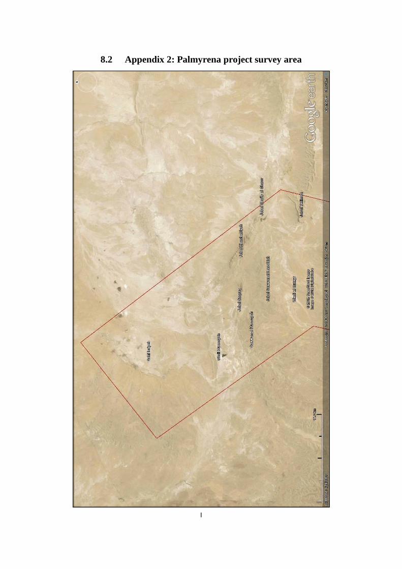
I
8.2 Appendix 2: Palmyrena project survey area
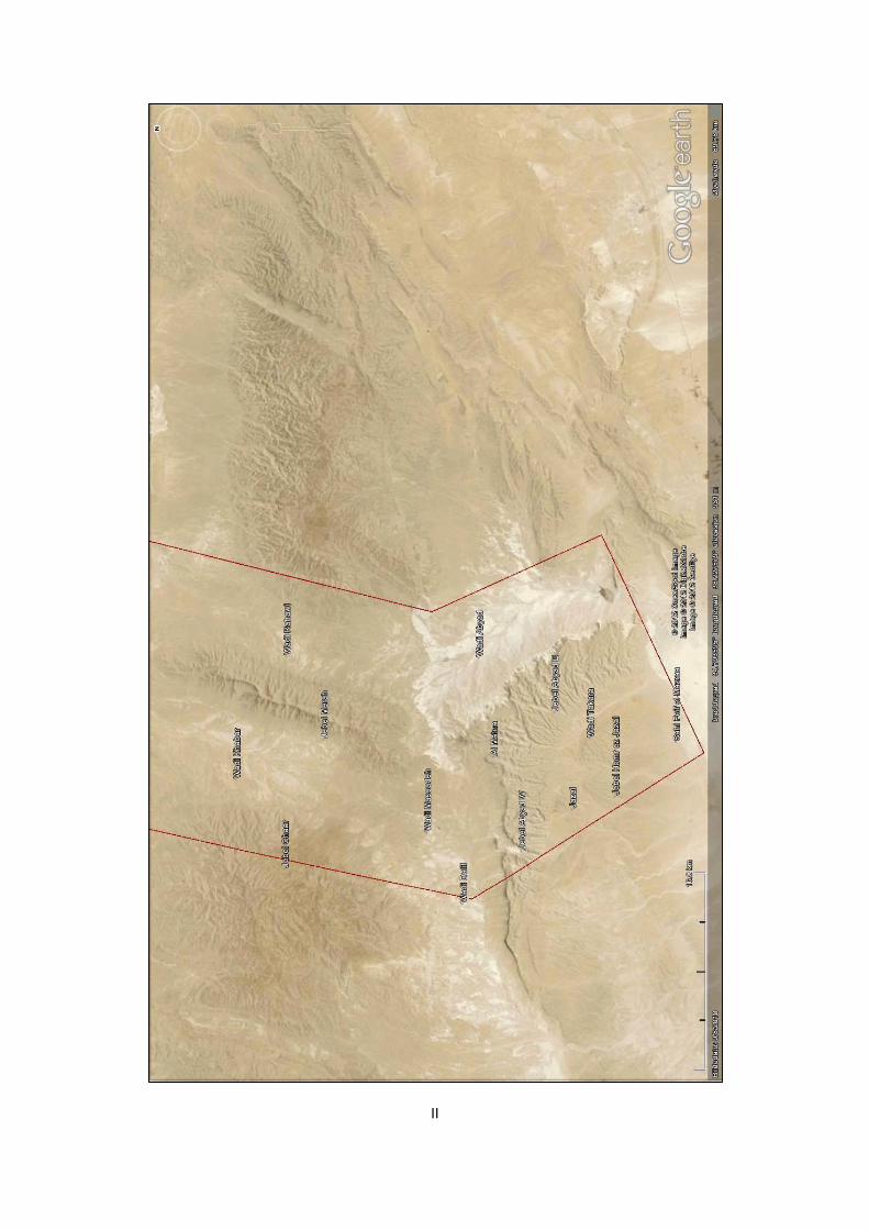
II
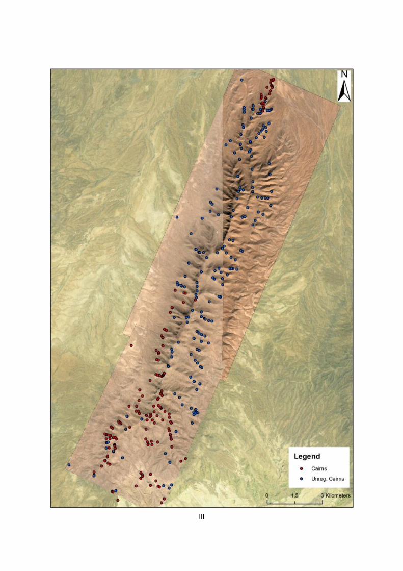
III

IV
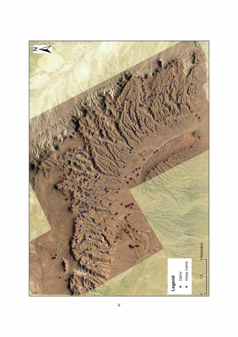
V

VI

I
8.3 Appendix 3: Topographical division for Google Earth survey
Region Region Name Region inclusive (local names deduced from French and Soviet maps and/or www.geographic.org)
1 Jebel Shaar Jebel Shaar/Tulûl el Khabar/Wadi el Kheurbet Mfadde
2 Wadi Khabar Wadi Khabar/Wadi Shalaleh/Dahr esh Shateb/Bir esh Shenâai
3 Jebel Merah Jebel el Merah S/Jebel Zoumlet el Khansîr/Tanîyet ez Zerr/Qalaat Treiye
4 Wadi Massadeh Wadi ad Dalil/Wadi Massadeh/Wadi Jhar
5 Jebel Abyad W Jebel Mazrur/Jebel Aarfa/Jebel el Masek/Jebel ad Dalil
6 Al Matna Jebel al Matna/Wadi el Masek/Tell Shalaleh/Wadi Shaaite/Jebel ez Zuweita
7 Jebel Abyad E Jebel Khsheibe/Jebel Dâr Baida/Jebel Yetîme/Jebel Mqeitaa
8 Jazal Bîr el Jazal/Tell el Aarfa/Sateh ej Jazal
9 Wadi Takara Wadi et Takâra/Wadi Khsheibe/Tell Tshelâbne
10 Jebel Homr ej Jazal Jebel Homr ej Jazal/S part of Wadi ez Zaab, Wadi Jazal and Wadi Jeirâne
11 Al Diwa Sahl Feif el Mazraâ/Wadi al Diwa/Dahr el Qubbah
12 Western Palmyra Steppe west of J. Haiyane, incl. Bîr Treifâwi, Naqâqîb Abu Fawâriss, Wadi el Mashqûqa, Wadi es Sahle and Wadi el Ghazw
13 Tulul Rwaissate Tulûl er Rwaissâte/mid-Wadi el Ghazw
14 Jebel Haiyan Jebel Haiyane/Jebel el Qâyed/Jebel el Aassâfir/Tulûl er Ramlâte/Tell Sarâssîr
15 Jebel Tar en Nuwaysir Jebel Târ en Nuwaysir/Dahr Rwaissâte Abu Fâres/Mazraat Abu Fawâriss
16 Jebel Marbat el Hassane Jebel Marbat el Hassan/Râss Aanntar/Tell Zelkha/Tell et Tamra
17 Wadi Abyad Wadi Abyad/Dahr Rhâret en Nasr/Wadi Zqâqîye/Wadi Turkmânîye/Duhûr el Mkeimen/Duhur el Aarda
18 Wadi Rahawi Wadi er Rahawi/Wadi Sleim/Wadi el Hawîye
19 Jebel Abu Rujmein Jebel Abu Rujmein (incl. all ranges east of Fâyej Tanîyet el Hawâ SW - Jebel Qaraa Jaber, Kheurbet Dbeiss,
Jebel Rejem el Qneiss, Jebel el Buweida, Tulûl el Mastâha, Rejem Saadûn, Jebel Deffâai, Jebel Bîr es Saiyâh)
20 Duhur Nuqur el Habiye Duhûr Nuqûr el Habîye/Tulûl Jere et Tair/Wadi Derrâj/Wadi es Sikke/Wadi el Majrude
21 Jebel Safra Jebel es Safra/Jebel Mashquqet Safra/Jebel ed Deraa/Wadi es Safra
22 Dahr el Qettar Dahr el Qettâr/Wadi Bseilâne
23 Jebel Mohamed ibn Ali J. Mohamed ibn Ali/Jebel Qettâr/Jebel Qalaat el Heri/Jebel Harrâzîye/Jebel Ubeyreh/Jebel Mazâr/Jebel Mashqûq Abadâne
24 Palmyra Palmyra-Tadmor/Tell el Aaweimir
25 Bir Mounsef Bîr el Mounsef
26 Jebel Duwara Jebel ad Dûwâra/Râss el Harrâr/Dahr en Nkeil/Dahr el Mhasse/Tell el Mqâtaa
27 Dahr el Moussoum Dahr el Moussoûm/Dahr el Yoûssefîye/Tell Belaoûm
28 Jebel Rass Aaqabet Jebel Râss Aaqabet esh Shuweyr/Tell Rawda
29 Jebel Shaara Jebel esh Shaara
30 Jebel Hawit er Rass Jebel Hawît er Râss S/Fâyej Tanîyet el Hawâ SE/Wadi Qutqut SW
31 Jebel Abu el Hawr Jebel Abu el Hawr/Wadi Qutqut SE/Mrhâret Umm Aasfûr NW/Tell el Bader
32 Jebel Waariye Jebel el Waarîye/Wadi Waarîye
33 Jebel Youssefîye Jebel el Yoûssefîye/Jebel Qalaat Kafeine
34 Wadi Qseibe Wadi Qseibe N/Wadi Mzabbad/Wadi Waarîye S
35 Kheurbet el Qbeibe Kheurbet el Qbeibe/Dahr ed Dehrâje/Tell Seffâri
36 Dahr el Mosri Dahr el Mosri
37 Biâr el Hawuz Hlale Biâr el Hawuz Hlâle (betw. Wadi Aabeiye and Wadi Hlâle)/Jebel ed Duwâhkîye
38 Jebel Qleilate Jebel Qleilate/Tell Umm Khessem
39 Wadi Fayej Wadi el Fâyej
40 Jebel Satih Jebel es Satih/Râss Khannsi/Mrhâret Umm Aasfûr SE/Jebel er Reissîye S
41 Wadi Sahil Wadi es Sahîl/Wadi el Kebîr W
42 Jebel Rakbet el Mezraq Jebel Rakbet el Mezrâq
43 Wadi Mashaai Wadi el Mashâai/Dahr Shaqîf Dabbâss
44 Dahr el Hazem Dahr el Hazem/Bîr Lafi
45 Soukhne Soukhne/Jbail Tanntûr
46 Wadi Neqeib Wadi en Neqeib/Tell en Neqeib
47 Wadi Kebir Wadi el Kebîr/Tell esh Shaqîf el Ghurâb
48 Jebel Dahek esh Sharqi Jebel ed Dâhek esh Sharqi/Wadi Ghadbân/Tell Kheshêm el Baghl/Wadi el Buwayb
49 Jebel Dahek Jebel ed Dâhek
50 Wadi Latum Wadi el Latûm/Wadi el Kharrûbe/Wadi Dâbbah/Wadi Ghadbân
51 Wadi Adima Wadi el 'Adîmah/Shârat Adîmah S
52 Wadi Maiyalate Wadi el Maiyâlâte E/Tell Rweimîye
53 Tulul Maiyalate Tulûl el Maiyâlâte/Tell Tanîyet et Taibe
54 Wadi Abu Nallah Wadi Abu Nallah/Wadi el Maiyâlâte W/Wadi er Ruhaybeh
55 Jebel Dahek el Gharbi Jebel Dâhek el Gharbi/Wadi ed Dâhek/Tell el Kharrûbe/Dahr el Matla/Wadi Umm Khasim/Al Latûm
56 Tulul al Bayda Tulûl al Bayda/Jebel Qal'at Nawwâr S/Wadi Nuwayr S
57 Wadi Sahil N Wadi es Sahîl N/Tulûl el Khûrîyâte/Sheikh Wâssil/Wadi Qutqut N/Wadi el Mahlabîye N/Wadi er Riyahiye
58 Wadi Sheqif el Aabd Wadi Sheqîf el Aabd/Bîr es Sleib/Tilâl el Muqtafiye
59 Jebel Taniyet es Safra J. Tanîyet es Safra/Wadi el Mahlabîye S/Dahr Shaibate et Tair/Wadi Rawâhet Bayda/J. er Reissîye N/J. el Msakhkham
60 Jebel Hawit er Rass N Jebel Hawît er Râss N/mid-Wadi Qutqut/Fâyej Tanîyet el Hawâ NE
61 Jebel Labidah Jebel Labidah/Jebel el Hamdâ/Jebel el Lubdah/Wadi el 'Asrân
Northern areas Region inclusive (local names deduced from French and Soviet maps and/or www.travelingluck.com )
a Jebel Asabi Jebel el Asâbi'/Asâbi' Qadim
b Jebel Yatime Jebel Yatîme/Tell Yatîme/Tell Barâghith
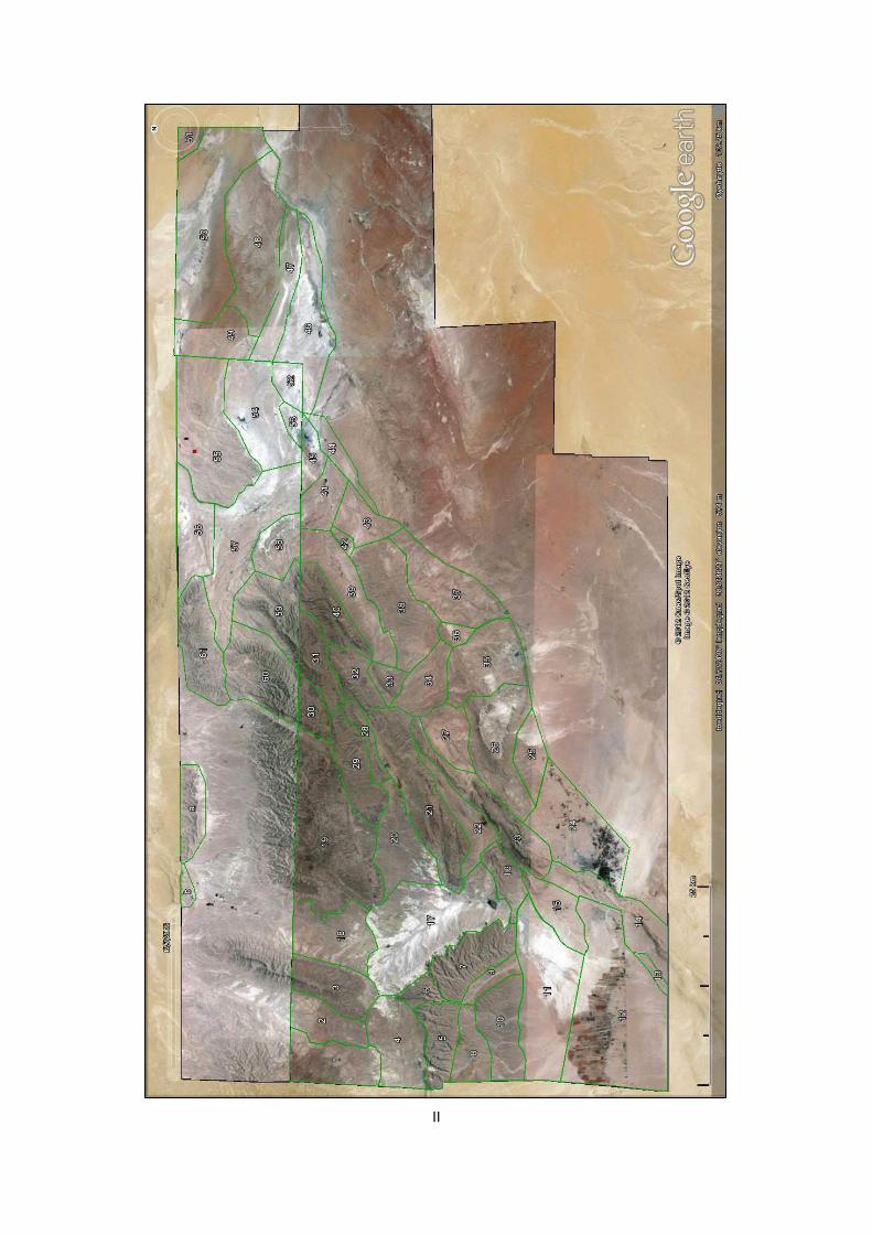
II

III
PALMYRENE STRUCTURES - THE NUMBERS
Total area of high-res. satellite imagery in Google Earth (incl. northern part) 6534 km 2
Region Tumuli Kites Enclosures Survey cairns Size (km2) App. size (km2) Cairns/km2
All 7528 426 2353 371 3799,40 3800 2,079
1 5 1 1636 0 59,72 60 0,084
2 30 0 " 1 43,16 43 0,718
3 233 2 " 161 54,34 54 7,251 These (2-10)
4 50 0 " 18 69,37 69 0,980 are including
5 133 0 " 65 42,99 43 4,606 tumuli
6 28 0 " 15 15,08 15 2,851 surveyed on
7 115 1 " 24 59,59 60 2,333 the ground
8 112 0 " 53 17,75 18 9,296
9 3 0 " 29 35,12 35 0,911
10 104 0 " 5 60,20 60 1,811
11 0 0 " 0 133,14 133 0,000
12 1 0 " 0 225,80 226 0,004
13 15 0 " 0 6,17 6 2,431
14 27 19 " 0 64,65 65 0,418
15 86 2 " 0 41,01 41 2,097
16 46 2 " 0 28,45 28 1,617
17 62 0 " 0 160,39 160 0,387
18 109 0 " 0 68,20 68 1,598
19 752 1 " 0 177,00 177 4,249
20 4 0 " 0 64,60 65 0,062
21 683 27 " 0 109,48 109 6,239
22 60 2 " 0 38,31 38 1,566
23 200 89 " 0 70,69 71 2,829
24 30 3 " 0 105,15 105 0,285
25 0 1 " 0 30,60 31 0,000
26 106 20 " 0 93,37 93 1,135
27 27 0 " 0 37,51 38 0,720
28 72 1 " 0 18,40 18 3,913
29 280 0 " 0 53,43 53 5,241
30 72 0 " 0 23,05 23 3,124
31 197 1 " 0 38,10 38 5,171
32 123 1 " 0 34,39 34 3,577
33 36 4 " 0 15,80 16 2,278
34 103 7 " 0 40,97 41 2,514
35 142 16 " 0 77,09 77 1,842
36 24 4 " 0 9,79 10 2,451
37 7 5 " 0 79,74 80 0,088
38 395 31 " 0 94,00 94 4,202
39 35 2 " 0 70,03 70 0,500
40 210 4 " 0 47,38 47 4,432
41 5 3 " 0 34,32 34 0,146
42 17 1 " 0 5,16 5 3,295
43 4 1 " 0 34,17 34 0,117
44 98 7 " 0 23,33 23 4,201
45 11 3 " 0 19,74 20 0,557
46 2 4 " 0 86,98 87 0,023
47 32 2 " 0 48,93 49 0,654
48 244 15 " 0 125,74 126 1,941

IV
TIERS OF TUMULUS DENSITY (for Figure 4.29)
Tumuli/km2 Tier level Colour
0.0 - 0.2 1
0.2 - 1.0 2
1.0 - 2.0 3
2.0 - 3.0 4
3.0 - 4.5 5
4.5 - 6.0 6
6.0 - 7.5 7
Over 7.5 8
49 79 8 " 0 50,61 51 1,561
50 4 0 " 0 175,26 175 0,023
51 17 0 " 0 9,98 10 1,703
52 3 0 231 0 18,60 19 0,161
53 3 2 " 0 9,87 10 0,304
54 15 5 " 0 86,29 86 0,174
55 363 15 " 0 133,74 134 2,714
56 155 11 " 0 54,52 55 2,843
57 183 15 " 0 116,90 117 1,565
58 92 10 " 0 36,84 37 2,497
59 341 10 132 0 66,32 66 5,142
60 382 14 132 0 80,92 81 4,721
61 761 54 222 0 67,17 67 11,329
Total 7528 426 2353 371 3799,40 - 2,157
Jebel Merah N 312 7 102 36 49,86 50 6,980 Satellite
Jebel Merah Total 545 9 - 197 104,20 104 7,121 studies
a 162 0 - 0 34,72 35 4,666
b 25 0 - 0 7,27 7 3,439
Areas calculated using http://www.daftlogic.com/projects-google-maps-area-calculator-tool.htm

V
PALMYRENE KITES (numbers refer to GE survey ID and not reproduced here)
Palmyrena Type Max size Direction Other Area
1 4A 50x45 W diffuse 16
2 3A 70x80 NW Kite 2011 3
3 3A 60x49 E
16
4 2C 59x 42 NW
21
5 3E 100x50 SE
21
6 1B 75x58 SE
21
7 1B 58x50 NW
21
8 3A 100x98 SE cut by wadi 21
9 3A 50x48 SW
21
10 2B 72x60 NE hexagon 21
11 1B 65x40 SE large cairn on antennae/cut by wadi 21
12 3B 55x23 S
21
13 2C? 48x ? SE
21
14 3A 65x65 SE edged by wadi 21
15 1A 70x68 NW
21
16 2A 83x54 NW
21
17 5B 52x30 SE
15
18 4D 50x42 E annex in N (thus 50x58 m) 15
19 1B 87x76 SE diffuse 1
20 2D 60x47 SE
3
21 1B 68x60 SE
21
22 1B 89x75 SE
21
23 2C 68x53 SE
21
24 2C 86x75 SE 2C/3A-mix 21
25 1B 135x75 SE
21
26 1B 89x77 NW
21
27 3A 125x100 SE
21
28 3A 90x80 SE
21
29 1B 79x68 W
21
30 3A 86x60 SE
21
31 3A 100x86 SW cut by wadi 21
32 5A 115x81 SE diffuse E-edge 21
33 3A 82x71 W
21
34 1B 55x45 NW diffuse 19
35 4E 82x75 SE
28
36 1B 96x87 SE edged by wadi 33
37 1B 71x60 E
33
38 3A 95x95 SE borders 39 33
39 3D 74x62 SE
annexes in SW and NW (thus
105x95 m), which borders 38 33
40 4D 97x62 SE
32
41 unknown unknown SW only antennae 31
42 5A 65x49 S
40
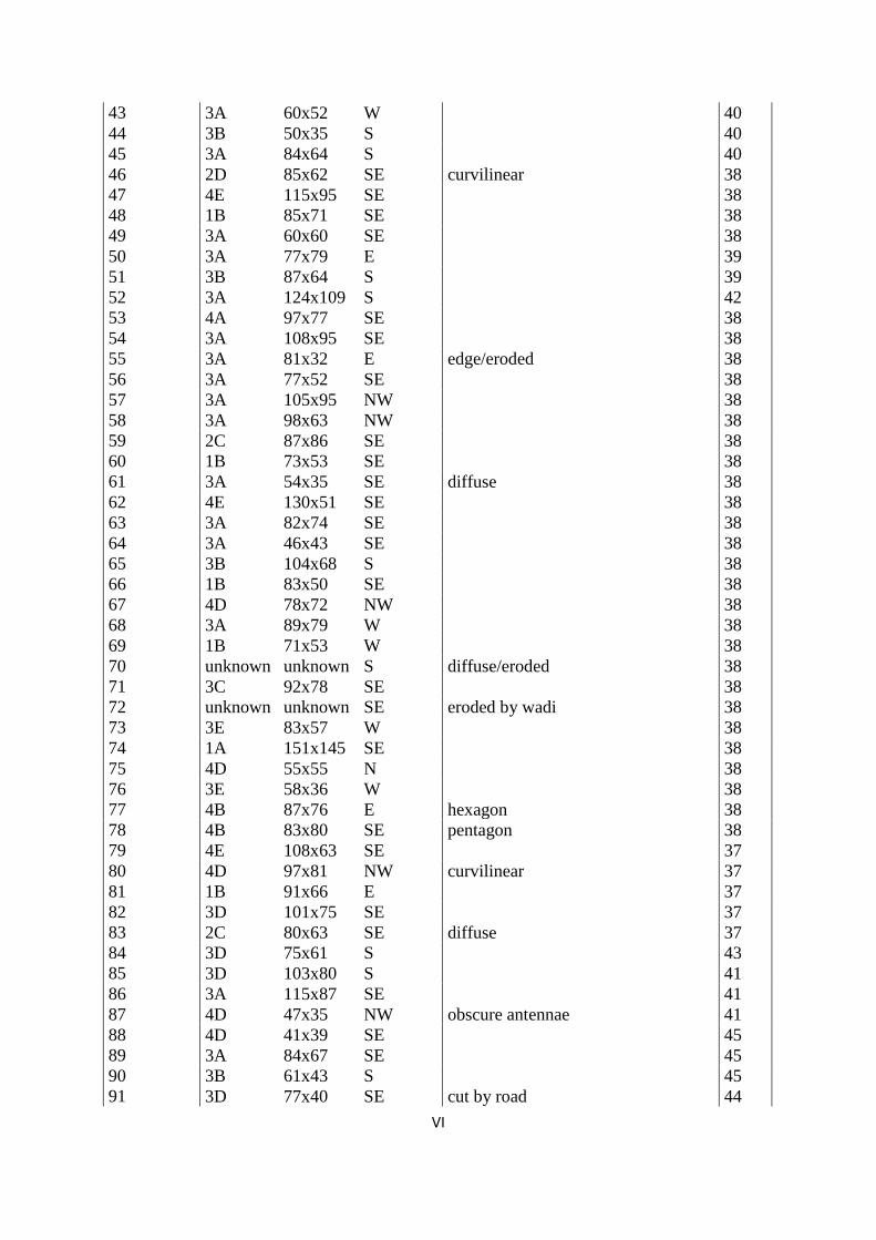
VI
43 3A 60x52 W
40
44 3B 50x35 S
40
45 3A 84x64 S
40
46 2D 85x62 SE curvilinear 38
47 4E 115x95 SE
38
48 1B 85x71 SE
38
49 3A 60x60 SE
38
50 3A 77x79 E
39
51 3B 87x64 S
39
52 3A 124x109 S
42
53 4A 97x77 SE
38
54 3A 108x95 SE
38
55 3A 81x32 E edge/eroded 38
56 3A 77x52 SE
38
57 3A 105x95 NW
38
58 3A 98x63 NW
38
59 2C 87x86 SE
38
60 1B 73x53 SE
38
61 3A 54x35 SE diffuse 38
62 4E 130x51 SE
38
63 3A 82x74 SE
38
64 3A 46x43 SE
38
65 3B 104x68 S
38
66 1B 83x50 SE
38
67 4D 78x72 NW
38
68 3A 89x79 W
38
69 1B 71x53 W
38
70 unknown unknown S diffuse/eroded 38
71 3C 92x78 SE
38
72 unknown unknown SE eroded by wadi 38
73 3E 83x57 W
38
74 1A 151x145 SE
38
75 4D 55x55 N
38
76 3E 58x36 W
38
77 4B 87x76 E hexagon 38
78 4B 83x80 SE pentagon 38
79 4E 108x63 SE
37
80 4D 97x81 NW curvilinear 37
81 1B 91x66 E
37
82 3D 101x75 SE
37
83 2C 80x63 SE diffuse 37
84 3D 75x61 S
43
85 3D 103x80 S
41
86 3A 115x87 SE
41
87 4D 47x35 NW obscure antennae 41
88 4D 41x39 SE
45
89 3A 84x67 SE
45
90 3B 61x43 S
45
91 3D 77x40 SE cut by road 44

VII
92 4B 63x62 S diffuse 44
93 5B 81x82 SE 26
94 1B 67x34 SE edged by road 44
95 3B 92x65 S
44
96 4E 84x70 S
44
97 3A 65x60 NE
44
98 3C 65x60 SE obscure antennae 44
99 3B 191x98 NW
7
100 3A 78x70 NW
38
Palmyra Type Max size Direction Other Area
1 4B 93x76 E 14
2 3D 76x60 E
14
3 4B 57x54 E
14
4 2C 70x61 E
14
5 3A 51x49 E
14
6 4B 68x49 E pentagon 14
7 4B 50x50 NE
14
8 1B 57x51 E
14
9 1B 96x64 E
14
10 4B 95x76 SE
14
11 1B 70x59 NE
23
12 1B 64x50 E
23
13 3A 79x62 NW
23
14 1B 49x37 E
23
15 2A 54x37 NW
23
16 1B 61x32 SE
23
17 2A 48x38 NW
23
18 unknown unknown NE eroded/destroyed 23
19 3A 62x52 W
23
20 1B 93x50 SW
23
21 3A 54x52 NE
23
22 2C 52x49 NE
23
23 3D 69x62 E remains of extra distal wall (52x62) 23
24 3A 68x61 SW
23
25 5A 84x52 NW
23
26 1B 79x70 NW
23
27 1B 58x53 SE annex in NE (thus 87x53) 23
28 1B 96x79 E
23
29 1B 91x80 NE
23
30 1B 90x76 NW
23
31 4D 50x41 W/E antennae on two sides 23
32 1B 47x40 E
23
33 4A 55x49 S
23
34 2B 75x67 SE
23
35 1B 75x55 N
23
36 2B 42x42 S large cairn in inlet 23
37 1B 82x54 NW
23
38 2B 86x43 NE
23
39 4B 72x63 NW
23

VIII
40 4E 58x56 NE enclosures on NW edge 23
41 4B 72x55 W large cairn on antennae 23
42 3B 78x58 S
23
43 3C 140x60 E cut by road 23
44 3A 47x44 NW 44/45 poss. one 23
45 3A 67x66 NW 44/45 poss. one 23
46 unknown unknown NW diffuse/eroded 23
47 4B? 78x51 NW diffuse 23
48 3A 68x70 SW
23
49 4B 53x39 SW hexagon 23
50 1B 79x73 E
23
51 unknown unknown E diffuse/eroded 23
52 4D 51x35 SW
23
53 3D 73x67 E
23
54 4D 52x38 E
23
55 1B 62x54 SW
23
56 4E 87x66 NW
23
57 3A 62x60 W obscure antennae 23
58 5B 81x73 SE
23
59 3A 52x47 SW
23
60 1B 71x57 E
23
61 1B 70x57 S
23
62 1B 71x60 NE
23
63 1B 61x59 SW
23
64 3A 56x53 SE mesa used as trap 23
65 3A 75x70 SE
23
66 4B 48x46 W diffuse/sharp turn 23
67 4D 48x45 W diffuse 23
68 1B 63x57 SE
23
69 1B 80x77 W
23
70 2A 67x43 SW
23
71 1B 76x63 E
23
72 3A 72x61 W
23
73
3A 67x66 N
mesa used as trap/cairn in middle of
trap 23
74 2B 80x55 SE antennae cut by buildings 23
75 1B 99x60 W edged by wadi 23
76 3B 59x45 S
23
77 3A 49x44 NW
23
78 1B 95x67 NW
23
79 1B 58x43 SE
23
80 3A 72x57 SE
23
81 4B 60x47 SE
23
82 3A 68x66 NW
23
83 3A? 81x60 SE diffuse 22
84 3A 86x64 W
22
85 1B 85x72 W
23
86 5B 116x53 W
23
87 3A 61x60 E antennae cut by road 14

IX
88 2C 56x54 E
14
89 4D 68x46 NW curvilinear 14
90 4E 64x58 SW
14
91 2A 62x59 N obscure antennae 14
92 4B 77x75 S
14
93 4D 59x59 E curvilinear 14
94 1B 43x41 S
14
95 3C 63x58 NW diffuse 23
96 2B 63x45 W
23
97 1B 88x85 E irregular 23
98 3C 57x47 W
23
99 4B 51x43 N pentagon 23
100 3C 59x31 E
23
101 3A 72x53 NE
23
102 4D 69x33 W diffuse 23
103 3A 56x55 SW
23
104 4D 62x42 SW curvilinear 23
105 2C 47x28 SE
26
106 2C 47x42 E
26
107 4B 48x43 N pentagon 26
108 4B 79x69 S pentagon 26
109 2B 57x49 E
26
110 3A 37x32 S
26
111 1B 42x40 SE diffuse 26
112 3A 58x55 SW
26
113 4E 128x115 S
26
114 3A 91x70 S
26
115 1B 71x60 SE
26
116 3A 90x61 E
26
117 4D 60x37 E
23
118 1B 125x76 E
23
119 4E 92x71 S
26
120 4A 112x113 E
26
121 1B 68x55 SE
26
122 4B 84x56 SE pentagon 26
123 unknown unknown NW eroded by wadi/cairn on antennae 26
124 unknown unknown E cliff edge as trap 26
125 4C 131x82 SE
26
126 3A 40x37 SE
26
127 3A 68x56 NW diffuse 35
128 4B 61x51 NW pentagon 35
129 2C 70x67 SE
35
130 5B 220x134 SE
irregular shape, mix of 1A/5B/border
on 131 35
131 3A 108x89 SE curvilinear/border on 130 (older?) 35
132 1B 64x60 S
35
133 unknown unknown NW eroded or cliff trap 35
134 1B 68x64 SE
35
135 1B 112x70 E
35

X
136 2C 117x83 SE
35
137 2D 85x70 SE
35
138 2C 65x60 SE obscure antennae 35
139 4D 62x40 NW
35
140 2B 193x66 NE diffuse/obscure antennae 35
141 3A 66x45 E
35
142 1B 116x88 SE
34
143 2A 76x47 SE
35
144 1B 72x66 NW
36
145 3A 100x88 SE
34
146 3A 118x95 S internal wall division 34
147 1B 113x95 NW
36
148 2C 152x76 S
36
149 3B 105x81 E distal wall eroded 36
150 3A 70x65 NW diffuse 24
151 1B 114x107 SW
34
152 2A 61x58 S
34
153 5B 98x67 E
34
154 2B 94x90 SE
34
155 3A 50x40 SE
25
156 3A 65x59 E
24
157 3A 83x76 NW
24
158 4B 71x50 E pentagon 14
159 4D 44x28 W
23
160 2D 65x47 NE
23
161 1B 61x39 NW 23
Soukhne Type Max size Direction Other Area
1 3D 55x46 SE 54
2 3A 88x100 SE 54
3 3A 102x108 SE 54
4 3A 102x116 S 54
5 Sock 43x37 SE curved antennae 55
6 3A 98x85 S 55
7 3A 57x55 NW 55
8 4E 98x81 S 55
9 3B 67x110 E 55
10 2C 71x69 SW 55
11 Sock 40x32 S curved antennae 55
12 3A 113x103 SE 55
13 4D 91x101 SE 55
14 unknown unknown NE eroded 55
15 unknown unknown SE eroded 55
16 unknown unknown SE edge 55
17 4D 69x111 SE 55
18 4B 119x130 SE pentagon 55
19 3B 97x76 S 57
20 2D 72x57 S 58
21 4D 68x69 S 58
22 3A 103x77 E 57
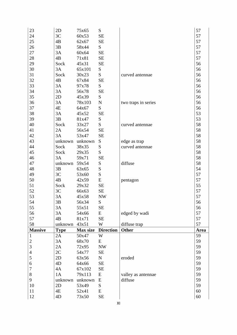
XI
23 2D 75x65 S 57
24 3C 60x53 SE 57
25 4B 62x67 SE 57
26 3B 58x44 S 57
27 3A 60x64 SE 57
28 4B 71x81 SE 57
29 Sock 45x31 SE 56
30 3A 65x101 S 56
31 Sock 30x23 S curved antennae 56
32 4B 67x84 SE 56
33 3A 97x78 S 56
34 3A 56x78 SE 56
35 2D 45x39 S 56
36 3A 78x103 N two traps in series 56
37 4E 64x67 S 56
38 3A 45x52 SE 53
39 3B 81x47 S 53
40 Sock 33x27 S curved antennae 58
41 2A 56x54 SE 58
42 3A 53x47 SE 58
43 unknown unknown S edge as trap 58
44 Sock 38x35 S curved antennae 58
45 Sock 29x35 S 58
46 3A 59x71 SE 58
47 unknown 59x54 S diffuse 58
48 3B 63x65 S 54
49 3C 53x60 S 57
50 4B 42x59 E pentagon 57
51 Sock 29x32 SE 55
52 3C 66x63 SE 57
53 3A 45x58 NW 57
54 3B 56x34 S 56
55 3A 55x51 SE 56
56 3A 54x66 E edged by wadi 57
57 4B 81x71 SE 57
58 unknown 43x51 W diffuse trap 57
Massive Type Max size Direction Other Area
1 2A 50x47 W 59
2 3A 68x70 E 59
3 2A 72x95 NW 59
4 2C 54x77 SE 59
5 2D 63x56 N eroded 59
6 4D 64x66 SE 59
7 4A 67x102 SE 59
8 1A 79x113 E valley as antennae 59
9 unknown unknown E diffuse 59
10 2D 53x49 S 59
11 4E 52x41 E 60
12 4D 73x50 SE 60

XII
13 3C 92x61 NW 60
14 5A 49x79 NW 60
15 1B 73x45 N 60
16 3A 69x71 NW 60
17 unknown unknown NW diffuse 60
18 3B 67x50 E 60
19 3A 62x62 E 60
20 3A 57x69 W 60
21 3A 64x49 S 60
22 3A 78x100 SE 60
23 3A 48x58 NW 60
24 Sock 55x75 NW 60
Labidah Type Max size Direction Other Area
1 4B 77x70 E hexagon 61
2 2C 50x46 SE 61
3 2D 20x20 SE tiny trap 61
4 3A 59x64 NW 61
5 3A 35x48 SE 61
6 unknown unknown N diffuse 61
7 unknown unknown NW diffuse 61
8 3A 42x40 S 61
9 3E 26x17 NE diffuse 61
10 3A 26x28 E diffuse 61
11 3A 75x57 S 61
12 4A 53x63 SE 61
13 3A 105x63 SE 61
14 2D 78x108 SE 61
15 4B 52x68 SE 61
16 Sock 59x36 S 61
17 5A 93x60 SE 61
18 Sock 48x33 SE curved antennae 61
19 Sock 33x21 NW curved antennae 61
20 4B 62x46 SE hexagon 61
21 2D 52x54 SE 61
22 3A 68x68 E 61
23 3A 48x50 SE 61
24 3A 65x55 SE diffuse 61
25 Sock 33x27 SE 61
26 3A 83x57 S 61
27 3A 53x47 S 61
28 Sock 27x30 S curved antennae 61
29 Sock 29x27 SE 61
30 Sock 25x17 NW diffuse 61
31 2A 49x51 SE 61
32 3A 85x76 E 61
33 3A 44x44 SE 61
34 3A 27x35 NW entrance crossing wadi 61
35 Sock 29x36 S curved antennae 61
36 3B 75x70 S 61

XIII
37 3A 50x54 SE diffuse 61
38 2A 60x47 NW 61
39 1B 49x55 NE obscure antennae 61
40 2D 75x125 SE 61
41 2C 75x74 E diffuse 61
42 1B 103x74 E 61
43 3A 103x85 W partly eroded 61
44 3A 73x80 W partly eroded 61
45 3A 58x46 SE 61
46 1B 76x57 S 61
47 2A 39x39 S curved antennae 61
48 3A 54x56 SE 61
49 5A 32x67 SE irregular 61
50 1B 61x37 SE irregular 61
51 4B 54x55 SE 61
52 1B 90x51 S 61
53 Sock 47x28 SE looks like 5B 61
54 unknown unknown E eroded 61
Eastern Type Max size Direction Other Area
1 3A 72x45 SE
48
2 1B 61x52 W
48
3 3A 75x70 SE
48
4 3A 73x55 SE
48
5 1B 62x45 SE
48
6 3D 75x55 SE
48
7 3A 94x65 SE
48
8 3A 60x62 SE
48
9 4B 65x73 S
48
10 3A 115x95 SE
48
11 unknown (edge) SE
48
12 4B 90x85 S
48
13 unknown unknown unknown
48
14 4A 70x50 S pentagon 48
15 3A 105x115 N 48
Desert Type Max size Direction Other Area
1 2B 125x93 S
49
2 unknown unknown SE eroded 49
3 4B 56x48 S pentagon 49
4 3D 115x95 S
49
5 3A 96x84 S
49
6 3A 105x97 NE under no. 5 49
7 unknown unknown N eroded 49
8 3A 48x47 S
49
9 2A 53x44 S sharp turn into trap 46
10 2B 100x65 S
47
11 4B 130x105 SE pentagon 47
12 3A 70x65 S obscure antennae 46
13 3A 77x68 S annex in N (thus 100x68) 46
14 3A 62x60 NW/SE obscure antennae 46

XIV
Directions:
Types:
E 62 15 %
1A 3
SE 149 35 %
1B 69
S 78 18 %
2A 15
SW 18 4 %
2B 11
W 29 7 %
2C 18
NW 57 13 %
2D 13
N 12 3 %
3A 121
NE 18 4 %
3B 18
unknown 1 0 %
3C 10
NW/SE 1 0 %
3D 11
W/E 1 0 %
3E 4
Total 426 100 %
4A 6
4B 34
4C 1
4D 23
4E 13
5A 6
5B 6
2C? 1
3A? 1
Sock 18
unknown 24
Total 426

I
8.4 Appendix 4: Area maps and Palmyrene structures
Page Area names Area no.
III Jebel Shaar / Wadi Khabar / Jebel Merah 1 / 2 / 3
IV Wadi Massadeh 4
V Jebel Abyad W 5
VI Al Matna 6
VII Jebel Abyad E / Wadi Takara 7 / 9
VIII Jazal / Jebel Homr ej Jazal 8 / 10
IX Al Diwa 11
X Western Palmyra 12
XI Tulul Rwaissate / Jebel Haiyane 13 / 14
XII Jebel Tar en Nuwaysir 15
XIII Jebel Marbat el Hassane 16
XIV Wadi Abyad 17
XV Wadi Rahawi 18
XVI Jebel Abu Rujmein 19
XVII Duhur Nuqur el Habiye 20
XVIII Jebel Safra / Dahr el Qettar 21 / 22
XIX Jebel Mohamed ibn Ali 23
XX Palmyra / Bir Mounsef 24 / 25
XXI Jebel Duwara 26
XXII Dahr el Moussoum 27
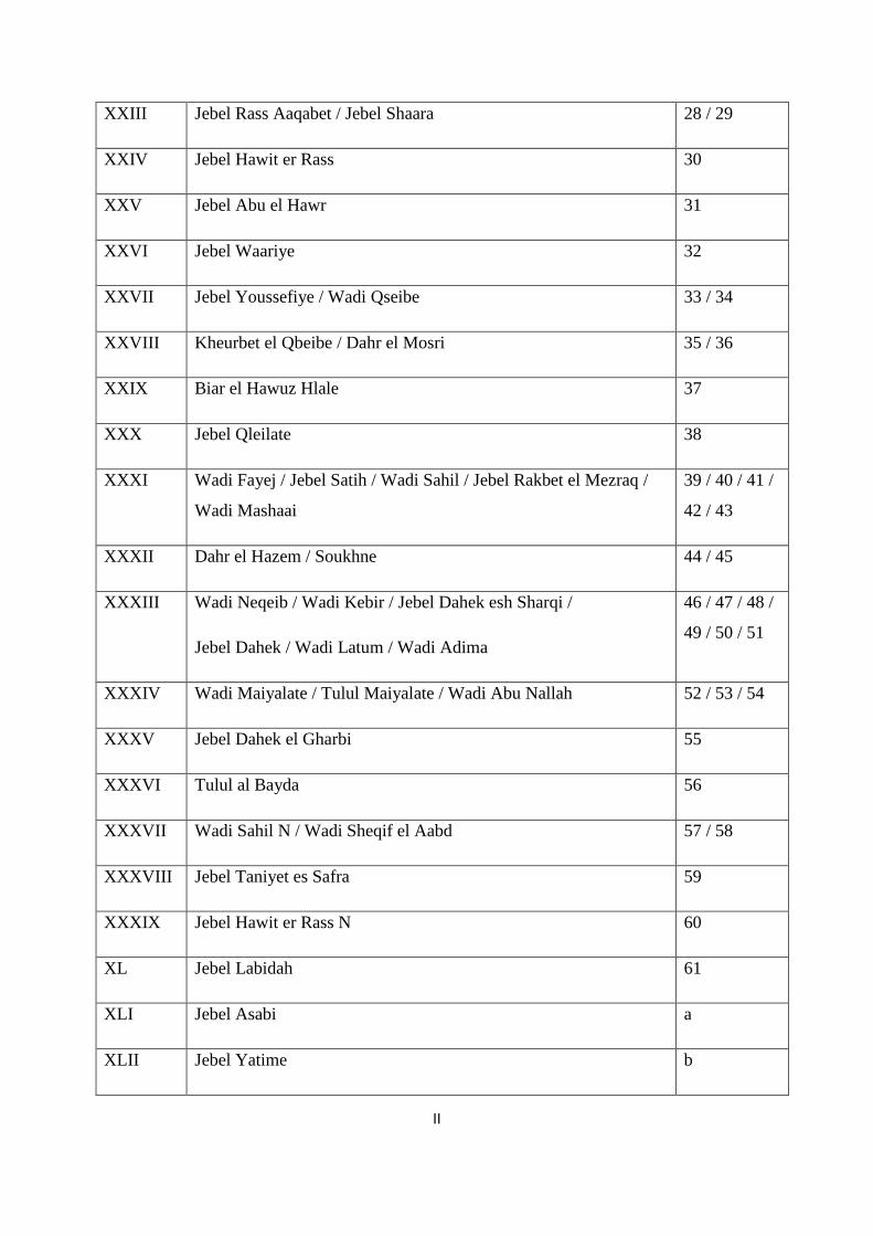
II
XXIII Jebel Rass Aaqabet / Jebel Shaara 28 / 29
XXIV Jebel Hawit er Rass 30
XXV Jebel Abu el Hawr 31
XXVI Jebel Waariye 32
XXVII Jebel Youssefiye / Wadi Qseibe 33 / 34
XXVIII Kheurbet el Qbeibe / Dahr el Mosri 35 / 36
XXIX Biar el Hawuz Hlale 37
XXX Jebel Qleilate 38
XXXI Wadi Fayej / Jebel Satih / Wadi Sahil / Jebel Rakbet el Mezraq /
Wadi Mashaai
39 / 40 / 41 /
42 / 43
XXXII Dahr el Hazem / Soukhne 44 / 45
XXXIII Wadi Neqeib / Wadi Kebir / Jebel Dahek esh Sharqi /
Jebel Dahek / Wadi Latum / Wadi Adima
46 / 47 / 48 /
49 / 50 / 51
XXXIV Wadi Maiyalate / Tulul Maiyalate / Wadi Abu Nallah 52 / 53 / 54
XXXV Jebel Dahek el Gharbi 55
XXXVI Tulul al Bayda 56
XXXVII Wadi Sahil N / Wadi Sheqif el Aabd 57 / 58
XXXVIII Jebel Taniyet es Safra 59
XXXIX Jebel Hawit er Rass N 60
XL Jebel Labidah 61
XLI Jebel Asabi a
XLII Jebel Yatime b

III
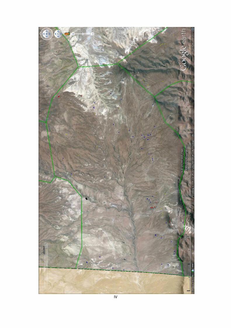
IV

V
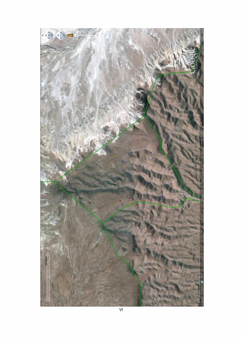
VI

VII

VIII

IX

X

XI
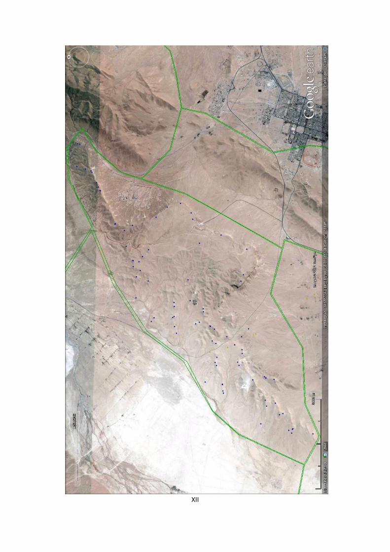
XII
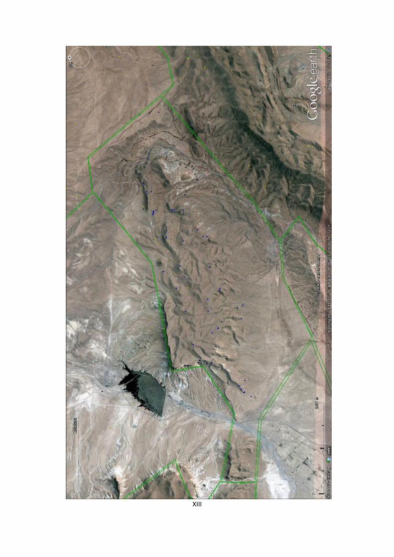
XIII

XIV
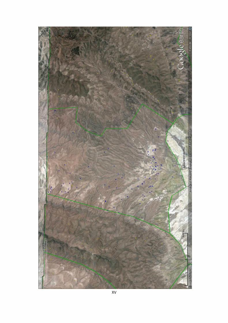
XV

XVI

XVII

XVIII

XIX
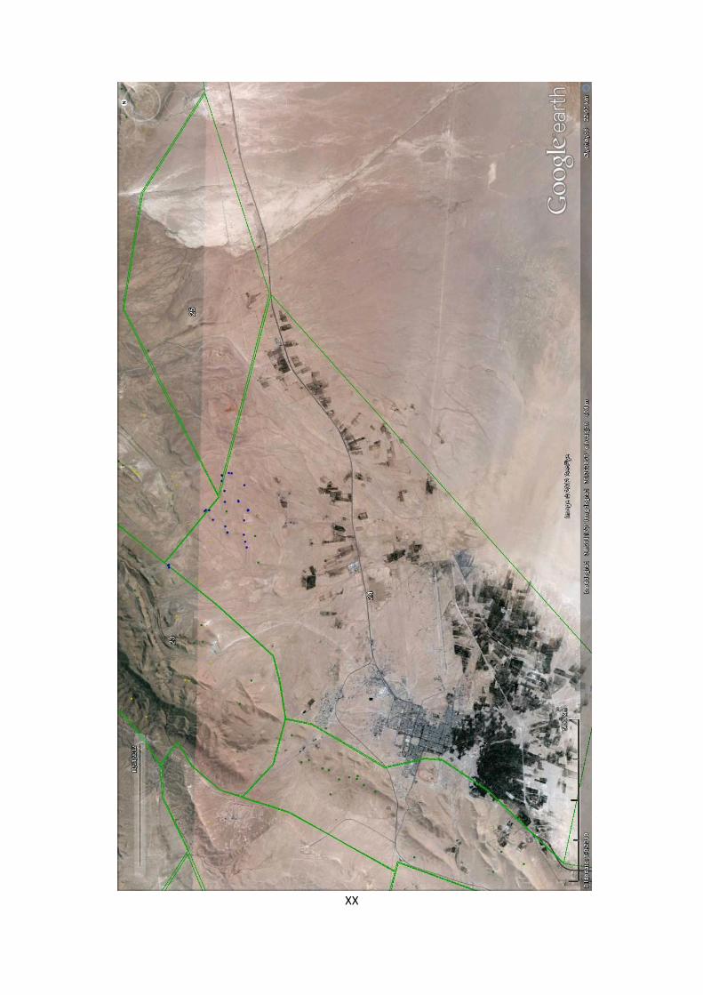
XX

XXI
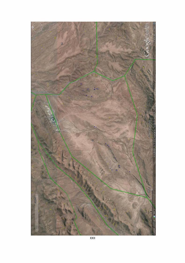
XXII
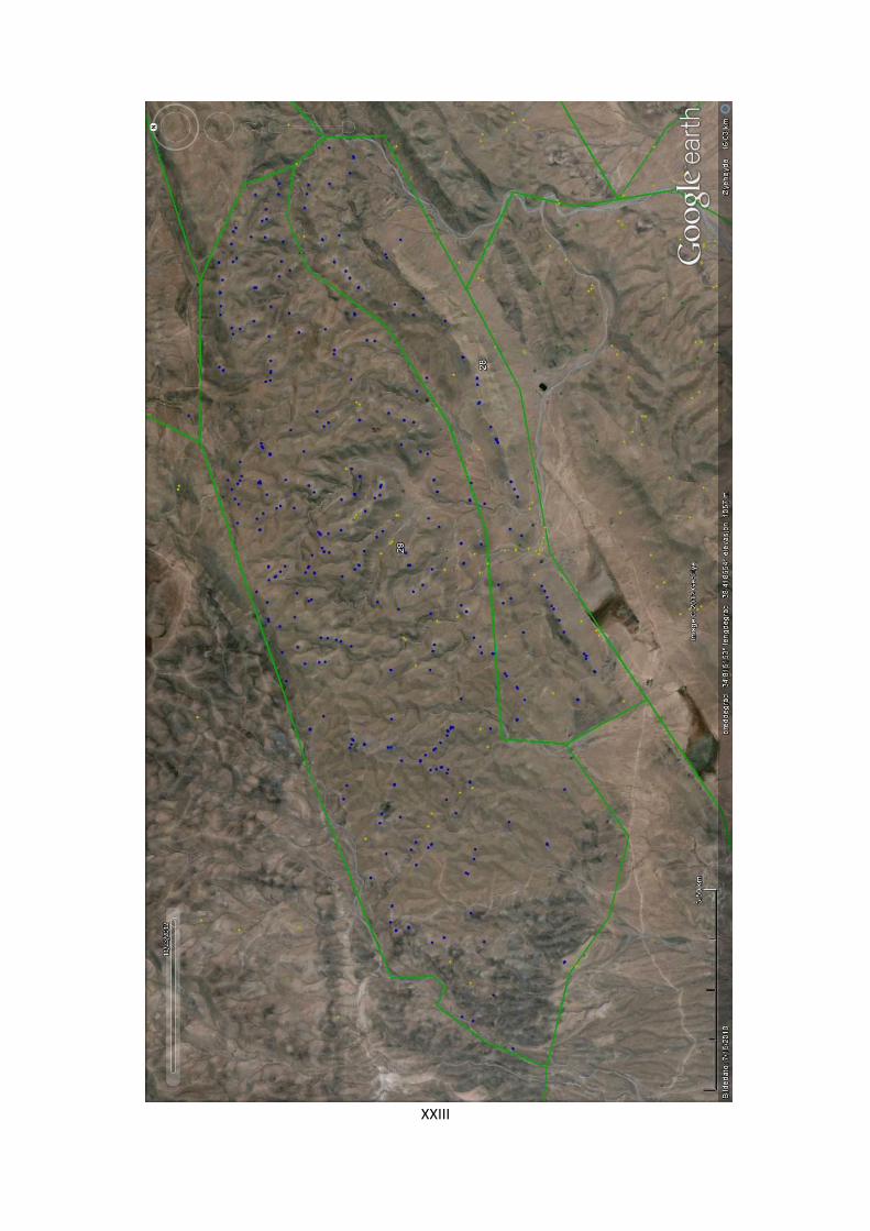
XXIII

XXIV

XXV

XXVI
XXVII

XXVIII
XXIX

XXX

XXXI
XXXII

XXXIII
XXXIV

XXXV

XXXVI

XXXVII
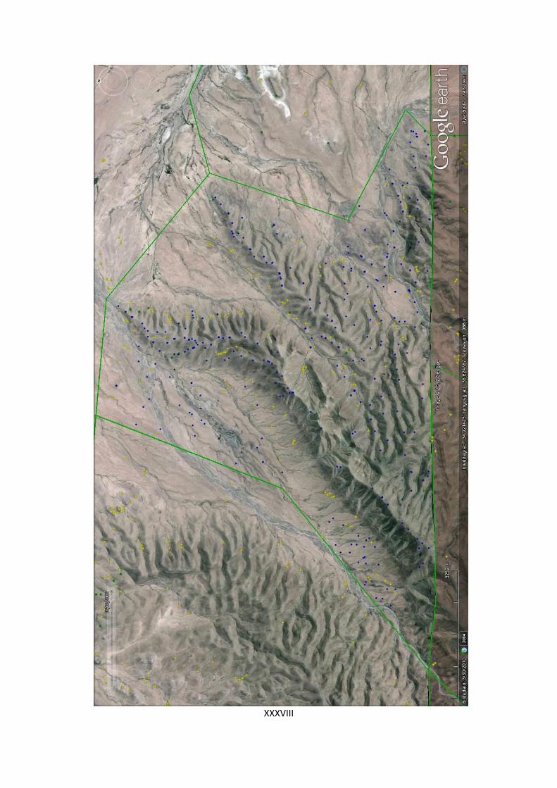
XXXVIII
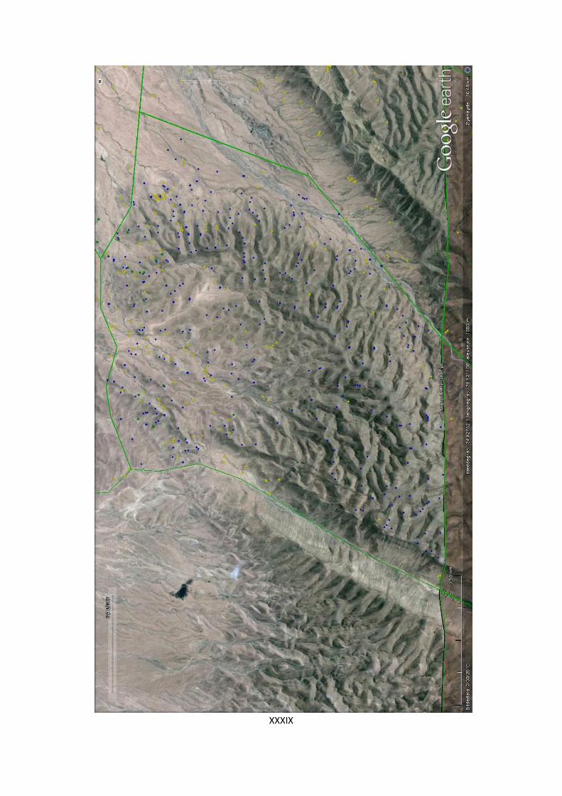
XXXIX

XL

XLI

XLII

ERRATA
(Pg. = Page, § = paragraph, = should be)
Pg. viii, line 1: Pastoral herd Herd on pasture
Pg. 1, §4, line 7: as tower-like tower-like
Pg. 2, §1, line 5: publications was and is publications were and are
Pg. 2, §1, line 8: when is grew when it grew
Pg. 4, §2, line 5: this has changed in during this has changed in
Pg. 4, §2, line 5: and its and their
Pg. 4, §2, line 8: question here concers question here concerns
Pg. 5, §1, line 1: mobil pastoralism mobile pastoralism
Pg. 5, §1, line 6: mobile grups mobile groups
Pg. 5, §1, line 7: mainly through pasturing mainly through the pasturing
Pg. 5, §2, line 2: will widen will be widened
Pg. 6, §2, line 3: in many of which many in which
Pg. 6, §3, line 6: provided it provided they
Pg. 6, §3, line 8: relevany relevant
Pg. 7, §1, line 1: Amorite Amorrite
Pg. 7, §1, line 5: whether it refer whether it refers
Pg. 7, §2, line 8: in all context in all contexts
Pg. 8, §1, line 2: matters is matters are
Pg. 8, §1, line 3: land use of land use in
Pg. 9, §2, line 3: (cf. 0) (cf. 1.2.1)
Pg. 9, §4, line 3: as follows:1) As follows: 1)
Pg. 10, §1, line 11: basis such questions basis of such questions
Pg. 10, §2, line 4: show the specific show how the specific
Pg. 14, §1, line 7: the region been the region was

Pg. 14, §1, line 14: powerful dynamic powerful dynamic force
Pg. 14, §2, line 6: joined on its right joined on its left
Pg. 15, §1, line 6: lay dry lie dry
Pg. 16, §1, line 8: scattered around in the scattered around the
Pg. 17, §1, line 1: utilizing utilising
Pg. 18, §1, line 2: as for certain as of certain
Pg. 19, §2, line 12: character its summers character of its summers
Pg. 20, §1, line 7: Palmyrene, than is the case Palmyrene than the case is
Pg. 20, §1, line 13: consequently partially covering which consequently partially covered
Pg. 22, §2, line 6: needed to barley needed to grow barley
Pg. 27, §3, line 13: fauna have fauna has
Pg. 28, §2, line 6: while the Euphrates while in the Euphrates
Pg. 32, §1, line 4: surge of integrationof surge in the integration of
Pg. 35, §2, line 2: It also received It also receives
Pg. 36, §2, line 12: which h they which they
Pg. 40, §1, line 12: regime, than regime than
Pg. 43, §1, line 2: and increase and an increase
Pg. 46, §1, line 12: its interplay with other atmospheric processes could have the interplay
with other atmospheric processes could have had
Pg. 47, §1, line 21: same time less seasonal same time turning less seasonal
Pg. 48: The entire page has been moved from pg. 55, resulting in the corresponding errata that
fig 2.14 and 2.15 have switched reference numbers.
Pg. 48, §1, line 3: the complexity if these the complexity of these
Pg. 50, §3, line 2: - is another issue – is another issue
Pg. 51, §1, line 2: as high resolution site as a high-resolution site
Pg. 53, §2, line 11: was correlated were correlated
Pg. 54, §2, line 8: that climate returned that the climate returned
Pg. 54, §2, line 23: that there decreases that decreases
Pg. 57, §2, line 19: does indicate forests does indicate that forests
Pg. 71, §1, line 8: (cf. 4.5.5) for a discussion (cf. 4.5.5 for a discussion
Pg. 76, §2, line 4: and argue and I will argue
Pg. 77, Figure 3.1, line 6: Sinjar as Saggar Sinjar was known as Saggar
Pg. 80, §1, line 7: can all fit scenarios can fit all scenarios
Pg. 83, §1, line 7: fact have been fact has been
Pg. 86, §3, line 5: was been left out has been left out
Pg. 89, §1, line 9: has been published was published
Pg. 89, §2, line 1: (cf. 0) (cf. 1.2.1)
Pg. 89, §2, line 6: Amorite Amorrite
Pg. 90, §1, line 7: are highly significant is highly significant
Pg. 90, §2, line 12: vast bureaucratic need vast bureaucracy
Pg. 91, §1, line 1: referring to both the pastoralist economy of the ancient town and suggestive
referring to the pastoralist economy of the ancient town and are suggestive
Pg. 91, §2, line 14: hiatus a smaller collection have hiatus, a smaller collection has
Pg. 91, §2, line 16: the Mari archives is the Mari archives are
Pg. 91, §2, line 19: Mari texts and Mari texts
Pg. 95, §2, line 5: Amorite components Amorrite components
Pg. 95, §2, line 5: become common became common
Pg. 97, §1, line 2: which comprise which comprises
Pg. 100, §2, line 5: Amorite chiefs Amorrite chiefs
Pg. 103, §1, line 12: void of devoid of
Pg. 105, §1, line 1: an Amorite dynasty an Amorrite dynasty
Pg. 111, §1, line 9: Yamhad, was married Yamhad and was married
Pg. 115, §1, line 2: the region has the region have
Pg. 115, §1, line 14: mobile groups has been mobile groups have been
Pg. 115, §1, line 15-16: bechronologically be chronologically

Pg. 116, §2, line 5: the monuments varies the monuments vary
Pg. 118, §1, line 8: the Palmyrena project suffer the Palmyrena project suffers
Pg. 120, §3, line 1: has indeed have indeed
Pg. 144, §3, line 9: spurs and spurs, and
Pg. 147, §3, line 2: actually are actually being
Pg. 147, §3, line 6: still incorporate still incorporates
Pg. 151, §1, line 5: steppe –stone steppe – stone
Pg. 160, §2, line 2: can and in effect also was can be and in effect also were
Pg. 160, §2, line 3: has been presented have been presented
Pg. 164, §2, line 3: - are more – are more
Pg. 166, Note 12, line 6: with tumuli called with tumuli is called
Pg. 167, §1, line 1: having relatively having a relatively
Pg. 167, §1, line 2: known routes and local natural its known routes, and its local natural
Pg. 167, Note 13, line 2: Soukhne Suhne
Pg. 170, §1, line 6: Figure 4.27Feil! Fant ikke referansekilden. Figure 4.27
Pg. 170, Figure 4.28, line 5: photo - along photo – along
Pg. 178, Figure 4.32, line 4: slopes and small wadis slopes, and small wadis
Pg. 185, §1, line 10: developments or external developments, or external
Pg. 192, §3, line 10: Hassie and Homs Hassie, and Homs
Pg. 194, §1, line 1: Palmyreneen Palmyrene
Pg. 195, §1, line 1: this study– this study –
Pg. 197, §1, line 21: very few of this very few examples of this
Pg. 198, §1, line 16: south of the al-Assad lake south of Lake Assad
Pg. 199, §2, line 3: was probably were probably
Pg. 199, §4, line 5: trapezoidal and axe-shaped trapezoidal, and axe-shaped
Pg. 202, §1, line 11: conceivalble conceivable
Pg. 206, Figure 4.49, line 2: there was there were

Pg. 210, §1, line 4: as platform s such as platforms
Pg. 210, §1, line 12: exposure, and exposure and
Pg. 213, §1, line 6: to single-aliquot to the single-aliquot
Pg. 213, §1, line 8: bleaching or bleaching, or
Pg. 214, §2, line 6: yield for yield
Pg. 214, §2, line 8: material and material
Pg. 217, §1, line 2: surveys in surveys from
Pg. 217, §1, line 10: shaft-tombs or cists tombs shaft tombs or cist tombs
Pg. 219, §1, line 4: attribute attributed
Pg. 220, §1, line 16: which is containing which contains
Pg. 222, §1, line 1: was attributed were attributed
Pg. 223, §4, line 3: do in fact have do have
Pg. 223, §4, line 8: group or group, or
Pg. 224, §2, line 5: structures or structures, or
Pg. 226, Figure 4.58, line 4: same pattern same result
Pg. 227, §1, line 5: stretches stretches
Pg. 228, §1, line 8: suggest a suggest
Pg. 229, §1, line 22: material or material, or
Pg. 229, §1, line 25: construction and construction, and
Pg. 234, §2, line 8: high carrying high-carrying
Pg. 235, §1, line 3: did certainly certainly did
Pg. 235, §1, line 19: sedenterised sedentarised
Pg. 235, §1, line 27: comes come
Pg. 237, §4, line 8: characterizing characterising
Pg. 238, §2, line 2: current the current
Pg. 238, §3, line 11: the mobile life the mobile lifestyle
Pg. 240, §2, line 3: middle range middle-range

Pg. 245, §1, line 24: allocation is allocation are
Pg. 247, §1, line 3: well be well have been
Pg. 254, §2, line 6: Feil! Fant ikke referansekilden. Figure 5.3
Pg. 254, §2, line 7: haracterised characterised
Pg. 254, §2, line 16: inJebel in Jebel
Pg. 255, Figure 5.5, line 1: land-use land use
Pg. 259, §2, line 2-3: views were sometimes been put forward, such as these ones views
such as these ones were sometimes put forward
Pg. 259, §4, line 1: probably has been probably have been
Pg. 259, §4, line 4: low-lever low-level
Pg. 259, §4, line 13: sets in set in
Pg. 260, §1, line 29: the as a raiding mechanism raiding as a procurement mechanism
Pg. 261, §1, line 5: there is there are
Pg. 271, §5, line 3: to this to
Pg. 282, §1, line 27: this the latter
Pg. 284, §1, line 21: storage store
Pg. 285, §2, line 6: this in this
Pg. 285, Text 5.15, line 1: lord Lord
Pg. 290, §2, line 9: portrays portray
Pg. 294, §2, line 10: can can put
Pg. 308, §1, line 29: which it which they
Pg. 316, Figure 5.12, line 5: Talhaym Talhayum
Pg. 317, Figure 5.13, line 1: Tribal competition While tribal competition
Pg. 318, §1, line 8: 5.11Feil! Fant ikke referansekilden. 5.11
Pg. 319, §1, line 6: the only the only other
Pg. 319, §2, line 15: lead led
Pg. 323, §1, line 7: is outdated are outdated
Pg. 325, §3, line 4: internment interment
Pg. 330, §1, line 11: summarized summarised
Pg. 331, §1, line 6: summarized summarised
Pg. 334, §2, line 7: convincinly convincingly
Pg. 335, §1, line 9: lead led
Pg. 336, §2, line 12: stress, could stress could
Pg. 338, §2, line 7: advantageous climtaes advantageous climates
Pg. 340, §2, line 8: The end commodity The end commodities
Pg. 341, §2, line 10: Then, there Then there
Pg. 341, §2, line 20: by mobil pastoralists by mobile pastoralists
Pg. 342, §1, line 7: resource resource
Pg. 342, §1, line 20: is uncertain are uncertain
Pg. 342, §2, line 1: which is represented which are represented
Pg. 342, §2, line 3: also be means also by means
Pg. 343, §1, line 13: do does
Pg. 344, §2, line 14: archeology archaeology
Pg. 345, §1, 6: (Kennedy 2011) (Kennedy & Bishop 2011)
Pg. 351, missing reference: Deadman, W. M. (2012). Defining the Early Bronze Age
landscape: a remote sensing-based analysis of Hafit tomb distribution in Wadi Andam,
Sultanate of Oman. Arabian Archaeology and Epigraphy 23, pp. 26-34.