Mixed Use Practices- A Case of Delhi - IJCRT.org
11
www.ijcrt.org © 2022 IJCRT | Volume 10, Issue 3 March 2022 | ISSN: 2320-2882 IJCRT2203392 International Journal of Creative Research Thoughts (IJCRT) www.ijcrt.org d490 Mixed Use Practices- A Case of Delhi 1 Shahnawaz Khan 1 Student, M.Arch 1 Faculty of Architecture and Ekistics 1 Jamia Millia Islamia, New Delhi, India Abstract: Mixed use development (MUD) is not a new phenomenon and has existed in India traditionally where the streets were of neighbourhood style. The modern planning approach focused on the segregation of uses and now the policies are coming back to using the MUD. There are numerous benefits which include the economic upliftment of retail businesses, lesser dependency on vehicles for local needs and the vibrant nature of the place which allows for interaction. Despite strict land use regulations mixed use development happens to fulfill the needs of people in an area (Mahajan, 2018, Pg. 8). The previous studies have defined and worked on a wide range of parameters but have never defined exactly what a “Good mixed use” is. The gap is also seen in the policy and guidelines where the definition and regulation is limited to the type of uses, road width and certain regulations in terms of FAR and Ground coverage. (MPD 2021, 2007) As quoted by Joseph Rykwert “Cities area all about mixed use, you don’t have cities without mixed use.” Mixed use is still ambiguous and there not a particular definition that can describe it properly (Hoppenbrouwer and Louw, 2005.) This study in favour of mixed use has attempted to define the MUD and define measures of mixed use areas. Keywords – Mixed Use, Neighbourhood Style, Density, Uses, Regulations. 1. INTRODUCTION The proposition of mixed use areas being vibrant and attractive places is based on the observations and rational part which are partly supported by the policies and advocates of mixed use planning in an ambiguous manner. The observations are defined by the experience that one has by living in an area and rational part is defined by the push on mixed use development in multiple initiatives and policy changes. Mixed use development according to the Master plan for Delhi-2021(MPD-2021) is the provision of non- residential uses in residential area. (MPD-2021, 2007) Stating it in general is easy as has been done frequently, but defining the components and scale which help in better city management and to differentiate this from those which create problems and chaos is necessary and missing. To improve this definition it is necessary to analyse the policies and practices with the hypothesis to find the necessary areas for improvement. Thus this paper studies the current policies, highlights the importance of such development, analyses the practices, finds the gaps and areas of improvement and emphasizes on the technical requirements necessary to implement the same. Various researches have been done on wide range of aspects related to the mixed use development but have never been able to define the best practices which help in improving the conditions of an area. Rapid Urbanisation, poor living conditions and the resulting increased population density led to the segregation of areas. During the last few decades mixed use has come up again in the discussion and practice in various cities around the globe. Mixed use development is now in the phase or renaissance in the urban areas. (Hoppenbrouwer and Louw, 2005) Mixed use development went a complete circle from segregation of uses in the early 20th century and then back to the planners considering mixed use for sustainability, viability and more interactive spaces. The advocates of mixed use development state that segregation of spaces in unnatural and mixing is necessary yet fail to define the degree and level of mixed use. (Grant, 2002) Modern planning in Delhi started with the formation of the first master plan in 1962 which strictly segregated the land use. The mixed land use in Delhi was the result of Supreme Court order to prevent wide scale demolition of unauthorized commercial development. The unauthorized development that came was a result of the demands and available job opportunities in the areas. Around 2000 streets were identified for mixed use development (MPD-2021, 2007). Though mixed use proliferated in Delhi but there’s limited developmental control to it which is obvious as one goes through the Master plan. The origin of this study was mixed use to understand its impact on the people in terms of vibrant life, catchment of diverse groups, socially inclusive spaces, contribution to local characteristics and finally to the technical requirements. The study would look at a prime area in Shaheen Bagh to test the hypothesis formed. Primary and secondary data collection will be done with surveys, questionnaire and street mapping.
-
Upload
khangminh22 -
Category
Documents
-
view
1 -
download
0
Transcript of Mixed Use Practices- A Case of Delhi - IJCRT.org

www.ijcrt.org © 2022 IJCRT | Volume 10, Issue 3 March 2022 | ISSN: 2320-2882
IJCRT2203392 International Journal of Creative Research Thoughts (IJCRT) www.ijcrt.org d490
Mixed Use Practices- A Case of Delhi
1Shahnawaz Khan 1Student, M.Arch
1Faculty of Architecture and Ekistics 1Jamia Millia Islamia, New Delhi, India
Abstract: Mixed use development (MUD) is not a new phenomenon and has existed in India traditionally where the streets were
of neighbourhood style. The modern planning approach focused on the segregation of uses and now the policies are coming back
to using the MUD. There are numerous benefits which include the economic upliftment of retail businesses, lesser dependency on
vehicles for local needs and the vibrant nature of the place which allows for interaction. Despite strict land use regulations mixed
use development happens to fulfill the needs of people in an area (Mahajan, 2018, Pg. 8).
The previous studies have defined and worked on a wide range of parameters but have never defined exactly what a “Good mixed
use” is. The gap is also seen in the policy and guidelines where the definition and regulation is limited to the type of uses, road
width and certain regulations in terms of FAR and Ground coverage. (MPD 2021, 2007)
As quoted by Joseph Rykwert “Cities area all about mixed use, you don’t have cities without mixed use.” Mixed use is still
ambiguous and there not a particular definition that can describe it properly (Hoppenbrouwer and Louw, 2005.) This study in favour
of mixed use has attempted to define the MUD and define measures of mixed use areas.
Keywords – Mixed Use, Neighbourhood Style, Density, Uses, Regulations.
1. INTRODUCTION
The proposition of mixed use areas being vibrant and attractive places is based on the observations and rational part which are partly
supported by the policies and advocates of mixed use planning in an ambiguous manner. The observations are defined by the
experience that one has by living in an area and rational part is defined by the push on mixed use development in multiple initiatives
and policy changes. Mixed use development according to the Master plan for Delhi-2021(MPD-2021) is the provision of non-
residential uses in residential area. (MPD-2021, 2007)
Stating it in general is easy as has been done frequently, but defining the components and scale which help in better city management
and to differentiate this from those which create problems and chaos is necessary and missing. To improve this definition it is
necessary to analyse the policies and practices with the hypothesis to find the necessary areas for improvement.
Thus this paper studies the current policies, highlights the importance of such development, analyses the practices, finds the gaps
and areas of improvement and emphasizes on the technical requirements necessary to implement the same.
Various researches have been done on wide range of aspects related to the mixed use development but have never been able to
define the best practices which help in improving the conditions of an area.
Rapid Urbanisation, poor living conditions and the resulting increased population density led to the segregation of areas. During
the last few decades mixed use has come up again in the discussion and practice in various cities around the globe. Mixed use
development is now in the phase or renaissance in the urban areas. (Hoppenbrouwer and Louw, 2005)
Mixed use development went a complete circle from segregation of uses in the early 20th century and then back to the planners
considering mixed use for sustainability, viability and more interactive spaces. The advocates of mixed use development state that
segregation of spaces in unnatural and mixing is necessary yet fail to define the degree and level of mixed use. (Grant, 2002)
Modern planning in Delhi started with the formation of the first master plan in 1962 which strictly segregated the land use. The
mixed land use in Delhi was the result of Supreme Court order to prevent wide scale demolition of unauthorized commercial
development. The unauthorized development that came was a result of the demands and available job opportunities in the areas.
Around 2000 streets were identified for mixed use development (MPD-2021, 2007). Though mixed use proliferated in Delhi but
there’s limited developmental control to it which is obvious as one goes through the Master plan.
The origin of this study was mixed use to understand its impact on the people in terms of vibrant life, catchment of diverse groups,
socially inclusive spaces, contribution to local characteristics and finally to the technical requirements. The study would look at a
prime area in Shaheen Bagh to test the hypothesis formed. Primary and secondary data collection will be done with surveys,
questionnaire and street mapping.

www.ijcrt.org © 2022 IJCRT | Volume 10, Issue 3 March 2022 | ISSN: 2320-2882
IJCRT2203392 International Journal of Creative Research Thoughts (IJCRT) www.ijcrt.org d491
STRUCTURE OF RESEARCH
This research follows a deductive of approach where the multiple theories of different nature have been identified and a hypothesis
has been formed. The hypothesis has been tested using qualitative and quantitative methods on the selected site and based on the
results, suggestions will follow. This is done to find the problems with the practices and the gaps in policies in respect to mixed use
development.
The methods used for analysis are surveys, mapping, photographic observation and user perception. Based on these methods the
problems are thoroughly studied while keeping the different variables in mind. The solutions will be discussed in the conclusion
part which would be focusing on the technical requirements at policy and practice level for implementation.
There are multiple reasons which support and legitimize the reason behind the study. Mixed use development is an important part
of the policy documents, local area plans, guidelines and the trend of overall development init iatives. These documents emphasize
on the high density, pedestrian friendly mixed use areas. But there is a visible ambiguity in evaluation, implementation and
improvement. This research will attempt to draw conclusions to define these parameters more clearly.
PRIMARY CASE
The study and analysis is done in a prime area of Shaheen Bagh which is an unauthorised settlement with mixed use nature. The
area is characterised by the presence of retail outlets of different kinds which cater to wide range of people. There are certain
common characters like a typical mixed use area and certain characters which are unique to this area. The area has mixed income
groups of different age groups. This is a high density and very active area which reflects the vibrant nature of the area by different
actives at various times of the day.
HYPOTHESIS
The hypothesis and author’s definition of a good mixed use are- A good mixed use is a high density sustainable (reduces dependency
on vehicle, supports local economy and social inclusion) area, improves environment and is pedestrian friendly.
2. IMPORTANCE- WHY MIXED USE?
If an area is composed of more than one type activity simultaneously in a horizontal, vertical or time dimension then it will be
mixed use. Mixed use is not something new and has always been there. The shop in front of your house, the schools around you
and the community spaces all from this in a very well organised manner.
The important reasons why an area has mixed use is because of: 1.Vitality 2.Safe environment 3.The better quality of services 4.The
need to travel less for basic things 5.Reduced car usage 6.Better use of public infrastructure. All of these will lead to the economic
(local), social (inclusion and catchment) and environmental (less fuel consumption) benefits. The category of benefits can be further
divided into the definite and possible benefits. While the definite benefits are vitality of the area, proper use of land, better
possibilities of income generation and the possible benefits will be reduces usage of vehicles, sustainability and more eyes on the
streets will ensure the sense of security for people at most of the times. (Coupland, 1997)
The recent initiatives both in terms of new development and redevelopment of existing areas emphasises on mixed use development.
The advocators suggest that mixed use can solve a wide range of problems and curb urban sprawl while simultaneously making an
area more vibrant and liveable. “The death and life of Great American Cities” by Jane Jacobs highlighted the importance of diversity
in cities. Rapid Urbanisation has changed the lives of users in more than one way. While mixed use is seen as a solution towards a
lot of issues including Urban Sprawl and single use zoning is seen as flawed (Gentin, Pg. 3). The revival of mixed use is a result
of the urban problems of congestion and degradation. (Grant, 2002)
In 2006 the Department for Communities and Local Government conducted a survey asking about the benefits of mixed use
development. It showed that 49% responses said that it improved sustainability, 37% said that it met household needs, 20% said
that it improved vitality, 24% said that it reduced crime, promotion of public transport and efficient use of existing land among
others.
CHALLANGES
The difference between the theories and on ground practice can’t be ignored. First, there is no common definition on which one can
agree. Second, there is no one mode of application to every site. Third, the existing norms and regulations need to be more contexts
specific, detailed and flexible. The definitions and practices are not clear and subject to misinterpretation.
Also there are no measures to tell if a mixed use area actually serves the intended purposes. There is an increase in the shift towards
high density mixed use development but without more defined approach this could not give the proposed benefits. The balance here
refers to degree of sustainable mixture that lies in between strictly segregated (only residential/commercial) uses and overly mixed
spaces (factory is a residential area) (Nohn, 2011, Pg. 10). Mixed use cannot be left uncontrolled and there needs to be regulations
to attain most the benefits. The major impact of uncontrolled development causes privatization of public spaces, lack of pedestrian
friendly movement and degradation of residential areas. (Mahajan, 2018)

www.ijcrt.org © 2022 IJCRT | Volume 10, Issue 3 March 2022 | ISSN: 2320-2882
IJCRT2203392 International Journal of Creative Research Thoughts (IJCRT) www.ijcrt.org d492
Benefits of Mixed use (Source: Urban Land Institute)
3. SITE STUDY
Locational Identity of Site (Sources: Google Maps, MPD-2021)
The area selected for study is Jamia Nagar area of which Shaheen Bagh is a part. Shaheen Bagh came into existence in the 1908s.
The area is well connected to the nearby areas like Noida, Nehru place, Okhla industrial area, Kalindi Kunj and other areas. The
nearest metro station is Jasola Vihar Shaheen Bagh metro station on the Magenta line.
The main road going along is GD Birla Marg and along the road there are a lot of commercial activities. The inner streets have a
mixture of commercial and residential areas of various types. The main road can be classified as mainly commercial with some
buildings having upper floors in residential as well. The streets immediately connecting the main road have the mixture of ground
floors as commercial and upper floors in residential. There are a few hotels along with residences. The streets are of varying sizes
with high pedestrian activity.
The mixed use area studied is about 1 km in length with combination of streets. The area chosen for study was due to high
commercial activity and the vibrant nature. If anyone has been to the area they would be able to relate with the food, people, crowd,
and the high activity levels. One can find everything from food, clothes, medicines and other items of household needs here. The
mixed use gives life to this area but one would realize that this needs regulation to reduce the chaos and the other reason being the
unplanned nature of the area. With the help of multiple surveys the issues would be identified and recommendations for its removal
will be given after taking local residents perspective into consideration. The area consists of an average of 4 storey houses with
commercial activities distributed in wide range and variety.

www.ijcrt.org © 2022 IJCRT | Volume 10, Issue 3 March 2022 | ISSN: 2320-2882
IJCRT2203392 International Journal of Creative Research Thoughts (IJCRT) www.ijcrt.org d493
DEFINING USES
Space utilisation and segregation (Source: Author)
4. OBSERVATIONS
The area has density population and the streets are mainly commercial in nature. The FAR of the ranges from 3 to 4 in the majority
of the area and at some places 5 with almost 100% coverage in most of places. The parking is inadequate with the vehicles being
parked on the internal and external streets.
The area was studied to find the existing structure of the uses. The selected area provides employment in a wide range of activities
and thus helping the local economy of the area. There are different kinds of shops that provide employment on varying scale and
division. The main street is mainly commercial in nature.

www.ijcrt.org © 2022 IJCRT | Volume 10, Issue 3 March 2022 | ISSN: 2320-2882
IJCRT2203392 International Journal of Creative Research Thoughts (IJCRT) www.ijcrt.org d494
Composition of Uses in the area (Source: Author)
S.No Land Use Type Units
1. Residential 234
2. Commercial 377
3. Professional 39
4. Open 0
Composition of Uses Category of shops in the area
Noise level in various parts of the area Measuring sound level in the area (Source: Author)
Recorded noise levels in heat map
58%36%
6%
Commercial Residential Professional Open
39%
20%
4%2%
32%
3%
Eating General store Pharmacy
Salon Cloth Hardware
020406080
100120
Maximum (Db)
Minimum (Db)

www.ijcrt.org © 2022 IJCRT | Volume 10, Issue 3 March 2022 | ISSN: 2320-2882
IJCRT2203392 International Journal of Creative Research Thoughts (IJCRT) www.ijcrt.org d495
USER SURVEY
User survey was done to know more about the problems/satisfaction level of users. The users included people from various
backgrounds. It consisted of the local residents, shopkeepers, the ones visiting the area for different purposes and people of different
age group.
Variables of the survey conducted (Source: Author) Areas Description
Dependency on vehicles This was done to find out if at all the mix nature of the area reduces the dependency on the vehicles.
Local Economy This was done to find out the effect of the mixed use nature on the local income generation.
Social Inclusion(Catchment of diversity) This was done to find out whether this area is socially inclusive for different age groups, genders,
communities and the interaction in between them.
Pedestrian movement This was done to analyse the status of pedestrian movement in the area.
Environmental perspective This was done to assess the impact of such development on the environment. Sound mapping was one exercise which was done to determine the record
the sound levels in area and comparison with the ambient levels.
Open area and green cover analysis was done to analyse the area for presence of green cover and open
areas.
Perception of safety This was done to know the perception of safety in the area with the local residents and visitor’s point of view.
Household needs This was done to analyse whether the presence of mixed use gives benefits in the household needs of the
people.
Visiting time and frequency This was done to measure the time spent and the frequency of visits of people in the area. Both with the
residents and visitors point of view were taken.
Mode of Transport (Source: Survey) Employment and income source (Source: Survey) Gender catchment (Source: Survey)
19%
10%28%
31%
12%
Bike Car
E-Rickshaw Metro
Auto 5%
60%
21%
11%3%
Formally employed Shop
Vendors Helpers
Odd Jobs
40%
59%
1%
Male Female Third Gender

www.ijcrt.org © 2022 IJCRT | Volume 10, Issue 3 March 2022 | ISSN: 2320-2882
IJCRT2203392 International Journal of Creative Research Thoughts (IJCRT) www.ijcrt.org d496
Age diversity of the area (Source: Survey) Pedestrian Movement Safety (Source: Survey)
Environmental Perception (Source: Survey) Perception of safety in people (Source: Survey)
Activity mapping at 6 PM (Source: Author)
18%
34%38%
6% 4%
Age 15-20 Age 20-35 Age 35-50
Age 50-60 Age 60+
0
2
4
6
8
10
12
Main street Internalstreets
Main road
Depends on time
Unsafe
Safe
02468
1012
Strong criticism
Disagree
Agree
0
2
4
6
8
10
12
14
16
Agree Disagree Neutral StronglyAgree
Visitor
Resident
www.ijcrt.org © 2022 IJCRT | Volume 10, Issue 3 March 2022 | ISSN: 2320-2882
IJCRT2203392 International Journal of Creative Research Thoughts (IJCRT) www.ijcrt.org d497
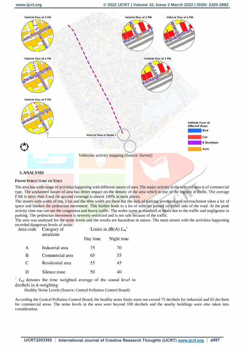
Vehicular activity mapping (Source: Survey)
5. ANALYSIS
FROM STRUCTURE OF USES
The area has wide range of activities happening with different nature of uses. The major activity in the selected area is of commercial
type. The unplanned nature of area has direct impact on the density of the area which is one of the highest in Delhi. The average
FAR is more than 3 and the ground coverage is almost 100% in most places.
The streets with width of 6m, 13m and the 40m width are there but the lack of parking provision and encroachment takes a lot of
space and hinders the pedestrian movement. This further leads to a lot of vehicles parked on either side of the road. At the peak
activity time one can see the congestion and heavy traffic. The nodes come at standstill at times due to the traffic and negligence in
parking. The pedestrian movement is severely restricted and is not safe because of the traffic.
The area was analysed for the noise levels and the results are hazardous in nature. The main streets with the activities happening
recorded dangerous levels of noise.
Healthy Noise Levels (Source: Central Pollution Control Board)
According the Central Pollution Control Board, the healthy noise limits must not exceed 75 decibels for industrial and 65 decibels
for commercial areas. The noise levels in the area were beyond 100 decibels and the nearby buildings were also taken into
consideration.

www.ijcrt.org © 2022 IJCRT | Volume 10, Issue 3 March 2022 | ISSN: 2320-2882
IJCRT2203392 International Journal of Creative Research Thoughts (IJCRT) www.ijcrt.org d498
FROM USER SURVEY
The survey was done on multiple parameters to test the Hypothesis on the site. The residents depend largely on the public transport
for conveyance where the majority of people use metro and E-Rickshaw for commuting. The mixed nature of the area supports the
local economy, income generation and employment where 60% of the people surveyed are employed in different shops of the area.
The area serves to the diverse age and gender types where each of the categories had different purpose to visit the area. There were
mixed responses on the pedestrian safety with the perception of unsafe pedestrian movement being slightly higher. The users also
pointed out at the lack of green cover, less open spaces, high noise levels and air pollution.
Over 80% of the users felt that the area is safe with the principle of more eyes on the street being on the major reasons. The users
strongly agreed on the availability of household items needed and the reason for visiting area was shopping, eating and meeting
people.
FROM ACTIVITY MAPPING
The area is occupied by different users for various activities at different times. The children can be seen at varying times but
importantly in the afternoon and evening. The evening time has more adults and women in particular.
The evening time is the most busy and active time when different users can be seen, primary users being the women followed by
men, elder people and children. People can be seen at food shops, meeting people, vending activities increase.
Vehicles also increase in the evening time with the fluctuations in the afternoon. Different types of public and private vehicles can
be seen with the majority being E-Rickshaws followed by the bikes and car at the end. The main streets had more cars and the
internal streets were occupied by the E-Rickshaws.
FROM POLICY
The policy used for reference is the MPD 2021 which is the regulating document in the current context. The document aims to
balance the socio-economic need and the environmental impact. But the regulations are limited to certain aspects and those aspects
have a scope of augmentation and revision. The aspects of defining the mix and ways to achieve it, density, parking regulations,
street type, setback, type of mixture are some the areas which could be improved for better regulation and getting the intended
benefits of mixed use development.
The current guidelines are the result of the Supreme Court order in 2006 to pacify the outrage and stop the demolition of commercial
areas, whereas this needs more defined approach. Mixed use is quite an ambiguous where the planners and developers are still
divided on the approach. Further there can be measures to test the efficacy of such areas for sustainability if the area actually serves
the purpose.
ISSUES
After going through the site and the policy review the author finds that there are certain areas of possible changes. The issues are
policy level shortcomings and the implemented issues on the site. Since the area is unplanned a lot of regulations have not been
followed and the other issues arise due to the unregulated introduction of commercial activities in the area. The issues found are:
No appropriate regulations which define the limit of the distribution of activities in the area. This results in rampant
commercialisation with little regard to the residential degradation. This also puts pressure on the supporting infrastructure for the
area.
Street level planning is missing as the street is the connecting units in the area. Streets have multiple roles to play as connections
and places themselves.
Environmental degradation- The area has hazardous sound levels and lacks the green and open spaces.
Pedestrian Movement- The pedestrian movement is severely compromised due to the commercial nature where the spaces are used
for parking, leaving bare minimum or no space for safe pedestrian movement.
Congestion- Inadequate parking provisions in the buildings results in vehicles being parked on the streets. This creates congestion
as the ROW is not properly available for movement.
Encroachment- The spaces in front of the shops are covered and occupied by the owners.
The issues stated above have been taken after the policy level review and with the help of the primary case study. The issues have
been categorised into certain parts to be able to overcome these in a holistic manner. The Hypothesis was tested and while there are
certain things that help in making the area a better place but there are some issues and shortcomings. The recommendations will
follow to try to overcome these issues.
6. RECOMMENDATIONS
POLICY LEVEL
The policy can be revised and augmented on multiple fronts which can be applicable to other areas as well:
It could start with defining the topic and intended results in a detailed manner and the ways to achieve them.
There are no specific density control measures where separate density control measures could be taken into consideration.
Use of variable densities could be taken into consideration.
The provision and regulation of parking can be revised and be done proportionately according to the type of mix in a
building.
Street can be taken into consideration not just a connection but also a place and provisions to make it pedestrian friendly.
Street design would play an important part in proper utilization of the ROW and reduction of chaos.
The other measure could be defining the setbacks depending on the different type of vertical or horizontal mix in the area.
One important measure would be categorising the different possible mixtures in an area starting from building level, street
level and block level. And defining the control measures for each one as there is no one fit solution for all.
Regulation of commercial activity strictly in order to maintain the residential nature of spaces and avoid rampant
commercialisation is necessary.

www.ijcrt.org © 2022 IJCRT | Volume 10, Issue 3 March 2022 | ISSN: 2320-2882
IJCRT2203392 International Journal of Creative Research Thoughts (IJCRT) www.ijcrt.org d499
Monitoring and evaluation protocols to keep the activities in check under balance are necessary.
Noise control could be included as it was found during the study at hazardous levels.
AREA LEVEL
The area level recommendations are more of the short term measures and certain area based approaches:
The noise level reduction is necessary as it is hazardous category at most of the places even in the residential areas nearby.
This would include suppression of sound at the source, provision of ample trees, use of sound absorbing materials and
control measures.
Improvement in pedestrian friendly movement and the supported infrastructure needed to ensure this.
Provision of open and recreational spaces in necessary and could be done by the authorities.
The main street where the study was conducted could be made pedestrian only street. The effective ROW has been reduced
which causes congestion.
The vending activity can be organised and the vendors be given allotted spaces for vending. This would help in irregular
ROW consumption.
Provision of designated spots for the E-Rickshaws as they are the one of the major forms of commute in the area.
7. CONCLUSION
This study was done to see the potential of the mixed use development, the related benefits to it and some of the challenges which
hinder the development. It is not a new concept and existed even before the formal recognition where the traditional Indian cities
had the neighbourhood concept. There are a lot of benefits which are related with the mixed use development ranging from reduction
in vehicle dependency, vibrancy and sustainability. But this seems half done without the proper development and monitoring
controls that are needed for proper implementation and monitoring.
An important part is measuring the efficacy of the areas having mixed nature. This would give the chance of further improvement
and better management of the area. This has to be done in terms of policy level regulations and implementation level.
This study has conducted a study to look at the various aspects related to the mixed use development to know about the benefits
and issues in the areas. The second thing is highlighting the need of revision in existing policy.
Existing Street (Source: Author)

www.ijcrt.org © 2022 IJCRT | Volume 10, Issue 3 March 2022 | ISSN: 2320-2882
IJCRT2203392 International Journal of Creative Research Thoughts (IJCRT) www.ijcrt.org d500
Proposed Street (Source: Author)
REFERENCES
[1] A.Aurand, “Density, Housing Types and Mixed Land Use: Smart Tools for Affordable Housing?” Urban Studies, 47(5) 1015–
1036, May,
2010
[2] M.Nohn, “Mixed-Use Zoning and Home-Based Production in India,” Weigo, USA, 978-92-95095-37-3, August, 2011
[3] R.Ewing, S.Handy, R.Brownson, O.Clemente, and E.Winston, “Identifying and Measuring Urban Design Qualities Related to
Walkability,” Journal of Physical Activity and Health, S223-S240, 2006
[4] M.Gentin, “ALL MIXED UP: A Critical Analysis of Mixed Use,” Unsw, 2009
[5] M.Mahajan, “Master Planned Mixed-Use: Lessons from Delhi,” Tekton, Delhi, Volume 5, Issue 2, September, 2018
[6] Delhi Development Authority, “Master Plan for Delhi-2021,” Delhi, February 07th 2007
[7] J. Grant, “Mixed Use in Theory and Practice,” APA Journal, Canada, Volume 68, No. 1, winter 2002
[8] E.Hoppenbrouwer, E.Louw, “Mixed-use development: Theory and practice in Amsterdam's Eastern Docklands,” European
Planning studies, Volume 13: No 7, 967-983, October 2005
[9] A. Coupland, “Reclaiming the city- Mixed Use Development,” Spon Press, London, UK, 1997
[10] Department For Communities and Local Government, “Mixed use development, practice and potential,” Crown Copyright,
London, 2005