Mineral Prospectivity Modeller - GTK - Projects
20
Mineral Prospectivity Modeller WP4: Dynamic modeling case study – Preliminary results 3.5.2018 Niiranen, T, Nykänen, V., MPM- project group
-
Upload
khangminh22 -
Category
Documents
-
view
0 -
download
0
Transcript of Mineral Prospectivity Modeller - GTK - Projects
Mineral Prospectivity Modeller
WP4: Dynamic modeling case study – Preliminary results
3.5.2018
Niiranen, T, Nykänen, V., MPM-
project group
Funding
3.5.2018Niiranen, T, Nykänen, V., MPM-project group2
3.5.2018Niiranen, T, Nykänen, V., MPM-project group3
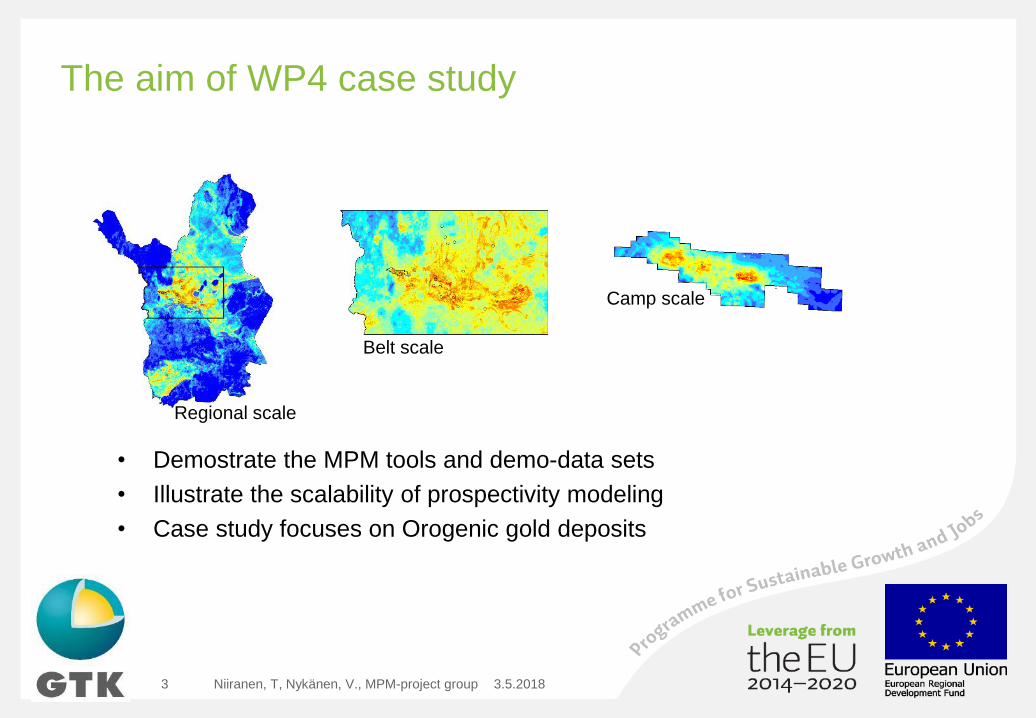
• Demostrate the MPM tools and demo-data sets
• Illustrate the scalability of prospectivity modeling
• Case study focuses on Orogenic gold deposits
The aim of WP4 case study
Regional scale
Belt scale
Camp scale
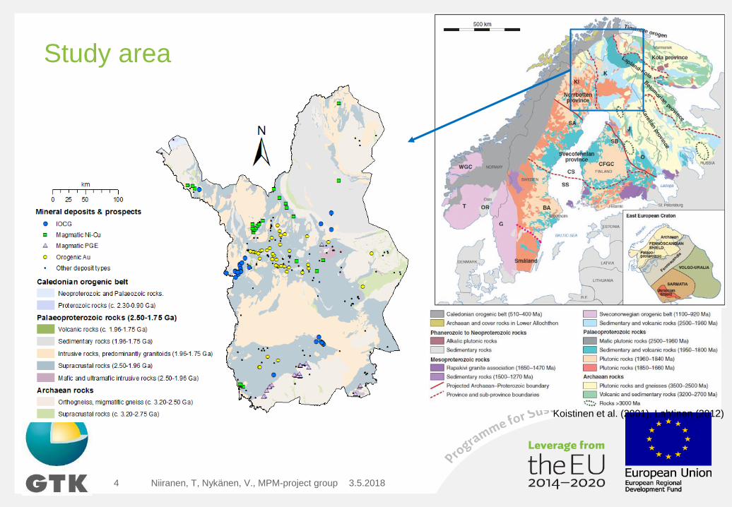
Study area
3.5.2018Niiranen, T, Nykänen, V., MPM-project group4
Koistinen et al. (2001), Lahtinen (2012)
3.5.2018Niiranen, T, Nykänen, V., MPM-project group5
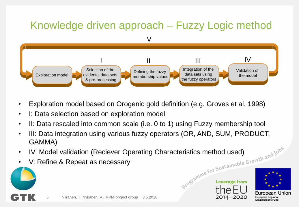
Knowledge driven approach – Fuzzy Logic method
• Exploration model based on Orogenic gold definition (e.g. Groves et al. 1998)
• I: Data selection based on exploration model
• II: Data rescaled into common scale (i.e. 0 to 1) using Fuzzy membership tool
• III: Data integration using various fuzzy operators (OR, AND, SUM, PRODUCT,
GAMMA)
• IV: Model validation (Reciever Operating Characteristics method used)
• V: Refine & Repeat as necessary
I II III IV
V
Exploration model
Selection of the
evidental data sets
& pre-processing
Defining the fuzzy
membership values
Integration of the
data sets using
the fuzzy operators
Validation of
the model
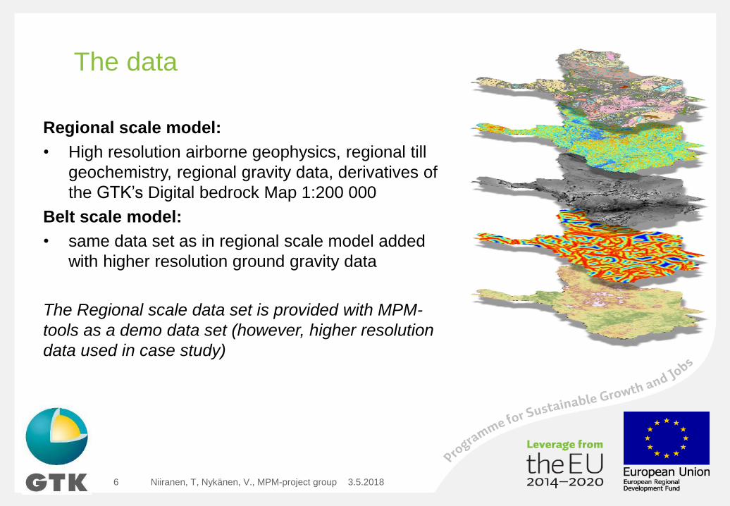
The data
Regional scale model:
• High resolution airborne geophysics, regional till
geochemistry, regional gravity data, derivatives of
the GTK’s Digital bedrock Map 1:200 000
Belt scale model:
• same data set as in regional scale model added
with higher resolution ground gravity data
The Regional scale data set is provided with MPM-
tools as a demo data set (however, higher resolution
data used in case study)
3.5.2018Niiranen, T, Nykänen, V., MPM-project group6
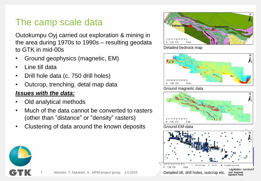
The camp scale data
Outokumpu Oyj carried out exploration & mining in
the area during 1970s to 1990s – resulting geodata
to GTK in mid-00s
• Ground geophysics (magnetic, EM)
• Line till data
• Drill hole data (c. 750 drill holes)
• Outcrop, trenching, detal map data
Issues with the data:
• Old analytical methods
• Much of the data cannot be converted to rasters
(other than ”distance” or ”density” rasters)
• Clustering of data around the known deposits
3.5.2018Niiranen, T, Nykänen, V., MPM-project group7
Detailed bedrock map
Ground magnetic data
Ground EM-data
Detailed till, drill holes, outcrop etc.
SaattoporaPahtavuoma
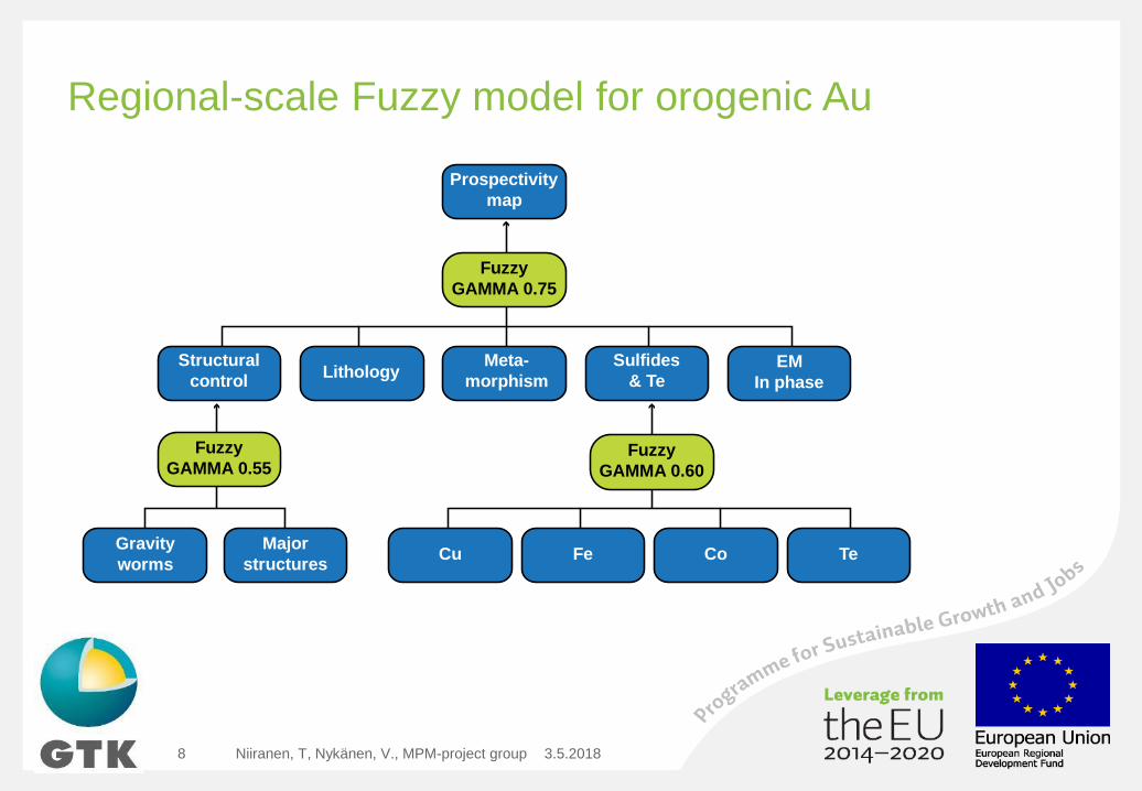
Regional-scale Fuzzy model for orogenic Au
3.5.2018Niiranen, T, Nykänen, V., MPM-project group8
Prospectivity
map
Structural
control
Gravity
worms
Major
structures
Fuzzy
GAMMA 0.55
Sulfides
& Te
Fe CoCu Te
Fuzzy
GAMMA 0.60
LithologyLithologyMeta-
morphismLithologyLithologyEM
In phase
Fuzzy
GAMMA 0.75
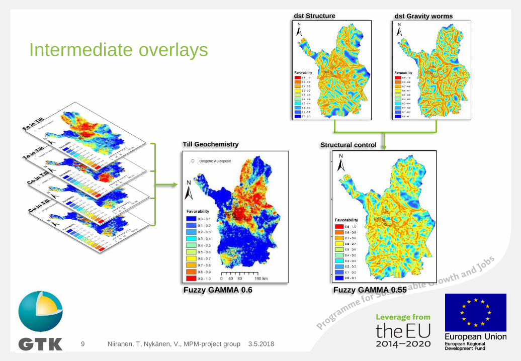
Intermediate overlays
3.5.2018Niiranen, T, Nykänen, V., MPM-project group9
Till Geochemistry
Fuzzy GAMMA 0.6
dst Structure dst Gravity worms
Structural control
Fuzzy GAMMA 0.55
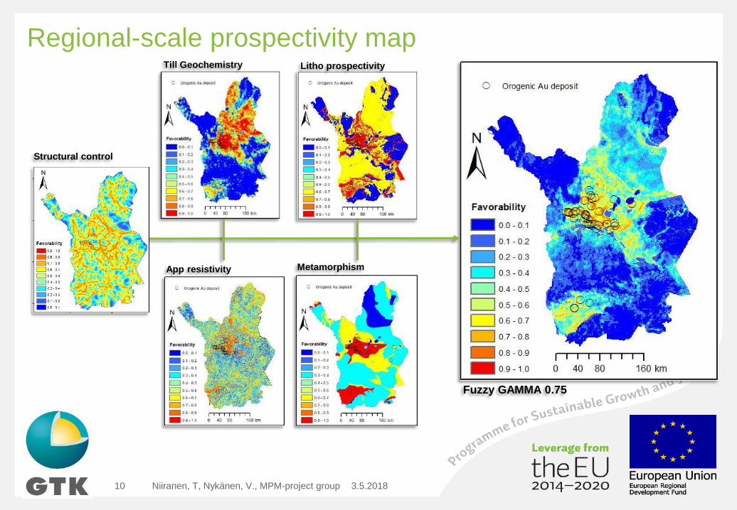
Regional-scale prospectivity map
3.5.2018Niiranen, T, Nykänen, V., MPM-project group10
Till Geochemistry
App resistivity
Litho prospectivity
Metamorphism
Fuzzy GAMMA 0.75
Structural control
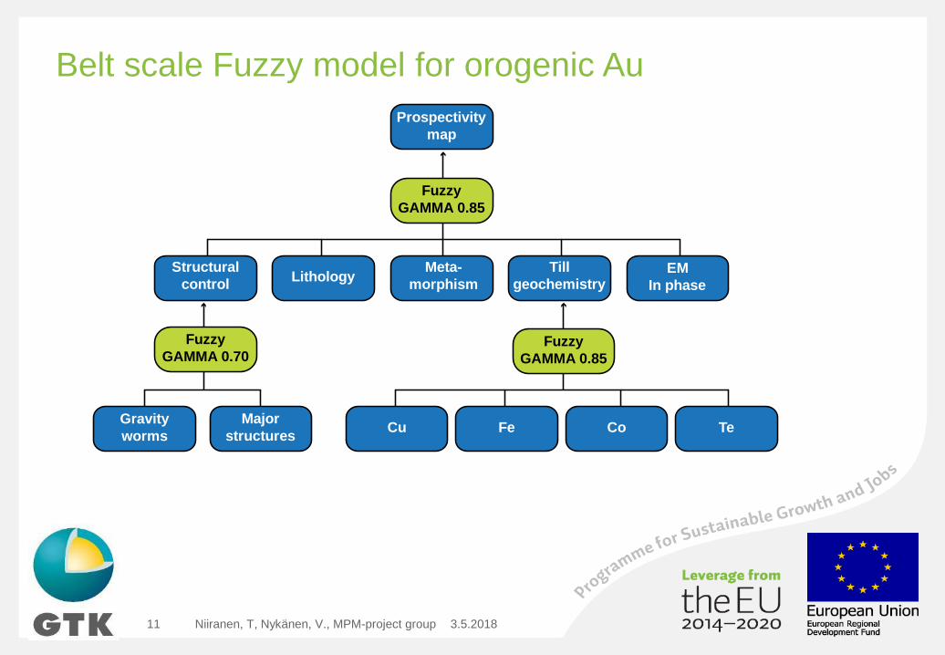
Belt scale Fuzzy model for orogenic Au
3.5.2018Niiranen, T, Nykänen, V., MPM-project group11
Prospectivity
map
Structural
control
Gravity
worms
Major
structures
Fuzzy
GAMMA 0.70
Till
geochemistry
Fe CoCu Te
Fuzzy
GAMMA 0.85
LithologyLithologyMeta-
morphismLithologyLithologyEM
In phase
Fuzzy
GAMMA 0.85
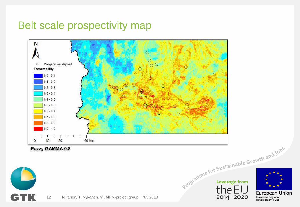
Belt scale prospectivity map
3.5.2018Niiranen, T, Nykänen, V., MPM-project group12
Fuzzy GAMMA 0.8
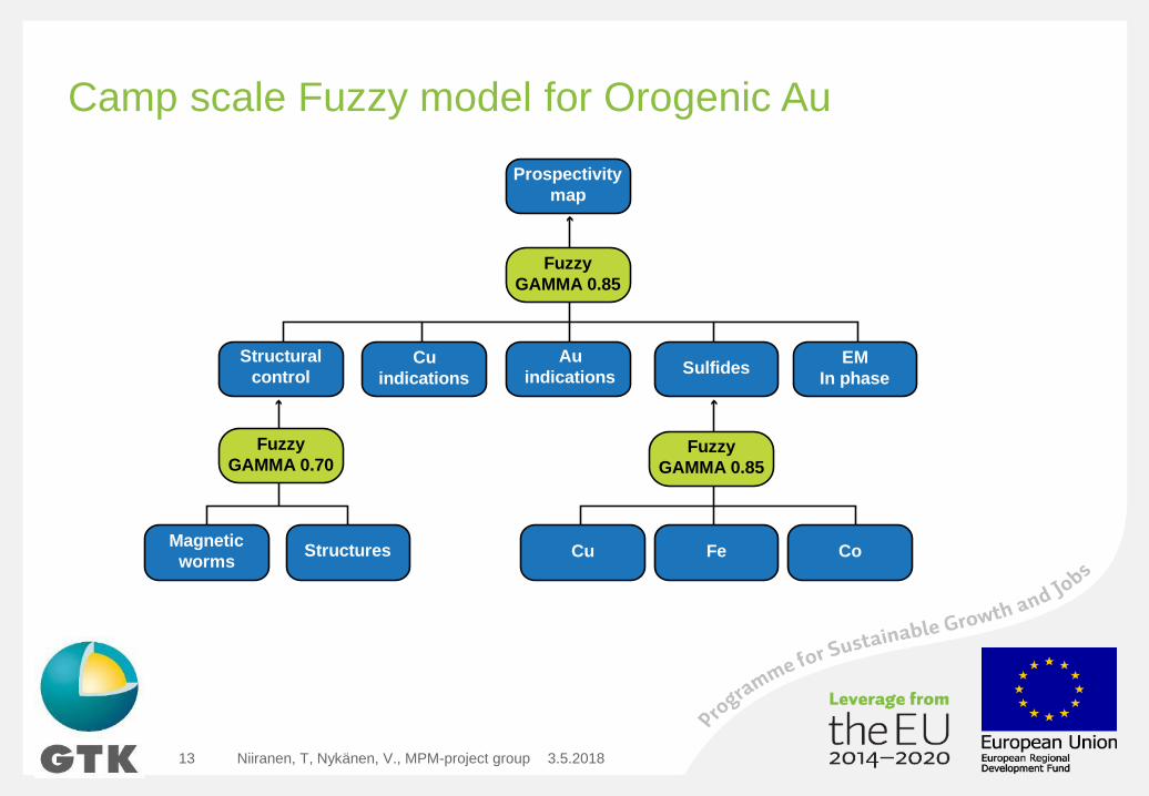
Camp scale Fuzzy model for Orogenic Au
3.5.2018Niiranen, T, Nykänen, V., MPM-project group13
Prospectivity
map
Structural
control
Magnetic
wormsStructures
Fuzzy
GAMMA 0.70
Sulfides
Fe CoCu
Fuzzy
GAMMA 0.85
LithologyCu
indications
Au
indicationsLithologyLithologyEM
In phase
Fuzzy
GAMMA 0.85
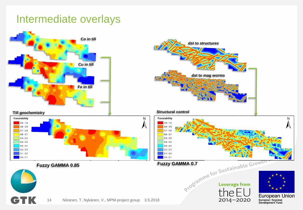
Intermediate overlays
3.5.2018Niiranen, T, Nykänen, V., MPM-project group14
Co in till
Cu in till
Fe in till
Till geochemistry Structural control
dst to structures
dst to mag worms
Fuzzy GAMMA 0.85 Fuzzy GAMMA 0.7
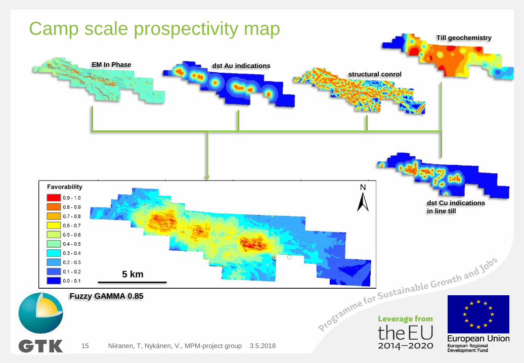
Camp scale prospectivity map
3.5.2018Niiranen, T, Nykänen, V., MPM-project group15
Fuzzy GAMMA 0.85
Till geochemistry
EM In Phase
dst Cu indications
in line till
dst Au indications
structural conrol
5 km
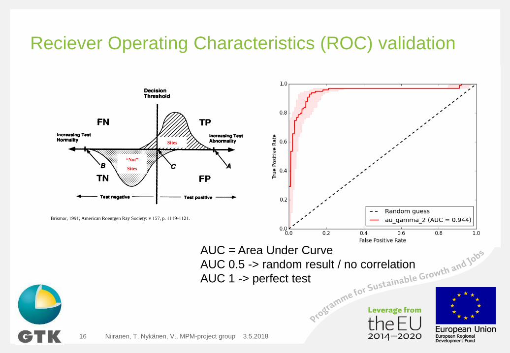
Reciever Operating Characteristics (ROC) validation
3.5.2018Niiranen, T, Nykänen, V., MPM-project group16
Brismar, 1991, American Roentgen Ray Society: v 157, p. 1119-1121.
Sites
“Not”
Sites
AUC = Area Under Curve
AUC 0.5 -> random result / no correlation
AUC 1 -> perfect test
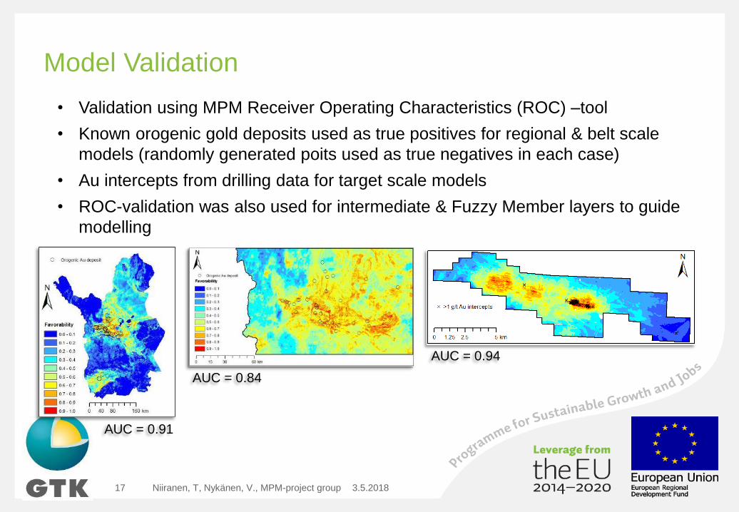
Model Validation
3.5.2018Niiranen, T, Nykänen, V., MPM-project group17
AUC = 0.91
AUC = 0.84
AUC = 0.94
• Validation using MPM Receiver Operating Characteristics (ROC) –tool
• Known orogenic gold deposits used as true positives for regional & belt scale
models (randomly generated poits used as true negatives in each case)
• Au intercepts from drilling data for target scale models
• ROC-validation was also used for intermediate & Fuzzy Member layers to guide
modelling
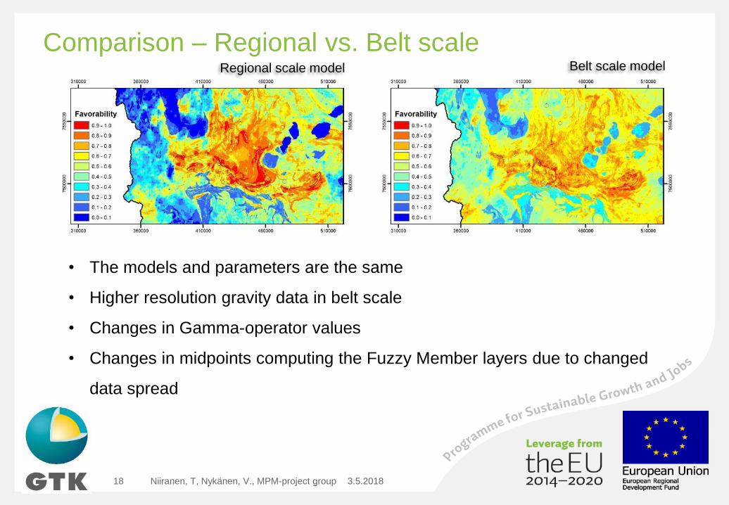
Comparison – Regional vs. Belt scale
3.5.2018Niiranen, T, Nykänen, V., MPM-project group18
Regional scale model Belt scale model
• The models and parameters are the same
• Higher resolution gravity data in belt scale
• Changes in Gamma-operator values
• Changes in midpoints computing the Fuzzy Member layers due to changed
data spread
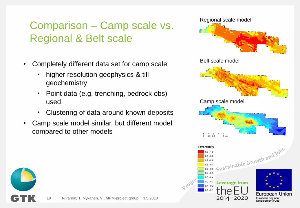
Comparison – Camp scale vs.
Regional & Belt scale
3.5.2018Niiranen, T, Nykänen, V., MPM-project group19
Regional scale model
Belt scale model
Camp scale model
• Completely different data set for camp scale
• higher resolution geophysics & till
geochemistry
• Point data (e.g. trenching, bedrock obs)
used
• Clustering of data around known deposits
• Camp scale model similar, but different model
compared to other models
Summary & Conclusions
3.5.2018Niiranen, T, Nykänen, V., MPM-project group20
• The exercise shows that the prospectivity modeling is a scalable, fast,
and cost effective method in all the stages of an exploration project - from
selecting the most prospective belts to outlining drilling targets
• A model can be easily adjusted for different scales and and fairly easily to
different data sets
• However: we recommend that one should always adjust the Fuzzy Membership
and Fuzzy Operator parameters moving from broader to tighter areas – even if
the data sets in both are the same (i.e. effect of data spread)
• In camp scale work the clustering of collected data is a major problem for
prospectivity modeling