Memphis and Shelby County Unified Development Code
506
-
Upload
khangminh22 -
Category
Documents
-
view
0 -
download
0
Transcript of Memphis and Shelby County Unified Development Code


THE MEMPHIS AND SHELBY COUNTY UNIFIED DEVELOPMENT CODE
The Zoning Code and Subdivision Regulations for the City of Memphis and Unincorporated Shelby County
Approved by the Shelby County Board of Commissioners: August 9, 2010 Approved by the Memphis City Council: August 10, 2010
and Incorporating the Following Amendments:
ZTA 12-001: approved by the Shelby Co. Board of Commissioners on August 27, 2012, and the Memphis City Council on July 17, 2012 ZTA 12-002: approved by the Shelby Co. Board of Commissioners on January 28, 2013, and the Memphis City Council on January 22, 2013
ZTA 13-001: approved by the Shelby Co. Board of Commissioners on April 15, 2013, and the Memphis City Council on April 16, 2013 ZTA 13-002: approved by the Shelby Co. Board of Commissioners on July 8, 2013, and the Memphis City Council on July 5, 2013

How to Use this Code
I WANT TO ESTABLISH A NEW USE IN AN EXISTING BUILDING: Find your zoning district on the Zoning Map. If your property is in a base district, look at Article 2, Districts and Uses, to determine whether the use is allowed. If the use
is listed in 2.5, Permitted Use Table with a cross-reference in the right-hand column, see 2.6, Use Standards. If your property is in a special purpose district, go to Article 7 to determine whether the use is allowed. Uses may be further restricted in Article 8, Overlay Districts. I WANT TO MODIFY A BUILDING OR DEVELOP A NEW BUILDING: Base Districts Determine whether the use is allowed by looking at Article 2, Districts and Uses. If the use is listed in Chapter 2.5, Permitted
Use Table with a cross-reference in the right-hand column, see Chapter 2.6, Use Standards. Go to Article 3, Building Envelope Standards, for your specific district to review the dimensional standards that apply to your
property. Alternative building envelope standards apply on any designated frontage. To determine whether or not a designated
frontage has been assigned to your property consult the Zoning Map (see Chapter 2.4 for additional details). An alternative height limit may have been established for your property if an official height map has been adopted by the
governing bodies. To determine whether or not a height map applies to your property consult the Zoning Map (see Chapter 2.4 for additional details).
Special Purpose and Overlay Districts The uses and dimensional standards for special purpose districts can be found in Article 7, Special Purpose Districts. The uses and dimensional standards for overlay districts can be found in Article 8, Overlay Districts. All Districts All districts are also subject to: Article 4, General Development Standards, which covers streetscapes, streets, access, parking, landscaping, lighting,
storage and signs. Article 6, Open Space and Natural Resource Protection, which covers tree protection, open space, steep slope protection,
stream buffers, floodways and stormwater management. I HAVE A USE, BUILDING, SITE OR SIGN THAT IS NONCONFORMING: Existing uses, buildings, sites and signs that met the rules when they were constructed, but do not comply with this development code are considered nonconforming. See Article 10, Nonconformities, for further details. I WANT TO CHANGE MY ZONING DISTRICT: Only the governing bodies may rezone property – following public notice and hearings. See Chapter 9.5, Zoning Change, for details on the procedure. I WANT TO SUBDIVIDE MY PROPERTY: Property can only be subdivided in accordance with the procedures in Chapter 9.7, Subdivision Review.
i
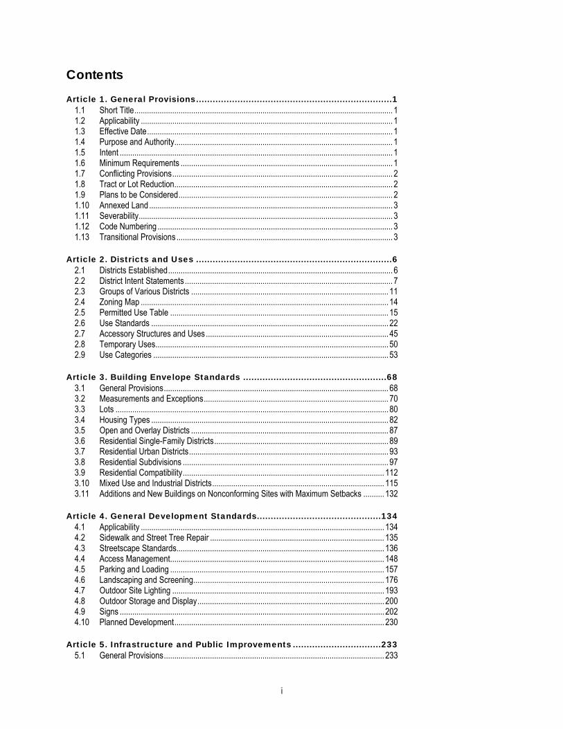
Contents Article 1. General Provisions.......................................................................1
1.1 Short Title........................................................................................................................... 1 1.2 Applicability ........................................................................................................................ 1 1.3 Effective Date..................................................................................................................... 1 1.4 Purpose and Authority........................................................................................................ 1 1.5 Intent .................................................................................................................................. 1 1.6 Minimum Requirements ..................................................................................................... 1 1.7 Conflicting Provisions......................................................................................................... 2 1.8 Tract or Lot Reduction........................................................................................................ 2 1.9 Plans to be Considered...................................................................................................... 2 1.10 Annexed Land.................................................................................................................... 3 1.11 Severability......................................................................................................................... 3 1.12 Code Numbering ................................................................................................................ 3 1.13 Transitional Provisions ....................................................................................................... 3
Article 2. Districts and Uses .......................................................................6 2.1 Districts Established........................................................................................................... 6 2.2 District Intent Statements ................................................................................................... 7 2.3 Groups of Various Districts .............................................................................................. 11 2.4 Zoning Map ...................................................................................................................... 14 2.5 Permitted Use Table ........................................................................................................ 15 2.6 Use Standards ................................................................................................................. 22 2.7 Accessory Structures and Uses ....................................................................................... 45 2.8 Temporary Uses............................................................................................................... 50 2.9 Use Categories ................................................................................................................ 53
Article 3. Building Envelope Standards ....................................................68 3.1 General Provisions........................................................................................................... 68 3.2 Measurements and Exceptions........................................................................................ 70 3.3 Lots .................................................................................................................................. 80 3.4 Housing Types ................................................................................................................. 82 3.5 Open and Overlay Districts .............................................................................................. 87 3.6 Residential Single-Family Districts................................................................................... 89 3.7 Residential Urban Districts............................................................................................... 93 3.8 Residential Subdivisions .................................................................................................. 97 3.9 Residential Compatibility................................................................................................ 112 3.10 Mixed Use and Industrial Districts.................................................................................. 115 3.11 Additions and New Buildings on Nonconforming Sites with Maximum Setbacks .......... 132
Article 4. General Development Standards.............................................134 4.1 Applicability .................................................................................................................... 134 4.2 Sidewalk and Street Tree Repair ................................................................................... 135 4.3 Streetscape Standards................................................................................................... 136 4.4 Access Management...................................................................................................... 148 4.5 Parking and Loading ...................................................................................................... 157 4.6 Landscaping and Screening........................................................................................... 176 4.7 Outdoor Site Lighting ..................................................................................................... 193 4.8 Outdoor Storage and Display......................................................................................... 200 4.9 Signs .............................................................................................................................. 202 4.10 Planned Development.................................................................................................... 230
Article 5. Infrastructure and Public Improvements ................................233 5.1 General Provisions......................................................................................................... 233

ii
5.2 Streets and Alleys .......................................................................................................... 234 5.3 Utilities............................................................................................................................ 251 5.4 Reservation of Public Land ............................................................................................ 253 5.5 Improvements ................................................................................................................ 254
Article 6. Open Space and Natural Resource Protection .......................257 6.1 Tree Removal................................................................................................................. 257 6.2 Open Space ................................................................................................................... 265 6.3 Steep Slope Protection .................................................................................................. 271 6.4 Stream Buffers ............................................................................................................... 272 6.5 Resource Extraction....................................................................................................... 273 6.6 Floodway Protection....................................................................................................... 274 6.7 Stormwater Management............................................................................................... 274
Article 7. Special Purpose Districts ........................................................275 7.1 Special purpose districts, generally................................................................................ 275 7.2 South Central Business Improvement District (SCBID) ................................................. 276 7.3 Uptown District (U) ......................................................................................................... 292
Article 8. Overlay Districts ......................................................................305 8.1 Overlay Districts Generally............................................................................................. 305 8.2 Medical Overlay District (-MO) ....................................................................................... 305 8.3 University District Overlay (-UDO) ................................................................................. 324 8.4 Midtown District Overlay (-MD) ...................................................................................... 338 8.5 Residential Corridor Overlay District (-RC) .................................................................... 372 8.6 Historic Overlay District (-H)........................................................................................... 374 8.7 Airport Overlay District (-AP).......................................................................................... 380 8.8 Floodplain Overlay District (-FP) .................................................................................... 380 8.9 Fletcher Creek Overlay District (-FC)............................................................................. 388 8.10 Transitional Office Overlay (-TO) ................................................................................... 390 8.11 Neighborhood Conservation Overlay District (-NC) ....................................................... 391
Article 9. Administration .........................................................................396 9.1 Review Bodies ............................................................................................................... 396 9.2 Summary of Review Authority........................................................................................ 400 9.3 Common Review Procedures ........................................................................................ 401 9.4 Text Amendment............................................................................................................ 409 9.5 Zoning Change............................................................................................................... 411 9.6 Special Use and Planned Development Review............................................................ 414 9.7 Subdivision Review........................................................................................................ 421 9.8 Right-of-Way Vacation ................................................................................................... 430 9.9 Right-of-Way Dedication ................................................................................................ 433 9.10 Street Name Change ..................................................................................................... 434 9.11 Plat of Record Revocation ............................................................................................. 435 9.12 Administrative Site Plan Review .................................................................................... 436 9.13 Special District Administrative Site Plan Review............................................................ 438 9.14 Special Exception Review.............................................................................................. 440 9.15 Temporary Use Review.................................................................................................. 442 9.16 Time Extensions............................................................................................................. 443 9.17 Sign Permit..................................................................................................................... 444 9.18 Demolition Permits ......................................................................................................... 445 9.19 Certificate of Occupancy ................................................................................................ 446 9.20 Written Interpretations.................................................................................................... 447 9.21 Administrative Deviation................................................................................................. 448 9.22 Variance ......................................................................................................................... 450
iii
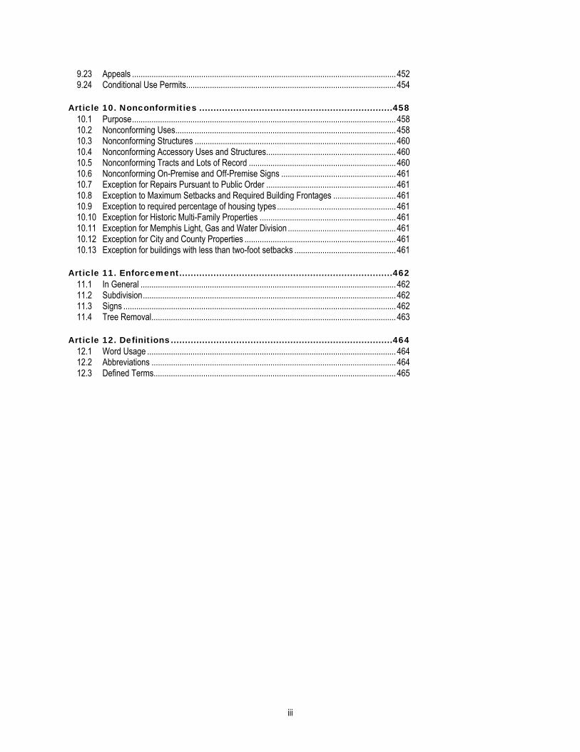
9.23 Appeals .......................................................................................................................... 452 9.24 Conditional Use Permits................................................................................................. 454
Article 10. Nonconformities ....................................................................458 10.1 Purpose.......................................................................................................................... 458 10.2 Nonconforming Uses...................................................................................................... 458 10.3 Nonconforming Structures ............................................................................................. 460 10.4 Nonconforming Accessory Uses and Structures............................................................ 460 10.5 Nonconforming Tracts and Lots of Record .................................................................... 460 10.6 Nonconforming On-Premise and Off-Premise Signs ..................................................... 461 10.7 Exception for Repairs Pursuant to Public Order ............................................................ 461 10.8 Exception to Maximum Setbacks and Required Building Frontages ............................. 461 10.9 Exception to required percentage of housing types ....................................................... 461 10.10 Exception for Historic Multi-Family Properties ............................................................... 461 10.11 Exception for Memphis Light, Gas and Water Division .................................................. 461 10.12 Exception for City and County Properties ...................................................................... 461 10.13 Exception for buildings with less than two-foot setbacks ............................................... 461
Article 11. Enforcement...........................................................................462 11.1 In General ...................................................................................................................... 462 11.2 Subdivision..................................................................................................................... 462 11.3 Signs .............................................................................................................................. 462 11.4 Tree Removal................................................................................................................. 463
Article 12. Definitions..............................................................................464 12.1 Word Usage ................................................................................................................... 464 12.2 Abbreviations ................................................................................................................. 464 12.3 Defined Terms................................................................................................................ 465


Memphis/Shelby County 1 Unified Development Code
Article 1. General Provisions 1.1 SHORT TITLE
This ordinance shall be known as “the development code for the City of Memphis and unincorporated Shelby County,” and may be cited and referred to as “this development code.”
1.2 APPLICABILITY A. The provisions of this development code shall apply to the development of all land within the jurisdiction of the City of
Memphis and Shelby County, exclusive of incorporated municipalities. No development shall be undertaken without prior authorization pursuant to this development code.
B. All divisions, departments, commissions, boards, and authorities, of Shelby County government; the City of Memphis government; Memphis, Light, Gas and Water Division; Shelby County Schools and Memphis City Schools shall comply with the requirements of this development code.
1.3 EFFECTIVE DATE This development code was adopted on August 10, 2010 and becomes effective on January 1, 2011, except as it applies to properties owned by Shelby County Schools and Memphis City Schools, in which case this development code becomes effective on August 1, 2011. Between the adoption date and the effective date, a property owner may choose to adhere to either this development code or the previously adopted Memphis and Shelby County Zoning Code and Subdivision Regulations.
1.4 PURPOSE AND AUTHORITY This development code is enacted pursuant to Chapter 165 of the Private Acts of the General Assembly of the State of Tennessee for the year 1921; Chapter 613 of the Private Acts of the General Assembly of the State of Tennessee for the year 1931; and Chapter 625 of the Private Acts of the General Assembly of the State of Tennessee for the year 1935. This development code is designed and enacted for the purpose of promoting the health, safety and welfare of the residents of the City of Memphis and Shelby County by lessening or preventing congestion in the public streets; securing safety from fire and other dangers; furthering the provision of adequate light and pure air; avoiding excessive concentrations of population and wasteful scattering of population; encouraging such distribution of population and such classification of land uses as will tend to facilitate and conserve adequate provisions for transportation, water supply, drainage, sanitation, educational opportunity, and recreation; protecting and promoting both urban and non-urban development; and preserving landmark buildings, objects and sites.
1.5 INTENT This development code is intended to accomplish the following:
A. Guide the future growth and development in the City and County. B. Implements the planned growth and rural areas of the adopted Shelby County Growth Plan, consistent with Public
Chapter 1101. C. Protect the character, and the social and economic stability of all parts of the City of Memphis and the unincorporated
area within Shelby County and to encourage the orderly and beneficial development thereof. D. Prohibit uses, buildings or structures incompatible with the character of established districts. E. Establish procedures necessary to implement and enforce the provisions of this development code. F. Guide public and private policy, and action to provide adequate and efficient public facilities. G. Consider the availability of public facilities and determine if there is sufficient capacity to serve current and future
development. H. Minimize the pollution of air and water, to safeguard the water table, to maintain the adequacy of drainage facilities,
and to encourage the wise use and management of natural resources. I. Encourage compliance with all applicable Americans with Disabilities Act Accessibility Guidelines. J. Establish district regulations which encourage originality and flexibility in design to ensure that development is properly
related to its site and to surrounding development patterns.
1.6 MINIMUM REQUIREMENTS The requirements of this development code shall be considered as the minimum requirements for the promotion of the public health, safety and general welfare.

1.13.1 Conflicting Provisions Article 1 General Provisions 1.13.1 New Development
Memphis/Shelby County 2 Unified Development Code
1.7 CONFLICTING PROVISIONS A. Where this development code imposes a greater restriction upon property than that imposed by other resolutions,
ordinances, rules, regulations, easements, covenants or agreements, the provisions of this development code shall govern.
B. All development must comply with relevant Federal and State regulations. Whenever any provision of this development code imposes a greater requirement or a higher standard than is required in any Federal or State statute or regulation, the provisions of this development code govern unless preempted by Federal or State law.
C. This development code shall not interfere with and does not supercede any regulations or guidelines of the Memphis and Shelby County Building Code.
D. Where the general standards of this Code conflict with standards set out in Articles 7 or 8, the standards of Articles 7 or 8 shall govern. Where the standards of Article 7 conflict with the standards set out in Article 8, the standards of Article 8 shall govern.
1.8 TRACT OR LOT REDUCTION No tract or lot, even though it may consist of one or more adjacent tracts or lots of record in single ownership, shall be reduced in size so that the minimum area per dwelling unit, minimum width, maximum density or building coverage requirements, and other requirements of this development code are not maintained. This prohibition shall not be construed to prevent the purchase or condemnation of narrow strips of land for public utilities or right-of-way purposes.
1.9 PLANS TO BE CONSIDERED The following plans shall be considered in any decisions under this development code.
A. Bicentennial Plan; B. Community Redevelopment Plan for the University Neighborhood Development Corporation/Highland Row Area; C. Community Redevelopment Plan for the Uptown Area; D. Downtown Streetscape Master Plan; E. Eastview Area Redevelopment Plan; F. Frayser (Futures) District Plan; G. Glenview Area Plan; H. Grays Creek Area Plan; I. 2000 Main Street Master Plan; J. MPO Long Range Transportation Plan; K. MPO Bicycle and Pedestrian Plan; L. Medical Center Area Plan; M. Midtown Corridor East/Binghampton Plan; N. Mud Island Report; O. Normal Station Area Plan; P. Rozelle Annesdale Neighborhood Plan; Q. Shelby County Greenway Plan; R. South Central Business Improvement District Area Plan; S. South Forum “SoFo” Redevelopment Plan; T. South Memphis District Plan; U. Uptown Redevelopment Plan; V. University District Comprehensive Plan; W. Victorian Village Redevelopment Plan; X. Vollintine-Evergreen Plan; Y. Whitehaven District Plan; Z. Winchester Park Area Study; and AA. Any other plans approved by the Memphis City Council and the Shelby County Board of Commissioners.
Article 1 General Provisions 1.10 Annexed Land 1.13.1 New Development
Memphis/Shelby County 3 Unified Development Code
1.10 ANNEXED LAND All land which shall, after the effective date of this development code, be annexed to the City of Memphis shall maintain the same zoning classification it had immediately prior to such annexation and shall be subject to the regulations applicable under such zoning district.
1.11 SEVERABILITY Should any clause or provision of this development code be declared by a court of competent jurisdiction to be unconstitutional or invalid, such decision shall not affect the validity of the ordinance codified in this development code as a whole or any part thereof other than the part declared to be unconstitutional or invalid, each article, section, clause and provision hereof being declared severable.
1.12 CODE NUMBERING This development code is divided into Articles, Chapters and Sections, as set forth below. The terms shall be used to interpret the provisions of this development code.
Article 3. [Example Text] Chapter 3.1 [Example Text] Section 3.1.1 [Example Text] Sub-Section 3.1.1A [Example Text] Paragraph 3.1.1A (1) [Example Text] Item 3.1.1A (1)(a) [Example Text] Sub-Item 3.1.1A (1)(a)(1) [Example Text]
1.13 TRANSITIONAL PROVISIONS
1.13.1 New Development A. Except as provided in Section 1.13.3, upon the effective date of this development code or any subsequent amendment,
any new building or other structure or any use of land shall be used, constructed or developed only in accordance with all applicable provisions of this development code.
B. No excavation or filling of land or construction of any public or private improvements shall take place or commence except in conformity with this development code.
1.13.2 Existing Development Except as provided in Section 1.13.3, any existing use, lot, building or other structure legally established prior to the effective date of this development code that does not comply with any provision of this development code shall be subject to the nonconforming provisions stipulated in Article 10, Nonconformities.
1.13.3 Previously Issued Permits and Approved Plans A. Planned Commercial (C-P) District and Planned Developments (PD)
1. The provisions of this development code do not apply to any planned commercial (C-P) districts, or planned developments (PD) that were approved by the governing bodies prior to the effective date of this development code, except as provided in this Sub-Section. Any condition or set of conditions, imposed by the governing body on such plan or planned development governs. If a previously approved planned commercial (C-P) or planned development (PD) is silent on a particular provision of this development code, the Planning Director may apply that provision to the previously approved C-P or PD.
2. If a previously approved planned commercial (C-P) or planned development (PD) references a former zoning district or former development standard then the new applicable zoning district standard or development standard under this development code shall apply.
3. If an approved plan in a planned commercial (C-P) district or a planned development (PD) expires for any reason, then the provisions of this development code governs.
4. In any approved planned commercial (C-P) district or planned development (PD) that references permitted uses in a zoning district, those uses permitted under the former zoning district classification shall be permitted and shall not be considered nonconforming uses. Further, the Planning Director may permit any additional uses that are not permitted under the former zoning district classification but are permitted under this development code in a corresponding district as provided in Section 1.13.4 (district conversion) after consideration as to the location and impact of such use or uses on adjacent properties and the general neighborhood.

1.13.3 Transitional Provisions Article 1 General Provisions 1.13.3 Previously Issued Permits and Approved Plans
Memphis/Shelby County 4 Unified Development Code
5. This Sub-Section shall also govern Apartment Shop Plans, Shopping Center Plans (SC-1), Wholesale Distribution Plans (ML) and Community Unit Plans (CUP) approved by the governing bodies prior to the effective date of this development code.
B. Variance, Special Use Permits, Use Variance 1. If, before the effective date of this development code, the Board of Adjustment grants any variance, or the
appropriate governing body grants any special use permit, special exception, or use variance, then such variance, permit or exception may be continued, extended, enlarged, or structurally altered only as provided in this development code.
2. Where no limitation as to the duration of the variance or use was imposed at the time of authorization, the use may be continued. When the use was granted for a specific period of time, the applicable provisions of this development code shall be applied upon the expiration of that time.
3. In no event shall such use be changed except to a conforming use or a nonconforming use as provided for in Article 10, Nonconformities. A change of use is a change to another use either under the same use category or different use category (see Chapter 2.9). A change in occupancy or ownership shall not by itself constitute a change in use.
C. Building Permits 1. Any building permit issued before the effective date of this development code or subsequent amendment shall
remain in effect provided that development has started within six months from the date of issuance of the permit and that the building permit remains in effect under the terms of the building code.
2. Development shall mean physical improvements such as, but not limited to, clearing and grading, water and sewer lines, footings, and/or foundations that have been developed on the site.
3. The storage of building materials or the placement of temporary structures shall not constitute beginning development.
D. Pending Applications The provisions of this development code do not apply to zoning and subdivision applications that are complete and pending at the effective date of this development code; such pending applications will be processed in accordance with and decided pursuant to the law existing on the date the application was filed.
Article 1 General Provisions 1.13 Transitional Provisions 1.13.4 District Conversion
Memphis/Shelby County 5 Unified Development Code
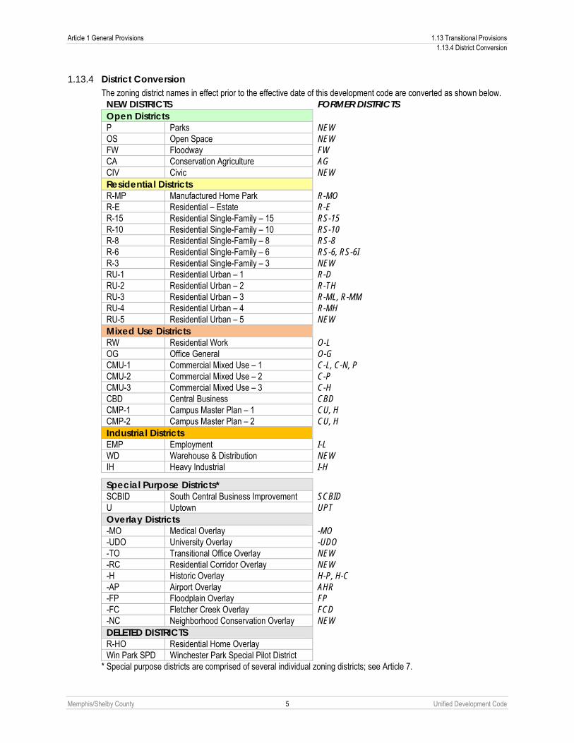
1.13.4 District Conversion The zoning district names in effect prior to the effective date of this development code are converted as shown below. NEW DISTRICTS FORMER DISTRICTS Open Districts P Parks NEW OS Open Space NEW FW Floodway FW CA Conservation Agriculture AG CIV Civic NEW Residential Districts R-MP Manufactured Home Park R-MO R-E Residential – Estate R-E R-15 Residential Single-Family – 15 RS-15 R-10 Residential Single-Family – 10 RS-10 R-8 Residential Single-Family – 8 RS-8 R-6 Residential Single-Family – 6 RS-6, RS-6I R-3 Residential Single-Family – 3 NEW RU-1 Residential Urban – 1 R-D RU-2 Residential Urban – 2 R-TH RU-3 Residential Urban – 3 R-ML, R-MM RU-4 Residential Urban – 4 R-MH RU-5 Residential Urban – 5 NEW Mixed Use Districts RW Residential Work O-L OG Office General O-G CMU-1 Commercial Mixed Use – 1 C-L, C-N, P CMU-2 Commercial Mixed Use – 2 C-P CMU-3 Commercial Mixed Use – 3 C-H CBD Central Business CBD CMP-1 Campus Master Plan – 1 CU, H CMP-2 Campus Master Plan – 2 CU, H Industrial Districts EMP Employment I-L WD Warehouse & Distribution NEW IH Heavy Industrial I-H
Special Purpose Districts* SCBID South Central Business Improvement SCBID U Uptown UPT Overlay Districts -MO Medical Overlay -MO -UDO University Overlay -UDO -TO Transitional Office Overlay NEW -RC Residential Corridor Overlay NEW -H Historic Overlay H-P, H-C -AP Airport Overlay AHR -FP Floodplain Overlay FP -FC Fletcher Creek Overlay FCD -NC Neighborhood Conservation Overlay NEW DELETED DISTRICTS R-HO Residential Home Overlay Win Park SPD Winchester Park Special Pilot District
* Special purpose districts are comprised of several individual zoning districts; see Article 7.

Memphis/Shelby County 6 Unified Development Code
Article 2. Districts and Uses 2.1 DISTRICTS ESTABLISHED
To carry out the provisions of this development code within the jurisdiction of the City of Memphis and unincorporated Shelby County the following zoning districts have been established and are applied to property as set forth on the Zoning District Map (see Chapter 2.4). Open Districts P Parks OS Open Space FW Floodway CA Conservation Agriculture CIV Civic Residential Districts R-MP Manufactured Home Park R-E Residential – Estate R-15 Residential Single-Family – 15 R-10 Residential Single-Family – 10 R-8 Residential Single-Family – 8 R-6 Residential Single-Family – 6 R-3 Residential Single-Family – 3 RU-1 Residential Urban – 1 RU-2 Residential Urban – 2 RU-3 Residential Urban – 3 RU-4 Residential Urban – 4 RU-5 Residential Urban – 5 Mixed Use Districts RW Residential Work OG Office General CMU-1 Commercial Mixed Use – 1 CMU-2 Commercial Mixed Use – 2 CMU-3 Commercial Mixed Use – 3 CBD Central Business CMP-1 Campus Master Plan – 1 CMP-2 Campus Master Plan – 2 Industrial Districts EMP Employment WD Warehouse & Distribution IH Heavy Industrial Special Purpose Districts* SCBID South Central Business Improvement U Uptown Overlay Districts -MO Medical Overlay -UDO University Overlay -TO Transitional Office Overlay -RC Residential Corridor Overlay -H Historic Overlay -AP Airport Overlay -FP Floodplain Overlay -FC Fletcher Creek Overlay -NC Neighborhood Conservation Overlay -MD Midtown District Overlay
* Special purpose districts are comprised of several individual zoning districts; see Article 7.

Article 2 Districts and Uses 2.2 District Intent Statements 2.2.1 Open Districts
Memphis/Shelby County 7 Unified Development Code
2.2 DISTRICT INTENT STATEMENTS
2.2.1 Open Districts A. Parks (P)
1. The P District is intended to create, preserve and enhance publicly owned parkland as permanent space to meet the active recreational needs of City and County residents.
2. The P District is intended to provide for both improved and unimproved parkland. Activities may include, but are not limited to, structures or other active, player-oriented facilities such playgrounds, recreational fields, ball-fields, sport courts, dog parks and associated accessory facilities such as parking areas and restrooms.
3. The district is also intended to accommodate buildings of a public nature such as museums, libraries, police, fire or EMS stations provided such uses shall not exceed ten percent of the lot area.
B. Open Space (OS) 1. The OS District is intended to create, preserve, and enhance land as permanent open space to meet the passive
recreational needs of City and County that are compatible with surrounding land uses. 2. Property in the OS District may be under public or private ownership. All property within the district must be
unoccupied or predominately unoccupied by buildings or other impervious surfaces. Unoccupied or predominately unoccupied by buildings or other impervious surfaces means that not more than five percent of the area of any land is occupied by such surfaces.
C. Floodway (FW) The FW District is intended to allow specified uses that will not create flood hazards and which will not be unduly damaged, if flooded. The uses and regulations allowed shall be consistent with the provisions of federal laws and administrative regulations.
D. Conservation Agriculture (CA) The CA District is intended to conserve agricultural land and undeveloped natural amenities while preventing the encroachment of incompatible land uses on farm land and other undeveloped areas. The types, area and intensity of land uses in this district are designed to encourage and protect agricultural uses and the conservation of undeveloped areas.
E. Civic (CIV) The CIV District is intended to provide for civic uses that serve the surrounding neighborhoods or produce intensive civic activities that do not readily assimilate into other zoning districts.
2.2.2 Predominantly Residential Districts The residential districts are intended to create, maintain and promote a variety of housing opportunities for individual households and to maintain the desired physical character of existing neighborhoods. While the districts primarily accommodate residential uses, nonresidential uses that are compatible with residential neighborhoods are also allowed.
A. Manufactured Home Park (R-MP) The R-MP District permits manufactured, modular and mobile homes in manufactured home parks. This district is provided to ensure a suitable living environment in manufactured home parks and to ensure the compatibility of such developments with adjacent property.
B. Residential–Estate (R-E) The R-E District is intended to accommodate low density single-family detached houses on individual lots. This district should be applied in areas where the land-use pattern is predominately single-family detached houses on large individual lots or where such a land use pattern is desired in the future. New R-E Districts are generally located no closer than 2,000 feet from a CMU-1, CMU-2, or CMU-3 district.

2.2.2 District Intent Statements Article 2 Districts and Uses 2.2.2 Predominantly Residential Districts
Memphis/Shelby County 8 Unified Development Code
C. Residential Single-Family (R-15, -10, -8, -6, -3) The single-family residential districts are intended to accommodate one single-family detached principal dwelling unit per lot. These districts should be applied in areas where the land-use pattern is predominately single-family residential or where such a land use pattern is desired in the future. Five single-family residential districts are established—R-15, R-10, R-8, R-6, and R-3—which are differentiated primarily on the basis of minimum lot area and setback requirements.
1. Residential Single Family – 15 (R-15) New R-15 districts are generally located at least 1,500 to 2,000 feet from a CMU-1, CMU-2, CMU-3 or CBD district.
2. Residential Single Family – 10 (R-10) New R-10 districts are generally located at least 1,500 to 2,000 feet from a CMU-1, CMU-2, CMU-3 or CBD district.
3. Residential Single Family – 8 (R-8) New R-8 districts are generally located at least 1,000 to 1,500 feet from a CMU-1, CMU-2, CMU-3 or CBD district.
4. Residential Single Family – 6 (R-6) New R-6 districts are generally located in an infill or redevelopment location where similar lot sizes are part of the original fabric of development. Additionally, R-6 districts should have a shared street network with and are generally located at least 500 to 1,000 feet from a CMU-1, CMU-2, CMU-3, or CBD district.
5. Residential Single Family – 3 (R-3) Residential Single Family – 3 (R-3) New R-3 districts are generally located in an infill or redevelopment location where similar lot sizes are part of the original fabric of development. Additionally, R-3 districts should have a shared street network with and are generally located at least 500 feet from a CMU-1, CMU-2, CMU-3, or CBD district.
D. Residential Urban Districts (RU-1, -2, -3, -4, -5) The residential urban districts are intended to accommodate development where the land-use pattern is predominately urban in character or where such a land use pattern is desired in the future. The RU- districts are intended to provide for a variety of housing opportunities at intensities compatible with surrounding land uses. The districts are intended to encourage residential infill on single lots and small tracts as well as new development on larger tracts in traditional urban patterns that mimic established portions of surrounding neighborhoods. The RU- districts allow a limited set of corner commercial uses subject to performance measures.
1. Residential Urban – 1 (RU-1) Residential development in the RU-1 District allows a variety of housing types including single-family detached (conventional, side yard house, cottage) and single-family attached (semi-attached, two-family). New RU-1 districts should have a shared street network with and are generally located at least 500 to 1,000 feet from a CMU-1, CMU-2, CMU-3, or CBD district or at are least 500 to 1,000 feet from an arterial.
2. Residential Urban – 2 (RU-2) Residential development in the RU-2 District allows a variety of housing types including single-family detached (conventional, side yard house, cottage), single-family attached (semi-attached, two-family, townhouse), and multifamily (large home, stacked townhouse). New RU-2 districts should have a shared street network with and are generally located at least 500 to 1,000 feet from a CMU-1, CMU-2, CMU-3, or CBD district or are least 500 to 1,000 feet from an arterial.
3. Residential Urban – 3 (RU-3) Residential development in the RU-3 District allows a variety of housing types including single-family detached (conventional, side yard house, cottage), single-family attached (semi-attached, two-family, townhouse), and multifamily (large home, stacked townhouse, apartment). New RU-3 districts are generally located in an infill or redevelopment location where similar lot sizes are part of the original fabric of development. Additionally, RU-3 districts should have a shared street network with and are generally located at least 500 feet from a CMU-1, CMU-2, CMU-3, or CBD district or are within 500 feet of an arterial.

Article 2 Districts and Uses 2.2 District Intent Statements 2.2.3 Mixed Use Districts
Memphis/Shelby County 9 Unified Development Code
4. Residential Urban – 4 (RU-4) Residential development in the RU-4 District allows a variety of housing types including single-family attached (townhouse) and multifamily (large home, stacked townhouse, apartment). New RU-4 districts are generally located in an infill or redevelopment location where similar housing types are part of the original fabric of development. Additionally, RU-4 districts should have a shared street network with and are generally located within 500 feet of a CMU-3, or CBD district or are within 500 feet of an arterial.
5. Residential Urban – 5 (RU-5) Residential development in the RU-5 District allows for higher intensity multifamily housing types as well as some corner commercial uses with an emphasis on live/work. New RU-5 districts are generally located in an infill or redevelopment location where similar housing types are part of the original fabric of development. Additionally, RU-5 districts should have a shared street network with and are generally located within 500 feet of a CMU-3, or CBD district or are within 500 feet of an arterial.
2.2.3 Mixed Use Districts A. Residential Work (RW)
The RW District is intended to provide appropriate areas for new and existing development that incorporates both small-scale residential and office uses within close proximity to one another and adjacent neighborhoods. The district is also intended to provide for live/work opportunities where people can live and work in the same physical space. The district can also be used as a transition between arterials or more intense commercial areas and established residential neighborhoods. Typical uses contain up to 4,000 square feet of floor area.
B. Office General (OG) The OG District is intended to accommodate a range of more intense professional office uses and a limited range of civic, residential and commercial service uses. The district is intended to be located along freeways and adjacent to commercial uses to act as a buffer between higher intensity commercial and lower intensity residential.
C. Commercial Mixed Use (CMU-) The commercial mixed use districts are intended to accommodate retail, service and commercial uses and to ensure that commercial-zoned areas are compatible with the character of existing neighborhoods. While the districts primarily accommodate commercial uses, apartments and upper-story residential are allowed in order to promote live-work and mixed use opportunities. To provide for additional housing choice, single-family detached is permitted in the CMU- districts. The CMU- districts are not intended to provide for areas exclusively dominated by any one particular use but provide for neighborhoods that successfully integrate several types of compatible uses together.
1. Commercial Mixed Use – 1 (CMU-1) The CMU-1 District is intended to provide for neighborhood serving commercial, office, and employment uses. Residential uses are encouraged above the ground floor. Compatible nonresidential uses should be located within walking distance to the established residential neighborhoods they are designated to serve. Auto-oriented uses are not appropriate in this district. Typical retail uses vary from 1,000 to 15,000 square feet of ground floor area.
2. Commercial Mixed Use – 2 (CMU-2) The CMU-2 District is intended to provide for commercial, office, and employment uses that serve through traffic as well as surrounding neighborhoods. Residential uses are allowed on the ground floor but upper story units are encouraged. Typical centers may include anchor tenants up to 80,000 square feet of ground floor area. Uses in this district are intended to be located within convenient traveling distance from the multiple neighborhoods they are designated to serve.
3. Commercial Mixed Use – 3 (CMU-3) The CMU-3 District is intended to accommodate a very board range of high intensity commercial, office and employment uses that require highly visible and highly accessible locations with direct access to arterials. Residential uses are allowed on the ground floor but upper story units are encouraged. Typical uses in this district serve regional needs. The permitted uses are generally uses not of a neighborhood or general commercial type, but serve large areas of the City and County.

2.2.4 District Intent Statements Article 2 Districts and Uses 2.2.4 Predominantly Industrial Districts
Memphis/Shelby County 10 Unified Development Code
D. Central Business (CBD) The CBD District is intended to accommodate high-intensity office, employment and residential uses within downtown. The district regulations recognize and support downtown's role as a center of regional importance and as a primary hub for business, communications, office, living, government, retail, cultural, educational, visitor accommodations, and entertainment. The district promotes vertical mixed-use (residential/nonresidential) projects that contain active ground-floor uses.
E. Campus Master Plan (CMP-) The campus master plan districts are intended to accommodate office, research and development, residential, light manufacturing and processing uses and other campus-like developments, such as hospitals, colleges and universities, allowing for clustering opportunities that help improve overall efficiency. Limited retail, restaurant and commercial uses are allowed, however, such uses are primarily for the convenience of employees or users of the campus.
1. Campus Master Plan – 1 (CMP-1) The CMP-1 District is intended to accommodate new development where the land-use pattern is predominately urban in character. New development should be urban in character with an emphasis on compact, vertical, pedestrian-oriented, mixed use development that fit seamlessly into the built environment. Landscaping requirements are reduced and buildings are pulled up much closer to the street.
2. Campus Master Plan – 2 (CMP-2) The CMP-2 District is intended to accommodate new development where the land-use pattern is predominately suburban in character or where such a land use pattern is desired in the future. New development should be suburban in character with an emphasis on low-rise buildings that blend flawlessly into the natural environment. Landscaping requirements are significant and development patterns are characterized by deep, gracious setbacks.
2.2.4 Predominantly Industrial Districts A. Employment(EMP)
The EMP District is intended to accommodate office, light manufacturing, research and development, warehousing, wholesale, processing and commercial uses in order promote economic viability, encourage employment growth, and limit the encroachment of non-industrial development within established industrial areas. Development should be operated in a relatively clean and quiet manner, and should not be obnoxious to nearby residential or commercial uses.
B. Warehouse Distribution (WD) The WD District is intended to accommodate a broad range of office/warehouse, warehouse/distribution and wholesale uses. The district is intended to recognize the high traffic volume and 24-hour nature of these uses.
C. Industrial–Heavy (IH) The IH district is intended to accommodate high-impact manufacturing, industrial or other uses, including extractive and waste-related uses, that by their nature create some nuisance, and which are not properly associated with or are compatible with nearby residential districts or other less intense mixed use or industrial districts.
2.2.5 Special Purpose Districts See Article 7.
2.2.6 Overlay Districts See Article 8.

Article 2 Districts and Uses 2.3 Groups of Various Districts 2.3.1 Open Districts
Memphis/Shelby County 11 Unified Development Code
2.3 GROUPS OF VARIOUS DISTRICTS
2.3.1 Open Districts Where the phrase “all open districts,” “open districts,” or phraseology of similar intent is used, the phrase includes the following districts:
A. Parks (P) B. Open Space (OS) C. Floodway (FW) D. Conservation Agriculture (CA) E. Civic (CIV)
2.3.2 Single-Family Districts Where the phrase "all single-family districts," "single-family districts," or phraseology of similar intent is used, the phrase includes the following districts:
A. Manufactured Home Park (R-MP) B. Residential – Estate (R-E) C. Residential Single-Family – 15 (R-15) D. Residential Single-Family – 10 (R-10) E. Residential Single-Family – 8 (R-8) F. Residential Single-Family – 6 (R-6) G. Residential Single-Family – 3 (R-3)
2.3.3 Residential Districts Where the phrase "all residential districts," "residential districts," or "residentially-zoned," or phraseology of similar intent is used, the phrase includes the following districts:
A. Manufactured Home Park (R-MP) B. Residential – Estate (R-E) C. Residential Single-Family – 15 (R-15) D. Residential Single-Family – 10 (R-10) E. Residential Single-Family – 8 (R-8) F. Residential Single-Family – 6 (R-6) G. Residential Single-Family – 3 (R-3) H. Residential Urban – 1 (RU-1) I. Residential Urban – 2 (RU-2) J. Residential Urban – 3 (RU-3) K. Residential Urban – 4 (RU-4) L. Residential Urban – 5 (RU-5)
2.3.4 Mixed Use Districts Where the phrase "all mixed use districts," "mixed use districts," or phraseology of similar intent is used, the phrase shall include the following districts:
A. Residential Work (RW) B. Office General (OG) C. Commercial Mixed Use – 1 (CMU-1) D. Commercial Mixed Use – 2 (CMU-2) E. Commercial Mixed Use – 3 (CMU-3) F. Central Business (CBD) G. Campus Master Plan – 1 (CMP-1) H. Campus Master Plan – 2 (CMP-2)

2.3.5 Groups of Various Districts Article 2 Districts and Uses 2.3.5 Industrial Districts
Memphis/Shelby County 12 Unified Development Code
2.3.5 Industrial Districts Where the phrase "all industrial districts," "industrial districts," or "industrially-zoned," or phraseology of similar intent is used, the phrase includes the following districts:
A. Employment (EMP) B. Warehouse & Distribution (WD) C. Heavy Industrial (IH)
2.3.6 Nonresidential Districts Where the phrase "all nonresidential districts," "nonresidential districts," or "nonresidentially-zoned," or phraseology of similar intent is used, the phrase includes the following districts:
A. Residential Work (RW) B. Office General (OG) C. Commercial Mixed Use – 1 (CMU-1) D. Commercial Mixed Use – 2 (CMU-2) E. Commercial Mixed Use – 3 (CMU-3) F. Central Business (CBD) G. Campus Master Plan – 1 (CMP-1) H. Campus Master Plan – 2 (CMP-2) I. Employment (EMP) J. Warehouse & Distribution (WD) K. Heavy Industrial (IH)
2.3.7 Special Purpose Districts Where the phrases “special purpose district”, or “special district”, or phraseology of similar intent is used, the phrases shall be construed to include the following districts:
A. South Central Business Improvement Special Purpose District (SCBID)
1. Sports and Entertainment (SE)
2. South Main (SM)
3. South Downtown Residential (R-SD)
4. Riverside Residential (R-R)
5. Bluffview Residential (R-B)
6. South Downtown Business Park (SDBP)
7. Gateway Commercial (C-G)
B. Uptown Special Purpose District (U)
1. Moderate-Density Residential (MDR)
2. High-Density Residential (HDR)
3. Mixed Use (MU)
4. Neighborhood Center Overlay (NC)
5. Uptown Hospital (UH)
6. Uptown Light Industrial (ULI)

Article 2 Districts and Uses 2.3 Groups of Various Districts 2.3.8 Overlay Districts
Memphis/Shelby County 13 Unified Development Code
2.3.8 Overlay Districts Where the phrases “overlay districts” or phraseology of similar intent is used, the phrases shall be construed to include the following districts:
A. Medical Overlay (-MO) B. University Overlay (-UDO) C. Transitional Office Overlay (-TO) D. Residential Corridor (-RC) E. Historic Preservation (-H) F. Airport (-AP) G. Floodplain (-FP) H. Fletcher Creek (-FC) I. Neighborhood Conservation (-NC) J. Midtown District Overlay (-MDO) K. Others as may be established by the Governing Bodies

2.4.1 Zoning Map Article 2 Districts and Uses 2.4.1 Zoning Map Incorporated
Memphis/Shelby County 14 Unified Development Code
2.4 ZONING MAP
2.4.1 Zoning Map Incorporated The boundaries of the zoning districts are established and shown on the “City of Memphis and Shelby County Zoning District Map” and may be cited and referred to as the “Zoning Map.” The Zoning Map is hereby made part of this development code. All notations, references and other information shown shall have the same force and effect as if fully set forth or described in this development code. The Zoning Map must be properly attested and kept on file by the Planning Director.
2.4.2 Omitted Land It is the intent of this development code that the entire area of the City of Memphis and Shelby County, except any incorporated territory outside the Memphis City limits, including all land and water areas, rivers, streets, alleys, railroads and other rights of way, be included in the districts established by this development code. Any area not shown on the Zoning Map as being included in any such district shall be classified in the CA District.
2.4.3 Height Map, Frontage Map The boundaries of all adopted height maps and frontage maps are shown and made part of the Zoning Map as established in Section 2.4.1.
2.4.4 Rules of Interpretation A. In the event that any uncertainty exists with respect to the intended boundaries as shown on the Zoning Map, the
Planning Director is authorized to interpret the Zoning Map. B. An application for a Zoning Map interpretation shall be submitted to the Planning Director. The application shall contain
sufficient information to enable the Planning Director to make the necessary interpretation. C. Where uncertainty exists as to the boundaries of any district shown on the Zoning Map, the following rules shall apply:
1. The boundaries are the center lines of the streets, alleys, waterways and rights-of-way, unless otherwise indicated. Where designation of a boundary line on the Zoning Map coincides with the location of a street, alley, waterway or right-of-way, the center line of the street, alley, water way or right-of-way shall be construed to be the boundary of such district.
2. Where the boundaries do not coincide with the location of streets, alleys, waterways and rights-of-way but do coincide with tract or lot lines, such tract or lot lines shall be construed to be the boundaries.
3. Where the boundaries do not coincide with the location of streets, alleys, waterways, rights-of-way, tract or lot lines, the boundary shall be determined by the use of the scale shown on the Zoning Map.
4. In any subdivided property, the lines on the Zoning Map shall be determined by use of the scale shown on the Zoning Map.
5. Where the district boundaries are not otherwise shown, and where the property has been or may be divided into blocks and lots, the boundaries shall be construed to be the lot lines, and where the districts designated on the Zoning Map made a part of this development code are bounded approximately by lot lines, the lot lines shall be construed to be the boundary of the district unless the boundaries are otherwise indicated on the Zoning Map.
D. Upon dispute of the Planning Director’s interpretation, the applicant may appeal the decision to the Board of Adjustment as set forth in Section 9.23.1.
2.4.5 Parcels Split by Two or More Zoning Districts Where a portion of a parcel falls within one zoning district and another portion of the same parcel is within a different zoning district the provisions of the respective zoning district apply to the portion of the parcel in that district, the boundary shall be determined by the use of the scale shown on the Zoning Map. The Board of Adjustment may extend a zoning district by a distance of not more than twenty-five feet where the boundary line of a zoning district divides a lot or tract held in single ownership on January 1, 2011.

Article 2 Districts and Uses 2.5 Permitted Use Table 2.5.1 General Provisions
Memphis/Shelby County 15 Unified Development Code
2.5 PERMITTED USE TABLE
2.5.1 General Provisions A. Approach to Categorizing Uses
1. Principal Uses Permitted principal uses by zoning district are set forth in the use table in Section 2.5.2. Permitted uses are grouped by use categories. Use categories are not zoning districts. Use categories classify land uses and activities based on common functional, product, or physical characteristics. Characteristics include the type and amount of activity, likely impact on surrounding properties, and site conditions. Use categories provide a systematic basis for assigning land uses to appropriate zoning districts. The use categories used in the use table in Section 2.5.2 are listed in Chapter 2.9, Use Categories.
2. Accessory Uses Accessory uses are allowed in conjunction with a principal use as set forth in Chapter 2.9, Use Categories, and are subject to the provisions of Chapter 2.7, Accessory Structures and Uses. No accessory use may be established on a site prior to the establishment of a permitted principal use.
B. Uses Not Specifically Listed 1. Individual uses are listed in Chapter 2.9, Use Categories (uses may be further defined in Article 12, Definitions).
Any use not specifically listed is expressly prohibited unless the Planning Director determines that the use is similar to a permitted use listed in this development code. Where the similar permitted use is subject to a use standard or special use review, the proposed use shall also be subject to such standard or special use review. The Planning Director shall not amend this development code by adding to or eliminating any use standard for the proposed use.
2. For properties that have been granted a use variation by the governing bodies prior to the adoption of this development code, any expansion, modification or amendment to said use variation, its permitted uses or conditions placed on its permitted uses shall be processed as a Special Use Permit as outlined in Chapter 9.6.
3. Where a use not listed is found by the Planning Director not to be similar to any other permitted use, the use shall be permitted only following a text amendment of this development code (see Chapter 9.4). Treatment of a use not specifically listed shall be determined by the Planning Director applying some or all of the following criteria:
a. The actual or projected characteristics of the proposed activity in relationship to the stated characteristics of each use permitted in the district;
b. The relative amount of site area or floor space and equipment devoted to the activity; c. Relative amounts of sales from each activity; d. The relative number of employees in each activity; e. Hours of operation; f. Building and site arrangement; g. Types of vehicles used and their parking requirements; h. The relative number of vehicle trips generated; i. Signs; j. How the use is advertised; and k. The likely impact on surrounding properties.
C. Developments with Multiple Principal Uses 1. When the principal uses of a development fall within different use categories, each principal use shall be classified
or treated individually and each use shall be subject to all applicable regulations for that use. 2. A development comprised of separate uses shall be reviewed using the most restrictive process from among the
proposed uses.
2.5.2 Permitted Use Table Article 2 Districts and Uses 2.5.2 Use Table Key
Memphis/Shelby County 16 Unified Development Code
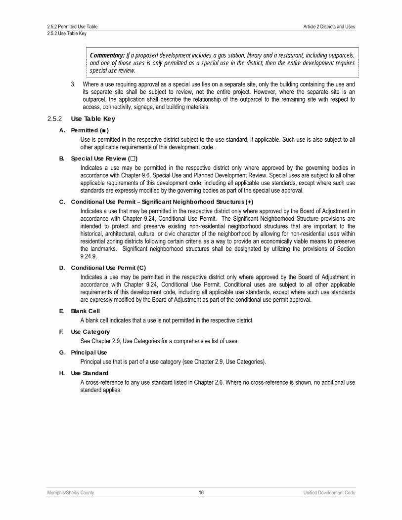
Commentary: If a proposed development includes a gas station, library and a restaurant, including outparcels, and one of those uses is only permitted as a special use in the district, then the entire development requires special use review.
3. Where a use requiring approval as a special use lies on a separate site, only the building containing the use and its separate site shall be subject to review, not the entire project. However, where the separate site is an outparcel, the application shall describe the relationship of the outparcel to the remaining site with respect to access, connectivity, signage, and building materials.
2.5.2 Use Table Key A. Permitted ( )
Use is permitted in the respective district subject to the use standard, if applicable. Such use is also subject to all other applicable requirements of this development code.
B. Special Use Review () Indicates a use may be permitted in the respective district only where approved by the governing bodies in accordance with Chapter 9.6, Special Use and Planned Development Review. Special uses are subject to all other applicable requirements of this development code, including all applicable use standards, except where such use standards are expressly modified by the governing bodies as part of the special use approval.
C. Conditional Use Permit – Significant Neighborhood Structures (+) Indicates a use that may be permitted in the respective district only where approved by the Board of Adjustment in accordance with Chapter 9.24, Conditional Use Permit. The Significant Neighborhood Structure provisions are intended to protect and preserve existing non-residential neighborhood structures that are important to the historical, architectural, cultural or civic character of the neighborhood by allowing for non-residential uses within residential zoning districts following certain criteria as a way to provide an economically viable means to preserve the landmarks. Significant neighborhood structures shall be designated by utilizing the provisions of Section 9.24.9.
D. Conditional Use Permit (C) Indicates a use may be permitted in the respective district only where approved by the Board of Adjustment in accordance with Chapter 9.24, Conditional Use Permit. Conditional uses are subject to all other applicable requirements of this development code, including all applicable use standards, except where such use standards are expressly modified by the Board of Adjustment as part of the conditional use permit approval.
E. Blank Cell A blank cell indicates that a use is not permitted in the respective district.
F. Use Category See Chapter 2.9, Use Categories for a comprehensive list of uses.
G. Principal Use Principal use that is part of a use category (see Chapter 2.9, Use Categories).
H. Use Standard A cross-reference to any use standard listed in Chapter 2.6. Where no cross-reference is shown, no additional use standard applies.

Article 2 Districts and Uses 2.5 Permitted Use Table 2.5.2 Use Table Key
Memphis/Shelby County 17 Unified Development Code
Key: Blank Cell = Not Permitted = Permitted = Special Use Approval C = Conditional Use Permit = Conditional Use Permit – Significant Neighborhood Structure
USE CATEGORY PRINCIPAL USE P OS
FW
CA
CIV
R-M
P
R-E
R-1
5
R-1
0
R-8
R-6
R-3
RU
-1
RU
-2
RU
-3
RU
-4
RU
-5
R-W
OG
CM
U-1
CM
U-2
CM
U-3
CBD
CM
P-1
CM
P-2
EMP
WD
IH Use
Standard RESIDENTIAL
Single-Family Detached Conventional Side Yard House 2.6.1A Cottage Single-Family Attached Semi-attached Two-Family Townhouse Multifamily Large Home Stacked Townhouse Apartment Upper-Story Residential Live-Work 2.6.1B Manufactured, Modular Home 2.6.1C Mobile Home C C 2.6.1D
Household Living (see 2.9.2A)
Manufactured Home Park 2.6.1E Boarding House, Rooming House, Single Room Occupancy
2.6.1F
Fraternity, Sorority, Dormitory 2.6.1F Monastery, Convent 2.6.1F Nursing Home, Full-time Convalescent, Hospice, Assisted Living Facility, Residential Home for the Elderly, Independent Living Facility
2.6.1F
Personal Care Home for the Elderly 2.6.1F
Group Living (see 2.9.2B)
Supportive Living Facility 2.6.1F CIVIC
Police, Fire, EMS Substation 2.6.2A Neighborhood Arts Center or Similar Community Facility (public)
Philanthropic Institution Museum, Library
Community Service (see2.9.3A)
All other City- or County-owned facilities not included in this Use Table
Adult day-care program Family Day Care Home (5 to 7 persons) 2.6.2B Group Day Care Home (8 to 12 persons) 2.6.2B Child Care Center (13+ persons) 2.6.2B Drop-in Child Care Center (15+ persons) 2.6.2B
Day Care (see 2.9.3B)
Nursery School, Preschool 2.6.2B Academy (special training) College, Community College, University
Education Facility (see 2.9.3C)
Seminary 2.6.2C School, Public or Private (K-12) 2.6.2C

2.5 Permitted Use Table Article 2 Districts and Uses 2.5.2 Use Table Key
Memphis/Shelby County 18 Unified Development Code
Key: Blank Cell = Not Permitted = Permitted = Special Use Approval C = Conditional Use Permit = Conditional Use Permit – Significant Neighborhood Structure
USE CATEGORY PRINCIPAL USE P OS
FW
CA
CIV
R-M
P
R-E
R-1
5
R-1
0
R-8
R-6
R-3
RU
-1
RU
-2
RU
-3
RU
-4
RU
-5
R-W
OG
CM
U-1
CM
U-2
CM
U-3
CBD
CM
P-1
CM
P-2
EMP
WD
IH Use
Standard School, Trade, Vocational, Business
Education Facility (see 2.9.3C)
Dormitory, housing for students or faculty accessory to educational facilities not classified as colleges, community colleges or universities
Blood Plasma Donation Center Medical or Dental Laboratory Pharmacy Hospital
Medical Facility (see 2.9.3D)
Medical, Dental or Chiropractic Clinic/Office, massage therapy, or outpatient surgery center
All parks and open areas, except as listed below:
Cemetery, Mausoleum, Columbarium, Memorial Park
2.6.2D
Game Preserve, Wildlife Management Area, Refuge, Animal Sanctuary
Recreation Field, without lights Recreation Field, with lights 2.6.2E
Park/Open Area (see 2.9.3E)
Reservoir, Control Structure, Water Supply, Water Well
Airport, Heliport, Airline Terminal 2.6.2F Bus, Train Passenger Terminal Taxicab Dispatch Station, Limousine Service
Passenger Terminal (see 2.9.3F)
Multimodal Facility All places of worship Place of Worship
(see 2.9.3G) Off-site parking for places of worship 2.6.2G
Social Service Institution (see 2.9.3H)
All social service institutions
All minor utilities All major utilities Amateur Radio Operator Tower (65 feet or less)
2.6.2H
Communication towers CMCS tower and facilities 2.6.2I Wind farm
Utilities (see 2.9.3I)
Solar farm 2.6.2J
COMMERCIAL
Funeral Services (see 2.9.4L)
Funeral establishment, funeral merchandise, funeral directing, crematorium and pet crematorium
2.6.3R
All indoor recreation, except as listed below: Adult-oriented establishment 2.6.3A
Indoor Recreation (see 2.9.4A)
Athletic, tennis, swim or health club

Article 2 Districts and Uses 2.5 Permitted Use Table 2.5.2 Use Table Key
Memphis/Shelby County 19 Unified Development Code
Key: Blank Cell = Not Permitted = Permitted = Special Use Approval C = Conditional Use Permit = Conditional Use Permit – Significant Neighborhood Structure
USE CATEGORY PRINCIPAL USE P OS
FW
CA
CIV
R-M
P
R-E
R-1
5
R-1
0
R-8
R-6
R-3
RU
-1
RU
-2
RU
-3
RU
-4
RU
-5
R-W
OG
CM
U-1
CM
U-2
CM
U-3
CBD
CM
P-1
CM
P-2
EMP
WD
IH Use
Standard Bar, Tavern, Cocktail Lounge, Nightclub 2.6.3B Convention Center Lodge, Membership Club
Indoor Recreation (see 2.9.4A)
Indoor Shooting Range All offices, except as listed below: Office
(see 2.9.4B) Radio, TV, or Recording Studio 2.6.3C Bed and Breakfast Hotel or Motel 2.6.3D
Overnight Lodging (see 2.9.4C)
Youth Hostel All outdoor recreation, except as listed below:
2.6.3E
Golf Course, Country Club, Clubhouse 2.6.3E Horse Stables, Riding Academy, Equestrian Center
2.6.3E
Outdoor Shooting Range 2.6.3E
Outdoor Recreation (see 2.9.4D)
Stadium or Arena, Commercial Amphitheater 2.6.3E Outdoor Advertising Sign (see 2.9.4E)
Permanent Off-Premise Advertising Sign (*Signs in CBD are only permitted outside of the CBID.)
Parking, Commercial (see 2.9.4F)
All commercial parking
All restaurants, except as listed below: 2.6.3F Restaurant with sale of alcoholic beverages, Brew Pub
2.6.3G Restaurant (see 2.9.4G)
Restaurant, Drive-in All retail sales and service, except as listed below:
Animal Hospital, Veterinary Clinic, Pet Clinic 2.6.3H Animal Boarding, Animal Shelter, Kennel, Doggy Day Care
2.6.3H
Art or photo studio, gallery 2.6.3I Bakery, retail Hair, nail, tanning, message therapy and personal care service, barber shop or beauty salon
Convenience store with gas pumps, Gas station, Commercial electric vehicle charge station
2.6.3J
Convenience store without gas pumps 2.6.3K Catering establishment, small-scale Cleaning establishment , pickup station 2.6.3L Farmers Market 2.6.3Q Greenhouse or Nursery, Commercial Payday loans and title loan establishments 2.6.3M
Retail Sales & Service (see 2.9.4H)
Post Office
2.5 Permitted Use Table Article 2 Districts and Uses 2.5.2 Use Table Key
Memphis/Shelby County 20 Unified Development Code
Key: Blank Cell = Not Permitted = Permitted = Special Use Approval C = Conditional Use Permit = Conditional Use Permit – Significant Neighborhood Structure
USE CATEGORY PRINCIPAL USE P OS
FW
CA
CIV
R-M
P
R-E
R-1
5
R-1
0
R-8
R-6
R-3
RU
-1
RU
-2
RU
-3
RU
-4
RU
-5
R-W
OG
CM
U-1
CM
U-2
CM
U-3
CBD
CM
P-1
CM
P-2
EMP
WD
IH Use
Standard Pawnshop Retail Sales Outdoor (vendor), Flea markets 2.6.3N Tattoo, Palmist, Psychic or Medium C Tractor-Trailer (fueling of)
Retail Sales & Service (see 2.9.4H)
Vehicle parts and accessories Mini-storage 2.6.3O Self-Service
Storage (see 2.9.4I) Indoor multi-story
2.6.3O
All Vehicle Service 2.6.3P All Vehicle Repair 2.6.3P All Vehicle Sales, Rental, Leasing, except as listed below:
2.6.3P
Tractor-Trailers and Heavy Trucks 2.6.3P
Vehicle Sales Service, & Repair (see 2.9.4J)
Manufactured housing 2.6.3P Water-Oriented (see 2.9.4K)
All water-oriented
INDUSTRIAL Wholesale Trade (see 2.9.5A)
All wholesale trade
All light industrial, except as listed below: Bulk mailing service Clothing, textile or apparel manufacturing Contractors storage 2.6.4A Detention center, jail, prison Lawn, tree or garden service 2.6.4A Light manufacturing or assembly of equipment, instruments, or goods
Lumberyard and wood products Microbrewery and microdistillery 2.6.4F Movie production facility Photo finishing laboratory Repair of scientific or professional instruments, electric motors
Research, Testing, and development Laboratory
Sheet metal shop Soft drink bottling Welding, machine, tool repair shop
Light Industrial (see 2.9.5B)
Woodworking, including cabinet makers and furniture manufacturing
Warehouse & Distribution (see 2.9.5C) All warehouse and distribution
All heavy industrial, except as listed below: Asbestos products
Heavy Industrial (see 2.9.5D)
Automobile dismantlers and recyclers

Article 2 Districts and Uses 2.5 Permitted Use Table 2.5.2 Use Table Key
Memphis/Shelby County 21 Unified Development Code
Key: Blank Cell = Not Permitted = Permitted = Special Use Approval C = Conditional Use Permit = Conditional Use Permit – Significant Neighborhood Structure
USE CATEGORY PRINCIPAL USE P OS
FW
CA
CIV
R-M
P
R-E
R-1
5
R-1
0
R-8
R-6
R-3
RU
-1
RU
-2
RU
-3
RU
-4
RU
-5
R-W
OG
CM
U-1
CM
U-2
CM
U-3
CBD
CM
P-1
CM
P-2
EMP
WD
IH Use
Standard Chemical, cosmetics, drug, soap, paints, fertilizers and abrasive products
Explosives Petroleum, liquefied petroleum gas and coal products includes refining
Radioactive materials/waste 2.6.4B Rubber and plastic products, rubber manufacturing
All waste related services, except as listed below:
Recycling Drop-off Facility Sanitary Landfill and Recycling Facility 2.6.4D Construction Debris Landfill 2.6.4D(2) Scrap Metal Processors and Wrecking, Junk or Salvage Yard
2.6.4E
Solid or Liquid Waste Transfer Station 2.6.4C
Waste-Related Services (see 2.9.5E)
Waste Incineration 2.6.4C OPEN
All agriculture, except as listed below: Neighborhood Garden 2.6.5E Crop, soil preparation, agricultural services, large animal and veterinary services
Farm labor and management services Sale of agriculture products, outdoor 2.6.5A Sale, rent, repair of tractors and related agricultural machinery
2.6.5B
Winery
Agriculture (see 2.9.6A)
Apiary 2.6.5F All resource extraction, except as listed below:
2.6.5B
Dredging, earth extraction, clearing or grading (silviculture)
2.6.5D Resource Extraction (see 2.9.6B)
Metal, sand stone, gravel clay, mining and other related processing
PLANNED Planned Development (see 9.6)
All planned developments 4.10

2.6 Use Standards Article 2 Districts and Uses 2.6.1 Residential Use Standards
Memphis/Shelby County 22 Unified Development Code
2.6 USE STANDARDS Unless indicated otherwise, when a regulation requires a proposed use or activity to be located a specified distance from an existing use, zoning district boundary, or activity, such distance or spacing requirement shall be calculated by direct, straight-line measurement from the nearest property line of the property upon which an existing use, zoning boundary, or activity is located to the nearest property line of the property whereon the proposed use or activity is to be located.
2.6.1 Residential Use Standards A. Side Yard House
1. Single Side Yard A single side yard shall be provided comprising the equivalent of two side yards of a conventional single-family detached house. This zero side setback may not be allowed on the side yard adjacent to residential district lots that are not part of the side yard house development. Each lot line with no side yard setback shall be indicated on the final plat.
2. Maintenance Easement An easement to allow for maintenance or repair of the house shall be required when the roof overhang or side wall of the house are proposed within four feet of the adjacent property line (no roof overhang shall be permitted to extend across the property line). The easement on the adjacent property shall provide at least five feet of unobstructed space. The easement shall be recorded on the subdivision plat.
3. Privacy Windows If the side wall of the house is on the property line, or within three feet of the property line, windows or other openings that allow for visibility into the side yard of the adjacent lot shall not be allowed. Windows that do not allow visibility into the side yard of the adjacent lot, such as a clerestory window or a translucent window, shall be allowed provided they comply with applicable building code requirements.
B. Live/Work A residential unit used as both living accommodation, which includes cooking space and sanitary facilities in conformance with applicable building standards; and adequate working space accessible from the living area, reserved for, and regularly used by, one or more persons who may reside in the unit. A live/work use may also occur when the residential unit is occupied separately from the work space. Permitted uses in a live/work unit shall be governed by Chapter 2.5, Use Table.

Article 2 Districts and Uses 2.6 Use Standards 2.6.1 Residential Use Standards
Memphis/Shelby County 23 Unified Development Code
1. All living space within the live/work unit needs to be contiguous with, and an integral part of, the working space, with direct and internal access between the two areas.
2. Each live/work unit shall have at least one primary entrance from common areas such as hallways, corridors, and/or exterior portions of the building, such as courtyards, breezeways, parking areas and public spaces.
3. A fully connected working space within a single live/work unit shall be considered accessory and shall not trigger occupancy separations within that unit.
4. Each unit shall include a kitchen and restroom facilities, consisting of a toilet, lavatory, shower and/or bathtub. Restroom facilities shall be provided to serve the commercial portion of the unit.
5. No equipment or process shall be used that creates excessive noise, vibration, glare, fumes, odors, or electrical interference.
6. A live/work unit shall be subject to all applicable licenses and business taxes. 7. Commercial signs shall be limited to one unlighted wall sign no larger than six square feet in area, attached to the
structure housing the live/work unit. 8. When located within a RU- district, live/work uses are subject to the following standards:
a. Work space within a live/work unit may be used as an office, studio, gallery, or for artisanal production involving the use of hand tools and small-scale, light mechanical equipment. No business, storage or warehousing of material, supplies or equipment shall be permitted outside of the unit.
b. Work space shall be on the first floor of a two story or greater building with residential space above the ground floor. Any work space above the ground floor may be permitted subject to the approval of a special exception by the Land Use Control Board. Residential kitchen and toiletry facilities may be permitted on the ground floor.
c. Live/work units shall be located within 200 feet of the right-of-way of a street intersection. If further than 200 feet from the intersection then the use is required to seek a special exception.
d. Maximum work space within a live/work unit shall be 4,000 square feet. e. Parking on the lot shall be located at the side or rear of a building and not between the building and the
street.
C. Manufactured, Modular Home A home constructed after June 15, 1976, and meeting or exceeding the manufactured home construction standards promulgated by the U.S. Department of Housing and Urban Development that were in effect at the time of construction. Additionally, manufactured or modular homes must meet all of the following requirements:
1. The home has a length not exceeding four times its width, with length measured along the longest axis and width measured at the narrowest part of the other axis.
2. The pitch of the roof of the home has a minimum vertical rise of three feet for each 12 feet of horizontal run and the roof is finished with a type of shingle that is commonly used in standard residential construction.
3. All roof structures provide an eave projection of no less than six inches, which may include a gutter. 4. The exterior siding consists predominantly of vinyl or aluminum horizontal siding (whose reflectivity does not
exceed that of gloss white paint), wood, or hardboard, comparable in composition, appearance and durability to the exterior siding commonly used in standard residential construction
5. The home is set up in accordance with the standards set by the state of Tennessee. The foundation area is screened by a continuous, permanent masonry foundation or masonry curtain wall in accordance with building code regulations, unbroken except for required ventilation and access, and installed under the perimeter of the home.
6. The moving hitch, wheels and axles, and transporting lights are removed. 7. The dimensional standards for a single-family detached conventional housing type apply to a manufactured or
modular house.
D. Mobile Home A mobile home constructed after June 15, 1976, and meeting or exceeding the construction standards promulgated by the U.S. Department of Housing and Urban Development that were in effect at the time of construction. A single mobile home may be allowed in the CA and R-MP districts as a conditional use in accordance with the following requirements:

2.6 Use Standards Article 2 Districts and Uses 2.6.2 Civic Use Standards
Memphis/Shelby County 24 Unified Development Code
1. The lot upon which the home is located is at least one acre, except for smaller lots of record established prior to the effective date of this development code.
2. A written statement from the Memphis and Shelby County Health Department approving the sewage disposal facilities for the home is required.
3. The conditional use permit may be granted for a maximum period of four years. 4. The home does not have a substantial or undue adverse effect upon adjacent property, the character of the area,
utility facilities and other matters affecting the public health, safety and general welfare. 5. The home meets the requirements of the state of Tennessee for installation and tie-downs. 6. The home is skirted with a durable material that encloses the area between the chassis and the ground. Durable
material includes but is not limited to vinyl or masonry. 7. The moving hitch, wheels and axles, and transporting lights are removed. 8. Any mobile home located in the Floodplain Overlay District is subject to the following additional requirements:
a. All homes must be anchored to resist floatation, collapse or lateral movement by providing over-the-top frame ties to ground anchors.
b. Over-the-top ties must be provided at each of the four corners of the home with two additional ties per side at intermediate locations on homes 50 feet or greater in length (a total of eight ties are required) and one additional tie per side on homes less than 50 feet in length (a total of six ties are required).
c. Frame ties must be provided at each of the four corners of the homes, with five additional ties per side at intermediate locations on homes 50 feet or greater in length (a total of 14 ties are required) and four additional ties per side on homes less than 50 feet in length (a total of 12 ties are required).
d. All components of the anchoring system must be capable of carrying a force of 4,800 pounds. e. Any additions to a home must be similarly anchored.
9. The dimensional standards for a single-family detached conventional housing type apply to mobile homes in the CA District.
E. Manufactured Home Park 1. Manufactured or modular homes located within manufactured home parks must meet the requirements of Sub-
Section C above. 2. Mobile homes located within manufactured home parks must meet the requirements of Sub-Section D above. 3. Manufactured home parks must meet the R-MP District standards as set forth in Section 3.6.3. 4. A site plan submitted and approved in accordance with the provisions of Chapter 9.12, Site Plan Review is
required prior to the issuance of any building permits for the development of a manufactured home park.
F. All Group Living 1. All group living facilities must meet all state licensing requirements. 2. A Class III buffer (see Section 4.6.5) shall be established along any side of the property adjacent to a residential
use. An alternative buffer may be approved through the site plan review process. 3. All parking, loading and unloading, and deliveries shall take place from the rear of the property or shall be
sufficiently screened from view as set forth in Sub-Section 4.6.5F.
2.6.2 Civic Use Standards A. Police, Fire, EMS Substation
A Class III buffer (see Section 4.6.5) shall be established along any side of the property adjacent to a residential use. An alternative buffer may be approved through the site plan review process.
B. All Day Care
1. General Provisions a. Day care facilities shall be required to meet the rules adopted and published pursuant the Tennessee
Department of Human Services. b. A Class III buffer (see Section 4.6.5) shall be established along any side of the property adjacent to a
residential use. An alternative buffer may be approved through the site plan review process.
Article 2 Districts and Uses 2.6 Use Standards 2.6.2 Civic Use Standards
Memphis/Shelby County 25 Unified Development Code
c. A facility that is located in a residential district shall maintain the residential character and scale of the area in which it is located.
d. Sufficient off-street passenger drop-off and passenger loading area shall be provided on-site, unless waived by the City or County Engineer (see Section 4.5.6 for stacking requirements associated with day care drop off).
e. The maximum number of children to be accommodated on site shall be specified. Children who are related to the child care provider by blood or marriage and are kept at the facility shall be counted for purposes of determining enrollment and facility compliance with these standards.
f. State and local health, education, and/or fire regulations may reduce but shall not increase the number of students permitted to be enrolled.
g. Enrollment shall mean the total number of children onsite at any one time. h. No playground equipment shall be permitted within the front building setback.
2. Group Day Care Home The property shall be located on a connector street, on an arterial, or on a minor street that serves only nonresidential uses or zoning districts, or on a minor street within 150 feet (measured from the property line) of an intersecting arterial.
3. Child Care Center a. The minimum site shall be 20,000 square feet in a residential district. b. The distance from the closest existing Child Care Center to a proposed Child Care Center shall not be
less than 1,320 feet when measured along the most direct roadway route between the two sites, if both sites are in a residential district.
c. The property shall be located: (a) on an arterial, (b) on a connector street, or (c) on a minor street within 200 feet (measured from the property line) of an intersecting arterial.
C. School, Public or Private, Seminary Public and private schools and seminaries are subject to the following standards.
1. Any lighted recreation field located on or off the campus and permitted by special use permit shall meet the requirements of Sub-section 2.6.2E below except along any frontages along a right-of-way, in which case a minimum Class II, Type C buffer (see Section 4.6.5) shall be established.
2. All parking lots associated with the school shall meet the requirements of Section 4.5.5.
3. The vehicular access for the school must be from the primary street.
4. Public and private schools shall be required to obtain a special use permit prior to 1) installing or constructing a principal or accessory use or structure on a platted residential lot that does not abut a connector or arterial, or 2) using a platted residential lot that does not abut a connector or arterial for any principal or accessory use.
5. Vehicular parking located between the principal school building and any primary street shall not exceed five percent of all designated vehicular parking, or eight parking spaces, whichever is greater.
6. In addition to the bicycle parking requirements of Sub-section 4.5.3C of this development code all schools shall provide secure bicycle parking at a ratio of 1:3 (bicycle to vehicle parking) within 200 feet of a functioning entrance to the principal building.
7. Lighted motor vehicle parking areas must meet the requirements of Chapter 4.7 Site Lighting, if applicable.
8. All stand-alone elementary, middle, junior high and high schools are exempt from the designated frontage requirements of Section 3.10.3 and are only required to meet the building envelope standards of Sub-Section 3.10.2B.

2.6 Use Standards Article 2 Districts and Uses 2.6.2 Civic Use Standards
Memphis/Shelby County 26 Unified Development Code
9. All elementary, middle and junior high schools shall be located on a connector or arterial, or on a local street if the drivable width of the local street adjacent to the school site is at least 40 feet wide.
10. All high schools shall be located on an arterial or connector.
11. A Class I buffer shall be required along any property lines abutting single-family residential lots.
12. Nonconforming schools. Schools constructed prior to August 1, 2011, are exempt from Paragraphs 5, 9 and 10 of this Sub-Section. Schools constructed prior to August 1, 2011, that do not meet the standards of Paragraphs 5, 9 and 10 and shall not be considered nonconformities in regards to those Paragraphs and may be modified, expanded and enlarged provided other sections of this Code are met.
D. Cemetery, Mausoleum 1. Special Use Permits for new cemeteries and the expansion of existing cemeteries within the City of Memphis
must be approved by the Board of County Commissioners and the City of Memphis. Special Use Permits for new cemeteries and the expansion of existing cemeteries in unincorporated Shelby County must be approved by the Board of County Commissioners and the legislative bodies of all municipalities within five miles of the cemetery.
2. New cemeteries shall be located on sites of at least ten acres. 3. A mausoleum which is not located in a cemetery shall be located on a site of at least two acres. 4. All structures located in a cemetery of six feet in height or over including, but not limited to mausoleums,
monuments and buildings, and all mausoleums not located in a cemetery and regardless of height shall be set back at least 100 feet from each lot line and public right-of-way.
5. All graves or burial lots shall be set back at least 30 feet from each lot line and public right-of-way. 6. A Class III buffer (see Section 4.6.5) shall be established along any side of the property adjacent to a residential
use. 7. A cemetery site shall not obstruct the development of any arterial or connector street proposed in the MPO Long
Range Transportation Plan. 8. Chapter 405 of the Private Acts of 1925 and Title 46, Chapter 1 of the Tennessee Code Annotated further
regulates the location, establishment and operation of cemeteries.
E. Recreation Field, with Lights Fields for recreation and athletics equipped with outdoor lighting shall be subject to the following standards:
1. A Class III buffer (see Section 4.6.5) shall be established along any side of the property within 400 feet of a single family residential use or single family residential district.
2. Field lighting must meet the requirements of Chapter 4.7, Outdoor Site Lighting.
F. Airport, Heliport, Airport Terminal Airports and heliports subject to the following additional standard that the application for a special permit shall be accompanied by the written recommendations of the Federal Aviation Administration.
G. All Places of Worship 1. The minimum site shall be 20,000 square feet in a residential district. All places of worship constructed prior to
January 1, 2011, are exempt from this provision. 2. Any lighted recreation field located on the campus and permitted by special use permit shall meet the
requirements of Sub-section 2.6.2.E above. 3. All parking shall be located on the same site as, or a contiguous site to, the site on which the place of worship is
located, or in a district that allows commercial parking as a principal use. A special use permit shall be required for all off-site parking for places of worship for parking not located on the same site as, or a contiguous site to, the site on which the place of worship is located, or in a district that allows commercial parking as a principal use (see Use Table, Section 2.5.2).
4. Parking is prohibited in the required front yard in residential zoning districts. 5. A Class II buffer shall be required along any property lines abutting single-family residential lots. 6. Places of worship are exempt from the designated frontage requirements of Section 3.10.3 and are only required
to meet the building envelope standards of Sub-Section 3.10.2B.

Article 2 Districts and Uses 2.6 Use Standards 2.6.2 Civic Use Standards
Memphis/Shelby County 27 Unified Development Code
H. Amateur Radio Operator Tower (65 feet or less) 1. The tower shall be located so that no part of the antenna or its elements shall encroach within the required side or
rear yard setbacks or within ten feet of any easement for overhead electric distribution or transmission lines. 2. The tower and any element of the tower including guy wires or anchors shall not be located within the front 40
percent of any area of the tract or lot abutting a public street or approved private drive. 3. The tower height shall be established as the tallest point of the supporting tower and shall not include antenna
mast or antenna elements affixed to the tower. 4. No more than one such tower shall be located on a tract or lot. 5. The request for a building permit shall be accompanied by a copy of a valid Amateur Radio Operators licensed
issued by the FCC for the location being requested. 6. A tower shall not be structurally installed in such a way that it could fall onto a neighbor’s property during normal
operations or if a disastrous windstorm comes along. Installation shall conform to all local building code and structural design requirements pertaining to wind loading and structural strength characteristics protecting against collapse of the tower.
7. Provisions must be made to keep children from climbing the tower. At a minimum an enclosure, including gates, shall be constructed around the property or the tower at least four feet above the underlying grounds to adequately restrict access to the base of the tower from small children.
8. The application for a building permit must be certified by a professional engineer stating that all local requirements have been met.
9. Any tower constructed prior to March 6, 1990, shall be permitted to remain. There shall not be any increase in height permitted.
10. There shall be administrative site plan review to provide landscape screening to reasonably screen the tower from adjacent residential properties as determined Planning Director.
I. CMCS and Communications (Radio, Television) Towers and Facilities
1. Communications (Radio, Television) Towers and Facilities Other than CMCS Towers a. Towers shall not be located in the approach or landing zones of an airport or heliport. b. The application for a special use permit shall be accompanied by the written recommendations of
appropriate state and federal agencies. c. Except when located in the CBD zoning district, radio and television towers over one hundred (100) feet
in height shall be setback, in addition to the distance required by the regulations of the district in which such towers are located, one foot for every three feet in height over one hundred (100) feet.
2. Special Use Review – All Tower Types
a. Application The application for a special use permit approval (see also Chapter 9.6) shall include the following:
1. A site plan drawn showing the property boundaries, tower, guy wire anchors (if any), existing structures, proposed transmission buildings and/or other accessory uses, access, parking, fences, a landscaping plan and existing abutting land uses around the site.
2. A study from a professional engineer which specifies the tower height and design including a cross-section of the structure, demonstrates the tower’s compliance with applicable structural standards, including a certification that the tower will withstand at a minimum sustained winds in accordance with the appropriate building code, and a description of the tower’s capacity, including the number and type of antennas which it can accommodate.
3. The applicant shall obtain written approval from Memphis Light, Gas & Water; Electric Distribution Engineering Division for construction of any tower located within a distance equal to the tower height plus the height of antenna elements from any transmission lines.
4. Written statements that the proposed tower will comply with regulations administered by the Federal Aviation Administration, Federal Communications Commission, and all applicable governmental bodies or that the tower is exempt from those regulations.
5. A letter of intent committing the tower owner and his or her successors to allow shared use of the tower if capacity exists based on existing and planned use, and if a future applicant agrees in writing

2.6 Use Standards Article 2 Districts and Uses 2.6.2 Civic Use Standards
Memphis/Shelby County 28 Unified Development Code
to pay any reasonable charge of shared use, the potential use is technically compatible and the future applicant is in good standing.
6. The minimum setback requirements of the zoning district shall apply to the equipment, structures, and other buildings which are auxiliary to functions of the tower. Exceptions to the minimum setback requirements may be permitted. The tower height shall not be used to calculate the minimum setback requirements. The district height restrictions do not apply to tower height and the height permitted for each new application shall be set on the basis of its own merits.
b. General Requirements The location, size and design of such facilities shall be such that minimal negative impacts result from the facility. Any application for a new tower shall not be approved nor shall any building permit for a new tower be issued unless the applicant certifies that the equipment planned for the proposed tower cannot be accommodated on an existing or approved tower or other structure due to one or more of the following reasons:
1. The planned equipment would exceed the structural capacity of existing and approved structures, considering existing and planned use of those structures, and those structures cannot be reinforced to accommodate planned or equivalent equipment at a reasonable cost.
2. The planned equipment would result in technical or physical interference with or from other existing or planned equipment and the interference cannot be prevented at a reasonable cost.
3. There are no appropriate existing or pending structures to accommodate the planned equipment, taking into account, among other factors, the applicant’s system requirements.
4. Other reasons that make it impractical to place equipment planned by the applicant on existing and approved structures.
c. Publicly-Owned Property Applications for towers and related facilities to be located on publicly owned and/or leased properties, including without limitations, public parks, the following criteria shall apply:
1. Approval of a Facility in a public park shall require a 2/3 majority by the governing bodies. The Facility will not unduly interfere with the functions or aesthetics of the city park or property.
2. A facility shall not be located on any public park less than ten acres in size. 3. Minimum distance between any facility and any playground shall be equal to one and a half times the
height of the tower. 4. The use of an existing tower or existing support structure is not technically, structurally, economically
or financially feasible. 5. Proposed CMCS facilities have adequate capacity to handle a minimum of three additional users. 6. All towers shall be a stealth application or consistent with the natural or built environment or the site.
Landscaping and screening may be required in addition to the minimum requirements of this development code.
7. Obstruction lighting and/or marking shall not be permitted in public parks or on public school properties. On other public properties, proposed lighting may be approved by the governing bodies as an element of the special use permit site plan and conditions.
8. Any facility which has ceased operations for a period of 180 continuous days shall be dismantled and removed from the site at the owner’s expense. Prior to the issuance of a building permit for such facility, adequate financial security not to exceed $20,000 shall be posted with the building official to assure the dismantling, removing and restoring of the public property/park upon which the facility will be located.
9. The planned equipment will not interfere with emergency communications including without limitation those of the Memphis Fire and Police Departments, the Shelby County Fire Department and/or the Shelby County Sheriff’s Department as substantiated through a RF (radio frequency) study. If interference occurs, proper remediation steps shall be taken at the owner’s expense.
d. Co-Location – CMCS Towers Only 1. Any proposed CMCS tower shall be structurally designed to accommodate at least three additional
CMCS sectorized antennas, if at least 100 feet in height, at least five additional CMCS sectorized

Article 2 Districts and Uses 2.6 Use Standards 2.6.2 Civic Use Standards
Memphis/Shelby County 29 Unified Development Code
antennas if at least 150 feet in height, at least six additional CMCS sectorized antennas if at least 170 feet in height. Colocated CMCS antennas shall be placed on a structure in such a manner as to avoid interference with or impairment of operations of existing antennas or other uses.
2. Nothing in these rules and regulations shall obligate the owner of an existing CMCS tower to colocate additional antennas on such tower or be construed to interfere with or limit the rights of parties to set rent or establish other terms and conditions of the shared use of a CMCS tower or facility.
e. Setbacks The minimum setback requirement for support structures including associated attachments shall correspond to the zoning district in which they are located, except that a minimum buffer equal to the height of the tower shall be maintained between any support structure (excepting sites incorporating stealth design) and a parcel with a single-family dwelling located in any single-family residential district. Exceptions to the minimum setback requirements may be permitted through Special Use Review, pursuant to Paragraph 2.6.2I(2)(a)(6). The tower height shall not be used to calculate the minimum setback requirements.
f. Accessory Facilities Accessory facilities may be permitted but may not include offices, long-term vehicle storage, other outdoor storage, or broadcast studios, except for emergency purposes or other uses that are not needed to send or receive transmissions.
g. Screening and Fencing 1. Existing on-site vegetation shall be preserved to the maximum extent practicable and shall be
supplemented as required by the Planning Director as necessary. Where the site abuts a residential district, the residential portion of an approved planned development, or public land or streets, a Class III buffer (see Section 4.6.5) shall be established along the side of the abutting property.
2. Security fencing shall be required around the base and guy anchors of any towers.
h. Lighting Towers shall not be artificially lighted unless:
1. Required by the Federal Aviation Administration or other governmental authority; 2. Circumstances make lighting appropriate for safety or other reasons unique to a specific application
that are set forth in that application, but in no case shall any lighting shine into adjacent residential structures.
i. Residential Districts Within residential districts, CMCS facilities, support structures and associated attachments shall be encouraged to locate on publicly owned and/or leased properties, public/private utility owned properties, or institutional uses.
3. Administrative Review in Non-Industrial Districts, Where Permitted
a. Application The application for administrative approval shall include the following:
1. A site plan drawn showing the property boundaries, tower, guy wire anchors (if any), existing structures, proposed transmission building and/or other accessory uses, access, parking, fences, a landscaping plan and existing abutting land uses around the site.
2. A study from a professional engineer which specifies the tower height and design including a cross-section of the structure, demonstrates the tower’s compliance with applicable structural standards, including a certification that the tower will withstand at a minimum sustained winds in accordance with the appropriate building code, and a description of the tower’s capacity, including the number and type of antennas which it can accommodate.
3. Written statements that the proposed tower will comply with regulations administered by the Federal Aviation Administration, Federal Communications Commission, and all applicable governmental bodies or that the tower is exempt from those regulations.

2.6 Use Standards Article 2 Districts and Uses 2.6.2 Civic Use Standards
Memphis/Shelby County 30 Unified Development Code
4. A letter of intent committing the tower owner and his or her successors to allow shared use of the tower if capacity exists based on existing and planned use, and if a future applicant agrees in writing to pay any reasonable charge of shared use, the potential use is technically compatible and the future applicant is in good standing.
b. Distance and Spacing 1. The edge of the tract or lot line the tower is locating on within the City limits of Memphis shall not
be closer than 500 feet from any property zoned R- or RU- or used for residential use including the residential portion of a planned development and residential uses within the CA District; 1,500 feet is applicable to sites within unincorporated Shelby County. Interstate highway right-of-way (which is zoned R-15) is exempt from this measurement. If the distance requirement cannot be met, a special use permit is required except for those cases locating in the EMP, WD and IH districts.
2. If a church, school, community center, or other institutional use falls within the 500 foot / 1,500 foot measurement area above, a special use permit shall be required.
3. All CMCS towers must be spaced a minimum distance of one-quarter mile as measured from property line to property line. In the EMP, WD and IH districts, the spacing shall be measured from the boundary of the leased area or property line, whichever is closer to the tower base.
4. Towers that do not meet the distance and spaced provisions of this Item shall be processed under the Special Use Review, per Sub-Section 2.6.2I(2).
c. Height The maximum tower height to be submitted for approval under an administrative approval is 200 feet from ground level. Any tower over 200 feet will require a special use permit.
d. Existing Structures Any application for a new tower shall not be approved nor shall any building permit for a new tower be issued unless the applicant certifies that the equipment planned for the proposed tower cannot be accommodated on an existing or approved tower or other structure due to one or more of the following reasons: 1. The planned equipment would exceed the capacity of existing and approved structures,
considering existing and planned use of those structures. 2. The planned equipment would result in technical or physical interference with or from other existing
or planned equipment. 3. There are no appropriate existing or pending structures to accommodate the planned equipment,
taking into account, among other factors, the applicant’s system requirements. 4. Other reasons that make it impractical to place equipment planned by the applicant on existing and
approved structures.
e. Co-Location – CMCS Towers Only 1. Any proposed tower shall be structurally designed to accommodate at least two CMCS sectorized
antenna arrays if 130 feet in height or greater. Co-located CMCS antennas shall be placed on a structure in such a manner as to avoid interference with or impairment of operations of existing antennas or other uses.
2. All CMCS towers within 1,000 feet of any property zoned R- or RU- or used for residential use or the residential portion of a planned unit development shall be of monopole design only. No lattice towers are permitted within this 1,000 foot area except by special use approval. Interstate highway right-of-way (which is zoned R-15) is exempt from the measurement criteria.
3. Nothing in these rules and regulations shall obligate the owner of an existing tower to colocate additional antennas on such tower or be construed to interfere with or limit the rights of parties to set rent or establish other terms and conditions of the shared use of a CMCS tower or facility.
f. Accessory Facilities Accessory facilities may be permitted but may not include offices, long-term vehicle storage, other outdoor storage, or broadcast studios, except for emergency purposes or other uses that are not needed to send or receive transmissions.

Article 2 Districts and Uses 2.6 Use Standards 2.6.2 Civic Use Standards
Memphis/Shelby County 31 Unified Development Code
g. Screening and Fencing 1. Existing on-site vegetation shall be preserved to the maximum extent practicable and shall be
supplemented as required by the Planning Director as necessary. Alternatives such as walls or fences may be permitted based on security or other reasons.
2. Security fencing shall be required around the base and guy anchors of any tower.
h. Lighting Towers shall not be artificially lighted unless: 1. Required by the Federal Aviation Administration or other governmental authority. 2. Circumstances make lighting appropriate for safety or other reasons unique to a specific
application that are set forth in that application, but in no case shall any lighting shine into adjacent residential areas.
i. Additional Review Authority 1. Applications for all towers, including towers proposed within the EMP, WD and IH districts shall be
subject to review by the Memphis-Shelby County Airport Authority within the area outlined by the-following boundaries: I-240, Lamar Avenue, Getwell Road, State Line Road and I-55. The Airport Authority shall have a l4-day period to provide comments. The application may be appealed to the Memphis City Council.
2. Within the CBD District, towers and facilities are subject to review and approval by the Design Review Board of the Downtown Memphis Commission. The action of the Design Review Board may be appealed to the Memphis City Council. The applicant may appeal directly to the City Council if the Design Review Board fails to act within six weeks.
3. Within the Central Business Improvement District (CBID) outside of CBD, applications for all towers including towers proposed within the EMP, WD and IH districts shall be subject to review by the Downtown Memphis Commission. The Downtown Memphis Commission shall have a 14-day period to provide comments. The application may be appealed to the Memphis City Council.
j. Setbacks The minimum setback requirements of the zoning district shall apply to the equipment, structures, and other buildings which are auxiliary to functions of the tower. Exceptions to the minimum setback requirements may be permitted. The tower height shall not be used to calculate the minimum setback requirements.
k. Appeals Should the Planning Director not support the approval of the tower or facilities during the administrative review, the applicant may file an appeal within ten days of receipt of the written decision at issue by giving a written request to the Planning Director requesting a public hearing before the governing bodies, subject to public notice to neighboring land owners within 500 feet if the site is located in the City of Memphis or 1,500 feet if located in unincorporated Shelby County.
l. Removal of Equipment Any tower and equipment shall be removed no later than 180 days after ceasing operations.
4. By Right Approval of CMCS Towers in Industrial Districts (EMP, WD, IH) a. CMCS towers are permitted by right in the EMP, WD and IH districts provided the towers do not extend
beyond 200 feet in height from ground level and the edge of the tract or lot line or leasable area shall not be closer than 500 feet from any property zoned R- or RU- or used for residential use, including the residential portion of a planned development, or residential uses within the CA District within the city limits of Memphis or 1,500 feet in unincorporated Shelby County.
b. If permitted by right, the minimum setback requirements of the zoning district shall apply to the equipment, structures, and other buildings which are auxiliary to functions of the CMCS tower. Exceptions to the minimum setback requirements may be permitted subject to the approval of the Building Official.
c. The tower height shall not be used to calculate the minimum building setback requirements. If closer than the 500 / 1,500 foot measurement criteria above, administrative review shall be required provided

2.6 Use Standards Article 2 Districts and Uses 2.6.2 Civic Use Standards
Memphis/Shelby County 32 Unified Development Code
the tower is no more than 200 feet in height. If higher than 200 feet, a special use permit shall be required.
d. Applications for all towers, including towers proposed within the EMP, WD and IH districts shall be subject to review by the Memphis-Shelby County Airport Authority within the area outlined by the-following boundaries: I-240, Lamar Avenue, Getwell Road, State Line Road and I-55. The Airport Authority shall have a l4-day period to provide comments. The application may be appealed to the Memphis City Council.
e. Within the Central Business Improvement District (CBID) outside of CBD, applications for all towers including towers proposed within the EMP, WD and IH districts shall be subject to review by the Downtown Memphis Commission. The Downtown Memphis Commission shall have a 14-day period to provide comments. The application may be appealed to the Memphis City Council.
J. Renewable Energy Systems (Wind / Solar) 1. Wind Energy Systems
a. General Provisions 1. Building mounted wind energy systems are permitted as accessory uses in all districts. Wind farms are
permitted as principal uses by right in IH and by special use approval in CA and EMP, pursuant to Chapter 2.5, Use Table.
2. The height of a wind energy system shall be measured from the base of the unit (grade if mounted on a tower, highest point of mounting if an appurtenance) to the uppermost vertical extension of any blade or other part of the system.
3. Wind energy systems shall be setback a minimum distance equal to 110% of the system’s total height from any property line, public right of way, or overhead utility line. All minimum setback requirements of the district in which the wind energy system is placed shall be adhered to.
4. Wind energy systems shall not be artificially lighted unless such lighting is required by the FAA or other governmental entity. If lighting is required the applicant shall provide a copy of the FAA determination to establish the required markings and / or lighting for the wind energy system.
5. All wind energy systems, including ancillary facilities, shall be of a matte (non-reflective), non-obtrusive finish that blends in with the surrounding environment.
6. The wind energy system and ancillary facilities shall be maintained in working condition and free of rust or other corrosion.
7. The lowest extension of any blade or other exposed moving component shall be at least fifteen (15) feet above the ground (at the highest point of the natural grade within thirty (30) feet of the base of the tower) and, in addition, at least fifteen (15) feet above any outdoor surfaces intended for human use, such as balconies or roof gardens, that are located directly below the wind energy system.
8. All ground mounted electrical or control equipment shall be secured to prevent unauthorized access. 9. Wind energy systems shall not interfere with communication systems such as, but not limited to, radio,
telephone, television, satellite, or emergency communications systems. 10. All signs other than the manufacturer’s, installer’s, or owner’s identification and appropriate warning and
safety signs are prohibited on the wind energy system. 11. All wind energy systems shall include (and the applicant shall provide proof of) an automatic braking,
governing or feathering system to prevent uncontrolled rotation, over speeding or excessive pressure on the wind energy structure, rotor blades, and other components.
12. No wind energy system shall be interconnected to the electrical grid without approval of MLGW. MLGW standards and regulations for interconnection shall apply. Off-grid systems (building mounted and small scale only) shall be exempt from MLGW standards and regulations so long as they are not connected to the utility grid.
13. Met towers shall be permitted under the same standards as a small wind energy system.
b. Building Mounted Wind Energy Systems 1. The setback of any building mounted wind energy system shall be a minimum of fifteen (15) feet from
the property line, public right-of way, public easement, or overhead utility lines as measured from the furthest outward extension of all moving parts.

Article 2 Districts and Uses 2.6 Use Standards 2.6.2 Civic Use Standards
Memphis/Shelby County 33 Unified Development Code
2. Noise emanating from the operation of a building mounted wind energy system(s) shall not exceed, at any time, the lowest ambient noise level that is present between the hours of 9:00 p.m. and 9:00 a.m. at any property line of a residential use parcel or from the property line of parks, schools, hospitals or churches. Noise emanating from the operation of a building mounted wind energy system shall not exceed, at any time, 5 dB over the lowest ambient noise level that is present between the hours of 9:00 p.m. and 9:00 a.m. at any property line of a non-residential use parcel.
3. Guy-wires shall not be permitted. 4. Building mounted wind energy systems shall not exceed 15 feet in height as measured from the highest
point of the roof of the building excluding chimneys, antennae, and similar appurtenances.
c. Wind Farms 1. Large wind energy systems are permitted as principal uses by right in the IH districts and by special use
approval and only in CA and EMP districts. 2. Large wind energy systems must be of monopole design, without guy wires. 3. Total height of each individual unit shall not exceed 500 feet. 4. Towers shall be set back a minimum of 110% the tower height from a participating property line.
Towers shall be set back a minimum of 1000 feet from non-participating property lines. Towers shall be setback 150% the tower height or 500 feet, whichever is greater, from any public right of way or overhead utility line.
5. A wind tower shall be separated from every other wind tower by a sufficient distance so as to not interfere with the other wind tower, particularly in the event of a tower or portion thereof falling. There is no limit to the number of individual units that may be situated in a large scale wind farm so long as all setback requirements and other stated limitations are adhered to
6. The vertical distance from ground level to the tip of a wind turbine blade when the blade is at its lowest point shall be at least 75 feet.
7. The noise generated by the operation of a large wind energy system shall not exceed 55 dB as measured at any point on non-participating property adjacent to the parcel on which the large wind energy system is located.
8. Large wind systems shall be subject to any additional standards as set by MLGW for interconnection purposes.
2. Solar Energy Systems a. General Provisions
1. Solar energy systems are permitted as an accessory use in all zoning districts, except for solar farms which are permitted as principal uses according to Chapter 2.5, Use Table.
2. Panels 4 square feet or less are exempt from these regulations. 3. All ground mounted electrical or control equipment shall be secured to prevent unauthorized access. 4. Equipment that is not functional or has not been used for a period of one (1) year must be removed. 5. Trees in the right-of-way may not be removed or damaged for increased access to sun. 6. Power grid interconnection shall be in accordance with MLGW standards and regulations.
b. Freestanding Solar Energy Systems 1. Free standing arrays are permitted in rear and side yards only. 2. Panel arrays must be setback either the minimum district setback or 110% the height of the panel array,
whichever is greater, as measured from grade to highest point on the array. 3. Arrays may not exceed the height of the principal structure or 35 feet, whichever is less. 4. Electrical lines from the panel array must be in conduit and placed below ground. 5. Panels must be appropriately screened from neighboring properties and public rights-of-ways.
c. Building Mounted Solar Energy Systems 1. On single-family residential structures, panel arrays shall not extend more than 12 inches above the
peak of any roof that is viewed from the street nor shall they extend more than 12 inches beyond any edge of the roof.

2.6 Use Standards Article 2 Districts and Uses 2.6.3 Commercial Use Standards
Memphis/Shelby County 34 Unified Development Code
2. Where the panels are placed atop a flat roof they shall not extend more than five feet above the roof and shall be appropriately screened from the public right of way via the building’s façade or similar mechanism.
3. Where panels are incorporated into or attached to the walls of a building they shall be appropriately glazed so as to prevent glare.
d. Solar Farms 1. Panel arrays shall meet all setback requirements of the respective district in which they are located. In
no instance shall an array be setback less than 110% of the height of the array. 2. Solar farms shall adhere to interconnection standards established by MLGW.
2.6.3 Commercial Use Standards A. Adult-Oriented Establishment
The governing bodies find that adult oriented establishments have a negative secondary effect on both the commercial and residential properties, resulting in blight and the downgrading of property values, increased criminal activity, and an adverse health impact. The following standards shall apply to all adult oriented establishments.
1. It shall be a violation of this development code for a person, corporation, or other legal entity to operate or cause to be operated any adult oriented establishment within one thousand five hundred (1,500) feet of:
a. A duly organized and recognized place of worship; b. A public or private elementary, middle, junior high or high school; c. A public or private day care facility or kindergarten; d. A boundary of a residential zoning district or historic overlay district; e. Any residential use; f. A family recreation center; g. A day care center; h. A park; or i. Any other adult oriented establishment.
2. For the purpose of this section, measurement shall be made in a straight line, without regard to intervening structures or objects, from the nearest property line of the premise where the adult oriented establishment is located, to the nearest property line of the premises of a place of worship, public or private elementary, middle, junior high or high school, public or private day care facility or kindergarten, residential use, family recreation center, day care center, park and any other adult oriented establishment, or to the nearest boundary of a residential zoning district or historic overlay district.
3. Adult-oriented establishments shall not be permitted on any site with a designated frontage. See Section 3.10.3.
B. Bar, Tavern, Cocktail Lounge, Nightclub 1. If located within the city limits of the City of Memphis then any bar, tavern, cocktail lounge or nightclub shall meet
all requirements of Title 7, Alcoholic Beverages, of the City of Memphis Code of Ordinances. 2. If located within unincorporated Shelby County then any bar, tavern, cocktail lounge or nightclub shall be
regulated in accordance with the requirements of Title 57 of the Tennessee Code Annotated. The use shall be located at least 500 feet from any single family residential district as measured from property line of the bar, tavern, cocktail lounge, or nightclub to the nearest boundary line of the single family residential district.
C. Radio, TV, or Recording Studio Radio and television transmission towers subject to the following additional standards:
1. Radio and television towers shall not be located in the approach or landing zones of an airport or heliport. 2. The application for a special use permit shall be accompanied by the written recommendations of appropriate
state and federal agencies. 3. Except when located in the CBD District, radio and television towers over 100 feet in height shall be set back, in
addition to the distance required by the regulations of the district in which such towers are located, one foot for every three feet in height over 100 feet. (See Sub-Section 2.6.2I)

Article 2 Districts and Uses 2.6 Use Standards 2.6.3 Commercial Use Standards
Memphis/Shelby County 35 Unified Development Code
D. Hotel and Motel All hotels and motels are required to meet the following standards:
1. Any change in the controlling interest of a hotel or motel, or the real property associated with such use shall require the approval of a new special use permit (see Chapter 9.6).
2. The owner or manager of any hotel or motel shall notify the Planning Director in writing of any change in name of the hotel or motel, not resulting in a change of ownership and shall apply for a new certificate of occupancy permit that reflects this change.
3. No fencing or screening is permitted which visually blocks the front building entrance from view from the public right-of-way.
4. The governing bodies find that hourly rate motels/hotels have a deleterious effect on both the commercial and residential segments of a neighborhood, are repeatedly associated with prostitution, causing blight and the downgrading of property values. Hourly rate hotels and motels are not permitted in any zoning district. No hotel or motel may provide rooms for rent or lease more than twice in any ten hour period. Three or more violations of this provision in a 24 month period shall be grounds for revocation of the certificate of occupancy permit.
E. Outdoor Recreation Outdoor recreational uses equipped with outdoor lighting shall be subject to the following standards:
1. Class III buffer (see Section 4.6.5) shall be established along any side of the property within 400 feet of a residential use as measured from property line of the recreation field to the nearest boundary line of a residential use.
2. Field lighting must the requirements of Chapter 4.7, Outdoor Site Lighting.
F. Restaurant Restaurants located in the OG District are subject to the following additional standards:
1. Must be within or attached to a building containing another non-restaurant. 2. The floor area of the restaurant cannot exceed 6,000 square feet. 3. Drive-thru pick-up windows are not permitted. 4. The design and materials of the building and signage must be compatible with the associated office building. 5. Must be 150 feet from a single-family residential district measured from the property line of the restaurant to the
nearest boundary line of the single-family residential district.
G. Restaurants with Sale of Alcoholic Beverages, Brew Pub 1. In the OG district, all the requirements of Sub-Section F apply. 2. If located within the city limits of the City of Memphis then any restaurant with sale of alcoholic beverages or brew
pub shall meet all requirements of Title 7, Alcoholic Beverages, of the City of Memphis Code of Ordinances. 3. If located within unincorporated Shelby County then any restaurant with sale of alcoholic beverages or brew pub
shall be regulated in accordance with the requirements of Title 57 of the Tennessee Code Annotated.
H. Animal Hospital, Veterinary Clinic, Pet Clinic, Animal Boarding, Animal Shelter, Kennel 1. In the CA, EMP, WD, IH districts, outdoor runs are permitted. 2. In all other districts, outdoor runs are not permitted. All overnight care of animals must occur indoors. All pens,
kennels and runs must be located within an enclosed building.
I. Art or Photo Studio or Gallery The following standards apply to art or photo studios or galleries permitted by special use permit in a RU-district.
1. Part of the contiguous use shall be within 100 feet of the right-of-way of a street intersection. 2. The use shall be located on the first floor of a two story or greater building. 3. Preference shall be given to existing buildings. 4. Maximum floor area of each individual user may not exceed 4,000 square feet. 5. Parking on the lot shall be located at the side or rear of a building and not between the building and the street.
J. Convenience Store with Gas Pumps, Gas Station, Commercial Electric Vehicle Charge Station
1. General Standards
2.6 Use Standards Article 2 Districts and Uses 2.6.3 Commercial Use Standards
Memphis/Shelby County 36 Unified Development Code
a. The primary building, including the fuel canopy, shall conform to all building envelope standards. b. Gasoline pumps, tanks, vents, EV chargers and pump islands shall be located no closer than 20 feet to any
side or rear property line or right-of-way. c. No sign of any type or any gasoline pump, tank, or EV charger shall be located within 20 feet of any
residential district. Furthermore, no gasoline pump, tank or tank vent pipe located at gasoline stations constructed on or after August 21, 2012, or at those gasoline stations that have been vacant for more than 365 days, shall be located within 125 feet of any single-family residential district.
d. A Class III buffer (see Section 4.6.5) shall be established along any side of the property adjacent to a residential use, provided such barrier or screen shall not restrict clear sight at any intersection or driveway.
e. Freestanding vents shall not be permitted. f. Any convenience store with gas pumps or gas stations constructed after January 28, 2013, or reactivated
after one year of discontinuance, shall be located at the intersection of two arterials, an arterial and a collector or two collectors, according to the Long Range Transportation Plan.
2. Fuel Canopies a. The canopy shall be located no closer than 15 feet to any side or rear property line or right-of-way. b. The canopy shall not exceed a height of 20 feet. c. The canopy shall be integrated architecturally with the design of the principal building and shall be
complementary to the overall color scheme of the building façade from which it projects. d. Canopy lighting shall not extend beyond the area beneath the canopy and all fixtures shall be recessed,
including any fixture or lens.
3. Single-Bay Automatic Car Wash An accessory single-bay automatic (not self-service) car wash completely enclosed except for openings necessary to allow entry and exit of vehicles shall be permitted subject to the following:
a. The car wash structure shall be located no closer than 50 feet on any side or property line adjacent to a residential district.
b. The car wash structure shall meet all applicable building envelope standards and shall not exceed a height of 20 feet or exceed an overall building dimension of 25 feet in width and 50 feet in length.
c. The car wash structure shall be constructed of building materials consistent with that of the principal building, including the roof.
d. The doors of the car wash building shall be architecturally compatible with the car wash building and shall be fully closed when the facility is not in operation.
e. The car wash structure shall be sited so as to discourage direct street view of the facility. Direct street access is permissible only when appropriate landscaped areas such as, but not limited to, planter islands or other landscaped features are used to screen from street view.
f. When located within 300 feet of a residential district, the car wash facility shall not operate before 6 AM or after 10 PM.
K. Convenience Store without Gas Pumps The following standards apply to convenience stores without gas pumps permitted by special use permit in a RU- district.
1. Part of the contiguous use shall be within 100 feet of the right-of-way of a street intersection. 2. The use shall be located on the first floor of a two story or greater building. 3. Preference shall be given to existing buildings. 4. Maximum floor area of each individual user may not exceed 4,000 square feet. 5. Parking on the lot shall be located at the side or rear of a building and not between the building and the street.
L. Cleaning Pick-up Station The following standards apply to cleaning pick-up stations permitted by special use permit in a RU-district.
1. Part of the contiguous use shall be within 100 feet of the right-of-way of a street intersection. 2. The use shall be located on the first floor of a two story or greater building. 3. Preference shall be given to existing buildings.

Article 2 Districts and Uses 2.6 Use Standards 2.6.3 Commercial Use Standards
Memphis/Shelby County 37 Unified Development Code
4. Maximum floor area of each individual user may not exceed 4,000 square feet. 5. Parking on the lot shall be located at the side or rear of a building and not between the building and the street.
M. Payday Loans, Title Loan Establishments 1. It shall be a violation of this development code for a person, corporation, or other legal entity to operate or cause
to be operated any payday loan or title loan establishment within 1,000 feet of any other establishment offering payday loans or title loans.
2. It shall be a violation of this development code for a person, corporation or other legal entity to operate or cause to be operated any payday loan or title loan establishment within 1,320 feet from the boundary of a residential district or historic overlay district.
3. Measurement shall be made in a straight line, without regard to intervening structures or objects, from the nearest property line of the premise where the payday loan or title loan establishment is located, to the nearest property line of the premises of any other payday loan or title loan establishment or any residential district or historic overlay district.
N. Retail Sales and Service Outdoor (Vendor) 1. An outdoor retail sales, service or vending facility shall be deemed stationary if it remains or operates on any
single tract or lot for more than a total of one-half hour in any 24 hour period. A special use permit may be granted for individual or multiple vending facilities. This Sub-Section shall not apply to mobile food preparation vehicles that adhere to the provisions of Memphis Code of Ordinances Section 16-261, et. seq., or the Shelby County Code of Ordinances Chapter 8, Article XVI.
2. No person shall place or operate or allow the placement or operation of any stationary retail sales, service or vending facility which serves the general public outdoors or on any privately owned site except in compliance with a special use permit.
3. Vending facilities as regulated under this section shall not be permitted to locate on vacant site. Each vending facility shall be located on the same site as, and shall share support facilities, including parking, sanitary and trash disposal facilities, with an on-premise host. As a condition of approval of a special use permit for a vending facility, the operator of such facility shall provide an agreement signed by the owner of the site, or the owner or operator of the on-premise use, if different from the property owner, to provide the support facilities required by this section.
4. The following standards shall be applied in granting a special use permit for an outdoor retail vending facility: a. Distance from Public Right-of-Way. No outdoor retail vending facility shall be located less than 30 feet from
any public right-of-way that does not allow on-street parking. b. Distance from Interstate Ramps. No outdoor retail or vending facility shall be located less than 100 feet from
an expressway, freeway or interstate highway on or off ramp. c. Distance from Intersections. No outdoor retail or vending facilities shall locate less than 30 feet from any
public street intersection. d. Distance from Residences. No outdoor retail or vending facilities shall locate less than 100 feet from a
residential district. e. Parking. Vending facilities shall not be located in or obstruct parking spaces, required by this article for the
operation of any other concurrent use. Vending facility shall provide a minimum of three parking spaces or the greater of the number of spaces required for parking at a ratio of one space for every 300 square feet of space occupied by outdoor retail display and vending areas.
f. Advertising Devices. Advertising used in conjunction with any outdoor retail vending facility shall be limited to one attached sign affixed to the exterior of the vending facility and shall be limited to a maximum of 35 square feet and ten feet in height. No advertising device shall be permitted to omit or broadcast any sound, noise or outcry.
g. Conditions. The vendor shall maintain the area around the vending facility in a clean and orderly fashion. Each outdoor retail vending facility shall display in a manner legible and visible to its clientele, the name and phone number of the vendor operating the facility, the special use permit and the certificate of occupancy certificate issued to the vendor.
2.6 Use Standards Article 2 Districts and Uses 2.6.3 Commercial Use Standards
Memphis/Shelby County 38 Unified Development Code
O. Self-Storage Facility
1. General a. No electrical power supply shall be accessible to the renter/lessee of the storage unit with the exception of
lighting fixtures and climate controls. b. The following activities shall be prohibited on the premises:
1. Commercial, wholesale or retail sales, flea markets or peddling, or miscellaneous or garage sales. However, once a month, the management of the self-storage mini-warehouse complex may conduct a one-day auction or sale of abandoned or stored materials to settle unpaid storage bills in accordance with State of Tennessee regulations.
2. Servicing, repair, or fabrication of motor vehicles, boats, trailers, lawn mowers, appliances, or other similar equipment.
3. Operation of a transfer-and-storage business. 4. Operation of power tools, spray painting equipment, table saws, lathes, compressors, welding
equipment, kilns, or other similar equipment except when needed for maintenance of the use. 5. Any activity that is noxious or offensive because of odors, dust, noise, fumes, or vibrations. 6. Storage of hazardous chemicals, flammable liquids, or combustible and explosive materials. 7. Habitation of storage units by humans or animals.
2. Mini-storage a. All storage shall be contained within a fully-enclosed building. However, the storage of boats, RV’s or other
similar vehicles may be permitted in accordance with Chapter 4.8, Outdoor Storage and Display. b. A Class III buffer (see Section 4.6.5) shall be established along any side of the property adjacent to a
residential use. c. Where the end wall of the self-storage facility is visible from a public right-of-way, the wall shall be buffered
by a hedge that has a mature height of at least four feet.
3. Indoor Multi-story All self-service storage on the property shall be in a minimum two-story, single-enclosed building. All storage units shall be accessed internally. External doors to individual units shall not be permitted. One consolidated loading area is permitted to the rear or side of the building. All storage of boats, RV’s or other similar vehicles shall be in the single-enclosed building.
P. Vehicle Sales, Service, and Repair
1. General Provisions a. A Class III buffer (see Section 4.6.5) shall be established along any side yard and rear yard of the property
adjacent to a residential use, provided such barrier or screen shall not restrict clear sight at any intersection or driveway.
b. The outdoor overnight storage of vehicles may be permitted in accordance with Chapter 4.8, Outdoor Storage and Display. Operable vehicles may be parked on-site during business hours. All vehicle parking shall be accomplished on the site, and in no case shall a parked vehicle encroach into the right-of-way.
c. There shall be no dismantling of vehicles for salvage. d. The storage of impounded vehicles shall not be permitted. e. All outdoor lighting shall be directed downward to the extent possible and shall not glare onto residential
property. Outdoor lighting must meet the requirements of Chapter 4.7, Outdoor Site Lighting. f. The maximum foot-candle for outdoor lighting shall be 60. g. Road testing of vehicles may be restricted to non-residential areas. h. New car display shall not be artificially elevated above the general topography of the site. i. No banners, flags, steamers, balloons or similar advertising devices, temporary or portable signs, reader
board signs, roof-mounted signs or tents shall be permitted. j. When located within 300 feet of a residential district, no outside speaker system shall be permitted and
automobile service doors shall be closed except for entry and exit of automobiles.

Article 2 Districts and Uses 2.6 Use Standards 2.6.3 Commercial Use Standards
Memphis/Shelby County 39 Unified Development Code
k. If the automobile dealership ceases to operate, all attached and detached signs depicting the dealership shall be removed from the property.
2. CMU-1, CBD, Designated Frontage a. The sales and leasing of motor vehicles shall be conducted within a fully-enclosed building. The outdoor
display and storage of vehicles for sale or rental shall not be permitted. b. All repair or service operations shall be conducted entirely within a fully-enclosed building. The term fully-
enclosed building shall not be construed to limit open bay doors during hours of operation. Service and repair activity may be conducted outside to the rear the building provided activity shall be fully screened from view from adjacent property and public right-of-way.
c. A maximum of two service bay doors no more than 24 feet in width each shall be permitted. No more than one bay door shall be permitted on each side of the building.
Q. Farmers Market
1. Due to the positive community relationships that are attributable to neighborhood-based farmers markets as evidenced in Memphis, Shelby County and throughout the nation, and due to the general decline in civic involvement that has occurred specifically in Memphis and Shelby County over the course of time, farmers markets shall be permitted by right in certain zoning districts as delineated in the Use Table, Section 2.5.2, if operated by a neighborhood-based, not-for-profit, entity such as a civic organization, neighborhood or homeowners association, Community Development Corporation or similar organization as determined by the Director of Planning. Any farmers market that does not adhere to the provisions of this Sub-Section shall require a Special Use Permit.
2. A minimum of 50 percent of the sales area of a farmers market shall be devoted to the sale of fruit and vegetables.
3. The hours of operation of a farmers market located in a Residential Urban Zoning District within 100 feet of a single-family residential use, as measured from property line to property line, shall be limited to 9AM to 6PM. The hours of operation of all other farmers markets shall be limited to 7AM to 8PM. One-hour preparation and dismantling periods for all farmers markets are permitted before and after the permissible hours of operation. Additional hours of operation may be granted with the issuance of a Special Use Permit.
4. A site plan shall be submitted and processed through the Administrative Site Plan Review procedures as set out in Chapter 9.12. The site plan shall indicate the location of the following items:
a. On-site parking, at a ratio of 1 space for every 1,000 square feet of floor area devoted to retail sales. Storage areas are not calculated for this requirement.
b. Lighting: Lighted motor vehicle parking areas must meet the requirements of Chapter 4.7 Outdoor Site Lighting.
c. Location of storage areas (building materials). d. Location of restrooms and trash receptacles. If operated on a temporary basis (no more than 2 days per
week), portable restrooms may be considered to meet this requirement. e. Fencing and landscaping, including the identification of the materials used, may be required at the discretion
of the Planning Director.
5. In zoning districts in which they are permitted by right, farmers markets may be operated in the required parking area of other uses with the issuance of a Temporary Use Permit (see Section 2.8.3). The Building Official may reject the temporary use permit if he or she finds that parking is not adequate for the permanent principal use or uses on the site; in which case, the applicant may file for a special use permit.
R. Funeral Establishments, Funeral Merchandise, and Funeral Directing 1. All standards and requirements of Memphis City Code §6-84 and TCA §62-5 shall apply. 2. Establishments engaged solely in the practices of funeral directing or selling funeral merchandise, as defined in
Section 12.3.1 of this Code, may be permitted in CMU-1 districts by Special Use. No other funeral establishments, as defined herein, shall be permitted within CMU-1 districts.
3. No permits of any kind shall be issued in connection with the construction, repair, or remodeling of any funeral establishment prior to the approval of such plans by the health department.
4. All wash basins shall have hot and cold running water.

2.6 Use Standards Article 2 Districts and Uses 2.6.4 Industrial Use Standards
Memphis/Shelby County 40 Unified Development Code
5. All floors in the workrooms of a funeral establishment shall be equipped with floor drains and be constructed of impervious materials.
6. No Certificate of Occupancy shall be issued prior to the issuance of a valid permit by the health officer pursuant to Memphis City Code §6-84-2.
2.6.4 Industrial Use Standards A. Contractors Storage, Lawn, Tree or Garden Service
The outdoor storage of material and equipment may be permitted in certain districts subject to the requirements of Chapter 4.8.
B. Radioactive Materials/Waste
1. A Class III buffer (see Section 4.6.5), or equivalent alternative shall be established along any side yard and rear yard of the property.
2. It shall be a violation of this development code for a person, corporation, or other legal entity to operate or cause to be operated any radioactive materials/waste facility within one thousand five hundred (1,500) feet of:
a. A public or private elementary, middle, junior high or high school; b. A public or private day care facility or kindergarten; c. A boundary of a residential or historic overlay district; or d. A public park.
3. For the purpose of this section, measurement shall be made in a straight line, without regard to intervening structures or objects, from the nearest property line of the premise where the radioactive materials/waste facility is located, to the nearest property line of the premises of a public or private elementary, middle, junior high or high school, public or private day care facility or kindergarten, or to the nearest boundary of a residential district or historic overlay district, or a public park.
C. Waste-Related Services This Sub-Section only applies to those uses that require special use permits. Based upon the hazardous nature of material or substances to be treated, disposed, stored or recycled on the site, the Land Use Control Board and governing bodies shall consider and may condition or delete particular material and substances based upon:
1. The site’s location to public or quasi-public facilities where considerable public assembly is anticipated including, but not limited to, schools, hospitals, parks and institutions;
2. The site’s location to existing or expected employment intensities; 3. The site’s location zoned and/or developed residential properties, and existing or proposed population densities; 4. The site’s location to arterials and routing of truck traffic and its proximity to other modes of transportation. 5. The adequacy of sewage treatment facilities to accommodate waste matter; and 6. The site’s location to any floodway and/or floodplain, and the potential contamination of surface or subsurface
ground water.
D. Landfill
1. Application The application for a special use permit approval (see also Chapter 9.6) shall show the following:
a. Contours of not less than two foot intervals (except on extremely steep slopes). b. The existing surface of the site and the surrounding properties within 50 feet from its boundaries. c. The ultimate depth elevations of the area to be excavated or filled. d. The ultimate finished surface of the site after all excavation and filling operations are completed. e. Cross sections at critical points to illustrate the methods to be employed in the process of excavation
and fill. f. Locations where excavation and filling operations will commence and the procedural sequence of
operations. g. Methods to be employed for surface drainage during and after completion of operations. h. The volumes of materials to be excavated and filled on the site where operations are to take place and
expected duration of landfill operations.

Article 2 Districts and Uses 2.6 Use Standards 2.6.4 Industrial Use Standards
Memphis/Shelby County 41 Unified Development Code
i. Improvements such as new roads and pavements to be installed on and off the site to enable the operation to be carried out.
j. A statement setting forth the type, location and conditions of such landfill operations including a hydro-geologic evaluation shall be submitted for review. The governing bodies shall require a written assessment of specific environmental issues regarding the proposed landfill operation.
2. General Provisions a. Landfill excavation or filling shall not be located within the approach zones of any airport. b. Landfill excavation or filling shall not be located within a minimum of 500 feet of any building used for
residential purposes. It is further provided that such distance restrictions shall also not apply to residential buildings for which construction was begun after the submission to the Tennessee Department of Environment and Conservation of a written request by the applicant for preliminary hydro geologic evaluation of the landfill site. No fill shall be located within the 100 year floodplain and no excavation except as expressly authorized by the appropriate legislative bodies shall be located within the 100 year floodplain.
c. No excavation or filling shall be made within 100 feet of any boundary of the site or within 100 feet of any street right-of-way.
d. The finished grade of side slopes of excavation and fills shall not exceed one foot vertical to two feet horizontal and shall be blended into undisturbed existing surfaces.
e. A landscape screen including a chain link, woven wire or similar secure fence shall be installed and maintained around the perimeter of the site. Gates of the same construction as the fence shall be provided, and shall remain locked at all times when active operations are not taking place and shall be properly maintained until all operations are completed.
f. Provisions shall be made for the proper drainage of stormwater falling on or crossing the site at all times during and after completion of the operations. The operations shall not obstruct the normal flow of any public drain, or abrogate the riparian rights of any other party to a stream or drain.
g. The depth of excavation and the materials to be used for fill shall not have any adverse effect on the supply, quality or purity of ground water or wells.
h. A layer of clean earth at least two feet thick shall be deposited and thoroughly compacted over all final fill to bring the surface to the finished surface grade as shown on the topographic plan filed with the application. The final fill and finished grade shall be stabilized, seeded and sodded or appropriately planted after completion and closure of each stage of landfill operations.
i. The installation of roads, parking areas, buildings, structures and operational facilities and equipment shall be located on the site so that adjoining properties will not be adversely affected.
j. The operation shall be conducted so as not to create a nuisance or cause undue noise, vibration, dust, odor or incandescence to adjacent properties. The premises shall be kept in a neat and clean condition at all times. No loose paper or debris shall be allowed on the site except on areas where active filling operations are taking place. Dusty conditions shall be corrected by sprinkling with water or by use of calcium chloride or some other approved method. No fires shall be permitted. Any smoldering flame or spontaneous combustion shall be immediately extinguished.
k. Except for protective fences, no building or structure, other than a scale and entry gatehouse erected in connection with the operation, shall be located in any required yard or closer than 100 feet from any property line.
l. The site for sanitary landfills shall be a minimum of 100 acres of land that would be approved by all regulatory agencies.
m. The application shall be accompanied by an affidavit by the applicant that the proposed landfill operation will comply with all local, state and federal laws of regulations applicable to such land filling operations and that all required permits and approval have been or will be secured. Furthermore, in any case in which these rules are in conflict with state or federal law or regulation, the more stringent rule, law or regulation, shall take precedence.
n. The landfill site shall not obstruct the development of any street proposed in the MPO Long Range Transportation Plan.
o. The landfill site shall have direct access to a major or connector street. Access to the site shall be located so as to require a minimum of travel on a public way.

2.6 Use Standards Article 2 Districts and Uses 2.6.5 Open Use Standards
Memphis/Shelby County 42 Unified Development Code
p. All materials delivered to the site shall be deposited and thoroughly compacted in accordance with the rules and regulations of the Tennessee Department of Health and Environment, Division of Solid Waste Disposal. Materials not permitted in landfills by state regulations shall not be permitted as fill material. Each day’s deposit, after compaction, shall be covered with a layer of earth at least six inches in thickness after compaction. The face of the fill as well as the horizontal surface shall be covered with a layer of earth to prevent any movement of fill by wind or water erosion.
q. Separation of materials or storage for the salvage thereof on the site shall be conducted within an enclosed building. All unacceptable fill material shall be removed from the premises immediately after delivery.
r. Water lines shall be installed, connected to a public water supply, or to some other source which by use of pumps will provide water in sufficient quantity to combat fires or settle dust.
s. The days and hours of landfill operations are subject to the approval of the legislative body. t. Any other conditions or standards as the legislative bodies may deem reasonable and appropriate to
prevent or minimize any adverse effect of such landfill operation. 3. Prior to the commencement of landfill operations, the applicant for the special use permit shall submit to the
building official a primary reclamation performance bond in the amount of $3,500 per acre for each acre to be excavated, less the amount of bond held by the state, increasing $100 per acre per year from the date of adoption of this Article, for landfill operations to insure that the land shall be restored, regraded and resloped as provided in this section when such operations cease. Said bond shall not be released until the work it secures is completed or a substitute serial bond is received by the appropriate government official which shall secure all remaining work under the original bond and all bonds submitted pursuant to this section and shall so state. Such primary reclamation performance bond may be on a serialized basis in five year increments. Such primary reclamation performance bond shall be released after primary reclamation activities are complete and the condition, grade and drainage of the land are approved in writing by the Building Official and City or County Engineer provided, however, that a proportionate release of not to exceed 60% of said primary reclamation bond may be authorized by the Building Official and City or County Engineer for phased or partial reclamation.
4. A final reclamation performance bond in an amount not less than 40% of the primary reclamation performance bond on deposit at the time of closure shall be submitted to the Building Official and retained for a period of five years after release of the primary reclamation bond to ensure restoration of reclaimed areas affected by settling and subsidence of filled land. Such final reclamation performance bond shall be released at the end of said five year period and after final reclamation activities are completed and the condition, grade, and drainage of the land are approved in writing by the Building Official and the City or County Engineer.
E. Scrap Metal Processors and Wrecking, Junk or Salvage Yard The following standards shall apply to Scrap Metal Processors and Wrecking, Junk, or Salvage Yards permitted by Special Use Permit in the IH District.
1. The site shall be located at least 1,500 feet from any residential district. 2. All Scrap Metal Processors and Wrecking, Junk, or Salvage Yards must comply with Memphis City Ordinance
5217 regulating junk and scrap metal dealers.
F. Microbreweries & Microdistilleries 1. If located within the city limits of the City of Memphis then any microbrewery or microdistillery shall meet all
requirements of Title 7, Alcoholic Beverages, of the City of Memphis Code of Ordinances. 2. If located within unincorporated Shelby County then any microbrewery or microdistillery shall be located at least
500 feet from any single family residential district as measured from property line of the microbrewery or microdistillery to the nearest boundary line of the single family residential district.
3. Tasting rooms may occupy no more than 2000 square feet, or 10% of the total microbrewery or microdistillery footprint, whichever is greater.
2.6.5 Open Use Standards A. Sale of Agricultural Products, Outdoors
See Sub-Section 2.6.5A.

Article 2 Districts and Uses 2.6 Use Standards 2.6.5 Open Use Standards
Memphis/Shelby County 43 Unified Development Code
B. Sale, Rent, Repair of Tractors and Related Agricultural Machinery 1. A Class III buffer (see Section 4.6.5) shall be established along any side yard and rear yard of the property
adjacent to a residential use, provided such barrier or screen shall not restrict clear sight at any intersection or driveway.
2. The outdoor overnight storage of vehicles may be permitted in accordance with Chapter 4.8, Outdoor Storage and Display. All tractor and related machinery parking shall be accomplished on the site, and in no case shall such parking encroach into the right-of-way.
3. The storage of impounded vehicles shall not be permitted. 4. All outdoor lighting shall be directed downward to the extent possible and shall not glare onto residential property.
Outdoor lighting must meet the requirements of Chapter 4.7, Outdoor Site Lighting. 5. The maximum foot-candle for outdoor lighting shall be 60. 6. Product display shall not be artificially elevated above the general topography of the site. 7. No banners, flags, streamers, balloons, or similar advertising devices, temporary or portable signs, reader board
signs, roof-mounted signs, outdoor speaker systems or tents shall be permitted.
C. Resource Extraction See Chapter 6.5.
D. Dredging, Earth Extraction, Clearing or Grading (Timber Cutting) See Chapter 6.6.

2.6 Use Standards Article 2 Districts and Uses 2.6.5 Open Use Standards
Memphis/Shelby County 44 Unified Development Code
E. Neighborhood Gardens
1. On-site sales at neighborhood gardens are prohibited in residential zoning districts (R-MP, R-E, R-15, R-10, R-8, R-6, R-3, RU-1, RU-2, RU-3, RU-4, RU-5 and RW), with the exception of Community Supported Agriculture.
2. Neighborhood gardens shall:
a. be managed to prevent the harborage of rodents and pests;
b. be maintained to prevent odors; and
c. be managed to (to the extent that is possible), to prevent the runoff of top soil and composting materials from flowing onto adjacent properties or into natural or human made storm channels.
3. If security fencing is provided within the required front yard, such fencing shall not include bare chain link or sight-proof wood fencing. Ornamental, wrought iron or decorative wood fencing are preferred materials. Vinyl-coated chain link fencing and a row of evergreen shrubs may be considered an acceptable alternative subject to the discretion of the Planning Director.
4. If lighting is provided, only security lighting that is shielded to direct the light onto the subject property shall be permitted.
5. The following accessory structures and uses are permitted on neighborhood garden sites:
a. Greenhouses;
b. Pole barns;
c. Aquaria and other related hydroponic infrastructure;
d. Sheds;
e. And other similar structures incidental to the operation of a neighborhood garden.
6. Greenhouses and pole barns shall meet the same setback requirements and height restrictions as any principal use in the zoning district. These structures are subject to review under Administrative Site Plan Review process.
7. Where an accessory structure such as a tool shed is the only building on the lot, said accessory structure shall not be located any closer to the front of the lot than the rear building elevation of abutting structures, and no less than 5 feet from any side or rear property line. Said structure shall not exceed 25 feet in height.
8. Lots and tracts used for neighborhood gardens with no structures that require a building permit are exempt from the minimum lot requirements of Article 3.
F. Apiaries (Beekeeping) 1. All colonies shall be duly registered with the Tennessee Department of Agriculture as required by Tennessee
Code Title 44, Chapter 15, (T.C.A. 44-15-101, et. seq.) the Tennessee Apiary Act of 1995, and shall adhere to all standards set forth in that Act.
2. Hives shall be placed no closer than 15 feet to any property line, measured from the nearest point on the hive to the property line.
3. The following standards apply as to the hive density and the number of permissible hives: a. ½ acre or less – 2 colonies b. More than ½ acre but less than ¾ acre – 4 colonies c. More than ¾ acre but less than 1 acre – 6 colonies d. 1 acre or larger – 8 colonies e. Except in the CA district no more than 8 colonies are permitted on any given parcel. In the CA district,
regardless of parcel size, where all hives are situated at least 200 feet in any direction from all property lines of the tract on which the apiary is situated there shall be no limit to the number of colonies.

Article 2 Districts and Uses 2.7 Accessory Structures and Uses 2.7.1 General
Memphis/Shelby County 45 Unified Development Code
2.7 ACCESSORY STRUCTURES AND USES
2.7.1 General Accessory structures and uses shall be consistent with all standards in the district for the principal use, except as expressly set forth below.
A. Accessory structures and uses shall be accessory and clearly incidental and subordinate to a permitted principal uses. No accessory use may be established on a site prior to the establishment of a permitted principal use (for permitted accessory uses associated with a principal see Chapter 2.9, Use Categories).
B. Accessory structures and uses shall be located on the same tract or lot as the permitted use or structure, or on a contiguous tract or lot in the same ownership. If a zoning district boundary bisects a tract or lot, or contiguous tracts or lots in the same ownership, separating an accessory structure or use from its principal use, such accessory structure or use shall be permitted if the zoning district in which it is located also permits its principal use.
C. Accessory structures and uses may not involve operations or structures not in keeping with the character of the primary use or principal structure served.
D. Accessory structures and uses may not be of a nature likely to attract visitors in larger numbers than would normally be expected, where applicable.
E. Any accessory structure shall be compatible with the architectural character of the principal structure. F. An accessory use shall contribute to the comfort, convenience or necessity of occupants of the primary use served. G. An accessory use shall only be located within a district that permits the principal use. H. Vehicles are prohibited as storage buildings or structures except as permitted on an active construction site. I. Accessory uses shall not include lighted recreation fields. J. Semi-trailers, shipping containers and storage PODS shall not be permitted as accessory structures except in the
industrial zoning districts.
2.7.2 Accessory Structures Accessory structures, not including accessory dwelling units (see Section 2.7.3) shall be subject to the following requirements:
A. Setbacks 1. No accessory structure shall be located closer than five feet to any other building or manufactured home on the
same tract or lot. Incidental screening and covering (open-air, breezeway type constructions) between the principal and accessory structure is permitted. However, substantial breezeway type constructions of solid materials that expand the closed-in, livable space are not permitted. Scale, transparency, and materials may be considered in determining compliance.
2. No accessory structure shall extend into the required front yard. 3. In single-family and residential zoning districts, no accessory structure shall extend forward of the front building.
Flagpoles, bird baths, statues and similar ornamental features are exempt. See also Sub-Section 3.2.9E, Encroachments.
4. No accessory structure shall extend into the required side yard setback, except for air conditioning and heating units, pool equipment and similar mechanical equipment. See also Sub-Section 3.2.9E, Encroachments.
5. Accessory structures shall be at least five feet from the rear property line. Any portion of accessory structure over 20 feet in height shall be located at least 20 feet from a rear lot line that does not abut an alley.
6. Any accessory garage connected to an alley or service drive by a driveway shall be located either five feet from the right-of-way of a rear alley or service drive or not less than 20 feet from the right-of-way of a rear alley or service drive. Fully enclosed garage structures constructed prior to the effective date of this Code (January 1, 2011) and abutting an alley may have a zero-foot setback. Such garage structures may be altered, expanded or rebuilt maintaining this zero-foot setback.
7. Setback encroachments may be permitted for accessory structures pursuant to Contextual Infill Standards (see Section 3.9.2).
B. Height Except as provided in Sub-Sections 2.6.2H, 2.6.2I, 3.2.6A and Section 2.7.9, the height of an accessory structure shall not exceed the height of the principal structure.

2.7 Accessory Structures and Uses Article 2 Districts and Uses 2.7.3 Accessory Dwelling Units
Memphis/Shelby County 46 Unified Development Code
C. Number The cumulative square footage of accessory structures on any given tract or lot shall not exceed 75% of the total square footage of the principal structure on the same tract or lot except for in the CA district, where no limitation applies.
2.7.3 Accessory Dwelling Units A. Applicability
1. Accessory dwelling units shall only be permitted as accessory to single-family detached dwellings that do not contain multiple dwelling units. No more than one accessory dwelling unit shall be permitted per lot. Accessory dwelling structures shall be subject to administrative site plan review as well as the standards of Sub-Section B.
B. Standards 1. The living area of the accessory dwelling unit may not exceed the living area of the principal structure. In no case
shall the total floor area of the accessory dwelling unit exceed 700 square feet except in the RE and CA districts where the total floor area of the accessory dwelling unit may not exceed 1,000 square feet.
2. One additional parking space on the same premises shall be required for the accessory dwelling unit. 3. An accessory dwelling shall either be located within the principal structure (and meet the principal structure
setback and yard requirements); or meet the standards in Sub-Section 2.7.2A above: 4. The height of a principal structure may not be exceeded by any accessory dwelling. 5. The accessory dwelling unit shall be architecturally consistent with the principal structure.
2.7.4 Home Occupations A. Prohibited Home Occupations
The following uses are not permitted as home occupations. 1. Vehicle and/or body and fender repair and painting. 2. Small engine repair. 3. Ongoing mechanical repair conducted outside of an entirely enclosed building. 4. Outdoor repair or fabrication or assembly of vehicles or equipment with internal combustion engines (such as
autos, motorcycles, scooters, snowmobiles or of large appliances. 5. Storage or display of more than one motor vehicle for sale. 6. Commercial nursery or truck farming. 7. Food handling, processing or packing, other than services that utilize standard home kitchen equipment. 8. Medical or dental lab. 9. Restaurant. 10. Real Estate Offices. 11. Bulk storage of flammable liquids. 12. Funeral homes and mortuaries. 13. Animal hospitals and kennels, including animal grooming and boarding. 14. Child care center. 15. Beauty Salons and barber shops that are designed to serve more than one (1) client at a time. 16. Adult oriented establishment. 17. Equipment rental. 18. Antique Sales 19. Storage and/or distribution of toxic or flammable materials, and spray painting or spray finishing operations that
involve toxic or flammable materials which in the judgment of the Fire Marshal pose a dangerous risk to the residence, its occupants, and/or surrounding properties.
20. Junk and salvage operations. 21. Storage and/or sale of fireworks. 22. Body piercing, body art or tattoo studios. 23. Massage parlors.

Article 2 Districts and Uses 2.7 Accessory Structures and Uses 2.7.5 Accessory Uses for Places of Worship
Memphis/Shelby County 47 Unified Development Code
24. Clubs, including fraternities & sororities. 25. Warehousing. 26. Assembly uses, including places of worship. 27. Academic or other instructions may not be given to more than four persons at the same time. 28. Headquarters or dispatch centers where persons come to the site and are dispatched to other locations. 29. Welding or machine shops.
B. Standards The intent of a home occupation is to permit very limited nonresidential activity in a residential dwelling, provided such activity does not impact or detract from the residential character of the neighborhood. A home occupation shall be deemed an accessory use and no further approval shall be required, provided the nonresidential use meets the following.
1. The use of the dwelling unit for home occupation shall be clearly incidental and subordinate to its use for residential purposes by its occupants, and shall under no circumstances change the residential character of the structure.
2. There shall be no change in the outside appearance of the building or premises, or other visible evidence of the conduct of a home occupation.
3. No business storage or warehousing of material, supplies or equipment shall be permitted outside of the primary dwelling unit except that certain landscaping business materials may be stored outdoors on lots of 4 acres or more so long as such storage is in the rear or side yard and appropriately screened from public view.
4. No equipment or process shall be used that creates excessive noise, vibration, glare, fumes, odors, or electrical interference.
5. No display of products shall be visible from the street. 6. A home occupation shall be subject to all applicable licenses and business taxes. 7. No persons other than members of the family residing on the premises shall be engaged in the home occupation. 8. Storage space and the operation of the business inside the dwelling unit may not exceed 25% of the first floor
area of the residence. 9. Only one customer shall be permitted at the residence at a time, except for group instruction (see Sub-Section
2.7.4C). There shall be no group instruction in connection with the home occupation. 10. All public contact related to the home occupation shall be limited to the period between 7AM to 8PM. 11. No signage specifically associated with the home occupation shall be permitted. 12. Adequate parking is available to serve the use. No such parking shall be located in a required front yard except
within an existing driveway. Driveways shall not be reduce or widened to accommodate the business.
C. Group Instruction
1. Any home occupation involving group instruction of four or less students per hour is permitted.
2. Any home occupation involving group instruction of more than four students per hour shall require the issuance of a Conditional Use Permit (see Chapter 9.24). In addition to the findings of fact provided in Section 9.24.6, the Board of Adjustment shall take the following into consideration when approving the maximum allowable number of students permitted per hour:
a. The number of sessions per day;
b. Whether the group instruction will take place on single-family lot or within a multi-family site;
c. The size of the subject site; and
d. The classification of the street(s) on which the site abuts, according to the MPO Long Range Transportation Plan.
3. Group occupations involving more than ten students at a time are prohibited.
2.7.5 Accessory Uses for Places of Worship Accessory uses are permitted for a place of worship in accordance with the following standards.
2.7 Accessory Structures and Uses Article 2 Districts and Uses 2.7.6 Swimming Pools
Memphis/Shelby County 48 Unified Development Code
A. The following facilities may be considered accessory to a place of worship. Additional buffering may be required through the review and approval of a site plan to address the intensity of the proposed place of worship and the proposed accessory uses. 1. Offices for the place of worship; 2. Rooms for religious instruction or counseling; 3. Meeting rooms for intermittent community meetings or instruction; 4. Fellowship hall; 5. Kitchen facilities; 6. Senior center, neighborhood arts center or other community center; 7. Temporary child and adult care during religious services or events; 8. Outdoor play area; 9. Columbarium; 10. Recording studio. 11. “Meals on Wheels” or other similar programs using the kitchen in the place of worship but delivering food
elsewhere; and 12. Residence for employees of the place of worship (see Sub-Section 2.7.5.D below). 13. Bookstores and gift shops.
B. A gymnasium or similar indoor recreational facility is permitted provided that the minimum site size of the place of worship shall not be less than ten acres.
C. A cemetery is permitted provided that the minimum site size of the place of worship shall not be less than five acres, and shall be subject to Sub-Section 2.6.2D.
D. Overnight accommodations for visitors and non-paying guests employed by the place of worship are permitted provided that the minimum site size of the place of worship shall not be less than five acres.
E. A family day care home, group day care home or child care center is permitted as an accessory use in a place of worship subject to Sub-Section 2.6.2B(1). The minimum site size for a child care center in a place of worship located in a residential district shall be 20,000 square feet, pursuant to Paragraph 2.6.2G(1).
F. The following uses are permitted only as additional principal uses, subject to the requirements of Chapter 2.5, Permitted Use Table and any associated use standard (see Chapter 2.6). 1. Dormitory, monastery, convent. 2. Schools. 3. Soup kitchens or other social service facilities. 4. Athletic field or similar facility.
2.7.6 Swimming Pools A swimming pool or the entire property on which it is located shall be walled or fenced to prevent uncontrolled access to such swimming pool from the street or from adjacent properties. Such swimming pool shall not be located in any required front yard and shall not be closer than five feet to any property line. Swimming pool equipment on residential lots may be located within the side yard setback so long as it is at least five feet from the property line and is screened from any public right-of-way. See 3.2.9E, Encroachments.
2.7.7 Vehicle Repair Up to two vehicles may be repaired simultaneously on a residential property if the vehicles are registered to an occupant of the residence.
2.7.8 Vehicle Sales Vehicle sales shall be prohibited within a residential district or on property devoted to residential use, except that the sale of a private vehicle registered to the occupant of the residence shall be allowed. No more than one such vehicle shall be displayed at a time.
2.7.9 CMCS Towers and Facilities CMCS antennas and related equipment may be permitted on any existing or approved structure except on single family residential structures as accessory to the principal structure or use. They shall not exceed the height required to accomplish their intended function, but in no circumstances can they extend more than 20 feet above the height of the

Article 2 Districts and Uses 2.7 Accessory Structures and Uses 2.7.10 Boats, Trucks, Heavy Equipment, Recreation Vehicles and Trailers in Residential Districts
Memphis/Shelby County 49 Unified Development Code
supporting structure upon which the antenna is attached or affixed. In addition, the antennae and equipment are required to be finished to be as closely compatible as reasonable with the color of the supporting structure upon which the antenna is attached or affixed, and in such a manner to make the antenna as visually unobtrusive as possible.
2.7.10 Boats, Trucks, Heavy Equipment, Recreation Vehicles and Trailers in Residential Districts A. Outdoor storage of no more than one accessory boat and trailer and no more than one accessory camping trailer or
recreational vehicle is permitted per single-family lot; provided no part of such storage area shall be located in the front yard and provided such boat and camping trailer or vehicle shall not be used for living, sleeping or housekeeping purposes. For the purposes of this Sub-Section, the term “trailer” includes utility, lawn service and related trailers that are attachable to vehicles.
B. The parking of trucks, heavy equipment or tractor trailers shall not be allowed. This requirement shall not prohibit commercial vehicles from making deliveries in a residential district. For the purposes of this Sub-Section, the terms “trucks” and “heavy equipment” includes vehicles or equipment in excess of 8,000 lbs., with the exception of consumer vehicles such as duallies.
2.7.11 Live chickens (hens only) kept on a single family detached lot (see also Code of Ordinances, City of Memphis, Article 8, Animals and Article 9, Health and Safety and Code of Ordinances, County of Shelby, Chapter 3, Animals and Chapter 14.5, Health and Sanitation)
A. Live chickens are permitted as an accessory use to a single-family principal structure on single family detached lots of not less than 5,000 square feet, provided that 15 square feet of space is afforded per chicken and the number of chickens permitted on a lot shall not exceed one bird per 1,500 square feet of lot size up to a maximum of 6 chickens, subject to the issuance of a permit from the health officer.
B. Except in the Conservation Agriculture (CA) District, chickens must be kept in a securely enclosed yard or pen at all times and at least 5 feet from a property boundary.
C. Roosters are prohibited except in the Conservation Agriculture (CA) District.
D. Storage of feed: All food and feed kept on lots designated for single family detached use for feeding chickens shall be kept and stored in rat free and rat proof containers, compartments or rooms unless kept in a rat proof building.
E. Management of chicken coops, chicken facilities and chicken waste:
1. Chickens and facilities for chickens must be managed to prevent the harborage of rodents and pests. 2. Facilities for chickens must be maintained in a manner to prevent noxious odors to adjoining properties. 3. Facilities for chickens must be located in a manner that prevents waste products from flowing onto adjacent
properties or into natural or human made storm channels.
2.7.12 Apiaries (Beekeeping) Apiaries are permitted as an accessory use on single family detached lots of not less than 10,000 square feet and as an accessory use in neighborhood gardens of not less than 5,000 square feet.

2.8 Temporary Uses Article 2 Districts and Uses 2.8.1 General Provisions
Memphis/Shelby County 50 Unified Development Code
2.8 TEMPORARY USES
2.8.1 General Provisions Certain uses are temporary in character. They vary in type and degree, as well as length of time involved. Such uses may have little impact on surrounding and nearby properties or they may present problems involving incompatibility of the temporary use with existing uses. Unless otherwise specified in this development code, the following regulations shall govern temporary uses (see also Chapter 9.15, Temporary Use Permit).
2.8.2 Temporary Uses Exempt from Permit The following permitted temporary uses are exempt from these requirements.
A. Outdoor Sales of Agriculture Products 1. The outdoor sales of agricultural products shall conform to the location for outdoor retail sales as set forth in Sub-
Section 2.6.3M except the Building Official may waive the requirement for an on-premise host and approve a use meeting the definition of agricultural products, seasonal outdoor sales of pumpkins and Christmas trees without an on premise host if the needed support facilities are provided on the site including restrooms, trash receptacles, parking and access.
2. The Building Official shall not approve agricultural products, seasonal outdoor sales of pumpkins and Christmas trees unless the site conforms to the location, parking, and sign requirements for granting a special use permit for an outdoor retail vending facility including (a) Distance from public right-of-way, (b) Distance from interstate ramps, (c) Distance from intersections, (d) Distance from residences, (e) Parking and (f) Advertising devices.
3. If the Building Official does not approve a proposed site for agricultural products, seasonal outdoor sales of pumpkins and Christmas trees, approval will require a special use permit.
B. Garage or Yard Sales Private sales are limited to two sales per dwelling unit each calendar year and the length of each permitted sale shall not exceed three consecutive days, except that the Building Official shall permit a third sale in any calendar year upon submission of sufficient proof a change in ownership of the residential premises on which the sale is to be conducted.
C. Storage PODS 1. One storage pod for off-site storage of household or other goods located in any yard is permitted for a maximum
of 30 consecutive days twice per calendar year. 2. The storage pod shall be placed completely on-site (and is not permitted to be placed in any type of public right-
of-way). 3. The storage POD shall be placed on a paved surface.
D. Construction Dumpsters One construction dumpster is permitted on-site in association with a valid building permit. The use of such a dumpster shall be strictly limited to the time actively underway. In no event shall the use of dumpster continue past expiration of the building permit.
E. Construction and Equipment Storage Construction materials and storage for construction undertaken on-site and contractor’s site office related solely to on-site construction.
F. Mobile Food Preparation Vehicles Mobile food preparation vehicles that adhere to the provisions of Memphis Code of Ordinances Section 9-52-84, et. seq., or the Shelby County Code of Ordinances Chapter 8, Article XVI.

Article 2 Districts and Uses 2.8 Temporary Uses 2.8.3 Temporary Use Permit Required
Memphis/Shelby County 51 Unified Development Code
2.8.3 Temporary Use Permit Required The following temporary uses are allowed subject to approval of a temporary use permit (see Chapter 9.15) in the frequency stated below except that no property shall have more than four of the events listed below in one calendar year.
Commentary: For example, a temporary use permit for a carnival would be counted in considering whether to issue a temporary use permit for a special event.
A. Commercial Circuses, Carnivals or Fairs Commercial circuses, carnivals or fairs, for not more than two consecutive weeks in any calendar year.
B. Temporary Religious or Revival Activities Temporary religious or revival activities in tents in association with a place of worship, for not more than two consecutive weeks in any calendar year.
C. Special Events Special events occurring for a time period and frequency as approved by the Building Official on a case-by-case basis.
D. Tent Sales Tent sales by merchants occupying the premises on which the sale is conducted and having a valid certificate of occupancy, and occurring no longer than seven consecutive days once every six months.
E. Grand Opening Sales Grand opening sales, including outside food and beverage vending, for three consecutive days, once per certificate of occupancy.
F. Outdoor Vehicle Show or Sale Outdoor motor vehicle or recreational vehicle show or sale, for three consecutive days, twice per calendar year.
G. Other Temporary Uses Other temporary uses similar in nature to the ones listed above, with corresponding limitations, as determined by the Building Official.
H. Approval Criteria No temporary use permit shall be granted until, to the satisfaction of the Building Official, the following requirements have been met.
1. No lighting or electrical service shall be provided without an electrical permit; 2. No temporary use structure shall be erected without a building permit; 3. No temporary use structure shall block fire lanes or pedestrian or vehicular access; 4. The site of the temporary use shall be cleared of all debris at the end of the temporary use. All temporary
structures shall be cleared from the site within five days after the use is terminated; 5. Written permission of the property owner for the temporary use shall be provided; 6. Adequate parking shall be provided; 7. Required parking for other uses shall remain available; 8. Evidence that adequate traffic control measures shall be provided; 9. Evidence that adequate provisions for trash disposal and sanitary facilities shall be provided; and 10. When appropriate, adequate provisions for crowd control shall be provided. 11. Permits for temporary uses with durations of one year or longer must be accompanied by a landscaping plan that
will meet the provisions of this Code.

2.8 Temporary Uses Article 2 Districts and Uses 2.8.4 Temporary Outdoor Display of Merchandise
Memphis/Shelby County 52 Unified Development Code
2.8.4 Temporary Outdoor Display of Merchandise
Commentary: The temporary outdoor display of merchandise should not be confused with the permanent outdoor display of merchandise (see Chapter 4.8, Outdoor Storage and Display).
A. Outdoor display of merchandise in mixed use or industrial districts by merchants occupying the premises and having a valid certificate of occupancy, occurring no longer than nine consecutive days up to four times per year, is allowed subject to issuance of a temporary use permit and all of the following conditions. 1. Merchandise shall only be displayed in front of the premises occupied by the merchant. 2. Merchandise shall not be displayed closer than five feet to any entrance to the premises. 3. Merchandise shall only be displayed in a manner that does not obstruct pedestrian or vehicular circulation or
traffic. 4. The display of merchandise shall not exceed eight feet in height. 5. Merchandise shall only be displayed during the merchant’s hours of operation, and must be taken inside the
premises at closing. 6. Merchandise shall only be displayed in an area not wider than 50% of the total linear frontage of the building
occupied by the merchant. 7. The required temporary use permit must be visibly displayed at the main entrance of the associated merchant. 8. A violation of any conditions set out in this Chapter shall constitute a violation of the temporary use permit and
cause said temporary use permit to be revoked. Once revoked, a temporary use permit shall not be issued for the same temporary use for a period of one year.
B. Any temporary use permit issued under Sub-Sections 2.8.3A through 2.8.3G above shall be counted in the maximum number of temporary use permits allowed for the temporary outdoor display of merchandise.
C. The requirements of this Chapter do not supersede the permanent outdoor storage or display requirements of Chapter 4.8, Outdoor Storage and Display.
2.8.5 Manufactured Home or Trailer for Temporary Use After approval by the Building Official, a manufactured home or trailer may be used as a temporary office, security shelter, or shelter for materials or tools (but not for residential purposes or sales offices) incident to construction on or development of the premises upon which the manufactured home or trailer is located. Such use shall be strictly limited to the time construction or development is actively underway. In no event shall the use continue more than six months without the further approval of the Planning Director. The temporary use shall be approved only upon finding that actual construction is continuing.
2.8.6 Temporary Use in Conjunction with Special Event Permit Where a valid permit has been issued by the City or County for use of adjacent right-of-way that makes the street unavailable to vehicular traffic, a temporary use permit may be issued in accordance for events on the grounds or in the parking lot of any adjacent site during the period of the special event permit.
2.8.7 Real Estate Development Projects A. A developer may request a temporary use permit for necessary commercial promotional, storage, or fabrication
activities at the development site that occur during construction of that developer’s project. B. When the request is for a temporary sales office, model home, or apartment, the application shall list the lots,
apartment units, or dwelling units to be initially sold. C. The temporary use permit shall be restricted to only those activities and properties listed on the petition. Such activities
shall not include any sale of properties outside the development site or any resale of properties. D. The following uses in connection with such a project require a temporary use permit:
1. Offices for sale of real estate or for persons engaged in the development. 2. Model homes or sample apartments.
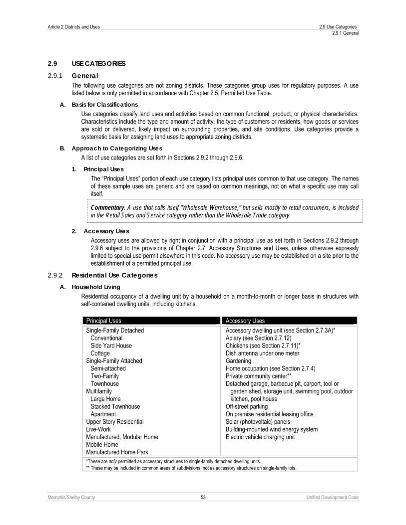
Article 2 Districts and Uses 2.9 Use Categories 2.9.1 General
Memphis/Shelby County 53 Unified Development Code
2.9 USE CATEGORIES
2.9.1 General The following use categories are not zoning districts. These categories group uses for regulatory purposes. A use listed below is only permitted in accordance with Chapter 2.5, Permitted Use Table.
A. Basis for Classifications Use categories classify land uses and activities based on common functional, product, or physical characteristics. Characteristics include the type and amount of activity, the type of customers or residents, how goods or services are sold or delivered, likely impact on surrounding properties, and site conditions. Use categories provide a systematic basis for assigning land uses to appropriate zoning districts.
B. Approach to Categorizing Uses A list of use categories are set forth in Sections 2.9.2 through 2.9.6.
1. Principal Uses The “Principal Uses” portion of each use category lists principal uses common to that use category. The names of these sample uses are generic and are based on common meanings, not on what a specific use may call itself.
Commentary. A use that calls itself “Wholesale Warehouse,” but sells mostly to retail consumers, is included in the Retail Sales and Service category rather than the Wholesale Trade category.
2. Accessory Uses Accessory uses are allowed by right in conjunction with a principal use as set forth in Sections 2.9.2 through 2.9.6 subject to the provisions of Chapter 2.7, Accessory Structures and Uses, unless otherwise expressly limited to special use permit elsewhere in this code. No accessory use may be established on a site prior to the establishment of a permitted principal use.
2.9.2 Residential Use Categories A. Household Living
Residential occupancy of a dwelling unit by a household on a month-to-month or longer basis in structures with self-contained dwelling units, including kitchens.
Principal Uses Accessory Uses
Single-Family Detached Conventional Side Yard House Cottage Single-Family Attached Semi-attached Two-Family Townhouse Multifamily Large Home Stacked Townhouse Apartment Upper Story Residential Live-Work Manufactured, Modular Home Mobile Home Manufactured Home Park
Accessory dwelling unit (see Section 2.7.3A)* Apiary (see Section 2.7.12) Chickens (see Section 2.7.11)* Dish antenna under one meter Gardening Home occupation (see Section 2.7.4) Private community center** Detached garage, barbecue pit, carport, tool or
garden shed, storage unit, swimming pool, outdoor kitchen, pool house
Off-street parking On premise residential leasing office Solar (photovoltaic) panels Building-mounted wind energy system Electric vehicle charging unit
*These are only permitted as accessory structures to single-family detached dwelling units. ** These may be included in common areas of subdivisions, not as accessory structures on single-family lots.

2.9 Use Categories Article 2 Districts and Uses 2.9.3 Civic Use Categories
Memphis/Shelby County 54 Unified Development Code
B. Group Living Residential occupancy of a structure by a group of people that does not meet the definition of Household Living. Tenancy is usually arranged on a monthly or longer basis. Generally, Group Living structures have a common eating area for residents, and the residents may receive care or training.
Principal Uses Accessory Uses
Boarding House, rooming house, single room occupancy
Fraternity, sorority, dormitory Independent Living Facility Monastery, convent Nursing home, full-time convalescent, hospice Personal care home for the elderly Residential home for the elderly, Assisted living
facility Supportive living facility
Adult day-care program Associated office Child care center (13+ persons) Food preparation or dining area Gardening Off-street parking Recreational facility Solar (photovoltaic) panels Building-mounted wind energy system Electric vehicle charging unit
2.9.3 Civic Use Categories A. Community Service
Uses of a public, nonprofit, or charitable nature providing ongoing public safety, educational, training, or counseling to the general public on a regular basis, without a residential component; provided, however, fire stations may include a residential component.
Principal Uses Accessory Uses
City and County-owned facilities Museum, library Neighborhood arts center or similar community facility (public) Philanthropic institution Police, fire, EMS substation
Associated office Food preparation or dining area Arts and crafts, day care, therapy area Indoor or outdoor recreation and athletic facility Gardening Limited retail sales (internal) Meeting area Off-street parking Solar (photovoltaic) panels Building-mounted wind energy system Electric vehicle charging unit
B. Day Care Uses providing care, protection, and supervision of children or adults on a regular basis away from their primary residence. Care is typically provided to a given individual for fewer than 18 hours each day, although the facility may be open 24 hours each day.
Principal Uses Accessory Uses
Adult day-care program Family day care home (5 to 7 persons) Group day care home (8 to 12 persons) Child care center (13+ persons) Drop-in child care center (15+ persons) Nursery school, preschool
Associated office Food preparation or dining area Gardening Health, arts and crafts, and therapy area Indoor or outdoor non-lighted recreation facility Off-street parking Solar (photovoltaic) panels Building-mounted wind energy system Electric vehicle charging unit

Article 2 Districts and Uses 2.9 Use Categories 2.9.3 Civic Use Categories
Memphis/Shelby County 55 Unified Development Code
C. Educational Facility Public and private (including charter or religious) schools at the elementary, middle, junior high, or high school level that provide basic academic education. Also includes colleges and other institutions of higher learning that offer courses of general or specialized study leading to a degree usually in a campus setting.
Principal Uses Accessory Uses Academy (special training) College, community college, university Seminary Elementary School, public or private Middle School, public or private Junior High School, public or private High School, public or private School, trade, vocational, business
Associated office Auditorium, theater Before- and after-school day care Cafeteria Dormitory, housing for students or faculty for colleges,
community colleges and universities* Food preparation or dining area Gardening Gymnasium Health facility Laboratory, library, museum Janitorial facility Meeting area Off-street parking Non-lighted play area, non-lighted recreational or sports
facility Nursery school, preschool Recreation fields Support commercial (college-operated bookstore, for example) Solar (photovoltaic) panels Building-mounted wind energy system Electric vehicle charging unit
* Dormitory, housing for students or faculty accessory to educational facilities that are not classified as colleges, community colleges or universities require the issuance of a Special Use Permit. This provision shall not apply to those dormitories constructed prior to January 1, 2011.
D. Medical Facility Uses providing medical or surgical care to patients. Some uses may offer overnight care.
Principal Uses Accessory Uses Blood plasma donation center Medical or dental laboratory Pharmacy Hospital Medical, dental or chiropractic clinic/office, massage therapy, or outpatient surgery center
Associated helicopter landing facility Associated office Chapel, ancillary worship space On-site day care where children are cared for while
parents or guardians are occupied on the premises Food preparation or dining area Gardening Housing for staff or trainees Limited retail sales (internal) Janitorial facility Meeting area Nursing or medical school Off-street parking Pharmacy Recreational facility Teaching facility Temporary housing for relatives of patients Solar (photovoltaic) panels Building-mounted wind energy system Electric vehicle charging unit

2.9 Use Categories Article 2 Districts and Uses 2.9.3 Civic Use Categories
Memphis/Shelby County 56 Unified Development Code
E. Park/Open Area Uses focusing on natural areas consisting mostly of vegetation, passive or active outdoor recreation areas, and having few structures.
Principal Uses Accessory Uses Botanical garden, nature preserve, recreational trail Cemetery, mausoleum, columbarium, memorial park including pet
cemetery, burial grounds Game preserve, wildlife management area, refuge, animal
sanctuary Recreation Field without lights, Recreation Field with lights, Reservoir, control structure, water supply, water well
Apiary (see Paragraph 2.7.12) Campground (public park only) Concession Gardening Maintenance facility Off-street parking Play equipment Recreational rentals Single residential unit for caretaker or security purposes Swimming pool, tennis court, ball field (public park only) Solar (photovoltaic) panels Building-mounted wind energy system Electric vehicle charging unit
F. Passenger Terminal Public or commercial facilities for the takeoff and landing of airplanes and helicopters, and terminals for taxi, rail or bus service.
Principal Uses Accessory Uses Airport, heliport Airline terminal Bus passenger terminal, taxi dispatch center, train passenger
terminal, limousine service Multimodal facility
Associated office Concession Food preparation or dining area Freight handling area Fueling facility Janitorial facility Limited retail sales (internal) Maintenance facility Off-street parking Park-and-ride facility Solar (photovoltaic) panels Building-mounted wind energy system Electric vehicle charging unit
G. Place of Worship Places of assembly that provide meeting areas for religious practice or ministry.
Principal Uses Accessory Uses Church, mosque, synagogue, temple Off-site parking for places of worship
See Section 2.7.5. Off-street parking Gardening Solar (photovoltaic) panels Building-mounted wind energy system Electric vehicle charging unit

Article 2 Districts and Uses 2.9 Use Categories 2.9.4 Commercial Use Categories
Memphis/Shelby County 57 Unified Development Code
H. Social Service Institution Uses that primarily provide treatment of those with psychiatric, alcohol, or drug problems, and transient housing related to social service programs.
Principal Uses Accessory Uses Correctional facility (private) Group shelter Neighborhood resource center Rehabilitative clinic Social service facility, soup kitchen, transient lodging or shelter
for the homeless Transitional home Work release center
Adult educational facility Associated office Food preparation or dining area Gardening Meeting room Off-street parking On-site day care where children are cared for while
parents or guardians are occupied on the premises Staff residences located on-site Solar (photovoltaic) panels Building-mounted wind energy system Electric vehicle charging unit
I. Utilities Public or private infrastructure serving a limited area with no on-site personnel (Minor Utility) or the general community and possibly having on-site personnel (Major Utility).
Principal Uses Accessory Uses
Minor utilities, including aeration facility, electrical substation, on-site stormwater retention or detention facility, neighborhood-serving telephone exchange/switching center, gas or electric installation/ transmission, water and wastewater pump station or lift station, gas gates, communications tower owned by MLGW, electrical transmission tower, water pumping facility and water tower or tank.
Major utilities, including electric or gas generation plant, filter bed, waste treatment plant, and solar or wind turbine farms.
Amateur Radio Operator Tower (65 feet or less) Communication towers (over 65 feet) CMCS tower and facilities Solar farms, wind farms (large scale) and wind farms (small
scale)
Control, monitoring, data or transmission equipment Off-street parking Storage Solar (photovoltaic) panels Building-mounted wind energy system Electric vehicle charging unit
2.9.4 Commercial Use Categories A. Indoor Recreation
Generally commercial uses, varying in size, providing daily or regularly scheduled recreation-oriented activities in an indoor setting.
Principal Uses Accessory Uses
Adult-oriented establishment Athletic, tennis, swim or health club Banquet hall Bar, tavern, cocktail lounge, nightclub Convention center Gymnastic facility, indoor sports academy Lodge, membership club Indoor entertainment activity such as pool hall, bowling alley,
game arcade Indoor shooting range Movie or other theater
Associated office Concession Food preparation or dining area Gardening Off-street parking Pro shop or sales of goods related to the on-site
activities of the specific use Solar (photovoltaic) panels Building-mounted wind energy system Electric vehicle charging unit

2.9 Use Categories Article 2 Districts and Uses 2.9.4 Commercial Use Categories
Memphis/Shelby County 58 Unified Development Code
B. Office Activities conducted in an office setting and generally focusing on business, government, professional, or medical services.
Principal Uses Accessory Uses Offices including advertising, business management consulting,
data processing, collection agency, real estate or insurance agent, professional service such as lawyer, accountant, bookkeeper, engineer, architect, sales office, travel agency, medical physical therapy
Call center Bank, credit union, industrial loan and thrift, savings and loan,
mortgage companies, investment or brokerage house, and other financial services
Counseling in an office setting Government office Photocopying, package shipping, blueprint Radio, TV or recording studio Security office Urgent care or emergency medical office Utility office
Ancillary storage Food preparation or dining area Health facility Janitorial facility Limited retail sales (internal) Meeting room Off-street parking On-site day care where children are cared for while
parents or guardians are occupied on the premises Other amenity for the use of on-site employees Restaurant Technical library Solar (photovoltaic) panels Building-mounted wind energy system Electric vehicle charging unit
C. Overnight Lodging Accommodations arranged for short term stays of less than 30 days for rent or lease.
Principal Uses Accessory Uses Hotel, or motel, bed and breakfast, youth hostel Hourly rate motel
Associated office Bar, tavern, cocktail Lounge, nightclub, restaurant with
entertainment Food preparation or dining area Gardening Laundry facility Meeting facility Off-street parking Restaurant Swimming pool, other recreational facility Solar (photovoltaic) panels Building-mounted wind energy system Electric vehicle charging unit

Article 2 Districts and Uses 2.9 Use Categories 2.9.4 Commercial Use Categories
Memphis/Shelby County 59 Unified Development Code
D. Outdoor Recreation Generally commercial uses, varying in size, providing daily or regularly scheduled recreation-oriented activities. Such activities may take place wholly outdoors or within a number of outdoor structures.
Principal Uses Accessory Uses Drive-in theater Campground, travel trailer park, recreational vehicle
park Executive par three golf course Extreme sports such as paintball, BMX facility or
skateboarding facility Golf course, country club, clubhouse Outdoor entertainment activity such as batting cage,
golf driving range, mini-amusement park, miniature golf facility, water park
Horse stable, riding academy, equestrian center Outdoor shooting range Sports academy for active recreational or competitive
sports Stadium or arena, commercial amphitheater
Associated office Caretaker or security person housing Classroom Clubhouse Concession Food preparation or dining area Gardening Jogging, hiking, fitness and other types of trails Limited retail sales (internal) Maintenance facility Off-street parking On-site day care where children are cared for while parents or
guardians are occupied on the premises Pro shop or sales of goods related to the on-site activities of the
specific use Solar (photovoltaic) panels Building-mounted wind energy system Electric vehicle charging unit
E. Outdoor Advertising Sign Any permanent off-premise outdoor advertising sign.
Principal Uses Accessory Uses
Permanent Off-Premise Advertising Sign none
F. Parking, Commercial Facilities that provide parking not accessory to a principal use, for which a fee may or may not be charged.
Principal Uses Accessory Uses Mixed parking lot (partially accessory to a principal
use, partly to rent for others), short- and long-term fee parking facility (truck and motor freight trailer parking not included)
Park-and-ride facility Motor vehicle parking lot Surface parking lot
Structure intended to shield parking attendants from the weather Solar (photovoltaic) panels Building-mounted wind energy system Electric vehicle charging unit
G. Restaurant Establishments that prepare and sell food for on- or off-premise consumption.
Principal Uses Accessory Uses
Pizza delivery facility Restaurant, fast-food restaurant, take-out, yogurt or ice
cream shop Restaurant with sale of alcoholic beverages, brew pub Restaurant, drive-in
Associated office Deck, patio for outdoor seating or dining Drive-thru facility Gardening Off-street parking Solar (photovoltaic) panels Building-mounted wind energy system Electric vehicle charging unit

2.9 Use Categories Article 2 Districts and Uses 2.9.4 Commercial Use Categories
Memphis/Shelby County 60 Unified Development Code
H. Retail Sales and Service Companies or individuals involved in the sale, lease, or rental of new or used products, or providing personal services or repair services to the general public.
Principal Uses Accessory Uses
Sales-Oriented Store selling, leasing or renting consumer, home, and
business goods including but not limited to alcoholic beverages, ammunition, antiques, appliances, art, art supplies, baked goods, bicycles, books, building supplies, cameras, carpet and floor coverings, crafts, clothing, computers, computer supplies, convenience goods, dry goods, electronic equipment, fabric, firearms, flowers, furniture, garden supplies, gifts or novelties, groceries, hardware, home improvement, household products, jewelry, medical supplies, music, musical instruments, pets, pet supplies, pharmaceuticals, photo finishing, picture frames, plants, postal substation, printed materials, produce, souvenirs, sporting goods, stationery, tobacco, used or secondhand goods, videos, and related products
Art or photo studio, gallery Convenience store with gas pumps, gas station Convenience store without gas pumps Consignment store Greenhouse or nursery, commercial, garden center Pawnshop Payday loans, title loan establishments Photo finishing pickup station, photo finishing by
computer and retail sales Retail Sales Outdoor (vendor), Flea Market, Farmers
Market, Farm Stand, Open Air Market, Vehicle parts and accessories, Wholesale club
Service-Oriented Animal grooming, animal hospital, veterinary clinic, pet
clinic, animal boarding, animal shelter, kennel, doggy day care
Dance, martial arts, music studio or classroom, personal trainer or gym
Catering establishment, small-scale Cleaning establishment, dry-cleaning or laundry drop-off
facility, laundromat, cleaning, pickup station, coin operated pickup station
Hair, nail, tanning, massage therapy and personal care service, barber or beauty shop
Quick-sign service, printing and publishing Post office, Taxidermist Tattoo shop, palmist, psychic, medium Tractor-trailers (fueling of) Wedding chapel Repair-Oriented Appliance, bicycle, canvas product , clock, computer,
jewelry, musical instrument, office equipment, radio, shoe, television or watch repair, tailor, milliner, upholsterer, locksmith
Artisan manufacturing Associated office Automatic one bay car wash facility Drive-thru facility Food preparation or dining area Gardening Off-street parking On-site day care where children are cared for
while parents or guardians are occupied on the premises
Repackaging of goods for on-site sale Storage of goods Solar (photovoltaic) panels Building-mounted wind energy system Electric vehicle charging unit
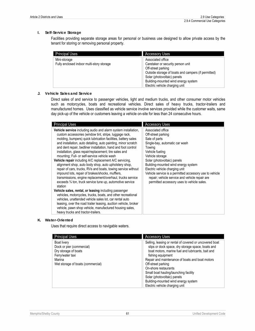
Article 2 Districts and Uses 2.9 Use Categories 2.9.4 Commercial Use Categories
Memphis/Shelby County 61 Unified Development Code
I. Self-Service Storage Facilities providing separate storage areas for personal or business use designed to allow private access by the tenant for storing or removing personal property.
Principal Uses Accessory Uses Mini-storage Fully enclosed indoor multi-story storage
Associated office Caretaker or security person unit Off-street parking Outside storage of boats and campers (if permitted) Solar (photovoltaic) panels Building-mounted wind energy system Electric vehicle charging unit
J. Vehicle Sales and Service Direct sales of and service to passenger vehicles, light and medium trucks, and other consumer motor vehicles such as motorcycles, boats and recreational vehicles. Direct sales of heavy trucks, tractor-trailers and manufactured homes. Uses classified as vehicle service involve services provided while the customer waits, same day pick-up of the vehicle or customers leaving a vehicle on-site for less than 24 consecutive hours.
Principal Uses Accessory Uses Vehicle service including audio and alarm system installation,
custom accessories (window tint, stripe, luggage rack, molding, bumpers) quick lubrication facilities, battery sales and installation, auto detailing, auto painting, minor scratch and dent repair, bedliner installation, hand and foot control installation, glass repair/replacement; tire sales and mounting; Full- or self-service vehicle wash
Vehicle repair including A/C replacement A/C servicing, alignment shop, auto body shop, auto upholstery shop, repair of cars, trucks, RVs and boats, towing service without impound lots, repair of brakes/shocks, mufflers, transmissions, engine replacement/overhaul, trucks service exceeds ¾ ton, truck service tune up, automotive service station
Vehicle sales, rental, or leasing including passenger vehicles, motorcycles, trucks, boats, and other recreational vehicles, unattended vehicle sales lot, car rental auto leasing, over the road trailer leasing, auction vehicle, broker vehicle, pawn shop vehicle, manufactured housing sales, heavy trucks and tractor-trailers.
Associated office Off-street parking Sale of parts Single-bay, automatic car wash Towing Vehicle fueling Vehicle storage Solar (photovoltaic) panels Building-mounted wind energy system Electric vehicle charging unit Vehicle service is a permitted accessory use to vehicle
repair; vehicle service and vehicle repair are permitted accessory uses to vehicle sales.
K. Water-Oriented Uses that require direct access to navigable waters.
Principal Uses Accessory Uses Boat livery Dock or pier (commercial) Dry storage of boats Ferry/water taxi Marina Wet storage of boats (commercial)
Selling, leasing or rental of covered or uncovered boat slips or dock space, dry storage space, boats and boat motors, marine fuel and lubricants, bait and fishing equipment
Repair and maintenance of boats and boat motors Off-street parking On-shore restaurants Small boat hauling/launching facility Solar (photovoltaic) panels Building-mounted wind energy system Electric vehicle charging unit

2.9 Use Categories Article 2 Districts and Uses 2.9.5 Industrial Use Categories
Memphis/Shelby County 62 Unified Development Code
L. Funeral Services
Principal Uses Accessory Uses Funeral establishment Funeral home, mortuary, undertaking establishment Funeral merchandising, funeral directing Crematorium, pet crematorium
Chapels Crematorium Off-street parking Solar (photovoltaic) panels Building-mounted wind energy system Electric vehicle charging unit
2.9.5 Industrial Use Categories A. Wholesale Trade
Firms or individuals involved in the sale, lease, or rent of products to industrial, institutional or commercial businesses only. The uses emphasize on-site sales or order-taking and often include display areas. Businesses may or may not be open to the general public, but sales to the general public are not permitted. Products may be picked up on-site or delivered to the customer.
Principal Uses Accessory Uses
Mail-order house Sale or rental of machinery, equipment, heavy
equipment, building materials, special trade tools, welding supplies, machine parts, electrical supplies, plumbing supplies, janitorial supplies, restaurant equipment, and store fixtures
Wholesale of food, clothing, auto parts, building hardware
Wholesale display Wholesale establishment
Associated office Food preparation or dining area Minor fabrication services On-site day care where children are cared for
while parents or guardians are occupied on the premises
Off-street parking Repackaging of goods Showroom Warehouse Solar (photovoltaic) panels Building-mounted wind energy system Electric vehicle charging unit

Article 2 Districts and Uses 2.9 Use Categories 2.9.5 Industrial Use Categories
Memphis/Shelby County 63 Unified Development Code
B. Light Industrial Firms engaged in the manufacturing, assembly, repair or servicing of industrial, business, or consumer machinery, equipment, products, or by-products mainly by providing centralized services for separate retail outlets. Contractors and building maintenance services and similar uses perform services off-site.
Principal Uses Accessory Uses
Brewery Bulk mailing service Catering establishment, large-scale Chemical, cosmetics, drug, soap, paints, fertilizers and
abrasive products Clothing, textile or apparel manufacturing Contractors storage (indoor/outdoor) including janitorial
and building maintenance service, exterminator, or other maintenance yard or facility, building, heating, plumbing, landscaping or electrical contractor and others who perform services off-site, but store equipment and materials or perform fabrication or similar work on-site
Detention center, jail, prison Distillery Food beverage products except animal slaughter,
stockyards Jewelry, silverware, plated ware Lawn, tree or garden service Laundry, dry-cleaning, and carpet cleaning plants,
cleaning establishment, large-scale Leather and leather products except tanning and
finishing Light manufacturing or assembly of equipment,
instruments, or goods including musical instruments, appliances, coated-ware, precision items, sporting goods, office and art supplies, electrical equipment/items, paper products (except pulp mills) printing, publishing, and lithography, production of artwork and toys, sign-making, metal products
Lumberyard and wood products Microbrewery, microbrewery with tasting room,
microdistillery Movie production facility Photo-finishing laboratory Repair of scientific or professional instruments, electric
motors Research, testing, and development laboratory Sheet metal shop Soft drink bottling Stone, clay, glass, and concrete products Storage area used for manufacturing Welding, machine, tool repair shop Woodworking, including cabinet makers and furniture
manufacturing
Accessory medical clinic Associated office Food preparation or dining area On-site day care where children are cared for
while parents or guardians are occupied on the premises
Employee recreational facility On-site repair facility Off-street parking Residential unit for security purposes (single unit) Retail or wholesale sales of goods Solar (photovoltaic) panels Building-mounted wind energy system Offices, guardhouse, generating plants,
pumphouses, and other accessory uses and buildings customary and incidental to light industrial uses
Electric vehicle charging unit

2.9 Use Categories Article 2 Districts and Uses 2.9.5 Industrial Use Categories
Memphis/Shelby County 64 Unified Development Code
C. Warehouse and Distribution Firms involved in the storage or movement of goods for themselves or other firms. Goods are generally delivered to other firms or the final consumer.
Principal Uses Accessory Uses
Bulk storage, including nonflammable liquids, cold storage plants, including frozen food lockers, household moving and general freight storage, separate warehouse used by retail store such as furniture or appliance store
Bus barn Central postal facility Commercial packing for fruits and vegetables Drop yard w/ or w/o preventative maintenance service Freight, service facility Outdoor storage yard Post Office and Parcel services Railroad switching yard, freight terminal, piggyback yard Transfer and storage business where there are no
individual storage areas or where employees are the primary movers of the goods to be stored or transferred
Trailer storage, drop off lot Truck or motor freight terminal, service facility Warehouse
Associated office Food preparation or dining area On-site day care where children are cared for
while parents or guardians are occupied on the premises
Employee recreational facility Off-street parking Outdoor storage yard Residential unit for security purposes (single unit) Retail or wholesale sales of goods Truck fleet parking and maintenance area Solar (photovoltaic) panels Building-mounted wind energy system Electric vehicle charging unit

Article 2 Districts and Uses 2.9 Use Categories 2.9.5 Industrial Use Categories
Memphis/Shelby County 65 Unified Development Code
D. Heavy Industrial Firms involved in research and development activities without light fabrication and assembly operations; limited industrial/manufacturing activities. The uses emphasize industrial businesses, and sale of heavier equipment. Factory production and industrial yards are located here.
Principal Uses Accessory Uses
Any use that is potentially dangerous, noxious or offensive to neighboring uses in the district or those who pass on public ways by reason of smoke, odor, noise, glare, fumes, gas, vibration, threat of fire or explosion, emission of particulate matter, interference with radio, television reception, radiation or any other likely cause
Asbestos, radioactive materials/waste Animal processing, packing, treating, and storage,
livestock or poultry slaughtering, concentrate plant, processing of food and related products, production of lumber, tobacco, chemical, rubber, leather, clay, bone, paper, pulp, plastic, stone, or glass materials or products, production or fabrication of metals or metal products including enameling and galvanizing,
Automobile dismantlers and recyclers Batch Plant Bulk storage of flammable liquids Chemical, cosmetics, drug, soap, paints, fertilizers and
abrasive products Commercial feed lot Concrete batching and asphalt processing and
manufacture, batch plant Cotton gin Earth moving and heavy construction equipment and
transportation equipment Explosives Fabricated metal products and machinery Impound lot, wrecker service includes city wreckers,
auto storage Leather and leather products includes tanning and
finishing Mulching facilities Petroleum, liquefied petroleum gas and coal products
and refining Primary metal manufacturing Pulp mills Rubber and plastic products, rubber manufacturing Sawmill, pulp mill Secondary materials dealers Tire recapping Tobacco products Transportation equipment
Associated office Food preparation or dining area Product repair On-site day care where children are cared for while parents or guardians are occupied on the premises Off-street parking Repackaging of goods Warehouse, storage Residential Unit for Security purposes (single unit) Retail or wholesale sales of goods Solar (photovoltaic) panels Building-mounted wind energy system Offices, guardhouse, generating plants,
pumphouses, and other accessory uses and buildings customary and incidental to heavy industrial uses
Electric vehicle charging unit

2.9 Use Categories Article 2 Districts and Uses 2.9.5 Industrial Use Categories
Memphis/Shelby County 66 Unified Development Code
E. Waste-Related Service Characterized by uses that receive solid or liquid wastes from others for transfer to another location and uses that collect sanitary wastes or that manufacture or produce goods or energy from the composting of organic material.
Principal Uses Accessory Uses
Animal waste processing Garbage or refuse collection service (office and truck
fleet) Junk or Salvage Yard Landfill Manufacture and production of goods from composting
organic material, composting facilities Recycling facility including recyclable material storage,
including construction material Recycling Drop-off Facility Solid or liquid waste transfer station Scrap Metal Processors and Wrecking Waste Incineration
Associated office Off-street parking On-site refueling and repair Recycling of material Repackaging and shipment of by-products Solar (photovoltaic) panels Building-mounted wind energy system Electric vehicle charging unit

Article 2 Districts and Uses 2.9 Use Categories 2.9.6 Open Use Categories
Memphis/Shelby County 67 Unified Development Code
2.9.6 Open Use Categories A. Agriculture
Characterized by uses that create or preserve areas intended primarily for the raising of animals and crops, conservation, and the secondary industries associated with agricultural production.
Principal Uses Accessory Uses
Commercial fishing Animal raising including horses, hogs, cows, sheep,
goats, and swine, poultry, rabbits, and other small animals, apiculture, aquaculture, dairying, personal or commercial animal breeding and development
Apiary Crop, soil preparation, agricultural services, large animal
and veterinary services Farm labor and management services Floriculture,
horticulture, pasturage, row and field crops, viticulture, tree or sod farm, silviculture
Fish hatcheries and preserves Grain, fruit, field crop and vegetable cultivation and
storage Hunting, trapping and game propagation Livestock, horse, dairy, poultry and egg products Livestock auction Milk processing plant Neighborhood garden (refer to Paragraph 2.6.5D(5) for
list of permissible accessory structures) Packing house for fruits or vegetables Plant nursery Plant nursery with landscape supply Poultry slaughtering and dressing Retail or wholesale sales of agriculturally-related
supplies and equipment Sale of agriculture products, outdoor Sale, rent, repair of tractors and related agricultural
machinery Timber tracts, forest nursery gathering of forest products Winery
Aircraft landing field or helicopter landing facility (private)
Associated offices Auction ring Barns, garages, sheds, silos, stables Dish antenna under 1meter Dock or pier Gardening Home occupations Housing for ranch or farm labor, including
manufactured homes Sale of agricultural products U-pick facilities Solar (photovoltaic) panels Building-mounted wind energy system Electric vehicle charging unit
B. Resource Extraction Characterized by uses that extract minerals and other solids and liquids from land.
Principal Uses Accessory Uses
Dredging, earth extraction Extraction of phosphate or minerals Extraction of sand or gravel, borrow pit Metal, sand stone, gravel clay, mining and other related
processing Stockpiling of sand, gravel, or other aggregate materials
Associated offices Equipment storage Resource processing

Memphis/Shelby County 68 Unified Development Code
Article 3. Building Envelope Standards 3.1 GENERAL PROVISIONS
3.1.1 Applicability A. New Building or Parking Area
The provisions of this Article apply to the construction of a new building or parking area.
B. Existing Building
1. Addition or Expansion The provisions of this Article apply only to the addition or expansion of the building, provided alteration to the existing building does not exceed the requirements set forth below.
2. Alteration See Paragraph 3.10.3A(2) for alterations.
3. Any expansion or addition, regardless of size, shall conform to the provisions of Chapter 3.11.
C. Existing Parking Area The provisions of this Article apply to an existing parking area when space for existing parking is expanded. The provisions of this Article do not apply to an existing parking area that has been restriped to accommodate more vehicles without any physical expansion of the parking area.
D. Residential Compatibility Additional applicability requirements may apply for residential compatibility (see Chapter 3.9).
E. Utilities Utility infrastructure and appurtenances not considered minor or major utilities are exempt from the standards of
this Article (see Sub-Section 2.9.3I).
3.1.2 Subdivision Review All subdivision shall occur in conformance with this Article as set forth in Chapter 9.7, Subdivision Review.
3.1.3 Site Plan Review A. All applicable development as defined above is subject to the site plan review process as set forth in Chapter 9.12,
Administrative Site Plan Review. B. Single-family detached and single-family attached housing types (used exclusively for residential purposes) on
individual tracts or lots do not have to submit a site plan for approval; however, developments with multiple single-family detached and single-family attached housing types on a single tract or lot, site are subject to the site plan review process.
C. No building permit will be issued nor structure or building erected, and no existing building or structure altered, remodeled, or enlarged or extended until the project or development has an approved site plan (if applicable).
3.1.4 Number of Buildings Per Tract or Lot A. One Building Per Tract or Lot
Except as set forth in Sub-Section B above or Sub-Section 3.1.3B below, every building erected or structurally altered after the effective date of this Code shall be located on a lot as herein defined and in no case shall there be more than one principal building erected on a single tract or lot of record. This provision shall not apply to property owned by the Memphis-Shelby County Airport Authority, or to property owned jointly by the City of Memphis and the County of Shelby and operated as a public terminal area under the jurisdiction of the Memphis and Shelby County Port Commission. In addition, CMCS towers or facilities, or power lines on a site shall not constitute an additional principal use or structure.

Article 3 Building Envelope Standards 3.1 General Provisions 3.1.4 Number of Buildings Per Tract or Lot
Memphis/Shelby County 69 Unified Development Code
B. Multiple Principal Buildings on a Tract or Lot
1. Defined A group of two or more office, commercial, industrial, civic, open uses, mixed uses or townhouse, large home, stacked townhouse, apartment buildings and/or other operations on a tract or lot operating under either common ownership or a condominium regime. The provisions of this section do not apply to a permanent off-premise advertising sign on an individual tract or lot (where only one such sign is permitted on an individual tract or lot).
2. General Multiple principal buildings with nonresidential (office, commercial, industrial, civic, open) uses, mixed uses, large home and apartment buildings shall meet all applicable development standards as set forth in this development code, including the building envelope standards of this Article. Additionally, if multiple principal buildings are established on a single unified site the following requirements shall be met:
a. Uses shall be limited to those permitted within the district in which the development is located (see Chapter 2.5, Permitted Use Table).
b. The overall intensity of the land use shall be no higher, and the standard of development no lower, than that permitted in the district in which the project is located.
c. Building standards. 1. For a tract or lot with multiple principal buildings that is located on a designated frontage, refer to
the building standards as set out in Section 3.10.3. 2. For a tract or lot with multiple principal buildings that is located on an undesignated frontage and in
a mixed use or industrial district, refer to the building standards as set out in Section 3.10.2. 3. For a tract or lot with multiple principal buildings that is located on an undesignated frontage and in
a residential district, refer to the building standards as set out in Chapters 3.7 and 3.8. d. If more than 50% of a tract or lot is redeveloped, as measured by land area, the Block Standards of
Section 5.2.5 shall apply and all private streets in the interior of the tract or lot must be reconstructed to the Street Standards, Section 5.2.7 and adhere to the Streetscape Plates, Section 4.3.3.
3. Review Process The review of sites with multiple principal buildings on a tract or lot is outlined in Chapter 9.12.

3.2 Measurements and Exceptions Article 3 Building Envelope Standards 3.2.1 Intent
Memphis/Shelby County 70 Unified Development Code
3.2 MEASUREMENTS AND EXCEPTIONS
3.2.1 Intent This section identifies and explains some of the more common forms of measurement used throughout this Article and other Articles of this development code. It also specifies exceptions to certain requirements of this development code.
3.2.2 Area Area shall be measured in gross square feet or acres.
A. Tract An area of land, under single ownership or owned by an entity, that is not a lot.
B. Site Any lot, tract or group of connected lots, tracts and/or parcels owned or functionally controlled by the same person or entity, assembled for the purpose of development.
C. Lot 1. A parcel or tract of land that is recorded in the Shelby County Register’s Office that is part of a subdivision and
designated on the subdivision plat as a lot; or a property that is exempt from subdivision (see Section 9.7.3) or a property described by metes and bounds that has been recorded in the Shelby County Register’s Office prior to March 1, 1989.
2. Minimum lot areas are exclusive of existing or proposed public or private right-of-way.

Article 3 Building Envelope Standards 3.2 Measurements and Exceptions 3.2.3 Blank Area and Building Separation
Memphis/Shelby County 71 Unified Development Code
3.2.3 Blank Area and Building Separation A. Blank Wall Area. A portion of the exterior façade of the building which does not include a substantial material change
(paint color is not considered a substantial change); windows or doors; or columns, pilasters or other articulation greater than 12 inches in depth. Blank wall area applies only to primary and side street facing facades.
B. Building Separation. The required separation between any two buildings.
3.2.4 Density Maximum permitted density shall be measured by the maximum number of dwelling units per gross acre of land.
3.2.5 Floor Area The floor area of a building is the sum of the horizontal areas of the several floors of all buildings on a lot measured from the exterior face of exterior walls. The following shall be excluded from calculation of the floor area:
A. Open exterior balconies or other covered open spaces;
B. Uncovered terraces, patios, porches, atria or steps;
C. Garages, carports or other areas, enclosed or unenclosed, used for the parking or circulation of motor vehicles;
D. Areas for housing major mechanical equipment which serves the building as a whole or major portion thereof, but not including utility areas within individual dwelling units;
E. Areas of common special purpose used by a substantial portion of the occupants of the premises, including, but not limited to the following: laundries, recreation areas, sitting areas, libraries, storage areas, common halls, lobbies, stairways and elevator shafts, attics and areas devoted exclusively to management and/or maintenance of the premises, but not including incidental commercial activities.
3.2.6 Height A. Building Height
1. The vertical distance measured from grade to the highest point of the roof for flat roofs, to the deck line for mansard roofs or to the mean height between eaves and ridge of any pitched roof. For buildings on sloped sites, the height shall be measured from the average ground level as measured along either the frontage of the lot or the front façade of the building.

3.2 Measurements and Exceptions Article 3 Building Envelope Standards 3.2.6 Height
Memphis/Shelby County 72 Unified Development Code
2. The maximum height limits of the district or officially adopted height map do not apply to spires, belfries, cupolas,
domes not intended for human occupancy, monuments, water tanks/towers, mechanical roof appurtenances or other similar structures which, by design or function, must exceed the established height limits. Amateur Radio Towers (see Sub-Section 2.6.2H) and CMCS and communications towers (see Sub-Section 2.6.2I) may exceed the district height limits.
3. The following structures may also exceed the limits of the district or officially adopted height map provided they do not exceed the maximum established height by more than 20 feet:
a. MLGW-owned buildings and infrastructure; b. Mechanical equipment; c. Visual screens surrounding roof mounted mechanical equipment; d. Chimney and vent stack; e. Elevator penthouse or bulkhead; f. Flagpole; g. Mechanical equipment room; h. Parapet wall, limited to a height of four feet; i. Stairway access to roof; j. Roof top deck; k. Skylight; l. Solar panels; and m. Wind turbines and other integrated renewable energy systems.
4. Roof top mechanical equipment must be screened in accordance with Sub-Section 4.6.8D. 5. No building or structure (unless set forth above) shall be erected or altered to exceed the maximum height limit
established for the district unless an official height map has been approved and adopted by the governing bodies (see Chapter 9.5, Zoning Change for the process for creating a new height map or amending an existing height map). All officially adopted height maps are made part of the Zoning Map (see Chapter 2.4 to determine if a height map applies to your property).
6. Additional height above that permitted in the district or shown on an officially adopted height map may be permitted though the special exception process (see Chapter 9.14), except for all single-family detached and single-family detached housing types.
B. Bulk Plane Any nonresidential or multifamily building that abuts a single-family residential district is subject to a bulk plane starting at 40 feet in height at the side or rear setback line, and extending upward one foot for every additional foot into the site from the setback line up to 100 feet of setback.

Article 3 Building Envelope Standards 3.2 Measurements and Exceptions 3.2.7 Transparency
Memphis/Shelby County 73 Unified Development Code
C. Ground Floor Elevation Ground floor elevation is measured from top of the final grade to the top of the finished ground floor.
D. Floor Height 1. Ground floor height is measured from the top of the finished to the top of the finished floor above. 2. Upper floor height is measured from the top of the finished floor to the top of the finished floor above. When there
is no floor above, upper floor height is measured from the top of the finished floor to the top of the wall plate.
3.2.7 Transparency A. Ground Floor
The minimum percentage of windows and doors that must cover ground floor façade measured between 2 and 10 feet above the adjacent sidewalk.
B. Upper Floors The minimum percentage of windows and doors that must cover an upper floor façade measured from floor to floor.

3.2 Measurements and Exceptions Article 3 Building Envelope Standards 3.2.8 Width
Memphis/Shelby County 74 Unified Development Code
3.2.8 Width A. Building Width
Building width shall be measured by the distance along the front plane of any building (as determined by the location of an entrance fronting on a street).
B. Site or Lot Width 1. Width shall be measured by the distance between the side site or lot lines (generally running perpendicular to a
street), measured at the front setback line along a straight line parallel to the front of the property line or along the chord of the front property line.
2. Where a setback area applies, lot width shall be measured by the distance between the side property lines
(generally running perpendicular to a street), measured at the front building line along a straight line parallel to the front of the property line or along the chord of the front property line.

Article 3 Building Envelope Standards 3.2 Measurements and Exceptions 3.2.9 Building Setbacks
Memphis/Shelby County 75 Unified Development Code
3.2.9 Building Setbacks A. General
1. No part of a yard or other open space required for any structure or use for the purpose of complying with the provisions of this development code may be included as a part of a yard or other open space similarly required for another structure or use.
2. All front, rear and side (street) setbacks, and parking setbacks are measured from the edge of the right-of-way. Side yard setbacks are measured from the side property line.
B. Types of Setbacks There are five types of setbacks – front (min), front (max), side (street), side (interior), and rear yards. Double frontage sites are considered to have two front setbacks.
1. Residential Lots Setbacks for corner and non-corner lots are determined according to the graphics below.
2. Non-residential Lots Setbacks for all non-residential lots are determined according to the graphic below. On corner lots, the rear setback is determined according to the dimensions of the lot. The rear setback is always measured from the property line most distant from the street.

3.2 Measurements and Exceptions Article 3 Building Envelope Standards 3.2.9 Building Setbacks
Memphis/Shelby County 76 Unified Development Code
C. Setback Area and Required Building Frontage The setback area is the area of land within the minimum front setback line and the maximum setback line. The required building frontage is the minimum percentage of the front building façade that must be located within the setback area. Breezeways and other covered areas along the frontage shall be calculated as part of the required building frontage requirements provided such breezeways and other covered areas do not constitute more than 20% of the total required building frontage.
D. Measurement of Setbacks
1. Front Setbacks Depth of a required front setback is measured at right angles to a straight line joining the foremost points of the side property lines. The foremost point of the side property lines, in the case of rounded property corners at street intersections, are assumed to be the point at which the side and front property lines would have met without such rounding.

Article 3 Building Envelope Standards 3.2 Measurements and Exceptions 3.2.9 Building Setbacks
Memphis/Shelby County 77 Unified Development Code
2. Side (Street) Setbacks Width of a required side (street) setback is measured in such a manner that the side yard established is a strip of the minimum width required by district regulations with its inner edge parallel with the side property line.
3. Side (Interior) Setbacks Width of a required side (interior) setback is measured in such a manner that the side yard established is a strip of the minimum width required by district regulations with its inner edge parallel with the side property line.
4. Rear Setbacks Depth of a required rear setback is measured in such a manner that the rear yard established is a strip of the minimum width required by district regulations with its inner edge parallel with the rear property line. For irregular lots, use the graphic below to determine the rear property line from which the required rear setback is measured. For irregular lots, the rear property line shall generally be defined as the property line that is the furthest from the front property line. For irregular lots with two property lines that are equidistant from the front property line, such as the situation in Lot 2 below, the rear property line shall be considered the line that is a distance of ten feet as measured from the rear corner of the lot. Such a line shall create an isosceles triangle at the rear of the lot.

3.2 Measurements and Exceptions Article 3 Building Envelope Standards 3.2.9 Building Setbacks
Memphis/Shelby County 78 Unified Development Code
5. Required Building Frontage The required building frontage is the minimum percentage of the front building façade that must be located within the setback area. The setback area is the area of land within the minimum front setback line and the maximum setback line.
6. Clear Sight Triangle All structures shall be clear of any required sight triangle (see Section 4.4.7).
E. Encroachments The following encroachment standards shall apply to all required setbacks unless otherwise stated, so long as they do not encroach into any public or utility easements. Underground structures covered by the ground may encroach into any required setback.
1. Accessory Structures Accessory structures (as permitted in Chapter 2.7, Accessory Structures and Uses).
2. Building Features a. Chimneys, pre-fabricated chimneys, flues, or smokestacks may encroach a maximum of four feet. b. Building eave or roof overhang may encroach up to two feet; provided that such encroachment is at least
three feet from the property line, its lower edge is at least 7½ feet above the ground elevation, and it is located at least five feet from any other building or eave.
c. Bay windows, entrances and similar features that are less than ten feet wide may encroach up to 42 inches but shall remain at least 42 inches from the property line.
d. Awnings or overhangs may encroach into a required front setback provided they do not encroach into the public right-of-way without a right-of-way encroachment permit. Awnings or overhangs over a public sidewalk must be a minimum of ten feet clear height above the sidewalk and be a minimum of six feet deep.
e. Balconies may encroach up to four feet into a required setback. Balconies may not project within five feet of a common property line and in any case balconies may not encroach into the public right-of-way without a right-of-way encroachment permit.
f. Sills and other ornamental features may encroach up to two feet. g. Unenclosed fire escapes or stairways may encroach up to eight feet. h. Attached garages and carports that are not accessed from the rear of the lot may encroach into the required
rear yard by up to 15 feet, provided a 5-foot setback is maintained from the rear property line. i. Attached garages and carports that are accessed from the rear of the lot may encroach into the required rear
yard by up to 15 feet, provided either a 5-foot setback or a 20-foot setback is maintained from the rear property line. Attached garages and carports with rear access that were legally constructed under prior Zoning Regulations with a setback of less than 5 feet, or with a setback of between five and 20 feet, are permitted and may be altered, expanded or rebuilt.
3. Enclosed Structures For alley-loaded lots with conventional, side yard, cottage, semi-attached, two-family or large home housing types, an enclosed structure that covers no more than 8% of the total lot area or 450 square feet, whichever is greater, may encroach into a required rear setback provided the structure is set back no more than five feet from the right-of-way of the rear alley.
4. Porches, Decks and Patios a. Unenclosed patios, decks or terraces may encroach up to four feet into a required side setback, and are
subject to no limitation in a required rear setback. b. Covered, unenclosed porches attached to the principal structure may encroach a maximum of eight feet into
a required front setback.
5. Mechanical Equipment and Utilities Lines a. Mechanical equipment associated with residential uses, such as HVAC units and security lighting, may
encroach into a required rear or side setback. Swimming pool equipment on residential lots may be located within the side yard setback so long as it is screened from any public or private street.

Article 3 Building Envelope Standards 3.2 Measurements and Exceptions 3.2.9 Building Setbacks
Memphis/Shelby County 79 Unified Development Code
b. Utility lines located underground and minor structures accessory to utility lines (such as hydrants, manholes, and transformers and other cabinet structures) may encroach into any required setback.
6. Pedestrian Bridges and Building Connections Pedestrian bridges, breezeways, building connections, and supports of these structures, upon findings that the connecting feature is necessary to provide safe pedestrian access or to improve transit access.
7. Driveways Driveways in conformance with the standards found in Chapter 4.4.
8. Signs Signs in conformance with the standards found in Chapter 4.9.
9. Buffers Buffers in conformance with the standards found in Section 4.6.5.
10. Fence and Walls Fences and walls in conformance with the standards found in Section 4.6.7.
11. Parking Parking is allowed as permitted in Chapter 4.5.
12. Outdoor Storage and Display Outdoor storage and display as permitted in Chapter 4.8.
13. Contextual Infill Standards
Encroachments may be permitted pursuant to Contextual Infill Standards, Section 3.9.2. F. Authority
An encroachment into a building setback or easement found in either this Code or any recorded plat or plan shall be heard by the Board of Adjustment as a variance request, unless authorized otherwise. However, the removal or relocation of a building setback or easement shall be heard by the Land Use Control Board as a major modification request (see Item 9.6.11E(2)(d) and Sub-Section 9.7.9B).

3.3 Lots Article 3 Building Envelope Standards 3.3.1 Lots
Memphis/Shelby County 80 Unified Development Code
3.3 LOTS
3.3.1 Lots A. Building Envelope Standards
Buildings must meet all applicable building envelope standards of this Article.
B. Frontage Unless otherwise approved, each lot must have frontage on a public street or an approved private drive. In no instance shall the minimum required frontage be less than 16 feet. No single-family detached or single-family attached unit with a frontage of less than 100 feet may have direct access to any street classified as an arterial or larger. Single-family detached or attached units with a frontage of less than 100 feet may be located along a public street or approved private drive classified as an arterial or larger provided that access to the units is in the form of either a frontage road or rear alley access (see Sub-Section 5.2.7F).
C. Land Remnants Unless otherwise approved by the Planning Director, remnants of land containing less area than the required minimum lot size prescribed by the underlying district shall not be allowed when approving a plat. In making a determination, the Planning Director shall consider adjacency to open space or park land, access to such, and the rights of users.
D. Side Lot Lines Unless otherwise approved by the Planning Director, side lot lines are required to intersect rights-of-way between 60 and 90 degrees on a straight street, or from the tangent of a curved street.
E. Double Frontage 1. Nonresidential lots with double frontage shall have offset access points to inhibit cut-through traffic.
F. Reverse Frontage 1. Reverse frontage lots are prohibited, except in situations where the pattern of reverse frontage is established
either immediately across the street from the subject property or on an abutting property to the subject property. On reverse frontage lots, the rear frontage area shall be held in a landscape easement or common ownership and a property owners association or similar mechanism shall be established for maintenance of the area.
2. Any reverse frontage shall provide a Class III buffer (see also Section 4.6.5).
G. Flag Lots 1. Where a flag lot is required to provide access to a landlocked area, no more than one flag lot may be created (a
series of flag lots accessing the same roadway is not allowed). 2. The minimum frontage of any flag lot shall not be less than 16 feet in width. 3. The actual lot width of a flag lot is measured as the width of the lot at the building line. 4. The building line is determined by using the required minimum front yard setback as measured from the point on
the lot where the lot is at the required minimum lot width. See image below.

Article 3 Building Envelope Standards 3.3 Lots 3.3.1 Lots
Memphis/Shelby County 81 Unified Development Code
5. Maximum setbacks established in this Code do not apply to flag lots.
H. Lot Numbering All lots must be numbered consecutively within each block phase or plat.

3.4 Housing Types Article 3 Building Envelope Standards
3.4 Housing Types
Memphis/Shelby County 82 Unified Development Code
3.4 HOUSING TYPES In order to allow for a variety of housing options and to establish a common housing terminology, the following housing types are established and are allowed by district as set forth in permitted use table. Character examples are provided for illustrative purposes only.
SINGLE-FAMILY DETACHED – CONVENTIONAL CHARACTER EXAMPLES A house containing one principal dwelling unit located on a single tract or lot with private yards on all four sides.
SINGLE-FAMILY DETACHED – SIDE YARD HOUSE CHARACTER EXAMPLES A house containing one principal dwelling unit located on a single tract or lot with private yards on three sides. A side yard house has only a single side yard comprising the equivalent of the two side yards of a conventional single-family house.

Article 3 Building Envelope Standards 3.4 Housing Types
3.4 Housing Types
Memphis/Shelby County 83 Unified Development Code
SINGLE-FAMILY DETACHED – COTTAGE CHARACTER EXAMPLES A one- or one and one-half story house containing one principal dwelling unit located on a single tract or lot with private yards on all four sides. A cottage takes vehicle access from the rear of the tract or lot.
SINGLE-FAMILY ATTACHED – SEMI-ATTACHED CHARACTER EXAMPLES A house with two attached principal dwelling units located on two separate lots that share a common wall along a lot line.

3.4 Housing Types Article 3 Building Envelope Standards
3.4 Housing Types
Memphis/Shelby County 84 Unified Development Code
SINGLE-FAMILY ATTACHED – TWO-FAMILY CHARACTER EXAMPLES A house with two attached principal dwelling units located on a single tract or lot (often called a duplex). The units may be located on separate floors or side-by-side.
SINGLE-FAMILY ATTACHED – TOWNHOUSE CHARACTER EXAMPLES A building with three to eight attached dwelling units located side by side consolidated into a single structure. Each unit is separated by a common side wall. Units are not vertically mixed. Each unit has its own external entrance. A townhouse takes vehicle access from the rear of the tract or lot.

Article 3 Building Envelope Standards 3.4 Housing Types
3.4 Housing Types
Memphis/Shelby County 85 Unified Development Code
MULTIFAMILY – LARGE HOME CHARACTER EXAMPLES A building with three to six attached dwelling units consolidated into a single structure. A large home is located on a single tract or lot, and contains common walls. The building looks like a conventional single-family house with a functional street facing primary entrance. Dwelling units within the building may be situated either wholly or partially over or under other dwelling units.
MULTIFAMILY – STACKED TOWNHOUSE CHARACTER EXAMPLES A multifamily residential building with two or more attached dwelling units consolidated into a single structure. Each unit shares a common wall and/or floor. Units are mixed vertically. Each unit typically has its own external entrance. A stacked townhouse takes vehicle access from the rear of the tract or lot.

3.4 Housing Types Article 3 Building Envelope Standards
3.4 Housing Types
Memphis/Shelby County 86 Unified Development Code
MULTIFAMILY – APARTMENT CHARACTER EXAMPLES A multifamily residential building containing three or more dwelling units consolidated into a single structure. An apartment contains common walls. Dwelling units within a building may be situated either wholly or partially over or under other dwelling units. The building often shares a common entrance. An apartment may also be a bungalow court, which is defined as a group of two or more individual buildings with fewer than three units each.

Article 3 Building Envelope Standards 3.5 Open and Overlay Districts 3.5.1 Parks (P)
Memphis/Shelby County 87 Unified Development Code
3.5 OPEN AND OVERLAY DISTRICTS
3.5.1 Parks (P) A. There is no minimum district site size or width. The minimum site size that allows construction of a building is 3,000
square feet in area. B. All buildings must be located at least 15 feet from the public right-of-way, but no closer than the setbacks of the
adjoining districts, and at least ten feet from adjacent property lines. C. All other structures must be at least ten feet from adjacent property lines and 15 feet from the public right-of-way. D. Maximum height of any building or structure cannot exceed the maximum height of the adjoining district (see Section
3.2.6 for additional height provisions).
3.5.2 Open Space (OS) A. There is no minimum district site size or width. The minimum site size that allows construction of a building is 3,000
square feet in area. B. All buildings must be located at least 20 feet from the public right-of-way, but no closer than the setbacks of the
adjoining districts, and at least ten feet from adjacent property lines. C. All other structures must be at least ten feet from adjacent property lines and 20 feet from the public right-of-way. D. Maximum height of any building or structure is 35 feet (see Section 3.2.6 for additional height provisions).
3.5.3 Floodway (FW) A. Applicability
Land located in the floodway of the City and County as shown on the Zoning Map is classified in this zoning district.
B. Prohibition on Development 1. With the exception of minor utilities, no new construction, substantial improvements to existing structures or
encroachments, including fill, is allowed in the FW District if such construction, improvement or encroachment would increase, in the opinion of the City or County Division of Public Works, the flood level within the City or County during the occurrence of the base flood discharge.
2. No dredging or earth extraction is permitted within a FW District without approval of a special use permit (see 9.6); and no clearing of timber or grading within certain areas of the floodway as specified in 6.6 is permitted without approval of a special use permit.
C. Exemptions 1. Activities conducted solely by local, state, and federal governments or agencies on easements or land owned by
said governments or agencies are exempt from the provisions of Sub-Section 6.6.1B However, no local, state or federal agency may delegate its exemption to any individual, partnership or corporation.
2. The harvest of timber for a sustained yield is considered an agricultural use, exempt from the provisions of Chapter 6.6. For the purposes of this development code, the harvest of timber constitutes the cutting and removal of trees greater than six inches in diameter at a height of 18 inches above the ground and retention of the remaining stump in place. Smaller trees may not be cut and the disposal of associated debris into a water course is prohibited.
D. Building Regulations 1. There is no minimum district site size or width. The minimum site size that allows construction of a building is
10,000 square feet in area. 2. All buildings must be located at least 30 feet from the public right-of-way and least 25 feet from adjacent property
lines. 3. All other structures must be at least ten feet from the public right-of-way and adjacent property lines. 4. Maximum height of any building or structure is 35 feet (see Section 3.2.6 for additional height provisions).
3.5.4 Conservation Agriculture (CA) See Chapter 3.6, Residential Single-Family Districts.

3.5 Open and Overlay Districts Article 3 Building Envelope Standards 3.5.5 Civic (CIV)
Memphis/Shelby County 88 Unified Development Code
3.5.5 Civic (CIV) A. The minimum district site size is 3,000 square feet in area and 30 feet in width. B. Buildings may be built up to the front property line but no closer than the district setbacks of the adjacent properties on
the same side of the street. C. Buildings shall be setback at least ten feet from any side or rear property line. D. Maximum height of any building or structure is 54 feet (see Section 3.2.6 for additional height provisions).
3.5.6 Overlay Districts as identified in Article 8.

Article 3 Building Envelope Standards 3.6 Residential Single-Family Districts 3.6.1 Regulations for Permitted Housing Types
Memphis/Shelby County 89 Unified Development Code
3.6 RESIDENTIAL SINGLE-FAMILY DISTRICTS
3.6.1 Regulations for Permitted Housing Types A. The following building and subdivision regulations apply to the principal buildings of permitted housing types in each
district (see Chapter 3.4 for housing type definitions and see Chapter 2.5, Permitted Use Table for permitted housing types by district). Residential compatibility standards may also apply (see Chapter 3.9). For building envelope standards affecting accessory structures see Chapter 2.7.
Housing Type
CA District
Conventional (w/o public water & w/o public sewer)
Conventional (w/ public water & approved individual treatment facility)
Conventional (w/ public water &
decentralized sewer)
Conventional (w/ public water &
public sewer) Tract or Lot (min) Area (acres) Width (ft.)
4 120
2 120
1 120
1 120
Building setback (min ft.) Front Side (interior) Side (total) Rear
60 20 40 40
60 20 40 40
60 20 40 40
60 20 40 40
Height (max ft.) 40 40 40 40 Curb and Gutter required No No No No
Housing Type
RE District
Conventional (w/o public water & w/o public sewer)
Conventional (w/ public water & approved individual treatment facility)
Conventional (w/ public water &
decentralized sewer)
Conventional (w/ public water & public sewer)
Tract or Lot (min) Area Width (ft.)
4 acres 120
2 acres 120
22,000 sq. ft. 110
22,000 sq. ft. 110
Building setback (min ft.) Front Side (interior) Side (total) Rear
50 15 30 40
50 15 30 40
50 15 30 40
50 15 30 40
Height (max ft.) 40 40 40 40 Curb and Gutter required No No Yes Yes
Housing Type
R-15 District
Conventional (w/ public water &
decentralized sewer)
Conventional (w/ public water & public sewer)
Tract or Lot (min) Area (sq. ft.) Width (ft.)
15,000 100
15,000 100
Building setback (min ft.) Front Side (interior) Side (total) Side (street) Rear
30 5 10 20 25
30 5 10 20 25
Height (max ft.) 40 40 Curb and Gutter required Yes Yes

3.6 Residential Single-Family Districts Article 3 Building Envelope Standards 3.6.1 Regulations for Permitted Housing Types
Memphis/Shelby County 90 Unified Development Code
Housing Type
R-10 District
Conventional (w/ public water &
decentralized sewer)
Conventional (w/ public water &
public sewer)
Side Yard (w/ public water &
public sewer) Tract or Lot (min) Area (sq. ft.) Width (ft.)
10,000 60
10,000 60
10,000 60
Building setback (min ft.) Front (without alley access) Front (with alley access) Side (interior) Side (total) Side (street) Rear
20 15 5 10 10 20
20 15 5 10 10 20
20 15 0 10 10 20
Height (max ft.) 40 40 40 Curb and Gutter required Yes Yes Yes
Housing Type
R-8 District
Conventional (w/ public water &
decentralized sewer)
Conventional (w/ public water &
public sewer)
Side Yard (w/ public water &
public sewer) Tract or Lot (min) Area (sq. ft.) Width (ft.)
8,000 50
8,000 50
8,000 50
Building setback (min ft.) Front (without alley access) Front (with alley access) Side (interior) Side (total) Side (street) Rear
20 15 5 10 10 20
20 15 5 10 10 20
20 15 0 10 10 20
Height (max ft.) 40 40 40 Curb and Gutter required Yes Yes Yes
Housing Types
R-6 District
Conventional (w/ public water &
decentralized sewer)
Conventional (w/ public water &
public sewer)
Side Yard (w/ public water &
public sewer) Tract or Lot (min) Area (sq. ft.) Width (ft.)
6,000 45
6,000 45
6,000 45
Building setback (min ft.) Front (without alley access) Front (with alley access) Side (interior alley/no alley) Side (total alley/no alley) Side (street) Rear
20 15
3.5/5 7/10 10 15
20 15
3.5/5 7/10 10 15
20 15 0
7/10 10 15
Height (max ft.) 40 40 40 Curb and Gutter required Yes Yes Yes

Article 3 Building Envelope Standards 3.6 Residential Single-Family Districts 3.6.2 Regulations for Permitted Nonresidential Uses
Memphis/Shelby County 91 Unified Development Code
Housing Type
R-3 District
Conventional (w/ public water &
decentralized sewer)
Conventional (w/ public water &
public sewer)
Side Yard (w/ public water &
public sewer)
Cottage (w/ public water & public sewer)
Tract or Lot (min) Area (sq. ft.) Width (ft.)
3,000 30
3,000 30
3,000 30
2,500 25
Building setback (min ft.) Front (alley access only) Side (interior) Side (total) Side (street) Rear
15 2.5 7 10 15
15 2.5 7 10 15
15 0 7 10 15
15 2.5 5 10 15
Height (max ft.) 40 40 40 30 Curb and Gutter required Yes Yes Yes Yes
B. Lots not served by public sewer or water:
1. Unsewered lots – A lot shall contain a minimum of two acres after road dedication, and shall have a minimum width of 150 feet unless served by a privately owned and maintained sewer system.
2. Public Water Not Available – When lots require both individual septic tank systems and a private well for water, the minimum lot size shall be 4 acres after road dedication with a minimum width of 150 feet.
3. Where the provisions of this Sub-Section cannot be met, the Board of Adjustment may grant a variance in these requirements after receiving a written opinion from the Health Department that the proposed variance would not create a health hazard and the proposed lots are acceptable for septic tank and/or wells.
4. See Section 5.3.3 for additional requirements associated with sanitary sewers and septic systems.
C. Parcels owned by MLGW are exempt from the requirement that a lot have water and sewer.
3.6.2 Regulations for Permitted Nonresidential Uses A. The following building and subdivision regulations apply to the principal buildings for permitted nonresidential uses.
Permitted nonresidential uses are set forth in Chapter 2.5, Permitted Use Table. For building envelope standards affecting accessory structures see Chapter 2.7. NONRESIDENTIAL USES C-A R-E R-15 R-10 R-8 R-6 R-3
Tract or Lot (min) with water/sewer Area (sq. ft.) Width (ft.)
20,000 100
20,000 100
20,000 100
20,000 100
20,000 100
20,000 100
20,000 100
Building setback (min ft.) Front (without alley access) Front (with alley access) Side (interior) Side (total) Side (street) Rear
60 -- 20 40 -- 40
50 -- 15 30 -- 40
30 -- 10 20 20 25
20 15 10 20 10 20
20 15 10 20 10 20
20 15 10 20 10 20
20 15 10 20 10 20
Height (max ft.) see also 3.2.6 40 40 40 40 40 40 40 Parking setback (min ft.) Front (without alley access) Front (with alley access)
60 ---
50 ---
30 ---
20 15
20 15
20 15
20 15
B. Drive-thru facilities are not permitted in any C-A or R- district.
3.6.3 Residential Manufactured Home Park (R-MP) A. General Provisions
1. The site for a manufactured home park must be a minimum of ten acres. 2. The site must provide direct access to arterials or connector streets as designated on the MPO Long Range
Transportation Plan.

3.6 Residential Single-Family Districts Article 3 Building Envelope Standards 3.6.3 Residential Manufactured Home Park (R-MP)
Memphis/Shelby County 92 Unified Development Code
3. The site must be served by public sanitary sewer and water facilities.
B. Building Envelope Standards
1. Residential a. Lots must have a minimum lot size of 4,000 square feet and have a minimum lot width of 40 feet. b. Building coverage may not exceed 40% of the total lot area. c. Each home shall have a front setback of at least 25 feet. d. Each home must be set back at least five feet from the side property line and 15 feet from the rear property line. e. Maximum height cannot exceed 35 feet (see Section 3.2.6 for additional height provisions).
2. Nonresidential a. Lots must have a minimum lot size of 4,000 square feet and have a minimum lot width of 40 feet. b. Building coverage may not exceed 60% of the total lot area. c. Each nonresidential building must have a front setback of at least 25 feet. d. Each nonresidential building must be set back at least ten from the side property line and 25 feet from the rear
property line. e. Maximum height cannot exceed 35 feet (see Section 3.2.6 for additional height provisions). f. Drive-thru facilities are not permitted.
C. Project Boundary Buffer A Class III buffer must be provided (see Section 4.6.5) along all project boundaries of a manufactured home park.
D. Open Space Open space equal to 35% of the total site area must be provided as either public or private common open space. Requirements for the configuration, use and management of common open are set forth in Chapter 6.2, Open Space.

Article 3 Building Envelope Standards 3.7 Residential Urban Districts 3.7.1 Permitted Housing Types
Memphis/Shelby County 93 Unified Development Code
3.7 RESIDENTIAL URBAN DISTRICTS
3.7.1 Permitted Housing Types The following housing types are allowed by district as set forth below (see Chapter 3.4 for housing type definitions).
Housing Type RU-1 RU-2 RU-3 RU-4 RU-5 Conventional Side Yard House Cottage
■ ■ ■
■ ■ ■
■ ■ ■
■ ■ ■
-- -- --
Semi-Attached Two-Family Townhouse
■ ■ --
■ ■ ■
■ ■ ■
■ ■ ■
-- -- ■
Large Home Stacked Townhouse Apartment
-- -- --
■ ■ --
■ ■ ■
■ ■ ■
■ ■ ■
■ = Permitted -- = not permitted
3.7.2 Building Regulations for Permitted Housing Types A. The following building and subdivision regulations apply to the principal buildings of permitted housing types.
Residential compatibility standards may also apply (see Chapter 3.9). For building envelope standards affecting accessory structures see Chapter 2.7. For the purpose of this Section, “% of Housing Types” shall be determined by calculating the number of units devoted to each housing type. The maximum front building setbacks, required building frontages and required percentage of housing types established in this Section shall not apply to buildings in existence prior to January 1, 2011. See Chapters 10.8 and 10.9.
B. Housing classified as Group Living under Section 2.5.2 shall follow the appropriate building regulations in this Section for the housing types in which the Group Living is located.
Housing Type Conventional Side Yard Cottage Semi-Attached Two-
Family RU-1 District Tract or Lot (min) Area (sq. ft.) Width (ft.) Height (max ft.) see also 3.2.6
6,000 45 40
6,000 45 40
4,000 35 30
3,000 30 40
8,000 50 40
Building setback (min ft.) Front (without alley access) Front (with alley access) Side (interior) Side (total) Side (street) Rear
20 15 5 10 10 20
20 15 0 10 10 20
-- 15 5 10 10 20
20 15 5 5 10 20
20 15 5 10 10 20
% of Housing Types 10 acres or more (max) 65% 60% 60% 40% 40%

3.7 Residential Urban Districts Article 3 Building Envelope Standards 3.7.2 Building Regulations for Permitted Housing Types
Memphis/Shelby County 94 Unified Development Code
Housing Type Conventional Side Yard
Cottage
Semi-Attached
Two-Family
Town- House1
Large Home
Stacked Townhouse1
RU-2 District Tract or Lot (min) Area (sq. ft.) Width (ft.) Unit width (ft.) Height (max ft.) see also 3.2.6
6,000 45 -- 40
6,000 45 -- 40
4,000 35 -- 30
3,000 30 -- 40
8,000 50 -- 40
1,500 20 20 45
12,000 50 -- 45
1,500 20 20 45
Building setback (min ft.) Front (without alley access) Front (with alley access) Front (min/max)* Required building frontage** Side (interior) Side (total) Side (street) Rear
20 15 -- -- 5 10 10 20
20 15 -- -- 0 10 10 20
-- 15 -- -- 5 10 10 20
20 15 -- -- 5 5 10 20
20 15 -- -- 5 10 10 20
-- --
2-20 80%
5 10 10 20
20 15 -- -- 5 10 10 20
-- --
2-20 80%
5 10 10 20
% of Housing Types 10 acres or more (max) 65% 60% 60% 40% 40% 20% 20% 30% * Maximum setback may be determined by averaging the setback distance over the width of the building with the approval of an administrative deviation. ** A frontage wall may be included in the calculation of required building frontage with the approval of an administrative deviation. 1. Front (max) and required building frontage only apply to those parcels in the CBID or Zone 1 depicted on Map 1 of Section 4.9.14 (i.e. inside the Parkways) or in the University District Overlay and
shall be measured from and along any abutting right-of-way and any internal drive onto which the buildings front.
Housing Type Conventional Side Yard
Cottage
Semi-Attached
Two-Family
Town- house1
Large Home
Stacked Townhouse1 Apartment1
RU-3 District Tract or Lot (min) Area (sq. ft.) Width (ft.) Unit width (ft.) Height (max ft.) see also 3.2.6
6,000 45 -- 40
6,000 45 -- 40
4,000 35 -- 30
3,000 30 -- 40
8,000 50 -- 40
1,300 18 18 45
10,000 50 -- 45
1,300 18 18 45
10,000 50 -- 45
Building setback (min ft.) Front (without alley access) Front (with alley access) Front (min/max)* Required building frontage** Side (interior) Side (total) Side (street) Rear
20 15 -- -- 5 10 10 20
20 15 -- -- 0 10 10 20
20 15 -- -- 5 10 10 20
20 15 -- -- 5 -- 10 20
20 15 -- -- 5 10 10 20
-- --
2-20 80%
5 10 10 20
20 15 -- -- 5 10 10 20
-- --
2-20 80%
5 10 10 15
-- --
2-20 50%
5 10 10 15
% of Housing Types More than 10 acres (max) 1 to 10 acres (max)
50% 50%
50% 60%
50% 80%
60% 100%
70% 100%
80% 100%
80% 100%
80% 100%
70% 100%
* Maximum setback may be determined by averaging the setback distance over the width of the building with the approval of an administrative deviation. ** A frontage wall may be included in the calculation of required building frontage with the approval of an administrative deviation. 1. Front (max) and required building frontage only apply to those parcels in the CBID or Zone 1 depicted on Map 1 of Section 4.9.14 (i.e. inside the Parkways) or in the University District Overlay and
shall be measured from and along any abutting right-of-way and any internal drive onto which the buildings front.

Article 3 Building Envelope Standards 3.7 Residential Urban Districts 3.7.2 Building Regulations for Permitted Housing Types
Memphis/Shelby County 95 Unified Development Code
Housing Type Conventional Side Yard
Cottage
Semi-Attached
Two-Family
Town- house1
Large Home
Stacked Townhouse1 Apartment1
RU-4 District Tract or Lot (min) Area (sq. ft.) Width (ft.) Unit width (ft.) Height (max ft.) see also 3.2.6
6,000 45 -- 40
3,000 30 -- 40
2,500 25 -- 30
2,500 25 -- 40
5,000 40 -- 40
1,100 16 16 50
8,000 50 -- 50
1,100 16 16 50
8,000 50 -- 75
Building setback (min ft.) Front (without alley access) Front (with alley access) Front (min/max)* Required building frontage** Side (interior) Side (total) Side (street) Rear
20 15 -- -- 5 10 10 20
-- 15 -- --
3.5 7 10 15
-- 15 -- --
2.5 5 10 15
-- 15 -- -- 5 5 10 20
-- 15 -- -- 5 10 10 20
-- --
2-20 80%
5 10 10 20
20 15 -- -- 5 10 10 20
-- --
2-20 80%
5 10 10 15
-- --
2-20 50%
5 10 10 15
% of Housing Types More than 10 acres (max) 1 to 10 acres (max)
50% 50%
50% 50%
50% 60%
60% 80%
70% 100%
80% 100%
80% 100%
80% 100%
80% 100%
* Maximum setback may be determined by averaging the setback distance over the width of the building with the approval of an administrative deviation. ** A frontage wall may be included in the calculation of required building frontage with the approval of an administrative deviation. 1. Front (max) and required building frontage only apply to those parcels in the CBID or Zone 1 depicted on Map 1 of Section 4.9.14 (i.e. inside the Parkways) or in the University District Overlay and
shall be measured from and along any abutting right-of-way and any internal drive onto which the buildings front.
Housing Type Town- house1
Large Home
Stacked Townhouse1 Apartment1
RU- 5 District Tract or Lot (min) Area (sq. ft.) Width (ft.) Unit width (ft.) Height (max ft.) see also 3.2.6
1,000 14 14 50
6,000 45 -- 50
1,000 14 14 50
6,000 45 --
105 Building setback (min ft.) Front (without alley access) Front (with alley access) Front (min/max)* Required building frontage** Side (interior) Side (total) Side (street) Rear
-- --
2-20 80%
5 10 10 20
20 15 -- -- 5 10 10 20
-- --
2-20 80%
5 10 10 15
-- --
2-20 50%
5 10 10 15
Percentage of Housing Types More than 10 acres (max) 1 to 10 acres (max)
80% 100%
80% 100%
80% 100%
80% 100%
* Maximum setback may be determined by averaging the setback distance over the width of the building with the approval of an administrative deviation. ** A frontage wall may be included in the calculation of required building frontage with the approval of an administrative deviation. 1. Front (max) and required building frontage only apply to those parcels in the CBID or Zone 1 depicted on Map 1 of Section 4.9.14 (i.e. inside the Parkways) or in the University District Overlay and
shall be measured from and along any abutting right-of-way and any internal drive onto which the buildings front.

3.7 Residential Urban Districts Article 3 Building Envelope Standards 3.7.3 Building Regulations for Permitted Nonresidential Uses
Memphis/Shelby County 96 Unified Development Code
3.7.3 Building Regulations for Permitted Nonresidential Uses A. The following building and subdivision regulations apply to the principal buildings for permitted nonresidential uses.
Permitted nonresidential uses are set forth in Chapter 2.5, Permitted Use Table. For building envelope standards affecting accessory structures see Chapter 2.7. The maximum front building setbacks and required building frontages established in this Section shall not apply to buildings in existence prior to January 1, 2011, provided that said buildings would otherwise be deemed conforming structures. See Chapter 10.8.
NONRESIDENTIAL USES RU-1 RU -2 RU-3 RU-4 RU-5
Lot or Tract (min) Area (sq. ft.) Width (ft.)
6,000 45
6,000 45
6,000 45
6,000 45
6,000 45
Building setback (min ft.) Front (min) Front (max)1
Required building frontage1 Side (interior) Side (total) Side (street) Rear
2 30
50% 5 10 10 20
2 30
50% 5 10 10 20
2 30
50% 5 10 10 20
2 30
50% 5 10 10 20
2 30
50% 5 10 10 20
Parking setback Shall align with front building setback in all RU districts.
Height (max ft.) see also 3.2.6 45 45 45 50 50 1. Front (max) and required building frontage only apply to those parcels in the CBID or Zone 1 depicted on Map 1 of Section 4.9.14 (i.e. inside the Parkways) or in the University
District Overlay and shall be measured from and along any abutting right-of-way and any internal drive onto which the buildings front.
B. Drive-thru facilities are not permitted in any RU- district.

Article 3 Building Envelope Standards 3.8 Residential Subdivisions 3.8.1 Ownership of Development Site
Memphis/Shelby County 97 Unified Development Code
3.8 RESIDENTIAL SUBDIVISIONS A variety of residential development patterns and housing types are permitted in the residential districts as set forth below. Where indicated within this chapter (Chapter 3.8), the LUCB may grant relief to certain subdivision regulations through the Planned Development Review procedure (See Chapter 9.6) or the Subdivision Review procedure (See Chapter 9.7).
3.8.1 Ownership of Development Site The development site to be subdivided may be held in single and separate ownership or in multiple ownership. If held in multiple ownership, however, the site shall be developed according to a single plan with common authority and common responsibility.
3.8.2 Required Formal Open Space A. Formal open space in the amount of 0.6% of the total development is required for any new majority residential
development of 15 acres or more. Provided, however, that if the area of the new development is less than 15 acres and has been subdivided by plat or by deed from a parcel that was 15 acres or larger after the effective date of this development code then the formal open space requirements apply.
B. Requirements for the configuration, use and management of formal open space are set forth in Section 6.2.3, Formal Open Space.
3.8.3 Permitted Housing and Subdivision Types The following housing types are allowed by district and subdivision type as set forth below (see Chapter 3.4 for housing type definitions). The building regulations on the following pages apply to principal buildings of permitted housing types. Residential compatibility standards may also apply (see Chapter 3.9). For building envelope standards affecting accessory structures see Chapter 2.7. All subdivision plats shall include a notation stating which housing types are approved for that particular subdivision.

3.8 Residential Subdivisions Article 3 Building Envelope Standards 3.8.4 Standard Subdivision
Memphis/Shelby County 98 Unified Development Code
Standard Subdivision C-A R-E R-15 R-10 R-8 R-6 R-3 RU-1 RU-2 RU-3 RU-4 RU-5 Conventional Side Yard Cottage
■ -- --
■ -- --
■ -- --
■ ■ --
■ ■ --
■ ■ --
■ ■ ■
■ ■ ■
■ ■ ■
■ ■ ■
■ ■ ■
-- -- --
Semi-attached Two-Family Townhouse
-- -- --
-- -- --
-- -- --
-- -- --
-- -- --
-- -- --
-- -- --
■ ■ --
■ ■ ■
■ ■ ■
■ ■ ■
-- -- ■
Large Home Stacked Townhouse Apartment
-- -- --
-- -- --
-- -- --
-- -- --
-- -- --
-- -- --
-- -- --
-- -- --
■ ■ --
■ ■ ■
■ ■ ■
■ ■ ■
Open Space Subdivision C-A R-E R-15 R-10 R-8 R-6 R-3 RU-1 RU-2 RU-3 RU-4 RU-5 Conventional Side Yard Cottage
■ -- --
■ ■ ■
■ ■ ■
■ ■ ■
■ ■ ■
■ ■ ■
■ ■ ■
■ ■ ■
■ ■ ■
■ ■ ■
-- -- --
-- -- --
Semi-attached Two-Family Townhouse
-- -- --
-- -- --
-- -- --
■ -- --
■ ■ --
■ ■ ■
■ ■ ■
■ ■ ■
■ ■ ■
■ ■ ■
-- -- --
-- -- --
Large Home Stacked Townhouse Apartment
-- -- --
-- -- --
-- -- --
-- -- --
■ -- --
■ -- --
■ -- --
■ ■ --
■ ■ ■
■ ■ ■
-- -- --
-- -- --
Sustainable Subdivision C-A R-E R-15 R-10 R-8 R-6 R-3 RU-1 RU-2 RU-3 RU-4 RU-5 Conventional Side Yard Cottage
-- -- --
-- -- --
-- -- --
■ ■ ■
■ ■ ■
■ ■ ■
■ ■ ■
■ ■ ■
■ ■ ■
■ ■ ■
■ ■ ■
-- -- --
Semi-attached Two-Family Townhouse
-- -- --
-- -- --
-- -- --
■ ■ ■
■ ■ ■
■ ■ ■
■ ■ ■
■ ■ ■
■ ■ ■
■ ■ ■
■ ■ ■
-- -- ■
Large Home Stacked Townhouse Apartment
-- -- --
-- -- --
-- -- --
■ -- --
■ -- --
■ -- --
■ -- --
■ ■ ■
■ ■ ■
■ ■ ■
■ ■ ■
■ ■ ■
3.8.4 Standard Subdivision Standard Subdivision is a pattern of residential subdivision that provides a majority of property owners with substantial yards on their own property. When implementing the standard subdivision in the C-A, R-E, R-15, R-10, R-8, R-6, and R-3 districts the standard subdivision must be consistent with the building regulations as set forth in Chapter 3.6. When implementing the standard subdivision in the RU-1, RU-2, RU-3, RU-4, or RU-5 districts the standard subdivision must be consistent with the building regulations set forth in Chapter 3.7.

Article 3 Building Envelope Standards 3.8 Residential Subdivisions 3.8.5 Open Space Subdivision
Memphis/Shelby County 99 Unified Development Code
3.8.5 Open Space Subdivision Open space subdivisions are an optional type of subdivision that trade conventional minimum lot area and dimensions for additional common open space. Opens space subdivisions are permitted in C-A, R-E, R-15, R-10, R-8, R-6, R-3, RU-1, RU-2, and RU-3 residential districts. An open space residential subdivision must be a sufficient size to ensure adequate common open space can be incorporated into the subdivision design. The designated common open space must be established prior to the calculation of the metrics below.
A. Contextual Perimeter Requirements in Open Space Subdivisions 1. The minimum size and minimum building setbacks of perimeter lots oriented towards an existing street shall be at
least 100% of the minimum size and minimum building setbacks for the actual zoning of the property. If, however, the property on the opposite side of the street has previously developed with smaller lot sizes, or has a currently approved plan of development with smaller lots sizes, the Land Use Control Board may permit the perimeter lots to be of a comparable size to those opposite lots within the overall size limitations established by this section.
2. Perimeter lots otherwise abutting an R- or RU- district may be reduced in size the equivalent of one zoning district. In situations where abutting lots of a neighboring development are smaller in size than would otherwise be required of the perimeter lots in the open space subdivision, the Land Use Control Board may permit the perimeter lots to be of a similar character to those abutting lots within the overall size limitations established by this section.
B. Open Subdivision Metrics Housing classified as Group Living under Section 2.5.2 shall follow the appropriate building regulations in this Sub-Section for the housing types in which the Group Living is located.
C-A District: Site Area (min) Average Lot Area
(min sq. ft.) Common Open
Space (min) Water/Sewer Open Space Subdivision 30 acres 26,000 20% Required
Housing Type Conventional Tract or Lot (min) Width (min ft.) Height (max ft.) see also 3.2.6
100 40
Building setback (min ft.) Front Side (interior) Side (total) Side (street) Rear
30 10 20 20 30
% of Housing Types (max) 100%
R-E District: Site Area (min) Average Lot Area
(min sq. ft.) Common Open
Space (min) Water/Sewer Open Space Subdivision 15 acres 13,200 20% Required
Housing Type Conventional
Side Yard Cottage
Tract or Lot (min) Width (min ft.) Height (max ft.) see also 3.2.6
80 40
45 40
35 30
Building setback (min ft.) Front (without alley access) Front (with alley access) Side (interior) Side (total) Side (street) Rear
20 15 5 10 10 20
20 15 0 10 10 20
-- 15 3 6 10 20
% of Housing Types (max) 100% 50% 60%

3.8 Residential Subdivisions Article 3 Building Envelope Standards 3.8.5 Open Space Subdivision
Memphis/Shelby County 100 Unified Development Code
R-15 District: Site Area (min) Average Lot Area
(min sq. ft.) Common Open
Space (min) Water/Sewer Open Space Subdivision 12 acres 9,000 20% Required
Housing Type Conventional
Side Yard Cottage
Tract or Lot (min) Height (max ft.) see also 3.2.6
60 40
45 40
35 30
Building setback (min ft.) Front (without alley access) Front (with alley access) Side (interior) Side (total) Side (street) Rear
20 15 5 10 10 20
20 15 0 10 10 20
-- 15 3 6 10 20
% of Housing Types (max) 100% 60% 60%
R-10 District: Site Area (min) Average Lot Area
(min sq. ft.) Common Open
Space (min) Water/Sewer Open Space Subdivision 10 acres 6,000 20% Required
Housing Type Conventional
Side Yard Cottage
Semi-Attached
Tract or Lot (min) Width (ft.) Height (max ft.) see also 3.2.6
50 40
45 40
35 30
35 40
Building setback (min ft.) Front (without alley access) Front (with alley access) Side (interior) Side (total) Side (street) Rear
20 15 5 10 10 20
20 15 0 10 10 20
-- 15 3 6 10 20
20 15 5 5 10 20
% of Housing Types (max) 100% 60% 60% 40%
R-8 District: Site Area (min) Average Lot Area
(min sq. ft.) Common Open
Space (min) Water/Sewer Open Space Subdivision 10 acres 4,800 20% Required
Housing Type Conventional
Side Yard Cottage
Semi-Attached
Two-Family
Large Home
Tract or Lot (min) Width (ft.) Height (max ft.) see also 3.2.6
45 40
45 40
35 30
35 40
50 40
60 40
Building setback (min ft.) Front (without alley access) Front (with alley access) Side (interior) Side (total) Side (street) Rear
20 15 5 10 10 20
20 15 0 10 10 20
-- 15 3 6 10 20
-- 15 5 5 10 20
20 15 5 10 10 20
20 15 5 10 10 20
% of Housing Types (max) 10 to 20 acres Larger than 20 acres
100% 80%
60% 60%
60% 60%
40% 40%
40% 40%
20% 20%
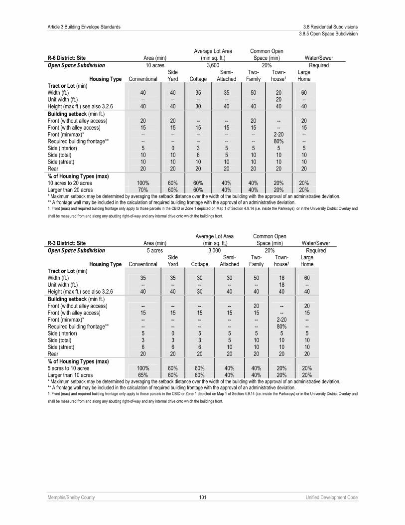
Article 3 Building Envelope Standards 3.8 Residential Subdivisions 3.8.5 Open Space Subdivision
Memphis/Shelby County 101 Unified Development Code
R-6 District: Site Area (min) Average Lot Area
(min sq. ft.) Common Open
Space (min) Water/Sewer Open Space Subdivision 10 acres 3,600 20% Required
Housing Type Conventional
Side Yard Cottage
Semi-Attached
Two-Family
Town-house1
Large Home
Tract or Lot (min) Width (ft.) Unit width (ft.) Height (max ft.) see also 3.2.6
40 -- 40
40 -- 40
35 -- 30
35 -- 40
50 -- 40
20 20 40
60 -- 40
Building setback (min ft.) Front (without alley access) Front (with alley access) Front (min/max)* Required building frontage** Side (interior) Side (total) Side (street) Rear
20 15 -- -- 5 10 10 20
20 15 -- -- 0 10 10 20
-- 15 -- -- 3 6 10 20
-- 15 -- -- 5 5 10 20
20 15 -- -- 5 10 10 20
-- --
2-20 80%
5 10 10 20
20 15 -- -- 5 10 10 20
% of Housing Types (max) 10 acres to 20 acres 100% 60% 60% 40% 40% 20% 20% Larger than 20 acres 70% 60% 60% 40% 40% 20% 20% * Maximum setback may be determined by averaging the setback distance over the width of the building with the approval of an administrative deviation. ** A frontage wall may be included in the calculation of required building frontage with the approval of an administrative deviation. 1. Front (max) and required building frontage only apply to those parcels in the CBID or Zone 1 depicted on Map 1 of Section 4.9.14 (i.e. inside the Parkways) or in the University District Overlay and
shall be measured from and along any abutting right-of-way and any internal drive onto which the buildings front.
R-3 District: Site Area (min) Average Lot Area
(min sq. ft,) Common Open
Space (min) Water/Sewer Open Space Subdivision 5 acres 3,000 20% Required
Housing Type Conventional
Side Yard Cottage
Semi-Attached
Two-Family
Town-house1
Large Home
Tract or Lot (min) Width (ft.) Unit width (ft.) Height (max ft.) see also 3.2.6
35 -- 40
35 -- 40
30 -- 30
30 -- 40
50 -- 40
18 18 40
60 -- 40
Building setback (min ft.) Front (without alley access) Front (with alley access) Front (min/max)* Required building frontage** Side (interior) Side (total) Side (street) Rear
-- 15 -- -- 5 3 6 20
-- 15 -- -- 0 3 6 20
-- 15 -- -- 5 3 6 20
-- 15 -- -- 5 5 10 20
20 15 -- -- 5 10 10 20
-- --
2-20 80%
5 10 10 20
20 15 -- -- 5 10 10 20
% of Housing Types (max) 5 acres to 10 acres 100% 60% 60% 40% 40% 20% 20% Larger than 10 acres 65% 60% 60% 40% 40% 20% 20% * Maximum setback may be determined by averaging the setback distance over the width of the building with the approval of an administrative deviation. ** A frontage wall may be included in the calculation of required building frontage with the approval of an administrative deviation. 1. Front (max) and required building frontage only apply to those parcels in the CBID or Zone 1 depicted on Map 1 of Section 4.9.14 (i.e. inside the Parkways) or in the University District Overlay and
shall be measured from and along any abutting right-of-way and any internal drive onto which the buildings front.
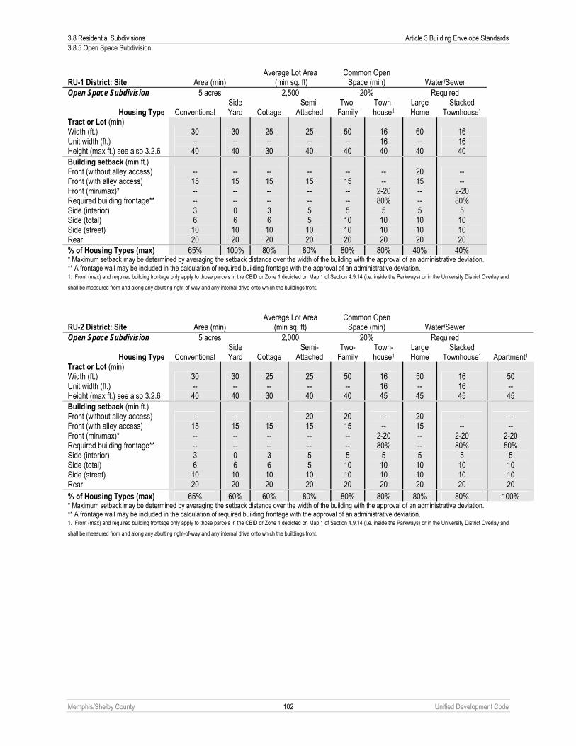
3.8 Residential Subdivisions Article 3 Building Envelope Standards 3.8.5 Open Space Subdivision
Memphis/Shelby County 102 Unified Development Code
RU-1 District: Site Area (min) Average Lot Area
(min sq. ft) Common Open
Space (min) Water/Sewer Open Space Subdivision 5 acres 2,500 20% Required
Housing Type Conventional
Side Yard Cottage
Semi-Attached
Two-Family
Town-house1
Large Home
Stacked Townhouse1
Tract or Lot (min) Width (ft.) Unit width (ft.) Height (max ft.) see also 3.2.6
30 -- 40
30 -- 40
25 -- 30
25 -- 40
50 -- 40
16 16 40
60 -- 40
16 16 40
Building setback (min ft.) Front (without alley access) Front (with alley access) Front (min/max)* Required building frontage** Side (interior) Side (total) Side (street) Rear
-- 15 -- -- 3 6 10 20
-- 15 -- -- 0 6 10 20
-- 15 -- -- 3 6 10 20
-- 15 -- -- 5 5 10 20
-- 15 -- -- 5 10 10 20
-- --
2-20 80%
5 10 10 20
20 15 -- -- 5 10 10 20
-- --
2-20 80%
5 10 10 20
% of Housing Types (max) 65% 100% 80% 80% 80% 80% 40% 40% * Maximum setback may be determined by averaging the setback distance over the width of the building with the approval of an administrative deviation. ** A frontage wall may be included in the calculation of required building frontage with the approval of an administrative deviation. 1. Front (max) and required building frontage only apply to those parcels in the CBID or Zone 1 depicted on Map 1 of Section 4.9.14 (i.e. inside the Parkways) or in the University District Overlay and
shall be measured from and along any abutting right-of-way and any internal drive onto which the buildings front.
RU-2 District: Site Area (min) Average Lot Area
(min sq. ft) Common Open
Space (min) Water/Sewer Open Space Subdivision 5 acres 2,000 20% Required
Housing Type Conventional
Side Yard Cottage
Semi-Attached
Two-Family
Town-house1
Large Home
Stacked Townhouse1 Apartment1
Tract or Lot (min) Width (ft.) Unit width (ft.) Height (max ft.) see also 3.2.6
30 -- 40
30 -- 40
25 -- 30
25 -- 40
50 -- 40
16 16 45
50 -- 45
16 16 45
50 -- 45
Building setback (min ft.) Front (without alley access) Front (with alley access) Front (min/max)* Required building frontage** Side (interior) Side (total) Side (street) Rear
-- 15 -- -- 3 6 10 20
-- 15 -- -- 0 6 10 20
-- 15 -- -- 3 6 10 20
20 15 -- -- 5 5 10 20
20 15 -- -- 5 10 10 20
-- --
2-20 80%
5 10 10 20
20 15 -- -- 5 10 10 20
-- --
2-20 80%
5 10 10 20
-- --
2-20 50%
5 10 10 20
% of Housing Types (max) 65% 60% 60% 80% 80% 80% 80% 80% 100% * Maximum setback may be determined by averaging the setback distance over the width of the building with the approval of an administrative deviation. ** A frontage wall may be included in the calculation of required building frontage with the approval of an administrative deviation. 1. Front (max) and required building frontage only apply to those parcels in the CBID or Zone 1 depicted on Map 1 of Section 4.9.14 (i.e. inside the Parkways) or in the University District Overlay and
shall be measured from and along any abutting right-of-way and any internal drive onto which the buildings front.

Article 3 Building Envelope Standards 3.8 Residential Subdivisions 3.8.6 Sustainable Subdivision
Memphis/Shelby County 103 Unified Development Code
RU-3 District: Site Area (min) Average Lot Area
(min sq. ft,) Common Open
Space (min) Water/Sewer Open Space Subdivision 5 acres 1,800 20% Required
Housing Type Conventional
Side Yard Cottage
Semi-Attached
Two-Family
Town-house1
Large Home
Stacked Townhouse1 Apartment1
Tract or Lot (min) Width (ft.) Unit width (ft.) Height (max ft.) see also 3.2.6
25 -- 40
25 -- 40
20 -- 30
25 -- 40
50 -- 40
14 14 45
50 -- 45
14 14 45
50 -- 45
Building setback (min ft.) Front (without alley access) Front (with alley access) Front (min/max)* Required building frontage** Side (interior) Side (total) Side (street) Rear
-- 15 -- -- 3 6 10 20
-- 15 -- -- 0 6 10 20
-- 15 -- --
2.5 5 10 20
20 15 -- -- 5 5 10 20
20 15 -- -- 5 10 10 20
-- --
2-20 80%
5 10 10 20
20 15 -- -- 5 10 10 20
-- --
2-20 80%
5 10 10 15
-- --
2-20 50%
5 10 10 15
% of Housing Types (max) 65% 60% 60% 80% 80% 80% 80% 80% 100% * Maximum setback may be determined by averaging the setback distance over the width of the building with the approval of an administrative deviation. ** A frontage wall may be included in the calculation of required building frontage with the approval of an administrative deviation. 1. Front (max) and required building frontage only apply to those parcels in the CBID or Zone 1 depicted on Map 1 of Section 4.9.14 (i.e. inside the Parkways) or in the University District Overlay and
shall be measured from and along any abutting right-of-way and any internal drive onto which the buildings front.
C. Required Common Open Space 1. Common open space is an integral part of an open space subdivision. Open space equal to 20% of the total site
area shall be provided as either public or private common open space. Requirements for open space are set forth in Chapter 6.2.
2. No additional open space shall be required on the site, except where otherwise required by state or federal law. In the case that a subdivision is being developed in phases, the amount of open space shall be computed separately for each phase, but may be combined with existing open space in earlier phases to create a larger uniform area.
3.8.6 Sustainable Subdivision Sustainable subdivisions are an optional subdivision type that is permitted in the R-10, R-8, R-6, R-3, RU-1, RU-2, RU-3, RU-4, and RU-5 residential districts. They trade smaller lot sizes (with smaller yards), additional land uses, more diverse housing types and increased density for a more sustainable relation of the subdivision to the environment. This is accomplished by offering incentives in exchange for a subdivision based on smart growth and green building principles. Sustainable subdivisions are intended to encourage development within existing communities and conserve natural and financial resources required for construction and maintenance of infrastructure.
A. Sustainable Subdivision Standards All sustainable subdivisions shall meet the following locational, connectivity, pattern and design, and green construction requirements.
1. Location Sustainable subdivisions should be located within or near existing neighborhoods or public transportation infrastructures. Sustainable subdivisions must satisfy at least one of the following requirements.
a. Locate the development on a previously developed site. b. Locate the development near transit service so that at least 50% of dwelling units within the
development are within ½ mile walk distance of an existing or planned public transportation stop. c. Locate the development near existing neighborhood shops, services, and facilities so that the project
boundary is within ¼-mile walking distance via a pedestrian path of at least five, or within ½-mile walking distance of at least eight specific uses from the following set of use categories:. 1. Community service (see Sub-Section 2.9.3A); 2. Day care (see Sub-Section 2.9.3B); 3. Education facility (see Sub-Section 2.9.3C); 4. Place of worship (see Sub-Section 2.9.3G);
3.8 Residential Subdivisions Article 3 Building Envelope Standards 3.8.6 Sustainable Subdivision
Memphis/Shelby County 104 Unified Development Code
5. Restaurant (see Sub-Section 2.9.4G); or 6. Retail sales and service (see Sub-Section 2.9.4H).
2. School, Housing, and Employment Proximity Sustainable subdivisions should promote public health through physical activity by facilitating walking to school and work, encouraging a diversity of uses and employment opportunities, and reducing energy consumption and pollution from motor vehicles by providing opportunities for shorter vehicle trips and/or use of alternative modes of transportation. Sustainable subdivisions must satisfy at least one of the following requirements.
a. Locate and/or design the subdivision so that the center of the development is within a ½-mile walking distance of a number of pre-project jobs equal to or greater than 50% of the number of dwelling units in the project;
b. Include a nonresidential component equaling at least 10% of the projects total building projected square footage; or
c. Locate or design the subdivision so that at least 30% of the projects dwelling units are within ½-mile walking distance of an existing or planned public or private school.
3. Reduced Automobile Dependence Sustainable subdivisions should encourage development in locations that exhibit superior performance in providing transportation choices or otherwise reducing motor vehicle use. Sustainable subdivisions must satisfy at least one of the following requirements.
a. Locate the subdivision on a site with transit service of four or more transit rides per week day. The total number of rides available during weekdays is defined as the number of buses or streetcars stopping within a ½-mile walking distance of at least 50% of the subdivision’s dwellings and business entrances; or
b. Design or locate the subdivision such that 50% of the dwelling units and business entrances are within three miles of at least ten or more of the specific uses listed in paragraph 1 above using an existing or planned bicycle network and/or a biking network that will be completed as part of the project (three mile distance is measured along the biking network, not as a straight radius) and for any nonresidential buildings (excluding hotels) and multifamily residential buildings without garages that are part of the subdivision, provide parking spaces or storage for a capacity of no less than five percent of the off-street parking space capacity provided for cars for those buildings.
4. Open Community Sustainable subdivisions should promote communities that are physically connected to each other and foster community and connectedness beyond the development. All streets and sidewalks that are built as part of the subdivision or which serve the subdivision directly shall be public streets and sidewalks or designated as available for general public use and, with the exception of alleys or parking areas, not gated.
5. Compact Development Sustainable subdivisions should promote the conservation of land, livability, transportation efficiency, and walkability. All residential components of the subdivision must be built at an average density of at least seven or more dwelling units per acre of buildable land available for residential uses. The specified average density must be achieved by the point in the subdivision’s construction at which 50% of dwelling units are built or within five years of the date that the first building is occupied, whichever is longer. In addition, sustainable subdivisions must satisfy at least one of the following requirements
a. Locate or design the subdivision such that at least 50% of the dwelling units are within ½ mile walk distance of at least four of the specific uses listed in paragraph 1 above; or
b. Include a sufficient variety of housing sizes and types in the subdivision such that the total variety of housing within a ¼-mile of the center of the project, achieves at least 0.5 according to the Simpson Diversity Index using the housing categories permitted in each sustainable subdivision district (see Sub-Section 3.8.6C).
6. Reduced Parking Footprint Sustainable subdivisions should design parking to facilitate walkability and to minimize the adverse environmental effects of surface parking lots. All nonresidential and multifamily residential buildings that are part of the subdivision, must locate all off-street surface parking lots to the side or rear of the buildings, leaving
Article 3 Building Envelope Standards 3.8 Residential Subdivisions 3.8.6 Sustainable Subdivision
Memphis/Shelby County 105 Unified Development Code
building frontages and streetscapes free of off-street surface parking lots. Additionally, all nonresidential and multifamily residential buildings may use no more than 20% of the total development footprint area for surface parking facilities, with no individual impervious surface parking lot larger than one and one half acres. Surface parking facilities include ground-level garages unless they are under space intended for human occupancy. Underground or multi-story parking facilities may be used to provide additional capacity. On-street parking spaces are exempt from this provision.
7. Street Network Sustainable subdivisions should provide appealing and comfortable pedestrian and bicycle friendly street environments in order to promote pedestrian activity and public health through increased physical activity. Sustainable subdivisions must provide continuous sidewalks consistent with Chapter 4.3, Streetscape Standards and conform to the MPO Long Range Transportation Plan regarding connectivity. Additionally, sustainable subdivisions must satisfy at least one of the following requirements.
a. Design the subdivision such that the subdivision’s average street grid density is at least 20 centerline miles/subdivision square mile; or
b. Design and build the subdivision so that there is at least one through-street at the project boundary every 800 feet or at existing abutting street intervals, whichever is smaller (this does not apply to connections which cannot physically be made).
8. Access to Public Spaces Sustainable subdivisions should be designed and located so as to provide a variety of open spaces close to work and home to encourage walking, physical activity, and time spent outdoors. Sustainable subdivisions shall satisfy at least one of the following requirements.
a. Locate or design the subdivision so that a formal open space (see Section 6.2.3) at least 2,500 square feet in size is within a walking distance of 800 feet of 70% of the dwelling units and business entrances in the subdivision; or
b. Locate or design the subdivision so that an active public open space facility of at least two acres lies within ½ mile walk distance of 70% of the dwelling units and business entrances in the subdivision.
9. Construction and Technology Sustainable subdivisions should design and construct buildings so as to utilize green building practices, extend the life cycle of existing building stock, reduce air, water and land pollution and reduce environmental impacts of new buildings as they relate to materials manufacturing and transport. Sustainable subdivisions shall satisfy at least one of the following requirements.
a. Design and construct or retrofit, at least 10% of the building square footage of the subdivision to be certified under at least one of the following LEED building rating systems: 1. LEED for New Construction; 2. LEED for Existing Buildings; 3. LEED for Homes; 4. LEED for Core and Shell; or 5. LEED for Schools; or
b. Design and construct at least 75% of new dwelling units in the subdivision to be certified EcoBuild homes under the MLGW EcoBuild program; or
c. Design and construct 55% of new dwelling units in the subdivision to be certified under the National Association of Home Builders (NAHB) Green Building standard, or other approved certifying program; or
d. Use roofing materials that have a Solar Reflectance Index (SRI) equal to or greater than the values in the table below for a minimum of 75% of the roof surface of all buildings within the project; or install a “green” (vegetated) roof for at least 50% of the roof area of all buildings within the project
Roof Type Slope SRI
Low-Sloped Roof ≤ 2:12 78 Steep-Sloped Roof ≥ 2:12 29
1. Combinations of SRI compliant and vegetated roof may be used provided that they collectively cover 75% of the roof area of all buildings; or

3.8 Residential Subdivisions Article 3 Building Envelope Standards 3.8.6 Sustainable Subdivision
Memphis/Shelby County 106 Unified Development Code
2. Locate the development footprint on areas that are 100% previously developed and for which the zone of construction is 100% previously developed; or
3. Incorporate into the subdivision the reuse of at least three buildings, that each maintains at least 50% (based on surface area) of the existing building structure (including structural floor and roof decking) and envelope (including exterior skin and framing, and excluding window assemblies and non-structural roofing material). Hazardous materials that are remediated as a part of the project scope shall be excluded from the calculation of the percentage maintained.
B. Sustainable Subdivision Incentives
1. Additional Uses Imperative to the implementation of sustainable developments is mixture of residential, commercial, and employment uses within a walkable distance of each other. As such the following additional uses are permitted by right in a sustainable subdivision provided that at least 50% of the developed square footage is in the form of residential uses.
a. Live-work b. Single tenant office uses under 5,000 square feet c. Bed and Breakfast d. Restaurants without drive-thru or drive in service e. Restaurants with the sale of alcoholic beverages, brewpub f. Retail sales and service smaller than 3,000 square feet without drive-thru service. g. Medical, dental or chiropractic clinic, massage therapy, outpatient surgery center smaller than 3,000
square feet. h. Health club i. School, public or private (K-12) j. Place of worship
2. Additional Parking for Nonresidential Uses In addition to any parking reduction allowed in Sub-Section 4.5.3E, nonresidential uses in a sustainable subdivision shall receive an additional 10% reduction based on the mixed use nature of the development.
C. Sustainable Subdivision Metrics
The designated formal open space shall be established prior to the calculation of the metrics below. Housing classified as Group Living under Section 2.5.2 shall follow the appropriate building regulations in this Sub-Section for the housing types in which the Group Living is located.

Article 3 Building Envelope Standards 3.8 Residential Subdivisions 3.8.6 Sustainable Subdivision
Memphis/Shelby County 107 Unified Development Code
R-10 District: Site Area (min) Average Lot Area
(min sq. ft.) Formal Open Space (min) Water/Sewer
Sustainable Subdivision 5 acres 6,000 0.6% Existing Required
Housing Type Conventional Side Yard Cottage
Semi-Attached
Two-Family
Town-house1
Large Home
Tract or Lot (min) Area (sq. ft.) Width (ft.) Unit width (ft.) Height (max ft.) see also 3.2.6
6,000 45 -- 40
6,000 45 -- 40
3,000 30 -- 30
3,000 30 -- 40
6,000 50 -- 40
1,500 20 20 40
8,000 50 -- 40
Building setback (min ft.) Front (without alley access) Front (with alley access) Front (min/max)* Required building frontage** Side (interior) Side (total) Side (street) Rear
20 15 -- -- 5 10 10 20
20 15 -- -- 0 10 10 20
-- 15 -- -- 3 6 10 20
20 15 -- -- 5 5 10 20
20 15 -- -- 5 10 10 20
-- --
2-20 80%
5 10 10 20
20 15 -- -- 5 10 10 20
% of Housing Types (max) 65% 60% 60% 40% 40% 20% 20% * Maximum setback may be determined by averaging the setback distance over the width of the building with the approval of an administrative deviation. ** A frontage wall may be included in the calculation of required building frontage with the approval of an administrative deviation. 1. Front (max) and required building frontage only apply to those parcels in the CBID or Zone 1 depicted on Map 1 of Section 4.9.14 (i.e. inside the Parkways) or in the University District Overlay and
shall be measured from and along any abutting right-of-way and any internal drive onto which the buildings front.
R-8 District: Site Area (min) Average Lot Area
(min sq. ft.) Formal Open Space (min) Water/Sewer
Sustainable Subdivision 2.5 acres 4,800 0.6% Existing Required
Housing Type Conventional Side Yard Cottage
Semi-Attached
Two-Family
Town-house1
Large Home
Tract or Lot (min) Area (sq. ft.) Width (ft.) Unit width (ft.) Height (max ft.) see also 3.2.6
4,800 35 -- 40
4,800 35 -- 40
3,000 30 -- 30
3,000 35 -- 40
5,500 50 -- 40
1,500 20 20 40
8,000 50 -- 40
Building setback (min ft.) Front (without alley access) Front (with alley access) Front (min/max)* Required building frontage** Side (interior) Side (total) Side (street) Rear
-- 15 -- -- 5 10 10 20
-- 15 -- -- 0 10 10 20
-- 15 -- -- 3 6 10 20
20 15 -- -- 5 5 10 20
20 15 -- -- 5 10 10 20
-- --
2-20 80%
5 10 10 20
20 15 -- -- 5 10 10 20
% of Housing Types (max) 65% 60% 60% 40% 40% 20% 20% * Maximum setback may be determined by averaging the setback distance over the width of the building with the approval of an administrative deviation. ** A frontage wall may be included in the calculation of required building frontage with the approval of an administrative deviation. 1. Front (max) and required building frontage only apply to those parcels in the CBID or Zone 1 depicted on Map 1 of Section 4.9.14 (i.e. inside the Parkways) or in the University District Overlay and
shall be measured from and along any abutting right-of-way and any internal drive onto which the buildings front.

3.8 Residential Subdivisions Article 3 Building Envelope Standards 3.8.6 Sustainable Subdivision
Memphis/Shelby County 108 Unified Development Code
R-6 District: Site Area (min) Average Lot Area
(min sq. ft.) Formal Open Space (min) Water/Sewer
Sustainable Subdivision 2.5 acres 3,600 0.6% Existing Required
Housing Type Conventional Side Yard Cottage
Semi-Attached
Two-Family
Town-house1
Large Home
Tract or Lot (min) Area (sq. ft.) Width (ft.) Unit width (ft.) Height (max ft.) see also 3.2.6
4,500 35 -- 40
4,500 35 -- 40
2,500 25 -- 30
3,000 30
-- 40
5,000 50 -- 40
1,500 20 20 40
8,000 50 -- 40
Building setback (min ft.) Front (without alley access) Front (with alley access) Front (min/max)* Required building frontage** Side (interior) Side (total) Side (street) Rear
-- 15 -- -- 5 10 10 20
-- 15 -- -- 0 10 10 20
-- 15 -- --
2.5 5 10 20
-- 15 -- -- 5 5 10 20
20 15 -- -- 5 10 10 20
-- --
2-20 80%
5 10 10 20
20 15 -- -- 5 10 10 20
% of Housing Types (max) 65% 60% 60% 40% 40% 20% 20% * Maximum setback may be determined by averaging the setback distance over the width of the building with the approval of an administrative deviation. ** A frontage wall may be included in the calculation of required building frontage with the approval of an administrative deviation. 1. Front (max) and required building frontage only apply to those parcels in the CBID or Zone 1 depicted on Map 1 of Section 4.9.14 (i.e. inside the Parkways) or in the University District Overlay and
shall be measured from and along any abutting right-of-way and any internal drive onto which the buildings front.
R-3 District: Site Area (min) Average Lot Area
(min sq. ft.) Formal Open Space
(min) Water/Sewer Sustainable Subdivision 2.5 acres 2,800 1.6% Existing Required
Housing Type Conventional
Side Yard Cottage
Semi-Attached
Two-Family
Town-house1
Large Home
Tract or Lot (min) Area (sq. ft.) Width (ft.) Unit width (ft.) Height (max ft.) see also 3.2.6
4,000 35 -- 40
4,000 35 -- 40
2,500 25 -- 30
2,500 30 -- 40
5,000 50 -- 40
1,300 18 18 40
8,000 50 -- 40
Building setback (min ft.) Front (without alley access) Front (with alley access) Front (min/max)* Required building frontage** Side (interior) Side (total) Side (street) Rear
-- 15 -- -- 5 10 10 20
-- 15 -- -- 0 10 10 20
-- 15 -- --
2.5 5 10 20
-- 15 -- -- 5 -- 10 20
20 15 -- -- 5 10 10 20
-- --
2-20 80%
5 10 10 20
20 15 -- -- 5 10 10 20
% of Housing Types (max) 65% 60% 60% 40% 40% 20% 20% * Maximum setback may be determined by averaging the setback distance over the width of the building with the approval of an administrative deviation. ** A frontage wall may be included in the calculation of required building frontage with the approval of an administrative deviation. 1. Front (max) and required building frontage only apply to those parcels in the CBID or Zone 1 depicted on Map 1 of Section 4.9.14 (i.e. inside the Parkways) or in the University District Overlay and
shall be measured from and along any abutting right-of-way and any internal drive onto which the buildings front.

Article 3 Building Envelope Standards 3.8 Residential Subdivisions 3.8.6 Sustainable Subdivision
Memphis/Shelby County 109 Unified Development Code
RU-1 District: Site Area (min) Average Lot Area
(min sq. ft) Formal Open Space (min) Water/Sewer
Sustainable Subdivision 2.5 acres 2,800 0.6% Existing Required
Housing Type Conventional Side Yard Cottage
Semi-Attached
Two-Family
Town-house1
Large Home
Stacked Townhouse1 Apartment1
Tract or Lot (min) Area (sq. ft.) Width (ft.) Unit width (ft.) Height (max ft.) see also 3.2.6
4,000 35 -- 40
4,000 35 -- 40
2,500 25 -- 30
2,500 30 -- 40
5,000 50 -- 40
1,200 16 16 40
8,000 50 -- 40
1,200 16 16 40
8,000 50 -- 40
Building setback (min ft.) Front (without alley access) Front (with alley access) Front (min/max)* Required building frontage** Side (interior) Side (total) Side (street) Rear
-- 15 -- -- 5 10 10 20
-- 15 -- -- 0 10 10 20
-- 15 -- --
2.5 5 10 20
-- 15 -- -- 5 5 10 20
20 15 -- -- 5 10 10 20
-- --
2-20 80%
5 10 10 20
20 15 -- -- 5 10 10 20
-- --
2-20 80%
5 10 10 15
-- --
2-20 50%
5 10 10 15
% of Housing Types (max) 65% 60% 60% 40% 40% 20% 20% 40% 20% * Maximum setback may be determined by averaging the setback distance over the width of the building with the approval of an administrative deviation. ** A frontage wall may be included in the calculation of required building frontage with the approval of an administrative deviation. 1. Front (max) and required building frontage only apply to those parcels in the CBID or Zone 1 depicted on Map 1 of Section 4.9.14 (i.e. inside the Parkways) or in the University District Overlay and
shall be measured from and along any abutting right-of-way and any internal drive onto which the buildings front.
RU-2 District: Site Area (min) Average Lot Area
(min sq. ft.) Formal Open Space (min) Water/Sewer
Sustainable Subdivision 2.5 acres 2,800 0.6% Existing Required
Housing Type Conventional Side Yard Cottage
Semi-Attached
Two-Family
Town-house1
Large Home
Stacked Townhouse1 Apartment1
Tract or Lot (min) Area (sq. ft.) Width (ft.) Unit width (ft.) Height (max ft.) see also 3.2.6
4,000 35 -- 40
4,000 35 -- 40
2,500 25 -- 30
2,500 30 -- 40
5,000 50 -- 40
1,200 16 16 45
7,000 45 -- 45
1,200 16 16 45
7,000 45 -- 45
Building setback (min ft.) Front (without alley access) Front (with alley access) Front (min/max)* Required building frontage** Side (interior) Side (total) Side (street) Rear
-- 15 -- -- 5 10 10 20
-- 15 -- -- 0 10 10 20
-- 15 -- --
2.5 5 10 20
-- 15 -- -- 5 5 10 20
20 15 -- -- 5 10 10 20
-- --
2-20 80%
5 10 10 20
20 15 -- -- 5 10 10 20
-- --
2-20 80%
5 10 10 15
-- --
2-20 50%
5 10 10 15
% of Housing Types (max) 65% 60% 60% 40% 40% 20% 20% 40% 20% * Maximum setback may be determined by averaging the setback distance over the width of the building with the approval of an administrative deviation. ** A frontage wall may be included in the calculation of required building frontage with the approval of an administrative deviation. 1. Front (max) and required building frontage only apply to those parcels in the CBID or Zone 1 depicted on Map 1 of Section 4.9.14 (i.e. inside the Parkways) or in the University District Overlay and
shall be measured from and along any abutting right-of-way and any internal drive onto which the buildings front.

3.8 Residential Subdivisions Article 3 Building Envelope Standards 3.8.6 Sustainable Subdivision
Memphis/Shelby County 110 Unified Development Code
RU-3 District: Site Area (min) Average Lot Area
(min sq. ft.) Formal Open Space (min) Water/Sewer
Sustainable Subdivision 2.5 acres 2,800 0.6% Existing Required
Housing Type Conventional Side Yard Cottage
Semi-Attached
Two-Family
Town-house1
Large Home
Stacked Townhouse1 Apartment1
Tract or Lot (min) Area (sq. ft.) Width (ft.) Unit width (ft.) Height (max ft.) see also 3.2.6
4,000 35 -- 40
4,000 35 -- 40
2,500 25 -- 30
2,500 30 -- 40
5,000 50 -- 40
1,200 16 16 45
6,000 40- -- 45
1,200 16 16 45
6,000 40 -- 45
Building setback (min ft.) Front (without alley access) Front (with alley access) Front (min/max)* Required building frontage** Side (interior) Side (total) Side (street) Rear
-- 15 -- -- 5 10 10 20
-- 15 -- -- 0 10 10 20
-- 15 -- --
2.5 5 10 20
-- 15 -- -- 5 5 10 20
20 15 -- -- 5 10 10 20
-- --
2-20 80%
5 10 10 20
20 15 -- -- 5 10 10 20
-- --
2-20 80%
5 10 10 15
-- --
2-20 50%
5 10 10 15
% of Housing Types (max) 50% 45% 50% 50% 50% 60% 20% 65% 65% * Maximum setback may be determined by averaging the setback distance over the width of the building with the approval of an administrative deviation. ** A frontage wall may be included in the calculation of required building frontage with the approval of an administrative deviation. 1. Front (max) and required building frontage only apply to those parcels in the CBID or Zone 1 depicted on Map 1 of Section 4.9.14 (i.e. inside the Parkways) or in the University District Overlay and
shall be measured from and along any abutting right-of-way and any internal drive onto which the buildings front.
RU-4 District: Site Area (min) Average Lot Area
(min sq. ft.) Formal Open Space (min) Water/Sewer
Sustainable Subdivision 2.5 acres 2,800 0.6% Existing Required
Housing Type Conventional Side Yard Cottage
Semi-Attached
Two-Family
Town-house1
Large Home
Stacked Townhouse1 Apartment1
Tract or Lot (min) Area (sq. ft.) Width (ft.) Unit width (ft.) Height (max ft.) see also 3.2.6
4,000 35 -- 40
4,000 35 -- 40
2,500 25 -- 30
2,500 30 -- 40
5,000 50 -- 40
1,000 14 14 50
6,000 40 -- 50
1,000 14 14 50
6,000 40 -- 75
Building setback (min ft.) Front (without alley access) Front (with alley access) Front (min/max)* Required building frontage** Side (interior) Side (total) Side (street) Rear
-- 15 -- -- 5 10 10 20
-- 15 -- -- 0 10 10 20
-- 15 -- --
2.5 5 10 20
-- 15 -- -- 5 5 10 20
20 15 -- -- 5 10 10 20
-- --
2-20 80%
5 10 10 20
20 15 -- -- 5 10 10 20
-- --
2-20 80%
5 10 10 15
-- --
2-20 50%
5 10 10 15
% of Housing Types (max) 65% 60% 60% 40% 40% 20% 20% 40% 20% * Maximum setback may be determined by averaging the setback distance over the width of the building with the approval of an administrative deviation. ** A frontage wall may be included in the calculation of required building frontage with the approval of an administrative deviation. 1. Front (max) and required building frontage only apply to those parcels in the CBID or Zone 1 depicted on Map 1 of Section 4.9.14 (i.e. inside the Parkways) or in the University District Overlay and
shall be measured from and along any abutting right-of-way and any internal drive onto which the buildings front.

Article 3 Building Envelope Standards 3.8 Residential Subdivisions 3.8.7 Regulations for Permitted Nonresidential Uses
Memphis/Shelby County 111 Unified Development Code
RU-5 District: Site Area (min) Average Lot
Area (min sq. ft.) Formal Open Space (min) Water/Sewer
Sustainable Subdivision 2.5 acres 1,800 0.6% Existing Required
Housing Type Town-house1
Large Home
Stacked Townhouse1 Apartment1
Tract or Lot (min) Area (sq. ft.) Width (ft.) Unit width (ft.) Height (max ft.) see also 3.2.6
1,000 14 16 50
5,000 40 -- 50
1,000 14 16 50
5,000 40 --
105 Building setback (min ft.) Front (without alley access) Front (with alley access) Front (min/max)* Required building frontage** Side (interior) Side (total) Side (street) Rear
-- --
7-15 80%
5 10 10 20
20 15 -- -- 5 10 10 20
-- --
7-15 80%
5 10 10 15
-- --
7-15 50%
5 10 10 15
% of Housing Types (max) 50% 20% 65% 80% * Maximum setback may be determined by averaging the setback distance over the width of the building with the approval of an administrative deviation. ** A frontage wall may be included in the calculation of required building frontage with the approval of an administrative deviation. 1. Front (max) and required building frontage only apply to those parcels in the CBID or Zone 1 depicted on Map 1 of Section 4.9.14 (i.e. inside the Parkways) or in the University District Overlay and
shall be measured from and along any abutting right-of-way and any internal drive onto which the buildings front.
3.8.7 Regulations for Permitted Nonresidential Uses A. Sustainable Subdivision
1. All nonresidential development in a sustainable subdivision must meet the shopfront or pedestrian frontage requirements (see Section 3.10.3).
2. Drive-thru facilities are not permitted in any sustainable subdivision.
B. Open Space Subdivision 1. All nonresidential development in an open subdivision must meet the shopfront, pedestrian or urban frontage
requirements (see Section 3.10.3). 2. Drive-thru facilities are not permitted in any open space subdivision.

3.9 Residential Compatibility Article 3 Building Envelope Standards 3.9.1 Garage and Carport Placement
Memphis/Shelby County 112 Unified Development Code
3.9 RESIDENTIAL COMPATIBILITY
3.9.1 Garage and Carport Placement A. Applicability
1. The following garage and carport placement requirements apply to all housing types within any district. 2. In addition to the standards provided below, attached garages and carports are considered part of the principal
structure and must meet all applicable requirements of the principal structure. 3. In addition to the standards provided below, detached garages and carports are considered accessory structures
and must meet all applicable requirements of Chapter 2.7, Accessory Structures and Uses.
B. Alley Access Required When an alley is provided and developed all vehicular access shall take place from the alley. Access may be taken from the side street on corner lots.
C. Conventional, Side Yard, Semi-Attached, Two-Family, Large Home Street-facing garages and carports, when provided must be positioned as set forth below, however, carports may not be permitted in the carriage court form.
D. Cottage, Townhouse, Stacked Townhouse Street-facing garages and carports are not permitted with cottage, townhouse or stacked townhouse units. When provided garages and carports must be positioned as set forth below.

Article 3 Building Envelope Standards 3.9 Residential Compatibility 3.9.2 Contextual Infill Standards
Memphis/Shelby County 113 Unified Development Code
3.9.2 Contextual Infill Standards A. Intent
The following standards are intended to accommodate the majority of infill development in existing residential neighborhoods. They have been crafted to allow an applicant (and staff) to look to the surrounding “context” for guidance in construction. These standards are intended to encourage reinvestment in existing neighborhoods and reinforce the traditional character of established residential neighborhoods.
B. Applicability 1. The contextual infill development standards shall be used on any residential project that is less than two acres in
size and is abutted on two or more sides by existing single-family detached or single-family attached development lots platted or established before 1950 in a residential district. For the purpose of this paragraph, development containing dwelling units fronting an abutting street to the subject site shall be considered an abutting development.
2. Residential projects two acres or more in size shall follow the applicable district standards (see Chapter 3.6, 3.7, or 3.8).
3. These contextual infill standards may not be used for nonresidential development in residential districts. 4. The provisions of this Section may be waived through the subdivision approval process, provided a determination
is made that no substantial harm will be imposed upon the health, safety and welfare of the surrounding neighborhood.
C. Lot Area There is no minimum lot area provided all other contextual infill standards are met.
D. Lot Width The minimum lot width requirement is the smaller of:
1. The average width of the four lots on either side of the project site fronting on the same block face (the two closest lots in either direction along the street); or
2. The average of the widths for all lots fronting on the same block face.
E. Front Setbacks Structures shall be located within the range of front setbacks on the street. This range of setbacks is measured on the basis of the four lots surrounding the project site (the two closest lots in either direction along the street).The new structure shall be located within the range of setbacks (no closer than the narrowest setback, no further than the deepest setback). Where a setback in these four lots is significantly out of the range of setbacks along the street, it may be eliminated from the range. Where the calculation of a range of setbacks is not practicable, the structure shall be located a minimum of 20 feet from the front property line.
F. Side and Rear Setbacks The minimum side and rear setback for the respective district applies. However, if the wall of an existing structure is located on or within three feet of the adjoining property line, windows or other openings in the new structure that would allow for visibility into the side or rear yard of the adjacent lot are not allowed unless a minimum ten-foot building separation is provided. Windows that do not allow visibility into the side or rear yard of the adjacent lot, such as clerestory windows or translucent windows, are allowed regardless of the building separation.

3.9 Residential Compatibility Article 3 Building Envelope Standards 3.9.2 Contextual Infill Standards
Memphis/Shelby County 114 Unified Development Code
G. Height Height may not exceed the applicable district standard (Chapter 3.6, 3.7, or 3.8) or in case of a height map not exceed the established height limitations of the official adopted height map (see Section 3.2.6).
H. Garages and Carports Street-facing garages and carports may be allowed if an alley is not present and street-facing garages or carports are part of the dominant character of all properties fronting on the same block face.
I. Front Porches A front porch shall be required if front porches are part of the dominant character of all properties fronting on the same block face. Any project that requires a front porch must have a front porch with a minimum depth of eight feet. A minimum porch depth of six feet may be approved by the Planning Director if any property on the same block face has a front porch less six feet in depth.
J. Ground Floor Elevation Raised ground floors shall be required if raised ground floors are part of the dominant character of all properties fronting on the same block face. Any project that requires a raised ground floor must have a foundation height of at least 18 inches measured from top of grade to the first finished floor. (See Sub-Section 3.2.6A, Building Height, to determine foundation height.) In the event of a demonstrated disability hardship, the Planning Director may approve an alternative zero-step entry design.

Article 3 Building Envelope Standards 3.10 Mixed Use and Industrial Districts 3.10.1 Applicability
Memphis/Shelby County 115 Unified Development Code
3.10 MIXED USE AND INDUSTRIAL DISTRICTS
3.10.1 Applicability A. The building regulations in a mixed use or industrial district may vary based on whether or not a frontage type has
been assigned to a specific property.
B. This Chapter applies to principal buildings only. For standards affecting accessory structures see Chapter 2.7.
3.10.2 Undesignated Frontage Standards A. General
The following general building regulations apply to all undesignated frontages (see Section 3.10.3 for designated frontage requirements). To determine whether or not a designated frontage has been assigned to a specific property consult the Zoning Map (see Chapter 2.4 for additional details).

3.10 Mixed Use and Industrial Districts Article 3 Building Envelope Standards 3.10.2 Undesignated Frontage Standards
Memphis/Shelby County 116 Unified Development Code
B. Apartment and Nonresidential RW* OG CMU-1 CMU-2 CMU-3 CBD
Tract or Lot (min) Area (sq. ft.) Width (ft.)
5,000 50
-- 100
10,000 25
20,000 50
-- 50
-- --
Building Height (max ft.) see also 3.2.6 Ground floor area (max sq. ft.)**
50 --
125 --
48 15,000
75
80,000
75 --
-- --
Setback (min ft.) Front Side (street) Side rear abutting single-family Side/rear abutting multifamily, nonresidential Side/rear abutting alley
20 20 10 5
5
20 20 10 5
5
20 20 10 5
5
20 20 10 5
5
20 20 10 5
5
Parking setback (min ft.) On street (parallel parking) From street (no parallel parking) Abutting single-family Abutting multifamily, nonresidential, alley
0 8 10 5
0 8 10 5
0 8 10 5
0 8 10 5
0 8 10 5
None*** None*** None*** None*** None***
0 8 10 5
CMP-1 CMP-2 EMP WD IH
Tract or Lot (min) Area (sq. ft.) Width (ft.)
10,000
25 20,000
50 20,000
50 20,000
50 20,000
50 Building Height (max ft.) see also 3.2.6 Height (max ft.) more than 100 ft from a residential district
125 125
75 75
60 60
60 60
60 100
Setback (min ft.) Front Side (street) Side/rear abutting single-family Side/rear abutting multifamily, nonresidential Side/rear abutting alley
20 20 10 5
5
20 20 25 5
5
30 20 10 5
5
30 20 10 5
5
30 20 10 5
5
Parking setback (min ft.) On street (parallel parking) From street (no parallel parking) Abutting single-family Abutting multifamily, nonresidential, alley
0 8 10 5
0 8 10 5
0 8 10 5
0 8 10 5
0 8 10 5
*Residential compatibility standards may apply see D **Maximum ground floor area shall not apply to sites that were developed prior to Jan. 1, 2011. Buildings on sites developed prior to Jan. 1, 2011, may be expanded, modified or rebuilt and exceed the maximum ground floor area standards. ***A property owner may also choose to opt into the CBD District Form Standards of Sub-Section 3.10.2E in lieu of these standards.
1. Reduced Front Setbacks The minimum front and side street setbacks of 20 feet as specified in Sub-Section 3.10.1A above may be reduced to zero feet provided the following provisions are met for any portion of the building façade that comes within 20 feet of the front or side property line:
a. Blank Wall Area Blank lengths of wall exceeding 30 linear ft. are prohibited.
b. Transparency 1. Ground floor facades for nonresidential uses must provide a minimum transparency of 40%; however,
the transparency requirement may be reduced to 30% if no façade plane of the building facing a public street exceeds a length to height ratio of 4:1. The offset between planes must be a minimum of 12 inches.
2. Ground floor facades for residential uses must provide a minimum transparency of 20%.

Article 3 Building Envelope Standards 3.10 Mixed Use and Industrial Districts 3.10.2 Undesignated Frontage Standards
Memphis/Shelby County 117 Unified Development Code
3. Ground floor transparency is measured between 2 and 10 ft. above the adjacent sidewalk. 4. Ground floor residential, office and industrial uses may provide translucent windows to meet all ground
floor transparency requirements. 5. Upper floor facades must provide a minimum transparency of 20%. 6. Retail sales and service uses. A minimum of 50% of the window pane surface area shall allow views
into the ground floor for a depth of at least four feet. Windows shall not be made opaque by window treatments (excepting operable sunscreen devices within the conditioned space).
2. Liner Buildings The building regulations in mixed use or industrial districts apply to all buildings fronting a public street or an approved private drive. In developments with ground floor areas greater than 15,000 square feet, liner buildings may be used to meet the setback and building frontage requirements.
3. Drive-Thru Facilities With the exception of financial institutions, drive-thru facilities are not permitted in an OG District. Drive-thru facilities are permitted through special exception process in a RW District (see Chapter 9.14). Location and screening requirements for drive-thru facilities in all other districts are set forth in Section 4.6.8.
C. Residential Housing Types For permitted housing types by district see the use table (Chapter 2.5).
Housing Type Conventional Side Yard Cottage
Semi-Attached
Two-Family
Town-house
Large Home
Stacked Townhouse
Tract or Lot (min) Area (sq. ft.) Width (ft.) Unit width (ft.) Height (max ft.) see also 3.2.6
4,000 35 -- 40
4,000 35 -- 40
2,500 25 -- 30
2,500 30 -- 40
5,000 50 -- 40
1,000 14 14 50
6,000 40 -- 40
1,000 14 14 50
Building setback (min ft.) Front (with street access) Front (with alley access) Front (min/max) Required building frontage Side (interior) Side (total) Side (street) Rear
-- 15 -- -- 5 10 10 20
-- 15 -- -- 0 10 10 20
-- 15 -- --
2.5 5 10 20
-- 15 -- -- 5 5 10 20
20 15 -- -- 5 10 10 20
-- --
2-20 80%
5 10 10
5 or 20+
20 15 -- -- 5 10 10 20
-- --
2-20 80%
5 10 10
5 or 20+

3.10 Mixed Use and Industrial Districts Article 3 Building Envelope Standards 3.10.2 Undesignated Frontage Standards
Memphis/Shelby County 118 Unified Development Code
D. Residential Compatibility Standards for the RW District 1. In a location where a side yard is adjacent to an existing conventional, side yard, cottage, semi-attached, or two-
family housing type: a. The front setback shall conform to contextual infill standards of Section 3.9.2; b. The building shall not exceed the average width of residential buildings located on the same block by more
than 25%; c. The height of the of the building shall not exceed the average height of residential buildings located on the
same block by more than 50%; d. No parking shall be permitted between the building and the street; e. New buildings shall be constructed with a residential appearance and conversions of residential structures
shall maintain a residential appearance; and f. Signs shall be governed by the single-family residential (R-E, R-15, R-10, R-8, R-6, R-3) district sign
regulations. 2. If designated to permit adaptive reuse of an existing residential dwelling, accessory structures shall be governed
by the single-family residential (R-E, R-15, R-10, R-8, R-6, R-3) district sign regulations.

Article 3 Building Envelope Standards 3.10 Mixed Use and Industrial Districts 3.10.2 Undesignated Frontage Standards
Memphis/Shelby County 119 Unified Development Code
E. CBD District Form Standards The following building form standards apply in the CBD District.
PLACEMENT ELEMENTS HEIGHT
SETBACK AREA 2ft min. (7 ft. if ground floor use is a restaurant with outdoor seating) to 15 ft. max. behind ROW line. CONTEXTUAL INFILL For any infill project in the CBD with less than 75 feet of frontage, and upon approval of the Planning Director, structures may be located closer to the ROW line than the minimum setback permits provided that the structure is located within the range of front setbacks on the street. This range of setbacks is measured on the basis of the four structures surrounding the project site (the two closest lots in either direction along the street).The new structure shall be located within the range of established setbacks (no closer than the narrowest setback, no further than the deepest setback). Where a setback in these four lots is significantly out of the range of setbacks along the street, it may be eliminated from the range. REQUIRED BUILDING FRONTAGE 1. Primary street. Building façade must be located within
the setback area for a minimum of 90% of the site width. The required building frontage may be reduced to accommodate no more than a single 20-ft. access drive for a rear parking area.
2. Side street. The building façade must be located within the setback area for a minimum of 60% of the site depth.
SIDE/REAR SETBACKS Abutting single-family: 10 ft min. Abutting multifamily, nonresidential: no minimum. PARKING SETBACK 1. Primary street setback. Min 30 ft. behind ROW line. 2. Side street setback. Min 10 ft. behind ROW line. Parking shall be located behind the parking setback line. No parking is permitted between the street and the building. This requirement shall not restrict on-street parking.
TRANSPARENCY (WINDOWS & DOORS) 1. Ground floor. Primary Street, Nonresidential Use: 50% min,
Residential Use: 20% min. Side Street, Nonresidential Use: 30% min, Residential Use: 20%. Ground floor transparency is measured between 2 and 10 ft. above the adjacent sidewalk. Ground floor residential, office and industrial uses may provide translucent windows to meet all transparency requirements.
2. Upper floor. Min 20% (floor to floor). 3. Retail sales and service uses. A minimum of 60% of the
window pane surface area shall allow views into the ground floor for a depth of at least 8 ft. Windows shall not be made opaque by window treatments (excepting operable sunscreen devices within the conditioned space).
BUILDING ENTRANCE 1. A functioning entrance, operable during normal business
hours, is required facing the primary street. An angled entrance may be provided at either corner of the building along the primary street to meet this requirement.
2. A building located on two primary streets shall have either one entrance per frontage or provide one angled entrance at the corner of the building at the intersection. Buildings located on corner lots shall meet all applicable intersection sight distance requirements. Additional entrances off another street, pedestrian area or internal parking area are permitted.
3. For nonresidential uses, a minimum of 50% of the required entrance shall be transparent.
4. Recessed entrances shall not exceed 3 ft. in depth and one floor in height.
BLANK WALL AREA Blank lengths of wall exceeding 30 linear ft. are prohibited on all primary street and side street building façades.
GROUND FLOOR ELEVATION For ground floor uses, the ground floor finished elevation shall be a minimum of 18 inches above the adjacent sidewalk. There is no minimum for ground floor nonresidential uses. FLOOR HEIGHT 1. Nonresidential Use: Ground floors
shall have a floor to floor height of at least 14 ft.
2. Residential Use: Ground floors shall have a floor to floor height of at least 11 ft.
3. Each upper floor shall have a floor to floor height of at least 9 ft.
3.10 Mixed Use and Industrial Districts Article 3 Building Envelope Standards 3.10.2 Undesignated Frontage Standards
Memphis/Shelby County 120 Unified Development Code
F. CMP-1, CMP-2 District Regulations
1. Zoning Map Change
a. Initial Zoning A campus area may elect to have all or parts of its area covered in the initial zoning map change, so long as those areas are covered by the appropriate campus master plan.
b. Subsequent Zoning Map Change Any property included as part of a campus in a campus master plan may be included in the CMP- district. A campus master plan shall be submitted to the Division of Planning and Development prior to any zoning map change submittal. Campus master plans shall be viewed as illustrative in nature and may be updated, in whole or in part, at any time.
2. Campus Area Delineation
a. Transitional Use Area 1. A Transitional Use Area shall be designed to establish standards at the edges of the campus that
minimize any adverse impacts of proposed development on adjacent non-campus properties. Standards shall be applicable to a 100-foot wide area at the boundaries of any CMP-1 District, and a 200-foot wide area at the boundaries of any CMP-2 District.
2. The Transitional Use Area shall be measured from the property line where directly abutting, and from the midpoint of any public right-of-way adjacent to the edge of the district. If a public right-of-way is wider than 200 feet and contains no existing or planned structures, a Transitional Use Area shall not be required.
3. Within a Transitional Use Area, the Planning Director shall consider the development on adjacent non-campus properties during the review of any administrative site plan to assure issues such as setbacks, building façade and site design are compatible with adjacent properties.
b. Internal Campus 1. All areas of each campus given the CMP- district designation that are not included within a Transitional
Use Area shall be considered to be within the Internal Campus. 2. Within the Internal Campus, only limited regulations shall apply, as indicated below.
3. Development Standards
a. Height 1. Transitional Use Area. The maximum height of a structure shall not exceed 150% of the average height
of buildings on adjacent properties (including those directly across a public right-of-way), to a maximum of 100 feet. In calculating the average height for the adjacent buildings, the following considerations shall be included: maximum permitted heights for developable vacant lots, the taller of buildings in front or behind each other and included within 150 feet of the perimeter transition area. Heights may not be increased beyond 150% of average surrounding heights unless a special exception is approved in accordance with Chapter 9.14, Special Exception Review.
2. Internal Campus. The maximum height of a structure shall be as set forth in Sub-Section B or C, unless a special exception is approved in accordance with Chapter 9.14, Special Exception Review.
b. Architectural Standards 1. Transitional Use Area. Within a Transitional Use Area, new buildings adjacent to public streets shall
have compatible exterior facades with adjacent properties. Compatibility shall be demonstrated by documentation that the design of a proposed building is compatible with adjacent buildings and sites, considering both architectural and site designs. This design information shall be submitted with the site plan for each proposed development within the Transitional Use Area. Each building shall have a direct orientation and entryway facing a street.
2. Internal Campus. Specific architectural standards shall not apply, unless shown as committed elements on a development plan.

Article 3 Building Envelope Standards 3.10 Mixed Use and Industrial Districts 3.10.2 Undesignated Frontage Standards
Memphis/Shelby County 121 Unified Development Code
c. Frontage Standards Any frontage designated on the Zoning Map within the Transitional Use Area shall meet the standards on Section 3.10.3, Frontage Standards. If desired, a campus master plan may designate frontages throughout the planned area.
d. Streetscape Standards The streetscape standards of Chapter 4.3 apply within any CMP- district.
e. Street Standards The street standards of Section 5.2.7 apply within any CMP- district.
f. Access Management All applicable access management standards of Chapter 4.4, Access Management, shall apply within any CMP- district.
g. Parking and Loading All applicable parking and loading standards of Chapter 4.5, Parking and Loading, shall apply within any CMP- district.
h. Landscaping and Screening All applicable landscaping and screening standards of Chapter 4.6, Landscaping and Screening, shall apply within any CMP- district.
i. Outdoor Site Lighting 1. Transitional Use Area. Within a Transitional Use Area, all standards of Chapter 4.7, Outdoor Site
Lighting, shall apply. 2. Internal Campus. Within the Internal Campus, the standards of Chapter 4.7, Outdoor Site Lighting, shall
not apply so long as the maximum illumination at the edge of the CMP- district does not exceed the limits imposed by Chapter 4.7.
j. Outdoor Storage and Display 1. Transitional Use Area. Within a Transitional Use Area, all standards of Chapter 4.8, Outdoor Storage
and Display, shall apply. 2. Internal Campus. Within the Internal Campus, the standards of Chapter 4.8, Outdoor Storage and
Display, shall not apply.
k. Natural Resource Protection All applicable natural resource protection standards of Article 6, Open Space and Natural Resource Protection, shall apply within any CMP- district.
l. Infrastructure and Public Improvements All applicable infrastructure and public improvements standards of Article 5, Infrastructure and Public Improvements, shall apply within any CMP- district.

3.10 Mixed Use and Industrial Districts Article 3 Building Envelope Standards 3.10.3 Frontage Standards
Memphis/Shelby County 122 Unified Development Code
3.10.3 Frontage Standards A. Applicability
1. The building regulations for sites with a designated frontage vary based on the frontage type assigned to a specific property. The Zoning Map specifically designates frontages. To determine whether or not a designated frontage has been assigned to a specific property consult the Zoning Map (see Chapter 2.4 for additional details).
2. The provisions of this Section shall apply to the following development, with the exception of single-family and two-family housing types:
a. All new building construction, and
b. All building expansion with removal of more than 25% of existing walls facing a public street, or a street-facing elevation if the parcel is landlocked; or removal of more than 50% of all existing exterior walls.
3. The standards of this Section addressing building placement and elements on sites with maximum setbacks do not apply to building additions and new buildings on nonconforming sites unless the provisions of Section 3.11.1 are met.
4. All existing buildings that are not in conformance with the requirements of the underlying district or this overlay district at the time of adoption shall be governed by Article 10 (nonconformities).
5. All stand-alone elementary, middle, junior high and high schools; places of worship; libraries and other types of public buildings are exempt from the designated frontage requirements of Section 3.10.3 and are only required to meet the building envelope standards of Sub-Section 3.10.2B.
6. Structured parking is permitted fronting on any street provided that on a designated frontage all frontage requirements are met. Such buildings shall contain active ground floor uses along the designated frontage for a minimum depth of at least 25 feet.
7. Location and screening requirements for drive-thru facilities are set forth in Sub-Section 4.6.8A.
B. Building Form Standards 1. The following building form standards apply to all buildings and housing types on designated frontages regardless
of the underlying zoning district. 2. For apartment and nonresidential, district regulations pertaining to tract or lot area, tract or lot width, building
height, and ground floor area still apply and are listed in Sub-Section 3.10.2B. 3. For all other housing types, district regulations pertaining to tract or lot area, tract or lot width, unit width and
building height still apply and are listed in Sub-Section 3.10.2C.
C. Setbacks
All setbacks in this section shall be measured from the public right-of-way. For sites that abut private streets or public streets with an alternative right-of-way set at the back of curb, the setbacks shall be measured from a point 10 feet from the face of curb.
D. Frontage Standards for Tracts or Lots with Multiple Principal Buildings
1. All setbacks, as set forth in the following table, shall be measured from the public right-of-way for buildings adjacent to public streets. For buildings located in the interior of the tract or lot, setbacks shall be determined from the adjacent private streets. Interior private streets may be assigned a designated frontage at the property owner’s request and the setbacks as set out in the following table shall apply; otherwise, the setbacks along interior private streets shall conform to the undesignated frontage standards as set out in Section 3.10.2, Chapter 3.7 or Chapter 3.8.
2. If more than 50% of a tract or lot is redeveloped, as measured by land area, the Block Standards of Section 5.2.5 shall apply and all private streets in the interior of the tract or lot must be reconstructed to the Street Standards, Section 5.2.7 and adhere to the Streetscape Plates, Section 4.3.3.
3. Required building frontage, as set out in the following table, shall be determined for an individual building by measuring the width of the building along the public right-of-way or private street on which it is oriented, along with the parking areas on either side of the building that are allocated to that building.

Article 3 Building Envelope Standards 3.10 Mixed Use and Industrial Districts 3.10.3 Frontage Standards
Memphis/Shelby County 123 Unified Development Code
E. Large Format Buildings and Structured Parking
LARGE FORMAT BUILDINGS
Liner buildings facing a designated frontage may be used to screen large format buildings. Shared parking is allowed between the large format building and the street provided liner buildings are constructed to the meet the designated frontage standards. Large format buildings screened by liner buildings (that meet the designated frontage requirements) are only required to meet the ground floor area, side/rear setback, parking setback, and building height requirements.
STRUCTURED PARKING
Structured parking is permitted fronting on any street provided that on a designated frontage all frontage requirements are met. Such buildings shall meet all applicable building envelope standards except for upper floor transparency requirements. Such building shall contain active ground floor uses along the designated frontage for minimum depth of least 25 feet.
F. Process
1. Process for designating streets. One side or both sides of a street may be designated with any frontage standard as set out in this Section through the Zoning Change process as outlined in Chapter 9.5.
2. Process for site plan review.
a. All development that meets the applicability of Paragraph 3.10.3A(2) shall be processed through the Special District Administrative Site Plan Review provisions as established in Chapter 9.13.
b. Administrative Deviations
See Chapter 9.21.
c. Special Exceptions
1. Authority

3.10 Mixed Use and Industrial Districts Article 3 Building Envelope Standards 3.10.3 Frontage Standards
Memphis/Shelby County 124 Unified Development Code
The Land Use Control Board is authorized to approve special exceptions from any requirement of this Section, with the exception of varying from the list of permitted uses, which shall be governed by the variance process as outlined in Chapter 9.22.
2. Application Procedure: See Chapter 9.14.
G. Additional standards for sites with designated frontages.
1. Prohibited Uses. The following uses shall be prohibited:
a. Adult-oriented establishments, and
b. Payday loans and title loan establishments.
2. Minimum Building Standards. The following building standards shall apply:
a. Mobile buildings are only allowed on active construction sites.
b. Metal sided buildings are not allowed on commercial sites.
c. Concrete Masonry Units shall only be used when combined with other masonry.
d. Exterior Insulating Finishing Systems (EIFS) shall be used for decorative elements only where used in the lower 2 stories of a building.
e. Tilt-up Precast-concrete buildings are not allowed on commercial sites.
f. Aluminum and vinyl siding are not allowed on commercial buildings.
g. Stacks, vents, and other protrusions through roofs of commercial buildings shall be painted to limit visibility.
h. Mechanical equipment on roofs shall be screened from view.
3. Additional requirements for Shopfront, Pedestrian and Urban Designated Streets.
a. Exit drives from drive through windows shall not exit onto a Shopfront, Pedestrian, or Urban designated street except as a drive that is shared with other traffic using the site. Exclusive drive through lanes shall not exit onto a Shopfront, Pedestrian, or Urban designated street.
b. Surface parking lots are not allowed except as accessory to a principal use permitted by the zoning district in which it is located.
c. Surface parking lots are not allowed except as accessory to a principal use permitted by the zoning district in which it is located.

Article 3 Building Envelope Standards 3.10 Mixed Use and Industrial Districts 3.10.3 Frontage Standards
Memphis/Shelby County 125 Unified Development Code
H. Frontage Tables
Shop
front
Pede
stria
n
Urb
an
Tran
sitio
nal
Com
mer
cial
Gen
eral
PLACEMENT Setback Area Front setback, no outdoor dining (min ft.) Front setback, with outdoor dining (min ft.) Front setback (max ft.) For the purposes of calculating the Required Building Frontage
2 7
151
2 7
151
2 7
201
2 7 65
2 7 86
2 7 90
Required Building Frontage (min %) Primary street (lot 100 feet in width or more) Primary street (lot less than 100 feet in width) Side street
80% 70% 40%
80% 70% 40%
70% 60% 35%
60% 60% 30%
50% 50% 25%
40% 40% 20%
Side/Rear Setback (min ft.) Abutting single-family Abutting multifamily, nonresidential2 Abutting alley Building separation
10 0 or 10
5 10
10 0 or 10
5 10
10 0 or 10
5 10
10 0 or 10
5 10
10 0 or 10
5 10
10 0 or 10
5 10
Parking Setback (min ft.) From primary street From side street Abutting single-family Abutting multifamily, nonresidential, alley On Street Parking Required
83 8 10 0
Yes5
83 8 10 0
Yes5
83 8 10 0
Preferred
0 or 84 0 or 84
10 0
No
0 or 84 0 or 84
10 0
No
0 or 84 0 or 84
10 0
No ELEMENTS Transparency (min %) Primary street Ground floor, nonresidential use Ground floor, residential use Upper floors, all uses
50 50 20
50 20 20
50 20 20
50 20 20
50 20 20
50 20 20
Side street Ground floor, nonresidential use Ground floor, residential use Upper floors, all uses
30 30 20
30 20 20
30 20 20
30 20 20
30 20 20
30 20 20
Building Entrance Facing primary street Required Required Required Required Required Required Blank Wall Area (max linear ft.) 25 30 30 35 35 35 ELEMENTS Ground Floor Elevation at Primary Street (min inches)
Residential use
18
18
18
18
18
18
Floor Height (min ft.) Ground floor height, nonresidential use Ground floor height, residential use Upper floor height, all uses
14 14 9
14 11 9
14 11 9
14 11 9
14 11 9
14 11 9
1 Maximum setback for buildings in the Shopfront, Pedestrian and Urban frontages may be determined by averaging the setback distance over the width of the building, subject to an Administrative Deviation, Chapter 9.21. 2 A 0-foot setback is permitted for attached buildings; however, a minimum setback of 10 feet is required between detached buildings. 3 Parking on Shopfront, Pedestrian and Urban frontages shall be located no closer to the primary street than the principal building. 4 For sites utilizing Streetscape Plates S-5 and S-6, a 0-foot parking setback is permitted; for sites utilizing all other Streetscape Plates, a minimum setback of 8 feet is required. 5 On-street parking is not required near intersections or where otherwise prohibited by the City or County Engineer.

3.10 Mixed Use and Industrial Districts Article 3 Building Envelope Standards 3.10.3 Frontage Standards
Memphis/Shelby County 126 Unified Development Code
SHOPFRONT
PLACEMENT ELEMENTS HEIGHT
GROUND FLOOR ELEVATION For ground floor residential uses, the ground floor finished elevation shall be a minimum of 18 inches above the adjacent sidewalk. There is no minimum for ground floor nonresidential uses. FLOOR HEIGHT 1. Ground floors shall have a floor to
floor height of at least 14 ft. 2. Each upper floor shall have a floor to
floor height of at least 9 ft.
STREETSCAPE PLATES
SETBACK AREA 2ft min. (7 ft. if ground floor use is a restaurant with outdoor seating) to 15 ft. behind ROW line. CONTEXTUAL INFILL For any infill project along a designated Shopfront Frontage with less than 75 feet of frontage, and upon approval of the Planning Director, structures may be located closer to the ROW line than the minimum setback provided that the structure is located within the range of front setbacks on the street. This range of setbacks is measured on the basis of the four structures surrounding the project site (the two closest lots in either direction along the street).The new structure shall be located within the range of established setbacks (no closer than the narrowest setback, no further than the deepest setback). Where a setback in these four lots is significantly out of the range of setbacks along the street, it may be eliminated from the range. REQUIRED BUILDING FRONTAGE Primary street (sites 100 ft. or more in width). The building façade must be located within the setback area for a minimum of 80% of the site width. Primary street (sites less than 100 ft. in width). The building façade must be located within the setback area for a minimum of 70% of the site width. For sites under 100 ft. in width, the required building frontage may be reduced to accommodate no more than a single 20-ft. access drive for a rear parking area. Side street. The building façade must be located within the setback area for a minimum of 40% of the site depth. SIDE/REAR SETBACKS Abutting single-family: 10 ft min. Abutting multifamily, nonresidential: 0 or 10 ft min. Abutting alley: 5 ft. min. Building separation: 10 ft min. PARKING SETBACK Primary street setback. Min 8 ft. behind ROW line. Side street setback. Min 8 ft. behind ROW line. Abutting single-family Min 10 ft. Parking shall be located behind the parking setback line. No parking is permitted between the street and the building. This requirement shall not restrict on-street parking. On street parking is required.
TRANSPARENCY (WINDOWS & DOORS) 1. Ground floor. Primary Street 50% min, Side Street
30% min. Ground floor transparency is measured between 2 and 12 ft. above the adjacent sidewalk.
2. Upper floor. Min 20% ( floor to floor). 3. A minimum of 60% of the window pane surface
area shall allow views into the ground floor for a depth of at least 8 ft. Windows shall not be made opaque by window treatments (excepting operable sunscreen devices within the conditioned space).
BUILDING ENTRANCE 1. A functioning entrance, operable during normal
business hours, is required facing the primary street. An angled entrance may be provided at either corner of the building along the primary street to meet this requirement.
2. A building located on two primary streets shall have either one entrance per frontage or provide one angled entrance at the corner of the building at the intersection. Buildings located on corner lots shall meet all applicable intersection sight distance requirements. Additional entrances off another street, pedestrian area or internal parking area are permitted.
3. A minimum of 50% of the required entrance shall be transparent.
4. Recessed entrances shall not exceed 3 ft. in depth and one floor in height.
BLANK WALL AREA Blank lengths of wall exceeding 25 linear ft. are prohibited on all primary and side street building façades.
The following streetscape plates apply to a Shopfront Designated Frontage, per Section 4.3.3: S-1, S-2, S-3 and S-4.

Article 3 Building Envelope Standards 3.10 Mixed Use and Industrial Districts 3.10.3 Frontage Standards
Memphis/Shelby County 127 Unified Development Code
PEDESTRIAN
PLACEMENT ELEMENTS HEIGHT
GROUND FLOOR ELEVATION For ground floor residential uses, the ground floor finished elevation shall be a minimum of 18 inches above the adjacent sidewalk. There is no minimum for ground floor nonresidential uses. FLOOR HEIGHT 1. Nonresidential Use: Ground floors shall
have a floor to floor height of at least 14 ft.
2. Residential Use: Ground floors shall have a floor to floor height of at least 11 ft.
3. Each upper floor shall have a floor to floor height of at least 9 ft.
STREETSCAPE PLATES
SETBACK AREA 2ft min. (7 ft. if ground floor use is a restaurant with outdoor seating) to 15 ft. behind ROW line. CONTEXTUAL INFILL For any infill project along a designated Pedestrian Frontage with less than 75 feet of frontage, and upon approval of the Planning Director, structures may be located closer to the ROW line than the minimum setback provided that the structure is located within the range of front setbacks on the street. This range of setbacks is measured on the basis of the four structures surrounding the project site (the two closest lots in either direction along the street).The new structure shall be located within the range of established setbacks (no closer than the narrowest setback, no further than the deepest setback). Where a setback in these four lots is significantly out of the range of setbacks along the street, it may be eliminated from the range. REQUIRED BUILDING FRONTAGE 1. Primary street (sites 100 ft. or more in width). The building
façade must be located within the setback area for a minimum of 80% of the site width.
2. Primary street (sites less than 100 ft. in width). The building façade must be located within the setback area for a minimum of 70% of the site width. For sites under 100 ft. in width, the required building frontage may be reduced to accommodate no more than a single 20-ft. access drive for a rear parking area.
3. Side street. The building façade must be located within the setback area for a minimum of 40% of the site depth.
SIDE/REAR SETBACKS Abutting single-family: 10 ft min. Abutting multifamily, nonresidential: 0 or 10 ft min. Abutting alley: 5 ft. min. Building separation: 10 ft min. PARKING SETBACK 1. Primary street setback. Min 8 ft. behind ROW line. 2. Side street setback. Min 8 ft. behind ROW line. 3. Abutting single-family Min 10 ft. 4. Parking shall be located behind the parking setback line. No
parking is permitted between the street and the building. This requirement shall not restrict on-street parking
5. On street parking is required.
TRANSPARENCY (WINDOWS & DOORS) 1. Ground floor. Primary Street, Nonresidential
Use: 50% min, Residential Use: 20% min. Side Street, Nonresidential Use:30%min, Residential Use: 20% min. Ground floor transparency is measured between 2 and 10 ft. above the adjacent sidewalk. Ground floor residential, office and industrial uses may provide translucent windows to meet all transparency requirements.
2. Upper floor. Min 20% (floor to floor). BUILDING ENTRANCE 1. A functioning entrance, operable during normal
business hours, is required facing the primary street. An angled entrance may be provided at either corner of the building along the primary street to meet this requirement.
2. A building located on two primary streets shall have either one entrance per frontage or provide one angled entrance at the corner of the building at the intersection. Buildings located on corner lots shall meet all applicable intersection sight distance requirements. Additional entrances off another street, pedestrian area or internal parking area are permitted.
3. For nonresidential uses, a minimum of 50% of the required entrance shall be transparent.
4. Recessed entrances shall not exceed 3 ft. in depth and one floor in height.
BLANK WALL AREA Blank lengths of wall exceeding 30 linear ft. are prohibited on all primary and side street building façades.
The following streetscape plates apply to a Pedestrian Designated Frontage, per Section 4.3.3: S-1, S-2, S-3 and S-4.
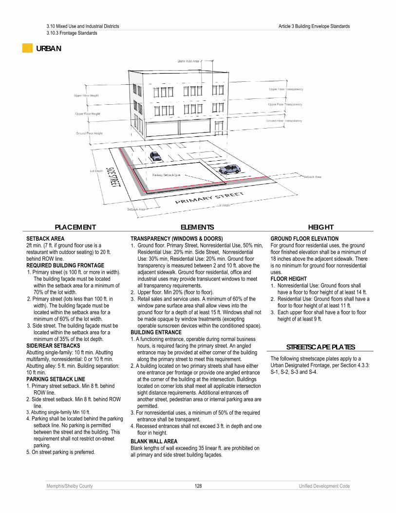
3.10 Mixed Use and Industrial Districts Article 3 Building Envelope Standards 3.10.3 Frontage Standards
Memphis/Shelby County 128 Unified Development Code
URBAN
PLACEMENT ELEMENTS HEIGHT
GROUND FLOOR ELEVATION For ground floor residential uses, the ground floor finished elevation shall be a minimum of 18 inches above the adjacent sidewalk. There is no minimum for ground floor nonresidential uses. FLOOR HEIGHT 1. Nonresidential Use: Ground floors shall
have a floor to floor height of at least 14 ft. 2. Residential Use: Ground floors shall have a
floor to floor height of at least 11 ft. 3. Each upper floor shall have a floor to floor
height of at least 9 ft.
STREETSCAPE PLATES
SETBACK AREA 2ft min. (7 ft. if ground floor use is a restaurant with outdoor seating) to 20 ft. behind ROW line. REQUIRED BUILDING FRONTAGE 1. Primary street (s 100 ft. or more in width).
The building façade must be located within the setback area for a minimum of 70% of the lot width.
2. Primary street (lots less than 100 ft. in width). The building façade must be located within the setback area for a minimum of 60% of the lot width.
3. Side street. The building façade must be located within the setback area for a minimum of 35% of the lot depth.
SIDE/REAR SETBACKS Abutting single-family: 10 ft min. Abutting multifamily, nonresidential: 0 or 10 ft min. Abutting alley: 5 ft. min. Building separation: 10 ft min. PARKING SETBACK LINE 1. Primary street setback. Min 8 ft. behind
ROW line. 2. Side street setback. Min 8 ft. behind ROW
line. 3. Abutting single-family Min 10 ft. 4. Parking shall be located behind the parking
setback line. No parking is permitted between the street and the building. This requirement shall not restrict on-street parking.
5. On street parking is preferred.
TRANSPARENCY (WINDOWS & DOORS) 1. Ground floor. Primary Street, Nonresidential Use, 50% min,
Residential Use: 20% min. Side Street, Nonresidential Use: 30% min, Residential Use: 20% min. Ground floor transparency is measured between 2 and 10 ft. above the adjacent sidewalk. Ground floor residential, office and industrial uses may provide translucent windows to meet all transparency requirements.
2. Upper floor. Min 20% (floor to floor). 3. Retail sales and service uses. A minimum of 60% of the
window pane surface area shall allow views into the ground floor for a depth of at least 15 ft. Windows shall not be made opaque by window treatments (excepting operable sunscreen devices within the conditioned space).
BUILDING ENTRANCE 1. A functioning entrance, operable during normal business
hours, is required facing the primary street. An angled entrance may be provided at either corner of the building along the primary street to meet this requirement.
2. A building located on two primary streets shall have either one entrance per frontage or provide one angled entrance at the corner of the building at the intersection. Buildings located on corner lots shall meet all applicable intersection sight distance requirements. Additional entrances off another street, pedestrian area or internal parking area are permitted.
3. For nonresidential uses, a minimum of 50% of the required entrance shall be transparent.
4. Recessed entrances shall not exceed 3 ft. in depth and one floor in height.
BLANK WALL AREA Blank lengths of wall exceeding 35 linear ft. are prohibited on all primary and side street building façades.
The following streetscape plates apply to a Urban Designated Frontage, per Section 4.3.3: S-1, S-2, S-3 and S-4.

Article 3 Building Envelope Standards 3.10 Mixed Use and Industrial Districts 3.10.3 Frontage Standards
Memphis/Shelby County 129 Unified Development Code
TRANSITIONAL
PLACEMENT ELEMENTS HEIGHT
GROUND FLOOR ELEVATION For ground floor residential uses, the ground floor finished elevation shall be a minimum of 18 inches above the adjacent sidewalk. There is no minimum for ground floor nonresidential uses. FLOOR HEIGHT 1. Nonresidential Use: Ground floors shall
have a floor to floor height of at least 14 ft.
2. Residential Use: Ground floors shall have a floor to floor height of at least 11 ft.
3. Each upper floor shall have a floor to floor height of at least 9 ft.
STREETSCAPE PLATES
SETBACK AREA 2ft min. (7 ft. if ground floor use is a restaurant with outdoor seating) to 65 ft. behind ROW line. REQUIRED BUILDING FRONTAGE 1. Primary street (sites 100 ft. or more in
width). The building façade must be located within the setback area for a minimum of 60% of the site width.
2. Primary street (sites less than 100 ft. in width). The building façade must be located within the setback area for a minimum of 60% of the site width.
3. Side street. The building façade must be located within the setback area for a minimum of 30% of the site depth.
SIDE/REAR SETBACKS Abutting single-family: 10 ft min. Abutting multifamily, nonresidential: 0 or 10 ft min. Abutting alley: 5 ft. min. Building separation: 10 ft min. PARKING SETBACK LINE 1. Primary/side street setback.
Parallel Parking: Min 0 ft behind ROW line. Not Parallel Parking: Min 8 ft. behind ROW line.
2. Abutting single-family Min 10 ft. 3. Parking shall be located behind the parking
setback line. One row of parallel parking, a one-way drive aisle and angled parking may be located between the building and the street.
TRANSPARENCY (WINDOWS & DOORS) 1. Ground floor. Primary Street, Nonresidential: 50% min,
Residential: 20% min. Side Street, Nonresidential: 30% min, Residential: 20% min. Ground floor transparency is measured between 2 and 10 ft. above the adjacent sidewalk. Ground floor residential, office and industrial uses may provide translucent windows to meet all transparency requirements.
2. Upper floor. Min 20% (floor to floor). 3. Retail sales and service uses. A minimum of 60% of the
window pane surface area shall allow views into the ground floor for a depth of at least 15 ft. Windows shall not be made opaque by window treatments (excepting operable sunscreen devices within the conditioned space).
BUILDING ENTRANCE 1. A functioning entrance, operable during normal business
hours, is required facing the primary street. An angled entrance may be provided at either corner of the building along the primary street to meet this requirement.
2. A building located on two primary streets shall have either one entrance per frontage or provide one angled entrance at the corner of the building at the intersection. Buildings located on corner lots shall meet all applicable intersection sight distance requirements. Additional entrances off another street, pedestrian area or internal parking area are permitted.
3. For nonresidential uses, a minimum of 50% of the required entrance shall be transparent.
4. Recessed entrances shall not exceed 3 ft. in depth and one floor in height.
BLANK WALL AREA Blank lengths of wall exceeding 35 linear ft. are prohibited on all primary and side street building façades.
The following streetscape plates apply to a Transitional Designated Frontage, per Section 4.3.3: S-1, S-2, S-3, S-4, S-5 and S-6.

3.10 Mixed Use and Industrial Districts Article 3 Building Envelope Standards 3.10.3 Frontage Standards
Memphis/Shelby County 130 Unified Development Code
COMMERCIAL
PLACEMENT ELEMENTS HEIGHT
GROUND FLOOR ELEVATION For ground floor residential uses, the ground floor finished elevation shall be a minimum of 18 inches above the adjacent sidewalk. There is no minimum for ground floor nonresidential uses. FLOOR HEIGHT 1. Nonresidential Use: Ground floors shall
have a floor to floor height of at least 14 ft.
2. Residential Use: Ground floors shall have a floor to floor height of at least 11 ft.
3. Each upper floor shall have a floor to floor height of at least 9 ft.
STREETSCAPE PLATES
SETBACK AREA 2ft min. (7 ft. if ground floor use is a restaurant with outdoor seating) to 86 ft. behind ROW line. REQUIRED BUILDING FRONTAGE 1. Primary street (sites 100 ft. or more in
width). The building façade must be located within the setback area for a minimum of 50% of the site width.
2. Primary street (sites less than 100 ft. in width). The building façade must be located within the setback area for a minimum of 50% of the site width.
3. Side street. The building façade must be located within the setback area for a minimum of 25% of the side depth.
SIDE/REAR SETBACKS Abutting single-family: 10 ft min. Abutting multifamily, nonresidential: 0 or 10 ft min. Abutting alley: 5 ft. min. Building separation: 10 ft min. PARKING SETBACK LINE 1. Primary/side street setback.
Parallel Parking: Min 0 ft behind ROW line, Not Parallel Parking: Min 8 ft. behind ROW line.
2. Abutting single-family Min 10 ft. 3. Parking shall be located behind the
parking setback line. A single drive aisle serving head-in parking spaces on one or both sides may be located between the building and the street.
TRANSPARENCY (WINDOWS & DOORS) 1. Ground floor. Primary Street, Nonresidential Use: 50% min,
Residential Use: 20% min. Side Street, Nonresidential: 30% min, Residential: 20%. Ground floor transparency is measured between 2 and 10 ft. above the adjacent sidewalk. Ground floor residential, office and industrial uses may provide translucent windows to meet all transparency requirements.
2. Upper floor. Min 20% (floor to floor). 3. Retail sales and service uses. A minimum of 60% of the
window pane surface area shall allow views into the ground floor for a depth of at least 15 ft. Windows shall not be made opaque by window treatments (excepting operable sunscreen devices within the conditioned space).
BUILDING ENTRANCE 1. A functioning entrance, operable during normal business
hours, is required facing the primary street. An angled entrance may be provided at either corner of the building along the primary street to meet this requirement.
2. A building located on two primary streets shall have either one entrance per frontage or provide one angled entrance at the corner of the building at the intersection. Buildings located on corner lots shall meet all applicable intersection sight distance requirements. Additional entrances off another street, pedestrian area or internal parking area are permitted.
3. For nonresidential uses, a minimum of 50% of the required entrance shall be transparent.
4. Recessed entrances shall not exceed 3 ft. in depth and one floor in height.
BLANK WALL AREA Blank lengths of wall exceeding 35 linear ft. are prohibited on all primary and side street building façades.
The following streetscape plates apply to a Commercial Designated Frontage, per Section 4.3.3: S-1, S-2, S-3, S-4, S-5, S-6 and S-7.

Article 3 Building Envelope Standards 3.10 Mixed Use and Industrial Districts 3.10.3 Frontage Standards
Memphis/Shelby County 131 Unified Development Code
3
GENERAL
PLACEMENT ELEMENTS HEIGHT
GROUND FLOOR ELEVATION For ground floor residential uses, the ground floor finished elevation shall be a minimum of 18 inches above the adjacent sidewalk. There is no minimum for ground floor nonresidential uses. FLOOR HEIGHT 1. Nonresidential Use: Ground floors shall
have a floor to floor height of at least 14 ft.
2. Residential Use: Ground floors shall have a floor to floor height of at least 11 ft.
3. Each upper floor shall have a floor to floor height of at least 9 ft.
STREETSCAPE PLATES
SETBACK AREA 2ft min. (7 ft. if ground floor use is a restaurant with outdoor seating) to 90 ft. behind ROW line. REQUIRED BUILDING FRONTAGE 1. Primary street (sites 100 ft. or more in
width). The building façade must be located within the setback area for a minimum of 40% of the site width.
2. Primary street (sites less than 100 ft. in width). The building façade must be located within the setback area for a minimum of 40% of the site width.
3. Side street. The building façade must be located within the setback area for a minimum of 20% of the side depth.
SIDE/REAR SETBACKS Abutting single-family: 10 ft min. Abutting multifamily, nonresidential: 0 or 10 ft min. Abutting alley: 5 ft. min. Building separation: 10 ft min. PARKING SETBACK LINE 1. Primary/side street setback.
Parallel Parking: Min 0 ft behind ROW line, Not Parallel Parking: Min 8 ft. behind ROW line.
2. Abutting single-family Min 10 ft.
TRANSPARENCY (WINDOWS & DOORS) 1. Ground floor. Primary Street, Nonresidential Use: 50% min,
Residential Use: 20% min. Side Street, Nonresidential: 30% min, Residential: 20% min Ground floor transparency is measured between 2 and 10 ft. above the adjacent sidewalk. Ground floor residential, office and industrial uses may provide translucent windows to meet all transparency requirements.
2. Upper floor. Min 20% (floor to floor). 3. Retail sales and service uses. A minimum of 60% of the
window pane surface area shall allow views into the ground floor for a depth of at least 15 ft. Windows shall not be made opaque by window treatments (excepting operable sunscreen devices within the conditioned space).
BUILDING ENTRANCE 1. A functioning entrance, operable during normal business
hours, is required facing the primary street. An angled entrance may be provided at either corner of the building along the primary street to meet this requirement.
2. A building located on two primary streets shall have either one entrance per frontage or provide one angled entrance at the corner of the building at the intersection. Buildings located on corner lots shall meet all applicable intersection sight distance requirements. Additional entrances off another street, pedestrian area or internal parking area are permitted.
3. For nonresidential use, a minimum of 50% of the required entrance shall be transparent.
4. Recessed entrances shall not exceed 3 ft. in depth and one floor in height.
BLANK WALL AREA Blank lengths of wall exceeding 35 linear ft. are prohibited on all primary and side street building façades.
The following streetscape plates apply to a General Designated Frontage, per Section 4.3.3: S-1, S-2, S-3, S-4, S-5, S-6, S-7, S-8, S-9, S-10, S-11 and S-12.

3.11 Additions and New Buildings on Nonconforming Sites with Maximum Setbacks Article 3 Building Envelope Standards 3.11.1 Applicability
Memphis/Shelby County 132 Unified Development Code
3.11 ADDITIONS AND NEW BUILDINGS ON NONCONFORMING SITES WITH MAXIMUM SETBACKS
3.11.1 Applicability Any development where a maximum setback applies that involves an addition to a nonconforming structure or the construction of a new building(s) on a nonconforming site with an existing building and the addition or new construction represents an increase of more than 50% of the existing building footprint area. Additions and new construction that represents an increase of less than 50% of the existing building footprint area are not subject to the building setback, building frontage, floor elevation or floor height provisions of Sub-Section 3.10.2E, Section 3.10.3 or Articles 7 or 8 of this Code. In no instance shall maximum setbacks, nor this Chapter, apply to townhouses and multi-family buildings subject to Section 3.7.2 or permitted nonresidential uses subject to Section 3.7.3, provided that said buildings were constructed prior to January 1, 2011, and would otherwise be deemed conforming structures. See Chapter 10.8
3.11.2 Permitted Additions Where an existing building is being expanded, the setback area and required building frontage standards apply to the ground level, street-facing façade of the entire addition as set forth below.
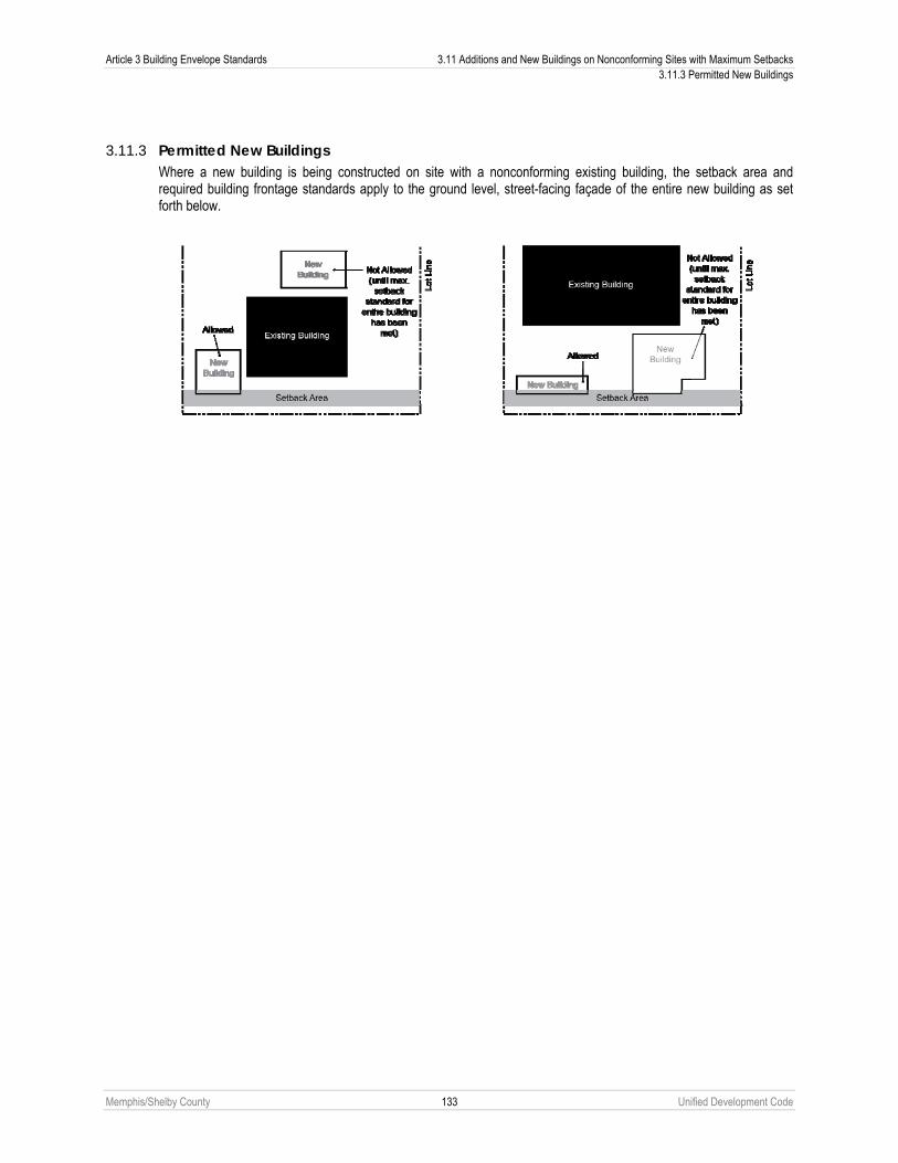
Article 3 Building Envelope Standards 3.11 Additions and New Buildings on Nonconforming Sites with Maximum Setbacks 3.11.3 Permitted New Buildings
Memphis/Shelby County 133 Unified Development Code
3.11.3 Permitted New Buildings Where a new building is being constructed on site with a nonconforming existing building, the setback area and required building frontage standards apply to the ground level, street-facing façade of the entire new building as set forth below.

Memphis/Shelby County 134 Unified Development Code
Article 4. General Development Standards 4.1 APPLICABILITY
The development standards of this Article apply to any development as set forth in the chart below. For the purpose of this table, an addition of an accessory structure to a site shall be considered “building expansion” and not “new construction.”
USE Side
wal
k &
Stre
et
Tree
Rep
air
Stre
etsc
ape
Stan
dard
s
Stre
et S
tand
ards
Acce
ss M
anag
emen
t
Park
ing
& Lo
adin
g
Land
scap
ing
& Sc
reen
ing
Out
door
Lig
htin
g
Out
door
Sto
rage
&
Dis
play
Sign
s
Single-Family Detached/Attached (Conventional, Side Yard, Cottage, Semi-Attached, Two-Family, Townhouse)
New Construction/New Facilities
Change of Use*
Multifamily (Large Home, Stacked Townhouse, Apartment, Group Living)
New Construction/New Facilities
Change of Use*
Expansion of Building Area (minimum 1,000 sq. ft. of expansion)
Expansion of Parking Area Only** 10 or more spaces
Industrial
New Construction/New Facilities
Change of Use*
Expansion of Building Area (minimum 10,000 sq. ft. of expansion)
All other uses
New Construction/New Facilities
Change of Use*
Expansion of Building Area (minimum 1,000 sq. ft. of expansion)
Expansion of Parking Area Only** 10 or more additional spaces
Cross-reference 4.2 4.3 5.2.7 4.4 4.5 4.6 4.7 4.8 4.9
= Apply to entire site or development (performance standards always apply)= Standards apply on a pro-rata basis to buildings and lots affected by the change (see Section 4.1.1). * = For the purpose of this Article, “Change in Use” shall mean a change from one of the use classifications of this table (“Single-Family Residential,” “Multifamily,” “Industrial” and “All other uses”) to another. However, some changes in use may require certain use standards as found in Chapter 2.6 to be installed. The Planning Director is authorized to determine whether the development standards of this Article, the use standards of Chapter 2.6 and the Administrative Site Plan Review processes of Article 9 apply to a particular request for a change in use on a case-by-case basis. ** Subject only if the provisions of Sub-Section 3.1.1C are met.
4.1.1 Pro-Rata Application The pro-rata basis is determined by measuring the gross land area proportion of the lot or tract affected by the new construction, new facilities, change in use, building expansion or expansion of parking area and initiating the appropriate improvements in that proportion to the overall lot or tract. Improvements are only required in the vicinity of the new construction, new facilities, change in use, building expansion or expansion of parking and may be waived by the Planning Director, in consultation with the City or County Engineer, in situations where the conditions or absence of pre-development improvements on the lot or tract make installation of new improvements impractical.

Article 4 General Development Standards 4.2 Sidewalk and Street Tree Repair 4.1.2 Maintenance of Required Improvements
Memphis/Shelby County 135 Unified Development Code
4.1.2 Maintenance of Required Improvements The responsibility for maintenance of all required improvements under this Article shall remain with the owner, their successors, heirs, assignees or any consenting grantee. All improvements required under this Article shall be maintained in good surface and structural condition and in compliance with any building or electrical code to ensure continued compliance with the provisions of this Article.
4.1.3 Site Plans Submitted Site plans submitted in accordance with this Chapter shall indicate the location of curbs, gutters and sidewalks on properties that abut the subject site in order to determine the appropriate streetscape plate on the subject site.
4.2 SIDEWALK AND STREET TREE REPAIR
4.2.1 Required Sidewalk Repair A. Prior to the issuance of any use and occupancy permit or the revision of any previously issued use and occupancy
permit, the owner of the property on which the requested use is located shall be required to show that any existing sidewalk or walkway abutting, on, or adjacent to the owner’s property is in good repair.
B. If unable to show that the existing sidewalk or walkway abutting on or adjacent to the owner’s meets the standards cited above the Building Official, or the City or County Engineer may require repair or replacement of the existing sidewalk or walkway.
C. Any required sidewalk repair or replacement required under this Chapter shall be on a pro-rata basis commensurate with the extent of the certificate of occupancy permit requested.
4.2.2 Required Street Tree Repair A. Prior to the issuance of any use and occupancy permit or the revision of any previously issued use and occupancy
permit, the owner of the property on which the requested use is located shall be required to show that any existing street tree wells or street trees on the owner’s property are planted and in a healthy condition.
B. If unable to show that the existing street tree wells or street trees on the owner’s property are planted and in a healthy condition the Building Official may require repair or replacement of the existing street tree wells or street trees.
C. Any required street tree or street tree well maintenance or replacement required under this Chapter shall be on a pro-rata basis commensurate with the extent of the use and occupancy permit requested.

4.3 Streetscape Standards Article 4 General Development Standards 4.3.1 Applicability
Memphis/Shelby County 136 Unified Development Code
4.3 STREETSCAPE STANDARDS
4.3.1 Applicability A. Conformance to the standards of this Chapter shall be in accordance with Chapter 4.1, Applicability.
B. Applicability to Aboveground Utilities.
1. For sites containing or abutting aboveground utilities as of January 1, 2011, or on a street that has been identified by MLGW for aboveground utilities, pursuant to this Chapter, for a Streetscape Plate requiring underground or rear-lot utilities, the Planning Director shall issue an administrative deviation on a case-by-case basis to allow for the continuance of the aboveground utilities. Appropriate accommodations on the location of the sidewalk and types of street trees shall be made with administrative deviations for sites with aboveground utilities.
2. Aboveground utilities shall not, under any circumstance, be considered nonconforming structures subject to the provisions of Article 10. Modifications, alterations and expansions to said infrastructure may be performed.
3. Aboveground utilities are permitted along rural cross-sections.
4.3.2 Purpose The streetscape standards ensure the coherence of the street-space. They also serve to assist building owners and operators with understanding the relationship between the street-space and their own lots. These streetscape standards define the development parameters for strips of land between buildings and the street, and includes on-site requirements (on private property outside of the public right-of-way) and off-site requirements (on public property inside of the public right-of-way).These standards also establish an environment that encourages and facilitates pedestrian activity. Native trees and plants contribute to privacy, reduction of noise and air pollution, maintenance of the natural habitat, and conservation of water. All trees found in the Streetscape Plates are to be planted at a minimum of forty feet on center from one another.

Article 4 General Development Standards 4.3 Streetscape Standards 4.3.3 Streetscape Plates
Memphis/Shelby County 137 Unified Development Code
4.3.3 Streetscape Plates The following streetscape plates must be installed along public and private streets abutting the subject property. Where more than one plate is allowed, the appropriate plate must be determined in consultation with the Planning Director.
Type of Development/Zoning District S-1 S-2 S-3 S-4 S-5 S-6 S-7 S-8 S-9 S-10 S-11 S-12 S-13 S-14 S-15
Designated Frontage (see 3.10.3) Shopfront Pedestrian Urban Transitional Commercial
■ ■ ■ ■ ■
■ ■ ■ ■ ■
■ ■ ■ ■ ■
■ ■ ■ ■ ■
-- -- -- ■ ■
-- -- -- ■ ■
-- -- -- -- ■
-- -- -- -- --
-- -- -- -- --
-- -- --
-- -- -- --
-- -- -- --
-- -- -- -- --
-- -- -- -- --
-- -- -- -- --
Mixed Use/ Industrial District Any district below, abutting arterial* Not abutting arterial: RW, OG, CMP-1, CMP-2 CMU-1, CMU-2, CMU-3 CBD EMP, WD, IH
■ ■ ■ ■ ■
■ ■ ■ ■ ■
■ ■ ■ ■ ■
■ ■ ■ ■ ■
■ ■ ■ -- ■
■ ■ ■ -- ■
■ ■ ■ -- ■
■ ■ ■ -- ■
■ ■ ■ -- ■
■ ■ ■ -- ■
■ ■ ■ -- ■
■ ■ ■ -- ■
■ ■ ■ -- ■
■ ■ ■ -- ■
■ ■ ■ -- ■
Residential Urban District (RU-) Conventional, Side Yard, Cottage, Semi-Attached, Two-Family, Large Home
-- -- -- -- -- -- -- -- -- -- -- -- ■ ■ ■
Townhouse, Stacked Townhouse, Apartment
■ ■ ■ ■ -- -- -- -- -- -- -- -- ■ ■ ■
Nonresidential Uses ■ ■ ■ ■ ■ ■ ■ ■ ■ ■ ■ ■ ■ ■ -- Residential Single-Family District RM-P, R-E, R-15, R-10, R-8, R-6, R-3 -- -- --
-- -- -- -- -- -- -- -- -- ■ ■ ■
Nonresidential Uses ■ ■ ■ ■ ■ ■ ■ ■ ■ ■ ■ ■ ■ ■ -- Open District P, OS, FW, CA CIV
-- ■
-- ■
-- ■
-- ■
-- ■
-- ■
-- ■
■ ■
■ ■
■ ■
■ ■
■ ■
■ ■
■ ■
-- --
* Sidewalks on sites that abut an arterial shall be a minimum of 10 feet from the face of the curb when a streetscape plate that includes a street tree is utilized unless waived by the Planning Director.
Notes: 1. The streetscape plates included in this section identify minimum building setbacks; for streetscapes within designated frontages, refer to Section 3.10.3 for maximum setbacks. 2. In lieu of right-of-way dedication, a pedestrian/utility easement may be recorded that meets the dimensions of the streetscape plates included in this section. Approval by the appropriate legislative body is not required for the recording of such pedestrian/utility easement. 3. Pursuant to Section 4.3.4, the Planning Director may permit alternative streetscape plates through the administrative deviation process.

4.3 Streetscape Standards Article 4 General Development Standards 4.3.3 Streetscape Plates
Memphis/Shelby County 138 Unified Development Code
Type S-1
Type S-2

Article 4 General Development Standards 4.3 Streetscape Standards 4.3.3 Streetscape Plates
Memphis/Shelby County 139 Unified Development Code
Type S-3
Type S-4

4.3 Streetscape Standards Article 4 General Development Standards 4.3.3 Streetscape Plates
Memphis/Shelby County 140 Unified Development Code
Type S-5
Type S-6
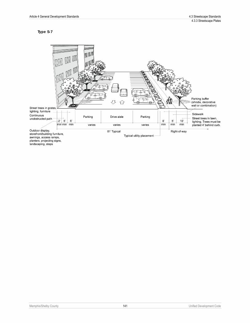
Article 4 General Development Standards 4.3 Streetscape Standards 4.3.3 Streetscape Plates
Memphis/Shelby County 141 Unified Development Code
Type S-7

4.3 Streetscape Standards Article 4 General Development Standards 4.3.3 Streetscape Plates
Memphis/Shelby County 142 Unified Development Code
Type S-8
Type S-9

Article 4 General Development Standards 4.3 Streetscape Standards 4.3.3 Streetscape Plates
Memphis/Shelby County 143 Unified Development Code
Type S-10
Type S-11

4.3 Streetscape Standards Article 4 General Development Standards 4.3.3 Streetscape Plates
Memphis/Shelby County 144 Unified Development Code
Type S-12
Type S-13

Article 4 General Development Standards 4.3 Streetscape Standards 4.3.3 Streetscape Plates
Memphis/Shelby County 145 Unified Development Code
Type S-14
Type S-15

4.3 Streetscape Standards Article 4 General Development Standards 4.3.4 Exceptions to Streetscape Plates
Memphis/Shelby County 146 Unified Development Code
4.3.4 Exceptions to Streetscape Plates A. On a case-by-case basis, the Planning Director is authorized to grant exceptions to the streetscape plates found in this
Chapter as part of the administrative deviation process found in Chapter 9.21 after determining that the strict adherence to the plates is impractical due to site constraints, streetscapes of abutting and adjoining properties or the presence of one of the situations delineated in this Section. The Planning Director is not authorized to waive the requirement to install curbs and gutters or widen a street; that power is granted to the City or County Engineer (see Sub-Section B below).
B. Curb, Gutters and Widening Exemption. The Planning Director, after consultation with the City or County Engineer may waive the requirement to install curbs and gutters on existing streets originally constructed without curbs and gutters if there are no planned public projects to build the curbs and gutters within the next 10 years, or if the street section is not contiguous to an improved section of roadway (see Sub-Section 5.2.16C). Sites that are granted a curb and gutter exemption are also eligible for an exemption from widening the roadway and installing sidewalks if there are no planned public projects to widen the road within the next 10 years, or if the street section is not contiguous to an improved section of roadway. The following minimum standards shall be followed on sites that have been granted a curb, gutter or widening exemption but are adjacent to sites with sidewalks, or, in the City or County Engineer’s determination, will involve a level of pedestrian activity that makes sidewalks necessary:
1. A 5-foot wide sidewalk shall be located at least 5 feet from the edge of the roadside drainage ditch.
2. The sidewalk shall be within a public pedestrian easement if located outside of the right-of-way.
3. A pedestrian bridge over the roadside drainage ditch will be required in the vicinity of a bus stop, intersection and other pedestrian features. At least one pedestrian bridge over the roadside drainage ditch shall be provided per lot. For residential lots, a driveway may serve as the pedestrian bridge.
4. The proposed location of the sidewalks and any interconnection between the sidewalk and the street shall be subject to approval by the City or County Engineer, depending on the road location.
5. The amount of flow and size of the roadside ditch will be considered and may result in some requirement for drainage improvements.
C. Sidewalk Connections.
1. The Planning Director may approve an administrative deviation from the streetscape standards to create a properly designed connection to sidewalks on properties that abut the subject property.
2. For sites with sidewalks existing prior to development, the Planning Director shall issue an administrative deviation to the streetscape plates to allow for the continuation of the sidewalk placement, if requested by the applicant. Only those sites where at least 50 percent of the sidewalks are in good repair shall be eligible for this administrative deviation.
D. Sidewalk Placement. For sites in developed areas where the predominant streetscape includes sidewalks in closer proximity to the curb than permitted in any of the streetscape plates included in this Chapter, the Planning Director may approve an administrative deviation to permit sidewalks to be placed either immediately behind the back of curb or behind a grass lawn of less than four-and-a-half feet in width. This provision shall only apply to those lots that are less than 325 feet in width.
E. Sidewalk Exemption. The Planning Director, after consultation with the City or County Engineer, may exempt the requirement to install sidewalks from a single site through the administrative deviation process, if not otherwise required by conditions placed on the site by a condition approved by the governing bodies, Land Use Control Board or Board of Adjustment. Only those sites that are eligible for curb and gutter exemptions pursuant to Sub-Section 4.3.4B above may be granted a sidewalk exemption by the Planning Director. The Planning Director and the Land Use Control Board may only be authorized to exempt the requirement to install sidewalks through the subdivision process if a street is identified as a rural street, which shall use the street standard identified in Sub-Section 5.2.7E.
F. Aboveground Utilities. The Planning Director shall approve an administrative deviation from the streetscape standards on a case-by-case basis for sites with aboveground utilities in accordance with Sub-Section 4.3.1B. The required street trees may be substituted with landscaping and shrubs that grow to a height that will not interfere with the aboveground utilities.
G. Rural cross section. Sites adjacent to a rural street are exempt from the streetscape plates.
Article 4 General Development Standards 4.3 Streetscape Standards 4.3.5 Installation Requirements
Memphis/Shelby County 147 Unified Development Code
4.3.5 Installation Requirements A. Certificate of Occupancy
All required streetscape elements must be installed prior to the issuance of a certificate of occupancy. A temporary certificate of occupancy may be issued under circumstances that would affect the planting of street trees (see Sub-Section E).
B. Tree Planting and Spacing Unless otherwise noted below, all trees planted in accordance with this section shall be Type A trees, as identified in Section 4.6.9.
1. Trees must be planted in accordance with the applicable streetscape plate and spaced as set forth below:
a. One Type A tree planted every 40 feet on center, on average; or b. When permitted below, Type B tree planted every 30 feet on center, on average; or c. Where overhead utilities exist, one Type C tree planted every 30 feet on center, on average. d. Shrubbery, hedges or foliage of any kind shall not project over sidewalks or walkways so as to interfere
with the free use of such sidewalks or walkways by pedestrians. All tree limbs above or near sidewalks or walkways shall be trimmed so that the lower branches thereof are not less than (8) eight feet above the sidewalk.
2. For S-6, S-7, S-2 9, S-12 and S-13 plates, trees shall be planted no more than 4’ behind the back of curb.
3. For S-13 and S-14, plates, the spacing in paragraph 1 above applies; however, a minimum of one tree must be planted per lot.
4. When planting islands are used (see plates S-5 and S-15), the following spacing requirements apply:
a. One Type A or B tree per planting island spaced 52 feet on center, on average; or b. Where overhead utilities exist, one Type C tree per planting island spaced 52 feet on center, on average.
For the S-5 plate:
c. Type A trees are required, unless underground utilities are present along the front of the property;
d. Type B trees are permitted in situations where underground utilities are located in a grass strip of at least 3 feet in width between the back of curb and sidewalk within the ROW; or
e. Type C trees are permitted in situations where overhead utilities are present along the street.
5. Tree spacing is considered the average spacing for trees. Where the specific location of a driveway, utility line or other feature conflicts with the placement of a tree, the tree spacing may be modified in consultation with the City or County Engineer.
6. All trees must be planted at least ten feet from street light poles, fire hydrants and signs.
7. When used, tree grates must be a minimum of four feet by six feet. Alternative tree root surface protection may be approved by the City or County Engineer.
8. Where underground utilities are present, a root barrier extending 18 inches deep is required.
C. Parking Buffer Where an eight-foot landscaped parking buffer is required, it may be eliminated provided that parallel parking is used in place of head-in parking.
D. Clear Sight Triangle
Excluding street trees 12 inches or less at Diameter at Breast Height (DBH) required by this Chapter, at the intersection of a driveway and a street and on all corner lots (the intersection of two streets); a clear sight triangle shall be established as set forth in Section 4.4.7. All established street trees encroaching into the clear sight triangle shall be maintained by the abutting property owner and shall be kept free of foliage for 80 inches measured up from the base of the tree. Any shrubs encroaching into the clear sight triangle shall not exceed 24 inches in height.
E. Landscaping Provisions All elements of the streetscape plate must meet the general landscaping requirements of Section 4.6.4.

4.4 Access Management Article 4 General Development Standards 4.4.1 Applicability
Memphis/Shelby County 148 Unified Development Code
4.4 ACCESS MANAGEMENT
4.4.1 Applicability Conformance to the standards of this Chapter shall be in accordance with Chapter 4.1, Applicability.
4.4.2 General Standards A. All buildings must be located on a site abutting a public street, private street or private drive, built in accordance with
the block standards in Chapter 3.3, the street dimensional standards of Section 5.2.7, and the street improvement standards of Chapter 5.2.
B. Unless otherwise allowed by the City or County Engineer, outparcels must take access from within the site.
C. To promote interconnectivity and discourage curb cuts, all nonresidential sites abutting a principal arterial street (as designated in the MPO Long Range Transportation Plan) must provide a shared access easement with a minimum paving width of 22 feet when abutting another mixed use or nonresidentially-zoned property in the same ownership, unless otherwise approved by the City or County Engineer. This section shall not apply to lots that have 300 or more linear feet of roadway frontage.
D. There may be no parking or driveway designed in such a way that will require the backing of vehicles into an arterial street.
E. No vehicle or obstacle may block driveways intended for use as a fire lane, cross-access easement or required parking.
4.4.3 Access to Roads A. Whenever a subdivision that involves the creation of one or more new streets borders on or contains an existing or
proposed arterial street, no direct driveway access may be provided from lots within the subdivision onto this street unless the lot width is 100 feet or greater.
B. When a site (except for a single-family attached or detached residential development) borders on or contains an existing or proposed arterial, access to the arterial may be limited by one of the following means:
1. Full movement driveway access from the site onto a principal arterial shall not be located closer than 300 feet to any other proposed or existing intersecting principal arterial or signalized intersection. Such measurement shall be from centerline to centerline of the two arterial roadways, or signalized intersection.
2. Sites may be subdivided so as to provide access onto a frontage road or reverse frontage road provided that the centerline of the frontage or reverse frontage road where it intersects the arterial may be no closer than 450 feet to the centerline of the nearest proposed or existing road; or
3. Approval of driveway access between a site and the arterial at an interval less than those specified may be granted only by review and recommendation of the City or County Engineer.
C. The driveway access provisions are not applicable to any property where:
1. The effect of such application would be to deprive the property of access; or 2. The size of the property being subdivided or lack of frontage on the arterial makes the alternatives above not
feasible.
D. No certificate of occupancy may be issued until the arterial access requirements of this Chapter have been met.
4.4.4 Residential Driveways Residential driveway access to and from streets must be constructed in accordance with City or County standards as outlined below:
A. Width of Driveway Excluding those sections where turning movements require larger dimensions, the width of a residential driveway within the required front yard of lots smaller than 15,000 square feet, must be no less than eight feet and no more than 22 feet, provided that the driveway is no wider than 16 feet at the property line. For subdivisions built prior to 1950 driveways must be a maximum of 12 feet wide and must extend 20 feet beyond the front of the house.

Article 4 General Development Standards 4.4 Access Management 4.4.5 Use of Residential Property for Access
Memphis/Shelby County 149 Unified Development Code
B. Location of Driveway Access Points At the street right-of-way, residential driveways must be spaced at least 20 feet from any other driveway on the same lot, but not nearer than 3½ feet to any side lot line. The minimum corner clearance from the curb line or edge of pavement of intersecting streets must be at least 20 feet from the point of tangency of the radius curvature, or 20 feet from the intersection of right-of-way lines, whichever is greater. The radius of the driveway must not encroach on the minimum corner clearance. No lot may have more than one driveway per street frontage unless the frontage allows for a circular driveway.
4.4.5 Use of Residential Property for Access Land which is zoned as a residential district may not be used for driveway purposes to any land which is located in a nonresidential or mixed use district.
4.4.6 Driveways for Multifamily Apartment and Nonresidential Uses A. Unless otherwise approved or required by the City or County Engineer a platted lot shall be permitted only one
driveway. Such determination shall consider site design, pedestrian and vehicle circulation, adjacent uses, topography, speed of traffic on the road being exited from, and other such considerations. Where required, driveways shall be contained wholly within the property frontage or as part of a joint access easement with an adjacent platted property.
B. Unless approved or required by the City or County Engineer, the permitted driveway for a corner lot shall connect to the street with the lower roadway classification except that no access shall be permitted to a local single family residentially zoned street without approval by the City or County Engineer.
C. Additional driveways may be considered by Planning Director in consultation with the City or County Engineer. The table below is intended to provide criteria that will be used in making a determination for arterial streets. In addition, evaluation shall consider the minimum driveway spacing and location requirements are met as follows, or where analysis has determined size and configuration of a single driveway cannot accommodate the traffic.
Site Frontage Permitted Driveways 200 feet of frontage or less 1
201 feet to 400 feet of frontage 2 401 feet to 600 feet of frontage 3 601 feet to 800 feet of frontage 4
4.4.7 Clear Sight Triangle Areas around all intersections, including the entrance of driveways onto streets, shall be kept clear of sight obstructions. The extent of these areas depends on a number of factors. Listed in Sub-Section 4.4.7A are a number of types of intersections and the regulations applicable to each. Sub-Section 4.4.7B establishes what may be in the area that is to be kept clear of sight obstructions. In every case, sight distance shall meet the most recent AASHTO standards.
A. Intersections by Type
1. Type “A” Intersection a. A type “A” intersection is one in which two streets converge in any configuration where one street is
controlled with either a stop or yield sign (minor street) and the other street is not controlled by a stop or yield sign or other control device (the through street).
b. The objective of a type “A” intersection is to allow traffic at the stop sign or approaching the yield sign on the minor street to see approaching traffic on the through street and to allow traffic on the through street to see approaching traffic on the minor street.
c. The dimensions of the area that must be clear of sight obstructions depends on whether the minor street is controlled by a stop or yield sign, the posted speed on the through street, and the number of through traffic lanes on the side of the through street closest to the minor street.
d. The area that must be kept clear is in the shape of a triangle at each corner of the intersection. Below are two diagrams and tables that will establish the length of two sides of the triangle. Connecting the end points of these two sides establishes the area to be kept clear of sight obstruction. Note that the two sides of the triangle shown on the diagrams below are measured along the edge of pavement.
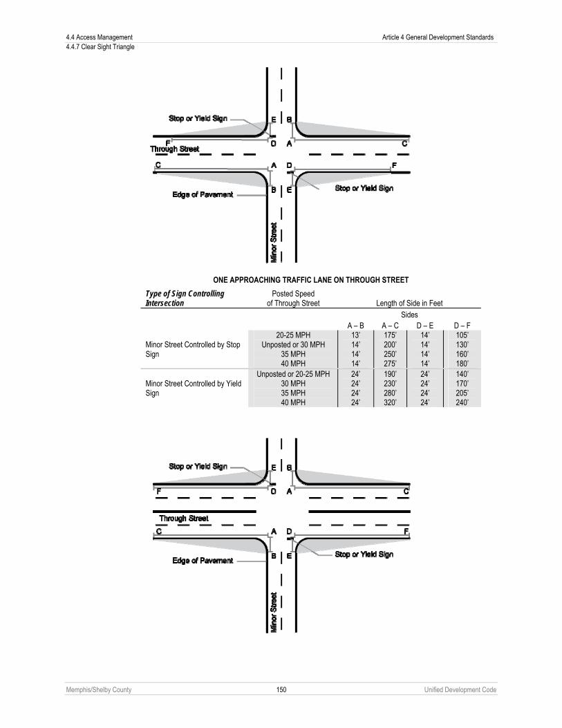
4.4 Access Management Article 4 General Development Standards 4.4.7 Clear Sight Triangle
Memphis/Shelby County 150 Unified Development Code
ONE APPROACHING TRAFFIC LANE ON THROUGH STREET
Type of Sign Controlling Intersection
Posted Speed of Through Street Length of Side in Feet
Sides A – B A – C D – E D – F
Minor Street Controlled by Stop Sign
20-25 MPH Unposted or 30 MPH
35 MPH 40 MPH
13’ 14’ 14’ 14’
175’ 200’ 250’ 275’
14’ 14’ 14’ 14’
105’ 130’ 160’ 180’
Minor Street Controlled by Yield Sign
Unposted or 20-25 MPH 30 MPH 35 MPH 40 MPH
24’ 24’ 24’ 24’
190’ 230’ 280’ 320’
24’ 24’ 24’ 24’
140’ 170’ 205’ 240’

Article 4 General Development Standards 4.4 Access Management 4.4.7 Clear Sight Triangle
Memphis/Shelby County 151 Unified Development Code
TWO APPROACHING TRAFFIC LANES ON THROUGH STREET
Type of Sign Controlling Intersection
Posted Speed of Through Street Length of Side In Feet
Sides A – B A – C D – E D – F
Minor Street Controlled by Stop Sign
20-25 MPH Unposted or 30 MPH
35 MPH 40 MPH
13’ 14’ 14’ 14’
175’ 200’ 250’ 275’
14’ 14’ 14’ 14’
75’ 90’
110’ 125’
Minor Street Controlled by Yield Sign
Unposted or 20-25 MPH 30 MPH 35 MPH 40 MPH
24’ 24’ 24’ 24’
190’ 230’ 280’ 320’
24’ 24’ 24’ 24’
105’ 130’ 130’ 180’
2. Type “B” Intersection a. A type “B” intersection is one in which two streets cross and neither is controlled by a stop or yield sign or
other control device. b. The object at these intersections is to allow traffic on both streets to see approaching traffic. c. The area that must be clear of sight obstruction is in the shape of two partially overlapping triangles at
each corner of the intersection. One side of each triangle is 24 feet long measured along the edge of pavement. The second side is 140 feet long measured along the edge of pavement. Connecting the end points of these sides will define the area that must be clear of sight obstruction.

4.4 Access Management Article 4 General Development Standards 4.4.7 Clear Sight Triangle
Memphis/Shelby County 152 Unified Development Code
3. Type “C” Intersection a. A type “C” intersection is one in which two streets converge in any configuration and both streets are
controlled by stop signs. b. The object at these intersections is to allow traffic stopped at the stop sign to see traffic stopped at the
stop signs in every approaching traffic lane. c. The areas that must be clear of sight obstructions are in the shape of triangles, one at each corner of the
intersection. Two sides of each triangle are ten feet long each as measured along the edge of pavement. Connecting the ends of these two sides defines the area that must be clear of sight obstructions.

Article 4 General Development Standards 4.4 Access Management 4.4.7 Clear Sight Triangle
Memphis/Shelby County 153 Unified Development Code
4. Type “D” Intersection a. A type “D” intersection is one in which all streets are controlled by a traffic light. The object at these
intersections is to allow traffic that could turn on a red light to see approaching traffic and to allow traffic with a green light to see traffic that could turn on a red light.
b. The areas that must be kept clear of sight obstructions are in the shape of a triangle, one at each corner of the intersection.
c. The dimensions of these areas depend on the speed of the two streets. Below is a diagram and table that will establish the length of two sides of these triangles. Connecting the end points of these two sides will establish the area that must be kept clear of sight obstructions at each corner of the intersection. Note that the two sides of the triangle shown on the diagram below are measured along the edge of pavement.
Intersecting Streets Posted Speed
of Through Street Length of Side In Feet Sides A – B and D – E A – C and D – F
Street 1
20-25 MPH Unposted or 30 MPH
35 MPH 40 MPH
13’ 14’ 14’ 14’
175’ 200’ 250’ 275’
Street 2
20-25 MPH Unposted or 30 MPH
35 MPH 40 MPH
13’ 14’ 14’ 14’’
175’ 200’ 250’ 275’

4.4 Access Management Article 4 General Development Standards 4.4.7 Clear Sight Triangle
Memphis/Shelby County 154 Unified Development Code
5. Type “E” Intersection a. A type “E” intersection is an intersection in which a driveway or access driveway serving any use other
than residential use enters a street. b. The object at these intersections is to allow traffic coming out of the driveway or vehicular access
easement or tract to see approaching traffic. c. These intersections are regulated as Type “A” intersections as if the driveway or vehicular access
easement or tract is the minor street controlled with a stop sign and the street is the through street.
6. Type “F” Intersection a. A type “F” intersection is an intersection in which a driveway or vehicular access easement or tract
serving exclusively residential uses enters a street. b. The object at these intersections is to allow traffic coming out of the driveway or vehicular access
easement or tract to see approaching traffic. c. The areas that must be clear of sight obstructions are the areas enclosed within triangles, one at each
corner of the intersection. Two sides of each triangle area are ten feet long each as measured along the edge of pavement. Connecting the ends of these two sides defines the area that must be clear of sight obstruction.
7. One-Way Streets and Streets with Median Barriers The provisions of this section are written to apply to streets with one-way traffic and streets with a median barrier. The City or County Engineer may modify the requirements of this section to fulfill the purpose of these regulations for intersections including a one-way street or a street with a median barrier.
8. Intersections Not Specifically Regulated The City or County Engineer shall establish the area that must be clear of sight obstructions on a case-by-case basis for intersections containing more than two streets and for other intersections that are not specifically regulated in paragraphs 1 through 6.
B. Permissible Intrusion in the Area to be Kept Clear of Sight Obstruction
1. General Except as provided in Paragraph 2 below unless specifically approved by the City or County Engineer, no sight obstruction may be within the area to be kept clear. A sight obstruction is considered any object whose height is greater than three feet above the grade of the respective center lines of the intersecting street, driveway, or vehicular access easement or tract.
2. Exceptions The following are permitted to be within the area that must be clear of sight obstructions.

Article 4 General Development Standards 4.4 Access Management 4.4.8 Guardhouses and Gates
Memphis/Shelby County 155 Unified Development Code
a. Natural and fabricated objects and natural topography of the ground if the City or County Engineer determines that adequate visual access is available.
b. To fulfill the intent of this section, the City or County Engineer may require land surface modification as part of any development activity on the subject property.
c. Any vegetation extending into the sight triangle must be pruned to maintain a minimum obstruction free height of eight feet above the finished ground level or as needed to provide adequate sight distance in accordance with paragraphs A and B above.
d. All signs and utility appurtenances must be located to minimize sight obstructions at the intersections and their locations shall be approved by the City or County Engineer.
C. Obstruction Deemed Nuisance – Abatement and Enforcement In addition to other remedies as may be provided herein, any obstruction maintained in violation of this section shall be deemed a violation of this development code and shall be processed in accordance with Article 11.
D. Exemptions No obstruction to cross visibility shall be deemed to be accepted from the application of this section because of its being in existence at the time of the adoption hereof, unless expressly exempted by the terms of this section.
4.4.8 Guardhouses and Gates Guardhouses, gates and other vehicular control devices are permitted subject to the following standards unless otherwise expressly approved by the City or County Engineer.
A. Residential Uses Vehicle control devices for residential uses shall meet the following standards.
Street Type Residential Units Queue Space Depth Local 0 to 30 units
30 + units 20 feet 40 feet
Connector 0 to 150 units 150+ units
40 feet 60 feet
Arterial 0 to 30 units 30 + units
40 feet 60 feet
B. All Other Uses Vehicle control devices for all other uses shall meet the following standards.
Street Type Queue Space Depth Local 20 feet Connector 40 feet Arterial 40 feet
C. Applicable Standards 1. Adequate maneuvering room shall be provided for vehicles to exit in a forward motion, subject to approval of the
City or County Engineer. 2. Emergency entrance and “exit only” gates shall be exempt from the queuing requirements. Gate openings shall
provide a minimum of 14 feet of clear width. 3. Two way access gates shall have a clear width of at least 20 feet. 4. Guardhouses and gates shall meet the requirements in Automatic Safety Bulletin #149, the Fire Official shall
require a siren-operated system (SOS) or other approved device that allows remote activation of the gate from the emergency vehicle.
5. No queuing spaces shall be located within the public right-of-way. 6. No gate shall swing out over the public right-of-way. 7. Queuing spaces shall be measured from the back of the sidewalk, or ten feet from the face of curb when no
sidewalk is present to the gate or control device, whichever is closest to the street.

4.4 Access Management Article 4 General Development Standards 4.4.8 Guardhouses and Gates
Memphis/Shelby County 156 Unified Development Code
D. Approval Process
1. Gates and guardhouses shall not be installed on public streets, except by action of the federal, state, County or City governments. Public streets may be converted to private streets pursuant to Section 5.2.18.
2. A subdivision plan or plat or planned development outline or final plan must be amended to indicate the location of gates, guardhouses and any realignment of common areas or infrastructure associated with the gates and guardhouses. The installation of a gates and guardhouses in subdivisions and planned developments shall be processed administratively pursuant to Paragraph 9.6.11E(3) for planned developments and Sub-Section 9.7.9A for subdivisions, provided the following provisions are met:
a. Before an application for such an amendment is accepted by the Office of Planning and Development, an affidavit shall be presented by the applicant that the percentage of lot owners as required by the homeowners or property owners association’s bylaws that govern amendments to the outline or final plan has agreed and voted for the amendment. A petition with the appropriate signatures indicating this vote shall be presented with the application.
b. The City or County Engineer and the City or County Fire Marshal has determined all provisions of this Section have been met.
3. For the purposes of the appeals processes outlined in Chapters 9.6 and 9.7, only the applicant homeowners or property owners association may appeal the determination of the Planning Director to the Land Use Control Board.

Article 4 General Development Standards 4.5 Parking and Loading 4.5.1 Applicability
Memphis/Shelby County 157 Unified Development Code
4.5 PARKING AND LOADING
4.5.1 Applicability A. Conformance to the standards of this Chapter shall be in accordance with Chapter 4.1, Applicability.
B. All applicable uses and developments must provide parking and loading facilities in accordance with this Chapter.
C. No certificate of occupancy shall be issued until these parking requirements have been met.
4.5.2 General Provisions A. Parking Required
No use shall provide less than the minimum number of parking spaces required under this Chapter. The use of any property is conditional upon the unqualified continuance and availability of the parking as required by this development code. Required parking may be for fee or at the discretion of the property owner or occupier.
B. Use of Parking Spaces Required parking spaces shall not be used for the storage or sale of merchandise, vehicle storage, vehicles for sale, or vehicle repair. Non-required spaces proposed for these uses shall be designated on a site plan.
C. Location of Parking Spaces Parking spaces must be located as set forth below.
1. Single-Family Detached, Single-Family Attached, Large Homes a. Only designated driveways that meet the requirements of Section 4.4.4 may be used for parking. b. Required parking spaces shall be located on the same lot, not including on-street parking and shall not be
located within the required front setback (see also Section 3.9.1 for garage parking requirements). c. For cottage housing types, street-facing garages and carports are not permitted (see Section 3.9.1 for
specific parking placement requirements). 2. Townhouse, Stacked Townhouse, Apartment, Nonresidential Uses, Civic Uses, Designated
Frontages a. All parking areas must observe the parking setback requirements of Article 3, Building Envelope Standards
and parking location requirements of Chapter 2.6, Use Standards.
b. Required parking is prohibited in the required front yard for places of worship located in residential zoning districts, as defined in Chapter 2.1.
c. Required parking is prohibited in the required front yard for townhouse, stacked townhouse and apartment uses.
d. All off-street parking shall be arranged so that no vehicle is forced onto any public street to gain access from one parking aisle to another parking aisle. All off-street parking facilities shall be arranged so that no vehicle is forced to back onto any public street.
e. Required parking spaces must be located on the same site or on off-site land within 300 feet of the building, structure or use served along the shortest available pedestrian route (measured from the nearest point of the parking area to the nearest point of the building, structure or use served by such parking lot); provided that such off-site parking complies with the following requirements (see Sub-Section 2.6.2G for additional requirements for a places of worship).
1. Additional distance may be allowed in accordance with an approved alternative parking plan (see Section 4.5.4).
2. Such off-site parking spaces are located within a district which would permit the use to which such parking is accessory or as permitted by the Land Use Control Board through the special exception process (see Chapter 9.14).
3. Such off-site parking spaces are in the same ownership as the use served, or if not in the same ownership, the Planning Director determines that such off-site parking spaces are reasonably likely to remain available for use during the life of the use to be served.
4. The owner of the use requesting the use of off-site parking spaces to fulfill required off-street parking requirements shall submit legal instruments to the Planning Director for review by the City or County Attorney who shall submit a report to the Planning Director indicating the length of time the owner may

4.5 Parking and Loading Article 4 General Development Standards 4.5.3 Parking Ratios
Memphis/Shelby County 158 Unified Development Code
use such off-street parking spaces under such legal instruments and any other information the Attorney considers relevant to the Planning Director’s determination.
5. For Townhouse and Stacked Townhouse housing types, street-facing garages and carports are not permitted (see Section 3.9.1 for specific parking placement requirements).
D. Clear Sight Triangle No parking lot or vehicular use area shall interfere with a clear sight triangle as established as in Section 4.4.7.
4.5.3 Parking Ratios A. Calculation of Parking Ratios
1. Developments containing more than one use shall provide parking spaces in an amount equal to the total of the requirements for all uses. A shared parking reduction may be allowed in accordance with an approved alternative parking plan (see Section 4.5.4).
2. Where fractional spaces result, the parking spaces required shall be construed to be the next highest whole number. When parking spaces are computed on the basis of the number of employees or students, the maximum number present at any one time shall govern.
3. The parking space requirements for a use not specifically listed in the table below shall be the same as for the listed use deemed most similar to the proposed use by the Planning Director.
4. In residential districts in which garage space is provided, the garage space may be considered in determining whether required parking has been met.
5. Tandem parking is permitted in association with all single-family detached and single-family attached housing types. Tandem parking may be allowed in association with all other housing types through the administrative deviation process (Chapter 9.21).
6. In stadiums, sports arenas, places of worship, and other places of public assembly where occupants utilize benches, pews, or other similar seating arrangements, each 24 lineal inches of such seating facilities count as one seat.
B. Minimum Parking Ratios Off-street parking spaces shall be provided for all uses listed in the amounts specified below. For the purpose of this Sub-Section, the list of “specific uses” in the tables below coincides with the principal uses as articulated in Chapter 2.9. All accessory uses, per Chapter 2.9, shall have the same parking ratio as their principal uses, unless indicated otherwise in this Sub-Section. Where in the opinion of the applicant, a listed ratio requires too much or too little parking, the applicant may provide an alternative parking plan with data submitted in support of higher or lower ratios (see Section 4.5.4). No minimum off-street parking spaces are required in the CBD District, the SBCID District and the University District Overlay (see Section 8.2.5). Reduced parking ratios apply in the Uptown District (see Chapter 7.3) and the Medical Overlay District (see Section 8.2.4).

Article 4 General Development Standards 4.5 Parking and Loading 4.5.3 Parking Ratios
Memphis/Shelby County 159 Unified Development Code
Use Category Specific Use Minimum Parking Spaces
SF= Square Feet FA = Floor Area RESIDENTIAL
Single-Family (Detached and Attached) and Two-Family
1.0 for each unit with 2 or less bedrooms; 2.0 for each unit with more than 2 bedrooms
Single-Family (Detached and Attached) and Two-Family on lots less than 40 ft. in width
1.0 per unit
Multifamily in the RU-4 and RU-5 zoning districts
1.0 per unit
Multifamily in the RU-3 zoning district 1.25 for each unit with 1 or less bedrooms; 1.5 for each unit with 2 or more bedrooms
Multifamily in all other zoning districts; Upper-Story Residential Guest Studio 1 bedroom 2 bedroom 3 bedroom 4 bedroom
0.15 per unit 1.0 per unit 1.5 per unit 1.5 per unit 1.5 per unit 1.5 per unit
Live-Work 2.0 per residential unit
Household Living (see 2.9.2A)
Manufactured Home Unit Guest
2.0 per unit 0.2 per unit
Group Living (see 2.9.2B)
All uses 1.0 per 4 beds
CIVIC Community Service (see 2.9.3A) All uses 1.0 per 300 SF FA
Day Care (see 2.9.3B) All uses
1 space for each 5 individuals accommodated, up to 50 individuals; for more than 50 individuals accommodated, 10 spaces plus 1 space per 10 individuals
Elementary, Middle, Junior High 1.0 per 300 SF of Classroom FA
Educational Facility (See 2.9.3.C)
All other uses
1.0 per 300 SF of FA or 10 for every acre devoted to use as recreation fields, plus 1 for every 4 spectator seats in auditoriums, gymnasiums or fixed outdoor seating, whichever is greater.
Hospital
0.5 space per bed (bassinets are not beds)& 1.0 space per doctor on staff + 0.5 space per employee
Medical Facility (see 2.9.3D)
All other uses 1.0 per 300 SF FA Botanical garden, nature preserve, recreational trail, park, recreation field without fixed seats
No minimum parking requirements
Cemetery, mausoleum, columbarium, memorial park including pet cemetery, burial grounds
1.0 per 150 plots plus 1.0 per 350 SF office area
Park/Open Area (see 2.9.3E) See also “Indoor and Outdoor Recreation” categories below
Recreation Field with fixed seats 1.0 per 10 seats or bench seating spaces

4.5 Parking and Loading Article 4 General Development Standards 4.5.3 Parking Ratios
Memphis/Shelby County 160 Unified Development Code
Use Category Specific Use Minimum Parking Spaces SF= Square Feet FA = Floor Area
Passenger Terminal (see 2.9.3F) All uses
1.0 per employee, plus 1.0 per 250 SF of terminal area
Place of Worship (see 2.9.3G) All uses
1.0 per 10 seats or bench seating spaces in main worship space
Social Service Institution (see 2.9.3H) All uses
1.0 per employee plus 1.0 per 250 SF office area
Utilities (see 2.9.3I) All uses None required
COMMERCIAL Bar, tavern, cocktail lounge, nightclub, restaurant with entertainment and all other uses without fixed seats
1.0 per 300 SF FA Indoor Recreation (see 2.9.4A) See also “Park/Open Area” category above Indoor sports facility and all other uses
with fixed seats 1.0 per 4 seats
Call Center 1.0 per 150 SF FA Office in OG district and all other districts (see 2.9.4B) All other uses 1.0 per 300 SF FA Office in RW district All uses 1.0 per 600 SF FA
Recreational vehicle park 1.0 per 4 pad sites Golf course, country club 4.0 per hole & 1.0 per employee Outdoor shooting range Min 5.0 & 1.0 per firing position Stadium or arena, commercial amphitheater
1.0 per 4 seats
Outdoor Recreation (see 2.9.4C) See also “Park/Open Area” category above
All other uses 1.0 per 500 SF FA & 1.0 per 1,000 SF of outdoor use area
Overnight Lodging (see 2.9.4D)
All uses 1.0 per room
Parking, Commercial (see 2.9.4F) All uses None required
Drive-in restaurant 1.0 per 100 SF FA Restaurant (see 2.9.4G) All other uses 1.0 per 300 SF FA
Furniture store 1.0 per 600 SF FA Art or photo studio, gallery 1.0 per 500 SF FA Retail Sales and Service with less than 4,000 square feet of floor area 1.0 per 1,000 SF FA
Retail Sales and Service (see 2.9.4H)
All other uses 1.0 per 300 SF FA Self-Service Storage (see 2.9.4I) All uses 1 per 250 SF office space
Car wash, self- and full-service 2.0 per bay Auto rental, sales or leasing or boat and recreational vehicle sales
1.0 per 500 indoor SF FA, plus 1.0 per 10,000 SF outdoor lot area
Vehicle Sales and Service (see 2.9.4J)
All other uses 5.0 per bay or 1.0 per 250 SF FA, as applicable whichever is greater
Water-Oriented (see 2.9.4K) All uses 1.0 space per 2 wet boat slips
INDUSTRIAL Wholesale Trade (see2.9.5A) All uses
1 per 300 SF FA office space + 1 per 4,000 SF indoor storage area
Research or experimental laboratory, without manufacturing
1 per 300 SF office space Light Industrial (see 2.9.5B)
All other uses 1 per 600 SF FA office space 1 per 4,000 SF indoor storage area
Warehouse and Distribution All uses 1 per 500 SF FA office space

Article 4 General Development Standards 4.5 Parking and Loading 4.5.3 Parking Ratios
Memphis/Shelby County 161 Unified Development Code
Use Category Specific Use Minimum Parking Spaces SF= Square Feet FA = Floor Area
(see 2.9.5C) 1 per 4,000 SF indoor storage area
Heavy Industrial (see 2.9.5D) All uses
1 per 700 SF FA office space 1 per 4,000 SF indoor storage area
Waste-Related Service (see 2.9.5E)
All uses 1 per 250 SF FA office space 1 per 4,000 SF indoor storage area
OPEN Agriculture Uses (see 2.9.6A) All uses None required
Resource Extraction (see 2.9.6B)
All uses None required
C. Bicycle Parking 1. All nonresidential developments with required minimum parking spaces pursuant to Sub-Section 4.5.3B in the
RW, OG, CMU-1, CMU-2, CMU-3, EMP and WD districts must provide a minimum of four bicycle parking spaces. 2. Nonresidential development in the RW, OG, CMU-1, CMU-2, CMU-3, EMP and WD districts providing more than
20 but less than 100 vehicle parking spaces are required to provide six bicycle parking spaces. An additional bicycle space must be provided for each additional 15 vehicle parking spaces, or fraction thereof. A maximum of 24 bicycle parking spaces is required. Bicycle parking facilities must be located within 200 feet of at least one functioning building entrance, except for shared parking facilities, which may be located anywhere on the same site as the uses sharing the facilities, provided it lies within 200 feet of any entrance.
3. Bicycle parking facilities shall be of a design as recommended by the Association of Pedestrian and Bicycle Professionals. (See APBP’s Bicycle Parking Guidelines). Alternative high-quality bicycle parking facilities may be approved by the Planning Director if they can be shown to:
a. Provide adequate theft protection and security; and b. Support the bicycle at two points of contact to prevent damage to the bicycle wheels and frame.
4. Minimum setbacks The minimum setbacks for bicycle parking shall be in accordance with the following graphics.
a. minimum setback between racks

4.5 Parking and Loading Article 4 General Development Standards 4.5.3 Parking Ratios
Memphis/Shelby County 162 Unified Development Code
b. minimum setback between racks and walls
c. minimum setbacks for perpendicular parking in the right-of-way

Article 4 General Development Standards 4.5 Parking and Loading 4.5.3 Parking Ratios
Memphis/Shelby County 163 Unified Development Code
d. minimum setbacks for parallel parking in the right-of-way
5. Administrative Deviations. The Planning Director may grant an administrative deviation from the required bicycle
parking requirements of this Sub-Section if the applicant has shown that there are either physical site conditions that make the installation of bicycle parking impractical or the proposed use, by its nature, is anticipated to generate a lesser need for bicycle parking. Uses include, but are not limited to drive-in theaters, funeral homes, mini-storage, and retail uses consisting of primarily bulky merchandise such as tire and furniture stores.
D. Unspecified Tenants in Industrial Buildings This provision applies to buildings with unspecified tenants in industrial districts. Where tenants are specified and listed by name of company, parking is calculated according to the uses identified in the floor plan. Where tenants are not specified, parking is calculated with 20% office and 80% warehouse.
E. Parking Reduction Table The following parking reductions apply to the required parking ratios for a specific use.

4.5 Parking and Loading Article 4 General Development Standards 4.5.4 Alternative Parking Plan
Memphis/Shelby County 164 Unified Development Code
Factor Applicable Use Criteria Parking Adjustment Transit All uses Use is located within a 660-foot walking
distance of a public transit stop. 10% Reduction
Pedestrian Access
Nonresidential Use is located where residents of all residential and mixed use areas within 1,320 feet of the subject properly can walk to and from the nonresidential use using a continuous sidewalk system (ignoring intervening streets).
5% Reduction, non designated frontage 10% Reduction, designated frontage
Public Parking Facilities
Nonresidential Use is located within 660-foot walking distance of a parking facility that is available for use by the public without charge (either directly or through a validation program in which the subject use participates).
10% Reduction
On-Street Parking
Residential Nonresidential
Use is located along one or more public street frontages where public parking is permitted. Where streets have been signed “No Parking” by the City or County, no credit for on-street parking is available. Partial credit may be granted for on-street parking that is restricted during certain hours. For instance, an on-street parking space with a parking prohibition between 7-9AM and 4-6PM shall count as 5/6 space since parking is not permitted for four hours over a twenty-four hour period (20/24).
One legal on-street parking space may be substituted for every required off-street parking space provided the on-street space is located on a public right-of-way immediately abutting the property seeking the parking reduction. Where a partial space straddles an extension of a side property line, the space may be counted by the abutting owner in front of whose property is 50% or more of the space is located.
Bicycle Parking
All uses See Sub-Section 4.5.3C. Reduction of one parking space for every five bicycle parking spaces for a maximum reduction of five parking spaces.
Protection of Qualified Trees
All uses Use that preserve and protect existing qualified trees in parking areas that provide a pervious preservation island equivalent to 25 square feet per inch of trunk diameter DBH, up to a maximum of 1,000 square feet.
10% max reduction. The exact percentage of reduction shall be determined by the Planning Director.
4.5.4 Alternative Parking Plan
A. General 1. Unless an alternative parking plan is approved at the time of administrative site plan approval, the parking ratios of
Section 4.5.3 apply. 2. The requirements of Section 4.5.3 may be modified where applicant-submitted parking data, prepared and sealed
by a registered engineer in the State of Tennessee with transportation expertise, illustrates that required parking ratios do not accurately apply to a specific development.
3. The data submitted for an alternative parking plan must include, at a minimum, the size and type of the proposed development, the mix of uses, the anticipated rate of parking turnover and the anticipated peak parking and traffic loads of all uses.
B. Shared Parking Provisions
1. General a. Joint use of up to 100% of required off-street parking spaces may be permitted for two or more uses located
in the same or different buildings, provided that the parking spaces are on the same lot or within 660 feet of the building, structure or use to be served along the shortest available pedestrian route (measured from the nearest point of the parking area to the nearest point of the building, structure or use served by such parking lot);.

Article 4 General Development Standards 4.5 Parking and Loading 4.5.4 Alternative Parking Plan
Memphis/Shelby County 165 Unified Development Code
b. The Planning Director may approve a shared parking plan when uses are located near one another and have different peak parking demands, or other characteristics that would enable them to share parking areas without resulting in significantly higher on-street parking in surrounding areas or unauthorized use of other parking facilities. Shared parking arrangements are subject to the requirements of this section.
2. Application In cases where the uses for which the shared parking is requested are located on lots under different ownership, the persons involved will file a joint written application with Planning Director setting forth the following information:
a. The names, addresses, and telephone numbers of the applicants. b. The ownership and location of the off-street parking spaces proposed to be jointly used. c. The uses which will jointly use the required off-street parking spaces, the hours of operation of each such
use, the number of required parking spaces per the this development code for each such use, and the number of parking spaces proposed to be jointly used.
d. Applicants wishing to use shared parking as a means of reducing the total number of required spaces must submit a shared parking analysis using the latest edition of Urban Land Institute’s Shared Parking. The study must be provided in a form established by the Planning Director and made available to the public. It address, at minimum, the size and type of the proposed development, the composition of tenants, the anticipated rate of parking turnover and the anticipated peak parking and traffic loads for all uses that will be sharing parking spaces.
e. Any other information required by the Planning Director.
3. Off-Site Parking Provisions
Required off-street parking spaces may be permitted by the Planning Director on a separate site from the site on which the principal use is located if the off-site parking complies with the all of following standards:
a. Off-site parking spaces are located within 660 feet from the primary entrance of the use served along the shortest available pedestrian route (measured from the nearest point of the parking area to the nearest point of the building, structure served by such parking lot).
b. Off-site parking may not be used to satisfy the required parking ratios for residential uses (except for guest parking), as well as convenience stores or other convenience-oriented uses. Required parking spaces reserved for persons with disabilities may not be located off-site.
c. The off-site parking must be located wholly within a zoning district that allows commercial parking as principal use.
4. Criteria for Review In reviewing an application, the following factors shall be considered:
a. Characteristics of each use and projected peak parking demand, including hours of operation. b. Potential reduction in vehicle movements afforded by multi-purpose use of spaces by employees, customers
or residents. c. Potential improvements in access, design, open space preservation and circulation afforded.
5. Agreements An alternative parking plan shall be enforced through written agreement among all owners of record providing that the land comprising the parking area shall never be disposed of except in conjunction with the sale of the building which the parking area serves so long as the facilities are required; and such agreement shall bind his or her heirs, successors, and assigns. An attested copy of the agreement between the owners of record shall be submitted to the Planning Director, approved by the City or County Attorney and filed with the Register of Deeds. Any applicable easements or joint access corridors which affect the shared parking plan shall be recorded on a final plat and in any restrictive covenant and shall be referenced on the site plan.
6. Amendment or Termination The approved alternative parking plan agreement may be amended or terminated through site plan submission to Planning Director through:
a. A petition filed by the owners whose properties include at least 75% of the square footage included in the alternative parking plan prior to amendment or termination; and

4.5 Parking and Loading Article 4 General Development Standards 4.5.4 Alternative Parking Plan
Memphis/Shelby County 166 Unified Development Code
b. Submission of evidence that each use has made alternative provisions to satisfy its off-street parking requirements.
C. Valet Parking Valet parking may be permitted as a means of satisfying otherwise applicable parking requirements where all of the following standards have been met:
1. Adequate assurance of the continued operation of the valet parking is provided, such as a contractual agreement for valet services or the tenant’s affidavit agreeing to provide such services;
2. An equivalent number of valet spaces are available to replace the number required on-site parking spaces. Such valet spaces do not require individual striping, and may take into account the tandem or mass parking of vehicles.
3. The design of the valet parking shall not cause customers who do not use the valet service to park off-premise or cause queuing in the right-of-way.
D. Violations Violations of an approved alternative parking plan constitute a violation of this development code and shall be subject to all applicable enforcement and penalty provisions.

Article 4 General Development Standards 4.5 Parking and Loading 4.5.5 Design and Maintenance
Memphis/Shelby County 167 Unified Development Code
4.5.5 Design and Maintenance A. Minimum Parking Dimensions
Parking spaces using geometric standards or configurations other than those specified below, such as for reverse-angle parking, may be approved subject to a determination by the City or County Engineer on a case by case basis.

4.5 Parking and Loading Article 4 General Development Standards 4.5.5 Design and Maintenance
Memphis/Shelby County 168 Unified Development Code

Article 4 General Development Standards 4.5 Parking and Loading 4.5.5 Design and Maintenance
Memphis/Shelby County 169 Unified Development Code

4.5 Parking and Loading Article 4 General Development Standards 4.5.5 Design and Maintenance
Memphis/Shelby County 170 Unified Development Code
B. Tractor Trailer Parking Space Requirements
Description Dimension
Parking space length 50 feet
Parking space width 9 feet
Outside turning radii 40 feet
Vertical clearance 14 feet
Backing and maneuvering area 50 feet
C. Surfacing
1. Surfacing Required Except as provided in Paragraph 2 below, where off-street facilities are provided for parking or any other vehicular use area, they must be surfaced with bituminous asphalt, concrete or other impervious pavement with a suitable stabilized subgrade approved by the City or County Engineer and maintained in a smooth, well-graded condition.
2. Non-Surface Parking a. Non-surface parking, such as gravel, grass, turfblock and grasscrete, may be permitted for specific uses as
set forth below provided they are approved by the City or County Engineer. Where provided, such alternative parking surfaces must be maintained in a smooth, well-graded condition. If parking demand is such that the non-surface parking is damaged or destroyed, then paving of such an area in accordance with this section may be required. Any conversion from pervious parking to impervious parking surfaces requires the approval of the City or County Engineer and may require additional drainage. Non-surface parking may be used in a site’s stormwater detention area when approved by the City or County Engineer.
b. All parking and vehicular use areas (excluding handicapped) may be non-surfaced for the following: 1. Uses which require parking on an average of less than five days per week during a month; 2. Places of worship; 3. Parks, playgrounds, ball fields, football and baseball stadiums, fairgrounds, and other similar outdoor
recreation areas; 4. Truck terminals, scrap metal facilities and other appropriate industrial uses; and 5. Any other uses deemed appropriate by the Planning Director.
D. Landscaping
1. Perimeter Screening a. All parking and vehicular use areas with frontage on any portion of a public street right-of-of way (not
including an alley) must provide landscaping in accordance with Streetscape Plates S-7, S-8, S-9, S-10 or S-11 as found in Chapter 4.3, Streetscape Standards.
b. The perimeter of all parking and vehicular use areas adjacent to a residential district must provide a Class III buffer (see Section 4.6.5).
2. Interior Landscaping a. Off-street parking areas with six or more parking spaces must provide landscaping in accordance with the
following requirements (see also Chapters 6.1 for preservation of existing trees and 4.6 for general landscaping requirements).
b. If seeking preservation credits under for an existing tree located in an interior island, terminal island, or perimeter island then such island must provide a nonpaved area no nearer than three feet inside the tree dripline but no less than ten feet from the centerline of the tree or a distance of nine times the diameter of the trunk (DBH) in feet, whichever is less, or as may be required to insure the survival of the preserved tree, subject to the approval of the Planning Director.

Article 4 General Development Standards 4.5 Parking and Loading 4.5.5 Design and Maintenance
Memphis/Shelby County 171 Unified Development Code
3. Interior Islands a. An interior landscaped island must be provided in accordance with the table below, unless otherwise
approved by the Planning Director.
Minimum Island Size
Square Feet
Frequency per Number of Spaces
Minimum Island Width Inside Curb
Maximum Distance from Other Island
Number of Shrubs ‘A’ per Trees
Tree Size (Caliper
Inch)
450 40 12’ 150’ 9/1 A or D = 3.0” 300 30 8’ 120’ 5/1 B or E = 2.5” 150 20 4’ 90’ 3/1 C or F = 2.0”
b. Unless otherwise approved by the Planning Director, each island must contain a minimum of 450 square feet
per Tree A; 300 square feet per Tree B; or 150 square feet per Tree C with a minimum width of eight feet inside the curb and include a minimum of one tree with a minimum caliper of 2½ inches. Planting islands must be evenly distributed throughout the parking area, with no parking space located more than 120 feet from a planting island.
c. Interior islands may be consolidated or intervals may be expanded in order to preserve existing trees where approved by the Planning Director.
d. Landscape areas a minimum of 6 feet by 45 feet in length may be substituted for required interior islands. The landscaped areas shall be located between parking rows.
e. Parking spaces abutting an interior island may have a depth of 16 feet rather than the required 19 feet in 90 degree parking layouts where the interior island is perpendicular to the parking space. Parking spaces in a 60 degree parking layout abutting an interior island may have a depth of 18 feet rather than the required 21 feet.
4. Terminal Islands For parking lots on sites of over one acre, all rows of spaces must terminate in a curbed landscaped island, unless an administrative deviation is approved by the Planning Director that would exempt a site from this requirement, provided additional landscaping is provided on the site. Each island must conform to the specifications described in Item 3.b above.

4.5 Parking and Loading Article 4 General Development Standards 4.5.5 Design and Maintenance
Memphis/Shelby County 172 Unified Development Code
5. Large Lot Perimeter Islands Perimeter islands are those islands that run perpendicular to parking spaces and separate rows of parking from one another. Lots with five or more drive aisles shall include a perimeter island. Lots with less than five parallel drive aisles are exempt from this requirement. A perimeter island with a minimum width of 11 feet inside the curb must be sited between every five adjoining drive aisles and along primary internal and external access drives. Intervals may be expanded in order to preserve existing trees, where approved by the Planning Director. Unless an equivalent alternative is approved by the Planning Director, landscaping of the perimeter islands must include evergreen shrubs planted three feet on center in a double staggered row in a planting bed that is of a width suitable for the required plant spacing, but at least 36 inches wide.
6. Drive Aisles a. Main parking lot drive aisles shall meet the standards below. The Planning Director, in consultation with the
City or County Engineer, is authorized to approve alternative but equivalent configurations during the administrative site plan review process.
7. Maximum Parking Area Pod Size Multiple bays of parking must be broken up by landscaped area, tree islands and buildings and divided into pods containing no more than the number of parking spaces listed in the table below. Existing trees must be incorporated into the parking areas to the maximum extent feasible.
District Pod Size (max) P, OS, FW, CA, CIV, R-, RU-, SCBID-,UPT-& CBD 60 spaces OG, CMU-1, CMU-2 160 spaces CMU-3 190 spaces
8. Vehicle Sales and Service The interior islands and terminal islands located in areas specially designated for the display of motor vehicles for sale or rental, as shown on an approved site plan, may be exempt from the parking lot landscaping requirements provided the pervious area of each island is planted with turf or groundcover. The parking lot landscape requirements apply to required employee and customers parking areas.
9. Tractor Trailer Staging, Loading and Parking The interior island and terminal island provisions do not apply to areas specially designated for tractor trailer staging and loading areas and tractor trailer parking areas, provided the provisions of Sub-Item 4.8.4B(3)(b)(1) are met.
E. Markings When six or more off-street parking spaces are required by this development code, all parking spaces within the parking area must be marked and maintained with paint or other suitable pavement marking material so as to be distinguishable. When any part of an off-street parking area is redesigned, those pavement markings that no longer apply must be completely removed.
Article 4 General Development Standards 4.5 Parking and Loading 4.5.5 Design and Maintenance
Memphis/Shelby County 173 Unified Development Code
F. Lighting All parking lot lighting shall meet the requirements of Chapter 4.7, Outdoor Site Lighting.
G. Parking Setbacks All parking and vehicular use areas shall observe the parking setback requirements of Article 3, Building Envelope Standards.
H. Curbs 1. Exclusive of bio-swale features, all landscaping in or adjacent to a parking or vehicular use area must be
protected from vehicular damage by a raised concrete curb six inches in height or equivalent barrier, however, the barrier need not be continuous.
2. Landscaped areas adjacent to all parking and vehicular use areas must be landscaped so that no plant material greater than 12 inches in height will be located within two feet of the curb or other protective barrier.
3. The Planning Director, in consultation with the City or County Engineer, may waive the requirement to install curbs around parking areas and other internal drives through the administrative deviation process. The Planning Director shall weigh the following factors when determining whether curbs may be waived: the proposed and existing land use on the site, the topography of the site and the land uses and topography of abutting sites.
I. Parking Encroachment Parking must be located so that no vehicle when parked will have any portion of such vehicle overhanging or encroaching on pedestrian or vehicular travel paths. If necessary, wheel stops or barriers may be required in order to enforce this provision.
J. Drainage Parking or vehicular use areas cannot drain onto or across public sidewalks or into adjacent property, except into a natural watercourse or a drainage easement. In already developed areas where this condition would be impossible to meet, the City or County Engineer may exempt the applicant from this requirement, provided that adequate provision is made for drainage (see also City of Memphis/Shelby County Storm Water Management Manual).
K. Location of Underground Infrastructure Underground utilities, irrigation, and drain lines which are placed beneath vehicular use area landscape islands must be installed as near to the edge of the island as possible, within the outer one third of the available width of island, so as not to interfere with tree installation.
L. Equivalent Alternatives The Planning Director is authorized to approve alternative but equivalent parking lot landscaping provisions during the administrative site plan review process.
M. Pedestrian Facilities Pedestrian facilities providing full and safe access to and through the site shall be installed in all off-street parking areas. Pedestrian facilities include walkways, sidewalks and crosswalks. Such facilities must be clearly marked and protected from vehicular encroachment by wheel stops or curbs. Pedestrian facilities shall be connected to pedestrian facilities on abutting sites, sidewalks in the abutting public right-of-way and entrances to buildings on the site. The Planning Director may waive the requirement to install pedestrian facilities based on the site’s size, use or uses and the presence of pedestrian facilities on surrounding sites and in the abutting public right-of-way.

4.5 Parking and Loading Article 4 General Development Standards 4.5.6 Queuing
Memphis/Shelby County 174 Unified Development Code
4.5.6 Queuing The following off-street vehicle queuing standards apply unless otherwise expressly approved by the City or County Engineer. The City or County Engineer may require additional off-street queuing spaces where trip generation rates suggest that additional spaces will be needed.
A. Minimum Number of Spaces Off-street queuing spaces must be provided as follows:
Minimum Spaces Measured From Automated teller machine 3 Machine Bank teller lane 4 Teller or window Pharmacy with Drive-thru 3 Window Car lubrication stall 2 Entrance to stall Car wash stall, automated 4 Entrance to wash bay Car wash stall, hand-operated 3 Entrance to wash bay Gasoline pump island 2 Pump island Restaurant with Drive-thru 6 Pick-up window Valet parking 3 Valet stand Guards and gatehouses See Section 4.4.8 School drop-off (public and private) Determined by City or County Engineer Day care and all other Determined by City or County Engineer
B. Design and Layout Required queuing spaces are subject to the following design and layout standards:
1. Dimensions Stacking spaces must be a minimum of 10 by 20 feet in size.
2. Location a. Queuing spaces cannot impede on- or off-site traffic movements or movements into or out of off-street
parking or other vehicular use areas. See Sub-Section 4.6.8A for specific requirements for drive-thru windows and lanes.
b. All required queuing spaces must be located on-site; no required queuing space is permitted in the public right-of-way.
3. Design Queuing spaces must be separated from other internal driveways by raised medians if deemed necessary by the City or County Engineer for traffic movement and safety.
4. Screening See Sub-Section 4.6.8A for specific requirements for drive- thru windows and lanes.
4.5.7 Loading A. Loading Facilities Required
1. As determined by the Planning Director, off-street loading facilities may be required for uses that regularly handle large quantities of goods. Loading must be of sufficient quantity to adequately serve the proposed use.
2. Any vehicle sales or rental facility or similar use requiring delivery of vehicles by truck must demonstrate adequate on-site area exists for the loading and unloading of such trucks.
3. Any convenience store or similar use requiring deliveries by truck must demonstrate adequate on-site area exists for the loading and unloading of such trucks.
4. There may not be a loading area designed in such a way that will require the backing of vehicles into a public street.
5. Public streets may not be used as maneuvering areas for backing into or onto a property unless approved by the City or County Engineer.

Article 4 General Development Standards 4.5 Parking and Loading 4.5.7 Loading
Memphis/Shelby County 175 Unified Development Code
6. Where access to a loading berth is from the alley, and truck loading is parallel to the alley, a width of twelve feet is required for the loading berth, measured from the centerline of the alley. This width must be maintained up to a height of 16 feet.
B. Design and Layout 1. Loading and unloading activity is not permitted in any public right-of-way except where designated by the City or
County Engineer. 2. Off-street loading facilities must be located as set forth in Sub-Section 4.6.8C. 3. Hours of loading and unloading operation within a residential district is limited to hours of 6:30 a.m. and 10:00
p.m. All loading docks shall be signed to indicate “no idling.”
C. Screening of Major Loading Areas All major loading areas must be screened in accordance with Sub-Section 4.6.8C. Major loading areas are determined by the Planning Director based on the presence of one or more of the following: loading bays, loading docks, loading ramps, roll-up doors or other related features that indicate the frequent handling of significant quantities of goods.

4.6 Landscaping and Screening Article 4 General Development Standards 4.6.1 Purpose
Memphis/Shelby County 176 Unified Development Code
4.6 LANDSCAPING AND SCREENING
4.6.1 Purpose The use of properly landscaped and maintained areas can reduce the potential incompatibility of adjacent land uses, conserve natural resources and maintain open space, protect established residential neighborhoods, and promote and enhance the community appearance. Landscaping must be coordinated with all site design elements including building layout, parking, access and signs.
4.6.2 Applicability A. Conformance to the standards of this Chapter shall be in accordance with Chapter 4.1, Applicability.
B. These landscaping provisions do not apply to single-family detached units, single-family attached units (not including townhouse sites) or large homes on a single lot or site, except for Sub-Sections 4.6.7 (fences and wall requirements).
C. These landscaping provisions shall not apply to temporary uses in operation for less than one year. These landscaping provisions shall apply to temporary uses that will be in operation for more than one year, per Paragraph 2.8.3H(11).
D. Streetscape planting requirements shall apply and are listed in Chapter 4.3, Streetscape Standards.
E. The Planning Director is authorized to approve alternative landscaping and screening provisions on a case by case basis during the administrative site plan review process.
F. These landscaping provisions shall not apply to utility infrastructure and appurtenances not considered minor or major utilities (see Sub-Section 2.9.3I).
4.6.3 Landscape Plan Required A landscape plan prepared in accordance with this Chapter must be submitted in conjunction with the required site plan. A registered Landscape Architect must prepare all landscape plans for all new, non-single family developments of five acres in size or larger, except where expressly exempted by the Planning Director. The Planning Director shall weigh the following factors when determining whether a site is exempt from this requirement: the size of the site, whether the project involves the construction of new buildings or additions to buildings, the existing and proposed use of the site and whether the site is adjacent to single-family residential uses.

Article 4 General Development Standards 4.6 Landscaping and Screening 4.6.4 General Provisions
Memphis/Shelby County 177 Unified Development Code
A. The landscape plan must adequately detail the requirements of this Chapter as follows:
1. Landscape summary. A landscape summary in matrix form shall be provided on the landscape plan and shall include:
a. Graphic symbol to indicate each type of plant material;
b. Botanical name or common name;
c. Total number of each type of plant material;
d. Height and spread of each type of plant material; and
e. Spacing of each type of plant material.
2. Illustrative information. Illustrative information consisting of the following shall be accurately depicted on the landscape plan:
a. The location, configuration and arrangement of all proposed buildings, internal streets and parking areas as reflected on the site plan;
b. The location and dimensions of all proposed landscaped areas with appropriate graphic symbols including existing trees that are being credited toward the development’s landscaping requirements;
c. Location and configuration of all special or textured paving areas;
d. Provisions for site irrigation; and
e. Any additional relevant information as may be required by the Planning Director.
B. The landscape architect must inspect and certify that all open space area, landscaping and the irrigation system are in substantial compliance with the landscape and irrigation plans approved as part of the development order.
C. In approving a landscape plan for new development, the Planning Director may allow or require deviations from the requirements of this Chapter whenever a literal application of a requirement to a property or premise would, because of circumstances or situations not generally common to other premises, not achieve the purpose or intent of the regulation or may cause an undesirable result.
D. Where improvements are proposed for lands, buildings, or structures that existed prior to the effective date of this Code, the Planning Director may approve a landscape plan with deviations from the requirements of this Chapter or impose alternative requirements that serve the purpose and intent of this article, if the requirements cannot be reasonably complied with because of the existing developed conditions.
4.6.4 General Provisions A. Clear Sight Triangle
Excluding street trees 12 inches or less in DBH required under Chapter 4.3 of this development code; at the intersection of a driveway and a street and on all corner sites (the intersection of two streets), a clear sight triangle shall be established as set forth in Section 4.4.7. All established street trees encroaching into the clear sight triangle shall be maintained by the abutting property owner and shall be kept free of foliage for 80 inches measured up from the base of the tree. Any shrubs encroaching into the clear sight triangle shall not exceed 24 inches in height.
B. Plant Material 1. Plant material shall be chosen from the lists of recommended plant species contained in Section 4.6.9. Plant
materials will be reviewed for suitability with regard to the eventual size and spread, susceptibility to diseases and pests, and appropriateness to existing soil, climate and site conditions.
2. Section 4.6.9 is used to define the species of trees and shrubs deemed to be Type A, B, or C trees and shrubs. The species may be expanded but are intended to provide guidance in selecting predominately hardy Tennessee native species.
C. Cold Hardy and Drought Tolerant Plants Plantings must be cold hardy for the specific location where they are to be planted. Trees and shrubs must be drought tolerant and able to survive on natural rainfall once established with no loss of health.

4.6 Landscaping and Screening Article 4 General Development Standards 4.6.4 General Provisions
Memphis/Shelby County 178 Unified Development Code
D. Soils Planting areas must have uncompacted coarse loam that is a minimum of 12 inches deep. Soils must be appreciably free of gravel, stones, rubble or trash. All compacted soil, contaminated soil or road base fill must be removed.
E. Issuance of Certificate of Occupancy The Building Official may not issue a permanent certificate of occupancy for an approved site plan or final plat, until all required landscaping and buffers have been installed in accordance with the approved site plan or final plat. A temporary certificate of occupancy may be issued for a period of 30 days under circumstances that would affect the seeding and planting of the site, or until the proper planting season is reached to complete the landscaping requirements, and may be extended up to 180 days upon request to the Building Official.
F. Maintenance of Landscaping
1. Responsibility
a. The responsibility for maintenance of all required landscaping shall remain with the owner, their successors, heirs, assignees or any consenting grantee. Maintenance is required in order to ensure the proper functioning of a landscaped area.
b. It shall be the responsibility of every owner of property adjacent to which or in front of which any tree is standing on any street and of every owner of property upon which any tree is standing which projects into the street to maintain and prune such tree in accordance with the standards established in Item 4.6.4.F(2)(b) of this development code.
2. Maintenance a. All landscaping must be maintained in an attractive and healthy condition. Maintenance may include, but not
be limited to, watering, mulching, fertilizing and pest management, mowing, weeding, removal of litter and dead plant material, and necessary pruning and trimming.
b. Necessary pruning and trimming must be in accordance with the American National Standards for Tree Care Operations: Tree Shrub and Other Woody Plant Maintenance – Standards Practices (Pruning), and may not be interpreted to include topping of trees through removal of crown material or the central leader, or any other similarly severe procedures such as lollipopping or meatballing that cause irreparable harm to the natural form of the tree, except where such procedures are necessary to maintain public overhead utilities. Any such activity is a violation of this development code. Additional plant material will be required to replace or supplement the damaged plant material on a one-for-one basis.
c. Dead or diseased plantings must be removed. Replacement plantings must be provided for any required plants which die or are removed for any reason and must meet all minimum standards and conform to the requirements of this development code.
d. Natural water courses must be maintained in a natural condition. e. A water source must be supplied within 50 feet of any planting requiring continuing watering. Where non-
native or non-drought tolerant native vegetation is incorporated an irrigation system is required. Irrigation systems must meet the standards of the City or County, as applicable.
f. Landscape structural features such as walls, fences, berms or water features must be maintained in a structurally safe and attractive condition.
g. Where other uses, including pedestrian, bike or other trails these uses must be maintained to provide for their safe use.
h. Special maintenance requirements necessary to preserve the landscape architect’s design intent must be noted on the landscape plan.
i. Ongoing maintenance to prohibit the establishment of prohibited exotic species is required.
3. Failure to Maintain In the event that any owner of a landscaped area fails to maintain the landscaped area according to the standards of this Chapter, the governing bodies have the right to recover the cost of enforcement, including reasonable attorney fees. The governing bodies may also, following reasonable notice and a demand that deficiency of maintenance be corrected, enter the landscaped area to take maintenance action. The cost of such maintenance will be charged to the party having the primary responsibility for maintenance of the

Article 4 General Development Standards 4.6 Landscaping and Screening 4.6.5 Required Buffers
Memphis/Shelby County 179 Unified Development Code
landscaped area. Any plant materials required by this development must be replaced within 180 days of their demise or removal.
4. Credit for Existing Plant Material a. When seeking credit for existing plant material, the required landscaping must incorporate existing
natural vegetation to the maximum extent feasible (see also Chapter 6.1 for preservation requirements for existing trees). Prior to disturbance of a required landscaped area, approval must be obtained from the Planning Director. Where existing vegetation is inadequate to meet the required planting standards, additional plant material may be required.
b. Credit for existing plant material must be allocated on a one-for-one basis for Type A, B or C trees or. The size of material may not be taken into account, except where such material is below the required minimum planting size.
c. The retention of existing vegetation must be maximized within proposed landscaped areas. Existing native habitat or vegetation located within landscaped area may be counted, provided such plant material meets the minimum standards of this Chapter. If the existing vegetation has been credited and is subsequently removed or dies, it must be replaced with the appropriate planting material on a one-for-one basis.
d. Credit may be permitted for existing plant material and walls on adjacent property, provided such items are in a permanently protected area, including, but not limited to: 1. A conservation easement or preserve area on adjacent property; or 2. An existing utility or drainage easement exceeding 100 feet in width.
G. Payment in Lieu Upon application, the Planning Director may find that, due to the size of the lot, compliance with the landscape requirements of this Chapter is impractical. If the Planning Director makes this finding then the Planning Director may accept a payment in lieu of the required landscape improvements to the Tree Mitigation Fund. This payment in lieu may not exceed the estimated amount of the required improvements. This provision is only applicable to non-residential lots less than 8,000 square feet in the OG, CMU-1, CMU-2, CMU-3, EMP, and IH districts.
H. Abutting Properties The Planning Director may approve an administrative deviation for the installation of landscaping on an abutting property to meet the provisions of this Chapter and Chapter 6.1, Tree Removal.
4.6.5 Required Buffers A. General Provisions
1. A buffer is a specified land area, located parallel to and within the outer perimeter of a lot and extending to the lot line, together with the planting and landscaping required on the land. A buffer may also contain, or be required to contain, a barrier such as a wall or fence where additional screening is necessary to achieve the desired level of buffering between districts of varying intensities or uses.
2. A buffer is determined exclusive of any required open space (see Article 3 for applicable open space requirements) unless the buffer meets minimum requirements for required open space (see Chapter 6.2).
3. A required buffer may count toward the provision for perimeter tree removal requirements (see Chapter 6.1). 4. It is the intent of a buffer to interrupt sight lines from adjacent property. If the grade of the site, or other condition,
prevents the buffer from accomplishing this purpose then the minimum requirements may be modified at the request of the Planning Director.
5. Water, sanitary sewer, electrical, telephone, natural gas, cable, storm drainage, or other service lines are permitted within buffers.
6. The parking of vehicles is prohibited in a required buffer. 7. Any 10-foot parking setback as proscribed in this Code may be reduced to seven feet if a Type A buffer is
provided. 8. The outside storage, display and sales of merchandise is prohibited in a required buffer.
B. District Boundary Buffer Table 1. Perimeter compatibility may be required along the boundaries of incompatible zoning districts. The following table
shall be used to determine the required buffer class (I, II, or III) between adjacent districts (see paragraph C below

4.6 Landscaping and Screening Article 4 General Development Standards 4.6.5 Required Buffers
Memphis/Shelby County 180 Unified Development Code
for buffer specifications). No district boundary buffer is required in the following districts: P, OS, FW, CA, CIV, R-E, R-15, R-10, R-8, R-6, R-3.
2. No buffer is required where the perimeter lots contain single-family detached, single-family attached or large homes, and the width of the perimeter lots are at least 75% as wide as the minimum lot size of the adjoining district.
3. In situations where an alley separates two or more zoning districts that would otherwise require a buffer according to the table below, the zoning districts shall be determined to be adjacent for the purpose of this Section and the provisions of the following table shall apply.
Subject District OS
FW
CA
CIV
R-M
P
R-E
R-*
RU
-1
RU
-2
RU
-3
RU
-4
RU
-5
RW
OG
CM
U-1
CM
U-2
CM
U-3
CBD
EMP
WD
IH
RU-1 -- -- I -- -- I I -- -- -- -- -- -- -- -- -- -- -- -- -- -- RU-2 -- -- I -- -- I I -- -- -- -- -- -- -- -- -- -- -- -- -- -- RU-3 -- -- II -- -- II II -- -- -- -- -- -- -- -- -- -- -- -- -- --
RU-4 -- -- II -- -- II II II II -- -- -- -- -- -- -- -- -- -- -- -- RU-5 -- -- II -- -- II II II II -- -- -- -- -- -- -- -- -- -- -- -- RW -- -- II -- II II II II II II -- -- -- -- -- -- -- -- -- -- -- OG -- -- III -- III III III III III II -- -- -- -- -- -- -- -- -- -- -- CMU-1 -- -- III -- III III III III III II I I -- -- -- -- -- -- -- -- --
CMU-2 -- -- III II III III III III III II II II II II -- -- -- -- -- -- --
CMU-3 -- -- III II III III III III III III II II II II -- -- -- -- -- -- -- CBD -- -- III II III III III III III III II II II II -- -- -- -- -- -- -- EMP -- -- III III III III III III III III III III III III III III II -- -- -- -- WD -- -- III III III III III III III III III III III III III III III III -- -- -- IH -- -- III III III III III III III III III III III III III III III III -- -- -- * R- = R-15, R-10, R-8, R-6, R-3
C. Buffer Planting Specifications
1. General Provisions a. The following chart establishes the specific width and plant material for a Class I, II, and III buffers. An
applicant is free to choose from each alternative (A, B, or C) within the respective buffer classification (I, II, or III). Buffers planted below overhead utility lines shall apply any of the allowed buffer alternatives, except that Type C tree shall replace any Type A or B trees at a rate of two Type C trees per required Type A or B tree.
b. Specified buffer plantings are required per 100 linear feet of buffer area. Plant material shall be chosen from the list of recommended plant species (see Section 4.6.9). Where plant material is accompanied by a fence or wall, the plant material shall be located on the subject property side of the fence.

Article 4 General Development Standards 4.6 Landscaping and Screening 4.6.5 Required Buffers
Memphis/Shelby County 181 Unified Development Code
Type A Type B Type C Class I Width: 7 feet
Trees: 2 Shrubs: 0 Barrier: Sight proof fence 6’ to 9’ high
Width: 10 feet Trees: 2 Shrubs: 24 Barrier: Chain link fence 6’ to 9’ high
Width: 15 feet Trees: 4 Shrubs: 30 Barrier: No wall or fence
Class II Width: 7 feet Trees: 4 Shrubs: 0 Barrier: Masonry wall 6’ to 9’ high
Width: 10 feet Trees: 4 Shrubs: 0 Barrier: Sight proof fence 6’ to 9’ high
Width: 15 feet Trees: 6 Shrubs: 24 Barrier: Chain link fence 6’ to 9’ high
Class III Width: 7 feet Trees: 4 Shrubs: 0 Barrier: Masonry wall 6’ to 9’ high
Width: 10 feet Trees: 4 Shrubs: 0 Barrier: Sight proof fence 6’ to 9’ high
Width: 15 feet Trees: 7 Shrubs: 24 Barrier: Sight proof fence 6’ to 9’ high
D. Buffer Types
1. Class I Buffer – Limited Screening

4.6 Landscaping and Screening Article 4 General Development Standards 4.6.5 Required Buffers
Memphis/Shelby County 182 Unified Development Code
2. Class II Buffer – Low Impact Screening
3. Class III Buffer – Moderate Impact Screening
E. Additional Required Buffers 1. A buffer between incompatible uses may still be required (see Chapter 2.6, Use Standards). 2. A Class III buffer must be provided along all project boundaries of a manufactured home park (see also Section
3.6.3). 3. The perimeter of all parking and vehicular use areas adjacent to a residential district must provide a Class III
buffer (see also Sub-Section 4.5.5D). 4. Any reverse frontage must provide a Class III buffer (see also Chapter 3.3). Where reverse frontage is provided,
the frontage area shall be held in common ownership and a property owners association or similar mechanism shall be established for maintenance of the area.

Article 4 General Development Standards 4.6 Landscaping and Screening 4.6.5 Required Buffers
Memphis/Shelby County 183 Unified Development Code
F. Location of Buffer 1. Buffers must be located within the outer perimeter of a site, parallel to and extending to the site boundary line.
Buffers may not be located on any portion of an existing, dedicated or reserved public or private street or right-of-way.
2. Except as provided below, the required buffer must be provided along the entire frontage immediately abutting the existing district or project boundary.
3. A buffer may be interrupted in order to provide access (pedestrian or vehicular) to adjacent properties or public right-of-way.
G. Design Variations While the buffer depth is normally calculated as parallel to the property line, design variations may be permitted and are calculated on the average depth of the buffer per 100 feet or portion of buffer. The minimum depth of the buffer at any one point shall not be less than ½ the required depth of the buffer chosen. Maximum depth for the purposes of installing required landscaping, or receiving credit for existing vegetation, cannot be more than 1½ times the required depth of the buffer chosen.
H. Plant and Structure Location within Buffer The placement of required plants and structures may be the decision of the applicant, provided the following requirements are satisfied:
1. Plant materials must be located so as to achieve the maximum level of protection. Plant material must meet the buffer requirements every 100 feet.
2. Type A and B trees may be located no closer than five feet from any structure. Type C trees may be planted no closer than three feet from any structure.
3. Buffer areas not retained in native habitat must be seeded or sodded with lawn, established with ground cover, or mulched with organic mulch. No turf grass may be planted under the drip line of trees. Inorganic ground cover may not exceed 20% of the total required area of the buffer.
I. Planting in Easements 1. Aside from any wall requirement, no buffer can be planted in drainage easements and no more than 30% may be
planted in dry retention ponds. 2. Trees and shrubs must be installed a minimum of five feet away from the flow line of a swale. 3. Existing trees may remain in dry retention ponds provided that the natural grade is undisturbed to the tree line,
species are planted that are adapted to seasonal flooding and the pond is adequately maintained. 4. Trees may be planted in underground utility easements with the Planning Director approval, provided the root
structure of the proposed tree is not anticipated to extend more than three feet below the ground. Shrubs may be planted, provided they are only within the outer three feet of the easement. MLGW may temporarily remove plantings within public utility easements for the purpose of utility maintenance. Where such trees and shrubs planted within a utility easement are removed, the property owner is responsible for replacement of required vegetation.
5. A minimum buffer width of five feet, or at least half the minimum required buffer width, must be provided outside of any required easements. The majority of buffer plantings and all structures must be located outside the easements.
J. Permitted Structures in Buffer Area
1. Walls Where walls are placed within any required buffer area, they must meet the following requirements.
a. Walls must be a minimum of six feet and a maximum of nine feet in height. b. All walls must be constructed of one or a combination of the following materials: poured or pre-cast
concrete form liner walls with color added, stucco over standard concrete masonry blocks, brick, stone, cast-stone, split-faced block or glass block in a structurally safe and attractive condition. Alternative walls may be permitted with the approval of the Planning Director. No walls containing more than 50% exposed standard concrete masonry blocks are permitted, whether painted or not.
c. No wall can be located within any required drainage, utility or similar easement.

4.6 Landscaping and Screening Article 4 General Development Standards 4.6.5 Required Buffers
Memphis/Shelby County 184 Unified Development Code
d. The applicant is required to demonstrate provision for access and maintenance of landscaping and the wall structure at the time of landscape plan approval.
e. Breaks in the wall may be provided for pedestrian connections to adjacent developments.
2. Berms Where berms are placed within any required buffer area, they must meet the following requirements.
a. Berms shall have a minimum average height of three feet with side slopes of not less than four feet horizontal for each one foot vertical with at least a two foot flat area on the top. The Planning Director may modify the height requirement in cases where sufficient room does not exist to construct a three foot berm.
b. Berms may be permitted to meander and may be permitted to be discontinuous provided that the plans are approved by the Planning Director.
3. Fences Where fences are placed within any required buffer area, they shall meet the following requirements:
a. Fences must be a minimum of six feet and a maximum of nine feet in height. b. Sight proof fences must be constructed of materials, such as treated wood and wrought iron. Sight proof
fences which utilize wooden posts must be set in a masonry support column every 40 feet. c. Chain link fencing must be galvanized, polyvinyl chloride (PVC) color coated in either black, dark green
or dark brown color coatings and be part of an evergreen landscape screening system. d. Breaks in the fence may be provided for pedestrian connections to adjacent developments. e. Fences must be maintained in a structurally safe and attractive condition and with finished faces and
plantings located towards the adjacent property. Any fence constructed in a buffer must be capable of withstanding a 30 pound per square foot horizontal wind load from any direction.
K. Permitted Use of Buffer Area A buffer area cannot be used for any principal building or use, accessory building or use, parking, vehicle use or storage area except as specifically permitted below.
1. A buffer may be used for passive recreation and picnic facilities; and it may contain pedestrian or bike trails, provided that:
a. Trails may be incorporated provided adequate width (minimum 15 feet) is added to the required buffer width to accommodate both the trail and the required buffer plantings. Buffers with trails may count toward the provision for required open space (see Chapter 6.2).
b. Nuisance exotics must be removed from required buffers. 2. Other appurtenances which require high visibility and easy access, such as fire hydrants, public and emergency
telephones, mail boxes and bus shelters or benches, are also permitted in a buffer. No screening of such appurtenances is required.
3. A driveway may cross perpendicular through a required buffer area. 4. A required buffer is encouraged to retain areas of native habitat and may incorporate water resources including
stormwater detention or retention facilities. However a minimum seven-foot contiguous width of the buffer shall be preserved as a planting area without stormwater facilities.
L. Ownership of Buffers Buffers shall remain under the same ownership as the property providing the buffer; they may be subjected to deed restrictions and subsequently be freely conveyed; or they may be transferred to any consenting grantees, such as the City or County, an approved land conservancy or land trust, or a property owners association approved by the Planning Director. Any such conveyance must adequately guarantee the protection and maintenance of the buffer in accordance with the provisions of this Chapter.
M. Alternative Compliance 1. The buffer requirements may be modified by the Planning Director through the administrative deviation process
upon a finding that a modification would be consistent with the purpose of this development code; that such modification would not adversely affect the land use compatibility or public interest; and that the subject site or modified buffer complies with one or more of the following criteria:

Article 4 General Development Standards 4.6 Landscaping and Screening 4.6.6 Additional Landscaping Requirements
Memphis/Shelby County 185 Unified Development Code
a. The buffer is parallel and adjacent to an existing utility or drainage easement of at least 100 feet in width;
b. The buffer is parallel and adjacent to property that is either undevelopable or unlikely to be developed under the provisions of its particular zoning district due to access to public roadways, topography, shape or property or other circumstances affecting its potential development;
c. The buffer is between uses that are to be developed under a common development; d. The buffer is adjacent to a property that has a joint use agreement with the subject site; e. The buffer is parallel and adjacent to an existing railroad right-of-way; or f. The topography of the site is such that buffering would not be effective.
2. Financial hardship due to meeting the requirements of this is section shall not be sufficient justification for alternative compliance.
4.6.6 Additional Landscaping Requirements A. Streetscape Plates
Streetscape planting requirements are listed in Chapter 4.3, Streetscape Standards. B. Parking Lot Landscaping
Parking lot landscaping requirements are listed in Sub-Section 4.5.5D.
4.6.7 Fences and Walls A. Retaining walls are exempt from the following provisions.
B. Temporary construction fencing around an active construction site that is removed within eighteen months of installation is exempt from the following provisions.
C. No fence or wall located within eight feet of a public right of way or located in a required front yard setback may exceed four feet in height in the single-family or CA residential districts.
D. A fence or wall may not exceed nine feet in height in any required side or rear setback area.
E. Fences and walls must be constructed of high quality materials, such as decorative blocks, brick, stone, treated wood and wrought iron. Electrified fences, barbed wire or concertina wire fences are not permitted in a residential district. Masonry walls shall be constructed to allow the flow of water from one side of the wall to the other. Electrified fences or barbed wire is permitted in any zoning for the keeping of livestock. Barbed wire or concertina wire is permitted in an industrial district provided the barbed wire or concertina wire is located at least eight feet above the ground. Electrified fences are permitted in industrial districts. Electrified fences, barbed wire or concertina wire may be permitted in other non-residential zoning districts through the administrative deviation process (see Chapter 9.21).
F. Uncoated chain-link fences are not permitted except in the EMP, WD, and IH districts or for the keeping of livestock and chickens. When used in conjunction for the keeping of livestock other than chickens, uncoated chain-link fences are only permitted on lots of at least 5 acres in size. When used in conjunction for the keeping of chickens, uncoated chain-link fences are only permitted outside of the required front yard. Otherwise, chain link fencing must be galvanized, polyvinyl chloride (PVC) color coated in either black, dark green or dark brown color coatings and part of an evergreen landscape screening system. At the intersection of a driveway and a street and on all corner sites (the intersection of two streets), a clear sight triangle shall be established as set forth in Section 4.4.7.
G. The Planning Director may permit additional fence material, additional fence height, or reduced setback through the administrative deviation process (see Chapter 9.21) if it is determined that such allowance is not contrary to the public interest and will not be injurious to the surrounding neighborhood. Factors to be considered by the Planning Director when making such an administrative deviation shall include the material, height or setback of fencing in the immediate vicinity of the subject site, the classification of the roadway abutting the subject site and the proposed use of the subject site.
H. The maximum length of a continuous, unbroken and uninterrupted fence or wall plane abutting a public right-of-way shall be 100 feet. Breaks shall be provided through the use of columns, landscaped areas, transparent sections and a change in material. This Sub-Section shall not apply to properties in industrial zoning districts.

4.6 Landscaping and Screening Article 4 General Development Standards 4.6.8 Screening
Memphis/Shelby County 186 Unified Development Code
4.6.8 Screening A. Drive-Thru Facilities
Drive-thru windows and lanes must be designed to adhere to the following standards: 1. In the CBD, SCBID, Uptown, and CMU-1 districts and on any designated shopfront, pedestrian or urban frontage
(see Section 3.10.3), drive-thru windows and lanes may not be placed between the right-of-way of the street and the associated building. Drive-thru windows and lanes associated with buildings must be placed to the side or rear of the building.
2. Where allowed, drive-thru windows and lanes placed between the right-of-way of primary street and the associated building require landscape plantings and/or berms installed and maintained along the entire length of the drive-thru lane, located between the drive-thru lane and the adjacent right-of-way (not including an alley).
3. Drive-thru windows and lanes placed between the right-of-way and the associated building require landscape plantings installed and maintained along the entire length of the drive-thru lane, located between the drive-thru lane and the adjacent right-of-way (not including an alley). Such screening must be a compact evergreen hedge or other type of dense foliage as permitted in Section 4.6.9. At the time of installation, such screening must be at least 36 inches in height and reach a height of 48 inches within two years of planting.
4. No drive-thru window is permitted on the side of a building facing any residential district. B. Service Areas
1. Trash collection, trash compaction, recycling collection and other similar service areas must be located on the side or rear of the building and be effectively screened from view from residential properties (does not include upper-story residential units associated with a mixed use building) or public rights-of-way (not including an alley).
2. Screening enclosures shall be a fence or wall composed of an opaque matte material compatible with the dominant material of the primary building. Compatibly of material is subject to Planning Director approval. Enclosures shall be a minimum of six feet in height.
3. All service areas must be located a minimum of 25 feet away from any abutting property in a single-family residential district. This distance may be reduced to seven feet if there is no single-family residential structure on the abutting single-family residential district or if the service area is screened by a masonry wall.
4. Service areas are not allowed in a required buffer area. C. Major Loading Areas
Major loading areas shall be subject to the following screening requirements. Refer to Sub-Section 4.5.7C for a definition of major loading areas.
1. Provide a minimum 100% year-round screen of all loading areas visible from residential properties (does not include upper-story residential units associated with a mixed use building) or public rights-of-way (not including an alley).
2. This screen must consist of, walls and plant material totaling eight feet in height at installation or completion of construction. Wall materials must be compatible with the primary structure.
3. Loading areas not in an industrial district must be located to the side or rear of buildings, unless the loading area is wholly within a fully-enclosed building and is not visible from the public right-of-way (not including an alley). The term fully-enclosed building does not limit bay doors open during loading or unloading operations.
4. Loading areas in all districts must be a minimum of 25 feet away from any abutting property in a single-family residential district.
D. Mechanical Equipment 1. All roof, ground and wall mounted mechanical equipment (e.g. air handling equipment, compressors, duct work,
transformers and elevator equipment) must be screened when within 150 feet of residential properties or public rights-of-way, as measured from the residential property line or public right-of-way to the nearest point of the footprint of the mechanical equipment. The mechanical equipment shall be screened as viewed at a point five feet above grade measured horizontally 150 feet from the mechanical equipment.
2. Except for antennas mounted on roofs pursuant to the provisions of this development code, all mechanical equipment located on the roof of any building constructed after the effective date of this development code must be fully screened by a parapet wall or other screening structure constructed of materials compatible with the principal building façade to the height of such equipment.
3. Wall or ground-mounted equipment screening must be constructed of: a. Planting screens;

Article 4 General Development Standards 4.6 Landscaping and Screening 4.6.9 Approved Plant List
Memphis/Shelby County 187 Unified Development Code
b. Brick, stone, reinforced concrete, or other similar masonry materials; or c. Redwood, cedar, preservative pressure treated wood, or other similar materials.
4. MLGW infrastructure (except minor and major utilities) is exempt from these requirements. E. Utilities
Major utilities must be screened by a Class III buffer or equivalent alternative approved by the Planning Director. Required access ways to these utilities are exempt from the screening provisions.
4.6.9 Approved Plant List A. General Notes
The following approved plant list is prepared in a format allowing the landscape architect/designer optimal flexibility in plant selection. At the same time, care has been taken to avoid some of the errors detracting from a landscape installation, both in the immediate and long-range time frame. The plant list includes trees and shrubs recommended for landscape planting in Shelby County. These plants have desirable growth habits, are hardy and are generally available from area nurseries. This list is not intended to be all inclusive, particularly as new species become available. Plants not on this list may be used upon approval of the planning director or his or her designee. All plants intended for use on a particular development shall be clearly indicated on the site plan or plat submitted for review.
B. Proper Plant Selection Plants have been grouped according to type (deciduous or evergreen) and mature size. This is essential in selecting the proper plant for a particular location. For example, shade trees (Tree “A”) should never be located in constructed locations or near overhead power lines. Focal or understory trees (Tree “C”) would be more appropriate in this instance.
C. Planting Context New planting should always blend well with existing plants in a particular area. For example, if a new development is planned for an area where one or more neighboring developments have established a particular street tree (or shrub, etc.), the new development should also use that same tree (or shrub, etc.) so long as it conforms to the standards herein. The owner (or landscape architect/designer) should be aware of the general types of trees and shrubs, both on neighboring sites and on site, and slated for preservation.
Tree A. Trees Over 50 Feet Tall
Common Name1 Botanical Name Growth Rate2 Recommended Cultivars
Norway Maple Acer platanoides Moderate "Cleveland," "Summer Shade,"
Red Maple (N) Acer rubrum Fast "Autumn Flame," "Tilford," "Red"
Katsura Tree3 Cercidiphyllum japonicum Fast
Seedless Green Ash (N)
Fraxirius penusylvanica lanceolata
Fast "Marshall's Seedless," "Newport," "Summit"
Ginkgo (Male) Ginkgo biloba Slow "Autumn Gold," "Lakeview," "Mayfield"
Kentucky Coffee Tree (N)
Gyrnnocladtis dioicus Moderate
Tulip Poplar4 (N) Liriodendron tulipifera Fast
Sycamore4 (N) Platanus occidentalis Fast
London Planetree Platanus x acerifolia Moderate
Sawtooth Oak(N) Quercus acutissima Moderate
Water Oak (N) Quercus nigra Moderate
Willow Oak (N) Quercus phellos Moderate
Red Oak (N) Quercus borealis Moderate

4.6 Landscaping and Screening Article 4 General Development Standards 4.6.9 Approved Plant List
Memphis/Shelby County 188 Unified Development Code
1 (N) denotes native tree. 2 Growth rate: slow—less than one foot per year; moderate—one foot to two feet per year; fast—more than two feet per year. 3 Katsura Tree—Use single trunk only. 4 These large natives require space and need planting where droppage of leaves is not objectionable.
Tree B. Trees 30 Feet to 50 Feet Tall
1 (N) denotes native tree. 2 Growth rate: slow—less than one foot per year; moderate—one foot to two feet per year; fast—more than two feet per year.
Tree C. Less Than 30 Feet Tall
Scarlett Oak (N) Quercus coccinea Fast
Shumard Oak Quercus shumardii
Bald Cypress (N) Taxodium distichum Moderate
Japanese Zelkova Zelkova serrata Fast "Parkview," "Village Green"
Basswood (N) Tilia americana Moderate
Lacebark Elm Ulmus parvifolia Moderate
Common Name1 Botanical Name Growth Rate2 Recommended Cultivars
Turkish Filbert Corylus colurna Moderate
Thornless Honey Locust (N)
Gleditsia triacanthos inermis
Fast "Skyline," "Shademaster," "Greenglory," "Moraine"
Blackgum (N) Nyssa sylvatica Slow
Japanese Pagoda Tree Sophora japonica Fast
Little Leaf Linden Tilia cordata Moderate "Greenspire"
Silver Linden Tilia tomentosa Moderate
Common Name1 Botanical Name Growth Rate2 Recommended Cultivars
Trident Maple Acer buergerianum Slow
Ironwood (American Horn-beam) (N)
Carpinus caroliniana Slow
Thornless Cockspur Hawthorn
Crataegus crusgalli inermis
Moderate
Washington Hawthorn (N) Crataegus phaenopyrum
Moderate "Clark"
Winter King Hawthorn Crataegus viridis Moderate
Goldenrain Tree Koelreuteris paniculata Moderate
Crepe Myrtle Lagerstroemia indica Fast "Cherokee," "Muskogee," "Potomac," "Natchez"
Hop Hornbeam Ostrya virginiana Slow
Persian Parrotia Parrotia persica Moderate
Chinese Pistache Pistacia chinensis Moderate
Sourwood3 (N) Oxydendrum arboreum Slow
Possumhaw Holly Ilex deciduous Moderate

Article 4 General Development Standards 4.6 Landscaping and Screening 4.6.9 Approved Plant List
Memphis/Shelby County 189 Unified Development Code
1 (N) denotes native tree. 2 Growth rate: slow—less than one foot per year; moderate—one foot to two feet per year; fast—more than two feet per year. 3 Questionable street tree for urban street.
Tree D. Evergreen Trees Over 30 Feet Tall (Evergreen Trees for Screening)
(Variety of Evergreen Trees is Encouraged)s
1 (N) denotes native tree. 2 Growth rate: slow—less than one foot per year; moderate—one foot to two feet per year; fast—more than two feet per year. 3 Easily transplanted, many cultivars, including "Canaerti," "Glauca."
Tree E. Evergreen Trees Less Than 30 Feet Tall
1 (N) denotes native tree. 2 Growth rate: slow—less than one foot per year; moderate—one foot to two feet per year; fast—more than two feet per year.
Shrub A
(Easily Maintained at Three-Foot to Four-Foot Height)
Common Name1 Botanical Name Growth Rate2 Effective Height
Eastern Red Cedar3 Juniperus virginiana
Moderate 40′—50′
Southern Magnolia (N) Magnolia grandiflora
Slow 60′—80′
Austrian Pine Pinus nigra Moderate 50′—60′
Eastern White Pine (N)
Pinus strobes Moderate 60′—80′
Scotch Pine Pinus sylvestris Fast 60′—90′
Japanese Black Pine Pinus thunbergii Moderate 30′—50′
Virginia (Scrub) Pine (N)
Pinus virginiana Moderate 20′—40′
Common Name1
Botanical Name Growth Rate2 Effective Height
Foster Holly #2 Ilex opaca "Fosteri #2"
Moderate 25'—30'
Savannah Holly
Ilex opaca "Savannah"
Moderate 25'—30'
Yaupon Holy Ilex vomitoria Moderate 12'—15'
Common Name Botanical Name Sun Shade Recommended Varieties
Edward Goucher Abelia
Abelia Grandiflora X X
Wintergreen Barberry
Berberis jilianae X X
Japanese Buxus microphylla X X "Koreana," "Wintergreen"

4.6 Landscaping and Screening Article 4 General Development Standards 4.6.9 Approved Plant List
Memphis/Shelby County 190 Unified Development Code
Shrub B. Evergreen Shrubs for Screening
(Easily Maintained at Six-Foot to Eight-Foot Height)
Shrub C. Evergreen Shrubs for Screening
(Easily Maintained at Eight-Foot to Fifteen-Foot Height)
Boxwood
Manhattan Euonymus
Euonymus kiautschovicus
X X "Manhattan"
Dwarf Burford Holly
Ilex cornuta "burfordii nana"
X X
Dwarf Horned Holly
Ilex cornuta "rotunda" X
Japanese Holly Ilex crenata X X "Compacta," "Green Island," "Greenluster," "Hetzii," "Convexza"
Dwarf Yaupon Holly
Ilex vomitoria "nana" X X "Stokes"
Dwarf Pfitzer Juniper
Juniperius chinensis X "Compace Pfitzer"
Common Name Botanical Name Sun Shade Recommended Varieties
Needlepoint Holly Ilex cornuta "Needlepoint" X X Willowleaf
Box Leaf Holly Ilex crenata X X "Buxifolia"
Brillant Holly Ilex x aquipernyi X X "Brillant"
Wax Myrtle Myrica cerifera X X
Gulf Tide Osmanthus Osmanthus heterophylus X X "Gulftide"
Burkwood Viburnum Viburnum x "Burkwood" X X
Willow Wood Viburnum
Viburnum x rhytidopbylloides
X "Willow wood"
Common Name Botanical Name Sun Shade Recommended Varieties
Eleagnus Eleagnus pungens X X "Fruitland"
Cassine Holly Ilex cassine X X
Chinese Holly Ilex cornuta X X "Burfordii," "Nellie R. Stevens"
Dr. Kassab's Holly Ilex x "Dr. Kassab" X
Yaupon Holly Ilex vomitoria X X
Fraser's Photinia Photinia x "Fraseri" X
Leatherleaf Viburnum
Viburnum rhytidophyllum
X

Article 4 General Development Standards 4.6 Landscaping and Screening 4.6.9 Approved Plant List
Memphis/Shelby County 191 Unified Development Code
Native Plants for a Naturalized Screen in Shade
Deciduous Ornamental Trees
Evergreen
Native Plants
Trees and Shrubs for Naturalizing in a Sunny Location
Common Name Botanical Name Size Remarks
Wild Plum Prunus Americana 30′
Sweet Bay Magnolia virginiana 30′ Semi-evergreen
Ironwood Carpinus caroliniana 20′—30′ Slow growth
Paw Paw Asemina triloba 20′—25′
Service Berry Amelanchier arborea 20′
Red Bud Cercis canadensis 20′
Flowering Dogwood Cornus florida 20′ Showy spring flowers in sun or partial shade
Hop Hornbeam Ostrya virginiana 20′ Slow growth; flaky bark
Dwarf Red Buckeye Aesculus pavia 15′ Slow growth; showy spring flowers
Devil's Walking Stick
Aralia spinosa 15′ Thicket forming
False Indigo Amorpha fruticosa 8′
Common Name Botanical Name Size Remarks
Eastern Red Cedar Juniperus virginiana 50' Grows well in sun
Yaupon Holly Ilex vomitoriana 20'
Common Name Botanical Name Size Remarks
Sweet Gum Liquidambar styraciflua 100′ Outstanding fall color
Oaks Quercus species 60′ Naturally occurring throughout region
River Birch Betula nigra 50′ Fast growth; tolerates shade and wet
Persimmon Diospyros virgimaxia 50′
Osage Orange Maclura pomifera 40′ Plant close to product thorny hedge; male plant preferred
Sassafras Sassafras albidum 40′ Forms dense thicket; good sound barrier
Fringe Tree Chionanthus virginicus 25′
Rough Leaf Dogwood
Cornus drummondi 20′ Forms dense thicket

4.6 Landscaping and Screening Article 4 General Development Standards 4.6.9 Approved Plant List
Memphis/Shelby County 192 Unified Development Code
Ornamental Shrubs for Shade
"Shrubs" shall be defined as a self-supporting woody plant, either deciduous or evergreen, with several stems and a normal mature height of three to twenty (20) feet in Shelby County. 1.Minor evergreen shrub (Shrub "A"): any evergreen shrub easily maintained at three to four feet in height in Shelby County. The minimum size at time of planting shall be eighteen (18) to twenty-four (24) inch spread, three-gallon, in accordance with AAN standards.
2. Intermediate Evergreen Shrub (Shrub "B"): any evergreen shrub easily maintained at six to eight feet in height in Shelby County. The minimum size at time of planting shall be eighteen (18) to twenty-four (24) inch spread, three-gallon, in accordance with AAN standards.
3. Major Evergreen Shrub (Shrub "C"): any evergreen shrub easily maintained at eight to fifteen (15) feet in height in Shelby County. The minimum size at time of planting shall be eighteen (18) to twenty-four (24) inch spread, three-gallon, in accordance with AAN standards.
"Trees" shall be defined as self-supporting woody plants of species which normally grow to an overall height of at least fifteen (15) feet in Shelby County. 1. Major deciduous tree (Tree "A"): any deciduous tree ordinarily maturing at a height of at least fifty (50) feet in Shelby County. The minimum size at time of planting shall be two to two and one-half inches caliper, B + B, in accordance with AAN standards.
2. Intermediate deciduous tree (Tree "B"): any deciduous tree ordinarily maturing at a height between thirty (30) and fifty (50) feet in Shelby County. The minimum size at time of planting shall be two to two and one-half inches caliper, B + B, in accordance with AAN standards.
3. Understory deciduous tree (Tree "C"): any deciduous tree ordinarily maturing at a height of less than thirty (30) feet in Shelby County. The minimum size at time of planting shall be as follows in accordance with AAN standards:
a. Single trunk: one and one-half to two inches caliper B + B.
Chickasaw Plum Prunus angustifolia 10′
Smooth Sumac Rhus glabra 10′ Fall colors
American Filbert Corytus americana 8′ Taller when found in natural habitat; forms dense thicket
Flameleaf Sumac Rhus copallina 8′ Outstanding fall color
Coralberry Symphiocarpos orbiculatus 5′ Attractive fruit; shade tolerant
Common Name Botanical Name Size Remarks
Sweet Shrub Calycanthus floridus 8′—10′ Clump forming; fragrant
Witch Hazel Hamamelis virginiana 8′—10′ Winter flowers
Oakleaf Hydrangea Hydrangea quercifolia 6′—8′ Showy summer flowers
Spice Bush Lindera benzoin 4′—6′ Spring flowers; fall colors; fragrant
American Beauty Berry
Callicarpa americana 4′—6′ Freezes to ground in severe winters
Inkberry Ilex glabra 4′—6′ Evergreen
Native Azalea available species 4′—6′ Needs strict attention to habitat requirements, then adapts well

Article 4 General Development Standards 4.7 Outdoor Site Lighting 4.7.1 Purpose
Memphis/Shelby County 193 Unified Development Code
b. Multiple: six to eight feet in height.
4. Evergreen tree (Tree "D"): any evergreen tree of mature height of at least twenty (20) feet in Shelby County. The minimum size at time of planting shall be five to six feet in height in accordance with AAN standards.
5. Evergreen tree (Tree "E"): any evergreen tree of mature height of between fifteen (15) and thirty (30) feet in Shelby County. The minimum size at time of planting shall be five to six feet in height in accordance with AAAN standards.
6. Naturalized screen trees (Tree "F"): any deciduous or evergreen tree native in Shelby County and attaining a height at maturity of at least twenty (20) feet. The minimum size at time of planting shall be five to six feet in height in accordance with AAN standards.
4.7 OUTDOOR SITE LIGHTING
4.7.1 Purpose All buildings and projects, including outparcels, shall be designed to provide safe, convenient, and efficient lighting for pedestrians and vehicles. Lighting shall be designed in a consistent and coordinated manner for the entire site. The lighting and lighting fixtures shall be integrated and designed so as to enhance the visual impact of the project on the community and shall be designed to blend into the surrounding landscape. Lighting design and installation shall ensure that lighting accomplishes on-site lighting needs without intrusion on adjacent properties. Outdoor site lighting shall be designed to
a. Meet the levels recommended in the current editions of The Lighting Handbook, the Recommended Practices, and other publications of the Illuminating Engineering Society (IES) for night-time safety, utility, security, productivity, enjoyment, and commerce
b. Minimize adverse offsite impacts of lighting such as light trespass and obtrusive light c. Curtail light pollution, reduce skyglow and improve the nighttime environment d. Help protect the natural environment from the adverse effects of night lighting from gas or electric sources e. Conserve energy and resources to the greatest extent possible
4.7.2 Applicability All outdoor lighting installed after the date of effect of this Code on sites that abut or are immediately across the public right-of-way from a single-family residential zoning district and meet the threshold requirements of Chapter 4.1 shall comply with all of the requirements of this Chapter. The following are not regulated by this Chapter:
1. Lighting on single-family or two-family residential sites.
2. Lighting for residential subdivisions and planned developments with fewer than seven principal dwelling units.
3. Lighting within public right-of-way or easement for the principal purpose of illuminating streets or roads. No exemption shall apply to any lighting within the public right of way or easement when the purpose of the luminaire is to illuminate areas outside the public right of way.
4. Lighting for public monuments and statuary.
5. Lighting solely for signs which may be regulated by other ordinances.
6. Repairs to existing luminaires not exceeding 25% of total installed luminaires.
7. Temporary lighting for theatrical, television, performance areas and construction sites.
8. Underwater lighting in swimming pools and other water features.
9. Temporary lighting and seasonal lighting provided that individual lamps are less than 10 watts and 70 lumens.
10. Lighting that is only used under emergency conditions.
11. In Lighting Zones 2, 3 and 4 (See Sub-Section 4.7.3E), landscape lighting controlled by an automatic device that is set to turn the lights off at one hour after the site is closed to the public or at a time established by special use permit.
4.7.3 Design Requirements Note: The tables referred to in this Section are found in Sub-Section 4.7.3D.
4.7 Outdoor Site Lighting Article 4 General Development Standards 4.7.3 Design Requirements
Memphis/Shelby County 194 Unified Development Code
Outdoor lighting shall primarily be used to provide safety while secondarily accenting key architectural elements and to emphasize landscape features. Light fixtures shall be designed as an integral design element that complements the design of the project. This may be accomplished through style, material or color. However, installations must minimize the adverse effects of backlight, uplight, and glare upon both the environment and neighboring land uses. All lighting fixtures designed or placed so as to illuminate any portion of a site shall meet the following requirements:
A. New Lighting For new developments, all outdoor lighting shall comply with either the Prescriptive or the Performance Method described in this section. A lighting plan and light fixture cut sheets must be submitted for these developments. When the Performance Method is used, the outdoor lighting plan shall include a point-by-point photometric plan and the maximum/minimum/average values from the lighting calculations. These calculations must be substantiated by a qualified lighting design professional. 1. Prescriptive Method
a. Total Site Lumen Limit
The total installed luminaire initial lumens of all outdoor lighting shall not exceed the total site lumen limit. The total site lumen limit shall be determined using either the Parking Space Method (Table A) or the Hardscape Area Method (Table B). Only one method shall be used per permit application, and for sites with existing lighting, existing lighting shall be included in the calculation of total installed lumens.
b. Limits to Off Site Impacts All luminaires shall be rated and installed according to Maximum Allowable Backlight, Uplight and Glare (BUG) Ratings (Tables C).
c. Light Shielding for Parking Lot Illumination
All parking lot lighting shall have no light emitted above 90 degrees. Exception: Ornamental parking lighting shall be permitted by special permit only, and shall meet the requirements of Table C-1 for Backlight, Table C-2 for Uplight, and Table C-3 for Glare, without the need for external field-added modifications.
2. Performance Method
a. Total Site Lumen Limit
The total installed luminaire initial lumens of all lighting systems on the site shall not exceed the allowed total site initial lumens. The allowed total site initial lumens shall be determined using Initial Lumen Allowances (Tables D and E). For sites with existing lighting, existing lighting shall be included in the calculation of total installed lumens.
b. Limits to Off Site Impacts All luminaires shall be rated and installed using either Option A or Option B. Only one option may be used per permit application.
Option A: All luminaires shall be rated and installed according to Maximum Allowable Backlight, Uplight
and Glare (BUG) Ratings (Tables C). Option B: The entire outdoor lighting design shall be analyzed using industry standard lighting software
capable of considering interreflections in the following manner: a. Input data shall describe the lighting system including luminaire locations, mounting
heights, aiming directions, and employing photometric data tested in accordance with IES guidelines. Buildings or other physical objects on the site within three object heights of the property line must be included in the calculations.

Article 4 General Development Standards 4.7 Outdoor Site Lighting 4.7.3 Design Requirements
Memphis/Shelby County 195 Unified Development Code
b. Analysis shall utilize an enclosure comprised of calculation planes with zero reflectance values around the perimeter of the site. The top of the enclosure shall be no less than 33 feet (10 meters) above the highest luminaire. Calculations shall include both the total lumens upon the inside surfaces of the top and vertical sides of the enclosure and the maximum vertical illuminance (footcandles and/or lux) on the vertical sides of the enclosure.
The design complies if: a. The total lumens on the inside surfaces of the virtual enclosure are less than 15% of the
total site lumen limit; and b. The maximum vertical illuminance on any vertical surface is less than the allowed
maximum illuminance per Table F. B. Existing Lighting
All existing developments with outdoor lighting installed prior to the effective date of this Code shall comply with the following.
1. Additions or Alterations
a. Major Additions
If a major addition or alteration occurs on a property, the lighting for that portion of the property impacted by the work shall comply with the same requirements of this Code as new lighting. For purposes of this section, the following are considered to be major additions or alterations to a portion of a property:
1) Additions of 25 percent or more in terms of additional dwelling units, gross floor area, seating
capacity, or parking spaces, either with a single addition or with cumulative additions after the effective date of this Code.
2) Single or cumulative additions, modification or replacement of 25 percent or more of installed outdoor lighting luminaries existing as of the effective date of this Code.
b. Minor Modifications
All additions, modifications, or replacement of less than 25 percent of outdoor lighting fixtures existing as of the effective date of this Code shall be considered minor modifications, and all new, replaced, or relocated lighting is only required to meet the BUG Ratings requirements of this Code.
3. Resumption of Use after Abandonment
If a property with non-conforming lighting is abandoned for a period of thirty (30) months or more, then all outdoor lighting shall be brought into compliance with this Code before any further use of the property occurs.
C. Lighting by Administrative Deviation Only Upon special permit issued by the Authority, lighting not complying with the technical requirements of this Code but consistent with its intent may be installed for complex sites or uses or special uses including, but not limited to, the following applications: 1. High Intensity and Special Purpose Lighting
a. Temporary lighting in which any single luminaire exceeds 20,000 initial luminaire lumens or the total lighting load exceeds 160,000 lumens
b. Aerial lasers c. Searchlights d. Other very intense lighting defined as having a light source exceeding 200,000 initial luminaire
lumens or an intensity in any direction of more than 2,000,000 candelas 2. Complex and Non-Conforming Uses
a. Sports facilities, including but not limited to unconditioned rinks, open courts, fields, and stadiums b. Construction lighting c. Lighting for industrial sites having special requirements, such as petrochemical manufacturing or
storage, shipping piers, etc. d. Parking structures
4.7 Outdoor Site Lighting Article 4 General Development Standards 4.7.3 Design Requirements
Memphis/Shelby County 196 Unified Development Code
e. Urban parks f. Ornamental and architectural lighting of bridges, public monuments, statuary and public buildings g. Theme and amusement parks h. Correctional facilities
To obtain an administrative deviation, applicants shall demonstrate that the proposed lighting installation:
a. Has sustained every reasonable effort to mitigate the effects of light on the environment and surrounding properties, supported by a signed statement describing the mitigation measures.
b. Employs lighting controls to reduce lighting at a Project Specific Curfew (“Curfew”) time to be established in the Permit.
A lighting plan and light fixture cut sheets must be submitted and must include a point-by-point photometric plan and the maximum/minimum/average values from the lighting calculations. These calculations must be substantiated by a qualified lighting design professional.
D. Tables Table A - Allowed Total Initial Luminaire Lumens per Site for Non-residential Outdoor Lighting, Per Parking Space Method May only be applied to properties up to 10 parking spaces (including handicapped accessible spaces).
LZ-1 LZ-2 LZ-3 490 lumens/space 630 lumens/space 840 lumens/space
Table B - Allowed Total Initial Lumens per Site for Nonresidential Outdoor Lighting, Hardscape Area Method May be used for any project. When lighting intersections of site drives and public streets or road, a total of 600 square feet for each intersection may be added to the actual site hardscape area to provide for intersection lighting. LZ-1 LZ-2 LZ-3
Base Allowance 1.25 lumens
per SF of hardscape
2.5 lumens per SF of
hardscape
5.0 lumens per SF of
hardscape Lumen Allowances in Addition to Base Allowance Additional allowances for sales and service facilities.
No more than two additional allowances per site. Use it or Lose it. Outdoor Sales Lots This allowance is lumens per square foot of uncovered sales lots used exclusively for the display of vehicles or other merchandise for sale, and may not include driveways, parking or other non-sales areas. To use this allowance, luminaires must be within 2 mounting heights of sales lot area.
4 lumens per square foot
8 lumens per square foot
16 lumens per square foot
Outdoor Sales Frontage This allowance is for lineal feet of sales frontage immediately adjacent to the principal viewing location(s) and unobstructed for its viewing length. A corner sales lot may include two adjacent sides provided that a different principal viewing location exists for each side. In order to use this allowance, luminaires must be located between the principal viewing location and the frontage outdoor sales area
0 1,000 lumens
per LF 1,500 lumens
per LF
Drive Up Windows 2,000 4,000 8,000

Article 4 General Development Standards 4.7 Outdoor Site Lighting 4.7.3 Design Requirements
Memphis/Shelby County 197 Unified Development Code
In order to use this allowance, luminaires must be within 20 feet horizontal distance of the center of the window.
lumens per
drive-up window
lumens per
drive-up window
lumens per
drive-up window
Vehicle Service Station This allowance is lumens per installed fuel pump.
4,000 lumens per pump
(based on 5 fc horizontal)
8,000 lumens per pump
(based on 10 fc horizontal)
16,000 lumens per pump
(based on 20 fc horizontal)
Tables C - Maximum Allowable Backlight, Uplight and Glare (BUG) Ratings May be used for any project.
A luminaire may be used if it is rated for the lighting zone of the site or lower in number for all ratings B, U and G. Luminaires equipped with adjustable mounting devices permitting alteration of luminaire aiming in the field shall not be permitted. Note: Reference IES Technical Memorandum TM-15, Luminaire Classification System for Outdoor Luminaires for a full description of these ratings. Table C-1 – Maximum Allowable Backlight (B) Ratings
Allowed Backlight Rating * LZ-1 LZ-2 LZ-3
Greater than 2 mounting heights from Property line B3 B4 B5 1 to less than 2 mounting heights from property line and ideally oriented** B2 B3 B4
0.5 to 1 mounting heights from property line and ideally oriented** B1 B2 B3
Less than 0.5 mounting height to property line and properly oriented** B0 B0 B1
*For property lines that abut public walkways, bikeways, plazas, and parking lots, the property line may be considered to be 5 feet beyond the actual property line for purpose of determining compliance with this section. For property lines that abut public roadways and public transit corridors, the property line may be considered to be the centerline of the public roadway or public transit corridor for the purpose of determining compliance with this section. NOTE: This adjustment is relative to Table C-1 and C-3 only and shall not be used to increase the lighting area of the site. ** To be considered 'ideally oriented', the luminaire must be mounted with the backlight portion of the light output oriented perpendicular and towards the property line of concern. Table C-2 – Maximum Allowable Uplight (U) Ratings
LZ-1 LZ-2 LZ-3 Allowed Uplight Rating U1 U2 U3
Allowed % light emission above 90º for street or Area lighting
0% 0% 0%
Table C-3 – Maximum Allowable Glare (G) Ratings
LZ-1 LZ-2 LZ-3 Allowed Glare Rating G1 G2 G3
Any luminaire not ideally oriented*** with 1 to less than 2 mounting heights to any property line of concern
G0 G1 G1
Any luminaire not ideally oriented*** with 0.5 to 1 mounting heights to any property line of concern G0 G0 G1

4.7 Outdoor Site Lighting Article 4 General Development Standards 4.7.3 Design Requirements
Memphis/Shelby County 198 Unified Development Code
Any luminaire not ideally oriented*** with less than 0.5 mounting heights to any property line of concern
G0 G0 G0
*** Any luminaire that cannot be mounted with its backlight perpendicular to any property line within 2X the mounting heights of the luminaire location shall meet the reduced Allowed Glare Rating in Table C-3. Table D May be used on any project. Note: The Total Initial Site Lumens is the sum of the Allowed Base Lumens per Site plus the Allowed Lumens per SF.
LZ-1 LZ-2 LZ-3 Allowed Lumens per SF 1.25 2.5 5.0
Allowed Base Lumens per Site 3,500 7,000 14,000 Table E All of the following are “use it or lose it” allowances. All area and distance measurements in plan view unless otherwise noted.
Lighting Application LZ-1 LZ-2 LZ-3 Additional Lumens Allowances for All Buildings except service stations and outdoor sales facilities.
A MAXIMUM OF THREE (3) ALLOWANCES IS PERMITTED. THESE ALLOWANCES ARE “USE IT OR LOSE IT”.
Building Entrances or Exits This allowance is per door. In order to use this allowance, luminaires must be within 20 feet of the door.
1,000 2,000 4,000
Building Facades This allowance is lumens per unit area of building façade that are illuminated. To use this allowance, luminaires must be aimed at the façade and capable of illuminating it without obstruction.
0 8/SF 16/SF
Sales or Non-sales Canopies This allowance is lumens per unit area for the total area within the drip line of the canopy. In order to qualify for this allowance, luminaires must be located under the canopy.
3/SF 6/SF 12/SF
Guard Stations This allowance is lumens per unit area of guardhouse plus 2000 sf per vehicle lane. In order to use this allowance, luminaires must be within 2 mounting heights of a vehicle lane or the guardhouse.
6/SF 12/SF 24/SF
Outdoor Dining This allowance is lumens per unit area for the total illuminated hardscape of outdoor dining. In order to use this allowance, luminaires must be within 2 mounting heights of the hardscape area of outdoor dining.
1/SF 5/SF 10/SF
Drive Up Windows This allowance is lumens per window. In order to use this allowance, luminaires must be within 20 feet of the center of the window.
2,000 per drive-up window
4,000 per drive-up window
8,000 per drive-up window
Additional Lumens Allowances for Service Stations only. Service stations may not use any other additional allowances.

Article 4 General Development Standards 4.7 Outdoor Site Lighting 4.7.3 Design Requirements
Memphis/Shelby County 199 Unified Development Code
Vehicle Service Station Hardscape This allowance is lumens per unit area for the total illuminated hardscape area less area of buildings, area under canopies, area off property, or areas obstructed by signs or structures. In order to use this allowance, luminaires must be illuminating the hardscape area and must not be within a building, below a canopy, beyond property lines, or obstructed by a sign or other structure.
4/SF 8/SF 16/SF
Vehicle Service Station Canopies This allowance is lumens per unit area for the total area within the drip line of the canopy. In order to use this allowance, luminaires must be located under the canopy.
8/SF 16/SF 32/SF
Additional Lumens Allowances for Outdoor Sales facilities only. Outdoor Sales facilities may not use any other additional allowances.
NOTICE: lighting permitted by these allowances shall employ controls extinguishing this lighting after a curfew time to be determined by the Planning Director.
Outdoor Sales Lots This allowance is lumens per square foot of uncovered sales lots used exclusively for the display of vehicles or other merchandise for sale, and may not include driveways, parking or other non-sales areas and shall not exceed 25% of the total hardscape area. To use this allowance, Luminaires must be within 2 mounting heights of the sales lot area.
4/SF 8/SF 12/SF
Outdoor Sales Frontage This allowance is for lineal feet of sales frontage immediately adjacent to the principal viewing location(s) and unobstructed for its viewing length. A corner sales lot may include two adjacent sides provided that a different principal viewing location exists for each side. In order to use this allowance, luminaires must be located between the principal viewing location and the frontage outdoor sales area.
0 1,000/LF 1,500/LF
E. Lighting Zones
Lighting zones reflect the base (or ambient) light levels established by the Planning Director. The Lighting Zone shall determine the limitations for lighting as specified in this Code. The Lighting Zones shall be as follows: LZ1: Low ambient lighting Areas where lighting might adversely affect flora and fauna or disturb the character of the area. The vision of human residents and users is adapted to low light levels. Lighting may be used for safety and convenience but it is not necessarily uniform or continuous. After Curfew, most lighting should be extinguished or reduced as activity levels decline. LZ2: Moderate ambient lighting Areas of human activity where the vision of human residents and users is adapted to moderate light levels. Lighting may typically be used for safety and convenience but it is not necessarily uniform or continuous. After Curfew, lighting may be extinguished or reduced as activity levels decline. LZ3: Moderately high ambient lighting

4.8 Outdoor Storage and Display Article 4 General Development Standards 4.8.1 Purpose
Memphis/Shelby County 200 Unified Development Code
Areas of human activity where the vision of human residents and users is adapted to moderately high light levels. Lighting is generally desired for safety, security and/or convenience and it is often uniform and/or continuous. After Curfew, lighting may be extinguished or reduced in most areas as activity levels decline.
4.8 OUTDOOR STORAGE AND DISPLAY
4.8.1 Purpose The purpose of this Chapter is to provide reasonable limits on the outside storage, display and sales of merchandise for an occupant holding a valid certificate of occupancy permit in a mixed-use or nonresidential district. These standards ensure that such display and storage contribute to the normal activities of a use while not creating a public health or safety hazard or a nuisance.
4.8.2 Applicability A. Conformance to the standards of this Chapter shall be in accordance with Chapter 4.1, Applicability. Outside storage
and display is not permitted in any residential district.
B. Where allowed, the outdoor sale, lease or rent of motor vehicles and heavy equipment as part of a properly permitted use shall not be considered merchandise, material or equipment and are subject to the parking lot screening requirements (see Sub-Section 4.5.5D).
4.8.3 Permitted by District Table Outdoor storage and display is allowed by district as designated below. Outside storage and display may be allowed in a district not specifically designated in accordance with the special exception process (see Chapter 9.14). Blank Cell = Not Permitted ■ = Permitted
RW OG
CMU-1
CMU-2
CMU-3 CBD
CMP-1
CMP-2 EMP WD IH
Outdoor Display and Sales ■ ■ ■ ■ ■ ■ ■ ■ ■
Limited Outdoor Storage ■ ■ ■ ■ ■ ■ ■ ■
General Outdoor Storage ■ ■ ■
4.8.4 Categories of Outside Storage and Display Outside storage and display is classified as follows.
A. Outdoor Display and Sales 1. Outdoor display is the outdoor display of products actively available for sale. The outdoor location of soft drink,
liquid propane gas storage racks, ice storage bins, or similar vending machines shall be considered outdoor display. Outdoor display shall not include merchandise or material in boxes, in crates, on pallets or other kinds of shipping containers (such merchandise shall be considered limited or general outdoor storage).
2. Outdoor display shall be permitted in association with any permitted nonresidential use (in accordance with Section 4.8.3) following review and approval of a site plan illustrating the extent of the permitted area for outdoor display provided it meets the standards below. a. Outdoor display shall be permitted adjacent to the building façade of the principal use and shall extend no
more than eight feet from the façade. b. Outdoor display shall be located no closer than five feet from any public entrance. c. Outdoor display shall occupy no more than 30% of the horizontal length of the building façade. d. Outdoor display shall not impair the ability of pedestrians to use the sidewalk or parking areas. e. Outdoor display shall not be located in parking or vehicular use areas.

Article 4 General Development Standards 4.8 Outdoor Storage and Display 4.8.4 Categories of Outside Storage and Display
Memphis/Shelby County 201 Unified Development Code
B. Outdoor Storage
1. General Outdoor storage is more intensive than outdoor display. Outdoor storage is not normally brought indoors overnight. Outdoor storage is broken in two categories as follows:
2. Limited Outdoor Storage a. Limited outdoor storage is the overnight outdoor storage of vehicles awaiting repair, RV and boat storage at
a self-service storage facility, merchandise or material in boxes, in crates, on pallets or other kinds of containers, shopping carts, garden supplies, contractor supplies or equipment, landscaping equipment, building supplies, plants, and other similar merchandise, material or equipment.
b. Limited outdoor storage is permitted in association with any permitted nonresidential use (in accordance with Section 4.8.3) following review and approval of a site plan illustrating the extent of the permitted area for limited outdoor storage provided it meets the standards below. 1. Limited outdoor storage shall not be more than 12 feet in height and shall be fully screened from view
from adjacent residential development by a Class III buffer as set forth in Section 4.6.5. 2. All limited outdoor storage shall be located at least 15 feet from the public right-of-way and any abutting
residential district. 3. Limited outdoor storage may be located in the rear setback area. 4. Limited outdoor storage may be located to the side of a building, provided it is not located within the
required side setback area or required buffer. 5. Vehicles awaiting repair may be stored up to 14 days within the required screened storage area,
provided that no more than two such vehicles shall be stored at any one time.
3. General Outdoor Storage a. General outdoor storage shall be defined as vehicle storage yards, overnight outdoor storage of shipping
containers and trailers, lumber, pipe, steel, and other similar merchandise, material or equipment. Salvage yards and junk yards are only permitted by issuance of a Special Use Permit, per the Permitted Use Table, Chapter 2.5.
b. General outdoor storage shall be permitted in association with any permitted nonresidential use (in accordance with Section 4.8.3) following review and approval of a site plan illustrating the extent of the permitted area for general outdoor storage provided it meets the standards below. 1. General outdoor storage shall be screened along the public street and any public access easement by a
Class III buffer as set forth in Section 4.6.5. In situations where general outdoor storage is located abutting or across the street from a residential district, such screening shall be high enough to completely conceal all outdoor storage from view. General outdoor storage on sites in the EMP, WD and IH Districts that are not within 500 feet of single-family residential zoning districts, as measured along the public right-of-way, are exempt from this requirement.
2. All general outdoor storage shall be located at least 15 feet from the public right-of-way and any abutting residential use or residential district.
3. No general outdoor storage shall be permitted in a front setback area. 4. General outdoor storage may be located in the side or rear setback area.

4.9 Signs Article 4 General Development Standards 4.9.1 Purpose and Scope
Memphis/Shelby County 202 Unified Development Code
4.9 SIGNS
4.9.1 Purpose and Scope These regulations are designed to protect and promote the public health, safety and welfare by controlling the type, number, location and physical dimensions of signs, to prevent the disruptions, obstructions and hazards to vehicular and pedestrian traffic that signs may cause, and to enhance the quality of the environment in residential and nonresidential districts. More specifically, it is the purpose of this chapter to:
A. Implement the plans and planning policies of the City of Memphis and Shelby County, together with any subsequent adopted amendments;
B. Provide liberally for the free expression of ideas through signs in residential and other areas;
C. Encourage the effective use of signs as a means of communication and to facilitate way-finding in Memphis and Shelby County;
D. Balance the desire and need of individuals to express their creativity in signs with the desire to maintain a pleasing visual environment for residents and the many visitors who come to the area each year;
E. Protect and enhance the value of properties and to have signage appropriate to the planned character and development of each area in the City of Memphis and Shelby County;
F. Allow larger signs in specified commercial and industrial areas along Interstate highways with their higher traffic speeds, than along city streets, where traffic speeds are lower and there is less need for size to ensure legibility to passersby;
G. Balance the need for information for motorists and pedestrians with the need for traffic safety by limiting signs or characteristics of signs that may be particularly distracting to drivers;
H. Provide clear and objective sign standards;
I. Provide a clear and efficient review procedure for sign applications; and
J. Enable fair and consistent enforcement of the regulations set forth in this Chapter.
4.9.2 Applicability A. Generally
This Chapter shall apply to all signs erected, placed, painted, installed or otherwise made visible on private or public property in the City of Memphis or Shelby County, except as otherwise provided herein.
B. Exemptions The following signs or sign elements are exempt from the provisions of this Chapter but are subject to any other applicable laws and regulations:
1. Any sign installed in a building or enclosed space and not visible or legible from the public right-of-way or from private or public property other than the property on which it is located;
2. Any sign which is not visible from a public right of way, public property or private property other than the lot on which the sign is located; provided, however, where a change in local condition causes the existing sign to become visible from any of the above listed locations, the existing sign shall comply with all existing sign ordinance elements and requirements at that time as if it were a new sign and, if those requirements and elements are met, a permit shall be required for the existing sign;
3. Any sign with a sign surface with less than four square feet in sign area and less than four feet in height (if freestanding), that is not separately lighted and that is not legible from the public right-of-way or from private or public property other than the property on which it is located; and

Article 4 General Development Standards 4.9 Signs 4.9.2 Applicability
Memphis/Shelby County 203 Unified Development Code
4. Signs located in the Central Business Improvement District (CBID) shall be subject only to the provisions of Memphis City Code §§12-32-1 and 12-36-1, the portion of the City Code commonly referred to as the CBID Sign Code.
5. Signs located in the South Central Business Improvement District (SCBID) shall be subject only to the provisions of Memphis City Code §§12-32-1 and 12-36-1, the portion of the City Code commonly referred to as the CBID Sign Code.
6. Signs located in the Uptown District (U) shall be subject only to the provisions of Memphis City Code §§12-32-1 and 12-36-1, the portion of the City Code commonly referred to as the CBID Sign Code.
C. Signs Subject to Other Standards
Signs listed in this sub-section shall be exempt from the permit requirements of this Chapter; but, shall, to the maximum extent allowed by law, be subject to the other standards of this ordinance. Where a sign is erected pursuant to a statute or a court order, the sign may exceed the size standards of this ordinance or otherwise deviate from the standards set forth in this ordinance to the extent that the statute or court order expressly required the larger size or other deviation. In all other respects, such signs shall conform to the standards of this ordinance. This sub-section shall apply to the following types of signs:
1. Signs conforming to the Manual of Uniform Traffic Control Devices and bearing no commercial message;

4.9 Signs Article 4 General Development Standards 4.9.2 Applicability
Memphis/Shelby County 204 Unified Development Code
2. Signs bearing no commercial message and installed by employees or officials of the City of Memphis and Shelby County, a state or federal agency in the course of their governmental duties (see Sub-Section 4.9.6.M);
3. Signs required by a state or federal statute; 4. Signs required by an order of a court of competent jurisdiction; 5. Signs installed by public utilities in their rights-of-way or on their facilities and bearing no commercial message
other than such message is necessary to identify the public utility and the use; and 6. Signs installed by a transit company with a franchise or other right to operate in the City of Memphis and/or
Shelby County, where such signs are installed along its routes and relate to schedules or other information about the transit route.
D. Signs Allowed Without a Permit The following signs or sign-like devices are allowed in all zoning districts without a sign permit and are not to be included in determination of the allowable numbers, type and area of a sign that requires a sign permit. If a sign otherwise falling under this Paragraph is electrified, it will require an electrical permit.
1. Signs used for the purpose of identifying the address of any building.
2. Detached signs not larger than six square feet in area and not taller than four feet in height, as measured from the final grade and containing no commercial message (e.g., “Enter” or “Exit” signs).
3. Detached signs smaller than seven square feet, otherwise allowed in residential zoning districts.
4. Wall signs containing no commercial message and not larger than four square feet in area.
5. Temporary holiday decorations used to celebrate a single holiday or season, provided that no such decoration shall contain a commercial message of any type.
6. Signs or tablets, names of buildings and date of erection, when cut into any masonry surface or inlaid so as to be part of the building or when constructed of bronze or other incombustible material, provided that no such sign shall exceed six square feet in area nor shall any such sign be separately illuminated.
7. Gravestones, not containing a commercial message, when erected in a lawful cemetery or graveyard.
8. Flags not containing a commercial message. Such flags must be flown in a manner that meets U.S. Code 36 U.S.C. 173 -178. Failure to display flags in this manner will be a violation of this Chapter. The height of flag poles permitted by this provision shall be governed by the maximum height of signs permitted in the zoning district. No more than four (4) flags shall be flown at any one time on one zoning lot.
9. Window graphics, provided not more than 25% of each window is covered by signs and is attached to the inside of the window. A lighted window sign is subject to requirements of the electrical code. On windows of vacant commercial space, 100% of the window may be covered by a screen or other sign or covering on the inside of the window. Any commercial message on this covering may only contain images or logos identifying the owner or leasor of the building or space provided these commercial messages on such coverings may not cover more 15% of the area of the screen or covering.
E. Other Actions Allowed Without a Permit The following signs and actions related to signs shall be exempt from the permit requirements of this Chapter but shall be subject to all other standards of this Chapter.

Article 4 General Development Standards 4.9 Signs 4.9.3 Registration, Permits and Decals Required
Memphis/Shelby County 205 Unified Development Code
1. Changing of the advertising copy or message on an existing painted or printed sign, marquee, changeable copy sign or a similar compliant sign, whether electrical, illuminated, electronic message center or non-illuminated painted message, provided that the copy on an electronic message board shall not change more frequently than allowed under Paragraph 4.9.6E(2).
2. Painting, repainting, cleaning or other normal maintenance and repair of a sign not involving structural alterations.
3. Installation of permanent signs smaller than six square feet where such signs are permitted by this Chapter, contain no commercial message, and involve no electrical installation.
4. Installation of temporary signs not larger than 32 square feet, where such signs are permitted by this Chapter and conform with this Chapter in all respects.
F. Product Displays, Sales Devices, and Menu Boards Allowed Without a Permit
1. Nothing in this Chapter shall prohibit or limit the outdoor display of products where allowed under this development code, although a particular product may be a thing which would be prohibited by this Chapter if used as a sign and although one or more such products may have on them permanent labels that might otherwise be regulated under this Chapter. This Chapter shall apply to any sign, banner, pennant, or other attention-attracting device affixed to a product displayed outdoors.
2. Signs on gasoline pumps, vending machines and other machines and devices used for the sale or dispensing of products are allowed without a permit provided the signs do not flash and that the signs are either not legible from any public right-of-way, public property or private property other than the lot on which the sign is located; or they consist entirely of letters that are less than four inches in height. All other signs on vending machines, gas pumps and similar devices shall be considered “signs” and shall be subject to all of the regulations of this Chapter.
3. In districts where drive-through and drive-up facilities are allowed, menu boards or other instructional or informational devices related to the drive-through or drive-up facilities are allowed without a permit when less than 25 square feet in size, and provided that the only word(s) on such device that are legible from any location other than the lot on which it is located shall include no commercial message but may only identify the device as a “menu,” “directory,” “instructions,” “information” or something similar. A menu board or other device larger than four square feet that includes a commercial message legible from any location other than the lot on which it is located or, if it is electrified, shall require a sign permit.
4. In districts where lighted or unlighted recreation fields are permitted as a principal or accessory use, a scoreboard located inside such athletic field is allowed without a permit.
4.9.3 Registration, Permits and Decals Required A. Registration of Signs
1. Except for signs listed in Sub-Section 4.9.2 B, C, or D, and other actions listed in Sub-Section 4.9.2.E, any sign existing prior to the effective date of this development code shall be registered with the building official within one hundred twenty (120) days of the effective date, or within 30 days of receipt of notice of failure to register a particular sign from the building official. Regardless of any exemption noted above all illuminated signs and all portable signs shall be registered with the building official.
2. Any applicant for a permit must provide all information that the building official may reasonably require in order to determine whether the sign is illegal, nonconforming, or conforming. The building official shall provide the owner of the sign with a written determination of whether the sign is illegal, nonconforming, or conforming within five business days after receipt of a complete registration form.
3. The building official shall maintain the original or a copy of every registration form filed for every sign existing prior to the effective date of this development code and all documents accompanying the registration form in his or her office. The building official shall make the registration forms and all accompanying documents available for public inspection during regular business hours.
4. The building official shall maintain a log of all registered signs that includes but not limited to the following information: the name, address and telephone number of the owner of the sign; the street address of the property where the sign is located; whether the sign is illegal, nonconforming or conforming; and the date of the last inspection of the sign. The building official shall make the log available for public inspection during regular business hours.

4.9 Signs Article 4 General Development Standards 4.9.4 Prohibited Signs
Memphis/Shelby County 206 Unified Development Code
B. Permits Required
1. Except for the signs listed in Sub-Sections 4.9.2B, C, and D, and other actions listed in Sub-Section 4.9.2E, no sign may be constructed, erected, relocated, expanded or altered unless the owner thereof obtains a sign permit from the building official.
2. Converting a sign to a different technology including but not limited to a change to tri-vision, changeable copy, or automatic changeable copy technology, shall require a permit to provide for administrative review of the conformance of the proposed modifications with this Chapter.
3. All illuminated signs shall require an electrical permit even if no other permit is required. The applicant for a sign permit shall provide the building official with such information as the building official requires to determine that the proposed sign conforms with this Chapter and with applicable technical codes.
4. The building official shall not be required to issue a sign permit unless such sign complies with the provisions of this Chapter, and all other applicable ordinances and regulations of the city or county.
C. Decals Required
1. A numbered identification decal shall be issued at the time of final inspection of a sign installation. The decal shall be displayed on the sign to which it has been assigned.
2. Within 30 days of the effective date of this ordinance, the building official shall issue identification decals to owners of all currently registered permanent off premise and on premise signs greater than 50 square feet with instructions explaining where to place these decals.
3. An off-premise sign shall require two decals. The decal on the board shall include the name of the current owner. The decal on the pole shall be at eye level and shall include the meter box address of the sign.
4. When the building official determines that a numbered identification decal has not been posted on a sign, the building official shall notify the owner of the sign in writing by certified mail that unless the numbered identification decal is posted on the sign within sixty (60) days after the date such notice is mailed, the sign shall be considered illegal and the building official shall initiate the necessary proceedings to secure removal of the sign.
4.9.4 Prohibited Signs A. The following signs are prohibited in all districts:
1. Bench signs;
2. Permanent off-premise signs except as expressly allowed under Section 4.9.8;
3. Any sign erected or painted upon a fence, tree, standpipe, rock, or other natural feature, except where certain signs are expressly allowed on fences under Section 4.9.7;
4. Any sign attached to or painted on a fire escape or utility pole, except the manufacturer’s or installer’s ID plate which shall not be legible from a distance of more than three (3) feet; and except signs that meet City or County utility pole installation policy which may be permitted.
5. Signs which contain flashing or intermittent illuminations, except where expressly allowed in accordance with Sub-Section 4.9.6E;
6. Portable signs except as allowed under Sub-Section 4.9.6L; and
7. Signs that produce sound or noise; cause interference with radio, telephone, television or other communication transmissions; produce or reflect motion pictures; emit visible smoke, vapor, particles, or odor. A sign on which the message is changed electronically not more than one time per eight seconds shall not be considered to be an animated sign or a sign with movement, but is classified as a changeable copy sign.
8. Signs that revolve, oscillate, are animated, or create an illusion of continuous movement are prohibited in the following districts: CA, R-E, R-15, R-10, R-8, R-6, R-3, RU-1, RU-2, RU-3, RW, OG and the exclusively residential zoning districts of the special purpose districts. See Sub-Section 4.9.6E.
B. All portable signs are prohibited in the Residential Districts or Open Districts.

Article 4 General Development Standards 4.9 Signs 4.9.5 Classification of Signs
Memphis/Shelby County 207 Unified Development Code
4.9.5 Classification of Signs A. Signs shall be generally classified as signs bearing a commercial message or not bearing a commercial message, and,
as temporary or permanent signs, which are all defined in Section 4.9.4. Signs bearing a commercial message shall be further classified as those bearing off-premise commercial messages, generally called “off-premise” signs or “billboards,” and all other commercial signs.
B. Signs shall be classified as follows, according to structure and as defined in Section 4.9.4:
1. Attached Signs:
a. Awning, canopy or marquee signs; b. Wall sign; c. Window graphic; and d. Roof sign.
2. Detached Signs:
a. A-Frame sign; b. Ground sign; c. Pole, post, or pylon sign; d. Portable sign; e. Projecting sign; and f. Sidewalk sign.
3. Changeable Copy Signs
4.9.6 General Standards A. Computation of Gross Surface Area
1. Signs Other than Wall Signs The gross surface area of a sign, except wall signs, is the entire area contained within a single continuous perimeter enclosing the extreme limits of such sign. For detached signs composed of more than one sign cabinet or module, the gross surface area shall include the sum of the area in each cabinet or module only. If a sign has more than one face, the gross surface area shall be equal to the maximum area of the sign face or faces visible from any ground position along any public right-of-way at any one time. The perimeter of a sign will not include lighting fixtures, pole covers, landscaping, framing, decorative roofing, moldings or aprons or other architectural or decorative embellishments, provided they contain no written copy, logos or symbols.
2. Wall Signs The gross surface area of a wall sign is the entire area contained within a single continuous perimeter, in a single geometric plane, which encloses the extreme limits of the advertising message(s), not including any irregularities or logos that are to be measured separately and included to determine the sign’s gross surface area. If the sign is composed of individual letters or symbols using the wall as the background with no added decoration, color or embellishment, the total sign area shall be calculated by measuring the area within the perimeter of each symbol or letter. The combined area of the individual figures shall be considered the total sign area.
3. Computation of Area of Multifaced Signs The sign area for a sign with more than one face shall be computed by adding together the area of all sign faces visible from any one point along any public right-of-way, public property or private property, other than the lot on which the sign is located, at one time. When two identical sign faces are placed back to back, so that both faces cannot be viewed at the same time from any point along a public right-of-way, public property or private property other than the lot on which the sign, is located, and when such sign faces are part of the same sign structure and are not more than forty-two (42) inches apart, the sign area shall be computed by the measurement of one of the faces.
4. Computation of Maximum Total Permitted Detached Sign Area for a Lot The permitted sum of the area of all individual detached signs on a lot shall be computed by multiplying the lot foot frontage (F) times (x) the appropriate multiplier (M) shown in Table 1, Detached Sign Area and Height and

4.9 Signs Article 4 General Development Standards 4.9.6 General Standards
Memphis/Shelby County 208 Unified Development Code
Table 2, Integrated Center Sign Area and Height, set out at the end of this chapter, for the type of street on which the lot is located. When a particular lot abuts two or more streets, the area for a sign(s) shall be computed on a basis of a single street frontage calculated from the intersection of the two street right-of-way lines.
B. Measurement of Height of Sign Sign height shall be measured from the elevation of the crown of the road that provides frontage for the lot on which the sign is located. This shall be considered the base elevation. The top elevation will be the highest point of the highest element of the sign, excluding any incidental structural element, such as an uplift cable for a projecting sign. For permanent off-premise signs oriented to be viewed from a U.S. Interstate, the height shall be based on the elevation of the crown of the interstate perpendicular to the sign support pole(s). In the event this location is a multi-level ramp or flyover, the lowest roadway level will be used as the starting elevation.

Article 4 General Development Standards 4.9 Signs 4.9.6 General Standards
Memphis/Shelby County 209 Unified Development Code
C. Sign Setback and Location on the Lot No sign greater than six square feet in area shall be erected in a Nonresidential District or in the non-residential portion of an approved planned development closer than ten (10) feet to any lot line, except as provided in this Article. No sign shall extend into any right-of-way except projecting signs where a building is located within six feet of the right-of-way.
D. Illuminated Signs 1. Externally illuminated signs shall be shaded wherever necessary to avoid casting a direct beam of light upon
property located in any residential district and the residential portion of an approved planned development. 2. No sign legible from any public right-of-way shall utilize:
a. Any exposed incandescent lamp with a wattage of more than sixty (60) watts unless a dimmer or sun screen is attached;
b. Any revolving beacon light; or c. A luminance in excess of three hundred fifty (350) foot lamberts measured at the sign face.
3. Signs in the Open Districts, Residential Districts, Residential Work (RW) and Office General (OG) districts may be illuminated but not flash, revolve, oscillate, be animated, create an illusion of continuous movement, contain any automatic changeable copy, LED or digital elements.
4. Flashing and movement on signs in all other districts is subject to Sub-Section 4.9.6E. E. On-Site Flashing Signs, Moving Signs and Changeable Copy Signs
1. Generally On-site signs that are animated, flash, move (See Paragraph 4.9.4A (8)), or simulate movement are prohibited except as allowed under this Sub-Section. A changeable copy sign is considered a different classification of sign under this Chapter; conversion of an existing sign to a changeable copy sign or to add changeable copy elements to it is allowed only if the modified sign will conform with all standards in this Chapter and with all other applicable standards related to the location, height, size and other characteristics of the sign. Conversion of an existing sign to tri-vision or changeable copy sign or similar technology shall require a permit in accordance with Sub-Section 4.9.3B.
2. Changeable Copy Signs Allowed under this Chapter Automatic changeable copy signs shall be permitted only in those districts in which “changeable copy sign, automatic” is listed as a permitted sign type and shall be subject to the following additional restrictions:

4.9 Signs Article 4 General Development Standards 4.9.6 General Standards
Memphis/Shelby County 210 Unified Development Code
a. Such technology shall be programmed so that the message or image on the sign changes no more often than once every eight seconds.
b. There shall be no effects of movement, flashing, scintillation, or similar effects in the individual images.
c. Changes of image shall be substantially instantaneous as seen by the human eye and shall not use fading, rolling, window shading, dissolving or similar effects as part of the change.
d. Video technology in signs shall use automatic level controls to reduce light levels at night and under cloudy or other darkened conditions, in accordance with the following standards. All electronic or digital display unit message boards shall have installed ambient light monitors, and shall at all times allow such monitors to automatically adjust the brightness level of the electronic billboard based on ambient light conditions. Maximum brightness levels for electronic or digital display boards shall not increase by more than 0.3 foot candles (over ambient levels) as measured using a foot candle meter at a pre-set distance. This distance shall be based upon the particular copy area size being considered as recommended by the Illuminating Engineering Society of North America (IESNA) guidelines.
e. Any sign using video technology which malfunctions, fails, or ceases to operate in its usual or normal programmed manner causing therein motion, movement, flashing or any other similar effects, shall be repaired or disconnected within 48 hours by the owner or operator of such sign.
f. The area of a sign consisting of electric or electronic message board elements shall not constitute more than 200 square feet of a sign.
g. The following limitations shall apply to the location of signs using video technology for a message board:
1. A sign on which the video technology includes 100 or more square feet of sign area shall not be erected within 500 feet of any Residential District or the residential portion of an approved planned development. This restriction shall not apply to the Mixed Use Districts allowing residential uses.
2. A sign on which the video technology includes 20 or more square feet of sign area but less than 100 square feet of sign area shall not be erected within 200 feet of any Residential District or the residential portion of an approved planned development. This restriction shall not apply to the Mixed Use Districts allowing residential uses.
3. A sign on which the video technology includes less than 20 square feet of sign area shall not be erected within 100 feet of any Residential District or the residential portion of an approved planned development. Civic uses in residential districts may be permitted the use of such technology on signs, provided that the required separation of 100 feet from any residential use is maintained.
h. The following limitations shall apply to the location of signs using an electric or electronic message board:
1. Signs with an electric or electronic message board are limited to sites that front arterial or collector roads, as identified by the Long Range Transportation Plan, and shall be limited to the frontage along said arterial or collector road.
2. A sign on which the electric or electronic message board includes 100 or more square feet of sign area shall not be erected within 500 feet of any property with a single-family dwelling.
3. A sign on which the electric or electronic message board includes 20 or more square feet of sign area but less than 100 square feet of sign area shall not be erected within 200 feet of any property with a single-family dwelling.
4. A sign on which the electric or electronic message board includes less than 20 square feet of sign area shall not be erected within 100 feet of any property with a single-family dwelling.

Article 4 General Development Standards 4.9 Signs 4.9.6 General Standards
Memphis/Shelby County 211 Unified Development Code
F. Interference with Roadway Visibility; Confusion of Drivers
1. No sign shall be maintained at any location where by reason of its position, size or shape, may obstruct, impair, obscure, interfere with the view of or be confused with any traffic control sign, signal or device or where it may interfere with, mislead or confuse traffic
2. No detached sign, except signs allowed under Paragraph 4.9.2D (1), (2) or (3), may be located in any clear sight triangle, as defined in Section 4.4.7.
3. No sign or sign structure obstructing an area between two feet and six feet above grade shall be located within ten (10) feet of the public right-of-way.
G. Obstruction of Access Ways No sign or sign structure shall obstruct free ingress to or egress from a fire escape, door or other required access way.
H. Obstruction of Window Surface No sign shall project over, occupy or obstruct any window surface required by any technical code for light or ventilation.
I. Sign Maintenance The sign owner shall be liable to maintain such sign, including its illumination sources, in neat and orderly condition and good working order at all times and to prevent the development of any deterioration in the safety of such sign. Nothing in this chapter shall prohibit the routine maintenance of any nonconforming sign or the changing of the copy or content of any nonconforming sign, except where such maintenance or change in copy would increase the degree of its nonconformity.
J. Projecting Sign A projecting sign shall be regulated as a detached sign and may project to within two feet of the curb line of a public street, provided however that no projecting sign shall project more than six feet into any required front yard. All projecting signs shall maintain a minimum clearance of eight feet above the right-of-way or sidewalk.
K. Awning, Canopy and Marquee Signs These signs shall be regulated as attached signs if they project eighteen (18) inches or less from the awning, canopy or marquee; and they shall be regulated as detached signs if they project more than eighteen (18) inches from the awning, canopy or marquee.
L. Portable Signs Portable signs shall conform to the following requirements:
1. Signs, if illuminated, shall meet the Underwriters Laboratories, Inc. Standards and the city/county electrical code; 2. Signs must be designed, built and located so that they will not be tipped over by wind velocities of less than eighty
(80) miles per hour; 3. Signs shall have affixed the number and date of issuance of the permit authorizing its use; and 4. No sign shall be permitted to locate in a required parking space.
M. Supplemental Wayfinding Signs On any site with required off-street parking or any site zoned and used for purposes other than single-family dwellings, supplemental way-finding signs shall be allowed and encouraged, subject to the following:
1. No such sign shall exceed five feet in height or 16 square feet in area; 2. Any such sign that is located within 50 feet of the right-of-way or that is legible from the right-of-way shall bear no
commercial message; 3. No such sign shall be located within 50 feet of adjacent property zoned for single-family residential uses; 4. Any such sign that is located within 150 feet of adjacent property zoned for single-family residential use shall be
internally lighted and when lighted only direct, white light is permitted. N. Detached, Permanent Signs
The following elements shall be a requirement for all detached signs: 1. The colors and materials of which the sign structure is constructed shall be of similar materials and
complementary to the principal structure.

4.9 Signs Article 4 General Development Standards 4.9.7 Regulations Applicable to Permanent Signs
Memphis/Shelby County 212 Unified Development Code
2. A landscaped area, containing a maximum area equivalent to two times the area of the permitted sign, shall be installed around the immediate base area of the sign. The maximum requirement for landscaped area shall be five hundred (500) square feet. If the sign is located within the landscaped area of streetscape plates S-7, S-8, S-9, S-10, S-11, or S-12, then the landscaping requirements of this sub-section shall be waived.
3. The landscaped area should be irrigated with an underground sprinkler system. O. Pole, Post or Pylon Signs
All pole, post or pylon signs with support poles having a diameter (width) of less than eighteen (18) inches shall be constructed with a pole cover or jacket around the support pole(s). The minimum dimension (depth or width) of the pole cover or jacket shall be twelve (12) inches.
4.9.7 Regulations Applicable to Permanent Signs A. Applicability of this Section
The provisions of this section shall apply to all permanent signs. In addition, permanent signs containing off-premise messages or otherwise classified as off-premise signs, shall be subject to the standards of Section 4.9.8. In case of a conflict between that section and this section, Section 4.9.8 shall control. As to issues addressed in this section but as to which Section 4.9.8 is silent, this section shall control.
B. Standards for Signs in the Open Districts, Residential Districts, and Residential Work (RW) District
1. Structural Types Permitted
Attached and detached signs are permitted, however, no pole or roof signs are allowed.
2. Maximum Gross Surface Area
The maximum gross surface area of signs in the Open Districts, Residential Districts, and Residential Work (RW) District may not exceed twelve (12) square feet, or twelve (12) square feet per acre of area of the lot, whichever is greater, up to a maximum of thirty-two (32) square feet.
3. Minimum Setback
No portion of a sign may be located within five (5) feet of a right-of-way, and no sign greater than twelve (12) square feet in area shall be located within fifty (50) feet of an adjacent Residential District or a residential portion of any approved planned development unless the sign is an attached sign.
4. Maximum Number Permitted
a. Residential Uses
One attached or one detached sign is permitted per frontage per lot. Attached signs shall be limited to the name of the establishment only.
b. Nonresidential uses
No more than one attached and one detached sign are permitted per frontage per lot. Attached signs shall be limited to the name of the establishment only.
5. Maximum Height For detached signs, five feet for signs twelve (12) square feet in area or less, and twelve (12) feet for signs greater than twelve (12) square feet in area. For attached signs, the height requirement for the zoning district in which the sign is to be located shall govern the maximum permitted height for the sign.
6. Illumination External or internal illumination shall be permitted.

Article 4 General Development Standards 4.9 Signs 4.9.7 Regulations Applicable to Permanent Signs
Memphis/Shelby County 213 Unified Development Code
7. Lettering Size of Nonresidential Attached Signs
a. Maximum of eighteen (18) inches in height if sign is located less than or equal to one hundred (100) feet from the street.
b. Maximum of thirty (30) inches in height if sign is located more than one hundred (100) feet from the street. C. Standards for Signs in the Office General (OG) District
1. Structural Types Permitted
Attached and detached signs are permitted, however, no roof signs are allowed.
2. Maximum Gross Surface Area
Thirty-five (35) square feet per sign for each face of building, except that for attached signs whose placement is above 35 feet in height, the maximum square footage per sign shall be 50 square feet.
3. Minimum Setback
No portion of a sign greater than ten (10) feet in height shall be located within ten (10) feet of a right-of-way, and no sign greater than twelve (12) square feet in area shall be located within fifty (50) feet of an adjacent residential district or a residential portion of a planned development unless the sign is attached. There shall be no minimum required setback for detached signs of ten (10) feet in height or less.
4. Maximum Number Permitted
a. Attached
One attached sign per ground floor establishment is permitted. If a site contains additional non-ground floor establishments then an additional attached sign is permitted for each non-ground floor establishment.
b. Detached
One detached sign per frontage per lot is permitted.
5. Maximum Height
a. Attached
The maximum height of attached signs is regulated as permitted by the district in which the sign is located.
b. Detached
The maximum height of a detached sign is sixteen (16) feet measured from the final grade to the top of the sign.
6. Illumination External or internal illumination shall be permitted.
D. Standards for Signs in the Mixed Use Districts (excluding OG and RW) and Industrial Districts
1. Structural Types Permitted
Attached, detached and changeable copy signs are permitted. The size, operation and location of changeable copies signs shall be subject to the controls for this type of sign established in this chapter.
2. Maximum Gross Surface Area
a. Attached
The maximum gross surface area of attached signs in the Mixed Use District (Excluding OG and RW) and Industrial Districts are not regulated.
b. Detached 1. In accordance with Table 1, Detached Sign Area and Height, set out at the end of this chapter. 2. Signs which are not in conformance with the required elements of Sub-Section 4.9.6N. shall be reduced
in size from the maximum area permitted, in accordance with the following:

4.9 Signs Article 4 General Development Standards 4.9.7 Regulations Applicable to Permanent Signs
Memphis/Shelby County 214 Unified Development Code
1. A ten (10) percent reduction shall be required when the sign structure is not constructed with the same or substantially the same or similar materials of the building.
2. A twelve (12) percent reduction shall be required when an irrigated landscaped area equivalent to two times the sign area is not provided.
3. Minimum Setback
a. Attached The minimum setback of attached signs in the Nonresidential Districts (Excluding OG and RW) and Industrial Districts are not regulated.
b. Detached 1. As regulated in Sub-Section 4.9.6C, but no sign shall be located within fifty (50) feet of an Open Space
District or Residential District or residential portion of an approved planned development. 2. All signs greater than ten (10) feet in height shall have a minimum setback of ten (10) feet from the right-
of-way which fronts the property. There shall be no minimum required setback for detached signs of ten (10) feet in height or less.
4. Maximum Number Permitted
a. Attached: five per establishment and no more than two of the five may be located on any awning, canopy or marquee. Only one changeable copy sign shall be allowed. If a single owner or tenant occupies a building of more than 200,000 square feet in an Industrial District four additional signs, not on a canopy, awning, or marquee, are allowed.
b. Detached: one sign per road frontage in accordance with the table below. If installed, an integrated center sign shall be considered as one of the detached signs.
Road frontage Maximum number of signs per
road frontage up to 399 feet 1 400-599 feet 2 600-899 feet 3 900-1199 feet 4 Over 1200 feet 5*
*An additional sign is permitted for every 300 feet of frontage over 1200 feet.
5. Maximum Height
a. Attached
The maximum height of attached signs is regulated as permitted by the district in which the sign is located.
b. Detached 1. In accordance with Table 1, Detached Sign Area and Height (see Map 1 for zone) set out at the end of
this chapter. 2. Interstate Highways 40, 55, 240, TN State Highways 300 and 385 controlled access road interchange
maximum height If a property has frontage on a controlled access roadway (I-40, I-55, I-240, TN 300 and 385 – Map 2) within one thousand five hundred (1,500) feet of a controlled access interchange measured from the center point of the interchange, the height of one sign shall be governed by the height permitted by the zoning district if the sign is oriented to and visible from the controlled access road travel lanes.
3. For properties located within a radius of one thousand five hundred (1,500) feet from a controlled access road/arterial road interchange which do not have controlled access roadway frontage, the height of one sign shall be governed by the height of the zoning district in which the property is located, subject to administrative site plan review if the property conforms to the following criteria:

Article 4 General Development Standards 4.9 Signs 4.9.7 Regulations Applicable to Permanent Signs
Memphis/Shelby County 215 Unified Development Code
1. The sign is oriented to and visible from the controlled access road travel lanes; 2. The sign is located more than five hundred (500) feet from property which is utilized for single-
family residences, including residential portions of a PD, or R-E, R-15, R-10, R-8, R-6, R-3 zoning; 3. The sign will conform in all respects except height with the standards applicable to the district in
which the sign is located; 4. If the sign will be legible from any property zoned for single-family residential use, including
residential portions of a PD, it shall not contain any moving, flashing or changeable copy elements. If the administrative site plan is rejected, the property owner may appeal the decision of the Office of Planning and Development to the Land Use Control Board and subsequently to the appropriate governing body.
6. Illumination
External or internal illumination shall be permitted. E. Complex Signs
In addition to the above permitted signage, a complex sign is permitted if the following standards and requirements are met.
1. Permitted districts A complex sign shall be allowed in the Open Districts and Residential Districts.
2. Standards The sign may bear no commercial message except the name of a neighborhood, project or complex containing a governmental use, school, or a minimum of thirty-five (35) lots or ten (10) dwelling units.
3. Maximum Gross Surface Area
a. The maximum gross surface area for a complex sign that conforms with the design standards of Sub-Section 4.9.6N shall not exceed the size shown in the column of the table below opposite the type of street from which the complex is entered.
Street Type Maximum Gross
Surface Area of Sign Local street (<60 feet ROW) 30 square feet Connector street (60-68 feet ROW) 30 square feet Arterial street (69-160 feet ROW) 50 square feet Limited access road (>161 feet) 100 square feet
b. Complex signs which are not in conformance with the required elements of Sub-Section 4.9.6N shall be reduced in size from the maximum area permitted, in accordance with each of the following.
1. A ten (10) percent reduction shall be required when the sign structure is not constructed with the same or substantially the same or similar materials of the building(s) or project, neighborhood, or complex character.
2. A twelve (12) percent reduction shall be required when an irrigated landscaped area equivalent to two times the sign area is not provided.
4. Minimum Setback Complex signs shall be setback at least ten (10) feet unless attached to a wall or fence.
5. Maximum Height The maximum height of a complex sign shall not exceed the height shown in the table below.

4.9 Signs Article 4 General Development Standards 4.9.7 Regulations Applicable to Permanent Signs
Memphis/Shelby County 216 Unified Development Code
Street Type
Maximum Height of Sign
Local street (<60 feet ROW) 10 feet Connector street (60-68 feet ROW) 10 feet Arterial street (69-160 feet ROW) 16 feet Limited access road (>161 feet) 24 feet
6. Illumination Direct or indirect illumination shall be permitted.
7. Structural Types Permitted Complex signs may be detached or attached to a wall or fence.
8. Maximum Number Permitted Two complex signs per frontage are permitted on the periphery of the complex.
F. Integrated Center Sign In addition to the above permitted signage, an integrated center sign shall be permitted provided the following standards and requirements are met.
1. Permitted Districts An Integrated Center Sign shall be allowed in the Mixed Use Districts and the Industrial Districts for any integrated center in such districts.
2. Structural Types Permitted Detached signs are permitted provided that no changeable copy signs are allowed in the Office General (OG) district.
3. Standards
a. The sign can only identify the name of the integrated center and/or the center’s establishments. If the sign is to contain the establishments of the center it must contain at least two establishments. An integrated center may contain more than one lot, provided the permanent detached on-premise sign requirements (this section) shall be calculated as if the integrated center was one lot. Otherwise, an integrated center sign is not permitted.
b. An integrated center sign shall also be permitted in the Office General (OG) District, if the center contains three or more zoning lots, has a total of two or more acres, and has shared parking or shared access; or meets the requirements of Item 4.9.7E(3)(a).
4. Maximum Gross Surface Area
a. In accordance with Table 2, Integrated Center Sign Area and Height, set out at the end of this chapter.
b. Integrated center signs which are not in conformance with the required elements of Sub-Section 4.9.6N, shall be reduced in size from the maximum area permitted, in accordance with the following.
1. A ten (10) percent reduction shall be required when the sign structure is not constructed with the same; substantially the same; or similar materials of the building.
2. A twelve (12) percent reduction shall be required when an irrigated landscaped area equivalent to two times the sign area is not provided.
5. Minimum Setback No integrated center sign shall be located within fifty (50) feet of a Residential District or Open District, or equivalent residential portion of a planned development.
6. Maximum Number Permitted One per frontage up to six hundred (600) feet of the integrated center, plus one additional integrated center sign for each additional four hundred (400) feet of each road frontage. However, frontage that is counted to

Article 4 General Development Standards 4.9 Signs 4.9.8 Standards Applicable to Permanent Off-premise Signs
Memphis/Shelby County 217 Unified Development Code
permit any detached sign, including an integrated center sign, shall not be counted to permit any other detached or integrated center sign.
7. Maximum Height
a. In accordance with Table 2, Integrated Center Sign Area and Height (See Map 1 for zone), set out at the end of this section.
b. U.S. Interstate Highways 40, 55, 240 and TN State Highways 300 and 385 controlled access road interchange maximum height.
If a property has frontage on a controlled access roadway (I-40, I-55, I-240, TN 300 and 385 – Map 2) within one thousand five hundred (1,500) feet of a controlled access interchange measured from the center point of the interchange, the height of one sign shall be governed by the height permitted by the zoning district if the sign is oriented to and visible from the controlled access road travel lanes.
c. For properties located within a radius of one thousand five hundred (1,500) feet from a controlled access road/arterial road interchange which do not have controlled access roadway frontage, the height of one sign shall be governed by the height of the zoning district in which the property is located, subject to administrative site plan review if the property conforms to each of the following criteria.
1. The sign is oriented to and visible from the controlled access road travel lanes. 2. The sign is located more than five hundred (500) feet from property which is utilized for single-family
residential (R-E, R-15, R-10, R-8, R-6, R-3) zoning, including residential portions of a PD. 3. The sign will conform in all respects except height with the standards applicable to the district in which
the sign is located. 4. If the sign will be legible from any property zoned for single-family residential use, including residential
portions of a PD, it shall not contain any moving, flashing or changeable copy elements. If the administrative site plan is rejected, the property owner may appeal the decision of the Office of Planning and Development to the Land Use Control Board and subsequently to the appropriate governing body.
8. Illumination External or internal illumination shall be permitted.
G. Other Requirements for Detached Signs
1. Spacing The minimum permissible horizontal distance between freestanding signs on the same property is seventy-five (75) feet.
2. Protection from Vehicle Damage Where a freestanding sign is located in a vehicular parking or circulation area, a base or barrier of concrete or steel, not less than thirty (30) inches high, shall be provided to protect the base of the sign from damage by vehicles.
3. Requirement for Street Address All detached signs shall provide the address and street of the building served, with minimum four-inch text. The address shall be posted in a color contrasting that of the marquee/signboard/pole cover jacket/base. When the building utilizes multiple addresses, such as multiple occupant mercantile tenants, the address range shall be posted.
4.9.8 Standards Applicable to Permanent Off-premise Signs A. Where Permitted
Permanent, off-premise signs are declared to be a principal use of the property on which they are located and are therefore allowed on sites which are legal lots in accordance with the requirements of the subdivision regulations and are:
1. Located in the Commercial Mixed Use-3 (CMU-3), Central Business District (CBD), Employment (EMP), or Heavy Industrial (IH) zoning district;
2. Located within 300 feet of an U.S. Interstate highway; and

4.9 Signs Article 4 General Development Standards 4.9.8 Standards Applicable to Permanent Off-premise Signs
Memphis/Shelby County 218 Unified Development Code
3. Has legal access from a public highway or street other than the U.S. Interstate Highway, or from a legally recorded easement from such public highway or street other than the U.S. Interstate Highway.
B. Maximum Gross Surface Area No permanent off-premise signs shall have a maximum gross surface area larger than six hundred seventy-two (672) square feet.
C. Structural Type Permitted The following structural types of permanent off-premise signs are permitted:
1. Attached wall signs;
2. Detached signs; and
3. Changeable copy signs. D. Minimum Setback
For supporting columns the minimum required front setback for the district in which the sign is located, or no closer than the setback of the closest nonresidential principal building on the same side of the road that is within two hundred (200) feet of the proposed sign, whichever is less. In no instance shall any portion of the sign, or column be setback less than twenty (20) feet.
E. Maximum Number Permitted
1. One sign (either attached or detached) with one thousand (1,000) foot spacing between such signs (measured from the center of the pole or edge of wall if attached) located along the same side of the same road. However; If more than eleven percent (11%) of a sign surface area consists of an automatic changeable copy video element there shall be a 2,000 foot separation between it and any other automatic changeable copy video sign with more than eleven percent (11%) of its sign face containing an automatic changeable copy video element along the same side of the same road facing the same direction.
2. Where located at or along the interchange of two or more U.S. Interstate Highways, no off-premise sign shall be closer than 1,000 feet from another off-premise sign, or closer than 2,000 feet where the signs include more than eleven percent (11%) of their sign faces as automatic changeable copy video signs, along the same side of a direct route of travel available to a motorist via roadway or ramp connecting these interstates.
3. All off-premise automatic changeable copy video signs including more than eleven percent (11%) of their sign face as automatic changeable copy video and that require a permit from the Tennessee Department of Transportation shall first obtain that state permit and shall include a copy of that permit with the application of a building permit to Construction Code Enforcement.
F. Landscaping Landscaping shall not be required around the base of a permanent off-premise sign, unless so conditioned by the Board of Adjustment, Land Use Control Board or governing body.
G. Other Standards The following requirements shall apply to all off-premises signs in all districts.
1. No portion of a detached sign, if it is legible from the interstate freeway, shall be closer than twenty (20) feet from the interstate freeway right-of-way and/or one hundred (100) feet from any emergency stopping shoulder lane.
Article 4 General Development Standards 4.9 Signs 4.9.8 Standards Applicable to Permanent Off-premise Signs
Memphis/Shelby County 219 Unified Development Code
2. No detached sign shall be permitted where the sign face or back of the sign is located within one hundred (100) feet of any property zoned residential or the residential portion of a planned development at the time the sign permit is secured.
3. No portion of a detached sign, pole or other supporting structure shall be located within one hundred (100) feet of any property zoned residential or the residential portion of a planned development.
4. The maximum gross surface area of a sign is as follows:
Along all U.S. Interstate Highways in Memphis and Shelby County; six hundred seventy-two (672) square feet.
5. Signs may be externally or internally illuminated.
6. Signs shall not exceed the maximum height permitted for detached signs in the district where the sign is located (see Section 4.9.7).
7. Off-premises signs shall not be permitted to be erected at any location within the City of Memphis and Shelby County except within those zoning districts that expressly allow off-premise signs, in locations where each portion of the installed sign is within 300 feet of U.S. Interstate Highways and the sign face is oriented toward such U.S. Interstate Highway.
8. Two decals are required for each off-premise sign. The decal on the board shall include the name of the current owner. The decal on the pole shall be at eye level and shall include the meter box address of the sign. Decals shall be provided at the final inspection of the sign by the Building Official. Failure to display the decals or improper display of the decals will result in the Office of Construction Code Enforcement taking action as described in Paragraph 4.9.3C(4).
H. Flashing Signs, Moving Signs and Changeable Copy On Off-Premise Signs
1. General Rule – Signs that move, flash or simulate movement are prohibited. A changeable copy sign is considered a different classification of sign under this ordinance; conversion of an existing sign to an automatic changeable copy video sign or to add an automatic changeable copy video element(s) to it is allowed only if the modified sign will conform with all standards in this section and with all other applicable standards related to the location, height, size and other characteristics of the sign. Conversion of an existing off premise sign to an automatic changeable copy sign or to another changeable copy technology, including digital changeable copy, shall require a permit in accordance with Sub-Section 4.9.3B.
2. Rules for Changeable Copy Signs Allowed under this Chapter. Automatic changeable copy off-premise signs shall be permitted only in those districts in which “changeable copy video sign, automatic” is listed as a permitted sign type and shall be subject to each of the following additional restrictions:
a. Such technology shall be programmed so that the message or image on the sign changes no more often than every eight seconds.
b. There shall be no effects of movement, flashing, scintillation, or similar effects in the individual images.
c. Changes of image shall be substantially instantaneous as seen by the human eye and shall not use fading, rolling, window shading, dissolving or similar effects as part of the change.
d. Video technology in signs shall use automatic level controls to reduce light levels at night and under cloudy or other darkened conditions, in accordance with the following standards. All electronic or digital display unit message boards shall have installed ambient light monitors, and shall at all times allow such monitors to automatically adjust the brightness level of the electronic billboard based on ambient light conditions. Maximum brightness levels for electronic or digital display boards shall not increase by more than 0.3 foot candles (over ambient levels) as measured using a foot candle meter at a pre-set distance of two hundred and fifty (250) feet for signs having a copy area of six hundred and seventy two (672) square feet. For electronic and digital copy area having a size other than 672 square feet, the pre-set distance of measurement shall be adjusted to an equivalent distance based upon the particular copy area size being considered as recommended by the Illuminating Engineering Society of North America (IESNA).
e. Any sign using video technology which malfunctions, fails, or ceases to operate in its usual or normal programmed manner causing therein motion, movement, flashing or any other similar effects, shall be repaired or disconnected within 48 hours by the owner or operator of such billboard.

4.9 Signs Article 4 General Development Standards 4.9.8 Standards Applicable to Permanent Off-premise Signs
Memphis/Shelby County 220 Unified Development Code
I. Illuminated Signs
1. Externally illuminated signs shall be shaded wherever necessary to avoid casting a direct beam of light upon property located in any residential district and the residential portion of an approved planned development.
2. No sign legible from any public right-of-way shall utilize:
a. Any exposed incandescent lamp with a wattage of more than sixty (60) watts unless a dimmer or sun screen is attached;
b. Any revolving beacon light; or
c. A luminance in excess of three hundred fifty (350) foot lamberts measured at the sign face. J. Sign Maintenance
The sign owner shall be liable to maintain such sign, including its illumination sources, in neat and orderly condition and good working order at all times and to prevent the development of any deterioration in the safety of such sign.
Nothing in this chapter shall prohibit the routine maintenance of any nonconforming sign or the changing of the copy or content of any nonconforming sign, except where such maintenance or change in copy would increase the degree of its nonconformity.
K. Nonconforming Off-Premise Sign Defined Any sign in existence on the effective date of this amendment which violates or does not conform to the current provisions of this Chapter, but was constructed, erected or maintained in accordance with the requirements of previously existing ordinances/resolutions or regulations, shall be regarded as a nonconforming sign. Any off-premise sign which was a nonconforming sign prior to the adoption of the 2005 amendments to the predecessor of this ordinance (which amendments prohibited off-premise signs at any location not within 300 feet of a U.S. Interstate Highway) shall remain a nonconforming sign and shall be treated as such, regardless of the fact that the passage of this amendment may create an additional characteristic of nonconformity because of its location other than along or within 300 feet of an U.S. Interstate Highway.
L. Nonconformity Provisions Related To Off-Premise Signs In addition to the provisions of Section 4.9.15, which apply to all nonconforming signs, the following provisions shall apply to nonconforming off-premise signs:
1. No nonconforming off-premise sign which has been removed voluntarily shall be replaced. This restriction is not intended to prevent the future erection of other signs on the site that conform fully with the provisions of this ordinance.
2. Any nonconforming off-premise sign, the use or copy of which is discontinued or removed for a period of six months regardless of any intent to resume or not to abandon such sign shall be deemed to be abandoned and shall not thereafter be re-established. Abandonment or obsolescence of a nonconforming sign shall terminate immediately the right to maintain such sign.
3. Any period of such discontinuance caused by governmental action, strikes or acts of God, without any contributing fault by the nonconforming user, shall not be considered in calculating the length of discontinuance for the purpose of this subdivision.

Article 4 General Development Standards 4.9 Signs 4.9.9 Temporary Sign Regulations
Memphis/Shelby County 221 Unified Development Code
M. Removal of Nonconforming Signs
1. Any Nonconforming Sign
a. If a nonconforming sign is damaged or destroyed by a force of nature or other action beyond the control of the sign owner, then it may be replaced with a sign of identical size in the same location or by a conforming sign provided that a complete application for a permit for the replacement is filed within sixty (60) days of the date of the damage or destruction, and the replacement or repair is completed before the expiration of the permit or any valid extension thereof. The repaired or replacement sign shall be considered a legal nonconforming sign.
b. If a nonconforming sign is voluntarily removed or damaged or destroyed through the actions of the sign owner, then such sign shall not be replaced except with a sign that fully conforms with the requirements of this ordinance. If such sign is an off-premise sign that is located more than 300 feet from a U.S. Interstate Highway, it shall not be replaced with an off-premise sign.
2. Off-Premise Signs In addition to the provisions of Paragraph 1 of this Sub-Section M, which apply to all nonconforming signs, each of the following provisions shall apply to nonconforming off-premise signs:
a. No nonconforming off-premise sign which has been removed voluntarily shall be replaced. This restriction is not intended to prevent the future erection of other signs on the site that conform fully with the provisions of this ordinance.
b. Any nonconforming off-premise sign, the use or copy of which is discontinued or removed for a period of six months regardless of any intent to resume or not to abandon such sign shall be deemed to be abandoned and shall not thereafter be re-established. Abandonment or obsolescence of a nonconforming sign shall terminate immediately the right to maintain such sign.
c. Any period of such discontinuance caused by government actions, strikes or acts of God, without any contributing fault by the nonconforming user, shall not be considered in calculating the length of discontinuance for the purposes of this subdivision.
3. Alteration, Expansion or Moving of Off-Premise Sign Any nonconforming off-premise sign shall not be changed or altered in any manner which would increase the degree of its nonconformity; be expanded; structurally altered to prolong its useful life; or removed in whole or in part to any other location where it would be nonconforming. Replacing the support structure of the sign shall be structurally altering the sign to prolong its useful life. Converting a sign to a different technology, such as tri-vision or changeable copy technology is prohibited unless the modified sign fully conforms to the applicable restrictions of this Chapter, including but not limited to those that specify the locations at which such technology is permitted.
4. Severability of Prohibition on Off-Premise Signs If any part section, subsection, paragraph, subparagraph, sentence, phrase, clause, term or word of this chapter and/or other provisions of this Chapter or other provisions of this Code or other sections of the Memphis and Shelby County Codes of Ordinances are declared invalid or unconstitutional by the valid judgment or decree of any court of competent jurisdiction, the declaration of such unconstitutionality shall not affect the limitations on off-premise signs as contained herein.
4.9.9 Temporary Sign Regulations A. Standards for Residential Districts and Conservation Agriculture (CA) Districts
1. Dimensions and Types Permitted
a. Temporary signs shall be either detached or attached signs.
b. Temporary signs in the CA, RU-3, RU-4, RU-5 and RW Districts shall not exceed eight feet in height and 16 square feet in area for any parcel that is less than two acres and an additional 16 square feet for any parcel that is two acres or more.

4.9 Signs Article 4 General Development Standards 4.9.9 Temporary Sign Regulations
Memphis/Shelby County 222 Unified Development Code
c. Temporary signs in the R-E, R-15, R-10, R-8, R-6, R-3, RU-1 and RU-2 Districts shall not exceed five feet in height and seven square feet in area.
d. Temporary signs may be double-faced, with the area limitation applying only to one face.
e. Temporary signs shall be set back at least 10 feet from the right-of-way and 15 feet from any other lot line.
2. Number Permitted Each occupied lot in a residential district shall be allowed a total of four detached signs, including not more than one permanent detached sign, and temporary detached signs (up to a total of four detached signs at any time) in addition to the one temporary attached sign in those districts identified in this section as allowing temporary attached signs.
3. Illumination Signs allowed under this subsection in the R-E, R-15, R-10, R-8, R-6, R-3, RU-1 and RU-2 Districts shall not be separately illuminated. Signs in the CA, RU-3, RU-4, RU-5 and RW Districts may be separately illuminated by direct white light, provided that no illuminated sign shall be located closer than 50 feet to any property zoned for single-family residential use.
4. Limitations on Commercial Messages All such signs may bear any message that is not a commercial message. The only commercial messages permitted on such signs are messages related to commercial activity lawfully conducted on the premises, including the lawful, occasional sale of personal property (such as through a garage sale, yard sale, estate sale or auction) or the sale, rental or lease of the premises.
5. Limitations on Time of Display Signs related to the sale of personal property shall be removed within twenty-four hours after the end of the sale. Signs related to the sale, lease or rental of the premises shall be removed no later than the date on which the deed, lease or other document representing the transaction is completed. Any such sign may contain any message other than a commercial message. If a message relates to an election or special event, such sign shall be removed within seven (7) days following the conclusion of such election or other event.
B. Standards for Mixed Use Districts
1. Dimensions and Types Permitted
a. Temporary signs shall be either detached or attached signs.
b. Temporary detached signs shall not exceed eight feet in height. No such sign may be larger than 16 square feet for any parcel that is less than 2 acres and an additional 16 square feet for any parcel that is two acres or more.
c. Temporary signs may be double-faced, with the area limitation applying only to one face.
d. Temporary detached signs shall be set back at least 10 feet from the right-of-way and 15 feet from any other lot line.
2. Number Permitted Each occupied lot in these districts shall be allowed one temporary detached sign and one temporary attached sign per lot frontage.
3. Illumination Temporary signs shall not be separately illuminated.
4. Limitations on Commercial Messages Such sign may bear a commercial message related to goods or services offered on the zoning lot where the sign is located, including the sale, rental or lease of the premises on which it is located or any part thereof.
5. Limitations on Time of Display Signs related to the sale, lease or rental of the premises shall be removed no later than the date on which the deed, lease or other document representing the transaction is completed. If a message relates to an election or special event, such sign shall be removed within seven (7) days following the conclusion of such election or

Article 4 General Development Standards 4.9 Signs 4.9.10 Noncommercial Messages Always Permitted
Memphis/Shelby County 223 Unified Development Code
other event. Any sign with any other commercial message shall be removed within one year of the date of issuance of the permit.
C. Standards for the Industrial Districts
1. Dimensions and Types Permitted
a. Temporary signs shall be either detached or attached signs.
b. Temporary detached signs shall not exceed 8 feet in height and 16 square feet for any parcel that is less than 2 acres and an addition 16 square feet for any parcel that is more than 2 acres.
c. Temporary attached signs shall not exceed 8 feet in height or 16 square feet for any parcel that is less than 2 acres and an additional 16 square feet for any parcel 2 acres or more unless it is a wall sign in which case it may be up to 500 square feet.
d. Temporary signs may be double faced with the area limitation applying to one face.
e. Temporary signs shall be set back at least 15 feet from the right-of-way and 15 feet from any other lot line.
2. Number permitted Each occupied lot in these districts shall be allowed one temporary detached sign and one temporary attached sign per lot frontage.
3. Illumination Temporary signs shall not be separately illuminated.
4. Limitation of Commercial Messages Such sign may bear a commercial message related to goods or services offered on the zoning lot where the sign is located, including the sale, rental or lease of the premises on which it is located or any part thereof.
5. Limitation on Time of Display Any sign with any commercial message shall be removed within one year of the date of issuance of the permit and a permit for that sign is not renewable for three months thereafter.
4.9.10 Noncommercial Messages Always Permitted Any sign allowed under this Chapter may contain, in lieu of any other message or copy, any lawful noncommercial message that does not direct attention to a business operated for profit, or to a product, commodity or service for sale or lease, or to any other commercial interest or activity, so long as said sign complies with the size, height, area and other requirements of this Chapter.
4.9.11 Violations Any of the following shall be a violation of this chapter and shall be subject to the enforcement remedies and penalties provided by this title:
A. To install, create, or erect any sign in a way that is inconsistent with any plan or permit governing such sign or the zoning lot on which the sign is located;
B. To install, create, or erect, any sign requiring a permit without such permit;
C. To install, create, or erect any sign in a way that is inconsistent with any plan or permit governing such sign or the zoning lot on which sign is located;
D. To fail to remove any sign that is installed, created, erected, or maintained in violation of this chapter, or for which the sign permit has lapsed;
E. To continue any such violation. Each such day of a continued violation shall be considered a separate violation when applying the penalty portions of this title.

4.9 Signs Article 4 General Development Standards 4.9.12 Enforcement and Penalties
Memphis/Shelby County 224 Unified Development Code
4.9.12 Enforcement and Penalties A. Any violation or attempted violation of this chapter or of any condition or requirement adopted pursuant hereto may be
restrained, corrected or abated, as the case may be, by injunction or other appropriate proceedings pursuant to state law. A violation of this chapter shall be considered a violation of the joint zoning ordinance/resolution of the city and county. The remedies of the city and/or county shall include, but not be limited to the following:
1. Issuing a stop-work order for any and all work on any signs on the same zoning lot;
2. Seeking an injunction or other order of restraint or abatement that requires the removal of the sign(s) or the correction of the nonconformity;
3. Imposing any penalties that can be imposed directly by the city and/or county under the joint zoning ordinance/resolution;
4. Seeking in court the imposition of any penalties that can be imposed by such court under the joint zoning ordinance/resolution; and
5. In the case of a sign that poses an immediate danger to the public health or safety, taking such measures as are available to the city and county under the applicable provisions of the joint zoning ordinance/resolution and building code for such circumstances.
B. All such remedies provided herein shall be cumulative. To the extent that state law may limit the availability of a particular remedy set forth herein for a certain violation or a part thereof, such remedy shall remain available for other violations or other parts of the same violation.
4.9.13 Severability A. Generally
If any part, section, subsection, paragraph, subparagraph, sentence, phrase, clause, term, or word of this chapter is declared unconstitutional by the valid judgment or decree of any court of competent jurisdiction, the declaration of such unconstitutionality shall not affect any other part, section, subsection, paragraph, subparagraph, sentence, phrase, clause, term or word of this chapter, except as limited by Section 4.9.13B.
B. Severability Where Less Speech Results Without diminishing or limiting in any way the declaration of severability set forth above in subsection A of this section or elsewhere in this Chapter or this Code, if any part, section, subsection, paragraph, subparagraph, sentence, phrase, clause, term or word of this Chapter is declared unconstitutional shall not affect any other part, section, subsection, paragraph, subparagraph, sentence, phrase, clause, term or word of this Chapter, even if such severability would result in a situation where there would be less speech, whether by subjecting previously exempt signs to permitting or otherwise additional standards.
C. Severability of Provisions Pertaining to Prohibited Signs Without diminishing or limiting in any way the declaration of severability set forth above in subsection A of this section, or elsewhere in this Chapter or in this Code, if any part, section, subsection, paragraph, subparagraph, sentence, phrase, clause, term or word of this Chapter or any other laws declared unconstitutional by valid judgment or decree of any court of competent jurisdiction, the declaration of such unconstitutionality shall not affect any other part, section, subsection, paragraph, subparagraph, sentence, phrase, clause, term or word of this Chapter that pertains to prohibited signs, including specifically those signs and sign types prohibited and not allowed under Section 4.9.4 of this Chapter. Furthermore, if any part, section, subsection, paragraph, subparagraph, sentence, phrase, clause, term or word of this Chapter or of any part of the Zoning Ordinance is declared unconstitutional by the valid judgment or decree of any court of competent jurisdiction, the declaration of such unconstitutionality shall not affect any other part, section, subsection, paragraph, subparagraph, sentence, phrase, clause, term or word of this Chapter, except as expressly provided in Section 4.9.13A.
D. Severability of Prohibition on Off-Premise Signs If any part, section, subsection, paragraph, subparagraph, sentence, phrase, clause, term or word of this chapter and/or other provisions of this Chapter or other provisions of Zoning Ordinance or this Code are declared invalid or unconstitutional by the valid judgment or decree of any court of competent jurisdiction, the declaration of such unconstitutionality shall not affect the limitations on off-premise signs as contained herein.

Article 4 General Development Standards 4.9 Signs 4.9.14 Maps and Charts
Memphis/Shelby County 225 Unified Development Code
4.9.14 Maps and Charts
TABLE 1: Detached Sign Area and Height Zone 1* Inside East, North, South Parkway and Interstate 240 Loop
Zone 2* Inside Interstate 40 / Interstate 55 / Interstate 240 Loop
Zone 3* Outside Interstate 40 / Interstate 55 / Interstate 240 Loop
Zone 4** Interchange
Frontage Multiplier
(ft.)
Maximum Square
Feet
Maximum Height
(ft.)
Frontage Multiplier
(ft.)
Maximum Square
Feet
Maximum Height
(ft.)
Frontage Multiplier
(ft.)
Maximum Square
Feet
Maximum Height
(ft.)
Maximum Height
Minor Street (= < 60’ ROW) 0.0 25 6 0.2 35 6 0.2 35 15
As Permitted By District
Connector Street (60-70’ ROW)
0.2 35 10 0.3 50 10 0.4 50 30 As Permitted
By District
Arterial Road (71-160’ ROW) 0.7 200 20 0.9 250 25 0.9 300 35
As Permitted By District
Controlled Access Road (= > 161’ ROW)
0.7 200 25 0.9 250 35 0.9 300 50 As Permitted
By District
Notes: 1) Frontage that is counted to permit any detached sign, including an integrated center sign, shall not be counted to permit any other detached or integrated center sign. 2) Minimum 40 feet of frontage required, except that 100 feet is required for pole signs along controlled access roads. These minimum frontage requirements do not apply to off-premise signs. * As shown on Map #1. ** As shown on Map #2.
CHART I: Detached Sign Area Calculations (lot frontage in feet) Multiplier (ft) 1 2 3 4 5 6 7 8 9 10 20 30 40 50 60 70 80 90 100
0.2 0.2 0.4 0.6 0.8 1.0 1.2 1.4 1.6 1.8 2 4 6 8 10 12 14 16 18 20 0.3 0.3 0.6 0.9 1.2 1.5 1.8 2.1 2.4 2.7 3 6 9 12 15 18 21 24 27 30 0.4 0.4 0.8 1.2 1.6 2 2.4 2.8 3.2 3.6 4 8 12 16 20 24 28 32 36 40 0.7 0.7 1.4 2.1 2.8 3.5 4.2 4.9 5.6 6.3 7 14 21 28 35 42 49 56 63 70 0.9 0.9 1.8 2.7 3.5 4.5 5.4 6.3 7.2 8.1 9 18 27 36 45 56 63 72 81 90

4.9 Signs Article 4 General Development Standards 4.9.14 Maps and Charts
Memphis/Shelby County 226 Unified Development Code
TABLE 2: Integrated Center Sign Area and Height Zone 1* Inside East, North, South Parkway and Interstate 240 Loop
Zone 2* Inside Interstate 40 / Interstate 55 / Interstate 240 Loop
Zone 3* Outside Interstate 40 / Interstate 55 / Interstate 240 Loop
Zone 4** Interchange
Frontage Multiplier
(ft.)
Maximum Square
Feet
Maximum Height
(ft.)
Frontage Multiplier
(ft.)
Maximum Square
Feet
Maximum Height
(ft.)
Frontage Multiplier
(ft.)
Maximum Square
Feet
Maximum Height
(ft.)
Maximum Height
Minor Street (=59’ ROW)
0.0 35 8 0.2 50 8 0.2 50 20 As
Permitted By District
Connector Street (60-70’ ROW)
0.2 100 15 0.3 150 15 0.4 200 35 As
Permitted By District
Arterial Road (71-160’ ROW)
0.8 300 20 1.0 350 35 1.0 400 40’ As
Permitted By District
Controlled Access Road (=161’ ROW)
0.8 300 25 1.0 350 40 1.0 400 55’ As
Permitted By District
Notes: 1) Frontage that is counted to permit any detached sign, including an integrated center sign, shall not be counted to permit any other detached or integrated center sign. 2) Minimum 40 feet of frontage required, except that 100 feet is required for pole signs along controlled access roads. These minimum frontage requirements do not apply to off-premise signs. * As shown on Map #1. ** As shown on Map #2.
Map #1.
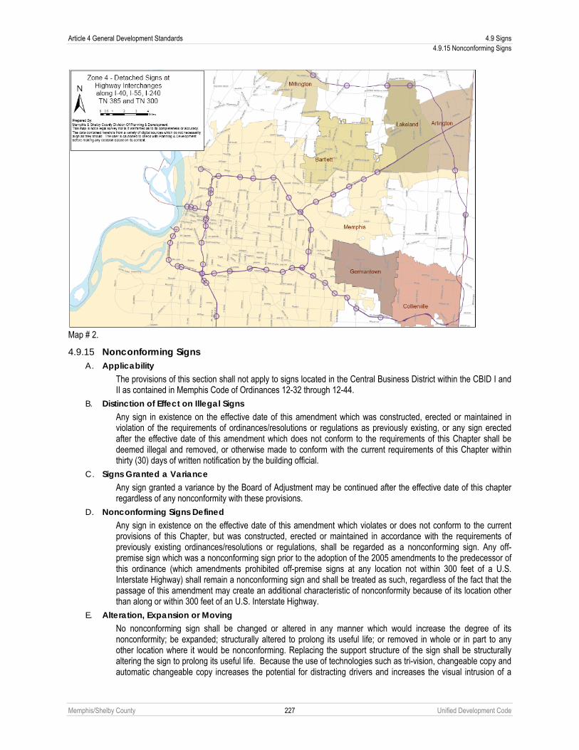
Article 4 General Development Standards 4.9 Signs 4.9.15 Nonconforming Signs
Memphis/Shelby County 227 Unified Development Code
Map # 2.
4.9.15 Nonconforming Signs A. Applicability
The provisions of this section shall not apply to signs located in the Central Business District within the CBID I and II as contained in Memphis Code of Ordinances 12-32 through 12-44.
B. Distinction of Effect on Illegal Signs Any sign in existence on the effective date of this amendment which was constructed, erected or maintained in violation of the requirements of ordinances/resolutions or regulations as previously existing, or any sign erected after the effective date of this amendment which does not conform to the requirements of this Chapter shall be deemed illegal and removed, or otherwise made to conform with the current requirements of this Chapter within thirty (30) days of written notification by the building official.
C. Signs Granted a Variance Any sign granted a variance by the Board of Adjustment may be continued after the effective date of this chapter regardless of any nonconformity with these provisions.
D. Nonconforming Signs Defined Any sign in existence on the effective date of this amendment which violates or does not conform to the current provisions of this Chapter, but was constructed, erected or maintained in accordance with the requirements of previously existing ordinances/resolutions or regulations, shall be regarded as a nonconforming sign. Any off-premise sign which was a nonconforming sign prior to the adoption of the 2005 amendments to the predecessor of this ordinance (which amendments prohibited off-premise signs at any location not within 300 feet of a U.S. Interstate Highway) shall remain a nonconforming sign and shall be treated as such, regardless of the fact that the passage of this amendment may create an additional characteristic of nonconformity because of its location other than along or within 300 feet of an U.S. Interstate Highway.
E. Alteration, Expansion or Moving No nonconforming sign shall be changed or altered in any manner which would increase the degree of its nonconformity; be expanded; structurally altered to prolong its useful life; or removed in whole or in part to any other location where it would be nonconforming. Replacing the support structure of the sign shall be structurally altering the sign to prolong its useful life. Because the use of technologies such as tri-vision, changeable copy and automatic changeable copy increases the potential for distracting drivers and increases the visual intrusion of a

4.9 Signs Article 4 General Development Standards 4.9.15 Nonconforming Signs
Memphis/Shelby County 228 Unified Development Code
sign on the streetscape, converting a sign to a different technology, such as tri-vision or changeable copy technology is prohibited unless the modified sign fully conforms with the applicable restrictions of this Chapter, including but not limited to those that specify the locations at which such technology is permitted.
F. Removal of Nonconforming Signs 1. Any Nonconforming Sign
a. If a nonconforming sign is damaged or destroyed by a force of nature or other action beyond the control of the sign owner, then it may be replaced with a sign of identical size in the same location or by a conforming sign provided that a complete application for a permit for the replacement is filed within sixty (60) days of the date of the damage or destruction, and the replacement or repair is completed before the expiration of the permit or any valid extension thereof. The repaired or replacement sign shall be considered a nonconforming sign.
b. If a nonconforming sign is voluntarily removed or damaged or destroyed through the actions of the sign owner, then such sign shall not be replaced except with a sign that fully conforms to the requirements of this ordinance. If such sign is an off-premise sign that is located more than 300 feet from a U.S. Interstate Highway, it shall not be replaced with an off-premise sign.
c. Any nonconforming on-premise sign, the use or copy of which is discontinued or removed for a period of three hundred sixty-five (365) days regardless of any intent to resume or not to abandon such sign shall be deemed to be abandoned and shall not thereafter be reestablished. Abandonment or obsolescence of a nonconforming sign shall terminate immediately the right to maintain such sign.
d. Any period of such discontinuance caused by government actions, strikes or acts of God, without any contributing fault by the nonconforming user, shall not be considered in calculating the length of discontinuance for the purposes of this subdivision.
2. Off-premise Signs In addition to the provisions of Paragraph 1 of this Sub-Section F, which apply to all nonconforming signs, the following provisions shall apply to nonconforming off-premise signs:
a. No nonconforming off-premise sign which has been removed voluntarily shall be replaced. This restriction is not intended to prevent the future erection of other signs on the site that conform fully with the provisions of this ordinance.
b. Any nonconforming off-premise sign, the use or copy of which is discontinued or removed for a period of six months regardless of any intent to resume or not to abandon such sign shall be deemed to be abandoned and shall not thereafter be reestablished. Abandonment or obsolescence of a nonconforming sign shall immediately terminate the right to maintain such sign.
c. Any period of such discontinuance caused by government actions, strikes or acts of God, without any contributing fault by the nonconforming user, shall not be considered in calculating the length of discontinuance for the purposes of this subdivision.
3. Removal of Nonconforming Sign Upon Change of Principal Use Any nonconforming sign shall be removed or brought into compliance with this chapter immediately upon a change in the principal use of the site, in accordance with Chart 1, Uses Permitted, set out at the end of this title.
4. Removal
For the purpose of this Chapter, “removal” shall mean removal of the entire structure of the sign. G. Enforcement of Removal
The Building Official shall conduct an inspection of every sign at least once each year to determine whether the sign conforms with the provisions of this title, make a written record of each such inspection and make all such reports available for public inspection during regular business hours.
If any sign is not removed as required by Sub-Section C and Paragraphs F.1 through 3 of this section, the building official shall initiate the necessary proceedings to secure removal of such illegal or nonconforming sign, or secure compliance with the provisions of this title.

Article 4 General Development Standards 4.9 Signs 4.9.16 Exception for Repairs Pursuant To Public Order
Memphis/Shelby County 229 Unified Development Code
Any owner who fails to remove an illegal sign within thirty (30) days of written notification by the Building Official, shall be fined fifty dollars ($50.00) per day until the sign is removed. In the event that an illegal sign is not removed within ninety (90) days of written notification of the owner by the Building Official, the city and/or county of Shelby are authorized to remove; but are not required to remove, the sign with all reasonable costs associated therewith to be paid by the owner. The city or county of Shelby shall have a lien on the property where the illegal sign was located for all reasonable costs that they incur in removing the sign.
Any resident of the city or the county of Shelby is authorized and empowered to initiate the necessary proceedings in Environmental Court to secure removal of an illegal sign if, but only if, the Building Official fails to initiate proceedings against the owner of the illegal sign to secure removal of the sign within ninety (90) days of written notification of the owner by the Building Official as set forth in the preceding paragraph.
Any owner who fails to remove a nonconforming sign within the applicable time set forth in Sub-Sections F.1 through 3 of this section, shall be fined fifty dollars ($50.00) per day until the sign is removed. In the event that a nonconforming sign is not removed within the time set forth in Sub-Sections F.1 through 3 of this section, the city and/or county of Shelby are authorized to remove; but are not required to remove, the sign with all reasonable costs associated therewith to be paid by the owner. The city or county of Shelby shall have a lien on the property where the nonconforming sign was located for all reasonable costs that they incur in removing the sign.
Any resident of the city or the county of Shelby is authorized and empowered to initiate the necessary proceedings in Environmental Court to secure removal of a nonconforming sign if removal of the sign is required under Sub-Sections F.1 through 3 of this section and if, but only if, the Building Official fails to initiate proceedings against the owner of the nonconforming sign to secure removal of the sign within ninety (90) days of the applicable time set forth in Sub-Sections F.1 through 3 of this section.
Upon the determination of the building official that a sign remains nonconforming after termination of the allowable time periods provided for herein above, the building official shall notify the sign owner and/or the owner of the land on which the nonconforming sign is located and such owner shall have thirty (30) days after such written notice within which to remove the sign. At the end of the thirty (30) day period, if the sign has not been removed or brought into compliance or properly appealed before the Memphis and Shelby County Board of Adjustment, the building official shall issue a summons into Environmental Court.
The removal expense may be made a lien upon such real property by the Building Official sending by certified mail to the owner of such real property, a notice of lien for the cost of such removal. The cost of all such mailing and the cost of obtaining the name and address of the owners shall be part of the cost of such removal.
H. Forfeiture Any private sign installed or placed on public property shall be forfeited to the public and subject to confiscation, unless it conforms to the requirements of this chapter. In addition to other remedies granted to it by this chapter, the Building Official shall have the right to recover from the owner or person placing the sign, the full costs of removal and disposal of the sign in a civil action.
4.9.16 Exception for Repairs Pursuant To Public Order Nothing in this chapter shall be deemed to prevent the strengthening or restoration to a safe condition of a building, structure or sign in accordance with an order of a public official who is charged with protecting the public safety and who declares such structure to be unsafe and orders it to be restored to a safe condition provided such restoration is not otherwise in violation of the various provisions of this chapter prohibiting the repair or restoration of partially damaged or destroyed buildings, structures or signs.

4.10 Planned Development Article 4 General Development Standards 4.10.1 Purpose
Memphis/Shelby County 230 Unified Development Code
4.10 PLANNED DEVELOPMENT
4.10.1 Purpose The intent of a special use permit for a planned development is to create a more desirable use of the land, a more coherent and coordinated development, and a better physical environment than would be possible under a single base zoning district or combination of base zoning districts. Planned developments are intended as a tool to allow creative and imaginative design that will promote amenities beyond those expected in conventional developments.
4.10.2 Applicability The governing bodies may, upon proper application, grant a special use permit for a planned development (see Chapter 9.6) for a tract of any size within the City or for tracts of at least three acres in unincorporated Shelby County to facilitate the use of flexible techniques of land development and site design, by providing relief from district requirements designed for conventional developments, and may establish standards and procedures for planned developments in order to obtain one or more of the following objectives:
A. Environmental design in the development of land that is of a higher quality than is possible under the regulations otherwise applicable to the property.
B. Diversification in the uses permitted and variation in the relationship of uses, structures, open space and height of structures in developments intended as cohesive, unified projects.
C. Functional and beneficial uses of open space areas.
D. Preservation of natural features of a development site.
E. Creation of a safe and desirable living environment for residential areas characterized by a unified building and site development program.
F. Rational and economic development in relation to public services.
G. Efficient and effective traffic circulation, both within and adjacent to the development site, that supports or enhances the approved transportation network.
H. Creation of a variety of housing compatible with surrounding neighborhoods to provide a greater choice of types of environment and living units.
I. Revitalization of established commercial centers of integrated design to order to encourage the rehabilitation of such centers in order to meet current market preferences.
J. Provision in attractive and appropriate locations for business and manufacturing uses in well-designed buildings and provision of opportunities for employment closer to residence with a reduction in travel time from home to work.
4.10.3 General Provisions The governing bodies may grant a special use permit for a planned development which modifies the applicable district regulations and other regulations of this development code upon written findings and recommendations of the Land Use Control Board and the Planning Director which shall be forwarded pursuant to provisions contained in this Chapter.
A. The proposed development will not unduly injure or damage the use, value and enjoyment of surrounding property nor unduly hinder or prevent the development of surrounding property in accordance with the current development policies and plans of the City and County.
B. An approved water supply, community waste water treatment and disposal, and storm water drainage facilities that are adequate to serve the proposed development have been or will be provided concurrent with the development.
C. The location and arrangement of the structures, parking areas, walks, lighting and other service facilities shall be compatible with the surrounding land uses, and any part of the proposed development not used for structures, parking and loading areas or access way shall be landscaped or otherwise improved except where natural features are such as to justify preservation.
D. Any modification of the district standards that would otherwise be applicable to the site are warranted by the design of the outline plan and the amenities incorporated therein, and are not inconsistent with the public interest.
E. Homeowners’ associations or some other responsible party shall be required to maintain any and all common open space and/or common elements.

Article 4 General Development Standards 4.10 Planned Development 4.10.4 Planned Residential Developments
Memphis/Shelby County 231 Unified Development Code
F. Lots of record are created with the recording of a planned development final plan.
4.10.4 Planned Residential Developments In addition to the standards and criteria set forth in Section 4.10.3, planned residential developments shall comply with the standards and criteria set forth below:
A. Formal Open Space A minimum of 0.6% of the total land area of a planned residential development of 15 acres or more shall be subject to the formal open space requirements of Section 6.2.3. No open area may be delineated or accepted as formal open space under the provisions of this Chapter unless it meets the standards of Chapter 6.2, Open Space.
B. Accessibility of Site All proposed streets, alleys and driveways shall be adequate to serve the residents, occupants, visitors or other anticipated traffic of the planned residential development. The location of the entrance points of the streets, alleys and driveways upon existing public roadways shall be subject to the approval of the City or County Division of Public Works.
C. Off-Street Parking Off-street parking shall be conveniently accessible to all dwelling units and other uses. Where appropriate, common driveways, parking areas, walks and steps may be provided, maintained and lighted for night use. Screening of parking and service areas shall be required through use of trees, shrubs and/or hedges and screening walls.
D. Pedestrian Circulation The pedestrian circulation system and its related walkways shall be separated, whenever feasible, from the vehicular street system in order to provide an appropriate degree of separation of pedestrian and vehicular movement.
E. Privacy The planned residential development shall provide reasonable visual and acoustical privacy for dwelling units within and adjacent to the planned residential development. Protection and enhancement of property and the privacy of its occupants may be provided by the screening of objectionable views or uses and reduction of noise through the use of fences, insulation, natural foliage, berms and landscaped barriers. High-rise buildings shall be located within the development in such a way as to minimize any adverse impact on adjoining low rise buildings.
F. Distance Requirements Where minimum distance requirements are provided between single family residential zoning districts and certain stipulated uses in this Code, the single-family residential areas of planned developments shall be considered zoned residential.
4.10.5 Planned Commercial or Industrial Developments Approval of a planned commercial or industrial development may be issued by the governing bodies for buildings or premises to be used for the retail sale of merchandise and services, parking areas, office buildings, hotels and motels and similar facilities ordinarily accepted as commercial center uses and those industrial uses which can be reasonably be expected to function in a compatible manner with the other permitted uses in the area. In addition to the applicable standards and criteria set forth in Section 4.10.3, planned commercial or industrial developments shall comply with the following standards:
A. Screening When commercial or industrial structures or uses in a planned commercial or industrial development abut a residential district or permitted residential buildings in the same development, screening may be required by the governing bodies.
B. Display of Merchandise All business, manufacturing and processing shall be conducted, and all merchandise and materials shall be displayed and stored, within a completely enclosed building or within an open area which is completely screened from the view of adjacent properties and public rights-of-way, provided, however, that when an automobile service station or gasoline sales are permitted in a planned commercial development, gasoline may be sold from pumps outside of a structure.
4.10 Planned Development Article 4 General Development Standards 4.10.5 Planned Commercial or Industrial Developments
Memphis/Shelby County 232 Unified Development Code
C. Accessibility The site shall be accessible from the proposed street network in the vicinity which will be adequate to carry the anticipated traffic of the proposed development. The streets and driveways on the site of the proposed development shall be adequate to serve the enterprises located in the proposed development.
D. Landscaping Landscaping shall be required to provide screening of objectionable views of uses and the reduction of noise. High-rise buildings shall be located within the development in such a way as to minimize any adverse impact on adjoining low-rise buildings.

Memphis/Shelby County 233 Unified Development Code
Article 5. Infrastructure and Public Improvements 5.1 GENERAL PROVISIONS
5.1.1 Applicability A. This Article applies to all development within the City of Memphis and unincorporated Shelby County as set forth in
Chapters 9.12, Administrative Site Plan Review and 9.7, Subdivision Review (see also 1), Summary of Review Authority).
B. Prior to final construction or grading approval, the applicant shall have installed improvements specified in this development code or guaranteed their installation as provided for in this Article.
C. No municipal services or utilities shall be extended or furnished to any development until the applicant has installed the improvements specified in this development code or guaranteed their installation as provided for in this Article.
5.1.2 Improvements A. Engineering plans and specifications shall be in accordance with applicable standards of the City or County pertaining
to construction of sanitary sewer, paving, drainage, sidewalk, driveways, streets, alleys, culverts, bridge facilities, and any other facilities regulated by City or County ordinances or design standards.
B. Engineering plans and specifications for the construction of water facilities shall be in accordance with applicable design standards of MLGW.
C. No improvements shall be made until all plans, profiles and specifications have been reviewed and approved by the City, County or other government agency under whose authority is required to approve.
D. The applicant shall enter into a standard improvement contract to construct at the applicant expense the improvements required in this Article, and other provisions of development code as set forth in this Article.
E. All improvements shall be constructed to meet locally adopted ADA standards.
5.1.3 Easements Appropriate easements shall be provided for public infrastructure and utilities.
5.1.4 Survey Markers and Monuments Survey corners shall be marked in accordance with the standards and practices of land surveying in the Tennessee Code Annotated.

5.2 Streets and Alleys Article 5 Infrastructure and Public Improvements 5.2.1 General
Memphis/Shelby County 234 Unified Development Code
5.2 STREETS AND ALLEYS
5.2.1 General All roadways shown on the Major Road Plan or MPO Long Range Transportation Plan shall be dedicated and improved in accordance with the requirements of the adopted plans. All other streets shall be dedicated and improved in accordance with this development code.
A. Purpose New streets within the City of Memphis and unincorporated Shelby County are intended to balance the needs of all types of traffic—auto, bicycle, and pedestrian— and to maximize mobility and convenience for all City and County residents. Design shall take into account auto, bicycle, and pedestrian modes of transportation. While all streets in conjunction with the streetscape will appropriately balance pedestrian and automobile needs, their character will vary by specific location. Some streets will carry a large volume of both automobile and pedestrian traffic and provide a more intense experience while others will provide more intimately scaled street-space.
B. Construction Standards The standards for construction of pavement on all streets shall be in accordance with the specifications established by the City or County.
C. Cash Payment When the required construction of improvements to roadways cannot meet the design standards of the City and County Engineers, a cash payment in-lieu-of-construction for the total cost of improvements shall be required. The governing bodies shall deposit the cash payment into an account for the improvement of the roadway, and shall be applied to the cost of improvements at the time of construction.
D. Maintenance Maintenance of all public rights-of-way (including maintenance and repair of sidewalk and street trees) between the edge of pavement or back of curb and the subject property shall be the responsibility of the abutting property owner.
E. Public Dedication The public dedication of all streets and rights-of-way shall be in fee simple.
F. Reserve Strips Reserve strips controlling access to streets are permitted only when the control of such strip is given to the City or County.
G. Clear Sight Triangle At the intersection of a driveway and a street and on all corner lots (the intersection of two streets), a clear sight triangle must be established as set forth in Section 4.4.7.
5.2.2 Street Dimensional Standards A. Dimensional standards for public streets are set forth below, Sections 5.2.7, et seq.
B. Curb and gutter are required on all urban streets as set forth below, Sections 5.2.7, et seq.
C. Minimum grade for all streets shall be one-half of one percent.
D. Maximum grade through intersections shall be four percent. The maximum grade shall extend a minimum of 50 feet each direction from the centerline of the intersecting streets or to the end of radii, whichever is the longer distance.
5.2.3 Alleys and Fire Lanes A. The width of an alley right-of-way shall be in conformance with in Section 5.2.7.
B. Alleys shall be provided for nonresidential uses where it is necessary to provide service access, such as access for emergency vehicles, off-street loading and parking consistent with and adequate for the uses proposed.
C. Alley intersections and sharp changes in alignment shall be avoided, but where necessary, corners shall be dedicated and improved sufficiently to permit safe vehicular movement.
D. Dead-end alleys may not be allowed unless approved by the City or County Engineer.

Article 5 Infrastructure and Public Improvements 5.2 Streets and Alleys 5.2.4 Connectivity
Memphis/Shelby County 235 Unified Development Code
E. Alleys shall not be used to determine the block face criteria included in Section 5.2.5.
F. New public alleys are only appropriate in certain areas of the city and discouraged otherwise. All alleys, whether private or public shall be constructed to meet the pavement requirements and standards of the City Engineer for city streets. The City Engineer, in consultation with the Planning Director, will determine whether public alleys are appropriate in a new development.
G. Alleys shall be paved and dedicated to the public unless such alleys are part of a private street development as described in Section 5.2.17.
H. A fire lane easement a minimum of 24 feet in width shall be provided when required by the Fire Marshal. The fire lane shall remain free of obstructions and provide access to the subdivision at all times.
5.2.4 Connectivity A. Developments shall provide roadways permanently open to the public that provide community wide access as part of
an overall connectivity network whose spacing generally occurs at ¼ mile intervals.
B. Existing streets in adjacent or adjoining areas shall be continued in a new subdivision. Whenever connections to anticipated or proposed surrounding streets are required by this Chapter, the right-of-way shall be extended and the street developed to the property line of the subdivided property (or to the edge of the remaining undeveloped portion of a single tract) at the point where the connection to the anticipated or proposed street is expected. Temporary turnarounds may be required to be constructed at the end of such streets pending their extension when such turnarounds appear necessary to facilitate the flow of traffic or accommodate emergency or service vehicles. No temporary dead-end street shall be permitted in excess of 500 feet unless no other practical alternative is available.
C. Subdivisions shall provide sufficient external access points to the existing or future roadway network as follows, however, in the case of any conflict between the provisions of this section and Chapter 3.3, Blocks, the provisions of Section 5.2.5 shall control.
1. Any residential subdivision of greater than 50 lots shall include at least two access points. The second access may consist of a stub street.
2. Any residential subdivision of greater than 100 lots shall include at least two access points. Stub streets shall not be considered part of the two access points.
3. No more than 80 certificates of occupancy may be issued within the subdivision until the required secondary access has been constructed or bonded for construction.
4. Residential subdivisions of 140 or more lots shall provide three separate access points. Where three or more access points are required, the Land Use Control Board may waive the requirement for immediate construction of more than two access points, provided that subdivision phasing and design illustrates the additional required connections. For those subdivisions large enough to require a third access, a stub-out street may be credited as a required access if the two functioning access roads are both connected to a connector road.
5. A waiver of these standards may be granted by the Land Use Control Board during approval of the preliminary subdivision plat only in extreme cases where limited frontage, natural features (slope, topography), or similar circumstances preclude the required connections and there is no substantial impact noted regarding emergency service delivery. An alternate public emergency access roadway may be provided to satisfy the requirements above with approval of the Land Use Control Board.
6. Where the Land Use Control Board determines it is necessary, a divided entrance shall be required for a subdivision or development. Where a divided entrance is credited as two access points, the divided entrance shall be four travel lanes from the intersection with the major road system to the first intersection within the development.
D. Street stubs into adjacent properties shall be required to ensure adequate circulation. All existing stub streets, contiguous to the property, shall be connected to the proposed street system. A waiver from these requirements for street stubs shall require approval of the Land Use Control Board. A decision of the Land Use Control Board may be appealed to the appropriate governing body but must receive a vote of the majority of the members of the governing body to be reversed.
5.2.5 Blocks This Section shall only apply to applications submitted to the Office of Planning and Development that involve the proposed installation of public streets.

5.2 Streets and Alleys Article 5 Infrastructure and Public Improvements 5.2.5 Blocks
Memphis/Shelby County 236 Unified Development Code
A. Block Measurement
1. Block
a. A block is bounded by one or more of the following:
1. A publicly-dedicated street that meets the requirements of this Chapter. 2. A private drive or private street that meets the requirements for a publicly-dedicated street, as set out in
this Chapter.
b. See Paragraph 5.2.5A(4) below for exemptions to the determination of a block.
c. If more than 50% of a tract or lot with multiple principal buildings is redeveloped, as measured by land area, the Block Standards of this chapter shall apply.
2. Block Perimeter Block perimeter is measured along the center line of intersecting streets that encompass a block as defined in Paragraph (1) above. The connectivity standards of Section 5.2.4 shall apply to the measurement of block perimeters.
3. Block Face
a. That portion of a block located between the closest intersecting streets that meets the requirements of Paragraph (1) above;
b. That portion of a block measured along the adjacent edge of the travel way of two intervening streets (as defined above); or
c. The distance from street deflections that occur with radii not greater than 125 feet and whose deflection is less than 135 degrees of deflection.

Article 5 Infrastructure and Public Improvements 5.2 Streets and Alleys 5.2.5 Blocks
Memphis/Shelby County 237 Unified Development Code
4. Block Exemptions Maximum block perimeter, block face, and cul-de-sacs lengths are set except where prevented by acceptable barriers. Acceptable barriers include: slopes in excess of 25%; freeways; railroad lines; a wetland, stream, creek or lake; a dedicated public open space or park a minimum width of 50 feet; preexisting development; or lease provisions, easements, covenants, or other restrictions existing prior to the effective date of this development code, which preclude street or access way connections.
5. Pedestrian Access A pedestrian access easement a minimum of 12 feet in width may be required to traverse blocks where deemed essential to provide access to institutional and community service uses or to retail and personal service uses.
B. Blocks
1. Residential Districts
a. Residential blocks must have sufficient width to provide for two tiers of residential lots, except where single tier lots are required to separate residential development from arterial traffic, to separate lots from an incompatible use, to accommodate a requirement for single loaded streets, to allow for unusual topographical conditions, where across from a public park or open space, or when adjacent to the outer perimeter of a subdivision.
b. The maximum perimeter of all blocks and the maximum length of any block face or cul-de-sac in the Residential (R-) districts, as measured from the centerline of the public or private street system, excluding alleys, surrounding a block or along a block face, shall be consistent with the dimensions set forth below.
Average Lot Size on Block
Maximum Block Perimeter (ft.)
Maximum Block Face (ft.) Cul-de-sac Length (ft.)
20,000 Square Feet 10,000 1,600 1,600
15,000 Square Feet 5,000 1,300 1,300
10,000 Square Feet 3,300 1,200 1,000
8,000 Square Feet 2,800 1,000 1,000
6,000 Square Feet 2,700 800 800
3,000 Square Feet 2,100 600 600

5.2 Streets and Alleys Article 5 Infrastructure and Public Improvements 5.2.5 Blocks
Memphis/Shelby County 238 Unified Development Code
2. Residential Urban Districts
a. Residential blocks must have sufficient width to provide for two tiers of residential lots, except where single tier lots are required to separate residential development from arterial traffic, to separate lots from an incompatible use, to accommodate a requirement for single loaded streets, to allow for unusual topographical conditions, where across from a public park or open space, or when adjacent to the outer perimeter of a subdivision
b. The maximum perimeter of all blocks and the maximum length of any block face or cul-de-sac in the Residential Urban (RU-) districts, as measured from the centerline of the public or private street system, excluding alleys, surrounding a block or along a block face, shall be consistent with the dimensions set forth below.
Residential Urban
District Maximum Block Perimeter (ft.)
Maximum Block Face/ Cul-de-sac Length (ft.)
RU – 1 2,400 800
RU – 2 2,400 700
RU – 3 2,400 650
RU – 4 2,400 650
RU – 5 2,400 650
3. Mixed Use Districts The maximum perimeter of all blocks and the maximum length of any block face or cul-de-sac in the RW, OG, CMU-1, CMU-2, CMU-3, CMP-1, and CMP-2 districts, as measured from the centerline of the public or private street system, excluding alleys, surrounding a block or along a block face, shall be consistent with the dimensions set forth below:

Article 5 Infrastructure and Public Improvements 5.2 Streets and Alleys 5.2.6 Street Layout
Memphis/Shelby County 239 Unified Development Code
Mixed Use District* (See 3.10.3 Frontage Standards)
Maximum Block Perimeter (ft.)
Maximum Block Face/ Cul-de-sac Length (ft.)
RW (Undesignated) Transitional/Commercial/General Urban Shopfront/Pedestrian
2,400 2,200 2,000 1,800
800 750 650 550
OG (Undesignated) Transitional/Commercial/General Urban Shopfront/Pedestrian
3,000 2,600 2,400 2,000
1,000 750 650 600
CMU-1 (Undesignated) Transitional/Commercial/General Urban Shopfront/Pedestrian
2,400 2,200 2,000 1,800
800 750 650 550
CMU-2 (Undesignated) Transitional/Commercial/General Urban Shopfront/Pedestrian
2,800 2,600 2,400 2,000
800 750 650 600
CMU-3 (Undesignated) Transitional/Commercial/General Urban Shopfront/Pedestrian
3,000 2,600 2,400 2,000
1,000 750 650 600
CMP-1 (Undesignated) Transitional/Commercial/General Urban Shopfront/Pedestrian
3,000 2,600 2,400 2,000
1,000 750 650 600
CMP-2 (Undesignated) Transitional/Commercial/General Urban Shopfront/Pedestrian
3,000 2,600 2,400 2,000
1,000 750 650 600
*In situations where frontage designations intersect, the average of the maximums shall control.
4. Procedure for Special Exceptions The Land Use Control Board may grant a special exception to the provisions of this Section during the subdivision review process.
5.2.6 Street Layout A. General
1. Street alignments shall conform to the alignments shown in the MPO Long Range Transportation Plans. 2. Streets shall be aligned to join with planned or existing streets. 3. Street jogs with centerline offsets of less than 125 feet shall be prohibited. Street offsets shall be approved by the
City or County Engineer. 4. Reverse curves on arterials shall be joined by a tangent a minimum of 100 feet in length. 5. Streets shall be designed to bear a logical relationship to the topography. 6. Street connections to adjacent properties shall be provided to ensure adequate traffic circulation within the
general area. 7. Street corridors shall be designed to ensure appropriate bicycle and pedestrian movement. Corridor design is
dependent on street type as established in this Chapter. Connector and arterial streets shall prioritize bicycle lanes, while local roads shall incorporate signed shared roadways as defined in the MPO’s Bike Plan.

5.2 Streets and Alleys Article 5 Infrastructure and Public Improvements 5.2.7 Street Standards
Memphis/Shelby County 240 Unified Development Code
5.2.7 Street Standards A. Applicability
1. Conformance to the standards of this Chapter shall be in accordance with Chapter 4.1, Applicability.
2. The following specifications illustrate acceptable configurations for public streets.
3. The City or County Engineer may adjust the configurations as necessary for specific conditions provided that the face of curb to face of curb maximum width does not exceed the width shown for the specific street type.
4. Requirements for private streets are listed in Section 5.2.17. B. Arterial Streets
Dimensional requirements for arterials are listed in the MPO Long Range Transportation Plan.
1. Freeway Streets with the sole purpose of carrying through traffic with the highest degree of mobility and safety. These roads provide no direct access to abutting properties.
2. Principal Arterial Streets serving major metropolitan activity centers, the highest traffic volume corridors, the longest trip desires, and a high proportion of total urban area travel on a minimum of mileage. Service to abutting land should be subordinate to the provision of travel service to major traffic movements. This system carries the major portion of trips entering and leaving an urban area, as well as the majority of through movements desiring to bypass the central city, and normally will carry important intraurban as well as intercity bus routes. Principal arterials will be designed to accommodate multi-modal transportation with particular attention given to the provision of an attractive pedestrian environment.
3. Minor Arterial Streets interconnecting with and augmenting the principal arterial system and providing service to trips of moderate length at a somewhat lower level of travel mobility. The system places more emphasis on land access and distributes travel to geographic areas smaller than those identified with the higher system. It includes all arterials not classified as principal or limited access roads. Principal arterials will be designed to accommodate multi-modal transportation with particular attention given to the provision of an attractive pedestrian environment.

Article 5 Infrastructure and Public Improvements 5.2 Streets and Alleys 5.2.7 Street Standards
Memphis/Shelby County 241 Unified Development Code
C. Connector Streets
1. Major Connector Streets serving commercial and industrial areas, or large volumes of residential traffic. Major connectors are intended to serve up to 10,000 vehicles per day. The standard curb to curb width shall be 36 feet. The City or County Engineer, with approval of the Planning Director, may adjust the following configuration to add or remove bike or parking lanes as necessary provided that the face of curb to face of curb width does not exceed 48 feet.
2. Minor Connector Streets serving moderate volumes of commercial and residential traffic. Minor connectors are intended to serve up to 7,000 vehicles per day. The City or County Engineer, with approval of the Planning Director, may adjust the following configuration to add or remove bike or parking lanes as necessary provided that the face of curb to face of curb width does not exceed 38 feet.

5.2 Streets and Alleys Article 5 Infrastructure and Public Improvements 5.2.7 Street Standards
Memphis/Shelby County 242 Unified Development Code
D. Local Streets
1. Major Local Streets providing access to commercial and residential properties at a lower level of service than connectors streets. Major locals are intended to serve up to 5,500 vehicles per day. The City or County Engineer may adjust the following configuration to add or remove parking lanes as necessary provided that the face of curb to face of curb width does not exceed 36 feet.
2. Minor Local Minor locals are intended for predominantly residential neighborhoods. Minor local provide the minimum level of mobility for two-way traffic. Minor locals are intended to serve up to 2,750 vehicles per day. The City or County Engineer may adjust the following configuration to add or remove parking lanes as necessary provided that the face of curb to face of curb width does not exceed 28 feet.

Article 5 Infrastructure and Public Improvements 5.2 Streets and Alleys 5.2.7 Street Standards
Memphis/Shelby County 243 Unified Development Code
E. Rural Streets Rural streets are intended for use where large lot residential neighborhoods or agricultural uses, both within the City of Memphis and in unincorporated Shelby County, are the predominant character. Rural streets provide the minimum level of mobility for two-way traffic. Rural streets are intended to serve up to 2,000 vehicles per day. The City or County Engineer may adjust the following configuration to add or remove sidewalks or swales as necessary.
F. Alley
A public or private right-of-way designed to serve as a secondary means of access to the side or rear of those properties whose principal frontage is on a street.
1. Residential Alley

5.2 Streets and Alleys Article 5 Infrastructure and Public Improvements 5.2.8 Corner Radii
Memphis/Shelby County 244 Unified Development Code
2. Commercial Alley
G. Enhanced Roadways
1. Medians
a. Medians may be used on Major Connectors, Minor Connectors and Major Locals. Medians must be a minimum of eight feet in width.
b. Street cross-sections that incorporate medians must include additional right-of-way to accommodate the median. However, the width of a median does not count against the face of curb to face of curb measurement.
c. A continuous turn lane may be modified to accommodate a median as permitted by the City or County Engineer.
d. Planting of street trees and shrubs in the median may be permitted by the City or County Engineer.
5.2.8 Corner Radii A. The applicable City or County Engineer shall evaluate curb radii based on the functional classification of intersecting
streets, and on the anticipated adjacent land at each intersection. In all cases, the applicable City or County Engineer will evaluate the curb radii based on a vehicle with a minimum 42-foot turning radius. The City or County Engineer may approve smaller curb radii provided the applicant provides supporting documentation that the modification is safe and appropriate.
B. Curb radii shall be designed based on the functional classification of intersecting streets and shall balance the need to accommodate safe large vehicle movements with pedestrian safety:
1. Smaller turn radii may be appropriate at intersections that have high volumes of pedestrian and cyclist crossings to support adjacent land uses. These include streets within the CMU- districts, connections between collector roads, and at intersections within RU- and CMU- districts.
2. Larger turn radii may be required at intersections that experience frequent, high volumes of truck and transit vehicle turns. These include arterials and streets serving or within industrial districts. In these locations, curb radii will be evaluated based on the following standard design vehicle: vehicle with a minimum 42-foot turning radius. If the applicable City or County Engineer anticipates larger vehicles on site, a larger curb radius may be required.
3. In locations where there is on-street parking in the receiving lane, consideration of tighter curb radii may be appropriate and still allow for safe larger vehicle movements
4. The minimum curb radii for the various street intersections are established below:

Article 5 Infrastructure and Public Improvements 5.2 Streets and Alleys 5.2.9 Tangents
Memphis/Shelby County 245 Unified Development Code
Intersection Type
Residential Single-Family
Districts
Residential Urban Districts
Mixed-Use
Districts Open Districts, and Industrial Districts
Arterial/Arterial 20 20 25 30 Arterial/Connector 20 15 20 25
Arterial/Minor 15 15 15 20 Connector/Connector 10 10 15 20
Connector/Minor 10 10 10 15 Minor/Minor 10 10 10 15
5.2.9 Tangents The minimum centerline tangents permitted on approach to intersections are shown below:
Intersection Type Tangent Length (feet) Arterial with Arterial 300 Arterial with Connector 200 Connector with Arterial or Connector 100 Connector with Local 75 Local with Local or other 75
5.2.10 Horizontal Curves 1. The minimum centerline radius permitted for each street classification is shown below:
Street Type Centerline Radius (feet) Principal Arterial 1,400 Minor Arterial 1,125 Major Connector 825 Minor Connector or Non-Residential Cul de Sac
400
Major Local 150 Minor Local 100 Residential Cul de Sac* 75
Note: Cul-de-sac streets may have one (1) corner with a centerline radius of seventy-five (75) feet located with no more than sixty percent (60%) of the total length of the street between the end of the cul-de-sac and the beginning of the curve.
2. Street jogs with centerline offsets of less than 125 feet shall be prohibited. Street offsets shall be approved by the City or County Engineer.
5.2.11 Design Speed Default speed is 25 mph with a stopping sight distance of 200 feet unless specific traffic calming geometrics are used. Use of low speed elements must be consistent throughout the length of the minor local street in order to maintain a constant design speed and introduce unexpected vertical and horizontal direction changes. Speed limit and other necessary warning signs shall be installed per the approved signing plan.
5.2.12 Intersections

5.2 Streets and Alleys Article 5 Infrastructure and Public Improvements 5.2.12 Intersections
Memphis/Shelby County 246 Unified Development Code
A. Spacing: Intersections on the same side of a street shall have a minimum separation in accordance with the following chart for each classification of street. Measurements shall be from centerline to centerline of intersecting streets. The required minimum intersection spacing or separation along each classification of street shall be the same regardless of the classification(s) of the intersecting streets.
B. Intersections shall approximate right angles as closely as possible.
C. Offset: The centerline of two streets intersecting the same road on opposite sides shall be offset as shown in the table below. The offset dimension between intersections is categorized by the type of facilities involved. If the two legs creating the offset are different types of facilities, the shorter of the offset dimensions shall apply. Offset Type “A” has no opposing left turn conflict. Offset Type “B” has an opposing left turn conflict.
Street Category Minimum Spacing (Separation)
Arterial (Principal or Minor) 400 Connector 200 Local 150
Type of Facility Type A (Feet) Type B (Feet) Arterial (Principal or Minor) 300 400 Connector 200 250 Local 150 150

Article 5 Infrastructure and Public Improvements 5.2 Streets and Alleys 5.2.13 Sight Distance
Memphis/Shelby County 247 Unified Development Code
5.2.13 Sight Distance
The minimum intersection sight distance and stopping sight distance shall be in accordance with current AASHTO standards.
5.2.14 Cul-de-Sacs A. Excluding industrial districts, any time a cul-de-sac is created, it may have either a landscaped center island or be
constructed of decorative concrete or concrete pavers, subject to approval by the City or County Engineer, and shall meet the following standards:
Residential or Mixed Use Maximum Length See Section 5.2.5 Minimum Turnaround Radii (to curb or edge of pavement as per street design)
33 ft
Minimum Center Island Radii 5 ft Industrial Maximum Length 2,500 ft
Minimum Turnaround Radii (including ROW) Determined by the type and intensity of development but in no case shall it be less than 33 ft
Minimum Center Island Radii 15 ft
5.2 Streets and Alleys Article 5 Infrastructure and Public Improvements 5.2.15 Dead-End Streets
Memphis/Shelby County 248 Unified Development Code
B. If a landscaped center island is utilized, the minimum turnaround radius (to curb or edge of pavement) shall be 62 feet and the minimum center landscape island radius shall be 44 feet (providing a minimum 18 foot pavement surface).
C. If the cul-de-sac is configured without a landscaped center island, the minimum turnaround radius (to curb or edge of pavement) shall be 33 feet.
D. A cul-de-sac shall terminate with a permanent turn-around with curb treatment consistent with the street design.
E. Cul-de-sac length shall be measured along the center line of the cul-de-sac from the single point of access at the public right-of-way to the radius point of the turnaround.
F. The applicant shall provide for perpetual maintenance of the unpaved island through a property owners association or other acceptable organization.
G. Permitted alternatives to cul-de-sacs include loop lanes, eyebrows and similar alternatives approved by the Land Use Control Board.
5.2.15 Dead-End Streets Dead-end streets shall be prohibited except for short stubs to permit extension. Temporary turnarounds shall be required where the street stub exceeds 250 feet in length. The applicant shall provide a Type III barricade and a sign or stenciled notice at the stub declaring that the particular street will connect with future development.
5.2.16 Roadway Dedication and Improvements A. Right-of-way dedication and improvement shall be as required for all roadways, except freeways, as designated on the
MPO Long Range Transportation or Major Road Plans. Right-of-way dedication is required for freeways but improvements shall not be required at developer expense.
B. For all arterial roads on the MPO Long Range Transportation or Major Road Plans, a minimum of two travel lanes from the centerline of the roadway or closest median edge shall be constructed. Four travel lanes shall be constructed if the property has frontage on both sides of the arterial road.
C. The improvements outlined in this Section may be waived by the City or County Engineer on a case-by-case basis if the street section is not contiguous to an improved section of roadway or if the conditions of Sub-Section 4.3.4B are met.
5.2.17 Private Streets Private streets may be allowed in a residential subdivision subject to meeting the requirements of this development code and the conditions set forth below.
A. General 1. Private streets shall be the principal access between a public street and platted lots that do not abut a public
street. Such private streets are not dedicated to the public and shall not be publicly maintained. The term “private street” may include both the pavement and areas of streets, alleys or service roads within a development.
2. The private streets shall be owned and maintained by a property owners association organized and upon approval of the Planning Director, may be transferred to a land conservancy or land trust. Any such conveyance must adequately guarantee the protection and maintenance of the private streets in accordance with the provisions of this Chapter.
3. All private streets shall be constructed to equal or exceed the base materials, compaction, and final surfacing standards for public streets and must be certified as such by the applicable City or County Engineer. If curb, gutter, and sidewalk are not provided, drainage swales adjacent to the roadway shall be required.
B. Access 1. A private street shall be labeled on the final plat and be assigned a lot and block number from its subdivision. 2. Private streets shall be reserved for use by owners and residents served by such private streets and all
governmental entities providing services and regulatory enforcement, as well as private service entities. Access to subdivisions containing private streets may be controlled by 24-hour security guard or a self-activated gate at the entrance. The gate shall be of a model approved by the appropriate fire department. The location of the gate shall meet the requirements outlined in section 4.5.6.

Article 5 Infrastructure and Public Improvements 5.2 Streets and Alleys 5.2.18 Conversion of Public Street to Private Street
Memphis/Shelby County 249 Unified Development Code
C. Front Setbacks and Lot Widths All private streets shall be treated as public street rights-of-way for purposes of determining required front setbacks and lot widths.
D. Maintenance The final plat shall be conditioned as follows:
1. Require perpetual maintenance of private streets by a property owners association to the same standards as connecting public streets for the safe use of persons using the streets; and
2. State that the City or County has absolutely no obligation or intention to ever accept such streets as public right-of-way.
5.2.18 Conversion of Public Street to Private Street A. Procedure
Conversions of a public street to a private street shall be processed as either an amendment to a planned development outline plan or final plan, an amendment to a subdivision plan or plat or a right-of-way vacation in accordance with the provisions of this Sub-Section.
1. Amendment to a planned development outline plan or final plan. For streets that are located entirely within a planned development that neither stub to adjacent undeveloped property nor connect to adjacent streets, and where an established homeowners association maintains common areas, a public to private street conversion shall be processed as an amendment to the planned development outline or final plan pursuant to Chapter 9.6 and require approval by the legislative body(s). Before an application for such an amendment is accepted by the Office of Planning and Development, an affidavit shall be presented by the applicant that the percentage of lot owners as required by the homeowners or property owners association’s bylaws that govern amendments to the outline or final plan has agreed on and voted for the amendment. A petition with the appropriate signatures indicating this vote shall be presented with the application.
2. Amendment to a subdivision plan or plat. In situations where all of the provisions of Paragraph (1) are met, except the street(s) proposed to be converted lies in a subdivision rather than a planned development, the public to private street conversion shall be processed as a modification of an approved plan or plat pursuant to Chapter 9.7 and require approval by the legislative body(s).
3. Right-of-way vacation. In situations that do not meet the provisions of Paragraphs (1) and (2) above, the application shall be processed as a right-of-way vacation pursuant to Chapter 9.8. Before an application for such a vacation is accepted by the Office of Planning and Development, an affidavit shall be presented by the applicant that 100% of the property owners that abut the street or streets to be converted, as well as any other property owners who will be levied fees to maintain the converted street, has agreed and voted for the vacation. A petition with the appropriate signatures indicating this vote shall be presented with the application. For the purpose of this Paragraph, the approval of property owners of parcels that abut but do not access the street to be converted are not required to approve the vacation, provided they will not be part of the owners association that will maintain the converted street.
B. The applicant shall provide proof that the applicant and/or the applicable owners association has and will maintain general liability insurance covering bodily injury, property damage and personal and advertising injury, on an occurrence form to cover any loss or damage that may occur related to the use of the street or private improvement that occurs subsequent to the vacation, with the City or County added as an additional insured. The policy limits will not be less than $1,000,000 per occurrence.
C. If more than one lot, a property owners association shall maintain the streets and other improvements granted to the association. If no formal community association exists in the subdivision, one shall be created.
D. Street maintenance shall include keeping the street driving surface in a good state of repair. Curbs, gutters, sidewalks and street trees shall be maintained so as to not present a safety hazard.
E. Unless otherwise required by the Public Works Director, stormwater systems, surface and underground, that collect runoff primarily from the area shall become private. The applicant shall retain public easements as required by the City or County Engineer where applicable.
F. Facilities, such as streetlights and underground utilities, shall be considered separately and the facility shall remain public if it can be shown it is in the best public interest for the facility to remain public.

5.2 Streets and Alleys Article 5 Infrastructure and Public Improvements 5.2.19 Street Names
Memphis/Shelby County 250 Unified Development Code
G. The connection of the private drive to the public street shall be redesigned and constructed to clearly distinguish between the public street and the private drive, unless waived by the Land Use Control Board through the special exception process as outlined in Chapter 9.14. The appropriate private street name sign shall be installed by the applicant.
5.2.19 Street Names Street names shall be approved by the City Engineer upon review of comments provided by MLGW if the project is within the city limits, or by Memphis Light, Gas and Water Division if the project is in the county. The applicant shall propose street names for new streets which will be considered with respect to the following criteria:
A. New streets shall be named so as to provide continuity of name with existing streets and so as to prevent conflict with identical or similar names in other parts of the City or County.
B. Streets lying on approximately the same line shall have the same name unless the intervening space between the separate parts is greater than 2,000 feet.
C. Other criteria as listed in Street Naming Guide for Memphis and Shelby County, TN.
5.2.20 Street Name Signs The Developer shall install permanent street name signs in accordance with design and location standards determined by the appropriate City or County Engineer.
5.2.21 Sidewalks A. Sidewalks shall be installed in accordance with the applicable streetscape plate (see Chapter 4.3), except for those
streets identified as rural streets, which shall use the street standard identified in Sub-Section 5.2.7E.
B. All sidewalks and curb ramps shall be constructed by the developer in accordance with the City and County’s design standards, and shall meet the requirements of the Americans with Disabilities Act.
C. All required sidewalks and street trees shall be constructed prior to the issuance of a certificate of occupancy.
5.2.22 Bikeways A. Configurations for streets that include bike lanes are set forth Section 5.2.7 Street Standards.
B. Dedication of necessary bikeways shall be in accordance with the MPO Regional Bicycle and Pedestrian Plan; design and construction shall be in accordance with City or County Engineer design standards. Bikeways include but are not limited to shared lanes, marked shared lanes, paved shoulders, bicycle lanes, bicycle boulevards, cycle tracks, and shared use paths.

Article 5 Infrastructure and Public Improvements 5.3 Utilities 5.3.1 General
Memphis/Shelby County 251 Unified Development Code
5.3 UTILITIES
5.3.1 General A. Unless otherwise waived by the governing bodies, all lots within the jurisdiction of the City of Memphis shall be
connected to the public water and sanitary sewer systems. Any lot that is approved for using septic tanks, alternative sewage disposal systems, or private water wells shall meet all requirements of the County and State health department regulations.
B. The applicant shall pay all costs for connecting to the public system, for the following public utilities, that is complete, in place and ready for service as follows:
1. Water mains, customer services, meter boxes, valves, fittings, fire hydrants and all appurtenances to make a complete operating water system within the subdivision or other development;
2. A complete sanitary sewer system including laterals and mains, manholes, clean-outs, customer service wyes, tees, lift stations, force mains, lines, and all appurtenances. When public sewers are within reasonable access to the subdivision, the subdivider shall provide sanitary sewer facilities to each lot therein. The subdivider shall provide sewers of the diameter necessary to serve the subdivision. The subdivider shall also provide for sewers to the boundary of his property for any future upstream development but shall only be required to pay for sewers with a capacity equal to or less than a 12 inch diameter pipe serving upstream development.
3. Stormwater improvements as required or according to plans adopted.
5.3.2 Water A. Water Supply and Fire Protection Standards
1. All lots shall be provided with municipal water supply and distribution systems for fire protection and domestic use. 2. Fire hydrants shall be provided as part of the water distribution system and as required by the Memphis Fire
Department and Shelby County Fire Department standards. B. Water System Required
Applicants shall be responsible for providing an approved public water supply system consistent with the Growth Plan. Where an approved public water supply or distribution main is within reasonable distance of the subdivision, but in no case less than one-half mile away and connection to the system is both possible and permissible, the applicant shall be required to bear the cost of connecting the subdivision or development to an existing water supply.
C. General Water System Design 1. The design and construction of the public water system shall comply with regulations covering extension of public
water systems adopted by MLGW. 2. Water systems shall be of sufficient size to furnish adequate domestic water supply to furnish fire protection and
water services to all lots serviced. 3. Fire flows are required to conform in accordance with the mutually agreed upon fire flow requirements established
by MLGW, Memphis Fire Department and Shelby County Fire Department standards. MLGW shall be responsible for providing required fire flows information for distribution to applicants. MLGW shall be responsible for updating this general listing if the mutually agreed upon requirements change.
D. Aeration Facilities All aeration facilities shall be at least 100 feet from the nearest property line of a parcel located within a single-family residential zoning district. The distance shall be measured from the closest point of the base of the aeration facility to the nearest property line of an adjacent parcel located within a single-family residential zoning district.
5.3.3 Sanitary Sewer or Septic Systems A. Sanitary Sewer System Required
An applicant shall be responsible for providing an approved public sanitary sewer system, consistent with the Growth Plan, throughout the entire subdivision or other development such that all lots will be capable of connecting to the sanitary sewer system unless otherwise allowed due to site conditions and/or constraints. Connection shall be required for all lots and subdivisions unless otherwise determined by the governing bodies. The design and

5.3 Utilities Article 5 Infrastructure and Public Improvements 5.3.4 Other Utilities
Memphis/Shelby County 252 Unified Development Code
construction of a public sanitary sewer system shall comply with regulations covering extension of public sanitary sewer systems adopted by the City or County.
B. General Sanitary Sewer System Design 1. All new public sanitary sewer systems shall be designed to conform to the City’s Engineering Design and Policy
Manual and constructed in accordance with the City Standard Construction Specifications. 2. If lift stations and/or force mains are required, the applicant shall be responsible for installation. All proposed lift
stations and/or force mains shall be evaluated on a case by case basis. 3. For subdivisions designed without access to public sanitary sewer, the developer shall provide a high intensity
soils map certified by a State of Tennessee licensed soil scientist as a supplement to the preliminary plan submission. The soils map shall be drawn at a scale of one-inch equals one hundred feet (1’=100’) or a larger scale suitable to the size of development if authorized by the Planning Director. The soils map shall illustrate the proposed location of two (2) disposal field bed areas in addition to the location of any principal and accessory uses. Principal and accessory uses are not permitted within the disposal bed area. All disposal field bed areas shall remain undisturbed so that each area can be used for the proper installation of the subsurface sewage disposal system.
C. Septic Systems When a public sanitary sewer is not accessible, the site is subject to a review of a high intensity soils map, certified by a State of Tennessee licensed soil scientist, as required to be submitted with the preliminary plan in Chapter 9.7. The Shelby County Health Department shall review the required soils map and the characteristics of the site together with the County Engineer and shall report the findings to the Land Use Control Board prior to the approval of the preliminary plan.
5.3.4 Other Utilities A. Electric transmission and distribution feeder lines and communication long-distance trunk and feeder lines and
necessary appurtenances may be placed above the ground. Such facilities shall be placed within easements or public rights-of-way provided all poles and lines located within any sidewalk, bicycle or pedestrian way provide a minimum 3-foot passage. Transformers, switching boxes, terminal boxes, meter cabinets, pedestals, ducts, and other facilities necessarily appurtenant to such underground utilities may be placed above the ground provided they remain clear of any sidewalk, bicycle or pedestrian way. All other new electric utility services shall be placed underground where functionally feasible as determined by MLGW. Temporary construction service may be permitted above ground.
B. All other utilities, including but not limited to telephone and cable, may be located on electric utility infrastructure as identified in Sub-Section A, above; otherwise, such infrastructure shall be located underground.
C. The applicant shall make the necessary arrangements including the provision of any easements to or any construction or installation charges with each of the serving utilities for the installation of such facilities and shall be subject to all applicable laws and regulations for their construction.
D. All electrical substations shall be at least 100 feet from the nearest property line of a parcel located within a single-family residential zoning district. The distance shall be measured from the closest point of the base of the electrical substation to the nearest property line of an adjacent parcel located within a single-family residential zoning district.

Article 5 Infrastructure and Public Improvements 5.4 Reservation of Public Land 5.4.1 Public Sites and Open Spaces
Memphis/Shelby County 253 Unified Development Code
5.4 RESERVATION OF PUBLIC LAND
5.4.1 Public Sites and Open Spaces Where a proposed park, playground, school, or other public use shown in an applicable plan to be considered (see Chapter 1.9) is located in whole or in part in a proposed subdivision, the governing bodies may require the reservation of such lands. Such reservation shall continue in effect for a period of not more than one year from the date of approval of the preliminary plan. This reservation period may be extended for an additional year upon submission of a letter to the governing bodies of intent to purchase by the appropriate governmental agency. Further extensions may be permitted upon mutual agreement between the subdivision owner and the governing bodies, each of which shall not exceed two years.
5.4.2 Termination The reservation may be terminated upon notice from the appropriate governmental agency stating that the property may be released for development.
5.4.3 Other Areas The governing bodies upon consideration of the particular type of development proposed, and particularly in large scale developments not anticipated in an applicable plan to be considered (see Chapter 1.9), may require the reservation of other lands the extent, character and location suitable to the needs created by such development for schools, parks and other public purposes. Such reservations shall be subject to the time period requirements of Section 5.4.1.

5.5 Improvements Article 5 Infrastructure and Public Improvements 5.5.1 General
Memphis/Shelby County 254 Unified Development Code
5.5 IMPROVEMENTS
5.5.1 General A. The developer shall enter into a standard improvement contract, a right-of-way permit or a street/utility cut permit to
construct the public improvements required in this section and other provisions of this development code
B. No improvements shall be made until all plans, profiles, and specifications, have been reviewed and approved by the City or other government agency whose authority is required to approve the improvements. All improvements shall meet the requirements of the City’s or County’s engineering design standards.
C. Issuance of a building permit by the building official does not constitute approval of any alterations or improvements to any public right of way. Alterations and/or improvements to public right of way include but are not limited to work performed on sidewalks, curb and gutter, driveway aprons and utility tie-ins. Right of way permits must be obtained from the appropriate City or County Engineer’s office.
D. Due to the frequency and volume of utility work within the City and County right of way; Memphis, Light, Gas and Water Division may establish separate and unique approval processes with the City or County Engineer to permit work within the City or County right of way.
5.5.2 Submission A. Engineering plans shall be submitted to the City or County Engineer for review and shall be prepared in accordance
with the design standards and specifications of the City or County. The plans, when signed by the City or County, shall become permanent records and the property of the City or County.
B. The City or County may from time to time publish design standards and policies which will form the basis of review. Additional required data may include but not be limited to:
1. The applicant shall submit along with his construction plans a drainage area map showing the subject property and all adjacent contributory drainage areas. Included on this map shall be grading and drainage information pertaining to any existing adjacent developments, design flow rates and supporting hydrologic and hydraulic data where applicable.
2. The applicant shall submit construction plans, showing that sanitary sewer service, if applicable, has been extended through the project, all the way to the project boundaries, to serve all upstream drainage basins.
5.5.3 Installation Improvements shall be constructed in accordance with the City or County construction standards and specifications.
A. Acceptance Any improvements constructed by the applicant shall not be officially accepted until final inspection has been made, as built drawings have been submitted and approval has been given by the City or County.
B. Warranty Warranty of all improvements shall be the responsibility of the applicant.
5.5.4 Required Hydrologic and Hydraulic Plans If a proposed subdivision is equal to or greater than five acres or 50 lots and is to be located partially or completely in a special flood hazard area (A Zone) where no water surface elevation data or floodway has been produced by the City or County Flood Insurance Study, the applicant shall submit detailed hydrologic and hydraulic plans prepared by a registered professional engineer which shall define the expected 100 year flood elevations throughout the site of the proposed development.
5.5.5 Standard Improvement Contract A. Required
A standard improvement contract shall be executed between the applicant and the City or County when improvements, as described in this development code, are required. The applicant shall provide the improvements as specified in the contract. Land development projects that require public improvement contracts shall include, but are not limited to, subdivisions, planned developments, planned commercial districts, special use permits and administrative site plan reviews. Private improvements that may require a standard improvement contract include, but are not limited to subdivisions and planned developments containing both single-family residential lots and at least one of the following: private streets, private sewers, private water, private drainage and detention, landscaping and other

Article 5 Infrastructure and Public Improvements 5.5 Improvements 5.5.5 Standard Improvement Contract
Memphis/Shelby County 255 Unified Development Code
private infrastructure that will be owned in common and maintained by a property or homeowners association. The City or County Engineer shall have the discretion to determine whether private improvements will require a standard improvement contract, road work permit or street/utility cut permit.
B. Expiration/Extension 1. If the applicant, due to unforeseen circumstances, is unable to complete all improvements required under the
contract in the time specified, the applicant shall submit a written request for extension of the contract period at least 60 days prior to the expiration of the existing contract for City/County contracts, or 35 days for City or County only contracts.
2. The request shall specify the reason for failure to complete the work as agreed, and a prospective date for such completion. Requests for extensions shall be approved or rejected by the governing bodies.
3. If a security has been provided to insure performance of the improvements specified under the contract and the security is inadequate to cover the cost of said uncompleted improvements at the time the extension is sought, the applicant shall provide additional security to cover current cost projections as made by the City or County.
4. Failure to follow this extension procedure constitutes a breach of the contract and places the applicant in violation of the subdivision regulations.
C. Property Transfer/Assumption Contract 1. Prior to transferring the rights and obligations of all or a portion of a standard improvement contract, the applicant
shall notify the City or County Engineer when the transfer is to occur and the name and address of the transferee. 2. The applicant shall provide the City or County Engineer with an assumption agreement by which the transferee
agrees to perform the work required under the standard improvement contract and to provide security needed to assure such performance. Said assumption agreement shall be subject to the review of the respective City or County Attorney and subject to the approval of the governing bodies.
D. Assurances To assure performance of the standard improvement contract provisions for required improvements, the applicant may select one of the following methods with the exception that any off-site public improvements must be fully bonded:
1. Full Bond The applicant shall submit a security deposit in the form of a performance bond, a cash deposit, a certificate of deposit, or irrevocable/automatically renewable letter of credit for 100% of the costs of improvements as computed by the respective City or County Engineer.
a. Recordation of Final Plat The final plat shall be recorded in the Shelby County register's office following legislative approval of the plat and the contract by the governing bodies. The Building Official may only issue building permits after proper recordation of the final plat.
b. Release of Bond The security posted by the applicant shall not be released until the City or County has inspected all of the improvements, and all improvements have been satisfactorily completed in accordance with the contract and engineering plans, and the governing bodies have accepted the completed improvements as outlined in Section 5.5.3.
c. Bond Reduction The City or County Engineer may approve a reduction in the amount of the bond as improvements are made and inspected, but in no case shall the bond be less than ten percent of the estimated costs of improvements.
d. Proof of Liability The applicant shall provide proof of liability insurance until the subdivision is officially accepted by the governing bodies. In the event of premature expiration of liability, a certificate of renewal shall be provided 30 days prior to expiration of the liability insurance.
5.5 Improvements Article 5 Infrastructure and Public Improvements 5.5.5 Standard Improvement Contract
Memphis/Shelby County 256 Unified Development Code
2. Alternate Bond The applicant shall submit a security deposit in the form of a performance bond, a cash deposit, a certificate of deposit, or irrevocable/automatically renewable letter of credit for a variable amount of security covering the costs of improvements that impact public systems and/or infrastructure, including, but not limited to, improvements to existing rights-of-way; sewer and/or drainage connections; sewer extensions of all kinds; sewer that serves upstream properties through the site; erosion control; traffic control on public roads; signalization of intersections, all as computed by the respective City or County Engineer.
a. Recordation of Final Plat The Planning Director may not record the final plat until either all required improvements have been installed to the specifications of the City or County Engineer and accepted by the governing bodies; or until all required improvements have been fully bonded. The Building Official may only issue building permits after proper recordation of the final plat.
b. Release of Alternate Bond Security posted by the applicant in the form of an alternate bond shall not be released until the City or County Engineer has inspected all of the improvements, and all improvements have been satisfactorily completed in accordance with the contract and engineering plans, and the governing bodies have accepted the completed improvements as outlined in Section 5.5.3.
c. Alternate Bond Reduction The City or County Engineer may approve a reduction in the amount of the alternate bond as required improvements are made and inspected, but in no case shall the alternate bond be less than ten percent of the estimated costs of required improvements.
d. Proof of Liability The applicant shall provide proof of liability insurance until the subdivision or planned development is officially accepted by the governing bodies. In the event of premature expiration of liability, a certificate of renewal shall be provided 30 days prior to expiration of the liability insurance.
e. Conversion to Full Bond
A subdivision or planned development being developed under an alternate bond may be converted to a full bond by submission of the appropriate documents and security outlined in Paragraph 5.5.5D(1). The City or County Engineer may permit a conversion upon approval of the security deposit without additional legislative approval. If conversion to a full bond occurs the plat may be recorded and building permits may be issued in accordance with Paragraph 5.5.5D(1).

Memphis/Shelby County 257 Unified Development Code
Article 6. Open Space and Natural Resource Protection 6.1 TREE REMOVAL
6.1.1 Purpose The purpose of this Chapter is to reasonably regulate and control the clearing of tree and wood vegetation in the City of Memphis and unincorporated Shelby County, to encourage the protection and preservation of existing trees and root systems, especially on the front, side and rear of parcels subject to development, to encourage the planting of new trees, and to establish procedures and minimum standards for fulfilling these purposes in appropriate areas. This section is not intended to apply to any existing and approved subdivisions and/or outline plans which have been approved by the Planning Director and Land Use Control Board (unless under appeal from that body), or property that is zoned EMP, WD or I-H.
6.1.2 Tree Survey, Permit requirements, Alternative procedures A. Applicability/Exemptions
The provisions of this Chapter shall apply to all tree removal in the unincorporated areas of Shelby County and the City of Memphis, except in the following cases, which do not require a notice of intent, a tree survey, or a tree permit:
1. Where the tree removal is on a residential lot or parcel containing an existing dwelling, used for that purpose, and which is ten acres or less in size;
2. Where the tree removal is incidental to development on a residential parcel of land two acres or less in size; 3. Where no more than five trees per acre on any lot or parcel containing an existing structure are removed; 4. Where the tree removal is incidental to development on a subdivided residential lot; 5. Where any existing and approved subdivision or outline plan has been approved by the Planning Director and the
Land Use Control Board, as of February 26, 2001, unless under appeal; 6. Where tree removal is incidental to the installation of utility infrastructure and appurtenances not considered minor
or major utilities (see Sub-Section 2.9.3I); 7. Where the property is zoned EMP, WD or I-H; and 8. If a party destroys or substantially damages a street tree inside the ROW that is required under this code, it shall
replace it with a specimen of at least 2 inches dbh. This includes work performed by the City, County and utility companies. The specimen shall be of a species with an expected limited height at maturity if planted under overhead electric lines. For the purpose of this Paragraph, “substantially damages” shall mean that the street tree dies within one year of the date of damage.
9. Where the tree removal is affiliated with any site plan approved pursuant to this Code. B. Tree Removal
1. General Requirements Except as provided in Sub-Section A above, it shall be unlawful for any person or entity to commence or cause to be commenced, the removal of any existing tree, without approval of a tree removal permit under the following procedures:
a. Approval of equivalent alternative tree planting plan; b. Approval of tree removal which conforms to the tree removal matrix; c. Approval of a development plan which replants trees according to the requirements in Sub-Section
6.1.3A; d. Approval of a waiver; or e. Documentation of designation within the USDA Conservation Reserve Program or timber harvesting.
2. Notice of Intent Required Survey/Permit a. No more than 45 and no less than ten working days before the removal of any existing tree a notice of
intent must be filed with the Planning Director; b. Before the removal of any existing tree, a tree survey shall be submitted to the Planning Director for
review, except as provided under Sub-Section A above.

6.1 Tree Removal Article 6 Open Space and Natural Resource Protection 6.1.2 Tree Survey, Permit requirements, Alternative procedures
Memphis/Shelby County 258 Unified Development Code
c. A permit shall be required if the removal of existing trees exceeds the matrix limits established under paragraph an equivalent alternative method as described under Item 3.a below is not selected, and no waiver of such requirement is provided by the Planning Director.
3. Notice of Intent Survey Not Required
a. Approval of Equivalent Alternative 1. Should the person or entity responsible for tree removal under this Chapter choose an equivalent
alternative method consisting of specific tree replacement planting actions in accordance with the tree removal landscape enhancement plates (see Section 6.1.6), a tree survey shall be waived and a permit shall not be required.
2. Requests to utilize the equivalent alternative method shall be made by written application to the Planning Director, who shall review the request for conformance to the provisions of this Chapter and either approve, return for revisions, or deny the request within ten working days of receipt.
3. If denied or returned for revisions, the reasons for the denial or revision shall be stated in writing and forwarded to the applicant. When the Planning Director approves such equivalent landscaping plate, the Planning Director shall file a notice with the county register of deeds affirmatively representing the equivalent landscaping plate selected and approved for the parcel in question. The register of deeds shall record a notice that the property in question requires such landscaping plate, and this requirement shall run with the land.
b. Parcels in USDA Conservation Reserve Program and Timber Harvesting 1. Parcels placed in the USDA Conservation Reserve Program shall not require a tree survey or a permit.
A notice of intent shall be required, but no fee shall be charged for such properties. 2. Where tree removal is incidental to a timber harvesting operation, no application fee shall be charged.
c. Approval of a Waiver 1. When the person or entity responsible for tree removal under this Chapter has filed a notice of intent,
accompanied by a petition for waiver of the tree survey and/or tree permit, setting forth specific reasons related to the nature of the property and/or the location of the trees on it that make it impractical or otherwise unnecessary to conduct a tree survey or obtain a permit, the Planning Director may waive the survey and permit requirements under this Chapter, but only upon a physical review of the site and/or a finding that such conditions warranting a waiver exist, when considering the purposes of this Chapter.
2. The waiver must be given in writing in order to be effective. Grounds for such a waiver include, but are not limited to, cases where there are an unusually small number of trees on the parcel (e.g., ten trees on a 15-acre lot) or where the applicant seeks to alter the parcel pursuant to any local, state, or federal regulatory requirements. Additionally, the Planning Director may waive the tree survey requirement when the person or entity responsible for tree removal under this Chapter has received certification from a licensed engineer, licensed landscape architect or certified arborist (or other professional acceptable to the Planning Director) that the proposed tree removal will not exceed the applicable percentages outlined in the tree removal matrix.
3. In cases where the equivalent alternative is used pursuant to paragraph a above, the Planning Director may also waive the side and rear yard screening requirements set forth in the landscape enhancement plates upon a finding that the implementation of such plates is impractical or unnecessary, based on the existing use of the adjacent property.
C. Conformance with the Tree Removal Matrix Removal of existing trees exceeding any of the percentages below, where an equivalent alternative or waiver is not used or given, shall require a permit:
Maximum Disturbed Area Proposed Use Perimeter of Site Remainder of Site Single-family (10,000 sq. ft. or less) 18% 100% Single-family (over 10,000 sq. ft.) 18% 80% Multifamily 18% 80% Office/institutional 18% 90% Retail 23% 90% Agricultural 18% 100%

Article 6 Open Space and Natural Resource Protection 6.1 Tree Removal 6.1.3 Permit Procedure
Memphis/Shelby County 259 Unified Development Code
6.1.3 Permit Procedure A. Development Plan Requirements
Before the issuance of a permit for tree removal, an applicant must submit a development plan or plans to the Planning Director, drawn to an appropriate scale, incorporating the tree survey, and outlining the proposed work to be accomplished and showing all of the following:
1. Species, size (DBH), and location of existing trees with a DBH of ten inches or greater proposed to be removed and those proposed to be preserved on the site.
2. The nature and extent of the proposed grading, earth-moving or change in elevation. The grading plan shall include existing and proposed contours at two-foot intervals.
3. The location of existing trees or groups of existing trees located on land with elevations ranging between plus two feet or minus two feet of the curb elevation of any existing roadway abutting the site. .
4. Tree protection measures consistent with the requirements of paragraph C below. 5. The number, species, size (DBH) and location of additional trees that will be planted on the site. 6. The nature and location of planned measures for controlling on-site generated erosion, sediment transport and
surface water runoff. 7. The development plan shall provide for retention of trees on the site in a reasonably distributed manner after
development. Trees retained may count toward any applicable landscaping requirements contained in Chapter 4.6.
8. The location of existing overhead or underground utilities, and any existing or proposed easements. 9. The location of existing or proposed public rights-of-way including any reservations for roads in accordance with
the MPO Long Range Transportation Plan. B. Replacement Requirements (Tree Bank)
1. General a. Mitigation of any disturbed area for which no permit was obtained shall be required. Perimeter areas shall be
reforested with a minimum of two times the estimated caliper inches of the trees removed. b. Any existing tree removed from a parcel of land which exceeds the matrix under the terms of an approved
development plan shall be replaced with four live trees having no less than a 2 1/2-inch caliper each. c. In the event that the Planning Director determines that the proposed site is located in any district that may
not adequately provide the required space to accommodate the provisions of this Chapter, or the soil types, topography and/or unusual nature of the site would not assure the growth of trees, or in the event the applicant prefers to contribute to the tree bank instead of on-site replacement, the applicant may contribute to the tree bank, an amount of money equal to the cost of providing the required replacement on the site up to a maximum contribution of $1,000.00 per acre of the area of the site for which a permit is required. The schedule of reasonable costs will be determined by the Planning Director and may be updated from time to time.
2. Tree Bank Administration a. Funds which are contributed to the tree bank will be distributed by the Planning Director. The Planning
Director shall consult with the Shelby County Environmental Improvement Committee and/or the Memphis City Beautiful Commission whichever is appropriate prior to approval of any distribution of tree bank funds.
b. Expenditure of the funds shall be for planting public trees and may be used for recognition and preservation of trees designated as public trees through a heritage tree program.
c. A heritage tree program may be developed by one or more of the following agencies: 1. The Memphis Parks Department; 2. The Shelby County Conservation Board; 3. The Memphis City Beautiful Commission; or 4. The Shelby County Environmental Improvement Committee.
6.1 Tree Removal Article 6 Open Space and Natural Resource Protection 6.1.4 Fees
Memphis/Shelby County 260 Unified Development Code
C. Protection Measures 1. All trees on public or private property that are designated for preservation shall be "guarded" during the
development of the site by a barrier or temporary fencing at least three feet high that designates the enclosed area as a tree protection zone.
2. This enclosure shall extend equal to a distance from the trunk to a point ten feet beyond. No construction materials, waste materials, excess dirt, or construction debris shall be deposited, nor shall any equipment or vehicles be allowed within this protection zone.
D. Application Review Procedure 1. All development plans shall be reviewed by the Planning Director for conformance to the provisions of this
Chapter and either approved, returned for revisions, or denied within ten working days of receipt. If denied or returned for revisions, the reasons for denial or revision shall be stated in writing and forwarded to the applicant. Amendments to development plans shall be reviewed in the same manner.
2. The development requirements contained in an approved development plan, including established drainage design, tree planting and preservation requirements and all other landscaping requirements, shall continue to follow equitable ownership for one year after certificate of occupancy or until an amendment to the plan is duly authorized. Amendments to the plan shall not be required in cases where the Planning Director has determined that the plan is out of compliance due to an Act of God.
E. Appeals Any dissatisfied applicant may appeal denial or partial approval of an application for a development plan to the Board of County Commissioners if the site is located within unincorporated Shelby County or the Memphis City Council if the site is located within the City of Memphis within ten days after the date of the notice of denial and shall make a written appeal to the Board of County Commissioners or Memphis City Council to consider the application as originally submitted, or with such revisions as may be approved by the Council or Commission.
F. Time Limit Unless otherwise specified, a tree permit shall automatically expire and become void if the work authorized by such permit is not commenced within 24 months after the date of the permit.
6.1.4 Fees Upon application for any required notice of intent or tree removal permit, the applicant shall pay to the Planning Director a fee based upon the size of the development to cover the cost of reviewing and inspecting the work performed under the terms of the permit. The fees shall be set by the Memphis City Council and Shelby County Board of Commissioners.
6.1.5 Inspection and Enforcement The requirements of this Chapter shall be enforced by the Planning Director in accordance with Article 11.

Article 6 Open Space and Natural Resource Protection 6.1 Tree Removal 6.1.6 Tree Removal Landscape Enhancement Plates
Memphis/Shelby County 261 Unified Development Code
6.1.6 Tree Removal Landscape Enhancement Plates

6.1 Tree Removal Article 6 Open Space and Natural Resource Protection 6.1.6 Tree Removal Landscape Enhancement Plates
Memphis/Shelby County 262 Unified Development Code

Article 6 Open Space and Natural Resource Protection 6.1 Tree Removal 6.1.6 Tree Removal Landscape Enhancement Plates
Memphis/Shelby County 263 Unified Development Code

6.1 Tree Removal Article 6 Open Space and Natural Resource Protection 6.1.6 Tree Removal Landscape Enhancement Plates
Memphis/Shelby County 264 Unified Development Code

Article 6 Open Space and Natural Resource Protection 6.2 Open Space 6.2.1 Applicability
Memphis/Shelby County 265 Unified Development Code
6.2 OPEN SPACE
6.2.1 Applicability A. The open space requirements of this development code include both a formal open space and a common open space
requirement. Where applicable, minimum open space requirements are set forth in the Article 3, Building Envelope Standards.
B. Formal open space in the amount of 0.6% of the total the development is required for any new majority residential development of 15 acres or more in any Planned Development, C-A, R- or RU- district. Provided, however, that if the area of the new development is less than 15 acres and has been subdivided by plat or by deed from a parcel that was 15 acres or larger after the effective date of this development code then the formal open space requirements apply.
C. In an Open Space Subdivision, common open space equal to 20% of the total site area must also be provided as either public or private common open space.
D. In a R-MP District, common open space equal to 20% of the total site area must also be provided as either public or private common open space.
E. In all districts, additional open space may be required when mandated by state or federal law, or when specified in open space or green way plans adopted by the City or County.
F. In the case that a development is being developed in phases, the amount of open space shall be computed separately for each phase, but may be combined with existing open space in earlier phases to create a larger uniform area.
G. The governing bodies reserve the right to refuse to accept public dedication of open space used to meet the requirements of this Chapter. The location of the proposed open space, its suitability for recreational and public use, and any adopted recreational or open space plans shall be considered in determining whether to accept dedication. The decision shall be made by the governing bodies in approval of preliminary subdivision plans, special use permits or outline plans, or by the Planning Director in approval of site plans. Any decision of the Planning Director relative to this Chapter may be appealed to the governing bodies.
H. The governing bodies may choose to receive a payment in lieu of the development of open space at a rate to be determined by the Planning Director, approved by the governing bodies.
6.2.2 Common Open Space A. Common Open Space Priority
In allocating land for common open space requirements, the following hierarchy of primary and secondary common open space shall be used.
1. Primary Common Open Space The following are considered primary common open space areas and shall be included within the common open space, unless the applicant demonstrates that this provision would constitute an unusual hardship and is counter to the purposes of this development code:
a. The 100-year floodplain; b. Stream buffer areas required along each side of all perennial and intermittent streams (see Chapter
6.4); c. Slopes above 25% of at least 5,000 square feet contiguous area (see Chapter 6.3); d. Jurisdictional wetlands under federal law (Section 404) that meet the definition applied by the Army
Corps of Engineers; e. Habitat for federally-listed endangered or threatened species; f. Historic, archaeological and cultural sites, cemeteries and burial grounds; g. Existing healthy native forests of at least ten contiguous acres in size that are subject to a forest
stewardship plan approved by the Tennessee Division of Forestry; and h. Agricultural lands of at least 20 contiguous acres containing at least 25% prime farmland soils or other
soils of statewide importance. 2. Secondary Common Open Space
The following are considered secondary common open space areas and shall be included within the required open space to the maximum extent feasible.

6.2 Open Space Article 6 Open Space and Natural Resource Protection 6.2.2 Common Open Space
Memphis/Shelby County 266 Unified Development Code
a. Existing healthy, native forests of at least one acre contiguous area; b. Individual existing healthy trees greater than 12 inches DBH; c. Other significant natural features and scenic view sheds such as ridge lines, hedge rows, field borders,
meadows, fields, peaks and rock outcroppings, particularly those that can be seen from public roadways;
d. Areas that connect the site to neighboring open space, trails or greenways; e. Soils with “severe” limitations for development due to drainage problems; and f. Landscaped site elements such as required buffers (see Section 4.6.5), formal open space and
landscaped medians. B. Configuration of Common Open Space
1. At least 40% of the required common open space shall be in a contiguous tract or series of tracts. For the purposes of this section, contiguous shall include any common open space bisected by a local residential street (including a residential connector), provided that:
a. A pedestrian crosswalk is constructed to provide access to the open space on both sides of the street; and
b. The street right-of-way area is not included in the calculation of minimum open space required.
2. The required common open space shall be directly accessible to the largest practicable number of lots within the subdivision. Non-adjoining lots shall be provided with safe, convenient access to the open space (i.e. mid-block connections in logical locations). At least 80% of the lots within a subdivision shall be within 1,600 feet to required common open space. This distance shall be measured in a straight line, without regard for street, sidewalk or trail connections to the open space.
3. Access to the open space shall be provided either by an abutting street or easement. Such easement shall be not less than 20 feet wide.
C. Permitted Uses of Common Open Space Uses of common open space may include the following:
1. Conservation areas for natural, archeological or historical resources; 2. Meadows, woodlands, wetlands, wildlife corridors, game preserves, or similar conservation-oriented areas; 3. Pedestrian or multipurpose trails; 4. Passive recreation areas; 5. Active recreation areas, provided that impervious area is limited to no more than 25% of the total open space
(active recreation areas in excess of this impervious area limit shall be located outside of the protected open space);
6. Golf courses (excluding clubhouse areas and maintenance facilities), provided the area does not exceed 50% of the required open space, and further provided that impervious area is limited to no more than ten percent of the total open space;
7. Above-ground utility rights-of-way, provided the area does not exceed 50% of the required open space; 8. Water bodies, such as lakes and ponds, and floodways provided the total surface area does not exceed 50% of
the required open space; 9. Agriculture, horticulture, silviculture or pasture uses, provided that all applicable best management practices are
used to minimize environmental impacts; 10. Landscaped stormwater management facilities; 11. Easements for drainage, access, and underground utility lines; and 12. Other conservation-oriented uses compatible with the purposes of this development code.
D. Prohibited Uses of Common Open Space Common open space shall not include the following:
1. Individual wastewater disposal systems (community systems may be permitted); 2. Streets (except for street crossings as expressly provided in paragraph B above) and parking areas;

Article 6 Open Space and Natural Resource Protection 6.2 Open Space 6.2.3 Formal Open Space
Memphis/Shelby County 267 Unified Development Code
3. Other activities as recorded on the legal instrument providing for permanent protection.
6.2.3 Formal Open Space Formal open space areas shall be developed as set forth below.
A. The shape, topography, and sub-soils shall be appropriate to the improvements proposed.
B. The intended types of open space improvements are described and diagrammed below. The diagrams are only illustrative; specific designs would be prepared in accordance with the text, which includes minimum and maximum size restrictions.
C. The minimum width for any required formal open space shall be nine feet.
D. Alternative but equivalent configurations may be allowed subject to approval by the Planning Director
E. The required formal open space shall be directly accessible to the largest practicable number of lots within the subdivision. At least 80% of the lots within a subdivision shall be within 1,600 feet to required formal open space. This distance shall be measured in a straight line, without regard for street, sidewalk or trail connections to the open space.
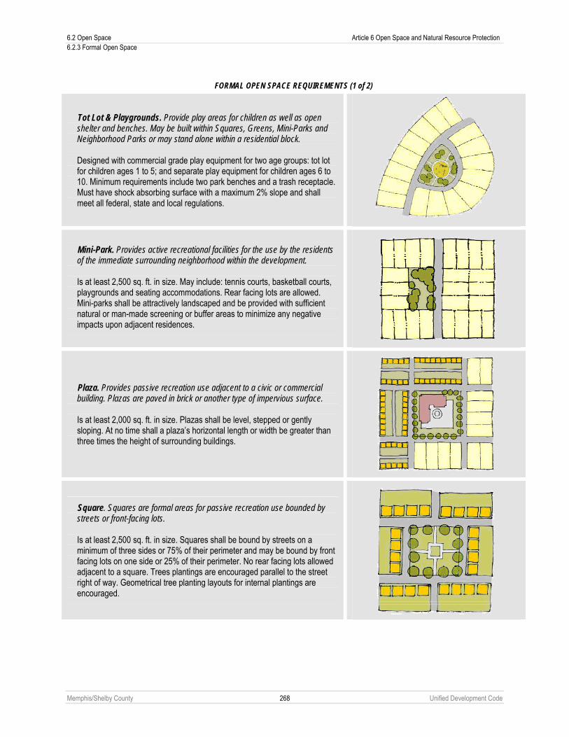
6.2 Open Space Article 6 Open Space and Natural Resource Protection 6.2.3 Formal Open Space
Memphis/Shelby County 268 Unified Development Code
FORMAL OPEN SPACE REQUIREMENTS (1 of 2)
Tot Lot & Playgrounds. Provide play areas for children as well as open shelter and benches. May be built within Squares, Greens, Mini-Parks and Neighborhood Parks or may stand alone within a residential block.
Designed with commercial grade play equipment for two age groups: tot lot for children ages 1 to 5; and separate play equipment for children ages 6 to 10. Minimum requirements include two park benches and a trash receptacle. Must have shock absorbing surface with a maximum 2% slope and shall meet all federal, state and local regulations.
Mini-Park. Provides active recreational facilities for the use by the residents of the immediate surrounding neighborhood within the development.
Is at least 2,500 sq. ft. in size. May include: tennis courts, basketball courts, playgrounds and seating accommodations. Rear facing lots are allowed. Mini-parks shall be attractively landscaped and be provided with sufficient natural or man-made screening or buffer areas to minimize any negative impacts upon adjacent residences.
Plaza. Provides passive recreation use adjacent to a civic or commercial building. Plazas are paved in brick or another type of impervious surface.
Is at least 2,000 sq. ft. in size. Plazas shall be level, stepped or gently sloping. At no time shall a plaza’s horizontal length or width be greater than three times the height of surrounding buildings.
Square. Squares are formal areas for passive recreation use bounded by streets or front-facing lots.
Is at least 2,500 sq. ft. in size. Squares shall be bound by streets on a minimum of three sides or 75% of their perimeter and may be bound by front facing lots on one side or 25% of their perimeter. No rear facing lots allowed adjacent to a square. Trees plantings are encouraged parallel to the street right of way. Geometrical tree planting layouts for internal plantings are encouraged.
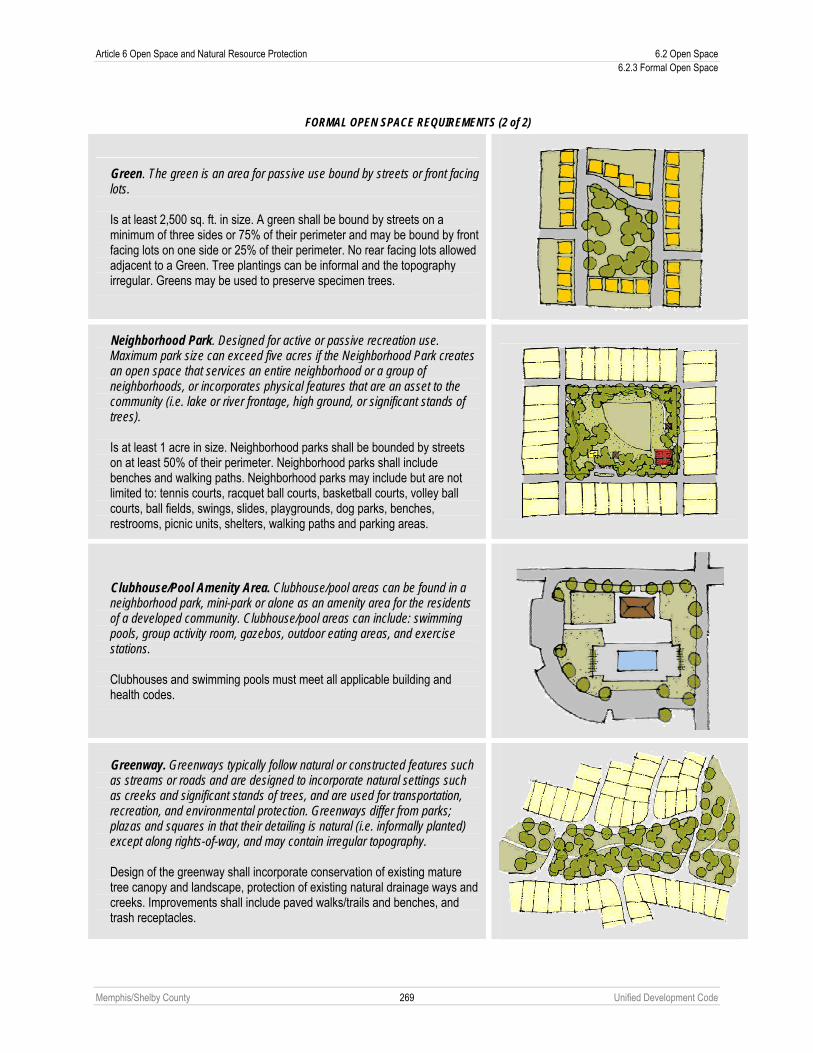
Article 6 Open Space and Natural Resource Protection 6.2 Open Space 6.2.3 Formal Open Space
Memphis/Shelby County 269 Unified Development Code
FORMAL OPEN SPACE REQUIREMENTS (2 of 2)
Green. The green is an area for passive use bound by streets or front facing lots.
Is at least 2,500 sq. ft. in size. A green shall be bound by streets on a minimum of three sides or 75% of their perimeter and may be bound by front facing lots on one side or 25% of their perimeter. No rear facing lots allowed adjacent to a Green. Tree plantings can be informal and the topography irregular. Greens may be used to preserve specimen trees.
Neighborhood Park. Designed for active or passive recreation use. Maximum park size can exceed five acres if the Neighborhood Park creates an open space that services an entire neighborhood or a group of neighborhoods, or incorporates physical features that are an asset to the community (i.e. lake or river frontage, high ground, or significant stands of trees).
Is at least 1 acre in size. Neighborhood parks shall be bounded by streets on at least 50% of their perimeter. Neighborhood parks shall include benches and walking paths. Neighborhood parks may include but are not limited to: tennis courts, racquet ball courts, basketball courts, volley ball courts, ball fields, swings, slides, playgrounds, dog parks, benches, restrooms, picnic units, shelters, walking paths and parking areas.
Clubhouse/Pool Amenity Area. Clubhouse/pool areas can be found in a neighborhood park, mini-park or alone as an amenity area for the residents of a developed community. Clubhouse/pool areas can include: swimming pools, group activity room, gazebos, outdoor eating areas, and exercise stations.
Clubhouses and swimming pools must meet all applicable building and health codes.
Greenway. Greenways typically follow natural or constructed features such as streams or roads and are designed to incorporate natural settings such as creeks and significant stands of trees, and are used for transportation, recreation, and environmental protection. Greenways differ from parks; plazas and squares in that their detailing is natural (i.e. informally planted) except along rights-of-way, and may contain irregular topography.
Design of the greenway shall incorporate conservation of existing mature tree canopy and landscape, protection of existing natural drainage ways and creeks. Improvements shall include paved walks/trails and benches, and trash receptacles.
6.2 Open Space Article 6 Open Space and Natural Resource Protection 6.2.4 Ownership and Management of Open Space
Memphis/Shelby County 270 Unified Development Code
6.2.4 Ownership and Management of Open Space A. Ownership
No residential lots shall be allowed to extend into the common or formal open space. Common and formal open space shall be accepted and owned by one of the following entities:
1. City of Memphis. The responsibility for maintaining the open space, and any facilities, shall be borne by the City. 2. Shelby County. The responsibility for maintaining the open space, and any facilities, shall be borne by the County. 3. Land conservancy or land trust. The responsibility for maintaining the open space and any facilities shall be borne
by a land conservancy or land trust. 4. Property owners association. A property owners association representing residents of the subdivision shall own
the open space. Membership in the association shall be mandatory and automatic for all property owners of the subdivision and their successors. The property owners’ association shall have lien authority to ensure the collection of dues from all members. The responsibility for maintaining the common open space and any facilities shall be borne by the property owner’s association.
5. Private landowner. The responsibility for maintaining the open space and any facilities shall be borne by the private landowner(s) subject to the approval of the Planning Director.
B. Management Plan Applicants shall submit a plan for the management of common and formal open space and other common facilities that:
1. Allocates responsibility and guidelines for the maintenance and operation of the open space and any facilities located thereon, including provisions for ongoing maintenance and for long-term capital improvements;
2. Estimates the costs and staffing requirements needed for maintenance and operation of, and insurance for, the open space and outlines the means by which such funding will be obtained or provided;
3. Provides that any changes to the plan be approved by the Planning Director; and 4. Provides for enforcement of the plan.
C. Failure to Maintain Common or Formal Open Space In the event the party responsible for maintenance of the open space fails to maintain all or any portion in reasonable order and condition, the City or County may assume responsibility for its maintenance and may enter the premises and take corrective action, including the provision of extended maintenance. The costs of such maintenance may be charged to the property owner’s association, or to the individual property owners that make up the property owner’s association, and may include administrative costs and penalties. Such costs shall become a lien on all subdivision properties.
6.2.5 Legal Instrument for Protection and Maintenance A. The common and formal open space shall be protected by a binding legal instrument approved by the appropriate
governmental attorney and will be recorded by the applicant prior to or with the plat. The standard shall be adequate protection and maintenance of the common open space. The instrument shall be one of the following:
1. A permanent conservation easement in favor of either: a. A land trust or similar conservation-oriented non-profit organization with legal authority to accept such
easements. The organization shall be bona fide and in perpetual existence and the conveyance instruments shall contain an appropriate provision for re-transfer in the event the organization becomes unable to carry out its functions; or
b. A governmental entity with an interest in pursuing goals compatible with the purposes of this development code. If the entity accepting the easement is not the City or County, then a third right of enforcement favoring the City or County shall be included in the easement.
2. A restrictive covenant for conservation purposes in favor of a governmental entity. 3. An equivalent legal tool that provides protection and maintenance, if approved by the City or County. 4. The instrument for protection and maintenance shall include clear restrictions on the use of the common open
space. These restrictions shall include all restrictions contained in this Chapter, as well as any further restrictions the applicant chooses to place on the use of the common or formal open space. Where appropriate, the instrument shall allow for stream or habitat restoration within the easement area.

Article 6 Open Space and Natural Resource Protection 6.3 Steep Slope Protection 6.3.1 Applicability
Memphis/Shelby County 271 Unified Development Code
6.3 STEEP SLOPE PROTECTION
6.3.1 Applicability A. Slope is the relationship of vertical rise to horizontal run, expressed as a percentage. Steep slope areas shall be
defined as land areas that:
1. Have a grade of 25% or more; and 2. Have an area of 5,000 square feet or greater.
B. Steep slope areas refer to natural grades and shall not include man-made grades. Slope calculations shall use the smallest contour interval for which maps are available. Steep slope areas shall be determined irrespective of site boundaries.
C. Steep slope areas shall be clearly indicated on all site plans, preliminary plats, outline plans, final plans and final plats. When a property owner or developer believes that the presence or location of a steep slope area is different than what is shown on the appropriate topographic map, the Planning Director shall have the authority to determine the location or presence of the moderate or steep slope area for purposes of meeting the requirements of this Chapter.
6.3.2 Steep Slope Development Limitations Development and land disturbing activity on steep slope areas shall be conducted only in accordance with the following requirements. Compliance with these requirements shall be determined by the approving entity.
A. Development shall be designed and constructed in order to minimize disturbance to the natural landform as much as possible. Development shall demonstrate appropriate terrain-adaptive design and construction techniques. An inability to design a particular development allowed by the underlying district without significant disturbance to the natural landform may indicate that the site should not accommodate the full amount of proposed development. Alternate site design and construction measures shall be encouraged to mitigate the effects of development on steep slopes. The grade of reconstructed slopes shall not exceed 50%. Non-load bearing retaining walls shall be encouraged in order to reduce the amount of disturbance to the natural slope.
B. In order to accommodate building placement on steep slope areas, front and side setbacks on lots on the interior of the development may be reduced by up to 50% through the administrative deviation process by the Planning Director (see Chapter 9.21).
C. On any site proposed for construction, no more than 15% of the steep slope area on the site shall be graded. For purposes of this calculation, the land areas of individual steep slope areas on the site shall be added together to establish the total steep slope area for the site.
D. Development shall be designed and arranged in order to minimize the impact of street construction on steep slope areas. Proposed right-of-way for arterial and connector roads shall be exempt from the steep slope area grading limits of this Chapter, provided that the Planning Director determines that proposed rights-of-way are designed and arranged in order to minimize the impact on steep slope areas.
6.3.3 Common Open Space Steep slope areas may be eligible for credit as common open space, provided they meet or exceed the minimum requirements of Chapter 6.2, Open Space.

6.4 Stream Buffers Article 6 Open Space and Natural Resource Protection 6.4.1 Buffer Required
Memphis/Shelby County 272 Unified Development Code
6.4 STREAM BUFFERS
6.4.1 Buffer Required A. A stream buffer shall be established on both sides of any stream determined to be “waters of the State” or a
jurisdictional water course by the Tennessee Department of Environment and Conservation (TDEC). The width of the required stream buffer shall be determined by TDEC, or as set forth in Sub-Section 8.8.5E or 8.8.5H abut in no case shall it be less than 60 feet.
B. Stream buffers shall be shown on all appropriate plans and plats submitted for review.
6.4.2 Limited Activity Permitted Except for the following limited activities, stream buffer areas shall remain undisturbed. Permitted activities within the stream buffer area include sanitary and storm sewer easements, providing the activities strictly adhere to all applicable erosion control requirements and all applicable water quality requirements. Perennial vegetation must be established as a necessary step in completing construction of any sanitary and storm sewer facilities. Sanitary and storm sewer easements shall be as close to perpendicular or parallel to the stream channel to minimize the impact on the stream buffer. Other overhead or underground utilities, roads, streets, bridges, or similar structures shall be placed within existing public rights-of-way if possible, but in any case, must cross the buffer as close to perpendicular as possible.
6.4.3 Re-vegetation All disturbed areas within the stream buffer areas shall be re-vegetated as required by TDEC.
6.4.4 Minimum Setback The minimum setback from a stream buffer for any building shall be at least ten feet.
6.4.5 Minimum Lot Size Land within a stream buffer shall not be used to meet minimum lot size requirements, except where lots are greater than one acre in area, in which case at least 50% of the lot shall remain outside the stream buffer.
6.4.6 Common Open Space Stream buffer areas may be eligible for credit as common open space, provided they meet or exceed the minimum requirements of Chapter 6.2, Open Space.

Article 6 Open Space and Natural Resource Protection 6.5 Resource Extraction 6.5.1 Special Use Permit Required
Memphis/Shelby County 273 Unified Development Code
6.5 RESOURCE EXTRACTION This Chapter shall not apply to water extraction.
6.5.1 Special Use Permit Required All resource extraction requires a special permit (see Chapter 9.6) and is subject to the following standards.
A. The application for a special permit shall be accompanied by a sworn affidavit by the applicant that all permits and approvals required by any local, state or federal environmental laws or regulations including, but not limited to, water and air pollution laws and regulations have been or will be secured, and that such use shall be operated in accordance with any such local, state or federal environmental laws or regulations.
B. Over-burden shall be retained on a suitable portion of the site of the sand or gravel or other extraction operations and shall be used for back fill.
C. Adequate supports shall be provided to prevent caving and backsliding into an excavated area. No excavation shall be made within 75 feet of the perimeter of the site of the sand, gravel or other extraction operation; within 100 feet of any street right-of-way or within 250 feet of any building used for residential purposes provided, however, that if the owner of the property adjoining, abutting or adjacent to the property which is the site of the sand, gravel or other extraction and processing operations agrees, in writing, such excavation may be closer to such property owner’s lot line provided that in no case shall an excavation be made within 30 feet of the lot line of any other property. Such notarized written agreement shall be submitted with the application for a special permit.
D. All excavations shall be filled and the land restored, re-graded and re-sloped as nearly as practicable to its original condition and grade within 90 days after the date sand, gravel or other extraction operations cease provided, however, that any excavation made closer than 250 feet to a property line of the property which is the site of the sand, gravel or other extraction operations shall be filled and the land restored, re-graded and re-sloped within nine months from the date the excavation within 250 feet of such property line is completed unless the owner of property abutting or adjoining such property line agrees, in writing, to an extension of time within which such reclamation activities shall be completed. Such written agreement shall be notarized and shall be submitted with the application for a special permit or to the Building Official at any time prior to the expiration of the nine-month period within which excavations within 250 feet of the property line of property which is the site of the sand, gravel or other extraction operations must be filled, restored, re-graded and re-sloped. Such agreement shall set forth the date when such reclamation activities shall be completed, which date shall, in no event, be later than 90 days after the date sand, gravel or other extraction operations on the property cease. Failure to complete reclamation activities by the date set forth in such agreement shall be deemed a violation of this Article. If at any time such agreement is modified, rescinded, or becomes null and void, the owner of the property which is the site of the sand, gravel or other extraction operation shall within ten days thereafter notify the Building Official thereof in writing stating whether such agreement is revoked, null and void or modified, and if modified, the provision of such agreement which has been modified along with a copy of the modified agreement. If the agreement is revoked or becomes null and void, excavations within 250 feet of the property line of the property shall cease immediately, and the area which was the subject of such agreement shall be filled, restored, re-graded or re-sloped within 90 days after the date of such agreement became null and void. If the date upon which reclamation activities shall be completed is revised in a modified agreement, reclamation activities shall be completed by such date.
E. Land shall be restored, re-graded and re-sloped as nearly as practicable to its original condition and grade provided, however, that after such reclamation activities, no slope on such land shall be steeper than three feet horizontal to one foot vertical and no greater quantities of drainage water shall flow onto adjoining properties or shall flow at a faster rate onto adjoining properties than such drainage water flowed prior to the commencement of sand, gravel or other extraction or processing activities on the land reclaimed.
F. Prior to the commencement of sand, gravel or other extraction operations, the applicant for the special permit shall submit to the Building Official a performance bond in the amount of $3,500 per acre, increasing $100 per acre per year from the date of adoption of this Article, for each acre proposed to be used for sand, gravel or other extraction operations to insure that the land shall be restored, re-graded and re-sloped as provided in this Chapter when such mining or extraction operations cease. Such performance bond shall be released after reclamation activities are complete and the condition, grade, and drainage of the land are approved in writing by the Building Official and City or County Engineer provided, however, that a proportionate release of such bond may be authorized by the Building Official and City or County Engineer for phased or partial reclamation.

6.6 Floodway Protection Article 6 Open Space and Natural Resource Protection 6.6.1 Dredging, Earth Extraction, Clearing or Grading (Silviculture)
Memphis/Shelby County 274 Unified Development Code
G. Equipment used in sand, gravel or other extraction or processing operations shall be operated in such a manner that noise and vibration are prevented, to the extent possible, from emanating beyond the boundaries of the site of the mining, extraction or processing operations.
H. A statement setting forth the type, location and conditions of such processing operations shall be submitted for the review and approval of the governing bodies. The governing bodies may require a written assessment of the environmental impact of the proposed sand, gravel or extractive operation and processing.
I. The location and surfacing of driveways providing access to and egress from the site are subject to the review and approval of the governing bodies.
J. The site operator shall take all measures necessary to prevent soil, gravel, sand, and other excavation-related materials from getting into public streets or leaving the site via other drainage ways.
6.6 FLOODWAY PROTECTION
6.6.1 Dredging, Earth Extraction, Clearing or Grading (Silviculture) A. Excavation within a floodway shall be permitted in accordance with the rules and regulations of the U.S. Army Corps of
Engineers (USACOE) and the Tennessee Department of Environment and Conservation (TDEC).
Stream Drainage Area (acres) Protected Distance from Top of Bank Less than 5,000 50 feet 5,000 to 19,999 100 feet 20,000 to 99,999 200 feet 100,000 or more 250 feet
B. The following additional standards and submission requirements shall apply:
1. The proposed land treatment shall not adversely affect adjacent or downstream properties, and shall not adversely affect public facilities or utilities.
2. When associated with a development application, conditions in excess of the requirements of USACOE and TDEC may be imposed pertaining to limitation of land disturbance activity, final slopes and grades, period of ground cover removal, construction of retaining walls, riprapping, landscaping, drainage facilities, reconstruction of natural storm protection features, and other relevant matters.
3. When not associated with a development, a bond to assure that the proposed or conditional protection measures are carried out as planned may also be required.
6.7 STORMWATER MANAGEMENT
6.7.1 Memphis and Shelby County Storm Water Management Manual The Memphis and Shelby County Storm Water Management Manual is hereby incorporated in this development code by reference. All development shall be subject to this manual, as specified in the manual itself.

Memphis/Shelby County 275 Unified Development Code
Article 7. Special Purpose Districts 7.1 SPECIAL PURPOSE DISTRICTS, GENERALLY
A. Special Purpose Districts may be established from time to time as the Governing Bodies see fit in order to promote a more carefully tailored standard of development within a specified geographical area. The nature, applicability, standards, regulations, and restrictions of each Special Purpose District may vary as appropriate in order to achieve the stated purpose and goals of a particular Special Purpose District.
B. Where the standards of a particular Special Purpose District, established by this Article, do not address standards established elsewhere in this Code, the standards established elsewhere apply.
C. Where the standards of a particular Special Purpose District, established by this Article, conflict with the standards established elsewhere in this Code other than Article 8, the Special Purpose District standards shall apply. If the standards established by this Article conflict with the standards established in Article 8, the standards of Article 8 shall apply.
D. Map Amendments. Parcels and tracts that are located outside of a Special Purpose District but are abutting or across the street from a parcel or tract that is included in that Special Purpose District may be rezoned to a zoning district included in that Special Purpose District through the Zoning Change process (see Chapter 9.5).
E. Signs. Signs in the Special Purpose Districts within the jurisdiction of the Downtown Memphis Commission shall meet the regulations and follow the procedures as outlined in Memphis City Code Section 12-36. Signs in the Special Purpose Districts outside of the jurisdiction of the Downtown Memphis Commission shall meet the regulations of Memphis City Code Section 12-36 but follow the procedures of this Code. See map at Section 4.9.2 for parcels within the jurisdiction of the Downtown Memphis Commission.
F. Applicability.
1. The provisions of this Article shall apply to the following development, with the exception of single-family and two-family housing types:
a. All new building construction, and
b. All building expansion with removal of more than 25% of existing walls facing a public street, or a street-facing elevation if the parcel is landlocked; or removal of more than 50% of all existing exterior walls.
c. All other development that meets the provisions of Section 7.2.9 in the SCBID Special Purpose District.
2. The standards of this Article addressing building placement on sites with maximum setbacks do not apply to building additions and new buildings on nonconforming sites unless the provisions of Section 3.11.1 are met.
3. All existing buildings that are not in conformance with the requirements of the underlying district or this overlay district at the time of adoption shall be governed by Article 10 (nonconformities).
G. Site plan review process for this Article.
1. All development that meets the applicability of Sub-Section 7.1F shall be processed through the Special District Administrative Site Plan Review provisions as established in Chapter 9.13.
2. Administrative Deviations
See Chapter 9.21.
3. Special Exceptions
The Land Use Control Board is authorized to approve special exceptions, in accordance with Chapter 9.14.
H. Use Standards
The Use Standards of Chapter 2.6 shall apply to all uses contained in this Article, unless otherwise stated. See Use Table, Chapter 2.5, for required use standards.
I. Streetscape Plates
Site plans submitted pursuant to this Article shall reflect the streetscape plates of Section 4.3.3, unless an alternative is approved pursuant to the standards of this Article. The appropriate streetscape plate for a site shall be determined by the Office of Planning and Development based on the proposed land use of the subject site and its equivalent zoning district according to Section 4.3.3.
7.2 South Central Business Improvement District (SCBID) Article 7 Special Purpose Districts 7.2.1 Sports and Entertainment (SE) District
Memphis/Shelby County 276 Unified Development Code
7.2 SOUTH CENTRAL BUSINESS IMPROVEMENT DISTRICT (SCBID)
7.2.1 Sports and Entertainment (SE) District A. Boundaries
Beginning at the intersection of Madison Avenue and Lauderdale Street and proceeding south on Lauderdale Street to a point approximately at the mid-point between Linden Avenue and Pontotoc Avenue; thence west on an irregular line approximately mid-block between Linden Avenue and Pontotoc Avenue to Third Street; thence south on Third Street to Pontotoc Avenue; thence west on Pontotoc Avenue to Second Street; thence north on Second Street to Linden Avenue; thence west on Linden Avenue to Front Street; thence north on Front Street to Beale Street; thence east on Beale Street to Second Street; thence north on Second Street to a point approximately mid-block between Madison Avenue and Court Avenue; thence east approximately mid-point on an irregular line to Danny Thomas Boulevard; thence south on Danny Thomas Boulevard to Madison Avenue; thence east from Madison Avenue to Lauderdale Street and the point of beginning. The Beale Street Historic District is excluded from the SE District.
B. Purpose and Intent of District This district is intended to permit a mixture of uses and activities that will complement the sports and entertainment facilities that are located in this area.
C. Permitted Uses
1. Residential Single Family Detached Dwellings Single Family Attached Dwellings Duplex Dwellings Townhouse Dwellings Multiple Family Dwellings Accessory Dwelling Unit
2. Additional Uses Permitted Retail Sales Retail Shop, Other Parking Garage Hotel (subject to site plan review by the legislative body) School, public or private Amusements, commercial indoor Art or Photo Studio or Gallery Barber or Beauty Shop Bank Financial Services Used Goods, Second Hand Sales (Pawn Shops Not Included) Personal Service Establishment (Does Not Include Adult Entertainment) Offices Music or Dancing Academy Bakery, retail Department or Discount Store Public Building Park Museum Restaurant, with or without Sales of Alcoholic Beverages Bed and Breakfast Catering Establishment Tavern, Cocktail Lounge or Night Club Processing and manufacturing incidental to retail establishment Group Day Care Home Child Care Center

Article 7 Special Purpose Districts 7.2 South Central Business Improvement District (SCBID) 7.2.2 South Main (SM) District
Memphis/Shelby County 277 Unified Development Code
Nursery School Printing and Publishing Radio or TV Studio Flower or Plant Store College or University Sports Facility Church Health Club Philanthropic Institution
3. Special Use Permit The following use requires the approval of a Special Use Permit: Retail Sales, Outdoor
D. Additional Requirements 1. Adult Entertainment shall not be permitted. 2. Any building, structure, or use is subject to the landscaping requirements of Chapter 4.6, Landscaping and
Screening. 3. A drive-thru window shall not be permitted. 4. Subject to the General Standards set forth in the “Site Plan Review Requirements” portion of Section 7.2.9,
surface parking lots are not allowed unless as accessory to a principal use permitted by the SE District or as approved by Special Exception (see Section 7.2.10).
5. All existing uses that are not in conformance with the requirements of the SE District at the time of adoption shall be governed by Article 10, Nonconformities.
6. Ground floor commercial use or public space shall be required in parking garages subject to the criteria listed in the SCBID Site Plan Review Specific Guidelines (see Section 7.2.9).
7. All new construction shall be subject to site plan review in accordance with the SCBID Site Plan Review Process and Criteria (see Section 7.2.9).
E. Bulk Regulations 1. Building Setbacks: Shall be subject to site plan review in accordance with the SCBID Site Plan Review Process
and Criteria (see Section 7.2.9). 2. Maximum Density: None 3. Maximum Height: 90 feet or 8 stories and shall be subject to site plan review in accordance with the SCBID Site
Plan Review Process and Criteria (see Section 7.2.9). 4. A building or structure exceeding 90 feet or 8 stories may be allowed subject to the approval of a Special
Exception (see Section 7.2.10) by the Land Use Control Board (with appeal to the City Council) and conformance with the Site Plan Review Requirements.
F. Parking Requirements 1. Any building, structure, or use is exempt from the off-street parking and loading requirements of Chapter 4.5
provided, however, that if off-street parking and loading are provided, they shall comply with the geometric requirements of Chapter 4.5.
2. Parking lots and garages shall be landscaped with Plate A-6, A-7 (see Section 7.2.8), or an equivalent streetscape approved by the Office of Planning and Development. All other screening requirements in Chapter 4.6 are also applicable to parking lots and garages.
3. The Land Use Control Board may approve modifications to any parking requirements in accordance with the Special Exception Requirements (see Section 7.2.10).
7.2.2 South Main (SM) District A. Boundaries
All of the existing South Main Special District and extended on the east side to run east along Pontotoc Avenue to Third Street; thence south along Third Street to Vance Avenue; thence east on Vance Avenue to Abel Street; thence south on Abel Street to G.E. Patterson Street; thence west on G.E. Patterson Street to Second Street; thence south on Second Street to Webster Avenue; thence approximately 500 feet west on Webster Avenue to the existing south boundary of the SMSD Zoning District; thence south to Carolina Avenue; thence west approximately

7.2 South Central Business Improvement District (SCBID) Article 7 Special Purpose Districts 7.2.2 South Main (SM) District
Memphis/Shelby County 278 Unified Development Code
500 feet to a point; thence northwest approximately 500 feet to the intersection of Georgia Avenue and Front Street; thence north on Front Street to the existing SMSD Zoning District. Also included is the area bordered by Beale Street to the north, an east-west alley approximately 170 feet south of Beale Street between Wagner Place and South Front Street to the south, South Front Street to the east, and Wagner Place to the west.
B. Purpose and Intent of District The purpose of the South Main District is to protect the unique character of this area while using it as a catalyst to encourage similar development south of the existing district that was established as a zoning district in 1988. To this end, these regulations seek to maintain and redefine the uses to ensure that the special ambience abundant in the existing South Main Special District and historical character of the area is complimented by new development. Specifically, the district goals remain largely the same as adopted in 1988 and the following specific purposes as adopted then remain largely the same which are:
1. To preserve and strengthen the South Main Area, the South Main Historic District, and the cultural character of the area.
2. To promote a harmonic redevelopment of the area consistent with the scale and character of existing mixed uses in the area.
3. To encourage the development and redevelopment of residential uses, and small scale commercial, and office uses, thereby strengthening the City’s tax base.
4. To promote the mixed uses character of the area and to prohibit or discourage large-scale uses as well as incompatible uses.
5. To preserve, maintain and enhance the existing scale of the street, building and open space features. 6. To provide and encourage amenities, such as public open space and street trees to improve the physical
environment. C. Permitted Uses
1. Residential Single Family Detached Dwellings Single Family Attached Dwellings Duplex Dwellings Townhouse Dwellings Multiple Family Dwellings Accessory Dwelling Unit
2. Additional Uses Permitted Church Museum Park Philanthropic Institution Public Building School, Public or Private Amusements, Commercial Indoor Art or Photo Studio or Gallery Bakery, retail Bank Barber or Beauty Shop Bed and Breakfast Business School Catering Establishment Cleaning Establishment Cleaning Pickup Station Farmers Market Financial Services Flower or Plant Store Greenhouse or Nursery, Commercial Hotel (subject to site plan review by the legislative body) Lodge, Club, Country Club

Article 7 Special Purpose Districts 7.2 South Central Business Improvement District (SCBID) 7.2.2 South Main (SM) District
Memphis/Shelby County 279 Unified Development Code
Music or Dancing Academy Offices Parking Garage Used Goods, Second Hand Sales (Does not include Pawn Shop) Personal Service Establishment (Does not include Adult Entertainment) Photo Finishing Photo Finishing Pickup Station Private Sales Processing and Manufacture Incidental to Retail Establishment (Footnote: Only a maximum of 75% of the building may be used for manufacturing and the manufacturing portion shall not be located at the street frontage.) Radio or TV studio Restaurant, with or without Sales of Alcoholic Beverages Retail Sales Retail Shop, other Services, other Business & Personal Tavern, Cocktail Lounge, or Night Club with 125 seats or less Undertaking or Funeral Establishment Veterinary Clinic (Without Outdoor Boarding)
3. Special Use Permit The following uses are subject to the approval of a Special Use Permit: Gas Stations Retail Sales, Outdoors Self-Storage Facilities Tavern, Cocktail Lounge or Night Club with greater than 125 seats
D. Additional Requirements 1. Adult Entertainment shall not be permitted. 2. Any building, structure, or use is subject to the landscaping requirements of Chapter 4.6, Landscaping and
Screening. 3. The maximum amount of street frontage shall be 100 linear feet. On corner lots, the maximum street frontage
shall be 100 feet on each street. The Land Use Control Board may approve a greater amount of street frontage in accordance with the SCBID Special Exception Standards (see Section 7.2.10).
4. In an existing building, the maximum street frontage for a use may exceed 100 linear feet. However, if the street frontage of a use in an existing building is decreased, the street frontage of a use may not thereafter increase to more than 100 linear feet without obtaining a Special Exception (see Section 7.2.10).
5. A drive-thru window shall not be permitted. 6. Subject to the General Standards set forth in the “Site Plan Review Requirements” portion of Section 7.2.9,
surface parking lots are not allowed unless as accessory to a principal use permitted by the SM District or as approved by Special Exception (see Section 7.2.10).
7. All existing uses that are not in conformance with the requirements of the SMS District at the time of adoption shall be governed by Article 10, Nonconformities.
8. All new construction shall be subject to site plan review in accordance with the SCBID Site Plan Review Process and Criteria (see Section 7.2.9).
E. Bulk Regulations 1. Building Setbacks: Shall be subject to site plan review in accordance with the SCBID Site Plan Review Process
and Criteria (see Section 7.2.9). 2. Maximum Density
a. For new residential construction – 40 dwelling units per acre. b. For mixed use developments- 60 dwelling units per acre c. For existing buildings – None
3. Maximum Height: 90 feet or 8 stories and shall be subject to site plan review in accordance with the SCBID Site Plan Review Process and Criteria (see Section 7.2.9). A building or structure exceeding 90 feet or 8 stories may

7.2 South Central Business Improvement District (SCBID) Article 7 Special Purpose Districts 7.2.3 South Downtown Residential (R-SD)
Memphis/Shelby County 280 Unified Development Code
be allowed subject to approval of a Special Exception (see Section 7.2.10) by the Land Use Control Board (with appeal to the City Council) and conformance with the Site Plan Review Requirements.
F. Parking Requirements 1. Any building, structure, or use is exempt from the off-street parking and loading requirements of Chapter 4.5
provided, however, that if off-street parking and loading are provided, they shall comply with the geometric requirements of Chapter 4.5.
2. Parking lots and garages shall be landscaped with Plate A-6, Plate A-7 (see Section 7.2.8), or an equivalent streetscape approved by the Office of Planning and Development (see Sub-Section 7.1I). All other screening requirements in Chapter 4.6, Landscaping and Screening, are also applicable to parking lots and garages.
3. The Land Use Control Board may approve modifications to any parking requirements in accordance with the Special Exception Requirements (see Section 7.2.10).
7.2.3 South Downtown Residential (R-SD) A. Boundaries
(North of Crump Boulevard) Beginning on Lauderdale Street at a point approximately mid-block between Linden Avenue and Pontotoc Avenue; thence south on Lauderdale Street to Vance Avenue; thence west on Vance Avenue to Danny Thomas Boulevard; thence south on Danny Thomas Boulevard to Mississippi Boulevard; thence northwest on Mississippi Boulevard to G.E. Patterson Street; thence west approximately 240 feet on G.E. Patterson Street; thence south to Webster Avenue; thence east along Webster Avenue to a point approximately 140 feet west of Danny Thomas Boulevard; thence south to Georgia Avenue; thence west on Georgia Avenue to Hernando Street; thence south on Hernando Street approximately 150 feet; thence west from Hernando Street to Third Street; thence north along Third Street to G.E. Patterson Street; thence east along G.E. Patterson Street to Abel Street; thence north on Abel Street to Vance Avenue; thence west on Vance Avenue to Third Street; thence north on Third Street to the south boundary of the SE Zoning District; thence east along an irregular line shared with the SE Zoning District to the point of beginning. (South of Crump Boulevard) Beginning at a point at the intersection of E.H. Crump Boulevard and Wellington Street and extending south on Wellington Street to Williams Avenue; thence west to Willoughby Street; thence south to McEwen Street; thence west on McEwen Street to Wallace Street; thence west of Wallace Street on an irregular line to Latham Street; thence north of Latham Street to Alston Street; thence west on Alston Street to Third Street; thence north on Third Street approximately 190 feet; thence east to Latham Street; thence north to E.H. Crump Boulevard; thence east on E.H. Crump Boulevard to Wellington Avenue and the point of beginning.
B. Purpose and Intent of District The purpose of this district is to encourage new residential neighborhood development in the South Downtown Area.
C. Permitted Uses Single Family Detached Dwellings Single Family Attached Dwellings Duplex Dwellings Multiple Family Dwellings Church Park School, Public or Private
D. Additional Uses Permitted Uses in accordance with the Commercial Mixed Use-1 (CMU-1) District shall be permitted throughout the remainder of the R-SD District subject to approval of a Special Exception (see Section 7.2.10) by the Land Use Control Board (LUCB) and the following criteria:
1. Any non-residential use shall be on the first floor of a two story or greater building. Any nonresidential uses above the ground floor may be permitted subject to the approval of a Special Exception (see Section 7.2.10) by the Land Use Control Board.
2. Preference shall be given to location within 100 feet of a street intersection. Properties beyond 100 feet of a street intersection will be strongly discouraged.
3. Preference shall be given to existing buildings.

Article 7 Special Purpose Districts 7.2 South Central Business Improvement District (SCBID) 7.2.4 Riverside Residential (R-R) District
Memphis/Shelby County 281 Unified Development Code
4. Maximum floor area per nonresidential establishment (excluding a church or a school) shall be 4,000 square feet. 5. Parking shall be located at the side or rear of a building and not between the building and the street.
E. Additional Requirements 1. Adult Entertainment shall not be permitted. 2. Any building, structure, or use is subject to the landscaping requirements of Chapter 4.6, Landscaping and
Screening. 3. Subject to the General Standards set forth in the “Site Plan Review Requirements” portion of Section 7.2.9,
surface parking lots are not allowed unless as accessory to a principal use permitted by the R-SD District or as approved by Special Exception (see Section 7.2.10).
4. A drive-thru window shall not be permitted. 5. All existing uses that are not in conformance with the requirements of the R-SD District at the time of adoption
shall be governed by Article 10, Nonconformities. 6. All new construction shall be subject to site plan review in accordance with the SCBID Site Plan Review Process
and Criteria (see Section 7.2.9). F. Bulk Regulations
1. Building Setbacks: Shall be subject to site plan review in accordance with the SCBID Site Plan Review Process and Criteria (see Section 7.2.9).
2. Maximum Density 3. New residential construction–40 dwelling units per acre 4. Existing building – None 5. Maximum Height – 4 Stories
G. Parking Requirements 1. Any building, structure, or use is exempt from the off-street parking and loading requirements of Chapter 4.5
provided, however, that if off-street parking and loading are provided, they shall comply with the geometric requirements of Chapter 4.5.
2. Parking lots and garages shall be landscaped with Plate A-6, Plate A-7 (see Section 7.2.8), or an equivalent streetscape approved by the Office of Planning and Development (see Sub-Section 7.1I). All other screening requirements in Chapter 4.6, Landscaping and Screening are also applicable to parking lots and garages.
3. The Land Use Control Board may approve modifications to any parking requirements in accordance with the Special Exception requirements (see Section 7.2.10).
7.2.4 Riverside Residential (R-R) District A. Boundaries
Starting at the Harahan Bridge and running north with the Mississippi River to Beale Street; thence turning east on Beale Street; thence turning south on Riverside Drive to the point where G.E. Patterson Street would intersect Riverside Drive; thence turning east along the extended point of G.E. Patterson Street to Tennessee Street; thence south on Tennessee Street to Georgia Avenue and west along Georgia Avenue to Riverside Drive; thence turning south along Riverside drive to the CSX Railroad Tracks to the Mississippi River and the point of beginning.
B. Purpose and Intent of District The purpose of the Riverside Residential District is to ensure that the river front will be an active, urban waterfront, while reinforcing the residential development along the southern end of downtown and protecting the unique views of the Mississippi River. The increases in density will provide for a more efficient utilization of public facilities and environmental amenities and resources.
C. Permitted Uses
1. Residential Single Family Detached Dwellings Single Family Attached Dwellings Duplex Dwellings Townhouse Dwellings Multiple Family Dwellings

7.2 South Central Business Improvement District (SCBID) Article 7 Special Purpose Districts 7.2.5 Bluffview Residential (R-B) District
Memphis/Shelby County 282 Unified Development Code
2. Additional Uses Permitted Church Park School, Public or Private The following uses are permitted only south of Channel 3 Drive and only south of Martyrs Park which includes the existing building known as 803 Channel 3 Drive: Radio or TV Studio; Offices; Public Buildings; Museum; Philanthropic Institution; Church.
D. Additional Requirements 1. Adult Entertainment shall not be permitted. 2. Any building, structure, or use is subject to the landscaping requirements of Chapter 4.6, Landscaping and
Screening. 3. Subject to the General Standards set forth in the “Site Plan Review Requirements” portion of Section 7.2.9,
surface parking lots are not allowed unless as accessory to a principal use permitted by the R-R District or as approved by Special Exception (see Section 7.2.10).
4. All existing uses that are not in conformance with the requirements of the R-R District at the time of adoption shall be governed by Article 10, Nonconformities.
5. All new construction shall be subject to site plan review in accordance with the SCBID Site Plan Review Process and Criteria (see Section 7.2.9).
E. Bulk Regulations 1. Building Setbacks: Shall be subject to site plan review in accordance with the SCBID Site Plan Review Process
and Criteria (see Section 7.2.9). 2. Maximum Density: None 3. Maximum Height: Shall be subject to site plan review in accordance with the SCBID Site Plan Review Process
and Criteria (see Section 7.2.9). F. Parking Requirements
1. Any building, structure, or use is exempt from the off-street parking and loading requirements of Chapter 4.5 provided, however, that if off-street parking and loading are provided, they shall comply with the geometric requirements of Chapter 4.5.
2. Parking lots and garages shall be landscaped with Plate A-6, Plate A-7 (see Section 7.2.8), or an equivalent streetscape approved by the Office of Planning and Development (see Sub-Section 7.1I). All other screening requirements in Chapter 4.6, Landscaping and Screening are also applicable to parking lots and garages.
3. The Land Use Control Board may approve modifications to any parking requirements in accordance with the Special Exception requirements (see Section 7.2.10).
7.2.5 Bluffview Residential (R-B) District A. Boundaries
Starting at the intersection of Riverside Drive and Georgia Avenue turning east and running along Georgia Avenue to Tennessee Street; thence north on Tennessee Street to G.E. Patterson Street; thence east on G.E. Patterson Street to front Street; thence south on Front Street to Georgia Avenue; thence southeast from Front Street to Carolina Avenue; thence east on Carolina Avenue approximately 500 feet; thence north on Webster Avenue; thence east on Webster Avenue to Second Street; thence north on Second Street to G.E. Patterson Street; thence east on G.E. Patterson Street to Third Street; thence south on Third Street to the CSX Railroad; thence west along the CSX Railroad approximately 1,550 feet to a point; thence south to E.H. Crump Boulevard; thence west along E.H. Crump Boulevard to Florida Street; thence north on Florida Street approximately 170 feet; thence west along an irregular line comprised of the rear property lines of properties along E.H. Crump Boulevard from Florida Street to the Interstate 55 Interchange with E.H. Crump Boulevard; thence north to Virginia Avenue; thence west and northwest along the Interstate 55 right-of-way to Riverside Drive; thence north on Riverside Drive to Georgia Avenue and the point of beginning.
B. Purpose and Intent of District
1. Building Objectives (Existing and New Construction): a. Retention of historic buildings. b. Preservation and restoration of historic elements.

Article 7 Special Purpose Districts 7.2 South Central Business Improvement District (SCBID) 7.2.5 Bluffview Residential (R-B) District
Memphis/Shelby County 283 Unified Development Code
c. New design that is compatible with and enhances the unique architectural and historic character of the district.
2. Land Use Objectives To include a variety of land uses that are compatible with the existing buildings and complimentary to the unique architectural characteristics of the Loft Residential Area.
3. Public Amenity Objective a. To provide an attractive and comfortable environment with public amenities that will reinforce the unique
architectural characteristics of the Loft Residential Area. b. Encourage housing, first floor retail, and corner store type neighborhood commercial establishments
indicative of mix-use districts. This variety of land uses will increase the level of street activity and encourage an “around-the-clock” presence of people. Encourage land uses that are pedestrian-oriented and do not require severe alterations to historic structures in order to accommodate autos.
C. Permitted Uses
1. Residential Single Family Detached Dwellings Single family Attached Dwellings Duplex Dwellings Townhouse Dwellings Multiple Family Dwellings Accessory Dwelling Unit
2. Additional Uses Permitted Bed & Breakfast Church Park Philanthropic Institution Art or Photo Studio or Gallery Bakery, Retail Bank Barber or Beauty Shop Catering Establishment Dry Cleaning Establishment Dry Cleaning Pickup Station Farmers Markets Financial Services Flower or Plant Store Group Day Care Home Child Care Center Home Occupations Hotel (subject to site plan review by the legislative body) Music or Dancing Academy Offices Parking Garage Personal Service Establishment (Does not include Adult Entertainment) Photo Finishing Public Building Restaurant, with or without Sales of Alcoholic Beverages Retail Sales Schools, Public or Private Tavern, Cocktail Lounge, Night Club (max. 4,000 sq. ft. in area) Veterinary Clinic (without Outdoor Boarding)
D. Additional Requirements 1. Adult Entertainment shall not be permitted.

7.2 South Central Business Improvement District (SCBID) Article 7 Special Purpose Districts 7.2.6 South Downtown Business Park (SDBP) District
Memphis/Shelby County 284 Unified Development Code
2. Any building, structure, or use is subject to the landscaping requirements of Chapter 4.6, Landscaping and Screening.
3. Residential buildings may allow non-residential uses, but only on the ground floor. Any non-residential uses above the ground floor may be permitted subject to the approval of a Special Exception (see Section 7.2.10) by the Land Use Control Board.
4. All new buildings shall be a minimum of two stories. 5. A drive-thru window shall not be permitted. 6. Subject to the General Standards set forth in the “Site Plan Review Requirements” portion of Section 7.2.9,
surface parking lots are not allowed unless as accessory to a principal use permitted in the R-B District or as approved by Special Exception (see Section 7.2.10).
7. All existing uses that are not in conformance with the requirements of the R-B District at the time of adoption shall be governed by Article 10, Nonconformities.
8. All new construction shall be subject to site plan review in accordance with the SCBID Site Plan Review Process and Criteria (see Section 7.2.9).
E. Bulk Regulations 1. Building Setbacks: Shall be subject to site plan review in accordance with the SCBID Site Plan Review Process
and Criteria (see Section 7.2.9). 2. Maximum Density: None 3. Maximum Height: 8 stories or 90 feet. All new buildings shall have a minimum height of two stories and shall
comply with Downtown Memphis Commission Design Review Board guidelines. Existing one-story buildings shall remain conforming buildings.
F. Parking Requirements 1. Any building, structure, or use is exempt from the off-street parking and loading requirements of Chapter 4.5
provided, however, that if off-street parking and loading are provided, they shall comply with the geometric requirements of Chapter 4.5.
2. Parking lots and garages shall be landscaped with Plate A-6, Plate A-7 (see Section 7.2.8), or an equivalent streetscape approved by the Office of Planning and Development (see Sub-Section 7.1I). All other screening requirements in Chapter 4.6, Landscaping and Screening are also applicable to parking lots and garages.
3. The Land Use Control Board may approve modifications to any parking requirements in accordance with the Special Exception requirements (see Section 7.2.10).
7.2.6 South Downtown Business Park (SDBP) District A. Boundaries
Beginning at the southwest corner of Georgia Avenue and Wood Street; thence south on Wood Street to the CSX Railroad; thence west along the CSX Railroad to Fifth Street; thence south along the southerly projection of Fifth Street approximately 500 feet; thence west approximately 350 feet; thence south on Fourth Street approximately 200 feet; thence along the alley south of Virginia Avenue to Third Street; thence approximately 150 feet north to Virginia Avenue; thence west along Virginia Avenue approximately 2,450 feet; thence north to the CSX Railroad; thence east along the CSX Railroad to Third Street; thence north along Third Street to a mid-point between Georgia Avenue and Carolina Avenue; thence east from this mid-point to Hernando Street; thence north on Hernando Street to Georgia Avenue; thence east on Georgia Avenue to Wood Street and the point of beginning.
B. Purpose and Intent of District This district is intended to permit the development and continued maintenance of commercial and industrial uses while allowing various mixed uses and promoting economic development in the South Downtown Area.
C. Permitted Uses
1. Residential Residential uses as an accessory use to the additional uses permitted below or Special Exception uses authorized by this district.
2. Additional Uses Permitted Automobile Service Station Art or Photo Studio or Gallery

Article 7 Special Purpose Districts 7.2 South Central Business Improvement District (SCBID) 7.2.6 South Downtown Business Park (SDBP) District
Memphis/Shelby County 285 Unified Development Code
Bakery, Retail Bank Barber or Beauty Shop Beverage Container Collection Center Business School Catering Establishment Church Retail Cleaning Establishment Cleaning Pickup Station Farmers Market Financial Services Flower or Plant Store Parking Garage Hotel (subject to site plan review by the legislative body) General Service & Repair Shop Greenhouse or Nursery, Commercial Laboratories Lawn, Tree, or Garden Service Music or Dancing Academy Offices Photo Finishing Photo Finishing Pick Up Station Plumbing Shop Restaurant, with or without Sales of Alcoholic Beverages Processing and Manufacture Incidental to Retail Establishment Radio/TV Studio Sheet Metal Shop Without Outdoor Storage Warehouse Indoor Wholesale Display Philanthropic Institution Manufacture/Remanufacture of motor vehicles (inside a building) Retail Sales
3. Special Exception The following uses are subject to the approval of a Special Exception by the Land Use Control Board: Manufacture, Storage, Distribution of Cosmetics, Drugs, Paints Contractors Storage (indoor only) Electrical or Electronic Equipment, Appliances & Instruments Fabricated Metal Products & Machinery Food/Beverage Products except Animal Slaughter, Stockyards, Rendering Furniture & Fixtures Jewelry, Silverware, Plated Ware, Musical Instruments, Toys, Sporting Goods, Office, Art Supplies Leather & Leather Products except Tanning and Finishing Paper Products except Pulp Mills Printing & Publishing Rubber & Plastic Products, except Rubber Manufacture Textile, Apparel Products, Cotton Factoring, Grading Post Office or Postal Facility Telephone Service Center Wholesale Establishment Expansion of existing outdoor storage of vehicles accessory to an existing business (new establishments featuring outdoor storage are prohibited)
D. Additional Requirements 1. Adult Entertainment shall not be permitted.

7.2 South Central Business Improvement District (SCBID) Article 7 Special Purpose Districts 7.2.7 Gateway Commercial (C-G) District
Memphis/Shelby County 286 Unified Development Code
2. Any building, structure, or use is subject to the landscaping requirements of Chapter 4.6, Landscaping and Screening.
3. A drive-thru window shall not be permitted. 4. Subject to the General Standards set forth in the “Site Plan Review Requirements” portion of Section 7.2.9,
surface parking lots are not allowed unless as accessory to a principal use permitted by the SDBP District or as approved by Special Exception (see Section 7.2.10).
5. All existing uses that are not in conformance with the requirements of the SDBP District at the time of adoption shall be governed by Article 10, Nonconformities.
6. Ground floor commercial use or public space shall be required in parking garages subject to the criteria listed in the SCBID Site Plan Review Specific Guidelines (see Section 7.2.9).
7. All new construction shall be subject to site plan review in accordance with the SCBID Site Plan Review Process and Criteria (see Section 7.2.9).
E. Bulk Regulations 1. Building Setbacks: Shall be subject to site plan review in accordance with the SCBID Site Plan Review Process
and Criteria (see Section 7.2.9). 2. Maximum Density: None 3. Maximum Height: 4 Stories
F. Parking Requirements 1. Any building, structure, or use is exempt from the off-street parking and loading requirements of Chapter 4.5
provided, however, that if off-street parking and loading are provided, they shall comply with the geometric requirements of Chapter 4.5.
2. Parking lots and garages shall be landscaped with Plate A-6, Plate A-7 (see Section 7.2.8), or an equivalent streetscape approved by the Office of Planning and Development (see Sub-Section 7.1I). All other screening requirements in Chapter 4.6, Landscaping and Screening, are also applicable to parking lots and garages.
3. The Land Use Control Board may approve modifications to any parking requirements in accordance with the Special Exception Requirements (see Section 7.2.10).
7.2.7 Gateway Commercial (C-G) District A. Boundaries
Beginning at a point along the Interstate 55 right-of-way east along an irregular line comprised of the rear property lines of properties along E.H. Crump Boulevard from the Interstate 55 Interchange with E.H. Crump Boulevard east to Florida Street; thence south on Florida Street to E.H. Crump Boulevard; thence along E.H. Crump Boulevard east approximately 500 feet; thence north to Virginia Street; thence east on Virginia Street to Third Street; thence south on Third Street to the alley south of Virginia Avenue; thence east along the alley approximately 830 feet; thence north to Fourth Street approximately 200 feet; thence east approximately 350 feet; thence north to the CSX Railroad; thence east to Wood Street; thence north on Wood Street to Georgia Avenue; thence west on Georgia Avenue approximately 100 feet; thence north to Webster Avenue; thence west on Webster Avenue to its terminus; thence north to G.E. Patterson Street; thence east on G.E. Patterson Street to Mississippi Boulevard; thence southeast on Mississippi Boulevard to Danny Thomas Boulevard; thence south along Danny Thomas Boulevard to E.H. Crump Boulevard; thence west along E.H. Crump Boulevard to Latham Street; thence south on Latham Street at a mid-point between E.H. Crump Boulevard and Alston Street; thence west along an irregular line to Michigan Street; thence south along Michigan Street to Gilbert Avenue; thence west along a projection of Gilbert Avenue to the I.C. Railroad; thence northwest along the I.C. Railroad to approximately 700 feet; thence west to Florida Street; thence south along Florida Street to Illinois Avenue; thence west along Illinois Avenue to Kentucky Street; thence north on Kentucky Street approximately 200 feet; thence west to the Interstate 55 right-of-way; thence north to the point of beginning.
B. Purpose and Intent of District This district is intended to promote redevelopment of a mixture of higher density residential, office, institutional, and commercial uses and provide an appropriate gateway to South Downtown.
C. Permitted Uses
1. Residential Multiple Family Dwellings

Article 7 Special Purpose Districts 7.2 South Central Business Improvement District (SCBID) 7.2.7 Gateway Commercial (C-G) District
Memphis/Shelby County 287 Unified Development Code
Accessory Dwelling Unit
2. Additional Uses Permitted Fraternity, Sorority Residential Home for the Aged Student Dormitory Church Child Care Center Group Day Care Home Hospital Hotel (subject to site plan approval by the legislative body) Lodge, Club, Country Club Museum Nursery School Park Philanthropic Institution Public Building Recreation Field School, Public or Private Amusements, Commercial Indoor Art or Photo Studio or Gallery Bakery, Retail Bank Barber or Beauty Shop Business School Catering Establishment Cleaning Establishment Cleaning Pickup Station Department or Discount Store Farmers Markets Financial Services Flower or Plant Store Gasoline Station General Service and Repair Shop Greenhouse or Nursery, Commercial Laboratories Motor Vehicle Service Music or Dancing Academy Offices Personal Service Establishment (Does not include Adult Entertainment) Photo-finishing Photo Finishing Pickup Station Radio or TV Studio Restaurant, with or without the Sale of Alcoholic Beverages Restaurant, Drive-in Retail sales Retail Shop, Other Services, Other Business & Personal Tavern, Cocktail Lounge or Night Club Undertaking or Funeral Establishment Vehicle Wash (Footnote: Allowed only as accessory to retail commercial) Veterinary Clinic Postal Office or Postal Facility Telephone Service Center Telephone Switching Center, Electric Transmission, Gas Piping, Water Pumping Station Self-Storage Facilities

7.2 South Central Business Improvement District (SCBID) Article 7 Special Purpose Districts 7.2.7 Gateway Commercial (C-G) District
Memphis/Shelby County 288 Unified Development Code
Taxicab Dispatch Station Contractor’s Storage (Indoor Only) Wholesale Distribution, Indoor Storage Only Food Processing
D. Additional Requirements 1. Adult Entertainment shall not be permitted. 2. Subject to the General Standards set forth in the “Site Plan Review Requirements” portion of Section 7.2.9,
surface parking lots are not allowed unless as accessory to a principal use permitted by the C-G District or as approved by Special Exception(see Section 7.2.10).
3. All existing uses that are not in conformance with the requirements of the C-G District at the time of adoption shall be governed by Article 10, Nonconformities.
4. Ground floor commercial use or public space shall be required in parking garages subject to the criteria listed in the SCBID Site Plan Review Specific Guidelines (see Section 7.2.9).
5. All new construction shall be subject to site plan review in accordance with the SCBID Site Plan Review Process and Criteria (see Section 7.2.9).
E. Bulk Regulations 1. Minimum Building Setbacks
a. Front – 30 Feet (Reduced setback permitted subject to Site Plan Review) b. Side – 0 Feet (10 feet if adjacent to residential) c. Rear – 15 Feet
2. Maximum Intensity – Same as required in Article 3. 3. Maximum Height – 50 Feet
F. Parking Requirements 1. The maximum number of parking spaces permitted shall not exceed the minimum parking ratios established in
Chapter 4.5. 2. The Land Use Control Board may approve modifications to any parking requirements in accordance with the
Special Exception Requirements (see Section 7.2.10). G. Required Landscaping
1. Along Public Streets – A minimum landscaping area 25 feet in width with a minimum of 50% of the plant materials to be evergreens. Berming is encouraged (Alternative landscaping permitted subject to Site Plan Review)
2. Along Rear Yards – In accordance with Chapter 4.6, Landscaping and Screening. 3. Along Side Yards – In accordance with Chapter 4.6, Landscaping and Screening. 4. Interior Landscaping Requirements – In accordance with Chapter 4.6, Landscaping and Screening.

Article 7 Special Purpose Districts 7.2 South Central Business Improvement District (SCBID) 7.2.8 Landscape Plates
Memphis/Shelby County 289 Unified Development Code
7.2.8 Landscape Plates

7.2 South Central Business Improvement District (SCBID) Article 7 Special Purpose Districts 7.2.8 Landscape Plates
Memphis/Shelby County 290 Unified Development Code
Article 7 Special Purpose Districts 7.2 South Central Business Improvement District (SCBID) 7.2.9 Site Plan Review
Memphis/Shelby County 291 Unified Development Code
7.2.9 Site Plan Review A. Review Required
Site plan review shall be required for: 1. All new building construction or building expansion or parking construction or expansion. 2. All demolition or relocation or any building or site listed on the National Register of Historical Places.
B. Authority to Require Dedication and Improvement: Any new building construction or building expansion or parking construction or expansion shall require the dedication and improvement of public facilities to provide adequate public streets, sidewalks, or other public infrastructure.
C. Procedures Applications shall be reviewed administratively by the Planning Director in accordance with Chapter 9.13.
D. General Standards The applicant shall present evidence:
1. That the site plan or a requested Special Exception Use will not have a substantial or undue adverse effect upon the neighborhood, the character of the applicable zoning district or any historical district, traffic conditions, parking, public infrastructure, and other matters affecting the public health, safety and general welfare.
2. That the site plan will be constructed and operated to be compatible with the neighborhood and with the purpose and intent of the applicable zoning district and SCBID Plan.
3. That the proposed development can be adequately served by public facilities. 4. That the proposed development will not result in the destruction, loss, or damage of any significant natural, scenic,
or historical district, site, or feature. 5. The Office of Planning and Development and Land Use Control Board may impose conditions to minimize
adverse effects on the neighborhood or on public facilities, and to insure compatibility of the proposed development with surrounding properties, uses, and the purpose and intent of the SCBID.
E. Parking Lot/Parking Garage Location Criteria: 1. Parking shall be located at the side or rear of a building and not between the building and the street. 2. Parking lots and garages shall be landscaped with Plate A-6, Plate A-7 (see Section 7.2.8) or an equivalent
streetscape approved by the Office of Planning and Development (see Sub-Section 7.1I). All other landscaping requirements (side yard, rear yard, and interior) shall comply with Chapter 4.6, Landscaping and Screening.
3. Parking structures are encouraged to locate behind buildings. 4. Any parking structure which has frontage on a public street is recommended to provide at least 60% of the 1st
floor of the street frontage in office, retail, commercial or public amenity space. F. Surface Parking Lot Requirements
Surface Parking Lots Discouraged on Corners – Surface parking lots shall not occur in front of the primary façade or on corner locations, except as otherwise deemed appropriate by the Memphis City Council. Surface parking lots shall be located a minimum of 65 feet from the intersection of any street measured from the edge of the right-of-way or 20% of the distance of the street frontage of the block, whichever is greater, or otherwise as deemed appropriate by the Memphis City Council. No surface parking lot shall have more than 200 feet of street frontage, inclusive of the required side yard landscape plate and no more than two such lots shall be contiguous in any one block, unless otherwise deemed appropriate by the Memphis City Council.
G. Driveways No more than two driveways shall be permitted to serve a surface parking lot. Surface parking lot driveways shall be a minimum width of 12 feet for one-way drives and 20 feet for two-way drives, at the right-of-way line. The maximum driveway width to parking areas shall not exceed 24 feet at the edge of the right-of-way.
H. Screening Surface parking lots shall meet the requirements of Plates A-6 or A-7 (see Section 7.2.8), modified as follows: The perimeter of all parking lots shall be visually screened through the use of a six-foot high masonry, wrought iron-masonry combination, or ornamental wrought-iron fence and landscaping as detailed on Plates A-6 and A-7, with an emphasis on any portions fronting a public street. All vegetation shall be irrigated with an automatic underground irrigation system.

7.3 Uptown District (U) Article 7 Special Purpose Districts 7.2.10 Special Exception Requirements
Memphis/Shelby County 292 Unified Development Code
I. Interior Landscaping Interior landscaping is encouraged to be located within the interior of parking areas.
J. Pavement All surface parking areas shall be paved with asphalt or concrete. All pre-existing building foundations shall be removed and the parking surface graded to provide positive surface drainage prior to pavement application.
K. Site Lighting Site lighting shall be provided within parking lots. Surface parking lots shall not be lighted using “wall pack” type fixtures. Site lighting shall be pedestrian-scaled and architecturally compatible with lighting installed in adjoining areas. Site lighting shall also:
1. Be limited to the amount and intensity necessary for safety, security and to compliment architectural character. Lighting is not permitted which would spill onto, or interfere with the character of, the surrounding neighborhood.
2. Be indirect or incorporate full shield cut-offs where lighting is visible from adjacent properties or public right-of-ways to avoid spill-over to adjoining areas.
L. Parking Lot Striping Surface parking stalls shall be delineated with painted strips and shall comply with other applicable City standards including marking for handicap parking spaces.
M. Loading and Refuse Screening 1. Loading docks, solid waste facilities, recycling facilities and other service elements shall be placed to the rear or
side yard of the building in visually unobtrusive locations with minimum impacts on view. 2. Screening shall be achieved through the use of walls, fences, and/or landscaping. 3. Refuse containers and facilities shall be hidden by an opaque wall or fence of sufficient height to screen the bin
and any appurtenances, but not less than six feet in height. Walls and fences shall be constructed to match the architectural detail of the principal structure and contain a securable gate to minimize blowing refuse. Trash containers serving non-residential uses shall not be located abutting residential property.
4. Recesses in the building and/or depressed access ramps may also be used for service areas.
7.2.10 Special Exception Requirements The Land Use Control Board shall have the authority to approve special exceptions in accordance with Chapter 9.14.
7.3 UPTOWN DISTRICT (U)
7.3.1 Purpose The purpose of this section is to provide carefully tailored zoning categories that will preserve and reinforce the Uptown Memphis area by encouraging rehabilitation and new construction that is sensitive to the existing urban form and reflects appropriates uses, scale and character of the neighborhood. This section is intended to serve as a guide to assist property owners, developers, architects, builders, business-owners, public officials, and other interested citizens when considering rehabilitation, redevelopment or new construction in the Uptown Memphis Area. This section should also be consulted by the Memphis and Shelby County Government with respect to proposed infrastructure and streetscape improvements. This section includes zoning regulations that govern land use, density, bulk and parking requirements.
7.3.2 Zoning Districts Outside of Uptown Zoning districts that are not among the specific categories created by this zoning regulation and design principle document are not applicable to properties within this area for the purpose of a rezoning. In the event a development that is compatible with the Uptown area, but is inconsistent with existing zoning, the creation of new Uptown zoning districts should be considered as an option to accommodate the proposal. Although it is not encouraged, a planned development or a variance could also be used to permit such a development.
7.3.3 Conflict with the Medical Overlay District The regulations found in this Chapter that conflict with the regulations of Section 8.2.4, the Medical Overlay District, shall not apply to parcels that are included in both the Uptown Special Purpose District and the Medical Overlay District.

Article 7 Special Purpose Districts 7.3 Uptown District (U) 7.3.4 Uptown Districts
Memphis/Shelby County 293 Unified Development Code
7.3.4 Uptown Districts The map and text below provide a general description of the eight special zoning districts and/or provisions established for the Uptown Memphis study area. The color reference for each district relates to the map.
A. Moderate-Density Residential District (MDR) The MDR District comprises the majority of the Uptown area and is intended to preserve the development pattern already existing in primarily residential areas. Land use types to be included in this district are single-family dwellings, two-family dwellings and limited institutions.
B. High-Density Residential District (HDR) Land use types to be included in this district are multifamily, townhouses and institutions. The largest concentration of this zoning district is adjacent Lauderdale Courts and Hurt Village. The district is also located in limited areas within the various neighborhoods that comprise the Uptown area.
C. Mixed Use District (MU) It is the intent of this district that uses be physically integrated. Permitted land use types include commercial, townhouses, apartments and institutions. The ideal model consists of building(s) with retail or restaurant uses on the ground floor and office and/or residential uses on the upper floors.
D. Neighborhood Center Overlay (NC) In order to encourage pedestrian activity at certain key locations, a Neighborhood Center overlay is being applied within the Mixed Use District in which the first floor of new development shall be used for retail, office and service uses. These areas are concentrated at the corner of N. Parkway and Danny Thomas Boulevard, as well as on Chelsea Avenue between the intersections of Thomas Street and Third Street. Buildings within the Neighborhood Center Overlay may be one story in height.
E. Uptown Hospital District (UH) The purpose of this district is to accommodate hospital and health-related uses in the Uptown area. These uses pose unique characteristics of scale and intensity, as well as demands upon community services and infrastructure. The Uptown Hospital District is designed to permit the development, expansion and modernization of these existing uses, while respecting the character and quality of life of the surrounding neighborhood.
F. Uptown Light Industrial District (ULI) This district is intended to provide areas in which the principal uses permitted are industrial in nature, yet compatible with the character of the Uptown area. Uses permitted include limited manufacturing, wholesaling and warehousing. The regulations of this district are designed to minimize the potential adverse impact such uses may have on nearby properties.
G. Significant Neighborhood Structure Significant neighborhood structure provisions are intended to protect and preserve existing non-residential neighborhood structures that are important to the historical, architectural, cultural or civic character of the neighborhood by allowing for non-residential uses following certain criteria as a way to provide an economically viable means to preserve the landmarks. See Section 7.3.13.
7.3.5 Moderate-Density Residential District A. Land Uses
Key permitted land uses in this district include single-family dwellings, two-family dwellings and institutions. See Section 7.3.11 for specific uses permitted in each zoning district. See Section 7.3.13 for Significant Neighborhood Structure.
B. Lot Sizes/Density 1. Single Family Lots
Minimum 3,500 square feet; Maximum 15,000 square feet.
2. Two Family Lots Minimum 6,000 square feet; Maximum 20,000 square feet.

7.3 Uptown District (U) Article 7 Special Purpose Districts 7.3.5 Moderate-Density Residential District
Memphis/Shelby County 294 Unified Development Code
3. Maximum Floor Area Ratio (FAR) None.
C. Build-to Lines/Setbacks The front “build-to line” establishes a position to which the front building facade shall be built. The location of the adjacent buildings front façade, within 100 feet of the proposed building, determines the range in which the front facade of the new building can be located. A “setback” establishes the minimum distance between the property line and the facade. See Sub-Section 3.2.9E for permitted obstructions within the building setback.
1. Residential a. Front Build-to Line: 10 feet to 30 feet. b. Side Build-to Line: 5 feet to 10 feet. c. Minimum Rear Setback for Primary Structure: 20 feet d. Garage and Accessory Structure Setback: 3 feet from a side or
rear property line
2. Institutional a. Front Build-to Line: 10 feet to 30 feet b. Side Build-to Line: 5 feet to 30 feet c. Minimum Rear Setback: 20 feet
D. Building Heights 1. Building heights shall not exceed 45 feet for residential uses. Building
height is the vertical distance measured from grade to the highest point of the roof for flat roofs and to the mean height between the eaves and the highest ridge for gable, hip and gambrel roofs.
2. Exceptions can be made for steeples, cupolas, and similar architectural elements. 3. First floor elevation shall be a minimum of 18 inches above finished grade for residential uses.
E. Required On-Site Parking Spaces
1. Residential a. 3 or fewer bedrooms per unit: 1 space for each unit b. 4 or more bedrooms per unit: 2 spaces for each unit
2. Institutional a. As regulated by Chapter 4.5, Parking and Loading. b. Various factors such as shared parking, proximity to public transit stops and available on-street parking may
affect the number of required on-site parking spaces. See Section 7.3.12.
F. Access & Parking 1. No more than one vehicular access point per property shall be provided from the primary street, and it shall be no
more than 12 feet in width for single-family and two-family homes. Driveways for other than single-family and two-family homes shall be no more than 24 feet in width. Access shall be from alleys when available.
2. Parking areas, including garages, shall not be located between the front building facade and the primary street. All parking areas, including garages, shall be located to the rear of building.
G. Landscaping 1. Along public ROW and for parking lot screening, landscaping plans shall be approved by the Office of Planning
and Development. 2. Where a nonresidential use abuts a residential use, a landscape plan shall be approved by the Office of Planning
and Development.

Article 7 Special Purpose Districts 7.3 Uptown District (U) 7.3.6 High-Density Residential District
Memphis/Shelby County 295 Unified Development Code
7.3.6 High-Density Residential District A. Land Uses
Key permitted land uses in this district include single and two-family homes, townhouses, multifamily homes and institutions. See Section 7.3.11 for specific uses permitted in each zoning district.
B. Lot Size/Density
1. Single-Family Lots Minimum 3,500 square feet; Maximum 15,000 square feet.
2. Two-Family Lots Minimum 6,000 square feet; Maximum 20,000 square feet.
3. Townhouse Lots Minimum 2,000 square feet per unit.
4. Multifamily Density Maximum 30 units/acre.
5. Maximum Floor Area Ratio (FAR) None.
C. Build-to Lines/Setbacks The front “build-to line” establishes a position to which the front building facade shall be built. The location of the adjacent buildings front façade, within 100 feet of the proposed building, determines the range in which the front facade of the new building can be located. A “setback” establishes the minimum distance between the property line and the facade. See Sub-Section 3.2.9E for permitted obstructions within the building setback.
1. Single or Two-Family a. Front Build-to Line: 10 feet to 30 feet. b. Side Build-to Line: 5 feet to 15 feet. c. Minimum Rear Setback: 20 feet.
2. Townhouse a. Front Build-to-Line: 5 feet to 10 feet. b. Minimum Side Setback: 5 feet for each end unit, 0 feet when part of a townhouse building. c. Minimum Rear Setback: 20 feet. d. No more than 8 units may be attached as one building.
3. Multifamily a. Front Build-to-Line: 5 feet to 10 feet. b. Minimum Side Setback: 5 feet. c. Minimum Rear Setback: Primary Structure, 20 feet.
4. Institutional a. Front Build-to-Line: 5 feet to 30 feet. b. Side Build-to-Line: 0 feet to 30 feet. c. Minimum Rear Setback Line: 20 feet.
5. Garage & Accessory Structure/Setback 3 feet from rear or side property line.

7.3 Uptown District (U) Article 7 Special Purpose Districts 7.3.7 Mixed Use District
Memphis/Shelby County 296 Unified Development Code
D. Building Heights 1. Building heights shall not exceed 45 feet for residential and institutional uses. Building height is the vertical
distance measured from grade to the highest point of the roof for flat roofs and to the mean height between the eaves and the highest ridge for gable, hip and gambrel roofs.
2. Exceptions can be made for steeples, cupolas, and similar architectural elements. 3. First floor elevations shall be a minimum of 18 inches above finished grade for residential uses.
E. Required On-Site Parking Spaces
1. Residential a. 3 or fewer bedrooms per unit: 1 space for each unit. b. 4 or more bedrooms per unit: 2 spaces for each unit.
2. Institutional a. As regulated by the Chapter 4.5, Parking and Loading. b. Various factors such as shared parking, proximity to public transit stops and available on-street parking may
affect the number of required on-site parking spaces. See Section 7.3.12.
F. Access & Parking 1. No more than one vehicular access point 12 feet in width per property shall be provided from the primary street for
single-family and two-family houses. Driveways for other than single-family and two-family homes shall be no more than 24 feet wide.
2. Parking areas, including garages, shall not be located between the front building façade and the primary street or to the sides of the building.
G. Landscaping 1. Along public ROW and for parking lot screening, landscaping plans shall be approved by the Office of Planning
and Development. 2. Where a nonresidential use abuts a residential use, a landscape plan shall be approved by the Office of Planning
and Development.
7.3.7 Mixed Use District A. Land Uses
Key permitted land uses in this district include commercial, townhouses, apartments and institutions. See Section 7.3.11 for specific uses permitted in each zoning district. It is the intent of this district that uses be physically integrated. The recommended model for buildings more than one story in height consists of a building(s) with retail or restaurant uses on the ground floor and office and/or residential uses on the upper floors. In order to encourage pedestrian activity at certain key locations, a Neighborhood Center overlay is being applied within the Mixed-Use District in which the first floor of new development shall be used for retail, restaurants, office or service uses.
B. Density Maximum Dwelling Units Per Acre: None
C. Build-to Lines/Setbacks The front “build-to line” establishes a position to which the front building facade shall be built. The location of the adjacent buildings front façade, within 100 feet of the proposed building, determines the range in which the front facade of the new building can be located. A “setback” establishes the minimum distance between the property line and the facade. See Sub-Section 3.2.9E for permitted obstructions within the building setback.

Article 7 Special Purpose Districts 7.3 Uptown District (U) 7.3.8 Uptown Hospital District
Memphis/Shelby County 297 Unified Development Code
1. Residential & Commercial a. Front Build-to Line: 0 feet to 10 feet. b. Minimum Side Setback: 0 feet. c. Minimum Rear Setback: 5 feet.
2. Institutional a. Front Build-to Line: 0 feet to 30 feet. b. Minimum Side Setback: 0 feet 3. c. Minimum Rear Setback: 5 feet.
D. Building Heights 1. Building heights shall not exceed 45 feet. Building height is the vertical distance measured from grade to the
highest point of the roof for flat roofs and to the mean height between the eaves and the ridge for gable, hip and gambrel roofs.
2. Exceptions can be made for steeples, cupolas, and similar architectural elements. 3. Finished floor elevations for residential uses shall be a minimum of 18 inches above finished grade.
E. Required On-Site Parking Spaces
1. Residential a. 3 or fewer bedrooms per unit: 1 space for each unit. b. 4 or more bedrooms per unit: 2 spaces for each unit.
2. Commercial 3 spaces/1,000 gross square feet
3. Institutional a. As regulated by Chapter 4.5, Parking and Loading. b. Various factors such as shared parking, proximity to public transit stops and available on-street parking may
affect the number of required on-site parking spaces. See Section 7.3.12.
F. Access & Parking 1. No more than one vehicular access point 12 feet in width per property shall be provided from the primary street for
single-family and two-family houses. Driveways for other than single-family and two-family homes shall be no more than 24 feet wide.
2. Parking areas, including garages, shall not be located between the front building façade and the primary street or to the sides of the building.
G. Landscaping 1. Along public ROW and for parking lot screening, landscaping plans shall be approved by the Office of Planning
and Development. 2. Where a nonresidential use abuts a residential use, a landscape plan shall be approved by the Office of Planning
and Development.
7.3.8 Uptown Hospital District A. Purpose
The purpose of the Uptown Hospital District is to establish regulations and principles that will assist hospitals and health-related uses to be designed to be compatible with the character of the Uptown area.
B. Land Uses Key permitted land uses in this district include hospital and health-related uses, as well as various commercial uses, institutional uses and special housing uses intended to primarily serve health care patients and employees. See Section 7.3.11 for a complete listing of uses permitted within the Uptown Hospital District.
C. Density/Intensity 1. Residential Density: 30 Dwelling Units Per Acre

7.3 Uptown District (U) Article 7 Special Purpose Districts 7.3.9 Uptown Light Industrial District
Memphis/Shelby County 298 Unified Development Code
2. Maximum Lot Coverage: 80% with 20% permeable surface as green space
D. Build-to Lines/Setbacks The front “build-to line” establishes a position to which the front building facade shall be built. The location of the adjacent buildings front façade, within 100 feet of the proposed building, determines the range in which the front facade of the new building can be located. A “setback” establishes the minimum distance between the property line and the facade. See Sub-Section 3.2.9E for permitted obstructions within the building setback.
1. Minimum Front Setback: 30 feet. 2. Minimum Side Setback: 10 feet. 3. Minimum Rear Setback: 5 feet. 4. 25 feet Setback along North Parkway.
E. Building Heights The building height shall be compatible with existing structures.
F. Required On-Site Parking
1. Institutional a. As regulated by Chapter 4.5, Parking and Loading. b. Various factors such as shared parking, proximity to public transit stops and available on-street parking may
affect the number of required on-site parking spaces. See Section 7.3.12.
G. Access & Parking 1. No more than one vehicular access point 12 feet in width per property shall be provided from the primary street for
single-family and two-family houses. Driveways for other than single-family and two-family homes shall be no more than 24 feet wide.
2. Parking areas, including garages, shall not be located between the front building façade and the primary street or to the sides of the building.
H. Landscaping 1. Along public ROW and for parking lot screening, landscaping plans shall be approved by the Office of Planning
and Development. 2. Where a nonresidential use abuts a residential use, a landscape plan shall be approved by the Office of Planning
and Development.
7.3.9 Uptown Light Industrial District A. Land Uses
This district is intended to provide areas in which the principal uses permitted are industrial, yet compatible with the character of the Uptown area. Uses permitted include limited manufacturing, wholesaling and warehousing, as well as ancillary office uses. See Section 7.3.11 for specific uses permitted in each zoning district.
B. Density/Intensity Maximum Tract or Lot Coverage: 90% with 10% permeable surface as green space.
C. Build-to Lines/Setbacks The front “build-to line” establishes a position to which the front building facade shall be built. The location of the adjacent buildings front façade, within 100 feet of the proposed building, determines the range in which the front facade of the new building can be located. A “setback” establishes the minimum distance between the property line and the facade. See Sub-Section 3.2.9E for permitted obstructions within the building setback.
1. Front Build-to-Line: 0 feet to 20 feet. 2. Minimum Side Setback: 10 feet. 3. Minimum Rear Setback: 20 feet.
D. Building Height 1. Building heights shall be compatible with neighboring buildings.

Article 7 Special Purpose Districts 7.3 Uptown District (U) 7.3.10 Parking, Loading Areas, Refuse & Site Lighting
Memphis/Shelby County 299 Unified Development Code
2. Building heights shall not exceed 45 feet. Building height is the vertical distance measured from grade to the highest point of the roof for flat roofs and to the mean height between the eaves and the highest ridge for gable, hip and gambrel roofs.
E. Access & Parking 1. Industrial: As regulated by Chapter 4.5, Parking and Loading. 2. Office: 3 spaces/1,000 gross square feet.
F. Landscaping 1. Along public ROW and for parking lot screening, landscaping plans shall be approved by the Office of Planning
and Development. 2. Where a non-residential use abuts a residential use, a landscape plan shall be approved by the Office of Planning
and Development.
7.3.10 Parking, Loading Areas, Refuse & Site Lighting A. Parking Lots
1. Location -Parking lots shall be located to the side or rear of buildings and, where possible, be accessed from secondary streets. Off-street parking shall not occur in front of the primary facade or on corner locations.
2. Design -Parking areas shall be organized into a series of small bays delineated by landscape islands consisting of trees and shrubs separating them. In general, no more than 16 contiguous parking spaces shall be allowed. Landscape islands shall have a minimum width of eight feet and a shade tree planted in the landscape island. Driveways to parking areas shall be no more than 24 feet wide.
3. Screening -The perimeter of all parking lots shall be visually screened through the use of walls, fences, and/or landscaping, with an emphasis on any portions fronting a street. The method of screening shall be determined by a sites context: The higher density portions of the study area shall emphasize masonry walls and fences, while less dense residential areas might emphasize landscape screening. In all cases, parking shall not extend past the established building line on a block. If landscaping is used, it shall generally consist of evergreens planted in an intertwined pattern with a minimum height and spread of 24 inches at a time of planting to provide year-round screening.
B. Parking Structures 1. Exterior walls of parking garages visible from public streets shall have an architectural cladding and flat floor
plates facing the primary street. 2. Parking structures with street frontage shall comply with all other standards for buildings constructed within this
document. 3. Parking structures are encouraged to be designed with ground floor uses compatible with neighboring areas in
order to blend with surrounding structures and continue the rhythm of storefronts along the street, where appropriate.
4. The treatment of parking structure facades facing streets shall give the appearance of an occupied Mixed Use or Commercial building.
C. Loading & Refuse 1. Loading docks, solid waste facilities, recycling facilities and other service elements shall be placed to the rear or
side yard of the building in visually unobtrusive locations with minimum impacts on view. 2. Screening shall be achieved through the use of walls, fences and/or landscaping. 3. Refuse containers and facilities shall be hidden by an opaque wall or fence of sufficient height to screen the bin
and any appurtenances, but not less than six feet in height. Walls and fences shall be constructed to match the architectural detail of the principal structure and contain a securable gate to minimize blowing refuse. Trash containers serving non-residential uses shall not be located abutting residential property.
4. Recesses in the building and/or depressed access ramps shall also be used for service areas.
D. Site Lighting 1. Site lighting shall be pedestrian-scaled and architecturally compatible with lighting installed in adjoining area. 2. Lighting shall be limited to the amount and intensity necessary for safety, security and to compliment architectural
character.

7.3 Uptown District (U) Article 7 Special Purpose Districts 7.3.11 Land Use Zoning Matrix
Memphis/Shelby County 300 Unified Development Code
3. Lighting which is visible from adjacent properties or roads must be indirect or incorporate full shield cut-offs. 4. Service area lighting shall be designed to avoid spill-over onto adjacent areas.
E. Mechanical Systems Mechanical equipment (including air conditioning units, pipes, ducts, vents, access doors, meters, transformers and other building system equipment) shall be positioned away from pedestrian ways and residential structures to minimize noise, exhaust and visual unsightliness.
7.3.11 Land Use Zoning Matrix USES PERMITTED MDR HDR MU UH ULI HOUSING Single-Family Attached X X Single-Family Detached X X Two Family X X Townhouse X X Multiple Family X X P4 OTHER HOUSING Accessory Dwelling Unit X X X X X Bed and Breakfast S S X Boarding House S X P4 Fraternity, Sorority House S Group Shelter S S X X Home for the Aged S X X S Hotel X15 X X Hospital X Student Dormitory S S X Transitional Home S S X INSTITUTIONS Airport, Heliport S S Cemetery, Mausoleum S S Church X X X X X College, university S X X X Child Care Center X S X Family Day Care Home X X X X Group Day Care Home X X X S Lodge, Club, Country Club S X S X Museum S X X X Nursing Home S X X X Nurse School S X X S Park X X X X X Philanthropic Institution S X X X X Post Office S X P4 Public Building S X X X X Recreational Field X X X X X School, any public or private X X X X S COMMERCIAL Art or Photo Studio or Gallery X X Bakery, retail X X

Article 7 Special Purpose Districts 7.3 Uptown District (U) 7.3.11 Land Use Zoning Matrix
Memphis/Shelby County 301 Unified Development Code
USES PERMITTED MDR HDR MU UH ULI Bank X P4 X Barber or Beauty Shop X P4 X Business School X P4 X Catering Establishment X X Cleaning, pickup station X P4 X Department or Discount Store X X Farmers Markets X P4 X Financial Services X P4 X Flower or Plant Store X P4 X Garage, commercial X P4 X Gasoline sales S X General Service &Repair Shop X X Laboratories X P4 X Music or Dancing Academy X X Offices X P4 X Parking Lot S Parking Garage S S S S Pawn Shop X X Personal Service Establishment X P4 X Photo Finishing X X Photo Finishing Pick-up X X Private Sales X X Radio or TV Studio X X Restaurant or Carry-Out Restaurant X 15 P4 X Restaurant, drive-in X P4 X Retail, any X P4 X Services, other business & personal X P4 X Tavern, Cocktail Lounge, Night Club or Micro-Brewery X X Used Goods, Second Hand Sales X X Veterinary Clinic X X Marina-Recreational Craft X 15 X 15 INDUSTRIAL
Chemicals, Cosmetics, Drugs, Soap, Paints, Fertilizer & Abrasive Products S Contractor's storage indoor X Electrical or electronic equipment, appliances& instruments X Fabricated Metal Products and Machine S
Food and beverage products except animal slaughter, stockyards, rendering and brewery X Furniture & fixtures X Gas, electric, water, sewerage; production, treatment facility S
Jewelry, silverware, plated ware, musical instruments, toys, sporting goods, office art supplies X

7.3 Uptown District (U) Article 7 Special Purpose Districts 7.3.11 Land Use Zoning Matrix
Memphis/Shelby County 302 Unified Development Code
USES PERMITTED MDR HDR MU UH ULI Leather & leather products except tanning &finishing X Paper products except pulp mills X Printing & Publishing X
Textile, apparel products, cotton factoring, grading except cotton gin X Boat dock, storage repair X Postal Facility/Distribution Center X Railroad Terminal X Telephone Service Center X
Telephone switching center, electric transmission, gas piping, water pumping station X X X X X Taxicab dispatch station X Transportation Equipment S Warehouse, self-service, mini-storage X Wholesale establishment X X = Use permitted by right; S = Use requiring legislative site plan review and approval subject to the issuance of a special use permit; P4 = Such use shall be part of hospital and designed and intended primarily to serve patients or employees; 15 = Use permitted by right in the Uptown Waterfront Overlay District.

Article 7 Special Purpose Districts 7.3 Uptown District (U) 7.3.12 Parking Provisions
Memphis/Shelby County 303 Unified Development Code
7.3.12 Parking Provisions A. Parking Reductions
Factor Applicable Use Criteria Parking Adjustment Transit Residential
Non-Residential Use is located within 660 feet of a public transit stop.
10% Reduction
Pedestrian Access
Non-Residential Use is located where residents of all residential and mixed use areas within 1,320 feet of the subject properly can walk to and from the non-residential use a continuous sidewalk system (ignoring intervening streets).
10% Reduction
Public Parking Facilities
Non-Residential Use is located within 660 feet of a parking facility that is available for use by the public without charge (either directly or through a validation program in which the subject use participates).
10% Reduction
On-Street Parking
Residential* Non-Residential
Use is located along one or more public street frontages where public parking is permitted. *Not available for single and two family buildings.
One legal on-street parking space can be substituted for every required off-street parking space provided the on-street space is located on a public right-of-way immediately abutting the property seeking the parking adjustment. Where a partial space straddles an extension of a side property line, the space may be counted by the abutting owner in front of whose property 50% or more of the space is located.
B. Shared Parking Provisions Joint use of up to 100% of required off-street parking spaces shall be permitted for two or more uses located in the same or different buildings, provided that the parking spaces are on the same lot or within 660 feet of the building, structure or use to be served. Within the Uptown area, the Planning Director or Land Use Control Board (as applicable) may approve a shared parking plan for a mixed use project when uses are located near one another and have different peak parking demands, or other characteristics that would enable them to share parking areas without resulting in significantly higher on-street parking in surrounding areas or unauthorized use of other parking facilities. Shared parking arrangements shall be subject to the requirements set forth below:
1. Application In cases where the uses for which the shared parking is requested are located on sites under different ownership, the persons involved will file a joint written application with the Planning Director setting forth the following information:
a. The names, addresses, and telephone numbers of the applicants. b. The ownership and location of the off-street parking spaces proposed to be jointly used. c. The uses which will jointly use the required off-street parking spaces, the hours of operation of each
such use, the number of required parking spaces per Chapter 4.5, Parking and Loading, for each such use, and the number of parking spaces proposed to be jointly used.
d. Any other information required by the Planning Director.
2. Criteria for Review In reviewing an application for a reduction in the minimum number of required parking spaces, the following factors shall be considered:
a. Characteristics of each use and projected peak parking demand, including hours of operation. b. Potential reduction in vehicle movements afforded by multi-purpose use of spaces by employees,
customers or residents. c. Potential improvements in access, design, open space preservation and circulation afforded.

7.3 Uptown District (U) Article 7 Special Purpose Districts 7.3.13 Significant Neighborhood Structure (SNS) Provisions
Memphis/Shelby County 304 Unified Development Code
d. Potential parking reduction in accordance with the parking reduction provisions of the City.
3. Agreements In cases where the uses for which the shared parking is requested are located on lots under different ownership, an agreement between the owners shall be required and subject to approval by the City Attorney and filed with the Register of Deeds. Any applicable easements and joint access corridors which tie the shared parking concept together will be required to be recorded on a final plat and in any restrictive covenant and shall be referenced on the site plan.
4. Amendment or Termination The approved shared parking agreement may be amended or terminated through site plan submission to the Planning Director and the Land Use Control Board through:
a. A petition filed by the owners whose properties include at least 75% of the square footage included in the shared parking lot prior to amendment or termination; and
b. Submission of evidence that each use has made alternative provisions to satisfy its minimum off-street parking requirements.
5. Off-Site Parking Provisions a. Required parking spaces may be located off-site provided that: Nonresidential use is located within 660
feet of a parking facility in which there is a formal agreement to designate spaces for the subject use. b. Residential use is located within 330 feet of a parking facility in which there is a formal agreement to
designate spaces for the subject use.
7.3.13 Significant Neighborhood Structure (SNS) Provisions A. Purpose
Significant Neighborhood Structure (SNS) provisions are intended to protect and preserve existing non-residential neighborhood structures that are important to the historical, architectural, cultural or civic character of the neighborhood. Some existing older buildings, such as corner stores and churches, may not physically lend themselves for permitted uses within residential areas. While this situation does not pose a problem for previously existing non-conforming uses that are “grandfathered in,” abandoned uses lose such status. These provisions give relief by allowing for non-residential uses following certain criteria as a way to provide an economically viable means to preserve Significant Neighborhood Structures. The designation of Significant Neighborhood Structure status for specific properties shall be triggered by an application to the Planning Director and an approval by the Board of Adjustment. Once approved, the boundaries shall be shown on the zoning map as an overlay.
B. Criteria for Consideration See Sub-Section 9.24.9B.
C. Significant Neighborhood Structure Development Plan See Sub-Section 9.24.9C.
D. Permitted Land Uses All land uses classified as permitted by right (X), special use (S) or permitted hospital related (P4) by the underlying zoning district(s) shall be permitted within the SNS district. Additional uses, including uses prohibited by the underlying zoning district(s), may be permitted subject to certain conditions as described in the Significant Neighborhood Structure development plan, provided they are determined by the Board of Adjustment to be compatible with, and sensitive to, abutting properties and the overall neighborhood fabric, and appropriate to preserve and maintain the district.
E. Design Principles See Sub-Section 9.24.9E.
F. Alternative Standards See Sub-Section 9.24.9F.
G. Cancellation See Sub-Section 9.24.9G.

Article 8 Overlay Districts 8.1 Overlay Districts Generally 8.2.1 Purpose
Memphis/Shelby County 305 Unified Development Code
Article 8. Overlay Districts 8.1 OVERLAY DISTRICTS GENERALLY
A. Overlay Districts may be established from time to time as the Governing Bodies see fit in order to promote a more carefully tailored standard of development within a specified geographical area. The nature, applicability, standards, regulations, and restrictions of each Overlay District may vary as appropriate in order to achieve the stated purpose and goals of a particular Overlay District.
B. Where the standards of a particular Overlay District, established by this Article, do not address standards established elsewhere in this Code, the standards established elsewhere apply.
C. Where the standards of a particular Overlay District, established by this Article, conflict with the standards established elsewhere in this Code, the Overlay standards shall apply.
D. Changes to frontage maps or height maps that were adopted as part of an Overlay District and incorporated into the Zoning Map shall be processed pursuant to Chapter 9.4, Text Amendment.
8.2 MEDICAL OVERLAY DISTRICT (-MO)
8.2.1 Purpose The purpose of the Medical Overlay District is to support the investment efforts of the various institutional uses located within the district by providing restrictions on those uses deemed incompatible with the future land uses anticipated in the area. The area is also intended to have a more urban, pedestrian-friendly, walkable character in the future, and therefore replacement standards that support this vision are included in the overlay district. Finally, mapped limitations on height will help reduce the impact of large-scale uses on the surrounding neighborhoods.
8.2.2 Applicability Within the Medical Overlay District, as designated below, the standards of this Chapter shall apply to:
A. All new building construction; B. All building expansion with removal of more than 25% of existing walls facing a public street, or a street-facing
elevation if the parcel is landlocked; or removal of more than 50% of all existing exterior walls. C. All existing buildings that are not in conformance with the requirements of the underlying district or this overlay district
at the time of adoption shall be governed by Article 10 (nonconformities). D. No Planned Developments (Section 4.10) shall be allowed within the Medical Overlay District.

8.2 Medical Overlay District (-MO) Article 8 Overlay Districts 8.2.3 Site Plan Review
Memphis/Shelby County 306 Unified Development Code
8.2.3 Site Plan Review A. Authority
The Planning Director is authorized to approve site plans within the Medical Overlay District in accordance with Chapter 9.13.
B. Administrative Deviations During the site plan review process, the Planning Director is authorized to approve administrative deviations (see Chapter 9.21) to the building envelope standards in Sub-Section 8.2.5C, where, owing to special conditions, strict enforcement of certain standards would be physically impractical.
C. Special Exceptions
1. Authority The Land Use Control Board is authorized to approve special exceptions to certain requirements of this Chapter in accordance with Chapter 9.14.
2. Permitted Special Exception The Land Use Control Board has the authority to approve special exceptions for the following standards:
a. Additional height on interior blocks on lots with designated Urban or Shopfront frontages (see Chapter 8.2.6).
b. Modifications to any parking requirements.

Article 8 Overlay Districts 8.2 Medical Overlay District (-MO) 8.2.4 Uses
Memphis/Shelby County 307 Unified Development Code
8.2.4 Uses A. All uses permitted by right or by special use permit in the underlying zoning districts are permitted in the Medical
Overlay District, with the exception of the following prohibited uses:
1. Agricultural Uses a. Commercial fishing b. Farm labor and management services c. Fish hatcheries and preserves d. Grain, fruit, field crop and vegetable cultivation and storage e. Hunting, trapping and game propagation f. Livestock, horse, dairy, poultry and egg products g. Timber tracts, forest nursery, gathering of forest products
2. Commercial Uses a. Adult entertainment. b. Beverage container collection center c. Beverage container recycling d. Boat rental, sale, storage or repair e. Campground, travel trailer park f. Garage, commercial storage g. Greenhouse or nursery, commercial h. Lawn, tree or garden service i. Lumberyard j. Mobile home sales k. Motor vehicle sales (allowed where located in a fully-enclosed building) l. Sheet metal shop m. Vehicle wash
3. Industrial Uses a. Manufacture, storage and distribution of asbestos products; chemical, paints, fertilizers and abrasive
products; explosives; fabricated metal products and machinery; lumber and wood products; petroleum, liquefied petroleum gas and coal products; petroleum and coal product refining; radioactive materials (except those used in medical testing, research or care); rubber and plastic products; stone, clay, glass and concrete products; transportation equipment
b. Animal and poultry slaughter, stockyards, rendering c. Automobile dismantlers and recyclers d. Contactor’s storage (outdoor) e. Drop yard (with or without preventative maintenance service) f. Leather and leather products tanning and finishing g. Metal, sand, stone, gravel, or clay mining or processing facility h. Primary metal manufacturing i. Primary metal distribution and storage j. Pulp mills k. Scrap metal processors l. Secondary materials dealers m. Tire recapping
4. Transportation and Public Facility Uses a. Airline terminal, freight, service facility b. Boat dock, storage, repair c. Bus terminal or service facility

8.2 Medical Overlay District (-MO) Article 8 Overlay Districts 8.2.4 Uses
Memphis/Shelby County 308 Unified Development Code
d. Garbage or refuse collection service e. Refuse treatment, storage, disposal or recycling f. Landfill g. Railroad switching yard, terminal, piggyback yard h. Taxicab dispatch station i. Truck or motor freight terminal, service facility
B. The following uses, where permitted by right in the underlying district, shall require a special use permit within the Medical Overlay District. 1. Boarding house 2. Fraternity, sorority 3. Group shelter 4. Rooming house 5. Transitional home 6. Student dormitory 7. Recreational field 8. Motor vehicle parking lot 9. Motor vehicle service station 10. Nightclub 11. Retail sales or vending, outdoor 12. Tavern, cocktail lounge 13. Contactor’s storage (indoor) 14. Warehouse, self-service or mini-storage
C. In addition, upper-story residential is permitted by right in the Medical Overlay District.

Article 8 Overlay Districts 8.2 Medical Overlay District (-MO) 8.2.5 Building Envelope Standards
Memphis/Shelby County 309 Unified Development Code
8.2.5 Building Envelope Standards A. Applicability
SHOPFRONT FRONTAGE
Buildings abut the street front and sidewalk – “Main Street” environment. There is no parking between the building and the street. Parking areas are located to the rear of buildings. Entrances are prominent and street facing. There often are two entrances, a pedestrian entrance and an ancillary automobile entrance.
URBAN FRONTAGE
Buildings abut the street front and sidewalk with greater spacing in between to balance the needs of both the pedestrian and automobile. There is no parking between the building and the street. Parking areas are located to the side and rear of buildings. Entrances are prominent and street facing. There often are two entrances, a pedestrian entrance and an ancillary automobile entrance.
COMMERCIAL FRONTAGE
Buildings are set back further from the street to allow for easier access by automobile. Parking occurs in front of buildings but is limited two bays with a single drive aisle. There is usually a single entrance facing the primary street served by an internal sidewalk.

8.2 Medical Overlay District (-MO) Article 8 Overlay Districts 8.2.5 Building Envelope Standards
Memphis/Shelby County 310 Unified Development Code
B. Frontage Map The following map designates Shopfront, Urban, and Commercial Frontages within the Medical Overlay District.

Article 8 Overlay Districts 8.2 Medical Overlay District (-MO) 8.2.5 Building Envelope Standards
Memphis/Shelby County 311 Unified Development Code
C. Building Regulations
The building envelope standards in the following table shall replace and supplement the respective regulations of the underlying nonresidential districts. Where no frontage is designated on the Frontage Map as Shopfront, Urban or Commercial, the General standards shall apply. Setbacks are measured from the right-of-way.
Shopfront Urban Commercial General
BUILDING & PARKING PLACEMENT Lot Area & Width Area (min sq. ft.) Width (min ft.)
-- --
-- --
-- --
-- --
Setback Area Front setback (min ft.) Front setback (max ft.)
7 151
7 151
7 751
7 --
Required Building Frontage (min %) Primary street (lot up to100 feet in width) Primary street (lot up to 125 feet in width) Primary street (all other lots) Side street
70 -- 80 40
-- 50 60 25
-- 50 60 25
-- -- -- --
Side/Rear Setback (min ft.) Abutting single-family Abutting multifamily, nonresidential Abutting alley Building separation
10 0 or 102
5 10
10 0 or 102
5 10
10 0 or 102
5 10
10 0 or 102
5 10
Parking Setback (min ft.) From primary street From side street Abutting single-family Abutting multifamily, nonresidential, alley
83 8 10 0
83 8 10 0
8 8 10 0
8 8 10 0
ELEMENTS Transparency (min %) Primary street Ground floor Upper floors
60 20
50 20
50 20
-- --
Side street Ground floor Upper floors
30 20
30 20
30 20
-- --
Building Entrance Facing primary street Required Required Required Allowed Blank Wall Area (max linear ft.) 30 30 30 --
HEIGHT Building Height (max ft.) See 8.2.6 See 8.2.6 See 8.2.6 See 8.2.6 Ground Floor Elevation (min inches) Residential use Nonresidential use
18 0
18 0
18 0
-- --
Floor Height (min/max ft.) Ground floor height Upper floor height
14/20 9/12
14/20 9/12
14/20 9/12
-- --
1 Maximum setback for buildings in the Shopfront, Urban and Commercial frontages may be determined by averaging the setback distance over the width of the building, subject to an Administrative Deviation, Chapter 9.21. 2 A 0-foot setback is permitted for attached buildings; however, a minimum setback of 10 feet is required between detached buildings. 3 Parking on Shopfront and Urban frontages shall be located no closer to the primary street than the principal building.
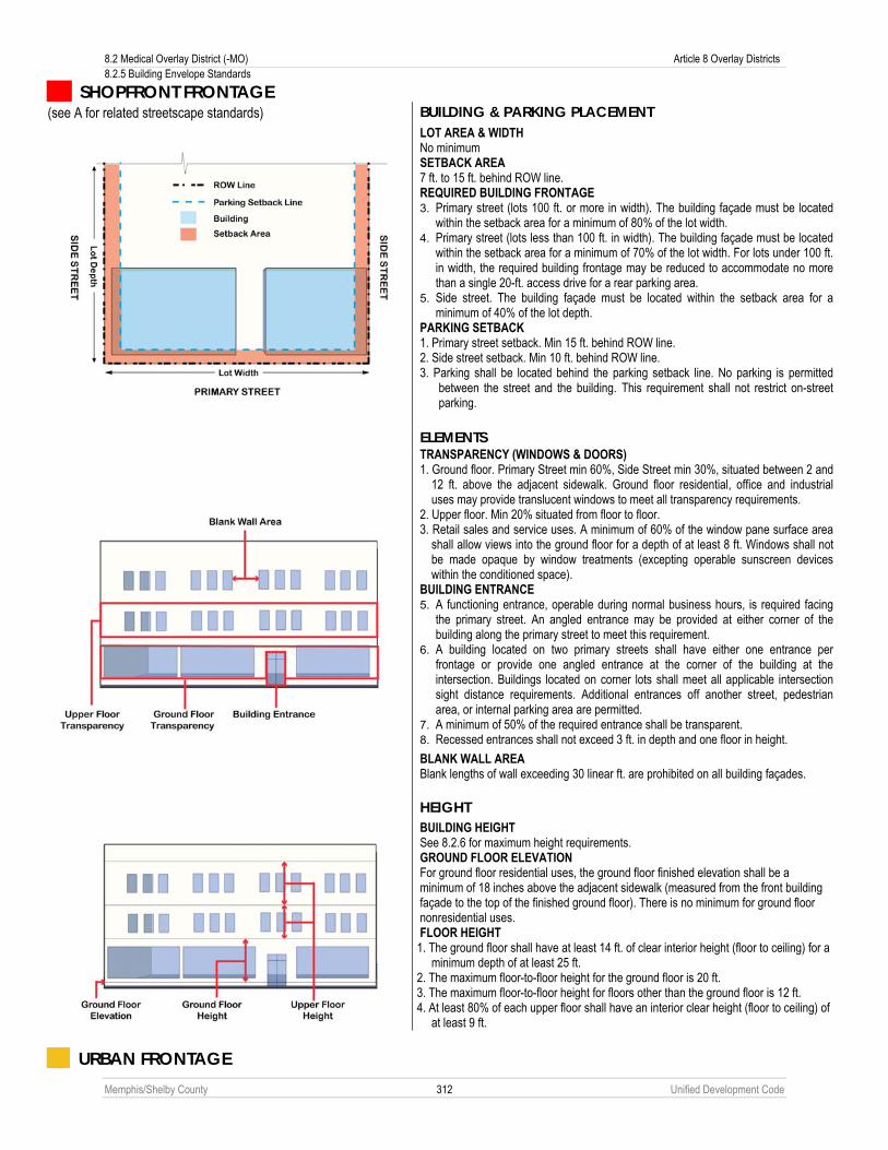
8.2 Medical Overlay District (-MO) Article 8 Overlay Districts 8.2.5 Building Envelope Standards
Memphis/Shelby County 312 Unified Development Code
SHOPFRONT FRONTAGE (see A for related streetscape standards) BUILDING & PARKING PLACEMENT
LOT AREA & WIDTH No minimum SETBACK AREA 7 ft. to 15 ft. behind ROW line. REQUIRED BUILDING FRONTAGE 3. Primary street (lots 100 ft. or more in width). The building façade must be located
within the setback area for a minimum of 80% of the lot width. 4. Primary street (lots less than 100 ft. in width). The building façade must be located
within the setback area for a minimum of 70% of the lot width. For lots under 100 ft. in width, the required building frontage may be reduced to accommodate no more than a single 20-ft. access drive for a rear parking area.
5. Side street. The building façade must be located within the setback area for a minimum of 40% of the lot depth.
PARKING SETBACK 1. Primary street setback. Min 15 ft. behind ROW line. 2. Side street setback. Min 10 ft. behind ROW line. 3. Parking shall be located behind the parking setback line. No parking is permitted
between the street and the building. This requirement shall not restrict on-street parking.
ELEMENTS
TRANSPARENCY (WINDOWS & DOORS) 1. Ground floor. Primary Street min 60%, Side Street min 30%, situated between 2 and
12 ft. above the adjacent sidewalk. Ground floor residential, office and industrial uses may provide translucent windows to meet all transparency requirements.
2. Upper floor. Min 20% situated from floor to floor. 3. Retail sales and service uses. A minimum of 60% of the window pane surface area
shall allow views into the ground floor for a depth of at least 8 ft. Windows shall not be made opaque by window treatments (excepting operable sunscreen devices within the conditioned space).
BUILDING ENTRANCE 5. A functioning entrance, operable during normal business hours, is required facing
the primary street. An angled entrance may be provided at either corner of the building along the primary street to meet this requirement.
6. A building located on two primary streets shall have either one entrance per frontage or provide one angled entrance at the corner of the building at the intersection. Buildings located on corner lots shall meet all applicable intersection sight distance requirements. Additional entrances off another street, pedestrian area, or internal parking area are permitted.
7. A minimum of 50% of the required entrance shall be transparent. 8. Recessed entrances shall not exceed 3 ft. in depth and one floor in height.
BLANK WALL AREA Blank lengths of wall exceeding 30 linear ft. are prohibited on all building façades.
HEIGHT
BUILDING HEIGHT See 8.2.6 for maximum height requirements. GROUND FLOOR ELEVATION For ground floor residential uses, the ground floor finished elevation shall be a minimum of 18 inches above the adjacent sidewalk (measured from the front building façade to the top of the finished ground floor). There is no minimum for ground floor nonresidential uses. FLOOR HEIGHT
1. The ground floor shall have at least 14 ft. of clear interior height (floor to ceiling) for a minimum depth of at least 25 ft.
2. The maximum floor-to-floor height for the ground floor is 20 ft. 3. The maximum floor-to-floor height for floors other than the ground floor is 12 ft. 4. At least 80% of each upper floor shall have an interior clear height (floor to ceiling) of
at least 9 ft.
URBAN FRONTAGE

Article 8 Overlay Districts 8.2 Medical Overlay District (-MO) 8.2.5 Building Envelope Standards
Memphis/Shelby County 313 Unified Development Code
(see B for related streetscape standards) BUILDING & PARKING PLACEMENT
LOT AREA & WIDTH No minimum SETBACK AREA 7 ft. to 15 ft. behind ROW line. REQUIRED BUILDING FRONTAGE 1. Primary street (lots 125 ft. or more in width). The building façade must be located
within the setback area for a minimum of 60% of the lot width. 2. Primary street (lots less than 125 ft. in width). The building façade must be located
within the setback area for a minimum of 50% of the lot width. 3. Side street. The building façade must be located within the setback area for a
minimum of 25% of the lot depth. PARKING SETBACK LINE 4. Primary street setback. Min 15 ft. behind ROW line. 5. Side street setback. Min 10 ft. behind ROW line. 6. Parking shall be located behind the parking setback line. No parking is permitted
between the street and the building. This requirement shall not restrict on-street parking.
ELEMENTS
TRANSPARENCY (WINDOWS & DOORS) 1. Ground floor. Primary Street min 60%, Side Street min 30%, situated between 2 and
12 ft. above the adjacent sidewalk. Ground floor residential, office and industrial uses may provide translucent windows to meet all transparency requirements.
2. Upper floor. Min 20% situated from floor to floor. 3. Retail sales and service uses. A minimum of 60% of the window pane surface area
shall allow views into the ground floor for a depth of at least 15 ft. Windows shall not be made opaque by window treatments (excepting operable sunscreen devices within the conditioned space).
BUILDING ENTRANCE 4. A functioning entrance, operable during normal business hours, is required facing
the primary street. An angled entrance may be provided at either corner of the building along the primary street to meet this requirement.
5. A building located on two primary streets shall have either one entrance per frontage or provide one angled entrance at the corner of the building at the intersection. Buildings located on corner lots shall meet all applicable intersection sight distance requirements. Additional entrances off another street, pedestrian area, or internal parking area are permitted.
6. A minimum of 50% of the required entrance shall be transparent. 7. Recessed entrances shall not exceed 3 ft. in depth and one floor in height.
BLANK WALL AREA Blank lengths of wall exceeding 30 linear ft. are prohibited on all building façades.
HEIGHT
BUILDING HEIGHT See 8.2.6 for maximum height requirements. GROUND FLOOR ELEVATION For ground floor residential uses, the ground floor finished elevation shall be a minimum of 18 inches above the adjacent sidewalk (measured from the front building façade to the top of the finished ground floor). There is no minimum for ground floor nonresidential uses. FLOOR HEIGHT 1. The ground floor shall have at least 14 ft. of clear interior height (floor to ceiling) for a
minimum depth of at least 25 ft. 2. The maximum floor-to-floor height for the ground floor is 20 ft. 3. The maximum floor-to-floor height for floors other than the ground floor is 12 ft. 4. At least 80% of each upper floor shall have an interior clear height (floor to ceiling) of
at least 9 ft.

8.2 Medical Overlay District (-MO) Article 8 Overlay Districts 8.2.5 Building Envelope Standards
Memphis/Shelby County 314 Unified Development Code
COMMERCIAL FRONTAGE (see C for related streetscape standards) BUILDING & PARKING PLACEMENT
LOT AREA & WIDTH No minimum SETBACK AREA 7 ft. to 75 ft. behind ROW line. REQUIRED BUILDING FRONTAGE 1. Primary street (lots 125 ft. or more in width). The building façade must be located
within the setback area for a minimum of 60% of the lot width. 2. Primary street (lots less than 125 ft. in width). The building façade must be located
within the setback area for a minimum of 50% of the lot width. 3. Side street. The building façade must be located within the setback area for a
minimum of 25% of the lot depth. PARKING SETBACK LINE 4. Primary/side street setback. Min 8 ft. behind ROW line. 5. Parking shall be located behind the parking setback line. A single 22-ft. drive aisle
serving 20-ft. deep parking spaces on one or both sides may be located between the building and the street. Where parking is provided between the building and the street, the 8-ft. parking setback area shall be landscaped.
ELEMENTS
TRANSPARENCY (WINDOWS & DOORS) 1. Ground floor. Primary Street min 60%, Side Street min 30%, situated between 2
and 12 ft. above the adjacent sidewalk. Ground floor residential, office and industrial uses may provide translucent windows to meet all transparency requirements.
2. Upper floor. Min 20% situated from floor to floor. 3. Retail sales and service uses. A minimum of 60% of the window pane surface area
shall allow views into the ground floor for a depth of at least 15 ft. Windows shall not be made opaque by window treatments (excepting operable sunscreen devices within the conditioned space).
BUILDING ENTRANCE 1. A functioning entrance, operable during normal business hours, is required facing
the primary street. An angled entrance may be provided at either corner of the building along the primary street to meet this requirement.
2. A building located on two primary streets shall have either one entrance per frontage or provide one angled entrance at the corner of the building at the intersection. Buildings located on corner lots shall meet all applicable intersection sight distance requirements. Additional entrances off another street, pedestrian area, or internal parking area are permitted.
3. A minimum of 50% of the required entrance shall be transparent. 4. Recessed entrances shall not exceed 3 ft. in depth and one floor in height.
BLANK WALL AREA Blank lengths of wall exceeding 30 linear ft. are prohibited on all building façades.
HEIGHT
BUILDING HEIGHT See 8.2.6 for maximum height requirements. GROUND FLOOR ELEVATION For ground floor residential uses, the ground floor finished elevation shall be a minimum of 18 inches above the adjacent sidewalk (measured from the front building façade to the top of the finished ground floor). There is no minimum for ground floor nonresidential uses. FLOOR HEIGHT 1. The ground floor shall have at least 14 ft. of clear interior height (floor to ceiling) for a
minimum depth of at least 25 ft. 2. The maximum floor-to-floor height for the ground floor is 20 ft. 3. The maximum floor-to-floor height for floors other than the ground floor is 12 ft. 4. At least 80% of each upper floor shall have an interior clear height (floor to ceiling) of
at least 9 ft.

Article 8 Overlay Districts 8.2 Medical Overlay District (-MO) 8.2.5 Building Envelope Standards
Memphis/Shelby County 315 Unified Development Code
LARGE FORMAT BUILDINGS
Liner buildings facing a designated frontage may be used to screen large format buildings. Shared parking is allowed between the large format building and the street provided liner buildings are constructed to the meet the designated frontage standards. Large format buildings screened by liner buildings (that meet the designated frontage requirements) are only required to meet the ground floor area, side/rear setback, parking setback, and building height requirements.
STRUCTURED PARKING
Structured parking is permitted fronting on any street provided that on a designated frontage all frontage requirements are met. Such buildings shall meet all applicable building envelope standards except for upper floor transparency requirements. Such building shall contain active ground floor uses along the designated frontage for minimum depth of least 25 feet.

8.2 Medical Overlay District (-MO) Article 8 Overlay Districts 8.2.6 Height Standards
Memphis/Shelby County 316 Unified Development Code
8.2.6 Height Standards A. Building Height Standards
The following map designates maximum building height limits within the Medical Overlay District.
Max Height
Area 1 General (no frontage designation) 35 feet Commercial/Urban/Shopfront Frontage 60 feet *
Area 2 General (no frontage designation) 80 feet * Commercial Frontage 80 feet Urban/ Shopfront Frontage (anywhere on lot) Block face (0 - 30 feet of lot depth) 80 feet Block interior (30+ feet of lot depth) 128 feet Additional height permitted for block interiors
by special exception
* subject to bulk plane (see Paragraph B below)

Article 8 Overlay Districts 8.2 Medical Overlay District (-MO) 8.2.6 Height Standards
Memphis/Shelby County 317 Unified Development Code
B. Bulk Plane

8.2 Medical Overlay District (-MO) Article 8 Overlay Districts 8.2.7 Streetscape Standards
Memphis/Shelby County 318 Unified Development Code
8.2.7 Streetscape Standards A. Shopfront Frontage
The following minimum streetscape standards apply along a Shopfront Frontage as designated in Sub-Section 8.2.5B (see Sub-Section 8.2.5C for related building envelope standards).

Article 8 Overlay Districts 8.2 Medical Overlay District (-MO) 8.2.7 Streetscape Standards
Memphis/Shelby County 319 Unified Development Code
B. Urban Frontage The following minimum streetscape standards apply along an Urban Frontage as designated in Sub-Section 8.2.5B (see Sub-Section 8.2.5C for related building envelope standards).

8.2 Medical Overlay District (-MO) Article 8 Overlay Districts 8.2.7 Streetscape Standards
Memphis/Shelby County 320 Unified Development Code
C. Commercial Frontage The following minimum streetscape standards apply along a Commercial Frontage as designated in Sub-Section 8.2.5B (see Sub-Section 8.2.5C for related building envelope standards). Developments with no on-site parking between the building street may follow the requirements for Urban Frontage (see B).
CO
MM
ERC
IAL
FRO
NTA
GE
1

Article 8 Overlay Districts 8.2 Medical Overlay District (-MO) 8.2.7 Streetscape Standards
Memphis/Shelby County 321 Unified Development Code
CO
MM
ERC
IAL
FRO
NTA
GE
2
8.2 Medical Overlay District (-MO) Article 8 Overlay Districts 8.2.8 Site Development Standards
Memphis/Shelby County 322 Unified Development Code
D. Street Trees A project developed in the Medical District Overlay shall provide street trees located at least every 40 feet on center. The street trees shall be planted in grates that are Americans with Disabilities Act (ADA) compliant or in planters with curbed beds. The location of street trees shall conform to the applicable streetscape plate.
8.2.8 Site Development Standards A. Applicability
The following supplemental site development standards apply in all nonresidential districts within the Medical Overlay District.
B. Landscaping and Screening 1. Any building, structure, or use is subject to the landscaping requirements of Chapter 4.6, Landscaping and
Screening.). 2. Trash collection, trash compaction, recycling collection and other similar service areas shall be located on
the side or rear of the building and shall be screened from view from residentially-zoned property or public rights-of-way. Screening enclosures shall be fully enclosed by opaque walls or fences at least eight feet high with self-closing access doors and shall be constructed of the same materials as the primary building or buildings.
3. Trash collection, trash compaction, recycling collection and other similar service areas shall be located a minimum of 50 feet away from any residentially-zoned property line.
4. No garage doors, bay doors or loading areas shall face a Shopfront or Urban Frontage. 5. Loading areas shall be subject to the following screening requirements:
a. Provide a minimum 100 percent year-round screen of all loading areas visible from residentially-zoned property or public right-of-way.
b. This screen shall consist of berms, walls, fences, plant material or combination totaling eight feet in height at installation or completion of construction. Wall or fence materials shall be compatible with the primary structure.
c. Loading docks shall be located to the side or rear of buildings when within 50 feet of any residentially-zoned property, unless the loading area is wholly within a closed building.
6. All roof, ground and wall mounted mechanical equipment (e.g. air handling equipment, compressors, duct work, transformers and elevator equipment) shall be screened from view from residential properties or public rights-of-way at ground level of the property line.
7. Roof-mounted mechanical equipment shall be shielded from view on all sides. Screening shall consist of materials consistent with the primary building materials, and may include metal screening or louvers which are painted to blend with the primary structure.
8. Wall or ground-mounted equipment screening shall be constructed of planting screens; brick, stone, reinforced concrete, or other similar masonry materials; or other similar materials.
9. Above-ground utilities and appurtenances to underground utilities which require above-ground installation shall be screened by a continuous planting of shrubs, with a minimum mature height equal to that of the utility structure. Required access ways to these utilities are exempt from the screening provisions.
C. Fences and Walls 1. Fences and walls shall be constructed of high quality materials, such as decorative blocks, brick, stone and
wrought iron. 2. Chain-link fences, barbed wire or concertina wire shall not be permitted. 3. Breaks in the fence or wall may be provided for pedestrian connections to adjacent developments. 4. The maximum length of a continuous, unbroken and uninterrupted fence or wall plane shall be 100 feet.
Breaks shall be provided through the use of columns, landscaped areas, transparent sections and a change in material.
5. Fences shall not be constructed in the sight triangle.

Article 8 Overlay Districts 8.2 Medical Overlay District (-MO) 8.2.9 Definitions
Memphis/Shelby County 323 Unified Development Code
D. Drive-Thru Facilities 1. A drive-thru window shall only be permitted where it is not facing the public right-of-way of a Shopfront or
Urban Frontage. 2. Drive-thru windows and lanes placed between the right-of-way and the associated building shall require
landscape plantings installed and maintained along the entire length of the drive-thru lane, located between the drive-thru lane and the adjacent right-of-way. Such screening shall be a compact evergreen hedge or other type of dense foliage. At the time of installation, such screening shall be at least 36 inches in height and shall reach a height of 48 inches within two years of planting.
3. No drive-thru window shall be permitted on the side of a building adjacent to any residentially-zoned property.
E. Parking 1. Due to the high availability of public transportation in the Medical Overlay District area, any building,
structure, or use may reduce the total number of required parking spaces specified in Chapter 4.5, Parking and Loading by up to 25 percent. Where off-street parking is provided, it shall comply with the geometric requirements of Chapter 4.5. Where parking spaces beyond the required parking spaces set forth in Chapter 4.5 are provided in surface parking lots, such additional spaces shall be established using pervious materials such as turf block, grasscrete or similar surfaces as approved by the City Engineer.
2. Surface parking lots are not allowed unless as accessory to a principal use permitted by both the underlying district and this overlay district, or as approved by special exception.
3. Any building, structure, or use must meet the loading requirements of Section 4.5.7. 4. The Land Use Control Board may approve modifications to any parking requirements in accordance with the
special exception process.
F. Signs The sign regulations in all residential zoning districts shall meet the district standards. Sign regulations in all nonresidential underlying zoning districts shall meet the standards of the sign regulations set out in Chapter 12-36 of the City of Memphis Code of Ordinances.
8.2.9 Definitions For the purposes of this Chapter, the following words and terms shall have the following meanings: A. Blank Wall Area. For the purposes of this chapter, blank wall area shall mean a portion of the exterior façade of
the building which does not include a substantial material change (paint color is not considered a substantial change); windows or doors; or columns, pilasters or other articulation greater than 12 inches in depth.
B. Commercial Frontage. See Section 8.2.5. C. Shopfront Frontage. See Section 8.2.5. D. Transparent. Material through which light can travel with minimal scattering so that objects can be viewed clearly
through it. E. Translucent. Material through which light passes, but in such a way that a clear image cannot be formed of the
object viewed through it. F. Upper-Story Residential. A residential unit on the upper floors of a permitted nonresidential use. G. Urban Frontage. See Section 8.2.5.
8.2.10 Conflict with the Uptown Special Purpose District The regulations found in this Section that conflict with the regulations of Chapter 7.3, the Uptown Special Purpose District, shall apply to parcels that are included in both the Uptown Special Purpose District and the Medical Overlay District.

8.3 University District Overlay (-UDO) Article 8 Overlay Districts 8.3.1 Purpose
Memphis/Shelby County 324 Unified Development Code
8.3 UNIVERSITY DISTRICT OVERLAY (-UDO)
8.3.1 Purpose The purpose of this overlay district is to provide carefully tailored zoning categories that will preserve and reinforce the University District by encouraging rehabilitation and new construction that is sensitive to the existing urban form and reflects appropriate uses, scale and character of the neighborhood. This overlay district is intended to serve as a guide to assist property owners, developers, architects, builders, business owners, public officials, and other interested citizens when considering rehabilitation, redevelopment or new construction in the University District. This document should also be consulted by the Memphis and Shelby County Government with respect to proposed infrastructure and streetscape improvement projects.
8.3.2 Boundaries The boundaries of the University District Overlay (-UDO) are shown on the map in Sub-Section 8.3.6B.
8.3.3 Applicability Within the University District Overlay (-UDO) the standards of this Chapter shall apply to: A. All new building construction; B. All building expansion with removal of more than 25% of existing walls facing a public street, or a street-facing
elevation if the parcel is landlocked; or removal of more than 50% of all existing exterior walls. C. All existing buildings that are not in conformance with the requirements of the underlying district or this overlay
district at the time of adoption shall be governed by Article 10, Nonconformities.
8.3.4 Site Plan Review A. Authority
The Planning Director is authorized to approve site plans within the University Overlay District in accordance with Chapter 9.13.
B. Administrative Deviations During the site plan review process, the Planning Director is authorized to approve administrative deviations (see Chapter 9.21) to the building envelope standards in Section 8.3.6, where, owing to special conditions, strict enforcement of certain standards would be physically impractical.
C. Special Exceptions
1. Authority The Land Use Control Board is authorized to approve special exceptions to certain requirements of this Chapter in accordance with Chapter 9.14.
2. Permitted Special Exception The Land Use Control Board has the authority to approve special exceptions for the following standards:
a. Additional height. b. Modifications to any parking requirements. c. Building width greater than 75 feet on a Shopfront designated Street d. Building width greater than 100 feet on an Urban designated Street
8.3.5 Uses Permitted All uses permitted by right (■) or by special use permit (□) within the boundaries of the University District Overlay (-UDO) shall as shown on the Uses Permitted Chart, Section 8.3.11.

Article 8 Overlay Districts 8.3 University District Overlay (-UDO) 8.3.6 Building Envelope Standards
Memphis/Shelby County 325 Unified Development Code
8.3.6 Building Envelope Standards SHOPFRONT FRONTAGE
Buildings abut the street front and sidewalk – “Main Street” environment. There is no parking between the building and the street. Parking areas are located to the rear of buildings. Entrances are prominent and street facing. There often are two entrances, a pedestrian entrance and an ancillary automobile entrance.
URBAN FRONTAGE
Buildings abut the street front and sidewalk with greater spacing in between to balance the needs of both the pedestrian and automobile. There is no parking between the building and the street. Parking areas are located to the side and rear of buildings. Entrances are prominent and street facing. There often are two entrances, a pedestrian entrance and an ancillary automobile entrance.
A. Additional Requirements: Shopfront and Urban Designated Streets 1. Exit drives from drive-thru windows shall not exit onto a Shopfront or Urban designated street except as a
drive that is shared with other traffic using the site. Exclusive drive-thru lanes shall not exit onto a Shopfront or Urban designated street.
2. Surface parking lots are not allowed except as accessory to a principal use permitted by the zoning district in which it is located.
3. Ground floor commercial use or public space shall be required along public street frontages of parking garages

8.3 University District Overlay (-UDO) Article 8 Overlay Districts 8.3.6 Building Envelope Standards
Memphis/Shelby County 326 Unified Development Code
B. Boundaries of the University District Overlay (-UDO)

Article 8 Overlay Districts 8.3 University District Overlay (-UDO) 8.3.6 Building Envelope Standards
Memphis/Shelby County 327 Unified Development Code
C. Frontage Map The following map designates Shopfront and Urban frontages within the University District Overlay.

8.3 University District Overlay (-UDO) Article 8 Overlay Districts 8.3.6 Building Envelope Standards
Memphis/Shelby County 328 Unified Development Code
D. Building Regulations The building envelope standards in the following table shall replace and supplement the respective regulations of the underlying zoning districts. Where no frontage is designated on the Frontage Map as Shopfront or Urban, the building regulations of the underlying zoning district apply.
Shopfront Urban
BUILDING & PARKING PLACEMENT Lot Area & Building Width Lot Area (min sq. ft.) Building Width (min ft.)
None 75
None 100
Setback Area Front setback (min ft.) Front setback (max ft.)
2 7
2 7
Required Building Frontage (min %) Primary street (lot up to100 feet in width) Primary street (lot up to 125 feet in width) Primary street (all other lots) Side street
70 -- 80 40
-- 50 60 25
Side/Rear Setback (min ft.) Abutting single-family Abutting multifamily, nonresidential Abutting alley Building separation
10 0 or 10
5* 10
10 0 or 10
5* 10
Parking Setback (min ft.) From primary street From side street Abutting single-family Abutting multifamily, nonresidential, alley
15 10 10 0
15 10 10 0
ELEMENTS Transparency (min %) Primary street Ground floor Upper floors
60 20
50 20
Side street Ground floor Upper floors
30 20
30 20
Building Entrance Facing primary street Required Required Blank Wall Area (max linear ft.) 30 30
HEIGHT Building Height (max ft.) **55 ** Ground Floor Elevation (min inches) Residential use 18 18 Floor Height (min ft.) Ground floor height (floor to floor) Second floor height (floor to floor)
14 11
12 11
* Not required if alley is 25 feet or more in width. ** Maximum Height governed by the Height Map at 8.3.7.

Article 8 Overlay Districts 8.3 University District Overlay (-UDO) 8.3.6 Building Envelope Standards
Memphis/Shelby County 329 Unified Development Code
SHOPRONT FRONTAGE (see 8.3.9 for related streetscape standards) BUILDING & PARKING PLACEMENT
LOT AREA & WIDTH No minimum SETBACK AREA 2 ft. to 7 ft. behind ROW line. REQUIRED BUILDING FRONTAGE 1. Primary street (lots 100 ft. or more in width). The building façade must be located
within the setback area for a minimum of 80% of the lot width. 2. Primary street (lots less than 100 ft. in width). The building façade must be located
within the setback area for a minimum of 70% of the lot width. For lots under 100 ft. in width, the required building frontage may be reduced to accommodate no more than a single 20-ft. access drive for a rear parking area.
3. Side street. The building façade must be located within the setback area for a minimum of 40% of the lot depth.
PARKING SETBACK 1. Primary street setback. Min 15 ft. behind ROW line. 2. Side street setback. Min 10 ft. behind ROW line. 3. Parking shall be located behind the parking setback line. No parking is permitted
between the street and the building. This requirement shall not restrict on-street parking.
ELEMENTS
TRANSPARENCY (WINDOWS & DOORS) 1. Ground floor. Primary Street min 60%, Side Street min 30%, situated between 2
and 12 ft. above the adjacent sidewalk. Ground floor residential, office and industrial uses may provide translucent windows to meet all transparency requirements.
2. Upper floor. Min 20% situated from floor to floor. 3. Retail sales and service uses. A minimum of 60% of the window pane surface area
shall allow views into the ground floor for a depth of at least 8 ft. Windows shall not be made opaque by window treatments (excepting operable sunscreen devices within the conditioned space).
BUILDING ENTRANCE 1. A functioning entrance, operable during normal business hours, is required facing
the primary street. An angled entrance may be provided at either corner of the building along the primary street to meet this requirement.
2. A building located on two primary streets shall have either one entrance per frontage or provide one angled entrance at the corner of the building at the intersection. Buildings located on corner lots shall meet all applicable intersection sight distance requirements. Additional entrances off another street, pedestrian area, or internal parking area are permitted.
3. A minimum of 50% of the required entrance shall be transparent. 4. Recessed entrances shall not exceed 3 ft. in depth and one floor in height.
BLANK WALL AREA Blank lengths of wall exceeding 30 linear ft. are prohibited on all building façades.
HEIGHT
BUILDING HEIGHT See 8.3.7 for maximum height requirements. GROUND FLOOR ELEVATION For ground floor residential uses, the ground floor finished elevation shall be a minimum of 18 inches above the adjacent sidewalk (measured from the front building façade to the top of the finished ground floor). There is no minimum for ground floor nonresidential uses. FLOOR HEIGHT At least 80% of the second floor shall have an interior clear height (floor to ceiling) of at least 9 ft.

8.3 University District Overlay (-UDO) Article 8 Overlay Districts 8.3.6 Building Envelope Standards
Memphis/Shelby County 330 Unified Development Code
URBAN FRONTAGE (see 8.3.9 for related streetscape standards) BUILDING & PARKING PLACEMENT
LOT AREA & WIDTH No minimum SETBACK AREA 2 ft. to 7 ft. behind ROW line. REQUIRED BUILDING FRONTAGE 1. Primary street (lots 125 ft. or more in width). The building façade must be located
within the setback area for a minimum of 60% of the lot width. 2. Primary street (lots less than 125 ft. in width). The building façade must be located
within the setback area for a minimum of 70% of the lot width. For lots under 125 ft. in width, the required building frontage may be reduced to accommodate no more than a single 20-ft. access drive for a rear parking area
3. Side street. The building façade must be located within the setback area for a minimum of 25% of the lot depth.
PARKING SETBACK LINE 1. Primary street setback. Min 15 ft. behind ROW line. 2. Side street setback. Min 10 ft. behind ROW line. 3. Parking shall be located behind the parking setback line. No parking is permitted
between the street and the building. This requirement shall not restrict on-street parking.
ELEMENTS
TRANSPARENCY (WINDOWS & DOORS) 1. Ground floor. Primary Street min 50%, Side Street min 30%, situated between 2 and
12 ft. above the adjacent sidewalk. Ground floor residential, office and industrial uses may provide translucent windows to meet all transparency requirements.
2. Upper floor. Min 20% situated from floor to floor. 3. Retail sales and service uses. A minimum of 60% of the window pane surface area
shall allow views into the ground floor for a depth of at least 8 ft. Windows shall not be made opaque by window treatments (excepting operable sunscreen devices within the conditioned space).
BUILDING ENTRANCE 1. A functioning entrance, operable during normal business hours, is required facing
the primary street. An angled entrance may be provided at either corner of the building along the primary street to meet this requirement.
2. A building located on two primary streets shall have either one entrance per frontage or provide one angled entrance at the corner of the building at the intersection. Buildings located on corner lots shall meet all applicable intersection sight distance requirements. Additional entrances off another street, pedestrian area, or internal parking area are permitted.
3. A minimum of 50% of the required entrance shall be transparent. 4. Recessed entrances shall not exceed 3 ft. in depth and one floor in height.
BLANK WALL AREA Blank lengths of wall exceeding 30 linear ft. are prohibited on all building façades.
HEIGHT
BUILDING HEIGHT See 8.3.7 for maximum height requirements. GROUND FLOOR ELEVATION For ground floor residential uses, the ground floor finished elevation shall be a minimum of 18 inches above the adjacent sidewalk (measured from the front building façade to the top of the finished ground floor). There is no minimum for ground floor nonresidential uses. FLOOR HEIGHT 1. At least 80% of the second floor shall have an interior clear height (floor to ceiling)
of at least 9 ft.

Article 8 Overlay Districts 8.3 University District Overlay (-UDO) 8.3.6 Building Envelope Standards
Memphis/Shelby County 331 Unified Development Code
LARGE FORMAT BUILDINGS
Liner buildings facing a designated frontage may be used to screen large format buildings. Shared parking is allowed between the large format building and the street provided liner buildings are constructed to the meet the designated frontage standards. Large format buildings screened by liner buildings (that meet the designated frontage requirements) are only required to meet the ground floor area, side/rear setback, parking setback, and building height requirements.
STRUCTURED PARKING
Structured parking is permitted fronting on any street provided that on a designated frontage all frontage requirements are met. Such buildings shall meet all applicable building envelope standards except for upper floor transparency requirements. Such building shall contain active ground floor uses along the designated frontage for minimum depth of least 25 feet.

8.3 University District Overlay (-UDO) Article 8 Overlay Districts 8.3.7 Height Standards
Memphis/Shelby County 332 Unified Development Code
8.3.7 Height Standards

Article 8 Overlay Districts 8.3 University District Overlay (-UDO) 8.3.8 Bulk Plane
Memphis/Shelby County 333 Unified Development Code
8.3.8 Bulk Plane
8.3.9 Streetscape Standards The following streetscape standards of Chapter 4.3 apply as follows: Streetscapes S-1 & S-2 apply along Shopfont Frontages. Streetscapes S-1, S-2, S-3 & S-4 apply along Urban Frontages. Frontage designations are shown on the Frontage Map in Sub-Section 8.3.6C (see Sub-Section 8.3.6D for related building envelope standards).

8.3 University District Overlay (-UDO) Article 8 Overlay Districts 8.3.10 Site Development Standards
Memphis/Shelby County 334 Unified Development Code
8.3.10 Site Development Standards A. Applicability
The following supplemental site development standards apply in all nonresidential districts within the University District Overlay (-UDO).
B. Landscaping and Screening 1. Any building, structure, or use is subject to the landscaping requirements of Chapter 4.6 Landscaping and
Screening. 2. Trash collection, trash compaction, recycling collection and other similar service areas shall be located on the
side or rear of the building and shall be screened from view from residentially zoned property or public rights-of-way. Screening enclosures shall be fully enclosed by opaque walls or fences at least eight feet high with self-closing access doors and shall be constructed of the same materials as the primary building or buildings.
3. Trash collection, trash compaction, recycling collection and other similar service areas shall be located a minimum of 50 feet away from any residentially zoned property line.
4. No garage doors, bay doors or loading areas shall face a Shopfront or Urban Frontage. 5. Loading areas shall be subject to the following screening requirements:
a. Provide a minimum 100 percent year round screen of all loading areas visible from residentially zoned property or public right-of-way.
b. This screen shall consist of berms, walls, fences, plant material or combination totaling eight feet in height at installation or completion of construction. Wall or fence materials shall be compatible with the primary structure.
c. Loading docks shall be located to the side or rear of buildings when within 50 feet of any residentially zoned property line.
6. All roof, ground and wall mounted mechanical equipment (e.g. air handling equipment, compressors, duct work, transformers and elevator equipment) shall be screened from view from residential properties or public rights-of-way at ground level of the property line.
7. Roof-mounted mechanical equipment shall be shielded from view on all sides. Screening shall consist of materials consistent with the primary building materials, and may include metal screening or louvers which are painted to blend with the primary structure.
8. Wall or ground mounted equipment screening shall be constructed of planting screens, brick stone, reinforced concrete, or other similar masonry materials; or other similar materials.
9. Above ground utilities and appurtenances to underground utilities which require above ground installation shall be screened by a continuous planting of shrubs, with a minimum mature height equal to that of the utility structure. Required access ways to these utilities are exempt from the screening provisions.
C. Fences and Walls 1. Fences and walls shall be constructed of high quality materials, such as decorative blocks, brick, stone and
wrought iron. 2. Chain link fences, barbed wire or concertina wire shall not be permitted. 3. Breaks in the fence or wall may be provided for pedestrian connections to adjacent developments. 4. The maximum length of a continuous, unbroken and uninterrupted fence or wall plane shall be 100 feet. Breaks
shall be provided through the use of columns, landscaped areas, transparent sections and a change in material. 5. Fences shall not be constructed in the sight triangle.

Article 8 Overlay Districts 8.3 University District Overlay (-UDO) 8.3.11 Uses Permitted In the University District Overlay (-UDO)
Memphis/Shelby County 335 Unified Development Code
D. Drive-Thru Facilities 1. A drive-thru window shall only be permitted where it is not facing the public right-of-way of a Shopfront or Urban
Frontage. 2. Drive-thru windows and lanes placed between the right-of-way and the associated building shall require
landscape plantings installed and maintained along the entire length of the drive-thru lane and the adjacent right-of-way. Such screening shall be a compact evergreen hedge or other type of dense foliage. At the time of installation, such screening shall be at least 36 inches in height and shall reach a height of 48 inches within two years of planting.
3. No drive-thru window shall be permitted on the side of a building adjacent to any residentially zoned property.
E. Parking 1. Due to the high availability of public transportation in the University District Overlay (-UDO) area, any building,
structure, or use is exempt from the off-street parking spaces for motor vehicles and loading requirements of Chapter 4.5.
2. Where off street parking is provided, it shall comply with the geometric requirements of Chapter 4.5. Where parking spaces beyond the required parking spaces set forth in Chapter 4.5 are provided in surface parking lots, such additional spaces shall be established using pervious materials such as turf block, grasscrete or similar surfaces as approved by the City Engineer.
F. Bicycle Parking 1. All nonresidential development in the CMU-1 and CMU-2 districts shall provide a minimum of two bicycle parking
spaces (high quality inverted U racks). 2. Nonresidential development in the CMU-1 and CMU-2 districts with more than 20 parking spaces shall provide a
minimum of six bicycle parking spaces. 3. Bicycle parking spaces must be located with 200 feet of a functioning building entrance. 4. All bicycle parking facilities must be high quality inverted, U type construction. Alternative high quality bicycle
parking facilities may be approved by the Planning Director if they can be shown to; a. Provide adequate theft protection and security; and b. Support the bicycle at two points of contact to prevent damage to the bicycle wheels and frame.
G. Signs 1. The sign regulations in all residential zoning districts shall meet the base district standards. 2. Sign regulations in all nonresidential underlying zoning districts shall meet the standards of the sign regulations
set out in Chapter 12-36 of the City of Memphis Code of Ordinances.
8.3.11 Uses Permitted In the University District Overlay (-UDO)
PRINCIPAL USE R6 RU-1 RU-3 CMU-1 CMU-2 CMP-2 RESIDENTIAL USES Household living
Single Family Detached ■ ■
Conventional ■ ■
Side Yard House ■
Cottage ■
Single Family Attached
Semi-attached ■
Two-Family ■
Multifamily
Townhouse ■ ■ ■ ■
Large Home ■ ■ ■ ■
Stacked Townhouse ■ ■ ■
Apartment ■ ■ ■
Upper-Story Residential ■ ■ ■ ■
Live-Work ■ ■ ■ ■
Manufactured Home (Type A) Modular ■ ■ ■ ■
Manufactured Home (Type B)
Manufactured Home Park

8.3 University District Overlay (-UDO) Article 8 Overlay Districts 8.3.11 Uses Permitted In the University District Overlay (-UDO)
Memphis/Shelby County 336 Unified Development Code
PRINCIPAL USE R6 RU-1 RU-3 CMU-1 CMU-2 CMP-2 Group living
Boarding House, Rooming House, Single Room Occupancy
□ □ ■
Fraternity, Sorority, Dormitory ■ □ ■ ■ ■
Monastery, Convent □ □ ■ ■
Nursing Home, Full- time Convalescent Hospice
□ □ □ ■
Personal Care Home for the Elderly ■ ■ □ □
Residential Home for the Elderly, Assisted Living Facility
□ ■ ■
Supportive Living Facility
■ ■ □ □
CIVIC USES
Community Service
Museum, Library □ □ ■ ■ ■
Neighborhood Arts Center or Similar Community Facility (public)
□ □ □ □
Philanthropic Institution ■ ■ ■
Police, Fire, EMS Substation ■ ■ ■ ■ ■
Day Care
Adult Day Care Program □ □ ■ □ □
Family Day Care Home (5 to 7 persons) ■ ■
Group Day Care Home (8-12 persons) □ □ ■ □ □
Child Care Center (13+ persons □ □ ■ □ □
Drop-in Child Care Center 15+ persons ■ □ □
Nursery School, Preschool □ □ ■ □ □
Education Facility
Academy (Special Training) ■ ■ ■
College, Community College, University ■ ■ ■
Seminary □ ■ ■ ■
School, Public or Private (K-12) ■ ■ ■ ■ ■ ■
School, Trade, Vocational, Business □ ■ ■ ■
Medical Facility
Blood Plasma Donation Center, Medical or Dental Laboratory
□ □ □
Hospital ■
Medical, Dental Office or Chiropractor ■ ■ ■
Park/Open Area
All Parks and Open Areas, except as listed below:
■ ■ ■ ■ ■ ■
Cemetery, Mausoleum, Columbarium, Memorial Park
□ □
Park, Dog Park ■ ■ ■ ■ ■
Recreation Field □ □
Reservoir, Control Structure, Drainage Well, Water Supply, Water Well
■ ■ ■ ■ ■ ■
Passenger Terminal
Airport, Heliport, Airline Terminal
Taxicab Dispatch Station, Limousine Service □
Multimodal Facility
Place of Worship
All Places of Worship ■ ■ ■ ■ ■ ■
Social Service
All Social Service Institutions □

Article 8 Overlay Districts 8.3 University District Overlay (-UDO) 8.3.11 Uses Permitted In the University District Overlay (-UDO)
Memphis/Shelby County 337 Unified Development Code
PRINCIPAL USE R6 RU-1 RU-3 CMU-1 CMU-2 CMP-2 Utilities
All Minor Utilities ■ ■ ■ ■ ■ ■
All Major Utilities
Communication Towers (65 feet or less) ■ ■ ■ ■ ■ ■
Communication Towers □
CMCS Tower and Facilities □ □ ■ ■ ■ ■
COMMERCIAL USES
Indoor Recreation
All Indoor Recreation except as listed below: ■ ■ ■
Adult Entertainment
Bar, Tavern, Cocktail Lounge, Nightclub □
Convention Center
Lodge, Membership Club □ □ □ ■ ■
Indoor Shooting Range □
Office
All offices except as listed below: ■ ■ ■
Radio, TV, or Recording Studio ■ ■ ■
Overnight Lodging
Bed and Breakfast ■ ■ □
Hotel, Motel □ □ □
Youth Hostel □ □ □
Outdoor Recreation
Outdoor Recreation as listed below:
Golf Course, Country Club, Clubhouse □ □ □
Parking, Commercial
All Commercial Parking □ □
Restaurants
All Restaurants, except as listed below ■ ■ □
Restaurants with sale of alcoholic beverages, Brew Pub
□ ■
Restaurant, Drive-in
Retail Sales and Service
All Retail Sales and Service except as listed below
■ ■
Animal Hospital, Veterinary Clinic, Pet Clinic ■ ■
Animal Boarding, Animal Shelter, Kennel, Doggy Day Care
■ ■
Art or Photo Studio or Gallery ■ ■ ■
Bakery, Retail ■ ■ □
Barber or Beauty Shop ■ ■ □
Bank ■ ■ □
Convenience Store with Gas Pumps, Gas Station
□ □
Convenience Store without Gas Pumps □ ■
Catering Establishment, small scale ■ ■
Cleaning Establishment, small scale ■ □
Cleaning, Pickup Station ■ ■
Farmers Market □ □
Greenhouse or Nursery, Commercial □
Post Office ■ ■ □
Pawnshop □
Retail Sales Outdoor (Vendor) □ □
Tattoo, Palmist, Psychic or Medium, Massage Parlor
□
Vehicle Parts and Accessories ■

8.4 Midtown District Overlay (-MD) Article 8 Overlay Districts 8.3.12 Definitions
Memphis/Shelby County 338 Unified Development Code
PRINCIPAL USE R6 RU-1 RU-3 CMU-1 CMU-2 CMP-2 Self-Storage
Self-Storage as listed below
Warehouse, self-service, mini-storage
Warehouse, indoor multi-story ■ ■
Vehicle Sales and Service
All Vehicle Service except as listed below □
Lube, Oil Change Facility □
Tire, Motor Vehicle Sales & Service □
Full or Self-service Vehicle Wash □
All Vehicle Repair □
All Vehicle Sales, Rental, Leasing, except as listed below
□ □
Manufactured Housing Sales
Industrial Uses as listed below
Lawn, Tree or Garden Service □
Light Manufacturing or Assembly of Equipment, Instruments or Goods
■ ■
Photo Finishing Laboratory □ ■
Repair of Scientific or Professional Instruments, Electric Motors
□ ■
Research, Testing and Development Laboratory
□ ■
Sheet Metal Shop □ ■
Welding, Machine, Tool Repair Shop □ ■
Woodworking, including Cabinet Makers and Furniture Manufacturing
□ ■
Warehouse □ □
Recycling Drop-off Facility □ □ □
Planned Development □ □ □
8.3.12 Definitions For the purposes of this Chapter, the following words and terms shall have the following meanings: A. Blank Wall Area – For the purposes of this chapter, blank wall area shall mean a portion of the exterior façade of the
building which does not include a substantial material change (paint color is not considered a substantial change; windows or doors; or columns, pilasters or other articulation greater than 12 inches in depth.
B. Shopfront Frontage – See Section 8.3.6. C. Urban Frontage – See Section 8.3.6. D. Transparent – Material through which light can travel with minimal scattering so that objects can be viewed clearly
through it. E. Translucent – Material through which light passes, but in such a way that a clear image cannot be formed of the object
viewed through it. F. Upper-Story Residential – A residential unit on the upper floors of a permitted non residential use.
8.4 MIDTOWN DISTRICT OVERLAY (-MD)
8.4.1 Purpose The purpose of this Chapter is to provide carefully tailored zoning categories that will preserve and reinforce the Midtown District by encouraging rehabilitation and new construction that is sensitive to the existing urban form and reflects appropriate uses, scale and character of the neighborhood. The intention of this Chapter is to promote development by providing owners and developers with predictability in respect to what is or is not expected of them when developing their property. This Chapter is intended to serve as a guide to assist property owners, developers, architects, builders, business owners, public officials, and other interested citizens when considering rehabilitation, redevelopment or new construction in the Midtown District. This Chapter should also be consulted by the Memphis and Shelby County Government with respect

Article 8 Overlay Districts 8.4 Midtown District Overlay (-MD) 8.4.2 Boundaries
Memphis/Shelby County 339 Unified Development Code
to proposed infrastructure and streetscape improvement projects. This Chapter includes zoning regulations that govern land use, density, bulk and parking requirements.
8.4.2 Boundaries The boundaries of the Midtown District Overlay are shown on the map in Section 8.4.8.
8.4.3 Applicability Within the Midtown District Overlay the standards of this Chapter shall apply to: A. All new building construction; B. All building expansion with removal of more than 25% of existing walls facing a public street, or a street-facing
elevation if the parcel is landlocked; or removal of more than 50% of all existing exterior walls. C. All existing buildings that are not in conformance with the requirements of the underlying district or this overlay district
at the time of adoption shall be governed by Article 10, Nonconformities.
8.4.4 Site Plan Review A. Authority
1. The Office of Planning and Development is authorized to approve site plans within the Midtown District Overlay. 2. All proposed development, except for single-family detached and single-family attached housing types, used
exclusively for residential purposes on individual lots, shall be subject to the administrative site plan review process.
3. Any planned development or use requiring a special use permit shall be subject to site plan review.
B. Authority to Require Dedication and Improvement All development required to submit a site plan pursuant this Chapter shall require the dedication and improvement or designation of pedestrian easement to provide adequate sidewalks and streetscape.
C. Application Procedure
Submittal Requirements
Site plans shall be drawn at a scale of 1 inch equals 100 feet and shall include, but not be limited to, the following: 1. Property boundary lines and dimensions; available utilities; and easements, roadways, rail lines and public rights-
of-way crossing and adjacent to the subject property; 2. The proposed height, dimensions and arrangement of buildings; 3. The type and location of proposed fencing and landscaping (including illustrations of applicable landscape plates); 4. The location of points of ingress and egress; 5. The location of driveways and parking lots; 6. The location of trash collection, trash compaction, recycling collection and other similar services areas; 7. The location of garage doors, bay doors or loading areas; 8. The location of all roof, ground and wall mounted mechanical equipment (e.g. air handling equipment,
compressors, duct work, transformers and elevator equipment); 9. The location of any drive-through facilities; 10. Illustrations of the proposed building or building expansion and its relationship to existing buildings within 100 feet
of the site; 11. Illustrations with dimensions of the exterior of the proposed building or building expansion; and 12. Illustrations of proposed signs including location, materials, dimensions, and type of lighting.

8.4 Midtown District Overlay (-MD) Article 8 Overlay Districts 8.4.5 Administrative Deviation
Memphis/Shelby County 340 Unified Development Code
D. Appeals 1. If the Office of Planning and Development does not approve the application, the applicant may appeal to the Land
use Control Board. 2. If the application is appealed to the Land Use Control Board, public notice shall be mailed to property owners
within a 300-foot radius of the subject property. 3. The Office of Planning and Development or any affected property owner within the notification area appearing at
the Land Use Control Board public hearing or who submitted written comments to the Board may appeal the decision of the Board to the City Council. Such appeal shall be in writing comments to the Director of Planning and submitted within ten working days of the Board’s action.
4. The City Council shall, after the public hearing, approve the appeal, approve the appeal with conditions, or deny the appeal.
E. Approval Criteria In approving a site plan, the approving entity shall consider the following:
1. Compliance with all requirements of this Chapter; 2. That the site plan will be constructed and operated to be compatible with the neighborhood and with the purpose
of this Chapter; and 3. That the proposed development can be adequately served by public facilities; 4. The approving entity may impose conditions to minimize adverse effects on the neighborhood or on public
facilities, and to insure compatibility of the proposed development with surrounding properties, uses, and the purpose and intent of this Chapter.
8.4.5 Administrative Deviation A. Authority.
During the site plan review process, the Office of Planning and Development is authorized to approve administrative deviations to the building envelope standards in Section 8.4.5 and the minimum building standards in Sub-Section 8.4.10B, where, owing to specials conditions, strict enforcement of certain standards would be physically impractical or creative alternatives may be considered. This optional process shall occur only where the applicant requests an administrative deviation to a standard as specified below.
B. Permitted Deviations 1. The Office of Planning and Development shall review the request in light of the intent and purpose of overlay
district requirements. The Office of Planning and Development shall have the authority to approve an administrative deviation for the following standards:
a. Building and Parking Placement
1. Setback area -increase of up to 20% of the maximum permitted setback. 2. Required building frontage (minimum percentage of build-to) – reduction of up to 10% of required length. 3. Required building frontage (minimum percentage of build-to) – reduction of up to 20% of required length
with construction of a frontage wall. 4. Parking setback-decrease of up to 10% of the minimum required setback. 5. A zero foot setback may be approved if existing adjacent buildings have a zero foot setback.
b. Elements
1. Transparency – up to 10%. 2. Blank wall area – increase of up to 20% of the maximum permitted blank wall area. 3. Building entrance – reduction up to 10% minimum required transparency. 4. Recessed entry – up to 10% of the maximum permitted depth.
c. Height
1. Minimum and maximum floor heights – up to 20% for any one floor, limit of 10% for any cumulative increase or decrease in building height.
2. The minimum ground floor elevation – up to 10%. d. Minimum Building Standards.
Creative use of metal panels, concrete masonry units (CMU), exterior insulating finishing systems (EIFS) and precast concrete may be approved administratively.

Article 8 Overlay Districts 8.4 Midtown District Overlay (-MD) 8.4.6 Special Exceptions
Memphis/Shelby County 341 Unified Development Code
e. Tandem Parking
Tandem Parking may be allowed through administrative deviation in housing types other than single-family detached and single-family attached. Tandem Parking for single-family detached and single-family attached are permitted by right.
f. Maximum Building Setbacks Allow for the setback to be determined by averaging the setback distance over the width of the building.
g. Streetscape Requirements Modification of streetscape requirements may be permitted due to existing site constraints such as existing utilities and location of existing buildings.
C. Approval Criteria To approve an administrative deviation, the Office of Planning and Development shall make an affirmative finding that all of the following criteria are met:
1. An administrative deviation does not conflict with streets, sidewalks, easements or landscape requirements.
2. An administrative deviation does not injure or damage the use, value, or enjoyment of surrounding property.
3. An administrative deviation does not have an adverse impact on land use compatibility.
4. An administrative deviation does not materially affect adjacent land uses and the physical character of uses in the immediate vicinity of the proposed
D. Unlisted Standards Unlisted and Listed Standards: Any request for a deviation from a standard of the Unified Development Code not included in the Midtown District Overlay shall be reviewed by the Board of Adjustment in accordance with Chapter 9.22, Variances. Any request for a deviation from a standard included in the Midtown Overlay District not listed as an Administrative Deviation shall be reviewed by the Land Use Control Board as a Special Exception, in accordance with Section 8.4.6, below.
8.4.6 Special Exceptions A. Authority
The Land Use Control Board is authorized to approve special exceptions to certain requirements of this Chapter. This optional process shall occur only where the applicant requests a special exception from a standard as specified below.
B. Application Procedure
1. An owner or other person who has a contractual interest in the property may file an application with the Office of Planning and Development. A site plan shall be submitted and reviewed in accordance with Section 8.4.4 above.
2. The Office of Planning and Development shall forward the site plan and a request for special exception to the Land Use Control Board.
3. The Land Use Control Board shall hold a public hearing on the application no less than 35 days or more than 75 days after an application has been filed. Notice of the hearing shall be mailed to all property owners within a 300 foot radius of the property.
4. The Land Use Control Board may by a majority vote approve, with the conditions or reject the application. The Board may defer a decision until the next regular board meeting.
5. The Office of Planning and Development or any individual appearing at the Land Use Control Board public hearing or who submitted written comments to the Board may appeal the decision of the Board to the City Council. Such appeal shall be in writing to the Director of Planning and submitted within 10 working days of the Board’s decision. The City Council shall, after the public hearing, approve the appeal, approve the appeal with conditions, or deny the appeal.
C. Permitted Special Exception
The Land Use Control Board shall have the authority to approve special exceptions for any deviation from a standard included in the Midtown District Overlay.

8.4 Midtown District Overlay (-MD) Article 8 Overlay Districts 8.4.6 Special Exceptions
Memphis/Shelby County 342 Unified Development Code
D. Approval Criteria
To approve a special exception, the Land Use Control Board shall make an affirmative finding that all of the following criteria are met;
1. A special exception does not conflict with streets, sidewalks, easements or landscape requirements.
2. A special exception does not injure or damage the use, value or enjoyment of surrounding property or hinder or prevent the development of surrounding property.
3. A special exception does not have an adverse impact on land use compatibility.
4. A special exception does not materially and adversely affect adjacent land uses and the physical character of uses in the immediate vicinity of the proposed use.
5. When approving a special exception, the Land Use Control Board should give special consideration to building and site improvements that enhance the level of pedestrian amenities.

Article 8 Overlay Districts 8.4 Midtown District Overlay (-MD) 8.4.7 Uses Permitted in the Midtown District Overlay
Memphis/Shelby County 343 Unified Development Code
8.4.7 Uses Permitted in the Midtown District Overlay Blank Cell= Not Permitted, ■ = Use permitted by right, □ = Use requiring approval of a special use permit + = Use requiring approval of a Conditional Use Permit for a Significant Neighborhood Structure
PRINCIPAL USE R6
RU
-1
RU
-2
RU
-3
RU
-4
RU
-5
RW
OG
CM
U-1
CM
U-2
CM
U-3
EMP
RESIDENTIAL Household Living Single Family Detached Conventional ■ ■ ■ ■ ■ ■ ■ ■ ■ ■ Side Yard House ■ ■ ■ ■ ■ ■ ■ ■ ■ ■ Cottage ■ ■ ■ ■ ■ ■ ■ ■ ■ Single Family Attached Semi-attached ■ ■ ■ ■ ■ ■ ■ ■ ■ Two-Family ■ ■ ■ ■ ■ ■ ■ ■ ■ Townhouse ■ ■ ■ ■ ■ ■ ■ ■ ■ ■ Multifamily Large Home ■ ■ ■ ■ ■ □ □ □ □ Stacked Townhouse ■ ■ ■ ■ ■ □ □ □ □ Apartment ■ ■ ■ □ □ □ □ Upper-Story Residential ■ ■ ■ ■ ■ ■ Live-Work □ □ ■ ■ ■ ■ ■ ■ ■ ■ Manufactured, Modular Home
■ ■ ■ ■ ■
Mobile Home Manufactured, Modular Home Park
Group Living Boarding House, Rooming House, Single Room Occupancy
□ □ □ □ ■ ■
Fraternity, Sorority, Dormitory
□ □ □ □ ■ ■
Monastery, Convent □ □ □ □ ■ ■ Nursing Home, Full- time Convalescent Hospice
■ ■ ■ ■ ■ □ ■ ■
Personal Care Home for the Elderly
■ ■ ■ ■ ■ ■
Residential Home for the Elderly, Assisted Living Facility, Independent Living Facility
■ ■ ■ ■ ■ □ ■ ■
Supportive Living Facility
■ ■ ■ ■ ■ □
CIVIC USES Community Service Museum, Library □ □ □ □ □ □ □ □ ■ ■ ■

8.4 Midtown District Overlay (-MD) Article 8 Overlay Districts 8.4.7 Uses Permitted in the Midtown District Overlay
Memphis/Shelby County 344 Unified Development Code
PRINCIPAL USE R6
RU
-1
RU
-2
RU
-3
RU
-4
RU
-5
RW
OG
CM
U-1
CM
U-2
CM
U-3
EMP
Neighborhood Arts Center or Similar Community Facility (public)
□ □ □ □ □ □ □ □ □ □ □
Philanthropic Institution □ ■ ■ ■ ■ Police, Fire, EMS Substation ■ ■ ■ ■ ■ ■ ■ ■ ■ ■ ■ ■ All other City- or County-owned facilities not included in this Use Table
□ □ □ □ □ □ □ ■ ■ ■ ■ ■
Day Care Adult Day Care Program □ □ □ □ □ □ □ ■ ■ ■ ■ ■ Family Day Care Home (5 to 7 persons)
■ ■ ■ ■ ■ ■ ■
Group Day Care Home (8-12 persons)
□ □ □ □ □ □ □ ■ ■ ■ ■ ■
Day Care Center (13+ persons
□ □ □ □ □ □ □ ■ ■ ■ ■
Drop-in Child Care Center 15+ persons
■ ■ ■ ■ □
Nursery School, Preschool □ □ □ □ □ □ □ ■ ■ ■ ■ □ Education Facility Academy (Special Training) ■ ■ ■ ■ ■ College, Community College, University
■ ■ ■ ■
Seminary □ □ □ □ □ □ □ ■ ■ ■ ■ School, Public or Private (K-12)
■ ■ ■ ■ ■ ■ ■ ■ ■ ■ ■
Dormitory, housing for students or faculty accessory to educational facilities not classified as colleges, community colleges or universities
□ □ □ □ □ □ □ □ □ □ □ □
School, Trade, Vocational, Business
■ ■ ■ ■ ■
Medical Facility Blood Plasma Donation Center
□ ■ ■ ■ ■
Medical or Dental Laboratory ■ ■ ■ ■ ■ Hospital □ ■ Medical, Dental or Chiropractor Clinic, massage therapy, or outpatient surgery center
+ + + + + + ■ ■ ■ ■ ■
Park/Open Area All Parks and Open Areas, except as listed below:
■ ■ ■ ■ ■ ■ ■ ■ ■ ■ ■ ■
Cemetery, Mausoleum, Memorial Park
□ □ □ □ □ □ □ □ □ □ □ □
Dog Park ■ ■ ■ ■ ■ ■ ■ ■ ■ ■ ■ ■ Recreation Field w/out lights ■ ■ ■ ■ ■ ■ ■ ■ ■ ■ ■ ■

Article 8 Overlay Districts 8.4 Midtown District Overlay (-MD) 8.4.7 Uses Permitted in the Midtown District Overlay
Memphis/Shelby County 345 Unified Development Code
PRINCIPAL USE R6
RU
-1
RU
-2
RU
-3
RU
-4
RU
-5
RW
OG
CM
U-1
CM
U-2
CM
U-3
EMP
Recreation Field w/ lights □ □ □ □ □ □ □ □ □ ■ ■ ■ Reservoir, Control Structure, Drainage Well, Water Supply, Water Well
■ ■ ■ ■ ■ ■ ■ ■ ■ ■ ■ ■
Passenger Terminal Airport, Heliport, Airline Terminal
□
Bus, Train Passenger Terminal
■ □
Taxicab Dispatch Station, Limousine Service
□ ■ ■
Multimodal Facility ■ ■ Place of Worship All Places of Worship ■ ■ ■ ■ ■ ■ ■ ■ ■ ■ ■ ■
Off-site parking for places of worship
□ □ □ □ □ □ □ □ □ □ □ □
All Social Service Institutions □ □
Utilities All Minor Utilities ■ ■ ■ ■ ■ ■ ■ ■ ■ ■ ■ ■ All Major Utilities □ Amateur Radio Operator Towers (65 feet or less)
■ ■ ■ ■ ■ ■ ■ ■ ■ ■ ■ ■
Communication Towers □ □ □ □ □ □ CMCS Tower and Facilities □ □ □ □ □ □ □ ■ ■ ■ ■ ■ Commercial Indoor Recreation All Indoor Recreation except as listed below:
■ ■ ■ ■
Adult-oriented Entertainment Athletic, tennis, swim or health club
■ ■ ■ ■ ■
Bar, Tavern, Cocktail Lounge, Nightclub
□ □ ■ ■
Convention Center □ Lodge, Membership Club □ □ □ □ □ □ □ □ ■ ■ ■ Indoor Shooting Range □ □ ■ Office All offices except as listed below:
+ + + + □ □ ■ ■ ■ ■ ■ ■
Radio, TV, or Recording Studio
+ + + + ■ ■ ■ ■ ■ ■
Overnight Lodging Bed and Breakfast + + + + □ □ ■ □ ■ ■ ■

8.4 Midtown District Overlay (-MD) Article 8 Overlay Districts 8.4.7 Uses Permitted in the Midtown District Overlay
Memphis/Shelby County 346 Unified Development Code
PRINCIPAL USE R6
RU
-1
RU
-2
RU
-3
RU
-4
RU
-5
RW
OG
CM
U-1
CM
U-2
CM
U-3
EMP
Hotel, Motel, Inn, Extended Stay Facility
□ □ □ □
Youth Hostel □ □ □ Outdoor Recreation All outdoor Recreation except as listed below:
□ ■
Golf Course, Country Club, Clubhouse
□ □ □ □ □ □ ■
Horse Stables, Riding Academy, Equestrian Center
■
Outdoor Shooting Range ■ Stadium or Arena, Commercial Amphitheater
■
Outdoor Advertising Sign Permanent Off-Premise Advertising Sign
Parking, Commercial All Commercial Parking
□ □ □ □
All Restaurants, except as listed below
+ + + + + □ ■ ■ ■ ■ ■
Restaurants with sale of alcoholic beverages, Brew Pub
+ + + + + ■ ■ ■ ■ ■
Restaurant, Drive-in □ ■ ■ ■ All Retail Sales and Service except as listed below
+ + + + + + ■ ■ ■ ■
Animal Hospital, Veterinary Clinic, Pet Clinic
+ + + + + + ■ ■ ■ ■
Animal Boarding, Animal Shelter, Kennel, Doggy Day Care
+ + + + + + ■ ■ ■ ■
Art or Photo Studio or Gallery
+ □ □ □ □ □ ■ ■ ■ ■ ■ ■
Bakery, Retail + + + + + + ■ ■ ■ ■ Barber or Beauty Shop + + + + + + ■ ■ ■ ■ ■ ■ Convenience Store with Gas Pumps, Gas Station
□ ■ ■ ■
Convenience Store without Gas Pumps
□ □ □ □ □ □ □ ■ ■ ■
Catering Establishment, small scale
+ + + + + + ■ ■ ■ ■

Article 8 Overlay Districts 8.4 Midtown District Overlay (-MD) 8.4.7 Uses Permitted in the Midtown District Overlay
Memphis/Shelby County 347 Unified Development Code
PRINCIPAL USE R6
RU
-1
RU
-2
RU
-3
RU
-4
RU
-5
RW
OG
CM
U-1
CM
U-2
CM
U-3
EMP
Cleaning Establishment, pickup station
□ □ □ □ □ ■ ■ ■ ■
Farmers Market □ □ □ □ □ ■ ■ ■ ■ Funeral establishment, funeral merchandise, funeral directing, crematorium and pet crematorium
□ ■ ■ ■
Greenhouse or Nursery, Commercial
+ + + + + + ■ ■ ■
Payday loans and title loan establishments
□ □ □
Post Office + + + + + + ■ ■ ■ ■ ■ Pawn Shop □ □ □ Retail Sales Outdoor (Vendor)
□ □ □
Tattoo, Palmist, Psychic or Medium, Massage Parlor
□ □ ■ □
Vehicle Parts and Accessories
■ ■ ■
Manufactured Housing Sales Self-Service Storage Mini-storage □ □ ■ Indoor multi-story ■ ■ ■ ■ All Vehicle Service ■ ■ ■ ■ All Vehicle Sales, Rental, Leasing *
□ □ ■ ■
All Water Oriented ■ ■

8.4 Midtown District Overlay (-MD) Article 8 Overlay Districts 8.4.7 Uses Permitted in the Midtown District Overlay
Memphis/Shelby County 348 Unified Development Code
PRINCIPAL USE R6
RU
-1
RU
-2
RU
-3
RU
-4
RU
-5
RW
OG
CM
U-1
CM
U-2
CM
U-3
EMP
Industrial All Wholesale Trade ■ ■ Light Industrial All light industrial except as listed below:
■
Bulk Mailing service ■ Clothing, textile or apparel manufacturing
□ ■
Contractors storage □ ■ Detention center, jail, prison Lawn, Tree or Garden Service
□ ■
Light Manufacturing or Assembly of Equipment, Instruments or Goods
□ □ ■ ■
Lumberyard and wood products
■
Microbrewery and microdistillery
+ + + + + + + ■ ■ ■ ■ ■
Movie production facility ■ Photo Finishing Laboratory □ ■ ■ Repair of Scientific or Professional Instruments, Electric Motors
□ ■ ■
Research, Testing and Development Laboratory
□ ■ ■
Sheet Metal Shop ■ Soft drink bottling ■ Welding, Machine, Tool Repair Shop
□ ■ ■
Woodworking, including Cabinet Makers and Furniture Manufacturing
□ ■ ■
Warehouse □ □ ■ Waste Related Services Recycling Drop-off Facility □ □ □ □ Agriculture Winery ■ Resource Extraction Dredging, earth extraction, clearing or grading (silviculture)
Planned Development □ □ □ □ □ □ □ □ □ □ □ □ * Outdoor display/storage of vehicles must be screened from view from the public right of way

Article 8 Overlay Districts 8.4 Midtown District Overlay (-MD) 8.4.8 Building Envelope Standards
Memphis/Shelby County 349 Unified Development Code
8.4.8 Building Envelope Standards A. Boundaries of the Midtown District Overlay

8.4 Midtown District Overlay (-MD) Article 8 Overlay Districts 8.4.8 Building Envelope Standards
Memphis/Shelby County 350 Unified Development Code
B. Frontage Map
The following map designates Shopfront, Pedestrian, Urban, Transitional, Commercial, or General frontages within the Midtown District Overlay.

Article 8 Overlay Districts 8.4 Midtown District Overlay (-MD) 8.4.8 Building Envelope Standards
Memphis/Shelby County 351 Unified Development Code
C. Frontage Standards
1. Applicability
a. The building regulations for sites with a designated frontage vary based on the frontage type assigned to a specific property. The Frontage Map specifically designates frontages. To determine whether or not a designated frontage has been assigned to a specific property consult the Frontage Map in Sub-Section 8.4.8B.
b. Any development or portion of a development, adjacent to a designated frontage on the Zoning Map shall comply with the standards established for the designated frontage type.
c. All stand-alone K-12 public or private schools, places of worship, libraries and other types of public buildings are exempt from the designated frontage requirements.
d. Structured parking is permitted fronting on any street provided that on a Shopfront, Pedestrian or Urban designated frontage all frontage requirements are met. Such buildings shall contain active ground floor uses along the designated frontage for minimum depth of least 25 feet. If frontage width requirements are met by the primary building, then the remaining portion of the lot may be occupied by a parking garage without an active ground floor use.
e. Location and screening requirements for drive-thru facilities are set forth in Sub-Section 8.4.10E.
2. Building Form Standards
a. The following building form standards apply to all buildings and housing types on designated frontages regardless of the underlying zoning district.
b. For apartment and nonresidential district regulations pertaining to tract or lot area, tract or lot width, building height, and ground floor area still apply and are listed in Sub-Section 3.10.2B.
c. For all other housing types, district regulations pertaining to tract or lot area, tract or lot width, unit width and building height still apply and are listed in Sub-Section 3.10.2C.

8.4 Midtown District Overlay (-MD) Article 8 Overlay Districts 8.4.8 Building Envelope Standards
Memphis/Shelby County 352 Unified Development Code
D. Building Regulations
The building envelope standards in the following table shall replace and supplement the respective regulations of the underlying zoning districts. Where no frontage is designated on the Frontage Map as Shopfront, Pedestrian, Urban, Transitional, Commercial, or General, see Article 3.
* Not required if alley is 25 feet or more in width. ** Maximum Height governed by the Height Map at Section 8.4.7. *** Setback shall generally conform to adjacent building setbacks. **** A frontage wall may be included in the calculation of required building frontage with the approval of an administrative deviation. 1 Maximum setback for buildings in the Shopfront, Pedestrian and Urban frontages may be determined by averaging the setback distance over the width of the building, subject to an Administrative Deviation, Section 8.4.5.
Shop
fron
t
Pede
stria
n
Urb
an
Tran
sitio
nal
Com
mer
cial
Gen
eral
BUILDING & PARKING PLACEMENT Lot Area & Building Width
Maximum Uninterrupted Façade Width (ft.) 75 100 100 100 100 100 Setback Area *** Front Setback Line (min. ft.) Front Setback Line, with outdoor dining (min. ft) Front Setback Line (max. ft.)
2 7 151
2 7 151
2 7 201
2 7 65
2 7 86
2 7 90
Required Building Frontage (min %) **** Primary Street (lot up to 100 feet in width) 70 70 60 60 50 40 Primary Street (lot 100 feet in width or more) 80 80 70 60 50 40 Side Street 40 40 35 30 25 20 Side/Rear Setback (min ft.) Abutting Single Family 10 10 10 10 10 10 Abutting Multifamily, Nonresidential =0 or >10 =0 or >10 =0 or >10 =0 or >10 =0 or >10 =0 or >10 Abutting Alley 5* 5 * 5* 5* 5* 5* Building Separation 10 10 10 10 10 10 Parking (Structured or Lot) Setback (min ft.) From Primary Street 15 15 15 0 or 8 0 or 8 0 or 8 From Side Street 10 10 10 0 or 8 0 or 8 0 or 8 Abutting Single Family 10 10 10 10 10 10 Abutting Multifamily, Nonresidential, Alley 0 0 0 0 0 0 On Street Parking Requirement Preferred Preferred Preferred None None None ELEMENTS Transparency (min %) Primary Street Ground Floor, non residential 50 50 50 50 50 50 Ground Floor, residential 50 20 20 20 20 20 Upper Floors 20 20 20 20 20 20 Side Street Ground Floor, non residential 30 30 30 30 30 30 Ground Floor, residential 30 20 20 20 20 20 Upper Floors 20 20 20 20 20 20 Building Entrance Facing Primary Street Required Required Required Required Required Required Blank Wall Area (max. linear ft.) 25 30 30 35 35 35 HEIGHT Building Height (max. ft.) ** ** ** ** ** ** Ground Floor Elevation (min. inches) Residential Use 18 18 18 18 18 18 Nonresidential use 0 0 0 0 0 0 Floor to Floor Height (min. ft) Ground Floor Height, nonresidential use 14 14 14 14 14 14 Ground Floor Height, residential use 14 11 11 11 11 11 Upper Floor Height (floor to floor) 10 10 10 9 9 9

Article 8 Overlay Districts 8.4 Midtown District Overlay (-MD) 8.4.8 Building Envelope Standards
Memphis/Shelby County 353 Unified Development Code
E. Shopfront
See Section 8.4.11 for streetscape requirements/ See Sub-Section 4.5.5D for parking landscaping requirements
PLACEMENT ELEMENTS HEIGHT
SETBACK AREA 2ft min. (7 ft. if ground floor use is a restaurant with outdoor seating) to 15 ft. behind ROW line. CONTEXTUAL INFILL For any infill project along a designated Shopfront Frontage with less than 75 feet of frontage, and upon approval of the Planning Director, structures may be located closer to the ROW line than the minimum setback provided that the structure is located within the range of front setbacks on the street. This range of setbacks is measured on the basis of the four structures surrounding the project site (the two closest lots in either direction along the street).The new structure shall be located within the range of established setbacks (no closer than the narrowest setback, no further than the deepest setback). Where a setback in these four lots is significantly out of the range of setbacks along the street, it may be eliminated from the range. REQUIRED BUILDING FRONTAGE 1. Primary street (sites 100 ft. or more in width). The building façade must be located within the setback area for a minimum of 80% of the site width. 2. Primary street (sites less than 100 ft. in width). The building façade must be located within the setback area for a minimum of 70% of the site width. For sites under 100 ft. in width, the required building frontage may be reduced to accommodate no more than a single 20-ft. access drive for a rear parking area. 3. Side street. The building façade must be located within the setback area for a minimum of 40% of the site depth. A frontage wall may be included in the calculation of required building frontage with the approval of an administrative deviation. SIDE/REAR SETBACKS Abutting single-family: 10 ft min. Abutting multifamily, nonresidential: 0 or 10 ft min. Abutting alley: 5 ft. min. Building separation: 10 ft min. PARKING SETBACK (Structure or Lot) 1. Primary street setback. Min 15 ft. behind ROW line. 2. Side street setback. Min 10ft. behind ROW line. 3. Abutting single-family Min 10 ft. 4. Parking shall be located behind the parking setback line. No parking is permitted between the street and the building. This requirement shall not restrict on-street parking. 5. On street parking is preferred.
TRANSPARENCY (WINDOWS & DOORS) 1. Ground floor. Primary Street 50% min, Side Street 30% min. Ground floor transparency is measured between 2 and 12 ft. above the adjacent sidewalk. 2. Upper floor. Min 20% ( floor to floor). 3. A minimum of 50% of the window pane surface area shall allow views into the ground floor for a depth of at least 8 ft. Windows shall not be made opaque by window treatments (excepting operable sunscreen devices within the conditioned space). BUILDING ENTRANCE 1. A functioning entrance, operable during normal business hours, is required facing the primary street. An angled entrance may be provided at either corner of the building along the primary street to meet this requirement. 2. A building located on two primary streets shall have either one entrance per frontage or provide one angled entrance at the corner of the building at the intersection. Buildings located on corner lots shall meet all applicable intersection sight distance requirements. Additional entrances off another street, pedestrian area or internal parking area are permitted. 3. A minimum of 50% of the required entrance shall be transparent. 4. Recessed entrances shall not exceed 3 ft. in depth and one floor in height.
BUILDING FACADE Blank lengths of wall exceeding 25 linear feet are prohibited on all primary and side street building façades. Façades greater than 75 feet in length along primary and side streets, as measured horizontally, shall be articulated to provide visual interest and a human scale by incorporating any combination of the following features: columns, pilasters, balconies, piers, variation of material building and setback variations of at least 2 feet. No uninterrupted length of any façade shall exceed 75 horizontal feet.
GROUND FLOOR ELEVATION For ground floor residential uses, the ground floor finished elevation shall be a minimum of 18 inches above the adjacent sidewalk. There is no minimum for ground floor nonresidential uses. FLOOR HEIGHT 1. Ground floors shall have a floor to floor height of at least 14 ft. 2. Each upper floor shall have a floor to floor height of at least 10 ft. MULTIPLE STORIES Multiple stories are encouraged, but not required
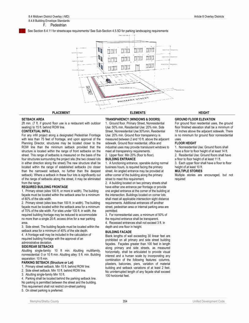
8.4 Midtown District Overlay (-MD) Article 8 Overlay Districts 8.4.8 Building Envelope Standards
Memphis/Shelby County 354 Unified Development Code
F. Pedestrian
See Section 8.4.11 for streetscape requirements/ See Sub-Section 4.5.5D for parking landscaping requirements
PLACEMENT ELEMENTS HEIGHT
SETBACK AREA 2ft min. (7 ft. if ground floor use is a restaurant with outdoor seating) to 15 ft. behind ROW line. CONTEXTUAL INFILL For any infill project along a designated Pedestrian Frontage with less than 75 feet of frontage, and upon approval of the Planning Director, structures may be located closer to the ROW line than the minimum setback provided that the structure is located within the range of front setbacks on the street. This range of setbacks is measured on the basis of the four structures surrounding the project site (the two closest lots in either direction along the street).The new structure shall be located within the range of established setbacks (no closer than the narrowest setback, no further than the deepest setback). Where a setback in these four lots is significantly out of the range of setbacks along the street, it may be eliminated from the range. REQUIRED BUILDING FRONTAGE 1. Primary street (sites 100 ft. or more in width). The building façade must be located within the setback area for a minimum of 80% of the site width. 2. Primary street (sites less than 100 ft. in width). The building façade must be located within the setback area for a minimum of 70% of the site width. For sites under 100 ft. in width, the required building frontage may be reduced to accommodate no more than a single 20-ft. access drive for a rear parking area. 3. Side street. The building façade must be located within the setback area for a minimum of 40% of the site depth. 4. A frontage wall may be included in the calculation of required building frontage with the approval of an administrative deviation. SIDE/REAR SETBACKS Abutting single-family: 10 ft min. Abutting multifamily, nonresidential: 0 or 10 ft min. Abutting alley: 5 ft. min. Building separation: 10 ft min. PARKING SETBACK (Structure or Lot) 1. Primary street setback. Min 15 ft. behind ROW line. 2. Side street setback. Min 10 ft. behind ROW line. 3. Abutting single-family Min 10 ft. 4. Parking shall be located behind the parking setback line. No parking is permitted between the street and the building. This requirement shall not restrict on-street parking 5. On street parking is preferred.
TRANSPARENCY (WINDOWS & DOORS) 1. Ground floor. Primary Street, Nonresidential Use: 50% min, Residential Use: 20% min. Side Street, Nonresidential Use:30%min, Residential Use: 20% min. Ground floor transparency is measured between 2 and 10 ft. above the adjacent sidewalk. Ground floor residential, office and industrial uses may provide translucent windows to meet all transparency requirements. 2. Upper floor. Min 20% (floor to floor). BUILDING ENTRANCE 1. A functioning entrance, operable during normal business hours, is required facing the primary street. An angled entrance may be provided at either corner of the building along the primary street to meet this requirement. 2. A building located on two primary streets shall have either one entrance per frontage or provide one angled entrance at the corner of the building at the intersection. Buildings located on corner lots shall meet all applicable intersection sight distance requirements. Additional entrances off another street, pedestrian area or internal parking area are permitted. 3. For nonresidential uses, a minimum of 50% of the required entrance shall be transparent. 4. Recessed entrances shall not exceed 3 ft. in depth and one floor in height.
BUILDING FACADE Blank lengths of wall exceeding 30 linear feet are prohibited on all primary and side street building façades. Façades greater than 100 feet in length along primary and side streets, as measured horizontally, shall be articulated to provide visual interest and a human scale by incorporating any combination of the following features: columns, pilasters, balconies, piers, variation of material building and setback variations of at least 2 feet. No uninterrupted length of any façade shall exceed 100 horizontal feet.
GROUND FLOOR ELEVATION For ground floor residential uses, the ground floor finished elevation shall be a minimum of 18 inches above the adjacent sidewalk. There is no minimum for ground floor nonresidential uses. FLOOR HEIGHT 1. Nonresidential Use: Ground floors shall have a floor to floor height of at least 14 ft. 2. Residential Use: Ground floors shall have a floor to floor height of at least 11 ft. 3. Each upper floor shall have a floor to floor height of at least 10 ft. MULTIPLE STORIES Multiple stories are encouraged, but not required
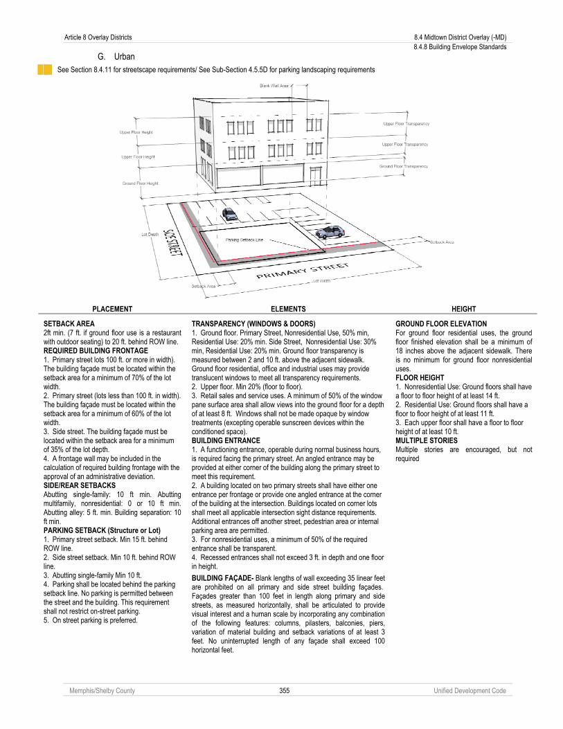
Article 8 Overlay Districts 8.4 Midtown District Overlay (-MD) 8.4.8 Building Envelope Standards
Memphis/Shelby County 355 Unified Development Code
G. Urban
See Section 8.4.11 for streetscape requirements/ See Sub-Section 4.5.5D for parking landscaping requirements
PLACEMENT ELEMENTS HEIGHT
SETBACK AREA 2ft min. (7 ft. if ground floor use is a restaurant with outdoor seating) to 20 ft. behind ROW line. REQUIRED BUILDING FRONTAGE 1. Primary street lots 100 ft. or more in width). The building façade must be located within the setback area for a minimum of 70% of the lot width. 2. Primary street (lots less than 100 ft. in width). The building façade must be located within the setback area for a minimum of 60% of the lot width. 3. Side street. The building façade must be located within the setback area for a minimum of 35% of the lot depth. 4. A frontage wall may be included in the calculation of required building frontage with the approval of an administrative deviation. SIDE/REAR SETBACKS Abutting single-family: 10 ft min. Abutting multifamily, nonresidential: 0 or 10 ft min. Abutting alley: 5 ft. min. Building separation: 10 ft min. PARKING SETBACK (Structure or Lot) 1. Primary street setback. Min 15 ft. behind ROW line. 2. Side street setback. Min 10 ft. behind ROW line. 3. Abutting single-family Min 10 ft. 4. Parking shall be located behind the parking setback line. No parking is permitted between the street and the building. This requirement shall not restrict on-street parking. 5. On street parking is preferred.
TRANSPARENCY (WINDOWS & DOORS) 1. Ground floor. Primary Street, Nonresidential Use, 50% min, Residential Use: 20% min. Side Street, Nonresidential Use: 30% min, Residential Use: 20% min. Ground floor transparency is measured between 2 and 10 ft. above the adjacent sidewalk. Ground floor residential, office and industrial uses may provide translucent windows to meet all transparency requirements. 2. Upper floor. Min 20% (floor to floor). 3. Retail sales and service uses. A minimum of 50% of the window pane surface area shall allow views into the ground floor for a depth of at least 8 ft. Windows shall not be made opaque by window treatments (excepting operable sunscreen devices within the conditioned space). BUILDING ENTRANCE 1. A functioning entrance, operable during normal business hours, is required facing the primary street. An angled entrance may be provided at either corner of the building along the primary street to meet this requirement. 2. A building located on two primary streets shall have either one entrance per frontage or provide one angled entrance at the corner of the building at the intersection. Buildings located on corner lots shall meet all applicable intersection sight distance requirements. Additional entrances off another street, pedestrian area or internal parking area are permitted. 3. For nonresidential uses, a minimum of 50% of the required entrance shall be transparent. 4. Recessed entrances shall not exceed 3 ft. in depth and one floor in height.
BUILDING FAÇADE- Blank lengths of wall exceeding 35 linear feet are prohibited on all primary and side street building façades. Façades greater than 100 feet in length along primary and side streets, as measured horizontally, shall be articulated to provide visual interest and a human scale by incorporating any combination of the following features: columns, pilasters, balconies, piers, variation of material building and setback variations of at least 3 feet. No uninterrupted length of any façade shall exceed 100 horizontal feet.
GROUND FLOOR ELEVATION For ground floor residential uses, the ground floor finished elevation shall be a minimum of 18 inches above the adjacent sidewalk. There is no minimum for ground floor nonresidential uses. FLOOR HEIGHT 1. Nonresidential Use: Ground floors shall have a floor to floor height of at least 14 ft. 2. Residential Use: Ground floors shall have a floor to floor height of at least 11 ft. 3. Each upper floor shall have a floor to floor height of at least 10 ft. MULTIPLE STORIES Multiple stories are encouraged, but not required

8.4 Midtown District Overlay (-MD) Article 8 Overlay Districts 8.4.8 Building Envelope Standards
Memphis/Shelby County 356 Unified Development Code
H. Transitional
See Section 8.4.11 for streetscape requirements/ See Sub-Section 4.5.5D for parking landscaping requirements
PLACEMENT ELEMENTS HEIGHT
SETBACK AREA 2ft min. (7 ft. if ground floor use is a restaurant with outdoor seating) to 65 ft. behind ROW line. REQUIRED BUILDING FRONTAGE 1. Primary street (sites 100 ft. or more in width). The building façade must be located within the setback area for a minimum of 60% of the site width. 2. Primary street (sites less than 100 ft. in width). The building façade must be located within the setback area for a minimum of 60% of the site width. 3. Side street. The building façade must be located within the setback area for a minimum of 30% of the site depth. 4. A frontage wall may be included in the calculation of required building frontage with the approval of an administrative deviation. SIDE/REAR SETBACKS Abutting single-family: 10 ft min. Abutting multifamily, nonresidential: 0 or 10 ft min. Abutting alley: 5 ft. min. Building separation: 10 ft min. PARKING SETBACK (Structure or Lot) 1. Primary/side street setback. Min 0 ft behind ROW line. 2. Abutting single-family Min 10 ft. 3. Parking shall be located behind the parking setback line. One row of parallel parking, a one-way drive aisle and angled parking may be located between the building and the street.
TRANSPARENCY (WINDOWS & DOORS) 1. Ground floor. Primary Street, Nonresidential: 50% min, Residential: 20% min. Side Street, Nonresidential: 30% min, Residential: 20% min. Ground floor transparency is measured between 2 and 10 ft. above the adjacent sidewalk. Ground floor residential, office and industrial uses may provide translucent windows to meet all transparency requirements. 2. Upper floor. Min 20% (floor to floor). 3. Retail sales and service uses. A minimum of 50% of the window pane surface area shall allow views into the ground floor for a depth of at least 8 ft. Windows shall not be made opaque by window treatments (excepting operable sunscreen devices within the conditioned space). BUILDING ENTRANCE 1. A functioning entrance, operable during normal business hours, is required facing the primary street. An angled entrance may be provided at either corner of the building along the primary street to meet this requirement. 2. A building located on two primary streets shall have either one entrance per frontage or provide one angled entrance at the corner of the building at the intersection. Buildings located on corner lots shall meet all applicable intersection sight distance requirements. Additional entrances off another street, pedestrian area or internal parking area are permitted. 3. For nonresidential uses, a minimum of 50% of the required entrance shall be transparent. 4. Recessed entrances shall not exceed 3 ft. in depth and one floor in height.
BUILDING FACADE Blank lengths of wall exceeding 35 linear feet are prohibited on all primary and side street building façades. Façades greater than 100 feet in length along primary and side streets, as measured horizontally, shall be articulated to provide visual interest and a human scale by incorporating any combination of the following features: columns, pilasters, balconies, piers, variation of material building and setback variations of at least 3 feet. No uninterrupted length of any façade shall exceed 100 horizontal feet.
GROUND FLOOR ELEVATION For ground floor residential uses, the ground floor finished elevation shall be a minimum of 18 inches above the adjacent sidewalk. There is no minimum for ground floor nonresidential uses. FLOOR HEIGHT 1. Nonresidential Use: Ground floors shall have a floor to floor height of at least 14 ft. 2. Residential Use: Ground floors shall have a floor to floor height of at least 11 ft. 3. Each upper floor shall have a floor to floor height of at least 9 ft. MULTIPLE STORIES Multiple stories are encouraged, but not required

Article 8 Overlay Districts 8.4 Midtown District Overlay (-MD) 8.4.8 Building Envelope Standards
Memphis/Shelby County 357 Unified Development Code
I. Commercial
See Section 8.4.11 for streetscape requirements/ See Sub-Section 4.5.5D for parking landscaping requirements
PLACEMENT ELEMENTS HEIGHT
SETBACK AREA 2ft min. (7 ft. if ground floor use is a restaurant with outdoor seating) to 86 ft. behind ROW line. REQUIRED BUILDING FRONTAGE 1. Primary street (sites 100 ft. or more in width). The building façade must be located within the setback area for a minimum of 50% of the site width. 2. Primary street (sites less than 100 ft. in width). The building façade must be located within the setback area for a minimum of 50% of the site width. 3. Side street. The building façade must be located within the setback area for a minimum of 25% of the side depth. 4. A frontage wall may be included in the calculation of required building frontage with the approval of an administrative deviation. SIDE/REAR SETBACKS Abutting single-family: 10 ft min. Abutting multifamily, nonresidential: 0 or 10 ft min. Abutting alley: 5 ft. min. Building separation: 10 ft min. PARKING SETBACK (Structure or Lot) 1. Primary/side street setback. Parallel Parking: Min 0 ft behind ROW line, Not Parallel Parking: Min 8 ft. behind ROW line. 2. Abutting single-family Min 10 ft. 3. Parking shall be located behind the parking setback line. A single drive aisle serving head-in parking spaces on one or both sides may be located between the building and the street.
TRANSPARENCY (WINDOWS & DOORS) 1. Ground floor. Primary Street, Nonresidential Use: 50% min, Residential Use: 20% min. Side Street, Nonresidential: 30% min, Residential: 20%. Ground floor transparency is measured between 2 and 10 ft. above the adjacent sidewalk. Ground floor residential, office and industrial uses may provide translucent windows to meet all transparency requirements. 2. Upper floor. Min 20% (floor to floor). 3. Retail sales and service uses. A minimum of 50% of the window pane surface area shall allow views into the ground floor for a depth of at least 8 ft. Windows shall not be made opaque by window treatments (excepting operable sunscreen devices within the conditioned space). BUILDING ENTRANCE 1. A functioning entrance, operable during normal business hours, is required facing the primary street. An angled entrance may be provided at either corner of the building along the primary street to meet this requirement. 2. A building located on two primary streets shall have either one entrance per frontage or provide one angled entrance at the corner of the building at the intersection. Buildings located on corner lots shall meet all applicable intersection sight distance requirements. Additional entrances off another street, pedestrian area or internal parking area are permitted. 3. For nonresidential uses, a minimum of 50% of the required entrance shall be transparent. 4. Recessed entrances shall not exceed 3 ft. in depth and one floor in height.
BUILDING FACADE Blank lengths of wall exceeding 35 linear feet are prohibited on all primary and side street building façades. Façades greater than 100 feet in length along primary and side streets, as measured horizontally, shall be articulated to provide visual interest and a human scale by incorporating any combination of the following features: columns, pilasters, balconies, piers, variation of material building and setback variations of at least 3 feet. No uninterrupted length of any façade shall exceed 100 horizontal feet.
GROUND FLOOR ELEVATION For ground floor residential uses, the ground floor finished elevation shall be a minimum of 18 inches above the adjacent sidewalk. There is no minimum for ground floor nonresidential uses. FLOOR HEIGHT 1. Nonresidential Use: Ground floors shall have a floor to floor height of at least 14ft. 2. Residential Use: Ground floors shall have a floor to floor height of at least 11 ft. 3. Each upper floor shall have a floor to floor height of at least 9 ft. MULTIPLE STORIES Multiple stories are encouraged, but not required

8.4 Midtown District Overlay (-MD) Article 8 Overlay Districts 8.4.8 Building Envelope Standards
Memphis/Shelby County 358 Unified Development Code
J. General
See Section 8.4.11 for streetscape requirements/ See Sub-Section 4.5.5D for parking landscaping requirements
PLACEMENT ELEMENTS HEIGHT
SETBACK AREA 2ft min. (7 ft. if ground floor use is a restaurant with outdoor seating) to 90 ft. behind ROW line. REQUIRED BUILDING FRONTAGE 1. Primary street (sites 100 ft. or more in width). The building façade must be located within the setback area for a minimum of 40% of the site width. 2. Primary street (sites less than 100 ft. in width). The building façade must be located within the setback area for a minimum of 40% of the site width. 3. Side street. The building façade must be located within the setback area for a minimum of 20% of the side depth. 4. A frontage wall may be included in the calculation of required building frontage with the approval of an administrative deviation. SIDE/REAR SETBACKS Abutting single-family: 10 ft min. Abutting multifamily, nonresidential: 0 or 10 ft min. Abutting alley: 5 ft. min. Building separation: 10 ft min. PARKING SETBACK (Structure or Lot) 1. Primary/side street setback. Parallel Parking: Min 0 ft behind ROW line, Not Parallel Parking: Min 8 ft. behind ROW line. 2. Abutting single-family Min 10 ft.
TRANSPARENCY (WINDOWS & DOORS) 1. Ground floor. Primary Street, Nonresidential Use: 50% min, Residential Use: 20% min. Side Street, Nonresidential: 30% min, Residential: 20% min Ground floor transparency is measured between 2 and 10 ft. above the adjacent sidewalk. Ground floor residential, office and industrial uses may provide translucent windows to meet all transparency requirements. 2. Upper floor. Min 20% (floor to floor). 3. Retail sales and service uses. A minimum of 50% of the window pane surface area shall allow views into the ground floor for a depth of at least 8 ft. Windows shall not be made opaque by window treatments (excepting operable sunscreen devices within the conditioned space). BUILDING ENTRANCE 1. A functioning entrance, operable during normal business hours, is required facing the primary street. An angled entrance may be provided at either corner of the building along the primary street to meet this requirement. 2. A building located on two primary streets shall have either one entrance per frontage or provide one angled entrance at the corner of the building at the intersection. Buildings located on corner lots shall meet all applicable intersection sight distance requirements. Additional entrances off another street, pedestrian area or internal parking area are permitted. 3. For nonresidential use, a minimum of 50% of the required entrance shall be transparent. 4. Recessed entrances shall not exceed 3 ft. in depth and one floor in height.
BUILDING FACADE Blank lengths of wall exceeding 35 linear feet are prohibited on all primary and side street building façades. Façades greater than 100 feet in length along primary and side streets, as measured horizontally, shall be articulated to provide visual interest and a human scale by incorporating any combination of the following features: columns, pilasters, balconies, piers, variation of material building and setback variations of at least 3 feet. No uninterrupted length of any façade shall exceed 100 horizontal feet.
GROUND FLOOR ELEVATION For ground floor residential uses, the ground floor finished elevation shall be a minimum of 18 inches above the adjacent sidewalk. There is no minimum for ground floor nonresidential uses. FLOOR HEIGHT 1. Nonresidential Use: Ground floors shall have a floor to floor height of at least 14 ft. 2. Residential Use: Ground floors shall have a floor to floor height of at least 11 ft. 3. Each upper floor shall have a floor to floor height of at least 9 ft. MULTIPLE STORIES Multiple stories are encouraged, but not required
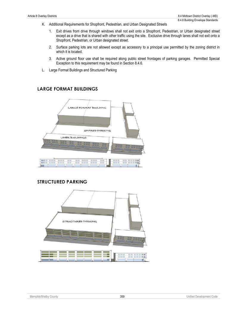
Article 8 Overlay Districts 8.4 Midtown District Overlay (-MD) 8.4.8 Building Envelope Standards
Memphis/Shelby County 359 Unified Development Code
K. Additional Requirements for Shopfront, Pedestrian, and Urban Designated Streets
1. Exit drives from drive through windows shall not exit onto a Shopfront, Pedestrian, or Urban designated street except as a drive that is shared with other traffic using the site. Exclusive drive through lanes shall not exit onto a Shopfront, Pedestrian, or Urban designated street.
2. Surface parking lots are not allowed except as accessory to a principal use permitted by the zoning district in which it is located.
3. Active ground floor use shall be required along public street frontages of parking garages. Permitted Special Exception to this requirement may be found in Section 8.4.6.
L. Large Format Buildings and Structured Parking
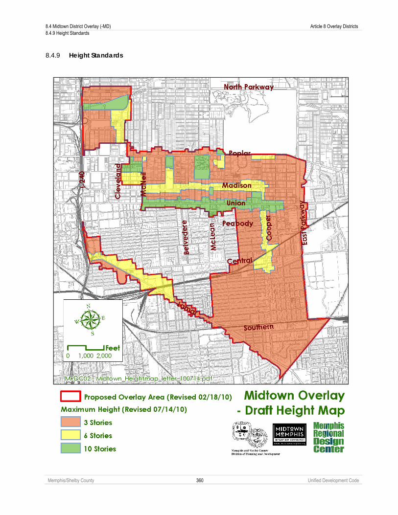
8.4 Midtown District Overlay (-MD) Article 8 Overlay Districts 8.4.9 Height Standards
Memphis/Shelby County 360 Unified Development Code
8.4.9 Height Standards

Article 8 Overlay Districts 8.4 Midtown District Overlay (-MD) 8.4.10 Site Development Standards
Memphis/Shelby County 361 Unified Development Code
A. Bulk Plane
B. Articulated Base
An appropriate pedestrian scaled articulated base is required for 6-10 story buildings.
8.4.10 Site Development Standards A. Applicability
The following supplemental site development standards apply in all non-single family residential districts within the Midtown District Overlay

8.4 Midtown District Overlay (-MD) Article 8 Overlay Districts 8.4.10 Site Development Standards
Memphis/Shelby County 362 Unified Development Code
B. Minimum Building Standards
1. Mobile buildings are only allowed on active construction sites.
2. Metal sided buildings are not allowed on commercial sites.
3. Concrete Masonry Units shall only be used when combined with other masonry.
4. Exterior Insulating Finishing Systems (EIFS) shall be used for decorative elements only where used in the lower 2 stories of a building.
5. Tilt-up Precast-concrete buildings are not allowed on commercial sites.
6. Aluminum and vinyl siding are not allowed on commercial buildings.
7. Stacks, vents, and other protrusions through roofs of commercial buildings shall be painted to limit visibility.
8. Mechanical equipment on roofs shall be screened from view.
9. See Section 8.4.5 for administrative deviations of Minimum Building Standards.
C. Landscaping and Screening
1. Any building, structure or use is subject to the landscaping requirements of Chapter 4.6.
2. Trash collection, trash compaction, recycling collection and other similar service areas shall be located on the side or rear of the building and shall be screened from view from residentially zoned property or public rights-of-way. Screening enclosures shall be fully enclosed by opaque walls or fences at least eight feet high with self-closing access doors and shall be constructed of compatible materials to the primary building or buildings.
3. No garage doors, bay doors or loading areas shall face a Shopfront, Pedestrian, or Urban Frontage.
4. Loading areas shall be subject to the following screening requirements:
a. Provide a minimum 100 percent year round screen of all loading areas visible from residentially zoned property or public right-of-way.
b. This screen shall consist of berms, walls, fences, plant material or combination totaling eight feet in height at installation or completion of construction. Wall or Fence materials shall be compatible with the primary structure.
c. Loading docks shall be located to the side or rear of buildings when within 50 feet of any residentially zoned property line.
5. All roof, ground and wall mounted mechanical equipment (e.g. air handling equipment, compressors, duct work, transformers and elevator equipment) shall be screened from view from residential properties or public rights-of-way at ground level of the property line.
6. Roof-mounted mechanical equipment shall be shielded from view on all sides. Screening shall consist of materials consistent with the primary building materials, and may include metal screening or louvers which are painted to blend with the primary structure.
7. Wall or ground mounted equipment screening shall be constructed of planting screens, brick stone, reinforced concrete, or other compatible masonry materials; or other similar materials.
8. Above ground utilities and appurtenances to underground utilities required by the development which require above ground installation shall be screened by a continuous planting of shrubs, with a minimum mature height equal to that of the utility structure. Required accessways to these utilities are exempt from the screening provisions.

Article 8 Overlay Districts 8.4 Midtown District Overlay (-MD) 8.4.11 Streetscape Plates
Memphis/Shelby County 363 Unified Development Code
D. Fences and Walls
1. Fences and walls shall be constructed of high quality materials, such as wood, decorative blocks, brick, stone and wrought iron.
2. Chain link fences, barbed wire or concertina wire shall not be permitted except on active construction sites. Fences must be removed after construction is complete.
3. Breaks in the fence or wall may be allowed for pedestrian connections to adjacent developments.
4. The maximum length of a continuous, unbroken and uninterrupted fence or wall plane shall be 100 feet. Breaks shall be provided through the use of columns, landscaped areas, transparent sections and a change in material.
5. Fences shall not be constructed in the sight triangle. See Section 4.4.7 Clear Site Triangle for description.
E. Drive-Through Facilities
1. A drive-through window shall only be permitted where it is not facing the public right-of-way of a Shopfront or Urban Frontage.
2. Drive through windows and lanes placed between the right-of-way and the associated building shall require landscape plantings installed and maintained along the entire length of the drive-through lane and the adjacent right-of-way. Such screening shall be a compact evergreen hedge or other type of dense foliage. At the time of installation, such screening shall be at least 36 inches in height and shall reach a height of 48 inches within two years of planting.
3. No drive-through window or drive-through speaker shall be permitted on the side of a building adjacent to any residentially zoned property.
8.4.11 Streetscape Plates The following streetscape plates shall apply to development subject to the provisions of the Midtown District Overlay. See Section 4.3.3 to determine the appropriate streetscape plate for each zoning district and designated frontage in the Midtown District Overlay. See Section 4.3.4 for eligible exceptions to the following streetscape plates.
Type S-1

8.4 Midtown District Overlay (-MD) Article 8 Overlay Districts 8.4.11 Streetscape Plates
Memphis/Shelby County 364 Unified Development Code
Type S-2

Article 8 Overlay Districts 8.4 Midtown District Overlay (-MD) 8.4.11 Streetscape Plates
Memphis/Shelby County 365 Unified Development Code
Type S-3
Type S-4

8.4 Midtown District Overlay (-MD) Article 8 Overlay Districts 8.4.11 Streetscape Plates
Memphis/Shelby County 366 Unified Development Code
Type S-5
Type S-6

Article 8 Overlay Districts 8.4 Midtown District Overlay (-MD) 8.4.11 Streetscape Plates
Memphis/Shelby County 367 Unified Development Code
Type S-7

8.4 Midtown District Overlay (-MD) Article 8 Overlay Districts 8.4.11 Streetscape Plates
Memphis/Shelby County 368 Unified Development Code
Type S-8
Type S-9

Article 8 Overlay Districts 8.4 Midtown District Overlay (-MD) 8.4.11 Streetscape Plates
Memphis/Shelby County 369 Unified Development Code
Type S-10
Type S-11

8.4 Midtown District Overlay (-MD) Article 8 Overlay Districts 8.4.11 Streetscape Plates
Memphis/Shelby County 370 Unified Development Code
Type S-12
Type S-13

Article 8 Overlay Districts 8.4 Midtown District Overlay (-MD) 8.4.11 Streetscape Plates
Memphis/Shelby County 371 Unified Development Code
Type S-14
Type S-15

8.5 Residential Corridor Overlay District (-RC) Article 8 Overlay Districts 8.5.1 Purpose
Memphis/Shelby County 372 Unified Development Code
8.5 RESIDENTIAL CORRIDOR OVERLAY DISTRICT (-RC)
8.5.1 Purpose A Residential Corridor Overlay District (-RC) serves as an additional layer of land use control that prohibits approval of nonresidential development (with the exception of certain civic and institutional uses) within 200 feet on either side of a designated roadway. This designation is intended to provide protection against encroachment of nonresidential uses along a designated Residential Corridor.
8.5.2 Overlay Restrictions A. All land fronting a designated Residential Corridor, for a depth of 200 feet, shall not be eligible for rezoning to a
nonresidential district nor shall such land be eligible for a change in use from a residential use to a nonresidential use. Certain civic and institutional uses may be permitted through the special use process (see 9.6).
B. All land fronting the designated Residential Corridor, for a depth of 200 feet, shall not be eligible for rezoning to a mixed use or nonresidential district or shall such land be eligible for a change in use from a residential use to a nonresidential use. Certain civic and institutional uses may be permitted through the special use process (see 9.6).
C. Rezoning to OG, CMU-1, CMU-2, CMU-3, CBD, CMP-1, CMP-2, EMP, WD, or IH shall be specifically prohibited and no special permits for uses other than those outlined above shall be considered.
D. Nonconforming uses along a designated Residential Corridor shall be subject to the provisions of Article 10, Nonconformities.
E. The preferred housing type adjacent to a designated Residential Corridor is a single-family detached structure, or, where appropriate, a large home.
8.5.3 Criteria for Designation Any street or section of street in order to be eligible for consideration as a Residential Corridor shall meet the following minimum standards: A. Classified as an arterial or as a major connector on the MPO Long Range Transportation Plan. B. Contain three blocks on either side or have 2,000 feet of continuous frontage on both sides. C. Have no more than five percent of the street frontage zoned and/or developed for office, commercial or industrial
purposes. D. For the purpose of this Chapter, a block is defined as the area abutting an arterial or a connector as set forth above;
which area is intersected at two points by a public street or freeway, a railroad right-of-way, corporate limit or power transmission line right-of-way easement purchased by the light, gas and water division or a drainage way with an existing channel width of at least 50 feet, provided that alleys shall not be defined as a block boundary.
8.5.4 Establishment of Specific Residential Corridors The following sections of street are hereby designated as Residential Corridors and are subject to the provisions of this Chapter:
Belvedere Boulevard Alley one-half block south of Union Avenue to Central Avenue Central Avenue Lamar Avenue to the L&N Railroad
IC Railroad to Ellsworth Street Highland Street to Goodlett Street
Coleman Road Raleigh-LaGrange to Yale Road East Parkway North Parkway to Young Avenue
Cooper Street to Lamar Avenue Elvis Presley Boulevard 654 feet south of Shelby Drive to Holmes Road Goodlett Street Graham Street to Park Avenue Graham Street Goodlett Street to Macon Road Holmes Road Elvis Presley to Millbranch Road Jackson Avenue Evergreen to Trezevant James Road Overton Crossing to Woodland Hills Cove
Birchfield Drive to Scenic Highway Highland Street to Water Street (except that portion from the west right-of-way line of Birchfield Drive to the west right-of-way line of the Illinois Central Gulf Railroad for a distance of approximately 1,115 feet)
McLean Street North Parkway to Poplar Avenue

Article 8 Overlay Districts 8.5 Residential Corridor Overlay District (-RC) 8.5.5 Procedure for Classification
Memphis/Shelby County 373 Unified Development Code
North Parkway Dunlap Street to East Parkway Park Avenue Goodlett Street to Mount Moriah Road (with the exception of
segment of the Park Avenue residential corridor beginning at a point +/– 429 feet west of Mount Moriah Road and extending westward a distance of 275 feet to a point 704 feet west of Mount Moriah Road
Peabody Avenue Cleveland Street to Cooper Street Perkins Street Park Avenue to Southern Avenue Poplar Avenue Rembert Street to East Parkway
Highland Street to West Cherry Circle Quince Road Lynnfield Street to the city limits Scenic Highway James Road to Highland Street South Parkway Elvis Presley Boulevard to Lamar Avenue
Cooper Street to Airways Road Stage Road Tena Drive to Bluefield Street Trezevant Street Jackson Avenue to North Parkway Walnut Grove Road Holmes Street to Brierview White Station Road Pelham Circle north to I-240
8.5.5 Procedure for Classification A. Through the rezoning process (see Chapter 9.5), any resident in the City of Memphis or unincorporated portion of
Shelby County may file an application, accompanied by a fee approved by the Memphis City Council and Shelby County Board of Commissioners, with Planning Director requesting that a street or section of a street be designated as a Residential Corridor or a previously designated segment he deleted.
B. The deletion of a street or segment of a street that has been designated as a Residential Corridor shall require a 2/3 vote of the governing bodies.
8.5.6 Administration Streets or sections of street designated as Residential Corridors shall be subject to periodic review as deemed necessary by the Planning Director.

8.6 Historic Overlay District Article 8 Overlay Districts 8.6.1 General Provisions
Memphis/Shelby County 374 Unified Development Code
8.6 HISTORIC OVERLAY DISTRICT
8.6.1 General Provisions A. Purpose
1. The Historic Overlay District (-H) is intended to protect and conserve the heritage and character of the community by providing for the preservation of designated areas, including individual properties that embody important elements of social, economic, political, or architectural history, and by promoting the stabilization and enhancement of property values throughout such areas.
2. It is intended that this development code ensure that buildings or structures in a Historic Overlay District are in harmony with other buildings or structures located within the District. However, it is not the intention of this development code to require the reconstruction or restoration of individual or original buildings, or to prohibit the demolition or removal of such buildings, or to impose architectural styles from particular historic periods, but rather to encourage design, which is harmonious with the character of the area.
B. District Established The Historic Overlay District (-H) is hereby established. All adopted Historic Overlay Districts are shown on the Zoning Map (see Chapter 2.4). In a designated Historic Overlay District, no building, structure, or site shall be constructed, altered, repaired, relocated or demolished unless the action meets with the requirements set forth in this development code for compliance with the Design Review Guidelines adopted for the District for issuance of a Certificate of Appropriateness.
C. Certificate of Appropriateness Required If a property owner within a Historic Overlay District seeks a building permit for exterior work, the owner must receive a Certificate of Appropriateness from the Landmarks Commission for such work (see Section 8.6.3, Certificate of Appropriateness).
8.6.2 Historic Overlay (-H) District Designation A. General Purposes
The following provisions are established in order that appropriate measures may be taken to ensure preservation of structures of historic value to the City of Memphis or Shelby County pursuant to the authority contained in Section 13-7-401 of the Tennessee Code. The general intent includes the following specific purposes:
1. To promote the educational and cultural welfare of the people of the City of Memphis or Shelby County; 2. To preserve and protect the historic and architectural value of significant resources; 3. To insure compatibility and to create an aesthetic atmosphere within a Historic Overlay District; 4. To foster civic beauty and community pride; 5. To stabilize and improve property values and to strengthen the local economy; 6. To enhance the City’s or County’s attractions to tourists and visitors and the support and stimulus to business and
industry thereby provided.
B. Pre-Application Conference An applicant shall schedule a pre-application conference in accordance with Section 9.3.1.
C. Application Requirements 1. An application for a Historic Overlay District zoning change shall be submitted in accordance with Section 9.3.3,
Application Requirements. 2. The Planning Director has established specific submittal requirements for a Historic Overlay District zoning change
(see Application for requirements).
D. Designation 1. The Landmarks Commission (see also Section 9.1.4) shall review applications regarding a Historic Overlay District.
A public hearing shall be held and notice given in accordance with Section 9.3.4, Public Hearings and Notification. 2. The Landmarks Commission shall furnish to the Land Use Control Board in writing, its recommendations regarding
the application for a Historic Overlay District zoning change). 3. The governing bodies shall review and consider the recommendations of the Landmarks Commission and the Land
Use Control Board prior to the establishment of a Historic Overlay District (see also Chapter 9.5, Zoning Change).

Article 8 Overlay Districts 8.6 Historic Overlay District 8.6.3 Certificate of Appropriateness
Memphis/Shelby County 375 Unified Development Code
E. Criteria for Designation Any use permitted in the underlying zoning district shall also be permitted in a Historic Overlay District. In addition to the zoning change criteria (see Chapter 9.5, Zoning Change), an application for a Historic Overlay District zoning change shall meet one or more of the following criteria, in that they are:
1. Associated with events which have made a significant contribution to local, state or national history; or 2. Associated with persons significant in our past; or 3. Comprised of structures or groups of structures that embody the distinctive characteristics of a type, period, or method
of construction; or that represent the work of a master or possess high artistic values; or that represent a significant and distinguishable entity whose components may lack individual distinction; or
4. Likely to yield archaeological information; or 5. Listed in the National Register of Historic Places.
F. Adoption of Design Review Guidelines 1. Prior to the establishment of any Historic Overlay District, the Landmarks Commission shall adopt a set of design
review guidelines, which it will apply in ruling upon the granting or denial of a Certificate of Appropriateness (see Section 8.6.3). Such design review guidelines shall be consistent with the purposes of this development code and with regulations and standards adopted by the Secretary of the Interior pursuant to the National Historic Preservation Act of 1966, as amended.
2. Reasonable public notice and opportunity for public comment, by public hearing or otherwise, shall be required before the adoption of any such design review guidelines.
3. Historic Multi-Family Properties. The Landmarks Commission shall have the authority to designate certain two-family, three-family and multi-family properties within any Historic Overlay District as Historic Multi-Family Properties, which shall be identified as those properties that were historically constructed for a particular use, but which the underlying zoning district no longer permits. Once the Landmarks Commission designates a property as a Historic Multi-Family Property, it shall not be defined as a nonconforming use, and Article 10 of this Code shall not apply.
8.6.3 Certificate of Appropriateness A. Applicability
1. The Building Official shall not issue any building or other permit in a Historic Overlay District for the construction, alteration, demolition or relocation of a building, object, structure or site within a Historic Overlay District unless a Certificate of Appropriateness has been issued.
2. The Landmarks Commission (see also Section 9.1.4) is authorized to review the construction, alteration, relocation or demolition of any building, structure, object or site, whether privately or publicly owned, which is located in a Historic Overlay District, and for which a building permit is not required, except work undertaken for the purpose of ordinary repair and maintenance.
3. Failure of a property owner or the holder of a building or other permit to construct, demolish, alter or relocate a building or any property in accordance with the requirements of the Certificate of Appropriateness shall constitute a violation of this development code.
B. Pre-Application Conference An applicant shall schedule a pre-application conference in accordance with Section 9.3.1.
C. Application Requirements 1. An application for a Certificate of Appropriateness shall be submitted in accordance with Section 9.3.3, Application
Requirements. 2. The Planning Director has established specific submittal requirements for a Certificate of Appropriateness (see
Application for requirements).
D. Landmarks Commission Action 1. The Landmarks Commission shall make a decision on the appropriateness of the proposed development within 30
days after the application has been determined complete and within ten days shall issue or deny the Certificate of Appropriateness, stating approval with or without attached conditions or disapproval with the grounds for disapproval stated in writing.

8.6 Historic Overlay District Article 8 Overlay Districts 8.6.3 Certificate of Appropriateness
Memphis/Shelby County 376 Unified Development Code
2. In the event of a determination to deny a Certificate of Appropriateness, the Landmarks Commission shall request consultation with the applicant for a period not to exceed 60 days for the purpose of considering modifications to the application in keeping with the determination criteria. If at the end of that time an acceptable solution has not been achieved, the Certificate of Appropriateness shall be denied. No subsequent application which is substantially the same shall be accepted for at least six months from the date of the final action.
E. Certificates of Appropriateness Determination 1. It shall be the duty of the Landmarks Commission to make the following determinations with respect to any Historic
Overlay District when application is made for a Certificate of Appropriateness, or whenever any such determination is deemed necessary by the Landmarks Commission.
a. Appropriateness of altering, constructing, moving or demolishing any building, structure or object within a Historic Overlay District.
b. Appropriateness of exterior architectural features, including signs and other exterior fixtures. c. Appropriateness of exterior design of any new addition on any existing building or structure. d. Appropriateness of front yard, side yards, off-street parking spaces, location of entrance drives into the
property, of sidewalks along the public right-of-way. e. Appropriateness of the general exterior design, arrangement, texture of material of the building or other
structure in question and the relation of such factors to similar features of buildings in the immediate surroundings, however, the Landmarks Commission shall not consider work undertaken for the purpose of ordinary repair and maintenance, nor shall it consider interior design or arrangement.
2. Upon review of the application for a building permit, the Landmarks Commission shall give prime consideration to: a. Historical or architectural value of the present structure. b. The relationship of the exterior architectural features of such structure to the rest of the structure in the
surrounding area. c. The compatibility of exterior design, arrangement, texture and materials proposed to be used. d. To any other factor, including aesthetic, which is deemed pertinent.
F. Application for Removal or Demolition An application for removal or demolition shall be considered, taking into account, economic hardship. The Landmarks Commission may, after reasonable notice, set an application for public hearing and may consider any or all of the following:
1. Estimate of the cost of the proposed redevelopment, alteration, demolition or removal and an estimate of any additional cost that would be incurred to comply with the recommendations of the Commission for changes necessary for the issuance of a Certificate of Appropriateness.
2. A report from a licensed engineer or architect with experience in rehabilitation as to the structural soundness of any structures on the property and their suitability for rehabilitation.
3. Estimated market value of the property in its current condition; after completion of the proposed redevelopment, alteration, demolition, or removal; after any changes recommended by the Landmarks Commission; and in the case of a proposed demolition, after renovation of the existing property for continued use.
4. In the case of a proposed demolition, an estimate from an architect, developer, real estate consultant, appraiser or other real estate professional experienced in rehabilitation as to the economic feasibility of rehabilitation or reuse of the existing structure on the property.
5. Amount paid for the property, the date of purchase and the party from whom purchased, including a description of the relationship, if any between the owner of record or Applicant, and the person from whom the property was purchased and any terms of financing between the seller and buyer.
6. If the property is income-producing, the annual gross income from the property for the previous two years; itemized operating and maintenance expenses for the previous two years; and depreciation deductions and annual cash flow before and after debt service, if any, during the same period.
7. Any other information considered necessary by the Landmarks Commission to make a determination as to whether the property does yield or may yield a reasonable return to the owners. Request for consideration shall be taken up at public hearing with reasonable notice and consideration given to any or all of the factors listed above.
G. Enforcement 1. To monitor work in a Historic Overlay District, the Landmarks Commission staff will conduct routine surveys to insure
that work in progress is undertaken and completed in compliance with the Certificate of Appropriateness and to see that the work is not undertaken without permits. If the Landmarks Commission finds that work undertaken is not done

Article 8 Overlay Districts 8.6 Historic Overlay District 8.6.4 Demolition by Neglect
Memphis/Shelby County 377 Unified Development Code
in accordance with the requirements for the Certificate of Appropriateness, it shall notify the owner of record in the following manner:
a. By certified mail to the last known address of the applicant or owner of record; or b. By telephone.
2. If within seven days, action is not undertaken by the owner to meet the requirements of the Certificate of Appropriateness, the Landmarks Commission may determine that noncompliance has occurred. The Landmarks Commission shall notify the Building Official of any such noncompliance. A Stop Work Order may be issued by the Building Official that all exterior work must stop until the order is lifted.
H. Use of Property Nothing in this development code shall be interpreted as giving the Landmarks Commission any authority to consider, review, examine or control the use of property classified as a Historic Overlay District. Use shall be controlled solely by the zoning controlling such property prior to its classification as a Historic Overlay District as may be rezoned by subsequent amendments.
I. Violation and Penalty 1. Where an alteration is undertaken without issuance of a Certificate of Appropriateness, the owner shall be required to
return the property, in as much is reasonably possible, to its state prior to the alteration, or as determined appropriate by the Landmarks Commission based upon the Design Review Guidelines.
2. In addition to the party determined to be in violation of this development code, any other person who may have knowingly assisted in the commission for any such violation shall be guilty of a separate offense.
8.6.4 Demolition by Neglect A. Applicability
For the purpose of this Chapter, demolition shall include the slow deterioration of a structure due to improper maintenance. Owners of certain historic properties are required to maintain their properties and not allow them to fall into disrepair. The requirements of this Chapter are applicable only to certain properties, termed "historic properties" in this Chapter. That term as used in this Chapter is defined to include designated historic landmarks and properties identified as "contributing" or "pivotal" in a designated Historic Overlay District. Nothing in this Section shall be construed to override the provisions of Section 8.4.3 requiring a Certificate of Appropriateness prior to any demolition within a Historic Overlay District.
B. Conditions of Neglect Defined and Prohibited Owners shall maintain or cause to be maintained the exterior and structural features of their historic properties and not allow conditions of neglect to occur on such properties. Conditions of neglect are as defined below. It shall be a violation of this development code to not remedy a condition of neglect within the period of time set. Conditions of neglect include the following:
1. Deterioration of exterior walls, foundations, or other vertical support that causes leaning, sagging, splitting, listing, or buckling.
2. Deterioration of flooring or floor supports, roofs, or other horizontal members that causes leaning, sagging, splitting, listing, or buckling.
3. Deterioration of external chimneys that causes leaning, sagging, splitting, listing, or buckling. 4. Deterioration or crumbling of exterior plasters or mortars. 5. Ineffective waterproofing of exterior walls, roofs, and foundations, including broken windows or doors. 6. Defective protection or lack of weather protection for exterior wall and roof coverings, including lack of paint, or
weathering due to lack of paint or other protective covering. 7. Rotting, holes, and other forms of decay. 8. Deterioration of exterior stairs, porches, handrails, window and door frames, cornices, entablatures, wall facings, and
architectural details that causes de-lamination, instability, loss of shape and form, or crumbling. 9. Heaving, subsidence, or cracking of sidewalks, steps, or pathways. 10. Deterioration of fences, gates, and accessory structures. 11. Deterioration that has a detrimental effect on the surrounding Historic Overlay District, or on the special character of
the historic landmark. 12. Deterioration that contributes to a hazardous or unsafe condition.
8.6 Historic Overlay District Article 8 Overlay Districts 8.6.4 Demolition by Neglect
Memphis/Shelby County 378 Unified Development Code
C. Initiation by Petition The initial determination that there is a condition of neglect shall be made by the Planning Director, after an investigation that is initiated by a petition from any person who is familiar with the subject property, which may include but not be limited to a City/County employee.
D. Notice of Investigation On receipt of a petition, the Planning Director shall notify the owners in writing of the allegation and the process for making a decision regarding the petition, including any applicable deadlines. Among other things, the notice shall offer the owner the opportunity to meet in person with the Planning Director and to present any relevant information. Notice shall be delivered by personal service, or by certified mail, return receipt requested. If certified mail is refused or unclaimed, notice may be delivered by first class mail, and shall be considered effective if such mail is not returned by the post office within 15 days of mailing. In the case of notice by first class mail, notice shall also be posted on the property. Notice of the investigation may also be given to the owners of nearby or adjacent properties or neighborhood associations.
E. Responsibilities of Planning Director The Planning Director shall:
1. Investigate the allegation that a condition of neglect exists; 2. Hold one or more meetings in which the owner, other persons who have received notice, or other interested persons
may give information; 3. Issue a written determination, supported by findings of fact, regarding the allegation within 45 days of the owner's
receipt of notice; 4. Include within the determination a time period for correcting the condition of neglect, if a condition of neglect has been
found; 5. Retain all information presented by the owner or other persons; 6. Deliver the written determination through any of the means for delivery of notice, as described above; 7. Designate the written determination as a final administrative determination with the right of appeal to the Landmarks
Commission; and 8. Include information regarding rights to a de novo hearing before the Landmarks Commission.
F. Suspension of Process The demolition by neglect process initiated under the requirements of this development code may be suspended in the event the owner agrees in writing to correct the alleged condition of neglect within a time period determined to be reasonable by the Planning Director. If the condition is not corrected within that time period, the process shall continue where it was suspended.
G. Appeal of Planning Director Decision 1. If the property owner disagrees with the Planning Director’s determination, the owner may appeal and may request a
hearing before the Landmarks Commission. 2. The request shall be delivered to the Planning Director, in writing, within 30 days of receipt of the Planning Director’s
determination. 3. The Landmarks Commission shall hold a hearing on the issue of whether demolition by neglect is occurring on the
property. 4. The Landmarks Commission’s written decision shall include findings of fact and conclusions regarding demolition by
neglect consistent with this Chapter. It shall be delivered to the appealing party by certified mail, return receipt requested.
5. Appeals from any decision of the Landmarks Commission may be taken in accordance with Section 9.23.3 of this Development Code. If the decision is not appealed it shall be considered a final decision subject to enforcement with no rights of appeal.
H. Safeguards from Undue Economic Hardship
1. Right of Claim of Economic Hardship The property owner is entitled to make a claim of undue economic hardship if the owner is unable to make needed repairs to the property because it is economically unfeasible.

Article 8 Overlay Districts 8.6 Historic Overlay District 8.6.4 Demolition by Neglect
Memphis/Shelby County 379 Unified Development Code
2. Issuance of Stay for Economic Hardship In the event that the owner or other parties in interest do not wish to contest the determination regarding the condition of neglect, but do wish to petition for a claim of undue economic hardship, the Planning Director’s order shall be stayed until after the Landmarks Commission's determination regarding the claim.
3. Process If a claim of undue economic hardship is made, the Planning Director shall receive all information from the property owners that the Landmarks Commission is entitled to receive pursuant to this development code, make a determination regarding whether there is undue economic hardship, and develop a plan for dealing with such hardship, if it is found to exist. The recommendation and plan shall be sent to the owner, certified mail, return receipt requested, with notice of the owner’s rights to appeal to the Landmarks Commission within 30 days of receipt. If the owner disagrees with the recommendation and plan the owner may request a hearing before the Landmarks Commission.
4. Evidence Regarding Undue Economic Hardship When a claim of undue economic hardship is made owing to the effects of this Chapter, the owner or parties in interest shall, where reasonably possible, provide the evidence below, describing the circumstances of hardship, and any additional evidence requested by the Planning Director or Landmarks Commission or evidence the owner considers relevant.
a. Nature of ownership (individual, business, or nonprofit) or legal possession, custody, and control. b. Financial resources of the owner and/or parties in interest. c. Cost of repairs. d. Assessed value of the land and improvements. e. Real estate taxes for the previous two years. f. Amount paid for the property, date of purchase, and party from whom purchased, including a description of
the relationship between the owner and the person from whom the property was purchased, or other means of acquisition of title, such as by gift or inheritance.
g. Annual debt service, if any, for previous two years. h. Any listing of the property for sale or rent, price asked, and offers received, if any. i. Annual gross income, if any, from the property for the previous two years. j. Itemized operating and maintenance expenses for the previous two years, including proof that adequate and
competent management procedures were followed. k. Annual cash flow, if any, for the previous two years.
I. Powers and Election of Remedies Nothing contained within this Chapter shall diminish the City/County’s power to declare a building unsafe or in violation of the minimum building code or any other applicable statute or code. In addition, the procedures described herein are mandatory only for determinations being made solely under the authority of this Chapter. Where other sections of the City/County Code apply, the City/County may, in its discretion, choose to process any action regarding the property under such other provisions alone, or under such provisions along with these provisions concurrently, or solely under these provisions. The City/County may also suspend the procedures of this Chapter at any time if an action has been initiated under other applicable law.
J. Penalties and Remedies Enforcement of this Chapter may be by any one or more of the following methods, and the institution of any action under any of these methods shall not relieve any party from any other civil or criminal proceeding prescribed for violations and prohibitions.
1. Equitable Remedy The City/County may apply for any appropriate equitable remedy to enforce the provisions of this Chapter.
2. Order of Abatement The City/County may apply for and the court may enter an order of abatement. An order of abatement may direct that improvements or repairs be made, or that any other action be taken that is necessary to bring the property into compliance with this Chapter. Whenever the party is cited for contempt by the court and the City/County has executed the order of abatement, the City/County shall have a lien on the property for the cost of executing the order of abatement.

8.7 Airport Overlay District (-AP) Article 8 Overlay Districts 8.7.1 Applicability
Memphis/Shelby County 380 Unified Development Code
K. Civil Penalty Civil penalties may be assessed for failure to comply with a final administrative determination or an un-appealed Landmarks Commission decision under the provisions and guidelines for assessing such penalties for violations of this development code. Prior to imposing a civil penalty the Planning Director shall deliver a written notice by personal service or by registered mail or by certified mail, return receipt requested, to the person responsible for the violation indicating the nature of the violation and ordering corrective action. Where the violation is the failure to remedy a condition of neglect within the time periods provided by the Planning Director or the Landmarks Commission no additional time period for compliance need be given. The notice shall include information regarding the possible assessment of civil penalties and other possible enforcement actions.
8.7 AIRPORT OVERLAY DISTRICT (-AP)
8.7.1 Applicability Properties subject to the Airport Overlay District (-AP) provisions and the specific height controls encumbering those properties shall be referenced on maps maintained and periodically updated by the Airport Authority. In cases of discrepancy, the specific Airport Overlay District boundaries depicted on maps maintained by the Airport Authority shall take precedence over generalized boundaries referenced on the Zoning Map. Within the Airport Overlay District, the maximum permitted height of structures shall be as prescribed by the Airport Authority.
8.7.2 General Provisions The maximum height of all structures within the Airport Overlay District shall be regulated in order to prevent obstructions to aircraft navigation associated with the Memphis International Airport (MEM), Millington Regional Jetport (NQA), DeWitt Spain Airport (M01), Charles Baker Airport (2M8) and Olive Branch Airport (OLV), thus protecting the health, safety and general welfare of the traveling public and this community. The provisions of this title are a supplement to the provisions of the Federal Aviation Act of 1958, 49 U.S.C. 1101 et seq., and Title 14, Code of Federal Regulations, Part 77 (as amended), all of which are incorporated into this code by reference.
8.8 FLOODPLAIN OVERLAY DISTRICT (-FP)
8.8.1 Purpose It is the purpose of this Chapter is to promote the public health, safety and general welfare, and to minimize public and private losses due to flood conditions in specific areas. This Chapter is designed to:
A. Restrict or prohibit uses which are vulnerable to water or erosion hazards, or which result in damaging increases in erosion, flood heights, or velocities;
B. Require that uses vulnerable to floods, including community facilities, be protected against flood damage at the time of initial construction;
C. Control the alteration of natural floodplains, stream channels, and natural protective barriers which are involved in the accommodation floodwaters;
D. Control filling, grading, dredging and other development which may increase flood damage or erosion; and E. Prevent or regulate the construction of flood barriers which will unnaturally divert flood waters or which may increase flood
hazards to other lands.
8.8.2 Objectives The objectives of this Chapter are:
A. To protect human life, health and property; B. To minimize expenditure of public funds for costly flood control projects; C. To minimize the need for rescue and relief efforts associated with flooding and generally undertaken at the expense of the
general public; D. To minimize prolonged business interruptions; E. To minimize damage to public facilities and utilities such as water and gas mains, electric, telephone and sewer lines,
streets and bridges located in floodable areas; F. To help maintain a stable tax base by providing for the sound use and development of flood prone areas in such a manner
as to minimize blight in flood areas; G. To ensure that potential homebuyers are notified that property is in a floodable area; and H. To maintain eligibility for participation in the National Flood Insurance Program.
Article 8 Overlay Districts 8.8 Floodplain Overlay District (-FP) 8.8.3 General Provisions
Memphis/Shelby County 381 Unified Development Code
8.8.3 General Provisions A. Application
This Chapter shall apply to all areas within the incorporated area with the City of Memphis and the unincorporated areas of Shelby County.
B. Basis for Establishing the Areas of Special Flood Hazard The Areas of Special Flood Hazard identified on the City of Memphis and Shelby County Federal Emergency Management Agency, Flood Insurance Study (FIS) and Flood Insurance Rate Map (FIRM), Community Panel Number 47157C, dated February 6, 2013, along with all supporting technical data, are adopted by reference and declared to be a part of this Chapter.
C. Requirement for Development Permit A development permit shall be required in conformity with this Chapter prior to the commencement of any development activities.
D. Compliance No land, structure or use shall hereafter be located, extended, converted or structurally altered without full compliance with the terms of this Chapter and other applicable regulations.
E. Abrogation and Greater Restrictions This Chapter is not intended to repeal, abrogate, or impair any existing easements, covenants, or deed restrictions. However, where this Chapter conflicts or overlaps with another regulatory instrument, whichever imposes the more stringent restrictions shall prevail.
F. Interpretation In the interpretation and application of this Chapter, all provisions shall be: (1) considered as minimum requirements; (2) liberally construed in favor of the governing body, and; (3) deemed neither to limit nor repeal any other powers granted under Tennessee statutes.
G. Warning and Disclaimer of Liability The degree of flood protection required by this Chapter is considered reasonable for regulatory purposes and is based on scientific and engineering considerations. Larger floods can and will occur on rare occasions. Flood heights may be increased by man-made or natural causes. This Chapter does not imply that land outside the Areas of Special Flood Hazard or uses permitted within such areas will be free from flooding or flood damages. This Chapter shall not create liability on the part of the City of Memphis or Shelby County, Tennessee or by any officer or employee thereof for any flood damages that result from reliance on this Chapter or any administrative decision lawfully made hereunder.
H. Penalties for Violation Violation of the provisions of this Chapter or failure to comply with any of its requirements, including violation of conditions and safeguards established in connection with grants of variance shall, upon conviction thereof, be fined not more than $50.00. Each day such violation continues shall be considered a separate offense. Nothing herein contained shall prevent either the City of Memphis or Shelby County from taking such other lawful actions to prevent or remedy any violation.
8.8.4 Administration A. Designation of Administrator
Within the City of Memphis, the City Engineer or their delegate is hereby appointed as the Administrator to implement the provisions of this Chapter. Within the unincorporated areas of Shelby County, the County Engineer or their delegate is hereby appointed as the Administrator to implement the provisions of this Chapter.
B. Permit Procedures Application for a development permit shall be made to the Administrator on forms furnished by the Administrator prior to any development activities. The development permit may include, but is not limited to the following: plans in duplicate drawn to scale and showing the nature, location, dimensions, and elevations of the area in question; existing or proposed structures, earthen fill placement, storage of materials or equipment, and drainage facilities. Specifically, the following information is required:

8.8 Floodplain Overlay District (-FP) Article 8 Overlay Districts 8.8.4 Administration
Memphis/Shelby County 382 Unified Development Code
1. Application Stage a. Elevation in relation to mean sea level of the proposed lowest floor, including basement, of all buildings where
Base Flood Elevations (BFE’s) are available, or to the highest adjacent grade when applicable under this Chapter.
b. Elevation in relation to mean sea level to which any non-residential building will be flood-proofed where BFE’s are available, or to the highest adjacent grade when applicable under this Chapter.
c. Design certificate from a registered professional engineer or architect that the proposed nonresidential flood-proofed building will meet the flood-proofing criteria in Sub-Sections 8.8.5A and 8.8.5B.
d. Description of the extent to which any watercourse will be altered or relocated as a result of proposed development.
2. Construction Stage a. Within unnumbered A zones, where flood elevation data are not available, the Administrator shall record the
elevation of the lowest floor on the development permit. The elevation of the lowest floor shall be determined as the measurement of the lowest floor of the building relative to the highest adjacent grade.
b. For all new construction and substantial improvements, the permit holder shall provide to the Administrator an as-built certification of the regulatory floor elevation or floodproofing level upon the completion of the lowest floor or floodproofing. Within unnumbered A zones, where flood elevation data is not available, the elevation of the lowest floor shall be determined as the measurement of the lowest floor of the building relative to the highest adjacent grade.
c. Any lowest floor certification made relative to mean sea level shall be prepared by or under the direct supervision of, a registered land surveyor and certified by same. When floodproofing is utilized for a nonresidential building said certification shall be prepared by or under the direct supervision of, a professional engineer or architect and certified by same.
d. Any work undertaken prior to submission of the certification shall be at the permit holder's risk. The Administrator shall review the above-referenced certification data. Deficiencies detected by such review shall be corrected by the permit holder immediately and prior to further work being allowed to proceed. Failure to submit the certification or failure to make said corrections required hereby shall be cause to issue a stop-work order for the project
C. Duties and Responsibilities of the Administrator Duties of the Administrator shall include, but not be limited to:
1. Review of all development permits to assure that the permit requirements of this Chapter have been satisfied, and that proposed building sites will be reasonably safe from flooding.
2. Advice to permittee that additional federal or state permits may be required, and if specific federal or state permit requirements are known, require that copies of such permits be provided and maintained on file with the development permit. This shall include Section 404 of the Federal Water Pollution Control Act Amendments of 1972, 33 U. S. C. 1334.
3. Notification to adjacent communities and the Tennessee Department of Economic and Community Development, Local Planning Assistance Office, prior to any alteration or relocation of a watercourse, and submission of evidence of such notification to the Federal Emergency Management Agency.
4. For any altered or relocated watercourse, submit engineering data/analysis within six months to the Federal Emergency Management Agency to ensure accuracy of community flood maps through the Letter of Map Revision process. Assure that the flood carrying capacity within an altered or relocated portion of any watercourse is maintained.
5. Record the elevation, in relation to mean sea level or the highest adjacent grade, where applicable of the lowest floor including basement of all new or substantially improved buildings, in accordance with Sub-Section 8.8.4B.
6. Record the actual elevation; in relation to mean sea level or the highest adjacent grade, where applicable to which the new or substantially improved buildings have been flood-proofed, in accordance with Sub-Section 8.8.4B.
7. When flood proofing is utilized for a structure, the Administrator shall obtain certification of design criteria from a registered professional engineer or architect, in accordance with Sub-Section 8.8.4B.
8. Where interpretation is needed as to the exact location of boundaries of the areas of special flood hazard (for example, where there appears to be a conflict between a mapped boundary and actual field conditions) the Administrator shall make the necessary interpretation. Any person contesting the location of the boundary shall be given a reasonable opportunity to appeal the interpretation as provided in this Chapter.
9. When base flood elevation data or floodway data have not been provided by the Federal Emergency Management Agency then the Administrator shall obtain, review and reasonably utilize any base flood elevation and floodway data

Article 8 Overlay Districts 8.8 Floodplain Overlay District (-FP) 8.8.5 Provisions for Flood Hazard Reduction
Memphis/Shelby County 383 Unified Development Code
available from a Federal, State, or other sources, including data developed as a result of these regulations, as criteria for requiring that new construction, substantial improvements, or other development in Zone A on the Community FIRM meet the requirements of this Chapter.
10. Within unnumbered A zones, where base flood elevations have not been established and where alternative data is not available, the Administrator shall require the lowest floor of a building to be elevated or floodproofed to a level of at least three feet above the highest adjacent grade (lowest floor and highest adjacent grade being defined in Section 12.3.3). All applicable data including elevations or flood proofing certifications shall be recorded as set forth in Sub-Section 8.8.4B.
11. All records pertaining to the provisions of this Chapter shall be maintained in the office of the Administrator and shall be open for public inspection. Permits issued under the provisions of this Chapter shall be maintained in a separate file or marked for expedited retrieval within combined files.
8.8.5 Provisions for Flood Hazard Reduction A. General Standards
In all flood prone areas the following provisions are required: 1. New construction and substantial improvements to existing buildings shall be anchored to prevent flotation, collapse or
lateral movement of the structure; 2. Manufactured homes shall be elevated and anchored to prevent flotation, collapse, or lateral movement. Methods of
anchoring may include, but are not limited to, use of over-the-top or frame ties to ground anchors. This standard shall be in addition to and consistent with applicable state requirements for resisting wind forces;
3. New construction and substantial improvements to existing buildings shall be constructed with materials and utility equipment resistant to flood damage;
4. New construction or substantial improvements to existing buildings shall be constructed by methods and practices that minimize flood damage;
5. All electrical, heating, ventilation, plumbing, air conditioning equipment, and other service facilities shall be designed and/or located so as to prevent water from entering or accumulating within the components during conditions of flooding;
6. New and replacement water supply systems shall be designed to minimize or eliminate infiltration of flood waters into the system;
7. New and replacement sanitary sewage systems shall be designed to minimize or eliminate infiltration of flood waters into the systems and discharges from the systems into flood waters;
8. On-site waste disposal systems shall be located and constructed to avoid impairment to them or contamination from them during flooding;
9. Any alteration, repair, reconstruction or improvements to a building that is in compliance with the provisions of this Chapter, shall meet the requirements of "new construction" as contained in this Chapter; and
10. Any alteration, repair, reconstruction or improvements to a building that is not in compliance with the provision of this Chapter, shall be undertaken only if said non-conformity is not further extended or replaced.
B. Specific Standards These provisions shall apply to all Areas of Special Flood Hazard as provided below:
1. Residential Construction a. Where base flood elevation data is available, new construction or substantial improvement of any residential
building (or manufactured home) shall have the lowest floor, including basement, elevated no lower than 24 inches above the base flood elevation. Should solid foundation perimeter walls be used to elevate a structure, openings sufficient to facilitate equalization of flood hydrostatic forces on both sides of exterior walls and to ensure unimpeded movement of floodwater shall be provided in accordance with the standards of Sub-Section 8.8.4B.
b. Within unnumbered A zones, where base flood elevations have not been established and where alternative data is not available, the Administrator shall require the lowest floor of a building to be elevated or floodproofed to a level of at least three feet above the highest adjacent grade (lowest floor and highest adjacent grade being defined in Section 12.3.3). All applicable data including elevations or flood proofing certifications shall be recorded as set forth in Sub-Section 8.8.4B.

8.8 Floodplain Overlay District (-FP) Article 8 Overlay Districts 8.8.5 Provisions for Flood Hazard Reduction
Memphis/Shelby County 384 Unified Development Code
2. Nonresidential Construction a. New construction or substantial improvement of any commercial, industrial, or nonresidential building, when BFE
data is available, shall have the lowest floor, including basement, elevated or floodproofed no lower than 24 inches above the level of the base flood elevation.
b. Within unnumbered A zones, where base flood elevations have not been established and where alternative data is not available, the Administrator shall require the lowest floor of a building to be elevated or floodproofed to a level of at least three feet above the highest adjacent grade (lowest floor and highest adjacent grade being defined in Section 12.3.3). All applicable data including elevations or flood proofing certifications shall be recorded as set forth in Sub-Section 8.8.4B.
c. Buildings located in all A-zones may be flood-proofed, in lieu of being elevated, provided that all areas of the building below the required elevation are watertight, with walls substantially impermeable to the passage of water, and are built with structural components having the capability of resisting hydrostatic and hydrodynamic loads and the effects of buoyancy. A registered professional engineer or architect shall certify that the design and methods of construction are in accordance with accepted standards of practice for meeting the provisions above, and shall provide such certification to the Administrator as set forth in Sub-Section 8.8.4B.
3. Elevated Building All new construction or substantial improvements to existing buildings that include any fully enclosed areas formed by foundation and other exterior walls below the base flood elevation, or required height above the highest adjacent grade, shall be designed to preclude finished living space and designed to allow for the entry and exit of flood waters to automatically equalize hydrostatic flood forces on exterior walls.
a. Designs for complying with this requirement must either be certified by a professional engineer or architect or meet the following minimum criteria: 1. Provide a minimum of two openings having a total net area of not less than one square inch for every square
foot of enclosed area subject to flooding; 2. The bottom of all openings shall be no higher than one foot above the finish grade; and 3. Openings may be equipped with screens, louvers, valves or other coverings or devices provided they permit
the automatic flow of floodwaters in both directions. b. Access to the enclosed area shall be the minimum necessary to allow for parking of vehicles (garage door) or
limited storage of maintenance equipment used in connection with the premises (standard exterior door) or entry to the elevated living area (stairway or elevator); and
c. The interior portion of such enclosed area shall not be partitioned or finished into separate rooms in such a way as to impede the movement of floodwaters and all such petitions shall comply with the provisions of Sub-Section 8.8.5B.
4. Standards for Manufactured Homes and Recreational Vehicles a. All manufactured homes placed, or substantially improved, on: (1) individual lots or parcels, (2) in expansions to
existing manufactured home parks or subdivisions, or (3) in new or substantially improved manufactured home parks or subdivisions, must meet all the requirements of new construction, including elevations and anchoring.
b. All manufactured homes placed or substantially improved in an existing manufactured home park or subdivision must be elevated so that either: 1. When base flood elevations are available the lowest floor of the manufactured home is elevated on a
permanent foundation no lower than 24 inches above the level of the base flood elevation; or 2. Absent base flood elevations the manufactured home chassis is elevated and supported by reinforced piers
(or other foundation elements) at least three feet in height above the highest adjacent grade. c. Any manufactured home, which has incurred “substantial damage” as the result of a flood or that has substantially
improved, must meet the standards of Sub-Sections 8.8.5A and 8.8.5B. d. All manufactured homes must be securely anchored to an adequately anchored foundation system to resist
flotation, collapse and lateral movement. e. All recreational vehicles placed on identified flood hazard sites must either:
1. Be on the site for fewer than 180 consecutive days; 2. Be fully licensed and ready for freeway use. A recreational vehicle is ready for freeway use if it is licensed,
on its wheels or jacking system, attached to the site only by quick disconnect type utilities and security devices, and has no permanently attached structures or additions; or

Article 8 Overlay Districts 8.8 Floodplain Overlay District (-FP) 8.8.5 Provisions for Flood Hazard Reduction
Memphis/Shelby County 385 Unified Development Code
3. The recreational vehicle must meet all the requirements for new construction, including the anchoring and elevation requirements of this section above if on the site for longer than 180 consecutive days.
5. Standards for Subdivisions Subdivisions and other proposed new developments, including manufactured home parks, shall be reviewed to determine whether such proposals will be reasonably safe from flooding. If a subdivision proposal or other proposed new development is in a flood-prone area, any such proposals shall be reviewed to ensure that:
a. All subdivision proposals shall be consistent with the need to minimize flood damage. b. All subdivision proposals shall have public utilities and facilities such as sewer, gas, electrical and water
systems located and constructed to minimize or eliminate flood damage. c. All subdivision proposals shall have adequate drainage provided to reduce exposure to flood hazards. d. Base flood elevation data shall be provided for subdivision proposals and other proposed developments
(including manufactured home parks and subdivisions) that are greater than 50 lots and/or five acres in area.
C. Standards for Areas of Special Flood Hazard with Established Base Flood Elevations and with Floodways Designated
Located within the Areas of Special Flood Hazard established in Sub-Section 8.8.3B are areas designated as floodways. A floodway may be an extremely hazardous area due to the velocity of floodwaters, debris or erosion potential. In addition, the area must remain free of encroachment in order to allow for the discharge of the base flood without increased flood heights and velocities. Therefore, the following provisions shall apply:
1. Encroachments are prohibited, including earthen fill material, new construction, substantial improvements or other developments within the regulatory floodway. Development may be permitted however, provided it is demonstrated through hydrologic and hydraulic analyses performed in accordance with standard engineering practices that the cumulative effect of the proposed encroachments or new development, when combined with all other existing and anticipated development, shall not result in any increase the water surface elevation of the base flood level, velocities or floodway widths during the occurrence of a base flood discharge at any point within the community. A registered professional engineer must provide supporting technical data and certification thereof.
2. New construction or substantial improvements of buildings shall comply with all applicable flood hazard reduction provisions of this section and all other provisions that apply to the FW District.
D. Standards for Areas of Special Flood Hazard Zones AE with Established Base Flood Elevations but without Floodways Designated
Located within the Areas of Special Flood Hazard established in Sub-Section 8.8.3B where streams exist with base flood data provided but where no floodways have been designated, (Zones AE) the following provisions apply:
1. No encroachments, including fill material, new structures or substantial improvements shall be located within areas of special flood hazard, unless certification by a registered professional engineer is provided demonstrating that the cumulative effect of the proposed development, when combined with all other existing and anticipated development, will not increase the water surface elevation of the base flood more than one foot at any point within the community. The engineering certification shall be supported by technical data that conforms to standard hydraulic engineering principles.
2. New construction or substantial improvements of buildings shall be elevated or flood-proofed to elevations established in accordance with Sub-Sections 8.8.5A and 8.8.5B.
E. Standards for Streams without Established Base Flood Elevations or Floodways (A Zones) Located within the Areas of Special Flood Hazard established in Sub-Section 8.8.3B where streams exist, but no base flood data has been provided (A Zones), or where a Floodway has not been delineated, the following provisions shall apply:
1. When base flood elevation data or floodway data have not been provided in accordance with Section 8.8.3, then the Administrator shall obtain, review and reasonably utilize any scientific or historic base flood elevation and floodway data available from a Federal, State or other source, in order to administer the provisions of Section 8.8.5. Base flood elevation data shall be provided for subdivision proposals and other proposed developments (including manufactured home parks and subdivisions) that are greater than 50 lots and/or five acres in area. Only if data is not available from these sources, then the following provisions shall apply.
2. No encroachments, including structures or fill material, shall be located within an area equal to the width of the stream or 20 feet, whichever is greater, measured from the top of the stream bank, unless certification by registered professional engineer is provided demonstrating that the cumulative effect of the proposed development, when combined with all other existing and anticipated development, will not increase the water surface elevation of the base flood more than one foot at any point. The engineering certification shall be supported by technical data that conforms to standard hydraulic engineering principles.

8.8 Floodplain Overlay District (-FP) Article 8 Overlay Districts 8.8.6 Variance Procedures
Memphis/Shelby County 386 Unified Development Code
3. In special flood hazard areas without base flood elevation data, new construction or substantial improvements of existing shall have the lowest floor of the lowest enclosed area (including basement) elevated no less than three feet above the highest adjacent grade at the building site. Openings sufficient to facilitate the unimpeded movements of floodwaters shall be provided in accordance with the standards of Section 8.8.5.
F. Standards for Areas of Shallow Flooding (AO and AH Zones) Located within the Areas of Special Flood Hazard established in Sub-Section 8.8.3B are areas designated as shallow flooding areas. These areas have special flood hazards associated with base flood depths of one to three feet where a clearly defined channel does not exist and where the path of flooding is unpredictable and indeterminate; therefore, the following provisions apply:
1. All new construction and substantial improvements of residential and non-residential buildings shall have the lowest floor, including basement, elevated to at least one foot above the flood depth number specified on the Flood Insurance Rate Map (FIRM), in feet, above the highest adjacent grade. If no flood depth number is specified, the lowest floor, including basement, shall be elevated, at least three feet above the highest adjacent grade. Openings sufficient to facilitate the unimpeded movements of floodwaters shall be provided in accordance with standards of Sub-Section 8.8.5B.
2. All new construction and substantial improvements of nonresidential buildings may be flood-proofed in lieu of elevation. The structure together with attendant utility and sanitary facilities must be flood proofed and designed watertight to be completely flood-proofed to at least one foot above the specified FIRM flood level, with walls substantially impermeable to the passage of water and with structural components having the capability of resisting hydrostatic and hydrodynamic loads and the effects of buoyancy. If no depth number is specified, the lowest floor, including basement, shall be flood proofed to at least three feet above the highest adjacent grade. A registered professional engineer or architect shall certify that the design and methods of construction are in accordance with accepted standards of practice for meeting the provisions of this Chapter and shall provide such certification to the Administrator as set forth above and Sub-Section 8.8.4B.
3. Adequate drainage paths shall be provided around slopes to guide floodwaters around and away from proposed structures.
4. The Administrator shall certify the elevation or the highest adjacent grade, where applicable, and the record shall become a permanent part of the permit file.
G. Standards for Areas Protected by Flood Protection System (A-99 Zones) Located within the Areas of Special Flood Hazard established in Sub-Section 8.8.3B. Are areas of the 100-year floodplain protected by a flood protection system but where base flood elevations and flood hazard factors have not been determined. Within these areas (A-99 Zones) all provisions of Sections 8.8.4 and 8.8.5 shall apply.
H. Standards for Unmapped Streams Located within the City of Memphis and Shelby County, Tennessee are unmapped streams where areas of special flood hazard are neither indicated nor identified. Adjacent to such streams the following provisions shall apply:
1. In areas adjacent to such unmapped streams, no encroachments including fill material or structures shall be located within an area of at least equal to twice the width of the stream, measured from the top of each stream bank, unless certification by a registered professional engineer is provided demonstrating that the cumulative effect of the proposed development, when combined with all other existing and anticipated development, will not increase the water surface elevation of the base flood more than one foot at any point within the locality.
2. When new elevation data is available, new construction or substantial improvements of buildings shall be elevated or flood proofed to elevations established in accordance with Sections 8.8.4 and 8.8.5.
8.8.6 Variance Procedures The provisions of this Chapter shall apply exclusively to areas of Special Flood Hazard within the City of Memphis and Shelby County, Tennessee.
A. Board of Adjustment 1. The City of Memphis and Shelby County Board of Adjustment shall hear and decide appeals and requests for
variances from the requirements of this Chapter. 2. Variances may be issued for the repair or rehabilitation of historic structures upon a determination that the proposed
repair or rehabilitation will not preclude the structure's continued designation as a historic structure and the variance is the minimum to preserve the historic character and design of the structure.
3. In passing upon such applications, the Board of Adjustment shall consider all technical evaluations, all relevant factors, all standards specified in other sections of this Chapter, and:
Article 8 Overlay Districts 8.8 Floodplain Overlay District (-FP) 8.8.6 Variance Procedures
Memphis/Shelby County 387 Unified Development Code
a. The danger that materials may be swept onto other property to the injury of others; b. The danger to life and property due to flooding or erosion; c. The susceptibility of the proposed facility and its contents to flood damage; d. The importance of the services provided by the proposed facility to the community; e. The necessity of the facility to a waterfront location, in the case of a functionally dependent facility; f. The availability of alternative locations, not subject to flooding or erosion damage, for the proposed use; g. The relationship of the proposed use to the comprehensive plan and floodplain management program for that
area; h. The safety of access to the property in times of flood for ordinary and emergency vehicles; i. The expected heights, velocity, duration, rate of rise and sediment transport of the flood waters and the effects of
wave action, if applicable, expected at the site; and j. The costs of providing governmental services during and after flood conditions including maintenance and repair
of public utilities and facilities such as sewer, gas, electrical, and water systems, and streets and bridges. 4. Upon consideration of the factors listed above, and the purposes of this Chapter, the Board of Adjustment may attach
such conditions to the granting of variances as it deems necessary to effectuate the purposes of this Chapter. 5. Variances shall not be issued within any designated floodway if any increase in flood levels during the base flood
discharge would result.
B. Conditions for Variances 1. Variances shall be issued upon a determination that the variance is the minimum relief necessary, considering the
flood hazard; and in the instance of a historical building, a determination that the variance is the minimum relief necessary so as not to destroy the historic character and design of the building.
2. Variances shall only be issued upon: a showing of good and sufficient cause, a determination that failure to grant the variance would result in exceptional hardship; or a determination that the granting of a variance will not result in increased flood heights, additional threats to public safety, extraordinary public expense, create nuisance, cause fraud on or victimization of the public, or conflict with existing local laws or ordinances.
3. Any applicant to whom a variance is granted shall be given written notice that the issuance of a variance to construct a structure below the base flood level will result in increased premium rates for flood insurance, and that such construction below the base flood level increases risks to life and property.
4. The Administrator shall maintain the records of all appeal actions and report any variances to the Federal Emergency Management Agency upon request.
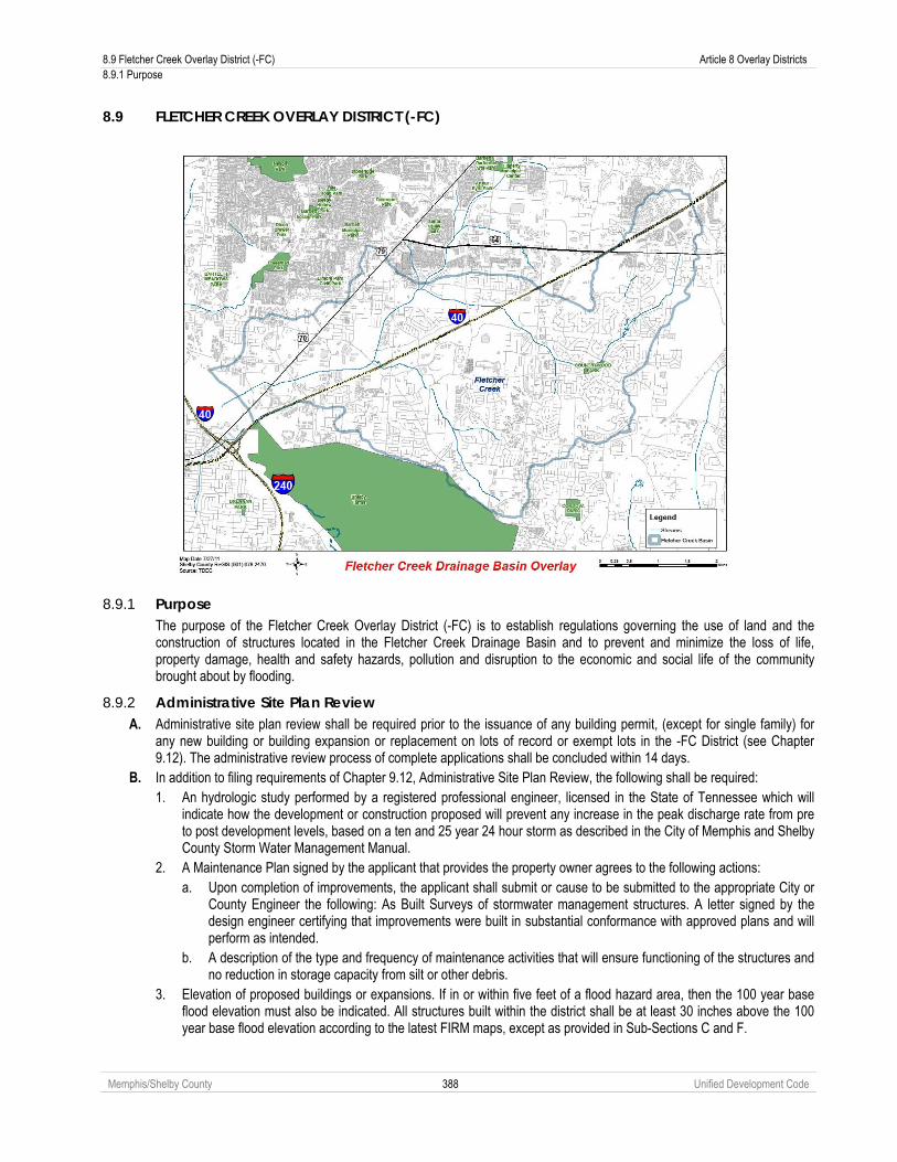
8.9 Fletcher Creek Overlay District (-FC) Article 8 Overlay Districts 8.9.1 Purpose
Memphis/Shelby County 388 Unified Development Code
8.9 FLETCHER CREEK OVERLAY DISTRICT (-FC)
8.9.1 Purpose The purpose of the Fletcher Creek Overlay District (-FC) is to establish regulations governing the use of land and the construction of structures located in the Fletcher Creek Drainage Basin and to prevent and minimize the loss of life, property damage, health and safety hazards, pollution and disruption to the economic and social life of the community brought about by flooding.
8.9.2 Administrative Site Plan Review A. Administrative site plan review shall be required prior to the issuance of any building permit, (except for single family) for
any new building or building expansion or replacement on lots of record or exempt lots in the -FC District (see Chapter 9.12). The administrative review process of complete applications shall be concluded within 14 days.
B. In addition to filing requirements of Chapter 9.12, Administrative Site Plan Review, the following shall be required: 1. An hydrologic study performed by a registered professional engineer, licensed in the State of Tennessee which will
indicate how the development or construction proposed will prevent any increase in the peak discharge rate from pre to post development levels, based on a ten and 25 year 24 hour storm as described in the City of Memphis and Shelby County Storm Water Management Manual.
2. A Maintenance Plan signed by the applicant that provides the property owner agrees to the following actions: a. Upon completion of improvements, the applicant shall submit or cause to be submitted to the appropriate City or
County Engineer the following: As Built Surveys of stormwater management structures. A letter signed by the design engineer certifying that improvements were built in substantial conformance with approved plans and will perform as intended.
b. A description of the type and frequency of maintenance activities that will ensure functioning of the structures and no reduction in storage capacity from silt or other debris.
3. Elevation of proposed buildings or expansions. If in or within five feet of a flood hazard area, then the 100 year base flood elevation must also be indicated. All structures built within the district shall be at least 30 inches above the 100 year base flood elevation according to the latest FIRM maps, except as provided in Sub-Sections C and F.

Article 8 Overlay Districts 8.9 Fletcher Creek Overlay District (-FC) 8.9.3 Application of Regulations
Memphis/Shelby County 389 Unified Development Code
4. Location of existing streams, channels or other drainage ways on the property and proposed storm water improvements to ensure handling the 10 and 25 year storm on site.
5. Location of all other required improvements including but not limited to roads, sidewalks, landscaping and buffer areas.
8.9.3 Application of Regulations A. The -FC Overlay District land is shown on the Zoning Map (see Chapter 2.4).The regulations contained in this Chapter
apply to the development of such land in addition to the regulations contained in the underlying zoning district for such land. B. The provisions of this Chapter apply to any new structure or expansion of an existing structure on a standard subdivided lot
as well as on all otherwise exempt lots, planned developments including lots which meet exemption criteria established in Chapter 9.7 Subdivision Review, and lots of record and any other land exempted from providing stormwater discharge improvements located within the Fletcher Creek Drainage Basin.
C. Notwithstanding anything to the contrary, the provisions of this Chapter shall not apply to any building that has been issued a building permit or certificate of occupancy certificate on or before the effective date of this development code.
D. If a property is located within the Fletcher Creek Basin west of Raleigh-LaGrange Road, it is exempt from the detention requirements of this Chapter. Such properties are still subject to the detention requirements of the Memphis and Shelby County Storm Water Management Manual.
E. If a development has an existing recorded final plat or has been issued a Final Plan/Plat Memorandum of Conformance by the Planning Director as of the effective date of this development code, the development will only be subject to the requirement for the lowest habitable floor elevations, including a basement, to be at least 30 inches above the 100 year base flood elevation according to the latest Flood Insurance Rate Maps.
F. The only exception to the 30 inches above the 100 year base flood elevation minimum floor elevation for issuance of a building permit is for an expansion of a single-family home which existed as of the effective date of this development code, which requires the lowest habitable floor elevation to be one foot above the 100 year base flood elevation according to the latest Flood Insurance Rate Maps.
8.9.4 Additional Requirements for Permits and Approvals A. No permit or approval required by this development code or building code shall be granted unless the development,
structure, or use of land proposed complies with the provisions of this Chapter. B. Any application for approval shall be required to:
1. Ensure the proposed development or construction will not increase the peak discharge rate from pre-development levels to post-development levels, based on a ten and 25 year, 24 hour storm as described in the Memphis and Shelby County Storm Water Management Manual. An hydrologic study prepared by a registered professional engineer, licensed in the State of Tennessee will be required to be submitted to the City and/or County Engineering Departments which will show how the proposed development or construction will prevent any increase in the peak discharge rate from pre- to post-development levels, based on a ten and 25 year, 24 hour storm as described in the Memphis and Shelby County Storm Water Management Manual.
2. Prepare and submit a Maintenance Plan, signed by the applicant, for any stormwater management improvements proposed or required. The owner is also responsible for maintaining any required stormwater detention to ensure storage capacity is maintained and the system is functioning properly. In the event that improper maintenance of private drainage facilities leads to situations which may impact on public safety, the City or County shall have the right where necessary to protect the public safety to enter onto private property for the purposes of repairing those facilities and restoring them to proper operation. The cost of said repairs are the responsibility of the property owner. The City or County shall bear no responsibility for repairs to private facilities. The City or County will bill the owner and if not paid within a reasonable time period, may place a lien on the property.
3. A Maintenance Plan signed by the applicant that provides the property owner agrees to the following actions: a. Upon completion of improvements, the applicant shall submit or cause to be submitted to the appropriate City or
County Engineer the following: 1. As Built Surveys of stormwater management structures. 2. A letter signed by the design engineer certifying that improvements were built in substantial conformance
with approved plans and will perform as intended. b. A description of the type and frequency of maintenance activities that will ensure functioning of the structure and
no reduction in storage capacity from silt or other debris. 4. There shall be no net loss of storage within the 100 year floodplain as defined and depicted on the 1982 FEMA Flood
Insurance Rate Maps (FIRM). Any filling of a building site within this portion of the Fletcher Creek Flood. Hazard Area will provide an equal amount of replacement of the floodplain capacity reduced by the fill. In-kind replacement of lost storage shall be provided by each development.

8.10 Transitional Office Overlay (-TO) Article 8 Overlay Districts 8.10.1 Purpose
Memphis/Shelby County 390 Unified Development Code
5. Building permits for new structures or building expansions in the –FC District will require an Affidavit of floor elevation showing the lowest habitable floor at least 30 inches above the 100 year base flood according to the latest Flood Insurance Rate Maps and the required drainage improvements for the -FC District signed by a licensed engineer or registered land surveyor submitted to Code Enforcement with a copy to the appropriate City or County Engineering Department.
6. The only exception to the 30 inch minimum above 100 year base flood for issuance of a building permit is for an expansion of an existing single-family detached home, which requires the lowest habitable floor elevation of the expansion be at least one foot above the 100 year base flood elevation.
8.10 TRANSITIONAL OFFICE OVERLAY (-TO)
8.10.1 Purpose The Transitional Office Overlay (-TO) is established to allow an orderly transition of use from residential use to relatively small-scale office use of lots and parcels fronting arterials, while maintaining a predominantly residential property appearance and building scale.
8.10.2 Designation of Transitional Office Overlay A. A Transitional Office Overlay may only be established as a zoning map change in accordance with the requirements
of Chapter 9.5. B. A Transitional Office Overlay may be established over any residential district, and may be established over more than
one residential district.
8.10.3 Site Plan Review The Planning Director is authorized to approve site plans within a Transitional Overlay District in accordance with Chapter 9.13.
8.10.4 Permitted Uses A. Any use permitted by right, subject to any use standard, or as a special use in the underlying base districts shall be
permitted in the overlay. B. The following uses or use categories shall be permitted in addition to the uses permitted in the underlying residential
district. No retail sales shall be permitted as a principal use in the overlay. i. Upper-story residential; ii. Medical facilities (other than hospitals); iii. Offices; iv. Animal hospitals, veterinary clinics, animal boarding places (all without outdoor pens or
runs); v. Artist galleries; and vi. Artist studios.
8.10.5 Special Development Standards The underlying district dimensional standards shall be met, except where expressly modified below.
A. Residential Appearance 1. Buildings in the Transitional Office Overlay shall maintain a single-family detached residential appearance
and scale. Residential appearance and scale shall expressly include details from residential uses within 150 feet of the overlay area. Such details may include the following features: a. Roof type, including extent of eaves, if any; b. Porches or other similar articulation of the front façade; c. Size, pattern and location of windows and doors; and d. Garage or parking location.
B. Building Length and Floor Area 1. The maximum length of a new building shall not exceed 80 feet. 2. The maximum floor area of any nonresidential use in the overlay or aggregation of multiple nonresidential
uses in a single building shall be 5,000 square feet.

Article 8 Overlay Districts 8.11 Neighborhood Conservation Overlay District (-NC) 8.11.1 Purpose
Memphis/Shelby County 391 Unified Development Code
C. Outdoor Activity All nonresidential activity (except that allowed within a residential district) shall occur within a completely enclosed building.
D. Parking No parking shall be permitted between the building and the street.
E. Front Setbacks Structures shall be located within the range of front setbacks on the street. This range of setbacks is measured on the basis of the four lots surrounding the project site (the two closest lots in either direction along the street).The new structure shall be located within the range of setbacks (no closer than the narrowest setback, no further than the deepest setback). Where a setback in these four lots is significantly out of the range of setbacks along the street, it may be eliminated from the range. Where the calculation of a range of setbacks is not practicable, the structure shall be adhere to the front setbacks for the underlying residential district.
F. Garages and Carports Street-facing garages and carports may be allowed if no alley is present and street-facing garages or carports are part of the dominant character of all properties fronting on the same block face.
G. Front Porches A front porch is required if front porches are part of the dominant character of all properties fronting on the same block face. Any project that requires a front porch must have a front porch with a minimum depth of eight feet. A minimum porch depth of six feet may be approved by the Planning Director if any property on the same block face has a front porch less six feet in depth.
H. Ground Floor Elevation Raised ground floors are required if raised ground floors are part of the dominant character of all properties fronting on the same block face Any project that requires a raised ground floor must have a foundation height of at least 18 inches measured from top of grade to the first finished floor.
8.11 NEIGHBORHOOD CONSERVATION OVERLAY DISTRICT (-NC)
8.11.1 Purpose The purpose of Neighborhood Conservation Overlay District (-NC) is to: A. Preserve and protect the character and valued features of established neighborhoods; B. Recognize the diversity among neighborhoods; C. Reduce conflicts between new construction and development in established neighborhoods; D. Provide knowledge about the parameters of neighborhood character; and E. Allow neighborhoods to formulate a plan that defines the common interests of the community that fosters a defined
character for an established neighborhood.
8.11.2 Certificate of Compliance Required If a property owner within an adopted Neighborhood Conservation District seeks a building permit, the owner must receive a Certificate of Compliance issued by the Planning Director for such work (see Section 8.11.11, Certificate of Compliance).

8.11 Neighborhood Conservation Overlay District (-NC) Article 8 Overlay Districts 8.11.3 General Provisions
Memphis/Shelby County 392 Unified Development Code
8.11.3 General Provisions A. District Establishment
Each Neighborhood Conservation Overlay District shall be established by a separate resolution that shall include a map defining the overlay boundaries, and the Neighborhood Conservation Plan and shall become part of the Zoning Map (see Chapter 2.4).
B. Plan Required All new development, additions, changes, and expansions within a Neighborhood Conservation Overlay District shall comply with the regulations associated with the Neighborhood Conservation Overlay District Plan (see Section 8.11.7).
C. District Specifics A Neighborhood Conservation Overlay District: 1. Shall include a minimum of 15 adjacent privately-owned tracts or lots, unless the area proposed is an extension of
the boundaries of a previously approved Neighborhood Conservation Overlay District. 2. Shall include public/privately-owned tracts or lots that are but not limited to:
a. Contiguous; b. Show similar development patterns: c. Of similar size; and d. Associated by common characteristics of geography, development, services and interests.
3. Shall consider other adjacent privately-owned lots having shared distinguishing characteristics that could be found to comprise a logical neighborhood unit, when determining the boundaries of a Neighborhood Conservation Overlay District.
D. Nonconformities Uses and structures legally existing at the time of the adoption of a Neighborhood Conservation Overlay District under these regulations may not become nonconforming solely by virtue of adoption of the District. Notwithstanding this provision, any changes or additions to uses or structures in the District that occur after the date of adoption of the District, shall comply with the provisions of the adopted District.
8.11.4 District Initiation The establishment of a Neighborhood Conservation Overlay District may only be initiated by a group of 50% or more of the property owners within the proposed boundaries demonstrating interest in the Neighborhood Conservation Overlay District.
8.11.5 Pre-application Conference A pre-application conference (see Section 9.3.1) shall be held prior to the submission of an application for a Neighborhood Conservation Overlay District.
8.11.6 Application and Submittal Requirements An application for a Neighborhood Conservation Overlay District shall include the following: A. Statement of Purpose that addresses the following issues:
1. What the proposed Neighborhood Conservation Overlay District wants to accomplish and why; 2. Description of neighborhood character and valued features to be protected in the neighborhood; and 3. Why the proposed Neighborhood Conservation Overlay District boundaries constitute a defined “neighborhood”.

Article 8 Overlay Districts 8.11 Neighborhood Conservation Overlay District (-NC) 8.11.7 Neighborhood Conservation Plan
Memphis/Shelby County 393 Unified Development Code
B. A map that indicates the boundaries of the proposed Neighborhood Conservation Overlay District, and identifies the lots within it.
C. Description of the neighborhood, detailing land use, development, and distinguishing characteristics of neighborhood. D. Description of the history and evolution of the neighborhood. E. A petition that is (i) affirmatively signed by at least 50% of the property owners of lots within the proposed district,
indicating those owners' support for the City/County to proceed with processing of the application, and (ii) signed by all of the other owners of lots in the proposed district indicating whether the property owner is AGAINST, UNDECIDED, or HAS NO COMMENT on the application; if the signature of the owner cannot be obtained, the applicant may substitute a signed affidavit stating that the applicant has attempted in good faith to obtain the signature of the owner but has been unable to do so. Owners of record will be based on currently available Assessor's information.
F. The name and phone number of a designated representative for the neighborhood, who has the power to withdraw the application at any time.
G. A list of all homeowner associations or other parties with an interest in the proposed Neighborhood Conservation Overlay District. This list shall include information as to the number of members and the officers’ names, mailing addresses, and phone numbers.
8.11.7 Neighborhood Conservation Plan A. General
1. A Neighborhood Conservation Plan shall detail the policies intended to protect the neighborhood character and valued features identified in the proposed Neighborhood Conservation Overlay District. The Neighborhood Conservation Plan shall be drafted in cooperation with the neighborhood and the Division of Planning and Development.
2. The Division of Planning and Development staff shall conduct a land use analysis of the neighborhood and shall present it at the neighborhood meetings. The land use analysis shall include at least the following elements: a. Zoning of area; b. Tract and lot sizes and configuration; c. Land uses in the neighborhood; d. Description of housing and other uses; e. Previous land use reviews completed in the neighborhood; and f. Aerial photos of neighborhood showing structure locations.
B. Neighborhood Meetings 1. At a minimum, two neighborhood meetings shall be conducted in conjunction with Division of Planning and
Development staff as part of the Neighborhood Conservation Plan formulation process: a. An initial meeting to discuss the land use analysis, the boundaries of the proposed Overlay District, and
what the neighborhood wants to accomplish with the Neighborhood Conservation Overlay District. b. A final meeting to present and discuss the final proposed Neighborhood Conservation Plan.
2. All property owners within the proposed Neighborhood Conservation Overlay District boundaries will be notified by the Planning Director of the meeting date and time, and shall be sent information about the proposal.
C. Plan Contents A Neighborhood Conservation Plan shall include the following:
1. A map indicating the properties included and the proposed boundaries of the Neighborhood Conservation Overlay District. These boundaries may change from those initially submitted or proposed, based on land use analysis and input from neighborhood meetings and property owners.
2. The proposed development standards and requirements for the Neighborhood Conservation Overlay District. 3. Other standards or background information related to the Neighborhood Conservation Overlay District such as:
a. Location of proposed buildings or additions; b. Height; c. Size; d. Exterior materials; e. Exterior lighting; f. Neighborhood character and compatibility;

8.11 Neighborhood Conservation Overlay District (-NC) Article 8 Overlay Districts 8.11.7 Neighborhood Conservation Plan
Memphis/Shelby County 394 Unified Development Code
g. Vistas preservation of or from specific locations, particularly from public lands and right of ways; h. Visual impact on natural features or neighborhood character; i. Compatibility with topography and vegetation; j. Landscaping and screening; k. Historic or archaeological resources; l. Runoff, erosion, and sedimentation; and m. Impact on Natural Landmarks or Natural Areas.

Article 8 Overlay Districts 8.11 Neighborhood Conservation Overlay District (-NC) 8.11.8 Conditions for Approval
Memphis/Shelby County 395 Unified Development Code
8.11.8 Conditions for Approval The Neighborhood Conservation Overlay District shall be approved only if the governing bodies find that: A. The proposed Neighborhood Conservation Overlay District is an established area with shared distinguishing
characteristics, which may include geography, development, services, and interests. B. The proposed Neighborhood Conservation Overlay District is a logical neighborhood unit with a closely settled
development pattern on similar sized lots. C. The Neighborhood Conservation Overlay District Plan must be consistent with any applicable adopted plan for the
areas (see Chapter 1.9), all applicable intergovernmental agreements, and the provisions of this development code.
8.11.9 Agency and Public Review A. Review of a Neighborhood Conservation Plan shall proceed through the zoning changes process as set forth in
Chapter 9.5, Zoning Change. B. The written consent of at least 72% of the owners of record of the lots within the proposed Neighborhood
Conservation Overlay District, with each property allowed only one vote, must be obtained prior to review of the Neighborhood Conservation Overlay District by the governing bodies. Owners of record will be based on currently available Assessor’s information.
C. Resolution of approval by the governing bodies shall include the Neighborhood Conservation Plan, and any specific site plan review criteria covered by Plan.
8.11.10 Amendments to an Approved Neighborhood District A. A text amendment to an approved Neighborhood Conservation Overlay District shall go through the zoning text
amendment process as set forth in Chapter 9.4, Text Amendment. B. A map amendment to an approved Neighborhood Conservation Overlay District shall go through the zoning map
amendment process as set forth in Chapter 9.5, Zoning Change.
8.11.11 Certificate of Compliance A. Within an adopted Neighborhood Conservation Overlay District, a Certificate of Compliance shall be issued prior
beginning work and to receiving any other permits required by law, including but not limited to, required building permits.
B. Applications for a Certificate of Compliance shall be made to the Planning Director, and shall include the following information:
1. A narrative describing the proposed work; 2. A site plan; 3. Photographs of existing conditions; 4. Plans and illustrations of proposed work; and 5. Other information as the Planning Director may reasonably require to determine compliance with the
approved Neighborhood Conservation Plan adopted for the Neighborhood Conservation Overlay District. C. The Planning Director shall issue a Certificate of Compliance if there is compliance with the Neighborhood
Conservation Plan as adopted for the Neighborhood Conservation Overlay District, and may attach conditions to a Certificate of Compliance which are reasonably required to meet the purpose of this development code. If the Planning Director does not issue a Certificate of Compliance or a written denial of an application for a Certificate of Compliance within 30 days after receiving an application with all required information, the Planning Director shall be deemed to have issued the Certificate of Compliance without conditions.
D. Issuance of a required Certificate of Compliance shall be a prerequisite to an application for a building permit within the Neighborhood Conservation Overlay District. The Building Official shall not accept an application for a building permit within the Neighborhood Conservation Overlay District unless it is accompanied by proof that a required Certificate of Compliance was issued or was deemed issued under the provisions of this development code.
8.11.12 Enforcement Whenever a building, streetscape or vistas is in violation of an approved Neighborhood Conservation Plan for a Neighborhood Conservation Overlay District, the Planning Director may serve written notice of the violation upon the violator directing compliance within a reasonable period of not less than ten days as determined by the Planning Director.

9.1 Review Bodies Article 9 Administration 9.1.1 Governing Bodies
Memphis/Shelby County 396 Unified Development Code
Article 9. Administration 9.1 REVIEW BODIES
9.1.1 Governing Bodies A. General Authority
The governing bodies may exercise additional powers as may be described elsewhere in this development code and as permitted by the City or County Code of Ordinances.
B. Final Authority With respect to this development code, the governing bodies are responsible for final action regarding:
1. Text amendments; 2. Zoning changes; 3. Comprehensive rezonings; 4. Special uses and special use amendments; 5. Planned development outline plan and amendments; 6. Planned development public contracts; 7. Final plat public contracts; 8. Right-of-way vacation; 9. Right-of-way dedication; and 10. Historic district designation.
9.1.2 Land Use Control Board A. Establishment
The Land Use Control Board is established pursuant to Joint Ordinance-Resolution No. 2524 (Memphis City Code § 2-50).
B. General Authority 1. The Land Use Control Board performs related duties as directed by the governing bodies. 2. The Land Use Control Board may exercise additional powers as may be described elsewhere in this development
code and as permitted by the City or County Code of Ordinances.
C. Review Authority With respect to this development code, the Land Use Control Board reviews and makes recommendations regarding:
1. Text amendments; 2. Zoning changes; 3. Comprehensive rezonings; 4. Special uses and special use amendments; 5. Planned development outline plan and amendments; 6. Right-of-way vacation; 7. Right-of-way dedication; and 8. Historic district designation.
D. Final Authority With respect to this development code, the Land Use Control Board shall be responsible for final action (subject to appeal) regarding:
1. Planned development major modifications; 2. Special use major modifications; 3. Major preliminary plans; 4. Resubdivision; 5. Street name change; 6. Plat of record vacation; and 7. Special exceptions.

Article 9 Administration 9.1 Review Bodies 9.1.3 Board of Adjustment
Memphis/Shelby County 397 Unified Development Code
9.1.3 Board of Adjustment A. Establishment
The Board of Adjustment is established pursuant to Joint Ordinance-Resolution No. 722 Memphis City Code § 2-48).
B. General Authority 1. The Board of Adjustment performs related duties as directed by the governing bodies. 2. The Board of Adjustment may exercise additional powers as may be described elsewhere in this development code
and as permitted by the City or County Code of Ordinances.
C. Final Authority With respect to this development code, the Board of Adjustment is responsible for final action regarding:
1. Variances; 2. Appeals from Administrative decisions 3. Interpretation of zoning district boundaries. 4. Change in nonconforming use permit; and 5. Conditional Use Permits.
9.1.4 Landmarks Commission A. Defined
The Memphis Landmarks Commission is identified as having the authority to enforce certain provisions of this development code.
B. Establishment The Landmarks Commission serves as a historic zoning commission pursuant to Tennessee Code 13-7-403 for the City of Memphis (see Memphis City Code § 14-24-5).
C. General Authority The Landmarks Commission conducts and encourages research, planning and educational projects for the purpose of protecting historic districts and documenting the historic significance thereof, including the following:
1. Recommend to the governing bodies designated sites and districts for loans and grants under the City Landmark Fund and subject to approval by the governing bodies; make application for and administer grants for the purpose of preserving and restoring structures and sites located within a Historic Overly District.
2. Initiate or assist in surveys, plans and studies and programs designed to identify, list and evaluate structures, objects, sites and areas worth of preservation and develop strategies and methods for their protection.
3. Consult with and consider the recommendations of civic groups, public agencies and citizens interested in historic preservation and provide information to the public.
4. Research historic properties and apply for designation to the National Register of Historic Places and establish a list of properties eligible for designation as a Historic Overlay District.
D. Review Authority With respect to this development code, the Landmarks Commission reviews and make recommendations regarding rezoning to a Historic district designation.
E. Final Authority With respect to this development code, the Landmarks Commission is responsible for final action regarding applications for a Certificate of Appropriateness.
9.1.5 Downtown Memphis Commission Design Review Board
A. Establishment The Downtown Memphis Commission Design Review Board is established pursuant to Memphis City Code § 12-44.
B. General Authority 1. The Downtown Memphis Commission Design Review Board performs related duties as directed by the City Council. 2. The Downtown Memphis Commission Design Review Board may exercise additional powers as may be described
elsewhere in this development code and as permitted by the City Code of Ordinances.

9.1 Review Bodies Article 9 Administration 9.1.6 Planning Director
Memphis/Shelby County 398 Unified Development Code
C. Final Authority With respect to this development code, the Downtown Memphis Commission Design Review Board is responsible for reviewing applications and issuing permits with respect to the design of public building façades and exteriors in public view, signs and other public improvements within the Central Business Improvement District.
9.1.6 Planning Director The Planning Director may designate any staff member to represent the Planning Director in any function assigned by this development code. The Planning Director remains responsible for any final action.
A. General Authority 1. The Planning Director performs related duties as directed by the governing bodies. 2. The Planning Director may exercise additional powers as may be described elsewhere in this development code and
as permitted by the City or County Code of Ordinances.
B. Review Authority With respect to this development code, the Planning Director reviews and makes recommendations regarding:
1. Text amendments; 2. Zoning changes; 3. Comprehensive rezonings; 4. Special uses, special use amendments and major modifications; 5. Planned development outline plan and amendments; 6. Planned development major modifications; 7. Major preliminary plans review; 8. Resubdivision; 9. Right-of-way vacation; 10. Right-of-way dedication; 11. Street name change; 12. Plat of record vacation; 13. Special exceptions 14. Historic district designation; 15. Certificates of appropriateness; and 16. Variances.
C. Final Authority With respect to this development code, the Planning Director is responsible for final action (subject to appeal) regarding:
1. Special use minor modifications; 2. Planned development minor modifications; 3. Planned development final plats; 4. Minor preliminary plans; 5. Final plats; 6. Administrative site plans; 7. Tree removal; 8. Final plat; Demolition by neglect; and 9. Administrative deviations.
9.1.7 Building Official A. Delegation of Authority
The Building Official may designate any staff member to represent the Building Official in any function assigned by this development code. The Building Official remains responsible for any final action.

Article 9 Administration 9.1 Review Bodies 9.1.8 Technical Review Committee
Memphis/Shelby County 399 Unified Development Code
B. General Authority 1. The Building Official performs related duties as directed by the governing bodies. 2. The Building Official may exercise additional powers as may be described elsewhere in this development code and as
permitted by the City or County Code of Ordinances.
C. Final Authority With respect to this development code, the Building Official is responsible for final action (subject to appeal) regarding the following:
1. Temporary use review; 2. Sign permit; 3. Certificate of occupancy; and 4. Written interpretations.
9.1.8 Technical Review Committee The Technical Review Committee is comprised of City and County agencies and is established to provide technical assistance in the review of certain provisions of this development code as set forth below.
A. Composition The Technical Review Committee shall consist of a representative from the following. The Planning Director shall serve as chairman of the Technical Review Committee and shall be responsible for all final recommendations.
1. Department of Planning and Development – Land Use Controls. 2. Department of Planning and Development – Comprehensive Planning. 3. Department of Construction Code Enforcement. 4. City Traffic Engineer. 5. City and County Public Works Divisions. 6. City and County Engineering Divisions. 7. City and County Fire Departments. 8. Shelby County Health Department. 9. Memphis Light, Gas, and Water Division.
B. Review Authority 1. With respect to this development code, the Technical Review Committee may review at the discretion of the Planning
Director the following: a. Text amendments; b. Special uses and special use revisions; c. Planned development outline plan amendments; d. Planned development minor modifications; e. Planned development final plats; f. Minor preliminary plans; g. Administrative site plans; and h. Special exceptions.
2. With respect to this development code, the Technical Review Committee shall review the following: a. Planned development outline plans; b. Planned development major modifications; c. Major preliminary plans; d. Resubdivision; e. Right-of-way vacation; f. Right-of-way dedication; g. Street name change; h. Plat of record vacation; and

9.2 Summary of Review Authority Article 9 Administration 9.2.1 Governing Bodies
Memphis/Shelby County 400 Unified Development Code
9.2 SUMMARY OF REVIEW AUTHORITY
9.2.1 Governing Bodies Unless set forth below, the City Council retains review and approval or appeal authority within the City limits of Memphis and the Board of Commissioners retains review and approval or appeal authority within unincorporated Shelby County.
9.2.2 Summary of Review Table Review, Recommendation, Decision and Approval
x-ref
City
or
Cou
nty
Engi
neer
Build
ing
Offi
cial
Tech
nica
l R
evie
w
Com
mitt
ee
Plan
ning
D
irect
or
Boar
d of
Ad
just
men
t
Land
mar
ks
Com
mis
sion
Land
Use
C
ontro
l Bo
ard
Gov
erni
ng
Bodi
es
Text Amendment 9.4 ∆ RR RR D Zoning Change 9.5 RR RR D Comprehensive Rezoning 9.5.12 RR RR D FEMA Floodway and Floodplain Maps 9.5.12 RR RR RR D Special Uses & Planned Developments:
Special Uses & Special Use Amendments 9.6 &
9.6.12A
∆ RR RR D*
Special Use Major Modification 9.6.12B R RR D A Special Use Minor Modification 9.6.12C ∆ D A*
P. D. Outline Plan & Amendments 9.6 &
9.6.11E(1)
R RR RR D*
P. D. Major Modifications 9.6.11E(2) R RR D A P. D. Minor Modifications 9.6.11E(3) ∆ D A* P. D. Final Plan 9.6 ∆ D A* P. D. Public Contract 9.6 RR D Subdivision: Minor Preliminary Plan 9.7.6 ∆ D A* Major Preliminary Plan 9.7.7 R RR D A Resubdivision R RR D A Final Plat without Standard Contract 9.7.8 ∆ D A* Final Plat w/Standard Contract 9.7.8 RR D Right-of-Way Vacation 9.8 R RR RR D Right-of-Way Dedication 9.9 R RR RR D Street Name Change 9.10 R RR D A Plat of Record Revocation 9.11 R RR D A Administrative Site Plan 9.12 R D A* Special District Administrative Review 9.13 R D A* Special Exception 9.14 ∆ RR D A Historic District Designation 8.6 RR RR RR D Certificate of Appropriateness 8.6.3 RR D A Historic District (Demolition by Neglect) 8.6.4 D A* A
Variance1 and Conditional Use Permit 9.22 & 9.24
RR D
Administrative Decision D D D A* Change in Nonconforming Use Permit 10.2.5 RR D 1. In the case of setback variation requests less than 5 feet only adjacent property owners shall be notified
D = Decision D* = Decision but no public hearing unless a request for a hearing is properly filed by an individual who was either present at LUCB and made a vocal objection or who submitted written comments to OPD prior to LUCB. R = Review RR = Review & Recommendation ∆ = Review at Discretion of Planning Director A = Appeal A* = Only the subject property owner or his or her representative may appeal decisions of the Planning Director, Building Official or City or County Engineer.
Within City Limits Within 5-Mile Limit Beyond 5-Mile Limit Zoning Change Council Council/Commission Commission 9.5 Special Uses, Planned Developments Council Council/Commission Commission 9.6
Within City Limits Within 3-Mile Limit Beyond 3-Mile Limit Right-of-Way Dedication Council Council/Commission Commission 9.9

Article 9 Administration 9.3 Common Review Procedures 9.3.1 Pre-Application Conference
Memphis/Shelby County 401 Unified Development Code
9.3 COMMON REVIEW PROCEDURES
9.3.1 Pre-Application Conference A. The pre-application conference is a meeting in which the Planning Director discusses the procedures, standards and
regulations required for approval in accordance with this development code with the applicant. B. A mandatory pre-application conference with the Planning Director shall be required for the following:
1. Zoning change; 2. Special use permit; 3. Planned development outline plan; 4. Minor preliminary plan ; 5. Major preliminary plan; 6. Right-of-way vacation; 7. Right-of-way dedication; 8. Plat of record; 9. Plat revocation; 10. Historic district designation; and 11. Certificate of Appropriateness.
C. A pre-application conference is optional for any application not listed in Sub-Section B above.
9.3.2 Neighborhood Notification and Meeting A. At least ten days, but not more than 120 days, prior to a hearing before the Land Use Control Board, the applicant shall
host and/or attend a neighborhood meeting with representatives from neighborhoods adjacent to the development site which the hearing involves:
1. Zoning changes not in compliance with any plans to be considered (see Chapter 1.9);
2. Special use permit or amendment to a special use permit;
3. Planned development outline plan or amendment to a planned development outline plan; and
4. All subdivisions except minor subdivisions.

9.3 Common Review Procedures Article 9 Administration 9.3.2 Neighborhood Notification and Meeting
Memphis/Shelby County 402 Unified Development Code
B. Procedure
1. Where applicable, the Office of Planning and Development shall mail notification of the neighborhood meeting prepared and provided by the applicant to the following individuals: 1) the officers of any neighborhood or business associations registered with the City of Memphis Office of Community Affairs whose boundaries include properties within 1,500 feet of the subject property; 2) all current residents of single-family and two-family dwellings within the notification area; 3) all property owners within the notification area, if different from the current residents; 4) the members of the Memphis City Council who represent the district and super-district in which the development is planned, or for areas in unincorporated Shelby County, the member of the Shelby County Board of Commissioners who represent the district in which the development is planned; and 5) all residents of multi-family dwellings within the notification area; to inform the community of the proposed development and solicit comments. If the applicant is unable to make notification to the multi-family dwellings, he or she shall provide notice to the Office of Planning and Development the reason and shall mail notification of the neighborhood meeting to the rental or management offices of all multi-family dwellings within the notification area with a request that said rental or management office post the notification in a conspicuous location within a common area(s), including, but not limited to: entry doors, hallways, mailbox areas and laundry rooms.
2. The neighborhood notification requirements shall be the same as the mailed public notice requirements in 9.3.4A. The notification shall identify the time and place of the neighborhood meeting, as well as a description and map of the project. The notification shall also include the public hearing date of when the application will be heard by the Land Use Control Board. The applicant shall contact the officer(s) of any neighborhood or business association registered with the City of Memphis Office of Community Affairs prior to determining a date for the neighborhood meeting.
3. The notification shall be prepared by the applicant and presented to the Office of Planning and Development no later than two working days prior to the date set out in the mailing requirement provided in Paragraph 4 below. The notification shall be folded, sealed and placed in stamped envelopes when presented to the Office of Planning and Development. The following items shall accompany the notification when presented to the Office of Planning and Development: a copy of the letter to be mailed to all parties, a copy of the address labels to whom notification will be mailed and a map of the notice area.
4. If practicable, the neighborhood meeting shall be held at a public building or place of worship within a one-mile radius of the subject property, or at the subject property itself.
5. If the notification package is determined to be complete by the Planning Director, the Office of Planning and Development shall mail the notification no later than 20 days prior to the hearing before the Land Use Control Board. If the neighborhood notification package is determined to the incomplete by the Planning Director, the application is subject to being considered incomplete and removed from the Land Use Control Board agenda.
6. Neighborhood meetings are the sole responsibility of the applicant. Documentation of its proceedings shall also be provided to the Office of Planning and Development. The applicant may request neighborhood organizations’ contact information, if available, from the Office of Planning and Development.
C. The purpose of the neighborhood notification and meeting is to inform the neighborhood of the nature of the proposed land use and development features and solicit comments. Applicants shall reserve at least 15 minutes of the neighborhood meeting for community members, businesses and/or neighborhood associations wishing to make a presentation regarding the development.
D. Any neighborhood or business association registered with the City of Memphis Office of Community Affairs whose boundaries include properties within 1,500 feet of the development area will have the opportunity to submit a Community Impact Statement (CIS). The purpose of the CIS is to provide community members a chance to give an opinion and any recommendation regarding the development project. The CIS shall not exceed 500 words. Neighborhood or business associations who intend to file a CIS must submit said statement to the Land Use Control Board or governing bodies no later than 5 days prior to the scheduled hearing date. The CIS shall be included within the staff report in a prominent position alongside the Land Use Control Board and Office of Planning and Development recommendations.

Article 9 Administration 9.3 Common Review Procedures 9.3.3 Application Requirements
Memphis/Shelby County 403 Unified Development Code
9.3.3 Application Requirements A. Initiation of Request
A request for development approval may be initiated in accordance with the following. For the purpose of this Sub-Section, “body” shall mean either the Memphis City Council or the Shelby County Board of Commissioners; “board” shall mean the Land Use Control Board and “staff” shall mean the Chief Administrative Officer of either the City of Memphis or Shelby County, or the Planning Director.
Agent/ Owner/
Applicant
Body/ Board/ Staff
Text Amendment ■
Zoning Change ■ ■
Comprehensive Rezoning ■*
Special Uses and Planned Developments:
Special Uses & Special Use Amendments ■
Special Use Minor Modifications ■
Special Use Major Modifications ■
P. D. Outline Plan & Amendments ■
P. D. Minor Modifications ■
P. D. Major Modifications ■
P. D. Final Plan ■
P. D. Public Contract ■
Subdivision:
Minor Preliminary Plan ■
Major Preliminary Plan ■
Resubdivision ■
Final Plat ■
Public Contract ■
Right-of-Way Vacation ■ ■
Right-of-Way Dedication ■
Street Name Change ■ ■
Plat of Record Revocation ■ ■
Administrative Site Plan Review ■
Special District Administrative Review ■
Special Exception Review ■
Temporary Use Review ■
Tree Removal ■
Sign Permit ■
Certificate of Occupancy ■
Historic District Designation ■ ■
Certificate of Appropriateness ■
Demolition by Neglect ■
Written Interpretations ■
Administrative Deviation ■
Variance and Conditional Use Permit ■
Appeal of Administrative Decision ■
Change in Nonconforming Use Permit ■
*Only the body(s) may initiate a request for a comprehensive rezoning (see Sub-Section 9.5.12A).

9.3 Common Review Procedures Article 9 Administration 9.3.3 Application Requirements
Memphis/Shelby County 404 Unified Development Code
B. Submittals Applications required under this development code shall be filed with the Division of Planning and Development in accordance with the following.
Planning Director
Building Official
Text Amendment ■
Zoning Change ■
Comprehensive Rezoning ■
Special Uses and Planned Developments:
Special Uses & Special Use Amendments ■
Special Use Minor Modifications ■
Special Use Major Modifications ■
P. D. Outline Plan & Amendments ■
P. D. Minor Modifications ■
P. D. Major Modifications ■
P. D. Final Plan ■
P. D. Public Contract ■
Subdivision:
Minor Preliminary Plan ■
Major Preliminary Plan ■
Resubdivision ■
Final Plat ■
Public Contract ■
Right-of-Way Vacation ■
Right-of-Way Dedication ■
Street Name Change ■
Plat of Record Revocation ■
Administrative Site Plan Review ■
Special District Administrative Review ■
Special Exception Review ■
Temporary Use Review ■
Tree Removal ■
Sign Permit ■
Certificate of Occupancy ■
Historic District Designation ■
Certificate of Appropriateness ■
Demolition by Neglect ■
Written Interpretations ■
Administrative Deviation ■
Variance and Conditional Use Permit ■
Appeal of Administrative Decision ■
Change in Nonconforming Use Permit ■
C. Forms Applications required under this development code must be submitted on forms and in such numbers as required by the Division of Planning and Development.

Article 9 Administration 9.3 Common Review Procedures 9.3.3 Application Requirements
Memphis/Shelby County 405 Unified Development Code
D. Fees Filing fees have been established to defray the cost of processing the application, as listed with the Division of Planning and Development and adopted by the governing bodies. Before review of an application, all filing fees must be paid in full.
E. Completeness Determination 1. All applications must be complete before the Planning Director/Building Official is required to review the
application. 2. An application is considered complete when it contains all of the information necessary to decide whether or not
the development as proposed will comply with all of the requirements of this development code. 3. The presumption is that all of the information required in the application forms is necessary to satisfy the
requirements of this Article. However, it is recognized that each application is unique, and therefore more or less information may be required according to the needs of the particular case. The applicant may rely on the recommendations of the Planning Director/Building Official as to whether more or less information shall be submitted.
4. Once the application has been determined complete, copies of the application shall be referred by the Planning Director/Building Official to the reviewing entities.
5. The Planning Director/Building Official may require an applicant to present evidence of authority to submit the application.
F. Application Deadline Complete applications shall be submitted in accordance with the published calendar schedule. Schedules indicating submittal dates shall be developed each year and made available to the public.
G. Staff Consultation after Application Submitted 1. Upon receipt of a complete application, within 21 days after the filing deadline, the Planning Director/Building
Official shall review the application and confer with the applicant to ensure an understanding of the applicable requirements of this development code; that the applicant has submitted all of the information they intend to submit; and that the application represents precisely and completely what the applicant proposes to do.
2. Once the applicant indicates that the application is as complete as the applicant intends to make it, the application shall be placed on the agenda of the appropriate review board in accordance with standard procedures. However, if the application is determined incomplete, a recommendation to deny the application on that basis shall be provided to the appropriate reviewing entity.
H. Concurrent Applications Applications may be filed and reviewed concurrently, at the option of the applicant.

9.3 Common Review Procedures Article 9 Administration 9.3.4 Public Hearings and Notification
Memphis/Shelby County 406 Unified Development Code
9.3.4 Public Hearings and Notification A. Required Hearings and Notification
A public hearing shall be required and notification given as set forth below: Public Hearing Public Hearing Notice Public Notice Mailed To
x-ref Boar
d of
Ad
just
men
t
Land
mar
ks
Com
mis
sion
Land
Use
C
ontro
l Boa
rd
Gov
erni
ng
Bodi
es
Sign
Pos
ted
Mai
led
New
spap
er
Publ
icat
ion
Subj
ect
Prop
erty
O
wne
rs
Adja
cent
O
wne
rs4
Ow
ners
with
in
500
Ft. R
adiu
s1
Nei
ghbo
rhoo
d As
soci
atio
ns
Text Amendment 9.4 PH PH LUCB/GB Zoning Change 9.5 PH PH SP M GB ■ ■ ■ ■ Comprehensive Rezoning 9.5.12 PH PH SP M LUCB/GB ■ FEMA Floodway and Floodplain Maps 9.5.12 PH PH LUCB/GB Special Uses & Planned Developments:
Special Uses & Special Use Amendments 9.6 &
9.6.12A PH
PH-AO SP M GB-RO ■ ■ ■ ■ Special Use Major Modifications 9.6.12B PH PH-AO SP M ■ ■ ■ Special Use Minor Modifications 9.6.12C PH-AO M-AO ■ □ □
P. D. Outline Plan & Amendments 9.6 &
9.6.11E(1) PH PH-AO SP M GB-RO ■ ■ ■ ■ P. D. Major Modifications 9.6.11E(2) PH PH-AO SP M ■ ■ ■ P. D. Minor Modifications 9.6.11E(3) PH-AO M-AO ■ □ □ P. D. Final Plan 9.6 P. D. Public Contract 9.6 Subdivision: Minor Preliminary Plan 9.7.6 PH-AO M-AO ■ ■ ■ Major Preliminary Plan 9.7.7 PH PH-AO M ■ ■ ■ Resubdivision PH PH-AO M ■ ■ ■ ■ Final Plat 9.7.8 Public Contract 9.7.8 Right-of-Way Vacation 9.8 PH PH SP M ■ ■ ■ Right-of-Way Dedication 9.9 PH PH M ■ ■ ■ Street Name Change 9.10 PH PH-AO M ■ ■ ■ Plat of Record Revocation 9.11 PH PH-AO M ■ ■ ■ Administrative Site Plan 9.12 PH-AO M-AO ■ □ □ Special Exception 9.14 PH PH-AO SP M ■ ■ ■ Special District Administrative Review 9.13 PH-AO ■ □3 □ Historic District Designation 8.6 PH PH PH SP M LM/LUCB/GB ■ ■ ■ Certificate of Appropriateness 8.6.3 PH M LM ■ ■ ■ Historic District (Demolition by Neglect) 8.6.4 PH-AO PH-AO □ □ Variance2 and Conditional Use Permit 9.22 & 9.24 PH M ■ ■ ■ Administrative Decision PH-AO □ Change in Nonconforming Use Permit 10.2.5 PH M ■ ■ ■ 1. If the 500-foot radius includes less than 25 property owners, the radius shall be extended at 100-foot intervals to reach a minimum of 25 property owners provided, however, that the maximum total radius is 1,500 feet. 2. In the case of setback variation requests less than 5 feet only adjacent property owners shall be notified. 3. Public notice mailed to property owners within a 300-foot radius of the subject property. 4. “Adjacent owners” includes abutting owners and those across the street or other ROW from the subject site. PH = Public Hearing
PH-AO = Public Hearing Upon Appeal Only
LUCB = Land Use Control Board GB = Governing Body P = Sign posted prior to administrative approval SP = Public Hearing Sign Posted LM = Landmarks Commission M = Public Hearing Notice Mailed M-AO = Public Hearing Notice Mailed - Appeal Only GB-RO = Governing Body Publication for Hearing upon Request Only
■ = Public Notice Sent To □ = Public Notice Sent Only On Appeal

Article 9 Administration 9.3 Common Review Procedures 9.3.4 Public Hearings and Notification
Memphis/Shelby County 407 Unified Development Code
B. Published Notice Where published notice is required, a distinctive advertisement shall be placed by the Planning Director in a local newspaper of general circulation in the City of Memphis and Shelby County not more than 30 or less than ten days prior to the date of the public hearing.
C. Posted Notice (Sign)
1. Sign Size and Type Each sign shall be two feet by three feet in size made to standards and specifications as provided by the Planning Director. All signs will include language stating that defacing or removal of the sign by anyone other than the owner or his or her agent is an illegal act and the person who defaces or removes the sign without permission of the owner will be penalized. Public notice signs are not subject to any sign permit or sign permit fees.
2. Location a. Zoning Change, Special Use, Planned Development, Special Exception
Signs shall be posted at the nearest right-of-way with the largest traffic volumes as determined by the Planning Director. Each sign shall be placed no closer than five feet from the right-of-way visible from each public street on which the subject property has frontage and placed outside the sight distance triangle. Additional signs may be required to be posted at each major roadway entrance to the development or as otherwise determined to be needed by the Planning Director.
b. Comprehensive Rezoning and Historic District Designation A sign shall be posted at each major roadway entrance to any area being comprehensively rezoned as determined by the Planning Director.
c. Right-of-Way Vacation A sign shall be posted at each end of the right-of-way to be vacated.
3. Responsibility for Installation and Removal a. The applicant shall be solely responsible for signage installation and removal and associated costs. b. Signs shall be erected not more than 30 or less than 10 days prior to the date of the public hearing.
Applicants may temporarily remove the signs after each public hearing, provided they reinstall the signs at least 10 days prior to the next public hearing. The applicant shall submit a signed affidavit stating that the signs were installed and the date and posting of the property.
c. Signs shall be removed within 14 days following final action by the governing bodies.
D. Mailed Notice
1. Where mailed notice is required, notification shall be mailed not more than 30 or less than 10 days prior to the date of the public hearing. Mailed notice shall be provided to all property owners within Shelby County in accordance with the provisions of this Code.
2. All of the neighborhood associations registered with the City of Memphis Office of Community Affairs whose boundaries include properties within 1,500 feet of the subject property shall be provided mailed notice in accordance with Sub-Section 9.3.4A.
E. Content of Notice 1. Published or Mailed Notice
Published or mailed notice shall provide at least the following: a. A case number; b. The address of the subject property (if available); c. The general location of the land that is the subject of the application, which may include, a location map d. A description of the action requested; e. Where a zoning change is proposed, the current and proposed districts; f. The time, date and location of the public hearing (or neighbor meeting if applicable); g. A phone number and email address to contact the Planning Director; and h. A statement that interested parties may appear at the public hearing.

9.3 Common Review Procedures Article 9 Administration 9.3.5 Notice of Decision
Memphis/Shelby County 408 Unified Development Code
2. Posted Notice Required posted notice shall indicate the following:
a. A case number; b. Type of action; and c. A phone number to contact the Planning Director; and d. All signs shall include language stating that defacing or removal of the sign by anyone other than the owner
or his agent is an illegal act and the person who defaces or removes the sign without permission of the owner will be penalized.
F. Constructive Notice 1. Minor defects in notice shall not impair the notice or invalidate proceedings pursuant to the notice if a bona fide
attempt has been made to comply with applicable notice requirements. 2. Undelivered mailed notice in excess of 25% of total required mailing within a 500-foot radius of the property only,
shall constitute failed notice and shall serve to invalidate proceedings unless sufficient notice is provided in accordance with this section.
9.3.5 Notice of Decision Within seven days after a decision is made, a copy of the decision shall be sent to the applicant and filed with the Planning Director, where it shall be available for public inspection during regular office hours.
9.3.6 Withdrawal of Application A. An applicant may withdraw an application at any time, by filing a statement of withdrawal with the Planning
Director/Building Official except as provided in paragraph C below.
B. The statement of withdrawal shall be signed by all persons who signed the application or their representative.
C. If a valid zoning protest petition has been filed, the application may be withdrawn only if the statement of withdrawal is filed no later than five days prior to the date of the public hearing upon which the matter is to be returned for action by the governing bodies. Thereafter, the application may be withdrawn only by action of the governing bodies, by majority vote.
D. The Planning Director/Building Official may withdraw applications due to the failure of the applicant to submit required information within 90 days of the initial request.
E. The application shall move forward to the agenda of the appropriate review body or, if not moved to the appropriate agenda within six months, may be withdrawn by the Planning Director.
F. At the request of the applicant, the Land Use Control Board, the Board of Adjustment or the Landmarks Commission may defer a case for one month, in addition to any permitted deferrals as provided in this Article. Additional deferrals are prohibited and will constitute a withdrawal.

Article 9 Administration 9.4 Text Amendment 9.4.1 Applicability
Memphis/Shelby County 409 Unified Development Code
9.4 TEXT AMENDMENT
9.4.1 Applicability The governing bodies shall consider amendments to the text of this development code in accordance with the provisions of this Chapter, as set forth below.
9.4.2 Application Requirements An application for a text amendment shall be submitted in accordance with Section 9.3.3, Application Requirements.
9.4.3 Planning Director Action A. The Planning Director shall draft the appropriate text amendment and prepare a
staff report that reviews the proposed amendment setting forth the purpose and reason for such an amendment.
B. The Planning Director may schedule the text amendment for review by the Technical Review Committee.
C. Following completion of technical review by staff, the Planning Director shall forward the completed request and any related materials to the Land Use Control Board.
9.4.4 Land Use Control Board Action A. Not less than 35 or more than 75 days after an application has been determined
complete, the Land Use Control Board shall hold a public hearing and give notice in accordance with Section 9.3.4, Public Hearings and Notification.
B. The Land Use Control Board shall make a recommendation on the request for a text amendment after deliberation and prior to the close of the public hearing. The Land Use Control Board may, prior to the close of the public hearing, defer a decision until the next regular meeting of the Board, at which time it shall recommend approval, rejection, or approval with conditions, unless held at the request of the applicant.
9.4.5 Governing Body Action A. Within 14 days following the Land Use Control Board public hearing, the Planning Director shall forward the completed
request and any related materials, including the Land Use Control Board recommendation, to the governing bodies for final action.
B. The governing bodies shall hold a public hearing and give notice in accordance with Section 9.3.4, Public Hearings and Notification, on the proposed text amendment after the receipt of the recommendations of the Land Use Control Board, and if applicable, the Planning Director.
C. The governing bodies may approve the text amendment, deny the text amendment, or defer decision until the next regular meeting of the governing bodies.
D. If the governing bodies approve different versions of a text amendment, a conference committee may be assembled to resolve any conflicts between the two versions. The conference committee shall be comprised of the members of the committees of the Memphis City Council and Shelby County Board of Commissioners that govern land use and zoning matters. The conference committee shall be chaired by the chairman of the appropriate City Council committee in even-numbered years and by the chairman of the appropriate Board of Commissioners committee in odd-numbered years. Five members of the conference committee shall constitute a quorum. Only members of the appropriate committees of the City Council and Board of Commissioners shall be entitled to vote at the conference committee. Upon approval of revised language, the text amendment shall be forwarded to the City Council and Board of Commissioners for approval or rejection, without amendment.
9.4.6 Approval Criteria A. In evaluating any proposed amendment of the text of this development code, the Land Use Control Board and the
governing bodies shall consider the following: 1. The extent to which the proposed text amendment is consistent with the remainder of the development code,
including, specifically, any purpose and intent statements;

9.4 Text Amendment Article 9 Administration 9.4.6 Approval Criteria
Memphis/Shelby County 410 Unified Development Code
2. The extent to which the proposed text amendment represents a new idea not considered in the existing development code, or represents a revision necessitated by changing circumstances over time;
3. Whether or not the proposed text amendment corrects an error in the development code; and 4. Whether or not the proposed text amendment revises the development code to comply with state or federal
statutes or case law.
B. In deciding whether to adopt a proposed text amendment to this development code, the central issue before the governing bodies is whether the proposed text amendment advances the public health, safety or welfare and is consistent with the purpose and intent of this development code.

Article 9 Administration 9.5 Zoning Change 9.5.1 Applicability
Memphis/Shelby County 411 Unified Development Code
9.5 ZONING CHANGE
9.5.1 Applicability The governing bodies shall consider amendments to the Zoning Map in accordance with the provisions of this Article. Amendments to the Zoning Map include the application of a specified frontage, whether it occurs as part of a modification of underlying zoning or as its own zoning change. Amendments also include modifications to any adopted height map or frontage map, or the initial imposition of a height map or frontage map where no height map or frontage map currently exists. For frontage and height maps adopted as part of an Overlay district, see Sub-Section 8.1D.
9.5.2 Zoning Change Requirements A. A zoning change shall correspond with the boundary lines of existing tracts and
lots, and with the centerline of any abutting streets or alleys. Where the boundaries of a zoning change request stop short of an exterior property line, it must be possible to subdivide and develop that portion of the property outside the proposed zoning change boundary in accordance with the existing zoning and other requirements of this development code.
B. All zoning requirements shall be met within the boundaries of the area being rezoned. If all of the requirements cannot be met on the site being rezoned, the zoning change shall be expanded to include all property necessary to meet zoning requirements.
C. Any zoning change affecting property within a community redevelopment area shall be supported by the Community Redevelopment Plan for that area.
9.5.3 Pre-Application Conference An applicant petitioning for a zoning change shall schedule a pre-application conference in accordance with Section 9.3.1.
9.5.4 Neighborhood Notification and Meeting An applicant petitioning for a zoning change may have to notify the surrounding neighborhood(s) (see Section 9.3.2).
9.5.5 Application Requirements An application for a zoning change shall be submitted in accordance with Section 9.3.3, Application Requirements.
9.5.6 Planning Director Action
A. The Planning Director shall prepare a report that reviews the zoning change request in light of any applicable plans to be considered (see Chapter 1.9) and the general requirements of this development code.
B. Following completion of technical review by staff, the Planning Director shall forward the completed request and any related materials to the Land Use Control Board.
9.5.7 Land Use Control Board Action A. Procedure
1. Not less than 35 or more than 75 days after an application has been determined complete, the Land Use Control Board shall hold a public hearing and give notice in accordance with Section 9.3.4, Public Hearings and Notification. For the purpose of this Paragraph, a change to a previously submitted special use, planned development or rezoning application, or a conversion from one to another, shall not be considered a new application insofar as the minimum 35-day review period is concerned.
2. The Land Use Control Board shall make a recommendation on the request for a zoning change after deliberation and prior to the close of the public hearing. The Land Use Control Board may, prior to the close of the public
9.5 Zoning Change Article 9 Administration 9.5.8 Governing Body Action
Memphis/Shelby County 412 Unified Development Code
hearing, defer the decision until the next regular meeting of the Board, at which time it shall recommend approval, rejection, or approval with conditions, unless held at the request of the applicant.
B. Review Criteria In making recommendations, the Land Use Control Board shall consider the following matters:
1. Consistency with any plans to be considered (see Chapter 1.9); 2. Compatibility with the present zoning (including any residential corridor overlay district) and conforming uses of
nearby property and with the character of the neighborhood; 3. Suitability of the subject property for uses permitted by the current versus the proposed district; 4. Whether the proposed change tends to improve the balance of uses, or meets a specific demand in the City or
County; and 5. The availability of adequate police services, fire services, school, road, park, wastewater treatment, water supply
and stormwater drainage facilities for the proposed zoning.
9.5.8 Governing Body Action A. Procedure
1. Within 14 days following the Land Use Control Board public hearing, the Planning Director shall forward the completed request and any related materials, including the Land Use Control Board recommendation, to the governing bodies for final action.
2. The governing bodies shall hold a public hearing and give notice in accordance with Section 9.3.4, Public Hearings and Notification, on the proposed zoning change after the receipt of the recommendations of the Land Use Control Board, and if applicable, the Planning Director.
3. The governing bodies may approve the zoning change, deny the zoning change, or defer decision until the next regular meeting of the governing bodies.
B. Approval Criteria In approving a zoning change, the governing bodies shall consider the following matters:
1. Consistency with any plans to be considered (see Chapter 1.9); 2. Compatibility with the present zoning (including any residential corridor overlay district) and conforming uses of
nearby property and with the character of the neighborhood; 3. Suitability of the subject property for uses permitted by the current versus the proposed district; 4. Whether the proposed change tends to improve the balance of uses, or meets a specific demand in the City or
County; and 5. The availability of adequate school, road, park, wastewater treatment, water supply and stormwater drainage
facilities for the proposed zoning.
9.5.9 Zoning Protest Petition A. The City Council may approve or reject a proposed amendment by a majority vote except a two-thirds vote shall be
required if the record owners of at least 20% of the frontage of the property which is the subject of the application or which is immediately to the rear thereof or which is directly across a public road therefrom, submit a duly signed and acknowledged petition in opposition to the proposed amendment no later than ten days after the last date notice of the public hearing before the City Council on the proposed amendment is published.
B. The Board of Commissioners of Shelby County may approve or reject a proposed amendment by a majority vote except that a four-fifths vote shall be required to approve an amendment for property in an unincorporated area of Shelby County within five miles of the Memphis corporate limits, if the record owners of at least 20% of the frontage of the property which is the subject of the application or which is immediately to the rear thereof or which is directly across a public road therefrom, submit a duly signed and acknowledged petition in opposition to the proposed amendment no later than ten days after the last date notice of the public hearing before the legislative body on the proposed amendment is published. A two-thirds vote of the Board of Commissioners is required to approve an amendment for property located in an unincorporated area of Shelby County beyond five miles of the Memphis corporate limits when the Land Use Control Board has recommended disapproval of the amendment.
C. To prompt the additional voting requirements outlined above, the petition must:
1. Be a written petition actually bearing the signatures and addresses of the requisite number of property owners and stating that the signers do protest the proposed change.
2. Be received at least five days before the scheduled public hearing before the governing bodies.
Article 9 Administration 9.5 Zoning Change 9.5.10 Modification of Application
Memphis/Shelby County 413 Unified Development Code
9.5.10 Modification of Application An applicant in a zoning matter may reduce the geographic scope or propose a district of lower density or intensity from that requested in the application by filing a statement of modification with the Planning Director.
9.5.11 Time Lapse between Applications A. In the event of a withdrawal of an application after the second reading by the governing bodies, no application for the
same property may be filed requesting the same rezoning of any portion of the property contained in the withdrawn application prior to the expiration of a minimum period of 18 months from the withdrawal of the application.
B. When the governing bodies have voted on a rezoning application and the proposed rezoning has either been denied or has failed to be approved by the vote required in the event of a valid protest petition, then the application shall be deemed to have expired, effective upon the date of the decision of the governing body, or any appeal thereof, becomes final, whichever is later.
C. No subsequent application on the same property requesting the same rezoning for any portion of the property contained in an application which has expired may be made prior to the expiration of a minimum period of 18 months from the date of expiration.
D. The governing bodies may waive the time-lapse requirements of this section where it is deemed to be in the public interest to do so.
9.5.12 Comprehensive Zoning Change A. Purpose
The purpose of a comprehensive zoning change is to rezone areas in conformance with the principles of comprehensive land use planning and staged development as reflected by established public plans and policies, and planned public facilities. Through comprehensive zoning change, consideration will be given to the character of the areas, suitability of particular uses, protecting natural areas, conservation and protection of aesthetics, conserving the value of buildings and communities and encouraging the most appropriate use of land throughout the City and County. These procedures shall further the protection of the health, safety and general welfare of the citizens of the City and County. Only the legislative bodies may initiate a comprehensive rezoning. If 100% of the subject property owners do not approve of the rezoning, a majority of the full legislative body or bodies (see Section 9.2.1) shall be required for final approval.
B. Designated Areas Comprehensive zoning changes shall be limited to those areas designated as planning districts or planning areas, or other areas for which a plan has been approved or adopted by the governing bodies after a public hearing and notice has been given in accordance with Section 9.3.4, Public Hearings and Notification. In addition, this procedure may be used to comprehensively zone properties in accordance with Federal Emergency Management Agency floodway and floodplain maps.

9.6 Special Use and Planned Development Review Article 9 Administration 9.6.1 Applicability
Memphis/Shelby County 414 Unified Development Code
9.6 SPECIAL USE AND PLANNED DEVELOPMENT REVIEW
9.6.1 Applicability A. Special uses within each zoning district are uses that may be appropriate in a
particular zoning district, but because of the increased potential for incompatibility with adjacent uses, require individual review by the governing bodies.
B. A special use permit is required for all special uses as set forth in Article 2, unless a waiver is obtained under the terms of Section 9.6.6.
C. A special use permit is also required for all planned developments (see Chapter 4.10).
D. A special use permit revision is required for any expansion, modification or amendment to a use variation, its permitted uses or conditions placed on its permitted uses that was granted by the governing bodies prior to the adoption of this development code.
E. Except for planned developments, where a use requiring special use approval lies on a separate tract or lot, only the building containing the use and its separate tract or lot shall be subject to special use review, not the entire project. However, where the separate tract or lot is an outparcel, the application for special use shall describe the relationship of the outparcel to the remaining site.
9.6.2 Mandatory Pre-Application Conference An applicant requesting a special use permit shall schedule a pre-application conference in accordance with Section 9.3.1.
9.6.3 Neighborhood Notification and Meeting An applicant requesting a special use permit or major modification to a special use permit shall notify the surrounding neighborhood(s) (see Section 9.3.2).
9.6.4 Application Requirements A. An application for a special use permit shall be submitted with a site plan in accordance with Section 9.3.3, Application
Requirements.
B. An application for a planned development in accordance with Section 9.3.3, Application Requirements, shall be submitted with an outline plan in accordance with 9.6.11A.
C. The Planning Director has established specific submittal requirements for special use permit and planned development applications (see Application Form for requirements).
9.6.5 Planning Director Action A. Upon submission of a completed application, the Planning Director may schedule the application for review by the
Technical Review Committee. The Technical Review Committee shall review the associated site plan or outline plan for consistency with the requirements of this development code.
B. Upon completion of the technical review, the Planning Director may meet with the applicant to discuss any changes in development design.
C. The Planning Director shall prepare a report that reviews the application in light of comments provided by the Technical Review Committee, and in light of any plans to be considered (see Chapter 1.9) and the general requirements of this development code. The report, site plan or outline plan, special use request and any related application materials shall be forwarded to the Land Use Control Board.
Article 9 Administration 9.6 Special Use and Planned Development Review 9.6.6 Waiver Provision for Hotels and Motels
Memphis/Shelby County 415 Unified Development Code
9.6.6 Waiver Provision for Hotels and Motels A. In lieu of submitting an application for a special use permit for any existing hotel or motel, an application may be filed
with the Planning Director for a waiver of the requirements of Sections 9.6.7, 9.6.8, and 9.6.9.
B. The application for a waiver shall be in such form as the Planning Director shall present and the governing bodies shall approve, except that the application shall at least contain the agreement of the transferor and transferee that the hotel or motel, will not be operated so as to lease or rent rooms more than twice in any ten hour period and that any violation of this agreement will terminate any Certificate of Occupancy permit issued pursuant to this section.
C. The Planning Director shall, within 21 days of receiving a completed waiver application, present to the City Council or the Board of County Commissioners or both, as the case may be, the application with the Planning Director’s recommendation for rejection or approval.
D. Unless otherwise conditioned, the waiver of the special use permit shall run with the land however; any change in ownership shall require a newly executed and recorded agreement between the purchaser and the appropriate governing body that the applicant will not permit the hotel or motel to be operated so as to lease or rent rooms more than twice in any ten hour period and that any violation of this agreement will terminate any Certificate of Occupancy permit issued pursuant to this section.
E. A Special Use Permit shall not be required for a hotel or motel seeking a Certificate of Occupancy for solely a change of name.
9.6.7 Land Use Control Board Action A. Not less than 35 or more than 75 days after an application has been determined complete, the Land Use Control Board
shall hold a public hearing and give notice in accordance with Section 9.3.4, Public Hearings and Notification. For the purpose of this Sub-Section, a change to a previously submitted special use, planned development or rezoning application, or a conversion from one to another, shall not be considered a new application insofar as the minimum 35-day review period is concerned.
B. The Land Use Control Board shall, after deliberation and prior to the close of the public hearing, recommend approval, rejection, approval with conditions or take the matter under advisement or defer decision until the next regular meeting of the Board at which time it shall recommend approval, rejection, or approval with conditions, unless held at the request of the applicant. The Land Use Control Board shall act upon a special use or planned development application within 75 days after the application has been determined complete, without exception.
9.6.8 Governing Body Action A. The LUCB’s recommendation and conditions of approval shall be forwarded to the appropriate governing bodies within
14 days from the close of the public hearing, or the receipt of a revised site plan reflecting the LUCB’s action, whichever is later. If there is no objection/appeal, no public hearing is required before the governing bodies.
B. The governing bodies shall approve or disapprove the special use permit or planned development and shall set forth any conditions imposed.
C. Upon Appeal 1. Appeals of a Land Use Control Board recommendation or condition of approval for items that otherwise would not
go to the governing bodies may be made by an individual who was either present at the Land Use Control Board meeting and made a vocal objection or submitted written comments to the Office of Planning and Development prior to the Land Use Control Board meeting. A written notice of appeal shall be filed with the Planning Director within 14 days after the date of the close of the public hearing.
2. If an appeal is filed by the applicant, or opponents to the proposed special use or planned development, the governing bodies shall hold a public hearing and give notice in accordance with Section 9.3.4, Public Hearings and Notification, on the application after receipt of the decision of the Land Use Control Board and the recommendations of the Planning Director. The governing bodies shall approve or disapprove the special use permit or planned development and shall set forth any conditions imposed.
9.6.9 Approval Criteria No special use permit or planned development shall be approved unless the following findings are made concerning the application:

9.6 Special Use and Planned Development Review Article 9 Administration 9.6.10 Conditions of Approval
Memphis/Shelby County 416 Unified Development Code
A. The project will not have a substantial or undue adverse effect upon adjacent property, the character of the neighborhood, traffic conditions, parking, utility facilities and other matters affecting the public health, safety, and general welfare.
B. The project will be constructed, arranged and operated so as to be compatible with the immediate vicinity and not interfere with the development and use of adjacent property in accordance with the applicable district regulations.
C. The project will be served adequately by essential public facilities and services such as streets, parking, drainage, refuse disposal, fire protection and emergency services, water and sewers; or that the applicant will provide adequately for such services.
D. The project will not result in the destruction, loss or damage of any feature determined by the governing bodies to be of significant natural, scenic or historic importance.
E. The project complies with all additional standards imposed on it by any particular provisions authorizing such use.
F. The request will not adversely affect any plans to be considered (see Chapter 1.9), or violate the character of existing standards for development of the adjacent properties.
G. The governing bodies may impose conditions to minimize adverse effects on the neighborhood or on public facilities, and to insure compatibility of the proposed development with surrounding properties, uses, and the purpose and intent of this development code.
H. Any decision to deny a special use permit request to place, construct, or modify personal wireless service facilities shall be in writing and supported by substantial evidence contained in a written record, per the Telecommunications Act of 1996, 47 USC 332(c)(7)(B)(iii). The review body may not take into account any environmental or health concerns.
9.6.10 Conditions of Approval A. In granting approval of a special use permit or planned development, the governing bodies may impose reasonable
conditions which serve to assure that the required findings are upheld. Such conditions may include, but are not limited to, right-of-way or easement dedication; recreation, open space, landscaping or buffer provision; limits on scale, intensity, or hours of operation; and other reasonable restrictions.
B. Any additional condition approved by the governing bodies shall become a part of the permit and be of equal importance in the responsibility of the applicant or subsequent assigns to adhere to its terms.
9.6.11 Planned Development Special Requirements The following additional requirements shall apply to all planned developments.
A. Outline Plan Required A complete application for approval of a planned development shall include an outline plan consistent with the requirements of this development code and shall also include at least one conceptual site plan illustrating a possible development scenario incorporating the proposed land use entitlements and conditions of the Outline Plan and indicating the following:
1. property boundary lines and dimensions, existing utilities and easements, roadways, rail lines and public rights-of-way, crossing adjacent to the subject property;
2. the proposed height, dimensions and arrangements of buildings on the property;
3. the type and location of proposed landscaping;
4. the location and points of ingress/egress (driveways), parking lots and loading areas on the site; and
5. any proposed substantial re-grading of the site and any significant topographical or physical features of the site including water courses or ponds.
B. Standards for Planned Development All planned developments shall meet the standards set forth in Chapter 4.10, Planned Development. The application may state which zoning district serves as the basis for the planned development, along with a description of the waivers or exceptions to the standards applicable in that district necessary to achieve the development proposed in the outline plan.
C. Action After Approval 1. Approval of a planned development and associated outline plan does not constitute final plan approval.

Article 9 Administration 9.6 Special Use and Planned Development Review 9.6.11 Planned Development Special Requirements
Memphis/Shelby County 417 Unified Development Code
2. An approved outline plan shall bind the applicant and the governing bodies with respect to the contents of the outline plan.
3. Review of projects within a planned development shall occur using all of the standards applicable to the district applied in the outline plan, with the exception of any modification of standards expressly approved by the governing bodies.
D. Final Plan Approval
1. Application Requirements a. An application for a final plan shall be submitted in accordance with Section 9.3.3, Application Requirements
and reviewed in conformance with Section 9.7.8, Final Plat Review. b. The Planning Director has established specific submittal requirements for final plan review (see Application
for requirements).
c. For planned developments with one phase, a final plan may be submitted simultaneously with an outline plan as an outline/final plan.
2. Planning Director Action a. Upon submission of a completed application, the Planning Director may schedule the final plan for review by
the Technical Review Committee. The Planning Director and Technical Review Committee, if applicable, shall review the final plan for consistency with the outline plan and other applicable requirements of this development code. The Planning Director shall determine whether the submitted plan substantially conforms to the approved outline plan and other applicable requirements of this development code. If the Planning Director finds that the submitted plan does not substantially conform to the approved outline plan, he may reject the submitted plan. The applicant may appeal the Planning Director’s determination on whether a final plan substantially conforms to the approved outline plan to the Land Use Control Board.
b. Upon completion of the technical review, the Planning Director may meet with the applicant to discuss any changes in development design.
3. Alternative Conformance The Planning Director may find that a final plan conforms with an approved outline plan if:
a. It provides for less density than the approved outline plan, except where such density was a condition of approval; or
b. It provides greater open space; or c. It modifies the orientation of buildings or their location as long as such changes do not significantly alter or
adversely affect the relationship of such buildings to the total development or any of its elements. Such modification shall not exceed a distance of: 1. 25 feet for final plans of two or less acres; 2. 50 feet for final plan of more than two but less than eight acres; 3. 100 feet for final plans of eight acres but than 20 acres; and 4. 150 feet for final plans of 20 acres or more.
E. Approved Outline or Final Plan Revisions Revisions to approved outline or final plans are classified as amendments, minor modification or major modification.
1. Amendments All outline and final plan amendments shall meet the standards set forth in Chapter 4.10, Planned Development. The following modifications to approved outline and final plans shall be deemed amendments:

9.6 Special Use and Planned Development Review Article 9 Administration 9.6.11 Planned Development Special Requirements
Memphis/Shelby County 418 Unified Development Code
a. A change to the permitted uses in a planned development, except in situations where a use of a higher classification is proposed to be changed to a use of a lower classification (see Item 9.6.11E(2)(e) below);
b. A modification to a condition that phases the uses; and
c. A conversion of public streets to private streets, pursuant to Section 5.2.18.
2. Major Modifications a. Proposed modifications to an approved outline plan or final plan not considered minor shall be subject to
approval of the Land Use Control Board with an appeal to the governing bodies. b. A modification to an outline or final plan shall require notification to all property owners within the planned
development but shall not require property owners to sign the modification application. c. The Planning Director may also require notification to adjacent property owners, and/or notification to
property owners within 500 feet of the property or area of the modification. d. Modifications to easements or setbacks affecting a single lot shall be processed as major modifications.
3. Minor Modifications a. Modifications may be approved by the Planning Director if they are within the scope and intent of the original
approval. The following items shall be considered by the Planning Director in approving minor modifications: 1. Compliance with all applicable requirements of this development code; 2. That the modification will not have a substantial or undue adverse effect upon adjacent properties, the
neighborhood, traffic conditions, parking, public infrastructure, and other matters affecting the public health, safety and general welfare; and
3. That the proposed modification will not result in the destruction, loss, or damage of any significant natural, scenic, or historic district, site, or feature.
b. The Planning Director may include conditions to insure compatibility of the proposed modification with surrounding properties, uses, and the purpose and intent of this development code.
c. The Planning Director shall notify the applicant whether the revision qualifies for administrative approval and the basis for the determination.
d. The Planning Director, following consultation with the Technical Review Committee, if appropriate, shall act on the revised plan within 21 days.
4. Revision Procedures a. The applicant shall submit an outline or final plan revision request to the Planning Director requesting
authorization for revision. b. If the plat has been recorded, the applicant shall submit the recorded plat with a statement describing the
revisions made and title block for the Planning Director’s signature and date of signing. c. Property owners within the modified portion of the planned development shall be required to sign the outline
plan or final plan for re-recording, except in situations where the applicant is a homeowners or property owners association. A representative of a homeowners or property owners association shall have the authority to sign the outline plan or final plan for re-recording with a statement to the effect that he or she is a legal representative of the homeowners or property owners association and that the appropriate percentage of lot owners as required by the homeowners or property owners association’s bylaws that govern amendments to the outline or final plan has agreed on and voted for the amendment.
d. In addition to the written request and revised plan, the applicant shall submit the required fees to the Planning Director for processing and re-recording the revised plat.
e. The Planning Director shall distribute copies of the revised plan to the appropriate agencies. f. The outline plan or final plan need not be re-recorded for single lot setback and easement modifications. In
lieu of re-recording the outline plan or final plan, an instrument shall be recorded with the Register of Deeds memorializing the setback or easement modification. A separate application shall be filed for each single lot setback and easement modification.

Article 9 Administration 9.6 Special Use and Planned Development Review 9.6.12 Revisions to Approved Special Use Permits
Memphis/Shelby County 419 Unified Development Code
F. Restrictive Covenants
Restrictive covenants placed on a planned development outline plan or final plan are private in scope to be enforced between property owners of lots within the planned development.
9.6.12 Revisions to Approved Special Use Permits Revisions to approved Special Use Permits shall be classified as minor modifications, which may be approved by the Planning Director; major modifications, which may be approved by the Land Use Control Board; and amendments, which require the approval of the governing bodies. A. Amendments
Any revision to an approved Special Use Permit that does not meet the provisions for Major or Minor Modifications set out below shall be processed as an amendment.
B. Major Modifications Time extensions (see Sub-Section 9.6.14B) to and requests to exceed the 24-month limitation on discontinuance (see Sub-Section 9.6.14C) of approved special use permits shall be processed as major modifications, subject to the provisions of Chapter 9.16. In addition, revisions to site plans approved in accordance with approved special use permits that do not meet the standards below set out for minor modifications (see Sub-Section 9.6.12C) shall be processed as major modifications.
C. Minor Modifications 1. Modifications may be approved by the Planning Director if they are within the scope and intent of the original
approval. Minor modifications shall include, but are not limited to, the following: a. A less than five percent increase, or any decrease, in the floor area or number of units. b. The relocation of any structure, dedicated street, easement or landscape screen in any direction from the
location shown on the site plan for the distances specified below based on the size of the development: 1. Less than 25 feet for site plans of two or less acres; 2. Less than 50 feet for site plans of more than two but less than eight acres; 3. Less than 100 feet for site plans of eight acres but less than 20 acres; and 4. Less than 150 feet for site plans of 20 acres or more. 5. The correction of drafting errors on the approved plan.
c. Modifications to the parking or landscaped areas that meet the provisions of this Code.
2. The following items shall be considered by the Planning Director in approving minor modifications:
a. Compliance with all applicable requirements of this development code;
b. That the modification will not have a substantial or undue adverse effect upon adjacent properties, the neighborhood, traffic conditions, parking, public infrastructure, and other matters affecting the public health, safety and general welfare; and
c. That the proposed modification will not result in the destruction, loss, or damage of any significant natural, scenic, or historic district, site, or feature.
3. The Planning Director may include conditions to insure compatibility of the proposed modification with surrounding properties, uses, and the purpose and intent of this development code.
4. The Planning Director shall notify the applicant whether the proposed revision qualifies for administrative approval and the basis for the determination.
5. The Planning Director shall distribute copies of the revised plan to the appropriate agencies. 6. The Planning Director, following consultation with the Technical Review Committee, if appropriate, shall act on the
revised plan within 21 days.

9.6 Special Use and Planned Development Review Article 9 Administration 9.6.13 Effect of Special Use and Planned Development Decisions
Memphis/Shelby County 420 Unified Development Code
9.6.13 Effect of Special Use and Planned Development Decisions A. If the governing bodies votes to deny an application, there may be no subsequent application for the same or similar
use submitted by any party for any part of the subject property until 18 months have elapsed from the date of denial, or from the date any appeal thereof becomes final, whichever is later. The governing bodies may waive the time-lapse requirements of this section where it is in the public interest to do so.
B. Unless otherwise conditioned, the special use permit or planned development, and any conditions imposed, shall run with the land and shall be binding on the original applicant as well as any successors, assigns, and heirs.
C. A special use permit or planned development shall be noted on the Zoning Map.
D. The issuance of a special use permit for a particular use shall not allow the development of the site for the special use, but shall merely authorize the filing of applications for required permits and approvals, including, but not limited to, building permits and certificates of occupancy.
E. The issuance of a planned development shall not allow the development of the site, but shall merely authorize the filing of applications for required permits and approvals, including, but not limited to, site plan and subdivision approval, building permits and certificates of occupancy.
F. The Building Official shall not issue a certificate of occupancy for a special use permit or planned development if any of the conditions imposed by the governing bodies in the approval have not been met.
G. If an approved planned development has not been constructed, the property owner may construct any use or building consistent with the provisions of the district(s) the property is located in. However, if any portion of the property is constructed or developed as provided by the approved planned development, the remaining portion shall be in conformance with the approved planned development unless amended.
9.6.14 Period of Validity A. Planned developments shall expire five years after the approval of the outline plan unless a final plan is filed with the
Office of Planning and Development within that five-year period. Where applicable, an application for a time extension may be filed as a Major Modification subject to Paragraph 9.6.11E(2). An application for a time extension shall be filed prior to the date of expiration and shall be subject to the provisions of Chapter 9.16.
B. Excluding planned developments, special use permits shall be implemented within 24 months of final approval or such permits shall be void. Where applicable, an application for a time extension may be filed as a Major Modification subject to Sub-Section 9.6.12B. An application for a time extension shall be filed prior to the date of expiration and shall be subject to the provisions of Chapter 9.16.
C. Excluding planned developments, if a special use permit has not been in use for any consecutive 24-month period, the permit shall be void. The applicant, at the time of a request for a certificate of occupancy, shall be responsible for providing proof to the Building Official of such continued use.
9.6.15 Revocation of a Special Use Permit or Planned Development A. If any conditions of a special use permit, planned development or other requirements of this development code are
violated, the governing bodies may revoke all or a portion of a special use permit or planned development.
B. Revocation may occur after an evidentiary hearing is conducted by the governing bodies.
C. A special use permit or planned development may be revoked upon a majority vote of the governing body approving the development.
D. Violation of a condition of approval shall be considered a violation of this development code and thereby subject to the provisions of Article 11, Enforcement, as well as this section.
9.6.16 Coordination with Variances An application to the Board of Adjustment for a variance may be submitted concurrently with a request to the Land Use Control Board for a special use permit. However, decisions shall be rendered separately for any variance and the special use permit.
9.6.17 Coordination with Zoning Change Applications An application for a special use permit may be reviewed concurrently with a zoning change application. However, decisions shall be rendered with separate votes.

Article 9 Administration 9.7 Subdivision Review 9.7.1 Applicability
Memphis/Shelby County 421 Unified Development Code
9.7 SUBDIVISION REVIEW
9.7.1 Applicability Except as expressly exempted below, no land shall be subdivided within the City of Memphis or unincorporated portion of Shelby County until:
A. The applicant has submitted a minor or major preliminary plan in accordance with this Article; and
B. The applicant has obtained approval of the minor or major preliminary plan and final plat; and
C. The approved final plat is filed and recorded in the Shelby County register's office; or
D. The applicant has obtained approval of a planned development final plat and the plat is recorded in the Shelby County register’s Office.
9.7.2 Dedication and Improvement A. A final plat shall require the dedication and
improvement of necessary public facilities to provide adequate public streets, sidewalks, or other public infrastructure for the development.
B. Prior to final construction acceptance, the applicant shall have installed all required improvements as specified in this development code or guarantee their installation as provided in Article 5.
C. No municipal services or utilities shall be extended or furnished to any development until the applicant has installed the required improvements or guaranteed their installation as provided for Article 5.
D. Engineering plans and specifications shall be in accordance with applicable standards of the City or County pertaining to construction of, paving, drainage, sidewalk, driveways, streets, alleys, culverts, and any other facilities regulated by City or County ordinances or design standards.
E. The applicant shall enter into a standard improvement contract to construct, at the applicant’s expense, improvements as specified in the approved construction documents as approved in accordance with
Article 5.
F. No construction shall commence until all plans, profiles and specifications have been reviewed and approved by the City, County or other governmental approving agency.
G. Upon approval by the City or County governmental agencies, the final plat shall be recorded in the Shelby County register’s office; provided, however, the following language shall be included on said final plat: “no construction permits for improvements within this subdivision shall be issued until verification is provided that the developer has installed or has paid to install the necessary municipal services or utilities.”
9.7.3 Subdivision Review Exemptions The following are exempted and are not subject to review under this Article:
A. Any division, of land recorded after March 1, 1989, within the City of Memphis or within three miles of the corporate limits of the City of Memphis, where each tract created conforms to the standards for exemption in either Paragraph 1 or Paragraph 2 below:
1. Four to 20 acres a. The division of land into tracts of between four and 20 acres exclusive of existing road right-of-way, or right-
of-way to be reserved; and b. Each tract has a minimum of 50 feet of frontage on a public road and a minimum width of 50 feet; and

9.7 Subdivision Review Article 9 Administration 9.7.3 Subdivision Review Exemptions
Memphis/Shelby County 422 Unified Development Code
c. Each tract has reserved right-of-way in accordance with the MPO Long Range Transportation Plan, provided such reservation shall be limited to a period of ten years; and
d. Each tract has drainage flows exiting the site produced by watersheds of less than 100 acres.
2. 20 acres or larger a. The division of land into tract of 20 acres or more exclusive of existing road right-of-way, or right-of-way to be
reserved; and b. Each tract has a minimum of 50 feet of frontage on a public road and a minimum width of 50 feet.
3. Certification The owner of any tract claiming to be exempt from subdivision review shall, at the time a building permit is applied for, provide to the Building Official a sealed survey and certification by a professional surveyor or professional engineer that the tract and all other tracts created by division of the original site of record to be in conformance with either paragraph 1 or paragraph 2 above. The original tract of record shall be defined as that tract of land existing by recorded deed or plat prior to March 1, 1989.
B. Any division, of land recorded after March 1, 1989, beyond three miles of the Memphis City limits, where each tract created conforms to the standards for exemption in either Paragraph 1 or Paragraph 2 below:
1. Four to 20 acres a. The division of land into tracts of between four and 20 acres exclusive of existing road right-of-way, or right-
of-way to be reserved; and b. Each tract has a minimum of 50 feet of frontage on a public road and a minimum width of 50 feet; and c. Each tract has reserved right-of-way in accordance with the MPO Long Range Transportation Plan, provided
such reservation shall be limited to a period of ten years; and d. Each tract has drainage flows exiting the tract produced by watersheds of less than 250 acres; and e. Any tract greater than four acres that does not conform to paragraph d above shall not be granted such
exemption unless approved by the County Engineer. The County Engineer may require drainage improvements including riprapping, dredging, sloping, seeding, sodding and other efforts to ensure the proper flow of storm water and to minimize erosion. Upon satisfactory completion of the improvements and inspection by the County Engineer, a building permit may be issued.
2. 20 acres or larger a. The division of land into tracts of 20 acres or more exclusive of existing road right-of-way, or right-of-way to
be reserved; and b. Each tract has a minimum of 50 feet of frontage on a public road and a minimum width of 50 feet.
3. Certification The owner of any tract claiming to be exempt from subdivision review shall, at the time a building permit is applied for, provide to the Building Official a sealed survey and certification by a professional surveyor or a professional engineer that the tract and all other tracts created by division of the original tract of record to be in conformance with either Paragraph 1 or Paragraph 2 above. The original tract of record shall be defined as that tract of land existing by recorded deed or plat prior to March 1, 1989.
C. The sale, exchange, or combining of parcels of land between one or more owners of adjoining properties, provided additional lots are not created and that the resulting parcels are not less than the minimum sizes required by this development code; and further provided that the resulting parcel from such sale, exchange, or combining of properties shall not be eligible for two-family dwellings in the R-15, R-10, R-8, R-6 or R-3 districts. Lot consolidation plats may be approved by the Planning Director pursuant to Paragraph 9.7.9A(3). Lot line alterations shall be permitted on exempt tracts so long as the minimum requirements for lots in that particular zoning district, according to Article 3, are maintained.
D. The division or sale of land by sale to any governmental agency for a public purpose.
E. Tracts recorded by deed or plat prior to March 1, 1989. Lot line alterations shall be permitted on exempt tracts so long as the minimum requirements for lots in that particular zoning district, according to Article 3, are maintained.

Article 9 Administration 9.7 Subdivision Review 9.7.4 Subdivision Types
Memphis/Shelby County 423 Unified Development Code
F. Any division of land beyond three miles of the Memphis City limits recorded prior to March 1, 1989, containing four acres of land and 50 feet of frontage on a public road constructed in accordance with this development code. The end of a stub street shall not be used to satisfy the requirements for road frontage.
G. There is no exemption within the Fletcher Creek Overlay District. Drainage requirements and additional requirements for building floor elevation are required in conformance with Fletcher Creek Overlay District (see 8.9).
H. There is no exemption for lots partitioned by judicial decree. Any court-ordered division of a tract of land must comply with the requirements of this chapter.
I. Lot line alterations shall be permitted on platted lots so long as the minimum requirements for lots in that particular zoning district, according to Article 3, are maintained.
9.7.4 Subdivision Types There are two types of subdivision review with differing levels of approval required for each. The criteria for establishing the applicable review process and the corresponding level of approval for each are indicated below.
A. Minor Subdivision 1. A minor subdivision is a subdivision that complies with the following:
a. Consists of not less than one, but not more than four lots. b. Conforms to the MPO Long Range Transportation Plan. c. Does not propose the re-subdivision of any lot in a previously approved subdivision. d. All lots shall have the minimum required frontage on an existing approved or improved public street as set
forth in Article 3, Building Envelope Standards, for the district in which the property is located and only one lot may be configured as a flag lot.
e. Comprises only one phase. f. Does not adversely affect the development of adjoining property and is not in conflict with any provisions of
this development code. 2. Minor subdivision review requires minor preliminary plan approval (see Section 9.7.6) and final plat approval (see
Section 9.7.8).
B. Major Subdivision 1. All other divisions of land not exempted in Section 9.7.3 or listed in paragraph A above shall be considered major
subdivisions. 2. Major subdivision review requires major preliminary plan approval (see Section 9.7.7) and final plat approval (see
Section 9.7.8).
C. The Planning Director, as Secretary of the Land Use Control Board, and the Land Use Control Board itself, is authorized to accept, upon review by the City or County Engineer, public rights-of-way through the minor and major subdivision processes unless a Standard Improvement Contract is required (Priv. Acts 1921, ch. 162, Section 8).
9.7.5 Pre-Application Conference and Neighborhood Notification and Meeting A. An applicant seeking subdivision approval shall schedule a pre-application conference in accordance with Section
9.3.1.
B. At the time of the pre-application conference, an applicant shall submit a sketch plan for review. This plan shall, in simple sketch form, show the proposed layout of streets, lots and other features in relation to existing conditions.
C. The Planning Director shall make a determination as to which approval process authorized by this Chapter can be used. The Planning Director may require the applicant to submit whatever supplemental information is necessary to make this determination.
D. An applicant requesting a subdivision that is not a minor subdivision shall notify the neighborhood(s) (see Section 9.3.2).
9.7.6 Minor Preliminary Plan Review A. Applicability
The expedited procedure for approval of minor subdivisions is intended to simplify processing of routine small subdivisions with due regard to protection of the public interest.

9.7 Subdivision Review Article 9 Administration 9.7.6 Minor Preliminary Plan Review
Memphis/Shelby County 424 Unified Development Code
B. Delegation of Authority The governing bodies hereby delegate review and approval authority for all minor preliminary plans to the Planning Director, with an appeal to the Land Use Control Board.
C. Application Requirements 1. An application for a minor preliminary plan shall be submitted in accordance with Section 9.3.3, Application
Requirements. 2. The Planning Director has established specific submittal requirements for a minor preliminary plan application
(see Application for requirements).
D. Planning Director Action 1. Upon submission of a completed application, the Planning Director may schedule the minor preliminary plan for
review by the Technical Review Committee. If applicable, the Technical Review Committee shall review the minor preliminary plan for consistency with the requirements of this development code. The Planning Director shall, after review by the Technical Review Committee, determine whether the submitted plan conforms to the standards for a minor subdivision.
2. If the minor preliminary plan is determined not to be in conformance with the requirements for a minor subdivision, the applicant may proceed with major preliminary plan approval (see Section 9.7.7).
E. Action Following Approval 1. Upon minor preliminary plan approval, the applicant may begin preliminary site work. All site work shall be
performed in compliance with the requirements of this development code, and other applicable regulations of the City, County, and State.
2. Approval of a minor preliminary plan does not constitute approval of the final plat. Application for approval of the final (recorded) plat will be considered only after the requirements for final plat approval as specified in Section 9.7.8 have been fulfilled and after all other specified conditions have been met.
F. Continuing Validity of Minor Preliminary Plans An approved minor preliminary plan shall retain its validity for two years. An applicant may request an extension of time. Requests for extensions shall be submitted in writing to the Planning Director prior to the expiration date. The applicant shall indicate the reasons for the extension and the estimated time for finalizing the development. When granted, an extension shall be for a 24-month period. An application for a time extension shall be subject to the provisions of Chapter 9.16.
G. Approval Criteria Minor preliminary plans shall be approved only when the Planning Director finds that all of the following conditions exist:
1. The plan complies with the standards of Article 3, Building Envelope Standards, Chapter 4.3, Streetscape Standards, Chapter 4.4, Access Management, Article 5, Infrastructure and Public Improvements, and any other applicable requirements of this development code;
2. The plan conforms to the MPO Long Range Transportation Plan; 3. The plan indicates that all subject lots will have frontage on existing approved or improved streets; 4. The plan does not propose the resubdivision of any lot in a previously approved subdivision; 5. New or residual tracts conform to the requirements of this development code and other applicable regulations; 6. No new streets are required or are likely to be required for access to interior property; 7. No drainage or utility easements involving City or County maintenance will be required to serve interior property; 8. No extension of public sewerage or water lines will be required; 9. The subdivision shall comprise only one phase; 10. The proposed subdivision will not adversely affect permissible development of the remainder of the tract or of
adjoining property; and 11. No waivers from the requirements of Article 5, Infrastructure and Public Improvements, have been requested.

Article 9 Administration 9.7 Subdivision Review 9.7.7 Major Preliminary Plan Review
Memphis/Shelby County 425 Unified Development Code
H. Appeals Appeals of a decision by the Planning Director shall be processed as an application to the Land Use Control Board and shall be filed with the Office of Planning and Development within 14 days of the date of the Planning Director’s decision. Only the property owner or his or her representative may appeal.
9.7.7 Major Preliminary Plan Review A. Applicability
Major preliminary plan submittal is required for all subdivisions that do not meet the definition of a minor subdivision as set forth in Section 9.7.4.
B. Delegation of Authority The governing bodies hereby delegate review and approval authority for all major preliminary plans to the Land Use Control Board, with review by Planning Director subject to appeal to the governing bodies.
C. Application Requirements 1. An application for a major preliminary plan shall be submitted in accordance with Section 9.3.3, Application
Requirements. 2. The Planning Director has established specific submittal requirements for a major preliminary plan application
(see Application for requirements). 3. An application for a waiver from any of the provisions for a major preliminary plan shall be submitted in writing by
the applicant at the time the major preliminary plan is filed. The application shall state the grounds for the waiver and all the facts relied upon by the applicant.
D. Planning Director Action 1. Upon submission of a completed application, the Planning Director may schedule the major preliminary plan for
review by the Technical Review Committee. If applicable, the Technical Review Committee shall review the major preliminary plan for consistency with the requirements of this development code.
2. Upon completion of the technical review, the Planning Director may meet with the applicant to discuss any changes in development design.
3. The Planning Director shall prepare a report that reviews the application in light of comments provided by the Technical Review Committee, any plans to be considered (see Chapter 1.9), and the general requirements of this development code. The report, major preliminary plan and any related application materials shall be forwarded to the Land Use Control Board.
E. Land Use Control Board Action 1. Not less than 35 or more than 75 days after an application has been determined complete, the Land Use Control
Board shall hold a public hearing and give notice in accordance with Section 9.3.4, Public Hearings and Notification.
2. The Land Use Control Board shall approve, approve with conditions, or reject the major preliminary plan after deliberation and prior to the close of the public hearing. The Land Use Control Board may, prior to the close of the public hearing, take the matter under advisement or defer decision until the next regular meeting of the Board.
F. Waivers 1. The Land Use Control Board is authorized to approve waivers to the requirements for a major preliminary plan
where the Land Use Control Board finds that extraordinary hardships or practical difficulties may result from strict compliance and where the intent of this development code may be served to a greater extent by an alternative proposal. Only those provisions found in Article 5 or Section 3.9.2 may be waived by the Land Use Control Board through the waiver process, unless a conflicting procedure is articulated.
2. A waiver shall not have the effect of nullifying the intent and purpose of this development code, and the Land Use Control Board shall not grant a waiver unless the Board makes findings based upon the evidence presented in each case that: a. The granting of the waiver will not be detrimental to the public safety, health, or welfare or injurious to other
property or improvements in the neighborhood in which the property is located;

9.7 Subdivision Review Article 9 Administration 9.7.7 Major Preliminary Plan Review
Memphis/Shelby County 426 Unified Development Code
b. The conditions upon which the request for a waiver are based are unique to the property for which the waiver is sought and are not generally applicable to other property;
c. Because of the particular physical surroundings, shape, or topographical conditions of the specific property involved, a particular hardship to the owner would result, as distinguished from a mere inconvenience, if the strict letter of this development code are enforced; and
d. The purpose of the wavier is not based primarily upon financial consideration. 3. In granting a waiver, the Land Use Control Board may require such conditions as will, in its judgment, secure
substantially the objectives of the standards or requirements of this development code.
G. Action Following Approval 1. Upon major preliminary plan approval, the applicant may begin proceedings to enter into a standard improvement
contract to begin site work and installation of improvements. All work shall be performed in compliance with the requirements of Article 5, Infrastructure and Public Improvements, and other applicable regulations of the City, County, and State.
2. Approval of a major preliminary plan does not constitute approval of the final plat. Application for approval of the final (record) plat will be considered only after the requirements for final plat approval as specified in Section 9.7.8 have been fulfilled and after all other specified conditions have been met.
H. Approval Criteria A major preliminary plan shall be approved by the Land Use Control Board if it meets the following criteria:
1. Conforms with all the provisions and requirements of any plans to be considered (see Chapter 1.9); 2. There are adequate public facilities available, to be provided by the applicant or programmed within the five-year
capital improvements program of the governing bodies to accommodate the proposed development; 3. Conforms with all the applicable provisions and requirements of this development code; and 4. Conforms with all the provisions and requirements of other applicable codes and ordinances relating to land
development not included in this development code.
I. Continuing Validity of Major Preliminary Plans An approved major preliminary plan shall retain its validity as set forth below.
1. Bond Applicants submitting a security deposit in accordance Article 5, Infrastructure and Public Improvements, instead of installing required improvements shall retain a valid approved plan for a period not exceeding 24 months from the date of preliminary approval.
2. No Bond Applicants posting no security deposit and installing required improvements shall retain a valid approved plan for a period not exceeding 24 months from the date of preliminary approval.
3. Sections A subdivision containing multiple phases may be conditioned by the Land Use Control Board to a sequence requiring the recording of final plans.
4. Time Extension An applicant may request an extension of time. Requests for extensions shall be submitted in writing to the Planning Director prior to the expiration date. The applicant shall indicate the reasons for the extension and the estimated sequence for finalizing the development. When granted, an extension shall be for a 24-month period. An application for a time extension shall be subject to the provisions of Chapter 9.16.
J. Appeals Appeals of a Land Use Control Board recommendation or condition of approval of minor or major preliminary plans may be made by an individual who was either present at the Land Use Control Board meeting and made a vocal objection or submitted written comments to the Office of Planning and Development prior to the Land Use Control Board meeting. A written notice of appeal shall be filed with the Planning Director within 14 days after the date of the close of the public hearing.
Article 9 Administration 9.7 Subdivision Review 9.7.8 Final Plat Review
Memphis/Shelby County 427 Unified Development Code
9.7.8 Final Plat Review A. Applicability
1. All division of land not exempted in Section 9.7.3 shall require final plat approval as set forth below. 2. The final plat shall constitute only that portion of the approved preliminary plan (if required) that the applicant
proposes to record and develop at the time of submission. Approval of the final plat shall be subject to the installation of the improvements designated in Article 5, Infrastructure and Public Improvements, or certified evidence that requirement improvements will be installed in accordance with this development code.
B. Application Requirements 1. An application for final plat approval shall be submitted in accordance with Section 9.3.3, Application
Requirements. 2. The Planning Director has established specific submittal requirements for a final plat application (see Application
for requirements).
C. Planning Director Action 1. Upon submission of a completed application, the Planning Director may schedule the final plan for review by the
Technical Review Committee. The Planning Director shall review the final plat for consistency with the requirements of the preliminary plan and other applicable requirements of this development code. The Planning Director shall determine whether the submitted plan substantially conforms to the approved preliminary plan and other applicable requirements of this development code.
2. Upon completion of the technical review, the Planning Director may meet with the applicant to discuss any changes in development design.
3. If the final plat contains public improvements, the Planning Director shall forward copies of the final plat to the appropriate City or County Engineer requesting preparation of any required contracts and approval resolutions for the governing bodies. The Planning Director shall complete the review of the final plat and notify the applicant of nonconformities, omissions, or corrections required before the final plan is forwarded for governing bodies’ action.
4. If a final plat contains no construction of public improvements, the Planning Director shall approve the final plat if it conforms to the approved preliminary plan.
5. The appeals processes for final plat decisions shall be processed in accordance with Sub-Sections 9.7.6H and 9.7.7J above.
D. Governing Body Action 1. If the final plat contains public improvements requiring a Standard Improvement Contract, then the governing
bodies shall approve the final plat before such plat is recorded. 2. Once construction plans have been submitted and tentatively approved by all appropriate state and local
agencies, the provisions of Section 5.5.5 have been met for the required public improvements and upon receiving notification from the Planning Director that the final plat is complete and correct, the appropriate City or County Engineer shall, within 14 days, forward to the governing bodies the final plat with the appropriate resolution and standard improvement contract executed by the applicant.
3. The governing bodies shall approve the final plat if it is in compliance with the approved preliminary plan. 4. The appropriate City or County Engineer shall sign the construction plans. 5. If the final plat is disapproved by the governing bodies, the reasons for such disapproval shall be stated in writing,
specifying the provisions of this development code with which the final plan does not comply. A revised final plat may be submitted to the Planning Director for further consideration.
E. Approval Criteria Final plats shall be approved only when the following conditions exist:
1. The plat substantially complies with the approved preliminary plan. 2. The plat complies with the applicable standards of Article 3, Building Envelope Standards, Chapter 4.3,
Streetscape Standards, Section 5.2.7, Street Standards, Chapter 4.4, Access Management, Article 5, Infrastructure and Public Improvements, and any other applicable requirements of this development code;
3. New and residual tracts will conform to the requirements of this development code and other applicable regulations;
4. All required right-of-way has been offered for reservation or dedication; and

9.7 Subdivision Review Article 9 Administration 9.7.9 Approved Plan or Plat Modifications
Memphis/Shelby County 428 Unified Development Code
5. All required public and/or private easements have been provided.
F. Action After Approval 1. After a final plat is approved by the governing bodies, the Planning Director shall record such plat in the Shelby
County Register’s Office after receipt of the resolution approving the final plat and any necessary contracts to provide improvements required by Article 5, Infrastructure and Public Improvements, and the required signatures for recordation have been secured. If the final plan contains no construction of public improvements, then the Planning Director shall record such plan without action of the governing bodies.
2. Following recordation of the final plat, the Planning Director shall distribute a copy of the plat to the Building Official, the governing bodies, the Fire Department, and other agencies responsible for providing services to the property.
9.7.9 Approved Plan or Plat Modifications A. Minor Modifications
1. Minor Preliminary Plan Modifications to an approved minor preliminary plan may be approved by the Planning Director.
2. Major Preliminary Plan Minor revisions to an approved major preliminary plan may be approved by the Planning Director if the revisions are within the scope and intent of the original approval.
3. Final Plat A final plat may be rerecorded to:
a. Revise or correct dimensions; b. Change street names; c. Add, delete or modify easements or private covenants; d. Add gates and guardhouses pursuant to the provisions of Section 4.4.8 upon review by the City or County
Engineer; e. Change subdivision name; or f. Other minor modifications that are within the scope and intent of the original approval subject to approval of
the Planning Director.
4. Procedures
a. Preliminary Plan 1. When revisions are proposed to an approved preliminary plan, the applicant shall submit a written
request to the Planning Director delineating the revisions and requesting authorization for administrative revision.
2. The Planning Director shall notify the applicant whether the proposed revision qualifies for minor modification and the basis for the determination. If approved, the final plat may be submitted in accordance with the revisions.
3. The Planning Director shall distribute copies of the revised plan to the appropriate agencies.
b. Final Plat 1. When minor revisions are proposed to an approved final plat, the applicant shall submit a written
request to the Planning Director delineating the revisions and requesting authorization for administrative revision.
2. If the plat has been recorded, the applicant shall submit the recorded plat with a statement describing the revisions made and title block for the Planning Director signature, and date of signing.
3. If the ownership on the final plat to which the revision applies has changed since the previous recording, an owner's and notary's certificates shall be provided on the plat for each current owner affected by the change, or a letter signed by affected property owners agreeing to the revisions.
4. In addition to the letter and the revised final plat, the applicant shall submit the required fees to the Planning Director for processing and rerecording the revised plat.
5. The Planning Director shall distribute copies of the recorded final plat to the appropriate agencies.

Article 9 Administration 9.7 Subdivision Review 9.7.10 Restrictive Covenants
Memphis/Shelby County 429 Unified Development Code
6. Property owners within the modified portion of the subdivision shall be required to sign the final plat for re-recording, except in situations where the applicant is a homeowners or property owners association. A representative of a homeowners or property owners association shall have the authority to sign the outline plan or final plan for re-recording with a statement to the effect that he or she is a legal representative of the homeowners or property owners association and that the appropriate percentage of lot owners as required by the homeowners or property owners association’s bylaws that govern amendments to the outline or final plan has agreed on and voted for the amendment.
7. The final plat need not be re-recorded for single lot setback and easement modifications. In lieu of re-recording the final plat, an instrument shall be recorded with the Register of Deeds memorializing the setback or easement modification. A separate application shall be filed for each single lot setback and easement modification.
B. Major Modifications Proposed modifications to an approved major preliminary plan or final plat not considered minor revisions shall be submitted to the Land Use Control Board and processed as in the case of the original application. Modifications to easements or setbacks affecting a single lot shall be processed as major modifications.
C. Appeals The appeals processes for approved plat or plan modifications shall be processed in accordance with Sub-Sections 9.7.6H and 9.7.7J above.
9.7.10 Restrictive Covenants Restrictive covenants placed on a subdivision plat are private in scope to be enforced between property owners of lots within the subdivision.

9.8 Right-of-Way Vacation Article 9 Administration 9.8.1 Pre-Application Conference
Memphis/Shelby County 430 Unified Development Code
9.8 RIGHT-OF-WAY VACATION
Right-of-way vacations shall be classified in the following four categories:
A. Conversions: public-to-private street conversions, pursuant to Section 5.2.18 of this Code;
B. Physical closures: street and alley closures that involve the physical closure of an existing street or alley and either a portion or all of the street or alley’s right-of-way will be vacated;
C. Abandonment: divesture of abandoned or excess right-of-way, paper streets, paper alleys and easements. Divestures do not involve the physical closure of an existing street or alley.
D. Excess right-of-way: City of Memphis right-of-way that meets the provisions of Section 2-16-1D of the City of Memphis Code of Ordinances. Such excess right-of-way shall be vacated utilizing the procedure outlined in Section 2-16-1D of the City of Memphis Code of Ordinances and not this Code.
9.8.1 Pre-Application Conference An applicant requesting right-of-way vacation shall schedule a pre-application conference in accordance with Section 9.3.1.
9.8.2 Application Requirements An application for right-of-way vacation shall be submitted in accordance with Section 9.3.3, Application Requirements.
A. The application shall include:
1. For conversions, the official application form shall include the signatures of the property owners as established in Section 5.2.18 of this Code.
2. For physical closures and abandonments, the official application form shall include the signatures of all abutting property owners. If any abutting property owners refuse to sign the application, the governing body may delete that portion of the right-way if they so choose. Abutting property owners are those owners who will be recipients of all or a portion of the right-of-way proposed to be vacated and are the owners of record at the time the right-of-way vacation application is filed with the Planning Director. To qualify as a recipient of all or a portion of former right-of-way, an abutting property owner’s parcel must be identified on the subdivision plat or Planned Development final plan through which the right-of-way proposed for vacation was originally dedicated to the City or County and that parcel must abut the right-of-way proposed for vacation.
3. A metes and bounds description of the right-of-way to be closed.
4. A plat of the street or alley closure drawn to scale and the names of all abutting property owners.
5. Any other appropriate submittal requirements for right-of-way vacation applications that the Planning Director may establish (see Application for specific requirements).
B. The chief administrative officer of the city or county may initiate a physical closure or abandonment.
C. After an application has been filed with the Planning Director, the withdrawal of consent to the closure by an abutting property owner is prohibited.
9.8.3 Planning Director Action A. Upon submission of a completed application, the Planning Director may schedule the application for review by the
Technical Review Committee. The Technical Review Committee may make comments concerning the vacation and conditions of approval.

Article 9 Administration 9.8 Right-of-Way Vacation 9.8.4 Land Use Control Board Action
Memphis/Shelby County 431 Unified Development Code
B. The Planning Director shall prepare a report that reviews the application in light of comments provided by the Technical Review Committee, any plans to be considered (see Chapter 1.9) and the general requirements of this development code. The report with a recommendation and any related application materials shall be forwarded to the Land Use Control Board.
9.8.4 Land Use Control Board Action A. Not less than 35 or more than 75 days after an application has been determined complete, the Land Use Control Board
shall hold a public hearing and give notice in accordance with Section 9.3.4, Public Hearings and Notification. For conversions and physical closures, mailed notice shall also be delivered to all property owners within a three hundred (300) foot radius of the street or alley closing.
B. The Land Use Control Board shall make a recommendation on the application after deliberation and prior to the close of the public hearing. The Land Use Control Board may, prior to the close of the public hearing, take the matter under advisement or defer decision until the next regular meeting of the Board.
9.8.5 Governing Body Action A. Within 21 days following the Land Use Control Board public hearing, the Planning Director shall forward the completed
request and any related materials, including the Land Use Control Board recommendation, to the governing bodies for final action.
B. The governing bodies shall hold a public hearing and give notice in accordance with Section 9.3.4, Public Hearings and Notification. The governing bodies shall by resolution approve, approve with conditions, or reject the application. The governing bodies may defer action until the next regular meeting.
C. Improvements associated with right-of-way vacations shall be completed no later than three years from the date of governing body approval, unless approved for a longer period by the governing body. Where improvements are not completed within three years of governing body approval, said approval shall expire.
9.8.6 Time Extensions A. Request for right-of-way vacation time extensions shall be processed in accordance with appropriate submittal
requirements as may be established by the Planning Director (see Application for specific requirements). An application for a time extension may be made after the date of expiration of the original right-of-way vacation approval by the governing body.
B. Not less than 35 or more than 75 days after an application has been determined complete, the Land Use Control Board shall hold a public hearing and give notice in accordance with Section 9.3.4, Public Hearings and Notification. For conversions and physical closures, mailed notice shall also be delivered to all property owners within a three hundred (300) foot radius of the street or alley closing.
C. The Land Use Control Board shall have the authority to approve a time extension. Appeals of the Land Use Control Board may be made to the governing bodies by an individual who was either present at the Land Use Control Board meeting and made a vocal objection or submitted written comments to the Office of Planning and Development prior to the Land Use Control Board meeting. A written notice of appeal shall be filed with the Planning Director within 14 days after the date of the close of the public hearing.
D. Time extensions shall be granted for three year intervals from the date of expiration of the original right-of-way vacation approval by the governing body, unless a longer period is specified by the governing body.
E. Time extensions shall be subject to the provisions of Chapter 9.16.
9.8.7 Transfer of Title and Recording The applicant shall pay to the appropriate Real Estate Department the cost for the transfer of title and the recording of appropriate deeds prior to the recording of any deeds.
9.8.8 Property Acquisition A. Property Acquired by Purchase
Where right-of-way was acquired by governmental purchase (city, county, state, or related agency or utility), the applicant shall pay the fee value of the property less any standard reductions for size, limited use, existing easements, or similar impediments. Property acquired by governmental purchase shall be inclusive regardless of how long the time period has been since acquired, how many times the abutting property has changed ownership, and whether or not the purchased property has or has not been used as a street or alley in the interim.

9.8 Right-of-Way Vacation Article 9 Administration 9.8.8 Property Acquisition
Memphis/Shelby County 432 Unified Development Code
B. Property Acquired by Dedication If the right-of-way was acquired by dedication or if it cannot be determined whether the street or alley was acquired by governmental purchase, it shall be assumed that the street or alley was acquired by dedication and no fee value payment is required.

Article 9 Administration 9.9 Right-of-Way Dedication 9.9.1 Applicability
Memphis/Shelby County 433 Unified Development Code
9.9 RIGHT-OF-WAY DEDICATION
9.9.1 Applicability These procedures shall apply to any dedication of public right-of-way that requires a Standard Improvement Contract that is not otherwise processed as part of a subdivision or a planned development.
9.9.2 Pre-Application Conference An applicant requesting right-of-way dedication shall schedule a pre-application conference in accordance with Section 9.3.1.
9.9.3 Application Requirements A. An application for right-of-way dedication shall be submitted in accordance with
Section 9.3.3, Application Requirements.
B. The Planning Director has established specific submittal requirements for right-of-way dedication applications (see Application for requirements).
9.9.4 Planning Director Action A. Upon submission of a completed application, the Planning Director may schedule
the application for review by the Technical Review Committee. The Technical Review Committee may make comments concerning the dedication and conditions of approval.
B. The Planning Director shall prepare a report that reviews the application in light of comments provided by the Technical Review Committee, any plans to be considered (see Chapter 1.9) and the general requirements of this development code. The report with a recommendation and any related application materials shall be forwarded to the Land Use Control Board.
C. The Planning Director, as Secretary of the Land Use Control Board, is authorized to accept, upon review by the City or County Engineer, public dedication of streets and alleys (Priv. Acts 1921, ch. 162, Section 8) if a Standard Improvement Contract is not required (see Section 5.5.5).
9.9.5 Land Use Control Board Action A. Not less than 35 or more than 75 days after an application has been determined complete, the Land Use Control Board
shall hold a public hearing and give notice in accordance with Section 9.3.4, Public Hearings and Notification.
B. The Land Use Control Board shall make a recommendation to approve, reject, or approve with conditions the application after deliberation and prior to the close of the public hearing. The Land Use Control Board may, prior to the close of the public hearing, take the matter under advisement or defer decision until the next regular meeting of the Board.
9.9.6 Governing Body Action A. Within 21 days following the Land Use Control Board public hearing, the Planning Director shall forward the completed
request and any related materials, including the Land Use Control Board recommendation, to the governing bodies for final action.
B. The governing bodies shall hold a public hearing and give notice in accordance with Section 9.3.4, Public Hearings and Notification. The governing bodies shall approve, approve with conditions, or reject the right-of-way dedication. The governing bodies may defer action until the next regular meeting.
9.9.7 Improvements A standard subdivision contract shall be required for the improvement of the dedicated street in accordance with Article 5, Infrastructure and Public Improvements.

9.10 Street Name Change Article 9 Administration 9.10.1 Application Requirements
Memphis/Shelby County 434 Unified Development Code
9.10 STREET NAME CHANGE
9.10.1 Application Requirements
A. An application for a street name change shall be submitted in accordance with Section 9.3.3, Application Requirements.
B. The Planning Director has established specific submittal requirements for street name change applications (see Application for requirements).
9.10.2 Planning Director Action A. Upon submission of a completed application, the Planning Director shall
schedule the application for review by the Technical Review Committee. The Technical Review Committee may make comments concerning the street name change and conditions of approval.
B. The Planning Director shall prepare a report that reviews the application in light of comments provided by the Technical Review Committee, any plans to be considered (see Chapter 1.9) and the general requirements of this development code. The report with a recommendation and any related application materials shall be forwarded to the Land Use Control Board.
C. If only one property owner abuts the street, the street name change may be processed administratively and approved by the Planning Director, upon review by the Technical Review Committee. Said property owner may appeal a rejection by the Planning Director to the Land Use Control Board.
9.10.3 Land Use Control Board Action A. Not less than 35 or more than 75 days after an application has been determined complete, the Land Use Control Board
shall hold a public hearing and give notice in accordance with Section 9.3.4, Public Hearings and Notification.
B. The Land Use Control Board shall make a decision on the application after deliberation and prior to the close of the public hearing. The Land Use Control Board may, prior to the close of the public hearing, take the matter under advisement or defer decision until the next regular meeting of the Board at which time it shall approve, reject, or approve with conditions, unless held at the request of the applicant.
9.10.4 Governing Body Action A. Appeals of the Land Use Control Board may be made to the governing bodies by an individual who was either present
at the Land Use Control Board meeting and made a vocal objection or submitted written comments to the Office of Planning and Development prior to the Land Use Control Board meeting. A written notice of appeal shall be filed with the Planning Director within 14 days after the date of the close of the public hearing.
B. The Planning Director shall forward the Land Use Control Board’s decision on any appeal to the appropriate governing body within 21 days of the close of the public hearing.
C. The governing bodies shall hold a public hearing and give notice in accordance with Section 9.3.4, Public Hearings and Notification. The governing bodies shall by resolution approve, approve with conditions, or reject the application. The governing bodies may defer action until the next regular meeting at which time it shall approve, reject, or approve with conditions, unless held at the request of the applicant.

Article 9 Administration 9.11 Plat of Record Revocation 9.11.1 Pre-Application Conference
Memphis/Shelby County 435 Unified Development Code
9.11 PLAT OF RECORD REVOCATION
9.11.1 Pre-Application Conference An applicant requesting a plat of record revocation shall schedule a pre-application conference in accordance with Section 9.3.1.
9.11.2 Application Requirements A. An application for a plat of record revocation shall be submitted in
accordance with Section 9.3.3, Application Requirements.
B. The Planning Director has established specific submittal requirements for plat of record revocation applications (see Application for requirements).
C. If streets have been improved, or partially improved, an application for right-of-way vacation in accordance with Chapter 9.8 shall also be filled.
9.11.3 Processing and Procedures A. The Planning Director shall process the request in accordance with
the procedures outlined in Sections 9.7.7, Major Preliminary Plan Review and 9.7.8, Final Plat Review.
B. The Land Use Control Board shall approve, approve with conditions, or reject the plat of record revocation request.
C. Appeals of the Land Use Control Board may be made to the governing bodies by an individual who was either present at the Land Use Control Board meeting and made a vocal objection or submitted written comments to the Office of Planning and Development prior to the Land Use Control Board meeting. A written notice of appeal shall be filed with the Planning Director within 14 days after the date of the close of the public hearing. The Planning Director shall forward the Land Use Control Board’s decision on any appeal to the appropriate governing body within 21 days of the close of the public hearing.
D. The governing bodies shall hold a public hearing and give notice in accordance with Section 9.3.4, Public Hearings and Notification. The governing bodies shall by resolution approve, approve with conditions, or reject the application. The governing bodies may defer action until the next regular meeting at which time it shall approve, reject, or approve with conditions, unless held at the request of the applicant.
E. The Planning Director shall record the revocation instrument in the Shelby County register's office after receipt of the certified resolution from the governing bodies.
F. Following recordation of the revocation instrument, the Planning Director shall distribute a copy of the instrument to the Building Official, the appropriate Public Works Division, the City and County Fire Department, and other appropriate agencies.
9.11.4 Standard Improvement Contract If there is an existing standard improvement contract and the revocation is approved, the contract and bond if any shall be released. All fees collected as part of the contract shall be nonrefundable.

9.12 Administrative Site Plan Review Article 9 Administration 9.12.1 Applicability
Memphis/Shelby County 436 Unified Development Code
9.12 ADMINISTRATIVE SITE PLAN REVIEW
9.12.1 Applicability A. All proposed development, except for single-family detached and single-family attached housing types, used
exclusively for residential purposes on individual lots, that meets the thresholds established in Chapter 4.1 shall be subject to the administrative site plan review process.
B. All applicable development in the Fletcher Creek Overlay District is subject to administrative site plan review (see Chapter 8.9).
C. Any planned development or use requiring a special use permit shall be subject to site plan review under Chapter 9.6, Special Use and Planned Development Review.
D. Any site plan for a proposed development in a Special Purpose District or Overlay District shall be subject to review under Chapter 9.13.
E. Any site plan associated with a request for a special exception shall be subject to review under Chapter 9.14. All divisions, departments, commissions, boards, and authorities, of Shelby County government, the City of Memphis government, Memphis Light, Gas and Water Division, Shelby County Schools and Memphis City Schools shall be subject to administrative site plan review and shall submit site plans to the Planning Director to review for compliance with the requirements of this development code. Only the following infrastructure owned or leased by Memphis Light, Gas and Water Division shall be subject to administrative site plan review: minor or major utilities as defined in Sub-Section 2.9.3I.
9.12.2 Purpose The administrative site plan review process assures that careful attention is given to site design to ensure compliance with the codes, ordinances and resolutions related to land development and building construction.
9.12.3 Administrative Review Process A. Application Requirements
1. An application for an administrative site plan shall be submitted in accordance with Section 9.3.3, Application Requirements.
2. The Building Official has established specific submittal requirements for an administrative site plan application (see Application for requirements).
B. Planning Director Action or City or County Engineer Action 1. All administrative site plans shall be reviewed by the Planning Director, or his or her designee, for compliance with
the provisions of this development code. 2. Upon submission of a completed application, the Planning Director may schedule the administrative site plan for
review by the Technical Review Committee. The Technical Review Committee may review the site plan for consistency with the requirements of this development code.
3. City or County Engineer Action. Only the following administrative site plans shall be reviewed by the City or County Engineer:
a. For sites that require the dedication of public right-of-way. b. For sites within sensitive drainage basins, as defined by the City or County Engineering, any new
development or redevelopment of sites two acres in size or greater. c. For sites outside of the sensitive drainage basins, projects requiring public impacts defined as construction
involving sewer, drainage or right-of-way improvements, including sidewalk construction.
C. Approval Criteria 1. The Building Official or designee shall review all administrative site plans for compliance with all applicable
requirements of this development code including but not limited to Article 3 and Article 4. 2. The approving entity may recommend improvements to the site plan to impose conditions to minimize adverse
effects on the neighborhood or on public facilities, and to insure compatibility of the proposed development with surrounding properties, uses, and the purpose and intent of this development code.

Article 9 Administration 9.12 Administrative Site Plan Review 9.12.4 Dedication and Improvement
Memphis/Shelby County 437 Unified Development Code
D. Effect of Site Plan Approval Approval of an administrative site plan shall permit the applicant to apply for any other permits and approvals including, but not limited to, those permits and approvals required by this development code and the building code.
E. Appeals
If the Building Official does not approve the application, the applicant may appeal to the Memphis and Shelby County Board of Adjustment in accordance with Chapter 9.23 of this development code.
F. Period of Validity Approved administrative site plans are valid for 18 months or until a building permit is issued, whichever is earliest.
9.12.4 Dedication and Improvement A. Public dedication or improvement of streets and alleys, as required under Article 5 of this development code, shall be
required during administrative site plan review pursuant to this Chapter. The Planning Director, as Secretary of the Land Use Control Board, is authorized to accept, upon review by the City or County Engineer, public dedication of streets and alleys through the administrative site plan review process (Priv. Acts 1921, ch. 162, Section 8).
B. When site plans are submitted for multiple buildings on a tract or lot, any apartment building, or any development on four or more acres in a nonresidential zoning district, the proposed development shall be subject to the following criteria:
1. The proposed development shall be reviewed to insure compliance with the requirements of the development code including any dedications or improvements required under Article 5.
2. The applicant shall install all required improvements as specified in this development code or shall guarantee there installation as provided in Article 5.
3. A final plat that will be recorded with the Office of the Shelby County Register of Deeds shall be required prior to the dedication of any necessary public facilities. For sites with multiple buildings on a tract or lot that do not necessitate the dedication of public facilities, a site plan that will be recorded with the Office of the Shelby County Register of Deeds shall be submitted.

9.13 Special District Administrative Site Plan Review Article 9 Administration 9.13.1 Applicability
Memphis/Shelby County 438 Unified Development Code
9.13 SPECIAL DISTRICT ADMINISTRATIVE SITE PLAN REVIEW
9.13.1 Applicability The Planning Director is authorized to approve site plans pursuant to this Chapter for all development within the SCBID Special Purpose District (see Chapter 7.1), Uptown Special Purpose District (see Chapter 7.3), Medical Overlay District (see Chapter 8.12), University District Overlay (see Chapter 8.3), Midtown District Overlay (see Chapter 8.4) and any other Special Purpose and/or Frontage Overlay District approved by the Memphis City Council and the Shelby County Board of Commissioners. In addition, the Planning Director is authorized to approve site plans pursuant to this Chapter for all development on a property that is zoned with a required Frontage Standard (see Section 3.10.3) and meets the threshold of Paragraph 3.10.3A(2). For development that does not meet the thresholds set out in Paragraph 3.10.3A(2), Article 7 and Article 8, but meet the thresholds set out in Chapter 4.1, the administrative site plan review process of Chapter 9.12 shall apply.
9.13.2 Pre-Application Conference An applicant requesting special district administrative site plan review in accordance with the Chapter shall schedule a pre-application conference in accordance with Section 9.3.1.
9.13.3 Application Requirements A. An application for special district administrative site plan review shall be submitted in accordance with Section 9.3.3,
Application Requirements.
B. The Planning Director has established specific submittal requirements for a special district administrative site plan application (see Application for requirements).
9.13.4 Planning Director or City or County Engineer Action A. All special district administrative site plans shall be reviewed by the Planning Director for compliance with the
provisions of the district.
B. Upon submission of a completed application, the Planning Director may schedule the administrative site plan for review by the Technical Review Committee. The Technical Review Committee may review the site plan for consistency with the district requirements.
C. The Planning Director shall determine whether the site plan conforms to the specific district requirements.
D. City or County Engineer Action. Only the following administrative site plans shall be reviewed by the City or County Engineer:
1. For sites that require the dedication of public right-of-way. 2. For sites within sensitive drainage basins, as defined by the City or County Engineering, any new development or
redevelopment of sites two acres in size or greater. 3. For sites outside of the sensitive drainage basins, projects requiring public impacts defined as construction
involving sewer, drainage or right-of-way improvements, including sidewalk construction.
9.13.5 Approval Criteria In approving a site plan, the approving entity shall consider the following:
A. Compliance with all the applicable district requirements;
B. That the site plan will not have a substantial or undue adverse effect upon the neighborhood, the character of the medical district, traffic conditions, parking, public infrastructure, and other matters affecting the public health, safety and general welfare;
C. That the site plan will be constructed and operated to be compatible with the neighborhood and with the purpose of the district;
D. That the proposed development can be adequately served by public facilities;

Article 9 Administration 9.13 Special District Administrative Site Plan Review 9.13.6 Appeals
Memphis/Shelby County 439 Unified Development Code
E. That the proposed development will not result in the destruction, loss, or damage of any significant natural, scenic, or historical district, site, or feature; and
F. The approving entity may impose conditions to minimize adverse effects on the neighborhood or on public facilities, and to insure compatibility of the proposed development with surrounding properties, uses, and the purpose and intent of the district.
9.13.6 Appeals A. If the Planning Director does not approve the application, the applicant may appeal to the Memphis and Shelby County
Board of Adjustment in accordance with Chapter 9.23 of this development code.
9.13.7 Dedication and Improvement A. Public dedication or improvement of streets and alleys, as required under Article 5 of this development code, shall be
required during administrative site plan review pursuant to this Chapter. The Planning Director, as Secretary of the Land Use Control Board, is authorized to accept, upon review by the City or County Engineer, public dedication of streets and alleys through the administrative site plan review process (Priv. Acts 1921, ch. 162, Section 8).
B. When site plans are submitted for multiple buildings on a tract or lot, any apartment building, or any development on four or more acres in a nonresidential zoning district, the proposed development shall be subject to the following criteria:
1. The proposed development shall be reviewed to insure compliance with the requirements of the development code including any dedications or improvements required under Article 5.
2. The applicant shall install all required improvements as specified in this development code or shall guarantee their installation as provided in Article 5.
3. A final plat that will be recorded with the Office of the Shelby County Register of Deeds shall be required prior to the dedication of any necessary public facilities. For sites with multiple buildings on a tract or lot that do not necessitate the dedication of public facilities, a site plan that will be recorded with the Office of the Shelby County Register of Deeds shall be submitted.

9.14 Special Exception Review Article 9 Administration 9.14.1 Applicability
Memphis/Shelby County 440 Unified Development Code
9.14 SPECIAL EXCEPTION REVIEW
9.14.1 Applicability The Land Use Control Board is authorized to approve special exceptions to certain requirements of this development code as specified below.
A. Increased height limits above that permitted in the base district or on an officially adopted height map (see Sub-Section 3.2.6A).
B. Drive-thru facilities in a RW District (see Paragraph 3.10.2B3);
C. Live/works units with work space above the ground floor or units located further than 100 feet from an intersection (see Sub-Section 2.6.1B).
D. Additional provisions for off-site parking (see Paragraph 4.5.2C2(e)(2);
E. Outside storage and display in a district not specifically allowed (see Chapter 4.8).
F. On-site creative signs that do not match the required dimensional standards (see Section 7.1.11).
G. Block provisions (Section 5.2.5).
H. All other special exceptions as set out in this Code.
9.14.2 Application Requirements A. An application for a special exception shall be submitted with a site plan in accordance with Section 9.3.3, Application
Requirements.
B. The Planning Director has established specific submittal requirements for special exception applications (see Application for requirements).
9.14.3 Planning Director Action A. Upon submission of a completed application, the Planning Director may schedule the application for review by the
Technical Review Committee. The Technical Review Committee may review the special exception request for consistency with the requirements of this development code.
B. Upon completion of the technical review, the Planning Director may meet with the applicant to discuss any changes in development design.
C. The Planning Director shall prepare a report that reviews the application in light of comments provided by the Technical Review Committee, and in light of any plans to be considered (see Chapter 1.9) and the general requirements of this development code. The report with a recommendation, site plan, special exception request and any related application materials shall be forwarded to the Land Use Control Board.
9.14.4 Land Use Control Board Action A. Not less than 35 or more than 75 days after an application has been determined complete, the Land Use Control Board
shall hold a public hearing and give notice in accordance with Section 9.3.4, Public Hearings and Notification.
B. The Land Use Control Board shall review the application in light of the specific intent and purpose of this development code, along with the criteria listed below.
C. The Land Use Control Board may approve the special exception, deny the special exception, or defer decision until the next regular meeting of the Board.
9.14.5 Appeal to the Governing Bodies A. Appeals of the Land Use Control Board may be made to the governing bodies by an individual who was either present
at the Land Use Control Board meeting and made a vocal objection or submitted written comments to the Office of Planning and Development prior to the Land Use Control Board meeting. A written notice of appeal shall be filed with the Planning Director within 14 days after the date of the close of the public hearing. The Planning Director shall forward the Land Use Control Board’s decision on any appeal to the appropriate governing body within 21 days of the close of the public hearing.

Article 9 Administration 9.14 Special Exception Review 9.14.6 Approval Criteria
Memphis/Shelby County 441 Unified Development Code
B. The governing bodies shall hold a public hearing and give notice in accordance with Section 9.3.4, Public Hearings and Notification. The governing bodies shall by resolution approve, approve with conditions, or reject the application. The governing bodies may defer action until the next regular meeting at which time it shall approve, reject, or approve with conditions, unless held at the request of the applicant.
9.14.6 Approval Criteria To approve a special exception, the Land Use Control Board shall make an affirmative finding that all of the following criteria are met:
A. The request will not adversely affect any plans to be considered (see Chapter 1.9).
B. A special exception does not injure or damage the use, value or enjoyment of surrounding property or hinder or prevent the development of surrounding property.
C. A special exception does not have an adverse impact on land use compatibility.
D. A special exception does not materially and adversely affect adjacent land uses and the physical character of uses in the immediate vicinity of the proposed use.
E. When approving a special exception, the Land Use Control Board shall give special consideration to building and site improvements that enhance the level of pedestrian amenities.
9.14.7 Additional Conditions A. In granting approval of a special exception, the Land Use Board may impose reasonable conditions which serve to
assure that the required findings are upheld. Such conditions may include, but are not limited to, right-of-way or easement dedication; recreation, open space, or buffer provision; limitation in scale, intensity, or hours of operation; and other reasonable restrictions.
B. Any additional condition shall become a part of the permit and be of equal importance in the responsibility of the applicant or subsequent assigns to adhere to its terms.
9.14.8 Effect of Decision A. If special exception is denied, there may be no subsequent application for the same or similar exception submitted by
any party for that portion of the subject property until 18 months have elapsed from the date of denial, or from the date any appeal thereof becomes final, whichever is later.
B. The special exception and additional conditions, if applicable, shall run with the land and shall be binding on the original applicant as well as any successors, assigns, and heirs.
C. The issuance of a special exception shall not allow the development of the site, but shall merely authorize the filing of applications for required permits and approvals, including, but not limited to, building permits and certificates of occupancy.
D. The Building Official shall not issue a certificate of occupancy for a premise for which a special exception has been granted if any of the conditions, imposed by the Land Use Control Board in approving the special exception, have not been met.
9.14.9 Period of Validity Special exceptions shall be implemented within 24 months of final approval or such permits shall be void. Upon application, the Planning Director, may grant extensions in increments not exceeding two years upon a finding that the character of the neighborhood has not substantially changed since approval of the original special exception that would require a public hearing as in the case of the original granting of the special exception. Time extensions shall be subject to the provisions of Chapter 9.16.

9.15 Temporary Use Review Article 9 Administration 9.15.1 Applicability
Memphis/Shelby County 442 Unified Development Code
9.15 TEMPORARY USE REVIEW
Commentary: Temporary outdoor uses should not be confused with permanent outdoor activities (for example, a car sales lot) that are only allowed in certain districts and require site plan approval, nor should they be confused with an outdoor display area (for example, a garden center that is part of a building supply store) that may be a part of a retail store and require site plan approval.
9.15.1 Applicability Temporary uses, in accordance with Chapter 2.8, occurring on property outside of the public right-of-way, including those operating for less than 30 days within a one-year time period, shall obtain a temporary use permit from the Building Official that outlines conditions of operations to protect the public, health, safety and welfare subject to the standards of Chapter 2.8,Temporary Uses.
9.15.2 Application Requirements A. An application for a temporary use permit shall be submitted in accordance with Section 9.3.3, Application
Requirements.
B. The Building Official has established specific submittal requirements for temporary use permit applications (see Application for requirements).
9.15.3 Building Official Action A. Once an application has been determined complete, the Building Official shall have up to 30 days to review the
application.
B. Following completion of the technical reviews by staff, the Building Official shall approve the issuance of a temporary use permit subject to the requirements of Chapter 2.8, Temporary Uses.
9.15.4 Revocation of a Temporary Use Permit A temporary use permit shall be revoked if the Building Official finds that the terms of the permit have been violated or that there is a hazard to the public health, safety and welfare.

Article 9 Administration 9.16 Time Extensions 9.16.1 Applicability
Memphis/Shelby County 443 Unified Development Code
9.16 TIME EXTENSIONS
9.16.1 Applicability This Chapter shall apply to all requests for a time extension pursuant to this Article.
9.16.2 Application Requirements Requests for time extensions may be filed pursuant to individual Chapters of this Article.
9.16.3 Findings of Fact The appropriate authority, pursuant to the individual Chapters of this Article, shall make the following findings in its approval, approval with conditions or rejection of an extension:
A. Changed conditions of the neighborhood and area in which the time extension is being made, as compared to conditions present during the original approval;
B. Changed conditions of the site in which the request is being made, as compared to conditions present during the original approval;
C. Any administrative or legislative policy, ordinance, regulation or comprehensive or neighborhood plan that has been adopted since the time of the original approval; and
D. The scope of construction, such as the size of the site or building, involved with the original approval.

9.17 Sign Permit Article 9 Administration 9.17.1 Applicability
Memphis/Shelby County 444 Unified Development Code
9.17 SIGN PERMIT
9.17.1 Applicability A. Except for signs listed in Chapter 4.9, Signs, no sign shall be constructed, erected,
relocated, expanded or altered in any manner until a sign permit has been issued by the Building Official.
B. The Building Official shall not be required to issue a sign permit unless such sign complies with the provisions of this development code, and all other applicable ordinances and regulations of the City or County.
C. Signs in the Central Business Improvement District shall be reviewed in accordance with Chapter 12-36 of the Memphis Code.
9.17.2 Application Requirements A. An application for a sign permit shall be submitted in accordance with Section 9.3.3, Application Requirements.
B. The Building Official has established specific submittal requirements for a sign permit application (see Application for requirements).
C. A sign permit shall not require a certificate of occupancy.
9.17.3 Building Official Action Following completion of the technical reviews by staff, the Building Official shall approve the sign permit, provided the sign meets all requirements of this development code, and all other applicable electrical and building code requirements.
9.17.4 Decals Required A. On-Premise Signs
1. A numbered identification decal shall accompany each permit issued for an on-premise sign. The decal shall be displayed on the sign to which it has been assigned. The applicant shall attach the decal in a conspicuous location which is accessible to the Building Official.
2. When the Building Official determines that a numbered identification decal has not been posted on a sign, the Building Official shall notify the owner of the sign in writing by certified mail that unless the numbered identification decal is posted on the sign within 30 days after the date such notice is mailed, the sign shall be considered illegal and the Building Official shall initiate the necessary proceedings to secure removal of the sign.
B. Off-Premise Signs 1. Two identification decals shall accompany each permit issued for an off-premise sign. One decal shall be placed
on the sign face displaying the name of the current owner. The remaining decal shall be placed at eye level on the pole displaying the meter box address of the sign. All off-premise signs shall comply prior to final inspections.
2. When the Building Official determines that the identification decals have not been posted on a sign, the Building Official shall notify the owner of the sign in writing by certified mail that unless the identification decals are posted on the sign within 30 days after the date such notice is mailed, the sign shall be considered illegal and the Building Official shall initiate the necessary proceedings to secure removal of the sign.
9.17.5 Temporary Signs A temporary sign permit shall be issued in accordance with Chapter 4.9, Signs.
9.17.6 Revocation of a Sign Permit The sign permit shall be revoked if a sign is found to be in violation of this development code, or other applicable electrical and building code requirements.

Article 9 Administration 9.18 Demolition Permits 9.17.6 Revocation of a Sign Permit
Memphis/Shelby County 445 Unified Development Code
9.18 DEMOLITION PERMITS Demolition permits are issued by the Memphis and Shelby County Office of Construction Code Enforcement. Demolitions are subject to Chapter 6.1, Tree Removal.
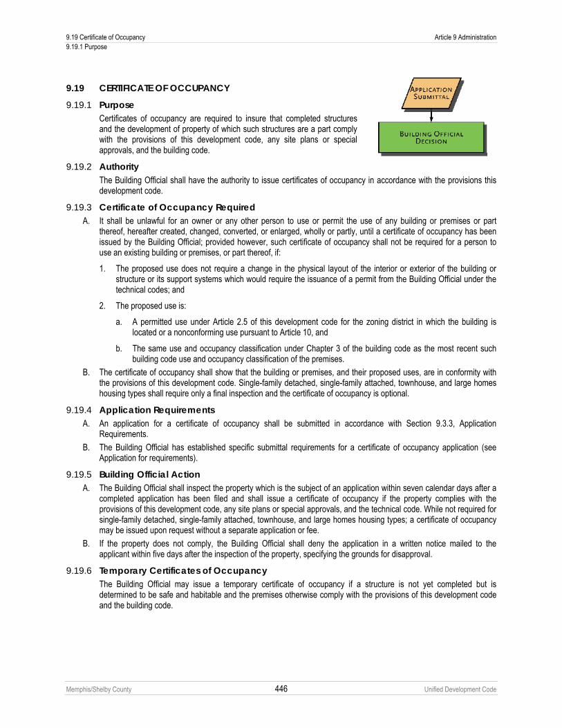
9.19 Certificate of Occupancy Article 9 Administration 9.19.1 Purpose
Memphis/Shelby County 446 Unified Development Code
9.19 CERTIFICATE OF OCCUPANCY
9.19.1 Purpose Certificates of occupancy are required to insure that completed structures and the development of property of which such structures are a part comply with the provisions of this development code, any site plans or special approvals, and the building code.
9.19.2 Authority The Building Official shall have the authority to issue certificates of occupancy in accordance with the provisions this development code.
9.19.3 Certificate of Occupancy Required A. It shall be unlawful for an owner or any other person to use or permit the use of any building or premises or part
thereof, hereafter created, changed, converted, or enlarged, wholly or partly, until a certificate of occupancy has been issued by the Building Official; provided however, such certificate of occupancy shall not be required for a person to use an existing building or premises, or part thereof, if:
1. The proposed use does not require a change in the physical layout of the interior or exterior of the building or structure or its support systems which would require the issuance of a permit from the Building Official under the technical codes; and
2. The proposed use is:
a. A permitted use under Article 2.5 of this development code for the zoning district in which the building is located or a nonconforming use pursuant to Article 10, and
b. The same use and occupancy classification under Chapter 3 of the building code as the most recent such building code use and occupancy classification of the premises.
B. The certificate of occupancy shall show that the building or premises, and their proposed uses, are in conformity with the provisions of this development code. Single-family detached, single-family attached, townhouse, and large homes housing types shall require only a final inspection and the certificate of occupancy is optional.
9.19.4 Application Requirements A. An application for a certificate of occupancy shall be submitted in accordance with Section 9.3.3, Application
Requirements.
B. The Building Official has established specific submittal requirements for a certificate of occupancy application (see Application for requirements).
9.19.5 Building Official Action A. The Building Official shall inspect the property which is the subject of an application within seven calendar days after a
completed application has been filed and shall issue a certificate of occupancy if the property complies with the provisions of this development code, any site plans or special approvals, and the technical code. While not required for single-family detached, single-family attached, townhouse, and large homes housing types; a certificate of occupancy may be issued upon request without a separate application or fee.
B. If the property does not comply, the Building Official shall deny the application in a written notice mailed to the applicant within five days after the inspection of the property, specifying the grounds for disapproval.
9.19.6 Temporary Certificates of Occupancy The Building Official may issue a temporary certificate of occupancy if a structure is not yet completed but is determined to be safe and habitable and the premises otherwise comply with the provisions of this development code and the building code.

Article 9 Administration 9.20 Written Interpretations 9.20.1 Applicability
Memphis/Shelby County 447 Unified Development Code
9.20 WRITTEN INTERPRETATIONS
9.20.1 Applicability When uncertainty exists, the Building Official, after consultation with the Planning Director and the City or County Attorney, shall be authorized to make all interpretations concerning the provisions of this development code.
9.20.2 Application Requirements A. A request for a written interpretation shall be submitted in accordance with Section 9.3.3, Application Requirements.
B. The Building Official established specific submittal requirements for a written interpretation request (see Application for requirements).
9.20.3 Building Official Action A. The Building Official shall review and evaluate the request in light of the text of this development code, the Zoning
Map, any plans to be considered (see Chapter 1.9) any other relevant information;
B. Following completion of the technical reviews by staff, the Building Official shall render an opinion.
C. The interpretation shall be provided to the applicant in writing.
9.20.4 Official Record The Building Official shall maintain an official record of all interpretations and shall provide a copy of all interpretations to the Planning Director. The record of interpretations shall be available for public inspection during normal business hours.

9.21 Administrative Deviation Article 9 Administration 9.21.1 Applicability
Memphis/Shelby County 448 Unified Development Code
9.21 ADMINISTRATIVE DEVIATION
9.21.1 Applicability During the administrative site plan review process, the Planning Director is authorized to approve administrative deviations to the standards listed below, where, owing to special conditions, strict enforcement of certain standards would be physically impractical. This optional process shall occur only where the applicant requests an administration deviation to a standard as specified below.
9.21.2 Permitted Deviations The Planning Director shall review the request in light of the intent and purpose of district requirements. The Planning Director shall have the authority to approve an administration deviation for the following standards:
A. Building and Parking Placement 1. Setback encroachment – increase of up to 10% of the maximum permitted setback and up to 10% of the minimum
permitted setback. 2. Required building frontage (minimum percentage of build-to) – reduction of up to 5% of required length.
3. Required building frontage (minimum percentage of build-to) – reduction of up to 5% of required length with construction of a frontage wall.
4. Required building frontage (minimum percentage of build-to) – allowance for a 0-foot setback for any expansion, modification, alteration or reconstruction of a building with a setback less than the required minimum setback as proscribed by this Code.
5. Parking setback – decrease of up to 5% of the minimum required setback.
6. Maximum building setbacks – allow for the setback to be determined by averaging the setback distance over the width of the building.
B. Elements 1. Transparency (minimum and maximum percent) – up to 5%. 2. Blank wall area – increase of up to 10% of the maximum permitted blank wall area. 3. Building entrance – reduction up to 10% of the minimum required transparency. 4. Recessed entry – up to 10% of the maximum permitted depth.
C. Height 1. Minimum floor heights – up to a 10% reduction for any one floor. 2. The minimum ground floor elevation – up to a 10% reduction.
D. Additional Provisions 1. Creative use of metal panels, concrete masonry units (CMU), exterior insulating finishing systems (EIFS) and
precast concrete may be approved administratively, where such materials are otherwise prohibited by this Code. 2. Tandem parking associated with any housing types other than single-family detached and single-family attached.
Tandem Parking for single-family detached and single-family attached are permitted by right. 3. All other administrative deviations as set out in this Code.
9.21.3 Application Requirements A. A request for an administrative deviation shall be submitted in accordance with Section 9.3.3, Application
Requirements.
B. The Planning Director has established specific submittal requirements for a request for an administrative deviation (see Application for requirements).
9.21.4 Administrative Deviation Criteria To approve an administrative deviation, the Planning Director shall make an affirmative finding that all of the following criteria are met:

Article 9 Administration 9.21 Administrative Deviation 9.21.5 Appeals
Memphis/Shelby County 449 Unified Development Code
A. An administrative deviation does not conflict with streets, sidewalks, easements or landscape requirements.
B. An administrative deviation does not injure or damage the use, value or enjoyment of surrounding property or hinder or prevent the development of surrounding property.
C. An administrative deviation does not have an adverse impact on land use compatibility.
D. An administrative deviation does not materially and adversely affect adjacent land uses and the physical character of uses in the immediate vicinity of the proposed.
E. An administrative deviation will not have an adverse impact on the urban form and/or the street-space.
9.21.5 Appeals If the Planning Director does not approve the application for an administrative deviation, the applicant may appeal to the Board of Adjustment.
9.21.6 Official Record The Planning Director shall maintain an official record of all administrative deviations. The record of administrative deviations shall be available for public inspection during normal business hours.

9.22 Variance Article 9 Administration 9.22.1 Applicability
Memphis/Shelby County 450 Unified Development Code
9.22 VARIANCE
9.22.1 Applicability A. The Board of Adjustment may vary certain requirements of this development code that will
not be contrary to the public interest, where, owing to special conditions, a literal enforcement of the certain provisions of this development code, will, in an individual case, result in practical difficulty or unnecessary hardship. In granting a variance, the Board of Adjustment shall ensure that the spirit of this development code shall be observed, public safety and welfare secured, and substantial justice done.
B. The Board of Adjustment shall have authority to vary the standards of this development code, except for those associated with subdivisions (see Sub-Section 9.7.7F for subdivision waivers).
9.22.2 Application Requirements A. A request for a variance shall be submitted in accordance with Section 9.3.3, Application Requirements.
B. The Planning Director has established specific submittal requirements for a request for a variance (see Application for requirements).
9.22.3 Burden of Proof The applicant seeking the variance shall have the burden of presenting evidence sufficient to allow the Board of Adjustment to reach the conclusions set forth below as well as the burden of persuasion on those issues.
9.22.4 Planning Director Action The Planning Director shall provide the Board of Adjustment with a copy of the application, a report with a recommendation and all relevant materials pertaining to the request.
9.22.5 Board of Adjustment Action A. Not less than 21 or more than 54 days after an application has been determined complete, the Board of Adjustment
shall hold a public hearing and give notice in accordance with Section 9.3.4, Public Hearings and Notification.
B. Prior to the adjournment of the meeting at which such public hearing is concluded, the Board shall act on the requested variance, or take the matter under advisement, or defer decision until the next regular meeting of the Board. Notice of the Board’s decision, along with its written findings shall be mailed to the applicant.
9.22.6 Findings of Fact The Board of Adjustment must make specific written findings of fact on each variance request. In granting any variance, the Board of Adjustment shall make the following findings:
A. Bulk and Other Non-Use Variances
1. Unusual characteristics of the property. The property is unusual in that it exhibits at least one of the following exceptional physical features as compared to other properties located in the same zoning district: exceptional topographic conditions, exceptional narrowness, exceptional shallowness, exceptional shape or any other extraordinary and exceptional situation or condition;
2. Practical difficulties or undue hardship. By reason of the unusual characteristic found to apply in Paragraph 1, the strict application of any regulation found in this Code would result in peculiar and exceptional practical difficulties to or exceptional or undue hardship upon the owner of such property;
3. The unusual characteristic found to apply in Paragraph 1 is not the result from any deliberate action by the owner;
4. That a variance from the strict application of this Code may be granted without substantial detriment to the public good and without substantially impairing the intent and purpose of an adopted plan and this Code;
5. The requested variance will be in harmony with the purpose and intent of this development code and will not be injurious to the neighborhood or to the general welfare;

Article 9 Administration 9.22 Variance 9.22.7 Conditions on Variance
Memphis/Shelby County 451 Unified Development Code
6. The variance is not granted simply because by granting the variance, the property could be utilized more profitably or that the applicant would save money.
B. Use Variances 1. In addition to the findings established for other variances in Sub-Section A, the Board of Adjustment shall also find
that none of the uses permitted on the property by Section 2.5.2 (the Use Table) are practicable due to either the unusual characteristic found to apply in Sub-Section A, Paragraph 1, or to any physical improvements made upon the property.
2. Off-premise signs. No use variance may be requested for an off-premise sign. See also Tennessee Code Annotated Section 54-21-116 (the Billboard Regulation and Control Act of 1972). This Paragraph shall not be construed to prohibit consideration of bulk and other non-use variances for off-premise signs.
3. Use Variances and Special Use Permits. No use variance may be requested for any use that requires the issuance of a Special Use Permit by the appropriate legislative bodies in the zoning district of the subject property, except for the expansion, modification or legitimization of uses established, structures built or sites developed prior to the effective date of this Code (January 1, 2011). See Article 2 for uses requiring Special Use Permits.
4. Use Variances, Rezonings and Planned Developments. No use variance may be requested on a piece of property if, within 18 months of the time of the filing of the request for a use variance, the Land Use Control Board has voted upon a request to approve a rezoning or planned development on the subject property, or any portion of the subject property.
5. Time extensions and other revisions to use variances approved by the Memphis City Council and Shelby County Board of Commissioners shall be processed as Special Use revisions, pursuant to Section 9.6.12 of this Code.
9.22.7 Conditions on Variance A. The Board of Adjustment may set forth conditions in the written resolution granting a variance. Such conditions may
relate to screening, landscaping, location and other conditions necessary to preserve the character of the area and protect property in the near vicinity. A violation of such conditions shall be a violation of this development code.
B. The Building Official shall determine when the applicant has complied with the conditions set forth in the resolution granting the variation.
9.22.8 Effect of Granting a Variance The grant of a variance shall not allow the development of the property for which a variance was granted but shall merely authorize the filing of applications for required permits and approvals, including, but not limited to, building permits and certificates of occupancy. Time extensions may be requested pursuant to the Rules of Procedure of the Board of Adjustment.

9.23 Appeals Article 9 Administration 9.23.1 Administrative Action
Memphis/Shelby County 452 Unified Development Code
9.23 APPEALS An appeal by any person aggrieved by a final order, interpretation or decision with regards to the provisions of this development code may be taken as set forth below.
9.23.1 Administrative Action A. Applicability
An appeal by any person aggrieved by a final order, interpretation or decision of the Planning Director, Building Official or other administrator in regards to the provisions of this development code may be taken to the Board of Adjustment. However, an appeal of a minor preliminary plan may only be taken to the Land Use Control Board.
B. Application Requirements 1. An appeal of any administrative decision shall be taken by filing a written notice of appeal specifying the grounds
for the appeal with the Planning Director and the appropriate body hearing the appeal. 2. An application for an administrative appeal shall be submitted in accordance with Section 9.3.3, Application
Requirements. 3. A notice of appeal of an administrative decision shall be considered filed when a complete application is delivered
to the Planning Director. The date and time of filing shall be entered on the notice. C. Board of Adjustment or Land Use Control Board Action
1. An appeal of an administrative decision shall be filed with the Secretary of the Board of Adjustment or, if a special exception or minor preliminary plan, with the Secretary of the Land Use Control Board and with the aggrieved entity, within five days of receipt of the decision.
2. Not less than 21 days after a notice of appeal is filed, the Board of Adjustment or Land Use Control Board shall hold a public hearing and give notice in accordance with Section 9.3.4, Public Hearings and Notification.
3. Prior to the adjournment of the hearing, the Board of Adjustment or Land Use Control Board may reverse or affirm (wholly or partly) or may modify the order, requirement, decision, or determination appealed from and shall make any order, requirement, decision or determination that in its opinion ought to be made in the case before it. To this end, the Board of Adjustment or Land Use Control Board shall have all the powers of the officer from whom the appeal is taken. The Board of Adjustment or Land Use Control Board may take the appeal under advisement or defer decision until the next regular meeting.
4. A motion to reverse, affirm, or modify the order, requirement, decision, or determination appealed from shall include, insofar as practicable, a statement of the specific reasons or findings of fact that support the motion.
5. If a motion to reverse or modify is not made, or fails to receive the affirmative vote of five members necessary for adoption, then the appeal shall be denied.
6. Any motion to overturn a decision shall state the reasons or findings of fact that support the motion. D. Effect of Appeal
1. An appeal shall stay all proceedings in furtherance of the action appealed, unless the administrative official from who the appeal is taken certifies to the Board of Adjustment or the Land Use Control Board that, because of facts stated in the certificate, a stay would, in their opinion, cause imminent peril to life or property or that because the violation is transitory in nature a stay would seriously interfere with the effective enforcement of this development code. In that case, proceedings shall not be stayed except by order of the Board of Adjustment, Land Use Control Board, Governing Body, or a court, issued on application of the party seeking the stay, for due cause shown, after notice to the administrative official.
2. An appeal shall not stop action lawfully approved (including construction activities authorized by a building permit); only actions presumed in violation of this development code are stayed.
9.23.2 Land Use Control Board Action A. Right to Appeal
Any individual appearing or submitting written comments on a particular application at a meeting of the Land Use Control Board may appeal a decision of the Land Use Control Board, on said application, to the governing bodies except where the Land Use Control Board hears an appeal of the Planning Director.
B. Submission of Appeal Appeals shall be submitted in writing to the chief administrative officer of the governing bodies. A copy of the appeal shall be sent to the Planning Director.

Article 9 Administration 9.23 Appeals 9.23.3 Landmarks Commission Action
Memphis/Shelby County 453 Unified Development Code
C. Deadline Appeals shall be submitted within 14 days of the Land Use Control Board’s decision.
D. Required information The request for an appeal shall indicate the name and case number of the application, the date of the Land Use Control Board action, the specific decision and/or conditions which are being appealed, and the name, address and phone number of the appellant.
E. Governing Body Action 1. The appeal shall be scheduled for legislative consideration. Notice shall be sent to the applicant, the appellant,
any individual appearing or who submitted written comments at the Land Use Control Board meeting, and members of the Technical Review Committee, not less than ten days or more than 35 days in advance of the scheduled hearing.
2. The governing bodies shall approve the appeal, approve with conditions, or deny the appeal. F. Revised Plan
A revised plan may be required by the governing bodies following a decision on the appeal.
9.23.3 Landmarks Commission Action A. Appeals from any decision of the Landmarks Commission may be taken in accordance with statutory certiorari,
provided for in Chapter 9, Title 27 of the Tennessee Code Annotated.
B. Nothing in this Chapter shall be interpreted as giving the Landmarks Commission any authority to consider, review, examine or control the use of property classified as a local historic district. Use shall be controlled solely by the zoning controlling such property prior to its classification as a local historic district or as may be rezoned by subsequent amendments.
9.23.4 Board of Adjustment Action Appeals from any decision of the Board of Adjustment may be taken in accordance with Chapter 9, Title 27 of the Tennessee Code Annotated.
9.23.5 Governing Body Action Appeals from any decision of the governing bodies may be taken in accordance with Chapter 9, Title 27 of the Tennessee Code Annotated.

9.24 Conditional Use Permits Article 9 Administration 9.24.1 Applicability
Memphis/Shelby County 454 Unified Development Code
9.24 CONDITIONAL USE PERMITS
9.24.1 Applicability A. Conditional uses within each zoning district are uses that may be appropriate in a
particular zoning district, but because of the increased potential for incompatibility with adjacent uses, require individual review by the Board of Adjustment.
B. A conditional use permit is required for all conditional uses as set forth in Article 2. C. Where a use requiring conditional use approval lies on a separate tract or lot, only
the building containing the use and its separate tract or lot shall be subject to conditional use review, not the entire project. However, where the separate tract or lot is an outparcel, the application for conditional use shall describe the relationship of the outparcel to the remaining site.
9.24.2 Application Requirements A. A request for a conditional use permit shall be submitted in accordance with Section 9.3.3, Application Requirements.
B. The Planning Director has established specific submittal requirements for a request for a conditional use permit (see Application for requirements).
9.24.3 Burden of Proof The applicant seeking the conditional use permit shall have the burden of presenting evidence sufficient to allow the Board of Adjustment to reach the conclusions set forth below as well as the burden of persuasion on those issues.
9.24.4 Planning Director Action The Planning Director shall provide the Board of Adjustment with a copy of the application, a report with a recommendation and all relevant materials pertaining to the request.
9.24.5 Board of Adjustment Action A. Not less than 21 or more than 54 days after an application has been determined complete, the Board of Adjustment
shall hold a public hearing and give notice in accordance with Section 9.3.4, Public Hearings and Notification.
B. Prior to the adjournment of the meeting at which such public hearing is concluded, the Board shall act on the requested conditional use permit, or take the matter under advisement, or defer decision until the next regular meeting of the Board. Notice of the Board’s decision, along with its written findings shall be mailed to the applicant.
9.24.6 Approval Criteria No conditional use permit shall be approved unless the following findings are made concerning the application:
A. The project will not have a substantial or undue adverse effect upon adjacent property, the character of the neighborhood, traffic conditions, parking, utility facilities and other matters affecting the public health, safety, and general welfare.
B. The project will be constructed, arranged and operated so as to be compatible with the immediate vicinity and not interfere with the development and use of adjacent property in accordance with the applicable district regulations.
C. The project will be served adequately by essential public facilities and services such as streets, parking, drainage, refuse disposal, fire protection and emergency services, water and sewers; or that the applicant will provide adequately for such services.
D. The project will not result in the destruction, loss or damage of any feature determined by the Board of Adjustment to be of significant natural, scenic or historic importance.

Article 9 Administration 9.24 Conditional Use Permits 9.24.7 Conditions of Approval
Memphis/Shelby County 455 Unified Development Code
E. The project complies with all additional standards imposed on it by any particular provisions authorizing such use.
F. The request will not adversely affect any plans to be considered (see Chapter 1.9), or violate the character of existing standards for development of the adjacent properties.
G. The Board of Adjustment may impose conditions to minimize adverse effects on the neighborhood or on public facilities, and to insure compatibility of the proposed development with surrounding properties, uses, and the purpose and intent of this development code.
H. Any other finding required for a particular conditional use permit as provided in this Code.
9.24.7 Conditions of Approval A. In granting approval of a conditional use permit, the Board of Adjustment may impose reasonable conditions which
serve to assure that the required findings are upheld. Such conditions may include, but are not limited to, right-of-way or easement dedication; recreation, open space, landscaping or buffer provision; limits on scale, intensity, or hours of operation; and other reasonable restrictions.
B. Any additional condition approved by the Board of Adjustment shall become a part of the permit and be of equal importance in the responsibility of the applicant or subsequent assigns to adhere to its terms.
9.24.8 Effect of Granting a Conditional Use Permit The grant of a conditional use permit shall not allow the development of the property for which a conditional use permit was granted but shall merely authorize the filing of applications for required permits and approvals, including, but not limited to, building permits and certificates of occupancy. Time extensions may be requested pursuant to the Rules of Procedure of the Board of Adjustment.
9.24.9 Significant Neighborhood Structure (SNS) Provisions A. Purpose
Significant Neighborhood Structure (SNS) provisions are intended to protect and preserve existing non-residential neighborhood structures that are important to the historical, architectural, cultural or civic character of the neighborhood. Some existing older buildings, such as corner stores and churches, may not physically lend themselves for permitted uses within residential areas. While this situation does not pose a problem for previously existing non-conforming uses that are “grandfathered in,” abandoned uses lose such status. These provisions give relief by allowing non-residential uses following certain criteria as a way to provide an economically viable means to preserve Significant Neighborhood Structures. The designation of Significant Neighborhood Structure status for specific properties shall be processed as Conditional Uses, subject to Use Table, Section 2.5.2.
B. Criteria for Consideration A Significant Neighborhood Structure is defined as a structure, it appurtenances and the associated property that has historical, cultural, architectural, or civic value and/or importance; and whose demolition or destruction would constitute an irreplaceable loss to the quality and character of its neighborhood; and that meets one or more of the following criteria:
1. It was originally constructed as a non-residential structure; 2. It is recognized as a significant element of the neighborhood and/or community; 3. It embodies characteristics that distinguish it from other structure of the neighborhood and/or community; 4. It is considered historically or architecturally significant; 5. Rezoning the property on which the structure exists to a general zoning district inconsistent with surrounding or
adjacent properties would have a significant negative impact to the neighborhood and/or community; 6. Retaining the features of the structure is important in maintaining the traditional neighborhood fabric; 7. Retaining the structure will help to preserve the variety of buildings and structures historically present within the
neighborhood, recognizing that such structure may be differentiated by age, function and architectural style in the neighborhood and/or community;
8. Retaining the structure will help to reinforce the neighborhood and/or community’s traditional and unique character.
C. Significant Neighborhood Structure Development Plan A development plan for the reuse of any structure to be identified as an SNS shall be submitted in accordance with 9.24.2 to the Planning Director and approved by the Board of Adjustment. No building permits, or land

9.24 Conditional Use Permits Article 9 Administration 9.24.9 Significant Neighborhood Structure (SNS) Provisions
Memphis/Shelby County 456 Unified Development Code
development permits of any other kind, shall be issued prior to the approval of the SNS development plan. Depending upon the extent of information determined necessary by the Planning Director on an application-by-application basis, the following types of information may be required:
1. A site plan of the proposed SNS, including underlying existing zoning districts; 2. The location, orientation, and size of all existing and proposed structures, features and other elements and
associated parking spaces; 3. The location of any structure on any property adjacent to the boundaries of the district; 4. The type, location, number and size of all significant existing and proposed vegetation; 5. The location, height and type of all existing and proposed fences or walls; 6. The location of any accessory structures for refuse collection, recycling or feature maintenance; 7. The location of all existing and proposed access points, loading areas and drive-thru lanes; 8. The location and name of all existing streets and alleys; 9. Photographs of all relevant site conditions, buildings, and other features; 10. Tabular data identifying the specific existing and proposed uses and square footage; structure height(s) and
parking spaces; 11. Certification by a civil engineer, architect, or landscape architect directly involved in the preparation of the
development plan. D. Permitted Land Uses
See Use Table, Section 2.5.2. E. Design Principles
1. Building Mass & Scale The mass and scale of any new construction or alternations to a structure shall be compatible with the existing on-site and surrounding uses, buildings, structures and streetscape.
2. Parking The number of required parking spaces shall be established recognizing available on-street parking and alternative parking available in the area. New parking spaces shall be located so as not to disrupt the continuity of the existing neighborhood context, building rhythm and streetscape and shall be placed to the side and rear of the key site feature being preserved to the extent possible.
3. Lighting Lighting shall be designed and located at a pedestrian scale consistent with pedestrian movements and the neighborhood. Lighting shall be concealed or shielded to avoid glare and off-site impacts on abutting properties. Light poles and fixtures shall be compatible with the function and design of the structure and the abutting properties.
4. Signs Any sign, where permitted as part of an SNS development plan, shall be consistent with the context, scale, and character of the neighborhood where the district is located. The site structure’s mass and scale, and the neighborhood in which it is located, shall be considered in sign size and design to ensure sensitivity and proportion to surrounding properties.
5. Landscaping Landscaping shall enhance and reinforce the distinguishing characteristics of the key site structure of site element, and appropriately buffer any physical alteration from adjacent properties.
F. Alternative Standards In addition to alternative permitted land uses, the approval of an SNS development plan, may establish alternative standards for minimum lot area, setback and building height standards. A finding must be made that those standards would serve to enhance and provide a strong sense of place, permit the reasonable use of the property, and not impair the continued use and enjoyment of abutting properties. These alternative standards may apply to the existing structure or structures, as well as any additions or new structures on the site.
G. Cancellation In the event that a building permit or certificate of occupancy has not been issued for the SNS property within two years from the date that the appropriate governing body approved the SNS development plan, the Board of

Article 9 Administration 9.24 Conditional Use Permits 9.24.9 Significant Neighborhood Structure (SNS) Provisions
Memphis/Shelby County 457 Unified Development Code
Adjustment may act to cancel a SNS designation at any time thereafter, upon giving the property owners 30 day’s prior notice to the Board of Adjustment public hearing at which the cancellation will be considered.

Memphis/Shelby County 458 Unified Development Code
Article 10. Nonconformities 10.1 PURPOSE
The purpose of this Chapter is to establish regulations and limitations on the continued existence of uses, lots, structures and signs established prior to the effective date of this development code that do not conform to the provisions of this development code. Many such nonconformities may continue, but the provisions of this Chapter are designed to curtail substantial investment in nonconformities and to bring about their eventual elimination, where appropriate, in order to preserve the integrity of the regulations established in this development code.
10.2 NONCONFORMING USES
10.2.1 Authority to Continue Any lawfully existing nonconforming use of part or all of a structure, or any lawfully existing nonconforming use of land not involving a structure or involving a structure which is accessory to such use of land, may be continued, so long as it remains otherwise lawful, subject to the provisions of Sections 10.2.2 through 10.2.7 below.
10.2.2 Ordinary Repair and Maintenance Normal maintenance and incidental repair or replacement, and installation or relocation of non-bearing walls, non-bearing partitions, fixtures, wiring or plumbing, may be performed on any structure that is devoted in whole or in part to a nonconforming use; provided, however, that this Chapter shall not be deemed to authorize any violation of Sections 10.2.3 through 10.2.7 below.
10.2.3 Extensions A nonconforming use shall not be extended, expanded, enlarged or increased in intensity. Such prohibited activity shall include, without being limited to:
A. Extension of such use to any structure or land area other than that occupied by such nonconforming use on the effective date of this development code, or any amendment to this code that causes such use to become nonconforming.
B. Extension of such use within a building or other structure to any portion of the floor area that was not occupied by such nonconforming use on the effective date of this development code, or any amendment to this code that causes such use to become nonconforming.
C. Operation of such nonconforming use in such a manner as to conflict with, or to further conflict with, if already conflicting on the effective date of this development code or any amendments to this code, any use limitations established for the district in which such use is located.
D. New construction, reconstruction or structural alteration.
10.2.4 Relocation No structure that is devoted in whole or in part to a nonconforming use shall be relocated in whole or in part to any other location on the same or any other tract or lot, unless the entire structure and the use of the structure after its relocation conform to all the regulations of the district in which the structure and use are located after being so relocated. No nonconforming use of land shall be relocated in whole or in part to any other location on the same or any other lot, unless such use conforms to all the regulations of the district in which such use of land is located after being so relocated.

Article 10 Nonconformities 10.2 Nonconforming Uses 10.2.5 Change in Use
Memphis/Shelby County 459 Unified Development Code
10.2.5 Change in Use A. Change in Nonconforming Use Permit
1. Board of Adjustment. A nonconforming use may be changed to a use of a similar or higher classification with the issuance of a Change in Nonconforming Use Permit. The Board of Adjustment shall have the authority to issue Change in Nonconforming Use Permits.
2. Application. A Change in Nonconforming Use Permit shall be processed in the same manner as a variance request (see Chapter 9.22). However, the Findings of Fact of Section 9.22.6 shall be substituted for the following: The Board shall find that the proposed use will create no greater adverse impacts on the surrounding area than the existing use.
3. Conflict with other Provisions. A Change in Nonconforming Use Permit shall not be issued for any use that requires the issuance of a Special Use Permit, according to Article 2, or for an off-premise sign. In addition, the Board of Adjustment shall not waive any use standard as set out in Chapter 2.6 with the approval of a Change in Nonconforming Use Permit. However, a companion application for a variance(s) may be filed with an application for a Change in Nonconforming Use Permit.
B. Higher Classification For the purpose of this Section, a use of a “higher classification,” per Priv. Acts 1921, ch. 165, sec 7 and Priv. Acts 1931, chapter 613, section 9, shall be determined accordingly. Those uses at the top of the following list are of a higher classification than those at the bottom. See Chapter 2.5, Use Table, for specific uses within each classification. For proposed uses within the same following categories as the existing use, or for proposed uses not included within the following categories, the Planning Director or the Board of Adjustment shall determine whether a proposed use is of a higher classification as compared to the existing use on a case-by-case basis.
1. Open
2. Single-Family Residential
3. Multi-Family Residential
4. Civic
5. Commercial
6. Industrial
10.2.6 Abandonment or Discontinuance When a nonconforming use of land or a nonconforming use of part or all of a structure is discontinued or abandoned for a period of 365 consecutive days, such use shall not thereafter be reestablished or resumed, regardless of any intent not to abandon and to resume such use. Discontinuance or abandonment for time to obtain a permit or license to operate or keep the nonconforming use, or due to a suspension, revocation, injunction, or loss of such permit or license, shall not toll any portion of the 365 days. Operation of any nonconforming use without a license or permit required of the owner or operator, for 365 consecutive days, shall constitute a termination of the nonconforming use. Revocation of a license to operate a nonconforming adult oriented establishment or to provide adult entertainment in a nonconforming location shall terminate such nonconforming use. Any subsequent use or occupancy of such land or structure shall comply with the regulations of the zoning district in which such land or structure is located.
10.2.7 Damage or Destruction A. In the event that any structure that is devoted in whole or in part to a nonconforming use is damaged or destroyed, by
any means, to the extent of more than 75% of the fair market value of such structure immediately prior to such damage, such structure shall not be restored unless the structure and the use will conform to all regulations of the district in which the structure and use are located. The prohibition against restoration within this Sub-section shall not apply to the restoration or repair of any damaged or destroyed public utility facility built prior to the effective date of this development code.

10.3 Nonconforming Structures Article 10 Nonconformities 10.3.1 Authority to Continue
Memphis/Shelby County 460 Unified Development Code
B. When such damage or destruction is 75% or less of the fair market value of the structure immediately prior to such damage, such structure may be repaired and reconstructed and used for the same purposes as it was before the damage or destruction, provided that such repair or reconstruction is commended and completed within 12 months of the date of such damage or destruction.
C. For the purpose of this Section, the calculation of 75% shall be determined as a percentage of the total fair market value of all buildings on the lot or tract.
10.3 NONCONFORMING STRUCTURES
10.3.1 Authority to Continue Any nonconforming structure which is devoted to a use which is permitted in the zoning district in which the structure is located may be continued so long as it remains otherwise lawful, subject to the provisions of Sections 10.3.2 through 10.3.4 below.
10.3.2 Enlargement, Repair, Alterations Any nonconforming structure may be enlarged, maintained, repaired or altered; provided, however, that no such enlargement, maintenance, repair or alteration shall either create an additional nonconformity or increase the degree of the existing nonconformity of all or any part of such structure (see Chapter 3.11 for special requirements applicable to any development where a maximum setback applies).
10.3.3 Damage or Destruction A. In the event that any nonconforming structure is damaged or destroyed, by any means, to the extent of more than 75%
of the fair market value of such structure immediately prior to such damage, such structure shall not be restored unless it will conform to the regulations of the district in which it is located. The prohibition against restoration within this Sub-section shall not apply to the restoration or repair of any damaged or destroyed public utility facility built prior to the effective date of this development code.
B. When such nonconforming structure is damaged or destroyed, by any means by 75% or less of the fair market value of the structure immediately prior to such damage, such structure may be repaired or reconstructed, provided that the repairs or restorations begin and are diligently pursued to completion within 12 months of the date of such damage.
C. For the purpose of this Section, the calculation of 75% shall be determined as a percentage of the total fair market value of all buildings on the lot or tract.
10.3.4 Relocation No nonconforming structure shall be relocated in whole or in part to any other location on the same or any other lot unless the entire structure shall thereafter conform to the regulations of the district in which such structure is located after being relocated.
10.4 NONCONFORMING ACCESSORY USES AND STRUCTURES No use or structure which is accessory to a principal nonconforming use or structure shall continue after such principal use or structure shall have ceased or terminated, unless such accessory use or structure shall thereafter conform to all the regulations of the district in which it is located.
10.5 NONCONFORMING TRACTS AND LOTS OF RECORD
10.5.1 Authority to Use for Single-Family Residence In any district in which single-family detached dwellings are a permitted use, notwithstanding the regulations imposed by any other provisions of this development code, a single-family detached dwelling which complies with the restrictions of Section 10.5.2 below may be erected on a nonconforming lot that is not less than 25 feet in width, and which:
A. Has less than the prescribed minimum tract or lot area, width and depth, or any of them; and
B. Is shown by a recorded plan or deed to have been a lot of record or tract owned separately and individually from adjoining tracts of land at a time when the creation of a lot or tract of such size, depth and width at such location would not have been prohibited by any zoning or other ordinance; and

Article 10 Nonconformities 10.6 Nonconforming On-Premise and Off-Premise Signs 10.5.2 Regulations for Single-Family Use of Nonconforming Tracts and Lots
Memphis/Shelby County 461 Unified Development Code
C. Has remained in separate and individual ownership from adjoining tracts of land continuously since March 1, 1989.
10.5.2 Regulations for Single-Family Use of Nonconforming Tracts and Lots A nonconforming tract or lot authorized to be used pursuant to Section 10.5.1 above may be used for single-family dwellings and permitted accessory uses thereto and no other structures. Construction of the single-family dwelling shall comply with all the regulations (except tract or lot area, width and depth) applicable to single-family dwellings in the district in which such tract or lot is located, except that the following requirements shall apply in place of the requirements otherwise applicable:
A. The dwellings shall be placed on the tracts or lots so as to provide a yard on each side of the dwelling;
B. The sum of the widths of the two side yards on such tracts or lots shall not be less than the smaller of:
1. 25% of the width of the tract or lot; or 2. The minimum total for both side yards prescribed by the building envelope standards of said zoning district; and 3. No side yard shall be less than three feet.
C. The minimum lot sizes of the CA District, as indicated in Section 3.6.1, shall apply for lots without public sewer or public water and shall be subject to review by the Shelby County Health Department.
10.6 NONCONFORMING ON-PREMISE AND OFF-PREMISE SIGNS See Section 4.9.15.
10.7 EXCEPTION FOR REPAIRS PURSUANT TO PUBLIC ORDER Nothing in this Article shall be deemed to prevent the strengthening or restoration to a safe condition of a building, structure or sign in accordance with an order of a public official who is charged with protecting the public safety and who declares such structure to be unsafe and orders it to be restored to a safe condition provided such restoration is not otherwise in violation of the various provisions of this Article prohibiting the repair or restoration of partially damaged or destroyed buildings, structures or signs.
10.8 EXCEPTION TO MAXIMUM SETBACKS AND REQUIRED BUILDING FRONTAGES The maximum setback and building frontage requirements that apply to townhouses and multi-family buildings, as established in Section 3.7.2 and to permitted nonresidential uses, as established in Section 3.7.3, shall not apply to buildings in existence prior to January 1, 2011. As such, this Article shall not apply to said buildings. In addition, the standards of Chapters 7.2, 7.3, 8.2, 8.3 and 8.4 addressing building placement and elements do not apply to building additions and new buildings on nonconforming sites unless the provisions of Chapter 3.11 are met.
10.9 EXCEPTION TO REQUIRED PERCENTAGE OF HOUSING TYPES The required percentage of housing types, as established in Section 3.7.2, shall not apply to buildings in existence prior to January 1, 2011.
10.10 EXCEPTION FOR HISTORIC MULTI-FAMILY PROPERTIES This Article shall not apply to properties designated as Historic Multi-Family Properties by the Landmarks Commission, pursuant to Section 8.5.2F(3).
10.11 EXCEPTION FOR MEMPHIS LIGHT, GAS AND WATER DIVISION Under no circumstance shall any infrastructure owned or leased by Memphis Light Gas, and Water Division be considered a nonconforming use or structure. Modifications, alterations and expansions to said infrastructure may be performed.
10.12 EXCEPTION FOR CITY AND COUNTY PROPERTIES Under no circumstance shall any property or structure owned or leased by the city of Memphis or Shelby County that was constructed prior to January 1, 2011, be considered a nonconforming use or structure. Modifications, alterations and expansions to said infrastructure may be performed.
10.13 EXCEPTION FOR BUILDINGS WITH LESS THAN TWO-FOOT SETBACKS Any minimum setback of two feet found in this Code shall not apply to any building that was built prior to January 1, 2011, with a setback of less than two feet.

Memphis/Shelby County 462 Unified Development Code
Article 11. Enforcement 11.1 IN GENERAL
Any person, firm or corporation violating any of the provisions of this development code shall, upon conviction thereof, be fined not more than $50.00. Each day’s continuance of a violation shall be considered a separate offense. In addition to the party violating this development code, any other person who may have knowingly assisted in the commission of any such violation shall be guilty of a separate offense.
11.2 SUBDIVISION
11.2.1 Violations A. No owner, or agent of the owner, of any tract of land in a proposed subdivision for which a preliminary plan has been
filed shall transfer or sell any such lot or portion of the proposed subdivision before a final plat of such subdivision has been approved by the appropriate governing body in accordance with the provisions of these regulations, and recorded in the office of the Shelby County register.
B. The subdivision of any tract of land, by the use of metes and bounds description for the purpose of sale, transfer, or lease with the intent of evading these regulations, shall not be permitted. All such described subdivisions shall be subject to all of the requirements contained in these regulations.
C. No street number or building permit shall be issued for the erection of any building or structure located on a lot or tract of land which violates the provisions of these regulations.
11.2.2 Penalties A. Appropriate actions and proceedings may be taken by law or in equity to prevent any violation of these regulations, to
restrain, correct, or abate a violation, or to prevent illegal occupancy of a building, structure or premise.
B. The appropriate division of public works may request that the appropriate attorney's office initiate legal action to require the bonding company to complete an approved subdivision recorded under the bonding procedure that is in violation of the standard improvement contract or other provisions of these regulations.
11.3 SIGNS
11.3.1 Violations Any of the following shall be a violation of this development code and shall be subject to the enforcement remedies and penalties as provided below:
A. To install, create, or erect any sign in a way that is inconsistent with any plan or permit governing such sign or the zone lot on which the sign is located.
B. To install, create, or erect, any sign requiring a permit without such permit.
C. To install, create, or erect any sign in a way that is inconsistent with any plan or permit governing such sign or the tract or lot on which sign is located.
D. To fail to remove any sign that is installed, created, erected, or maintained in violation of this development code, or for which the sign permit has lapsed.
E. To continue any such violation. Each such day of a continued violation shall be considered a separate violation when applying the penalty portions of this Chapter.
11.3.2 Penalties Any violation or attempted violation of this development code or of any condition or requirement adopted pursuant hereto may be restrained, corrected or abated, as the case may be, by injunction or other appropriate proceedings pursuant to state law. The remedies of the City and/or County shall include, but not be limited to the following:
A. Issuing a stop-work order for any and all work on any signs on the same tract or lot;
B. Seeking an injunction or other order of restraint or abatement that requires the removal of the signs or the correction of the nonconformity;
C. Imposing any penalties that can be imposed directly by the City and/or County under this development code;

Article 11 Enforcement 11.4 Tree Removal 11.3.3 Cumulative Remedies
Memphis/Shelby County 463 Unified Development Code
D. Seeking in court the imposition of any penalties that can be imposed by such court under this development code; and
E. In the case of a sign that poses an immediate danger to the public health or safety, taking such measures as are available to the City and County under the applicable provisions of this development code and the building code for such circumstances.
11.3.3 Cumulative Remedies All such remedies provided herein shall be cumulative. To the extent that state law may limit the availability of a particular remedy set forth for a certain violation or a part thereof, such remedy shall remain available for other violations or other parts of the same violation.
11.4 TREE REMOVAL
11.4.1 Inspection and Enforcement A. The requirements of Chapter 6.1, Tree Removal, shall be enforced by the Planning Director. If the Planning Director
finds any person, firm or entity engaged in tree removal activity who fails to obtain a required permit or otherwise act in accordance with this Chapter or any permit issued pursuant thereto, the Planning Director may issue a City and/or County ordinance citation charging the person, firm, or entity with violating one or more provisions of this development code.
B. The Planning Director shall have the power to conduct such investigations as it may reasonably deem necessary to carry out its duties as prescribed in this Chapter, including but not limited to the power to enter at reasonable times upon any property, public or private, for the purpose of investigating and inspecting the sites of any land disturbing or tree removal activities.
11.4.2 Violations and Penalties The Planning Director is authorized to issue a stop work order to any person who violates any provision of Chapter 6.1, Tree Removal, or rule or order adopted or issued pursuant to Chapter 6.1. Violation of Chapter 6.1, shall be the basis of withholding a final inspection permit and certificate of occupancy until such violation is corrected to the satisfaction of the Planning Director. Violation of this Chapter may also be the basis for injunctive relief, with such actions being brought and enforced through the Environmental Court. In addition, where trees have been removed in violation of this Chapter, the person or entity responsible for tree removal under this Chapter may be required to replace the trees removed with a size and species recommended by the Planning Director or otherwise approved by the court and in accordance with Sub-Section 6.1.3B before a final inspection permit and certificate of occupancy is issued.

12.1 Word Usage Article 12 Definitions 11.4.2 Violations and Penalties
Memphis/Shelby County 464 Unified Development Code
Article 12. Definitions 12.1 WORD USAGE
In the interpretation of this Article, the provisions and rules of this section shall be observed and applied, except when the context clearly requires otherwise:
A. Words uses in the present tense shall include the future tense.
B. Words in the singular number include the plural number and words in the plural number include the singular number.
C. The masculine gender shall include the feminine and the feminine gender shall include the masculine.
D. The word “shall” is mandatory.
E. The word “must” is mandatory.
F. The word “may” is permissive.
G. The words “shall not,” “must not” or “may not” are intended to impose binding obligations the violation of which can result in disciplinary action.
H. The word “person” includes the individuals, firms, corporations, associations and any other similar entities.
I. The word “City” means the City of Memphis, Tennessee.
J. The word “County” means Shelby County, Tennessee.
K. The phrase “City or County Engineer” is the engineer with the appropriate jurisdiction over the relevant project or development.
L. In case of any difference of meaning or implication between the text of this Article and any caption, illustration or table, the text of this Article shall control.
M. Words not specifically defined herein shall be interpreted in accord with their usual dictionary meaning and customary usage.
12.2 ABBREVIATIONS For the purpose of these regulations the abbreviations, terms, and words used herein shall be used, interpreted, and defined as set forth below.
A. AASHTO: American Association of State Highway and Transportation Officials
B. ADA: Americans with Disabilities Act.
C. CBD: Central Business District.
D. CMCS: Commercial Mobile Communications Services.
E. DBH: Diameter Breast Height.
F. FAA: Federal Aviation Administration
G. LEED: Leadership in Energy and Environmental Design.
H. LUCB: The Memphis and Shelby County Land Use Control Board.
I. MLGW: Memphis Light, Gas and Water.
J. MOC: Memorandum of Conformance
K. MPO: Memphis Metropolitan Planning Organization
L. NGVD: National Geodetic Vertical Datum of 1929 (formerly mean sea level datum).
M. ROW: Right-of-way
N. TDEC: Tennessee Department of Environment and Conservation.
O. USACOE: United States Army Corps of Engineers.

Article 12 Definitions 12.3 Defined Terms 12.3.1 General Definitions
Memphis/Shelby County 465 Unified Development Code
12.3 DEFINED TERMS For the purpose of this development code, certain numbers, terms, and words used shall be used, interpreted, and defined as set forth below. Unless specifically defined below, words or phrases used shall be interpreted as to give them the meaning they have in common usage and to give this development code its most reasonable application given its stated purpose and objectives.
12.3.1 General Definitions The following definitions apply throughout this development code. Specific definitions for Chapter 6.1, Tree Removal are listed in Section 12.3.2. Specific definitions for Chapter 8.8, Floodplain Overlay District are listed in Section 12.3.3. Specific definitions for Chapter 4.9, Signs are listed in Section 12.3.4.
A A-FRAME SIGN: A type of detached sign in which the back bracing is in the shape of an “A” (also known as a “sandwich board
sign”).
ABUTTING: Sharing a common border; adjoining. Parcels across the street from one another are not abutting.
ACCESSORY USE: A use incidental and subordinate to a permitted principal use (see Chapter 2.7 for additional requirements).
ACCESSORY STRUCTURE: A structure incidental and subordinate to a permitted principal structure that is consistent with the structures and uses permitted in the zoning district in which it is located (see Chapter 2.7 for additional requirements). A structure that is functionally part of the main building, enclosed by a roof or wall and not substantially open to the environment shall be considered an appurtenance to the principal structure, and not an accessory structure. Accessory structures include, but are not limited to the following: above-ground swimming pools; agricultural structures, such as farm storage structures, grain bins, corn cribs, and general purpose barns; air conditioning units (ground mounted); bike and skateboard ramps; bird baths; boathouses; cabanas; detached decks; flagpoles; detached garages; detached guesthouses and secondary dwelling units; dog kennels; dumpsters and trash enclosures; electric transformers; emergency power generators; garden utility sheds; gazebos; greenhouses; heat pumps; hot tubs; liquid storage tanks (i.e. gas, water); mechanical air conditioners and heaters; outdoor fireplaces; outhouses; pavilions; pergolas; playhouses; pole barns; pool equipment; spa enclosures; storage sheds (non-habitable); treehouses; and workshops.
ACADEMY (SPECIAL TRAINING): Any educational facility, public or private, that is not licensed or certified by the State of Tennessee as an elementary, middle, junior high or high school, or as a college or university.
ADMINISTRATIVE DEVIATION: The Planning Director may allow minor deviations from select areas of this development code consistent with Chapter 9.21.
ADULT BOOKSTORE: Means a business that offers, as its principal or predominate stock or trade, sexually oriented material, devices, or paraphernalia, whether determined by the total number of sexually oriented materials, devices or paraphernalia offered for sale or by the retail value of such materials, devices or paraphernalia, specified sexual activities, or any combination or form thereof, whether printed, filmed, recorded or live, and that restricts or purports to restrict admission to adults or to any class of adults. The definition specifically includes items sexually oriented in nature, regardless of how labeled or sold, such as adult novelties, risqué gifts or marital aids.
ADULT CABARET: Means an establishment that features as a principal use of its business, entertainers, waiters, or bartenders who expose to public view of the patrons within such establishment, at any time, the bare female breast below a point immediately above the top of the areola, human genitals, pubic region, or buttocks, even if partially covered by opaque material or completely covered by translucent material, including swim suits, lingerie, or latex covering. "Adult cabaret" includes a commercial establishment that features entertainment of an erotic nature, including exotic dancers, strippers, male or female impersonators, or similar entertainers.
ADULT ENTERTAINMENT: Means any exhibition of any adult-oriented motion picture, live performance, display or dance of any type, that has as a principal or predominant theme, emphasis, or portion of such performance, any actual or simulated performance of specified sexual activities or exhibition and viewing of specified anatomical areas, removal of articles of clothing or appearing unclothed, pantomime, modeling, or any other personal service offered customers.

12.3 Defined Terms Article 12 Definitions 12.3.1 General Definitions
Memphis/Shelby County 466 Unified Development Code
ADULT MASSAGE PARLOR: An establishment or place primarily in the business of providing massage or tanning services where one or more of the employees exposes to public view of the patrons within such establishment, at any time, the bare female breast below a point immediately above the top of the areola, human genitals, pubic region, or buttocks, even if partially covered by opaque material or completely covered by translucent material.
ADULT MINI-MOTION PICTURE THEATER: Means an enclosed building with a capacity of fewer than 50 persons regularly used for presenting material distinguished or characterized by an emphasis on matter depicting, describing or relating to specified sexual activities or specified anatomical areas as defined in this section, for observation by patrons in the building.
ADULT MOTION PICTURE THEATER: Means an enclosed building with a capacity of 50 or more persons regularly used for presenting material having as a dominant theme or presenting material distinguished or characterized by an emphasis on matter depicting, describing or relating to specified sexual activities or specified anatomical areas as defined in this section, for observation by patrons in the building.
ADULT NOVELTY STORE: Means an establishment having at least five percent of its retail sales area devoted to adult goods which are distinguished or characterized by their emphasis on matter depicting, describing, or relating to “specified sexual activities” or “specified anatomical areas” as these terms are later defined in this section.
ADULT ORIENTED ESTABLISHMENT: Includes, but is not limited to, an adult bookstore, adult motion picture theater, adult mini-motion picture establishment, adult cabaret, escort agency, sexual encounter center, adult massage parlor, rap parlor; further, "adult-oriented establishment" means any premises to which the public patrons or members are invited or admitted and that are so physically arranged as to provide booths, cubicles, rooms, compartments or stalls separate from the common areas of the premises for the purpose of viewing adult-oriented motion pictures, or wherein an entertainer provides adult entertainment to a member of the public, a patron or a member, when such adult entertainment is held, conducted, operated or maintained for a profit, direct or indirect. "Adult-oriented establishment" further includes, without being limited to, any adult entertainment studio or any premises that is physically arranged and used as such, whether advertised or represented as an adult entertainment studio, rap studio, exotic dance studio, encounter studio, sensitivity studio, model studio, escort service, escort or any other term of like import.
ADULT DAY CARE PROGRAM: Services provided to ten or more adult recipients, for more than three hours per day, by a provider of such services who is not related to such adult, pursuant to an individualized plan of care designed to maintain or restore each adult’s optimal capacity for self-care through medical or social services.
AGRICULTURAL PRODUCTS: Grain and vegetable produce, fruits, plants, raw unprocessed nuts, honey, ornamentals and flowers. For the purpose of this development code, animal products, soil, mulch and other earthen material shall not be considered to be agricultural products.
AIRPORT: The Memphis International Airport, General Dewitt Spain Airport, Charles W. Baker Airport and Navy Memphis.
ALLEY: A public or private right-of-way designed to serve as a secondary means of access to the side or rear of those properties whose principal frontage is on a street (see also Sub-Section 5.2.7F).
ALTER OR ALTERATION: Any exterior change due to or because of new construction, change of materials, demolition or otherwise to buildings, objects, structures or sites. Alteration shall not include ordinary repair and maintenance.
AMBIENT NOISE LEVEL: The amount of background noise at a given location prior to the installation of a wind energy system which may include, but is not limited to, traffic, machinery, lawnmowers, human activity and the interaction of wind with the landscape.
ANIMATED SIGN: A sign which uses movement or change of lighting to depict action or create a special effect or scene.
APARTMENT: A residential building containing three or more dwelling units consolidated into a single structure. An apartment contains common walls. Dwelling units within a building may be situated either wholly or partially over or under other dwelling units. The building often shares a common entrance (see also Chapter 3.4).
APIARY: any place where one or more colonies of honey bees are located (see also Sub-Section 2.6.5F)
APPLICANT: The record owner of a site and/or buildings located thereon, the lessee thereof (with the written approval of the record owner), or a person holding a bona fide contract to purchase the same; applying for permits or other approval required by this development code.
APPROVING ENTITY: A general term for the entity responsible for review and approval authority as set forth in Section 9.2.2.

Article 12 Definitions 12.3 Defined Terms 12.3.1 General Definitions
Memphis/Shelby County 467 Unified Development Code
AQUACULTURE: The farming of fish and other aquatic organisms.
ARTERIAL: A road designated as either a Principal Arterial or as a Minor Arterial in the MPO Long Range Transportation Plan.
ASSISTED LIVING FACILITY: A group living facility providing residential accommodations and health care, including but not limited to: a nursing home, residential home for the elderly, home for full time convalescents and similar institutions. See also “Nursing Home,” “Personal Care Home”, and “Residential Home for the Elderly”.
ATTACHED SIGN: A sign permanently attached to a building, awning, canopy, marquee, wall or roof.
ATTACHED STRUCTURE: A structure which is actually, physically and permanently connected to another structure, either principal or accessory. Principal structures are deemed to be attached if they share a common wall, foundation, roof or other significant architectural element.
AUTO BODY SHOP AND REPAIR: Any structure that includes a shop or garage where automotive vehicles are repaired as well as a shop or garage where minor auto servicing operations such as oil changes and radiator flushes take place.
AUTO-ORIENTED USES: The primary reliance on the automobile for the means of access and transportation.
AUTOMOBILE DISMANTLERS AND RECYCLERS: Any person, farm, association, corporation, or trust resident or nonresident who is engaged in the business and/or providing facilities for the purpose of recovering parts from automobiles and trucks which have been wrecked or otherwise rendered inoperable as transportation vehicles with said parts recovered being for resale and further reduce used automobiles and trucks to a condition capable of salvage for their metal scrap content by scrap processors.
AWNING: A shelter projecting from and supported by the exterior wall of a building constructed of non-rigid materials on a supporting framework. An awning is distinguished from a marquee in that a marquee is covered with rigid material. An awning is distinguished from a canopy in that an awning is cantilevered, whereas a canopy is supported by posts or other devices beyond the building wall.
B BANQUET HALL: Any place of business maintained, in whole or in part, for public rental for the purpose of private party events,
whether family, group, or corporate in nature, where access by the general public is restricted, and with or without the sale, serving or consumption of alcoholic beverages.
BAR: Any establishment primarily in the business of the sale of alcoholic beverages for on-premises consumption and possessing the appropriate licenses for such and where the sale of prepared food-stuffs and other non-alcohol related sales account for 40% or less of the establishment’s income. For regulatory purposes of this code the following terms are synonymous with “Bar”: “Cocktail Lounge”, “Nightclub”, and “Tavern”.
BED AND BREAKFAST: A permanently owner occupied private home with a maximum of twelve (12) guest rooms furnishing temporary lodging and breakfast to paying customers.
BEE: Common domesticated honey bee, Apis Mellifera.
BEEKEEPER: Person who owns or has charge of one or more colonies of bees.
BEEKEEPING EQUIPMENT: Anything used in the standard operations of an apiary, such as but not limited too hive bodies, supers, frames, top and bottom boards, and extractors.
BENCH SIGN: Any sign located on any part of the surface of a bench or seat placed on or adjacent to a public Right-of-way.
BERM: In the context of landscaping or buffering requirements, a mound of earth typically used to shield, screen, and buffer undesirable views and to separate potentially incompatible land uses.
BEVERAGE CONTAINER COLLECTION CENTER: A building or portion of a building used for the incidental storage of beverage containers.
BEVERAGE CONTAINER RECYCLING CENTER: A building or portion of a building used for the crushing of beverage containers commonly used by the general public and the incidental storage of such containers.

12.3 Defined Terms Article 12 Definitions 12.3.1 General Definitions
Memphis/Shelby County 468 Unified Development Code
BIKE LANE: A portion of a street reserved for use by bikes, usually separated from general purpose lanes by a stripe of paint and signage
BLANK WALL AREA: A portion of the exterior façade of the building which does not include a substantial material change (paint color is not considered a substantial change); windows or doors; or columns, pilasters or other articulation greater than 12 inches in depth (see Section 3.2.3).
BLOCK: An area of land bounded by streets, or by a combination of streets and railroad rights-of-way, shorelines or boundary lines of municipalities.
BLOCK FACE: See Section 5.2.5.
BLOCK PERIMETER: See Section 5.2.5.
BOARDING HOUSE, ROOMING HOUSE: A building where lodging is provided for compensation for five or more persons, who are not transients, by prearrangement for definite periods, provided that no convalescent or chronic care is provided.
BOAT LIVERY: A commercial enterprise that rents or leases rental boats or watercraft.
BORROW PIT: Any place or premises where dirt, soil, sand, gravel or other material is removed below the grade of surrounding land, for any purpose other than that necessary and incidental to site grading or building construction.
BREW PUB: A restaurant featuring beer that is brewed on site.
BREWERY: A plant where beer is produced.
BUILDING: Any structure, place or any other construction built for the shelter or enclosure of person, animals or personal property or any part of such structure when subdivided by division walls or party walls extending to or above the roof and without openings in such separate walls. The term “building” shall be construed as is followed by the words “or any part thereof.”
BUILDING CODE: The Building Codes of the City of Memphis and Shelby County as amended.
BUILDING ELEVATION: Shall mean an architectural diagram showing the exterior surface of a building (including the roof, wall and all architectural appendages) as if projected onto a vertical plane.
BUILDING ENVELOPE STANDARDS: The basic parameters governing location of building construction. This includes the area for building placement and certain required/permitted building elements (see also Article 3).
BUILDING EXPANSION: Any exterior expansion of an existing building that increases the habitable floor area, or increases the amount of commercial or industrial floor area.
BUILDING FRONTAGE, REQUIRED: The minimum percentage of the front building façade that must be located within the setback area. (See Sub-Section 3.2.9C.)
BUILDING HEIGHT: The vertical distance measured from grade to the highest point of the roof for flat roofs, to the deck line for mansard roofs or to the mean height between eaves and ridge of any pitched roof (see also Sub-Section A).
BUILDING LINE: The line established by this Code beyond which a building shall not extend.
BUILDING MOUNTED SOLAR ENERGY SYSTEM: Any array of solar panels and related equipment attached to or incorporated as a part of any roof, wall or other portion of a structure to supplement the energy needs of the principal use.
BUILDING MOUNTED WIND ENERGY SYSTEMS: A wind energy system structurally attached to a roof, the side of a building, a cell tower, or similar structure as an appurtenance not exceeding 15 feet in height nor exceeding a generating capacity of 10 kW and generally used as a means to supplement energy reduction.
BUILDING OFFICIAL: The Administrator of the Memphis and Shelby County Office of Construction Code Enforcement, or his or her designee.
BUILDING, PRINCIPAL: A building that contains the main or principal use of a site on which the building is situated.
BUILDING SEPARATION: The distance required between two detached principal structures. In some zoning districts, principal structures are permitted to be attached with 0-foot side yard setbacks; in these instances, a building separation is not required.
Article 12 Definitions 12.3 Defined Terms 12.3.1 General Definitions
Memphis/Shelby County 469 Unified Development Code
BUFFER: A specified land area, located parallel to and within the outer perimeter of a site and extending to the property line, together with the planting and landscaping required on the land (see Section 4.6.5).
BUG RATING: Backlight, Uplight, Glare (BUG). Illuminating Engineering Society’s (IES) standard of measurement for LED luminaires.
BULK: The minimum or maximum lot area, yard area, height or land use intensity ratios permitted or required in any zoning district.
BUS BARN: See Bus Terminal.
BUS TERMINAL: Any building where intercity or intracity bus trips begin or terminate or the building or land where buses used in such trips are parked, serviced or repaired.
C CANOPY: A roof-like shelter projecting from a building wall and supported by posts or other devices beyond the building wall,
typically constructed of non-rigid materials on a supporting framework. A canopy is distinguished from an awning in that an awning is cantilevered and supported by the building wall, whereas a canopy is supported away from the building wall.
CARPORT: A one-story structure entirely open on one or more sides used for vehicle parking or vehicle storage.
CEMETERY OR GRAVEYARD: Land used or intended to be used for the burial of the dead and dedicated for cemetery purposes. A cemetery or graveyard may include a funeral home, mortuary, or a columbarium, but shall not include a crematorium.
CENTERLINE: A line painted or marked upon a roadway for the purpose of separating opposing traffic, or in some instances, an imaginary line an equal distance between the two opposite right-of-way lines, or proposed right-of-way lines, along a roadway.
CERTIFICATE OF APPROPRIATENESS: A document giving approval or approval contingent on meeting certain specified conditions which is issued by the Landmarks Commission (see also Section 8.6.3).
CERTIFICATE OF OCCUPANCY: The authorization of the Building Official to occupy premises affirming that the use and conditions of the premises comply with this development code (see also Chapter 9.19). Also known as a Use and Occupancy Permit or a UNO.
CERTIFICATE OF OCCUPANCY, TEMPORARY: The authorization by the Building Official to occupy the premises even though the structure or improvements are not complete but have been judged to be safe and habitable (see Chapter 9.19).
CHILD CARE CENTER: Any place or facility operated by any person or entity that provides child care for three or more hours per day for at least 13 children who are not related to the primary caregiver; provided, that a child care agency shall not be classified as a “child care center” that operates as a “group child care home” and keeps three additional school age children; provided, further, that all children, related or unrelated shall be counted in the adult-to-child supervision ratios and group sizes applicable to child care centers; with the exception, that if the child care center is operated in the occupied residence of the primary caregiver, children nine years of age or older who are related to the primary caregiver will not be counted in determining the adult-to-child supervision ratios or group sizes applicable to child care centers if such children are provided a separate space from that occupied by the child care center. The Department may permit children in the separate space to interact with the children in the licensed child care center in such manner as it may determine is appropriate.
CHURCH: See Place of Worship.
CLINIC: A facility which provides medical, psychiatric or surgical service for sick or injured persons exclusively on an out-patient basis, including emergency treatment, diagnostic services, training, administration, and services to outpatients, employees, or visitors by a group of two or more physicians, dentists, or other health care professionals. The term “Clinic” includes immediate care facilities, where emergency treatment is the predominant form of care provided at the facility.

12.3 Defined Terms Article 12 Definitions 12.3.1 General Definitions
Memphis/Shelby County 470 Unified Development Code
CLUB: A building or premises, owned or operated by a corporation, association, person or persons, for a social, education or recreational purpose, to which membership is required for participation and which is not operated primarily for profit or to render a service which is customarily carried on as a business.
CO-LOCATION: The placement of two or more commercial mobile radio service facilities by different cellular service providers on the same tower, existing building or other structure of the same parcel of property.
COLLEGE: An institution of higher learning especially one providing a general or liberal arts education rather than technical or professional training
COLONY: A hive and its equipment and appurtenances including bees, comb, honey, pollen, and brood.
COMMERCIAL MOBILE COMMUNICATIONS SERVICES (CMCS): Common carriers authorized to provide mobile and fixed wireless telecommunications services to the public, including without limitation, cellular, paging, air to ground, personal communications services, local multipoint distribution services, specialized mobile radio services, and other telecommunications providers. These services shall include towers, equipment, and other accessory uses needed to provide the hardware needed to provide for CMCS.
COMMUNICATIONS TOWER: Any tower that transmits communication signals that is not otherwise defined as a Commercial Mobile Communications Services tower or an Amateur Radio Operator Tower.
COMMUNITY SUPPORTED AGRICULTURE (CSA): A farming and food distribution model that consists of community members
supporting a community gardening or farming operation so that growers and consumers provide mutual support and share the risks and benefits of local food production. It typically involves CSA members paying a fee or volunteering in exchange for weekly to monthly pick up or delivery of vegetables, fruit and other farm products.
COMPREHENSIVE REZONING: A rezoning initiated by the governing bodies and approved only after it has either adopted or approved a plan for the subject area.
CONCRETE BATCHING PLANT: Shall mean an industrial establishment or plant where a material made from sand, pebbles, and/or crushed stone is held together by a mass of cement or mortar.
CONDOMINIUM: A building, or group of buildings, in which dwelling units, offices or floor area are designated for separate ownership, and the remainder of the structure, land area, and facilities are commonly owned by all the unit owners on a proportional, undivided basis.
CONNECTOR: As it pertains to specified uses permitted along connector streets, a connector shall be defined as any street identified as either a collector or connector in the Long Range Transportation Plan.
CONSTRUCTION: The erection of any improvements on any site, whether the site is presently improved or unimproved.
CONTIGUOUS: See “Abutting”.
CONTRACTOR: A person who contracts to erect structures or buildings, construct streets, lay pipe, move earth or otherwise do land development. A contractor includes a person who contracts to perform all or part of another’s contract as defined above.
CONTRACTORS STORAGE: The use of land or buildings for the storage or parking of materials, equipment, vehicles or supplies used by a contractor off the premises on which such storage is located.
CONVENIENCE STORE: Any building or structure that is primarily designed and stocked to sell a limited selection of perishable and non-perishable items and which may be opened long hours for the convenience of shoppers. Vehicular fuel sales may be an accessory use to a convenience store.
CORRECTIONAL FACILITY: A facility for the detention, confinement, treatment or rehabilitation of persons arrested or convicted for the violation of civil or criminal law, where inmates and detainees are under 24-hour supervision by professionals, except when on approved leave. Such facilities include adult detention centers, juvenile detention centers, jails and prisons.
COUNTRY CLUB: A private club for members, their families and guests, for the purpose of social and recreational activities.
CREMATORIUM: A facility used for the incineration of the deceased bodies.

Article 12 Definitions 12.3 Defined Terms 12.3.1 General Definitions
Memphis/Shelby County 471 Unified Development Code
D DEMOLITION: The complete or partial removal, except by act of God, of a building, object, structure or site.
DEMOLITION BY NEGLECT: The destruction of a structure in a Historic Overlay District caused by failure to perform maintenance over a long period consistent (see Section 8.6.4).
DENSITY: The number of dwelling units per acre of gross land area (see also Section 3.2.4).
DESIGN REVIEW GUIDELINES: Standards set forth by this ordinance which are adopted by the Historic Landmark Commission for a Historic Overlay District and which are considered by the Landmarks Commission in granting Certificates of Appropriateness.
DEVELOPMENT: Any man-made change defined as the construction of buildings or other structures, mining, dredging, paving, filling, grading or site clearing, and grubbing in amounts greater than ten cubic yards on any lot or excavation.
DIAMETER BREAST HEIGHT: Trunk diameter measured at five feet from ground level. If a tree splits into multiple trunks below five feet, the trunk is measured at its most narrow point beneath the split.
DISTILLERY: Any place or premises wherein any wines or liquors are manufactured for sale, in excess of 5,000 gallons per year. Distilleries may or may not include a tasting room on-site, and may or may not operate in conjunction with an on-site restaurant or bar. All relevant state and local regulations apply, including but not limited to TCA Title 57 and Memphis Code of Ordinances Title 7. For on-site sales by manufacturer compliance with TCA 57-3-204 applies.
DORMITORY: A building with many rooms providing sleeping and living accommodations for a number of usually unrelated persons; usually associated with an educational institution.
DRIVE-IN FACILITY: An establishment that, by design, physical facilities, service, or packaging procedures encourages or permits customers to receive services, obtain goods, or be entertained while remaining in their motor vehicles.
DRIVE-THROUGH FACILITY: An establishment that, by design, physical facilities, service, or packaging procedures encourages or permits customers to receive services or obtain goods while in their motor vehicles on a short-term basis and while in a queue.
DRIVE-UP FACILITY: Any establishment that meets the definition of either a drive-in facility or drive-through facility.
DROP-IN CHILD CARE CENTER: DROP-IN CHILD CARE CENTER:
1. A place or facility operated by any person or entity providing child care for 15 or more children at the same time, none of whom are related to the primary caregiver, for short periods of time as follows:
a. Workweek Care
i. Provided during regular working hours, Monday through Friday, 6:00AM to 6:00PM.
ii. No individual child may be in child care for more than seven hours per day or 14 hours per week, exclusive of snow days.
b. Evening and Weekend Care
i. Provided weekday evenings after 6:00PM and weekends beginning on Friday at 6:00PM and ending on Sunday at 10:00PM.
ii. An individual child may receive care in excess of seven hours per day, but may not receive care in excess of a total of 20 hours per week, exclusive of snow days.
c. Exception for Snow Days. Drop-in care for school age children may exceed the maximum hours listed in parts 1 and 2, above, during snow days.
2. Notwithstanding any other provision to the contrary, drop-in centers operated by not-for-profit organizations that provide child care without compensation for no more than two hours per day with a maximum of ten hours per week, while the parent or other custodian is engaged in short-term activities on the premises of the organization, shall register as providing “casual care” and shall not be deemed to be, or regulated as, a drop-in center.
DUALLY: A pickup truck, specifically one with four wheels on the rear axle.

12.3 Defined Terms Article 12 Definitions 12.3.1 General Definitions
Memphis/Shelby County 472 Unified Development Code
DWELLING UNIT: Any building or portion of a building providing complete independent permanent facilities for living, sleeping, cooking, eating and sanitation designed for or used exclusively as living quarters by one family but not including a tent, seasonal quarters, travel trailer, a room in a hotel, motel or boarding house.
E EASEMENT: Authorization by a property owner for the use of any designated part of their property by another for a specified
purpose.
ECOBUILD: A voluntary "green building" program created by MLGW to stimulate energy and environmental awareness through the promotion and use of energy-efficient and environmentally-friendly technology, materials and techniques in new home construction.
ELECTRIC VEHICLE CHARGING UNIT (EV CHARGER): The actual infrastructure unit to which electric or hybrid-electric vehicles are connected for the purposes of recharging said vehicles. These are comparable to a standard gasoline pump, though utilizing electricity rather than petroleum or ethanol based fuels. These may be installed as stand-alone accessory uses in any zoning district. A commercial (fee based) electric vehicle charging unit is limited to non-residential zoning districts.
ELECTRIC VEHICLE CHARGING STATION: A facility that provides electric vehicle charging for a fee. Service center arrangements which include a significant structure such as, but not limited to, a canopy or adjoining convenience store are considered “commercial electric vehicle charge stations” for the purposes of this Code and subject to the regulations of “Gas Stations” and are limited to Commercial and Industrial zones. See also “Convenience Store w/ Gas Pumps.”
ELEMENT, COMMON: An amenity or facility, whose maintenance is the responsibility of a property owners association or comparable group of owners in a nonresidential development, which is regularly available for use by the occupants of more than one dwelling or structure, including, but not limited to, undedicated streets or drives, recreational and parking facilities, open space and sanitary and storm sewers or other drainage facilities.
ENLARGEMENT: In addition to the floor area of an existing building, an increase in the size of any other existing structure or an increase in the portion of a site occupied by an existing use.
EXTERIOR: All outside surfaces of any building, object, structure or site.
F FAÇADE: The exterior walls of a building.
FAMILY: In addition to customary domestic servants, either (a) an individual or two or more persons related by blood, marriage or adoption, maintaining a common household in a dwelling unit; or (b) a group of not more than four persons who are not related by blood, marriage, or adoption, living together as a common household in a dwelling unit, or “(c)” a group of eight or fewer unrelated mentally retarded, mentally handicapped or physically handicapped persons, (as certified by any authorized entity including governmental agencies or licensed medical practitioners), and may include three additional persons acting as houseparents or guardians, also need not be related to each other or to any of the mentally retarded, mentally handicapped or physically handicapped persons in the group, living together in a residence licensed, where required by law, by a duly authorized governmental agency, or in other instances, approved by the Planning Director who shall provide any such applicant with written notice of his determination. This (c) definition of “family” does not apply to residences wherein mentally retarded, mentally handicapped or physically handicapped persons reside when such residences are operated on a commercial basis.”
FAMILY DAY CARE HOME: A home (an occupied residence) operated by a person for the purpose of receiving therein a minimum of five and a maximum of seven children under 17 years of age, who are not related to such person and whose parent(s) or guardian(s) are not residents in the same house, for less than 24 hours per day for care, without transfer of legal custody.
FAMILY RECREATION CENTER: Any facility, which is oriented principally towards meeting the athletic or recreational needs of families and whose targeted customer is a minor child, including, but not limited to, the provision of one or more of the following: ice skating; roller skating; skateboarding; paintball; mini-golf; bowling; go-carts; climbing facilities; indoor and/or outdoor athletic fields or courts; or other similar athletic or recreation activities.

Article 12 Definitions 12.3 Defined Terms 12.3.1 General Definitions
Memphis/Shelby County 473 Unified Development Code
FARMERS MARKET: A market for the purpose of selling predominately fresh fruits and vegetables, (a minimum 50% of the display area must be devoted to fresh fruit and vegetables). A Farmers Market is subject to Use Standards (2.6.3Q). If those standards cannot be met, then this shall require the filing of an application for a Special Permit.
FINAL PLAN: A final plat prepared for land located within a planned development. See definition of Final Plat below. FINAL PLAT: A map and supporting materials of certain described land prepared in accordance with this Code as an instrument
for recording real estate interests with the Shelby County Register of Deeds.
FINANCIAL SERVICES: Any building, room, space or portion thereof where an establishment provides a variety of financial services, including generally, banks, credit unions, industrial loan and thrift, savings and loan, and mortgage companies. Financial services do not include title loan and payday loan establishments.
FLETCHER CREEK DRAINAGE BASIN: Establish additional regulations governing the use of land and the construction of structures located in the Fletcher Creek Drainage Basin (see also Chapter 8.9).
FLOOR AREA: The sum of the horizontal areas of the several floors of all buildings on a lot measured from the exterior face of exterior walls. The following shall be excluded from calculation of the floor area:
1. Open exterior balconies or other covered open spaces;
2. Uncovered terraces, patios, porches, atria or steps;
3. Garages, carports or other areas, enclosed or unenclosed, used for the parking or circulation of motor vehicles;
4. Areas for housing major mechanical equipment which serves the building as a whole or major portion thereof, but not including utility areas within individual dwelling units;
5. Areas of common special purpose used by a substantial portion of the occupants of the premises, including, but not limited to the following: laundries, recreation areas, sitting areas, libraries, storage areas, common halls, lobbies, stairways and elevator shafts, attics and areas devoted exclusively to management and/or maintenance of the premises, but not including incidental commercial activities.
FLYWAY BARRIER: A wall, solid fence, dense vegetation, or combination there-of at least 6 feet in height and spanning a minimum of 10 feet in each direction from a beehive erected for the purpose of diverting the flight path of bees over and around neighboring properties and away from areas utilized by people generally. (See Sub-Section 2.6.5F).
FORMAL OPEN SPACE: Means open space improved in accordance with Section 6.2.3 and owned and maintained in accordance with Section 6.2.4 of this development code.
FRATERNITY, SORORITY HOUSE: A dwelling maintained exclusively for members of an organization that is affiliated with an academic or professional college, university, or other recognized institution of higher learning.
FREESTANDING SOLAR ENERGY SYSTEMS: Any array of solar panels and related equipment supported by a pole or similar framework independent of any principal structure on the site.
FRONTAGE: 1) A designated street frontage where alternative building envelope standards apply. To determine whether or not a designated frontage has been assigned to your property consult the Zoning Map or maps associated with overlay districts in Article 8 (see also Section 3.10.3); or 2) The uninterrupted linear or curvilinear extent of a lot measured along the street right-of-way from the intersection of one side lot line to the intersection of the other side lot line abutting on a street or way; except that the ends of incomplete streets (stubs), or street without a vehicle turn-around, shall not be considered frontage. The measurement of lot frontage shall not include irregularities in the street line and, in the case of a corner lot, shall extend to the point of intersection of the side line of the rights-of-way. If a lot has frontage on more than one street, frontage on one street only may be used to satisfy the minimum lot frontage. Access via private access easements across adjacent properties to a public street shall not constitute frontage except for subdivisions and planned developments with private drives as approved by the Land Use Control Board.
FRONTAGE WALL: A wall of at least four (4) feet in height (as measured from the adjacent sidewalk) that is constructed of similar materials and design as the principal building. Frontage walls may be included as a part of a lot’s required building frontage with the approval of an administrative deviation. Blank sections of frontage walls without transparency or breaks shall be limited to a maximum of 20 linear feet.
FUNERAL DIRECTING: The practice of supervising funerals, the making of arrangements for funeral services or the making of financial arrangements for the rendering of funeral services.
12.3 Defined Terms Article 12 Definitions 12.3.1 General Definitions
Memphis/Shelby County 474 Unified Development Code
FUNERAL ESTABLISHMENTS: Any entity having charge of the embalming, burial, cremation, entombment or other form of the disposition of a dead human body or engaged in the practice of preparing dead human bodies for such.
FUNERAL MERCHANDISE: Receptacles and containers used for burial, entombment, or other final disposition of a dead human body.
G GARAGE: A building or the portion of a building designed and intended for the parking or temporary storage of motorized
vehicles
GARDEN: A plot of ground where flowers, shrubs, vegetables, fruits, or herbs are cultivated.
GAS STATION: Any building, structure or land used for dispensing, sale or offering for sale at retail of automotive fuel and accessories. A gas station may provide car wash services or auto services only as an accessory use to its primary function of dispensing automotive fuel.
GOVERNING BODIES: The governing bodies identified as having authority to enforce certain provisions of this development code are the:
1. Memphis City Council established pursuant to the City Charter (herein after referred to as the City Council); and
2. Shelby County Board of Commissioners established pursuant to the County Charter (herein after referred to as the Board of Commissioners).
GRADE: For buildings and structures more than five feet from any street line, the average level of the finished surface adjacent to the building or structure. For buildings or structures any portion of which is located within five feet of a street line or lines, the curb level or the average of the curb levels, or their equivalent established ground surface, adjacent to such street line or lines.
GROSS LAND AREA: The area of a site within the property lines.
GROUNDCOVER: Low-growing perennial and/or evergreen plants, other than turf-grass, which grow and spread in such a manner as to provide continuous plant coverage. Such plants are typically shorter than 18 inches, and may include herbs, ivies, ornamental grasses, perennials, spreading evergreens, succulents, vines and wildflowers. Annuals, mulches and stone are not considered groundcovers, nor are tree canopies.
GROUP DAY CARE HOME: Any facility operated by a person, social agency, corporation or institution, or any other group which receives a minimum of eight and a maximum of 12 children (and up to three additional school-age children who will only be present before and after school, on school holidays, on school snow days, and during school summer vacation) for less than 24 hours per day for care outside their own homes, without transfer of legal custody. Before a group day care home opens, fire safety and environmental inspectors must approve the facility.
GROUP INSTRUCTION: Instruction of any more than one individual at a time, excluding activities incidental to the operation of a day care facility of no more than seven customers at a time.
GROUP SHELTER: A residence, operated by a public or private agency, which may provide a program of services in addition to room and board to persons on a voluntary basis under continuous protective supervision. This definition does not include supportive living facilities or personal care homes for the elderly licensed by any duly authorized governmental agencies, or in other instances, approved by the Planning Director (who shall provide any such applicant with written notice of his determination), and thereby allowed by right within all residential zones in accordance with the definition of “family” hereunder.
GROWTH PLAN: Refers to the Shelby County Growth Plan, consistent with Public Chapter 1101.
H HEALTH DEPARTMENT: The Memphis and Shelby County Health Department.
HEAVY EQUIPMENT: Engineering vehicle or construction equipment that is specially designed for executing civil engineering and construction tasks.
HEAVY TRUCK: Any truck weighing 8,000 pounds or more.
Article 12 Definitions 12.3 Defined Terms 12.3.1 General Definitions
Memphis/Shelby County 475 Unified Development Code
HIGH-PRESSURE SODIUM (HPS) LAMP: A sodium vapor lamp typically utilizing sodium, mercury, xenon, and other elements to achieve a bluish white light. HPS lamps emit a wider spectrum of wavelengths than LPS lamps, allowing for the viewer to distinguish the color of objects.
HISTORIC OVERLAY DISTRICT: Overlay district that is intended to protect and conserve the heritage and character of the community by providing for the preservation of designated areas, including individual properties that embody important elements of social, economic, political, or architectural history, and by promoting the stabilization and enhancement of property values throughout such areas (see also Chapter 8.6).
HISTORIC STRUCTURE: Any structure that is:
(a) Listed individually in the National Register of Historic Places (a listing maintained by the Department of the Interior) or preliminarily determined by the Secretary of the Interior as meeting the requirements for individual listing on the National Register;
(b) Listed as a contributing structure to a National Register of Historic Places District (a listing maintained by the Department of the Interior) or preliminarily determined by the Secretary of the Interior as meeting the requirements for a district listed on the National Register;
(c) Individually listed on a state inventory of historic places which has been approved by the Secretary of the Interior; or
(d) Individually listed on the Memphis Register, which has been certified by the Memphis Landmarks Commission.
HIVE: A structure intended for the housing of a bee colony.
HOME OCCUPATION: A business, profession, occupation or trade conducted for gain entirely within a residential dwelling or within a structure accessory to a residential building (see also Section 2.7.4).
HOMEOWNERS ASSOCIATION: A group of owners of property in a development, which group is responsible for the enforcement of rules and regulations governing the common elements of such development.
HOSPITAL: An institution providing medical and surgical care for humans only, for both in and out patients, including medical service, training, and research facilities.
HOTEL: A building in which lodging or boarding and lodging are provided and offered to the public for compensation and in which ingress and egress to and from all rooms are made through an inside lobby or office supervised by a person in charge at all hours. As such, it is open to the public in contradistinction to a boardinghouse, a lodging house, or an apartment.
HOTEL (HOURLY RATE): A building in which lodging or boarding and lodging are provided and offered to the public for compensation, and in which ingress and egress to and from all rooms are made through an inside lobby or office supervised by a person in charge at all hours. As such, it is open to the general public in contradistinction to a boarding house, a lodging house, or an apartment. Such lodging is offered to the public more than twice within any ten hour period.
HYDROPONIC FARM: A farm utilizing particular equipment and techniques to grow plants in mineral nutrient solutions, generally in water, without the use of soil.
I INDEPENDENT LIVING FACILITY: Any premises operated for persons aged 55 or older and includes a common dining facility,
common space, and multiple independent living spaces. Tenants are independently mobile adults who are not related to the operator, and who do not require assistance or supervision in such matters as dressing, bathing, diet, or medication prescribed for self-administration, nor require hospitalization or care in a skilled nursing home or in intermediate care facilities. These facilities are a form of “Group Living” facilities. See Sections 2.6.1F and 2.9.2B.
INDUSTRIAL DISTRICTS: See Section 2.3.5.
INFILL OR REDEVELOPMENT: An area of platted or unplatted land that, together with all adjacent vacant land in private ownership, includes no more than 20 acres of land, and where the land along at least 75 percent of the boundaries of the proposed development (ignoring intervening streets) has been developed.

12.3 Defined Terms Article 12 Definitions 12.3.1 General Definitions
Memphis/Shelby County 476 Unified Development Code
INSTITUTION: A building occupied or operated by a non-profit society, corporation, individual foundation or governmental agency for the purpose of providing charitable, social, educational or similar services of non-profit character to the public.
INTEGRATED CENTER: A group or assemblage of two or more establishments served by common immediate off-street parking and/or shared access.
L LANDFILL, CONSTRUCTION DEBRIS: The use of property for the treatment and disposal of wastes resulting from construction,
remodeling, repair and demolition of structures and from road building. Such wastes include but are not limited to bricks, concrete and other masonry materials, soil, rock and lumber, road spoils, rebar and paving material.
LANDFILL, SANITARY: The use of property for the treatment and disposal of trash, refuge, garbage and other solid and liquid waste by means of burial in an excavated area and covering with earthen material. This classification shall not include use of property for the disposal of hazardous wastes as the term is defined by the Tennessee Department of Health and Environment, Division of Waste Management.
LANDMARK BUILDING: A building which with the approval of the building owner has been designated by the Landmarks Commission to be of significant aesthetic, architectural or historical importance or value.
LANDMARKS COMMISSION: The historic zoning commission pursuant for the City of Memphis (see also Section 9.1.4).
LANDSCAPING: Aesthetic improvements using natural and manmade materials.
LARGE WIND ENERGY SYSTEMS: A wind energy system exceeding 100 feet in height or with a generating capacity of greater than 100 kW and generally considered utility scale.
LEADERSHIP IN ENERGY AND ENVIRONMENTAL DESIGN (LEED) GREEN BUILDING RATING SYSTEM™: A building rating System that encourages and accelerates global adoption of sustainable green building and development practices through the creation and implementation of universally understood and accepted tools and performance criteria (see www.usgbc.org/leed).
LEGISLATIVE BODY: The City Council of the City of Memphis, Tennessee, and/or the Board of Commissioners of Shelby County, Tennessee.
LIGHTED RECREATION FIELD: A lighted outside area designed and equipped for the conduct of sports and leisure time activities including but not limited to baseball, softball, soccer, tennis court, swimming pools, football, and field hockey.
LIVE/WORK: A residential unit used as both living accommodation, which includes cooking space and sanitary facilities in conformance with applicable building standards; and adequate working space accessible from the living area, reserved for, and regularly used by, one or more persons who may reside in the unit. A live/work use may also occur when the residential unit is occupied separately from the work space.
LIVESTOCK: For the purposes of these regulations, Livestock shall include cattle, cows, sheep, horses, mules, swine, goats, and 7 or more chickens.
LOADING AREA, OFF-STREET: An unobstructed, hard-surfaced area of at least 12 feet in width and 30 feet in length (from r.o.w.), together with space for maneuvering, and having a vertical clearance of at least 14 feet, designed and located on a lot for the temporary parking of commercial vehicles, trucks and semi-tractors trailers while loading or unloading goods, merchandise, materials or wares.
LODGE: A building or premises used for meetings and activities of a fraternal order or society.
LODGING HOUSE: See Rooming House.
LOT: A parcel or tract of land that is recorded in the Shelby County Register's Office that is part of a subdivision and designated on the subdivision plat as a lot; or a property that is exempt from subdivision (see Section 9.7.3) or a property described by metes and bounds that has been recorded in the Shelby County Register's Office prior to March 1, 1989 (see also Sub-Section 3.2.2C).
LOT, CORNER: A lot which adjoins the point of intersection of two or more streets.

Article 12 Definitions 12.3 Defined Terms 12.3.1 General Definitions
Memphis/Shelby County 477 Unified Development Code
LOT, DOUBLE FRONTAGE (OR REVERSE FRONTAGE): A lot other than corner lots abutting two or more streets.
LOT, FLAG: A lot on which the buildable area is connected to the street by a strip of land, more narrow than the typical minimum lot width, provided that the width at the front building line at least equals the required minimum lot width.
LOT, INTERIOR: A lot other than a corner lot.
LOT AREA PER DWELLING UNIT: That amount of the lot area for each dwelling unit located on the lot.
LOT LINE, FRONT: In the case of an interior lot abutting upon only one street, the property line separating such lot from the street; in the case of a double frontage lot or a corner lot, each property line separating such lot from the street shall be considered a front property line.
LOT LINE, REAR: That property line which is parallel to and most distant from the front property line of the lot; provided, however, that in the case of an irregular or triangular lot or tract, a property line ten feet in length, entirely within the lot parallel to, and at the maximum possible distance from, the front property line shall be considered to be the rear property line.
LOT LINE, SIDE: Any property line other than a front or rear property line.
LOT LINES: The property lines bounding a lot.
LOT OF RECORD: An area of land that is a lot in a subdivision recorded on the records of the Shelby County Register’s Office, or that is described by a metes and bounds description which has been so recorded prior to March 6, 1956, or lots or tracts exempt from the Chapter 9.7, Subdivision Review
LOT WIDTH: The distance between the side site or lot lines (see also Sub-Section 3.2.8B).
LOW-PRESSURE SODIUM (LPS) LAMP: A sodium vapor lamp typically utilizing sodium, neon, and argon to achieve a yellow light around the 589 nm wavelength.
LUMINAIRE: An electric lighting fixture, wall bracket, portable lamp, or other complete lighting unit designed to contain one or more electric lighting sources and associated reflectors, refractors, housing, and such support for those items as necessary.
M MANUFACTURED HOME: A structure transportable in one or more sections, which, in the traveling mode, is eight body feet or
more in width, or 40 body feet or more in length, or, when erected on site, is 320 or more square feet, and which is built on a permanent chassis and designed to be used as a dwelling with or without a permanent foundation when connected to the required utilities, and includes the plumbing, heating, air conditioning, and electrical systems contained in the structure.
MANUFACTURED HOME PARK OR SUBDIVISION, EXISTING: A manufactured home park or subdivision for which the construction of facilities for servicing the lots on which the manufactured homes are to be affixed (including at a minimum the installation of utilities, the construction of streets, and either final site grading or the pouring of concrete pads) is completed before November 23, 1982.
MANUFACTURED HOME PARK OR SUBDIVISION, EXPANSION TO AN EXISTING: The preparation of additional sites by the construction of facilities for servicing the lots on which the manufactured homes are to be affixed (including the installation of utilities, the construction of streets, and either final site grading or the pouring of concrete pads).
MANUFACTURED HOME PARK OR SUBDIVISION, NEW: A manufactured home park or subdivision for which the construction of facilities for servicing the lots on which the manufactured homes are to be affixed (including at a minimum, the installation of utilities, the construction of streets, and either final site grading or the pouring of concrete pads) is completed on or after November 23, 1982.
MANUFACTURING: The processing and converting of raw, unfinished or finished materials or products, or any of these, into an article or substance of different character, or for use for a different character, or for use for a different purpose.
MAP, ZONING: The City of Memphis and Shelby County Zoning District Map (see Chapter 2.4).

12.3 Defined Terms Article 12 Definitions 12.3.1 General Definitions
Memphis/Shelby County 478 Unified Development Code
METEOROLOGICAL TOWERS (MET TOWERS): Include the tower, base plate, anchors, guy cables and hardware, anemometers (wind speed indicators), wind direction vanes, booms to hold equipment anemometers and vanes, data logger, instrument wiring, and any telemetry devices that are used to monitor or transmit wind speed and wind flow characteristics over a period of time for either instantaneous wind information or to characterize the wind resource at a given location.
MICROBREWERY: A brewery that produces no more than 15,000 barrels of beer in a year. Microbreweries may or may not include an on-site tasting room, and may or may not operate in conjunction with a bar. If operated in conjunction with a restaurant, the operation shall be considered a brewpub.
MICRODISTILLERY: Any place or premises wherein any wines or liquors are manufactured for sale, not to exceed 5,000 gallons per year, generally referred to as a craft, boutique, or artisan distillery. Microdistilleries may or may not include an on-site tasting room, and may or may not operate in conjunction with an on-site restaurant or bar. For operation of an on-site tasting room or in conjunction with an on-site restaurant or bar additional permitting may be required. All relevant federal, state, and local regulations apply, including but not limited to TCA Title 57 and Memphis Code of Ordinances Title 7. For on-site sales by manufacturer compliance with TCA 57-3-204 applies.
MIXED USE DEVELOPMENT: shall mean a single building containing more than one principal permitted land use or a single development of more than one building containing more than one principal permitted land use. In a mixed-use development, the different types of land uses are in close proximity, planned as a unified complementary whole, and functionally integrated to the use of vehicular and pedestrian access and parking areas.
MIXED USE DISTRICTS: See Section 2.3.4.
MOBILE HOME: A structure manufactured before June 15, 1976, that is not constructed in accordance with the National Manufactured Home Construction and Safety Standards Act of 1974, (42 U.S.C. § 5401 et seq.). It is a structure that is transportable in one or more sections that in the traveling mode is eight body feet or more in width and 40 body-feet or more in length, or, when erected on site, is 320 or more square feet and that is built on a chassis and designed to be used as a dwelling with or without a permanent foundation when connected to the required utilities and includes any plumbing, heating, air conditioning and electrical systems contained in the structure.
MODULAR HOME: Shall mean a factory built home, other than a mobile home, which meets all of the following requirements: is designed only for erection or installation on a site-built permanent foundation; is not designed to be moved once so erected or installed; is designed and manufactured to comply with a nationally recognized model building code or an equivalent local code, or with a state or local modular building code recognized as generally equivalent to building codes for site-built housing. Such units shall provide all of the accommodations necessary to be a dwelling unit and shall be connected to all utilities in conformance with applicable regulations. The term modular home does not include a recreational vehicle.
MONOPOLE, CMCS TOWER: A support structure constructed of a single, self-supporting hollow metal tube securely anchored to a foundation.
MOTEL: A building in which lodging or boarding and lodging are provided and offered to the public for compensation and in which at least a portion of the rooms are directly accessible from a public or private right-of-way, from a parking lot or space or from the exterior of the building. As such, it is open to the public in contradistinction to a boarding house or apartment.
MOTEL (HOURLY RATE): A building in which lodging or boarding and lodging are provided and offered to the public for compensation and in which at least a portion of the rooms are directly accessible from a public or private right-of-way, from a parking lot or space or from the exterior of the building. As such, it is open to the general public in contradistinction to a boarding house or apartment. Such lodging is offered to the public more than twice within any ten hour period.
MPO LONG RANGE TRANSPORTATION PLAN: The most recent Memphis Urban Area Long Range Transportation Plan as prepared and amended by the MPO from time to time but typically prepared every four years.
MULTIFAMILY: A large home, stacked townhouse or apartment housing type (see Chapter 3.4).
MUSEUM: A nonprofit, noncommercial establishment operated as a repository or a collection of nature, scientific, or literary curiosities or objects of interest or works of art, not including the regular sale or distribution of the objects collected.

Article 12 Definitions 12.3 Defined Terms 12.3.1 General Definitions
Memphis/Shelby County 479 Unified Development Code
N NATIONAL REGISTER OF HISTORIC PLACES: A national listing of buildings, sites, districts and objects which are considered
worth of preservation because of their architectural merits or importance in local, regional or national history. Listing on the National Register of Historic Places does not bring a property under provisions of the Landmarks Ordinance unless the property is designated as a Historic Overlay District.
NEIGHBORHOOD ARTS CENTER OR SIMILAR COMMUNITY FACILITY (PUBLIC): An area and/or structure where a group of people living in the same locality (community) and having common interests gather for neighborhood meetings, recreational activities, and/or classes.
NEIGHBORHOOD GARDEN: An area of land that is operated by an individual, a group of individuals, a public or private entity, a Neighborhood-Based Organization or a Community Development Corporation for the purpose of growing and harvesting food crops and/or non-food, ornamental crops, such as flowers for consumption, donation, or for sale off-site, subject to Use Standards (see Section 2.6.5E). Live chickens may be kept in neighborhood gardens, pursuant to Section 2.7.11. Neighborhood gardens may be divided into separate plots for cultivation by one or more individuals or may be farmed collectively by members of the group and may include common areas maintained and used by group members. On site sale of products grown on site may be permitted subject to the Use Standards listed in Section 2.6.5E.
NIGHTCLUB: A place of entertainment typically open at night, generally providing music, space for dancing, or similar entertainment and where alcoholic beverages and minor food-stuffs may be sold for on-premises consumption contingent upon the establishment possessing a current and valid license permitting such sales.
NONCONFORMING STRUCTURE: Any building or structure, other than a sign, lawfully existing on the effective date of this development code, or any amendment to its rendering such building or structure conforming, which does not comply with all of the regulations of this development code, or any amendment hereto, governing requirements for the zoning district in which such building or structure is located (see also Chapter 10.3).
NONCONFORMING LOT OR TRACT OF RECORD: A lot or tract of record which does not comply with the site requirements for any permitted use in the district in which it is located (see also Chapter 10.5).
NONCONFORMING SIGN: Any sign lawfully existing on the effective date of this development code, or any amendment to its rendering such sign nonconforming, which does not comply with all of the standards and regulations of this development code or any amendment hereto (see also Chapter 10.6).
NONCONFORMING USE: Any use lawfully being made of any land, building or structure, other than a sign, on the effective date of this development code, or any amendment to its rendering such use nonconforming, which does not comply with all of the regulations of this development, or any amendment hereto, governing use for the zoning district in which such land, building or structure is located (see also Section 4.9.15.
NONRESIDENTIAL DISTRICTS: See Section 2.3.6.
NUCLEUS COLONY: a small quantity of honey bees with a queen housed in a smaller than usual hive box designed generally for the transplanting of bees, or for a similar related purpose.
NURSERY: A retail establishment selling plants and garden supplies in which all merchandise other than plants is kept within an enclosed building or a fully screened enclosure, and fertilizer of any type is stored and sold in package form only. Stock in trade shall be comprised primarily of live plant material, with hardscape materials such as railroad ties, boulders, landscape gravel, and crushed rock limited to a relatively small percentage of sales.
NURSERY SCHOOL, PRESCHOOL: A school, with an accredited training program and staffed with certified teachers, for children who are not old enough to attend kindergarten.
NURSING HOME: An establishment which provides full time convalescent or chronic care, or both, for five or more individuals who are not related by blood or marriage to the operator or who, by reason of advanced age, chronic illness or infirmity, and unable to care for themselves and required skilled medical staff. This definition does not include supportive living facilities or personal care homes for the elderly licensed by any duly authorized governmental agencies, or in other instances, approved by the Planning Director (who shall provide any such applicant with written notice of his determination), and thereby allowed by right within all residential zones in accordance with the definition of “family” hereunder.

12.3 Defined Terms Article 12 Definitions 12.3.1 General Definitions
Memphis/Shelby County 480 Unified Development Code
O OBSTRUCTION: Any tangible inanimate physical object, natural or artificial protruding above the surface of the ground.
OFF-GRID SYSTEMS: Wind energy systems (building mounted and small scale only) or Solar energy systems (excluding solar farms) that are constructed so as to not interconnect with the utility grid.
OFF-SITE PARKING FOR PLACES OF WORSHIP: Parking for places of worship not located on the same site as, or a contiguous site to, the site on which the place of worship is located (see Paragraph 2.6.2G(3)).
OPEN SPACE: Land that meets the provisions of Chapter 6.2.
OPEN SPACE, COMMON: Land that meets the provisions of Section 6.2.2.
OPEN SPACE, FORMAL: Land that meets the provisions of Section 6.2.3.
OUTPARCEL: A nonresidential parcel divided from the original development tract, defined by metes and bounds or by a subdivision plat depicting it as an undivided tract, intended for conveyance to a party subsequent to the original developer, or withheld by the developer for development separately from the majority of the original tract.
OWNER: Includes the holder of legal title as well as holders of any equitable interest, such as trust beneficiaries, contract purchasers, option holders, lessees under leases having an unexpired term of at last ten years, and the like. Whenever a statement of ownership is required by this development code, full disclosure of all legal and equitable interest in the property is required.
P PARCEL: An area of land that to be used, developed, or built upon as a unit under single ownership (and can include multiple
lots, sites or tracts that are all under single ownership).
PARK: Any land or facility that is: 1. Set apart for recreation of the public, to promote its health and enjoyment; or
2. Property of the local, state or federal government, or any department or agency thereof, specifically designated as a park, natural area or recreation area.
PARKING LOT: Any land area used or intended to be used for the purpose of temporary, daily, or overnight storage of vehicles, which is not located in a dedicated public right-of-way, a travel lane, a service drive or any easement for public ingress or egress. See also Vehicular Use Area.
PARKING SPACE: A space for the parking of a motor-driven vehicle within a parking lot and having a permanent means of access to a street right-of-way without requiring passage through another parking space.
PARTICIPATING PROPERTY: Any property on which a large wind system is located and that is in the same wind farm system as another large wind system
PAWNSHOP: An individual or business that offers monetary loans in exchange for an item of value.
PAYDAY LOAN ESTABLISHMENT: Any building, room, space or portion thereof where a person, company, or other legal entity makes or facilitates a deferred presentment service, such that the person, company or legal entity provides currency or a payment instrument in exchange for a person’s check or agreement to provide access to a drawer’s account in a financial institution and agrees to hold that person’s check for a period of time prior to presentment, deposit, or redemption or facilitates this process. Payday loan establishments include persons or businesses licensed under Title 45, Chapter 17, of the Tennessee Code Annotated.
PEDESTRIAN WAY: A facility provided primarily for the movement of pedestrians within or between developments.
PERSONAL CARE HOME FOR THE ELDERLY: Any premises operated for persons aged 55 or older, in which food, shelter and personal assistance or supervision are provided for a period exceeding twenty-four (24) consecutive hours for eight (8) or fewer independently mobile adults who are not related to the operator and who require assistance or supervision in such matters as dressing, bathing, diet, or medication prescribed for self-administration, but do not require hospitalization or care in a skilled nursing home or in intermediate care facilities. This definition does not apply to residences wherein mentally retarded, mentally disabled or physically disabled persons reside when such residences are operated on a commercial basis.

Article 12 Definitions 12.3 Defined Terms 12.3.1 General Definitions
Memphis/Shelby County 481 Unified Development Code
PHASING: A proposed plan for the completion of a development in increments or stages.
PHILANTHROPIC INSTITUTION: An organization distributing or supported by funds set aside for humanitarian purposes.
PLACE OF WORSHIP: Any building where congregations gather for prayer as well as accessory buildings and uses, operated, maintained, and controlled under the direction of a religious group on a regular basis. Examples include churches, temples, synagogues, and mosques.
PLANNED DEVELOPMENT: An area of land, controlled by a landowner, to be developed as a single entity for a number of dwelling units, and commercial and/or industrial uses (see Chapter 4.10). Planned developments shall be reviewed consistent with Chapter 9.6.
PLANNING DIRECTOR: The Director of the Memphis and Shelby County Office of Planning and Development, or his or her designee. In the absence or vacancy of the office of the Director of the Office of Planning and Development, the Director of the Memphis and Shelby County Division of Planning and Development or his or her designee shall be deemed as the Planning Director insofar as the administration of this Code is concerned (see also Section 9.1.6).
PLAT, FINAL: The plat filed at the time of completion of a minor or major subdivision or planned development.
PLAT OF RECORD REVOCATION: Procedure by which an applicant may request the revocation of a subdivision consistent with Chapter 9.11.
PLATTED RESIDENTIAL LOT: A parcel that is part of a recorded subdivision that is located in a residential zoning district or a parcel that is part of a residential portion of a planned development.
PORCH, UNENCLOSED: A porch that is not enclosed in any way except by screens, awnings, columns, balustrades or railings. A porch that is enclosed by windows shall not be considered an unenclosed porch.
PRELIMINARY PLAN, MAJOR: Process for reviewing major subdivision plans consistent with Chapter 9.7.
PRELIMINARY PLAN, MINOR: Administrative process for reviewing minor subdivision plans consistent with Chapter 9.7.
PREMISES: Any building, lot, parcel of land or portion of land, whether improved or unimproved, including adjacent sidewalks and parking strips.
PRINCIPAL STRUCTURE or USE: A use or structure legally permitted and serving as the dominant, primary structure or use on a tract or lot. See Chapter 2.5.
PRIVATE CLUB OR LODGE: A building and related facilities owned or operated by a corporation, association or group of persons for social, educational or recreational purposes of members regularly paying dues, but not primarily for profit nor to render a service which is customarily carried on as a business and which is not a country club.
PRIVATE COMMUNITY CENTER: A part of a residential subdivision or planned development that is under the management and unified control of the operators of the project or development, and that is used by the residents of the subdivision or development for a place of meeting, recreation, or social activity. This facility is not open to the general public and is not used as a place of business.
PRIVATE DRIVE: A means of vehicular access to a property owned and maintained by a private entity or home owners association.
PRIVATE SALES: The sale, on premises used for residential purposes, of property which is owned, utilized, and maintained by an individual or member of a residence, and acquired in the normal course of living in or maintaining a residence, excluding merchandise which was purchased for resale or obtained on consignment and excluding sales of five (5) or less items.
PRIVATE STREET: A private street constructed in accordance with Section 5.2.17.
PROCESSING: The procedure adopted by a person or party for the conversion of unprepared scrap materials into prepared grades of metallic suitable for re-melting, rerolling, reforming, extruding and utilization in metallic’s manufacture, both ferrous and nonferrous.
PROPERTY (OR HOME) OWNERS ASSOCIATION: A private, nonprofit corporation of property owners for the purpose of owning, operating and maintaining various common properties and facilities. In some instances, such as in

12.3 Defined Terms Article 12 Definitions 12.3.1 General Definitions
Memphis/Shelby County 482 Unified Development Code
condominium projects, the property owners’ association does not own the common property and facilities, but nevertheless operates and maintains them on behalf of the individual condominium owners.
R RAP PARLOR: An establishment or place primarily in the business of providing nonprofessional conversation or similar service
for adults.
RECREATION FIELD: An outside area designed and equipped for the conduct of sports and leisure time activities including but not limited to baseball, softball, soccer, tennis court, swimming pools, football, and field hockey.
RECREATIONAL VEHICLE: Shall mean a vehicle that is: (a) Built on a single chassis; (b) Four hundred-square feet or less when measured at the largest horizontal projections; (c) Designed to be self-propelled or permanently towable by a light duty truck; and (d) Not designed primarily for use as a permanent dwelling but as temporary living quarters for recreational, camping, travel, or seasonal use.
RECYCLING: The reclamation of refuse for reuse.
REDEVELOPMENT: Development that occurs on a site with existing structures, paved surfaces or other infrastructure.
REFUSE: The worthless or useless part of something that is unused in one operation but possible for use in another capacity or under different circumstances.
REGISTERED ENGINEER: An engineer properly licensed and registered in the State of Tennessee.
RESIDENTIAL BUILDING: A building the principal use of which is a residential use.
RESIDENTIAL DISTRICT: See Section 2.3.3.
RESIDENTIAL HOME FOR THE ELDERLY, ASSISTED LIVING FACILITY: A building where at least two ambulatory persons, of at least 55 years of age, reside and are provided with food and custodial care for compensation, but not including nursing homes or similar institutions devoted primarily to the care of the chronically ill or the incurable. This definition does not include supportive living facilities or personal care homes for the elderly licensed by any duly authorized governmental agencies, or in other instances, approved by the Planning Director (who shall provide any such applicant with written notice of his determination), and thereby allowed by right within all residential zones in accordance with the definition of “family” hereunder.
RESIDENTIAL LOT, PLATTED: See platted residential lot.
RESIDENTIAL, MULTI-FAMILY: A dwelling or dwellings, or portion thereof, designed for or occupied by three or more families living independently of each other. Multi-family dwelling includes large homes, stacked townhouses and condominium or apartment buildings in which the individual dwelling units are typically located one over the other.
RESIDENTIAL, SINGLE-FAMILY: Single-family attached or single-family detached dwellings.
RESIDENTIAL USE OR PURPOSE: Any building or portion of a building used as a dwelling unit.
RESTAURANT: An establishment where food is available to the general public primarily for consumption within a structure on the premises and/or which is by design of physical facilities or by service or packaging procedures permits or encourages the purchase of prepared, ready-to-eat foods intended to be consumed off the premises, and where the consumption of food in motor vehicles on the premises is neither permitted nor encouraged and the sale of alcoholic beverages are not provided.
RESTAURANT, DRIVE-IN: An establishment where food is served in disposable containers and which by design of facilities or by the type of service and packaging permits or encourages the purchase of prepared, ready-to-eat food for consumption on the premises in motor vehicles.
RESUBDIVISION: Any subdivision of an existing lot in a recorded subdivision.
RETAIL SALES, OUTDOOR (VENDOR): The sale of goods outdoors (see Sub-Section 2.6.3N).

Article 12 Definitions 12.3 Defined Terms 12.3.1 General Definitions
Memphis/Shelby County 483 Unified Development Code
RETAIL SHOP: An establishment engaged primarily in the sale of goods for personal use or consumption rather than for resale to the ultimate consumer.
RIGHT-OF-WAY: Land publicly owned or dedicated for public use as a street, pedestrian walkway, bicycle path, alley or similar area over which people have the right to pass or travel.
RIGHT-OF-WAY-DEDICATION: Procedure by which the developer of a subdivision may dedicate certain improved streets to the City or County consistent with Chapter 9.9.
RIGHT-OF-WAY VACATION: Procedure by which the City or County agrees to divest a right-of-way, a portion of a right-of-way or an easement to the appropriate land owner consistent with Chapter 9.8.
ROOMING HOUSE: A building where lodging is provided for compensation for five or more persons, who are not transients, by prearrangement for definite periods, provided that no convalescent or chronic care is provided.
S SALVAGE OR JUNK YARD: A building, structure, parcel of land, or portion thereof, where two or more motor vehicles not in
running condition, or parts thereof, are stored in the open and are not being restored to operation; or any land, building, or structure used for wrecking or storing of such motor vehicles or farm machinery, or parts thereof, stored in the open and not being restored to operating condition.
SCHOOL, ELEMENTARY: A public or private school which includes any student in kindergarten through grade six.
SCHOOL, HIGH: A public or private school which includes any student in grades ten through twelve.
SCHOOL, JUNIOR HIGH: A public or private school which includes any student in grades seven through eight.
SCHOOL, MIDDLE: A public or private school which includes any student in grades seven through eight.
SCHOOL, PRIVATE: A school which is privately owned or operated with a curriculum comparable to that of a public school.
SCHOOL, PUBLIC: A school which is publicly owned and operated or which may be privately owned and operated subject to a charter approved by the public school board.
SCHOOL (TECHNICAL, TRADE, or VOCATIONAL): A school that trains students in a variety skilled or semiskilled trades, health care, or computer technology.
SCRAP METAL PROCESSOR: Any persons or parties having facilities for processing and storing iron, steel or nonferrous scrap and whose principal product is scrap iron and steel or nonferrous scrap for sale or remelting purposes.
SCRAP PROCESSING YARD: Any place having the necessary machinery, equipment and other facilities to process, refine, manufacture or prepare and store scrap iron, scrap steel or nonferrous materials for resale or for remelting purposes.
SCREENING: The use of vegetation, fencing or berms to limit the view of one premises from another.
SECONDARY MATERIAL DEALERS: Any person who shall engage in the business of buying, storing and selling secondary materials consisting of old or scrap copper, brass, rope, rags, batteries, paper, rubber, iron, steel and other old scrap, ferrous or nonferrous.
SERVICE STATION: See Gas Station.
SETBACK: See Section 3.2.9.
SETBACK, SIDE (STREET): See Section 3.2.9.
SETBACK, SIDE (INTERIOR): See Section 3.2.9.
SIDEWALK: A paved facility intended primarily for pedestrian access and located within a right-of-way or pedestrian easement.
SIGN PERMIT: Permit issued to an applicant by the Building Official indicating that the sign is in conformance with Chapter 4.9.
SIMPSON DIVERSITY INDEX: Simpson Diversity Index = 1- Σ (n/N)2 ,
Where

12.3 Defined Terms Article 12 Definitions 12.3.1 General Definitions
Memphis/Shelby County 484 Unified Development Code
n = the total number of dwellings in a single category, and
N = the total number of dwellings in all categories.
SINGLE-FAMILY ATTACHED: A dwelling containing two or more attached dwelling units, located side-by-side and totally separated from each other by an unpierced wall extending from ground to roof designed exclusively for occupancy by one family per dwelling unit. Semi-Attached House, Two-Family House, Townhouse (see also Chapter 3.4).
SINGLE-FAMILY DETACHED: A detached (freestanding and surrounded on all sides by open areas or yards) dwelling designed exclusively for occupancy by one family. Conventional House, Side Yard House, Cottage House (see also Chapter 3.4).
SINGLE-FAMILY DISTRICTS: See Section 2.3.2.
SINGLE-FAMILY HOME: Conventional House, Side Yard House, Cottage House, Semi-Attached House, Two-Family House, Townhouse (see also Chapter 3.4).
SINGLE ROOM OCCUPANCY: A building or buildings under a single management, operated under a governmental assistance program, used to provide small efficiency dwelling units for single individuals, and which may provide by referral or may provide on the site a variety of social, vocational and/or medical services designed and intended to assist those housed in the facility to obtain permanent housing and to care for themselves.
SITE: Any lot, tract or group of connected lots, tracts and/or parcels owned or functionally controlled by the same person or entity, assembled for the purpose of development (see also Sub-Section 3.2.2B).
SITE PLAN, ADMINISTRATIVE: Administrative procedure for site plan review consistent with Chapter 9.12
SLICKSTICK, CMCS TOWER: A type of stealth monopole design where all antenna and related equipment are housed inside the pole structure rather than attached to the exterior of the pole.
SOLAR FARM: Any freestanding array of solar panels in excess of 100 square feet in gross surface area
SOLAR ENERGY SYSTEM: Device or combination of devices, or parts thereof that collect, store, or transform director solar, radiant energy into electrical energy and that contributes to a principal uses energy supply, typically composed of photovoltaic cells or arrays of multiple photovoltaic cells and related equipment.
SPECIAL EXCEPTION REVIEW: Procedure by which the Land Use Control Board may approve exceptions to certain requirements of this development code consistent with Chapter 9.14.
SPECIAL USE REVIEW: The procedure of reviewing an application for a special use permit consistent with Chapter 9.6.
SPECIAL USE: Any use identified in Article 2 that requires the issuance of a special use permit by the governing bodies.
SPECIFIED ANATOMICAL AREAS: Less than completely and opaquely covered:
1. Human genitals, pubic region,
2. Buttock,
3. Female breast below a point immediately above the top of the areola;
4. Human male genitals in a discernible turgid state, even if completely and opaquely covered.
SPECIFIED SEXUAL ACTIVITIES:
1. Human genitals in a state of sexual stimulation or arousal;
2. Acts of human masturbation, sexual intercourse or sodomy;
3. Fondling or other erotic touching of human genitals, pubic region, buttock or female breast.
4. Acts of bestiality.
STANDARD IMPROVEMENT CONTRACT: A contract between an applicant and the governing bodies that describes the improvements that are required of the applicant, specifies the time period the applicant shall have to complete the required improvements, and fully delineates the responsibilities of each party with respect to the construction and acceptance of any public improvements.

Article 12 Definitions 12.3 Defined Terms 12.3.1 General Definitions
Memphis/Shelby County 485 Unified Development Code
STEALTH DESIGN (CMCS TOWERS): Stealth design in CMCS towers is the common industry practice of disguising the CMCS tower inside another structure such as, but not limited to, a steeple, clocktower, or other architectural element, or limiting the visibility of the tower by disguising it as a flagpole, tree, painted slickstick, or similar camouflaging technique.
STREET: A right-of-way for vehicular and pedestrian access that is accepted for the public use, and is maintained by the city, county, or state, whether designated as a street, highway, thoroughfare, road, parkway, avenue, boulevard, lane, place, cove, cul-de-sac, or loop.
STREET CLOSURE: See Right-of-Way vacation, Chapter 9.8.
STREET LINE: A property line separating a street from other land.
STREET NAME CHANGE: Procedure by which an applicant may seek to change the name of a public street consistent with Chapter 9.10.
STREET, PRIMARY: Unless otherwise designated on the Zoning Map or Frontage Maps, the primary street for a site or lot is the abutting street with the highest classification on the MPO Long Range Transportation Plan; or if not designated on the MPO Long Range Transportation Plan, the street with the highest traffic counts. For corner and double frontage lots, the primary street shall be determined by the pattern of the orientation of buildings located on corner or double frontage lots on the same intersection or street; or in the absence of such a pattern, the primary street shall be determined as the abutting street with the highest classification on the MPO Long Range Transportation Plan; or, if not designated on the MPO Long Range Transportation Plan, the street with the highest traffic counts. For lots that abut a street or streets with designated frontage, the primary street or streets shall be defined as the street or streets with designated frontage. Other abutting streets shall be defined as side streets.
STREET, SIDE: Any street that is not defined as a primary street.
STRUCTURAL ALTERATION: Any change in either the supporting members of a building, such as bearing walls, columns, beams and girders, or in the dimensions of configurations of the roof or exterior walls.
STRUCTURE: Any object constructed or installed by man, including, but without limitation, buildings, towers, smokestacks and overhead transmission lines and the poles or other structures supporting the same, but not including paving or surfacing of the ground.
SUBDIVISION: The division of a tract or parcel of land into two (2) or more lots, sites, or other divisions requiring new street or utility construction, or any division of less than four (4) acres for the purpose, whether immediate or future, of sale or building development, and includes resubdivision and, when appropriate to the context, relates to the process of resubdividing or to the land or area subdivided. The creation of a single lot of record may also be processed as a subdivision.
SUBDIVISION, MAJOR: A subdivision that is complies with Sub-Section 9.7.4B.
SUBDIVISION, MINOR: A subdivision that complies with Sub-Section 9.7.4A.
SUBSTANTIAL EVIDENCE: Substantial evidence is the standard applied to decisions in relation to The Telecommunications Act of 1996. Substantial evidence must be in the form of a written record and is defined by the Courts as “more than a mere scintilla. It means such relevant evidence as a reasonable mind might accept as adequate to support a conclusion.” (See Sprint Spectrum L.P. v. Zoning Hearing Bd. of Willistown Tp., 43 F. Supp. 2d 534)
SUBSTANTIAL IMPROVEMENT: Any repair, reconstruction or improvement of a structure the cost of which equals or exceeds 50% of the market value of the structure either before the improvement or repair is started, or if the structure has been damaged, before the damage occurred.
SUPPORTIVE LIVING FACILITY: Any residence licensed, where required by law, by a duly authorized governmental agency, or in other instances approved by the Planning Director, in which eight or fewer unrelated mentally retarded, mentally handicapped or physically handicapped persons, (as certified by any duly authorized entity including governmental agencies or licensed medical practitioners) reside, and may include three additional persons acting as houseparents or guardians who need not be related to each other or to any of the mentally retarded, mentally handicapped or physically handicapped persons residing in the home. This definition does not apply to residence wherein mentally retarded, mentally handicapped or physically handicapped persons reside when such residences are operated on a commercial basis. Also, this definition does not include a nursing home which requires skilled medical staff to provide full time convalescent or chronic care, or both.

12.3 Defined Terms Article 12 Definitions 12.3.1 General Definitions
Memphis/Shelby County 486 Unified Development Code
T TANDEM PARKING: The parking of two vehicles, one immediately behind the other, in such a manner that one vehicle must be
moved before the other.
TAVERN: Any establishment primarily in the business of the sale of alcoholic beverages for on-premises consumption and possessing the appropriate licenses for such and where the sale of prepared food-stuffs is incidental.
TECHNICAL CODE: Consists of any and all building codes, plumbing codes, electrical codes, fire codes, mechanical codes, and fuel gas codes which are adopted by the legislative bodies.
TEMPORARY: Shall mean a period of time under one year, unless otherwise specified in this development code.
TEMPORARY USE PERMIT: Procedure by which the Building Official may grant a permit allowing temporary uses subject to the standards of Chapter 2.8.
TEXT AMENDMENT: An official change or modification to the text of this development code consistent with the provisions of Chapter 9.4.
TOWNHOUSE: See Chapter 3.4.
TWO-FAMILY: See Chapter 3.4.
TIMBER HARVESTING. Removal of some or all trees on a tract of land, not incidental to development of the land for non-agricultural purposes, for the purpose of obtaining income, developing the environment necessary to regenerate the forest, or to achieve some special objective such as the development of special wildlife habitat needs.
TITLE LOAN ESTABLISHMENT: Any building, room, space or portion thereof where a person, company, or other legal entity engaged in the business of making loans in exchange for possession of the certificate of title to property or a security interest in titled property. Title loan establishments include persons or businesses licensed under Title 45, Chapter 15, of the Tennessee Code Annotated.
TRACT: An area of land, under single ownership or owned by an entity, that is not a lot (see Sub-Section 3.2.2A).
TRACTORS AND RELATED AGRICULTURAL MACHINERY: Vehicles and machinery used in the general operations of farming and agricultural activity, including but not limited to: tractors, combines, pivot irrigation systems, plows, tillers, hay balers, backhoes and similar equipment. This equipment is generally designed to perform specific agricultural functions and is generally not permitted for use as general transportation on public roadways. Trucks, cars, and other like vehicles designed primarily for transportation on public roadways is expressly excluded from this term.
TRACTOR-TRAILER (SALES, RENTAL, LEASING, FUELING AND SERVICE OF): shall mean a motorized vehicle of greater than one-ton carrying capacity with two or more axles, including tractor-trailer combinations and buses; or any vehicle equipped with a body designed to carry property over the public highways and generally and commonly used for such transport of cargo rather than passengers. This term shall also include truck-tractors, trailers, semi-trailers when used in combination; also included is any property on which a business involving the maintenance, parking, servicing, storage or repair of commercial vehicles of greater than 15,000 gross vehicle weight (GVW) or similar heavy commercial vehicles is conducted, including the dispensing of motor fuel or other petroleum products directly into motor vehicles; and the sale of accessories or equipment for such commercial vehicles. May also include overnight accommodations and restaurant facilities.
TRANSITIONAL HOME: A residence used for the purposes of rehabilitating persons from correctional facilities, mental institutions, and alcoholic and drug treatment centers and operated by a public or private agency duly authorized and licensed by the state, which agency houses individuals being cared for by the agency and deemed by the agency to be capable of living and functioning in a community and which provides continuous professional guidance. This definition does not include supportive living facilities or personal care homes for the elderly licensed by any duly authorized governmental agency or in other instances, approved by the director of the Memphis and Shelby County office of planning and development (who shall provide any such applicant with written notice of his or her determination), and thereby allowed by right within all residential zones in accordance with the definition of “family” hereunder.
TRANSLUCENT: Material through which light passes, but in such a way that a clear image cannot be formed of the object viewed through it.
TRANSPARENT: Material through which light can travel with minimal scattering so that objects can be viewed clearly through it.

Article 12 Definitions 12.3 Defined Terms 12.3.1 General Definitions
Memphis/Shelby County 487 Unified Development Code
TREATMENT: Any method, technique or process including neutralization designed to change the physical, chemical or biological character or composition of any refuse so as to neutralize such refuse or so as to render such refuse nonhazardous, safer for transport, amenable for recovery or amenable for storage.
TREE: Any self-supporting woody perennial plant, usually with one main stem or trunk.
TREE, EXISTING: A tree having a ten-inch DBH which is not located in the existing or proposed public right-of-way, does not interfere with required slope stabilization treatments or required right-of-way sight distance, and is not in a public utility easement. The following trees are not considered as "existing":
1. A tree demonstrated to be dead or dying;
2. A tree that is diseased and likely to die if defined as such by the Planning Director;
3. A tree that is damaged or injured to the extent that it is likely to die or become diseased as defined by Planning Director;
4. A tree that is an immediate threat or danger to the health and safety of the general public as determined by the Planning Director; or
5. A tree that is listed on the "undesirable" tree list as defined by the Planning Director.
TREE REMOVAL: Process by which an applicant may request a tree removal permit consistent with Chapter 6.1.
TRUCK OR MOTOR FREIGHT TERMINAL, SERVICE FACILITY: An establishment engaged in transporting goods or commodities for another business enterprise, including the parking and repair of the motor vehicles used in providing such service.
U UNIVERSITY: an institution of learning of the highest level, having a college of liberal arts and a program of graduate studies
together with several professional schools, as of theology, law, medicine, and engineering, and authorized to confer both undergraduate and graduate degrees.
UPPER STORY RESIDENTIAL: Any residential unit located on any floor above a ground floor nonresidential use.
USE-BY-RIGHT: A use specifically permitted in a particular zoning district, per Chapter 2.5, Use Table.
USE VARIANCE: A variance authorizing the property to be used for a purpose prohibited by this land development code, as distinguished from a variance in lot area, yard size, building height, or other dimensional bulk requirements.
UTILITY, MAJOR: Infrastructure including, but not limited to the following: electric or gas generation plant, filter bed, waste treatment plant, and solar or wind turbine farm.
UTILITY, MINOR: Infrastructure including, but not limited to the following: aeration facility, electrical substation, on-site
stormwater retention or detention facility, neighborhood-serving telephone exchange/switching center, gas or electric installation/ transmission, water and wastewater pump station or lift station, gas gates, electrical transmission tower, communications tower owned by MLGW, water pumping facility and water tower or tank.
V VARIANCE: A variance which relaxes the standards or regulations of this development code consistent with Chapter 9.22.
VEHICULAR USE AREA: Any portion of the site or property, paved or unpaved, designed to receive or accommodate vehicular traffic, including the driving, parking, temporary storage, loading, or unloading of any vehicle.
VEHICLE STORAGE: The use of any premises for outdoor parking of wrecked or abandoned vehicles.
VENDING FACILITY: A structure or other physical establishment within which the primary vending operation takes place. A Vending Facility shall not include an automobile.

12.3 Defined Terms Article 12 Definitions 12.3.1 General Definitions
Memphis/Shelby County 488 Unified Development Code
W WHOLESALE DISPLAY: A display of commodities of a wholesale establishment.
WHOLESALE ESTABLISHMENT: A business engaged in the sale of commodities in quantity, usually for resale or business use, chiefly to retailers, other businesses, industries and institutions.
WIND ENERGY SYSTEM: Equipment including, but not limited to, base, blade, generator, nacelle, rotor, tower, transformer, vane, wire, inverter, batteries, or related components used to convert, store, or transfer wind energy into usable electricity.
WIND ENERGY SYSTEM, SMALL: A wind energy system not exceeding 100 feet in height and that generates 100 kW or less, typically suited for individual homes, small businesses, farms, and similar small-scale establishments
WIND ENERGY SYSTEM, TOTAL HEIGHT: When measuring a wind energy system the total height shall be measured from the base of the unit to the uppermost vertical extension of any blade or other part of the system. Base of the unit means grade if a tower mounted system or the point of mounting if mounted as an appurtenance to a structure.
WINERY: Means and includes any place or premises wherein wines are manufactured from any fruit or brandies distilled as the by-product of wine or other fruit or cordials compounded, and also includes a winery for the manufacture of wine. All relevant state and local regulations apply, including but not limited to TCA Title 57 and Memphis Code of Ordinances Title 7.
WORKING DAYS: Monday through Friday, excluding holidays on which City Hall is closed to the public.
WRITTEN INTERPRETATIONS: The Building Official may issue written interpretations of this development code (see Chapter 9.20).
Y YARD: The open space on a lot between a lot line and a building or structure which is unoccupied and unobstructed from grade
to the sky, except for permitted obstructions as stated within this code. This includes the area between the lot line and the setback line as well as any additional area between the setback line and the actual building façade.
YARD, FRONT: A yard extending across the entire front of the lot measured between the front lot line of the lot and a line drawn parallel to the front lot line at the required building line on the lot, or any projection thereof.
YARD, REAR: A yard opposite from the front yard and parallel to the rear lot line, extending across the entire rear of a lot and measured between the rear lot line and the required building line, or any projection thereof.
YARD, REQUIRED: The area along the front, side and rear property lines of a property, including but not limited to the minimum setback area.
YARD, SIDE: A yard extending along a side lot line from the front yard to the rear yard and measured between the side lot line and the required building line or any projection thereof.
Z ZONING CHANGE: An amendment to the zoning map consistent with Chapter 9.5.
ZONING DISTRICT: An area or areas identified in the Zoning Atlas for which the regulations and requirements governing use, lot, and bulk of building and premises are uniform.
ZONING LOT: A lot of record as recorded in the Shelby County register's office, or a parcel of land of at least four acres in area with independent frontage of at least fifty (50) feet on a dedicated road.

Article 12 Definitions 12.3 Defined Terms 12.3.2 Tree Removal Definitions
Memphis/Shelby County 489 Unified Development Code
12.3.2 Tree Removal Definitions The following definitions apply to Chapter 6.1, Tree Removal and are not intended to be applied to any other Article, Chapter or Section of this development code.
DEVELOPMENT PLAN: A plan that identifies the proposed work to be accomplished on any parcel of land, including a site plan identifying trees to be removed and trees to be preserved, protected or planted in accordance with the standards of this Chapter.
EQUIVALENT ALTERNATIVE / EQUIVALENT LANDSCAPING PLATE: Specific tree replacement planting actions in accordance with the landscape enhancement plates as defined and illustrated administered by the Planning Director and for which neither a tree survey or tree removal permit is required.
NOTICE OF INTENT: Written notice received by the Planning Director at least ten working days before any existing tree removal.
PERIMETER OF SITE: The outside boundary of the total site as defined by the proposed (for a zoning change application) or existing (for a proposed planned development) zoning classifications for front, rear, and side setbacks, except that in no case shall any applicable yard be less than 15 feet in width. The front setback shall not include required reservation of right-of-way for arterials or connector streets.
REMAINDER: That portion of the total site not classified as "perimeter”.
TIMBER HARVESTING: Removal of some or all trees on a parcel of land, not incidental to development of the land for nonagricultural purposes, for the purpose of obtaining income, developing the environment necessary to regenerate the forest, or to achieve some special objective such as the development of special wildlife habitat needs.
TREE: Any self-supporting woody perennial plant, usually with one main stem or trunk.
TREE BANK: A fund set up to receive monies from owners or developers who, for reasons determined by the director or by the owner or developer, are unable to successfully plant and maintain trees on the site under development, with such monies to be used for planting and maintaining public trees under a planning process administered by the director.
TREE, EXISTING: For the purpose of this ordinance [section], a tree having a ten-inch DBH which is not located in the existing or proposed public right-of-way, does not interfere with required Shelby County slope stabilization treatments or Shelby County required right-of-way sight distance, and is not in a public utility easement. The following trees are not considered as "existing" for purposes of this Chapter 6.1::
A tree demonstrated to be dead or dying;
A tree that is diseased and likely to die if defined as such by the Planning Director;
A tree that is damaged or injured to the extent that it is likely to die or become diseased as the Planning Director;
A tree that is an immediate threat or danger to the health and safety of the general public as determined by the Planning Director; or
A tree that is listed on the "undesirable" tree list as defined by the Planning Director.
TREE REMOVAL: Process by which an applicant may request a tree removal permit consistent with Chapter 6.1.
TREE SURVEY: A graphic illustration of existing trees upon a site which includes reasonably detailed location, diameter and species types. The survey (if one is required) shall show the location, size and type of trees upon the site, including common or scientific names. The survey shall also indicate which trees are intended for removal and which will be left undisturbed and shall include all trees. The survey shall show locations of existing and proposed buildings, layouts of roads, utilities, parking areas for vehicles, storage areas for construction materials, "cut and fill" areas, and other items that disturb or compact the soil in tree root zones. The survey shall show existing and proposed grades and subsequent erosion control measures to prevent excessive siltation over the roots of protected trees and appropriate tree protection fencing for protected trees.
UNDESIRABLE TREE LIST: The Planning Director will compile and maintain a list of trees that are deemed undesirable. The list may be modified from time to time.

12.3 Defined Terms Article 12 Definitions 12.3.3 Floodplain Overlay District Definitions
Memphis/Shelby County 490 Unified Development Code
12.3.3 Floodplain Overlay District Definitions The following definitions apply to Chapter 8.8, Floodplain Overlay District and are not intended to be applied to any other Article, Chapter or Section of this development code.
ACCESSORY STRUCTURE: A structure subordinate to the principal structure which shall conform to the following:
1. Accessory structures shall not be used for human habitation.
2. Accessory structures shall be designed to have low flood damage potential.
3. Accessory structures shall be constructed and placed on the building site so as to offer the minimum resistance to the flow of floodwaters.
4. Accessory structures shall be firmly anchored to prevent flotation which may result in damage to other structures.
5. Service facilities such as electrical and heating equipment shall be elevated or floodproofed.
ACT: Statutes authorizing the National Flood Insurance Program that are incorporated in 42 U.S.C. 4001-4128.
ADDITION (TO AN EXISTING BUILDING): Any walled and roofed expansion to the perimeter of a building in which the addition is connected by a common load-bearing wall other than a firewall. Any walled and roofed addition, which is connected by a firewall or is separated by an independent perimeter load-bearing wall, shall be considered “New Construction”.
APPEAL: A request for a review of the local enforcement officer’s interpretation of any provision of Chapter 8.8 or a request for a variance.
AREA OF SHALLOW FLOODING: A designated AO or AH Zone on the Flood Insurance Rate Map (FIRM) with one percent or greater annual chance of flooding to an average depth of one to three feet where a clearly defined channel does not exist, where the path of flooding is unpredictable and indeterminate; and where velocity flow may be evident. (Such flooding is characterized by ponding or sheet flow.)
AREA OF SPECIAL FLOOD-RELATED EROSION HAZARD: Land which is most likely to be subject to severe flood-related erosion losses. The area may be designated as Zone E on the Flood Hazard Boundary Map (FHBM). After the detailed evaluation of the special flood-related erosion hazard area in preparation for publication of the FIRM, Zone E may be further refined.
AREA OF SPECIAL FLOOD HAZARD: Land in the floodplain subject to a one- percent or greater chance of flooding in any given year. The area may be designated as Zone A on the FHBM. After detailed ratemaking has been completed in preparation for publication of the FIRM, Zone A usually is refined into Zones A, AO, AH, A1-30, AE or A99.
BASE FLOOD: Flood having a one percent chance of being equaled or exceeded in any given year.
BASEMENT: That portion of a building having its floor subgrade (below ground level) on all sides.
BUILDING: Any structure built for support, shelter, or enclosure for any occupancy or storage (see "Structure").
DEVELOPMENT: Any man-made change to improved or unimproved real estate, including, but not limited to, buildings or other structures, mining, dredging, filling, grading, paving, excavating, drilling operations, or storage of equipment or materials.
ELEVATED BUILDING: a non-basement building built to have the lowest floor of the lowest enclosed area elevated above the ground level by means of fill, solid foundation perimeter walls with openings sufficient to facilitate the unimpeded movement of floodwater, pilings, columns, piers, or shear walls adequately anchored so as not to impair the structural integrity of the building during a base flood event.
EMERGENCY FLOOD INSURANCE PROGRAM OR EMERGENCY PROGRAM: The program as implemented on an emergency basis in accordance with section 1336 of the Act. It is intended as a program to provide a first layer amount of insurance on all insurable structures before the effective date of the initial FIRM.
EROSION: The process of the gradual wearing away of landmasses. This peril is not per se covered under the Program.
EXCEPTION: A waiver from the provisions of Chapter 8.8 which relieves the applicant from the requirements of a rule, regulation, order or other determination made or issued pursuant to Chapter 8.8.
EXISTING CONSTRUCTION: Any structure for which the "start of construction" commenced before the effective date of this development code.

Article 12 Definitions 12.3 Defined Terms 12.3.3 Floodplain Overlay District Definitions
Memphis/Shelby County 491 Unified Development Code
EXISTING STRUCTURES: See "Existing Construction".
EXPANSION TO AN EXISTING MANUFACTURED HOME PARK OR SUBDIVISION: The preparation of additional sites by the construction of facilities for servicing the lots on which the manufactured homes are to be affixed (including the installation of utilities, the construction of streets, and either final site grading or the pouring of concrete pads).
FLOOD OR FLOODING: A general and temporary condition of partial or complete inundation of normally dry land areas from:
1. The overflow of inland or tidal waters;
2. The unusual and rapid accumulation or runoff of surface waters from any source.
FLOOD ELEVATION DETERMINATION: A determination by the Administrator of the water surface elevations of the base flood, that is, the flood level that has a one percent or greater chance of occurrence in any given year.
FLOOD ELEVATION STUDY: An examination, evaluation and determination of flood hazards and, if appropriate, corresponding water surface elevations, or an examination, evaluation and determination of mudslide (i.e., mudflow) or flood-related erosion hazards.
FLOOD HAZARD BOUNDARY MAP (FHBM): An official map issued by the Federal Emergency Management Agency, where the boundaries of areas of special flood hazard have been designated as Zone A.
FLOOD INSURANCE RATE MAP (FIRM): An official map issued by the Federal Emergency Management Agency, delineating the areas of special flood hazard or the risk premium zones applicable to the community.
FLOOD INSURANCE STUDY: Official report provided by the Federal Emergency Management Agency, evaluating flood hazards and containing flood profiles and water surface elevation of the base flood.
FLOODPLAIN OR FLOOD-PRONE AREA: Any land area susceptible to being inundated by water from any source (see definition of "flooding").
FLOODPLAIN MANAGEMENT: The operation of an overall program of corrective and preventive measures for reducing flood damage, including but not limited to emergency preparedness plans, flood control works and floodplain management regulations.
FLOOD PROTECTION SYSTEM: Those physical structural works for which funds have been authorized, appropriated, and expended and which have been constructed specifically to modify flooding in order to reduce the extent of the area within a community subject to a "special flood hazard" and the extent of the depths of associated flooding. Such a system typically includes hurricane tidal barriers, dams, reservoirs, levees or dikes. These specialized flood modifying works are those constructed in conformance with sound engineering standards.
FLOODPROOFING: Means any combination of structural and nonstructural additions, changes, or adjustments to structures which reduce or eliminate flood damage to real estate or improved real property, water and sanitary facilities, structures and their contents.
FLOOD-RELATED EROSION: The collapse or subsidence of land along the shore of a lake or other body of water as a result of undermining caused by waves or currents of water exceeding anticipated cyclical levels or suddenly caused by an unusually high water level in a natural body of water, accompanied by a severe storm, or by an unanticipated force of nature, such as a flash flood, or by some similarly unusual and unforeseeable event which results in flooding.
FLOOD-RELATED EROSION AREA OR FLOOD-RELATED EROSION PRONE AREA: A land area adjoining the shore of a lake or other body of water, which due to the composition of the shoreline or bank and high water levels or wind-driven currents, is likely to suffer flood-related erosion damage.
FLOOD-RELATED EROSION AREA MANAGEMENT: The operation of an overall program of corrective and preventive measures for reducing flood-related erosion damage, including but not limited to emergency preparedness plans, flood-related erosion control works and flood plain management regulations.
FLOODWAY: The channel of a river or other watercourse and the adjacent land areas that must be reserved in order to discharge the base flood without cumulatively increasing the water surface elevation more than a designated height.
FREEBOARD: A factor of safety usually expressed in feet above a flood level for purposes of floodplain management. "Freeboard" tends to compensate for the many unknown factors that could contribute to flood heights greater than the height calculated for a selected size flood and floodway conditions, such as wave action, bridge openings and the hydrological effect of urbanization of the watershed.

12.3 Defined Terms Article 12 Definitions 12.3.3 Floodplain Overlay District Definitions
Memphis/Shelby County 492 Unified Development Code
FUNCTIONALLY DEPENDENT USE: A use which cannot perform its intended purpose unless it is located or carried out in close proximity to water. The term includes only docking facilities, port facilities that are necessary for the loading and unloading of cargo or passengers, and ship building and ship repair facilities, but does not include long-term storage or related manufacturing facilities.
HIGHEST ADJACENT GRADE: The highest natural elevation of the ground surface, prior to construction, adjacent to the proposed walls of a structure.
HISTORIC STRUCTURE: Any structure that is:
Listed individually in the National Register of Historic Places (a listing maintained by the U.S. Department of Interior) or preliminary determined by the Secretary of the Interior as meeting the requirements for individual listing on the National Register;
Certified or preliminarily determined by the Secretary of the Interior as contributing to the historical significance of a registered historic district or a district preliminarily determined by the Secretary to qualify as a registered historic district;
Individually listed on the Tennessee inventory of historic places and determined as eligible by states with historic preservation programs which have been approved by the Secretary of the Interior; or
Individually listed on a local inventory of historic places and determined as eligible by communities with historic preservation programs that have been certified either:
By an approved state program as determined by the Secretary of the Interior, or
Directly by the Secretary of the Interior.
LEVEE: A man-made structure, usually an earthen embankment, designed and constructed in accordance with sound engineering practices to contain, control, or divert the flow of water so as to provide protection from temporary flooding.
LEVEE SYSTEM: A flood protection system, which consists of a levee, or levees, and associated structures, such as closure, and drainage devices, which are constructed and operated in accordance with sound engineering practices.
LOWEST FLOOR: Means the lowest floor of the lowest enclosed area, including a basement. An unfinished or flood resistant enclosure used solely for parking of vehicles, building access or storage in an area other than a basement area is not considered a building's lowest floor; provided, that such enclosure is not built so as to render the structure in violation of the applicable non-elevation design requirements of Chapter 8.8.
MANUFACTURED HOME: A structure, transportable in one or more sections, which is built on a permanent chassis and designed for use with or without a permanent foundation when attached to the required utilities. The term "Manufactured Home" does not include a "Recreational Vehicle", unless such transportable structures are placed on a site for 180 consecutive days or longer.
MANUFACTURED HOME PARK OR SUBDIVISION: A manufactured home park or subdivision for which the construction of facilities for servicing the lots on which the manufactured homes are to be affixed (including, at a minimum, the installation of utilities, the construction of streets, final site grading or the pouring of concrete pads) is completed before the effective date of the first floodplain management code or ordinance adopted by the community as a basis for that community’s participation in the National Flood Insurance Program (NFIP)).
MAP: The Flood Hazard Boundary Map (FHBM) or the Flood Insurance Rate Map (FIRM) for a community issued by the Agency.
MEAN SEA LEVEL: The average height of the sea for all stages of the tide. It is used as a reference for establishing various elevations within the floodplain. The term is synonymous with National Geodetic Vertical Datum (NGVD) or other datum, to which base flood elevations shown on a community's Flood Insurance Rate Map are referenced.
NATIONAL GEODETIC VERTICAL DATUM (NGVD): As corrected in 1929 is a vertical control used as a reference for establishing varying elevations within the floodplain.
NEW CONSTRUCTION: Any structure for which the "start of construction" commenced after the effective date of this development code and includes any subsequent improvements to such structure.
NEW MANUFACTURED HOME PARK OR SUBDIVISION: A manufactured home park or subdivision for which the construction of facilities for servicing the lots on which the manufactured homes are to be affixed (including at a minimum, the installation of utilities, the construction of streets, and either final site grading or the pouring of concrete pads) is
Article 12 Definitions 12.3 Defined Terms 12.3.3 Floodplain Overlay District Definitions
Memphis/Shelby County 493 Unified Development Code
completed after the effective date of this development code and includes any subsequent improvements to such structure.
NORTH AMERICAN VERTICAL DATUM (NAVD): As corrected in 1988 is a vertical control used as a reference for establishing varying elevations within the floodplain.
100-YEAR FLOOD: See "Base Flood".
PERSON: Includes any individual or group of individuals, corporation, partnership, association, or any other entity, including State and local governments and agencies.
RECREATIONAL VEHICLE: A vehicle which is: (b) Built on a single chassis; (c) 400 square feet or less when measured at the largest horizontal projection; (d) Designed to be self-propelled or permanently towable by a light duty truck; and (e) Designed primarily not for use as a permanent dwelling but as temporary living quarters for recreational, camping,
travel, or seasonal use.
REGULATORY FLOODWAY: The channel of a river or other watercourse and the adjacent land areas that must be reserved in order to discharge the base flood without cumulatively increasing the water surface elevation more than a designated height.
RIVERINE: Relating to, formed by, or resembling a river (including tributaries), stream, brook, etc.
SPECIAL HAZARD AREA: an area having special flood, mudslide (i.e., mudflow) and/or flood-related erosion hazards, and shown on an FHBM or FIRM as Zone A, AO, A1-30, AE, A99, or AH.
START OF CONSTRUCTION: Includes substantial improvement, and means the date the building permit was issued, provided the actual start of construction, repair, reconstruction, rehabilitation, addition, placement, or other improvement was within 180 days of the permit date. The actual start means either the first placement of permanent construction of a structure (including a manufactured home) on a site, such as the pouring of slabs or footings, the installation of piles, the construction of columns, or any work beyond the stage of excavation; and includes the placement of a manufactured home on a foundation. (Permanent construction does not include initial land preparation, such as clearing, grading and filling; nor does it include the installation of streets and/or walkways; nor does it include excavation for a basement, footings, piers, or foundations or the erection of temporary forms; nor does it include the installation on the property of accessory buildings, such as garages or sheds, not occupied as dwelling units or not part of the main structure. For a substantial improvement, the actual start of construction means the first alteration of any wall, ceiling, floor, or other structural part of a building, whether or not that alteration affects the external dimensions of the building.
STATE COORDINATING AGENCY: The Tennessee Department of Economic and Community Development’s, Local Planning Assistance Office as designated by the Governor of the State of Tennessee at the request of the Administrator to assist in the implementation of the National Flood Insurance Program for the state.
STRUCTURE: A walled and roofed building that is principally above ground, a manufactured home, a gas or liquid storage tank, or other man-made facilities or infrastructures.
SUBSTANTIAL DAMAGE: Damage of any origin sustained by a structure whereby the cost of restoring the structure to it’s before damaged condition would equal or exceed 50% of the market value of the structure before the damage occurred.
SUBSTANTIAL IMPROVEMENT: Any repairs, reconstruction’s, rehabilitation’s, additions, alterations or other improvements to a structure, taking place during a 5-year period, in which the cumulative cost equals or exceeds 50% of the market value of the structure before the "start of construction" of the improvement. The market value of the structure shall be (1) the appraised value of the structure prior to the start of the initial repair or improvement, or (2) in the case of damage, the value of the structure prior to the damage occurring. This term includes structures which have incurred "substantial damage", regardless of the actual repair work performed. “Substantial Improvement” is considered to occur when the first alteration of any wall, ceiling, floor or other structural part of the building commences, whether or not that alteration affects the external dimensions of the building. The term does not, however, include either: (1) Any project for improvement of a structure to correct existing violations of state or local health, sanitary, or safety code specifications which have been pre-identified by the local code enforcement official and which are the minimum necessary to assure

12.3 Defined Terms Article 12 Definitions 12.3.4 Signage Definitions
Memphis/Shelby County 494 Unified Development Code
safe living conditions and not solely triggered by an improvement or repair project or; (2) Any alteration of a "historic structure", provided that the alteration will not preclude the structure's continued designation as a "historic structure".
SUBSTANTIALLY IMPROVED EXISTING MANUFACTURED HOME PARKS OR SUBDIVISIONS: Where the repair, reconstruction, rehabilitation or improvement of the streets, utilities and pads equals or exceeds 50% of the value of the streets, utilities and pads before the repair, reconstruction or improvement commenced.
VARIANCE: To grant of relief from the requirements of Chapter 8.8 which permits construction in a manner otherwise prohibited by Chapter 8.8 where specific enforcement would result in unnecessary hardship.
VIOLATION: The failure of a structure or other development to be fully compliant with Chapter 8.8. A structure or other development without the elevation certificate, other certification, or other evidence of compliance required in Chapter 8.8 is presumed to be in violation until such time as that documentation is provided.
WATER SURFACE ELEVATION: The height, in relation to the National Geodetic Vertical Datum (NGVD) of 1929, (or other datum, where specified) of floods of various magnitudes and frequencies in the floodplains of riverine areas.
12.3.4 Signage Definitions The following definitions apply to Chapter 4.9 Signs, and as used elsewhere throughout this development code.
A-FRAME SIGN: A type of detached sign in which the back bracing is in the shape of an “A” (also known as a “sandwich board sign”).
ANIMATED SIGN: A sign which uses movement or change of lighting to depict action or create a special effect or scene.
ATTACHED SIGN: A sign permanently attached to a building, awning, canopy, marquee, wall or roof.
AWNING: A roof-like structure that serves as a shelter, as over a storefront, window, door or deck.
AWNING SIGN: Any sign constructed of fabric-like nonrigid material which is a part of a fabric or flexible plastic awning and which is framed and attached to a building.
BENCH SIGN: Any sign located on any part of the surface of a bench or seat placed on or adjacent to a public Right-of-way.
CHANGEABLE COPY SIGN: A type of sign on which copy is shown on the same sign face, such as reader boards with changeable letters or changeable pictorial panels, and the copy changes by means of intermittent lighting, either automatically or manually.
COMPLEX: A group of a specific number of lots or number of dwelling units, neighborhood, park, school, or governmental use..
COMPLEX SIGN: Any on-premise sign which identifies the name of a complex.
DETACHED SIGN: Any sign not attached to or forming a part of a building.
ESTABLISHMENT: A principal business or activity including institutional uses.
FREESTANDING SIGN: Any detached sign supported by one or more upright poles, columns, or braces placed in, upon or supported by the ground and not attached to any building or structure. Freestanding signs are generally categorized as having two classes: pole, post or pylon signs, and ground signs of which monument signs are a subclass.
GROSS SURFACE AREA (WALL SIGNS): The area contained within a single continuous perimeter, in a single geometric plane, which encloses the extreme limits of the advertising message.
GROSS SURFACE AREA (OTHER THAN WALL SIGNS): The entire area contained with a single continuous perimeter enclosing the extreme limits of such sign. (See 4.9.6.A(1))
GROUND SIGN: a class of freestanding sign, which is anchored to the ground similar to a pole, post or pylon sign, but which has a monolithic or columnar line and which maintains essentially the same contour from grade to top of the sign. Height and setbacks are to be the same as for freestanding signs.
ILLUMINATED SIGN: Any sign which has characters, letters, figures, designs or outline illuminated by electric lights or luminous tubes as a part of the sign proper.
ILLUMINATED (DIRECT): Illumination which is so arranged the light is directed into the eyes of the viewer from the light source.
ILLUMINATED (INDIRECT): Illumination so arranged that the light is reflected from the sign to the eyes of the viewer.

Article 12 Definitions 12.3 Defined Terms 12.3.4 Signage Definitions
Memphis/Shelby County 495 Unified Development Code
ILLUMINATED (INTERNAL): The illuminating element(s) is incorporated into the physical body of the sign.
ILLUMINATED (EXTERNAL): The illuminating element(s) is not incorporated into the physical body of the sign but is instead within close proximity to the sign such as attached to the signs support structure or located on the ground.
INTEGRATED CENTER SIGN: An on-premise sign which identifies the name of an integrated center and/or the establishments in the center.
MARQUEE SIGN: Signage on any hood, awning or canopy of permanent construction, projecting from the wall of a building above an entrance or projecting over walkways
MONUMENT SIGN: A subclass of Ground Signs, any sign which is mounted on a low or small dressed base or platform which encloses the structural members that support the sign with brick, decorative masonry, natural and decorative stone, masonry with a stucco finish, or painted metal with the bottom of the sign face at or within a few feet of the base at grade and not exceeding ten (10) feet in overall height.
PERMANENT ON-PREMISE SIGN: A sign whose removal within a specified period of time is not required by this development code and which otherwise complies with the provisions of this development code that attracts attention to a product, service commodity, or entertainment which is conducted, sold or offered on the premises where the sign is located.
PERMANENT OFF-PREMISE SIGN: A Wall Sign, Detached Sign, or Changeable Copy Sign of no more than 672 square feet, commonly referred to as “Billboards” that attracts attention to a product, service, commodity, or entertainment which primarily, but not exclusively, is conducted, sold, produced, or offered off the premise where the sign is located.
POLE, POST, OR PYLON SIGN: Any on-premise freestanding sign that is supported by one or two uprights upon the ground which are not attached or braced by any other structure, but which by reason of height, width or other characteristic does not qualify as a Ground Sign.
POLE, POST, OR PYLON COVER OR JACKET: A cover or jacket consisting of painted metal, brick, decorative masonry, natural and decorative stone, or masonry with a stucco finish which encloses and is permanently attached to the sign pole, post or pylon that supports the sign. No additional copy or lettering is permitted on the pole cover, except for street address numbers.
PORTABLE SIGN: A sign generally single or double sided which is easily movable and not permanently attached to the ground or other unmovable surface.
PROJECTING SIGN: a sign that is wholly or partly dependent upon a building for support and which projects more than eighteen (18) inches horizontally from a building at the point of basic attachment.
REAL ESTATE SIGN: A sign advertising the sale, lease or rental of real property.
ROOF SIGN: Any sign mounted on, and supported by, the main roof portion of a building, or above the uppermost edge of a parapet wall of a building and which is wholly or partially supported by such building.
SIDEWALK SIGN: A freestanding sign all or part of which is located on a sidewalk.
SUPPLEMENTAL WAYFINDING SIGNS: Any on-premise signs limited to directions for pedestrian or vehicular traffic including, but not limited to, signs to entrances, exits, parking areas or one-way drives.
TEMPORARY SIGN: A sign whose removal within a specific period of time is required by this development code and which otherwise complies with the provisions of this development code.
TRI-VISION SIGN: A sign composed of multiple panel segments which rotate and stop to show multiple images or messages in the same space at different times, typically used on off-premises signs.
VIDEO TECHNOLOGY: a sign or portion thereof that displays an electronic image or video, which may or may not include text, including but not limited to television screens, plasma screens, digital screens, flat screens, LED screens, video boards, holographic displays, or other technologies of a similar nature. Digital signs that do not utilize video technology are not included in this definition.
VISION TRIANGLE: An area up to ten (10) feet in height above the ground, bounded by the right-of-way lines of two intersecting roads and a line connecting two points that are twenty (20) feet from the intersection along each right-of-way.
WALL SIGN: Any sign which is painted on or attached to a wall and is within the perimeters of the wall.
WINDOW GRAPHIC: Any sign which is attached to or which can be seen by looking into a window.

12.3 Defined Terms Article 12 Definitions 12.3.4 Signage Definitions
Memphis/Shelby County 496 Unified Development Code
Index Abbreviations ..................................................................464 Access Management ......................................................148
Clear Sight Triangle....................................................149 Driveways ...................................................................148 Gates and Guardhouses ............................................155 Roads .........................................................................148
Accessory Structures and Uses........................................45 Accessory Uses............................................................15 Residential Districts
CMCS Towers..........................................................48 Dwelling Units ..........................................................46 Home Occupations...................................................46 Places of Worship ....................................................47 Recreational Vehicles ..............................................49 Swimming Pools.......................................................48 Vehicle
Repair ..................................................................48 Sales ....................................................................48
Structures .....................................................................45 Administration .................................................................396
Building Official...........................................................398 Planning Director ........................................................398 review
Zoning Change.......................................................411 Review
Authority .................................................................400 Authority Table .......................................................400 Final Plat ................................................................427 Procedures.............................................................401 Public Hearing and Notification ..............................406 Requirements.........................................................403 Special Use ............................................................414 Subdivision.............................................................421 Text Amendment....................................................409
Review Bodies............................................................396 Board of Adjustment (BOA)...................................397 Downtown Memphis Commission Design Review
Board .................................................................397 Land Use Control Board (LUCB)............................396 Landmarks Commission.........................................397
Administrative Deviation .................................................448 Adult Entertainment ..........................................................34 Agriculture.........................................................................67 Airport Overlay District ....................................................380 Alley ................................................................................234
Access Required ........................................................112 And Fire Lanes ...........................................................234 Commercial Alley........................................................244 Residential Alley .........................................................243
Annexed Land.....................................................................3 -AP..................................................................................380 Apartment .........................................................................86 Apiaries (Beekeeping........................................................44
Appeal ............................................................................ 452 Area.................................................................................. 70 Art or photo studio, gallery ............................................... 19 Arterial Streets................................................................ 240 Bar (Tavern, Cocktail Lounge, Nightclub) ........................ 34
Indoor Recreation Use Table ....................................... 57 Bicycle Facilities
Bicycle Parking .......................................................... 161 Sustainable Subdivision............................................. 104
Blank Wall Area................................................................ 71 Boarding House................................................................ 17 Buffers ............................................................................ 179
District Boundary Buffers ........................................... 179 Planting Specifications............................................... 180 Stream Buffers ........................................................... 272 Structures................................................................... 183
Berms .................................................................... 184 Fences................................................................... 184 Walls...................................................................... 183
Types/Classes ........................................................... 181 Building Envelope Standards ........................................... 68 Building Height ................................................................. 71 Building Separation .......................................................... 71 Building Width .................................................................. 74 Bulk Plane ........................................................................ 72 CA ...................................................................................... 7 Campus Master Plan District ............................................ 10 CBD.................................................................................. 10
Form Standards ......................................................... 119 Vehicle Sales, Service, and Repair.............................. 39
Cemetery, Mausoleum ..................................................... 26 Central Business District ......................................See CBD Certificate of Appropriateness ........................................ 375 Certificate of Occupancy ................................................ 446 CIV ..................................................................................... 7 Civic District........................................................................ 7 Civic Use Categories........................................................ 54 Clear Sight Triangle........................................................ 149
Landscaping Provision............................................... 177 Streetscaping Provision ............................................. 147
CMCS Tower and Facilities.............................................. 27 CMP-1 .............................................................................. 10 CMP-2 .............................................................................. 10 CMU-1 ................................................................................ 9 CMU-2 ................................................................................ 9 CMU-3 ................................................................................ 9 Code Numbering ................................................................ 3 Commercial Mixed Use ...................................................... 9 Commercial Use Categories ............................................ 57 Community Service .......................................................... 54 Conditional Use Permit................................................... 454 Conservation Agriculture District ........................................ 7 Conventional House ......................................................... 82

INDEX
Memphis/Shelby County 497 Unified Development Code
Corner Radii....................................................................244 Cottage .............................................................................83 Cul-de-Sacs ....................................................................247 Day Care...........................................................................54 Day Care Center .........................17, 25, 276, 283, 287, 300 Dead-End Streets ...........................................................248 Definitions .......................................................................464
Abbreviations..............................................................464 Floodplain Overlay District Definitions........................491 Housing Type Definitions (w/Illustrations) ....................82 Signage Definitions.....................................................495 Tree Removal Definitions ...........................................490 Word Usage................................................................464
Demolition by Neglect .....................................................377 Density ..............................................................................71 Districts and Uses...............................................................6 Districts Established............................................................6 Drive-Thru Facilities
Screening ...................................................................186 Dwelling Units,Accessory..................................................46 Educational Facility ...........................................................55 Effective Date......................................................................1 Electric Vehicle (EV) Charging Station ...... See Gas Station EMP ..................................................................................10 Employment District(EMP)................................................10 Enforcement....................................................................462
Tree Removal .............................................................463 Farmer’s Market................................................................39 -FC..................................................................................388 Fences ............................................................................185
Buffers ........................................................................184 Fletcher Creek Overlay District .......................................388 Floodplain Overlay District ..............................................380 Floodway District.................................................................7 Floodway Protection .......................................................274 Floor Height ......................................................................73 -FP ..................................................................................380 Frontage..........................................................................122 Frontage Map....................................................................14 Funeral Services ...............................................................62 FW ......................................................................................7 Garden
Agriculture Use Table ...................................................67 Neighborhood Garden............................................21, 44 Open Area Use Table...................................................56 Service Storage ............................................................40 Services........................................................................20
Gas Station .................................................................19, 35 Frontage Requirements................................................76
General Outdoor Storage................................................201 Gross Floor Area...............................................................71 Ground Floor Elevation .....................................................73 Ground Floor Transparency..............................................73 Group Day Care Home .....................................................25 Group Living......................................................................54 H…..................................................................................374
Heavy Industrial................................................................ 64 Height Map ....................................................................... 14 Historic Multi-Family Properties
Exception for .............................................................. 461 Historic Overlay District .................................................. 374 Home Occupations........................................................... 46 Hotels and Motels
Use Category ............................................................... 58 Use Standards ............................................................. 35 Waiver Provision ........................................................ 415
Household Living.............................................................. 53 Housing Types ................................................................. 82 IH… .................................................................................. 10 Indoor Recreation............................................................. 57 Industrial Districts and Use
EMP ............................................................................. 10 Heavy Industrial ........................................................... 64 Industrial Developments ............................................ 231 Light Industrial.............................................................. 63 Mixed Use and Industrial Districts.............................. 115 Sign Standards .......................................................... 213
Temporary Signs ................................................... 223 Use Categories ............................................................ 62 Use Standards ............................................................. 40 Warehouse Distribution District.................................... 10
Industrial Districts and Uses Industrial Districts......................................................... 12 Industrial–Heavy District .............................................. 10
Infill Contextual Infill .......................................................... 113
Infrastructure .................................................................. 233 Intent Statements ............................................................... 7 Landfill .............................................................................. 40
Permitted Use Sanitary/Construction .............................................. 21
Use Categories ............................................................ 66 Landscape Plan.............................................................. 176 Landscaping and Screening........................................... 176
Parking....................................................................... 170 Landscaping Maintenance ............................................. 178 Large Home...................................................................... 85 Light Industrial .................................................................. 63 Lighting
CMCS Tower ......................................................... 29, 31 Fuel Canopy................................................................. 36 Outdoor site Lighting.................................................. 193 Recreation Field........................................................... 26 SCBID ........................................................................ 292 Significant Neighborhood Structure ........................... 456 Uptown....................................................................... 299
Limited Outdoor Storage ................................................ 201 List of Various Districts..................................................... 11 Live/Work ......................................................................... 22 Live-Work ......................................................................... 17 Loading............................................................ See Parking Local Streets .................................................................. 242

INDEX
Memphis/Shelby County 498 Unified Development Code
Lot Width...........................................................................74 Manufactured Home
Residential Park (R-MP)...............................................91 Temporary Use.............................................................52
Manufactured Home (Type A), Modular............................23 Manufactured Home (Type B)...............................17, 23, 53 Manufactured Home Park .................................................24 Manufactured Home Park District .......................................7 Medical Facility .................................................................55 Medical Overlay District ..................................................305 Minor Arterial...................................................................240 -MO.................................................................................305 Motel ................................................ See Hotels and Motels Multiple Buildings on a Lot ................................................69 Multiple Principal Uses......................................................15 Natural Resource Protection...........................................257 -NC..................................................................................391 Neighborhood Conservation Overlay District..................391 Neighborhood Notification...............................................401 Nonconforming Accessory Uses and Structures ............460 Nonconforming Lots of Record .......................................460 Nonconforming Structures ..............................................460 Nonconforming Uses ......................................................458 Nonconformities ..............................................................458 Nonresidential Districts .................................................9, 12 Nursing Home...................................................................17 Office.................................................................................58 Office General District.........................................................9 OG ......................................................................................9 Open Districts .....................................................................7 Open Space....................................................................265 Open Use Categories .......................................................67 OS.......................................................................................7 Outdoor Advertising Sign ..................................................59 Outdoor Display ..............................................................200 Outdoor Recreation...........................................................59 Outdoor Site Lighting ..................................... See Lighting Outdoor Storage .............................................................201 Outdoor Storage and Display..........................................200 Overlay Districts..............................................................305 Overnight Lodging.............................................................58 Park/Open Area ................................................................56 Parking............................................................................157
Bicycle Parking ...........................................................161 Commercial ..................................................................59 Design
Dimensions ............................................................167 Islands....................................................................171 Landscaping...........................................................170
Industrial Unspecified Tenants ..............................................163
Lighting ................................... See Outdoor Site Lighting Loading.......................................................................174 Off-SiteParking ...........................................................165 Parking Ratios ............................................................158
Table ......................................................................158
Parking Reduction Table............................................ 163 Queuing ..................................................................... 174 Shared Parking .......................................................... 164 Sustainable Subdivision............................................. 104 Uptown....................................................................... 299
Parks & Open Space District .............................................. 7 Passenger Terminal ......................................................... 56 Payday Loans, Title Loan Establishments and Pawnshops
..................................................................................... 37 Permit Required
Temporary Uses .......................................................... 51 Permitted Use Table......................................................... 16 Permitted Uses................................................................. 15 Photo finishing laboratory................................................. 20 Place of Worship .............................................................. 56 Planned Development .................................................... 230
Commercial or Industrial ............................................ 231 Residential ................................................................. 231
Plat of Record Revocation.............................................. 435 Police, Fire, EMS Substation............................................ 24 Post Office........................................................................ 19 Pre-Application Conference ........................................... 401 Principal Arterial ............................................................. 240 Principal Use .................................................................... 15 Private Streets................................................................ 248 Public Hearings and Notification .................................... 406 Public Improvements.............................................. 233, 254 Purpose and Authority........................................................ 1 -RC................................................................................. 372 R-E ..................................................................................... 7 Renewable Energy Systems ............................................ 32
Solar........................................................................... 33 Utilities Use Table ........................................................ 57 Wind............................................................................. 32
Repairs Pursuant to Public Order Exception for .............................................................. 461
Required Building Frontage.............................................. 76 Residential Compatibility ................................................ 112 Residential Corridor Overlay District .............................. 372 Residential Districts.......................................................... 11 Residential Home for the Elderly...................................... 17 Residential Single-Family Districts ..................................... 7 Residential Subdivisions .................................................. 97 Residential Urban Districts ................................................. 8 Residential Use Categories.............................................. 53 Residential Work (RW)....................................................... 9 Residential–Estate District ................................................. 7 Resource Extraction ................................................. 67, 273 Restaurant........................................................................ 59 Retail Sales and Service .................................................. 60 Review Authority ............................................................ 400 Review Procedures ........................................................ 401 Right-of-Way Dedication ................................................ 433 Right-of-Way Vacation ................................................... 430 R-MP .................................................................................. 7 RU-1 ................................................................................... 8

INDEX
Memphis/Shelby County 499 Unified Development Code
RU-2....................................................................................8 RU-3....................................................................................8 RU-4....................................................................................9 Rules of Interpretation.......................................................14 RW......................................................................................9 Sanitary Sewer or Septic Systems..................................251 Screening........................................................................186
SCIBD.........................................................................292 Self-Service Storage.........................................................61 Semi-Attached House.......................................................83 Setback Area ....................................................................76 Setbacks, Permitted Nonresidential Uses in Residential
Urban Districts ..............................................................96 Setbacks, Permitted Nonresidential Uses in Single-Family
Districts.........................................................................91 Setbacks, Residential Single-Family Districts...................89 Setbacks, Residential Urban Districts...............................93 Setbacks,Apartment and Nonresidential.........................116 Side Yard House.........................................................22, 82 Sidewalk and Street Tree Repair ....................................135 Sidewalks........................................................................250 Sign Permit .....................................................................444 Single-Family Residential Districts......................................8 Site Plan Review.............................................................436 Social Service Institution...................................................57 South Central Business Improvement District (SCBID) ..276 Special Exception Review...............................................440 Special Purpose Districts ..........................................12, 275
South Central Business Improvement District (SCBID) Gateway Commercial.............................................286 Residential Districts................................................280 South Main .............................................................277 Sports and Entertainment ......................................276
South Central Business Improvement District (SCBID)...............................................................................276
South Central Business Improvement Special Purpose District (SCBID)........................................................12
Uptown Districts
High-Density Residential District (HDR)..........293 Mixed Use District (MU)...................................293 Moderate-Density Residential District (MDR)..293 Neighborhood Center Overlay (NC)..................293 Uptown Hospital District (UH)..........................293 Uptown Light Industrial District (ULI) .............293
Districts ..................................................................293 Land Use Matrix .....................................................300 Parking ...........................................................299, 303 Significant Neighborhood Structure (SNS).............304
Uptown .......................................................................292 Uptown (U) ...................................................................12
Stacked Townhouse .........................................................85 Steep Slope Protection ...................................................271
Stormwater Management ............................................... 274 Street Name Change...................................................... 434 Street Names ................................................................. 250 Street Standards ............................................................ 240 Streetscape Plates ......................................................... 137 Sustainable Subdivision ................................................. 103 Temporary Use............................................................... 442 Temporary Uses............................................................... 50
Permit Required ........................................................... 51 Time Extensions............................................................. 443 Townhouse....................................................................... 84 Tract or Lot Reduction........................................................ 2 Transitional Provisions ....................................................... 3 Trees
Buffers........................................................................ 180 Parking....................................................................... 164
Landscaping .......................................................... 170 Street Tree Repair ..................................................... 135 Streetscape Standards .............................................. 147 Tree Protection .......................................................... 257 Tree Removal ............................................................ 257
Definitions.............................................................. 490 Enforcement .......................................................... 463 Landscape Enhancement Plates........................... 261 Permit .................................................................... 259
Tree Sales.................................................................... 50 Two-Family House ........................................................... 84 University District Overlay (-UDO).................................. 324 Upper Floor Transparency ............................................... 73 Uptown District (U) ......................................................... 292 Use Category ................................................................... 16 Use Standard ................................................................... 22 Utilities...................................................................... 57, 251 Variance ......................................................................... 450 Vehicle Sales and Service................................................ 61 Walls
Blank Wall Area ........................................................... 71 Landscaping............................................................... 185
Buffers ................................................................... 183 Wall Signs .................................................................. 207
Warehouse and Distribution ............................................. 64 Warehouse Distribution District ........................................ 10 Waste-Related Service..................................................... 66 Water-Oriented................................................................. 61 Wholesale Trade .............................................................. 62 Word Usage ................................................................... 464 Written Interpretation...................................................... 447 Zoning Change............................................................... 411
Comprehensive Zoning Change ................................ 413 Protest of Zoning Change .......................................... 412
Zoning District List (Old/New Conversion) ......................... 5 Zoning Map ...................................................................... 14