Medieval Chaul under the Nizam Shahs: an Historic and Archaeological Investigation
23
53 3 Medieval Chaul Under the Nizam Shahs An Archaeological and Historical Investigation —Pushkar Sohoni— Introduction he coastal town of Chaul, located at the estuary formed by the Kundalika river and the Arabian Sea, is mentioned in several histories of the Indian medieval period with respect to the Bahmanis (1347–1538) and the Nizam Shahs (1490–1636). Several travellers, such as Nikitin, Barbosa and Varthema describe it in their accounts. 1 In the iteenth century, the capitals of the Bahmanis, at Gulbarga and later Bidar, were serviced largely by the seaports in their proximity such as Dabhol and Goa. Its prox- imity to the kingdom of Gujarat was a cause of concern, 2 and might have led to its relatively limited use by the Bahmanis. However, Chaul was an important port for the trade routes into the North-Western Deccan, and served the Bahmani province (ṭaraf) of Daulatabad and Junnar. Since this province became the basis for the new independent state founded by Ahmad Nizam Shah in 1490, Chaul became the principal port of the Nizam Shahs. he natural changes in this area, which accelerated in the seventeenth century, caused the Kundalika river to be inundated with sediments, resulting in the formation of sandbars that completely choked the harbour. he transformation of the physical geography of this area and the rise in the sea level here have recently been proven quite conclusively using archaeological methods, 3 and even earlier sources have com- mented on these environmental changes. 4 In the seventeenth century, the presence of large numbers of pirates, coupled with transformed landscape, completely devastated
Transcript of Medieval Chaul under the Nizam Shahs: an Historic and Archaeological Investigation
53
3
Medieval Chaul Under the Niz am Shahs
An Archaeological and Historical Investigation
—Pushkar Sohoni—
Introduction
he coastal town of Chaul, located at the estuary formed by the Kundalika river and the Arabian Sea, is mentioned in several histories of the Indian medieval period with respect to the Bahmanis (1347–1538) and the Nizam Shahs (1490–1636). Several travellers, such as Nikitin, Barbosa and Varthema describe it in their accounts.1 In the iteenth century, the capitals of the Bahmanis, at Gulbarga and later Bidar, were serviced largely by the seaports in their proximity such as Dabhol and Goa. Its prox-imity to the kingdom of Gujarat was a cause of concern,2 and might have led to its relatively limited use by the Bahmanis. However, Chaul was an important port for the trade routes into the North-Western Deccan, and served the Bahmani province (ṭaraf) of Daulatabad and Junnar. Since this province became the basis for the new independent state founded by Ahmad Nizam Shah in 1490, Chaul became the principal port of the Nizam Shahs.
he natural changes in this area, which accelerated in the seventeenth century, caused the Kundalika river to be inundated with sediments, resulting in the formation of sandbars that completely choked the harbour. he transformation of the physical geography of this area and the rise in the sea level here have recently been proven quite conclusively using archaeological methods,3 and even earlier sources have com-mented on these environmental changes.4 In the seventeenth century, the presence of large numbers of pirates, coupled with transformed landscape, completely devastated
54
The Visual World of Muslim India
the importance of Chaul as a port of trade.5 he sack of the town by Shivaji Bhonsale in the 1660s was conclusive and resulted in a declining population.6 he sixteenth century was therefore the last signiicant occupation of the town as a trading port.7 he decline of Chaul thus parallels the end of the Nizam Shah dynasty in 1636 and the rise of Surat as a mercantile port in the seventeenth century.
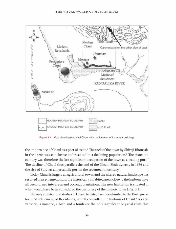
Today Chaul is largely an agricultural town, and the altered natural landscape has resulted in a settlement shit: the historically inhabited areas close to the harbour have all been turned into areca and coconut plantations. he new habitation is situated in what would have been considered the periphery of the historic town (Fig. 3.1).
he only architectural studies of Chaul, to date, have been limited to the Portuguese fortiied settlement of Revadanda, which controlled the harbour of Chaul.8 A cara-vanserai, a mosque, a bath and a tomb are the only signiicant physical ruins that
Figure 3.1 Map showing medieval Chaul with the location of its extant buildings
55
medieval chaul under the nizam shahs
allow a reconstruction of the extent and location of medieval Chaul under the Nizam Shahs. hese extant buildings dateable to the reign of the Nizam Shahs provide a par-tial description of the physical fabric of this once prosperous town. Archaeological excavations provide some evidence to corroborate the historical descriptions of the settlement. his essay is an attempt to plot the few extant structures on an integrated map in order to provide some information on the nature of this settlement in the six-teenth century. In this research, the archaeological evidence and historical sources are used together to better understand late medieval Chaul.
Historical background
Chaul became very important as a port under the Nizam Shahs because it was the only large port that they controlled, their only major source of trade and their sole point of cultural interaction with other countries of the Indian Ocean. he port was at its greatest in the middle of the sixteenth century, when the Nizam Shahs and the Portuguese were largely at peace. Portuguese Chaul (Revadanda) and Chaul of the Nizam Shahs (referred to as upper Chaul, later occasionally as Muhammedan Chaul (sic)) were twin settlements, both with prospering trade. Upper Chaul was noted for manufacturing apart from just the trade; woodwork and weaving were particularly important.9 he period between the 1530s and the 1570s was the most peaceful and proitable period of commerce for both the Portuguese and the Nizam Shahs.
he beginning and the end of the sixteenth century saw some of the most important battles for the control of Chaul. he earliest was in 1508, when the governor of Diu appointed by the Sultan of Gujarat, along with the naval forces sent by the Mamluk sultan of Egypt, the Zamorin of Calicut, and the Deccan sultanates (Nizam Shah and Adil Shah), jointly defeated the Portuguese of the coast of Chaul.10 In 1509, the Portuguese avenged this loss, and Burhan Nizam Shah I (r. 1509–1553) signed a treaty with them, as a condition of which a Portuguese factor was to be appointed at Chaul.11 In 1516 the Portuguese were allowed to build a factory at Chaul as per a treaty between the Portuguese Governor Lopo Soares d’Albergaria and Burhan Nizam Shah I.12 In 1521, Chaul was attacked by a leet from Bijapur. As a result, Burhan Nizam Shah I allowed the Portuguese to build a fort at lower Chaul, close to the sea, as a defence against the naval forces of the Adil Shah. he Portuguese factor of Chaul, Fernão Camello, was not only granted permission to build a fort, but actually encouraged by Burhan Nizam Shah I to do so, for reasons of the latter’s rivalry with the sultan of Gujarat.13 his Portuguese fort (Revadanda) was completed in 1524 despite attacks
56
The Visual World of Muslim India
by Malik Aiyaz of Diu. Gujarati ships aided by Turkish forces attacked in 1528, and it was the joint forces of the Nizam Shah and the Portuguese that repelled this attack.14 In 1557, ater the accession of Husayn Nizam Shah I (r. 1553–1565), the Portuguese proposed that the hill of Korlai be ceded to them. Husayn Nizam Shah I not only refused, but instead sent his oicers to build a fort on the promontory of Korlai. he Portuguese resisted and it was eventually decided that none would fortify that point, which strategically controlled the entrance to the harbour.
In 1570–71, the forces of Murtaza Nizam Shah I (r. 1565–1586) tried to lay siege to Portuguese Chaul, but their attempt failed miserably and they had to sue for peace. he Portuguese strengthened their fortiications, and when Burhan Nizam Shah II (r. 1590–1595) tried to build a fort at Korlai, the Portuguese crossed the bay and cap-tured the fort. By this time, the Nizam Shahs were trying to hem in the Portuguese by building a fort on the western spur of land, so as to control the passage of ships to the harbour at Revadanda.
By the end of the sixteenth century, the Portuguese had a virtual monopoly on the trade in the Arabian sea. hey controlled the independent traders by issuing passes (cartazes) to all the ships plying the area. Ships were not allowed to trade unless approved of by the Portuguese authorities. he supply of war-horses from the Middle East, so crucial for the warring factions in the Deccan, was thus guarded by the Portuguese, and this was an important consideration for the Nizam Shahs to declare peace with them for a long period.15 he Portuguese were also considered useful allies against Bijapur and Gujarat, and a treaty to that efect was signed by the Nizam Shah and the Portuguese.16
he Mughals under Akbar captured and controlled Chaul briely in 1600 when they laid siege to the city of Ahmadnagar.17 hen in 1609, an attempt to capture Portuguese Chaul was made by the Nizam Shah’s forces.18 In the early seventeenth century, Malik Ambar (the regent for the Nizam Shahs) and the Portuguese signed a peace treaty. Ater 1631, Chaul declined with the rise of Surat, the Portuguese losses at Hormuz, the fall of the Nizam Shahs and the arrival of the Mughals and the English. It was briely captured by the forces of Bijapur, who handed it over to the Mughals.19 Chaul never recovered as a major trading centre and the city was described as a ruin as early as 1672.20
Historical sources
Chaul has been mentioned by travellers since the early Greeks, and was referred to by Ptolemy as Simylla.21 Many medieval Arab geographers and merchants have also
57
medieval chaul under the nizam shahs
let us with descriptions of ‘Sheool’ or ‘Saimur,’22 but the irst credible source for our period of study (beginning in the late iteenth century) was the Russian trader Afanasy Nikitin.23 Nikitin described the people and the customs of the country around ‘Chivil,’ under the administration of Mahmud Gawan, but did not leave behind any description of the town.
Ludovico Varthema, a Bolognese merchant, visited ‘Cevul’ around 1506. Very similar to Nikitin’s description, most of the people are described as going around almost naked, except for some of the ‘Moorish’ merchants. He also mentioned Chaul as possessing a very beautiful river, along which foreign vessels plied.24 He described the king of Chaul as a pagan, suggesting an identity for the governor of the town in this period.25
Cesar Frederici, a Venetian merchant, came to Chaul in 1563. His descriptions conirm the location of the Chaul of the Nizam Shahs and of Portuguese Chaul.26
he most valuable descriptions of the port are by Pietro della Valle, who visited Chaul in 1623 and 1625.27 He described the Chaul of the Nizam Shah in some detail. He described two ways to get from Revadanda to Chaul; the longer way from Revadanda to Chaul was by a winding road through meadows, palm trees and forests (much the same as today), and a shorter passage by means of a small boat across the small tongue of water:
I went to view a Town of the Moors, subject to Nizam Sciah, and his Governor Melik Ambar, and because near Ciaul, call’d Ciaul di Riba, that is, Upper Ciaul. he way leading to it is fair and handsome, amongst Groves of Palms and other Fruit-trees, and it stands on the same bank of the River more Northwards with Ciaul of the Portugals. ‘Tis a large town well inhabited both by Moors and Gentiles, specially near the Bazar or Market-place, where the shops aford plenty of things necessary…
Beyond the Bazar, the Houses stand not so close together, but scatter’d here and there, amongst Gardens, or rather woods of Palmes and other Fruit-trees, which are very thick, tall and handsome, afording shadow to the streets all the way, which are broad, long, green and very delightful. he Moors for the most part dwell near the Bazar towards the River, which passes not far of, and is navigable seven or eight leagues upwards; Here also the Mahometans have their Meschita’s, hot baths, (which the gentiles use not, because they wash themselves publickly in their cisterns), and places of Sepulture; a Dogana, or Customhouse; and lastly, a Divan, or Court of Justice, and what-ever belongs to their Government. Most of the Gentiles, who are
58
The Visual World of Muslim India
the greatest part, live in Houses remote from the Bazar, amongst Gardens and Trees, where in several places they have sundry temples of their Idols.28
hese descriptions perfectly it the physical evidence of the settlement that we can recover today. hey leave no doubt as to the position of the port of Chaul, at the place referred to as upper Chaul. From these descriptions, we can infer that the town con-sisted mainly of the port and the market, and we can corroborate this account with the locations of the extant market, bath and mosque.
Physical evidence
Although there have been signiicant changes in the creek at Chaul obfuscating the exact location of the docks and jetties, there is adequate physical evidence to conjec-ture the layout and site of the town. here are some remains along what would have been the riverbank. hese are in the form of an embankment and some fortiications, the mosque at the south-western corner and the hammam not too far of. A mound dotted with several graves is also in the area where the historic town was located.29 Other miscellaneous structures, such as a store (perhaps a granary), and a few stray walls of the port commander’s quarters (locally called Rajkot) also survive. On the ancient and medieval road inland from Chaul are a tomb and a caravanserai. All these structures of medieval Chaul are described in some detail below, followed by the archaeological evidence uncovered through excavations.
Caravanserai
he caravanserai in Chaul is on the old road travelling inland from the town. his ancient road would have been the only signiicant route connecting Chaul with the hinterland of the Deccan, and had been used since early Buddhist times (c. 200 BCE to 200 CE).30 his is borne out by geographical surveys, which indicate that the larger river basin and associated marshes would have made this the easiest path to travel inland to the east (where the larger commercial and production centres of the northern Deccan viz. Junnar, Daulatabad, Paithan, etc. were located.) his road passes through a natural barrier of hills separating the town from the caravanserai. his was an ideal location for a building complex that housed itinerant merchants and travellers, as it was isolated from the town. he caravanserai was also provided its own source of water
59
medieval chaul under the nizam shahs
in the form of a small natural pond behind, isolating it from the town and keeping it self-suicient.
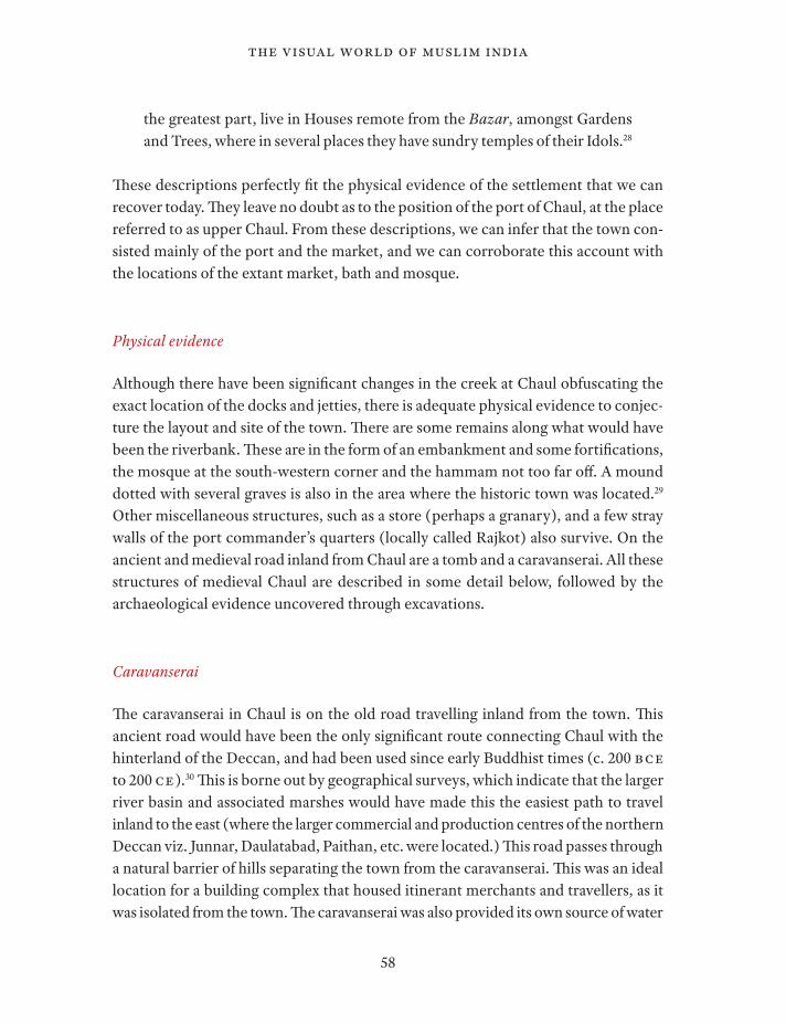
he building is now locally called kalawantinicha mahal (‘courtesan’s palace’ in Marathi), but the layout and location leave no room to entertain this label as historically accurate. Besides, the hamlet located a few hundred metres from this site is called Sarai, corroborating the early function of this site as a caravanserai. A direction-stone, with the names and directions to neighbouring towns (not an uncommon feature under the later Nizam Shahs, especially Burhan Nizam Shah II)31 was found close to the site,32 and is in conformance with the role of this structure as a caravansarai.
he caravanserai is of fairly large dimensions (the enclosure wall contains an area of approximately 60x45 m), with two major extant structures: a block of rooms at the front (east) and a similar but smaller set of vaulted spaces along the rear (west) wall. he enclosure wall survives, and the arcaded spaces that ran along its inside are obvious from the ruins (Figs. 3.2, 3.3).
he central room on the western side has a prayer niche, but this alone is not adequate to accord this building the primary function of a mosque; this building does
Figure 3.2 Plan of the
Caravansarai just outside medieval Chaul
60
The Visual World of Muslim India
not have any of the other details required of a mosque in this period and region. he east block of rooms and forms the entrance to the complex.
Although the architectural program of a travellers’ station is universal, the form of a caravanserai is itself a Middle Eastern idea. he relevance of the town as a large trading port in the sixteenth century would have necessitated a caravanserai of these dimen-sions for itinerant traders. he patterns and scale of the vaulting are characteristic of the Nizam Shahs, as also the planning modules for the staircase. Similar construction is found at sites around Ahmadnagar, such as Manzarsumbah (called Manjareshna in the Burhān-i Ma’āthir)33 and the Lakkad Mahal in the Hasht Bihisht complex.
Mosque
he mosque is located on raised ground on the peninsula of Chaul, visible from what would have been the harbour (Figs. 3.4, 3.5). It would have presented an impressive sight for the merchants and traders on the ships, with its large bulbous dome and grand scale. It is now in fairly ruinous condition, with only parts of the
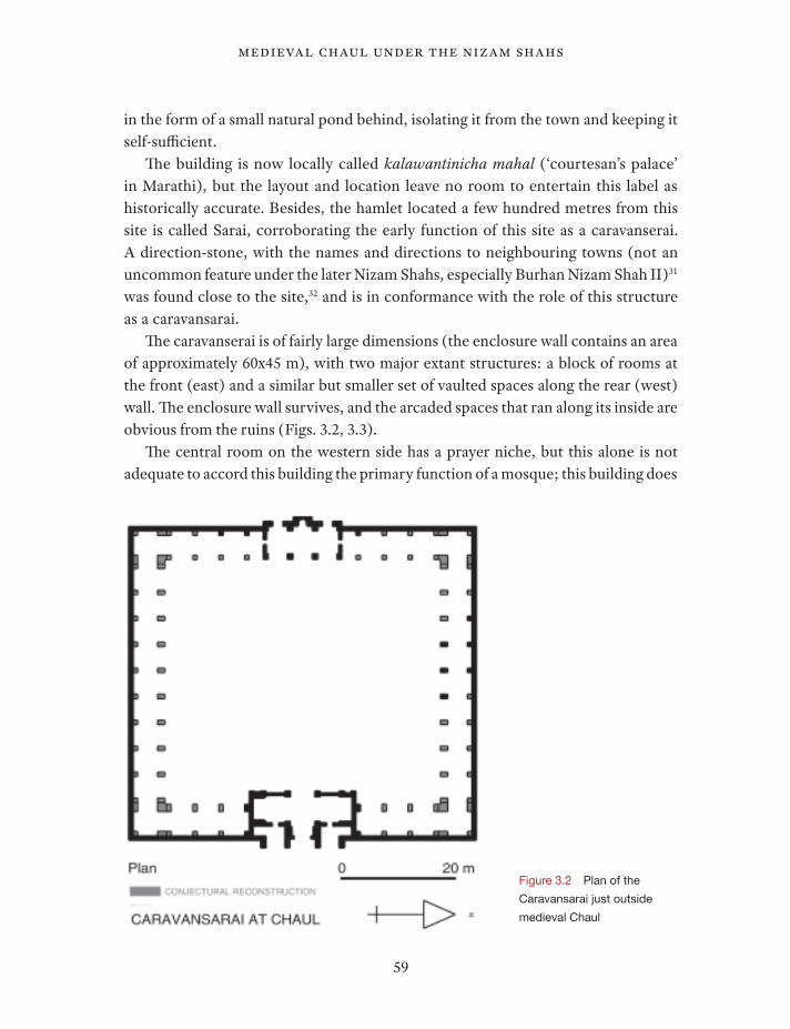
Figure 3.3 The eastern entrance pavilion of the Caravansarai with remnants of the peripheral columns in the foreground

Figure 3.5 A view of the mosque from the south east
Figure 3.4
Plan and conjectural
elevation of the mosque
62
The Visual World of Muslim India
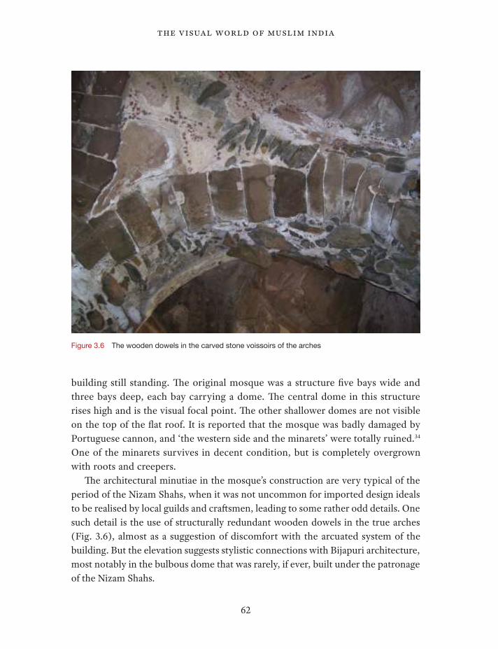
building still standing. he original mosque was a structure ive bays wide and three bays deep, each bay carrying a dome. he central dome in this structure rises high and is the visual focal point. he other shallower domes are not visible on the top of the lat roof. It is reported that the mosque was badly damaged by Portuguese cannon, and ‘the western side and the minarets’ were totally ruined.34 One of the minarets survives in decent condition, but is completely overgrown with roots and creepers.
he architectural minutiae in the mosque’s construction are very typical of the period of the Nizam Shahs, when it was not uncommon for imported design ideals to be realised by local guilds and cratsmen, leading to some rather odd details. One such detail is the use of structurally redundant wooden dowels in the true arches (Fig. 3.6), almost as a suggestion of discomfort with the arcuated system of the building. But the elevation suggests stylistic connections with Bijapuri architecture, most notably in the bulbous dome that was rarely, if ever, built under the patronage of the Nizam Shahs.
Figure 3.6 The wooden dowels in the carved stone voissoirs of the arches
63
medieval chaul under the nizam shahs
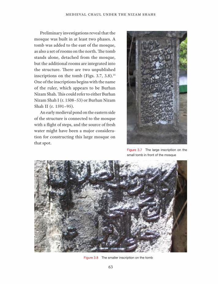
Preliminary investigations reveal that the mosque was built in at least two phases. A tomb was added to the east of the mosque, as also a set of rooms on the north. he tomb stands alone, detached from the mosque, but the additional rooms are integrated into the structure. here are two unpublished inscriptions on the tomb (Figs. 3.7, 3.8).35 One of the inscriptions begins with the name of the ruler, which appears to be Burhan Nizam Shah. his could refer to either Burhan Nizam Shah I (r. 1508–53) or Burhan Nizam Shah II (r. 1591–95).
An early medieval pond on the eastern side of the structure is connected to the mosque with a light of steps, and the source of fresh water might have been a major considera-tion for constructing this large mosque on that spot.
Figure 3.7 The large inscription on the
small tomb in front of the mosque
Figure 3.8 The smaller inscription on the tomb
64
The Visual World of Muslim India
Hammam
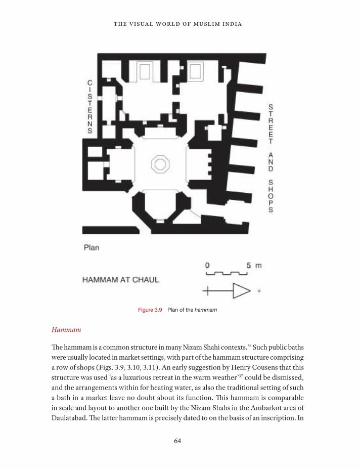
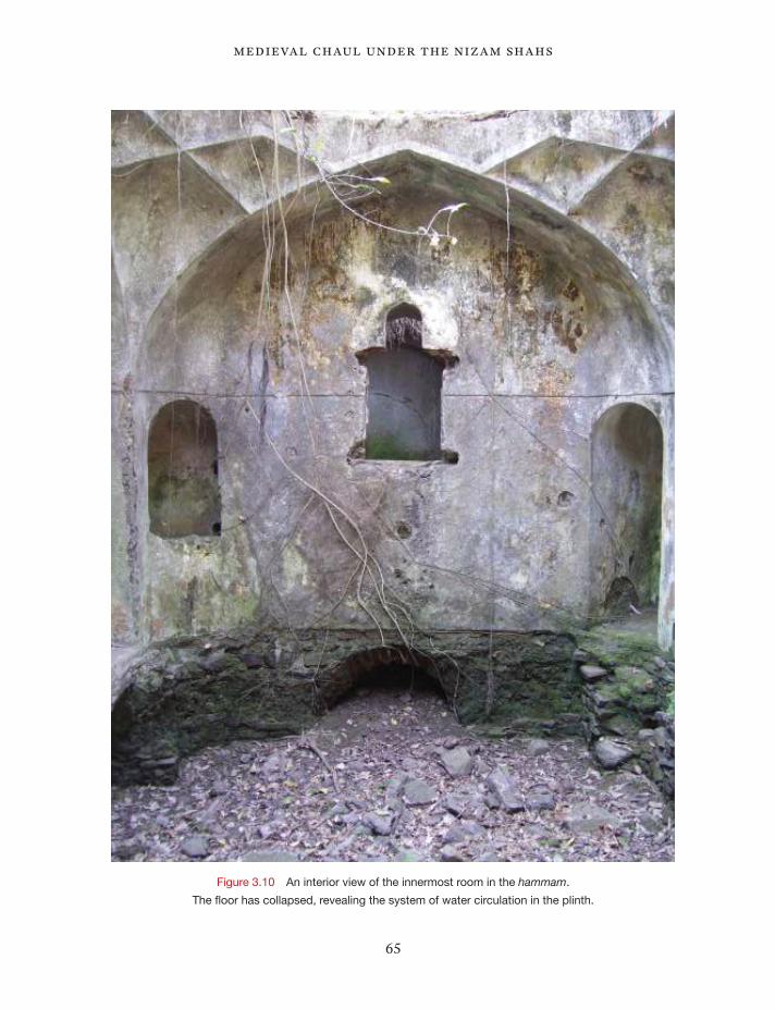
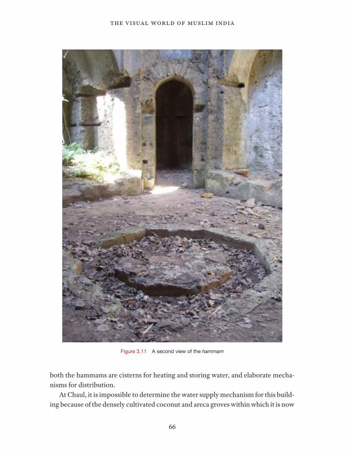
he hammam is a common structure in many Nizam Shahi contexts.36 Such public baths were usually located in market settings, with part of the hammam structure comprising a row of shops (Figs. 3.9, 3.10, 3.11). An early suggestion by Henry Cousens that this structure was used ‘as a luxurious retreat in the warm weather’37 could be dismissed, and the arrangements within for heating water, as also the traditional setting of such a bath in a market leave no doubt about its function. his hammam is comparable in scale and layout to another one built by the Nizam Shahs in the Ambarkot area of Daulatabad. he latter hammam is precisely dated to on the basis of an inscription. In
Figure 3.9 Plan of the hammam
65
medieval chaul under the nizam shahs
Figure 3.10 An interior view of the innermost room in the hammam.
The loor has collapsed, revealing the system of water circulation in the plinth.
66
The Visual World of Muslim India
both the hammams are cisterns for heating and storing water, and elaborate mecha-nisms for distribution.
At Chaul, it is impossible to determine the water supply mechanism for this build-ing because of the densely cultivated coconut and areca groves within which it is now
Figure 3.11 A second view of the hammam
67
medieval chaul under the nizam shahs
situated. here is a well adjacent to the bath, and it is very likely that it was adequate to provide water for the hammam. However, the area contains a fair number of fresh water sources, and it is conceivable that water was lited from one or more of these wells.
he loor of this hammam was reportedly paved with marble lagstones, which are no longer to be found.38 he row of shops on the street face of the structure would have faced the market area, and one of the shop openings is the public entrance for the bath, a design not uncommon for public hammams.39 Upon entering via this access, one comes into a grand room with a domed ceiling, containing an octagonal khazīna (storage room). his room leads to two other chambers, both of which have small bathing pools and connected systems for drawing water of diferent temperatures. Its layout, scale and context prove that it was a public bath, a judgment in concordance with the descriptions of early travellers.
Tombs
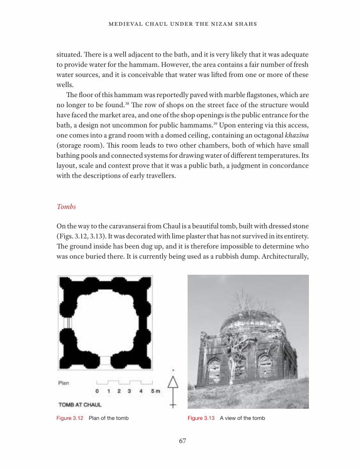
On the way to the caravanserai from Chaul is a beautiful tomb, built with dressed stone (Figs. 3.12, 3.13). It was decorated with lime plaster that has not survived in its entirety. he ground inside has been dug up, and it is therefore impossible to determine who was once buried there. It is currently being used as a rubbish dump. Architecturally,
Figure 3.12 Plan of the tomb Figure 3.13 A view of the tomb
68
The Visual World of Muslim India
it is very similar to the tombs built under the Bahmanis and the early Nizam Shahs, especially in some of the decorative details, like the carved jamb corners.
Miscellaneous structures
Back in the old town of Chaul, the citadel Rajkot now exists only as two ruinous walls. Even in 1916, this structure was described as beyond repair, comprising no more than a few barely standing walls overgrown with vegetation.40
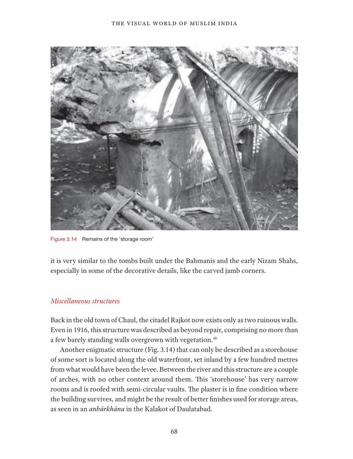
Another enigmatic structure (Fig. 3.14) that can only be described as a storehouse of some sort is located along the old waterfront, set inland by a few hundred metres from what would have been the levee. Between the river and this structure are a couple of arches, with no other context around them. his ‘storehouse’ has very narrow rooms and is roofed with semi-circular vaults. he plaster is in ine condition where the building survives, and might be the result of better inishes used for storage areas, as seen in an anbārkhāna in the Kalakot of Daulatabad.
Figure 3.14 Remains of the ‘storage room’
69
medieval chaul under the nizam shahs
Along the bank of the Kundalika river (approximately a kilometre from the present bank) is an embankment wall, which runs a length of more than 300 metres.
Archaeological data
Archaeological explorations and excavations at Chaul have been carried out since 2003 by teams from the Deccan College and Post-Graduate Institute.41 he main aim was to recover the archaeological evidence of the ancient trade mentioned in various texts. he work conducted so far has been successful in that objective. he recovered ceramics and antiquities conirm the literary record. he site of Chaul has revealed evidence of trade in three phases of Indian history: the early historic (500 BCE – 500 CE), the early medieval (500 CE – 1300 CE) and the late medieval periods (1300 CE – 1700 CE).42
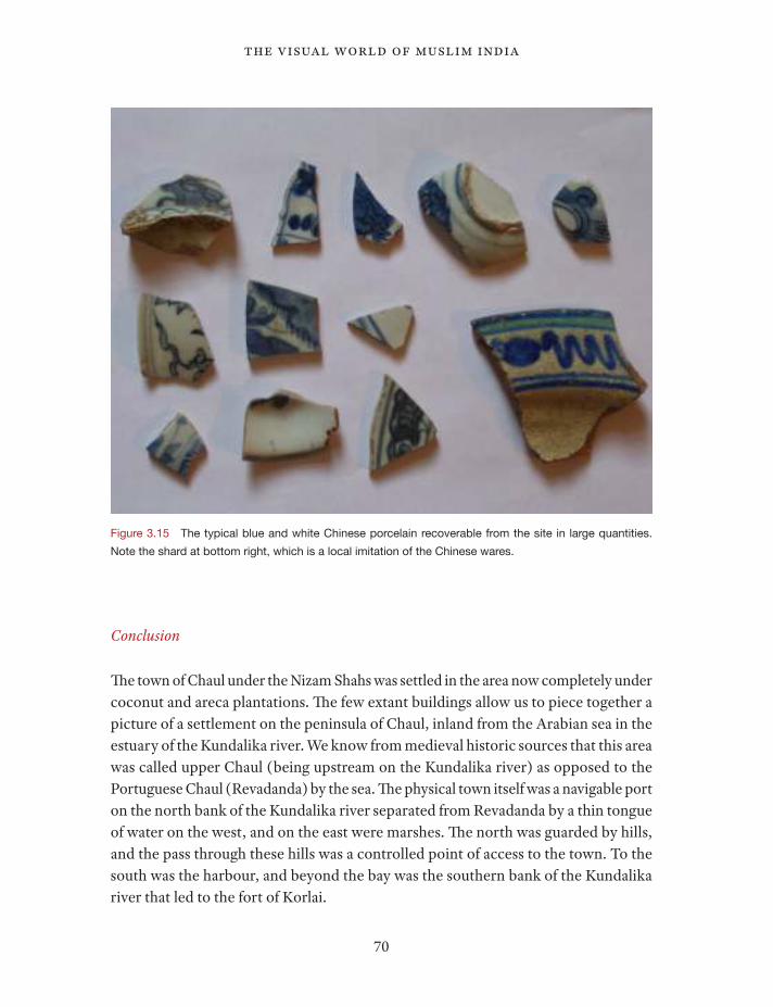
Evidence of trade was noticed through all these periods. Pottery belonging to the Roman world, especially amphorae, were discovered during the excavations. he types belong to the early centuries of the Christian era. Similarly, ceramic types such as the Turquoise Glazed Ware of the eighth-ninth centuries and Hatched Sgraiato Ware of the tenth-twelth centuries, which were manufactured in the Persian Gulf region, were also recovered from the excavations. From the later medieval period, most of the ceramic assemblage comprises the Chinese blue and white porcelain and Monochrome Ware (Fig. 3.15). he blue and white ceramics are very densely and ubiquitously scattered in the area between the mosque and Rajkot. he evidence of trade in this period is further corroborated by various antiquities such as glass micro-beads, Indo-Paciic beads, large amount of glass bottles and debitage, ivory chunks and so forth, all of which were essentially items of trade in the medieval period.
In the 2008 season, the walls of a small structure were traced on top on the hill that controls the pass between the historic town and the caravansarai. Unfortunately, as with the other trenches, there were space constraints that did not allow the complete structure to be recovered.
he other excavation trenches were all within a kilometre of the present riverbank. It was noticed during the preliminary explorations that as one starts moving away from the river the evidence of ancient and medieval habitation decreases. Hence, it can be inferred that during the later medieval period, the small activity area was centred around the western end of the river, and that the existence of Chaul in this phase was also largely dependent on the trade network fed by its harbour.
70
The Visual World of Muslim India
Conclusion
he town of Chaul under the Nizam Shahs was settled in the area now completely under coconut and areca plantations. he few extant buildings allow us to piece together a picture of a settlement on the peninsula of Chaul, inland from the Arabian sea in the estuary of the Kundalika river. We know from medieval historic sources that this area was called upper Chaul (being upstream on the Kundalika river) as opposed to the Portuguese Chaul (Revadanda) by the sea. he physical town itself was a navigable port on the north bank of the Kundalika river separated from Revadanda by a thin tongue of water on the west, and on the east were marshes. he north was guarded by hills, and the pass through these hills was a controlled point of access to the town. To the south was the harbour, and beyond the bay was the southern bank of the Kundalika river that led to the fort of Korlai.
Figure 3.15 The typical blue and white Chinese porcelain recoverable from the site in large quantities. Note the shard at bottom right, which is a local imitation of the Chinese wares.
71
medieval chaul under the nizam shahs
An inscription at Kanheri from the sixth century referred to the donation made for the cave complex by a goldsmith from Chaul.43 he existence of a professional goldsmith resident at Chaul, wealthy enough to endow a grant for a remote religious complex, suggests a very diferent pattern of settlement in the early historic period. Large numbers of temple fragments (some of them in situ) from the early medieval period in this area conirm the density of the settlement at that time. However, the later medieval period had settlement patterns that were signiicantly diferent.44
he medieval Chaul of the Nizam Shahs was certainly on the same site as that ancient Chaul, as proven quite conclusively by the continuous archaeological evidence of trade goods and built structures. Most of the active temples in Chaul today are of a late medieval origin and on the margins of the historic town, suggesting that there was a shit in temple settlements in the sixteenth century towards the fringes of the port town. his is corroborated by accounts of Chaul by travellers in the sixteenth century when they describe the location of the settlements of the gentiles (sic) on the outskirts of town.
he part of the town that had the semblance of an urban centre wasics divided into mercantile and administrative sections. he palace complex of the governor of Chaul under the Nizam Shah was located at the eastern end of the settlement with fortiied walls, in the area called Rajkot. he market and the public quarter were on the western end of town, where the mosque and the hammam are located. Chaul prob-ably did not have a large resident population in this period, and the local economy in the surrounding area was still largely agrarian, with fruit groves and plantations, as noted by the travellers’ accounts. Chaul could then be described essentially as a cantonment town in a port controlling maritime commerce that was not necessarily to the immediate beneit of most for all the local population.
he town was described by Barbosa in 1514 as more of a fair or carnival than a city,45 and the lack of archaeological recovery of large dense settlements over a large part of Chaul conirms this description. here are no travellers’ descriptions of the grandeur or the urban character of Chaul. In fact, the relatively austere and poor lifestyle of the people was worth a commentary for many of the travellers.46
he character of this town may also be extrapolated from a letter written by Albuquerque, the Viceroy of Goa, to the King of Portugal, in which he suggested in the same sentence that Danda and Chaul were the two important places on the western seaboard that the Portuguese should capture. Danda was described as a beautiful town with palaces, and Chaul received no such praise,47 suggesting that the latter was not a real urban centre in this period, but a trading port and a strategic node with only a few local residents involved in its commercial activities.
72
The Visual World of Muslim India
Under the Nizam Shahs, the settlement was only a commercial and military base, and the involvement of the local residents was limited to the basic labour force needed for seasonally running a port town. All the archaeological evidence and the historic descriptions of medieval Chaul in the sixteenth century indicate a seasonal place of exchange, a market in a true sense without most of the paraphernalia of a city with a large wealthy residential population. his is in agreement with the thesis presented by André Wink, that many Indian towns and cities in the medieval period were largely labile.48 Chaul as a trading port was even more so, because its raison d’être was com-merce, and this was an activity that could be facilitated only seasonally.49 he military function of the town was also only seasonal, in part because most of the troops were only part-time soldiers.
hus, it would not be unreasonable to suggest that important port towns in this period were not necessarily thriving urban areas, at least not throughout the year, and Chaul provides a good historical and archaeological model towards understanding such settlements. Perhaps, our comprehension of the nature of other towns in this period needs to be revised along similar lines.
he relatively small area of permanent habitation in the Chaul of the Nizam Shahs provides a very rich archaeological site with potential for further exploration.
Notes
1 Afanasy Nikitin, Duarte Barbosa, Ludovico Varthema, Francois Pyrard, William Keeling (captain
of the third voyage of the British East India Company), Pietro Della Valle, Cesar Frederici, all let
accounts of Chaul, from the late iteenth to the early seventeenth centuries.
2 In the Mīrāt-i Aḥmadī by Ali Muhammad Khan, tr. Sir E.C. Bayley as he local Muhammedan dynasties:
Gujarat (London, 1886), Danda-Rajpuri, south of Chaul, is mentioned as a sarkār of the Gujarat ṣūba.
he sultans of Gujarat mentioned this port as their tributary, though those claims can be regarded
largely as rhetorical. Also see the Mīrāt-i Sikandarī, ed. S.C. Misra and M.L. Rahman (Baroda, 1961),
147–48, where incursions into Mahim and Jeul (sic) by the sultans of Gujarat are mentioned as raids.
3 V. Gogte, ‘he ancient port of Chaul,’ Journal of Indian Ocean Archaeology 3 (2006), 62–80.
4 Joseph Gerson da Cunha, Notes on the history and antiquities of Chaul and Bassein (Bombay, 1876),
4.
5 Maharashtra State Gazetteers: Kolaba District (revised edition), vol. XI of the Gazetteer of Bombay
Presidency (Bombay, 1964), 728. he pirates were allegedly so great in number that even Portuguese
battleships were afraid of any potential confrontation.
6 Gazetteer, 732.

73
medieval chaul under the nizam shahs
7 Gazetteer, 734. Chaul does get mentioned as a ‘considerable seaport …in 1781’ in the Gazetteer, but
that account is unsubstantiated and at odds with the evidence.
8 Gerson da Cunha, Antiquities; Gritli von Mitterwallner, Chaul: eine unerforschte Stadt an der Westüste
Indiens (Wehr-. Sakral- und Profanarchitektur) (Berlin, 1964).
9 Gazetteer, 727.
10 Shaykh Zaynuddin, Tuḥfatu’l-Mujāhidīn, tr. by M.J. Rowlandson as Tohfut-ul-mujahideen (London,
1833), 92–93; Gazetteer, 24–29.
11 da Cunha, Antiquities, 34.
12 Ibid., 34–36; P.M. Joshi, ‘he Portuguese on the Deccan coast: sixteenth and seventeenth centuries,’
Journal of Indian History 46/1 (April 1968), 83.
13 da Cunha, Antiquities, p. 35. he terms of the treaty also stipulated the supply of horses by the
Portuguese to the Nizam Shah; Joshi, ‘he Portuguese,’ 84.
14 da Cunha, Antiquities, 39.
15 Joshi, ‘he Portuguese,’ 65–88.
16 da Cunha, Antiquities, 84: ‘his was relected in the repeated treaties of friendship between Goa and
Ahmadnagar, in the help given by the former to the sultanate in its conlicts with Gujarat and in the
complete absence of any warlike atmosphere between them during the lifetime of Burhan I.’
17 Gazetteer, 727.
18 da Cunha, Antiquities, 63.
19 Gazetteer, 729.
20 da Cunha, Antiquities, 67. For the decline of Chaul, see L.B. Kenny, ‘Antiquity of Chaul as a medieval
port of Konkan,’ in Essays in Maritime Studies, ed. B. Arunachalam, vol. 2 (Mumbai, 2002), 129–35.
21 Gogte et al., ‘Ancient port of Chaul,’ 62; da Cunha, Antiquities, 7–11.
22 Tuḥfatu’l-Mujāhidīn, 92; Gazetteer, 718; da Cunha, Antiquities, 7.
23 Afanasy Nikitin, Voyage beyond three seas 1466–1472 (Moscow, 1985).
24 he travels of Ludovico Varthema, tr. John Winter Jones (London, 1863), 114.
25 Ibid.
26 he voyage and trauaile of M. Ceasar Frederick, merchant of Venice, into the East India, the Indies, and
beyond the Indies, tr. homas Hickock (London, 1588).
27 Gazetteer, 78–79.
28 he Travels of Sig. Pietro della Valle, a noble Roman, into East-India and Arabia Deserta (London,
1665), 224–25 [Letter IX from Mascat dated January 19, 1625]
29 his mound is also noted in the Gazetteer, p. 750, as being a mile south of Bhagvati Devi’s temple,
close to a pond called Pokharn.
30 Gogte, ‘Ancient port of Chaul.’
31 K.A. Kadiri, ‘Some more direction-stones of the Nizam Shahi dynasty,’ in Epigraphia Indo-Moslemica
1970 (published 1975), 48–49.
74
The Visual World of Muslim India
32 his direction stone has not been located but, based on local inquiries, the author did track it down
to that location.
33 Burhān-i Ma’āthir by Syed Ali Tabataba’i (Delhi, 1936), 542–43.
34 da Cunha, Antiquities, 113.
35 hese inscriptions are mentioned in the Gazetteer, 751, and speculative translations and dates have
been presented. However, the inscriptions themselves remain unpublished. he Annual Report of
Indian Epigraphy, 1959–60 (Calcutta, 1963), 149, refers to two illegible and damaged inscriptions
at the mosque in Chaul, explaining that the actual tablets could not be located, and only the older
estampages had survived. D.R. Bhandarkar, in Progress report of the western circle of the Archaeological
Survey of India: Archaeology (1915–16), 66, states that this mosque is not worthy of conservation.
here is no mention of any of the inscriptions.
36 At least seven intact hammams survive at various sites of the Nizam Shahs. here are hammams
within the Ambarkot at Daulatabad, on the hill fort of Shivneri, at Chaul, at Manzarsumbah, in the
Hasht Bihisht Bagh on the outskirts of Ahmadnagar with the Shahi Hammam nearby.
37 Progress report of the Archaeological Survey of India, Western Circle: Archaeology (1899–1900), 2.
38 da Cunha, Antiquities, 113: ‘he pavement, which was all of marble lags, has thus been removed…’
39 One of the most celebrated public hammams, the Ganj Ali Khan in the city bazaar of Kerman, is
accessible through a store bay in the Kerman Bazaar in a very similar way. Very oten, the revenues
from the shops on the side paid for the upkeep of the institution.
40 Progress report of the Archaeological Survey of India, Western Circle: Archaeology (1915–16), 66.
41 his section, which deals with the ceramics, was written with signiicant contributions by Dr. Abhijit
Dandekar of the Deccan College Post-Graduate and Research Institute, Pune. Dr. Dandekar has been
the director of the excavations and surveys at Chaul since 2008, which were initially directed for more
than four seasons by Vishwas Gogte, also of Deccan College. Some of the excavation seasons have
been published in part: V. Gogte, ‘Discovery of the ancient port of Chaul,’ Man and Environment
28/1 (2003), 67–74; id., ‘Ancient port of Chaul.’
42 In Gogte, ‘Discovery,’ 69, the early and late medieval period in this context are deined as 500–1300
AD and 1300–1700 AD respectively. he early and late medieval period are assigned equally arbitrary
dates by Kathleen Morrison in ‘Commerce and Culture in South Asia: Perspectives from Archaeology
and History,’ Annual Review of Anthropology 26 (1997), 87–108.
43 Himanshu Prabha Ray, ‘Kanheri: he archaeology of an early Buddhist pilgrimage centre in Western
India,’ World Archaeology 26/1 ( June 1994), 35–46.
44 Kathleen Morrison, ‘Commerce and Culture,’ 100, has suggested that the shit in physical patterns
of urban settlements in the late medieval period mostly involved expansion and settlement density,
but this is certainly not true at this site.
45 A Description of the coasts of East Arica and Malabar by Duarte Barbosa, tr. Henry E.J. Stanley
(London, 1866), 69–71: ‘his place is one of great commerce in merchandise, and in the months
75
medieval chaul under the nizam shahs
of December, January, February and March there are many ships from the Malabar country and all
other parts, which arrive with cargoes…In this port, there are few inhabitants, except during three
or four months of the year, the time for putting in cargo, when there arrive merchants from all the
neighbourhood, and they make their bargains during this period, and despatch their goods, and ater
that return to their homes till the next season, so that this place is like a fair in those months.’ See
also the Gazetteer, 735.
46 Nikitin, Barbosa, della Valle are all struck by the frugal lifestyles of the native people, unless they are
soldiers or administrators.
47 F.C. Danvers, he Portuguese in India, vol. 1 (London, 1894), 291.
48 Al-Hind: he making of the Indo-Islamic World (Leiden, 1990), vol. 3: Indo-Islamic society 14th-15th
centuries. Wink refers to several instances of the ephemeral nature of Indian settlements in this period,
which he says were a result of natural and manmade factors. He argues that most settlements could
not be thought of as real cities in a European sense because they faced ‘…sharp seasonal luctuations
of the number of their inhabitants, the general mobility of large numbers of people, the long tradition
of internal migration caused by military invasions and raids, famines, epidemics and droughts,
as well as the general volatility of Indian political and military life.’ (73). ‘he city had little or no
autonomy in the historical Indian ocean region’ and ‘…the Indian city as such was certainly not the
privileged locus of sustained and cumulative social change’ (76); ‘he Indo-Islamic cities were the
sites of political and military power, apart from being commercial centers. But even so, they were
essentially not recognized as legal entities in any way, and the inhabitants of cities and towns enjoyed
no special privileges’ (77–78).
49 Wink, Al-Hind, vol. 3, 1: ‘he instability of Indian cities, while primarily due to geophysical and
hydrological factors, was enhanced by demographic volatility associated with the monsoon climate
and the generally very high mobility of the Indo-Islamic ruling elites.’