Massive Sulphide Deposits at Myra Falls Operations ...
42
Massive Sulphide Deposits at Myra Falls Operations, Vancouver Island, British Columbia Mineral Deposits Division of the Geological Association of Canada Cordilleran Round-Up Field Trip January 2005 Part 1 – Field Trip Guide A. Chong, M. Becherer, R. Sawyer, H. Wasteneys, R. Baldwin, F. Bakker, and I. McWilliams Part 2 –Overview of Selected Topics on the Massive Sulphide Deposits at Myra Falls- Update 2005 A. Chong Geofile 2005-20
-
Upload
khangminh22 -
Category
Documents
-
view
4 -
download
0
Transcript of Massive Sulphide Deposits at Myra Falls Operations ...
Massive Sulphide Deposits at Myra Falls Operations,
Vancouver Island, British Columbia
Mineral Deposits Division of the Geological Association of Canada Cordilleran Round-Up Field Trip
January 2005
Part 1 – Field Trip Guide A. Chong, M. Becherer, R. Sawyer, H. Wasteneys, R. Baldwin, F. Bakker, and I. McWilliams
Part 2 –Overview of Selected Topics on the
Massive Sulphide Deposits at Myra Falls- Update 2005 A. Chong
Geofile 2005-20

ButtleLake
H-W Mine
Battle Mine
Marshall Zone
Ridge Zone East
Ridge Zone WestExtension
Zone
Trumpeter Zone
Price Deposit
Myra Mine
Lynx Mine
43 Block
Gap Zone
1 km
50
0m
E
Mt. Phillips
4500.
Stra
itofG
eorg
ia
Campbell River
Courtenay
Buttle Lake
VANCOUVER
ISLAND
Strathcona-Westmin
Class ‘B’ Park
Strathcona
Class ‘A’ Park
Pacific
Ocean
British
Columbia
Vancouver
Scale
0 20km
N
Myra Falls MineMyra Falls Mine
Canada

Volcanic-Hosted Massive Sulphide Deposits at Myra Falls Operations, Vancouver Island, British Columbia
1
Volcanic-Hosted Massive Sulphide Deposits at Myra Falls Operations,
Vancouver Island, British Columbia
Part 1 – Field Trip Guide A. Chong, M. Becherer, R. Sawyer, H. Wasteneys, R. Baldwin, F. Bakker and I. McWilliams
Part 2 – Overview of Selected Topics on the Myra Falls Massive Sulphide Deposits
A. Chong

Volcanic-Hosted Massive Sulphide Deposits at Myra Falls Operations, Vancouver Island, British Columbia
2
Table of Contents List of Figures.......................................................................................................................................3 List of Tables ........................................................................................................................................3 List of Plates .............................................................................................Error! Bookmark not defined. Introduction ..........................................................................................................................................4 1.0 Field Trip Guide .........................................................................................................................4 by A. Chong, M. Becherer, R. Sawyer, H. Wasteneys, R. Baldwin, F. Bakker and I. McWilliams
1.1 Location..................................................................................................................................................4 1.2 Infrastructure .........................................................................................................................................4
1.2.1 Mining ................................................................................................................................4 1.2.2 Concentrator .......................................................................................................................6
1.3 General Geology....................................................................................................................................6 1.4 Tour Itinerary..........................................................................................................................................9 1.5 Tour 1: Battle-Gap Mine .......................................................................................................................9
1.5.1 Introduction.........................................................................................................................9 1.5.2 Battle-Gap Geology .............................................................................................................9 1.5.3 Contact Zone Mineralization Discussion ..............................................................................10
1.6 Tour 2: H-W Mine (43 Block)..............................................................................................................10 1.6.1 Introduction.......................................................................................................................10 1.6.2 43-Block Geology ..............................................................................................................10 1.6.3 43 Block Discussion...........................................................................................................10
2.0 Overview of Selected Topics on the Myra Falls Massive Sulphide Deposits ....................13 by A. Chong
2.1 History ..................................................................................................................................................13 2.2 Regional Geology and Metallogeny...................................................................................................15 2.3 Mine Geology .......................................................................................................................................17
2.3.1 Price Formation.................................................................................................................18 2.3.2 Myra Formation .................................................................................................................18 2.3.3 Thelwood Formation ..........................................................................................................18
2.4 Geochronology ....................................................................................................................................18 2.5 Metamorphism .....................................................................................................................................19 2.6 Structure...............................................................................................................................................19 2.7 H-W Horizon Synvolcanic Faults and Cu-Fe Enrichment................................................................22 2.8 Hydrothermal Alteration .....................................................................................................................25
2.8.1 Footwall Price Formation Alteration .....................................................................................25 2.8.2 H-W Horizon Hangingwall Alteration....................................................................................25 2.8.3 Lynx-Myra-Price Hydrothermal Alteration.............................................................................26
2.9 Orebody Geometry .............................................................................................................................26 2.10 Orebody Mineralogy...........................................................................................................................28 2.11 Sulphide Textures...............................................................................................................................30 2.12 Ore Reserves.......................................................................................................................................34 2.13 Orebody Tonnage, Grade and Classification ..................................................................................34 2.14 Myra Falls compared to other VHMS Regions.................................................................................35 2.15 Concluding Remarks..........................................................................................................................36
Acknowledgements............................................................................................................................37 References ..........................................................................................................................................37

Volcanic-Hosted Massive Sulphide Deposits at Myra Falls Operations, Vancouver Island, British Columbia
3
List of Figures
Part 1 - Field Trip Guide Figure 1.1 Myra Falls Operations location map 4
Figure 1.2 Location map of VHMS deposits at Myra Falls Operations 7
Figure 1.3 Myra Falls composite geology section 8
Figure 1.4 Battle deposit – longitudinal section 4075mN 11
Figure 1.5 Battle deposit - South Trough lens section 1780 E 12
Figure 1.6 H-W deposit - 43 Block Geology - Sections 3975 N and 4405 E 13
Part 2 – Overview of Selected Topics on the Massive Sulphide Deposits at Myra Falls Figure 2.1 Sicker Group Location Map and schematic stratigraphic column of Vancouver Island 18
Figure 2.2 Sicker Group stratigraphy 19
Figure 2.3 Location of major structures and VHMS deposits at Myra Falls Operations 23
Figure 2.4 Location of major synvolcanic growth faults 24
Figure 2.5 H-W deposit – Cu and Fe contours 26
Figure 2.6 Battle deposit – Cu and Fe contours 27
Figure 2.7 Battle deposit - Geology section 1390 E 31
Figure 2.8 H-W deposit - Geology section 3505 E 31
Figure 2.9 Sulphide textures – Battle and Gap deposits 36
Figure 2.10 Sulphide textures – H-W deposit 37
Figure 2.11 Sulphide textures – Ore clast breccia 38
List of Tables Table 2.1 Myra Falls Operations: Exploration – Development – Mining Cycles 15
Table 2.2 Myra Falls: Metamorphic mineral assemblages 22
Table 2.3 Myra Falls: Deformation history 22
Table 2.5 Myra Falls: Orebody mineralogy 32
Table 2.6 2002 MFO Pre-mining geological resource estimate 39
Table 2.7 Mean tonnage and grade data for selected VHMS deposit types 41
Cover photo: Myra Falls Operations
(WNW view of Myra Valley with H-W head frame in the foreground.
The concentrator and Lynx open pit are in the background.)

Volcanic-Hosted Massive Sulphide Deposits at Myra Falls Operations, Vancouver Island, British Columbia
4
VOLCANIC-HOSTED MASSIVE SULPHIDE DEPOSITS AT MYRA FALLS OPERATIONS
Introduction Welcome to Myra Falls Operations. The property hosts numerous polymetallic Zn-Pb-Cu-Au-Ag-rich volcanic-hosted massive sulphide (VHMS) deposits.
This paper is divided into two parts. The first part is a brief description of the location, infrastructure and general geology. Included in this section is the itinerary and guide for the underground tour.
The second part delves into selected geological aspects by both academic researchers and company geologists. Studies have focused on characterizing the volcanic stratigraphy, paleotopography, lithogeochemistry, structure, specific individual massive sulphide deposits, metal zoning and exploration strategy. Included in this paper is the rich exploration and mining history at Myra Falls, as well as summaries of research and observations describing the VHMS deposits at Myra Falls on a property scale. Topics include synvolcanic faults, footwall and hangingwall hydrothermal alteration, orebody geometries, ore reserves, and property scale metal zoning.
For purposes of discussion, all directional references in this report are relative to mine property grid that is rotated 48o east of true north. Tonnage and grade estimates mentioned in the text are based on pre-mining mineral resource estimates unless otherwise stated.
1.0 Field Trip Guide A. Chong, M. Becherer, R. Sawyer, H. Wasteneys, R. Baldwin, F. Bakker and I. McWilliams
1.1 Location Polymetallic Zn-Pb-Cu-Au-Ag-rich VHMS deposits at Myra Falls Operations are located 90 km southwest of Campbell River in central Vancouver Island, British Columbia, Canada.
The property is situated within Strathcona Provincial Park at the southern tip of Buttle Lake (Fig. 1.1). The claim group totals 3,328 hectares and is 7 km long by 1 to 3 km wide on a northwest trend. Terrain is mountainous, having over 1,200 m of vertical relief. The steep slopes are heavily wooded with fir, hemlock, and cedar. Precipitation is typically over 250 cm per year, and may include up to 5 m of snow in winter. Temperature ranges from 32o C in summer to –18o C in winter.
1.2 Infrastructure Approximately 400 people are employed at Myra Falls Operations. One million tonnes of ore is mined annually producing about 102,000 tonnes of Zn concentrate and 60,000 tonnes of Cu concentrate. Between 14,000 to 38,000 ounces of Au and 0.4 M to 1.3 M ounces of Ag is produced annually as well.
1.2.1 Mining The Lynx and Myra mines are two past-producing mines located within Myra valley. The Price mine is a deposit yet to be exploited. All three of these deposits crop out at surface and are known in mine terminology as the Lynx-Myra-Price Horizon.
At depth, there are two distinct but integrated mining areas currently in production. These two mining areas are centered about VHMS deposits, the H-W (Harold Wright) deposit and the Battle-Gap deposits. The H-W mining area is accessed via a 716-metre-deep six-compartment vertical shaft that is linked to the production areas by more than 14 km of ramps and lateral development. The Battle-Gap mining area is linked to the H-W shaft by two 1.8 km long drifts from 18 and 20 levels.
The Extension Zone is located between the H-W and Battle-Gap deposits. Initial ore development began during December 2004 and production is scheduled for 2005.

Volcanic-Hosted Massive Sulphide Deposits at Myra Falls Operations, Vancouver Island, British Columbia
5
Current underground mining methods utilized at Myra Falls depend on orebody geometry and include drift and fill, cut and fill, drift, and sublevel longhole open stoping. Some surface mining is still conducted within the Lynx open pit. Hydraulic backfilling uses pyritic mill cycloned tailings. Approximately 55% of the tailings are pumped underground for this purpose.
Ore is mined and then trammed by 5 and 8 yard LHD scoops or 10 to 20 tonne dump trucks to a series of ore passes positioned along the 3.1 km
of developed strike length. Grizzlies positioned over the ore pass dumping locations size the muck to -60 cm. Ore is then transported on 24 level rail haulage and dumped into a 3,000 tonne coarse ore bin. Due to a wide variation in ore grade, the ore is blended through mucking rates from the individual stopes to the various ore passes as well as at ore pass chutes on 24 level. An underground jaw crusher reduces the muck to –15 cm. Muck is then hoisted to surface by two 10.5 tonne skips into a 100 tonne surge bin in the headframe.

Volcanic-Hosted Massive Sulphide Deposits at Myra Falls Operations, Vancouver Island, British Columbia
6
1.2.2 Concentrator The mill and concentrator have a capacity of 1.4 M tonnes per year. At surface, the muck is transported by a 1.4 km long conveyor belt. This belt discharges into a 3,600 tonne coarse ore bin at the concentrator. Secondary and tertiary cone crushing and screening reduces the mill feed to less than 16 mm x 28 mm size. Two 3,500 tonne fine ore bins receive this crushed material.
The concentrator has two parallel grinding and rougher circuits, each capable of treating 2,000 tonnes per day. Rod mill discharge is pumped to a pair of Krebs D20LB cyclones. Cyclone underflow is ball mill feed and is 80% to 85% solids. Product from the grinding circuit is 75% to 80% passing –200 mesh. Cyclone underflow is then passed through a Knelson gold concentrator that recovers coarse free gold. Gold and silver recoveries are about 53% and 77% respectively.
The resultant mill slurry is then processed first by two Cu rougher flotation circuits producing a Cu final concentrate which reports to the 32’ Cu concentrate thickener. Copper rougher scavenger tail and Cu cleaner scavenger tail are conditioned and then spit into two Zn rougher circuits.
Zinc rougher concentrate from both circuits are combined and pumped to the Zn regrind pump box where Cu sulfate and collector blend are added to reactivate Zn, and lime is added to adjust pH, aiding Fe depression. The Zn final column concentrate reports to the 32’ Zn concentrate thickener whereas the column tail reports to the Zn regrind circuit. Zn and Cu recoveries typically run at 90% and 86% respectively. Zn and Cu concentrates are then pressure filtered to remove water.
Concentrate is transported from the property by truck 90 km to Discovery Terminal, a deep-sea docking facility located in Campbell River. The concentrate is loaded onto barge or ship for smelters in Asia, Europe, and North America.
1.3 General Geology Volcanic-hosted massive sulphide (VHMS) deposits on Vancouver Island, including those at Myra Falls, are hosted by ancient island arc systems of the Paleozoic Sicker Group (Hoy, 1991). The Paleozoic Sicker Group is considered part of the allochthonous Wrangellia terrane, which in turn is part of the Insular Belt of the Canadian Cordillera (Jones et al., 1977).
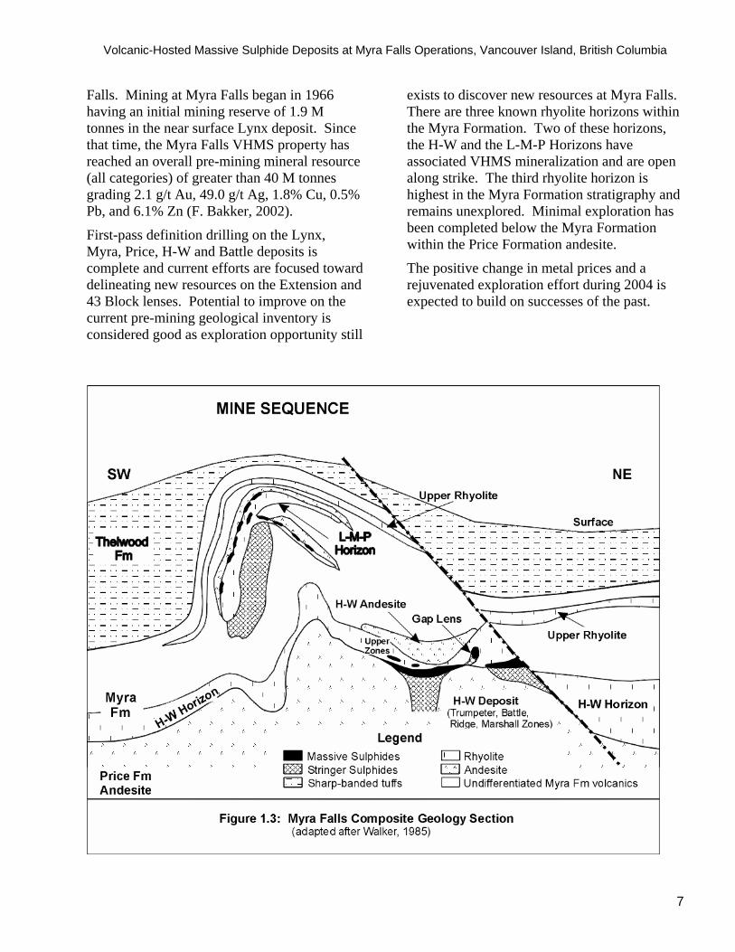
VHMS deposits at Myra Falls are hosted by the 310 to 440 m thick Myra Formation and are associated with the at-depth H-W Horizon and the near-surface Lynx-Myra-Price (L-M-P) Horizon (Figs. 1.2 and Fig. 1.3) (Pearson, 1993). VHMS mineralization associated with the H-W Horizon is typically at or proximal to the upper contact of the Price Formation andesite. VHMS deposits immediately overlying the Price Formation andesite contact are the 22 M tonne H-W deposit and the 6 M tonne Battle deposit. The H-W Horizon also has subordinate but economically significant mineralization within stacked lenses located 10 to 70 m above the larger deposits. In mine terminology these stacked lenses are known as Upper Zone mineralization. In the Battle deposit area, Upper Zone mineralization is hosted by felsic volcaniclastic rocks proximal to the base of or within quartz feldspar porphyry flow-dome complexes.
VHMS mineralization in the L-M-P Horizon is located in the upper portion of the Myra Formation. These deposits were the first to be exploited on the property due to their surface exposure. L-M-P ore lenses are high-grade polymetallic VHMS deposits spatially associated with rhyolite rocks in the stratigraphic footwall and a mafic sill located in the immediate hangingwall. The L-M-P Horizon has low tonnage per deposit, with an average size of 2.4 M tonnes and a combined total of 7.2 M tonnes overall.
There have been over 100 years of mineral exploration activity in central Vancouver Island and four decades of active mining at Myra
Volcanic-Hosted Massive Sulphide Deposits at Myra Falls Operations, Vancouver Island, British Columbia
7
Falls. Mining at Myra Falls began in 1966 having an initial mining reserve of 1.9 M tonnes in the near surface Lynx deposit. Since that time, the Myra Falls VHMS property has reached an overall pre-mining mineral resource (all categories) of greater than 40 M tonnes grading 2.1 g/t Au, 49.0 g/t Ag, 1.8% Cu, 0.5% Pb, and 6.1% Zn (F. Bakker, 2002).
First-pass definition drilling on the Lynx, Myra, Price, H-W and Battle deposits is complete and current efforts are focused toward delineating new resources on the Extension and 43 Block lenses. Potential to improve on the current pre-mining geological inventory is considered good as exploration opportunity still
exists to discover new resources at Myra Falls. There are three known rhyolite horizons within the Myra Formation. Two of these horizons, the H-W and the L-M-P Horizons have associated VHMS mineralization and are open along strike. The third rhyolite horizon is highest in the Myra Formation stratigraphy and remains unexplored. Minimal exploration has been completed below the Myra Formation within the Price Formation andesite.
The positive change in metal prices and a rejuvenated exploration effort during 2004 is expected to build on successes of the past.

Volcanic-Hosted Massive Sulphide Deposits at Myra Falls Operations, Vancouver Island, British Columbia
8

Volcanic-Hosted Massive Sulphide Deposits at Myra Falls Operations, Vancouver Island, British Columbia
9
1.4 Tour Itinerary
The tour may include stops at underground drift exposures, surface outcrops, and drill core. Rock types to be highlighted are from the footwall Price Formation andesite, Myra Formation VHMS mineralization, hangingwall chert, altered coarse volcaniclastic rocks, upper zone mineralization, ore clast breccia, and hangingwall andesite.
Note: Direction references will be relative to mine grid coordinates. Mine grid north is 48° east of true north.
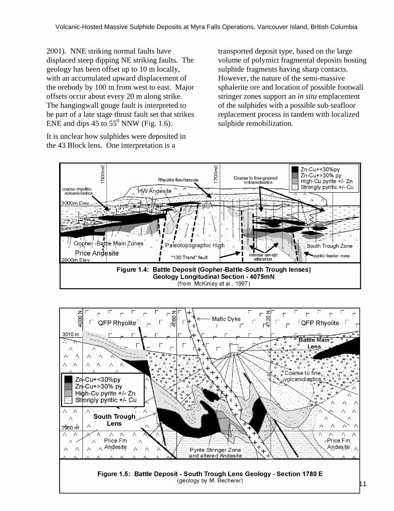
1.5 Tour 1: Battle-Gap Mine 1.5.1 Introduction The South Trough and Upper Zone lenses are part of the Battle deposit. The Battle deposit is located 1.0 km west of the H-W headframe (Fig. 1.2). There is a total of 6.0 M tonnes grading 1.4 g/t Au, 53.2 g/t Ag, 1.8% Cu, 0.7% Pb and 12.5% Zn (Bakker, 2002) within the pre-mining mineral resource from a total of 7 different VHMS lenses.
Areas with good drift exposures include the Battle Main, South Trough, Gnu, Gap, and Upper Zone lenses (Fig. 1.4).
1.5.2 Battle-Gap Geology The main geological units from stratigraphic footwall to hangingwall are:
Price Formation Andesite Footwall Andesite: The footwall andesite has texturally destructive, pervasive sericite-chlorite-silica hydrothermal alteration. There is weak to moderate E-W foliation fabric with moderate to steep north-dipping axial planar cleavage. In less altered areas, the Price Formation andesite is characteristically a massive amygdaloidal flow. Pillowed flow facies have also been observed but are not common.
Myra Formation (H-W Horizon) Contact Zone Ore Lenses: The Battle Main, Gopher, South Trough, and Gnu sulphide
lenses are located at or proximal to the Price Formation andesite contact. Mineralization is massive to semi-massive and stringer style sulphides with sphalerite, sphalerite-chalcopyrite-pyrite, and pyrite-chalcopyrite assemblages. Sulphides surround rhyolite and cherty fragments. Sulphide grain size ranges from very fine to coarse as a result of metamorphic recrystallization.
H-W Rhyolite: The volcaniclastic rocks are autoclastic breccias, resedimented syn-eruptive mass flow deposits and mudstones. Silicified mudstone (“chert” in mine terminology) is white to grey-white, massive to bedded and conformably overlies the Contact Zone lenses. Small-scale folding and subvertical strike-slip faulting is common.
Mafic Dykes: A continuous, east-striking, north dipping, 6 to 8 m thick mafic dyke intrudes the South Trough lenses. The dyke occurs proximal to a massive pyrite-chalcopyrite pipe and displays moderate intensity vein-style carbonate alteration. Centimetre-scale mafic dyke swarms occur along the Gopher Zone footwall contact.
Upper Zone Lenses: The Upper Zone lenses are positioned 10 to 70 m up-stratigraphy of the Price Formation andesite contact. These lenses typically have a mineral assemblage of sphalerite-galena-barite-chalcopyrite-tennantite+/-bornite+/-electrum. Individual lenses have been deformed and may display folded and lens-shaped geometries.
Quartz Feldspar Porphyry: Quartz-feldspar porphyry is located approximately 30 plus metres up-stratigraphy of Contact Zone mineralization and commonly forms the immediate hangingwall, or is spatially associated with the Upper Zone lenses. This unit is typified by grey-white, aphanitic to quartz +/-feldspar phyric, massive rhyolite. Autobrecciated facies equivalents are present along the margins. Quartz and feldspar phenocrysts are millimetre-size, with subhedral forms. Quartz phenocrysts typically have

Volcanic-Hosted Massive Sulphide Deposits at Myra Falls Operations, Vancouver Island, British Columbia
10
glassy reflectance. Feldspar phenocrysts are variably sericite-altered. Hangingwall Andesite – Ore Clast Breccia: This unit is a massive to brecciated feldspar +/-pyroxene phyric andesite. Jigsaw-fit quench textures can be observed in drillcore. Local fragments of bleached andesite, quartz-feldspar porphyry and massive sulphides are minor components of the unit. Weak, patchy to vein-style epidote-chlorite alteration is also present.
1.5.3 Contact Zone Mineralization Discussion Contact Zone mineralization occurs within topographic depressions having overall dimensions between 250 to 600 m along strike, 30 to 250 m perpendicular to strike, and depths ranging between 15 to 53 m. In the South Trough, section 1780E shows a folded sequence of rocks with steep, brittle offsets (Fig. 1.5). There are two main massive to semi-massive sphalerite-pyrite-chalcopyrite-rich sulphide lenses along with an upper zone lens located higher in the stratigraphic column. A subvertical, massive pyrite-chalcopyrite-rich massive sulphide pipe, and a steep north-dipping mafic dyke bisect the South Trough area into north and south lenses. Massive to semi-massive sphalerite-rich portions of these lenses are found concentrically outward from the pyrite-chalcopyrite pipe. Reconstruction of the lenses reveals a low aspect (aspect ratio = 0.4), sheet geometry for both north and south lenses.
1.6 Tour 2: H-W Mine (43 Block) 1.6.1 Introduction This tour is an alternate in the event Tour 1 is not possible. The 43 Block mining area lies northeast of the H-W Main lens and along strike of the North Lens (Fig. 1.2). There is a pre-mining mineral resource (all categories) of 971,000 tonnes grading 2.6 g/t Au, 52.8 g/t Ag, 1.7% Cu, 0.5% Pb and 5.8% Zn. The ore lens has a strike length of about 400 m and an average height of 20 m. On N-S cross-section, the orebody displays a wedge or triangular
shape. The hangingwall contact is defined by a 45 degree, NNW-dipping fault zone (Fig. 1.6). The main geological units from stratigraphic footwall to hangingwall are:
1.6.2 43-Block Geology Price Formation Andesite Footwall Andesite: The footwall andesite unit is characterized by massive, feldspar-phyric andesite with breccia facies. The breccia facies has both monomict andesite breccias as well as polymict andesite-rhyolite breccia.
Myra Formation (H-W Horizon) Rhyolite Fragmental: The rhyolite fragmental contains lapilli to block size angular fragments set in sericite-pyrite altered matrix. Millimetre-scale quartz + feldspar phenocrysts may be observed within individual fragments.
Ore Clast Breccia: The ore clast breccia unit is characterized by a gradual transition from footwall andesite to the rhyolite fragmental and is marked by an increasing presence of sulphide fragments, with pyrite and chalcopyrite stringers.
Main Ore Lens: The main ore lens consists of semi-massive to locally well-banded pyrite, sphalerite, and chalcopyrite; sulphides enclose rhyolite fragments. Massive sulphides are also intercalated with pyrite-rhyolite fragmental units.
Hangingwall Fault: The hangingwall fault is defined by a clay and gouge rich fault zone up to 10 m thick. The fault zone incorporates ore lens material, andesite, rhyolite and argillite.
Hangingwall Assemblage: This assemblage includes massive and feldspar-phyric andesite, rhyolite fragmental, rhyolite quartz-feldspar porphyry, and locally, black argillite.
1.6.3 43-Block Discussion Three major brittle-ductile fault groups have structurally deformed the 43 Block area (Jones,
Volcanic-Hosted Massive Sulphide Deposits at Myra Falls Operations, Vancouver Island, British Columbia
11
2001). NNE striking normal faults have displaced steep dipping NE striking faults. The geology has been offset up to 10 m locally, with an accumulated upward displacement of the orebody by 100 m from west to east. Major offsets occur about every 20 m along strike. The hangingwall gouge fault is interpreted to be part of a late stage thrust fault set that strikes ENE and dips 45 to 550 NNW (Fig. 1.6).
It is unclear how sulphides were deposited in the 43 Block lens. One interpretation is a
transported deposit type, based on the large volume of polymict fragmental deposits hosting sulphide fragments having sharp contacts. However, the nature of the semi-massive sphalerite ore and location of possible footwall stringer zones support an in situ emplacement of the sulphides with a possible sub-seafloor replacement process in tandem with localized sulphide remobilization.

Volcanic-Hosted Massive Sulphide Deposits at Myra Falls Operations, Vancouver Island, British Columbia
12

Volcanic-Hosted Massive Sulphide Deposits at Myra Falls Operations, Vancouver Island, British Columbia
13
2.0 Overview of Selected Topics on the Massive Sulphide Deposits at Myra Falls
Albert Chong
2.1 History The Early Years The first documented exploration and mineral prospecting in central Vancouver Island began in 1865 with the John Buttle expedition. The expedition ventured from the west coast fishing village of Tofino, up Bedwell Sound and Bedwell River valley into what is now the southern margin of Strathcona Park. This was the first recorded sighting of what is now Buttle Lake. In 1910, the Price Ellison Expedition ventured into the Buttle Lake area. Ellison’s recommendation to the provincial legislature led to the Strathcona Park Act in 1911, protecting the first and oldest provincial park in British Columbia. Mineral prospecting and staking was opened up shortly afterwards; the first claims were staked in 1917. The outcome was discovery of the surface expressions for the Lynx, Myra, and Price deposits in Myra and Thelwood valleys (Fig. 1.2).
Sporadic exploration continued until 1961, when Western Mines Limited acquired the property from the Reynolds Syndicate. Exploration and ore definition drilling focused on the Lynx showings in Myra valley, outlining an initial mining reserve of 1.9 M tonnes. Mining started in the Lynx open pit in 1966 and was quickly followed by underground mining.
Since the opening of the Lynx mine, there have been four subsequent phases of exploration, development and mining (E-D-M) from four past and current producing mines. Each cycle has taken about a decade to run its course, with some minor overlap (Table 2.1). Initiation of each cycle commenced with the need to discover new resources, as existing resources were being depleted. Much of the detailed historical information between 1966 and 1993 has been described by Pearson (1993). The following text has taken the information by
Pearson (1993) and summarized it in the context of the E-D-M cycle perspective. Pre-mining mineral resource values summarized in this paper are from Bakker (2002). The 1960’s Near-surface Exploration-Development-Mining (E-D-M) Cycle (Lynx mine commissioning)
The L-M-P Horizon is associated with a sequence of sericite schist and associated volcanic rocks of both rhyolitic and andesitic composition. Footwall rocks are typically rhyolite. The hangingwall has rocks of rhyolitic composition as well as a komatiitic sill unit known as the G-flow in mine terminology.
Exploration emphasized the near-surface Lynx showings (Fig. 1.2). Development and mining began on the Lynx open pit in 1966 at a rate of 600 to 900 tons per day. Underground mining followed shortly thereafter, with an original mining reserve estimate of 1.9 M tonnes. Boat access to the property ceased after the construction of a road along the east side of Buttle Lake, connecting the minesite to the town of Campbell River. Surface infrastructure facilities were constructed with much of the raw material being logged, milled or excavated on site.
The 1970’s L-M-P Horizon E-D-M and at-depth exploration (Myra Deposit commissioning; H-W Horizon Discovery)
Exploration, development and mining continued on the near surface L-M-P Horizon showings and deposits. The Lynx mine continued to operate and production began at the Myra mine during 1972 at a rate of 200 to 400 tons per day. Total production from the Myra mine was 1.0 M tonnes at 3.0 g/t Au, 160.0 g/t Ag, 1.0% Cu, 1.5% Pb and 9.5% Zn.
In 1976, Brascan Ltd. acquired control of Western Mines Limited and formed Westmin Resources Ltd. Recognizing a decline in the mineral inventory, an aggressive exploration

Volcanic-Hosted Massive Sulphide Deposits at Myra Falls Operations, Vancouver Island, British Columbia
14
program was launched. The exploration program utilized recent developments in the understanding of volcanic hosted massive sulphide (VHMS) deposits from the Canadian Shield. One key development was the understanding that deposits are hosted in relatively thick, multi-cyclic volcanic piles, and sulphide mineralization is found in the second or higher cycle, at or near the base of the host cycle (Franklin and Thorpe, 1982). The base of the host Myra Formation for the L-M-P deposits was not defined at the time. Following assessment of the property for its volcanic stratigraphy, structural deformation, style of mineralization and hydrothermal alteration, a decision to drill the north limb of the Myra anticline below the L-M-P Horizon was made. This decision was rewarded by discovery of the large tonnage H-W deposit 400 m below the Myra valley floor in December, 1979.
The 1980’s L-M-P Horizon and H-W Horizon E-D-M (Along-strike discoveries; Commissioning of the H-W Mine)
H-W deposit delineation, development and production was the focus for in the 1980’s, concurrent with exploration of both the Lynx-Myra-Price Horizon and the newly discovered H-W Horizon. Accelerated diamond drilling on the H-W deposit resulted in a positive production decision and the H-W mine was commissioned in 1985. Continued exploration lead to the discovery of along-strike equivalents of both mineralized horizons. Discoveries were made on the West G and S Zones of the L-M-P Horizon. On the new H-W Horizon, discoveries were made immediately northeast of the H-W deposit at the 42 and 43 Block lenses.
Approximately 3 km west of the H-W deposit, crosscuts spaced 150 m apart were driven north of the existing Lynx mine workings during 1988. These crosscuts provided diamond drill platforms to explore the newly interpreted H-W Horizon trend. As a result of exploration diamond drilling in 1989 and 1990, over fifty ore grade mineralized intersections were cored
on what is now known as the Ridge Zone West and Ridge Zone East areas. These intersections range from 0.2 to 22.5 m thickness. A preliminary mineral resource estimate of 668,000 tonnes was outlined in both the Ridge East and Ridge West Zones.
The 1990’s Continued L-M-P Horizon and H-W Horizon E-D-M (Discovery and commissioning of the Battle-Gap deposits)
Following confirmation of strike length continuity of the H-W Horizon westward for at least 3 km and the availability of new diamond drill platforms, an exploration program was launched to target the H-W Horizon between the Ridge Zones and the main H-W deposit (Fig. 1.2). In 1991, this program intersected 33.1 m of ore grade massive sulphide mineralization in the Gap lens. Subsequent discoveries of this exploration program were the Battle and the Extension deposits. Other peripheral discoveries on the H-W horizon during this time included the Trumpeter Zone, located approximately 1 km east of the H-W deposit. In 1995, the Marshall Zone was discovered approximately 1 km northwest of the Battle deposit lenses.
A positive production decision was reached for the Battle and Gap deposits; production began in 1995. Underground production from the Lynx mine was terminated in 1993 due to poor economic parameters, however, limited access is still available for ventilation and exploration purposes. Ownership of the property changed hands during 1998, when Boliden Limited acquired Westmin Resources Limited to form Boliden-Westmin (Canada) Limited.
The Current E-D-M Cycle (2000 to present):
Recent exploration efforts have been directed towards upgrading indicated and inferred resources of the Ridge Zone West and Marshall Zones, located 1 km west and northwest of the current infrastructure. The Price deposit, located to the east in Thelwood valley, has also been revisited. Diamond drilling for new undiscovered VHMS deposits has yet to be

Volcanic-Hosted Massive Sulphide Deposits at Myra Falls Operations, Vancouver Island, British Columbia
15
successful during the current E-D-M cycle. Development of drill platforms is essential as the western half of the property lies under the 1,520 m high Phillips Ridge. During 2004, an exploration drift on the 24 level rail haulage drift was established to explore the eastern extension of the Marshall Zone, located 600 m NW of the Battle deposit. Current exploration is peripheral to H-W Horizon deposits and northward.
Definition diamond drilling is currently delineating the Extension Zone and 43 Block. The Extension Zone is located between the H-W and Battle Zone deposits and extends over a 1 km strike length. Current pre-mining mineral resource estimate is 1.1 M tonnes. 43 Block definition diamond drilling is nearing completion; mining of initial stoping blocks on this structurally deformed lens commenced in 2001. Near surface resources of the high-grade Lynx deposit S-Zone of the L-M-P Horizon have also been outlined.
Active mining at Myra Falls Operations is currently based out of the H-W head frame and the majority of the mining activity comes from the H-W, 43 Block, and Battle-Gap deposits. Minor supplemental ore is being extracted from the Lynx open pit. Current production rates are 1.0 M tonnes annually at rates ranging between 2,800 and 3,400 tonnes per day.
During July 2004, the Myra Falls Operations was acquired by Breakwater Resources Limited and is now owned by NVI Mining Limited.
2.2 Regional Geology and Metallogeny VHMS deposits on Vancouver Island, including those at Myra Falls, are hosted by ancient island arc systems of the Paleozoic Sicker Group (Hoy, 1991). The Paleozoic Sicker Group is considered part of the allochthonous Wrangellia terrane, which is a
portion of the Insular Belt of the Canadian Cordillera (Jones et al., 1977).
The Wrangellia terrane has three major volcano-sedimentary cycles and can be traced for 2,000 km from the southern tip of Vancouver Island northward to south-central Alaska (Jones et. al, 1977). At Myra Falls, the oldest volcanic cycle is the Devonian to Mississippian Sicker Group volcanic rocks, which are conformably overlain by limestone of the Permian Buttle Lake Formation (Fig. 2.1). The second volcanic cycle is the Vancouver Group; comprised of Triassic Karmutsen Formation tholeiitic volcanic rocks, overlain by limestone of the Quatsino Formation. The third cycle is the Jurassic Bonanza Group volcanic rocks (Fig. 2.1).
The Sicker Group is exposed on Vancouver Island in several fault-bounded uplifts. At Myra Falls, the Sicker Group, in order of decreasing age, comprises the basement Price Formation andesite, Myra Formation felsic to mafic volcanic rocks, Thelwood Formation mafic fine volcaniclastic rocks, Flower Ridge Formation mafic breccias and sills, and Buttle Lake limestone (Muller, 1980; Juras, 1987). The footwall Price Formation andesite rocks and Myra Formation felsic to mafic volcanic rocks are the host strata to VHMS deposits at Myra Falls.
On Vancouver Island, two major metallogenic groups were classified by Northcote and Muller (1972), volcanic and plutonic. Massey (1992) has further subdivided the two groups based on timing relative to pre and post accretion. The plutonic group deposits are skarn, vein, Sooke-type Cu and porphyry Cu. Two main VHMS areas occur on Vancouver Island. They are centered about the past producing Twin J mine in the Cowichan-Horne Lake Sicker Group uplift and the Myra Falls deposits in the Buttle Lake Sicker Group uplift.

Volcanic-Hosted Massive Sulphide Deposits at Myra Falls Operations, Vancouver Island, British Columbia
16
TABLE 2.1 - MYRA FALLS OPERATIONS: EXPLORATION - DEVELOPMENT - MINING CYCLES
HORIZON Zone Pre-1960 1960's Cycle 1970's Cycle 1980's Cycle 1990's Cycle Current1917 1960 1970 1980 1990 2000
LMP Lynx
Myra
Price
H-W H-W
42-43 Blocks
Ridge Zones
Battle-Gap
Extension
Trumpeter
Marshall
Exploration - Development Phase Mining Phase

Volcanic-Hosted Massive Sulphide Deposits at Myra Falls Operations, Vancouver Island, British Columbia
17
2.3 Mine Geology The Myra Falls VHMS deposits occur at or near the base of Paleozoic Sicker Group rocks within the Buttle Lake uplift and are associated with the first recognized phase of volcanism on Vancouver Island. From oldest to youngest, mine sequence geology specific to the H-W and
Battle-Gap mining areas are the Price Formation, Myra Formation and Thelwood Formation as established by Juras (1987) (Fig. 2.2). The following text is a summary of work by Walker (1985) and Juras (1987), with minor supplements from Barrett and Sherlock (1996).

Volcanic-Hosted Massive Sulphide Deposits at Myra Falls Operations, Vancouver Island, British Columbia
18
2.3.1 Price Formation The Price Formation is the stratigraphic basement within the Buttle Lake uplift and is at least 300 m thick consisting of feldspar +/- pyroxene porphyritic basaltic andesite flows and flow breccias with lesser volcaniclastic deposits. Rocks from this unit are moderate to strongly altered with chlorite + epidote + albitic plagioclase +/- actinolite assemblages.
A conspicuous feature of this formation is the presence of medium to very coarse grained, black to dark green pyroxene phenocrysts pseudomorphed by actinolite. However, the presence of pyroxene grains is not diagnostic of the Price Formation as pyroxene phenocrysts and crystals also occur within overlying formations. The top of the Price Formation is defined as the lower contact of the first widespread appearance of rhyolitic volcanic rocks of the overlying Myra Formation. Juras (1987) postulates that the Price Formation represents an early phase of island arc volcanism in a marginal basin or volcanic arc setting.
2.3.2 Myra Formation The Myra Formation is 310 to 440 m thick and conformably overlies the Price Formation (Pearson, 1993). The Myra Formation consists of rhyolitic volcanic flows, volcaniclastic and intrusive rocks with lesser sedimentary units. The volcanic rocks are predominantly intermediate in composition, consisting of flows and flow breccias, and subaqueous volcaniclastic rocks emplaced by sediment gravity flow processes. Sedimentary units include heterolithic volcaniclastic breccia and lesser sandstone, siltstone, argillite and chert. The Myra Formation hosts VHMS mineralization. Individual units are continuous along a northwest to southeast trend but have abrupt facies changes on a northeast to southwest orientation (Walker, 1985).
Juras (1987) postulates that the Myra Formation represents a phase of island arc rifting and basin development, as reflected by three general geologic settings: a volcanic arc
setting consisting of andesite to rhyolite flows and volcaniclastic deposits; a rift basin setting comprising volcanogenic sediments, pelagic deposits, hydrothermal mineralization, and intermediate volcanic flows; and lastly, an intra–arc or back–arc rift setting consisting of mafic flows and volcaniclastic deposits.
In their study of the H-W mine volcanic stratigraphy, Barrett and Sherlock (1996) avoid the stratigraphic terminology and summarized the Myra Formation in terms of lithological composition, stratigraphic position and volcanic facies associations. These intervals are: the massive sulphides immediately above or proximal to the footwall andesite Price Formation, the Lower level felsic stratigraphy, the Middle stratigraphy intrusive mafic unit, and the heterogeneous Upper portion of felsic to mafic volcaniclastic units with lesser felsic and mafic flows and sills. The Upper portion is also host to the Lynx, Myra and Price massive sulphide deposits.
2.3.3 Thelwood Formation The Thelwood Formation conformably, and in places unconformably, overlies the Myra Formation. The Thelwood Formation is 270 to 500 m thick and is characterized by thin-bedded, fine-grained mafic volcaniclastic turbidites, tuffs, volcaniclastic debris flows and penecontemporaneous mafic sills. Turbidite beds are 5 to 30 cm thick and grade upward from coarse-grained crystal-lithic mafic sandstone to pale green, laminated siltstone-mudstone. Volcanic debris flows are 1 to 10 cm thick, moderately well sorted, crudely stratified and consist mainly of gravel to pebble-sized mafic clasts. Mafic sills are 1 to 10 m thick (Walker, 1985; Juras, 1987).
2.4 Geochronology Juras (1987), Parrish and McNicoll (1992), and Barrett and Sherlock (1996) report U-Pb zircon age determinations on rhyolite from the Myra Formation. Juras (1987) sampled a rhyolite unit in the upper part of the Myra Formation and he estimates an age of 370 +18/-6 Ma for the upper rhyolite unit. Parrish and McNicoll

Volcanic-Hosted Massive Sulphide Deposits at Myra Falls Operations, Vancouver Island, British Columbia
19
(1992) sampled a rhyolite from the lower part of the Myra Formation and estimate a minimum age of 366 +/-4 Ma for the Myra Formation, interpreted as the probable age of crystallization of the rhyolite. Barrett and Sherlock (1996) sampled felsic volcanic strata near the H-W deposit and report an age estimate of 365 +/-4 Ma (weighted mean age of 5 fractions) or 369 +12/–7 Ma (best fit line) that confirmed the work of Parrish and McNicoll (1992). These dates indicate a Late Devonian to Early Mississippian age.
Jones (2001) identified radiolaria in the sediments immediately overlying the H-W and Battle deposits. Muller (1980) identified radiolaria in a sediment-sill unit at the top of the Myra Formation. Radiolaria from both locations indicate an Early Mississippian age.
2.5 Metamorphism The most extensive work on metamorphism in the Buttle Lake uplift was by Juras (1987). Regional metamorphism in the Buttle Lake uplift is lower greenschist facies in the Price and Myra Formations and lower greenschist to
subgreenschist pumpellyite-actinolite in the younger Thelwood and Flower Ridge Formations respectively. Metamorphic mineral assemblages are diverse, reflecting the original bulk composition of rock types present (Table 2.2). In the Thelwood Formation, Juras (1987) attributes silicification as alteration from the penecontemporaneous emplacement of thick mafic sills. Moderate to strong irregular veining and disseminations of epidote is attributed to hydrothermal activity.
Early Mesozoic metamorphism was caused by burial. This interpretation is based on the resetting of K-Ar and Rb-Sr isotopic dates as a result of emplacement of the Early Jurassic Island Intrusions (Walker, 1985 and Juras, 1987). Phyllosilicate phases have been recrystallized to coarser grain sizes and there is some pressure shadow development. These effects are most pronounced in the hinge areas of Mesozoic structures and in schist zones related to faulting. The recrystallization is not prevalent in the Price and Myra Formations.
Table 2.2: Myra Falls: Metamorphic Mineral Assemblages (from Juras, 1987)Price Fm Basaltic andesite, andesite chl+ep+ap+q+cc+/-act
(m id-ocean ridge analogy)Myra Fm High MgO basalt act+chl+ab+ep
chl+cc+ser+hemBasalt chl+q+ab
chl+ep+ab+q+/-act+/-ccep+q+ab+cc+/-act
Basaltic andesite, andesite ep+ab+q+/-chl+/-cc+/-actchl+ab+q+/-ep+/-cc
Feldspar porphyritic felsic volcanic ab+q+ep+ser+/-chl+/-hemQuartz feldspar porphyritic rhyolite ser+q+ab+/-chlThelwood Formation Intermediate tuffs chl+ep(+/-clz)+q+ab
Mafic sills chl+ab+epFlower Ridge Formation basalt chl+ep(+/-clz)+ab+q+act+/-cc+/-pp
chl+ep(+/-clz)+ab+q+act+/-ccActinolite - act; Albite - ab; Apatite - ap; Calcite - cc; Chlorite - chl; Clinozoisite - clz; Epidote - ep; Hem atite - hem ; Prehnite-pum pellyite - pp; Quartz - q; Sericite - ser

Volcanic-Hosted Massive Sulphide Deposits at Myra Falls Operations, Vancouver Island, British Columbia
20
2.6 Structure Five phases of deformation have been interpreted at Myra Falls. Walker (1985) and Juras (1987) documented two early ductile deformation events; a large scale, upright, open fold referred to as the Myra anticline; and a ductile event that has resulted in broad zones of shearing. Reid (1993), Berry (2000) and Jones
(2001) focused on subsequent property-wide brittle deformation events. Berry (2000) and Jones (2001) proposed a 5-stage structural history for Myra Falls as outlined in Table 2.3 and Fig. 2.3. Orientations noted in Table 2.3 and the following text are relative to true north, facilitating correlations between both property and regional scale observations.
Table 2.3: Myra Falls District: Deformation History (Berry, 2000; Jones, 2001)Event General Description
D5 NE-SW compression resulting in NE-SW dipping gouge-rich thrust faults and coeval,steep E to SE trending sinistral strike-slip faults.
D4 Extension with planar normal faults.
D3 NE-SW compression; a two-stage generation of steep strike-slip faults;followed by shallow-dipping NE-SW dipping thrust faults.
D2 Shear zones.
D1 NE-SW compression; folding and development of an NW-SE foliation;shallow plunges to the NW and SE.

Volcanic-Hosted Massive Sulphide Deposits at Myra Falls Operations, Vancouver Island, British Columbia
21
Jones (2001) interpreted the structural history at Myra Falls within a regional context, incorporating observations from structural studies in northern Vancouver Island around the Quatsino-Port McNeill area (Nixon et al., 1994), central Vancouver Island (Muller, 1980), and south Vancouver Island around the Cowichan Uplift (England and Calon, 1991; Massey, 1992; Yorath et al., 1999). Jones (2001) concludes that ductile D1 folding is a result of NE-SW compression. Structures resulting from this event have been mapped in Sicker Group rocks throughout Vancouver Island. The D1 folding event is believed to have occurred within the Wrangellia terrane prior to collision with the ancient North American craton.
D3 faults at Myra Falls result from a two- stage evolution of strike-slip and thrust faults. A similar two-stage strike-slip and thrust faulting
event has been documented in northern Vancouver Island and is believed to have occurred during the post-Mid Cretaceous to pre-Late Cretaceous time (Nixon et al., 1994).
Large scale, gouge-rich D5 thrust faults at Myra Falls are likely related to the large NW-oriented thrust faults that dominate the structural fabric of Vancouver Island. These thrust faults may be correlated to north-dipping thrust faults in the Cowichan Uplift of southern Vancouver Island documented by England and Calon (1991), Massey (1992), and Yorath et al. (1999). The faults are inferred to have developed during crustal shortening caused by the collision and accretion of Wrangellia, Pacific Rim and Cresent terranes onto North America. Strike-slip components of the D5 faults are due to NW movement of the Pacific Plate relative to the North American plate.

Volcanic-Hosted Massive Sulphide Deposits at Myra Falls Operations, Vancouver Island, British Columbia
22
2.7 H-W Horizon Synvolcanic Faults and Cu-Fe Enrichment Synvolcanic faults and fracture zones that formed the conduits for discharging hydrothermal fluids at Myra Falls are poorly preserved due to hydrothermal overprinting and reactivation from subsequent deformation. In a property-wide study, Jones (2001) identified several large-scale synvolcanic faults based on the following criteria: rapid changes in footwall elevation, elevation changes in the younger Thelwood Formation basal contact, stratigraphic thickness changes in the Myra and H-W Formations, and marked facies variation for fine grained facies and porphyry bodies (Fig. 2.4). Movements on these faults are interpreted to be greater than 30 m.
In addition to the criteria used by Jones (2001) outlined above, other possible indicators for synvolcanic fracture systems that may have been conduits for discharging hydrothermal fluids are an increase in altered and unaltered mafic dykes, as well as proximity of Cu-Fe enrichment in massive sulphide and footwall stringer mineralization. The dykes are indicative of structural conduits that have been used by magmatic and potential hydrothermal fluids. Cu-Fe enrichment represents the presence of chalcopyrite and pyrite formed at relatively high temperatures towards the base of a sulphide mound by metal zone refinement processes (Eldridge et al., 1983).
A number of the large-scale synvolcanic faults defined by Jones (2001) are spatially associated with anomalous Cu-Fe enrichment based on block modeling by Minesight software of the ore lenses using an inverse distance cubed algorithm. This is apparent within the H-W
deposit, where two prominent east-trending Cu-Fe enrichment zones are proximal and subparallel to steeply dipping, east-trending, major synvolcanic faults located north of the H-W Main and North lenses (Figs. 2.4, 2.5, and 2.8).
For the Battle deposit area, there are two examples of the association between Cu-Fe enrichment and mafic dykes localized along synvolcanic faults or fracture systems. These examples are the east trending Cu-Fe enrichment through the South Trough lens and between the Gopher and Battle Main lenses (Fig. 2.6). The South Trough lens has an east-trending 6 to 8 m wide steeply dipping mafic dyke and a steep-dipping massive pyrite zone (Figs. 2.6 and 1.5). A fault system between the Gopher and Battle Main lenses has a well-developed, pyritic hydrothermal feeder system, centimeter-scale mafic dykes subparallel to the fault system, as well as the footwall contact. These observations are based on drift mapping and drillcore interpretations.
The Gap deposit has an east-west linear Cu-Fe enrichment zone characterized by massive to veined pyrite near the base of the deposit as well as in the footwall feeder system (Figs. 2.6 and 2.7). This enrichment zone is a steep-dipping massive pyrite+/-chalcopyrite+/-sphalerite zone observed in both drillcore and drift exposures. The synvolcanic fault located immediately south of the Gap deposit appears to be a possible channelway for hydrothermal fluids as the pyritic footwall stringer zone below the Gap deposit appears to originate along this fault system on section 1390E (Fig. 2.7).
Volcanic-Hosted Massive Sulphide Deposits at Myra Falls Operations, Vancouver Island, British Columbia
23

Volcanic-Hosted Massive Sulphide Deposits at Myra Falls Operations, Vancouver Island, British Columbia
24

Volcanic-Hosted Massive Sulphide Deposits at Myra Falls Operations, Vancouver Island, British Columbia
25
2.8 Hydrothermal Alteration Alteration mineralogy at Myra Falls includes sericite and silica with subordinate chlorite, albite and carbonate. Sulphide mineralogy of pyrite+/-chalcopyrite+/-sphalerite+/-galena+/-tennantite is also present in varying modal percentages as disseminations and veinlets. The overall depth and lateral distribution of the hydrothermal system for the Myra Falls deposits has not yet been defined. Zones of pyrite stringer mineralization have been observed to underlie the H-W, Battle, Lynx and Myra deposits. A majority of the following discussion is based on hydrothermal alteration studies for deposits on the H-W Horizon, as little has been written about the L-M-P Horizon on this topic.
2.8.1 Footwall Price Formation Alteration Alteration within the Price Formation andesite is not well defined at depth beneath the mineralized zones as diamond drill coverage is typically designed to primarily define the orebodies. The most common alteration immediately below the ore lenses in the Price Formation andesite is a texturally destructive intense sericite-quartz-pyrite alteration. Hydrothermal alteration has been observed in the Price Formation andesite to depths of at least 80 m below the H-W deposit (Barrett and Sherlock, 1996). A zone of albite-quartz+/-sericite+/-chlorite alteration flanks the main hydrothermal alteration feeder system in the footwall of the H-W deposit (Juras, 1987).
The largest zone of hydrothermal pyrite stringer mineralization at Myra Falls underlies the H-W deposit, where pyrite content ranges from several to more than 30% (Walker, 1985). The pyrite is coarsely crystalline (a few to several millimetres) in contrast to the overlying, typically fine-grained, massive pyrite. Individual stringers are composed of pyrite and quartz and range up to at least a metre thick (Walker, 1985). Generally, pyrite stringer mineralization is not economic.
Immediately below the Battle deposit, a similar texturally destructive intense sericite-quartz-
pyrite alteration system exists. Localized intense Mg-chlorite alteration is also present within the sericite-quartz-pyrite alteration below the Battle deposit (Robinson, 1994; Sinclair, 2000). Thirty meters below the Battle deposit a sericite-chlorite-pyrite alteration assemblage becomes dominant (Sinclair, 2000).
A semi-conformable pyrite stringer mineralized zone has been observed to underlie the Battle Main lens for a few meters into the footwall rocks. A more extensive pyrite stringer zone with intense sericite-quartz alteration is spatially associated with an interpreted synvolcanic fault between the Gopher and Battle Main lenses. This Gopher-Battle Main stringer zone appears to have a subvertical orientation, possibly representing an alteration pipe that crosscuts the above-mentioned semi-conformable alteration zone (Fig. 2.7). Below the Battle-Gopher-South Trough lenses, are disseminated to veined coarse-grained pyrite stringer zones.
2.8.2 H-W Horizon Hangingwall Alteration Juras (1987) notes that at the property-scale, felsic volcanic rocks in the Myra Formation form numerous mineral assemblages. Feldspar porphyritic felsic volcanic rocks have been hydrothermally altered to the assemblage albite-quartz-epidote-sericite+/-chlorite+/-hematite. Quartz-feldspar porphyritic rhyolite has an alteration mineral assemblage of sericite-quartz-albite+/-chlorite.
The hangingwall alteration in felsic volcanic rocks above the Battle deposit area is typically diffuse and unfocussed, but can be well developed in areas with Upper Zone style mineralization. The most common alteration minerals are a pervasive sericite-quartz assemblage. Intense hydrothermal silicification of fine-grained facies volcaniclastic deposits immediately above massive sulphide mineralization commonly produces a lithology referred to as “chert” in mine terminology (Jones, 2001). Dolomite, barite and disseminated to veinlet style sulphides are also present. The dolomite alteration occurs as

Volcanic-Hosted Massive Sulphide Deposits at Myra Falls Operations, Vancouver Island, British Columbia
26
texturally destructive blebs and rhombs up to 2 cm in diameter. It has a restricted distribution and is interpreted to mark the edges of the hydrothermal system (Sinclair, 2000).
The current understanding is that much of the hangingwall alteration is the footwall alteration for the Upper Zones and Gap deposit (Robinson, 1994; Sinclair, 2000). Spatially overlying the Battle Main lens but underlying the Gap lens is a massive, well-defined, focused, massive pyrite stringer zone below the Gap lens. The Gap lens has a vertically elongate pipe-shaped geometry (Fig. 2.7).
2.8.3 Lynx-Myra-Price Hydrothermal Alteration The following discussion on L-M-P hydrothermal alteration is from Walker (1985). Ore-related alteration has been metamorphosed and is now manifested by broad zones of pyrite-sericite schist. Within the more extensive sericite schists, which contain a few percent disseminated pyrite, two separate zones of pyrite stringer mineralization have been recognized along the Lynx-Myra-Price Horizon. These pyrite stringer zones underlie the Lynx and Myra deposits. The Lynx deposit pyrite stringer zone conformably underlies the S-Zone lenses (Fig. 1.3).
A relatively smaller pyrite stringer zone underlies the Myra deposit. The Myra pyrite stringer zone has elevated Cu values, which have locally attained economic Cu concentrations sufficient to allow mining. Smaller zones of galena and sphalerite-bearing stringer mineralization are recognized peripheral to or away from the major pyrite stringer zones mentioned above.
2.9 Orebody Geometry Ore lenses at Myra Falls have been modified by varying degrees of deformation. The Lynx and Myra deposits have been substantially folded making derivation of primary geometry difficult. Other lenses such as 43 Block have had at least 3 phases of brittle-ductile deformation, also making derivation of primary
geometry difficult. Even though the Battle, Gap and H-W deposits have had many phases of brittle and ductile deformation superimposed on their original geometries, the current gross overall geometries and thickness variations appear to be reasonably similar to their inferred original geometries prior to deformation. Therefore, a review of the orebody geometries of the Battle, Gap, and H-W deposits would be useful as a general guideline to the variety of geometry types for the H-W Horizon at Myra Falls.
Aspect ratios are typically calculated for primary undeformed lens geometries by the following formula: thickness ÷ length. For purposes of discussion, the aspect ratios used in this document are for deformed, secondary aspect ratios. Lengths used are for N-S minor axis dimensions as this perspective provides the greatest variation for massive sulphide geometry.
The Battle Main lens has a sheet-style geometry measuring approximately 900 m long, by 250 m wide, by 3 to 30 m thick and has an aspect ratio below 0.2 (Figs. 2.6 and 2.7). The Gopher lens (approximately 1.0 M tonnes) appears to have an asymmetric mound geometry with an aspect ratio of approximately 1.0 at its thickest part on a N-S cross-section perspective. The Upper Zones, located 10 to 70 m above the main lenses are polymetallic disseminations, stockwork veins, and massive sulphide lenses with low aspect ratios. The Gap lens has a high aspect ratio of 2 and measures at least 330 m long, by 30 m wide, by 3 to 45 m thick. Sinclair (2000) documented the Gap lens as having a pipe-shaped geometry.
The H-W Main lens appears to have an asymmetric mound geometry at its thickest accumulation measuring 950 m long, by 450 m wide, by 1 to 60 m thick (Figs. 2.5 and 2.8). Further to the east at 3750E, the H-W Main lens thins out and has a low aspect sheet-like geometry. The North lens appears to be a low-aspect-ratio mound or sheet-style deposit on 3750E. Upper Zone style mineralization of disseminated to massive replacement-style vein

Volcanic-Hosted Massive Sulphide Deposits at Myra Falls Operations, Vancouver Island, British Columbia
27
mineralization is prominent above the polymetallic southern fringe of the H-W Main lens. Based on the above discussion, there are currently four main types of ore lens geometries for the H-W Horizon at Myra Falls. These geometries are:
1. Low-aspect-ratio, asymmetric mound deposits ranging from 1.0 to 10.0 M tonnes
2. Low-aspect-ratio sheet (lens) deposits ranging between 0.01 to 6.0 M tonnes
3. Upper Zone disseminated to replacement vein and lens-style mineralization
4. High-aspect-ratio pipe-shaped deposits as per the Gap deposit, with tonnage potential of at least 700,000 tonnes

Volcanic-Hosted Massive Sulphide Deposits at Myra Falls Operations, Vancouver Island, British Columbia
28
2.10 Orebody Mineralogy The following discussion of orebody mineralogy is taken largely from Walker (1985), Robinson (1994), Wilson (1993) and Sinclair (2000). Sulphide mineralogy at Myra Falls is typical of most VHMS deposits. Common sulphide minerals present in order of decreasing abundance are pyrite, sphalerite, chalcopyrite and galena. Less common sulphides are pyrrhotite, arsenopyrite (Walker,
1985) and the Cu-rich sulphides bornite, renierite and anilite (Robinson, 1994; Sinclair, 2000). Common sulfate and sulphosalt minerals present are barite and tennantite, respectively. A late-stage Ag-Au rich mineral assemblage includes stromeyerite and electrum (Sinclair, 2000). Table 2.5 lists the orebody minerals present at Myra Falls, their general chemical formulas, and some of the more significant element associations.
Table 2.5: Myra Falls Ore Body MineralogyAssemblage Type Mineral General Formula Other elements Inclusions - ImpuritiesCu-Pb-Zn-Fe Sulphides Pyrite FeS2 Ni, As Zn, Cd, Cu, Pb, As, Mn, Au
Sphalerite ZnS Fe, Cd, Cu, Mn
Galena PbS Se, Te Zn, Fe, Cu
Chalcopyrite CuFeS2 Se, In Ba, Zn, Au
Pyrrhotite Fe1-xS
FeAsS
Sulphosalts Tennantite (Cu10Ag) Zn2Fe(As3, Sb)S12 Fe, Se, Ag, Cd
Trace Minerals Rutile TiO2 Si, Al, Fe
Colusite Cu3(As,Ge,V)S4 Ba, Sb Ag, Mo, Zn, Fe
Tellurides Altaite PbTe
Hessite Ag2Te3
Pilsenite Bi2Te3
Cu-Rich Sulphides Bornite Cu5FeS4 Ag, Ba Zn, Cd
Covellite CuS
Renierite Cu10(Zn1-xCu)Ge2-xAsxFe4S16 V, Sb, Ba
Anilite Cu2(Ag)S Ag, Ba
Late Ag-Au Rich Sulphides Stromeyerite CuAgS Fe
Precious metals Electrum AuAg
Native silver Ag
Gangue Barite BaSO4 Sr
Quartz SiO2
Muscovite K2Al4(Si6Al2O20)(OH,F)4 Na, Ba, Mg, Fe
Epidote Ca2(Al,Fe)3Si3O12(OH)
Calcite CaCO3
Gypsum CaSO4-2H2O
Anhydrite CaSO4
Jasper SiO2 Fe
Specularite Fe2O3
Smithsonite ZnCO3
Data after Robinson (1992), Wilson (1993), Sinclair (2000), M. Becherer (pers. comm., 2003), Chong (2004)
Assemblages adapted from Battle-Gap study by Sinclair (2000)

Volcanic-Hosted Massive Sulphide Deposits at Myra Falls Operations, Vancouver Island, British Columbia
29
Sinclair (2000) has identified three main mineral assemblages. These are: a Cu-Pb-Zn-Fe-rich mineral assemblage, a Cu-rich mineral assemblage and a late stage Ag-Au-rich assemblage for the Battle deposit. Since the Battle deposit has a similar but enhanced sulphide mineralogy relative to other deposits at Myra Falls, the assemblages outlined by Sinclair (2000) will be used to discuss the orebody mineralogy.
Cu-Pb-Zn-Fe-rich mineral assemblage: Common minerals for the Cu-Pb-Zn-Fe-rich assemblage are pyrite, sphalerite, galena, chalcopyrite and tennantite.
Pyrite has a wide range of textures ranging from microscopic framboids, ring structures, fine-grained disseminated euhedra, fine-grained spongy pyrite and annealed coarse-grained porphyroblasts (Robinson, 1994; Sinclair, 2000). The framboids, ring structures and fine-grained spongy pyrite are interpreted as primary textures formed during VHMS mineral deposition (Sinclair, 2000). Coarse-grained porphyroblasts and cataclastic textures are interpreted to be the result of metamorphism and deformation. Pyrite has Au and As associations identified by ion microprobe (Wilson, 1993). Au values range between 25 ppb and 1000 ppb.
In the Battle-Gap deposit and Upper Zone areas much of the sphalerite is a low-Fe variety averaging approximately 0.6 wt% Fe (Robinson, 1994; Sinclair, 2000) and is commonly referred to as “honey sphalerite”. In the H-W and Lynx deposits sphalerite is darker grey in colour due to a relatively higher Fe content (pers. comm. M. Becherer, 2003). In thin section, sphalerite crystals exhibit textures resulting from metamorphism. These textures include coarsening of individual crystals, 120-degree triple points between sphalerite crystals, and the migration of chalcopyrite to triple point junctions and grain boundaries (Sinclair, 2000).
Galena at Myra Falls occurs as recrystallized anhedral masses and grains interlocked with tennantite and barite. Chalcopyrite is generally remobilized. The sulphosalt present is the As-rich end-member tennantite.
Cu-rich sulphides: Bornite is common within the Gap deposit, Upper Zone mineralization, the Bornite lens and the northeast portion of the H-W Main lens. Renierite, also known as orange bornite, occurs as rounded grains in bornite, or in sphalerite where bornite is abundant. Anilite is a “blue” copper-rich sulphide that is part of the chalcocite group (Robinson, 1994; Sinclair, 2000).
Trace minerals are rutile, tellurides and colusite. The tellurides of altaite, hessite, and pilsenite commonly occur as microscopic inclusions in tennantite and galena. Colusite occurs exclusively in the Gap and Upper Zone ores as rounded blebs in sphalerite, pyrite and bornite (Sinclair, 2000).
Au-Ag assemblage: Gold within the Gap and Upper Zone mineralization above the Battle deposit occurs as submicroscopic inclusions at grain boundaries and scattered grains of gold or electrum (Sinclair, 2000). In 2000, a mine geologist observed a 1 m thick barite layer with stromeyerite-tennantite-electrum (+/-manganese?) veining located in the immediate hangingwall to the polymetallic Zn-Pb-Cu-Ba-enriched portion of the H-W deposit (Fig. 2.10b). A sample from this barite layer returned an outstanding precious metal assay of 5,000 g/t Au and 5,379 g/t Ag.
Mineral Chemistry:
Sulphide samples from the H-W deposit have been evaluated by electron microprobe and proton microprobe (Wilson, 1993). Silver occurs at significant levels in tennantite (0.1 to 1.2 wt%) and galena (60 to 250 ppm). Cadmium is present in sphalerite and tennantite at concentrations of 0.33 and 0.1 wt%,

Volcanic-Hosted Massive Sulphide Deposits at Myra Falls Operations, Vancouver Island, British Columbia
30
respectively. Chalcopyrite contains a few tens of ppm of Se and In, and tennantite contains up to 500 ppm Te. Pyrite and chalcopyrite can each contain tens of ppm Mo (Barrett and Sherlock, 1996).
In the Upper and Gap Zones of the Battle deposit area, Ag occurs at significant levels in tennantite, stromeyerite and electrum (Sinclair, 2000). Silver in tennantite is supported by electron microprobe analyses for tennantite grains from the Ridge Zone West deposit (Chong, 2004). Cadmium in the Battle-Gap area is contained within sphalerite and tennantite. Probed chalcopyrite samples are pure and lack detectable Zn, Pb, Ag, As and Sb (Sinclair, 2000).
There are two main associations for the occurrence of gold at Myra Falls (Barrett and Sherlock, 1996; Hayward, 2001). These associations are: coarse free gold and electrum associated with galena, and fine free gold and electrum associated with pyrite grain boundaries. Barrett and Sherlock (1996) also suggest the possibility of submicroscopic gold in pyrite for the H-W deposit. This possibility has not been substantiated.
Chrysoullis (1989) investigated the Au mineralogy of the H-W deposit and the different ore types by optical and scanning electron microscopy, electron and ion probe analyses, diagnostic cyanidation and image analyses of the Au minerals. The principal Au carrier was electrum with 22-30 wt% Ag and native Au with approximately 13 wt% Ag. Electrum was more Au-rich in bornite-bearing ores where associated with galena and chalcocite. This work is supported by Sinclair’s (2000) work on the Gap deposit.
Chrysoullis (1989) determined that the average concentration of solid solution Au was 1.78 and 0.67 ppm in galena and bornite respectively. Fine-grained electrum is found associated with pyrite and sphalerite, enclosed in tennantite. Average solid solution Au concentration in tennantite is 6.3 ppm.
2.11 Sulphide Textures Sulphides may be texturally massive to semi-massive, banded, fragmental or as stockwork veins ranging from millimeter to centimeter in width (Figs. 2.9, 2.10 and 2.11). Lower greenschist metamorphism has recrystallized almost all sulphides present, with the exception of microscopic, fine-grained primary pyrite with framboidal and ring structure forms (Sinclair, 2000). Fragments of hostrock are included within massive to semi-massive sulphide in most deposits at Myra Falls.
Sulphide-bearing fragmental rock commonly referred to as “ore clast breccia” in mine terminology is found throughout the mine sequence stratigraphy (Walker, 1985). Sulphide fragment size is typically on a centimetre scale and may range from sharply angular forms to fluidal remobilized contacts (Fig. 11b). Sulphide clast composition varies from pyrite to chalcopyrite-sphalerite rich. Many of the “ore clast breccia” occurrences are hosted by autobrecciated to massive mafic flow-dome complexes, or occasionally felsic complexes as in the 43 Block area. Peperitic textures are commonly observed at the margins of these flow-dome complexes and are interpreted to be formed by the interaction of a hot magma with wet, unconsolidated sediments. Interestingly, many of the “ore clast breccia” occurrences are not necessarily within paleo-depressions downslope of massive sulphide lenses. Instead, many of the occurrences are located immediately adjacent to or enveloping massive sulphide mineralization. Examples of this are the Ridge Zone West and 43 Block respectively (Fig. 2.11).

Volcanic-Hosted Massive Sulphide Deposits at Myra Falls Operations, Vancouver Island, British Columbia
31

Volcanic-Hosted Massive Sulphide Deposits at Myra Falls Operations, Vancouver Island, British Columbia
32

Volcanic-Hosted Massive Sulphide Deposits at Myra Falls Operations, Vancouver Island, British Columbia
33

Volcanic-Hosted Massive Sulphide Deposits at Myra Falls Operations, Vancouver Island, British Columbia
34
2.12 Ore Reserves Mining at Myra Falls began in 1966 with an initial mining reserve of 1.9 M tonnes at the near surface Lynx deposit. Since that time, the Myra Falls VHMS property has reached an overall pre-mining mineral resource of greater than 40 M tonnes grading 2.1 g/t Au, 49.0 g/t Ag, 1.8% Cu, 0.5% Pb and 6.1% Zn (Table 2.6). As of January 2004, approximately 23.9 M tonnes have been mined and milled at the Myra Falls property since the beginning of production.
Ore reserves are calculated using the Mintec Inc. Minesite-Compass software. Three-dimensional block models are generated for each deposit area. Individual block sizes are 5 m along strike by 5 m perpendicular to strike by 4 m vertical. Grade estimation of blocks uses an inverse distance cubed algorithm. The search ellipsoid measures 50 m along strike, 25 m perpendicular to strike, and 15 m vertically. All precious metal and base metal assays are performed on site by the Myra Falls assay laboratory. Off-site independent assay laboratories perform check assays.
2.13 Orebody Tonnage, Grade and Classification The Myra Falls VHMS property has 12 known deposit areas. Each deposit area represents a cluster of individual lenses. Six of the twelve known deposits have tonnages greater than 1.0 M tonnes (Table 2.7). The overall average deposit size for the Myra Falls VHMS district is 3.4 M tonnes with grades of 1.8% Cu, 0.4% Pb, 5.7% Zn, 2.0 g/t Au and 38.2 g/t Ag. Deposits within the mineral resource range from 211,000 tonnes for the relatively undefined Cu-rich Trumpeter Zone to 22.1 M tonnes for the pyrite-rich polymetallic H-W deposit.
The near surface L-M-P Horizon has a 7.2 M tonne mineral resource with an average deposit size of 2.4 M tonnes. Based on their Zn and Cu ratios, the L-M-P deposits would fall under the Solomon (1976) metal content classification as Zn-Pb-Cu deposits (Table 2.6). There are an estimated 120 individual lenses within the Lynx deposit along a 2,750 meter strike length. The mineralization occurs as a folded and faulted array of individual lenses varying in size from 10,000 to 150,000 tonnes. Lens dimensions range from 3 to 6 m thick, 30-60 m dip length and 90 to 120 m strike length (Becherer, 1992).
The at-depth H-W Horizon has a current mineral resource of 33.7 M tonnes with an
Table 2.6: 2002 MFO Pre-mining Geological Inventory Estimate (modified after Bakker, 2002) Deposit Tonnes Average Au Ag Cu Pb Zn Zn Ratio Cu Ratio Metal Content
Deposit Size g/t g/t % % % (1) (2) Classification (3)
Lynx 5,809,090 2.5 90.4 1.6 1.0 7.5 88 18 Zn-Pb-CuMyra 1,037,000 3.0 160.0 1.0 1.5 9.5 86 10 Zn-Pb-CuPrice 380,581 2.1 73.2 1.4 1.3 9.2 88 13 Zn-Pb-CuL-M-P Horizon 7,226,671 2,408,890 2.6 99.5 1.5 1.1 7.9 88 16 Zn-Pb-CuHW 22,137,280 2.2 27.0 2.0 0.3 3.7 93 35 Zn-Cu43-block 971,436 2.6 52.8 1.7 0.5 5.8 92 23 Zn-CuTrumpeter 211,440 2.4 57.7 3.4 0.3 3.9 93 47 Zn-CuExtension 1,156,236 1.0 28.7 1.4 0.3 4.5 94 24 Zn-CuBattle 5,965,296 1.4 53.2 1.8 0.7 12.5 95 13 Zn-CuGap 778,025 2.0 121.3 2.0 1.0 13.8 93 13 Zn-CuRidge-east 326,461 0.8 41.1 0.7 0.8 4.7 86 13 Zn-Pb-CuRidge-west 982,661 2.0 71.8 0.9 0.8 6.8 90 11 Zn-Pb-CuMarshall 1,210,366 1.6 80.3 0.5 0.6 5.3 89 9 Zn-Pb-CuH-W Horizon 33,739,201 3,748,800 2.0 38.2 1.8 0.4 5.7 93 24 Zn-CuMFO TOTAL 40,965,872 3,413,823 2.1 49.0 1.8 0.5 6.1 92 23 Zn-Cu
(1) Zn Ratio 100*Zn / (Zn+Pb)January - 2004 Diluted Mining Reserve (2) Cu Ratio 100*Cu / (Cu+Zn)MFO TOTAL 7,746,914 1.2 39.98 1.15 0.52 6.33 (3) Solomon (1976) and Large (1992)

Volcanic-Hosted Massive Sulphide Deposits at Myra Falls Operations, Vancouver Island, British Columbia
35
average deposit size of 3.7 M tonnes (Table 2.6). Deposits within the H-W Horizon are primarily classified as Zn-Cu type and include the H-W deposit and its adjacent lenses. Interestingly, the Battle and Gap deposits also fall within the Zn-Cu group in spite of their high Pb and Zn values relative to other deposits on the property. An explanation for this is that the Pb values are not sufficient to bring the Zn ratio below 90.
Zn-Pb-Cu deposit types in the H-W Horizon are the Ridge Zone West, Ridge Zone East and
Marshall Zones. These deposits are located approximately 1.0 km west of the current infrastructure (Fig. 1.2). The metal content of these deposits suggests that they may represent distal mineralization peripheral to the main hydrothermal system (Gemmell, 1998). Wide-spaced exploration style diamond drilling has been carried out on these deposits. Hence, other Zn-Cu deposit types west of the Battle deposit area may remain to be discovered.
2.14 Myra Falls compared to other VHMS Regions Numerous workers have conducted statistical analysis characterizing VHMS deposits and mining camps around the world. Sangster (1980) calculated the average area occupied by a cluster or mining district to be about 850 km2, equivalent to a circular diameter of about 32 km, and host between 4 and 20 deposits. Boldy (1977) estimated that approximately 80% of the VHMS deposits fall in the size range of 0.1 to 10 M tonnes with about 50% being less than 1.0 M tonnes for Canadian Archean VHMS deposits. From a grade perspective, Gibson and Kerr (1992) state that 88% of Canadian
deposits have combined Cu+Pb+Zn grades of less than 10%. The Myra Falls property covers an area of approximately 33 km2. Compared to Sangster’s (1980) estimate of 850 square kilometers for an average VHMS district, the Myra Falls property is approximately 1/25th the size. Since the extent of the Myra Falls VHMS mineralization is not defined, the amount of prospective ground both on and off the property within Sicker Group volcanic rocks on Vancouver Island is considered high. In terms of tonnage, the 22.0 M tonne H-W deposit would be considered within the upper 20% of VHMS deposits with a significant Au content (> 1.0 M contained ounces). Though
Table 2.7: Mean Tonnage and Grade Data for Selected VHMS Deposit TypesDeposit Number of Tonnes Cu Pb Zn (1) Au Ag Zn ratio Cu ratio Au
Type Deposits (millions) (%) (%) (%) (g/t) (g/t) (2) (3) TonnesAustralian depositsCu 16 12.6 1.3 0.0 0.2 14.0 1.6 8.0 85 85 20.2Zn-Cu 4 8.6 1.6 0.5 6.9 3.0 0.8 61.0 93 19 6.9Zn-Pb-Cu 10 7.6 1.0 4.7 11.8 10.0 2.0 117.0 72 8 15.2Canadian Archean depositsCu 7 5.4 1.8 0.0 0.8 6.0 0.4 9.0 100 69 2.2Zn-Cu 36 15.7 1.5 0.1 3.7 34.0 0.8 38.0 98 28 12.6Zn-Pb-Cu 1 2.0 2.7 1.4 10.0 1.0 0.8 214.0 88 21 1.6Cdn Bathurst District (Paleozoic)Zn-Pb-Cu 20 14.3 0.6 2.2 5.5 19.0 0.5 62.0 71 9 7.2Cdn Myra Falls District (Paleozoic)Zn-Cu 6 5.2 1.9 0.4 5.7 6.0 2.0 35.4 93 25 10.5Zn-Pb-Cu 6 1.6 1.3 1.0 7.3 6.0 2.3 92.4 88 15 3.7Japanese Green Tuff Belt(4) (Tertiary)Cu 4 3.4 1.1 0.0 0.2 2.0 0.5 5.0 87 84 1.7Zn-Cu 2 3.3 1.3 0.0 3.8 1.0 1.4 59.0 100 26 4.6Zn-Pb-Cu 11 12.4 1.7 1.1 4.7 3.0 3.0 97.0 82 27 37.2Modified after Large (1992)(1) Number of deposits for which data was available to calculate average Au and Ag grades(2) Zn Ratio 100 * Zn / (Zn+Pb)(3) Cu Ratio 100 * Cu / (Cu+Zn)(4) Close clusters or unit orebodies of kuroko deposits are grouped as single deposits in this tabulation

Volcanic-Hosted Massive Sulphide Deposits at Myra Falls Operations, Vancouver Island, British Columbia
36
not considered to be large deposits, the Lynx, Myra, Price, Battle and Gap deposits have combined Cu+Pb+Zn grades greater than 10% and are considered high grade. Table 2.7 compares the Myra Falls VHMS deposits mean tonnes and grades to other selected VHMS regions around the world. There does not appear to be any consistent trends between the deposits currently known at Myra Falls relative to any of the other VHMS regions listed in Table 2.7. The most significant comparisons are: 1. Myra Falls mean tonnages for both Zn-Cu and Zn-Pb-Cu deposit types re considerably less than those listed for the Australian and other Canadian VHMS categories 2. Cumulative Cu+Pb+Zn grade for the six Zn-Cu type deposits at Myra Falls (8.0%) is substantially higher than the other areas listed with the exception of four Australian deposits 3. Cumulative Cu+Pb+Zn grade for the six Zn-Pb-Cu type deposits at Myra Falls (9.6%) is lower than the Australian and Canadian Archean deposits selected but of higher cumulative grade than Zn-Pb-Cu deposits of the Bathurst district and the Japanese Green Tuff Belt 4. Mean Au grades for Zn-Cu and Zn-Pb-Cu deposit types at Myra Falls are similar to or significantly higher than the other areas listed 5. Mean Ag grade for Zn-Pb-Cu type deposits at Myra Falls is similar to the other VHMS areas listed, except for Canadian Archean Zn-Pb-Cu deposits. Mean Ag grade for Myra Falls Zn-Pb-Cu deposits is less than half that for the mean Ag grade for the Zn-Pb-Cu deposits of the Canadian Archean.
2.15 Concluding Remarks There have been over 100 years of mineral exploration activity in central Vancouver Island and four decades of active mining at Myra Falls. Much effort has been focused on establishing the volcanic setting, synvolcanic faults, paleoseafloor depressions and structural deformation of the Myra Falls property. Other studies and data obtained from exploration and
mining have aided in characterizing disposition, geometry, mineralogy, metal zoning and hydrothermal alteration of the various VHMS deposits at Myra Falls. VHMS deposits at Myra Falls are associated with the rhyolite-dominated L-M-P and H-W Horizons within the Myra Formation of the Sicker Group. Mineralization in the L-M-P horizon is a series of stacked lenses with a felsic footwall. Mineralization in the H-W Horizon is focused at the contact with the footwall Price Formation andesite. H-W Horizon stacked upper zone vein systems and lenses are located within rhyolite above the Price Formation contact. Both L-M-P and H-W horizons have mafic flow-sill complexes in direct contact with or proximal to the hangingwall of massive sulphide mineralization. The L-M-P and H-W horizons are host to 12 known deposits with a variety of geometries, tonnages, and metal contents. The common orebody geometries found at Myra Falls are low-aspect-ratio sheets, low-aspect-ratio asymmetric mounds, upper zone vein and lens, and high-aspect-ratio pipes. The H-W deposit is a large tonnage Cu-Zn VHMS deposit. The Battle, Gap, Lynx, Myra, and Price deposits have high Zn+Pb+Cu metal grades. The Myra Falls property has only had 50% of its current claim explored. The lateral extent of the L-M-P and the H-W Horizons have not been fully defined. A third rhyolite horizon is untested. Compared to other VHMS regions in the Canadian Archean and the world, Sicker Group rocks on Vancouver Island have strong potential to host additional VHMS deposits. Based on the above observations and on comparisons, exploration potential at Myra Falls and on Vancouver Island is very good. The studies and observations mentioned earlier are the foundation for future discoveries of VHMS deposits at Myra Falls and the Sicker Group volcanic rocks on Vancouver Island. The questions to be answered are, what is the true maximum potential of the property and how do we realize that potential?

Volcanic-Hosted Massive Sulphide Deposits at Myra Falls Operations, Vancouver Island, British Columbia
37
Acknowledgements The authors would like to thank Dani Alldrick for requesting the tour. The management team at Myra Falls Operations is thanked for allowing the geology department to host the tour and write this paper. Many thanks to Fiona Childe, Georgina Price, and Geoffrey Locke for editing the manuscript.
References Bakker, F., 2002. January 2002 geological resources and
mining reserves for Myra Falls Operations. Boliden-Westmin Limited internal company report. 127 p.
Barrett, T.J., Sherlock, R.L., 1996. Volcanic stratigraphy, lithogeochemistry, and seafloor setting of the H-W massive sulphide deposit, Myra Falls, Vancouver Island, British Columbia; Exploration and Mining Geology; vol. 5, no. 4, pp. 421-458.
Becherer, M., 1992. Grade control and mining methods in the Lynx mine, Myra Falls Operations, Westmin Resources Limited. Westmin Resources Limited internal company report. 3 p.
Berry, R., 2000. Structural geology of the Myra Falls Operation. Centre for Ore Deposit Research, University of Tasmania. Boliden-Westmin Limited internal company report. 18 p.
Boldy, J., 1977. (Un)certain exploration facts and figures. CIMM Bulletin, May 1977, pp. 86-95. Chong, A., 2003. Overview of selected topics on the massive sulphide deposits at Myra Falls. Myra Falls Operations company report, 31p.
Chong, A., Becherer, M., Sawyer, R., Palmer, K., and Bakker, F., 2003. Massive sulphide deposits at Myra Falls Operations, Vancouver Island, British Columbia. In Geological field trips southern British Columbia, Geological Association of Canada, Cordilleran Section, Vancouver, pp. 93-103.
Chong, A.G., 2004. The polymetallic Ridge Zone West VHMS deposit, Myra Falls, Vancouver Island, British Columbia. Unpublished M.Sc. thesis submitted for review, Centre for Ore Deposit Research, University of Tasmania, Hobart, Australia. 239p.
Chrysoullis, S.L., 1989. Determination of invisible gold in flotation products and four ore types from the H-W mine, British Columbia. Westmin Resources Limited internal company report.
Eldridge, C.S., Barton, P.B., Ohmoto, H. 1983. Mineral textures and their bearing on formation of the Kuroko orebodies. Economic Geology, Monograph 5, pp.241-281.
England, T.D.J., and Calon, T.J., 1991. The Cowichan fold and thrust system, Vancouver Island,
southwestern British Columbia. Geological Society of America Bulletin, vol. 103, pp. 336-362.
Franklin, J.M. and Thorpe, R.I., 1982. Comparative metallogeny of the Superior, Slave, and Churchill Provinces. In Precambrian Sulphide Deposits, H.S. Robinson Memorial Volume. Edited by Hutchinson R.W., Spence, C.D., and Franklin, J.M., The Geological Association of Canada, Special Paper 25, pp. 3-90.
Gemmell, J.B., 1998. District scale metal zoning, Myra Falls VHMS Deposits, B.C., Canada. Internal Boliden-Westmin Limited company report. 31 p.
Gibson, H.L. and Kerr, D.J., 1992. Giant volcanic-associated massive sulphide deposits: with emphasis on Archean examples. In Giant Ore Deposits - Proceedings of the Giant Ore Deposits Workshop, Queen's University, edited by Whiting, B.H. et al., May 11-13 1992. pp. 492-522. Hayward, L., 2001. Gold recovery study at Myra Falls, British Columbia, Canada. Unpublished M.Sc. thesis, Leicester University, United Kingdom. pp. 149.
Hoy, T., 1991. Volcanogenic massive sulphide deposits in British Columbia. In Ore deposits, tectonics and metallogeny. In the Canadian Cordillera. Ministry of energy, mines and petroleum resources, British Columbia Geological Survey Branch Paper 1991-4, pp. 89-124. Jones, D.L., Silberling, N.J., and Hillhouse, J., 1977. Wrangellia – A displaced terrane in northwest North America. Canadian Journal of Earth Sciences, vol. 14, pp. 2565 – 2577.
Jones, S., 2001. Geology and alteration of the hangingwall “Cap” rocks of the Myra Falls VHMS district, British Columbia, Canada. Unpublished PhD study, Centre for Ore Deposit Research, University of Tasmania, Australia. 497p.
Juras, S.J., 1987. Geology of the polymetallic volcanogenic Buttle Lake Camp, with emphasis on the Price hillside, Central Vancouver Island, British Columbia, Canada. Unpublished Ph.D. thesis, University of British Columbia, 279 p.
Large, L.L., 1992. Australian volcanic-hosted massive sulfide deposits: features, styles, and genetic models. Economic Geology, vol. 87, p. 469-510.
Massey, N.W.D., 1992. Geology and mineral resources of the Duncan sheet, Vancouver Island, Geological Survey of Canada Report 92B/13, 57 p.
McKinley, S.D.M., Pearson, C.A., Juras, S.J., 1997. Paleotopography and ore zonation of the Battle Zn-Cu-Au-Ag VMS deposit, Vancouver Island, British Columbia. In 50th anniversary GAC/MAC annual meeting, Ottawa.
Muller, J.E., 1980. The Paleozoic Sicker Group of Vancouver Island, British Columbia. Geological Survey of Canada, Paper 79-30, 22 p.
Nixon, G.T., Hammack, J.L., Koyanagi, V.M., Payie, G.J., Panteleyev, A., Massey, N.W.D., Hamilton,
Volcanic-Hosted Massive Sulphide Deposits at Myra Falls Operations, Vancouver Island, British Columbia
38
J.V., Haggart, J.W., 1994. Preliminary geology of the Quatsino – Port McNeill map areas, Northern Vancouver Island (92L/12,11). In Geological Fieldwork 1993. Edited by Grant, B. and Newell, J.M. British Columbia Ministry of Energy, Mines and Petroleum Resources, Paper 1994-1, Pp. 63-86.
Northcote, K.E. and Muller, J.E., 1972. Volcanism, plutonism, and mineralization: Vancouver Island. In The Canadian Mining and Metallurgical CIM Bulletin, October 1972, pp. 49-57.
Parrish, R.R., and McNicoll, V.J., 1992. U-Pb age determinations from the southern Vancouver Island area, British Columbia. In Radiogenic age and isotopic studies: Report 5. Geological Survey of Canada Paper 91-2, pp. 79-86.
Pearson, C.A., 1993. Mining zinc-rich massive sulfide deposits on Vancouver Island, British Columbia. In International Symposium – World Zinc ’93. Hobart, Australia, pp. 75-84.
Reid, R.R., 1993. Westmin structure, 18 and 20 level data. Westmin Resources Limited internal company report, 48 p.
Robinson, M., 1994. Geology, mineralisation and alteration of the Battle Zone, Buttle Lake Camp, Central Vancouver Island Southwestern British Columbia. M.A.Sc. thesis, University of British Columbia, 268p.
Sangster, D.F., 1980. Quantitative characteristics of volcanogenic massive sulphide deposits. CIMM Bulletin, February 1980, pp. 74-81.
Sinclair, B.J., 2000. Geology and genesis of the Battle Zone VHMS deposits, Myra Falls district, British Columbia, Canada. Unpublished Ph.D. thesis, Centre for Ore Deposit Research, University of Tasmania, Australia, 313p.
Solomon, M., 1976. “Volcanic” massive sulphide deposits and their host rocks – a review and an explanation, In handbook of strata-bound and stratiform ore deposits, II, Regional studies and specific deposits. Edited by Wolf, K.A., Amsterdam, Elsevier, pp. 21-50. Walker, R.R., 1985. Westmin Resources’ massive sulphide deposits, Vancouver Island; Geological Society of America, Cordilleran Section Meeting, May 1985, Vancouver, B.C., Field Trip Guidebook, pp. 1-13.
Wilson, G., 1993. Mineralogy of sulphide ores from the H-W Kuroko deposit, British Columbia, part II, multi-element analysis of the ore minerals. Westmin Resources Limited internal company report, 42p.
Yorath, C.J., Sutherland Brown, A., and Massey, N.W.D., 1999. Lithoprobe, southern Vancouver Island, British Columbia. Geology. Geological Survey of Canada Bulletin 498, 145 p.

Sea Level
1000m
Myra Valley
Myra Mine
Price Mine
Trumpeter ZoneFar West
West Test
Ridge West
50
0m
E
25
00
mE
45
00
mE
55
00
mE
Ridge EastMarshall Zone
Battle Zone
HW Mine
43 Block
Extension ZoneGap Zone
24 Level
21 Level
18 Level 13 Level
5 Level10 Level
15 LevelHWShaft
Lynx Shaft
Lynx Mine
Projected Vertical Section
MYRA FALLS OPERATIONSHW Horizon Ore Zone
LMP Horizon Ore Zone
HW Horizon Potential
LMP Horizon Potential
Sea Level
Thelwood Valley
S. McKinley,
1997
55
00
mE
MINE SEQUENCE/MYRA FORMATION
Composite Cross-Section
Upper Rhyolite
HW Andesite
H-W Horizon
Price
Andesite
Upper Rhyolite
Lynx-Myra-Price
Horizon
Thelwood Formation
Thelwood
Formation
SW NE
Andesite
Legend
Massive Sulphides
Stringer Sulphides
Rhyolite
Undifferentiated volcanics
Tuffaceous sediments/mafic sills
H-W Main &
Gopher Lenses
H-W Horizon
H-W North Lens
& Battle Deposit
SMcK, 1997
Core Zone Fault
(strike-slip)
North
Fault
Composed by Brian Grant
Mineral Deposits DivisionGAC
BRIT
ISH COLUM
BIA
GEO
LOGICAL SU
R
VEY
CanadaMinistry of Energy and MinesMines and Minerals Division