
Maryland Humanities Council History Matters! - CiteSeerX
379
Maryland Humanities Council History Matters! Interpretive Plan for the Lower Susquehanna Heritage Greenway
-
Upload
khangminh22 -
Category
Documents
-
view
2 -
download
0
Transcript of Maryland Humanities Council History Matters! - CiteSeerX

Maryland Humanities Council
History Matters!
Interpretive Plan for the
Lower Susquehanna
Heritage Greenway

ii
History Matters!A History of Maryland’s Lower Susquehanna Region
The Lower Susquehanna region is the bold termination of the wide, powerful
Susquehanna River and the gentle beginning of the great Chesapeake Bay. Water dominates andshapes the lives of the humans along the shores just as it dominates and shapes the contours of itsland.1 The commanding river pulls people together; and at the same time, it divides them. Maryland’s Harford County to the south and Cecil County to the north, separated by the river,are pulled away from one another toward competing economic centers. Harford County easilyconnects with urban Baltimore, and Cecil County is lured away from Maryland’s influence byPhiladelphia and Wilmington. The Lower Susquehanna is a borderland connected by the mightywaters that dominate its existence.
When we began reviewing the history of the Lower Susquehanna region of Maryland, weread the existing volumes on Harford and Cecil Counties; and we talked to our heritage areapartners in the region. What did they need? Excellent histories focusing on the important menand events of the region already exist.2 What could we add?
We gathered together experts on Maryland’s history and culture to discuss how we mightfill in what was missing in our existing knowledge of the state. We visited local historians in theLower Susquehanna to learn what information they needed to better interpret their region. Mostagreed that we needed to explore the lives of the everyday people who lived and worked anddied near these great waters. They wanted to know more about Native cultures, women, AfricanAmericans, farmers, immigrants, and factory workers. Our historians and our local expertssuggested that we look at the region from several perspectives, and that we connect the themesof Maryland’s past to this specific area by comparing and contrasting its change over time whileexploring the tensions and conflicts arising from change. With our Susquehanna partners wedecided to pay particular attention to the area’s:
• Settlement patterns across the centuries
• Changes in the landscape Natural Environment – Resources to sustain life & attract settlement Built Environment – Incidental reshaping through settlementDesigned Environment – Human impact on the land __Shift from Natural to Agricultural to Urban to Suburban
• Individual Communities and Cultures: Everyday lives of the common people__Especially women; Native Americans; African Americans; farm and factory workers;
and immigrants
• Waterways, including the Chesapeake Bay and the Susquehanna River
• Transportation/Economics

iii
• Freedoms Won, Freedoms Lost__Religious, Political, and Intellectual
• Adaptation and Ingenuity__Tools, Transportation, and Technology
We decided to explore four stages of development within each theme:1. Meeting basic necessities to sustain life2. Bringing economic/strategic forces into play, including: politics, defense, trade,
transportation, communication, borders/contact points, violence3. Improving quality of life4. Pursuing recreation, creative arts, aesthetics, and design
This focused history of the Lower Susquehanna is written by a diverse group of scholars,each attempting to keep these factors in mind. Members of the History Matters! staff andadvisory panel spent countless hours helping co-author and edit this history.
At the Maryland Humanities Council, Stephen Hardy gathered together a basic history ofthe last 300 years, focusing on population and economic data, and wrote the colonial history. Members of the Advisory Panel wrote component chapters and advised on themes across thecenturies:
Michael Dixon, Historian of the Historical Society of Cecil County, shared hisextensive knowledge of the historical resources of the Susquehanna region. Hisdeep understanding of the development of commerce along the greatSusquehanna River lent insights across the centuries.
Sharon Harley, former Director of the Afro-American Studies Program andAssociate Professor of Afro-American Studies at the University of MarylandCollege Park, contributed her sharp insights on Maryland history in general andAfrican American history in particular.
Judy Leonard, President, Board of the Lower Susquehanna Heritage Greenway,enthusiastically supported our work, opened many doors, and shared herexperiences and perceptions about the region and the Greenway.
Whitman Ridgway, Associate Professor of History at the University of MarylandCollege Park, authored the chapters related to the nineteenth century. Hisextensive political insights stretched across three centuries of Maryland’s past.
John Seidel, Assistant Professor of Anthropology and Environmental Studies,Washington College, contributed the prehistoric and Native American history ofthe region, the state of archaeological research in the area, and the maritimehistory of the Upper Chesapeake. He authored the chapters on the prehistoric andEuropean contact periods and provided much of the text dealing with

iv
archaeological and maritime subjects in other chapters.
Bruce Thompson, Coordinator of the Catoctin Center for Regional Studies andAssociate Professor of History at Frederick Community College, used his keensense of the subtleties of twentieth-century issues to write the chapters thatconcerned that century, plus the introduction to the individual site analysis.
We learned from each person we met with as we toured the region. Special thanks aredue to Ellsworth Shank, Curator of the Susquehanna Museum of Havre de Grace, for sharing hisextensive expertise on the history of the region. We are grateful to Bob Chance, ExecutiveDirector of the Lower Susquehanna Heritage Greenway, for his historical introduction andoverview of the Greenway, its development, and its future plans.
Hannah Byron, Director of Tourism Development for the State of Maryland, and MarciRoss, Manager of Destination Resources, Office of Tourism Development offered theirperspectives and support to the project. Hannah served as the project’s link with the MarylandHeritage Areas Authority.
We would like to thank the Maryland Heritage Areas Authority for authorizing this workas the pilot project of History Matters!, our heritage areas initiative, and to the Board ofDirectors and Steering Committee of the Lower Susquehanna Heritage Greenway, Inc., for theirgenerous participation as partners in this project. Special thanks go to Elizabeth Hughes, Chief ofthe Office of Heritage Planning and Outreach at the Maryland Historical Trust, and to RodneyLittle, Director of the Division of Historical and Cultural Programs, Maryland Department ofHousing and Community Development, for their support and encouragement. And we need tothank the Board of the Maryland Humanities Council for their vision in authorizing this projectin the Spring of 2000.
To enhance our understanding of each period, we drew from historical essays onMaryland in the seventeenth, eighteenth, nineteenth, and twentieth centuries by Lois Green Carr,Jean Russo, Whitman Ridgway, and George Callcott, written for our Maryland History andCulture Bibliography project.
Our thanks and respect go out to all of the site administrators and guides who gave sofreely of their time and expertise, graciously hosted our panel during its tour, and welcomed ourinquiries with courtesy and remarkable good will:
Connie Beims, Berkley Crossroads and Hosanna School; Ellen Mencer, Chesapeake Heritage Conservancy and Skipjack MARTHA LEWIS; Ron Smith and Lou Kinney, Conowingo Dam; John Narvell, Friends of Concord Point Lighthouse, Inc.; Jennifer Jones, Havre de Grace Decoy Museum; William Putland, Havre de Grace Maritime Museum; Brenda Dorr Guldenzopf, Havre de Grace Maritime Museum and Havre de Grace Decoy
Museum; Marlene Magness, Historical Society of Harford County;

v
Erika Quesenbery, Paw Paw Museum; Barbara Brown and Sharon Weygand, Town of Perryville; Linda Noll, Steppingstone Museum Association Inc.; Robert Magee, Charles Hiner, Arthur Coates, and Kathryn Lince, Susquehanna Museum of
Havre de Grace at the Lockhouse; Rick Smith and Clark Old, Susquehanna State Park; and Craig Lanphear, Swan Harbor Farm.
We would like to thank those Maryland scholars who gathered together for a day to helplay the groundwork for exploring the history of the various regions of our state:
Louise Akerson, Past President, Archaeology Society of Maryland; Mary Alexander, Director, Museum Assistance Program, Maryland Historical Trust; Robert Brugger, History Editor, The Johns Hopkins University Press; Hannah Byron, Director, Maryland State Office of Tourism Development; George Callcott, Professor Emeritus of History, University of Maryland College Park; Ric Cottom, Deputy Director Publications, Maryland Historical Society;Dennis Curry, Senior Archaeologist, Maryland Historical Trust; Nancy Davis, Deputy Director Museum, Maryland Historical Society; Nicole Diehlman, Administrator, Statewide Preservation Programs, Maryland Historical Trust; Rhoda Dorsey, President Emerita, Goucher College; Michael Dyson, President, Small Museum Association; Elaine Eff, Director, Cultural Conservation Program, Maryland Historical Trust;Cheryl Fox, Historical Programs Officer, African-American Initiative Program, Maryland
Historical Trust; Jamie Hunt, Outreach and Public Relations Coordinator, Preservation Maryland, and Director,
Baltimore Heritage; Catherine Gira, President, Frostburg State University; James Harris, Dean of Arts and Humanities, University of Maryland, College Park; Elizabeth Hughes, Chief, Office of Heritage Planning and Outreach, Maryland Historical Trust; Richard Hughes, Administrator of Archaeology, Maryland Historical Trust; Doug McElrath, Curator of Marylandia and Rare Books, University of Maryland College Park; Mary Mannix, Director of the Maryland Room, Frederick Public Library; Stephen Patrick, Director, Bel Air Mansion and President, Maryland Association of History
Museums; Whitman Ridgway, Associate Professor of History, University of Maryland College Park; Orlando Ridout V, Chief, Office of Research, Survey and Registration, Maryland Historical
Trust; Marci Ross, Destination Resources Manager, Office of Tourism Development;Helen Rountree, Retired Professor of Anthropology, Old Dominion University;John Seidel, Assistant Professor of Anthropology and Environmental Studies, Washington
College; Marcie Taylor-Thoma, Specialist in Social Studies, Maryland State Department of Education; Bruce Thompson, Coordinator, Catoctin Center for Regional Studies and Associate Professor of
History, Frederick Community College; and John T. Willis, Secretary of State of the State of Maryland.
vi
And my deepest gratitude goes to Carol Benson, here at the Maryland HumanitiesCouncil. This is her project. She coordinated the entire project, supplied the missing facts, editedeach contribution, and made sure that diverse parts became a whole. She also oversaw andcompiled the site analysis section of this project.
Because of the contributions of each of these people, I have found it a joy to read and editthis volume.
Barbara Wells SarudyExecutive Director, Maryland Humanities CouncilEditor, History Matters!: A History of Maryland’s Lower Susquehanna Region
July 2001

vii
1. See also the National Park Service’s exemplary publication, “Bay Plain and Piedmont: ALandscape History of the Chesapeake Heartland From 1.3 Billion Years Ago to 2000,” availableat their website, <www.chesapeakebay.net/pubs/gateways/plainandpiedmont/>.
2. Histories of the development of these two counties include:Economic/Political:
Livingood, James W. The Philadelphia-Baltimore Trade Rivalry, 1780-1860. New York:Arno Press, 1970.
Cecil County:Blumgart, Pamela James, ed. At the Head of the Bay: A Cultural and Architectural
History of Cecil County, Maryland. Elkton, MD: Cecil Historical Trust, 1996.Garrett, Jerre. Muffled Drums and Mustard Spoons: Cecil County, Maryland, 1860-1865.
Shippensburg, PA: White Mane Publishing, 1996.Johnston, George. History of Cecil County, Maryland and Early Settlements around the
Head of the Chesapeake Bay and on the Delaware River with sketches of some of the OldFamilies of Cecil County. 1881; reprinted, Baltimore: Heritage Books, 1998.
Miller, Alice E. Cecil County Maryland – A Study In Local History. Elkton, MD: C. &.L. Print. & Specialty Co., 1949.
Harford County:Jay, Peter A., ed. Havre de Grace: An Informal History. Havre de Grace, MD:
Susquehanna Publishing Company, 1986.Preston, Walter W. History of Harford County Maryland From the Years 1608 (The Year
of Smith’s Expedition) to the Close of the War of 1812. Baltimore: Press of the Sun Book Office,1901. Reprinted by Regional Publishing Company, Baltimore, 1972.
Weeks, Christopher. An Architectural History of Harford County, Maryland. Baltimore:Johns Hopkins University Press, 1996.
Wright, C. Milton. Our Harford Heritage: A History of Harford County, Maryland(Privately published, 1967).
NOTES

viii
History Matters!Interpretive Plan
Table of Contents
Foreword, by Barbara Wells Sarudy........................................................................................i
Part One: A History of the Lower Susquehanna RegionIntroduction.................................................................................................................2The Geological Landscape..........................................................................................8Prehistory, To 1600...................................................................................................11The Contact Period, 1600-1650................................................................................30A Period of Quiet Growth, 1650-1740.....................................................................44Growth And The Grain Trade, 1740-1776................................................................62Revolution, Experimentation, and the New Nation, 1776-1811...............................79The War of 1812 and Antebellum Economic Development, 1811-1860.................99Civil War, Freedom, and the Industrial Revolution, 1861-1917............................122Two World Wars and a Depression, 1900-1945.....................................................146Passing Through, 1945-2000..................................................................................180
Appendix 1: Tables.................................................................................................201Appendix 2: Primary Sources.................................................................................226Appendix 3: Records of the Susquehanna and Tidewater Canal............................238Appendix 4: Susquehanna Region Maps of Interest...............................................242
Part Two: Site Analysis, Lower Susquehanna Heritage GreenwayIntroduction.............................................................................................................245Conowingo Dam.....................................................................................................259Berkley Crossroads.................................................................................................264Darlington Area.......................................................................................................268Susquehanna State Park..........................................................................................270Steppingstone Museum...........................................................................................274Paw Paw Museum...................................................................................................277Port Deposit............................................................................................................282Tome School for Boys............................................................................................283Perryville Railroad Museum...................................................................................286Rodgers Tavern.......................................................................................................289Susquehanna Museum of Havre de Grace at the Lockhouse..................................294Concord Point Lighthouse......................................................................................298Havre de Grace Maritime Museum.........................................................................301Havre de Grace Decoy Museum.............................................................................305Skipjack MARTHA LEWIS...................................................................................309Havre de Grace........................................................................................................312Swan Harbor Farm..................................................................................................314Overall Comments for the Lower Susquehanna Heritage Greenway.....................318

ix
Appendix A: Table, History Matters! Interpretive Themes cross-referenced withL S H G I n t e r p r e t i v eSites..........................................................................................326
Appendix B: Research Resources...........................................................................327Appendix C: Tax Credit Programs for Historic Properties.....................................335
Lower Susquehanna Region Bibliography..........................................................................339

History Matters!Interpretive Plan
Part One
A History of Maryland’s Lower Susquehanna Region
Edited by Barbara Wells Sarudy
Carol BensonMichael L. DixonStephen G. Hardy
Sharon HarleyWhitman H. Ridgway
John L. SeidelBruce A. Thompson
with the help of:
George CallcottLois Green Carr
Jean Russo
December 14, 2001
Copyright 2001.All rights reserved.
Maryland Humanities CouncilHunt Valley, Maryland
2
INTRODUCTION
The mighty Susquehanna River follows a course of 444 miles from its source at Otsego
Lake in New York, nourishing central Pennsylvania and about fifteen miles of Maryland before
it widens to become the Chesapeake Bay. It is the Bay’s largest tributary, providing ninety
percent of the fresh water to the upper part of the Bay, and nearly fifty percent of all the fresh
water in the estuary. On its trip through Maryland, it first encounters grand old hills, where
communities such as Arkhaven, Bald Friar, Conowingo, Pilot Town, and Head of Canal once
flourished. The river flows past towering cliffs, as it passes the town of Port Deposit still
clinging to its foothold under the looming granite bluffs. Here the river rushes quickly past,
almost as if it is in a hurry to empty itself into the Bay. Nestled down at its mouth, on low
ground, are the towns of Perryville and Havre de Grace, overlooking the shallows of the
Susquehanna Flats.
Along its length, the Susquehanna River both connects and divides vast and diverse
landscapes including two neighboring Maryland counties that form its opposite banks: Cecil and
Harford. The two counties form a “borderland” area between piedmont and coastal plain, and
between north and south, but they are enlivened and defined by their relationship to the river.
This area at the head of the Chesapeake Bay has been integrally connected to wider economic,
social, and political worlds. For centuries, these diverse trends and forces met, mixed, competed,
and divided the people and their history on many different levels.
Before Europeans even knew there was a North American continent, the region that
eventually became Cecil and Harford Counties was a borderland. Here northern, war-like tribes
of the Iroquoian culture came into contact with the southern, agricultural tribes of the

3
Algonquian culture. They met, fought, traded, and coexisted in this border area.
Captain John Smith was the first European to explore this area in the early seventeenth
century in his quest for a Northwest passage to Asia for England’s use, driven by the hope to
prosper from the riches that would ensue from this trade. In 1608, Smith’s party ascended the
river about as far as the present-day village of Lapidum and the town of Port Deposit, and
marked the site on his map with an “X” labeled “Smith Fayles.” He could get no “further up
than two miles up [the Susquehanna] on account of the rocks.” His diary gives a fascinating
account of the region and its native peoples as seen through European eyes.
England was not the only European power interested in this area and its economic
potential. Sharing Smith’s hope that the river would serve as a passageway to the west,
adventurers and explorers from Sweden, France, and Holland also saw the area as a gateway and
competed in the seventeenth century to exploit the riches of this region.
The first English settlement was on Palmer’s Island (later called Watson’s and Garrett),
situated at the mouth of the river, between modern-day Perryville and Havre de Grace. In 1622
Edward Palmer was granted a patent of land here; about 1631, William Claiborne set up a
trading post here, finding it a naturally favorable situation for Native American trade. It would
be about seventy years before anyone would claim a patent on the Cecil County side of the river.
George Talbot received the patent of 30,000 acres in 1680; his holdings embraced all of the
riverfront land from Perryville to the lots in dispute with Pennsylvania. Talbot, an Irishman,
called his patent Susquehanna Manor and later New Connaught or “New Ireland.”
English settlers came to dominate the area as the Calvert family colonized Maryland.
From the mid-seventeenth century, planters in the southern parts of Cecil and Harford Counties
established tobacco plantations that would have been largely indistinguishable from others in
4
southern Maryland counties such as Charles, Anne Arundel, and Prince George’s. The forced
labor of African slaves helped to supply very large plantations. Tobacco planters were tied to an
international economy based on tobacco trade to London and Bristol and eventually to other
outposts such as Liverpool and Glasgow. From England and Scotland, Chesapeake tobacco was
often sent on to France, Russia, the German states, and the Netherlands.
By the late colonial period, many farmers on both sides of the Susquehanna were
engaged in a very different type of agriculture—wheat- and corn-based, usually using family, or
hired labor instead of indentured servants or slaves. Many of these new farms were owned by a
new wave of settlers. The region became more ethnically and culturally diverse as the Germans
and Scotch-Irish joined the English and Africans; and Quakers and Presbyterians intermingled
with established Catholic and Anglican churches. Farmers found ready markets in the rapidly
growing ports of Baltimore and Philadelphia. Their products were shipped to feed slaves
laboring on West Indian sugar plantations, the poor starving in Southern Europe, and
increasingly to English workers. In Cecil and Harford counties, people were becoming farm-
holders not slave-holders, because of economic changes and religious influences such as
Quakerism, Methodism, and German sects.
During the American Revolution, this area’s loyalty split; some supported Independence
and change, others the English and the status quo. Robert Alexander was a notable Loyalist
from the area, while Henry Hollingsworth was a leading supporter of the Patriot cause, serving
as Commissary General of the Eastern Shore, responsible for supplying patriot forces. Not only
did the elites of society divide; everyday citizens chose sides as well. Joseph Watson, a Tory
who was a hatter by trade, joined the British army and attacked the courthouse at Court-house
point in Cecil County. The wheat farms that had replaced many of the traditional tobacco fields
5
provided both cattle fodder and flour to provision the revolutionary troops. The Quakers of
Nottingham refused to perform military duty at all, and fifty-five of them were court-martialed,
receiving fines and sentences of two months in prison.1
In the first half of the nineteenth century, the Lower Susquehanna region became the
stage for economic competition and conflict between Philadelphia and Baltimore. The
merchants of each city wanted to control the lucrative trade that flowed through the region and
waged an economic war through political and legal battles over improvements to the river itself.
Even the merchants of the growing town of Havre de Grace sought to compete with the two
giants as a trade center. Increasingly, the agriculture of this area moved away from tobacco and
completely embraced grain production. Because growing grain crops was less labor-intensive,
the number of enslaved African-Americans declined. At the same time, the number of free
blacks increased dramatically. The Underground Railroad surely ran through this area—with
some residents participating in it and others actively trying to stop it.
Industrial growth in towns like Havre de Grace, Port Deposit, Perryville, and Elkton and
the area in between provided employment for immigrants, poor whites, and free blacks. The
bustling railroad yards in Perryville attracted a large transient labor force, many of them
immigrants; the quarries of Port Deposit also attracted black and immigrant labor, notably
Italians skilled in quarrying and working stone.
The Civil War split this area again, like so many other parts of Maryland and nation. The
people of Cecil County threatened to separate from Maryland if the state seceded from the
Union. Federal troops were stationed in Harford County to make sure it remained loyal—at least
one member from a prominent Harford County family became a confederate general, while 40
other in the county sympathetic to the South paid a special assessment for burning barns in
6
1863.2
In the late nineteenth century, the Susquehanna lost much of its transportation value.
Harford and Cecil Counties became increasingly involved in dairy and truck farming that were
stimulated by the continually improving railroad links to Baltimore and Philadelphia. Similarly,
river and bay commerce in ice-harvesting, fishing, and water-fowling for the commercial and
sport markets became viable ways of earning a livelihood.
In the twentieth century, division and conflict continued in this border region. As the
Susquehanna ceased to be valuable for transportation, it became an impediment and divider in
the region. Today, residents of Cecil County often go to Delaware to shop and get their news
from Wilmington or Philadelphia. Indeed the Census Bureau placed Cecil County in the
Wilmington Metropolitan Area. In contrast, Harford County is socially and culturally oriented
toward Baltimore and is placed in the Baltimore Metropolitan Area. Marketing followed these
artificial divisions, splitting the region further.
Throughout its history, this region around the Lower Susquehanna has served as a
borderland for competing societies, economies, and cultures.

7
1. George Johnston, History of Cecil County, Maryland and Early Settlements around the Headof the Chesapeake Bay and on the Delaware River with sketches of some of the Old Families ofCecil County (1881: Reprint ed., Baltimore: Heritage Books, 1998) 335-6; 333; 318.
2. C. Milton Wright, Our Harford Heritage (Privately published, 1967) 376-8.
NOTES

8
THE GEOLOGICAL LANDSCAPE
The geology of Harford and Cecil counties is a borderland encompassing both piedmont
and coastal plain. The boundary between the two, the fall line, marks the limit of navigation in
the Susquehanna with rapids and a steep gradient. Below this line the coastal plain of this region
is a rolling upland, as opposed to the flat, featureless character of the Bay’s eastern shore. Above
the rapids the higher piedmont terrain is a broad undulating surface marked by low knobs and
ridges, incised by numerous narrow and steep stream valleys running toward the river. Under the
soil is a complex series of metamorphosed rocks, including gneisses, slates, phyllites, schists,
marble, serpentine, and granitic and gabbroic rocks. The major formations of the area consist of
a combination of highly metamorphosed sedimentary masses and areas of granitic and gabbroic
rocks that have been intruded in a molten state. Because of the variety of these rock types, the
topography is highly diversified.1
Three geologic formations have played a major role in the region’s economic history.
The formation known as Port Deposit granite, a granodiorite gneiss, is found extensively through
Cecil and Harford counties, and extends southwestward in discontinuous exposures adjacent to
the fall line towards Baltimore City.2 Quarried in the vicinity of Port Deposit, this granite with a
dark color and even granular texture was much prized as a building stone.
A large mass of serpentine lies on the west side of the Conowingo-Baltimore City
gabbroic mass, running from the State line southward for about seven miles to the Dublin area of
Harford County, then more westerly through Chrome Hill to Jarrettsville.3 A particularly
attractively variegated green serpentinite formation has been quarried in the northern Harford
area for use as a decorative architectural stone. Small masses of soapstone occur in association
9
with serpentine near Dublin in Harford County, and were well-known to Native Americans of
this region, who utilized the stone for bowls and other implements.
In the north-central area of Harford County, a micaceous quartz conglomerate formation
called the Cardiff conglomerate has been sharply folded around a very fine blue-black slate layer
known as Peach Bottom slate.4 This slate was extensively quarried by a community of Welsh
miners beginning in 1725, when two brothers names James and William Reese from Wales
purchased a tract called York Barrens. They attracted skilled Welsh immigrants to the area to
quarry the stone, developing a series of commercial operations which prospered until the 1920s.
Peach Bottom slate won first prize and international attention at London’s Crystal Palace
Exposition of 1850,5 and it was the source of slate for roofs and other building uses throughout
the greater Baltimore area until asphalt shingles displaced them in the market.
Finally, iron ore is found sporadically in the area; bog ore, or limonite, is found as a
weathering product of siderite in the Arundel Clay Formation and was mined in the area of
Harford County between the Gunpowder and Bush rivers south of the old town of Joppa, modern
Joppatowne. Other deposits near Sarah Furnace south of Jarrettsville, and Clayton Road near
VanBibber also produced ore that was used in local furnaces.6
10
1. Harold E. Vokes, Geography and Geology of Maryland (Baltimore: 1957) 56.
2. Vokes, 63.
3. Vokes, 62-63.
4. Vokes, 61.
5. Christopher Weeks, An Architectural History of Harford County (Baltimore: The JohnsHopkins University Press, 1996) 83, 100-101, 359-360.
6. Vokes, 107; C. Milton Wright, Our Harford Heritage (Privately published, 1967) 143.
NOTES
11
PREHISTORY, TO 1600
Evidence from Pennsylvania’s Meadowcroft Rockshelter archaeological dig to the
northwest and Virginia’s Cactus Hill site to the south suggest the presence of humans in the Mid-
Atlantic region 15,000 years ago or earlier. Archaeologists divide the prehistory of the this area
into the three major periods: the Paleoindian period (9000-8000 BC); the Archaic period, which
is subdivided into the Early Archaic (8000-6500 BC), Middle Archaic (6500-3000 BC), and Late
Archaic (3000-1000 BC); and the Woodland period, which is subdivided into the Early
Woodland (1000 BC-200 AD), Middle Woodland (200-900 AD), and Late Woodland (900-1600
AD).
Paleoindian and Early Archaic Periods (9000-6500 BC)
Life for people living in the Mid-Atlantic during the Paleoindian and Early Archaic
periods was heavily influenced by the significant environmental shifts that accompanied the end
of the last ice age. During this ice age, global temperatures were significantly lower than those of
today. Much of the world’s precipitation was frozen and did not run off into oceans. As a result,
large portions of the globe’s water were locked in ice, and sea levels dropped by as much as 83
meters in this region. The continental shelf was exposed as dry land during this marine
regression, and the great estuary we know today as the Chesapeake Bay did not exist. In its
place was a river valley, with the deeply entrenched ancestral Susquehanna running through
channels that today appear on navigation charts as the deepest portions of the Bay. Early
peoples would have traveled and lived on the exposed continental shelf and the portions of the
Susquehanna Valley that are now inundated. Indeed, these shorelines may have been among the

12
most attractive homes for humans, but archaeological traces of how they lived are now covered
by water and sediments accumulated over the last few thousand years.1
The colder temperatures of this period and the proximity of ice sheets had a profound
impact upon the ecology of the region. The differences can best be understood by comparing the
distribution of flora and fauna in today’s moderate climates with the distribution of 11,000 years
ago. A traveler of today who moves from northern Canada south through New England to the
Middle Atlantic will, for example, notice distinctive shifts in vegetation. Close to the Arctic
Circle, tundra predominates. To the south, tundra gives way to spruce, which ultimately is
replaced by pine forests in lower latitudes. Mixed deciduous forests appear only as more
southerly, temperate regions are reached. During this era, these broad bands of vegetation were
shifted more than 600 miles south by the cold. Tundra conditions existed into southern
Pennsylvania as late as 9300 BC, and the lower Susquehanna region was likely covered with a
mix of spruce and pine, with grasslands and some small amounts of deciduous tress in sheltered
areas.2
What early people in the region ate depended on what was available. The species of
animals inhabiting this region were also quite different. The estuarine species that define the
region today, particularly oysters (Crassostrea virginica) and blue crab (Callinectes sapidus),
require brackish water and could not survive the cold, rushing waters of the Susquehanna.
Anadromous fish such as shad and herring probably were not well established at this point either.
In their place were aquatic communities that are similar to most of today’s freshwater rivers at
similar latitudes. Terrestrial fauna included many of the species indigenous to the region today,
but there were some others that have long since disappeared. The most astonishing of these were
large animals adapted to colder conditions, the so-called “megafauna.” These included
13
mammoth, mastodon, musk ox, giant beaver, and peccaries, as well as grazing animals such as
camels, horses, moose, elk, and caribou. Many of these species became extinct at the end of the
ice age.3
No Paleoindian sites have been excavated within the Lower Susquehanna area, and only
four intact sites have been excavated within Maryland’s portion of the Chesapeake. The
presence of people in the area may be inferred, however, on the basis of individual finds of
artifacts that are characteristic of the period. The most compelling evidence comes from
projectile points found in the region. These are almost certainly from spears or darts, as the bow
and arrow was not introduced to the region until 800 AD. The points characteristic of the period
from 9000 to 8000 years ago are commonly called “Clovis points,” after the site at which they
were first recognized. Most are thin and lanceolate in shape and have a “flute” or concavity that
extends from the base of the point up its flat sides. To produce these, workers skillfully removed
flakes from stone cores. Chert, jasper, or flint—very fine-grained forms of quartz—were the
preferred material for points, although other types of stone were used. Archaeologists recognize
a number of variant styles of these fluted points, although there is some disagreement upon how
the projectiles they tipped were used. Some archaeologists feel that they were utilized solely on
thrusting or hand-thrown spears, while others feel that there is evidence for the use of
sophisticated spear-throwers (atl-atls). These devices acted as extensions of the thrower’s arm
and significantly increased range and striking power.4
Paleoindians relied heavily upon hunting a variety of small game, some of which was
trapped or snared rather than dispatched with projectiles. They also fished and gathered
seasonally available plant foods, including roots, nuts, and berries. It is probable that they used a
variety of tools such as baskets and nets in procuring these foods, but these were made of organic
14
materials that have seldom survived their long burial in the soil. What has survived best are their
stone tools. In addition to fluted points, Paleoindians used sharp flakes of stone, as well as
choppers, scrapers, and drills. These implements were put to work in butchering animals,
scraping and curing hides, and for a variety of other purposes. Many tools are thought by
archaeologists to have been multi-purpose tools (the “Swiss Army knives” of their day) and
show evidence of continual re-sharpening.5
Paleoindians were highly mobile, and probably moved around the region over the course
of a year, taking advantage of seasonally available resources. Riverine environments such as the
Lower Susquehanna and inland swamps were important, because they attracted a diversity of
game and provided other important resources. People gathered into small territorial bands that
probably split up during some parts of the year and then coalesced into larger groups for
activities such as nut harvesting or for mutual support during the harsh winter. We know little
about their shelters or the more perishable elements of their material culture, as little evidence
has survived. Archeological work in the Shenandoah Valley suggests the early inhabitants of the
Mid-Atlantic built with skins over a sapling framework, while excavations in Maine point to the
use of a lean-to covered with hides and supported by stone slabs.6
Although the importance of organic materials such as wood and fibers in the Paleoindian
tool kit should not be overlooked, these people relied heavily upon stone. Stones sources were
not consistently available throughout the Chesapeake, and it is clear that Paleoindians were
attracted to rock outcroppings and potential quarry sites. These are exposed, most visible, and
readily available at the fall line along the rivers on the Chesapeake’s western shore. One of the
most extensive Paleoindian archaeological excavations in the Chesapeake, Virginia’s
Williamson site, is located on the fall line and reveals extensive evidence of quarrying. Some

15
archaeologists have suggested that base camps were chosen near a stone source during the
winter, and satellite sites were utilized around the base camp for activities such as quarrying,
hunting, and butchering. Others have drawn an analogy to life among Subarctic Indian groups
before the introduction of snowshoes. Without this technology, access to the uplands was
difficult during the snowy winter months and life would have revolved around the more easily
traveled river bottoms. During the summer, the focus of life shifted toward resources available
in inland areas.7
The Lower Susquehanna’s fall line area would have been a logical source of stone
materials for Paleoindians, as well as, perhaps, a convenient point at which to cross the river.
Additionally, areas in the valley with a southern exposure providing protection from winter
winds would have afforded an added attraction for winter camps. Inland swamps that attracted
game also seem to have been favored locations for Paleoindians.8
The fall line has additional importance as the dividing line between two major
physiographic provinces, the coastal plain and the piedmont. Different ecosystems characterize
each of these territories, and the boundary between them is known as an “ecotone.” Ecotones
have long been recognized by ecologists as areas with a wide diversity and relative abundance
floral and faunal species. The Lower Susquehanna area is situated across just such an ecotone,
and this has been one of the region’s strengths throughout the prehistoric and historic periods.
Through the end of the Paleoindian period and into the Early Archaic, temperatures
began to warm. Sea levels gradually rose with the melting of the ice sheets, and on land pine
gradually replaced spruce, and forests replaced grasslands. Populations of browsers such as
deer, elk, and moose grew, while grazing megafauna disappeared. Although humans must have
changed their hunting and gathering techniques slightly to accommodate these shifts, the social
16
organization of Indians in the area seems to have changed little. However, they did begin
making their tools from more readily available quartz and quartzite. Another shift can be seen in
projectile point styles. Instead of the older fluted points, Early Archaic Indians began to produce
points with notched or stemmed bases.9
Middle Archaic (6500 - 3000 BC)
The climate continued to moderate during the Middle Archaic, and the environment
eventually reached essentially modern conditions. Sea level rose approximately four feet per
century between roughly 8000 BC and 4000 BC, after which the rate of rise slowed to about
eight inches per century. Despite the relatively rapid rise of water during the Early Archaic and
much of the Middle Archaic periods, it took several thousand years for the Chesapeake Bay to
form and take on its modern shape. The rising ocean submerged the continental shelf and
reached the present mouth of the Chesapeake Bay by 8000 BC. By about 5000 BC, the estuary
reached well into the Potomac River, and by about 4000 BC it reached present day Annapolis.
The bay reached the bottom of Lower Susquehanna and acquired its current configuration by
about 1000 BC, although sea level rise has continued in the present and erosion has significantly
changed the shoreline of the bay since the completion of the estuary 3,000 years ago.10
The denser forests of this period supported large numbers of deer and turkey that were
important food for Middle Archaic Indians. Perhaps as a result of shifts in hunting strategy,
projectile points took on a new shape, with a base that is termed “bifurcate” by archaeologists
due to its pronged appearance. It is likely that these and other variations in style over time
reflect changes and experiments in hafting, or attaching the points to shafts. Many
archaeologists believe that there was a pronounced shift away from the earlier reliance on

17
hunting and that people became even more dependent upon foraging during this period.
Certainly the emerging mixed deciduous forests of the period provided expanded opportunities
for gathering plant foods such as hickory and other nuts. Other food stuffs also grew more
abundant. Evidence from the Chesapeake is sparse, but Middle Archaic Indians in the Southeast
ate various kinds of river mollusks and seem generally to have expanded the kinds of foods they
used; this likely was true in the Lower Susquehanna as well. As the water level rose around the
growing Chesapeake Bay, Native Americans increasingly utilized resources from the swamps
and marshes forming along its margins.11 For the first time, the Chesapeake estuary was
beginning to form in the northern part of the Bay, bringing with it the abundant estuarine flora
and fauna that are characteristic of today’s Chesapeake Bay. In addition, interior wetlands
expanded and provided a focus for human settlement. Foods associated with such settings
included hundreds of species of riverine mollusks, as well as seeds from grasses and other plants
in both riverine and interior wetlands.
In response to the greater abundance and variety of resources (food, stone, and other
materials) available to Middle Archaic populations, they seem to have been somewhat less
mobile than earlier peoples. Populations grew significantly, although estimates are unreliable.
The size of social bands, not surprisingly, also seems to have grown; although the seasonal
break-up and coalescence of these groups into smaller and larger parts seems to have continued.
Because they were living in an increasingly dense forest and eating more nuts and other
plant materials, native peoples began to make ground stone tools for processing nuts and plants
and axes and adzes for woodworking. They made these tools by grinding away the stone’s
surface rather than flaking it, as was the previous practice. The existence of so many tools
emphasizes the importance of perishable wood and organic products. The Indians probably
18
fashioned a variety of items from bowls and baskets to nets and snares.
Late Archaic (3000 - 1000 BC)
In many respects, the Late Archaic period represents both a culmination and an
intensification of developments seen through the earlier Archaic eras. The frequency and range
of ground stone tools made by the people expanded greatly during this period. Their axes were
larger and seem designed for heavier use. Indians fashioned projectile points, blades, scrapers,
and other flaked stone tools out of a wider variety of stone, including local quartz and quartzite,
and materials such as rhyolite that were brought in from neighboring areas. Archaeologists have
just uncovered a site in Washington County, Maryland, which served as a short-term camp used
by local Indians for both quarrying rhyolite from nearby Smith Mountain and for manufacturing
finished spear points before carrying them out to trade with others.12 Other ground stone items
include perforated stones that have been interpreted as spearthrowing atl-atl weights and stone
netsinkers. In addition, bowls or containers made of soft soapstone or steatite appear as artifacts
on Late Archaic sites. Steatite outcrops are common along the fall line of western shore rivers,
and soapstone bowls and platter-like vessels (or fragments) are widely distributed on sites of the
period. Indians placed a heated stone in a bowl of liquid, thereby heating its contents. They also
heated foods in containers made of combustible wood, bark, or skin.13
Some Late Archaic Indians in regions near the Lower Susquehanna produced highly
decorated and intricate bones tools including awls, fish hooks (some also made out of shell), and
harpoons. These latter objects, along with stone netsinkers, reveal the important role of fishing
during this period. Late Archaic Indians also constructed elaborate and fishtraps or weirs along
the region’s rivers.14
19
By the end of this period, both shellfish and anadromous fish were firmly established in
the Chesapeake Bay. This new environment also resulted in a variety of additional plant species
and attracted waterfowl and animals. Late Archaic people ate not only the traditional deer and
turkey, but also beaver, racoon, opossum, gray squirrel, fox squirrel, gray fox, dog, cottontail
rabbit, passenger pigeon, eastern box turtle, gulf periwinkle, soft-shell clam, ribbed mussel,
oysters, stout tagellus, various kinds of snakes, hickory nuts, acorn, wild mustard, knotweed,
smartweed, blueberries, cherries, and wild legumes.15
The Spring runs of spawning fish provided an important and abundant source of food,
and archaeological evidence strongly suggests that people had developed various means of
storing these and other foods for use over extended periods of time. They stored dried fish,
smoked oysters, and ground nuts in containers or in pits. The ability to reliably store and
stockpile foods relieved the relative scarcity of resources during the winter months, and led to
continued population growth. This ability to stockpile also lead to people occupying a smaller
area as they focused on locally abundant food sources and stored them over the course of a year.
Nevertheless, both small and large band sites are evident in the region, with a growing focus on
both riverine and swamp areas.16
The greater social complexity seen in the Late Archaic period is linked to growing long-
distance trade in the region. Evidence of this trade can be seen in the presence of stone points
made from rhyolite—from Pennsylvania and the Blue Ridge Mountains—and argillite—from
Delaware, Pennsylvania, and New Jersey. Additionally, several copper artifacts have been found
in nearby Kent County, Maryland. These include two long, thin copper spear points and a
copper hoe blade recovered at different sites. There are no local sources of copper, and these
objects are typical of artifacts produced by Wisconsin’s “Old Copper Culture” of the Late

20
Archaic era. A logical route for such trade would have been by water, and it may be during this
period that the Susquehanna first began to serve as an important trade corridor.17
Early Woodland (1000 BC -200 AD)
The use of ceramics is one of the most important features distinguishing the Woodland
people from the Archaic. Early Woodland Indians modeled ceramics from local clays, tempered
with materials such as crushed steatite or sand, and fired at relatively low temperatures. Marcy
Creek and Selden Island wares, for example, utilized crushed soapstone as a temper, while
Accoceek ware contained sand. Accoceek ware, which is distributed along the western shore
and on Maryland’s eastern shore below the Choptank River, was decorated by pressing cord or
nets into the clay before it was fired. On the upper eastern shore, Wolfe Neck ware was more
prevalent; it was distinguished by a crushed quartz temper and similar surface decorations.18
Native American’s use of ceramics had a tremendous impact upon population growth by
simultaneously increasing both life expectancy and birth rates. Unlike previous materials,
pottery could be placed directly on a fire and had a profound impact upon diet, health, and
longevity. Liquids and stews could be placed in a pot and heated for much of the day. As a
result, meat and other ingredients were softened, while nutrients were retained. This made for a
significant improvement in the diet of older people with poor teeth. Cooking with ceramics also
made it possible for women to wean children at an earlier age; no longer breast feeding, a female
was again fertile and could reproduce. Earlier weaning lead to decreased spacing between
children.
Early Woodland Indians ate crabs and shellfish from the Chesapeake Bay. The present
distribution of oyster beds is far south of the Havre de Grace area, but evidence suggests that

21
they were plentiful in the uppermost Bay in earlier times.19 One researcher recorded close to 15
million square yards of “Susquehanna River Oyster-Beds” in 1883, along with large expanses in
the Sassafras, Back, Gunpowder, and Bush Rivers.20 Current salinity levels at the mouth of the
Susquehanna are too low to support oysters, suggesting a change of some magnitude in that
variable. No research on the subject is readily available, but it seems likely that the less
disturbed forest ecosystems of the prehistoric period prevented freshwater run-off and resulted in
higher salinity levels than those of today.
There also are suggestions that people were promoting the growth of specific plants such
as conepatus (also known as goosefoot, which has small starchy seeds that were collected) and
brassicas (wild mustard; both the seeds, leaves, and flowers were used in a variety of ways).21
While collecting these plants, Native Americans seem to have purposefully distributed their
seeds and encouraged their spread and growth.
Trade networks that first emerged during the Archaic period grew markedly during Early
Woodland times. Within the Upper Chesapeake, this is most evident in the Delmarva Adena
complex. The Adena, one of the “Moundbuilder” groups originating in the Ohio Valley,
produced distinctive artifacts and followed unique burial practices at a variety of sites on both
sides of the Chesapeake Bay. These sites are characterized by large mortuary complexes in
which burials are accompanied by elaborate grave goods, including:
large and extremely well-made points and blades of Flint Ridge (Ohio)chalcedony, tubular blocked-end pipes made from Indiana limestone and Ohiofireclay, stone effigy pipes, highly polished gorgets fashioned from shales andslates originating in Ohio and Pennsylvania, birdstones, finely made and highlypolished paint cups carved from steatite and hematite or made from copper, androlled copper beads. Perhaps most striking, beyond even the spectacular nature ofthese artifacts, is the origins of the materials from which they were made. Virtually all of the materials derive from the Ohio Valley and Great Lakes region,some 500 miles distant.22

22
The Adena’s extensive trade routes and higher level of social complexity was greater than
anything that preceded it. The burial of certain individuals with high status and exotic materials
indicates a hierarchy within society that is different than the apparent egalitarian organization of
earlier periods. Although Adena influences disappeared from the region by 1 AD, the new social
complexity and trade contacts persisted much longer.
Middle Woodland (200 - 900 A.D.)
Middle Woodland peoples continued to cluster in larger groups along waterways, while
smaller camps were located inland areas, especially around swamps and other ecosystems with
abundant resources. Their use of plants intensified further, again with indications that some
species were being encouraged in preference to others. Native American burials from
Delaware’s Island Field site indicate a carbohydrate-rich diet, probably because they were
heavily using plants such as goosefoot, amaranth (an annual herb that produces edible seeds) and
perhaps wild rice.23 The Indians refined their ceramic wares both in form and technology, and
oyster shell tempers were introduced.
Curiously, complex burial sites such as Island Field and others in Oxford and Riverton on
Maryland’s Eastern Shore appear in the Middle Woodland, located in areas that have relatively
few resources that would have made them attractive. It has been suggested (Custer 1989:294)
that these sites are situated on trade corridors and are linked to complex social and trade
networks that are reminiscent of the earlier Adena complex.24
Late Woodland (900 AD-1600 AD)
Native American culture in the Late Woodland period witnessed significant social and
23
technological changes throughout much of the Chesapeake. Indians developed more
sophisticated and more durable ceramics. Shell-tempered ceramic wares were developed in the
Delaware Valley and then spread first to the Chesapeake’s eastern shore and then to the western
shore. This distribution once again emphasizes the wider links between Native American
populations over a large area, and this is supported by the development and spread of additional
regional ceramic types throughout the period.25
Stone projectile points fashioned by the Late Woodland Indians are predominantly small
and triangular in shape. Unlike most earlier “projectile points,” these small triangular points
frequently show edge angles, breakage characteristics, and wear consistent with their use as
projectile tips. These triangular points signal one of the most important technological changes of
the period—the introduction of the bow and arrow. North American peoples invented the bow
and arrow around 3000 BC in the Arctic, and they spread very slowly to other areas. This
technology reached the Chesapeake about 900 AD and brought with it a significant advantage
for hunters. Hunters found the bow was easier to handle in dense woods or thickets than a spear
and spear thrower, and arrows could be loosed with a greater velocity and flatter trajectory than a
spear.26
The bow and arrow was used on a variety of game, especially deer, which comprised a
large proportion of the meat eaten by Indians of the Late Woodland period. These weapons
allowed the people along the Lower Susquehanna to eat the ducks flying overhead and
swimming in the surrounding waters. Garbage deposits also indicate that these early inhabitants
of the Chesapeake consumed waterfowl, bobcat, racoon, skunk, and wolf, as well as
extraordinary amounts of fish, including sturgeon and gar. In addition, “almost every variety of
nut available in the region is recovered on late Woodland sites, along with many starchy and oily

24
seeds and tuberous plants”, especially amaranth and chenopod (goosefoot).27 Amaranth could be
prepared in a variety of ways: ground into flour, cooked or boiled as cereal, toasted, or even
popped like popcorn. Another useful plant, the growth of which was encouraged by Native
Americans, was sumpweed or marsh elder (Iva annua). Found along river and lake banks,
sumpweed has an oily seed that has a high nutritional value that made it a valuable food.28
During this period, Indians also began to domesticate plants, such as squash, beans, and
maize (corn). Many of these cultigens had originated centuries earlier in Central America, but it
took time both for the idea to spread and for strains to develop that could tolerate growing
conditions in the Middle Atlantic. Agriculture probably moved into the lower western shore
around 900 AD as evidenced by the preference to settle in flat river bottom lands that were
suitable for cultivation. Indian reliance on cultigens may have dissipated somewhat in the
northernmost portions of the Chesapeake, including the Lower Susquehanna area, and
surprisingly little evidence of cultivation exists on Maryland’s Eastern Shore.29
With improved hunting techniques and expanded opportunities for harvesting plant
foods, populations continued to grow; with the population shift into floodplains came the
coalescence of people into larger villages. This transition is reflected in burial practices after
1400 AD, in which bones were gathered together for communal burial in a single large pit, or
ossuary. These “communities of the dead” reflected the changed lifestyles of this period.30
In much of the Chesapeake region after 1500 AD, Indians made the shift from tribal
groups to what are more properly termed chiefdoms. These societies were:
typically centralized and internally ranked. These are also what might be termedredistributive societies with those in power collecting as tribute part of theirsubjects’ production. The most important position was that of paramount chief,but nominal leaders also included various subchiefs, the religious leadership, and

25
minor councilors as well as other people in various positions of authority.
The largest and most important chiefdoms on the western shore of Maryland by the time the
English first arrived in the area were the Powhatan Confederacy, centered around the James
River and nearby tributaries, and the Piscataway, located somewhat farther north, along the
Potomac River. On the eastern shore, populations seem to have been smaller and less complex,
but chiefdoms did exist. By the time the John Smith visited and wrote about the northern eastern
shore in 1608, two major groups lived on the Sassafras and Chester Rivers.31

26
1. Richard J. Dent, Jr., Chesapeake Prehistory: Old Traditions, New Directions (New York:Plenum Press, 1995) 73.
2. Maureen Kavanagh, Archeological Resources of the Monocacy River Region, Frederick andCarroll Counties, Maryland (Frederick County Planning Commission and Carroll CountyPlanning Commission, 1982) 8; Laurie Cameron Steponaitis, “An Archeological Study of thePatuxent Drainage, Volume I,” Maryland Historical Trust Manuscript Series, 24 (Annapolis:Maryland Historical Trust and the Tidewater Administration, 1983) 39; Dent, 75-80; DennisCurry, “Prehistoric Kent County,” in Michael Bourne and Eugene Johnstone, eds., HistoricHouses of Kent County (Chestertown, MD: Historical Society of Kent County, 1998) 1.
3. O. P. Hay, The Pleistocene of North American and Its Vertebrated Animals from States Westof the Mississippi River and from the Canadian Provinces East of Longitude 95 Degrees(Washington, DC: Carnegie Institution, 1923) 344-354; Dent, 80-81. Humans probably hadsome role in this extinction, although the extent of that impact and the relative importance ofother variables such as changing climate, ecological shifts, and seasonal temperature extremes(which may have effected reproduction) are hotly debated among archaeologists andpaleontologists.
4. William M. Gardner, “Flint Run Paleoindian Complex and Its Implications for Eastern NorthAmerican Prehistory,” Amerinds and Their Paleoenvironments in Northeastern North America (New York: The New York Academy of Sciences, 1977, 258) argues that spear throwers werenot used by Paleoindians. He sees the introduction of notched projectile points after thePaleoindian period, ca. 8000 BC, as indicative of a shift from thrusting spears to the use of aspear thrower. Although side-notching may have provided a more secure means of fasteningpoints to a shaft, no clear rationale for linking this form to the introduction of the spear throwerhas been articulated, nor does it correlate well with the clearly demonstrated use of spearthrowers in Upper Paleolithic Europe (perhaps as early as 30,000 years ago) without notchedpoints. Many prehistorians, including some from the Chesapeake region (e.g. Curry [1998]),have accepted Gardner’s position with little debate. Stuart Feidel, in Prehistory of the Americas New York: Cambridge University Press, 1987: 65-66), on the other hand, notes the presence ofbone spear thrower parts on sites dating from 10,500 to 7,500 BC and suggests that it is mostlikely the spear throwers were part of the tool kit that the first Americans brought with them intheir migration from Asia.
5. Traditional images of Paleoindians cast them primarily as hunters of big game, particularly themegafauna. However, current excavations increasingly fail to support this picture.
6. Jay F. Custer, Prehistoric Cultures of the Delmarva Peninsula (Newark, DE: University ofDelaware Press, 1989; William M. Gardner, The Flint Run Paleo-Indian Complex: APreliminary Report, 1971-73 Seasons (Washington, DC: The Catholic University of America,1974); Richard Michael Gramly, The Adkins Site: A Paleo-Indian Habitation and AssociatedStone Structure (Buffalo, NY: Persimmon Press, 1988).
NOTES

27
7. William M. Gardner, “Paleoindian Settlement Patterns and Site Distribution in the MiddleAtlantic (Preliminary Version),” unpublished manuscript, 1979; Jack Irion, Geoffrey Melhuish,Antonio Segovia, and David M. Beard, Archeological Investigations of the Proposed C&DCanal, Maryland and Delaware: Cultural Resource Reconnaissance and Sensitivity Survey(Frederick, MD: R. Christopher Goodwin & Associates, Inc., 1995) 1:10.
8. After Joseph M. McAvoy, Nottaway River Survey Part I: Clovis Settlement Patterns (Richmond, VA: Archaeological Society of Virginia and Nottaway River Publications, 1992) 45,and Dent, 109. Curry, “Prehistoric Kent County,” 4.
9. Notched and stemmed points reflect a shift in how points were secured to spear shafts. Sinewor cord seems to have been wrapped around the point and the spear shaft at the notch or stem. Although some archaeologists (Gardner [1977]) believe that this provided a more secureattachment, it may instead simply have provided more efficient penetration of a target. Wrapping the cord around the notch secured the point without covering any of the sharp cuttingedge of the point. Although some have argued that such points may reflect the introduction ofthe spear thrower, it is likely that such devices were used earlier by Paleoindians (see footnote 4above).
10. Dent, 83-84.
11. C. E. Cleland, “The Focal-Diffuse Model: An Evolutionary Perspective on PrehistoricCultural Adaptations of the Eastern United States,” Midcontinental Journal of Archaeology(1976) 1:59-76; Dent, 177.
12. Baltimore Sun, July 13, 2001, p. B1.
13. Dent, 184. Some archaeologists believe that burn marks on such bowls indicate that foodwas heated in them over a fire.
14. Hebert C. Kraft, “Indian Prehistory of New Jersey,” in Herbert C. Kraft, ed., A DelawareIndian Symposium (Harrisburg: Pennsylvania Historical and Museum Commission, 1974) 13;T.G. Cook, “Broadpoint: Culture, phase, horizon, tradition, or knife.” Journal of Anthropologicalresearch 32 (1976) 337-357.
15. Dent, 187.
16. Dent; Irion et al.; Curry.
17. Curry, 8.
18. Jay F. Custer, Delaware Prehistoric Archaeology (Newark: University of Delaware Press,1984) 84; Dent, 227.
19. Christopher Weeks (An Architectural History of Harford County, Maryland [Baltimore: TheJohns Hopkins University Press, 1996] 5, n.2) notes the widespread use of oyster heaps ormiddens by colonial surveyors as landmarks, and that early twentieth century observers countednumerous shell mounds in Harford County, despite their use by farmers as a source of lime in the

28
nineteenth century.
20. William K. Brooks, The Oyster (Baltimore: The Johns Hopkins University Press, 1891;reprinted by The Johns Hopkins University Press, 1996) 216, Table 4.
21. Dent, 231.
22. Curry, 9.
23. Jay F. Custer, K. R. Rosenberg, G. Mellin, and A. Washburn, "A Reexamination of theIsland Field Site 7K-F-17, Kent County, Delaware," Archaeology of Eastern North America 18(1990): 199.
24. Custer, Prehistoric Cultures of the Delmarva Peninsula, 294.
25. Dent, 244.
26. J. H. Blitz, “Adoption of the Bow and Arrow in Prehistoric North America,” North AmericanArchaeologist 9 (1988): 123-147.
27. Dent, 254.
28. David and Nancy Asch, “The Economic Potential of Iva annua and its PrehistoricImportance in the Lower Illinois Valley.” In The Nature and Status of Ethnobotany, edited byRichard Ford (Ann Arbor, MI: Museum of Anthropology, University of Michigan, Ann Arbor,1987) 300-341; B.D. Smith, “The Independent Domestication of Indigenous Seed-Bearing Plantsin Eastern North America.” In Emergent Horticultural Economies of the Eastern Woodlands(Carbondale, IL: Center for Archaeological Investigations, Southern Illinois University, 1987) 3-48.
29. Archaeologists disagree on the extent to which Native American populations in this regiondepended upon these plants. Some feel that they comprised a relatively minor part of the dietand that cultivation was limited until Europeans appeared on the scene and created increaseddemand (Custer). Others believe that agriculture moved from the Piedmont into the CoastalPlain of the lower Chesapeake by around 900 A.D. and then became especially important fromabout 1330 A.D. on. See Stephen R. Potter, Commoners, Tribute, and Chiefs. (Charlottesville,VA: University Press of Virginia, 1993). Clarence Geier, points out that: “As one moves northalong the peninsula, both ethnohistoric and archaeological data identify communities ofdecreasing social complexity. In the southern part, where there is some evidence of the use ofcorn agriculture, large villages occur, as do ossuary burials. In the northern part of thepeninsula, Late Woodland groups lack these features.” “Development and Diversification:Cultural Directions During the Late Woodland/Mississippian Period in Eastern North America,”in Theodore R. Reinhart and Mary Ellen N. Hodges, eds., Middle and Late Woodland Researchin Virginia: A Synthesis, Special Publication No. 29 (Richmond, VA: Archeological Society ofVirginia, 1992), 290.

29
30. Dennis C. Curry, Feast of the Dead: Aboriginal Ossuaries in Maryland. (Myersville, MD:Archeological Society of Maryland, and the Maryland Historical Trust, 1999).
31. As described by Dent, 271.
30
THE CONTACT PERIOD, 1600-1650
The earliest contacts between Europeans and Native Americans probably have been lost
to history, but some contact was made prior to the English settlement of Jamestown in 1607.
One of the earliest reconnaissances of the Bay by Europeans may have been undertaken by the
Venetian-born explorer John Cabot and his son, Sebastian, who sailed south along the Atlantic
seaboard from Newfoundland in 1498, claiming parts of the New World for England. Few
details of the Cabots’ discoveries exist, aside from secondary accounts by Sir Walter Raleigh and
Richard Hakluyt, a chronicler of New World explorations.1
Giovanni da Verrazano, an Italian sailing under the flag of France for King Francis I,
made the first recorded European exploration of the Chesapeake area in 1524. Sailing northward
from the Carolinas, he reportedly anchored in a small bay that he accessed through an opening in
a barrier island. Later, his party explored some of the mainland and the Chesapeake Bay. The
earliest known map of the Chesapeake area was created by Juan Vespucci, a Spaniard, in 1526.
This chart depicted the North American coast from Florida to Cape Henlopen, and it identified
the Chesapeake Bay as the Bahia de Santa Maria. However, Vespucci’s chart lacks sufficient
detail to show any of the many islands that occupy the bay. In 1588, Vincente Gonzales became
the first European known to traverse the entire length of the Chesapeake estuary.2
The Spanish had send Jesuit missionaries into the Chesapeake from their northern
outposts at Santa Helena and Saint Augustine. Father Andrew White, who accompanied Leonard
Calvert in the colonization of Maryland in 1634, noted that a Spanish Jesuit, Father Segura, had
reportedly visited the northern Chesapeake on a missionary expedition in 1570.3 His mission
apparently was unsuccessful, however, and sustained contact did not come until the next century.
31
In 1607, the Virginia Company of London established the first successful English
foothold in North America at Jamestown, in the southern Chesapeake. Captain John Smith led
two expeditions up the Chesapeake Bay in 1608 and 1609 and provided both the first written
descriptions and a reasonably detailed map of the area. In the text that accompanied Smith’s
map of the Chesapeake, published in 1612, Smith provided a concise depiction of the people and
terrain he encountered at the head of the Bay on his 1608 voyage.4 Smith related that:
At the end of the Bay where it is 6 or 7 miles in breadth, there fall into it 4 smallrivers, 3 of them issuing from divers boggs ringed with high mountaines. There isone [the Susquehanna] that commeth du north 3 or 4 daies journy from the headof the bay and fals from rocks and mountaines, upon this river inhabit a peoplecalled Sasquesahanock.” They are seated 2 daies higher then was passage fro thediscoverers barge. . . .
Smith was mightily impressed by the Susquehannock, describing them as follows:
60 of those Sasquesahanocks, came to the discoverers with skins, Bowes,Arrowes, Targets [shields], Beads, Swords, and Tobacco pipes for presents. Suchgreat and well proportioned men, are seldome seene, for they seemed like Giantsto the English, yea and to the neighbours, yet seemed of an honest and simpledisposition, with much adoe restrained from adoring the discoverers as Gods. Those are the most strange people of all those Countries, both in language andattire; for their language it may well beseeme their proportions, sounding fromthem, as it were a great voice in a vault, or cave, as an Eccho. Their attire is theskinnes of Beares, and Woolves, some have Cassacks made of Beares heads andskinnes that a mans necke goes through the skinnes neck, and the ears of the bearefastned to his shoulders behind, the nose and teeth hanging downe his breast, andat the end of the nose hung a Beares Pawe....One had the head of a Woolfehanging in a chain for a Jewell, his Tobacco pipe 3 quarters of a yard long,prettily carved with a Bird, a Beare, a Deare, or some devise at the great end,sufficient to beat out the braines of a man, with bowes, and arrowes, and clubssutable to their greatnesse and conditions...They can make neere 600 able andmighty men and are pallisadoed in their Townes to defend them from theMassawomekes thier mortall enimies. 5 o fthier chiefe Werowances came aboardthe discoverers and crossed the Bay in their Barge. The picture of the greatest ofthem is signified in the Mappe. [The right side of Smith’s map is dominated by amassive Indian.] The calfe of whose leg was 3 quarters of a yard about, and all therest of his limbes so answerable to that proportion, that he seemed the goodliestman that ever we beheld. His haire, the one side was long, the other shore closewith a ridge over his crown like a cocks combe. His arrowes were five quarterslong, headed with flints or splinters of stone, in forme like a heart, and inch broad,

32
and an inch and a halfe or more long. These hee wore in a woolves skinne at hisback for his quiver, his bowe in his hand and his club in the other, as isdescribed.5
Smith also described impressive runs of shad and herring in the upper reaches of the Bay.
Although Smith’s descriptions may appear exaggerated, many Indians exceeded six feet
in height and were significantly taller than most Englishmen of the period. In addition, the
Susquehannock language was Iroquoian, and in comparison with the Algonquian languages
more familiar to Smith, Iroquoian tonal qualities may well have produced sounds resembling a
“voice in a vault.” Smith’s characterizations find support in the descriptions of George Alsop,
an indentured servant on a farm near present day Havre de Grace from 1658 to around 1663.6
As Smith indicated, the Susquehannocks made trips to the mouth of the Susquehanna and
the Bay. This presence increased in later years, and they became a force to be reckoned with.
They first emerged as a recognizable group by around 1500 AD, well up the Susquehanna in
present-day Bradford County, Pennsylvania. By 1575 they had come down the river and taken
up a territory that comprises present-day Lancaster County; excavations have even shown their
presence on the upper Potomac River Valley in the mid-1500s. They built palisade walls around
their settlements for defensive purposes, inside of which they constructed clusters of bark-
covered longhouses. The tribe’s population reached its peak in about 1650 at 3,000, but declined
thereafter due to pressures from both other Indian groups and European settlers. During the
early part of the seventeenth century, however, they were expanding their influence into the
upper Chesapeake.7
John Smith’s The Proceedings of the English Colonie, published in 1612, provides
further details of Smith’s encounter with the Susquehannocks, their enemies the Massawomeks,
and the upper eastern shore’s Tockwoghs. The Massawomeks probably were another Iroquoian
33
group, as Smith was told that they came from “the river of Cannida, and from the French to have
their hatchets, and such like tooles by trade;” their northern origin is supported by Smith’s
description elsewhere of the Massawomeks’ “small boats made of the barkes of trees sowed with
barke and well luted with gumm.” This appears to be a description of birchbark canoes, a boat
developed by northern Indians, rather than the dugout log canoes indigenous to the Chesapeake.
Whatever their precise origin, the appearance of the Massawomeks in the area and their access to
French trade goods indicate both the great mobility that some of these peoples were capable of,
as well as the extent and impact of European trade goods at this early date. The Tockwogh,
encountered by Smith along what probably was the Sassafras River, seem also to have been
enemies of the Massawomeks and friendly with the Susquehannock. They too had access to
trade goods as Smith makes clear in his report of their many “hatchets, knives, and peeces of
yron, and brass,” reportedly obtained from the Susquehannock. The Tockwogh also lived in a
palisaded village, with what Smith described as formal and substantial defenses.8
John Smith’s discoveries impressed some of the Englishmen who read about them. One
of these gentlemen, Edward Palmer, developed plans that concerned a small island shown on
Smith’s map at the mouth of the Susquehanna. While Palmer’s plans came to nought, the island
became quickly became part of another ambitious scheme, this time to develop the fur trade with
the Susquehannock. This plan was the brain child of William Claiborne, who had arrived in
Virginia in 1621. During his 1626-1627 explorations of the northern Chesapeake Bay, Claiborne
formulated plans for establishing a fur-trading empire with the Indians. He based his operations
on Kent Island, which he named after his native home of Kent County, England. He also named
and utilized other islands in the area, including Claiborne's Island, which would become Sharp's
Island; and Popeley's (later Poplar) Island, which he named after his friend, Lieutenant Richard

34
Popeley. By October, 1631, three years before the Lord Baltimore’s colonists left England,
Claiborne’s settlement on Kent Island was established and thriving. The settlement reportedly
was a large, permanent community with a stockaded fort, a church, a store, and docks; it was
surrounded by plantations, and Claiborne used Palmer’s Island as an advance trading station.9
John Fullwood, a 33-year-old interpreter, described how Claiborne obtained the valuable
island:
. . . in the month of Aprill or May Anno 1637, the said king of the Susquehannoes
. . . did give to the said Claiborne the said Palmers Iland [and] the said king didcutt some trees upon the Iland, and did cause his people to cleare some ground forthe said Claiborne to plant his corn upon that yeare, After which the saidClaiborne did (by his servants) build houses and make a Fort for their bettersecurity upon the said Island.10
The fur-trading enterprise proved profitable, as beaver pelts became high-status items in
England and Europe. Claiborne continued to conduct a large trading operation with the Indians,
sometimes to the detriment of both the natural environment and the local tribes. By the early
1700s several explorers noticed a significant drop in the beaver population in the bay and its
tributaries. They also noted that in order to get muskets, knives, shirts, and alcohol, the local
tribes had become less conservative and more ambitious in their hunting. Many tribes gave up
farming and became hunters to meet the European demand for furs. As the supply of pelts in
their area gave out due to over-hunting or trapping, they expanded their activity into areas
occupied by other groups. Elsewhere, indigenous groups were pressed hard by English and
Dutch settlers, who forced them to move out of their territories. As a result, Native American
groups were on the move and territorial boundaries were constantly shifting, over quite large
areas. Larger groups or coalitions were more successful in this pattern of shifting populations,
disrupting smaller groups who could not withstand their pressure.11
While Claiborne was expanding his trade empire, Cecilius Calvert, the second Lord

35
Baltimore, and his followers established the Maryland colony on the banks of the Potomac River
in 1634. As the Maryland settlers expanded their holdings, they became embroiled in a land
dispute with Claiborne and his followers. Unwilling to abandon his gains, Claiborne appealed to
the English crown, but in 1638 the British Committee of Trade and Plantations ruled in favor of
Lord Baltimore and granted him unchallenged proprietorship of the colony.12
By 1638 Palmer’s Island had fallen to Lord Baltimore, who was enforcing his jurisdiction
over the entire northern portion of the Chesapeake, including Kent Island. During subsequent
hostilities with the Susquehannocks in 1643, Palmer’s Island was again fortified (“ffort
Conquest”) and garrisoned. The uneasy relationship with the Susquehannock continued until
1652, when a treaty was signed, ending the conflict. The island was returned to Claiborne at this
point, but the fur trade had by this time died out.13
English Settlement
Beginning late in the sixteenth century, Englishmen began to make plans for colonies in
North America, but they took a path different from that of the Spaniards, who had preceded them
by nearly a century in the western hemisphere. The Spanish crown spent a fortune keeping its
colonies subject to central governmental control; the English crown initially left control and
planning of colonial enterprises to private companies and entrepreneurs. Joint stock companies
established the first permanent settlements in Massachusetts and Virginia.
Maryland, the next major area of successful planting, was the work of individuals,
George Calvert and his oldest son Cecil, the first and second Lords Baltimore. They had two
main goals: as land developers they sought profits, and as Catholics they sought relief from the
legal disabilities they suffered in England. George Calvert had been attracted to the possible

36
profits of colonies while in the service of James I, and he had started a plantation in
Newfoundland in the early 1620s. Calvert’s reconversion to the Roman Catholicism about 1625
destroyed his public career but rekindled his interest in a New World colony with a different
vision: a place where Catholics and Protestants could live peacefully together and make money.
One cold winter in Newfoundland, however, convinced Calvert that this was not the place for
him; and in 1629, he asked Charles I for a grant of land in the northern Chesapeake. George
Calvert died before the grant and charter were finalized, but on June 20, 1632, Cecilius Calvert,
age 27, became the first proprietor of Maryland and its more than 12,000 square miles of land
and water.
The charter allowed him to raise armies to defend his grant. He could appoint colonial
officials and judges and erect courts, and there was no appeal to the English crown. But he could
not pass laws without the consent of the freemen of the colony, and his colonists and their
descendants were declared English subjects with all the rights of Englishmen. These were
protections settlers needed to be willing to emigrate to such a far away land, ruled by a noble
with such powers.
The charter did not mention religion, except to allow the Maryland proprietor to erect
Christian churches and cause “the same to be . . . consecrated according to the Ecclesiastical
Laws of our Kingdom of England.” This last provision was a protective mask in a largely
Protestant, anti-Catholic world. The proprietor was not ordered by the English crown to found
such churches, nor were the inhabitants forbidden to build churches founded on other principles.
The creation of churches was silently left to the will of the Maryland inhabitants.
The Calverts, perhaps pragmatically, believed religion should be a private affair. The role
of the state should be to preserve civil order, not to enforce religious uniformity. In early
37
Maryland, people of any Christian religion were to be welcome, and any person (not disqualified
by other restrictions, such as age, sex, or servile status) was to be eligible to hold office and vote,
regardless of religious beliefs. No one was to criticize another for his religious practices or argue
in favor of his own. No public taxation was to support any religious institution. Church and State
were to be totally separate.
To attract investor-leaders, called “gentlemen adventurers,” Calvert offered land and
power on extremely favorable terms. Anyone in the first expedition from England to Maryland
who would transport five able men with equipment and provisions for a year could obtain a
manor grant of 2,000 acres in return for a small annual quit rent. As Calvert recruited for the
second expedition, he broadened his strategy with offers of opportunity for poorer men—one
hundred acres per man for those who brought fewer than five men or only themselves.
By late 1633, Cecilius Calvert was ready to launch his colony. Virginians were indignant
that King Charles I had not listened to their claim to Maryland’s lands as part of Virginia; after
all, until 1623, the northern Chesapeake had been part of the Virginia Company grant.
Furthermore, William Claiborne had made a settlement on Kent Island and in 1632 had sent
burgesses to the Virginia assembly. Claiborne pushed his claim to Kent Island and fought its
seizure by the Calverts until his death in the 1670s.
Other dangers appeared during the 1640s and 1650s, with the outbreak of civil war in
England between Parliament and Charles I, the King's execution, and the rule of Parliament and
Protectorate thereafter. Luckily Cecilius had excellent political skills. No longer able to rely on
his royal court connections, he managed to gain support for his colony from the tobacco
merchants of London. With their help, he had remarkable success in fending off the repeal of his
charter by a hostile Parliament. But not until the restoration of Charles II in 1660 was Lord

38
Baltimore’s position reasonably safe.
In early Maryland, there is little evidence that the manor lords set up local courts. Law
enforcement was generally provided by proprietary courts, with judges appointed by the
governor. All in all, Maryland’s manorial plan failed to provide political stability, physical
protection, or quick profits for the lords, and it came to an end with Ingle’s Rebellion in 1645. A
ship captain, Richard Ingle, using letters of marque issued by Parliament, raided St. Mary’s on
the grounds that the Calverts supported the King and that the proprietary rulers were papists who
were persecuting Maryland’s Protestant settlers. Dissatisfied Protestants joined him. Leonard
Calvert escaped to Virginia to get help but did not return until the end of 1646. When he did
return, Calvert found a colony that had had between 500 and 600 inhabitants in 1645 reduced to
about 100, fewer than had arrived in the Ark and Dove. The others had left in search of more
stable conditions across the Potomac in Virginia. Shortly afterwards, Governor Leonard Calvert
died.
With such a minuscule population, Cecilius Calvert essentially had to start his
colonization efforts over again. This time, he did not return to the family’s original manorial
vision. After Leonard’s death in 1647, he appointed a dissenting Protestant governor, William
Stone, and took immediate measures to encourage rapid immigration. Realizing that he needed
more Protestant settlers of substance, he persuaded a group of radical Protestants suffering
persecution in Virginia to move to Maryland. It was a short voyage, and they began arriving in
1649. More important, the Proprietor began to offer warrants for 50 acres of land to each
indentured servant who had fulfilled his term of service.
A boom in the tobacco industry also helped Calvert fill his colony. Settlers poured into
southern Maryland, not only as servants but, for a while at least, in family groups of free

39
landholders. By 1660, there were nearly 6,000 inhabitants in the colony. Calvert’s new measures
fostered the society of small and middling planters who dominated the Maryland landscape for
the next fifty or more years—until slavery helped to create the more stratified society of the
eighteenth century.
One major achievement of Maryland’s manorial period remained. The Maryland charter
called for an assembly of freemen to ratify laws; Cecilius Calvert had expected to write and
propose them. Nevertheless, the Assembly refused to accept a code of laws that he sent to
Maryland in 1638. Instead, the freemen present wrote some laws themselves that, in Leonard
Calvert’s words, were as suitable to the colony’s needs as those the Proprietor had sent. Cecilius
did not reject them, although he continued to push for adoption of his own. He accepted the right
of the Assembly to initiate legislation, and it has continued to do so from that day to this.
There were two environmental facts that affected all Europeans who came to the
Chesapeake, regardless of religion, status, or intention. First was a totally new disease
environment for which immigrants carried no immunities acquired in their European childhoods.
Nearly everyone fell ill during their first year and many died. Malaria was rampant and while not
necessarily lethal, weakened the colonists for other diseases. Life expectancy for those who
immigrated to the Chesapeake was lower than in Europe, regardless of wealth. Second, virgin
Maryland forests with their giant root systems could not be plowed. Instead, settlers learned the
Indian method of girdling trees and planting crops in hills between the roots and underneath the
bare branches. This method meant they had to change both their system of husbandry and the
crops they grew. Indian corn, rather than English grains, became their basic food; and tobacco,
already established in Virginia as a crop sold in European markets, became their chief export.
Short life expectancy and tobacco together affected basic aspects of seventeenth-century
40
Maryland life. Tobacco demanded constant care. A stream of indentured servants was needed to
supply the demand, since they were hardly trained to do the arduous work before it was time for
them to be set free. The demand was primarily for men to work in the tobacco fields. Sex ratios
were about three men to one woman over most of the century. Combined with short life
expectancy, these circumstances were disruptive of family life. Many men never married, and
those who did usually died before their children came of age to inherit property. Step-parents
abounded; and many children lost both parents when young, with no surviving relative on hand
to help them.
Over much of the seventeenth century, the tobacco economy offered opportunity for poor
men as well as rich, provided that they did not die too soon. Once a servant was free, he needed
little capital to set up for himself. As freedom dues, he received from his master enough corn for
a year, with seed for the following year, clothing, an axe, and a hoe. These, with a bed and a pot,
would suffice for a start once he had found a planter to lease him some land. Or he could work
for wages—very high in this labor short society—until he had saved enough to buy a land
warrant and pay for a survey or patent. Once established he imported servants of his own to
make the most of his land.
Immigration was the primary source of Maryland’s population growth until late in the
century. Economic, social, and environmental conditions inhibited natural increase through
growth of families. Seventy to eighty-five percent of immigrants came as servants. They married
late and died early, with time to produce only four or five children, of whom about half would
live long enough to marry. Hence most couples did not do more than reproduce themselves. It
was their surviving children—who lived longer than their parents because they had immunities
to disease acquired in childhood—who began to increase the native-born population. However,

41
the process was slow, especially so long as servant immigration was heavy. The adult Maryland
population was not predominantly native born until early in the eighteenth century.
After Ingle’s Rebellion and just before the arrival of the Virginian radical Protestants,
Cecilius Calvert finally wrote down his policy of toleration for all Christians in the Act for
Religion of 1649. This act expressed the longstanding policy of silence to prevent religious
conflict. No one was to reproach anyone for his religion or proselytize for his own, and penalties
for violations were severe. This law was the first such legislation in the American colonies and
perhaps in the western world. This act was abrogated in 1654, when Lord Baltimore lost control
of his colony to the Virginia interests that had so long opposed him; but he achieved a settlement
in 1657 that restored his government and the act. It remained in force until 1689, when a
bloodless revolution overturned Lord Baltimore’s rule.
42
1. Charles B. Clark, ed. The Eastern Shore of Maryland and Virginia (New York: LewisHistorical Publishing Company, 1950) 1:5.
2. Harry F. Covington, “The Discovery of Maryland or Verrazano's Visit to the Eastern Shore,”Maryland Historical Magazine 10 (1915): 204-209. Donald G. Shomette, “ArchaeologicalResource Potential in the Maryland Tidewater Resulting from Marine Transgressions During theHolocene Epoch: Kent Island,”in John D. Broadwater, ed., Underwater ArchaeologyProceedings from the Society for Historical Archaeology Conference (Tucson, AZ: Society forHistorical Archeology, 1991) 1.
3. C. Milton Wright, Our Harford Heritage (Privately published, 1967) 2.
4. The best transcriptions of Smith’s descriptions are John Smith, The Complete Works ofCaptain John Smith (1580-1631), ed. by Philip L. Barbour, 3 vols. (Chapel Hill, NC: Universityof North Carolina Press, 1986). These volumes provide excellent source material for anyinterpretation of this region during initial contact. Smith, Vol. 1: 148-150.
5. Smith, Vol. 1: 149-150.
6. Archaeological investigations also have confirmed some of Smith’s descriptions of theSusquehannock and have painted a much fuller picture of these impressive people. The besttreatment of the Susquehannock is Barry Kent’s Susquehanna’s Indians (Harrisburg, PA:Pennsylvania Historical and Museum Commission, 1993), in which he fully discusses both thehistorical and archaeological evidence. Kent, 28. Alsop’s descriptions are summarized byChristopher Weeks, An Architectural History of Harford County, Maryland (Baltimore: TheJohns Hopkins University Press, 1996) 5.
7. Kent, 15-21, 408, 413; to understand the Susquehannocks in the context of Iroquoian culture,see Daniel K. Richter, The Ordeal of the Longhouse: The Peoples of the Iroquois League in theEra of European Colonization (Chapel Hill: University of North Carolina Press, 1992).
8. Smith, Vol. 1: 230-232; 232; 166; 231.
9. According to research conducted by archaeologist Dennis Pogue [reported in EricKlingelhofer, “The Search for ‘Ffort Conquest’ and the Claiborne Virginian Settlement: AnArchaeological Survey of Garrett Island, Cecil County, Maryland, 1984,” (unpublishedmanuscript on file at the Maryland Historical Trust)], this island, today known as Garrett Island,was acquired by Palmer some time before 1625. Palmer planned to build an “academy” on theisland, but was forestalled by his death in 1625. More recent research by Weeks (Weeks, 9)suggests a different sequence of events, in which Palmer established a trading post on the islandby 1616 and brought substantial numbers of people (by some reports over 200) to populate theisland and its environs.
Another version is recorded by Walter W. Preston, History of Harford County, Maryland(Baltimore: Press of the Sun Book Offices, 1901; reprinted Baltimore: Regional Publishing Co.,1972) 23: “The first settlement at the head of the bay is supposed to have been made by Edward
NOTES

43
Palmer, a cultivated Englishman, on Palmer’s, or Watson’s Island, at the mouth of theSusquehanna. . . . The date of this settlement is uncertain, but Neal, the historian, states that theletters of John Pory, secretary of the Virginia Company, which bear date previous to Clayborne’ssettlement on Kent Island, say that he and others had made discovery in the great bay northward,‘where we left very happily settled nearly a hundred Englishmen, with a hope of good trade infurs.’
“When Palmer's Island was taken possession of in 1637 by Lord Baltimore’s agents, fourservants were found and some books, indicating that Palmer himself had resided there. In apetition to the King of England by Capt. William Clayborne, protesting against interference byLord Baltimore's people who came over in the Ark and Dove in 1633, it is declared that thepetitioner, previous to the coming of the Calverts, had discovered and settled a plantation andfactory upon a small island in the mouth of the Susquehanna river. The petitioner refers to theyears 1627-8-9 . . . .”
The best concise history of Claiborne’s efforts, focusing primarily upon the Kent Islandsettlement, is Fred Hopkins, “Opportunity, Accomplishment, and Betrayal: The Saga of WilliamClaiborne’s 17th-Century Settlement in the Upper Chesapeake,” in John Broadwater, ed.,Underwater Archaeology Proceedings for the Society for Historical Archaeology Conference(Tucson, AZ: Society for Historical Archeology, 1991).
10. William H. Browne, et al. Archives of Maryland (Baltimore and Annapolis: MarylandHistorical Society and Maryland State Archives, 1883- ) 5:231-232.
11. Albright G. Zimmerman, “European Trade Relations In the 17th and 18th Centuries,” inHerbert C. Kraft, ed., A Delaware Indian Symposium (Harrisburg, PA: The PennsylvaniaHistorical and Museum Commission, 1974) 61, 68.
12. Oswald Tilghman, History of Talbot County, Maryland 1661-1861 (Baltimore: Williams andWilkens Co., 1915) 2:1.
13. Klingelhofer, 8; Barry C. Kent, Susquehanna’s Indians (Harrisburg, PA: The PennsylvaniaHistorical and Museum Commission, 1993). Although several subsequent owners are recorded,no direct evidence for settlement on the island is known until 1783, when tax assessments forIsaac D. Watson indicated the presence of a dwelling house, barn, outhouse, and orchard;Hauducoeur’s map of 1799 shows the location of two structures, while later maps place a mid-nineteenth century dwelling on the high ground on the west side of the island and a twentiethcentury fish packing plant on the north end. Klingelhofer, 9-10.
44
A PERIOD OF QUIET GROWTH: 1650-1740
The population in the area adjoining the Susquehanna River valley grew slowly over the
late seventeenth and early eighteenth century. By 1720, this area looked like much of the rest of
the “tobacco colony” of Maryland, as settlers moved in looking for fertile new grounds for the
voracious tobacco plant. The lands below the Elk River and along the Bay’s coast provided
ideal areas for growing the colony’s staple crop.
By now, only small remnants remained of the province’s original Native American
inhabitants. The Susquehannock Indians resisted English settlement in the upper Bay until 1652;
in that year Nathaniel Utie settled a plantation on Spesutie Island. Other Maryland colonists
acquired holdings in the region, from the Gunpowder and Bush Rivers up to the lower Deer
Creek Valley; but for the next thirty years or so, settlement in the area was restricted primarily to
the shoreline of the Chesapeake and its major tributaries, as shown on Augustine Herrman’s
1673 Maryland map. Some of the new landowners, such as Utie, took up residence, while others
simply held the land as an investment and did not personally settle in the area. As more people
moved into the region, it became clear that local governance was required. Maryland’s thinly-
scattered population covered enough area up and down the Bay and along the Potomac River to
warrant creation of counties. The Assembly established Baltimore County in 1659,
encompassing all of present-day Cecil, Harford, and Baltimore Counties, and Baltimore City,
along with parts of today’s Anne Arundel, Howard, Carroll, and Frederick Counties.
The first documented settlement in Cecil County other than that on Palmer’s Island was
made in 1658, as people began settling on Carpenter's Point near the mouth of Principio Creek.
A few years later, Augustine Herrman built his home on Bohemia Manor, and soon the estuaries

45
of the Elk and Sassafras rivers were dotted with plantations. By 1674, enough settlers had put
down roots to warrant the cutting off of the portion of Baltimore County east of the Chesapeake
Bay to form a new county named in honor of the aged Proprietor, Cecil, Lord Baltimore.1
The county’s name of “Cecil” was proposed by Augustine Herrman, who had received a
grant of several thousand acres of land in northeastern Maryland as payment for preparing a map
of the young colony. This new county, at the head of Chesapeake Bay on the north side of the
Susquehanna River, had an area of 386 square miles, a considerable part of which was
intersected by waters of the Bohemia, Elk, and North East rivers.2 Harford County was not
carved out of Baltimore County until 1773.
On June 6, 1674, Charles Calvert, as Captain-General of Maryland, issued a
proclamation establishing Cecil County. He quickly followed with a second on June 19
modifying the boundary of the new county where it overlapped with Kent County. The usual
method of creating counties was by Act of the Assembly, and the Governor’s proclamation
creating Cecil County is the only instance of its kind.3
The northern frontier area that Calvert divided into Baltimore and Cecil Counties had a
total of 534 tithables—any white male over 16 or any black male or female over 16— with a
total of about 1,600 people in 1671.4 By 1675, Baltimore had 319 tithables and the newly
formed Cecil had 399.5 In 1692, the eastern part of Baltimore County (Spesutia Hundred),
contained only 128 tithables.6 By 1695, Cecil had grown to 618 tithables, while all Baltimore
County had only 496.7
Both Baltimore and Cecil Counties were further divided into hundreds and later into
parishes. The Maryland colonists had brought with them from England ideas about the structure
of good government, and the concept of counties was copied from the shire system of the mother
46
county. Each shire or county was divided into units called “hundreds.” This name arose from the
fact that in England the hundred was a community that could be expected to furnish 100 men for
military service.8
Initially, Cecil County was divided into five hundreds, but as the population grew, these
hundreds were further subdivided for the convenience of the inhabitants. When the first Federal
census was taken in 1790, there were fifteen hundreds in Cecil County: North Sassafras, South
Sassafras, Bohemia, Bohemia Manor, Middle Neck, Back Creek, Elk Neck, Charlestown, South
Milford, North Milford, East Nottingham, West Nottingham, Octoraro, South Susquehanna, and
North Susquehanna. There is no record of the exact boundaries of these hundreds, although their
names indicate their general location.9 The hundreds in neighboring Baltimore County were
Spesutia Hundred, Northside Patapsco Hundred, Southside Patapsco Hundred, Northside
Gunpowder Hundred, and Southside Gunpowder Hundred.
Each hundred had a constable, who, in addition to discharging the usual duties of an
officer of that name, made an annual return of the taxables in his hundred and collected the taxes.
In 1798, the hundreds were supplanted by election districts, when Cecil County was divided into
four election districts by commissioners who had been designated for that purpose by the State
Legislature.10
By the beginning of the eighteenth century, Maryland was governed directly by King and
Parliament. Although the Catholic Lords Baltimore had retained their ownership of the colony’s
land, Maryland’s “Revolution” of 1689 had resulted in both Crown rule and the Church of
England as Maryland’s established church.
From Maryland’s founding until 1689, the Proprietary government of the Calverts did not
levy taxes for the support of any church. Therefore, few churches were built in Maryland.
47
When Maryland’s first royal governor assumed his office in 1692, many Maryland colonists
who were members of the Church of England, appealed to the new governor and Assembly so
“that their religious rights and liberties be secured under a Protestant Government.” The solidly
Protestant Assembly passed a Vestry Act. The act was challenged, however, by Roman
Catholics and Quakers, and it was 1702 before a Vestry Act was finally approved by the English
crown.11 First, and foremost, this act provided that all Marylanders would pay taxes to support
the Church of England even though they were not compelled to attend.
All the territory which now constitutes Cecil County was placed in a Church of England
parish called “North Sassafras.” The vestry was to receive, preserve, and employ all tobacco,
wares, goods, and merchandise which were raised for benefit of the church or ministry of the
parish; and as soon as enough had been accumulated, they were to erect a church. For this
purpose the vestrymen were required to keep a record of their proceedings and procure annually
from the constables in each hundred a list of all taxables in the parish, each of whom, without
distinction, was assessed 40 pounds of tobacco to support the clerical establishment. In 1763 this
tax was reduced to 30 pounds per annum. It was the duty of the Sheriff of the County to collect
the tax, and he was allowed a commission for his efforts.12
After the church had been erected, the vestry was to apply the tax receipts to the “use and
benefit of the minister.” The vestry was also authorized to receive any gift or bequest for the
benefit of the minister, or of the poor, and to sue for securing or preserving the parish property as
fully as any body politic or corporate might or could do. In case of a vacancy in the vestry, the
remaining members were authorized to fill the office.13
In addition to establishing the Anglican Church in Maryland, the Vestry Act also
addressed the proper keeping of the Sabbath. While the Act of Religion of 1649 had provided
48
punishments for breaching the Sabbath, the framers of the Vestry Act of 1702 still felt that
Sunday “hath been and still is, by many wicked, loud, and disorderly people, profaned and
neglected by working, drunkenness, swearing, gaming and unlawful pastimes and debaucheries.”
The Protestant General Assembly dictated that no person should work on Sunday, nor permit his
children, servants, or slaves, to do so (except in case of necessity or mercy), nor permit them to
abuse the Sabbath by drunkenness, swearing, gaming, fishing, hunting, or by any other sports,
pastimes, or recreations whatsoever.14
By the beginning of the eighteenth century, Maryland was home to about 30,000 people.
Most had come to the colony as indentured servants or were the descendants of servants of
British origin. Most settlers were farmers called planters, producing tobacco as their major
export crop and primary source of income. The majority of the colonial population was by this
time native-born, with profound consequences for the future development of the society. The
native-born increasingly intermarried with one another; they lived longer than immigrants,
because they acquired immunities to local diseases in childhood; and they passed on to their
grown children the resources and position they had acquired over their lifetime in the colony. In
the relatively homogeneous society of the seventeenth century, opportunities had still existed for
a newcomer lacking connections, but this now gave way to an increasingly stratified social
structure. A distinct ruling elite began to emerge, made up of families interconnected by
elaborate kinship networks, commanding a disproportionate share of the colony’s wealth, and
monopolizing positions of power.
Most of the approximately 3,500 people scattered over the huge area of northern
Maryland were white—white plantation owners purchased white indentured servants from
England and Scotland to grow tobacco for European markets and corn to feed themselves. Like
49
most Maryland colonists, they ate beef, pork and corn, washed down with cider or rum. Cattle
and hogs foraged for their food in the woods, although they might be fed a little corn in winter.
The animals needed for meat were slaughtered in the fall and salted or smoked for storage and
consumption during the rest of the year. Most of the other goods the colonists needed, including
cloth, were imported from Great Britain.
Working to produce tobacco that supported their existence was a year-round task. In the
winter, laborers cleared new lands (because tobacco quickly wore out the land it used) and
repaired fences to keep wild animals, cattle, and hogs out of the fields. In the spring, they
planted tobacco seedlings and hoed the mounds in the fields for corn and tobacco. When the
tobacco started growing in the field, they examined each plant periodically for worms and other
pests— which they removed and destroyed by hand. In the early summer, planters and their
servants topped each tobacco plant by destroying the tobacco bloom; the plant, frustrated that it
could not flower to reproduce, then put its energy into making the tobacco leaves larger. In the
humid heat of the late summer, the laborers harvested the tobacco, and cured it in a tobacco barn.
Then, in the fall, they sorted the tobacco, tied it into small bundles, and packed it into hogsheads
for shipping to England. A frost too late or too early, a wet spring, a strong summer
thunderstorm, or an accidental fire in the tobacco barn could destroy a year’s worth of work.15
Tobacco was a bulky crop, most efficiently moved by water, and the Chesapeake’s
waterways provided access to Maryland’s interior for ocean-going vessels. As result, most early
colonists sought land on navigable waters. Deep-draft vessels arriving for the tobacco harvest
brought with them finished goods from England. This pattern effectively bypassed and negated
the traditional functions of towns. As a consequence, repeated and intensive efforts at town-
building in colonial Maryland largely met with failure. Tobacco was a land-hungry crop,
50
robbing nutrients from the soil at a rapid pace; so any planter with the means sought to surround
himself with property sufficiently large to provide new fields as used soils became exhausted.
Individual dwellings often were surrounded by extensive “buffer zones,” strengthening the
dispersed nature of settlement. Neighbors had to travel to meet.
Lower Susquehanna planters planned their labor on the other great staple on the
plantation—corn—around the tobacco schedule. Corn required less labor and attention, and they
planted it in the late spring and harvested it in the fall. Occasionally they would hoe to keep the
weeds in check in the cornfields.
In the midst of this agricultural economy, gentlemen planted an anomalous industry in
the Lower Susquehanna—the production of iron. An association of British investors formed the
Principio Company and constructed the Principio Furnace around 1715 to produce pig iron and
other cast iron products.16 In keeping with their agricultural surroundings, the owners managed
the ironworks on a plantation model. Slaves and indentured servants carried out most of the
heavy manual labor of cutting wood and making charcoal, digging iron ore, and making lime.
The ironworks apparently employed at least one Native American in this period, as the name
“Indian James” appears on its books in an entry of 1726.17 The owners exported most of the
furnace’s production to Great Britain, where laborers fashioned it into finished iron products.
While Principio was a financial success, it was only a foreshadowing of the extensive industry
that would eventually be established along the waterways in the Lower Susquehanna region. For
most of the residents of Cecil and eastern Baltimore Counties, early eighteenth-century life was
still agricultural.18
While the diet of most Chesapeake residents consisted of corn, beef, and pork, the
inhabitants of the Lower Susquehanna region enjoyed another source of protein. While avoiding
51
shellfish, colonists relied heavily upon salted herring, and in later years took full advantage of
the seasonal availability of anadromous fish such as shad and herring to vary their diets.19
Occasionally a duck would make its way onto the colonial table.
During the seventeenth and early eighteenth centuries, almost all tasks performed by the
planters and farmers in the Susquehanna region were done by hand. Until the virgin forests, with
their extensive root systems were gone, tobacco and corn fields were hoed and tended by
humans; animals could not be used for plowing or weeding these crops. Settlers cut wood for
fires and tobacco hogsheads by hand. Families built houses with simple tools—the adze, the
froe, the saw, and the auger—using local materials: wood, oyster-shell plaster, and clay bricks.
Perhaps nowhere is the overriding use of labor for agricultural purposes more evident
than in house construction. No seventeenth century buildings survive in the Lower Susquehanna
area, and only a handful are known throughout Maryland. Their perishability was a function of
their hasty and simple construction. Rather than building time-consuming brick or stone
foundations, settlers constructed typical seventeenth century dwellings on posts that were set into
the ground at intervals around the building’s perimeter. Builders attached sills and plates to
these posts, forming a frame that was then sided with riven clapboards. They built their
chimneys of wood daubed with clay inside and out to preserve them from fire and the elements.
These “post-in-ground” or “earthfast” buildings were seldom large, generally measuring
perhaps sixteen to eighteen feet square, with one or two rooms on the ground floor and a
sleeping loft above. Archaeologists have encountered only the remains of such houses –
traceable primarily through stains left behind by the posts and postholes – across the length and
breadth of the Chesapeake. The underpinnings of these buildings were highly vulnerable to both
rot and termites; and although settlers periodically dug out and replaced the posts, few posts or
52
houses survived into the nineteenth century.20
Life was full of hard physical labor and relatively short. Over the late seventeenth
century, the average immigrant man only lived to about age 43; his wife’s life was probably
shorter.21 Among immigrants, men outnumbered women by three to one. The ability to choose
among competing marriage partners perhaps gave women more power and influence in this
English colony than they might have had in their mother country.
One example of this increased power might be the case of Mary Wheeler. In 1674 she
filed a paper titled “A Renunciation” in Cecil County. It reads, in part:
Know all men by these presents that I, Mary Wheeler, lately counted wife of JohnWheeler, Senior, planter of Cecil County, do disown him as my husband in allrespects till death do part, and that I and my heirs have nothing to demand uponor any interest or account whatsoever from the said John Wheeler, Sr or his heirs. For witness whereof I have hereunto set my hand and seal this 23rd day of June,1674.
In 1676 the said John Wheeler, Sr., planter, sold by deed, in which his wife did not join, his
dwelling and plantation called Wheeler’s Point, on the east side of Chesapeake Bay on the north
side of Sassafras River.22
For children, life in the seventeenth and early eighteenth century Chesapeake was even
more tenuous than it was for their parents. One-quarter of all children died within the first year
of life; at least another quarter died before reaching twenty. Women and children worked in the
gardens and fields as well as in the house. In a labor-short society, everyone contributed to the
success of the plantation.
The threat of Indian attack was greatly diminished by the eighteenth century, but the day-
to-day life of most colonists was isolated. Few neighbors or protectors were close by; the nearest
farm might be a mile or more away. Most often these early settlers saw each other on days when
53
the court was in session—a few days a year—or on Sundays at church services.
Locally printed newspapers were non-existent, so word of mouth provided most news.
The provincial capital, moved to Annapolis in 1695 from the more distant St. Mary’s City, was
still a long trip by water. Early settlers traveled on the interstate highway of their time—the
Chesapeake Bay and her tributaries, including the Susquehanna River. Storms, contrary winds,
winter ice, and other weather surprises made this kind of travel hazardous and unpredictable.
Most of the early land grants at the head of the Bay were on the water, to facilitate the loading of
tobacco onto ships and the travel of families to and fro.23
Boats were particularly important for those living along the Lower Susquehanna and
Upper Chesapeake Bay. For their personal transport and intra-bay activities, colonists built small
craft including shallops and other vessels of European design. At a Calvert County site,
excavated fragments of outer hull planking, frames, the gunwale, a stringer, the clamp, and a
possible keel, appear to represent a clinker-built, small sloop or shallop, constructed in the
Northern European tradition.24
Other colonial boats departed from European custom and followed local traditions. The
use of dugout log canoes by native Americans was first observed by English explorers in 1585
on Roanoke Island, North Carolina, and was later recorded again by Captain John Smith during
his travels on the Chesapeake. European settlers adopted this native boat form, as few possessed
the specialized skills, tools, or time necessary to build more complex craft. Using crude tools
made from iron and steel, rather than stone, settlers modified the traditional single log design
into a two-log configuration. The two logs that formed the hull were joined along their
longitudinal axes with treenails and mortise-and-tenon joints.25 By the late 1600s, Chesapeake
colonists relied primarily on log canoes for transportation, hunting, and fishing; and they valued
54
them highly.
Again, the scarcity of labor inhibited the building of larger, ocean-going vessels in
Maryland during this period, despite enormous reserves of timber suitable for ship construction,
and an ample shoreline, ideal for the location of launching ways. Governor Charles Calvert
wrote in 1678 that no ships were being built in Maryland. Colonists of the early Chesapeake
were largely content to rely on ships built and owned by outsiders – from England, New
England, and Holland – to bring them supplies and carry their annual export of tobacco to
market, and concentrated their own labors upon the production of the lucrative, staple crop of
tobacco.26
Colonial travelers could find two important land routes at the head of the Chesapeake
Bay. The first was a road from the head of the Elk River to the Delaware River. It is doubtful
that bulky commodities like tobacco and corn were transported overland by this route because of
the prohibitive cost. Even when short, overland travel was slow and costly; however, expensive
goods—like rum and liquor—could bear the higher overland transport costs. In fact, the
Assembly passed a duty on “liquors imported by land from Pennsylvania” in October 1694, in
addition to the duties that existed for importing rum and liquor by ship. To enforce the new tax
at the head of the Bay, a Naval Officer (the title for a provincial customs official) was appointed
for Cecil County. This office existed until the 1750s.27
The second route through the region was the Post Road, meeting the Susquehanna River
between Susquehanna Lower Ferry (on the Cecil side) and Stockett’s plantation (present-day
Havre de Grace). This road was designed to traverse the colonies along the coast, and crossed
head of the Chesapeake Bay here to link the South and Middle Atlantic with New England. It
generally followed the fall line along most of its course in the Chesapeake region. Its builders
55
opened the Post Road through the Lower Susquehanna area in 1670, hardly anticipating
centuries of continued road-building efforts in this location, most recently culminating in the
construction of I-95.
Ferries were another integral component of the colonial transportation system. As early
as 1695, a public ferry linked the land portions of the Post Road across the Susquehanna. This
was the only ferry across the river for some time; about 1729, Thomas Cresap, who later became
one of the most colorful figures on Maryland’s western frontier, established a second, regular
ferry service from near Smith’s Falls (Port Deposit area) to Lapidum. This ferry came to be
known as Creswell’s Ferry.28
Over the course of the first quarter of the eighteenth century, the colonial Chesapeake
changed radically. Increasingly, the labor force used on tobacco plantations became enslaved
Africans. This change happened for three inter-related reasons. First, the population growth in
Great Britain, which had pushed many young English men and women across the Atlantic to
become indentured servants in the Chesapeake’s tobacco fields, now created more opportunities
at home in England for the young. Therefore, the available supply of indentured servants
diminished. Second, the monopoly of the Royal African Company on the slave trade to the
British colonies ended in 1696. Now, any English merchant could participate in the lucrative
slave trade. The supply of slaves increased markedly. Finally, life expectancy for everyone in
the Chesapeake began to rise as the population became predominantly native-born. In the
seventeenth-century Chesapeake, if a new laborer died after four or five years, a planter would
buy a cheaper indentured servant instead of the more expensive slave. But now, a new laborer
could live seven or ten or fifteen years, so the more expensive slave—with a lifetime of labor
and offspring that would be slaves as well—was a much better investment than the cheaper
56
indentured servant, who was free after five to seven years.29 By 1704, there were 4,475 slaves
and 30,437 white inhabitants in Maryland.30 Because the initial cost to purchase a slave was
greater, slaveholding became another privilege of economic success and further separated the
elite from the middling and lower sorts.
In the early eighteenth century, free white society was still relatively homogeneous. The
most successful planters did not enjoy a standard of living dramatically different from that of the
middling and lower-class people who were their neighbors, but change was on the way. Some
men were able to accumulate much larger fortunes by combining cultivation of tobacco (and
wheat, for some) with iron works, shipbuilding, land speculation, money lending, office holding,
and professions such as law or medicine. They celebrated their success in material terms,
building larger brick homes furnished with imported mahogany furniture, silver tea and coffee
services, prints and paintings, and other objects that set them apart from the rest of the
population. It is their legacy that symbolizes the colonial Tidewater for many, but as a group
they only constituted about 10 percent, at most, of the population. The middling and lower sorts
lived much more modestly, with smaller houses of frame construction, furnished more sparsely
and with little in the way of imported furniture or silver wares. Even at the end of the eighteenth
century, the frame house measuring 16 feet by 20 feet was far more common than the brick
mansion.
The upper part of the Bay followed Maryland’s broader population trends. In 1704, Cecil
County contained 407 “Masters of Families,” 489 “Free Women and Servant Women,” 716
“Free Children, Boys and Girls,” 430 “Free men and Servant Men,” 95 “Servants Boys and
Girls,” and 198 “Slaves.” Baltimore County had 364 “Masters of Families,” 418 “Free Women
and Servant Women,” 632 “Free Children, Boys and Girls,” 235 “Free men and Servant Men,”
57
74 “Servants Boys and Girls,” and 204 “Slaves.”31 However, the population in Baltimore
County was not evenly distributed across the landscape: St. Paul’s Parish, which stretched from
Elk Ridge to the Back River, had 520 tithables; St. John’s Parish, which encompassed the area of
the Gunpowder River, had 247 tithables; and St. George’s Parish, which contained only Spesutia
Hundred (near the Susquehanna), had 210 tithables.32
Eight years later, in 1712, Maryland’s slave population had almost doubled to 8,408
while the white population had only grown to 37,743. During this same time, Cecil County’s
entire population declined by ten percent. It had 504 “Masters and Taxable men” compared to
837 in 1704; it had 435 “White women” compared to 489 in 1704; it had 873 children compared
to 811 in 1704; and 285 “Negroes” compared to 198 in 1704.33 Most of the population decline
probably came from indentured servants who had completed their term of service and moved out
of Cecil County to Delaware, Pennsylvania, or other parts of Maryland.34 This loss was only
partially offset by a fifty percent growth in the number of slaves in the county.
In contrast, by 1712 Baltimore County’s population had grown considerably; the eastern
part of this county would later become Harford County. It had 785 “Masters and Taxable men”
compared to 599 in 1704; it had 572 “White women” compared to 418 in 1704; it had 1,114
children compared to 706 in 1704; and 452 “Negroes” compared to 204 in 1704.35 Here too, the
doubling of the slave population reflected the colony-wide transition taking place in Maryland’s
labor force from indentured white servants to African slaves.
The population at the head of the Bay now grew steadily over the next couple of decades.
By 1733, there were 1,787 taxables in Cecil County.36 Of this number about two-thirds lived in
St. Stephen’s Parish (the part of the county below the Elk River) and about one-third lived in St.
Mary Ann’s Parish (the part of the county above the Elk River).37
58
By 1733 in Baltimore County, there were 2,924 taxables.38 About 40% of the population
lived in St. Paul’s Parish, and about 30% each lived in St. John’s Parish and St. George’s
Parish.39 This latter parish encompassed much of modern-day Harford County, and which had
seen its population quadruple in the thirty years since 1704.
By the 1730s, Cecil and Harford Counties resembled much of the rest of the Chesapeake.
Tobacco was the primary crop; slave labor was often used to produce it; and most “towns” were
either crossroads or small settlements. After 1740, the change in the economic base of the
Lower Susquehanna had as profound an effect on the culture and society as the change to slavery
had some 40 years before.
59
1. Bulletin of the Historical Society of Cecil County 1 (October 25, 1955): 4.
2. Ibid.
3. Ibid.
4. Arthur E. Karinen, “Numerical and Distributional Aspects of Maryland Population, 1631-1840,” Ph.D. diss., University of Maryland, College Park, 1958, 177. When only the number oftithables (or taxables) are available, conversion to approximate population figures use the 3.0multiplication factor suggested by Karinen, 10.
5. Ibid., 178.
6. Ibid.
7. Ibid. See Appendix 1, Table 1.
8. Bulletin of the Historical Society of Cecil County 2 (January 30, 1956): 4.
9. Ibid.
10. Ibid.
11. Bulletin of the Historical Society of Cecil County 42 (May 6, 1972): 7-8.
12. Ibid.
13. Ibid.
14. Ibid.
15. An excellent contemporary description of the process can be found in William Tatham, AnHistorical and Practical Essay on the Culture and Commerce of Tobacco (London, 1800).
16. The group of London investors who formed the Principio Company as a joint stock companyon March 4, 1720 were Joshua Gee, Joseph Farmer, William Russell, Thomas Russell, JohnRuston, and Stephen Onion. Ironmaster John England joined the partnership shortly thereafter.One of the later partners was Augustine Washington, father of George Washington.Pennsylvania Magazine of History XI (1887): 63, 190, 288, and see Milt Diggins, “Principio,”Cecil County Historical Society Web Site, <cchistory.org/Principio.htm>.
17. George Johnston, History of Cecil County, Maryland and Early Settlements around the Headof the Chesapeake Bay and on the Delaware River with sketches of some of the Old Families ofCecil County (1881: Reprint ed., Baltimore: Heritage Books, 1998) 4. I thank Erika Quesenberyfor this reference.
NOTES

60
18. Milt Diggins, “Principio”; Ronald L. Lewis, “Slavery on Chesapeake Iron Plantations Beforethe American Revolution,” Journal of Negro History 59 (1974) 242-254; Keach Johnson, “TheGenesis of the Baltimore Iron Works,” Journal of Southern History 19 (1953) 157-179; Johnson,“The Baltimore Company Seeks English Markets: A Study of the Anglo-American Iron Trade,1731-1755,” William and Mary Quarterly, 3d ser., 16 (1959) 37-60.
19. Larry S. Chowning, Chesapeake Legacy: Tools & Traditions (Centreville, MD: TidewaterPublishers, 1995) 11-12, 19; Robert Beverley, The History and Present State of Virginia. Editedby Louis B. Wright (Chapel Hill: University of North Carolina Press, 1947).
20. Cary Carson, Norman F. Barka, William Kelso, Garry W. Stone, and Dell Upton, “Impermanent Architecture in the Southern American Colonies,” Winterthur Portfolio 16(1981): 135-196 provides the best overview of this architecture, although examples existthroughout the archaeological literature.
21. Lois G. Carr and Lorena S. Walsh, “The Planter’s Wife: The Experience of White Women inSeventeenth-Century Maryland,” William and Mary Quarterly, 3d ser., 34 (1977): 542-571. Reprinted, with corrections, in In Search of Early American: The William and Mary Quarterly,1943-1993 (Williamsburg, VA: Institute of Early American History and Culture, 1993).
22. Cecil County Liber M 1, folio 71; Bulletin of the Historical Society of Cecil County 7(October 21, 1957): 3.
23. The colonial St. Mary Anne’s Church in North East is located on the North East River for areason. While some of the closer planters might have arrived by land, most would have probablycome by boat. That is why the original “front door” (long before the 1904 tower addition) facedthe river.
24. The remains of one such vessel were investigated by Robert Neyland, “The Lyons CreekBoat Remains,” in Toni L. Carrell, ed., Underwater Archaeology Proceedings from the Societyfor Historical Archaeology Conference (Tucson, AZ: Society for Historical Archeology, 1990)in Lyons Creek, a minor tributary of Patuxent River, in Calvert County. From the collection ofpredominantly Rhenish ceramic sherds which were associated with the wreck, Neyland placed itwithin the period 1690-1740. In contrast, Donald G. Shomette, “The Patuxent River SubmergedCultural Resource Survey: Historic Overview,” (unpublished manuscript, 1979) dated the vesselto 1680-1720.
25. M. V. Brewington, Chesapeake Bay Log Canoes and Bugeyes (Cambridge, MD: TidewaterPublishers, 1963) 1.
26. Joseph A. Goldenberg, Shipbuilding in Colonial America (Charlottesville, VA: UniversityPress of Virginia, 1976) 26.
27. Donell M. Owings, His Lordship’s Patronage: Offices of Profit in Colonial Maryland(Baltimore: Maryland Historical Society, 1953) 61-62, 164.

61
28. George Johnston, History of Cecil County, Maryland, 237-9; Alice E. Miller, Cecil CountyMaryland, A Study in Local History (Elkton, MD: C. & L. Printing and Specialty Co., 1949) 106.Some other sources cite different dates around this time.
29. Russell R. Menard, “From Servants to Slaves: The Transformation of the Chesapeake LaborSystem,” Southern Studies 16 (1977): 355-90.
30. William H. Browne, et al. Archives of Maryland (Baltimore and Annapolis: MarylandHistorical Society and Maryland State Archives, 1883- ) 25: 256.
31. Karinen, 185.
32. Ibid., 185-6.
33. Ibid., 188.
34. From legislation passed by the General Assembly in 1715 we can infer that there was also asignificant problem of indentured servants being aided in escaping from their masters across theSusquehanna by “ill minded people Inhabitting and residing att the head of the bay.” Strictregulation was to be imposed on those who transported passengers across the river. Johnston,237-8; Archives of Maryland 30:321-3. I thank Erika Quesenbery for directing my attention tothis reference.
35. Ibid., 188.
36. Ibid., 192.
37. Cecil County Tithable Data for 1729; Karinen 191.
38. Karinen, 192.
39. Tax Lists of 1737 for Baltimore County; Karinen, 193.
62
GROWTH AND THE GRAIN TRADE, 1740-1776
While the population of the Susquehanna area grew relatively steadily in the fifty years
before 1740, a fundamental economic change produced an explosion in population over the next
fifty years. The counties at the head of the Bay decreased the amount of tobacco they grew,
unlike their neighbors on the lower Western Shore. From the mid to late 1730s, the economy of
this area became increasingly involved in the production of corn and wheat for export. At this
time the tobacco market stagnated, and fresh, new tobacco lands in southern Maryland and
piedmont Virginia outproduced older, less fertile areas like the Susquehanna region. In response
to these economic pressures, planters increasingly grew corn and wheat for export to the West
Indies and southern Europe.
The advertisements of land for sale demonstrate the growing importance of wheat and
other grain crops for the area at the head of the Bay. A 1764 advertisement of land for sales
described the tracts as:
A Plantation, containing 208 Acres . . . with two orchards, house, kitchen andbarn, . . . on Sasquehannah river, in the upper end of Cecil County, Maryland,bounded on the Cannowingo creek, where the purchaser may build a mill of anykind. The uncleared land is allowed to be excellent for hemp, barley, corn ortobacco, and the old for wheat.1
A later advertisement described another tract of land in the Lower Susquehanna reflected both
the old agricultural traditions and the coming of the grain economy:
. . . a valuable plantation, containing about 440 acres of land, . . . lying in CecilCounty, . . . a good brick house and kitchen, two good frame barns, a square logNegroe quarter, corn houses and stables, with other necessary houses; a goodbearing orchard, and plenty of good springs of water, . . . may properly be stiled acommodious farm, the soil being remarkably fertile for corn and wheat . . . .2
Small and large farms like the ones described in these advertisements became common in the
63
Lower Susquehanna region after the 1740s.
While the cultivation of tobacco required continual labor and tending that would keep a
servant or slave constantly employed during the growing season, wheat required only two
periods of extensive labor—sowing and harvesting. The labor of a slave was too valuable to be
underused in grain production, so farmers in the Lower Susquehanna increasingly used
servants—especially convict and Irish servants—and their own growing families as farm labor.
This labor force was not always a reliable one, however. Runaway white servants had
many more options than did escaped slaves, who were instantly recognizable. Period newspapers
are full of advertisements detailing the clothing and appearance of runaway servants. For
example, in 1750, William Hitchman advertised the running away of
. . . an Irish servant man, named Dennis Fitzpatrick, about 35 years of age, ofmiddle stature, has a down look, is a thin fellow, pretends to be a sailor, and has abald head; Had on when he went away a lead colour’d broadcloth great coat, halfworn, a black pee jacket, with leather buttons, and a read and white diced ditto, ahalf worn beaver hat, worsted cap, home made coarse shirt and trowsers, bluewoolen stockings, and good shoes; his jacket and trowsers are tarrry. And aservant woman, named Sheeley Macarty, about 36 years of age, is thick and shortand can’t speak a word of good English: Had a blue stuff gown, faced with red, aquilted petticoat of the same, one breadth of it in a dun colour . . . .3
In 1756, James Harrison, who lived at Susquehanna Ferry advertised for the runaway
. . . a convict servant man, named James Walker, a fresh coloured man, about 40years old, about five feet 9 inches high, wears his own hair, which is somewhatgrey: Had on when he went away, a thick set olive brown fustian coat, and redjacket, with no buttons on it, but laced. Stole from his said master a white mare,with a short switch tail, newly trimmed, about 13 hands high, a natural pacer, ahunting saddle, with a piece set in the pummel, and a yellow broad cloth pair ofhousings. Likewise took with him, a light colored broad cloth great coat, a newpair of mens shoes, with several other things too tedious to mention . . . . 4
In 1757, John Brown advertised for his runaway servant
. . . named John Shupard, a Gardiner by Trade, a short ill looking fellow, about 5feet high, aged about 23 years, his eyes look sore; had on when he went away, alight coloured German serge Coat, with white Metal Buttons, the Coat very much
64
worn; a flowered Manchester Velvet Jacket, very much worn, a pair of Englishleather Breeches, Country made shoes and stockings, about half worn, and oldFelt Hat, a brown wig, with one Curl at the Bottom, and Ozenbrigs Shirt. Hiswhole Apperance is shabby. . . .5
The grain produced by these owners, servants, and slaves on Susquehanna farms had to
be milled before being sold. Servants and slaves also helped mill the grain. Advertisements give
some idea of the great complexity and high level of investment and technology in a milling
operation:
To be SOLD, or LET for a Term of Years, A GRIST Mill with all conveniencesfor Bolting, with two pair of Stones, the one of which is Cullens,...situated at theHead of North East, in Cecil County, commonly known by the Name of NorthEast Mill: Likewise is to be Sold at the same Place, a lusty Negro Fellow aCooper and Miller.6
To be SOLD, THE Plantation whereon the late Major John Copson last lived,situated near the Head of North East River, in Cecil County, Maryland, at theHead of Chesapeak Bay...on which there is a large new Stone Grist Mill wellcompleated, with two Water Wheels, within the Building, and two pair of Stones,supply'd with a constant Run of Water in the dryest Seasons, with Boulting Mills,...well scituated for the purchasing of Grain, and for the Trade not only of thisBay but of Delaware, not being distant from Christine above 15 Miles.7
TO be sold by public Vendue, on Wednesday the 22d of this instant October, bythe Subscribers, a Grist and a Saw mill, with all the Utensils belonging thereto,and 20 Acres of Land; both the said Mills are double geared; the Grist Mill is anovershot Mill, with one Pair of Stones, and Room for another Pair, two goodboulting cloths that go by Water, and hoisting Geers all in good Order, with everyThing ready for Merchants Work, supplied by a constant and plentiful Steam ofWater throughout the Year, capable of turning out a considerable Quantity ofFlour daily, with proper Attendance. The Mill house is built of good Stone andLime, 42 Feet by 24, two Stories high, situate near the Mouth of Octorara Creek,in Cecil County, about four Miles from Rock Run Landing, on SasquehannahRiver, where large Vessels may load, 12 from Charles Town, and 28 fromChristine Bridge, very convenient for the Markets of Pennsylvania and Maryland,lying in a very fine Part of the Country for purchasing Wheat and Timber.8
In 1742 the General Assembly established Charlestown on the North East River for the
purpose of improving trade because “the Encouragement of Trade and Navigation is the surest
Means of promoting the Happiness and encreasing the Riches of every County.”9 To the

65
Assembly, the town seemed necessary because “there being as yet no such Place settled at or
near the Head of the Chesapeak Bay.”
To attract settlers and investors, the new town advertised in the Pennsylvania Gazette:
Cecil County, Maryland, December 1, 1742. WHEREAS by a late Act ofAssembly of this Province, it is therein enacted, That at a certain Place in the saidCounty, called Long Point, on North East River, shall be laid out for a Town andCommon Five Hundred Acres of Land, Two Hundred Acres whereof by certainCommissioners therein appointed, are to be laid our into Two Hundred Lots for aTown, to be called Charlestown...Lots for the first Purchase; and building a Housethereon, with a Brick or Stone Chimney, in any Manner equal to 400 Square Feet,shall give the Purchaser a Fee simple in the said Lot for Ever, paying only Twopence Current Money of England Annual Rent. And for Encouragement of allPersons of whatever Religious Profession or Perswasion, the Inhabitants of thesaid Town, their Servants and Slaves actually residing or dwelling therein, are bythe said Act exempted and discharged from the Forty per Poll granted to theEpiscopal Clergy of this Province, and all other Parochial Taxes, Charges, andDues whatsoever. And likewise the Inhabitants of said Town after one YearsResidency are declared Residents of this Province, and thereby to enjoy all theBenefits and Immunities thereunto belonging..10
A 1743 advertisement for Charlestown specified when the distribution of lots would take
place and reminded future residents that they were exempt from the dreaded parish levy, while a
1744 advertisement gave notice of a semiannual fair to be held in the town. This could be both a
profitable and an amusing place to settle.
NOTICE is hereby given...for the Encouragement of all religious Sects andPersuasions to build and settle in the said Town, the Inhabitants thereof, by thesaid Act of Assembly, are forever exempted from the Payment of the FortyPounds of Tobacco per Poll granted by former Laws to the Episcopal Clergy ofthis Province, and from all other Parochial Charges whatsoever, and also to enjoyseveral other Privileges and Immunities not heretofore granted to any other Townin Maryland.11
Cecil County Maryland, Oct. 1, 1744. Whereas by Act of Assembly of Maryland,two annual Fairs are appointed to be held in Charles-Town, on N. East River, insaid County, on the Eighteenth Day of October, and the Twenty third Day ofApril, Yearly to hold each for three Days. This is to give Notice that on the 18thDay of October Inst. the said Fair will be begun, and held accordingly for theBuying and Selling of Horses, Cattle, and all other Country Commodities &Produce, as well as of Goods and Merchandize, of all Sorts. And during the

66
continuance of said Fairs, all Persons by the said Act are priviledged fromArrests, within the Town and Common of Charles Town, and in going andreturning therefrom, in the said County.12
Later advertisements in 1746 and 1749 by the Charlestown clerk noted the availability of lots
that had not been properly developed.13
Unlike some other ill-fated attempts to establish towns in the Upper Chesapeake, this one
succeeded and took hold. Charlestown grew and prospered for the same reason that Baltimore
and Frederick did—trade in flour, wheat, and corn. The nature of the tobacco trade combined
with the natural advantages of wide rivers that were navigable by ocean-going ships stymied
most attempts to establish new towns in the Chesapeake.14 The tobacco that earlier Marylanders
grew needed little processing. Planters had their own private wharves and storage areas; visiting
ships retrieved tobacco hogsheads there directly, and also delivered any imported goods from
England. Towns were unnecessary for this earlier economy.
In contrast, wheat and corn were bulky relative to their value. Since farmers grew these
commodities in inland areas, the grain had to be transported by wagon to a mill. The miller then
ground and processed the grain. It was then carted by wagon again to a town or warehouse,
where a local merchant gathered a cargo sufficient for export. The number of steps involved and
the new type of marketing these products required nurtured the growth of urban places.
After only two years, the residents of Charlestown had raised enough money to build a
public wharf and storehouse. The Assembly approved this addition because Charlestown was
“represented to be most conveniently situated for the Trade of all Sorts of Grain, Flour, Flax,
Seed, and such Commodities.” Additionally, the act provided for a flour inspector to make sure
that all exports were “of equal Goodness and Fineness with the like Commodities usually
exported from the neighbouring trading colonies.” To further the authority of the inspector and
67
the success of the town, flour could not be exported from any other place on the North East River
except Charlestown.15
The new town quickly attracted people; by 1744, the town had 92 taxables, including 7
slaves.16 The first Charlestown fair was held by the town on May 10, 1744, and “great Numbers
of People did meet.” The Assembly regularized these fairs to be held twice a year—in April and
October—because “the adjacent County produceth many useful Commodities, which brought to
such Fair or Fairs to be sold, might be of Benefit and Advantage to the Trade and People of this
Province.”
This rapid growth also prompted the Assembly to authorize a shipyard for the town at
Carpenter’s Point because of the “Plenty of Timber . . ., the great Conveniencies of Forges, . . .
[and] many useful Tradesmen and Labourers” that were available in Charlestown.17
Shipbuilding was not a new industry in this area; there is evidence of it as early as 1731.18 And
it continued as late as the 1760s as evidenced by this advertisement:
Charles Town, Cecil County, Maryland, August 1, 1768. TO be SOLD, on very reasonable terms, a ship on the stocks, of the followingdimensions; 66 feet keel, straight rabbit, 24 feet beam, 11 and half feet hold, and afeet 10 inches between decks; she is planked up to the black streak, the lowerdeck beams in, and kneed, the running plank 2 and a half inches, and the whole ofthe plank and timber well seasoned, a part goods will be taken in pay.19
By 1750, Charlestown had a “ public Market-House, . . . where all Sorts of Provisions,
for the Supply of Inhabitants . . . [were] bought and sold in great Plenty,” in addition to the
public warehouse. However, “Forstallers and Hawkers” were selling goods “from House to
House” in competition with the market and allegedly “to the great Inconvenience and
Disappointment of the poorer Sort of Inhabitants, as well as the Neighbourhood, who used to be
supplied therefrom.” The Assembly went on to ban buying and selling within a mile of the town,

68
except at the markethouse.
Charlestown also had services and industries that might only have been found in larger
cities before this time. It had a silversmith— John Finney lived in Charlestown in 1754 where
he made and mended clocks and watches and all sorts of gold and silver pieces.20 It had a still
house to make rum from molasses; and it had a teacher who could give lessons in English,
French, or Latin. The community was beginning to reflect the style of its northern urban
neighbor, Philadelphia.
To be SOLD or RENTED, For a Term of Years, by the Subscribers, A LARGEcommodious STILL HOUSE, with a Store House, Dwelling House, Wood Yardand Garden thereunto belonging, all under one Inclosure (convenient StoneCellars being under the two last mentioned Houses) situate, lying and being onthe Bank of North East River, near the Head of Chesopeak Bay, in Charles Town,Cecil County, Maryland. The Buildings, Stills, Worms, Pumps, Cisterns, and allother Utensils, are in good Order and Repair. From its convenient Situation, nearthe Head of Chesopeak, any Quantity of Rum, distilled there, may be vended insaid Bay, at a higher Price considerably than at any Distillery in Philadelphia; theRum heretofore made at it has always been in high Credit, in said Bay; Melassescan be purchased there on as good Terms as at Philadelphia, Provisions cheaper;any Quantity of Wood, at Seven Shillings per Cord, delivered at the Distillery,and the Land Carriage saved between the two Bays.21
The subscriber, living in Charles Town, Cecil county, and province of Maryland,hereby acquaints all gentlemen living convenient thereto, that he doth now, andwill hereafter, teach children, or others, the English language, as it is now taughtin Philadelphia, at Ten Shillings per quarter: And that he will also begin a class inthe Latin about the first of April next, which he will teach at Fifty Shillings perannum. Any gentlemen that will send their children to his school at the aforesaidplace, may depend upon their being duly waited on by their humble servant,JOHN CHISHOLM. N.B. He will also teach the French Language upon veryreasonable terms.22
John Chisholm’s Charlestown school was not the first educational establishment in Cecil
County. In 1723, the General Assembly passed an “Act for the Encouragement of Learning and
Erecting Schools in the several Counties within this Province.” One school was to be built in
69
each county supervised by a board of seven visitors for each county appointed for life. They
were authorized to purchase 100 acres of land for school purposes and to clear 50 acres of the lot
which the schoolmaster might cultivate. The schoolmaster was forbidden to raise tobacco
because this might infringe on the profits enjoyed by the local planters.23
The Visitors were to meet four times a year and were invested with full power to employ
teachers who were to be “members of the Church of England, and of pious and exemplary Lives
and Conversations, and capable of teaching well the Grammar, good Writing, and the
Mathematicks.” As compensation for their services, schoolmasters were allowed a stipend of
twenty pounds sterling per annum for teaching the “free scholars” appointed by the Visitors, and
they might augment this by private arrangements with more affluent patrons of the school.
The Board of Visitors for Cecil County was composed of Col. John Ward, Major John
Dowdall, Col. Benjamin Pierce, Stephen Knight, Edward Jackson, Richard Thompson, and
Thomas Johnson, Jr. In accordance with the Act of 1723, they purchased 100 acres of land in
Sassafras Neck on the south side of the Bohemia River, which included the point immediately
above the Bohemia River Bridge. This site was called “Free School Point.”
By the mid-1760s the school apparently needed more pupils, as the Board of Visitors
advertised in the Pennsylvania Gazette:
We the Vistors of Cecil County Free School, take this Method of recommendingsaid School to the Notice of the Public. Inasmuch as we, for these our Years lastpast, have had the Trial of Mr. JOSEPH COUDON, of a good moral Character,and continues to acquit himself with general Applause, in teaching Latin, Greek,and the practical Branches of the Mathematicks, together with English, by goodmethods, and grammatically. And as said Master has employed a Gentleman whoteaches Writing, Arithmetic, and the English language grammatically also, and isapproved of as an Usher, we doubt not but any Gentlemen applying to said Schoolfor the Education of Youth will find the Event to their Satisfaction. Signed byOrder, WILLIAM PEARCE, Register.
N.B. Good and convenient Boarding it to be had, on reasonable Terms; and any
70
inclining, are humbly requested by the Master to apply as soon as possible.24
In addition to the Cecil County Free School, the Jesuits operated a school for Roman
Catholic boys at Bohemia Manor; and in 1744, an academy was started in West Nottingham.
The West Nottingham Academy was founded by Samuel Finley, a native of Armagh County,
Ireland. He remained in charge of the school until July 1761, when he was named president of
the College of New Jersey (present-day Princeton University). The academy was established in
conjunction with Finley’s pastoral work at the Presbyterian Church at Nottingham, and the
school acquired a great reputation in educating young men for the ministry and other
professions.25
While children were being educated and families were growing, corn and wheat became
the predominant agricultural crops in the Lower Susquehanna during the third quarter of the
eighteenth century. The tobacco culture was not yet completely displaced from Cecil and
Harford Counties, however. To ensure that only good and merchantable tobacco was exported to
England, Maryland passed a tobacco inspection act in 1747, seventeen years after Virginia and
more than a half-century after it was first proposed. Planters hoped that impartial inspection
would raise the price and the reputation of Maryland’s main agricultural crop. In Cecil County,
only three tobacco warehouses were authorized by the Assembly to be inspection points:
Fredericktown on the Sassafras River; John Holland’s at Bohemia Ferry; and Charlestown on the
North East River. In the area that is now encompassed by Harford County, the Assembly
authorized four warehouses: Joppa Ferry Landing, near Point House on the Gunpowder River;
Otter Point Landing, near Red Clift on the Bush River; John Loney’s on Swan Creek; and Rock
Run on the Susquehanna.26
Twenty years later, when 600 acres of prime, bayside land in Spesutia Lower Hundred

71
was advertised for rent, tobacco was not mentioned; the only crop listed was “forty seven
bushels of wheat put in the ground.” Additionally, the land was promoted as good for meadow
and grazing.27 Since the fertility of the property caused “the first settlers of Baltimore county to
fix on it for their first residence,” tobacco must have been grown there for many years. Yet, by
the eve of the American Revolution, it does not even warrant mention in an extensive property-
for-sale advertisement.
The commercial Susquehanna fishing industry also started during this period of economic
diversification. Fishing was not only significant for the subsistence of Native Americans, but
also was important for the early colonists. During the colonial period, the clear commercial
orientation of planters, merchants and shipwrights towards the water naturally drew them to
fishing for their own tables. During the early part of this period, shellfish was considered a crisis
food by colonists on the Bay. Francis Makemie tried to encourage the harvest of the Bay’s
bounty in 1705, and even developed an elaborate plan to export pickled oysters.28 Nevertheless,
there are no records of any shipments of seafood out of Maryland between 1696 and 1715.29
Exports of herring and oysters to Jamaica and London became increasingly common by mid-
century, however.30 And the bounty of the upper Chesapeake Bay was amazing.
Herring typically ran in the Bay from the first of April to mid-May, and fishermen
primarily used haul seines. George Washington, for example, ordered a 75 fathom seine
measuring 10 feet deep in the middle and 8 feet at the ends, with the mesh a size appropriate to
herring.31 George Washington allocated rations of fish to feed his slaves. “Virginia-cured
herring” was a popular food in the late eighteenth century, and fishing rights along the shoreline
of Bay properties were often sold or leased.32 Fishermen also used haul seines for taking
croakers and spot in the late 1770s, and they were the tool of choice for the annual shad runs

72
until gill nets were introduced in 1838.33
The bounty of the Upper Chesapeake Bay in 1750 was noted by the Pennsylvania
Gazette, which reprinted a news item from Annapolis:
ON Monday morning last, in Middle River, in Baltimore county, was made asgreat a draught of Bass, or Rock fish, as ever was known. At one haul of thesaine, when they drew under the ice, they caught near 1800 of them, and aboutone third of which measured 4 feet, or more, and weighed from 40 to 50 pounds,and upwards. At a moderate computation, above 30,000 weight of fish weretaken at one haul, many of which were brought down and sold here [Annapolis].34
Yet, by 1768, newspapers noted that the “great Quantities of Fish which were formerly to be
found and taken in the [Susquehanna River] . . . are much diminished.” Maryland’s General
Assembly reacted to this by banning “Wares [weirs], Dams, Pots and other Devices erected for
the taking of Fish” from the Susquehanna because “it is found by Experience that large
Quantities of young Fish unfit for use have been for many Years past killed and destroyed” by
these devices.35
Even as the fish population was declining, the human population in Cecil and eastern
Baltimore Counties continued its rapid growth in the backcountry and along the Susquehanna
River after 1740. The boundary disputes between William Penn and Lord Baltimore seem to
have somewhat slowed settlement in the borderland region of the far northern parts of Cecil and
Baltimore Counties. But after Mason and Dixon’s division between the two colonies, more
farmers poured into the areas off the shores because of surer land titles. Many of the new
residents, like the residents at Nottingham, were Quakers.
Numerous Quakers settled in the Lower Susquehanna region during the eighteenth
century, some along the Octoraro Creek in Cecil County and others founding the Village of
Darlington in Harford County. The earliest Meeting in the area was founded at Deer Creek in
73
eastern Baltimore County in 1731; it was an offshoot of the Bush River Meeting.36 In 1720,
Nathaniel Rigbie owned more than 2,000 acres of land along the Susquehanna called Phillip’s
Purchase, extending from Shure’s Landing to Glen Cove. In 1737 Rigbie sold 3½ acres to
“Quakers” at Darlington, on which the Society of Friends erected their meeting house.37
By 1755, Cecil County’s population had grown to a total of 7,731 and Baltimore
County’s had exploded to 17,238, making it the most populous county in the province. In Cecil
County the distribution of population had almost reversed itself from twenty years earlier; now,
about 60% of the population lived in St. Mary Ann’s Parish north and west of the Elk River
where the wheat culture predominated, while only 40% percent lived in St. Stephen’s south of
the Elk.38 By 1767, St. Mary Ann’s Parish had grown to 1,325 taxables from 1,117 in 1755.39
While still a fair-sized town, Charlestown had not grown in the previous twenty years; the
town’s 60 houses had 89 taxables, and an approximate population of 350.40
Finally, in 1773, the General Assembly created Harford County.41 The act was prompted
by the petition of “a Considerable Body of the Inhabitants of Baltimore County,” and it was
enacted because it would “conduce greatly to the Ease and Convenience of the People,” by
making travel to the courthouse easier.
In the thirty-five years before the American Revolution, Cecil and Harford Counties
experienced rapid economic and population growth. This development resulted from the
agricultural switch to growing wheat and corn, away from the traditional Chesapeake staple crop
of tobacco. This change led to an early industrial base of grist mills and supported a fledgling
town.
The settlers increasingly reacted to the English taxes being levied against them for their
growing economy. Although the Maryland colonists’ contest with authority focused on the
74
Proprietor rather than the King and Parliament, as in most of the other colonies, Marylanders
took an active part in the fight against the Stamp Act in 1765. They formed chapters of the Sons
of Liberty and hanged the appointed stamp collector in effigy in Annapolis. Repeal of the Stamp
Act in 1766 restored harmony for a time, but subsequent efforts by Parliament to collect taxes by
other means, and the local fight over fees and clergymen’s salaries, continued to set colonists
and the mother country at odds. Marylanders like William Paca, Samuel Chase, Charles Carroll
of Carrollton, and others became leaders in the colonists’ fight to defend what they perceived as
their liberties. Paca, Chase, and Carroll, with Thomas Stone, signed the Declaration of
Independence in August 1776 as representatives of the thirteen mainland colonies made official
the breach with England.42 Maryland had already formed an extra-legal body, the provincial
convention, that governed the province from 1774 until 1777. An executive body, the Council of
Safety, was added in 1775. (The last proprietary governor, Robert Eden, left the colony on a
British ship in June 1776.) The ninth convention adopted the state’s first constitution in October,
which provided for elections that fall for a Senate (indirectly) and House of Delegates. Both
houses, meeting in February 1777, elected a five-member Executive Council and chose Thomas
Johnson as the new state’s first governor.
Maryland’s first constitution was a conservative document, retaining property
qualifications for voting, with even greater wealth required for office-holding, and limiting direct
election of state officials to the House of Delegates. But the fight for independence engaged a
broad spectrum of the population—as members of crowds took part in popular protest and as
soldiers joined the Continental Army and local militias—so that it proved to be impossible to
retain a political system in which the elite exercised full control. It would not be long before
universal male suffrage—for white males only—supplanted property qualifications. A

75
Declaration of Rights, adopted in November 1776, ended the position of the Church of England
as the state-supported religion, and granted all Christians, including Catholics, freedom of
worship. Catholics regained the franchise that they had lost in 1718, and Quakers regained the
right to hold office since they were no longer being required to take oaths of allegiance to the
King. Jews would have to wait until the next century for the right to vote. Free blacks who met
the property qualifications were also eligible to vote, at least for the time being.
The signal political event of the eighteenth century was the achievement of independence
from imperial rule, in concert with neighboring colonies to the north and south to form a union
around the principles enunciated in the Declaration of Independence. More subtle, but equally
significant, was the evolution of Maryland’s agricultural economy in two directions, one the
continuance of tobacco cultivation using slave labor in some regions and the other the production
of wheat with free labor. The Upper Susquehanna would find itself torn between the economic
pull and the ideologies of the North and the South.

76
1. Pennsylvania Gazette, October 11, 1764.
2. Pennsylvania Gazette, February 9, 1769.
3. Pennsylvania Gazette, September 20, 1750.
4. Pennsylvania Gazette, May 27, 1756.
5. Pennsylvania Gazette, September 15, 1757.
6. Pennsylvania Gazette, September 24, 1741.
7. Pennsylvania Gazette, May 27, 1742.
8. Pennsylvania Gazette, October 2, 1760.
9. William H. Browne, et al, eds. Archives of Maryland (Baltimore and Annapolis: MarylandHistorical Society and Maryland State Archives, 1883- ) 42: 434-440.
10. Pennsylvania Gazette, December 14, 1742.
11. Pennsylvania Gazette, April 21, 1743
12. Pennsylvania Gazette, October 4, 1744.
13. “Cecil County, Maryland, May 12, 1746. “Whereas several Lots in Charlestown, in a said county, are forfeited for want of building
thereon, according to the act of assembly in that case made and provided. The commissioners forsaid town do hereby give notice, that to the intent the late proprietors of said lots so forfeited,may have an opportunity to renew or take up again their several and respective lots that the saidcommissioners will meet at Charlestown aforesaid, on Friday the 20th day of June next, at whichtime and place, any person or persons whose lots are forfeited, may renew their title thereto, onpaying to the said commissioners the sum of Fifty Shillings, current money (being the like sumfirst paid on balloting thereof) which renewal will entitle them by law to three year longer time,for building on and saving their said lots. And the said commissioners do further give notice, thatall such forfeited lots, not again renewed or taken up by the first proprietors aforesaid, on the dayaforesaid, will be disposed of to any other person, in such other manner, as may seem to the saidcommissioners most for the advantage of the town, and as the laws relating the said town direct.”(Pennsylvania Gazette, May 22, 1746.)
“Cecil County, Maryland, May 8, 1749. “Notice is hereby given to all persons, who took up or renewed their titles to the lots in
Charles Town, on the 20th of June, 1746, and have not built thereon, as the law directs; That thecommissioners will meet at said town, at the house of Richard Norton, on Tuesday, the 20th ofJune next, in order to give renewal to such of said lots as may then be forfeited, with time forsaving the said lots until the 30th day of May, 1752, at the same rates as hitherto paid at the
NOTES
77
taking up and former renewal of said lots. To which renewal all former proprietors, desiring thesame, shall have preference in renewing their former lots; otherwise they will be disposed of toany person or persons then willing to renew or take up the same. FRA. LEE, Register.”(Pennsylvania Gazette, May 18, 1749.)
14. Jacob M. Price, “Economic Function and the Growth of American Port Towns in theEighteenth Century,” Perspectives in American History 8 (1974): 121-176; Carville V. Earle andRonald Hoffman, “Staple Crops and Urban Development in the Eighteenth-Century South,”Perspectives in American History 10 (1976): 5-78.
15. Archives of Maryland, 42: 616-624.
16. Arthur E. Karinen, “Numerical and Distributional Aspects of Maryland Population, 1631-1840,” Ph.D. diss., University of Maryland, College Park, 1958, 195.
17. Archives of Maryland, 42: 621.
18. Pennsylvania Gazette, November 18, 1731.
19. Pennsylvania Gazette, August 11, 1768.
20. Bulletin of the Historical Society of Cecil County 46 (May 19, 1975): 1; Bulletin of theHistorical Society of Cecil County 52 (December 1982): 6.
21. Pennsylvania Gazette, December 31, 1767.
22. Pennsylvania Gazette, March 10, 1752.
23. Bulletin of the Historical Society of Cecil County 38 (January 16, 1971): 4.
24. Pennsylvania Gazette, January 3, 1765. The Free School was converted to an Almshouse in1787. W. Kilty, Laws of Maryland, Vol. 1, 1787, Ch. 18.
25. George Johnston, History of Cecil County, Maryland (1881: Reprint ed., Baltimore: HeritageBooks, 1998) 278; Bulletin of the Historical Society of Cecil County 7 (October 21, 1957): 4.
26. Archives of Maryland, 44: 609.
27. Pennsylvania Gazette, October 1, 1767.
28. John R. Wennersten, The Oyster Wars of the Chesapeake Bay (Centreville: TidewaterPublishers, 1981) 6.
29. Arthur P. Middleton, Tobacco Coast: A Maritime History of Chesapeake Bay in theColonial Era (Newport News, VA: The Mariner's Museum, 1953) 224.
30. Wennersten, 6-7.

78
31. Larry S. Chowning, Harvesting the Chesapeake: Tools & Traditions (Centreville, MD:Tidewater Publishers, 1990) 10-14.
32. Ibid., 12,14.
33. Ibid., 9, 30.
34. Pennsylvania Gazette, April 5, 1750.
35. Archives of Maryland, 61: 425-7.
36. Maryland State Archives, “Directory of Maryland Religious Institutions Featuring theReligious Records Collection of the Maryland State Archives,” April, 2000. See<www.mdarchives.state.ms.us/msa/speccol/church/counties/html/ha.html>
37. Darlington Lions’ Club, Know Your Dublin-Darlington Area (Darlington: n.d.) 3.
38. Karinen, 198.
39. Karinen, 201.
40. Karinen, 202, 205.
41. Archives of Maryland, 64: 198-201.
42. Another signer, Benjamin Rush of Philadelphia, was educated at the West NottinghamAcademy in Rising Sun, which had been founded by his uncle, Rev. Samuel Finley; Johnston,278.
79
REVOLUTION, EXPERIMENTATION, AND THE NEW NATION, 1776-1811
The relatively short period between Independence and the War of 1812 saw the Lower
Susquehanna Valley, including Cecil and Harford Counties, buzzing with activity. Industry
blossomed. Local citizens, recognizing the increasing pull of business away from the upper
Chesapeake toward Baltimore and Philadelphia, resolutely established a port at Havre de Grace
to challenge Baltimore’s supremacy in trade on the upper Chesapeake. Entrepreneurial investors
clamored to create a canal along the lower Susquehanna to attract more goods trade from central
Pennsylvania down into the Chesapeake. More people began moving into the area, so the
population of both counties grew at a quickened pace. Most traditional planters stopped growing
tobacco and began concentrating on grain and other farm products. Yet despite the region’s
economic growth, Philadelphia and Baltimore continued to maintain their economic dominance
of the region, and increasingly this area at the head of the bay was torn between these larger
spheres.
The Impact of the Revolution
Reflecting the divisions and tensions in much of the Chesapeake region and in the rest of
the British American colonies, the American Revolution at the Head of the Bay was not a
uniformly popular or patriotic effort by any means. Some colonists longed for freedom from
England and some just longed for freedom. Still others did not want to sever ties with the
mother country at all.
Enslaved blacks soon learned that they could gain their freedom by joining with the
British. In late 1777, a Harford County militia officer used his troops “to prevent the Negroes,
80
servants, and disaffected peoples from going over to the enemy” as “several Negroes are gone
from our parts on board, and some white people and without a lookout, a number more will go.”
A Cecil County officer reported that he did not have enough troops to assure security in his
county and to “take up a number of the Negroes that, at present, have nobody to stop them from
going to the enemy.”1 Ironically, at the same time that many Americans were fighting for their
political independence from England, many slaves in the Chesapeake attempted to seize on the
opportunity to gain their personal freedom.
Many others in the Lower Susquehanna were eager to earn freedom for their country
from Great Britain, while some hoped to retain the status quo. Robert Alexander, who owned
900 acres at the Head of Elk, was a notable Loyalist; while the influential Henry Hollingsworth
was a leading supporter of the Patriot cause, serving as Commissary General of the Eastern
Shore, responsible for supplying patriot forces. Not only did the elites of society divide;
everyday citizens chose sides as well. Joseph Watson, a Tory who was a hatter by trade, joined
the British army and participated in an attack on the courthouse at Courthouse Point in Cecil
County. Farmers whose wheat farms had replaced traditional tobacco fields provided both cattle
fodder and flour to provision the revolutionary troops. The Quakers who had moved into
Nottingham refused to perform military duty at all; and fifty-five of them were court-martialed,
receiving fines plus sentences of two months in prison.2
At the outbreak of the Revolution, John Ford (1752-1824) was captain of an independent
company of militia guarding the outlets of the Elk and Susquehanna Rivers. As the war
intensified, he formally joined the Continental army and was commissioned captain in the
Sassafras Battalion on April 21, 1778, taking part in the battles of Long Island, Brandywine,
Germantown, Monmouth, King’s Mountain, Guilford Court House, and Camden. At Camden he

81
was one of 170 men of the Maryland Line who were taken prisoner on August 16, 1780.
Captain Ford owned a plantation called the “Tanyard” at the head of North East River,
and St. John’s Manor in Elk Neck, which extended down the Elk River to Turkey Point.
When the British army of 17,000 men commanded by Sir William Howe came up the Elk River
on August 27, 1777, en route to Philadelphia, they disembarked at Oldfield Point, where John
Ford’s family lived. They burned his home and carried away property estimated to be worth
£400 to feed their troops. An inventory of his loss included 3 horses, 4 cows, 28 sheep, 13 large
hogs, 36 geese, 100 bushels of corn, 8 barrels of herring, one dozen shad, and a pound of salt.3
In 1781, the French Army under Rochambeau plus part of the American Army under Lafayette
marched southward through the region toward Yorktown. Once again, the lower Susquehanna
was a route to be passed through on the way to and from urban Philadelphia.
One legacy of the Revolution was that well-connected Patriots hoped to grow wealthier
by speculating in confiscated Loyalist and British property in the area. One of the most valuable
prizes was the Principio Iron Works in Cecil County. It was purchased on liberal credit by a
syndicate headed by Samuel Chase and William Paca. With the restoration of peace they were
dismayed when the Maryland state government, facing the daunting task of repaying the costs of
the revolutionary war, sought prompt repayment of this debt. They became leaders of the “paper
money” faction in the new state legislature, which advocated the use of currency to repay specie
debts. As the economic crisis broadened in the late 1780s, involving people at all levels of
society, the conflict between the debtors and the creditors divided Maryland’s government.
Chase and Paca emerged as leaders of the Anti-federalists, which had a strong base in the debtor
movement, and actually opposed ratification of the federal Constitution in 1788.
The Maryland Constitution of 1776 reflected tensions between the two influential

82
ideologies of the revolutionary era, republicanism and democracy, which would animate state
politics throughout the nineteenth century. The Declaration of Rights articulated the new social
and political contract between the people and their governors. More than a bill of rights, where
certain essential rights were reserved to the people, it stipulated that all power emanated from the
people and that the governors were accountable to them; indeed, they were their trustees.
Yet the structure of the new government kept the common people at arm’s length. Only
those male citizens who met a minimum property requirement could vote directly for delegates
to the general assembly and indirectly for the Senate. Every five years voters elected Senatorial
Electors who would then meet together to elect a fifteen-member Senate. If there was a vacancy
in the Senate between elections, then the Senate itself selected a replacement. The people of
Maryland had no direct voice in the election of the Governor, who was elected indirectly by the
joint legislature, nor for the selection of most local offices, which were appointed by the
Governor, with the concurrence of his Executive Council.
Republican theory did not require greater popular participation. Frequent elections for
the delegates to the lower house and the Governor tethered the trustees to their constituents. The
five-year term of the indirectly elected Senate gave it independence from undue influence from
the executive and the popularly based assembly and provided the whole system with stability.
Age and property qualifications for office-holders were designed to keep power in the hands of
Christian men who had a greater stake in traditional economic and social issues than other
voters. Maryland’s revolutionary generation attempted to craft a system of government that
would balance direct and indirect elections to keep the destabilizing power of the common
people in check, as well as hopefully assure that office-holders would remain true to their trust,
by requiring them to be substantial citizens, who would serve short terms in office.
83
After the Revolution, not all Marylanders enjoyed equal political rights or citizenship.
Slaves and women did not enjoy the franchise, nor did they have equal rights to men. Until the
election laws were changed in 1802 establishing white manhood suffrage, some Free Blacks who
met the property qualifications voted. Office-holding was also limited to Christians. It would
only be in 1826 that legislation was adopted allowing Jews access to public office-holding and
equal rights and privileges as enjoyed by Christians. Notwithstanding the adoption of the 13th
Amendment, which ended slavery, both the Maryland State Constitutions of 1864 and 1867
continued to restrict the franchise to white males. This would not change until the ratification of
the 15th Amendment in 1870 which gave the black male the right to vote. It would not be until
1920 that women of any race or religion were allowed to vote in the United States.
Slavery in the New Republic
Following the Revolution, an increasing number of Marylanders questioned whether the
institution of slavery was consistent with the underlying principles of the new republic. And this
was particularly true in the borderland region of the Lower Susquehanna. The reasons for this
were complex. Quakers and Methodists debated whether one could own a slave and remain true
to their religious principles.4 Others questioned slavery for economic reasons. Raising grain
required fewer workers to bring the crop to harvest, so it was more efficient to hire free workers
seasonally than to own slaves, who had to be maintained year-round. Employers who hired free
agricultural workers or leased the slaves of others did not have to bear the burden of feeding,
housing and clothing slaves. Still others questioned whether the principles enunciated in the
Declaration of Independence, especially the assertion that all men are created equal and that
freedom was a natural right, could permit slavery and freedom to co-exist in the American

84
republic.
States addressed the problem of slavery in different ways. In the upper south, the
legislatures of Virginia and Maryland liberalized their manumission laws, making it easier for an
owner to free a slave. Neighboring Delaware did not change its laws, but other states above the
Mason-Dixon line adopted legislation providing for the gradual emancipation of all slaves, while
the constitutions of Massachusetts and Vermont stipulated that all men were born free. Although
the objective of these various schemes was to liberate the slave from bondage, it is important to
recognize that usually the slave bore the cost. Rather than immediate emancipation, which gave
no compensation to the slaveholder for the loss of his property, many owners required slaves to
labor for a term of years before being granted their freedom.
Information from court records in Harford and Cecil counties reflects these diverse
trends. Although the region was the borderland between the North and the South between the
Revolution and the Civil War, slaves continued to be bought and sold in the upper Chesapeake.
Some were sold to labor in the deep south. Other owners manumitted their laborers for various
reasons. In Harford County, John W. Lewis freed his slave James in 1785, observing that
“holding slaves is repugnant to the laws of God;” while two years later Isaac Webster, also citing
religious reasons, arranged for the freedom of his slaves when they reached legal age. Harford
County Methodist preacher Freeborn Garrettson made provisions to free his Negro James, who
was 19, when he turned legal age. William Bond, influenced by the ideals of the Declaration of
Independence, stated that “freedom is the natural right of mankind,” as he freed Harry in 1785;
while nine years earlier Samuel Harris freed ten slaves who had reached the age of 25, “being
concerned over the justice of keeping them.” Elizabeth Stump, “believing freedom to be the
inalienable right of all human beings,” freed all of her slaves in 1804. Others, not concerned

85
about rights and religion, appeared to free their slaves to save the money that would be needed to
maintain them in their old age. One Harford County slaveholder freed his slaves Simon, aged
60, Cato, aged 70, and Rose, aged 70, in 1805. A Pennsylvania owner, facing stricter state
manumission laws in his own state, leased a slave couple and their child in 1795 in Harford
County, each to serve until they were thirty-one years of age, then to be set free. Leasing or
renting out slaves was common during the second half of the eighteenth century in Maryland, but
freeing them at the end of the contract was unusual.
Reflecting the complexity of a slave system where African Americans co-existed as slave
and free, Harford County court records also document Free Blacks purchasing and manumitting
slaves, who were often part of their family. Negro Jack purchased Fanny from Benjamin Everett
in 1798 and listed five children by name who were to be freed upon reaching legal age. Charles
Williams executed a document in 1815 stating that “My yellow woman, Mary, being my wife,
and her three children are hereby free.” These Free Blacks worked and saved to purchase
freedom for their loved ones.
At the close of the war, in 1782, Cecil County had a total population of 10,383, of which
about 75% was white and 25% was black. Harford County had a population of 12,418, split
along racial lines similar to Cecil County.5 As early as 1783, the Cecil and Harford County tax
lists already reveal a number of free blacks. In Harford County, they seem to have lived largely
in the eastern part of the county.6
Opportunities for manumission declined throughout the nineteenth century. Following
the Nat Turner Rebellion in Virginia in 1831, the state legislatures of both Virginia and
Maryland adopted legislation that curtailed manumissions, mandated that all newly manumitted
slaves had to leave the state, and limited the freedom of Free Blacks. In Maryland many white

86
farmers and urban employers protested this legislation and refused to implement it because of
their dependence upon Free Black labor.
Commerce
With the 1783 peace with Britain, Chesapeake Bay residents hatched grand schemes to
increase trade directed into the Chesapeake. In Virginia, the Potowmack Canal Company began
building a canal and locks around the Great Falls, so that trade from the upper Potomac would
flow to the port of Alexandria. Similarly, on the Cecil County side of the Susquehanna River,
the Susquehanna Company received a state charter to build a canal and locks from the state line
to the Tidewater. By making easy navigation around the falls of the river possible, the residents
of Cecil and Harford Counties hoped the trade from the heartland of Pennsylvania would flow
down through the Chesapeake.7 In 1795, Englishman Thomas Twining observed:
[Crossing the Susquehanna,] I could not but feel a great desire to remain longeramidst such scenery, and explore the further beauties which the course of theSusquehannah would probably disclose. This river, however, though one of thelargest that run into the Chesapeake, is not a very great length, since its sourcesare in the Alleghany Mountains, in the upper parts of the States of Pennsylvaniaand New York, a distance of about three hundred miles. Although muchobstructed, in this course, by falls and rapids, it is navigable, or, as the Americanssay, boatable, down the stream, nearly from its rise; but sloops and sea-craft canascend it only three or four miles above Havre [de Grace], being there stopped bysome rapids. It is not improbably that many of these impediments will hereafterbe removed, or avoided by means of locks and canals and other contrivances, andthat a navigable communication may connect the Chesapeake, the great Atlantic,with the chain of lakes in the north, and with the Ohio and Mohawk rivers, andthus by the Mississippi and Hudson, into which these rivers respectively flow,with New Orleans and New York. Such are the gigantic schemes of this aspiringpeople.8
A wide range of Marylanders embodied this confidence and enthusiasm, including
Charles Carroll of Carrollton, Otto H. Williams, Charles Ridgely, Edward Lloyd, William
87
Augustine Washington, Aquilla Hall, Thomas Russell, and John Churchman, all of whom
invested in the canal. The canal was not to be less than 30 feet wide, nor less than 3 feet deep.
The locks were to be big enough to pass a boat 80 feet long and 12 feet wide. It was planned to
be completed by 1790.9
But, by 1790, the Susquehanna Canal was still not complete and running short of money.
The Assembly extended the completion time to 1798 and allowed more shares to be sold to gain
additional capital.10 In 1797, the Assembly granted yet another completion extension to 1805
and authorized another capital increase.11 When the canal finally began operating in 1803, it had
numerous problems, including a strong current and excessive siltation due to the mills that
operated along it.12 A major disappointment to its investors, in 1817 it was sold at a great loss;
and it closed altogether in 1836.13
Merchants on the Harford side of the Susquehanna imagined similar big dreams. The
small, sleepy town of Havre de Grace was incorporated in 1785, after being laid out by Robert
Young Stokes in 1782.14 Town planners developed a grid plan for organized expansion, with 850
acres of land divided into 4,500 building lots, the smaller streets connecting wider, evenly-
spaced avenues and a central square for commerce. The dream of civilization and sophistication
had come to the Lower Susquehanna. The costs of “civilizing” the urban frontier sometimes
impinged on individual freedom—in 1798 the General Assembly prohibited geese and swine
from “going at large” in the town.15
The building of a canal was not the only change taking place in the land at the Head of
the Bay. Here planters were almost totally abandoning tobacco culture. By 1789, the state
assembly exempted Cecil County from having to maintain tobacco warehouses and inspections
for the simple reason that no more tobacco was being grown for export in that county. Harford
88
County and the other counties of the Eastern Shore were given permission to have their
inspection warehouses open fewer days than the rest of the state, as they, too, sharply reduced
tobacco production.16
While waiting for the Susquehanna Canal to be built, a few intrepid Pennsylvanians ran
the rapids of the river for the first time in the 1790s trying to get their goods to the markets at the
mouth of the Susquehanna. A German miller named Breider from Huntington is credited with
being the first to make the trip, in 1796.17 Using large, flat-bottomed and crudely-constructed
boats called “arks,” they connected the rapidly growing hinterland to the Chesapeake Bay. Arks
ranged from 75 to100 feet long, and 15 to 20 feet wide, and they were shallow—only 3 to 5 feet
deep. The boatmen filled these with flour, wheat, whiskey, and iron as well as butter, cloverseed,
flaxseed, and lard.18 When they came to Creswell’s Ferry (later Port Deposit), Lapidum, or
Havre de Grace, they transferred their cargoes onto larger vessels to be carried to the Baltimore
or Philadelphia markets. When they finally reached the mouth of the bay and delivered their
precious cargoes, they disassembled their crude arks and sold the lumber.
Another early effort to improve navigation along the Lower Susquehanna was the
building of the Conewago, a mile-long channel around the falls in southern Pennsylvania,
between 1793 and 1797. Eventually becoming part of the Susquehanna and Tidewater Canal, the
small village of Conowingo, which would be flooded after the construction of the Conowingo
Dam in 1928, would spring to life on this site.19
Facing opposition from the Pennsylvania legislature, which opposed improving the
navigation of the Susquehanna River because of the obvious advantage to Maryland, local
advocates of internal improvements favored two different projects. One, which had been popular
since the last century, was to improve the navigation of the river itself by removing obstacles.

89
The other was to construct a canal. Late in the eighteenth century, entrepreneurs devised a third
option: the construction of a canal across the Delmarva Peninsula which would connect the
Delaware River and the Chesapeake Bay, called the “Cross Cut” canal. Baltimore and
Philadelphia trade interests continued to vie for the commerce at the head of the Bay. When
legislation was proposed for the Cross Cut in 1796 in the state legislature, the following
appeared in a Baltimore newspaper:
“There is nothing more threatening, than the scheme to open a communication betweenthe Chesapeake and Delaware Bays. Should that event ever take place, a very largeportion of the Chesapeake trade will forsake its present channel and flow into the port ofPhiladelphia.”
Even Henry Hollingsworth, a member of a prominent Cecil County mercantile family which had
successful businesses in Baltimore City and Philadelphia, wrote: “...though I have never been a
well wisher to the X cut yet I can never agree to have it until we have assurance of the
Susquehanna being opened also - let them go hand in hand and I am for both.”20
The Maryland legislators looked for a compromise, as politicians often would with
internal improvement projects. As Hollingsworth had endorsed the idea, the legislature enacted
legislation which balanced the various conflicting interests of the state. In 1799, the General
Assembly adopted a plan which authorized the Cross Cut canal, improvements on the
Susquehanna River itself, and funding for a project on the Potomac River. By this time, with the
encouragement of Jesse Hollingsworth who ran the family business in Baltimore City, city
boosters enthusiastically supported a public subscription to fund the project.21
The Chesapeake & Delaware Canal (1804-1805), the Cross Cut canal’s official title, was
unusual in several respects. It was the first canal to rely on contractors. Rather than have the
company have total control over its construction, it delegated that responsibility to contractors,
who were paid as the work progressed. Friction between imported laborers and the locals

90
increased until a brawl broke out at an Elkton fair in October 1804 between Irish canal workers
and local citizens, both white and black. The source of this tension reflected a common problem
in canal construction: the workers were unhappy, because the contractor was not paying them on
a regular basis.22
The continuing economic change and diversification of Cecil and Harford Counties in
this period is reflected in two legislative acts—one dealing with each county. In 1794, the
Assembly provided for public hay scales to weigh hay brought to market in Elkton and a wood
corder to accurately measure all firewood.23 The demand for these two important commodities
came not from the fledgling settlements of Elkton or Havre de Grace but from the rapidly
growing cities of Philadelphia and Baltimore. Farmers procured the hay for draft horses that
provided transportation and hauling, and everyone used firewood for cooking and heating.
Travelers found road travel difficult in both counties. On his 1795 journey through the
area, Thomas Twining wrote:
[From Elkton,] We proceeded very slowly ... the road being exceedingly deepand rough, often quitting what appeared to be the intended line, and winding, fora fresh and firmer bottom, through the partially cleared forest on either side, thedriver, with great dexterity, guiding his horses round the stumps of trees goingover such roots as would only shake us a little, and avoiding others that would belikely to overturn us. The fields of such parts as were cleared were alwayssurrounded by the zigzag fence of bars. . . . All the trees being cut down, aboutthree feet above the ground, the openings left in the forests were extremelyunpicturesque, the enclosures having the appearance of large sheep-pens.Although the remaining stumps of the trees rendered the fields most unsightly,and, obstructing the plough, obliged the farmer to leave much grounduncultivated, they would probably remain undisturbed until the decay of theirroots should facilitate their removal. For in a new country, as America now was,land is cheap and labor dear. . . .
Soon after sunrise we crossed a river on which Charlestown is situated,two miles lower, at its junction with the Chesapeake, and at nine o'clock reachedthe banks of the Susquehannah where we found a boat ready to take us over toHavre de Grace, on the opposite side. As we pulled upon the rope stretched acrossthis rapid stream, I contemplated, with peculiar pleasure, the ancient woods whichstill threw their broad shadow upon its surface. I was greatly struck with the wild

91
poetic cast of this enchanting spot, all the features of which were as Indian as itsname, excepting, indeed, the new-built town of Havre de Grace, whose whitehouses on the southern shore . . . interrupted the magnificent line of foliage.24
...For myself I not only made a good dinner, the pork being excellent, but Ilearned a circumstance which itself was worth my share of the reckoning. I wasinformed that great numbers of pigs were turned loose into the woods of theSusquehanna, where they run wild, living and growing fat upon the acorns andnuts of various sorts which abound there. Before winter the poor animals arehunted, and such as are caught—for many probably escape—are killed for homeconsumption and exportation.25
Some of these captured pigs were headed for far-away tables in Baltimore and
Philadelphia and beyond. In Harford County, the growing town of Havre de Grace was
becoming a major port for the export of flour and salt-cured foods such as fish and pigs.
Congress designated it a “port of entry and delivery,” and the state sought to prevent the
exportation of unmerchantable flour and damaged provisions.26 To maintain the quality of
exports, the General Assembly authorized an inspector of flour and an inspector of “salted beef,
pork, and fish of every kind.” Similar inspectors worked in Baltimore, and this act extended the
regulations to Havre de Grace.
African Americans—both free and slave—played an integral part in Havre de Grace from
its founding. Frank Ridgley, a local historian and Havre de Grace resident, argues that the land
in certain sections of Havre de Grace was so undesirable that free blacks and indentured servants
were freely allowed to occupy it. While most were unskilled men and women, a few were
carpenters and blacksmiths. Some of the early black residents were said to be sailors
accompanying the Marquis de Lafayette during the American Revolution, who decided to
become permanent residents in the area. Although slavery existed in Maryland, Havre de Grace
attracted a number of free blacks and runaway slaves. Some blacks saw the town as just a stop
on the “Underground Railroad;” while many others stayed on, making Havre de Grace their

92
home.
As blacks settled in the town, they purchased land. A few families, like the Duttons,
Jones, Peacos and others, owned land, largely in the area known as “Hilltown” or “Dutton’s
Woods.” Unfortunately, some areas where blacks resided and owned land later became the sites
for the Baltimore and Ohio Railroad and later on, highway Route 40, reducing black land
ownership. Today, some of these displaced families live in the “Hilltown” section of Havre de
Grace. The Tydings Park area in south Havre de Grace was home to a number of black families
who, working “together as earth moving teams,” literally built the area up from swamp land.27
From the timber industry to railroad and road construction, black entrepreneurs and
laborers played an important role in the economic development of Havre de Grace and Cecil
County. For example,
The Dutton family supplied much of the timber used to construct the early waterfrontbulkheads and the shipyard, and members of the Jones family were longtime iceharvesters. In the 1930s the last ice harvest was done on the Susquehanna, and CharlieJones [was] the harvester.28
Free African Americans in the Lower Susquehanna had to guard their freedom. Some struggled
to maintain their free status as the case of David McCann makes clear.29
Although most commodities in the Upper Chesapeake Bay were exported from the area
to the larger urban centers up and down the Atlantic, some natural resources drew the rich and
those hoping for commercial profits to the area. Fish and ducks were the lures. Across the
channel from Havre de Grace, the Susquehanna Flats—the broad, shallow expanse of water
where the Susquehanna River empties into the Chesapeake Bay—offered ideal nesting and
feeding grounds for water fowl. Native Americans and colonists had long enjoyed this tasty
bounty, but the first reference to fowling in the State of Maryland appears in the tales told of
93
Commodore John Rodgers, who as a boy growing up at Rodgers Tavern was known to “brave
the cold waters of the Susquehanna to retrieve the ducks and geese that were shot by gentlemen
on the shore.”30
In 1802, Richard Colegate sold twenty-four acres on Gunpowder Neck, known as
“Colegate’s Fowling Ground.” Soon gentlemen with leisure time and funds began forming
exclusive gunning clubs on the best grounds for fowling. The earliest known duck-hunting club,
the “Maxwell’s Point Gunning Club,” was established in 1819 by a group of Baltimore
gentlemen. Fishing and duck-hunting quickly became an important component of the economy
of the lower Susquehanna and the Upper Chesapeake Bay.
Even as outsiders visited the area to fish and hunt, the resident population in the Lower
Susquehanna region continued to grow at the end of the eighteenth century. By 1790 Cecil
County had 13,625 inhabitants. Of this number, about 25% were slaves and 163 comprised “all
other free persons.” “All other free persons” are those people who were not white and were free;
most often, these were free blacks.31 Harford County’s population was slightly greater, with a
total of 14,976. Here as well, slaves comprised almost 25% of the population, but 775 were
classified as “all other free persons.” Each of these counties on the northern edge of Maryland
had a significant population of free blacks by the time George Washington was president.
On the eve of the War of 1812, the 1810 Census shows that Cecil’s population had
declined slightly to 13,006. Slaves comprised just under 20% of this population, and just over
7% were non-white free persons. Harford’s population, however, had grown to 21,258. The
slave population comprised about 20% of the total, but over 10% of the county’s population was
comprised of non-white free persons. This latter number is slightly higher than the Maryland
average of 9%, but certainly well below areas like Kent, Queen Anne’s, Talbot, and Dorchester
94
counties with 17%, 17%, 14%, and 15%, respectively.32 These eastern shore counties were more
heavily involved in grain production, and this is reflected in the large number of blacks who
were no longer slaves.
The 1810 census also provides an imperfect glimpse at the important role that industry
would play in the Susquehanna River region in the nineteenth century. Increased wheat and
grain production demanded more mills. Harford and Cecil counties possessed at least 92 flour
mills, producing a minimum of 76,404 barrels of flour worth $467,520. This value represented
about one-fifth of the total flour produced in Maryland, and these counties were outranked in
production only by Frederick, Baltimore, and Washington counties.33 In addition to these flour
mills, there were at least 47 saw mills in Harford, and 50 in Cecil.34
Second in value to the production of flour was the manufacture of iron products. In
1810, Cecil and Harford laborers produced over a quarter million dollars worth of iron products.
Harford had three blast furnaces; Cecil had one. Together they produced over 1,900 tons of pig
iron valued at $109,400. In addition to the furnaces, Cecil County had several associated iron
industries. People employed at five iron forges (probably using a bloomery process) produced
804 tons of bar iron, valued at $88,400; and the county had six naileries producing 660,800
pounds of nails valued at $53,500.
Surprisingly, next in value of production came textiles. In 1810 each county produced
about $66,000 worth of fabrics. Additionally, Harford county artisans produced 750 yards of
carpeting and coverlets, valued at $2,500; and both counties produced a total of 16,988 pairs of
stockings worth $10,946. To produce these goods the counties adjoining the Susquehanna had
weavers operating over 300 looms, 9 stocking looms, at least 6 carding machines and 6 fulling
mills. The one organized woolen manufacturing establishment in Cecil County employed some
95
of the latest labor-saving devices: 4 jennies, 1 spinning frame, and 6 spindles, all presumably
driven by water power.
People working at twenty tanneries in the two counties produced over $57,000 worth of
finished leather. Artisans used a portion of this leather to make the $18,000 worth of boots,
shoes, and slippers produced by Cecil and Harford; and some of the leather was used by the 6
saddlers in Harford County to make over $3,000 in saddles and bridles.
At nineteen hatteries in the two counties workers produced $56,000 worth of hats
probably exported to Philadelphia and Baltimore. One glue manufacturer made $500 worth of
glue. A flax mill owner in Harford County produced 1,500 gallon of flax oil; while five cabinet
makers produced almost $3,000 in finished wood products, two carriage makers produced
$6,500 worth of carriages, and a paper mill produced 2,750 reams of paper for growing
commerce and government.
The people of Harford and Cecil counties could not have consumed all of this production
by themselves. Much was transported to the growing cities of Baltimore and Philadelphia; traded
up the Susquehanna River by wagon to the interior of Pennsylvania; or exported to consumers
far beyond the Chesapeake, just as the dominant agricultural crop, flour, was also being sent far
beyond the shores of the Bay.

96
1. Ronald Hoffman, A Spirit of Dissension: Economics, Politics, and the Revolution in Maryland(Baltimore: The Johns Hopkins University Press, 1973) 204.
2. George Johnston, History of Cecil County, Maryland (1881: Reprint ed., Baltimore: HeritageBooks, 1998) 335-6; 333; 318.
3. Bulletin of the Historical Society of Cecil County 17 (January 1961): 4.
4. In 1779, the Baltimore Yearly Meeting of the Society of Friends approved aminute which required all members to free their slaves under the threat of disownment. HunterSutherland, “Slavery in Harford County,” Harford Historical Bulletin 35 (1988): 25. Thisvaluable article is also the source for the information in the following paragraphs.
5. Arthur E. Karinen, “Numerical and Distributional Aspects of Maryland Population, 1631-1840,” Ph.D. diss., University of Maryland, College Park, 1958, 207.
6. See Appendix 2, Primary Sources 1 and 2.
7. Maryland, Laws and Statutes, “An Act for Making the River Susquehanna Navigable from theLine of this State to Tide Water,” Nov 1783, ch 23.
8. T. Twining, Travels in America 100 years ago (New York: Harper & Brothers, 1894) 71-126.
9. Maryland, Laws and Statutes, “An Act for Making the River Susquehanna Navigable from theLine of this State to Tide Water,” Nov 1783, ch 23; Johnston, 376.
10. Maryland, Laws and Statutes, “An Act to Allow the Proprietors of the Susquehanna Canal aFurther Time to Complete the Same, and to Extend the Number of Shares to Thirty,” 1790, ch36.
11. Maryland, Laws and Statutes, “An Additional Supplement of the Act, Entitled, An Act forMaking the River Susquehanna Navigable from the Line of this State to Tide Water,” 1797, ch99.
12. Marion Morton, “Historical Report on the Southern Terminal of the Susquehanna andTidewater Canal at Havre de Grace.” Unpublished report for the Susquehanna Museum of Havrede Grace, February 14, 1978, 3.
13. James W. Livingood, The Philadelphia-Baltimore Trade Rivalry, 1780-1860 (New York:Arno Press, 1970) 33-35.
14. Maryland, Laws and Statutes, “An Act for Erecting a Town at the Mouth of SusquehannaRiver in Harford County, and for Appointing Commissioners to Regulate and Govern the Same,”1785, ch 55.
NOTES

97
15. Maryland, Laws and Statutes, “An Act to Prevent the Going at Large of Geese and Swine inthe Town of Havre-de-Grace, in Harford County,” 1798, ch 51.
16. Maryland, Laws and Statutes, “An Act to Regulate the Inspection of Tobacco,” 1789, ch 26,section 69.
17. Alice E. Miller, Cecil County Maryland – A Study In Local History (Elkton: C. &. L. Print.& Specialty Co., 1949) 107; Livingood, 32-33.
18. Susquehanna Register of Arks, Rafts, etc. in Miller, 108-109.
19. R.G. Ringcliffe, “Conowingo!” A History of a Great Development on the Susquehanna,”Newcomen Society in North America Address (Philadelphia, 1953); Cecil Whig, Feb. 3, 1971;The Record (Havre de Grace), Nov. 11, 1974; and see Peter Way, Common Labor: Workers andthe Digging of North American Canals, 1780-1860 (Baltimore: The Johns Hopkins UniversityPress, 1997) 21.
20. Baltimore Gazette, Aug. 31, 1796; see also, in the same paper, a series of essays by Agricola,March 5, 8, 10, 1796. See Henry Hollingsworth to Levi H. Hollingsworth & Sons, Dec. 28,1798, Hollingsworth Papers, Historical Society of Pennsylvania.
21. Baltimore Federal Gazette, April 18, 1801.
22. Way, 39, 40, 287.
23. Maryland, Laws and Statutes, “An Act for the Weighing of Hay and Cording of Wood inElkton, Caecil County,” 1794, ch 19.
24. Bulletin of the Historical Society of Cecil County 52 (December 1982) 4-5.
25. Bulletin of the Historical Society of Cecil County 52 (December 1982) 5.
26. Maryland, Laws and Statutes, “An Act to Prevent the Exportation of Flour, NotMerchantable, and Unsound Salted Provisions, from the Port of Havre-de-Grace,” 1796, ch 21.
27. Peter A. Jay, Havre de Grace: An Informal History (Havre de Grace: SusquehannaPublishing Company, 1986) 119.
28. Ibid., 118.
29. For the story of David McCann, see Appendix 2, Primary Source 3.
30. Thanks to Barbara Brown for sharing this invaluable piece of information.
31. United States. Bureau of the Census, Return of the Whole Number of Persons within theSeveral Districts of the United States, according got an Act providing for the Enumeration of theInhabitants of the United States Passed March the First, One Thousand Seven Hundred andNinety (Philadelphia: Joseph Gale, 1791) 47. Actually, the number of free Negroes and

98
Mulattoes was closer to 275 from examination of the original census schedules.
32. United States, Bureau of the Census, Aggregate Amount Persons Within the United States ofAmerica in the Year 1810 (Washington, DC: 1811) 33.
33. United States, Bureau of the Census, A Statement of the Arts and Manufactures of the UnitedStates of America for the year 1810; Digested and Prepared by Tech Coxe, Esquire, ofPhiladelphia (Philadelphia: A. Cornman, Jr., 1814) 79.
34. Ibid; see Johnston, 403, for an accounting of mills, forges, and a nail factory active in CecilCounty which derive from a source of 1807. I thank Erika Quesenbery for this reference.

99
THE WAR OF 1812 AND ANTEBELLUM ECONOMIC DEVELOPMENT, 1811-1860
Less than 40 years after the American Revolution, the United States and Great Britain
were at war again. Because of their proximity to the Chesapeake Bay, the war touched Harford
and Cecil Counties with destruction and violence, and both counties benefitted from new
national economic policies enacted in response to wartime problems. The superior British
maritime forces targeted the Upper Chesapeake and the towns at the mouth of the Susquehanna.
Many of the structures of the growing town of Havre de Grace were burned to the ground
by the British in their assault on the city on May 3, 1813, led by Rear Admiral George Cockburn,
whose fleet sailed up the Chesapeake Bay pillaging and burning towns. Surviving structures in
Havre de Grace include the Rodgers House and the house of Jean Baptiste Aveilhe.1 After the
war, the town was rebuilt along the established grid plan.
Cecil County also fell prey to British attacks. On May 6th a flotilla of 18 barges manned
by sailors from the fleet ascended the Sassafras River. On board were 150 marines under
command of Lieutenant Westphal of HMS Marlborough with Admiral Cockburn aboard. When
the barges appeared, the embattled farmers discharged a round of musket shots and hastily fled;
and the British then proceeded to set fire to the houses in both villages. Fredericktown on the
Cecil County side of the Sassafras River and Georgetown on the Kent side of the river were both
burned.2
At the time of these attacks the populations of Harford and Cecil counties were becoming
more similar. By 1820 they had again shifted to a more even ratio, 15,924 (down from 21,258)
and 16,048 (up from 13,006), respectively.
From the 1790s, the area around Creswell’s Ferry was a place for receiving lumber from

100
the heavily forested areas drained by the Susquehanna River. Quickly the small village turned
from a sleepy ferry landing into a thriving lumber and shipping town. In 1812, surveyor Hugh
Beard made a plat of the town and that year Governor Levin Winder signed a bill changing the
name from Creswell’s Ferry to Port Deposit, as “. . . it is represented to this general assembly,
that inconveniences arise from the different names that have been applied to Creswell’s Ferry on
the Susquehanna in Cecil County.” The Legislature agreed and declared that the place would be
“called and known in the future as Port Deposit.”3
The characteristics of the Susquehanna made navigation above Port Deposit perilous for
all but the enterprising rivermen on the arks and rafts. This created an enormous opportunity for
the river town, providing a unique commercial life for the better part of the nineteenth century.
In 1817, approximately $1,870,000 in goods passed York Haven, Pennsylvania, heading for Port
Deposit; and from April 1 to July 5 of that year, 343 arks and 989 rafts were recorded on the
river.4 In 1821, 535 arks and 925 rafts reached Port Deposit, carrying goods totaling $1,121,000.
Pennsylvania and Maryland farmers and miners shipped wheat, flour, corn, flaxseed, rye,
whiskey, clover seed, butter, lard, potatoes, potash, apples, buckwheat, tobacco, oil, tallow, pork,
beef, harness, calfskins, iron, bituminous coal, plaster-of-Paris, slate, salt, bark, and a huge
amount of lumber.5
By 1836, thriving businessmen in Port Deposit had developed an array of commercial
facilities:
John P. Vanneman's wharf and warehouse, and stone dwelling, known asthe lower boarding house, kept by Mr. Vanneman who with his estimable wifewere great favorites with the lumberman and merchants who visited Port . . . .
Wharf and warehouse of Samuel Roland and Cornelis Smith, occupied byAllen Anderson. In this warehouse was stored all the merchandise received from,and products of the country shipped to Baltimore. The leading trade of Anderson'swharf was the chrome received in barrels and in bulk from the quarries of IsaacTyson. Immense quantities of this ore was shipped to Baltimore, thence to
101
England, to be manufactured into paints, and reshipped to this country.This was the steamboat wharf. The Norfolk, Captain Wm. Virden, and
afterwards the Governor Walcott, Captain Wm. Owens of Baltimore, ran here,touching for freight and passengers at several points in Cecil and Kent counties.This was the only public conveyance to Baltimore.6
And learning from the mistakes of the earlier canal attempts, developers of the canal on
the Harford County side of the Susquehanna met with greater success. It was proposed as early
as 1823, and early discussion included plans for a still-water inland canal from Havre de Grace
to Baltimore. The opening of the Chesapeake and Delaware Canal in 1829 provided a huge
incentive to businessmen and politicians in both Philadelphia and Baltimore to improve the river
for trade. Maryland chartered the Tidewater Canal Company in December, 1834; and
Pennsylvania chartered its own canal entity, the Susquehanna Canal Company, in April 1835.
The two corporations operated together under the name Susquehanna and Tidewater Canal
Company but remained legally separate to comply with different state regulations.7
The construction of the canal was an enormous undertaking. Its 45-mile length between
Wrightsville, Pennsylvania and Havre de Grace included 29 locks, 150 feet long and 18 feet
wide, each built solidly from ashlar granite blocks, allowing boats to be raised a total of 233 feet
between Havre de Grace and Wrightsville.8 The cost was staggering; at $3.5 million it averaged
about $80,000 per mile, making it the third most expensive American canal to be built before
the Civil War.9
Builders opened the channel to water in 1839, but heavy rains and floods followed and
major damage to the embankments and masonry required extensive repairs. The canal finally
opened to traffic in the spring of 1840, and a huge economic boom was forecast for Havre de
Grace, with many speculators investing in real estate there. Canal trade grew rapidly, but the
newly-emerging railroads were not far behind. Although early railroads could not carry the
102
heavy and bulky goods that the canal boats transported, they had an adverse economic impact on
canal profits almost from the start.10
Canal trade grew yearly until about 1870, when profits reached their peak. The
Pennsylvania section of the canal was closed in 1890, leaving only the lower section active until
it closed completely around 1900.
Comparative tables of the traffic both up and down the river recording data in the years
1847, 1857, and 1867 illustrate the types and quantities of goods people were producing and
trading along the Susquehanna’s hinterlands. Traders sent tobacco, bark, coal, kaoline, liquors
(domestic), lime, limestone, copper and iron ore, hay, grass seed, staves and headings down the
river but not up, while soda ashes, bacon, beef, and pork, burrs and blocks, clay, coffee, fish,
grindstones, hides, marble, nails, salt, sand, and stone traveled up the river.11
When the goods from central Pennsylvania reached the Bay, they were increasingly
transported away from the region in steam-powered ships. Although sailing vessels remained
important in the Chesapeake well into the twentieth century, steam-powered vessels steadily
increased their share of commerce in the early decades of the nineteenth century. The explosion
in steam service transformed the Chesapeake coastline. By the 1860s, settlements had
mushroomed on many of the Bay’s inlets and tributaries, and the people in these communities
were served by steamboats.12
The Baltimore firm of Charles Reeder had built the steam engines for two of Baltimore’s
first four steamboats between 1815 and 1816. The company eventually expanded to construct
entire vessels, as well as locomotives, steam-powered pumps, and various other pieces of
machinery. Charles Reeder’s son continued in the business, and the company’s engines
eventually powered more than forty-one Chesapeake Bay steamers.13
103
Several vessels of the name Susquehanna serviced the Lower Susquehanna region. The
first recorded vessel of that name was a steam-powered wood hull built in 1826, with a stern-
wheel.14 Built in Baltimore, the vessel was 82 feet long, had a 26 inch draft, and was designed
for service on the Susquehanna and upper Bay.
Continuing the area’s century-old boat building tradition, in 1852, local entrepreneur R.
H. Thomas built a small steamboat and launched it at Port Herman, a new town on the Elk. It
was intended to run to Elkton, North East, Port Deposit, and up the Sassafras, Bohemia, and
Chester rivers and other tributaries and to connect with Philadelphia and Baltimore boats at Port
Herman. It needed no wharf and could land and receive freight and passengers at almost any
point on the shore, giving farmers a cash market at their doors.15
Ironically, the form of transportation that would soon eclipse both canals and steam ships
arrived at the head of the Bay just as the Susquehanna and Tidewater canal opened. On July 14,
1837, the railroad line from Wilmington, Delaware, to Perryville opened. The tracks ran down
to the water’s edge, so that trains could be easily loaded onto the railroad ferry for the one-mile
journey across the Susquehanna River.
Maryland’s road system in early nineteenth century was also shedding its colonial
backwardness. Travelers could now ride more easily between the North and the South, between
the urban centers of Philadelphia and Baltimore. The first bridge across the Susquehanna river
was the toll bridge at Rock Run, constructed between 1813-1818, and in use from 1818-1856. A
fire in 1823, said to have been caused by an iron-shod sleigh driven too rapidly across it, put this
toll bridge out of commission, but it was rebuilt and in operation again by 1828.16 The toll was
collected at the “Jersey Toll House,” which still stands in Susquehanna State Park.17 One span of
the bridge was destroyed in 1854 by the rhythmic motion of a herd of cattle being driven across
104
too rapidly. The bridge was repaired, but the harsh winter of 1856 destroyed the bridge again;
and this time it was not replaced. Today, only the massive piers remain.
The Conowingo Bridge, a covered bridge seven miles upstream, opened to travel in 1859.
During the Civil War, Federal troops were stationed here for three years to prevent Southern
armies from crossing to the north. Once again, the Lower Susquehanna was the borderland
between the two. Part of the bridge was destroyed by fire in 1907 and rebuilt. The bridge finally
was destroyed by dynamite in 1928 to make way for the Conowingo Dam, which began
commercial operation that year.
This improving transportation network encouraged numerous industries to flourish in the
Lower Susquehanna region during the nineteenth century including tanbark mills, paper mills,
fulling mills, iron furnaces and forges, sawmills, flint mills, lime kilns, slate, granite and marble
quarries, canneries, and creameries, as well as the unique ice harvesting and fish exporting
industries that flourished on the river.18 The mills and furnaces, dependent on water power, were
located along the steep-gradient streams and creeks that fed into the Susquehanna in the vicinity
of Stafford, Rock Run, and Lapidum.
The flint industry was particularly active on the Harford County side of the river,
supplied from flint quarries near Castleton and above Broad Creek. One thriving flint furnace
and grinding plant was located at Stafford. It was in use before 1850 and depended on the
Susquehanna and Tidewater Canal both for supplies and to ship the finished product to New
Jersey porcelain factories.19
Granite quarries at Port Deposit opened around 1817, and extensive quarrying operations
began in 1829 and lasted well into the twentieth century. Port Deposit granite was extensively
used as a building stone locally, and was used for the construction of five churches in the town.
105
As a building material it is also found in the Naval Academy in Annapolis, the Maryland State
Penitentiary in Baltimore, Haverford College in PA; in Fortress Monroe (VA), Fort Delaware
(DE), and Fort Carroll and Fort McHenry in Maryland; and landmark buildings in New York
(the entrance to the Lincoln Tunnel); Boston (Boston Public Library); Washington, D.C. (The
U.S. Treasury building, Catholic University, and St. Thomas Episcopal Church) and Florida (the
sea wall in St. Augustine).20
In the early years, the stone was transferred via arks to a “staging area” mid-river.
Cribs were built, out in the river, on which cranes were erected for the purpose ofhoisting the granite that was boated in arks from the quarries, to be loaded onboard vessels. These cranes were worked by horses, and in the Spring, theseanimals were boated out to their island homes, and remained there until broughtashore at the close of navigation. There were no stone wharves then.21
There was a great demand for lumber, fueled in part by the great demand for charcoal for
the iron industry, and entrepreneurs built sawmills “on almost every stream.”22 One source
estimates as much as 2 ½ tons of charcoal were needed for every ton of pig iron produced.23
Iron ore, while not abundant, was present in Harford County in enough quantities to
support an active iron industry in the area. Iron manufacturers found bog ore in southern Harford
along waterways, and deposits near Sarah Furnace south of Jarrettsville and on Clayton Road
near VanBibber were adequate sources of ore.24
The Lower Deer Creek area on the Harford County side of the river supported seven
furnaces; the first to be built was Rock Forge, established by George Rock in Stafford in 1749.
The largest, most active furnace in the area was Deer Creek Iron Works (originally Lebanon
Forge), located near the Conowingo Bridge and home also to a general store and gristmill. It
remained in operation until 1878.25
In Havre de Grace, Joseph and John Price Whitaker located two iron furnaces at the foot
106
of Bourbon Street in 1845, as an adjunct to their large operation at Principio. This site was
adjacent to the new Philadelphia, Wilmington, and Baltimore Railroad, and more advantageously
placed for transport than the Principio site.26
The paper mill located just below Glen Cove near Darlington was the most active mill on
the Susquehanna and Tidewater Canal. It produced sulphite (brown wrapping) paper, wallpaper,
and “chevroette,” a filling material for stylish women’s bustles and petticoats.27
Fishing continued to be an important part of the Lower Susquehanna’s economy. By
1800, Marylanders’ appetite for shellfish had increased substantially. In fact, advertisements
from Maryland oyster dealers could be found over a wide area on the east coast.28 The
commercialization of the fisheries was still hampered, however, by the perishability of the
product; and those who were most successful in the seafood industry lived and worked close to
the larger population centers.
Before 1800, the oyster fishermen operated from small, open dugout canoes, using tongs
to scoop up the shellfish from the shallows. At about that time, however, New England
schooners began to appear in the Bay in great numbers, using large boats equipped with
mechanical oyster dredges. These opportunistic New Englanders moved south into the
Chesapeake after decimating the oyster beds from Cape Cod through Long Island Sound and the
Delaware Bay. In an effort to protect the local fishing industry, the Maryland General Assembly
outlawed dredges, and in 1820 the transport of oysters in vessels registered out-of-state was
forbidden. Although these laws had some effect in preserving the fisheries for Maryland
residents, they did not prevent the continued use of the dredge. Having learned to use the
mechanized approach, which was both easier on the arms and more productive, few Maryland
watermen were inclined to return to tonging. In the season of 1869-1870, 563 licensed dredging

107
vessels were working Maryland’s oyster harvest, and many of these were actually owned by out-
of-state residents who simply registered their vessels in Maryland under false bills of sale.29
At one time, oyster beds covered the bottoms of the Upper Bay. Although the precise
extent of local oyster beds is unclear and the timing of their disappearance is not known,
research might answer these questions.30 William K. Brooks recorded close to 15 million square
yards of “Susquehanna River Oyster-Beds” in 1883, along with large expanses in the Sassafras,
Back, Gunpowder, and Bush Rivers.31
The increased productivity of oyster fishermen, the growing popularity of oysters
nationwide, and the improved preservation introduced by the canning industry, led to an
unprecedented boom in commercial Maryland fishing. This is demonstrated by the remarkable
spread of the canning industry. The first oyster cannery in the state was opened in Baltimore by
New York businessman Thomas Kensett in 1849. Within a year, five canneries had been
established in the area; by 1860, there were nearly 60 packing houses along Baltimore’s city
wharf alone. The B&O Railroad was by this time carrying over 3,000 pounds of oysters a year
out of Baltimore.32
In the 1870s, truck farming increased, the use of steam pressure cookers sped up the
canning process; and new land and water transportation routes opened to fuel a continued growth
in the Chesapeake Bay fishery. The Chesapeake's shellfish resources, and the cheap
transportation the Bay provided between the farmers, watermen, and Baltimore’s deepwater port,
situated Maryland perfectly to capitalize on the new worldwide demand for canned foods.
As business grew in the Upper Chesapeake, so did the population. By 1840, 17,232
persons lived in Cecil County. Of these, 13,329 were white, 2,551 were free blacks, and 1,352
were slaves. The total population of Harford County was 17,120, comprised of 12,041 free
108
whites, 2,436 free blacks, and 2,643 slaves. Of the 3,158 persons employed in the various sectors
of the 1840 Cecil County economy, the vast majority—2,205—were engaged in agriculture.
However, about 30% of the workforce was engaged in non-agricultural activities: manufactures
and trades; mining; commerce; navigation of the ocean; navigation of canals, lakes, and rivers;
and learned professions and engineers. In Harford County, the situation was similar but with a
greater tilt toward agriculture. Of the 3,838 workers employed by the Harford County economy,
2,824 were agricultural. About 26% were engaged in non-agricultural activities.
This is in contrast to other Maryland counties (with the exception of industrial Baltimore)
where only about 18% of the workforce was engaged in non-agricultural pursuits.33 Thus Cecil
and Harford Counties were still heavily agricultural, but they averaged a higher degree of non-
agricultural employment, like the nearby urban areas of Philadelphia, Wilmington, and
Baltimore.
The agricultural production data from the 1840 census of Harford and Cecil Counties
demonstrates the strong involvement of the area in growing grain and other foodstuffs. Tobacco
had totally disappeared as a commercial crop by this date.34
A decade later, in 1850, the populations of the Cecil and Harford Counties had grown to
18,939 and 19,356 respectively. In Cecil County, 15,472 (81.7%) were white, 2,623 (13.8%)
were free blacks, and 844 (4.4%) were slaves. The town of Port Deposit had developed into a
thriving center of 1,008 people, comprised of 788 whites (78.2%), 220 free blacks (21.8%), and
no slaves.35
Across the Susquehanna in Harford County, 14,413 (74.5%) were white, 2,777 (14.3%)
were free blacks, and 2,166 (11.2%) were slaves. The population of Havre de Grace had a racial
make-up similar to Port Deposit, with a significant difference: of the total population of 1,335,
109
1,048 were whites (78.5%), 203 were free blacks (15.2%), and 82 were slaves (6.1%).36
The wave of foreign immigration that swept over east coast cities in the 1830s and 1840s
had relatively little impact on Cecil and Harford Counties. By 1850, only 702 of the 18,939
residents of Cecil County were born in a foreign country, and only 991 of the 19,356 residents of
Harford. When compared to Baltimore County, where about 19% of the population was born in
a foreign country, the 4% to 5% of foreign-born residents in these counties was quite small.37
Even though the foreign-born population was relatively low, in Cecil County the portion
of the population born out of state was relatively high. Since the county’s population numbers
were relatively stable or growing slowly during the first half of the nineteenth century, the 15.8%
of Cecil’s 1850 population that was born in states other than Maryland would indicate a high
degree of in- and out-migration. In contrast, Harford County appears to be much less mobile
with only 6.4% of the population born in states other than Maryland.38
Education had become more widely available since John Chisolm of Charlestown had
first advertised to teach French, English, and Latin in the 18th century. Neither Cecil nor Harford
Counties had any “Colleges” in 1850, but each had a large number of public schools. Twenty-
nine schools, employing one teacher each, educated 784 students in Cecil County. Of the $4,173
spent annually on public education, $426 came from endowment, $3,000 came from taxation,
and $747 came from public funds. The situation was similar in Harford County, where thirty
schools employing 30 teachers taught 657 students in 1850. The entire budget of $4,150 came
from public funds.39
In addition to the public schools, each county had private academies. In Cecil, two
academies employed five teachers and enrolled 40 students. The $1,060 budget of these
institutions came half from endowments and half from other sources. In Harford, five academies

110
employed five teachers and instructed 135 students per year. Their combined budgets of $650
came mostly from endowments with a small amount of public funds.40
From the census information alone, it would appear that 824 students in Cecil and 792 in
Harford were educated. However, when families were asked if their children attended school
during the year, it was reported that 1,392 white males and 1,163 white females did so. In
Harford, 1,164 white males and 1,049 white females were reported to attend. Also in Cecil, it
was reported that 8 free black males and 13 free black females attended school during the year,
while none are reported in Harford County.41
By 1850, adult literacy rates reported in Harford and Cecil appear to be very high among
whites and relatively high among free blacks.42 Only about one to two percent of the total white
population in both counties could not read or write. In the free African-American communities,
however, the illiteracy rate was about a quarter of each county’s free black population.43
The agricultural base of the Susquehanna region changed little in mid-century. In 1850,
farmers in both counties continued to rely mostly on grain production for income. However,
local farm families were producing items suitable for urban markets, like butter, cheese, and hay,
in greater quantities. These perishable items now could be transported more quickly either by
railroad or steamship to the Baltimore and Philadelphia markets.44
While religious affiliation listed in the 1850 census was varied, Methodism continued to
predominate in the Susquehanna Valley.45 In Port Deposit, the congregation of the Howard
Methodist Episcopal Church, built by freedmen in 1853, was reputed to be active in the
Underground Railroad. This might have begun in the 1840s, when free blacks held religious
meetings in both the “Old Factory Building” and the “Still House,” and, as noted in the Cecil
Whig, “beyond the Factory were a few small houses occupied by colored persons . . . .”46
111
By 1860, on the eve of the war that divided the country, and almost split Maryland as
well, Cecil and Harford Counties’ population continued the trends it had followed for over a half
century. The population was growing, and the African American population was becoming
freer. In that year, a total of 23,862 persons lived in Cecil County. Of these 83.8% (19,994)
were white, 12.2% (2,918) were free blacks, and 4.0% (950) were slaves. In Harford County, the
population of 23,415 was composed of 76.7% (17,971) white, 15.6% (3,644) free blacks, and
7.7% (1,800) slaves.47
Cecil and Harford counties continued to remain rather isolated from the urban areas that
they sent their farm and industrial products to in 1860. Few newcomers flowed into the area.
There continued to be only a small population of foreign-born residents of Cecil and Harford
Counties—about 6% to 7% in each county. This percentage was minimal compared to the one-
fourth of Baltimore City’s population that was foreign-born, yet it was much higher that the
heavily agricultural counties such as Charles, Calvert, St. Mary’s, Somerset, Talbot, and
Dorchester.48
Agriculture continued along the same diversified lines it had for several decades, but with
notably increasing amounts of dairy products and hay, presumably for the urban markets.49 Much
of this agricultural production took place on medium-sized farms. Most farms in Cecil and
Harford Counties were between 20 and 500 acres, reflecting the prevalence of family farms and
the lack of large slave-based plantations that were present in Southern and Eastern Maryland.50
Water transportation remained important on the Upper Chesapeake. Maryland had three
operating canals by 1860: the Susquehanna and Tidewater, the Chesapeake and Delaware, and
the Chesapeake and Ohio. In contrast to 45-mile-long Susquehanna and Tidewater Canal, from
Wrightsville, Pennsylvania to Havre de Grace, which was 50 feet wide and 5 feet deep, had 29
112
lock structures each measuring 110 feet long by 17 feet wide, had a total rise and fall of 233 feet,
and cost $4,668,486 to build, the Chesapeake and Delaware Canal was only 12.63 miles long and
ran from Delaware City to the Back Creek of the Elk River. It was 66 feet wide and 10 feet deep,
had only 3 lock structures each measuring 220 feet long and 24 feet wide, had a total rise and fall
of 32 feet, and cost $3,547,561 to build.51
Blacks and whites worked on the canals, as the social climate changed for all on the eve
of the Civil War. While Methodism continued to be the preferred religion at the Head of the
Bay,52 the Quaker presence and influence in the Darlington and Berkley sections of Harford
County provided a special, indeed unique, experience for blacks in this upper northeastern area
of Maryland. The area is suspected as the site of a number of “safe” houses on the Underground
Railroad for blacks escaping slavery elsewhere in the state (especially the tobacco-producing
areas of Western Shore) and in the deep South, and it sustained a small black community with
deep historical roots in the area. And, as early as 1827, there was an Anti-Slavery Society in the
neighborhood of Bel Air.53 The debate over the expansion of slavery that accompanied the
Mexican American War also spilled into Harford and Cecil Counties, and was combined with
other reform movements of the day.54
In Havre de Grace, local African Americans built churches, schools, and other
institutions to meet their religious and social needs. The first black church and educational
institution were the result of the work of members of the Peaco family. Originally, in 1849, the
Peaco family operated church services out of their home, located on Zion Hill. Religious services
were held at Mt. Zion A.M.E. Church from 1850 until 1865. Afterwards, the congregants
worshiped at a local building, while the St. James A.M.E. Church on Green Street was being
built. Other blacks organized and built the St. Matthew Memorial A.U.M.P. Church in the

113
southern section of Havre de Grace. Before separate black churches were built, blacks were early
members of the predominantly white Havre de Grace United Methodist Church. Its membership
rolls from 1842 reveal that there were 21 “colored” members and 74 white members. Among the
prominent female figures in the black religious movement of Havre de Grace was the Reverend
Clara Cozsell, founder and pastor of the Zion Temple Church. Originally founded by Baptists,
this church adhered to the Apostolic religious doctrine.55
And, in 1852, Daniel Ross and Henry Hopkins represented Harford County at a
Convention of the Free Colored People of Maryland, held in Baltimore on the July 26th, “for the
purpose of taking into consideration the condition and prospects of the colored race.”56
Antebellum Cecil and Harford Counties produced some notable literary and artistic
talent. Harford County’s earliest published poet was a woman. Brasseya Johnson (circa 1762-
1831), the daughter of Ann Halde and William Johnson, Esq., was born in county Wicklow,
Ireland. She married John Allen (1795-1817), rector of St. George’s Episcopal church in
Perryman. Rector Allen was a mathematician, scholar, and like other clergyman at the turn of
the nineteenth century, he was interested in social and political concerns. His wife Brasseya
expressed her own views through her poetry. Daniel P. Ruff, Abingdon printer and teacher,
published her Pastorals, Elegies, Odes, Epistles and Other Poems in 1806.57
Cecil County boasted several notable early poets, collected in George Johnston’s The
Poets and Poetry of Cecil County, Maryland (Elkton, MD: Published by the editor, 1887). Sarah
Ewing Hall, who lived in the hills of Octoraro, wrote several poems, including “Sketch of a
Landscape” in 1806, and a popular book entitled Conversations on the Bible.58
Edwin Booth was not the only great antebellum actor from Harford County. Ira Aldridge
(1807-1867), a free black man from Bel Air, became the first internationally-renowned actor of
114
African-American descent. He moved to New York City as a young boy with his parents, and
attended the African Free School in Manhattan. He began acting while still in school as part of
the African Grove Theater troupe on Bleeker Street. After the theater where they performed was
struck by vandals and forced to close, Aldridge worked backstage at a white theater, the
Chatham, where he could watch the plays from the wings.
Ira’s father, a Presbyterian minister, sent his son abroad to study at the University of
Glasgow. While there, Ira was drawn to the London theater scene, and before he was twenty, he
appeared as Othello at the Royalty Theater, with Edmund Kean playing Iago. He went on to tour
all of Europe’s major cities, garnering honors including the Order of Chevalier from the King of
Prussia and the Cross of Leopold from Russia’s Czar. Aldridge never returned to the U.S., and
died at age sixty while on tour in Poland. An Ira Aldridge Memorial chair is located in the
Shakespeare Memorial theater at Stratford-on-Avon.59
Although some blacks from the Lower Susquehanna were venturing far to achieve
freedom and success, slavery was still present in Harford and Cecil counties on the eve of the
Civil War, but to a lesser extent than in Southern Maryland. The large number of free blacks in
these counties, the proximity of both counties to Pennsylvania and the North, and the
extraordinarily low number of slaves on any one farm, make historical generalities about slavery
problematic in the Upper Chesapeake. By 1860, most slaveholders in the area each owned five
or fewer enslaved African Americans. Apparently slaves moved fairly freely around their
neighborhoods for social activities and religious gatherings as well as for meeting potential
marriage partners.60
As the Civil War approached, the tension between slave and free in Maryland became
more apparent where the transportation arteries converged at the Susquehanna River. The river,
115
which was yet to be crossed by a railroad bridge, was a barrier to continuous travel by rail
between the north and the south. To complete their journey most passengers had to leave their
trains at Havre de Grace and at Perryville, where the rail cars were conveyed across the river on
specially-constructed ferries, and then reboard. It was here that runaway slaves, free blacks, and
slave-catchers crossed paths.
The most famous Maryland runaway slave to use this escape route was Frederick
Douglass. Disguised as a sailor and substituting a seaman’s protection for the state mandated
free papers, Frederick Douglass boarded a train from Baltimore destined for Philadelphia in
1838. As he recounted his journey to freedom:
The passage of the Susquehanna river at Havre de Grace was at that time made by ferry-boat, on board of which I met a young colored man by the name of Nicols, who camevery near betraying me. He was a “hand” on the boat, but instead of minding hisbusiness, he insisted upon knowing me, and asking me dangerous questions as to where Iwas going, and when I was coming back, etc. I got away from my old and inconvenientacquaintance as soon as I could decently do so, and went to another part of the boat. Once across the river I encountered a new danger. Only a few days before I had been atwork on a revenue cutter, in Mr. Price’s shipyard, under the care of Captain McGowan. On the meeting at this point of the two trains, the one going south stopped on the trackjust opposite to the one going north, and it so happened that this Captain McGowan sat ata window where he could see me very distinctly, and would certainly have recognized mehad he looked at me but for a second. Fortunately, in the hurry of the moment, he did notsee me, and the trains soon passed each other on their respective ways. But this was notthe only hair-breadth escape. A German blacksmith, whom I knew well, was on the trainwith me, and looked at me very intently, as if he thought that he had seen me somewherebefore in his travels. I really believe he knew me, but had no heart to betray me. At anyrate, he saw me escaping and held his peace.
The last point of imminent danger, and the one I dreaded most, was Wilmington. Here we left the train and took the steamboat to Philadelphia. In making the change Iagain apprehended arrest, but no one disturbed me, and I was soon on the broad andbeautiful Delaware, speeding my way to the Quaker City.61
While Frederick Douglass was soon re-united with and wed Anna Murray, whose
successful flight from Baltimore was never recounted, there were poignant stories about family
members of runaway slaves who remained behind, and about those who assisted them. After

116
four of slave Casey’s children fled to Pennsylvania, her master told her to visit them and “not to
show her face on his farm again until she had brought back her fugitive sons and daughters.”
After they refused, she returned to her master twice, only to be driven away for not returning
with her children. Slave catchers, such as Thomas McCreary of Elkton, frequently recaptured
fugitive slaves from free states and restored them to their former masters.62 Perhaps the harshest
case concerned Ellis Pennington, a free black man who had aided a colored servant to escape,
and found himself before a court:
PUBLIC SALE OF A NEGRO MAN Notice is hereby given that by virtue of an order of the Circuit Court for CecilCounty, passed October term 1861, the undersigned will sell at a public sale onFriday, the 15th of November, 1861 at the Court House door in the town ofElkton. ELLIS PENNINGTON Free Negro, as a slave for 12 years from the dayof sale. The above negro is to be sold out of the State. Terms cash. Sale tocommence at 11 o'clock a.m. Sheriff's Office James E. Oldham.
Maryland law made it difficult for free blacks to travel without being accosted.
Following the Nat Turner rebellion, the General Assembly adopted legislation in 1831
prohibiting non-resident free blacks from entering the state and subjected them to a $20.00 fine if
they were apprehended.
We give notice to all our people who are in the habit of going South, to Baltimore andWashington, that the way is hedged up between here and there. No colored person isallowed to pass Havre de Grace, but is taken out of the cars, fined $20, and then made toreturn from whence they came. Quite a number, lately, have been stopped, fined, andturned back. No one living in Maryland, who goes out of the State for ten days, canreturn again.....63
As the Civil War approached, tensions increased in the area. Much of Cecil County’s
population appeared to be pro-Union. In the 1860 election, John Bell, candidate of the
Constitutional Union party, carried Cecil County with a slim majority. This close result reflected
the trend in the state: John C. Breckinridge – the Southern Democrat – won Maryland from Bell
by a margin of less than 500 votes out of over 90,000.64 A Cecil County demonstration almost a
117
month after Fort Sumter was fired upon, reflected the continuing pro-Union sentiment of a large
portion of the population:
ELKTON, Md., April 23d. - A large Union meeting was held heretoday, and attended by 800 delegates. Resolutions were passeddeclaring that, let Maryland do what she will, Cecil county will notsecede.
At the same time, southern sympathizers recognized that they could inhibit federal efforts to
move troops from the north to protect Washington, D.C. by disrupting railroad traffic. One
report stated that secessionists had “organized two companies at Perrymanville, below Havre de
Grace, and their intention is understood to be a decided resistance to the opening of the road. A
large portable battery, built by Baldwin & Co....has been sent down to aid the work of de-
constructing the railroad.” Another noted that a prominent citizen had a quantity of guns stored
in his barn. Notwithstanding these efforts, however, the federal government was able to move
troops from the Perryville railhead via steamboat to Baltimore where they were used to restore
peace after the riots which are alluded to in the state song.65

118
1. Christopher Weeks, An Architectural History of Harford County, Maryland (Baltimore: JohnsHopkins University Press, 1996) 370. The account of an eyewitness to the burning of Havre deGrace, Rev. Jared Sparks, was published in the North American Review of July 1817; WilliamM. Marine, The British Invasion of Maryland, 1812-1815 (1913; reprint, Baltimore:Genealogical Publishing Co., 1977) 35-48.
2.George Johnston, History of Cecil County, Maryland (1881: Reprint ed., Baltimore: HeritageBooks, 1998) 419-20.
3. The Laws of Maryland, from the end of the Year 1799 with a Full Index . . ., Vol. IV(Annapolis, MD: J. Green) Nov. 1812, Chap XLIV. According to Johnston, 394, a portion of thetown had also previously been known as Rock Run.
4. James W. Livingood, The Philadelphia-Baltimore Trade Rivalry, 1780-1860 (New York:Arno Press, 1970) 37.
5. Livingood, 55, 57.
6. Cecil Whig, January 30, 1876
7. Marion Morton, “Historical Report on the Southern Terminal of the Susquehanna andTidewater Canal at Havre de Grace.” Unpublished report for the Susquehanna Museum of Havrede Grace, February 14, 1978, 3-4. See also Ellsworth B. Shank, “Navigation of the LowerSusquehanna River,” Harford Historical Bulletin 30 (Fall 1986): 84-103.
8. C. Milton Wright, Our Harford Heritage (Privately published, 1967) 123-124.
9. Livingood, 77.
10. Livingood, 76-77.
11. See Appendix 3, adapted from Morton, C 2-3.
12. John L. Seidel, Historic Maps of the West and Rhode Rivers, Vol. I: Maps & HistoricalAnalysis (Washington, DC: Maritime Archaeological and Historical Society, 1993).
13. David C. Holly, Chesapeake Steamboats: Vanished Fleet (Centreville, MD: Tidewater,1994) 50-61.
14. Holly, 61-62, 134, 279.
15. Cecil Whig, Nov. 13, 1852.
16. Wright, 111.
17. Weeks, 260, no. 2-12.
NOTES
119
18. Wright, 137-165.
19. Ibid., 157-159.
20. Earl Arnett, Robert J. Brugger, and Edward C. Papenfuse. Maryland, A New Guide to the OldLine State, 2d ed. (Baltimore: Johns Hopkins University Press, 1999) 148; and thanks to ErikaQuesenbery for sharing her records on Port Deposit granite.
21.Cecil Whig, February 5, 1876.
22. Wright, 150.
23. Ibid.
24. Ibid., 142-143.
25. Ibid.,143-145.
26. Ibid.,145.
27. Darlington Lions’ Club, Know Your Dublin-Darlington Area (Darlington: n.d.) 4-5.
28. John R. Wennersten The Oyster Wars of the Chesapeake Bay (Centreville, MD: TidewaterPublishers, 1981) 7.
29. William Warner, Beautiful Swimmers, (New York: Penguin Books, 1976) 68; Wennersten,27.
30. Maryland produced detailed maps of the state’s oyster beds around the turn of the century,and these are available at the Maryland State Archives in Annapolis; time did not permit areview of these maps for this project.
31. William K. Brooks, The Oyster (Baltimore: The Johns Hopkins University Press, 1891)Table 4. The full figures cited for the northern portion of the bay are:
Susquehanna River Oyster-Beds 14,700,000 square yardsSassafras River Oyster-Beds 3,300,000 square yardsBack River Oyster-Beds 2,200,000 square yardsBack River Oyster-Beds 1,200,000 square yardsGunpowder River Oyster-Beds 3,800,000 square yardsBush River Oyster-Beds 1,300,000 square yardsHawk Cove Oyster-Beds 960,000 square yards
32. Wennersten,14. R. Lee Burton, Jr., Canneries of the Eastern Shore (Cambridge, MD:Tidewater Publishers, 1986).
33. United States, Bureau of the Census, Sixth Census or Enumeration of the Inhabitants of theUnited States in 1840 (Washington, DC: Blair and Reeves, 1841), 196-201, reports the number

120
of persons employed in seven different areas. The percentages were figured by dividing thenumber of persons in a particular category by the sum of all persons in the seven categories.
34. See Appendix 1, Table 2.
35. United States, Bureau of the Census, Statistical View of the United States . . . Being aCompendium of the Seventh Census [1850] (Washington, DC: Beverley Tucker, 1854) 248-253.
36. Ibid.
37. Ibid.
38. Ibid.
39. United States, Bureau of the Census, The Seventh Census of the United States: 1850 . . .(Washington, DC: Robert Armstrong, 1853) 223-224.
40. Ibid.
41. Ibid.
42. In Cecil County, 87 white male adults and 70 white female adults could not read and write. In Harford County, 92 white male adults and 115 white female adults could not read and write.United States, Bureau of the Census, The Seventh Census of the United States: 1850 . . .(Washington, DC: Robert Armstrong, 1853) 225.
43. Ibid. In Cecil, 696 free black adults (351 males and 345 females) could not read and write. In Harford, 659 free black adults (335 males and 324 females) were illiterate.
44. See Appendix 1, Table 3.
45. See Appendix 1, Table 4.
46. Cecil Whig, January 30, 1876; February 5, 1876; reprinted in “Port Deposit Forty Years Agoand Now. Letter No. 1.” Bulletin of the Historical Society of Cecil County 55 (January 1988): 3-4; “Port Deposit: Forty Years Ago and Now. Letter No. 2.” Bulletin of the Historical Society ofCecil County 56 (May 1988): 2, 5-6.
47. United States, Bureau of the Census, Population of the United States in 1860 . . .(Washington, DC: Government Printing Office, 1864) 210-214. See Appendix 1, Tables 5 and 6for the distribution of the two counties’ population among election districts.
48. United States, Bureau of the Census, Population of the United States in 1860 . . .(Washington, DC: Government Printing Office, 1864) 215.
49. See Appendix 1, Table 7. In 1860, the value of real property in Cecil county was $8,651,500,while the value of personal property (including slaves) was $3,534,305. In Harford County,these values were $8,706,309 and $3,929,860, respectively. United States, Bureau of the Census,

121
Statistics of the United States (including Mortality, Property, &c.) in 1860 . . . (Washington, DC:Government Printing Office, 1866) 304.
50. See Appendix 1, Table 8.
51. United States, Bureau of the Census, Statistics of the United States (including Mortality,Property, &c.) in 1860 . . . (Washington, DC: Government Printing Office, 1866) 335-336.
52. See Appendix 1, Table 9.
53. Freedom’s Journal, April 6, 1827.
54. See Appendix 2, Primary Sources 4 and 5.
55. Jay, 119-120.
56. See Appendix 2, Primary Source 6.
57. Harford Historical Bulletin 26 (Fall 1985): 77.
58. Johnston, op. cit., 189-193.
59. C. Tolbert, “Ira Aldridge – Shakespearean Actor, Black Contemporary to Edwin Booth.”Harford Historical Bulletin 15 (Winter 1983): 10-11.
60. See Appendix 1, Table 10.
61. Michael Meyer, ed. Frederick Douglass: The Narrative and Selected Writings (New York:Modern Library, 1984) 180-181. For another example of the dangers of using the ferry for run-away slaves, see the “Story of Ellen Crafts,” The North Star, July 20, 1848.
62. “Perplexing Case of Slave Caption,” North Star, Oct. 16, 1851. For an especially involvedstory of how slave-catchers operated, including the details of recapture and murder, see “Letterfrom Baltimore,” The National Era, Vol. VI, No. 263, p.11 (January 15, 1852).
63. “To Southern Travelers,” The Christian Recorder, Feb. 23, 1861. See also, for an earlierexample which includes the law, see “A Law Perverted,” The National Era, Vol. V, No. 251, p.170 (Oct. 23, 1851).
64. In Cecil County, John Bell (Constitutional Union Party) received 1792 votes; John C.Breckinridge (Southern Democrat) received 1503 votes; Stephen Douglas (Northern Democrat)received 393 votes; Abraham Lincoln (Republican) received 158 votes; Cecil Whig, November10, 1861. The Constitutional Union Party was formed from the remnants of the American Partyand the Whig Party, and stood for “The Constitution of the country, the union of the States, andthe enforcement of the laws.” The party feared the slavery issue would destroy the Union, andtook no position on it.
65. Christian Recorder, May 4, 18, 1861.
122
CIVIL WAR, FREEDOM, AND THE INDUSTRIAL REVOLUTION, 1861-1917
The Civil War changed Cecil and Harford Counties just as it changed the rest of the
nation. African Americans who were enslaved were freed, and black males were technically
equal citizens in the United States. Cecil and Harford County loyalties were split, though not as
badly as other areas in this border state. The war also spurred industrial and population growth
in the cities, and to some extent in the Susquehanna Valley; and agricultural production
increased to meet Baltimore and Philadelphia’s expanding demand for food to feed their growing
populations.
Almost immediately, the Union war effort hit home in Cecil County. In the spring of
1861, the government took over Perry Point, and forced its owner John Stump to leave his
homestead and move to Harford County. After the Stumps left, Perryville residents watched as
more than 2,000 troops, in a variety of uniforms, assembled at Perry Point. Droves of mules,
branded on the shoulder with “U.S.,” were constantly on the move around Perryville. Residents
were ruffled by the activity that surrounded and paraded through their town. The Cecil Whig
reported, “At present, it is the great mule school of the country.”1
Hundreds of wagons arrived weekly. Some were ready to roll, while others lay in pieces
piled on the roadsides. Their iron axles were uniform in size and pattern. The wagon bodies were
painted blue, and the running gears were dark brown. They were fitted with sturdy canvas
covers.
As wagons were assembled, they were pulled to the edge of a field a couple of acres
across, where several hundred mules grazed. An estimated 1,200 to 1,500 mules were in such
enclosures around Perryville. The process of pairing mule and wagon was slow, and the Cecil

123
Whig reported that all the mules were green and had to be broken before they could join the
supply wagon trains headed for the Civil War. There were 25 wagons to a train, with four mules
and a driver for each wagon. Every supply train had its own train master and assistant.
In 1861, when 1,600 troops of the 11th and 14th Regiments of the U.S. Infantry prepared
to winter near Perryville, a Cecil Democrat correspondent reported on his visit to the
encampment.
“The Government depot at Perryville is now the most important in the country. Itcontains 11,000 mules, 3,500 horses, 3,000 wagons and 3,200 teamsters withquantities of hay, oats and corn, of not less value than one million five hundredthousand dollars. The total property cannot be less than five million dollars. Theseanimals and articles are in charge of the 14th regiment of regulars, 800 strong,under command of Major Giddings, and part of the eleventh regiment of regulars,comprising 150 men in all, including teamsters and soldiers, about 4,500 men.The tents are pitched on the brink of the Susquehanna River; sentries are postedon all the adjacent roads, and the most perfect military discipline prevails withinthe precincts of the camp. To guard the mules and horses is a most difficult duty.Notwithstanding all precautions, stampedes frequently occur and the animals aregiven to mortality. About 2 horses and 2 mules are dying every day.”
In the spring of 1862, the quartermaster advertised for 200 teamsters. The pay was $25 a
month, but only experienced drivers willing to travel where ordered were asked to apply. But
soon after this call, the government abruptly decided to move the camp in its entirety. The Cecil
Democrat reported on March 29 that depots were established further south to meet the needs of
the moving army. The government disposed of a considerable amount of property at auction in
Perryville on May 26, 1862. A partial list included 23 mules; 12 horses; 15 mares with foals; 50
cooking and heating stoves; 15,000 grain sacks; 60,000 old tire irons; 8;000 lbs old tire iron;
175,000 feet assorted lumber; 15 barracks; 271 neck halters; 200 lbs horse shoe nails; 112 stable
forks; 82 lanterns. The Perryville Mule School had traveled on.
Under the leadership of Captain Alonzo Snow, men primarily from Port Deposit and
nearby towns formed a Battery of the U.S. Army’s 1st Maryland Light Artillery in 1861, which

124
went on to distinguished service in the war. “Snow’s Battery B” served nearly four years, taking
part in the battles of the Peninsular Campaign and Antietam in 1862, and campaigns in western
Virginia and the Shenandoah Valley in 1864. Officers included Captain Lucius A. Gerry, First
Lt. Theodore J. Vanneman, First Lt. James H. Kidd, Second Lt. John M. Bullock, Second Lt.
Leonard S. Parker, Second Lt. William Trainor, and Second Lt. Enos T. Hall. Nineteen of the
Battery were taken prisoner in the retreat after the unsuccessful expedition against Lynchburg,
most of which were sent to the infamous Andersonville Prison where a number of them died.
The Maryland Monument at Antietam lists the battles in which Battery B was engaged.2
John A. J. Creswell, also from Port Deposit, became active in politics and rose to national
prominence in this period. From a member of Maryland’s House of Delegates (1861) to the U.S.
House of Representatives (1863-65) and then the Senate (1865-67), he reached his height when
he was appointed Postmaster General of the United States in 1869, serving until 1874. His work
to reorganize the Post Office Department included the revision of postal treaties and laws, the
extension of free delivery, and increased money-order business. One-cent post cards were
introduced, and some reforms he set in motion, such as a postal savings bank and telegraph, were
implemented after his term.3
An important legacy of the Civil War was the eradication of slavery. But it would be a
very convoluted journey for most Maryland slaves. In the first place, the fact that Maryland was
a border state with strong Southern sympathies meant that President Abraham Lincoln was
especially careful not to offend its population. His Emancipation Proclamation freed only those
slaves whose masters were in rebellion against the United States; those slaves unfortunate
enough to be held by unionists remained enslaved. When it was clear that the end of slavery was
near, the Maryland legislature passed an apprenticeship law which permitted whites to
125
apprentice African American children. The Registrar of Wills for Cecil County reported in 1867
that since November 1864, when the legislation took effect, 142 black children had been bound
out. The Harford County Registrar stated that 180 apprentices had been bound, of whom 75 were
still in service in 1867. The Union Army took steps to curtail this practice. Considering this
situation, it is not surprising that a former slave, Annie Davis, wrote President Lincoln from Bel
Air wanting to know what freedoms she had. It was 1864, and she wanted to visit her family on
the Eastern Shore but her mistress would not allow her to go.4
Facing the inevitable emancipation of their property, several Harford County owners sold
their slaves in creative ways in an effort to prolong their servitude. For instance, in 1861 Joseph
Webster sold his slave Jacob Colerain to Joseph Batemen until 1892; in 1863 Stephenson Archer
purchased the services of Negro Dick Bradford for a term of six years, and John Sappington sold
a ten year old Negro boy, Thomas Scott Durbin, for $5, until he was to be free in 1881.5
Tensions in the changing relationships can be seen in two separate incidents. Frederick
Douglass, who had become an abolitionist spokesman and an important African American leader
since his escape from slavery, planned to speak at Havre de Grace in 1864. The local civil
authorities, anticipating a riot, wanted to prevent his appearance. The military authorities,
arguing that Douglass’s speeches were sensible and would do much good, advocated permitting
him to speak. In another incident, Miss. Mary J. C. Anderson, a female African American
school teacher in Havre de Grace who was being paid by an eastern philanthropic society, was
assaulted by three white men in 1866. She reported the assault to the magistrate, who refused to
act until some prominent citizens, who witnessed the attack, demanded that he take action.
Overcoming her fear that such action might cause trouble for her school, she testified before the
grand jury; and at trial the local jury found in her favor but awarded her damages of one cent
126
and assessed her court costs.6
African Americans served in the union armed forces and made valuable contributions to
the war effort. While runaway slaves provided labor in union camps from the beginning of the
war, the national government was hesitant to offend “loyal” slave owners by actively recruiting
African Americans in Maryland. African Americans, both free and slave, circumvented this by
fleeing to Washington, D.C., or by simply appearing in army camps across the state. By 1863,
the federal government was making provision for the recruitment of Negro troops. Between
1863 and 1865, some 43 slaves enlisted in the union forces from Harford County, most of whom
came from Upper Harford. The slave owners in Lower Harford, who supported the
Confederacy, resisted having their slaves join the union forces.7
The post-war period witnessed economic as well as social and cultural changes. In 1866,
the railroad ferry was replaced with the first railroad bridge across the Susquehanna. Ten years
later, Perryville became more firmly established as a railroad center, when it became the junction
point of the Columbia and Port Deposit branch with the main line from Washington and
Baltimore to Wilmington and Philadelphia. In the 1880s, the Philadelphia extension of the
Baltimore and Ohio Railroad was built through Cecil County, its tracks passing just north of
town. Despite all this, Perryville grew very slowly. By 1880, its population was 250 and in the
January session of the Legislature in 1882, it was incorporated as a town, six years after it
became a railroad junction. In 1890, there were 344 residents in the town and by 1900 the
population had doubled to 770.8
Trains made their impact along the Susquehanna as well. Even as the Susquehanna and
Tidewater Canal reached its peak revenue and traffic year in 1870, train tracks continued their
steady expansion. The first train had come to Port Deposit in 1867; the railroad did not interfere

127
too much with the river traffic over the next few years. Port slowly settled down to a more
routine method of business, duplicating many rural towns.
In spite of increased railroad activity, steamships continued to play a vital role in the
upper Chesapeake. For example, like its predecessor of 1826, a propeller-driven steam vessel
was also named the Susquehanna, built by Charles Reeder of Baltimore for the Tolchester Beach
Improvement Company in 1898. The boat ran between the Port Deposit, Havre de Grace,
Betterton, and the resort at Tolchester. This iron-hulled boat was over 157 feet in length. She
was described as
. . . the graceful Susquehanna (1898), a vessel of symmetry and style built entirely byReeder, was propeller-driven by a compound (two cylinder) engine using high-pressuresteam (125 pounds per square inch) from an advanced type of water tube boiler, in whichwater was turned into nearly super-heated steam as it passed through tubes inside theboiler hot with the gases of combustion.9
Since the Reeder company built steam engines for both locomotives and ships, Chesapeake Bay
steamers used the latest technology. Although trains eventually replaced the steam ships, the
B&O’s Mount Clare yards were technologically tied to the steamers plying the Bay.
But the Bay was important for more than the trade steaming across it. The fish-packing
business continued to employ a large number of people in the Lower Susquehanna during the
spring months. Large seines operated by steam and horse power landed shad and herring in
great numbers, and the fish were packed and shipped off for sale to the city markets.10
The canning industry began to take hold in Harford County in the late 1860s, when
George T. Baker began canning in the kitchen of his farm near Aberdeen. From this small
beginning at the Baker farm, canning spread over much of the county. Of all the crops canned in
Harford County, tomatoes, green beans, and corn were the primary commodities.11
Aberdeen and Perryman areas became the dominant canning centers in Harford county.

128
Nearly 180 canneries were listed in the county over the years, some being successor operations
in existing buildings or in new facilities on the site of a previous cannery. In the early years,
when
canning was not regulated, some of the canneries amounted to little more than a shed with a dirt
floor. However, as the industry grew, laws to govern the operations of canneries were developed.
Also, laws governing child labor, workman’s compensation, withholding taxes, and social
security had an effect on the operation of the canneries. Tightening regulations caused some
canneries to close.
Canneries needed to be near a good supply of water and a reasonably reliable
transportation system. The railroads running through Aberdeen and Perryman allowed the
canned goods to be shipped to buyers in nearby cities and in other states. In the western part of
the County, the Baltimore and Lehigh (later Maryland and Pennsylvania) Railroad also provided
shipping capability. Canners could rely on both the local and Baltimore labor markets for
necessary help during canning season. Canning flourished in Harford County because of the
agricultural nature of the county, the availability of many well-watered sites for building, the
nearby transportation resources, its reliable labor force, and the nearby markets in Baltimore and
Philadelphia.
The people who worked in the canning houses were both local and from Baltimore.
Often entire families of Czech and Polish descent came north from Baltimore during the summer
and lived in shanties, low one-story buildings about four rooms long. An entire family would
commonly live in one room. Some would build a wooden frame on which they placed a straw
tick (mattress) for sleeping. Canners usually cooked their own food outside over a makeshift
stove, the cooking area often having a roof over it to provide some protection for the food in the

129
event of rain.12
On the Cecil County side, active canneries operated in nearby Colora. The Silver
Canning Company was established by W. Scott Silver in 1894, with factories in both Colora and
Rising Sun; they specialized at first in the canning of cream-style corn. The family-run company
continued canning operations at Colora until the late 1950s. The George J. Liddell and Brother
Canning Company was started in Colora in 1917, and canned both corn and tomatoes. The
cannery burned in 1925, but was rebuilt. Here, too, the workforce included a number of Polish
families brought in seasonally from Baltimore; they lived together in rudimentary housing
“across the branch.”13
Many families still worked to pull the natural resources from the land around the Lower
Susquehanna region. The extraction industries continued to prosper. At the turn of the twentieth
century, the Port Deposit granite quarries were operated by the McClenahan Granite Company
which employed 300 men in the work. The McClenahan family operated the quarries for over 80
years.14
Blacks continued to struggle for equality. The political participation of newly-freed
blacks in Cecil County was denied by members of the Democratic party who gained control of
the General Assembly. They opposed the citizenship rights of blacks by implementing Jim Crow
segregation. The fourteenth and fifteenth Amendments to the United States Constitution
effectively overturned the state and local statutes, and black men began to vote in the 1870 Cecil
County elections. However, their voting rights did not prevent the county from segregating them
into certain sections of the county “at the edge of town or in isolated communities, such as Mt.
Zoar in the country’s northwestern barrens.” Prior to receiving funds from the General Assembly
in 1872 to establish schools for black children, black schools were built and run with private

130
funds. One such school was known as “Conowingo School No. 5.”15
After the Civil War, African Americans in Harford and Cecil Counties established
several churches to meet the black population’s religious as well as social needs. In 1867, blacks
in the Coloured Methodist Episcopal Society purchased the land on Herndon Hill (also called
Hookers Hill) upon which to build a church. After worshiping at each other’s homes, in 1876
they were able to purchase a warehouse to serve as their church building and placed it on the
land the trustees had purchased. That year, the Ames Methodist Episcopal Chapel (later, the
Ames United Methodist Church) of Bel Air (named by and for Bishop Edward Ames,) was
dedicated. Located “on the Harford Pike at the southwest corner of the town,” Ames belonged
to the so-called “Gunpowder Circuit,” along with Asbury, Sharp Street, Mount Zion,
Edgewood, Tabernacle, Bel Air, Sharp Street Mission and Mount Hope, which had eight rotating
preachers.16
As the size of the congregation grew, Ames church members built a new, larger church
building in 1886, pastored by T. H. Dansbury. On the lot adjacent to the new church, a burial
ground was established for members of the church. Shortly thereafter, a parsonage was built
nearby. In the late 1880s, Ames Chapel boasted of having 295 full members and 22 probationary
members.
In Port Deposit, the Bethel A.M.E. Methodist Church had a similar history. The African
American congregation dates its origins to 1848, when a few area slaves met secretly together in
members’ homes. The first Bethel A.M.E. Church was built in Bethel Hollow, on the southern
limits of the town, in 1911 would move to a new church building located at 196 North Main
Street.17
After the Civil War more immigrants began to appear in the Lower Susquehanna. By

131
1870, Cecil County had a total population of 25,874; about 84% (21,860) was white and 16%
(4,014) was black. The foreign-born population of Cecil was only 1,060, but about 10% (2,462)
of the population had one or both parents of foreign birth. Of those who were foreign-born, 598
were from Ireland, 201 were from England or Wales, 193 were from Germany, 23 were from
France, 18 from Scotland, 16 from British America (Canada), and 7 were from Switzerland.
Harford’s population was 22,605; about 79% (17,750) white and 21% (4,855) black. The
proportion of foreign-born population was higher for Harford than for Cecil—1,206 residents
had been born abroad. And, about 12% (2,731) of the population were the children of one or
both foreign-born parents. Of the Harford County residents who were foreign-born, 569 came
from Ireland, 403 came from Germany, 108 from England and Wales, 29 from Switzerland, 28
from Scotland, 14 from France, 14 from Holland, 12 from British America, 3 from Sweden and
Norway, and 2 from Austria. The town of Port Deposit in Cecil County had a population of
1,839; 73.5% (1,352) were white and 26.5% (487) were black. Of the 1,839 residents, 132 were
foreign-born.18 The village of Darlington, in Harford County, had 168 residents; 141 were white
and 27 were black. Only 4 were foreign-born.19
Whites and blacks, boys and girls continued receiving an education on the Upper
Chesapeake Bay. In 1870, 4,009 children in Cecil County attended school during the year. Of
this number 2,019 were white males, 1,847 were white females, 72 were black males, and 71
were black females. In Harford County, 2,541 children had schooling—1,202 white males,
1,123 white females, 105 black males, and 111 black females.20 Religious statistics from 1870
continue the pattern of previous years;21 and Harford and Cecil Counties continued strong
agricultural production.22
In 1880, the population of Cecil and Harford Counties had increased to 27,108 and
132
28,042 residents, respectively. This was the high point in the number of African American
inhabitants in these counties; over the next several decades the number of black residents
declined. In contrast, the population of Baltimore city almost doubled from 212,418 in 1860 to
508,957 in 1900. Much of this population came from foreign immigrants, but a large proportion
also came from rural blacks and whites moving to the city for economic opportunity and,
perhaps on the former’s part, a less restrictive racial environment.
One significant figure in the history of African-Americans from the area was Sarah
Collins Fernandis (1863-1951), who was born in Port Deposit. Like many other African
Americans in the late nineteenth century, she left Cecil County for Baltimore City. Fernandis
was an educator and pioneering social worker, as well as a prominent black club woman. Her
social welfare and public health activities fostered institutions in segregated black communities.
She was the first African-American female to be employed by a public welfare agency in
Maryland. She was also a poet and published author; one of her articles, “Inter-racial Activities
of Baltimore Women,” appeared in the October 1922 issue of The Southern Workman. Two
volumes of her poetry were published in 1925, and numerous poems have also been included in
anthologies.23
Other African Americans like Jim Rice remained in the area their entire lives. Born
around 1839 at Perry Point (which the Stumps owned before selling it to the Atlas Powder
Company in 1918 for government use), Jim Rice soon became the slave of John Stump’s young
daughter-in-law. Consequently, he was not freed like the other slaves at Perry Point who
“belonged” to John Stump once they reached the age of forty, as John’s will of 1825 stipulated.
Historian Barbara Fields documents the practice of “delayed manumission” in Cecil County, in
which enslaved women, men, and children would be freed when they reached a certain age.24
133
Jim Rice remained on the Perry Point plantation when slavery ended, performing a
variety of odd jobs, ranging from milking, cutting wood, stoking the fires in the coal and wood
stoves, and cooking, including “beating those delicious Maryland biscuits.” Caroline Smith Hall,
one of the granddaughters of John Stump, recalled, “if there was anything special going on at
‘Gravelly Hill’ on the Harford side of the river, he [Jim] liked to drive [a horse-drawn buggy]
across the bridge and attend it, and he liked to do it in proper style too.” In homage to his
faithful service, when Jim Rice died at Perry Point in 1916, he was given an elaborate funeral
service, attended by mostly whites, including Stump family members who came from as far
away at Philadelphia and Baltimore. Following his funeral, he was buried at the Cokesbury
cemetery.25
By 1890, Cecil County’s population had declined to 25,851, while Harford County’s had
barely grown to 28,993 residents. As the new century dawned in 1900, both counties had
experienced decreases in their population during the previous decade; Cecil County had 24,662
inhabitants and Harford County had 28,269, representing a loss of 1,189 for Cecil and 724 for
Harford. Undoubtedly some of the population loss was due to the economic opportunities in the
rapidly growing city of Baltimore, whose population increased almost 18% over the same
period.26
The declining economic opportunity is reflected in each county’s continuing loss of
African American population. In 1880 and 1890, Cecil County had 4,464 and 3,978 black
residents, respectively; by 1900 this had fallen to 3,805. In Harford in 1880 and 1890, the black
population was 6,657 and 6,376, respectively. In 1900 this number was 5,834. Again,
presumably, many of these people moved to Baltimore for jobs and opportunities. During this
same twenty year period the African American population of Baltimore City exploded from
134
53,716 to 67,104 to 79,258.27
The number of foreign-born residents also decreased. While Cecil County had 875 and
894 foreign-born residents in 1880 and 1890, by 1900 this number had fallen by almost a third,
to 599. Harford had 1,335 and 1,261 foreign-born residents in 1880 and 1890; by 1900 this
number had fallen by more than a quarter, to 908.
The population of Port Deposit in 1900 was 1,575, down considerably from 1,908 a
decade earlier. However, the booming town of Perryville had more than doubled its population
from 344 in 1890 to 770.28 In Harford County, the population of Darlington increased slightly
from 239 in 1890 to 260 in 1900. In Havre de Grace, the population was 3,423. Of this number,
2,858 were white, 563 were black, and 2 were Chinese. The vast majority of Havre de Grace’s
residents were native-born—only 156 were foreign-born.29
While some were moving away for work, others were traveling to the Lower
Susquehanna for entertainment and to escape the very cities which were drawing workers away
from the region. Railroads made the area a recreational destination for people growing tired of
the urban grind of Baltimore and Philadelphia. Harford County was renowned for its horse-
breeding and racing. The Darlington area has been the home to several notable horse farms,
including Ernest G. Hackney’s Elberton Hill Farm; Vaughan Flannery’s Cockade Farm; and the
Boniface family’s Bonita Farm, home of 1983 Preakness winner, Deputed Testimony. Havre de
Grace’s race track, “The Graw,” opened on August 24, 1912, and brought such economic
success to the area that it acquired the nickname “Little Chicago.” Famous horses such as Man
O’War, War Admiral, Equipoise, Exterminator, Seabiscuit, and Winooka raced here before the
racetrack saw economic decline in the 1940s. Racing came to an end when the track was sold in
1951.30

135
In Cecil County, local baseball teams provided summer entertainment. In 1876, the Cecil
Whig carried a report that “A GAME OF BASEBALL will be played next Saturday, in one of
Mrs. Murphy’s fields, by the Port Deposit Base Ball club and the Rock Run club. An exciting
game is anticipated, as both clubs have been practicing.” The same year, a baseball club from
Havre de Grace also played in Port Deposit.31
Another sport, duck-hunting, reached its commercial and pleasure sport heyday in the
late nineteenth century. Maryland began regulating waterfowl hunting in 1842; and by mid-
century, state and county regulations were so stringent that duck shooting passed almost
exclusively into the hands of two classes of men: professional gunners or market hunters, and
rich sportsmen from Baltimore, Philadelphia, New York, and New England.
During the late nineteenth and early twentieth centuries, Harford and Cecil County boat
builders, decoy makers, guides, polers, fishermen, and hunters sold their skills to the rich
gentlemen who visited and sold their excess catch to the market. President Grover Cleveland was
a familiar sportsman on the Susquehanna Flats between 1885 and 1897, staying at the Wellwood
Club at Charlestown. Other local businesses felt the impact of this commercial institution as
well. Many of the mooring anchors for the boats and ballast weights for the decoys came from
the local iron works situated along the banks of the rivers and creeks in the Upper Chesapeake.
Nelson Price Whitaker’s Iron Works in Principio marked their weights with a raised W. Some of
the older upper Chesapeake Bay decoy makers weighted their decoys with iron keels made from
worn out horseshoes, which they would have a local blacksmith reshape with points, so that they
could be driven into the belly of the decoy. In later years, cast or poured lead mooring anchor
weights replaced their iron predecessors, because lead was easier to work with.32
Visiting Chesapeake sportsmen needed more than weights and decoys to bag their
136
treasures. Local boat builders developed a variety of platforms for gunning depending on the
difficulty of the shooter’s location and his financial means. In the Susquehanna Flats, many
hunters shooting from the water preferred the sinkbox, a wooden platform with a coffin-shaped
box sunken into its center. Local boat makers often painted the sinkbox grey to match the color
of the surrounding waters. Builders surrounded the wooden platform with a frame covered with
muslin or canvas sheeting. The shooter would lie concealed in the box, and depending upon his
weight, would rest a number of cast-iron sinkbox decoys upon the platform, so that the top of the
box was at water level. To further disguise the gunner, hunters would place flat-bottom duck
decoys upon the cloth-covered outer frame.
The duck-hunter would float a “rig” or grouping of wooden duck decoys numbering as
high as three hundred in the waters around his sinkbox. Harford and Cecil County decoy carvers
often would brand the rigs of decoys with the owner’s name, a particular gunning club’s name,
or the name of the sailing scow which held the license for the sinkbox. Each decoy was carved
by hand—hatchets roughed out the bodies, draw knives and spoke shaves smoothed their lines,
and carving knives made from retired straight razors created the detail of the heads.
In their heyday during the late nineteenth century, about fifty sinkbox rigs operated out of
Havre de Grace on the Susquehanna Flats. The sinkbox was a controversial device; most hunters
loved it. In Henry Keen and Joel Pusey’s personal gunning log, they recorded a good day of
sinkboxing on November 19, 1926: 712 canvasback ducks killed. Most naturalists despised it.
Ferdinand C. Latrobe wrote in the Maryland Conservationist, “The sinkbox is in reality a
floating blind. It is nothing more than an anchored box or coffin with hinged flaps to keep the
water from invading it. It is a wholesale murdering sort of thing and has little ‘sport’ about it.”
However, local and visiting Chesapeake sportsmen adopted a variety of shooting tactics.

137
Another highly effective gunning method was “toling.” Gunners would hide in the marsh grasses
along the shore while their “dog man” would toss an object to a playfully trained dog. The dog,
preferably a bushy-tailed, reddish dog, would prance along the shoreline with his “toy” in his
mouth. Curious fowl could not resist making a closer inspection of these antics on the shore and
would swim in for a better view, not anticipating the waiting ambush. Canvasback and redheads
were touted to be the easiest species to tole.
Below the Susquehanna Flats, on the Chesapeake Bay rivers and coves that surrounded
the necks in Harford County, “pass shooting” and “bar shooting” became popular methods of
duck hunting. In pass shooting the gunner stood on the shore in line with the flight pattern of the
ducks. As the fowl “traded” or flew from one feeding or resting ground to another, the fowler
would take his shots. In “bar shooting,” the gunman waited on the sand bars which reached into
the water from the shoreline. Both of these positions often required difficult overhead shooting.
Seasoned bay hunters usually preferred one method over another, often just for the sport of it.
Henry Weld in an 1883 letter said that, “Some of us, especially I, am devoted to the bar shooting
and would sooner kill one overhead than three over decoys.”
Another method facilitated by the irregular shape of the bay shoreline was “point
shooting,” where the gunners stood out on the point of land where the ducks flew fast and high.
These methods often demanded a large-bore shoulder gun; “fowling pieces” or shotguns of four-
gauge (a barrel with a one inch opening) were not unusual.
Sportsman, gunning clubs, gunning scows, and market gunners all needed decoys to lure
wary fowl, and this demand spawned a sizable industry of carvers in the Upper Chesapeake.
Native Americans had been the first decoy makers. They styled marsh grasses into the form of
ducks and then stretched feathered skins over the form. The creators of the first wooden decoys
138
are unknown, but their lures were in use by the early 1800s.
By the mid-nineteenth century, a distinctive decoy style had evolved in the Upper
Chesapeake. Most decoys from this area are full-bodied, round-bottomed birds designed to ride
well and right themselves in the water in all varieties of weather. Chesapeake carvers
predominantly created canvasbacks, bluebills, and redheads. The Upper Chesapeake style of
decoy carving has two distinctive sub-types: one from the Harford County side of the Flats and
the other from the Cecil County side. The Harford County, or Havre de Grace style, has an
upswept tail with no defined shelf for the neck to rest upon. The Cecil County, or North East
River style, has a paddle tail emerging straight from the rear of the decoy and a distinct shelf
upon which the neck rests. The earliest examples of the Havre de Grace style are attributed to
John Holly, while the initial Cecil County style is attributed to John B. Graham.
John “Daddy” Holly lived in Havre de Grace from his birth in 1818 to his death in 1892.
It was here that Holly and his family perfected their decoy style. While some of Holly’s earliest
work exhibited a shelf and well-defined tail, he quickly eliminated both because of the high
demand for decoys. Holly’s sparse style of carving accomplished the desired form more quickly
without slowing down to shape the unnecessary shelf and paddle tail. The Hollys produced huge
rigs of decoys, and their decoys wear the brands of gunners from Long Island to the Carolinas.
The Holly family created decoys, gunning boats, sinkboxes, and waterfowl art from the mid-
1800s until the 1920s. In 1880, “Daddy” Holly still took sport gunners out on his boat, the
William W. Hopkins, and his sloop, the Jumbo.
James T. Holly was living in Havre de Grace when Kreider’s Sporting Anecdotes,
published in Philadelphia in 1853, listed him as one of the most highly respected duck hunters
from the town and related that in one day of hunting he had killed 183 canvasbacks. During the
139
1850s, he owned two vessels large enough to provide living accommodations. In addition, he
had a highly successful boat and sink box building business, and was credited with designing the
coffin-shaped sink box. He was an accomplished, although self-taught, artist and his illustrations
of duck shooting on the Susquehanna Flats are well known.
Other Havre de Grace carvers include Robert F. “Bob” McGaw (1879-1958) who carved
canvasbacks, redheads, black heads, sprigtails, baldpates, black ducks and mallards. Sam Barnes
(1847-1926), also of Havre de Grace, carved a few swans plus canvasbacks, redheads, and black
heads. R. Madison Mitchell (1901-1993, an undertaker by trade), and Paul Gibson (1902-), both
of Havre de Grace, carved all species that landed on the flats.
Across the Susquehanna Flats in Cecil County, John Black Graham (1822-1912) came
from a Charlestown family who worked with wood. His grandfather, William Graham, had
settled there before the 1790 census and was a cabinetmaker and undertaker, as was his father,
Zachariah. John followed in the family business. Boat building and duck decoy carving were
logical additions to the traditional family enterprise as waterfowling grew in popularity. Sink
boxes were often compared to coffins. Graham’s decoys, like Holly’s, were to become the
standard on which other artisans based their carvings.
Perryville decoy carvers included Henry Davis (1875-1956), and Asa Owens (1876-
1960), who often carved together. Davis was a full time fisherman, hunter, and guide, and
Owens was a commercial fisherman who also harvested ice from the Susquehanna for W.H. Cole
and A.H. Owens.33
Cecil County decoy makers also included W. Scott Jackson (1852-1929), George
Washington “Wash” Barnes (1861-1915), and Carroll Cleveland “Wally” Algard (1883-1959).
Leonard Pryor (1876-1967) of Chesapeake City made canvasbacks plus a few pintails. Milton

140
Watson (1911-1985) of Chesapeake City also carved canvasbacks. Henry (1868-1944) and
George Lockard (1866-1931) of Elk Neck produced canvasbacks, redheads, and a few black
heads. William Y. “Snake” Heverin (1860-1951) of Charlestown is noted for canvasbacks,
redheads, black heads, and a few black ducks. Benjamin Dye (1821-1896) of Cecil County
carved canvasbacks. Joseph Coudon (1860-1947) of Aiken carved both decoys and relief
carvings. Horace Graham (1893-1981) of Chestertown carved several species. Charlie “Speed”
Joiner (1921-) of Betterton and Chestertown, who learned decoy making from R. Madison
Mitchell, also carved a variety of species. Hunters Bob (1910-) and Bill Litzenberg (1908-1975)
of Elkton also carved decoys.34
The Susquehanna Flats decoy carvers were almost too accomplished in their art of
deception. The great flocks of migrating fowl diminished as the gunners became increasingly
proficient in their harvests. As early as 1832, J. J. Sharples noted “that the number of fowl on
[the] Chesapeake Bay was then decidedly less than in years past.” In the 1870s, George B.
Grinnell estimated that as many as 15,000 canvasbacks were shot daily on the Bay to supply
demand for the succulent birds in area markets and restaurants.
During the last quarter of the nineteenth century, Havre de Grace became the center for
sport gunning in Maryland. Duck hunting became the fashionable fall sport among the rich, and
locals began to outfit completely self-sufficient gunning rigs. These rigs consisted of a large
sailing vessel, one or two 16 foot bushwacking boats, a sink box, and anywhere from 300 to 700
duck decoys. Some of the rigs were owned by elite sportsmen and captained by local watermen.
Others were owned by the man who captained them. These usually were Havre de Grace
residents who made their living with their boats, fishing in the off season and renting their
hunting rigs to various sportsmen during the gunning season.
141
The sailing vessel or “lay boat” was lavishly outfitted and offered the rich gunners
accommodations as comfortable as they might receive in town. Many were equipped with
feather bed berths with velvet curtains, and there were men who looked after them including a
galley cook who turned out delicious meals. Occasionally, boats included a general cabin area
where the gentlemen could drink, play cards, and recount the day’s activities. The bushwacking
boats, or “run boat,” were used to set out and pick up the decoys, to carry the gunners to and
from the sink box, and to retrieve the downed ducks.
Bushwhacking is an ingenious method of waterfowling practiced only on the upper
reaches of the Chesapeake Bay. Several hundred decoys were first rigged out in the water, then
the scull boat, a bushwhack, with its long rear-mounted oar, was taken up wind of the rig and
anchored. When the ducks pitched into the rig, the boat was sculled down wind, usually by a
black man, with a hunter in the bow and only a canvas curtain between him and the vision of the
stooled-out decoys. The ducks would swim to the outer edge of the stool, and many times, they
would take off into the wind. This put them in a position quite advantageous to the hunter.
Most of the “lay boats” originally were commercial sailing scows converted into gunning
house boats. Sportsmen and local watermen realized that by building a cabin on such a scow,
they could convert these shallow draft sailing vessels into gunning boats. Most of these scows
were single-masted, sloop-rigged, and had lee boards rather than centerboards.
By the turn of the century, at least some boats were being built specifically for the
wealthy hunters. For example, a Havre de Grace gunning yacht, the Jennie F. Moore, was
square-sterned and skipjack rigged, and her two cabins were extravagantly appointed. The crew
bunked in the smaller forward cabin, and the wealthy visitors used the aft cabin. Solid bronze
gun racks, directly above each of the eight bunks, held some of the finest weapons ever fired on
142
the Flats. Visiting sportsmen could spend weeks on the Bay hunting and fishing.
After 1900, waterfowling declined in the upper Bay. The punt gun—a large barreled bun
that could kill 30 or 40 ducks at a time, was outlawed in 1910. By this time, fewer hunters
traveled by rail car to shoot on the Upper Bay.
The railroads played a large role in transporting people and goods in and out of the
Lower Susquehanna. Rail competition increased and the Pennsylvania Railroad erected a new
bridge in 1906. In this game of one-upmanship, the B&O quickly followed with a double track
bridge in 1910. Perryville — with its roundhouse, Y tracks, and its grand 1905 train
station—served as the hub for all rail traffic. Trains traveling up and down the Susquehanna
merged onto the lines heading for Philadelphia or Baltimore, speeding the region’s goods to
distant markets.
Yet, trains as the dominant form of transportation were soon to be replaced like the dirt
roads, the shallops, the arks, and the canals that had preceded them. The era of the automobile
had come to Cecil and Harford Counties.35
143
1. Bulletin of the Historical Society of Cecil County 62 (September 1992): 1.
2. Alice E. Miller, Cecil County, Maryland: A Study in Local History (Elkton, MD: C. & L.Printing Co., 1949) 123; Morton F. Taylor, “Sketch of Snow’s Battery,” Uppershoresman (Oct.1981); Erika Quesenbery, “Remembering Snow’s Battery B,” Rising Sun Herald, September 30,1996, 10..
3. Maryland Civil War Centennial Commission, Maryland Remembers: A Guide to HistoricPlaces and People of the Civil War in Maryland (Hagerstown: Maryland Civil War CentennialCommission) 1961; Columbia Electronic Encyclopedia (New York: Columbia University Press,2000).
4. For an excellent treatment of the complexities of the death of slavery in Maryland, see IraBerlin, et al., eds., Freedom: A Documentary History of Emancipation, 1861-1867, Series I, Vol.I: The Destruction of Slavery (Cambridge: Cambridge University Press, 1985), especiallyChapter 6; and Ira Berlin, et al., eds., Freedom: A Documentary History of Emancipation, 1861-1867, Series I, Vol. II: The Wartime Genesis of Free Labor: The Upper South (Cambridge:Cambridge University Press, 1993), especially Chapter 4.
5. Hunter Sutherland, “Slavery in Harford County,” Harford Historical Bulletin 35 (Winter1988): 23.
6. See material from the 40th Congress, Committee on the Judiciary, H.R. 40A-F 13.2,Investigation of the Conditions in Maryland, on file (Harford County) at the Freedmen andSouthern Society Project, University of Maryland, College Park. Special thanks are due to Dr.Leslie Rowland, Director, for sharing this unpublished information.
7. Sutherland, “Slavery in Harford County,” 26-27. See also the Berlin volumes cited above.
8. U.S. Bureau of the Census, Department of Commerce, Decennial Census 1890 - 1900; TheMaryland Directory, 1880, 141.
9. David C. Holly, Chesapeake Steamboats: Vanished Fleet (Centreville, MD: Tidewater, 1994)134, 279; 50-61. In 1923 she was sold for service in New Orleans, saw service later in NewYork, and finally found her way back home and was sold to the Tolchester Lines, Inc., workingin 1941, 1943, and 1947-48 as the Francis Scott Key. Her whereabouts during the interveningyears in not clear.
10. Cecil Whig, Port Deposit, April 3, 1901.
11. Margaret S. Bishop, “The Canning Industry in Harford County,” Harford Historical Bulletin42 (Fall 1989): 75-87.
12. During World War II most canners needed to use local help because of the gas rationing, andthe shortage of labor left few canneries operating after World War II. Most were closed by the
NOTES
144
1950s, except for Mitchell’s near Perryman, which discontinued canning in 1985, and Jourdan’snear Darlington.
13. Colora Civic Association, Colora, Cecil County Maryland. How the Village Originated andRelated History, 1869-1997 (Baltimore, Gateway Press, 1997) 65-67.
14. Cecil Whig, Port Deposit, April 3, 1901. An invaluable oral history of the men who workedin the Port Deposit quarries, many of whom were from Italian immigrant families, was compiledby Nancy Roberts in April 1976. Entitled “We Called It the Everlasting Granite, and By Golly, ItIs,” it is located at the Historical Society of Cecil County.
15. Pamela James Blumgart, ed, At the Head of the Bay: A Cultural and Architectural History ofCecil County Maryland (Elkton: Cecil Historical Trust, 1996) 104-5, 108.
16. James R. Dorsey, Sr. "The History of Ames United Methodist Church," Harford HistoricalBulletin 35 (Winter 1988): 7-12.
17. “A Walking Tour Guide of Historic Port Deposit” (Port Deposit, MD: 1996).
18. See Appendix 1, Tables 11 and 12 for the population distribution by Election District in bothcounties in 1870.
19. United States, Bureau of the Census, The Statistics of the Population of the United States . . .[1870] (Washington, DC: Government Printing Office, 1872) 358.
20. United States, Bureau of the Census, The Statistics of the Population of the United States . . .[1870] (Washington, DC: Government Printing Office, 1872) 415.
21. See Appendix 1, Table 13.
22. See Appendix 1, Table 14.
23. Encyclopedia of Social Work, Eighteenth ed., Vol. 2 (Silver Spring, Maryland: 1987) 923;Notable Maryland Women, Winifred G. Helmes, ed. (Cambridge, Maryland: TidewaterPublishers) 127-129; Lorraine E. Roses and Ruth E. Randolph, Harlem Renaissance andBeyond: Literary Biographies of 100 Black Women Writers, 1900-1945 (Boston: G.K. Hall,1990) 109-111.
24. An unpublished manuscript in the Cecil County Historical Society entitled “Recollection ofA Slave Named Jim Rice” was written by Caroline Smith Hall, one of the granddaughters of oneof his original owners, John and Mary Alicia Mitchell Stump. Barbara J. Fields, Slavery andFreedom on the Middle Ground: Maryland during the Nineteenth Century (New Haven: YaleUniversity Press, 1985) 30.
25. Hall, op. cit.
26. United States, Bureau of the Census, Census Reports: Population (Washington, DC: USCensus Office, 1901) 1:196-197.
145
27. United States, Bureau of the Census, Census Reports: Population (Washington, DC: USCensus Office, 1901) 1:511.
28. United States, Bureau of the Census, Census Reports: Population (Washington, DC: USCensus Office, 1901) 1:196-197. For population statistics for Cecil and Harford Counties in1900, see Appendix 1, Tables 15 and 16.
29. United States, Bureau of the Census, Census Reports: Population (Washington, DC: USCensus Office, 1901) 1:197, 620.
30. James E. Ross, “Havre de Grace Racetrack,” Harford County Directory: A Reference Bookof History, Business and General Information (Baltimore: State Directories PublishingCommission, 1953) 181.
31. Frank Kelso, “The Port Deposit Black Sox,” Bulletin of the Historical Society of CecilCounty 77/78 (Autumn/Winter 1998): 10-12.
32. Robert H. Richardson, ed., Chesapeake Bay Decoys: The Men Who Made and Used Them.(Burtonsville, MD: Decoy Magazine, 1991) 30-34.
33. Thanks to Barbara Brown for sharing this information, published by Evans McKinney in hiswork on carvers of the Susquehanna (second ed.)
34. Ibid., 31-47; David and Joan Hagan, Upper Chesapeake Bay Decoys and Their Makers(West Chester, PA: Schiffer Publishing Co., 1990) passim.
35. The Maryland State Archives, Automobile Registration Certificates & The Cecil Whig,"When Cars Drove Into Cecil County" by Michael L. Dixon, February 5, 2001, C1ff.

146
TWO WORLD WARS AND A DEPRESSION, 1900-1945
Dramatic changes awaited the Lower Susquehanna region in the twentieth century.
Change was nothing new. The transportation revolution, demise of slavery, and industrialization
punctuated the nineteenth century, as outsiders – primarily entrepreneurs from Baltimore and
Philadelphia – sought ways to connect with the Lower Susquehanna region in order to tap its
resources. In the twentieth century most of the major changes in the area can be attributed
directly to the federal government.
From 1900 through 1945, these changes benefitted the region. World War I (WWI)
brought the federal government into the region. After the Great War, life in the Lower
Susquehanna resumed its former routine, but changes were in the works. World War II (WWII)
created an economic boom in which the federal government became the area’s largest employer.
Outside forces, particularly the federal government, would assume a direct influence on the lives
of the people in the Lower Susquehanna.
Progressivism
Nationally, the new century began with optimism, and the conviction that the evils of the
past—the political machines run by the bosses, industrial monopolies and labor strife,
sweatshops and child labor abuses—could be replaced by something better. The zeal for
improvement became a movement—the Progressive Movement—concerned less with creating
wealth than with its management by experts and enlightened citizens for the betterment of
society.
In Maryland, as elsewhere, the movement centered in the rising new middle
147
class—professionals, managers, engineers, accountants, clerks and bureaucrats—a class mostly
ignored by the established political parties, but whose numbers were surging, who were
determined to have their say. The middle class loved to organize. In Maryland, a Civil Service
Reform League lobbied for appointment to political office on the basis of merit rather than
patronage. A Charity Organization Society was created to provide succor to the poor. A
Municipal Art Society promoted public museums and then began working for an urban sewerage
system. The Maryland Federation of Women’s Clubs promoted charity and tentatively turned its
attention to women’s suffrage.
Maryland newspapers, eager to expose wrongdoing, joined the reform movement. The
powerful new Johns Hopkins University established as its mission the application of knowledge
for public well-being. Its medical professors promoted a statewide system of public health; its
philosophers transformed methods for teaching in the schools; its economics and sociology
scholars urged inheritance and income taxes to redistribute wealth. One of their students,
Woodrow Wilson, imagined reconstructing the nation and the world.
The reformers’ first concern was to break the control of the established political
machines. In Maryland, through a series of laws from 1892 to 1908, they obtained a uniform
state ballot to replace the ballots distributed and pre-marked by the parties; they obtained closed
voting booths to prevent party workers from assisting voters; and they listed candidates without
party symbols in order to discourage the illiterate. Promoted as democratic reforms, the changes
had exactly the effect the middle class intended—they kept the faint-hearted, the illiterate, and
the working class generally from the polls. In Maryland, voting participation declined from an
average of 82 percent of the eligible voters in the 1890s, to 49 percent in the 1920s.
The reformers were eager to transfer power from elected officials to experts and citizen

148
boards. Appointed boards gained control over local schools, libraries, and parks. A Maryland
state health board promoted the first state hospitals for the tubercular and insane, and obtained
food and drug inspection laws. Statewide citizen commissions, acting for grassroots consumers,
gained control over rates charged by electric, water, telephone, railroad and shipping companies.
Other Maryland commissions gained legal authority to license electricians, plumbers,
pharmacists, barbers, and many other occupations.
The aims of reformers were two-edged, both socially beneficial and narrowly self-
serving. The largest issue in state politics from 1904 to 1911 was the reformers’ effort to
disfranchise and segregate African-Americans. Disfranchisement failed, defeated by a massive
turnout of black voters who mobilized to save themselves, and with the support of immigrants
who understood that they also were under attack. Segregation, however, succeeded, for the
towns and counties of Maryland passed hundreds of laws providing for legal segregation of
schools, transportation, parks, restaurants, stores, rest-rooms and sporting events.
Reaction did not overwhelm reform. In 1912 Maryland gained final court approval for
the first Workman’s Compensation Law in the United States, by which employers and
employees contributed to a fund that provided insurance against job injuries. The law was a
model for national legislation that came three decades later. Maryland adopted a compulsory
school attendance law, created a model system of state parks, and promoted agricultural
experimentation and advice to farmers. By 1917, people were ready for an even greater crusade.
World War I
World War I brought Maryland’s Progressive spirit to its culmination—its Boy Scout
enthusiasm, its moral earnestness, its faith in government, and its citizen management of affairs.
149
The Maryland General Assembly established a Council of Defense made up of 126 of the state’s
most prominent citizens, along with an advisory Women’s Section and a Colored Section. The
Council had an almost unlimited budget, subject only to the Governor’s veto, to defend the
state, supervise the draft, maintain certain controls over wages and prices, provide housing for
war industries, and generally to promote war fervor. The Council sponsored a compulsory labor
law, encouraged homeowners to plant Liberty Gardens, and encouraged neighborhood policing
of Sugarless Mondays, Meatless Tuesdays, Wheatless Wednesdays, Porkless Fridays, and Two-
Meal Saturdays. The Council promoted the expansion of federal facilities in the Lower
Susquehanna and upper Chesapeake Bay at Aberdeen, Edgewood, and Perryville.
The First World War had a much greater impact on Cecil and Harford counties than it did
on many other parts of the United States. Like other areas, men in Cecil and Harford counties
volunteered for military service, and there was general patriotic support for the war effort. For
instance, one week after the U.S. entered WWI forty-one women in Harford County merged
several humanitarian relief programs together to form the Harford County Red Cross. Fifteen
black women also established a Colored Auxiliary. By the end of the first World War, the
women of Harford County “were credited with the production of knitted and sewn garments,
comfort kits, one knitted blanket and fifty-three gun-wipes.”1 The organization expanded
tremendously after WWI, adding auxiliaries and broadening its scope of activities. The women
of the Red Cross were similarly dedicated to supporting future war efforts, but they also offered
disaster relief.
America’s entry into WWI prompted the United States government to purchase much of
the land in the southern part of Harford County to create Aberdeen Proving Ground and
Edgewood Arsenal. Land that had been enormously productive for tomatoes, wheat, and Poole’s
150
Island peaches, and a special kind of sugar corn called “shoepeg” corn, as well as supporting a
large fishing industry and elite clubhouses on the area’s choice duck-hunting grounds, was
appropriated by the government to create a new site for the U.S. Army’s Ordnance testing
facilities after New Jersey’s Sandy Hook Proving Ground was deemed inadequate. Highly
profitable farms like Poverty Island, Planter’s Delight, Shandy Hall, and Swamp Quarter, all of
which had been in family hands for generations, were taken over; in all, more than 3,000 people
and 12,000 farm animals were moved from the area; even family graveyards were relocated.2
In the summer and fall of 1917, the U.S. Army purchased property at an average price of
$100 per acre to establish the Aberdeen Proving Ground. Construction on the approximately
four-by-fifteen-mile site began in fall 1917, and the first artillery was fired on January 2, 1918.
Aberdeen quickly became the U.S. Army’s main testing facility, firing 416,294 rounds of
ammunition in 1918 as compared to 7,000 rounds annually expended at another site prior to
WWI. By Armistice Day 1918, 4905 troops and 6,000 civilians worked at Aberdeen Proving
with nearly $12 million in construction projects in progress.3
In addition to testing artillery and ammunition, the U.S. Army Ordinance Department
was also charged with developing America’s chemical warfare capability. In November 1917,
this activity took place in Harford County at a location called Gunpowder Neck Reservation,
which was renamed Edgewood Arsenal in May 1918. The four chemicals used in gas warfare
during WWI – chlorine, phosgene, chloropicrin, and mustard gas – were produced at Edgewood,
making the United States the world leader in the production of poison gas. In addition to
chemical plants, the Army built barracks, a hospital, and over 500 other structures by October
1918 at Edgewood.4
In Cecil County, the government acquired the old mule school grounds at Perry Point
151
from the Stump family to manufacture gunpowder during WWI and to house a Veterans
Administration hospital after the war. Perry Point sits at the junction of the Susquehanna River
and the Chesapeake Bay. It was part of John Bateman’s original patent in 1658, and is said to
have been named for his wife, Mary Perry. Later Richard Perry and his two sons owned the
property from 1700 to 1729. The Thomas family owned the 1,800 acre farm from 1729 to 1800,
when John Stump bought it. On February 16, 1918, the Federal Government bought the property
and leased it to the Atlas Powder Company, which manufactured ammonium nitrate.5
The Roaring 20s
By the 1920s people were tired of reform and eager to enjoy themselves. The Great War
was over. It was the legendary decade of materialism and gaiety. Maryland offered elite country
clubs, gentlemen’s clubs, service clubs, women’s clubs, fraternal and ethnic clubs, and for
almost everybody, the nighttime jazz clubs and speakeasies. Local police refused to enforce the
national prohibition laws that lasted from 1920 to 1933, and illegal booze may have flowed more
freely in Maryland than in any other state.
Even in the giddiness of the 1920s there were dark spots in the state’s economy and
mood. Farmers lost their lucrative European markets as the war ended, and the farm economy
began its long fall into depression. In the small towns the Ku Klux Klan flourished with an anti-
black, anti-foreign, and anti-city message. The Klan held national “klaverns” in Maryland in
1926 and 1928. Crime, racketeering, and gambling were rampant; there were lynchings;
Maryland claimed the country’s greatest number of slot machines. But the band played on.
Depression and the New Deal
152
The Great Depression descended relentlessly, first to the farms, then to the city and
suburbs. From 1929 to 1933, Maryland’s per capita income dropped 45 percent; industrial
production dropped 60 percent; construction declined 87 percent.
Most people were more awestruck than angry. Local and state government had never
faced such problems before, and tax revenues were plunging. Many communities came together
in volunteer charity efforts. In Maryland, the Protestant Welfare Association, the Bureau of
Catholic Charities, the Association of Jewish Charities, the Salvation Army, and almost every
church, labor union and social fraternity tried to establish soup kitchens or offer food baskets to
the needy. But charity was not enough, and finally the New Deal came from Washington like a
whirlwind.
New Deal relief agencies (Works Progress Administration, Civilian Conservation Corps,
National Youth Administration and others) poured about $8 per capita per year into
Maryland—much less than elsewhere because the state refused to provide required matching
funds. Recovery programs (Agricultural Adjustment Act, National Recovery Act and others)
provided about $24 per capita per year. Reform programs (Social Security, wage and hour laws,
stock market control, banking control) proved the most successful and lasting of government
efforts.
Although the military installations in Harford and Cecil Counties were downsized after
WWI, they still provided jobs and economic stability in the Lower Susquehanna region. At
Aberdeen Proving Ground 914 people (584 civilian) were on the payroll in June 1922, and
during the 1930s, about 600 people (military and civilian combined) were employed. The most
significant work being done there was in tank design under the leadership of a young officer
named Joseph Colby. In addition, nearly 750 people worked on the $3.5 million construction
153
projects at the base during the New Deal. They built several permanent buildings, including
“twenty-eight officers’ homes, eighteen noncommissioned officers’ quarters, enlisted barracks, a
firehouse, garages for military vehicles, new hangars at the airfield, and a substantial number of
other structures.” Many of these structures were built out of native stone quarried in the Lower
Susquehanna region, further stimulating the local economy. Other New Deal programs
employed hundreds of men in projects to prevent erosion, improve drainage, plant and clear
trees, and enhance the landscape. Late in 1939, the Army began construction of its Ballistics
Research Laboratory at Aberdeen to foster ballistics research and experimentation.6
Edgewood Arsenal experienced similar growth during the interwar period. The Chemical
Warfare Service became a permanent branch of the military, and all of the Army’s chemical
research and testing was moved to Edgewood. Army chemists also conducted research on ways
to eradicate marine borers, boll weevils, barnacles, and rats that potentially carried the Bubonic
Plague. On the eve of WWII, the Army “revamped and modernized” the original chemical
production facilities and built new ones. Operations during WWII would dwarf all previous
activity.7
After WWI, the federal government replaced the Atlas Powder Company in Perry Point
with a rehabilitation center and psychiatric hospital for veterans. The Perry Point Veteran’s
Administration Hospital was formally dedicated in 1930.8 Although not as prominent as
Aberdeen Proving Ground or Edgewood Arsenal, the Perry Point facility also altered the
landscape, generated civilian jobs, and provided economic stability throughout the twentieth
century. WWI resulted in significant changes for the Lower Susquehanna.
In the 1920 presidential election campaign, Warren G. Harding called for a return to
“normalcy.” Although Aberdeen Proving Ground, Edgewood Arsenal, and Perry Point Veterans
154
Administration Hospital had been opened during the first World War, life in the Lower
Susquehanna during the 1920s and 1930s for the most part settled back into a familiar routine.
Nevertheless, major changes in the landscape and transportation were emerging.
The early twentieth-century economy in the Lower Susquehanna clearly had its roots in
the nineteenth century. Most communities in Harford and Cecil counties were still largely
agricultural in character. The river continued to be a focal point for trade as steamers like the
Susquehanna plied the waters with cargo and people bound for Baltimore, Wilmington, or
Philadelphia. Families could find work in the canneries, fish houses, fertilizer plants, and ice
houses in Port Deposit, Perryville, and Havre de Grace. The quarries of Port Deposit continued
operation, employing "powder monkeys" to set charges and stone cutters to produce headstones,
building blocks, and other materials. Some manufacturing jobs were available in the Armstrong
Stove and Manufacturing Company in Perryville, and the town continued to serve as a railroad
hub for both the Pennsylvania Railroad and the B&O Railroad. As in the rest of the country,
times were hard in the 1930s, and it would not be until World War II that the economy would
rebound.9
From 1900 to 1940, Cecil County’s population barely grew from 24,662 to 26,407. In
contrast, Harford County grew by about 25% from 28,269 in 1900 to 35,060 in 1940. Half of
this growth occurred in the 1930s and can be partially attributed to migration due to the
construction projects and New Deal programs operating out of Aberdeen Proving Ground and
Edgewood Arsenal. Immigrants were never large in number, but small enclaves could be found
in the area. For example, Italian immigrant quarry workers celebrated May Day (Labor Day) in
Port Deposit prior to WWI, and Chesapeake City in Cecil County became known as Maryland’s
“Little Ukraine.”10
155
The slow exodus of African-Americans out of Cecil and Harford Counties continued in
the first forty years of the twentieth century as it had for the last twenty years of the nineteenth.
In 1880, there were 4,464 African-American residents of Cecil County—an all-time high. By
1940, this number was almost halved (2,317). A similar trend was evident in Harford County,
although not as dramatic. From a high of 6,657 in 1880, the black population of Harford had
fallen by more than one-third (4,023). In contrast, between 1900 and 1940, the population of the
city of Baltimore grew from 508,957 to 859,100. Again, greater economic opportunity and a
better racial climate probably drew most of these blacks to the growing cities of Baltimore,
Philadelphia, and Wilmington.11
No matter where blacks lived, segregation was a prominent feature of American society
in the 1920s and 1930s, and the Lower Susquehanna was no different. Racial separation was a
way of life in the early twentieth century, and its pervasive legacy is still evident in residential
housing. The number of blacks in Harford and Cecil counties was never particularly large, and
was declining in the interwar period, which weakened traditional black communities. Those
who remained faced unyielding racial barriers. Blacks had their own housing, churches, and
schools. Public places like theaters and restaurants either denied access to blacks or relegated
them to certain sections. Most blacks worked jobs such as laborers for the railroad, cooks and
housekeepers, and maintenance men. Moreover, white attitudes were generally considered to be
hostile. A Writer’s Project history of Maryland in 1940 describe race relations as follows:
In the counties of Maryland, particularly on the Eastern Shore and in southernMaryland, the Negro lives under much the same conditions his ancestors knew. Oyster shucking, crab-picking, truck farming, work in canneries – these are hischief means of earning a meager livelihood. Dependent largely upon thegenerosity of a white employer or landowner, he is generally described in thephrase, ‘Sure, I love niggers, the old-fashioned kind, that know their place.’”12
156
Still, one black resident in Port Deposit, the largest black community along the Susquehanna
River, noted: “We went to different churches and different schools, but we all had things in
common. We were all poor together.” Most homes did not have indoor plumbing or electricity.
“The only time we had running water was when somebody had two buckets and ran through the
house with it.”13
Yet, no matter how poor a person was, education beckoned as a gateway to opportunity.
Blacks in the Lower Susquehanna believed this, as evidenced by the strong support for the
Freedman’s Bureau schools constructed shortly after emancipation – Hosanna School, Green
Spring, and McComas Institute – and subsequently segregated public schools.14
Clayton Creswell Stansbury (b. 1893) led the push to improve the black school system in
the 1920s and 1930s. He was born in Harford County in the area which is now Aberdeen
Proving Ground. Stansbury moved with his family to Baltimore in his youth, attended night
school at Douglass High School, and earned his equivalency degree. He then returned to Havre
de Grace, where he became active in community affairs. Especially active on minority issues,
Stansbury helped to protest segregated library facilities, worked for voting rights, and led the call
for a high school for minority students in Harford County. As chairman of the Harford County
Colored P.T.A., he oversaw the building of the first high school for minority students in the
county in Havre de Grace in 1930, and four years later a second school was erected in Bel Air.
He was chosen as commencement speaker for the first graduating class of the Havre de Grace
Colored High School.15
Teachers such as Cornelia Franklin Ruff (d. 1981) made sure that good education was
available to black students. Ruff was one of the pioneer teachers in the Harford County School
system. A native of Bel Air, Maryland, she was a graduate of the first Bel Air Public School for

157
Negro Children on Hayes Street, and had to attend a high school for black children in Baltimore.
Upon her graduation from Morgan State College and New York University, Ruff spent the next
forty-eight years teaching in various Harford County schools and being active in numerous
community and professional organizations, and her church, Ames Methodist Episcopal Church
(now called Ames United Methodist).16
The black communities in Harford and Cecil counties, however, were not as quick to act
as Stansbury and Ruff. In fact, Stansbury often complained about the complacency of the black
community in Harford County. One particular episode that stoked his ire was the teachers’
salary campaign being championed by Thurgood Marshall and the National Association for the
Advancement of Colored People (NAACP) in the mid-1930s. By state law the salaries of white
teachers and black teachers were different, with black teachers receiving a little more than half of
that earned by their white counterparts. The first test case was actually settled out of court with
Montgomery County agreeing to equalize teachers’ salaries. Cecil County only employed
sixteen black teachers and, after some hesitation, agreed to equalize teachers’ salaries just to
keep Marshall out of the county. The Harford County Board of Education offered only to pay
black teachers $100 more per year with no promise of equalization in the future. The black
teachers of Harford County accepted the deal rather than take a chance with litigation.17
Segregation was not limited to the schools. Recreational sports also divided along racial
lines in the 1920s, 1930s, and 1940s. Whites flocked to the Susquehanna Flats for duck hunting
and sprinted to “The Graw” in Havre de Grace for horse racing. Whites also played baseball in
the Susquehanna (“Susky”) League, while blacks in Port Deposit formed their own independent
baseball team, the Port Deposit Black Sox.
Duck-hunting had been a mainstay of white hunters for decades, even spawning a local
158
tradition of making decoys that made Havre de Grace the “Decoy Capital of the World.” From
the 1910s, however, water fowling declined in the upper Bay. The punt gun—a large barreled
gun that could kill 30 or 40 ducks at a time, was outlawed in 1910. Federal condemnation of
Harford County’s bay-front land for the Aberdeen Proving Grounds and the Edgewood Arsenal
during World War I eliminated many good fowling spots. The exceptional effectiveness of the
sinkbox led to stricter federal water fowling regulations by the 1930s. A 1935 proclamation
issued by President Franklin D. Roosevelt finally outlawed the sinkbox, the mainstay of
Chesapeake water fowling. The elimination of the sinkbox was a serious blow because it was
nearly impossible to secure a stationary blind on the Susquehanna Flats. That year, the Havre de
Grace Republican greeted the opening of the hunting season with a gloomy headline: “Only a
few gunners try their luck for ducks on the opening day of the 1935-36 season.” And yet, the
State Game Division reported an estimated quarter million ducks in the vicinity of the
Susquehanna Flats on that opening day.18
The Havre de Grace Race Track (locally known as the “Graw”) provided an alternative
form of entertainment between 1919 and 1952. Maryland horse breeders used the one-mile track
near the Chesapeake Bay to prepare their steeds for the Kentucky Derby and other major races.
The Graw attracted quality thoroughbreds such as Man O’War and Seabiscuit, and patrons
arrived from Philadelphia, Baltimore, and Washington, D.C., via special trains.19
Blacks had to create their own fun. Whites had been playing baseball in Cecil County
since 1866. Perryville, Havre de Grace, and Aberdeen had teams in the Susquehanna (“Susky”)
League, formed in 1920. Thomas Fields, Sr., and his fellow WWI veterans founded the area’s
first black baseball team, the Port Deposit Black Sox, in the late 1920s. By 1934, the team built
a new field on the old “log pond” of the Susquehanna Canal. The Black Sox usually played
159
African American teams from Lancaster, Philadelphia, and Baltimore, but sometimes played
white teams from Elk, Perryville, and Havre de Grace. The baseball team continued to play
through World War II, but drifted apart in the 1950s.20
Politically, the most obvious change after World War I was that women began voting in
1920, thanks to the Nineteenth Amendment. Initially, there were mixed feelings about this
activity. Both white women and black women in Maryland had organized suffrage societies in
the early 1900s. Local meetings of support were held in Elkton, Port Deposit, and
Fredericktown throughout the 1910s. In opposition, the Maryland League for State Defense
fought women’s suffrage on the premise that voting was a state prerogative. Maryland’s General
Assembly apparently agreed, with both houses refusing to ratify the Nineteenth Amendment by 2
to 1 margins. Despite this setback, enough states ratified the amendment in 1919 for it to
become law, and Maryland women prepared to exercise their new civic duty. An editorial in the
Cecil Democrat declared: “Here’s to hoping all the women will see and feel it a duty incumbent
upon them to register this coming week. We Southern women, the majority of us, did not seek
suffrage, did not want it thrust upon us, but now it’s come, let’s accept the inevitable like good
citizens and do all we can to keep the good old state of Maryland where she belongs, in the
Democratic ranks.”21 About 1,000 women registered the first day in Cecil County, although the
novelty of women voting soon wore off and did not effect the outcome of elections.
Harford and Cecil counties remained solidly Democratic and conservative, reflecting the
trend statewide. Albert C. Ritchie, Democrat, served as Governor of Maryland from 1920-1935.
He was the first Governor to be re-elected since 1838, ultimately serving four terms. He held a
strong states’ rights philosophy of government, which led him to oppose prohibition and the
New Deal. Ritchie was the state’s most popular governor. He believed the business of

160
Maryland was business. He hired a management firm to streamline government operations; won
approval for a civil service system that had long been dear to reformers; established a budget
system controlled largely by economists; reduced the number of state elections by extending
legislative terms from two to four years; and he appointed scores of citizens’ commissions, made
up of fashionable people, to advise on nearly every aspect of government. State property taxes
dropped sharply, and so did state services. A powerful state movie censorship board worked to
keep subversive ideas away from the masses.
Harry Nice was a Republican Governor (1935-1939) who accepted the federal
government largess offered through the New Deal programs. Herbert R. O’Conor was a
Democrat Governor (1939-1947) and former State Attorney General who stressed “patriotism,
good management, and economy.”22
The Lower Susquehanna region was home to two prominent politicians in the early
twentieth century – Austin Lane Crothers and Irwin France. Crothers hailed from Cecil County
and served as governor from 1908 to 1912. John R. Lambert described Crothers’ administration
as follows:
There are few state administrations that have compiled such a record of positiveachievement as did his. The most notable measures passed during his terms ofoffice are a direct primary elections law, an improved corrupt practices law, agood roads bill, and, of even more far-reaching significance, the Public UtilitiesCommission Act. Crothers’ administration, in sum, constitutes the progressivemovement in Maryland.23
France, a doctor and gentleman farmer, married the widow (Evalyn Nesbitt) of Jacob
Tome, a successful businessman and financier from Port Deposit who died in 1898. France used
Tome’s fortune to become a U.S. Senator and later ran unsuccessfully for President. During
WWI, he was appointed Ambassador to Russia. After Evalyn died while he was serving as
ambassador, France married the daughter of a Russian aristocrat and member of the royal court,
161
but his second marriage was not a happy one. According to Paw Paw Museum curator Erika
Quesenbery, his new wife “was very demanding and while living in a house on Main Street
would walk onto the porch to wave to the ‘peasants’ of Port Deposit. When they did not bow,
she became infuriated and had to be hospitalized for a mental condition. Eventually, her
increasing demands on Irwin and her mother’s nagging, propelled them into a head splitting
divorce with a rather large settlement for the time.”24 France’s political career was finished.
The Lower Susquehanna’s most famous political son in the interwar period was Millard
E. Tydings (1890-1961) of Havre de Grace. He rose through Maryland state politics, fought in
WWI, and sponsored the bill that created the University of Maryland in 1920. He later served in
the U.S. House and then twenty-four years in the U.S. Senate (1927-1951). Richard Walsh and
William Lloyd Fox described Tydings as “an admired independent of scintillating mind and
rapier tongue.” He was a conservative Democrat who was willing to be critical of Democratic
administrations for being too intrusive into people’s lives. His longevity suggests that most
Marylanders approved, until his removal in the election of 1950 for allegedly being soft on
communism.25 Good government meant promoting local self-government, protecting citizens
from outside forces (federal government or communism), and preserving the status quo.
Despite the “normalcy” of the interwar period there were two significant changes taking
place in the Lower Susquehanna. The first and most obvious change to the landscape of the
Susquehanna River Valley during the interwar period came with the construction of the
Conowingo Dam. The Susquehanna is a large river, over 500 miles long with over 2,500 miles
of tributaries. More importantly, the river drops rapidly (167 feet) in its approach to the
Chesapeake Bay. This drop, coupled with rapids which had always made navigation upstream
above “Smith’s Falls” impractical, provides a continual flow of water that is ideal for turning
162
turbines in a hydroelectric plant.
Designed by Stone & Webster of Boston, Arundel Corporation of Maryland began
constructing the $52 million Conowingo Dam and Hydroelectric Plant in 1926. It was a massive
undertaking:
Sixteen miles of railroad track had to be relocated. Huge coffer dams wereconstructed to divert the river, millions of cubic yards of earth and rock wereexcavated, thousands of cubic yards of concrete were poured, two separateconstruction camps of 3,800 men were erected, a police force and fire departmentwere established, fifty-eight miles of transmission lines and two substations werebuilt, and the old state highway across the river had to be removed and relocatedto cross the river on top of the dam.26
To get construction materials to the site, Arundel Corporation also built a railroad along the old
Susquehanna & Tidewater Canal that ran from Conowingo to Havre de Grace. Completed and
operational by March 1, 1928, “the Conowingo Dam was one of the largest hydroelectric plants
in the nation.”27 Initially, the plant generated 252 Megawatts of inexpensive electricity for the
city of Philadelphia, and it added another 260 Megawatts of generating capacity in 1964.
Clearly, the main benefactors were people living outside Harford and Cecil counties, but
what impact did the dam have on people’s lives in the Lower Susquehanna? The direct
economic impact was limited. The villagers of Conowingo lost their homes and community
when the one-mile-wide and fourteen-mile-long Conowingo Lake was created by the dam. Yet,
virtually no-one protested. In fact, many villagers, along with migrants from the South, worked
on the construction of the dam, because the money was good and jobs were hard to find. Once
built, however, the dam did not provide many jobs.28
From a transportation standpoint, little changed as well. The roadway (U.S. Route 1)
across the top of the dam merely replaced the crossing at the Conowingo Bridge, which had
existed as a wood structure from 1844 to 1907 and steel structure since 1909; the Harford-Cecil
163
transportation link remained. The Susquehanna & Tidewater Canal had essentially ceased
operation thirty years before the dam was built. And the railroad constructed on the Canal’s tow
path to supply building materials to the dam site was not used after the dam’s completion. So
there were no new transportation routes created, nor any destroyed, by the dam.29
Conowingo means “at the rapids” and marked the limit of navigation from the
Chesapeake Bay up the Susquehanna River. In one sense, the construction of the Conowingo
Dam merely replaced a natural obstacle with a man-made one. Yet, the dam did alter the
functionality of the river and its surrounding landscape. Moving goods (e.g., lumber) up and
down the river was no longer possible; even the shad and herring were blocked from going
upstream to their spawning grounds. By the time the Conowingo Dam was built, overfishing had
already closed down most of the commercial shad and herring fishing operations in the Lower
Susquehanna River.30 Amazingly the shad and herring survived, and today they are thriving
thanks in part to the fish lifts (West Lift in 1972 and East Lift in 1991) operating at the dam.
Conowingo Dam had a significant impact on the physical and natural environment in and
around the Susquehanna River. Bird refuges, including a Bald Eagle wintering area, have been
established around the dam, and Conowingo Lake provides excellent sport fishing. The dam
helped regulate the flow of the Susquehanna River and put an end to the threat of large and
damaging ice gorges that had long plagued Port Deposit and other river towns. The demise of
the ice gorges, however, had an unanticipated result. According to A. Hughes Spencer of Havre
de Grace, “Those ice gorges were good for the [Susquehanna] Flats. They brought the mud up
and let the sand settle to the bottom. Now the bottom of the flats is all sand, and the celery can’t
grow on it. That’s one reason why the canvasback ducks don’t come back to the Flats
anymore.”31

164
Finally, the construction of the dam affected communities along and near the river. The
best example is Berkley Crossroads, which was a thriving crossroads community along U.S.
Route 1 prior to the road’s relocation across the dam. According to a recent report, "Berkley
looks much as it did at the turn of the twentieth century. The structures and houses have been
maintained with no new construction at the Crossroads. This simple rural crossroads is one of
the few remaining unsullied snapshots of early Harford County, maintaining its historic
presence."32 The building of the dam essentially froze the community in time. While the
Conowingo Dam had limited economic impact on the livelihoods of most of the residents in the
area, it became a permanent fixture in the river that had subtle effects on their lives and their
environment.
The second significant change that occurred in the Lower Susquehanna during the
interwar period was the transportation revolution of the twentieth century. In the nineteenth
century, dirt roads, canals, and railroads overcame geographic boundaries to link Americans and
create new market opportunities. Urban markets needed the food and natural resources
generated in the Lower Susquehanna region to support industrialization. Canal boats, steam
boats, and trains carried the region’s goods to its external markets. In the early twentieth
century, steam boats still operated on the waterways, and bumpy dirt roads such as the Old Post
Road cut through the area. Travel by horse and buggy to Baltimore took two to three hours.
Between 1917 and 1945, railroads emerged as the dominant mode of transportation, while the
popularity of the automobile was growing.33
The first railroad in America was the Baltimore and Ohio Railroad (B&O), which ran
from Baltimore to Ellicott City in 1831. Soon thereafter (1836) the Baltimore and Port Deposit
Railroad built tracks to Havre de Grace, and later became the Philadelphia, Wilmington, and
165
Baltimore Railroad Company. This company also completed the first railroad bridge across the
Susquehanna River in 1866. The B&O Railroad built its own bridge twenty years later (1886).34
Over the years, rail competition increased and the Pennsylvania Railroad erected a new bridge in
1906, and converted their old railroad bridge into a highway bridge. In this game of one-
upmanship, the B&O quickly followed with a double track bridge in 1910. Perryville – with its
roundhouse, “big Y” tracks, and new train station (1905) – served as the only major terminal
between Baltimore and Wilmington for all rail traffic. Trains traveling up and down the
Susquehanna merged onto the lines heading for Philadelphia or Baltimore, speeding the region's
goods to distant markets.35
Trains served as the dominant form of transportation for the Lower Susquehanna region
throughout the interwar period. In 1917, the Pennsylvania Railroad employed over 300 people.
The number dropped some in the 1920s, but construction of the Conowingo Dam boosted
business. The Great Depression in the 1930s brought hard times to the area; but WWII restored
prosperity, and the Penn Line employed 200 people to primarily shuttle sailors back and forth to
Bainbridge Naval Training Center. Big changes were coming, however. Electric and diesel
engines were replacing steam engines, thereby ending the need to stop in Perryville to take on
coal and water. Moreover, another transportation option had rolled into town.36
The first recorded sighting of an automobile in Cecil County was in April 1900 when a
“horseless carriage” rumbled through Elkton and startled a horse named “Poor Excuse” into a
mad dash through town. Lewis Abrahams, Jr. of Port Deposit was the first person to get an
automobile license in Cecil County. Cruising around the town in a four-horsepower locomobile
in 1904, he had state certificate 502. By 1906, Mr. Abrahams could drive to Havre de Grace on
the old Baltimore, Wilmington, and Philadelphia railroad bridge which had been converted to a
166
toll vehicular and pedestrian bridge. The arrival of this noisy, cantankerous contraption signaled
an era that would transform this region more radically than any since the Archaic Period, some
10,000 years earlier. The era of the automobile had come to Cecil and Harford counties.37
Soon the number of automobiles in the region increased rapidly. By 1909, a dealership
was established in Rising Sun and speed limits were posted in towns. The Ford Motor Co.
initiated the mass production of automobiles, and between 1908 and 1927 Ford sold 15 million
Model T automobiles. A major reason for the spread of the Model T was its steadily declining
price tag: $825 in 1908, $550 in 1913, and $290 in 1924. Garages sprang up to provide,
gasoline, oil, and other products and services to support the automobiles.38
Moreover, in the early twentieth century U.S. Route 1 replaced the Old Post Road as the
main thoroughfare along the Atlantic seaboard. Though faster, U.S. Route 1 was much like the
Old Post Road in that small towns greeted the traveler every few miles. Travelers passing
through Harford and Cecil counties could pause at a place like Berkley Crossroads, eat lunch,
and take in the scenery. The main difference was that towns like Havre de Grace, Perryville, and
Port Deposit were no longer points of destination along the primary transportation corridor. Of
course, neither was Berkley Crossroads after the Old Conowingo Bridge was razed and U.S.
Route 1 was re-routed across the Conowingo Dam in 1928. The full impact of the automobile’s
arrival, however, would come after World War II.
World War II
The Depression had been gray and discouraging, but then war came again with drums
and sunshine. War production began in 1939 and soared for six years, and the economy never
ceased growing. Largely because of its location, Maryland became a center for military training

167
and shipments abroad. Maryland’s war industries were concentrated in the 30-mile strip
between Elkton and Baltimore, where wartime workers quadrupled the area’s peacetime
population. Employers were desperate for labor. Triumph Industries in Elkton, producing
munitions, recruited workers by dropping leaflets from airplanes in rural areas as far away as
West Virginia..
For Maryland, the major result of the war was prosperity, and especially for those who
had been at the bottom of the social ladder. Minorities and women gained permanent entry into
occupations that had excluded them, and this was particularly true in Harford and Cecil
Counties. But once again, the source of their prosperity, their location on the great
Susquehanna River and the Upper Chesapeake Bay presented worries for its inhabitants. When
World War II started, the results of decades of efforts by the citizens of Cecil and Harford
counties to harness energy from the Susquehanna and to improve the transportation on and
across it, suddenly began to worry them. On December 13, 1941, in the Havre de Grace
Republican, editor Stanley Barrett wrote, “Harford County occupies one of the most dangerous
spots in the country from the standpoint of air raids, located as it is adjoining both the Edgewood
Arsenal and Aberdeen Proving Ground, the two railroad bridges and the road bridge at Havre de
Grace and the Conowingo Power Plant and road bridge at that point.”39
The Maryland General Assembly again created a Council of Defense, made up of leading
citizens, with unprecedented power to promote war production, allocate labor to particular needs,
control wages and prices, control rents, provide housing for workers, supervise the rationing of
consumer goods, and be on alert for disloyalty. Eventually about 248,000 Marylanders would
serve in uniform; and about 5,000 would die in service.
The residents of Harford and Cecil counties went on alert almost immediately. Along the

168
Susquehanna River and the Chesapeake Bay, aircraft observation posts, usually situated along
the nation’s sea coasts, were mandated by the War Department. Each county’s American Legion
post was asked to oversee them. In most instances these stations dotted throughout the area were
tiny frame shacks with windows all around, containing a pot-bellied stove, a desk or counter, a
couple of chairs, and a telephone. They usually sat in the middle of a field to afford a clear view
of the skies and were hot in summer and cold in winter. Local observers attended school one
night a week for six or eight weeks learning from textbooks and instructors to identify planes,
both enemy and friendly. Each observer had a scheduled three-hour shift and the posts were
manned around the clock. There were reported to be 30 to 40 of these posts in each county.
“Spotters” reported every flying craft they heard or saw. A log was kept of each incident and an
immediate phone call was made to the Baltimore center where each observer’s information was
tallied and reconciled with other reports. The observer reported the number of planes, the
number of motors on each, the distance from the ground (high or low), whether they were seen
or heard, the station code name, the direction from the station and the direction in which the
planes were headed.40
The Coast Guard set up concrete towers along the Bay to watch for enemy submarines
and local boaters and watermen rescued downed test pilots from Maryland airplane factories.
Many watermen joined the Merchant Marine, while the Coast Guard created a Mounted Patrol to
survey the coastlines of the Bay and the Susquehanna River using either their own mounts or
those belonging to the government. Men who were not eligible for military service because of
age, deferment, or essential defense work were called upon to join the volunteer Home Guard.
These volunteer home-front troops were trained for patrol and guard duties, riot control, first aid,
and potential evacuation procedures. The United States Office of Civil Defense coordinated the
169
work of local volunteers. In February 1943, the Harford County Civil Defense director reported
1,171 volunteers including 410 air raid wardens, 300 auxiliary firemen, 75 auxiliary policemen,
26 medical personnel, 110 in protective services, and 200 involved in local community service.41
The military installations located in Harford and Cecil counties were also gearing up for
war. In Harford County, Aberdeen Proving Ground had 914 employees in 1940 and rapidly
grew to its peak population of 30,000 military personnel and 5,700 civilians in 1943. Besides
testing weapons developed by manufacturers, Aberdeen engineers also created new weapons,
including proximity fuses, rocket-launching bazookas, mine detonators, and mortars. Edgewood
Arsenal had a peak force of 3,400 military and 10,700 civilian workers. Most of these
employees, which included scientists and skilled technicians, were associated with the Army
Chemical Center at Edgewood. They developed the flame thrower, new kinds of bombs and
smoke screens, and poison gases.42
North of the Susquehanna River, in Cecil County, the Perry Point Veterans
Administration Hospital would become swamped with new arrivals from army hospitals on the
war fronts and was desperate for attendants, nurses, aides, and doctors. And the opening of
Bainbridge Naval Training Center in Port Deposit put additional strain on the nearly depleted
pool of local workers.43 It was another shot in the arm for the area when the Tome School for
Boys, above Port Deposit, was converted into the Bainbridge Naval Training Center in March
1942. At its peak, Bainbridge’s population included 30,000 military personnel and 5,000
civilian personnel. The Center’s swollen wartime population brought prosperity and commerce
to Port Deposit and surrounding communities. Bainbridge had several service schools for
specialized training that included Dental Technician, Electricians Mate, Fire Control Technician,
Gunners Mate, Hospital Corpsman, Nuclear Power Specialist, Personnelman, Postal Clerk,
170
Physical Instructors School, Quartermaster, Radioman, Stewardsmate, Teleman, and Yeoman.44
Defense industries had already begun production by the time America entered the war.
In fact, by August 1941 the federal government had over $1 billion worth of contracts with
Maryland companies.45 One of those companies was the Wiley Manufacturing in Port Deposit.
Glen M. Wiley of Lancaster, Pennsylvania, had founded the company in 1939 at the outbreak of
the war. He had designed and developed a 360-degree revolving crane, the “Wiley Whirly.” It
helped build hundreds of vessels during World War II. Two ocean-going vessels were launched
at Wiley. The Turecamo was a double-bottomed, 13,700 long-ton tank barge. The other was a
single skin oil tanker of 70,000 ton capacity. Wiley also built a great variety of small craft,
including fishing boats, and larger vessels up to 425 feet. In addition, it produced automatic
hatch covers, heavy lift masts, concrete steam cranes and buckets, and any manner of floating
steel up to 2,400 tons dead weight.
The location at Port Deposit presented some challenges. Limited space necessitated
expanding along the waterfront to the old Tome School property to the south. Company offices,
previously housed in a historic half-round concrete warehouse built to withstand the ice gorges
common before the Conowingo Dam was built, were moved to the old school house—a location
still subject to flooding.
To meet labor demands, recruiters placed ads in rural newspapers and leaflets to get
Appalachians, blacks, and other ethnic groups from southern Pennsylvania to come work in the
defense industries. According to historian George Callcott, the results were remarkably
successful as evidenced in the town of Elkton. “Soon hundreds of females, many in their teens,
arrived at the Elkton bus station every day. By the end of 1942, in the town of 3,500 long-term
residents, another 11,500 people, about 80 percent of them women, were working for Triumph

171
Industries. Another 6,000 people drifted in as family members, construction workers, or camp
followers looking for profits from the influx.”46
Servicemen and defense workers were not just flocking to Harford and Cecil counties,
they were beginning their families there. A Maryland state census of the civilian population
showed Harford was the fastest growing county in the state. On March 1, 1943 there were 42,628
persons, a 33.8 percent increase in just three years.47 When the 48-hour waiting period between
application and marriage was abolished for military personnel, the rush to be wed was startling.
In one brief four day period, 21 couples appeared for nuptials. They came from 12 states and one
foreign country, although most of the grooms were stationed at Aberdeen Proving Ground and
Edgewood Arsenal.48
The rapid population growth put a tremendous strain on the existing infrastructure.
Military command helped to provide housing, schools, and recreational facilities in Harford
County. Even so, surrounding towns like Aberdeen, Edgewood, Joppatowne, and Havre de
Grace struggled to accommodate everybody. For example, by June 1943, the Havre de Grace
Municipal Utilities Commission was desperate because it could not provide all the city residents
with water. Even though everyone had been asked to conserve in every way possible, the
consumption exceeded the utilities’ ability to provide. The daily use in 1937 was 275,000 gallons
and had climbed to 603,500 gallons each day in 1944.49
When war production began, managers found that their new defense workers were ill-
prepared to take their places at machines and desks, so free training courses opened for anyone
interested in learning, perfecting, or expanding their skills. The War Department equipped
complete machine shops at Havre de Grace and Bel Air High Schools, and the public school
systems ran classes through the day and into the night to accommodate shift workers. New
172
courses included blueprint reading, mechanical drawing, sheet-metal manufacture,
woodworking, welding, forging, machine shop, auto mechanics, electricity, advanced
mathematics, aircraft metal manufacture, and farm machinery repair. High schools and
elementary schools offering day and night courses included Bel Air, Aberdeen, Jarrettsville,
Dublin, Forest Hill, and Churchville.50
The rapid population growth also brought other problems. A ruckus arose in 1944 when
the Pennsylvania Railroad imported one hundred Mexican laborers into Havre de Grace to work
on the railroad beds, tracks and bridges. These men were housed in a labor camp within the city
limits, although the City Council had vetoed their housing proposal several weeks earlier.
Trouble arose when the Mexican men were misunderstood by frustrated residents and general
mayhem ensued. It required the Mexican Ambassador, officials of the railroad, local government
agencies, and the Havre de Grace police to convince the workers and citizens alike that they
could exist together in harmony.51
The most scandalous problems took place in nearby Elkton, where no one took the lead
in shouldering responsibility for the changes taking place. Triumph Industries was the largest
employer in 1940, employing 211 people to make Chinese firecrackers. Contracts poured in
from Finland, England, and then the U.S. Navy. The company was so poorly managed that
President Franklin D. Roosevelt ordered that the plant be seized and placed under the
receivership of a group of executives from Pittsburgh. Production improved, but the work was
dangerous for the predominantly female work force. Packing shells turned hair red and skin
yellow. There were frequent accidents, the worst of which occurred in May 1943, killing 15 and
injuring 100. Management’s only response was to ensure production by constructing hundreds
of small buildings to limit the impact of the accidents. Safety was not a priority.

173
Understandably, annual employee turnover was over 100 percent.52
To make matters worse, there was nothing for the transient population to do when their
work shift ended. Old residents feared and resented the newcomers. According to historian
George Callcott, “People stood in lines to get into restaurants, laundries, grocery stores. Local
businesses and churches sometimes refused to serve the newcomers. There was little for
employees to do in their off hours but walk the streets.” Then there were the recruits from
Bainbridge Naval Training Center, who would ride the train to Elkton and run wild. So bad was
the situation in Elkton that the Navy declared martial law in late 1942. The USO eventually
calmed the situation by providing recreational activities and operating as a mediator between the
newcomers, businesses, and government (local and federal).53
The war changed women’s lives dramatically. Women had only received the right to
vote in the United States in 1920, but by April 1943, nearly 50 percent of the defense workers in
Harford County were women, including 48% of all employees at the Edgewood Arsenal and
37% at the Aberdeen Proving Ground. Women received pay equal to men, but they often had to
go home after a normal 10-hour shift and cope with meals, children, cleaning, and laundry as
they worried about their husbands, sons, and fathers who were off at war. Women also worked
to can their family’s food as scarcities increased. Local schools offered free canning courses at
Bel Air, Jarretsville, Highland, Slate Ridge, Dublin, Darlington, Havre de Grace. It was
primarily women who grew the food their families needed in victory gardens, and contests were
held to choose the best. Fertilizer was rationed, and gardeners and farmers had to bring their own
totes for seeds and fertilizer, because the traditional jute used for bags was needed for rope for
the Navy. Butter, meat, cheese, and fish were rationed, and oleomargarine came with a color pill
that consumers could work in to make it look something like the scarce butter it replaced.54

174
Even before the beginning of the war in America the women volunteering at the Harford
County Red Cross were busy sewing and knitting for British War Relief. Between April 1940
and March 1941, the women shipped 1,855 articles of wearing apparel they had made. The
sewing was done in small groups in private homes. The Darlington sewing group met each
Tuesday, bringing food, sewing machines, chairs and fabrics. By mid-August 1941 these women
had sewn 300 articles. These activities continued throughout the war. Women in local churches
collected, sorted, repaired, and packed used clothing to send to European refugees and for
storage in disaster evacuation camps across the county. Local dry cleaning establishments
prepared them for shipment and provided trucks to deliver them to collection agencies.55
Transportation in private automobiles was a real problem during the war. Tires were a
scarce commodity purchased only by certificate from the tire ration board. Gasoline and oil were
also rationed. In February 1942, automobile rationing began, and pre-war cars were stored with
their chrome and rubber parts heavily coated with Vaseline until they could be offered for sale
once again. A ban on pleasure driving went into effect in early 1943. It was simply one of many
sacrifices made for the war effort. The federal government, industry, and the citizenry in the
Lower Susquehanna all pulled together to meet the challenge of WWII.56
The Second World War has been called a historical watershed for both America and
Maryland. This interpretation does not quite fit the Lower Susquehanna area. WWII did lead to
the federal government becoming the region’s number-one employer, stimulating a temporary
boom economy. The arrival of the federal government in the Lower Susquehanna, however,
actually began with WWI and the establishment of Aberdeen Proving Ground, Edgewood
Arsenal, and the Perry Point Veteran’s Administration Hospital. These military installations of
the Lower Susquehanna would now have a direct influence on many people’s lives.

175
The interwar period had brought a return to normalcy, but other outside forces – the
Philadelphia Electric Company’s building of the Conowingo Dam and the beginning of the
automobile revolution – also impacted the region. In the past, outside forces such as
entrepreneurs in Philadelphia and Baltimore had vied for access to the Susquehanna in order to
bring the region’s resources to the nation. The Conowingo Dam follows this pattern. The
automobile would foment a new transportation revolution that would fundamentally affect the
Lower Susquehanna after WWII. These outside influences came to dominate changes in the
region in the 1917-1945 period.
Nevertheless, in 1945 all was well. Marylanders had lost their lives, but their sacrifices
helped the Allies win; and prosperity reigned throughout America, including the Cecil and
Harford Counties. The postwar world would offer new challenges to America and to the Lower
Susquehanna.
176
1. Mary Jane Taylor, “History of the American Red Cross in Harford County,” HarfordHistorical Bulletin 77 (Summer 1998): 6. See pages 3-56 for details of the organization’sactivities in the twentieth century.
2. C. Milton Wright, Our Harford Heritage (Privately published, 1967) 324; Harford CountyDirectory: A Reference Book of History, Business and General Information (Baltimore: StateDirectories Publishing Commission, 1953) 51; see also<www.apg.army.mil/aberdeen_proving_ground.htm>.
3. Keir Sterling, “Aberdeen Proving Ground: The Early Years (to about July, 1941),” HarfordHistorical Bulletin 49 (Summer 1991): 56-63.
4. Ibid., 67-68. The best overview of Edgewood Arsenal is Jeffery K. Smart, “From Plowshare toSword: Historical Highlights of Gunpowder Neck and Edgewood Arsenal to the End of WorldWar I,” Harford Historical Bulletin 63 (Winter 1995): 3-49. See also James R. Dorsey, Sr.,“Men at War, Edgewood Arsenal, Md. 1918,” Harford Historical Bulletin 27 (Winter 1986): 19-23.
5. Earl Arnett, Robert J. Brugger, and Edward C. Papenfuse. Maryland: A New Guide to the OldLine State, 2nd ed. (Baltimore: The Johns Hopkins University Press, 1999) 144; Michael L.Dixon, "Looking Back, Fifty events that shaped Cecil County in the past century," Cecil Whig, December 31, 1999, 1 - 16.
6. Sterling, 74-77; the quotation is from p. 75.
7. Sterling, 75.
8. Arnett, Brugger, and Papenfuse, 145.
9. Jerre Garrett, The Way We Lived: A Treasury of Recollections of Life in Cecil County, 1900-1945 (Elkton, MD: Historical Society of Cecil County, 1999); Fred Kelso, "A Step Back ...PortDeposit Granite...Part II: The Quarries," Port Deposit Post, October 27, 1995, p. 3; Jerre Garrett,A. Raymond Jackson Recalls: Perryville, Maryland 1900-1913 (Elkton, MD: Historical Societyof Cecil County, 1994); and Amy W. Roe, "Perryville Takes Shape: Assessing an HistoricalLandscape" (Class Project, Fall 1997; in Historical Society of Cecil County), 43.
10. United States, Bureau of the Census. Fifteenth Census of the United States: 1930.Population, Vol. 3, Pt. 1, 1067; United States, Bureau of the Census. Sixteenth Census of theUnited States: 1940. Population, Vol. 2, Pt. 3, 558. The Havre de Grace election district jumpedfrom 3,345 in 1930 to 4,967 in 1940.] Catherine A. Christen to Mike Dickson [sic], 3 January1996, Historical Society of Cecil County; Stephen Basarab, Paul Fenchak, and Wolodymyr C.Sushko, The Ukrainians of Maryland (Baltimore: Ukrainian Education Association of Maryland,Inc., 1986), 87-97.
NOTES
177
11. The population of Philadelphia in 1900 is listed at 1,293,697 and in 1940 at 1,931,334,representing an increase of 49.3 percent; and that of Wilmington in 1900 is 76,508 and 112,504in 1940, representing an increase of 47.0 percent. Campbell Gibson, “Population of the 100Largest Cities and Other Urban Places in the United States: 1790 to 1940,” Population DivisionWorking Paper, No. 27 (June 1998), Tables 13, 17. See<www.census.gov/population/census/documentation/twps027.html>.
12. Writers’ Program, Maryland. Maryland, a Guide to the Old Line State (New York: OxfordUniversity Press, 1940 [reprinted 1973]), 60.
13. Beth Miller, “Blacks Enriched the Town’s History,” Sunday News Journal (July 14, 1991),A14; Jerre Garrett, The Way We Lived: A Treasury of Recollections of Life in Cecil County,1900-1945 (Elkton, MD: Historical Society of Cecil County, 1999), 31-32.
14. James T. Wollon, Jr., “Freedman’s Bureau School Houses,” Harford Historical Bulletin 15(Winter 1983): 5-6. For a listing of the black public schools in Cecil County in the earlytwentieth century, see William E. Arnold, “School Building Survey of Cecil County, Maryland”(1948) in the Historical Society of Cecil County.
15. Russell Stansbury, “Biographical Sketch: Clayton Creswell Stansbury.” Harford HistoricalBulletin 15 (1983): 7-9. Other schools for blacks in Harford County included: Gunpowder NeckMethodist Meeting House Magnolia School (1920-1951), Bel Air Colored High School (opened1934), and Central Consolidated School (opened 1950).
16. James R. Dorsey, Sr., “Cornelia F. Ruff,” Harford Historical Bulletin 35 (Winter 1988) 1-2.
17. Stansbury, 8; Bruce A. Thompson, “The Civil Rights Vanguard: The NAACP and the BlackCommunity in Baltimore, 1931-1942,” (Ph.D. diss., University of Maryland, 1996) 327-28.
18. Most decoy makers like R. Madison Mitchell, Bob McGaw, and the Ward brothers werewhite. Oral tradition suggests that there were a few black decoy makers and that blacks wereoften hired as guides. See the Decoy Museum’s webpage at <www.decoymuseum.com> formore information on decoy making.
19. Arnett, Brugger, and Papenfuse, 488; Writers’ Program, Maryland, 324. The best overviewhistory of the race track is David R. Craig, “History of the Havre de Grace Racetrack,” HarfordHistorical Bulletin 59 (Winter 1994): 27-48. On horse racing in Harford County, see MaryannaSkrowronski, “The History of Horse Racing in Harford County,” Harford Historical Bulletin 74(Fall 1997): 3-25.
20. Chuck DeSocio, “Cecil County Plays Ball,” Bulletin of the Historical Society of CecilCounty 70 (Spring 1995): 1, 4-5; Fred Kelso, “The Port Deposit Black Sox,” Historical Societyof Cecil County Website, <www.cchistory.org>, 9 May 2001, or Bulletin of the HistoricalSociety of Cecil County 77/78 (Autumn/Winter 1998): 10-12. For the location of the field, seeAlice E. Miller, Cecil County, Maryland: A Study in Local History (Elkton, MD: C. & L.Printing Co., 1949) 113.
178
21. Cecil Democrat, September 25, 1920, 4; Woman’s Suffrage in Maryland Time line, 1901-1921, Historical Society of Cecil County.
22. Morris L. Radoff, The Old Line State: A History of Maryland (Annapolis, MD: Hall ofRecords Commission, 1971), 128-132; George H. Callcott, Maryland & America, 1940-1980(Baltimore: The Johns Hopkins University Press, 1985), 55.
23. Radoff, 122-123.
24. Communication from Erika Quesenbery to Carol Benson, e-mail dated March 29, 2001.
25. Richard Walsh and William Lloyd Fox, Maryland, A History: 1632-1974 (Baltimore:Maryland Historical Society, 1974) 802-803. See also Caroline H. Keith, For Hell and A BrownMule: The Biography of Senator Millard E. Tydings (Lanham, MD: Madison Books, 1991).
26. Conowingo Dam, Visitor Center.
27. Lisa Respers, “Monument to the Power of a River,” Baltimore Sun, November 19, 1997. Seealso “River Floods Conowingo as Dam Is Closed,” Baltimore Sun, January 19, 1928, and PeterA. Jay, “Dam-Building Days on the Susquehanna,” Baltimore Sun, June 26, 1997.
28. Dot Clark, “Cecil’s Lost Town,” Cecil Whig, February 3, 1971; Tessa G. Turner, “You’dNever Know There Was a Conowingo Village,” The Record, September 11, 1974.
29. “Old Conowingo Span Wrecked by Explosives,” Baltimore Sun, November 29, 1927.
30. “When Fishing Was in Its Heyday on the Susquehanna,” Harford Historical Bulletin 31(Winter 1987): 12-17.
31. Ibid., 13.
32. Report on Berkley Crossroads project and Hosanna School, prepared for History Matters!Advisory Panel site visit, March 17, 2001.
33. Sterling, 59.
34. This bridge is still in operation under the Chessie (CSX) Railroad Corporation, formed by themerger of the Chesapeake and Ohio, Baltimore and Ohio, and Western Maryland Railroads.
35. Marilyn Pare, “The Trains Ran Daily Then and They Used to Stop,” The Record, March 26,1975; Jeff Mezzatesta, “Modern Era Taxes Station’s Glory Days,” Cecil Whig, May 6, 1981.
36. Ibid.
37. The Maryland State Archives, Automobile Registration Certificates; Michael L. Dixon,“When Cars Drove into Cecil County,” Cecil Whig (February 5, 2001): C1.

179
38. Jerre Garrett, “The Automobile in Cecil County,” Bulletin of the Historical Society of CecilCounty 64 (April 1993): 1, 3-4.
39. A history of the effect of World War II on the people of Harford County can be found inEsther Dombrowski, “The Homefront: Harford County during World War II, Part I,” HarfordHistorical Bulletin 65 (Summer 1995): 107-152 and “The Homefront: Harford County duringWorld War II, Part II,” Harford Historical Bulletin 66 (Fall 1995): 155-204. Much of thefollowing information is garnered from that source.
40. The Aegis, June 6, 1941, 1.
41. The Aegis, October 2, 1942, 3; February 13, 1942, 5. The Republican, July 19, 1941, 4.
42. Callcott, 39.
43. The Republican, August 1, 1942, 1.
44. Callcott, 44. The Training Center was much like a small town in itself, growing to 1,200acres. A railroad spur serving Bainbridge’s warehouses was constructed between Colora andLiberty Grove. The base had a chapel, theater, amphiteater and included a mock destroyer escorttraining ship that was named the USS Commodore. See <www.usntcbainbridge.org>.
45. Walsh and Fox, 785.
46. Callcott, 37.
47. The Aegis, January 15, 1943, 3.
48. The Aegis, June 11, 1943, 1.
49. Callcott, 39; The Republican, August 5, 1944, 1.
50. Baltimore Sun, January 14, 1942.
51. The Republican, August 12, 1944, 1; September 9,1944, 1; September 23, 1944, 1;September 30, 1944, 1.
52. Callcott, 37.
53. Ibid., 37-38. The quotation is from p. 37.
54. The Aegis, April 10, 1943, 1; May 16, 1941, 6; May 22, 1942.
55. The Republican, May 10,1941, 8. The Aegis, January 2, 1942, 1; October 2, 1942.
56. The Aegis, January 9, 1942, 6; February 27, 1942, 1; January 15, 1943, 3; May 28, 1943, 9;December 10, 1943, 7; The Republican, June 26, 1942.
180
PASSING THROUGH, 1945-2000
Historian Michael Dixon has noted that “the automobile age [was] an era that would
forever alter Cecil County.”1 The same can be said for Harford County and much of Maryland in
general. Typically one thinks of suburbs, shopping malls, fast-food restaurants, motels, drive-
ins, new construction projects, and roadways jammed with frustrated and angry commuters. For
the Lower Susquehanna region, however, the automobile era brought isolation and insularity, as
the major new transportation corridors bypassed the region. The results have been slow
population growth and economic decline, but also a greater degree of preservation of the
region’s natural and historical resources than in more booming areas.
Bypassing the Lower Susquehanna
In the nineteenth century the Susquehanna River, and the canals that ran alongside it,
provided a Northwest-Southeast corridor that connected the region’s products to the outside
world via the Chesapeake Bay. The railroad and Old Post Road served as Northeast-Southwest
corridor that carried people and goods over land between Philadelphia and Baltimore. At
different times, other roads and bridges crossed the Susquehanna, but these were the major
routes through the area. The Lower Susquehanna was the junction for these corridors, which
made it a logical place for travelers to seek food, refreshment, and lodging. It also made it a
convenient and popular destination for businessmen and sportsmen.
The transportation revolution of the twentieth century created bypasses through the
Lower Susquehanna region. The first roads for automobiles had been built for horse and buggy.
Governor Austin Crothers completed U.S. Route 1 to Washington, D.C., as part of a “good roads
181
movement,” which made Maryland the first state to commit to building a system of highways.
U.S. Route 1 had been a state road for quite some time and a trail before that. In its early years,
the road crossed the Susquehanna River via a toll bridge at Conowingo. The State bought the
bridge in 1911 and ended the tolls, expediting travel along the emerging state highway system.2
Another bridge existed at the southern end of the Lower Susquehanna. The Pennsylvania
Railroad completed a new double-track bridge across the Susquehanna in 1906, and instead of
destroying the old single-track bridge (built in 1873), the company offered to give it away free.
Seven men took the deal, kicked in $100 each, and converted the bridge to automobile use. The
group made $370,000 in tolls over the years and sold their “gold mine bridge” to the state for
$585,000 in 1923.3 These early roads and bridges carried traffic over the river and enhanced
accessibility to the Lower Susquehanna, but did not substantially change the nature of travel in
Harford and Cecil Counties.
The construction of larger highways, however, did affect transportation patterns. The
Dual Highway (U.S. Route 40) was formally opened in 1941. Although it ran parallel to the Old
Post Road and the railroads, the Dual Highway bypassed towns, including Perryville, that had
previously been located along thoroughfares. Hotels, restaurants, gas stations, and other
businesses popped up along the new highway to serve automobile passengers and truckers.
Trucks had replaced the horse-drawn wagon as the carrier of America’s goods, and large trucks
needed good roads. Meanwhile, the federal government funded the construction of interstate
highways so the military could move troops and supplies efficiently. One of the east coast’s
major arteries, Interstate 95 (I-95) was completed in November 1963. Access was limited to
designated interchanges with local roads, and two full service centers (food and gas) were
constructed in the median of I-95 between Baltimore and the Delaware State line. Consequently,
182
travelers on I-95 have no need to get off the interstate and pass through Harford and Cecil
counties on their way to other destinations.4
The trains followed a similar pattern. A 1972 newspaper article lamented, “Now the
trains just roll on through.”5 During the 1920s, Perryville had been the only major terminal
between Baltimore and Wilmington; the steam engines needed to stop there to take on coal and
water. Bainbridge Naval Training Center kept the Perryville depot bustling during World War
II. Rail traffic in the postwar period declined precipitously for three reasons: the close of
Bainbridge Naval Training Center, the end of mail deliveries via rail for western Cecil County,
and the rise of trucking firms and United Parcel Service (UPS) to haul bulk mail. In addition, the
diesel train engines that replaced the old steam engines did not need to stop as frequently,
making the stop in Perryville unnecessary. The Perryville station was reopened in 1991,
however, to serve as a daily passenger platform for MARC.6 The trains, like the interstate, now
help to move most people through the Lower Susquehanna without stopping. The impact of this
change in transportation would have wide-ranging effects.
Population Growth
Before 1945, most American cities resembled cities in Europe. Population was
concentrated within the city and its very close suburbs. Almost everyone used some sort of
public transportation—whether street cars, taxis, autobuses, or short line trains—for their daily
travel. Trains connected major and minor cities and were by far the most commonly used
method of intercity transport. Rural areas surrounding these cities engaged in truck farming to
feed the ever-growing industrial powerhouses in their midst.
In the United States, the post-war period changed all of that. While Europe and the rest

183
of the world struggled to rebuild itself to pre-war levels, accumulated wealth and pent-up
demand from the wartime economy propelled the United States on an unparalleled economic and
social trajectory. Suburban living became the norm for most, not the preserve of the wealthy.
To get to and from these suburbs, travelers needed automobiles. The earlier infrastructure of
trains, street cars, and the like could not expand rapidly enough to meet the demands of the new
reality. Indeed, they became viewed as obstacles to good automobile traffic flow in cities. In the
name of military defense, the federal government constructed new intercity highways, which
allowed the suburbs to expand even further away from the cities. Moreover, the convenience
and speed of modern air transport quickly doomed most passenger train travel. The face of post-
World War II America changed rapidly as population and economic growth followed the new
transportation corridors.7
The same would be true for Harford and Cecil counties. As the census figures show, the
population for Cecil and Harford counties grew rapidly after World War II.8 From 1950 to 2000,
Cecil County grew 225 percent and Harford County exploded by 524 percent. With this
population boom came a decline in farmland and the rise of a suburban landscape.
Much of this population growth in Cecil and Harford counties, however, was not in the
Lower Susquehanna region. The Lower Susquehanna Heritage Greenway, organized in 1997 to
promote heritage and natural resources tourism, is located in three election districts: District 7 in
Cecil County (Port Deposit and Perryville); and Havre de Grace and Dublin in Harford County.
These district numbers show that the population growth in the Lower Susquehanna region was
considerably slower than either Cecil County or Harford County.9
In Cecil County, the 7th election district (which included Port Deposit and Perryville)
rivaled the Elkton (county seat) election district for numeric supremacy in the 1940s, 1950s, and

184
1960s. After 1970, however, both Elkton and North East surged past Port Deposit/Perryville.10
With no dramatic growth in the election districts in the southern end of the county, it seems clear
that the new settlement pattern in Cecil was away from the Susquehanna River and toward the
northern and eastern areas closest to Wilmington and Philadelphia. In fact, most Cecil Countians
today are economically and culturally oriented toward those cities.
A similar settlement pattern can be found in Harford County. A breakdown of Harford’s
population by election districts in 1970 demonstrates that the largest concentrations were in the
districts closest to Baltimore.11 Their growth represented the rapid suburbanization that was
taking over the county. Fully 30% of the workers in the county worked outside of the county,
up from 15% only ten years earlier. In contrast, Havre de Grace grew only 15%, a rate more like
Cecil County’s. By the 1970s, suburban growth was pulling the population away from the
Susquehanna River toward the rival urban centers (Baltimore to the southwest,
Wilmington/Philadelphia to the northeast).
The Lower Susquehanna region was gaining population but only at a slow rate.12 The 65
percent population growth of the area from 1950 to 2000 just did not compare with the meteoric
population growth taking place elsewhere in Cecil County (225 percent) or Harford County (524
percent). The Lower Susquehanna remained relatively untouched by development as commuters
rushed up and down the I-95 corridor between their urban jobs and suburban communities.
Shrinking Economic Base
One of the reasons for the slow population growth and new transportation corridors that
bypassed the Lower Susquehanna was the economic decline of the region. Conversely, the
transportation change and lack of population growth also fueled the area’s economic decline.

185
Caught in a “Catch-22" situation, Lower Susquehanna in the late twentieth century would lose its
major employers.
Agriculture declined in importance as a source of employment in Cecil County, as it did
around the rest of the state and country. By 1970, only 6% of the workforce was employed in
this sector. Construction, manufacturing, and public administration all employed more workers
in Cecil County than did agriculture. In fact, the largest manufacturing sector—transportation
equipment—alone employed almost twice as many people.
The agricultural sector in Harford experienced a decline similar to Cecil’s. In 1960, only
3.5% of the county’s workforce labored on farms. Only forty years earlier, it had provided
incomes for almost a third of the county’s population. Manufacturing had become the largest
employment sector, engaging 22% of the population. This was followed closely by public
administration, and in the boom times of growth, construction was the third largest area for
workers.13
Manufacturing retained its stability the longest, but even this segment of the economy
fell. First to go were the seasonal industries tied to agricultural production, canneries for
example. With the demise of canneries, fish houses, and ice houses, local families could no
longer supplement their incomes with seasonal work. Even more damaging was the closure of
the railroad station and the Armstrong Stove Foundry in Perryville. In recent decades,
Perryville has transformed itself from a railroad town into a highway stop, moving its business
center to an outlet location easily accessible from I-95 and specializing in service and retail
sales.14
The most successful manufacturing interest after WWII was Wiley Manufacturing.
When most shipyards were experiencing financial difficulties after the war, Port Deposit’s Wiley
186
Manufacturing continued as one of the fastest-growing small commercial yards on the East Coast
by adapting to the commercial market. In Maryland, Wiley employed a workforce of 380, third
only to Baltimore’s Bethlehem Steel Company yard and the Maryland Shipbuilding and Drydock
Company. Wiley’s motto was “We Build Steel That Floats.” The floating steel included tunnel
components for I-95 (Baltimore Harbor) that were floated and towed away without being placed
on barges.
One of the largest ships manufactured at Wiley was MN Miss Circle Line, built for Circle
Line-Statue of Liberty, Inc. of New York. The 400-ton, 152-foot ferry, with a twin-screw diesel
engine, could carry 1,037 passengers, and took over eight months to build in 1964. Another
ferry, the Surry, carrying up to 50 cars and 350 passengers, was constructed for travel on the
James River between Glasshouse Point and Scotland, Virginia. Nevertheless, even with such
success, Wiley Manufacturing eventually bowed to economic pressures and closed in 1981.15
The federal government remains the most stable employer in Lower Susquehanna region.
Aberdeen Proving Ground and Edgewood Arsenal combined administratively in 1971, but both
areas have continued to carry out their respective missions, ordinance testing and chemical
warfare research. Today, the base employs over 7,500 civilians, 3,900 military personnel, and
3,000 contractors. It is the largest employer in Harford County and one of the largest in the State
of Maryland. In FY 1999, Aberdeen Proving Grounds’ total economic impact on Harford
County was $520.9 million.16
The federal government’s impact along the Susquehanna River in Cecil County has not
always been positive. The Perry Point Veteran’s Administration Hospital is still operating but it
employs only a few civilians and seemingly has minimal effect on the local economy.
Bainbridge Naval Training Center closed in 1947 but partially reopened in 1951 as a WAVES

187
training center and as a Naval Academy prep school. Its permanent closure in 1976, combined
with the demise of Wiley Manufacturing in 1981, torpedoed Port Deposit’s economic base.
Derogatory nicknames such as “Port Decrepit,” and “Port Depression” illustrate the hard times
that have followed for the town. Today, Port Deposit’s hopes are pinned on developing its
waterfront and the recently incorporated Bainbridge property that a corporation has purchased.17
Natural Disasters
The legendary natural disasters along the Lower Susquehanna have hurt economic and
demographic growth. Prior to the construction of the Conowingo Dam in 1928, ice jams were
relatively common and caused considerable damage. After the dam was built, the ice jams
ceased, but major storms could not be stopped. On October 16, 1954, Hurricane Hazel brought
her near 100-mile per hour winds and left behind tremendous damage, particularly along the
Susquehanna River and Chesapeake Bay. Electric and telephone lines, trees, and buildings were
ripped apart. Yet, it was a snow storm on March 19 and 20, 1958 (totaling about 42 inches in
northern Cecil County) that “caused ‘more damage and disruption . . . than any storm on
record.’” According to historian Michael Dixon,
As the raging storm blanketed the area, full-grown trees snapped and smashedagainst power lines; sturdy poles that had withstood the full blast of a hurricanewere broken in two; and some modern steel towers crumpled under the awfulforce of a storm that ‘couldn’t happen.’ For about 12 hours, Cecil was completelywithout electricity from Conowingo Power Company, and it was eleven daysbefore all service was restored. The weight of the wet snow also caved inbuildings, causing the death of a Rising Sun farmer in one case.18
The most dramatic storm, however, was Tropical Storm Agnes on June 23-24, 1972. The
storm dumped as much as ten inches of rain in the area, and in one 24-hour period, 650 billion
gallons of water, silt, and mud passed through the Conowingo Dam. For only the second time in
188
the dam’s history all fifty-three flood gates were opened. Nevertheless, the reservoir behind the
115 foot dam continued to rise and citizens abandoned their homes in Port Deposit, Perryville,
and Havre de Grace. The crest finally peaked at 111.5 feet at 3:30 a.m. on June 24, shattering
the old record of 108 feet in 1936.19
Agnes caused tremendous damage along the Susquehanna River, with Port Deposit being
hit hardest. About 500 Port Deposit residents and 241 ambulatory patients from Perry Point
Veterans Administration Hospital had been evacuated to Bainbridge Naval Training Center,
which provided trailers and food. As the water receded, the river left mud behind everywhere.
Parts of Port Deposit had mud 4' to 6' deep, a massive clean-up job indeed! Seven months later
most of the mud was gone, but about fifty Port Deposit families were still living in trailers at
Bainbridge and some homes and buildings on the river side of Main Street remained vacated.20
Worse yet, Agnes caused a major setback to the ecology of the Susquehanna River and
the Chesapeake Bay. Over twenty million tons of sediment dumped into the Chesapeake Bay.
The mud buried the wild celery and other grasses which supported the fragile aquatic life of the
Susquehanna Flats. The final blow was an ice jam that broke in Pennsylvania in January 1996,
allowing an eight-foot high wall of water to spew chunks of ice and nine million tons of
sediment into the Bay. The grasses were permanently smothered and the migratory ducks which
had fed here for centuries, and supported the celebrated wildfowling and decoy-making industry
of Havre de Grace, never returned.21
A similar threat exists today. According to a report by Susan Q. Stranahan in the
Washington Post, billions of pounds of dirt have built up behind three dams on the Susquehanna
River in Pennsylvania. Moreover, the sediment behind the Conowingo Dam is increasing
rapidly. Apparently, the Susquehanna has been dumping dirt into the Chesapeake Bay for

189
centuries. The name “Susquehanna” is Algonquin in origin and means “mud river,” and the
multitude of islands present in the river provide corroborating evidence.22
Nevertheless, the river and people who live along it are resilient. Surprisingly, today
catfish are an important fishery industry in the Susquehanna and the Chesapeake. Driven by the
demand for fish for stocking lakes elsewhere in the country, catfish takes in Maryland rose from
110,500 pounds in 1980 to over 1 million pounds in 1986. This made it the top fin fish caught in
the state.23 Circular hoop nets currently are used in this fishery, and live catfish are stored in
tanks on the boat, and loaded at the dock onto flatbed trucks equipped with tanks in which water
circulates. Catfish rigs are used from the Chester River up into the Susquehanna.24
Adjusting to a New World
Since WWII, the residents of the Lower Susquehanna have had to make numerous
adjustments to changes brought by forces outside their control. Besides dealing with economic
changes and nature’s displays of power, political and social changes from American society also
impinged on their lives.
In the late 1940s and early 1950s, the Cold War provided a fertile environment for
America’s second red scare. The House Un-American Activities Committee (HUAC), Truman
loyalty investigations, and Alger Hiss trial perpetuated the witch hunt for suspected communists
or communist sympathizers. The conditions were ripe for Joseph McCarthy, a Senator from
Wisconsin making a name for himself as an anti-communist. McCarthy’s allegations of
communists working in the State Department prompted Congress in 1950 to order the Senate
Armed Services Committee to investigate the charges. As Committee Chair, Senator Millard
Tydings of Havre de Grace got the dubious honor of spearheading this investigation.
190
Tydings, a 24-year veteran of the U.S. Senate, was feared and respected for his
formidable intellect and sharp tongue. He had a reputation for being tough, yet fair. Under
Tydings, McCarthy’s allegations would receive an honest review. Like most of his neighbors,
Tydings was staunchly anti-communist, but as his biographer noted, Tydings wanted “neither
witch hunt nor whitewash.”25
Three months of contentious hearings on just the specific charges made by McCarthy, not
the general allegation of federal government employment of communists, led Tydings and the
committee to conclude that McCarthy was a liar and a fraud. McCarthy had no proof, thereby
making the charges “perhaps the most nefarious campaign of half-truths and untruths in the
history of this republic.”26 McCarthy maliciously countered by denouncing Tydings for partisan
politics and covering up the truth. Unfortunately, McCarthy had become a darling of the media
and the public, so Tydings’s razor-sharp retorts made the speaker look like “a caustic, haughty,
power-entrenched bully backed by the Washington bureaucracy and its highly paid press staff,
slicing up their hero.”27 The Republicans used the situation to defeat Tydings’s bid for re-
election, thus becoming McCarthy’s “most famous victim.”28 In the blink of an eye the Lower
Susquehanna had lost its champion of conservatism. Their ability to resist federal and state
mandates was dealt a severe blow.
Even Tydings’s presence probably could not have prevented the changes associated with
the civil rights movement. Segregation prevailed as a way of life throughout the United States,
and Cecil and Harford counties were no exception. The percentage of the black population in
Cecil County’s overall population has dropped significantly since 1950.29 Only a handful of
small, and relatively poor, black communities have persisted within Cecil County. In fact, until
the 2000 census the largest black community was in Port Deposit. The prospects for mobilizing

191
the people and resources necessary to carry out a civil rights campaign were always dim. The
black communities and overall population were more stable in Harford County, thanks in part to
the desegregated military posts at Aberdeen and Edgewood and later outmigration by blacks
from Baltimore into the County’s western suburbs.
It is not surprising that blacks in Harford County engaged Juanita Jackson Mitchell and
the Baltimore Branch of the National Association for the Advancement of Colored People
(NAACP) to help them desegregate their public schools in the late 1950s. As a result of
Mitchell’s actions, Harford County’s Board of Education convened a special 36-member
Citizens Committee in 1955 to make recommendations regarding desegregation of the public
schools. The resulting resolution, which the Board adopted, was:
. . . that any child regardless of race may make individual application to the Boardof Education to be admitted to a school other than the one attended by such child,and the admission to be granted by the Board of Education in accordance withsuch rules and regulations as it may adopt and in accordance with the availablefacilities in such schools; effective for the school year beginning September1956.30
Fair implementation of this decision was tougher to achieve. Of the sixty applications for
transfer, only fifteen were granted for the 1956-1957 school year. Overcrowding at the white
schools was the reason given, but the Board of Education acknowledged that new white students
having just moved to Harford would be admitted to those same overcrowded schools. Four
black students whose requests for transfer had been denied sued the Harford County Board of
Education.
During the subsequent legal proceedings, the Board of Education adopted a new
desegregation policy in which any black student petition for transfer to an elementary school
would be granted so long as the school was not overcrowded (10% above capacity), and by
September 1958, all county elementary schools were to be desegregated. The secondary schools

192
were to be desegregated by 1963. In the meantime, black applicants for transfer to a secondary
school had to be “screened by a special educational board to determine their readiness for
integration.” The white applicants had no such requirement.
In testimony before Chief Judge Roszel C. Thomsen, U.S. District Court, it became clear
that the primary reason for screening secondary school applicants was that separate did not mean
equal for education in Harford County. Students coming out of the black elementary schools
were ill-prepared for the white secondary schools. Promoting desegregation at the elementary
school level helped to correct the problem. Judge Thomsen accepted the explanation and
approved Harford County’s desegregation plan, but he made it known that he would protect the
constitutional rights of students. To make the point, he ordered that the transfer applications for
two students – Stephen Moore, Jr., and Dennis Sprigg – be accepted as if they were white.
During the transition period he ruled in favor of another black student denied admission to a
white high school.31
Besides the courts, the federal government often had a direct role in the civil rights
struggles that took place in the region. In Harford County, Aberdeen Proving Ground was a
desegregated military base that housed several black families and supported efforts to secure
equal opportunities. The nature of the activities at Perry Point Veteran’s Administration
Hospital and Bainbridge Naval Training Center did not lend themselves well to pursuing civil
rights; individuals came and left these institutions without their families. In fact, it appears these
institutions were more open to local custom. For example, on August 12, 1954, nearly three
months after the Brown decision, the Cecil County Board of Education signed a lease with
Bainbridge to rent a building to be used as a public school. The lease contained the military’s
standard provision for non-discrimination. The State Superintendent of Schools said he could
193
not sign the original lease, asked for its cancellation, and sought a new lease that allowed for
segregation. The Undersecretary of the Navy signed the new lease that allowed local officials to
determine if segregated activities would be permitted.32
The Route 40 demonstrations in 1961 directly pitted the federal government against the
segregationist practices of Cecil and Harford counties. Prior to the completion of I-95 in 1963,
Route 40 was the major highway between New York and Washington, D.C. Foreign diplomats
traveled Route 40 regularly as they shuttled back and forth between their United Nations
headquarters and their embassies. Routinely, African diplomats were denied service in
Maryland. In response to their complaints the State Department issued profuse apologies. In the
summer of 1961, the newly-installed Kennedy Administration decided that the segregationist
practice of denying service to diplomats was unacceptable, and put Maryland highway services
to the test.
On June 26, 1961, Ambassador Adam Malick Sow of Chad was en route to Washington
to present his credentials to President Kennedy. He stopped near Edgewood for gasoline and he
attempted to purchase a cup of coffee, only to be told that the restaurant did not serve Negroes.
A strong complaint was lodged with the State Department. Within days diplomats from Niger,
Cameroon, and Togo filed similar complaints. Under heavy pressure from President Kennedy,
Maryland Governor J. Millard Tawes issued a formal apology to the diplomats.33
In August, a reporter from the Afro-American newspaper dressed in a maroon robe and
leopard-skin crown and attempted to enter a restaurant in Baltimore. After initially being
rebuffed, the reporter’s “aides” said that he was the finance minister from “Goban.” They were
then seated. The newspaper ridiculed the hypocrisy of practicing segregation yet serving African
diplomats: “By the simple process of putting on a few rented clothes and mumbling gibberish,
194
[the newspapermen] were transformed into men of distinction, who received the red carpet
treatment at restaurants which wouldn’t have given them a drink of water if they had entered as
colored Americans.”34
Two weeks later, on September 5, three black Americans from Philadelphia challenged
segregated services on Route 40. They stopped near North East, were denied service at Bar-H
Chuckhouse, and were arrested for violating the state trespass law. The three citizens refused to
pay the $50 fine, post bail, or eat. Their hunger strike lasted seventeen days until they were
brought to trial and the judge suspended their fines for time already served.35
The federal government then launched a campaign to end segregation along Route 40.
Government officials visited restaurant owners and pleaded with them to desegregate for the
good of our nation’s foreign relations. The answer was no. Restaurant owners feared losing
their local clientele if they desegregated. CORE (Congress of Racial Equality) called for a
freedom ride on November 11 that would result in mass arrests. Negotiations ensued. Three
quarters (35 of 47) of the restaurant owners agreed to desegregate, Governor Tawes promised to
introduce legislation to ban segregation in public accommodations, and CORE called off the
freedom ride. In 1963, the Maryland state legislature passed an open accommodations law for
Baltimore and twelve counties, including Harford and Cecil. The following year the entire state
was included. The struggle for black civil rights had achieved much more than the federal
government’s goal of desegregating Route 40.36
As seen through Tydings’s ouster and the impact of the civil rights movement, outside
forces could affect the lives of the people in the Lower Susquehanna. Yet, despite Vietnam,
“women’s lib,” the energy crisis, Reaganomics, the Gulf War, and other developments in the late
twentieth century, people got on with their lives, making adjustments as they were necessary. At

195
its core, life along the Susquehanna River remained largely unchanged.
One of the benefits of the region’s stagnation is that natural and historical resources have
been preserved. These resources, in turn, have given rise to a new and growing industry –
tourism. According to the Lower Susquehanna Heritage Greenway management plan,
After World War II, increasing numbers of visitors flocked to the Susquehanna toenjoy boating, fishing, hunting, and other water-related sports and activities. Because much of the area was unspoiled by development, it presented a haven fornature enthusiasts. The rise of the automobile contributed greatly to this tourismboom, allowing city dwellers to more easily reach the scenic waters of Maryland. The tourism industry has continued to grow to the present day.37
Historical and cultural tourism is also on the rise with the establishment of several
museums and heritage organizations:
1. Susquehanna Museum of Havre de Grace (1970)2. Steppingstone Museum (1970)3. Paw Paw Museum (1975)4. Havre de Grace Decoy Museum (1986)5. Chesapeake Heritage Conservancy, Skipjack MARTHA LEWIS (1994)6. Perryville Railroad Museum (1996)7. Havre de Grace Maritime Museum (2001)
Significant historical sites include Conowingo Dam, Hosanna School, Rodgers Tavern, Concord
Point Lighthouse, and Swan Harbor Farm; and the towns of Havre de Grace, Port Deposit, and
Darlington have recognized historic districts. In addition, the Susquehanna State Park was
established in 1958. Finally, the Lower Susquehanna Heritage Greenway, Inc., organized in
1997 to operate the Lower Susquehanna Heritage Greenway as a Recognized Heritage Area
within the State of Maryland. In 2001, the Greenway’s status was upgraded to a Certified
Heritage Area. It seems clear that the region’s future success is bound together with
rediscovering its past.
Over the course of the second half of the twentieth century, the automobile revolution
fundamentally altered the nature of transportation, culture, and the economy in Harford and
196
Cecil counties. No longer was the Susquehanna River a major transportation route or
destination. Travelers speeding along the new interstates could now easily reach Baltimore or
Philadelphia without stopping, and the Lower Susquehanna no longer offered economic or
cultural enticements to pull people off the road. The changing transportation corridor acerbated
the decline of agriculture, resource extraction, and manufacturing. The Susquehanna River,
which had once brought people together, now acted as a cultural divide with Harford’s residents
oriented toward Baltimore, and Cecil’s population focused toward Wilmington and Philadelphia.
In fact, the population growth during post-war suburbanization polarized these communities in
those directions, away from the Lower Susquehanna region.
Most travelers using the interstate or railroads in the late twentieth century just pass
through the Lower Susquehanna on their way to other destinations. The winds of social and
environmental change have also swept through the region since 1945, with more profound
results. With the civil rights movement, the federal government forced local residents to
desegregate the restaurants, schools, and all places of accommodation. Segregation would no
longer be the nation’s or the Lower Susquehanna’s racial policy, but the cultural climate at the
dawn of the twenty-first century still reflects the discrimination of the past with a de jure color
line in residential housing and the occasional presence of the Ku Klux Klan. The other outside
agent of change has been the environment. When Tropical Storm Agnes in 1972 buried the
Susquehanna Flats, the migratory birds began to pass through the Lower Susquehanna on their
way to other feeding grounds. Tourism to the region’s natural and historical resources has been
growing, but only time will tell if it can help transform the Lower Susquehanna heritage area
into “a traveler’s harbor in a hectic world.”38
For the past fifteen years one type of event has consistently drawn people to the region.

197
Each year Northeast and Havre de Grace hold decoy shows. Decoys, first produced by the Native
Americans to draw waterfowl close enough to catch, have now become highly prized works of
decorative arts. Decoys were used to lure ducks so that Native peoples, colonists, and early
residents of the state could eat to sustain themselves and their families. As the nineteenth century
progressed, hand-carved decoys became part of the economic system which harvested waterfowl
for the commercial market and drew rich sportsmen to shoot along the Susquehanna Flats. As the
twentieth century progressed and commercial and recreational hunting declined, those hand-
carved decoys became sought after as works of art. Now they are traded in a new economy, not
as a means to and end, but for their intrinsic creative beauty.
198
1. Mike Dixon, “Looking Back: Fifty Events That Shaped Cecil County in the Past Century,”Cecil Whig, December 29, 1999, 5.
2. Ibid.; Robert J. Brugger, Maryland: A Middle Temperament, 1634-1980 (Baltimore: JohnsHopkins University Press, 1988) 430.
3. Sheryl H. Olson, Baltimore: The Building of an American City (Baltimore: Johns HopkinsUniversity Press, 1980) 290-291.
4. Dixon; Kenneth T. Jackson, Crabgrass Frontier: The Suburbanization of the United States(New York: Oxford University Press, 1985) 183.
5. Jim Panyard, “Perryville’s Down, But Not Out,” Wilmington Evening Journal, January 21,1972, 25.
6. Marilyn Pare, “The Trains Ran Daily Then and They Used to Stop,” The Record, March 26,1975; Jeff Mezzatesta, “Modern Era Taxes Station’s Glory Days,” Cecil Whig, May 6, 1981;Dixon.
7. Jackson, passim. Although the rise of aviation had minimal impact on the LowerSusquehanna, the region witnessed two tragedies. On May 30, 1947, Eastern Airlines Flight 605crashed outside of Port Deposit, killing forty-nine passengers and four crew members. The skieswere clear and no cause was ever determined. It was the worst commercial aviation disaster inthe United States up until that time. On December 8, 1963, Pan American Airways Flight 214was hit by lightning and plummeted into a cornfield outside Elkton. All eighty-one people died. See Dixon.
8. See Appendix 1, Table 19.
9. See Appendix 1, Table 20.
10. See Appendix 1, Table 21.
11. See Appendix 1, Table 22.
12. See Appendix 1, Table 23.
13. United States, Bureau of the Census. Census of Population: 1960, Vol. 1, Pt. 22: Maryland,22-154.
14. Jim Kranz, “Perryville’s Boom Went to Bust with Passage of Rail Service,” Compass 2, no.41 (May 27, 1976), 1; and see information at <www.perryvillemd.org/history.htm>.
15. Michael Shultz, “Town is alive again with tunnel contract,” Evening Sun, April 24, 1981,A1,3; “‘Bon Voyage’ Waved to I-95 Tunnel Tube,” Cecil Whig, April 29, 1981, A1.
NOTES
199
16. See <www.apg.army.mil/aberdeen_proving_ground.htm>.
17. Earl Arnett, Robert J. Brugger, and Edward C. Papenfuse, Maryland: A New Guide to theOld Line State, 2nd ed. (Baltimore: Johns Hopkins University Press, 1999), 146; Beth Miller, “Onthe Waterfront: Hopes for Recovery in Port Deposit,” News Journal, July 14, 1991, A14; andHistory Matters! Site Information from the Paw Paw Museum, Spring 2001.
18. Dixon.
19. Ibid.; “Conowingo Dam Defies Flood,” Baltimore News American, June 25, 1972, 1A, 3A;Dot Clark, “Runaway River Routs Hundreds,” Cecil Whig, June 28, 1972, 1A, 3A.
20. Clark; “Port Deposit Begins Its Massive Mop Up,” Cecil Whig, June 28, 1972, 3A; and AlanMueller, “Port Deposit’s Rising Anew from Ruin,” Wilmington Evening Journal, January 25,1973, Historical Society of Cecil County.
21. Susan Q. Stranahan, “The River That Could Choke the Chesapeake,” Washington Post, April8, 2001, B3.
22. Ibid.
23. Larry S. Chowning, Chesapeake Legacy: Tools & Traditions (Centreville: TidewaterPublishers, 1995) 103.
24. Ibid., 105-110.
25. Caroline H. Keith, “For Hell and a Brown Mule”: The Biography of Senator Millard E.Tydings (Lanham, MD: Madison Books, 1991), title of chapter 1.
26. George H. Callcott, Maryland & America, 1940 to 1980 (Baltimore: Johns HopkinsUniversity Press, 1985), 125.
27. Keith, 77.
28. Callcott, 125.
29. See Appendix 1, Table 24.
30. Decision, Stephen Moore, Jr., et al. v. Board of Education of Harford County, Civil ActionNo. 9105, November 23, 1956, Juanita Jackson Mitchell Papers, Mitchell Family, Baltimore.
31. Decision, Stephen Moore, Jr., et al. v. Board of Education of Harford County, Civil ActionNo. 9105, June 20, 1957, Juanita Jackson Mitchell Papers, Mitchell Family, Baltimore;“Desegregation Appeal Seen in Harford,” Baltimore Evening Sun, June 12, 1957; and“Desegregation Ruling,” Baltimore Evening Sun, June 12, 1957. For the subsequent litigationsee, “Board Ruling Reversed in Negro’s Case,” Baltimore Sun, May 26, 1960.

200
32. Clarence Mitchell to Charles E. Wilson, Secretary of Defense, October 19, 1954, ClarenceMitchell Papers, Mitchell Family, Baltimore.
33. J. Anthony Lukas, “Trouble on Route 40,” The Reporter (October 26, 1961), 41-42.
34. Ibid., 42.
35. Ibid.
36. Callcott, 155-157; Lukas, 43.
37. Lower Susquehanna Heritage Greenway, Inc., Management Plan, May 2000, 17.
38. Cecil County Tourism Bookmark. See also <www.seececil.org>.
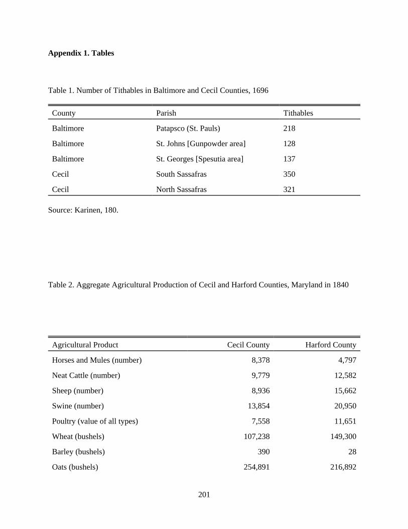
201
Appendix 1. Tables
Table 1. Number of Tithables in Baltimore and Cecil Counties, 1696
County Parish Tithables
Baltimore Patapsco (St. Pauls) 218
Baltimore St. Johns [Gunpowder area] 128
Baltimore St. Georges [Spesutia area] 137
Cecil South Sassafras 350
Cecil North Sassafras 321
Source: Karinen, 180.
Table 2. Aggregate Agricultural Production of Cecil and Harford Counties, Maryland in 1840
Agricultural Product Cecil County Harford County
Horses and Mules (number) 8,378 4,797
Neat Cattle (number) 9,779 12,582
Sheep (number) 8,936 15,662
Swine (number) 13,854 20,950
Poultry (value of all types) 7,558 11,651
Wheat (bushels) 107,238 149,300
Barley (bushels) 390 28
Oats (bushels) 254,891 216,892

202
Rye (bushels) 1,802 20,158
Buckwheat (bushels) 6,480 8,757
Corn (bushels) 276,621 324,416
Wools (pounds) 16,438 29,652
Hops (pounds) 583 166
Wax (pounds) 201 165
Potatoes (bushels) 40,734 79,880
Hay (tons) 7,875.0 9,444.5
Hemp and Flax (tons) 22.0 0.5
Source: United States, Bureau of the Census, Compendium of the Enumeration of the Inhabitants
and Statistics of the United States . . . [1840] (Washington, DC: Blair and Rives, 1841), 138-
149.

203
Table 3. Aggregate Agricultural Production of Cecil and Harford Counties, Maryland in 1850
Agricultural Product Cecil County Harford County
Horses (number) 3,254 3,662
Asses and Mules (number) 80 224
Milk Cows (number) 4,184 5,003
Working Oxen (number) 1,522 1,515
Other Cattle (number) 4,939 4,113
Sheep (number) 4,705 8,424
Swine (number) 9,767 14,342
Total Livestock Value 377,135 444,400
Value of Slaughtered Animals 77,868 100,560
Wheat (bushels) 168,112 186,421
Rye (bushels) 232 2,010
Indian Corn (bushels) 410,060 516,537
Oats (bushels) 208,380 220,012
Wool (pounds) 17,373 21,312
Peas and Beans (bushels) 83 620
Irish Potatoes (bushels) 45,812 44,653
Sweet Potatoes (bushels) 427 1,820
Barley (bushels) 6
Buckwheat (bushels) 15,673 34,180
Value of Orchard Products 5,837 9,507
Wine (gallons) 56
Value of Market Gardens 125 336
Butter (pounds) 279,078 236,825
Cheese (pounds) 1,225
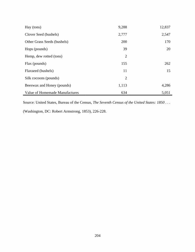
204
Hay (tons) 9,288 12,837
Clover Seed (bushels) 2,777 2,547
Other Grass Seeds (bushels) 200 170
Hops (pounds) 39 20
Hemp, dew rotted (tons) 2
Flax (pounds) 155 262
Flaxseed (bushels) 11 15
Silk cocoons (pounds) 2
Beeswax and Honey (pounds) 1,113 4,286
Value of Homemade Manufactures 634 5,051
Source: United States, Bureau of the Census, The Seventh Census of the United States: 1850 . . .
(Washington, DC: Robert Armstrong, 1853), 226-228.
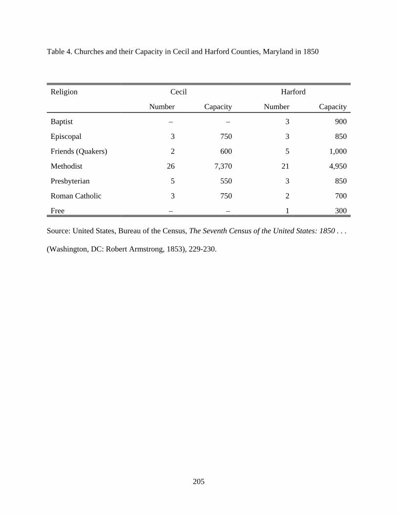
205
Table 4. Churches and their Capacity in Cecil and Harford Counties, Maryland in 1850
Religion Cecil Harford
Number Capacity Number Capacity
Baptist – – 3 900
Episcopal 3 750 3 850
Friends (Quakers) 2 600 5 1,000
Methodist 26 7,370 21 4,950
Presbyterian 5 550 3 850
Roman Catholic 3 750 2 700
Free – – 1 300
Source: United States, Bureau of the Census, The Seventh Census of the United States: 1850 . . .
(Washington, DC: Robert Armstrong, 1853), 229-230.
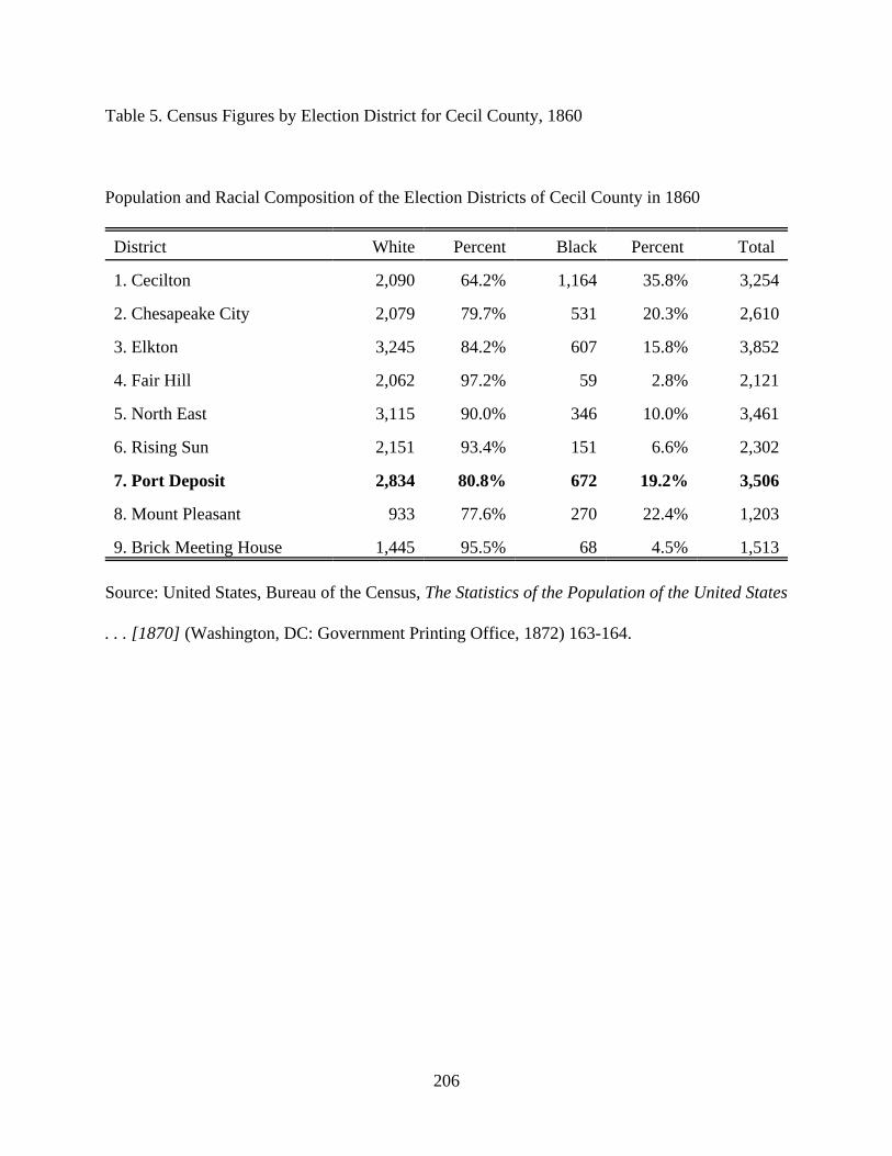
206
Table 5. Census Figures by Election District for Cecil County, 1860
Population and Racial Composition of the Election Districts of Cecil County in 1860
District White Percent Black Percent Total
1. Cecilton 2,090 64.2% 1,164 35.8% 3,254
2. Chesapeake City 2,079 79.7% 531 20.3% 2,610
3. Elkton 3,245 84.2% 607 15.8% 3,852
4. Fair Hill 2,062 97.2% 59 2.8% 2,121
5. North East 3,115 90.0% 346 10.0% 3,461
6. Rising Sun 2,151 93.4% 151 6.6% 2,302
7. Port Deposit 2,834 80.8% 672 19.2% 3,506
8. Mount Pleasant 933 77.6% 270 22.4% 1,203
9. Brick Meeting House 1,445 95.5% 68 4.5% 1,513
Source: United States, Bureau of the Census, The Statistics of the Population of the United States
. . . [1870] (Washington, DC: Government Printing Office, 1872) 163-164.

207
Table 6. Census Figures by Election District for Harford County, 1860
Population and Racial Composition of the Election Districts of Harford County in 1860
District White Percent Black Percent Total
1. Abingdon 1,846 68.0% 869 32.0% 2,715
2. Hall’s Cross Roads 3,327 69.0% 1,498 31.0% 4,825
3. Belair 4,045 76.6% 1,237 23.4% 5,282
4. Marshall’s 3,726 83.1% 759 16.9% 4,485
5. Dublin 3,513 84.8% 632 15.2% 4,145
6. Town of Havre de Grace 1,514 77.1% 449 22.9% 1,963
Source: United States, Bureau of the Census, The Statistics of the Population of the United States
. . . [1870] (Washington, DC: Government Printing Office, 1872) 163-164.
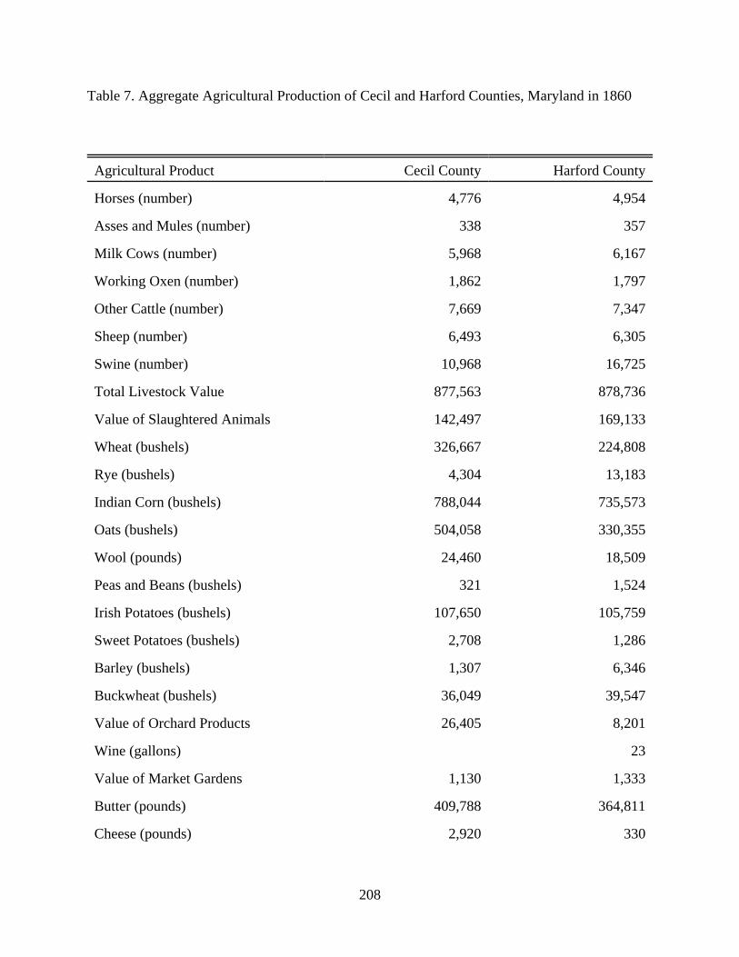
208
Table 7. Aggregate Agricultural Production of Cecil and Harford Counties, Maryland in 1860
Agricultural Product Cecil County Harford County
Horses (number) 4,776 4,954
Asses and Mules (number) 338 357
Milk Cows (number) 5,968 6,167
Working Oxen (number) 1,862 1,797
Other Cattle (number) 7,669 7,347
Sheep (number) 6,493 6,305
Swine (number) 10,968 16,725
Total Livestock Value 877,563 878,736
Value of Slaughtered Animals 142,497 169,133
Wheat (bushels) 326,667 224,808
Rye (bushels) 4,304 13,183
Indian Corn (bushels) 788,044 735,573
Oats (bushels) 504,058 330,355
Wool (pounds) 24,460 18,509
Peas and Beans (bushels) 321 1,524
Irish Potatoes (bushels) 107,650 105,759
Sweet Potatoes (bushels) 2,708 1,286
Barley (bushels) 1,307 6,346
Buckwheat (bushels) 36,049 39,547
Value of Orchard Products 26,405 8,201
Wine (gallons) 23
Value of Market Gardens 1,130 1,333
Butter (pounds) 409,788 364,811
Cheese (pounds) 2,920 330
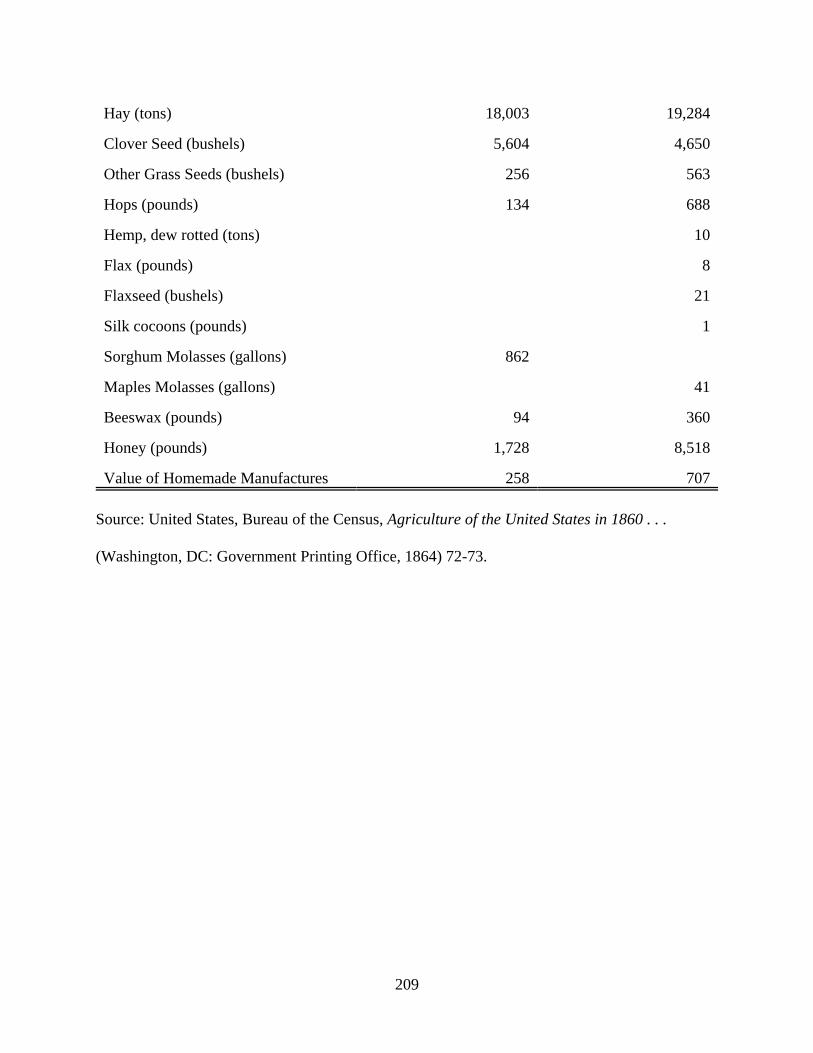
209
Hay (tons) 18,003 19,284
Clover Seed (bushels) 5,604 4,650
Other Grass Seeds (bushels) 256 563
Hops (pounds) 134 688
Hemp, dew rotted (tons) 10
Flax (pounds) 8
Flaxseed (bushels) 21
Silk cocoons (pounds) 1
Sorghum Molasses (gallons) 862
Maples Molasses (gallons) 41
Beeswax (pounds) 94 360
Honey (pounds) 1,728 8,518
Value of Homemade Manufactures 258 707
Source: United States, Bureau of the Census, Agriculture of the United States in 1860 . . .
(Washington, DC: Government Printing Office, 1864) 72-73.
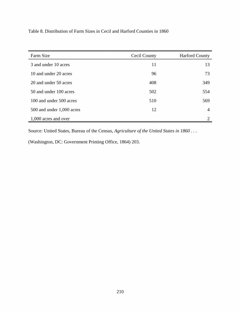
210
Table 8. Distribution of Farm Sizes in Cecil and Harford Counties in 1860
Farm Size Cecil County Harford County
3 and under 10 acres 11 13
10 and under 20 acres 96 73
20 and under 50 acres 408 349
50 and under 100 acres 502 554
100 and under 500 acres 510 569
500 and under 1,000 acres 12 4
1,000 acres and over 2
Source: United States, Bureau of the Census, Agriculture of the United States in 1860 . . .
(Washington, DC: Government Printing Office, 1864) 203.
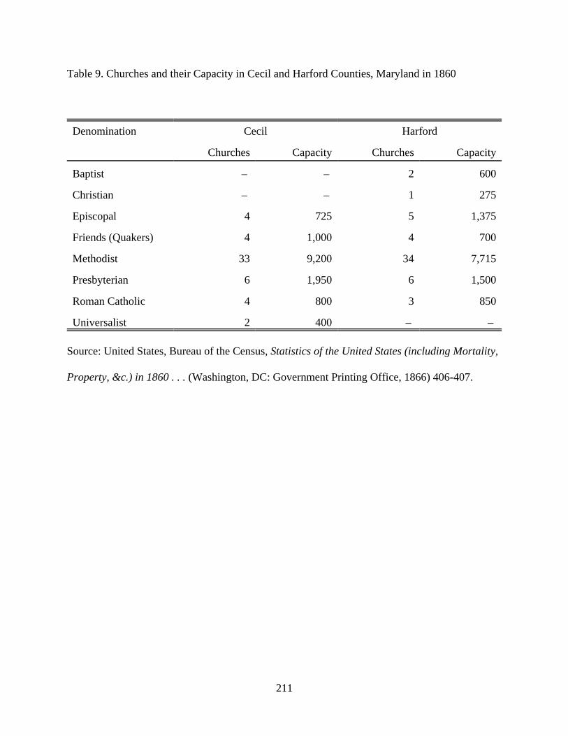
211
Table 9. Churches and their Capacity in Cecil and Harford Counties, Maryland in 1860
Denomination Cecil Harford
Churches Capacity Churches Capacity
Baptist – – 2 600
Christian – – 1 275
Episcopal 4 725 5 1,375
Friends (Quakers) 4 1,000 4 700
Methodist 33 9,200 34 7,715
Presbyterian 6 1,950 6 1,500
Roman Catholic 4 800 3 850
Universalist 2 400 – –
Source: United States, Bureau of the Census, Statistics of the United States (including Mortality,
Property, &c.) in 1860 . . . (Washington, DC: Government Printing Office, 1866) 406-407.

212
Table 10. Number of Slaveholders Categorized by the Number of Slaves They Held
in Cecil and Harford Counties in 1860
Number of Slaves Cecil County Harford County
1 slaves 58 203
2 slaves 27 109
3 slaves 21 93
4 slaves 20 75
5 slaves 10 51
6 slaves 7 26
7 slaves 6 25
8 slaves 4 22
9 slaves 3 7
10 to 14 slaves 12 29
15 to 19 slaves – 10
20 to 29 slaves 2 4
30 to 39 slaves 2 1
40 to 49 slaves – 2
Total Slaveholders 172 950
Total Slaves 657 1,800
Source: United States, Bureau of the Census, Agriculture of the United States in 1860 . . .
(Washington, DC: Government Printing Office, 1864) 231.

213
Table 11. Population Statistics for Cecil County, 1870
Population of Cecil County, by Race, Ethnicity, and Election District in 1870
District White % Black % Native % Foreign % Total
1. Cecilton 2,274 68.1% 1,063 31.9% 3,252 97.5% 85 2.5% 3,337
2. Chesapeake City 2,084 77.7% 599 22.3% 2,543 94.8% 140 5.2% 2,683
3. Elkton 3,627 87.0% 543 13.0% 3,962 95.0% 208 5.0% 4,170
4. Fair Hill 2,102 94.7% 117 5.3% 2,105 94.9% 114 5.1% 2,219
5. North East 3,327 91.3% 318 8.7% 3,516 96.5% 318 8.7% 3,645
6. Rising Sun 2,493 95.2% 125 4.8% 2,546 97.3% 72 2.8% 2,618
7. Port Deposit 3,334 79.4% 864 20.6% 3,994 95.1% 204 4.9% 4,198
8. Mount Pleasant 1,141 79.2% 299 20.8% 1,392 96.7% 48 3.3% 1,440
9. Brick Mtg
House
1,478 94.5% 86 5.5% 1,504 96.2% 60 3.8% 1,564
Source: United States, Bureau of the Census, The Statistics of the Population of the United States
. . . [1870] (Washington, DC: Government Printing Office, 1872) 163.

214
Table 12. Population Statistics for Harford County, 1870
Population of Harford County, by Race, Ethnicity, and Election District in 1870
District White % Black % Native % Foreign % Total
1. Abingdon 2,076 79.9% 522 20.1% 2,303 88.6% 295 11.4% 2,598
2. Hall’s Cross
Roads
2,671 70.2% 1,134 29.8% 3,700 97.2% 105 2.8% 3,805
3. Bellair 4,406 78.0% 1,244 22.0% 5,333 94.4% 317 5.6% 5,650
4. Marshall’s 3,639 82.5% 770 17.5% 4,236 96.1% 173 3.9% 4,409
5. Dublin 3,118 80.7% 744 19.3% 3,777 97.8% 85 2.2% 3,862
6. Town of Havre
de Grace
1,840 80.7% 441 19.3% 2,050 89.9% 231 10.1% 2,281
Source: United States, Bureau of the Census, The Statistics of the Population of the United States
. . . [1870] (Washington, DC: Government Printing Office, 1872) 164.

215
Table 13. Churches and Their Capacity in Cecil and Harford Counties in 1870
Denomination Cecil Harford
Churches Capacity Churches Capacity
All 42 11,050 75 14,900
Baptist – – 17 200
Episcopal 4 1,000 7 1,500
Methodist 28 6,850 25 6,700
Presbyterian 6 2,000 13 3,650
Roman Catholic 2 550 5 1,500
Source: United States, Bureau of the Census, The Statistics of the Population of the United States
. . . [1870] (Washington, DC: Government Printing Office, 1872) 542.
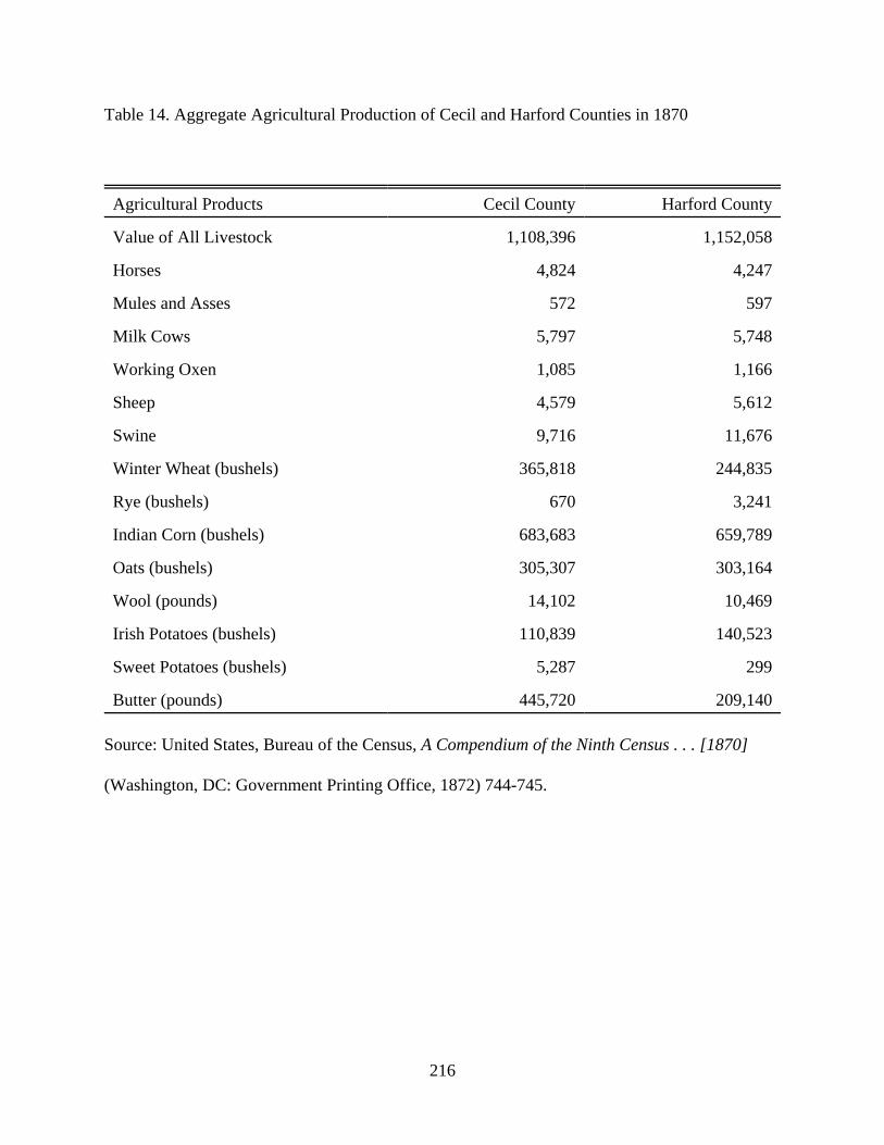
216
Table 14. Aggregate Agricultural Production of Cecil and Harford Counties in 1870
Agricultural Products Cecil County Harford County
Value of All Livestock 1,108,396 1,152,058
Horses 4,824 4,247
Mules and Asses 572 597
Milk Cows 5,797 5,748
Working Oxen 1,085 1,166
Sheep 4,579 5,612
Swine 9,716 11,676
Winter Wheat (bushels) 365,818 244,835
Rye (bushels) 670 3,241
Indian Corn (bushels) 683,683 659,789
Oats (bushels) 305,307 303,164
Wool (pounds) 14,102 10,469
Irish Potatoes (bushels) 110,839 140,523
Sweet Potatoes (bushels) 5,287 299
Butter (pounds) 445,720 209,140
Source: United States, Bureau of the Census, A Compendium of the Ninth Census . . . [1870]
(Washington, DC: Government Printing Office, 1872) 744-745.

217
Table 15. Population Statistics for Cecil County, 1890
Population of Cecil County by Election District in 1890
Election District Population
1. Cecilton 2,985
2. Chesapeake 2,426
3. Elkton 4,817
4. Fair Hill 2,011
5. North East 3,998
6. Rising Sun 2,661
7. Port Deposit 4,313
8. Oakwood (Mt. Pleasant) 1,249
9. Calvert (Brick meeting House) 1,391
Source: United States, Bureau of the Census, Census Reports: Population (Washington, DC: US
Census Office, 1901) 1:196.
Table 16. Population Statistics for Harford County, 1890
Population of Harford County by Election District in 1890
Election District Population
1. Abingdon 2,785
2. Hall Crossroads 5,729
3. Belair 6,890
4. Marshall 4,712

218
5. Dublin 5,633
6. Town of Havre de Grace 3,244
Source: United States, Bureau of the Census, Census Reports: Population (Washington, DC: US
Census Office, 1901) 1:197.
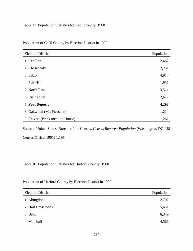
219
Table 17. Population Statistics for Cecil County, 1900
Population of Cecil County by Election District in 1900
Election District Population
1. Cecilton 2,662
2. Chesapeake 2,251
3. Elkton 4,917
4. Fair Hill 1,931
5. North East 3,511
6. Rising Sun 2,617
7. Port Deposit 4,298
8. Oakwood (Mt. Pleasant) 1,214
9. Calvert (Brick meeting House) 1,261
Source: United States, Bureau of the Census, Census Reports: Population (Washington, DC: US
Census Office, 1901) 1:196.
Table 18. Population Statistics for Harford County, 1900
Population of Harford County by Election District in 1900
Election District Population
1. Abingdon 2,702
2. Hall Crossroads 5,631
3. Belair 6,349
4. Marshall 4,566

220
5. Dublin 5,598
6. Town of Havre de Grace 3,423
Source: United States, Bureau of the Census, Census Reports: Population (Washington, DC: US
Census Office, 1901) 1:197.

221
Table 19. Population of Cecil and Harford Counties, 1950-2000
Cecil County Harford County
1950 33,356 51,782
1960 48,408 76,722
1970 53,291 115,378
1980 60,430 145,930
1990 71,347 182,132
2000 85,951 218,590
Source: Compiled from U.S. Census Data, 1950-2000.
Table 20. Population of Election Districts in Lower Susquehanna Heritage Greenway, 1950-
2000
Port Deposit Havre de Grace Dublin
1950 7,532 7,809 5,800
1960 13,125 8,510 7,412
1970 13,182 9,791 8,977
1980 8,628 10,549 10,558
1990 9,514 10,753 11,138
2000 10,325 12,745 11,848
Source: Compiled from U.S. Census Data, 1950-2000.
Table 21. Population of Largest Election Districts in Cecil County, 1950-2000
Port Deposit Elkton North East
1950 7,532 8,787 5,157

222
1960 13,125 12,710 7,442
1970 13,182 13,362 8,928
1980 8,628 15,864 12,507
1990 9,514 18,093 15,631
2000 10,325 22,523 18,673
Source: Compiled from U.S. Census Data, 1950-2000.

223
Table 22. Population of Harford County by Election Districts, 1970
Election District Total
1. Abingdon 27,977
2. Halls Cross Roads 29,450
3. Bel Air 30,803
4. Marshall 8,380
5. Dublin 8,977
6. Havre de Grace 9,791
Source: Compiled from U.S. Census Data, 1950-2000.
Table 23. Population Growth of Lower Susquehanna Relative to Aggregate Population Growth
of Cecil and Harford Counties, 1950-2000
Aggregate Population
of Harford/Cecil
(H/C)
Aggregate Population
Lower Susquehanna
(LS)
Percentage of LS to
H/C Aggregate
Population
1950 85,138 21,141 24.8%
1960 125,130 29,047 23.2%
1970 168,669 31,950 18.9%
1980 206,360 29,735 14.4%
1990 253,479 31,405 12.4%

224
2000 304,541 34,918 11.5%
Source: Compiled from U.S. Census Data, 1950-2000.
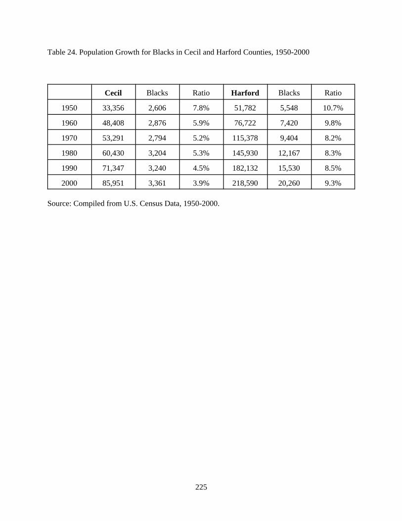
225
Table 24. Population Growth for Blacks in Cecil and Harford Counties, 1950-2000
Cecil Blacks Ratio Harford Blacks Ratio
1950 33,356 2,606 7.8% 51,782 5,548 10.7%
1960 48,408 2,876 5.9% 76,722 7,420 9.8%
1970 53,291 2,794 5.2% 115,378 9,404 8.2%
1980 60,430 3,204 5.3% 145,930 12,167 8.3%
1990 71,347 3,240 4.5% 182,132 15,530 8.5%
2000 85,951 3,361 3.9% 218,590 20,260 9.3%
Source: Compiled from U.S. Census Data, 1950-2000.
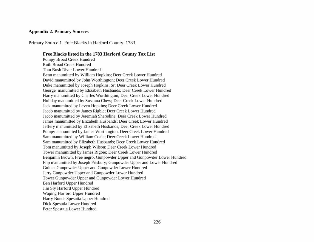
226
Appendix 2. Primary Sources
Primary Source 1. Free Blacks in Harford County, 1783
Free Blacks listed in the 1783 Harford County Tax ListPompy Broad Creek Hundred Ruth Broad Creek HundredTom Bush River Lower Hundred Benn manumitted by William Hopkins; Deer Creek Lower Hundred David manumitted by John Worthington; Deer Creek Lower Hundred Duke manumitted by Joseph Hopkins, Sr; Deer Creek Lower Hundred George manumitted by Elizabeth Husbands; Deer Creek Lower Hundred Harry manumitted by Charles Worthington; Deer Creek Lower HundredHoliday manumitted by Susanna Chew; Deer Creek Lower HundredJack manumitted by Leven Hopkins; Deer Creek Lower HundredJacob manumitted by James Rigbie; Deer Creek Lower HundredJacob manumitted by Jeremiah Sheredine; Deer Creek Lower HundredJames manumitted by Elizabeth Husbands; Deer Creek Lower HundredJeffery manumitted by Elizabeth Husbands; Deer Creek Lower Hundred Pompy manumitted by James Worthington. Deer Creek Lower HundredSam manumitted by William Coale; Deer Creek Lower HundredSam manumitted by Elizabeth Husbands; Deer Creek Lower Hundred Tom manumitted by Joseph Wilson; Deer Creek Lower HundredTower manumitted by James Rigbie; Deer Creek Lower HundredBenjamin Brown. Free negro. Gunpowder Upper and Gunpowder Lower Hundred Flip manumitted by Joseph Prisbury; Gunpowder Upper and Lower HundredGuinea Gunpowder Upper and Gunpowder Lower HundredJerry Gunpowder Upper and Gunpowder Lower HundredTower Gunpowder Upper and Gunpowder Lower HundredBen Harford Upper HundredJim Sly Harford Upper HundredWaping Harford Upper HundredHarry Bonds Spesutia Upper Hundred Dick Spesutia Lower Hundred Peter Spesutia Lower Hundred

227
Tower Spesutia Lower Hundred Rachel Good Neighbourhood, pt, 1 acres. Spesutia Upper HundredAaron manumitted by Jeremiah Sheredine; Susquehanna HundredBob manumitted by William Cox; Susquehanna HundredGeorge manumitted by Richard Johns; Susquehanna Hundred Jacob manumitted by William Cox; Susquehanna Hundred Jehu West Long Acre, 50 acres; Susquehanna Hundred Joshua Wests Long Acre, 50 acres; Susquehanna HundredParraway manumitted by Nathaniel Rigbie; Susquehanna HundredPollidore manumitted by Nathaniel Rigbie; Susquehanna HundredWill manumitted by Richard Johns; Susquehanna Hundred

228
Primary Source 2. Free Blacks in Cecil County, 1783
Free Blacks listed in the 1783 Cecil County Tax ListNed 1st DistrictJames Coppin Four free negroes; 1st DistrictJack Gold. Free mulatto; 1st District John Hynson. 150 acres. Five free negroes; 1st District John Lang. 3 1/2 acres. Three free male negroes; 1st District Robert Vallo. 1/2 acre. Free negro; 1st District Charles 3rd District James Channell 5th District
229
Primary Source 3. Article on the Case of David McCann, From The Colored American, July 11,1840.
AN INTERESTING CASE OF ESCAPE. Hannah Boardley and her daughter Fanny were held as slaves by StephenHammond Dorsey, of the State of Maryland. Believing that they had a legal claimto their freedom, David McCann, a respectable colored man, who resided in CecilCounty, Maryland, and was possessed of some property, assisted them to escape,and they went to Philadelphia. After they had been in that city some time, theymade their case known to the acting committee of the Abolition Society, whoimmediately took measures to inform Stephen H. Dorsey, where they might befound, and requested him, if he thought he had any claim upon them, to comeforward and establish it. But knowing McCann was able to pay any damages thatmight be awarded against him, declined arresting Hannah and Fanny, andcommenced a prosecution against him for aiding in the elopement.
This case excited much interest, and was attended with great difficulty;inasmuch as Dorsey would not arrest the fugitives, knowing they had a legalclaim to their freedom, and no legal decision could be had in their case until hedid so, and fears were entertained that McCann would be ruined. As I was passingup Third street, on my common concerns, in the 4th month, 1801, I saw BenedictDorsey standing at his door, and stopped to speak to him, when he introduced meto a young man who was standing by him, by the name of Benedict Cromwell, ashis cousin, and informed me that he was from Maryland. Upon inquiry I found hewas from the neighborhood where S.H. Dorsey lived. I asked him if he wasacquainted with Stephen Hammond Dorsey, he replied that he was, and said hewas his uncle. I went without delay in search of a constable, and soon found one. Itold him if he would arrest Hannah, and her daughter Fanny, and call upon theyoung man above mentioned and get him to procure their commitment as thefugitive slaves of his uncle, S.H. Dorsey, that he should be well rewarded, andwillingly undertook to do so, and soon succeeded in arresting Hannah and herdaughter, and took them before a magistrate where young Cromwell attended andtestified they were his uncle's fugitive slaves, and they were committed to prison.Upon this being accomplished, application was made to Chief Justice EdwardShippen, who issued a Habeas Corpus, and directed notice to be given to Dorsey.A notice was accordingly prepared and sent to Joseph Churchman, of Cecilcounty, Maryland, with a request that he would serve a copy of it upon Dorsey.He promptly attended to the business; and in a little time the notice was returnedto us with his affirmation endorsed on the back, stating, that on a day thereinmentioned, he served the within notice upon Stephen H. Dorsey, by leaving acopy of it at his house, in the hands of one of his family. - When the case came onfor hearing before the Chief Justice, Judge Thomas Smith was also present, hebeing one of the Associate Justices of the Supreme Court. The Judges decidedthat the proof of the serving of the notice was insufficient, as it might have beengiven to one of his slave, and that Dorsey might not have come to the knowledgeof it. The case was therefore postponed for about ten days, to give time to notifythe claimant. John Stowers, a constable of the city, was engaged to go to
230
Maryland and serve the notice upon Dorsey, personally. Upon his return hehanded me a letter from Stephen Hammond Dorsey, of which the following is acopy, viz.
‘May 15th, 1801. SIR, - On Monday evening I received a notification from Philadelphia, signedIsaac T. Hopper, one of the acting committee of the Society, &c. &c.
“I am sorry the Society have put themselves to so much unnecessary troublein the business, as no act of theirs, nor any thing they may do in the premises, canby any means affect me; nor would I give them one cent, provided they wouldbring the slaves to my own door, and deliver them up. - What have I to do withthe trifling junto, or Society? They, however, from their very humaneproceedings, seem (one day) to have made themselves liable for the negroes. Thevillain who feloniously stole them is indicted, and bound in recognizance for hisappearance with bail, at our next August court, when I shall certainly convict him,and has set up the plea of their being free, as a mitigation of his and hisaccomplices villany, but he and they must and will fail.
‘I beg you will not give yourselves any trouble about my property, as I knowperfectly well how (eventually) to have it restored to me without your aid. Itseems to me you might find necessary business to employ yourselves about, andnot eternally be at works of supererogation.
‘I thank you for your notification, and shall be careful to preserve it, as mayone day be a clue to lead me to my negroes in their most secret recesses. I amsorry, however, that in your notification you have departed from the truth,because it was not at the instance of Benedict Cromwell she was put to jail: heknew I looked upon myself as safe, and cared nothing about them.‘STEPHEN H. DORSEY. ‘To Isaac T. Hopper.’
At the time to which the case was adjourned the two colored women werebrought before the Judges, and Stowers proved the service of the notice, when thefollowing facts were made to appear, viz. Hannah Boardley was formerly theslave of William Ewing, of the State of Maryland, who, several years before, hadhired her to Samuel Gilchrist, of Little Britain township, Lancaster country, andState of Pennsylvania, with whom she lived about two years. On StephenHammond Dorsey’s marrying William Ewing’s daughter, Hannah was given tothem, and she lived with them several years. During this time she had Fanny, whowas a mulatto, and it was said she was the daughter of her master. As Hannah hadbeen hired to a person in Pennsylvania, and had lived there more than six months,with the consent of her master, after the passing of the act of 1780, for the gradualabolition of slavery, she became entitled to her freedom, and of course herdaughter was also free. Upon these facts being established to the satisfaction ofthe Judges, they were both decreed to be free, and were discharged accordingly.
A copy of the proceedings were made out, and duly authenticated by EdwardBurd, Prothonotary of the Supreme Court of the State of Pennsylvania,accompanied by the certificate of the Governor, with the seal of the

231
Commonwealth affixed certifying that Edward Burd was Prothonotary, andforwarded to Cecil county, Maryland; and when the trial of David McCann cameon, they were laid before the court, when David was acquitted, to the greatsatisfaction of his friends and neighbors, for he was much respected, being anindustrious, orderly, sober man. While they were waiting for some person toappear on behalf of Dorsey, Samuel Gilchrist, who attended from Lancastercounty as a witness, was looking out of the window into the street, and espied acolored woman carrying an umbrella to keep the sun off, for it was a clear, sunnyday, he suddenly exclaimed, "My good ---, look here, look here, - there goes anegro with an umbrella to keep the sun off, why death itself could not change hercomplexion, and I am sure the sun cant." Judge Smith called to him and said, "Doyou know where you are, sir?" Gilchrist replied, "No, I never was in town afore."This person was the son of the Samuel Gilchrist who had hired Hannah, and was asmall lad when she lived with his father: and when he was examined as a witness,he stated that she had lived in his father's family about a year. The Judge asked,"How do you know it was a year?" "I did not say it was a year." "Well, what didyou say?" "I said it was about a year." "How do you know it was about a year?""Because I know she came in cherry time, and went away in cherry time; and Ithink she lived with us about two years, but I am not certain of that: but I am sureshe lived with us from one cherry time to another, at least." No person appearedon behalf of S.H. Dorsey. The Judges could hardly maintain their gravity whilethis witness was examined. Hannah and her daughter Fanny were excellentservants, and conducted themselves to the satisfaction of the families where theyresided, and manifested much gratitude for the interest taken in their behalf. Verysoon after they were discharged, I wrote a letter to Stephen Hammond Dorsey, inanswer to the one he sent me by John Stowers, who served the notice of theHabeas Corpus upon him. The following is a copy of it, viz.
‘PHILADELPHIA, 6th Mo. 1st, 1801. ‘STEPHEN HAMMOND DORSEY, - I received a few lines from thee per JohnStowers, the constable, who served the notice of the Habeas Corpus upon thee. Imay say in truth I was pleased with the communication, and have no doubt butour friendly correspondence may tend to mutual advantage.
‘I have the satisfaction of informing thee that the freedom of Hannah andFanny are both firmly established, upon principles that cannot be shaken by allthe artifice, ingenuity, violence, or malignity of any person whatever; which iscertainly a pleasing circumstance to every friend of humanity.
‘I also congratulate thee in the prospect of thy bringing some villain to justice.I certainly wish thee success; it always gives me pleasure when I hear of thosenegro stealers being brought to justice. I have lately been engaged in a business ofthe same kind. A villain feloniously stole a little boy, his own son for what Iknow, for he was a mulatto, and some members of the Abolition Society caughthim, and expect to see the penalty of the law inflicted upon him.
‘Some of the society have also lately been engaged in relieving from bondagesome persons who were illegally claimed as slaves, in which truly commendableemployment they have been successful; and there are some cases now depending,
232
in which there is little doubt of the issue being favorable. ‘I have given thee this brief sketch of the situation of the abolition business
among us, being fully assured it must be highly pleasing to every honest man, andto the friends of humanity. We have every encouragement to pursue our labors:the cause is gaining ground fast in these parts.
‘I shall esteem it a kindness, when leisure will permit, if thou wilt indulge mewith a few lines upon the subject. The two colored females lately liberated, joinme in desire, that thou may live to see more clearly than I fear thou hast yet done,the evils of holding our fellow-beings in bondage. ‘I am, with due regard, ‘Thy friend, ‘ISAAC T. HOPPER.’
The two colored women having established their claim to freedom, inconsequence of which David McCann was acquitted. This so exasperated Dorsey,that he determined on seeking revenge, and to accomplish his object he made hisblack boy, Caesar, go before a magistrate and swear that McCann urged andadvised him to put pounded glass in the milk the family were to use, in order todestroy them: in case of refusal, he threatened the boy that he would put him injail and keep him there till court, and that he should be hanged. The boy, underthis apprehension, complied - went before a magistrate, took the oath, andWilliam McCann was apprehended and put in jail on the 5th of the 6th month,1802, and remained in irons until the 7th of 8th month following, when Caesarwas brought up to substantiate the charge, - but here, truth prevailed; for thoughhis dreaded master was alongside of him, he could not in the presence of hisMaker be again induced to perjure himself; but declared it was not true, that hismaster made him swear it, and said he was compelled to do it by a dread of whathe threatened him with. The poor man was of course liberated, but theconfinement ruined him: he said that he had been persecuted and prosecuted - thatperjury and subornation of perjury had been resorted to, to injure him withoutcause and without reason - and that though they ultimately failed to destroy himtotally, yet they succeeded in reducing him to that situation which would haveentitled him to that situation which would have entitled him to the commiserationof the humane; but that, alas! he was not a white man.
I was well acquainted with David McCann: he lived near Bold Friars Ferry,Maryland, and cultivated a plantation on shares, and sustained a good characterfor integrity, sobriety, and industry. Caesar, the boy, who refused to testifyagainst David before the court, was taken from the court house to prison, fromwhence he was sold to the speculators, and taken to the South. The unprincipledindividual who compelled him to swear falsely, would have been liable to aprosecution for subornation of perjury, but a slave is not permitted to testifyagainst a white man.

233
Primary Source 4. Article on the Anti-Slavery Movement from Harford County
From The National Era, September 23, 1847:
With the War feeling added to the Rum Interest - always on their side, in this city,some how or other - the Democracy will probably sweep everything before themthis fall. In one of the earlier letters of this series, perhaps the very first, I statedthat the case of the venerable Quaker, Robert Gover, indicted by a grand jury in Harford county, on the charge of circulating "incendiary publications," contrary tothe act of 1835, chapter 325, had been removed to Baltimore county court, andthat it had been "continued" to the present term. I predicted, at the time, that theprosecutor for the State would be found quite willing to avoid the issue thuspresented; and I now state, on the most reliable authority, that the case will notcome on at the present term either - if, indeed, it ever does! The plea of "feeblehealth" has been set up by Mr. Gover's influential friends in this city, and the casehas been again "continued," in answer to their prayer! Since the issue ofSLAVERY vs. THE LIBERTY OF THE PRESS will probably have to be made insome person, before that other great issue of FREEDOM vs. SLAVERY shallhave been settled, it seems to me that a more suitable person than Mr. Govercould not well have been found. He not only has the family influence and wealthnecessary to fee lawyers, but has declared himself, from the beginning, "ready forthe trial, having done nothing but his right, and what was proper and just, andnothing that he would not do again." Under such circumstances, a triumph to FreeDiscussion would be inevitable before any court in this city, whatever it might bein more pro-slavery sections of the State!
Primary Source 5. Article on the Anti-Slavery Movement from Cecil County
From The National Era, September 9, 1847:Anti-Slavery Meetings in Maryland - Truth Triumphant, &c.
I proceed to notice other indications of Progress nearer home. And here it is myjoy to state, that I have at length made an opening for the Anti-Slavery Reform inMaryland. On arriving at Harrisville, Cecil county, . . . I found a meeting arrangedfor me, near a school-house, which was offered to the friends of the cause, butproved too small for the purpose. I addressed it in the morning on Intemperance,and in the afternoon on Slavery. Everything went off quietly and gratifyingly. Theimmediate result was, the passage of the following resolutions, nearlyunanimously:
Resolved, That as citizens of the sisters States of Pennsylvania and Maryland,united by many ties of interest, we rejoice to see the opening this day made on thesubject of Slavery, and hail it as an omen of Progress.
Resolved, That we believe the time has come when our sectional jealousiesand differences should be forgotten, in an earnest and persevering effort to rid,not only Maryland, but the country at large, of this moral and social evil.
Resolved, That we are determined that our sanction shall never be given to the
234
further extension of slavery - feeling, as we do, that having allowed it theconstitutional guarantees within its present limits, we have done all that can befairly asked of us, as lovers of Truth and Justice, or as true Patriots.
Considering the above result "glory enough for one day," I proceeded next toa Temperance "Harvest Home," held about ten miles distant, on the Marylandside of the interstatal line. This was on the 26th instant. There was an immensecollection of people present, from many miles around, and ample arrangementsfor their comfort had been made. The speaking was boldly truthful and effective -William Nicholson, of Philadelphia; Howard Meeks, of New York and DanielNeals, of Westchester [West Chester?], being among the speakers. At the close ofthe meeting, permission having been previously obtained from the owners of thewoods and the Committee of Arrangements, I announced that I would address thepeople, next day, upon the subject of Slavery. On arriving at the ground, nextmorning, lo and behold! the stand and seats had disappeared! A mob, headed by anotorious rumseller in the neighborhood, named William B. Biles, had, during thenight, compelled the owners of the boards to remove them, (from their ownground, mind!) with threats of burning them, elsewise! One load of them beingstill on the wagon, we readily procured them; and, speedily rigging up seats, andusing a "carry-all" for a "stand," the doings of the day were opened with an ablespeech upon Social Reform, according to the system of Charles Fourier, deliveredby Howard Meeks. A recess was then had, with the view of hearing theAnti-Slavery speech after dinner. In the mean time, a mob of rough androwdy-looking men, for the most part, made their appearance, armed with clubsand other implements of violence. Having threatened, for a while, to no purpose,and finding me about to proceed with my remarks, they suddenly changed theirattitude, and spoke of legal interference, of a troop coming to take me to Elkton,(the county seat,) and all that! My friends told them there was no need of eithertheir clubs or their troops - that they would guaranty my prompt delivery, inresponse to the legal process, if any should be issued. Some of them set off for awarrant, as they avowed, others remaining as spies. I proceeded, according toappointment, declaring my readiness to answer to the laws of my State, should Iviolate them. I spoke plainly of the moral as well as physical evils of slavery -pointing out the omnipresent evidences of its ruinous influence upon Maryland,and not forgetting to remind my assailants how woefully it made slaves of whitemen! There was no further obstacle thrown in my way, even the mobitesappearing to be confounded by the plain and simple truths given me to utter - nordid I hear anything further of "troops," or "warrants," or "jails," although Iremained over night near the spot, and on the Maryland side of the line, as oneconscious of the Right could well afford to do. In order to show the reversedeffect of this base attempt to crush the utterance of Anti-Slavery truth and stop theear of Progress, and the feelings of the meeting which thus nobly stood by me inthis trying ordeal, I send you the preamble and resolutions passed on the occasion,begging of you to find room for them; for they will be everywhere regarded aspeculiarly significant.
Whereas it is the right of the people to assembly peaceably together, toconsult upon matters pertaining to their interests, as well as to "petition for
235
redress of grievances;" and whereas an effort has been made, by William B. Biles,Charles Biles, John Wherry, Edward Lewis, ----- Evans, Eli Harrigan, ----- Jenny,Charles Crouch, (and other citizens of Maryland, whose names are now unknownto this meeting,) to prevent our assembling together on the present occasion - theyhaving, under cover of the night, demolished the stand and seats procured for thismeeting - therefore,
Resolved, That we are determined never to surrender the rights guarantied tous, because the views we express may happen to militate against the peculiarinterests of certain exclusive classes, being resolved to know no exceptions to therule of free and untrammeled discussion of all the questions relating to the trueinterests of Humanity.
Resolved, That since the discussion of the institution of slavery has beenassailed by our mobocratic opposers, as the pretext for their violence, we areconvinced, more firmly than ever, that it is the KEYSTONE of the stupendousarch of Error and Wrong, against which, as friends of Universal Reform, we areearnestly struggling, and that it is the more needful to expose its wickedness andoppression.
Resolved, That we believe that not only the physical, but the moral interestsof Maryland, demand that slavery shall cease within her borders - resting, as itdoes, like an incubus upon her body social, while blasting, as if with a generalmildew, the fruits of her beautiful and naturally productive soil, and drying up, aswith a rushing wind, the fountains of Truth and Justice.
Resolved, That the officers of this meeting be, and they are hereby, authorizedto draw up and forwards to the Legislature of Maryland, at its next session, apetition praying the immediate passage of a law for the abolition of slavery withinour borders.
It should be known that these foregoing resolutions were passed at a meetingin Maryland, presided over by a Marylander, while being moved and seconded byMarylanders - men who are not disposed longer to hide, under a bushel, thatglorious light which is yet destined to redeem our State and people from thethraldom of our special evil, and bless us with returning prosperity!
Primary Source 6. Article on the Convention of Free Colored People of Maryland, From TheNational Era, August 12, 1852:
The Convention held its session three days, and numerous speeches were made,some urging emigration to Liberia, and others opposing it. The proceedings arefully reported in the Sun, which says that the proceedings were ‘conducted in themost creditable manner.’The following, among other resolutions, were adopted.
Resolved, That, comparing the relative advantages afforded us in Canada, theWest Indies, and Liberia - these being the places beyond the limits of the UnitedStates to which circumstances have directed our attention - we are led to examinethe claims of Liberia particularly; for there alone, we have been told that we canexercise all the functions of a free Republican Government, and hold an honorable position among the nations of the earth.
236
Resolved, That this Convention recommend to the colored people ofMaryland the formation of societies in the counties of this State and the city ofBaltimore, who shall meet monthly, for the purpose of raising means to establishand support free schools for the education of our poor and destitute children.
Resolved, That as this subject is one of the greatest importance to us, and theconsideration of which, whatever may be the result, cannot be put aside, werecommend to our people in this State to establish and maintain an organization inregard to it, the great object of which shall be inquiry and discussion, which,without committing any, may lead to accurate information; and that a Conventionlike the present, composed of delegates from the respective counties in the State,and from Baltimore city, be held annually at such times and places as may behereafter designated.
Resolved, That in thus expressing our opinions it is not our purpose to counselemigration as either necessary or proper in every case. The transfer of an entirepeople from one county to another must necessarily be the work of generations.Each individual now and hereafter must be governed by the circumstances of hisown condition, of which he alone can be the judge, as well in regard to the time of removal as to the place to which he shall remove; butdeeply impressed ourselves with the conviction that sooner or later removal musttake place, we would counsel our people to accustom themselves to that idea.
Resolved, That this Convention recommend to the ministers of the Gospelamong the free colored population of Maryland to endeavor, by contributionsfrom their congregations and by other means, to raise funds for the purpose offorwarding the benevolent object of educating the children of the destitute colored
persons in this State; and that they also impress upon the minds of their hearers the benefitswhich would necessarily result from development of their intellects, and the bringing into fullestuse those mental powers and reasoning faculties which distinguish mankind from the brutecreation; and that this be requested of them as a part of their duty as ministers of the religion ofour Lord and Savior, Jesus Christ.
Wm. Perkins spoke of the law enforced in Kent county, by which the childrenof free colored persons, whom the officers decided the parents were unable tosupport, were bound out; and also of the law which prohibited a colored personreturning to the State, if he should happen to leave it. They were oppressed andborne down.
Charles O. Fisher moved that a committee of five be appointed to draw up amemorial to the Legislature of Maryland, praying more indulgence to the coloredpeople of the State, in order that they may have time to prepare themselves for achange in their condition, and for removal to some other land.
Daniel Koburn, of Baltimore, in referring to the oppressive laws of the State,said the hog law of Baltimore was better moderated than that in reference to thecolored people. The hog law said at certain seasons they should run about, and atcertain seasons be taken up; but the law referring to colored people allowed them to be taken up at any tim
Charles Dobson, of Talbot, said that the time had come when free coloredmen in his county had been taken up and sold for one year, and when that yearwas out, taken up and sold for another year. Who knew what the next Legislaturewould do? and if any arrangements could be made to better their condition, he

237
was in favor of them. . . . The following is the committee appointed: John H. Walker and James A. Handy, of Baltimore; Wm. Perkins, of Kent;Thomas Fuller, of Dorchester; and Daniel J. Ross, of Harford county.
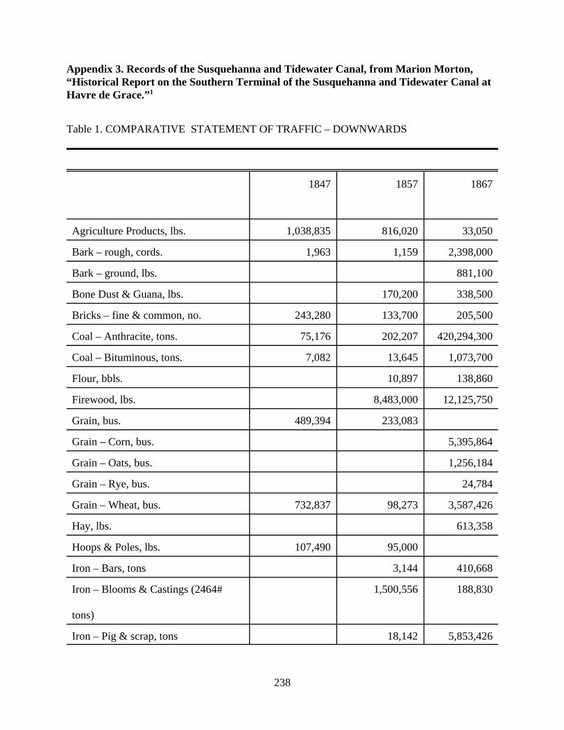
238
Appendix 3. Records of the Susquehanna and Tidewater Canal, from Marion Morton,“Historical Report on the Southern Terminal of the Susquehanna and Tidewater Canal atHavre de Grace.”1
Table 1. COMPARATIVE STATEMENT OF TRAFFIC – DOWNWARDS
1847 1857 1867
Agriculture Products, lbs. 1,038,835 816,020 33,050
Bark – rough, cords. 1,963 1,159 2,398,000
Bark – ground, lbs. 881,100
Bone Dust & Guana, lbs. 170,200 338,500
Bricks – fine & common, no. 243,280 133,700 205,500
Coal – Anthracite, tons. 75,176 202,207 420,294,300
Coal – Bituminous, tons. 7,082 13,645 1,073,700
Flour, bbls. 10,897 138,860
Firewood, lbs. 8,483,000 12,125,750
Grain, bus. 489,394 233,083
Grain – Corn, bus. 5,395,864
Grain – Oats, bus. 1,256,184
Grain – Rye, bus. 24,784
Grain – Wheat, bus. 732,837 98,273 3,587,426
Hay, lbs. 613,358
Hoops & Poles, lbs. 107,490 95,000
Iron – Bars, tons 3,144 410,668
Iron – Blooms & Castings (2464#
tons)
1,500,556 188,830
Iron – Pig & scrap, tons 18,142 5,853,426
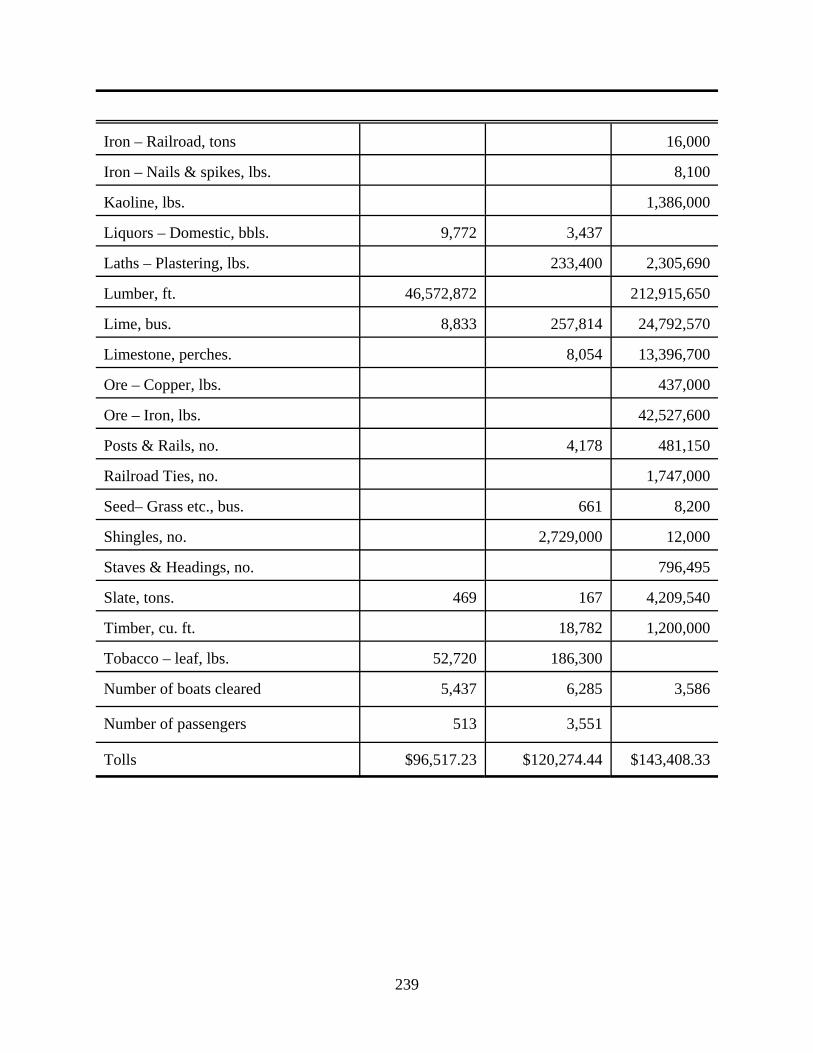
239
Iron – Railroad, tons 16,000
Iron – Nails & spikes, lbs. 8,100
Kaoline, lbs. 1,386,000
Liquors – Domestic, bbls. 9,772 3,437
Laths – Plastering, lbs. 233,400 2,305,690
Lumber, ft. 46,572,872 212,915,650
Lime, bus. 8,833 257,814 24,792,570
Limestone, perches. 8,054 13,396,700
Ore – Copper, lbs. 437,000
Ore – Iron, lbs. 42,527,600
Posts & Rails, no. 4,178 481,150
Railroad Ties, no. 1,747,000
Seed– Grass etc., bus. 661 8,200
Shingles, no. 2,729,000 12,000
Staves & Headings, no. 796,495
Slate, tons. 469 167 4,209,540
Timber, cu. ft. 18,782 1,200,000
Tobacco – leaf, lbs. 52,720 186,300
Number of boats cleared 5,437 6,285 3,586
Number of passengers 513 3,551
Tolls $96,517.23 $120,274.44 $143,408.33
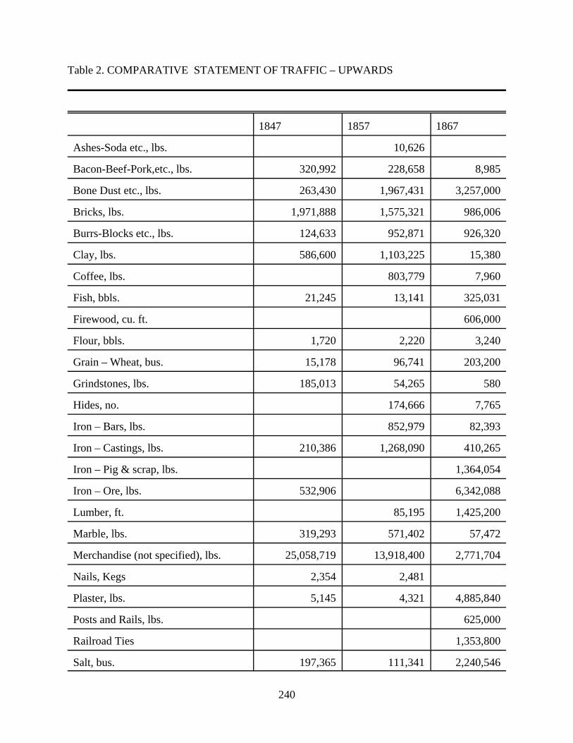
240
Table 2. COMPARATIVE STATEMENT OF TRAFFIC – UPWARDS
1847 1857 1867
Ashes-Soda etc., lbs. 10,626
Bacon-Beef-Pork,etc., lbs. 320,992 228,658 8,985
Bone Dust etc., lbs. 263,430 1,967,431 3,257,000
Bricks, lbs. 1,971,888 1,575,321 986,006
Burrs-Blocks etc., lbs. 124,633 952,871 926,320
Clay, lbs. 586,600 1,103,225 15,380
Coffee, lbs. 803,779 7,960
Fish, bbls. 21,245 13,141 325,031
Firewood, cu. ft. 606,000
Flour, bbls. 1,720 2,220 3,240
Grain – Wheat, bus. 15,178 96,741 203,200
Grindstones, lbs. 185,013 54,265 580
Hides, no. 174,666 7,765
Iron – Bars, lbs. 852,979 82,393
Iron – Castings, lbs. 210,386 1,268,090 410,265
Iron – Pig & scrap, lbs. 1,364,054
Iron – Ore, lbs. 532,906 6,342,088
Lumber, ft. 85,195 1,425,200
Marble, lbs. 319,293 571,402 57,472
Merchandise (not specified), lbs. 25,058,719 13,918,400 2,771,704
Nails, Kegs 2,354 2,481
Plaster, lbs. 5,145 4,321 4,885,840
Posts and Rails, lbs. 625,000
Railroad Ties 1,353,800
Salt, bus. 197,365 111,341 2,240,546

241
1.Unpublished report for the Susquehanna Museum of Havre de Grace, February 14, 1978, C 2-3. Our thanks to Robert McGee and his colleagues at the Susquehanna Museum of Havre deGrace for sharing this invaluable document with us.
Sand, lbs. 109,562 27,200
Shingles, no. 2,021,650 233,500
Slate, lbs. 3,635,400
Stone, lbs. 953,100
Sundries, lbs. 338,525 946,201 799,655
Timber, lbs. 1,550,000
Number of boats cleared 4,710 4,827 3,082
Number of passengers 197 37
Tolls $33,380.47 $20,837.79 $11,181.37

242
Appendix 4. Susquehanna region maps of interest
1608, Captain John Smith, Map of the Chesapeake Bay.
1666, George Alsop, Map [“A Land-skip of the Province of Mary-Land or the Lord BaltimorsPlantation neere Virginia”], in Character of the Province of Mary-Land. Maryland HistoricalSociety.
1670, Augustine Herrman, Map of Virginia and Maryland, John Carter Brown Library,Providence, RI.
1757, Map of Maryland, published August 1757 in London Magazine or Gentleman’s MonthlyIntelligencer, Historical Society of Harford County.
1799, Christian P. Hauducoeur, A Map of the Head of Chesapeake Bay and Susquehanna River[includes inset of Havre de Grace], engraving. Maryland State Archives.
1801-2, Benjamin Henry Latrobe, Susquehanna River Survey Map, Sections 1-10, pencil, penand ink, watercolor. Maryland Historical Society.
1825, F. Lucas, A topographical map of the route of a proposed canal and the country betweenConewago and Baltimore. Historical Society of Harford County.
1836, T. J. Lee and C. N. Hagner, Chart of the Susquehanna River and Head Waters of theChesapeake Bay, surveyed by order of Congress under the direction of G. W. Hughes, U.S. CivilEngineer. Historical Society of Harford County.
1858, Jennings and Herrick, A Map of Harford County, Maryland. From original surveys byS.W. Herrick, Civil Engineer. Reproduced by Andrew W. Bristow, Bel Air, Maryland.
1858, Simon J. Martenet, Map of Cecil County, Maryland. Reprinted by Cecil CountyBicentennial Commission.
1878, Simon J. Martenet, Map of Harford County, Maryland. “Shore Lines and Tide Water fromU.S. Coastal Survey, the County from Actual Surveys” by Martenet. Corrected and revised byJ.W. McNabb, County Surveyor, lithograph. Reproduced by the Historical Society of HarfordCounty.
1881, George Reese, Map of Cecil County, “under the direction of” George Johnston, forpublication in George Johnston, History of Cecil County, Maryland (1881; reprint ed.,Baltimore: Heritage Books, 1998)
1968, State of Maryland, Maryland Geological Survey, Geologic Map of Harford County.
1986, State of Maryland, Department of Natural Resources, Maryland Geological Survey,

243
Geologic Map of Cecil County.
1990's, Satellite image of Chesapeake Bay region, GEOPIC, Earth Satellite Corporation.

History Matters!Interpretive Plan
Part Two
Site AnalysisLower Susquehanna Heritage Greenway
Edited by Carol Benson
Michael L. DixonStephen G. Hardy
Sharon HarleyWhitman H. Ridgway
John L. SeidelBruce A. Thompson
December 14, 2001
Copyright 2001.All rights reserved.
Maryland Humanities CouncilHunt Valley, Maryland
245
INTRODUCTION
Rivers draw people to them, yet separate us. Clearly a geographical divide of land
masses, rivers are also frequently used by people to divide themselves politically, economically,
and culturally. Such is the case with the portion of the Susquehanna River that runs between
Harford and Cecil counties in Maryland.
Yet, as much as the river is used as a dividing line, it also binds the people of this region
together. Initially, small boats and ferries carried goods and people across the water, then
bridges spanned the river and linked the two sides. Today, commuter trains and interstate
highways rush people over the Susquehanna River and right on by the communities that call the
river home. And, although their experiences have been somewhat different, the people of the
communities of the Lower Susquehanna Heritage Greenway (LSHG) share the river and a
common heritage. So, today at the dawn of the twenty-first century it is the river that brings
them together as they strive to preserve and share their story with the future.
This introduction centers around three major historical themes linked to the river that
could be developed as part of the region's heritage tourism plan: harvesting nature's resources,
transportation, and community bonds with the river. These are shared experiences that have
been preserved for today . . . and tomorrow.
HARVESTING NATURE'S RESOURCES
Agriculture
The Lower Susquehanna has been called a "Land of Plenty" (LSHG promotional video),
and one of the historical themes of the region has been harvesting nature's resources. Agriculture
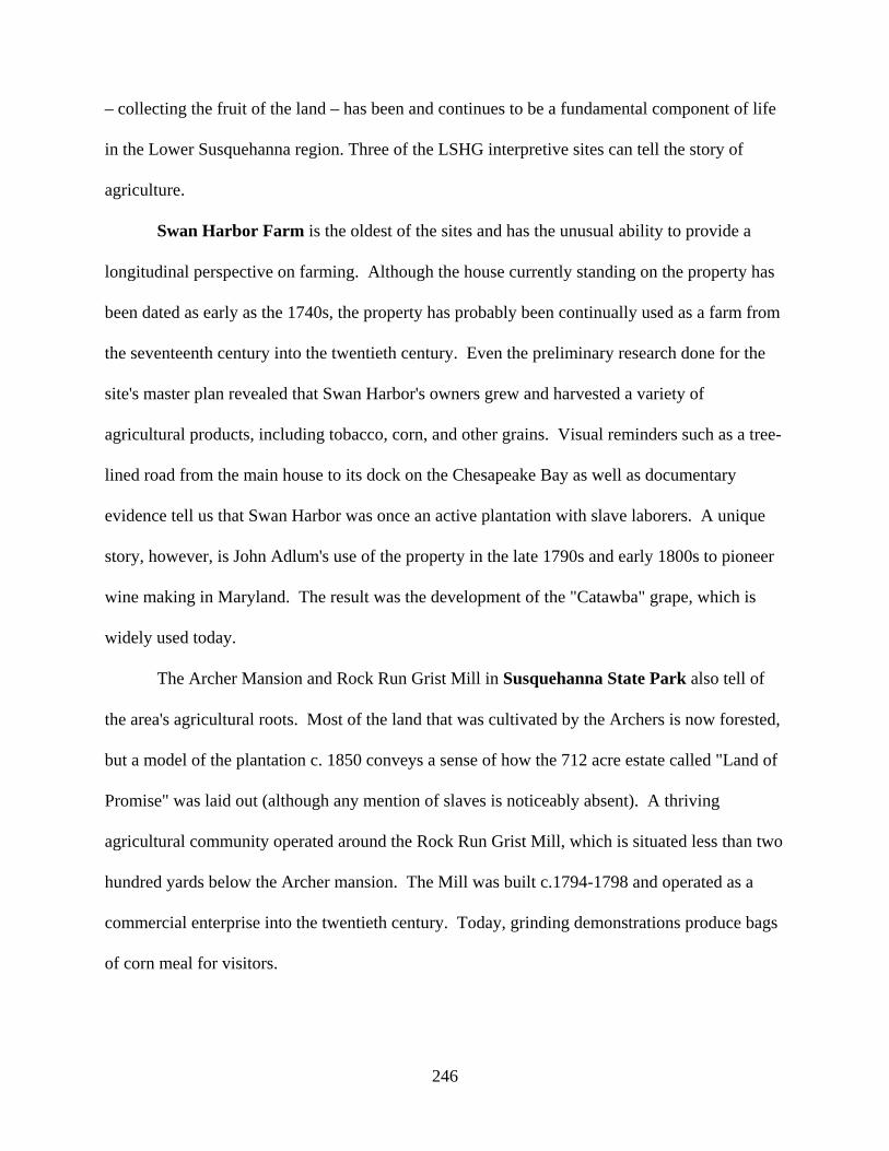
246
– collecting the fruit of the land – has been and continues to be a fundamental component of life
in the Lower Susquehanna region. Three of the LSHG interpretive sites can tell the story of
agriculture.
Swan Harbor Farm is the oldest of the sites and has the unusual ability to provide a
longitudinal perspective on farming. Although the house currently standing on the property has
been dated as early as the 1740s, the property has probably been continually used as a farm from
the seventeenth century into the twentieth century. Even the preliminary research done for the
site's master plan revealed that Swan Harbor's owners grew and harvested a variety of
agricultural products, including tobacco, corn, and other grains. Visual reminders such as a tree-
lined road from the main house to its dock on the Chesapeake Bay as well as documentary
evidence tell us that Swan Harbor was once an active plantation with slave laborers. A unique
story, however, is John Adlum's use of the property in the late 1790s and early 1800s to pioneer
wine making in Maryland. The result was the development of the "Catawba" grape, which is
widely used today.
The Archer Mansion and Rock Run Grist Mill in Susquehanna State Park also tell of
the area's agricultural roots. Most of the land that was cultivated by the Archers is now forested,
but a model of the plantation c. 1850 conveys a sense of how the 712 acre estate called "Land of
Promise" was laid out (although any mention of slaves is noticeably absent). A thriving
agricultural community operated around the Rock Run Grist Mill, which is situated less than two
hundred yards below the Archer mansion. The Mill was built c.1794-1798 and operated as a
commercial enterprise into the twentieth century. Today, grinding demonstrations produce bags
of corn meal for visitors.
247
Located within the Susquehanna State Park on the hill above the Archer Mansion and
Rock Run Grist Mill is the Steppingstone Museum. Here visitors can see a wide range of
cultural materials and techniques associated with rural life (both farm and village). Exhibits
include a farm house (built c. 1771 but presented as it was used between 1880-1920), a wood
working shop, a blacksmith shop, a cannery, a cooper shop, a dairy shop, a farm and garden tool
shop, a pottery shop, a wheelwright shop, a carriage barn, a corn crib, a weaving room, a
veterinarian shop, and a general store.
On a larger scale, the agricultural story includes the active cannery industry of the region.
An example is the Owens Canning Factory, which operated in Perryville during the 1890s and
early 1900s. It processed tomatoes and corn, with one of the labels called "River-Side Brand"
(see Perryville Walking Tour Guide).
Extraction
Besides crops, the land surrounding the Susquehanna River has also yielded two
important resources – timber and stone. Native Americans sought out the rich outcroppings
along the Fall Line for stones to make their tools. From colonial times to the nineteenth century,
the many iron works in the area depended on the area’s vast timber resources to fuel their forges.
Timber and stone are equally central to the story of Port Deposit. This small commercial town
on the east bank of the river started as Smith's Ferry, and was later known as Creswell's Ferry. It
quickly became a collection point for products moving up and down the river. Timber floated
down the Susquehanna and lumber yards produced building materials. In addition, the town
became a "port of deposit" for coal and grain from Pennsylvania on the Susquehanna Canal. All
248
of these products were transferred to ships that slipped down the remainder of the Susquehanna
River and through the Chesapeake Bay to a growing nation.
Port Deposit became more famous, however, for its granite. Blessed with rich deposits of
high-quality granite just north of the town, Port Deposit developed a thriving quarry and stone
masonry trade. Many of the historic structures in Port Deposit are made of granite, but the
town’s granite can also be found throughout the Lower Susquehanna and from Washington,
D.C., to Philadelphia.
One further site relating to the extraction of natural resources can be found in Perryville
at the Principio Furnace and Iron Works. The Principio Furnace, dating to 1722, was one of the
first iron furnaces in Maryland. This furnace, along with the Principio Iron Works built in 1775,
helped establish the iron industry in the United States. The British destroyed the furnace during
the War of 1812, but it was rebuilt and used through World War II. Local Harford County
sources provided much of the iron ore used by this and other iron industry sites.
Harvesting the River
The Susquehanna River itself has also been a valuable natural resource. Shad, herring,
and other fish have always been plentiful and served as a source of food for Native Americans
and later European settlers. The potter's shed at Steppingstone Museum was originally a fish
shed designed for smoking herring. The fishing season ran from late April through early June.
The fishing industry in Port Deposit took off in the 1820s with the invention of floats, which
were "large, floating platforms, anchored in midstream, on which were built sheds as living
quarters for the fisherfolk." The floats allowed the fishermen to catch a large amount of fish at
one time. An old fisherman recalled, "One year, I earned $1,400 in three months from catching

249
shad and perch, but I must say I worked night and day and seldom had my hip boots off" (The
Heritage Cookbook, Paw Paw Museum).
Over 125 species of fish can be found in the lower Susquehanna, but the construction of
the Conowingo Dam – along with over-fishing and increased pollution – had a tremendous
impact on migratory fish. The American Shad fights its way up the river every 3-6 years to
spawn. Modern dams presented an insurmountable obstacle. In 1972, the hydroelectric company
installed a fish lift and added another in 1991. The fish are similarly transferred over three other
dams and can now run all the way to Binghampton, New York, nearly 440 miles from the river’s
mouth. The shad have made a remarkable comeback and have a bright future.
Ice was another resource harvested from the river. According to the Susquehanna
Museum of Havre de Grace, diaries from 1880-1900 locate three ice houses near the Lock
Tender's House on the Susquehanna & Tidewater Canal. There was also a large ice house just
up the river in Lapidum. Ice harvesting began in the Perryville area about 1875 and became a
mainstay of the town's economy. Perryville's "Walking Tour Guide" brochure indicates that "at
least 100,000 tons of ice were harvested each winter. The blocks were cut with large saws,
pulled ashore by horses, and stored in layers separated by straw" in the town's ice houses. One
such ice house, the American Company Ice House, was destroyed by fire in the early 1900s (see
oral history with A. Raymond Jackson). Of course ice was not always friendly. Port Deposit
recorded six ice gorges twenty to thirty feet high from 1857 to 1910. The ice simply kept piling
up on the river and being dumped into the town. In 1910, it took the Pennsylvania Railroad eight
days to clear the tracks in town, and the ice was piled so high on both sides of the track that only
the top could be seen of the first train that went through (The Heritage Cookbook).

250
Finally, the Susquehanna's most famous "crop" was ducks. Rodgers Tavern served duck
and other foods as early as the eighteenth century. For centuries, hunters have flocked to the
Susquehanna Flats at the mouth of the river to enjoy superb duck hunting. The vegetation that
grew in the flats attracted ducks in droves. In the twentieth century, decoy making was a
booming business and gradually became a form of folk art as duck hunting was halted with the
destruction of the vegetation in the Flats. The Havre de Grace Decoy Museum has a wonderful
exhibit called "Gunning the Flats" that shows visitors the techniques, boats, and decoys used in
duck hunting throughout the twentieth century. The museum has over 2,400 pieces in its
collection, and the craft of decoy making is alive and well today.
Harnessing the River
Anyone who ever lived along a river or major creek can tell you that water can be quite
powerful. Floods are an annual concern for anybody living along a river, but on the
Susquehanna spring rains are even more dangerous because of the ice that collects in the river
during the winter. The spring rains break apart the ice and sending large flows down river
without warning. In addition, storms such as Hurricane Agnes can strike in the summer and fall
months. Pictures and exhibits at the Rock Run Grist Mill (Susquehanna State Park) and the Paw
Paw Museum effectively remind visitors of these stark realities of river life.
The Susquehanna River, however, also offered opportunity for anyone able to harness its
power. It is a large river, over 500 miles long with over 2,500 miles of tributaries. More
importantly, the river drops rapidly (167 feet) in its approach to the Chesapeake Bay. This drop,
coupled with rapids which had made navigation upstream impractical, provides a continual flow
of water that is ideal for turning turbines in a hydroelectric plant.
251
Construction of the Conowingo Dam and Hydroelectric Plant began in 1926. It was a
massive undertaking:
Sixteen miles of railroad track had to be relocated. Hugh coffer dams wereconstructed to divert the river, millions of cubic yards of earth and rock wereexcavated, thousands of cubic yards of concrete were poured, two separateconstruction camps of 3,800 men were erected, a police force and fire departmentwere established, fifty-eight miles of transmission lines and two substations werebuilt, and the old state highway across the river had to be removed and relocatedto cross the river on top of the dam (Conowingo Dam, Visitor Center).
Completed in 1928, the plant generated 252 Megawatts of inexpensive electricity for the city of
Philadelphia, and added another 260 Megawatts of generating capacity in 1964.
The land yielded abundant crops and valuable natural resources. The water provided
food, ice, and power. Indeed this has been a land, and river, of plenty for the people who call the
Lower Susquehanna home.
TRANSPORTATION
Water
Transportation has been an ongoing theme in the LSHG region. The Susquehannock
Indians no doubt navigated the river, and the Europeans, led by Captain John Smith in 1608,
began their exploration of the area by sailing up river as far as the rapids (just above Conowingo
Dam). Navigation up river ended at that point. Navigation down the river was possible,
however. Early settlers constructed arks out of timber to haul goods to market. A typical ark
would be "ninety feet long, sixteen feet wide, and four feet deep, with a capacity of sixty tons.
Each end terminated in a point and on the stern was mounted a huge oar that required the
strength of two strong men to ply it" (The Heritage Cookbook, Paw Paw Museum). The arks
usually came down river in the spring when the swelled currents carried their loads of lumber,
252
coal, flour, or whiskey over the dangerous rocks. Once the arks arrived at their destination, they
were torn apart and sold. Several houses in Port Deposit and Havre de Grace reportedly are
made of ark wood. The Paw Paw Museum has an ironing board made of ark wood on display.
Crossing the river has also been a water transportation goal. The first ferry (Lower
Susquehanna Ferry) was established in 1695 between Rodgers House in Havre de Grace and
Rodgers Tavern (formerly known as Stevenson’s Tavern) in Perryville. The Upper
Susquehanna Ferry crossed in the vicinity of Lapidum, which was also known as Bell's Landing.
Another ferry (called Smith's Ferry) was established at Port Deposit in 1729 by Thomas Cresap;
John Creswell later bought the property and renamed the ferry crossing. The first steam ferry,
"Susquehanna," began operating in 1837.
Obviously boats have played a central role in transporting people and goods. The Havre
de Grace Maritime Museum, scheduled to open in June 2001, will convey the history of
making wooden boats. A school will be housed in the museum to teach the art of boat making.
Boat traffic between the Susquehanna River and the Chesapeake Bay was heavy enough to
warrant the building of the Concord Point Lighthouse in 1827. The lighthouse operated for 150
years under the watch of the descendants of the lighthouse's first keeper – John O'Neill, defender
of Havre de Grace during the War of 1812. The LSHG also offers a look at life aboard the
Skipjack Martha Lewis. Skipjacks were designed to harvest oysters, and seldom, if ever,
operated in the northern end of the Chesapeake Bay. Nevertheless, the Martha Lewis offers a
connection between the Lower Susquehanna and the greater Bay.
Finally, canals played an important role in the economic development of the Lower
Susquehanna in the nineteenth century. The earliest canal, Susquehanna Canal or Maryland
Canal, ran on the east side of the Susquehanna River from Port Deposit, north around the rapids,
253
barely into Pennsylvania. Competition between Philadelphia and Baltimore, however, kept the
canal from being extended further north and potentially channeling trade to Baltimore.
The more successful canal was the Susquehanna & Tidewater Canal, which ran 45 miles
from Havre de Grace to Wrightsville, Pennsylvania. The canal had twenty-nine lift locks that
raised the barges a total of 233 feet. The barges moved at about three miles per hour and took a
couple of days to complete the canal trek. The canal operated from 1839 to 1900 and played a
significant role in the economic development of the Lower Susquehanna region before
succumbing to the railroad.
Rail
The first railroad in America ran from Baltimore to Ellicott City in 1831. Soon thereafter
(1836) the Baltimore and Port Deposit Railroad built tracks to Havre de Grace, and later became
the Philadelphia, Wilmington, and Baltimore Railroad Company. This company also completed
the first railroad bridge across the Susquehanna River in 1866. The Baltimore and Ohio (B&O)
Railroad built its own bridge twenty years later. Over the years, rail competition increased and
the Pennsylvania Railroad erected a new bridge in 1906. In this game of one upmanship, the
B&O quickly followed with a double track bridge in 1910. Perryville – with its roundhouse, Y
tracks, and new train station (1905) – served as the hub for all rail traffic. Trains traveling up
and down the Susquehanna merged onto the lines heading for Philadelphia or Baltimore,
speeding the region's goods to distant markets. (Perryville Railroad Museum)
Roads
254
Despite the importance of water and rail transportation, roads have also shaped the Lower
Susquehanna region profoundly. It was the Old Post Road, established in 1666, that first
connected the region to the outside world. The Susquehanna Lower Ferry (1695) and
establishments like the Rodgers House in Havre de Grace and Rodgers Tavern in Perryville were
established specifically to serve those who traveled the Old Post Road. By the late eighteenth
century, stagecoaches regularly carried passengers between Philadelphia and Baltimore. George
Washington's frequent use of the road testifies to its importance to the region.
In the nineteenth and twentieth centuries, several routes have crossed the Susquehanna
River. At Rock Run in Susquehanna State Park an abutment and pilings can be seen of the
bridge that once stood there. The roads connecting to this area appear to be local in nature, so
the bridge's impact may have been limited. The Old Conowingo Bridge was a more significant
structure located north of the hydroelectric dam. Route 40 connected Havre de Grace and
Perryville in 1939.
In the 1920s, U.S. 1 replaced the Old Post Road as the main thoroughfare along the
Atlantic seaboard. Though faster, U.S. 1 was much like the Old Post Road in that small towns
greeted the traveler every few miles. Travelers passing through Harford and Cecil counties
could pause at a place like Berkley Crossroads, eat lunch and take in the scenery. The main
difference was that towns like Havre de Grace, Perryville, and Port Deposit were no longer
points of destination along the primary transportation corridor. Of course, neither was Berkley
Crossroads after U.S. 1 was re-routed across the Conowingo Dam in 1928. When the
construction of Interstate 95 was completed in 1963, there was even less need for travelers to
stop in the region. Now thousands of people speed by daily. Yet, it is precisely this isolation
that has helped to preserve the heritage of the Lower Susquehanna Heritage Greenway.
255
COMMUNITY BONDS WITH THE RIVER
Each community has its own story that tells about the people who live there, how they
adapted to their environment, and, in the case of the LSHG, why the Susquehanna river
continues to be the focal point of their cultural heritage. Rivers, like people and communities,
have personalities. The personality of the Lower Susquehanna changed in the early twentieth
century with the construction of the Conowingo Dam. Consequently, the relationship or bonds
that communities have had with the river have changed over time.
Conowingo Dam
Conowingo means “at the rapids,” and the rapids marked the limit of navigation from the
Chesapeake Bay up the Susquehanna River. In one sense, the construction of the Conowingo
Dam merely replaced a natural obstacle with a man-made one. Yet, the dam altered the
surrounding landscape and the river’s functionality. Moving goods (e.g., lumber) up and down
the river was no longer possible. Even the shad were blocked from going upstream to their
spawning ground. Today, there are two fish lifts and bird refuges, including a Bald Eagle
wintering area, that have been established around the dam in an effort to better enable man and
nature to live together. Moreover, Conowingo Dam had a massive impact on the physical and
natural environment in and around the Susquehanna River. U.S. 1 and sixteen miles of railroad
tracks were relocated, and it was this relocation that led to communities like Berkeley
Crossroads begin bypassed.
Berkley Crossroads
256
“Berkley looks much as it did at the turn of the twentieth century. The structures and
houses have been maintained with no new construction at the Crossroads. This simple rural
crossroads is one of the few remaining unsullied snapshots of early Harford County, maintaining
its historic presence." (Berkley Crossroads presentation materials) Berkley Crossroads is a
community consisting of African Americans, Quakers, and whites of West European descent.
The community recognized that their lives are woven together, which is reflected in the oral
histories that have been recently collected. The building of the dam essentially froze the
community in time. Now, with the aid of grants from the Maryland Historic Trust, community
volunteers are actively researching and preserving their heritage, including their relationship
with the river. As a local heritage project, Berkley Crossroads can serve as a model for other
crossroads communities, and for other communities and historical sites within the Lower
Susquehanna Heritage Greenway that hope to preserve their rich resources before they
disappear.
Rock Run in Susquehanna State Park
A brochure for the LSHG notes that the Susquehanna State Park "lies in a traditionally
agricultural area and has remained essentially unchanged since the late 1800's when the area was
a commercial success." The Rock Run Grist Mill was at the heart of that success. The presence
of a post office in the mill helps to tell this rural community’s story. And after farmers had
brought their grains here to be ground, the final product could be shipped down the river by boat,
by canal when that transportation system was completed, or by wagon across the Rock Run
bridge. The river was a focal point for the farmer to process (mill) and deliver his products.

257
Port Deposit
Port Deposit is a river town. It has a history of good times and bad times depending upon
the vagaries of river. Port Deposit grew to be Maryland’s 8th largest city before the Civil War
because of trade boom on the Susquehanna River, and the town’s granite is still a prominent
feature of many buildings between Washington, D.C., and Philadelphia. The town also
experienced a variety of economic changes in the twentieth century, including the loss of up-
river trade when the Conowingo Dam was built, the operation of the Wiley Manufacturing
Company, and the development of the Tome School for Boys (and later Bainbridge Naval Base).
Floods, wood planks from arks that used to float down the river, and Paw Paw trees whose fruit
repel mosquitoes are constant reminders that Port Deposit is still a river town with its own
distinct culture.
Interestingly, Port Deposit's culture and people has been quite diverse. Twenty-one
percent of Port Deposit’s population in the 1850's consisted of free blacks, and the congregation
of the Howard Methodist Episcopal Church, built by freed slaves in 1853, was active in the
Underground Railroad. Later, Port Deposit had a black baseball team, the “Port Deposit Black
Sox.” The town also seems to have had an Irish presence, mixing with people of English,
German, and Jewish backgrounds. The economic opportunities and hardships of the river were
shared by all, if not all evenly.
Perryville
Despite its geographical connection with the Lower Susquehanna, Perryville has not
depended completely on the river for its livelihood or sense of self. Named for Mary Perry, wife
of John Bateman who was the first English settler in the area, Perryville has focused on being a
258
land-based transportation junction and industrial site. From the Old Post Road to today's
railroads, Perryville has been a transportation hub. Highlights from the town's "Walking Tour
Guide" include the Armstrong Stove and Manufacturing Company, Owens Canning Factory, and
Eureka Fertilizer Company. This is also where Principio, one of the first iron works in
Maryland, was located. The river simply never completely reeled them in.
Havre de Grace
The city of Havre de Grace has a particularly close relationship with the water. Perched
on the western edge of where the Susquehanna River and Chesapeake Bay merge, the city has
embraced the water as an integral part of its culture and way of life. Thus, it is not surprising
that Havre de Grace's museums all focus on water in some way. Even most of the city's industry
has a connection with water: redistributing of grain, lumber, coal, and other products coming
down the Susquehanna River; boat building; canning; collecting ice; and waterfowl hunting.
Only the thoroughbred race track seems unrelated, and that reflects the rich farmlands of the
upper plain. Havre de Grace's story is its relationship to the river and bay that surrounds the city.

259
INDIVIDUAL SITE ANALYSIS
FOR THE LOWER SUSQUEHANNA HERITAGE GREENWAY
Conowingo Dam
Following approval by Maryland, Pennsylvania, and the Federal Power Commission, the
Conowingo Dam project was begun March 8, 1926, and was completed less than two years later,
with commercial operation commencing on March 1, 1928. It is the last of four hydroelectric
plants harnessing power from the Susquehanna River, the others being the Holtwood, Safe
Harbor, and York Haven plants in Pennsylvania. At its conception, the Conowingo project was
second only to Niagara Falls in its hydroelectric output, as seven turbine generators were
originally designed to produce 252 Megawatts of electricity. At the time it was the single largest
generation station to be built in one step.
The massive construction project included two temporary villages (complete with sewage
and water systems, their own hospital, mess halls and police force) housing a labor force of
3,800 men, and a ten-mile railroad spur located along the former towpath of the Susquehanna
and Tidewater Canal to bring materials to the site. The final product was a concrete facility that
is 4,648 feet in length and rises 104 feet above the riverbed.
An additional 260 Megawatts of capacity was added to the plant in 1964 with the addition of
four new turbine units, bringing the plant’s total to 512 Megawatts. The average annual
generation is 1,800,000 Megawatt-hours, enough to provide service to 300,000 homes. The plant
is currently operated by PECO Energy.
260
The plant is a secondary facility, augmenting the power produced at PECO Energy’s nuclear
and fossil fuel plants during the peak-demand periods each day. Hydroelectric plants can come
on-line almost immediately to satisfy a rapid demand for electricity and then be taken back off-
line just as quickly. They also can provide emergency back-up power, since they do not need
electricity to start-up, they are used to restart other power plants on the same system. Conowingo
was used for this crucial role during the Northeast Corridor Blackouts of the 1960s. Today, the
Conowingo facility is tied to the Peach Bottom Atomic Power Station as a backup emergency
power source.
Use of the Conowingo plant is heavily dependent on the flow of the Susquehanna River. The
water pressure that turns the turbines is created by the drop of the river as it makes its way to the
Chesapeake Bay. The river drops 167 feet over its last 25 miles, and the Conowingo dam utilizes
89 feet of that drop. When heavy spring rains combined with melting snow and ice from New
York and Pennsylvania create an overabundance of water flow, the 50 large crest gates and 2
smaller gates can be opened as necessary to bypass the water around the powerhouse.
Conversely, in late summer, low levels in the 14 square-mile “pond” area above the dam
sometimes require sparing use of the turbines.
The construction of dams across the Susquehanna put an end to the annual migrations of
anadromous fish, most notably the American shad and herring so important to the river’s earlier
fishing industries, upriver to spawn. PECO and its predecessors have been actively involved in
efforts to restore these fish to the river by installing fish lifts to enable them to pass over the dam.
The smaller West Lift was put into place in 1972, and the larger, more state-of-the-art East Lift
was built in 1991. The latter is presently capable of transferring 750,000 American shad,
together with numerous other fish species, upriver in a season. In 2001, more than 185,000 shad

261
had passed over the dam by Memorial Day, with a total of 200,000 expected by the end of the
season.
The facility provides tours to approximately 33,000 visitors each year. A fisherman’s catwalk
extends along the western portion of the building is open to visitors most days and provides
excellent views of the many birds actively feeding in the area, including large numbers of gulls,
great blue herons, black-crowned night-herons, ospreys, bald eagles and an occasional golden
eagle. Conowingo is considered one of the best places to view bald eagles east of the Mississippi
River because the birds are nearly always present and the viewing conditions are excellent.
Thematic links:
Changes in the Landscape
Chesapeake Bay/Waterways/Transportation
Adaptation and Ingenuity (Technology)
Potential unrecognized resources or stories:
The hydroelectric plant is a remarkable living museum of twentieth century technology. The
tools, engines, monitors, and computers reflect seventy years of industrial history. The
knowledge of tour guides regarding the plant’s equipment, tools, and processes could be
enhanced by visual displays and exhibits along the tour route.
Possible interpretive improvement:
While a little information about the construction of the dam and hydroelectric plant can be
gleaned from photographs and newspaper clippings in the lobby area as well as the general

262
brochure, much more could be done to illustrate this important topic for the visitor. One
surprising fact we learned was that when the dam was built it was not attached to the bed-rock
and the only thing holding it in place was its own dead weight. This was later corrected in the
1980s. The construction of this facility was a massive undertaking, and its completion brought
with it drastic changes, such as the creation of the “pond” upstream, immersing familiar
landmarks and settlements forever. An enhanced exhibit featuring newspaper accounts,
photographs, and artifacts from the construction period could recreate this fascinating
transformation for visitors.
Much more could be done to present the history of the plant and its impact on the lower
Susquehanna River region; a detailed history could be made available through the company's
web site or the Lower Susquehanna Heritage Greenway, and a historical overview with images
could be presented to visitors in a separate brochure. The role of electricity in transforming
American society could be told using changes in the Lower Susquehanna Heritage Greenway
region as examples, i.e., how work was done in factories, in the home, and on the farm in the
1920s and today.
More interpretative outdoor signs along the riverbank bordering the parking area would have
the benefit of being accessible to visitors unaware of or unable to take the tours. These might
include the construction of the dam; the flooding of the towns upstream after the dam was
completed; the challenge of getting the shad to their spawning grounds and the impact of the
dam on aquatic life in general; and the rare and unusual birds attracted here.
Additional comments:

263
The tour was very long, and would be difficult for visitors with short time frames and young
people with short attention spans; perhaps a shorter alternative could be offered.
PECO owns the land adjacent to the river on the Cecil side of the dam, which was an
important native American site. Interpretive outdoor signs might be constructed that would
highlight the significance of the site and the history of the Susquehannocks.

264
Berkley Crossroads
There are two distinct layers of interpretation to be presented here: a significant African
American historic site and the surrounding “Berkley Crossroads” community. Berkley
Crossroads is a diverse community consisting of African Americans, Quakers, and whites of
West European descent. Members of the larger community recognized that their lives are woven
together, and four distinct stories are included in their oral histories. First, this small settlement
includes a free African American community that established its own church, cemetery, and the
Hosanna School, built with the help of the Freedman's Bureau in 1867 by local black residents.
The Hosanna School (initially called the Berkley School) educated both adults and children.
Second, Rigbie House was an important colonial site, where General LaFayette quartered his
troops during the American Revolution. The third story is that of Quaker homesteads such as
Swallowfield dating to the eighteenth century, which evidently played a role in the Underground
Railroad. Oral histories reveal that fugitive slaves hid in Swallowfield's ice house or barn (both
still standing) and were rowed up the Susquehanna River to Pennsylvania when the coast was
clear. And finally, the crossroads was part of U.S. Route 1, taking advantage of that busy route’s
commerce, and then was bypassed by the highway’s subsequent relocation when the Conowingo
Dam was built in 1928.
Thematic links:
Settlement Patterns
Changes in the Landscape
Individual Communities and Cultures

265
Chesapeake Bay/Waterways/Transportation
Freedoms Won, Freedoms Lost
Potential unrecognized resources or stories:
The presentation of the Hosanna School museum as a heritage site and the Berkley
Crossroads oral history project are relatively recent endeavors that have accomplished much in a
short period of time. There are plans to complete the restoration of the building by adding the
second floor, which has previously been destroyed. The artifacts in the school are gifts from
community members who have bought into the project and participated in the oral histories.
The Hosanna School story is rich, and it presents an opportunity to delve deeper into the
history of the local African American community. It is imperative that the cemetery and
foundation for a former church located near the school be preserved and studied through
historical and archeological research. These sites are legacies of the free black community's
heritage and can provide much insight.
The relationship between the school and the local black church and the St. James AME
church in Havre de Grace should be clarified and strengthened. AME church records might be
available in addition to oral history. The curious visitor may want to know more about the free
black community that existed, such as where did the these individuals come from? Were they
manumitted by the Rigbies or other local white families? How did these free blacks earn a
living? It would also be beneficial to include information about other schools for African
Americans in Harford county, including the “school for colored children” at the Gunpowder
Neck Methodist Meeting House Magnolia School (1920-1951), Havre de Grace Colored High
266
School (opened 1930), Bel Air Colored High School (opened 1934), and the Central
Consolidated School (opened 1950).
Possible interpretive improvement:
The Hosanna School site represents the primary venue for the presentation of African-
American history within the heritage area. The restored school already is the locus of a
remarkable interpretive focus. Underutilized, however, is the nearby archaeological site of the
1835 (or earlier) Hosanna A.M.E. Church and its associated cemetery. The entire complex
should be interpreted as a whole, as it bears witness to a vibrant free Black community in the
area before and after the Civil War. The importance of this community might be highlighted
through the use of historical documents that show the terrible conditions under which many other
African-Americans lived in nearby areas, such as the “slave-pens” of Cecil County. The
probable importance of the area in the Underground Railroad may be another area for
interpretive expansion, although this must be done carefully due to the uncertainties that
accompany this topic.
The current linkage of Hosanna School with the Berkley crossroads project is logical, given
the link between Quakerism and the drive toward Black freedom. The records of the local
Friends meetings might provide rich interpretive material.
There are three other major opportunities to expand on what is being accomplished in
Berkley Crossroads. First, this community can serve as a role model, not only for other
“crossroads” communities but also for other community historical sites within the Lower
Susquehanna Heritage Greenway that would like to expand their knowledge of their own
heritage. Second, Berkley Crossroads could help Cecil County counterparts to locate and restore

267
the Freedman School and black community that had been located across the old U.S. 1 bridge.
Third, the Hosanna School's interpretation can be broadened to link it to segregated education in
the region, the twentieth century fight to desegregate the schools, and the civil rights movement
protests along the new U.S. 1 in the early 1960s.
Current plans for the site mean that it will not be open to the public on a regular basis. An
unobtrusive outdoor sign might be constructed which would explain the history of the site, the
importance of Freedmen's Bureau schools, their contribution to the transition from slavery to
freedom, and the location of other Freedmen's Bureau schools in the area.
Additional comments:
Officials should make every effort to see that the AME church and cemetery site are brought
under the control of Hosanna School. This complex is a significant archaeological site,
potentially eligible for listing on the National Register of Historic Places, and it would therefore
not be advisable to attempt to move gravestones or burials from their original locations.
268
Darlington Area
Unlike other parts of the heritage area, this area does not have a specific site as a focus.
Nevertheless, Darlington has an important collection of historic structures and its Quaker
founders were an important segment of the region’s population. Unless a specific site is
identified as an interpretive center, perhaps the best approach would be to develop a walking
and/or driving tour through the area supplemented with brief written interpretive materials,
focusing not only on individual structures but on the social and religious background of the area,
as well as Quaker support for manumission and other social causes.
Although the founding of Darlington is dated by residents to 1737, when Nathaniel Rigbie
conveyed to “the people called Quakers” the three and a half acres on which the Society of
Friends built their meeting house, the Deer Creek Friends Meetinghouse was not built until 1784,
and the remainder of the early extant structures in the town appear to be from around 1800.
Before any interpretive plan is developed, additional research on the village’s origins and
development is needed.
Based on a quick walk through the village, striking features are the slate sidewalks and roofs
and the wonderful mix of different house types (and ages) in a non-linear plan. The oldest
buildings appear to cluster around the juncture of Main Street and the Shuresville Road; these
stone structures are difficult to date with any assurance from the exterior, but likely date to
around 1800. Victorian structures are interspersed along the streets, but they are restrained and
lack the highly decorative elements seen on many buildings of the period. Amid this reserved
architecture, however, is a truly astonishing Gothic revival church (Grace Memorial Episcopal
Church, built 1876). The building is masterfully designed, using what are most certainly local

269
materials, such as the detailed slate roof. Architectural gems such as this and the “old feel” of
Darlington will make it an interesting waypoint on any tour through the heritage area.
Thematic links:
Settlement Patterns
Changes in the Landscape
Individual Communities and Cultures and their Assimilation/Non-Assimilation
Freedoms Won, Freedoms Lost
Possible interpretive improvement: Not applicable.
270
Susquehanna State Park
The formation of the park and restoration of the historic buildings was achieved in large part
through the foresight of J. Gilman Paul and Donaldson Brown, the park’s two great benefactors,
who supported the preservation of the area for public use.
Three prehistoric and 39 historic sites are located within the park. Prehistoric sites include
the soapstone quarry, partially destroyed, used by Native Americans during the late archaic
period (3,000 to 1,000 B.C.). It has suffered erosion and further quarrying in historic times. A
site beside the river north of Rock Run was partially destroyed during the construction of the
Susquehanna and Tidewater Canal and Stafford Road. A third site was destroyed by the
construction of the park’s Deer Creek parking facilities.
The historic sites include farm buildings on the open plateaus above the river, industrial
structures along Deer Creek, and buildings associated with commerce in the river towns of
Lapidum and Rock Run. (The J. Gilman Paul farm [“Land of Promise”] was converted to use as
the grounds of the Steppingstone Museum and will be discussed separately.) Accessible to the
public are the Mill at Rock Run (1798), a water-powered grist mill built by John Stump of
Stafford, and passed on to his daughter, Ann, and her husband, Dr. John Archer Jr.; the Jersey
Toll House, associated with the Jersey Toll Bridge – also called the Rock Run Bridge – (1818);
the Carter-Archer Mansion (1804), with a stone carriage barn, and a mill-pond and its race; as
well as remnants of the historic canal and locks. The Rock Run Miller’s House (ca. 1800), is
restored to its original appearance, but is not open to the public; it houses park personnel.
Improvements underway include restoring the corn shelling equipment in the Rock Run Mill
in order to have a display operational by this summer; the signage along Stafford Road is being

271
upgraded; and the Park has applied for a grant through the National Park Service for interpretive
signage and interpretative displays for the Jersey Toll House.
The park has dual (compatible) missions, that of the Department of Natural Resources, and
that of the Maryland State Forest and Park Service, focused on preserving the resources (both
natural and historical) in the Susquehanna River basin area, while providing an opportunity for
people to enjoy the area. Susquehanna State Park has over 12 miles of hiking and biking trails
plus 2.3 miles of the Lower Susquehanna Heritage Greenway trail that is handicapped-
accessible. The 3,000-acre park also includes a camping area, a picnic area and a boat launching
area and ramp. In 2000 over 167,000 people visited Susquehanna State Park.
Thematic links:
Settlement Patterns
Changes in the Landscape
Chesapeake Bay/Waterways & Transportation
Adaptation and Ingenuity
Potential unrecognized resources or stories:
This site is so historically rich that further and more detailed interpretations are possible.
The grist mill, its interior contents, the local post office it housed, and surrounding environs
(including the Toll House, Rock Run House, and the Spring House as well as remnants of the
historic canal and locks ) focus on how humans interacted with each other, with the region’s
natural resources, and with the Susquehanna River. Rock Run was an economic and
transportation junction that also served as a community center. The mansion and grist mill tell
272
of the area’s agricultural roots. The canal and toll house testify to efforts to overcome the
Susquehanna River as a barrier to transportation.
The Archer Mansion and its model of Rock Run c. 1850 are well done. But there is no
mention of slaves. James J. Archer was a slave owner who fought for the Confederacy. Slave or
servant quarters were added to the house; archeological surveys may be needed to dig up further
evidence of slaves to be incorporated into the story. It would also be interesting to be told more
about the members of the Archer family. One of the rooms in the mansion displays
correspondence from James Archer and clothing worn by the women who resided here. Many
visitors undoubtedly are curious to learn more, not only about James J. Archer and his
experiences before, during and after the Civil War, but also about the lives of the women of the
family, especially Ann Archer.
While there are excellent outdoor signs on the canal, which explain how the locks were built
and the operation of the canal itself, more are needed. One could be devoted to how this site
served as a commercial crossroads over time. The Jersey Toll House and pilings in the river tell
visitors that a bridge once crossed the Susquehanna at Run Rock. The story of businesses that
thrived here because of bridge traffic would enhance the presentation. Another should be
devoted to the mill itself, when it was built, and how it changed over time.
Complete restoration of the mill would enable staff to interpret the machinery and
architectural aspects of the building. In the mill itself some of the illustrative material was in the
form of newspaper articles tacked to the wall. It is great stuff! But it ought to be better
presented, and protected from further deterioration.
Possible interpretive improvement:

273
Although tobacco was the early staple crop of the Chesapeake region, farmers made a
shift to grain production in the eighteenth century, when tobacco prices had fallen dramatically
and were subject to unpredictable fluctuations. Wheat seems to have become dominant in these
areas by around 1740, and agricultural diversification included cultivation of rye, corn, and hay.
These important shifts are related to the growing importance of mills in the region. The Rock
Run Gristmill in Susquehanna State Park could place its operations into a larger socioeconomic
context by discussing this important shift. The mill also contains a remarkable array of mill
machinery that could effectively be used to illustrate the changes in mill technology over time.
The structure of the Archer house, and some photographs seen there, suggested the presence
of African Americans, both as slaves and servants. In response to our questions, we learned that,
indeed, blacks worked for the Archer family and lived in the surrounding community. Blacks
likely joined many other laborers in constructing and the bridge, canal and railroads constructed
along and across the Susquehanna River and the Tidewater Canal. The role of African
Americans and most other residents of the surrounding community, except the owners of the
mill, is absent from the “Historic Walking Tour” guide for the mill and the Susquehanna State
Park. The brochure and presentations to the public are solid, but could be even stronger by
incorporating some of the information listed above.

274
Steppingstone Museum
This museum complex consists of an historic stone farmhouse (c. 1771) and a variety of
exhibits and workshop demonstration sites in outbuildings and barns which together offer an
understanding, including a hands-on approach, into rural arts and crafts and the daily life in a
Harford County farming community in the period 1880-1920. "The purpose of the interpretive
program at Steppingstone is the acquisition, preservation, and study of the material culture of
America’s last rural generation, as well as the exhibition and demonstrated use of the artifacts.
The museum was established for the education of the younger generation and continues to strive
to achieve this goal through a variety of guided tours and craft workshop programs." Visitors
can enter the eighteenth-century farmhouse, with formal sitting room, sleeping quarters, and
rustic kitchen with wood-burning stove and ice box; visit the farm’s dairy and herb garden; and
step inside a series of fully-furnished shops dedicated to woodworking, black-smithing,
wheelwrighting, and coopering, each manned with volunteer demonstrators on a rotating basis.
Additional buildings house a farm and garden tool shop, pottery shed, carriage barn, corn crib,
weaving room, decoy-makers shop, veterinarian shop, general store, and the museum’s latest
exhibit, a cannery.
The presentation includes a video -- “Down the Road: Featuring the Steppingstone
Museum” -- in the museum’s Visitor Center. The museum also has its own website
(www.steppingstonemuseum.org).
Thematic links:
Settlement Patterns

275
Changes in the Landscape
Adaptation and Ingenuity
Potential unrecognized resources or stories:
Some of the buildings relocated to the grounds at the time of the museum’s formation, have
historically interesting stories, for example, the potter’s shed was actually a fish shed used to
smoke herring. The farmhouse was built c. 1771, but is presented with antiques from the 1880-
1920 time period. Signs, brochures, and the web site could tell about these historically
significant structures.
Possible interpretive improvement:
The presentation could offer a fuller discussion of the historical and regional context of early
twentieth century local farms and of the human and community dimension of craft and
agricultural work. Despite the scenic beauty and traditional folkways demonstrated at this site,
the overall historical interpretation could be better tied together. Does the museum represent an
individual farm, or does it approximate a rural village center that provided agricultural support
and processing services to a wider area? The economic and community interconnections
between farm and rural village could be more clearly presented.
Exhibits could include examples of indigenous agricultural techniques - crops, methods of
cultivation, harvesting, and processing. Outdoor signs could be devoted to explaining the
agricultural history of the region: the transition from tobacco to grain and its impact on slavery;
the inter-dependence between grain, mills, and external transportation; how the changing

276
demands for new crops (corn, tomatoes, &c.) generated by urban markets and connected by new
transportation systems affected the local agricultural economy; and how machines influenced
agriculture. Another exhibit could talk about the nature of the family farm - how extensive and
interconnected was it; who lived on the farm; what happened to the family farm over time (and
what happened to the children - did they move away in search of better agricultural
opportunities, or did they abandon farming for other occupations in the vicinity?)
Additional comments:
The site could refer visitors to the Smithsonian Museum of Science and Technology for
related exhibits on agricultural equipment and farm construction.

277
Paw Paw Museum
The Paw Paw Museum is the historical archive of the Port Deposit Heritage Corporation, a
25-year-old non-profit historic preservation organization for the town of Port Deposit. The
building dates from 1821, when it was Port Deposit’s first Methodist church. It had separate
entrances for men, women, and for slaves. The building has since been used as a meeting hall,
academy, store, restaurant, and has since the early 1990s has been restored as a museum and
library celebrating the history of the town of Port Deposit.
The museum’s collections include household items; correspondence from the Civil War to
the present (some Civil War letters describe artifacts also part of the collection); documentary
letters, business ledgers (and other manuscripts), currency and banking artifacts, early maps,
artistic renderings and photographs of Port Deposit dating to the nineteenth and twentieth
centuries; student journals; and Jacob Tome’s will, together with an extensive collection on the
Jacob Tome School. They retain a photograph of every building in Port Deposit and collect
family histories of every name historically attached to the town. On permanent exhibit are the
sword, pistol and flask (monogrammed) of Captain Alonzo Snow of Snow’s Civil War Battery
B; Civil War clothing and artifacts of other Port Deposit residents; Jacob Tome’s gold coin
scales; Armstrong and Bibb Stove Company stove originals; and an ark oar fashioned into an
ironing board.
The museum is located in the heart of the historic district of Port Deposit, one of two Cecil
County municipalities in the LSHG. It is ideally situated to tell a central and important story, that
of changing environmental, economic and technological conditions and how those changes
affected the area. Through nearly two centuries, these powerful forces first created the “Port of
278
Deposit;” then through most of the nineteenth century demands for the raw goods brought down
the mighty Susquehanna caused the town to prosper. Port Deposit grew to be Maryland’s eighth
largest city before the Civil War because of trade boom on the Susquehanna River. The town’s
granite is still a prominent feature of many buildings between Washington, D.C. and
Philadelphia. Yet by the late nineteenth century, prosperity slowly began to yield to a changing
nation’s needs. It was this long, slow decline that fortunately preserved the town.
Thematic links:
Settlement Patterns
Changes in the Landscape
Individual Communities and Cultures
Chesapeake Bay/Waterways/Transportation
Adaptation and Ingenuity
Potential unrecognized resources or stories:
Subscription records from the Black Christian Recorder for the 1860s indicate significant
subscriptions from Port Deposit, the participation of locals in disputes over church politics, and
other matters; these and other sources might be used to develop an African-American component
to the museum’s message. Workers’ homes at the north end of town should be addressed
directly in interpretive programs, as this adds a significant social dimension to the story.
Life in a river town is well documented in the large photographic collection, which, for
instance, documents the frequent disasters (floods and ice gorges) that struck this odd narrow

279
settlement. In addition, the photographic collection and the artifacts on display show how many
townspeople made a living off the river, harvesting fish, working at the warehouses, or laboring
for the merchants who lived off the trade coming down the river. The story of the town’s “ups
and downs” was particularly effective, as were artifacts, displays and figures that demonstrated
the town’s affluence and importance in earlier periods.
Possible interpretive improvement:
Port Deposit is a fascinating community and the Paw Paw Museum is a central place from
which to investigate it. It is one of the few sites that is open all year round. The museum itself,
however, does not seem to have a central theme – rather there are a variety of changing
exhibitions reflecting various stories relating the community. Both because the museum’s
artifacts are so eclectic and the displays are designed to be changed often, it was not always
possible to perceive the connection between one display case and another and the overall themes
being presented. A graphic/technology/computer-generated or hands-on component to the very
traditional exhibition format might also be welcome.
The broad approach to interpretation was quite successful during the History Matters! panel
visit, largely because of the enthusiasm of the curator/interpreter. This success, however, may
hold within it a significant weakness, in that no institution can rely on the talents and enthusiasm
of a single individual forever. In order to successfully bring in additional interpreters, the
museum may be well-advised to scale back the scope of its message somewhat, or devise
structured ways of tailoring it to individual groups. The amount of material on display also
might be overwhelming to a visitor who does not get the accompanying explanation for each
section.

280
The original Native American inhabitants could be the subject of a more comprehensive
display; the projectile points on display lack any real impact, as they are not identified as to age,
function, or cultural context. The town's economic history would also make for a particularly
effective exhibit. If the town’s early prosperity was due to processing the lumber from the rafts
and arks that rode the river’s spring freshets, an exhibit focusing on the lumber trade, the form
and function of the arks, and the processing of the lumber that took place here. The impact of the
railroad would be another major story, as would the development of the quarry and the many
structures, both local and distant, that make use of Port Deposit granite. More might also be said
about the Wiley Manufacturing Co., especially in view of its importance through 1980, including
its employment impact on the community, what its activities were, and what happened when it
finally decided to pull out of the community after the completion of the work on the Key Tunnel
in Baltimore.
A fuller discussion of the rich history of African Americans in Port Deposit and of how the
various parts of Port Deposit history and society are interrelated would be an important addition.
Black history could be expanded in some additional directions. If 21% of the town's population
were free blacks on the 1850s, did a black community emerge after the Civil War, and if so, what
happened to it over time? The Howard ME Church, built by freed slaves in 1853, was active in
the Underground Railroad. The story of the town’s black baseball team, the “Port Deposit Black
Sox,” is also an interesting one. Not only does it tell the role of local blacks in “America’s
favorite past-time,” but also reveals that “`many of the guys on the original team worked at the
granite quarries” and often “knocked the ball into the Susquehanna River.” (Kelso [1998] 11)
In an effort to be more inclusive, the curator at the Paw Paw Museum in conjunction with the
Boys and Girls Club of Cecil County is working with the African-American community to study

281
and document the history of the former Freeman Hall Colored School. The curator also hopes to
develop future presentation on the life of Evalyn Nesbitt Tome France and other notable Port
Deposit women such as Elizabeth Foreman Lewis and Alice E. Miller. This will add greatly to
the diversity of stories the museum is seeking to tell about Port Deposit.
Finally, the museum is adding to its collection of oral histories and those can be used to
strengthen the interpretation of the twentieth century, a period of a decline in Port Deposit.
Additional comments:
Due to limited space, only about twenty percent of the museum’s holdings can be displayed
at any one time. If the museum is to be a focal point for heritage tourism, it will need to plan for
growth, including more exhibit space, additional parking, and greater accessibility for the
handicapped.
282
Port Deposit
The town of Port Deposit is an important part of the heritage area, and much of its story is
addressed at the Paw Paw Museum. Interpretive signs in the town might assist in imparting the
town’s history and encourage visitor movement on foot. Easy access to the Tome School and the
views from the hill should prove an effective draw to visitors, as will implementation of
watertaxi service. Water access is especially important in Port Deposit because of the narrow
streets and scarcity of parking; any reduction in traffic also will remove one of the most common
complaints against heritage tourism.
The town might also benefit from refurbishing its docks for riverfront tours and/or
developing a bus tour of selected sites (e.g., the 1821 building which houses the Paw Paw
Museum itself, that had three doors: one for men, one for women, and one for blacks). The bus
tour could include the Tome School when it is refurbished. Make it easy for visitors to
experience Port Deposit’s rich historical legacy.
The Port Deposit Walking Tour brochure gives an excellent overview and brief history of the
town for the interested visitor.
283
Tome School for Boys
Jacob Tome was Cecil County's first millionaire. He wanted to give something back to the
community of Port Deposit, so he created the Jacob Tome Institute in 1894, providing a free
education to all white children of the town, both male and female. After Tome’s death in 1898,
the endowment he had created was used to create the Tome School for Boys on the hill above
Port Deposit, overlooking the Susquehanna River. The school opened in 1902 with imposing
buildings and a two million dollar endowment. Designed in the Beaux Arts style of architecture
by architects Boring and Tilton (who designed the Ellis Island Immigrant Station,) and
landscape design supervised by Frederick Law Olmsted, the campus was state-of-the-art in its
day. Lasting only 40 years, the school attracted Franklin Delano Roosevelt as a guest speaker
and educated children of the Carnegie and Mellon families. Maryland’s Secretary of Economic
Development Mike Lewin’s father graduated from the school as did R. J. Reynolds.
The boys of Port Deposit could attend free of charge as day students to learn a trade or
prepare for college. Boys from other communities paid to attend, and students from around the
country and the world boarded here. After it closed, the school was purchased by the government
in 1941; through condemnation of seventy surrounding farms it was converted to a 1,100 acre
naval training center, the U.S. Naval Training Center Bainbridge. The campus became part of the
Federal Government’s holdings after WWII and was used primarily for housing officers until it
was removed from caretaker status during the Korean War. At this point the Tome School
became a Naval Academy Preparatory School or NAPS, and all recruits headed for Annapolis
were required to enter NAPS in Port Deposit successfully first.

284
What was once a unique private boarding school is now an historic landmark. While the
campus is closed, the still grand buildings and grounds that served as administrative and
residential buildings remain. The site (once opened and restored) would benefit from having a
strong heritage component; it also has a spectacular view of the Susquehanna River.
Thematic links:
Changes in the Landscape
Individual Communities and Cultures
Adaptation and Ingenuity
Potential unrecognized resources or stories:
At present, the Tome School for Boys is in need of major restoration. Lowe Community
Development has acquired the school and the property associated with the Bainbridge Naval
Station. Restoring the Tome School would foster heritage tourism and serve as an anchor for the
entire Lowe development project. By working together, Lowe and Port Deposit could feature
the school in its tourism packages and preserve an important part of the region’s heritage.
The Historic American Building Survey/Historic American Engineering Record
(HABS/HAER) is a program of the National Park Service that documents structures using large-
format photography, architectural drawings, and written histories. A recent project of
HABS/HAER has been the Bainbridge Naval Station, which included Tome School. The
information collected by HABS/HAER would be invaluable in the restoration and future
interpretation efforts.1

285
Possible interpretive improvement: Not applicable.
Additional comments:
It would be interesting if an education-themed tour was designed to take visitors to the Tome
School for Boys site, Freeman Hall (the black school in Port Deposit), and the Hosanna School
in Berkley Crossroads, as well as other significant educational sites within the Lower
Susquehanna heritage Greenway.
286
Perryville Railroad Museum
The museum was opened in 1996 in the restored Perryville Train Station (orig. date 1905,
restored in 1991 for use by the MARC commuter train system.) It is organized and operated by
volunteers from the Perryville Chapter of the National Railway Historical Society, and aims to
commemorate the history of the railroad in Perryville and demonstrate Perryville’s important
role in rail development. Exhibits include railroad artifacts and a model train display of
Perryville’s distinctive “Y” track, allowing trains arriving from the direction of Port Deposit to
join the north-south track. As a transfer point for passengers traveling between Philadelphia and
Baltimore, Perryville (“the railroad hub”) was a major transportation depot.
Thematic links:
Chesapeake Bay/Waterways/Transportation
Adaptation and Ingenuity
Potential unrecognized resources or stories:
This is the only site that addresses rail transportation in the Lower Susquehanna Heritage
Greenway. While the site would be enhanced by additional development, the potential is good
for historical interpretation and educational programs on the history of the railroad and its impact
in the region. Perryville was a railroad hub for trains traveling along the Susquehanna River and
between Baltimore and Philadelphia; today it serves as a MARC rail station.
287
Any presentation centering on the construction of the railroad bridges and the laying of the
tracks cannot exclude the diverse workforce employed to accomplish these major construction
projects.
A simple but effective addition to the site would be a pamphlet that is available outside the
building, so that visitors can obtain one when the site is closed. This would be most effective if
it included a tour component that visitors could utilize even when there is no access to the
exhibits inside. This component might consist of two elements: 1) an architectural description
of the train station itself, which is an interesting and handsome structure (1906 neo-colonial with
Flemish bond brick, etc.); 2) a discussion of the local importance of the railroad and the extent
and location of the old rail yards in Perryville (accompanied, perhaps, by a brief discussion of
the local products such as stoves that were shipped by rail). This might eliminate some of the
frustration of visitors who cannot get into the train museum by providing them with an
alternative activity (and drawing them, hopefully, into other parts of the heritage area, as the
Rodgers Tavern is adjacent to the old rail yards).
Possible interpretive improvement:
Given the importance of Perryville as a rail crossroad and as a maintenance facility, much of
which is gone now, old photographs could be exhibited to recapture its past greatness. This is
especially true for the roundhouse and some of the commercial structures - the ice-house and the
canneries - which were served by rail.
Links could be made between this site and similar sites both within and outside the state.
The B&O Museum in Baltimore, housed in an old round house and has a fine collection of

288
engines, cars, and other railroad equipment, and also has a model train exhibit. One might also
create a link to the national railroad museum in Pennsylvania
Additional comments:
Publicity for this site seems minimal; its inclusion on a LSHG web site might enhance
visitation.
289
Rodgers Tavern
Rodgers Tavern is an important landmark in Maryland history. The Old Post Road, or
Queen’s Highway, ran beside the tavern and was the main North-South thoroughfare through the
colonies in the seventeenth and eighteenth centuries. The first ferry crossing the Susquehanna
River was established in 1695. The current structure dates to c.1740. Originally known as
Stephenson’s Tavern or The Ferry House, Rodgers Tavern is on the National Register of Historic
Places. Frequented by the famous, including General (and later, President) George Washington,
as well as ordinary soldiers and local folks, it served as a staging area during the American
Revolution and was a transportation landmark in the eighteenth and nineteenth centuries. In
addition, the first church services in Perryville were conducted at the tavern, beginning in 1781.
Thematic links:
Settlement Patterns
Changes in the Landscape
Chesapeake Bay/Waterways/Transportation
Freedoms Won, Freedoms Lost
Adaptation and Ingenuity
Potential unrecognized resources or stories:
This is a fine example of a colonial/early national stone structure that has been well
preserved, which is accessible and has convenient parking. Its primary interpretative focus
seems to be that George Washington, Lafayette, and other dignitaries "slept" here while they
290
were on various journeys. That may be enough to get people in the door, but it doesn’t reflect
the site's real importance as part of a more general theme: the evolving transportation system. In
the colonial/early national period the only way to cross rivers was by ferry. Unfortunately, as is
often the case, ferry sites were situated where bridges were constructed later in the nineteenth
century. Therefore, the "lost" site has to be re-constructed from drawings/pictures to place this
structure in context. The operation of the ferry and the post-road in this period could be
recaptured, both by using drawings/pictures in the building and on outdoor signs, and to
establish a foot-path from the tavern to where the ferry operated. This might be the drop-off
point for the water-taxi service. This could be done on both sides of the river.
While not part of the presentation of the tavern’s history, the story of the tavern’s co-owner,
Elizabeth Rodgers (along with her husband , Colonel John Rodgers) speaks to gender history at
the turn of the nineteenth century. When Colonel Rodgers died in 1791, his wife continued to
operate the Tavern.
Although the basement of the house has modern intrusions such as track lighting that detract
from the site’s historic features, the upper two stories are nicely redone. The house interior
appears difficult to effectively interpret because of current uses, so interpretation might be
expanded to focus on the exterior. Although the external architecture of the house provides
some interesting interpretive elements, the greatest potential lies elsewhere. The area between
the rear of the house and the water could be used to interpret the early ferry crossings on the
Susquehanna quite effectively. A variety of primary source materials could be used to enhance
such interpretation, including maps (such as Revolutionary War camp maps by Berthier, Dennis
Griffith’s map of Maryland [1794], C.P. Hauducoeur’s map of the Upper Chesapeake [1799],
291
and Benjamin Henry Latrobe’s Susquehanna River Survey Map [1801-2]), drawings (Latrobe’s
sketch of a Susquehanna ferry c. 1800, etc.), and photographs.
There are a variety of more recent stories that also are of interest. These include the fish
house, established in the nineteenth century, that once stood where condominiums are now
located. It brings other aspects of local life to the fore, including the roles of women in the fish
house. Other waterfront installations included ice houses and at least one canning factory. Each
of these industries demonstrate the seasonality of work for many people in the region, a facet of
local life that could be better addressed, not only here, but at other LSHG sites. A fertilizer
factory also was located on the shoreline; although the source for its materials is not clear, it
probably processed guano brought up the Bay from international sources.
Presenting these topics to visitors is difficult; self-guided options seem most appropriate for
this area at present, in a combination of signs and printed material. The current historical
interpretation presented at Rodgers Tavern is a brochure. A future use of the tavern as a visitor’s
center or local history museum could also be the starting point for a historical walking tour
through Perryville. The brochure for the walking tour is already available and markers should be
set up indicating the various sites along the tour.
The several highway and railroad bridges also deserve notice. They reflect changing
technology and construction techniques. There must be pictures of their construction and use
over time, not to mention the remnants of earlier bridges, which would make a fascinating out-
door sign.
A related theme is the importance of taverns in this period. Given the fact that people often
complained about their accommodations, references to accommodations at the tavern could be
used to convey a sense of who Rodgers was and how he ran the tavern; his work force may have
292
included slaves. The types of food served, and information on how they were prepared would
also interest the visitor.
Possible interpretive improvement:
The brochure is well done, but there are many more possibilities for this site. If there were
more resources available, the tavern could be restored to approximate its original use. A
restaurant with eighteenth-century-style food, ambiance, and artifacts would attract many
visitors. The wait staff could dress in period costumes and George Washington’s diaries and
other documents from the 1775-1800 period could be used to support the design and historical
interpretation that is presented. A variety of methods (brochures, place mats, plaques, etc.) could
be used to convey the site’s role in transportation history. This would also make it a strong
starting point for visiting Perryville’s other historical sites (see walking tour) or a separate local
history museum on property near the tavern.
The site would be a prime location for a water taxi stop, which would also provide an
opportunity to present the story of this important river crossing and how it changed over time
(ferry, railroad bridges, and roads).
Additional comments:
Adjacent areas, through which visitors must pass to get to the site, hold interest (despite the
lack of readily visible features) because of the interesting array of buildings and facilities that
once stood there (rail yards, rail shops, stove factory, boarding houses, etc.). The presentation
could include more discussion of the community’s diverse racial and ethnic make-up, the
various racial enclaves, and the diverse institutions and organizations that surround the tavern.

293
Interpretation of these topics through signs and/or brochures could provide a segue between
different parts of Perryville and serve to hold visitors in the area somewhat longer.
294
Susquehanna Museum of Havre de Grace at the Lockhouse
Located in an historic Lockhouse, this small museum operated by a group of dedicated
volunteers focuses on the history of Havre de Grace and its heritage relating to the Susquehanna
River. The Susquehanna Museum has the dual mission of presenting the history of the
Susquehanna & Tidewater Canal (1840-1900) as well as the history of Havre de Grace. It aims
to collect, preserve, document, and publish the cultural heritage of the City of Havre de Grace
and the surrounding area and interpret this rich history through educational programs and
exhibits. The Museum is in the North Park area of Havre de Grace, in the Lock Tender's House
next to outlet lock #10 at the southern end of the canal near where the Susquehanna River
empties into the Chesapeake Bay. The lock has been restored and there is a functioning pivot
bridge that spans the lock and provides a hands-on experience for visitors, who then can walk
along the canal’s tow path.
This is an excellent facility for telling the story of the canals on the Susquehanna. The
lockhouse and grounds, including the outlet lock, a portion of the canal and the swinging bridge,
all will make this an important heritage resource stop on the interconnected greenway’s heritage
route.
The museum’s special collections include the papers and artifacts of the late Senator Millard
Tydings; artifacts from the Havre de Grace Track, “The Graw”; and a 100+ year-old Steinway
piano. One of the museum’s special exhibits is the “Ultimate Sacrifice” Exhibit. This is a
traveling exhibit emphasizing the sacrifices made by the men and women of Havre de Grace,
Harford and Cecil Counties and the upper Bay in the wars of the twentieth Century. As a result
295
of this exhibit, the Museum has been designated as an Official 50th Anniversary of the Korean
War Commemorative Site by the United State Government.
Thematic links:
Settlement Patterns
Changes in the Landscape
Individual Communities
Chesapeake Bay/Waterways/Transportation
Adaptation and Ingenuity (Technology)
Potential unrecognized resources or stories:
Since African Americans were among the residents and workers in the area, the museum
could better represent their lives and experiences among its displays and in its oral presentations.
As a repository of the Millard Tydings collection of personal papers, and a full range of
photographs and artifacts related to the city’s history, it most likely has more information to offer
about Havre de Grace’s diverse community.
Possible interpretive improvement:
The museum building, the historic Lock Tender's House, is well preserved. Through an
introductory video entitled "A Road on Water: The Susquehanna & Tidewater Canal," small
exhibits within the building, explanatory signs located on the property, and a fully-restored,
296
operational pivot bridge, it does an excellent job of conveying the basics of the canal's history
and importance to the region.
The museum’s dual missions are equally valid and important, and to successfully fulfill both
would require larger amounts of exhibit space than are currently available. Within the confined
space of the lockhouse, the marriage of the story of the canal with the city's history is a strained
one. The wide variety of artifacts do not easily lend themselves to the coherent story that the
histories of both the canal and the city deserve. The temporary exhibit space (currently showing
the “Ultimate Sacrifice” exhibit), the images of early Havre de Grace in the upstairs hallways,
the kitchen with nineteenth and early twentieth century artifacts, and the parlor with a Steinway
piano detract from the canal story, and fall short of a comprehensive overview of the city's rich
historical legacy, which is covered briefly but clearly in the museum’s brochure.
To make for a more consistent message, the nineteenth-century bedroom upstairs and the
parlor and kitchen downstairs would be better presented as they would have been used by the
lock tender's family, which still allows for a wide range of artifacts and interpretation. The
presentation of the toll collector’s office is much more successful in maintaining a unified theme.
Despite the museum’s excellent use of its of resources to tell the canal’s unique and
fascinating story, even more could be done here. A much more comprehensive exhibit focusing
entirely on the canal could and should be planned utilizing the rich array of information available
on the construction of the canal, its economic history, and the lives of the people who built it
(Irish in particular) and the people who operated the boats, the locks, the industries located
alongside the canal, and other aspects of the distinctive canal lifestyle.
The museum also aims to present the rich history the city of Havre de Grace and its role in
the development of transportation, industry, and culture in the Susquehanna River and the

297
Chesapeake Bay. As it already has made plans for an expansion, it seems clear that its ambitious
and worthy dual mission necessitates planning for more exhibit space, preferably with a separate
exhibit building in order to properly present the complex threads of this vast and vital story.
298
Concord Point Lighthouse
The second oldest lighthouse tower on the Chesapeake Bay, the Concord Point Lighthouse
was built in 1827 by John Donohoo, responsible for numerous early Chesapeake lighthouses.
Local patriot John O’Neill was named Keeper as partial reward for his heroism in defense of the
city of Havre de Grace during the War of 1812, and he remained in the post until his death in
1838, when his descendants assumed his duties until the light was automated in 1920. The
O’Neill home still stands across the street. The lighthouse was deactivated in 1975, but the light
is still operational. Built of Port Deposit granite, it rises to 32 feet. The Keeper lived across the
street in the Keeper’s House, now known as the John O’Neill House, which is currently being
restored and renovated by the City of Havre de Grace and the Friends of Concord Point
Lighthouse, Inc.
The lighthouse signals the point where the Susquehanna River empties into the Chesapeake
Bay. This is a still developing resource, which also includes the open park land around the site,
and the old, weather-worn cannon. Situated right at the edge of the bay, it is an attractive site
with outstanding potential for drawing visitors. From its summit the monument offers a
panoramic view of the river, the Susquehanna Flats, and the upper reaches of the Chesapeake
Bay.
Thematic links:
Chesapeake Bay/Waterways/Transportation
Adaptation and Ingenuity
299
Potential unrecognized resources or stories:
Current interpretation focuses on the light itself as a navigational aid. The resource provides
a perfect opportunity to explore the larger issue of travel on the Chesapeake, especially the
hazards to navigation and the ways in which mariners dealt with these problems before the light
was built. Hazards general to the Bay as a whole could be discussed, as well as specific features
o f the waters off Concord Point (such as Battery Island, the Susquehanna Flats, and even rocks
farther upstream). Sailing techniques prior to the installation of formal navigation aids could be
interpreted, including the use of sailing directions, early charts, and “local knowledge” such as
ranges. Facsimiles of early charts would provide aids to this interpretation. Modern navigation
aids also could be discussed, including those visible out on the water from the light.
The light-keeper’s house is an important resource in several ways. It is an interesting
example of vernacular architecture and it could provide an important means of interpreting a
specific segment of Havre de Grace’s population. Research might provide information on the
socioeconomic background of the light-keeper and his family; census and tax data, for example,
could provide important information for reconstruction and interpretation.
A new sign telling the story of the lighthouse and its history has already been produced and
will soon be installed. A self-guided tour brochure for Havre de Grace also provides a brief
overview.
Links could be made between this site and the Turkey Point Lighthouse, and other
lighthouses on the Bay and to maritime museums where other lighthouses have been preserved
(notably the Hooper Strait Lighthouse at the Chesapeake Bay Maritime Museum in St. Michaels
and the Drum Point Lighthouse at the Calvert Marine Museum). One of the nearby boardwalk’s
outdoor interpretative signs could be devoted to the variety of lighthouses on the Bay.

300
Possible interpretive improvement:
The nearby War of 1812 artillery battery and John O’Neill story are important to Havre de
Grace, but to visitors unaware of the connection between the two, the interpretation of this
skirmish at the light itself seems like a distraction. The War of 1812 hero became the first light-
keeper, and successive generations of O’Neills continued the family’s unbroken service in this
capacity from 1827 to the lighthouse’s automation in the 1920s. This is an interesting piece of
the story that should be clearly explained to visitors.
Additional comments:
The cannon located on a pedestal outside of the light is corroding and severely exfoliating. If
this deterioration is not arrested, it will eventually disappear. The Maryland Archaeological
Conservation Laboratory at the Jefferson Patterson Park and Museum (part of the Maryland
Historical Trust) can provide technical assistance with this type of problem.
Although it might be tempting to expand the focus of the lighthouse’s interpretation to other
aspects of the region’s maritime history, a tight focus on navigation seems advisable, especially
given the proximity of the Havre de Grace Maritime Museum.
301
Havre de Grace Maritime Museum
The Havre de Grace Maritime Museum will open on June 15, 2001 in a striking new building
on the popular Waterfront Promenade between Concord Point Lighthouse and the Havre de
Grace Decoy Museum. Originally incorporated in 1988 to preserve the maritime history of
Havre de Grace, the nearly-finished museum plans to display exhibits on the region’s unique
maritime history, including local boat-building dating back to colonial times, the War of 1812,
the steamship era, locally-born naval leaders, and the active nautical commerce of the area.
Exhibits will include artifacts, memorabilia, and photographs on a variety of maritime themes
relating to the lower Susquehanna River and upper Chesapeake Bay. The announced inaugural
exhibit, “Going Fishing,” will present the history of fishing in the area, from early Native
American habitation to today.
The museum’s Chesapeake Wooden Boat Builders School is already under way in the
facility. A 15-foot labstrake canoe, with stem bent ribs and caned seats was built of white pine
and cherry with ash trim, and a rebuilt 14-foot sailboat were the first products of the school.
Educational programs for schools in Harford and Cecil counties will focus on the area’s
maritime heritage, and a unique environmental program will be presented at the Susquehanna
Flats Environmental Center, also under development.
Thematic links:
Changes in the Landscape
Chesapeake Bay/Waterways/Transportation
302
Adaptation and Ingenuity
Potential unrecognized resources or stories:
The museum’s alliance with a teaching center for building wooden boats is very appropriate,
but there is a contrast between this facility and the layout of eighteenth/nineteenth century
boatyards, which were broad expanses of waterfront land, containing boats in various stages of
construction. Photographs of nineteenth - and early twentieth-century boatyards could be used to
illustrate the center’s earlier counterparts. The Chesapeake Wooden Boat Builder’s School will
focus on the types of boats historically built in Havre de Grace. Given the importance of
maritime history to this region, one would hope for exhibits or examples to also include an ark, a
canal boat, the various fishing craft associated with shad or herring, and the types of craft
devoted to duck hunting (also seen at the Decoy Museum), and the steamboats that
revolutionized navigation on the Bay and on its tributaries in the nineteenth century.
Another angle for interpretation lies with the riverine ecosystem and the importance of
waterways for travel, from Paleoindian times to the present. This aspect of maritime technology
is not currently interpreted in any of Maryland’s maritime museums and could be an interesting
avenue for the Havre de Grace Maritime Museum to explore, and supplement planned
environmental programs focused on the Susquehanna Flats.
Of particular appeal might be information regarding water culture (songs, superstitions, and
folklore). Business and city records should supplement community memory. Oral histories and
303
family photos should be preserved. This research would also inform the exhibits the museum
plans to present to the public.
The museum has an unusual chance to explore, compare, and contrast different uses of and
adaptations to the water. Native American maritime technology is a relatively unexplored topic
in regional maritime museums. Where explored, treatment usually is cursory, using John
White’s famous prints from the Roanoke area to illustrate the making of dugout canoes. Some
archaeologists have suggested that people arrived in the Americas not just on foot during the last
Ice Age, but also by boats. Although controversial, the theory is based on evidence for the
existence of boats as early as 40,000 years ago or earlier. It emphasizes the long-standing use of
this technology, which likely was available to the first Americans more the 12,000 years ago.
Early Americans may have moved up the ancestral Susquehanna by boat, exploiting its
aquatic resources and perhaps in search of stone at the Fall Line. Estuarine resources would not
have been available, however, until the Bay was fully formed some 3,000 years ago.
Native American maritime technology includes, among other things, canoes, fishing weirs,
fish pots, hooks, and shellfish extraction. Although only boats are discussed here as an example,
all of these offer interesting possibilities for exhibits. Unlike other regional museums,
interpretations of Indian canoes could legitimately compare local dugout canoes with northern
birchbark canoes, using John Smith’s descriptions of Massawomek bark canoes as a focal point
(see the accompanying historical essay). This would open the door to an exploration of the
different adaptations Native Americans made to different environments. Dugout canoes are
more stable on the wide, rough waters of the Chesapeake, and their more durable bottoms are
better for collection of oysters, for example, while bark canoes were handier on inland lakes and
rivers and their lightness made them easier to portage over rapids.
304
The Maritime Museum also offers interesting potential for interactive computer displays,
although these are expensive will likely be possible only in the long term. As an example, an
interesting interactive display could show visitors the interplay between hull types, bottom
depth, and navigation aids. Choosing between shallow or deeper draft hulls, a visitor could
attempt an approach into Havre de Grace’s harbor, first without navigational aids (they almost
certainly would run aground on the Flats) and then using ranges, modern buoys and channel
markers; variation could include approaching the harbor at night, in fog, or with tows. Another
interactive angle could track the Bay’s formation utilizing modern bathymetry, beginning with
the river confined to its Ice Age channel and then showing the impact of gradually rising sea
level until the current shoreline is reached. Many variations on this might be possible, including
visualizations of the growth of oyster reefs, the effects of shoreline erosion, and the impact of
sedimentation upon bottom configurations.
Possible interpretive improvement: Not applicable.

305
Havre de Grace Decoy Museum
Havre de Grace is known as the “decoy capital of the world.” It is on the Susquehanna Flats
that some of the best waterfowl hunting in the world took place in the nineteenth and early
twentieth centuries. Located on the banks of the historic Susquehanna Flats, just off Havre de
Grace’s waterfront promenade, the Havre de Grace Decoy Museum was created between 1981 to
1986 by concerned local citizens who wanted to ensure that the heritage of waterfowling and
decoys was not lost. They refitted an outbuilding from the neighboring Bayou Hotel, an historic
hunting lodge, to house the museum. Today it houses four permanent exhibits, including famed
Havre de Grace carver R. Madison Mitchell’s original workshop, and a series of temporary
exhibits. The museum’s collection consists of over 2400 objects, including decoys, boats,
shotguns, carving tools, etc. and represents the work of over 300 different artists. In addition,
the museum maintains a research library with over 600 volumes dedicated to decoy collecting,
carving, ecology, waterfowl hunting, and the heritage of the Chesapeake Bay.
The mission of the museum is to collect, document, preserve, and interpret waterfowl decoys
within the context of the heritage of the Chesapeake Bay. The study of decoy styles, and their
artistic and social values are essential components of that heritage. The museum also seeks to
educate, present, and document the influence that the surrounding environment, the Susquehanna
Flats and the Chesapeake Bay, has had on decoy history.
The museum is actively updating its exhibits. The introductory exhibit, entitled “What is a
Decoy?,”is being substantially revised to include more educational content. It will better explain
the use of decoys, the difference between decorative and working decoys, and will include
decoys from across North America. The final quarter of the exhibit will focus on decoys from
306
the Lower, Middle, and Upper Chesapeake Bay, with an emphasis on the Havre de Grace Style
of carving. The second floor gallery showcases the work of carvers especially important to the
history of decoy carving in the Chesapeake Bay region. It is being significantly expanded with
the addition of four new exhibit cases.
Thematic links:
Changes in the Landscape
Individual Communities and Cultures
Chesapeake Bay/Waterways/Transportation
Adaptation and Ingenuity
Potential unrecognized resources or stories:
The museum shows the different types of decoys made by artisans from WWII to the mid-
1970s. A diorama of Bob McCall’s shop with R. Madison Mitchell’s voice captures the spirit of
this “unique American folk art.” The museum also has a wonderful exhibit called “Gunning the
Flats” that shows visitors the techniques, boats, and decoys used in duck hunting throughout the
twentieth century.
New exhibits already under construction with a more educational focus will strengthen the
museum. As the director acknowledged, there should also be a greater focus on diversity within
the exhibits presented. The craft of decoy making has primarily been the work of white males,
but a few women were involved in decorative decoy making. Similarly, there were a few
African-American carvers, and African Americans served as duck-hunting guides. Although the

307
museum has made an effort to present this type of material in lectures and special programs,
these stories should be added to its exhibits as well.
The artifacts, displays, photographs, and signage in the museum were very well presented.
The website and annual Decoy and Wildlife Art Festival all contribute well to the museum’s
mission of preserving and educating the public about the heritage of decoy making.
Possible interpretive improvement:
The museum is run in a very professional manner and is actively seeking to update and
improve the interpretation it offers.
Based on a review of archaeological data for the upper Bay, the Late Woodland period (900
A.D. – ca. 1607 A.D.) is the first in which waterfowl were extensively hunted by Native
Americans. The museum may wish to incorporate this in its interpretive program, and effective
use of ethnographic analogies could be made to illustrate possible hunting techniques.
One of the museum’s special features is its partnership with contemporary carvers. The
workshop of R. Madison Mitchell, one of the area’s most influential carvers and one of the
museum’s founders, is located behind the Decoy Museum and appears exactly as he left it when
he died. The workshop should be thoroughly documented, with some of the artifacts moved into
the main building. A living history could be presented out of the workshop, particularly when
craftsmen’s demonstrations are taking place next door. This would give visitors a sense not only
of the craft today but also of its interesting local history.
Special programming might also help to recreate for the visitor a sense of the late nineteenth-
century concept of duck hunting as a leisure/sporting activity and the connection to the stately
hotel next door.

308
The museum has plans to create an Environmental Center, and here they might expand its
interpretation to explain why this area was so attractive to ducks; why the migratory duck pattern
has diminished; and how changes in the ecology of the Susquehanna River has affected all of
this, including the disappearance of the celery grass with the silt deposited at the river’s mouth in
the aftermath of Hurricane Agnes, and recent efforts to restore these grasses.
Additional comments:
In addition to the various activities that the museum sponsors, they might consider one
focusing on the training and use of dogs in duck hunting, to attract a different audience than their
other activities currently reach.
309
Skipjack MARTHA LEWIS
The Skipjack MARTHA LEWIS is a floating museum. It is a visible symbol of the
Chesapeake Bay and reminds us that the Lower Susquehanna Heritage Greenway was connected
to other parts of Maryland, and society at large, through the bay.
The Skipjack, Maryland’s state boat, was developed in the late 1880s, and quickly became
the Bay’s preferred oyster dredge boat, as it had an ideal configuration for its purpose, being
very wide with a shallow draft, and cheaper and easier to construct than bugeyes or traditionally
framed schooners. The sloop rig was more powerful and maneuverable in light winds, as well.
During the late 1890s and early 1900s hundreds of skipjacks dredged for oysters along the Bay’s
lower eastern shore. Today, only a dozen working boats remain to dredge the oyster beds
between November and March.
One of the few remaining working dredge boats of the Chesapeake Bay Oyster Fleet, the
Skipjack MARTHA LEWIS was originally built in 1955 by Bronza Parks in Wingate, Maryland.
It was restored in 1994 by shipwright Allen C. Rawl in alliance with the City of Havre de Grace
and the Havre de Grace Maritime Museum, and it is operated and maintained by the Chesapeake
Heritage Conservancy, Inc., a non-profit corporation established in 1994 to develop and
supervise programs on historic preservation, maritime heritage, estuarine studies and
conservation of the Chesapeake Bay. The boat serves as an ambassador for the City of Havre de
Grace, Cecil and Harford Counties, the Lower Susquehanna Heritage Greenway, and for the
State of Maryland, traveling over 1500 nautical miles each year attending cultural events,
skipjack races, and maritime festivals. It also acts as a Living History museum with educational
programs, called Discovery Classrooms, which offer over 1600 students each year the
310
opportunity to experience history and participate in hands-on studies about the Bay and its
environment.
The MARTHA LEWIS is a V-bottom, two-sail bateau with a 49 ft. 5 in. length on deck, 16
ft. 7 in. beam, draws 3 ft. 8 in., weighs 8 gross tons, and carries almost 2000 square feet of sail. It
can carry 32 passengers. When not participating as one of the few boats of the Chesapeake
dredging fleet, the MARTHA LEWIS is berthed in Havre de Grace, well north of the nearest
oyster bed. Nevertheless its programs are designed to introduce local students to the preservation
of the fleet, estuarine studies, the ecology of the bay, and the natural sciences. Other tours for the
public take visitors out into the Susquehanna River and the Flats and can include background
information on the maritime history of the area.
Thematic links:
Chesapeake Bay/Waterways/Transportation
Potential unrecognized resources or stories:
Unfortunately, we did not get the opportunity to see the boat or any of the educational
programs. According to the literature, the major focus of the “Discovery Classrooms”
educational program has been estuary and environmental studies. Students are given a hands-on
experience raising the sails, collecting plankton, performing water tests, and other tasks.
Historical content could also be offered as part of the program.
311
Possible interpretive improvement:
The MARTHA LEWIS presentation states that skipjacks were used not only for dredging
oysters but also for moving goods up and down the Bay. Skipjacks were designed for dredging,
however, and this was their primary function. They were used to transport cargoes only in the
off-season, as a means of earning extra income for their skippers. We could find no explicit
references to skipjacks as far north as Havre de Grace, and the oyster beds in this area were
probably dying out at about the same time that skipjacks were being developed in the lower Bay.
The precise methods for oyster harvesting in the northernmost parts of the Bay during the last
years of the twentieth century are uncertain and should be a focus for further research. At this
point it seems unlikely that skipjacks had any direct or regular connection with the region.
However, the fact that there were oyster beds in the Susquehanna and other upper Bay rivers in
earlier times, and documented here as late as 1883 [see documentation in Part One], makes the
topic of oysters, their habitat, and the ecology of the Bay a particularly relevant one for the
education programs that are presented here as part of the Discovery Classrooms offerings to
students, and could be included as a part of all of the Chesapeake Heritage Conservancy’s
programs and activities.
312
Havre de Grace
Havre de Grace is a very pleasant and attractive community which is well situated as a day-
trip destination in its own right. Unlike the Paw-Paw Museum, which serves as a central
location to inform tourists about Port Deposit, there is no institution focusing solely on Havre de
Grace itself, although the Susquehanna Museum of Havre de Grace includes the city’s history in
its presentation. Assuming that there is no real support to create another museum in Havre de
Grace, some consideration might be given to constructing a kiosk at a location near to the sites
on the southern end of town which would serve that function, perhaps adjacent to a major
parking area. The themes that could be presented would be the city’s role as a transportation
center (post road; ferry; bridge; canal; railroad; steamboat); its changing economic base; the
War of 1812 experiences; the city during the Civil War, including its role in the recruitment of
Colored troops; and its surviving historical sites (walking map).
Improved signage showing the way into town from various approaches would help in
attracting visitors. Approach routes are difficult to find and visually unappealing, discouraging
potential visitors before they arrive in town. The town and county should be encouraged by
LSHG to improve preferred approach routes to be more of a draw for first-time visitors.
Havre de Grace Signature Sidewalk:
This is a marvelous way of connecting the sites from the lighthouse to the city marina. It is
well constructed, offers an excellent view of the bay and some of the wet-lands next to the
shore, and is a pleasure to walk. Explanatory signs have been designed for display along the

313
sidewalk. In addition to historical information, one might be devoted to explaining the fish and
birds that frequent the area and the effort to replant the celery grass that was characteristic of the
area until Hurricane Agnes caused the Flats to be silted over.
314
Swan Harbor Farm
A 469-acre site that is a public park run by the Harford County Department of Parks and
Recreation, Swan Harbor Farm fronts onto the Chesapeake Bay. It incorporates active farmlands,
woods, wetlands, and historic structures.
Thematic links:
Settlement Patterns
Changes in the Landscape
Chesapeake Bay/Waterways/Transportation
Potential unrecognized resources or stories:
Four major potential resources could be developed and presented to the public. First, Swan
Harbor Farm has the potential to be a hands-on agricultural demonstration museum. In fact, the
site’s master plan acknowledges this is an as yet unrealized possibility. The history of
agriculture in the Lower Susquehanna Heritage Greenway and Maryland including crops and
cultivation techniques could be presented from the seventeenth century through the twentieth
century. I am not aware of another site in Maryland that can offer such a longitudinal
perspective of agriculture.
For example, John Adlum used the property in the late 1790s and early 1800s to pioneer
wine making in Maryland. “Catawba” grapes could be grown and harvested at Swan Harbor. It
is not known if Adlum produced his own wine, but that is possible (samples could be given to
315
adult tourists). Other demonstration crops would include tobacco, corn, grains, etc. Some of the
corn and grains could be ground at the Rock Run Grist Mill. It seems likely that the Maryland
Agricultural Education Foundation, which plans to locate its headquarters at Swan Harbor,
would support this initiative.
Second, Swan Harbor can be interpreted as a plantation (c.1800). Adlum is known to have
had at least six slaves, who probably lived in a separate log structure. There is also evidence that
a “colored graveyard” existed. Archeological digs and historical research would provide
evidence for an authentic preservation. In addition, the existence of a port on the Chesapeake
Bay and of a mill would be key components of the plantation economy. When coupled with the
idea of developing a demonstration agricultural museum, Swan Harbor’s potential for historical
interpretation is enormous.
Third, the house could be used to highlight architectural features (e.g., brickwork, types of
floor boards, window frames, etc.,) from different eras. The current use of this structure as a
rental facility makes this type of presentation difficult. Also missing was the dynamic history of
the various families who owned Swan Harbor before it came under the direction of the Harford
Parks and Planning Commission. This human history makes the place really come alive.
Finally, the staff at Swan Harbor have recognized the potential of showcasing the natural
resources on the site. Herb gardens are being established around the house. In addition, there
are several old trees around the house and along a road leading down to the Bay. While visiting
the site, we were able to walk through a stand of 200-year-old English boxwood trees.
Possible interpretive improvement:
316
Swan Harbor Farm provides the best opportunity of any of the LSHG sites to interpret the
colonial period. Although the 17th century history of this property is not clear, additional
research could provide site specific information. The present structures clearly post-date the
period, but an interpretive program could be developed to treat the early history of the region, the
distinctive nature of tobacco cultivation, and the importance of the later shift to wheat and
diversified agriculture, including Adlum’s experiments in viticulture. The site also lends itself to
broader interpretation because of its more open landscape and water frontage. A cut along the
property’s water front provides evidence of a road down to a landing or wharf, and underwater
reconnaissance by volunteers from an organization such as the Maritime Archaeological &
Historical Society or the Maryland Historical Trust might provide some evidence or pilings or
other waterfront features. After appropriate research into the 17th century history of the property
is completed, it might be possible to follow up leads with a terrestrial archaeology program that
could provide important new evidence for the region. Alternatively, examples could be drawn
from recent excavations of Old Baltimore, completed at Aberdeen Proving Grounds to the south.
The history of the property and the main house are briefly reviewed by Christopher Weeks in
his book on Harford County’s architecture, but the property would benefit greatly from
additional, careful research even if there are no plans for meaningful public interpretation.
Weeks indicates a 1790 date for the house’s construction and describes the brick bond as English
(an alternating row of stretchers with a row of headers), a rare treatment for the county. In fact,
the east (waterfront) facade of the house is laid in Flemish bond, with English bond at the rear.
A detailed examination of the house and associated records might yield a more precise
construction date and other information about its evolution and use.

317
This property is a significant archaeological site that is almost certainly eligible for listing on
the National Register of Historic Places. Ground disturbance around the house and outbuildings
should be kept to a minimum and ideally should be preceded by professional archaeological
excavation. The affects of small, individual disturbances can accumulate over time and
eventually result in large-scale destruction of significant archaeological features. These
suggestions also apply to other historic features on the property, including mill stones and
foundations. Because of the potential for inadvertent destruction of irreplaceable archaeological
resources on this site, the county should give serious consideration to retaining a cultural
resource consulting firm to prepare a cultural resource management plan.
Additional comments:
The 1840s U.S. Coast Survey map of the Havre de Grace area (copy on file at the Maryland
Historical Trust Library; originals in the National Archives) shows interesting details of site
layout including structures, field lines, and orchards.
318
OVERALL COMMENTS
FOR THE LOWER SUSQUEHANNA HERITAGE GREENWAY
In the formation of a heritage area, local governments, public heritage sites, museums, and
parks, private historic institutions, and many dedicated officials, professionals and volunteers
have come together to work in concert to present the region’s story as accurately, informatively,
and attractively as possible to the heritage tourism visitor. It would be beneficial to all if the
area’s interpretive programming was also coordinated among sites to the greatest degree
possible.
The story of two of the region’s populations, Native Americans and African Americans, must
become part of a seamless regional presentation coordinated between the various historic sites.
Current coverage of these topics is provided as a supplement or afterthought at most sites,
although panelists found information available from site personnel at every location in response
to visitors’ questions.
Native American interpretation:
Some attempt should be made both to place Native American materials within their specific
time periods and to establish a cultural context in interpretation. Interpretation also should
emphasize that archaeological sites are fragile, nonrenewable resources that should be protected.
It would be highly beneficial if all interpretation in LSHG that deals with archaeological
materials sends a common message of stewardship. The message should avoid encouraging
collecting by individuals and emphasize the need for protection of sites and their careful
excavation by professionals.
319
Among the individual sites in LSHG, the Susquehanna State Park is best positioned to tell
the Native American part of the region’s story. This is an important, if poorly understood and
often overlooked part of the area’s heritage that has wonderfully engaging elements upon which
an interpretive program could be developed. A public program might include exhibitions (or
video-taped demonstrations) of flint-knapping to produce projectile points and other stone tools.
Hands-on activities could include spear throwing with atlatls. Interpretation also might focus on
other subsistence practices of Paleoindians and highlight the importance of the Fall Line as a
natural feature and as a resource utilized by people throughout prehistory and history. As the
park’s current interpretation largely focuses on nature, this expansion of interpretation could
show past human links to natural systems.
Port Deposit might be another place to tell part of this story, given the town’s past reliance
upon quarrying of Fall Line deposits. The Paw Paw Museum also might find ways of
incorporating this part of the region’s heritage.
Several Archaic period (3,000 – 1,000 B.C. ) Indian sites are recorded on islands in the
middle of the Susquehanna River. LSHG may wish to plan to use some of these islands for
interpretation of prehistoric lifeways, perhaps as part of the planned water taxi system. Signage
along shore points and on the islands themselves visible from watercraft might serve this purpose
as well as providing an element for self-guided water tours by boaters, although a means of
discouraging artifact collecting must be found.
Another part of this heritage are the famous prehistoric petroglyphs, or rock carvings, found
along the Susquehanna above today’s Conowingo Dam. Although technically outside of the
LSHG area, they provide insights into the art and aesthetics of some of the area’s prehistoric
inhabitants. It is not clear who made them or when they were constructed, but nineteenth- and

320
early twentieth-century observers found them impressive. Before the river was dammed, the
section near Bald Friar (a hilltop opposite Broad Creek, on the Cecil County side of the river)
was known for both its depth and swift current. On rocks and islands in this area, fifty-three
figures were carved. These images have been described by Marye (1938) and Cresthull (1973),
among others, but there has been no consensus on either their origin or meaning, other than that
they are Native American. Curiosity-seekers had damaged many of the carvings by the 1920s,
and before their complete inundation by the dam in 1928, the Maryland Academy of Sciences
rescued some of the carvings. Some are now housed in the Historical Society of Harford
County, while others are displayed outside the Cecil County Historical Society. It would be
appropriate for them to be exhibited within LHSG, closer to their original location, or if it were
not feasible to do this with the original petroglyphs themselves, it might be possible to make
casts for display locally, either at Conowingo Dam or in Susquehanna State Park.
An additional interpretive opportunity concerns oysters. Current evidence suggests that the
range of oysters within the Bay, up to and including the Susquehanna river-bed, has changed
dramatically since the Native American Woodland period, probably due to changes in salinity
among other causes. Both the Havre de Grace Maritime Museum and the Skipjack Martha
Lewis may wish to consider ways in which this can be brought into their interpretive programs.
The movement of the Native American peoples through the LSHG area in the late 1500s and
early 1600s, as well as the story of John Smith’s journey here, provide a number of interpretive
possibilities. Smith’s progress up the Susquehanna was impeded by rapids at the Fall Line, the
approximate location of which is known and also marked on his map. Signs on land should
reflect this important location, the most northerly penetration of any Englishman into the interior
of the region to this point. Both water trails and the water taxi could use this as an interpretive
321
element. The river was equally important as a communication and transportation corridor for
Native Americans. Smith’s description in his Map of Virginia of the Massawomeks included
their “small boats made of the barkes of trees sowed with barke and well luted with gumme”
(Barbour 1986, Vol. I:166) This appears to be a description of birchbark canoes, a feature of
northern Indians, rather than the dugout log canoes indigenous to the Chesapeake. The Havre de
Grace Maritime Museum could use this angle to contrast the variety of Indian maritime
technologies documented here.
African American interpretation:
Unlike the Native American story, which seems ideally suited to interpretation at a primary
location (possibly the Susquehanna State Park) supplemented by coordinated signage and
exhibits at other LSHG sites, it is necessary to tell the African American component of the
region’s story at every site. African Americans were an essential element of every locality,
industry, and pastime of the Lower Susquehanna, and these stories need to be part of the
seamless interpretive presentation offered to visitors at every LSHG site. In addition to the
Hosanna School, already highlighted for its African American heritage, further archaeological
and historical investigation will help to identify more of the region’s specifically African
American settlements, businesses, churches and schools that can be incorporated into
interpretive materials, tours, and programs for visitors.
Changes in the region’s ecology:
322
Although Principio Furnace is not currently within the LSHG, it and a number of smaller
iron-working operations took advantage of the water power provided the steep creeks of the Fall
Line (e.g. Octararo Creek). These important industrial activities might be best interpreted
through road-side signs in the area. The environmental impacts of the iron industry, not the least
of which was the stripping of forest from the region’s hillsides for fuel, may be an issue for any
environmental programs or interpretation dealing with water quality. Massive increases in run-
off must have been a consequence. Erosion may have had an impact upon agriculture, but
increased water turbidity surely had a negative impact upon submerged aquatic vegetation, as
well as upon oysters, which were once abundant in the river. Oysters could survive periodic the
periodic turbidity associated with storm events, as well as the bursts of fresh water that storm
run-off generated, provided that the population remained reasonably large.
Potential for cooperative special exhibitions:
As the various heritage institutions begin to work collectively within the partnerships created
by the LSHG, there will be an enormous potential for collaborative special exhibits, with
different elements of an overall story told at the separate institutions. Such special exhibits could
be an attractive summer-long promotion that would attract old and new visitors alike. An exhibit
entitled Susquehanna Life could focus on life along the river, with each institution bringing its
own ideas and perspectives to the mix. Every locality and every individual site located here owes
its story and its very existence to the opportunity and sustenance provided by river in one manner
or another, and each could reveal that unique relationship in its own way, for a very powerful
collective impact.

323
An exhibit called Hurricane! could tell the strong stories of Hurricane Agnes’s impact but
also cover similar earlier catastrophic storms. Conowingo Dam could put its data on display,
giving a rare glimpse into the real measure of a storm’s force; the Decoy Museum could focus on
the loss of the celery grasses that meant an immediate halt to the visits of migrating ducks to the
area, causing the long history of gunning on the Flats to come to an abrupt end; Hosanna School
could detail the loss of its upper story to a hurricane; The Paw Paw Museum could describe the
impact of various hurricanes (and other natural disasters) on Port Deposit; the Susquehanna
Museum might display its own photographs and documents from these storms; the Maritime
Museum could tell of ships blown off their moorings, other wreckage, and tales of heroic
maritime bravery to salvage lives and cargoes; and so on.
Another cooperative exhibit that would have enormous potential would be one that chose a
year of significant importance throughout the region, with the individual institutions again
coordinating their stories. Information would be especially abundant if the year chosen was a
census year. The year 1870, often cited as the peak year from traffic along the Susquehanna and
Tidewater Canal, and the fist census year after the Civil War, would provide enormously
interesting grounds for an exhibit. Steppingstone Museum could tell of daily life in that year; the
Susquehanna State Park could describe the Archer family’s activities that year, among other
stories; the Susquehanna Museum could display pages from the Canal Company’s ledgers from
that year, summarizing the canal’s traffic and goods traveling both up and down; the Paw Paw
Museum could tell of Jacob Tome’s activities and other local banks’ and businesses’ affairs in
1870; the Perryville sites could tell of the state of the railroad. This kind of cooperative
programming could make an earlier era truly come to life.

324
Finally, with the exception of the Conowingo Dam, one of the things that is striking about
the historical sites open to the public within the LSHG is the minimal impact attributed to the
twentieth century. Interstate 95 significantly altered the flow of people and goods through the
region. While in one sense the interstate hurt the local economies, it also prevented development
which helped to ensure the preservation of cultural sites. Similarly, none of the sites directly
addresses the impact of industrialization in the late nineteenth and early twentieth centuries.
Manufacturing, and its recent decline, undoubtedly affected the people and natural resources in
the region. Institutions like the Bainbridge naval base and the Havre de Grace race track also
played an important role in the region’s story. There are many other important and untold stories
that could and should be brought out by innovative interpretive programming.
Implementing a heritage tourism plan that presents a focused, balanced and interconnected
history of the area is the challenge that awaits the Lower Susquehanna Heritage Greenway. A
water taxi service that promotes tourism along both sides of the Susquehanna River will connect
historical sites, and make it profitable for Harford County and Cecil County people to work
together. One can envision a variety of water tour packages, including but not limited to
agriculture (Swan Harbor Farm, Susquehanna State Park, and Steppingstone Museum),
transportation (Susquehanna Museum and Rodgers Tavern), maritime history (Concord Point
Lighthouse, Maritime Museum, Decoy Museum, and the Martha Lewis), and community life
along the river (Port Deposit, Susquehanna State Park, Conowingo Dam, and Berkley
Crossroads). Natural resources tours via water are also a strong possibility. Water tourism
would supplement the trail and driving tours being developed. Moreover, water tourism is an
innovative way to get people to spend more time and money in the local economies. Finally,

325
water tourism would return the Susquehanna River to its rightful place as the central player in
the Lower Susquehanna Heritage Greenway’s story.

326
Appendix A: Table, History Matters! Interpretive Themes cross-referenced with LSHG Interpretive Sites
Conow
ingo D
amBerk
ley Cros
sroad
s
Darling
ton A
reaSusq
ueha
nna S
PStep
pingst
one
Paw Paw
Muse
um
Tome S
choo
l Site
Perryv
ille RR M
useum
Rodge
rs Tav
ernSusq
ueha
nna M
useum
Conco
rd Pt.
HdG M
aritim
eHdG
Deco
y Muse
um
Skipjac
k MARTHA L.
Swan H
arbor
Farm
Settlement patterns
! ! ! ! ! ! ! !
Changes in the Landscape
! ! ! ! ! ! ! ! ! ! ! !
Individual Communitiesand Cultures
! ! ! ! ! !
Chesapeake Bay/Waterways/Transp.
! ! ! ! ! ! ! ! ! ! ! !
Freedoms Won, Freedoms Lost
! ! !
Adaptation and Ingenuity
! ! ! ! ! ! ! ! ! ! !
327
Appendix B: Research Resources
Cecil County Historical Society
135 E. Main Street, Elkton, Maryland 21921
The Cecil County Historical Society is a historical and genealogical research library and a
museum that interprets Cecil County’s past through artifacts, documents, and images. It now has
two periodical publications, a quarterly bulletin, the Bulletin of the Historical Society of Cecil
County, and a journal entitled the Journal of Cecil County History, offering original historical
articles; and it also offers public programs.
The library’s extensive collection of books, manuscripts, maps, government documents and
newspapers contains over 2,000 books and 12,000 issues of newspapers (starting in 1827).
Included in the collection are newspapers from Port Deposit, such as the Port Deposit Rock, the
Central Courant, and the Port Deposit Press. The library preserves newspaper clippings,
obituaries, souvenir booklets, pamphlets, and other memorabilia related to County families,
businesses, organizations, churches, schools, towns, industries and important events.
Photographic collections include an impressive array of postcards, slides, prints, glass plates,
negatives, lantern slides, stereocards and daguerreotypes. Wills, land records, correspondence,
receipts, business and organization records and much more comprise the manuscript collections.
An oral history of a few of the county’s seniors book published by the Society in 1999, entitled
The Way We Lived.
The Society’s museum features nineteenth century furnishings, historic artifacts and works of
art of local interest. Four permanent exhibits and regularly changing displays highlight aspects of
328
Cecil County history. The collection ranges from colonial furnishings to Victorian doll-houses.
Permanent exhibits consist of a country store, Rev. William Duke's log house, an early American
kitchen, and the Sheriff John F. DeWitt Military Museum.
While the collections focusing on African American’s history and life in Cecil County are
limited, there are materials in the Cecil County Assessments Collection, the Vertical Files
(largely newspaper clippings and a Black history file), the John R. DeWitt Military Museum (an
army uniform and other artifacts of an African American serviceman); a Register of Slaves; an
African American doll collection; and the personal papers and materials of Cecil Countian Eva
Muse.
The Society is open three days each week and one Saturday each month. It’s full collection
is open at that time or by appointment. The Society’s website address is http://cchistory.org/.
Historical Society of Harford County
143 N. Main Street, Bel Air, Maryland 21014-0366
The Historical Society of Harford County contains a research library, an archives, a family
history and genealogy research collection, and a court records section. It also houses exhibits
within its main building and in its museum building, the Hays House, built in 1788, located at
324 Kenmore Avenue in Bel Air. It publishes a quarterly journal, the Harford Historical
Bulletin, and presents numerous public programs.
The Archives of the Society are housed in a separate area within the Society and manned by
an entirely volunteer staff, some of whom have worked with this collection since 1976 when the
material was returned from storage in the Maryland Historical Society. The foundation of the
329
collection was established beginning in 1885 with Dr. G. W. Archer, society historian, collecting
most of the material. There were few photographs in that collection but at present there are
better than 7700 photographs, tintypes, lantern slides, daguerreotypes, albums, glass negatives
and post cards. These are all indexed and cross filed according to subjects. The subjects include
buildings, towns, bridges, railroads, politicians, people, churches, events, African Americans and
Harford County unique subjects (Susquehanna and Tidewater Canal, fishing and ducking, APE,
mills, Susquehanna River locations etc.) Also included are the photographic collections of
Mason, Wollon (Hughes and Shriver), Hooker, Holden and Hodge.
Other items in the Archival collection include:
1. Pamphlets: 409 pamphlets dealing with various subjects, among them Almanacs from
1836; speeches by John C. Calhoun 1841, Daniel Webster 1847, Stevenson Archer 1874,
Thomas Jefferson 1906, Zachary Taylor 1848, Augustus Bradford 1864; Political Register 1834,
Harper’s Monthly 1857; Vindication of Count Pulaski; Alexander Hamilton 1800; Slavery in
New Jersey 1890; Colonization - John Latrobe 1851; B & O Railroad 1859; Geological Survey
Pa. 1839; Soil Survey Harford County 1927; John Adams; 1896 Anatomy JHU; Maryland
Temperance 1839.
2. Special Collections, which at present represents 155 items are: Oath of Allegiance 1778;
indentures - mostly parchment; Banneker’s Almanac 1795; Revolutionary War Pension Claims
and Appointments; day book Columbia Mills 1820-22; Observations on Certain Documents by
Alexander Hamilton; Field and Survey books - Thomas White, James Steele, Daniel Scott;
Archer genealogical charts; Associators and Non-associators 1776; 1814 U.S. Direct Tax
Assessments Harford County; Rumsey Papers; W.S. Forwood Scrapbook; taxables free males
330
1778; Hays Papers of 40th Regiment; Booth family material; John Allen graduation certificate
1790; certificate of ownership for Ark used on the Susquehanna and Tidewater Canal - Stephen
Boyd; Thomas Hays plat of Bel Air circa early 1800s.
3. Newspapers: the Society’s collection of old newspapers includes the Susquehanna
Advocate 1839; Delaware Gazette 1796; Public Ledger 1836; National American 1857, The
Hive 1903; Havre de Grace Republican and Bel Air Times 1800s; Federal Gazette and
Baltimore Advertiser 1800s and many others. They are not available to researchers at this time
due to the deteriorating condition of the papers. They are in the encapsulation cycle.
4.Vertical Storage: The largest amount of material in the Archives is stored in file folders
appropriately titled. and cross filed. Included are: Indentures from the early 1700s; family
name files; The George W. Archer Collection; The Hays Papers; The Chew Papers; store
account books; deeds -Abingdon, Havre de Grace and Bel Air lots 1700s - 1800s; tract name
files; churches; schools - public and private; Baltimore County land tracts; P.W. & B, Port
Deposit, Baltimore and Delta, Ma & Pa, B & O Railroads; turnpikes - Baltimore and Havre de
Grace, Baltimore and Bel Air, Baltimore and Reisterstown; slave records - manumissions and
sales; Civil War; Deer Creek Farmer’s Club; election returns and laws; fisheries (14);
Gunpowder Neck Field Book 1785; inquisitions - unknown; Lumber Inspectors; Aberdeen
Proving Ground; Baltimore and Harford Electric Co.; Bel Air Academy; Bel Air and Havre de
Grace Race Track; Bush Mill; Cardiff Green Marble Co.; Computers - Eniac; Conowingo
Dam; Enterprise Carriage Co.; Hair Factory; Susquehanna Flint Co.; Jail Accounts
1910-1937; Peach Bottom Slate Co.; Ring Factory; Mason Dioxin; Negro passbook; Paca’s
331
Park #1 and #2; Postal History of Mills and Iron Furnaces; Revolutionary War; Sokol -
Czechoslovakian Athletics (Bata); Temperance Society Harford County; War of 1812 - capture
of Havre de Grace.
5. Collections in vertical storage include papers of: Nancy Webster Barnes; Mary Bristow;
J. Edmund Bull - Revolutionary War notes; George G. Curtiss - school; Louisa Finney France -
deeds, surveys, Finney family; Katharine Harlan (Churchville area, Dr. David Harlan),
Elizabeth Hicks; Jean C Hughes - Bush bicentennial; WW2; Joseph Hughes - sketches; Myrtle
Johnson - DAR, genealogy; David Lee - Jerusalem Mill; John Magness - Whitaker’s Mill;
James Moores - legal papers Bel Air Paper Mill; Pamela Nichol - clippings, letters; Ralph G.
Norman; Edna and Susan Osborn - Aberdeen area; Alice Parker - Griffith letters, Civil War
diaries; Jeanette Parker - genealogy Stephenson, Rock Run area; Charles H. Reed -
Susquehanna Power and Paper, Pa. and Dublin; Mary Wright Barnes; J. Alexis Shriver -
papers, electric, telephone, Susquehanna and Tidewater; Albert P. Silver and Col. Benjamin
Silver - genealogy Stephen Boyd and fisheries; Frank Stewart - postal covers; George Van
Bibber - writings and sketches; James T. Wollon - Mahoney, Susquehanna and Tidewater,
Booth; Eloise H .Wilson - school materials, genealogy, Wilson family; C. Milton Wright;
Dorothy Young - fashions, patterns, Lee family.
6. The major Boxed Collections include: Ralph Norman - Millwrights, flour sacks, new
calculator 1908, store ledgers 1898 to 1904; C. Milton Wright - moon landing, WW 2: Katharine
Harlan - newspapers1837- to 1893, scrapbook, letter book, music book Margaret Herbert, Dr.
David Harlan journals at sea. naval papers and letters: Susan Osborn - newspapers - Harper’s
332
Weekly 1863, Frank Leslie’s Illustrated 1862 to 1863 and other papers, DAR; needlework, home
magazines 1889, literary pamphlets; work books - Stump family 1700's; J. Alexis Shriver -
George Washington’s trips, telephones, electric, Bel Air Country Club; Deer Creek Farmers;
George W, Archer genealogical notes #1, #2; Col Benjamin Silver - survey books.
7. The Map collection contains 104 maps, mostly old or copies including: Philadelphia and
Baltimore Central Railroad 1856; Rochambeau’s map; Susquehanna River and Havre de Grace
lots; Maryland and Delaware 1799; Maryland 1935; Washington 1884; Virginia and Maryland
1767; Susquehanna Railroad; Greyhound Bus routes 1930; German war map WW2;
Washington to Richmond 1864; Mulberry Point.
8. The Plat collection includes 266 oversized plats, mostly of land tracts in Harford County
cross filed by tract and owner name including Swansbury Mill; Maiden’s Bower; Lands of
George Mc Causland; Clagetts Forest; Royal Exchange; Christoper’s Camp; Peach Bottom
and Delta Railroad; Royal Exchange; Havre de Grace canal basin; Bush Mill; Bel Air Sanitary
Survey 1920; Lapidum; Jerusalem; Maryland and Pennsylvania Railroad. Plats smaller than 8
½ x 14 are stored with the vertical material and cross filed.
9. Oversized items: The collections include 1052 items that are larger than the 8 ½ x 14 file
storage and which, for the most part, have been encapsulated. Included in this category are
fragile newspaper articles; indentures for 1700 and 1800 properties; land disputes 1799s; sale of
slaves; resurvey for schoolhouse lot 1792; roll of substitutes for drafted men 1864; Association
of Freemen 1775,76; Fee list Harford County; Thomas Hall daybook; oversize Havre de Grace
333
lots 1700-1800; Pensions certificate; Havre de Grace Ferry Company; special articles;
Election ballot and election returns 1812; copy books William Stump Forwood; William Day
marriage certificate; roads - survey; William Nelson genealogy; Jurors, non-jurors 1780;
Charcoal drawings - Jeanette Parker; music - Harford County writers; diplomas; Revolutionary
War Company; Taxables 1775 - 1778; Stump and Jackson - sale notice; calendars; Godey’s
Lady Book; medical phrenological chart; 1779 Spesutie Island survey; blue prints - Harford
National Bank, Masonic Lodge building, Hollingsworth Wheel Co.; Bel Air Electric Co.;
Gunpowder River, Fork, land patents - Wm. Marye; will - Aquilla Paca 5/8/1720.
The Society’s website address is <www.harfordhistory.net/>.
Maryland Historical Society
201 West Monument Street, Baltimore, Maryland 21201-4674
The Maryland Historical Society’s collection includes more than 200,000 objects and 6.2
million books and documents, ranging from pre-settlement to the present and representing
virtually every aspect of Maryland history and life. It is the oldest continually operating cultural
institution in the state, housing the most significant collection of Maryland cultural artifacts in
the world.
Permanent museum installations vary in scope and are rich in artifacts and fine and
decorative arts. They include the eighteenth- and nineteenth-century galleries; the Gallery of
334
Early Maryland Life, 1634–1800; the Darnall Young People's Gallery of Maryland History;
Remembrances of Childhoods Past; Enoch Pratt House period rooms; the Radcliffe Maritime
Museum; War of 1812 in Maryland, featuring the original manuscript of “The Star-Spangled
Banner;” Maryland in the Civil War; Hands-on History Center; the Symington Sporting Arts
Gallery and Library; and a long-term version of the nationally-acclaimed installation “Mining
the Museum,” which interprets the heritage of African and Native Americans.
The Publications Division publishes new scholarship on the state's history and culture, in a
collection of over 30 titles ranging from the state's history and genealogy to its fine and
decorative arts. The Society also publishes scholarly catalogues of its collections and
exhibitions. The Society’s website address is <www.mdhs.org/>.
Other Websites:
• Maryland State Archives Website, <www.mdarchives.state.md.us/>
• The Library of Congress, American Memory collection Website,
<http://memory.loc.gov/ammem/hhhtml/hhhome.html>
• Inventory of African American Historical and Cultural Resources (by county),
<www.sailor.lib.md.us/docs/af_am/cecil.html> and
<www.sailor.lib.md.us/docs/af_am/harford.html>

335
Appendix C: Financial Assistance for Interpretive Improvement Projects
The Maryland Heritage Preservation and Tourism Areas Program provides a variety of financialassistance tools to non profit organizations and local governments who wish to conductinterpretive improvement projects at historical attractions located within a certified heritage area(CHA). Listed below is a brief overview of those grants, loans, and tax credits available to nonprofit organizations, local governments, private individuals and for profit business entities withprojects located within CHAs. For more detailed information about these programs, please go to<www.marylandhistoricaltrust.net>.
I. Grants
The Maryland Heritage Areas Authority (MHAA) provides matching grants of up to 50% of thecost of various capital and non-capital activities within CHAs. To be eligible for one of thesegrants, the project must address or complete a priority activity identified in and consistent withthe goals, objectives, strategies and actions outlined in the approved heritage area ManagementPlan. Generally, grants will be made as one time awards, not for ongoing projects or activitieswhich require a multi-year grant commitment.
Eligible applicants include non-profit organizations, local jurisdictions, individuals, and businessentities. Non-profit organizations and business entities must be in good standing, qualified to dobusiness in Maryland and have the legal capacity and authority to incur obligations in the grantprogram. The application must be accompanied by written evidence that the management entityfor the CHA endorses the project and the applicant as the appropriate lead agent for the project.
Non-Capital Projects: The following non-capital projects or activities anywhere in the CHAmay be assisted with these grants.
Planning The preparation, duplication, and distribution of research, field investigation, data recovery, documentation, feasibility, and planning studies for activities which will support the CHA.
Design The preparation, duplication, and distribution of design documents for projects and activities which will support the CHA.
Interpretation The development and presentation of interpretive exhibits, materials, or other appropriate products to further the educational and recreational objectives of the CHA.
Marketing The preparation of studies and promotional materials which will address a
significant marketing deficit identified in the Management Plan for theCHA.
Programming The implementation of activities which encourage revitalization of andreinvestment in CHA resources and which address a significant deficit

336
identified in the Management Plan for the CHA. Eligible programmingexpenses include costs associated with:
• special events (e.g. seminars, conferences, performances,
reenactments, commemorations, etc.) • public outreach • education and instruction • leadership development • leveraging exceptional unforeseen revitalization and reinvestment
opportunities
Capital Projects: The following capital projects or activities within CHA Target InvestmentZones may be assisted with Maryland Heritage Fund grants. All capital project activity mustconform with the Secretary of the Interior’s Standards for the Treatment of Historic Properties.
Acquisition The acquisition of fee title or interest other than fee title of real property.
Development New construction, or repair or alteration of an existing building, structure,or site which makes possible a contemporary use while preserving thosefeatures of the property which are significant to its historical, architectural,and cultural values.
Preservation Activities directed to sustain the existing form, integrity, and material of a building, structure, or site.
Restoration Activities directed to accurately recovering the form and details of aproperty and its setting as it appeared at a particular period of time bymeans of the removal of later work or by the replacement of missingearlier work.
II. Loans
The Maryland Heritage Areas Authority (MHAA) Loan Program is a flexible gap financingprogram designed to assist with the preservation of heritage resources and the enhancement ofheritage attractions and visitor services located within CHA Target Investment Zones.
Eligible applicants include non-profit organizations, local jurisdictions, individuals, and businessentities. Non-profit organizations and business entities must be in good standing, qualified to dobusiness in Maryland and have the legal capacity and authority to incur obligations in the loanprogram. All loan applications must be accompanied by written evidence that the managemententity for the CHA endorses the project and the applicant as the appropriate lead agent for theproject.
To be eligible for an MHAA loan, the project must address or complete a priority activityoutlined in the approved Management Plan. Only projects located in CHA Target Investment
337
Zones are eligible for loan funding. All capital project activity must conform with the Secretaryof the Interior’s Standards for the Treatment of Historic Properties. Projects that are otherwiseeligible for funding through the DHCD Neighborhood Business Development Program (NBDP)will not be considered for MHAA funding unless an application has also been submitted toNBDP.
Eligible uses of loan funds include:
Acquisition: Acquisition of fee title or interest other than fee title of real property. Rehabilitation : Activities directed to sustain the existing form, integrity, and materialof a building, structure, or site. Includes repair or alteration that makes possible acontemporary use while preserving those features of the property which are significant toits historical, architectural, and cultural values. Restoration: Activities directed to accurately recovering the form and details ofproperty and its setting as it appeared at a particular period of time by means of theremoval of later work or by the replacement of missing earlier work.New construction: Eligible use of loan funds if design is responsive to relevant designguidelines.Leasehold improvements: Rehabilitation, restoration, or minor new constructionactivities are eligible uses of loan funds if the term of the lease is at least equal to theterm of the loan. Purchase of equipment, furnishings, inventory: Loan funds may be made available incombination with other capital improvements. Working capital: Eligible use of loan funds in combination with other capitalimprovements only.
III. Tax Credits
Maryland income tax credits equal to 25% of rehabilitation expenditures are available for therehabilitation of listed or designated historic structures throughout Maryland, including thoselocated within CHA Target Investment Zones. The project must conform to the Secretary of theInterior’s Standards for the Treatment of Historic Properties. The rehabilitation expenditure forowner-occupied property must exceed $5,000 over a 24-month period. The rehabilitationexpenditure for income-producing property must be substantial, in an amount exceeding theadjusted basis of the property (generally the purchase price, minus the value of the land, minusany depreciation taken). If the credit exceeds the taxpayer’s tax liability, a refund may beclaimed in the amount of the excess. Organizations exempt form taxation under Section501(c)(3) of the Internal Revenue Code are also refund eligible.
Tax credit eligible structures include those: a) listed in the National Register of Historic Places;b) designated as a historic property under local law; or c) located in a National Register listed orlocally designated historic district and certified by the Director of the Maryland Historical Trustas contributing to the significance of the district.

338
In addition, non-listed, non-designated historic structures as well as non-historic structureslocated within CHA Target Investment Zones are eligible for the tax credit if the structure hasbeen certified by the Authority as contributing to the significance of the CHA.
A non-listed, non-designated historic structure can contribute to the significance of a CHA if itis:
1. Eligible for individual listing in the National Register of Historic Places; or
2. A contributing resource within a National Register eligible district.
The Heritage Area Management Plan should identify which non-listed, non-designated historicstructures are eligible for listing in the National Register.
A non-historic structure can contribute to the significance of a CHA if it is:
1. Not architecturally, historically, or culturally significant in and of itself, but itsrehabilitation significantly enhances the overall architectural, historical, or culturalquality of the heritage area and the visitor experience.
The Heritage Area Management Plan should identify the types of rehabilitation projectsinvolving non-historic structures which the Heritage Area wishes the Authority to considereligible for the Heritage Preservation Tax Credit. The Management Plan should identify theZone-specific uses (e.g. types of heritage tourism-related uses such as entertainment,interpretation, lodging, and retail), characteristics of the physical improvements (e.g. exteriordesign requirements and incorporation of interpretive devices), and other standards (e.g.minimum economic benefits generated and percentage of activity or sales resulting fromtourism) which the Heritage Area can demonstrate would qualify rehabilitation of a non-historicstructure for the tax credit.
(Note: we would like to thank Elizabeth Hughes, Chief, Office of Heritage Planning andOutreach at the Maryland Historical Trust, for providing this invaluable summary of FinancialAssistance available for Interpretive Improvement Projects.)
339
LOWER SUSQUEHANNA REGION BIBLIOGRAPHY
300th Anniversary Commemorative Booklet: Historical Sketches and Pictures of Cecil County,Maryland. Elkton, MD: Cecil Whig Publishing Co., 1974.
Adams, Carolyn. Hunter Sutherland’s Slave Manumissions and Sales in Harford County,Maryland, 1775-1865. Bowie, MD: Heritage Books, 1999.
Alsop, George. A Character of the Province of Mary-land. Cleveland, OH: Burrows Brothers,1902. [First published in 1666. This book provides the best contemporary view of the areaduring the initial stages of settlement in the mid-17th century. Delightfully written, the bookprovides insights into an astonishing variety of subjects, from natural history to comments on theeconomy, politics, and the nature of frontier society in the upper Chesapeake. The author,George Alsop, worked as an indentured servant on a farm owned by Thomas Stockett nearpresent day Havre de Grace from 1658 to around 1663 and published a description of theprovince in 1666. Any LSHG organization seeking interpretive material for the 17th century willfind colorful quotes in Alsop. Institutions in Havre de Grace may find Alsop’s descriptions aninteresting counterpoint to today’s landscape.]
Andrews, Mabel E. "What Happened to Moore's Mill?" Harford Historical Bulletin 33 (Summer1987): 63-64.
Andrews, Mabel E. "Vanishing Spring Houses." Harford Historical Bulletin 22 (Fall 1984): 49-53. [Discusses structures built over water springs.]
Arnett, Earl, Robert J. Brugger, and Edward C. Papenfuse. Maryland: A New Guide to the OldLine State. Baltimore: the Johns Hopkins University Press, 1999. [This book is the second majorreworking of the a Maryland guide first produced by the Maryland Writer’s Project out of theWorks Progress Administration in 1940. Essentially a travel guide to the entire state, the bookincludes useful tour segments through LSHG and provides some historical background that isquite interesting. The LSHG area is not treated as a single unit in the guide, however, and theregion’s resources are included in several different tours.]
Asch, David, and Nancy Asch. “The Economic Potential of Iva annua and its PrehistoricImportance in the Lower Illinois Valley.” In The Nature and Status of Ethnobotany, edited byRichard Ford, 300-341. Ann Arbor, MI: Museum of Anthropology, University of Michigan, AnnArbor, 1987.
Austin, Gwendolyn Hackley. "In Search of the Little Black Guinea Man; A Case Study inUtilizing Harford County and other Maryland Resources to Track Black Family History."Harford Historical Bulletin 36 (Spring 1988): 29-41.
Banz, Richard. “Maryland and Pennsylvania, a Vanishing Harford Heritage." Harford HistoricalBulletin 36 (Spring 1988): 53-57.

340
Barada, Mary Finney. "Churchville Presbyterian Church." Harford Historical Bulletin 38 (Fall1988): 99-103.
Barbour, P. L. The Complete Works of Captain John Smith, Vols. 1-3. Chapel Hill: Universityof North Carolina Press, 1986. [The most readily accessible and recent publication of JohnSmith’s works, this version is well-annotated and carefully prepared. Smith’s descriptions of thetravails of the Jamestown settlement are well known, but he also provided the first detailedaccount of the northern portions of the Chesapeake, in what is now Maryland. His descriptionsof Native Americans, geography, and environment provide an important view of the region onthe eve of colonization.]
Basarab, Stephen, Paul Fenchak, and Wolodymyr C. Sushko. The Ukrainians of Maryland.Baltimore: Ukrainian Education Association of Maryland, Inc., 1986.
Bashore, Harvey B., William A. Kelker, and J. Haldeman O’Connor. Contributions to theIndian History of the Lower Susquehanna Valley. Harrisburg, PA: Committee on Archaeologyof the Dauphin County Historical Society, 1898.
Beard, Alice C. Births, Deaths and Marriages of the Nottingham Quakers, 1680-1889.Westminster, MD: Willow Bend, 1989.
Beaver, Donna Morrison. "Something for Everyone: Nowland's Store." Bulletin of the HistoricalSociety of Cecil County 67 (April 1994): 1, 3.
"'Belle Farm' Historic Harford County Mansion." Peninsula Pacemaker 20 (September 1992):22-23.
Benson, Evelyn. The Story of the Susquehannocks. Lancaster, PA: Conestoga Chapter No. 4,Society for Pennsylvania Archaeology, 1958.
Beveridge, James. “The Fictile Art of the Susquehannock Indians.” Maryland Academy ofSciences Bulletin 5 (1926): 21-24.
Beverley, Robert. The History and Present State of Virginia. London: 1705. Republished in1722; reprinted, Louis B. Wright (editor), Chapel Hill: University of North Carolina Press, 1947.
Bishop, Margaret S. "Canning Industry in Harford County." Harford Historical Bulletin 42 (Fall1989): 75-87.
"Black Horse." Harford Historical Bulletin 31 (Winter 1987): 8.
Blitz, J. H. “Adoption of the Bow and Arrow in Prehistoric North America.” North AmericanArchaeologist 9 (1988): 123-147. [A useful overview of the adoption of the bow and arrow byNative Americans; important as a technological innovation of the Woodland Period in LSHG.]
341
Blumgart, Pamela James, ed. At the Head of the Bay: A Cultural and Architectural History ofCecil County Maryland. Elkton, MD: Cecil Historical Trust, 1996.
Boden, Mrs. Harry Clark, IV. Mount Harmon Plantation at World's End Cecil County, Md. N.p.: Published by the author, 1976.
Bowers, Deborah. "On the Road Again: The Bookmobile in Harford County." HarfordHistorical Bulletin 67 (Winter 1996): 28-31.
Bowers, Deborah. "A One-Hundred Year History of Libraries in Harford County from 1885."Harford Historical Bulletin 67 (Winter 1996): 3-27.
Brandt, Thirza M. "The Historical Society's Photographic Archives Collection." HarfordHistorical Bulletin 61 (Summer 1994): 133-40.
Brewington, M. V. Chesapeake Bay Log Canoes and Bugeyes. Cambridge, MD: TidewaterPublishers, 1963. [A classic overview of log canoes, which were an extremely important (butoften overlooked) method of water travel through the colonial period and beyond, as well assome of the canoes more elaborate derivatives.]
Brewington, M. V. Chesapeake Bay Sailing Craft. Published by the Calvert Marine Museumand Chesapeake Bay Maritime Museum. Portland, ME: Anthoensen Press, 1966. [A goodreview of the different and specialized types of Bay craft.]
Bristow, Mary R. "An Old Business." Harford Historical Bulletin 16 (Spring 1983): 13-17.[Funeral director's business in Aberdeen, 1854-present.]
Bristow, Mary R. "Some Harford County Mills, Millers, and Millwrights in 1783 and 1871."Harford Historical Bulletin 7 (Spring 1974): 25, 28.
Brockmann, R. John. "Feeling 'The Old' on Main Street in Warwick." Bulletin of the HistoricalSociety of Cecil County 75 (Winter 1997): 1, 4-5.
Brooks, Neal A. “The Northern Chesapeake: Perspectives on Early Baltimore and HarfordCounties." Harford Historical Bulletin 38 (Fall 1988): 95-98.
Brooks, William K. The Oyster. Baltimore: Johns Hopkins University Press, 1891; republished,Johns Hopkins University Press, 1996. [The first comprehensive study of the biology of oysters,this work also provides an illuminating look at the oyster industry and stresses on the fishery inthe late 19th century.]
Brown, John E., comp. "Articles from The Harford Historical Bulletin Concerning HarfordCounty History, Arranged According to Historical Periods." Harford Historical Bulletin 56(Spring 1993): 58-71.
342
Brown, John E. "Life, Labor and Land Next Door to Baltimore City: Harford County in 1798."Harford Historical Bulletin 40 (Spring 1989): 27-34.
Brown, John E. "Tax Assessments and Population Distribution in Late Eighteenth CenturyHarford County." Harford Historical Bulletin 34 (Fall 1987): 65-70.
Brown, John E. "Toward the Writing of a New County History." Harford Historical Bulletin 64(Spring 1995): 55-104.
Brown, June E. Abstracts of Cecil County Maryland Land Records, 1734-1753. Westminster,MD: Willow Bend, 1999.
Brown, June E. Abstracts of Cecil County Maryland Land Records, 1673-1751. Westminster,MD: Willow Bend, 1998.
Browne, Gary L. "Milling, Mining and Milking: The Evolution of Harford County." HarfordHistorical Bulletin 48 (Spring 1991): 46-54.
Browne, William H., et al. Archives of Maryland. Baltimore and Annapolis: MarylandHistorical Society and Maryland State Archives, 1883- .
Bruggeman, Seth C. “Pennsylvania Boatbuilding: Charting a State Tradition.” PennsylvaniaHistory 65 (1998): 170-189.
Brugger, Robert J. Maryland: A Middle Temperament, 1634-1980. Baltimore: Johns HopkinsUniversity Press, 1988.
Bull, J. Edmund. "John Love: The Forgotten Patriot." Harford Historical Bulletin 11(Spring/Summer 1977): 42, 44. [Biographical Sketch of Love (1730-1793).]
Bull, J. Edmund. "Bushtowne Store." Harford Historical Bulletin 11 (Spring/Summer 1977): 47.[Description of an 18th century store.]
Bump, Charles Weathers. Down the Historic Susquehanna: A summer’s jaunt from Otsego to theChesapeake. Baltimore: The Baltimore Sun, 1899.
Burgess, Robert H. Chesapeake Sailing Craft. Cambridge, MD: Tidewater Publishers, 1975.
Burton, R. Lee, Jr. Canneries of the Eastern Shore. Cambridge, MD: Tidewater Publishers,1986.
Cadwalader, Mary H. "Elkton." Maryland 16 (Autumn 1983): 39-43.
Cadwalader, Mary H. "The Mill." Harford Historical Bulletin 28 (Spring 1986): 35-37.[Jerusalem Mills.]

343
Cadzow, Donald A. Archaeological Studies of the Susquehannock Indians of Pennsylvania. Harrisburg, PA: Safe Harbor Report No. 2, Pennsylvania Historical Commission, 1936.
Cadzow, Donald A. Petroglyphs [Rock Carvings] in the Susquehanna River near Safe Harbor,Pennsylvania. Harrisburg, PA: Safe Harbor Report No. 1, Pennsylvania Historical Commission,1934.
Callcott, George H. Maryland & America, 1940-1980. Baltimore: Johns Hopkins UniversityPress, 1985.
Callum, Agnes Kane. “Corporal Philip Webster: A Civil War Soldier." Harford HistoricalBulletin 35 (Winter 1988): 3-6.
Calvert, Cecil County Maryland. Bi-Centennial of Brick Meeting House, Calvert, Cecil CountyMaryland, Seventh Day, Ninth Month [September] 14. Lancaster, PA: Wickersham, 1902.
Cameron, Roldah N. "Levi Oldham Cameron: Cecil County Builder & Politician." Bulletin of theHistorical Society of Cecil County 67 (April 1994): 4-5.
Captain Jeremiah Baker Chapter, Daughters of the American Revolution, comp. Cecil CountyMaryland Marriage Licenses, 1777-1840. Baltimore: Genealogical Publishing Co., 1974.
Carmer, Carl. The Susquehanna. New York: Rinehart & Co., 1955.
Carr, William O. "Gabriel Christie: Harford's Jeffersonian Congressman." Harford HistoricalBulletin 52 (Spring 1992): 49-69.
Carson, Cary, Norman F. Barka, William Kelso, Garry W. Stone, and Dell Upton. “Impermanent Architecture in the Southern American Colonies.” Winterthur Portfolio 16(1981): 135-196. [The first overview of the impermanent dwellings that characterized much ofthe American south, including Maryland, during colonization. “Earthfast” and other buildingtypes allowed planters to focus efforts on their lucrative and labor-intensive crops. Maintenanceof these structures (the posts on which they rested continually rotted or were attacked bytermites) often required the assistance of neighbors, and thus provided an important form ofsocial contact in a dispersed settlement pattern.]
Cecil County Maryland. Cecil County Maryland: Marriage Licences, 1777-1840. Baltimore:1976.
"Cecil County." Maryland 26 (September/October 1994): [25-31, 33, 35-40, 41, 43, 45].
Cecil County in the Revolutionary War. Cecil County Bicentennial Committee, 1976.
Cecil County Maryland 1608-1850 As Seen By Some Visitors and Several Essays on LocalHistory Collected by G. E. Gifford, Jr. Rising Sun, MD: George E. Gifford MemorialCommittee, Calvert School, 1974.

344
"Cecil County Postmasters-1853." Bulletin of the Historical Society of Cecil County 66(December 1993): 3, 7.
"Cecil Minister Had to Pick Two for Execution in Civil War." Bulletin of the Historical Societyof Cecil County 54 (May 1987): 1-3.
Chambers, Benjamin. Manuscript map of line survey, Pennsylvania State Archives RG26,Charters, Proprietary and Indian Deeds...1681-1838, No. 18. Harrisburg, PA: PennsylvaniaHistorical and Museum Commission, 1868.
Chambers, Tom. "Harford County Newspapers of the 19th Century." Harford Historical Bulletin50 (Fall 1991): 87-88.
Chambers, Tom. "The Travail of Early Newspapers in Harford County." Harford HistoricalBulletin 50 (Fall 1991): 96-100.
Chambers, Tom. "Harford's Rich Newspaper Heritage: Harford County Newspapers EstablishedDuring the 19th Century." Harford Historical Bulletin 50 (Fall 1991): 89-95.
Chambers, Tom. "Political Parties, Their Newspapers and Their Battling Editors." HarfordHistorical Bulletin 50 (Fall 1991): 101-12.
Chambers, Tom. "Political Upheaval Brings Upheaval in Harford County NewspaperPublishing." Harford Historical Bulletin 50 (Fall 1991): 113-27.
Chapelle, Howard I. American Sailing Small Craft: Their Design, Development andConstruction. New York: W. W. Norton & Company, Inc., 1951. [An important book on thedevelopment of various types of vernacular American boats, this book also discusses thedevelopment of the skipjack and other Maryland vessels.]
Chidester, Karen, and Elly Williamson. "Mister Creswell's Chairs." Bulletin of The HistoricalSociety of Cecil County 79 (Autumn 1998): 8-10.
Chowning, Larry S. Harvesting the Chesapeake: Tools & Traditions. Centreville, MD:Tidewater Publishers, 1990. [This and others in a series by Chowning provide a remarkable lookat traditional water crafts and subsistence on the Chesapeake Bay. Although they tend to focusmore on Virginia, Maryland is covered and much information from southern portions of the Baymay be extended to the north. Engagingly written and full of information from today’swatermen, the books are less than thorough about citing the sources of historical information.]
Chowning, Larry S. Chesapeake Legacy: Tools & Traditions. Centreville, MD: TidewaterPublishers, 1995.
Chrismer, Jim. "Doing Harford County History...Harford Furnace." Harford Historical Bulletin53 (Summer 1992): 91-93.
345
Chrismer, James E. "Harford County's Role in the Development of the Bill of Rights." HarfordHistorical Bulletin 52 (Spring 1992): 33-48.
Chrismer, James E. "A Saga of the Civil War: William and Margaret Bissell." HarfordHistorical Bulletin 60 (Spring 1994): 51-94.
Chrismer, James E. "Uncertain Loyalty: Harford County in April 1861." Harford HistoricalBulletin 72 (Spring 1997): 3-8.
Clark, Charles B. (ed.) The Eastern Shore of Maryland and Virginia. Vols. 1 and 2. New York:Lewis Historical Publishing Company, 1950.
Clark, John S. Selected Manuscripts of General John S. Clark Relating to the AboriginalHistory of the Susquehanna. Edited by Louise Welles Murray. Athens, PA: Society forPennsylvania Archaeology, 1931.
Clark, Raymond B., Jr., and Sara Seth. "Harford County Maryland, Wills." Maryland andDelaware Genealogist 16 (January 1975): 6-7; (July 1975): 58-59.
Cleland, C. E. “The Focal-Diffuse Model: An Evolutionary Perspective on Prehistoric CulturalAdaptations of the Eastern United States.” Midcontinental Journal of Archaeology 1 (1976): 59-76.
Cole, Merle T. "Racing Real Estate, and Realpolitik: The Havre De Grace State MilitaryReservation." Maryland Historical Magazine 91 (Fall 1996): 328-46.
Colora Civic Association. Colora, Cecil County Maryland. How the Village Originated andRelated History, 1869-1997. Baltimore: Gateway Press, 1997.
Copley, Anne G. "Comings and Goings: Migration in Cecil County." Bulletin of The HistoricalSociety of Cecil County 79 (Autumn 1998): 1, 11.
Copley, Anne G. "The Elk Forge Company." Bulletin of the Historical Society of Cecil County62 (September 1992): 4-6.
Copley, Anne G. "Establishment of the Various Boundaries Between Maryland, Delaware, andSoutheastern Pennsylvania." Bulletin of the Historical Society of Cecil County 60 (December1991): 6-7.
Covington, Harry F. “The Discovery of Maryland or Verrazano's Visit to the Eastern Shore.” Maryland Historical Magazine 10 (1915).
Cowie, Ann. “Cardiff, Where Slate Was King.” Maryland 15 (Autumn 1982): 33-35.
346
Craig, David R. "History of the Havre de Grace Racetrack." Harford Historical Bulletin 59(Winter 1994): 27-48.
Cresthull, Paul. “A Catalog of Maryland Petroglyphs.” Maryland Archeology 9 (1973): 29-34.[Contains information on the petroglyphs from the Bald Friar, Conowingo area.]
Cresthull, Paul. “Typology of Human Head Petroglyphs from the Bald Friar Site.” MarylandArcheology 10 (1974): 7-14.
Cronin, Charlotte Garretson. "Aberdeen's Railroad Stations." Harford Historical Bulletin 54(Fall 1992): 112-17.
Cronin, Charlotte Garretson. "The First Bank in Aberdeen." Harford Historical Bulletin 54 (Fall1992): 101-5.
Cronin, Charlotte Garretson. "The Incorporation of Aberdeen-1892." Harford Historical Bulletin54 (Fall 1992): 97-101.
Cronin, Charlotte Garretson. "The Role of Railroads in Aberdeen." Harford Historical Bulletin54 (Fall 1992): 105-12.
Cronin, Eugene. "Dell's Pharmacy and its Ancestry." Harford Historical Bulletin 54 (Fall 1992):120-22.
Curry, Dennis C. Feast of the Dead: Aboriginal Ossuaries in Maryland. Myersville, MD:Archeological Society of Maryland, Inc., and the Maryland Historical Trust, 1999.
Curry, Dennis C. “Prehistoric Kent County.” Historic Houses of Kent County (Michael Bourneand Eugene Johnstone, editors). Chestertown, MD: Historical Society of Kent County, 1998. [Ashort review of Native American prehistory from nearby Kent County, much of the informationapplies to the rest of the upper Chesapeake Bay.]
Custer, Jay F. “Archaic Cultural Dynamics in the Central Middle Atlantic.” Journal of MiddleAtlantic Archaeology 4 (1988): 39-60.
Custer, Jay F. Delaware Prehistoric Archaeology. Newark, DE: University of Delaware Press,1984.
Custer, Jay F. A Management Plan for the Archaeological Resources of the Upper DelmarvaRegion of Maryland. Maryland Historical Trust Manuscript Series No. 31, 1983. [Although nowsomewhat dated, this provides a useful overview of archaeological resources in nearby areas anda plan for managing them.]
Custer, Jay F. Prehistoric Cultures of the Delmarva Peninsula. Newark, DE: University ofDelaware Press, 1989. [An excellent overview of the prehistoric archaeology of the Delmarvaand are highly relevant to interpretations of the LSHG.]
347
Custer, Jay F., K. R. Rosenberg, G. Mellin, and A. Washburn. "A Reexamination of the IslandField Site 7K-F-17, Kent County, Delaware." Archaeology of Eastern North America 18 (1990):145-212.
“Cutlas, Guyas.” “Port Deposit: Forty Years Ago and Now. Letter No. 1.” Bulletin of theHistorical Society of Cecil County 55 (January 1988): 3-4. [Reprint from the Cecil Whig ofJanuary 30, 1876.]
“Cutlas, Guyas.” “Port Deposit: Forty Years Ago and Now. Letter No. 2.” Bulletin of theHistorical Society of Cecil County 56 (May 1988): 2, 5-6. [Reprint from the Cecil Whig ofFebruary 5, 1876.]
Darlington Lions’ Club. Know Your Dublin-Darlington Area. Darlington: n.d.
Daum, Mea. "When Fishing was in its Heyday on the Susquehanna." Harford HistoricalBulletin 31 (Winter 1987): 12-17.
DeBoard, Kermit. "The Philadelphia, Wilmington & Baltimore Railroad." Bulletin of theHistorical Society of Cecil County 81 (Spring/Summer 1999): 1, 7.
Delano, Audrey. "The Crawford Manufactory." Bulletin of the Historical Society of CecilCounty 48 (December 1978): 1-2.
Dent, Richard J., Jr. Chesapeake Prehistory: Old Traditions, New Directions. New York:Plenum Press, 1995. [This work is by far the best overview of the prehistory of the Chesapeake. It contains useful sections on changing environments and also explains the processes of socialand cultural change through time. Stylistically the book reads like an advanced textbook andtherefore is not easy reading.]
DeSocio, Chuck. "Cecil County Plays Ball." Bulletin of the Historical Society of Cecil County 70(Spring 1995): 1, 4-5.
Dilts, James D. “Railroad Towns in Maryland.” Maryland Humanities (Spring/Summer 1995):4-7.
Dixon, Michael L. "Assessing the Risk: Insurance Cartography in Cecil Co." Bulletin of theHistorical Society of Cecil County 74 (Autumn 1996): 6-7.
Dixon, Michael L. "Cecil County Election Districts." Bulletin of the Historical Society of CecilCounty 75 (Winter 1997): 6-7.
Dixon, Michael L. "Head of Elk and How it Grew." Bulletin of the Historical Society of CecilCounty 73 (Spring 1996): 1, 4-8.

348
Dixon, Michael L. "Looking Back: Fifty Events that Shaped Cecil County in the Past Century."Cecil Whig, December 31, 1999, 1 - 16.
Dixon, Michael L. "Postcards: A Link to Cecil's Past." Bulletin of the Historical Society of CecilCounty 77/78 (Autumn/Winter 1998): 7-8.
Dixon, Michael L. "The Railroad Comes to Elkton." Bulletin of the Historical Society of CecilCounty 82 (Autumn 1999): 1, 6.
Dixon, Michael L. "Warwick: A Municipality No More." Bulletin of the Historical Society ofCecil County 74 (Autumn 1996): 7.
Dombrowski, Esther. "The Homefront: Harford County During World War II, Part I." HarfordHistorical Bulletin 65 (Summer 1995): 107-52; Part II, 66 (Fall 1995): 155-204.
Donehoo, George P. “Brief Summary of the Archaeology of the Susquehanna.” Second Reportof the Pennsylvania Historical Commission. Harrisburg, PA: Pennsylvania HistoricalCommission, 1918.
Dorsey, James R., Sr. "Cornelia F. Ruff." Harford Historical Bulletin 35 (Winter 1988): 1-2.
Dorsey, James R., Sr. "Faithful Mammy and Family of J. A. Hunter." Harford HistoricalBulletin 46 (Autumn 1990): 75-77.
Dorsey, James R., Sr. "Green Spring Church." Harford Historical Bulletin 47 (Winter 1991): 33-38.
Dorsey, James R., Sr. "The History of Ames United Methodist Church." Harford HistoricalBulletin 35 (Winter 1988): 7-12.
Dorsey, James R., Sr. "Men at War, Edgewood Arsenal, Md. 1918." Harford Historical Bulletin27 (Winter 1986): 19-23.
Dorsey, James R., Sr., and Margaret D. Pagan. "History of Magnolia School." HarfordHistorical Bulletin 35 (Winter 1988): 12-18.
Doutrich, Paul. "Cresap's War: Expansion and Conflict in the Susquehanna Valley."Pennsylvania History 53 (April 1986): 89-104.
Drago, Harry S. Canal Days in America. New York: Branhall House, 1972.
Dryden, Elaine. "Thomas Archer Hays, Sr." Harford Historical Bulletin 25 (Summer 1985): 38-41.
Dugan, Mary L. "Mute Inglorious Milton." Bulletin of the Historical Society of Cecil County 74(Autumn 1996): 1, 5-6.

349
Dwyer, Eddie, ed. A Trip into Yesterday and a Tale of Grandpa’s Life Aboard a Canal Boat.Havre de Grace, MD: The Havre de Grace Record, n.d.
"Early Settlements on What is Now A. P. G. in Harford County." Harford Historical Bulletin 27(Winter 1986): 3-8. [Aberdeen Proving Grounds.]
England, C. Walter, comp. Joseph England and his Descendants: A Quaker Family of CecilCounty Maryland .... Boyce, VA: Published by the author, 1975.
Ewing, Mrs. Cecil E. "The Mitchell House, Fair Hill, Maryland." Bulletin of the HistoricalSociety of Cecil County 46 (May 19, 1975): [2-3].
Feidel, Stuart. Prehistory of the Americas. New York: Cambridge University Press, 1987.
Fenchak, Paul. “An Historical Sketch of the Ukrainians of Maryland.” In Ethnic Heritages andHorizons: An Expanding Awareness, Ethnic Affairs Committee of Baltimore County, 131-136.Towson, MD: 1980.
Forwood, William Stump. "The Homes on Deer Creek." Harford Historical Bulletin 41(Summer 1989): 50-74.
Forwood, William Stump. "The Homes on Deer Creek." Harford Historical Bulletin 45 (Summer1990): 44-73.
Forwood, William Stump. "Homes on Deer Creek." Harford Historical Bulletin 51 (Winter1992): 2-31.
Forwood, William Stump. "Homes on Deer Creek." Harford Historical Bulletin 32 (Spring1987): 23-40.
Frazer, Persifor, Jr. The Geology of Lancaster County. Second Geological Survey ofPennsylvania, Harrisburg, PA: CCC, 1880.
Futer, Arthur A. European Trade Materials from Historical Periods on Susquehannock Sites. Lancaster, PA: Conestoga Chapter No. 4, Society for Pennsylvania Archaeology, 1958.[Although somewhat dated, this source provides information on the kinds of artifacts or tradegoods that would have worked their way through the LSHG in early colonial and contact years.]
Galbraith, F.G. “Rock Carvings on the Susquehanna River.” Annual Report of the SmithsonianInstitution for 1881. Washington, DC: 1883, 642.
Gardner, William M. The Flint Run Paleo-Indian Complex: A Preliminary Report, 1971-73Seasons. Washington, DC: The Catholic University of America, 1974.

350
Gardner, William M. “Flint Run Paleoindian Complex and Its Implications for Eastern NorthAmerican Prehistory.” In Amerinds and Their Paleoenvironments in Northeastern NorthAmerica, 257-263. New York: The New York Academy of Sciences, 1977.
Gardner, William M. “Paleoindian Settlement Patterns and Site Distribution in the MiddleAtlantic (Preliminary Version).” Unpublished manuscript, 1979.
Gerrett, Jerre. A Raymond Jackson Recalls: Perryville, Maryland 1900-1913. Elkton, MD:Historical Society of Cecil County, 1994.
Garrett, Jerre. "Annual Fair of the Cecil County Agricultural Society." Bulletin of the HistoricalSociety of Cecil County 61 (April 1992): 1, 3-4.
Garrett, Jerre. "The Automobile in Cecil County." Bulletin of the Historical Society of CecilCounty 64 (April 1993): 1, 3-4.
Garrett, Jerre. "Cecil County Bottling Companies." Bulletin of the Historical Society of CecilCounty 68 (September 1994): 6-7.
Garrett, Jerre. "Cheap John: The Poor Man's Friend." Bulletin of the Historical Society of CecilCounty 69 (December 1994): 1, 3-4.
Garrett, Jerre. "The Elkton, Andora and Lewisville Plank Road Company." Bulletin of theHistorical Society of Cecil County 60 (December 1991): 1, 3.
Garrett, Jerre. "A History of the Elkton Police Department." Bulletin of the Historical Society ofCecil County 65 (September 1993): 1, 3-5.
Garrett, Jerre. "An Important Era in Rising Sun: The Railroad Arrives." Bulletin of the HistoricalSociety of Cecil County 63 (December 1992): 1, 3-4.
Garrett, Jerre. Muffled Drums and Mustard Spoons: Cecil County, Maryland, 1860-1865.Shippensburg, PA: White Mane Publishing, 1996.
Garrett, Jerre. "Perryville: Scene of the Great Civil War Mule School." Bulletin of the HistoricalSociety of Cecil County 62 (September 1992): 1, 3.
Garrett, Jerre. The Way We Lived: A Treasury of Recollections of Life in Cecil County, 1900-1945. Elkton, MD: Historical Society of Cecil County, 1999.
Geier, Clarence. “Development and Diversification: Cultural Directions During the LateWoodland/Mississippian Period in Eastern North America.” In Middle and Late WoodlandResearch in Virginia: A Synthesis, edited by Theodore R. Reinhart and Mary Ellen N. Hodges,277-302. Archeological Society of Virginia Special Publication No. 29, 1992.
351
George, Christopher T. "Harford County in the War of 1812." Harford Historical Bulletin 76(Spring 1998): 3-61.
Grey, Ralph. The National Waterway: A History of the Chesapeake and Delaware Canal 1769-1965. Chicago: University of Illinois Press, 1967.
Goldenberg, Joseph A. Shipbuilding in Colonial America. Newport News, VA: The MarinersMuseum, 1976.
Gramly, Richard Michael. The Adkins Site: A Paleo-Indian Habitation and Associated StoneStructure. Buffalo, NY: Persimmon Press, 1988.
Goss, Scott. “Group Must Sell Garrett Island.” Cecil Whig, March 13, 2001.
Gwillim, Joy. "Slavery in Cecil County." Bulletin of the Historical Society of Cecil County 68(September 1994): 5-6.
Hagan, David, and Joan Hagan. Upper Chesapeake Bay Decoys and Their Makers. WestChester, PA: Schiffer Publishing, Ltd., 1990.
Harford County Board of Education, Annual Reports of Colored Schools. Bel Air: HarfordCounty Board of Education, 1920-1949.
Harford County Directory: A Reference Book of History, Business and General Information.Baltimore: State Directories Publishing Commission, 1953.
"Harford County Maryland, Wills." Maryland and Delaware Genealogist 15 (January 1974): 12-13.
Harlow, Alvin F. Old Towpaths: The Story of the American Canal Era. Port Washington, NY:Kennikat Press, 1926 (reprint 1954).
Harris, Mrs. Norris. "Abstracts from St. George's Parish, Harford County Maryland: Bailey,Bayley, Bowdey, Newsom, etc." Maryland and Delaware Genealogist 17 (January 1976): 8-9;(April 1976): 37.
Havre de Grace Public Library. Historic Havre de Grace. Havre de Grace, MD: 1939.
Hay, O. P. The Pleistocene of North America and Its Vertebrated Animals from the States Westof the Mississippi River and from the Canadian Provinces East of Longitude 95 Degrees. Washington, DC: Carnegie Institution, 1923.
The Heritage Cookbook, Vol. II. Port Deposit, MD: Port Deposit Heritage Corporation, 1979.
Higgins, Michael W., and Louis B. Conant. The Geology of Cecil County, Maryland. MarylandGeological Survey, Bulletin 37, 1990.

352
"History of Bell of Abingdon." Harford Historical Bulletin 44 (Spring 1990): 22.
"History of Women in Cecil County." Bulletin of the Historical Society of Cecil County 49(October 1979): [1-2].
"History of the Elkton Academy." Bulletin of the Historical Society of Cecil County 58 (May1990): 1.
Hodge, David C. "The Hooker Collection: Inventory and Annotations." Harford HistoricalBulletin 61 (Summer 1994): 117-32.
Hodge, David C. "The Sesquicentennial of Photography and Will Hooker and His Silver Plates."Harford Historical Bulletin 61 (Summer 1994): 97-116.
Hogue, William M. The Jacob Tome Institute and Its Schools: The First Hundred Years. NorthEast, MD: The Tome School, 1995.
Holly, David C. Chesapeake Steamboats: Vanished Fleet. Centreville, MD: TidewaterPublishing Co., 1994.
Hopkins, Fred. “Opportunity, Accomplishment, and Betrayal: The Saga of William Claiborne’s17th-Century Settlement in the Upper Chesapeake.” In Underwater Archaeology Proceedingsfrom the Society for Historical Archaeology Conference, edited by John Broadwater, 1991. [Thebest short overview of William Claiborne’s settlement of Kent Island and his efforts at corneringthe Indian trade in the upper Chesapeake Bay.]
Hopkins, Joseph Carroll. "Charles Worthington (1701-1774), Gentleman Planter of AnneArundel and Harford County Maryland." Maryland Genealogical Society Bulletin 23 (Winter1982): 71-82.
Hopkins, Joseph Carroll. "Private Graveyard of the Amos Jones Family of Harford County."Maryland Genealogical Society Bulletin 20 (Winter 1979): 89-92.
Hotchkiss, Horace L. "A Visit to Rose Hill in the 1850's." Bulletin of the Historical Society ofCecil County 61 (April 1992): 7-8.
Howard, Ernest A. Cecil County Maryland Public Schools 1850-1858. N.p.: Cecil CountyRetired Teachers Association, [1976].
[Hughes, Joseph?]. "An Old Landmark Destroyed—Burning of Rock Hall." Harford HistoricalBulletin 31 (Winter 1987): 7.
"Important Dates in Maryland's History." Harford Historical Bulletin 46 (Autumn 1990): 91-99.
"Index to the 1850 Mortality Schedule, Cecil County Maryland." Maryland GenealogicalSociety Bulletin 15 (August 1974): 154-56.
353
“The Indian Pictographs of the Susquehanna.” Maryland Academy of Sciences Bulletin 6 (1927):62-64.
“The Indian Rocks of the Susquehanna.” Maryland Academy of Sciences Bulletin 7 (1928):53-59.
Irion, Jack, Geoffrey Melhuish, Antonio Segovia, and David M. Beard. ArcheologicalInvestigations of the Proposed C&D Canal, Maryland and Delaware: Cultural ResourceReconnaissance and Sensitivity Survey, Vol. I. Frederick, MD: R. Christopher Goodwin &Associates, Inc., 1995.
Jackson, Kenneth T. Crabgrass Frontier: The Suburbanization of the United States. New York:Oxford University Press, 1985.
Jay, Peter A., ed. Havre de Grace: An Informal History. Havre de Grace, MD: SusquehannaPublishing Company, 1986.
Jennings, Francis P. “Glory, Death, and Transfiguration: the Susquehannock Indians in theSeventeenth Century.” Proceedings of the American Philosophical Society 112 (1968): 15-53.
Jennings, Francis P. “The Indian Trade of the Susquehanna Valley.” Proceedings of theAmerican Philosophical Society 110 (1966): 406-424.
Jennings, Francis P. “Susquehannock.” In Handbook of North American Indians, Vol. 15(Northeast), edited by Bruce G. Trigger, 362-367. Washington, DC: Smithsonian Institution,1978. [Provides a concise overview of the history of the Susquehannock Indians. Kent (1993)provides a more thorough review.]
Johnson, Myrtle Greer. “A Twentieth Century Migration To Harford County.” HarfordHistorical Bulletin 12 (Fall-Winter 1977): 49-55.
Johnson, Ruth Ann. "Cecil County Libraries: Guardians of Minds and Morals." Bulletin of theHistorical Society of Cecil County 59 (September 1991): 6-7.
Johnston, George. Cecil County: A Reference Book of History, Business and GeneralInformation. Maryland: County Directories of Maryland, 1956.
Johnston, George. History of Cecil County, Maryland and Early Settlements around the Head ofthe Chesapeake Bay and on the Delaware River with sketches of some of the Old Families ofCecil County. 1881; reprinted, Baltimore: Heritage Books, 1998.
Johnston, George, comp. and ed. The Poets and Poetry of Cecil County, Maryland. Maryland:published by the editor, 1887.
Jones, C. Clark. "Methodism in Harford County." Harford Historical Bulletin 47 (Winter 1991):10-30.

354
Kaltenbacher, Terri. "Pooles Island Lighthouse: Reviving a Neglected History." HarfordHistorical Bulletin 74 (Fall 1997): 26-43.
Kavanagh, Kathryn Hopkins. "The House that Booth Built, A Revisit: Harford County's TudorHall." Harford Historical Bulletin 71 (Winter 1997): 3-59.
Kavanagh, Maureen. Archeological Resources of the Monocacy River Region, Frederick andCarroll Counties, Maryland. Submitted to the Maryland Historical Trust, Frederick CountyPlanning Commission and Carroll County Planning and Zoning Commission, 1982.
Keith, Caroline H. For Hell and A Brown Mule: The Biography of Senator Millard E. Tydings.Lanham, MD: Madison Books, 1991.
Kelso, Fred. "The Port Deposit Black Sox." Bulletin of The Historical Society of Cecil County77/78 (Autumn/Winter 1998): 10-12.
Kent, Barry C. “Piney Island and the Archaic of Southeastern Pennsylvania.” PennsylvaniaArchaeologist 66 (1996): 1-42.
Kent, Barry C. Susquehanna’s Indians. Harrisburg, PA: The Pennsylvania Historical andMuseum Commission, 1993. [The best comprehensive review of the Susquehannock, this workrelies heavily on archaeological evidence, but also makes excellent use of historical sources. Any interpretation of the lower Susquehanna’s Indians during the contact and colonial periodsshould review this source.]
Kent, Brent. Making Dead Oysters Talk: Techniques for Analyzing Oysters from ArchaeologicalSites. Crownsville, MD: Maryland Historical Trust, 1988. [This booklet was written primarilyfor archaeologists and discusses the kinds of information that can be obtained from a carefulstudy of oyster shells. Discussions include some basic oyster biology, the relationship betweenshell shape and habitat, and a discussion of how oysters grow, leaving annual rings in theirshells. These rings can be used to date oysters, but they also show variations indicative ofwinters and stresses such as storms and heat waves. Study of other aspects of shells can provideinformation of water salinity, harvesting techniques and how oysters were prepared for the table. A useful source for anyone interpreting fisheries and the relationship between oysters andenvironment.]
Kidwiler, Elias W. History of Havre De Grace: "The Town We Live In." Havre De Grace, MD:Havre De Grace Record, 1947.
Klingelhofer, Eric. The Search for “Ffort Conquest” and the Claiborne Virginian Settlement:An Archaeological Survey of Garrett Island, Cecil County, Maryland, 1984. [MS on file at theMaryland Historical Trust, Crownsville. This brief, type-written report discusses anarchaeological survey of Garrett Island. It includes a brief history of the island, based on variousprimary and secondary sources. Although the primary goal of the work (discovering 17th centuryevidence) was unsuccessful, the survey did provide useful archaeological data on later uses of
355
the island. A more recent survey of Garrett Island has been undertaken, but the results are not yetavailable.]
Kracke, Robert D., and Carol Bench. "Through the Cracks of History: Those Shape Notes."Harford Historical Bulletin 21 (Summer 1984): 38-46. [Hymnal scores and their use in HarfordCounty].
Kraft, Herbert C. “Indian Prehistory of New Jersey.” In A Delaware Indian Symposium, editedby Herbert C. Kraft. Harrisburg, PA: Pennsylvania Historical and Museum Commission, 1974.
Larew, Marilynn M. "Pennsylvania Influence in Early Bel Air." Harford Historical Bulletin 48(Spring 1991): 39-45.
Larew, Marilynn M. Bel Air, An Architectural and Cultural History, 1782-1945. Crownsville,MD: Maryland Historical Trust Press, 1995.
"Larry MacPhail: Harford County's Laird of Glenangus and 'The Shrewdest Executive in theHistory of Baseball'." Harford Historical Bulletin 59 (Winter 1994): 3-26.
Lemon, James T. The Best Poor Man’s Country: A Geographical Study of Early SoutheasternPennsylvania. Baltimore: Johns Hopkins University Press, 1972.
Livezey, Jon H. "The Coale Family of Deer Creek." Harford Historical Bulletin 33 (Summer1987): 53-61.
Livezey, Jon H., and Helene Davis. Harford County Marriage Licences, 1777-1865.Westminster, MD: Willow Bend, 1993.
Livingood, James W. “The Canalization of the Lower Susquehanna.” Pennsylvania History 8(1941).
Livingood, James W. The Philadelphia-Baltimore Trade Rivalry, 1780-1860. New York: ArnoPress, 1970.
Logan, Jerald E. "Eden Mill of Harford County Maryland." Old Mill News 25 (Fall 1997): 10-11.
McAvoy, Joseph M. Nottaway River Survey Part I: Clovis Settlement Patterns. Richmond, VA:Archaeological Society of Virginia and Nottaway River Publications, 1992 .
McCall, Davy. "An Arkhaven Entrepreneur." Bulletin of the Historical Society of Cecil County76 (Spring 1997): 1, 4.
McCall, Nelson H. “Cecil County Confederate Soldiers.” Bulletin of the Historical Society ofCecil County 75 (Winter 1997): 5-6.

356
McGrain, John W. “Conowingo Bridge – 1820." Harford Historical Bulletin 12 (Fall/Winter1977) 54. [Primary source document from Baltimore American, October 2, 1820.]
McGrain, John W. "Harford County's Mill Heritage." Harford Historical Bulletin 75 (Winter1998): 2-43.
McGrain, John W. "Harford County's Mill Heritage." Harford Historical Bulletin 80 (Spring1999): 3-52.
McGraw, R.F., Jr. [Sullivan, C. J., Jr.] A Chronicle of Letters: Robert F. McGraw, Jr., DecoyMaker, Havre De Grace, Maryland 1879-1958. Fallston, MD: Maplehurst, 1985. McIntosh, J. Rieman. A History of the Elkridge Fox Hunting Club, The Elkridge Hounds, theElkridge-Harford Hunt Club 1878-1978. Monkton, MD: published by the author, 1978.
McKee, Sally A. "What is My History?" Bulletin of the Historical Society of Cecil County 61(April 1992): 4-5.
McKeown, Geraldine. “ ‘Old Ironsides' and the Cecil County Connections." Bulletin of TheHistorical Society of Cecil County 77/78 (Autumn/Winter 1998): 1, 9.
McKinney, J. Evans. Decoys of the Susquehanna Flats and their Makers. Ocean City, MD:Decoy Magazine, 1990.
McMahon, James D., Jr. “Grave Sites, Petroglyphs, and Relics: the Turn of the CenturyArchaeology of David Herr Landis.” Pennsylvania Heritage 22 (1996): 4-13.
McMullen, Drew. "A Colonial Schooner is Set to Sail the Chester Again!" Bulletin of theHistorical Society of Cecil County 79 (Autumn 1998): 4-5.
"McNabb [Family]." Harford Historical Bulletin 10 (Winter 1975): 38.
Magness, Marlene M. "Harford County Certificates of Estray, 1794-1841." Harford HistoricalBulletin 10 (Winter 1975): 37-38.
Mahoney, Ella V. Sketches of Tudor Hall and the Booth Family. Bel Air, MD: Tudor Hall, 1925.
Mallery, Garrick. “Picture-Writing of the American Indians.” Tenth Annual Report of theBureau of American Ethnology, 1888-89. Washington, DC: 1893.
Manchester, Andi. "Chesapeake City." Chesapeake Bay Magazine 23 (January 1994): 25-29.
Manchester, Andi. "Havre de Grace." Chesapeake Bay Magazine 22 (March 1993): 28-32.
Manning, John, and Stanley White. "Upper Bay Museum." Bulletin of the Historical Society ofCecil County 61 (April 1992): 5-6.
357
Martin, Virginia S., Flora H. Wiley, and Samuel Q. Tharpe. Where Else? ...But In Highland!Highland Community Association Board of Directors, [n.d.]
Marye, William B. “Early Settlers of the Site of Havre de Grace.” Maryland HistoricalMagazine 13 (1918): 197-214.
Marye, William B. “Petroglyphs near Bald Friar.” In A Report of the Susquehanna RiverExpedition [Sponsored in 1916 by the Museum of the American Indian, Heye Foundation],compiled by Warren King Moorehead. Andover, MA: Andover Press, 1938, 97-121. [The firstdetailed discussion of the petroglyphs or rock carvings that were located in the Susquehanna nearBald Friar, this work is important because the carvings were inundated after the completion ofConowingo Dam.]
Maryland: Its Resources, Industries and Institutions. Baltimore: Sun Job Printing Office, 1893.
Maryland Civil War Centennial Commission. Maryland Remembers: A Guide to Historic Placesand People of the Civil War in Maryland. Hagerstown: Maryland Civil War CentennialCommission, 1961.
"The Maryland Directory: A Look at Cecil's Communities in 1882." Bulletin of the HistoricalSociety of Cecil County 62 (September 1992): 9-11; 64 (April 1993): 8-9; 66 (December 1993):4-5; 67 (April 1994): 6-7.
Maryland Geological Society. Geology of Harford County, Maryland. Baltimore: MarylandGeological Society, 1969.
Mason, Samuel, Jr. Historical Sketches of Harford County, Maryland. Lancaster, PA: publishedby the author, 1953.
Meeks, Mark. “St. Joan of Arc Parish – Aberdeen.” Harford Historical Bulletin 12 (Fall-Winter1977): 52-55. [Catholics in the town of Aberdeen, especially from end of WW I.]
Middleton, Arthur P. Tobacco Coast: A Maritime History of Chesapeake Bay in the ColonialEra. Newport News, VA: The Mariner's Museum, 1953; reprint, Baltimore and Annapolis:Johns Hopkins University Press and Maryland State Archives, 1984. [The classic history of thecolonial Chesapeake from a maritime standpoint.]
Middlewood, Esther. "Cecil's Old Mill Hard at Work." Old Mill News 25 (Summer 1997): 19.
Miers, Earl Schenk. The Susquehanna: River and Legend. New York and Newark: Spiral Press,1969.
Miller, Alice E. Cecil County Maryland – A Study In Local History. Elkton, MD: C. &. L. Print.& Specialty Co., 1949.
358
Miller, Arlene K. "Cecil County Fair." Bulletin of the Historical Society of Cecil County 61(April 1992): 6-7.
Miller, Arlene K. "Farmers and Mechanics Mutual Insurance Association of Cecil County."Bulletin of the Historical Society of Cecil County 60 (December 1991): 5-6.
Miller, Arlene K. "Grange Organizations in Cecil County." Bulletin of the Historical Society ofCecil County 61 (April 1992): 8-9.
Mills, Scott A. History of West Nottingham Academy: 1744-1981. Lanham, MD: MarylandHistorical Press, 1985.
Mooney, Bill. "Havre de Grace: a track back in time." Maryland Horse 61 (December1995/January 1996): 38-45.
Moorehead, Warren King, ed. A Report of the Susquehanna River Expedition. Andover, MA:Andover Press, 1938. [This edited report contains a variety of interesting and useful sectionsdealing with the natural and cultural history of the region. The timing of the survey is importantbecause of the significant landscape changes that have occurred since it was written.]
Morgan, Ralph H., Jr. Harford County Wills, 1774-1800. Westminster, MD: Willow Bend, 1990.
Morton, Marion. “Historical Report on the Southern Terminal of the Susquehanna and TidewaterCanal at Havre de Grace.” Unpublished report for the Susquehanna Museum of Havre de Grace,February 14, 1978.
"Nagle [Family]." Harford Historical Bulletin 7 (Spring 1974): 26, 28.
Neiman, Fraser Duff. “Domestic Architecture at the Clifts Plantation: the Social Context ofEarly Virginia Building.” Northern Neck Historical Magazine 28 (1978): 96-128. Reprinted inCommon Places: Readings in American Vernacular Architecture, Dell Upton and John MichaelVlach, eds., Athens, GA: University of Georgia Press. [This article provides a detailedexamination of the housing on an early Virginia plantation, and provides a view of housingstyles that spread throughout the Chesapeake. “Earthfast” and other building types allowedplanters to focus efforts on their lucrative and labor-intensive crops. Maintenance of thesestructures (the posts on which they rested continually rotted or were attacked by termites) oftenrequired the assistance of neighbors, and thus provided an important form of social contact in adispersed settlement pattern.]
Neyland, Robert. "The Lyons Creek Boat Remains." Underwater Archaeology Proceedingsfrom the Society for Historical Archaeology Conference, edited by Toni L. Carrell. Tucson. AZ:Society for Historical Archeology, 1990. [This short paper reports on the archaeologicaldiscovery of a early shallop, an important boat type of the colonial period. Any boat remainstake on added significance on the Chesapeake due to the overwhelming reliance upon watertransportation.]

359
Nicholas, Francis C. “The Petroglyphs of the Susquehanna.” Maryland Academy of SciencesBulletin 8 (1929): 5-13.
Noll, Linda. "The Apprentice System: Yesterday and Today." Harford Historical Bulletin 70(Fall 1996): 153-55.
Noll, Linda. "J. Edmund Bull: Founder of Steppingstone Museum (1904-1976)." HarfordHistorical Bulletin 70 (Fall 1996): 139-44.
Noll, Linda. "The Land of Promise: A Brief History of the Site." Harford Historical Bulletin 70(Fall 1996): 127-31. Noll, Linda. "The Steppingstone Museum: A Step Back in Time." Harford Historical Bulletin 70(Fall 1996): 145-47.
Noll, Linda. "William Lorenzo Foard (1885-1981) and the Foard Blacksmith Shop." HarfordHistorical Bulletin 70 (Fall 1996): 148-52.
Okonowicz, Ed. Disappearing Delmarva: Portraits of the Peninsula People. Elkton, MD: Mystand Lace Publishers, 1997.
Olson, Sheryl H. Baltimore: The Building of An American City. Baltimore: Johns HopkinsUniversity Press, 1980.
"Paper Mill—It was Near Bel Air." Harford Historical Bulletin 31 (Winter 1987): 1-4.
Parker, George A. "The Susquehanna Bridge on the Philadelphia, Wilmington and BaltimoreRailroad." Railroad History (Spring 1976): 39-55.
Parks, Gary W. "Deer Creek Society of Friends Vital Records, 1761-1823, Harford County,Maryland." Maryland Genealogical Society Bulletin 22 (Summer 1981): 195-207.
Peden, Henry C., Jr. Abstracts of the Orphans Court Proceedings of Harford County, 1778-1800.Westminster, MD: Willow Bend: 1990.
Peden, Henry C., Jr. "Col. Aquila Hall: Harford County's Revolutionary War Patriot." HarfordHistorical Bulletin 34 (Fall 1987): 71-75.
Peden, Henry C., Jr. Early Anglican Church Records of Cecil County. Westminster, MD: WillowBend, 1990.
Peden, Henry C., Jr. Early Anglican Church Records of Cecil County: Records of St. Stephen’sParish and St. Ann’s Parish. Westminster, MD: Willow Bend, 1990.
Peden, Henry C., Jr. Early Harford Countians: A to K – Individuals Living in Harford CountyMaryland In Its Formative Years, Vol. 1. Westminster, MD: Willow Bend, 1993.
360
Peden, Henry C., Jr. Early Harford Countians: L to Z – Individuals Living in Harford CountyMaryland In Its Formative Years, Vol. 2. Westminster, MD: Willow Bend, 1999.
Peden, Henry C., Jr. Early Harford Countians: Supplement – Individuals Living in HarfordCounty Maryland In Its Formative Years, Vol. 3. Westminster, MD: Willow Bend, 1999.
Peden, Henry C., Jr. Harford County Maryland, Divorce Cases, 1827-1912: An Annotated Index.Westminster, MD: Willow Bend, 1999.
Peden, Henry C., Jr. "Harford County Place Names, Past and Present, Their Location, Origin andMeaning, Part I: A-J." Harford Historical Bulletin 78 (Fall 1998): 3-52.
Peden, Henry C., Jr. "Harford County Place Names, Past and Present: Their Location, Origin andMeaning, Part II: K-Z." Harford Historical Bulletin 79 (Winter 1999): 3-49.
Peden, Henry C., Jr. Heirs and Legatees of Harford County Maryland, 1802-1846. Westminster,MD: Willow Bend, 1988.
Peden, Henry C., Jr. Inhabitants of Cecil County, 1649-1774. Westminster, MD: Willow Bend,1993.
Peden, Henry C., Jr. Inhabitants of Harford County, Maryland, 1791-1800. Westminster, MD:Willow Bend, 1999.
Peden, Henry C., Jr. Quaker Records of Northern Maryland: Births, Deaths, Marriages andAbstracts from the Minutes, 1716-1800. Westminster, MD: Family Line Publications, 1993.
Peden, Henry C., Jr. Revolutionary Patriots of Cecil County Maryland. Westminster, MD:Willow Bend, 1991.
Peden, Henry C., Jr. Revolutionary Patriots of Harford County Maryland, 1775-1783.Westminster, MD: Willow Bend, 1985.
Peterman, Father Thomas. "Cecilton in Cecil County." Bulletin of the Historical Society of CecilCounty 64 (April 1993): 4-5.
Phillips, Watson D. “The History of Public Education in Cecil County Maryland, Before 1876.”M.A. thesis, University of Maryland, 1939.
Porter, Frank W., III. "Salvaging the Past: Excerpt on the Salvaging of the Susquehanna RiverPetroglyphs." Newsletter of the American Committee to Advance the Study of Petroglyphs andPictographs 3 (1982): 12-17.
Porter, T.C., and S.C. Boyd. “Report on Bald Friar Petroglyphs.” Proceedings of the AmericanPhilosophical Society 10 (1868): 522.

361
Porter, T.C., and S.C. Boyd. “Report on Bald Friar Petroglyphs.” Proceedings of the AmericanPhilosophical Society 11 (1869): 3.
Potter, S. R. Commoners, Tribute, and Chiefs. Charlottesville: University of Virginia Press,1993.
“The Prehistoric Petroglyphs of the Susquehanna.” Maryland Academy of Sciences Bulletin 8(1929) no. 2: 4-13; no. 4: 7-10.
“To Preserve One of the Greatest Monuments of Maryland.” Maryland Academy of SciencesBulletin 6 (1927): 21-22.
Preston, Walter W. History of Harford County Maryland From the Years 1608 (The Year ofSmith’s Expedition) to the Close of the War of 1812. Baltimore: Press of the Sun Book Office,1901; reprinted by Regional Publishing Company, Baltimore, 1972.
Prettyman, George B., Sr. "Lester Stanley German: Major League Baseball Player in the 1890s."Harford Historical Bulletin 54 (Fall 1992): 117-20.
Quesenbery, Erika. “Remembering Snow’s Battery B.” Rising Sun Herald, September 30, 1996,10. [MI, CE, 19]
Radoff, Morris L. The Old Line State: A History of Maryland. Annapolis, MD: Hall of RecordsCommission, 1971.
Rau, Charles. “Observations on Cup-Shaped and other Lapidarian Sculptures of the Old Worldand in North America.” Contributions to North American Ethnology [Washington, D.C.] 5(1882): 60-62, figs. 46-51.
Ray, Joseph C., Jr. West Nottingham Academy, 1744 - 1994: A Pictorial History. Rising Sun,MD: West Nottingham Academy, 1994.
Reamy, Bill and Martha. St. George’s Parish Register [Harford County, Maryland], 1689-1793.Westminster, MD: Willow Bend, 1988. "Recipes and Home Cures from the 1840's." Bulletin of the Historical Society of Cecil County 55(January 1992): 1-2.
Reynolds, George M. “Indian Picture Writing from Bald Friar Maryland.” Archeological Societyof Maryland Miscellaneous Papers 3 (1960): 23-26.
Reynolds, George M. "Union Hospital of Cecil County." Bulletin of the Historical Society ofCecil County 65 (September 1993): 6-9.
Reynolds, George M. "Lighting of Cecil County." Bulletin of the Historical Society of CecilCounty 71 (Fall 1995): 1, 4-6.

362
Rhine, C. Stewart. "The Maryland and Pennsylvania Railroad, Part I: Birth of the MA & PARailroad." Harford Historical Bulletin 69 (Spring 1996): 35-72.
Rhine, C. Stewart. "The Maryland and Pennsylvania Railroad, Part II: The MA & PA Railroad inHarford County." Harford Historical Bulletin 69 (Summer 1996): 75-124.
Richardson, Robert H., ed. Chesapeake Bay Decoys: The Men Who Made and Used Them.Burtonsville, MD: Decoy Magazine, 1991.
Robbins, Charles L. "Harford County Circuit Court Minutes 1830-1839." Harford HistoricalBulletin 81 (Summer 1999): 42-53.
Robbins, Charles L. R. Madison Mitchell, His Life and Decoys. Bel Air, MD: Privatelypublished, 1987.
Robbins, Charles L. "Seventeenth Century Harford County." Harford Historical Bulletin 62 (Fall1994): 159-74.
Robbins, Charles L. "Sources Useful to the Study of Seventeenth Century Harford County."Harford Historical Bulletin 62 (Fall 1994): 175-79.
Robbins, Charles L., and Selman G. Wright. Harford Images. Bel Air, MD: published by theAuthors, 1973.
Roberts, Nancy. "When the Mast Logs Floated to Port Deposit." Bulletin of the HistoricalSociety of Cecil County 81(Spring/Summer 1999): 4-5.
Roberts, Nancy, ed. “‘We Called if the Everlasting Granite and, By Golly, It Is:’ Port DepositStories.” Unpublished manuscript at the Historical Society of Cecil County, April, 1976.
Robinson, Dorothy B. "Cecil County." Heartland of Del-Mar-Va 11 (Fireside 87-88): 106-108.
Robinson, Dorothy B. "The Elkton Debating Society." Bulletin of the Historical Society of CecilCounty 63 (December 1992): 4-5.
Robinson, Sara. "Slate Quarrying and the Welsh." Harford Historical Bulletin 39 (Winter1989): 1-4.
"Rock Run Mill at Havre de Grace, MD, to undergo restoration." Old Mill News 23 (Summer1995): 11.
Roe, Amy W. “Perryville Takes Shape: Assessing an Historical Landscape.” Class Project, Fall1997. Unpublished paper in the Historical Society of Cecil County.
363
Rollo, Vera F. Henry Harford: Last Proprietor of Maryland. N.p.: Harford County Committee ofthe Maryland Bicentennial Commission, 1976.
Rollo, Vera F. "Henry Harford—One of Maryland History's 'Lost Ones' for 200 Years."Maryland Historical Magazine 80 (Summer 1985): 180-98.
Rowe, Ella. "Pastorial Records of the Rev'd. John R. Keech, Christ Church, St. John's ParishBaltimore and Harford Counties, Maryland 1819-1861." Maryland Genealogical Society Bulletin20 (Fall 1979): 269-86.
Sawyer, Jeffrey K. "Women, Law, and the Pursuit of Happiness in Early Harford County."Harford Historical Bulletin 81 (Summer 1999): 3-41.
Schnetzka, John. "History of the Slate Industry." Harford Historical Bulletin 39 (Winter 1989):5-9.
Scriven, George B. “Dry Stone Wall Craftsmanship.” Harford Historical Bulletin 12(Fall/Winter 1977) 54.
Scriven, George B. "The Susquehanna and Tidewater Canal." Maryland Historical Magazine 71(Winter 1976): 522-26.
Seidel, John L. Historic Maps of the West and Rhode Rivers. Volume I: Maps & HistoricalAnalysis. Washington, DC: Maritime Archaeological & Historical Society, 1993.
Selckmann, August. "The Susquehanna: Mother of the Chesapeake." Maryland 23 (Autumn1990): 6-17.
Shagena, Jack L. "Chesapeake Chesapike." Bulletin of the Historical Society of Cecil County 72(Winter 1996): 1, 5-7.
Shank, Ellsworth B. "Navigation of the Lower Susquehanna River." Harford Historical Bulletin30 (Fall 1986): 84-99.
Shank, Ellsworth B. "Origin of the Street Names of Havre de Grace." Harford HistoricalBulletin 24 (Spring 1985): 27-32.
Shank, William H. The Amazing Pennsylvania Canals. York, PA: American Canal andTransportation Center, 1973.
Shank, William H., and Robert S. Mayo. “The First Susquehanna Canal.” American Canals,Bulletin 21 (May 1977) 6-7.
Sherrill, Richard James. "The Tidewater Canal: Harford County's Contribution to 'The CanalEra'." Harford Historical Bulletin 58 (Fall 1993): 131-84.
364
Shirk, Willis L., Jr. “Wright's Ferry: a Glimpse into the Susquehanna Backcountry.”Pennsylvania Magazine of History and Biography 120 (1996): 61-87.
Shomette, Donald G. "Archaeological Resource Potential in the Maryland Tidewater Resultingfrom Marine Transgressions During the Holocene Epoch: Kent Island." In UnderwaterArchaeology Proceedings from the Society for Historical Archaeology Conference, edited byJohn D. Broadwater. Tucson, AZ: Society for Historical Archeology, 1991.
Shomette, Donald G. Lost Towns of Tidewater Maryland. Centreville, MD: TidewaterPublishers, 2000.
Shomette, Donald G. The Patuxent River Submerged Cultural Resource Survey: HistoricOverview. Unpublished manuscript, 1979.
Shriver, J. Alexis. Lafayette in Harford County, 1781. Bel Air, MD: Privately printed, 1931.
Simmons, James R. "Natural History of Harford County Maryland." Harford Historical Bulletin62 (Fall 1994): 143-58.
Singlewald, Joseph T. Report on the Iron Ores of Maryland, with an Account of the IronIndustry. Baltimore: Maryland Geological Survey, 1911.
Skrowronski, Maryanna. "The History of Horse Racing in Harford County." Harford HistoricalBulletin 74 (Fall 1997): 3-25.
“Slave Trading In 1776.” Harford Historical Bulletin 12 (Fall-Winter 1977): 50.
Smart, Jeffery K. "Burning Bridges: The Events Leading Up to the Military Occupation ofHarford County in 1861." Harford Historical Bulletin 72 (Spring 1997): 9-56.
Smart, Jeffery K. "From Plowshare to Sword: Historical Highlights of Gunpowder Neck andEdgewood Arsenal to the End of World War I." Harford Historical Bulletin 63 (Winter 1995): 3-49.
Smeltzer, Gerald. Canals Along the Lower Susquehanna 1796 to 1900. York, PA: HistoricalSociety of York County, 1963.
Smith, B. D. “The Independent Domestication of Indigenous Seed-Bearing Plants in EasternNorth America.” In Emergent Horticultural Economies of the Eastern Woodlands, 3-48.Carbondale, IL: Center for Archaeological Investigations, Southern Illinois University, 1987.
Smith, Philip Kingsley, and William Louis Smith. "Anglican and Episcopal Churches of HarfordCounty." Harford Historical Bulletin 73 (Summer 1997): 3-39.
Stansbury, Russell. "Biographical Sketch [of] Clayton Crewell Stansbury." Harford HistoricalBulletin 15 (Winter 1983): 7-9. [Havre de Grace community leader, ca. 1920-1950].
365
Sterling, Keir. "Aberdeen Proving Ground: The Early Years (to about July, 1941)." HarfordHistorical Bulletin 49 (Summer 1991): 55-79.
Stewart, Frank M. "History of Postal Service in Harford County." Harford Historical Bulletin 55(Winter 1993): 3-32.
Stewart, Michael. "Comparison of Late Woodland Cultures: Delaware, Potomac, andSusquehanna River Valleys, Middle Atlantic Region." Archaeology of Eastern North America 21(Fall 1993): 163-78.
Stranahan, Susan Q. “The River That Could Choke the Chesapeake.” Washington Post, April 8,2001, B3.
Stranahan, Susan Q. Susquehanna, River of Dreams. Baltimore: Johns Hopkins University Press,1993. [This books provides an interesting overview of the Susquehanna, with a special focus onenvironmental issues. Although the primary focus is on Pennsylvania, relevant discussions forLSHG include the dynamics of the river, geology, historical impacts from logging and rafting,and the links today between upstream events and the health of the Chesapeake Bay.]
Steponaitis, Laurie Cameron. “An Archeological Study of the Patuxent Drainage, Volume I..” Maryland Historical Trust Manuscript Series No. 24. Annapolis, MD: Maryland HistoricalTrust and the Tidewater Administration, 1983.
Streeter, S. F. “The Fall of the Susquehannock: A Chapter from the Indian History ofMaryland.” Historical Magazine 1 (1857): 65-73.
Stubbs, Bill. "Confederates in Cecil County." Bulletin of the Historical Society of Cecil County66 (December 1993): 1, 3.
Sutherland, Hunter C. "Biographical Sketch of George Washington Archer (1824-1907)."Harford Historical Bulletin 38 (Fall 1988): 104-15.
Sutherland, Hunter C. "A Brief History of the Bush River Friends Meeting of Harford CountyMaryland." Maryland Historical Magazine 77 (Winter 1982): 365-69.
Sutherland, Hunter C. "Hanna Carter Hollingsworth's Diary, 1876-1882." Harford HistoricalBulletin 46 (Autumn 1990): 78-90.
Sutherland, Hunter C. The Little Falls Meeting of Friends, 1738-1988. Bel Air, MD: HistoricalSociety of Harford County 1988.
Sutherland, Hunter C. "The Nottingham Quarterly Meeting and the History of Early Friends inHarford County Maryland." Harford Historical Bulletin 40 (Spring 1989): 35-48.
366
Sutherland, Hunter C. "Slavery in Harford County." Harford Historical Bulletin 35 (Winter1988): 19-27.
Tanner, H. S. A Description of the Canals and Railroads of the United States. New York: T.R.Tanner and Disturnell, 1840.
Taylor, Blaine. "May 3, 1813: Cockburn vs. O'Neill at Havre de Grace, Britain's Sea-GoingCommando Burns the ‘Harbor of Mercy'." Harford Historical Bulletin 43 (Winter 1990): 1-20.
Taylor, Mary Jane. "History of the American Red Cross in Harford County." Harford HistoricalBulletin 77 (Summer 1998): 3-64.
Taylor, Morton F. "Dr. Richards' Hospital." Bulletin of the Historical Society of Cecil County 66(December 1993): 6. [Private hospital in Port Deposit.]
Taylor, Morton F. "The Sheriff John F. DeWitt Military Museum Opens." Bulletin of theHistorical Society of Cecil County 62 (September 1992): 7.
Taylor, Morton F. “Sketch of Snow’s Battery.” Uppershoresman, October 1981.
Thompson, Bruce A. “The Civil Rights Vanguard: The NAACP and the Black Community inBaltimore, 1931-1942.” Ph.D. December 14, 2001, University of Maryland, 1996.
Tilghman, Oswald. History of Talbot County Maryland 1661-1861, Vol. II. Baltimore:Williams and Wilkens Company, 1915.
Tolbert, Christine. “Ira Aldridge – Shakespearean Actor, Black Contemporary to Edwin Booth.Harford Historical Bulletin 15 (Winter 1983) 10-11.
Tome Memorial United Methodist Church. “1872-1972: One Hundred Years for Christ.” PortDeposit, MD: 1972.
Tucker, Barclay Earl. ["History of Forest Hill."] Harford Historical Bulletin 29 (Summer 1986):53-83.
"Turkey Point Lighthouse." Bulletin of the Historical Society of Cecil County 58 (May 1990): 3.
Turner, William F. Picturesque Harford County: The Artistic Impressions of William F. Turner.Edgewood, MD: Duncan & Duncan, Inc., 1997.
"Twelve Exciting Days." Harford Historical Bulletin 11 (Spring/Summer 1977): 43. [British inHarford County, 1777].
University of Maryland, Bureau of Business and Economic Research. “Harford CountyMaryland: An Area of Economic Vitality and Contrasts.” Studies in Business and Economics 3:(December 1949).
367
Valentino, David Wayne. "Tectonics of the Lower Susquehanna River Region, SoutheasternPennsylvania and Northern Maryland: Late Proterozoic Rifting to Late Paleozoic DextralTranspression." Ph.D. diss., Virginia Polytechnic Institute and State University, 1993.
Vaugh, Clarence. "Some Venerable Leaders." Harford Historical Bulletin 20 (Spring 1984): 18-23. [Biographical sketches of black leaders in Harford County history].
"Vignette: 'You Can Take a Boy Out of the Country But...'." Harford Historical Bulletin 47(Winter 1991): 31-32. [Francis Asbury].
Vokes, Harold E. Geography and Geology of Maryland. Maryland Department of Geology,Mines and Water Resources, Bulletin 19. Baltimore: Waverly Press, 1957.
Wakefield, Manville B. Coal Boats to Tidewater: The Story of the Delaware and Hudson Canal.South Fallsburg, NY: Steingart Associates, 1965.
Walker, Irma, and James T. Wollon, Jr. "George Archer's Life and Work." Harford HistoricalBulletin 56 (Spring 1993): 35-57.
Walsh, Richard, and William Lloyd Fox. Maryland, A History: 1632-1974. Baltimore: MarylandHistorical Society, 1974.
Ward, H. Henry. "Analysis of the Dilks Collection, Cecil County Maryland." Bulletin of theArchaeological Society of Delaware 23 (Summer 1987): 24-48.
Ward, H. Henry, and Jay F. Custer. "Archaeological Investigations of the Alleged John HansonSteelman House, Cecil County Maryland." Bulletin of the Archaeological Society of Delaware23 (Summer 1987): 1-9.
Ward, H. Henry, and Jay F. Custer. "Steatite Quarries of Northeastern Maryland andSoutheastern Pennsylvania: An Analysis of Quarry Technology." Pennsylvania Archaeologist 58(September 1988): 33-49.
Warner, William. Beautiful Swimmers. New York: Penguin Books, 1976.
Watkins, McClarin, "I Remember Quarrying Slate at Delta-Cardiff." Harford Historical Bulletin39 (Winter 1989): 10-17.
Weeks, Christopher. An Architectural History of Harford County, Maryland. Baltimore: JohnsHopkins University Press, 1996. [This book provides the only comprehensive overview ofHarford County’s historic architecture. It also provides some interesting commentary on thehistory of the region.]
Weeks, Christopher. "Bouncing Along the Post Road: Eighteenth Century Harford County asSeen by Travelers." Harford Historical Bulletin 57 (Summer 1993): 74-127.
368
Weeks, Christopher. "Harford Furnace and the Early Maryland Iron Industry." HarfordHistorical Bulletin 53 (Summer 1992): 71-80.
Welsh, Lee M. The Welsh/Welch Families in Cecil and Washington Counties. N.p.: publishedby the author, ca. 1979.
Wennersten, John R. The Oyster Wars of the Chesapeake Bay. Centreville, MD: TidewaterPublishers, 1981. Wennersten, John R. Maryland's Eastern Shore: A Journey in Time and Place. Centreville,MD: Tidewater Publishers, 1992.
Wesler, Kit W., Gordon J. Fine, Dennis J. Pogue, Patricia A. Sternheimer, Aileen F. Button, E.Glyn Furgurson, and Alvin H. Luckenbach. Maryland Department of TransportationArchaeological Resources Survey, Vol. I: Eastern Shore. Maryland Historical Trust ManuscriptSeries 5 (1981).
Wesler, Kit W., Gordon J. Fine, Dennis J. Pogue, Patricia A. Sternheimer, Aileen Fl Button, E.Glyn Furgurson, and Alvin H. Luckenbach. Maryland Department of TransportationArchaeological Resources Survey, Vol. II: Western Shore. Maryland Historical TrustManuscript Series 6 (1981).
Wesler, Kit W., Gordon J. Fine, Dennis J. Pogue, Patricia A. Sternheimer, Aileen Fl Button, E.Glyn Furgurson, and Alvin H. Luckenbach. Maryland Department of TransportationArchaeological Resources Survey, Vol. III: Piedmont. Maryland Historical Trust ManuscriptSeries 7 (1981).
Wiley, Flora H. "Third Precinct-Fourth District." Harford Historical Bulletin 19 (Winter 1984):1-12.
Williams, Gladys. "The Beginnings of Union United Methodist Church from 1849-1860."Harford Historical Bulletin 15 (Winter, 1983): 2-5.
Williams, Jane. "Building Ships and Boats in Cecil County." Bulletin of the Historical Society ofCecil County 68 (September 1994): 1, 4-5.
Williamson, Elly. "Winter: A Season of Celebration." Bulletin of The Historical Society of CecilCounty 80 (Winter 1998): 1, 8-11.
Wilsey, Edward F. "Maryland and Pennsylvania Railroad Company." Harford HistoricalBulletin 42 (Fall 1989): 88-102.
Wilsey, Edward F. "A Second Presbyterian Church in Bel Air." Harford Historical Bulletin 36(Spring 1988): 42-52.

369
Wollen, Carolyn C., and J. Thomas. "County Post Offices from 1832." Harford HistoricalBulletin 8 (Summer 1974): 29-30.
Wollon, James T., Jr. "Addendum to: 'Architecture of Episcopal Churches in Harford County'."Harford Historical Bulletin 79 (Winter 1999): 50-52.
Wollon, James T., Jr. "The American Legion Building—Havre de Grace." Harford HistoricalBulletin 30 (Fall 1986): 100-103.
Wollon, James T. Jr. “Aquila Scott House." Harford Historical Bulletin 10 (Winter,1975): 39-40.
Wollon, James T., Jr. "Architecture of Episcopal Churches in Harford County." HarfordHistorical Bulletin 73 (Summer 1997): 40-64.
Wollon, James T., Jr. "Baker Houses, Aberdeen." Harford Historical Bulletin 16 (Spring 1983):8-11.
Wollon, James T., Jr. "Bush Hotel." Harford Historical Bulletin 11 (Spring/Summer 1977): 46.
Wollon, James T., Jr. "An Early Dwelling Near Aberdeen." Harford Historical Bulletin 7(Spring 1974): 27.
Wollon, James T., Jr. "Freedman's Bureau School Houses." Harford Historical Bulletin 15(Winter 1983): 5-6.
Wollon, James T., Jr. "Harford County Architectural Notes-Fair Meadows." Harford HistoricalBulletin 53 (Summer 1992): 81-90.
Wollon, James T., Jr. "Harford County Architectural Notes: The Land of Promise." HarfordHistorical Bulletin 70 (Fall 1996): 132-38.
Wollon, James T., Jr. "The Hays House." Harford Historical Bulletin 25 (Summer 1985): 50-57.
Wollon, James T., Jr. "Methodist Church Architecture in Harford County." Harford HistoricalBulletin 47 (Winter 1991): 1-9.
Wollon, James T., Jr. "Officers' Houses at Aberdeen Proving Ground." Harford HistoricalBulletin 49 (Summer 1991): 80-86.
Wollon, James T., Jr. “The Old First National Bank.” Harford Historical Bulletin 14 (Fall 1982):1-3.
Wollon, James T., Jr. "The Rodgers House." Harford Historical Bulletin 24 (Spring 1985): 13-16.

370
Wollon, James T., Jr. "St. Ignatius' Church, Hickory." Harford Historical Bulletin 9 (Fall 1974):35-36.
Wollon, James T., Jr. "Shandy Hall." Harford Historical Bulletin 27 (Winter 1986): 9-11.
Wollon, James T., Jr. "Smith House – Spesutia Island." Harford Historical Bulletin 8 (Summer1974): 31-32.
Wright, C. Milton. Our Harford Heritage: A History of Harford County, Maryland. Privatelypublished, 1967.
Wright, F. Edward. Maryland Militia War of 1812, Vol. 3: Cecil and Harford Counties. SilverSpring, MD: Family Line, 1980.
Writers’ Program, Maryland. Maryland, A Guide to the Old Line State. New York: OxfordUniversity Press, 1940; reprint, 1973.
Wysong, Thomas T. The Rocks of Deer Creek, Harford County Maryland: Their Legends andTheir History. Baltimore: A.J. Conlon, 1870.
Young, Dorothy Hays. "The Archives of the Historical Society of Harford County." HarfordHistorical Bulletin 23 (Winter 1985): 1-5.
Zimmerman, Albright G. “European Trade Relations In the 17th and 18th Centuries.” In ADelaware Indian Symposium, edited by Herbert C. Kraft, 57-70. Harrisburg, PA:Commonwealth of Pennsylvania, The Pennsylvania Historical and Museum Commission, 1974.