Personal Belongings Made of Metal From the Novy Svet Shipwreck
ORI GIN AL PA PER
Maritime and Shipwreck Archaeology in the WesternIndian Ocean and Southern Red Sea: An Overviewof Past and Current Research
Paul J. Lane
Published online: 12 September 2012� Springer Science+Business Media, LLC 2012
Abstract This paper provides an overview of previous archaeological research on
shipwrecks and the maritime archaeology of the Western Indian Ocean and southern Red
Sea. It highlights the early pioneering research on the Santo Antonio de Tanna, wreck off
Mombasa Island, before discussing more recent discoveries, surveys and excavations.
Attention is drawn to the important distinction between ‘shipwreck’ and ‘maritime’
archaeology, and the need to develop integrated programmes aimed at investigating the
diversity of the maritime heritage of these two regions. Particular attention is also drawn to
the increased activity of treasure hunters and other threats to the underwater heritage of
these regions, the need to sustain ongoing training and capacity building in maritime
archaeology and for strengthening existing legislation.
Keywords Maritime archaeology � Indian Ocean � Red Sea � Shipwrecks � Maritime
landscapes
Introduction
Maritime and shipwreck archaeology are comparatively under-developed in the Western
Indian Ocean (hereafter WIO) region and adjacent southern Red Sea zone (hereafter RSZ)
relative to many other parts of the world, despite some early pioneering studies in these
areas. Over the last decade, partly as a result of various British and Irish research initiatives
(see below) this situation has begun to change. This period has also witnessed a revival of
interest in the region on the part of treasure diving companies, with at least one mounting
sustained campaigns. There is also growing awareness of the range of other threats to the
underwater heritage of these regions (e.g., Pollard 2012, see also Pollard et al. this
P. J. Lane (&)Department of Archaeology, University of York, King’s Manor, York YO1 7ED, UKe-mail: [email protected]
P. J. LaneHonorary Research Fellow, School of Geography, Archaeology and Environmental Studies, Universityof the Witwatersrand, Johannesburg, South Africa
123
J Mari Arch (2012) 7:9–41DOI 10.1007/s11457-012-9102-0

volume), and the need to revise existing national archaeological legislation to take into
account the changing nature of these threats and the opportunities for collaboration pro-
vided under the terms of the 2001 UNESCO Convention on the Protection of the
Underwater Cultural Heritage (hereafter CPUCH) (see Lane 2007). A particularly
encouraging trend has been the steady rise in interest in underwater archaeology among the
various national archaeological agencies and the beginnings of investment in the training
of local archaeologists as divers and in maritime and underwater archaeology. However,
although the potential for future research is great—especially where a maritime rather than
an exclusively underwater perspective is adopted (e.g., Breen and Lane 2003; Lane 2005;
Pollard 2008a; Mallinson et al. 2009; Rhodes 2010; Christie 2007, 2011), sustaining these
developments will be challenging for most WIO and RSZ archaeological services, not least
because of the limited number of trained personnel and scarcity of internal funding for both
research and underwater heritage protection.
Accordingly, collaborative projects involving partnerships between WIO and/or RSZ
archaeologists and colleagues from countries with more established programmes and
expertise in underwater and maritime archaeology are likely to offer the most viable means
of sustaining the current impetus, at least for the foreseeable future. As discussed below,
several recent and ongoing initiatives have been relatively successful at stimulating both
interest in and demand for this type of archaeological expertise. Moreover, most of these
projects have been carried out with relatively modest levels of funding, the main key to their
success being the emphasis placed on training and local capacity building as part of the
overall research process. While all, thus far, have been driven by an external and better
resourced partner from the UK, Ireland, France, the USA, the Netherlands or, most recently,
China, rather than being developed by local archaeologists, the latter are increasingly
beginning to establish their own research agendas and priorities. There is also considerable
scope for broader collaboration with partners from others sectors of the Indian Ocean, and
from colleagues based in Egypt and South Africa where there already exists considerable
expertise in maritime and underwater archaeology (Gribble 2002; Morcos et al. 2003;
Chirikure et al. 2010; Khalil 2008; Khalil and Mustafa 2002; see also South African Heritage
Resources Agency, n.d. and Alexandria Centre for Maritime Archaeology (CMA) and
Underwater Cultural Heritage, n.d.). Possibilities exist also for developing collaboration
with colleagues based in other Indian Ocean or Red Sea states, especially where these have
well established underwater and maritime archaeology divisions—such as the Marine
Archaeology Centre at the National Institute of Oceanography (NIO) at Dona Paula, Goa in
India. In an attempt to encourage wider international interest in the underwater heritage of
both areas, this article provides a summary of previous underwater shipwreck investigations
in the WIO and RSZ and recently completed maritime archaeology projects involving the use
of marine geophysics and inter-tidal and/or underwater surveys. The paper concludes with
some suggestions regarding possible future research topics and priorities.
Early Shipwreck Archaeology: The ‘Mombasa Wreck’
The first, and still best known, systematic underwater archaeological excavation in the
WIO (Fig. 1) was of the wreck of a Portuguese frigate, Santo Antonio de Tanna (more
commonly known as ‘the Mombasa wreck’), which sank in 1697 while assisting with the
defence of Fort Jesus, Mombasa Island (Kenya), which at the time was under attack from
Omani forces (Kirkman 1974; Sassoon 1982). Archival sources indicate that the vessel was
ordered in 1678 and eventually commissioned in 1681 (Blot 1991). It was built at Bassein
10 J Mari Arch (2012) 7:9–41
123

(also rendered Bacaim, and now known as Vasai), near Goa on the west coast of India, and
was named after the nearby city of Tana and St Anthony of Padua (Jordan 2001). Bassein
was an important seaport of the Gujarat kingdoms from the fifteenth century, and later
under the Portuguese became a major shipbuilding centre and trading port (D’Silva 1997).
Bassein’s local maritime environment is also well-known for its rich underwater archae-
ological heritage that includes several Portuguese wrecks, some of which have parallels
with Santo Antonio de Tanna (Tripati et al. 2004). The latter vessel was sent from Goa to
Mombasa in 1696 as part of a small squadron of ships comprising two frigates, two galliots
and three large auxiliary boats, with a total complement of 770 men (Strandes 1968:220),
under the command of General Luis Mello de Sampaio. The latter had orders to support the
Portuguese garrison in Fort Jesus which by then was under siege. At the time, the bulk of
Fig. 1 Location of excavated shipwrecks in the western Indian Ocean and southern Red Sea. Site key: 1 the‘Mombasa wreck’—Santo Antonio de Tanna; 2 Black Assarca Island, Eritrea; 3 Mafia Archipelago,Tanzania; 4 Boudeuse, Seychelles; 5 Espadart; 6 Nossa Senhora de Consolaca; 7 IDM-010; 8 Almiranta SaoJose; 9 Sussex; 10 HMS Sirius; 11 L’Utile; 12 H.M.S. Serapis; 13 Degrave
J Mari Arch (2012) 7:9–41 11
123

the Portuguese fleet was engaged in mounting a blockade of Arab ports in the Persian Gulf
and so was unavailable to meet this new threat. The squadron arrived off Mombasa in
December 1696 eventually entering harbour in the late afternoon of Christmas Day
(Strandes 1968:219–220). However, De Sampaio did not stay long and after delivering
supplies sailed south to take up the post of Governor of Mozambique. As Piercy (2005) has
argued, his failure to break the siege during this initial visit probably played a significant
part in the eventual success of the Omani forces. Following several requests for assistance,
De Sampio did eventually return to Mombasa in September 1697, with a fleet of seven
vessels including Santo Antonio de Tanna, which entered Tudor Creek (the channel on the
northern side of Mombasa Island) on the 4th September under heavy fire (Sassoon 1982).
Following the transfer of supplies to the fort, the ship was moored below the outer walls of
the fort on the 20th October. Later that day, the mooring cables broke (Kirkman 1972:155)
or were severed by enemy cannon (Jordan 2001:302) and the frigate drifted free before
running aground on a reef, losing its rudder in the process and ultimately sinking after
taking on water during the next high tide (Jordan 2001:302).
The wreck lies close to the entrance to Tudor Creek on the north side of Mombasa
Island (Fig. 2) diagonally across a steeply sloping (ca. 30�) section of the seabed at a depth
of between 13 m to 16 m, and at low tide roughly 40 m from the shore and ca. 150 m from
the fort outworks (Piercy 1977). It was discovered in the 1960s by two sports divers,
Conway Plough and Peter Phillips, who recovered some artefacts from the seabed and
brought them to the attention of the then curator of Fort Jesus Museum, James Kirkman.
With the assistance of these two sports divers, Kirkman organised a small exploratory
investigation of the wreck in 1970, during which many more artefacts were recovered,
Fig. 2 Plan of excavated remains of the Mombasa wreck
12 J Mari Arch (2012) 7:9–41
123

including a bronze swivel gun bearing the Portuguese coat of arms and the date of 1673.
These finds, coupled with documentary sources, helped Kirkman confirm that the wreck
was that of Santo Antonio de Tanna (Kirkman and Bentley-Buckle 1972; Kirkman 1978).
In 1976, Robin Piercy and Donald Frey from the Institute of Nautical Archaeology (INA),
at Texas A&M University, made an assessment and visual survey of the wreck at the
request of Fort Jesus Museum (Piercy 1976). Using a metal detector and a magnetometer,
they identified a number of areas down-slope from the hull that might benefit from detailed
investigation, while also establishing that the ship was roughly 38 m in length and had a
beam of about 8 m. The results of the survey and the importance of the finds already
recovered led to INA being invited by the National Museums of Kenya (NMK) to conduct
a more detailed underwater investigation of the wreck. This took place over four field
seasons between 1977 and 1980, with diving operations, artefact recording, documentation
and preliminary storage being conducted from a lighter moored over the site as a diving
platform (Bass 1997; Bass et al. 1992; Piercy 1982, 1983, 1992; Sassoon 1978, 1979).
From here, finds were transferred to Fort Jesus for storage and conservation. Eventually, a
well equipped conservation laboratory for dealing with finds from underwater marine
contexts was also established at the museum (Mwadime 1991), and this remains the only
facility of its kind in the region.
The wreck was protected beneath a deposit of fine silt and coral fragments that was in
places up to 2 m deep. This had helped preserve a large section of the hull (approximately
30 m) from the stern to the bow, and to the bottom of the first deck on the port side. At the
start of the excavations a 2 9 2 m grid constructed from scaffolding was laid across the
centre of the hull section, following the base-line established during the 1970 test-exca-
vation. Three areas were excavated during the initial season, leading to the exposure of the
keelson from the stern knee to just forward of the mast-step and the port-side framing
(Piercy 1977). Over the following two seasons the rest of the surviving hull was excavated,
along with two trial trenches on the port side aimed at investigating debris that had spread
from the vessel as it decayed (Piercy 1978, 1979). Recording of the shape of the hull was
undertaken by Jeremy Green from the Western Australia Maritime Museum, who used a
combination of photogrammetry and recording lateral sections at one metre intervals along
the surviving length of the hull and at right angles to the keelson (Green 1978). The
excavations revealed that the ship was built entirely of teak (Tectona grandis), with planks
secured by iron fasteners. During the final season in 1980, a 7 9 3 m area was excavated
down slope of the stern (i.e., off the port side of the vessel as it lies) so as to continue
investigation of the dense concentration of finds on this side (Piercy 1981).
Over 6,000 finds were recovered during the course of the excavations. These included
items associated with the sailing and navigation of the vessel, such as the remains of sails,
rope, lantern fragments, sail maker’s palms and two compasses, along with a range of
fittings; armaments including a bronze breech loading swivel gun, iron cannon, iron shot,
grenades, and wooden powder flasks; domestic items used by the ship’s crew and their
personal possessions, including Portuguese faience and a variety of other ceramics,
wooden bowls and bucket. Goods, including mangrove poles (Powell 1996, 1999),
believed to have been destined for commercial disposal by members of the crew were also
found on board. Detailed study of these finds and their conservation has been ongoing for a
number of years (Mwadime 1991; Piercy 1992), and several reports are available,
including analyses of the ceramics (Sassoon 1981, 1983, 1991; Willoughby 1991),
armaments (Darroch 1986, 1991), rigging (Thompson 1985, 1988, 1991) and the ship’s
structure (Fraga 2007; Jordan 2001), as well as various other artefact types (Hall 1991;
J Mari Arch (2012) 7:9–41 13
123
Oertling 1991; Richardson 1991). A full report on the excavations and the finds is in
preparation (Robin Piercy pers. comm. 2006).
The wreck site has been re-surveyed twice over the past decade or so. In 2001, as part of
a broader study of Mombasa’s maritime seascapes (Breen and Lane 2003; McConkey and
McErlean 2007) and training exercise, a marine geophysical survey involving bathymetric
profiling, side-scan sonar and magnetometry was carried out in Tudor Creek on the north
side of Mombasa Island, concentrating on the area of the Old Port, including the section of
the seabed where Santo Antonio de Tanna lies (Quinn et al. 2007). This highlighted 50
suspected cultural anomalies on the seabed in the vicinity of the Old Port, many of which
were subsequently ‘ground-truthed’ by divers. This included inspection of the wreck site,
during which it was noted that exposed timbers and frames were both ‘soft to touch’ and
showed signs of active degradation by marine borers (Quinn et al. 2007:1458). The side-
scan sonar survey of the wreck site also documented the likely presence of a V-shaped
anomaly on the steeply sloping eastern flank of the excavated portion, which may represent
a further depositional zone associated with the wreck (Quinn et al. 2007:1458). Three of
the other anomalies were the wrecks of nineteenth and twentieth century ‘coastal traders’;
others were associated with the remains of a former twentieth century bridge across the
creek and other modern activity (Forsythe et al. 2003; Quinn et al. 2007). In addition,
another anomaly, designated M2, survives on the seabed as a low mound with locally
exposed timbers and artefacts below a veneer of sand. This probably represents the remains
of a further historic wreck of seventeenth or eighteenth century date (Quinn et al.
2007:1457–1458).
Two other Portuguese vessels are known to have sunk or at least been destroyed during
the siege of Mombasa. On Christmas Day 1696 a manchua (a form of single-masted galiot,
with a lateen sail and 12 pairs of oars) ran aground below the site of the early second
millennium AD settlement of Kongowea—which lies in the general vicinity of the current
Coast Province General Hospital (Sassoon 1980; McConkey and McErlean 2007). This
may well have been broken up or burnt where it ran aground. An earlier incident happened
on 15th September 1697, when another manchua sank shortly after the Portuguese
squadron had entered harbour and was in the process of anchoring opposite Fort Jesus.
Between 2005 and 2007, Hans-Martin Sommer, who at the time was the NMK’s maritime
archaeologist, made a series of dives in the vicinity of Santo Antonio de Tanna and located
timbers ca. 25 m distant from that wreck. These were duly photographed and drawn (these
records are lodged at Fort Jesus Museum). On the basis of the position of this material, and
the recovery of what might be the remains of a rowlock, Sommer has proposed this could
represent the remains of the manchua that sank in 1697 (Sommer 2007a). Further inves-
tigations are clearly needed to substantiate this, however.
Past Research: Other Shipwrecks
Elsewhere in the region a number of other shipwrecks (see Fig. 1) have been investigated
archaeologically. In several cases investigations have entailed non-intrusive mapping of
the vessel remains and their associated contents with minimal recovery of any artefacts. In
others, the position of the site has simply been noted with no further investigation as yet.
As outlined below, however, a few underwater wreck sites have been subject to controlled
excavation, while others have been excavated but possibly to rather questionable standards.
These different projects are summarised below.
14 J Mari Arch (2012) 7:9–41
123

Black Assarca Island, Eritrea
The remains of a probable seventh century AD wreck were found in 1995 by sports divers
close to Black Assarca Island, situated in the middle of the Massawa Channel off Eritrea.
The island is a small coral outcrop rising only a few metres above sea level and is known as
a shipping hazard today. An initial survey of the site revealed a mound of amphorae and
scattered pottery covering an area of about 7 9 15 m. Limited excavations and further
mapping of the site were conducted in 1997, directed by Ralph K. Pedersen from the INA
under the auspices of the Ministry of Marine Resources of Eritrea, with additional financial
support from the British Institute in Eastern Africa (BIEA) (Pedersen 2000, 2008). This
later work located other clusters of ceramics of Mediterranean and Near Eastern origin on
the seabed. The bulk of the finds were amphorae, most probably used for transporting wine.
‘Ayla-Axum’ type amphorae were the most common form represented in the assemblage.
These have a characteristic long, conical ‘carrot-shaped’ form with external rilling (or
corrugations). They are so named because examples are known from Aksum in Ethiopia,
the capital of the Aksumite Kingdom (Phillipson 2003), and also occur around Ayla/Aila
(the ancient name for Aqaba) (Pedersen 2008). Other dated examples have been recovered
from Adulis on the Eritrean coast (Munro-Hay 1982; Peacock and Blue 2007), which
served as Aksum’s main seaport, and from the Ptolomeic harbour of Berenike in Egypt
(Sidebotham and Wendrich 1998). Another amphorae wreck is known from further north
in the Red Sea around Fury Shoal, Zabargad Island in Egyptian waters, about 40 km north
of the Sudan border, where Dressel 1 and 2 type amphorae dated to the first century
BC—first century AD have been observed (Purpura 2004), and more recently mapped
(Blue et al. 2010:95–96). A scatter of third or fourth century AD ceramics has also been
noted on the seabed near a small island beyond the Dahlak Kebir archipelago in Eritrean
waters, and there are also reports of a deep water wreck lying between Black Assarca and
Massawa (Pedersen 2008:91); neither have been investigated archaeologically.
Manda and Ungwana, Kenya
Over the years, there have been periodic reports of finds of Chinese and other imported
ceramics being recovered from the seabed between Manda and Pate Islands, in the Lamu
archipelago, northern Kenya, and examples of some of the material (which is mostly
eighteenth century or later in date—Mark Horton personal communation 27/7/2010)
recovered is on display in Lamu Museum. The long history of trans-oceanic trade between
East African coastal communities and India, China, the Persian Gulf and the Mediterranean
world is well documented as a result of archaeological research on coastal sites such as
Shanga in northern Kenya and Kilwa in southern Tanzania (see Kusimba 1999; Horton and
Middleton 2000; Sinclair 2007 for summaries). Consequently, it is highly likely that traces
of wrecks associated with this trade and dating from at least the last few centuries BC
onwards may occur all the way along the East African coast. In this sense, these reports of
underwater finds of Chinese porcelain are in no way surprising.
More recently, however, it has been suggested that the remains of a Chinese ocean-
going junk that formed part of the fleet led by the Ming Dynasty Admiral Zheng He during
the fifteenth century (Finlay 2008) may have survived. Since 2006, the NMK and the
Chinese government have conducted limited diver surveys aimed at locating this wreck
and a more substantial campaign was initiated in 2010, following signing of a joint
agreement between the governments of China and Kenya. Initial underwater investigations
were conducted in 2006 and 2007, in the channel where fishermen have long reported the
J Mari Arch (2012) 7:9–41 15
123
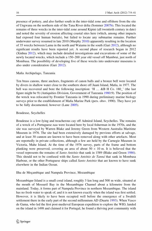
presence of pottery, and also further south in the inter-tidal zone and offshore from the site
of Ungwana on the northern side of the Tana River delta (Sommer 2007b). This located the
remains of three wrecks in the inter-tidal zone around Kipini (all twentieth century in date)
and noted the severity of erosion affecting coastal sites here (which, among other impacts
had exposed four human burials), but failed to locate any submarine remains. Further
underwater survey resumed in late 2010 (Murphy 2010) apparently resulting in the location
of 35 wrecks between Lamu in the north and Watamu in the south (Gari 2012), although no
significant results have been reported yet. A second phase of research began in 2012
(Xinhua 2012), which may include detailed investigations and excavations of some of the
newly located wrecks, which include a 150–200 year old vessel off Mambrui, just north of
Mombasa. The possibility of developing five of these wrecks into underwater museums is
also under consideration (Gari 2012).
Mafia Archipelago, Tanzania
Ten brass canons, three anchors, fragments of canon balls and a bronze bell were located
by divers in shallow water close to the southern shore off Juani Island, Mafia, in 1977. The
bell was recovered and bore the following inscription: ‘H … &B H Co. 180_’ (the last
figure might be 9) (Antiquities Division, Government of Tanzania 1980:9). The position of
the wreck was relocated by Frontier Tanzania in 1990 during preliminary marine biology
surveys prior to the establishment of Mafia Marine Park (pers. obsv. 1990). They have yet
to be fully documented, however (Lane 2005).
Boudeuse, Seychelles
Boudeuse is a low-lying and treacherous cay off Admiral Island, Seychelles. The remains
of a wreck of a Portuguese nau were located here by local fisherman in the 1970s, and the
site was surveyed by Warren Blake and Jeremy Green from Western Australia Maritime
Museum in 1976. The site had been extensively damaged by previous efforts at salvage,
and at least 30 cannon are known to have been removed along with other artefacts. Most
are reportedly in private collections, although a few are held by the Carnegie Museum in
Victoria, Mahe Island. At the time of the 1976 survey, parts of the frame and bottom
planking were preserved, covering an area of about 50 9 10 m. It is believed that the
vessel represents the remains of Santo Antonio that sank in 1589 (Blake and Green 1986).
This should not to be confused with the Santo Antonio de Tanna that sank in Mombasa
Harbour, or the other Portuguese ships called Santo Antonio that are known to have sunk
elsewhere in the Indian Ocean.
Ilha de Mocambique and Nampula Province, Mozambique
Mozambique Island is a small coral island, roughly 3 km long and 500 m wide, situated at
the mouth of Mossuril Bay in the Mozambique Channel about a kilometre from the
mainland. Today, it forms part of Nampula Province in northern Mozambique. The island
has no fresh water to speak of, and it is not known exactly when the island was first settled.
However, it is likely to have been occupied well before the emergence of a Swahili
settlement there in the early part of the second millennium AD (Duarte 1993). When Vasco
de Gama, who led the first post-medieval European expedition to explore the WIO, landed
on the island in 1498 and claimed it for Portugal, he found a thriving port community with
16 J Mari Arch (2012) 7:9–41
123
Arab and other shipping in its deep, sheltered anchorage between the island and the
mainland. Although gold, ivory and timber were among some of the exports, Newitt (2004)
suggests that the primary reason for the town’s existence was as a boat-building centre. The
skills of the local inhabitants were certainly quickly recognised and utilised by the Por-
tuguese settlers following Vasco de Gama’s return in 1502 (Newitt 2004). Over the next
few decades, over a hundred Portuguese nau and other ships visited while on the carreirada India, as the route from Lisbon to Goa was known. By 1540, Mozambique had become
the second most important naval base, after Goa, in the Indian Ocean and the town later
became one of the most important captaincies of the Estado da India (Newitt 2004). The
town remained the capital of Portuguese East Africa until the late nineteenth century when
this role was transferred to Lorenco Marques (now Maputo). In view of its long and varied
history and the wealth of surviving architectural remains, the island was designated a
World Heritage Site in 1991, and an international campaign to restore and conserve this
heritage was launched by UNESCO in 1997.
Given the significance of Ilha de Mocambique as a ship-building location, trading port
and naval base during its history, the area in the vicinity of the island is known to have
numerous wrecks, and surveys along the Mozambique coast show that the waters around
the Island ‘‘are by far the richest spot along the Mozambican coast with regard to the
underwater archaeological heritage’’ (Macamo 2001:6; see also Duarte, this volume).
Preliminary surveys were undertaken during the colonial era and subsequently extended
between 1996 and 1999 by archaeologists from Eduardo Mondlane University, with
support from Brown University and the US National Park Service (Duarte, this volume).
This resulted in the location of several important wreck sites and other archaeological
material. However, further, systematic archaeological research has been hampered since
the award in 1999 of an exclusive concession by the Mozambique Ministry of Culture to
Arqueonautas Worldwide (established in 1995 as a private share holding company in
Madeira, [Portugal Regiao Autonoma da Maderia 2003]) to conduct surveys and exca-
vations of wrecks around Ilha de Mocambique. In April 2003, the company was granted an
extension until October 2009 to cover 700 km of coastline along the coast of Nampula
Province (Arqueonautas Worldwide 2010, ‘Projects and historical research’), which has
since been extended (Duarte, this volume). The company’s partners are Patrimonio In-
ternacional SARL. The company uses a combination of archival research, marine remote
sensing (typically magnetometer survey), diver reconnaissance of magnetometer anoma-
lies, and excavation, and a statement of its methods appears on the company website
(Arqueonautas Worldwide 2010, ‘Archaeology’). According to the company’s website,
thus far some ‘‘79 historical shipwrecks have been confirmed by historical research of
which 22 are of outstanding cultural and historical value’’, although as recently as May
2012 the discovery of a newly located wreck site, possibly the remains of Sao Miguel eAlmas which sank en route from Portugal to India in 1771, was reported on the company
website (Arqueonautas Worldwide 2010, ‘Current News’).
The surveys in Mozambique began in May 2000 (previously the company had been
running operations in the Cape Verde Islands), and following the detection of a number of
magnetic anomalies that could represent ship remains, the site of a sixteenth century
‘Iberian trader’ designated IDM-002 (later identified as Espadarte, which sank in 1558),
was selected for excavation between mid-2001 and November 2002 (Mirabal 2001; Bound
2002; see also Duarte, this volume). Among the main finds recovered from this wreck was
a large cargo of Chinese porcelain from the period of Emperor Jiajing’s rule (AD
1522–1566) during the Ming Dynasty. Over the ensuing years, survey and excavations
have continued around Ilha de Mocambique, but have also been extended to 12 other
J Mari Arch (2012) 7:9–41 17
123
locations along the coast of Nampula Province. To the north of Ilha de Mocambique, these
are Pinda Bank, the Nacala area, and Porto Velhaco, and to the south—Lunga Bay, Infuse
shoals, Mogincual shoals, San Antonio shoal, Mafamede island, Caldeira shoal, Moma
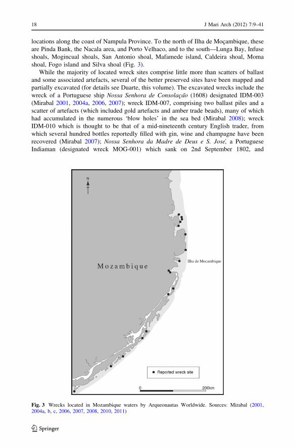
shoal, Fogo island and Silva shoal (Fig. 3).
While the majority of located wreck sites comprise little more than scatters of ballast
and some associated artefacts, several of the better preserved sites have been mapped and
partially excavated (for details see Duarte, this volume). The excavated wrecks include the
wreck of a Portuguese ship Nossa Senhora de Consolacao (1608) designated IDM-003
(Mirabal 2001, 2004a, 2006, 2007); wreck IDM-007, comprising two ballast piles and a
scatter of artefacts (which included gold artefacts and amber trade beads), many of which
had accumulated in the numerous ‘blow holes’ in the sea bed (Mirabal 2008); wreck
IDM-010 which is thought to be that of a mid-nineteenth century English trader, from
which several hundred bottles reportedly filled with gin, wine and champagne have been
recovered (Mirabal 2007); Nossa Senhora da Madre de Deus e S. Jose, a Portuguese
Indiaman (designated wreck MOG-001) which sank on 2nd September 1802, and
Fig. 3 Wrecks located in Mozambique waters by Arqueonautas Worldwide. Sources: Mirabal (2001,2004a, b, c, 2006, 2007, 2008, 2010, 2011)
18 J Mari Arch (2012) 7:9–41
123
comprised a scatter of ca. 100 cannon, some associated cannon balls and artefactual
material including several later eighteenth century gold coins and a number of copper
sword hilts (Mirabal 2008, 2009); San Jose, which sank in 1622 (designated MOG-003),
from which four bronze cannon and ca. 24,000 silver coins have been recovered
(Mirabal 2005, 2006, 2007, 2008); and wreck ANG-005, believed to be the remains of
Bredenhof, a Dutch East India Company (VOC) vessel, first located in 1986 (see below),
from which Arqueonautas Worldwide recovered over 3,700 copper duit coins (Mirabal
2001:8).
Full reports on these excavations are promised, although at present only interim reports,
posted on the company website are available. The company has also contributed to the
redesign of the Museo da Marinha (Museum of the Navy) on Ilha de Mocambique, which
re-opened in August 2007. This contains displays of many of the finds generated by their
activities. The company also aspires to be considered a serious archaeological research
body. For instance, founder and chief executive of Arqueonautas, Count Nikolaus
Sandizell, in an interview for the New York Times in April 2001 reportedly stated that ‘‘We
don’t consider ourselves treasure hunters. We consider ourselves as more a maritime
archaeology group. Our image is a little bit more serious’’ (Kinetz 2001). However, the
company is equally concerned with ‘salvage’. For instance, it sold over six tons of ‘low
alpha lead’ from N.S. de Consolacao to ‘Global LAL Inc., USA’ in March 2007 (Lane
2007), and in December 2000, Sotheby Holdings Inc. auctioned finds from nine wrecks the
company had investigated in the Cap Verde Islands (Sotheby 2000). More recently, Ming
ceramics and gold from IDM-002 were sold by Christies in 2004, and further pieces of gold
scrap from this wreck were sold by Sedwick Coins in May 2007 (Sedwick 2007). Artefacts,
described as mostly ‘repetitive’ (with the exception of the coins, seals and parts of ship
structure), can be purchased directly from the company via its ‘online shop’ webpage
(Arqueonautas Worldwide 2010—‘ARQ’s On-Line Shop’).
Sussex
This East India Company ship sank around Bassas d’India in the Mozambique Channel in
1738. The remains of the wreck were located in 1987, and investigated by a team from the
French Department of Marine Archaeological Research (DRASM) (Bousquet et al. 1990;
L’Hour et al. 1991). The ship was carrying a cargo of Chinese porcelain when it sank, some
fragments of which were recovered from the seabed along with some glass fragments.
Traces of an unidentified nineteenth century wreck were also located on the reef itself,
while a cast iron cannon associated with two large anchors found near the southern tip may
represent the remains of Santiago—a Portuguese carrack that was lost in 1585 (Bousquet
et al. 1990; see also Duarte, this volume).
HMS Sirius
This British 5th rate frigate (i.e., a frigate mounting 32–44 guns with the main battery on a
single deck) was built in 1797, and was wrecked off Mauritius in 1810. The site was
discovered in 1964, and remains lay scattered across the bottom mud at depths extending
from 6 to 24 m; the bow was reported to be still in situ embedded in the mud. Parts of the
vessel were damaged during salvage operations in 1968, and limited excavation of the site
has been conducted by a team from Australia (von Arnim 1998).
J Mari Arch (2012) 7:9–41 19
123

L’Utile
This ship, which belonged to the French Compagnies des Indes Orientales, sank on 31st
July 1761 off ‘Sandy Island’ (now known as Tromelin Island) while en route to Ile de
France (Mauritius) from Madagascar after being blown off course by a storm. It was
carrying a cargo of Madagascan slaves that had been acquired illegally. One hundred and
twenty members of the crew and around 60 slaves were able to reach the comparative
safety of the island, and supplies were salvaged from the wreck. The island is a sandy cay
little more than a square kilometre in extent with a maximum elevation of ca. 8.5 m
(Marriner et al. 2010). It is situated in an area prone to cyclones, and the shores are often
swept by storm surges, making settlement hazardous. The French crew built a makeshift
boat and sailed away, leaving the slaves behind with food for about 3 months. Despite
promising to return, on reaching Madagascar the crew were prevented from returning to
help rescue the slaves. Fifteen years later, in November 1776, seven women and an eight-
month old baby were rescued by the crew of La Dauphine (Guerout and Romon 2008). The
fate of the other slaves is unknown, although they are presumed to have died on the island
or perhaps while trying to make their own escape.
Archaeological and related studies were conducted on Tromelin in 2006, 2008 and
2010, coordinated by a French not-for-profit organisation the Groupe de Recherche en
Archeologie Navale (GRAN), as part of a broader programme of research on the history of
slavery in the WIO coordinated by UNESCO (Guerout 2007; Guerout and Romon 2007).
An underwater survey was conducted around the island in 2006, supplemented by geo-
archaeological survey of the island aimed at learning more about how the abandoned slave
population adapted to this hostile environment. Divers located remains of the ship,
including iron anchors and cannon, scattered over a wide area. Each item was recorded in
situ and their location on the seabed was plotted. Concurrent with this, test-excavations
were undertaken on land in an effort to locate the camp used by the Madagascan and
French survivors. Eventually, the remains of a small house built from coral and salvaged
material was located, as well as the remains of a small oven which was used for baking
biscuits. Further excavations in 2008 exposed two further buildings, and the whole com-
plex appears to represent the remains of a dwelling, workshop and kitchen (Marriner et al.
2010:1303). The reports by Guerout (2007; Guerout and Romon 2007) provide further
details, while some of the finds and plans of underwater remains can also be seen on the
project website: http://www.archeonavale.org/Tromelin/.
Degrave, Madagascar
Four cannon and an anchor were located in shallow water near Belitsaky by Michael
Parker-Pearson and his team while conducting research on the archaeology of the
Antandroy Kingdom. These possibly derive from Degrave, which was wrecked on the
southern tip of Madagascar in 1703 while en route back to England from Bengal, forcing
members of the crew to abandon ship (Parker-Pearson and Golden 2002; see also van den
Boogaerde 2009:89–96). The survivors from Degrave were duly captured and enslaved by
the local Antandroy king, Andriankirindra. One of them, Robert Drury, kept a diary of his
time on the island and after 16 years on Madagascar, mostly in captivity, he managed to
return to England, where his diaries were later published (Parker-Pearson and Golden
2002).
20 J Mari Arch (2012) 7:9–41
123
H.M.S. Serapis
This British warship was captured by John Paul Jones in September 1779, during the
American War of Independence following a naval battle in the North Sea off Flamborough
Head. After capturing the vessel, John Paul Jones sailed to Texel on the Dutch coast with
the rest of his fleet, where Serapis and the rest of Jones’ fleet (except the Alliance) were
placed under the French flag. In 1781, Serapis was sent to the French fort on Ile Sainte
Marie, off the northern coast of Madagascar, under the command of a Captain Roche.
While ashore, a fire broke out on board and despite the best efforts of the crew, the ship
sank (van den Boogaerde 2009:205–207). The wreck of Serapis was relocated in late 1999
by Richard Swete, an American ‘nautical archaeologist’, and his associate Michael Tuttle,
following several years of magnetometer survey of Ambudifutatra Harbour (Serapis
Project 2008). In May 2004, a team of archaeologists and historians led by Michael Tuttle,
Prof. Jean Aime Rakotoarisoa and Dr. Chantal Radimilahy from the University in
Madagascar, recommenced research on the site. An area of copper lining from the hull and
an associated ballast pile was located, within which numerous artefacts were observed.
These features were mapped and recorded, with a limited number being lifted for diag-
nostic purposes and further analysis. These have been deposited at the University of
Antananarivo Museum of Art and Civilization for conservation (Society for Historical
Archaeology 2004).
Other Wreck Sites
Numerous twentieth century wrecks, including some sunk during both World Wars are
known in the southern Red Sea and WIO. Many of these are visited on a regular basis by
sports divers. In previous decades, sports divers commonly removed ‘souvenirs’ from such
sites. Although such practices continue, self-policing by sports divers and the dive com-
panies that operate in the region has encouraged a significant reduction in this kind of
threat to the integrity of the underwater heritage. Far greater threats are posed by com-
mercial treasure hunters, who often style themselves as ‘maritime archaeologists’ while
exploiting loopholes in the existing international and national legislation governing the
protection of the underwater cultural heritage, salvage and the sea (see Lane 2007 for a
synopsis).
Given the long history of trans-oceanic trade between East Africa, the Persian world, the
Indian subcontinent and even south-east Asia, it is highly likely that wrecks associated with
this trade await discovery. The more extensive documentary sources associated with the
era of European expansion, and the increase in maritime traffic that accompanied this
increase, provide a further indication of the likely scale of the underwater archaeological
resource in the region (Tables 1, 2, 3). Perhaps the most famous of these is that of SaoRafael, one of the four ships that comprised Vasco de Gama’s initial exploration fleet,
which sank off Tanga, possibly close to a sandbank opposite the Swahili town of Tongoni,
after being set alight (Gillman 1944; Scott 1942; Strandes 1968:28). Theal (1901:390–391,
476–479) also mentions archival sources documenting the loss in 1505–6 of three Portu-
guese vessels shortly after they left Kilwa. A number of other Portuguese ships are said to
have sunk off the Kenya coast between Mombasa and Malindi (Sommer 2007c; also
Guinote et al. 1998). These include: (1) the carrack El Rei, which formed part of a fleet
under the command of Pedro Alvarez de Cabral that left Lisbon in 1500 (Grenlee 1938),
and is said to have been burned after grounding on a sandbar off Mombasa; (2) Nossa
J Mari Arch (2012) 7:9–41 21
123

Senhora da Graca, originally part of a four ship expedition under the command of Hen-
rique de Macedo and said to have been wrecked off Malindi; and (3) Aguia, a galleon
believed to have been wrecked off Mombasa in 1600 (Boxer 1968) (for others see
Table 1). None of these have been relocated as yet, although recent surveys as part of the
MUCH programme (see Sharfman et al. this volume) have located some traces including
an anchor that could mark one of the wreck sites.
Almost 400 years after Sao Rafael foundered, 150 Arab and Indian dhows and many
European ships were sunk in and around Zanzibar Harbour following a major hurricane in
1872 (Sheriff 1987:234). Since many of the dhows were laden with cargo, one might
expect that the remains of several of these would have survived on the seabed. In fact,
recent marine geophysical surveys by the Centre for Maritime Archaeology, University of
Ulster, has established that conditions for wreck preservation in this area seem to have
been extremely poor, and only minimal traces survive (or, perhaps are not detectable with
current technology) (pers. comm. Colin Breen 2/10/07). This underlines the fact that while
maritime trade is known to have been extensive for many centuries, and ships are known to
have sunk for various reasons, this does not guarantee that all such wrecks will have left
archaeological traces.
Most of the published information concerning European wrecks in the WIO and
southern Red Sea has been compiled by enthusiasts and amateur historians. Details are
mostly published on the Internet, although occasionally also in book form. Good examples
of the latter are the books by Patience (2006) which covers East Africa and van den
Boogaerde’s (2009) book on shipwrecks off Madagascar. The latter lists a total of 10
Portuguese East India Company vessels, eight VOC ships, four British East India Company
ships, 21 French East India Company vessels, five Royal Navy ships, five French navy
vessels, 17 pirate ships and 88 other vessels (including a German U-boat from WW2 and
two Japanese midget submarines) known to have been wrecked, scuppered or otherwise
sunk in Madagascan waters since ca. AD 1500. The remains of only a handful of these
have been relocated by divers, however (Table 2).
The following brief summary of some of the better known wrecks is intended to
illustrate the nature of this resource, the potential for further research and the ongoing
threats from treasure hunters. It is not intended to be comprehensive. It also needs to be
reiterated that while the archaeology of the ‘deep sea’ is restricted to wrecks (including
those of aircraft) and materials jettisoned from vessels, the underwater archaeology of the
continental shelf also comprises the remains of former terrestrial sites that were subse-
quently inundated following changes in sea-level at different times in the past (Ase 1987;
Ramsay and Cooper 2002; Camoin et al. 2004). No such sites have yet been located, but as
demonstrated by recent work off the Cape of Good Hope, South Africa (Werz and
Flemming 2001), and on-going research in the Red Sea (see below), it is probably only a
matter of time before similar remains are located off the East African coast.
Eighteenth-Nineteenth Century European Wrecks
St. Geran
St. Geran was commissioned by the French Compagnies des Indes Orientales and launched
at Orient, France in 1736. She was wrecked on her maiden voyage during a violent storm
off the north coast of Mauritius in August 1736. Nine members of the crew were rescued
(out of a total of 149), and the heroic efforts of the islanders later inspired the novel ‘Paulet Virginie’ by the French author Bernadin de Saint-Pierre. At the time St. Geran was
22 J Mari Arch (2012) 7:9–41
123

Table 1 List of known Portuguese Indiamen shipwrecks in the Western Indian Ocean
Expedition date Vessel Location and date wrecked
1500 Unknown Coast of Malindi, 1501
1502 Sao Pantaleao? Parcel de Sofala, 1502
1505 Sao Joao Mozambique or Kilwa, 1505
1505 Santiago «Galega» Leaving the Kilwa barra, April 6, 1506 & two others
1506 Leitoa Mozambique, 1507
1506 N Sra da Luz Pate, 1506
1506 Santa Maria das Virtudes Pate
1507 Sao Romao? Between Sofala and Mozambique, 1507
1507 Sao Joao? Between Sofala and Mozambique, 1507
1507 Sao Romao? Between Sofala and Mozambique, 1507
1507 Sao Simao Between Sofala and Mozambique, 1507
1508 Unknown Indian Ocean? 1508–1509?
1510 Sao Roque? Mozambique, 1510
1519 Santo Antonio Malindi/Kilwa? or Mafia? 1519–1520?
1524 Barbosa Between Mozambque and India, 1524
1524 Sao Jorge Low waters off Malindi, 1524
1524 Santa Helena Mozambique, August 1524?
1524 «Garca» Close to Mozambique, 1524
1528 S Asanto Antonio? Parcel de Sofala, 1528
1530 S. Dinis or Ajuda? Socotra, 1530–1531?
1530 Santa Maria Socotra or Mozambique, 1530?
1546 Espırito Santo Comoro Islands, 1547
1547 Santa Cruz Socotra, Sept 1547
1549 Salvador «Burgalesa» Close to Mozambique, 1549
1557 Aguia Mombasa, Aug 20, 1561
1564 Flor de la Mar Mozambique, 1556
1565 Tigre Mozambique, May 16, 1566
1576 Sao Jorge Entrance of Mozambique barra, 1576
1581 Sao Pedro Parcel de Sofala, 1583
1582 Sao Luıs Rio de Quelimane/Parcel de Sofala, 1582
1585 Sao Lourenco Mozambique, 1586
1589 Santo Antonio Between Mozambique and India, 1589
1591 Sao Luıs Mozambique, 1592/1593?
1592 N Sra da Nazare Mozambique, July 15, 1593
1593 Sao Cristovao Between Mozambique and Goa, Aug 17, 1594
1595 N Sra da Victoria Mozambique, 1596
1595 N Sra do Rosario Mozambique, April 8, 1597
1601 Santo Antonio Socotra, end 1601
1607 Sao Francisco Mozambique, Sept 1, 1607
1607 N Sra da Consolacao Mozambique, July 25, 1608
1608 N Sra da Salvacao Mombasa, April 17, 1609
1608 Bom Jesus Mozambique, Aug 17, 1608
1614 Sao Boaventura Maldive Islands, March 22, 1615
J Mari Arch (2012) 7:9–41 23
123

wrecked, she was carrying a cargo of textiles and metal-ware to be exchanged for spices on
reaching her destination, and a batter of 18 cannons (Blot 1979). Pieces have been salvaged
from the wreck over the years, and while most artefacts are now in private collections some
are on display in Mahebourg Museum on Mauritius (Tirvengadum 1983).
Bredenhof
This Dutch East India Company (VOC—Vereenigde Oostindische Compagnie) ship was
built in 1746, and was wrecked on a reef 13 miles from the East African coast and ca. 120
Table 2 Confirmed pre-twentieth century wrecks around Madagascar
Vessel Date lost Location and material remains
Sao Ildefonso 1527 Southern Madagascar; numerous cannon
Adventure Galley 1698 Sainte-Marie Island, NE Madagascar (vessel used by the pirate WilliamKidd; others reported from vicinity are Flying Dragon (1721),Rouparelle (1698), Mocha (1699) & New Soldado (1699)).
Nossa Senhora doMonte do Carmo
1774 Salara reef, west coast; cannon and anchors, artefact scatter
Degrave 1701 South Madagascar; iron cannon, ship’s bell
Aurora 1770 ? Star Bank, southern Madagascar; large anchors and cannon
HMS Serapis 1781 Sainte-Marie Island, NE Madagascar—copper box, copper hull lining,ballast, artefact scatter
Winterton 1792 Point St Felix (Ambatomifoka); anchors, cannon, ballast and artefactscatter
Surprise 1885 Near Salara, SW Madagascar; anchors, hull fragments, artefacts
Le Tage 1890 Nosi Mahampana (Barracouta Islands) NE Madagascar; steel hull
Source van den Boogaerde (2009)
Table 1 continued
Expedition date Vessel Location and date wrecked
1616 Sao Juliao Comoro Islands, Aug 18, 1616
1620 Sao Joao Evangelista Close to Mombasa, 1620
1622 Santa Teresa deJesus Entrance of Mozambique barra, July 25, 1622
1622 Sao Carlos Mozambique, July 25, 1622
1623 Santa Isabel Mozambique, Jan 28, 1624
1623 Sao Simao Mozambique, Jan 28, 1624
1623 Sao Braz Mozambique, Jan 28, 1624
1623 N Sra da Guia Between Mozambique and Muscat, 1623/24?
1642 Sao Bento Mozambique, Dec 27, 1642
1647 Santo Milagre Close to Mozambique, 1647
1649 N Sra do Bom Sucesso Mozambique, 1649?
1660 Conceicao Mozambique, 1660?
1661 N Sra da Salvacao Mozambique, 1661?
1670 N Sra dos Remedios Mombasa or Mozambique, 1670?
Source Guinote et al. 1998, as listed by Texas A&M University Portuguese wrecks project:http://nautarch.tamu.edu/NAPwiki/index.php/Portuguese_Indiamen_Shipwrecks. Accessed March 2012
24 J Mari Arch (2012) 7:9–41
123

miles south of Ilha de Mocambique in 1753, on her third voyage to Bengal. She was
carrying a cargo of 29 chests of bar silver, a chest of 5,000 gold ducats and 14 barrels of
small copper currency (duiten), with a total value at the time in excess of 325,000 guilders,
plus some wine and 38 tons of wheat that had been taken on when the ship reached Cape
Town in April. A large part of the bullion was jettisoned by the crew in an effort to save the
ship (and reportedly to stop other nations getting hold of it if the ship eventually foundered
close to the shore and its cargo could be salvaged). There were several survivors who
managed to reach the Mozambique coast and eventually made their way back to Holland
where the account of the loss and the efforts to save the ship became quite celebrated. In
May 1986, a salvage company registered in the Cayman Islands managed to locate the
remains of the wreck, and also some of the silver bullion that had been jettisoned. Later
that year, 542 of these silver ingots were auctioned by the Amsterdam wing of Christies,
for a total value of roughly US $250,000 (Christies Amsterdam B.V. 1986; see also Duarte,
this volume). In 2010, following new surveys, Arqueonautas reported that the wreck had
been relocated (Mirabal 2010:10). Other VOC wrecks in the region are listed in Table 3,
and British East India wrecks are listed in Table 4.
Table 3 Known Dutch East India Company (VOC) wrecks
Vessel name Approximate location and reason for loss Date of wreck
Zierikzee Ran aground, Cabacella, Mozambique 26th May 1607
Medemblik Near Maldive Islands 1608
Goede Fortuin Lost near Socotra
Arend Lost near Cape Mauritius
Dubble Arend Lost near Mauritius 1630
Koning David South-east coast of Madagascar 29th Aug. 1639
Tulp Off Madagascar 2nd Dec. 1656
Grundel ‘Cape Hangklip’, East African coast 20th Feb. 1673
Snoeper Capsized near Maldive Islands 1674
Baarzande Lost off Mozambique coast 9th June 1711
Ravenstein Maldive Islands 8th May 1726
Bredenhof Foundered on reef off Mozambique coast during hurricane 6th June 1753
Banda Foundered on a reef near Mauritius during hurricane 6th March 1615
Gelderland Mauritius, ran shore during hurricane 6th March 1615
Geunieerde Provincien Near Mauritius during hurricane 6th March 1615
Gouda Near Madagascar, lost during a storm 18th March 1625
Arnhem Brandao, east of Madagascar 12th Feb. 1662
Concordia Near Mauritius 1708
Zuiderburg Near Mauritius 1708
Oude Zijpe Mauritius 1717
Raadhuis vanMiddelburg
Near Mauritius 1722
Rijnestein Near Mauritius 1722
Huis te Forest Near Mauritius 1722
Naarstigheid Delagoa Bay, deliberately set on fire as no longer seaworthy 1st Jan. 1757
Indiaan Between the Cape and Mauritius 1781
Sources Parthesius 2010; A list of 653 VOC wreck between ca. 1595 and 1800, can be found here:http://forum.treasurenet.com/index.php?topic=30320.0. Accessed April 2012
J Mari Arch (2012) 7:9–41 25
123

Nossa Senhora do Monte do Carmo
This Portuguese ship sank off the west coast of Madagascar on 18th August 1774. It was
re-located and ‘salvaged’ by a Belgian self-styled ‘marine archaeologist’ Robert Stenuit in
the late 1980s and early 1990s (Anon 1992). Little has been reported regarding what was
found or recovered, however.
World War I Wrecks
Naval engagements between British and German forces during the course of WWI resulted
in vessels on both sides being sunk (Charlewood 1960a, b; Hatchell 1954). These include
the German battleship S.M.S. Konigsberg, which was eventually sunk after extended naval
action in the Rufiji River Delta in 1915. Over time, the hulk sank gradually into the soft
mud and parts of the superstructure were salvaged in 1962, although up to 1965 the
freeboard remained visible above water. It is now completely buried, although potentially
still quite well preserved. Various items have been salvaged from the ship over the years.
These include her main guns which were recovered by the Germans and modified for use
on land. After the defeat of German troops, captured guns were taken as trophies to
Pretoria, Leopoldville, Stanleyville, Kampala, Dar es Salaam and Mombasa. The latter
example stands on display outside Fort Jesus Museum, alongside one of the guns salvaged
from the British cruiser H.M.S. Pegasus, which was sunk by S.M.S. Konigsberg off
Zanzibar town during a surprise attack on 20th September 1914 (Hatchell 1954). Other
items in public collections include a wardroom dining set (National Railway Museum,
Nairobi, Kenya), zinc cordite cases (Zanzibar Museum), a porthole (Dar es Salaam
Table 4 Known English East India Company wrecks
Vessel Datelost
Location
Smyrna merchant 1660 Island of Joao da Nova, Primeira Isles, off Mozambique
Love 1665 60 miles from Mozambique
Anne 1689 Wrecked off Madagascar
Ruby 1699 At Mayotte
Degrave 1701 South Madagascar
Bedford 1702 Lost with all hands off Mauritius
Liampo 1706 Near town of Mozambique
Northampton 1746 50 leagues east of Reunion
Bengal 1809 Parted company on 14th March 1809 with the main convoy of East Indiamenoff Mauritius in a gale and not heard of again
Calcutta 1809 Off Mauritius
Jane Duchess ofGordon
1809 Off Mauritius
Lady Jane 1809 Off Mauritius
Admiral Gambier 1817 Wrecked on a coral reef in the Mozambique Channel on 20th June 1817
Cablava 1818 Cargados Carajos (St Brandon shoals) off Mauritius
Sources van den Boogaerde 2009; Wrecksite.eu—http://www.wrecksite.eu/ownerbuilderview.aspx?3686.Accessed April 2012; and East India Company Ships—http://www.eicships.info/index.html. Accessed May2012
26 J Mari Arch (2012) 7:9–41
123

Museum, Tanzania) and a torpedo director and shell casings (Imperial War Museum,
London). The wreck of Pegasus was sold in 1955 and broken up for scrap, however parts
remain on the seabed and it is a popular dive site. There is one other vessel associated with
Konigsberg that can still be seen. This is S.S. Somali, which served as the supply ship for
Konigsberg, which was sunk during the same naval engagement slightly further north in
the Rufiji Delta near Salale. For years it was obscured by vegetation, but some of this is
reported to have been cleared sometime between 1995 and 2000, to expose the greater part
of the hull and surviving superstructure.
Seascapes and Landscapes: Recent Maritime Archaeology Projects
On mainland Eastern Africa from Somalia to Mozambique, the offshore islands of Pemba,
Zanzibar and the Mafia archipelago, and the Comoro Islands, there is a long and distinguished
tradition of ‘coastal’ or ‘Swahili’ archaeology (for overviews see Kusimba 1999; Horton and
Middleton 2000). Similar research is also well established on Madagascar (Wright 1993). In all
these areas, scholars have long recognised that access to the sea and the utilisation of maritime
resources, as well as trans-oceanic trade were important contributory factors to the rise of
Swahili towns and the evolution of a distinctive Swahili culture (e.g., Prins 1965; Allen 1993;
Pearson 1998; Horton and Middleton 2000), and quite possibly pre-Swahili communities as
well (e.g., Chittick 1979; Smith and Wright 1988; Chami 1999a; Blench 1996; Sinclair 2007;
Boivin and Fuller 2009; Boivin et al. 2009). However, despite the importance of trans-oceanic
trade to these communities, there has been no systematic attempt to establish whether any
shipwrecks (or any other underwater remains) associated with the Indian Ocean trade during
this era survive, despite occasional reports of finds of Chinese porcelain and similar materials
being dredged up by fisherman at various points off the East African coast (see above). Also,
until the last decade, research on specifically maritime themes was limited to preliminary
studies of the information available from ethnography, historical sources and ‘grafitti’ as to the
types of boats used (Garlake and Garlake 1964; Chittick 1980; Prins 1982; Gilbert 1998;
Poumailloux 1999), and a few studies of fishing strategies and technologies (Horton and
Mudida 1993; Kleppe 1996, 2001; Van Neer 2001), and the exploitation of maritime resources
such as mangroves (Whitehouse 2001; Radimilahy 2001) and salt (Chittick 1975).
Over the last decade, this situation has begun to change and the value of adopting a
‘cultural landscape’ approach to the investigation of the maritime archaeology of the
region, both for the purposes of compiling a more comprehensive inventory of the range of
archaeological remains that survive on the coastal foreshore, inter-tidal zone and under-
water along the East African coast and around the offshore islands, and for changing
research paradigms, is increasingly recognised (Breen and Lane 2003; Lane 2005). Par-
ticularly influential here has been the work of staff and research students at the CMA at the
University of Ulster in developing integrated approaches, often in collaboration with local
research bodies including the Coastal Archaeology Unit of the NMK, the Tanzania
Department of Antiquities, the Department of Archaeology, University of Khartoum, the
National Corporation of Antiquities and Museums of Sudan (NCAM), and the BIEA.
The CMA’s first project was on Mombasa Island on the southern Kenyan coast, which
has been witness to historical settlement and port activity for nearly two thousand years
(Berg 1968; Sassoon 1980, 1982). As outlined above, the primary aim was to study the
port-town and island of Mombasa using contemporary integrated landscape approaches. It
was interdisciplinary in scope and involved archaeologists, geologists, geophysicists and
historians, involving systematic foreshore and inter-tidal zone surveys, marine geophysical
J Mari Arch (2012) 7:9–41 27
123
surveys supplemented by targeted inspection of sub-surface anomalies by divers, and some
small scale excavation on land and use of various archival sources (Breen et al. 2001;
Breen and Lane 2003; Forsythe et al. 2003; McConkey and McErlean 2007; Quinn et al.
2007). Subsequent work by staff and students of CMA have included a marine geophysical
survey of the Zanzibar channel between Zanzibar Stone Town and Bagamoyo on the
mainland (Breen in prep.); detailed investigation of the maritime landscapes of the
medieval town and port of Suakin on the Red Sea coast of Sudan; and two maritime
archaeological landscape projects carried out by CMA students as part of their PhD
research (Pollard 2007; Rhodes 2008).
Suakin is situated upon a coral island at the end of a long inlet, ca. 60 km south of
present-day Port Sudan (Fig. 4). The first historical reference to a port of this name dates to
the ninth century AD, although reference to a port in this vicinity is made in the PeriplusMaris Erythraei (ca. first century AD) and in Ptolemy’s Geography (second century AD)
(Mallinson 2012). It is possible that the island was used as a staging post, with a water
reservoir during the classical period (Chittick 1981), although additional evidence for a
Roman presence has not been located. The recent excavations indicate the presence on the
island of a settlement with likely wattle-and-daub houses by the mid-eleventh century
(Smith et al. 2012:175). However, Suakin only came to prominence in the late fifteenth
century, following the decline of the port of ‘Aydhab to the north (which probably lay
some 20 km south of ‘Aydhab proper at Halaib, see Peacock and Peacock 2008), and from
AD 1517 it served as the southernmost port of Egypt under the Ottoman Empire. Suakin is
certainly best known for its buildings from its heyday during the Ottoman era (Greenlaw
1994), which until recently were some of the best preserved domestic and commercial
Ottoman architecture anywhere in the former Ottoman empire. Despite several well
intended plans to protect this cultural resource, a lack of coordinated action and appreci-
ation of the corrosive effects of marine salts in the local groundwater, has meant that many
of these buildings have partially or totally collapsed (Phillips 2012). Between 2002 and
2011 the town was the focus of architectural and archaeological study (Mallinson et al.
2009; Mallinson 2012; Smith et al. 2012), and in 2004 a maritime archaeological com-
ponent was added to this programme of research and restoration. Excavations indicate
continuous occupation of the island from at least the eleventh century, with gradual
infilling and rebuilding across the original coral island supplemented by repeated addition
of waterfronts and other masonry extensions around its periphery (Mallinson et al. 2009).
These recent excavations also demonstrate that prior to the establishment of Ottoman
control, off-loading from ships was typically by landing bow forward to the shore, giving
easy access to the nearby merchants’ houses (Mallinson 2012:166). Subsequently, how-
ever, a quay and accompanying custom’s office were built, which was later to form a larger
quayside. Trade at the port also expanded rapidly, prompting the Portuguese explorer Joao
de Castro, who visited in 1541, to liken the scale of activity to that seen in Lisbon (Smith
et al. 2012:179), which is also attested by the diverse range of ceramics from China, India,
the Persian Gulf, Egypt and other parts of the Red sea zone that have been recovered
(Mallinson et al. 2009; Smith et al. 2012). As well as this more general work, detailed
investigations of the developments under British colonial rule in the late nineteenth century
have been carried out by Rhodes (2011). This aspect of the project focused on the creation
and modification of a customs complex, the development of the waterfront, and the
colonial administrative buildings on the main island, and related changes on the smaller
Condenser/Quarantine Island, with its piers and associated railway.
Adulis, on the Eritrean coast ca. 50 km south of Massawa (see Fig. 4), was another
important Red Sea port and has also been the focus of recent studies from a maritime
28 J Mari Arch (2012) 7:9–41
123
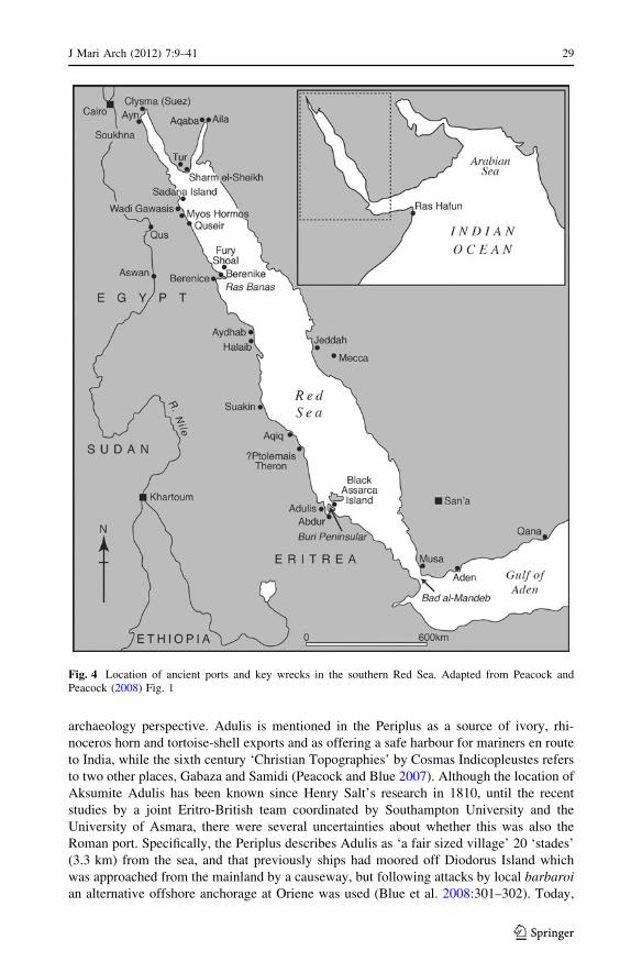
archaeology perspective. Adulis is mentioned in the Periplus as a source of ivory, rhi-
noceros horn and tortoise-shell exports and as offering a safe harbour for mariners en route
to India, while the sixth century ‘Christian Topographies’ by Cosmas Indicopleustes refers
to two other places, Gabaza and Samidi (Peacock and Blue 2007). Although the location of
Aksumite Adulis has been known since Henry Salt’s research in 1810, until the recent
studies by a joint Eritro-British team coordinated by Southampton University and the
University of Asmara, there were several uncertainties about whether this was also the
Roman port. Specifically, the Periplus describes Adulis as ‘a fair sized village’ 20 ‘stades’
(3.3 km) from the sea, and that previously ships had moored off Diodorus Island which
was approached from the mainland by a causeway, but following attacks by local barbaroian alternative offshore anchorage at Oriene was used (Blue et al. 2008:301–302). Today,
Fig. 4 Location of ancient ports and key wrecks in the southern Red Sea. Adapted from Peacock andPeacock (2008) Fig. 1
J Mari Arch (2012) 7:9–41 29
123

Adulis is situated 7 km from the sea and most of the surface remains at the site date to the
period of Adulis’s prominence as the main port for the Aksumite kingdom, thus raising
doubts that the ruins also mark the location of the town during the Classical era. However,
by using a combination of sediment coring, remote sensing, and survey the recent project
managed to establish that Roman Adulis underlies the main Aksumite town, and, that
sedimentation and other coastal geomorphological processes had caused a seaward
extension of the shoreline. Identification of the likely location of the shoreline in the early
first millennium AD from satellite imagery coupled with detailed sedimentological anal-
yses, also resulted in the identification of the former Diodorus Island in the Galla Hills to
the south. The later Aksumite places of Gabaza, also in the Galla hills, and Samidi some
7 km to the north, were also relocated (Peacock and Blue 2007).
Further south, recent maritime cultural landscape studies have focused in particular on
the development of waterfront and harbour facilities under different economic, socio-
cultural and political conditions, and on the exploitation of marine resources. Although
closely modelled on the Mombasa Harbour study, only one of these has involved the
integrated use of marine geophysics and diver surveys (Breen in prep.). This was con-
ducted in 2005 in the area of sheltered water that lies between Zanzibar Stone Town and a
series of small islands a few kilometres offshore that protect the harbour. Zanzibar Island
has been a centre of Indian Ocean commerce and cultural developments for centuries, and
previous archaeological research along this stretch of coastline has suggested the presence
of a number of small fishing villages since at least the early centuries AD. Those in the
immediate area of what became Stone Town, however, only grew in size after the arrival of
the Portuguese in the late fifteenth century.
For his doctoral research, Edward Pollard (2007) investigated the maritime cultural
landscapes around Bagamoyo and Kaole in central Tanzania, and Kilwa in the southern
part of the country (see also references in Pollard et al., this volume). The aim was to build
on the well established body of work on the archaeology of Swahili and earlier ‘Early
Farming and Metal Working’ (or ‘Iron Age’) sites along the East African coast, by
adopting a much more explicit focus on identifying the ‘maritime’ elements of these. In
particular, this entailed documentation of any evidence for a nautical infrastructure asso-
ciated with these sites (e.g., landing places, wharves, jetties, lighthouses, navigational
guides), evidence relating to the marine economy (e.g., fish-traps, fishing equipment) and
exploitation of marine resources (e.g., fish, mangroves, shell-fish, salt, coral), transporta-
tion facilities (shipwrecks, ballast, coastal access routes), and social and religious mani-
festations of a ‘maritime culture’ (such as manifested by coastal shrines, mosques,
settlement layout) (Pollard 2008a:36–42). A combination of inter-tidal and coastal surveys
supplemented by selected test-excavations at several sites and ethnoarchaeological studies
of the contemporary maritime landscape generated a wealth of new insights (see Pollard
2008a), especially with regard to the maritime landscape around Kilwa Kiswani, southern
Tanzania, during first half of the second millennium AD. Among other features, the inter-
tidal surveys identified a sequence of previously unrecognised, yet substantial, coral
causeways and platforms of likely thirteenth-sixteenth century date. Some of these were
used to access low water perhaps for unloading ships but also perhaps to facilitate
exploitation of marine resources including shell-fish beds (Pollard 2008b); others may have
been used as navigation markers (Pollard 2011) or breakwaters.
Pollard’s surveys also identified the social and religious significance of the sea to the
Kilwa community, as evidence by, for instance the location of particular mosques (Pollard
2008b, c), and also the diversity of economic activities, from salt extraction and lime
burning to fishing that took place along the foreshore and in the intertidal zone (see also
30 J Mari Arch (2012) 7:9–41
123
Lane 2005). Although smaller in scale, comparable studies have now been conducted by
Annalisa Christie around Malindi (Christie 2007) and in the Mafia archipelago, especially
around the ca. twelfth to seventeenth century AD site of Kua on Juani Island (Christie
2011). A particular feature of this study was that it sought to explore what archaeologists
mean by referring to sites, landscapes or cultures as ‘maritime’, concluding that in many
cases the use of the term simply implies a use of marine resources or settlement beside the
sea, neither of which are especially insightful observations. Instead, Christie urges the
development of a more socially informed perspective that recognises that not all societies
that live beside the sea have a ‘maritime culture’ as well (Christie 2011, Christie, in press
a; see also Westerdahl 1992). In the Kua case, a combination of archaeological survey and
excavation supplemented by ethnoarchaeological studies of fishing practices (the first to be
conducted in the region) and oral histories, Christie was also able to demonstrate evidence
for differential access to maritime resources between members of the Swahili elite and
‘commoners’ living at the site (Christie 2011, in press b).
Mafia was also a focus of Daniel Rhodes’ recent maritime landscape study, along with a
number of coastal towns (Mombasa, Tanga, Pangani, Bagamoyo, Unguja, Dar es Salaam,
Chole and Kilwa Kivinje) along the Tanzania and Kenya coasts. In contrast to the work by
Pollard and Christie, Rhodes’s focus was on the nineteenth century archaeology and
architectural history of these towns and especially following the establishment of European
colonial rule (British and German). This remains a neglected area of study in the region,
despite the obvious potential given the wealth of material evidence, documentary sources
and scope for the collection of oral histories. A specific focus of this comparative study was
on how manipulation and transformation of the waterfronts of these pre-European settle-
ments, such as through the addition of quays, seawalls, slipways, new harbours and cus-
toms houses, served to reinforce the new social distinctions and power relations that
emerged within the context of European colonial rule (Rhodes 2010). Another noticeable
feature was the increased militarisation of some of these settlements as the European
powers themselves struggled for control over different territories and seaways, as is well
documented around Mombasa Harbour—although this process began soon after the arrival
of the Portuguese (McConkey and McErlean 2007) and also included Omani activity as
well (see Lane 2005).
Conclusion: Future Prospects and Trends
The excavation of the Mombasa wreck in the 1970s was a promising start to underwater
archaeology in the western Indian Ocean and southern RSZ. However, as this review has
highlighted, despite the obvious potential for sustained archaeological surveys and even
excavations, underwater and maritime archaeology in region was virtually suspended for
the next two decades. There seem to be several reasons for this, including the widespread
perception among archaeologists in the region that this field of archaeology has little to
contribute to understanding the African past, coupled also by the obvious expense of
underwater excavations and subsequent artefact conservation projects, and the lack of
investment in local capacity building. To its credit, and despite other demands on a limited
budget, the NMK has sustained the excellent marine conservation facilities that were set up
at Fort Jesus Museum to deal with the finds from the Mombasa wreck. These represent a
very real resource but are presently under utilised and without additional support main-
taining the laboratory may eventually come to be regarded as a financial burden that can no
longer be supported.
J Mari Arch (2012) 7:9–41 31
123

It is only in the last decade that maritime archaeology has been revived in the region. As
reviewed above, this has been stimulated by projects that have taken a more holistic
approach that extends well beyond an older, narrower focus on shipwrecks. Two, equally
important, additional objectives of these recent projects have been to provide training and
capacity building for local archaeologists and cultural heritage managers, and to raise the
profile of maritime and underwater archaeology in the region. The success of this strategy
can be gauged by the range of subsequent activity, the increased level of interest among
archaeologists based in the region, and the beginning of integration of maritime and
underwater archaeology into national archaeological services. This is important given the
very long history of engagement with the sea by the diverse populations that have occupied
the coastal littorals of the southern Red Sea and western Indian Ocean. This activity has
prompted a change in perspective, also, on the part of local archaeologists, who have begun
to recognise wrecks and other underwater remains (where they occur in their territorial
waters) as being a part of their heritage assets. The launch of the UNESCO CPUCH in
2001 has also helped, although it is a matter of regret that at the time of writing none of the
coastal states bordering either the southern Red Sea or the western Indian Ocean have
ratified this convention.
Nonetheless, other international partners are becoming more actively involved in sup-
porting the development of underwater archaeology in the region. For instance, since mid-
2008 the Centre for International Heritage Activities in the Netherlands has been assisting
the Antiquities departments in Tanzania, South Africa, and Mozambique to develop a
programme in Maritime and Underwater Cultural Heritage (MUCH) (Centre for Interna-
tional Heritage Activities n.d.; see Sharfman et al., this volume). This has included pro-
viding practical training for selected personnel as divers, training in maritime and
underwater archaeology and legislation, and conducting shoreline and underwater surveys
around Kilwa Kisiwani, Songo Mnara, Kismania Mafia and Ilha de Mocambique. The
possibility of developing some sites, including underwater ones, for heritage tourism is also
being investigated. NMK have gone further, with the creation of a new position for a
‘marine archaeologist’ at Fort Jesus, and also now maintain a historical shipwreck
inventory. As reported above, the governments of China and Kenya have also signed an
agreement to jointly explore the Kenyan coast for wrecks and terrestrial remains associated
with the voyages to East Africa led by Admiral Zheng He during the fifteenth century. The
project involves collaboration between the NMK Coastal Archaeology Unit and the School
of Archaeology and Museology at Peking University, Beijing. This research, with planned
terrestrial investigations and underwater surveys at Malindi as well as further work around
Lamu was announced via the international media in mid-2010 (Murphy 2010). New
underwater surveys have also been conducted recently around the island of Reunion as part
of a wider archaeological resources assessment project coordinated by Edouard Jacquot for
the Institut national de recherches archeologiques preventives (INRAP), the French
national organisation for preventive archaeology (INRAP 2012). The CMA also continues
to act as an official advisor to the Tanzania Antiquities Department and NMK’s Coastal
Archaeology Unit on the management of submerged cultural resources and also sustains its
partnership with NCAM in Khartoum, Sudan (Colin Breen, pers. comm. 8/2010).
Alongside these explicitly maritime archaeology initiatives, there is growing interest
among terrestrial archaeologists in the exploitation of marine resources during different
periods, as well as in the possible impacts of sea-level change on coast-dwelling societies.
For example, new research suggests that coastal routes were critical to the subsequent
dispersal of early Anatomically Modern Humans (AMH) to other parts of the world, and
their abilities to make deliberate open water crossings and exploit marine resources are
32 J Mari Arch (2012) 7:9–41
123
now being assessed (e.g., Oppenheimer 2009). Thus far, most research has concentrated in
the RSZ (e.g., Walter et al. 2000; Bailey et al. 2007a, b). This is perhaps because the
sequence of marine terraces of Pleistocene origin that border the modern coastline are
relatively well dated (Lambeck et al. 2011) in contrast to those found along the East
African littoral. In the RSZ one of the most important is a former reef terrace lying between
6 and 10 m above current ASL, on which archaeological surveys have located frequent in
situ Middle Stone Age (MSA) artefacts dating to around 125 kya (Walter et al. 2000;
Buffler et al. 2010). While raised terraces with MSA artefacts are also known along the
East African littoral (e.g., at Kilwa, see Chittick 1974, and around Mombasa, Oosterom
1988) the dating of these terraces is much less secure. Accordingly, one priority for future
research would be to develop a much better dated sea-level curve for the region, which
takes into account the complicating factor of local tectonic activity. More systematic and
coordinated survey of the different marine terraces would also be beneficial, including
those now submerged.
With reference to the early Holocene, most of the recent research has been conducted in
the RSZ, especially Eritrea where surveys and excavations have revealed several early-
middle Holocene human occupations, notably at the sites of Gelalo NW, Misse East (both
occupied during the eighth millennium BC), and Asfet (occupied in the sixth millennium
BC) (Beyin 2010, 2011; Bar-Yosef Mayer and Beyin 2009). It is suggested that occupation
of coastal zones during the early Holocene, and the practice of gathering shell-fish that
emerged as a consequence, may represent an adaptive response to increasing aridity in the
interior as a result of regional and global climatic changes (Bar-Yosef Mayer and Beyin
2009). Sites of an equivalent date and nature further south have yet to be investigated in
any detail, although shell-fish gathering was clearly an important subsistence practice for
some pre-farming communities—such as those at Chibuene (Sinclair 1982) and around
Sofala (Liesegang 1972) and elsewhere in southern Mozambique (Derricourt 1975). As
well as being well-documented on the South African coast (Steele and Klein 2008;
Jerardino 2010), Neville Chittick recovered an LSA long-blade industry associated
with shell-fish, some of which showed clear signs of human modification, at Ras Hafun,
Somaliland (Chittick 1976).
For later periods, more work has been conducted along the East African coast and
nearby offshore islands (e.g., Chami 1999b; Helm 2000). Of particular current interest is
the dating of the initial introduction of SE Asian domesticates, such as banana, taro and
chicken. While this is not a new topic, it has been given particular emphasis by the
Sealinks Project, led by Nicole Boivin and funded by the European Research Council. This
also aims to resolve the many uncertainties concerning the timing of long-distance, trans-
oceanic connections between different communities occupying the Indian Ocean rim in the
last few millennia BC and the emergence of early seafaring (Sealinks 2008). An important
aspect of this research has been the systematic sampling for palaeobotanical remains at
coastal sites spanning the transition from hunting and gathering to food production in both
Kenya (Helm et al. 2012) and Tanzania (Sealinks 2008, Project news). A related issue is
when the close (Pemba, Unguja, Mafia) and more distant offshore islands (Madagascar,
Comoros Islands, Seychelles) were first occupied and by whom (Beaujard 2005, 2011;
Chami 2009). Here too, providing well dated sea-level curves for the East African coast
and the offshore islands, coupled with systematic survey of the inter-tidal zones and
appropriate sections of the seabed should be regarded as a priority for future work (see also
Pollard 2009).
In summary, the past decade has helped lay the basis—in terms of awareness, capacity
and intellectual frameworks—for more sustained and sustainable programmes of maritime
J Mari Arch (2012) 7:9–41 33
123
and underwater archaeology in both regions. This heightened sensitivity has also
encouraged greater awareness among national archaeological agencies of the need to
extend impact assessments and mitigation work to include underwater contexts as well as
terrestrial ones, as for example illustrated by the surveys in Tudor Creek around Fort Jesus
in 2010 in advance of the laying of a fibre optic cable (Wanyama 2010). Previous, ship-
wreck-oriented research has also highlighted the likely potential of the underwater
archaeology, although thus far focus has been exclusively on ships of European origin.
While there is certainly scope for further investigation of these, and a pressing need to
accord them better protection from commercial salvage and treasure hunters, a more
integrated approach to the entire range of underwater and maritime archaeological
resources is now needed (Breen and Lane 2003). This must include the compilation of
national inventories of all known underwater archaeological sites; the introduction of a
regular system for monitoring the more significant of these; the introduction of systems
that facilitate the reporting of new finds made by sports divers, fishermen and other
members of the public; public awareness campaigns targeted at different audiences ranging
from local residents to tourists and government officials to sensitise them as to the his-
torical and cultural value of such remains; a moratorium on all commercially oriented
surveys for historic shipwrecks, irrespective of their origins; the adoption of legislation that
enforces requirements for Archaeological Impact Assessments and if necessary mitigation
work based on the ‘polluter pays’ principle; and the development of national and regional
strategies for maritime and underwater archaeology which identify research priorities and
identify the themes and geographical locations that have greatest potential. In all this,
international partners will probably be needed to provide training, capacity building and
even financial support, but it must be the locally based archaeologists who set the agendas.
Acknowledgments I would like to thank the editor Athena Trakadas for her helpful comments andsuggestions on an earlier draft of this paper, and Colin Breen for preparing the illustrations and his long-standing commitment to the promotion of maritime archaeology in eastern Africa and comments on earlierversions of this paper.
References
Allen JdeV (1993) Swahili origins: Swahili culture and the Shungwaya phenomenon. James Currey, LondonAnon (1992) Periodical notes. Int J Naut Arch 21:171–175Antiquities Division, Government of Tanzania (1980) Annual report of the Antiquities Division for the years
1976 and 1977. Ministry of National Culture and Youth, United Republic of Tanzania, Dar es SalaamArqueonautas Worldwide (2010) Protecting world maritime heritage since 1995. http://aww.pt/typo3/index.
php?id=138&L=2. Accessed May 2012Ase L (1987) Sea-level changes on the East Coast of Africa during the Holocene and Late Pleistocene. In:
Tooley MJ, Sherman I (eds) Sea-level changes. Blackwell, Oxford, pp 276–295Bailey GN, Flemming NC, King GCP, Lambeck K, Momber G, Moran LJ, Al-Sharekh A, Vita-Finzi C
(2007a) Coastlines, submerged landscapes, and human evolution: the Red Sea basin and the FarasanIslands. J Island Coast Arch 2:127–160
Bailey GN, Al-Sharekh A, Flemming N, Lambeck K, Momber G, Sinclair A, Vita-Finzi C (2007b) Coastalprehistory in the southern Red Sea Basin, underwater archaeology, and the Farasan Islands. Proc SemArabian Stud 37:1–16
Bar-Yosef Mayer DE, Beyin A (2009) Late Stone Age shell middens on the Red Sea coast of Eritrea.J Island Coast Arch 4:108–124
Bass GF (1997) Santo Antonio de Tanna. In: Delgado J (ed) Encyclopedia of underwater and maritimearchaeology. British Museum Press, London, pp 361–362
Bass GF, Piercy RCM, Darroch A (1992) The wreck of the Santo Antonio de Tanna. Archaeology 45:32–35
34 J Mari Arch (2012) 7:9–41
123
Beaujard P (2005) The Indian Ocean in Eurasian and African world-systems before the 16th century.J World Hist 16:411–465
Beaujard P (2011) The first migrants to Madagascar and their introduction of plants: linguistic and eth-nological evidence. Azania 46:169–189
Berg FJ (1968) The Swahili community of Mombasa 1500–1900. J Afr Hist 9:35–56Beyin A (2010) Prehistoric settlements on the Red Sea coast of Eritrea: archaeological investigation of the
Buri Peninsula and Gulf of Zula. Lambert Academic Publishing, SaarbruckenBeyin A (2011) Early to Middle Holocene human adaptations on the Buri Peninsula and Gulf of Zula,
coastal lowlands of Eritrea. Azania 46:123–140Blake W, Green J (1986) A mid-XVI century Portuguese wreck in the Seychelles. Intl J Naut Arch 15:1–23Blench RM (1996) Archaeology, language and the African past. AltaMira Press, LanhamBlot J-Y (1979) L’epave du Saint-Geran, vaisseau de la compagnie des Indes echoue au large de l’ıle
Maurice. Archeologia 136:52–61Blot J-Y (1991) Research in India provides clues. INA Q 18(2):6–8Blue L, Gebreyesus Y, Glazier D, Habtemichael D, Peacock D, Russom R (2008) Assessing Ancient Adulis:
recent investigations of the ancient Red Sea port. In: Schmidt PR, Curtis MC, Teka Z (eds) Thearchaeology of Eritrea. Red Sea Press, Trenton, pp 301–309
Blue L, Hill JD, Thomas R (2010) New light on the nature of Indo-Roman trade: Roman period shipwrecksin the northern Red Sea. In: Agius DA, Cooper JP, Trakadas A, Zazzaro C (eds) Navigated spaces,connected places: proceedings of Red Sea Project V. BAR International Series 2346, British Foun-dation for the Study of Arabia monographs no. 12, Oxford, pp 91–100
Boivin N, Fuller DQ (2009) Shell middens, ships and seeds: exploring coastal subsistence, maritime tradeand the dispersal of domesticates in and around the ancient Arabian Peninsula. J World Prehist22:113–180
Boivin N, Blench R, Fuller DQ (2009) Archaeological, linguistic and historical sources on ancient seafaring:a multidisciplinary approach to the study of early maritime contact and exchange in the ArabianPeninsula. In: Petraglia MD, Rose JI (eds) The evolution of human populations in Arabia: paleoen-vironments, prehistory and genetics. Springer, London, pp 251–278
Bound M (2002) Mozambique—progress report on underwater archaeological operations off the Island ofMozambique (December 2002). Arqueonautas Worldwide, unpublished report
Bousquet G, L’Hour M, Richez F (1990) The discovery of an English East Indiaman at Bassas da India, aFrench atoll in the Indian Ocean: the Sussex (1738). Intl J Naut Arch 19:81–85
Boxer CR (1968) Further selections from the Tragic History of the Sea, 1559–1565: narratives of theshipwrecks of the Portuguese East Indiamen Aguia and Garca (1559), Sao Paulo (1561) and themisadventures of the Brazil-ship Santo Antonio (1565). Halykut Society, London
Breen CP (in prep.) The historic port of Stonetown, ZanzibarBreen CP, Lane PJ (2003) Archaeological approaches to East Africa’s changing seascape. World Arch
35:469–489Breen CP, Forsythe W, Lane P, McErlean T, McConkey R, Omar AL, Quinn R, Williams B (2001) Ulster
and the Indian Ocean? Recent maritime archaeological research on the East African coast. Antiquity75:797–798
Buffler RT, Bruggemann JH, Ghebretensae BN, Walter RC, Guillaume MMM, Berhe SM, McIntosh W,Park LE (2010) Geologic setting of the Abdur archaeological site on the Red Sea coast of Eritrea,Africa. Glob Plan Change 72:429–450
Camoin GF, Montaggioni LF, Braithwaite CJR (2004) Late glacial to post glacial sea levels in the WesternIndian Ocean. Marine Geol 206:119–146
Centre for International Heritage Activities (n.d.) Underwater cultural heritage management programmeTanzania. http://www.heritage-activities.org/. Accessed May 2012. See also: http://www.heritage-activities.nl/drupal/sites/default/files/content/brief_overview_UCHM_0.pdf. Accessed May 2012
Chami FA (1999a) Roman beads from the Rufiji Delta, Tanzania: first incontrovertible archaeological linkwith Periplus. Curr Anth 40:237–241
Chami FA (1999b) The early Iron Age on Mafia island and its relationship with the hinterland. Azania34:1–10
Chami FA (ed) (2009) Zanzibar and the Swahili coast from c 30,000 years ago. Dar es Salaam, E&D VisionPublishing Ltd.
Charlewood CJ (1960a) Naval actions on the Tanganyika coast, 1914–1917, Part I. Tang Notes Records54:121–138
Charlewood CJ (1960b) Naval actions on the Tanganyika coast, 1914–1917, Part II. Tang Notes Records55:153–180
J Mari Arch (2012) 7:9–41 35
123
Chirikure S, Sinamai A, Goagoses E, Mubusisi M, Ndoro W (2010) Maritime archaeology and trans-oceanictrade: a case study of the Oranjemund shipwreck cargo, Namibia. J Mar Arch 5:37–55
Chittick HN (1974) Kilwa, an Islamic trading city on the east African coast, 2 vols. British Institute inEastern Africa, Nairobi
Chittick HN (1975) An early salt-working site on the Tanzanian coast. Azania 10:151–153Chittick HN (1976) An archaeological reconnaissance in the Horn: the British-Somali Expedition, 1975.
Azania 11:117–133Chittick HN (1979) Early ports in the Horn of Africa. Int J Naut Arch 8:273–277Chittick HN (1980) Stone anchor shanks in the western Indian Ocean. Int J Naut Arch 9:3–6Chittick HN (1981) A cistern at Suakin, and some remarks on burnt bricks. Azania 16:181–183Christie AC (2007) Maritime archaeology: a new approach for the Swahili Coast? Evaluating ‘seamless’
maritime methodologies in East Africa. Unpublished MA thesis, Institute of Archaeology, UCLChristie AC (2011) Exploring the social context of maritime exploitation in the Mafia archipelago,
Tanzania: an archaeological perspective. Unpublished PhD dissertation, University of YorkChristie AC (in press a) Is maritime ethnography a useful approach for interpreting maritime societies in the
archaeological record? In: Proceedings of the 3rd international congress on underwater archaeologyChristie AC (in press b) Exploring the social context of maritime exploitation along the East African coast
from the 12th–18th c. AD: recent research in the Mafia Archipelago, Tanzania. In: Proceedings of the19th Indo-Pacific Prehistory Association Conference
Christies Amsterdam B.V. (1986) The Bredenhof bullion. 542 silver bars, most stamped with VOCmarkings, salvaged this year from the wreck of the ‘Bredenhof’, which went down in 1753 in theMozambique Channel. Christies, Amsterdam
D’Silva RD (1997) Ship-building in Portuguese Bassein, 1534–1739. In: Mathew KS (ed) Ship-building andnavigation in the Indian Ocean region AD 1400–1800. Munshiram Manoharlal Publishers, New Delhi,pp 94–97
Darroch AC (1986) The visionary shadow: a description and analysis of the armaments aboard the SantoAntonio de Tanna. Unpublished MA thesis, College Station, Texas A&M University
Darroch AC (1991) The weapons from the San Antonio de Tanna. INA Q 18(2):4–6Derricourt RM (1975) Some coastal shell middens in southern Mocambique. Azania 10:135–139Duarte RT (1993) Northern Mozambique in the Swahili world. Uppsala University Studies in African
Archaeology 4, UppsalaFinlay R (2008) The voyages of Zheng He: ideology, state power, and maritime trade in Ming China. J Hist
Soc 8:327–347Forsythe W, Quinn R, Breen C (2003) Subtidal archaeological investigations in Mombasa’s Old Port. In:
Mitchell P, Haour A, Hobart J (eds) Researching Africa’s past: new bontributions from Britisharchaeologists. Oxford University School of Archaeology monograph 57, Oxford, pp 133–138
Fraga TM (2007) Santo Antonio de Tana: story and reconstruction. Unpublished M.A. Thesis, Texas A&MUniversity, College Station
Gari A (2012) Africa: first underwater museums to be built in Mombasa. The Star (Nairobi) 30 May 2012.http://allafrica.com/stories/201206010068.html. Accessed June 2012
Garlake P, Garlake M (1964) Early ship engravings of the East African coast. Tanz Notes Records63:197–206
Gilbert E (1998) The mtepe: regional trade and the late survival of sewn ships in East African waters. Int JNaut Arch 27:43–50
Gillman C (1944) San Raphael—supplementary note. Tang Notes Records 19:66Green J (1978) Appendix 1: the survey procedure in Mombasa wreck excavation: second preliminary report,
1978 by Robin C M Piercy. Int J Naut Arch 7:311–314Greenlaw JP (1994) The coral buildings of Suakin. Kegan Paul, LondonGrenlee WB (1938) [1995 reprint] The voyage of Pedro Alvares Cabral to Brazil and India: from con-
temporary documents and narratives. Asian Education Services, New DelhiGribble J (2002) Past, present, and future of maritime archaeology in South Africa. In: Ruppe CV, Barstad
JF (eds) International handbook of underwater archaeology. Springer, London, pp 553–567Guerout M (2007) Tromelin, L’ıle des esclaves oublies. Archeologia 443:30–42Guerout M, Romon T (2007) Tromelin (Ocean Indien)—une archeologie de la detresse. Les nouvelles de
l’archeologie 108–109:113–118Guerout M, Romon T (2008) L’Utile 1761; ‘‘esclaves oublies’’. Archeopages—Constructions de
l’archeologie, pp 59–62Guinote P, Frutuoso E, Lopes A (1998) Naufragios e Outras Perdas da Carreira da India. Ed. Grupo de
Trabalho do Ministerio da Educacao para as Comemoracoes dos Descobrimentos, Lisboa
36 J Mari Arch (2012) 7:9–41
123
Hall J (1991) A fire in the bowl, a medicine in the smoke: evidence of smoking aboard the San Antonio deTanna. INA Q 18(2):18–22
Hatchell GW (1954) Maritime relics of the 1914–18 war. Tang Notes Records 36:1–21Helm R (2000) Conflicting histories: the archaeology of the iron-working, farming communities in the
central and southern region of Kenya. PhD. dissertation, University of BristolHelm R, Crowther A, Shipton C, Temgeza A, Fuller R, Boivin N (2012) Exploring agriculture, interaction
and trade on the eastern African littoral: preliminary results from Kenya. Azania 47:39–63Horton MC, Middleton J (2000) The Swahili: the social landscape of a mercantile society. Blackwell,
OxfordHorton MC, Mudida N (1993) Exploitation of maritime resources: evidence for the origins of the Swahili
communities of East Africa. In: Shaw T, Sinclair P, Andah B, Okpoko A (eds) The archaeology ofAfrica: food, metals and towns. Routledge, London, pp 673–693
INRAP (2012) Premiere operation d’archeologie preventive a La Reunion. Paris, INRAP. http://www.inrap.fr/userdata/c_bloc_file/10/10691/10691_fichier_press2012-01-25-1ereoperationarcheologieprenventive.pdf. Accessed May 2012
Jerardino A (2010) Large shell middens in Lamberts Bay, South Africa: a case of hunter–gatherer resourceintensification. J Arch Sci 37:2291–2302
Jordan B (2001) Wrecked ships and ruined empires: An interpretation of the Santo Antonio de Tanna’s hullremains using archaeological and historical data. In: Alves F (ed) Proceedings of the internationalsymposium on the archaeology of medieval and modern ships of Iberian-Atlantic tradition. InstitutoPortugues de Arqueologia, Lisbon, pp 301–316
Khalil E (2008) Education in maritime archaeology: the Egyptian Case Study. J Mar Arch 3:85–91Khalil E, Mustafa M (2002) Underwater archaeology in Egypt. In: Ruppe CV, Barstad JF (eds) International
handbook of underwater archaeology. Springer, London, pp 519–534Kinetz E (2001) Salvage firms look to long-term investors and a bit of luck. New York Times 7 April 2001.
http://www.nytimes.com/2001/04/07/your-money/07iht-mt2_ed2_.html. Accessed April 2012Kirkman JS (1972) A Portuguese wreck off Mombasa, Kenya. Int J Naut Arch 1:153–157Kirkman JS (1974) Fort Jesus: a Portuguese fortress on the East African coast. Clarendon Press (BIEA
Memoir 4), OxfordKirkman JS (1978) Note on the literary evidence for the loss of the Santo Antonio de Tanna. Int J Naut Arch
8:308–309Kirkman J, Bentley-Buckle AW (1972) A Portuguese wreck off Mombasa, Kenya. Int J Naut Arch
1:153–157Kleppe EJ (1996) Women in the trading network on medieval Zanzibar. Kvinner Arkeologi Norge
21:139–163Kleppe EJ (2001) Archaeological investigations at Kizimkazi Dimbani. In: Amoretti BS (ed) Islam in East
Africa: new sources. Herder, Rome, pp 361–384Kusimba CM (1999) The rise and fall of Swahili states. Altamira, Walnut CreekL’Hour M, Richez F, Bousquet G (1991) Decouverte d’un navire de l’E.I.C.: Le Sussex. Cahiers d’Arch-
eologie Subaquatique 10:175–198Lambeck K, Purcell A, Flemming NC, Vita-Finzi C, Alsharekh AM, Bailey GN (2011) Sea level and
shoreline reconstructions for the Red Sea: isostatic and tectonic considerations and implications forhominin migration out of Africa. Q Sci Rev 30:3542–3574
Lane PJ (2005) Maritime archaeology: a prospective research avenue in Tanzania. In: Mapunda BBB,Msemwa P (eds) Salvaging Tanzania’s cultural heritage. Dar es Salaam University Press, Dar esSalaam, pp 96–132
Lane PJ (2007) New international frameworks for the protection of underwater cultural heritage in thewestern Indian Ocean. Azania 41:115–136
Liesegang G (1972) Archaeological sites on the Bay of Sofala. Azania 7:147–159Macamo SL (2001) The management of the cultural heritage of Mozambique Island: practices and expe-
riences (1991–2001). Unpublished paper presented at the BIEA-COMREC workshop on maritimeheritage & coastal management in the Western Indian Ocean Region, Lotus Hotel, Mombasa, 2nd-3rdOctober 2001
Mallinson M (2012) Suakin: paradigm of a port. In: Agius DA, Cooper JP, Trakadas A, Zazzaro C (eds)Navigated spaces, connected places: proceedings of Red Sea Project V. BAR International Series 2346,British Foundation for the Study of Arabia monographs no. 12, Oxford, pp 159–172
Mallinson M, Smith L, Breen C, Forsythe W, Phillips J (2009) Ottoman Suakin 1541—1865 AD—lost andfound. In Peacock A (ed) Frontiers of the Ottoman world. Proceedings of the British Academy 156,Oxford University Press, Oxford, pp 469–492
J Mari Arch (2012) 7:9–41 37
123

Marriner N, Guerout M, Romon T (2010) The forgotten slaves of Tromelin (Indian Ocean): new geoar-chaeological data. J Arch Sci 37:1293–1304
McConkey R, McErlean T (2007) Mombasa Island: a maritime perspective. Int J Hist Arch 11:99–121Mirabal A (2001) Interim report of the marine archaeological survey performed in Ilha de Mocambique,
from May to July 2001. Arqueonautas Worldwide—unpublished reportMirabal A (2004a) Interim report of the marine archaeological survey performed in the Province of
Nampula, Mocambique, from September to December 2003. Arqueonautas Worldwide—unpublishedreport
Mirabal A (2004b) Second interim report of the marine archaeological survey performed in Ilha deMocambique, from March to July 2004. Arqueonautas Worldwide—unpublished report
Mirabal A (2004c) No title [Interim report of the marine archaeological survey and excavations, Nampulaprovince, Mozambique from September 2003 to December 2004]. Arqueonautas Worldwide—unpublished report
Mirabal A (2005) Marine archaeological survey, Nampula province, Republic of Mozambique, Septemberto December 2004; Third interim report. Arqueonautas Worldwide—unpublished report
Mirabal A (2006) Intermediate report on underwater archaeological excavation off the Island ofMozambique and Mogincual, from April to November 2005. Arqueonautas Worldwide—unpublishedreport
Mirabal A (2007) Interim report on underwater archaeological excavation off the Island of Mozambique andMogincual, from March to November 2006. Arqueonautas Worldwide—unpublished report
Mirabal A (2008) Intermediate report on underwater archaeological excavation in Mogincual and survey offthe Island of Mozambique, from April to November 2007. Arqueonautas Worldwide—unpublishedreport
Mirabal A (2010) Intermediate report of the underwater archaeological survey on the Island of Mozambique,from May to September 2009. Arqueonautas Worldwide—unpublished report
Mirabal A (2011) Intermediate report of the underwater archaeological survey on the Island of Mozambiqueand Ilhas Primeiras. From March to July 2010. Arqueonautas Worldwide—unpublished report
Morcos S, Tongring N, Halim Y, El-Abbadi M, Awad H (2003) Towards integrated management ofAlexandria’s coastal heritage. UNESCO (Coastal region and small island papers 14), Paris
Munro-Hay S (1982) The foreign trade of the Aksumite port of Adulis. Azania 17:107–125Murphy Z (2010) Zheng He: Symbol of China’s ‘peaceful rise’. BBC News Online, 28th July 2010.
http://www.bbc.co.uk/news/world-asia-pacific-10767321. Accessed May 2012Mwadime W (1991) Report from Fort Jesus: conservation and recent developments. INA Q 18(2):28–29Newitt M (2004) Mozambique Island: the rise and decline of an east African coastal city, 1500–1700. Port
Stud 20:21–37Oertling TJ (1991) The pumps [San Antonio de Tanna] INA Quarterly 18(2):14–15Oosterom AP (1988) The geomorphology of southeast Kenya. PhD. thesis, Agricultur al University,
WageningenOppenheimer S (2009) The great arc of dispersal of modern humans: Africa to Australia. Quat Int 202:2–13Parker-Pearson M, Golden K (2002) In search of the Red Slave: shipwreck and captivity in Madagascar.
Sutton Publishing, StroudParthesius R (2010) Dutch ships in tropical waters: the development of the Dutch East India Company
(VOC) shipping network in Asia 1595–1660. Amsterdam University Press, AmsterdamPatience K (2006) Shipwrecks and salvage on the East African coast, 1499–2004. Poole, Kevin PatiencePeacock D, Blue L (eds) (2007) The ancient Red Sea port of Adulis, Eritrea; report of the Eritro-British
Expedition, 2004–5. Oxbow Books, OxfordPeacock D, Peacock A (2008) The enigma of ‘Aydhab: a medieval islamic port on the Red Sea coast. Int J
Naut Arch 37:32–48Pearson MN (1998) Port cities and intruders: the Swahili coast, India and Portugal in the early modern
period. John Hopkins University Press, BaltimorePedersen RK (2000) Under the Erythraean Sea: an ancient shipwreck in Eritrea. INA Q 27(2/3):3–13Pedersen RK (2008) The Byzantine-Aksumite period shipwreck at Black Assarca Island, Eritrea. Azania
43:77–94Phillips J (2012) Beit Khorshid Effendi: a ‘trader’s’ house at Suakin. In: Agius DA, Cooper JP, Trakadas A,
Zazzaro C (eds) Navigated spaces, connected places: proceedings of Red Sea Project V. BAR Inter-national Series 2346, British Foundation for the Study of Arabia monographs no. 12, Oxford,pp 187–199
Phillipson DW (2003) Aksum: an archaeological introduction and guide. Azania 38:1–68Piercy RCM (1976) The Mombasa Shipwreck. INA Q 3.3Piercy RCM (1977) Mombasa wreck excavation, preliminary report. Int J Naut Arch 6:331–347
38 J Mari Arch (2012) 7:9–41
123

Piercy RCM (1978) Mombasa wreck excavation, second preliminary report. Int J Naut Arch 7:301–319Piercy RCM (1979) Mombasa wreck excavation, third preliminary report. Int J Naut Arch 8:303–309Piercy RCM (1981) Mombasa wreck excavation, fourth preliminary report. Int J Naut Arch 10:109–118Piercy RCM (1982) Excavation of a shipwreck in Mombasa Harbor, Kenya. Nat Geog Soc Res Reports,
1976 Projects: 17–30Piercy RCM (1983) The Mombasa wreck excavation. Museum 137:27–29Piercy RCM (1992) The wreck of the San Antonio de Tanna. Archaeology 45(3):32–35Piercy RCM (2005) The tragedy of the Santo Antonio de Tanna: Mombasa, Kenya. In: Bass G (ed) Beneath
the seven seas. Thames & Hudson, London, pp 172–179Pollard EJD (2007) An archaeology of Tanzanian coastal landscapes in the Middle Iron Age (6th to 15th
centuries AD). Ph.D. dissertation, University of UlsterPollard EJD (2008a) The archaeology of Tanzanian coastal landscapes in the 6th to 15th centuries AD (the
Middle Iron Age of the region). British Archaeological Reports S1873—Cambridge Monographs inAfrican Archaeology 76, Oxford
Pollard EJD (2008b) Inter-tidal causeways and platforms of the 13th- to 16th-century city-state of KilwaKisiwani, Tanzania. Int J Naut Arch 37:98–114
Pollard EJD (2008c) The maritime landscape of Kilwa Kisiwani and its region, Tanzania, 11th to 15thcentury AD. J Anth Arch 27:265–280
Pollard EJD (2009) Settlement adaptation to a changing coastline: archaeological evidence from Tanzaniaduring the first and second millennia AD. J Isl Coast Arch 4:82–107
Pollard EJD (2011) Safeguarding Swahili trade in the 14th and 15th centuries: a unique navigationalcomplex in south-east Tanzania. World Arch 43:458–477
Pollard JED (2012) Present and past threats and response on the east coast of Africa: an archaeologicalperspective. J Coast Cons 16:143–158
Poumailloux P (1999) Le ‘mtepe’, bateau cousu des Swahili, suivi d’un glossaire technique. Etudes OceanIndien 27(28):227–328
Powell CA (1996) The logs from the Mombasa wreck. INA Q 23(2):7–15Powell CA (1999) Ebony and empire: the logs from the Mombasa wreck. Mvita 8:15–19Prins AHJ (1965) Sailing from Lamu: a study of maritime culture in Islamic east Africa. Van Gorcum,
AssenPrins AHJ (1982) The mtepe of Lamu, Mombasa and the Zanzibar sea. Paideuma 28:85–100Purpura G (2004) Il Periplo del Mare Eritreao di anonimo del I sec. d.C. e altri testi sul commercio fra Roma
e Occidente attraverso l’Oceano Indiano e la Via della Seta. Memorie della Societa Geografica Italiana7:13–19. http://www.archeogate.it/subacquea/article.php?id=138#17. Accessed April 2012
Quinn R, Forsythe W, Breen C, Boland D, Lane P, Omar AL (2007) Process-based models for port evolutionand wreck formation at Mombasa, Kenya. J Arch Sci 34:1449–1460
Radimilahy C (2001) Mangrove environment in north-western Madagascar: case studies of Mahajamba andBombetoka Bays. In: Chami F, Pwiti G, Radimilahy C (eds) People, contacts and the environment inthe African past. Dar es Salaam University Press (Studies in the African Past No 1), Dar es Salaam,pp 113–23
Ramsay PJ, Cooper JAG (2002) Late quaternary sea-level change in South Africa. Quat Res 57:89–92Regiao Autonoma da Maderia (2003) Sumario: Arqueonautas Worldwide, Arqueologia Subaquatica S.A.
Journal Official IV, No. 19, 4/3/2003. http://www.gov-madeira.pt/joram/4serie/Ano%20de%202003/IVSerie-019-2003-03-04.pdf. Accessed May 2012
Rhodes D (2008) Expressions of power and ideologies within the indigenous and non-indigenous historicarchaeologies and built environments of colonial East Africa. Ph.D. dissertation, University of Ulster
Rhodes D (2010) Historical archaeologies of nineteenth-century colonial Tanzania: a comparative study.British Archaeological Reports S2075—Cambridge Monographs in African Archaeology 79, Oxford
Rhodes D (2011) The nineteenth-century colonial archaeology of Suakin, Sudan. Int J Hist Arch 15:162–189Richardson LS (1991) The compasses [San Antoniio de Tanna]. INA Q 18(2):16–18Sassoon H (1978) Marine thoughts of a land archaeologist derived from the Mombasa Wreck Excavation.
In: Arnold JB (ed) Beneath the water of time: the proceedings of the ninth conference on underwaterarchaeology. Texas Antiquities Committee Publication No. 6, San Antonio, pp 33–37
Sassoon H (1979) The Santa Antonio Portuguese wreck off Mombasa. Kenya Past Present 11:29–36Sassoon H (1980) Excavations at the site of early Mombasa. Azania 15:1–42Sassoon H (1981) Ceramics from the wreck of a Portuguese ship at Mombasa. Azania 16:97–130Sassoon H (1982) The sinking of the Santo Antonio de Tanna in Mombasa harbour. Paideuma 28:101–108Sassoon H (1983) Pots and pans from the Portuguese wreck in Mombasa harbour. Kenya Past Present
15:18–26Sassoon H (1991) The Portuguese Faience [San Antonio de Tanna]. INA Q 18(2):22–24
J Mari Arch (2012) 7:9–41 39
123

Scott RR (1942) The reefs of San Raphael. Tang Notes Records 14:19–26Sealinks (2008) The Sealinks project. http://sealinks.arch.ox.ac.uk/index.html. Accessed April 2012Sedwick (2007) Daniel Frank Sedwick presents Treasure Auction #1 closing May 30, 2007 http://
issuu.com/sedwickcoins/docs/_ta_1__may_2007?mode=window&backgroundColor=#000000. AccessedApril 2012
Serapis Project (2008) The history of HMS Serapis. http://www.serapisproject.org/history.html. AccessedApril 2012
Sheriff A (1987) Slaves, spices and ivory in Zanzibar: integration of an East African commercial empire intothe world economy 1770–1873. James Currey, London
Sidebotham SE, Wendrich WZ (1998) Berenike: archaeological fieldwork at a Ptolemaic-Roman port on theRed Sea coast of Egypt, 1994–1998. Sahara 10:85–96
Sinclair PJJ (1982) Chibuene—an early trading site in southern Mozambique. Paideuma 28:149–164Sinclair PJJ (2007) What is the archaeological evidence for external trading contacts on the East African
coast in the first millennium BC? In: Starkey JP, Wilkinson TJ (eds) Natural resources and culturalconnections of the Red Sea. British Archaeological Reports—Society for Arabian Studies monographvol. 5: Proceedings of Red Sea Project III, Oxford, pp 1–8
Smith MC, Wright HT (1988) The ceramics from Ras Hafun in Somalia: notes on a classical maritime site.Azania 23:115–141
Smith LMV, Mallinson MDS, Phillips JS, Adam AH, Said AI, Barnard H, Breen CP, Breen G, Britton D,Forsythe W, Jansen van Rensberg J, McErlean T, Port S (2012) Archaeology and the archaeologiclaand historicla evidence for the trade of Suakin, Sudan. In: Agius DA, Cooper JP, Trakadas A, ZazzaroC (eds) Navigated spaces, connected places: proceedings of Red Sea Project V. BAR InternationalSeries 2346, British Foundation for the Study of Arabia Monographs No. 12, Oxford, pp. 173–186
Society for Historical Archaeology (2004) Underwater (worldwide). SHA Newlsetter (Fall 2004) 37/3.http://www.sha.org/underwater/news/04fall.cfm. Accessed April 2012
Sommer H-M (2007a) A new shipwreck off Fort Jesus, Mombasa: Preliminary survey report. Unpublishedreport prepared for the Coastal Archaeology Unit, Fort Jesus Museum, Mombasa
Sommer H-P (2007b) Preliminary survey report for a Chinese shipwreck off Pate Island. Unpublished reportprepared for the Coastal Archaeology Unit, Fort Jesus Museum, Mombasa
Sommer H-P (2007c) Portuguese shipwrecks off the Kenyan coast. Unpublished report prepared for theCoastal Archaeology Unit, Fort Jesus Museum, Mombasa
Sotheby (2000) Important clocks, watches, scientific instruments and the Arqueonautas collection of marinearchaeology, December 19, 2000. Sotheby, London
Steele TE, Klein RG (2008) Intertidal shellfish use during the Middle and Later Stone Age of South Africa.Archaeofauna 17:63–76
Strandes J (1968) [1899] The Portuguese period in East Africa, edited and annotated by J Kirkman (2ndedn). Kenya Literature Bureau, Nairobi
Theal GM (1901) Records of south-eastern Africa Collected in various libraries and archive departments inEurope, Volume V. Government of the Cape Colony, 1898–1903
Thompson BF (1985) Rigging elements from a 17th Century Portuguese frigate. In: Johnston PF (ed)Proceedings of the sixteenth conference on underwater archaeology. Society for historical archaeology,Pleasant Hill, pp 100–102
Thompson BF (1988) The rigging of 17th-century frigate at Mombasa, Kenya. M.A. dissertation, TexasA&M University, College Station
Thompson BF (1991) Reconstructing the rigging elements. INA Q 18(2):10–13Tirvengadum DD (1983) L’epave du Saint-Geran a l’ıle Maurice: du mythe au muse. Mus Int 137:54–56Tripati S, Gaur Sundaresh AS, Vora KH (2004) Shipwreck archaeology of Goa: evidence of maritime
contacts with other countries. Curr Sci 89:1238–1245Van den Boogaerde P (2009) Shipwrecks of Madagascar. Strategic Book Publishing, New YorkVan Neer W (2001) Animal remains from the medieval site of Kizimkazi Dimbani, Zanzibar. In Amoretti
BS (ed) Islam in East Africa: new sources Herder, Rome, pp 385–410von Arnim Y (1998) The wreck of the 5th rated British frigate HMS Sirius (1797) in Mauritius. Bull Aus
Inst Mar Arch 22:35–44Walter RC, Buffler RT, Bruggemann JH, Guillaume MMM, Berhe SM, Negasi B, Libsekal Y, Cheng H,
Edwards RL, von Cosel R, Neraudeau D, Gagnon M (2000) Early human occupation of the Red Seacoast of Eritrea during the last interglacial. Nature 405:65–69
Wanyama P (2010) Conservation of maritime archaeological heritage in Kenya. In: Paper presented at theinternational seminar on maritime cultural heritage: preservation, presentation & education, April 3–4,2010, Bibliotheca Alexandrina, Alexandria
40 J Mari Arch (2012) 7:9–41
123
Werz B, Flemming NC (2001) Discovery in Table Bay of the oldest handaxes yet found underwaterdemonstrates preservation of hominid artefacts on the continental shelf. S Afr J Sci 97:183–185
Westerdahl C (1992) The maritime cultural landscape. Int J Naut Arch 21:5–14Whitehouse D (2001) East Africa and the maritime trade of the Indian Ocean, AD 800–1500. In: Amoretti
BS (ed) Islam in East Africa: new sources. Herder, Rome, pp 411–424Willoughby FP (1991) The Martaban jars [San Antonio de Tanna]. INA Q 18(2):25–27Wright H (1993) Trade and politics on the eastern littoral of Africa, AD 800–1300. In: Shaw T, Sinclair P,
Andah B, Okpoko A (eds) The archaeology of Africa: food, metals and towns. Routledge, London,pp 658–672
Xinhua (2012) Chinese archaeologists to begin excavation in Kenya. Capital News 9 May 2012. http://www.capitalfm.co.ke/news/2012/05/chinese-archaeologists-to-begin-excavation-in-kenya/. AccessedJune 2012
J Mari Arch (2012) 7:9–41 41
123
Copyright © 2022 FDOKUMEN